agenda_012418.pdf - City of Dallas
776
JANUARY 24, 2018 CITY COUNCIL AGENDA CERTIFICATION This certification is given pursuant to Chapter XI, Section 9 of the City Charter for the City Council Agenda dated January 24, 2018. We hereby certify, as to those contracts, agreements, or other obligations on this Agenda authorized by the City Council for which expenditures of money by the City are required, that all of tne money required for those contracts, agreements, and other obligations is in the City treasury to the credit of the fund or funds from which the money is to be drawn, as required and permitted by the City Charter, and that the money is not appropriated for any other purpose. /"l City Manager Elizabeth Reich 6 ul-- Chief Financial Officer 1 /# 1r / ate Date
-
Upload
khangminh22 -
Category
Documents
-
view
0 -
download
0
Transcript of agenda_012418.pdf - City of Dallas

JANUARY 24, 2018 CITY COUNCIL AGENDA CERTIFICATION
This certification is given pursuant to Chapter XI, Section 9 of the City Charter for the City Council Agenda dated January 24, 2018. We hereby certify, as to those contracts, agreements, or other obligations on this Agenda authorized by the City Council for which expenditures of money by the City are required, that all of tne money required for those contracts, agreements, and other obligations is in the City treasury to the credit of the fund or funds from which the money is to be drawn, as required and permitted by the City Charter, and that the money is not appropriated for any other purpose.
/"l
---,.£...-...,,;...=.._..,:,,.....i=::~:.__.._:...:._:~-'~ City Manager
~jf) Elizabeth Reich 6 ul-- Chief Financial Officer
1/# 1r / ate
Date


General Information
The Dallas City Council regularly meets on Wednesdays beginning at 9:00 a.m. in the Council Chambers, 6th floor, City Hall, 1500 Marilla. Council agenda meetings are broadcast live on WRR-FM radio (101.1 FM) and on Time Warner City Cable Channel 16. Briefing meetings are held the first and third Wednesdays of each month. Council agenda (voting) meetings are held on the second and fourth Wednesdays. Anyone wishing to speak at a meeting should sign up with the City Secretary’s Office by calling (214) 670-3738 by 5:00 p.m. of the last regular business day preceding the meeting. Citizens can find out the name of their representative and their voting district by calling the City Secretary’s Office. If you need interpretation in Spanish language, please contact the City Secretary’s Office at 214-670-3738 with a 48 hour advance notice. Sign interpreters are available upon request with a 48-hour advance notice by calling (214) 670-3738 V/TDD. The City of Dallas is committed to compliance with the Americans with Disabilities Act. The Council agenda is available in alternative formats upon request. If you have any questions about this agenda or comments or complaints about city services, call 311. Rules of Courtesy City Council meetings bring together citizens of many varied interests and ideas. To insure fairness and orderly meetings, the Council has adopted rules of courtesy which apply to all members of the Council, administrative staff, news media, citizens and visitors. These procedures provide: That no one shall delay or interrupt the proceedings, or refuse
to obey the orders of the presiding officer. All persons should refrain from private conversation, eating,
drinking and smoking while in the Council Chamber. Posters or placards must remain outside the Council Chamber. No cellular phones or audible beepers allowed in Council
Chamber while City Council is in session. “Citizens and other visitors attending City Council meetings shall observe the same rules of propriety, decorum and good conduct applicable to members of the City Council. Any person making personal, impertinent, profane or slanderous remarks or who becomes boisterous while addressing the City Council or while attending the City Council meeting shall be removed from the room if the sergeant-at-arms is so directed by the presiding officer, and the person shall be barred from further audience before the City Council during that session of the City Council. If the presiding officer fails to act, any member of the City Council may move to require enforcement of the rules, and the affirmative vote of a majority of the City Council shall require the presiding officer to act.” Section 3.3(c) of the City Council Rules of Procedure.
Información General
El Ayuntamiento de la Ciudad de Dallas se reúne regularmente los miércoles en la Cámara del Ayuntamiento en el sexto piso de laAlcaldía, 1500 Marilla, a las 9 de la mañana. Las reunionesinformativas se llevan a cabo el primer y tercer miércoles del mes. Estas audiencias se transmiten en vivo por la estación de radio WRR-FM 101.1 y por cablevisión en la estación Time Warner CityCable Canal 16. El Ayuntamiento Municipal se reúne el segundo y cuarto miércoles del mes para tratar asuntos presentados demanera oficial en la agenda para su aprobación. Toda persona que desee hablar durante la asamblea del Ayuntamiento, debeinscribirse llamando a la Secretaría Municipal al teléfono (214)670-3738, antes de las 5:00 pm del último día hábil anterior a la reunión. Para enterarse del nombre de su representante en el Ayuntamiento Municipal y el distrito donde usted puede votar,favor de llamar a la Secretaría Municipal.
Si necesita interpretación en idioma español, por favor comuníquese con la oficina de la Secretaria del Ayuntamiento al 214-670-3738 con notificación de 48 horas antes.
Intérpretes para personas con impedimentos auditivos estándisponibles si lo solicita con 48 horas de anticipación llamando al(214) 670-3738 (aparato auditivo V/TDD). La Ciudad de Dallas está comprometida a cumplir con el decreto que protege a las personas con impedimentos, Americans with Disabilties Act. La agenda del Ayuntamiento está disponible en formatos alternos si lo solicita.
Si tiene preguntas sobre esta agenda, o si desea hacer comentarios o presentar quejas con respecto a servicios de laCiudad, llame al 311.
Reglas de Cortesía
Las asambleas del Ayuntamiento Municipal reúnen a ciudadanosde diversos intereses e ideologías. Para asegurar la imparcialidady el orden durante las asambleas, el Ayuntamiento ha adoptado ciertas reglas de cortesía que aplican a todos los miembros delAyuntamiento, al personal administrativo, personal de los mediosde comunicación, a los ciudadanos, y a visitantes. Estosreglamentos establecen lo siguiente:
Ninguna persona retrasará o interrumpirá los procedimientos, o se negará a obedecer las órdenes del oficial que preside la asamblea.
Todas las personas deben de abstenerse de entablar conversaciones, comer, beber y fumar dentro de la cámaradel Ayuntamiento.
Anuncios y pancartas deben permanecer fuera de la cámara del Ayuntamiento.
No se permite usar teléfonos celulares o enlaces electrónicos (pagers) audibles en la cámara del Ayuntamiento durante audiencias del Ayuntamiento Municipal.
“Los ciudadanos y visitantes presentes durante las asambleas delAyuntamiento Municipal deben de obedecer las mismas reglas decomportamiento, decoro y buena conducta que se aplican a losmiembros del Ayuntamiento Municipal. Cualquier persona quehaga comentarios impertinentes, utilice vocabulario obsceno o difamatorio, o que al dirigirse al Ayuntamiento lo haga en formaescandalosa, o si causa disturbio durante la asamblea delAyuntamiento Municipal, será expulsada de la cámara si el oficialque esté presidiendo la asamblea así lo ordena. Además, se le prohibirá continuar participando en la audiencia ante elAyuntamiento Municipal. Si el oficial que preside la asamblea notoma acción, cualquier otro miembro del Ayuntamiento Municipalpuede tomar medidas para hacer cumplir las reglas establecidas, y el voto afirmativo de la mayoría del Ayuntamiento Municipalprecisará al oficial que esté presidiendo la sesión a tomar acción.”Según la sección 3.3(c) de las reglas de procedimientos delAyuntamiento.
Handgun Prohibition Notice for Meetings of Governmental Entities
"Pursuant to Section 30.06, Penal Code (trespass by license holder with a concealed handgun), a person licensed under Subchapter H, Chapter 411, Government Code (handgun licensing law), may not enter this property with a concealed handgun." "De acuerdo con la sección 30.06 del código penal (ingreso sin autorización de un titular de una licencia con una pistol oculta), una persona con licencia según el subcapítulo h, capítulo 411, código del gobierno (ley sobre licencias para portar pistolas), no puede ingresar a esta propiedad con una pistola oculta." "Pursuant to Section 30.07, Penal Code (trespass by license holder with an openly carried handgun), a person licensed under Subchapter H, Chapter 411, Government Code (handgun licensing law), may not enter this property with a handgun that is carried openly." "De acuerdo con la sección 30.07 del código penal (ingreso sin autorización de un titular de una licencia con una pistola a la vista), una persona con licencia según el subcapítulo h, capítulo 411, código del gobierno (ley sobre licencias para portar pistolas), no puede ingresar a esta propiedad con una pistola a la vista."


AGENDA CITY COUNCIL MEETING
WEDNESDAY, JANUARY 24, 2018 ORDER OF BUSINESS
Agenda items for which individuals have registered to speak will be considered no earlier than the time indicated below:
9:00 a.m. INVOCATION AND PLEDGE OF ALLEGIANCE OPEN MICROPHONE
MINUTES Item 1
CONSENT AGENDA Items 2 - 35
ITEMS FOR INDIVIDUAL CONSIDERATION
No earlier Items 36 - 38 than 9:15 a.m.
PUBLIC HEARINGS AND RELATED ACTIONS
1:00 p.m. Items 39 - 62
NOTE: A revised order of business may be posted prior to the date of the council meeting if necessary.


AGENDA
CITY COUNCIL MEETING
JANUARY 24, 2018
CITY OF DALLAS
1500 MARILLA STREET
COUNCIL CHAMBERS, CITY HALL
DALLAS, TEXAS 75201
9:00 A.M. Invocation and Pledge of Allegiance (Council Chambers) Agenda Item/Open Microphone Speakers VOTING AGENDA 1. Approval of Minutes of the January 10, 2018 City Council Meeting CONSENT AGENDA City Attorney's Office 2. Authorize settlement of the lawsuit styled James Daniel Martin, II v. City of Dallas,
Cause No. DC-17-01594 - Not to exceed $37,000 - Financing: Current Funds 3. Authorize Supplemental Agreement No. 1 to the professional services contract with the
Law Offices of William W. Krueger, III, P.C., for additional legal services necessary in the lawsuit styled Mary Dawes, et al. v. The City of Dallas, et al., Civil Action No. 3:17-CV-01424-D - Not to exceed $150,000, from $50,000 to $200,000 - Financing: Current Funds

January 24, 2018 2 CONSENT AGENDA (continued) Department of Public Works LBJ Freeway/Skillman Street Interchange *Note: Item Nos. 4, 5 and 6 must be considered collectively. 4. * Authorize (1) a Project Specific Agreement with Dallas County for funding
participation in the design and construction of the LBJ Freeway/Skillman Street Interchange Project; (2) receipt and deposit of funds from Dallas County in an amount not to exceed $3,996,440 for Dallas County’s share of local funding contributions for the project costs; and (3) an increase in appropriations in an amount not to exceed $3,996,440 in the Capital Projects Reimbursement Fund - Not to exceed $3,996,440 - Financing: Capital Projects Reimbursement Funds
5. * Authorize an Interlocal Agreement with the North Central Texas Council of
Governments (NCTCOG) to transfer $4,377,000 in local funding to the NCTCOG to establish a portion of the Metropolitan Planning Organization Revolver Fund in exchange for $4,377,000 in state funds for the LBJ Freeway/Skillman Street Interchange Project - Not to exceed $4,377,000 - Financing: Capital Projects Reimbursement Funds ($3,996,440) and 2012 Bond Funds ($380,560)
6. * Authorize a Memorandum of Understanding with the North Central Texas Council of
Governments, Texas Department of Transportation (TxDOT) and Dallas County that outlines expectations of each agency pertaining to the LBJ Freeway/Skillman Street Interchange Project that is being implemented as part of TxDOT’s planned LBJ Freeway East Corridor Design-Build project - Financing: No cost consideration to the City
7. Authorize an increase to the twenty-four month construction services contract with
Vescorp Construction, LLC dba Chavez Concrete Cutting for sidewalk and barrier free ramp installation paving services for the sidewalk replacement and barrier free ramp program to extend the term of the contract for an additional twelve months from March 2018 to March 2019 - Not to exceed $875,350, from $3,501,400 to $4,376,750 - Financing: General Obligation Commercial Paper Funds
Department of Sustainable Development and Construction 8. Authorize an amendment to an existing lease agreement with Dallas County Hospital
District d/b/a Parkland Health & Hospital System to extend the lease agreement for an additional five-years for approximately 1,000 square feet of office space located at 5200 Harry Hines Boulevard to be used as Communication and Information Services Mobile Data Terminal for the period February 1, 2018 through January 31, 2023 - Not to exceed $5,000 - Financing: Communication and Information Services Current Funds (subject to annual appropriations)

January 24, 2018 3 CONSENT AGENDA (continued) Department of Sustainable Development and Construction (continued) 9. An ordinance granting a private license to Bishop Arts Phase 1A LLC, for the use of
approximately 314 square feet of aerial space to occupy, maintain and utilize one canopy without premise sign over a portion of 9th Street right-of-way near its intersection with Bishop Avenue - Revenue: $100 one-time fee, plus the $20 ordinance publication fee
10. An ordinance granting a revocable license to Dallas MTA, L.P. d/b/a Verizon Wireless,
for the use of a total of approximately 10 square feet of aerial space to install, maintain and utilize two aerial signs over a portion of Commerce Street right-of-way located near its intersection with Ervay Street - Revenue: $2,000 annually, plus the $20 ordinance publication fee
Department of Transportation 11. Authorize (1) an Interlocal Agreement with the North Central Texas Council of
Governments related to the transfer of ownership of Transportation Investments Generating Economic Recovery funded Modern Streetcar Project assets and streetcar project-related funds; (2) receipt and deposit of funds from SLF III - Canyon Developer Funds in the amount of $3,000,000; (3) an increase in appropriations in the amount of $1,114,809 from $975,000 to $2,089,809 in General Funds; and (4) payment to Dallas Area Rapid Transit for operation and maintenance costs for the Dallas Streetcar System for Fiscal Year 2018 - Total not to exceed $2,089,809 - Financing: General Funds ($2,089,809)
12. Authorize (1) acceptance of a grant from the Texas Department of Transportation
(TxDOT) (Grant No. CSJ 0918-47-972) for extending the Dallas Streetcar System to Bishop Arts District and to the Omni Hotel and Kay Bailey Hutchison Convention Center and to purchase streetcar vehicles in an amount not to exceed $8,095,751; (2) establishment of appropriations in an amount not to exceed $8,095,751 in the TIGER Modern Streetcar System Fund; (3) receipt and deposit of TxDOT grant funds in an amount not to exceed $8,095,751 in the TIGER Modern Streetcar System Fund; and (4) execution of the Advance Funding Agreement with the Texas Department of Transportation - Not to exceed $8,095,751 - Financing: Texas Department of Transportation Grant Funds
13. Authorize payment to the Texas Department of Transportation for the City's local match
for construction of the Southern Gateway Public Green's infrastructure over Interstate Highway 35E - Not to exceed $7,077,600 - Financing: General Obligation Commercial Paper Funds

January 24, 2018 4 CONSENT AGENDA (continued) Library 14. Authorize (1) acceptance of a grant from the Texas State Library and Archives
Commission (FAIN No. LS-00-16-0044-16, CFDA No. 45.310) for partial reimbursement of interlibrary loan service's direct costs in an amount not to exceed $51,035, for the period September 1, 2016 through August 31, 2017; (2) establishment of appropriations in an amount not to exceed $51,035 in the Interlibrary Loan 16-17 Fund; (3) receipt and deposit of funds in an amount not to exceed $51,035 in the Interlibrary Loan 16-17 Fund; and (4) execution of the grant agreement - Not to exceed $51,035 - Financing: Texas State Library and Archives Commission Grant Funds
Office of Budget 15. An ordinance amending Ordinance No. 30651, previously approved on September 20,
2017 to appropriate monies for projects authorized by the 2017 General Obligation bond program totaling $155,712,117 - Financing: 2017 Bond Funds
Office of Procurement Services 16. Authorize a service contract for cleaning, recoating, and repair services for two water
tanks - Utility Service Co., Inc., lowest responsible bidder of six - Not to exceed $511,800 - Financing: Water Utilities Currents Funds
17. Authorize a two-year service contract for the continued use of the existing software to
facilitate the new hire and performance management process with SHI Government Solutions, Inc. through the Department of Information Resources - Not to exceed $547,912 - Financing: Communication and Information Services Current Funds (subject to annual appropriations)
18. Authorize a three-year service contract for the repair of fire equipment and the purchase
of associated tools and parts for the Fire-Rescue Department - Metro Fire Apparatus Specialists, Inc. in the amount of $384,800 and Casco Industries, Inc. in the amount of $89,500, lowest responsible bidders of two - Total not to exceed $474,300 - Financing: General Funds (subject to annual appropriations)
19. Authorize a three-year service contract for mobile technology center managed services
with GTS Technology Solutions, Inc. through the Department of Information Resources - Not to exceed $1,944,000 - Financing: Communication and Information Services Current Funds (subject to annual appropriations)
20. Authorize a six-year service contract for upgrade, maintenance, and support of software
to the Automated Fingerprint Identification System - NEC Corporation of America, sole source - Not to exceed $649,789 - Financing: General Funds (subject to annual appropriations)
21. Authorize (1) the rejection of the only proposal received for operational management of
the Southern Skates Roller Skating Rink Facility; and (2) the re-advertisement for a new solicitation - Financing: No cost consideration to the City

January 24, 2018 5 CONSENT AGENDA (continued) Office of Procurement Services (continued) 22. Authorize a five-year cooperative purchase agreement for the purchase,
implementation, maintenance and support of a hosted electronic plan review system for Building Inspection provided by Avolve Software Corporation and sold through SHI Government Solutions, Inc. through the Texas Association of School Boards - Not to exceed $2,245,136 - Financing: General Funds (subject to annual appropriations)
23. Authorize the purchase of two fiberglass chemical storage tanks for the Elm Fork Water
Treatment Plant - Nautical Outfitters Corp. d/b/a Tank Depot, lowest responsible bidder of three - Not to exceed $93,500 - Financing: Water Utilities Current Funds
24. Authorize a five-year subscription contract for the licensing, hosting, and technical
support of a citywide enterprise asset management system with IBM Corporation through the Department of Information Resources, State of Texas Cooperative - Not to exceed $6,736,567 - Financing: Communication and Information Services Current Funds (subject to annual appropriations)
25. Authorize a three-year master agreement for fire hydrant backflow preventers and parts
- Ferguson Enterprises, Inc. in the amount of $173,825, Fortiline, Inc. in the amount of $45,063, and Core & Main, LP in the amount of $3,000, lowest responsible bidders of seven - Total not to exceed $221,888 - Financing: Water Utilities Current Funds
26. Authorize a three-year master agreement for aeration basin diffusers and parts for
Water Utilities - Evoqua Water Technologies, LLC in the amount of $1,065,000, Environmental Dynamics International, Inc. in the amount of $504,400, Hartwell Environmental Corporation in the amount of $240,800 and Simba Industries in the amount of $112,650, lowest responsible bidders of four - Total not to exceed $1,922,850 - Financing: Water Utilities Current Funds
27. Authorize a three-year master agreement for service center supplies, equipment, and
tools - IEH Auto Parts LLC dba Auto Plus Auto Parts in the amount of $2,010,098 and Midway Auto Supply Co. in the amount of $451,885, lowest responsible bidders of three - Total not to exceed $2,461,983 - Financing: Equipment Services Current Funds ($1,408,773), General Funds ($631,200), Water Utilities Current Funds ($281,610), Stormwater Drainage Management Current Funds ($91,000), and Convention and Event Services Current Funds ($49,400)
28. Authorize a three-year master agreement for veterinary drugs and supplies consisting of
medications, preventatives, vaccines, diagnostic tests, and supplies for the Department of Dallas Animal Services - Bayer HealthCare, LLC in the amount of $2,254,266 or $2,092,817 (Tie Bid - Line 3), MWI Veterinary Supply Co dba MWI Animal Health in the amount of $997,808 or $836,360 (Tie Bid - Line 3), and Harris Pharmaceutical, Inc. in the amount of $40,000, lowest responsible bidders of three - Total not to exceed $3,130,626 - Financing: General Funds

January 24, 2018 6 CONSENT AGENDA (continued) Park & Recreation Department 29. Authorize a contract for construction of three family aquatic centers at Kidd Springs
Park located at 807 West Canty Street, Lake Highlands North Park located at 9400 Church Road, and Tietze Park located at 2700 Skillman Street - The Fain Group, Inc., best value proposer of three - Not to exceed $14,776,735 - Financing: Elgin B. Robertson Land Sale Funds ($4,161,735) and 2017 Bond Funds ($10,615,000) (subject to appropriations)
30. Authorize a five-year management, maintenance and operating agreement with Dallas
County Audubon Society, Inc. dba Audubon Dallas to manage, maintain and operate the Cedar Ridge Preserve, providing accessibility to open space properties and trails located at 7171 Mountain Creek Parkway - Financing: No cost consideration to the City
31. Authorize Supplemental Agreement No. 8 to the professional services contract with
Perkins+Will, Inc. for construction documents, bidding, and construction administration phases for the addition of a senior center, technology center and gymnasium to the Singing Hills Recreation Center replacement project located at 6805 Patrol Way - Not to exceed $443,300, from $881,487 to $1,324,787 - Financing: 2017 Bond Funds (subject to appropriations)
Water Utilities Department 32. Authorize a construction contract for the installation of water and wastewater mains at
15 locations (list attached) - Muniz Construction, Inc., lowest responsible bidder of six - Not to exceed $5,763,443 - Financing: Water Utilities Capital Improvement Funds
33. Authorize a construction contract for Peak Flow Basin No. 4 Expansion and Site
Improvements at the Southside Wastewater Treatment Plant - Eagle Contracting Limited Partnership, lowest responsible bidder of six - Not to exceed $14,399,000 - Financing: Water Utilities Capital Improvement Funds
34. Authorize a construction services contract for the installation of a 72-inch water
transmission pipeline in Harry Hines Boulevard from Cullum Lane to Walnut Hill Lane - S.J. Louis Construction of Texas Ltd., lowest responsible bidder of five - Not to exceed $18,885,731 - Financing: Water Utilities Capital Improvement Funds
35. Authorize a five-year contract with one five-year renewal option, with the United States
of America acting through the U. S. Army Corps of Engineers to continue providing untreated water, from January 24, 2018 through January 23, 2023 - Estimated Annual Revenue: $3,332

January 24, 2018 7 ITEMS FOR INDIVIDUAL CONSIDERATION City Secretary's Office 36. Consideration of appointments to boards and commissions and the evaluation and
duties of board and commission members (List of nominees is available in the City Secretary's Office)
Office of Economic Development 37. Authorize (1) a resolution of support for 2400 Bryan Street, LP, or its affiliate, related to
its application for 9% Low Income Housing Tax Credits from the Texas Department of Housing and Community Affairs for the new construction of up to a 230-unit residential development located at 2400 Bryan Street; and (2) a line of credit for the proposed development in the amount of $500 - Not to exceed $500 - Financing: Public/Private Partnership Funds
38. Authorize (1) a resolution of support for CLO Mountain Housing, LP, or its affiliate,
related to its application for 9% Low Income Housing Tax Credits from the Texas Department of Housing and Community Affairs for the new construction of a 100-unit residential development located on the southwest corner of Camp Wisdom Road and Mountain Creek Parkway to be known as Cielo at Mountain Creek; and (2) a line of credit for the proposed development in the amount of $500 - Not to exceed $500 - Financing: Public/Private Partnership Funds
PUBLIC HEARINGS AND RELATED ACTIONS Department of Sustainable Development and Construction ZONING CASES - CONSENT 39. A public hearing to receive comments regarding an application for and an ordinance
granting an amendment to, and an expansion of, Specific Use Permit No. 1718 for tower/antenna for cellular communication on property zoned a CR Community Retail District with a D Liquor Control Overlay and existing deed restrictions [Z801-138] on a portion, on the west line of Midway Road and the north line of West Northwest Highway
Recommendation of Staff and CPC: Approval for a ten-year period with eligibility for automatic renewals for additional ten-year periods, subject to a revised site/elevation plan and conditions
Z167-234(WE) 40. A public hearing to receive comments regarding an application for and an ordinance
granting the renewal of Specific Use Permit No. 1548 for an open-enrollment charter school on property zoned an IR Industrial Research District, on the west and north side of Forestgate Drive, north of Forest Lane
Recommendation of Staff and CPC: Approval for a five-year period with eligibility for automatic renewals for additional five-year periods, subject to a revised site plan, revised traffic management plan, and conditions
Z167-259(WE)

January 24, 2018 8 PUBLIC HEARINGS AND RELATED ACTIONS (continued) Department of Sustainable Development and Construction (continued) ZONING CASES - CONSENT (continued) 41. A public hearing to receive comments regarding an application for and an ordinance
granting the renewal of Specific Use Permit No. 2105 for an alcoholic beverage establishment, limited to a bar, lounge, or tavern, on property zoned an MU-3 Mixed Use District, on the southwest corner of Harry Hines Boulevard and Willowbrook Road
Recommendation of Staff and CPC: Approval for a two-year period, subject to conditions
Z167-371(SM) 42. A public hearing to receive comments regarding an application for and an ordinance
granting an amendment to Planned Development Subdistrict No. 119 for Multiple-Family Subdistrict uses within Planned Development District No. 193, the Oak Lawn Special Purpose District, on the southwest line of Cedar Springs Road, between Lucas Drive and Hawthorne Avenue
Recommendation of Staff and CPC: Approval, subject to a development plan and conditions
Z167-379(WE) 43. A public hearing to receive comments regarding an application for and an ordinance
granting a CS Commercial Service District on property zoned an IR-D-1 Industrial Research District with a D-1 Liquor Control Overlay, on the northwest line of South Belt Line Road, southwest of Kleberg Road
Recommendation of Staff and CPC: Approval with retention of the D-1 Liquor Control Overlay
Z167-383(WE) 44. A public hearing to receive comments regarding an application for and an ordinance
granting the renewal of, and amendment to, Specific Use Permit No. 2127 for a restaurant without drive-in or drive-through service on property zoned Subdistrict B within Planned Development District No. 619 with Historic Overlay No. 87, on the north side of Main Street, east of North Field Street
Recommendation of Staff and CPC: Approval for a three-year period, subject to a site plan and conditions
Z167-398(JM) 45. A public hearing to receive comments regarding an application for and an ordinance
granting a Specific Use Permit for a vehicle display, sales, and service use on property zoned Subdistrict 1 within Planned Development District No. 535, the C.F. Hawn Special Purpose District No. 3, with a D-1 Liquor Control Overlay, on the southwest corner of the C.F. Hawn Service Road and Ellenwood Drive
Recommendation of Staff and CPC: Approval for a three-year period, subject to a site plan, landscape plan and conditions
Z167-399(JM)

January 24, 2018 9 PUBLIC HEARINGS AND RELATED ACTIONS (continued) Department of Sustainable Development and Construction (continued) ZONING CASES - CONSENT (continued) 46. A public hearing to receive comments regarding an application for and an ordinance
granting an amendment to Specific Use Permit No. 44 for an electrical substation on property zoned an R-16(A) Single Family District, on the south line of Northaven Road, east of the Dallas North Tollway
Recommendation of Staff and CPC: Approval, subject to a revised site plan and conditions
Z167-401(WE) 47. A public hearing to receive comments regarding an application for and an ordinance
granting a Specific Use Permit for a child-care facility on property zoned an R-7.5(A) Single Family District, on the south corner of Ferguson Road and Drummond Drive
Recommendation of Staff and CPC: Approval for a five-year period with eligibility for automatic renewals for additional five-year periods, subject to a site plan and conditions
Z167-403(WE) 48. A public hearing to receive comments regarding an application for and an ordinance
granting an MU-2 Mixed Use District on property zoned an IR Industrial Research District on the west line of Gretna Street, south of Lupo Drive
Recommendation of Staff and CPC: Approval Z178-102(SM) 49. A public hearing to receive comments regarding an application for and an ordinance
granting an MU-1 Mixed Use District and a resolution accepting deed restrictions volunteered by the applicant on property zoned an IR Industrial Research District on the west line of Brundrette Street, south of Pollard Street
Recommendation of Staff and CPC: Approval, subject to deed restrictions volunteered by the applicant
Z178-103(SM) 50. A public hearing to receive comments regarding an application for and an ordinance
granting a CS Commercial Service District on property zoned an IR Industrial Research District, on the northeast line of Ambassador Row and West Mockingbird Lane
Recommendation of Staff and CPC: Approval Z178-106(PD) 51. A public hearing to receive comments regarding an application for and an ordinance
granting a Specific Use Permit for an auto service center on property zoned an NC(E) Neighborhood Commercial Enhanced Subdistrict within Planned Development District No. 595, the South Dallas/Fair Park Special Purpose District on the northeast line of Second Avenue, between Metropolitan Avenue and Penelope Street
Recommendation of Staff and CPC: Approval for a two-year period, subject to a site plan and conditions
Z178-110(PD)

January 24, 2018 10 PUBLIC HEARINGS AND RELATED ACTIONS (continued) Department of Sustainable Development and Construction (continued) ZONING CASES - INDIVIDUAL 52. A public hearing to receive comments regarding an application for and an ordinance
granting the creation of a new subarea and amendments to the preservation criteria within Area A in Planned Development District No. 63 with Historic Overlay No. 1 on property at the southeast corner of Swiss Avenue and Parkmont Street with consideration given to and an ordinance granting a Specific Use Permit for an extended-hours historic house museum and meeting space use
Recommendation of Staff: Approval of the creation of the new subarea, subject to a development plan and conditions, approval of a Specific Use Permit for an extended-hours historic house museum and meeting space use for a two-year period, subject to a site plan and staff’s recommended conditions; and approval of an amendment to the H/1 Historic Overlay, subject to preservation criteria
Recommendation of CPC: Approval of the creation of the new subarea, subject to a development plan and conditions, approval of a Specific Use Permit for an extended-hours historic house museum and meeting space use for a five-year period, subject to a site plan and conditions; and approval of an amendment to the H/1 Historic Overlay, subject to preservation criteria
Z145-337(MD/RB) 53. A public hearing to receive comments regarding an application for and an ordinance
granting the renewal of Specific Use Permit No. 1989 for the sale of alcoholic beverages in conjunction with a general merchandise or food store 3,500 square feet or less on property zoned Subarea 6 within Planned Development District No. 366, the Buckner Boulevard Special Purpose District, with a D-1 Liquor Control Overlay on the northeast corner of South Buckner Boulevard and Norvell Drive
Recommendation of Staff: Approval for a five-year period with eligibility for automatic renewals for additional five-year periods, subject to conditions
Recommendation of CPC: Approval for a five-year period, subject to conditions Z167-284(PD) 54. A public hearing to receive comments regarding an application for the renewal of
Specific Use Permit No. 2104 for an alcoholic beverage establishment, limited to a bar, lounge, or tavern, on property zoned an MU-3 Mixed Use District, on the southwest corner of Harry Hines Boulevard and Willowbrook Road
Recommendation of Staff and CPC: Denial Z167-370(SM)

January 24, 2018 11 PUBLIC HEARINGS AND RELATED ACTIONS (continued) Department of Sustainable Development and Construction (continued) ZONING CASES - INDIVIDUAL (continued) 55. A public hearing to receive comments regarding an application for and an ordinance
granting an IM Industrial Manufacturing District and an ordinance granting a Specific Use Permit for an industrial (outside) potentially incompatible use limited to a concrete crushing facility on property zoned a CS Commercial Service District, on the east line of South Central Expressway, south of Youngblood Road
Recommendation of Staff: Denial Recommendation of CPC: Approval of an IM Industrial Manufacturing District; and
approval of a Specific Use Permit for an industrial (outside) potentially incompatible use limited to a concrete crushing facility for a five-year period, subject to a site plan and conditions
Z167-376(WE) 56. A public hearing to receive comments regarding an application for and an ordinance
granting a CR Community Retail District and an ordinance granting a Specific Use Permit for a mini-warehouse use on property zoned an R-10(A) Single Family District and NS(A) D-1 Neighborhood Service District with a D-1 Liquor Control Overlay on a portion on the north corner of South Belt Line Road and Garden Grove Drive
Recommendation of Staff: Denial Recommendation of CPC: Approval of a CR Community Retail District with retention of
the D-1 Liquor Control Overlay on a portion and approval of a Specific Use Permit for a mini-warehouse use for a ten-year period with eligibility for automatic renewals for additional ten-year periods, subject to a site plan and conditions
Z167-381(WE) 57. A public hearing to receive comments regarding an application for and an ordinance
granting an MF-2(A) Multifamily District and a resolution accepting deed restrictions volunteered by the applicant on property zoned a CR Community Retail District, on the south line of West Illinois Avenue, between Duncanville Road and Knoxville Street
Recommendation of Staff: Approval Recommendation of CPC: Approval, subject to deed restrictions volunteered by the
applicant Z167-391(PD) 58. A public hearing to receive comments regarding an application for and an ordinance
granting a Planned Development Subdistrict for GR General Retail Subdistrict uses and auto painting or body rebuilding shop (inside) use by right, and an accessory motor vehicle storage outside use on property zoned a GR General Retail Subdistrict within Planned Development District No. 193, the Oak Lawn Special Purpose District, on the northeast corner of Maple Avenue and Vagas Street
Recommendation of Staff: Denial Recommendation of CPC: Approval, subject to a development/landscape plan and
conditions Z167-400(JM)

January 24, 2018 12 PUBLIC HEARINGS AND RELATED ACTIONS (continued) Department of Sustainable Development and Construction (continued) ZONING CASES - UNDER ADVISEMENT - INDIVIDUAL 59. A public hearing to receive comments regarding an application for and (1) an ordinance
granting a Planned Development District for commercial, industrial and transportation uses; (2) an ordinance granting an amendment to Specific Use Permit No. 1715 for an industrial (outside) potentially incompatible use for an asphalt batching plant [Tract II]; (3) an ordinance granting a Specific Use Permit for two industrial (outside) not potentially incompatible uses for a concrete batching plant [Tract I and Tract III]; (4) an ordinance terminating Specific Use Permit No. 1613 for an industrial (outside) not potentially incompatible use for a concrete batch plant; and (5) a resolution terminating deed restrictions [Z078-204] on property zoned an IR-D Industrial Research District with a D Liquor Control Overlay on a portion and Specific Use Permit No. 1613 on a portion; a CS-D Commercial Service District with a D Liquor Control Overlay on a portion and Specific Use Permit No. 1602 for vehicle storage lot on a portion; and an IM-D Industrial Manufacturing District with a D Liquor Control Overlay on a portion, Specific Use Permit No. 1715 on a portion and deed restrictions on the northeast corner of State Highway 310 and Linfield Road
Recommendation of Staff and CPC: Approval of a Planned Development District for commercial, industrial and transportation uses, subject to a conceptual plan and conditions; approval of an amendment to Specific Use Permit No. 1715 for an asphalt batch plant for a ten-year period with eligibility for automatic renewals for additional ten-year periods, subject to a site/landscape plan and conditions; approval of a Specific Use Permit for an industrial (outside) not potentially incompatible use for a concrete batch plant on Tract I and Tract III for a ten-year period with eligibility for automatic renewal for one ten-year period, subject to a site/landscape plan and conditions; approval of the termination of Specific Use Permit No. 1613; and approval of the termination of deed restrictions [Z078-204]
Z145-301(WE) Note: This item was considered by the City Council at public hearings on September 27,
2017, October 25, 2017, and December 13, 2017, and was held under advisement until January 24, 2018, with the public hearing open
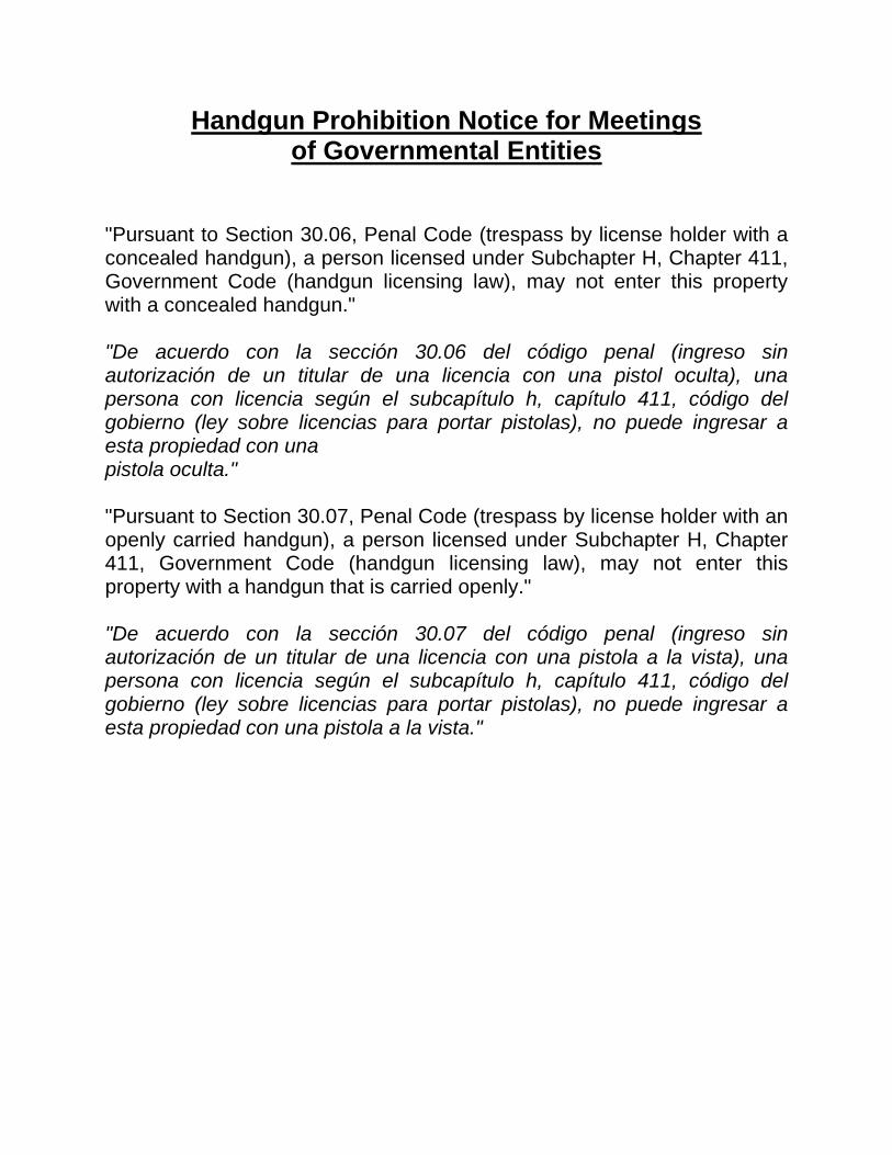
60. A public hearing to receive comments regarding an application for and an ordinance
granting a Specific Use Permit for the sale of alcoholic beverages in conjunction with a general merchandise or food store 3,500 square feet or less on property zoned an LI-D-1 Light Industrial District with a D-1 Liquor Control Overlay, on the northeast corner of Forney Road and South Buckner Boulevard
Recommendation of Staff: Approval for a two-year period with eligibility for automatic renewals for additional five-year periods, subject to a site plan and conditions
Recommendation of CPC: Approval for a three-year period with eligibility for automatic renewals for additional five-year periods, subject to a site plan and conditions
Z167-359(WE) Note: This item was considered by the City Council at a public hearing on December 13,
2017, and was deferred until January 24, 2018, with the public hearing open

January 24, 2018 13 PUBLIC HEARINGS AND RELATED ACTIONS (continued) Department of Sustainable Development and Construction (continued) THOROUGHFARE PLAN AMENDMENTS Department of Transportation 61. A public hearing to receive comments to amend the City of Dallas' Thoroughfare Plan to
change the dimensional classification of Canada Drive from (1) Westmoreland Road to Holystone Street from a standard four-lane divided (S-4-D) roadway within 80 feet of right-of-way to a special four-lane divided (SPCL 4D) roadway with bicycle facilities and parking on both sides of the roadway within 100 feet of right-of-way and 78-feet of pavement; and (2) Holystone Street to Hampton Road from a standard four-lane divided (S-4-D) roadway within 80-feet of right-of-way to a special four-lane divided (SPCL 4D) roadway with bicycle facilities and parking on the north side of the roadway within 100-feet of right-of-way and 75-feet of pavement; and at the close of the hearing, authorize an ordinance implementing the change - Financing: No cost consideration to the City
MISCELLANEOUS HEARINGS Office of Environmental Quality 62. A public hearing to receive comments on a proposed municipal setting designation to
prohibit the use of groundwater as potable water beneath property owned by Foundation Building Materials, LLC, located near the intersection of John Carpenter Freeway and Dividend Drive and adjacent street rights-of-way; and an ordinance authorizing support of the issuance of a municipal setting designation to Foundation Building Materials, LLC, by the Texas Commission on Environmental Quality and prohibiting the use of groundwater beneath the designated property as potable water - Financing: No cost consideration to the City

January 24, 2018 14
Water and Wastewater Main Installations Agenda Item No. 32
District 1 Mayrant Drive from Pratt Street to Llewellyn Avenue District 2 Alley between Shorecrest Drive and Wylie Drive from Weiss Street to Reeves Street Dallas North Tollway from Lomo Alto Drive to Lemmon Avenue Maple Avenue from Bomar Avenue northwest Production Drive from Lucas Drive northwest District 5 Bruton Road from Hillburn Drive to Prichard Lane District 6 Bill Harrod Street from Nomas Street to Clymer Street Brundrette Street from Calypso Street to Canada Drive Chippewa Drive from Iroquois Drive to Ingersoll Street Wichita Street from Riverfront Boulevard to Slocum Street District 9 Knob Oak Drive from State Highway 78 (Garland Road) northwest District 14 Alley between Country Club Circle and Gaston Avenue from Gaston Avenue to Pearson Drive Alley between Cole Avenue and McKinney Avenue from Knox Street northeast Reiger Avenue from Glasgow Drive to Slaughter Avenue Slaughter Avenue from Reiger Avenue southeast

January 24, 2018 15
EXECUTIVE SESSION NOTICE A closed executive session may be held if the discussion of any of the above agenda items concerns one of the following: 1. seeking the advice of its attorney about pending or contemplated litigation, settlement
offers, or any matter in which the duty of the attorney to the City Council under the Texas Disciplinary Rules of Professional Conduct of the State Bar of Texas clearly conflicts with the Texas Open Meetings Act. [Tex. Govt. Code §551.071]
2. deliberating the purchase, exchange, lease, or value of real property if deliberation in an open meeting would have a detrimental effect on the position of the city in negotiations with a third person. [Tex. Govt. Code §551.072]
3. deliberating a negotiated contract for a prospective gift or donation to the city if deliberation in an open meeting would have a detrimental effect on the position of the city in negotiations with a third person. [Tex. Govt. Code §551.073]
4. deliberating the appointment, employment, evaluation, reassignment, duties, discipline, or dismissal of a public officer or employee; or to hear a complaint or charge against an officer or employee unless the officer or employee who is the subject of the deliberation or hearing requests a public hearing. [Tex. Govt. Code §551.074]
5. deliberating the deployment, or specific occasions for implementation, of security personnel or devices. [Tex. Govt. Code §551.076]
6. discussing or deliberating commercial or financial information that the city has received from a business prospect that the city seeks to have locate, stay or expand in or near the city and with which the city is conducting economic development negotiations; or deliberating the offer of a financial or other incentive to a business prospect. [Tex Govt. Code §551.087]


AGENDA DATEITEM IND
# OK DEF DISTRICT TYPE DEPT. DOLLARS LOCAL MWBE DESCRIPTION1 All V NA NA NA NA Approval of Minutes of the January 10, 2018 City Council Meeting
2 N/A C ATT, POL $37,000.00 NA NAAuthorize settlement of the lawsuit styled James Daniel Martin, II v. City of Dallas, Cause No. DC-17-01594 - Not toexceed $37,000 - Financing: Current Funds
3 N/A C ATT $150,000.00 NA NA
Authorize Supplemental Agreement No. 1 to the professional services contract with the Law Offices of William W.Krueger, III, P.C., for additional legal services necessary in the lawsuit styled Mary Dawes, et al. v. The City of Dallas, etal., Civil Action No. 3:17-CV-01424-D - Not to exceed $150,000, from $50,000 to $200,000 - Financing: Current Funds
4 10 C PBW GT NA NA
LBJ Freeway/Skillman Street Interchange: Authorize: (1) a Project Specific Agreement with Dallas County for fundingparticipation in the design and construction of the LBJ Freeway/Skillman Street Interchange Project; (2) receipt anddeposit of funds from Dallas County in an amount not to exceed $3,996,440 for Dallas County’s share of local fundingcontributions for the project costs; and (3) an increase in appropriations in an amount not to exceed $3,996,440 in theCapital Projects Reimbursement Fund - Not to exceed $3,996,440 - Financing: Capital Projects Reimbursement Funds
5 10 C PBW $4,377,000.00 NA NA
LBJ Freeway/Skillman Street Interchange: Authorize: Authorize an Interlocal Agreement with the North Central TexasCouncil of Governments (NCTCOG) to transfer $4,377,000 in local funding to the NCTCOG to establish a portion of theMetropolitan Planning Organization Revolver Fund in exchange for $4,377,000 in state funds for the LBJFreeway/Skillman Street Interchange Project - Not to exceed $4,377,000 - Financing: Capital Projects ReimbursementFunds ($3,996,440) and 2012 Bond Funds ($380,560)
6 10 C PBW NC NA
LBJ Freeway/Skillman Street Interchange: Authorize: Authorize a Memorandum of Understanding with the North CentralTexas Council of Governments, Texas Department of Transportation (TxDOT) and Dallas County that outlinesexpectations of each agency pertaining to the LBJ Freeway/Skillman Street Interchange Project that is being implementedas part of TxDOT’s planned LBJ Freeway East Corridor Design-Build project - Financing: No cost consideration to the City
7 All C PBW $875,350.00 74.30% 100.00%
Authorize an increase to the twenty-four month construction services contract with Vescorp Construction, LLC dbaChavez Concrete Cutting for sidewalk and barrier free ramp installation paving services for the sidewalk replacement andbarrier free ramp program to extend the term of the contract for an additional twelve months from March 2018 to March2019 - Not to exceed $875,350, from $3,501,400 to $4,376,750 - Financing: General Obligation Commercial PaperFunds
8 2 C DEV, CIS $5,000.00 NA NA
Authorize an amendment to an existing lease agreement with Dallas County Hospital District d/b/a Parkland Health &Hospital System to extend the lease agreement for an additional five-years for approximately 1,000 square feet of officespace located at 5200 Harry Hines Boulevard to be used as Communication and Information Services Mobile DataTerminal for the period February 1, 2018 through January 31, 2023 - Not to exceed $5,000 - Financing: Communicationand Information Services Current Funds (subject to annual appropriations)
9 1 C DEV REV $100 NA NA
An ordinance granting a private license to Bishop Arts Phase 1A LLC, for the use of approximately 314 square feet ofaerial space to occupy, maintain and utilize one canopy without premise sign over a portion of 9th Street right-of-way nearits intersection with Bishop Avenue - Revenue: $100 one-time fee, plus the $20 ordinance publication fee
10 14 C DEV REV $2,000 NA NA
An ordinance granting a revocable license to Dallas MTA, L.P. d/b/a Verizon Wireless, for the use of a total ofapproximately 10 square feet of aerial space to install, maintain and utilize two aerial signs over a portion of CommerceStreet right-of-way located near its intersection with Ervay Street - Revenue: $2,000 annually, plus the $20 ordinancepublication fee
11 1, 2 C TRN $2,089,809.00 NA NA
Authorize (1) an Interlocal Agreement with the North Central Texas Council of Governments related to the transfer ofownership of Transportation Investments Generating Economic Recovery funded Modern Streetcar Project assets andstreetcar project-related funds; (2) receipt and deposit of funds from SLF III - Canyon Developer Funds in the amount of$3,000,000; (3) an increase in appropriations in the amount of $1,114,809 from $975,000 to $2,089,809 in GeneralFunds; and (4) payment to Dallas Area Rapid Transit for operation and maintenance costs for the Dallas StreetcarSystem for Fiscal Year 2018 - Total not to exceed $2,089,809 - Financing: General Funds ($2,089,809)
January 24, 2018
Page 1

AGENDA DATEITEM IND
# OK DEF DISTRICT TYPE DEPT. DOLLARS LOCAL MWBE DESCRIPTION
January 24, 2018
12 1, 2 C TRN GT NA NA
Authorize (1) acceptance of a grant from the Texas Department of Transportation (TxDOT) (Grant No. CSJ 0918-47-972)for extending the Dallas Streetcar System to Bishop Arts District and to the Omni Hotel and Kay Bailey HutchisonConvention Center and to purchase streetcar vehicles in an amount not to exceed $8,095,751; (2) establishment ofappropriations in an amount not to exceed $8,095,751 in the TIGER Modern Streetcar System Fund; (3) receipt anddeposit of TxDOT grant funds in an amount not to exceed $8,095,751 in the TIGER Modern Streetcar System Fund; and(4) execution of the Advance Funding Agreement with the Texas Department of Transportation - Not to exceed$8,095,751 - Financing: Texas Department of Transportation Grant Funds
13 1, 4 C TRN $7,077,600 NA NA
Authorize payment to the Texas Department of Transportation for the City's local match for construction of the SouthernGateway Public Green's infrastructure over Interstate Highway 35E - Not to exceed $7,077,600 - Financing: GeneralObligation Commercial Paper Funds
14 All C LIB GT NA NA
Authorize (1) acceptance of a grant from the Texas State Library and Archives Commission (FAIN No. LS-00-16-0044-16,CFDA No. 45.310) for partial reimbursement of interlibrary loan service's direct costs in an amount not to exceed $51,035,for the period September 1, 2016 through August 31, 2017; (2) establishment of appropriations in an amount not toexceed $51,035 in the Interlibrary Loan 16-17 Fund; (3) receipt and deposit of funds in an amount not to exceed $51,035in the Interlibrary Loan 16-17 Fund; and (4) execution of the grant agreement - Not to exceed $51,035 - Financing: TexasState Library and Archives Commission Grant Funds
15 N/A C OFS $155,712,117.00 NA NAAn ordinance amending Ordinance No. 30651, previously approved on September 20, 2017 to appropriate monies forprojects authorized by the 2017 General Obligation bond program totaling $155,712,117 - Financing: 2017 Bond Funds
16 3,
Outside C PBD, WTR $511,800.00 0.00% 1.95%Authorize a service contract for cleaning, recoating, and repair services for two water tanks - Utility Service Co., Inc.,lowest responsible bidder of six - Not to exceed $511,800 - Financing: Water Utilities Currents Funds
17 All CPBD, CVS, HRD, CIS $547,912.00 NA NA
Authorize a two-year service contract for the continued use of the existing software to facilitate the new hire andperformance management process with SHI Government Solutions, Inc. through the Department of InformationResources - Not to exceed $547,912 - Financing: Communication and Information Services Current Funds (subject toannual appropriations)
18 All C PBD, FIR $474,300.00 18.87% 0.00%
Authorize a three-year service contract for the repair of fire equipment and the purchase of associated tools and parts forthe Fire-Rescue Department - Metro Fire Apparatus Specialists, Inc. in the amount of $384,800 and Casco Industries, Inc.in the amount of $89,500, lowest responsible bidders of two - Total not to exceed $474,300 - Financing: General Funds(subject to annual appropriations)
19 N/A C PBD, CIS $1,944,000.00 NA NA
Authorize a three-year service contract for mobile technology center managed services with GTS Technology Solutions,Inc. through the Department of Information Resources - Not to exceed $1,944,000 - Financing: Communication andInformation Services Current Funds (subject to annual appropriations)
20 All CPBD, CIS,
POL $649,789.00 0.00% 0.00%
Authorize a six-year service contract for upgrade, maintenance, and support of software to the Automated FingerprintIdentification System - NEC Corporation of America, sole source - Not to exceed $649,789 - Financing: General Funds(subject to annual appropriations)
21 4 C PBD, PKR NC NA NAAuthorize (1) the rejection of the only proposal received for operational management of the Southern Skates RollerSkating Rink Facility; and (2) the re-advertisement for a new solicitation - Financing: No cost consideration to the City
22 All CPBD, CIS,
DEV $2,245,136.00 NA NA
Authorize a five-year cooperative purchase agreement for the purchase, implementation, maintenance and support of ahosted electronic plan review system for Building Inspection provided by Avolve Software Corporation and sold throughSHI Government Solutions, Inc. through the Texas Association of School Boards - Not to exceed $2,245,136 - Financing:General Funds (subject to annual appropriations)
23 Outside C PBD, WTR $93,500.00 0.00% 0.00%
Authorize the purchase of two fiberglass chemical storage tanks for the Elm Fork Water Treatment Plant - NauticalOutfitters Corp. d/b/a Tank Depot, lowest responsible bidder of three - Not to exceed $93,500 - Financing: Water UtilitiesCurrent Funds
24 All C PBD, CIS $6,736,566.24 NA NA
Authorize a five-year subscription contract for the licensing, hosting, and technical support of a citywide enterprise assetmanagement system with IBM Corporation through the Department of Information Resources, State of Texas Cooperative- Not to exceed $6,736,567 - Financing: Communication and Information Services Current Funds (subject to annualappropriations)
Page 2

AGENDA DATEITEM IND
# OK DEF DISTRICT TYPE DEPT. DOLLARS LOCAL MWBE DESCRIPTION
January 24, 2018
25 All C PBD, WTR $221,887.30 21.66% 0.00%
Authorize a three-year master agreement for fire hydrant backflow preventers and parts - Ferguson Enterprises, Inc. inthe amount of $173,825, Fortiline, Inc. in the amount of $45,063, and Core & Main, LP in the amount of $3,000, lowestresponsible bidders of seven - Total not to exceed $221,888 - Financing: Water Utilities Current Funds
26 All C PBD, WTR $1,922,849.50 87.47% 0.00%
Authorize a three-year master agreement for aeration basin diffusers and parts for Water Utilities - Evoqua WaterTechnologies, LLC in the amount of $1,065,000, Environmental Dynamics International, Inc. in the amount of $504,400,Hartwell Environmental Corporation in the amount of $240,800 and Simba Industries in the amount of $112,650, lowestresponsible bidders of four - Total not to exceed $1,922,850 - Financing: Water Utilities Current Funds
27 All C
PBD, CES, TWM, WTR,
EBS $2,461,983.00 18.35% 0.00%
Authorize a three-year master agreement for service center supplies, equipment, and tools - IEH Auto Parts LLC dba AutoPlus Auto Parts in the amount of $2,010,098 and Midway Auto Supply Co. in the amount of $451,885, lowest responsiblebidders of three - Total not to exceed $2,461,983 - Financing: Equipment Services Current Funds ($1,408,773), GeneralFunds ($631,200), Water Utilities Current Funds ($281,610), Stormwater Drainage Management Current Funds($91,000), and Convention and Event Services Current Funds ($49,400)
28 All C PBD, DAS $3,130,625.08 0.00% 0.00%
Authorize a three-year master agreement for veterinary drugs and supplies consisting of medications, preventatives,vaccines, diagnostic tests, and supplies for the Department of Dallas Animal Services - Bayer HealthCare, LLC in theamount of $2,254,266 or $2,092,817 (Tie Bid - Line 3), MWI Veterinary Supply Co dba MWI Animal Health in the amountof $997,808 or $836,360 (Tie Bid - Line 3), and Harris Pharmaceutical, Inc. in the amount of $40,000, lowest responsiblebidders of three - Total not to exceed $3,130,626 - Financing: General Funds
29 1, 10, 14 C PKR $14,776,735.00 29.26% 33.66%
Authorize a contract for construction of three family aquatic centers at Kidd Springs Park located at 807 West CantyStreet, Lake Highlands North Park located at 9400 Church Road, and Tietze Park located at 2700 Skillman Street - TheFain Group, Inc., best value proposer of three - Not to exceed $14,776,735 - Financing: Elgin B. Robertson Land SaleFunds ($4,161,735) and 2017 Bond Funds ($10,615,000) (subject to appropriations)
30 3 C PKR NC NA NA
Authorize a five-year management, maintenance and operating agreement with Dallas County Audubon Society, Inc. dbaAudubon Dallas to manage, maintain and operate the Cedar Ridge Preserve, providing accessibility to open spaceproperties and trails located at 7171 Mountain Creek Parkway - Financing: No cost consideration to the City
31 8 C PKR $443,300.00 95.96% 28.78%
Authorize Supplemental Agreement No. 8 to the professional services contract with Perkins+Will, Inc. for constructiondocuments, bidding, and construction administration phases for the addition of a senior center, technology center andgymnasium to the Singing Hills Recreation Center replacement project located at 6805 Patrol Way - Not to exceed$443,300, from $881,487 to $1,324,787 - Financing: 2017 Bond Funds (subject to appropriations)
32 1, 2, 5, 6,
9, 14 C WTR $5,763,443.00 92.73% 85.89%Authorize a construction contract for the installation of water and wastewater mains at 15 locations - Muniz Construction,Inc., lowest responsible bidder of six - Not to exceed $5,763,443 - Financing: Water Utilities Capital Improvement Funds
33 8 C WTR $14,399,000.00 34.13% 28.76%
Authorize a construction contract for Peak Flow Basin No. 4 Expansion and Site Improvements at the SouthsideWastewater Treatment Plant - Eagle Contracting Limited Partnership, lowest responsible bidder of six - Not to exceed$14,399,000 - Financing: Water Utilities Capital Improvement Funds
34 6 C WTR $18,885,730.20 4.15% 24.83%
Authorize a construction services contract for the installation of a 72-inch water transmission pipeline in Harry HinesBoulevard from Cullum Lane to Walnut Hill Lane - S.J. Louis Construction of Texas Ltd., lowest responsible bidder of five -Not to exceed $18,885,731 - Financing: Water Utilities Capital Improvement Funds
35 Outside C WTR REV $3,331.83 NA NA
Authorize a five-year contract with one five-year renewal option, with the United States of America acting through the U. S.Army Corps of Engineers to continue providing untreated water, from January 24, 2018 through January 23, 2023 -Estimated Annual Revenue: $3,332
36 N/A I SEC NC N/A N/AConsideration of appointments to boards and commissions and the evaluation and duties of board and commissionmembers (List of nominees is available in the City Secretary's Office)
Page 3

AGENDA DATEITEM IND
# OK DEF DISTRICT TYPE DEPT. DOLLARS LOCAL MWBE DESCRIPTION
January 24, 2018
37 14 I ECO $500.00 NA NA
Authorize (1) a resolution of support for 2400 Bryan Street, LP, or its affiliate, related to its application for 9% Low IncomeHousing Tax Credits from the Texas Department of Housing and Community Affairs for the new construction of up to a230-unit residential development located at 2400 Bryan Street; and (2) a line of credit for the proposed development in theamount of $500 - Not to exceed $500 - Financing: Public/Private Partnership Funds
38 3 I ECO $500.00 NA NA
Authorize (1) a resolution of support for CLO Mountain Housing, LP, or its affiliate, related to its application for 9% LowIncome Housing Tax Credits from the Texas Department of Housing and Community Affairs for the new construction of a100-unit residential development located on the southwest corner of Camp Wisdom Road and Mountain Creek Parkwayto be known as Cielo at Mountain Creek; and (2) a line of credit for the proposed development in the amount of $500 - Notto exceed $500 - Financing: Public/Private Partnership Funds
39 6 PH DEV NC NA NA
A public hearing to receive comments regarding an application for and an ordinance granting an amendment to, and anexpansion of, Specific Use Permit No. 1718 for tower/antenna for cellular communication on property zoned a CRCommunity Retail District with a D Liquor Control Overlay and existing deed restrictions [Z801-138] on a portion, on thewest line of Midway Road and the north line of West Northwest Highway
40 10 PH DEV NC NA NA
A public hearing to receive comments regarding an application for and an ordinance granting the renewal of Specific UsePermit No. 1548 for an open-enrollment charter school on property zoned an IR Industrial Research District, on the westand north side of Forestgate Drive, north of Forest Lane
41 6 PH DEV NC NA NA
A public hearing to receive comments regarding an application for and an ordinance granting the renewal of Specific UsePermit No. 2105 for an alcoholic beverage establishment, limited to a bar, lounge, or tavern, on property zoned an MU-3Mixed Use District, on the southwest corner of Harry Hines Boulevard and Willowbrook Road
42 2 PH DEV NC NA NA
A public hearing to receive comments regarding an application for and an ordinance granting an amendment to PlannedDevelopment Subdistrict No. 119 for Multiple-Family Subdistrict uses within Planned Development District No. 193, theOak Lawn Special Purpose District, on the southwest line of Cedar Springs Road, between Lucas Drive and HawthorneAvenue
43 8 PH DEV NC NA NA
A public hearing to receive comments regarding an application for and an ordinance granting a CS Commercial ServiceDistrict on property zoned an IR-D-1 Industrial Research District with a D-1 Liquor Control Overlay, on the northwest lineof South Belt Line Road, southwest of Kleberg Road
44 14 PH DEV NC NA NA
A public hearing to receive comments regarding an application for and an ordinance granting the renewal of, andamendment to, Specific Use Permit No. 2127 for a restaurant without drive-in or drive-through service on property zonedSubdistrict B within Planned Development District No. 619 with Historic Overlay No. 87, on the north side of Main Street,east of North Field Street
45 8 PH DEV NC NA NA
A public hearing to receive comments regarding an application for and an ordinance granting a Specific Use Permit for avehicle display, sales, and service use on property zoned Subdistrict 1 within Planned Development District No. 535, theC.F. Hawn Special Purpose District No. 3, with a D-1 Liquor Control Overlay, on the southwest corner of the C.F. HawnService Road and Ellenwood Drive
46 13 PH DEV NC NA NA
A public hearing to receive comments regarding an application for and an ordinance granting an amendment to SpecificUse Permit No. 44 for an electrical substation on property zoned an R-16(A) Single Family District, on the south line ofNorthaven Road, east of the Dallas North Tollway
47 9 PH DEV NC NA NA
A public hearing to receive comments regarding an application for and an ordinance granting a Specific Use Permit for achild-care facility on property zoned an R-7.5(A) Single Family District, on the south corner of Ferguson Road andDrummond Drive
48 6 PH DEV NC NA NAA public hearing to receive comments regarding an application for and an ordinance granting an MU-2 Mixed Use Districton property zoned an IR Industrial Research District on the west line of Gretna Street, south of Lupo Drive
49 6 PH DEV NC NA NA
A public hearing to receive comments regarding an application for and an ordinance granting an MU-1 Mixed Use Districtand a resolution accepting deed restrictions volunteered by the applicant on property zoned an IR Industrial ResearchDistrict on the west line of Brundrette Street, south of Pollard Street
Page 4

AGENDA DATEITEM IND
# OK DEF DISTRICT TYPE DEPT. DOLLARS LOCAL MWBE DESCRIPTION
January 24, 2018
50 6 PH DEV NC NA NA
A public hearing to receive comments regarding an application for and an ordinance granting a CS Commercial ServiceDistrict on property zoned an IR Industrial Research District, on the northeast line of Ambassador Row and WestMockingbird Lane
51 7 PH DEV NC NA NA
A public hearing to receive comments regarding an application for and an ordinance granting a Specific Use Permit for anauto service center on property zoned an NC(E) Neighborhood Commercial Enhanced Subdistrict within PlannedDevelopment District No. 595, the South Dallas/Fair Park Special Purpose District on the northeast line of SecondAvenue, between Metropolitan Avenue and Penelope Street
52 14 PH DEV NC NA NA
A public hearing to receive comments regarding an application for and an ordinance granting the creation of a newsubarea and amendments to the preservation criteria within Area A in Planned Development District No. 63 with HistoricOverlay No. 1 on property at the southeast corner of Swiss Avenue and Parkmont Street with consideration given to andan ordinance granting a Specific Use Permit for an extended-hours historic house museum and meeting space use
53 7 PH DEV NC NA NA
A public hearing to receive comments regarding an application for and an ordinance granting the renewal of Specific UsePermit No. 1989 for the sale of alcoholic beverages in conjunction with a general merchandise or food store 3,500 squarefeet or less on property zoned Subarea 6 within Planned Development District No. 366, the Buckner Boulevard SpecialPurpose District, with a D-1 Liquor Control Overlay on the northeast corner of South Buckner Boulevard and Norvell Drive
54 6 PH DEV NC NA NA
A public hearing to receive comments regarding an application for the renewal of Specific Use Permit No. 2104 for analcoholic beverage establishment, limited to a bar, lounge, or tavern, on property zoned an MU-3 Mixed Use District, onthe southwest corner of Harry Hines Boulevard and Willowbrook Road
55 8 PH DEV NC NA NA
A public hearing to receive comments regarding an application for and an ordinance granting an IM IndustrialManufacturing District and an ordinance granting a Specific Use Permit for an industrial (outside) potentially incompatibleuse limited to a concrete crushing facility on property zoned a CS Commercial Service District, on the east line of SouthCentral Expressway, south of Youngblood Road
56 8 PH DEV NC NA NA
A public hearing to receive comments regarding an application for and an ordinance granting a CR Community RetailDistrict and an ordinance granting a Specific Use Permit for a mini-warehouse use on property zoned an R-10(A) SingleFamily District and NS(A) D-1 Neighborhood Service District with a D-1 Liquor Control Overlay on a portion on the northcorner of South Belt Line Road and Garden Grove Drive
57 3 PH DEV NC NA NA
A public hearing to receive comments regarding an application for and an ordinance granting an MF-2(A) MultifamilyDistrict and a resolution accepting deed restrictions volunteered by the applicant on property zoned a CR CommunityRetail District, on the south line of West Illinois Avenue, between Duncanville Road and Knoxville Street
58 2 PH DEV NC NA NA
A public hearing to receive comments regarding an application for and an ordinance granting a Planned DevelopmentSubdistrict for GR General Retail Subdistrict uses and auto painting or body rebuilding shop (inside) use by right, and anaccessory motor vehicle storage outside use on property zoned a GR General Retail Subdistrict within PlannedDevelopment District No. 193, the Oak Lawn Special Purpose District, on the northeast corner of Maple Avenue andVagas Street
59 7 PH DEV NC NA NA
A public hearing to receive comments regarding an application for and (1) an ordinance granting a Planned DevelopmentDistrict for commercial, industrial and transportation uses; (2) an ordinance granting an amendment to Specific UsePermit No. 1715 for an industrial (outside) potentially incompatible use for an asphalt batching plant [Tract II]; (3) anordinance granting a Specific Use Permit for two industrial (outside) not potentially incompatible uses for a concretebatching plant [Tract I and Tract III]; (4) an ordinance terminating Specific Use Permit No. 1613 for an industrial (outside)not potentially incompatible use for a concrete batch plant; and (5) a resolution terminating deed restrictions [Z078-204]on property zoned an IR-D Industrial Research District with a D Liquor Control Overlay on a portion and Specific UsePermit No. 1613 on a portion; a CS-D Commercial Service District with a D Liquor Control Overlay on a portion andSpecific Use Permit No. 1602 for vehicle storage lot on a portion; and an IM-D Industrial Manufacturing District with a DLiquor Control Overlay on a portion, Specific Use Permit No. 1715 on a portion and deed restrictions on the northeastcorner of State Highway 310 and Linfield Road
Page 5
AGENDA DATEITEM IND
# OK DEF DISTRICT TYPE DEPT. DOLLARS LOCAL MWBE DESCRIPTION
January 24, 2018
60 7 PH DEV NC NA NA
A public hearing to receive comments regarding an application for and an ordinance granting a Specific Use Permit for thesale of alcoholic beverages in conjunction with a general merchandise or food store 3,500 square feet or less on propertyzoned an LI-D-1 Light Industrial District with a D-1 Liquor Control Overlay, on the northeast corner of Forney Road andSouth Buckner Boulevard
61 6 PH TRN NC NA NA
A public hearing to receive comments to amend the City of Dallas' Thoroughfare Plan to change the dimensionalclassification of Canada Drive from (1) Westmoreland Road to Holystone Street from a standard four-lane divided (S-4-D)roadway within 80 feet of right-of-way to a special four-lane divided (SPCL 4D) roadway with bicycle facilities and parkingon both sides of the roadway within 100 feet of right-of-way and 78-feet of pavement; and (2) Holystone Street toHampton Road from a standard four-lane divided (S-4-D) roadway within 80-feet of right-of-way to a special four-lanedivided (SPCL 4D) roadway with bicycle facilities and parking on the north side of the roadway within 100-feet of right-of-way and 75-feet of pavement; and at the close of the hearing, authorize an ordinance implementing the change -Financing: No cost consideration to the City
62 6 PH OEQ NC NA NA
A public hearing to receive comments on a proposed municipal setting designation to prohibit the use of groundwater aspotable water beneath property owned by Foundation Building Materials, LLC, located near the intersection of JohnCarpenter Freeway and Dividend Drive and adjacent street rights-of-way; and an ordinance authorizing support of theissuance of a municipal setting designation to Foundation Building Materials, LLC, by the Texas Commission onEnvironmental Quality and prohibiting the use of groundwater beneath the designated property as potable water -Financing: No cost consideration to the City
TOTAL $245,533,432.32
Page 6


AGENDA ITEM # 2STRATEGIC PRIORITY:
Government Performance and Financial Management
AGENDA DATE: January 24, 2018
COUNCIL DISTRICT(S): N/A
DEPARTMENT: City Attorney's OfficePolice Department
CMO: Larry Casto, 670-3491Jon Fortune, 670-1204
MAPSCO: N/A________________________________________________________________
SUBJECT
Authorize settlement of the lawsuit styled James Daniel Martin, II v. City of Dallas, Cause No. DC-17-01594 - Not to exceed $37,000 - Financing: Current Funds
BACKGROUND
Plaintiff filed a lawsuit against the City of Dallas seeking compensation for bodily injuries and other damages sustained in an automobile collision on March 28, 2015, involving a Dallas Police Department vehicle. The City and James Daniel Martin, II have reached a proposed settlement subject to City Council approval. Plaintiff is represented by Loncar & Associates.
PRIOR ACTION/REVIEW (COUNCIL, BOARDS, COMMISSIONS)
City Council will be briefed by memorandum on January 19, 2018.
FISCAL INFORMATION
Funding for this item is budgeted in the current fiscal year
Current Funds - $37,000

COUNCIL CHAMBER
January 24, 2018
WHEREAS, a lawsuit styled James Daniel Martin, II v. City of Dallas, Cause No. DC-17-01594, was filed by the plaintiff, James Daniel Martin, II, seeking compensation from the City of Dallas for bodily injuries and other damages sustained in an automobile collision on March 28, 2015, involving a Dallas Police Department vehicle; and
WHEREAS, the plaintiff has agreed to a settlement of the case whereby the City will pay James Daniel Martin, II, Loncar & Associates, and all other persons having an interest in the settlement proceeds, the total amount of $37,000; and
WHEREAS, it is in the best interest of the City to settle this lawsuit.
Now, Therefore,
BE IT RESOLVED BY THE CITY COUNCIL OF THE CITY OF DALLAS:
SECTION 1. That the proposed settlement of the lawsuit, styled James Daniel Martin, II v. City of Dallas, Cause No. DC-17-01594, in an amount not to exceed $37,000 is hereby approved.
SECTION 2. That the Chief Financial Officer is hereby authorized to pay James Daniel Martin, II, Loncar & Associates, and all other persons having an interest in the settlement proceeds, the amount of $37,000, from Fund 0192, Department ORM, Unit 3890, Object 3521, Vendor CTORM001.
SECTION 3. That this resolution shall take effect immediately from and after its passage in accordance with the provisions of the Charter of the City of Dallas, and it is accordingly so resolved.

AGENDA ITEM # 3STRATEGIC PRIORITY:
Government Performance and Financial Management
AGENDA DATE: January 24, 2018
COUNCIL DISTRICT(S): N/A
DEPARTMENT: City Attorney's Office
CMO: Larry Casto, 670-1333
MAPSCO: N/A________________________________________________________________
SUBJECT
Authorize Supplemental Agreement No. 1 to the professional services contract with the Law Offices of William W. Krueger, III, P.C., for additional legal services necessary in the lawsuit styled Mary Dawes, et al. v. The City of Dallas, et al., Civil Action No. 3:17-CV-01424-D - Not to exceed $150,000, from $50,000 to $200,000 - Financing: Current Funds
BACKGROUND
Supplemental Agreement No. 1 will authorize the Law Offices of William W. Krueger, III, P.C., to continue providing legal services in connection with the representation of Dallas Police Officer Jason Kimpel in the lawsuit styled Mary Dawes, et al. v. The City of Dallas, et al., Civil Action No. 3:17-CV-01424-D.
PRIOR ACTION/REVIEW (COUNCIL, BOARDS, COMMISSIONS)
City Council will be briefed in Executive Session on January 17, 2018.
FISCAL INFORMATION
Funding for this item is budgeted in the current fiscal year.
Current Funds - $150,000

COUNCIL CHAMBER
January 24, 2018
WHEREAS, on July 7, 2017, Administrative Action No. 17-6314, authorized a professional services contract with the Law Offices of William W. Krueger, III, P.C., for legal services necessary in connection with the representation of Dallas Police Officer Jason Kimpel in the lawsuit styled Mary Dawes, et al. v. The City of Dallas, et al., Civil Action No. 3:17-CV-01424-D, in an amount not to exceed $50,000; and
WHEREAS, the professional legal services of the Law Offices of William W. Krueger, III, P.C., continue to be necessary.
Now, Therefore,
BE IT RESOLVED BY THE CITY COUNCIL OF THE CITY OF DALLAS:
SECTION 1. The City Manager is hereby authorized to sign Supplemental Agreement No. 1 to the professional services contract with the Law Offices of William W. Krueger, III, P.C., approved as to form by the City Attorney, for additional legal services necessary in the lawsuit styled Mary Dawes, et al. v. The City of Dallas, et al., Civil Action No. 3:17-CV-01424-D, in an amount not to exceed $150,000, increasing the original contract amount from $50,000 to $200,000.
SECTION 2. That the Chief Financial Officer is hereby authorized to disburse funds, in periodic payments to the Law Offices of William W. Krueger, III, P.C., in an amount not to exceed $150,000 from Fund 0192, Department ORM, Unit 3890, Object 3033, Contract No. ATT-2017-00002639, Vendor No. VC17318.
SECTION 3. That this resolution shall take effect immediately from and after its passage in accordance with the provisions of the Charter of the City of Dallas, and it is accordingly so resolved.

AGENDA ITEMS # 4,5,6STRATEGIC PRIORITY:
Mobility Solutions, Infrastructure, and Sustainability
AGENDA DATE: January 24, 2018
COUNCIL DISTRICT(S): 10
DEPARTMENT: Department of Public Works
CMO: Majed Al-Ghafry, 670-3302
MAPSCO: 27 C D G________________________________________________________________
SUBJECT
LBJ Freeway/Skillman Street Interchange
* Authorize (1) a Project Specific Agreement with Dallas County for funding participation in the design and construction of the LBJ Freeway/Skillman Street Interchange Project; (2) receipt and deposit of funds from Dallas County in an amount not to exceed $3,996,440 for Dallas County’s share of local funding contributions for the project costs; and (3) an increase in appropriations in an amount not to exceed $3,996,440 in the Capital Projects Reimbursement Fund - Not to exceed $3,996,440 - Financing: Capital Projects Reimbursement Funds
* Authorize an Interlocal Agreement with the North Central Texas Council of Governments (NCTCOG) to transfer $4,377,000 in local funding to the NCTCOG to establish a portion of the Metropolitan Planning Organization Revolver Fund in exchange for $4,377,000 in state funds for the LBJ Freeway/Skillman Street Interchange Project - Not to exceed $4,377,000 - Financing: Capital Projects Reimbursement Funds ($3,996,440) and 2012 Bond Funds ($380,560)
* Authorize a Memorandum of Understanding with the North Central Texas Council of Governments, Texas Department of Transportation (TxDOT) and Dallas County that outlines expectations of each agency pertaining to the LBJ Freeway/Skillman Street Interchange Project that is being implemented as part of TxDOT’s planned LBJ Freeway East Corridor Design-Build project - Financing: No cost consideration to the City

Agenda Date 01/24/2018 -page 2
BACKGROUND
The Interstate Highway 635 at Skillman/Audelia Project, also known as LBJ Skillman Gateway Project and LBJ Freeway/Skillman Street Interchange Project is a partnership project between the City of Dallas, Dallas County, North Central Texas Council of Governments (NCTCOG) and Texas Department of Transportation (TxDOT) and is a key component of TxDOT’s larger LBJ Freeway East Corridor Project. The interchange project includes the realignment and reconstruction of the Skillman Street bridge, the cross-street approaches, as well as the Skillman Street at Audelia Road/Whitehurst Drive and Skillman Street at Audelia Road/Adleta Court intersections. The project also includes pedestrian and bicycle facilities that will eventually connect to the City’s existing trail network. This Council action will authorize a Project Specific Agreement with Dallas County and an Interlocal Agreement with NCTCOG needed to transfer required local funds for the project. This Council action will also authorize a four-party Memorandum of Understanding between the City of Dallas, Dallas County, TxDOT and NCTCOG that outlines expectations of each agency pertaining to the LBJ Freeway/Skillman Street Interchange Project that is being implemented as part of TxDOT’s planned LBJ Freeway East Corridor Design-Build project.
TxDOT has long planned to improve LBJ Freeway from US Highway 75 to US Highway 80, and as such, obtained schematic approval in 2003. However, due to funding constraints, the implementation of the project has been on hold for over ten years. In order to expedite the LBJ Freeway at Skillman Street interchange improvements, the City administered and funded the design of the improvements so that the project could be implemented as a stand-alone Design-Bid-Build project should funding become available. The interchange improvements entail eliminating the originally proposed Skillman Street grade separated flyover and replacing with a wider at-grade bridge, as well as re-aligning Skillman Street to provide a more bicycle and pedestrian-friendly environment and to promote economic development.
The Metropolitan Planning Organization (MPO) Revolver Fund is a partnership program authorized by the Texas Transportation Commission (TTC) in 2015 with selected MPO’s. The TTC subsequently set aside $10 million in state funds for the purpose of replacing local funds in specific projects, thus permitting the local funds to be transferred to NCTCOG to establish the MPO Revolver Fund in the Dallas-Fort Worth region. The MPO Revolver Fund will be used by NCTCOG to cash flow expenses for MPO administered federal and state transportation programs while such expenses are pending reimbursement from the applicable funding agency.
In 2015, NCTCOG sought out the City’s assistance and participation in the newly-created MPO Revolver Fund program, and in turn, NCTCOG agreed to facilitate/prioritize the allocation of funds for the right-of-way acquisition, utility relocation, and construction costs for the LBJ Freeway/Skillman Street Interchange Project, which the City has identified as a priority.

Agenda Date 01/24/2018 -page 3
BACKGROUND (continued)
On December 10, 2015, the Regional Transportation Council (RTC) approved a funding strategy that included $4,377,000 in combined Dallas County and City of Dallas local funds for the Interstate Highway 635 at Skillman/Audelia Project in exchange for $4,377,000 in state funds to establish a portion of the MPO Revolver Fund. The RTC also agreed to allocate the remaining $65 million in funds needed for the project. The Project Specific Agreement with Dallas County will authorize the receipt of Dallas County’s share of local funding contributions to the project. The Interlocal Agreement with NCTCOG will authorize the transfer of $4,377,000 (City - $380,560.50; Dallas County - $3,996,439.50) to NCTCOG for the MPO Revolver Fund.
The LBJ Freeway East Corridor Project was reactivated by TxDOT in 2015 and is now planned to be implemented as a Design-Build project that will also include the LBJ Freeway at Skillman Street interchange improvements. The City has coordinated with community stakeholders and agency partners throughout its design efforts, which to date have produced 95 percent plans. Now that the LBJ Freeway/Skillman Street Interchange improvements are proposed to be constructed in conjunction with the LBJ Freeway East Corridor Project, the 95 percent plans and associated engineering design documents prepared by the City have been transferred to TxDOT. It is imperative to ensure that the schedule, timeline, and key design components of the LBJ Freeway/Skillman Street Interchange Project are preserved as part of TxDOT’s planned LBJ Freeway East Corridor Design-Build project, thus the need for a four-party Memorandum of Understanding between the City, County, TxDOT and NCTCOG that outlines the expectations of each agency.
The total local funding participation for the LBJ Freeway/Skillman Street Interchange Project is $7,992,879.00, which is to be split 50/50 between Dallas County and the City. The City’s share of local funding contribution, $3,996,439.50, includes the $3,615,879 previously spent on the schematic and design of the project. Local funding in the amount of $4,377,000 will be replaced with funds from the MPO Revolver Fund and will be used for construction. The remaining $65 million construction costs will be funded by State/Federal funds. As such, a total of approximately $69.3 million is being allocated for the LBJ Freeway/Skillman Street Interchange Project that is included in TxDOT’s LBJ Freeway East Corridor Project.
ESTIMATED SCHEDULE OF PROJECT
Began Schematic July 2011Began Environmental July 2011Completed Schematic May 2014Began Final Design May 2014Completed Environmental June 2015Completed Final Design (95% completion*) November 2017Begin LBJ East Corridor design-Build Project Spring 2019Complete LBJ East Corridor design-Build Project Spring 2023

Agenda Date 01/24/2018 -page 4
ESTIMATED SCHEDULE OF PROJECT (continued)
* LBJ Freeway/Skillman Street Interchange Project is now to be included in TxDOT’s LBJ Freeway East Corridor Design-Build Project. The 95 percent plans were transferred to TxDOT.
PRIOR ACTION/REVIEW (COUNCIL, BOARDS, COMMISSIONS)
On January 10, 2001, City Council authorized a master agreement with Dallas County governing future transportation major capital improvement projects between the City of Dallas and Dallas County by Resolution No. 01-0104.
On April 13, 2011, City Council authorized a new ten-year master agreement with Dallas County governing major transportation capital improvement projects by Resolution No. 11-0927.
On June 22, 2011, City Council authorized a professional services contract with Bridgefarmer and Associates, Inc. for the preliminary engineering design of bridge, paving and drainage improvements for the LBJ Freeway at Skillman Street interchange planned improvements by Resolution No. 11-1695.
On June 26, 2013, City Council authorized Supplemental Agreement No. 1 to the professional services contract with Bridgefarmer & Associates, Inc. for the final engineering design of bridge, paving and drainage improvements for the LBJ Freeway at Skillman Street interchange by Resolution No. 13-1147.
On October 9, 2017, the Mobility Solutions, Infrastructure, and Sustainability Committee was briefed by the North Central Council of Governments' Director of Transportation regarding the Texas Transportation Commission’s initiative to fund several critically needed big projects in the metropolitan area of the state, including the LBJ Freeway East Corridor from US Highway 75 to IH 30.
Information about this item will be provided to the Mobility Solutions, Infrastructure and Sustainability Committee on January 22, 2018.
FISCAL INFORMATION
Capital Projects Reimbursement Funds - $3,996,439.502012 Bond Funds - $380,560.50

Agenda Date 01/24/2018 -page 5
FISCAL INFORMATION (continued)
Estimated Project Cost
Schematic $ 323,127.00Design $ 3,292,752.00Construction (MPO Revolver*) $ 4,377,000.00 (this action)Total Project Cost funded by Local** $ 7,992,879.00
Construction (State/Federal) $65,000,000.00
Funding Sources
Dallas County’s Share $ 3,996,439.50 (this action)City’s Share $ 3,996,439.50Total Local Funding** $ 7,992,879.00
*Local funds for partial construction costs, to be replaced with state funds per MPO Revolver of Understanding
**These are the local funding contributions toward the total estimated project cost of $69.3 million for the LBJ/Skillman Interchange improvements that are to be included in TxDOT’s LBJ Freeway East Corridor Project.
MAP
Attached

THIS PROJECT
LBJ FREEWAY AT SKILLMAN STREET INTERCHANGE
MAPSCO 27C, D, G

COUNCIL CHAMBER
January 24, 2018
WHEREAS, on January 10, 2001, City Council authorized a master agreement with Dallas County governing future transportation major capital improvement projects between the City of Dallas and Dallas County by Resolution No. 01-0104; and
WHEREAS, the Master Agreement with Dallas County contained a ten-year expiration clause and expired on April 24, 2011; and
WHEREAS, on April 13, 2011, City Council authorized a new ten-year master agreement with Dallas County governing major transportation capital improvement projects by Resolution No. 11-0927; and
WHEREAS, the City of Dallas and Dallas County desire to improve the Interstate Highway (IH) 635 at Skillman/Audelia Interchange; and
WHEREAS, the City is the lead agency for the IH 635 at Skillman/Audelia Project responsible for administering the design; and
WHEREAS, on June 22, 2011, City Council authorized a professional services contract with Bridgefarmer and Associates, Inc. for the preliminary engineering design of bridge, paving and drainage improvements for the LBJ Freeway at Skillman Street interchange planned improvements, in an amount not to exceed $323,127.00, by Resolution No. 11-1695; and
WHEREAS, on June 26, 2013, City Council authorized Supplemental Agreement No. 1 to the professional services contract with Bridgefarmer & Associates, Inc. for the final engineering design of bridge, paving and drainage improvements for the LBJ Freeway at Skillman Street Interchange, in an amount not to exceed $3,256,804.00, increasing the contract amount from $323,127.00 to $3,579,931.00, by Resolution No. 13-1147; and
WHEREAS, on December 6, 2016, Administrative Action No. 16-7085 authorized Supplemental Agreement No. 2 to the professional services contract with Bridgefarmer & Associates, Inc. for additional conceptual aesthetic bridge lighting design for the LBJ Freeway at Skillman Street Interchange, in an amount not to exceed $35,948.00, increasing the contract amount from $3,579,931.00 to $3,615,879.00; and
WHEREAS, it is now necessary to authorize the Project Specific Agreement with Dallas County for the funding participation in the design and construction of the LBJ Freeway/Skillman Interchange Project, and the receipt and deposit of funds from Dallas County in an amount not to exceed $3,996,439.50 for Dallas County’s share of the local funding contributions for the project costs.
Now, Therefore,

COUNCIL CHAMBER
January 24, 2018
BE IT RESOLVED BY THE CITY COUNCIL OF THE CITY OF DALLAS:
SECTION 1. That the City Manager is hereby authorized to sign the Project Specific Agreement with Dallas County for the funding participation in the design and construction of the LBJ Freeway/Skillman Interchange Project, approved as to form by the City Attorney.
SECTION 2. That the Chief Financial Officer is hereby authorized to receive and deposit funds from Dallas County, in an amount not to exceed $3,996,439.50 in the Capital Projects Reimbursement Fund, Fund 0556, Department PBW, Unit S402, Activity INGV, Revenue Code 6511.
SECTION 3. That the City Manager is hereby authorized to increase appropriations in the Capital Projects Reimbursement Fund, Fund 0556, Department PBW, Unit S402, Activity INGV, Object 4510, in an amount not to exceed $3,996,439.50.
SECTION 4. That the Chief Financial Officer is hereby authorized to return any unused funds and interest earned on the funds upon completion of this project to Dallas County in accordance with the provisions of the Project Specific Agreement.
SECTION 5. That this contract is designated as Contract No. PBW-2018-00004996.
SECTION 6. That this resolution shall take effect immediately from and after its passage in accordance with the provisions of the Charter of the City of Dallas, and it is accordingly so resolved.

COUNCIL CHAMBER
January 24, 2018
WHEREAS, the Texas Transportation Commission authorized a partnership program with selected Metropolitan Planning Organization's (MPO) and set aside $10 million in state funds for the purpose of replacing the local funds on specific projects thus permitting the local funds to be sent to the North Central Texas Council of Governments (NCTCOG) to establish the MPO Revolver Fund in the Dallas-Fort Worth region; and
WHEREAS, the MPO Revolver Fund will be used by NCTCOG to cash flow expenses for MPO-administered federal and state transportation programs while such expenses are pending reimbursement from the applicable funding agency; and
WHEREAS, the City of Dallas desires to assist NCTCOG in establishing the MPO Revolver Fund and has identified the Interstate Highway (IH) 635 at Skillman/Audelia Project, also known as LBJ Skillman Gateway Project and LBJ Freeway/Skillman Street Interchange Project suitable for the replacement of local funds with state funds; and
WHEREAS, the City of Dallas and NCTCOG have established a funding swap strategy for the IH 635 at Skillman/Audelia Project in order to implement a portion of the MPO Revolver Fund; and
WHEREAS, it is now necessary to authorize an Interlocal Agreement with NCTCOG to transfer $4,377,000.00 in local funds to NCTCOG to establish a portion of the Metropolitan Planning Organization Revolver Fund in exchange for $4,377,000.00 in State funds for the IH 635 at Skillman/Audelia Project, also known as the LBJ Freeway/Skillman Street Interchange Project.
Now, Therefore,
BE IT RESOLVED BY THE CITY COUNCIL OF THE CITY OF DALLAS:
SECTION 1. That the City Manager is hereby authorized to sign the Interlocal Agreement with the North Central Texas Council of Governments, approved as to form by the City Attorney, to establish the terms and conditions of needed funding transaction for the LBJ Freeway/Skillman Street Interchange Project, in order to establish the Metropolitan Planning Organization (MPO) Revolver Fund, in an amount not to exceed $4,377,000.00.
SECTION 2. That the Chief Financial Officer is hereby authorized to disburse funds in an amount not to exceed $4,377,000.00 to NCTCOG in accordance with the terms and conditions of the agreement, as follows:

COUNCIL CHAMBER
January 24, 2018
SECTION 2. (continued)
Capital Projects Reimbursement FundFund 0556, Department PBW, Unit S402Activity INGV, Object 4510, Program PB12S402 Encumbrance/Contract No. PBW-2018-00004997 Vendor 066264 $3,996,439.50
Street and Transportation Improvements FundFund 3U22, Department PBW, Unit S402Activity INGV, Object 4510, Program PB12S402,Encumbrance/Contract No. PBW-2018-00004997Vendor 066264 $ 380,560.50
Total amount not to exceed $4,377,000.00
SECTION 3. That the Chief Financial Officer is hereby authorized to deposit any unused Street and Transportation Improvements Fund advanced to NCTCOG pertaining to this project in Fund 3U22, Department PBW, Unit S402, Revenue Source 6511.
SECTION 4. That the Chief Financial Officer is hereby authorized to deposit any unused Capital Projects Reimbursement Fund advanced to NCTCOG pertaining to this project in Fund 0556, Department PBW, Unit S402, Object 4510, and refunded to Dallas County from Fund 0556, Department PBW, Unit S402, Revenue Source 6511.
SECTION 5. That this resolution shall take effect immediately from and after its passage in accordance with the provisions of the Charter of the City of Dallas, and it is accordingly so resolved.

COUNCIL CHAMBER
January 24, 2018
WHEREAS, on October 9, 2017, the Mobility Solutions, Infrastructure, and Sustainable (MSIS) Committee was briefed by the North Central Council of Governments' Director of Transportation (NCTCOG) regarding the Texas Transportation Commission’s initiative to fund several critically-needed large projects in the metropolitan area of the state, including the LBJ Freeway East Corridor from US Highway 75 to Interstate Highway 30; and
WHEREAS, the City has been administering and funding the design of the LBJ Freeway/Skillman Street Interchange improvements to expedite the reconstruction of the interchange as a stand-alone Design-Bid-Build project; and
WHEREAS, after years of delay, the LBJ Freeway/ Skillman Street Interchange Project, which was originally planned to be separated and expedited as a stand-alone project, is now proposed to be implemented as a part of Texas Department of Transportation’s (TxDOT) LBJ Freeway East Corridor Design-Build Project; and
WHEREAS, it is imperative to ensure the schedule, timeline, and key design components of the LBJ Freeway/Skillman Street Interchange Project are preserved as part of TxDOT’s LBJ Freeway East Corridor Design-Build Project; and
WHEREAS, it is now necessary to authorize a Memorandum of Understanding with the North Central Texas Council of Governments, Texas Department of Transportation, and Dallas County that outlines expectations of each agency pertaining to the LBJ Freeway/Skillman Street Interchange Project that is being implemented as part of TxDOT’s planned LBJ Freeway East Corridor Design-Build Project.
Now, Therefore,
BE IT RESOLVED BY THE CITY COUNCIL OF THE CITY OF DALLAS:
SECTION 1. That the City Manager is hereby authorized to sign a Memorandum of Understanding with the North Central Texas Council of Governments, Texas Department of Transportation, and Dallas County that outlines expectations of each agency pertaining to the LBJ Freeway/Skillman Street Interchange Project that is being implemented as part of TxDOT’s planned LBJ Freeway East Corridor Project, approved as to form by the City Attorney.
SECTION 2. That this contract is designated as Contract No. PBW-2018-00004998.
SECTION 3. That this resolution shall take effect immediately from and after its passage in accordance with the provisions of the Charter of the City of Dallas, and it is accordingly so resolved.


AGENDA ITEM # 7STRATEGIC PRIORITY:
Mobility Solutions, Infrastructure, and Sustainability
AGENDA DATE: January 24, 2018
COUNCIL DISTRICT(S): All
DEPARTMENT: Department of Public Works
CMO: Majed Al-Ghafry, 670-3302
MAPSCO: Various________________________________________________________________
SUBJECT
Authorize an increase to the twenty-four month construction services contract with Vescorp Construction, LLC dba Chavez Concrete Cutting for sidewalk and barrier free ramp installation paving services for the sidewalk replacement and barrier free ramp program to extend the term of the contract for an additional twelve months from March 2018 to March 2019 - Not to exceed $875,350, from $3,501,400 to $4,376,750 - Financing: General Obligation Commercial Paper Funds
BACKGROUND
On January 27, 2016, City Council authorized a twenty-four month sidewalk and barrier free ramp installation paving services contract for construction services by Resolution No. 16-0178.
This action will authorize an increase to extend the existing twenty-four month contract with Vescorp Construction, LLC dba Chavez Concrete Cutting for an additional twelve months to continue providing sidewalk and barrier free ramp installation paving services for the sidewalk replacement and barrier free ramp program. The extension is granted due to the contractor's outstanding performance and the agreement to continue using the original contract bid rates.The change order will authorize additional time to continue the installation of barrier free ramps. Installation of barrier free ramps throughout the city is required in order to be in compliance with the Americans with Disabilities Act. This is a citizen-driven program based on demand. Work orders are created as citizens pay to get their sidewalk replaced.
ESTIMATED SCHEDULE OF PROJECT
Begin Construction March 2018Complete Construction March 2019

Agenda Date 01/24/2018 - page 2
PRIOR ACTION/REVIEW (COUNCIL, BOARDS, COMMISSIONS)
On January 27, 2016, City Council authorized a twenty-four month sidewalk and barrier free ramp installation paving services contract for construction services by Resolution No. 16-0178.
Information about this item will be provided to the Mobility Solutions, Infrastructure, and Sustainability Committee on January 22, 2018.
FISCAL INFORMATION
2017 Bond Program (General Obligation Commercial Paper Funds) - $875,350
Construction Contract $3,501,400 Change Order No. 1 (this action) $ 875,350
Total Project Cost $4,376,750
M/WBE INFORMATION
See attached.
OWNER
Vescorp Construction, LLC dba Chavez Concrete Cutting
Hugo Chavez, President
MAP
Attached

BUSINESS INCLUSION AND DEVELOPMENT PLAN SUMMARY
PROJECT: Authorize an increase to the twenty-four month construction services contract with Vescorp Construction, LLC dba Chavez Concrete Cutting for sidewalk and barrier free ramp installation paving services for the sidewalk replacement and barrier free ramp program to extend the term of the contract for an additional twelve months from March 2018 to March 2019 - Not to exceed $875,350, from $3,501,400 to $4,376,750 - Financing: General Obligation Commercial Paper Funds
Vescorp Construction, LLC dba Chavez Concrete Cutting is a local, minority firm, has signed the "Business Inclusion & Development" documentation, and proposes to use the following sub-contractors.PROJECT CATEGORY: Construction
_______________________________________________________________
LOCAL/NON-LOCAL CONTRACT SUMMARY - THIS ACTION ONLY
Amount Percent
Local contracts $650,350.00 74.30%Non-local contracts $225,000.00 25.70%
--------------------------- ---------------------------
TOTAL THIS ACTION $875,350.00 100.00%
LOCAL/NON-LOCAL M/WBE PARTICIPATION THIS ACTION
Local Contractors / Sub-Contractors
Local Certification Amount Percent
Vescorp Construction HMDB37282Y0518 $650,350.00 100.00%--------------------------- ---------------------------
Total Minority - Local $650,350.00 100.00%
Non-Local Contractors / Sub-Contractors
Non-local Certification Amount Percent
Estrada Concrete Ready Mix HMMB68706N0619 $225,000.00 100.00%--------------------------- ---------------------------
Total Minority - Non-local $225,000.00 100.00%
TOTAL M/WBE PARTICIPATIONThis Action Participation to Date
Amount Percent Amount Percent
African American $0.00 0.00% $0.00 0.00%Hispanic American $875,350.00 100.00% $4,148,787.40 94.79%Asian American $0.00 0.00% $0.00 0.00%Native American $0.00 0.00% $0.00 0.00%WBE $0.00 0.00% $227,962.60 5.21%
----------------------- ---------------------- --------------------------- ---------------------------
Total $875,350.00 100.00% $4,376,750.00 100.00%

PAVING SERVICES CONTRACT Infrastructure at Various Locations

COUNCIL CHAMBER
January 24, 2018
WHEREAS, on January 27, 2016, City Council authorized a twenty-four month sidewalk and barrier free ramp installation paving services contract for construction services, in an amount not to exceed $3,501,400, by Resolution No. 16-0178; and
WHEREAS, it is now recommended to authorize Change Order No. 1 to extend the construction services contract an additional twelve months from the original twenty-four month contract with Vescorp Construction, LLC dba Chavez Concrete Cutting due to the contractor’s outstanding performance and the agreement to continue using the original contract bid rates, in an amount not to exceed $875,350 from $3,501,400 to $4,376,750.
Now, Therefore,
BE IT RESOLVED BY THE CITY COUNCIL OF THE CITY OF DALLAS:
SECTION 1. That the additional twelve-month extension to the construction services contract with Vescorp Construction, LLC dba Chavez Concrete Cutting (Change Order No.1) is authorized.
SECTION 2. That the increase in the construction services contract with Vescorp Construction, LLC dba Chavez Concrete Cutting (Change Order No. 1) is authorized for the sidewalk and barrier free ramp installation paving services, in an amount not to exceed $875,350, increasing the contract amount from $3,501,400 to $4,376,750.
SECTION 3. That the Chief Financial Officer is hereby authorized to disburse funds in an amount not to exceed $875,350 to Vescorp Construction, LLC dba Chavez Concrete Cutting from Master Agreement Service Contract No. MASCPBWD2016CR160178, Vendor VS89922.
SECTION 4. That this contract is designated as Contract No. PBW-2016-00000072.
SECTION 5. That this resolution shall take effect immediately from and after its passage in accordance with the provisions of the Charter of the City of Dallas, and it is accordingly so resolved.


AGENDA ITEM # 8STRATEGIC PRIORITY:
Mobility Solutions, Infrastructure, and Sustainability
AGENDA DATE: January 24, 2018
COUNCIL DISTRICT(S): 2
DEPARTMENT: Department of Sustainable Development and ConstructionDepartment of Communication and Information Services
CMO: Majed Al-Ghafry, 670-3302Jody Puckett, 670-3390
MAPSCO: 34X________________________________________________________________
SUBJECT
Authorize an amendment to an existing lease agreement with Dallas County Hospital District d/b/a Parkland Health & Hospital System to extend the lease agreement for an additional five-years for approximately 1,000 square feet of office space located at 5200 Harry Hines Boulevard to be used as Communication and Information Services Mobile Data Terminal for the period February 1, 2018 through January 31, 2023 – Not to exceed $5,000 - Financing: Communication and Information Services Current Funds (subject to annual appropriations)
BACKGROUND
This item authorizes an amendment to an existing lease agreement with Dallas County Hospital District d/b/a Parkland Health & Hospital System to extend the lease agreement for an additional five-years for approximately 1,000 square feet of office space located at 5200 Harry Hines Boulevard. The five-year extension will provide for the continued use of Communication and Information Services Mobile Data Terminal.
The five-year extension will begin on February 1, 2018 through January 31, 2023.
PRIOR ACTION/REVIEW (COUNCIL, BOARDS, COMMISSIONS)
Information about this item will be provided to the Mobility Solutions Infrastructure & Sustainability Committee on January 22, 2018.

Agenda Date 01/24/2018 - page 2
FISCAL INFORMATION
Communication and Information Services Current Funds (subject to annual appropriations) - $5,000
OWNER
Dallas County Hospital District d/b/a Parkland Health & Hospital System
Fredrick P. Cerise, M.D., MPH, President
MAP
Attached

N
'I I'
// 'I ..._.Ii..
1
I
5744 S744
Bta055
5200 Harry Hines


COUNCIL CHAMBER
January 24, 2018
WHEREAS, the City of Dallas, a Texas municipal corporation (“City”), as tenant, and Dallas County Hospital District d/b/a Parkland Health and Hospital System, a political subdivision of the State of Texas (“Landlord”), as Landlord, executed a Lease Agreement dated July 17, 2017, whereby City leased approximately 1,000 square feet of office space on the 12
th floor, having a street address of 5200 Harry Hines, City of
Dallas, Dallas County, Texas (the “Lease”); and
WHEREAS, the Lease, as amended, expires by its own terms on January 31, 2018; and
WHEREAS, the parties desire to renew, extend, modify and/or amend the Lease to provide for an additional five-year term.
Now, Therefore,
BE IT RESOLVED BY THE CITY COUNCIL OF THE CITY OF DALLAS:
SECTION 1. That the City Manager, is hereby authorized to sign the First Amendment to the Lease Agreement between Dallas County Hospital District d/b/a Parkland Health and Hospital System, a political subdivision of the State of Texas, and the City of Dallas, approved as to form by the City Attorney.
SECTION 2. That the special terms and conditions of the First Amendment to the Lease Agreement are:
a. The term of the Lease is extended for an additional five (5) years, effective February 1, 2018 and ending January 31, 2023, provided however, that City and Landlord retain the right to terminate the Lease as provided elsewhere therein.
b. Annual rental payments shall be as follows (subject to annual appropriations):
February 1, 2018 – January 31, 2023 $1,000.00 per year
c. All other terms of the Lease hereby shall remain unchanged and in full force and effect.
SECTION 3. That the Chief Financial Officer is hereby authorized to draw warrants payable to Dallas County Hospital District d/b/a Parkland Health and Hospital System, or its successors and assigns on the first day of each year in advance during the lease term beginning February 1, 2018 in the amount specified below:
February 1, 2018 – January 31, 2023 $1,000.00 per year(subject to annual appropriations)

COUNCIL CHAMBER
January 24. 2018 SECTION 4. That the payments will be charged as follows:
February 1, 2018 - January 31, 2023: Fund 0197, Department DSV, Unit 1812, Object 3099, Encumbrance/Contract No. CX-DSV-2018-00004848, Commodity 97145, Vendor VC0000012333.
SECTION 5. That the Chief Financial Officer is hereby authorized to draw warrants payable to the respective utility, sanitation and janitorial companies upon receipt of a bill for services or other applicable charges throughout the term of the lease.
SECTION 6. That this resolution shall take effect immediately from and after its passage in accordance with the provisions of the Charter of the City of Dallas, and it is accordingly so resolved.
APPROVED AS TO FORM:
LARRY E.f ASTO, City Attorney ~
/~A A ~ /f / .
BY: / PV" ~ .vtU -+-~--'--"~~~~---~
Assistant City Attorney

AGENDA ITEM # 9STRATEGIC PRIORITY:
Mobility Solutions, Infrastructure, and Sustainability
AGENDA DATE: January 24, 2018
COUNCIL DISTRICT(S): 1
DEPARTMENT: Department of Sustainable Development and Construction
CMO: Majed Al-Ghafry, 670-3302
MAPSCO: 54G________________________________________________________________
SUBJECT
An ordinance granting a private license to Bishop Arts Phase 1A LLC, for the use of approximately 314 square feet of aerial space to occupy, maintain and utilize one canopy without premise sign over a portion of 9th Street right-of-way near its intersection with Bishop Avenue – Revenue: $100 one-time fee, plus the $20 ordinance publication fee
BACKGROUND
This item grants a private license to Bishop Arts Phase 1A LLC, for the use of approximately 314 square feet aerial space to occupy, maintain and utilize one canopy without premise sign over a portion of 9th Street right-of-way near its intersection with Bishop Avenue. The use of this area will not impede pedestrian or vehicular traffic.
The licensee will indemnify the City and carry general liability insurance naming the City as an additional insured.
PRIOR ACTION/REVIEW (COUNCIL, BOARDS, COMMISSIONS)
Information about this matter will be provided to the Mobility Solutions Infrastructure & Sustainability Committee on January 22, 2018.
FISCAL INFORMATION
Revenue - $100 one-time fee, plus the $20 ordinance publication fee

Agenda Date 01/24/2018 - page 2
OWNER
Bishop Arts Phase 1A LLC
Exxir LLC
Farrokh N. Nazerian, Managing Member
MAP
Attached

LICENSE AREA
N
Block 32/3152
BISHOP AVEN
UE
Canopy License Area 313.6 sqft

MG/45123 1
ORDINANCE NO. _____________
An ordinance granting a private license to Bishop Arts Phase 1A LLC, to occupy,
maintain and utilize a portion of Bishop Avenue public right-of-way located near the
intersection of 9th Street adjacent to City Block 32/3152 within the limits hereinafter more
fully described, for the purpose of occupying, maintaining and utilizing a canopy without
premise sign; providing for the terms and conditions of this license; providing for the
one-time fee compensation to be paid to the City of Dallas; providing for payment of the
publication fee; and providing an effective date of this license and ordinance.
ooo0ooo
SECTION 1. That a private license, hereinafter referred to as “license”, subject to the
restrictions and conditions of this ordinance, is hereby granted to Bishop Arts Phase 1A
LLC, a Texas limited liability company its successors and assigns, hereinafter referred
to as “GRANTEE”, to occupy, maintain and utilize for the purpose set out hereinbelow
the tract of land described in Exhibit A, hereinafter referred to as “licensed area” which
is attached hereto and made a part hereof.
SECTION 2. That this license is granted for a term of forty (40) years, unless sooner
terminated according to other terms and provisions herein contained.
SECTION 3. That GRANTEE shall pay to the City of Dallas a one-time license fee in
the sum of ONE HUNDRED AND NO/100 ($100.00) DOLLARS, for the license herein
granted, said sum to be paid prior to the final passage of this ordinance and shall cover
the consideration for the license term, in accordance with the special fees established
by Section 43-115.1 of the Dallas City Code. Such consideration shall be in addition to
and exclusive of any other taxes or special assessments required by law to be paid by
GRANTEE. All sums payable to the City of Dallas hereunder shall be paid to the Chief
Financial Officer of the City of Dallas and deposited in the General Fund, Fund 0001,
Department DEV, Unit 1181, Revenue Code 8200. In the event GRANTEE’s check for
the license fee is dishonored, GRANTEE shall pay to the City a processing fee of
$25.00 for each dishonored check. Additionally, all monies owed to the City under this
license shall be subject to the assessment of interest at a rate of 10 percent a year from

MG/45123 2
SECTION 3. (continued)
the day after any monies become due until it is paid in full, in accordance with Section
2-1.1 of the Dallas City Code.
SECTION 4. That the licensed area shall be used by GRANTEE for the following
purpose under the direction of the Director of Department of Sustainable Development
and Construction of the City of Dallas: occupy, maintain, and utilize a canopy without
premise sign.
SECTION 5. That this license is subject to the provisions set forth in Exhibit B, attached
hereto and made a part hereof.
SECTION 6. That this license is nonexclusive and is made expressly subject and
subordinate to the right of the City to use the licensed area for any public purpose. The
Governing Body of the City of Dallas reserves the right by resolution duly passed by
said Governing Body, to terminate and cancel this license upon giving GRANTEE sixty
(60) days notice of its intent to cancel. Upon termination, all rights granted hereunder
shall thereupon be considered fully terminated and cancelled and the City of Dallas shall
not be held liable by reason thereof. Said resolution shall be final and shall not be
subject to review by the Courts. GRANTEE shall have the right of cancellation upon
giving the City of Dallas sixty (60) days written notice of its intention to cancel, and in
either event upon the termination or cancellation by the City or GRANTEE, as the case
may be, this license shall become null and void and GRANTEE or anyone claiming any
rights under this instrument shall remove, to the extent required by the Director of
Department of Sustainable Development and Construction, any improvements and
encroachments from the licensed areas at GRANTEE’s expense. Failure to do so shall
subject GRANTEE to the provisions contained in Exhibit B, Subsection (a). All work
shall be done at the sole cost of GRANTEE and to the satisfaction of the Director of
Department of Sustainable Development and Construction.
SECTION 7. That the license and the proposed use of the licensed area is subject to
the following terms and conditions:
(a) GRANTEE shall comply with the requirements of Planned Development District
(PD) No. 830; and

MG/45123 3
SECTION 7. (continued)
(b) GRANTEE must obtain a right-of-way permit from the Public Works
Department in addition to any required building permit; and
(c) GRANTEE must comply with the Americans with Disabilities Act and Texas
Accessibility Standard Requirements.
SECTION 8. That upon the effectiveness of this ordinance, the Director of Department
of Sustainable Development and Construction, or designee, is hereby authorized to
execute a NOTICE OF LICENSE and to file same in the deed records of Dallas County,
Texas. Additionally, the Director of Department of Sustainable Development and
Construction, or designee, is hereby authorized to execute a cancellation of Notice of
License upon termination by the City or GRANTEE and to file such cancellation of
Notice of License in the deed records of Dallas County, Texas.
SECTION 9. That the terms and conditions contained in this ordinance shall be binding
upon GRANTEE, its successors and assigns.
SECTION 10. That this license may not be assigned without prior written approval from
the Director of Department of Sustainable Development and Construction, or designee.
Such assignment shall recite that it is subject to the terms, restriction and conditions
contained in this ordinance. The assignee shall deliver evidence of ownership of
property abutting the licensed area, and a copy of the assignment, along with the
assignee’s written acceptance of the provisions of this ordinance, to the Director of
Department of Sustainable Development and Construction within 10 days of such
assignment; said assignment and written acceptance shall be forwarded to the City
Secretary of the City of Dallas. Should GRANTEE fail to obtain prior written approval for
assignment of this license or fail to provide the City of Dallas with the required written
acceptance and a copy of the assignment, the Director of Department of Sustainable
Development and Construction, or designee, may terminate this license.
SECTION 11. That the City Secretary is hereby authorized and directed to certify a
copy of this ordinance for recordation in the Deed Records of Dallas County, Texas,
which certified copy shall be delivered to the Director of Department of Sustainable
Development and Construction, or designee. Upon receipt of the fee pursuant to
Section 3 of this ordinance, an acceptable certificate of insurance and the fee for

SECTION 11. (continued)
publishing this ordinance which GRANTEE shall likewise pay, the Director of
Department of Sustainable Development and Construction, or designee, shall deliver to
GRANTEE the certified copy of this ordinance. The Director of Department of
Sustainable Development and Construction, or designee, shall be the sole source for
receiving certified copies of this ordinance for one year after its passage.
SECTION 12. That this contract is designated as Contract No. DEV-2018-00004697.
SECTION 13. That this ordinance shall take effect immediately from and after its
passage and publication in accordance with the provisions of the Charter of the City of
Dallas, and it is accordingly so ordained.
APPROVED AS TO FORM: LARRY E. CASTO, City Attorney DAVID COSSUM, Director
Department of Sustainable Development and Constr ti
MGl45123 4

BISHOP AVEN
UE
Canopy License Area 313.6 Sq ft
EXHIBIT A

EXHIBIT B COMMERCIAL ENTITY
ADDITIONAL LICENSE PROVISIONS
That this license is granted subject to the following additional conditions, terms and reservations:
(a) That at such time as this license is terminated or canceled for any reason whatsoever, GRANTEE,
upon orders issued by the City acting through the Director of Sustainable Development and
Construction, or designee, shall remove all installations, improvements and appurtenances owned
by it situated in, under or attached to the licensed area, and shall restore the premises to its former
condition in accordance with the requirements of the Director of Sustainable Development and
Construction at the sole cost of GRANTEE. In the event, upon termination of this license,
GRANTEE shall fail to remove its installations, improvements and appurtenances and to restore the
licensed area in compliance with orders issued by City, or such work is not done to the satisfaction
of the Director of Sustainable Development and Construction, then in either event the City shall
have the right to do all work necessary to restore said area to its former condition or cause such
work to be done, and to assess the cost of all such work against GRANTEE; in neither event shall
the City of Dallas be liable to GRANTEE on account thereof.
(b) It is further understood that if and when the City of Dallas, in the exercise of its discretion, shall
determine that the grade of any street, sidewalk or parkway should be modified or changed, or that
any other work should be done in connection with any public improvement which will affect the
licensed area, and/or any of GRANTEE'S installations and improvements thereon, any
modifications or changes to GRANTEE's facilities in the licensed area or in construction or
reconstruction of any public improvement attributable to GRANTEE's use of the licensed area
and/or its installations and improvements thereon , shall be made at the sole expense of GRANTEE
and to the satisfaction of the Director of Sustainable Development and Construction.
(c) At such time as this license is granted, it is agreed, and a condition hereof, that GRANTEE shall
procure and keep in full force and effect Commercial General Liability Insurance coverage
issued by an insurance company authorized and approved by the State of Texas, acceptable to the
City of Dallas and issued in the standard form approved by the Texas Department of Insurance.
The insured provisions of this policy must name the City of Dallas as an additional insured
protecting the City of Dallas against any and all claims for damages to persons or property as a
result of or arising out of the use, operation and maintenance by GRANTEE of the licensed area
and GRANTEE's installations, improvements, landscaping and equipment in connection therewith
and located therein. The Commercial General Liability coverage must include, but not limited to,
Premises/Operations, Independent Contractors and Contractual Liability with minimum combined
bodily injury (including death) and property damage limits of not less than $500,000 per occurrence
and $500,000 annual aggregate. This insurance shall also include coverage for underground,
explosion and collapse hazards (i.e. not excluded). If this insurance is written on a claims-made
form, coverage shall be continuous (by renewal or extended reporting period) for not less than
License -Commercial Exhibit B Rev 01/2010
1

EXHIBIT B COMMERCIAL ENTITY
ADDITIONAL LICENSE PROVISIONS
twelve (12) months following termination of this license and removal of the installations,
improvements and appurtenances and restoration of the licensed area pursuant to paragraph (a)
above. Coverage, including any renewals, shall contain the same retroactive date as the original
policy applicable to this license. The City of Dallas reserves the right to review the insurance
requirements set forth herein during the effective term of the license and to adjust insurance
coverages and their limits when deemed necessary and prudent by the City of Dallas' Risk
Management based upon changes in statutory law, court decisions, or the claims history of the
industry as well as the City of Dallas.
1. GRANTEE agrees that with respect to the above required insurance, all insurance contracts
and certificates of insurance will contain and state, in writing, that coverage shall not be
canceled, nonrenewed or materially changed except after thirty (30) days written notice by
certified mail to Department of Sustainable Development and Construction.
2. GRANTEE shall carry said insurance at its expense and shall furnish the City of Dallas proof
of such insurance. In the event said insurance should terminate during the licensing term
hereof, or GRANTEE fails to furnish proof of insurance coverage in accordance with the
specifications as required by this section, the Director of Sustainable Development and
Construction, or designee, may terminate the license granted herein.
(d) GRANTEE is prohibited from using the licensed area in any manner which violates Federal , State
or local laws, regulations, rules and orders, regardless of when they become or became effective,
including without limitation, those related to health, safety, noise, environmental protection, waste
disposal and water and air quality, and shall provide satisfactory evidence of compliance upon the
request of the City of Dallas. Should any discharge, leakage, spillage, emission or pollution of any
type occur upon or from the licensed area due to GRANTEE's use and occupancy thereof,
GRANTEE, at its expense, shall be obligated to clean up the licensed area to the satisfaction of the
City of Dallas and any governmental body having jurisdiction thereover. The City of Dallas may, at
its option, clean the licensed area. If the City of Dallas elects to do so, GRANTEE shall promptly
pay to the City of Dallas the reasonable cost of such cleanup upon receipt of bills therefore.
GRANTEE agrees that the indemnity provisions contained in paragraph (g) herein shall be fully
applicable to the requirements of this paragraph, in event of GRANTEE'S breach of this paragraph ,
or as a result of any such discharge, leakage, spillage, emission or pollution arising out of the
GRANTEE's use of the licensed area.
(e) This license is subject to all State laws, the provisions of the Charter of the City of Dallas as it now
exists, or may hereafter be adopted or amended, and the ordinances of the City of Dallas now in
effect or those which may hereafter be passed or adopted. The City of Dallas shall have the right to
increase or decrease the compensation to be charged for the use contemplated by this grant in
License -Commercial Exhibit B Rev 01/2010
2

EXHIBIT B COMMERCIAL ENTITY
ADDITIONAL LICENSE PROVISIONS
accordance with the provisions of the Dallas City Code as it now exists, or as may hereafter be
adopted or amended.
(f) The Governing Body of the City of Dallas reserves the right, at any time without notice, to terminate
and cancel this license, by resolution , upon a finding by the Governing Body that this license is
inconsistent with the public use of the property or whenever the purpose or use of the license is
likely to become a nuisance and all rights granted hereunder shall thereupon be considered fully
terminated and canceled and the City of Dallas shall not be held liable by reason thereof. The
decision of the Governing Body of the City in this matter shall be final and binding upon all parties
insofar as the City's determination as to whether the GRANTEE's use of this license constitutes a
nuisance or is inconsistent with the public use of the property.
(g) As a condition hereof, GRANTEE agrees and is bound to defend, indemnify and hold the City of
Dallas, its officers, agents and employees, harmless against any and all claims, lawsuits,
judgments, costs and expenses for bodily injury (including death), property damage or other harm
for which recovery of damages is sought, suffered by any person or persons, that may arise out of
or be occasioned by the use, occupancy and maintenance of the licensed area or GRANTEE's
installations and improvements within the licensed area, from any act or omission of any
representative, agent, customer and/or employee of GRANTEE, or by GRANTEE's breach of any
of the terms or provisions of this license, or by any negligent or strictly liable act or omission of
GRANTEE, its officers, agents, employees or contractors in the use, occupancy and maintenance
of GRANTEE's installations and improvements within the licensed area; except that the indemnity
provided for in this paragraph shall not apply to any liability resulting from the sole negligence or
fault of the City of Dallas, its officers, agents, employees or separate contractors, and in the event
of joint and concurring negligence or fault of both the GRANTEE and the City of Dallas,
responsibility and liability, if any, shall be apportioned comparatively in accordance with the laws of
the State of Texas, without, however, waiving any governmental immunity available to the City of
Dallas under Texas law and without waiving any defenses of the parties under Texas law. This
obligation to indemnify and defend shall also include any claim for damage that any utility or
communication company, whether publicly or privately owned, may sustain or receive by reason of
GRANTEE's use of the licensed area or GRANTEE's improvements and equipment located
thereon. In addition to the foregoing , GRANTEE covenants and agrees never to make a claim of
any kind or character whatsoever against the City of Dallas for damage of any kind that it may
suffer by reason of the installation, construction , reconstruction , operation or maintenance of any
public improvement, utility or communication facility on the licensed area, whether presently in
place or which may in the future be constructed or installed, including but not limited to, any water
or wastewater mains or storm sewer facilities, regardless of whether such damage is due to
License -Commercial Exhibit B Rev 01/2010
3
I

EXHIBIT B COMMERCIAL ENTITY
ADDITIONAL LICENSE PROVISIONS
flooding , infiltration, backflow or seepage caused from the failure of any installation, natural causes,
City's negligence, or from any other cause whatsoever.
(h) This license is subject to any existing utilities or communication facilities, including drainage,
presently located within the licensed area, owned and/or operated by the City of Dallas or any utility
or communications company, public or private, and to any vested rights presently owned by an
utility or communications company, public or private, for the use of the licensed area for facilities
presently located within the boundaries of said licensed area. It is the intent of the foregoing that
this permission herein is made expressly subject to the utilization of the licensed area for
communication and utility purposes, both public and private, including drainage, over, under,
through, across and along the licensed area. No buildings shall be constructed or placed upon,
over or across the licensed area in such a manner as to interfere with the operation of any utilities
and communication facilities. All and any communication company and utility, both public and
private, shall have the right to remove and keep removed all or parts of any build ings which may in
any way endanger or interfere with the construction, maintenance or efficiency of its respective
systems within the licensed area. All communication companies and utilities, both public and
private, shall have the full right to remove and keep removed all parts of any buildings, fences,
trees, or other improvements or growths which in any way may endanger or interfere with the
construction, maintenance and efficiency of its respective system and shall at all times have the full
right of ingress and egress to or from and upon the licensed area for the purpose of constructing,
relocating , inspecting, patrolling, maintaining and adding to or removing all or part of its respective
systems without the necessity at any time of procuring the permission of anyone.
License -Commercial Exhibit B Rev 01/2010
4

AGENDA ITEM # 10STRATEGIC PRIORITY:
Mobility Solutions, Infrastructure, and Sustainability
AGENDA DATE: January 24, 2018
COUNCIL DISTRICT(S): 14
DEPARTMENT: Department of Sustainable Development and Construction
CMO: Majed Al-Ghafry, 670-3302
MAPSCO: 45L________________________________________________________________
SUBJECT
An ordinance granting a revocable license to Dallas MTA, L.P. d/b/a Verizon Wireless, for the use of a total of approximately 10 square feet of aerial space to install, maintain and utilize two aerial signs over a portion of Commerce Street right-of-way located near its intersection with Ervay Street - Revenue: $2,000 annually, plus the $20 ordinance publication fee
BACKGROUND
This item grants a revocable license to Dallas MTA, L.P. d/b/a Verizon Wireless, for the use of a total of approximately 10 square feet of aerial space to install, maintain and utilize two aerial signs over a portion of Commerce Street right-of-way located near its intersection with Ervay Street. The use of this area will not impede pedestrian or vehicular traffic.
The licensee will indemnify the City and carry general liability insurance naming the City as an additional insured.
PRIOR ACTION/REVIEW (COUNCIL, BOARDS, COMMISSIONS)
Information about this item will be provided to the Mobility Solutions, Infrastructure & Sustainability Committee on January 22, 2018.
FISCAL INFORMATION
Revenue - $2,000 annually, plus the $20 ordinance publication fee
Agenda Date 01/24/2018 - page 2
OWNER
Dallas MTA, L.P. d/b/a Verizon Wireless
Verizon Wireless Texas, LLC, General Partner
John G. Stratton, President
MAP
Attached

LICENSE AREAS
135/96
SIGN #1 7 sq. ft.
SIGN #2 3 sq. ft.


DS/45265 1
ORDINANCE NO. _____________
An ordinance granting a revocable license to Dallas MTA, L.P. d/b/a Verizon Wireless to
install, maintain and utilize a portion of Commerce Street right-of-way located near the
intersection of Commerce and Ervay Streets, adjacent to City Block 135/96 within the
limits hereinafter more fully described, for the purpose of installing, maintaining and
utilizing two aerial signs; providing for the terms and conditions of this license; providing
for the annual compensation to be paid to the City of Dallas; providing for payment of
the publication fee; and providing an effective date of this license and ordinance.
ooo0ooo
BE IT ORDAINED BY THE CITY COUNCIL OF THE CITY OF DALLAS:
SECTION 1. That a revocable license, hereinafter referred to as “license”, subject to
the restrictions and conditions of this ordinance, is hereby granted to Dallas MTA, L.P.
d/b/a Verizon Wireless, a Delaware limited partnership, its successors and assigns,
hereinafter referred to as “GRANTEE”, to occupy, maintain and utilize for the purpose
set out hereinbelow the tract of land described in Exhibit A, hereinafter referred to as
“licensed areas” which is attached hereto and made a part hereof.
SECTION 2. That this license is granted for a term of five (5) years, unless sooner
terminated according to other terms and provisions herein contained.
SECTION 3. That GRANTEE shall pay to the City of Dallas the sum of TWO
THOUSAND AND NO/100 DOLLARS ($2,000.00) annually for the license herein
granted, said sum to become due and payable on the 2nd
day of January each year, in
advance, during the term hereof; provided, however, that the first payment due
hereunder in the sum of TWO THOUSAND AND NO/100 DOLLARS ($2,000.00) shall
be paid prior to the final passage of this ordinance and shall cover the consideration for
2018. Such consideration shall be in addition to and exclusive of any other taxes or
special assessments required by law to be paid by GRANTEE. Should GRANTEE fail to
pay the above stated annual fee within sixty (60) days of the due date, the Director of
the Department of Sustainable Development may terminate this license. All sums
payable to the City of Dallas hereunder shall be paid to the Chief Financial Officer of the
City of Dallas and deposited in the General Fund, Fund 0001, Department DEV,

DS/45265 2
SECTION 3. (continued)Unit 1181, Revenue Code 8200. In the event GRANTEE’s check for the license fee is
dishonored, GRANTEE shall pay to the City a processing fee of $25.00 for each
dishonored check. Additionally, all monies owed to the City under this license shall be
subject to the assessment of interest at a rate of 10 percent a year from the day after
any monies become due until it is paid in full, in accordance with Section 2-1.1 of the
Dallas City Code.
SECTION 4. That the licensed area shall be used by GRANTEE for the following
purpose under the direction of the Director of Department of Sustainable Development
and Construction of the City of Dallas: to install, maintain and utilize two aerial signs
over a portion of Commerce Street right-of-way.
SECTION 5. That this license is subject to the provisions set forth in Exhibit B, attached
hereto and made a part hereof.
SECTION 6. That this license is nonexclusive and is made expressly subject and
subordinate to the right of the City to use the licensed areas for any public purpose. The
Governing Body of the City of Dallas reserves the right to terminate and cancel this
license, at will, by resolution passed by said Governing Body. Upon termination, all
rights granted hereunder shall thereupon be considered fully terminated and cancelled
and the City of Dallas shall not be held liable by reason thereof. Said resolution shall be
final and shall not be subject to review by the Courts. GRANTEE shall have the right of
cancellation upon giving the City of Dallas sixty (60) days written notice of its intention to
cancel, and in either event upon the termination or cancellation by the City or
GRANTEE, as the case may be, this license shall become null and void and GRANTEE
or anyone claiming any rights under this instrument shall remove, to the extent required
by the Director of Department of Sustainable Development and Construction, any
improvements and encroachments from the licensed areas at GRANTEE’s expense.
Failure to do so shall subject GRANTEE to the provisions contained in Exhibit B,
Subsection (a). All work shall be done at the sole cost of GRANTEE and to the
satisfaction of the Director of Department of Sustainable Development and
Construction.

DS/45265 3
SECTION 7. That the license is subject to the following conditions, terms and
reservations:
(a) GRANTEE acknowledges that the City of Dallas' alignment of Streetcar Central
Link has not been set and one of the proposed alignments is on Commerce
Street.
(b) GRANTEE shall obtain a right-of-way permit from Public Works Department in
addition to any required Building Permits and assure Texas Department of
Licensing and Regulation and American Disability Act (TDLR/ADA)
requirements are met for all signage.
SECTION 8. That upon the effectiveness of this ordinance, the Director of Department
of Sustainable Development and Construction, or designee, is hereby authorized to
execute a NOTICE OF LICENSE and to file same in the deed records of Dallas County,
Texas. Additionally, the Director of Department of Sustainable Development and
Construction, or designee, is hereby authorized to execute a cancellation of Notice of
License upon termination by the City or GRANTEE and to file such cancellation of
Notice of License in the deed records of Dallas County, Texas.
SECTION 9. That the terms and conditions contained in this ordinance shall be binding
upon GRANTEE, its successors and assigns.
SECTION 10. That this license may not be assigned without prior written approval from
the Director of Department of Sustainable Development and Construction, or designee.
Such assignment shall recite that it is subject to the terms, restrictions and conditions
contained in this ordinance. The assignee shall deliver evidence of ownership of
property abutting the licensed area, and a copy of the assignment, along with the
assignee’s written acceptance of the provisions of this ordinance, to the Director of
Department of Sustainable Development and Construction within 10 days of such
assignment; said assignment and written acceptance shall be forwarded to the City
Secretary of the City of Dallas. Should GRANTEE fail to obtain prior written approval for
assignment of this license or fail to provide the City of Dallas with the required written
acceptance and a copy of the assignment, the Director of Department of Sustainable
Development and Construction, or designee, may terminate this license.

SECTION 11. That the City Secretary is hereby authorized and directed to certify a
copy of this ordinance for recordation in the Deed Records of Dallas County, Texas,
which certified copy shall be delivered to the Director of Department of Sustainable
Development and Construction, or designee. Upon receipt of the fee pursuant to
Section 3 of this ordinance, an acceptable certificate of insurance and the fee for
publishing this ordinance which GRANTEE shall likewise pay, the Director of
Department of Sustainable Development and Construction, or designee, shall deliver to
GRANTEE the certified copy of this ordinance. The Director of Department of
Sustainable Development and Construction, or designee, shall be the sole source for
receiving certified copies of this ordinance for one year after its passage.
SECTION 12 . That this contract is designated as Contract No. DEV-2018-00005088.
SECTION 13. That this ordinance shall take effect immediately from and after its
passage and publication in accordance with the provisions of the Charter of the City of
Dallas, and it is accordingly so ordained.
APPROVED AS TO FORM:
LARRY E. CASTO City Attorne
DAVID COSSUM Director of Department of Sustainable Develop e t and Construction
BY_-t-+-~~~,,.,__~----1 ~"-u)~,i~; c____::;~,..._--r--;(L:;---;A-.=-s:-:si-=st~a~nt;-;D~i~re=-=c::-to=-=r:------A
DS/45265 4

LICENSE AGREEMENT BEING PART OF COMMERCE STREET
ADJACENT TO CITY OF DALLAS BLOCK 135196
JOHN GRIGSBY SURVEY, ABSTRACT NO. 495 CITY OF DALLAS. DALLAS COUNTY, TEXAS
Exhibii ~
Description of a 10 square foot or 0.0002 acre tract of land situated in the John Grigsby Survey, Abstract No. 495, City of Dallas, Dallas County, Texas and being a portion of Commerce Street (78.7 feet wide) (Volume 143, Page 403, Map Records, Dallas County, Texas); said 10 square foot tract also being adjacent to City of Dallas Block 135/96 of Smith, Murphy and Martin Addition, an addition to the City of Dallas, Texas recorded in Volume 143. Page 403, Map Records, Dallas County, Texas; said I 0 square foot tract also being adjacent to that tract of land conveyed to FC Mere Complex, LP, by General Warranty Deed recorded in County Clerk's Instrument No. 200503552633, Official Public Records, Dallas County, Texas; said I 0 square foot tract being more particularly described by metes and bounds as follows;
COMMENCING, at a PK nail found at the southwest corner of said City Block 135/96; said point also being at the intersection of the northeast right-of-way line of Ervay Street (50 feet wide) (Volume 143, Page 403, Map Records, Dallas County, Texas) and the northwest right-of-way line of said Commerce Street;
THENCE, North 76 degrees 00 minutes 00 seconds East, with said northwest right-of-way line, a distance of 1 .87 feet to the POINT OF BEGINNING;
THENCE, North 76 degrees 00 minutes 00 seconds East, continuing, with said northwest right-of-way line, a distance of 22.92 feet to a point for corner, from which a"+" cut in concrete found bears North 76 degrees 00 minutes 00 seconds East, a distance of 275.21 feet;
THENCE, South I 4 degrees 00 minutes 00 seconds East, leaving said northwest right-of-way line, a distance of 0.60 feet to a point for corner;
THENCE, South 76 degrees 00 minutes 00 seconds West, a distance of 12.50 feet to a point for corner;
THENCE, North 14 degrees 00 minutes 00 seconds West, a distance of 0.50 feet to a point for comer;
THENCE, South 76 degrees 00 minutes 00 seconds West, a distance of 9.82 feet to a point for corner;
THENCE, South 30 degrees 29 minutes 42 seconds West, a distance of 3.62 feet to a point for comer;
THENCE, North 59 degrees 30 minutes 18 seconds West, a distance of 0.50 feet to a point for comer;
THENCE, North 30 degrees 29 minutes 42 seconds East, a distance of 3.27 feet to the POINT OF BEGrNING;
CONTAINING, I 0 square feet or 0.0002 acres of land, more or less.
Bearings are based upon the northwest right-of-way line of Commerce Street bearing North 76 degrees 00 minutes 00 seconds East, according to the plat of Smith, Murphy and Martin's Addition, recorded in Volume 143, Page 403, Deed Records Dallas County Texas.
(For SPRG use only)
Reviewed by: __ Q;,...:.~...:. __ _ Date: ( 2. - ( I -17 SPRG NO: 4341
SHEET 1OF2

,~
CITY BLOCK 135/96 SMITH. MURPHY
AND MARTIN ADDJnON V. 143. P. 403
M.R.D.C.T.
1808 COMMERCE STREET FC MERC COMPLEX, LP
INST. NO. 200503552633 O.P.R.D.C. T.
-LOTUNE
~:~L CM) 4•00·00· w 200.00·
.. ,... CUT IM
OONICRETE FOUN!> (OM}
Point of Beginning
I I I I I I I I
' I I I I I I
L-------J LI '< ""'v'b ----------po~oT---~ ~
BASEMENT EASEMENT CITY ORD. NO. 3245 & 'C:? \()
CITY ORD. NO. 931783 N
INST. NO. 200600361553 & INST. NO. 20070145946 O.P .R.O.C. T.
LINE TABLE LINE DISTANCE BEARING
LI 1.87' N 75•00·00· E L2 22.92' N 76•oo·oo· E L3 0.60' s 14•00·00· £
Commencing PK NAIL FOUND (CM)
ERY.AY S2'.REET ( 50' PUBLIC RIGHT-OF-WAY } ( V. 143, P. 403, M.R.D.C. T. }
LEGEND
M.R.D.C. T.- Map Records, Dallas County, Texas
20 0 - -
-~~~ •u ~~~ VJ t! a:
i§ ~ ~ it tr)
~ (.) () -~
~~~ ~ Q. tr) SS , ,,.
""" -G~s --40.0'
20
L4 12.50' S 75•00·00· HI O.P.R.D.C. T- Offklal Public Records, ---L5 0.50' N 14•00·00· W L6 9.82' s 76•oo·oo· HI L7 3.62' s Jo•29·42· w LB 0.50' N 59"30'18" W L9 3.27' N 30"29'42" E
(CM/-In sf. No.
V.-P.-
Dallas County, Texas Control/Ing Monument Instrument Number Volume Page
Scale in Feet
IJCENSE AGREEMENT Bearings are based upon the northwest right-of-way One of Commerce Street bearing N 76"00'00" E, according to tht: plat of Smith, Murphy and Martin's Addlllon, recorded In Volume 143, Page ~03, D.R.D.C.T. C> BEING
PART OF COMMERCE STREET
\' n ~'1 :-;~ ·9..~ ... -~ v.~-\\ J ADJACENT TO
\ [,J<f'ff-2 .- ~~·::0\s TE '1/Z-1 l\\ l 'Z.\ 6 l-? CITY OF DALLAS BLOCK 135/96 p1-.....,.,~ ·\ u·U'
r;=:========i ;p0/Q.- ?;[ \ .. # JOHN GRIGSBY SURVEY, ABSTRACT NO. 495 R
. db(Forsi;;G_lg~ 0"1Yl ~p .... \ ... R··1;:; .. 5C-;1i:1iistf~G CITY OF DALLAS DALLAS COUNTY TEXAS ev1ewe y: -J!.2..:______ .! noGE '· ··········;.... • I
oaia 12- • ' - f'7 \i ... \.~.~···;;;o:.1 ,;.?/Q: Gonzalez It SchneeberP 2100 Ult.-s. ._.._.,
SPRGNO: 4341 ~·-·-.::.i1:E55\~ .. ·-P ea• 200, RlollanllOll, T•xae 1'082 1,1'•o'";·1~~~j~ engineers • surveyors 19721 11MU1 Fu:cem 118-8801
SHEET 2 OF 2 ·~~ DATEi DECEMBER. 2017 PROJ. NO.: 4485-17-0l-01 DWG. NO.: 4415-ftrfzon

EXHIBIT B COMMERCIAL ENTITY
ADDITIONAL LICENSE PROVISIONS
That this license is granted subject to the following additional conditions, terms and reservations:
(a) That at such time as this license is terminated or canceled for any reason whatsoever, GRANTEE,
upon orders issued by the City acting through the Director of Sustainable Development and
Construction, or designee, shall remove all installations, improvements and appurtenances owned
by it situated in, under or attached to the licensed area, and shall restore the premises to its former
condition in accordance with the requirements of the Director of Sustainable Development and
Construction at the sole cost of GRANTEE. In the event, upon termination of this license,
GRANTEE shall fail to remove its installations, improvements and appurtenances and to restore the
licensed area in compliance with orders issued by City, or such work is not done to the satisfaction
of the Director of Sustainable Development and Construction, then in either event the City shall
have the right to do all work necessary to restore said area to its former condition or cause such
work to be done, and to assess the cost of all such work against GRANTEE; in neither event shall
the City of Dallas be liable to GRANTEE on account thereof.
(b) It is further understood that if and when the City of Dallas, in the exercise of its discretion, shall
determine that the grade of any street, sidewalk or parkway should be modified or changed, or that
any other work should be done in connection with any public improvement which will affect the
licensed area, and/or any of GRANTEE's installations and improvements thereon, any
modifications or changes to GRANTEE's facilities in the licensed area or in construction or
reconstruction of any public improvement attributable to GRANTEE's use of the licensed area
and/or its installations and improvements thereon, shall be made at the sole expense of GRANTEE
and to the satisfaction of the Director of Sustainable Development and Construction.
(c) At such time as this license is granted, it is agreed, and a condition hereof, that GRANTEE shall
procure and keep in full force and effect Commercial General Liability Insurance coverage
issued by an insurance company authorized and approved by the State of Texas, acceptable to the
City of Dallas and issued in the standard form approved by the Texas Department of Insurance.
The insured provisions of this policy must name the City of Dallas as an additional insured
protecting the City of Dallas against any and all claims for damages to persons or property as a
result of or arising out of the use, operation and maintenance by GRANTEE of the licensed area
and GRANTEE's installations, improvements, landscaping and equipment in connection therewith
and located therein. The Commercial General liability coverage must include, but not limited to,
Premises/Operations, Independent Contractors and Contractual Liability with minimum combined
bodily injury (including death) and property damage limits of not less than $500,000 per occurrence
and $500,000 annual aggregate. This insurance shall also include coverage for underground,
explosion and collapse hazards (i.e. not excluded). If this insurance is written on a claims-made
form, coverage shall be continuous (by renewal or extended reporting period) for not less than
License -Commercial Exhibit B Rev 01/2010

EXHIBIT B COMMERCIAL ENTITY
ADDITIONAL LICENSE PROVISIONS
twelve (12) months following termination of this license and removal of the installations,
improvements and appurtenances and restoration of the licensed area pursuant to paragraph (a)
above. Coverage, including any renewals, shall contain the same retroactive date as the original
policy applicable to this license. The City of Dallas reserves the right to review the insurance
requirements set forth herein during the effective term of the license and to adjust insurance
coverages and their limits when deemed necessary and prudent by the City of Dallas' Risk
Management based upon changes in statutory law, court decisions, or the claims history of the
industry as well as the City of Dallas.
1. GRANTEE agrees that with respect to the above required insurance, all insurance contracts
and certificates of insurance will contain and state, in writing, that coverage shall not be
canceled, nonrenewed or materially changed except after thirty (30) days written notice by
certified mail to Department of Sustainable Development and Construction.
2. GRANTEE shall carry said insurance at its expense and shall furnish the City of Dallas proof
of such insurance. In the event said insurance should terminate during the licensing term
hereof, or GRANTEE fails to furnish proof of insurance coverage in accordance with the
specifications as required by this section, the Director of Sustainable Development and
Construction, or designee, may terminate the license granted herein.
(d) GRANTEE is prohibited from using the licensed area in any manner which violates Federal, State
or local laws, regulations, rules and orders, regardless of when they become or became effective,
including without limitation, those related to health, safety, noise, environmental protection, waste
disposal and water and air quality, and shall provide satisfactory evidence of compliance upon the
request of the City of Dallas. Should any discharge, leakage, spillage, emission or pollution of any
type occur upon or from the licensed area due to GRANTEE's use and occupancy thereof,
GRANTEE, at its expense, shall be obligated to clean up the licensed area to the satisfaction of the
City of Dallas and any governmental body having jurisdiction thereover. The City of Dallas may, at
its option, clean the licensed area. If the City of Dallas elects to do so, GRANTEE shall promptly
pay to the City of Dallas the reasonable cost of such cleanup upon receipt of bills therefore.
GRANTEE agrees that the indemnity provisions contained in paragraph (g) herein shall be fully
applicable to the requirements of this paragraph, in event of GRANTEE's breach of this paragraph,
or as a result of any such discharge, leakage, spillage, emission or pollution arising out of the
GRANTEE's use of the licensed area.
(e) This license is subject to all State laws, the provisions of the Charter of the City of Dallas as it now
exists, or may hereafter be adopted or amended, and the ordinances of the City of Dallas now in
effect or those which may hereafter be passed or adopted. The City of Dallas shall have the right to
increase or decrease the compensation to be charged for the use contemplated by this grant in
License -Commercial Exhibit B Rev 01/2010

EXHIBIT B COMMERCIAL ENTITY
ADDITIONAL LICENSE PROVISIONS
accordance with the provisions of the Dallas City Code as it now exists, or as may hereafter be
adopted or amended.
(f) The Governing Body of the City of Dallas reserves the right, at any time without notice, to terminate
and cancel this license, by resolution, upon a finding by the Governing Body that this license is
inconsistent with the public use of the property or whenever the purpose or use of the license is
likely to become a nuisance and all rights granted hereunder shall thereupon be considered fully
terminated and canceled and the City of Dallas shall not be held liable by reason thereof. The
decision of the Governing Body of the City in this matter shall be final and binding upon all parties
insofar as the City's determination as to whether the GRANTEE's use of this license constitutes a
nuisance or is inconsistent with the public use of the property.
(g) As a condition hereof, GRANTEE agrees and is bound to defend, indemnify and hold the City of
Dallas, its officers, agents and employees, harmless against any and all claims, lawsuits,
judgments, costs and expenses for bodily injury (including death), property damage or other harm
for which recovery of damages is sought, suffered by any person or persons, that may arise out of
or be occasioned by the use, occupancy and maintenance of the licensed area or GRANTEE's
installations and improvements within the licensed area, from any act or omission of any
representative, agent, customer and/or employee of GRANTEE, or by GRANTEE's breach of any
of the terms or provisions of this license, or by any negligent or strictly liable act or omission of
GRANTEE, its officers, agents, employees or contractors in the use, occupancy and maintenance
of GRANTEE's installations and improvements within the licensed area; except that the indemnity
provided for in this paragraph shall not apply to any liability resulting from the sole negligence or
fault of the City of Dallas, its officers, agents, employees or separate contractors, and in the event
of joint and concurring negligence or fault of both the GRANTEE and the City of Dallas,
responsibility and liability, if any, shall be apportioned comparatively in accordance with the laws of
the State of Texas, without, however, waiving any governmental immunity available to the City of
Dallas under Texas law and without waiving any defenses of the parties under Texas law. This
obligation to indemnify and defend shall also include any claim for damage that any utility or
communication company, whether publicly or privately owned, may sustain or receive by reason of
GRANTEE's use of the licensed area or GRANTEE's improvements and equipment located
thereon. In addition to the foregoing, GRANTEE covenants and agrees never to make a claim of
any kind or character whatsoever against the City of Dallas for damage of any kind that it may
suffer by reason of the installation, construction , reconstruction, operation or maintenance of any
public improvement, utility or communication facility on the licensed area, whether presently in
place or which may in the future be constructed or installed, including but not limited to, any water
or wastewater mains or storm sewer facilities, regardless of whether such damage is due to
License -Commercial Exhibit B Rev 01/2010

EXHIBIT B COMMERCIAL ENTITY
ADDITIONAL LICENSE PROVISIONS
flooding, infiltration , backflow or seepage caused from the failure of any installation, natural causes,
City's negligence, or from any other cause whatsoever.
(h) This license is subject to any existing utilities or communication facilities, including drainage,
presently located within the licensed area, owned and/or operated by the City of Dallas or any utility
or communications company, public or private, and to any vested rights presently owned by an
utility or communications company, public or private, for the use of the licensed area for facilities
presently located within the boundaries of said licensed area. It is the intent of the foregoing that
this permission herein is made expressly subject to the utilization of the licensed area for
communication and utility purposes, both public and private, including drainage, over, under,
through, across and along the licensed area. No buildings shall be constructed or placed upon,
over or across the licensed area in such a manner as to interfere with the operation of any utilities
and communication facilities. All and any communication company and utility, both public and
private, shall have the right to remove and keep removed all or parts of any buildings which may in
any way endanger or interfere with the construction, maintenance or efficiency of its respective
systems within the licensed area. All communication companies and utilities, both public and
private, shall have the full right to remove and keep removed all parts of any buildings, fences,
trees, or other improvements or growths which in any way may endanger or interfere with the
construction, maintenance and efficiency of its respective system and shall at all times have the full
right of ingress and egress to or from and upon the licensed area for the purpose of constructing,
relocating , inspecting, patrolling, maintaining and adding to or removing all or part of its respective
systems without the necessity at any time of procuring the permission of anyone.
License -Commercial Exhibit B Rev 01/2010

AGENDA ITEM # 11STRATEGIC PRIORITY:
Mobility Solutions, Infrastructure, and Sustainability
AGENDA DATE: January 24, 2018
COUNCIL DISTRICT(S): 1, 2
DEPARTMENT: Department of Transportation
CMO: Majed Al-Ghafry, 670-3302
MAPSCO: 44Z 45P S T W 54D________________________________________________________________
SUBJECT
Authorize (1) an Interlocal Agreement with the North Central Texas Council of Governments related to the transfer of ownership of Transportation Investments Generating Economic Recovery funded Modern Streetcar Project assets and streetcar project-related funds; (2) receipt and deposit of funds from SLF III - Canyon Developer Funds in the amount of $3,000,000; (3) an increase in appropriations in the amount of $1,114,809 from $975,000 to $2,089,809 in General Funds; and (4) payment to Dallas Area Rapid Transit for operation and maintenance costs for the Dallas Streetcar System for Fiscal Year 2018 - Total not to exceed $2,089,809 - Financing: General Funds ($2,089,809)
BACKGROUND
The City of Dallas maintains several Interlocal Agreements (ILAs) with the North Central Texas Council of Governments (NCTCOG), Federal Transit Administration (FTA), Texas Department of Transportation (TxDOT), and with Dallas Area Rapid Transit (DART) pertaining to the Dallas Streetcar System. These ILAs established the City of Dallas as the owner of the Dallas Streetcar and allow for the City to rely on technical expertise from DART to operate and maintain the Dallas Streetcar on behalf of the City.
On September 15, 2009, the City of Dallas and NCTCOG jointly applied for Transportation Investments Generating Economic Recovery (“TIGER”) grant funds to construct the first phase of the Dallas modern streetcar. This first phase has often been referred to as the “TIGER” phase or the “Starter” phase of the streetcar project. Subsequent phases have been referred to as “Extensions”.

Agenda Date 01/24/2018 - page 2
BACKGROUND (continued)
On December 27, 2010, the FTA awarded a TIGER grant to NCTCOG for construction of the first phase of the streetcar system. As grantee, NCTCOG also receives title to the assets acquired with the grant funds. These assets include the streetcar rail from Union Station to North Oak Cliff near Methodist Hospital, the streetcar power supply equipment, the first two streetcar vehicles, and other components of the streetcar system.
If approved, this action will authorize the City Manager to enter into an ILA with NCTCOG to transfer the project assets to the City. Entering into the ILA and transferring the assets is also consistent with the existing ILA between DART, NCTCOG, and the City dated May 26, 2011 and authorized by Resolution No. 11-1185 on April 27, 2011.
On June 22, 2011, City Council, acting on behalf of the Davis Garden TIF District, authorized a development agreement with SLF III – The Canyon TIF, LP (Developer) to fund $3,000,000 towards the North Oak Cliff Streetcar System over a ten-year period by Resolution No. 11-1751. In the agreement, dated January 16, 2015, the Developer agreed to pay $300,000 annually to NCTCOG for Streetcar support over a ten-year period. To date $1,200,000 has been collected by NCTCOG. The next payment of $300,000 is anticipated by September 2019.
This action will transfer to the City, the $1,200,000 in developer funds already collected by NCTCOG, plus up to an additional $1,800,000 in future developer funds as they are received.
On May 28, 2014, City Council authorized the City Manager to negotiate an ILA with DART for the operation and maintenance (O&M) of the Dallas Streetcar System (Union Station to Methodist Hospital) by Resolution No. 14-0831. This ILA, which was executed by the City Manager on September 19, 2014 and executed by DART on January 27, 2015, further defined roles and responsibilities for the ongoing O&M of the streetcar system.
On June 15, 2016, Resolution No. 16-0980 authorized an amendment to the ILA to also include the operation and maintenance of the extensions to the streetcar system. As expected, the City and DART continue to operate based on the terms outlined in this amended ILA.
DART has estimated the total streetcar O&M costs for FY 2017-18 to be $2,089,809, of which $579,809.00 was included in DART's budget. Due to the unanticipated receipt of developer funds, DART will defer these costs in the current Fiscal Year. The $975,000 included in the City's annual budget for FY 2017-18 for Streetcar O&M will be reduced to $889,000. The $1,200,000 balance will be provided by the developer funds. In accordance with the O&M ILA with DART, DART covers the O&M costs and then invoices the City on a monthly basis.

Agenda Date 01/24/2018 - page 3
BACKGROUND (continued)
The FY 2017-18 needs for the Streetcar O&M are $2,089,809. This need represents an increase of $568,283 over last year's O&M budget of $1,521,526. The increase is primarily due to extending the operating hours in the morning from 9:30 AM to Midnight to 5:30 AM to Midnight. Also the headways between streetcars was reduced from 30 minutes to 20 minutes.
This proposed action will also authorize the payment of funds to DART for O&M up to the allocated amounts of $889,000 budgeted in the General Fund and $1,200,000 in developer funds totaling $1,875,000.
PRIOR ACTION/REVIEW (COUNCIL, BOARDS, COMMISSIONS)
On May 26, 2011, NCTCOG, the City of Dallas, and DART entered into an ILA to establish each party’s respective roles and responsibilities for the planning, construction, implementation, operation, and maintenance of the Project.
On May 28, 2014, City Council authorized an Interlocal Agreement with the Dallas Area Rapid Transit to detail agency roles and responsibilities related to operation and maintenance of the TIGER Grant-funded Dallas Streetcar Project (Union Station to North Oak Cliff) by Resolution No. 14-0831.
On June 15, 2016, City Council authorized an amendment to the ILA with DART to provide for the operation and maintenance costs for the southern and northern extensions of the Dallas Streetcar System (Union Station to North Oak Cliff) and two additional vehicles by Resolution No. 16-0980.
On June 15, 2016, City Council authorized payment to Dallas Area Rapid Transit for operation and maintenance costs for the Dallas Streetcar System (Union Station to North Oak Cliff) for Fiscal Year 2016, by Resolution No. 16-0981.
On March 22, 2017, City Council authorized payment to Dallas Area Rapid Transit for the operation and maintenance of the Dallas Streetcar System (Union Station to North Oak Cliff) for Fiscal Year 2017, by Resolution No. 17-0489.
Information about this item will be provided to the Mobility Solutions, Infrastructure and Sustainability Committee on January 22, 2018.

Agenda Date 01/24/2018 - page 4
FISCAL INFORMATION
General Funds - $2,089,809
The combination of the City’s revised budget of $889,000, plus the one-time receipt of $1,200,000 in developer funds for the streetcar will provide a total of $2,089,809. Assuming a 3% escalation of O&M costs in future years, the O&M budget would develop as follows:
FY 2017-18 Budget Need = $2,089,809
Budget as of Proposed10/1/17 Amendment Variance
$ 975,000 $ 889,809 $ 85,191 General Fund*$ - $1,200,000 ($1,200,000) SLF III - Canyon
Developer Funds* (of the $1,200,000 One-Time amount)
$ 579,809 $ -_______ $ 579,809 DART Contribution (deferred to future FY)**
$1,554,809 $2,089,809 ($ 535,000) Total
FY 2018-19 Budget Need = $2,152,503
$ 975,000 $ 692,885 $282,115 General Fund*$ - $ 300,000 ($300,000) SLF III - Canyon
Developer Funds (Annual)*
$ - $ 579,809 ($579,809) DART ContributionSurplus from FY 2017-18**
$ 579,809 $ 579,809 $ -______ DART Contribution **$1,554,809 $2,152,503 ($597,694) Total
FY 2019-20 Budget Need = $2,217,078
$1,337,269 $1,337,269 $ - General Fund*$ 300,000 $ 300,000 $ - SLF III - Canyon
Developer Funds (Annual)*
$ 579,809 $ 579,809 $ -_______ DART Contribution**$2,217,078 $2,217,078 $ -
* City Contribution** DART Contribution

Agenda Date 01/24/2018 - page 5
FISCAL INFORMATION (continued)
Council District Amount
1 $1,880,828.002 $ 208,981.00
Total $2,089,809.00
Future year funding of escalation of O&M will be considered during FY 2018-19 budget development.
MAP
Attached

City of Dallas
LOCATOR MAP
Dallas ModernStreetcar Extensions
Districts: 1, 2 MAPSCO: 44Z, 45P, S, T, W, 54D
Omni Hotel
Methodist Hospital
Bishop Arts
Union Station
COUNCIL CHAMBER
January 24, 2018
WHEREAS, the City of Dallas, Dallas Area Rapid Transit (DART), North Central Texas Council of Governments (NCTCOG ) and Texas Department of Transportation (TxDOT) have entered into interlocal agreements (ILAs) related to the funding, construction, and operation of the Dallas Streetcar System; and
WHEREAS, on September 15, 2009, NCTCOG and the City of Dallas submitted, as joint applicants, a Transportation Infrastructure Generating Economic Recovery (TIGER) grant application to the United States Department of Transportation (USDOT) for the planning, construction, and implementation of the Dallas Streetcar Project (the Project) in the City; and
WHEREAS, on February 17, 2010, USDOT awarded $23 million from the TIGER grant program for the Project; and
WHEREAS, on May 17, 2010, NCTCOG, as the Project sponsor entered into a Memorandum of Understanding (MOU) with USDOT, Federal Transit Administration (FTA) which established the statement of work, project budget, the project schedule, and the project finance plan; and
WHEREAS, on April 27, 2011, City Council authorized an ILA with NCTCOG and DART to detail agency roles and responsibilities related to the financial commitment for operation and maintenance of the TIGER Grant Streetcar Project, by Resolution No. 11-1185; and
WHEREAS, on August 29, 2012, the FTA provided written approval for the transfer of project assets to the City subject to the inclusion of a reversionary clause that ensures NCTCOG’s ability to maintain satisfactory continuing control for the life of the project assets should the City fail in its obligations; and
WHEREAS, all project site work has been completed, the project vehicles are operational, and DART, NCTCOG, and the City of Dallas have fulfilled or are currently fulfilling their respective project roles and responsibilities; and
WHEREAS, on June 22, 2011, City Council, authorized a development agreement with SLF III - The Canyon TIF, L.P., "SLF" to dedicate future TIF revenues pursuant to the Davis Garden TIF District to extend and to support the North Oak Cliff Streetcar in the Davis Garden TIF District, in an amount not to exceed $3,000,000.00; and

COUNCIL CHAMBER
January 24, 2018
WHEREAS, on June 22, 2011, City Council issued a resolution declaring the intent of Tax Increment Financing Reinvestment Zone Number Sixteen (Davis Garden TIF District) to reimburse the SLF III - The Canyon TIF, L.P., "SLF" a grant of up to $3,000,000.00, pursuant to the Davis Garden TIF district Grant Program, for expenditures necessary or convenient to the implementation of the project plans for the Davis Garden TIF District to extend and to support the North Oak Cliff Streetcar in the Davis Garden TIF district; and
WHEREAS, to date, NCTCOG has received $1,200,000.00 from the Developer and anticipates receiving an additional $1,800,000.00 in funds from the Developer in the future.
Now, Therefore,
BE IT RESOLVED BY THE CITY COUNCIL OF THE CITY OF DALLAS:
SECTION 1. That the City Manager is hereby authorized to sign an Interlocal Agreement with NCTCOG to (1) transfer the TIGER Grant Streetcar Project assets and streetcar project-related funds to the City of Dallas (2) transfer to the City, funds collected from SLF III - The Canyon TIF, LP for the Dallas Streetcar, approved as to form by the City Attorney; and (3) make payments to Dallas Area Rapid Transit for operation and maintenance costs for the Dallas Streetcar System for Fiscal Year 2018, not to exceed $2,089,809.
SECTION 2. That the Chief Financial Officer is hereby authorized to receive and deposit SLF III - The Canyon TIF, LP Funds, Fund 0001, Department BMS, Unit 1991 Activity INGV, Revenue Code 6512, in an amount not to exceed $3,000,000.00 plus accrued interest.
SECTION 3. That the City Manager is hereby authorized to increase appropriations in an amount not to exceed $1,114,809 from $975,000 to $2,089,809 in General Fund, Fund 0001, Department BMS, Unit 1991, Object 3070.
SECTION 4. That the Chief Financial Officer is hereby authorized to disburse funds in accordance with the terms and conditions of the contract from:
General FundFund 0001, Department BMS, Unit 1991, Activity OF01Object 3070, Program No. PBPRP629, Encumbrance MASC-PBW-2017-00003478Vendor 232802, in an amount not to exceed $2,089,809
SECTION 5. That the contract with NCTOG is designated as Contract No. TRN-2018-00004376.

COUNCIL CHAMBER
January 24, 2018
SECTION 6. That this resolution shall take effect immediately from and after its passage in accordance with the provisions of the Charter of the City of Dallas, and it is accordingly so resolved.


AGENDA ITEM # 12STRATEGIC PRIORITY:
Mobility Solutions, Infrastructure, and Sustainability
AGENDA DATE: January 24, 2018
COUNCIL DISTRICT(S): 1, 2
DEPARTMENT: Department of Transportation
CMO: Majed Al-Ghafry, 670-3302
MAPSCO: 44Z 45P S T W 54D________________________________________________________________
SUBJECT
Authorize (1) acceptance of a grant from the Texas Department of Transportation (TxDOT) (Grant No. CSJ 0918-47-972) for extending the Dallas Streetcar System to Bishop Arts District and to the Omni Hotel and Kay Bailey Hutchison Convention Center and to purchase streetcar vehicles in an amount not to exceed $8,095,751; (2) establishment of appropriations in an amount not to exceed $8,095,751 in the TIGER Modern Streetcar System Fund; (3) receipt and deposit of TxDOT grant funds in an amount not to exceed $8,095,751 in the TIGER Modern Streetcar System Fund; and (4) execution of the Advance Funding Agreement with the Texas Department of Transportation - Not to exceed $8,095,751 - Financing: Texas Department of Transportation Grant Funds
BACKGROUND
The City maintains several Interlocal Agreements ILAs with the North Central Texas Council of Governments (NCTCOG), Federal Transit Administration (FTA), Texas Department of Transportation (TxDOT), and with Dallas Area Rapid Transit (DART) pertaining to the Dallas Streetcar System. These ILAs established the City of Dallas as the owner of the Dallas Streetcar and allowed for the City to rely on technical expertise from DART to operate and maintain the Dallas Streetcar on behalf of the City.
This proposed action seeks to authorize the City Manager to sign an Advance Funding Agreement with TxDOT to reallocate unused Regional Tollroad Revenue (RTR) funds from completed streetcar phases and apply them to the Streetcar Extensions.

Agenda Date 01/24/2018 - page 2
BACKGROUND (continued)
The Urban Circulator Project expanded the McKinney Avenue Trolley service to the Central Business District. Streetcar track and power supply were constructed on St. Paul Street from Ross Avenue to Federal Street. This project was also designed to accommodate the modern streetcar following a future connection to the Central Link. FTA “Urban Circulator” funds in the amount of $4,900,000.00 and RTR funds in the amount of $5,000,000.00 were allocated to this project. Of the RTR funds, approximately $3,000,000.00 remain unused.
The Starter Phase of the Dallas Streetcar System was constructed to provide service from Union Station downtown to near the Methodist Hospital in North Oak Cliff. RTR funds, in the amount of $15,800,000.00 were allocated to the Starter Phase. Of these RTR funds approximately $5,100,000.00 remain unused.
The Streetcar Extension Projects extended the streetcar service south from the Methodist Hospital to the Bishop Arts District, and north from Union Station to the Omni Hotel, and provided two more streetcar vehicles. Texas Mobility Funds in the amount of $30,872,531.00 were allocated for these projects. However, these funds are insufficient to complete the work.
NCTCOG has approved reallocating the unused RTR funds from the Urban Circulator and Starter Projects to the Streetcar Extension Projects. These funds will be sufficient to complete the streetcar extensions and to purchase two additional vehicles.
In order to receive these RTR funds, the City must enter into an Advanced Funding Agreement with TxDOT. This action, if approved, will authorize the City Manager to sign the agreement and receive the $8,095,750.75 in unused RTR grant funds from completed streetcar phases and apply them to the streetcar extensions.
PRIOR ACTION/REVIEW (COUNCIL, BOARDS, COMMISSIONS)
On September 15, 2009, NCTCOG and the City jointly submitted a Transportation Investments Generating Economic Recovery (TIGER) grant application to FTA for the planning, construction, and implementation of the Starter Phase of the Dallas Streetcar System.
On February 17, 2010, FTA awarded $23 million from the TIGER grant program for the Starter Phase (Union Station to North Oak Cliff).

Agenda Date 01/24/2018 - page 3
PRIOR ACTION/REVIEW (COUNCIL, BOARDS, COMMISSIONS) (continued)
On August 4, 2010, the City Council authorized acceptance of a grant from NCTCOG, functioning as agent for the Texas Department of Transportation for the development of a modern streetcar system that will operate in and around the Central Business District; execute an ILA with NCTCOG and DART to detail project roles and responsibilities related to technical engineering, environmental analysis and public involvement of the TIGER Grant streetcar proposal; ILA with DART to outline project roles and responsibilities related to the development of the Streetcar System Plan and Financial Feasibility Analysis; an Interlocal Cooperation Agreement with DART to establish a cooperative purchasing program for goods and services by Resolution No. 10-1921.
On May 26, 2011, NCTCOG, the City, and DART entered into an ILA to establish each party’s respective roles and responsibilities for the planning, construction, implementation, operation, and maintenance of the Project.
On April 11, 2012, City Council authorized an ILA with NCTCOG and DART to detail agency roles and responsibilities related to procurement and financial matters for implementation of the TIGER Grant funded Dallas Streetcar Project (Union Station to North Oak Cliff) by Resolution No. 12-1041.
On June 27, 2012, City Council authorized the acceptance of an RTR grant from TxDOT functioning as agent for NCTCOG for the development of a modern streetcar loop extending from the McKinney Avenue Trolley terminus at St. Paul Street to the connection with the Olive Street extension by Resolution No. 12-1649.
On August 8, 2012, City Council authorized the acceptance of an RTR grant from NCTCOG for the development of a modern streetcar system that will operate from Union Station in the Central Business District into North Oak Cliff near Methodist Hospital by Resolution No. 12-1921.
On April 10, 2013, City Council authorized an ILA with DART related to procurement and financial matters for implementation of the Urban Circulator Streetcar by Resolution No. 13-0618.
On September 24, 2014, City Council authorized the acceptance of a grant from the NCTCOG, functioning as agent for the TxDOT, for the extension of the TIGER Modern Streetcar System which will operate in North Oak Cliff from Methodist Hospital to the Bishop Arts District; the acceptance of a grant from the NCTCOG, functioning as agent for the TxDOT, for the extension of the TIGER Modern Streetcar System which will operate in the Central Business District from Union Station to the Omni Hotel; and the acceptance of a grant from the NCTCOG, functioning as agent for the TxDOT for the purchase of streetcar vehicles to operate on the expanded modern streetcar system by Resolution No. 14-1645.

Agenda Date 01/24/2018 - page 4
PRIOR ACTION/REVIEW (COUNCIL, BOARDS, COMMISSIONS) (continued)
On September 24, 2014, City Council authorized an Interlocal Agreement with DART to outline project roles and responsibilities related to design and design support for the northern and southern extensions and the procurement of rail for the southern extension by Resolution No. 14-1646.
On April 8, 2015, City Council authorized an Interlocal Agreement with DART for construction services for extension of the Dallas Union Station to Oak Cliff Streetcar Project (Union Station to North Oak Cliff) by Resolution No. 15-0709.
On June 17, 2015, City Council authorized the disbursement of funds to DART for construction of extensions of the Dallas Streetcar Project, and for the purchase of two additional Streetcar vehicles to serve the expanded system by Resolution No. 15-1168.
On May 11, 2016, City Council authorized the disbursement of additional funds to DART for the construction of the Dallas Streetcar Extension Project by Resolution No. 16-0737.
On May 11, 2017, NCTCOG approved reallocating unused funds from the St. Paul Street (Urban Circulator) phase and from the Starter (TIGER) Phase to the Streetcar Extensions phase. These additional funds will be sufficient to complete the streetcar extensions and vehicle purchase.
Information on this item will be provided to the Mobility Solutions, Infrastructure and Sustainability Committee on January 22, 2018.
FISCAL INFORMATION
Texas Department of Transportation Grant Funds - $8,095,750.75
Council District Amount
1 $7,286,175.682 $ 809,575.07
Total $8,095,750.75
MAP
Attached

City of Dallas
LOCATOR MAP
Dallas ModernStreetcar Extensions
Districts: 1, 2 MAPSCO: 44Z, 45P, S, T, W, 54D
OmniHotel
Methodist Hospital
Bishop Arts
ClydeWarren
UnionStation


COUNCIL CHAMBER
January 24, 2018
WHEREAS, the City of Dallas recognizes the emerging evolution of transportation infrastructure in the city of Dallas and the importance of providing an integrated transportation system that balances the needs of pedestrians, transit, bicycles and automobiles; and
WHEREAS, on June 8, 2005, City Council adopted the Comprehensive Transportation Plan for the Dallas Central Business District by Resolution No. 05-1759; and
WHEREAS, the principles of Complete Streets must be employed across the city and the development of a streetcar network for downtown and the surrounding communities is essential to establishing livable, sustainable communities; and
WHEREAS, the City of Dallas, Dallas Area Rapid Transit (DART), North Central Texas Council of Governments (NCTCOG) and Texas Department of Transportation (TxDOT) have entered into interlocal agreements (ILAs) related to the funding, construction, and operation of the Dallas Streetcar System; and
WHEREAS, on September 15, 2009, NCTCOG and the City of Dallas jointly submitted a Transportation Investments Generating Economic Recovery (TIGER) grant application to the Federal Transit Administration (FTA) for the planning, construction, and implementation of the Starter Phase of the Dallas Streetcar System; and
WHEREAS, on February 17, 2010, FTA awarded $23 million from the TIGER Grant Program for the Starter Phase (Union Station to North Oak Cliff) of the Dallas Streetcar System; and
WHEREAS, on May 17, 2010, NCTCOG, as the project sponsor, entered into a Memorandum of Understanding (MOU) with USDOT, FTA, which established the statement of work, project budget, the project schedule, and the project finance plan; and
WHEREAS, on August 4, 2010, City Council authorized acceptance of a $10,000,000.00 grant from NCTCOG, functioning as agent for TxDOT, for the development of a modern streetcar system that will operate in and around the Central Business District; Interlocal Agreement with the NCTCOG and DART to detail project roles and responsibilities related to technical engineering, environmental analysis and public involvement of the TIGER Grant streetcar proposal; into an Interlocal Agreement with DART in the amount of $3,000,000.00 to outline project roles and responsibilities related to the development of the Streetcar System Plan and Financial Feasibility Analysis; and an Interlocal Cooperation Agreement with DART to establish a cooperative purchasing program for goods and services by Resolution No. 10-1921; and

COUNCIL CHAMBER
January 24, 2018
WHEREAS, on April 27, 2011, City Council authorized an ILA with NCTCOG and DART to detail agency roles and responsibilities related to the financial commitment for operation and maintenance of the TIGER Grant streetcar project (Union Station to Methodist Hospital) by Resolution No. 11-1185; and
WHEREAS, on May 26, 2011, NCTCOG, the City, and DART entered into an ILA to establish each party’s respective roles and responsibilities for the planning, construction, implementation, operation, and maintenance of the Project; and
WHEREAS, on April 11, 2012, City Council authorized an ILA with NCTCOG and DART to detail agency roles and responsibilities related to procurement and financial matters for implementation of the TIGER Grant funded Dallas Streetcar Project by Resolution No. 12-1041; and
WHEREAS, on June 27, 2012, City Council authorized the acceptance of a $5,000,000.00 grant from the Texas Department of Transportation, functioning as agent for NCTCOG, for the development of a modern streetcar loop extending from the McKinney Avenue Trolley terminus at St. Paul Street to the connection with the Olive Street extension by Resolution No. 12-1649; and
WHEREAS, on August 8, 2012, City Council authorized the acceptance of funds in the amount of $5,800,000.00 through a grant from NCTCOG for the development of a modern streetcar system that will operate from Union Station in the Central Business District into North Oak Cliff near Methodist Hospital by Resolution No. 12-1921; and
WHEREAS, on April 10, 2013, City Council authorized an ILA with DART related to procurement and financial matters for implementation of the Urban Circulator Streetcar Project by Resolution No. 13-0618; and
WHEREAS, on September 24, 2014, City Council authorized the acceptance of a $15,000,000.00 grant from NCTCOG, functioning as agent for TxDOT for the extension of the TIGER Modern Streetcar System which will operate in North Oak Cliff from Methodist Hospital to the Bishop Arts District; the acceptance of a $7,872,531.00 grant from NCTCOG, functioning as agent for the TxDOT for the extension of the TIGER Modern Streetcar System which will operate in the Central Business District from Union Station to the Omni Hotel; and the acceptance of an $8,000,000.00 grant from NCTCOG, functioning as agent for TxDOT for the purchase of streetcar vehicles to operate on the expanded modern streetcar system by Resolution No. 14-1645; and
WHEREAS, on September 24, 2014, City Council authorized an Interlocal Agreement in the amount of $3,400,000.00 with DART to outline project roles and responsibilities related to design and design support for the northern and southern extensions and the procurement of rail for the southern extension by Resolution No. 14-1646; and

COUNCIL CHAMBER
January 24, 2018
WHEREAS, on April 8, 2015, City Council authorized an Interlocal Agreement with DART for construction services for extension of the Dallas Union Station to Oak Cliff Streetcar Project (Union Station to North Oak Cliff) by Resolution No. 15-0709; and
WHEREAS, on June 17, 2015, City Council authorized the disbursement of funds in an amount not to exceed $27,472,531.00 to DART for construction of extensions of the Dallas Streetcar, and for the purchase of two additional Streetcar vehicles to serve the expanded system by Resolution No. 15-1168; and
WHEREAS, on May 11, 2016, City Council authorized a disbursement in an amount not to exceed $1,200,000.00 to DART for the construction of the Dallas Streetcar Extension Project by Resolution No. 16-0737; and
WHEREAS, on May 11, 2017, NCTCOG approved reallocating up to $8,240,000.00 in unused funds from the St. Paul Street (Urban Circulator) Phase and from the Starter (TIGER) Phase to the Streetcar Extensions Phase. These additional funds will be sufficient to complete the streetcar extensions and vehicle purchase.
Now, Therefore,
BE IT RESOLVED BY THE CITY COUNCIL OF THE CITY OF DALLAS:
SECTION 1. That the City Manager is hereby authorized to accept a grant from the Texas Department of Transportation (Grant No. CSJ 0918-47-972) for the purpose of extending the Dallas Streetcar System to Bishop Arts District and to the Omni Hotel and to purchase streetcar vehicles in an amount not to exceed $8,095,750.75; and sign the Advance Funding Agreement with the Texas Department of Transportation, approved as to form by the City Attorney.
SECTION 2. That the City Manager is hereby authorized to establish appropriations in an amount not to exceed $8,095,750.75 in the TIGER Modern Streetcar System Fund, Fund F437, Department TRN, Unit 3564, Object 4710.
SECTION 3. That the Chief Financial Officer is hereby authorized to receive and deposit TxDOT grant funds in an amount not to exceed $8,095,750.75 in the TIGER Modern Streetcar System Fund, Fund F437, Department TRN, Unit 3564, Revenue Code 6516.
SECTION 4. That the Chief Financial Officer is hereby authorized to disburse funds in an amount not to exceed $8,095,750.75 in accordance with the terms and conditions of the agreement from the TIGER Modern Streetcar System Fund, Fund F437, Department TRN, Unit 3564, Object 4710.

COUNCIL CHAMBER
January 24, 2018
SECTION 5. That the City Manager is hereby authorized to reimburse to TxDOT any expenditure identified as ineligible. The City Manager shall notify the appropriate City Council Committee of expenditures identified as ineligible not later than 30 days after the reimbursement.
SECTION 6. That the City Manager shall keep the appropriate City Council Committee informed of all final granting agency monitoring reports not later than 30 days after the receipt of the report.
SECTION 7. That this contract is designated as Contract No. TRN-2018-00004375.
SECTION 8. That this resolution shall take effect immediately from and after its passage in accordance with the provisions of the Charter of the City of Dallas, and it is accordingly so resolved.

AGENDA ITEM # 13STRATEGIC PRIORITY:
Mobility Solutions, Infrastructure, and Sustainability
AGENDA DATE: January 24, 2018
COUNCIL DISTRICT(S): 1, 4
DEPARTMENT: Department of Transportation
CMO: Majed Al-Ghafry, 670-3302
MAPSCO: 55E________________________________________________________________
SUBJECT
Authorize payment to the Texas Department of Transportation for the City's local match for construction of the Southern Gateway Public Green's infrastructure over Interstate Highway 35E - Not to exceed $7,077,600 - Financing: General Obligation Commercial Paper Funds
BACKGROUND
The Texas Department of transportation (TxDOT) is currently developing the Southern Gateway Project (SGP), a highway project intended to provide congestion relief, increase capacity, and improve mobility in southern Dallas. The SGP is a 10-mile roadway project that entails full reconstruction of Interstate Highway (IH) 35E from Colorado Boulevard to U.S. Highway 67 split, widening of the freeway from four to five general purpose lanes in each direction, and will include two reversible, non-tolled, managed express lanes. In addition, U.S. Highway 67 from IH 35E to IH 20, will be widened from two to three general-purpose lanes in each direction, include a reversible, non-tolled, managed express lane, and improve access to Southwest Center Mall.
During the planning for the SGP, local leaders and community stakeholders recognized the opportunity for TxDOT to include a deck plaza over IH 35E in the project as a local enhancement to reconnect Oak Cliff neighborhoods, provide a community gathering place and generate economic development. This local enhancement to the state facility is referred to as the Southern Gateway Public Green (SGPG).
The Regional Transportation Council (RTC) created a partnership with TxDOT and the Texas Transportation Commission (TTC) to implement congestion relief projects in the Dallas-Fort Worth area. As part of this effort, on March 10, 2016, the RTC approved $656 million towards the construction of the SGP. The RTC also programmed up to $40 million towards the SGPG project contingent on a 20 percent local match.

Agenda Date 01/24/2018 - page 2
BACKGROUND (continued)
On June 22, 2016, City Council authorized a resolution endorsing a preferred location for a deck in the SGP corridor; and a commitment to explore funding options for construction of a deck park by Resolution No. 16-1128.
On April 27, 2017, TxDOT conditionally awarded a design-build contract with Pegasus Link Constructors for the construction of both the SGP and the SGPG. In July 2017, TxDOT executed the final contract with the contractor and will begin construction in early 2018.
On May 22, 2017, the Transportation and Trinity River Project Committee (TTRPC) supported building a phased option of the project. This option allows the construction of all foundations required for the total project plus half the deck surface between Ewing Avenue to Lancaster Avenue. The cost of this option is $35,388,000. The City’s 20 percent local match is $7,077,600. In addition, the TTRPC also supported using Transportation Development Credits (TDCs) for the local match as a placeholder until the bond funds were approved.
On June 8, 2017, the RTC approved the use of TDCs for the local match with the understanding that the City of Dallas will include funding for the local match in an upcoming bond program and/or seek other sources of funding to provide the local match.
On June 28, 2017, City Council authorized: a Local Project Advance Funding Agreement with the TxDOT for the design-build construction of the Southern Gateway Public Green deck structure for Phase 1 and foundations for both Phase 1 and Phase 2; an Operation and Maintenance Agreement with the TxDOT for the Southern Gateway Public Green; an Airspace Lease Agreement with TxDOT for the use of the surface area and airspace over the IH 35E corridor from Marsalis Avenue to Ewing Avenue for the Southern Gateway Public Green; and a Memorandum of Understanding with the RTC regarding the use of TDCs to cover the local match commitment for the Southern Gateway Public Green; by Resolution No. 17-1053.
On November 7, 2017, the citizens of Dallas approved the 2017 Bond package.
The TxDOT design-build contract is underway and with the passage of the 2017 Bond Program, it is now necessary to begin funding of the City’s local match of $7,077,600. As directed by the City Council, this match will be funded by the 2017 Bond Program. In addition, the City will be responsible for the tunnel and park maintenance at an approximate annual cost of $3,000,000 once the project is complete.
This action will authorize payment to TxDOT for the City’s share of the 20 percent local match in the amount of $7,077,600.

Agenda Date 01/24/2018 - page 3
ESTIMATED SCHEDULE OF PROJECT
Began Design October 2017Begin Construction January 2018Complete Construction January 2022
Note: The design can, and continues to be modified during construction so there is no typical completion date for design.
PRIOR ACTION/REVIEW (COUNCIL, BOARDS, COMMISSIONS)
On May 23, 2016, the Transportation and Trinity River Project Committee was briefed and supported the Marsalis Avenue to Ewing Avenue option for the Southern Gateway Public Green as the preferred location.
On June 22, 2016, City Council authorized a resolution endorsing a preferred location for a deck in the Southern Gateway Project Corridor; and a commitment to explore funding options for construction of a deck park by Resolution No. 16-1128.
On September 26, 2016, the Transportation and Trinity River Project Committee was briefed on the conceptual plan that would be provided to TxDOT for the Southern Gateway Public Green.
On January 18, 2017, City Council was briefed on the Southern Gateway Public Green Conceptual Plan tunnel requirements and funding commitment.
On May 22, 2017, the Transportation and Trinity River Committee was briefed on and supported construction of a reduced project: Phase 1 along with foundations for a future Phase 2 of the Southern Gateway Public Green. The Committee also supported using RTC’s program for Transportation Development Credits to fulfill the City’s 20 percent match requirement.
On June 28, 2017, City Council authorized a Local Project Advance Funding Agreement with the Texas Department of Transportation (TxDOT) to establish responsibilities for the design-build of the Southern Gateway Public Green (SGPG) for the deck structure for Phase 1 and foundations for Phase 1 and Phase 2; an Operation and Maintenance Agreement with TxDOT for SGPG; an Airspace Lease Agreement with TxDOT for the use of the surface area and airspace over IH 35E corridor from Marsalis Avenue to Ewing Avenue for the SGPG; and a Memorandum of Understanding with the Regional Transportation Council regarding the use of Transportation Development Credits to cover the local match commitment for the SGPG by Resolution No.17-1053.
Information about this item will be provided to the Mobility Solutions, Infrastructure and Sustainability Committee on January 22, 2018.

Agenda Date 01/24/2018 - page 4
FISCAL INFORMATION
2017 Bond Program (General Obligation Commercial Paper Funds) - $7,077,600.00
Council District Amount
1 $3,538,8004 $3,358,800
Total $7,077,600
MAP
Attached

Southern Gateway Public GreenCouncil Districts: 1,4
MAPSCO: 55E
Ewin
g Av
e.
Mar
salis
Ave
.Phase I
½ Deck & All Foundations
Phase II½ Deck


COUNCIL CHAMBER
January 24, 2018
WHEREAS, the City of Dallas seeks to become a more livable city that can continue to promote a healthy population and a robust economy; and
WHEREAS, the City recognizes that streets play a vital part in achieving this goal; and
WHEREAS, on January 27, 2016, City Council adopted the Complete Streets Design Manual as a comprehensive policy guide for all public or private projects that impact the planning, design, construction, and operation of streets, by Resolution No. 16-0173; and
WHEREAS, the Regional Transportation Council (RTC) included the Southern Gateway Project in the region’s Metropolitan Transportation Plan, called the Mobility 2040 Plan, and has consistently identified the Southern Gateway Project as the highest-priority project in the eastern side of the Dallas-Fort Worth region; and
WHEREAS, on March 10, 2016, the RTC approved a $656 million package of state and regional funding to construct the Southern Gateway Project; and
WHEREAS, the Southern Gateway Project runs through and provides access to vital parts of the Southern Dallas community and offers an opportunity to include design elements that improve mobility and safety, enhance quality of life for the surrounding community, and encourages economic development; and
WHEREAS, the Southern Gateway Public Green has been identified in the CityMAP document as a transformational economic catalyst for Southern Dallas, and furthermore, identified the area between Ewing Avenue and Marsalis Avenue as the optimal location; and
WHEREAS, on June 22, 2016, City Council authorized a resolution endorsing a preferred location for a deck in the Southern Gateway Project Corridor and a commitment to explore funding options for construction of a deck park, by Resolution No. 16-1128; and
WHEREAS, TxDOT conditionally awarded the Southern Gateway Project to Pegasus Link Constructors on April 27, 2017; and
WHEREAS, on June 8, 2017, the RTC approved the use of Transportation Development Credits to cover the City’s local match; and

COUNCIL CHAMBER
January 24, 2018
WHEREAS, on June 28, 2017, City Council authorized a Local Project Advance Funding Agreement with the Texas Department of Transportation (TxDOT) to establish responsibilities for the design-build of the Southern Gateway Public Green for the deck structure for Phase 1 and foundations for Phase 1 and Phase 2; an Operation and Maintenance Agreement with TxDOT for Southern Gateway Public Green; an Airspace Lease Agreement with TxDOT for the use of the surface area and airspace over Interstate Highway (IH) 35E corridor from Marsalis Avenue to Ewing Avenue for the Southern Gateway Public Green; and a Memorandum of Understanding with the Regional Transportation Council (RTC) regarding the use of Transportation Development Credits (TDCs) to cover the local match commitment for the Southern Gateway Public Green, by Resolution No. 17-1053; and
WHEREAS, it is now necessary to provide the City’s funding commitment to the Texas Department of Transportation for the local match for the construction of the infrastructure of the Southern Gateway Public Green over IH 35E.
Now, Therefore,
BE IT RESOLVED BY THE CITY COUNCIL OF THE CITY OF DALLAS:
SECTION 1. That the Chief Financial Officer is hereby authorized to disburse funds to the Texas Department of Transportation for the City's local match for construction of the Southern Gateway Public Green's infrastructure over IH 35E in accordance with the terms and conditions of the Local Project Advance Funding Agreement from:
2017 Bond Funds, Fund 1V00, Department TRN, Unit VB10,Activity CWPK, Object 4599, Program PK17VB10Encumbrance/Contract No. CX-TRN-2017-00002050Vendor No. 239588, in an amount not to exceed $7,077,600.00
SECTION 2.That this resolution shall take effect immediately from and after its passage in accordance with the provisions of the Charter of the City of Dallas, and it is accordingly so resolved.

AGENDA ITEM # 14STRATEGIC PRIORITY:
Quality of Life
AGENDA DATE: January 24, 2018
COUNCIL DISTRICT(S): All
DEPARTMENT: Library
CMO: Joey Zapata, 670-1204
MAPSCO: N/A________________________________________________________________
SUBJECT
Authorize (1) acceptance of a grant from the Texas State Library and Archives Commission (FAIN No. LS-00-16-0044-16, CFDA No. 45.310) for partial reimbursement of interlibrary loan service's direct costs in an amount not to exceed $51,035, for the period September 1, 2016 through August 31, 2017; (2) establishment of appropriations in an amount not to exceed $51,035 in the Interlibrary Loan 16-17 Fund; (3) receipt and deposit of funds in an amount not to exceed $51,035 in the Interlibrary Loan 16-17 Fund; and (4) execution of the grant agreement - Not to exceed $51,035 - Financing: Texas State Library and Archives Commission Grant Funds
BACKGROUND
Interlibrary Loan (ILL) is a service that allows customers to request materials owned by another library system. Prior to August 31, 2012, when the Texas State Legislature eliminated funding for interlibrary loan services, the Dallas Public Library served as a TexNet Center and received funding for the interlibrary loan service. Since then, the Dallas Public Library has absorbed the cost and continued to provide the service.
The Texas State Library Commission is providing reimbursement payments to Texas public libraries who made interlibrary loan lends in State Fiscal Year 2017. The Dallas Public Library completed 8,520 lends using the Navigator ILL system in State Fiscal Year 2017, and will receive a total payment of $51,034.80.
PRIOR ACTION/REVIEW (COUNCIL, BOARDS, COMMISSIONS)
On January 28, 2015, City Council authorized the acceptance of a grant from the Texas State Library and Archives Commission (FAIN No. LS-00-13-0044-13, CFDA No. 45.310) for partial reimbursement of interlibrary loan services' direct costs for the period September 1, 2013 through August 31, 2014, by Resolution No. 15-0170.

Agenda Date 01/24/2018 - page 2
PRIOR ACTION/REVIEW (COUNCIL, BOARDS, COMMISSIONS) (continued)
On January 13, 2016, City Council authorized the acceptance of a grant from the Texas State Library and Archives Commission (FAIN No. LS-00-14-0044-14, CFDA No. 45.310) for partial reimbursement of interlibrary loan services' direct costs for the period September 1, 2014 through August 31, 2015, by Resolution No. 16-0080.
On January 25, 2017, City Council authorized the acceptance of a grant from the Texas State Library and Archives Commission (FAIN No. LS-00-15-0044-15, CFDA No. 45.310) for partial reimbursement of interlibrary loan services' direct costs for the period September 1, 2015 through August 31, 2016, by Resolution No. 17-0193.
Information about this item will be provided to the Quality of Life, Arts and Culture Committee on January 22, 2018.
FISCAL INFORMATION
Texas State Library and Archives Commission Grant Funds - $51,034.80

COUNCIL CHAMBER
January 24, 2018
WHEREAS, the Dallas Public Library provides a Interlibrary Loan (ILL) service to its customers, allowing them to request materials owned by another library system; and
WHEREAS, the Dallas Public Library completed 8,520 lends using the Navigator ILL system in State Fiscal Year 2017; and
WHEREAS, the Texas State Library Commission is providing reimbursement payments to Texas public libraries who made interlibrary loan lends in State Fiscal Year 2017; and
WHEREAS, it is recommended that the City Manager be authorized to accept a grant from the Texas State Library and Archives Commission for partial reimbursement of interlibrary loan service's direct costs in an amount not to exceed $51,034.80 for the period September 1, 2016 through August 31, 2017.
Now, Therefore,
BE IT RESOLVED BY THE CITY COUNCIL OF THE CITY OF DALLAS:
SECTION 1. That the City Manager is hereby authorized to accept a grant from the Texas State Library and Archives Commission (FAIN No. LS-00-16-0044-16, CFDA No. 45.310) for partial reimbursement of interlibrary loan service’s direct costs in an amount not to exceed $51,034.80 for the period September 1, 2016 through August 31, 2017; and sign the grant agreement, approved as to form by the City Attorney.
SECTION 2. That the City Manager is hereby authorized to establish appropriations in an amount not to exceed $51,034.80 in the Interlibrary Loan 16-17 Fund, Fund F543, Department LIB, Unit 3566, various object codes, per the attached Schedule.
SECTION 3. That the Chief Financial Officer is hereby authorized to receive and deposit grant funds in an amount not to exceed $51,034.80 in the Interlibrary Loan 16-17 Fund, Fund F543, Department LIB, Unit 3566, Revenue Code 6506.
SECTION 4. That the Chief Financial Officer is hereby authorized to disburse funds in an amount not to exceed $51,034.80 from the Interlibrary Loan 16-17 Fund, Fund F543, Department LIB, Unit 3566, various object codes, in accordance with the grant agreement and per the attached Schedule.
SECTION 5. That the City Manager is hereby authorized to reimburse to the granting agency any expenditure identified as ineligible. The City Manager shall notify the appropriate City Council Committee of expenditures identified as ineligible not later than 30 days after the reimbursement.

COUNCIL CHAMBER
January 24, 2018
SECTION 6. That the City Manager shall keep the appropriate City Council Committee informed of all final granting agency monitoring reports not later than 30 days after the receipt of the report.
SECTION 7. That this contract is designated as Contract No. LIB-2018-00005072.
SECTION 8.That this resolution shall take effect immediately from and after its passage in accordance with the provisions of the Charter of the City of Dallas, and it is accordingly so resolved.

Object Code Description Amount
3090 City Forces 44,828.34
3099 Miscellaneous Special Services 6,206.46
Total 51,034.80
Schedule
Interlibrary Loan 2017 Reimbursement
Fund F543, Unit 3566


AGENDA ITEM # 15STRATEGIC PRIORITY:
Government Performance and Financial Management
AGENDA DATE: January 24, 2018
COUNCIL DISTRICT(S): N/A
DEPARTMENT: Office of Budget
CMO: Elizabeth Reich, 670-7804
MAPSCO: N/A________________________________________________________________
SUBJECT
An ordinance amending Ordinance No. 30651, previously approved on September 20, 2017 to appropriate monies for projects authorized by the 2017 General Obligation bond program totaling $155,712,117 - Financing: 2017 Bond Funds
BACKGROUND
On November 7, 2017, Dallas voters approved 10 bond propositions for public purposes totaling $1,050,000,000. The propositions consist of individual projects to be funded and completed over a five-year period, beginning in FY 2017-18. The amount needed for each proposition in the first year is shown in the attached attachment.
Because the bond election was held after the FY 2017-18 operating and capital budgets were adopted in September 2017, the projects authorized by the 2017 bond program must now be added to the FY 2017-18 capital budget. Approval of the proposed budget amendment ordinance will fulfill this requirement and increase the FY 2017-18 capital budget from $492,055,538 to $647,767,655.
PRIOR ACTION/REVIEW (COUNCIL, BOARDS, COMMISSIONS)
On September 20, 2017, City Council authorized final reading and adoption of the appropriation ordinance for the FY 2017-18 City of Dallas Operating, Capital, and Grant & Trust Budgets by Ordinance No. 30651.
On January 17, 2018, City Council will be briefed on the implementation details of the 2017 bond program.
FISCAL INFORMATION
2017 Bond Funds - $155,712,117

Attachment
Proposition Program FY 2017-18
Amount A Street and Transportation Improvements $49,539,869B Park and Recreation Facilities and Improvements 74,837,648C Fair Park Improvements 8,950,000D Flood Protection and Storm Drainage Improvements 3,379,200E Library 7,500,000F Cultural and Performing Arts Facilities and Improvements 2,760,000G Public Safety Facilities and Improvements 3,561,000H Repairs and Improvements to City Hall and to Various City
Service and Administrative Facilities 2,684,400
I Economic Development Program 2,000,000J Permanent, Supportive, and Transitional Housing Facilities
for the Homeless 500,000
Total FY 2017-18 $155,712,117

Amending the FY 2017-18 Budget Ordinance - Page 1
1/10/18
ORDINANCE NO. _____________ An ordinance amending Ordinance No. 30651 (2017-2018 FY Operating and Capital Budgets’
Appropriations Ordinance) to make certain adjustments to fund appropriations for fiscal year
2017-2018 for public improvements to be financed from obligations authorized by the 2017 bond
election and other revenues of the city of Dallas, as needed, and to authorize the city manager to
implement those adjustments; providing a saving clause; and providing an effective date.
WHEREAS, on September 20, 2017, the city council passed Ordinance No. 30651, which
adopted the operating and capital budgets’ appropriations ordinance for fiscal year 2017-18;
WHEREAS, the voters of the city of Dallas authorized the city to issue obligations during
the 2017 bond election and that authorization has created a need to establish new capital funds;
and
WHEREAS, the city council is authorized, in accordance with Chapter XI, Section 5, of
the Dallas City Charter, to appropriate, from time to time, excess revenues of the city to such uses
as will not conflict with any uses for which such revenues specifically accrued; Now, therefore,
BE IT ORDAINED BY THE CITY COUNCIL OF THE CITY OF DALLAS:
SECTION 1. That Section 9 of Ordinance No. 30651 is amended by adding capital funds
to fund appropriations for fiscal year 2017-18 to read as follows:
“SECTION 9. (a) That the following amounts are hereby appropriated from the funds
indicated for the projects listed in the FY 2017-18 capital budget:
CAPITAL FUNDS
From the Acquisition of Land in the Cadillac Heights Area for Future Location of City Facilities Fund (4T11) 12,549,000

Amending the FY 2017-18 Budget Ordinance - Page 2
From the Aviation Capital Construction Fund (0131) 28,710,691 From the Capital Construction Fund (0671) for City and Cultural Facilities 6,000,000 From the City Center Tax Increment Financing District Fund (0035) 6,067,628 From the City Hall, City Service and Maintenance Facilities Fund (1V60) 2,684,400 From the Convention Center Capital Construction Fund (0082) 11,462,329 From the Cultural Arts Facilities Fund (1V49) 2,760,000 From the Cypress Waters Tax Increment Financing District Fund (0066) 1,409,340 From the Deep Ellum Tax Increment Financing District Fund (0056) 1,600,000 From the Downtown Connection Tax Increment Financing District Fund (0044) 12,106,751 From the Economic Development Fund (1V52) 2,000,000 From the Fair Park Improvements Fund (1V02) 8,950,000 From the Farmers Market Tax Increment Financing District Fund (0036) 2,000,000 From the Flood Protection and Storm Drainage Facilities Fund (1V23) 3,379,200 From the Fort Worth Avenue Tax Increment Financing District Fund (0058) 1,094,406 From the Homeless Assistance Facilities Fund (1V43) 500,000 From the Library Facilities Fund (1V42) 7,500,000 From the Maple/Mockingbird Tax Increment Financing District Fund (0064) 2,930,899

Amending the FY 2017-18 Budget Ordinance - Page 3
From the Oak Cliff Gateway Tax Increment Financing District Fund (0034) 1,010,023 From the Park and Recreation Facilities Fund (1V00) 74,837,648 From the Public/Private Partnership Fund (0352) 8,279,024 From the Public Safety Facilities Fund (1V33) 3,561,000 From the Resurfacing and Reconstruction Improvements Fund (0717) 4,100,000 From the Sports Arena Tax Increment Financing District (0038) 6,556,229 From the Transit Oriented Development Tax Increment Financing Fund (0062) 485,965 From the Storm Water Drainage Management Capital Construction Fund (0063) 8,272,053 From the Flood Protection and Storm Drainage Facilities Fund (2U23) 8,320,720 From the Street and Alley Improvement Fund (0715) 20,400,373 From the Street and Transportation Improvement Fund (4T22) 512,986 From the Street and Transportation Improvement Fund (4U22) 29,387,120 From the Street and Transportation Improvement Fund (1V22) 49,539,869 From the Vickery Meadow Tax Increment Financing District Fund (0048) 2,000,000 From the Wastewater Capital Construction Fund (0103) 15,145,000 From the Wastewater Capital Improvement Fund (2116) 94,500,000 From the Wastewater Capital Improvement Fund (3116) 34,000,000

Amending the FY 2017-18 Budget Ordinance - Page 4
From the Water and Wastewater Public Art Fund (0121) 71,250 From the Water Capital Construction Fund (0102) 35,958,750 From the Water Capital Improvement Fund (2115) 59,000,000 From the Water Capital Improvement Fund (3115) 48,125,000 From the 2018 Master Lease - Equipment Fund (ML18) 24,500,000 From the 2018 Master Lease – Sanitation Equipment Fund (MLS1) 5,500,000 CAPITAL FUNDS TOTAL $647,767,655 [492,055,538]
(b) That the following amounts are hereby appropriated from the funds
indicated for payment of the FY 2017-18 Debt Service Budget:
DEBT SERVICE FUNDS
From the General Obligation Debt Service Fund (0981) 267,322,998 DEBT SERVICE FUNDS TOTAL $267,322,998 (c) That these appropriations and all previous appropriated funds for these
projects remain in force until each project is completed or terminated.
(d) That the appropriations listed in Subsections (a) and (b) may be increased
by the city council upon the recommendation of the city manager.”
SECTION 2. That the city manager is hereby authorized, upon written notice to the city
controller, to transfer funds to make the adjustments to appropriations set forth in this ordinance.

Amending the FY 2017-18 Budget Ordinance - Page 5
SECTION 3. That it is the intent of the city council, by passage of this ordinance, to
appropriate the funds for the city departments and activities. No office or position is created by the
appropriation.
SECTION 4. That Ordinance No. 30651 will remain in full force and effect, save and
except as amended by this ordinance.
SECTION 5. That this ordinance will take effect immediately from and after its passage
and publication in accordance with the provisions of the Charter of the City of Dallas, and it is
accordingly so ordained.
APPROVED AS TO FORM:
LARRY E. CASTO, City Attorney
By Assistant City Attorney Passed _______________________________


AGENDA ITEM # 16STRATEGIC PRIORITY:
Government Performance and Financial Management
AGENDA DATE: January 24, 2018
COUNCIL DISTRICT(S): 3, Outside City Limits
DEPARTMENT: Office of Procurement ServicesWater Utilities Department
CMO: Elizabeth Reich, 670-7804Majed Al-Ghafry, 670-3302
MAPSCO: 52 K 2 T________________________________________________________________
SUBJECT
Authorize a service contract for cleaning, recoating, and repair services for two water tanks - Utility Service Co., Inc., lowest responsible bidder of six - Not to exceed $511,800 - Financing: Water Utilities Currents Funds
BACKGROUND
This service contract will provide cleaning, recoating and repair services for two water tanks. The standard life of the coating system for water tanks last between 15 to 20 years. Over time the protective coating deteriorates posing a safety risk for operation personnel and to the water quality. Services under this contract include cleaning, surface preparation, repainting and repairs of the interior and exterior walls, floors and ceilings of each tank. Products used in the maintenance process must meet National Sanitation Foundation Standards for drinking water. Each tank will be dewatered and out of service for approximately 60 calendar days during refurbishment. Customers will be serviced from other locations while the tanks are down. This service allows the City to maintain compliance with current federal, state, local, and Environmental Protection Agency regulations and requirements.
This service contract will provide refurbishment services for Elm Fork and Red Bird elevated water storage tanks. The Red Bird tank was built in 1964 and holds approximately 1 million gallons of water. The Elm Fork tank was constructed around 1992 and holds approximately 500,000 gallons of water.
As part of the solicitation process and in an effort to increase competition, the Office of Procurement Services used its procurement system to send out 575 email bid notifications to vendors registered under respective commodities.

Agenda Date 01/24/2018 - page 2
BACKGROUND (continued)
To further increase competition, the Office of Procurement Services uses historical solicitation information, the internet, and vendor contact information obtained from user departments to contact additional vendors by phone. Additionally, in an effort to secure more bids, the Office of Business Diversity's ResourceLINK Team sent notifications to 25 chambers of commerce and advocacy groups to ensure maximum vendor outreach.
On November 10, 2015, City Council authorized the wage floor rate of $10.37, by Resolution No. 15-2141; the selected vendor meets this requirement.
PRIOR ACTION/REVIEW (COUNCIL, BOARDS, COMMISSIONS)
The Government Performance & Financial Management Committee will receive this item for consideration on January 16, 2018.
FISCAL INFORMATION
Water Utilities Currents Funds - $511,800
M/WBE INFORMATION
97 - Vendors contacted97 - No response 0 - Response (Bid) 0 - Response (No Bid) 0 - Successful
The recommended awardee has fulfilled the good faith requirements set forth in the Business Inclusion and Development Plan adopted on October 22, 2008, by Resolution No. 08-2826, as amended.
BID INFORMATION
The Office of Procurement Services received the following bids from solicitation number BM1725. We opened them on October 27, 2017. We recommend the City Council award this service contract to the lowest responsive and responsible bidder by group.

Agenda Date 01/24/2018 - page 3
BID INFORMATION (continued)
*Denotes successful bidder
Bidders Address Amount
*Utility Service 535 Courtney Hodges Blvd. Group 1 - $200,800Co., Inc. Perry, GA 31069 Group 2 - $311,000
D&M Tank, LLC 6901 Mansfield Cardinal Rd. Group 1 - $208,050Kennedale, TX 76060 Group 2 - $326,500
CFG Industries, 22535 Magnolia Hills Dr. Group 1 - $237,500LLC Magnolia, TX 77354 Group 2 - $556,000
N. G. Painting, LP 1225 Bandera Hwy. Group 1 - $256,000Suite A2 Group 2 - $417,000Kerrville, TX 78028
TMI Coatings, Inc. 3291 Terminal Dr. Group 1 - $312,000St. Paul, MN 55121 Group 2 - $468,000
Blastco Texas 16201 Wood Dr. Non-responsive**Channelview, TX 77530
**Blastco Texas was deemed non-responsive due to not meeting specifications.
OWNER
Utility Service Co., Inc.
Dominique Demessence, Chief Executive OfficerJonathan Cato, Vice President of Business Shane Albritton, SecretaryFernando Almirall, Treasurer

BUSINESS INCLUSION AND DEVELOPMENT PLAN SUMMARY
PROJECT: Authorize a service contract for cleaning, recoating, and repair services for two water tanks - Utility Service Co., Inc., lowest responsible bidder of six - Not to exceed $511,800 - Financing: Water Utilities Currents Funds
Utility Service Co., Inc. is a non-local, non-minority firm, has signed the "Business Inclusion & Development" documentation, and proposes to use the following sub-contractor.PROJECT CATEGORY: Other Services
_______________________________________________________________
LOCAL/NON-LOCAL CONTRACT SUMMARY
Amount Percent
Total local contracts $0.00 0.00%Total non-local contracts $511,800.00 100.00%
------------------------ ------------------------
TOTAL CONTRACT $511,800.00 100.00%
LOCAL/NON-LOCAL M/WBE PARTICIPATION
Local Contractors / Sub-Contractors
None
Non-Local Contractors / Sub-Contractors
Non-local Certification Amount Percent
Ricochet Fuel WFWB69066Y0219 $10,000.00 1.95%------------------------ ------------------------
Total Minority - Non-local $10,000.00 1.95%
TOTAL M/WBE CONTRACT PARTICIPATION
Local Percent Local & Non-Local Percent
African American $0.00 0.00% $0.00 0.00%Hispanic American $0.00 0.00% $0.00 0.00%Asian American $0.00 0.00% $0.00 0.00%Native American $0.00 0.00% $0.00 0.00%WBE $0.00 0.00% $10,000.00 1.95%
---------------------- ---------------------- ---------------------- -----------------------
Total $0.00 0.00% $10,000.00 1.95%

COUNCIL CHAMBER
January 24, 2018
BE IT RESOLVED BY THE CITY COUNCIL OF THE CITY OF DALLAS:
SECTION 1. That the City Manager is hereby authorized to sign a service contract with Utility Service Co., Inc. (VS0000062935), approved as to form by the City Attorney, for cleaning, recoating, and repair services for two water tanks, in an amount not to exceed $511,800. If the service was bid or proposed on an as needed, unit price basis for performance of specified tasks, payment to Utility Service Co., Inc. shall be based only on the amount of the services directed to be performed by the City and properly performed by Utility Service Co., Inc. under the contract.
SECTION 2. That the Chief Financial Officer is hereby authorized to disburse funds in an amount not to exceed $511,800 to Utility Service Co., Inc. from Service Contract No. DWU-2018-00004874.
SECTION 3. That this resolution shall take effect immediately from and after its passage in accordance with the provisions of the Charter of the City of Dallas, and it is accordingly so resolved.


AGENDA ITEM # 17STRATEGIC PRIORITY:
Government Performance and Financial Management
AGENDA DATE: January 24, 2018
COUNCIL DISTRICT(S): All
DEPARTMENT: Office of Procurement ServicesCivil ServiceDepartment of Human ResourcesDepartment of Communication and Information Services
CMO: Elizabeth Reich, 670-7804T.C. Broadnax, 670-3297Jody Puckett, 670-3390
MAPSCO: N/A________________________________________________________________
SUBJECT
Authorize a two-year service contract for the continued use of the existing software to facilitate the new hire and performance management process with SHI Government Solutions, Inc. through the Department of Information Resources - Not to exceed $547,912 - Financing: Communication and Information Services Current Funds (subject to annual appropriations)
BACKGROUND
This service contract will allow for the continued use of the existing software to facilitate hiring and the performance management process, utilized by various City departments. This system automates the City’s hiring process by allowing for approval routing, email notifications, qualification screening, and tracking progress throughout the entire on-boarding process. Benefits of the system include, but are not limited to:
Accept and process job applications submitted onlineManage position eligibility listsSchedule applicants for testing and provide management with test scores
Additionally, the system automates the performance management process by allowing managers to document, rate and report on employee work performance electronically.

Agenda Date 01/24/2018 - page 2
BACKGROUND (continued)
A contract for a new human capital management system is currently being negotiated and will be presented to City Council for approval in the near future. This new system will provide a consolidated platform for all human capital needs to also include the services listed above. Once the new human capital management system is in place and the above services are absorbed, the contract with SHI Government Solutions, Inc. will be terminated.
The Department of Information Resources is authorized by Chapter 791 of the Texas Government Code and Subchapter F, Chapter 271, Texas Local Government Code. Section 271.102 of the Texas Local Government Code authorizes a local government to participate in a Cooperative Purchasing Program with another local government or a local cooperative organization.
On November 10, 2015, City Council authorized the wage floor rate of $10.94, by Resolution No. 15-2141; the selected vendors meet this requirement.
PRIOR ACTION/REVIEW (COUNCIL, BOARDS, COMMISSIONS)
The Government Performance & Financial Management Committee will receive this item for consideration on January 16, 2018.
FISCAL INFORMATION
Communication and Information Services Current Funds - $547,912 (subject to annual appropriations)
OWNER
SHI Government Solutions, Inc.
Thai Lee, PresidentAl Fitzgerald, Vice President

COUNCIL CHAMBER
January 24, 2018
BE IT RESOLVED BY THE CITY COUNCIL OF THE CITY OF DALLAS:
SECTION 1. That the City Manager is hereby authorized to sign a service contract with SHI Government Solutions, Inc. (502145) through the Department of Information Resources, approved as to form by the City Attorney, for the continued use of the existing software to facilitate the new hire and performance management process for a term of two years, in an amount not to exceed $547,912. If the service was bid or proposed on an as needed, unit price basis for performance of specified tasks, payment to SHI Government Solutions, Inc. shall be based only on the amount of the services directed to be performed by the City and properly performed by SHI Government Solutions, Inc. under the contract.
SECTION 2. That the Chief Financial Officer is hereby authorized to disburse funds in an amount not to exceed $547,912 (subject to annual appropriations) to SHI Government Solutions, Inc. from Service Contract No. DSV-2017-00003103.
SECTION 3. That this resolution shall take effect immediately from and after its passage in accordance with the provisions of the Charter of the City of Dallas, and it is accordingly so resolved.


AGENDA ITEM # 18STRATEGIC PRIORITY:
Public Safety
AGENDA DATE: January 24, 2018
COUNCIL DISTRICT(S): All
DEPARTMENT: Office of Procurement ServicesFire-Rescue Department
CMO: Elizabeth Reich, 670-7804Jon Fortune, 670-1204
MAPSCO: N/A________________________________________________________________
SUBJECT
Authorize a three-year service contract for the repair of fire equipment and the purchase of associated tools and parts for the Fire-Rescue Department - Metro Fire Apparatus Specialists, Inc. in the amount of $384,800 and Casco Industries, Inc. in the amount of $89,500, lowest responsible bidders of two - Total not to exceed $474,300 - Financing: General Funds (subject to annual appropriations)
BACKGROUND
This action does not encumber funds; the purpose of a service contract is to establish firm pricing for goods and services for a specific term, which are ordered on an as needed basis.
This service contract will provide for the repair of fire equipment and the purchase of associated tools and parts for approximately 150 emergency fire apparatus and includes:
AxesNozzlesPiston valvesAdaptersHosesExtinguishers
As part of the solicitation process and in an effort to increase competition, the Office of Procurement Services used its procurement system to send out 1,195 email bid notifications to vendors registered under respective commodities. To further increase competition, the Office of Procurement Services uses historical solicitation information, the internet, and vendor contact information obtained from user departments to contact additional vendors by phone.

Agenda Date 01/24/2018 - page 2
BACKGROUND (continued)
Additionally, in an effort to secure more bids, the Office of Business Diversity's ResourceLINK Team sent notifications to 25 chambers of commerce and advocacy groups to ensure maximum vendor outreach.
On November 10, 2015, City Council authorized the wage floor rate of $10.94, by Resolution No. 15-2141; the selected vendor meets this requirement.
PRIOR ACTION/REVIEW (COUNCIL, BOARDS, COMMISSIONS)
On November 12, 2014, City Council authorized a three-year service contract for parts, repair and purchase of fire equipment tools for Fire-Rescue with Metro Fire Apparatus Specialists, Inc. and Casco Industries, Inc. by Resolution No. 14-1875.
Information about this item will be provided to the Public Safety and Criminal Justice Committee on January 22, 2018.
FISCAL INFORMATION
General Funds- $474,300 (subject to annual appropriations)
M/WBE INFORMATION
104 - Vendors contacted104 - No response 0 - Response (Bid) 0 - Response (No Bid) 0 - Successful
The awardees have fulfilled the good faith effort requirements set forth in the Business Inclusion and Development Plan adopted on October 22, 2008, by Resolution No. 08-2826, as amended.
BID INFORMATION
The Office of Procurement Services received the following bids from solicitation number BR1713. We opened them on October 20, 2017. We recommend the City Council award this service contract to the lowest responsive and responsible bidder by group. Information related to this solicitation is available upon request.
*Denotes successful bidders

Agenda Date 01/24/2018 - page 3
BID INFORMATION (continued)
Bidders Address Amount
*Metro Fire Apparatus 17350 SH 249 Multiple GroupsSpecialists, Inc. Suite 250
Houston, TX 77064
*Casco Industries, Inc. 1517 W. Carrier Pkwy. Multiple GroupsSuite 118Grand Prairie, TX 75050
OWNERS
Metro Fire Apparatus Specialists, Inc.
Craig N. Russell, President
Casco Industries, Inc.
Doug Shaumburg, PresidentPolly Ebarb, Vice PresidentColeman Brown, Secretary

BUSINESS INCLUSION AND DEVELOPMENT PLAN SUMMARY
PROJECT: Authorize a three-year service contract for the repair of fire equipment and the purchase of associated tools and parts for the Fire-Rescue Department - Metro Fire Apparatus Specialists, Inc. in the amount of $384,800 and Casco Industries, Inc. in the amount of $89,500, lowest responsible bidders of two - Total not to exceed $474,300 - Financing: General Funds (subject to annual appropriations)
Metro Fire Apparatus Specialists, Inc. is a non-local, non-minority firm, has signed the "Business Inclusion & Development" documentation, and proposes to use their own workforce. Casco Industries, Inc. is a local, non-minority firm, has signed the "Business Inclusion & Development" documentation, and proposes to use their own workforce.PROJECT CATEGORY: Other Services
_______________________________________________________________
LOCAL/NON-LOCAL CONTRACT SUMMARY
Amount Percent
Total local contracts $89,500.00 18.87%Total non-local contracts $384,800.00 81.13%
------------------------ ------------------------
TOTAL CONTRACT $474,300.00 100.00%
LOCAL/NON-LOCAL M/WBE PARTICIPATION
Local Contractors / Sub-Contractors
None
Non-Local Contractors / Sub-Contractors
None
TOTAL M/WBE CONTRACT PARTICIPATION
Local Percent Local & Non-Local Percent
African American $0.00 0.00% $0.00 0.00%Hispanic American $0.00 0.00% $0.00 0.00%Asian American $0.00 0.00% $0.00 0.00%Native American $0.00 0.00% $0.00 0.00%WBE $0.00 0.00% $0.00 0.00%
---------------------- ---------------------- ---------------------- -----------------------
Total $0.00 0.00% $0.00 0.00%
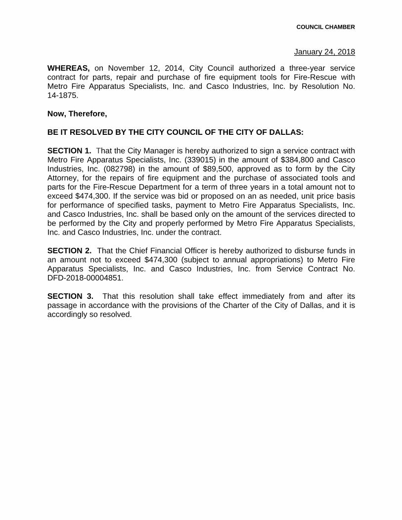
COUNCIL CHAMBER
January 24, 2018
WHEREAS, on November 12, 2014, City Council authorized a three-year service contract for parts, repair and purchase of fire equipment tools for Fire-Rescue with Metro Fire Apparatus Specialists, Inc. and Casco Industries, Inc. by Resolution No. 14-1875.
Now, Therefore,
BE IT RESOLVED BY THE CITY COUNCIL OF THE CITY OF DALLAS:
SECTION 1. That the City Manager is hereby authorized to sign a service contract with Metro Fire Apparatus Specialists, Inc. (339015) in the amount of $384,800 and Casco Industries, Inc. (082798) in the amount of $89,500, approved as to form by the City Attorney, for the repairs of fire equipment and the purchase of associated tools and parts for the Fire-Rescue Department for a term of three years in a total amount not to exceed $474,300. If the service was bid or proposed on an as needed, unit price basis for performance of specified tasks, payment to Metro Fire Apparatus Specialists, Inc. and Casco Industries, Inc. shall be based only on the amount of the services directed to be performed by the City and properly performed by Metro Fire Apparatus Specialists, Inc. and Casco Industries, Inc. under the contract.
SECTION 2. That the Chief Financial Officer is hereby authorized to disburse funds in an amount not to exceed $474,300 (subject to annual appropriations) to Metro Fire Apparatus Specialists, Inc. and Casco Industries, Inc. from Service Contract No. DFD-2018-00004851.
SECTION 3. That this resolution shall take effect immediately from and after its passage in accordance with the provisions of the Charter of the City of Dallas, and it is accordingly so resolved.


AGENDA ITEM # 19STRATEGIC PRIORITY:
Mobility Solutions, Infrastructure, and Sustainability
AGENDA DATE: January 24, 2018
COUNCIL DISTRICT(S): N/A
DEPARTMENT: Office of Procurement ServicesDepartment of Communication and Information Services
CMO: Elizabeth Reich, 670-7804Jody Puckett, 670-3390
MAPSCO: N/A________________________________________________________________
SUBJECT
Authorize a three-year service contract for mobile technology center managed services with GTS Technology Solutions, Inc. through the Department of Information Resources - Not to exceed $1,944,000 - Financing: Communication and Information Services Current Funds (subject to annual appropriations)
BACKGROUND
This service contract provides for mobile technology center managed services. Under this contract the vendor will supply qualified technicians to install mobile radio and technology for the Dallas Police Department, Fire-Rescue Department, EMS vehicles along with all other non-emergency vehicles. These services will allow for an increase in the number of units serviced each year and minimize the downtime of vehicles. Also included is radio repair and support to the 911 telephone system infrastructure as well as other services required by the mobile technology center. The contract allows for two shifts of technicians and a supervisor on a continuous basis, seven days a week and allows the mobile technology center to operate 24 hours a day.
The mobile technology center handles approximately 12,000 service tickets and performs over 300 new equipment installations per year.
PRIOR ACTION/REVIEW (COUNCIL, BOARDS, COMMISSIONS)
The Government Performance & Financial Management Committee will receive this item for consideration on January 16, 2018.
FISCAL INFORMATION
Communication and Information Services Current Funds - $1,944,000 (subject to annual appropriations)

Agenda Date 01/24/2018 - page 2
OWNER
GTS Technology Solutions, Inc.
Ryan Grant, PresidentScott Sizemore, Vice President

COUNCIL CHAMBER
January 24, 2018
BE IT RESOLVED BY THE CITY COUNCIL OF THE CITY OF DALLAS:
SECTION 1. That the City Manager is hereby authorized to sign a service contract with GTS Technology Solutions, Inc. (263234) through the Department of Information Resources, approved as to form by the City Attorney, for mobile technology center managed services for a term of three years, in an amount not to exceed $1,944,000. If the service was bid or proposed on an as needed, unit price basis for performance of specified tasks, payment to GTS Technology Solutions, Inc. shall be based only on the amount of the services directed to be performed by the City and properly performed by GTS Technology Solutions, Inc. under the contract.
SECTION 2. That the Chief Financial Officer is hereby authorized to disburse funds in an amount not to exceed $1,944,000 (subject to annual appropriations) to GTS Technology Solutions, Inc. from Service Contract No. DSV-2018-00004793.
SECTION 3. That this resolution shall take effect immediately from and after its passage in accordance with the provisions of the Charter of the City of Dallas, and it is accordingly so resolved.


AGENDA ITEM # 20STRATEGIC PRIORITY:
Government Performance and Financial Management
AGENDA DATE: January 24, 2018
COUNCIL DISTRICT(S): All
DEPARTMENT: Office of Procurement ServicesDepartment of Communication and Information ServicesPolice Department
CMO: Elizabeth Reich, 670-7804Jody Puckett, 670-3390Jon Fortune, 670-1204
MAPSCO: N/A________________________________________________________________
SUBJECT
Authorize a six-year service contract for upgrade, maintenance, and support of software to the Automated Fingerprint Identification System - NEC Corporation of America, sole source – Not to exceed $649,789 – Financing: General Funds (subject to annual appropriations)
BACKGROUND
This service contract will provide continued maintenance and support of the Automated Fingerprint Identification System (AFIS) utilized by the Dallas Police Department (DPD). Additionally, this contract will provide software and hardware to allow for a state mandated upgrade of the system.
AFIS is currently utilized by the Texas Department of Public Safety (TXDPS). The City's use of this system provides immediate access to a database of approximately six million fingerprint records. This database is the primary resource to which latent fingerprints are electronically compared.
DPD's AFIS Unit of the Crime Scene Response Section utilize the system for the identifications of suspects from crime scenes and provides critical information in criminal investigations and subsequent prosecutions.
TXDPS has mandated that all law enforcement agencies utilizing the AFIS system upgrade their software and workstation accessories by December 31, 2017 to maintain connectivity with TXDPS.

Agenda Date 01/24/2018 - page 2
BACKGROUND (continued)
On November 10, 2015, City Council authorized the wage floor rate of $10.94, by Resolution No. 15-2141; the selected vendor meets this requirement.
PRIOR ACTION/REVIEW (COUNCIL, BOARDS, COMMISSIONS)
On August 8, 2012, City Council authorized Supplemental Agreement No. 1 to increase the service contract with NEC Solutions, Inc. for maintenance and support for the Automated Fingerprint Identification System and to extend the term five years by Resolution No. 12-1884.
Information about this item will be provided to the Public Safety and Criminal Justice Committee on January 22, 2018.
FISCAL INFORMATION
General Funds - $649,789 (subject to annual appropriations)
M/WBE INFORMATION
The Office of Procurement Services did not contact any M/WBE or other vendors for this item because the recommend awardee has the exclusive licensing rights and is the sole source provider.
The awardee has fulfilled the good faith effort requirements set forth in the Business Inclusion and Development (BID) Plan adopted on October 22, 2008, by Resolution No. 08-2826, as amended.
BID INFORMATION
Bidder Address Amount
NEC Corporation of America 3929 W. John Carpenter Fwy. $649,789Irving, TX 75063
Note: The Office of Procurement Services conducted a sole source review and found no exceptions.
OWNER
NEC Corporation of America
Shinsuke Takahashi, President Taichiro Hashizawa, Vice President
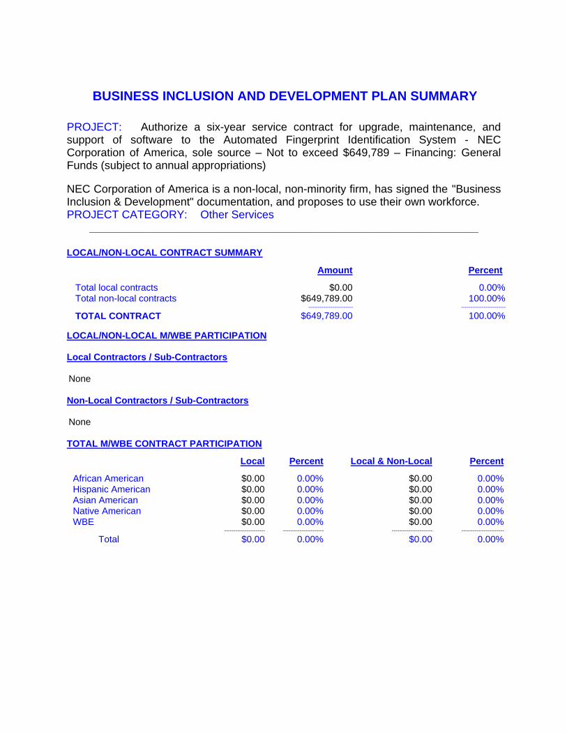
BUSINESS INCLUSION AND DEVELOPMENT PLAN SUMMARY
PROJECT: Authorize a six-year service contract for upgrade, maintenance, and support of software to the Automated Fingerprint Identification System - NEC Corporation of America, sole source – Not to exceed $649,789 – Financing: General Funds (subject to annual appropriations)
NEC Corporation of America is a non-local, non-minority firm, has signed the "Business Inclusion & Development" documentation, and proposes to use their own workforce. PROJECT CATEGORY: Other Services
_______________________________________________________________
LOCAL/NON-LOCAL CONTRACT SUMMARY
Amount Percent
Total local contracts $0.00 0.00%Total non-local contracts $649,789.00 100.00%
------------------------ ------------------------
TOTAL CONTRACT $649,789.00 100.00%
LOCAL/NON-LOCAL M/WBE PARTICIPATION
Local Contractors / Sub-Contractors
None
Non-Local Contractors / Sub-Contractors
None
TOTAL M/WBE CONTRACT PARTICIPATION
Local Percent Local & Non-Local Percent
African American $0.00 0.00% $0.00 0.00%Hispanic American $0.00 0.00% $0.00 0.00%Asian American $0.00 0.00% $0.00 0.00%Native American $0.00 0.00% $0.00 0.00%WBE $0.00 0.00% $0.00 0.00%
---------------------- ---------------------- ---------------------- -----------------------
Total $0.00 0.00% $0.00 0.00%

COUNCIL CHAMBER
January 24, 2018
WHEREAS, on August 8, 2012, City Council authorized Supplemental Agreement No. 1 to increase the service contract with NEC Solutions, Inc. for maintenance and support for the Automated Fingerprint Identification System and to extend the term five years by Resolution No. 12-1884; and
WHEREAS, on September 15, 2014, Administrative Action No. 14-6723 authorized Supplemental Agreement No. 2 to the service contract, with NEC Corporation of America to extend support for the Automated Fingerprint Identification System; and
WHEREAS, on August 10, 2017, Administrative Action No. 17-6431 authorized Supplemental Agreement No. 3 to the service contract, with NEC Corporation of America for hardware upgrade to the Automated Fingerprint Identification System workstations.
Now, Therefore,
BE IT RESOLVED BY THE CITY COUNCIL OF THE CITY OF DALLAS:
SECTION 1. That the City Manager is hereby authorized to sign a new service contract or a supplemental agreement to the existing contract, whichever provides more favorable terms for the City, with NEC Corporation of America (VS0000081029), approved as to form by the City Attorney, for upgrade, maintenance, and support of software to the Automated Fingerprint Identification System for a term of six years, in an amount not to exceed $649,789. If the service was bid or proposed on an as needed, unit price basis for performance of specified tasks, payment to NEC Corporation of America shall be based only on the amount of the services directed to be performed by the City and properly performed by NEC Corporation of America under the contract.
SECTION 2. That the Chief Financial Officer is hereby authorized to disburse funds in an amount not to exceed $649,789 (subject to annual appropriations) to NEC Corporation of America from Service Contract No. DSV-2017-00001886.
SECTION 3. That this resolution shall take effect immediately from and after its passage in accordance with the provisions of the Charter of the City of Dallas, and it is accordingly so resolved.

AGENDA ITEM # 21STRATEGIC PRIORITY:
Government Performance and Financial Management
AGENDA DATE: January 24, 2018
COUNCIL DISTRICT(S): 4
DEPARTMENT: Office of Procurement ServicesPark & Recreation Department
CMO: Elizabeth Reich, 670-7804Willis Winters, 670-4071
MAPSCO: 66 E________________________________________________________________
SUBJECT
Authorize (1) the rejection of the only proposal received for operational management of the Southern Skates Roller Skating Rink Facility; and (2) the re-advertisement for a new solicitation - Financing: No cost consideration to the City
BACKGROUND
This action will authorize the rejection of the only proposal received for solicitation BKZ1708 for a five-year service contract, with one five-year renewal option, for operational management of the Southern Skates Roller Skating Rink Facility. The Park and Recreation Department will modify the specifications. The Office of Procurement Services further determined it would be more advantageous to the City to reject the proposal and re-advertise for a new solicitation.
PRIOR ACTION/REVIEW (COUNCIL, BOARDS, COMMISSIONS)
Information about this item was provided to the Park Board via memorandum on December 19, 2017.
The Government Performance & Financial Management Committee will receive this item for consideration on January 16, 2018.
FISCAL INFORMATION
No cost consideration to the City.

COUNCIL CHAMBER
January 24, 2018
WHEREAS, it has been determined that it is in the best interest of the City of Dallas to reject the only proposal that was received for operational management of the Southern Skates Roller Skating Rink Facility.
Now, Therefore,
BE IT RESOLVED BY THE CITY COUNCIL OF THE CITY OF DALLAS:
SECTION 1. That the only proposal received for operational management of the Southern Skates Roller Skating Rink Facility is hereby rejected and authorization to advertise a new solicitation is granted.
SECTION 2. That this resolution shall take effect immediately from and after its passage in accordance with the provisions of the Charter of the City of Dallas, and it is accordingly so resolved.

AGENDA ITEM # 22STRATEGIC PRIORITY:
Government Performance and Financial Management
AGENDA DATE: January 24, 2018
COUNCIL DISTRICT(S): All
DEPARTMENT: Office of Procurement ServicesDepartment of Communication and Information ServicesDepartment of Sustainable Development and Construction
CMO: Elizabeth Reich, 670-7804Jody Puckett, 670-3390Majed Al-Ghafry, 670-3302
MAPSCO: N/A________________________________________________________________
SUBJECT
Authorize a five-year cooperative purchase agreement for the purchase, implementation, maintenance and support of a hosted electronic plan review system for Building Inspection provided by Avolve Software Corporation and sold through SHI Government Solutions, Inc. through the Texas Association of School Boards - Not to exceed $2,245,136 - Financing: General Funds (subject to annual appropriations)
BACKGROUND
This contract will provide for the purchase, implementation, maintenance and support of a hosted electronic plan review system. This web-based solution will provide a web portal to allow citizens to electronically submit building plans for review, apply, and pay fees for various building permits.
An automated system will add efficiency that will enable staff to receive building plans, conduct reviews, revise, track, inspect, and archive all documents electronically. The electronic plan review process will also provide additional efficiencies by enabling simultaneous review of specific plans by multiple trades, eliminating the current “one-at-a-time” review. Maintenance includes patches, updates, and technical support for five years.

Agenda Date 01/24/2018 - page 2
BACKGROUND (continued)
Building Inspection plan reviewers will be able to communicate with applicants through the new system’s web portal with questions and clarifications that they need from the applicant. The electronic plan review system will also allow the applicants to resubmit the applications and receive status without going to the City's Building Inspection office and thus receive status through the citizen portal. Additionally, the system will eliminate the need for paper documents which will help the City to shift the resources used to accept, sort, and store documents to other areas in the need of attention.
The Texas Association of School Boards (BuyBoard) conforms to the requirements of Texas statutes that are applicable for competitive bids and proposals, in accordance with the Interlocal Cooperation Act, Chapter 791, Texas Government Code. In addition, BuyBoard receives bids from manufacturers and dealers throughout the United States.
PRIOR ACTION/REVIEW (COUNCIL, BOARDS, COMMISSIONS)
The Government Performance & Financial Management Committee will receive this item for consideration on January 16, 2018.
FISCAL INFORMATION
General Funds - $2,245,136 (subject to annual appropriations)
OWNER
SHI Government Solutions, Inc.
Thai Lee, PresidentKoGuan Leo, Vice President

COUNCIL CHAMBER
January 24, 2018
BE IT RESOLVED BY THE CITY COUNCIL OF THE CITY OF DALLAS:
SECTION 1. The City Manager is hereby authorized to sign a cooperative purchase agreement provided by Avolve Software Corporation and sold through SHI Government Solutions, Inc. (502145) through the Texas Association of School Boards, approved as to form by the City Attorney, for the purchase, implementation, maintenance and support of a hosted electronic plan review system for a term of five years, in an amount not to exceed $2,245,136. If the service was bid or proposed on an as needed, unit price basis for performance of specified tasks, payment to SHI Government Solutions, Inc. shall be based only on the amount of the services directed to be performed by the City and properly performed by SHI Government Solutions, Inc. under the contract.
SECTION 2. That the Chief Financial Officer is hereby authorized to disburse funds in an amount not to exceed $2,245,136 (subject to annual appropriations) to SHI Government Solutions, Inc. from Service Contract No. DSV-2018-00004689.
Fund Department Unit Object Encumbrance Amount0150 DEV 3141 4735 DSV-2018-00004689 $1,377,2560150 DEV 3141 3110 DSV-2018-00004689 $ 867,880
SECTION 3. That this resolution shall take effect immediately from and after its passage in accordance with the provisions of the Charter of the City of Dallas, and it is accordingly so resolved.


AGENDA ITEM # 23STRATEGIC PRIORITY:
Government Performance and Financial Management
AGENDA DATE: January 24, 2018
COUNCIL DISTRICT(S): Outside City Limits
DEPARTMENT: Office of Procurement ServicesWater Utilities Department
CMO: Elizabeth Reich, 670-7804Majed Al-Ghafry, 670-3302
MAPSCO: 2T________________________________________________________________
SUBJECT
Authorize the purchase of two fiberglass chemical storage tanks for the Elm Fork Water Treatment Plant – Nautical Outfitters Corp. d/b/a Tank Depot, lowest responsible bidder of three - Not to exceed $93,500 - Financing: Water Utilities Current Funds
BACKGROUND
This purchase will provide two fiberglass chemical tanks for the Elm Fork Water Treatment Plant (EFWTP). Each tank is double walled and has the capacity to hold 12,000 gallons of phosphate which is used in the treatment of potable water. The current tanks are single walled and have reached their useful life. The EFWTP uses the phosphate to treat 330 million gallons of water daily.
As part of the solicitation process and in an effort to increase competition, the Office of Procurement Services used its procurement system to send out 165 email bid notifications to vendors registered under respective commodities. To further increase competition, the Office of Procurement Services uses historical solicitation information, the internet, and vendor contact information obtained from user departments to contact additional vendors by phone. Additionally, in an effort to secure more bids, the Office of Business Diversity's ResourceLINK Team sent notifications to 25 chambers of commerce and advocacy groups, to ensure maximum vendor outreach.
PRIOR ACTION/REVIEW (COUNCIL, BOARDS, COMMISSIONS)
The Government Performance & Financial Management Committee will receive this item for consideration on January 16, 2018.

Agenda Date 01/24/2018 - page 2
FISCAL INFORMATION
Water Utilities Current Funds - $93,500
M/WBE INFORMATION
15 - Vendors contacted15 - No response 0 - Response (Bid) 0 - Response (No Bid) 0 – Successful
The recommended awarded has fulfilled the good faith requirements set forth in the Business Inclusion and Development (BID) Plan adopted on October 22, 2008, by Resolution No. 08-2826, as amended.
BID INFORMATION
The Office of Procurement Services received the following bids from solicitation number BM1727. We opened them on August 25, 2017. We recommend the City Council award this purchase to the lowest responsive and responsible bidder by in its entirety. *Denotes successful bidder
Bidders Address Amount
*Nautical Outfitters Corp. 1627 S. Dixie Hwy. Line 1: $93,500d/b/a Tank Depot Pompano Beach, FL 33060
Plastic Watertanks.com, 361 Neptune Ave. West Line 1: $95,500Inc. Babylon, NY 11704
Climate Force, Inc. 6618 Club View Ct. Line 1: $244,420Flowery Beach, GA 30542
OWNER
Nautical Outfitters Corp. d/b/a Tank Depot
James Glen, President Bob Devire, Vice PresidentAnthony Lamb, Secretary

BUSINESS INCLUSION AND DEVELOPMENT PLAN SUMMARY
PROJECT: Authorize the purchase of two fiberglass chemical storage tanks for the Elm Fork Water Treatment Plant – Nautical Outfitters Corp. d/b/a Tank Depot, lowest responsible bidder of three - Not to exceed $93,500 - Financing: Water Utilities Current Funds
Nautical Outfitters Corp. d/b/a Tank Depot is a non-local, non-minority firm, has signed the "Business Inclusion & Development" documentation, and proposes to use their own workforce.PROJECT CATEGORY: Goods
_______________________________________________________________
LOCAL/NON-LOCAL CONTRACT SUMMARY
Amount Percent
Total local contracts $0.00 0.00%Total non-local contracts $93,500.00 100.00%
------------------------ ------------------------
TOTAL CONTRACT $93,500.00 100.00%
LOCAL/NON-LOCAL M/WBE PARTICIPATION
Local Contractors / Sub-Contractors
None
Non-Local Contractors / Sub-Contractors
None
TOTAL M/WBE CONTRACT PARTICIPATION
Local Percent Local & Non-Local Percent
African American $0.00 0.00% $0.00 0.00%Hispanic American $0.00 0.00% $0.00 0.00%Asian American $0.00 0.00% $0.00 0.00%Native American $0.00 0.00% $0.00 0.00%WBE $0.00 0.00% $0.00 0.00%
---------------------- ---------------------- ---------------------- -----------------------
Total $0.00 0.00% $0.00 0.00%

COUNCIL CHAMBER
January 24, 2018
BE IT RESOLVED BY THE CITY COUNCIL OF THE CITY OF DALLAS:
SECTION 1. That the purchase of two fiberglass chemical tanks for the Elm Fork Water Treatment Plant is authorized with Nautical Outfitters Corp. d/b/a Tank Depot (VC18085), in an amount not to exceed $93,500.
SECTION 2. That the Purchasing Agent is authorized, upon appropriate requisition, to issue a purchase order for two fiberglass chemical tanks for the Elm Fork Water Treatment Plant. If a formal contract is required for this purchase instead of a purchase order, the City Manager is hereby authorized to execute the contract, approved as to form by the City Attorney.
SECTION 3. That the Chief Financial Officer is hereby authorized to disburse funds, in an amount not to exceed $93,500, to Nautical Outfitters Corp. d/b/a Tank Depot from the following appropriations:
Fund Department Unit Object Amount Encumbrance/Contract No.
0100 DWU 7240 4720 $93,500 PO DWU-2018-00005125
SECTION 4. That this resolution shall take effect immediately from and after its passage in accordance with the provisions of the Charter of the City of Dallas, and it is accordingly so resolved.

AGENDA ITEM # 24STRATEGIC PRIORITY:
Government Performance and Financial Management
AGENDA DATE: January 24, 2018
COUNCIL DISTRICT(S): All
DEPARTMENT: Office of Procurement ServicesDepartment of Communication and Information Services
CMO: Elizabeth Reich, 670-7804Jody Puckett, 670-3390
MAPSCO: N/A________________________________________________________________
SUBJECT
Authorize a five-year subscription contract for the licensing, hosting, and technical support of a citywide enterprise asset management system with IBM Corporation through the Department of Information Resources, State of Texas Cooperative - Not to exceed $6,736,567 - Financing: Communication and Information Services Current Funds (subject to annual appropriations)
BACKGROUND
This subscription contract will provide licensing, hosting and technical support of a citywide enterprise asset management system. This system will provide the City with an efficient and fully integrated platform to monitor the operational use and sustainment of all capital assets with effective conditions assessment processes. Examples of capital assets include City buildings, streets, pipelines, treatment plants, facilities, and their associated subcomponents.
The consolidation of data, information and reporting in the new system will allow the City to make better informed decisions on asset use, sustainment and replacement. This new system will fully integrate the following vital functions into one comprehensive system:
The consolidation of all capital asset project management efforts including budgetingThe consolidation of all work orders, scheduling, and capital asset maintenance efforts The consolidation of all capital asset sustainment inventory management processesThe determination of capital asset needs prioritization and replacement decisions
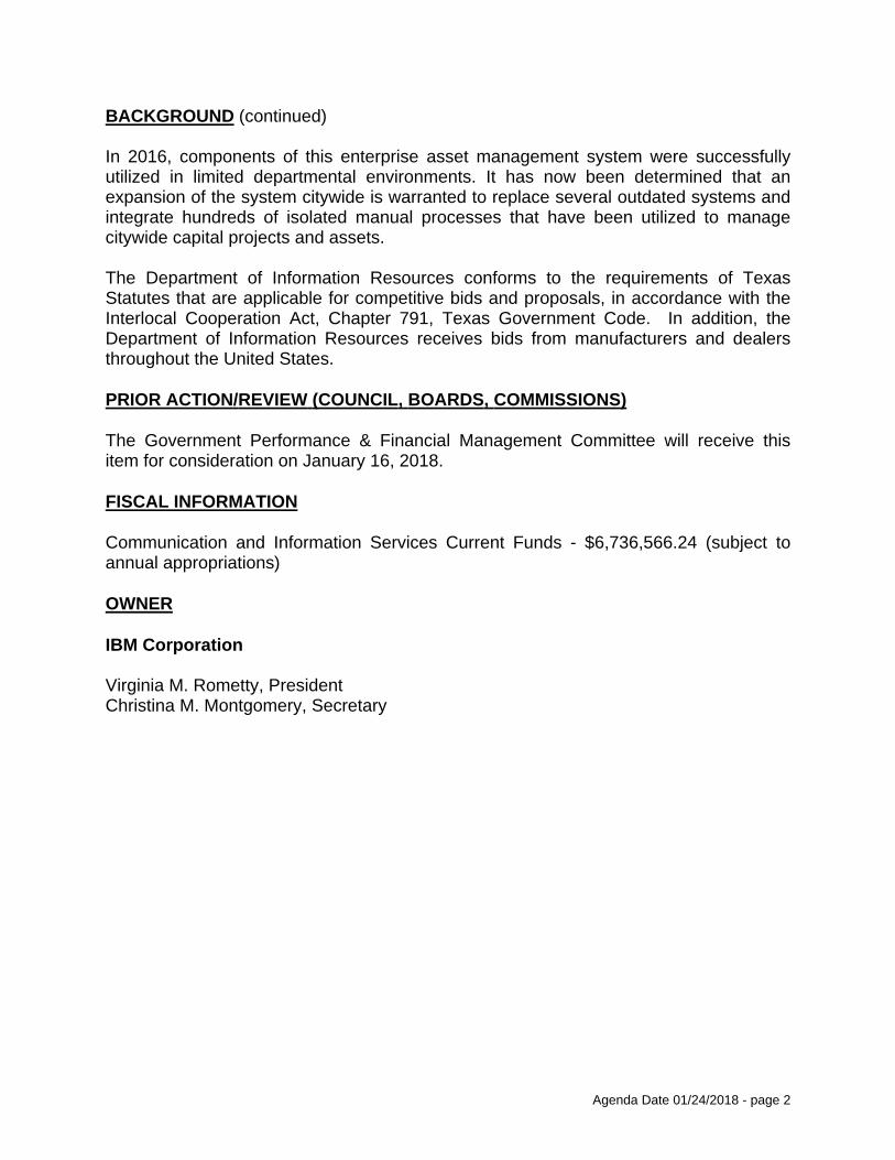
Agenda Date 01/24/2018 - page 2
BACKGROUND (continued)
In 2016, components of this enterprise asset management system were successfully utilized in limited departmental environments. It has now been determined that an expansion of the system citywide is warranted to replace several outdated systems and integrate hundreds of isolated manual processes that have been utilized to manage citywide capital projects and assets.
The Department of Information Resources conforms to the requirements of Texas Statutes that are applicable for competitive bids and proposals, in accordance with the Interlocal Cooperation Act, Chapter 791, Texas Government Code. In addition, the Department of Information Resources receives bids from manufacturers and dealers throughout the United States.
PRIOR ACTION/REVIEW (COUNCIL, BOARDS, COMMISSIONS)
The Government Performance & Financial Management Committee will receive this item for consideration on January 16, 2018.
FISCAL INFORMATION
Communication and Information Services Current Funds - $6,736,566.24 (subject to annual appropriations)
OWNER
IBM Corporation
Virginia M. Rometty, PresidentChristina M. Montgomery, Secretary

COUNCIL CHAMBER
January 24, 2018
BE IT RESOLVED BY THE CITY COUNCIL OF THE CITY OF DALLAS:
SECTION 1. That the City Manager is hereby authorized to sign a subscription contract with IBM Corporation (001003) through the Department of Information Resources, approved as to form by the City Attorney, for the licensing, hosting, and technical support of a citywide enterprise asset management system for a term of five years, in an amount not to exceed $6,736,566.24. If the service was bid or proposed on an as needed, unit price basis for performance of specified tasks, payment to IBM Corporation shall be based only on the amount of the services directed to be performed by the City and properly performed by IBM Corporation under the contract.
SECTION 2. That the Chief Financial Officer is hereby authorized to disburse funds in an amount not to exceed $6,736,566.24 (subject to annual appropriations) to IBM Corporation from Service Contract No. DSV-2018-00004698.
SECTION 3. That this resolution shall take effect immediately from and after its passage in accordance with the provisions of the Charter of the City of Dallas, and it is accordingly so resolved.


AGENDA ITEM # 25STRATEGIC PRIORITY:
Government Performance and Financial Management
AGENDA DATE: January 24, 2018
COUNCIL DISTRICT(S): All
DEPARTMENT: Office of Procurement ServicesWater Utilities Department
CMO: Elizabeth Reich, 670-7804Majed Al-Ghafry, 670-3302
MAPSCO: N/A________________________________________________________________
SUBJECT
Authorize a three-year master agreement for fire hydrant backflow preventers and parts – Ferguson Enterprises, Inc. in the amount of $173,825, Fortiline, Inc. in the amount of $45,063, and Core & Main, LP in the amount of $3,000, lowest responsible bidders of seven - Total not to exceed $221,888 - Financing: Water Utilities Current Funds
BACKGROUND
This action does not encumber funds; the purpose of a master agreement is to establish firm pricing for goods, for a specific term, which are ordered on an as needed basis.
This master agreement will provide fire hydrant backflow preventers and parts for the Water Utilities Department. The backflow preventers restrict the reverse flow of non-potable water into the water supply through the fire hydrants. Backflow preventers provided under this contract will be used to replace old and worn out models and any preventers damaged beyond repair. This contract will also provide replacement parts for general maintenance of backflow preventers. The average life expectancy of the backflow preventer is approximately 3 years.
Additionally under a licensing/leasing program the City supplies backflow preventers to the commercial customer for construction projects, demolition, and special events. Currently the City manages approximately 800 accounts which require this equipment. A customer applies for a permit and is required to place a deposit for use of the backflow preventer. The customer is charged a monthly service fee for the use of the equipment.

Agenda Date 01/24/2018 - page 2
BACKGROUND (continued)
As part of the solicitation process and in an effort to increase competition, the Office of Procurement Services used its procurement system to send out 526 email bid notifications to vendors registered under respective commodities. To further increase competition, the Office of Procurement Services uses historical solicitation information, the internet, and vendor contact information obtained from user departments to contact additional vendors by phone. Additionally, in an effort to secure more bids, the Office of Business Diversity's ResourceLINK Team sent notifications to 25 chambers of commerce and advocacy groups to ensure maximum vendor outreach.
PRIOR ACTION/REVIEW (COUNCIL, BOARDS, COMMISSIONS)
On August 27, 2014, City Council authorized a three-year master agreement for fire hydrant backflow preventers, parts and water security plugs for Water Utilities with Fortiline, Inc., McGard, LLC, American Backflow Products Company, and Test Gauge & Backflow Supply, Inc. by Resolution No. 14-1351.
The Government Performance & Financial Management Committee will receive this item for consideration on January 16, 2018.
FISCAL INFORMATION
Water Utilities Current Funds - $221,887.30
M/WBE INFORMATION
67 - Vendors contacted67 - No response 0 - Response (Bid) 0 - Response (No Bid) 0 - Successful
The recommended awardees have fulfilled the good faith requirements set forth in the Business Inclusion and Development (BID) Plan adopted on October 22, 2008, by Resolution No. 08-2826, as amended.
BID INFORMATION
The Office of Procurement Services received the following bids from solicitation number BM1724. We opened them on September 15, 2017. We recommend the City Council award this master agreement to the lowest responsive and responsible bidders by line. Information related to this solicitation is available upon request.

Agenda Date 01/24/2018 - page 3
BID INFORMATION (continued)
*Denotes successful bidders
Bidders Address Amount
*Ferguson Enterprises, 7982 Highway 69 N Multiple LinesInc. Tyler, TX 75706
*Fortiline, Inc. 11200 Seagoville Rd. Multiple LinesBalch Springs, TX 75180
*Core & Main, LP 4333 Irving Blvd. Multiple LinesDallas, TX 75247
Act Pipe & Supply, Inc. 1888 W. Northwest Hwy. Multiple Lines
Dallas TX 75220
Test Gauge & Backflow 3321 Garden Brook Dr. Multiple LinesSupply, Inc. Farmers Branch, TX 75234
Best Plumbing 3039 Vemtrie Ct. Multiple LinesSpecialties, Inc. Myersville, MD 21773
Texas Irrigation Supply 16813 Joe Barbee Dr. Multiple LinesRound Rock, TX 78664
OWNERS
Ferguson Enterprises, Inc.
Kevin Murphy, President Bill Thees Jr., President
Fortiline, Inc.
Frank Seymour, PresidentBen Cagle, Vice President Jason Painter, Secretary
Core & Main, LP
Steve LeClair, President Chuck Zappola, Vice President
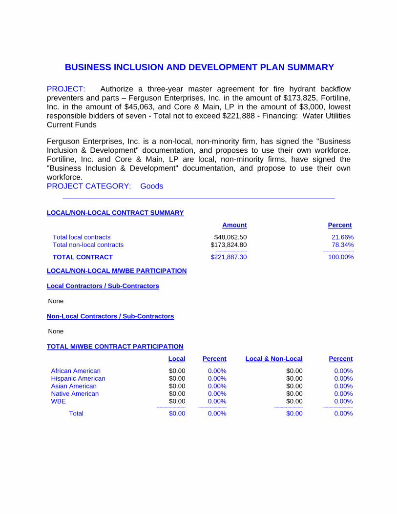
BUSINESS INCLUSION AND DEVELOPMENT PLAN SUMMARY
PROJECT: Authorize a three-year master agreement for fire hydrant backflow preventers and parts – Ferguson Enterprises, Inc. in the amount of $173,825, Fortiline, Inc. in the amount of $45,063, and Core & Main, LP in the amount of $3,000, lowest responsible bidders of seven - Total not to exceed $221,888 - Financing: Water Utilities Current Funds
Ferguson Enterprises, Inc. is a non-local, non-minority firm, has signed the "Business Inclusion & Development" documentation, and proposes to use their own workforce. Fortiline, Inc. and Core & Main, LP are local, non-minority firms, have signed the "Business Inclusion & Development" documentation, and propose to use their own workforce.PROJECT CATEGORY: Goods
_______________________________________________________________
LOCAL/NON-LOCAL CONTRACT SUMMARY
Amount Percent
Total local contracts $48,062.50 21.66%Total non-local contracts $173,824.80 78.34%
------------------------ ------------------------
TOTAL CONTRACT $221,887.30 100.00%
LOCAL/NON-LOCAL M/WBE PARTICIPATION
Local Contractors / Sub-Contractors
None
Non-Local Contractors / Sub-Contractors
None
TOTAL M/WBE CONTRACT PARTICIPATION
Local Percent Local & Non-Local Percent
African American $0.00 0.00% $0.00 0.00%Hispanic American $0.00 0.00% $0.00 0.00%Asian American $0.00 0.00% $0.00 0.00%Native American $0.00 0.00% $0.00 0.00%WBE $0.00 0.00% $0.00 0.00%
---------------------- ---------------------- ---------------------- -----------------------
Total $0.00 0.00% $0.00 0.00%

COUNCIL CHAMBER
January 24, 2018
WHEREAS, on August 27, 2014, City Council authorized a three-year master agreement for fire hydrant backflow preventers, parts and water security plugs for Water Utilities with Fortiline, Inc., McGard, LLC, American Backflow Products Company, and Test Gauge & Backflow Supply, Inc. by Resolution No. 14-1351.
Now, Therefore,
BE IT RESOLVED BY THE CITY COUNCIL OF THE CITY OF DALLAS:
SECTION 1. That the City Manager is hereby authorized to sign a master agreement with Ferguson Enterprises, Inc. (VS87161) in the amount of $173,824.80, Fortiline, Inc. (VS0000073028) in the amount of $45,062.50, and Core & Main, LP (VS0000038746) in the amount of $3,000.00, approved as to form by the City Attorney, for the purchase of fire hydrant backflow preventers and parts for a term of three years in a total amount not to exceed $221,887.30.
SECTION 2. That the Purchasing Agent is authorized, upon appropriate request and documented need by a user department, to issue a purchase order for fire hydrant backflow preventers and parts. If a written contract is required or requested for any or all purchases of fire hydrant backflow preventers and parts under the master agreement instead of individual purchase orders, the City Manager is authorized to execute the contract, upon approval as to form by the City Attorney.
SECTION 3. That the Chief Financial Officer is hereby authorized to disburse funds in an amount not to exceed $221,887.30 to Ferguson Enterprises, Inc., Fortiline, Inc., and Core & Main, LP from Master Agreement Contract No. DWU-2018-00005133.
SECTION 4. That this resolution shall take effect immediately from and after its passage in accordance with the provisions of the Charter of the City of Dallas, and it is accordingly so resolved.


AGENDA ITEM # 26STRATEGIC PRIORITY:
Government Performance and Financial Management
AGENDA DATE: January 24, 2018
COUNCIL DISTRICT(S): All
DEPARTMENT: Office of Procurement ServicesWater Utilities Department
CMO: Elizabeth Reich, 670-7804Majed Al-Ghafry, 670-3302
MAPSCO: N/A________________________________________________________________
SUBJECT
Authorize a three-year master agreement for aeration basin diffusers and parts for Water Utilities - Evoqua Water Technologies, LLC in the amount of $1,065,000, Environmental Dynamics International, Inc. in the amount of $504,400, Hartwell Environmental Corporation in the amount of $240,800 and Simba Industries in the amount of $112,650, lowest responsible bidders of four - Total not to exceed $1,922,850 - Financing: Water Utilities Current Funds
BACKGROUND
This action does not encumber funds; the purpose of a master agreement is to establish firm pricing for goods, for a specific term, which are ordered on an as needed basis.
This master agreement will enable Water Utilities (DWU) to purchase aeration basin diffusers and parts. Air diffusers are flexible membranes with small holes that allow air to be distributed in a controlled manner in order to maintain consistent oxygen levels throughout the basins. This air distribution is essential for the proper development of micro-organisms and the processing of sludge. Over time, the membranes wear out and begin to tear, at which time the diffusers are replaced. Materials provided by this agreement will allow for the replacement and maintenance of existing diffusers for activated sludge basins at the City’s wastewater treatment plants as needed. DWU currently has approximately 4,600 diffusers in service which aide in the average daily flow treatment of 150 million gallons of wastewater.
As part of the solicitation process and in an effort to increase competition, the Office of Procurement Services used its procurement system to send out 257 email bid notifications to vendors registered under respective commodities.

Agenda Date 01/24/2018 - page 2
BACKGROUND (continued)
To further increase competition, the Office of Procurement Services uses historical solicitation information, the internet, and vendor contact information obtained from user departments to contact additional vendors by phone. Additionally, in an effort to secure more bids, the Office of Business Diversity's ResourceLINK Team sent notifications to 25 chambers of commerce and advocacy groups to ensure maximum vendor outreach.
PRIOR ACTION/REVIEW (COUNCIL, BOARDS, COMMISSIONS)
On January 28, 2015, City Council authorized a three-year master agreement for air diffusers and parts for sludge basins at wastewater treatment plants by Resolution No. 15-0159.
The Government Performance & Financial Management Committee will receive this item for consideration on January 16, 2018.
FISCAL INFORMATION
Water Utilities Current Funds - $1,922,849.50
M/WBE INFORMATION
29 - Vendors contacted28 - No response 1 - Response (Bid) 0 - Response (No Bid) 1 - Successful
The recommended awardees have fulfilled the good faith requirements set forth in the Business Inclusion and Development (BID) Plan adopted on October 22, 2008, by Resolution No. 08-2826, as amended.
BID INFORMATION
The Office of Procurement Services received the following bids from solicitation number BM1731. We opened them on September 29, 2017. We recommend the City Council award this master agreement to the lowest responsive and responsible bidders by line. Information related to this solicitation is available upon request.
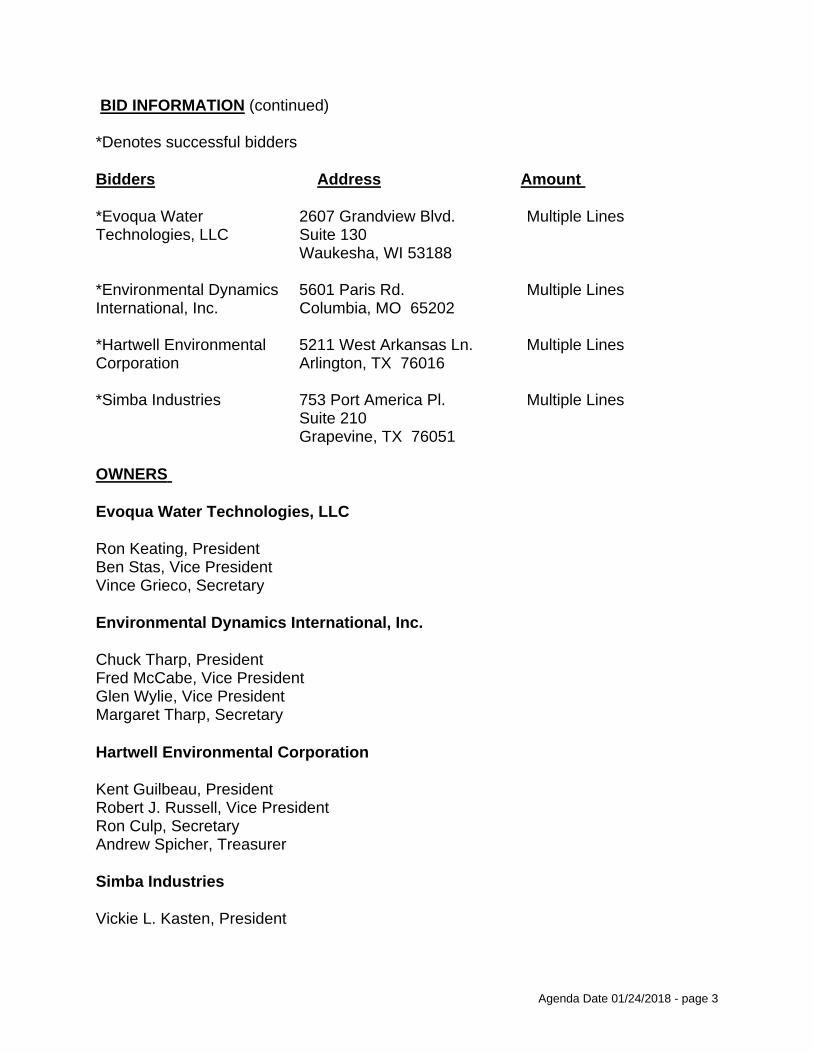
Agenda Date 01/24/2018 - page 3
BID INFORMATION (continued)
*Denotes successful bidders
Bidders Address Amount
*Evoqua Water 2607 Grandview Blvd. Multiple LinesTechnologies, LLC Suite 130
Waukesha, WI 53188
*Environmental Dynamics 5601 Paris Rd. Multiple LinesInternational, Inc. Columbia, MO 65202
*Hartwell Environmental 5211 West Arkansas Ln. Multiple LinesCorporation Arlington, TX 76016
*Simba Industries 753 Port America Pl. Multiple LinesSuite 210Grapevine, TX 76051
OWNERS
Evoqua Water Technologies, LLC
Ron Keating, President Ben Stas, Vice President Vince Grieco, Secretary
Environmental Dynamics International, Inc.
Chuck Tharp, President Fred McCabe, Vice President Glen Wylie, Vice PresidentMargaret Tharp, Secretary
Hartwell Environmental Corporation
Kent Guilbeau, President Robert J. Russell, Vice PresidentRon Culp, Secretary Andrew Spicher, Treasurer
Simba Industries
Vickie L. Kasten, President

BUSINESS INCLUSION AND DEVELOPMENT PLAN SUMMARY
PROJECT: Authorize a three-year master agreement for aeration basin diffusers and parts for Water Utilities - Evoqua Water Technologies, LLC in the amount of $1,065,000, Environmental Dynamics International, Inc. in the amount of $504,400, Hartwell Environmental Corporation in the amount of $240,800 and Simba Industries in the amount of $112,650, lowest responsible bidders of four - Total not to exceed $1,922,850 - Financing: Water Utilities Current Funds
Evoqua Water Technologies, LLC is a local, non-minority firm, has signed the "Business Inclusion & Development" documentation, and proposes to use their own workforce. Environmental Dynamics International, Inc. and Hartwell Environmental Corporation are non-local, non-minority firms, have signed the "Business Inclusion & Development" documentation, and propose to use their own workforce. Simba Industries is a local, minority firm, has signed the "Business Inclusion & Development" documentation, and proposes to use their own workforce.PROJECT CATEGORY: Goods
_______________________________________________________________
LOCAL/NON-LOCAL CONTRACT SUMMARY
Amount Percent
Total local contracts $1,682,049.50 87.48%Total non-local contracts $240,800.00 12.52%
------------------------ ------------------------
TOTAL CONTRACT $1,922,849.50 100.00%
LOCAL/NON-LOCAL M/WBE PARTICIPATION
Local Contractors / Sub-Contractors
None
Non-Local Contractors / Sub-Contractors
None
TOTAL M/WBE CONTRACT PARTICIPATION
Local Percent Local & Non-Local Percent
African American $0.00 0.00% $0.00 0.00%Hispanic American $0.00 0.00% $0.00 0.00%Asian American $0.00 0.00% $0.00 0.00%Native American $0.00 0.00% $0.00 0.00%WBE $0.00 0.00% $0.00 0.00%
---------------------- ---------------------- ---------------------- -----------------------
Total $0.00 0.00% $0.00 0.00%

COUNCIL CHAMBER
January 24, 2018
WHEREAS, on January 28, 2015, City Council authorized a three-year master agreement for air diffusers and parts for sludge basins at wastewater treatment plants by Resolution No. 15-0159.
Now, Therefore,
BE IT RESOLVED BY THE CITY COUNCIL OF THE CITY OF DALLAS:
SECTION 1. That the City Manager is hereby authorized to sign a master agreement with Evoqua Water Technologies, LLC (VC15753) in the amount of $1,065,000.00, Environmental Dynamics International, Inc. (500845) in the amount of $504,400.00, Hartwell Environmental Corporation (359127) in the amount of $240,800.00 and Simba Industries (519720) in the amount of $112,649.50, approved as to form by the City Attorney, for the purchase of aeration basin diffusers and parts for Water Utilities for a term of three-years in a total amount not to exceed $1,922,849.50.
SECTION 2. That the Purchasing Agent is authorized, upon appropriate request and documented need by a user department, to issue a purchase order for aeration basin diffusers and parts for Water Utilities. If a written contract is required or requested for any or all purchases of aeration basin diffusers and parts for Water Utilities under the master agreement instead of individual purchase orders, the City Manager is authorized to execute the contract, approved as to form by the City Attorney.
SECTION 3. That the Chief Financial Officer is hereby authorized to disburse funds in an amount not to exceed $1,922,849.50 from Master Agreement No. DWU-2018-00005154.
SECTION 4. That this resolution shall take effect immediately from and after its passage in accordance with the provisions of the Charter of the City of Dallas, and it is accordingly so resolved.


AGENDA ITEM # 27STRATEGIC PRIORITY:
Government Performance and Financial Management
AGENDA DATE: January 24, 2018
COUNCIL DISTRICT(S): All
DEPARTMENT: Office of Procurement ServicesDepartment of Convention and Event ServicesDepartment of Trinity Watershed ManagementWater Utilities DepartmentDepartment of Equipment and Building ServicesDepartment of Street ServicesFire-Rescue DepartmentPark & Recreation DepartmentPolice Department
CMO: Elizabeth Reich, 670-7804Joey Zapata, 670-3009Jody Puckett, 670-3390Majed Al-Ghafry, 670-3302Jon Fortune, 670-1204
MAPSCO: N/A________________________________________________________________
SUBJECT
Authorize a three-year master agreement for service center supplies, equipment, and tools - IEH Auto Parts LLC dba Auto Plus Auto Parts in the amount of $2,010,098 and Midway Auto Supply Co. in the amount of $451,885, lowest responsible bidders of three - Total not to exceed $2,461,983 - Financing: Equipment Services Current Funds ($1,408,773), General Funds ($631,200), Water Utilities Current Funds ($281,610), Stormwater Drainage Management Current Funds ($91,000), and Convention and Event Services Current Funds ($49,400)
BACKGROUND
This action does not encumber funds; the purpose of a master agreement is to establish firm pricing for goods, for a specific term, which are ordered on an as needed basis.
This master agreement will be used citywide and provides for service center supplies, equipment, and tools. The service center supplies, equipment, and tools master agreement includes items such as lubricants, aerosols, and drive belts, as well as pneumatic, hand, and power tools, which will be used in over 15 facilities to repair and maintain a fleet of over 5,480 vehicles.

Agenda Date 01/24/2018 - page 2
BACKGROUND (continued)
Service centers repair City equipment such as:
Civilian service vehicles
Police vehicles
Fire vehicles
Heavy equipment Lawn equipment
As part of the solicitation process and in an effort to increase competition, the Office of Procurement Services used its procurement system to send out 209 email bid notifications to vendors registered under respective commodities. To further increase competition, the Office of Procurement Services uses historical solicitation information, the internet, and vendor contact information obtained from user departments to contact additional vendors by phone. Additionally, in an effort to secure more bids, the Office of Business Diversity's ResourceLINK Team sent notifications to 25 chambers of commerce and advocacy groups to ensure maximum vendor outreach.
PRIOR ACTION/REVIEW (COUNCIL, BOARDS, COMMISSIONS)
The Government Performance & Financial Management Committee will receive this item for consideration on January 16, 2018.
FISCAL INFORMATION
Equipment Services Current Funds – $1,408,773General Funds – $631,200Water Utilities Current Funds – $281,610Stormwater Drainage Management Current Funds – $91,000Convention and Event Services Current Funds – $49,400
M/WBE INFORMATION
19 - Vendors contacted19 - No response 0 - Response (Bid) 0 - Response (No Bid) 0 - Successful
The awardees have fulfilled the good faith effort requirements set forth in the Business Inclusion and Development Plan adopted on October 22, 2008, by Resolution No. 08-2826, as amended.

Agenda Date 01/24/2018 - page 3
BID INFORMATION
The Office of Procurement Services received the following bids from solicitation number BR1716. We opened them on November 10, 2017. We recommend the City Council award this master agreement to the lowest responsive and responsible bidders by line. Information related to this solicitation is available upon request.
*Denotes successful bidders
Bidders Address Amount
*IEH Auto Parts LLC dba 901 N. Lenola Rd. Multiple LinesAuto Plus Auto Parts Moorestown, NJ 08057
*Midway Auto Supply Co. 1101 S. Hampton Rd. Multiple LinesDallas, TX 75208
Installers Sales & Service 3030 Lincoln Ct. Multiple LinesGarland, TX 75041
OWNERS
IEH Auto Parts LLC dba Auto Plus Auto Parts
Dan Ninivaggi, Chief Executive Officer
Midway Auto Supply Co.
Martin Levine, PresidentSteve Levine, Vice PresidentHerb Levine, SecretaryLarry Levine, Treasurer

BUSINESS INCLUSION AND DEVELOPMENT PLAN SUMMARY
PROJECT: Authorize a three-year master agreement for service center supplies, equipment, and tools - IEH Auto Parts LLC dba Auto Plus Auto Parts in the amount of $2,010,098 and Midway Auto Supply Co. in the amount of $451,885, lowest responsible bidders of three - Total not to exceed $2,461,983 - Financing: Equipment Services Current Funds ($1,408,773), General Funds ($631,200), Water Utilities Current Funds ($281,610), Stormwater Drainage Management Current Funds ($91,000), and Convention and Event Services Current Funds ($49,400)
Midway Auto Supply Co. is a local, non-minority firm, has signed the "Business Inclusion & Development" documentation, and proposes to use their own workforce. IEH Auto Parts LLC dba Auto Plus Auto Parts is a non-local, non-minority firm, has signed the "Business Inclusion & Development" documentation, and proposes to use their own workforce.PROJECT CATEGORY: Goods
_______________________________________________________________
LOCAL/NON-LOCAL CONTRACT SUMMARY
Amount Percent
Total local contracts $451,885.00 18.35%Total non-local contracts $2,010,098.00 81.65%
------------------------ ------------------------
TOTAL CONTRACT $2,461,983.00 100.00%
LOCAL/NON-LOCAL M/WBE PARTICIPATION
Local Contractors / Sub-Contractors
None
Non-Local Contractors / Sub-Contractors
None
TOTAL M/WBE CONTRACT PARTICIPATION
Local Percent Local & Non-Local Percent
African American $0.00 0.00% $0.00 0.00%Hispanic American $0.00 0.00% $0.00 0.00%Asian American $0.00 0.00% $0.00 0.00%Native American $0.00 0.00% $0.00 0.00%WBE $0.00 0.00% $0.00 0.00%
---------------------- ---------------------- ---------------------- -----------------------
Total $0.00 0.00% $0.00 0.00%

COUNCIL CHAMBER
January 24, 2018
BE IT RESOLVED BY THE CITY COUNCIL OF THE CITY OF DALLAS:
SECTION 1. That the City Manager is hereby authorized to sign a master agreement with IEH Auto Parts LLC dba Auto Plus Auto Parts (VS91623) in the amount of $2,010,098 and Midway Auto Supply Co. (006372) in the amount of $451,885, approved as to form by the City Attorney, for the purchase of service center supplies, equipment, and tools for a term of three years in a total amount not to exceed $2,461,983.
SECTION 2. That the Purchasing Agent is authorized, upon appropriate request and documented need by a user department, to issue a purchase order for service center supplies, equipment, and tools. If a written contract is required or requested for any or all purchases of service center supplies, equipment, and tools under the master agreement instead of individual purchase orders, the City Manager is hereby authorized to execute a contract, approved as to form by the City Attorney.
SECTION 3. That the Chief Financial Officer is hereby authorized to disburse funds in an amount not to exceed $2,461,983 to IEH Auto Parts LLC dba Auto Plus Auto Parts and Midway Auto Supply Co. from Master Agreement Contract No. POM-2018-00005181.
SECTION 4. That this resolution shall take effect immediately from and after its passage in accordance with the provisions of the Charter of the City of Dallas, and it is accordingly so resolved.


AGENDA ITEM # 28STRATEGIC PRIORITY:
Public Safety
AGENDA DATE: January 24, 2018
COUNCIL DISTRICT(S): All
DEPARTMENT: Office of Procurement ServicesDepartment of Dallas Animal Services
CMO: Elizabeth Reich, 670-7804Nadia Chandler Hardy, 670-1611
MAPSCO: N/A________________________________________________________________
SUBJECT
Authorize a three-year master agreement for veterinary drugs and supplies consisting of medications, preventatives, vaccines, diagnostic tests, and supplies for the Department of Dallas Animal Services - Bayer HealthCare, LLC in the amount of $2,254,266 or $2,092,817 (Tie Bid – Line 3), MWI Veterinary Supply Co dba MWI Animal Health in the amount of $997,808 or $836,360 (Tie Bid – Line 3), and Harris Pharmaceutical, Inc. in the amount of $40,000, lowest responsible bidders of three - Total not to exceed $3,130,626 - Financing: General Funds
BACKGROUND
This action does not encumber funds; the purpose of a master agreement is to establish firm pricing for goods, for a specific term, which are ordered on an as needed basis.
This master agreement will allow the Department of Dallas Animal Services (shelter) to purchase veterinary drugs and supplies consisting of medications, preventatives, vaccines, diagnostic tests, and supplies for the care of the shelter animals. Medications to be purchased under this agreement range from vaccines to heartworm prevention drugs. These medications will be administered by the shelter’s in-house veterinarians.
The shelter houses and cares for over 600 animals daily and takes in an average of 75 cats and dogs per day. Other animals received at the shelter include livestock, exotic animals, and wildlife. Each animal is examined upon arrival and treated based on the animal’s needs; treatment is provided until it is no longer necessary or until the animal leaves the shelter. Each adopted animal is required to be vaccinated as well as spayed/neutered prior to leaving the facility.

Agenda Date 01/24/2018 - page 2
BACKGROUND (continued)
As part of the solicitation process and in an effort to increase competition, the Office of Procurement Services used its procurement system to send out 432 email bid notifications to vendors registered under respective commodities. To further increase competition, the Office of Procurement Services uses historical solicitation information, the internet, and vendor contact information obtained from user departments to contact additional vendors by phone. Additionally, in an effort to secure more bids, the Office of Business Diversity's ResourceLINK Team sent notifications to 25 chambers of commerce and advocacy groups, to ensure maximum vendor outreach.
PRIOR ACTION/REVIEW (COUNCIL, BOARDS, COMMISSIONS)
On October 23, 2013, City Council authorized a three-year master agreement for the purchase of veterinary drugs and supplies with Butler Schein Animal Health, Bayer Animal Health, and Neogen Corporation by Resolution No. 13-1819.
The Government Performance & Financial Management Committee will receive this item for consideration on January 16, 2018.
FISCAL INFORMATION
General Funds - $3,130,625.08
M/WBE INFORMATION
43 - Vendors contacted43 - No response 0 - Response (Bid) 0 - Response (No Bid) 0 - Successful
The awardees have fulfilled the good faith effort requirements set forth in the Business Inclusion and Development (BID) Plan adopted on October 22, 2008, by Resolution No. 08-2826, as amended.
BID INFORMATION
The Office of Procurement Services received the following bids from solicitation number BV1706. We opened them on July 14, 2017. We recommend the City Council award this master agreement to the lowest responsive and responsible bidders by lines. Information related to this solicitation is available upon request.

Agenda Date 01/24/2018 - page 3
BID INFORMATION (continued)
*Denotes successful bidders
Bidders Address Amount
*Bayer HealthCare, 12707 W. 63rd St. Multiple LinesLLC Shawnee, KS 66216
*MWI Veterinary Supply 3041 W. Pasadena Dr. Multiple LinesCo dba MWI Animal Boise, ID 83705Health
*Harris Pharmaceutical, 9090 Park Royal Dr. Multiple LinesInc. Ft. Myers, FL 33909
OWNERS
Bayer HealthCare, LLC
Daniel Apel, PresidentRaymond F. Kerins, Jr, Vice PresidentJessica Monachello, SecretaryTracy E. Spagnol, Treasurer
MWI Veterinary Supply Co dba MWI Animal Health
Mark Shaw, PresidentJohn Ryan, Vice President
Harris Pharmaceutical, Inc.
Janice Harris, PresidentSusan King, Vice President

BUSINESS INCLUSION AND DEVELOPMENT PLAN SUMMARY
PROJECT: Authorize a three-year master agreement for veterinary drugs and supplies consisting of medications, preventatives, vaccines, diagnostic tests, and supplies for the Department of Dallas Animal Services - Bayer HealthCare, LLC in the amount of $2,254,266 or $2,092,817 (Tie Bid – Line 3), MWI Veterinary Supply Co dba MWI Animal Health in the amount of $997,808 or $836,360 (Tie Bid – Line 3), and Harris Pharmaceutical, Inc. in the amount of $40,000, lowest responsible bidders of three - Total not to exceed $3,130,626 - Financing: General Funds
Bayer HealthCare, LLC, MWI Veterinary Supply Co dba MWI Animal Health, and Harris Pharmaceutical, Inc. are non-local, non-minority firms, have signed the "Business Inclusion & Development" documentation, and propose to use their own workforce.PROJECT CATEGORY: Goods
_______________________________________________________________
LOCAL/NON-LOCAL CONTRACT SUMMARY
Amount Percent
Total local contracts $0.00 0.00%Total non-local contracts $3,130,625.08 100.00%
------------------------ ------------------------
TOTAL CONTRACT $3,130,625.08 100.00%
LOCAL/NON-LOCAL M/WBE PARTICIPATION
Local Contractors / Sub-Contractors
None
Non-Local Contractors / Sub-Contractors
None
TOTAL M/WBE CONTRACT PARTICIPATION
Local Percent Local & Non-Local Percent
African American $0.00 0.00% $0.00 0.00%Hispanic American $0.00 0.00% $0.00 0.00%Asian American $0.00 0.00% $0.00 0.00%Native American $0.00 0.00% $0.00 0.00%WBE $0.00 0.00% $0.00 0.00%
---------------------- ---------------------- ---------------------- -----------------------
Total $0.00 0.00% $0.00 0.00%

COUNCIL CHAMBER
January 24, 2018
WHEREAS, on October 23, 2013, City Council authorized a three-year master agreement for the purchase of veterinary drugs and supplies with Butler Schein Animal Health, Bayer Animal Health, and Neogen Corporation, by Resolution No. 13-1819.
Now, Therefore,
BE IT RESOLVED BY THE CITY COUNCIL OF THE CITY OF DALLAS:
SECTION 1. That the City Manager is hereby authorized to sign a master agreement with Bayer HealthCare, LLC (358123) in the amount of $2,254,265.75 or $2,092,817.00 (Tie Bid – Line 3), MWI Veterinary Supply Co dba MWI Animal Health (VS0000035134) in the amount of $997,808.00 or $836,359.25 (Tie Bid – Line 3), and Harris Pharmaceutical, Inc. (VS94509) in the amount of $40,000.08, approved as to form by the City Attorney, for the purchase of veterinary drugs and supplies consisting of medications, preventatives, vaccines, diagnostic tests, and supplies for the Department of Dallas Animal Services for a term of three years in a total amount not to exceed $3,130,625.08.
SECTION 2. That the Purchasing Agent is authorized, upon appropriate request and documented need by a user department, to issue a purchase order for veterinary drugs and supplies consisting of medications, preventatives, vaccines, diagnostic tests, and supplies for the Department of Dallas Animal Services. If a written contract is required or requested for any or all purchases of veterinary drugs and supplies consisting of medications, preventatives, vaccines, diagnostic tests, and supplies for the Department of Dallas Animal Services under the master agreement instead of individual purchase orders, the City Manager is hereby authorized to execute a contract, approved as to form by the City Attorney.
SECTION 3. That the Chief Financial Officer is hereby authorized to disburse funds in an amount not to exceed $3,130,625.08 to Bayer HealthCare, LLC, MWI Veterinary Supply Co dba MWI Animal Health, and Harris Pharmaceutical, Inc. from Master Agreement Contract No. POM-2018-00004878.
SECTION 4. That this resolution shall take effect immediately from and after its passage in accordance with the provisions of the Charter of the City of Dallas, and it is accordingly so resolved.


AGENDA ITEM # 29STRATEGIC PRIORITY:
Quality of Life
AGENDA DATE: January 24, 2018
COUNCIL DISTRICT(S): 1, 10, 14
DEPARTMENT: Park & Recreation Department
CMO: Willis Winters, 670-4071
MAPSCO: 27K 36Q, U 44Y 54B, C________________________________________________________________
SUBJECT
Authorize a contract for construction of three family aquatic centers at Kidd Springs Park located at 807 West Canty Street, Lake Highlands North Park located at 9400 Church Road, and Tietze Park located at 2700 Skillman Street - The Fain Group, Inc., best value proposer of three - Not to exceed $14,776,735 – Financing: Elgin B. Robertson Land Sale Funds ($4,161,735) and 2017 Bond Funds ($10,615,000) (subject to appropriations)
BACKGROUND
On March 10, 2017, three proposals were received for Phase 1 Aquatic Facilities at Crawford Memorial Park, Fretz Park, Samuell Grand Park (Package 1); Kidd Springs Park, Lake Highlands North Park and Tietze Park (Package 2). The Fain Group, Inc. was selected as the best value proposer for both packages. Bid Package 1 in the amount of $20,562,297 was awarded on June 28, 2017, by Resolution No. 17-1085. The Fain Group Inc.’s Best and Final Offer Price for Bid Package 2 is $14,776,735.
This action will authorize a contract with The Fain Group, Inc., to implement Phase 1 Aquatic Facilities – Package 2 for three family aquatic centers at Kidd Springs Park, Lake Highlands North Park and Tietze Park.
This project requires full-year operating and maintenance funding in the amount of $179,506 for Kidd Springs Park, $179,506 for Lake Highlands North Park and $126,769 for Tietze Park.

Agenda Date 01/24/2018 - page 2
BACKGROUND (continued)
The scope of work at Kidd Springs and Lake Highlands North Community Family Aquatic Centers includes:
1. Children’s Play Pool with multi-level play unit with sprays and slides and ground geyser sprays in zero beach entry.
2. Two single rider body flume slides with a single plunge pool.3. Six lane lap pool with a one meter diving board.4. Shade structures.5. Bathhouse to include concessions, men and women locker rooms, a family rest
room, office and lifeguard room.6. Pool filtration equipment building.
The scope of work at Tietze Neighborhood Family Aquatic Center includes:
Children’s Play Pool with multi-level play unit with sprays and slides and ground 1.geyser sprays in zero beach entry.One single rider body flume slide with a run-out.2.Four lane lap pool.3.Shade structures.4.Bathhouse to include concessions, men and women locker rooms, a family rest 5.room, office and lifeguard room.Pool filtration equipment building.6.
Proposals based on Request For Competitive Sealed Proposal (RFCSP) are evaluated on pre-set criteria which include cost, qualifications of the prime contractor, construction amount and schedule ratings, which are based on mathematical formulas, with the best price and best schedule being given the highest scores. Ratings "1" to "10" are given for each criterion with "10" being the best rating. These ratings are multiplied by the weighting to obtain the score for each criterion.
The following is a list of the rating criteria and values for each criterion:
Rating Criteria Value
1. Proposed Construction Contract Award 40%2. Qualifications/Experience/References for Prime Firm 15%3. Subcontractor Experience 10%4. Business Inclusion and Development Plan 15%5. Financial Sufficiency 10%6. Schedule/Time of Completion 10%
100%
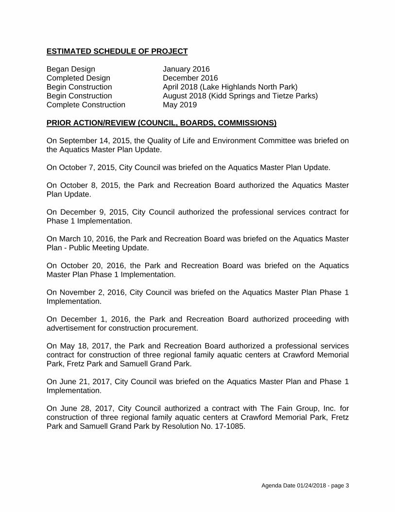
Agenda Date 01/24/2018 - page 3
ESTIMATED SCHEDULE OF PROJECT
Began Design January 2016Completed Design December 2016Begin Construction April 2018 (Lake Highlands North Park)Begin Construction August 2018 (Kidd Springs and Tietze Parks)Complete Construction May 2019
PRIOR ACTION/REVIEW (COUNCIL, BOARDS, COMMISSIONS)
On September 14, 2015, the Quality of Life and Environment Committee was briefed on the Aquatics Master Plan Update.
On October 7, 2015, City Council was briefed on the Aquatics Master Plan Update.
On October 8, 2015, the Park and Recreation Board authorized the Aquatics Master Plan Update.
On December 9, 2015, City Council authorized the professional services contract for Phase 1 Implementation.
On March 10, 2016, the Park and Recreation Board was briefed on the Aquatics Master Plan - Public Meeting Update.
On October 20, 2016, the Park and Recreation Board was briefed on the Aquatics Master Plan Phase 1 Implementation.
On November 2, 2016, City Council was briefed on the Aquatics Master Plan Phase 1 Implementation.
On December 1, 2016, the Park and Recreation Board authorized proceeding with advertisement for construction procurement.
On May 18, 2017, the Park and Recreation Board authorized a professional services contract for construction of three regional family aquatic centers at Crawford Memorial Park, Fretz Park and Samuell Grand Park.
On June 21, 2017, City Council was briefed on the Aquatics Master Plan and Phase 1 Implementation.
On June 28, 2017, City Council authorized a contract with The Fain Group, Inc. for construction of three regional family aquatic centers at Crawford Memorial Park, Fretz Park and Samuell Grand Park by Resolution No. 17-1085.

Agenda Date 01/24/2018 - page 4
PRIOR ACTION/REVIEW (COUNCIL, BOARDS, COMMISSIONS) (continued)
On December 7, 2017, the Park and Recreation Board authorized a contract with the Fain Group for construction of three family aquatic centers at Kidd Springs Park, Lake Highlands North Park and Tietze Park.
Information about this item will be provided to the Quality of Life, Arts and Culture Committee on January 22, 2018.
FISCAL INFORMATION
Elgin B. Robertson Land Sale Funds - $4,161,7352017 Bond Funds - $10,615,000 (subject to appropriations)
Council District Amount
1 $ 5,984,29610 $ 5,256,66614 $ 3,535,773
Total $14,776,735
M/WBE INFORMATION
See attached.
BID INFORMATION
The following three proposals were received and opened on March 10, 2017.
*Denotes successful bidder
Package 1** Package 2***Proposers Total Bid Total Bid Scores
*The Fain Group, Inc. $20,969,000 $14,897,000 4,641.501616 N. Sylvania AvenueFort Worth, Texas 76111Ratliff Construction $20,897,465 $15,185,535 4,205.00Turner Construction $22,978,975 $17,011,678 4,185.50
Notes: After value engineering, the best and final offer from The Fain Group, Inc. was for $14,776,735 for Package 2.
**Package 1: Crawford Park, Fretz Park and Samuell Grand Park***Package 2: Kidd Springs Park, Lake Highlands North Park and Tietze Park
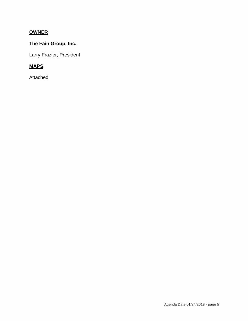
Agenda Date 01/24/2018 - page 5
OWNER
The Fain Group, Inc.
Larry Frazier, President
MAPS
Attached

BUSINESS INCLUSION AND DEVELOPMENT PLAN SUMMARY
PROJECT: Authorize a contract for construction of three family aquatic centers at Kidd Springs Park located at 807 West Canty Street, Lake Highlands North Park located at 9400 Church Road, and Tietze Park located at 2700 Skillman Street - The Fain Group, Inc., best value proposer of three - Not to exceed $14,776,735 – Financing: Elgin B. Robertson Land Sale Funds ($4,161,735) and 2017 Bond Funds ($10,615,000) (subject to appropriations)
The Fain Group, Inc. is a non-local, non-minority firm, has signed the "Business Inclusion & Development" documentation, and proposes to use the following sub-contractors.PROJECT CATEGORY: Construction
_______________________________________________________________
LOCAL/NON-LOCAL CONTRACT SUMMARY
Amount Percent
Total local contracts $4,323,411.00 29.26%Total non-local contracts $10,453,324.00 70.74%
------------------------ ------------------------
TOTAL CONTRACT $14,776,735.00 100.00%
LOCAL/NON-LOCAL M/WBE PARTICIPATION
Local Contractors / Sub-Contractors
Local Certification Amount Percent
Aquatics Resources WFWB87703Y0618 $4,232,211.00 97.89%------------------------ ------------------------
Total Minority - Local $4,232,211.00 97.89%
Non-Local Contractors / Sub-Contractors
Non-local Certification Amount Percent
E. McDaniel TruckingCBS MechanicalAlliance Glass
BMB76763Y1018HMDFW24410218WFWB5579N0818
$5,000.00$586,470.00$149,720.00
0.05%5.61%1.43%
------------------------ ------------------------
Total Minority - Non-local $741,190.00 7.09%

TOTAL M/WBE CONTRACT PARTICIPATION
Local Percent Local & Non-Local Percent
African American $0.00 0.00% $5,000.00 0.03%Hispanic American $0.00 0.00% $586,470.00 3.97%Asian American $0.00 0.00% $0.00 0.00%Native American $0.00 0.00% $0.00 0.00%WBE $4,232,211.00 97.89% $4,381,931.00 29.65%
---------------------- ---------------------- ---------------------- -----------------------
Total $4,232,211.00 97.89% $4,973,401.00 33.66%
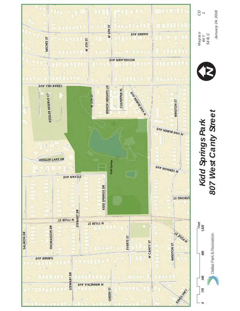
Kid
d Sp
rings
W C
AN
TY S
T
N TYLER ST
HAINES AVE
TURNER AVE
CEDAR HILL AVE
N WINNETKA AVE
WOODLAWN AVE
W 6
TH S
T
NEC
HES
ST
SYLVAN AVE
SALM
ON
DR
STEW
ART
DR
EVER
TS S
T
THO
MA
SSO
N D
R
GRE
EN S
T
WIN
STO
N S
T
W 5
TH S
T
KID
D S
PRIN
GS
DR
N VERNON AVEN
VAN
BURE
N AV
E
N POLK
ST
KING
S HW
Y
CU
LPEP
PER
PL
KESSLER LAKE DR
STRONG ST
BISH
OP
HEI
GH
TS L
N
KES
SLER
RES
ERV
E C
T
WIN
STO
N S
T
N TYLER ST
STEW
ART
DR
W 5
TH S
T
N VAN BUREN AVE
Kidd
Spr
ings
Par
k80
7 W
est C
anty
Stre
et0
340
680
1,020
170
Feet
IC
D 1
Janu
ary
24,
201
8
Ma
psc
o44
Y54
B, C

Lake
Hig
hlan
ds N
orth
CH
URC
H R
D
ESTA
TE L
N
DART
RID
GE
DR
WHITE ROCK TRL
FIELDCREST DR
GA
TETR
AIL
DR
ELMCREST DR
MERRIWOOD DR
GARDEN OAKS DR
FIEL
DC
REST
CTDAHMAN CIR DARTRIDGE CIR
Lake
Hig
hlan
ds N
orth
Par
k93
44 C
hurc
h Ro
ad0
275
550
825
137.5
Feet
IC
D 10
Janu
ary
24,
201
8
Ma
psc
o27
K

Tiet
ze
LLA
NO
AV
E
CONCHO ST
SKILLMAN ST
DELMAR AVE
NORRIS ST
ALDERSON ST
VEL
ASC
O A
VE
MA
RQU
ITA
AV
E
CLEMENTS ST
VAN
DER
BILT
AV
E
VIC
KER
Y B
LVDG
OO
DW
IN A
VE
CECILLE ST
VAN
DER
BILT
AV
E
VEL
ASC
O A
VE
VIC
KER
Y B
LVD
Tietz
e Pa
rk27
00 S
killm
an S
treet
027
555
082
513
7.5Fe
et
IC
D 14
Janu
ary
24,
201
8
Ma
psc
o36
Q, U

COUNCIL CHAMBER
January 24, 2018
WHEREAS, on March 10, 2017, three proposals were received for Phase 1 Aquatic Facilities at Crawford Memorial Park, Fretz Park, Samuell Grand Park (Package 1), and Kidd Springs Park, Lake Highlands North Park and Tietze Park (Package 2). The scope of work at Kidd Springs and Lake Highlands North Community Family Aquatic Centers includes: Children’s Play Pool with multi-level play unit with sprays and slides and ground geyser sprays in zero beach entry; two single rider body flume slides with a single plunge pool; six lane lap pool with a one meter diving board; shade structures; bathhouse to include concessions, men and women locker rooms, a family rest room, office, lifeguard room and pool filtration equipment building; and the scope of work at Tietze Neighborhood Family Aquatic Center includes: Children’s Play Pool with multi-level play unit with sprays and slides and ground geyser sprays in zero beach entry; one single rider body flume slide with a run-out; four lane lap pool; shade structures; bathhouse to include concessions, men and women locker rooms, a family rest room, office, lifeguard room; and a pool filtration equipment building; and
WHEREAS, on June 28, 2017, City Council authorized a contract with The Fain Group, Inc., for construction of three regional family aquatic centers (Package 1) at Crawford Memorial Park located at 8700 Elam Road, Fretz Park located at 6994 Belt Line Road, and Samuell Grand Park located at 6200 East Grand Avenue, in an amount not to exceed $20,562,297 (Crawford Park $7,219,772, Fretz Park $6,445,526, Samuell Grand Park $6,896,999), by Resolution No. 17-1085; and
WHEREAS, it has been determined that acceptance of the best and final offer from The Fain Group, Inc., for construction of three family aquatics centers (Package 2) at Kidd Springs Park located at 807 West Canty Street, Lake Highlands North Park located at 9400 Church Road, and Tietze Park located at 2700 Skillman Street, in an amount not to exceed $14,776,735 is the best value for the City of Dallas.
Package 1 Package 2Proposers Total Bid Total Bid Scores
The Fain Group, Inc. $20,969,000 $14,897,000 4,641.50Ratliff Construction $20,897,465 $15,185,535 4,205.00Turner Construction $22,978,975 $17,011,678 4,185.50
After value engineering, the best and final offer from The Fain Group, Inc. for Package 2 was $14,776,735.
Now, Therefore,
BE IT RESOLVED BY THE PARK AND RECREATION BOARD AND THE CITY COUNCIL OF THE CITY OF DALLAS:

COUNCIL CHAMBER
January 24, 2018
SECTION 1. That the City Manager is hereby authorized to sign a contract with The Fain Group, Inc. approved as to form by the City Attorney, for construction of three family aquatic centers at Kidd Springs Park located at 807 West Canty Street, Lake Highlands North Park located at 9400 Church Road, and Tietze Park located at 2700 Skillman Street in an amount not to exceed $14,776,735 (Kidd Springs Park $5,984,296, Lake Highlands North Park $5,256,666, Tietze Park $3,535,773).
SECTION 2. That the President of the Park and Recreation Board and the City Manager are hereby authorized to execute a construction contract with The Fain Group, Inc., approved as to form by the City Attorney.
SECTION 3. That the Chief Financial Officer is hereby authorized to disburse funds in an amount not to exceed $14,776,735 to The Fain Group, Inc. in accordance with the terms and conditions of Contract No./Encumbrance CX-PKR-2018-00004777 as follows:
Kidd Springs Park2017 Bond FundsFund 1V00, Department PKR, Unit VB01, Object 4599Activity AQFC, Program PK17VB01Commodity 91200, Vendor VS0000040276 $4,298,800
Elgin B. Robertson Land Sale FundFund 0467, Department PKR, Unit W109, Object 4599Activity AQFC, Program PKP945.3 Commodity 91200, Vendor VS0000040276 $1,685,496
Subtotal $5,984,296
Lake Highlands North Park2017 Bond FundsFund 1V00, Department PKR, Unit VB01, Object 4599Activity AQFC, Program PK17VB01Commodity 91200, Vendor VS0000040276 $3,776,200
Elgin B. Robertson Land Sale FundFund 0467, Department PKR, Unit W109, Object 4599Activity AQFC, Program PKP945.4Commodity 91200, Vendor VS0000040276 $1,480,466
Subtotal $5,256,666

COUNCIL CHAMBER
January 24, 2018
SECTION 3. (continued)
Tietze Park2017 Bond FundsFund 1V00, Department PKR, Unit VB01, Object 4599Activity AQFC, Program PK17VB01Commodity 91200, Vendor VS0000040276 $2,540,000
Elgin B. Robertson Land Sale FundFund 0467, Department PKR, Unit W109, Object 4599Activity AQFC, Program PKP945.5Commodity 91200, Vendor VS0000040276 $995,773
Subtotal $3,535,773
Total amount not to exceed $14,776,735
SECTION 4. That this resolution shall take effect immediately from and after its passage in accordance with the provisions of the Charter of the City of Dallas, and it is accordingly so resolved.


AGENDA ITEM # 30STRATEGIC PRIORITY:
Quality of Life
AGENDA DATE: January 24, 2018
COUNCIL DISTRICT(S): 3
DEPARTMENT: Park & Recreation Department
CMO: Willis Winters, 670-4071
MAPSCO: N/A________________________________________________________________
SUBJECT
Authorize a five-year management, maintenance and operating agreement with Dallas County Audubon Society, Inc. dba Audubon Dallas to manage, maintain and operate the Cedar Ridge Preserve, providing accessibility to open space properties and trails located at 7171 Mountain Creek Parkway - Financing: No cost consideration to the City
BACKGROUND
The City, through the Park and Recreation Department, maintains the Cedar Ridge Preserve which consists of approximately 633 acres in size and features approximately 9 miles of trails, native trees, grasses and wildflowers, butterfly gardens, picnic areas, birds, insects and reptiles southwest of the Dallas City Limits. Dallas County Audubon Society, Inc., a Texas nonprofit corporation organized to preserve scenic and ecological principles on native lands and grounds, and wishes to continue to manage the Cedar Ridge Preserve on behalf of the City of Dallas. The Cedar Ridge Preserve has partnered with the City since 2002 for the management, maintenance and operations of the premises. Dallas County Audubon Society, Inc. continues to provide educational opportunities at the Cedar Ridge Preserve working with the community and various volunteer groups, and walk and hike participants. In the past year, the Cedar Ridge Preserve has welcomed an estimated 350,000 visitors and hosted over 3,600 volunteer hours.
In addition to the obligations described, Dallas County Audubon Society, Inc. shall submit an annual Performance Plan for the premises which will identify performance indicators. The annual performance indicators to be included are: conduct a minimum of 1 educational opportunity per month, maintain 60 volunteer hours each month and clear out 4 acres of prairie per year.
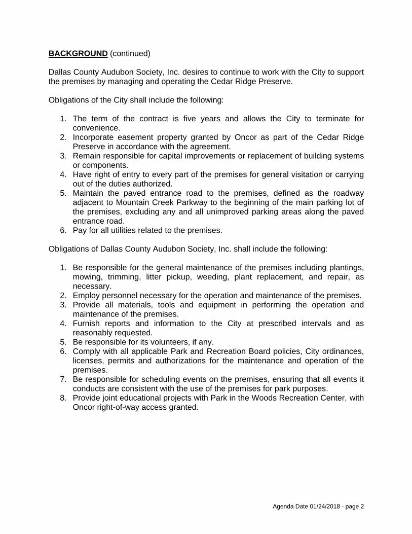
Agenda Date 01/24/2018 - page 2
BACKGROUND (continued)
Dallas County Audubon Society, Inc. desires to continue to work with the City to support the premises by managing and operating the Cedar Ridge Preserve.
Obligations of the City shall include the following:
The term of the contract is five years and allows the City to terminate for 1.convenience.Incorporate easement property granted by Oncor as part of the Cedar Ridge 2.Preserve in accordance with the agreement.Remain responsible for capital improvements or replacement of building systems 3.or components.Have right of entry to every part of the premises for general visitation or carrying 4.out of the duties authorized.Maintain the paved entrance road to the premises, defined as the roadway 5.adjacent to Mountain Creek Parkway to the beginning of the main parking lot of the premises, excluding any and all unimproved parking areas along the paved entrance road.Pay for all utilities related to the premises.6.
Obligations of Dallas County Audubon Society, Inc. shall include the following:
Be responsible for the general maintenance of the premises including plantings, 1.mowing, trimming, litter pickup, weeding, plant replacement, and repair, as necessary.Employ personnel necessary for the operation and maintenance of the premises.2.Provide all materials, tools and equipment in performing the operation and 3.maintenance of the premises.Furnish reports and information to the City at prescribed intervals and as 4.reasonably requested.Be responsible for its volunteers, if any.5.Comply with all applicable Park and Recreation Board policies, City ordinances, 6.licenses, permits and authorizations for the maintenance and operation of the premises.Be responsible for scheduling events on the premises, ensuring that all events it 7.conducts are consistent with the use of the premises for park purposes.Provide joint educational projects with Park in the Woods Recreation Center, with 8.Oncor right-of-way access granted.

Agenda Date 01/24/2018 - page 3
BACKGROUND (continued)
Obligations of Dallas County Audubon Society, Inc. (continued)
9. Retain all revenues generated from the operation of the premises.10. Comply with all state and federal environmental laws applicable to the use and
maintenance of the premises.11. Obtain and maintain insurance as prescribed by the City’s Office of Risk
Management, naming the City, its officers, employees and elected representatives as additional insured parties.
PRIOR ACTION/REVIEW (COUNCIL, BOARDS, COMMISSIONS)
On November 21, 2002, the Park and Recreation Board authorized a ten-year management agreement with Dallas County Audubon Society, Inc., dba Audubon Dallas.
On December 11, 2002, City Council authorized a ten-year management agreement with Dallas County Audubon Society, Inc. dba Audubon Dallas by Resolution No. 02-3547.
On November 16, 2017, the Park and Recreation Board authorized a five-year operation and management agreement with Dallas County Audubon Society, Inc. dba Audubon Dallas.
Information about this item was provided to the Quality of Life, Arts and Culture Committee on January 8, 2018.
Information about this item will be provided to the Quality of Life, Arts and Culture Committee on January 22, 2018.
FISCAL INFORMATION
No cost consideration to the City.

COUNCIL CHAMBER
January 24, 2018
WHEREAS, the City Charter provides for the Park and Recreation Board to grant contracts and agreements within park facilities with such terms and conditions as it shall deem proper; and
WHEREAS, the City Charter requires that the City Council shall approve any contract which exceeds one year in duration; and
WHEREAS, the City of Dallas (City) is the owner of a tract of land known as the Cedar Ridge Preserve in extreme southwest Dallas, as depicted on Exhibit A; and
WHEREAS, the City has entered into an Open Space Use Agreement with the County of Dallas (the County) for a period of 99 years for certain tracts of real property located contiguous with, or in close proximity to, the Cedar Ridge Preserve, which are further described in Exhibit B of this Agreement (Open Space Properties); and
WHEREAS, the City seeks to preserve the Open Space Properties and the Cedar Ridge Preserve (collectively referred to as the Premises) in an undisturbed and undeveloped state on behalf of the County and for the benefit of the citizens of Dallas; and
WHEREAS, Dallas County Audubon Society, Inc. dba Audubon Dallas organized to preserve scenic and ecological values on native lands and grounds managed the Premises on behalf of the City in the past and now wish to enter into a new Agreement; and
WHEREAS, the City hereby authorizes Dallas County Audubon Society, Inc. dba Audubon Dallas to manage the Premises in accordance with this Agreement.
Now, Therefore,
BE IT RESOLVED BY THE PARK AND RECREATION BOARD AND THE CITY COUNCIL OF THE CITY OF DALLAS:
SECTION 1. That the City Manager is hereby authorized to sign a five-year management, maintenance and operating agreement with Dallas County Audubon Society, Inc. dba Audubon Dallas, approved as to form by the City Attorney, to manage, maintain and operate the Cedar Ridge Preserve located at 7171 Mountain Creek Parkway, providing accessibility to open space properties and trails.

COUNCIL CHAMBER
January 24, 2018
SECTION 2. That the President of the Park and Recreation Board and the City Manager are hereby authorized to execute a five-year management, maintenance and operating agreement with Dallas County Audubon Society, Inc. dba Audubon Dallas, approved as to form by the City Attorney.
SECTION 3. That the duration of the agreement will be for a term of five years.
SECTION 4. That this contract is designated as Contract No. PKR-2018-00004879.
SECTION 5. That this resolution shall take effect immediately from and after its passage in accordance with the provisions of the Charter of the City of Dallas, and it is accordingly so resolved.

.. . . C £ 0f f' H I t.t.
EXHIBIT A

EXHIBIT A Legal pescri p clon o C Escp~g§nt park
r1a.o "°'"" 11ooo 1A9 a waot. o f 1....,. oit11&CH 1a ti.. •"1111.p iu-U ,...,,.,., ~u-act. ~- 1ZJ. t.be .lob.a SCa>f9"t •c.n-~y, ~•tz•et Yo .. ll1$,. aid e.1Ma ~r .... • WU- aarroy, .U..u..a. So. Uzt, o aJ.l&a C-.tT, ~-- . ""' i..1A9 ~·~ ~tr d••ni~ u tollcowu
UG.nafl•O at. • poiat l.a t.i.t .. .,._ lia.e of °"""'tT Vl.eY ..,..., a&L4 pol:At. M.l.af U.. C<>..C.. ... c ""'DU ot Lot. u ia 111""-" • I UOS o f n.a 11-.0 ... ua· u _ ..... La ¥01- n1n, ugoo u.11 o t tt.o ic.a.p -. o( Dalt.a ca.o.e,r, l°'.XUI
T l:DCll 111 a w"'tl>orl.Y 41x·-·Laa aloaf HJA _." lS.- ,.19 a .,......,. ...
~!:t!!f~~1:, 'i:!~i .•• :~ . .:· .s::.::.. ·:r '~ ~·.: . ~ <llltaau ot lU. U taat.1
:MIZllCS J.a • ao-dr 4.J..rec:t.ioa ooet.~ .i ... ., •Al•., ... 11.M vJ.t.ll a C'\l.r¥'8 to t:.M .rlqht:. •&id ~ h&YL.a4' a ce.ott&.1 uci. of ll• ft' 2t• M4 & r•U• ot. t,t.oo te.9,. ... a.re d.i.a~ o1
Tm::HCll :rm:JICS '!'lllDOQI '!'llDC& 'f~ T.-S TDllCll T'HIQICS
·T~ TllDICI 'fllDOCa TUl!ICS TllDlc::I T~ T IEllCI:
'1 . ll c-cr · oo• 10• cao• w, oolltJ.a.S. .. .e.1.oel9 a&JA -..c. t1..4a, >11 . 11 t .. t:._, at• JC• 1'• •· 1112. to r ... e, 21• 211 to• a,. $01. 74 fNtt u• n• •o• w, U 30.M t-• ot• it• 11• w, 21"·'' f"••t• n• u• 01• w, 1u.o , .... , o• ll' •7" W, HO. 07 t .. ~ 11• u• n• "• tn.u '"~ 1•• Js• ,,. w,. 21s .. u t .. c, oo• 11• n • v, ' ' '· o.o i .. c, o• os• $&• w, u t .J4 , .... , .,. 15'. 11• w, 1S4.00 ,_, J2" n• ~·· w, sn.« , .... , n• u• so• •· 211.u , .. .,, 75" lS' Ot" 1', lU.OI f .. t: u• u• 41• 11, us.01 t-t to a 5'0£at. ta t M ..... 11- of
.. a . ti.9twq No,. llUt
i=: : !:: ::: !~:: ~~:J..= ::!.,1=.a ~·J::~'m.n t•t• rmrai • u• ,,, n• a OQll~ aloOf a.at4 .... t. LU4, iso,.u t""' 'IDMClt • 11• 20' 0,. I oaet.1A"1»v alo"'I a4U .... t u-. 124 ... f-*"• T!ZIQ 1a a "".rtb .. .otul.7 cUreot.ioa ooatJ.aal..1>9 aloaf •&:IA ....,._ 1.1.u,
a.o ... J.Mri.ot r 01• U• u• a, w.t• c:UT• ,,.,,1 .. , a c:.Dtnl Ut l • o! Ot- )C• 11 • &Dill a r .. i .. of l9-t•. 11 feet. u. &r0 .Uaua,.. <>I Ul.u 1-t•
Tlll!XClll • u• 02• 54• •· 111.u r .. t, TllDCll a.u• u• n• 1, us.u te:•u 1'- 8 '1• JO' Jt" I, lH.11 fHt1 T!IEllCl • tt• n• u • a, us.n· '"*' t!llOICll-11_..• lJ• St• s , 111. t1 f•t1 ·rsi:arcz • u • u• u• i . 211.00 , .. .,, t'UllCI I 12• u • u• c, Jfl.U fM~ Tl!!2!Q • 40" 01' 0 .. I , JIJ,H t .. c1 ?'II.MCI s 11• l 1• co• a. 2u .10 i .. -., 'fl!Zllal I u• Ot• Jt• a, us. 14 f .. t1 TIJDC:ll • n• u• .,. 11, •11. •o t .. ~ TllZHOI II H • $0' st• I, 0 &.41 t•tt ~-~ • u• n• u• " • 2u.u to.ec1 tltQlcs • u• u • oo• c, us.a t -t• ~~ • •t• lJ' co• a, 111.ti t .. t, flfl.llC:a 1a a IQut.borly o!.l~ac:UOD v1tll • .,......,. to U.. lett , Otord
!jAj~f1~. 0:;. ·~ 1!• c!.ii:.&J:t~~o:Jl~!:t • ::::•!,:nt.!!:. '%lll»c:2 :' l:?'s:! !::'t m . •• t_., 'fKl:ltQr t. • ..aue-ba ..... cly ~z•c:t-Loo wfcf\ ' our.. co c:b • 1.• lt.. C2ao'Cd
&.IA-ElOf • Sl' J:J• >t• a, •&J.d i;ut"T'9 h..t.•l"'-• • ccnt.rAl ;..'fl• ot ll • O.S' 1 t• Miid 1 ~tdi\Ui ot Sol. 40 feet. a.a uc: 41 • t a.ooe o f ... ,. ·-- --. ... .... ...... ... ,. __ , ,.. .. , ....... - ....... ~ .. ~ ... r ·j 96.9~.r "~-d.1......Jl..

· . N Dallas City Limits
Exhibit "B.. + .:I Park Property • • .· • Dallas County
Descr1pt1on of • Greenhills Property (Acquired by
Escarpment Park Dallas county 1112002)

Tract: l
!O.llAl'.l2MJ!.'l'f' 1.C:REP/1ENT F0 8 ESC>Jtl'Kp!T PN!JS M12 com:n CPl?.lf S P1.C§ i'MSl:RVZ I N Dl\LU.S , 1'!:XJl.S
c rTY OF DALI.1.S >.NP CJl!!NJ{lLLS FQtnro1.TtON. t NC.
Legal Cescriot1on o f D4l l as County Cpen Space Pr ope[ties
Being a . 141 . 136 acre tract of land situated in the John Sc roqgy survtr~. Abstract Number 1375, ch• George Wilson Survey, >..bstr4ct ~u.mber 1529 and the Phillip Ki11111el Survey, >..bstract Number 723, Dallas County, Texas and 4lso being a portion of •Tract 2 ' As described in deed dated Ftbz:uary 2, 1984 fro~ Mardev, ~.v. Cinole, Inc. And Ontell, Inc. to Hol.llltain Creek Joint Venture r ecorded in Volume 84048 , Paqe 4143 , Deed Recorda of Dallas County, Texas (ORDCTl. and being inore particularly described by 1r.et:es and 'boun~ as fol low•:
~NG at a 1 inch iron pipe found in the east: l i ne of that certeio tract of land conveyed to the United Se.tel of America as evidenced by deed recorded in Vol~ 78226, P'"aqe 3072 , ORDCT, for the southwesterly corner o~ thot certain ' Tl"act (• as described in said deed to ~.ou.otain Creek Joint Venture and the nort.hwest:erly corner of HiQh Pointe SubcUvbion, an addition t o t he City of Cedar Kill AJ evidenc.ci by plat recorded in Volume 84128, Paqe 1250, ORDCT1
THENCE North 40'26')8• East a distance o f 7435.11 feet to 41\ axle rod found in the west l~oe of the Dallas Power and Light: Co:npany right-of-way recorded in Volume 10, Paqe 2176, ORDCT, for the southeast corner of said Mountain Cree.le Joint Venture tract and the northe&St corner of that c•rtain tract conveyed to Dallas County, as evidenced by dHd recordad in Volwu 90111, 1'•9• 2644, OR.OCT, sa.ir.e beinq th• POINT Of' 8EOINNING1
Ttfl~l'~£ along cr.e COlJllCn lLne bet~en said Dallas County, tract: a nd said Mountain Creek J oint Ventur• tract: as follows1
South 76 dt!Q-rees 30'19" West a dlstance of 1084 .29 teet t o a l 1nch i ron rod found for corner ; South 03 de9raes 15'52• East a distance of 623 . l) f eet to a 5/8 i nch i ron rod found for corner ; South 64 degrees 41'20' West a d iste.nce of 420 . 22 feet to a SIS inch i ron rod found Cor corner1 South 30 de~ees 01•25 • East a distance of 251 . 42 feet to a 5/8 i nch i ron rod found for t he northeast corner or that cert a i n t rac t: o f l and conveyed to th• Ci ty o f Da llas a s r eco rded in Volume 8ll07 Paqe 2495 , DRDCT1
EX\UBll B
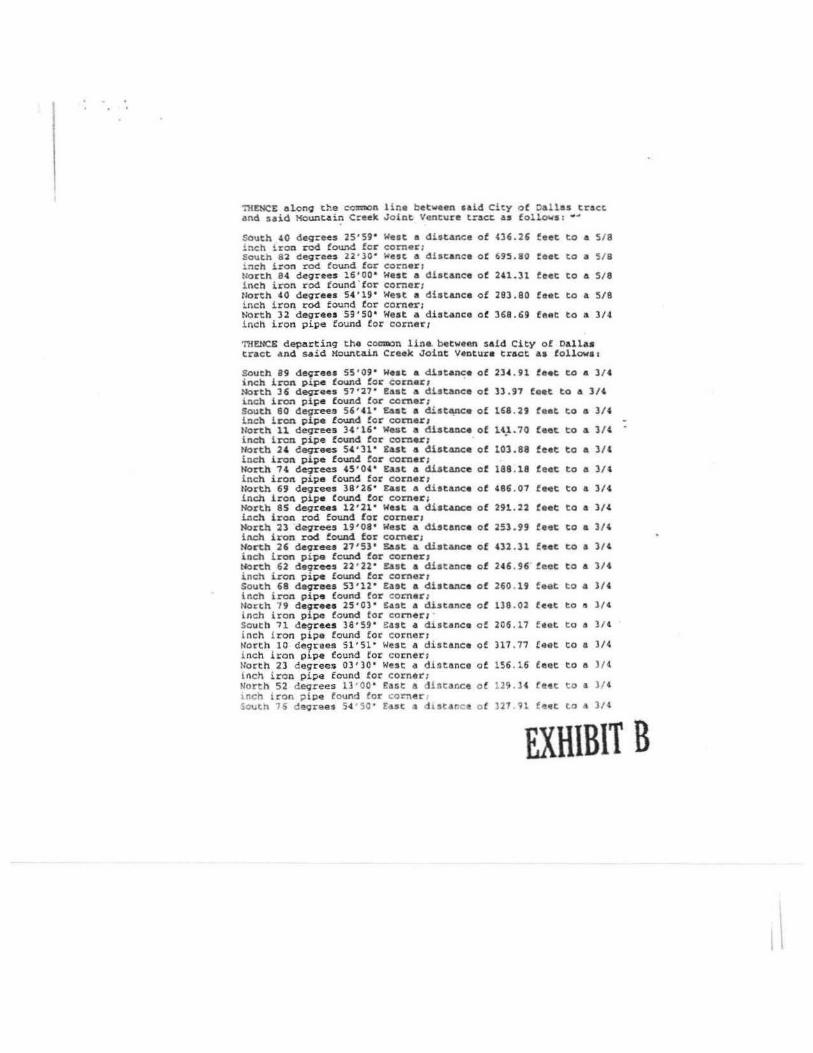
":HENCE elon9 t~e c0%:llC>n lina betwatll\ aald ci~y o f Oallas tract and said Mountain Creek J o lnt Venture t~acc. as follows : --
South. 40 degr~ 25'59" Wast a distance inch iron rod found for cornar;
of 436.26 feet to a 518
South 82 dt!.<;re~ 22 • 30• West a discanca Of 695.80 feet to a 5/8 inch iron rod found for corner1 North. 84 de9rees 16'00° Wast a distance of 2'1.31 feet tO A 518 inch iron rod found for corncr1 North 40 degrees 54 '19' West a distance of 283.80 feet to a. 518 inch iron rod found for corner; North 32 degrees 59'50 ° West a diotance o f 368.69 feet to a 3/4 inch iron pipe found for corner1
'MU~NCE departing the coll'IQOn line. between said City of Dall as tract and said Kountaill Creek Joint Venture tract as follows1
South 89 degrees 55'09" Waat a distance of 2H . 91 feet co a 314 inch iron pipe found for corneJ:"1 North 36 deqrees 57'27 ' East a distance ot ll .97 feet to A 3/4 i.nch iron pis:e found !or comer; South 80 degr~ 56''1 ' £ut a d.ist.,,nce of 168 . 29 feat to a 314 inch iron pipe found for comer1 tlorth 11 deqrees 3' '16 ' We.st a distance of u"-.10 feet to a 3/( inch iron pipe found for corner; N<>rtb ;a deqrees 54 • 31" East a dist=c• ot l03 .88 feat to a )/(
inch iron pipe found for corner; North 7 4 deqre<?S 45 • 04 • East a distance of 188 . 18 feat to a 31' inch iron pipe found for corner1 North 69 degrees 38'26 ' Ea.•t a distance of 486 .07 faet to a 3/4 inch iron pip• found for corner; North 85 degrees 12 • 21 ' west a distance of 291.22 feet to a 3/4 inch iron rod foW'ld for cornor 1 North ~3 degrees 19'08' West a discance of 253.99 feat to a lH inch iron rod found for cornu1 North 26 degxees 27 '53 • ~st a distance of 02 . 31 feat co a )I' inch iron pipe found for corner; North 62 degrees 22'22 ' East a distance of 246. 96 feot to a 3/4 inch lron pipe found for corner 1 South 68 de<,Jrees 53'12' east a distance of 260 . 19 feet to a )/4 inch iron pipe fOllnd tor corner: Horth 79 degrees 25'0) ' East a distance of l38 .02 hat to 11 )/ ( inch iron pipe found for corner1 South 11 degrees 39•59 • East a distance of 206 . l 7 hot to a 31' inch iron pipe found for corner; North 10 de9rees Sl'Sl ' West a distance of 317 . 77 feet to a 3/4 i nch lron pipe found for corner; North 23 degrees 03 •lo • West a dlstance of 156.16 feet to !l )/4 lnch iron pipe found for corner; North 52 degrees tJ •oo · £a&t a dlstance o f 129 . 34 !'!et t o a J / 4 i nc h iron p ipe found for corner ~o~th 76 degrees 54 50' East 3 d 1star.c o f }27 91 feet to a )/4
EXHIBIT B

inch iron pipe found for corner; south 52 deqrees 95'45 ' £aat a distance of 519.97 feat to a 3 / 4 inch iron pipe found for cornar 1 North 13 deqrees 56' 43 ' Ea•t a distance of 61 98 feet to a 3/ 4 i nch iron pipe found for corner 1 North u deqrees 23 • 49 • Wast a distance oC i nch iron rod found for corner;
U9 . ll feet to a 3/ 4
north 17 deqrus lS • 04 • West a distance of. llli. 06 feet to a l/4 inch iron pipe found- tor corner; !lorth 25 deqrees 50'45 ' East a distance o f 183. l 7 f eet to a 314 i nch iron pipe found for cornen Horth 00 deqrees 05' 59 ' West. a distance of inch iron pipe found for corner1
l U.96 feet to a 3/4
North 61 deqreea 14'49' We•t a disto.ac• inch iron rod found for corner1
Of 315.00 ta et to a 5/8
North 14 degree• 56'04' West a distance o f 360.00 feet to & 3/8 inch iron rod found for corner; North 28 degrees 43'46 ' We•t a distance o f U6.10 feet to a 518 inch iron rod found tor cornar i llore.h 01 deqreea 36'00 ' We•t a di•tanc• of 470.17 f eat to a 5/8 inch iron pipe foWld for corner; North 69 degrees 37'22 ' East a distance of inch iron rod found for corner1
HS . JS feet to a l/l
South 14 deorees 44 ' 14 ' East a distance ot 159.05 feet to a 1/'2 inch iron red found for corner1 South 52 deqrees 41 ' l9 • East a distance of 109. 07 feet to a l/2 inch iron rod found for corner; North 75 deqrees u•so· £&at a dbtance ot 164.20 feet to a v2 inch iron rOd four.d tor corner: So\lth 17 degree.s 34' 43 ' !Ast a distance of 140 . 06 feet to a 1/2 iocb i. c-on rod found for eomar 1 North 76 deqraes 45'26' &a.t & distance i nch iron rod found for corner 1
of 153.94 feet to • 1/2
South 81 degree.s 50'38' E.ut a distance of 475 . 70 feet to & 5 / 8 inch iron rod set for corner1
TRENC£ South 36 deqrees 01'11' East 190l . 34 feet along uid westerly line of Dall•• Power 4 Llqbt Co. tract to the POIN'l' OF BEGINNINGt
C"OHTA"DIING within the ir:etea recited Ul .136 acres ot land. rron or less, and..Peir.9 all the property conveyed to the County o f OaUu by d eed cecorded ln Volume ___ Page ---· DIWCT
fu'{H\Bli B
\

Tract 2
B£ING a 92 . 826 acre tract of l and $ituated in the John Scroqqy Su%Vey, Abstract Number 1375 and the City ot Oall4S Block N\Unber 8611. Oa.lles County, Texas end also being a portion of "Tract 4• Q~ described i..~ deed dated febt\Jat:y 2, 1984 frora Hardev, N.V. Cinole, Inc. and orw~ll, Inc. to Mountain Creek Joint Venture r ecorded in Volume 84018, Page • 143, Deed Records of Dallas County, Texas (Drux:T), and being 1110re particularly described by metes and bounds as follows:
B!GIN:fING at a l inch iron pipe fo\U\d in the oast line of that certain tract of lend conveyed to the Onited States ot Americ• as evidenced by deed recorded in Voll.Ute 78226, Page 3072, OR.OCT, for the southWasterly corner of the 11dd l'.ounta.ln e re.it Joinc: venture • Ti:act 4 • and cJ1a noi:t.bweste.r ly corn•r ot High POinte Subdiviaiou. an add.i.tion to the City of Cedu" Rill u evidenced bv plat rec.oi:ded in Volwne 84128 , Pave 1250, ORDCT1
nit?~ Horth 29 devnH '1 ' 19 • wut &10119 the eut line of sa.ld Unit..:! Stat~ o f A::>erica tract a di1ta.nce of 1767.79 feet to• l-114 inch irOll p!.pe found ln the eut line of I' .H. 1382 (a vanable width right-of-way) for the most "'est.erly eornsr of said HQunta= Creek Joint Venture tt"act 1 • •
TMENC& along the west line of the Mountain Creek Joint Venture tract. and t.he ~st line of F.M. l38l as tollowa 1
Horth 09 degrees 01'30' Seat • dista.nce of 284 .88 feet. to a highway monwmnt. fowid for corner 1 North 16 deqrees 32''6' East. a distance of 378 . 39 feec to a hi9hway lllOnumedt. found for corneri North l7 deqrees 06'01 " ~st• ~stance of 140.87 feet to a highway rnonu:J:el'.lt found for corner1 North 17 degrees 51'29 " C.st A distAllce of 102.53 feet to 4 1/2 l.nch iron rod lound for tba northwut comer of said Mounta in Cr eak J'oinc Venture Tract. and the southwest corner of that c ercain tract of Lu!d conveyed t.o the City of Dallu as evidenced by deed recorded in Vol\11118 81107, Pa9e 249S, Dl\DCT;
THENCE along~the cOllllllOn l ine between said City of Dalla• tract ond said Mountain Creak Joint. venture trace ea follows:
South 48 degrees 25'14 ' Eaat a dis tance Lnch iron pipe found tor corner : South 76 degre~ 06'40 " £est ~ diocance Inch I.ran pipe found Cor corner i South 54 deqrees 14 ' 42 ' r.,et a di1tenc& lnch iron pipe found for .orner; Sout.h ) ) d1!9rees 2 4 •1 0 · £4at o di~tance 1r.ch Ton pipe fcund tor corner;
o!
of
of
of
363 . 68
21 l. to
217 57
l9 1 0
feet to a 3/4
! eat to 1 )/4
feec t:> , l/4
teat ~o ,. 3/4
EXHIBIT B

tlorth 89 deqrees 52'34' East a distance of 753.99 feet to a 3/' inch iron pipe found !or a 11:T1er1 Sout.b 42 degrees l6'31' £&9t a distance of 149 . 39 feet to a 3/4 inch iron pipe found for comer; ~orth 00 deqrees 17'14 ' west • distance of 595.10 Ceet to a J/ ' inch iron pipe found for corner 1 North 73 degr~ 32'24' Eost • diatan.c41 of 215 .53 feet to a 3/4 lnch i ron pipe found for corner; South 28 degrees 46 ''53 ' East a dilta.nce ot 972. SJ feet to a 3H inch iron pipe found for corner 1 North 48 deoreee 46 • 03' £.Ut a distance of 740 .14 feet to a 314 i nch iron pi~ found tor comor1 South 28 -degreCUI 44'28' E4et a distance of 392.41 feet to a 3/4 inch iron pipe found for comer1 South OS deorees 11'21' East a distance of 237.58 feat to a 3/4 inch iron pipe found in the north line ot Hioh Pointe Su.bd.ivhloo tor the southeast corner ot said Mountain Creek Joint Venture tract and the most southerly corner of Hid City ot Dalla• trac:t1
'nfSl~& South 60 degrees 01'40 ' West a distance of 2951.10 feet to the POn;T OF BEGlJMI.00;
Containing within the mete• recited 98 . 826 acres of land, ll'Ore or len, and being all the prop9rty conveyed to the Councy of Dalluby deed recorded in Vol.- _, Page ___:_, DROC'l'.
EX\UB\1 B

7rpct 3
Being a tract of land situated t n the Phillip Kiamell Survey. Abstract No. 723, the George Wilson Survey, Abstract ~o. 1529, City of Dallas, Callas Councy, Ttx.as and being the same tract ot land conveyed to Greenhill• toundation, Inc. recorded in Volwr.e 92009, Page 2136, Deed Records, Dallas County, Texas, and be.i.ng more particularly described as follows:
Beginning at a 1/2 inch iron ·rod s et for the northwest corner of t.ot 1, Block B/8650 of 1'ha Woode Thirteenth Section, llJl llddition tO· the City of Dallas, Dallas CoUllty, Texas aa recorded in Vol-=e 79187, Page 111.l, Plat AecorcU, Dallas County, Texas, and being on ehe soutb right-of-~ay line o f Mountain Creek Parlc"'1ly (torir~rly Flori~a-Daoieldale Road 100' R.O.W.).
TK'ENCB. along the westerly line o f said Wood.s 'Mlirteenth Section with 1/2 inch iron rods set u follows:
Sou.tb 51 degrees 19 minutes 09 aeccnd.s West a distance of 92 .87 teeti South 43 d119rees 34 seconda (sic) 00 seconds West a dis tance of 281.84 feet to the begicning of a curve to the left having a central. a.~gle of 11 degrees 08 11\inut•• 34 seconds and a radiu& of 555.00 feet; ~long sa.id curve to the left a distance o f 107 . 94 feet to the meat northerly northeast corner of a tract of land conveyed to the City of Dallas, recorded i n Volume 81107, Pao• 2493, Oeed Records, Dal.las County, Texo•:
TllENC~. along the northerly line of said City ot Cal las tract of l and as tollcws:
north 89 degrees n :ninutes 00 saconds West a distance ot 496. 55 feat to a 3/4 inch 5'.ICker rod by a fence post !or corner: NOrth 89 degrees 48 ::Unutes 00 eecond4 West a distance ot 516 .87 feet to a 1/2 inch iron rod aet for corner; South 01 degrees 17 :ninutes 13 •econd.a East a distance ot 219 09 feet to a 5 / 8 inch iron rod found tor corner; and Soutb 68 degree• 54 i:U.nutas 5~ second.a West a distance of 435.00 feet.. t;Q a 5/8 inch iron rod found for a southea•tarly corner of a tract ot land conveyed to Booth Creek Invest~enta . tnc. recorded in Volume 82069, Paqe 0945, oeed Records, Dallas County, •[email protected] 1
'rK'£NCE. with the easterly l i ne n f soid Booth Creak Cnvestrncnts tract as follows:
l-lorth 29 cleqraes 20 minutes 02 seconds '1'!St a dutonc a of 251 . Sl te~t to a S/B lncb iron rod fourd for c?rner r 'IOr:h ~5 degrees ll ~inu~es 44 , e cond5 Cast • disrance of 420 lZ teet ~o d 5/8 1nch ron rod found by a fence pose ! or corner
EXRlBli B

North 02 deqrees 27 oinutes ll seconds Wes t o distance or 622.97 feet to a S/8 inch iron rod found by fence post for cor:ner; ~ North 77 degrees 20 sunutes 00 seconds e&at, alo ng the general direction of a fence l ine , a distance of l,08• . 48 feet to a 3/4 inch suclter rod found for corner in tho southerly right-ofvay lin11 1250' R.O.W.I or a Dalla• l'ower and Light tract of land recorded i n Volu:ne 1.0 Pao• 2176, Oeed records, Oallas County, Texas1
TH.ENCE, continuing along said Cellos Power and Light right-of-way line, South '6 degrees 26 mi.nucu 00 seconds Ease a distonce of 441.0l to a 1/2 inch iron rod aec t or corner in the eoutherly right-of - way line of aforementioned HoWltain Creek Parkway in a curve to the left having a central ongle of 06 deqree1 18 minutes 54 seconds and a radius of 1.050.00 feet1
'Mi£NCE, along said right-of-way line and cu~• to the left on arc distance of 115.73 feet to the eCJIN'J' OP 8EGIHNINa and containing 26.2913 acres or 1,145,247 aquare feet of land.
IRllHll'9/\ 'l'R>.CT 8 AtqUUID Oii - U , 2001. UIC1-"1)n<:;
&la'M PdM
PROPZJU'r DUCILI1>'1'IOll TRACT a
Being a tract of land situated in the Phillip tth.nell. Survey, ~t.ract No. 723, City of D4llu, Dallas County, Tex.as and being a portion of that cereain tract oC la.ad COllveyed to Cree.nhills Foundation, Inc., recorded in Volw.e 82009, Paoe. 21361 Deed Records , Dallas Cowlty, Tax.as, and being more pareicularly described as follows•
Co=canclog at a. S/8 in.ch iron rod found at o coam:m corner o f t hat certain t.ract: of land conveyed t.o Booch Creek Invescment•. rnc., recorded in Volume 82069, Paoe OUS, Deed Records, Oollu County, ~. and that certain tract of lend conveyed to the Cit.y of Daile.a, recorded in VolUKIO 81107, Page 2493, Deed Records. Da.l.las County, Texas, and being tha south corna~ of the C.oroa Wilson Survey, Ab1tract No. 1529, and being on the co:=on line of th11 Phill.ip Kimell Survey, .\bstract. ~IO. 723 ond the John Sc:roqgy Surrey., Abstract. No. 1375 :
'l'nttnce a lo-ng.the northerly line ot the aforesaid City o f Dallas tract, North 68 degrees 54 minutes 59 seconds East a cilscance of 247 .85 leet1 and departing said l ine, North 28 degrees 13 nunutes 51 seconds west a d i stance o f 20 . 30 feet t o the l'Oitrr OF SEGINNlNG:
Thance wi t h 1/2 inch icon rods sut f or cornets as follows 1
Horth 28 ceqrees t3 t111nucee 51 teconds West a distance ~f 70 , 15 feet:
EXHIBIT B
I .

~rth 61 degrees •6 minutes 09 seconds &Ht a distance of 83.U feet1 North 02 degrees 27 minutes 1.) se<:ends WHt a distanca of 181.52 feet; North 65 deqraes 33 minutes u seconds East a distance ot 10.78 feet1 North 02 degrees 27 adnuc:es 13 eeconda Walt a di.s ta.nce of n•.69 !eet1
08 'tainutes South 88 degrees u seconds Cast a distance of 151. 93 feeti North 08 deqrees 20 minutes ~!.ii second.a Eaat a diatance of 27'.81 feet:1 North 89 degrees 0 lllinutes 25 second.I Caat a distance of 299. 71 t:eet1 north 00 degrees 10 m.inut:ea H s econds WHt a distance of 1.f.3.U f eet1 North u degrees '9 minutes 26 aecond4 £.sst e distance ot 260.89 feet1 South 00 degrees 10 ininutes H seconds E41•t a diatence ot 193.U feet1 South 89 deqrees 49 m.iautes 26 11eeonds Eaat a distance of 260.89 feet1 South 00 deQrees 10 aim:tes 3' seconds East s distance ot U0.10 -faet1 South 10 degree a 15 minutes 19 seconds West a distance of 193.82 feet; North 89 deqrees 48 iainutea 00 ·~ WUt a distance of 304.77 feet; Sol.Ith oa dagr~ 27 CUJlutes 13 sa<:onda East a distance ot 42 .31 r:-t; South 87 deqre~ 32 lllinutes '7 seconds Weat a distance of 61.CS feet;
Seat a distance of 210.63 South 02 degrees 27 minutes ll seccndls feet; and South 61 degreea 46 adnutes 09 seconds West a di.stance ot 157 . 8' feet to the POINT OF BEOIN!UNQ and contAinlOJJ , .8583 acres or 211 ,626 Squar• feet of land.
EXRIBli B

'l'r:act 4.
Seing a 30.010 acre tract of land situated in the William Clarlc Survey, A-233. Dalla:! County, Texas and beinq part of a called 181.700 acre tract as described in Voluine 74054, Page 2288 of the Dallas County Deed Records and being ll¥lre po.rticularly described as follows:
CCMMBNCI"NG ~T A l-3/4 ' iron pipe at the northeast corne-r of the Willii1111 Clark Survey, 1.-233;
'raENCE South 60 degrees 49' 22 · West, 966.04 feet to the TRUE POINT OF BEGINNING:
TiiENCE South 02 degrees 50' os · West, 562.59 feet to a 1/2 inch iron rod:
THENCB south 89 degrees 22' 47 ' East , 60t.15 !eet ta a 1/2 inch iron rod;
TMENCE South 01 degrees 53' 58• East, 281.06 feet to a 1/2 inch iron rod at: the beginninq ot a curve to the left: having a central angle of 20 deqrees 14' 44* , a radius of 924.91 feet, a tangent l ength of 167.91 feet , a chord bearing of South 08 degrees 23' 25" West and a chord distance of 330. 42 feeti
THENCE along said curve to the left, 322.20 feet to a 1/2 inch iron rod;
THENCB North 76 deqrees 44' 04 ' West, .95 . 01 feet to a 1/2 inch l.ron rod1
TH!Th'CS N<>rth 61 degrees 32' 09 • West, 132.70 feec. to a 112 inch iron rod;
nlENCE "'Orth so degrees 25' 04 " West, 142.73 feet to a 11<? inch iron rod;
THENCE South 69 deqrees 5 4' J.6 ' west, 152.85 feet to a 1/2 inch iron ro<l;
THENCE Sout 64 degrees 00' 16' west, 143 . 37 feet to a 1/2 i nch i ron rod;
'l'!fENCE South 66 degrees .38' 31 ' west, 119 ."11 feet to a 1/2 inch iron rod:
THENCE Nor t h 8 7 Lron rod ;
degrees 02 . 13 ' west , 117. 82 feet to a 1 /2 inch
'I'HEWCE Nor t h 18 degrees 56 ' 32 . West.. 127 . 41 teet to ~ 1/2 l OCh
EXRIB11 B

iron rod;
TKEHCE south 49 degrees 08' 39' weat, 142 .12 teeee to a 1/2 inc:h iron rod1
TllENCS SO\lth 14 degrees 46' 42' West, 115.35 feet to 11 1/2 ic.c:h icon rod;
'I'H£~ North '8 degceea 53' os · Weat, n.24 teee to & 1/2 inc:h iron rod;
'I'HDICB North 71 iroti rod1
c1egreea 12' 47• Wast, t38.02 feet ta a t/2 inch
TKDICB North 79 degrees 16' 21 ' West, 189.57 feet to a 1/2 inch iron rod1
nfDICE North 63 deqreu 16' .co · West, 190. 31 teet to a 1/2 inch iron rod1
'!'Hl?NCB North 45 degree a 29' 30 • iron rod1
weat, 188.68 het to a ~/2 inch
'mENCB North 3 7 degrees 37' 03 " Waat, lU.07 feet to a 1/2 inch iron rod;
'll{DICE North 60 d~ees 0' 22 • Eaat, 1. (09.65 feet to ch!J POW'r OF BEGINNING and containing l0.010 acre• (l,307. 254 5qll4re feet) ot land, more ere leaa.
EXHIBIT B

·.
Tract 5
Being a 12 .182 acre trAcc of land situated in the William Clark Survey, A-233, Dallas County, Texas and being part of a called 181, 700 acre tract as described in Vol11.::1e 7'054, Page 2288 of tha Dallas County need Records, and being more particularly described as !oll<Ns:
BEGINNING at a 1-3/4 ' iron pipe at tho northeast corner of William Clark Survey. A-233;
THE:NCE south 28 deqrees Sl' 28• &a.at, 401.60 feet to a 1/2 iron rod at the b99innin9 of a oontangent curve to the left having a central a.n;le ot 61 degrees 20' 53 ' , a radius of 760.00 feet, a tangent length of 450 .79 feet, a chord bearing of South 28 degrees 46' 29• West and e c:hord dist&z\ce o f 775.431
THENCE alonq said nontangent curve to the left 813.75 feet to a 1/2 inch iron rod on the we3t right-of-way of Straus Road1
THENCE South 01 ' (sicl 53• (sic) 58 ° East, 178 feet along said west right-of-way line to a 1/2 inch iron rod1
THENCE ~orth 89 degrees 22' 47 " West, 50•.lS Ceet to a l/2 inc:h iron road (sic};
'IRENC£ North 02 degrees 50' 05 " &aat, 562.59 feet to a l/2 inch iron raod (sic!;
THENCE North 60 degrees 49 ' 22 • East, 966.04 feet to the POrNT OF BEGINNINO and cont.aining 12.182 acre• (530,631 square feetl ot land, more o r less save 1tnd except . 950 acres 141, 367 Square feet) located i.Jl t.he right of wa.y of Straus R.oad.
EXHIBIT B

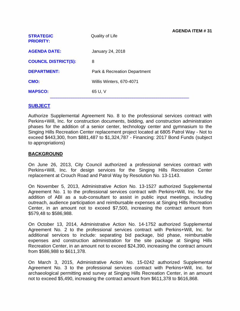
AGENDA ITEM # 31STRATEGIC PRIORITY:
Quality of Life
AGENDA DATE: January 24, 2018
COUNCIL DISTRICT(S): 8
DEPARTMENT: Park & Recreation Department
CMO: Willis Winters, 670-4071
MAPSCO: 65 U, V________________________________________________________________
SUBJECT
Authorize Supplemental Agreement No. 8 to the professional services contract with Perkins+Will, Inc. for construction documents, bidding, and construction administration phases for the addition of a senior center, technology center and gymnasium to the Singing Hills Recreation Center replacement project located at 6805 Patrol Way - Not to exceed $443,300, from $881,487 to $1,324,787 - Financing: 2017 Bond Funds (subject to appropriations)
BACKGROUND On June 26, 2013, City Council authorized a professional services contract with Perkins+Will, Inc. for design services for the Singing Hills Recreation Center replacement at Crouch Road and Patrol Way by Resolution No. 13-1143.
On November 5, 2013, Administrative Action No. 13-1527 authorized Supplemental Agreement No. 1 to the professional services contract with Perkins+Will, Inc. for the addition of ABI as a sub-consultant to assist in public input meetings, including outreach, audience participation and reimbursable expenses at Singing Hills Recreation Center, in an amount not to exceed $7,500, increasing the contract amount from $579,48 to $586,988.
On October 13, 2014, Administrative Action No. 14-1752 authorized Supplemental Agreement No. 2 to the professional services contract with Perkins+Will, Inc. for additional services to include: separating bid package, bid phase, reimbursable expenses and construction administration for the site package at Singing Hills Recreation Center, in an amount not to exceed $24,390, increasing the contract amount from $586,988 to $611,378.
On March 3, 2015, Administrative Action No. 15-0242 authorized Supplemental Agreement No. 3 to the professional services contract with Perkins+Will, Inc. for archaeological permitting and survey at Singing Hills Recreation Center, in an amount not to exceed $5,490, increasing the contract amount from $611,378 to $616,868.

Agenda Date 01/24/2018 - page 2
BACKGROUND (continued)
On April 8, 2015, City Council authorized, Supplemental Agreement No. 4 to the professional services contract with Perkins+Will, Inc. for the Singing Hills Recreation Center replacement located at Crouch Road and Patrol Way for construction administration phase services and coordination of the recreation center with the DART Camp Wisdom light rail station in an amount not to exceed $168,368.20, increasing the contract from $616,868.00 to $785,236.20, by Resolution No. 15-0708.
On January 22, 2016, Administrative Action No. 16-0059, authorized Supplemental Agreement No. 5 to the professional services contract with Perkins+Will, Inc. for the additional services including additional community meeting, updated energy model, value engineering, security monitoring and additional reimbursable expense at Singing Hills Recreation Center, in an amount not to exceed $33,250, increasing the contract amount from $785,236.20 to $818,486.20.
On July 18, 2016, Administrative Action No. 16-0907 authorized Supplemental Agreement No. 6 to the professional services contract with Perkins+Will, Inc. for revised LEED documentation, revision to the exterior rendering and additional reimbursable expenses at Singing Hills Recreation Center, in an amount not to exceed $18,000, increasing the contract amount from $818,486.20 to $836,486.20.
On September 27, 2017, Administrative Action No. 17-1009 authorized Supplemental Agreement No. 7 to the professional services contract with Perkins+Will, Inc. for the study of adding a 3,500 square foot senior center and a renovation of approximately 1,500 square foot of space for a technology center at the Singing Hills Recreation Center, in an amount not to exceed $45,000.00, increasing the contract amount from $836,486.20 to $881,486.20.
This action will approve Supplemental Agreement No. 8 to the professional services contract with Perkins+Will, Inc., in the amount of $443,300 for construction documents, bidding, and construction administration phases for the addition of a senior center, technology center and gymnasium to the Singing Hills Recreation Center replacement project related to the 2017 Bond Program project scope. This supplemental agreement will include construction documents for additional components of the Singing Hills Recreation Center replacement project.
The scope of the original Singing Hills Recreation Center replacement project was reduced after the first proposals were received, because all proposals exceeded the available budget. The gymnasium was deleted from the original scope of work and has now been funded from the 2017 Bond Program. In addition to the gymnasium, the 2017 Bond Program will fund the addition of an approximately 5,000 square foot senior center and a 1,500 square foot technology center. Both will be physically attached to the existing building. The construction documents will include the repackaging of the original gymnasium drawings and inclusion of the senior and technology center additions.
Agenda Date 01/24/2018 - page 3
BACKGROUND (continued)
Construction of the Phase 1 program space is currently underway and is due for completion at the end of January, 2018.
ESTIMATED SCHEDULE OF PROJECT
Begin Design January 2018Complete Design March 2018Begin Construction June 2018Complete Construction May 2019
PRIOR ACTION/REVIEW (COUNCIL, BOARDS, COMMISSIONS)
On January 4, 2018, the Park and Recreation Board authorized Supplemental Agreement No. 8 to the professional services contract with Perkins+Will, Inc. for construction documents, bidding and construction administration phases for the addition of a senior center, technology center and gymnasium to the Singing Hills Recreation Center replacement project located at 6805 Patrol Way.
The Quality of Life, Arts and Culture Committee will be briefed by memorandum regarding this matter on January 22, 2018.
FISCAL INFORMATION
2017 Bond Funds - $443,300 (subject to appropriations)
M/WBE INFORMATION
See attached.
OWNERS
Perkins+Will, Inc.
Phillip Callison, Principal
MAP
Attached

BUSINESS INCLUSION AND DEVELOPMENT PLAN SUMMARY
PROJECT: Authorize Supplemental Agreement No. 8 to the professional services contract with Perkins+Will, Inc. for construction documents, bidding, and construction administration phases for the addition of a senior center, technology center and gymnasium to the Singing Hills Recreation Center replacement project located at 6805 Patrol Way - Not to exceed $443,300, from $881,487 to $1,324,787 - Financing: 2017 Bond Funds (subject to appropriations)
Perkins + Will, Inc. is a local, non-minority firm, has signed the "Business Inclusion & Development" documentation, and proposes to use the following sub-contractors.PROJECT CATEGORY: Professional Services
_______________________________________________________________
LOCAL/NON-LOCAL CONTRACT SUMMARY
Amount Percent
Total local contracts $425,390.00 95.96%Total non-local contracts $17,910.00 4.04%
------------------------ ------------------------
TOTAL CONTRACT $443,300.00 100.00%
LOCAL/NON-LOCAL M/WBE PARTICIPATION
Local Contractors / Sub-Contractors
Local Certification Amount Percent
Pacheco KochJaster QuintanillaBasharkhah
HMMB72402N0919IMDB66332Y0818WFWB42442N0719
$27,600.00$42,000.00$58,000.00
6.49%9.87%
13.63%------------------------ ------------------------
Total Minority - Local $127,600.00 30.00%
Non-Local Contractors / Sub-Contractors
None
TOTAL M/WBE CONTRACT PARTICIPATION
Local Percent Local & Non-Local Percent
African American $0.00 0.00% $0.00 0.00%Hispanic American $27,600.00 6.49% $27,600.00 6.23%Asian American $42,000.00 9.87% $42,000.00 9.47%Native American $0.00 0.00% $0.00 0.00%WBE $58,000.00 13.63% $58,000.00 13.08%
---------------------- ---------------------- ---------------------- -----------------------
Total $127,600.00 30.00% $127,600.00 28.78%

Feet 0 255 510 1,020 1,530
d lla ·-®a k R~reation ~ Par &
N
A
'\ ..
*ti!
~ ffi1 ... UJ < 0 z S;
/ /
Singing Hills Recreation Center (Crouch Rd & Patrol Way)
I~ .% (") Jo ~ ~
Maps co 65 UV
District 8
A/arch 5,2015

COUNCIL CHAMBER
January 24, 2018
WHEREAS, on June 26, 2013, City Council authorized a professional services contract with Perkins+Will, Inc. for design services for the Singing Hills Recreation Center replacement at Crouch Road and Patrol Way in an amount not to exceed $579,488, by Resolution No. 13-1143; and
WHEREAS, on November 5, 2013, Administrative Action No. 13-1527 authorized Supplemental Agreement No. 1 to the professional services contract with Perkins+Will, Inc. for the addition of ABI as a sub-consultant to assist in public input meetings, including outreach, audience participation and reimbursable expenses at Singing Hills Recreation Center, in an amount not to exceed $7,500, increasing the contract amount from $579,488 to $586,988; and
WHEREAS, on October 13, 2014, Administrative Action No. 14-1752 authorized Supplemental Agreement No. 2 to the professional services contract with Perkins+Will, Inc. for additional services to include: separating bid package, attending pre-bid conference, responding to questions, preparing addendums and participating in bidder evaluations, reimbursable expenses and construction administration for the site package at Singing Hills Recreation Center, in an amount not to exceed $24,390, increasing the contract amount from $586,988 to $611,378; and
WHEREAS, on March 3, 2015, Administrative Action No. 15-0242 authorized Supplemental Agreement No. 3 to the professional services contract with Perkins+Will, Inc. for archaeological permitting and survey at Singing Hills Recreation Center, in an amount not to exceed $5,490, increasing the contract amount from $611,378 to $616,868; and
WHEREAS, on April 8, 2015, City Council authorized Supplemental Agreement No. 4 to the professional services contract with Perkins+Will, Inc. for the Singing Hills Recreation Center replacement located at Crouch Road and Patrol Way for construction administration phase services and coordination of the recreation center with the DART Camp Wisdom light rail station in an amount not to exceed $168,368.20, increasing the contract from $616,868 to $785,236.20, by Resolution No. 15-0708; and
WHEREAS, on January 22, 2016, Administrative Action No. 16-0059 authorized Supplemental Agreement No. 5 to the professional services contract with Perkins+Will, Inc. for the additional services including additional community meeting, updated energy model, value engineering, security monitoring and additional reimbursable expense at Singing Hills Recreation Center, in an amount not to exceed $33,250, increasing the contract amount from $785,236.20 to $818,486.20; and

COUNCIL CHAMBER
January 24, 2018
WHEREAS, on July 18, 2016, Administrative Action No. 16-0907 authorized Supplemental Agreement No. 6 to the professional services contract with Perkins+Will, Inc. for revised LEED documentation, revision to the exterior rendering and additional reimbursable expenses at Singing Hills Recreation Center, in an amount not to exceed $18,000, increasing the contract amount from $818,486.20 to $836,486.20; and
WHEREAS, on September 27, 2017, Administrative Action No. 17-1009 authorized Supplemental Agreement No. 7 to the professional services contract with Perkins+Will, Inc. for the study of adding a 3,500 square foot senior center, a renovation of approximately 1,500 square foot of space for a technology center at the Singing Hills Recreation Center, in an amount not to exceed $45,000, increasing the contract amount from $836,486.20 to $881,486.20.
Now, Therefore,
BE IT RESOLVED BY THE PARK AND RECREATION BOARD AND THE CITY COUNCIL OF THE CITY OF DALLAS:
SECTION 1. That the City Manager is hereby authorized to sign Supplemental Agreement No. 8 to the professional services contract with Perkins+Will, Inc., approved as to form by the City Attorney, for construction documents, bidding, and construction administration phases for the addition of a senior center, technology center and gymnasium to the Singing Hills Recreation Center replacement project located at 6805 Patrol Way in an amount not to exceed $443,300.
SECTION 2. That the President of the Park and Recreation Board and the City Manager are hereby authorized to sign Supplemental Agreement No. 8 to the professional services contract with Perkins+Will, Inc., approved as to form by the City Attorney.
SECTION 3. That the Chief Financial Officer is hereby authorized to disburse funds in an amount not to exceed $443,300, increasing the contract from $881,486.20 to $1,324,786.20, to Perkins+Will, Inc., from 2017 Bond Funds, Fund 1V00, Department PKR, Unit VB22, Object 4112, Activity MMCF, Program PK17VB22, CT-PKR13019391.1, Commodity 92500, Vendor 503372.
SECTION 4. That this contract is designated as Contract No. PKR-2016-00000022.
SECTION 5. That this resolution shall take effect immediately from and after its passage in accordance with the provisions of the Charter of the City of Dallas, and it is accordingly so resolved.


AGENDA ITEM # 32STRATEGIC PRIORITY:
Mobility Solutions, Infrastructure, and Sustainability
AGENDA DATE: January 24, 2018
COUNCIL DISTRICT(S): 1, 2, 5, 6, 9, 14
DEPARTMENT: Water Utilities Department
CMO: Majed Al-Ghafry, 670-3302
MAPSCO: Various________________________________________________________________
SUBJECT
Authorize a construction contract for the installation of water and wastewater mains at 15 locations (list attached) - Muniz Construction, Inc., lowest responsible bidder of six - Not to exceed $5,763,443 - Financing: Water Utilities Capital Improvement Funds
BACKGROUND
This action consists of the replacement and rehabilitation of approximately 19,994 feet of water and wastewater mains. This includes the installation of approximately 132 feet of 4-inch, 311 feet of 6-inch, 11,396 feet of 8-inch, 30 feet of 12-inch, and 70 feet of 16-inch water mains, and the installation of approximately 790 of feet 6-inch, 1,460 feet of 8-inch, 370 feet of 10-inch, 2,370 feet of 12-inch, 833 feet of 15-inch, 730 feet of 18-inch, 290 feet of 24-inch, 640 feet of 33-inch, and 572 feet of 54-inch wastewater mains.
The existing water and wastewater mains were built between 1926 and 1983. These mains are contributing to an increase in maintenance costs, as well as service interruptions. The installation of the proposed segments will improve the capacity of the water and wastewater systems and reduce maintenance costs.
Muniz Construction, Inc. has had no completed contractual activities with the City of Dallas in the past three years.
ESTIMATED SCHEDULE OF PROJECT
Began Design December 2013Completed Design August 2017Begin Construction March 2018Complete Construction March 2020

Agenda Date 01/24/2018 - page 2
PRIOR ACTION/REVIEW (COUNCIL, BOARDS, COMMISSIONS)
On September 11, 2013, City Council authorized a professional services contract with Huitt-Zollars, Inc. to provide engineering services for the replacement and rehabilitation of water mains and wastewater mains at 32 locations by Resolution No. 13-1582.
Information about this item will be provided to the Mobility Solutions, Infrastructure and Sustainability Committee on January 22, 2018.
FISCAL INFORMATION
Water Utilities Capital Improvement Funds - $5,763,443.00
Design $ 443,842.30Construction (this action) $5,763,443.00
Total Project Cost $6,207,285.30
Council District Amount
1 $ 406,464.002 $1,422,027.005 $1,422,409.006 $1,550,717.009 $ 579,911.00
14 $ 381,915.00
Total $5,763,443.00
M/WBE INFORMATION
See attached.
BID INFORMATION
The following six bids with quotes were opened on October 27, 2017:
*Denotes successful bidder
Bidders Bid Amount
*Muniz Construction, Inc. $5,763,443.001835 Garden Springs DriveDallas, Texas 75253
RKM Utility Services, Inc. $6,446,420.00
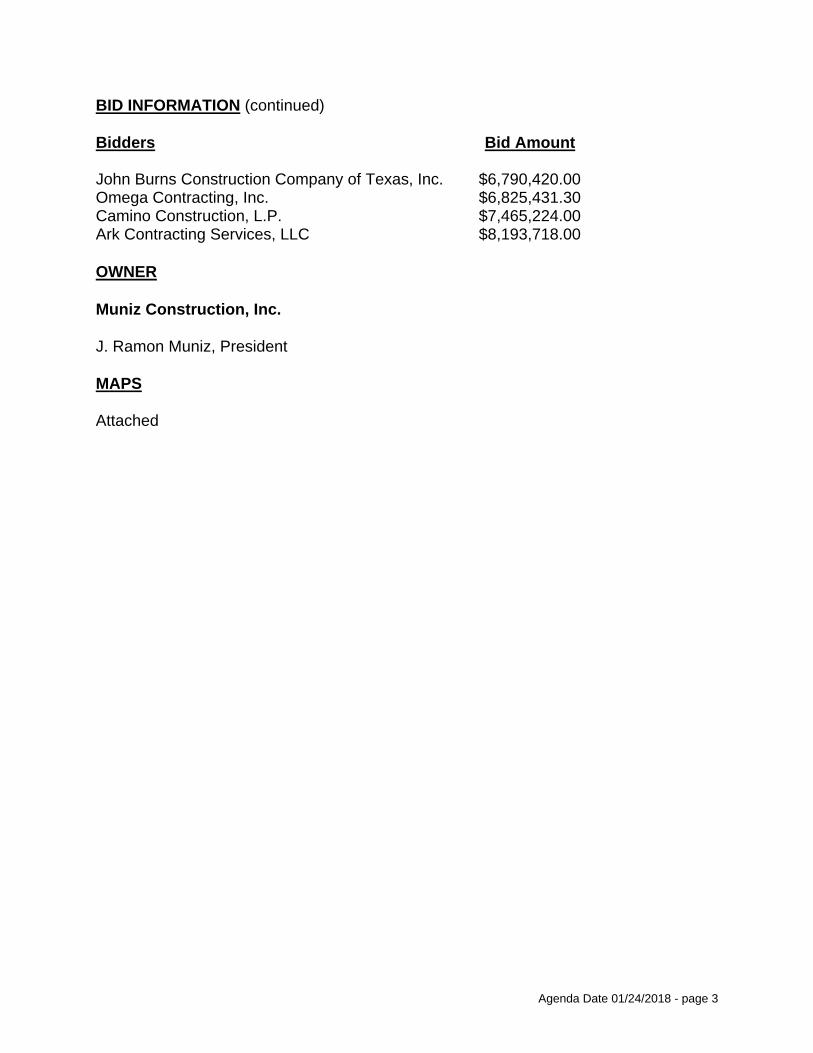
Agenda Date 01/24/2018 - page 3
BID INFORMATION (continued)
Bidders Bid Amount
John Burns Construction Company of Texas, Inc. $6,790,420.00Omega Contracting, Inc. $6,825,431.30Camino Construction, L.P. $7,465,224.00Ark Contracting Services, LLC $8,193,718.00
OWNER
Muniz Construction, Inc.
J. Ramon Muniz, President
MAPS
Attached

BUSINESS INCLUSION AND DEVELOPMENT PLAN SUMMARY
PROJECT: Authorize a construction contract for the installation of water and wastewater mains at 15 locations (list attached) - Muniz Construction, Inc., lowest responsible bidder of six - Not to exceed $5,763,443 - Financing: Water Utilities Capital Improvement Funds
Muniz Construction, Inc. is a local, minority firm, has signed the "Business Inclusion & Development" documentation, and proposes to use the following sub-contractors.PROJECT CATEGORY: Construction
_______________________________________________________________
LOCAL/NON-LOCAL CONTRACT SUMMARY
Amount Percent
Total local contracts $5,344,562.00 92.73%Total non-local contracts $418,881.00 7.27%
------------------------ ------------------------
TOTAL CONTRACT $5,763,443.00 100.00%
LOCAL/NON-LOCAL M/WBE PARTICIPATION
Local Contractors / Sub-Contractors
Local Certification Amount Percent
Muniz Construction, Inc.MB Concrete Construction, Inc.Magnum Manhole and Underground Company, Inc.
HMMB35997N0718HMMB78289N0519WFDB90520Y1018
$3,329,871.79$1,556,129.61
$64,254.60
62.30%29.12%
1.20%
------------------------ ------------------------
Total Minority - Local $4,950,256.00 92.62%
Non-Local Contractors / Sub-Contractors
None
TOTAL M/WBE CONTRACT PARTICIPATION
Local Percent Local & Non-Local Percent
African American $0.00 0.00% $0.00 0.00%Hispanic American $4,886,001.40 91.42% $4,886,001.40 84.78%Asian American $0.00 0.00% $0.00 0.00%Native American $0.00 0.00% $0.00 0.00%WBE $64,254.60 1.20% $64,254.60 1.11%
---------------------- ---------------------- ---------------------- -----------------------
Total $4,950,256.00 92.62% $4,950,256.00 85.89%

8" Water MainN/A Wastewater MainMapsco: 54 LCouncil District: 1
ZAN
G B
LVD
BE
CK
LE
Y A
VE
TY
LE
R S
T
CLARENDON DR
PR
AT
T S
T
VE
RN
ON
AV
E
R L
TH
OR
NT
ON
FW
Y
BO
YD
ST
LL
EW
EL
LYN
AV
E
R L
TH
OR
NT
ON
HO
V
MONSSEN DR
AR
GE
NTI
A D
R
MANUS DR
MAYRANT DR
BR
OO
KH
AV
EN
DR
SE
EV
ER
S A
VE
NOLTE DR
WOOLSEY DR
GO
YE
NS
DR
GRIFFITH AVE
BIZERTE A
VE
BANCROFT DR
BIS
HO
P A
VE
SH
EL
MIR
E D
R
AD
AM
S A
VE
WYNNEWOOD DR
BROOKS AVE
PELMAN ST
MA
DIS
ON
AV
E
ELMDALE PL
BERKLEY AVE
CIRCLE DR
HOEL DR
JERDEN LN
WY
SO
N P
LCONRAD ST
OWENSONS DR
DELAWARE AVE
RO
CK
WO
OD
ST
R L
TH
OR
NT
ON
AC
RD
SUFFOLK AVE
AR
BO
RV
ITA
E A
VE
ELMHURST PL
LEBANON AVE
ZAN
G B
LVD
BIZERTE
AVE
TY
LE
R S
T
VE
RN
ON
AV
E
TY
LE
R S
T
Council District 1
Council District 4
Council District: 1
8
3
6
5
7
4
2
13
1
12
14
9
1110«
Contract No. 17-343/344
Mayrant Drive
from to Llewellyn Avenue
Water and Wastewater Main Installations
Dallas Water Utilities
at 1 LocationsSegment 1 of 1PID: 6029

8" Water Main8" Wastewater MainMapsco: 33 DCouncil District: 2
SH
OR
EC
RE
ST
DR
WYL
IE D
R
WEISS ST
REEVES ST
NORTHWEST H
WY
LAKEFIELD PARK DR
LOVE
FIE
LD D
R
NORTHWEST H
WY
Council District 2
Council District 6
Council District: 2
8
3
6
5
7
4
2
13
1
12
14
9
1110«
Contract No. 17-343/344
Alley between Shorecrest Drive and Wylie Drivefrom Weiss Street to Reeves Street
Water and Wastewater Main Installations
Dallas Water Utilities
at 1 LocationsSegment 2 of 1PID: 3954

N/A Water Main15" Wastewater MainMapsco: 34 VCouncil District: 2
LEMM
ON AVE
KING
S RD
BOWSER AVE
LOM
O A
LTO
DR
DA
LL
AS
NO
RT
H T
OL
LW
AY
LAHOMA ST
CEDAR SPRINGS RD
MAHANNA S
T
RAWLINS ST
WESTWAY AVE
ROLAND AVE
FAIRWAY ST
PRESCOTT AVE
HALL ST
WE
ST
SID
E D
R
HAWTHORNE A
VE
RALEIGH S
T
HERSCHEL AVE
VANDELIA ST
HOLLAND AVE
DA
LL
AS
NO
RT
H T
OL
LW
AY
AC
RD
GILBERT AVE
MA
CA
RT
HU
R A
VE
LOM
O A
LTO
CT
LEMM
ON AVE
HALL ST
HERSCHEL AVE
PRESCOTT A
VE
HAWTHO
RNE AVE
VA
ND
EL
IA S
T
Council District 2
Council District 14
Council District: 2
8
3
6
5
7
4
2
13
1
12
14
9
11
10«
Contract No. 17-343/344
from Lomo Alto Drive to Lemmon Avenue
Dallas North Tollway
Water and Wastewater Main Installations
Dallas Water Utilities
at 1 LocationsSegment 3 of 1PID: 4510

N/A Water Main18" Wastewater MainMapsco: 34 PCouncil District: 2
MAPLE AVE
DENTON DR
MOCKIN
GBIRD L
N
FOREST PARK RD
BOM
AR AVE
FIELDER C
T
MANO
R WAY
KIMSEY D
R
STUTZ DR
HAWES A
VE
TREADWAY P
LZTREADW
AY ST
EGAN A
VE
CALLISTO CT
MOCKIN
GBIRD L
N
BOM
AR AVE
Council District 2
Council District: 2
8
3
6
5
7
4
2
13
1
12
14
9
1110«
Contract No. 17-343/344
from Bomar Avenue northwest
Maple Avenue
Water and Wastewater Main Installations
Dallas Water Utilities
at 1 LocationsSegment 4 of 1PID: 4971

8" Water Main33" Wastewater MainMapsco: 34 YCouncil District: 2
LUCAS D
R
HARRY HINES BLVD
HONDO
AVE
ARROYO
AVE
AFTON ST
HAWTHO
RNE AVE
SYLVESTER ST
MACATEE D
R
ROSEWO
OD AVE
BENGAL ST
LAKE AVE
WYCLIFF AVE
KENDALL DR
VAG
AS ST
WENG
E LN
NEW W
ATER LN
HARRY HINES BLVD
WYCLIF
F AVE
Council District 2
Council District: 2
8
3
6
5
7
4
2
13
1
12
14
9
1110«
Contract No. 17-343/344
from Lucas Drive northwest
Production Drive
Water and Wastewater Main Installations
Dallas Water Utilities
at 1 LocationsSegment 5 of 1PID: 4508

8" Water Main12" Wastewater MainMapsco: 58 B, CCouncil District: 5
BRUTON RD
TILLMAN STU
TIC
A D
R
HIL
LB
UR
N D
R
PR
ICH
AR
D L
N
PL
EA
SA
NT
DR
BU
CK
NE
R B
LVD
UMPHRESS RD
JOA
N D
R
RAVEHILL LN
LO
LIT
A D
R
YU
CC
A D
R
CO
NN
ER
DR
HUTTIG AVE
AL
HA
MB
RA
ST
GA
YL
OR
D D
R
MA
CK
LN
LA
S C
RU
CE
S L
N
MA
JOR
DR
QU
INT
O D
R
SH
OR
TAL
DR
MARINGO DR
DUGAN ST
FO
NV
ILL
E D
R
SEYDEL ST
DAINGERFIELD DR
SA
NTA
CR
UZ
DR
VALLEJO DR
HO
UG
HT
ON
RD
REVA STPIEDMONT DR
OL
DF
IEL
D D
R
DANDY LN
COLEBROOK ST
STONEHURST ST
RE
XL
AW
N D
R
OR
MO
ND
DR
JOHN M
CCOY DR
VALENTINE CT
MACK CIR
BRUTON RD
STONEHURST ST
GA
YL
OR
D D
R
BU
CK
NE
R B
LVD
REVA ST
OL
DF
IEL
D D
R
Council District 5
Council District: 5
8
3
6
5
7
4
2
13
1
12
14
9
1110«
Contract No. 17-343/344
from Hillburn Drive to Prichard Lane
Bruton Road
Water and Wastewater Main Installations
Dallas Water Utilities
at 1 LocationsSegment 6 of 1PID: 4534

8" Water Main8" Wastewater MainMapsco: 42 KCouncil District: 6
NOMAS ST
SINGLETON BLVD
CLY
ME
R S
T
LAPSLEY ST
IRO
QU
OIS
DR
BERNAL DR
ING
ER
SO
LL
ST
PUEBLO ST CLA
IBO
UR
NE B
LVD
IRO
QU
OIS
DR
BERNAL DR
SINGLETON BLVD
Council District 6
Council District: 6
8
3
6
5
7
4
2
13
1
12
14
9
1110«
Contract No. 17-343/344
from Nomas Street to Clymer Street
Bill Harrod Street
Water and Wastewater Main Installations
Dallas Water Utilities
at 1 LocationsSegment 7 of 1PID: 734

8" Water MainWastewater Main
Mapsco: 43 HCouncil District: 6
LEATH ST
CALYPSO ST
HA
MP
TO
N R
D
CANADA DR
ANGELINA DR
PU
GE
T S
T
DA
RIE
N S
T
FIN
IS S
T
HA
MP
TO
N C
ON
N
CA
NA
DA
CO
NN
HA
MP
TO
N R
D
CANADA DR
HA
MP
TO
N C
ON
N
Council District 6
Council District: 6
8
3
6
5
7
4
2
13
1
12
14
9
1110«
Contract No. 17-343/344
from Calypso Street to Canada Drive
Brundrette Street
Water and Wastewater Main Installations
Dallas Water Utilities
at 1 LocationsSegment 8 of 1PID: 5159

8" Water Main10" Wastewater MainMapsco: 42 UCouncil District: 6
CHIPPEWA DR
IRO
QU
OIS
DR
ING
ER
SO
LL
ST
CH
AL
K H
ILL
RD
BLACKHAWK DR
FANNIE ST
EAGLE HEIGHTS DR
FANNIE ST
Council District 6
Council District: 6
8
3
6
5
7
4
2
13
1
12
14
9
1110«
Contract No. 17-343/344
from Iroquois Drive to Ingersoll Street
Chippewa Drive
Water and Wastewater Main Installations
Dallas Water Utilities
at 1 LocationsSegment 9 of 1PID: 1900

8" Water Main54" Wastewater MainMapsco: 45 JCouncil District: 6
DR
AG
ON
ST
RIV
ER
FRO
NT B
LVD
ST
EM
MO
NS
FW
YS
TE
MM
ON
S S
ER
V
SLO
CU
M S
T
ST
EM
MO
NS
AC
RD
CONTINENTAL AVE
WOODALL RODGERS FWY
WO
OD
AL
L R
OD
GE
RS
RA
MP
VIC
TO
RY
AV
E
WOODALL RODGERS ACRD
HOWELL ST
PARKHOUSE ST LA
MA
R S
T
ST
EM
MO
NS
RA
MP
PITTSBURG ST
CO
RE
ST
ST
EM
MO
NS
FW
Y
RIV
ER
FRO
NT B
LVD
WOODALL RODGERS FWY
Council District 6
Council District 2
Council District: 6
8
3
6
5
7
4
2
13
1
12
14
9
11
10«
Contract No. 17-343/344
from Riverfront Boulevard to Slocum Street
Wichita Street
Water and Wastewater Main Installations
Dallas Water Utilities
at 1 LocationsSegment 10 of 1PID: 3781

8" Water Main12" Wastewater MainMapsco: 37 RCouncil District: 9
GARLAND R
D
GASTO
N PKW
Y
ANGO
RA ST
KN
OB
OA
K D
R
LAWTHER DR
EM
ER
AL
D IS
LE
DR
SAN FERNANDO
WAY
LUNAR LN
OLD GATE LN
FOR
ES
T H
ILLS
BLV
D
MAG
ELLAN CIR
REDWO
OD CIR
BALLY MO
TE DR
HAWSER DR
GARLAND R
D
Council District 9
Council District: 9
8
3
6
5
7
4
2
13
1
12
14
9
1110«
Contract No. 17-343/344
Knob Oak Drivefrom State Highway 78 (Garland Road) northwest
Water and Wastewater Main Installations
Dallas Water Utilities
at 1 LocationsSegment 1 of 1PID: 4593

8" Water MainN/A Wastewater MainMapsco: 36 VCouncil District: 14
AVALON AVE
GASTON AVE
PE
AR
SO
N D
R
COUNTRY CLUB CIR
Council District 14
Council District 9
Council District: 14
8
3
6
5
7
4
2
13
1
12
14
9
1110«
Contract No. 17-343/344
Alley between Country Club Circle and Gaston Avenuefrom Gaston Avenue to Pearson Drive
Water and Wastewater Main Installations
Dallas Water Utilities
at 1 LocationsSegment 1 of 1PID: 3069

8" Water MainN/A Wastewater MainMapsco: 35 R, VCouncil District: 14
KNOX ST
CO
LE
AV
E
MC
KIN
NE
Y A
VE
Council District 14
Council District: 14
8
3
6
5
7
4
2
13
1
12
14
9
11
10«
Contract No. 17-343/344
Alley between Cole Avenue
from Knox Street northeast
Water and Wastewater Main Installations
Dallas Water Utilities
at 15 LocationsSegment 13 of 15PID: 5568

8" Water MainN/A Wastewater MainMapsco: 36 ZCouncil District: 14
GLASGOW DR
REIGER A
VE
SLAUGHTER AVEVICTO
R ST
REIGER AVE
Council District 14
Council District: 14
8
3
6
5
7
4
2
13
1
12
14
9
1110«
Contract No. 17-343/344
from Glasgow Drive to Slaughter Avenue
Reiger Avenue
Water and Wastewater Main Installations
Dallas Water Utilities
at 1 LocationsSegment 1 of 1PID: 3092

8" Water Main8" Wastewater MainMapsco: 36 ZCouncil District: 14
SLAUGHTER AVE
REIGER A
VE
GLASGOW DR
REIGER A
VE
Council District 14
Council District: 14
8
3
6
5
7
4
2
13
1
12
14
9
1110«
Contract No. 17-343/344
Slaughter Avenue
from Reiger southeast
Water and Wastewater Main Installations
Dallas Water Utilities
at 1 LocationsSegment 1 of 1PID: 3093


COUNCIL CHAMBER
January 24, 2018
WHEREAS, on October 27, 2017, six bids were received for the installation of water and wastewater mains at 15 locations, Contract No. 17-343/344, listed as follows:
Bidders Bid Amount
Muniz Construction, Inc. $5,763,443.00RKM Utility Services, Inc. $6,446,420.00John Burns Construction Company of Texas, Inc. $6,790,420.00Omega Contracting, Inc. $6,825,431.30Camino Construction, L.P. $7,465,224.00Ark Contracting Services, LLC $8,193,718.00
WHEREAS, the bid submitted by Muniz Construction, Inc., 1835 Garden Springs Drive, Dallas, Texas 75253, in the amount of $5,763,443.00, is the lowest and best of all bids received.
Now, Therefore,
BE IT RESOLVED BY THE CITY COUNCIL OF THE CITY OF DALLAS:
SECTION 1. That the bid submitted by Muniz Construction, Inc., in the amount of $5,763,443.00, for doing the work covered by the plans, specifications, and contract documents, Contract No. 17-343/344, be accepted.
SECTION 2. That the City Manager is hereby authorized to sign a construction services contract with Muniz Construction, Inc., approved as to form by the City Attorney, for the installation of water and wastewater mains at 15 locations.
SECTION 3. That the Chief Financial Officer is hereby authorized to disburse funds in an amount not to exceed $5,763,443.00 to Muniz Construction, Inc. as follows:
Contract No. 17-343Water Capital Improvement FundFund 2115, Department DWU, Unit PW40Object 4550, Program 717343, Vendor VS0000016417Encumbrance/Contract No. CX-DWU-2018-00004767 $2,584,846.00
Contract No. 17-344Wastewater Capital Improvement FundFund 2116, Department DWU, Unit PS40Object 4560, Program 717344, Vendor VS0000016417Encumbrance/Contract No. CX-DWU-2018-00004767 $3,178,597.00
Total amount not to exceed $5,763,443.00

COUNCIL CHAMBER
January 24, 2018
SECTION 4. That this resolution shall take effect immediately from and after its passage in accordance with the provisions of the Charter of the City of Dallas, and it is accordingly so resolved.
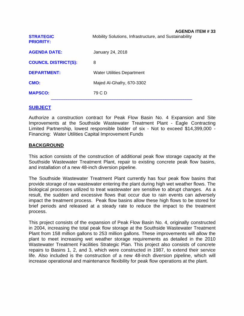
AGENDA ITEM # 33STRATEGIC PRIORITY:
Mobility Solutions, Infrastructure, and Sustainability
AGENDA DATE: January 24, 2018
COUNCIL DISTRICT(S): 8
DEPARTMENT: Water Utilities Department
CMO: Majed Al-Ghafry, 670-3302
MAPSCO: 79 C D________________________________________________________________
SUBJECT
Authorize a construction contract for Peak Flow Basin No. 4 Expansion and Site Improvements at the Southside Wastewater Treatment Plant - Eagle Contracting Limited Partnership, lowest responsible bidder of six - Not to exceed $14,399,000 - Financing: Water Utilities Capital Improvement Funds
BACKGROUND
This action consists of the construction of additional peak flow storage capacity at the Southside Wastewater Treatment Plant, repair to existing concrete peak flow basins, and installation of a new 48-inch diversion pipeline.
The Southside Wastewater Treatment Plant currently has four peak flow basins that provide storage of raw wastewater entering the plant during high wet weather flows. The biological processes utilized to treat wastewater are sensitive to abrupt changes. As a result, the sudden and excessive flows that occur due to rain events can adversely impact the treatment process. Peak flow basins allow these high flows to be stored for brief periods and released at a steady rate to reduce the impact to the treatment process.
This project consists of the expansion of Peak Flow Basin No. 4, originally constructed in 2004, increasing the total peak flow storage at the Southside Wastewater Treatment Plant from 158 million gallons to 253 million gallons. These improvements will allow the plant to meet increasing wet weather storage requirements as detailed in the 2010 Wastewater Treatment Facilities Strategic Plan. This project also consists of concrete repairs to Basins 1, 2, and 3, which were constructed in 1987, to extend their service life. Also included is the construction of a new 48-inch diversion pipeline, which will increase operational and maintenance flexibility for peak flow operations at the plant.

Agenda Date 01/24/2018 - page 2
BACKGROUND (continued)
The following chart illustrates Eagle Contracting Limited Partnership's contractual activities with the City of Dallas for the past three years:
PBW DWU PKR
Projects Completed 0 1 0Change Orders 0 0 0Projects Requiring Liquidated Damages 0 0 0Projects Completed by Bonding Company 0 0 0
ESTIMATED SCHEDULE OF PROJECT
Began Design April 2015Completed Design August 2017Begin Construction March 2018Complete Construction September 2019
PRIOR ACTION/REVIEW (COUNCIL, BOARDS, COMMISSIONS)
On June 12, 2013, City Council authorized a professional services contract with HDR Engineering, Inc. to provide engineering services for the design of a new peak flow storage basin at the Southside Wastewater Treatment Plant by Resolution No. 13-0978.
Information about this item will be provided to the Mobility Solutions, Infrastructure and Sustainability Committee on January 22, 2018.
FISCAL INFORMATION
Water Utilities Capital Improvement Funds - $14,399,000
Design $ 1,446,313Construction (this action) $14,399,000
Total Project Cost $15,845,313
M/WBE INFORMATION
See attached.

Agenda Date 01/24/2018 - page 3
BID INFORMATION
The following six bids with quotes were opened on November 3, 2017:
*Denotes successful bidder
Bidders Bid Amount
*Eagle Contracting Limited Partnership $14,399,0005700 Park Vista CircleFort Worth, Texas 76244
Crescent Constructors, Inc. $14,877,000Archer Western Construction, LLC $16,848,840Reyes Group, Ltd. $17,171,392Quest Civil Constructors, Inc. $17,572,572Oscar Renda Contracting, Inc. $17,582,400
OWNER
Eagle Contracting Limited Partnership
Roy Ewen, President and Limited PartnerBilly Haynes, Vice-President and Limited Partner
MAP
Attached

BUSINESS INCLUSION AND DEVELOPMENT PLAN SUMMARY
PROJECT: Authorize a construction contract for Peak Flow Basin No. 4 Expansion and Site Improvements at the Southside Wastewater Treatment Plant - Eagle Contracting Limited Partnership, lowest responsible bidder of six - Not to exceed $14,399,000 - Financing: Water Utilities Capital Improvement Funds
Eagle Contracting Limited Partnership is a non-local, non-minority firm, has signed the "Business Inclusion & Development" documentation, and proposes to use the following sub-contractors.PROJECT CATEGORY: Construction
_______________________________________________________________
LOCAL/NON-LOCAL CONTRACT SUMMARY
Amount Percent
Total local contracts $4,914,222.00 34.13%Total non-local contracts $9,484,778.00 65.87%
------------------------ ------------------------
TOTAL CONTRACT $14,399,000.00 100.00%
LOCAL/NON-LOCAL M/WBE PARTICIPATION
Local Contractors / Sub-Contractors
Local Certification Amount Percent
Shankle Concrete & Construction Co.Ram Tool & Supply Co., Inc.LKT & Associates, LLCMobile Enterprises, Inc.
BMDB81879Y0818WFWB10044N0518WFDB19699Y1118WFDB83554N0918
$2,513,467.00$886,856.00$609,000.00$123,015.00
51.15%18.05%12.39%
2.50%------------------------ ------------------------
Total Minority - Local $4,132,338.00 84.09%
Non-Local Contractors / Sub-Contractors
Non-local Certification Amount Percent
Partnering for Success, Inc. HFMB42467Y0618 $8,345.00 0.09%------------------------ ------------------------
Total Minority - Non-local $8,345.00 0.09%
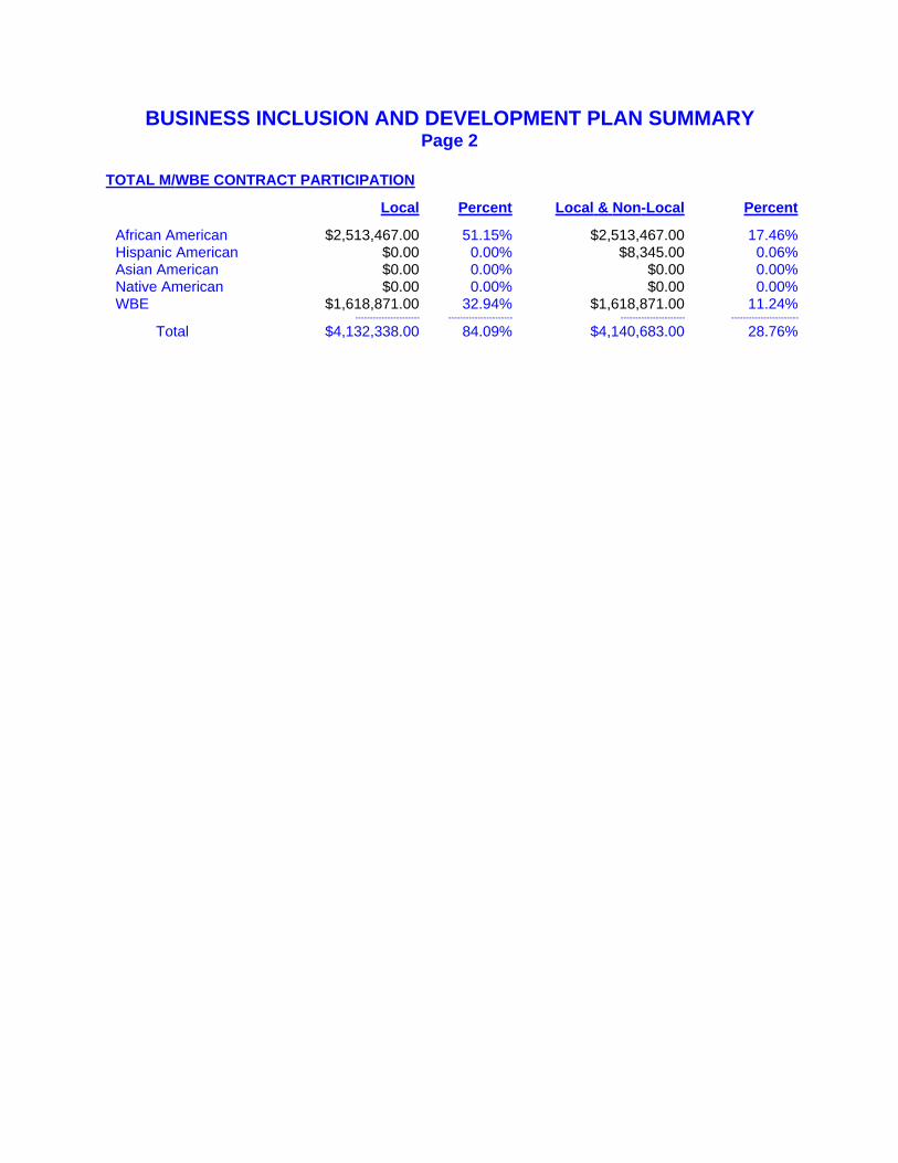
BUSINESS INCLUSION AND DEVELOPMENT PLAN SUMMARYPage 2
TOTAL M/WBE CONTRACT PARTICIPATION
Local Percent Local & Non-Local Percent
African American $2,513,467.00 51.15% $2,513,467.00 17.46%Hispanic American $0.00 0.00% $8,345.00 0.06%Asian American $0.00 0.00% $0.00 0.00%Native American $0.00 0.00% $0.00 0.00%WBE $1,618,871.00 32.94% $1,618,871.00 11.24%
---------------------- ---------------------- ---------------------- -----------------------
Total $4,132,338.00 84.09% $4,140,683.00 28.76%

LOG
CABINRD
JORDAN
VALLEY
RD
MIDDLEFIELD
RD
Council District 8
8
3
6
5
7
4
2
13
1
12
14
9
1110«
1 of 1
Mapsco: 79 C D
Southside Wastewater Treatment Plant
!!
Council District: 8
Dallas Water Utilities Contract No. 18-012
Southside Wastewater Treatment PlantPeak Flow Basin No. 4 Expansion and Site Improv ments

COUNCIL CHAMBER
January 24, 2018
WHEREAS, on November 3, 2017, the six bids listed below were received in response to Contract No. 18-012 for the construction of the Peak Flow Basin No. 4 Expansion and Site Improvements at the Southside Wastewater Treatment Plant, listed as follows:
Bidders Bid Amount
Eagle Contracting Limited Partnership $14,399,000Crescent Constructors, Inc. $14,877,000Archer Western Construction, LLC $16,848,840Reyes Group, Ltd. $17,171,392Quest Civil Constructors, Inc. $17,572,572Oscar Renda Contracting, Inc. $17,582,400
WHEREAS, the bid submitted by Eagle Contracting Limited Partnership, 5700 Park Vista Circle, Fort Worth, Texas 76244, in the amount of $14,399,000, is the lowest and best of all bids received.
Now, Therefore,
BE IT RESOLVED BY THE CITY COUNCIL OF THE CITY OF DALLAS:
SECTION 1. That the bid submitted by Eagle Contracting Limited Partnership, in the amount of $14,399,000, for doing the work covered by the plans, specifications, and contract documents, Contract No. 18-012, be accepted.
SECTION 2. That the City Manager is hereby authorized to sign a construction contract with Eagle Contracting Limited Partnership, approved as to form by the City Attorney, for the Peak Flow Basin No. 4 Expansion and Site Improvements at the Southside Wastewater Treatment Plant, in an amount not to exceed $14,399,000.
SECTION 3. That the Chief Financial Officer is hereby authorized to disburse funds in an amount not to exceed $14,399,000 to Eagle Contracting Limited Partnership from Wastewater Capital Improvement Fund, Fund 2116, Department DWU, Unit PS31, Object 4330, Program 718012, Encumbrance/Contract No. CX-DWU-2018-00004650, Vendor 356959.
SECTION 4. That this resolution shall take effect immediately from and after its passage in accordance with the provisions of the Charter of the City of Dallas, and it is accordingly so resolved.


AGENDA ITEM # 34STRATEGIC PRIORITY:
Mobility Solutions, Infrastructure, and Sustainability
AGENDA DATE: January 24, 2018
COUNCIL DISTRICT(S): 6
DEPARTMENT: Water Utilities Department
CMO: Majed Al-Ghafry, 670-3302
MAPSCO: 23 N S T X 33 B________________________________________________________________
SUBJECT
Authorize a construction services contract for the installation of a 72-inch water transmission pipeline in Harry Hines Boulevard from Cullum Lane to Walnut Hill Lane - S.J. Louis Construction of Texas Ltd., lowest responsible bidder of five - Not to exceed $18,885,731 - Financing: Water Utilities Capital Improvement Funds
BACKGROUND
This action consists of the installation of approximately 17,700 feet of water mains. This includes the installation of approximately 10,700 feet of 72-inch, 2,100 feet of 8-inch, and 4,900 feet of 12-inch water mains.
Dallas Water Utilities has plans to install a 72-inch water transmission pipeline between the Elm Fork Water Treatment Plant and the Bachman Water Treatment Plant. The 72-inch pipeline is required to increase system capacity, hydraulic flexibility, and meet system needs as recommended through master planning and long range supply planning efforts. Portions of the pipeline have been constructed and this project will install the southern connection from Cullum Lane to Walnut Hill Lane. A future construction project will install the last section, the northern connection from Farmers Branch to the Elm Fork Water Treatment Plant.
The existing water mains were built between 1974 and 1979. These mains are contributing to an increase in maintenance costs, as well as service interruptions. The installation of the proposed mains will improve the capacity of the water distribution system and reduce maintenance costs.
S.J. Louis Construction of Texas Ltd. has had no completed contractual activities with the City of Dallas in the past three years.

Agenda Date 01/24/2018 - page 2
ESTIMATED SCHEDULE OF PROJECT
Began Design November 2013Completed Design August 2017Begin Construction March 2018Complete Construction September 2019
PRIOR ACTION/REVIEW (COUNCIL, BOARDS, COMMISSIONS)
On September 11, 2013, City Council authorized a professional services contract with Black & Veatch Corporation to provide engineering services for the replacement and rehabilitation of water mains and wastewater mains at 13 locations by Resolution No. 13-1582.
On June 28, 2017, City Council authorized the City of Dallas to assume responsibility for operation and maintenance of State Highway Loop 354 (Harry Hines Boulevard) from Interstate Highway (IH) 35 East (35E) to Loop 12 in Dallas; a request to the Texas Department of Transportation to remove State Highway Loop 354 (Harry Hines Boulevard) from IH 35E to Loop 12 from the State Highway System to facilitate the construction of a 72-inch water transmission main in Harry Hines Boulevard from Walnut Hill Lane to just south of the Webb Chapel Extension; the transfer of funds from the City of Dallas, Water Utilities Capital Construction Fund to the City of Dallas, Mobility and Street Services - Resurfacing and Reconstruction Improvements Fund for future roadway maintenance in three annual installments; and the establishment of appropriations in the Resurfacing and Reconstruction Improvements Fund by Resolution No. 17-1056.
Information about this item will be provided to the Mobility Solutions, Infrastructure and Sustainability Committee on January 22, 2018.
FISCAL INFORMATION
Water Utilities Capital Improvement Funds - $18,885,730.20
Design $ 953,000.00Construction (this action) $18,885,730.20
Total Project Cost $19,838,730.20
M/WBE INFORMATION
See attached

Agenda Date 01/24/2018 - page 3
BID INFORMATION
The following five bids with quotes were opened on October 13, 2017:
*Denotes successful bidder
Bidders Bid Amount
*S.J. Louis Construction of Texas Ltd. $18,885,730.20520 South 6th AvenueMansfield, Texas 76063
BAR Constructors, Inc. $24,151,675.00Oscar Renda Contracting, Inc. $26,850,500.00Texas Sterling Construction Co. $29,342,769.00John Burns Construction Company of Texas, Inc. $34,104,770.00
OWNER
S.J. Louis Construction of Texas Ltd.
James L. Schueller, President and Chief ManagerLes V. Whitman, Executive Vice President and General Manager
MAP
Attached

BUSINESS INCLUSION AND DEVELOPMENT PLAN SUMMARY
PROJECT: Authorize a construction services contract for the installation of a 72-inch water transmission pipeline in Harry Hines Boulevard from Cullum Lane to Walnut Hill Lane - S.J. Louis Construction of Texas Ltd., lowest responsible bidder of five - Not to exceed $18,885,731 - Financing: Water Utilities Capital Improvement Funds
S.J. Louis Construction of Texas Ltd. is a non-local, non-minority firm, has signed the "Business Inclusion & Development" documentation, and proposes to use the following sub-contractors.PROJECT CATEGORY: Construction
_______________________________________________________________
LOCAL/NON-LOCAL CONTRACT SUMMARY
Amount Percent
Total local contracts $784,000.00 4.15%Total non-local contracts $18,101,730.20 95.85%
------------------------ ------------------------
TOTAL CONTRACT $18,885,730.20 100.00%
LOCAL/NON-LOCAL M/WBE PARTICIPATION
Local Contractors / Sub-Contractors
Local Certification Amount Percent
A.E.A. Transportation HMDB22701Y1118 $784,000.00 100.00%------------------------ ------------------------
Total Minority - Local $784,000.00 100.00%
Non-Local Contractors / Sub-Contractors
Non-local Certification Amount Percent
LKT Associates, LLC WFDB19699Y1118 $3,905,929.57 21.58%------------------------ ------------------------
Total Minority - Non-local $3,905,929.57 21.58%
TOTAL M/WBE CONTRACT PARTICIPATION
Local Percent Local & Non-Local Percent
African American $0.00 0.00% $0.00 0.00%Hispanic American $784,000.00 100.00% $784,000.00 4.15%Asian American $0.00 0.00% $0.00 0.00%Native American $0.00 0.00% $0.00 0.00%WBE $0.00 0.00% $3,905,929.57 20.68%
---------------------- ---------------------- ---------------------- -----------------------
Total $784,000.00 100.00% $4,689,929.57 24.83%

N/A Wastewater MainMapsco: 23 N, S, X, 33 BCouncil District: 6
DE
NT
ON
DR
WALNUT HILL LN
MA
RS
H L
N
STEMM
ONS FW
Y
NORTHWEST HWY
LOMBARDY LN
HA
RR
Y H
INE
S B
LVD
LA
RG
A D
R
PARK LN
ST
EM
MO
NS
TE
XP
RE
SS
STOREY LN
BR
OC
KB
AN
K D
R
MANANA DR
WEBB CHAPEL RD
WEBB C
HAPEL EXT
SH
AD
Y T
RL
KINKAID DR
MO
NR
OE
DR
EL
CE
NT
RO
DR
DARVANY DR
COMM
UNITY D
R
ST
EM
MO
NS
SE
RV
KENDALE DR
SH
OR
EC
RE
ST
DR
TIMBERLINE DR
CLYDEDALE D
R
FIN
NE
LL
ST
LOCKMOOR LN
NEWCASTLE DR
SHEI
LA L
N
WIT
HAM S
T
WHIRLAWAY RD
WILLOWBROOK RD
CITATION DR
BRENNER DR
ST
EM
MO
NS
AC
RD
ANDJON DR
BACHMAN DR
STEMM
ONS TRL
CO
MP
OS
ITE
DR
FREEWOOD DR
JUSTICE WAY
NORTHWEST SERV
AB
LE
S L
N
HARGROVE DR
CHIRENO
ST
WY
LIE
DR
MYRTLE SPRINGS AVE
TE
CH
NO
LO
GY
BLV
D
PE
NS
IVE
DR
OLY
MP
IC D
R
GL
EN
RIO
LN
BO
WM
AN
BLV
D
RENTZEL ST
BLYSTONE LN
EL RITO DR
JAM
ISO
N D
R
STRAIGHTW
AY DR
SP
AR
KM
AN
RD
JAM
ES
PA
RK
ER
WA
Y
WALNUT HILL LN
SH
AD
Y T
RL
NORTHWEST H
WY
PARK LN
MA
RS
H L
N
Council District 6
Council District 13
Council District 2
Council District: 6
8
3
6
5
7
4
2
13
1
12
14
9
11
10«Harry Hines Boulevardfrom south of Walnut Hill Lane to Cullum Lane
Contract No. 18-00572 Elm Fork Water Transmission Pipeline Project
Dallas Water Utilities
1 of 1PID: 5542

COUNCIL CHAMBER
January 24, 2018
WHEREAS, on October 13, 2017, the five bids listed below were received in response to Contract No. 18-005 for the installation of a 72-inch water transmission pipeline in Harry Hines Boulevard from Cullum Lane to Walnut Hill Lane, listed as follows:
Bidders Bid Amount
S.J. Louis Construction of Texas Ltd. $18,885,730.20BAR Constructors, Inc. $24,151,675.00Oscar Renda Contracting, Inc. $26,850,500.00Texas Sterling Construction Co. $29,342,769.00John Burns Construction Company of Texas, Inc. $34,104,770.00
WHEREAS, the bid submitted by S.J. Louis Construction of Texas Ltd., 520 South 6th Avenue, Mansfield, Texas 76063, in the amount of $18,885,730.20, is the lowest and best of all bids received.
Now, Therefore,
BE IT RESOLVED BY THE CITY COUNCIL OF THE CITY OF DALLAS:
SECTION 1. That the bid submitted by S.J. Louis Construction of Texas Ltd., in the amount of $18,885,730.20, for doing the work covered by the plans, specifications, and contract documents, Contract No. 18-005, be accepted.
SECTION 2. That the City Manager is hereby authorized to sign a construction services contract with S.J. Louis Construction of Texas Ltd., approved as to form by the City Attorney, for the installation of a 72-inch water transmission pipeline in Harry Hines Boulevard from Cullum Lane to Walnut Hill Lane, in an amount not to exceed $18,885,730.20.
SECTION 3. That the Chief Financial Officer is hereby authorized to disburse funds in an amount not to exceed $18,885,730.20 to S.J. Louis Construction of Texas Ltd. from Water Capital Improvement Fund, Fund 3115, Department DWU, Unit PW40, Object 4550, Program 718005, Encumbrance/Contract No. CX-DWU-2018-00004920, Vendor VS0000078761.
SECTION 4. That this resolution shall take effect immediately from and after its passage in accordance with the provisions of the Charter of the City of Dallas, and it is accordingly so resolved.

AGENDA ITEM # 35STRATEGIC PRIORITY:
Mobility Solutions, Infrastructure, and Sustainability
AGENDA DATE: January 24, 2018
COUNCIL DISTRICT(S): Outside City Limits
DEPARTMENT: Water Utilities Department
CMO: Majed Al-Ghafry, 670-3302
MAPSCO: Outside City Limits________________________________________________________________
SUBJECT
Authorize a five-year contract with one five-year renewal option, with the United States of America acting through the U. S. Army Corps of Engineers to continue providing untreated water, from January 24, 2018 through January 23, 2023 - Estimated Annual Revenue: $3,332
BACKGROUND
This item is for authorization to enter into a new untreated water purchase contract with the United States of America acting through the U. S. Army Corps of Engineers. The U. S. Army Corps of Engineers is currently purchasing untreated water from Dallas for use at its Lewisville Aquatic Ecosystem Research Facility (LAERF) under an existing untreated water purchase contract which expired on June 12, 2015.
LAERF is an experimental pond facility which supports studies and research related to the biology, ecology, and management of aquatic plants. As a part of the U. S. Army Corps of Engineers’ research, water is diverted from Lewisville Lake to the Corps’ 54 research ponds which are filled and drained independently for control of different hydrologic regimes. The U. S. Army Corps of Engineers’ LAERF is located in Lewisville, Texas, immediately below the dam of Lewisville Lake, a U. S. Army Corps of Engineers water supply reservoir.
The U. S. Army Corps of Engineers desires to purchase a maximum of 4,887,765 gallons of untreated water annually for industrial purposes to compensate Dallas for evaporative losses due to the research ponds. The City of Dallas has water rights in Lewisville Lake for multiple purposes, including rights for industrial use.

Agenda Date 01/24/2018 - page 2
BACKGROUND (continued)
Untreated water provided to the U. S. Army Corps of Engineers by Dallas will be billed at Dallas’ ordinance rate for regular untreated water service in accordance with Chapter 49. Estimated annual revenue to Dallas is $3,331.83. The revenue estimate is based on Dallas’ current untreated water rate of $1.0225 per 1,000 gallons of untreated water used multiplied by the contracted annual average usage amount of 3,258,510 gallons. Based on the annual maximum usage amount of 4,887,765 gallons, annual revenues to Dallas could increase up to $4,997.74. The sale of untreated water to the U.S. Army Corps of Engineers is subject to, and limited by, available system supply. The City of Dallas currently contracts with the U. S. Army Corps of Engineers for water storage and operation and maintenance of Lewisville, Ray Roberts and Grapevine Lakes.
PRIOR ACTION/REVIEW (COUNCIL, BOARDS, COMMISSIONS)
On June 13, 1990, City Council authorized Untreated Water Purchase Contract with the U. S. Army Corps of Engineers by Resolution No. 90-1946.
Information about this item will be provided to the Mobility Solutions, Infrastructure and Sustainability Committee on January 22, 2018.
FISCAL INFORMATION
Estimated Annual Revenue: $3,331.83 (at current untreated water rate)
MAP
Attached

"
Carrollton
TheColony
Lewisville
LewisvilleLake
LAERFIntake
8
3
6
5
7
4
2
13
1
12
14
9
1110
«Location: Lewisville Aquatic Ecosystem Research Facility (LAERF), Lewisville
Council Districts: Outside City of Dallas
Department: DWU
United States of America, acting through the U. S. Army Corps of Engineers,Untreated Water Purchase Contract
Army_Corps_Untreated_W


COUNCIL CHAMBER
January 24, 2018
WHEREAS, the United States of America, acting through the U. S. Army Corps of Engineers, currently purchases untreated water for industrial purposes from the City of Dallas, and Dallas currently sells untreated water to the U. S. Army Corps of Engineers as set forth under the terms, covenants, and conditions stated in an Untreated Water Contract between the City of Dallas and the U. S. Army Corps of Engineers dated June 13, 1990; and
WHEREAS, the City of Dallas owns water rights in Lewisville Lake including industrial water rights; and
WHEREAS, the U. S. Army Corps of Engineers requests to continue to purchase untreated water from the City of Dallas as compensation for evaporation losses from impoundments at a diversion point located at Lewisville Lake in Denton County, Texas; and
WHEREAS, the U. S. Army Corps of Engineers Untreated Water Contract with Dallas expired on June 12, 2015; and
WHEREAS, Dallas and the U. S. Army Corps of Engineers desire to enter into a new Untreated Water Contract; and
WHEREAS, the initial term of the new five-year Untreated Water Contract, which has one five-year renewal option, will be January 24, 2018 through January 23, 2023; and
WHEREAS, approval of the new contract would be in the best interest of the City of Dallas as well as the U. S. Army Corps of Engineers.
Now, Therefore,
BE IT RESOLVED BY THE CITY COUNCIL OF THE CITY OF DALLAS:
SECTION 1. That the City Manager is hereby authorized to enter into an Untreated Water Contract with the United States of America, acting through the U. S. Army Corps of Engineers, to purchase untreated water from the City of Dallas for the initial term of January 24, 2018 through January 23, 2023, with one five-year renewal option, in the estimated annual revenue amount of $3,331.83 after approval of the contract documents by the City Attorney.
SECTION 2. That the Chief Financial Officer is hereby authorized to receive and deposit all receipts for service from the U.S. Army Corps of Engineers to the Water Utilities Current Fund, Fund 0100, Department DWU, Unit 7005, Revenue Code 7847.
SECTION 3. That this contract is designated as Contract No. DWU-2018-00004847.

COUNCIL CHAMBER
January 24, 2018
SECTION 4. That this resolution shall take effect immediately from and after its passage in accordance with the provisions of the Charter of the City of Dallas, and it is accordingly so resolved.

DEPARTMENT:
AGENDA DATE:
City Secretary
January 24, 2018
COUNCIL DISTRICT(S): N/A
________________________________________________________________
SUBJECT
Consideration of appointments to boards and commissions and the evaluation and duties of board and commission members (List of nominees is available in the City Secretary's Office)


AGENDA ITEM # 37STRATEGIC PRIORITY:
Economic and Neighborhood Vitality
AGENDA DATE: January 24, 2018
COUNCIL DISTRICT(S): 14
DEPARTMENT: Office of Economic Development
CMO: Raquel Favela, 671-5257
MAPSCO: 45 M________________________________________________________________
SUBJECT
Authorize (1) a resolution of support for 2400 Bryan Street, LP, or its affiliate, related to its application for 9% Low Income Housing Tax Credits from the Texas Department of Housing and Community Affairs for the new construction of up to a 230-unit residential development located at 2400 Bryan Street; and (2) a line of credit for the proposed development in the amount of $500 - Not to exceed $500 - Financing: Public/Private Partnership Funds
BACKGROUND
On December 14, 2016, City Council adopted Resolution No. 16-1989 which guides the development community to carefully select the sites for Housing Tax Credit (HTC) projects that desire City support:
Multi-family rental units seeking to be developed as new construction using ohousing tax credits shall not receive City support, including a resolution of “no objection” unless they are in census tracts meeting all of the criteria for “High Opportunity Areas”.
High Opportunity Areas are defined as:oDallas census tracts with less than 20% poverty rate; andin the attendance zone of an elementary school that has a state accountability rating of “Met Standard” from the Texas Education Agency
Note: The 2018 Qualified Allocation Plan issued by Texas Department of Housing and Community Affairs does not consider the school ratings.

Agenda Date 01/24/2018 - page 2
BACKGROUND (continued)
Multi-family rental units seeking to be developed as a rehabilitation project ousing housing tax credits shall be considered city wide, subject to the City’s obligations to affirmatively further fair housing and uphold the Fair Housing Act, and shall not receive City support, including a resolution of “no objection” without proposed increased capital improvements, investment, and maintenance.
Allow support of all HTC projects if located in census tracts covered by an oapproved and funded Concerted Revitalization Plan (CRP).
Note: All CRP’s are expired and are under review through the Market Value Analysis and the development of a comprehensive housing policy due to be presented to City Council in March 2018.
Each project considered shall be evaluated by the Fair Housing and Human oRights Office to ensure the project affirmatively furthers fair housing and otherwise complies with the City’s obligation under the Fair Housing Act.
In December 2017, RMGM Developers, LLC (RMGM) notified the City that it intends to develop a 14 to 15 story structure at 2400 Bryan Street with 5 floors of parking and 9 to 10 floors of residential units (Project). The Project will be developed and owned by a to-be formed partnership called 2400 Bryan Street, LP. RMGM or an affiliate of RMGM will control the general partner of the new entity. RMGM is owned by John H. (Jack) Matthews and D. Scott Galbraith.
The Project will have a total of up to 230 units, which will include 24 efficiency units, 130 one-bedroom units, 62 two-bedroom units, and 14 three-bedroom units. Approximately 120 of the 230 total units will be offered at market value rents. The remaining approximately 110 units will be reserved for low income households, of which 12 units will be reserved for households earning at or below 30% of area median family income, 46 units will be reserved for households earning at or below 50% of area median family income, and 52 units will be reserved for households earning at or below 60% of area median family income. The income-restricted units will be distributed throughout the unit types and throughout the Project.
The Project site is located in a High Opportunity Area, the Walker Targeted Area, as described under the Walker Consent Decree, and the Project will accept Walker Settlement Vouchers, a type of voucher administered by the Dallas Housing Authority. The project is located in Census tract 48113001701 which has a poverty rate of 5.9% The project is served by Ben Miliam Elementary School which is rated "Met Standard".

Agenda Date 01/24/2018 - page 3
BACKGROUND (continued)
The Project is part of a multi-phased development that includes the Project, the recently opened Old Dallas High School redevelopment, and a future phase of commercial development. In addition to the approximately 230 residential units, the Project also includes approximately 400 parking garage spaces and 10,000 square feet of retail. The Project will break ground in early 2019 and will complete construction on or before August 31, 2021.
Because the City of Dallas has not been able to support Low Income Housing Tax Credit projects in the competitive 9% cycle in several years due to expired CRP’s and no submittals in High Opportunity Areas, staff recommends assisting the project with a nominal $500 line of credit through the Public/Private Partnership Fund for development costs which will allow them to score an additional point. Additional funding may be recommended for Council approval at a later time once staff completes financial underwriting for the Project.
PRIOR ACTION/REVIEW (COUNCIL, BOARDS, COMMISSIONS)
Information about this item will be provided to the Economic Development and Housing Committee on January 16, 2018.
FISCAL INFORMATION
Public/Private Partnership Funds - $500
OWNER/DEVELOPER
RMGM Developers, LLC
Scott Galbraith, MemberJack Matthews, Member

COUNCIL CHAMBER
January 24, 2018
WHEREAS, RMGM Developers, LLC, on behalf of a to-be formed entity called 2400 Bryan Street, LP, or an affiliate thereof (the “Applicant”) has proposed development of up to a 15-story structure at 2400 Bryan Street in the City of Dallas, Texas; and
WHEREAS, the proposed development will include 5 floors of parking and up to ten floors containing approximately 230 residential units, of which approximately 120 will be leased at market rates and of which approximately 110 will be reserved for low income households; and
WHEREAS, the Applicant has advised City that it intends to submit an application (TDHCA #18269) to the Texas Department of Housing and Community Affairs (TDHCA) for 2018 9% Housing Tax Credits for the proposed development at 2400 Bryan Street; and
WHEREAS, pursuant to §11.3(c) of the TDHCA 2018 Qualified Allocation Plan (“QAP”), an Application that proposes the New Construction of a Development that is located one linear mile or less from another Development that:
(A) serves the same type of household as the proposed Development, regardless of whether the Development serves families, elderly individuals, or another type of household; and
(B) has received an allocation of Housing Tax Credits or private activity bonds for any New Construction at any time during the three-year period preceding the date the Application Round begins; and
(C) has not been withdrawn or terminated from the Housing Tax Credit Program; and
(D) does not meet one of the other exceptions listed in §11.3(c)(2)(A) – (F).
Such Developments shall be considered ineligible, unless the Governing Body of the appropriate municipality or county where the Development is to be located has by vote specifically allowed the construction of a new Development located within one linear mile or less from a Development described as TDHCA #17413, Flora Lofts; and
WHEREAS, the expenditure of Public/Private Partnership funds supporting this development project is consistent with the City’s revised Public/Private Partnership Guidelines and Criteria.
Now, Therefore,
BE IT RESOLVED BY THE CITY COUNCIL OF THE CITY OF DALLAS:

COUNCIL CHAMBER
January 24, 2018
SECTION 1. That the City of Dallas, acting through its governing body, hereby confirms that it supports the proposed development to be located at 2400 Bryan Street, the project’s application for 2018 9% Housing Tax Credits, and any allocation by the TDHCA of 2018 9% Housing Tax Credits for the proposed development.
SECTION 2. That this formal action has been taken to put on record the support expressed by the City of Dallas on January 24, 2018, and that for and on behalf of the governing body, the City Secretary, or their designee, is hereby authorized, empowered, and directed to certify this resolution to the Texas Department of Housing and Community Affairs.
SECTION 3. That the City Manager or their designee, upon approval as to form by the City Attorney, is hereby authorized to execute a line of credit agreement in the amount of $500 with 2400 Bryan Street, LP or its affiliate for the construction of the proposed development at 2400 Bryan Street. The agreement will have the following terms:
a. 2400 Bryan Street, LP or its affiliate must be awarded 2018 9% Housing Tax Credits by TDHCA; and
b. The line of credit will have an interest rate of 1%. Interest will not be incurred or accrue until and unless funds are drawn; and
c. The line of credit must be repaid in full on expiration or termination of the Land Use Restriction Agreement recorded by TDHCA.
SECTION 4. That as provided for in 10 TAC §11.3(d) it is hereby acknowledged that the proposed New Construction development is located one linear mile or less from a Development that serves the same type of household as the proposed Development and has received an allocation of Housing Tax Credits (or private activity bonds) for New Construction since January 5, 2015 and that the governing body of City of Dallas has by vote specifically allowed the construction of the development at 2400 Bryan Street and to authorize an allocation of Housing Tax Credits for the Development.
SECTION 5. That prior to receiving a conditional City of Dallas building permit required by TDHCA prior to closing on the tax credits, the Project Developer will consult with the City of Dallas Sustainable Development and Construction Department with regard to security related and other design standards.
SECTION 6. That the Chief Financial Officer is hereby authorized to encumber and disburse funds from Public/Private Partnership Funds in accordance with this resolution as follows:
Fund 0352, Department ECO, Unit P151, Object 3015, Activity PPPF, Encumbrance/Contract No. ECO-2018-00005187, Vendor VC18122, in an amount not to exceed $500.

COUNCIL CHAMBER
January 24, 2018
SECTION 7. That the Chief Financial Officer is hereby authorized to set up a Receivable Balance Sheet Account in Public/Private Partnership Fund, Fund 0352, Department ECO, Balance Sheet 033F and an Unavailable Revenue Balance Sheet Account 0898 in fund 033F, in the amount of $500.
SECTION 8. That the Chief Financial Officer is hereby authorized to receive, accept and deposit loan payments from 2400 Bryan Street, LP, in Public/Private Partnership Fund, Fund 0352, Department ECO, Principal Revenue Code 847G and Interest Revenue Code 0847H, and debit Balance Sheet 0001 (Cash); as well as debit Unavailable Revenue Balance Sheet Account 0898 and credit Receivable Balance Sheet account 033F.
SECTION 9. That this resolution shall take effect immediately from and after its passage in accordance with the provisions of the Charter of the City of Dallas, and it is accordingly so resolved.

AGENDA ITEM # 38STRATEGIC PRIORITY:
Economic and Neighborhood Vitality
AGENDA DATE: January 24, 2018
COUNCIL DISTRICT(S): 3
DEPARTMENT: Office of Economic Development
CMO: Raquel Favela, 670-3309
MAPSCO: 61A -Y Z________________________________________________________________
SUBJECT
Authorize (1) a resolution of support for CLO Mountain Housing, LP, or its affiliate, related to its application for 9% Low Income Housing Tax Credits from the Texas Department of Housing and Community Affairs for the new construction of a 100-unit residential development located on the southwest corner of Camp Wisdom Road and Mountain Creek Parkway to be known as Cielo at Mountain Creek; and (2) a line of credit for the proposed development in the amount of $500 - Not to exceed $500 - Financing: Public/Private Partnership Funds
BACKGROUND
On December 14, 2016, City Council adopted Resolution No. 16-1989 which guides the development community to carefully select the sites for Housing Tax Credit (HTC) projects that desire City support:
Multi-family rental units seeking to be developed as new construction using ohousing tax credits shall not receive City support, including a resolution of “no objection” unless they are in census tracts meeting all of the criteria for “High Opportunity Areas”.
High Opportunity Areas are defined as:oDallas census tracts with less than 20% poverty rate; andin the attendance zone of an elementary school that has a state accountability rating of “Met Standard” from the Texas Education Agency
Note: The 2018 Qualified Allocation Plan issued by Texas Department of Housing and Community Affairs does not consider the school ratings.

Agenda Date 01/24/2018 - page 2
BACKGROUND (continued)
Multi-family rental units seeking to be developed as a rehabilitation project using ohousing tax credits shall be considered city wide, subject to the City’s obligations to affirmatively further fair housing and uphold the Fair Housing Act, and shall not receive City support, including a resolution of “no objection” without proposed increased capital improvements, investment, and maintenance.
Allow support of all HTC projects if located in census tracts covered by an oapproved and funded Concerted Revitalization Plan (CRP).
Note: All CRP’s are expired and are under review through the Market Value Analysis and the development of a comprehensive housing policy due to be presented to City Council in March 2018.
Each project considered shall be evaluated by the Fair Housing and Human oRights Office to ensure the project affirmatively furthers fair housing and otherwise complies with the City’s obligation under the Fair Housing Act.
In January 2018, Casa Linda Development Corporation notified the City that it intends to develop a 100-unit multi-family development located on the southwest corner of Camp Wisdom Road and Mountain Creek Parkway to be known as Cielo at Mountain Creek (Project). The Project will be developed and owned by a to-be formed partnership called CLO Mountain Housing, LP. Highridge Costa Housing, LLC or a wholly owned subsidiary of Highridge Costa Housing, LLC will be the Managing General Partner and Casa Linda Development Corporation or a wholly owned subsidiary of Casa Linda Development Corporation will be the Administrative General Partner of the new entity. Highridge Costa Housing, LLC is owned by Certo Housing Partners, LLC (51%) and International Management and Development, Inc. (49%). Certo Housing Partners, LLC is 100% owned by Michael A. Costa and International Management and Development, Inc. is owned by Mohannad (Moe) Mohanna (50%) and Alison Mohanna (50%). Casa Linda Development Corporation is owned by Linda S. Brown (50%) and Sara Reidy (50%).
The Project will have a total of 100 units, which will include 70 one-bedroom units and 30 two-bedroom units. Ten of the units will be reserved for households earning at or below 30% of area median family income, 40 units will be reserved for households earning at or below 50% of area median family income, and 50 units will be reserved for households earning at or below 60% of area median family income.
This project is located in a High Opportunity Area in census tract 48113016510 which has a 9.1% poverty rate and is served by the Duncanville ISD in the attendance zone of the Hyman Elementary School and has a rating of “Met Standard.” The development will meet or exceed the 2010 ADA standards and Texas Accessibility Standards.

Agenda Date 01/24/2018 - page 3
BACKGROUND (continued)
Because the City of Dallas has not been able to support LIHTC projects in the competitive 9% cycle in several years due to expired CRP’s and no submittals in High Opportunity Areas, staff recommends assisting the project with a nominal $500 line of credit through the Public/Private Partnership Fund for development costs which will allow them to score an additional point.
PRIOR ACTION/REVIEW (COUNCIL, BOARDS, COMMISSIONS)
Information about this item will be provided to the Economic Development and Housing Committee on January 16, 2018.
FISCAL INFORMATION
Public/Private Partnership Funds - $500
OWNERS CO- DEVELOPERS
Highridge Costa Housing, LLC Highridge Costa Housing, LLCCasa Linda Development Corporation Casa Linda Development Corporation

COUNCIL CHAMBER
January 24, 2018
WHEREAS, Highridge Costa Housing, LLC and Casa Linda Development Corporation, on behalf of a to-be formed entity called CLO Mountain Housing, LP, or an affiliate thereof (the “Applicant”) has proposed development of a 100-unit affordable housing development, Cielo at Mountain Creek on the southwest corner of Camp Wisdom Road and Mountain Creek Parkway in the City of Dallas, Texas; and
WHEREAS, the Project will have a total of 100 units, all of the units will be reserved for low income households, which will include 70 one-bedroom units and 30 two-bedroom units; ten of the units will be reserved for households earning at or below 30% of area median family income, 40 units will be reserved for households earning at or below 50% of area median family income, and 50 units will be reserved for households earning at or below 60% of area median family income; and
WHEREAS, the Applicant has advised the City that it intends to submit an application to the Texas Department of Housing and Community Affairs (TDHCA) for 2018 9% Housing Tax Credits for the proposed development; and
WHEREAS, the expenditure of Public/Private Partnership funds supporting this development project is consistent with the City’s revised Public/Private Partnership Guidelines and Criteria.
Now, Therefore,
BE IT RESOLVED BY THE CITY COUNCIL OF THE CITY OF DALLAS:
SECTION 1. That the City of Dallas, acting through its governing body, hereby confirms that it supports the proposed development to be located on the southwest corner of Camp Wisdom Road and Mountain Creek Parkway in the City of Dallas, Texas, the project’s application for 2018 9% Housing Tax Credits, and any allocation by the TDHCA of 2018 9% Housing Tax Credits for the proposed development. SECTION 2. That this formal action has been taken to put on record the support expressed by the City of Dallas on January 24, 2018, and that for and on behalf of the governing body, the City Secretary, or their designee, is hereby authorized, empowered, and directed to certify this resolution to the Texas Department of Housing and Community Affairs.
SECTION 3. That the City Manager or their designee, upon approval as to form by the City Attorney, is hereby authorized to execute a line of credit agreement in the amount of $500 with CLO Mountain Housing, LP or its affiliate for the construction of the proposed development. The agreement will have the following terms:

COUNCIL CHAMBER
January 24, 2018
SECTION 3. (continued)
a. CLO Mountain Housing, LP or its affiliate must be awarded 2018 9% Housing Tax Credits by TDHCA; and
b. The line of credit will have an interest rate of 1%. Interest will not be incurred or accrue until and unless funds are drawn; and
c. The line of credit must be repaid in full on expiration or termination of the Land Use Restriction Agreement recorded by TDHCA.
SECTION 4. That as provided for in 10 TAC §11.3(d) it is hereby acknowledged that the proposed New Construction development will not be located one linear mile or less from a Development that serves the same type of household as the proposed Development and has received an allocation of Housing Tax Credits (or private activity bonds) for New Construction since 1/5/2015 and that the governing body of City of Dallas has by vote specifically allowed the construction of the development at Cielo at Mountain Creek and to authorize an allocation of Housing Tax Credits for the Development.
SECTION 5. That prior to receiving a conditional City of Dallas building permit required by TDHCA prior to closing on the tax credits, the Project Developer will consult with the City of Dallas Sustainable Development and Construction Department with regard to security related and other design standards.
SECTION 6. That the Chief Financial Officer is hereby authorized to encumber and disburse funds from Public/Private Partnership Funds in accordance with this resolution as follows:
Fund 0352, Department ECO, Unit P151, Object 3015, Activity PPPF, Encumbrance/Contract No. ECO-2018-00005204, Vendor VC18123, in an amount not to exceed $500.
SECTION 7. That the Chief Financial Officer is hereby authorized to set up a Receivable Balance Sheet Account in Public/Private Partnership Fund, Fund 0352, Department ECO, Balance Sheet 033F and an Unavailable Revenue Balance Sheet Account 0898 in Fund 033F, in the amount of $500.
SECTION 8. That the Chief Financial Officer is hereby authorized to receive, accept and deposit loan payments from CLO Mountain Housing, LP, in Public/Private Partnership Fund, Fund 0352, Department ECO, Principal Revenue Code 847G and Interest Revenue Code 0847H, and debit Balance Sheet 0001 (Cash); as well as debit Unavailable Revenue Balance Sheet Account 0898 and credit Receivable Balance Sheet Account 033F.

COUNCIL CHAMBER
January 24, 2018
SECTION 9. That this resolution shall take effect immediately from and after its passage in accordance with the provisions of the Charter of the City of Dallas, and it is accordingly so resolved.

AGENDA ITEM # 39Mobility Solutions, Infrastructure, and Sustainability
AGENDA DATE: January 24, 2018
COUNCIL DISTRICT(S): 6
DEPARTMENT: Department of Sustainable Development and Construction
CMO: Majed Al-Ghafry, 670-3302
MAPSCO: 59 G
SUBJECT
A public hearing to receive comments regarding an application for and an ordinance granting an amendment to, and an expansion of, Specific Use Permit No. 1718 for tower/antenna for cellular communication on property zoned a CR Community Retail District with a D Liquor Control Overlay and existing deed restrictions [Z801-138] on a portion, on the west line of Midway Road and the north line of West Northwest HighwayRecommendation of Staff and CPC: Approval for a ten-year period with eligibility for automatic renewals for additional ten-year periods, subject to a revised site/elevation plan and conditionsZ167-234(WE)

1
HONORABLE MAYOR & CITY COUNCIL WEDNESDAY, JANUARY 24, 2018 ACM: Majed Al-Ghafry FILE NUMBER: Z167-234(WE) DATE FILED: March 3, 2017 LOCATION: On the west line of Midway Road and the north line of West
Northwest Highway COUNCIL DISTRICT: 6 MAPSCO: 59 G SIZE OF REQUEST: Approx. 1.16 acres CENSUS TRACT: 94.02 APPLICANT: Danial Nutt [AT&T] OWNER: Sandy Owens REPRESENTATIVE: Jeremy Baldwin REQUEST: An application for an amendment to, and an expansion of,
Specific Use Permit No. 1718 for tower/antenna for cellular communication on property zoned a CR Community Retail District with a D Liquor Control Overlay and existing deed restrictions [Z801-138] on a portion.
SUMMARY: The purpose of this request is to relocate the existing auxiliary
building housing electronic and communication equipment for the existing tower/antenna for cellular communication tower [AT&T]. The existing tower/antenna will remain at its present location.
STAFF RECOMMENDATION: Approval for a ten-year period with eligibility for
automatic renewals for additional ten-year periods, subject to a revised site/elevation plan and conditions
CPC RECOMMENDATION: Approval for a ten-year period with eligibility for
automatic renewals for additional ten-year periods, subject to a revised site/elevation plan and conditions

Z167-234(WE)
2
BACKGROUND INFORMATION:
The applicant’s request for an amendment to, and an expansion of, Specific Use Permit No. 1718 will allow for the relocation of an existing auxiliary building housing electronic and communication equipment for the tower/antenna for cellular communication tower.
The existing location and height of the cellular tower will not change. The maximum height of the existing cellular tower will not exceed 65 feet above grade. Even though the approved site plan shows a maximum height of 78 feet, the cellular tower was built a maximum height of 65 feet.
The existing deed restrictions will remain on a portion of the site, and will continue to prohibit the following uses on that portion of the site: inside commercial amusement, including modeling studios; steam baths and massage parlors, bar, lounge or tavern; restaurant; barber and beauty shops; beverage store; second-hand store; pawn shop; Army/Navy stores, discount stores, government “surplus” stores, wholesale or factory outlets and any use that exhibits lewd or pornographic material. In addition, the restrictions prohibit all buildings to one story and a total structure height not to exceed 24 feet, which includes the roof, canopies, and attached signs.
The request site is adjacent to single family dwellings to the north, and a one-story retail strip development to the west. Properties east of the site, across Midway Road, consist of various retail and personal service uses. South of the site is developed with a general merchandise or food store with a fueling station. Additional properties, south of the site, across West Northwest Highway is developed with a church use and an undeveloped tract of land.
Zoning History: There has not been any zoning changes request in the area for the past five years. Thoroughfares/Streets:
Thoroughfare/Street Type Existing ROW Proposed ROW
Midway Road Minor Arterial 100 ft. 100 ft. West Northwest Highway
Principal Arterial 100 ft. 100 ft.

Z167-234(WE)
3
Land Use:
Zoning Land Use Site CR-D Office, Cellular tower,
Car wash North R-10(A) Single Family South R-7.5(A), CR-D-1 Single Family, Church,
General merchandise or food store with fueling
station East PDD No. 70 Retail and personal
service West PDD No. 851 Retail and personal
service COMPREHENSIVE PLAN: The forwardDallas! Comprehensive Plan was adopted by the City Council in June 2006. The forwardDallas! Comprehensive Plan outlines several goals and policies which can serve as a framework for assisting in evaluating the applicant’s request. There are no goals or policies supporting or opposing the request. STAFF ANALYSIS: Land Use Compatibility: The request is developed with an office and car wash. The applicant’s request for an amendment to, and an expansion of, Specific Use Permit No. 1718 will allow for the relocation of an existing auxiliary building housing electronic and communication equipment for the tower/antenna for cellular communication tower. The existing 65-foot cellular tower will remain at its current location, which is located north of an existing general merchandise or food store with a fueling station. The applicant proposes to raze the existing office and car wash use to construct a CVS pharmacy on the site. As a result of the location of the CVS Pharmacy, the applicant needs to relocate the auxiliary building housing electronic and communication equipment. A portion of the request site has existing deed restrictions, which will remain on the property. The deed restrictions prohibit the following uses: inside commercial amusement, including modeling studios; steam baths and massage parlors, bar, lounge or tavern; restaurant; barber and beauty shops; beverage store; second-hand store; pawn shop; Army/Navy stores, discount stores, government “surplus” stores, wholesale or factory outlets and any use that exhibits lewd or pornographic material. In addition, the restrictions prohibit all buildings to one story and a total structure height not to exceed 24-feet, which includes the roof, canopies, and attached signs. The request site is adjacent to single family dwellings to the north, and a one-story retail strip development to the west. Properties east of the site, across Midway Road, consist

Z167-234(WE)
4
of various retail and personal service uses. South of the site is developed with a general merchandise or food store with a fueling station. Additional properties, south of the site, across West Northwest Highway is developed with a church use and an undeveloped tract of land. The general provisions for a Specific Use Permit in Section 51A-4.219 of the Dallas Development Code specifically state: (1) The SUP provides a means for developing certain uses in a manner in which the specific use will be consistent with the character of the neighborhood; (2) Each SUP application must be evaluated as to its probable effect on the adjacent property and the community welfare and may be approved or denied as the findings indicate appropriate; (3) The city council shall not grant an SUP for a use except upon a finding that the use will: (A) complement or be compatible with the surrounding uses and community facilities; (B) contribute to, enhance, or promote the welfare of the area of request and adjacent properties; (C) not be detrimental to the public health, safety, or general welfare; and (D) conform in all other respects to all applicable zoning regulations and standards. The regulations in this chapter have been established in accordance with a comprehensive plan for the purpose of promoting the health, safety, morals, and general welfare of the city.
The applicant’s request is consistent with the intent of the Dallas Development Code which stipulates that a monopole cellular tower is exempt from residential proximity slope height restrictions if an SUP is required for the monopole cellular use and the impact of the tower height on an adjacent residential district is considered in the SUP process. Although the subject site is adjacent to residential uses, the monopole tower will enhance the vital communication service throughout the area. The location of the existing monopole will not change. In September 2011, the City Council approve Specific Use Permit No. 1718 for a tower/antenna for cellular communication for a ten-year period with eligibility for automatic renewals for additional ten-year periods. The amendment to, and expansion of, SUP No. 1718 will permit the relocation of the existing auxiliary building housing electronic and communication equipment for the tower/antenna for cellular communication tower.
Development Standards:
DISTRICT SETBACKS Density Height Lot
Coverage Special
Standards PRIMARY Uses
Front Side/Rear
CR Community retail
15’
20’ adjacent to residential
OTHER: No Min.
0.75 FAR overall 0.5 office
54’ 4 stories 60%
Proximity Slope Visual
Intrusion
Retail & personal service, office
Landscaping: In general, landscaping must be provided in accordance with the landscaping requirements in Article X, as amended. Traffic: The Engineering Division of the Sustainable Development and Construction Department has reviewed the request and determined that it will not impact the

Z167-234(WE)
5
surrounding street system for the proposed development. Parking: Parking will be provided in accordance to the parking requirements in the Dallas Development Code, as amended, which is one space if the cellular communication tower/antenna has an auxiliary building housing electronic and communication equipment (“auxiliary building”) greater than 120 square feet. The auxiliary building is greater than 120 square feet, therefore one parking space is required for this use. The applicant is providing one space on site.

Z167-234(WE)
6
CPC Action (November 30, 2017)
Motion I: It was moved to recommend approval of an amendment to, and an expansion of, Specific Use Permit No. 1718 for tower/antenna for cellular communication for a ten-year period with eligibility for automatic renewals for additional ten-year periods, subject to a revised site plan, elevation plan and conditions on property zoned a CR Community Retail District with a D Liquor Control Overlay and existing deed restrictions [Z801-138] on a portion, on the west line of Midway Road and the north line of West Northwest Highway.
Maker: Carpenter Second: Houston Result: Failed: 6 to 5
For: 6 - Rieves*, Houston, Shidid, Carpenter,
Lavallaissa, Tarpley Against: 5 - West, Davis, Housewright, Schultz, Murphy Absent: 1 - Mack Vacancy: 0 Conflict: 3 - Jung, Peadon, Ridley *out of the room, shown voting in favor
Note: At the public hearing the Chair erroneously indicated Motion I had failed. However, Commissioner Rieves was out of the room and should have been shown in favor.
Motion II: It was moved to recommend approval of an amendment to, and an expansion of, Specific Use Permit No. 1718 for tower/antenna for cellular communication for a ten-year period, subject to a revised site plan, elevation plan and conditions on property zoned a CR Community Retail District with a D Liquor Control Overlay and existing deed restrictions [Z801-138] on a portion, on the west line of Midway Road and the north line of West Northwest Highway.
Maker: Schultz Second: Murphy Result: Carried: 11 to 0
For: 11 - West, Rieves*, Houston, Davis, Shidid,
Carpenter, Lavallaissa, Housewright, Schultz, Murphy, Tarpley

Z167-234(WE)
7
Against: 0 Absent: 1 - Mack Vacancy: 0 Conflict: 3 - Jung, Peadon, Ridley *out of the room, shown voting in favor
Note: Motion II was null and void.
Notices: Area: 300 Mailed: 15 Replies: For: 1 Against: 0 Speakers: For: David Prejean, 5566 Waneta Dr., Dallas, TX, 75209 Against: None

Z167-234(WE)
8
LIST OF OFFICERS [AT&T]

Z167-234(WE)
9
1. USE: The only use authorized by this specific use permit is a tower/antenna for cellular communication.
2. SITE PLAN: Use and development of the Property must comply with the attached site/elevation plan.
3. TIME LIMIT: This specific use permit expires on [September 14, 2021], (ten years from the passage of the ordinance), but is eligible for automatic renewal for additional 10-year periods, pursuant to Section 51A-4.219 of Chapter 51A of the Dallas City Code, as amended. For automatic renewal to occur, the Property owner must file a complete application for automatic renewal with the director before the expiration of the current period. Failure to timely file a complete application will render this specific use permit ineligible for automatic renewal. (Note: The Code currently provides that applications for automatic renewal must be filed after the 180th but before the 120th day before the expiration of the current specific use permit period. The Property owner is responsible for checking the Code for possible revisions to this provision. The deadline for application for automatic renewal is strictly enforced.)
4. HEIGHT: The tower/antenna for cellular communication may not exceed [78] 65 feet in height.
5. LIGHTING. The tower/antenna for cellular communication may not be illuminated, as required by the Federal Aviation Administration.
6. COMMUNICATION TOWER: Any tower/antenna for cellular communication over 65 feet in height must be constructed to support the antenna arrays for at least two other wireless communication carriers, and the tower/antenna for cellular communication must be made available to other carriers upon reasonable terms.
7. SHARED USE WITH OTHER CARRIERS: Any tower/antenna for cellular
communication must be constructed to support the antenna arrays for at least two other wireless communications carriers, and the tower/antenna for cellular communication must be made available to other carriers upon reasonable terms.
8. SIGNAGE: No signs may be attached to the tower/antenna for cellular
communication. 9. MAINTENANCE: The Property must be properly maintained in a state of good
repair and neat appearance. 10. GENERAL REQUIREMENTS: Use of the Property must comply with all federal and
state laws and regulations, and with all ordinances, rules, and regulations of the City of Dallas.
CPC PROPOSED SUP CONDITIONS

Z167-234(WE)
10
PROPOSED SITE/ELEVATION PLAN

Z167-234(WE)
11
EXISITING SITE PLAN
Page 1 of 2

Z167-234(WE)
12
EXISITING SITE PLAN Page 2 of 2

Z167-234(WE)
13
HIGHGROVE DR ~
~<v $0
<f>'V
o'11BERR4 -<.: ~
'Y'.t.
'Si
~ E5 m 0
LA PLACE DR ;xi
WOODCREEK DR
ti W NORTHWEST HWY 16
5
t
WILADADR
1
BROOKVIEW DR
1 GLOSTER RD
MANNING LN
W NORTHWEST HWY ... ~"t"
BRfTToN WOODS COCHRAN CHAPEL CIR
VICINITY MAP Case no: ---=Z=-1::...;6=-7:....·_2_3_4 __
10/23/2017 1 :6,000 Date: --------

Z167-234(WE)
14
® AERIAL MAP
Z167-234 Case no: -~::...:...:::....:......=.;;.....__ __
10/23/2017 Date: __ ....:....__ ____ _
1 :2,400
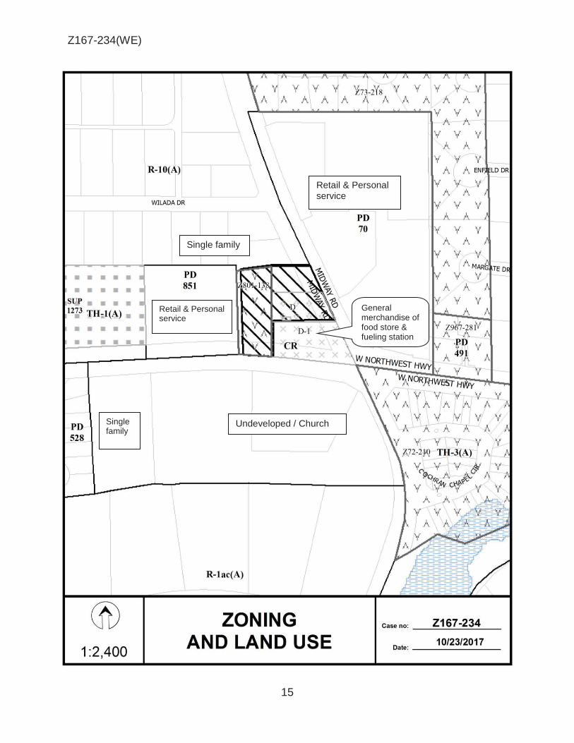
Z167-234(WE)
15
Single family
Undeveloped / Church
Single family
Retail & Personal service
Retail & Personal service
General merchandise of food store & fueling station

Z167-234(WE)
16
CPC RESPONSES

Z167-234(WE)
17
Notification List of Property Z167-234
15 Property Owners Notified 1 Property Owners in Favor 0 Property Owners Opposed
Reply Label # Address Owner 1 4275 W NORTHWEST HWY AIRPORT FREEWAY FUEL CENTER LP
2 9221 MIDWAY RD CONSTANCE MIDWAY LTD
3 9227 MIDWAY RD MCGILL MANDY
4 4255 W NORTHWEST HWY CVS PHARMACY INC
5 9101 MIDWAY RD COCHRAN CHAPEL
6 9027 MIDWAY RD COCHRAN CHAPEL METHODIST
7 4180 WILADA DR KNIGHT ALLAN M
8 4188 WILADA DR MOORE NICKY N
9 4194 WILADA DR MORADI MASOUD &
O 10 9241 MIDWAY RD ARNOLD H DAVID
11 4193 WILADA DR HARDAGE PATRICK C & KRISTIE N
12 4187 WILADA DR CRAVEN ROBERT P &
13 4235 W NORTHWEST HWY MIDWAY NORTHWEST HIGHWAY SHOPPING CENTER LLC
14 4343 W NORTHWEST HWY PRESTON HOLLOW INDIAN SCH
15 4343 W NORTHWEST HWY HEB GROCERY COMPANY LP

AGENDA ITEM # 40Mobility Solutions, Infrastructure, and Sustainability
AGENDA DATE: January 24, 2018
COUNCIL DISTRICT(S): 10
DEPARTMENT: Department of Sustainable Development and Construction
CMO: Majed Al-Ghafry, 670-3302
MAPSCO: 18 W
SUBJECT
A public hearing to receive comments regarding an application for and an ordinance granting the renewal of Specific Use Permit No. 1548 for an open-enrollment charter school on property zoned an IR Industrial Research District, on the west and north side of Forestgate Drive, north of Forest LaneRecommendation of Staff and CPC: Approval for a five-year period with eligibility for automatic renewals for additional five-year periods, subject to a revised site plan, revised traffic management plan, and conditionsZ167-259(WE)


1
HONORABLE MAYOR & CITY COUNCIL WEDNESDAY, JANUARY 24, 2018 ACM: Majed Al-Ghafry
FILE NUMBER: Z167-259(WE) DATE FILED: March 29, 2017
LOCATION: West and north side of Forestgate Drive, north of Forest Lane
COUNCIL DISTRICT: 10 MAPSCO: 18 W
SIZE OF REQUEST: Approx. 5.58 acres CENSUS TRACT: 190.19
APPLICANT/OWNER: Harmony Public Schools
REPRESENTATIVE: Karl Crawley, Masterplan
REQUEST: An application for the renewal of Specific Use Permit No. 1548 for an open-enrollment charter school on property zoned an IR Industrial Research District.
SUMMARY: The applicant is requesting to renew the existing SUP for an
open-enrollment charter school [Harmony Science Academy]. The applicant missed the time period required to apply for automatic renewal.
STAFF RECOMMENDATION: Approval for a five-year period with eligibility for automatic renewals for additional five-year periods, subject to a revised site plan, revised traffic management plan, and conditions.
CPC RECOMMENDATION: Approval for a five-year period with eligibility for automatic renewals for additional five-year periods, subject to a revised site plan, revised traffic management plan, and conditions.

2
Z167-259(WE)
BACKGROUND INFORMATION: The request site is currently developed with an open enrollment charter school
and office showroom warehouse.
SUP No. 1548 was established on May 12, 2004, for a maximum of 17 classrooms. On April 26, 2006, this SUP was approved to allow a maximum of 36 classrooms. In January 2007, an amendment to SUP No. 1548 was approved to increase the maximum number of classrooms to 40, increase the site area by an additional three acres, and include a gymnasium.
In April 2012, the City Council approved an amendment to Specific Use Permit
No. 1548 to increase the number of classrooms by seven, to a total of 47 classrooms.
The applicant did not submit an application for renewal within the time period
specified in the conditions and as a result had to submit an application for renewal of SUP No. 1548.
The applicant’s request for a renewal of Specific Use Permit No. 1548 will permit
the continued operation of the charter school. A revised site plan has been submitted to reflect the existing playground area as well as a new orientation of the parking area in front of the high school, which is located north of the elementary/middle school. There are no other changes that are being considered for Specific Use Permit No. 1548, except for the reduction in the number of classrooms from 47 to 40, and time limit of the Specific Use Permit.
The surrounding land uses consist of single family to the west, multifamily to the
north, and office showroom warehouse uses to the east and south. Zoning History: There has been one recent zoning change requested within the area within the past five years.
1. Z167-128 On February 22, 2017, the City Council
approved Specific Use Permit No. 2230 for a utility or government installation other than listed to allow an elevated water storage tank use.
Thoroughfares/Streets:
Thoroughfares/Street Type Existing ROW
Forest Lane Principle Arterial 107 ft.

3
Z167-259(WE)
Land Use:
Zoning Land Use
Site IR with SU P No. 1548 Charter school
North MF-2(A) Multifamily
South IR Office showroom warehouse
East IR Office showroom warehouse
West R-7.5(A) Single family
STAFF ANALYSIS:
Comprehensive Plan:
The requested zoning change is compatible with the intent of the Comprehensive Plan because it complies with the following goals and policies:
Land Use Element
GOAL 1.1 Align Land Use Strategies with Economic Development Priorities
Policy 1.1.5 Strengthen existing neighborhoods and promote neighborhoods’ unique characteristics.
Economic Element
GOAL 2.5 Foster A City of Great Neighborhoods
Policy 2.5.1 Promote strong and distinctive neighborhoods to enhance
Dallas’ quality of life. Land Use Compatibility:
Specific Use Permit No. 1548 is for an open enrollment charter school. The approximately 5.5-acre request site is zoned an IR Industrial Research District and is located within an office park. The renewal of SUP No. 1548 will allow for the continued operation of the existing charter school. There are no additional changes that are being considered for SUP No. 1548 except for a revised traffic management plan (TMP) and a revised site plan which depicts the existing playground area, as well as the orientation of the parking area in front of the high school, which is located north of the elementary/middle school.

4
Z167-259(WE)
The surrounding land uses are single family to the west, multifamily to the north, and office showroom warehouse uses to the east and south.
The general provisions for a Specific Use Permit in Section 51A-4.219 of the Dallas Development Code specifically state: (1) The SUP provides a means for developing certain uses in a manner in which the specific use will be consistent with the character of the neighborhood; (2) Each SUP application must be evaluated as to its probable effect on the adjacent property and the community welfare and may be approved or denied as the findings indicate appropriate; (3) The city council shall not grant an SUP for a use except upon a finding that the use will: (A) complement or be compatible with the surrounding uses and community facilities; (B) contribute to, enhance, or promote the welfare of the area of request and adjacent properties; (C) not be detrimental to the public health, safety, or general welfare; and (D) conform in all other respects to all applicable zoning regulations and standards. The regulations in this chapter have been established in accordance with a comprehensive plan for the purpose of promoting the health, safety, morals, and general welfare of the city.
The applicant has submitted a TMP report with this application which the Engineering Division has reviewed and supports.
Parking/Traffic:
The Engineering Division of the Sustainable Development and Construction Department has reviewed the request and determined that it will not significantly impact the surrounding street system for the proposed development. The Traffic Management Plan has also been reviewed and is recommended for approval.
The Traffic Management Plan will incorporate two Exhibits: Exhibit -2 and Exhibit -3. Exhibit -2 depicts the circulation and length of queueing lanes for the elementary /middle school while Exhibit-3 depicts the circulation and length of queuing lanes for the high school.
Landscaping:
Landscaping is required in accordance with Article X of the Dallas Development Code, as amended. However, the applicant’s request will not trigger any Article X requirements, as no new construction is proposed on the site.

5
Z167-259(WE)
CPC Action (November 16, 2017)
Motion: In considering an application for the renewal of Specific Use Permit No. 1548 for an open-enrollment charter school on property zoned an IR Industrial Research District on the west and north side of Forestgate Drive, north of Forest Lane, it was moved to hold this case under advisement until November 30, 2017.
Maker: Housewright Second: Houston Result: Carried: 14 to 0
For: 14 - West, Houston, Davis, Shidid*, Carpenter,
Mack, Lavallaissa, Jung, Housewright, Schultz, Peadon, Murphy, Ridley, Tarpley
Against: 0 Absent: 1 - Rieves Vacancy: 0
*out of the room, shown voting in favor
Notices: Area: 400 Mailed: 55 Replies: For: 1 Against: 0
Speakers: None
CPC Action (November 30, 2017)
Motion: In considering an application for the renewal of Specific Use Permit No. 1548 for an open-enrollment charter school on property zoned an IR Industrial Research District on the west and north side of Forestgate Drive, north of Forest Lane, it was moved to hold this case under advisement until December 14, 2017.
Maker: Housewright Second: Rieves Result: Carried: 12 to 0
For: 12 - West, Rieves, Houston, Davis, Carpenter,
Lavallaissa, Jung, Housewright, Peadon, Murphy, Ridley, Tarpley
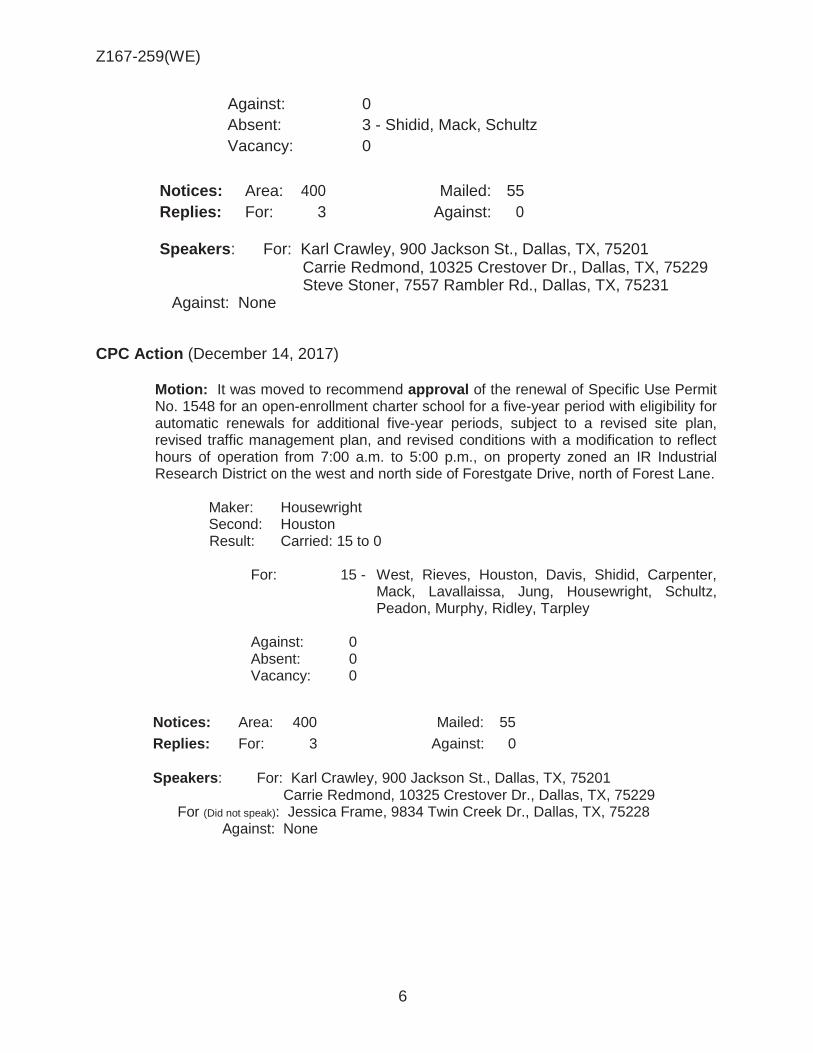
6
Z167-259(WE)
Against: 0 Absent: 3 - Shidid, Mack, Schultz Vacancy: 0
Notices: Area: 400 Mailed: 55 Replies: For: 3 Against: 0
Speakers: For: Karl Crawley, 900 Jackson St., Dallas, TX, 75201 Carrie Redmond, 10325 Crestover Dr., Dallas, TX, 75229 Steve Stoner, 7557 Rambler Rd., Dallas, TX, 75231
Against: None
CPC Action (December 14, 2017)
Motion: It was moved to recommend approval of the renewal of Specific Use Permit No. 1548 for an open-enrollment charter school for a five-year period with eligibility for automatic renewals for additional five-year periods, subject to a revised site plan, revised traffic management plan, and revised conditions with a modification to reflect hours of operation from 7:00 a.m. to 5:00 p.m., on property zoned an IR Industrial Research District on the west and north side of Forestgate Drive, north of Forest Lane.
Maker: Housewright Second: Houston Result: Carried: 15 to 0
For: 15 - West, Rieves, Houston, Davis, Shidid, Carpenter,
Mack, Lavallaissa, Jung, Housewright, Schultz, Peadon, Murphy, Ridley, Tarpley
Against: 0 Absent: 0 Vacancy: 0
Notices: Area: 400 Mailed: 55
Replies: For: 3 Against: 0 Speakers: For: Karl Crawley, 900 Jackson St., Dallas, TX, 75201 Carrie Redmond, 10325 Crestover Dr., Dallas, TX, 75229 For (Did not speak): Jessica Frame, 9834 Twin Creek Dr., Dallas, TX, 75228 Against: None

7
Z167-259(WE)
List of Partners/Principals/Officers
COSMOS FOUNDATION, INC. Board of Directors
Oner Ulvi Celpcikay Mustafa Ata Atik Cengizhan Keskin Bilal Akin Ellen A. MacDonald
Officers
Oner Ulvi Celpcikay, President Mustafa Ata Atik, Secretary Cengizhan Keskin, Treasurer Bilal Akin, Vice President Ellen A. MacDonald, Vice President Fatih Ay, Cluster Superintendent Dallas-Waco

8
Z167-259(WE)
CPC PROPOSED SUP CONDITIONS 1. USE: The only use authorized by this specific use permit is an open-enrollment
charter school. 2. SITE PLAN: Use and development of the Property must comply with the
attached site plan. 3. TIME LIMIT: This specific use permit expires on (five years from the passage of
this Ordinance) [April 10, 2017], but is eligible for automatic renewals for additional five-year periods pursuant to Section 51A-4.219 of Chapter 51A of the Dallas City Code, as amended. For automatic renewal to occur, the Property owner must file a complete application for automatic renewal with the director before the expiration of the current period. Failure to timely file a complete application will render this specific use permit ineligible for automatic renewal. (Note: the Code currently provides that applications for automatic renewal must be filed after the 10th but before the 120th day before the expiration of the current specific use permit period. The Property owner is responsible for checking the Code for possible revisions to this provision. The deadline for applications for automatic renewal is strictly enforced.)
4. INGRESS-EGRESS: Ingress and egress must be provided in the locations
shown on the attached site plan. No other ingress and egress is permitted. 5. CLASSROOMS: The maximum number of classrooms is 4[7]0, limited to no
more than 1[8]9 kindergarten and elementary classrooms, 1[5]1 junior high/middle school classrooms, and 1[4]0 high school classrooms.
6. HOURS OF OPERATION: The open-enrollment charter school may only operate between 7[8]:00 a.m. and 5[4]:00 p.m., Monday through Friday, and between 8:00 a.m. and 12:00 noon on Saturday.
7. STUDENT LOADING AND UNLOADING:
A. A designated area for student loading and unloading must be identified with pavement markings and signage in the location shown on the attached traffic management [site] plan.
B. School personnel must be provided at student loading and unloading areas, as shown on the attached traffic management plan, between the hours of 7:30 a.m. to 8:15 a.m., 2:50 p.m. to 3:15 p.m., and 3:45 p.m. to 4:00 p.m., Monday through Friday to facilitate traffic circulation and student loading and unloading.
C. Pavement markings showing the direction of traffic must be provided as
shown on the attached traffic management [site] plan.
D. Student loading and unloading is prohibited on Forestgate Drive.

9
Z167-259(WE)
8. TRAFFIC MANAGEMENT PLAN:
A. Prior to the issuance of a certificate of occupancy for Building C, the Property owner must comply with the provisions outlined in the attached traffic management plan.
B. Thirty days prior to each new school year, the Property owner must
provide the director of public works and transportation with an update to the traffic management plan. Any changes required by the director after review of the revised plan must be implemented within 15 days after the date of the director’s request.
9. MAINTENANCE: The Property must be properly maintained in a state of good
repair and neat appearance. 10. GENERAL REQUIREMENTS: Use of the Property must comply with all federal
and state laws and regulations, and with all ordinances, rules and regulations of the City of Dallas.”

10
Z167-259(WE)
PROPOSED SITE PLAN

11
Z167-259(WE)
EXISTING SITE PLAN WITH CIRCULATION PLAN

12
Z167-259(WE)
December 4, 2017 PK# 3126-17.003
TRAFFIC MANAGEMENT PLAN Project
Harmony Science Academy In Dallas, Texas
Prepared for:
City of Dallas
Onbehatfof:
Harmony Science Academy
""'""''"'''' _..,. t OF /I:' \ ... -"''?,\ ......... '; ,J- ' • .f!c-; •••• * ···1v- ., ~*··· ···* 1.a '*i \*~ it ..•••.••.•••.••••.•••..•.•• i ••• l
i'. STEVE E. STONER l l ··--:-· ..................... , ... ~ ~~~ 84828 :t:;~ "I' a \ / A\ ·"~"" t ;<"~·~C[NSt--;.··~..,
l f Ss ........ -;~,.::' \'\ IONAL " ...,-
~!'~ I 1214111 I
Prepared by:
~~ Pacheco Koch 7557 Rambler Ro ad, Suite 1400 Dallas. Texas 75231-2388 (972) 235-3031 www.pkc e .com TX. REG: ENGINEERING FIRM F-1 4439 TX. REG. SURVEYING FIRM LS-10193805-00

13
Z167-259(WE)
INTRODUCTION
TABLE OF CONTENTS
1 Project Description 1 TMP Objectives 2 Methodology 3 Expectations 4
TRAFFIC MANAGEMENT PLAN 5
Existing Site Plan
Exhibit 1. Existing Conditions Exhibit 2. Recommendations/Proposed Conditions – Elementary and
Middle Schools (Separate Pick-Up) Exhibit 3. Recommendations/Proposed Conditions – High School
Appendix

14
Z167-259(WE)
INTRODUCTION The services of Pacheco Koch (PK) were retained by on behalf of Harmony Schools, to prepare a Traffic Management Plan (TMP) for the Harmony Science Academy located at 11995 Forestgate Drive in Dallas, Texas. This TMP is site-specific and relates to the peak traffic activity associated with school traffic at the site.
Harmony Science Academy (the “School”) is seeking to renew its Specific Use Permit (SUP) from the City of Dallas (the “Approving Agency”). Submittal of a TMP, prepared by a registered professional engineer experienced and skilled in the field of traffic/transportation engineering, is one of the requirements of City’s review process. This TMP was prepared by registered professional engineers employed by Pacheco Koch. Pacheco Koch is a licensed engineering firm based in Dallas, Texas, that provides professional services in traffic engineering, transportation planning, and other fields.
Project Description
The site currently consists of a K-12 public charter school. The school consists of three, adjacent buildings—one each for the elementary, middle, and high schools. Access to the campus is via Forestgate Drive, a local street, which forms a loop that intersects with Forest Lane, a thoroughfare. In this section (between Plan Road and Skillman Street), Forest Lane is an eight-lane, median-divided cross-section. The intersections of Forest Lane and Forestgate Drive are STOP-controlled. Nearby traffic signals are located on Forest Lane at the intersections with Plano Road (east of Forestgate Drive) and Skillman Street (west of Forestgate Drive).
The campus is located within a business park and is surrounded by small offices and other businesses. Multifamily is located north of the site and single family is located west of the site. An existing site plan, prepared by Heights Venture Architects, is provided at the end of this report.
Current enrollment is summarized below in Table 1. The School is not seeking to increase enrollment through the pending SUP renewal.

15
Z167-259(WE)
Currently, each school start at 7:45 AM on school days. The Elementary School ends at 2:45 PM; the Middle and High Schools end at 3:25 PM.
TMP Objectives
A Traffic Management Plan (TMP) is a site- or area-specific plan of recommended actions and strategies to manage vehicular traffic and parking, pedestrian activity, and travel by all other modes during peak demand conditions for a planned event. The “Objectives” of a TMP are to:
1. Provide a safe environment for all Users on site and the travelling public in the vicinity of the site during the Event times;
2. Minimize (and maintain within reasonable levels) travel delays and traffic congestion on site and in the vicinity of the site during the Event;
3. Ensure reasonable access and circulation is maintained on the public street system in the vicinity of the site during the Event;
4. Provide appropriate information to the travelling public in the vicinity of the site to allow for proper awareness of anticipated traffic conditions during the Event; and,
5. Promote reasonable strategies to manage travel demand to and from the site, including use of alternative modes of travel (such as walk, bike, bus, transit, etc.), when practical.

16
Z167-259(WE)
DEFINITIONS:
Terms are used in this report: “Event”– a planned event(s), recurring or non-recurring, for which this TMP is being prepared (i.e., “school day”)
“School” (a.k.a., “Event Organizer”) – the person, group, or organization responsible for the Event
“TMP Manager” – a person or persons designated by the School to implement the TMP (also see additional tasks in the Expectations section)
“Users” – guests/patrons attending the Event “Analyst” – the person(s) preparing the TMP for the School
“Approving Agency” – the municipality or government agency requiring the Traffic Management Plan
“Traffic Department” – the department of the public agency responsible for traffic operations for a given right-of-way
“Site” – the property at which the Event is located (generally assumed to be occupied by the School)
“TMP Strategies” – actions recommended by the Analyst to be undertaken before, during, or after the Event in order to manage traffic on or off site
DISCLAIMERS:
A TMP should be developed by, or in concert with, an individual familiar with the general characteristics of the Event and the associated traffic/transportation needs. For this study, PK worked with School representatives to develop the proposed recommendations.
Recommended TMP Strategies should be based upon applicable engineering principles of traffic safety and traffic operations.
Any recommended TMP Strategies involving traffic control devices in the public right-of- way (including installation or removal of signs, pavement markings, etc.) are subject to the approval of, and must be implemented under direction of, the Traffic Department.
No private individual should perform, or attempt to perform, any act of traffic control within public right-of-way; only deputized officers of the law or other authorized representatives of the Traffic Department may manipulate traffic conditions within the public right-of-way.

17
Z167-259(WE)
Pacheco Koch was not involved with site selection, site design, or the current operations for this project. Pacheco Koch is not responsible for the implementation of the recommended TMP Strategies contained in this study.
Methodology
When feasible, the Analyst should conduct first-hand observations of existing event to develop an understanding of site-specific traffic/transportation characteristics, such as: drop-off/pick-up frequency, parking needs, alternative travel mode use, safety issues, queuing, traffic congestion, site access, current traffic management strategies in use, etc. When it is not feasible to conduct such observations, interviews with staff or personnel familiar with those items is desirable. When neither option is available, the Analyst may be required to rely upon published information and/or professional judgment and experience.
Once the base information is assembled, the Analyst should estimate the projected traffic/transportation characteristics generated by the proposed Event. Next, the Analyst should inventory the attributes and resources of the subject site and determine how the site can best accommodate those projected conditions. Based upon that assessment, the recommended TMP Strategies shall be developed to optimally achieve the basic TMP Objectives. The recommended TMP Strategies should be reviewed by the School (ideally, the TMP Manager) for refinement and approval before formal submittal to the Approving Agency.
Expectations
NOTE TO SCHOOL: By submittal of a TMP to the Approving Agency, the School is implicitly agreeing to implement, maintain, and comply with the recommended actions presented herein subject to acceptance by Approving Agency and any associated conditions Approving Agency may impose. It is also inferred that the School agrees to be self-accountable for these actions until and unless Approving Agency deems further measures are appropriate or the TMP is no longer required.
Recommended TMP Strategies may include one-time measures to be implemented before the Event and/or ongoing actions to be performed before, during, or after the Event. Recommended TMP Strategies involving on-site measures or actions are generally considered to be the responsibility of the School.
To ensure appropriate compliance and consistent implementation of the TMP, it is recommended that the School appoint a TMP “Manager”. In general, a Manager should be a qualified and capable individual or group of individuals assigned to take responsibility of the TMP and be accountable for successful implementation in order to achieve the Objectives described earlier (see “TMP Objectives”). Other specific duties of the Manager include:
• Monitor effectiveness of TMP strategies and make prudent adjustments, as
needed, to more effectively accomplish the TMP Objectives

18
Z167-259(WE)
• Maintain an awareness of readily-available alternative transportation modes serving the site and facilitate and promote their use during the Event when practical
• Serve as a liaison to the Approving Agency(-ies), when needed
• When applicable, provide training and direction to other personnel assigned to
implement the TMP measures
• Provide instruction to Users on how to comply with the intent of the TMP Recommended TMP Strategies were developed specifically for the period(s) of peak traffic demand and are depicted in the respective exhibits. For periods of less intense traffic demand, recommended TMP Strategies may be utilized, in part or in whole, as needed to realize the TMP Objectives.
Changes to TMP
Informal changes to any recommended TMP Strategies presented herein to improve efficiency or effectiveness may be implemented at the discretion of the School if those changes are prudent and do not compromise the TMP Objectives. It is recommended that changes implemented under such circumstances be documented and retained by the School for future reference or upon request. At the discretion of the Approving Agency, submittal of a formally revised TMP report/document or a validation study may be required on a predetermined or as needed basis.
TRAFFIC MANAGEMENT PLAN
NOTE: Recommended TMP Strategies contained herein are based upon the best data, site-specific information, and analytical processes readily available at the time of the study. However, specific quantities related to traffic congestion at peak periods (e.g., duration, length of queue, etc.) are estimated values. Actual quantities may vary due to unknown or unquantifiable variables and other operational factors that may occur. In the event that actual, future conditions generate undue burden on Users and/or the travelling public, modifications to the TMP should be considered. (See preceding NOTE for guidance on implementing changes to the TMP.) However, in extreme conditions, TMP actions may not be capable of mitigating all traffic conditions, and it may be incumbent on Harmony Science Academy to consider operational, institutional, or other long-term changes to address issues on a more permanent basis.
A graphical summary of existing conditions is depicted in Exhibit 1; graphical summaries of recommendations and proposed conditions are depicted in Exhibits 2 and 3 for the Elementary, Middle, and High schools, respectively. All assumptions, calculations, and other quantitative data are provided in the Appendix.
A summary of specific recommendations are provided below:

19
Z167-259(WE)
1. During the afternoon pick-up period, transition from an “unmanaged pickup protocol” to a “managed pick-up protocol” in which all parents must enter a controlled queue line and pick-up students at a designated loading area. See traffic control measures depicted in Exhibits 2 and 3.
2. Introduce a separate release (i.e., pick-up) time for all three schools:
Elementary, Middle, and High schools. Release times should be separated by a minimum of 20 minutes with Elementary School release first and High School release last.
3. Disincentive abuse of “walking” students who do not walk home but are
actually picked up by parents off school property. Recommended methods are:
a. Do not release “walkers” until the last release time,
b. Scrutinize eligibility of students to register as “walker” such as by limiting
the privilege to students with proof of residence within one mile of campus.
4. Install [Caity forces] ‘No Parking’ signs along Forestgate Drive at driveways
and corners to improve visibility.
5. Monitor parking lot and enforce no parent parking/queuing.
6. Install a traffic sign to restrict left turns at the exit driveways in front of the elementary building.
7. Install temporary “A-stand signs (For Afternoon) to discourage school parking
on private parking lots.
8. School should allow families with multiple students in different school grades to temporarily park at a designated parking area. Parents should wait for their older students (middle and high school grades).
END OF MEMO

20
Z167-259(WE)
PROPOSED TRAFFIC MANAGEMENT PLAN Elementary /Middle School

21
Z167-259(WE)
PROPOSED TRAFFIC MANAGEMENT PLAN High School

22
Z167-259(WE)
11
® 1 :6,000
I PINERIDG~ DR
~----___J '. Cityof ~ ! Garland LI • Cl
! ~ It ll IL
-J~_J_ :Q~ 4~t1l11
1~ 11 ~ t::UJ1 . . ::i !a_ _J I I I I I I I
~ ~11TI ··-··-··-·.
VICINITY MAP Case no: Z167-259
Date: 11/1/2017

23
Z167-259(WE)

24
Z167-259(WE)
Multifamily
Single Family Office /
Showroom / Warehouse
Office / Showroom / Warehouse

25
Z167-259(WE)
1

26
Z167-259(WE)
CPC RESPONSES

27
Z167-259(WE)
1111311017
Reply List of Property Owners
Z167-l59
55 Proper(1· Owners Notified 3 Proper(1· Owners i11 Fm·or 0 Proper~r Oimers Opposed
R eply Label # Address Owuer
1 12005 FORESTGATE DR COSMOS FOU?-.. "DA TION IKC
2 11945 FORESTGATE DR COSMOS FOU?-.. "DA TION IKC
0 3 10335 RED ELM RD DANH HANH
4 10.~W RFD F.J.M RO ()\VF.NS TF.RRY
5 10501 BLACK W ALi'-TUT DR HARDJK ELVER!.1' &
6 10505 BLACK WAL'-TUT DR BROSSETT DANIEL L &
7 10547 BLACK WALNUT DR NGUYEN XGA TCYET REVOCABLE LIVlNG TR
8 10551 BLACK WAL'IUT DR BAWIRAL&
9 10338 RED ELM RD NGLl'EN XGHIEP ET AL LF ES
10 10342 RED ELM RD WADDLE~TIA B
11 10346 RED ELM RD A VERETIE RANDOLPH A &
12 10339 PORTRUSHDR NG1)YEN DUY & LINH
13 10335 PORTRUSHDR ITBEJE ASTER G
14 10331 PORTRUSHDR GARCIA :MIGUEL H ERRERA &
15 10330 PORTRUSHDR VASQUEZ NORA
16 10334 PORTRUSHDR NGLl'EN KIM LAN
17 10338 PORTRUSHDR WAH EH
18 10342 PORTRUSHDR PALACIOS ~ARY ISABEL
19 10339 BLACK WAL'IUT DR COOPER BRENDA
20 10335 BLACK WAL'-TUT DR TCANG KHUP LAK
21 10402 BLACK WAL'-TUT DR CASADOS CESAR
22 10406 BLACK WAU..TUT DR POUNCIE ERICA N
23 10410 BLACK WAL'IUT DR VU TOMMY
24 10414 BLACK WAL'IUT DR GRA?-..Tf REGIKALD & LAPRENSA
25 10418 BLACK WAL'IUT DR HARRIS MARY K
26 10422 BLACK WAL'IUT DR LOVELL LEAH SCSAK

28
Z167-259(WE)
1111.l!lOJ 7
R eply Label # Address Ou111er
27 10426 BLACK WALNUT DR CHUKWUMA PEACE
28 104..~ BLACK WALNUT DR GOYAL ASHOK KUMAR &
29 10434 BLACK WALNUT DR TRAN BINH VAN &
0 30 10502 BLACK WALNUT DR HANSO!'\ FAMILY PARTNERSHIP
31 10506 BLACK WALNUT DR BACA BENJAMIN S & MARIAM
32 10510 BLACK W ALl'\JUT DR GALLEGOS ISIDRO &
33 10514 BLACK WALNUT DR MOSELEY WILLIAM G & MYKA J
34 10518 BLACK WALNUT DR NGUYENSAMD
35 10522 BLACK WALNUT CT NGUYEN KIM CHI
36 10530 BLACK WALNUT CT ORUPABO ADELAIDE
37 10534 BLACK WALNlJiCT BALDERAS TRINIDAD &
38 10538 BLACK WALNlJiCT CHAN KWO!'\G POU & SIU YIN
39 10542 BLACK WALNUT CT MATHEW JAYA T
40 10383 WHITE ELM RD PRAXA YBANE LEXUS A
41 10379 WHITE ELM RD HAMMOND BERNESTEAN
42 10375 WHITE ELM RD PARK YONG D ESTATE OF
43 10371 WHITE ELM RD TEXAS LAND CAPITAL LP
44 10367 WHITE ELM RD SPECIALIZED SERVICES LLC
45 10363 WHITE ELM RD HOWARD DARRYL
46 10359 WHITE ELM RD SIMS ANiHONY L
47 10355 WHITE ELM RD PHAt'-1 MJNH QUOC &
48 12105 PLANO RD SHARBER SCH OOLS INC
49 10503 FORESTLN DIRKIN PROPERTIES FIRST LP
so 12002 FORESTGATE DR PSFW PROPERTIES LLC
51 11805 FORESTGATE DR A VJSTONE NORTHGATE III H LLC
52 12061 FORESTGATE DR WALTERSCHEID GILES W &
53 12203 PLA!'\O RD FOREST GARDEN IN"VESTORS
54 12303 PLAt"O RD NORTHGA TE VLLG ASSOC LLC
0 55 12215 FORESTGATE DR HONG PROPERTIES LTD

AGENDA ITEM # 41Mobility Solutions, Infrastructure, and Sustainability
AGENDA DATE: January 24, 2018
COUNCIL DISTRICT(S): 6
DEPARTMENT: Department of Sustainable Development and Construction
CMO: Majed Al-Ghafry, 670-3302
MAPSCO: 23 W
SUBJECT
A public hearing to receive comments regarding an application for and an ordinance granting the renewal of Specific Use Permit No. 2105 for an alcoholic beverage establishment, limited to a bar, lounge, or tavern, on property zoned an MU-3 Mixed Use District, on the southwest corner of Harry Hines Boulevard and Willowbrook RoadRecommendation of Staff and CPC: Approval for a two-year period, subject to conditionsZ167-371(SM)


1
HONORABLE MAYOR & CITY COUNCIL WEDNESDAY, JANUARY 24, 2018 ACM: Majed Al-Ghafry
FILE NUMBER: Z167-371(SM) DATE FILED: August 8, 2017 LOCATION: Southwest corner of Harry Hines Boulevard and Willowbrook
Road COUNCIL DISTRICT: 6 MAPSCO: 23 W SIZE OF REQUEST: Approx. 6.474 acres CENSUS TRACT: 99.00 APPLICANT/OWNER: Bhagat Holdings, Ltd. REPRESENTATIVE: Tailim Song Law Firm REQUEST: An application for the renewal of Specific Use Permit No.
2105 for an alcoholic beverage establishment, limited to a bar, lounge, or tavern, on property zoned an MU-3 Mixed Use District.
SUMMARY: The applicant requests the renewal of SUP No. 2105 to
continue the operation of the existing bar [Radius Sports Bar & Grill].
CPC RECOMMENDATION: Approval for a two-year period, subject to conditions. STAFF RECOMMENDATION: Approval for a two-year period, subject to conditions.

Z167-371(SM)
2
BACKGROUND INFORMATION: The site is developed with three structures constructed in 1984, according to Dallas
Central Appraisal District Records, and the subject suite was previously occupied by various restaurants, according to permit records.
On September 24, 2014, City Council approved SUP No. 2105 for a 4,087-square foot bar, lounge, or tavern use within the northernmost suite of the westernmost building on the site.
Since the granting of SUP No. 2105, the suite has been occupied by three different
bar, lounge, or tavern operators. The current occupant, One Radius, LLC [DBA Radius Sports Bar & Grill], obtained a Certificate of Occupancy on October 12, 2017.
Zoning History: There has been no recent zoning activity in the immediate area
relevant to this request.
Traffic: The Engineering Division of the Sustainable Development and Construction Department has reviewed the requested amendment and has no objection to the request.
Thoroughfare/Street Designation Thoroughfare Roadway Section
Harry Hines Boulevard Principal Arterial Standard-8 lanes-Divided; 130’ ROW
Willowbrook Road Local 55’ ROW
STAFF ANALYSIS: Comprehensive Plan: The forwardDallas! Comprehensive Plan was adopted by the City Council in June 2006. The forwardDallas! Comprehensive Plan outlines several goals and policies which can serve as a framework for assisting in evaluating the applicant’s request. The proposed zoning request meets the following goal and objective of the comprehensive plan.
Economic Element
Goal 2.1 Promote balanced growth
Policy 2.1.1 Ensure that zoning is flexible enough to respond to changing economic conditions.

Z167-371(SM)
3
Surrounding Land Uses:
Location Zoning Land Use
Site MU-3 with SUP Nos.
2104, 2105, 2106 Shopping center
North IR and MU-3 Office/showroom/warehouse and
retail store with gas
East CS and IR Drive through restaurants, retail
with gas, and undeveloped South MU-3 Auto sales West CS Warehouse
Land Use Compatibility: The request site is developed with three one-story, masonry, and multi-tenant shopping center structures. The bar, lounge, or tavern use for the existing SUP is located in the northernmost suite of the westernmost building, which abuts a wooded drainage area. Surrounding land uses of the shopping center consist of an office/showroom/warehouse use and gas station to the north; two drive-through restaurants are located adjacent to the shopping center to the east, undeveloped land and another gas station are located on the opposite side of Harry Hines Boulevard to the east; a third gas station and a nonconforming auto sales use is located to the south, and a warehouse is located opposite of a 75-foot wide drainage easement to the west. The general provisions for a Specific Use Permit in Section 51A-4.219 of the Dallas Development Code specifically state: (1) The SUP provides a means for developing certain uses in a manner in which the specific use will be consistent with the character of the neighborhood; (2) Each SUP application must be evaluated as to its probable effect on the adjacent property and the community welfare and may be approved or denied as the findings indicate appropriate; (3) The city council shall not grant an SUP for a use except upon a finding that the use will: (A) complement or be compatible with the surrounding uses and community facilities; (B) contribute to, enhance, or promote the welfare of the area of request and adjacent properties; (C) not be detrimental to the public health, safety, or general welfare; and (D) conform in all other respects to all applicable zoning regulations and standards. The regulations in this chapter have been established in accordance with a comprehensive plan for the purpose of promoting the health, safety, morals, and general welfare of the city.

Z167-371(SM)
4
Staff supports the continued operation of the use; however, because the following police reports are from when the use was vacant and because the applicant proposes to extend the hours of operation (which staff does not support), a term of two years is recommended which will allow for a re-evaluation of the new operator and the extended hours. Off-Street Parking: The parking analysis on the existing SUP site plan shows there is 4,087 square feet of a bar, lounge, or tavern use in the suite assigned to SUP No. 2105. One space per 100 square feet of floor area is required for a bar, lounge, or tavern use, which results in 41 spaces for the area authorized by SUP No. 2105. According to the Certificates of Occupancy (COs) issued since 2006, the overall floor area of this suite is 4,000 square feet and the notes on the COs say that 40 spaces are required and provided within the overall shopping center.
Police Reports:
The following three lists (crime, arrests, and calls) were obtained by staff from the Dallas
Police Department.
Crime, Jan 1 2016 - Sep 20 2017
Incident No. Date Time UCR Offense Address
107940-2017 5/14/2017 2:00 Assault 2415 W Northwest Hwy
028641-2017 2/5/2017 22:00 Assault 2415 W Northwest Hwy
182305-2016 7/29/2016 21:00 Miscellaneous 2415 W Northwest Hwy
168769-2017 7/22/2017 22:30 Theft/Bmv 2415 W Northwest Hwy
162478-2017 7/15/2017 0:15 Other Thefts 2415 W Northwest Hwy
131767-2017 6/10/2017 23:30 Theft/Bmv 2415 W Northwest Hwy
071804-2017 3/31/2017 1:30 Uumv 2415 W Northwest Hwy
057429-2017 3/12/2017 1:45 Theft/Bmv 2415 W Northwest Hwy
041986-2017 2/22/2017 3:00 Burglary-Business 2415 W Northwest Hwy
035113-2017 2/13/2017 3:30 Robbery-Individual 2415 W Northwest Hwy
010555-2017 1/14/2017 2:30 Robbery-Individual 2415 W Northwest Hwy
282226-2016 11/26/2016 3:00 Robbery-Individual 2415 W Northwest Hwy
212139-2016 9/3/2016 1:30 Robbery-Individual 2415 W Northwest Hwy

Z167-371(SM)
5
Arrests, Jan 1 2016 - Sep 20 2017 Incident
No. Arrest No. ID
Date Time Charge
Description Address
097258-2017
0017722-2017
5/1/2017 0:00 Evading Arrest
Detention 2415 W
Northwest Hwy 097258-
2017 0017722-
2017 5/1/2017 0:00
Unlawful Carrying Weapon
2415 W Northwest Hwy
097258-2017
0017722-2017
5/1/2017 0:00 Warrant Hold
(Outside Agency) 2415 W
Northwest Hwy
Calls, Jan 1 2016 - Sep 20 2017 Master
Incident No. Date Time Problem
Priority Description
Address
17-1062829 6/4/2017 22:29 07 - Minor Accident
3 - General Service
2415 W Northwest Hwy
17-0617527 4/2/2017 2:48 6XEA -
Disturbance Emerg Amb
1 - Emergency
2415 W Northwest Hwy
17-0606594 3/31/2017 17:27 09V - UUMV 4 - Non Critical
2415 W Northwest Hwy
17-0349803 2/22/2017 10:28 11B - Burg of
Bus 3 - General
Service 2415 W
Northwest Hwy
17-1633434 8/27/2017 3:25 25 - Criminal
Assault 2 - Urgent
2415 W Northwest Hwy

Z167-371(SM)
6
Prior CPC Action – November 30, 2017: Motion: It was moved to recommend approval of the renewal of Specific Use Permit No. 2105 for an alcoholic beverage establishment, limited to a bar, lounge, or tavern for a two-year period, subject to staff’s recommended conditions with a modification to amend the hours of operation from 8:00 a.m. to 2:00 a.m. on property zoned an MU-3 Mixed Use District, on the southwest corner of Harry Hines Boulevard and Willowbrook Road.
Maker: Carpenter Second: West Result: Carried: 9 to 0
For: 9 - West, Rieves, Davis, Carpenter, Lavallaissa,
Jung, Peadon, Murphy, Tarpley Against: 0 Absent: 6 - Houston, Shidid, Mack, Housewright, Schultz,
Ridley Vacancy: 0
Notices: Area: 400 Mailed: 43 Replies: For: 0 Against: 0 Speakers: For: Shawan Bhagat, 652 Timber Crest Cr., Highland Village, TX, 75077 Against: None

Z167-371(SM)
7

Z167-371(SM)
8
CPC Recommended Amendments to SUP No. 2105 1. USE: The only use authorized by this specific use permit is an alcoholic beverage
establishment limited to a bar, lounge, or tavern. 2. SITE PLAN: Use and development of the Property must comply with the attached site
plan.
3. TIME LIMIT: This specific use permit expires on two years [September 24, 2017]. 4. FLOOR AREA: Maximum floor area for the alcoholic beverage establishment limited to
a bar, lounge, or tavern is 4,087 square feet in Building 2 as shown on the attached site plan.
5. HOURS OF OPERATION: The alcoholic beverage establishment limited to a bar,
lounge, or tavern may only operate between 8:00 a.m. [6:00 p.m.] and 2:00 a.m. (the next day), Monday through Sunday.
6. INGRESS-EGRESS: Ingress and egress must be provided in the location shown on the
attached site plan. No other ingress or egress is permitted. 7. MAINTENANCE: The Property must be properly maintained in a state of good repair
and neat appearance. 8. GENERAL REQUIREMENTS: Use of the Property must comply with all federal and
state laws and regulations, and with all ordinances, rules, and regulations of the City of Dallas.

Z167-371(SM)
9
EExxiissttiinngg SSiittee PPllaann
((nnoo cchhaannggeess))

Z167-371(SM)
10
1 :7,200
Case no: Z167-371 VICINITY MAP
Date: 9/22/2017

Z167-371(SM)
11
Retail w/Gas Office/showroom/
warehouse
Auto Sales
Warehouse
Restaurants with drive throughs Retail
w/Gas
Undeveloped
CS
IR
Retail w/Gas
MU-3

Z167-371(SM)
12
CPC Responses

Z167-371(SM)
13
11/29/2017
Reply List of Property Owners Z167-371
43 Property Owners Notified 0 Property Owners in Favor 0 Property Owners Opposed
Reply Label # Address Owner 1 2425 W NORTHWEST HWY NWH LAND LP
2 10091 HARRY HINES BLVD EPCM REALTY INC
3 10065 HARRY HINES BLVD EL TACASO INC
4 2415 W NORTHWEST HWY BHAGAT HOLDINGS LTD
5 10120 HARRY HINES BLVD TEXAS FOREST PROP INC
6 10002 HARRY HINES BLVD NORTH TEXAS STORES CORP
7 2711 STOREY LN 2223 LOMBARDY WAREHOUSE LLC
8 10251 HARRY HINES BLVD RIVERA FAMILY LTD PS THE
9 10251 HARRY HINES BLVD RIVERA BLANCA LEONARA
10 10251 HARRY HINES BLVD RIVERA BLANCA
11 10251 HARRY HINES BLVD RIVERA BLANCA
12 10251 HARRY HINES BLVD GONZALEZ JOSE ANTONIO & GENOVEVA
13 10251 HARRY HINES BLVD GONZALEZ JOSE
14 10251 HARRY HINES BLVD RAMIREZ GUSTAVO & HERLINDA
15 10251 HARRY HINES BLVD FLORENXIO ZUNIGA
16 10251 HARRY HINES BLVD EMANUEL MARTINEZ
17 10251 HARRY HINES BLVD RIVERA FAMILY LTD PS THE
18 10251 HARRY HINES BLVD CARLOS GARCIA
19 10251 HARRY HINES BLVD LORENZO ANTONIO
20 10251 HARRY HINES BLVD LOPEZ JOSE
21 10251 HARRY HINES BLVD HERNANDEZ JOSE
22 10251 HARRY HINES BLVD PEREZ ELOY
23 10251 HARRY HINES BLVD CASTRO OSVALDO
24 10251 HARRY HINES BLVD BALDERAS TOBIAS
25 10251 HARRY HINES BLVD MENDEZ RAFIEL
26 10251 HARRY HINES BLVD GARCIA-GUZMAN JOSE ELIAS

Z167-371(SM)
14
11/29/2017
Reply Label # Address Owner 27 10251 HARRY HINES BLVD RIVERA ISSAC
28 10251 HARRY HINES BLVD CLEMENTINA ROJAS
29 2621 WILLOWBROOK RD ALLMAN COMPANY DALLAS LLC
30 2617 WILLOWBROOK RD HBSS REAL ESTATE LLC
31 10222 HARRY HINES BLVD 10220 HARRY HINES LLC
32 10220 HARRY HINES BLVD 10220 HARRY HINES LLC
33 2615 WILLOWBROOK RD BARN CEMENT LLC
34 10110 HARRY HINES BLVD SIKKA INVESTMENTS LLC
35 2616 WILLOWBROOK RD MOUSSA GEORGE STANLEY TR
36 2626 WILLOWBROOK RD WAREHOUSE DEVELOPMENT LTD
37 2401 W NORTHWEST HWY WAREHOUSE DEVELOPMENT
38 10045 HARRY HINES BLVD KELLER JACQUELYN
39 10025 HARRY HINES BLVD HANDSOME FELLOW LC
40 10025 HARRY HINES BLVD BENDA INVESTMENTS
41 2635 WILLOWBROOK RD SOUTHLAND CORP
42 10217 HARRY HINES BLVD PENA JOSE
43 2631 WILLOWBROOK RD LOMBARDY LANE LTD

AGENDA ITEM # 42Mobility Solutions, Infrastructure, and Sustainability
AGENDA DATE: January 24, 2018
COUNCIL DISTRICT(S): 2
DEPARTMENT: Department of Sustainable Development and Construction
CMO: Majed Al-Ghafry, 670-3302
MAPSCO: 34 V
SUBJECT
A public hearing to receive comments regarding an application for and an ordinance granting an amendment to Planned Development Subdistrict No. 119 for Multiple-Family Subdistrict uses within Planned Development District No. 193, the Oak Lawn Special Purpose District, on the southwest line of Cedar Springs Road, between Lucas Drive and Hawthorne AvenueRecommendation of Staff and CPC: Approval, subject to a development plan and conditionsZ167-379(WE)


1
HONORABLE MAYOR & CITY COUNCIL WEDNESDAY, JANUARY 24, 2018 ACM: Majed Al-Ghafry FILE NUMBER: Z167-379(WE) DATE FILED: August 18, 2017 LOCATION: Southwest line of Cedar Springs Road, between Lucas Drive
and Hawthorne Avenue COUNCIL DISTRICT: 2 MAPSCO: 34 V SIZE OF REQUEST: Approx. 2.13 acres CENSUS TRACT: 4.05 APPLICANT: Urban Loft Partners, Inc. OWNER: Circle Park Texas, LLC REPRESENTATIVE: Karl Crawley, MASTERPLAN REQUEST: An application for an amendment to Planned Development
Subdistrict No. 119 for Multiple-Family Subdistrict uses within Planned Development District No. 193, the Oak Lawn Special Purpose District.
SUMMARY: The purpose of this request is threefold: 1) to create two
separate tracts that will permit an existing multiple-family development to remain on one tract and to develop a residential development tract on the adjacent tract; 2) to modify the development standards as it relates to the lot size and structure height; and, 3) to modify the landscape requirements.
STAFF RECOMMENDATION: Approval, subject to a development plan and
conditions. CPC RECOMMENDATION: Approval, subject to a development plan and
conditions.

Z167-379(WE)
2
BACKGROUND INFORMATION: On October 10, 2015, the City Council approved Planned Development Subdistrict
No. 119 for Multiple Family Subdistrict uses on property zoned a Multiple Family Subdistrict.
Planned Development Subdistrict No. 119 was established to redevelop the property to accommodate a 188-unit multiple-family development. The applicant, at the time, requested several modifications to the MF-2 Multiple Family Subdistrict, which included the following; increase in structure height, increase in lot coverage, increase in density, allow certain encroachments into the front yard setbacks, and alternative landscape regulations.
The property containing the existing multiple-family units was acquired by new
ownership and is currently under renovation. The remaining property is currently under contract.
The applicant proposes to create two tracts within PDS No. 119: one tract will
remain developed with the existing multiple-family uses, and the second tract will be developed with a residential development tract. The amendment to PDS No. 119 conditions will reflect the removal of specific development standards and certain urban design requirements that related to the previously approved development.
The applicant’s current proposal is to raze an existing church and a single-family dwelling to construct a 26-unit residential development tract in an area that is designated on the conceptual plan as Tract 1. The existing multiple-family development will remain in Tract 2 and will be governed by the MF-2 Multiple Family Subdistrict regulations.
Planned Development District No. 193 defines a residential development tract as a development of three or more individually platted lots in an MF-1, MF-2, or MF-3 subdistrict in which the dwelling units, whether attached or detached, are accessed from a shared driveway, and the dwelling units do not have any other dwelling units above or below them. Residential development tracts may be platted as shared access developments.
The applicant is proposing several modifications to the residential development tract regulations as it relates to the front yard and average lot area.
The surrounding land uses consist of residential uses of mixed densities, with a
community service center (Dallas Housing Authority’s Cedar Springs Multi-Purpose Center) located south of the site’s Lucas Drive frontage. The depressed travel lanes of the Dallas North Tollway are visible eastward from the site. Multiple family uses exists on property to the east/southeast along the Lucas Drive frontage. Properties that are adjacent to the site on Hawthorne Avenue are developed with single family uses.

Z167-379(WE)
3
Zoning History: There have been four zoning changes requested in the area during the past five years.
1. Z112-266 On October 24, 2012, the City Council approved an amendment to Planned Development Subdistrict No. 91 for Multiple Family Subdistrict uses within Planned Development District No. 193, the Oak Lawn Special Purpose District.
2. Z123-178 On April 24, 2013, the City Council approved an
amendment to and expansion of PDS No. 75, subject to a conceptual plan and conditions
3. Z123-326 On March 26, 2014, the City Council approved
a Planned Development Subdistrict for MF-2 Multiple Family Subdistrict Uses on property zoned an MF-2 Multiple Family Subdistrict within Planned Development District No. 193, the Oak Lawn Special Purpose District.
4. Z145-279 On October 28, 2015, the City Council approved a Planned Development Subdistrict for MF-2 Multiple Family Subdistrict Uses on property zoned an MF-2 Multiple Family Subdistrict within Planned Development District No. 193, the Oak Lawn Special Purpose District [request site].
Thoroughfares/Streets:
Thoroughfare/Street Type Existing ROW
Proposed ROW
Cedar Springs Road Collector 60 ft. 60 ft. Lucas Drive Local 50 ft. 50 ft. Hawthrorne Avenue Local 50 ft. 50 ft.

Z167-379(WE)
4
Land Use:
Zoning Land Use
Site PDS No. 119 Multiple Family,
Church, Single Family
Northeast PDS No. 4 Multiple Family Southeast PDS No. 91 Multiple Family Northwest PDS No. 70 Multiple Family Southwest MF-2 Single Family
COMPREHENSIVE PLAN: The fowardDallas! Comprehensive Plan was adopted by the City Council in June 2006. The fowardDallas! Comprehensive Plan outlines several goals and policies which can serve as a framework for assisting in evaluating the applicant’s request. LAND USE GOAL 1.2 PROMOTE DESIRED DEVELOPMENT
Policy 1.2.1 Use Vision Building Blocks as a general guide for desired
development patterns.
GOAL 1.3 PROVIDE EQUITABLE OPPORTUNITIES FOR DALLAS RESIDENTS Policy 1.3.1 Create housing opportunities throughout Dallas ECONOMIC GOAL 2.1 PROMOTE BALANCED GROWTH Policy 2.1.1 Ensure that zoning is flexible enough to respond to changing economic conditions URBAN DESIGN GOAL 5.1 PROMOTE A SENSE OF PLACE, SAFETY, AND WORKABILITY Policy 5.1.3 Encourage complementary building height, scale, design, and character. Area Plans: The Oak Lawn Special Purpose District and the Oak Lawn Plan include the following objectives:

Z167-379(WE)
5
(1) To achieve buildings more urban in form. (2) To promote and protect an attractive street level pedestrian environment with
continuous street frontage activities in retail areas. (3) To encourage the placement of off-street parking underground or within buildings
similar in appearance to non-parking buildings. (4) To promote development appropriate to the character of nearby neighborhood
uses by imposing standards sensitive to scale and adjacency issues. (5) To use existing zoned development densities as a base from which to plan, while
providing bonuses to encourage residential development in commercial areas. (6) To discourage variances or zoning changes which would erode the quantity or
quality of single-family neighborhoods, or would fail to adhere to the standards for multiple-family neighborhoods and commercial areas.
(7) To promote landscape/streetscape quality and appearance. A portion of the site will be redeveloped with a residential development tract and will have access from Cedar Springs Road and Hawthorne Avenue. The portion of the property that is constructed with a multiple family development will remain and will be governed by the MF-2 regulations. With respect to compliance with the above referenced objectives, staff has worked with the applicant to ensure that the urban design criteria, where applicable, will remain on the proposed residential development tract. As provided herein, Objective Nos. 1 and 7 are provided for in the applicant’s development vision to create walkability along Cedar Springs Road. Combined with recommended plantings and an increased setback from the southwestern property line, Objective No. 4 is palatable.
Lastly, Objective Nos. 2, 3 and 5 are not applicable to this request because of the following: 1) retail and commercial uses are not a permitted use in an MF-2 Subdistrict; therefore, creating continuous street frontage activities within retail areas is not palatable; and 2) the proposed request for a residential development tract will contain single family units that do not require the off-street parking to be placed underground. STAFF ANALYSIS: Land Use Compatibility: The 2.13-acre site is developed with a multiple family development, a church, and a single-family dwelling. On October 28, 2015, the City Council approved Planned Development Subdistrict No. 119 for Multiple Family District uses. When PDS No. 119 was established, the intent was to raze the existing multiple family development, church, and single-family dwelling and redevelop the site with a 188-unit multiple family development, with a maximum structure height of 60 feet.

Z167-379(WE)
6
Planned Development District No. 193 defines a residential development tract as a development of three or more individually platted lots in an MF-1, MF-2, or MF-3 subdistrict in which the dwelling units, whether attached or detached, are accessed from a shared driveway, and the dwelling units do not have any other dwelling units above or below them. Residential development tracts may be platted as shared access developments. The applicant’s request for an amendment to Planned Development Subdistrict No. 119 will allow for the creation of two tracts: one tract will remain developed with the existing multiple-family uses, and the second tract will be developed with a 26-unit residential development tract. The amendment to PDS No. 119 conditions will reflect the removal of specific development standards and certain urban design requirements that would have governed the development of the previously proposed 188-unit multiple-family development. The surrounding land uses consist of residential uses of mixed densities, with a community service center (Dallas Housing Authority’s Cedar Springs Multi-Purpose Center) located south of the site’s Lucas Drive frontage. The depressed travel lanes of the Dallas North Tollway are visible eastward from the site. Multiple family uses exist on property to the east/southeast along the Lucas Drive frontage. Properties that are adjacent to the site on Hawthorne Avenue are developed with single family uses. The redevelopment of the site to incorporate a 26-unit residential development tract will integrate within the existing development fabric, with single family and multiple family uses. Due to the single family uses on Hawthorne Avenue, the applicant will limit the structure height of the residential development tract within 50 feet of the southwest property line to 36 feet, and allow projections not to exceed ten feet above the maximum structure height. These projections include elevator or stair penthouse, mechanical equipment room, skylights, clerestory, chimney and vent stacks, visual screens which surround roof mounted mechanical equipment, and parapet walls, limited to a height of four feet. In an MF-2 Subdistrict, projections can exceed up to 12 feet above the maximum structure height of 36 feet. In addition, the structure height of the remaining portion of the development will not exceed 50 feet. Projections are prohibited on any structures that exceed 36 feet in height. The maximum number of stories proposed for the residential development tract is four. Lastly, the average lot area of the lots within a residential development tract must equal or exceed 1,900 square feet. However, the applicant is proposing to reduce the average lot area from 1,900 square feet to 1,500 square feet.

Z167-379(WE)
7
The chart below shows a comparison between development standards of the existing PDS No. 119 and the proposed Tracts.
Staff supports the applicant’s request for an amendment to Planned Development Subdistrict No. 119, subject to a development plan and conditions. Parking: The applicant will meet the off-street and guest parking regulations in accordance with Part I of PDD No. 193 for the specific off-street parking and loading requirements for each use. Landscaping: Landscaping must be provided in accordance with Part 1 of PDD No. 193. Plant materials must be maintained in a healthy, growing condition.
PDS No. 119 (Multiple Family development)
Tract I (residential tracts)
Tract II (MF-2 Subdistrict)
Yard, Lot & Space Regulations
Front Yard 25 ft. Cedar Springs Road 15 ft. Hawthorne Ave. 15 ft. Lucas Drive
15 ft. on Hawthorne Ave. & Cedar Springs Road
15 ft. on Hawthorne Ave. & Lucas Drive
Side Yard 45 ft. 5 ft. between Tracts 1& 2; 10 ft. otherwise
10 ft.
Rear Yard 15 ft. on Hawthorne Ave. & Cedar Springs Road
15 ft.
Height 60 ft. 50 ft.; 36 ft. within 50 ft. of southwest property line
36 ft.
Stories Five Four Three Density 188 units 26 units MF-2 Density Lot coverage 65 percent 60 percent 60 percent Sidewalks widths 8 ft. Cedar Springs Road
6 ft. Hawthorne Ave. & Lucas Drive
6 ft. on Hawthorne Ave. & Cedar Springs Road
4 ft. on Lucas Drive and 6 ft. on Cedar Springs Road
Parking Requirements
Per Code Per Code Per Code

Z167-379(WE)
8
CPC Action (November 16, 2017)
Motion: In considering an application for an amendment to Planned Development Subdistrict No. 119 for Multiple-Family Subdistrict uses within Planned Development District No. 193, the Oak Lawn Special Purpose District, on the southwest line of Cedar Springs Road, between Lucas Drive and Hawthorne Avenue, it was moved to hold this case under advisement until November 30, 2017.
Maker: Ridley Second: Murphy Result: Carried: 14 to 0
For: 14 - West, Houston, Davis, Shidid, Carpenter,
Mack, Lavallaissa, Jung, Housewright, Schultz, Peadon, Murphy, Ridley, Tarpley
Against: 0 Absent: 1 - Rieves Vacancy: 0
Notices: Area: 500 Mailed: 199 Replies: For: 1 Against: 1 Speakers: For: Karl Crawley, 900 Jackson St., Dallas, TX, 75202 Against: None
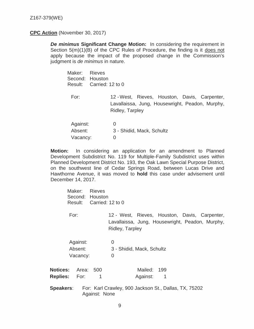
Z167-379(WE)
9
CPC Action (November 30, 2017)
De minimus Significant Change Motion: In considering the requirement in Section 5(m)(1)(B) of the CPC Rules of Procedure, the finding is it does not apply because the impact of the proposed change in the Commission’s judgment is de minimus in nature.
Maker: Rieves Second: Houston Result: Carried: 12 to 0
For: 12 - West, Rieves, Houston, Davis, Carpenter,
Lavallaissa, Jung, Housewright, Peadon, Murphy, Ridley, Tarpley
Against: 0 Absent: 3 - Shidid, Mack, Schultz Vacancy: 0
Motion: In considering an application for an amendment to Planned Development Subdistrict No. 119 for Multiple-Family Subdistrict uses within Planned Development District No. 193, the Oak Lawn Special Purpose District, on the southwest line of Cedar Springs Road, between Lucas Drive and Hawthorne Avenue, it was moved to hold this case under advisement until December 14, 2017.
Maker: Rieves Second: Houston Result: Carried: 12 to 0
For: 12 - West, Rieves, Houston, Davis, Carpenter,
Lavallaissa, Jung, Housewright, Peadon, Murphy, Ridley, Tarpley
Against: 0 Absent: 3 - Shidid, Mack, Schultz Vacancy: 0
Notices: Area: 500 Mailed: 199 Replies: For: 1 Against: 1 Speakers: For: Karl Crawley, 900 Jackson St., Dallas, TX, 75202 Against: None

Z167-379(WE)
10
CPC Action (December 14, 2017) Z167-379(WE) Planner: Warren Ellis
Motion: It was moved to recommend approval of an amendment to Planned Development Subdistrict No. 119 for Multiple-Family Subdistrict uses, subject to a development plan and conditions within Planned Development District No. 193, the Oak Lawn Special Purpose District, on the southwest line of Cedar Springs Road, between Lucas Drive and Hawthorne Avenue.
Maker: Rieves Second: Ridley Result: Carried: 15 to 0
For: 15 - West, Rieves, Houston, Davis, Shidid,
Carpenter, Mack, Lavallaissa, Jung, Housewright, Schultz, Peadon, Murphy, Ridley, Tarpley
Against: 0 Absent: 0
Vacancy: 0
Notices: Area: 500 Mailed: 199 Replies: For: 1 Against: 1 Speakers: For: Karl Crawley, 900 Jackson St., Dallas, TX, 75202
Against: None

Z167-379(WE)
11
LIST OF OFFICERS

Z167-379(WE)
12
SEC. S-119.101. LEGISLATIVE HISTORY.
PD Subdistrict 119 was established by Ordinance No. 29916, passed by the Dallas City Council on October 28, 2015.
SEC. S-119.102. PROPERTY LOCATION AND SIZE.
PD Subdistrict 119 is established on property fronting on the southwest line of Cedar Springs Road between Hawthorne Avenue and Lucas Drive. The size of PD Subdistrict 119 is approximately 2.13 acres.
SEC. S-119.103. DEFINITIONS AND INTERPRETATIONS.
(a) Unless otherwise stated, the definitions and interpretations in Chapter 51 and Part I of this article apply to this division. If there is a conflict, this division controls. If there is a conflict between Chapter 51 and Part I of this article, Part I of this article controls. In this division: [
(1) STOOP means a small porch leading to the entrance of a
residential structure. (2)] SUBDISTRICT means a subdistrict of PD 193.
(b) Unless otherwise stated, all references to articles, divisions, or sections in
this division are to articles, divisions, or sections in Chapter 51. (c) This subdistrict is considered to be a residential zoning district.
SEC. S-119.104. EXHIBITS.
The following exhibit[s] [are] is incorporated into this division:
(1) Exhibit S-119A: development conceptual plan. (2) Exhibit S-119B: landscape development plan -Tract I.
SEC. 51P-.104.1. CONCEPTUAL PLAN.
Development and use of the Property must comply with the attached conceptual plan (Exhibit ___). If there is a conflict between the text of this division and the conceptual plan, the text of this division controls.
CPC PROPOSED PDS CONDITIONS

Z167-379(WE)
13
SEC. 51P-.105. DEVELOPMENT PLAN.
(a) Tract 1: A development plan must be approved by the city plan commission before the issuance of any building permit to authorize work in this subdistrict. [Development and use of the Property must comply with the development plan (Exhibit S-119A).] If there is a conflict between the text of this division and the development plan, the text of this division controls.
(b) Tract 2: For all uses, no development plan is required, and the provisions
of Section 51-4.702 regarding submission of or amendments to a development plan, site analysis plan, development schedule, and landscape plan do not apply.
SEC. S-119.106. MAIN USES PERMITTED.
The only main uses permitted in this subdistrict are those main uses permitted in
the MF-2 Multiple-Family Subdistrict, subject to the same conditions applicable in the MF-2 Multiple-Family Subdistrict, as set out in Part I of this article. For example, a use permitted in the MF-2 Multiple-Family Subdistrict only by specific use permit (SUP) is permitted in this subdistrict only by SUP; a use subject to development impact review (DIR) in the MF-2 Multiple-Family Subdistrict is subject to DIR in this subdistrict; etc. SEC. S-119.107. ACCESSORY USES.
As a general rule, an accessory use is permitted in any subdistrict in which the
main use is permitted. Some specific accessory uses, however, due to their unique nature, are subject to additional regulations in Section 51P-193.108. For more information regarding accessory uses, consult Section 51P193.108. SEC. S-119.108. YARD, LOT, AND SPACE REGULATIONS.
(Note: The yard, lot, and space regulations in this section must be read together
with the yard, lot, and space regulations in Part I of this article. If there is a conflict between this section and Part I of this article, this section controls)
(a) In general. Except as provided in this section, the yard, lot, and space regulations of the MF-2 Multiple-Family Subdistrict apply.
(b) Front yard. (1) On Cedar Springs Road, minimum front yard is 25 feet.
(2) On Hawthorne Avenue and Lucas Drive, minimum front yard is 15 feet. [(3) [Except as provided in this paragraph, on Lucas Drive, minimum front yard is 15 feet. Minimum front yard for the northern 30 feet of the facade on Lucas Drive is 10 feet as shown on the development plan.]
[(4) The following may be located in the required front yard:]

Z167-379(WE)
14
[(A) on Cedar Springs Road and Hawthorne Drive, fences no more than four feet in height;] [(B) on Lucas Drive, fences no more than six feet in height] [(C) railings for stairs, stoops, and porches with a maximum height of 42 inches;] [(D) patios and covered seating areas;] [(E) balconies; and] [(F) arbors.]
[(5) Any fence located in the required front yard must have at least 50 percent open surface.] [(6) Any balcony in the required front yard must have a minimum clearance of eight feet above grade.
(c) Side yard.
(1) Except as provided in this subsection, minimum side yard is 10 feet. Between Tracts 1 and 2, minimum side yard is five feet. (2) The side yard setback for a residential development tract is zero for internal setbacks. The setback between residential development tracts is seven feet. [Minimum side yard for a multiple family structure is 45 feet.]
[(1) Except as provided in this subsection, minimum side yard is 25 feet.] [(2) Minimum side yard for a multiple family structure is 45 feet.] (c) Rear yard. Except as provided in this subsection, minimum rear yard is 10 feet. Between Tracts 1 and 2, minimum rear yard is five feet. (e) Density.
(1) Tract 1: Maximum number of dwelling units is 26 [188].
(2) Tract 2. Must comply with MF-2 Subdistrict regualtions

Z167-379(WE)
15
(f) Height. (1) Tract 1 (a) Maximum structure height is 50 feet. (b) For a residential development tract within 50 feet of the southwest property line, maximum structure height is 36 feet. The following structures may project up to 10 feet above the maximum structure height:
(i) elevator or stair penthouse.
(ii) mechanical equipment room. (iii) skylights. (iv) clerestory. (v) chimney and vent stacks. (vi) visual screens which surround roof mounted mechanical equipment (vii) parapet walls, limited to a height of four feet.
[(1) Except as provided in this subsection, maximum height for occupied floor area is 60 feet.] [(2) Maximum height for the pool and amenity deck, as measured to the finished floor, is 12 feet. [(3) Any elevator penthouse, mechanical equipment, and a clerestory may project a maximum of 12 feet above maximum height. [(4) A parapet wall constructed to a maximum height of four feet may project above maximum height. (2) Tract 2. Maximum structure height is 36 feet (g) Lot coverage. Maximum lot coverage is 60 [65] percent. Aboveground parking structures are included in lot coverage calculations; surface parking lots and underground parking structures are not.
(h) Stories. Maximum number of stories above grade is five. (1) Tract 1, For a residential development tract, m[M]aximum number of stories above grade is four [five]. (2) Tract 2, For multiple family uses, maximum number of stories above grade is three.

Z167-379(WE)
16
(i) Lot area. For single family uses within a residential development tract, no minimum lot area. Minimum average lot area of the lots within a residential development tract is 1,500 square feet. SEC. S-119.119. OFF-STREET PARKING AND LOADING [(a) Except as provided in this section, c]Consult Part I of this article for the specific off-street parking and loading requirements for each use.
[(b) For an accessory community center (private), no off-street parking is required.] SEC. S-119.110. ENVIRONMENTAL PERFORMANCE STANDARDS. See Article VI. SEC. S-119.111. LANDSCAPING. (a) In general. Except as provided in this section, landscaping and screening must be provided in accordance with Part I of this Article. [(b) Multiple-family. For a multiple-family use, landscaping must comply with the landscape plan (Exhibit S-119B).]
(b) Cedar Springs Road and Hawthorne Avenue: The tree planting
zone is that area parallel to between two and one-half and twenty feet from the back of the projected street curb. [Multiple-family. For a multiple-family use, landscaping must comply with the landscape plan (Exhibit S-119B).]
(c) Maintenance. Plant materials must be maintained in a healthy, growing condition. SEC. S-119.112. SIDEWALKS FOR TRACT 1 [MULTIPLE-FAMILY USE.] (a) Cedar Springs Road. A minimum unobstructed width of six [eight] feet must be [provided] located within ten feet from the back of the curb. (b) Hawthorne Avenue [and Lucas Street]. A minimum unobstructed width of six feet must be [provided] located within ten feet from the back of the curb.
(c) Tree grates. Handicapped accessible tree grates are considered as part of the unobstructed sidewalk width.
(d) Ingress and egress. Where a driveway connects through a sidewalk to right-of-way, design and construction of the driveway must be level with any connecting sidewalk.

Z167-379(WE)
17
SEC. S-119.113. SIGNS
Signs must comply with the provisions for nonbusiness zoning districts in Article VII SEC. S-119.114. URBAN DESIGN REQUIREMENTS FOR TRACT 1
[MULTIPLE-FAMLY USE] [(a) Cedar Springs Road entrance. A minimum of one visible and usable entrance is required on the Cedar Springs Road facade. The entrance must be clearly identified using an awning, paving treatments, a change in roofline, porticos, arcades, arches, integral planters, a stoop or front porch, color treatments, or similar means.] [(b)] Facade elements. To help break up long facades along Cedar Springs Road, [Lucas Drive, and Hawthorne Avenue] and make the structure appear as multiple structures, building facades along Cedar Springs Road must incorporate at least two [four]of the following elements [and facades along Lucas Drive and Hawthorne Avenue must incorporate at least three of the following elements]: (1) A change in building material, color, and texture that effectively contrasts from the rest of the facade. (2) Vertical articulation of the facade and roofline with strong forms to help break up the building mass. (3) Accentuation of the building’s base, middle, and top through combination of materials, detailing, and building articulation. [(4) Stepped-back upper floors] [(5) Deeply inset windows] [(6) Inset or projecting volumes, awnings, or canopies.] (b) Pedestrian amenities. In Tract 1 a minimum of two of the following pedestrian amenities are required along the Cedar Springs Road frontage: bench, trash receptacle, and/or bike rake. [(c)] Ground level residential entrances. A minimum of five multiple-family dwelling units must provide direct access from the sidewalk.]
[(d)] Fenestrations. Multiple-family fenestrations constructed on the southwestern facade must be designed to restrict the view from inside the structure onto adjacent properties utilizing translucent glazing or other similar materials.
[€] Parking garage.
[(1) Except as provided in this subsection, all aboveground parking structures must comply with the structure facade standards for off-street parking structures in Section 51P-193.127(a).]

Z167-379(WE)
18
[(2) Parking structure facades must include at least one of the following: heavy gauge metal screen, pre-cast concrete panels, laminated glass, or photovoltaic panels.]
[(3) Aboveground parking structures must have a solid wall or panel on each level with a minimum height of 36 inches to block light spillage from headlights.]
[(f) Patios and balconies. Patios and balconies are prohibited on the southwestern facade above the second floor.] [(g) Pedestrian amenities. A minimum of two each of the following pedestrian amenities are required along the Cedar Springs Road frontage: bench, trash receptacle, and bicycle rack.] [(h) Pedestrian trail or walkway. A pedestrian trail or walkway is required to connect the building to the street at two locations on the Cedar Springs Road frontage. The purpose of the pedestrian trail or walkway is to provide pedestrian connectivity between the building and the street. These pedestrian trails or walkways may be constructed of permeable material, such as decomposed granite, and must have a minimum width of four feet.]
[(i) Screening. The pool and amenity deck must be screened from the southwest and southeast by evergreen shrubs in either a planter or individual containers which at the time of planting must be spaced so as to give a solid appearance with a minimum height of six feet and capable of growing to a minimum height of eight feet within two years.] SEC. S-119.115. ADDITIONAL PROVISIONS. (a) [Live or amplified outdoor music is prohibited.] [(b)] The Property must be properly maintained in a state of good repair and neat appearance. [(c)](b) Development and use of the Property must comply with all federal and state laws and regulations, and with all ordinances, rules, and regulations of the city. [(d)](c)Except as provided in this division [or shown on the development plan], development and use of the Property must comply with Part I of this article.
SEC. S-119.116. COMPLIANCE WITH CONDITIONS. (a) All paved areas, permanent drives, streets, and drainage structures, if any, must be constructed in accordance with standard city specifications, and completed to the satisfaction of the city.
(b) The building official shall not issue a building permit to authorize work, or a certificate of occupancy to authorize the operation of a use, in this subdistrict

Z167-379(WE)
19
until there has been full compliance with this division, the Dallas Development Code, the construction codes, and all other ordinances, rules, and regulations of the city.
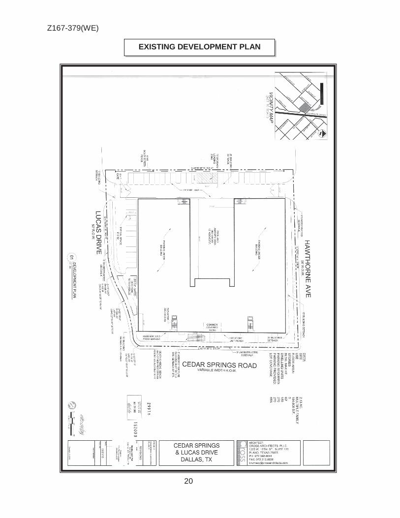
Z167-379(WE)
20
EXISTING DEVELOPMENT PLAN
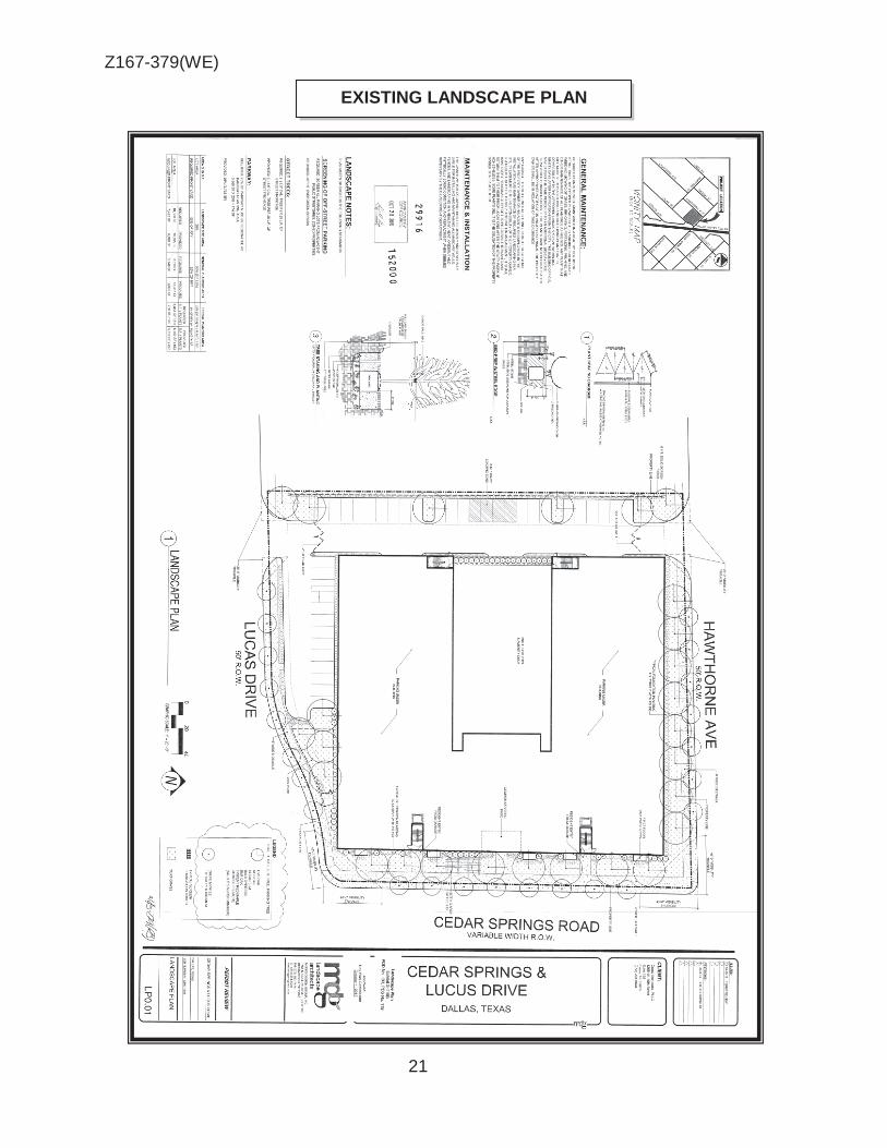
Z167-379(WE)
21
EXISTING LANDSCAPE PLAN

Z167-379(WE)
22
PROPOSED DEVELOPMENT PLAN

Z167-379(WE)
23

Z167-379(WE)
24
® AERIAL MAP
Z167-379 Case no: -~=-=---.:::....:.....::._
9/22/2017 Date: _---=.:_:=..__ __ 1 :3,600

Z167-379(WE)
25
Multiple family
Multiple family
R-10(A)
Single family
Multiple family
Multiple family
Multiple family
Multiple family

Z167-379(WE)
26
1
2
3
4

Z167-379(WE)
27
CPC RESPONSES
39
199 Property Owners Notified (49 parcels) 1 Replies in Favor (1 parcels) 1 Replies in Opposition (1 parcels)
500 1 Area of Notification 12/14/2017 Date
Z167-379
CPC 1:3,600

Z167-379(WE)
28
Notification List of Property Owners
Z167-379
199 Property Owners Notified 1 Property Owners in Favor 1 Property Owners Opposed
Reply Label # Address Owner 1 4515 CEDAR SPRINGS RD MAKER CS LLC
2 4505 CEDAR SPRINGS RD CIRCLE PARK TEXAS LLC
3 4503 CEDAR SPRINGS RD TEXAS TURNPIKE AUTHORITY
4 2920 HAWTHORNE AVE LARA PEDRO
5 3000 HAWTHORNE AVE MAKER CS LLC
6 4438 VANDELIA ST OSTROM RYAN L
7 4434 VANDELIA ST JONES BRUCE L &
8 4428 VANDELIA ST DAILY LOUIS R
9 4415 VANDELIA ST W&W INTERNATIONAL
10 4419 VANDELIA ST STANG CHRISTOPHER
11 4423 VANDELIA ST WHITTEN ERIC
12 4427 VANDELIA ST SCHNEER KENNETH E &
13 4431 VANDELIA ST DIESEN DIANA
14 4435 VANDELIA ST CED CHARLES & BETTY
15 4439 VANDELIA ST CUSTER DANIEL J
16 4518 VANDELIA ST REYES RENE J &
17 4512 VANDELIA ST YOUNG JAMES
X 18 4508 VANDELIA ST HARTLEY THOMAS G &
19 4506 VANDELIA ST BOONE OLIVIA E
20 4502 VANDELIA ST HERNANDEZ LUIS R
21 4503 VANDELIA ST NICHOLAS COREY EDWARD
22 4507 VANDELIA ST BRIDWELL THOMAS & MAUREEN
23 4509 VANDELIA ST TEXAS UTILITIES ELEC CO
24 4610 CEDAR SPRINGS RD FOONG CHAN C & YUNIE M
25 4548 CEDAR SPRINGS RD FOONG CHAN C & YUNIE MOON
26 2903 LUCAS DR SOOCKAR KARL D

Z167-379(WE)
29
12/13/2017
Reply Label # Address Owner 27 2909 LUCAS DR KELCHER MANAGEMENT INC
28 2915 LUCAS DR RODNEY E JOHNSON PPTIES LLC
29 2923 LUCAS DR GREATER MOUNT ZION BAPTIST
CHURCH
O 30 2900 HAWTHORNE AVE MUMM CHARLES
31 2906 HAWTHORNE AVE MONZURES ERASMO &
32 2908 HAWTHORNE AVE GUEVARA ANTONIO &
33 2912 HAWTHORNE AVE ALEJANDRO JOSE ALFREDO
34 2916 HAWTHORNE AVE ALEJANDRO JOSE A & BLANCA
35 2902 RALEIGH ST PARKS CHARLES I JR
36 2906 RALEIGH ST SOMMER WADE EVEN
37 2912 RALEIGH ST SOMMER LANCE & MARCIA
38 2916 RALEIGH ST NORRIS JESSE E
39 2820 KINGS RD DALLAS HOUSING AUTHORITY
40 3083 HERSCHEL AVE CEDAR POINTE MULTIFAMILY LLC
41 2924 LUCAS DR TRG CEDAR SPRINGS LP
42 4606 CEDAR SPRINGS RD FAIRFIELD MADISON LLC
43 2919 LUCAS DR IRVIN ROSS GREGORY
44 4533 CEDAR SPRINGS RD CH REALTY VII MF DALLAS DYLAN LP
45 4414 CEDAR SPRINGS RD SAMUEL STEVEN D
46 4414 CEDAR SPRINGS RD HU JOSEPH
47 4414 CEDAR SPRINGS RD CHAU CATHERINE
48 4414 CEDAR SPRINGS RD PARKER ROBERT E &
49 4414 CEDAR SPRINGS RD MALINOSKI EDWARD ANTON
50 4414 CEDAR SPRINGS RD EMBABI SHERIF & AHMED
51 4414 CEDAR SPRINGS RD SCHIAVONE JILL M
52 4414 CEDAR SPRINGS RD THOMAS STEVEN C
53 4414 CEDAR SPRINGS RD WISNIEWSKI MICHELLE
54 4414 CEDAR SPRINGS RD GARCIA ARNALDO RIVERA
55 4414 CEDAR SPRINGS RD BORELLI MARCOS F & NANCY P DE
HOYOS
56 4414 CEDAR SPRINGS RD ARAGON DANIA Z

Z167-379(WE)
30
12/13/2017
Reply Label # Address Owner
57 4414 CEDAR SPRINGS RD KASSAP ALEXANDER
58 4414 CEDAR SPRINGS RD PAI SAMIR A
59 4414 CEDAR SPRINGS RD BOLDING GARY
60 4414 CEDAR SPRINGS RD MARTINEZ JOSE
61 4414 CEDAR SPRINGS RD WENG TZUULIN JULIAN
62 4414 CEDAR SPRINGS RD CHEN TING YU
63 4414 CEDAR SPRINGS RD FREESE DOUGLAS W & KAREN H
64 4414 CEDAR SPRINGS RD PARK EDWARD
65 4414 CEDAR SPRINGS RD HSU TZU HAN D &
66 4414 CEDAR SPRINGS RD COSTELLO REVOCABLE TRUST
67 4414 CEDAR SPRINGS RD EAP SHEILA
68 4414 CEDAR SPRINGS RD TREINEN JAY
69 4414 CEDAR SPRINGS RD SRISOUPHAN DARAVANE
70 4414 CEDAR SPRINGS RD OLDENBURGH PATRICK L JR
71 4414 CEDAR SPRINGS RD JASSO KELLIE
72 4414 CEDAR SPRINGS RD GELFAND ANDREW & DONNA
73 4414 CEDAR SPRINGS RD NGOH SHAWN H
74 4414 CEDAR SPRINGS RD JOHNSON RENEE ANN
75 4414 CEDAR SPRINGS RD ZENG KEVIN
76 4414 CEDAR SPRINGS RD POTHEN PAUL NICHOLAS
77 4414 CEDAR SPRINGS RD ZAPATA CARLOS A
78 4414 CEDAR SPRINGS RD ELLIS KEVIN
79 4414 CEDAR SPRINGS RD MIHECOBY ALLEN F
80 4414 CEDAR SPRINGS RD BELLARY RAGHU NARAYANRAO &
KUMUDINI G
81 4414 CEDAR SPRINGS RD RACER DENNIS
82 4414 CEDAR SPRINGS RD DOHERTY BRITTANY &
83 4414 CEDAR SPRINGS RD ROSSER L B
84 4414 CEDAR SPRINGS RD MUTREJA SWADESH & JAI G
85 4414 CEDAR SPRINGS RD SHARMA DARPAN &
86 4414 CEDAR SPRINGS RD FAROOQI MIDHAT S &
87 4414 CEDAR SPRINGS RD BAZEMORE GEORGE C III

Z167-379(WE)
31
12/13/2017
Reply Label # Address Owner 88 4414 CEDAR SPRINGS RD DO THAO
89 4414 CEDAR SPRINGS RD APNAR JOHN
90 4414 CEDAR SPRINGS RD GONZALEZ-DICKSON FAMILY LP
91 4414 CEDAR SPRINGS RD HENDERSON JEFF
92 4414 CEDAR SPRINGS RD BURGOON LARRY REV TRUST
93 4414 CEDAR SPRINGS RD JOHNSON JILL
94 4414 CEDAR SPRINGS RD HARIRI WAHIB ADNAN
95 4414 CEDAR SPRINGS RD HOSIER MEGAN
96 4414 CEDAR SPRINGS RD REEVES JEFFREY S TRUST &
97 4414 CEDAR SPRINGS RD BATCHELOR EDWARD J &
98 4414 CEDAR SPRINGS RD DANVERS CHRISTOPHER
99 4414 CEDAR SPRINGS RD PAVLOCK GREGORY
100 4414 CEDAR SPRINGS RD MUSTAFA SARAH ZAHRA
101 4414 CEDAR SPRINGS RD ODUNSI ABAYOMI N
102 4414 CEDAR SPRINGS RD DAVIS ROBBIE
103 4414 CEDAR SPRINGS RD PATEL RISHI JAYENDRA
104 4414 CEDAR SPRINGS RD BOCSARDI MIHAELA C &
105 4414 CEDAR SPRINGS RD HOLLINGSWORTH HOLDINGS LLC
106 4414 CEDAR SPRINGS RD XALIKIAS NANCY ALEXIS
107 4414 CEDAR SPRINGS RD LEWIS SANDI R
108 4414 CEDAR SPRINGS RD PHAM LINH L
109 4414 CEDAR SPRINGS RD LENG CHIH CHUN
110 4414 CEDAR SPRINGS RD SANCHEZ MARIO H
111 4414 CEDAR SPRINGS RD GRIMES STEPHANIE R
112 4414 CEDAR SPRINGS RD FITZGERALD ROBERT BELL
113 4414 CEDAR SPRINGS RD 4414 CEDAR SPRINGS RD 324
114 4414 CEDAR SPRINGS RD SAREMI YAVAR SHOKOUH
115 4414 CEDAR SPRINGS RD CHEN JIAQIANG
116 4414 CEDAR SPRINGS RD ZENG LINSI &
117 4414 CEDAR SPRINGS RD FRANCO LUIZ L GUIMARES &
118 4414 CEDAR SPRINGS RD AGUIRRE PATRICIA
119 4605 CEDAR SPRINGS RD GRANADO HERIBERTO &

Z167-379(WE)
32
12/13/2017
Reply Label # Address Owner 120 4605 CEDAR SPRINGS RD MAYES JUSTIN
121 4605 CEDAR SPRINGS RD ONEILLWARREN DEIDRE
122 4605 CEDAR SPRINGS RD LONG JAMES D
123 4605 CEDAR SPRINGS RD NOWAK KEITH
124 4605 CEDAR SPRINGS RD CRAWFORD STEVEN B
125 4605 CEDAR SPRINGS RD NGUYEN STEPHEN K
126 4605 CEDAR SPRINGS RD ORMBREK JACK
127 4605 CEDAR SPRINGS RD PERAZA ELIER
128 4605 CEDAR SPRINGS RD KRUEGER DALE J JR
129 4605 CEDAR SPRINGS RD TRAVIESO ANDRE G
130 4605 CEDAR SPRINGS RD PIPER JANAYE
131 4605 CEDAR SPRINGS RD HEUER DANIEL
132 4605 CEDAR SPRINGS RD BALACHANDRAN NAVEEN
133 4605 CEDAR SPRINGS RD POLE RAJEEV & PRITHVIRAJ
134 4605 CEDAR SPRINGS RD OAKLAWN PROPERTIES LLC
135 4605 CEDAR SPRINGS RD CROCKETT JASMINE F
136 4605 CEDAR SPRINGS RD BROWN TONY LEE JR
137 4605 CEDAR SPRINGS RD CRAVENS JOSHUA DAVID
138 4605 CEDAR SPRINGS RD ROUMIANTSEVA DARIA
139 4605 CEDAR SPRINGS RD HENSON CHRISTOPHER
140 4605 CEDAR SPRINGS RD BIERNIAK MAREK O & ANNA M
141 4605 CEDAR SPRINGS RD CLARE RHETT
142 4605 CEDAR SPRINGS RD TURNER CRAIG & LAUREN
143 4605 CEDAR SPRINGS RD HOLLAND JAMES HOWARD
144 4605 CEDAR SPRINGS RD FOUST ERNEST L
145 4605 CEDAR SPRINGS RD MCCARTHY EDMOND JR & MARY
146 4605 CEDAR SPRINGS RD GOMEZ RITA CERVANTES
147 4605 CEDAR SPRINGS RD SAMI ARJAMAND
148 4605 CEDAR SPRINGS RD MONTALVO HENRY S & CARY L
149 4605 CEDAR SPRINGS RD THOMAS TEENA
150 4605 CEDAR SPRINGS RD LYNN LAUREN A
Z167-379(WE)
33
12/13/2017
Reply Label # Address Owner 151 4605 CEDAR SPRINGS RD HUNG CHARING
152 4605 CEDAR SPRINGS RD BEARIST GROUP LLC
153 4605 CEDAR SPRINGS RD TANANA VADZIM
154 4605 CEDAR SPRINGS RD SAMENI FALLAH SAM
155 4605 CEDAR SPRINGS RD POLUNSKY LEE N
156 4605 CEDAR SPRINGS RD PARK YOUNG HWAN &
157 4605 CEDAR SPRINGS RD ARAUJO REUBEN
158 4605 CEDAR SPRINGS RD BAO PAUL XIAPEI &
159 4605 CEDAR SPRINGS RD ROLAND CAROLINE
160 4605 CEDAR SPRINGS RD BOWERS MATTHEW S
161 4605 CEDAR SPRINGS RD KAUL BUPESH & RITA
162 4605 CEDAR SPRINGS RD JACOBS DAVID A
163 4605 CEDAR SPRINGS RD NOTO ANGELA
164 4605 CEDAR SPRINGS RD ROUM KEVIN S
165 4605 CEDAR SPRINGS RD SKOFF LINDA
166 4605 CEDAR SPRINGS RD LY TU ANH &
167 4605 CEDAR SPRINGS RD SYED SANA SALMA
168 4605 CEDAR SPRINGS RD
169 4605 CEDAR SPRINGS RD JIAO RHODA
170 4605 CEDAR SPRINGS RD AMIN ABDUL HAFIZ
171 4605 CEDAR SPRINGS RD JOHNS JOEY
172 4605 CEDAR SPRINGS RD PAULUS MICHAEL
173 4605 CEDAR SPRINGS RD SEVART JOSEPH W
174 4605 CEDAR SPRINGS RD PANZA LUCY G & NICHOLAS P
175 4605 CEDAR SPRINGS RD THIBODEAU MARK
176 4605 CEDAR SPRINGS RD JONES JAMES A
177 4605 CEDAR SPRINGS RD FORRETTE PHILLIP H
178 4605 CEDAR SPRINGS RD FINCK MARK B
179 4605 CEDAR SPRINGS RD OBALEK ANETA K
180 4605 CEDAR SPRINGS RD HAMEDANI BAHAR
181 4605 CEDAR SPRINGS RD BARNETT JESSICA E

Z167-379(WE)
34
12/13/2017
Reply Label # Address Owner 182 4605 CEDAR SPRINGS RD HU RANDOLF
183 4605 CEDAR SPRINGS RD LIN TONY &
184 4605 CEDAR SPRINGS RD DEGG REBECCA ANN
185 4605 CEDAR SPRINGS RD JOHN SANGITA ELIZABETH &
186 4605 CEDAR SPRINGS RD SKOFF DALE A
187 4605 CEDAR SPRINGS RD WANG YIFAN
188 4605 CEDAR SPRINGS RD VIDARTE ALIONA V
189 4605 CEDAR SPRINGS RD ZHANG YUE
190 4605 CEDAR SPRINGS RD PICKENS DOUGLAS R
191 4605 CEDAR SPRINGS RD LANGHAM STUART
192 4605 CEDAR SPRINGS RD YOUSUF SARA G
193 4605 CEDAR SPRINGS RD WASHBURN MATTHEW SAXTON
194 4605 CEDAR SPRINGS RD CARVALHO MARCO A
195 4605 CEDAR SPRINGS RD CHOI WON JOON
196 4605 CEDAR SPRINGS RD LIN CHENYING
197 4605 CEDAR SPRINGS RD LEVY ALISSA
198 4605 CEDAR SPRINGS RD MILLER IRYNA
199 4605 CEDAR SPRINGS RD BENNETT FAMILY LIVING TRUST THE

AGENDA ITEM # 43Mobility Solutions, Infrastructure, and Sustainability
AGENDA DATE: January 24, 2018
COUNCIL DISTRICT(S): 8
DEPARTMENT: Department of Sustainable Development and Construction
CMO: Majed Al-Ghafry, 670-3302
MAPSCO: 69A U
SUBJECT
A public hearing to receive comments regarding an application for and an ordinance granting a CS Commercial Service District on property zoned an IR-D-1 Industrial Research District with a D-1 Liquor Control Overlay, on the northwest line of South Belt Line Road, southwest of Kleberg RoadRecommendation of Staff and CPC: Approval with retention of the D-1 Liquor Control Overlay Z167-383(WE)

1
HONORABLE MAYOR & CITY COUNCIL WEDNESDAY, JANUARY 24, 2018 ACM: Majed Al-Ghafry FILE NUMBER: Z167-383(WE) DATE FILED: August 25, 2017 LOCATION: Northwest line of South Belt Line Road, southwest of Kleberg
Road COUNCIL DISTRICT: 8 MAPSCO: 69A U SIZE OF REQUEST: Approx. 1.317 acres CENSUS TRACT: 171.02 APPLICANT Vaquero Ventiures OWNER: David and Cathy Shifts REPRESENTATIVE: Doak Raulston REQUEST: An application for a CS Commercial Service District on
property zoned an IR-D-1 Industrial Research District with a D-1 Liquor Control Overlay.
SUMMARY: The purpose of this request is to allow for the development
of a general merchandise of food store greater than 3,500 square feet.
STAFF RECOMMENDATION: Approval with retention of the D-1 Liquor Control
Overlay CPC RECOMMENDATION: Approval with retention of the D-1 Liquor Control
Overlay

Z167-383(WE)
2
BACKGROUND INFORMATION: The request site is developed with a vehicle or engine repair or maintenance and a
vacant single-family dwelling.
The request site is contiguous to an industrial use and an electrical substation that is zoned for IR Industrial Research District uses. The property that is northeast of the request site is zoned for a CS Commercial Service District and is undeveloped. The property southeast of the request site, across South Belt Line Road is undeveloped and is zoned for R-10(A) Single Family District uses.
The applicant’s request for a CS Commercial Service District will allow for
development of a one-story, 9,100 square foot general merchandise or food store.
The CS Commercial Service District, permits by right, a general merchandise or food store greater than 3,500 square feet. Any portion of the proposed development over 26 feet in height will have to comply with the residential proximity slope due to the residential adjacency across South Belt Line Road.
Zoning History: There has been one zoning change requested in the area in the past five years.
1. Z123-227 On Wednesday, June 26, 2013, the City Council approved the renewal of Specific Use Permit No. 1843 for the sale of alcoholic beverages in conjunction with a general merchandise or food store 3,500 square feet or less.
Thoroughfares/Streets:
Thoroughfare/Street Type Existing ROW
Proposed ROW
South Belt Line Road Principal Arterial 100 ft. 100 ft. Land Use:
Zoning Land Use
Site IR-D-1 Auto Related use, Single
Family
Northeast CS-D-1 Undeveloped Southeast R-10(A) Undeveloped Northwest IR-D-1 Electrical Substation Southwest IR-D-1 Industrial

Z167-383(WE)
3
COMPREHENSIVE PLAN: The fowardDallas! Comprehensive Plan was adopted by the City Council in June 2006. The fowardDallas! Comprehensive Plan outlines several goals and policies which can serve as a framework for assisting in evaluating the applicant’s request. LAND USE GOAL 1.2 PROMOTE DESIRED DEVELOPMENT
Policy 1.2.1 Use Vision Building Blocks as a general guide for desired
development patterns. The proposed use is part of the community’s long-term use envisioned by the West Kleberg Community Plan.
West Kleberg Community Plan (2007): The West Kleberg Community Plan identified a vision statement: To reflect "Old Kleberg’s" historical heritage, to promote a strong rural atmosphere, to allow for future growth with sensitivity to future amenities and infrastructure of a modern urban environment. Long-time residents seem to have mixed feelings about growth, noting on one side the negative impacts of crowds, noise, traffic, and pollution, while acknowledging the benefits of improved public services, better schools, and new neighborhood-serving retail and commercial business locating to the area. The subject site is located within Sub-area 3, which is comprised of approximately 3,390 acres of which 42 percent was vacant or undeveloped, and 40 percent was comprised of public service (mainly the southside Wastewater Treatment Center) at publication in 2007. The report reveals that “an overall analysis of the land use shows that businesses are generally located along the Hwy. 175-freeway corridor. The next concentration of small-scale uses is found at the intersection of South Belt Line Road and Seagoville Road. There is one grocery store to serve this community, with several smaller scale convenient stores scattered throughout the area. Other than that, groceries are purchased within a 5-mile radius in the cities of Balch Springs and Seagoville (e.g., Wal-Mart Super Centers, Minyards and Kroger). The majority of businesses operating in the area include: Auto Sales, Service and Display, Machinery, Heavy Equipment or Truck Sales and Service, and Auto Salvage and Reclamation”. The Future Vision Map depicts a 1,000-foot buffer zone as ideal for business development along the Highway 175-freeway corridor. Land assemblage may be required to develop in these areas to construct uses such as a hospital, bank, mix use project and so on. Business nodes to possibly stimulate economic activity are earmarked at the intersections of Seagoville and Belt Line Roads; Highway 175, and
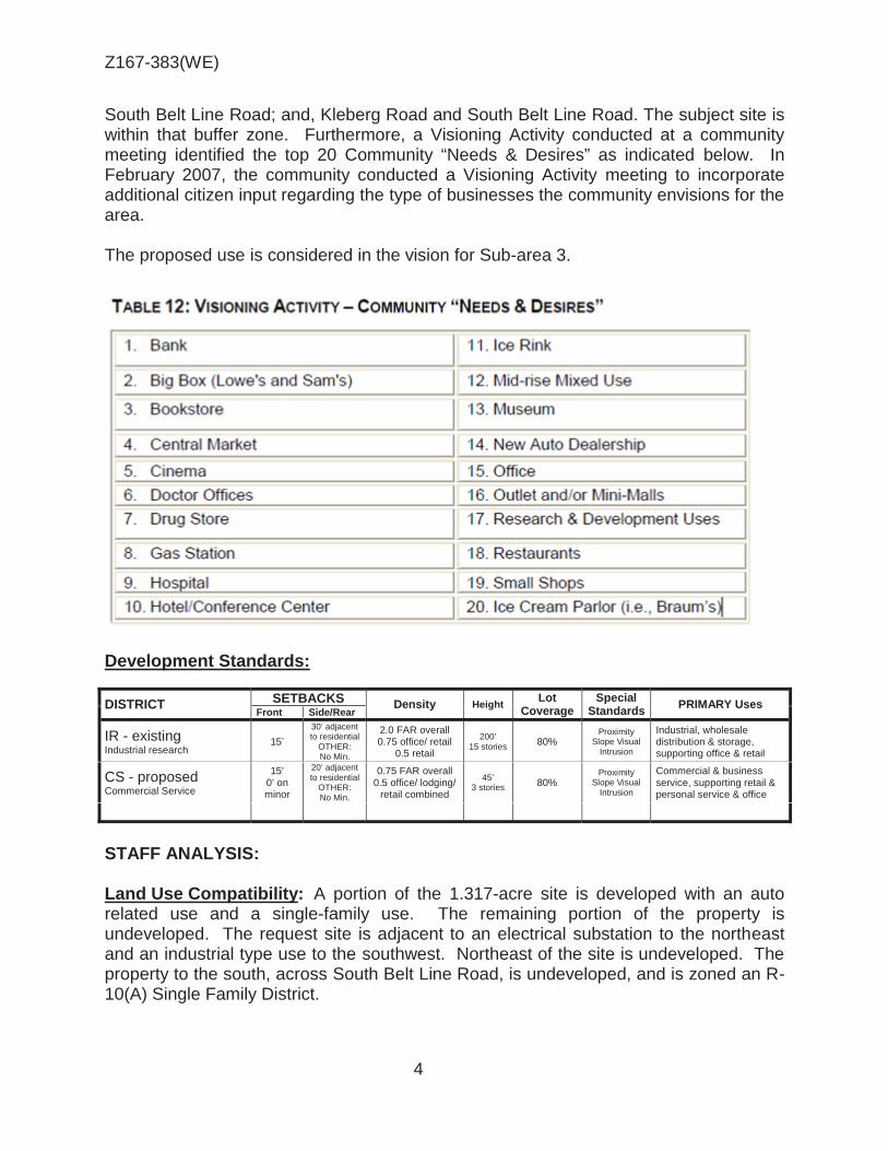
Z167-383(WE)
4
South Belt Line Road; and, Kleberg Road and South Belt Line Road. The subject site is within that buffer zone. Furthermore, a Visioning Activity conducted at a community meeting identified the top 20 Community “Needs & Desires” as indicated below. In February 2007, the community conducted a Visioning Activity meeting to incorporate additional citizen input regarding the type of businesses the community envisions for the area. The proposed use is considered in the vision for Sub-area 3.
Development Standards:
DISTRICT SETBACKS Density Height Lot
Coverage Special
Standards PRIMARY Uses
Front Side/Rear
IR - existing Industrial research
15’
30’ adjacent to residential
OTHER: No Min.
2.0 FAR overall 0.75 office/ retail
0.5 retail
200’ 15 stories 80%
Proximity Slope Visual
Intrusion
Industrial, wholesale distribution & storage, supporting office & retail
CS - proposed Commercial Service
15’ 0’ on minor
20’ adjacent to residential
OTHER: No Min.
0.75 FAR overall 0.5 office/ lodging/
retail combined
45’ 3 stories 80%
Proximity Slope Visual
Intrusion
Commercial & business service, supporting retail & personal service & office
STAFF ANALYSIS: Land Use Compatibility: A portion of the 1.317-acre site is developed with an auto related use and a single-family use. The remaining portion of the property is undeveloped. The request site is adjacent to an electrical substation to the northeast and an industrial type use to the southwest. Northeast of the site is undeveloped. The property to the south, across South Belt Line Road, is undeveloped, and is zoned an R-10(A) Single Family District.

Z167-383(WE)
5
The applicant’s request for a CS Commercial Service District will allow for development of a one-story, 9,100 square foot general merchandise or food store. Any development that exceeds 26 feet in height will have to comply with the residential proximately slope due to the residential adjacency across South Belt Line Road. The applicant’s request for a general merchandise or food store complies with the type of uses the community envisioned in the area. The West Kleberg Community Plan, 2007, states that the community had a consensus to maintain the rural character in areas that remains predominately residential (low to moderate residential) with neighborhood serving retail and commercial uses along South Belt Line Road, Kleberg Road and Highway 175. Staff recommendation is for approval of the applicant’s request of a CS Commercial Service District. Based on several aerials maps, there improvements to the area are minimal. The proposed development of a general merchandise of food store is consistent with the vision of the West Kleberg Community Plan, 2007. Landscaping: Landscaping must be provided in accordance with Article X, as amended. Plant materials must be maintained in a healthy, growing condition. Parking: The parking requirement for a general merchandise of food store greater than 3,500 square feet is one space per 200 square feet of floor area. Based on the proposed 9,100 square feet of floor area, the number of spaces required is 46 spaces.

Z167-383(WE)
6
CPC Action (November 30, 2017)
Motion: It was moved to recommend approval of a CS Commercial Service District on property zoned an IR-D-1 Industrial Research District with a D-1 Liquor Control Overlay, on the northwest line of South Belt Line Road, southwest of Kleberg Road.
Maker: Lavallaissa Second: Houston Result: Carried: 14 to 0
For: 14 - West, Rieves, Houston, Davis, Shidid,
Carpenter, Lavallaissa, Jung, Housewright, Schultz, Peadon, Murphy, Ridley, Tarpley
Against: 0 Absent: 1 - Mack Vacancy: 0
Notices: Area: 300 Mailed: 15 Replies: For: 0 Against: 0 Speakers: For: None For (Did not speak): Doak Raulston, 2900 Wingate St., Fort Worth, TX, 76107 Against: None

Z167-383(WE)
7
W.A Landreth Co-founder
Brain C. Williams Co-founder
Emily L. Crockett Chief Operating Officer & Senior Counsel
LIST OF OFFICERS Vaquero Ventures

Z167-383(WE)
8

Z167-383(WE)
9
® AERIAL MAP
Z167-383 Case no: _--=..:....=....:..--=....::;_;;___
9/22/2017 Date: _ ____::..=...._ __ _ 1 :2,400

Z167-383(WE)
10
Industrial
Undeveloped
Single Family
Undeveloped
General merchandise of food store & fueling station
Single Family
R-10(A)
Single Family
Electrical substation
Undeveloped

Z167-383(WE)
11
1

Z167-383(WE)
12
CPC RESPONSES
___ 1_5 __ Property Owners Notified (25 parcels) __ ......;;;0 ___ Replies in Favor (0 parcels) ___ 0 ___ Replies in Opposition (O parcels) __ 3_00 __ ' __ Area of Notification
11/30/2017 Date
/
Z167-383 CPC
1 :2,400

Z167-383(WE)
13
Notification List of Property Owners
Z167-383
15 Property Owners Notified 0 Property Owners in Favor 0 Property Owners Opposed
Reply Label # Address Owner 1 2511 S BELTLINE RD STUTTS DAVID O & CATHY E
2 2500 GREAT OAK DR TEXAS UTILITIES ELEC CO
3 2450 S BELTLINE RD SALAZAR FRANCISCO & MIRIAM
DELACRUZ
4 13529 KLEBERG RD BAHARIA MALIK A
5 13523 KLEBERG RD GEORGE BEN E
6 13517 KLEBERG RD HALL SALLY E L & THOMAS T
7 13530 LENOSA LN FOREMAN BOB
8 13500 LENOSA LN GALVAN MARTIN
9 2619 S BELTLINE RD J & R TRUCK & EQUIP SALES
10 2531 S BELTLINE RD COMPRESSORS UNLIMITED
11 2501 GREAT OAK DR BOREN B C
12 2501 GREAT OAK DR BOREN BILLY C
13 2500 GREAT OAK DR GEORGE BEN E TR
14 2500 S BELTLINE RD CHAMBLESS BENJAMIN P
15 13325 PINE VALLEY DR DALLAS AREA HABITAT FOR

AGENDA ITEM # 44Mobility Solutions, Infrastructure, and Sustainability
AGENDA DATE: January 24, 2018
COUNCIL DISTRICT(S): 14
DEPARTMENT: Department of Sustainable Development and Construction
CMO: Majed Al-Ghafry, 670-3302
MAPSCO: 45 P
SUBJECT
A public hearing to receive comments regarding an application for and an ordinance granting the renewal of, and amendment to, Specific Use Permit No. 2127 for a restaurant without drive-in or drive-through service on property zoned Subdistrict B within Planned Development District No. 619 with Historic Overlay No. 87, on the north side of Main Street, east of North Field StreetRecommendation of Staff and CPC: Approval for a three-year period, subject to a site plan and conditionsZ167-398(JM)


1
HONORABLE MAYOR & CITY COUNCIL WEDNESDAY, JANUARY 24, 2018
ACM: Majed Al-Ghafry
FILE NUMBER: Z167-398(JM) DATE FILED: September 21, 2017 LOCATION: North side of Main Street, east of North Field Street COUNCIL DISTRICT: 14 MAPSCO: 45 P SIZE OF REQUEST: ±14,550 sq. ft. CENSUS TRACT: 31.01 APPLICANT: William Katz OWNER: Davis 1309 Main, LLC REPRESENTATIVE: Nick Galen
REQUEST: An application for the renewal of, and amendment to, Specific Use Permit No. 2127 for a restaurant without drive-in or drive-through service on property zoned Subdistrict B within Planned Development District No. 619 with Historic Overlay No. 87.
SUMMARY: The applicant proposes to maintain the existing restaurant
[Frankie’s Sports Bar and Grill] located at the street level and to extend operating hours to begin at 10:00 a.m. instead of 11:00 a.m. A restaurant 2,000 square feet or more located below street level requires an SUP. On December 10, 2014, the City Council approved this Specific Use Permit for a three-year period.
CPC RECOMMENDATION: Approval for a three-year period, subject to a site
plan and conditions. STAFF RECOMMENDATION: Approval for a three-year period, subject to a site
plan and conditions.

Z167-398(JM)
2
BACKGROUND INFORMATION:
The request site is an existing one-story restaurant without drive-in or drive-through service with 14,550 square feet of floor area.
SUP No. 2127 was granted by City Council on December 10, 2013 and expires on December 10, 2017.
The current request is to renew the SUP. There are no proposed changes to the existing site plan. The applicant has requested to change the opening time from 11:00 a.m. to 10:00 a.m.
Zoning History: There have been seven zoning change requests in the area within the last five years.
1. Z167-130: On June 28, 2017, the City Council approved Historic Overlay District No. 150 (One Main Place) on property zoned Planned Development District No. 619, an area bounded by Main Street, Griffin Street, Elm Street, and North Field Street with the exception of the northwest corner of North Field Street and Main Street.
2. Z156-249: On August 4, 2016, the City Plan Commission approved a request for a Specific Use Permit for installation of a non-premise district activity videoboard on property zoned Planned Development District No. 619 on the northwest corner of Main Street and North Field Streets. (No CC action found and no SUP issued)
3. Z145-276: On September 9, 2015, the City Council approved the renewal of Specific Use Permit No. 1755 for two attached projecting non-premise district activity videoboard signs on property zoned Planned Development District No. 619, located on the north side of Main Street and the east side of Four Way Place.
4. Z145-277: On September 9, 2015, the City Council approved the renewal of Specific Use Permit No. 1788 an attached projecting non-premise district activity videoboard sign on property zoned Planned Development District No. 619, located on the northeast corner of Commerce Street and South Field Street.
5. Z145-278: On September 9, 2015, the City Council approved the renewal of Specific Use Permit No. 1791 for an attached projecting non-premise district activity videoboard sign on property zoned Planned Development District No. 619, located on the south side of Elm Street and the east side of North Akard Street.
6. Z134-322: On September 9, 2015, the City Council approved an application for expansion and modifications to Historic Overlay 36, Adolphus Hotel on property zoned Planned Development District No. 619, located on the northwest corner of South Akard Street and Commerce Street.
7. Z134-254: On December 10, 2014, the City Council approved the renewal of Specific Use Permit No. 1887 for an alcoholic beverage establishment limited to

Z167-398(JM)
3
a bar, lounge or tavern and a commercial amusement (inside) limited to a Class A dance hall on property within Planned Development District No. 619, located on the south side of Main Street, east of South Field Street.
Thoroughfares/Streets:
Thoroughfare/Street Type Existing ROW Proposed ROW
Main Street Minor Arterial 80 feet 80 feet
North Field Street Local 50 feet 50 feet
Traffic: The Engineering Division of the Sustainable Development and Construction Department has reviewed the request and determined that the proposed amendment will not have a negative impact on the surrounding street system. Surrounding Land Uses:
Zoning Land Use
Site PDD No. 619; H/87 Residential, retail, and office
North PDD No. 619 Restaurants, office, and retail
East PDD No. 619; H/36 on a portion
Hotel, offices, and retail
South PDD No. 619 Restaurant, retail, and parking garage
West PDD No. 619; H/87 Residential, retail, and office
STAFF ANALYSIS:
Comprehensive Plan:
The comprehensive plan does not make a specific land use recommendation related to the request, however the forwardDallas! Vision Illustration, adopted June 2006, is comprised of a series of Building Blocks that depicts general land use patterns. Building Blocks are generalized patterns without well-defined boundaries that indicate where certain types and densities of development might logically occur. The Vision Illustration depicts the request site as within the City’s Downtown; a centrally located hub that provides high intensity concentrated regional job and commercial

Z167-398(JM)
4
activity supported by high density housing. A Downtown Building Block includes pedestrian-oriented and mixed-use development that offers multiple transportation options. The request is consistent with the forwardDallas! Vision to promote a pedestrian-oriented mix of uses in the downtown area. Land Use Compatibility: The request site is surrounded by a mix of uses, which include retail, restaurant, parking garage and office uses. The existing establishment provides a service within the Central Business District and does not negatively impact the adjacent properties. The general provisions for a Specific Use Permit in Section 51A-4.219 of the Dallas Development Code specifically state: (1) The SUP provides a means for developing certain uses in a manner in which the specific use will be consistent with the character of the neighborhood; (2) Each SUP application must be evaluated as to its probable effect on the adjacent property and the community welfare and may be approved or denied as the findings indicate appropriate; (3) The city council shall not grant an SUP for a use except upon a finding that the use will: (A) complement or be compatible with the surrounding uses and community facilities; (B) contribute to, enhance, or promote the welfare of the area of request and adjacent properties; (C) not be detrimental to the public health, safety, or general welfare; and (D) conform in all other respects to all applicable zoning regulations and standards. Parking: Planned Development District No. 619 requires off-street parking to be provided per the CA-1(A) Central Area District standards. For a new structure or an addition to an existing structure, one space is required for each 2,000 square feet of floor area. The proposed use is located within an existing structure; therefore, no parking is required. Police Records: Period of reporting is since the SUP was granted in December of 2013 to present.

Z167-398(JM)
5

Z167-398(JM)
6

Z167-398(JM)
7
December 2013

Z167-398(JM)
8
List of Officers

Z167-398(JM)
9
CPC Action November 30, 2017
Motion: It was moved to recommend approval of the renewal and amendment of Specific Use Permit No. 2127 for a restaurant without drive-in or drive-through service for a three-year period, subject to a site plan and conditions on property zoned Subdistrict B within Planned Development District No. 619 with Historic Overlay No. 87, on the north side of Main Street, east of North Field Street.
Maker: Lavallaissa Second: Houston Result: Carried: 14 to 0
For: 14 - West, Rieves, Houston, Davis, Shidid,
Carpenter, Lavallaissa, Jung, Housewright, Schultz, Peadon, Murphy, Ridley, Tarpley
Against: 0 Absent: 1 - Mack Vacancy: 0
Notices: Area: 200 Mailed: 279 Replies: For: 0 Against: 0 Speakers: None

Z167-398(JM)
10
AMENDING SUP CONDITIONS SUP NO. 2127
1. USE: The only use authorized by this specific use permit is a restaurant without
drive-in or drive-through service.
2. SITE PLAN: Use and development of the Property must comply with the attached site plan.
3. TIME LIMIT: This specific use permit expires on December 10, 2017 three-years
from the passage of this ordinance.
3. HOURS OF OPERATION: The restaurant without drive-in or drive-through service may only operate between 11:00 a.m. 10:00 a.m. and 2:00 a.m. Monday through Sunday.
4. MAINTENANCE: The Property must be properly maintained in a state of good
repair and neat appearance.
5. GENERAL REQUIREMENTS: Use of the Property must comply with all federal and state laws and regulations, and with all ordinances, rules, and regulations of the City of Dallas.

Z167-398(JM)
11
Existing Site Plan

Z167-398(JM)
12
lf\ 00 SI ~ \['JO
~ Tu, Lubben Plaza
\ ®
VICINITY MAP 1 :4,800
1' S;..o Federa l Plaza
'1<z J';.
Pacific Plaza
*-4 o'I'
.s-"'
Z167-398 case no: ---=~.:........::c...::....;; __
10/23/2017 Date: -------

Z167-398(JM)
13
® AERIAL MAP
Z167-398 Case no: _..!::...!..:~:.=...:::...-
10/23/2017 Date: _ ____:_:::..=....._ __ 1 :1,200

Z167-398(JM)
14

Z167-398(JM)
15
CD 13

Z167-398(JM)
16
CPC RESPONSES

Z167-398(JM)
17
11/29/2017
Reply List of Property Owners Z167-398 279 Property Owners Notified 0 Property Owners in Favor 0 Property Owners Opposed
Reply Label # Address Owner 1 1302 ELM ST DAVIS 1309 MAIN LLC
2 1401 ELM ST DREVER 1401 ELM LLC
3 1301 MAIN ST NAYEB FAMILY LP
4 1217 MAIN ST HEADINGTON REALTY & CAPITAL LLC
5 1400 MAIN ST RBP ADOLPHUS LLC
6 1404 MAIN ST APAL CO LLC
7 1412 MAIN ST 1412 MAIN STREET LLC
8 1300 MAIN ST RBP ADOLPHUS LLC
9 1402 MAIN ST APAL LLC
10 1306 MAIN ST RBP ADOLPHUS LLC
11 1315 COMMERCE ST RBP ADOLPHUS LLC
12 1414 ELM ST LICGF DALLAS LOFTS INC
13 1407 MAIN ST LICGF DALLAS LOFTS INC
14 1407 MAIN ST DRED PROPERTIES LTD
15 1407 MAIN ST DCAR PROPERTIES LTD
16 1200 MAIN ST TONOLI FRANK E &
17 1200 MAIN ST FISCHER JOSHUA A
18 1200 MAIN ST 1621 ERVAY LTD
19 1200 MAIN ST BRANAMAN MICHAEL S &
20 1200 MAIN ST SMITH RANDOLPH
21 1200 MAIN ST DIXON GLORIA D
22 1200 MAIN ST ORTIZ GUILLERMINA
23 1200 MAIN ST FONTENOT TOMMY JAMES
24 1200 MAIN ST RAFF GEORGE JR
25 1200 MAIN ST SMITH DANIEL E & HERMA A
26 1200 MAIN ST BRANSTETTER ROBERT M & CAROL SHELTON

Z167-398(JM)
18
11/29/2017
Reply Label # Address Owner 27 1200 MAIN ST FREEMAN SCOTT
28 1200 MAIN ST BOBBITT CHARLES MICHAEL
29 1200 MAIN ST JUAREZ GERARDO
30 1200 MAIN ST KIRKLAND MYRA EDITH &
31 1200 MAIN ST AMONGKOL JITTADA KITTY
32 1200 MAIN ST HART STANLEY L &
33 1200 MAIN ST SMITH SHERIA D
34 1200 MAIN ST CRIST EUGENE SCOTT
35 1200 MAIN ST TERESI MARK A & JEANNE N
36 1200 MAIN ST CWALINO PETER
37 1200 MAIN ST KISLING MISTY
38 1200 MAIN ST SANADI NISAR & THU NGUYET
39 1200 MAIN ST CARPENTER ROBIN N
40 1200 MAIN ST MASTAGLIO LINDA R
41 1200 MAIN ST LOPEZ DENNIS A
42 1200 MAIN ST CLARK TAMPA CATHERINE
43 1200 MAIN ST BAILEY PETER & MARY
44 1200 MAIN ST PERRI ANTHONY J &
45 1200 MAIN ST KANTELADZE ANNA &
46 1200 MAIN ST FAYE WILLIS DESIGNS INC
47 1200 MAIN ST BAGARIA SAPNA & SURESH
48 1200 MAIN ST PARKER MARK GRAHAM
49 1200 MAIN ST ABDULKHAALIQ ANWAAR
50 1200 MAIN ST ARAUJO JOSEPH
51 1200 MAIN ST CHATTERJEE ARUNABHA
52 1200 MAIN ST SALVANT WAYNE
53 1200 MAIN ST ELLER TOM J & ROBYN
54 1200 MAIN ST MASSEY LINDA
55 1200 MAIN ST DASH PRIYARANJAN &
56 1200 MAIN ST MUEHLENWEG ROBERT J &
57 1200 MAIN ST CUEVAS ISRAEL F

Z167-398(JM)
19
11/29/2017
Reply Label # Address Owner 58 1200 MAIN ST EDWARDS JAMES & BARBARA
59 1200 MAIN ST NORRED J WESLEY III
60 1200 MAIN ST JIA YUEMENG
61 1200 MAIN ST BIERMAN SYDNEY GRACE
62 1200 MAIN ST KADAN PROPERTIES LP
63 1200 MAIN ST CAMPOS EDWARD
64 1200 MAIN ST ADAMS WILHELMINA J
65 1200 MAIN ST COMBS DAMETIA
66 1200 MAIN ST YAVANZA LLC
67 1200 MAIN ST ALCANTARA PEDRO
68 1200 MAIN ST HERICKS JAMES &
69 1200 MAIN ST BAKER WILLIAM H III
70 1200 MAIN ST SPRING TRUMAN E JR
71 1200 MAIN ST TITTLE CYNTHIA LARK
72 1200 MAIN ST DANIEC MONICA
73 1200 MAIN ST BLACK PAUL
74 1200 MAIN ST HAQUE NAZ &
75 1200 MAIN ST BRANCELA JOHN
76 1200 MAIN ST LINDSAY HAWNI E
77 1200 MAIN ST CHANEY GARY WAYNE 1992 FAMILY TRUST
78 1200 MAIN ST NGUYEN MICHAEL
79 1200 MAIN ST BENEVENTI MARK FRANCIS
80 1200 MAIN ST DU YALI
81 1200 MAIN ST PATOINE TERESA SUSAN
82 1200 MAIN ST SAIED ANNA M
83 1200 MAIN ST FAIRCHILD MELISSA
84 1200 MAIN ST CANON JOSEPH & ELIZABETH
85 1200 MAIN ST DEMPSEY MICHAEL THOMAS &
86 1200 MAIN ST HARRIS KENDRICK LASALLE
87 1200 MAIN ST CRIST EUGENE SCOTT
88 1200 MAIN ST PATEL JAYSHREE &

Z167-398(JM)
20
11/29/2017
Reply Label # Address Owner 89 1200 MAIN ST ALSUP LAUREN BRITTANY
90 1200 MAIN ST KAHANE DENNIS SPENCER
91 1200 MAIN ST PRIBADI LILIANA
92 1200 MAIN ST SALEEM ADEEL
93 1200 MAIN ST ANTAO RYAN TRISTEN
94 1200 MAIN ST MOBLEY HENRY B JR
95 1200 MAIN ST COWAN MICHAEL & MARTHA
96 1200 MAIN ST GHODSI YEGANEH &
97 1200 MAIN ST CLEERE LARRY J &
98 1200 MAIN ST IPPOLITO MARTA
99 1200 MAIN ST CIN ALBERTO DAL
100 1200 MAIN ST BROWN GLENN ALAN
101 1200 MAIN ST ROMERO GERALD & LOURDES
102 1200 MAIN ST BEANEY STEVEN LEE
103 1200 MAIN ST SCARBOROUGH DONALD D
104 1200 MAIN ST KEANE JUSTIN SCOTT &
105 1200 MAIN ST BROWN NOLLEY LEON CLEMON &
106 1200 MAIN ST LUMME DONALD GUY JR
107 1200 MAIN ST XIE JIMIN
108 1200 MAIN ST OROZCO CARLOS A
109 1200 MAIN ST BABAKHANIAN ROUBEN
110 1200 MAIN ST DOMINGUEZ JOSE R
111 1200 MAIN ST PURNELL KENNETH
112 1200 MAIN ST ROSALES JORGE
113 1200 MAIN ST MA MAU & JUYEI
114 1200 MAIN ST THOMAS BIJU
115 1200 MAIN ST COMPEAU BRYAN
116 1200 MAIN ST MADDERRA RHONDA & FARON
117 1200 MAIN ST HONRALES MARK &
118 1200 MAIN ST CRAIG TERRY E &
119 1200 MAIN ST BALUCH HOLDINGS LLC

Z167-398(JM)
21
11/29/2017
Reply Label # Address Owner 120 1200 MAIN ST ADROVIC ARMIN
121 1200 MAIN ST ROMIG RANDALL
122 1200 MAIN ST BRAUM EARL E JR
123 1200 MAIN ST TAUSCH JOHANNES &
124 1200 MAIN ST MORAIS JUSTIN
125 1200 MAIN ST MATHEWS AMIT &
126 1200 MAIN ST MCCANS WILLIAM
127 1200 MAIN ST LOPEZ ADAN FRANCISCO
128 1200 MAIN ST JUDAH JOHN K
129 1200 MAIN ST HANNA IHAB
130 1200 MAIN ST MORENO KRISTINE M
131 1200 MAIN ST BAKER ARIANNE &
132 1200 MAIN ST MOORE ROBERT W
133 1200 MAIN ST SANTAMARIA ARTHUR &
134 1200 MAIN ST RAZA SYED S & NASREEN S
135 1200 MAIN ST BOSE RANAVIR & SARMILA
136 1200 MAIN ST FUNG DAVID KARL & KATHY LEE FUNG
137 1200 MAIN ST FLORES GEORGINA E
138 1200 MAIN ST LI LIETAO
139 1200 MAIN ST TINSLEY GARY A
140 1200 MAIN ST MICHULKA GEORGE &
141 1200 MAIN ST BYRUM TADD A &
142 1200 MAIN ST HUTCHINSON ANDREW F II
143 1200 MAIN ST KHEMANI PRAVIN
144 1200 MAIN ST SUTTONDEABREU ILA I
145 1200 MAIN ST BENTLEY BRIAN D
146 1200 MAIN ST CLARK CHRISTIAN
147 1200 MAIN ST DAIYA NAMRATA
148 1200 MAIN ST JACKSON JAN B & ROGER
149 1200 MAIN ST SALVANT WAYNE F &
150 1200 MAIN ST LIN HUANG SHENG

Z167-398(JM)
22
11/29/2017
Reply Label # Address Owner 151 1200 MAIN ST HILL SIMON &
152 1200 MAIN ST HIBSID 1 LLC
153 1200 MAIN ST QUARTOS VACA LLC
154 1200 MAIN ST KOKES KEVIN K
155 1200 MAIN ST HARRIS CARLOS
156 1200 MAIN ST JAIN NEHA
157 1200 MAIN ST CHAMBERLAIN BLAKE BARRETT
158 1200 MAIN ST KHAN MOIN
159 1200 MAIN ST KLAMM CYNTHIA B &
160 1200 MAIN ST L & M FAMILY TRUST THE
161 1200 MAIN ST JACKSON CAROL
162 1200 MAIN ST COWDEN PETER
163 1200 MAIN ST NARAN ASHOK
164 1200 MAIN ST LANCASTER PHILLIP & IRENE
165 1200 MAIN ST
166 1200 MAIN ST AN JOSHUA DON ALLEN
167 1200 MAIN ST POLANCO PAUL
168 1200 MAIN ST DAMANI ANIRUDH A
169 1200 MAIN ST DOCKTER BRYAN
170 1200 MAIN ST UNDERHILL JAMES S
171 1200 MAIN ST DEAR CORY & CLARK MEREDITH
172 1200 MAIN ST STRINGER CHRISTOPHER & KATIE
173 1200 MAIN ST STROTHMAN RHONDA K
174 1200 MAIN ST REMPHREY BRYAN S
175 1200 MAIN ST DYNKIN ANTHONY
176 1200 MAIN ST BROWNELL SUSAN K &
177 1200 MAIN ST LANCASTER PHILLIP GEOFFREY &
178 1200 MAIN ST HOLLANDER KEVIN J & BETH A
179 1200 MAIN ST AHUMADA MUCIO
180 1200 MAIN ST LESTER MARY C
181 1200 MAIN ST LIN MILO M &

Z167-398(JM)
23
11/29/2017
Reply Label # Address Owner 182 1200 MAIN ST GARNER SUSAN
183 1200 MAIN ST MOORE ROBERT W
184 1200 MAIN ST CHAFFIN LYNDAL A
185 1200 MAIN ST HUMES EDUARDO
186 1200 MAIN ST VIRANI ASIF
187 1200 MAIN ST DIXON ADAM
188 1200 MAIN ST XIE JIMIN & WEIYAN JEANNE LI
189 1200 MAIN ST JHAVERI SATYEN DHIREN
190 1200 MAIN ST ABDULWAHAB MANNIE
191 1200 MAIN ST GODOY DULCE MARIA RIVAS
192 1200 MAIN ST KOSTREVA JOSH A
193 1200 MAIN ST ZOLLER ROBERT W
194 1200 MAIN ST SARETSKY NEIL &
195 1200 MAIN ST KOERBER ELLEN &
196 1200 MAIN ST GREENSTREET TROY A
197 1200 MAIN ST RICHARDS GILL & ELIZABETH ANN
198 1200 MAIN ST NATHAL JULIO
199 1200 MAIN ST SINGERMAN ALEXANDER
200 1200 MAIN ST 13TX PROPERTIES LLC
201 1200 MAIN ST POON PHILIP
202 1200 MAIN ST ROMERO ROBERT R &
203 1200 MAIN ST HAYES MONIQUE C
204 1200 MAIN ST RICHARDS GILL & ELIZABETH ANN
205 1200 MAIN ST HAGLER TRENT L
206 1200 MAIN ST REVELLE ANIEL W III & CAROL L
207 1200 MAIN ST OLTMAN GREGG
208 1200 MAIN ST MALHOTRA MANISH
209 1200 MAIN ST MEADOWS TAYLOR
210 1200 MAIN ST FICKEL MATTHEW & MARY BETH
211 1200 MAIN ST SHAFFNER GLORIA
212 1200 MAIN ST GOLNABI ROSITA NINA & NEIMA

Z167-398(JM)
24
11/29/2017
Reply Label # Address Owner 213 1200 MAIN ST CAMPBELL W DONALD &
214 1200 MAIN ST GASPER ADAM D
215 1200 MAIN ST MCCLAIN JONI L MD FAMILY TRUST
216 1200 MAIN ST REVIS MARK
217 1200 MAIN ST NAZARUK ALEKSANDER
218 1200 MAIN ST YING KEN W
219 1200 MAIN ST AMEHAYES AMDETSION
220 1200 MAIN ST THEIS LANGSTON & ELIZABETH SMITH
221 1200 MAIN ST KEANE JUSTIN
222 1200 MAIN ST BODLEY GABRIELLE
223 1200 MAIN ST MCBRIDE KAREN & GEORGE S
224 1200 MAIN ST WILSON GLEN TAYLOR &
225 1200 MAIN ST DURRA OMAR
226 1200 MAIN ST PHILLIPS DAVID G
227 1200 MAIN ST WARREN BLAKE T &
228 1200 MAIN ST MARKHOFF STEVEN
229 1200 MAIN ST GRANT JASON A & MARIA
230 1200 MAIN ST PIERCE KEVIN G
231 1200 MAIN ST CUNNINGHAM THOMAS G
232 1200 MAIN ST POWERS A MARKS
233 1200 MAIN ST WERLE LESLEY
234 1200 MAIN ST BERMAN DANIEL
235 1200 MAIN ST PERRI VINEYARDS & REAL ESTATE
236 1200 MAIN ST RANDOLPH HEATHER ELAINE &
237 1200 MAIN ST FISCHER TRISA
238 1200 MAIN ST INDIGO CAPITAL GROUP LLC
239 1200 MAIN ST KNIPE LUTHER DASSON III
240 1200 MAIN ST IPPOLITO ESTER
241 1200 MAIN ST PATKOVIC MARIJANA
242 1200 MAIN ST BASH DAMIEN
243 1200 MAIN ST BRODNER SAMUAL C & LEIGH A

Z167-398(JM)
25
11/29/2017
Reply Label # Address Owner 244 1200 MAIN ST FIELDS FOSTER LAND TRUST
245 1200 MAIN ST SHIPP RONALD B
246 1200 MAIN ST ALCANTARA PEDRO
247 1200 MAIN ST COX JOHN VERNON TR & GAY GAYLE TR
248 1200 MAIN ST COX JOHN VERNON TR &
249 1200 MAIN ST SMITH LAURA
250 1200 MAIN ST BALUCH AMIR &
251 1200 MAIN ST ONU ADISA M
252 1200 MAIN ST TANG YIHCHIH &
253 1200 MAIN ST MAYORGA LUIS A
254 1200 MAIN ST MUSABASIC MEMSUD
255 1200 MAIN ST GILMAN ALEX
256 1200 MAIN ST MOTGI GURUBASAPPA V & SHASHI R MOTGI
257 1200 MAIN ST SARDARABADI ABDOL M &
258 1200 MAIN ST WATTS FAMILY TRUST
259 1200 MAIN ST KORNEGAY FAMILY TRUST
260 1200 MAIN ST TRAMMELL DUANE &
261 1200 MAIN ST DUNCAN ROBERT J &
262 1200 MAIN ST JHAVERI SATYEN DHIREN
263 1200 MAIN ST WALSH WILLIAM ANTHONY
264 1200 MAIN ST REAGANS KIMBERLY
265 1200 MAIN ST KRISHNA SHAILENDRA &
266 1200 MAIN ST PONZIO JOHN &
267 1200 MAIN ST BARBADILLO OSCAR JR
268 1200 MAIN ST DAVIS WALKER L
269 1200 MAIN ST HERNDON CYNTHIA A
270 1200 MAIN ST PERRI VINEYARDS &
271 1200 MAIN ST GARCIA CASSANDRA
272 1200 MAIN ST BARBATO CRISTINA COSTA
273 1200 MAIN ST BOWLES NEAL A & CARLA D WATSON
274 1200 MAIN ST GALAL PHILLIPE & NIKI M STOLIS

Z167-398(JM)
26
11/29/2017
Reply Label # Address Owner 275 1200 MAIN ST WILKINSON EARL J
276 1200 MAIN ST CALDWELL ROGER W & KIMBERLY S
277 1200 MAIN ST BELGAUM LLC
278 1201 MAIN ST ONE MAIN PLACE HOTEL LLC
279 1201 MAIN ST ONE MAIN PLACE OFFICE LLC

AGENDA ITEM # 45Mobility Solutions, Infrastructure, and Sustainability
AGENDA DATE: January 24, 2018
COUNCIL DISTRICT(S): 8
DEPARTMENT: Department of Sustainable Development and Construction
CMO: Majed Al-Ghafry, 670-3302
MAPSCO: 65 H
SUBJECT
A public hearing to receive comments regarding an application for and an ordinance granting a Specific Use Permit for a vehicle display, sales, and service use on property zoned Subdistrict 1 within Planned Development District No. 535, the C.F. Hawn Special Purpose District No. 3, with a D-1 Liquor Control Overlay, on the southwest corner of the C.F. Hawn Service Road and Ellenwood DriveRecommendation of Staff and CPC: Approval for a three-year period, subject to a site plan, landscape plan and conditionsZ167-399(JM)


1
HONORABLE MAYOR & CITY COUNCIL WEDNESDAY, JANUARY 24, 2018
ACM: Majed Al-Ghafry
FILE NUMBER: Z167-399(JM) DATE FILED: September 22, 2017 LOCATION: Southwest corner of the C.F. Hawn Service Road and Ellenwood Drive COUNCIL DISTRICT: 8 MAPSCO: 65 H SIZE OF REQUEST: ±1.172 acres CENSUS TRACT: 117.02 APPLICANT/OWNER: Luisa Jimenez ℅ Gueros Auto Shop
REQUEST: An application for a Specific Use Permit for a vehicle display, sales, and service use on property zoned Subdistrict 1 within Planned Development District No. 535, the C.F. Hawn Special Purpose District No. 3, with a D-1 Liquor Control Overlay.
SUMMARY: The applicant proposes to develop the site with a vehicle
display, sales, and service center. CPC RECOMMENDATION: Approval for a three-year period, subject to a site
plan, landscape plan and conditions. STAFF RECOMMENDATION: Approval for a three-year period, subject to a site
plan, landscape plan and conditions.

Z167-399(JM)
2
BACKGROUND INFORMATION:
The request site is largely undeveloped, with a single-family residence located on the southern portion. The applicant plans to convert the nearly 2,400 square-foot home into an office for operation of the proposed vehicle display, sales, and service use. Additionally, the applicant proposes to construct a new 2,100 square-foot metal building for operation of the business. The vehicle display area accounts for 1,296 square feet of outdoor area.
PD No. 535, the C.F. Hawn Special Purpose District No. 3 was established in 1999 and contains approximately 132.98 acres. The request area occupies approximately 1.172 acres of land within PD No. 535.
Subdistrict 1 is a Light Industrial Subdistrict in which a vehicle display, sales, and service use requires a Specific Use Permit. Surrounding land uses include: outside salvage and reclamation, auto wrecker, and vehicle display, sales, and service to the north; undeveloped land to the east; outside salvage and reclamation to the south; and, vehicle or engine maintenance or repair, inside industrial, and cell antennae/communications tower to the west.
Zoning History: There has been one zoning case in the area over the past five years.
1. Z134-190: On August 10, 2011, the City Council approved the renewal of SUP No. 1717 for a vehicle display, sales, and service use for a three-year period at the northwest corner of C.F. Hawn Service Road and Haymarket Road. This case was auto-renewed on October 5, 2017, for a new three-year period (Z167-298).
Thoroughfares/Streets:
Traffic: The Engineering Division of the Sustainable Development and Construction Department has reviewed the request and determined that the proposed amendment will not have a negative impact on the surrounding street system.
Thoroughfare/Street Type Existing ROW Proposed ROW
CF Hawn Service Road Freeway Variable Variable
Ellenwood Drive Local 60 feet 60 feet

Z167-399(JM)
3
Surrounding Land Uses:
Zoning Land Use
Site PD No. 535, Subdistrict 1 w/D-1 Overlay
Undeveloped & Residential
North PD No. 535, Subdistrict 1 w/D-1 Overlay
Outside salvage & reclamation, auto wrecker, and vehicle display, sales, & service
East PD No. 535, Subdistrict 1 w/D-1 Overlay
Undeveloped
South CS Commercial Service Outside salvage & reclamation
West PD No. 535, Subdistrict 1 w/D-1 Overlay
Industrial inside, vehicle or engine repair or maintenance, and cellular antennae/ communications tower
STAFF ANALYSIS:
Comprehensive Plan:
The Comprehensive Plan does not make a specific land use recommendation related to the request, however the forwardDallas! Vision Illustration, adopted June 2006, is comprised of a series of Building Blocks that depicts general land use patterns. Building Blocks are generalized patterns without well-defined boundaries that indicate where certain types and densities of development might logically occur. The Vision Illustration depicts the request site as being within a Commercial Center or Corridor Building Block. These areas primarily function as service and job destinations and are similar to Business Centers or Corridors, but are smaller and incorporate less density. These corridors, commonly at the intersection of major streets, are easily accessed via automobiles. Buckner Boulevard is an example of a Commercial Corridor. Buildings in these areas tend to be on separate parcels and stand one to five stories with offices, restaurants and a range of retail and commercial uses thus creating jobs and providing services to adjacent residential communities. Landscaping and urban design will enhance the visitor’s experience and is used to separate sidewalks from major roads and define pedestrian routes in large parking lots. Public transit enhancements, as well as quality access and visibility, are important components of successful auto-oriented development. The applicant’s request generally complies with the following goal and policy of the Comprehensive Plan.

Z167-399(JM)
4
LAND USE GOAL 1.1 ALIGN LAND USE STRATEGIES WITH ECONOMIC DEVELOPMENT PRIORITIES
Policy 1.1.5 Strengthen existing neighborhoods and promote neighborhoods’ unique characteristics. Acknowledge the importance of neighborhoods to the city’s long-term health and vitality.
Implementation Measure 1.1.5.3 Encourage neighborhood-serving office, retail, or other non-residential uses to be located in residential community areas, primarily on significant roadways or at key intersections.
GOAL 1.2 PROMOTE DESIRED DEVELOPMENT
Policy 1.2.1 Use Vision Building Blocks as a general guide for desired development patterns.
The proposed vehicle display, sales, and service use is consistent with the characteristics of the building block. The business would provide new jobs and expand upon the existing land use pattern and industry located along C.F. Hawn Service Road. Land Use Compatibility: The request site is surrounded by outside salvage and reclamation, auto wrecker, and vehicle display, sales, and service to the north; undeveloped land to the east; outside salvage and reclamation to the south; and, vehicle or engine maintenance or repair, inside industrial, and cell antennae/communications tower to the west. The general provisions for a Specific Use Permit in Section 51A-4.219 of the Dallas Development Code specifically state: (1) The SUP provides a means for developing certain uses in a manner in which the specific use will be consistent with the character of the neighborhood; (2) Each SUP application must be evaluated as to its probable effect on the adjacent property and the community welfare and may be approved or denied as the findings indicate appropriate; (3) The city council shall not grant an SUP for a use except upon a finding that the use will: (A) complement or be compatible with the surrounding uses and community facilities; (B) contribute to, enhance, or promote the welfare of the area of request and adjacent properties; (C) not be detrimental to the public health, safety, or general welfare; and (D) conform in all other respects to all applicable zoning regulations and standards. The proposed establishment would provide a service that is related to the surrounding uses and does not negatively impact adjacent properties. The SUP process of

Z167-399(JM)
5
continuous review, up-keep, and public input would allow for the periodic review of the land use to ensure it continues to compliment the surrounding neighborhood over time. Parking: PD No. 535 refers to the Dallas Development Code for parking regulations. Pursuant to the Dallas Development Code, the off-street parking requirement for the vehicle sales, display, and service use is one space per 500 square feet of floor area, inclusive of the display area. Therefore, the ±4,494-square-foot buildings (combined for existing and proposed structure) and ±1,296-square feet of display area require space 12 spaces. As illustrated on the site plan, 12 spaces are provided. Landscaping: The new development on the property will require landscaping per Article X of the Dallas Development Code, as amended. A landscape plan has been submitted with this request and is conditioned by the SUP requirements. At the time of this report, the City Arborist was reviewing the proposed landscape plan. An update will be provided at the hearing.

Z167-399(JM)
6
CPC Action November 30, 2017
Motion: It was moved to recommend approval of a Specific Use Permit for a vehicle display, sales, and service use for a three-year period, subject to a site plan, landscape plan and conditions (as briefed) on property zoned Subdistrict 1 within Planned Development District No. 535, the C.F. Hawn Special Purpose District No. 3, with a D-1 Liquor Control Overlay, on the southwest corner of the C.F. Hawn Service Road and Ellenwood Drive.
Maker: Lavallaissa Second: Houston Result: Carried: 14 to 0
For: 14 - West, Rieves, Houston, Davis, Shidid,
Carpenter, Lavallaissa, Jung, Housewright, Schultz, Peadon, Murphy, Ridley, Tarpley
Against: 0 Absent: 1 - Mack Vacancy: 0
Notices: Area: 300 Mailed: 14 Replies: For: 0 Against: 0 Speakers: For: None For (Did not speak): Salvador Jimenez, 1111 Ellenwood Dr., Dallas, TX, 75217 Against: None

Z167-399(JM)
7
CPC Approved SUP Conditions
1. USE: The only use authorized by this specific use permit is a vehicle display, sales, and service use.
2. SITE PLAN: Use and development of the Property must comply with the attached
site plan. 3. TIME LIMIT: This specific use permit expires on (three years) from the passage of
this ordinance.
4. HOURS OF OPERATION: The vehicle display, sales, and service use may only operate between 8:00 a.m. and 8:00 p.m., Monday through Saturday.
5. INGRESS-EGRESS: Ingress and egress must be provided in the locations shown
on the attached site plan. No other ingress or egress is permitted.
6. OFF-STREET PARKING: Off-street parking must be provided in the locations shown on the attached site plan. Areas for parking, vehicle display, and maneuvering of vehicles must be paved with a nonpermeable surface.
7. SIGNS: Flags and pennants are not permitted. 8. MAINTENANCE: The Property must be properly maintained in a state of good
repair and neat appearance.
9. GENERAL REQUIREMENTS: Use of the Property must comply with all federal and state laws and regulations, and with all ordinances, rules, and regulations of the City of Dallas.

Z167-399(JM)
8
Proposed Site Plan

Z167-399(JM)
9
r I
0 er
®
RYLIE CREST DR
1 :6,000
L _.,.:...,.,...---,-.,...
~ I I I
I STINSON ST
f if,· i '1'
t CALMAR ST
I --1-.....___.__._,
VICINITY MAP
0 er. 1--•
~· er, <(,
~ :r:.
.. -··-· I
I
I City of
i ~ l''": ~'~"~ I T 1 ~~-
... · . ...
Z167-399 Case no: _-=..:....=....:.___::_:'-"----
11 /1 /2017 Date: ------

Z167-399(JM)
10
AERIAL MAP 1 :2,400
Case no: _....;;Z::....:1..:::6..:....7-..::::3~99~
Date: __ 11_11_12_0...:.._17~-

Z167-399(JM)
11

Z167-399(JM)
12
1

Z167-399(JM)
13
CPC RESPONSES
5
14 Property Owners Notif ied (18 parcels) -----0 Replies in Favor (0 parcels) -----
__ _;o ___ Replies in Opposition (0 parcels) _ ___;;3...:.00..;;..._' __ Area of Notif ication
11/ 30/201 T Dat e
I I I
I I
l 1
I I I I
I ti
Z167-399
CPC
I
t I I I r
r I
I
1 :2,400

Z167-399(JM)
14
11/29/2017
Reply List of Property Owners Z167-399
14 Property Owners Notified 0 Property Owners in Favor 0 Property Owners Opposed Reply Label # Address Owner 1 1111 ELLENWOOD DR GONZALEZ GILBERTO
2 10900 C F HAWN FWY GALEANO CARLOS
3 1119 HAYMARKET RD WEAVER FAMILY LIVING TRUST
4 1115 HAYMARKET RD GNR RESOURCES LLC
5 10818 C F HAWN FWY GROCO PAINT INC
6 1115 ELLENWOOD DR MM RYLIE HOLDINGS LLC
7 10818 C F HAWN FWY GROGAN GEORGE W
8 10820 C F HAWN FWY SPARKLE HOLDINGS INC
9 10822 C F HAWN FWY SAUCEDO JUAN A &
10 10750 C F HAWN FWY CEDANO ALBERTO M
11 10829 C F HAWN FWY SULE ETC LLC
12 10821 C F HAWN FWY EGBUNA JOHN
13 10931 C F HAWN FWY GODOY ANGEL M
14 10831 C F HAWN FWY BROWN FRANK

AGENDA ITEM # 46Mobility Solutions, Infrastructure, and Sustainability
AGENDA DATE: January 24, 2018
COUNCIL DISTRICT(S): 13
DEPARTMENT: Department of Sustainable Development and Construction
CMO: Majed Al-Ghafry, 670-3302
MAPSCO: 25 A
SUBJECT
A public hearing to receive comments regarding an application for and an ordinance granting an amendment to Specific Use Permit No. 44 for an electrical substation on property zoned an R-16(A) Single Family District, on the south line of Northaven Road, east of the Dallas North TollwayRecommendation of Staff and CPC: Approval, subject to a revised site plan and conditionsZ167-401(WE)


1
HONORABLE MAYOR & CITY COUNCIL WEDNESDAY, JANUARY 24, 2018 ACM: Majed Al-Ghafry FILE NUMBER: Z167-401(WE) DATE FILED: September 25, 2017 LOCATION: South line of Northaven Road, east of the Dallas North
Tollway COUNCIL DISTRICT: 13 MAPSCO: 25 A SIZE OF REQUEST: Approx. 4.364 acres CENSUS TRACT: 134 APPLICANT/OWNER: Oncor Electric REPRESENTATIVE: Karl Crawley, MASTERPLAN REQUEST: An application for an amendment to Specific Use Permit No.
44 for an electrical substation on property zoned an R-16(A) Single Family District.
SUMMARY: The purpose of the request is to allow for improvements to
the existing electrical substation equipment that is functionally obsolete and must be upgraded. The revised site plan will allow for approximately 15,000 square feet of replacement electrical equipment [Oncor] and the installation of a control building to house additional equipment.
STAFF RECOMMENDATION: Approval, subject to a revised site plan and
conditions. CPC RECOMMENDATION: Approval, subject to a revised site plan and
conditions.

Z167-401(WE)
2
BACKGROUND INFORMATION: In October 1953, the City Council approved Specific Use Permit No. 44 for an
electrical distribution substation. There are no records of the approved site plan.
The request site is developed with an electrical substation. The maximum height of the utility poles will not exceed 95 feet in height.
The applicant proposes to make improvements to the electrical substation equipment. The amended site plan will allow for approximately 15,000 square feet of replacement electrical equipment that has become obsolete. In addition, the applicant will construct a control building that will store the additional equipment.
SUP No. 44 was approved under Chapter 51 development regulations where an electrical distribution substation is no longer an applicable use under Chapter 51A. The electrical distribution substation use will be changed to reflect Chapter 51A main use. The new use will be considered as a utility or governmental installation other than listed to be used as an electrical utility center and tower/antenna for cellular communications.
The surrounding land uses consist of single family uses, and a private school, kindergarten and day nursey [SUP No. 405].
Zoning History: There has not been any zoning change requested in the area during the past five years. Thoroughfares/Streets:
Thoroughfare/Street Type Existing ROW
Proposed ROW
Northaven Road Local 50 ft. 50 ft. Traffic: The Engineering Division of the Sustainable Development and Construction Department has reviewed the request and determined that the proposed development will not have a negative impact on the surrounding street system. Land Use:
Zoning Land Use Site R-16(A) Electrical Substation
North R-16(A) Single Family South R-16(A) Single Family East R-16(A) Single Family West R-16(A), SUP No. 405 Private school, kindergarten
and day nursey
Z167-401(WE)
3
COMPREHENSIVE PLAN: The forwardDallas! Comprehensive Plan was adopted by the City Council in June 2006. The forwardDallas! Comprehensive Plan outlines several goals and policies which can serve as a framework for assisting in evaluating the applicant’s request. LAND USE GOAL 1.2 PROMOTE DESIRED DEVELOPMENT
Policy 1.2.1 Use Vision Building Blocks as a general guide for desired
development patterns. STAFF ANALYSIS: Land Use Compatibility: The 4.364-acre site is developed with an electrical substation. In October 1953, the City Council approved Specific Use Permit No. 44 for an electrical distribution substation for a permanent time period. The amendment to Specific Use Permit No. 44 will allow the applicant to upgrade the electrical equipment as well as construct a control building that will store the additional equipment. The perimeter of the request site will remain secured with a seven-foot fence. The upgrade to the electrical equipment, which is now obsolete, will allow the surrounding community to continue to receive the necessary services by the electrical company. The surrounding land uses consist of single family uses, with a private school, kindergarten and day nursey [SUP No. 405], located to the west. The electrical substation has been at this location for over 60 years and will not deter nor detract from the surrounding area. The upgrade to the electrical substation will improve the services to the community. In addition, there are several utility poles that extend beyond the residential proximately slope. However, the Development Code states that, “structures for utility and public service uses and institutional uses may be erected to any height consistent with the Federal Aviation Administration air space limitations, residential proximity slope height restrictions and the building code. In addition, local utility transmission and distribution lines and supporting structures are exempt from the residential proximity slope height restrictions.” Staff has no objections to the structure height of the utility poles. The general provisions for a Specific Use Permit in Section 51A-4.219 of the Dallas Development Code specifically state: (1) The SUP provides a means for developing certain uses in a manner in which the specific use will be consistent with the character of the neighborhood; (2) Each SUP application must be evaluated as to its probable effect on the adjacent property and the community welfare and may be approved or denied as the findings indicate appropriate; (3) The city council shall not grant an SUP for a use except upon a finding that the use will: (A) complement or be compatible with the surrounding uses and community facilities; (B) contribute to, enhance, or promote the welfare of the area of request and adjacent properties; (C) not be detrimental to the public health, safety, or general welfare; and (D) conform in all other respects to all

Z167-401(WE)
4
applicable zoning regulations and standards. The regulations in this chapter have been established in accordance with a comprehensive plan for the purpose of promoting the health, safety, morals, and general welfare of the city. Development Standards:
DISTRICT SETBACKS Density Height Lot
Coverage Special
Standards PRIMARY Uses
Front Side/Rear
R-16(A) Single Family
35’ 10’ 1 Dwelling Unit/
16,000 sq. ft. 30’ 40% RPS Single family
Landscaping: Any landscaping of the property will not be triggered because the site is not increasing the impervious surface or floor area by 2,000 square feet of floor area. Parking: The Dallas Development Code requires that the off-street parking for an electrical substation is two spaces.

Z167-401(WE)
5
CPC Action (December 14, 2017)
Motion: It was moved to recommend approval of an amendment to Specific Use Permit No. 44 for an electrical substation, subject to a site plan and conditions on property zoned an R-16(A) Single Family District, on the south line of Northaven Road, east of the Dallas North Tollway.
Maker: Carpenter Second: Mack Result: Carried: 15 to 0
For: 15 - West, Rieves, Houston, Davis, Shidid,
Carpenter, Mack, Lavallaissa, Jung, Housewright, Schultz, Peadon, Murphy, Ridley, Tarpley
Against: 0 Absent: 0 Vacancy: 0
Notices: Area: 400 Mailed: 51 Replies: For: 4 Against: 1 Speakers: None
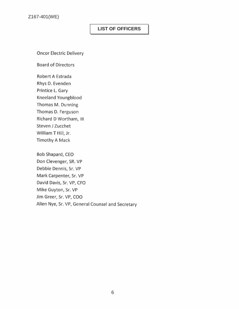
Z167-401(WE)
6
LIST OF OFFICERS

Z167-401(WE)
7
1. USE: The only use authorized by this specific use permit an electrical substation.
2. SITE PLAN: Use and development of the Property must comply with the attached site plan.
3. TIME LIMIT: This specific use permit has no expiration date. 4. INGRESS AND EGRESS: Ingress and egress must be provided in the
locations shown on the attached site plan. No other ingress or egress is permitted.
5. SCREENING: A minimum seven-foot-high chain link fence must be
provided around the perimeter of the Property. 6. HEIGHT: Maximum structure height is 95 feet. 7. MAINTENANCE: The Property must be properly maintained in a state of
good repair and neat appearance. 9. GENERAL REQUIREMENTS: Use of the Property must comply with all
federal and state laws and regulations, and with all ordinances, rules, and regulations of the City of Dallas.
[(1) That the development shall be generally in conformance with the site plan
as approved by the City Plan Engineer. (2) That all means of ingress and egress to the property shall be approved by
the City Plan Engineer. (3) That the entire development shall be adequately fenced and that the fence
on the front portion of the tract shall not be closer than fifty feet (50’) to Northaven Road.
(4) That the entire development shall be adequately landscaped as indicated
on the approved site plan and all plant materials shall be maintained in a healthy growing condition at all times.]
CPC AMENDMENT TO SUP NO. 44

Z167-401(WE)
8
PROPOSED SITE PLAN – SUP No. 44

Z167-401(WE)
9
PRESTON HAVEN OR
DEL ROY DR
BOCA RATON DR
MEADOW CREST DR
L RUSSWOOD OR
CASTLEWOOD RD
TANBARK RD
PEBBLE.BROOK DR
® 1 :6,000
PRESTON HAVEN DR
DEL ROY DR
VICINITY MAP
MEADOW CREST DR
a: 0 NORTHAVEN RD 0
~
~ l
GRAMERC'i PL
ELDERWOOD DR
ROYAL CREST DR
BURGUNDY RD
@ z 0 tn li1 a..
\>R£5TON ROYAL SC
ROYAL LN
Case no: ---=Z=-1.:...:6=-7=--4__:_:0:_1.;,..__
10/24/2017 Date: ---------

Z167-401(WE)
10

Z167-401(WE)
11
Single Family
Single Family
Single Family
Private school, kindergarten and day nursey

Z167-401(WE)
12
CPC RESPONSES

Z167-401(WE)
13
Notification List of Property Owners
Z167-401
51 Property Owners Notified 4 Property Owners in Favor 1 Property Owners Opposed
Reply Label # Address Owner 1 5700 NORTHAVEN RD TEXAS UTILITIES ELEC CO
2 5608 NORTHAVEN RD JHDIII INVESTMENTS LLC
3 5706 MEADOW CREST DR GARON HERBERT JR
X 4 5821 NORTHAVEN RD HO REGINA W
5 5815 NORTHAVEN RD WATROS DAVID C & ALISON M
6 5807 NORTHAVEN RD GLOBAL ASIAN INC LLC
7 5614 MEADOW CREST DR WORLEY DAVID ALLAN
8 5622 MEADOW CREST DR PARSONS HENRY DAVID
9 5628 MEADOW CREST DR CHENG SAMUEL &
10 5636 MEADOW CREST DR CRAIN JOHN H &
11 5642 MEADOW CREST DR WILENSKY RAYMOND D EST OF
12 5650 MEADOW CREST DR FELLER CANDACE C & MITCHELL J
13 5656 MEADOW CREST DR RUGGERI ANTHONY T & CAROL
14 5664 MEADOW CREST DR MEGREDY JULIA JONELL
15 5605 NORTHAVEN RD WALKER MARTI LF EST
16 5611 NORTHAVEN RD MARSHALL NEIL & KYLA
17 5619 NORTHAVEN RD GUTIERREZ JAVIER G
O 18 5627 NORTHAVEN RD LI HUIJEN
19 5707 NORTHAVEN RD SUMMERS GREGORY C & KELLY K
20 5715 NORTHAVEN RD LEVY JERRY ALAN
O 21 5723 NORTHAVEN RD STEWART LAMONA JANE
22 5731 NORTHAVEN RD JACKSON KYLE & VERONICA
23 5818 ELDERWOOD DR KENT JAMES N
24 5828 ELDERWOOD DR BUSKUHL MARK H &
25 5836 ELDERWOOD DR BUTLER DENNIS C
26 5844 ELDERWOOD DR HIGGINS BART E

Z167-401(WE)
14
12/13/2017
Reply Label # Address Owner 27 5852 ELDERWOOD DR CALLICUTT LINDA GRACE VINSON
28 5860 ELDERWOOD DR KRAMER JEFFRY & JAN
29 5868 ELDERWOOD DR MALOUF STEPHEN F
30 5807 ELDERWOOD DR DESKINS CASEY STEVEN
O 31 5815 ELDERWOOD DR ANDERSON DANIEL B
32 5823 ELDERWOOD DR MATHIS MARY GOOLSBY
O 33 5831 ELDERWOOD DR MOON LORENE REAVIS
34 5839 ELDERWOOD DR RAHIM AHMED & LAUREN
35 5847 ELDERWOOD DR JOHNSON SCOTT E &
36 5855 ELDERWOOD DR WILLIAMS BRADLEY KENT
37 5863 ELDERWOOD DR JONES BRIAN WALTER
38 5871 ELDERWOOD DR REED H WADE & MARILYN
39 11223 NORTHLAND CIR KRUMINS ARVIDS
40 11215 NORTHLAND CIR CANON PATRICK CHARLES ARTHUR &
41 11205 NORTHLAND CIR KEESY KRIS A
42 11202 NORTHLAND CIR RIZOS DAWN
43 11216 NORTHLAND CIR SMITH GARRY JOSEPH &
44 11224 NORTHLAND CIR BROWNIE BERT R EST OF
45 11249 JAMESTOWN RD WETZEL JOHN G &
46 11241 JAMESTOWN RD RICHARDSON KEVEN
47 11233 JAMESTOWN RD WISE KIM A
48 11140 RUSSWOOD CIR 11140 RUSSWOOD LLC
49 11130 RUSSWOOD CIR RODRIGUES STEPHEN S
50 5722 MEADOW CREST DR FAULKNER ADRIENNE A
51 5808 ELDERWOOD DR CONSTANT MERIDITH C &

AGENDA ITEM # 47Mobility Solutions, Infrastructure, and Sustainability
AGENDA DATE: January 24, 2018
COUNCIL DISTRICT(S): 9
DEPARTMENT: Department of Sustainable Development and Construction
CMO: Majed Al-Ghafry, 670-3302
MAPSCO: 39 B
SUBJECT
A public hearing to receive comments regarding an application for and an ordinance granting a Specific Use Permit for a child-care facility on property zoned an R-7.5(A) Single Family District, on the south corner of Ferguson Road and Drummond DriveRecommendation of Staff and CPC: Approval for a five-year period with eligibility for automatic renewals for additional five-year periods, subject to a site plan and conditionsZ167-403(WE)


1
HONORABLE MAYOR & CITY COUNCIL WEDNESDAY, JANUARY 24, 2018 ACM: Majed Al-Ghafry FILE NUMBER: Z167-403(WE) DATE FILED: September 28, 2017 LOCATION: South corner of Ferguson Road and Drummond Drive COUNCIL DISTRICT: 9 MAPSCO: 39 B SIZE OF REQUEST: Approx. 3.4 acres CENSUS TRACT: 126.04 APPLICANT: Mi Escuelita OWNER: San Francisco de Asis Episcopal Church REPRESENTATIVE: Robert Baldwin, Baldwin Associates, Inc. REQUEST: An application for a Specific Use Permit for a child-care
facility on property zoned an R-7.5(A) Single Family District. SUMMARY: The purpose of the request is to allow for a child-care facility
use [Mi Escuelita Preschool] to operate within an existing church facility. The applicant will provide care to children from two-and-a-half to five years of age, and will operate the child-care facility Monday through Friday, between the hours of 7:00 a.m. to 7:00 p.m.
STAFF RECOMMENDATION: Approval for a five-year period with eligibility for
automatic renewals for additional five-year periods, subject to a site plan and conditions.
CPC RECOMMENDATION: Approval for a five-year period with eligibility for
automatic renewals for additional five-year periods, subject to a site plan and conditions.

Z167-403(WE)
2
BACKGROUND INFORMATION:
The request site is developed with an existing church.
The applicant proposes to use approximately four classrooms within the church to provide care to children from two and a half to five years of age. The applicant will operate the child-care facility between the hours of 7:00 a.m. to 7:00 p.m., Monday through Friday.
The surrounding land uses consist of single family uses, a church, and, across Drummond Drive, an animal clinic without outside run [PDD No. 224].
Zoning History: There has not been any zoning changes requested in the area during the past five years. Thoroughfares/Streets:
Thoroughfare/Street Type Existing ROW
Proposed ROW
Ferguson Road Principal Arterial 100 ft. 100 ft. Drummond Drive Local 50 ft. 50 ft.
Traffic: The Engineering Division of the Sustainable Development and Construction Department has reviewed the request and determined that the proposed development will not have a negative impact on the surrounding street system. Land Use:
Zoning Land Use Site R-7.5(A) Church
Northeast R-7.5(A), PDD No. 224
Single family, Animal clinic without outside run
Southeast R-7.5(A) Single family Northwest MF-1(A), NS(A), SUP
No. 1304 Multifamily, Retail & personal
service with motor vehicle fueling station
West R-7.5(A) Church COMPREHENSIVE PLAN: The forwardDallas! Comprehensive Plan was adopted by the City Council in June 2006. The forwardDallas! Comprehensive Plan outlines several goals and policies which can serve as a framework for assisting in evaluating the applicant’s request.

Z167-403(WE)
3
LAND USE GOAL 1.2 PROMOTE DESIRED DEVELOPMENT
Policy 1.2.1 Use Vision Building Blocks as a general guide for desired
development patterns. URBAN DESIGN GOAL 5.3 ESTABLISHING WALK-TO-CONVENIENCE
Policy 5.3.1 Encourage a balance of land uses within walking distance of each other. STAFF ANALYSIS: Land Use Compatibility: The 3.4-acre site is developed with a church and surrounded by single family uses. The applicant proposes to use 8,000 square feet of floor area within the existing church for a child-care facility. The applicant is proposing to operate the child-care facility between the hours of 7:00 a.m. to 7:00 p.m., Monday through Friday. The request site has two driveway approaches, one on Ferguson Road and the other on Drummond Drive, to access the site. The existing playground equipment that is located within a secured area on the church’s property, will be utilized by the attendees of the child-care facility. The general provisions for a Specific Use Permit in Section 51A-4.219 of the Dallas Development Code specifically state: (1) The SUP provides a means for developing certain uses in a manner in which the specific use will be consistent with the character of the neighborhood; (2) Each SUP application must be evaluated as to its probable effect on the adjacent property and the community welfare and may be approved or denied as the findings indicate appropriate; (3) The city council shall not grant an SUP for a use except upon a finding that the use will: (A) complement or be compatible with the surrounding uses and community facilities; (B) contribute to, enhance, or promote the welfare of the area of request and adjacent properties; (C) not be detrimental to the public health, safety, or general welfare; and (D) conform in all other respects to all applicable zoning regulations and standards. The regulations in this chapter have been established in accordance with a comprehensive plan for the purpose of promoting the health, safety, morals, and general welfare of the city. The proposed child-care facility may not deter nor attract from the character of the existing neighborhood. The child-care facility will use a portion of the church facility, and as a result of the location of the proposed use, can become another option for parents seeking child-care. Staff is recommending approval of a Specific Use Permit for a child-care facility for a five-year period with eligibility for automatic renewals for additional five-year periods,

Z167-403(WE)
4
subject to a site plan and conditions. Development Standards:
DISTRICT SETBACKS Density Height Lot
Coverage Special
Standards PRIMARY Uses
Front Side/Rear
R-7.5(A) Single Family
25’ 5’ 1 Dwelling Unit/
7,500 sq. ft. 30’ 45% Single family
Landscaping: Landscaping of any development will be in accordance with Article X, as amended. However, due to the site not increasing any impervious surface or floor area, landscaping the site is not required. Parking: The Dallas Development Code requires that the off-street parking for a child-care facility may be established in the ordinance granting the SUP, otherwise one space per 500 square feet of floor area. In addition, there is a provision in the Development Code under Special Parking that states “institutional and community service uses may share parking in residential districts on the same lot where both uses are located.” The applicant has submitted a parking analysis that demonstrates that the church and child-care facility have a sufficient amount of off-street parking to serve both uses. Below is the parking analysis for the proposed use: Church: Total pew length: 10,392 inches 10,392 ft./18 inches = 577 seats in the sanctuary 577 seats/4 seats per parking space = 144 spaces required for the church Child-care facility: Total floor area: 8,000 square ft. 8,000 sq. ft. /500 sq. ft. = 16 spaces Total required off-street parking for both uses: 160 spaces Total number of spaces provided: 196 spaces

Z167-403(WE)
5
CPC Action (November 30, 2017)
Motion: It was moved to recommend approval of a Specific Use Permit for a child-care facility for a five-year period with eligibility for automatic renewals for additional five-year periods, subject to a site plan and conditions on property zoned an R-7.5(A) Single Family District, on the south corner of Ferguson Road and Drummond Drive.
Maker: Lavallaissa Second: Houston Result: Carried: 14 to 0
For: 14 - West, Rieves, Houston, Davis, Shidid,
Carpenter, Lavallaissa, Jung, Housewright, Schultz, Peadon, Murphy, Ridley, Tarpley
Against: 0 Absent: 1 - Mack Vacancy: 0
Notices: Area: 300 Mailed: 37 Replies: For: 3 Against: 2 Speakers: None

Z167-403(WE)
6
LIST OF OFFICERS

Z167-403(WE)
7
1. USE: The only use authorized by this specific use permit is a child-care facility. 2. SITE PLAN: Use and development of the Property must comply with the attached
site plan. 3. TIME LIMIT: This specific use permit expires on (five-year period from the passage
of this ordinance), but is eligible for automatic renewal for additional five-year periods, pursuant to Section 51A-4.219 of Chapter 51A of the Dallas City Code, as amended. For automatic renewal to occur, the Property owner must file a complete application for automatic renewal with the director before the expiration of the current period. Failure to timely file a complete application will render this specific use permit ineligible for automatic renewal. (Note: The Code currently provides that applications for automatic renewal must be filed after the 180th but before the 120th day before the expiration of the current specific use permit period. The Property owner is responsible for checking the Code for possible revisions to this provision. The deadline for application for automatic renewal is strictly enforced.)
4. FLOOR AREA: The maximum floor area is 8,000 square feet in the location shown
on the attached site plan. 5. HOURS OF OPERATION: The child-care facility may only operate between 7:00
a.m. and 7:00 p.m., Monday through Friday. 6. OFF-STREET PARKING: A minimum of 16 off-street parking spaces are required in
the location shown on the attached site plan. 7. INGRESS AND EGRESS: Ingress and egress must be provided as shown on the
attached site plan. No other ingress or egress is permitted. 8. MAINTENANCE: The Property must be properly maintained in a state of good repair
and neat appearance. 9. GENERAL REQUIREMENTS: Use of the Property must comply with all federal and
state laws and regulation, and with all ordinances, rules, and regulations of the City of Dallas.
CPC PROPOSED SUP CONDITIONS

Z167-403(WE)
8
PROPOSED SITE PLAN

Z167-403(WE)
9
'
' WEATHER VANE LN
3 -' Sl ~ LOCHLYNN CIR
~ FEATHERBROOK Of?
VICINITY MAP 1 :6,000
, City of • . Garland
' ( ti ·,. .)~ . '
' . . ' . .
' ' ..
' ' . .
'
Case no: Z167-403 ---=-:...=...:...~~~
Date: 10/24/2017
.
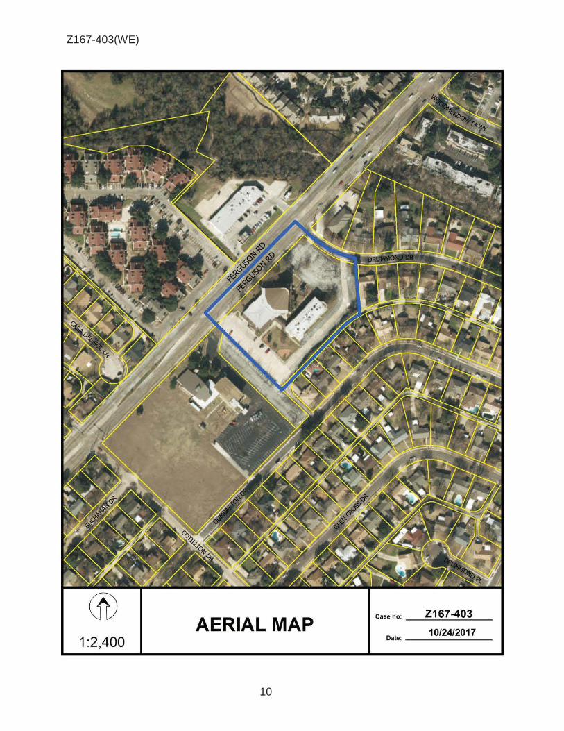
Z167-403(WE)
10
® AERIAL MAP
Z167-403 Case no: _...:::....:....::....:...____;:___
10/24/2017 Date: _ ____:_:_ __ _ 1 :2,400

Z167-403(WE)
11
Single Family
Single Family
Single Family
Church
Animal clinic without outside run
Retail & personal service with fueling station

Z167-403(WE)
12
CPC RESPONSES

Z167-403(WE)
13
Notification List of Property Owners
Z167-403
37 Property Owners Notified 3 Property Owners in Favor 2 Property Owners Opposed
Reply Label # Address Owner 1 11540 FERGUSON RD CORPORATION OF EPISCOPAL
2 3847 CASA DEL SOL LN VALENCIA LUIS
3 3851 CASA DEL SOL LN RAMIREZ MARCOS MENDOZA &
4 3855 CASA DEL SOL LN CHAVEZ ISIDRO & IRENE
5 11642 DRUMMOND DR VELEZ JOSE M
6 11648 DRUMMOND DR JAMES LAURA G LIFE ESTATE
X 7 11654 DRUMMOND DR SPEARS RUTH
8 11662 DRUMMOND DR DEALBA CLAUDIA
9 11672 DRUMMOND DR CLINGMAN JAMES W
O 10 11550 FERGUSON RD MCKINNEY NELSON
11 11430 DUMBARTON DR REASONS DUSTINA D
12 11436 DUMBARTON DR RIVERA-DIAZ MOISES
13 11448 DUMBARTON DR AUST LAURA D &
14 11456 DUMBARTON DR TODD PHILIP A
15 11462 DUMBARTON DR HANNA MARK
X 16 11468 DUMBARTON DR SALINAS ELIAS JR
17 11474 DUMBARTON DR HOLT EVELYN
18 11484 DUMBARTON DR VALENCIANA TANYA
19 11510 DUMBARTON DR DAVIS MARK E &
20 11459 DUMBARTON DR IDE DEBBIE
21 11465 DUMBARTON DR RODRIGUEZ GILBERTO
22 11471 DUMBARTON DR BAHENA CASTULO & SENORINA
23 11477 DUMBARTON DR ESTRADA BERNARDINO
24 11481 DUMBARTON DR TORRES NOEL &
25 11485 DUMBARTON DR FISHER LINDA A & CHARLES
O 26 11503 DUMBARTON DR BROWN MARDITH LEA

Z167-403(WE)
14
11/29/2017
Reply Label # Address Owner 27 11509 DUMBARTON DR RAMOS GUSTAVO & SILVIA V RAMOS
28 11515 DUMBARTON DR MOULTON NANCY
29 11641 DRUMMOND DR BRITO ARSENIO &
30 11647 DRUMMOND DR KING LEON & REBECCA
O 31 11653 DRUMMOND DR DALE JOHN P
32 11661 DRUMMOND DR MENDOZA JUAN &
33 11669 DRUMMOND DR WALLACE JORDAN &
34 11511 FERGUSON RD SHADOWBROOK REDEVELOPMENT LLC
35 11611 FERGUSON RD EXPONENTIAL PPTY GROUP V LLC
36 11555 FERGUSON RD UNITED BIG D INC
37 11440 FERGUSON RD RIDGE POINTE FELLOWSHIP
AGENDA ITEM # 48Mobility Solutions, Infrastructure, and Sustainability
AGENDA DATE: January 24, 2018
COUNCIL DISTRICT(S): 6
DEPARTMENT: Department of Sustainable Development and Construction
CMO: Majed Al-Ghafry, 670-3302
MAPSCO: 44 A
SUBJECT
A public hearing to receive comments regarding an application for and an ordinance granting an MU-2 Mixed Use District on property zoned an IR Industrial Research District on the west line of Gretna Street, south of Lupo DriveRecommendation of Staff and CPC: ApprovalZ178-102(SM)
1
HONORABLE MAYOR & CITY COUNCIL WEDNESDAY, JANUARY 24, 2018 ACM: Majed Al-Ghafry
FILE NUMBER: Z178-102(SM) DATE FILED: October 5, 2017 LOCATION: West line of Gretna Street, south of Lupo Drive COUNCIL DISTRICT: 6 MAPSCO: 44 A SIZE OF REQUEST: Approx. 0.27 acre CENSUS TRACT: 100.00 OWNER/APPLICANT: Justin McMillin REPRESENTATIVE: Audra Buckley, Permitted Development REQUEST: An application for an MU-2 Mixed Use District on property
zoned an IR Industrial Research District. SUMMARY: The applicant requests to utilize the existing structure for
three dwelling units. STAFF RECOMMENDATION: Approval CPC RECOMMENDATION: Approval

Z178-102(SM)
2
BACKGROUND INFORMATION: The area of request is developed with a 6,000 square-foot one-story structure that
was constructed in 1965, according to Dallas Central Appraisal District records.
The existing building has been split into three separate tenant spaces since December 2003, according to permit records.
On July 11, 2017, the current property owner was issued a Certificate of Occupancy (CO) as an office/showroom/warehouse use for each of the three suites.
Zoning History: There has been one zoning change requested in the past five
years. 1. Z134-331: On November 12, 2014, the City Council approved an MU-3 Mixed Use
District on property zoned an IR Industrial Research District Thoroughfares/Streets:
Thoroughfare/Street Function ROW
Gretna Street Local 50 feet
Traffic: The Engineering Division of the Sustainable Development and Construction Department has reviewed the request and determined that the proposed development will not have a negative impact on the surrounding street system. STAFF ANALYSIS: AREA PLAN: The Stemmons Corridor – Southwestern Medical District Area Plan was adopted by City Council on June 23, 2010 and identifies the area of request within the Urban Mixed-Use Medium Development Block. Page 39 of the Vision and Policy Plan Component states the following:
This Development Block encourages a mix of office, retail, service and residential uses on the same block or within the same building. It also provides flexibility in the types of uses in the area while emphasizing a walkable character. Residential development in this development block will be in mid- to high-rise structures.

Z178-102(SM)
3
Detached single-family residential development is considered incompatible with this Development Block. Residents within the Urban Mixed-Use development blocks will have access to a large array of businesses all within easy walking distance if not within their own building.
COMPREHENSIVE PLAN: The fowardDallas! Comprehensive Plan was adopted by the City Council in June 2006. The fowardDallas! Comprehensive Plan outlines several goals and policies which can serve as a framework for assisting in evaluating the applicant’s request. The request does not support or obstruct the Plan’s goals or policies.
Economic Element
GOAL 2.1 PROMOTE BALANCED GROWTH
Policy 2.1.1 Ensure that zoning is flexible enough to respond to changing economic conditions.
Urban Design
Policy 5.1.3 Encourage complementary building height, scale, design and character.
Surrounding Land Uses:
Location Zoning Land Use
Site IR Vacant
North IR Office
East IR Office
South IR Open Storage
West IR Machine or Welding Shop
and Warehouse Land Use Compatibility: The approximately 0.27-acre site contains a 6,000 square-foot, one-story vacant structure. Surrounding properties are commercial in nature and include offices to the north and east, an open storage lot to the south, and a machine or welding shop and warehouse to the west.

Z178-102(SM)
4
Staff supports the request of an MU-2 Mixed Use District because (1) the request is consistent with the Urban Mixed-Use Medium Development Block recommendations within the Stemmons Corridor – Southwestern Medical District Area Plan, (2) the MU-2 District is more comparable to the development standards of the IR District than the MU-1 or MU-3 District, and (3) single family uses are not allowed in the MU-2 District. Development Standards:
DISTRICT SETBACKS
Density Height Lot Coverage
Special Standards PRIMARY Uses
Front Side/Rear
IR
Industrial Research
15’
30’ adjacent to residential
OTHER: No Min.
2.0 FAR overall
0.75 office/ retail
0.5 retail
200’ 15 stories 80% Proximity Slope
Visual Intrusion
Industrial, wholesale distribution & storage, supporting office & retail
MU-2 Mixed Use-2
15’
20’ adjacent to residential
OTHER: No Min.
1.6 FAR base 2.0 FAR
maximum + bonus for residential
135’ 10 stories
180’ 14 stories with retail
80%
Proximity Slope U-form setback Tower spacing Visual Intrusion
Office, retail & personal service, lodging, residential
Landscaping: Landscaping, when triggered, will be in accordance with Article X, as amended.

Z178-102(SM)
5
Prior CPC Action – December 14, 2017:
Motion: It was moved to recommend approval of an MU-2 Mixed Use District on property zoned an IR Industrial Research District, on the west line of Gretna Street, south of Lupo Drive.
Maker: Carpenter Second: Mack Result: Carried: 15 to 0
For: 15 - West, Rieves, Houston, Davis, Shidid,
Carpenter, Mack, Lavallaissa, Jung, Housewright, Schultz, Peadon, Murphy, Ridley, Tarpley
Against: 0 Absent: 0 Vacancy: 0
Notices: Area: 200 Mailed: 17 Replies: For: 3 Against: 0 Speakers: None

Z178-102(SM)
6

Z178-102(SM)
7
® AERIAL MAP
Z178-102 Case no: _=--:....:.._-=----::.....: __
11/27/2017 Date: ____ _
1 :1,200

Z178-102(SM)
8
Open Storage
Office
Warehouse
Machine or Welding Shop
Office

Z178-102(SM)
9
1

Z178-102(SM)
10
CPC Responses

Z178-102(SM)
11
12/13/2017
Reply List of Property Owners Z178-102
17 Property Owners Notified 3 Property Owners in Favor 0 Property Owners Opposed
Reply Label # Address Owner O 1 4829 GRETNA ST MCMILLIN JUSTIN
2 4809 VICKSBURG ST GRAF JOYCE ANN &
3 4815 VICKSBURG ST GRAF JOYCE ANN &
4 4817 VICKSBURG ST GRAF JOYCE & SULLIVAN ANN
5 4819 VICKSBURG ST MJRP CORPORATION INC
6 4835 VICKSBURG ST MJRP CORPORATION INC
7 4839 VICKSBURG ST VICKSBURG PARTNERSHIP LLC
8 4802 VICKSBURG ST DCSJ EDWARDS LLC
9 4810 VICKSBURG ST QUINN SCOTT
10 4820 VICKSBURG ST SOUTHERLAND GARY D
11 4834 VICKSBURG ST HORTON BRUCE RAGSDALE &
12 4838 VICKSBURG ST LERER STEPHEN A
O 13 1107 LAGOON DR FASTLANE INVESTMENTS LLC
O 14 1109 LAGOON DR WRIGHT GEORGE E
15 4831 GRETNA ST GRAHAM STEVE & CO LLC
16 4820 GRETNA ST MW CLINT PROPERTIES LLC
17 1111 LAGOON DR LAGOON VENTURE LLC
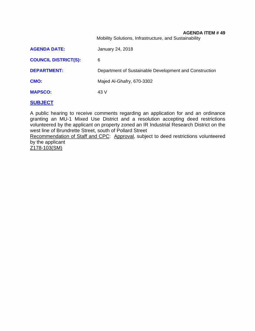
AGENDA ITEM # 49Mobility Solutions, Infrastructure, and Sustainability
AGENDA DATE: January 24, 2018
COUNCIL DISTRICT(S): 6
DEPARTMENT: Department of Sustainable Development and Construction
CMO: Majed Al-Ghafry, 670-3302
MAPSCO: 43 V
SUBJECT
A public hearing to receive comments regarding an application for and an ordinance granting an MU-1 Mixed Use District and a resolution accepting deed restrictions volunteered by the applicant on property zoned an IR Industrial Research District on the west line of Brundrette Street, south of Pollard StreetRecommendation of Staff and CPC: Approval, subject to deed restrictions volunteered by the applicantZ178-103(SM)

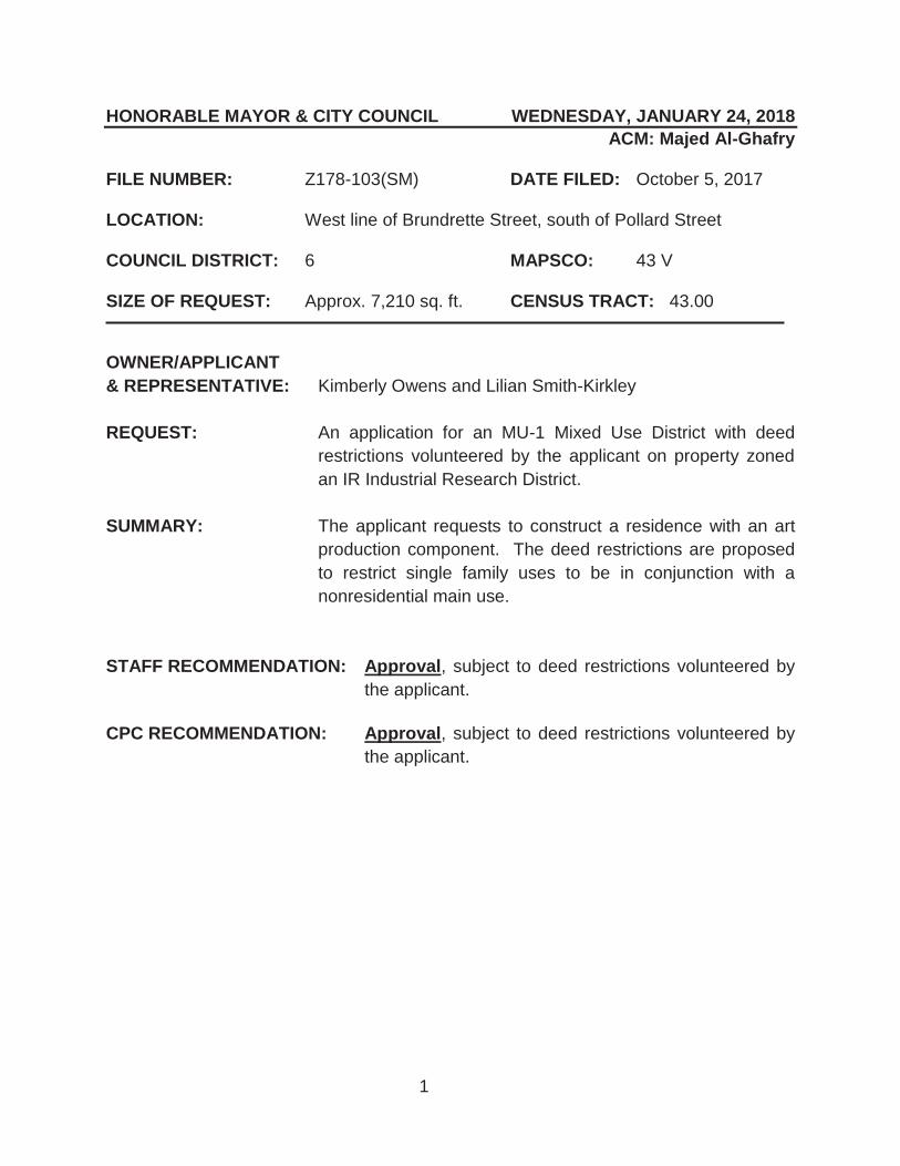
1
HONORABLE MAYOR & CITY COUNCIL WEDNESDAY, JANUARY 24, 2018 ACM: Majed Al-Ghafry
FILE NUMBER: Z178-103(SM) DATE FILED: October 5, 2017 LOCATION: West line of Brundrette Street, south of Pollard Street COUNCIL DISTRICT: 6 MAPSCO: 43 V SIZE OF REQUEST: Approx. 7,210 sq. ft. CENSUS TRACT: 43.00 OWNER/APPLICANT & REPRESENTATIVE: Kimberly Owens and Lilian Smith-Kirkley REQUEST: An application for an MU-1 Mixed Use District with deed
restrictions volunteered by the applicant on property zoned an IR Industrial Research District.
SUMMARY: The applicant requests to construct a residence with an art
production component. The deed restrictions are proposed to restrict single family uses to be in conjunction with a nonresidential main use.
STAFF RECOMMENDATION: Approval, subject to deed restrictions volunteered by
the applicant. CPC RECOMMENDATION: Approval, subject to deed restrictions volunteered by
the applicant.

Z178-103(SM)
2
BACKGROUND INFORMATION: The area of request is undeveloped and is under the same ownership as the
adjacent property to the north.
The property owners are a print maker and painter that currently operate an art production facility to the north. The owners request to develop the site with a live/work art production facility that would contain a single family unit on the second floor and an art production facility on the bottom floor in order to accommodate their growing art production business. The sale and display of the art that is produced on site will occur off-site in a gallery in the Design Studio.
Zoning History: There have been no zoning changes requested in the past five years.
Thoroughfares/Streets:
Thoroughfare/Street Function ROW
Brundrette Street Local 50 feet
Traffic: The Engineering Division of the Sustainable Development and Construction Department has reviewed the request and determined that the proposed development will not have a negative impact on the surrounding street system. STAFF ANALYSIS: COMPREHENSIVE PLAN: The fowardDallas! Comprehensive Plan was adopted by the City Council in June 2006. The fowardDallas! Comprehensive Plan outlines several goals and policies which can serve as a framework for assisting in evaluating the applicant’s request. The request does not support or obstruct the Plan’s goals or policies.
Economic Element
GOAL 2.1 PROMOTE BALANCED GROWTH
Policy 2.1.1 Ensure that zoning is flexible enough to respond to changing economic conditions.
GOAL 2.4 CREATE AND MAINTAIN AN ENVIRONMENT FRIENDLY TO BUSINESSES AND ENTREPRENEURS
Policy 2.4.2 Restore Dallas as the premier city for conducting business within the region.

Z178-103(SM)
3
Land Use Compatibility: The approximately 7,210 square-foot lot is relatively flat and grassy. The property owners are a print maker and painter that currently operate an art production facility to the north with an industrial (inside) certificate of occupancy. The owners request to develop the site with a live/work art production facility that would contain a single family unit on the second floor and an art production facility on the bottom floor to accommodate their growing art production business. The sale and display of the art that is produced on site will occur off-site in a gallery in the Design Studio. Surrounding land uses include an art production business, or industrial (inside) in Dallas Development Code terminology, to the north, undeveloped land to the east and south, and a multifamily development to the west. Additional industrial uses are located further north and the historic Specific Use Permit No. 98 for a quarry is located further south and southeast. Nonconforming single family uses are located further west and a church is located northwest of the site. Staff supports the request of an MU-1 Mixed Use District because the applicant has offered deed restrictions to make the property more compatible with surrounding uses. The deed restrictions are proposed to restrict single family uses to be in conjunction with a nonresidential main use, as standalone single family uses are seen as incompatible with adjacent nonresidential properties. Development Standards:
DISTRICT SETBACKS
Density Height Lot Coverage
Special Standards PRIMARY Uses
Front Side/Rear
IR
Industrial Research
15’
30’ adjacent to residential
OTHER: No Min.
2.0 FAR overall
0.75 office/ retail
0.5 retail
200’ 15 stories 80% Proximity Slope
Visual Intrusion
Industrial, wholesale distribution & storage, supporting office & retail
MU-1 Mixed Use-1
15’
20’ adjacent to residential
OTHER: No Min.
0.8 FAR base 1.0 FAR
maximum + bonus for residential
90’ 7 stories
120’ 9 stories with retail
80%
Proximity Slope U-form setback Tower spacing Visual Intrusion
Office, retail & personal service, lodging, residential
Landscaping: Landscaping, when triggered, will be in accordance with Article X, as amended.
Zoning Land Use Site IR Undeveloped
North IR Art Production East IR Undeveloped
South IR Undeveloped West IR Multifamily

Z178-103(SM)
4
Prior CPC Action – December 14, 2017:
Motion: It was moved to recommend approval of an MU-1 Mixed Use District with deed restrictions volunteered by the applicant, subject to deed restrictions volunteered by the applicant on property zoned an IR Industrial Research District, on the west line of Brundrette Street, south of Pollard Street.
Maker: Carpenter Second: Mack Result: Carried: 15 to 0
For: 15 - West, Rieves, Houston, Davis, Shidid,
Carpenter, Mack, Lavallaissa, Jung, Housewright, Schultz, Peadon, Murphy, Ridley, Tarpley
Against: 0 Absent: 0 Vacancy: 0
Notices: Area: 200 Mailed: 8 Replies: For: 0 Against: 0 Speakers: For: None For (Did not speak): Kimberly Owens, 2003 Brundrette St., Dallas, TX, 75208 Lillian Smith-Kirkley, 2003 Brundrette St., Dallas, TX, 75208 Sean Garman, 3615 Gillespie St., Dallas, TX, 75219 Against: None

Z178-103(SM)
5
Proposed Volunteered Deed Restrictions
II.
The Owner does hereby impress all of the Property with the following deed restrictions ("restrictions"), to wit:
Single family uses are only permitted as part of a live/work unit. LIVE/WORK UNIT means an interior space that combines a residential main use with a nonresidential main use. A live/work unit is considered a nonresidential use.

Z178-103(SM)
6

Z178-103(SM)
7
® AERIAL MAP
Z178-103 Case no: _...=....:.....:..-=......;;__;:_ __
10/26/2017 Date: ------1 :1,200

Z178-103(SM)
8
Art Production
Undeveloped
Multifamily Undeveloped

Z178-103(SM)
9
CPC Responses

Z178-103(SM)
10
12/13/2017
Reply List of Property Owners Z178-103
8 Property Owners Notified 0 Property Owners in Favor 0 Property Owners Opposed
Reply Label # Address Owner 1 2003 BRUNDRETTE ST SMITHKIRKLEY LILLIAN &
2 1911 BRUNDRETTE ST DALLAS INDIAN REVIVAL CENTER
3 2015 BRUNDRETTE ST NAVA ALFONSO &
4 1910 IVANHOE LN DALLAS INDIAN REVIVAL CENTER
5 1912 IVANHOE LN MARTINEZ JORGE
6 2006 IVANHOE LN DALLAS INDIAN REVIVAL
7 2010 IVANHOE LN DALLAS INDIAN REVIVAL CTR
8 2030 W COMMERCE ST JORGENSEN EARLE M CO

AGENDA ITEM # 50Mobility Solutions, Infrastructure, and Sustainability
AGENDA DATE: January 24, 2018
COUNCIL DISTRICT(S): 6
DEPARTMENT: Department of Sustainable Development and Construction
CMO: Majed Al-Ghafry, 670-3302
MAPSCO: 33 T
SUBJECT
A public hearing to receive comments regarding an application for and an ordinance granting a CS Commercial Service District on property zoned an IR Industrial Research District, on the northeast line of Ambassador Row and West Mockingbird LaneRecommendation of Staff and CPC: ApprovalZ178-106(PD)


1
HONORABLE MAYOR & CITY COUNCIL WEDNESDAY, JANUARY 24, 2018
ACM: Majed Al-Ghafry FILE NUMBER: Z178-106(PD) DATE FILED: October 9, 2017 LOCATION: Northeast line of Ambassador Row and West Mockingbird
Lane COUNCIL DISTRICT: 6 MAPSCO: 33 T SIZE OF REQUEST: ±1.79 acres CENSUS TRACT: 100.00 APPLICANT Del Lago Ventures, Inc. OWNER: Group 701, LLC REPRESENTATIVE: David Martin/Tommy Mann (Winstead PC) REQUEST: An application for a CS Commercial Service District on
property zoned an IR Industrial Research District. SUMMARY: The purpose of this request is to allow for the development
of a general merchandise or food store greater than 3,500 square feet with a motor vehicle fueling station. [RaceTrac]
STAFF RECOMMENDATION: Approval CPC RECOMMENDATION: Approval

Z178-106(PD)
2
BACKGROUND INFORMATION: The request site is developed with a vacant vehicle display, sales, and service use.
The property last obtained approval of a Certificate of Occupancy on November 12,
2010, under the business name, US Auto House.
The proposed CS Commercial Service District will allow for the development of a one-story, 5,411-square foot general merchandise or food store [Racetrack] with fueling stations.
The request site is contiguous to warehouse and office uses zoned for IR Industrial Research District uses.
Zoning History: There has been one zoning change requested in the area in the past five years.
1. Z145-102 On December 10, 2014, the City Council approved a request for a CS Commercial Service District and Specific Use Permit No. 2128 for an auto auction on property zoned an IR Industrial Research District located on the southwest line of John Carpenter Freeway Frontage Road.
Thoroughfares/Streets:
Thoroughfare/Street Type Proposed ROW Ambassador Row Community Collector 60 ft. W. Mockingbird Lane Principal Arterial 100 ft.
Traffic:
The Engineering Division of the Sustainable Development and Construction Department reviewed the proposed request and determined that the request will not have a negative impact on the existing street system. Land Use:
Zoning Land Use Site IR Vacant Vehicle Display, Sales & Service
Northeast IR Restaurant, Pawn Shop Northwest IR Machine Shop-Industrial (Inside) Southeast IR, SUP No. 58 Office Southwest IR Office Showroom/Warehouse South IR Vacant Structure
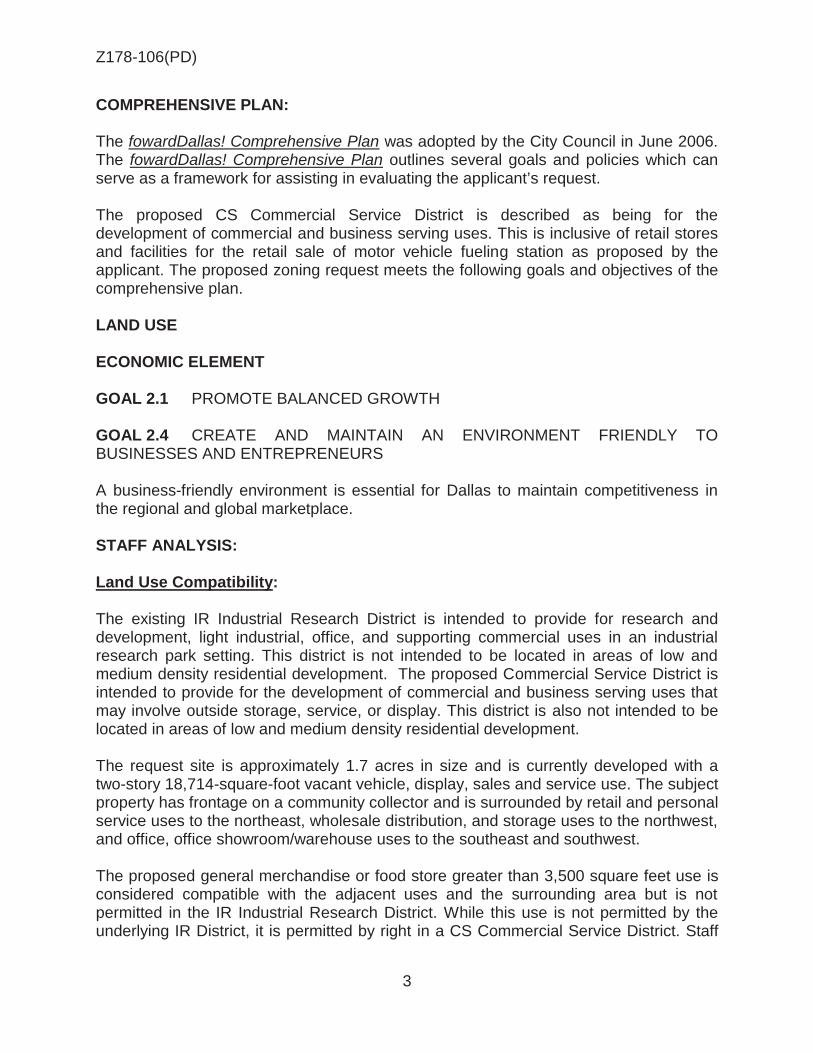
Z178-106(PD)
3
COMPREHENSIVE PLAN: The fowardDallas! Comprehensive Plan was adopted by the City Council in June 2006. The fowardDallas! Comprehensive Plan outlines several goals and policies which can serve as a framework for assisting in evaluating the applicant’s request. The proposed CS Commercial Service District is described as being for the development of commercial and business serving uses. This is inclusive of retail stores and facilities for the retail sale of motor vehicle fueling station as proposed by the applicant. The proposed zoning request meets the following goals and objectives of the comprehensive plan. LAND USE ECONOMIC ELEMENT GOAL 2.1 PROMOTE BALANCED GROWTH GOAL 2.4 CREATE AND MAINTAIN AN ENVIRONMENT FRIENDLY TO BUSINESSES AND ENTREPRENEURS
A business-friendly environment is essential for Dallas to maintain competitiveness in the regional and global marketplace. STAFF ANALYSIS: Land Use Compatibility: The existing IR Industrial Research District is intended to provide for research and development, light industrial, office, and supporting commercial uses in an industrial research park setting. This district is not intended to be located in areas of low and medium density residential development. The proposed Commercial Service District is intended to provide for the development of commercial and business serving uses that may involve outside storage, service, or display. This district is also not intended to be located in areas of low and medium density residential development. The request site is approximately 1.7 acres in size and is currently developed with a two-story 18,714-square-foot vacant vehicle, display, sales and service use. The subject property has frontage on a community collector and is surrounded by retail and personal service uses to the northeast, wholesale distribution, and storage uses to the northwest, and office, office showroom/warehouse uses to the southeast and southwest. The proposed general merchandise or food store greater than 3,500 square feet use is considered compatible with the adjacent uses and the surrounding area but is not permitted in the IR Industrial Research District. While this use is not permitted by the underlying IR District, it is permitted by right in a CS Commercial Service District. Staff

Z178-106(PD)
4
recommends approval based on the zoning change being consistent with the current land uses within the area. Development Standards:
DISTRICT Setbacks
FAR Height Lot
Coverage
Special Standards Primary Uses
Front Side/Rear Existing
IR Industrial Research
15’ 30’ adjacent to
residential OTHER: No Min.
2.0 FAR overall 0.75
office/ retail
0.5 retail
200’ 15 stories 80%
Proximity Slope Visual
Intrusion Industrial, wholesale distribution & storage, supporting office & retail
Proposed
CS Commercial Service
15’ 0’ on minor
20’ adjacent to residential OTHER: No Min.
0.75 FAR overall
0.5 office/ lodging/
retail combined
45’ 3 stories 80%
Proximity Slope Visual
Intrusion Commercial & business service, supporting retail & personal service & office
Landscaping: Landscaping must be provided in accordance with Article X, as amended. Parking: The parking requirement for a general merchandise or food store 3,500 square feet or greater use is 1 space per 200 square feet of floor area for uses with less than 10,000 square feet of floor area,1 required ADA accessible space for every 10 required parking spaces plus two off street parking spaces for the motor vehicle fueling station. Based on the proposed 5,411 square feet of the proposed construction, the number of spaces required is 27 spaces plus the 2 ADA space and 2 for the fueling station with a minimum total of 31 parking spaces required. The applicant is proposing 32 spaces.

Z178-106(PD)
5
Prior CPC Action December 14, 2017:
Motion: It was moved to recommend approval of a CS Commercial Service District on property zoned an IR Industrial Research District, on the northwest corner of Ambassador Row and West Mockingbird Lane.
Maker: Carpenter Second: Mack Result: Carried: 15 to 0
For: 15 - West, Rieves, Houston, Davis, Shidid,
Carpenter, Mack, Lavallaissa, Jung, Housewright, Schultz, Peadon, Murphy, Ridley, Tarpley
Against: 0 Absent: 0 Vacancy: 0
Notices: Area: 300 Mailed: 15 Replies: For: 1 Against: 0 Speakers: None

Z178-106(PD)
6
GROUP 701, LLC Mahmoud Shahsiah - Manager DEL LAGO VENTURES, INC. Carl Bolch, JR – Chief Executive Officer Allsion Bolch Moran – President Max Lenker – Chief Financial Officer Robert J. Dumbacker – Chief Legal Officer Susan Bass Bolch – Vice President Natalie Bolch Morhous – Vice President Melanie Bolch Isbill – Vice President Jordan Bass Bolch – Vice President
LIST OF OFFICERS

Z178-106(PD)
7
/ /
ENVOY CT
_J
(; HALIFAX ST
1
® VICINITY MAP
Z178-106 Case no: --=..:....:....=.......;;...:;...;; __
10!24/2017 1 :6,000 Date: -------

Z178-106(PD)
8
® AERIAL MAP
Z178-106 Case no: _ __;=..!..:....:::.....::..=...;:;.___
10/2412017 Date: __ ....:....:: ____ _
1 :2,400

Z178-106(PD)
9
Office, Showroom/Warehouse Office
Machine Shop
Restaurant
Vacant Structure

Z178-106(PD)
10
1

Z178-106(PD)
11
CPC RESPONSES
___ 1-'-5 __ Property Owners Notified (17 parcels) ___ 1;.._ __ Replies in Favor {l parcels) __ ....;O:__ __ Replies in Opposition (0 parcels) __ 3_00_ ' __ Area of Not if icat ion
12/14/ 2017 Date
Z178- 106
CPC 1 :2,400

Z178-106(PD)
12
12/13/2017
Reply List of Property Owners Z178-106
15 Property Owners Notified 1 Property Owners in Favor 0 Property Owners Opposed
Reply Label # Address Owner O 1 7410 AMBASSADOR ROW 7410 AMBR LLC
2 7300 AMBASSADOR ROW GROUP 701 LLC
3 1035 W MOCKINGBIRD LN FRIS CHKN LLC % CAJUN OPERATING CO
4 7108 ENVOY CT S & P ASSETS LLC
5 7275 ENVOY CT SCHLEIN ROBERT P &
6 950 W MOCKINGBIRD LN GAYU INC
7 910 W MOCKINGBIRD LN GAYU INC
8 7500 AMBASSADOR ROW MICROPROPERTIES SIX LLC
9 7301 AMBASSADOR ROW GERSHMAN PROPERTIES LLC
10 7611 JOHN W CARPENTER FWY WEITZMAN HERBERT D TRUSTEE
11 1055 W MOCKINGBIRD LN CLOUD HOLDINGS LLC
12 1055 W MOCKINGBIRD LN FOSTER DAN & KIM B
13 7303 JOHN W CARPENTER FWY HEIDARI AL
14 7601 AMBASSADOR ROW FESI AMBASSADOR ROW LP
15 1010 W MOCKINGBIRD LN MILBAUER JOHN E TRUST THE

AGENDA ITEM # 51Mobility Solutions, Infrastructure, and Sustainability
AGENDA DATE: January 24, 2018
COUNCIL DISTRICT(S): 7
DEPARTMENT: Department of Sustainable Development and Construction
CMO: Majed Al-Ghafry, 670-3302
MAPSCO: 46 U
SUBJECT
A public hearing to receive comments regarding an application for and an ordinance granting a Specific Use Permit for an auto service center on property zoned an NC(E) Neighborhood Commercial Enhanced Subdistrict within Planned Development District No. 595, the South Dallas/Fair Park Special Purpose District on the northeast line of Second Avenue, between Metropolitan Avenue and Penelope StreetRecommendation of Staff and CPC: Approval for a two-year period, subject to a site plan and conditionsZ178-110(PD)


1
HONORABLE MAYOR & CITY COUNCIL WEDNESDAY, JANUARY 24, 2018 ACM: Majed Al-Ghafry
FILE NUMBER: Z178-110(PD) DATE FILED: October 16, 2017
LOCATION: Northeast line of Second Avenue, between Metropolitan Avenue and Penelope Street
COUNCIL DISTRICT: 7 MAPSCO: 46 U
SIZE OF REQUEST: ±9,115 sq. ft. CENSUS TRACT: 27.02 REPRESENTATIVE: Silvia A. Soto APPLICANT: Martin’s Mobile
OWNER: MMGCR Holdings LLC REQUEST: An application for a Specific Use Permit for an auto service
center use on property zoned NC(E) Neighborhood Commercial Enhanced Subdistrict within Planned Development District No. 595, the South Dallas/Fair Park Special Purpose District.
SUMMARY: The applicant proposes to operate an auto service center
within an existing 1,050 square foot structure. STAFF RECOMMENDATION: Approval for a two-year period, subject to a site plan
and conditions. CPC RECOMMENDATION: Approval for a two-year period, subject to a site plan
and conditions.

Z178-110(PD)
2
BACKGROUND INFORMATION:
On September 26, 2001, the City Council approved Planned Development District No. 595.
The area of request is currently improved with a one story, 1,050-square-foot
metal structure.
Zoning History: There have been two recent zoning requests in the area within the last five years.
1. Z145-119 On March 25, 2015, the City Council approved an application for a new tract within Planned Development District No. 730 on property zoned Subdistrict R-5(A) within Planned Development District No. 595, the South Dallas/Fair Park Special Purpose District and Planned Development District No. 730 located on the northwest line of Hooper Street, west of Bexar Street.
2. Z134-123 On May 14, 2014, the City Council approved an application for a Planned Development District for CS Commercial Service District uses on property zoned a CC Community Commercial Subdistrict, Tract 10 within Planned Development District No. 595, the South Dallas/Fair Park Special Purpose District located on the southeast corner of Robert B. Cullum Boulevard and Borich Street.
Thoroughfares/Streets:
Thoroughfare/Street Type Proposed ROW 2nd Avenue Community Collector 60 ft.
Traffic: The Engineering Division of the Department of Sustainable Development and Construction has reviewed the request and has no objection to the proposed use. Land Use:
Zoning Land Use
Site PDD No. 595 (NC(E)) Vacant Structure
East PDD No. 595 (NC(E)) Undeveloped
South PDD No. 595 (CC) Undeveloped
West PDD No. 595 (NC(E)) Undeveloped
North PDD No. 595 (R-5(A)) Undeveloped

Z178-110(PD)
3
Comprehensive Plan: The fowardDallas! Comprehensive Plan was adopted by the City Council in June 2006. The fowardDallas! Comprehensive Plan outlines several goals and policies which can serve as a framework for assisting in evaluating the applicant’s request. The applicant’s request is consistent with the following goals and policies of the Comprehensive Plan. The request site is within a retail corridor that is located within the Southern Sector. LAND USE ELEMENT GOAL 1.1 ALIGN LAND USE STRATEGIES WITH ECONOMIC DEVELOPMENT
PRIORITIES
Policy 1.1.2 Focus on Southern Sector development opportunities. ECONOMIC ELEMENT GOAL 2.1 PROMOTE BALANCED GROWTH
Policy 2.1.3 Support efforts to grow retail and residential opportunities in the Southern Sector.
STAFF ANALYSIS:
Land Use Compatibility: The site is currently developed with a 1,050-square-foot vacant one-story metal building, along the Second Avenue frontage. The applicant is planning to utilize the existing structure for an auto service center. The property is immediately adjacent to vacant lots. The surrounding area is comprised of retail and personal service uses and commercial service uses along the Second Avenue corridor. Single family uses are located further north of the request site. The surrounding uses are compatible with the proposed use on the subject property as similar uses are present within the area. The request site fronts along Second Avenue which is classified as a community collector. Second Avenue intersects at S. Fitzhugh Avenue, a minor arterial with 100 feet of R.O.W. divided by a median with 6-lanes and connects with Robert B. Cullum, a principal arterial with 107 feet of R.O.W., divided by 6-lanes and provides adequate service to the businesses along this section of the street. Staff recommends approval based on the zoning change being consistent with the current land use and future land use goals in Planned Development District No. 595.

Z178-110(PD)
4
Development Standards:
DISTRICT SETBACKS Density Height Lot
Coverage Special
Standards PRIMARY Uses
Front Side/Rear
PDD No. 595 0’
or 15’
15’ adjacent to residential
OTHER: No Min. or 5’
0.5 FAR
30’ 2 stories 40%
Proximity Slope Visual
Intrusion
Retail & personal service, office
Parking: The proposed auto service center use requires that two parking spaces be provided at a ratio of 1 space per 500 square feet of floor area. Additionally, PDD No. 595 requires that required off-street parking is prohibited within 30 feet of the public street curb. As, required, the applicant is proposing three parking spaces to be located at the rear of the existing structure. No significant increase in the number of vehicles will be generated.
Landscaping: Landscaping is required per Article X of the Dallas Development Code, as amended.

Z178-110(PD)
5
Prior CPC Action December 14, 2017: Note: The Commission considered this item individually.
Motion: It was moved to recommend approval of a Specific Use Permit for an auto service center use for a two-year period, subject to a site plan and conditions on property zoned an NC(E) Neighborhood Commercial Enhanced Subdistrict within Planned Development District No. 595, the South Dallas/Fair Park Special Purpose District, on the northeast line of Second Avenue, between Metropolitan Avenue and Penelope Street.
Maker: Mack Second: Houston Result: Carried: 15 to 0
For: 15 - West, Rieves, Houston, Davis, Shidid,
Carpenter, Mack, Lavallaissa, Jung, Housewright, Schultz, Peadon, Murphy, Ridley, Tarpley
Against: 0 Absent: 0 Vacancy: 0
Notices: Area: 200 Mailed: 30 Replies: For: 1 Against: 1 Speakers: None

Z178-110(PD)
6
1. USE: The only use authorized by this specific use permit is an auto service
center.
2. SITE PLAN: Use and development of the Property must comply with the
attached site plan.
3. TIME LIMIT: This specific use permit expires on ______(two-year period from
the passage of this ordinance.
4. LANDSCAPING:
A. Landscaping must be provided and maintained in accordance with Article X.
B. Plant material must be maintained in a healthy, growing condition.
5. FLOOR AREA: Maximum floor area is 1,050 square feet.
6. HOURS OF OPERATION: An auto service center may only operate between
8:00 a.m. and 6:00 p.m., Monday through Saturday.
7. SCREENING: Screening of off-street parking must be provided.
8. LIGHTING: Lighting must be directed away from any adjacent residential areas.
9. MAINTENANCE: The Property must be properly maintained in a state of good
repair and neat appearance.
10. GENERAL REQUIREMENTS: Use of the Property must comply with all federal
and state laws and regulations, and with all ordinances, rules, and regulations of the City of Dallas.
PROPOSED SUP CONDITIONS

Z178-110(PD)
7
CPC PROPOSED SITE PLAN

Z178-110(PD)
8

Z178-110(PD)
9

Z178-110(PD)
10
Vacant, Undeveloped
Vacant, Undeveloped
Vacant, Undeveloped
Vacant, Undeveloped

Z178-110(PD)
11
1
2

Z178-110(PD)
12
CPC RESPONSES

Z178-110(PD)
13
12/13/2017
Reply List of Property Owners Z178-110
30 Property Owners Notified 1 Property Owners in Favor 1 Property Owners Opposed Reply Label # Address Owner O 1 2308 2ND AVE MMGCR HOLDINGS LLC
2 2223 2ND AVE SMITH ELIZABETH R F
3 2210 S 2ND AVE WILLIAMS BYRON
4 3521 METROPOLITAN AVE HARRIS MAMIE ETAL
5 3517 METROPOLITAN AVE DALLAS NEIGHBORHOOD
6 3515 METROPOLITAN AVE WILLINGHAM RODNEY & RHONDA
7 2305 S 2ND AVE IGLEHART CLARENCE &
8 2311 2ND AVE WILONSKY HARRY
9 2315 S 2ND AVE STERN MARGARET EST OF
10 2319 S 2ND AVE DAVIS ROBERT R JR & DANN
11 2323 2ND AVE WOFFORD DONDI
12 3410 METROPOLITAN AVE IGLEHART CLARENCE &
13 2204 ROBERT B CULLUM BLVD TINSLEY TOBERT T EST
14 2212 ROBERT B CULLUM BLVD IGLESIA DEL MAESTRO
15 2404 2ND AVE MNR DFW HOLDINGS LLC
16 2302 S 2ND AVE LE LOC DUC &
17 2304 2ND AVE SCANTLEN SARAH EST
18 2314 2ND AVE WATTS LEO
19 3514 METROPOLITAN AVE DALLAS HOUSING ACQUISITION &
DEV CORP
20 3528 METROPOLITAN AVE DAVIS CHORSIA M ANGTON
21 3520 METROPOLITAN AVE BOYD JUANITA JONES
22 3524 METROPOLITAN AVE DAVIS LARRY
23 3526 METROPOLITAN AVE UNKNOWN
24 3533 PENELOPE ST HARRIS GLADYS
X 25 3529 PENELOPE ST STAFFORD DONALD A
26 3525 PENELOPE ST GRO PROPERTIES INC

Z178-110(PD)
14
12/13/2017 Reply Label # Address Owner 27 3521 PENELOPE ST FLORES CARLOS
28 3515 PENELOPE ST EDWARDS MARTHA
29 3516 PENELOPE ST SANCHEZ ENRIQUE &
30 3524 PENELOPE ST CRAYTON HORACE L ESTATE OF

AGENDA ITEM # 52Mobility Solutions, Infrastructure, and Sustainability
AGENDA DATE: January 24, 2018
COUNCIL DISTRICT(S): 14
DEPARTMENT: Department of Sustainable Development and Construction
CMO: Majed Al-Ghafry, 670-3302
MAPSCO: 36 X
SUBJECT
A public hearing to receive comments regarding an application for and an ordinance granting the creation of a new subarea and amendments to the preservation criteria within Area A in Planned Development District No. 63 with Historic Overlay No. 1 on property at the southeast corner of Swiss Avenue and Parkmont Street with consideration given to and an ordinance granting a Specific Use Permit for an extended-hours historic house museum and meeting space useRecommendation of Staff: Approval of the creation of the new subarea, subject to a development plan and conditions, approval of a Specific Use Permit for an extended-hours historic house museum and meeting space use for a two-year period, subject to a site plan and staff’s recommended conditions; and approval of an amendment to the H/1 Historic Overlay, subject to preservation criteriaRecommendation of CPC: Approval of the creation of the new subarea, subject to a development plan and conditions, approval of a Specific Use Permit for an extended-hours historic house museum and meeting space use for a five-year period, subject to a site plan and conditions; and approval of an amendment to the H/1 Historic Overlay, subject to preservation criteriaZ145-337(MD/RB)

1
HONORABLE MAYOR & CITY COUNCIL WEDNESDAY, JANUARY 24, 2018
ACM: Majed Al-Ghafry
FILE NUMBER: Z145-337(MD/RB) DATE FILED: August 25, 2015
LOCATION: Southeast corner of Swiss Avenue and Parkmont Street
COUNCIL DISTRICT: 14 MAPSCO: 36 X
SIZE OF REQUEST: Approx. 1.124 Acres CENSUS TRACT: 14
APPLICANT/OWNER: Dallas County Medical Society Alliance Foundation REPRESENTATIVE: Rob Baldwin REQUEST: An application for the creation of a new subarea and amendments to the
preservation criteria within Area A in Planned Development District No. 63 with Historic Overlay No. 1 with consideration given to a Specific Use Permit for an extended-hours historic house museum and meeting space use.
SUMMARY: The applicant proposes to create a new subarea to allow for a new use,
historic house museum and meeting space, by right and establish regulations for the use. The proposed Specific Use Permit would be for the historic house museum and meeting space use to operate during hours past 5:00 p.m. (extended hours), subject to certain conditions. The applicant is also proposing to amend the preservation criteria for the structure (Aldredge House).
STAFF RECOMMENDATION: Approval of the creation of the new subarea, subject to a development plan and conditions, approval of a Specific Use Permit for an extended-hours historic house museum and meeting space use for a two-year period, subject to a site plan and staff’s recommended conditions; and approval of an amendment to the H/1 Historic Overlay, subject to preservation criteria.
CPC RECOMMENDATION: Approval of the creation of the new subarea, subject to a development plan and conditions, approval of a Specific Use Permit for an extended-hours historic house museum and meeting space use for a five-year period, subject to a site plan and conditions; and approval of an amendment to the H/1 Historic Overlay, subject to preservation criteria.

Z145-337(MD/RB)
2
BACKGROUND:
The Aldredge House was constructed in 1917 for George W. Aldredge. The home was built by Hal Thompson in the French Renaissance motif. In 1974, the home was donated to the Women’s Auxiliary to the Dallas County Medical Society.
PD No. 63/Historic District No. 1 was created on September 10, 1973, by Ordinance No. 14247.
o Only single-family and duplex dwellings were allowed with several exceptions.
o The general exceptions included: Library, Art Gallery, or Museum (public); Lodge or fraternal organization; Institution of religious, charitable, philanthropic, service or civic
nature. o The three uses listed above were allowed on properties on which there
was: A structure with primary structural decay; A structure irreparably damaged by fire or natural disaster; A structure whose owner can show evidence of economic hardship,
including the burden of preservation; or No structure at the effective date of the ordinance.
o Each block was allowed only one structure of the above uses. o The ordinance specifically called out the Aldredge House separately from
the uses allowed above.
Approval of the PD on September 10, 1973, made the use at 5500 Swiss Avenue a legal use for an institution of religious, charitable, philanthropic, service or civic nature.
The Dallas Development Code in the 1970s defined an establishment for religious, charitable, or philanthropic nature as a facility sponsored or operated by an organization established for religious, or philanthropic purposes, including, but not limited to residences for the indigent or handicapped and training and educational facilities. Organizations with the same use designation (Institution of religious, charitable, philanthropic, service or civic nature) through a specific use permit include Junior League, War on Poverty, pre-school, Home for Girls and Aged and Child Care Center, and religious tapes recording and storing. The

Z145-337(MD/RB)
3
SUP was only required in residential and office districts. Other organizations in commercial districts would have also been classified under this use.
City records indicate that a certificate of occupancy number 8006167595 was issued on September 16, 1980, for a “(6994) Civic, social, and fraternal associations” (Medical Society Club) at 5500 Swiss Avenue to owner Dallas County Medical Society Auxiliary. The Dallas Development Code did not list a “civic, social, and fraternal associations” use.
On February 3, 1982, PD No. 63/Historic District No. 1 was amended. o Limited uses to single-family residential uses. o Removed the language above regarding the “charitable and philanthropic
designation for the Women’s Auxiliary to the Dallas County Medical Society, and this use is hereby approved.”
o Added 1.5 Nonconforming Uses “Nonconforming uses are permitted to remain in accordance with
the Dallas Development Code. The following nonconforming uses are expressly recognized:
5500 Swiss Avenue – Dallas County Medical Society Auxiliary Headquarters.
6120 Swiss Avenue – United States Post Office.
On January 23, 1985, PD No. 63/Historic District No. 1 was amended for a second time.
o Language in the previous ordinance was removed and replaced with the following under Section 12. Use regulations for Area A.
(c) Except as otherwise provided below, uses are limited to single-family residential uses.
(d) The duplex use at 5600-02 Swiss Avenue is expressly recognized as a legal use unless and until the structure in which the use is located is destroyed, in which case the right to operate the duplex use terminates immediately.
(e) The medical society auxiliary social club use currently operated by the Dallas County Medical Society Auxiliary at 5500 Swiss Avenue is expressly recognized as a nonconforming use.
An Institution of religious, charitable, philanthropic, service or civic nature use, by definition, allowed a broad category of uses within the category. The organizations receiving an SUP for this use are as varied as the possible interests. The properties receiving a CO for “civic, social, and fraternal associations” are equally varied.

Z145-337(MD/RB)
4
In determining what activities would be allowed under these two categories, staff would need to first look at the definition or the title of the use. Secondly, staff would look at other properties with the same use or CO to see what types of activities are typical. Activities that would be in the realm for a civic, social, and fraternal associations and an institution of religious, charitable, philanthropic, service or civic nature use would include, but are not limited to, meetings, gathering place for members, parties (including weddings), dinners, fundraising, training, and educational events.
As a nonconforming use, the Aldredge House may continue to operate as a civic, social, and fraternal associations and an institution of religious, charitable, philanthropic, service or civic nature use until a compliance date is set by the Board of Adjustment for the termination of the use.
In July 2015, an application for consideration of the termination of the nonconforming use was submitted to the Board of Adjustment (BDA145-099). On October 21, 2015, the Board denied without prejudice the request for expedited compliance of the nonconforming use because “based on the evidence and testimony presented at the public hearing, we find that continued operation of this nonconforming use will not have an adverse effect on nearby properties.” The Board action has been appealed to District Court. Currently, a hearing date has not been scheduled.
Prior to the BDA public hearing, the applicant submitted the application for the amendment to the Planned Development District and Historic Overlay. The applicant subsequently amended their application to add a request for a Specific Use Permit for a use that was later defined as a Social Event use.
On October 19, 2017, the City Plan Commission held this case under advisement. The District Commissioner met with the applicant and the opposition afterward. A new use definition was proposed.
On November 9, 2017, the Commission held the case under advisement to allow staff to advertise for a Specific Use Permit for an extended hours historic house museum and meeting space use.
The applicant is no longer requesting an SUP but would like the new use – historic house museum and meeting space – to be allowed by right in the new PD subarea.

Z145-337(MD/RB)
5
Thoroughfare/Street Existing & Proposed ROW
Swiss Avenue Local; 50’ ROW
Parkmont Street Local; 50’ ROW
Traffic: The Engineering Division of the Sustainable Development and Construction Department has reviewed the requested amendment to PDD No. 63 and determined it will not impact the surrounding street system. STAFF ANALYSIS Comprehensive Plan: The forwardDallas! Comprehensive Plan was adopted by the City Council in June 2006. The forwardDallas! Comprehensive Plan outlines several goals and policies which can serve as a framework for assisting in evaluating the applicant’s request. URBAN DESIGN ELEMENT GOAL 5.1 PROMOTE A SENSE OF PLACE, SAFETY AND WALKABILITY Policy 5.1.3 Encourage complementary building height, scale, design and character.
5.1.3.1 Encourage the use of historic and conservation districts to protect the character and scale of Dallas’ older residential neighborhoods, retail centers and office buildings.
Land Use Compatibility:
The property is developed with a two-story structure that was originally built as a single-family home. The property transitioned into a non-residential use in 1973, with the creation of Planned Development District No. 63 and Historic Overlay No. 1.
Surrounding land uses to the northeast, northwest, and southwest consist of low density residential uses, predominately single-family structures. To the southeast of the properties is multifamily fronting on Gaston Avenue. Savage Park is situated at the north corner of Swiss Avenue and Parkmont Street, across from the subject property.
The applicant’s request is to create a new use to allow the property to become conforming again. The applicant originally requested an amendment to the PD and the Historic Overlay. After the application was submitted and before notices were mailed, the applicant amended the application to include an SUP for social events. After the initial CPC public hearing, the applicant requested to have the use allowed by right in the PD and not by SUP.

Z145-337(MD/RB)
6
The first notice for CPC public hearing indicated that the request was for an amendment to the PD, an SUP for a Social Event use (which was a newly created use in the PD), and an amendment to the preservation criteria in Historic Overlay. After the first public hearing, a different use was proposed and the application needed to be re-noticed to accurately the revised request.
The applicant is requesting a new use – Historic House Museum and Meeting Space – allowed by right to operate between 8:00 a.m. and 10:00 p.m. The use is defined as a “facility that offers tours and hosts educational programs, fundraising activities, and official meetings of non-profit organizations. Except for use of the property for portrait photographs, an historic house and meeting space does not include commercial events or use of the Property for a fee.” Staff and CPC are recommending the hours of operation allowed by right be 9:00 a.m. to 5:00 p.m. and an SUP be required for the use to operate after 5:00 p.m.
The general provisions for a Specific Use Permit in Section 51A-4.219 of the Dallas Development Code specifically state: (1) The SUP provides a means for developing certain uses in a manner in which the specific use will be consistent with the character of the neighborhood; (2) Each SUP application must be evaluated as to its probable effect on the adjacent property and the community welfare and may be approved or denied as the findings indicate appropriate; (3) The city council shall not grant an SUP for a use except upon a finding that the use will: (A) complement or be compatible with the surrounding uses and community facilities; (B) contribute to, enhance, or promote the welfare of the area of request and adjacent properties; (C) not be detrimental to the public health, safety, or general welfare; and (D) conform in all other respects to all applicable zoning regulations and standards.
Off-Street Parking: PD No. 63 requires two off-street parking spaces for each single-family dwelling unit. The new subarea will carry forward this parking requirement as well as require a minimum of 56 off-street parking spaces for the requested use. This will include utilization of tandem parking, subject to a valet permit, as required by City regulations. The applicant provides for a parking lot on Gaston Avenue, approximately 450 feet to the southwest. The property provides for 36 spaces, but can provide for additional spaces when managed by a valet.
In the mid-1970s, the parking required for the establishment for religious, charitable or philanthropic nature use at this location was determined to be 55 spaces with 36 of the spaces located in a lot within 1,000 feet of the lot. Staff has continued with this number plus one since there are 56 spaces currently.

Z145-337(MD/RB)
7
Preservation Criteria:
The Aldredge House was constructed in 1917 and is basically a central hall floor plan, two stories with a full attic and partial basement. A morning room, living room, central hall with a half bath, dining room, butler’s pantry, kitchen (with a small porch) and breakfast room are downstairs. Four bedrooms, a sitting room, three bathrooms, dressing room and sleeping porch were upstairs. Later an art gallery and a garden room were added downstairs. The house is covered with hard finished tan Roman brick and a slate roof.
The additions to the preservation criteria for the Aldredge House include preservation of portions of the interior of the house. Section 51A-4.501(e)(3) states the interior of historic structures may be included in the preservation criteria “if the interior is customarily open and accessible to the public and the interior has extraordinary architecture…value.” The Landmark Commission recommended preservation criteria for specific elements of the living room, the dining room, the entry hall, the two-story stair hall, and the green house due to their remaining mostly intact from the original construction.
Items such as wood trim and paneling, plaster walls and ceilings, fireplace mantle and hearth, and floors must be preserved. Maintenance of the items such as painting the same color would require review by the staff but alternations would require Landmark Commission approval.
There are currently two or three historic structures with interior protection in Dallas. The Lakewood Theater is the most recent case having protection for the lobby. The Hall of State at Fair Park also has preservation criteria for the portions of the interior.
Staff considered this additional requirement in evaluating the request. No other structure in the Swiss Avenue Historic District has the requirement to maintain the interior. Opening historic homes that are not used for residences is not uncommon for historic areas throughout the country. These structures can and do coexist in residential areas. The Historic House Museum and Meeting Space, as defined in the conditions, could provide an avenue to help preserve the valued interior and provide an opportunity for others to learn about the house and its ongoing preservation. The availability of the house to tours, educational programs, and meetings allows the Aldredge House to be an ambassador for historic preservation in Dallas.

Z145-337(MD/RB)
8
Dallas County Medical Society Alliance Foundation
Board of Directors
2016-17
Officers
President Barenda Hino
Treasurer Sheri Miller
Treasurer-Elect Mary Joy Hinton
Recording Secretary Laura Noe
Corresponding Secretary Sarah Hardin
Parliamentarian Lori Routh
Historian
1st VP -- Health Projects Sandy DeBusk
2nd VP -- Philanthropy
3rd VP -- Aldredge House RuLan Hebeler
4th VP -- Edith Cavell Cheri Whitten
4th VP Elect Diane Moy

Z145-337(MD/RB)
9
City Plan Commission Action: October 19, 2017
Motion: In considering an application for the creation of a new subarea, a Specific Use Permit for a Social Event Use, and amendments to the preservation criteria within Area A in Planned Development District No. 63 with Historic Overlay No. 1 on the southeast corner of Swiss Avenue and Parkmont Street, it was moved to hold this case under advisement until November 9, 2017.
Maker: Ridley Second: Murphy Result: Carried: 15 to 0
For: 15 - West, Rieves, Houston, Davis, Shidid,
Carpenter, Mack, Lavallaissa, Jung, Housewright, Schultz, Peadon, Murphy, Ridley, Tarpley
Against: 0 Absent: 0 Vacancy: 0
Notices: Area: 500 Mailed: 91 Replies: For: 9 Against: 32 Speakers: For: Rob Baldwin, 39045 Elm St., Dallas, TX, 75226 Barenda Hino, 3306 Princeton Ave., Dallas, TX, 75205 Joann Hampton, 5408 Swiss Ave., Dallas, TX, 75214 David Preziosi, 2922 Swiss Ave., Dallas, TX, 75204 Larry Offutt, 6038 Bryan Parkway, Dallas, TX, 75206 Donna Rogers, 5518 Swiss Ave., Dallas, TX, 75214 For (Did not speak): Martha Heimberg, 1523 Abrams Rd., Dallas, TX, 75214 Mark Aldredge, 5133 Greenbren Dr., Dallas, Tx, 75225 Harryette Ehrhardt, 5731 Swiss Ave., Dallas, TX, 75214 Virginia McAlester, 5703 Swiss Ave., Dallas, TX, 75214 Roger Lee Carroll, 6004 Bryan Parkway, Dallas, TX, 75206 Laura Noe, 3948 Centenary Dr., Dallas, TX, 75225 Against: Barbara McDaniel, 5439 Swiss Ave., Dallas, TX, 75214 James Dunkerley, 5507 Bryan St., Dallas, TX, 75214 David Dean, 5420 Swiss Ave., Dallas, TX, 75214 Rhonda McCune, 5514 Swiss Ave., Dallas, TX, 75214 Craig Scheef, 5916 Swiss Ave., Dallas, TX, 75214 James Finley, 5421 Swiss Ave., Dallas, TX, 75214 Jerry Baus, 5617 Swiss Ave., Dallas, TX, 75214 Tonia Kuesel, 5215 Swiss Ave., Dallas, TX, 75214 Bryan Wohlfeld, 4938 Swiss Ave., Dallas, TX, 75214

Z145-337(MD/RB)
10
Arch McColl, 5405 Swiss Ave., Dallas, TX, 75214 Yvo Demsedt, 5316 Live Oak St., Dallas, TX, 75206 Against (Did not speak): Neil Burger, 5418 Bryan St., Dallas, TX, 75206 Stephen Ezell, 5744 Swiss Ave., Dallas, TX, 75214 Louise Finley, 5421 Swiss Ave., Dallas, TX, 75214 Christy Scheef, 5916 Swiss Ave., Dallas, TX, 75214 David Bayoud, 6807 Bryan Parkway, Dallas, TX, 75214 Paul Lockman, 4933 Swiss Ave., Dallas, TX, 75214 Ann Libert, 5316 Live Oak St., Dallas, TX, 75206 Floy Gaidarski, 8177 Midtown Blvd., Dallas, TX, 75231 Jean Dean, 5420 Swiss Ave., Dallas, TX, 75214
City Plan Commission Action: November 9, 2017
Motion: In considering an application for the creation of a new subarea, a Specific Use Permit for a Social Event Use, and amendments to the preservation criteria within Area A in Planned Development District No. 63 with Historic Overlay No. 1 on the southeast corner of Swiss Avenue and Parkmont Street, it was moved to hold this case under advisement until November 30, 2017, and instruct staff to re-advertise and re-notice for a specific use permit for a house museum or meeting place; extended hours.
Maker: Ridley Second: Murphy Result: Carried: 14 to 0
For: 14 - Rieves, Houston, Davis, Shidid, Carpenter,
Mack, Lavallaissa, Jung, Housewright, Schultz, Peadon, Murphy, Ridley, Tarpley
Against: 0 Absent: 0 Vacancy: 0 Abstained: 1 - West** **abstained from voting, due to bus tour requirement
Notices: Area: 500 Mailed: 91 Replies: For: 9 Against: 34 Speakers: For: Rob Baldwin, 39045 Elm St., Dallas, TX, 75226 Rulan Hebeler, 3600 Lexington Ave., Dallas, TX, 75205 Joann Hampton, 5408 Swiss Ave., Dallas, TX, 75214 Larry Offutt, 6038 Bryan Parkway, Dallas, TX, 75206 Virginia McAlester, 5703 Swiss Ave., Dallas, TX, 75214

Z145-337(MD/RB)
11
Martha Heimberg, 1523 Abrams Rd., Dallas, TX, 75214 Melanie Vanlandingham, 6311 Lakeshore Dr., Dallas, TX, 75214 Evelyn Montgomery, 4602 Swiss Ave., Dallas, TX, 75214 For (Did not speak): Janel Broussard, 6043 Bryan Parkway, Dallas, TX, 75206 Mariana Greene, 6045 Bryan Parkway, Dallas, TX, 75206 Thomas Hogua, 5924 Bryan Parkway, Dallas, TX, 75206 Kathleen Ragsdale, 6033 Bryan Parkway, Dallas, TX, 75206 Steve Putnam, 5430 Gaston Ave., Dallas, TX, 75214 David Preziosi, 2922 Swiss Ave., Dallas, TX, 75204 Mary Hall, 6177 Llano Ave., Dallas, TX, 75214 Laura Aldredge, 3133 Greenbrier Dr., Dallas, TX, 75225 Robert Cox, 6119 Bryan Parkway, Dallas, TX, 75206 Thom Aldredge, 10842 Ridge Springs Dr., Dallas, TX, 75218 Katherine Seale, 5500 Chatham Hill Rd., Dallas, TX, 75220 Mark Aldredge, 3133 Greenbrier Dr., Dallas, TX, 75225 Christopher Aldredge, 9753 Edgepine Dr., Dallas, TX, 75238 Jim Anderson, 4706 Swiss Ave., Dallas, TX, 75204 Elizabeth Offutt, 6201 Bryan Pl., Dallas, TX, 75214 Mari Smith, 10210 Killenny Pl., Dallas, TX, 75228 Laura Noe, 3948 Centenary Dr., Dallas, TX, 75225 Roger Lee Carroll, 6004 Bryan Parkway, Dallas, TX, 75206 JoAnne McCullough, 3317 Princeton Ave., Dallas, TX, 75205 Steve Clicque, 5703 Swiss Ave., Dallas, TX, 75214 Daniel Endaly, 1922 Palace Dr., Grand Prairie, TX, 75050 Barbara Williams, 3131 Maple Ave., Dallas, TX, 75201 Diane Sherman, 107 N. Clinton Ave., Dallas, TX, 75208 Against: Jean Dunkerley, 5507 Bryan St., Dallas, TX, 75214 Rhonda McCune, 5514 Swiss Ave., Dallas, TX, 75214 Ken Kuesel, 5215 Swiss Ave., Dallas, TX, 75214 Risa Weinberger, 5501 Bryan St., Dallas, TX, 75206 Stephanie Stanley, 5505 Gaston Ave., Dallas, TX, 75214 Barbara McDaniel, 5439 Swiss Ave., Dallas, TX, 75214 Brian Shultz, 5007 Swiss Ave., Dallas, TX, 75214 David Dean, 5420 Swiss Ave., Dallas, TX, 75214 Against (Did not speak): Martha Hulse, 5001 Swiss Ave., Dallas, TX, 75214 Jenny Hulse, 5001 Swiss Ave., Dallas, TX, 75214 Louise Finley, 5421 Swiss Ave., Dallas, TX, 75214 Anne Nolan, 5527 Swiss Ave., Dallas, TX, 75214 Paul Lockman, 4933 Swiss Ave., Dallas, TX, 75214 Arch McColl, 5405 Swiss Ave., Dallas, TX, 75214 Unknown: Becky Portera, 6626 Gaston Ave., Dallas, TX, 75214

Z145-337(MD/RB)
12
City Plan Commission Action: November 30, 2017
Motion I: It was moved to recommend approval for the creation of a new subarea, subject to a development plan and staff’s recommended conditions with the following modifications: 1) Under SEC. 51P-63.103. DEFINITIONS. (a)(15) to read as follows: “HISTORIC HOUSE MUSEUM AND MEETING SPACE means a facility that offers tours and hosts educational programs, fundraising activities, and official meetings of non-profit organizations. Except for the use of the Property for portrait photographs, an historic house museum and meeting space does not include commercial events or use of the Property for a fee”, 2) Under SEC. 51P-63.132. USE REGULATIONS FOR AREA G. (b)(1) to read as follows: “Historic house museum and meeting space is allowed to operate: (A) by right between 9:00 a.m. and 5:00 p.m., Monday through Sunday, and (B) by SUP only after 5:00 p.m. and 9:00 p.m., Monday through Sunday”, and approval of a Specific Use Permit for an extended-hours historic house museum and meeting space use for a two-year period, subject to a site plan and staff’s recommended conditions with the following modification to Condition #4, to read as follows: “DAYS AND HOURS OF OPERATION An extended-hours historic house museum and meeting space use may only operate between 5:00 p.m. and 9:00 p.m., Monday through Sunday, a maximum total of 36 times per calendar year and a maximum total of three non-consecutive events per month”; and approval of an amendment to the H/1 Historic Overlay, subject to preservation criteria within Area A in Planned Development District No. 63 with Historic Overlay No. 1 on the southeast corner of Swiss Avenue and Parkmont Street.
Maker: Ridley Second: Housewright Result: Failed: 6 to 7
For: 6 - West, Carpenter, Lavallaissa, Housewright,
Peadon, Ridley Against: 7 - Rieves, Houston, Davis, Shidid, Jung, Murphy,
Tarpley Absent: 2 - Mack, Schultz Vacancy: 0
Motion II: It was moved to recommend approval for the creation of a new subarea, subject to a development plan and staff’s recommended conditions with the following modifications: 1) Under SEC. 51P-63.103. DEFINITIONS. (a)(15) to read as follows: “HISTORIC HOUSE MUSEUM AND MEETING SPACE means a facility that offers tours and hosts educational programs, fundraising activities, and official meetings of non-profit organizations. Except for the use of the Property for portrait photographs, an historic house museum and meeting space does not include commercial events or use of the Property
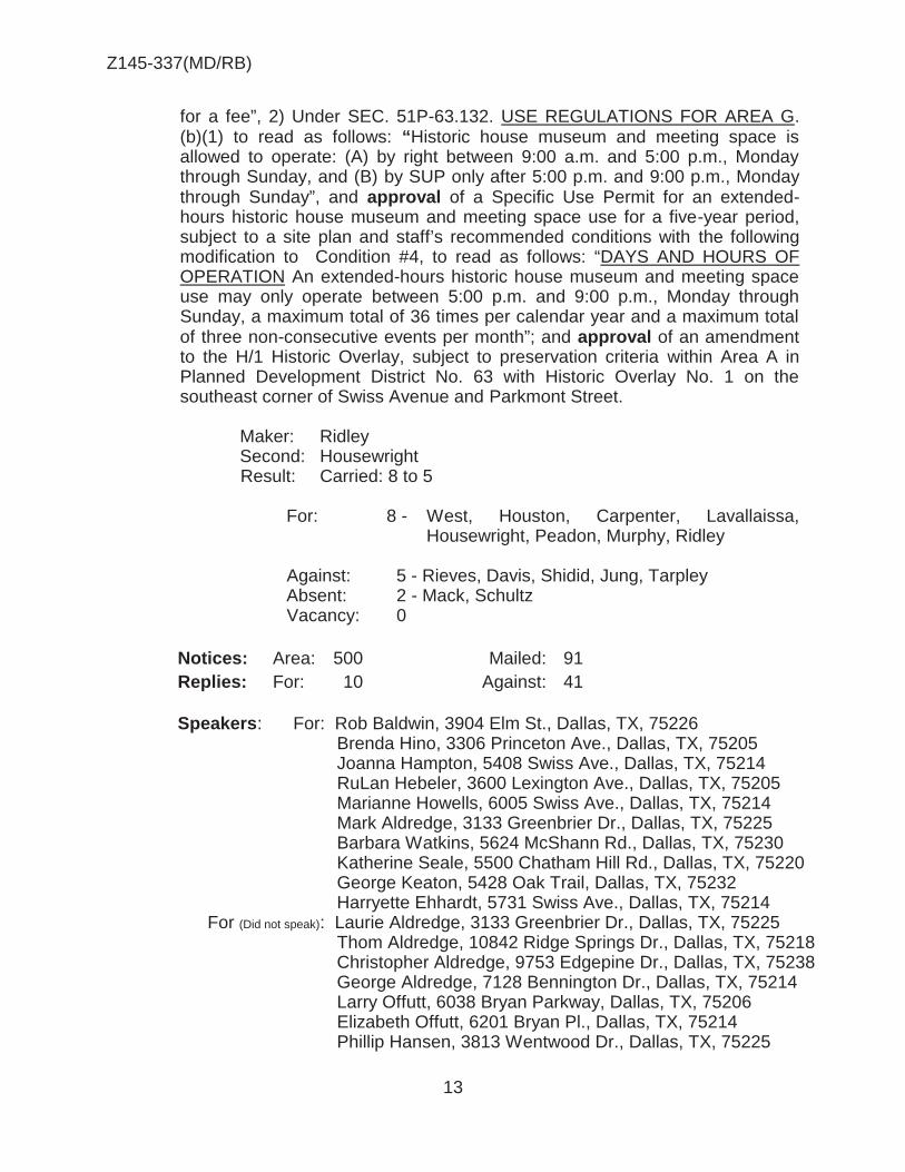
Z145-337(MD/RB)
13
for a fee”, 2) Under SEC. 51P-63.132. USE REGULATIONS FOR AREA G. (b)(1) to read as follows: “Historic house museum and meeting space is allowed to operate: (A) by right between 9:00 a.m. and 5:00 p.m., Monday through Sunday, and (B) by SUP only after 5:00 p.m. and 9:00 p.m., Monday through Sunday”, and approval of a Specific Use Permit for an extended-hours historic house museum and meeting space use for a five-year period, subject to a site plan and staff’s recommended conditions with the following modification to Condition #4, to read as follows: “DAYS AND HOURS OF OPERATION An extended-hours historic house museum and meeting space use may only operate between 5:00 p.m. and 9:00 p.m., Monday through Sunday, a maximum total of 36 times per calendar year and a maximum total of three non-consecutive events per month”; and approval of an amendment to the H/1 Historic Overlay, subject to preservation criteria within Area A in Planned Development District No. 63 with Historic Overlay No. 1 on the southeast corner of Swiss Avenue and Parkmont Street.
Maker: Ridley Second: Housewright Result: Carried: 8 to 5
For: 8 - West, Houston, Carpenter, Lavallaissa,
Housewright, Peadon, Murphy, Ridley Against: 5 - Rieves, Davis, Shidid, Jung, Tarpley Absent: 2 - Mack, Schultz Vacancy: 0
Notices: Area: 500 Mailed: 91 Replies: For: 10 Against: 41 Speakers: For: Rob Baldwin, 3904 Elm St., Dallas, TX, 75226 Brenda Hino, 3306 Princeton Ave., Dallas, TX, 75205 Joanna Hampton, 5408 Swiss Ave., Dallas, TX, 75214 RuLan Hebeler, 3600 Lexington Ave., Dallas, TX, 75205 Marianne Howells, 6005 Swiss Ave., Dallas, TX, 75214 Mark Aldredge, 3133 Greenbrier Dr., Dallas, TX, 75225 Barbara Watkins, 5624 McShann Rd., Dallas, TX, 75230 Katherine Seale, 5500 Chatham Hill Rd., Dallas, TX, 75220 George Keaton, 5428 Oak Trail, Dallas, TX, 75232 Harryette Ehhardt, 5731 Swiss Ave., Dallas, TX, 75214 For (Did not speak): Laurie Aldredge, 3133 Greenbrier Dr., Dallas, TX, 75225 Thom Aldredge, 10842 Ridge Springs Dr., Dallas, TX, 75218 Christopher Aldredge, 9753 Edgepine Dr., Dallas, TX, 75238 George Aldredge, 7128 Bennington Dr., Dallas, TX, 75214 Larry Offutt, 6038 Bryan Parkway, Dallas, TX, 75206 Elizabeth Offutt, 6201 Bryan Pl., Dallas, TX, 75214 Phillip Hansen, 3813 Wentwood Dr., Dallas, TX, 75225

Z145-337(MD/RB)
14
Wendy Hansen, 3813 Wentwood Dr., Dallas, TX, 75225 Cynthia Hudgins, 2822 Cornerstone Pkwy., Dallas, TX, 75225 W. Robert Hudgins, 2822 Cornerstone Pkwy., Dallas, TX, 75225 Caroline Hansen, 11818 Inwood Rd., Dallas, TX, 75244. Sarah Jo Hardin, 3548 Rankin St., Dallas, TX, 75205 Janel Broussard Wood, 6043 Bryan Parkway, Dallas, TX, 75206 Valerie Kaiser, 6035 Br9yan Parkway, Dallas, TX, 75206 Jordan Kaiser, 6035 Br9yan Parkway, Dallas, TX, 75206 Adam Kaiser, 4800 Northway Dr., Dallas, TX, 75206 Mari Smith, 10210 Killenny Pl., Dallas, TX, 75228 Laura Noe, 3948 Centenary Dr., Dallas, TX, 75225 Evelyn Montgomery, 4602 Swiss Ave., Dallas, TX, 75214 Roger Lee Carroll, 6004 Bryan Parkway, Dallas, TX, 75206 David Preziosi, 2922 Swiss Ave., Dallas, TX, 75204 Thomas Hogua, 5924 Bryan Parkway, Dallas, TX, 75206 Martha Heimberg, 1523 Abrams Rd., Dallas, TX, 75214 Melanie Vanlandingham, 6311 Lakeshore Dr., Dallas, TX, 75214 Robert Cox, 6119 Bryan Parkway, Dallas, TX, 75206 Daniel Endaly, 1922 Palace Dr., Grand Prairie, TX, 75050 Becky Portera, 6626 Gaston Ave., Dallas, TX, 75214 JoAnne McCullough, 3317 Princeton Ave., Dallas, TX, 75205 Barbara Williams, 3131 Maple Ave., Dallas, TX, 75201 Michelle Manners, 6214 Bryan Parkway, Dallas, TX, 75214 Robert Thomas, 6048 Bryan Parkway, Dallas, TX, 75206 Kenneth Stern, 6201 Bryan Parkway, Dallas, TX, 75214 Linda Solomon, 6145 Bryan Parkway, Dallas, TX, 75206 Debby Rodgers, 6312 Bryan Parkway, Dallas, TX, 75214 Virginia Bonifields, 5714 Swiss Ave., Dallas, TX, 75214 Clare Chaney, 5907 Swiss Ave., Dallas, TX, 75214 Jody Bowers, 5112 Swiss Ave., Dallas, TX, 75214 Elizabeth Mast, 5711 Swiss Ave., Dallas, TX, 75214 Sheryl Miller, 3805 Cantera Ln., Richardson, TX, 75082 Rene Schmidt, 715 Parkmont St., Dallas, TX, 75214 Stephen Vesecky, 4696 S. Versailles Ave., Dallas, TX, 75209 Caroline Reagor, 4625 Sugar Mill Rd., Dallas, TX, 75244 Evelyn Hamilton, 4406 Gloster Rd., Dallas, TX, 75220 Kathy Restrpo, 5024 Airline Rd., Dallas, TX, 75205 DeEtte Peters, 3905 Centenary Ave., Dallas, TX, 75225 Jane Viere, 3415 Cornell Ave., Dallas, TX, 75205 Roena Tandy, 450 Allison Dr., Dallas, TX, 75208 Jo North, 15250 Prestonwood Blvd., Dallas, TX, 75248 Ellen Welch, 3661 Mockingbird Ln., Dallas, TX, 75205 Christine Goff, 3933 Wentwood Dr., Dallas, TX, 75225 Tara Carey Chittoor, 4526 Dorset Rd., Dallas, TX, 75229 Pamela Ventouras, 5935 Goliad Ave., Dallas, TX, 75204 Lori Routh, 2925 Daniel Ave., Dallas, TX, 75205 Keith Routh, 2925 Daniel Ave., Dallas, TX, 75205 Cheri Whitten, 2925 Daniel Ave., Dallas, TX, 75205

Z145-337(MD/RB)
15
Mark Turner, 6139 La Vista Dr., Dallas, TX, 75214 Anne Blomeyer, 3310 Fairmount St., Dallas, TX, 75201 Wilson Fuqua, 3618 Fairmount St., Dallas, TX, 75219 Gary Lawler, 5620 Live Oak St., Dallas, TX, 75206 Elizabeth Gunby, 3209 Colgate Ave., Dallas, TX, 75225 Ellen Stuart, 4201 Larchmont St., Dallas, TX, 75205 Lindalyn Adams, 6171 Bandera Ave., Dallas, TX, 75225 Lupe Smith, 3883 Turtle Creek Blvd., Dallas, TX, 75219 Against: Jim Dunkerley, 5507 Bryan St., Dallas, TX, 75214 Rhonda McCune, 5514 Swiss Ave., Dallas, TX, 75214 Arch McColl, 5405 Swiss Ave., Dallas, TX, 75214 David Dean, 5420 Swiss Ave., Dallas, TX, 75214 Tonia Kuesel, 5215 Swiss Ave., Dallas, TX, 75214 Against (Did not speak): Michael McCune, 5514 Swiss Ave., Dallas, TX, 75214 Ken Kuesel, 5215 Swiss Ave., Dallas, TX, 75214 Martha Hulse, 5001 Swiss Ave., Dallas, TX, 75214 Jenny Hulse, 5001 Swiss Ave., Dallas, TX, 75214 Barbara McDaniel, 5439 Swiss Ave., Dallas, TX, 75214 Stephanie Stanley, 5505 Gaston Ave., Dallas, TX, 75214 Risa Weinberger, 5501 Bryan St., Dallas, TX, 75206 Louise Finley, 5421 Swiss Ave., Dallas, TX, 75214 James Finley, 5421 Swiss Ave., Dallas, TX, 75214 Paul Lockman, 4933 Swiss Ave., Dallas, TX, 75214 Vanessa Hoffman, 6017 Swiss Ave., Dallas, TX, 75214 Gary Hoffman, 6017 Swiss Ave., Dallas, TX, 75214 Michelle Baus, 5617 Swiss Ave., Dallas, TX, 75214 Jerry Baus, 5617 Swiss Ave., Dallas, TX, 75214 Nancy Pinson, 5602 Swiss Ave., Dallas, TX, 75214 David Pinson, 5602-5602 Swiss Ave., Dallas, TX, 75214 Alexandria Watters, 5603 Swiss Ave., Dallas, TX, 75214 Sandra Fite, 5611 Swiss Ave., Dallas, TX, 75214 Colin Fite, 5611 Swiss Ave., Dallas, TX, 75214 Vance Vannoy, 5602 ½ Swiss Ave., Dallas, TX, 75214 Nancy Phillips, 5204 Live Oak St., Dallas, TX, 75206 Stephen Putnam, 5430 Gaston Ave., Dallas, TX, 75214 Edward Anderson, 4726 Victor St., Dallas, TX, 75246
Sue Hilton, 6280 Prospect Ave., Dallas, TX, 75214

Z145-337(MD/RB)
16
Landmark Commission Action: October 5, 2015
5500 Swiss Avenue Swiss Avenue Historic District Mark Doty An application for modifications to and creation of a new subdistrict within Historic Overlay 1, Swiss Avenue, on the northeast corner of Parkmont Street and Swiss Avenue. Speakers: For: Robert Baldwin, Elizabeth Gunby, Virginia McAlester, Mark Aldredge, Larry
Offett, Barenda Hino, Lindalyn Adams, David Preziosi, Jim Anderson Against: Charles Hamilton, James Dunkerley, Stephanie Stanley
Motion: Approval of an application for modifications to and creation of a new subdistrict within Historic Overlay 1, Swiss Avenue, on the northeast corner of Parkmont Street and Swiss Avenue, with modification of the stair hall as proposed. Maker: Tapscott
Second: *Birrer
Results: 15/0
Ayes: - 15 Amonett, *Birch, Birrer, Bowers, Flabiano, Gadberry, Greenberg, Johnson, Jordan, Parsons, *Sherman, Seale, Tapscott, Thomas-Drake, Williams
Against: - 0 Absent: - 1 Maten Vacancies: - 1 12

Z145-337(MD/RB)
17
CPC RECOMMENDED CONDITIONS ARTICLE 63 and HISTORIC OVERLAY NO. 1.
PD 63.
SEC. 51P-63.101. LEGISLATIVE HISTORY. PD 63 was established by Ordinance No. 14247, passed by the Dallas City Council on September 10, 1973. Ordinance No. 14247 amended Ordinance No. 10962, Chapter 51 of the 1960 Revised Code of Civil and Criminal Ordinances of the City of Dallas. Ordinance No. 14247 was amended by Ordinance No. 15715, passed by the Dallas City Council on December 21, 1977, and Ordinance No. 15766, passed by the Dallas City Council on March 15, 1978. On February 3, 1982, the Dallas City Council passed Ordinance No. 17285, repealing Ordinance Nos. 14247, 15715, and 15766, and re-establishing PD 63. Ordinance No. 17285 was amended by Ordinance No. 18563, passed by the Dallas City Council on January 23, 1985. (Ord. Nos. 10962; 14247; 15715; 15766; 17285; 18563; 25423) SEC. 51P-63.102. PROPERTY LOCATION AND SIZE. PD 63 is established on property generally located southeast of Live Oak Street, south of La Vista Drive, northwest of the alley between Swiss Avenue and Gaston Avenue, and northeast of Fitzhugh Avenue. The size of PD 63 is approximately 116.88 acres. SEC. 51P-63.103. DEFINITIONS. (a) In this article: (1) ACCEPTABLE COLOR RANGE means the range of colors shown on Exhibit 63C. (2) APPLICANT means the property owner or his designee. (3) BLOCK means an area bounded by streets on all sides. (4) BLOCKFACE means all of the lots on one side of a block. (5) CERTIFICATE OF APPROPRIATENESS means a certificate issued by the city to authorize certain acts to be performed in this district. (See the enforcement section of this article.) (6) COLUMN means the entire column including the base and capital, if any.

Z145-337(MD/RB)
18
(7) COMMISSION means the city plan and zoning commission. (8) COMMITTEE means the landmark committee created under Section 51-3.103. (9) CORNER LOT means a lot that has frontage on two different streets. (10) CORNER SIDE FACADE means a main building facade facing the side street. (11) CORNER SIDE YARD means a side yard that abuts a street. (12) DIRECTOR means the director of development services or his representative. (13) FENCE means a structure or hedgerow that provides a physical barrier, including a fence gate. (14) FRONT YARD means the portion of a lot that abuts a street and extends across the width of the lot between the street and a main building and lines parallel to and extending outward from the front facade of a main building. “Required” front yard means the portion of the front yard between the street and the setback line. (15) HISTORIC HOUSE MUSEUM AND MEETING SPACE means a facility that offers tours and hosts educational programs, fundraising activities, and official meetings of non-profit organizations. Except for the use of the Property for portrait photographs, an historic house museum and meeting space does not include commercial events or renting the space for a fee. (1615) LOT means a building site, as defined in the Dallas Development Code. (1716) PARKWAY means the area between the paved portion of a street and a front lot line. (1817) PLANTER BOX means a permanent container for plants that is non-movable. (1918) PRESERVATION CRITERIA means the standards considered by the director, committee, and commission in determining whether a certificate of appropriateness should be granted or denied. (2019) REAR YARD means: (A) on an interior lot, the portion of the lot between the side lot lines that extends across the width of the lot between a main building and lines parallel

Z145-337(MD/RB)
19
to and extending outward from the rear facade of a main building and the rear lot line; and (B) on a corner lot, the portion of the lot that extends between the interior side lot line and a line parallel to and extending outward from the rear corner of the corner side facade, and between the rear lot line and a main building and a line parallel to and extending outward from the interior side corner of the rear facade. (2120) SCREENING means a structure or planting that provides a visual barrier. (2221) SCREENING FACTOR means the degree to which a structure provides a visual barrier. (2322) SIDE YARD means any portion of a lot not occupied by a main building that is not a front or rear yard. “Side yard” includes “corner side yard.” (2423) STORY means the portion of a building between any two successive floors, or between the top floor and the ceiling above it. (2524) THIS DISTRICT means the Swiss Avenue Historic District. (2625) TRIM COLOR means a paint color other than the dominant color. Wood colored translucent stain is not a trim color. Trim color does not include the color of screen and storm doors and windows, gutters, downspouts, porch floors, and ceilings. (b) Except as otherwise provided in this section, the definitions contained in the Dallas Development Code, as amended, apply to this article. SEC. 51P-63.104. INTERPRETATIONS. (a) Unless otherwise stated, the interpretations in Chapter 51 apply to this article. (b) Unless otherwise stated, all references to articles, divisions, or sections in this article are to articles, divisions, or sections in Chapter 51. SEC. 51P-63.105. RECONCILIATION WITH ORDINANCE NO. 17285 AND
THE DALLAS DEVELOPMENT CODE. The provisions of Ordinance No. 17285 and the Dallas Development Code, as amended, apply to the Swiss Avenue Historic District unless expressly modified or repealed by this article. In the event of a conflict, the provisions of this article control.

Z145-337(MD/RB)
20
SEC. 51P-63.106. NONCONFORMING USES AND STRUCTURES. (a) In general. Except as otherwise provided in this article, Section 51-4.704 relating to nonconforming uses and structures, applies to all uses and structures in this district. (b) Nonconforming uses. (1) Termination when building destroyed. Except as otherwise provided below, if a building in which a nonconforming use is located is destroyed, the right to operate the nonconforming use terminates immediately. (2) Nonconforming servants’ or caretakers’ quarters. The right to operate a nonconforming servants’ or caretakers’ quarters use does not terminate when the structure in which the use is located is damaged or destroyed. A servants’ or caretakers’ quarters must be used by bona fide servants or caretakers and may not be rental accommodations. (c) Rebuilding damaged or destroyed nonconforming buildings. If a nonconforming single-family main or accessory building is damaged or destroyed, it may be rebuilt at the same location without the approval of the board of adjustment. SEC. 51P-63.107. GRAPHICS. Graphics that illustrate the requirements of this article are labelled Exhibit 63B. In the event of a conflict, the text of this article controls over any graphic display in Exhibit 63B. SEC. 51P-63.108. ENFORCEMENT. (a) Certificate of appropriateness required. A person commits an offense if, without first obtaining a certificate of appropriateness from the city expressly authorizing the act, he: (1) places or constructs a main or accessory building on property in this district; (2) makes exterior alterations to a main or accessory building in this district; or (3) places, constructs, installs, or maintains a structure or non-plant-material landscape item outside a building on property in this district. (b) Vegetation restrictions. A person commits an offense if he places or maintains a plant in this district in violation of one of the following vegetation restrictions:

Z145-337(MD/RB)
21
(1) A vegetable garden is prohibited in the front yard and may not be located in a side yard unless it is totally screened. (2) Foundation plantings may not exceed two feet in height above the first story finish floor. (3) Only grass, trees, ground cover, and flowers are permitted in the parkway. All trees in the parkway must be placed a uniform distance apart and be planted along a line parallel to the street. Flower beds may not comprise more than 50 percent of the parkway area. (c) Compliance with use regulations and development standards required. A person commits an offense if he violates one of the use regulations or development standards in Sections 51P-63.114, 51P-63.115, 51P-63.117, 51P-63.118, 51P-63.120, 51P-63.121, 51P-63.123, 51P-63.124, 51P-63.126, 51P-63.127, 51P-63.129, and 51P-63.130 of this article. (d) Defenses to prosecution. (1) It is a defense to prosecution under Subsections (a)(2) and (a)(3) that the act was: (A) the installation, maintenance, or replacement of: (i) outdoor lights that are 10 inches or less in diameter and (aa) located at ground level; (bb) attached to a tree or shrub and located on or above its lowest branch; (cc) located along eaves or soffits; or (dd) located on an accessory building; (ii) recreational equipment for children, such as a swingset, playhouse, or jungle gym, in a rear yard; (iii) security or ornamental bars on the rear facade of a main building or on an accessory building; (iv) a lawn sprinkler system; or (v) an air conditioning unit in a side or rear yard; or

Z145-337(MD/RB)
22
(B) performed in a rear yard, and the alteration, structure, or landscape item is six feet or less in height or totally screened; (C) performed in a side yard, and the alteration, structure, or landscape item is six feet or less in height and totally screened by a fence or hedge that is at least six feet in height; or (D) the installation or maintenance of a special purpose sign. (2) It is an additional defense to prosecution under Subsection (a)(3) that the structure or landscape item was temporarily placed, constructed, or installed. For purposes of this subsection, an act is temporary in nature if it occurs no more than two time periods during the calendar year for a maximum of five days per time period. (3) There is no defense to prosecution for a violation of Subsection (a)(1). (e) Criminal responsibility. A person is criminally responsible for a violation if he: (1) commits or assists in the commission of an act in violation; or (2) owns part or all of the land or a structure on the land where a violation exists. SEC. 51P-63.109. PENALTY. (a) A person violating a provision of Ordinance No. 17285, as amended by Ordinance No. 18563, upon conviction, is punishable by a fine not to exceed $1000. [The provisions of Ordinance No. 17285, as amended by Ordinance No. 18563, are codified in this article.] (b) In addition to punishment by fine, the City may, in accordance with state law, provide civil penalties for a violation of this article, and institute any appropriate action or proceedings to prevent, restrain, correct, or abate the unlawful erection, construction, reconstruction, alteration, repair, conversion, or maintenance of a building, structure, or land in this district. SEC. 51P-63.110. REVIEW PROCEDURES FOR CERTIFICATES OF
APPROPRIATENESS. (a) In general. The standard review procedure outlined in Section 51-4.501 applies to this district, except as expressly modified by this section. (b) Review by the director.

Z145-337(MD/RB)
23
(1) Director's determination of procedure. Upon receipt of an application for a certificate of appropriateness, the director shall characterize the proposed work as falling into one of the following three categories: (A) Routine maintenance or replacement. (B) Minor exterior alterations. (C) Work requiring review by the committee and commission. The director shall review and grant or deny certificates of appropriateness for proposed work that is routine maintenance or replacement or a minor exterior alteration in accordance with the review standards provided in this section. If the proposed work requires review by the committee and commission, the director shall forward the application to the committee for review in accordance with the standard certificate of appropriateness review procedure outlined in Section 51-4.501. All decisions to be made by the director under this section must be made within 10 days of receipt of the application. (2) Routine maintenance and replacement defined. Routine maintenance is the processes of cleaning (including water blasting and stripping), repainting an item the same color, and otherwise stabilizing deteriorated or damaged architectural features. Routine replacement occurs whenever a duplicate item is substituted for an item that is deteriorated or damaged. Repainting an item a different color is neither routine maintenance nor routine replacement. (3) Minor exterior alteration defined. The following are minor exterior alterations for purpose of this article. (A) The application, installation, maintenance, or replacement of: (i) a chimney located on an accessory building, or on the rear 50 percent of a main building and not part of the corner side facade; (ii) an awning located on an accessory building, or on the rear facade of a main building; and (iii) a roof of the same or an original material that does not include a change in color; (iv) a wood or chain link fence that is not painted or stained; (v) gutters and downspouts of a color within the acceptable color range that matches or complements the dominant, trim, or roof color; (vi) paint of a color within the acceptable color range;

Z145-337(MD/RB)
24
(vii) skylights and solar panels; (viii) storm windows and doors; or (ix) window and door screens. (B) The restoration of original architectural elements that does not include the use of paint outside the acceptable color range. (4) Review standards for routine maintenance and replacement. The director shall review all proposed work that falls into the categories of routine maintenance and routine replacement to determine whether or not the original item to be maintained or replaced was legally installed. Legal installation includes both work that was legally performed before September 10, 1973, the date this district was established, and work performed after that date by authority of a valid certificate of appropriateness. The director shall grant a certificate of appropriateness for the proposed maintenance or replacement of an original item that was legally installed. If the original item was not legally installed, the director shall not grant a certificate but instead shall treat the application as being for a certificate of appropriateness to authorize the installation of the original item. (5) Review standards for minor exterior alterations. The director shall review all proposed work that falls into the category of minor exterior alterations to determine whether the proposed work complies with the preservation criteria and regulations contained in this article and all other applicable ordinances. If the proposed work complies, the director shall grant a certificate of appropriateness for the work. If the proposed work does not comply with or is not addressed by the preservation criteria and regulations contained in this article or any other applicable ordinance, the director shall deny the certificate. (c) Appeals. A decision to grant a certificate of appropriateness may not be appealed. A decision to deny a certificate of appropriateness may be appealed only by the applicant. An appeal from a decision to deny a certificate is made by submitting a written request for appeal to the director within ten days of the decision. (d) Review by the committee. The standards in Subsection (e) below should be used by the committee in making its recommendation to the commission. (e) Review by the commission and city council. (1) When reviewing an appeal from the director's decision to deny a certificate of appropriateness, the commission or city council shall first determine whether the proposed work is routine maintenance or replacement. If the proposed work is routine maintenance or replacement, the commission or council shall next determine whether or not the original item to be maintained or replaced was legally installed. If the original item was legally installed, the commission or council shall approve the routine maintenance or replacement. If the original item was not legally

Z145-337(MD/RB)
25
installed or if the proposed work is not routine maintenance or replacement, the commission or council shall review the application using the standards provided in the following subsections. (2) In reviewing an application, the commission or city council shall determine whether the proposed work complies with the preservation criteria and regulations contained in this article and all other applicable ordinances. If the proposed work complies, the commission or council shall grant the certificate. (3) Except as otherwise provided in this section, if the proposed work does not comply with or is not addressed by the preservation criteria and regulations contained in this article or any other applicable ordinance, the commission or council shall deny the certificate. (4) If the proposed work is not addressed by the preservation criteria and regulations contained in this article and all other applicable ordinances and the work will not have an adverse effect on the external architectural features, future preservation, maintenance, or use of: (A) a structure in this district; (B) a blockface in this district; or (C) this district as a whole; the commission or council shall grant the certificate. (5) If the proposed work is the restoration of original architectural elements and will not have an adverse effect on the external architectural features, future preservation, maintenance, or use of: (A) a structure in this district; (B) a blockface in this district; or (C) this district as a whole; the commission or council shall grant the certificate. In determining whether the proposed work constitutes the restoration of original architectural elements, the commission or council shall consider all available materials, including but not limited to photographs and drawings showing the original appearance of the building and its surrounding property at the time of construction. (Ord. Nos. 18563; 25423) SEC. 51P-63.111. NOTICE REQUIREMENTS. The following notice requirements apply to this district: (1) When required. The director shall give the notice required by this section only when a person applies for a certificate of appropriateness to construct a new main building, or to move a main building onto an existing lot.

Z145-337(MD/RB)
26
(2) Content of notice. The notice required by this section must contain a description of the lot where a main building will be constructed or moved, and the date, time, and location of the committee meeting at which the application will be considered. (3) Manner of notification. The notice required by this section is a written notice to be given not less than 21 days before the committee meeting at which the application will be considered. Notice is given by depositing the notice properly addressed and postage paid in the United States Mail to the property owners entitled to notice under Paragraph (4) of this subsection as evidenced by the last approved city tax roll. (4) Who must be notified. The director shall notify the following persons in this district whenever notice is required by this section: (A) The owners of all lots in the blockface of the area of request. (B) The owners of all lots in the blockface across the street from the area of request. (C) If the area of request is a corner lot, the owners of all other corner lots at the same intersection. (D) The president of the Swiss Avenue Historic District Association at an address provided by the association. SEC. 51P-63.112. PROCEDURAL CHANGES WHEN NOTICE IS REQUIRED. The procedural time requirements in Section 51-4.501 applicable to the committee and the commission apply to this district except in those cases where notice is required under the previous section of this article. In such cases, the committee shall make its recommendation within 45 days of receipt of the application by the director. If final action has not been taken by the committee and the commission within 55 days of the director's receipt of the application: (1) the director shall issue a certificate of appropriateness to the applicant for the proposed work; and (2) if all requirements of the Dallas Development Code and the construction codes are met and a building permit is required for the proposed work, the building official shall issue a building permit to the applicant for the proposed work. SEC. 51P-63.113. CREATION OF AREAS. This district is hereby divided into seven six separate areas, which shall be known as "Area A," "Area B," "Area C," "Area D," "Area E," and "Area F,” and Area “G."

Z145-337(MD/RB)
27
Property descriptions of Areas A through F are attached to Ordinance No. 18563. A map showing the area boundaries is labelled Exhibit 63A. (1) Uses that were illegal on February 3, 1982, are illegal uses under this article. Except as otherwise provided in this article, nonconforming uses are governed by Section 51-4.704. (2) The number of dwelling units on a building site may not be increased. If the number of dwelling units in a building is reduced, or the building is replaced with another building containing a lesser number of dwelling units, the building site shall thereafter be limited to the lesser number of dwelling units. (3) Except as otherwise provided below, uses are limited to single-family residential uses. (4) The duplex use at 5600-02 Swiss Avenue is expressly recognized as a legal use unless and until the structure in which the use is located is destroyed, in which case the right to operate the duplex use terminates immediately.
(5) The medical society auxiliary social club use currently operated by the Dallas County Medical Society Auxiliary at 5500 Swiss Avenue is expressly recognized as a nonconforming use. SEC. 51P-63.115. DEVELOPMENT STANDARDS FOR AREA A (a) In general. Except as otherwise provided in this section, the development standards in the Dallas Development Code, as amended, applicable to an R-10 Single-Family District apply to all property in Area A. In the event of a conflict, the provisions of this section control. (b) Height requirements. Maximum permitted heights for buildings and structures are: (1) 36 feet for a main building; and (2) 24 feet for an accessory building or structure. (c) Lot size requirements. Lots must conform to the following standards: (1) Each lot must have a minimum area of 10,000 square feet and a minimum depth of 230 feet. (2) Each lot must have a width no less than 90 percent of the average width of all lots in both the same and the opposite blockface. (3) Lots platted on or before February 3, 1982, are legal building sites, even though they may not conform to the requirements of this section.

Z145-337(MD/RB)
28
(d) Maximum lot coverage. Maximum permitted lot coverage for all buildings and structures combined is 25 percent. (e) Minimum front yard. (1) All buildings and structures must have a minimum front yard setback of 65 feet. (2) The main building on an interior lot must have a front yard setback that is: (A) equal to that of the closest main building on either side of the lot in the same blockface; or (B) between those of the closest main buildings on either side of the lot in the same blockface. (3) The main building on a corner lot must have a front yard setback that is within five percent of that of the closest main building in the same blockface. (f) Minimum rear yard. Minimum permitted rear yard setbacks for buildings and structures are: (1) 60 feet for a main building if the lot is 230 feet or less in depth;
(2) 90 feet for a main building if the lot is over 230 but less than or equal to 250 feet in depth; (3) 120 feet for a main building if the lot is over 250 feet in depth; and (4) five feet for an accessory building or structure. (g) Minimum side yards. (1) All buildings and structures must have: (A) on interior lots, a minimum side yard the greater of 10 feet or 80 percent of the average interior side yard in the blockface; and (B) on corner lots, a minimum corner side yard the greater of 15 feet or 80 percent of the average corner side yard of the other corner lots at the same intersection. (2) Except as otherwise provided in this section, no balcony, porch, or any portion of a building may extend into the required side yard. Roof eaves may project up to three feet into the required side yard.

Z145-337(MD/RB)
29
(h) Off-street parking requirements. Single-family and duplex uses must provide at least two off-street parking spaces behind the front yard for each dwelling unit. (i) Signs. Signs are governed by the provisions for non-business zoning districts in Article VII, "Sign Regulations," and all other applicable sign ordinances and laws. (j) Story requirements. A main building must have at least two stories. SEC. 51P-63.116. PRESERVATION CRITERIA FOR AREA A.
The following preservation criteria apply to all property in Area A (1) Building placement, form, and treatment. (A) Accessory buildings. Accessory buildings: (i) are only permitted in the rear yard no closer than 15 feet to a main building; and (ii) must be compatible with the scale, shape, roof form, materials, detailing, and color of a main building. (B) Additions. All additions to a building must be compatible with the dominant horizontal or vertical characteristics, scale, shape, roof form, materials, detailing, and color of the building. (C) Architectural detail. Materials, colors, structural and decorative elements, and the manner in which they are used, applied, or joined together must be typical of the style and period of a main building and compatible with the other buildings on the blockface. (D) Awnings. (i) Wood, metal, and plastic awnings are not permitted unless they: (aa) are on an accessory building or the rear facade of a main building; (bb) complement the color scheme of the building to which they are attached; and (cc) are totally screened. (ii) All awnings on the front and side facades of a main building must be typical of its style and period and complement its color scheme.

Z145-337(MD/RB)
30
(E) Building placement. All buildings must be placed so as not to adversely affect the rhythm of spaces between buildings on the blockface. (F) Building widths. Minimum permitted width for a main building is 80 percent of the average width of the existing main buildings in the blockface. (G) Chimneys. All chimneys must be compatible with the style and period of a main building. Chimneys on the front 50 percent of a main building or on a corner side facade must be: (i) constructed of brick, stucco, stone, or other materials that look typical of the style and period of a main building; and (ii) of a style and proportion that is typical of the style and period of a main building. (H) Color. (i) Brick and stone surfaces. Brick and stone surfaces not previously painted must not be painted unless the applicant establishes that: (aa) painting is the only method by which the brick or stone may be restored or preserved; or (bb) the color and texture of replacement brick or stone cannot be matched with that of the existing brick or stone surface and the paint color matches that of the existing brick or stone surface. (ii) Certain colors prohibited. Fluorescent and metallic colors are not permitted on the exterior of any structure in this district. (iii) Dominant and trim colors. All structures must have a dominant color and no more than three trim colors. The colors of a structure must be complementary of each other and the overall character of this district. (iv) Gutters and downspouts. Gutters and downspouts must be painted or colored to match or complement the color scheme of the structure to which they are attached. (v) Roof colors. Roof colors must complement the style and overall color scheme of the structure. (vi) Stain. The use and color of stain must be typical of the style and period of the building on which the stain is applied.

Z145-337(MD/RB)
31
(I) Columns. (i) Function. Columns are only permitted as vertical supports near the front entrance of a main building, or as vertical supports for porches. (ii) Materials. Columns must be constructed of brick, wood, cut stone, or other materials that look typical of the style and period of a main building. No pipe or wrought iron columns are permitted. (iii) Style. Columns must be of a style typical of the style and period of a main building. (iv) Width dimensions. (aa) The width of a one-story column shaft at its widest point must be at least one-eighth the height of the column. (bb) The width of a two-story column shaft at its widest point must be at least one-tenth the height of the column. (J) Facade materials. (i) In general. The only permitted facade materials are brick, wood siding, stone, and stucco. All facade treatments and materials must be typical of the style and period of a main building. (ii) Brick. All exposed brick on facades must be fired brick as defined by the American Standard Testing Materials Designation C-126-75A, Type Grade FBS-SW. (iii) Wood facades. Existing wood facades must be preserved as wood facades. Wood shingles are not permitted as a primary facade material, but may be used in roof gables and on columns and foundation skirts in a manner that is typical of the style and period of a main building. (K) Front entrances and porches. (i) Detailing. Railings, moldings, tilework, carvings, and other detailing and architectural decorations on front entrances and porches must be typical of the style and period of a main building. (ii) Enclosures. A front entrance or porch may not be enclosed with any material, including iron bars, glass, or mesh screening. (iii) Facade openings. Porches must not obscure or conceal any facade openings in a main building.

Z145-337(MD/RB)
32
(iv) Floor coverings. Carpeting is not permitted as a porch floor or step covering. (v) Location. An entrance treatment, including door transoms, sidelights, stained glass, trim, and hardware, must be retained in its original location. (vi) Style. The main building must have a front porch or entry treatment with a shape, roof form, materials, and colors that are typical of the style and period of the building. (L) Height to width ratio. The relationship between the height and width of the front facade of a main building, including side projections, must be compatible with those of the other main buildings in the blockface. (M) Porte cocheres. Except as otherwise provided in this subsection, porte cocheres must be preserved as architectural features and not be enclosed on any side by fences, gates, or any other materials. A wrought iron gate is permitted across the rear opening of a porte cochere if it has a screening factor of less than 50 percent and is compatible with the style and scale of a main building. (N) Roof forms. (i) Eaves and soffits. The height of eaves and soffits on a main building must be within 10 percent of the height of eaves and soffits on the closest main building in this district of a similar style and having the same number of stories. (ii) Materials and colors. Roof materials and colors must complement the style and overall color scheme of the building or structure. Tar and gravel (built-up) is only permitted as a roof material on covered porches and porte cocheres with flat roofs. (iii) Overhang. The roof overhang on a building must be compatible with the style and scale of the building. A replacement roof on an existing building must have an overhang that is equal to or greater than the overhang of the roof it replaces. (iv) Patterns. Roof patterns of a main building must be typical of the style and period of the architecture of the building and include separate substructure roofs. (v) Skylights and solar panels. Skylights and solar panels are only permitted on: (aa) the rear 50 percent of the roof of a main building on an interior lot;

Z145-337(MD/RB)
33
(bb) the rear inside quadrant of the roof of a main building on a corner lot; and (cc) the roof of an accessory building in the rear yard. (vi) Slope and pitch. The degree and direction of roof slope and pitch must be typical of the style and period of a main building and compatible with existing building forms in this district. Flat or Mansard roof designs are not permitted on main or accessory buildings or structures, except that a covered porch or porte cochere may have a flat roof that is typical of the style and period of a main building. (O) Stairs. Second and third story exterior staircases are only permitted on accessory buildings and the rear 50 percent of a main building, except that they are not permitted on a corner side facade. (P) Windows and doors. (i) Front facade openings. The total number of window and door openings (combined) in the front facade of a main building must be equal to or greater than the total number of original window and door openings (combined) in that facade. The number of door openings in the front facade of a main building may not be increased. (ii) Glass. Clear, decorative stained, and clear leaded glass typical of the style and period of the building may be permitted in any window opening. Reflective, tinted, opaque, and mirrored glass and plastic are not permitted in any opening. Translucent glass is not permitted except in a bathroom window. (iii) Screens, storm doors, and storm windows. Screens, storm doors, and storm windows may be permitted if: (aa) their frames are painted or colored to match or complement the color scheme of a main building; (bb) they do not obscure significant features of the windows and doors they cover; and (cc) the screen mesh is 18 by 16 gauge. (iv) Security and ornamental bars. Security and ornamental bars are only permitted on an accessory building or on the rear or side facades of a main building. (v) Shutters. Shutters must be typical of the style and period of the building and appear to be installed in a manner to perform their intended function.

Z145-337(MD/RB)
34
(vi) Style. (aa) All windows and doors in the front facade of a main building must be proportionally balanced in a manner typical of the style and period of the building. (bb) No single, fixed plate glass is allowed except as part of an original period design. The size and proportion of window and door openings located on the front and side facades of a main building must be typical of the style and period of the building. (cc) All windows, doors, and lights in the front and side facades of a main building must be typical of the style and period of the building and compatible with the windows, doors, and lights in the front and side facades of the other main buildings in the blockface. Windows must contain at least two lights (window panes). Sidelights must be compatible in style and materials with the door. (dd) The frames of windows must be trimmed in a manner typical of the style and period of the building. (2) Landscaping. (A) Certain items prohibited in front and corner side yards. The following items are not permitted in the front and corner side yards: (i) Above-ground meters. (ii) Berms. (iii) Pylons and similar structures. (iv) Rock or sculpture gardens. (B) Fences. (i) Definitions. The following definitions apply to terms used in these fence regulations: (aa) FINISHED SIDE means the side of a fence that does not reveal the structural components. (bb) STRUCTURAL COMPONENT means a post, column, or other vertical or horizontal member providing support and strength for a fence.

Z145-337(MD/RB)
35
(ii) Form. (aa) Fences must be constructed and maintained in a vertical position. (bb) The top edge of a fence must be along a line that is either horizontal or parallel to grade. Except in the case of a picket, chain link, or wrought iron fence, the top edge of a fence must be flat. (iii) Height. Maximum permitted height for a fence is nine feet. (iv) Location. (aa) Fences are not permitted in the front yard. (bb) A fence in an interior side yard must be located in the rear 50 percent of the side yard and behind the rearmost side projection of a main building, except that the commission may allow a fence to be located in the rear 75 percent of the side yard if it determines that the fence does not screen any portion of a significant architectural feature of a main building on the same or an adjacent lot. (cc) A fence in the corner side yard must not be directly in front of the corner side facade, except that the commission may allow a fence that is directly in front of all or any portion of the rear 50 percent of the corner side facade if: [1] more screening is necessary to insure privacy due to unusually high pedestrian or vehicular traffic; and [2] the fence does not screen all or any portion of a significant architectural feature of a main building. (dd) A fence in the corner side yard must be set back a minimum of two feet from a public sidewalk. (ee) A fence must run either parallel or perpendicular to a building wall or lot line. (ff) A fence on a vacant lot must be set back a distance that is equal to or greater than the setback of the closest main building in the same blockface. In the case of a single interior vacant lot, the setback of the fence must be equal to or greater than the setback of a main building on the adjacent lot with the greater setback. (v) Materials. A fence must be constructed of one or more of the following materials: metal or plastic-coated chain link, wrought iron, wood, brick, or stucco. Exposed concrete blocks are not permitted.

Z145-337(MD/RB)
36
(vi) Masonry fences. (aa) The color, texture, pattern, and dimensions of masonry and the color, width, type, and elevation of mortar joints in a fence column or base must match the masonry and mortar joints of a main building as nearly as practicable. (bb) All exposed brick in a fence must be fired brick as defined by the American Standard Testing Materials Designation C-126-75A, Type Grade FBS-SW. (vii) Metal fences. (aa) Wrought iron and metal fences must be compatible with the style and period of a main building. (bb) If a wrought iron or metal fence is painted or colored, the color must be black, dark green, or dark brown and complement the color of a main building. (viii) Wooden fences. (aa) All wooden structural posts must be at least four inches in diameter (nominal size). (bb) The side of a wooden fence facing a public street must be the finished side. (cc) Wooden fences may be painted or stained a color that is complementary to a main building. (C) Outdoor lighting. Outdoor light fixtures on the front facade of a main building and on poles in the front yard must be compatible with the style and period of a main building and not obscure or conflict with significant architectural details. Overhead and exposed wiring and conduit for outdoor lighting is not permitted. (D) Pavement, filler, and edging materials. Pavement, filler, and edging materials, such as landscape timbers, gravel, and bark, used in landscape beds in the front and corner side yards must be reviewed by the commission as part of an overall landscape plan if the landscape beds collectively comprise more than 25 percent of the combined areas of the front and corner side yards. No more than 25 percent of the front yard of a residential use may be covered by pavement or filler materials. (E) Planter boxes. Planter boxes must be: (i) an integral part of and typical of the style and period of a main building;

Z145-337(MD/RB)
37
(ii) 18 inches or less in height; (iii) 36 inches or less in depth; and (iv) constructed of brick, stone, or smooth-finish concrete that matches or is compatible in texture, color, and style with a main building. (F) Retaining walls. Retaining walls are not permitted in the front and side yards except to preserve a natural or existing slope or to make a slope similar to that of an adjacent lot. The height of a retaining wall must not exceed the height of the slope it retains. A retaining wall must be constructed of unpainted stone, brick, stucco, or smooth-finish concrete that is compatible in texture, color, and style with a main building. (G) Sidewalks, driveways, and curbing. (i) Materials. (aa) No exposed aggregate, asphaltic, or artificially colored concrete or epoxy resin is permitted as a sidewalk, driveway, or curbing material. (bb) All public sidewalks and curbing must be constructed of brush finish concrete. (cc) All private sidewalks and driveways must be constructed of brush finish concrete, brick, tile, or slate. Gravel is allowed in the center strip of a ribbon driveway. Any material used in a sidewalk or driveway must be compatible in texture, color, and style with a main building. (ii) Width, style, and spacing. (aa) The maximum permitted width of a driveway in the front yard is 10 feet. The driveway width may be expanded to 20 feet at any point behind the front facade. (bb) Ribbon driveways are only permitted if the owner establishes that a ribbon driveway was an original architectural element of the site. If a ribbon driveway is permitted, the ribbons must be at least one foot wide. (cc) Circular driveways are not permitted in the front yard. (dd) A driveway constructed in the front yard adjacent to an existing driveway on an adjacent lot must be spaced a minimum of one foot from the existing driveway on the adjacent lot.

Z145-337(MD/RB)
38
SEC. 51P-63.117 through SEC. 51P-63.131 Omitted for brevity SEC. 51P-63.132. USE REGULATIONS FOR AREA G.
(a) Purpose. The purpose of this subsection is to preserve the structure at 5500 Swiss Avenue (the “House”), its specific interior architectural features, and the grounds. The House, which is a Registered Texas Historic Landmark, is one of the most important residential landmarks in the City of Dallas due to its retention of its original floor plan and many original exterior and interior architectural elements. The general objectives of the conditions for Area G are to promote and protect the health, safety, welfare, and enjoyment of the public and to preserve and enhance the historical, architectural, and cultural significance of Swiss Avenue, one of the most intact historic residential streets in the United States.
(b) In general. The use regulations in this article applicable to Area A apply to all property in Area G except as expressly modified in this section.
(1) Historic house museum and meeting space is allowed to operate: Staff recommendation:
Applicant’s request:
(C) Set up and tear down of equipment and associated functions
must occur during the hours of operation.
(2) A caretaker’s quarters is a permitted accessory use only in conjunction with an historic house museum and meeting space.
(A) by right between 9:00 a.m. and 5:00 p.m., Monday through Sunday, and
(B) by SUP only after 5:00 p.m., Monday through Sunday.
(A) by right between 8:00 a.m. and 10:00 p.m., Monday through Sunday.

Z145-337(MD/RB)
39
SEC. 51P-63.115. DEVELOPMENT STANDARDS FOR AREA G. (a) In general. The development standards in this article applicable to Area A apply to all property in Area G except as expressly modified in this section. (b) Off-street parking requirements.
(1) Single-family. A minimum of two off-street parking spaces per dwelling unit is required. Required parking may not be located within the required front yard.
(2) Historic house museum and meeting space. A minimum of 56 parking off-street parking spaces are required.
(A) A minimum of 19 off-street parking spaces must be located within Area G.
(B) Maneuvering in the alley is allowed in order to access parking spaces.
(C) Four tandem spaces within Area G may only be used in conjunction with a valid valet permit.
(C) Remote parking is allowed within a walking distance no greater than 450 feet from the use.
(D) Remote parking may be based on a lease of the remote
parking spaces only if the lease:
(i) is in writing; (ii) contains legal descriptions of the properties affected; (iii) specifies the special parking being provided and the
hours of operation of any use involved; (iv) is governed by the laws of the state of Texas; (v) is signed by all owners of the properties affected; (vi) signed by all lienholders, other than taxing entities, that
have an interest in or an improvement on the properties; (vii) is for a minimum term of three years; and (viii) provides both the owner of the lot occupied by the use
and the owner of the remote parking lot shall notify the building official in writing if there is a breach of any provision of the lease, or if the lease is modified or terminated.

Z145-337(MD/RB)
40
(c) Additional provisions for an historic house museum and meeting space.
(1) No tents or other temporary structures are allowed.
(2) No amplified music or live music is allowed outside.
(3) Weddings and wedding receptions are not permitted.
(4) Outdoor lighting is permitted in the locations shown on the site plan. No other outdoor lighting is permitted unless approved by a Certificate of Appropriateness. Temporary lighting is permitted but is limited to string lighting and portable light standards. Maximum height of string lighting is 10 feet, as measured to the highest point of string lighting. Maximum height of a light fixture for a portable light standard is eight feet, as measured to highest point of the light fixture. SEC. 51P-63.116. PRESERVATION CRITERIA FOR AREA G. (a) In general. The preservation criteria in this article applicable to Area A apply to all property in Area G except as expressly modified in this section. (b) Area G Interior preservation.
(1) The following areas within the House are protected:
(A) Living room. Stained wood surfaces may not be painted. Painted surfaces may be re-painted the same color without review. If paint color is altered, the proposed color is subject to staff review. Stone fireplace and hearths must remain. Alterations to the finish of stained wood surfaces are subject to review. Protected features within the living room are:
(i) Decorative plaster ceiling. (ii) Mahogany trim work at windows, doors and paneling. (iii) Fireplace mantle and hearth. (iv) 1.5-inch gauge quarter-sawn white oak flooring.
(B) Entry vestibule. Painted surfaces may be re-painted the same color without review. If paint color is altered, the proposed color is subject to staff review. Stone flooring must be maintained and preserved. Any alteration of stone work is subject to review by the commission. Protected features within the entry hall are:
(i) Dressed plaster walls.
(ii) Marble flooring.

Z145-337(MD/RB)
41
(C) Foyer and Two-Story Stair hall. Stained wood surfaces may not be painted. Painted surfaces may be re-painted the same color without review. If paint color is altered, the proposed color is subject to staff review. Alterations to the finish of wood surfaces are subject to review. Deteriorated painted plaster inserts in paneling may be replaced only with like material and is subject to review by the commission. Protected features within the stair hall are:
(i) Mahogany paneling with painted plaster inserts.
(ii) Decorative metal handrails.
(iii) 1.5-inch gauge quarter-sawn white oak flooring.
(D) Dining room. Stained wood surfaces may not be painted.
Painted surfaces may be re-painted the same color without review. If paint color is altered, the proposed color is subject to staff review. Stone fireplace and hearth must be maintained and preserved. Alterations to the finish of wood surfaces are subject to review. Protected features within the dining room are:
(i) Decorative plaster ceiling.
(ii) Walnut trim work at windows, doors, and wainscot.
(iii) Fireplace mantle and hearth.
(iv) 1.5-inch gauge quarter-sawn white oak flooring.
(E) Greenhouse. The metal glazing system may be re-painted
the same color without review. Glazing may be maintained without review. Glass may be replaced with new glass that matches the original glass without review. Protected features within the greenhouse are:
(i) Glazing and metal glazing system.
(ii) Tile flooring.
(2) Protected features of the protected interior areas may not be
altered or removed without review by the commission, unless otherwise specified. All work must comply with the Secretary of Interior Standards for “Preservation” and the applicable “Preservation Briefs”. SEC. 51P-63.1332. ADDITIONAL PROVISIONS [BUILDING OFFICIAL]. (a) The Property must be properly maintained in a state of good repair and neat appearance.

Z145-337(MD/RB)
42
(b) Development and use of the Property must comply with all federal and state laws and regulations, and with all ordinances, rules, and regulations of the city. [The building official shall not issue a building permit or certificate of occupancy for a use in this district until there has been full compliance with this article, the Dallas Development Code, the construction codes, and all other applicable ordinances, rules, and regulations of the city.] SEC. 51P-63.1343. COMPLIANCE WITH CONDITIONS [STREETS AND PAVING]. (a) All paved areas, permanent drives, streets, and drainage structures, if any, must be constructed in accordance with standard city specifications to the satisfaction of the city [director of public works and transportation]. (b) The building official shall not issue a building permit to authorize work, or a certificate of occupancy to authorize the operation of a use, until there has been full compliance with this article, the Dallas Development Code, the construction codes, and all other ordinances, rules, and regulations of the city. SEC. 51P-63.1354. COMPLIANCE WITH CONDITIONS. The building official shall not issue a certificate of occupancy for a use in this PD until there has been full compliance with this article, as amended, and with the construction codes and all other applicable ordinances, rules, and regulations of the city. SEC. 51P-63.135. ZONING MAP. PD 63 is located on Zoning Map No. I-8.

Z145-337(MD/RB)
43
CPC RECOMMENDED SPECIFIC USE PERMIT CONDITIONS
CPC RECOMMENDED CONDITIONS FOR SPECIFIC USE PERMIT
1. USE: The only use authorized by this specific use permit is an extended-hours historic house museum and meeting space use.
2. SITE PLAN: Use and development of the Property must comply with the
attached site plan. CPC Recommendation: 3. TIME LIMIT: This specific use permit expires five years from passage of this
ordinance (date). Staff recommendation: 3. TIME LIMIT: This specific use permit expires two years from passage of this
ordinance (date). CPC Recommendation: 4. DAYS AND HOURS OF OPERATION: An extended-hours historic house
museum and meeting space use may only operate between 5:00 p.pm. and 9:00 p.m., Monday through Sunday, a maximum total of 36 times per calendar year and a maximum total of three non-consecutive events per month.
Staff recommendation: 4. DAYS AND HOURS OF OPERATION: An extended-hours historic house
museum and meeting space use may only operate between 5:00 p.pm. and 8:00 p.m., Monday through Sunday, a maximum total of 26 times per calendar year and a maximum total of three non-consecutive events per month.
5. MAINTENANCE: The Property must be properly maintained in a state of good
repair and neat appearance. 6. GENERAL REQUIREMENTS: Use of the Property must comply with all
federal and state laws and regulations, and with all ordinances, rules, and regulations of the City of Dallas.

Z145-337(MD/RB)
44
PPrrooppoosseedd DDeevveellooppmmeenntt//SSiittee PPllaann

Z145-337(MD/RB)
45

Z145-337(MD/RB)
46

Z145-337(MD/RB)
47
SSiinnggllee ffaammiillyy
MMuullttiiffaammiillyy
SSiinnggllee ffaammiillyy

Z145-337(MD/RB)
48
11

Z145-337(MD/RB)
49
CPC RESPONSES

Z145-337(MD/RB)
50
11/30/2017
Reply List of Property Owners Z145-337
91 Property Owners Notified 10 Property Owners in Favor 41 Property Owners Opposed
Reply Label # Address Owner O 1 5500 SWISS AVE DALLAS CO MEDICAL SOC
O 2 5924 BRYAN PKWY HOGUE THOMAS II
X 5 5430 GASTON AVE PUTNAM STEPHEN K
O 6 5436 GASTON AVE DLS CO MED SOC WOMENS AUX
7 5444 GASTON AVE GASTON COMMONS LLC
X 10 5416 SWISS AVE ROSE ROBERT N JR
O 12 5408 SWISS AVE HAMPTON JOHN G & JOANNA L
X 13 5400 SWISS AVE POWER CRAIG P
X 16 5417 SWISS AVE HURST JAMES & CAREY
X 17 5421 SWISS AVE FINLEY JAMES NEAL & LOUISE
MCCLINTOCK
X 19 5420 BRYAN ST VAUGHAN ROBERT B
X 21 5505 GASTON AVE STANLEY MABLE C
22 5507 GASTON AVE GATOR REO LLC
O 25 5520 SWISS AVE MILLER JANICE SUE
O 26 5518 SWISS AVE ROGERS ROBERT H & DONNA
X 27 5514 SWISS AVE MCCUNE MICHAEL J &
X 30 5610 SWISS AVE SCHUTZE ROBERT E
X 31 5602 SWISS AVE PINSON DAVID & NANCY
35 5606 GASTON AVE JAMES MICHAEL R ETAL
O 36 5943 BRYAN PKWY GREINER JUSTIN DAVID &
38 5503 BRYAN ST MOBLEY THERESA & ORAN
X 39 5507 BRYAN ST DUNKERLEY JAMES F &
X 40 5521 SWISS AVE HAMILTON CHRISTOPHER SCOTT
& ANNE LANGDON
X 41 5527 SWISS AVE NOLAN MICHAEL J & ANNE R
O 43 5948 BRYAN PKWY SCHAUB ROBYN & ADAM C
44 5944 BRYAN PKWY MEYER MICHELLE &

Z145-337(MD/RB)
51
11/30/2017
Reply Label # Address Owner 45 5940 BRYAN PKWY ALVES ANTONIO &
46 5936 BRYAN PKWY 5936 BRYAN PKWY LLC
O 47 5930 BRYAN PKWY MCCOLLUM ROBERT H
48 5421 BRYAN ST HETRICK DENNIS W &
51 6008 BRYAN PKWY SAWYER JOHN S IV
52 6004 BRYAN PKWY CARROLL ROGER LEE
53 5407 BRYAN ST MILLER SHERYL
54 5407 BRYAN ST ROWLAND CASSANDRA K &
55 5407 BRYAN ST YOUNGER SUZAN L
56 5407 BRYAN ST RICE SABRIYA
57 5407 BRYAN ST PATTERSON EARL T & BETTY J
58 5407 BRYAN ST SMID SUSAN M
59 5407 BRYAN ST MCMAHAN STEVEN ALLEN
60 5407 BRYAN ST LONG LAURA KAREN
61 5407 BRYAN ST HOCKENBERRY STEVEN S
62 5407 BRYAN ST HALL LAUREN ELIZABETH
63 5407 BRYAN ST BURDUROGLU ISMAIL
64 5407 BRYAN ST BATTIATO SHERLIE
65 5407 BRYAN ST DIETZEL ASHLEY E
66 5407 BRYAN ST SCHULTZ CHRISTOPHER &
67 5407 BRYAN ST WALLACE MARY E
68 5407 BRYAN ST MULCH BRITTANY MEGAN
69 5407 BRYAN ST PENNINGTON STEPHEN KEITH
70 5407 BRYAN ST ECHOLS WILLIAM
71 5407 BRYAN ST LE JENNIFER S
72 5407 BRYAN ST GOUGH DONNA L TRUST
73 5407 BRYAN ST HOOKER JACK HULEN
74 5407 BRYAN ST FERNANDES CYRIL J
75 5407 BRYAN ST STIEHL KRISTIN A
76 5407 BRYAN ST MINICK MATTHEW E
77 5407 BRYAN ST MARCAU DE GANDOLFO ANA MARIA

Z145-337(MD/RB)
52
11/30/2017
Reply Label # Address Owner 78 5407 BRYAN ST ZELENIAK ANN MARIE TRUST
79 5407 BRYAN ST BIERSCHENK STEPHEN W
80 5407 BRYAN ST FAVELA RICARDO
81 5407 BRYAN ST HANSEN CARLY M
82 5407 BRYAN ST BOVEE TRAVIS N
83 5407 BRYAN ST MORELLO GINA
84 5407 BRYAN ST BRAGAW RANDALL P & ROXANNE
85 5407 BRYAN ST NORDYKE SHEILA A
86 5407 BRYAN ST DEORE WENDY
10000 5926 BRYAN PKWY
O A1 5416 GASTON AVE OSGOOD JENNIFER
X A2 5422 GASTON AVE SIEGEL ROBYN S &
X A3 5405 GASTON AVE ROLLING CASH UPPER E LP
X A4 5411 GASTON AVE ROLLING CASH UPPER E LP
X A5 5435 GASTON AVE ROLLING CASH UPPER E LP
X A6 5602 GASTON AVE ROLLING CASH UPPER E LP
X A7 5619 GASTON AVE ROLLING CASH UPPER E LP
X A8 5425 GASTON AVE SC GASTON LLC
X A9 5412 SWISS AVE RAMIREZ RENE M
X A10 5405 SWISS AVE MCCOLL CASSANDRA A &
ARCHIBALD C III
X A11 5411 SWISS AVE COSTELLO JAMES R &
X A12 5439 SWISS AVE MCDANIEL LLOYD H &
X A13 5418 BRYAN ST BURGER NEIL R
X A14 5515 GASTON AVE SC MARQUEE LLC
X A15 907 N BEACON ST JSH 907 BEACON LLC
X A16 5601 GASTON AVE POWER 5601 GASTON LLC
X A17 5614 SWISS AVE EARLY CHRISTIAN W
X A18 5500 GASTON AVE HISTORIC RESIDENCES OF EAST
DALLAS LLC
X A19 5516 GASTON AVE BAILEY DAVID J & CYNTHIA J
X A20 5520 GASTON AVE ALTMAN SAM
X A21 5520 GASTON AVE ALTMAN SAM

Z145-337(MD/RB)
53
11/30/2017
Reply Label # Address Owner X A22 5501 BRYAN ST WEINBERGER RISA
X A23 5533 SWISS AVE MCCAVIT TODD A & LAURA W
X A24 5603 SWISS AVE WATTERS DANIEL &
ALEXANDRIA M
X A25 5617 SWISS AVE BAUS JERRY E & MICHELLE A
X A26 6000 BRYAN PKWY
X A27 5611 SWISS AVE
X A28 5420 SWISS AVE
X A29 5450 GASTON AVE

AGENDA ITEM # 53Mobility Solutions, Infrastructure, and Sustainability
AGENDA DATE: January 24, 2018
COUNCIL DISTRICT(S): 7
DEPARTMENT: Department of Sustainable Development and Construction
CMO: Majed Al-Ghafry, 670-3302
MAPSCO: 48 U
SUBJECT
A public hearing to receive comments regarding an application for and an ordinance granting the renewal of Specific Use Permit No. 1989 for the sale of alcoholic beverages in conjunction with a general merchandise or food store 3,500 square feet or less on property zoned Subarea 6 within Planned Development District No. 366, the Buckner Boulevard Special Purpose District, with a D-1 Liquor Control Overlay on the northeast corner of South Buckner Boulevard and Norvell DriveRecommendation of Staff: Approval for a five-year period with eligibility for automatic renewals for additional five-year periods, subject to conditionsRecommendation of CPC: Approval for a five-year period, subject to conditionsZ167-284(PD)

1
HONORABLE MAYOR & CITY COUNCIL WEDNESDAY, JANUARY 24, 2018 ACM: Majed Al-Ghafry
FILE NUMBER: Z167-284(PD) DATE FILED: April 27, 2017 LOCATION: Northeast corner of South Buckner Boulevard and Norvell Drive COUNCIL DISTRICT: 7 MAPSCO: 48 U SIZE OF REQUEST: ±1.009 acre CENSUS TRACT: 90.00 REPRESENTATIVE: Misham Awadelkariem
APPLICANT: Autry’s, Inc.
OWNER: Faten Daouk REQUEST: An application for the renewal of Specific Use Permit No.
1989 for the sale of alcoholic beverages in conjunction with a general merchandise or food store 3,500 square feet or less on property zoned Subarea 6 within Planned Development District No. 366, the Buckner Boulevard Special Purpose District, with a D-1 Liquor Control Overlay.
SUMMARY: The applicant proposes to continue the sale of beer and
wine for off-premise consumption in conjunction with the existing general merchandise or food store.
STAFF RECOMMENDATION: Approval for a five-year period with eligibility for
automatic renewals for additional five-year periods, subject to conditions.
CPC RECOMMENDATION: Approval for a five-year period, subject to
conditions.

Z167-284(PD)
2
BACKGROUND INFORMATION: On September 12, 2012, City Council approved Specific Use Permit No. 1989 for
for the sale of alcoholic beverages in conjunction with a general merchandise or food store 3,500 square feet or less, for a five-year period.
The ±1.009-acre request site is developed with a ±3,600-square foot building comprised of two suites. One suite is occupied with a ±2,557-square foot general merchandise or food store (convenience store); the other with a ±1,131-square foot hair salon.
The applicant proposes to continue the sale of beer and wine for off-premise consumption in conjunction with the convenience store.
The request site is surrounded by undeveloped land to the north; single family residential to the east; a convenience store to the south and a convalescent hospital/nursing home and undeveloped land to the west.
Zoning History: There have been two recent zoning change requests in proximity to the subject site within the last five years.
1. Z156-208 On January 11, 2017, the City Council approved Specific Use Permit No. 2208 for a commercial amusement (inside) limited to a dance hall use.
2. Z112-219 On August 22, 2012, the City Council approved Specific Use
Permit No. 1986 for the sale of alcoholic beverages in conjunction with a general merchandise or food store greater than 3,500 square feet.
Thoroughfares/Streets:
Thoroughfare/Street Type Existing ROW
S. Buckner Boulevard Principal Arterial 100-ft.
Norvell Drive Local 50-ft.
Land Use:
Zoning and Use
Site PDD No. 366 Convenience store; hair salon
North PDD No. 366 Undeveloped
East R-7.5(A) Single family
South PDD No. 366 Convenience store
West PDD No. 366; PDD No. 75 Convalescent hospital/nursing home

Z167-284(PD)
3
STAFF ANALYSIS: Comprehensive Plan: The Comprehensive Plan does not make a specific land use recommendation related to the request, however the forwardDallas! Vision Illustration, adopted June 2006, is comprised of a series of Building Blocks that depicts general land use patterns. Building Blocks are generalized patterns without well-defined boundaries that indicate where certain types and densities of development might logically occur. The Vision Illustration depicts the request site as within a Residential Neighborhood. While single family dwellings are the dominant land use in such areas, shops, restaurants, or institutional land uses that serve residents may be located at the edges or at key intersections. In general, the applicant’s proposal is consistent with the following goals and policies of the Comprehensive Plan. LAND USE ELEMENT Goal 1.1 Promote desired development
Policy 1.1.5: Use Vision Building Blocks as a general guide for desired development patterns
URBAN DESIGN ELEMENT GOAL 5.3 Establishing walk-to convenience
Policy 5.3.1: Encourage a balance of land uses within walking distance of each other.
Land Use Compatibility: The ±1.009-acre request site is developed with a ±3,600-square foot building comprised of two suites. One suite is occupied with a ±2,557-square foot general merchandise or food store (convenience store); the other with a ±1,131-square foot hair salon. The applicant proposes the continued sale of beer and wine for off-premise consumption in conjunction with the convenience store. Due to the existing zoning of a D-1 Liquor Control Overlay, the sale of alcoholic beverages on the property requires renewal of the Specific Use Permit. The request site is surrounded by undeveloped land to the north; single family residential to the east; a convenience store to the south and a convalescent hospital/nursing home and undeveloped land to the west.

Z167-284(PD)
4
The general provisions for a Specific Use Permit in Section 51A-4.219 of the Dallas Development Code specifically state: (1) The SUP provides a means for developing certain uses in a manner in which the specific use will be consistent with the character of the neighborhood; (2) Each SUP application must be evaluated as to its probable effect on the adjacent property and the community welfare and may be approved or denied as the findings indicate appropriate; (3) The city council shall not grant an SUP for a use except upon a finding that the use will: (A) complement or be compatible with the surrounding uses and community facilities; (B) contribute to, enhance, or promote the welfare of the area of request and adjacent properties; (C) not be detrimental to the public health, safety, or general welfare; and (D) conform in all other respects to all applicable zoning regulations and standards. The regulations in this chapter have been established in accordance with a comprehensive plan for the purpose of promoting the health, safety, morals, and general welfare of the city. The general merchandise use is also regulated by Chapter 12B of the Dallas City Code, Convenience Stores. This chapter applies to all convenience stores, which is defined as any business that is primarily engaged in the retail sale of convenience goods, or both convenience goods and gasoline, and has less than 10,000 square feet of retail floor space; the term does not include any business that has no retail floor space accessible to the public. The purpose of Chapter 12B is to protect the health, safety, and welfare of the citizens of the city of Dallas by reducing the occurrence of crime, preventing the escalation of crime, and increasing the successful prosecution of crime that occurs in convenience stores in the city. This chapter establishes a registration program for convenience stores and provides requirements relating to:
surveillance camera systems, video recording and storage systems, alarm systems, drop safes, security signs, height markers, store visibility, safety training programs, and trespass affidavits.
A separate certificate of registration to comply with Chapter 12B is required for each physically separate convenience store. A certificate of registration for a convenience store expires one year after the date of issuance and must be renewed annually. The applicant’s request is consistent with the intent of the Dallas Development Code. Therefore, staff recommends approval of the renewal of Specific Use Permit No. 1989 for the sale of alcoholic beverages in conjunction with a general merchandise or food store 3,500 square feet or less for a five-year period with eligibility for automatic renewal for additional five-year periods, subject to conditions.

Z167-284(PD)
5
Traffic: The Engineering Division of the Sustainable Development and Construction Department has reviewed the request and determined that it will not significantly impact the surrounding roadway system. Parking: Pursuant to the Dallas Development Code, the off-street parking requirement for a general merchandise or food store use is one (1) space per 200 square feet of floor area, the requirement for personal services use is also one (1) space per 200 square feet of floor area. Therefore, the existing ±2,557-square foot general merchandise or food store (convenience store) and ±1,131-square foot hair salon requires 18 spaces. The subject site is currently served by 18 parking spaces, as depicted on the site plan. Landscaping: Landscaping is provided in accordance with Planned Development District No. 366 regulations (§51P-366.110).

Z167-284(PD)
6
Master_Incident_Number Response_Date Response_Time Problem Address ZipCode17-1706496 9/7/2017 9:58 6X - Major Dist (Violence) 3510 S Buckner Blvd 7522717-1647041 8/29/2017 10:13 40/01 - Other 3510 S Buckner Blvd 7522717-1356845 7/16/2017 23:09 6X - Major Dist (Violence) 3510 S Buckner Blvd 7522717-1199325 6/24/2017 18:26 40 - Other 3510 S Buckner Blvd 7522717-1186880 6/22/2017 22:05 09V-01 UUMV Just Ocrd 3510 S Buckner Blvd 7522717-1014847 5/29/2017 9:43 6X - Major Dist (Violence) 3510 S Buckner Blvd 7522717-0553427 3/23/2017 21:34 6X - Major Dist (Violence) 3510 S Buckner Blvd 7522717-0450337 3/8/2017 16:21 6X - Major Dist (Violence) 3510 S Buckner Blvd 7522717-0437822 3/6/2017 21:02 6X - Major Dist (Violence) 3510 S Buckner Blvd 7522716-1063775 6/1/2016 23:46 21B - Business Hold Up 3510 S Buckner Blvd 7522716-0530977 3/20/2016 7:38 41/11B - Burg Busn in Progress 3510 S BUCKNER BLVD 7522716-0082385 1/13/2016 20:05 6X - Major Dist (Violence) 3510 S Buckner Blvd 7522716-0047080 1/8/2016 7:48 11B - Burg of Bus 3510 S Buckner Blvd 7522715-2505155 12/15/2015 1:54 12B - Business Alarm 3510 S Buckner Blvd 7522715-1699232 8/22/2015 6:01 12B - Business Alarm 3510 S Buckner Blvd 7522715-0789615 4/26/2015 0:47 DASF-Dist Active Shooter Foot 3510 S Buckner Blvd 7522715-0535239 3/22/2015 14:11 6X - Major Dist (Violence) 3510 S Buckner Blvd 7522715-0474373 3/13/2015 21:39 6X - Major Dist (Violence) 3510 S Buckner Blvd 7522715-0418904 3/5/2015 18:12 09/01 - Theft 3510 S Buckner Blvd 7522714-2106789 10/27/2014 19:47 6X - Major Dist (Violence) 3510 S Buckner Blvd 7522714-1410625 7/22/2014 0:05 31 - Criminal Mischief 3510 S BUCKNER BLVD 7522714-1410575 7/21/2014 23:50 31/01 - Crim Mis/Prog/Non Felo 3510 S Buckner Blvd 7522714-0813779 4/30/2014 19:42 6X - Major Dist (Violence) 3510 S Buckner Blvd 7522714-0539927 3/22/2014 22:33 34 - Suicide 3510 S Buckner Blvd 7522714-0530292 3/21/2014 16:59 6X - Major Dist (Violence) 3510 S Buckner Blvd 7522714-0198767 1/31/2014 5:34 12B - Business Alarm 3510 S Buckner Blvd 7522713-2173158 11/7/2013 3:01 12B - Business Alarm 3510 S Buckner Blvd 7522713-2174083 11/7/2013 8:48 32 - Suspicious Person 3510 S Buckner Blvd 7522713-2092597 10/25/2013 23:01 6X - Major Dist (Violence) 3510 S Buckner Blvd 7522713-1832237 9/17/2013 13:17 40/01 - Other 3510 S Buckner Blvd 7522713-1833406 9/17/2013 16:23 40/01 - Other 3510 S Buckner Blvd 7522713-1617793 8/18/2013 11:14 7X - Major Accident 3510 S Buckner Blvd 7522713-1230284 6/25/2013 18:36 6X - Major Dist (Violence) 3510 S Buckner Blvd 7522713-0964931 5/21/2013 12:47 6X - Major Dist (Violence) 3510 S Buckner Blvd 7522713-0810854 4/29/2013 21:23 40/01 - Other 3510 S Buckner Blvd 75227
Police Report: The Dallas Police Department’s offense incident report for the period from April 2013 to present.
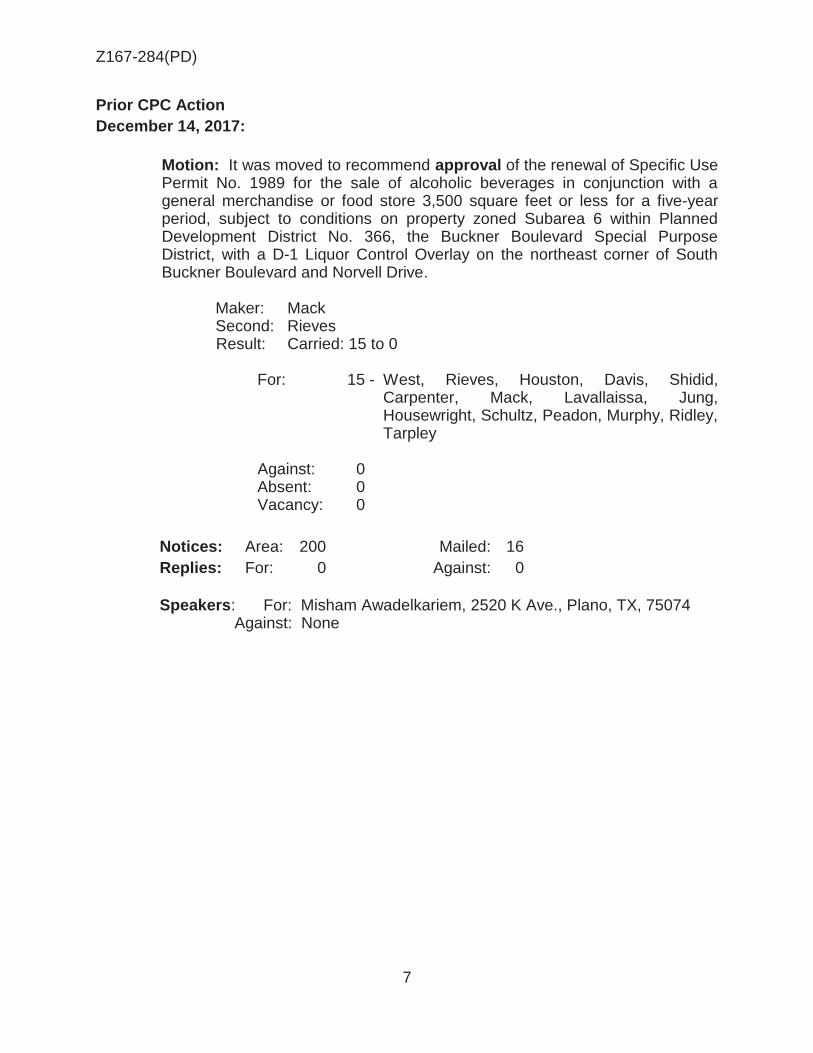
Z167-284(PD)
7
Prior CPC Action December 14, 2017:
Motion: It was moved to recommend approval of the renewal of Specific Use Permit No. 1989 for the sale of alcoholic beverages in conjunction with a general merchandise or food store 3,500 square feet or less for a five-year period, subject to conditions on property zoned Subarea 6 within Planned Development District No. 366, the Buckner Boulevard Special Purpose District, with a D-1 Liquor Control Overlay on the northeast corner of South Buckner Boulevard and Norvell Drive.
Maker: Mack Second: Rieves Result: Carried: 15 to 0
For: 15 - West, Rieves, Houston, Davis, Shidid,
Carpenter, Mack, Lavallaissa, Jung, Housewright, Schultz, Peadon, Murphy, Ridley, Tarpley
Against: 0 Absent: 0 Vacancy: 0
Notices: Area: 200 Mailed: 16 Replies: For: 0 Against: 0 Speakers: For: Misham Awadelkariem, 2520 K Ave., Plano, TX, 75074
Against: None

Z167-284(PD)
8
Partners/Principals/Officers: Owner: Duke & Sons, Inc. Imad Daouk, Sole Officer and Director Applicant: Autry’s, Inc. Tigest Atnafe, President/Vice President and Director Ahmed Omar, Director

Z167-284(PD)
9
CPC Recommended Conditions
1. USE: The only use authorized by this specific use permit is the sale of alcoholic beverages in conjunction with a general merchandise or food store 3,500 square feet or less.
2. SITE PLAN: Use and development of the Property must comply with the attached site plan.
3. CPC Recommended
TIME LIMIT: This specific use permit expires on ________ (five-year) period.
3. Staff Recommended: TIME LIMIT: This specific use permit expires on ________ (five-year) period but is eligible for automatic renewal for additional five-year periods pursuant to Section 51A-4.219 of Chapter 51A of the Dallas City Code, as amended. For automatic renewal to occur, the Property owner must file a complete application for automatic renewal with the director before the expiration of the current period. Failure to timely file a complete application will render this specific use permit ineligible for automatic renewal. (Note: The Code currently provides that applications for automatic renewal must be filed after the 180th but before the 120th day before the expiration of the current specific use permit period. The Property owner is responsible for checking the Code for possible revisions to this provision. The deadline for applications for automatic renewal is strictly enforced.)
4. FLOOR AREA: Maximum floor area is 2,557-square feet.
5. MAINTENANCE: The Property must be properly maintained in a state of good repair and neat appearance.
6. GENERAL REQUIREMENTS: Use of the Property must comply with all federal and
state laws and regulations, and with all ordinances, rules, and regulations of the City of Dallas.

Z167-284(PD)
10
Site Plan

Z167-284(PD)
11
Enlarged Site Plan

Z167-284(PD)
12

Z167-284(PD)
13
® AERIAL MAP
Case no: Z167-284
1 :2,400 Date: __ 5_11_01_2_01_7 _

Z167-284(PD)
14
Convalescent hospital/ nursing
home
Single Family
Undeveloped
Convenience Store

Z167-284(PD)
15
1
2

Z167-284(PD)
16
CPC RESPONSES

Z167-284(PD)
17
12/13/2017
Reply List of Property Owners Z167-284 16 Property Owners Notified 0 Property Owners in Favor 0 Property Owners Opposed Reply Label # Address Owner 1 3510 S BUCKNER BLVD DUKE & SONS INC
2 3701 S BUCKNER BLVD TEXAS UTILITIES ELEC CO
3 3625 S BUCKNER BLVD MEZA JESUS
4 7000 SCYENE CIR BUCKNER SCYENE SNF LTD
5 8123 NORVELL DR OROZCO JOSE LUIS
6 8127 NORVELL DR HURTADO DOMINGO
7 8131 NORVELL DR BARRAZA ELIAS
8 8137 NORVELL DR HERNANDEZ AGUSTIN
9 8122 NORVELL DR SANCHEZ REBECA &
10 8126 NORVELL DR BANDA ANTONIO &
11 8130 NORVELL DR RODRIGUEZ GUILLERMO SOTO
12 8136 NORVELL DR CLEMENS SCOTT
13 3608 S BUCKNER BLVD 4 CUSTOM WHEELS & TIRES INC
14 3608 S BUCKNER BLVD MARES NOEL
15 8008 NORVELL DR LINSK DALLAS HOLDINGS LLC
16 3424 S BUCKNER BLVD YARA GROUP LLC

AGENDA ITEM # 54Mobility Solutions, Infrastructure, and Sustainability
AGENDA DATE: January 24, 2018
COUNCIL DISTRICT(S): 6
DEPARTMENT: Department of Sustainable Development and Construction
CMO: Majed Al-Ghafry, 670-3302
MAPSCO: 23 W
SUBJECT
A public hearing to receive comments regarding an application for the renewal of Specific Use Permit No. 2104 for an alcoholic beverage establishment, limited to a bar, lounge, or tavern, on property zoned an MU-3 Mixed Use District, on the southwest corner of Harry Hines Boulevard and Willowbrook RoadRecommendation of Staff and CPC: DenialZ167-370(SM)
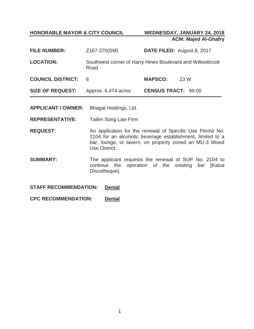
1
HONORABLE MAYOR & CITY COUNCIL WEDNESDAY, JANUARY 24, 2018 ACM: Majed Al-Ghafry
FILE NUMBER: Z167-370(SM) DATE FILED: August 8, 2017 LOCATION: Southwest corner of Harry Hines Boulevard and Willowbrook
Road COUNCIL DISTRICT: 6 MAPSCO: 23 W SIZE OF REQUEST: Approx. 6.474 acres CENSUS TRACT: 99.00 APPLICANT / OWNER: Bhagat Holdings, Ltd. REPRESENTATIVE: Tailim Song Law Firm REQUEST: An application for the renewal of Specific Use Permit No.
2104 for an alcoholic beverage establishment, limited to a bar, lounge, or tavern, on property zoned an MU-3 Mixed Use District.
SUMMARY: The applicant requests the renewal of SUP No. 2104 to
continue the operation of the existing bar [Kalua Discotheque].
STAFF RECOMMENDATION: Denial CPC RECOMMENDATION: Denial

Z167-370(SM)
2
BACKGROUND INFORMATION: The site is developed with three structures constructed in 1984, according to Dallas
Central Appraisal District Records. The southernmost building was originally used for office and personal service tenants, according to permit records.
On April 22, 2011, Certificate of Occupancy No. 1007151101 was issued to Saul Cordona [DBA Kalua Discotheque] for a 16,965-square-foot commercial amusement (inside) use with a dance hall. Notes on this certificate of occupancy also indicated a shared parking agreement with other uses on site.
On September 24, 2014, City Council approved SUP No. 2104 for a 17,557-square foot bar, lounge, or tavern use within the southernmost structure on the site.
On September 4, 2015, Certificate of Occupancy No. 1406131114 was issued to
Kalua, LLC [DBA Kalua Discotheque] for a 16,965-square foot commercial amusement (inside) use with a dance hall.
Zoning History: There has been no recent zoning activity in the immediate area
relevant to this request.
Traffic: The Engineering Division of the Sustainable Development and Construction Department has reviewed the requested amendment and has no objection to the request.
Thoroughfare/Street Designation Thoroughfare Roadway Section
Harry Hines Boulevard Principal Arterial Standard-8 lanes-Divided; 130’ ROW
Willowbrook Road Local 55’ ROW
Comprehensive Plan: The forwardDallas! Comprehensive Plan was adopted by the City Council in June 2006. The forwardDallas! Comprehensive Plan outlines several goals and policies which can serve as a framework for assisting in evaluating the applicant’s request. The proposed zoning request meets the following goal and objective of the comprehensive plan.

Z167-370(SM)
3
Economic Element
Goal 2.1 Promote balanced growth
Policy 2.1.1 Ensure that zoning is flexible enough to respond to changing economic conditions.
STAFF ANALYSIS: Surrounding Land Uses:
Location Zoning Land Use
Site MU-3 with SUP Nos.
2104, 2105, 2106 Shopping center
North IR and MU-3 Office/showroom/warehouse and
retail store with gas
East CS and IR Drive through restaurants, retail
with gas, and undeveloped South MU-3 Auto sales West CS Warehouse
Land Use Compatibility: The request site is developed with three one-story, masonry, multi-tenant shopping center structures. The bar, lounge, or tavern use for the existing SUP occupies the majority of southernmost building. Surrounding land uses of the shopping center consist of an office/showroom/warehouse use and gas station to the north; two drive-through restaurants are located adjacent to the shopping center to the east, undeveloped land and another gas station are located on the opposite side of Harry Hines Boulevard to the east; a third gas station and a nonconforming auto sales use is located to the south, and a warehouse is located opposite of a 75-foot wide drainage easement to the west. The general provisions for a Specific Use Permit in Section 51A-4.219 of the Dallas Development Code specifically state: (1) The SUP provides a means for developing certain uses in a manner in which the specific use will be consistent with the character of the neighborhood; (2) Each SUP application must be evaluated as to its probable effect on the adjacent property and the community welfare and may be approved or denied as the findings indicate appropriate; (3) The city council shall not grant an SUP for a use except upon a finding that the use will: (A) complement or be compatible with the surrounding uses and community facilities; (B) contribute to, enhance, or promote the welfare of the area of request and adjacent properties; (C) not be detrimental to the

Z167-370(SM)
4
public health, safety, or general welfare; and (D) conform in all other respects to all applicable zoning regulations and standards. The regulations in this chapter have been established in accordance with a comprehensive plan for the purpose of promoting the health, safety, morals, and general welfare of the city. Staff recommends denial of the continued operation of the use because the following police reports suggest that the land use does not meet the standards of approval for a specific use permit as it is seen to not complement or be incompatible with the surrounding uses and community facilities; does not contribute to, enhance, or promote the welfare of the area of request and adjacent properties; and is detrimental to the public health, safety, or general welfare. Off-Street Parking: The existing SUP site plan shows an overall 364 parking spaces in the shopping center. The parking analysis on the existing SUP site plan shows there are two dance floors (990 and 1904 square feet each) within an overall 17,557-square foot suite. Dance floors cannot be an accessory use and therefore are required to provide one space per 25 square feet of dance floor area which results in 116 spaces for the dance floors of this suite. The remainder of the overall suite, 14,663 square feet, is required to provide one space per 100 square feet of floor area for either a commercial amusement (inside) use that is not a dance floor or for a bar, lounge, or tavern use, which results in an additional 147 spaces for the area outside of the dance floors. These two requirements total 263 spaces for this suite within the shopping center. According to the two previously issued Certificates of Occupancy (COs), the overall floor area of this suite was 16,965 square feet and the notes on the COs say that 259 spaces are required and provided. Comments on the 2010 interior remodel permit issued to convert the space from personal service and office uses to a dance hall note a shared parking agreement with other uses in the shopping center. However, the shared parking agreement was not located in the permit files at Building Inspection.
Police Reports: The following three lists (crime, arrests, and calls) were obtained by
staff from the Dallas Police Department. An Excel spreadsheet can be viewed on the
CPC page under the plans link.
Crime, Jan 1 2016 - Sep 20 2017 Incident No. Date Time UCR_Offense Address 190963-2017 8/21/2017 1:00 Robbery-Individual 2435 W Northwest Hwy 184160-2017 8/13/2017 3:00 Assault 2435 W Northwest Serv N

Z167-370(SM)
5
Crime, Jan 1 2016 - Sep 20 2017 (continued) Incident No. Date Time Ucr_Offense Address 166983-2017 7/22/2017 21:00 Assault 2435 W Northwest Hwy 161387-2017 7/16/2017 3:55 Assault 2435 W Northwest Hwy 138507-2017 6/19/2017 2:30 Agg Assault - NFV 2435 W Northwest Hwy 100161-2017 5/5/2017 3:00 Assault 2435 W Northwest Serv N 085367-2017 4/17/2017 2:00 Agg Assault - NFV 2435 W Northwest Hwy 085290-2017 4/17/2017 0:05 Other Thefts 2435 W Northwest Hwy 084575-2017 4/15/2017 23:30 Assault 2435 W Northwest Hwy 079461-2017 4/10/2017 1:00 Agg Assault - NFV 2435 W Northwest Hwy 072999-2017 4/3/2017 2:30 Agg Assault - FV 2435 W Northwest Hwy 067437-2017 3/25/2017 22:00 UUMV 2435 W Northwest Hwy 039463-2017 2/19/2017 2:00 Agg Assault - NFV 2435 W Northwest Hwy 039463-2017 2/19/2017 2:00 Fail To ID 2435 W Northwest Hwy 039623-2017 2/19/2017 0:00 Assault 2435 W Northwest Hwy 306291-2016 12/24/2016 5:00 Robbery-Individual 2435 W Northwest Hwy 303084-2016 12/19/2016 2:00 Assault 2435 W Northwest Hwy 272341-2016 11/14/2016 0:10 Assault 2435 W Northwest Hwy 252218-2016 10/17/2016 10:00 UUMV 2435 W Northwest Hwy 248326-2016 10/16/2016 1:30 Agg Assault - NFV 2435 W Northwest Serv N 247572-2016 10/15/2016 1:35 Assault 2435 W Northwest Hwy
242511-2016 10/9/2016 0:00 Vandalism & Crim
Mischief 2435 W Northwest Hwy
226173-2016 9/19/2016 3:00 Robbery-Individual 2435 W Northwest Serv N 223959-2016 9/16/2016 23:00 UUMV 2435 W Northwest Hwy 213778-2016 9/5/2016 3:40 Disorderly Conduct 2435 W Northwest Hwy 213778-2016 9/5/2016 3:40 Disorderly Conduct 2435 W Northwest Hwy 207751-2016 8/29/2016 3:00 Resist Arrest 2435 W Northwest Hwy 206977-2016 8/28/2016 0:00 Embezzlement 2435 W Northwest Hwy 184465-2016 7/29/2016 2:30 Assault 2435 W Northwest Hwy 154358-2016 6/26/2016 2:00 Assault 2435 W Northwest Hwy 154424-2016 6/26/2016 1:45 Agg Assault - NFV 2435 W Northwest Hwy 154424-2016 6/26/2016 1:45 Agg Assault - NFV 2435 W Northwest Hwy 128547-2016 5/29/2016 1:30 Assault 2435 W Northwest Hwy 072628-2016 3/27/2016 2:45 Criminal Trespass 2435 W Northwest Hwy 059700-2016 3/11/2016 23:00 UUMV 2435 W Northwest Hwy
035372-2016 2/13/2016 2:53 Vandalism & Crim
Mischief 2435 W Northwest Hwy
011416-2016 1/15/2016 2:00 Assault 2435 W Northwest Hwy 001078-2016 1/2/2016 0:00 Other Thefts 2435 W Northwest Hwy 000226-2016 1/1/2016 0:00 Agg Assault - Nfv 2435 W Northwest Hwy

Z167-370(SM)
6
Arrests, Jan 1 2016 - Sep 20 2017 Incident
No. Arrest No. ID
Arrest No. Date Time Charge
Description Address
205475-2017
0036906-2017
17-036906 9/8/2017 0:40 Warrant-Dallas PD
(ALIAS) 2435 W
Northwest Hwy 195015-
2017 0035096-
2017 17-
035096 8/26/2017 23:00 Public Intoxication 2435 W
Northwest Serv N 195015-
2017 0035101-
2017 17-
035101 8/26/2017 2:30 Public Intoxication 2435 W
Northwest Serv N 195015-
2017 0035103-
2017 17-
035103 8/26/2017 2:30 Public Intoxication 2435 W
Northwest Serv N 184067-
2017 0033198-
2017 17-
033198 8/13/2017 1:19 Public Intoxication 2435 W
Northwest Serv N 172769-
2017 0031241-
2017 17-
031241 7/30/2017 2:15 Public Intoxication 2435 W
Northwest Serv N 161998-
2017 0029356-
2017 17-
029356 7/17/2017 0:46 Public Intoxication 2435 W
Northwest Hwy 161350-
2017 0029248-
2017 17-
029248 7/16/2017 3:15 Warrant Hold (Outside Agency)
2435 W Northwest Serv N
161350-2017
0029248-2017
17-029248 7/16/2017 3:15 Warrant-Dallas PD
(ALIAS) 2435 W
Northwest Serv N 125687-
2017 0022868-
2017 17-
022868 6/4/2017 0:40 Public Intoxication 2435 W
Northwest Serv N 120525-
2017 0021981-
2017 17-
021981 5/29/2017 2:50 Public Intoxication 2435 W
Northwest Serv N 113040-
2017 0020640-
2017 17-
020640 5/20/2017 2:46 Public Intoxication 2435 W
Northwest Serv N 100949-
2017 0018424-
2017 17-
018424 5/6/2017 0:10 Public Intoxication 2435 W
Northwest Hwy 101029-
2017 0018441-
2017 17-
018441 5/6/2017 0:10 Poss Cont Sub Pen Grp 1 <1g
2435 W Northwest Hwy
101029-2017
0018441-2017
17-018441 5/6/2017 0:10 Public Intoxication
2435 W Northwest Hwy
100166-2017
0018283-2017
17-018283 5/5/2017 3:15 Public Intoxication
2435 W Northwest Serv N
094334-2017
0017221-2017
17-017221 4/28/2017 2:30 Public Intoxication
2435 W Northwest Hwy
094334-2017
0017224-2017
17-017224 4/28/2017 2:30 Public Intoxication
2435 W Northwest Hwy
094334-2017
0017226-2017
17-017226 4/28/2017 2:30 Public Intoxication
2435 W Northwest Hwy
088758-2017
0016255-2017
17-016255 4/21/2017 2:50 Public Intoxication
2435 W Northwest Hwy
085377-2017
0015603-2017
17-015603 4/17/2017 2:20 Public Intoxication
2435 W Northwest Hwy

Z167-370(SM)
7
Arrests, Jan 1 2016 - Sep 20 2017 (continued) Incident
No. Arrest No. ID
Arrest No. Date Time Charge
Description Address
085367-2017
0015602-2017
17-015602 4/17/2017 2:00 Assault (Agg) -
Deadly Weapon 2435 W
Northwest Serv N 084631-
2017 0015467-
2017 17-
015467 4/16/2017 2:00 Public Intoxication 2435 W
Northwest Serv N 084631-
2017 0015469-
2017 17-
015469 4/16/2017 2:00 Public Intoxication 2435 W
Northwest Serv N 084548-
2017 0015452-
2017 17-
015452 4/16/2017 0:20 Public Intoxication 2435 W
Northwest Hwy 084548-
2017 0015455-
2017 17-
015455 4/16/2017 0:20 Public Intoxication 2435 W
Northwest Hwy 079446-
2017 0014436-
2017 17-
014436 4/10/2017 1:45 Warrant-Dallas PD (ALIAS)
2435 W Northwest Hwy
079461-2017
0014440-2017
17-014440 4/10/2017 1:30 Assault (Agg) -
Serious Bodily Injury 2435 W
Northwest Serv N 059791-
2017 0010716-
2017 17-
010716 3/17/2017 2:20 Public Intoxication 2435 W
Northwest Hwy 059791-
2017 0010720-
2017 17-
010720 3/17/2017 2:20 Public Intoxication 2435 W
Northwest Hwy 058278-
2017 0010423-
2017 17-
010423 3/15/2017 2:35 Public Intoxication 2435 W
Northwest Serv N 056027-
2017 0010031-
2017 17-
010031 3/12/2017 3:35 Public Intoxication 2435 W
Northwest Serv N 048961-
2017 0008697-
2017 17-
008697 3/3/2017 1:54 Public Intoxication 2435 W
Northwest Hwy 048961-
2017 0008696-
2017 17-
008696 3/3/2017 1:49 Public Intoxication 2435 W
Northwest Hwy 039463-
2017 0006917-
2017 17-
006917 2/19/2017 2:00 Assault (Agg) -Deadly Weapon
2435 W Northwest Hwy
039463-2017
0006917-2017
17-006917 2/19/2017 2:00
Fail To ID -Intentionally
Provides False Info
2435 W Northwest Hwy
037906-2017
0006586-2017
17-006586 2/17/2017 0:15 Public Intoxication
2435 W Northwest Hwy
033094-2017
0005684-2017
17-005684 2/11/2017 1:06 Public Intoxication
2435 W Northwest Serv N
022283-2017
0003733-2017
17-003733 1/29/2017 1:00 Public Intoxication
2435 W Northwest Serv N
288599-2016
0050900-2016
16-050900 12/4/2016 1:43 Public Intoxication
2435 W Northwest Serv N
288599-2016
0050899-2016
16-050899 12/4/2016 1:00 Public Intoxication
2435 W Northwest Serv N

Z167-370(SM)
8
Arrests, Jan 1 2016 - Sep 20 2017 (continued) Incident
No. Arrest No. ID
Arrest No. Date Time Charge
Description Address
282717-2016
0050027-2016
16-050027 11/27/2016 1:30
Fail To ID -Intentionally
Provides False Info
2435 W Northwest Serv N
282717-2016
0050027-2016
16-050027 11/27/2016 1:30 Interfere W/ Public
Duties 2435 W
Northwest Serv N 282717-
2016 0050027-
2016 16-
050027 11/27/2016 1:30 Public Intoxication 2435 W
Northwest Serv N
282717-2016
0050031-2016
16-050031 11/27/2016 1:30
Fail To ID -Intentionally
Provides False Info
2435 W Northwest Serv N
282717-2016
0050031-2016
16-050031 11/27/2016 1:30 Interfere W/ Public
Duties 2435 W
Northwest Serv N 282717-
2016 0050031-
2016 16-
050031 11/27/2016 1:30 Public Intoxication 2435 W
Northwest Serv N 271620-
2016 0048228-
2016 16-
048228 11/13/2016 1:15 Warrant Hold (Outside Agency)
2435 W Northwest Serv N
265881-2016
0047322-2016
16-047322 11/6/2016 1:15 Public Intoxication
2435 W Northwest Serv N
252738-2016
0045200-2016
16-045200 10/21/2016 3:28 Warrant-Dallas PD
(Alias) 2435 W
Northwest Serv N 252688-
2016 0045183-
2016 16-
045183 10/21/2016 1:40 Public Intoxication 2435 W
Northwest Hwy 242519-
2016 0043522-
2016 16-
043522 10/9/2016 3:00 Public Intoxication 2435 W
Northwest Serv N 242519-
2016 0043523-
2016 16-
043523 10/9/2016 3:00 Public Intoxication 2435 W
Northwest Serv N 230718-
2016 0041881-
2016 16-
041881 9/25/2016 1:00 No Code 2435 W
Northwest Hwy 229812-
2016 0041297-
2016 16-
041297 9/24/2016 0:15 Public Intoxication 2435 W
Northwest Serv N 225567-
2016 0040576-
2016 16-
040576 9/19/2016 0:01 Public Intoxication 2435 W
Northwest Hwy 223882-
2016 0040302-
2016 16-
040302 9/17/2016 3:02 Public Intoxication 2435 W
Northwest Hwy 223882-
2016 0040299-
2016 16-
040299 9/17/2016 2:55 Public Intoxication 2435 W
Northwest Hwy 223882-
2016 0040297-
2016 16-
040297 9/17/2016 2:47 Public Intoxication 2435 W
Northwest Hwy 223882-
2016 0040287-
2016 16-
040287 9/17/2016 2:17 Public Intoxication 2435 W
Northwest Hwy 217116-
2016 0039110-
2016 16-
039110 9/9/2016 2:30 Public Intoxication 2435 W
Northwest Hwy

Z167-370(SM)
9
Arrests, Jan 1 2016 - Sep 20 2017 (Continued) Incident
No. Arrest No. ID
Arrest No. Date Time Charge
Description Address
213759-2016
0038485-2016
16-038485 9/5/2016 3:00 Public Intoxication
2435 W Northwest Hwy
207751-2016
0037453-2016
16-037453 8/29/2016 3:30 Resist Arrest Search
Or Transport 2435 W
Northwest Hwy 207666-
2016 0037412-
2016 16-
037412 8/29/2016 1:00 Public Intoxication 2435 W
Northwest Hwy 207666-
2016 0037415-
2016 16-
037415 8/29/2016 1:00 Public Intoxication 2435 W
Northwest Hwy 206966-
2016 0037288-
2016 16-
037288 8/28/2016 2:50 Public Intoxication 2435 W
Northwest Hwy 201109-
2016 0036217-
2016 16-
036217 8/21/2016 3:00 Public Intoxication 2435 W
Northwest Hwy 201109-
2016 0036219-
2016 16-
036219 8/21/2016 3:00 Public Intoxication 2435 W
Northwest Hwy 201109-
2016 0036223-
2016 16-
036223 8/21/2016 3:00 Public Intoxication 2435 W
Northwest Hwy 177470-
2016 0032190-
2016 16-
032190 7/24/2016 1:00 Public Intoxication 2435 W
Northwest Hwy 167182-
2016 0030514-
2016 16-
030514 7/11/2016 2:10 Public Intoxication 2435 W
Northwest Serv N 166535-
2016 0030419-
2016 16-
030419 7/10/2016 12:30 Public Intoxication 2435 W
Northwest Hwy 160846-
2016 0029402-
2016 16-
029402 7/3/2016 2:57 Public Intoxication 2435 W
Northwest Hwy 152521-
2016 0027810-
2016 16-
027810 6/24/2016 1:45 Public Intoxication 2435 W
Northwest Hwy 152516-
2016 0027806-
2016 16-
027806 6/24/2016 1:31 Public Intoxication 2435 W
Northwest Hwy 147949-
2016 0027014-
2016 16-
027014 6/19/2016 1:40 APOWW (Social Services Referral)
2435 W Northwest Serv N
128550-2016
0023461-2016
16-023461 5/29/2016 1:30 Public Intoxication
2435 W Northwest Hwy
121045-2016
0022004-2016
16-022004 5/21/2016 1:30 Public Intoxication
2435 W Northwest Hwy
110132-2016
0019911-2016
16-019911 5/9/2016 2:27 Public Intoxication
2435 W Northwest Serv N
109329-2016
0019756-2016
16-019756 5/8/2016 2:29 Public Intoxication
2435 W Northwest Serv N
109329-2016
0019756-2016
16-019756 5/8/2016 2:29 Resist Arrest Search
Or Transport 2435 W
Northwest Serv N 103962-
2016 0018757-
2016 16-
018757 5/2/2016 1:15 Public Intoxication 2435 W
Northwest Hwy

Z167-370(SM)
10
Arrests, Jan 1 2016 - Sep 20 2017 (Continued) Incident
No. Arrest No. ID
Arrest No. Date Time Charge
Description Address
078540-2016
0013967-2016
16-013967 4/3/2016 2:00 Public Intoxication
2435 W Northwest Hwy
072628-2016
0012871-2016
16-012871 3/27/2016 2:45 Public Intoxication
2435 W Northwest Hwy
066587-2016
0011796-2016
16-011796 3/20/2016 2:08 Warrant Hold
(Outside Agency) 2435 W
Northwest Hwy 061229-
2016 0010839-
2016 16-
010839 3/14/2016 2:13 Public Intoxication 2435 W
Northwest Serv N 060441-
2016 0010733-
2016 16-
010733 3/13/2016 3:09 Public Intoxication 2435 W
Northwest Hwy 042901-
2016 0007570-
2016 16-
007570 2/22/2016 11:30 Warrant Hold (Outside Agency)
2435 W Northwest Hwy
036855-2016
0006427-2016
16-006427 2/15/2016 2:20 Public Intoxication
2435 W Northwest Serv N
031082-2016
0005335-2016
16-005335 2/8/2016 2:21 Public Intoxication
2435 W Northwest Hwy
031081-2016
0005332-2016
16-005332 2/8/2016 2:04 Public Intoxication
2435 W Northwest Hwy
030397-2016
0005214-2016
16-005214 2/7/2016 3:07 Warrant Hold
(Outside Agency) 2435 W
Northwest Hwy 028673-
2016 0004876-
2016 16-
004876 2/5/2016 1:44 Public Intoxication 2435 W
Northwest Hwy 028674-
2016 0004879-
2016 16-
004879 2/5/2016 1:40 Public Intoxication 2435 W
Northwest Hwy 024481-
2016 0004070-
2016 16-
004070 1/31/2016 1:28 Public Intoxication 2435 W
Northwest Hwy 024481-
2016 0004070-
2016 16-
004070 1/31/2016 1:28 [Blank] 2435 W
Northwest Hwy 024481-
2016 0004069-
2016 16-
004069 1/31/2016 1:22 Public Intoxication 2435 W
Northwest Hwy 024481-
2016 0004069-
2016 16-
004069 1/31/2016 1:22 [Blank] 2435 W
Northwest Hwy 017934-
2016 0002939-
2016 16-
002939 1/23/2016 2:00 Warrant Hold (Outside Agency)
2435 W Northwest Hwy
007452-2016
0001228-2016
16-001228 1/10/2016 1:39 Public Intoxication
2435 W Northwest Hwy
006785-2016
0001133-2016
16-001133 1/9/2016 3:30 Public Intoxication
2435 W Northwest Hwy
006785-2016
0001133-2016
16-001133 1/9/2016 3:30 Resist Arrest Search
Or Transport 2435 W
Northwest Hwy 000984-
2016 0000180-
2016 16-
000180 1/2/2016 1:30 Public Intoxication 2435 W
Northwest Hwy

Z167-370(SM)
11
Calls, Jan 1 2016 - Sep 20 2017 Master
Incident No. Date Time Problem Priority Address
17-1711988 9/8/2017 5:58 20R - Robbery (report)+1hr 4 2435 W Northwest Serv Wb 17-1626182 8/26/2017 2:56 30/01 - ODO w/Prisoner 2 2435 W Northwest Serv Wb 17-1619254 8/25/2017 3:06 07 - Minor Accident 3 2435 W Northwest Serv Wb 17-1619207 8/25/2017 2:49 6X - Major Dist (Violence) 2 2435 W Northwest Serv Wb 17-1593183 8/21/2017 7:27 40/01 - Other 2 2435 W Northwest Serv Wb 17-1187959 6/23/2017 2:03 40/01 - Other 2 2435 W Northwest Serv Wb 17-1094909 6/9/2017 13:48 09V - UUMV 4 2435 W Northwest Serv Wb 17-1073814 6/6/2017 14:14 6X - Major Dist (Violence) 2 2435 W Northwest Serv Wb 17-1057016 6/4/2017 0:44 30/01 - ODO w/Prisoner 2 2435 W Northwest Serv Wb 17-0951386 5/20/2017 3:20 07 - Minor Accident 3 2435 W Northwest Serv Wb 17-0928086 5/16/2017 23:05 6X - Major Dist (Violence) 2 2435 W Northwest Serv Wb 17-0796944 4/28/2017 2:27 16 - Injured Person 3 2435 W Northwest Serv Wb 17-0722948 4/16/2017 23:57 6X - Major Dist (Violence) 2 2435 W Northwest Serv Wb 17-0380798 2/27/2017 3:28 09V - UUMV 4 2435 W Northwest Serv Wb 17-0280652 2/12/2017 2:35 20 - Robbery 2 2435 W Northwest Serv Wb 17-0272383 2/11/2017 2:29 DAEV-Dist Armed Encounter Veh 1 2435 W Northwest Serv Wb 17-0271926 2/11/2017 0:45 6X - Major Dist (Violence) 2 2435 W Northwest Serv Wb 17-0181235 1/28/2017 21:53 6X - Major Dist (Violence) 2 2435 W Northwest Serv Wb 17-0146726 1/23/2017 16:47 32 - Suspicious Person 2 2435 W Northwest Serv Wb 17-0091895 1/15/2017 3:00 6X - Major Dist (Violence) 2 2435 W Northwest Serv Wb 16-2537502 12/25/2016 9:50 20 - Robbery 2 2435 W Northwest Serv Wb 16-2528014 12/24/2016 3:01 6X - Major Dist (Violence) 2 2435 W Northwest Serv Wb 16-2520951 12/23/2016 2:15 6X - Major Dist (Violence) 2 2435 W Northwest Serv Wb 16-2445725 12/12/2016 0:08 6X - Major Dist (Violence) 2 2435 W Northwest Serv Wb 16-2388332 12/3/2016 3:59 31 - Criminal Mischief 4 2435 W Northwest Serv Wb 16-2380558 12/2/2016 2:17 6X - Major Dist (Violence) 2 2435 W Northwest Serv Wb 16-2259040 11/13/2016 3:41 07 - Minor Accident 3 2435 W Northwest Serv Wb 16-2258421 11/13/2016 1:10 7CE - City Equipment Accident 3 2435 W Northwest Serv Wb 16-2098599 10/21/2016 3:10 19 - Shooting 1 2435 W Northwest Serv Wb 16-2094456 10/20/2016 14:29 09V - UUMV 4 2435 W Northwest Hwy 16-2019923 10/10/2016 0:39 6X - Major Dist (Violence) 2 2435 W Northwest Serv Wb 16-1999380 10/7/2016 3:44 20 - Robbery 2 2435 W Northwest Serv Wb 16-1964298 10/2/2016 5:59 40/01 - Other 2 2435 W Northwest Serv Wb 16-1875342 9/19/2016 16:26 20R - Robbery (report)+1hr 4 2435 W Northwest Serv Wb 16-1871302 9/19/2016 2:54 6X - Major Dist (Violence) 2 2435 W Northwest Serv Wb 16-1769435 9/5/2016 2:30 6X - Major Dist (Violence) 2 2435 W Northwest Serv Wb Priority Description Key: 1 - Emergency 2 - Urgent 3 - General Service 4 - Non Critical

Z167-370(SM)
12
Calls, Jan 1 2016 - Sep 20 2017 (continued) Master
Incident No. Date Time Problem Priority Address
16-1717996 8/29/2016 4:30 6X - Major Dist (Violence) 2 2435 W Northwest Serv Wb 16-1717456 8/29/2016 0:57 30/01 - ODO w/Prisoner 2 2435 W Northwest Serv Wb 16-1717381 8/29/2016 0:34 6XA - Major Dist Ambulance 2 2435 W Northwest Serv Wb 16-1701144 8/26/2016 18:46 40 - Other 3 2435 W Northwest Serv Wb 16-1684002 8/24/2016 13:16 24 - Abandoned Property 4 2435 W Northwest Serv Wb 16-1667149 8/22/2016 0:07 40 - Other 3 2435 W Northwest Serv Wb 16-1667104 8/21/2016 23:57 6X - Major Dist (Violence) 2 2435 W Northwest Serv Wb 16-1617802 8/15/2016 2:14 16A - Injured Person w/Amb 2 2435 W Northwest Serv Wb 16-1611687 8/14/2016 3:20 07 - Minor Accident 3 2435 W Northwest Serv Wb 16-1517237 8/1/2016 12:36 16 - Injured Person 3 2435 W Northwest Serv Wb 16-1407617 7/17/2016 2:33 07 - Minor Accident 3 2435 W Northwest Serv Wb 16-1352449 7/9/2016 2:18 41/20 - Robbery - In Progress 1 2435 W Northwest Serv Wb 16-1195795 6/19/2016 2:46 11V - Burg Motor Veh 3 2435 W Northwest Serv Wb 16-1142124 6/12/2016 1:51 6XA - Major Dist Ambulance 2 2435 W Northwest Serv Wb 16-0982158 5/22/2016 2:27 6X - Major Dist (Violence) 2 2435 W Northwest Serv Wb 16-0973866 5/21/2016 1:06 40 - Other 3 2435 W Northwest Serv Wb 16-0965336 5/19/2016 23:23 38 - Meet Complainant 4 2435 W Northwest Serv Wb 16-0930968 5/15/2016 3:45 31 - Criminal Mischief 4 2435 W Northwest Serv Wb 16-0909390 5/12/2016 14:30 40/01 - Other 2 2435 W Northwest Serv Wb 16-0877554 5/8/2016 4:59 6X - Major Dist (Violence) 2 2435 W Northwest Serv Wb 16-0676095 4/10/2016 2:17 7X - Major Accident 2 2435 W Northwest Serv Wb 16-0626746 4/3/2016 2:40 6X - Major Dist (Violence) 2 2435 W Northwest Serv Wb 16-0340030 2/21/2016 4:02 40 - Other 3 2435 W Northwest Serv Wb 16-0332275 2/20/2016 3:01 41/20 - Robbery - In Progress 1 2435 W Northwest Serv Wb 16-0295321 2/14/2016 21:38 09/01 - Theft 3 2435 W Northwest Serv Wb 16-0248610 2/8/2016 1:37 30/01 - ODO w/Prisoner 2 2435 W Northwest Hwy 16-0157205 1/25/2016 11:53 20R - Robbery (report)+1hr 4 2435 W Northwest Hwy 16-0053457 1/9/2016 3:26 30/01 - ODO w/Prisoner 2 2435 W Northwest Hwy
Priority Description Key: 1 - Emergency 2 - Urgent 3 - General Service 4 - Non Critical

Z167-370(SM)
13
Prior CPC Action – November 30, 2017:
Motion: It was moved to recommend denial of the renewal of Specific Use Permit No. 2104 for an alcoholic beverage establishment, limited to a bar, lounge, or tavern, on property zoned an MU-3 Mixed Use District, on the southwest corner of Harry Hines Boulevard and Willowbrook Road.
Maker: Carpenter Second: Rieves Result: Carried: 10 to 0
For: 10 - West, Rieves, Davis, Carpenter, Lavallaissa,
Jung, Peadon, Murphy, Ridley, Tarpley Against: 0 Absent: 5 - Houston, Shidid, Mack, Housewright, Schultz Vacancy: 0
Notices: Area: 400 Mailed: 43 Replies: For: 0 Against: 0 Speakers: For: Amy Hsu, 8111 LBJ Hwy., Dallas, TX, 75251 Shawan Bhagat, 652 Timber Crest Cr., Highland Village, TX, 75077 Victor Renteria, 239 Benwick Dr., Sunnyvale, TX, 75182 Haben Tewelde, 8111 LBJ Hwy., Dallas, TX, 75251 Laura Romo, 1202 Pioneer Dr., Dallas, TX, 75224 Against: None

Z167-370(SM)
14
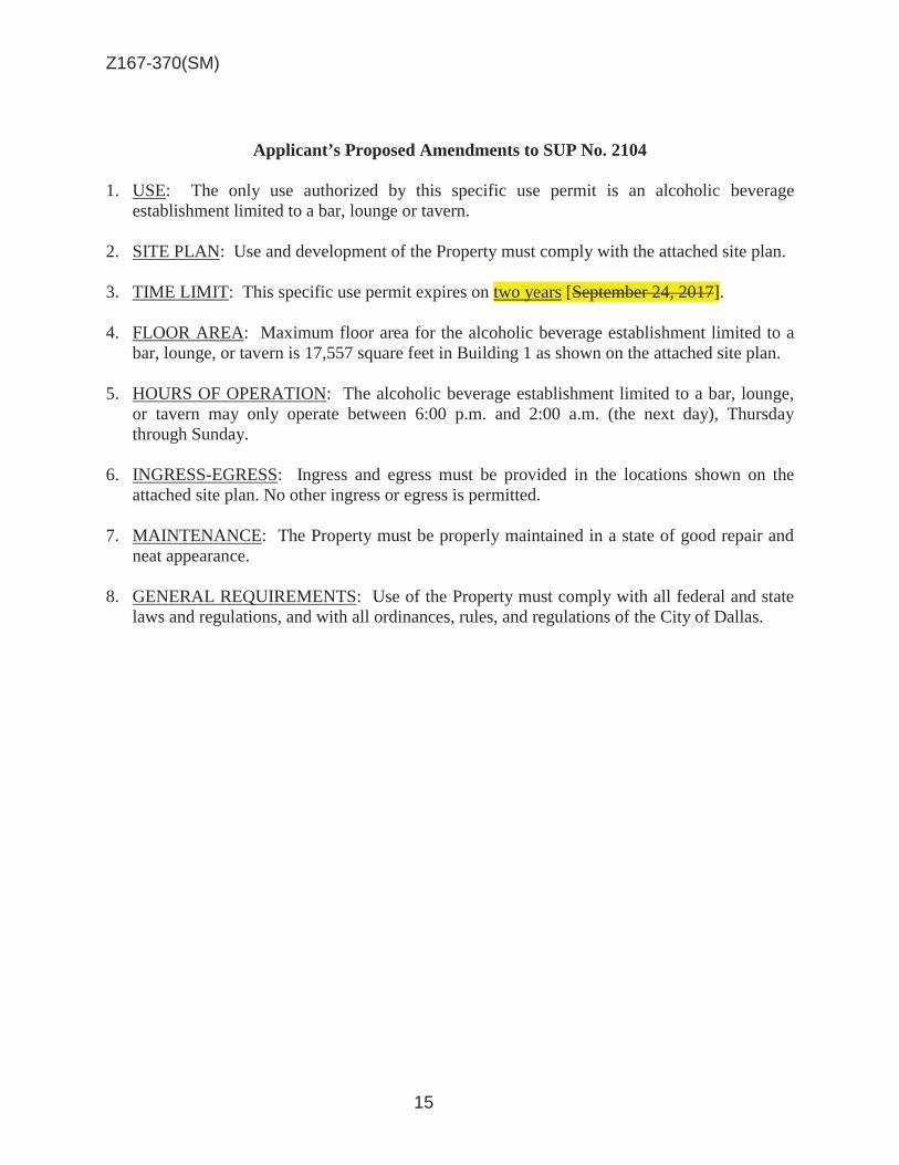
Z167-370(SM)
15
Applicant’s Proposed Amendments to SUP No. 2104 1. USE: The only use authorized by this specific use permit is an alcoholic beverage
establishment limited to a bar, lounge or tavern. 2. SITE PLAN: Use and development of the Property must comply with the attached site plan. 3. TIME LIMIT: This specific use permit expires on two years [September 24, 2017]. 4. FLOOR AREA: Maximum floor area for the alcoholic beverage establishment limited to a
bar, lounge, or tavern is 17,557 square feet in Building 1 as shown on the attached site plan. 5. HOURS OF OPERATION: The alcoholic beverage establishment limited to a bar, lounge,
or tavern may only operate between 6:00 p.m. and 2:00 a.m. (the next day), Thursday through Sunday.
6. INGRESS-EGRESS: Ingress and egress must be provided in the locations shown on the
attached site plan. No other ingress or egress is permitted. 7. MAINTENANCE: The Property must be properly maintained in a state of good repair and
neat appearance. 8. GENERAL REQUIREMENTS: Use of the Property must comply with all federal and state
laws and regulations, and with all ordinances, rules, and regulations of the City of Dallas.

Z167-370(SM)
16
Existing Site Plan g(no changes)
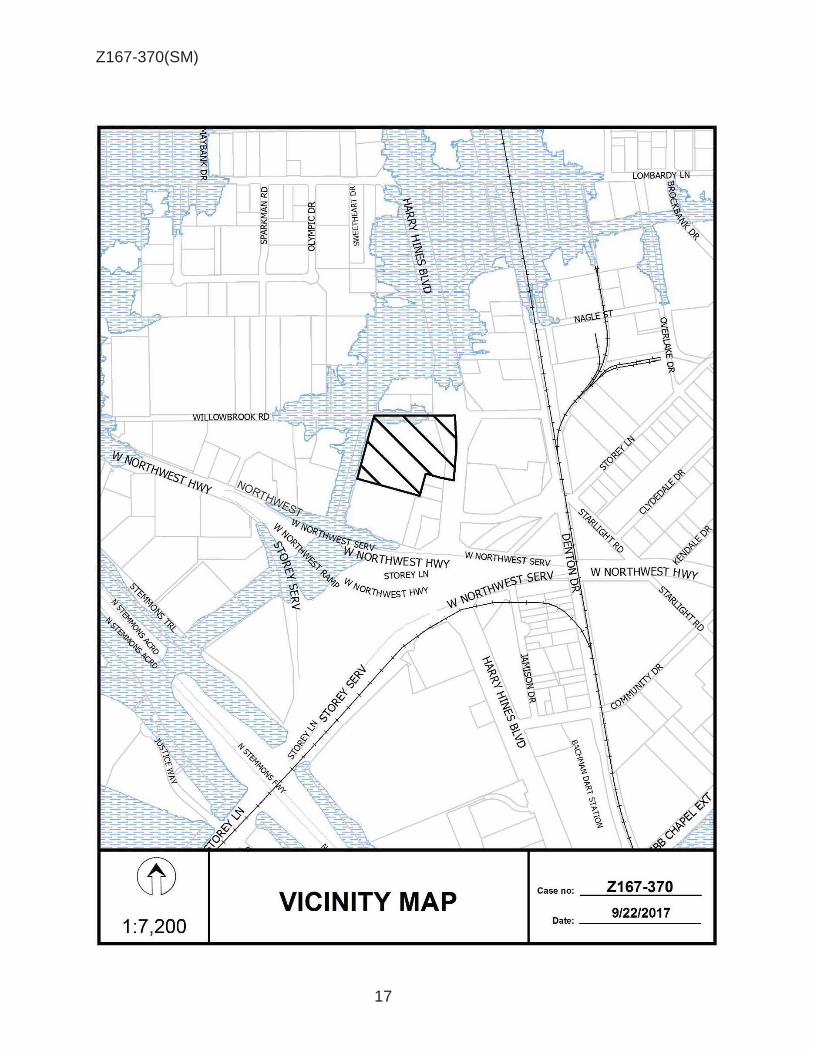
Z167-370(SM)
17
~
® VICINITY MAP
1 :7,200
'\
~ ..... ~.
~ % '11 z ~ 0 ,,
\ ~ U'
~ L 0
..L.
1
Case no: __ Z_16_7_-_3_7_0 __
9/22/2017 Date: -------

Z167-370(SM)
18
Retail w/Gas
Auto Sales
Warehouse
Retail w/Gas
Retail w/Gas
Undeveloped
Restaurants with drive throughs
Office/showroom//warehouse
IR CS

Z167-370(SM)
19
CPC Responses

Z167-370(SM)
20
11/29/2017
Reply List of Property Owners Z167-370
43 Property Owners Notified 0 Property Owners in Favor 0 Property Owners Opposed
Reply Label # Address Owner 1 2425 W NORTHWEST HWY NWH LAND LP
2 10091 HARRY HINES BLVD EPCM REALTY INC
3 10065 HARRY HINES BLVD EL TACASO INC
4 2415 W NORTHWEST HWY BHAGAT HOLDINGS LTD
5 10120 HARRY HINES BLVD TEXAS FOREST PROP INC
6 10002 HARRY HINES BLVD NORTH TEXAS STORES CORP
7 2711 STOREY LN 2223 LOMBARDY WAREHOUSE LLC
8 10251 HARRY HINES BLVD RIVERA FAMILY LTD PS THE
9 10251 HARRY HINES BLVD RIVERA BLANCA LEONARA
10 10251 HARRY HINES BLVD RIVERA BLANCA
11 10251 HARRY HINES BLVD RIVERA BLANCA
12 10251 HARRY HINES BLVD GONZALEZ JOSE ANTONIO & GENOVEVA
13 10251 HARRY HINES BLVD GONZALEZ JOSE
14 10251 HARRY HINES BLVD RAMIREZ GUSTAVO & HERLINDA
15 10251 HARRY HINES BLVD FLORENXIO ZUNIGA
16 10251 HARRY HINES BLVD EMANUEL MARTINEZ
17 10251 HARRY HINES BLVD RIVERA FAMILY LTD PS THE
18 10251 HARRY HINES BLVD CARLOS GARCIA
19 10251 HARRY HINES BLVD LORENZO ANTONIO
20 10251 HARRY HINES BLVD LOPEZ JOSE
21 10251 HARRY HINES BLVD HERNANDEZ JOSE
22 10251 HARRY HINES BLVD PEREZ ELOY
23 10251 HARRY HINES BLVD CASTRO OSVALDO
24 10251 HARRY HINES BLVD BALDERAS TOBIAS
25 10251 HARRY HINES BLVD MENDEZ RAFIEL
26 10251 HARRY HINES BLVD GARCIA-GUZMAN JOSE ELIAS

Z167-370(SM)
21
11/29/2017
Reply Label # Address Owner 27 10251 HARRY HINES BLVD RIVERA ISSAC
28 10251 HARRY HINES BLVD CLEMENTINA ROJAS
29 2621 WILLOWBROOK RD ALLMAN COMPANY DALLAS LLC
30 2617 WILLOWBROOK RD HBSS REAL ESTATE LLC
31 10222 HARRY HINES BLVD 10220 HARRY HINES LLC
32 10220 HARRY HINES BLVD 10220 HARRY HINES LLC
33 2615 WILLOWBROOK RD BARN CEMENT LLC
34 10110 HARRY HINES BLVD SIKKA INVESTMENTS LLC
35 2616 WILLOWBROOK RD MOUSSA GEORGE STANLEY TR
36 2626 WILLOWBROOK RD WAREHOUSE DEVELOPMENT LTD
37 2401 W NORTHWEST HWY WAREHOUSE DEVELOPMENT
38 10045 HARRY HINES BLVD KELLER JACQUELYN
39 10025 HARRY HINES BLVD HANDSOME FELLOW LC
40 10025 HARRY HINES BLVD BENDA INVESTMENTS
41 2635 WILLOWBROOK RD SOUTHLAND CORP
42 10217 HARRY HINES BLVD PENA JOSE
43 2631 WILLOWBROOK RD LOMBARDY LANE LTD

AGENDA ITEM # 55Mobility Solutions, Infrastructure, and Sustainability
AGENDA DATE: January 24, 2018
COUNCIL DISTRICT(S): 8
DEPARTMENT: Department of Sustainable Development and Construction
CMO: Majed Al-Ghafry, 670-3302
MAPSCO: 67 P
SUBJECT
A public hearing to receive comments regarding an application for and an ordinance granting an IM Industrial Manufacturing District and an ordinance granting a Specific Use Permit for an industrial (outside) potentially incompatible use limited to a concrete crushing facility on property zoned a CS Commercial Service District, on the east line of South Central Expressway, south of Youngblood RoadRecommendation of Staff: DenialRecommendation of CPC: Approval of an IM Industrial Manufacturing District; and approval of a Specific Use Permit for an industrial (outside) potentially incompatible use limited to a concrete crushing facility for a five-year period, subject to a site plan and conditionsZ167-376(WE)
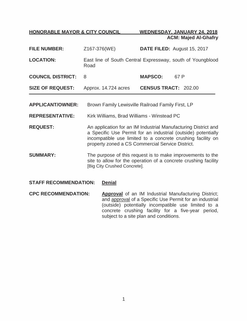
1
HONORABLE MAYOR & CITY COUNCIL WEDNESDAY, JANUARY 24, 2018 ACM: Majed Al-Ghafry FILE NUMBER: Z167-376(WE) DATE FILED: August 15, 2017 LOCATION: East line of South Central Expressway, south of Youngblood
Road COUNCIL DISTRICT: 8 MAPSCO: 67 P SIZE OF REQUEST: Approx. 14.724 acres CENSUS TRACT: 202.00 APPLICANT/OWNER: Brown Family Lewisville Railroad Family First, LP REPRESENTATIVE: Kirk Williams, Brad Williams - Winstead PC REQUEST: An application for an IM Industrial Manufacturing District and
a Specific Use Permit for an industrial (outside) potentially incompatible use limited to a concrete crushing facility on property zoned a CS Commercial Service District.
SUMMARY: The purpose of this request is to make improvements to the
site to allow for the operation of a concrete crushing facility [Big City Crushed Concrete].
STAFF RECOMMENDATION: Denial CPC RECOMMENDATION: Approval of an IM Industrial Manufacturing District;
and approval of a Specific Use Permit for an industrial (outside) potentially incompatible use limited to a concrete crushing facility for a five-year period, subject to a site plan and conditions.

Z167-376(WE)
2
BACKGROUND INFORMATION:
In September 2008, the City Council approved a CS Commercial Service District in lieu of an IM Industrial Manufacturing District and denied a Specific Use Permit for an outside salvage and reclamation use.
A concrete crushing facility is considered a “potentially incompatible industrial use” and is permitted by a Specific Use Permit only, in an IM Industrial Manufacturing District.
The Specific Use Permit will permit the applicant to operate a concrete crushing facility on site.
There is a 100-foot floodplain that surrounds the Property. The applicant proposes
to install the processing equipment, truck scale, and off-street parking, as well as the processed materials storage, and recyclable material storage area, outside the floodplain area.
The request site is immediately adjacent to undeveloped tracts of land. A Union
Pacific railroad line and the City of Dallas’ McCommas Bluff Landfill is located to the northeast and east of the site. Properties northwest of the site, across South Central Expressway, are developed with various types of auto related uses and outside salvage yard or reclamation uses.
Zoning History: There has not been any recent zoning change requested in the area. Thoroughfares/Streets:
Thoroughfare/Street Type Existing ROW
Proposed ROW
S. Central Expressway (U.S. 75)
Variable lane widths
Variable lane widths
Youngblood Road Local Street 35 ft. 35 ft. Land Use:
Zoning Land Use
Site CS Undeveloped
Northwest AA Auto related uses, Outside salvage yard or reclamation use
Southeast IM Undeveloped Northeast IM City of Dallas’ McCommas Bluff
Landfill Southwest A(A) Undeveloped, Auto related use

Z167-376(WE)
3
COMPREHENSIVE PLAN: The fowardDallas! Comprehensive Plan was adopted by the City Council in June 2006. The fowardDallas! Comprehensive Plan outlines several goals and policies which can serve as a framework for assisting in evaluating the applicant’s request. LAND USE GOAL 1.1 ALIGN LAND USE STRATEGIES WITH ECONOMIC DEVELOPMENT PRIORITIES.
Policy 1.1.1 Implement the Trinity River Corridor Plan. Urban Design Element GOAL 5.2 STRENGTHEN COMMUNITY AND NEIGHBORHOOD IDENTITY.
Policy 5.2.3 Ensure attractive gateways into the city.
TRINITY RIVER CORRIDOR COMPREHENSIVE LAND USE PLAN The Trinity River Corridor Comprehensive Plan identifies the site as being in a Community Corridor and within the I-45 Gateway District Study area. The recommended land use for the corridor is Regional Employment. The Community Corridor module recommends a primary land use to be comprised of community serving retail and regional serving office. An optional land use includes industrial-distribution uses. In addition, the stakeholders in the Gateway District Study area, which includes the Joppa residents, “supported planning and investment that would improve the quality of life for Joppa residents by better buffering between the neighborhood and its industrial neighbors. Even though Joppa is approximately 2 miles north of the request site, the residents were a part of the Study area and voiced their desires for the area. Furthermore, the study recommended eliminating junk yards in the district along transportation corridors for better land uses such as business parks. The Plan also identifies protected areas for the Five Mile Creek, the Lemmon Hill and one tributary stream, which bisects the southern portion of the site. These protected areas may pose an impact from the potential runoff of the proposed use into Five Mile Creek.

Z167-376(WE)
4
STAFF ANALYSIS: Land Use Compatibility: The 14.724-acre site is linear in shape and is undeveloped. The request site is adjacent to a Union Pacific railroad line and the City of Dallas’ McCommas Bluff Landfill. Properties northwest of the site, across South Central Expressway, are developed with various types of auto related uses and outside salvage yard or reclamation uses. There are undeveloped tracts of land that are southeast of the request site. Properties that are southwest of the request site consist of auto related uses and undeveloped tracts of land. The applicant’s request for a Specific Use Permit for a concrete crushing facility is only permitted in an IM Industrial Manufacturing District. The proposed concrete crushing facility will have two large designated storage areas that will be used for processed materials and recyclable materials. The stockpile of these materials will be limited to a maximum height of 45 feet. The process equipment and various scales (track and scale house) are proposed to be located between the two designated storage areas. The only access onto the site is from one driveway approach form South Central Expressway. Although the applicant is proposing to secure the property with a six-foot solid fence and maintain the vegetation along the frontage road, staff is concerned that the proposed 45-foot stockpiles of materials will be visible from South Central Expressway. In addition, the proposed use is not consistent with the future vision of the forwardDallas! Plan and Trinity River Corridor Comprehensive Plan. The Trinity River Corridor Comprehensive Plan identifies the type of uses that are proposed in a Community Corridor Module. The primary land use categories are the core land uses that are the primary focus in the Corridor module. The secondary land uses support the primary land uses. The flexibility factors are the recommended land use percentages that provide a balance mix of primary and supporting uses.
%
Primary Land Use % Flexibility factor
Retail-Community 25% +10% Office Regional 25%
Secondary Land Use
Mixed Use A 20% + 5% Residential-Multi-Family 3 20% + 5% Entertainment + 5% + 5% Civic + 5% + 5%
Optional Land Uses
Park & Open Space Industrial-Distribution 5% Retail-Neighborhood 10%
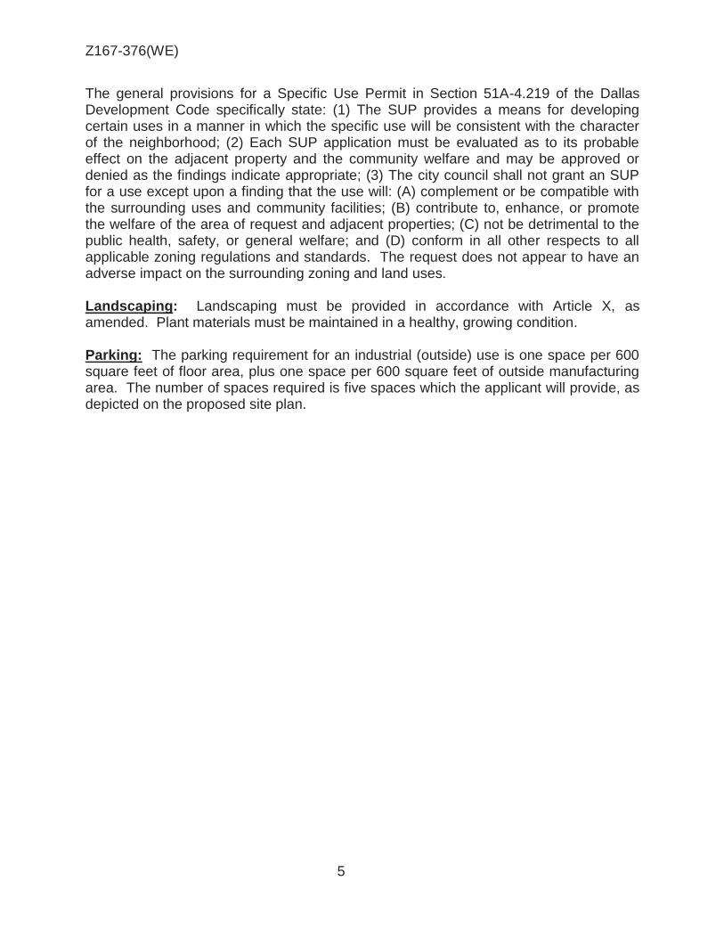
Z167-376(WE)
5
The general provisions for a Specific Use Permit in Section 51A-4.219 of the Dallas Development Code specifically state: (1) The SUP provides a means for developing certain uses in a manner in which the specific use will be consistent with the character of the neighborhood; (2) Each SUP application must be evaluated as to its probable effect on the adjacent property and the community welfare and may be approved or denied as the findings indicate appropriate; (3) The city council shall not grant an SUP for a use except upon a finding that the use will: (A) complement or be compatible with the surrounding uses and community facilities; (B) contribute to, enhance, or promote the welfare of the area of request and adjacent properties; (C) not be detrimental to the public health, safety, or general welfare; and (D) conform in all other respects to all applicable zoning regulations and standards. The request does not appear to have an adverse impact on the surrounding zoning and land uses. Landscaping: Landscaping must be provided in accordance with Article X, as amended. Plant materials must be maintained in a healthy, growing condition. Parking: The parking requirement for an industrial (outside) use is one space per 600 square feet of floor area, plus one space per 600 square feet of outside manufacturing area. The number of spaces required is five spaces which the applicant will provide, as depicted on the proposed site plan.

Z167-376(WE)
6
CPC Action (December 14, 2017)
Motion: It was moved to recommend approval of an IM Industrial Manufacturing District and approval of a Specific Use Permit for an industrial (outside) potentially incompatible use limited to a concrete crushing facility for a five-year period, subject to a site plan and conditions on property zoned a CS Commercial Service District, on the east line of South Central Expressway, south of Youngblood Road.
Maker: Lavallaisaa Second: Houston Result: Carried: 14 to 1
For: 14 - West, Rieves, Houston, Davis, Shidid,
Carpenter, Mack, Lavallaissa, Jung, Housewright, Peadon, Murphy, Ridley, Tarpley
Against: 1 - Schultz Absent: 0 Vacancy: 0
Notices: Area: 400 Mailed: 11 Replies: For: 1 Against: 0 Speakers: For: Brad Williams, 2728 N. Harwood St., Dallas, TX, 75201 Trey Brown, 6909 Joyce Way, Dallas, TX, 75225 Against: None

Z167-376(WE)
7
1. USE: The only use authorized by this specific use permit is for an industrial
(outside) potentially incompatible use limited to a concrete crushing facility.
2. SITE PLAN: Use and development of the Property must comply with the attached site plan.
CPC Recommendation 3. TIME LIMIT: This specific use permit expires on ________(five years from the
passage of this ordinance. Applicant’s Proposal
3. TIME LIMIT: This specific use permit expires on ________(twenty years from the passage of this ordinance), but is eligible for automatic renewal for additional twenty-year periods pursuant to Section 51A-4.219 of Chapter 51A of the Dallas City Code, as amended. For automatic renewal to occur, the Property owner must file a complete application for automatic renewal with the director before the expiration of the current period. Failure to timely file a complete application will render this specific use permit ineligible for automatic renewal. (Note: The Code currently provides that applications for automatic renewal must be filed after the 180th but before the 120th day before the expiration of the current specific use permit period. The Property owner is responsible for checking the Code for possible revisions to this provision. The deadline for applications for automatic renewal is strictly enforced.)
4. GROUND AND DUST CONTROL All areas of the Property, inclusive of any
stockpiles, must be sprinkled with water or chemicals as necessary to achieve maximum control of dust emission.
5. INGRESS-EGRESS: Ingress and egress must be provided in the location shown
on the attached site plan. The drive approach to the Property must be constructed on concrete pavement. Internal parking and circulation drives may be constructed of either concrete or crushed rock.
6. STOCKPILE HEIGHT: The maximum stacking height for stockpiles, both raw
material and finished product, shall be in accordance with applicable TCEQ regulations or 45 feet, whichever is less.
7. MAINTENANCE: The Property must be properly maintained in a state of good
repair and neat appearance.
CPC PROPOSED SUP CONDITIONS

Z167-376(WE)
8
8. GENERAL REQUIREMENTS: Use of the Property must comply with all federal and state laws and regulations, and with all ordinances, rules, and regulations of the City of Dallas.

Z167-376(WE)
9
General Partner: BLRR Management, LLC Members:
Mason C. Brown
Barbara L. Brown
Michael A. Richard
LIST OF OFFICIERS

Z167-376(WE)
10
PROPOSED SITE PLAN

Z167-376(WE)
11
® VICINITY MAP
Case no: Z167-376
1 :7,200 Date: ___ 10_/=.24..::./.=2:.01.:,: 7'..__

Z167-376(WE)
12
® AERIAL MAP
Z167-376 Case no: _ ___.::::....:....::~::...._ __
10/24/2017 Date: __ ..:.___ ___ _ 1 :4,800

Z167-376(WE)
13
City of Dallas land fill
Auto reclamation
Undeveloped Undeveloped
Undeveloped
Auto salvage
Auto salvage
Union Pacific railroad
Undeveloped
CS

Z167-376(WE)
14
CPC RESPONSES

Z167-376(WE)
15
Notification List of Property Owners
Z167-376
11 Property Owners Notified 1 Property Owners in Favor 0 Property Owners Opposed
Reply Label # Address Owner 1 4401 LINFIELD RD ST LOUIS S W RAILWAY CO
2 9999 NO NAME ST UNION PACIFIC RR CO
3 9500 S CENTRAL EXPY DESEV INVESTMENT GROUP LLC
O 4 9800 S CENTRAL EXPY BROWN FAMILY LEWISVILLE RR
FAMILY 1ST LP
5 10400 S CENTRAL EXPY MARTINEZ ELISEO J & AMAPOLA
6 9600 S CENTRAL EXPY COMET AUTO SALVAGE INC
7 5305 YOUNGBLOOD RD NICKS BIG TRUCK SALES
8 5200 YOUNGBLOOD RD TEXAS UTILITIES ELEC CO
9 9901 S CENTRAL EXPY County of Dallas
10 9915 S CENTRAL EXPY VAZQUEZ IRENE
11 5200 SIMPSON STUART RD FCC S A

AGENDA ITEM # 56Mobility Solutions, Infrastructure, and Sustainability
AGENDA DATE: January 24, 2018
COUNCIL DISTRICT(S): 8
DEPARTMENT: Department of Sustainable Development and Construction
CMO: Majed Al-Ghafry, 670-3302
MAPSCO: 69A M; 70 J
SUBJECT
A public hearing to receive comments regarding an application for and an ordinance granting a CR Community Retail District and an ordinance granting a Specific Use Permit for a mini-warehouse use on property zoned an R-10(A) Single Family District and NS(A) D-1 Neighborhood Service District with a D-1 Liquor Control Overlay on a portion on the north corner of South Belt Line Road and Garden Grove DriveRecommendation of Staff: DenialRecommendation of CPC: Approval of a CR Community Retail District with retention of the D-1 Liquor Control Overlay on a portion and approval of a Specific Use Permit for a mini-warehouse use for a ten-year period with eligibility for automatic renewals for additional ten-year periods, subject to a site plan and conditionsZ167-381(WE)

1
HONORABLE MAYOR & CITY COUNCIL WEDNESDAY, JANUARY 24, 2018 ACM: Majed Al-Ghafry FILE NUMBER: Z167-381(WE) DATE FILED: August 24, 2017 LOCATION: North corner of South Belt Line Road and Garden Grove Drive COUNCIL DISTRICT: 8 MAPSCO: 69A M; 70 J SIZE OF REQUEST: Approx. 3.184 acres CENSUS TRACT: 171.01 APPLICANT/OWNER: Golden Star Holdings, LLC, /Aziz Jiwani, Manager REPRESENTATIVE: Roger Albright REQUEST: An application for a CR Community Retail District and a
Specific Use Permit for a mini-warehouse use on property zoned an R-10(A) Single Family District and NS(A) D-1 Neighborhood Service District with a D-1 Liquor Control Overlay on a portion.
SUMMARY: The purpose of this request is to allow for the construction of
approximately 54,730 square feet of storage space consisting of five, one-story structures. The proposed mini-warehouse use will include a 1,000-square-foot accessory office for the caretaker quarters.
STAFF RECOMMENDATION: Denial CPC RECOMMENDATION: Approval of a CR Community Retail District with
retention of the D-1 Liquor Control Overlay on a portion and approval of a Specific Use Permit for a mini-warehouse use for a ten-year period with eligibility for automatic renewals for additional ten-year periods, subject to a site plan and conditions.

Z167-381(WE)
2
BACKGROUND INFORMATION: The request site is undeveloped.
The applicant’s request for a CR Community Retail District and a Specific Use
Permit will allow for development of a mini-warehouse use. The CR Community Retail District permits mini-warehouse uses by a Specific Use Permit.
The request site is contiguous to undeveloped tracts of land that are zoned for R-10(A) Single Family District uses and NS(A) Neighborhood Service District uses. Properties located southwest of the site, across Garden Grove Drive are developed with single family uses and an undeveloped tract of land. In addition, there are several properties that are located southeast of the site, across South Belt Line Road, that are developed with single family uses and an undeveloped tract of land.
Zoning History: There has been one zoning change requested in the area within the past five years. 1. Z156-289 On February 22, 2017, the City Council approved a CR Community
Retail District with volunteered deed restrictions and denied the request for a Specific Use Permit for the sale of alcoholic beverages in conjunction with a general merchandise or food store 3,500 square feet or less.
Thoroughfares/Streets:
Thoroughfare/Street Type Existing ROW
Proposed ROW
S. Belt Line Road Principal Arterial 80 ft. 80 ft. Garden Grove Drive Local Street 60 ft. 60 ft.
Land Use:
Zoning Land Use
Site R-10(A), NS(A)-D-1 Undeveloped
Northeast R-10(A), D(A) Single Family Southeast NS(A)-D-1, PDD No.
777 with D-1, SUP No. 1886
Undeveloped, General merchandise or food store
Northwest R-10(A), R-7.5(A) Single Family Southwest CR-D-1 with DR, PDD
No. 777, SUP No. 1886 Undeveloped, General
merchandise or food store

Z167-381(WE)
3
COMPREHENSIVE PLAN: The fowardDallas! Comprehensive Plan was adopted by the City Council in June 2006. The fowardDallas! Comprehensive Plan outlines several goals and policies which can serve as a framework for assisting in evaluating the applicant’s request. LAND USE GOAL 1.2 PROMOTE DESIRED DEVELOPMENT
Policy 1.2.1 Use Vision Building Blocks as a general guide for desired
development patterns.
While the use could provide a service to neighborhood residents, it may not be a desirable long-term use envisioned by the West Kleberg Community Plan.
West Kleberg Community Plan (2007): The West Kleberg Community Plan identified a vision statement: To reflect "Old Kleberg’s" historical heritage, to promote a strong rural atmosphere, to allow for future growth with sensitivity to future amenities and infrastructure of a modern urban environment. Long-time residents seem to have mixed feelings about growth, noting on one side the negative impacts of crowds, noise, traffic, and pollution, while acknowledging the benefits of improved public services, better schools, and new neighborhood-serving retail and commercial business locating to the area. The subject site is located within Sub-area 1, which is comprised of approximately 2,047 acres of which 46 percent was vacant or undeveloped, and 33 percent was comprised of Single Family (SF) uses at publication in 2007. Commercial service and retail uses are dominant along Highway 175, with a concentration of these uses between Edd Road and South Belt Line Roads. The West Kleberg community desires to encourage economic development along its main corridors, namely Highway 175 and South Belt Line Road. A retail gap analysis completed with the plan identified that residents of this area were likely to spend in nearby Balch Springs or the city of Mesquite. Retail facilities are not sufficiently available. This analysis may not accurately reflect the preferences of households within the study area; however, it can serve as a source for future projections for these types of services needed within this sector of Dallas. The Future Vision Map depicts a 1,000-foot buffer zone as ideal for business development along the Highway 175-freeway corridor. Land assemblage may be required to develop in these areas to construct uses such as a hospital, bank, mix use project and so on. Business nodes to possibly stimulate economic activity are earmarked at the intersections of Seagoville and Belt Line Roads, Highway 175, and South Belt Line Road and Kleberg and South Belt Line Road. The subject site is within

Z167-381(WE)
4
that buffer zone. Furthermore, a Visioning Activity conducted at a community meeting identified the top 20 Community “Needs & Desires” as indicated below. The proposed use was not a consideration in the vision for Sub-area 1.
STAFF ANALYSIS: Land Use Compatibility: The land uses adjacent to the request site are developed with single family uses. The request site has frontages on South Belt Line Road and Garden Grove Drive and the proposed mini-warehouse use will have access from Garden Grove Drive. The property south of the request site, across South Belt Line Road is developed with neighborhood retail development [PDD No. 777 with a SUP No. 1886]. The applicant’s request for a CR Community Retail District and a SUP will allow for the construction of approximately 54,730 square feet of storage space consisting of five, one-story structures. The proposed mini-warehouse use will include a 1,000-square-foot accessory office for the caretaker quarters. The proposed mini-warehouse use will have requirements for building materials to exclude materials that may not be consistent with the surrounding residential developments. A minimum of 80 percent brick concrete masonry unit split face, stone or cementitious fiberboard siding, excluding fenestration will be required. The maximum structure height is 29 feet. The applicant will comply with the development regulations in the CR District. In addition, the hours of operation proposed is from 6:00 a.m. to 9:00 p.m., Monday through Sunday The general provisions for a Specific Use Permit in Section 51A-4.219 of the Dallas Development Code specifically state: (1) The SUP provides a means for developing certain uses in a manner in which the specific use will be consistent with the character

Z167-381(WE)
5
of the neighborhood; (2) Each SUP application must be evaluated as to its probable effect on the adjacent property and the community welfare and may be approved or denied as the findings indicate appropriate; (3) The city council shall not grant an SUP for a use except upon a finding that the use will: (A) complement or be compatible with the surrounding uses and community facilities; (B) contribute to, enhance, or promote the welfare of the area of request and adjacent properties; (C) not be detrimental to the public health, safety, or general welfare; and (D) conform in all other respects to all applicable zoning regulations and standards. The request does not appear to have an adverse impact on the surrounding zoning and land uses. Even though the proposed development could serve the community in the short term and the applicant has provided a large buffer area due to the residential adjacency, staff cannot support the request because of the community’s vision for the type of uses that are desired in the area. Also, staff is aware that there have not been any improvements to the site in over 10 years. Development Standards:
DISTRICT SETBACKS Density Height Lot
Coverage Special
Standards PRIMARY Uses
Front Side/Rear
R-10(A) - existing Single Family
30’ 6’ 1 Dwelling Unit/
10,000 sq. ft. 30’ 45% Single family
NS(A) - existing Neighborhood service
15’
20’ adjacent to residential
OTHER: No Min.
0.5 FAR 30’ 2 stories 40%
Retail & personal service, office
CR - proposed Community retail
15’
20’ adjacent to residential
OTHER: No Min.
0.75 FAR overall 0.5 office
54’ 4 stories 60%
Proximity Slope Visual
Intrusion
Retail & personal service, office
Landscaping: Landscaping of any development will be in accordance with Article X, as amended. Due the residential adjacency to the north and west, the applicant is required to provide a minimum 10-foot landscape buffer strip along the entire perimeter of the site that is adjacent to the residential property. The applicant is providing at least a 27-foot buffer strip between the proposed mini-warehouse use and the single family uses. If the City Plan Commission recommends approval, the applicant will revise the site plan to reflect the requirements that are outlined in item #1 below. The development code also requires the following plant materials in a landscape buffer strip:
(1) If a fence with a buffer strip is required along any part of the perimeter of a lot, the buffer strip must contain either one large canopy tree or two large non-canopy trees at a minimum average density of one large canopy tree or two large non-canopy trees for each 50 linear feet of the buffer strip, with new trees spaced no less than 25 feet apart.

Z167-381(WE)
6
(2) When a fence is not provided, the applicant will have to comply with the design standards and must contain one of the following groups of plant materials at a minimum average density of one group for each 50 linear feet of the buffer strip: (i) One large canopy tree and one large non-canopy tree. (ii) One large canopy tree and three small trees. (iii) One large canopy tree and three large evergreen shrubs. (iv) One large canopy tree, two small trees, and one large evergreen shrub. (v) One large canopy tree, one small tree, and two large evergreen shrubs. (vi) Two large non-canopy trees. Parking: The off-street parking requirement for a mini-warehouse use is a minimum of six spaces. Spaces may not be used for outside storage, vehicle storage, or parking for vehicles for rent. The applicant is providing seven off-street parking spaces.

Z167-381(WE)
7
Prior CPC Action December 14, 2017
Motion: It was moved to recommend approval of a CR Community RetailDistrict with a D-1 Liquor Control Overlay on a portion and approval of a SpecificUse Permit for a mini-warehouse use for a ten-year period with eligibility forautomatic renewals for additional ten-year periods, subject to a site plan andconditions on property zoned an R-10(A) Single Family District and NS(A) D-1Neighborhood Service District with a D-1 Liquor Control Overlay on a portion onthe north corner of South Belt Line Road and Garden Grove Drive.
Maker: Lavallaissa Second: Rieves Result: Carried: 11 to 0
For: 11 - West, Rieves, Davis, Carpenter, Lavallaissa,
Jung, Housewright, Peadon, Murphy, Ridley,Tarpley
Against: 0 Absent: 4 - Houston, Shidid, Mack, Schultz Vacancy: 0
Notices: Area: 300 Mailed: 37 Replies: For: 1 Against: 2 Speakers: For: Roger Albright, 3301 Elm St., Dallas, TX, 75226 Against: None Against (Did not speak): Nellie Green, 1421 S. Beltline Rd., Dallas, TX, 75253

Z167-381(WE)
8
1. USE: The only use authorized by this specific use permit is a mini-warehouse use.
2. SITE PLAN: Use and development of the Property must comply with the
attached site plan. 3. TIME LIMIT: This specific use permit expires on_____, (ten-year period from the
passage of this ordinance), but is eligible for automatic renewal for additional ten-year periods, pursuant to Section 51A-4.219 of Chapter 51A of the Dallas City Code, as amended. For automatic renewal to occur, the Property owner must file a complete application for automatic renewal with the director before the expiration of the current period. Failure to timely file a complete application will render this specific use permit ineligible for automatic renewal. (Note: The Code currently provides that applications for automatic renewal must be filed after the 180th but before the 120th day before the expiration of the current specific use permit period. The Property owner is responsible for checking the Code for possible revisions to this provision. The deadline for applications for automatic renewal is strictly enforced).
4. FLOOR AREA: a. The maximum floor area is 54,730 square feet. b. Maximum floor area for the accessory office is 1,000 square feet in
the location shown on the attached site plan. 5. HOURS OF OPERATION: The mini-warehouse may only operate between 6:00
a.m. and 9:00 p.m., Monday through Sunday. 6. OUTSIDE STORAGE: Outside storage of vehicles, parking for vehicles for rent,
boats, and /or equipment is prohibited. 7. HEIGHT: The use authorized by this specific use permit may not exceed 29 feet
in height. 8. MATERIALS: The exterior facades must be a minimum 80 percent brick
concrete masonry unit split face, stone or cementitious fiberboard siding, excluding fenestration.
9. FENCE: A minimum 6-foot wrought iron fence, is required in the location as
shown on the landscape plan.
CPC PROPOSED SUP CONDITIONS

Z167-381(WE)
9
10. MAINTENANCE: The Property must be properly maintained in a state of good
repair and neat appearance. 11. GENERAL REQUIREMENTS: Use of the Property must comply with all federal
and state laws and regulations, and with all ordinances, rules, and regulations of the City of Dallas.

Z167-381(WE)
10
PROPOSED SITE PLAN

Z167-381(WE)
11

Z167-381(WE)
12
® AERIAL MAP
Z167-381 Case no: _...:::....:....::....:........;,_;;____
9/22/2017 Date: _ ___::__.: __ _ 1 :2,400

Z167-381(WE)
13
Single family
Single Family
Single Family
Single Family
Undeveloped
Retail & personal service
R-10(A)
Undeveloped
Single Family

Z167-381(WE)
14
1

Z167-381(WE)
15
CPC RESPONSES

Z167-381(WE)
16
Notification List of Property Owners
Z167-381
37 Property Owners Notified 1 Property Owners in Favor 2 Property Owners Opposed
Reply Label # Address Owner 1 1429 S BELTLINE RD DALLAS METRO HOLDINGS LLC
2 13435 GARDEN GROVE DR ORTIZ JOSE & BELEN
3 1416 S BELTLINE RD HINKLE DAKOTA KEITH &
X 4 1430 S BELTLINE RD VOYLES E JANE
5 1442 S BELTLINE RD HUMPHRIES KENNETH
6 1436 S BELTLINE RD MCCOY LARRY D & LAURA M
7 1448 S BELTLINE RD MORALES ELSA
X 8 1512 BELT LINE RD WALNUT HILLTOP CORP
9 13624 GARDEN GROVE DR LUNA RUBEN
10 13601 INDIAN WELLS RD CHAVEZ RAQUEL &
O 11 1500 S BELTLINE RD 1500 S BELTLINE LLC
12 13405 GARDEN GROVE DR AMADOR ADRIAN &
13 13327 GARDEN GROVE DR SOTO GUADALUPE
14 1421 S BELTLINE RD CLEPPER STEVEN & KATHY J
15 1421 S BELTLINE RD GREEN NELLIE
16 1415 S BELTLINE RD EASTER AVAN SR
17 1407 S BELTLINE RD EASTER AVAN SR
18 1343 S BELTLINE RD ONTIVEROS FRANCISCO J
19 1408 BELTLINE RD WHITE CLOUD REALTY SERVICES
INC
20 13615 BIGGS ST TIONLOC ALEXANDER C
21 13621 BIGGS ST TIONLOC ANTHONY
22 13618 BIGGS ST LEMUS JUAN J & YANIRA C
23 13612 BIGGS ST VOYLES KENNETH
24 13621 GARDEN GROVE DR DELEON JOEL &
25 13625 GARDEN GROVE DR ROGERS KRYSTAL M &
26 1512 VIDA CT HUNTSBERRY JACQUELINE

Z167-381(WE)
17
11/29/2017
Reply Label # Address Owner 27 1508 VIDA CT DIAZ LUIS C & NANCY
28 1504 VIDA CT GASPARMARTINEZ JHONATAN
MISCHEL
29 1500 VIDA CT GUILLEN ISAIAS
30 1519 VIDA CT WAGGONER DON & ELVIA
31 1515 VIDA CT EUCEDA INVESTMENTS CORP
32 1511 VIDA CT KENTVILLE LLC
33 1507 VIDA CT KIRKS PROPERTY DEVELOPMENT
LLC
34 1504 HUNTERWOOD DR GM CAPITAL LLC
35 1508 HUNTERWOOD DR WARD OPELENE
36 1512 HUNTERWOOD DR CHILDS BRIAN
37 1516 HUNTERWOOD DR NASCIMENTO JOAQUIM CARLOS

AGENDA ITEM # 57Mobility Solutions, Infrastructure, and Sustainability
AGENDA DATE: January 24, 2018
COUNCIL DISTRICT(S): 3
DEPARTMENT: Department of Sustainable Development and Construction
CMO: Majed Al-Ghafry, 670-3302
MAPSCO: 52 U
SUBJECT
A public hearing to receive comments regarding an application for and an ordinance granting an MF-2(A) Multifamily District and a resolution accepting deed restrictions volunteered by the applicant on property zoned a CR Community Retail District, on the south line of West Illinois Avenue, between Duncanville Road and Knoxville StreetRecommendation of Staff: ApprovalRecommendation of CPC: Approval, subject to deed restrictions volunteered by the applicantZ167-391(PD)

1
HONORABLE MAYOR & CITY COUNCIL WEDNESDAY, JANUARY 24, 2018 ACM: Majed Al-Ghafry
FILE NUMBER: Z167-391(PD) DATE FILED: September 11, 2017 LOCATION: South line of West Illinois Avenue, between Duncanville Road and
Knoxville Street COUNCIL DISTRICT: 3 MAPSCO: 52 U SIZE OF REQUEST: ± 2.46 acres CENSUS TRACT: 108.01
REPRESENTATIVE: Elsie Thurman
APPLICANT/OWNER: CCA Investments Inc. REQUEST: An application for an MF-2(A) Multifamily District with deed
restrictions volunteered by the applicant on property zoned a CR Community Retail District.
SUMMARY: The applicant proposes to develop the site with a multifamily
residential community containing 137 dwelling units and typical accessory uses such as a leasing office, exercise room, swimming pool, and party room. The general zoning change will allow uses within the MF-2(A) Multifamily District.
STAFF RECOMMENDATION: Approval CPC RECOMMENDATION: Approval, subject to deed restrictions volunteered by
the applicant.
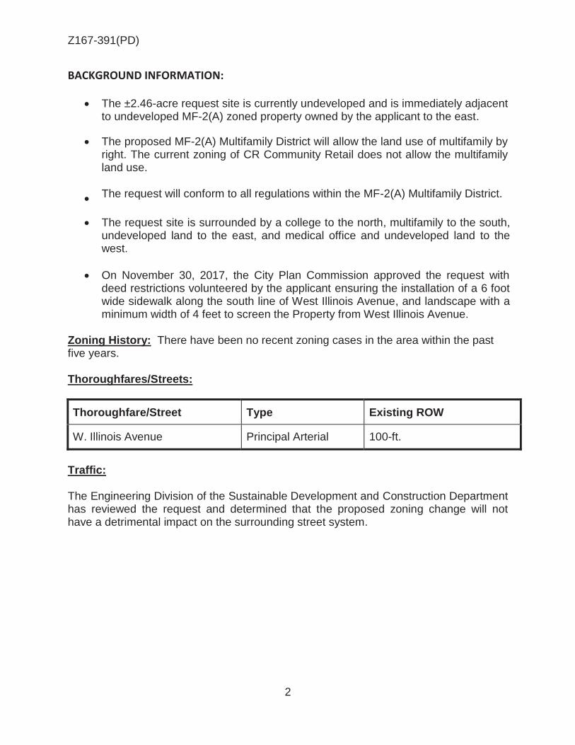
Z167-391(PD)
2
BACKGROUND INFORMATION:
The ±2.46-acre request site is currently undeveloped and is immediately adjacent to undeveloped MF-2(A) zoned property owned by the applicant to the east.
The proposed MF-2(A) Multifamily District will allow the land use of multifamily by right. The current zoning of CR Community Retail does not allow the multifamily land use.
The request will conform to all regulations within the MF-2(A) Multifamily District.
The request site is surrounded by a college to the north, multifamily to the south, undeveloped land to the east, and medical office and undeveloped land to the west.
On November 30, 2017, the City Plan Commission approved the request with deed restrictions volunteered by the applicant ensuring the installation of a 6 foot wide sidewalk along the south line of West Illinois Avenue, and landscape with a minimum width of 4 feet to screen the Property from West Illinois Avenue.
Zoning History: There have been no recent zoning cases in the area within the past five years. Thoroughfares/Streets:
Thoroughfare/Street Type Existing ROW
W. Illinois Avenue Principal Arterial 100-ft.
Traffic: The Engineering Division of the Sustainable Development and Construction Department has reviewed the request and determined that the proposed zoning change will not have a detrimental impact on the surrounding street system.

Z167-391(PD)
3
Land Use:
Zoning Land Use
Site CR Undeveloped Land
North R-7.5(A) Mountain View College
South MF-2(A) Multifamily
East MF-2(A) Undeveloped Land
West CR Medical Office and Undeveloped Land
Comprehensive Plan:
The forwardDallas! Comprehensive Plan was adopted by the City Council in June 2006. The forwardDallas! Comprehensive Plan outlines several goals and policies which can serve as a framework for assisting in evaluating the applicant’s request. The request complies with the following land use goals and policies of the Comprehensive Plan: LAND USE ELEMENT
GOAL 1.1 ALIGN LAND USE STRATEGIES WITH ECONOMIC DEVELOPMENT PRIORITIES
Policy 1.1.15 Strengthen existing neighborhoods and promote neighborhoods’ unique characteristics. Acknowledge the importance of neighborhoods to the city’s long-term health and vitality. Implementation Measure 1.1.5.4 Provide appropriate transitions between non-residential uses and neighborhoods to protect stability and quality of life.
ECONOMIC ELEMENT GOAL 2.1 Promote Balanced Growth
Policy 2.1.1 Ensure that zoning is flexible enough to respond to changing economic conditions.
NEIGHBORHOOD PLUS One of the goals of Neighborhood Plus is to expand homeownership. This goal encourages a wider range of housing types to respond to emerging preferences, identifies incentives for infill development and home improvements in targeted neighborhoods, expands programs to reach a broader range of potential home buyers, and develops partnership to increase the pool of eligible loan applicants.

Z167-391(PD)
4
GOAL 6 Enhance Rental Housing Options Policy 6.1 Raise the quality of rental property through better design standards, proactive and systematic code enforcement, and zero tolerance towards chronic offends. Action 6.1.3 Strengthen regulatory standards and provide incentives for volume single family and multi-family developers to provide a range of housing unit sizes, and include family-friendly amenities such as play area or open/green space for active, healthy living. Per the applicant, the request site would provide swimming pools as an amenity to their tenants. The site will have to comply with Article X landscaping regulations. One of the design standards of this particular policy with in Neighborhood Plus is pedestrian amenities that could be used in order to meet compliance with this zoning requirement. Land Use Compatibility: The applicant is proposing to construct a multifamily residential community containing 137 dwelling units and typical accessory uses such as a leasing office, pavilion, exercise room, party room and swimming pool, on the area of request. Since these accessory uses are incidental to a multifamily development they must be for the exclusive use of the residents of the community and their guests. The ±2.46-acre request site is currently undeveloped and immediately adjacent to a 3.16-acre site currently zoned MF-2(A) and owned by the applicant. The request site is adjacent to a college to the north, multifamily to the south, undeveloped land to the east, and medical office and undeveloped land to the west. West Illinois Avenue is a principal arterial and borders the north side of the site. An MF-2(A) Multifamily District is consistent with the overall land use pattern of the area. There are adjacent parcels that are zoned MF-2(A) to support this general zoning change. The MF-2(A) Multifamily District supports the development of residential uses, institutional and community service uses, and recreation uses. This zoning district prohibits all commercial and office uses; and focuses on area regulations that are designed to protect the residential character and to prevent the overcrowding of the land by providing minimum standards for building spacing, yards, off-street parking, and coverage. Staff’s recommendation is approval because the applicant’s request is consistent with the intent of the Dallas Development Code as the rezoning of this 2.46-acre tract will provide a stair step zoning pattern from low density residential development to medium density residential development and finally commercial, retail, and personal service development directly adjacent to the highway.

Z167-391(PD)
5
Development Standards:
District Setbacks Density Height Lot
Coverage Special
Standards Primary Uses
Front Side/Rear
CR Community Retail
15
20’ adjacent to residential
OTHER: No Min.
0.75 FAR overall
0.5 office
54’ 4 stories
60% Proximity Slope Visual Intrusion
Retail & Personal Service, Office
MF-2(A)
Multifamily 15’
10’/15’ or 10’ when
building site backs up to non MF-2(A)
Based on unit size 36’ 60% Proximity Slope
Multifamily, Duplex, Single Family
Parking: Pursuant to the Dallas Development Code, the off-street parking must be provided in accordance with Division 51A-4.200. The Dallas Development Code requires off-street parking to be provided at one space per bedroom with a minimum of one space per dwelling unit plus 0.25 spaces per dwelling unit for guest parking. Landscaping: Landscaping must be provided in accordance with the landscaping requirements in Article X, as amended.
Residential

Z167-391(PD)
6
Prior CPC Action November 30, 2017: Note: The Commission considered this item individually.
Motion: It was moved to recommend approval of an MF-2(A) Multifamily District, subject to deed restrictions volunteered by the applicant on property zoned a CR Community Retail District, on the south line of West Illinois Avenue, between Duncanville Road and Knoxville Street.
Maker: Houston Second: Jung Result: Carried: 13 to 0
For: 13 - West, Rieves*, Houston, Shidid, Carpenter,
Lavallaissa, Jung, Housewright, Schultz, Peadon, Murphy, Ridley, Tarpley
Against: 0 Absent: 1 - Mack Vacancy: 0 Conflict: 1 - Davis *out of the room, shown voting in favor
Notices: Area: 300 Mailed: 7 Replies: For: 0 Against: 0 Speakers: For: Elsie Thurman, 9406 Biscayne Blvd., Dallas, TX, 75218 For (Did not speak): Emeka Akpunku, 1203 Tulip Ct., Cedar Hill, TX, 75104 Against: None

Z167-391(PD)
7
List of Partners/Principals/Officers CCA Investments, Incorporated Emeka Akpunku

Z167-391(PD)
8
II. The Owner does hereby impress all of the Property with the following deed restrictions (“restrictions”), to wit: (1) A 6 foot wide sidewalk must be installed along the south line of West Illinois Avenue. (2) Landscape with a minimum width of 4 feet must be installed to screen the Property from West Illinois Avenue.
Proposed Volunteered Deed Restrictions
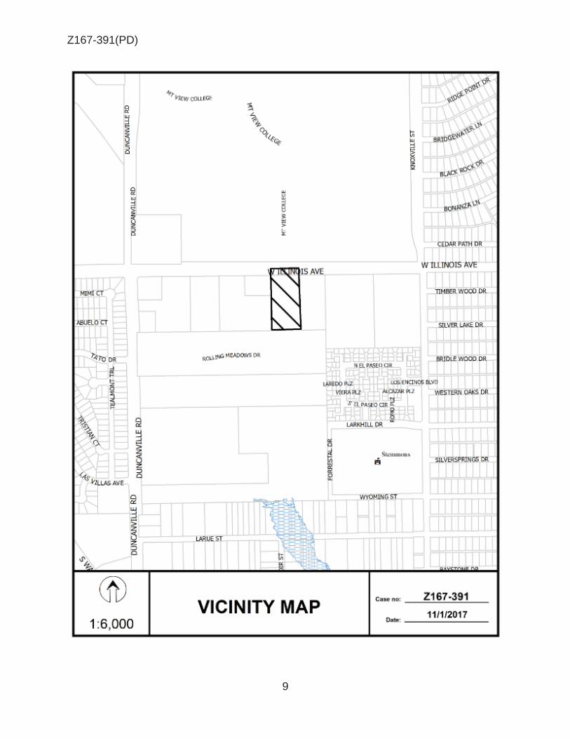
Z167-391(PD)
9

Z167-391(PD)
10
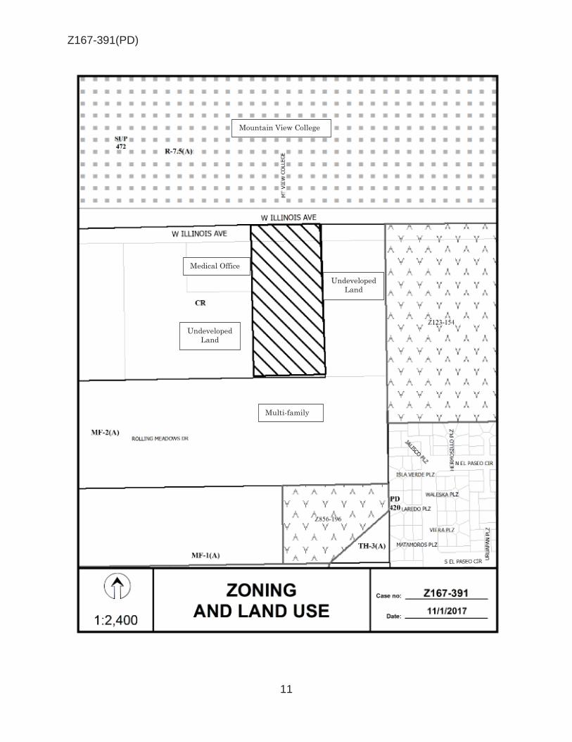
Z167-391(PD)
11
Mountain View College
Medical Office
Multi-family
Undeveloped Land
Undeveloped Land

Z167-391(PD)
12
CPC RESPONSES

Z167-391(PD)
13
11/29/2017
Reply List of Property Owners Z167-391
7 Property Owners Notified 0 Property Owners in Favor 0 Property Owners Opposed
Reply Label # Address Owner 1 4800 W ILLINOIS AVE CCA INVESTMENTS INC
2 4849 W ILLINOIS AVE DALLAS COUNTY COMMUNITY
3 4732 W ILLINOIS AVE LBU HOLDINGS INC
4 2500 DUNCANVILLE RD ROLLING MEADOWS INVESTORS LLC
5 715 JALISCO PLAZA CARREON EDGARDO JAVIER
6 4810 W ILLINOIS AVE INVESTMENT PROPERTY SOLUTIONS INC &
7 4810 W ILLINOIS AVE BNNC INC

AGENDA ITEM # 58Mobility Solutions, Infrastructure, and Sustainability
AGENDA DATE: January 24, 2018
COUNCIL DISTRICT(S): 2
DEPARTMENT: Department of Sustainable Development and Construction
CMO: Majed Al-Ghafry, 670-3302
MAPSCO: 34 Z
SUBJECT
A public hearing to receive comments regarding an application for and an ordinance granting a Planned Development Subdistrict for GR General Retail Subdistrict uses and auto painting or body rebuilding shop (inside) use by right, and an accessory motor vehicle storage outside use on property zoned a GR General Retail Subdistrict within Planned Development District No. 193, the Oak Lawn Special Purpose District, on the northeast corner of Maple Avenue and Vagas StreetRecommendation of Staff: DenialRecommendation of CPC: Approval, subject to a development/landscape plan and conditionsZ167-400(JM)

1
HONORABLE MAYOR & CITY COUNCIL WEDNESDAY, JANUARY 24, 2018
ACM: Majed Al-Ghafry
FILE NUMBER: Z167-400(JM) DATE FILED: September 25, 2017
LOCATION: Northeast corner of Maple Avenue and Vagas Street
COUNCIL DISTRICT: 2 MAPSCO: 34 Z
SIZE OF REQUEST: ±0.532 acres CENSUS TRACT: 4.05 OWNER: Johnny P. Harvey APPLICANT/ REPRESENTATIVE: Santos Martinez, Masterplan REQUEST: An application for a Planned Development Subdistrict for GR
General Retail Subdistrict uses and auto painting or body rebuilding shop (inside) use by right, and an accessory motor vehicle storage outside use on property zoned a GR General Retail Subdistrict within Planned Development District No. 193, the Oak Lawn Special Purpose District.
SUMMARY: The purpose of this request is to allow an auto painting or
body rebuilding shop (inside) use by right. The use is not allowed in current zoning of GR Subdistrict. Harvey’s Paint and Body shop has been in operation since the 1960s. The applicant would like to expand the nonconforming use into the neighboring suite. The current request is to rezone to achieve conformity for the use and site. Additionally, outdoor storage of vehicles under repair would be allowed, as depicted on the proposed development/landscape plan.
STAFF RECOMMENDATION: Denial CPC RECOMMENDATION: Approval, subject to a development/landscape plan
and conditions.

Z167-400(JM)
2
BACKGROUND INFORMATION:
On February 8, 1985, Planned Development District No. 193, the Oak Lawn Special Purpose District, was approved by the City Council. The PD is comprised of approximately 2,593 acres, and provides standards to promote and protect the health, safety, welfare, convenience, and enjoyment of the public, and in part, to achieve the objectives outlined in the PD.
The purpose of this request is to allow an existing auto painting or body rebuilding shop (inside) use by right. Harvey’s Paint & Body shop has been in operation since the 1960s and obtained a CO for vehicle or engine repair or maintenance uses on June 23, 1992. The use was non-conforming (per POSSE) since it is not allowed in the GR Subdistrict, but existed before the PD was created and rezoned the property.
According to DCAD records, the original structures include a 2,452 square-foot building erected in 1952, and a 5,858 square-foot building erected in 1958.
The intent is to expand into an attached 3,224 square-foot neighboring suite erected in 1945, which requires the site to become conforming. The proposed development/landscape plan indicates the shop would now encompass 10,720 square feet with a total area of approximately 0.532 acres.
The proposed PD subdistrict would allow the current uses under GR General Retail, as well as the auto painting or body rebuilding shop (inside) use by right, and outside accessory motor vehicle storage with additional provisions as depicted on the development/landscape plan.
Zoning History: There have been three zoning cases within the area of request in the last five years.
1. Z156-164: On August 10, 2016, the City Council approved an ordinance creating Planned Development Subdistrict No. 125 for MF-2 Multiple Family Subdistrict uses with office and retail uses on property zoned an MF-2 Multiple Family Subdistrict within Planned Development District No. 193, the Oak Lawn Special Purpose District, in an area bounded by the Dallas North Tollway, Fairmount Street, and Knight Street.
2. Z156-229: On September 14, 2016, the City Council approved the expansion of Planned Development Subdistrict No. 78 for MF-2 Multiple-Family on property zoned an MF-2 Multiple Family District within Planned Development District No. 193 the Oak Lawn Special Purpose District, in an area generally bounded by Fairmount Street to the southwest, Throckmorton Street on the northwest side, Brown Street on the northeast side (on a portion) and Reagan Street on the southeast side.
3. Z134-351: On January 14, 2015, the City Council denied an application for a Planned Development Subdistrict MF-2 Multiple-family Subdistrict and mini-warehouse uses on property zoned an MF-2 Multiple Family Subdistrict within Planned Development District No. 193, the Oak Lawn Special Purpose District, in an area bounded by the Dallas North Tollway, Fairmount Street, and Knight Street.

Z167-400(JM)
3
Thoroughfares/Streets:
Thoroughfare/Street Type Existing ROW Proposed ROW
Maple Avenue Community Collector 60 feet 60 feet
Vagas Street Local 50 feet 50 feet
Land Use:
Zoning Land Use
Site PD No. 193, GR Auto Painting or Body Rebuilding Shop (Inside) & Retail
Northwest PD No. 193, GR Retail Food Store
Northeast PD No. 193, GR Retail, Auto Service Center, & Undeveloped
Southeast PD No. 193, GR Auto Service Center
Southwest PD No. 193, GR Restaurant & Pawn Shop
Traffic: The Engineering Division of the Sustainable Development and Construction Department has reviewed the request and determined that it will not have a detrimental impact on the surrounding street system. Comprehensive Plan: The forwardDallas! Comprehensive Plan was adopted by the City Council in June 2006. The forwardDallas! Comprehensive Plan outlines several goals and policies which can serve as a framework for assisting in evaluating the applicant’s request. The Plan identifies the site to be within a Business Center or Corridor Building Block. This Building Block represents major employment or shopping destinations outside of Downtown. Examples include the Galleria area, the NorthPark Center area, Southwest Center Mall area at I-20 and US Hwy 67 and the Stemmons Corridor. Business Centers are usually at major intersections or along highways or major arterials and rely heavily on car access. These areas typically include high-rise office towers and low- to mid-rise residential buildings for condos or apartments and may include multifamily housing. Land uses are typically separated from one another by parking lots, freeways or arterial roads. Streets in these areas emphasize efficient movement of vehicles. Bold lighting and linear landscaping features such as esplanades and tree-lined boulevards can all work to distinguish and identify these areas. Public spaces may be at key entry points and central locations. Gateway landscaping, monuments and other devices will provide

Z167-400(JM)
4
visibility from the freeway and guide visitors to destinations. Public transit may play a role in these areas and help create some pockets of transit oriented development. Business Centers and Corridors provide important concentrations of employment within Dallas that compete with suburban areas. In general, the applicant’s request is inconsistent with the following goal and policy of the Comprehensive Plan. LAND USE ELEMENT GOAL 1.1 ALIGN LAND USE STRATEGIES WITH ECONOMIC DEVELOPMENT
PRIORITIES
Policy 1.1.5.1 Recognize adopted area/neighborhood plans in guiding development and zoning decisions.
GOAL 1.2 PROMOTE DESIRED DEVELOPMENT
Policy 1.2.1 Use Vision Building Blocks as a general guide for desired development patterns.
Although the proposed development is compatible with surrounding uses with respect to scale and character, the proposed expansion of a use which became nonconforming with the adoption of the PD in 1985 is inconsistent with the objectives of the plan. Additionally, Maple Avenue is the boundary line for the Stemmons Corridor-Southwestern Medical District Area Plan which identifies the area as a residential neighborhood. While the frontages that line Maple Avenue are commercial, directly behind them to the southwest are primarily single-family residential units. The same can be said of properties to the northeast of businesses traveling further southeast on Maple Avenue. Land Use Compatibility:
Surrounding land uses include: retail food store to the northwest; retail, auto service center, and undeveloped to the northwest; auto service center to the southeast; and, a restaurant without drive-through and pawn shop to the southwest. The undeveloped tract to the northeast holds deed restrictions requiring affordable housing. Further southwest is a residential neighborhood. A PD is similar to an area plan in how a vision is created with the development of the controlling document. This neighborhood offers a bevy of auto-related uses fronting on Maple Avenue. While an auto repair garage (inside) use could remain by right in the GR Subdistrict, the auto painting or body rebuilding shop (inside) use was excluded when the property was rezoned to PD 193. An alternative could be to rezone to an existing district which allows the auto painting or body rebuilding shop (inside) use. This includes the Light Commercial, High

Z167-400(JM)
5
Commercial, central area, and industrial subdistricts. Although, staff may not support all uses allowed by rezoning to one of those districts. In example, rezoning to the LC Subdistrict would add 14 uses by right, three under specific conditions, and one by SUP with visual screening (open storage). About half of the new uses fall under the commercial uses category. Ultimately, staff cannot support the creation of a subdistrict to expand a nonconforming use. Additionally, during a recent site visit, staff witnessed vehicles stored outside of the facility pending completion of work. Open storage is not allowed in the existing GR Subdistrict. Open storage with screening is allowed by right in central area and industrial subdistricts, and by SUP only in the LC subdistrict. Staff offered to possibly support an LC Subdistrict with SUP for open storage with visual screening, but the applicant chose to pursue a PDS and to address the open storage by allowing outside accessory motor vehicle storage with additional provisions including:
1) The maximum number of vehicles that are allowed to be stored outside at any one time is six.
2) The vehicle storage area is limited to the area shown on the development/landscape plan.
3) A minimum 6-foot-tall solid screening fence is required to screen the vehicle storage area from public rights-of-way.
While the proposed provisions would help in the orderly use of the property, there would be no regulatory periodic review to protect neighbors from possible deterrence over time. Code enforcement would be the only option to pursue property maintenance. Staff cannot support the creation of a PDS to ultimately circumvent the SUP process of continuous review, up-keep, and public input. If the current request for a PDS were approved, the request would be tied to a development/landscape plan and conditions. The development/landscape plan has been reviewed for compliance. The plan indicates the shop would now encompass 10,720 square feet with a total area of approximately 0.532 acres. Parking:
Parking required by Sec. 51P 193.107(l)(9)(C) states that one parking space is required for each 500 square feet of floor area with a minimum of five required off-street parking spaces. In addition, a number of parking spaces equal to or greater than 20 percent of the standard off-street parking requirement for the use must be provided and designated as parking for employees of the use. Parking spaces that are used to repair motor vehicles and located in a structure are not counted in determining the required parking. If more than ten off-street parking spaces are required for this use, handicapped parking must be provided pursuant to Section 51P-193.116. According to the development/landscape plan submitted, the site would have 10,720 square-feet of floor area requiring 21 parking spaces. A total of 28 parking spaces and two bicycle spaces are provided.
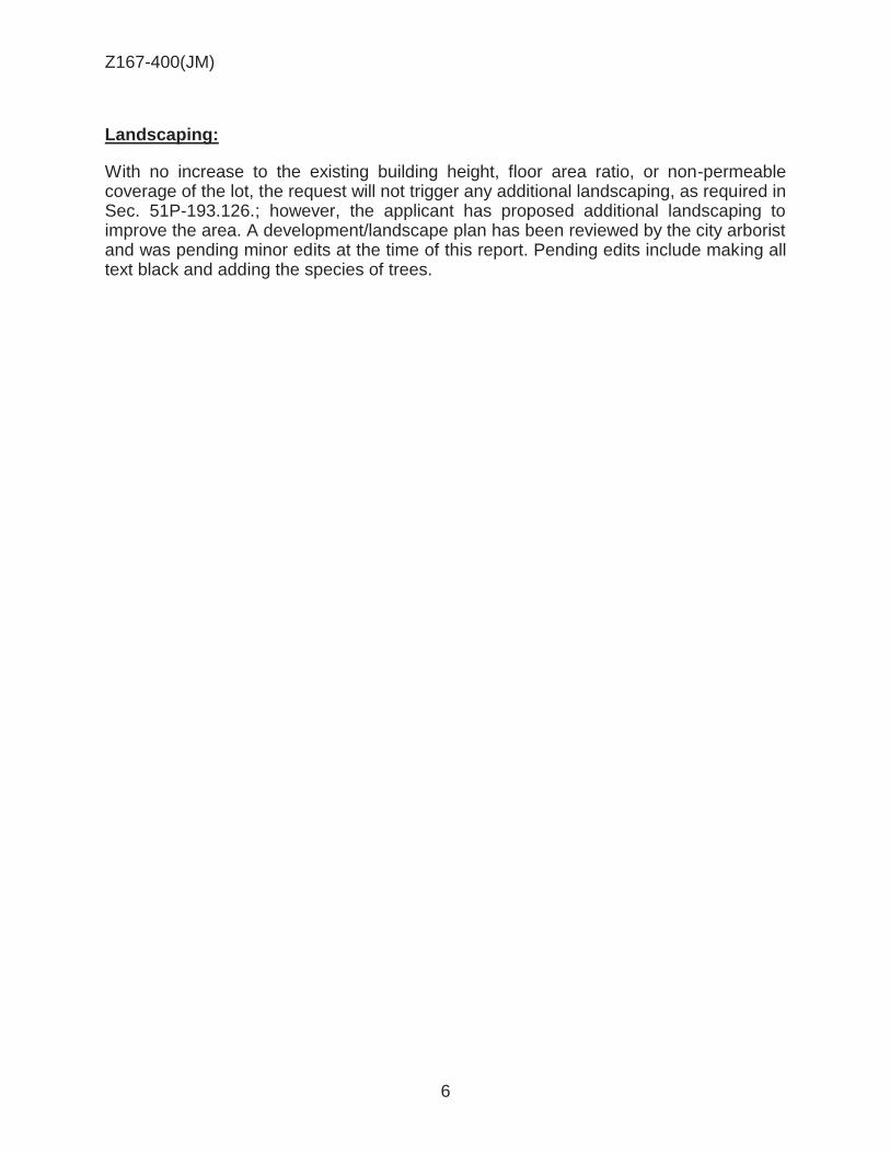
Z167-400(JM)
6
Landscaping:
With no increase to the existing building height, floor area ratio, or non-permeable coverage of the lot, the request will not trigger any additional landscaping, as required in Sec. 51P-193.126.; however, the applicant has proposed additional landscaping to improve the area. A development/landscape plan has been reviewed by the city arborist and was pending minor edits at the time of this report. Pending edits include making all text black and adding the species of trees.

Z167-400(JM)
7
CPC Action November 30, 2017
Motion: It was moved to recommend approval of a Planned Development Subdistrict for GR General Retail Subdistrict uses and auto painting or body rebuilding shop (inside) use by right, and an accessory motor vehicle storage outside use, subject to a development plan and conditions on property zoned a GR General Retail Subdistrict within Planned Development District No. 193, the Oak Lawn Special Purpose District, on the northeast corner of Maple Avenue and Vagas Street.
Maker: Rieves Second: Murphy Result: Carried: 9 to 0
For: 9 - West, Rieves, Davis, Carpenter, Lavallaissa,
Jung, Peadon, Murphy, Tarpley Against: 0 Absent: 6 - Houston, Shidid, Mack, Housewright, Schultz,
Ridley Vacancy: 0
Notices: Area: 500 Mailed: 133 Replies: For: 4 Against: 7 Speakers: For: Santos Martinez, 900 Jackson St., Dallas, TX, 75202 For (Did not speak): John Harvey, 4300 Maple Ave., Dallas, TX, 75219 Against: None

Z167-400(JM)
8
Division S- . PD Subdistrict .
SEC. S- . LEGISLATIVE HISTORY.
PD Subdistrict was established by Ordinance No. , passed by the Dallas City Council on . (Ord. )
SEC. S- . PROPERTY LOCATION AND SIZE.
PD is established on property located northeast of Maple Avenue and northwest of Vagas Street. The size of PD is approximately 0.532 acres. (Ord. )
SEC. S- . DEFINITIONS AND INTERPRETATIONS.
(a) Unless otherwise stated, the definitions and interpretations in Chapter 51 and in Part I of this article apply to this division. If there is a conflict, this division controls. If there is a conflict between Chapter 51 and Part I of this article, Part 1 of this article controls.
(b) In this division,
(1) OUTSIDE ACCESSORY MOTOR VEHICLE STORAGE means the outdoor placement of vehicles awaiting on-site repair or maintenance.
(2) SUBDISTRICT means a subdistrict of PD 193.
(c) Unless otherwise stated, all references to articles, divisions, or sections in this article are to articles, divisions, or sections in Chapter 51.
(d) This district is considered to be a nonresidential zoning district.
SEC S- _____. EXHIBITS.
The following exhibit is incorporated into this division:
Exhibit XA: development/landscape plan.
SEC S- _____. DEVELOPMENT LANDSCAPE PLAN.
(a) Development and use of the Property must comply with the development/landscape plan (Exhibit A). If there is a conflict between the text of this division and the development/landscape plan, the text of this division controls.
CPC Approved PDS Conditions

Z167-400(JM)
9
SEC S-______. MAIN USES PERMITTED.
(a) Except as provided in this section, the only main uses permitted are those main uses permitted in the GR General Retail Subdistrict, subject to the same conditions applicable in the GR General Retail Subdistrict as set out in Part I of this article. For example, a use permitted in the GR General Retail Subdistrict only by specific use permit (SUP) is permitted in this subdistrict only by SUP; a use subject to development impact review (DIR) in the GR General Retail Subdistrict is subject to DIR in this subdistrict; etc.
(b) The following use is permitted by right:
-- Auto painting or body rebuilding shop (inside).
SEC S . ACCESSORY USES.
(a) As a general rule, an accessory use is permitted in any subdistrict in which the main use is permitted. Some specific accessory uses, however, due to their unique nature, are subject to additional regulations in Section 51P-193.108. For more information regarding accessory uses, consult Section 51P-193.108.
(b) Outside accessory motor vehicle storage is permitted only as accessory to an auto painting or body rebuilding shop (inside).
SEC. S-____. YARD, LOT AND SPACE PROVISIONS.
(Note: The yard, lot, and space regulations in this section must be read together with the yard, lot, and space regulations in Part I of this article. If there is a conflict between this section and Part I of this article, this section controls.)
The yard, lot, and space regulations for the GR General Retail District Subdistrict apply.
SEC. S- . OFF-STREET PARKING AND LOADING.
Consult Part I of this article for the specific off-street parking and loading requirements for each use.
SEC. S . ENVIRONMENTAL PERFORMANCE STANDARDS.
See Article VI.
SEC. S- . LANDSCAPING AND SCREENING.
(a) Landscaping must be provided in accordance with the development/landscape plan.
(b) Landscaping must be maintained in a healthy, growing condition.

Z167-400(JM)
10
SEC. S- . SIGNS.
Signs must comply with the provisions for business zoning districts in Article VII.
SEC. 51P-____. BUILDING FACADES.
Building facades facing Maple Avenue and Vagas Street must be painted to visually tie all buildings as one cohesive facility.
SEC. 51P- . ADDITIONAL PROVISIONS.
(a) In general.
(1) The Property must be properly maintained in a state of good repair and neat
appearance.
(2) Development and use of the Property must comply with all federal and state laws and regulations, and with all ordinances, rules, and regulations of the city.
(3) Development and use of the Property must comply with Part I of this article.
(b) Outside accessory motor vehicle storage. is subject to the following conditions:
(1) The maximum number of vehicles that are allowed to be stored outside at any one time is
six.
(2) The vehicle storage area is limited to the area shown on the development/landscape plan.
(3) A minimum 6-foot-tall solid screening fence is required to screen the vehicle storage area from public rights-of-way.
SEC. 51P-____. COMPLIANCE WITH CONDITIONS.
(a) All new paved areas, permanent drives, streets, and drainage structures, if any, must be constructed in accordance with standard city specifications, and completed to the satisfaction of the director of public works and transportation.
(b) The building official shall not issue a building permit to authorize work, or a certificate of occupancy to authorize the operation of a use, until there has been full compliance with this article, the Dallas Development Code, the construction codes, and all other ordinances, rules, and regulations of the city.

Z167-400(JM)
11
Proposed Development/Landscape Plan

Z167-400(JM)
12
I-Iousto1 e
1 :6,000 VICINITY MAP
Case no: Z167-400
Date: 10/23/201 7

Z167-400(JM)
13
® AERIAL MAP
Z167-400 case no: -~~.::.=:.=..::___
10/23/2017 Date: _ _____:__:~---1 :2,400

Z167-400(JM)
14
Undeveloped
Auto Service
Auto Service & Retail
Pawn Shop & Restaurant
Undeveloped
Child Care Facility
Private School
Single Family
Retail Food Store
Undeveloped
Single Family

Z167-400(JM)
15
1 & 3
2

Z167-400(JM)
16
CPC RESPONSES
__ 1;;..;3;...;;3 __ Property Owners Notified (72 parcels) ___ 4..;..._ __ Replies in Favor (5 parcels)
----'7'---- Replies in Opposition (7 parcels) __ 500 __ ' __ Area of Notification 11/ 30/2017 Date
Z167-400
CPC
/ l
50
1 :2,400

Z167-400(JM)
17
11/29/2017
Reply List of Property Owners Z167-400
133 Property Owners Notified 4 Property Owners in Favor 7 Property Owners Opposed
Reply Label # Address Owner 1 4316 MAPLE AVE MIA FINANCIAL CORPORATION
O 2 4310 MAPLE AVE HARVEY JOHNNY P
3 4223 FAIRMOUNT ST FAIR KNIGHT PARTNERS LTD
4 2609 DOUGLAS AVE MCCLAIN CAROLYN
5 2544 HONDO AVE INKWELL GROUP LLC
6 2516 HONDO AVE MAPLE REAL ESTATE VENTURE
7 4346 MAPLE AVE RODRIGUEZ JESUS
8 4338 MAPLE AVE MAPLE REAL EST VENTURES
9 4330 MAPLE AVE MAPLE REAL EST VENTURES
10 2525 WYCLIFF AVE WYCLIFF TOLLWAY LTD
12 4343 MAPLE AVE MONTERREY ENTERPRISES INC
X 13 4333 MAPLE AVE MAPLE HEIGHTS INVESTMENTS LLC
14 2434 HONDO AVE GONZALEZ AJILEO &
15 2430 HONDO AVE TERRONES ANTONIO
16 2417 WYCLIFF AVE WILCHES FRANCES D
17 2423 WYCLIFF AVE BRINGAS GABRIAL LEHI
21 2516 WYCLIFF AVE TEXAS TURNPIKE AUTHORITY
22 4331 MAPLE AVE CTO16 DALLAS LLC &
23 4323 MAPLE AVE CTO16 DALLAS LLC &
24 4311 MAPLE AVE CTO16 DALLAS LLC
25 2418 WYCLIFF AVE TRAN XUAN LAN T
26 2414 WYCLIFF AVE HERNANDEZ ESTHER H
27 2415 VAGAS ST DANG NGHIEP
28 2419 VAGAS ST MACIAS MARIA
29 2421 VAGAS ST SALAZAR HUMBERTO &
30 2427 VAGAS ST ALANIZ HERMILO G

Z167-400(JM)
18
11/29/2017
Reply Label # Address Owner X 31 2435 VAGAS ST DTX RENTALS LP PS
32 2439 VAGAS ST BARRON CARMEN
33 4244 MAPLE AVE BELL WARREN H TRUSTEE
34 4242 MAPLE AVE ANDOR PROPERTIES LLC
35 4226 MAPLE AVE GRTP LTD
36 4222 MAPLE AVE PRESCOTT INTERESTS LTD
37 4251 MAPLE AVE JUREK PROPERTIES LTD
38 4231 MAPLE AVE EBENEZER IGLESIA
39 2430 VAGAS ST HERNANDEZ FRANCISCO &
40 2426 VAGAS ST GARCIA GONZALO & MARLENE
41 2422 VAGAS ST HERNANDEZ FRANCISCO &
42 2418 VAGAS ST TRAN LOI VAN
43 2414 VAGAS ST GELBAND SCOTT L
44 2419 DOUGLAS AVE PORRAS NOAH J JR
45 2423 DOUGLAS AVE MEDRANO PROPERTIES LTD
46 4211 MAPLE AVE DALLAS COMMUNITY CENTER
47 2438 DOUGLAS AVE MARTINEZ CONSEPCION &
48 2432 DOUGLAS AVE GARZA CHRISTOPHER
49 2430 DOUGLAS AVE MEDRANO PROPERTIES LTD
50 4210 FAIRMOUNT ST PURE FAIRMOUNT APTS LLC
51 4305 MAPLE AVE 4305 MAPLE AVENUE LLC
O 52 2442 WYCLIFF AVE VALVERDE AGUSTIN OSWALDO
O 53 2438 WYCLIFF AVE PUENTE MARTHA PATRICIA
O 54 2434 WYCLIFF AVE ROSASGOMEZ FAUSTINO
55 2430 WYCLIFF AVE HUYNH CHU VAN &
56 2426 WYCLIFF AVE HERNANDEZ JUAN EST OF &
57 2422 WYCLIFF AVE MONROY JOSE HECTOR &
58 4234 MAPLE AVE DAO SON & TRAM
59 4323 BROWN ST PFLANZER PARTNERS LTD
60 2627 DOUGLAS AVE HILL DANIEL
61 2627 DOUGLAS AVE PEDRAZA JAVIER

Z167-400(JM)
19
11/29/2017
Reply Label # Address Owner 62 2627 DOUGLAS AVE LOPEZ STEVE
63 2627 DOUGLAS AVE DOMINGUEZ JOSE JORGE &
64 2627 DOUGLAS AVE ADAMS MELVIN C
65 2627 DOUGLAS AVE HWONG SHUPING
66 2627 DOUGLAS AVE HINSON LISA ANNE &
67 2627 DOUGLAS AVE AKBARI LEYLA
68 2627 DOUGLAS AVE DYNASTY PROPERTY ID 2 LLC
69 2627 DOUGLAS AVE COLEMAN RONALD M & JULIE
70 2627 DOUGLAS AVE PFLANZER PARTNERS LTD
71 2627 DOUGLAS AVE MATA JOSE M
72 2627 DOUGLAS AVE FULLER LUC GAETAN
73 2627 DOUGLAS AVE PHILLIPS STEVEN &
74 2627 DOUGLAS AVE CRUZ GUSTAVO
75 2627 DOUGLAS AVE NGUYEN LE BA
76 2627 DOUGLAS AVE FINKENBINER JONATHAN & JULIE
77 2627 DOUGLAS AVE MCELROY HOWARD WYNNE
78 2627 DOUGLAS AVE HENNIG GWEN
79 2627 DOUGLAS AVE TODD ANTHONY &
80 2627 DOUGLAS AVE BETANCOURT ADRIANA
81 2627 DOUGLAS AVE HAVARD DOUG
82 2627 DOUGLAS AVE TRAN LINDA VAN
83 2627 DOUGLAS AVE SUSANTIO RUDY &
84 2627 DOUGLAS AVE GUZMAN MARIO C
85 2627 DOUGLAS AVE DOMINGUEZ JOSE JORGE &
86 2627 DOUGLAS AVE PETE LEO A
87 2627 DOUGLAS AVE HESS CRAIG
88 2627 DOUGLAS AVE COLEMAN RONALD M
89 2627 DOUGLAS AVE TRAN LINDA V
90 2627 DOUGLAS AVE CUNNINGHAM CRAIG
91 2627 DOUGLAS AVE MCHUGH JOHN
92 2627 DOUGLAS AVE DEJEAN GERALD G

Z167-400(JM)
20
11/29/2017
Reply Label # Address Owner 93 2627 DOUGLAS AVE HUTTON JERRY B JR
94 2627 DOUGLAS AVE LEUNG WAI KUEN &
95 2627 DOUGLAS AVE QUINTANILLA JOE
96 2627 DOUGLAS AVE REYARANDA LLC
97 2627 DOUGLAS AVE GANDY JASON
98 2627 DOUGLAS AVE COLEMAN RONALD M &
99 2627 DOUGLAS AVE RODRIGUEZ GRACIELA
100 2627 DOUGLAS AVE NOWAK KEITH
101 2627 DOUGLAS AVE GOLDBERG RUTH
102 2627 DOUGLAS AVE ZUNIGA JUAN ANTONIO & MARIA
103 2627 DOUGLAS AVE HERRERA JUAN LOPEZ &
104 2627 DOUGLAS AVE BANERJEE NARAYAN KRISHNA
105 2627 DOUGLAS AVE WILLIAMS SANDIE
106 2627 DOUGLAS AVE LACEY CATHRYN
107 2627 DOUGLAS AVE GANDY JASON
108 2627 DOUGLAS AVE MCHUGH JOHN
109 2627 DOUGLAS AVE PARRIS ABIGAIL
110 2627 DOUGLAS AVE SEVILLA MANAGEMENT LLC
111 2627 DOUGLAS AVE CASTELLANOS BRUNELLA N & CIRO
112 2627 DOUGLAS AVE LOPEZ ZULEMA
113 4323 BROWN ST HERNANDEZ DANIELLA N
114 4323 BROWN ST TILLERY JAMES WAYNE
115 4323 BROWN ST BROWNE JOSE A
116 4323 BROWN ST PARRA BERTHA
117 4323 BROWN ST PFLANZER PARTNERS LTD
118 4323 BROWN ST PFLANZER PARTNERS LTD
119 4323 BROWN ST AGUILAR ROXANA PALACIOS &
120 4323 BROWN ST REYARANDA LLC
121 4323 BROWN ST PRINCIPE SELENE A TRUST AGREEMENT
122 4323 BROWN ST SOISSON CHRISTIAN
123 4323 BROWN ST QUEZADA ARNOLDO & MARA BIATRIZ

Z167-400(JM)
21
11/29/2017
Reply Label # Address Owner 124 4323 BROWN ST SLAGLE JODY GLYN
125 4323 BROWN ST STEPHAN JERALD M
126 4323 BROWN ST CASTRO GEORGE L
127 4323 BROWN ST CUMMINGS JOHN LYNN
128 4323 BROWN ST MERCADO EDUARDO V
129 4323 BROWN ST PARRA MARITHZA
130 4323 BROWN ST CATHEY GARY A
131 4323 BROWN ST SOTELO ALFREDO H &
132 4323 BROWN ST FAUST DANNY K
133 4323 BROWN ST BUSTAMANTE CESAR MEDINA
X A1 2439 WYCLIFF AVE FORTNER NHU THI
X A2 2435 WYCLIFF AVE ERICSON LINDA
X A3 2431 WYCLIFF AVE ARROYO HONDO INVESTMENTS LLC
X A4 4347 MAPLE AVE MAPLE HEIGHTS INVESTMENTS LLC
X A5 2427 WYCLIFF AVE ARROYO HONDO INVESTMENTS LLC

AGENDA ITEM # 59Mobility Solutions, Infrastructure, and Sustainability
AGENDA DATE: January 24, 2018
COUNCIL DISTRICT(S): 7
DEPARTMENT: Department of Sustainable Development and Construction
CMO: Majed Al-Ghafry, 670-3302
MAPSCO: 56 Q; U; V
SUBJECT
A public hearing to receive comments regarding an application for and (1) an ordinance granting a Planned Development District for commercial, industrial and transportation uses; (2) an ordinance granting an amendment to Specific Use Permit No. 1715 for an industrial (outside) potentially incompatible use for an asphalt batching plant [Tract II]; (3) an ordinance granting a Specific Use Permit for two industrial (outside) not potentially incompatible uses for a concrete batching plant [Tract I and Tract III]; (4) an ordinance terminating Specific Use Permit No. 1613 for an industrial (outside) not potentially incompatible use for a concrete batch plant; and (5) a resolution terminating deed restrictions [Z078-204] on property zoned an IR-D Industrial Research District with a D Liquor Control Overlay on a portion and Specific Use Permit No. 1613 on a portion; a CS-D Commercial Service District with a D Liquor Control Overlay on a portion and Specific Use Permit No. 1602 for vehicle storage lot on a portion; and an IM-D Industrial Manufacturing District with a D Liquor Control Overlay on a portion, Specific Use Permit No. 1715 on a portion and deed restrictions on the northeast corner of State Highway 310 and Linfield RoadRecommendation of Staff and CPC: Approval of a Planned Development District for commercial, industrial and transportation uses, subject to a conceptual plan and conditions; approval of an amendment to Specific Use Permit No. 1715 for an asphalt batch plant for a ten-year period with eligibility for automatic renewals for additional ten-year periods, subject to a site/landscape plan and conditions; approval of a Specific Use Permit for an industrial (outside) not potentially incompatible use for a concrete batch plant on Tract I and Tract III for a ten-year period with eligibility for automatic renewal for one ten-year period, subject to a site/landscape plan and conditions; approval of the termination of Specific Use Permit No. 1613; and approval of the termination of deed restrictions [Z078-204]Z145-301(WE)Note: This item was considered by the City Council at public hearings on September 27, 2017, October 25, 2017, and December 13, 2017, and was held under advisement until January 24, 2018, with the public hearing open

-1
HONORABLE MAYOR & CITY COUNCIL WEDNESDAY, JANUARY 24, 2018
ACM: Majed Al-Ghafry FILE NUMBER: Z145-301(WE) DATE FILED: July 17, 2015 LOCATION: State Highway 310 and Linfield Road, northeast corner COUNCIL DISTRICT: 7 MAPSCO: 56 Q; U; V SIZE OF REQUEST: Approx. 74.74 acres CENSUS TRACT: 86.03 APPLICANT/OWNER: St. Louis S. W. Railway Co. Union Pacific %Erik Omar REPRESENTATIVE: Maxwell Fisher, MASTERPLAN REQUEST: An application for (1) a Planned Development District for commercial,
industrial and transportation uses; (2) an amendment to Specific Use Permit No. 1715 for an industrial (outside) potentially incompatible use for an asphalt batching plant [Tract II]; (3) a Specific Use Permit for two industrial (outside) not potentially incompatible uses for a concrete batching plant [Tract I and Tract III]; (4) the termination of Specific Use Permit No. 1613 for an industrial (outside) not potentially incompatible use for a concrete batch plant; and (5) the termination of deed restrictions [Z078-204] on property zoned an IR-D Industrial Research District with a D Liquor Control Overlay on a portion and Specific Use Permit No. 1613 on a portion; a CS-D Commercial Service District with a D Liquor Control Overlay on a portion and Specific Use Permit No. 1602 for vehicle storage lot on a portion; and an IM-D Industrial Manufacturing District with a D Liquor Control Overlay on a portion, Specific Use Permit No. 1715 on a portion and deed restrictions.
CPC RECOMMENDATION:
Approval of a Planned Development District for commercial, industrial and transportation uses, subject to a conceptual plan and conditions; approval of an amendment to Specific Use Permit No. 1715 for an asphalt batch plant for a ten-year period with eligibility for automatic renewals for additional ten-year periods, subject to a site/landscape plan and conditions; approval of a Specific Use Permit for an industrial (outside) not potentially incompatible use for a concrete batch plant on Tract I and Tract III for a ten-year period with eligibility for automatic renewal for one ten-year period, subject to a site/landscape plan and conditions; approval of the termination of Specific Use Permit No. 1613; and approval of the termination of deed restrictions [Z078-204].

Z145-301(WE)
2
STAFF RECOMMENDATION: Approval of a Planned Development District for commercial, industrial and transportation uses, subject to a conceptual plan and conditions; approval of an amendment to Specific Use Permit No. 1715 for an asphalt batch plant for a ten-year period with eligibility for automatic renewals for additional ten-year periods, subject to a site/landscape plan and conditions; approval of a Specific Use Permit for an industrial (outside) not potentially incompatible use for a concrete batch plant on Tract I and Tract III for a ten-year period with eligibility for automatic renewal for one ten-year period, subject to a site/landscape plan and conditions; approval of the termination of Specific Use Permit No. 1613; and approval of the termination of deed restrictions [Z078-204].

Z145-301(WE)
3
BACKGROUND INFORMATION:
The purpose of the request is to allow for an asphalt batch plant to continue to operate on Tract I and allow for two additional concrete batch plants to operate on Tracts II and III within the subject site. The applicant is also requesting to terminate an SUP that allows for the operation of a batch plant on the northern portion of the site as well as deed restrictions that are on a portion of the site. The deed restrictions prohibit specific lodging and industrial uses on a portion of the property.
The applicant’s request for a Planned Development District for commercial, industrial and transportation uses will allow the site to be governed under cohesive development regulations. Currently, there are three zoning districts that are located throughout the site: CS Commercial Service District, IR Industrial Research District, and an IM Industrial Manufacturing District.
The existing rail yard has served as a rail hub for Union Pacific Railroad since the turn of the 20th century. The site is currently being used to transport various types of materials to various destinations in the city. A large portion of the site is paved, but is undeveloped.
On September 26, 2007, the City Council approved a Specific Use Permit No. 1613 for an industrial (outside) not potentially incompatible use for a concrete batch plant for a ten-year period.
On June 25, 2008, the City Council approved a Specific Use Permit No. 1715 for an industrial (outside) potentially incompatible use for an asphalt batch plant for a five year period and approved deed restrictions prohibiting specific lodging and industrial type uses on site.
On June 26, 2013, the City Council approved an amendment to Specific Use Permit No. 1715 for a ten year period with eligibility for automatic renewals for additional ten year periods.
On February 5, 2015, the City Plan approved a minor amendment to the site plan for the location of natural gas and vaporization tanks to facilitate the process for the batching plant operations.
The applicant has proposed to operate three batching plants on site; two new concrete batching plants and one existing asphalt batching plant. These plants will be contiguous to one another and will be located adjacent to the western property line, near South Central Expressway. To differentiate between the various three SUPs, the batch plant conditions will be identified as Tracts. Tracts I and III are new concrete batch plants and Tract II is an existing asphalt plant. The eastern portion of the site is developed with a rail line that will transport the materials from the batch plant to various destinations.

Z145-301(WE)
4
Zoning History: There has been one zoning case in the area over the past five years. 1. Z123-184 On June 26, 2013, the City Council approved an amendment to
Specific Use Permit No. 1715 for an industrial (outside) potentially incompatible use for an asphalt batching plant for a ten-year period with eligibility for automatic renewals for additional ten-year periods. [Request site]
Thoroughfares/Streets:
Thoroughfare/Street Type Existing ROW
Proposed ROW
State Highway 301 Variable right-of-way
widths
Variable right-of-way
widths Linfield Road Principal
Arterial 100 ft. 100 ft.
Land Use Compatibility:
Zoning Land Use Site IM-D, CS-D, IR-D
SUP No. 1613, SUP No. 1715 with DR,
SUP No. 1602,
Rail line, Asphalt batch plant
North IR, CS Auto related use, Great Trinity Forest
South IR, IM Industrial, bar East IR-D, IR Rail Line, Flood Plain West CS Auto related uses, hotel or motel,
Commercial type uses STAFF ANALYSIS COMPREHENSIVE PLAN: The fowardDallas! Comprehensive Plan was adopted by the City Council in June 2006. The fowardDallas! Comprehensive Plan outlines several goals and policies which can serve as a framework for assisting in evaluating the applicant’s request. The Plan identifies the request site in an Industrial Building Block. The request site is located within an area of the city that has been operating with industrial uses. A portion of the site has a rail line that transports and delivers various types of material to the City. The proposed concrete batching plants are a vital part of the industrial fabric that allows specific materials to be processed and transported to various locations throughout the City.

Z145-301(WE)
5
LAND USE ELEMENT: GOAL 1.2 Promote desired development.
Policy 1.2.1 Use Vision Building Blocks as a general guide for desired development patterns
Trinity River Corridor Comprehensive Land Use Plan. In March 2005, the City Council approved the Trinity River Corridor Comprehensive land Use Plan. The site is located within a Residential Urban module, which limits uses to residential and compatible residential, office, and civic uses but references the flexibility factor for industrial-manufacturing uses are unlimited. Land Use Compatibility: The request site is developed with an improved surface parking lot, an asphalt batching plant and a rail line that is being used to transport materials to and from the site. The applicant’s request for a Planned Development District will permit the following: 1) consolidation of three zoning districts under one governing set of development standards and regulations, 2) terminate Specific Use Permit No. 1613 for a batching plant, 3) terminate existing deed restrictions that prohibited certain type of industrial and lodging uses, 4) permit two additional concrete batching plants and 5) extend time period for Specific Use Permit No. 1715. The three batch plants will be divided into three separate tracts with individual SUP conditions that will allow for each operation to function separately. The request site will have two concrete batch plants that will be operated by separate tenants and an asphalt batch plant that is currently operating on site. The request site has been an industrial site for over 70 years with an active rail line to transport various types of materials throughout the City as well as various parts of the country. The proposed consolidation of the zoning districts will allow for certain main uses to be permitted on site as well as comply with cohesive set of development standards and regulations. The proposed PDD conditions will allow for certain main uses to be permitted on site. The uses will allow the applicant some flexibility to develop the site with uses that are compatible with the adjacent land uses. In addition, consolidating the zoning district into one set of regulations will make any future development comply with one set of regulations as oppose to developing a project that is govern by several zoning regulations. The applicant believes that the IM Industrial Manufacturing District will support their future needs as it relates to the yard, space and lot regulations. Moreover, the applicant is proposing to terminate deed restrictions that are on an existing asphalt batching plant, which is located on the northern portion of the site. The deed restrictions prohibited the following uses: Extended stay hotel or motel, Hotel or motel, Industrial (inside) not potentially incompatible, Industrial (inside) potentially incompatible, Lodging or boarding house, Medical/infectious waste incinerator, Metal salvage facility, Mining, Municipal waste incinerator, Organic compost recycling facility,

Z145-301(WE)
6
Outside salvage or reclamation, and Pathological waste incinerator. The PDD conditions will prohibit a majority of the uses above except for the Industrial (inside) not potentially incompatible and Industrial (inside) potentially incompatible. The industrial (inside) type uses should not have any negative impact on the adjacent uses as a result of the materials and operations are conducted inside the facility. In June 2013, the City Council approved an amendment to Specific Use Permit No. 1715 for an industrial (outside) potentially incompatible use for an asphalt batching plant. The applicant is requesting the terminate Specific Use Permit No. 1613 for an asphalt batch plant because the plant is no longer in operation. The general provisions for a Specific Use Permit in Section 51A-4.219 of the Dallas Development Code specifically state: (1) The SUP provides a means for developing certain uses in a manner in which the specific use will be consistent with the character of the neighborhood; (2) Each SUP application must be evaluated as to its probable effect on the adjacent property and the community welfare and may be approved or denied as the findings indicate appropriate; (3) The city council shall not grant an SUP for a use except upon a finding that the use will: (A) complement or be compatible with the surrounding uses and community facilities; (B) contribute to, enhance, or promote the welfare of the area of request and adjacent properties; (C) not be detrimental to the public health, safety, or general welfare; and (D) conform in all other respects to all applicable zoning regulations and standards. The regulations in this chapter have been established in accordance with a comprehensive plan for the purpose of promoting the health, safety, morals, and general welfare of the city. Staff’s recommendation of ten years periods with one additional ten year period will allow staff the opportunity to evaluate and monitor the various operations. The batch plants will be monitored by the City’s Environmental Air and Quality Control Department. The provisions in the SUP conditions will require ground and dust control measures. The additional uses on site will support the operations of the UP Intermodal Terminal in Wilmer as well as provide a valuable service to the City of Dallas. The compatibility of land uses and the site’s adjacency to an existing rail line allows an opportunity for the applicant to use the existing infrastructure and resources to operate the proposed uses. Development Standards:
DISTRICT SETBACKS Density Height Lot
Coverage Special
Standards PRIMARY Uses
Front Side/Rear
CS Commercial Service
15’ 0’ on minor
20’ adjacent to residential
OTHER: No Min.
0.75 FAR overall 0.5 office/ lodging/
retail combined
45’ 3 stories 80%
Proximity Slope Visual
Intrusion
Commercial & business service, supporting retail & personal service & office
IR Industrial research
15’
30’ adjacent to residential
OTHER: No Min.
2.0 FAR overall 0.75 office/ retail
0.5 retail
200’ 15 stories 80%
Proximity Slope Visual
Intrusion
Industrial, wholesale distribution & storage, supporting office & retail
IM Industrial manufacturing
15’ 0’ on minor
30’ adjacent to residential
OTHER: No Min.
2.0 FAR overall 0.75 office/ retail
0.5 retail
110’ 8 stories 80%
Proximity Slope Visual
Intrusion
Industrial, wholesale distribution & storage, supporting office & retail
Proposed PDD
15’ 0’ on minor
30’ adjacent to residential
OTHER: No Min.
2.0 FAR overall 0.75 office/ retail
0.5 retail
110’ 8 stories 80%
Proximity Slope Visual
Intrusion
Industrial, wholesale distribution & storage, supporting office & retail

Z145-301(WE)
7
Landscaping: Landscaping must be provided as shown on the site plan / landscape plan. Due to the proposed development and operation of the batch plants, Article X landscaping requirements will be triggered for the entire site. Since the entire site was developed prior to the adoption of Article X standards and is completely covered with impervious surface, the applicant is proposing to landscape the areas that are visible from the street to screen the batch plants. The chart below compares the differences between Article X requirements and the applicant’s proposed landscaping of the site.
Article X Standards Applicants Proposal
Typically, site trees are required at 1:4000 sf. of building site (74.74 acres = 814 trees)
Site trees not required
Typical is all required parking spaces within 120’ of a large canopy tree.
Parking lot trees not required
Typical street tree requirement is 1:50’ (1540/50 = 31 trees (within 30 feet of curb)
Street trees amended to Linfield Road requirement only at 1:40 feet. No street tree requirement for SH310.
Two design standards are typical Design standards not required. The PDD conditions will amend Article X standards to reflect the following:
Street trees (10.125) would be placed along Linfield Road at 1:40’. A minimum 30 deep landscape buffer is required along Linfield Road. A minimum of 5 large canopy trees are required within 120 feet from the SH310
curb line at the main entrance.
Traffic: The Engineering Division of the Sustainable Development and Construction Department has reviewed the request and determined that it will not have a detrimental impact on the surrounding street system. Parking: The Development Code requirement for off-street parking for an industrial (outside) use is one space per 600 square feet of floor area plus one space per 600 square feet of outside manufacturing area. The 1,900 square feet of office floor area that is associated with each concrete batch plant requires three off-street parking spaces. The applicant is providing three off-street parking spaces for the area identified as Tract I. As for the existing SUP No. 1715 and the area identified as Tract III, the applicant is providing more than three spaces. Staff will ask the applicant to revised the site plans to reflect the actual number of off-street parking spaces. The use does not involve outside manufacturing.

Z145-301(WE)
8
Miscellaneous – PDD conditions: The applicant is requesting a parking reduction for the Office showroom/warehouse use. The applicant is proposing one space per 333 square feet of office floor area, one space per 1,000 square feet of floor area for first 20,000 square feet of showroom/warehouse floor area, and one parking space for each 6,000 square feet of floor area in excess of 20,000 square feet of showroom/warehouse. The Development Code requires one space per 333 square feet of office floor area, one space per 1,000 square feet of floor area for the showroom/warehouse. The applicant envisions that the request site could a use where the back office is computerized; thus, reducing the need for vehicular traffic and off-street parking.

Z145-301(WE)
9
CPC Action (December 15, 2016)
Motion: In considering an application for 1) a Planned Development District for commercial, industrial and transportation uses, 2) an amendment to Specific Use Permit No. 1715 for an industrial (outside) potentially incompatible use for an asphalt batching plant [Tract II], 3) a Specific Use Permit for two industrial (outside) potentially incompatible uses for concrete batching plants [Tract I and Tract III], 4) terminate Specific Use Permit No. 1613 for an industrial (outside) not potentially incompatible use for a concrete batch plant, and 5) terminate deed restrictions [Z078-204] on property zoned an IR Industrial Research District with a Dry Overlay on a portion and Specific Use Permit No. 1613 on a portion; a CS Commercial Service District with a Dry Overlay on a portion and Specific Use Permit No. 1602 on a portion; and an IM Industrial Manufacturing District with a Dry Overlay on a portion, Specific Use Permit No. 1715 on a portion and deed restrictions on a portion on the northeast corner of State Highway 310 and Linfield Road, it was moved to hold this case under advisement until January 19, 2017.
Maker: Houston Second: Davis Result: Carried: 12 to 0
For: 12 - Anglin, Houston, Davis, Shidid, Haney, Jung,
Housewright*, Schultz, Peadon, Murphy, Ridley, Tarpley
Against: 0 Absent: 2 - Rieves, Anantasomboon Vacancy: 1 - District 7
*out of the room, shown voting in favor
Notices: Area: 500 Mailed: 64 Replies: For: 3 Against: 1
Speakers: None
CPC Action (January 19, 2017)
Motion: In considering an application for 1) a Planned Development District for commercial, industrial and transportation uses, 2) an amendment to Specific Use Permit No. 1715 for an industrial (outside) potentially incompatible use for an asphalt batching plant [Tract II], 3) a Specific Use Permit for two industrial (outside) potentially incompatible uses for concrete

Z145-301(WE)
10
batching plants [Tract I and Tract III], 4) terminate Specific Use Permit No. 1613 for an industrial (outside) not potentially incompatible use for a concrete batch plant, and 5) terminate deed restrictions [Z078-204] on property zoned an IR Industrial Research District with a Dry Overlay on a portion and Specific Use Permit No. 1613 on a portion; a CS Commercial Service District with a Dry Overlay on a portion and Specific Use Permit No. 1602 on a portion; and an IM Industrial Manufacturing District with a Dry Overlay on a portion, Specific Use Permit No. 1715 on a portion and deed restrictions on a portion on the northeast corner of State Highway 310 and Linfield Road, it was moved to hold this case under advisement until February 16, 2017.
Maker: Mack Second: Houston Result: Carried: 15 to 0
For: 15 - Anglin*, Rieves, Houston, Davis, Shidid,
Anantasomboon, Mack, Haney, Jung, Housewright, Schultz, Peadon, Murphy, Ridley, Tarpley
Against: 0 Absent: 0 Vacancy: 0
*out of the room, shown voting in favor
Notices: Area: 500 Mailed: 64 Replies: For: 3 Against: 1
Speakers: None

Z145-301(WE)
11
CPC Action (February 16, 2017)
Motion: It was moved to recommend approval of a Planned Development District for commercial, industrial and transportation uses, subject to a conceptual plan and conditions, approval of an amendment to Specific Use Permit No. 1715 for an asphalt batch plant on Tract II for a ten-year period with eligibility for automatic renewals for additional ten-year periods, subject to a site/landscape plan and conditions, approval of a Specific Use Permit for an industrial (outside) not potentially incompatible use for a concrete batch plant on Tract I for a ten-year period with eligibility for automatic renewal for one ten-year period, subject to a site/landscape plan and conditions, approval of an Specific Use Permit for an industrial (outside) not potentially incompatible use for a concrete batch plant on Tract III for a ten-year period with eligibility for automatic renewal for one ten-year period, subject to a site/landscape plan and conditions, approval of the termination of Specific Use Permit No. 1613 and termination of deed restrictions on a portion; and approval of the termination of deed restrictions [Z078-204] on property zoned an IR Industrial Research District with a Dry Overlay on a portion and Specific Use Permit No. 1613 on a portion; a CS Commercial Service District with a Dry Overlay on a portion and Specific Use Permit No. 1602 on a portion; and an IM Industrial Manufacturing District with a Dry Overlay on a portion, Specific Use Permit No. 1715 on a portion and deed restrictions on a portion on the northeast corner of State Highway 310 and Linfield Road.
Maker: Mack Second: Anglin Result: Carried: 10 to 2
For: 10 - Anglin, Rieves, Houston, Shidid, Mack, Jung,
Housewright, Peadon, Murphy, Ridley Against: 2 - Davis, Haney Absent: 3 - Anantasomboon, Schultz, Tarpley Vacancy: 0
Notices: Area: 500 Mailed: 64 Replies: For: 3 Against: 1
Speakers: For: Dallas Cothrum, 900 Jackson St., Dallas, TX, 75202 Against: None

Z145-301(WE)
12
Current Zoning Districts
IM
IR
Request site

Z145-301(WE)
13
LIST OF OFFICERS St. Louis S. W. Railway Co. Union Pacific

Z145-301(WE)
14
LIST OF OFFICERS St. Louis S. W. Railway Co. Union Pacific

Z145-301(WE)
15
ARTICLE
PD
SEC. 51P- .101. LEGISLATIVE HISTORY. PD was established by Ordinance No. , passed by the Dallas City Council on . SEC. 51P- .102. PROPERTY LOCATION AND SIZE. PD is established on property east line of State Highway 301, north of Linfield Road. The size of PD is approximately 74.74 acres.
SEC. 51P- .103. DEFINITIONS AND INTERPRETATIONS.
(a) Unless otherwise stated, the definitions and interpretations in Chapter 51A apply to this article. (b) Unless otherwise stated, all references to articles, divisions, or sections in this article are to articles, divisions, or sections in Chapter 51A.
(c) This district is considered to be a non-residential zoning district.
SEC. 51P-___.104. CREATION OF TRACTS. This Planned Development District is divided into four tracts: Tract I, Tract II Tract III and Tract IV.
SEC. 51P-___.105. EXHIBIT. The following exhibit is incorporated into this article: Exhibit ___A: conceptual plan. SEC. 51P- . 106. CONCEPTUAL PLAN.
Development and use of the Property must comply with the conceptual plan (Exhibit A). If there is a conflict between the text of this article and the conceptual plan, the text of this article controls.
CPC PROPOSED PDD CONDITIONS

Z145-301(WE)
16
SEC. 51P- .107. DEVELOPMENT PLAN NOT REQUIRED The provisions of Section 51A-4.702, “Planned Development (PD) District Regulations,” relating to site plans and development plans, do not apply to this district.
SEC. 51P- .108. MAIN USES PERMITTED.
a) Agricultural uses.
-- None permitted.
b) Commercial and business service uses. -- Building repair and maintenance shop. -- Bus or rail transit vehicle maintenance or storage facility.
-- Custom woodworking, furniture construction, or repair. -- Electronics service center. -- Job or lithographic printing. -- Machine or welding shop -- Machinery, heavy equipment, or truck sales and services.
-- Technical school. -- Tool or equipment rental.
-- Vehicle or engine repair or maintenance.
c) Industrial uses. -- Industrial (inside) potentially incompatible. -- Industrial (outside) potentially incompatible. [SUP] -- Industrial (inside) for light manufacturing. -- Industrial (inside or outside) not potentially incompatible. -- Temporary concrete or asphalt batching plant. [By special authorization of the building official.]
d) Miscellaneous uses. -- Attached non-premise sign [SUP] -- Temporary construction or sales office.
e) Office uses.
-- Office.
f) Recreation uses. -- None permitted.
g) Residential uses. -- None permitted
h) Retail and personal service uses. -- Auto service center.

Z145-301(WE)
17
-- Commercial parking lot or garage. -- Liquefied natural gas fueling station. -- Truck stop
i) Transportation uses. -- Airport or landing field. [SUP] -- Commercial bus station and terminal. -- Railroad passenger station. [SUP] -- Railroad yard, roundhouse, or shops. -- Transit passenger shelter. -- Transit passenger station or transfer center. [By SUP or city council resolution.]
j) Utility and public service uses. -- Electrical generating plant. [SUP] -- Electrical substation. -- Local utilities. -- Police or fire station. -- Radio, television, or microwave tower. -- Tower/antenna for cellular communication. -- Utility of government installation other than listed.
k) Wholesale, distribution, and storage uses. -- Auto auction. -- Contractor’s maintenance yard. -- Freight terminal. -- Mini-warehouse. -- Office showroom/warehouse. -- Outside storage [RAR] -- Petroleum product storage and wholesale. -- Recycling buy-back center. -- Recycling collection center. -- Recycling drop-off container. -- Recycling drop-off for special occasion collection. -- Sand, gravel, or earth sales and storage. -- Trade center. -- Vehicle storage lot. -- Warehouse.
SEC. 51P- .109. ACCESSORY USES. (a) As a general rule, an accessory use is permitted in any district in which the main use is permitted. Some specific types of accessory uses, however, due to their unique nature, are subject to additional regulations in Section 51A-4.217. For more information regarding accessory uses, consult Section 51A-4.217.

Z145-301(WE)
18
(b) The following accessory uses are not permitted in this subdistrict: -- Accessory medical/infectious waste incinerator. -- Accessory pathological waste incinerator. -- General waste incinerator.
-- Pedestrian skybridges. SEC. 51P- .110. YARD, LOT, AND SPACE REGULATIONS. (Note: The yard, lot, and space regulations in this section must be read together with the yard, lot, and space regulations in Division 51A-4.400. In the event of a conflict, between this section and Division 51A-4.400, this section controls.) In general. Except as provided in this section, the yard, lot, and space regulations of the IM Industrial Manufacturing District apply. SEC. 51P- .111. OFF-STREET PARKING AND LOADING. Consult the use regulations contained in Division 51A-4.200 for the specific off-street parking/loading requirements for each use.
(a) Office/showroom, warehouse: One space per 333 square feet of office floor area. One space per 1,000 square feet of floor area for first 20,000 square feet of showroom/warehouse floor area. One parking space for each 6,000 square feet of floor area in excess of 20,000 square feet of showroom/warehouse.
(b) Outside storage: One space per 10,000 square feet of site area
designated as outside storage.
SEC. 51P- .112. ENVIRONMENTAL PERFORMANCE STANDARDS.
See Article VI.
SEC. 51P- .113. LANDSCAPING AND TREE PRESERVATION.
Except as provided in this section, landscaping must be provided in accordance with Article X. In the event there is a conflict between this section and Article X, this section controls.
(a) Site trees are not required. (b) A minimum 30’ deep landscape buffer is required along Linfield Road and at
the main entrance on S. Central Expressway as described on the conceptual plan. (c) One street tree is required for each 40 lineal feet of the aforementioned
landscape buffer along Linfield Road.

Z145-301(WE)
19
(d) A minimum of 5 large canopy trees are required within 120 feet of the S.
Central Expressway (SH310) curb line at the main entrance. (e) Parking lot trees are not required. (f) Section 51A-10.126 Design Standards do not apply.
(g) Compliance with provision (d) of this section is not required until a building
permit is issued to authorize construction of a habitable building with a minimum cumulative floor area of 5,000 square feet or greater. SEC. 51P- .114. SIGNS. Signs must comply with the provisions for business zoning districts in Article VII. SEC. 51P- .115. ADDITIONAL PROVISIONS.
(a) The entire Property must be properly maintained in a state of good repair and neat appearance.
(b) Screening of on-site outdoor activities or storage from public streets is not
required. (c) Development and use of the Property must comply with all federal and state laws and regulations, and with all ordinances, rules, and regulations of the City of Dallas.
SEC. 51P- .116. COMPLIANCE WITH CONDITIONS.
(a) All paved areas, permanent drives, streets, and drainage structures, if any, must be constructed in accordance with standard City of Dallas specifications, and completed to the satisfaction of the director of public works and transportation. (b) The building official shall not issue a building permit to authorize work, or a certificate of occupancy to authorize the operation of a use in this district until there has been full compliance with this article, the Dallas Development Code, the construction codes, and all other ordinances, rules, and regulations of the City of Dallas.

Z145-301(WE)
20
PROPOSED CONCEPTUAL PLAN

Z145-301(WE)
21
1. USE: The only use authorized by this specific use permit is an industrial
(outside) not potentially incompatible use to be used as a concrete batching plant.
2. SITE PLAN: Use and development of the Property must comply with the
attached site plan/landscape plan. 3. TIME LIMIT: This specific use permit expires on ________(ten years from the
passage of this ordinance), but is eligible for automatic renewal for one additional ten-year periods pursuant to Section 51A-4.219 of 51A of the Dallas City Code, as amended. For automatic renewal to occur, the Property owner must file a complete application for automatic renewal with the director before the expiration of the current period. Failure to timely file a complete application will render this specific use permit ineligible for automatic renewal. (Note: The Code currently provides that applications for automatic renewal must be filed after the 180th but before the 120th day before the expiration of the current specific use permit period. The Property owner is responsible for checking the Code for possible revisions to this provision. The deadline for application for automatic renewal is strictly enforced.)
4. DUST CONTROL:
A. The following conditions must be met on an ongoing basis:
i. Trucks must be loaded through a discharge equipped with a water ring that eliminates visible dust emissions.
ii. All permanent roads inside the plant must be paved, watered, and
swept to eliminate visible dust emissions.
iii. The area between the sand/aggregate stockpiles and conveyor charge hopper used for vehicle traffic must be paved, watered, and swept as necessary to achieve maximum control of dust emissions. Other areas used for vehicle traffic must be watered as necessary to eliminate visible dust emissions.
iv. During operations, all stockpiles must be sprinkled with water or
chemicals as necessary to eliminate visible dust emissions.
CPC PROPOSED SUP CONDITIONS Tract I

Z145-301(WE)
22
v. The cement storage silos and cement weigh hopper must be vented
to a fabric filter to eliminate visible dust emissions.
vi. During operations, the conveyor charge hopper must have a water spray sufficient to eliminate visible dust emissions.
vii. To avoid overloading, a mechanism must be installed on each
cement storage silo to warn operators that the silo is full. viii. Spillage of cement must be cleaned up and contained or dampened
within 30 minutes so that emissions from wind erosion and/or vehicle traffic are minimized.
B. A ground and dust control plan incorporating existing and proposed
infrastructure required by Paragraph A must be documented in written form and delivered to the director of environmental and health services and the director of sustainable development and construction by _____(60 days after passage of ordinance).
5. FLOOR AREA: The maximum floor area is 1,900 square feet in the location
shown on the attached site plan and landscape plan. 6. PARKING: A minimum of three off-street parking spaces must be provided in the
location as shown on the attached site plan and landscape plan. 7. OUTSIDE STORAGE: Materials stored outside must be located within bins that
are screened on three sides by a 10 foot high solid screening wall. Maximum height of materials is 40 feet.
8. MAINTENANCE: The Property must be properly maintained in a state of good
repair and neat appearance. 9. GENERAL REQUIREMENTS: Use of the Property must comply with all federal
and state laws and regulations, and with all ordinances, rules, and regulations of the City of Dallas.

Z145-301(WE)
23
PROPOSED SITE PLAN Tract I

Z145-301(WE)
24
1. USE: The only use authorized by this specific use permit is an industrial
(outside) potentially incompatible use for an asphalt batching plant. 2. SITE PLAN: Use and development of the Property must comply with the
attached site plan. 3. TIME LIMIT: This specific use permit expires on [June 26, 2023] (ten years from
the passage of this ordinance), but is eligible for automatic renewal for one additional ten-year period pursuant to Section 51A-4.219 of 51A of the Dallas City Code, as amended. For automatic renewal to occur, the Property owner must file a complete application for automatic renewal with the director before the expiration of the current period. Failure to timely file a complete application will render this specific use permit ineligible for automatic renewal. (Note: The Code currently provides that applications for automatic renewal must be filed after the 180th but before the 120th day before the expiration of the current specific use permit period. The Property owner is responsible for checking the Code for possible revisions to this provision. The deadline for application for automatic renewal is strictly enforced.)
4. LANDSCAPING: Landscaping must be provided as shown on the attached site plan. Plant materials must be maintained in a healthy, growing condition.
5. GROUND AND DUST CONTROL:
A. The following conditions must be met on an ongoing basis:
i. All permanent roads inside the plant must be paved, watered, and swept to eliminate visible dust emissions.
ii. During operations, all stockpiles must be sprinkled with water or
chemicals as necessary to eliminate visible dust emissions.
iii. Spillage of cement must be cleaned up and contained or dampened within 30 minutes so that emissions from wind erosion and vehicle traffic are minimized.
CPC AMENDMENT TO SUP No. 1715 Tract II

Z145-301(WE)
25
iv. Emissions from the drum dryer must be vented to a fabric filter baghouse. The baghouse must be installed in accordance with the manufacturer’s specifications and operated properly. No visible fugitive emissions may leave the site.
v. To avoid overloading, a mechanism must be installed on each
cement storage silo to warn operators that the silo is full.
C. A ground and dust control plan incorporating existing and proposed infrastructure, as required by conditions (i) through (iii) above, must be documented in written form and delivered to the Director of Environmental and Health Services and the Director of Sustainable Development and Construction by [August 24, 2008].
6. OUTSIDE STORAGE: Materials stored outside must be located in bins that are
screened on three sides by 10-foot-high screening wall.
7. PARKING: Parking must be located as shown on the attached site plan. 8. PERMITS: A certificate of occupancy may not be issued until all required
environmental permits are obtained from the Texas Commission on Environmental Quality, Federal Emergency Management Agency, and all other state, federal, or city agencies.
9. SCREENING: A minimum eight-foot-high screening fence must be provided in
the location shown on the attached site plan The fence must either be solid or have screening elements, such as slats or mesh, to screen the interior of the Property.
10. MAINTENANCE: The Property must be properly maintained in a state of good
repair and neat appearance. 11. GENERAL REQUIREMENTS: Use of the Property must comply with all federal
and state laws and regulations, and with all ordinances, rules, and regulations of the City of Dallas.

Z145-301(WE)
26
PROPOSED SITE PLAN Tract II

Z145-301(WE)
27
1. USE: The only use authorized by this specific use permit is an industrial
(outside) not potentially incompatible use to be used as a concrete batching plant.
2. SITE PLAN: Use and development of the Property must comply with the
attached site plan/landscape plan. 3. TIME LIMIT: This specific use permit expires on ________(ten years from the
passage of this ordinance), but is eligible for automatic renewal for one additional ten-year periods pursuant to Section 51A-4.219 of 51A of the Dallas City Code, as amended. For automatic renewal to occur, the Property owner must file a complete application for automatic renewal with the director before the expiration of the current period. Failure to timely file a complete application will render this specific use permit ineligible for automatic renewal. (Note: The Code currently provides that applications for automatic renewal must be filed after the 180th but before the 120th day before the expiration of the current specific use permit period. The Property owner is responsible for checking the Code for possible revisions to this provision. The deadline for application for automatic renewal is strictly enforced.)
4. DUST CONTROL:
A. The following conditions must be met on an ongoing basis:
i. Trucks must be loaded through a discharge equipped with a water ring that eliminates visible dust emissions.
ii. All permanent roads inside the plant must be paved, watered, and
swept to eliminate visible dust emissions.
iv. The area between the sand/aggregate stockpiles and conveyor charge hopper used for vehicle traffic must be paved, watered, and swept as necessary to achieve maximum control of dust emissions. Other areas used for vehicle traffic must be watered as necessary to eliminate visible dust emissions.
CPC PROPOSED SUP CONDITIONS Tract III

Z145-301(WE)
28
iv. During operations, all stockpiles must be sprinkled with water or chemicals as necessary to eliminate visible dust emissions.
v. The cement storage silos and cement weigh hopper must be vented
to a fabric filter to eliminate visible dust emissions.
vi. During operations, the conveyor charge hopper must have a water spray sufficient to eliminate visible dust emissions.
vii. To avoid overloading, a mechanism must be installed on each
cement storage silo to warn operators that the silo is full. viii. Spillage of cement must be cleaned up and contained or dampened
within 30 minutes so that emissions from wind erosion and/or vehicle traffic are minimized.
D. A ground and dust control plan incorporating existing and proposed
infrastructure required by Paragraph A must be documented in written form and delivered to the director of environmental and health services and the director of sustainable development and construction by _____(60 days after passage of ordinance).
5. FLOOR AREA: The maximum floor area is 1,900 square feet in the location
shown on the attached site plan and landscape plan. 6. PARKING: A minimum of two off-street parking spaces must be provided in the
location as shown on the attached site plan and landscape plan. 7. OUTSIDE STORAGE: Materials stored outside must be located within bins that
are screened on three sides by a 10 foot high solid screening wall. Maximum height of materials is 40 feet.
8. MAINTENANCE: The Property must be properly maintained in a state of good
repair and neat appearance. 9. GENERAL REQUIREMENTS: Use of the Property must comply with all federal
and state laws and regulations, and with all ordinances, rules, and regulations of the City of Dallas.

Z145-301(WE)
29
PROPOSED SITE PLAN Tract III

Z145-301(WE)
30
[1. USE: The only use authorized by this specific use permit is an industrial (outside) not potentially incompatible use for a concrete batch plant.]
[2. SITE PLAN: Use and development of the Property must comply with the
attached site plan.] [3. TIME LIMIT: This specific use permit shall automatically terminate on
June 14, 2016.] [4. LANDSCAPING: Landscaping must be provided as shown on the
attached site plan. Plant materials must be maintained in a healthy, growing condition.]
[5. GROUND AND DUST CONTROL:]
[A. The following conditions must be met on an ongoing basis:]
[i. All on-site travelways and maneuvering lanes must be paved, watered, and swept as necessary to achieve maximum control of dust emissions.]
[ii. During operations, all stockpiles must be sprayed with water as necessary to achieve maximum control of dust emissions.]
[iii. All silos and weigh hoppers must be vented to a filter to eliminate visible dust emissions.]
[iv. To avoid overloading, a mechanism must be installed on each silo to warn operators that the silo is full.]
[v. Spillage of materials must be cleaned up and contained or dampened within 30 minutes of the spillage so that emissions from wind erosion and vehicle traffic are minimized.]
[B. A ground and dust control plan incorporating existing and proposed
infrastructure as required by conditions (i) through (v) above must be documented in written form and delivered to the director of environmental and health services and the director of development services within 60 days after the passage of this ordinance.]
TERMINATE SUP No. 1613

Z145-301(WE)
31
[6. OUTSIDE MATERIALS STORAGE: Materials stored outside must be located in bins that are screened on three sides by solid walls a minimum of 10 feet in height.]
[7. PARKING: Parking must be located as shown on the attached site plan.] [8. SCREENING: A minimum eight-foot-high solid fence must be provided in
the location shown on the attached site plan.] [9. MAINTENANCE: The Property must be properly maintained in a state of
good repair and neat appearance.] [10. GENERAL REQUIREMENTS: Use of the Property must comply with all
federal and state laws and regulations, and with all ordinances, rules, and regulations of the City of Dallas.]

Z145-301(WE)
32
TERMINATE SITE PLAN SUP No. 1613

Z145-301(WE)
33
THE STATE OF TEXAS) ) KNOW ALL PERSONS BY THESE PRESENTS: COUNTY OF DALLAS )
I. The undersigned, St. Louis S. W. Railway Co. – Union Pacific ("the Owner"), is the owner of the following described property ("the Property"), being a tract of land in the Douglas M. McFarland Survey, Abstract No. 986, City of Dallas, Dallas County, Texas, and the Robinson F. Smith Survey, Abstract No. 1376, City of Dallas, Dallas County, Texas, and being all of those tracts of land described in deeds to St. Louis Southwestern Railway Company of Texas (known as Union Pacific Railroad Company), as recorded in Volume 70229, Page 1658, Volume 68190, Page 1569, Volume 68225, Page 1766, Volume 68214, Page 1312, Document No. 200503630485, Volume 68225, Page 1744, Volume 68225, Page 1774, Volume 68225, Page 1764, Volume 68184, Page 1460, Volume 68225, Page 1776, Volume 68225, Page 1762, Volume 68225, Page 1856, Volume 68225, Page 1794, Volume 68225, Page 1792, Volume 68225, Page 1900, Volume 68184, Page 1464, Volume 68225, Page 1824, Volume 68225, Page 1798, Volume 68184, Page 1544, Volume 68202, Page 1752, Volume 68225, Page 1790, Volume 68225, Page 1788, Volume 68225, Page 1786, Volume 69017, Page 0253, Volume 68225, Page 1832, Volume 68225, Page 1758, Volume 68184, Page 1542, Volume 68225, Page 1784, Volume 70224, Page 1311, Volume 70224, Page 1309, Volume 70229, Page 1658, Volume 68225, Page 1782, City of Dallas Ordinance No. 26484, as recorded in Document No. 200600462770, and parts of those tracts of land described in City of Dallas Ordinance No. 12355, recorded in Volume 68229, Page 2035, and City of Dallas Ordinance No. 12409, recorded in Volume 69017, Page 253, and being all of the G.C. Newton Addition, an addition to the City of Dallas, Dallas County, Texas, as recorded in Volume 14, Page 443, A Re-Subdivision Of Part Of Lot 7, Block 8/6100 For H.F. & Lillie 0. Cauble, an addition to the City of Dallas, Dallas County, Texas, as recorded in Volume 14, Page 301, the Revision Of Lot 7-A, Block 816100, Bailey Heights Addition, an addition to the City of Dallas, Dallas County, Texas, as recorded in Volume 20, Page 469, the Subdivision of Part of Lot 10, Block 8/6100, an addition to the City of Dallas, Dallas County, Texas, as recorded in Volume 39, Page 213, the Kosanke & Headrick Subdivision, an addition to the City of Dallas, Dallas County, Texas, as recorded in Volume 33, Page 171, and parts of the Bailey Heights Addition, an addition to the City of Dallas, Dallas County, Texas, as recorded in Volume 5, Page 90, and the Subdivision Of Part Of Lot 12, Block 8, Bailey Heights Addition, an addition to the City of Dallas, Dallas County, Texas, as recorded in Volume 16, Page 383, all recorded in the Deed Records of Dallas County, Texas (D.R.D.C.T.), and being more particularly described as follows:
TERMINATE DEED RESTRICTIONS
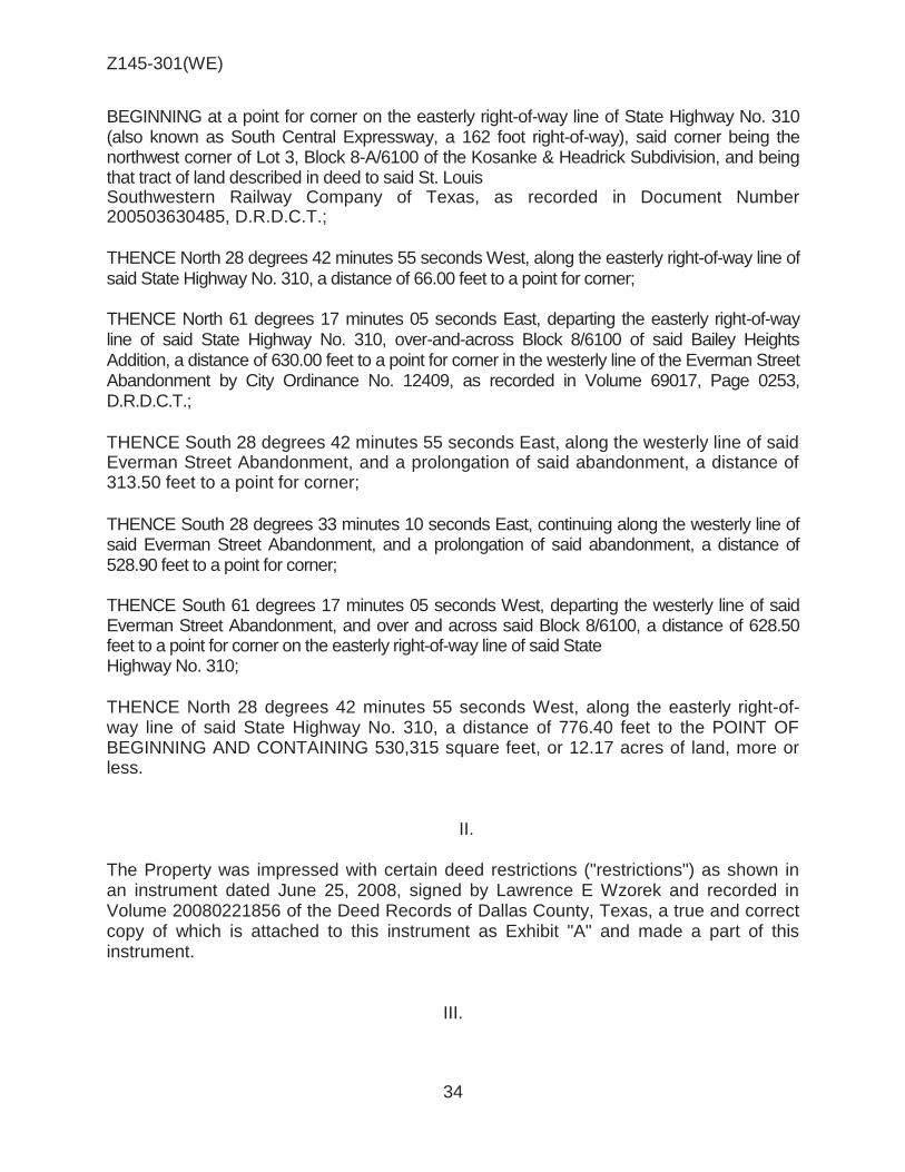
Z145-301(WE)
34
BEGINNING at a point for corner on the easterly right-of-way line of State Highway No. 310 (also known as South Central Expressway, a 162 foot right-of-way), said corner being the northwest corner of Lot 3, Block 8-A/6100 of the Kosanke & Headrick Subdivision, and being that tract of land described in deed to said St. Louis Southwestern Railway Company of Texas, as recorded in Document Number 200503630485, D.R.D.C.T.;
THENCE North 28 degrees 42 minutes 55 seconds West, along the easterly right-of-way line of said State Highway No. 310, a distance of 66.00 feet to a point for corner;
THENCE North 61 degrees 17 minutes 05 seconds East, departing the easterly right-of-way line of said State Highway No. 310, over-and-across Block 8/6100 of said Bailey Heights Addition, a distance of 630.00 feet to a point for corner in the westerly line of the Everman Street Abandonment by City Ordinance No. 12409, as recorded in Volume 69017, Page 0253, D.R.D.C.T.;
THENCE South 28 degrees 42 minutes 55 seconds East, along the westerly line of said Everman Street Abandonment, and a prolongation of said abandonment, a distance of 313.50 feet to a point for corner;
THENCE South 28 degrees 33 minutes 10 seconds East, continuing along the westerly line of said Everman Street Abandonment, and a prolongation of said abandonment, a distance of 528.90 feet to a point for corner;
THENCE South 61 degrees 17 minutes 05 seconds West, departing the westerly line of said Everman Street Abandonment, and over and across said Block 8/6100, a distance of 628.50 feet to a point for corner on the easterly right-of-way line of said State Highway No. 310;
THENCE North 28 degrees 42 minutes 55 seconds West, along the easterly right-of-way line of said State Highway No. 310, a distance of 776.40 feet to the POINT OF BEGINNING AND CONTAINING 530,315 square feet, or 12.17 acres of land, more or less.
II. The Property was impressed with certain deed restrictions ("restrictions") as shown in an instrument dated June 25, 2008, signed by Lawrence E Wzorek and recorded in Volume 20080221856 of the Deed Records of Dallas County, Texas, a true and correct copy of which is attached to this instrument as Exhibit "A" and made a part of this instrument.
III.

Z145-301(WE)
35
The Owner does hereby terminate and release the following restrictions as they apply to the Property, to wit: The following uses are prohibited: Extended stay hotel or motel. Hotel or motel. Industrial (inside) not potentially incompatible. Industrial (inside) potentially incompatible. Lodging or boarding house. Medical/infectious waste incinerator. Metal salvage facility. Mining. Municipal waste incinerator. Organic compost recycling facility. Outside salvage or reclamation. Pathological waste incinerator.
These restrictions shall continue in full force and effect for a period of twenty (20) years from the date of execution, and shall automatically be extended for additional periods of ten (10) years unless amended or terminated in the manner specified in this document.
IV. The above termination was made following a public hearing before the City Plan Commission and a public hearing before and approval by the City Council of the City. Notice of the public hearings was given as would have been required by law for a zoning change on the Property. The Owner must file this instrument in the Deed Records of the county or counties where the Property is located at his or her sole cost and expense before the termination becomes effective.
V. The termination of these restrictions is not intended to restrict the right of the City Council of the City to exercise its legislative duties and powers insofar as zoning of the Property is concerned.
VI. The Owner agrees to defend, indemnify, and hold harmless the City from and against all claims or liabilities arising out of or in connection with this termination.
VII.

Z145-301(WE)
36
® VICINITY MAP
Case no: Z145-301
1 :9,600 Date: 9/23/2016

Z145-301(WE)
37
® AERIAL MAP
Z145-301 Case no: _-=....:......:....::.....:....::....__
9/23/2016 Date: _ ___:._ __ _ 1 :8,400

Z145-301(WE)
38
Industrial
Auto related use
Hotel/ motel
Bar
Commercial / Industrial
Commercial / Industrial
Single family
IM

Z145-301(WE)
39
1

Z145-301(WE)
40
CPC RESPONSES i--====- 1
'e, ~ 1i> '£i 1<-
ILLINOIS AGRO ~ "" ~
Property 0 Re I" . wners Notified ( p ies in Favor (3 106 parcels) Replies in 0 .. parcels) A ppos1t1on (l
rea of Not·f· . parcels)
====~~~r:'.~e: /
1cat1on ate
Z145-30J
CPC 1 :7,200
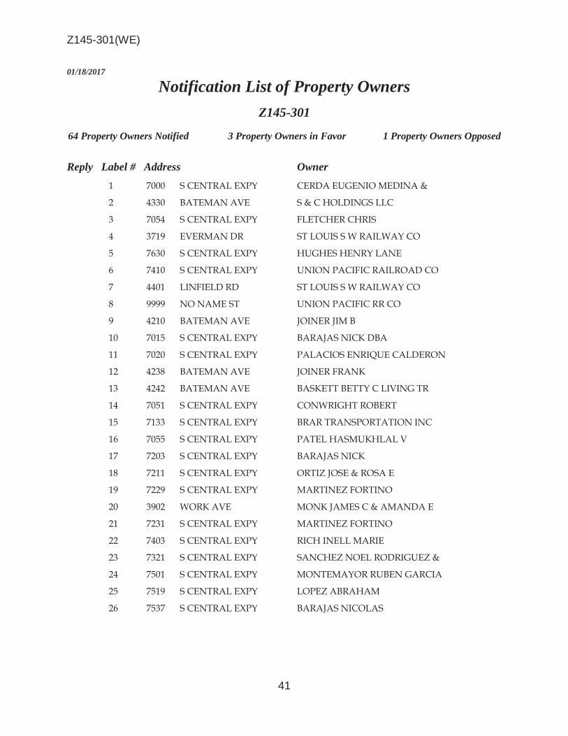
Z145-301(WE)
41
01/18/2017
Notification List of Property Owners Z145-301
64 Property Owners Notified 3 Property Owners in Favor 1 Property Owners Opposed
Reply Label # Address Owner 1 7000 S CENTRAL EXPY CERDA EUGENIO MEDINA &
2 4330 BATEMAN AVE S & C HOLDINGS LLC
3 7054 S CENTRAL EXPY FLETCHER CHRIS
4 3719 EVERMAN DR ST LOUIS S W RAILWAY CO
5 7630 S CENTRAL EXPY HUGHES HENRY LANE
6 7410 S CENTRAL EXPY UNION PACIFIC RAILROAD CO
7 4401 LINFIELD RD ST LOUIS S W RAILWAY CO
8 9999 NO NAME ST UNION PACIFIC RR CO
9 4210 BATEMAN AVE JOINER JIM B
10 7015 S CENTRAL EXPY BARAJAS NICK DBA
11 7020 S CENTRAL EXPY PALACIOS ENRIQUE CALDERON
12 4238 BATEMAN AVE JOINER FRANK
13 4242 BATEMAN AVE BASKETT BETTY C LIVING TR
14 7051 S CENTRAL EXPY CONWRIGHT ROBERT
15 7133 S CENTRAL EXPY BRAR TRANSPORTATION INC
16 7055 S CENTRAL EXPY PATEL HASMUKHLAL V
17 7203 S CENTRAL EXPY BARAJAS NICK
18 7211 S CENTRAL EXPY ORTIZ JOSE & ROSA E
19 7229 S CENTRAL EXPY MARTINEZ FORTINO
20 3902 WORK AVE MONK JAMES C & AMANDA E
21 7231 S CENTRAL EXPY MARTINEZ FORTINO
22 7403 S CENTRAL EXPY RICH INELL MARIE
23 7321 S CENTRAL EXPY SANCHEZ NOEL RODRIGUEZ &
24 7501 S CENTRAL EXPY MONTEMAYOR RUBEN GARCIA
25 7519 S CENTRAL EXPY LOPEZ ABRAHAM
26 7537 S CENTRAL EXPY BARAJAS NICOLAS

Z145-301(WE)
42
01/18/2017
Reply Label # Address Owner 27 7601 S CENTRAL EXPY HURTADO CARLOS & MARIA
28 7623 S CENTRAL EXPY PATIDAR PARIMAL C
29 7022 S CENTRAL EXPY KROLIK KAROL
30 7034 S CENTRAL EXPY LENAMOND THOMAS
31 3627 EVERMAN DR MARTYN PANSY MCCONNELL
32 4331 BATEMAN AVE PATTERSON DOROTHY L
33 4337 BATEMAN AVE HERNANDEZ HERMINIO
34 7038 S CENTRAL EXPY LENAMOND THOMAS D
35 4314 BATEMAN AVE FLETCHER CHRISTOPHER B
36 7046 S CENTRAL EXPY FLECTHER CHRISTOPHER B
37 4343 BATEMAN AVE SAMULKA W B & ANNIE B
38 4332 BATEMAN AVE HERNANDEZ GEORGE &
39 4327 BATEMAN AVE LENAMOND THOMAS
40 7641 S CENTRAL EXPY PATEL MAHESH K & JASU M
41 4100 BASCOM LN SHREE JALARAM REV TR THE
42 7910 S CENTRAL EXPY TAMKO ASPHALT PRODUCTS
43 4542 LINFIELD RD COIT CLAUDETTE BOSH
44 7715 HULL AVE WILMER HUTCHINS ISD ET AL
45 7703 BROWNSVILLE AVE JACKSON MICHAEL J & RONNIE L
X 46 7707 BROWNSVILLE AVE JACKSON MICHAEL J
47 7711 BROWNSVILLE AVE BRANCH ANNIE M EST OF
48 7715 BROWNSVILLE AVE MOSS CLOIS
49 7719 BROWNSVILLE AVE CLINTON JULIA MAE EST OF
50 7721 BROWNSVILLE AVE DALLAS HOUSING ACQUISITION & DEV
CORP
51 7727 BROWNSVILLE AVE LONG CURTIS JAMES
52 7731 BROWNSVILLE AVE MONTERO FLORIBERTO MOLINA
53 7704 CARBONDALE ST MCCLINTON JULIA MAE EST OF
54 4518 LINFIELD RD CLINTON JULIA MAE
O 55 7708 CARBONDALE ST CHRISTOPHER LARRY WAYNE
56 7712 CARBONDALE ST RECA LIMITED PS
O 57 7716 CARBONDALE ST MILLER CLEOPHUS JR &

Z145-301(WE)
43
01/18/2017
Reply Label # Address Owner O 58 7720 CARBONDALE ST MILLER CLEOPHUS JR &
59 7724 CARBONDALE ST HIGH SAM & BAILEY
60 7732 CARBONDALE ST DALLAS NEIGHBORHOOD
61 7736 CARBONDALE ST RHODES EZELL C
62 7740 CARBONDALE ST ALLAHHAM BASEL KHALED
63 7635 S CENTRAL EXPY SHREE JALARAM CORP
64 4202 LINFIELD RD JASUMAN ENTERPRISES INC

AGENDA ITEM # 60Mobility Solutions, Infrastructure, and Sustainability
AGENDA DATE: January 24, 2018
COUNCIL DISTRICT(S): 7
DEPARTMENT: Department of Sustainable Development and Construction
CMO: Majed Al-Ghafry, 670-3302
MAPSCO: 48 Q
SUBJECT
A public hearing to receive comments regarding an application for and an ordinance granting a Specific Use Permit for the sale of alcoholic beverages in conjunction with a general merchandise or food store 3,500 square feet or less on property zoned an LI-D-1 Light Industrial District with a D-1 Liquor Control Overlay, on the northeast corner of Forney Road and South Buckner BoulevardRecommendation of Staff: Approval for a two-year period with eligibility for automatic renewals for additional five-year periods, subject to a site plan and conditionsRecommendation of CPC: Approval for a three-year period with eligibility for automatic renewals for additional five-year periods, subject to a site plan and conditionsZ167-359(WE)Note: This item was considered by the City Council at a public hearing on December 13, 2017, and was deferred until January 24, 2018, with the public hearing open


1
HONORABLE MAYOR & CITY COUNCIL WEDNESDAY, JANUARY 24, 2018 ACM: Majed Al-Ghafry FILE NUMBER: Z167-359(WE) DATE FILED: July 26, 2017 LOCATION: Northeast corner of Forney Road and South Buckner
Boulevard COUNCIL DISTRICT: 7 MAPSCO: 48 Q SIZE OF REQUEST: Approx. 0.564 acres CENSUS TRACT: 112.07 APPLICANT / OWNER: Buckner Food, Inc. REPRESENTATIVE: Jon R. Featherston The Dimension Group REQUEST: An application for a Specific Use Permit for the sale of
alcoholic beverages in conjunction with a general merchandise or food store 3,500 square feet or less on property zoned an LI-D-1 Light Industrial District with a D-1 Liquor Control Overlay.
SUMMARY: The applicant proposes the sale of alcoholic beverages for
off-premise consumption in conjunction with the existing general merchandise or food store [7 Eleven, Inc.].
CPC RECOMMENDATION: Approval for a three-year period with eligibility for
automatic renewals for additional five-year periods, subject to a site plan and conditions.
STAFF RECOMMENDATION: Approval for a two-year period with eligibility for
automatic renewals for additional five-year periods, subject to a site plan and conditions.

Z167-359(WE)
2
BACKGROUND INFORMATION:
The ±0.564-acre request site is developed with a 3,010-square-foot general merchandise or food store (convenience store) and vehicle fueling station (gas pumps).
On December 11, 2013, the City Council approved a Specific Use Permit for the sale of alcoholic beverages in conjunction with a general merchandise or food store 3,500 square feet or less for a two-year period on the request site.
In April 2015, a letter was sent to the applicant advising them to submit an
application to renew SUP No. 2054 for the sale of alcoholic beverages in conjunction with a general merchandise or food store 3,500 square feet or less. An application was not submitted and SUP No. 2054 expired on December 11, 2015.
The proposed request is to sell alcohol for off-premise consumption in conjunction
with the general merchandise use on the property.
The general merchandise use is permitted by right. The sale of alcoholic beverages for off-premise consumption is prohibited in a D Liquor Control Overlay and requires a specific use permit in the D-1 Liquor Control Overlay.
The adjacent land uses consist of a warehouse and church use to the north, warehouse uses to the east and an industrial (inside) use to the south. Properties west of the request site, across South Buckner Boulevard, are undeveloped.
Zoning History: There has been one zoning change requested in the area in the
past 5 years. 1. Z145-284 On November 10, 2015, the City Council approved
a renewal of Specific Use Permit No. 2052 for the sale of alcoholic beverages in conjunction with a general merchandise or food store 3,500 square feet or less on property zoned an LI-D-1 Light Industrial District with a D-1 Liquor Control Overlay.
Thoroughfares/Streets:
Thoroughfare/Street Type Existing ROW
Proposed ROW
Forney Road Collector 80 ft. 80 ft. South Buckner Boulevard
Principal Arterial 100 ft. 100 ft.

Z167-359(WE)
3
Traffic: The Engineering Division of the Sustainable Development and Construction Department has reviewed the request and determined that the proposed development will not have a negative impact on the surrounding street system. COMPREHENSIVE PLAN: The forwardDallas! Comprehensive Plan was adopted by the City Council in June 2006. The forwardDallas! Comprehensive Plan outlines several goals and policies which can serve as a framework for assisting in evaluating the applicant’s request. ECONOMIC ELEMENT GOAL 2.4 CREATE AND MAINTAIN AN ENVIRONMENT FRIENDLY TO
BUSINESSES AND ENTREPRENEURS
Policy 2.4.2 Restore Dallas as the premier city for conducting business within the region.
Land Use:
Zoning Land Use Site LI-D-1 General merchandise or food
store North LI-D-1 Warehouse, Church South LI-D-1 Industrial (Inside) East LI-D-1 Warehouse West LI-D-1 Undeveloped
STAFF ANALYSIS: Land Use Compatibility: The approximately 0.564-acre site is zoned an LI-D-1 Light Industrial District with a D-1 Liquor Control Overlay and is currently developed with a general merchandise or food store and a motor vehicle fueling station. The request for a Specific Use Permit will allow the applicant to sell alcohol for off-premise consumption in conjunction with the general merchandise. The general merchandise use is permitted by right. The sale of alcoholic beverages for off-premise consumption is prohibited in a D Liquor Control Overlay and requires a specific use permit in the D-1 Liquor Control Overlay. The adjacent land uses consist of a warehouse and church use to the north, warehouse uses to the east and an industrial (inside) use to the south. Properties west of the request site, across South Buckner Boulevard, are undeveloped. The proposed request complies with the alcoholic distance requirement of 300 feet from a church, which is measured front door to front door along the right-of-way lines.

Z167-359(WE)
4
The general provisions for a Specific Use Permit in Section 51A-4.219 of the Dallas Development Code specifically state: (1) The SUP provides a means for developing certain uses in a manner in which the specific use will be consistent with the character of the neighborhood; (2) Each SUP application must be evaluated as to its probable effect on the adjacent property and the community welfare and may be approved or denied as the findings indicate appropriate; (3) The city council shall not grant an SUP for a use except upon a finding that the use will: (A) complement or be compatible with the surrounding uses and community facilities; (B) contribute to, enhance, or promote the welfare of the area of request and adjacent properties; (C) not be detrimental to the public health, safety, or general welfare; and (D) conform in all other respects to all applicable zoning regulations and standards. The regulations in this chapter have been established in accordance with a comprehensive plan for the purpose of promoting the health, safety, morals, and general welfare of the city. The general merchandise use is also regulated by Chapter 12B of the Dallas City Code, Convenience Stores. This chapter applies to all convenience stores, which is defined as any business that is primarily engaged in the retail sale of convenience goods, or both convenience goods and gasoline, and has less than 10,000 square feet of retail floor space; the term does not include any business that has no retail floor space accessible to the public. The purpose of Chapter 12B is to protect the health, safety, and welfare of the citizens of the city of Dallas by reducing the occurrence of crime, preventing the escalation of crime, and increasing the successful prosecution of crime that occurs in convenience stores in the city. This chapter establishes a registration program for convenience stores and provides requirements relating to:
surveillance camera systems, video recording and storage
systems, alarm systems, drop safes, security signs, height markers,
store visibility, safety training programs, and trespass affidavits.
A separate certificate of registration to comply with Chapter 12B is required for each physically separate convenience store. A certificate of registration for a convenience store expires one year after the date of issuance and must be renewed annually. The applicant’s request, subject to the attached conditions, is consistent with the intent of the Dallas Development Code.

Z167-359(WE)
5
Development Standards:
DISTRICT SETBACKS Density Height Lot
Coverage Special
Standards PRIMARY Uses
Front Side/Rear
LI Light Industrial
15’
30’ adjacent to residential
OTHER: No Min.
1.0 FAR overall 0.75 office/ retail
0.5 retail
70’ 5 stories 80%
Proximity Slope Visual
Intrusion
Industrial, wholesale distribution & storage, supporting office & retail
Landscaping: Landscaping of any development will be in accordance with Article X, as amended. The request site will not trigger any landscaping because there is no increase in the total floor area. Parking: The Dallas Development Code requires off-street parking to be provided for a general merchandise or food store 3,500 square feet or less is at one space for each 200 square feet of floor area. Based on the 3,010 square feet of floor area, the development requires 17 spaces with 17 being provided per the attached site plan. Dallas Police Department: Below is a police report indicating the offenses of the request site during the past three years. The site will be razed and a new structure will be built under new ownership.
Incident Num
Time1
UCR_Offense Address Zip Code
261881-2014 10:05 OTHER THEFTS 4710 S BUCKNER BLVD 75227 216066-2015 18:00 BURGLARY-BUSINESS 4710 S BUCKNER BLVD 75227 204705-2015 23:00 BURGLARY-BUSINESS 4710 S BUCKNER BLVD 75227 187209-2015 2:18 BURGLARY-BUSINESS 4710 S BUCKNER BLVD 75227 110709-2015 23:57 ROBBERY-INDIVIDUAL 4710 S BUCKNER BLVD 75227 153418-2015 0:30 ASSAULT 4710 S BUCKNER BLVD 75227 134224-2015 20:55 LIQUOR OFFENSE 4710 S BUCKNER BLVD 75227 110709-2015 23:57 ROBBERY-INDIVIDUAL 4710 S BUCKNER BLVD 75227 110709-2015 23:57 ROBBERY-INDIVIDUAL 4710 S BUCKNER BLVD 75227 047101-2017 16:50 ASSAULT 4710 S BUCKNER BLVD 75227 006007-2016 23:00 VANDALISM & CRIM MISCHIEF 4710 S BUCKNER BLVD 75227 169407-2017 1:30 BURGLARY-BUSINESS 4710 S BUCKNER BLVD 75227 140112-2017 23:40 AGG ASSAULT - FV 4710 S BUCKNER BLVD 75227 021304-2017 20:07 AGG ASSAULT - NFV 4710 S BUCKNER BLVD 75227 243296-2016 3:16 BURGLARY-BUSINESS 4710 S BUCKNER BLVD 75227

Z167-359(WE)
6
CPC Action (October 5, 2017)
Motion: In considering an application for a Specific Use Permit for the sale of alcoholic beverages in conjunction with a general merchandise or food store 3,500 square feet or less on property zoned an LI-D-1 Light Industrial District with a D-1 Liquor Control Overlay on the northeast corner of Forney Road and South Buckner Boulevard, it was moved to hold this case under advisement until October 19, 2017.
Maker: Mack Second: Houston Result: Carried: 14 to 0
For: 14 - West, Rieves, Houston, Davis, Shidid,
Carpenter, Mack, Lavallaissa, Jung, Housewright, Schultz, Peadon, Murphy, Tarpley
Against: 0 Absent: 1 - Ridley Vacancy: 0
Notices: Area: 200 Mailed: 7 Replies: For: 1 Against: 1
Speakers: For: Santos Martinez, 900 Jackson St., Dallas, TX, 75202 Against: None
CPC Action (October 19, 2017)
Motion: It was moved to recommend approval of a Specific Use Permit for the sale of alcoholic beverages in conjunction with a general merchandise or food store 3,500 square feet or less for a three-year period with eligibility for automatic renewals for additional five-year periods, subject to a site plan and conditions on property zoned an LI-D-1 Light Industrial District with a D-1 Liquor Control Overlay on the northeast corner of Forney Road and South Buckner Boulevard.
Maker: Mack Second: Jung Result: Carried: 15 to 0
For: 15 - West, Rieves*, Houston, Davis, Shidid*,
Carpenter, Mack, Lavallaissa, Jung, Housewright, Schultz, Peadon, Murphy, Ridley, Tarpley

Z167-359(WE)
7
Against: 0 Absent: 0 Vacancy: 0
*out of the room, shown voting in favor
Notices: Area: 200 Mailed: 7 Replies: For: 1 Against: 1
Speakers: For: Santos Martinez, 900 Jackson St., Dallas, TX, 75202 Against: None

Z167-359(WE)
8
1. USE: The only use authorized by this specific use permit is the sale of alcoholic beverages in conjunction with a general merchandise or food store 3,500 square feet or less.
2. SITE PLAN: Use and development of the Property must comply with the
attached site plan. CPC Recommendation 3. TIME LIMIT: This specific use permit expires on_____, (three-year period from
the passage of this ordinance), but is eligible for automatic renewal for additional five-year periods, pursuant to Section 51A-4.219 of Chapter 51A of the Dallas City Code, as amended. For automatic renewal to occur, the Property owner must file a complete application for automatic renewal with the director before the expiration of the current period. Failure to timely file a complete application will render this specific use permit ineligible for automatic renewal. (Note: The Code currently provides that applications for automatic renewal must be filed after the 180th but before the 120th day before the expiration of the current specific use permit period. The Property owner is responsible for checking the Code for possible revisions to this provision. The deadline for applications for automatic renewal is strictly enforced).
Staff’s Recommendation 3. TIME LIMIT: This specific use permit expires on_____, (two-year period from the
passage of this ordinance), but is eligible for automatic renewal for additional five-year periods, pursuant to Section 51A-4.219 of Chapter 51A of the Dallas City Code, as amended. For automatic renewal to occur, the Property owner must file a complete application for automatic renewal with the director before the expiration of the current period. Failure to timely file a complete application will render this specific use permit ineligible for automatic renewal. (Note: The Code currently provides that applications for automatic renewal must be filed after the 180th but before the 120th day before the expiration of the current specific use permit period. The Property owner is responsible for checking the Code for possible revisions to this provision. The deadline for applications for automatic renewal is strictly enforced).
4. MAINTENANCE: The Property must be properly maintained in a state of good
repair and neat appearance.
CPC PROPOSED SUP CONDITIONS

Z167-359(WE)
9
5. GENERAL REQUIREMENTS: Use of the Property must comply with all federal and state laws and regulations, and with all ordinances, rules, and regulations of the City of Dallas.

Z167-359(WE)
10
PROPOSED SITE PLAN
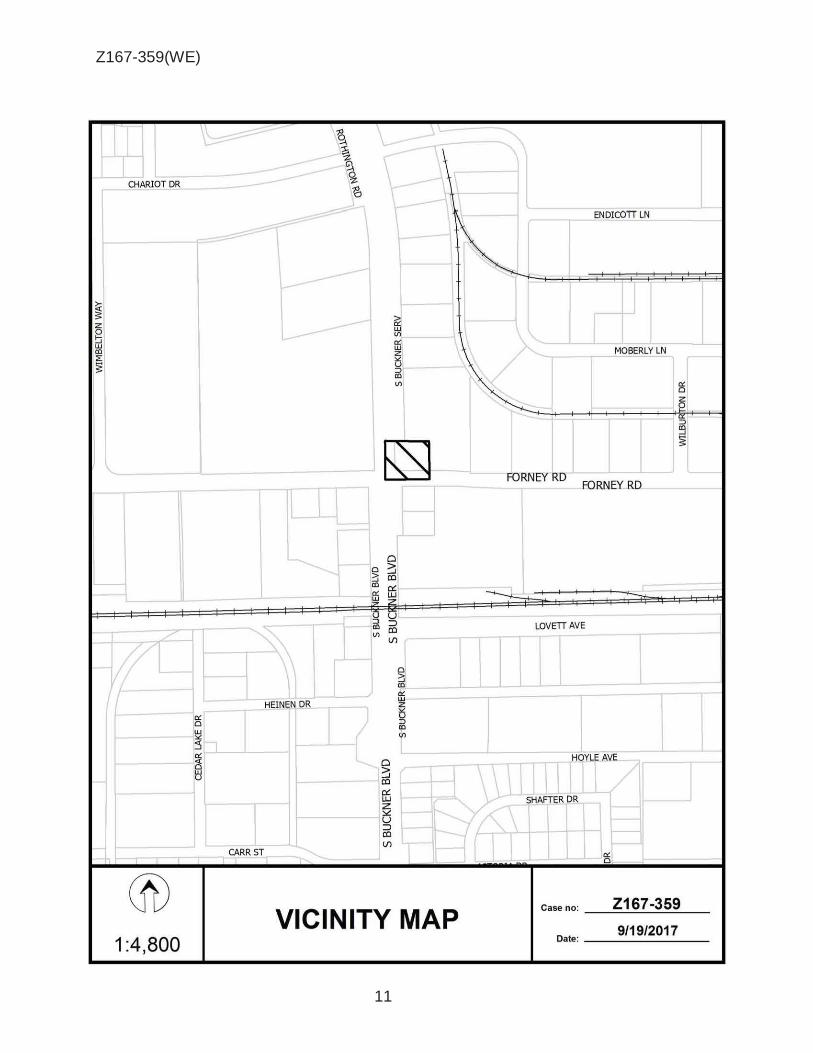
Z167-359(WE)
11
CHARIOT DR
ENDICOTT LN
~ ii: ~ w Vl
MOBERLY LN
z
er: 0
w ~
z w
0 al :E
::;) ~ al Vl er:
Cl z 0
::;)
~ ~
FORNEY RD FORNEY RD
Cl Cl '.:i ::; co al 0:: er: LU w
f
u ::;) ::::> al co Vl (J)
1 Cl ::; al l
LOVETT AVE
er: w
HEINEN DR z 0 ::;)
er: al Cl
Vl UJ :.: 5 er:
Cl C3 '.:i ~ co 0:: LU
1 z ~ u ::::> co (J)
CARR ST er: Cl
® VICINITY MAP
Z167-359 Case no: -~:....:....:::....:__.::....=...:....__
9/19/2017 1 :4,800 Date:-------

Z167-359(WE)
12
® AERIAL MAP
Z167-359 Case no: _.=....:....=:-=-....::....: __
9/19/2017 Date: _ __:__ __ _ 1 :1,200

Z167-359(WE)
13
Undeveloped
C-Store
Warehouses
Industrial (inside)
Warehouses
Church
Warehouses
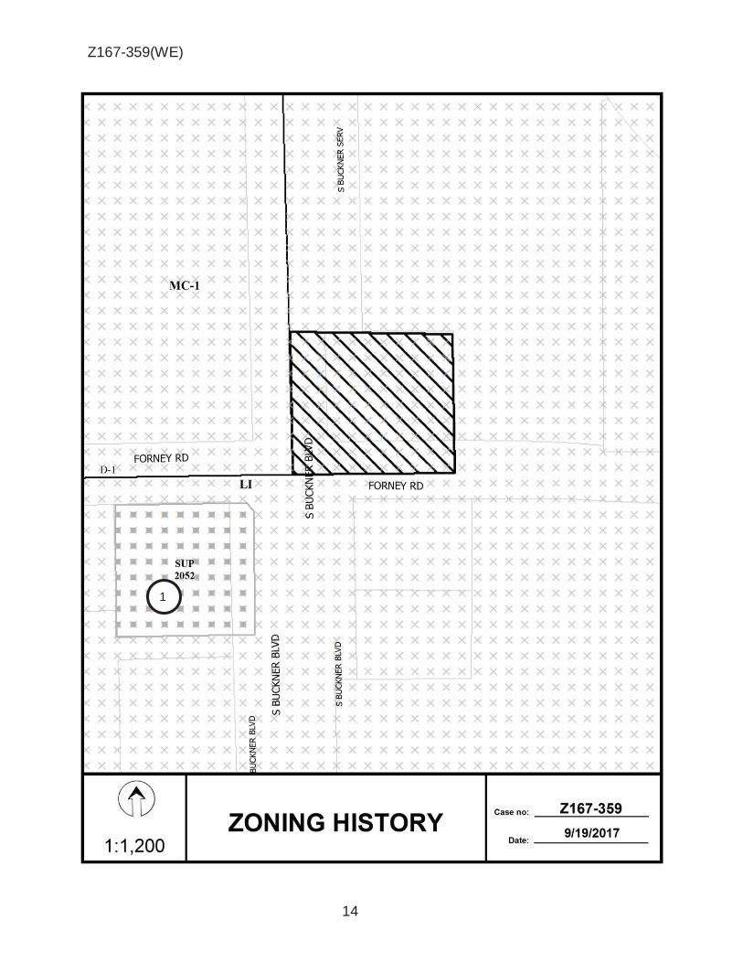
Z167-359(WE)
14
1

Z167-359(WE)
15
CPC RESPONSES

Z167-359(WE)
16
Notification List of Property Owners
Z167-359
7 Property Owners Notified 1 Property Owners in Favor 1 Property Owners Opposed
Reply Label # Address Owner O 1 4710 S BUCKNER BLVD DEVIN BRICH GROUP DORP
2 4700 S BUCKNER BLVD NW REALTY INC
3 4520 S BUCKNER BLVD SOUTH BUCKNER 4520 LP THE
4 8131 FORNEY RD TAGGERT TEXAS LTD
X 5 4740 S BUCKNER RD INTERNATIONAL BIBLE ASSOC
6 4625 S BUCKNER BLVD BUCKNER FOODS INC
7 4612 S BUCKNER BLVD RICHMOND P CURT

AGENDA ITEM # 61STRATEGIC PRIORITY:
Mobility Solutions, Infrastructure, and Sustainability
AGENDA DATE: January 24, 2018
COUNCIL DISTRICT(S): 6
DEPARTMENT: Department of Transportation
CMO: Majed Al-Ghafry, 670-3302
MAPSCO: 43F G H________________________________________________________________
SUBJECT
A public hearing to receive comments to amend the City of Dallas' Thoroughfare Plan to change the dimensional classification of Canada Drive from (1) Westmoreland Road to Holystone Street from a standard four-lane divided (S-4-D) roadway within 80 feet of right-of-way to a special four-lane divided (SPCL 4D) roadway with bicycle facilities and parking on both sides of the roadway within 100 feet of right-of-way and 78-feet of pavement; and (2) Holystone Street to Hampton Road from a standard four-lane divided (S-4-D) roadway within 80-feet of right-of-way to a special four-lane divided (SPCL 4D) roadway with bicycle facilities and parking on the north side of the roadway within 100-feet of right-of-way and 75-feet of pavement; and at the close of the hearing, authorize an ordinance implementing the change - Financing: No cost consideration to the City
BACKGROUND
The Department of Transportation is requesting an amendment to Canada Drive to facilitate the design of a multimodal roadway project funded by capital funds. Staff has worked with the Department of Public Works and the Department of Planning and Urban Design to establish a street design that is consistent with the West Dallas Vision that was approved by City Council and the City Plan Commission in 2011 and meets the needs of adjacent schools. The design improves vehicular operations and incorporates amenities that accommodate pedestrians, cyclists, and public transit users.
The proposed design will add bicycle facilities and on-street parking. Currently, Canada Drive between Westmoreland Road and Holystone Street operates as a four-lane roadway with parking. This operation will be maintained and bicycle facilities will be added. Canada Drive between Holystone Street and Hampton Road operates as a two-lane roadway. This segment will be enhanced to a four-lane roadway with bicycle facilities and parking on the north side of the roadway.

Agenda Date 01/24/2018 - page 2
BACKGROUND (continued)
The proposed design will incorporate Complete Street elements such as Integrated Stormwater Management elements, lighting, trees, and sidewalks.
Staff recommends approval to the City of Dallas Thoroughfare Plan to change the dimensional classification of Canada Drive from Westmoreland Road to Holystone Street from a standard four-lane divided (S-4-D) roadway within 80 feet of right-of-way to a special four-lane divided (SPCL 4D) roadway with bicycle facilities and parking on both sides of the roadway within 100 feet of right-of-way and 78 feet of pavement; and Holystone Street to Hampton Road from a standard four-lane divided (S-4-D) roadway within 80 feet of right-of-way to a special four-lane divided (SPCL 4D) roadway with bicycle facilities and parking on the north side of the roadway within 100 feet of right-of-way and 75 feet of pavement.
PRIOR ACTION/REVIEW (COUNCIL, BOARDS, COMMISSIONS)
On November 16, 2017, the City Plan Commission Thoroughfare Committee acted on this item and followed staff recommendation.
On December 14, 2017, the City Plan Commission acted on this item and followed staff recommendation.
Information about this item will be provided to the Mobility Solutions, Infrastructure & Sustainability Committee on January 22, 2018.
FISCAL INFORMATION
No cost consideration to the City.
MAP
Attached
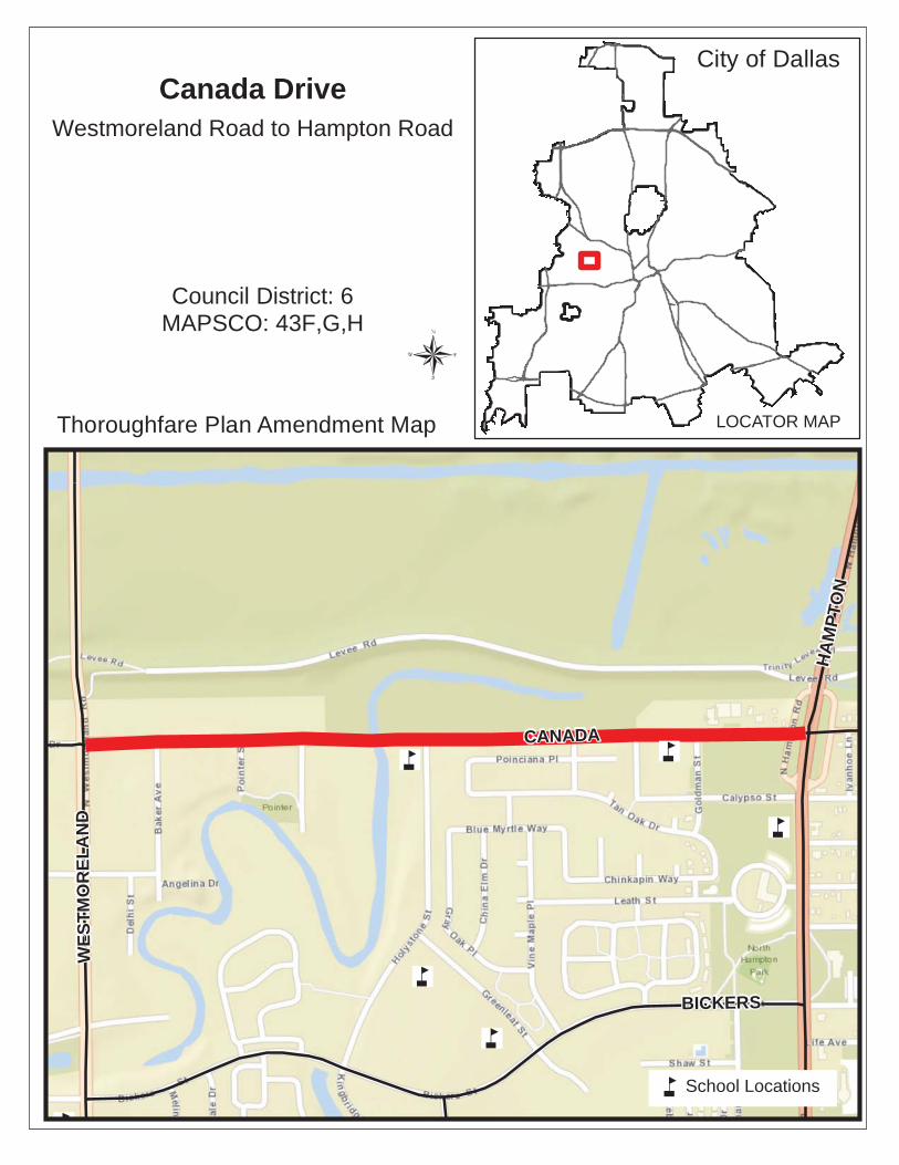
CANADA
BICKERS
HA
MP
TO
N
WE
ST
MO
RE
LA
ND
Thoroughfare Plan Amendment Map
City of Dallas
LOCATOR MAP
Council District: 6 MAPSCO: 43F,G,H
Canada DriveWestmoreland Road to Hampton Road
School Locations


AGENDA ITEM # 62STRATEGIC PRIORITY:
Quality of Life
AGENDA DATE: January 24, 2018
COUNCIL DISTRICT(S): 6
DEPARTMENT: Office Of Environmental Quality
CMO: Majed Al-Ghafry, 670-3302
MAPSCO: 33 T________________________________________________________________
SUBJECT
A public hearing to receive comments on a proposed municipal setting designation to prohibit the use of groundwater as potable water beneath property owned by Foundation Building Materials, LLC, located near the intersection of John Carpenter Freeway and Dividend Drive and adjacent street rights-of-way; and an ordinance authorizing support of the issuance of a municipal setting designation to Foundation Building Materials, LLC, by the Texas Commission on Environmental Quality and prohibiting the use of groundwater beneath the designated property as potable water - Financing: No cost consideration to the City
Recommendation of Staff: Approval
BACKGROUND
Based on information provided by the Applicant, the designated property is underlain by a perched shallow aquifer that is encountered at approximately 12 - 15 feet below ground surface (bgs) and extends to approximately 55 feet bgs at the top of the underlying Eagle Ford Group. The Eagle Ford Group is considered a regional aquitard that is composed primarily of shale, sandstone, and limestone and has an estimated thickness of approximately 200 to 300 feet in the area. The anticipated direction of groundwater flow beneath the designated property is to the south-southeast. A portion of this shallow groundwater has been affected by trichloroethene (TCE), arsenic, chromium, and lead at concentrations above groundwater ingestion standards. Potential onsite sources identified at the designated property include a former oil water separator, a former grit trap, three 10,000-gallon underground storage tanks (USTs) that have been out of use since 2005, and one former 500-gallon used oil UST that was removed from the ground in 1998. The anticipated source for arsenic, chromium, and lead is from naturally occurring metals in the suspended sediment in the groundwater sample collected from a temporary monitor well. The anticipated source for TCE is from offsite facilities to the northwest of the designated property where TCE has been identified.

Agenda Date 01/24/2018 - page 2
BACKGROUND (continued)
A portion of the designated property was entered into the Voluntary Cleanup Program (VCP) administered by the Texas Commission on Environmental Quality (TCEQ) in January 2017 and is designated as VCP Facility ID No. 2860.
The applicant has requested that the City support its application for a Municipal Setting Designation (MSD). A public meeting will be held on January 16, 2018 to receive comments and concerns. Notices of the meeting were sent to 206 property owners within 2,500 feet of the property and 111 private well owners within 5 miles of the property. There are no other municipalities within one-half mile of the property.
This item is a municipal setting designation ordinance prohibiting the use of potable groundwater beneath property located near the intersection of John Carpenter Freeway and Dividend Drive including adjacent street rights-of-way; and supporting the issuance of a MSD by TCEQ.
The applicant’s current plan is to obtain closure through the VCP supported by a MSD. Currently, the designated property is used for office space and warehouse storage by Foundation Building Materials, LLC. The anticipated future use of the designated property will remain commercial and light industrial.
PRIOR ACTION/REVIEW (COUNCIL, BOARDS, COMMISSIONS)
This item has no prior action.
FISCAL INFORMATION
No cost consideration to the City.
OWNER
Foundation Building Materials, LLC
FBM Intermediate Holdings LLC, Governing PersonRuben D. Mendoza, President
MAP
Attached

CITY OF DAALLAS
MSDDesign
Prope
Dated
erty
MDe
Applican
Municipal Sesignated Pr
MSD Lnt – Foundat8231 John C
Dalla
Setting Desiroperty BounLog OEQ007tion BuildingCarpenter F
as, TX 75247
gnationndary Map 70g Materials, Lreeway7
LLC


MSD OEQ 0070 Foundation Building Materials, LLC (8321 John Carpenter Freeway) - Page 1
12-19-17
ORDINANCE NO. __________
A municipal setting designation ordinance prohibiting the use of designated groundwater from
beneath property generally located at 8231 John Carpenter Freeway and supporting issuance of a
municipal setting designation certificate by the Texas Commission on Environmental Quality;
providing a penalty not to exceed $2,000; providing a saving clause; providing a severability
clause; and providing an effective date.
WHEREAS, Subchapter W, “Municipal Setting Designations,” of Chapter 361, “Solid
Waste Disposal Act,” of the Texas Health and Safety Code authorizes the Texas Commission on
Environmental Quality to create municipal setting designations; and
WHEREAS, Section 51A-6.108, “Municipal Setting Designation Ordinance,” of Article
VI, “Environmental Performance Standards,” of Chapter 51A, “Dallas Development Code:
Ordinance No. 19455, as amended,” of the Dallas City Code authorizes municipal setting
designation ordinances prohibiting the use of designated groundwater as potable water and
thereby enable the Texas Commission on Environmental Quality to certify a municipal setting
designation for designated property; and
WHEREAS, the city council finds that:
(1) the eligibility criteria of Section 361.803 of the Texas Health and Safety Code have
been met;
(2) this municipal setting designation ordinance will not have an adverse effect on the
current or future water resource needs or obligations of the city of Dallas;
(3) there is a public drinking water supply system that satisfies the requirements of
Chapter 341 of the Texas Health and Safety Code and that supplies or is capable of supplying
drinking water to the designated property and property within one-half mile of the designated
property; and
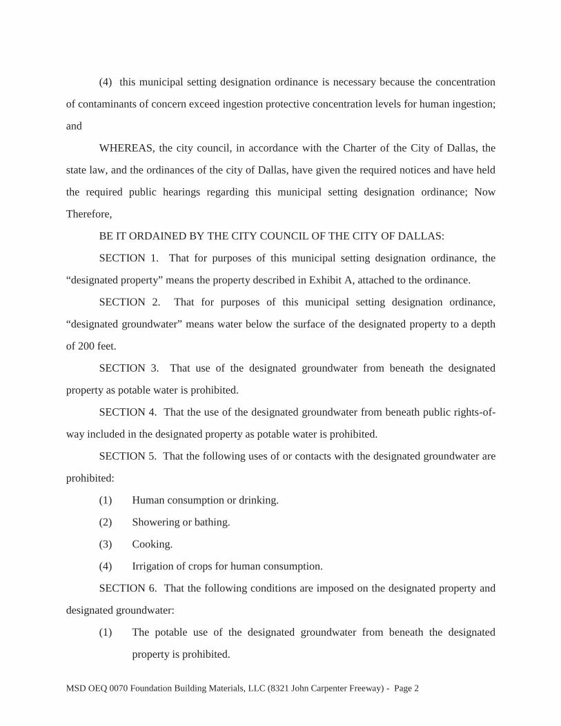
MSD OEQ 0070 Foundation Building Materials, LLC (8321 John Carpenter Freeway) - Page 2
(4) this municipal setting designation ordinance is necessary because the concentration
of contaminants of concern exceed ingestion protective concentration levels for human ingestion;
and
WHEREAS, the city council, in accordance with the Charter of the City of Dallas, the
state law, and the ordinances of the city of Dallas, have given the required notices and have held
the required public hearings regarding this municipal setting designation ordinance; Now
Therefore,
BE IT ORDAINED BY THE CITY COUNCIL OF THE CITY OF DALLAS:
SECTION 1. That for purposes of this municipal setting designation ordinance, the
“designated property” means the property described in Exhibit A, attached to the ordinance.
SECTION 2. That for purposes of this municipal setting designation ordinance,
“designated groundwater” means water below the surface of the designated property to a depth
of 200 feet.
SECTION 3. That use of the designated groundwater from beneath the designated
property as potable water is prohibited.
SECTION 4. That the use of the designated groundwater from beneath public rights-of-
way included in the designated property as potable water is prohibited.
SECTION 5. That the following uses of or contacts with the designated groundwater are
prohibited:
(1) Human consumption or drinking.
(2) Showering or bathing.
(3) Cooking.
(4) Irrigation of crops for human consumption.
SECTION 6. That the following conditions are imposed on the designated property and
designated groundwater:
(1) The potable use of the designated groundwater from beneath the designated
property is prohibited.

MSD OEQ 0070 Foundation Building Materials, LLC (8321 John Carpenter Freeway) - Page 3
(2) The potable use of the designated groundwater from beneath public rights-of-way
included in the designated property is prohibited.
(3) The portion of the designated property assigned VCP No. 2860 must receive a
certificate of completion from the Texas Commission on Environmental Quality
by no later than January 24, 2020.
SECTION 7. That the city council supports the application to the Texas Commission on
Environmental Quality for a municipal setting designation on the designated property, with the
following comments:
(1) The Texas Commission on Environmental Quality, as the state agency chartered
to protect human health and the environment, is requested to thoroughly review
the conditions of the designated property and issue a certificate of completion
only when all contaminants of concern, through the applicable routes of exposure,
have been addressed.
SECTION 8. That the public rights-of-way immediately adjacent to the designated
property must be included, at no additional cost to the city of Dallas, in the application to the
Texas Commission on Environmental Quality.
SECTION 9. That a state or federal program must address the entire non-ingestion
protective concentration level exceedence zone originating from sources on the designated
property or migrating from the designated property no later than January 24, 2020. That within
this time period, the applicant shall provide the managing director of the office of environmental
quality documentation, including a certificate of completion from the Texas Commission on
Environmental Quality, that it has been addressed to the satisfaction of the agency administering
the program. If it has not been addressed, the managing director of the office of environmental
quality may, for good cause, take any of the following actions:
(1) allow additional time to address the non-ingestion protective concentration level
exceedence zone;

MSD OEQ 0070 Foundation Building Materials, LLC (8321 John Carpenter Freeway) - Page 4
(2) request a review by the Texas Commission on Environmental Quality or the
agency administering the program;
(3) recommend to the city council that this municipal setting designation ordinance
be repealed;
(4) request additional information or documentation from the applicant; or
(5) pursue other actions that the managing director of the office of environmental
quality believes may be warranted.
SECTION 10. That any person owning, operating, or controlling the designated property
remains responsible for complying with all applicable federal and state laws and regulations; all
ordinances, rules, and regulations of the city of Dallas; and all environmental regulations, and
that this municipal setting designation ordinance in itself does not change any environmental
assessment or cleanup requirements applicable to the designated property.
SECTION 11. That any person owning, operating, or controlling any portion of the
designated property is responsible for ensuring compliance with this ordinance with respect to
their portion of the designated property. Allowing use of designated ground water for potable
purposes or failure to provide the managing director of the office of environmental quality with
required documentation is a violation of this ordinance and may result in the ordinance being
repealed for that portion of the designated property.
SECTION 12. That approval of this municipal setting designation ordinance shall not be
construed to subject the city of Dallas to any responsibility or liability for any injury to persons
or damages to property caused by any contaminant of concern.
SECTION 13. That within 30 days after adoption of this municipal setting designation
ordinance, the applicant shall provide the managing director of the office of environmental
quality with an electronic file showing the location of the designated property and the designated
groundwater in a format compatible with the city of Dallas’ geographic information system.
MSD OEQ 0070 Foundation Building Materials, LLC (8321 John Carpenter Freeway) - Page 5
SECTION 14. That within 60 days after adoption of this municipal setting designation
ordinance, the managing director of the office of environmental quality shall file a certified copy
of this municipal setting designation ordinance in the deed records of the county where the
designated property is located.
SECTION 15. That within 60 days after adoption of this municipal setting designation
ordinance, the managing director of the office of environmental quality shall send a certified
copy of this municipal setting designation ordinance to the applicant and the Texas Commission
on Environmental Quality, and that the managing director of the office of environmental quality
shall notify the Texas Commission on Environmental Quality 60 days prior to any amendment or
repeal of this municipal setting designation ordinance.
SECTION 16. That the applicant shall provide the managing director of the office of
environmental quality with a copy of the municipal setting designation certificate issued by the
Texas Commission on Environmental Quality pursuant to Section 361.807 of the Texas Health
and Safety Code within 30 days after issuance of the certificate.
SECTION 17. That the applicant shall provide the managing director of the office of
environmental quality with a copy of the certificate of completion or other documentation issued
by the Texas Commission on Environmental Quality showing that any site investigations and
response actions required pursuant to Section 361.808 of the Texas Health and Safety Code have
been completed to the satisfaction of the Texas Commission on Environmental Quality within
the time period required. The managing director of the office of environmental quality may, for
good cause, extend the time for submitting the documentation.
SECTION 18. That the applicant shall notify the managing director of the office of
environmental quality in writing if the applicant determines that notice is required to be sent to
an owner of other property beyond the boundaries of the designated property under Title 30
Texas Administrative Code, Chapter 30, Section 350.55(b), and provide the name of the property
owner, the property address, and a copy of the notice sent to the property owner.
MSD OEQ 0070 Foundation Building Materials, LLC (8321 John Carpenter Freeway) - Page 6
SECTION 19. That a person violating a provision of this municipal setting designation
ordinance, upon conviction, is punishable by a fine not to exceed $2,000, and that the Texas
Commission on Environmental Quality shall be notified of any violations.
SECTION 20. That Chapter 51A of the Dallas City Code shall remain in full force and
effect, save and except as amended by this municipal setting designation ordinance.
SECTION 21. That the terms and provisions of this municipal setting designation
ordinance are severable and are governed by Section 1-4 of Chapter 1 of the Dallas City Code, as
amended.
SECTION 22. That this municipal setting designation ordinance shall take effect
immediately from and after its passage and publication in accordance with the provisions of the
Charter of the City of Dallas, and it is accordingly so ordained.
APPROVED AS TO FORM: LARRY E. CASTO, City Attorney By__________________________________ Assistant City Attorney Passed ______________________________

"Exhibit A"
MSD SURVEY 8231 JOHN W CARPENTER FRE£WA Y
PART OF CITY BLOCK 44/7940, BROOK HOLLOW INDUSTRIAL DISTRICT, NUMBER FOUR JAMES MCLAUGHLIN SURVEY, ABSTRACT NO. 845
CITY OF DALLAS, DALLAS, COUNTY, TEXAS
PROPERTY DESCRIPTION
BEING a 2.821 acre (122,878 square foot) tract of land situated in the JAMES MCLAUGHLIN SURVEY, ABSTRACT NO. 845 and being part of City Block No. 44/7940 of Brook Hollow Industrial District, Number Four, on addition to the City of Doi/as according to the plot recorded in Volume 31, Page 113 Map Records, Doi/as County, Texas and being all of that certain tract conveyed to FBM BAV LLC by deed recorded in Instrument No. 201600321149 Officio/ Public Records, Doi/as County, Texas and being more particularly described as follows:
BEGINNING ot a 5/8 inch iron rod with yellow plastic cop stomped "NW WARD" found for comer in the southwesterly line of JOHN W CARPENTER FREEWAY (a JOJ foot public right-of-way), said rod being the east corner of said FBM BAV tract and the north comer of Lot 1, Block 44/7940 of Carpenter Subdivision, on addition to the City of Dallas according to the plat recorded in Volume 88100, Page 2742 Plat Records, Dallas County, Texas, said rod a/so being North 51"51'00" West a distance of 4.30.00 feet from a 1/2 inch iron rod with yellow plastic cap stomped "SANOS" found for corner at the intersection of said southwesterly line of JOHN W CARPENTER FREEWAY and the northwesterly line of METROMEDIA PLACE (o 60 foot public right-of-way);
THENCE South J8"09'00" West. along the common line between said FBM BAV tract and said Lot 1 for a distance of 396.60 feet to a 1/2 inch iron rod with orange plastic cop stamped "P&C 100871" set for corner, said rod being the southernmost south corner of said FBM BAV tract;
THENCE North 69"5J'OJ" West, continuing along said common line for a distance of 45.22 feet to a 1 /2 inch iron rod with orange plastic cop stomped "P&C 100871" set for corner, said rod being in the northeasterly line of D.A.R. T. (a 40 foot right-of-way), said rod being the northernmost south corner of said FBM BA V tract;
THENCE North 51"51 '00" West, along the common line between said FBM BAV tract and said northeasterly line of D.A.R. T. for a distance of 257.00 feet to a 1/2 inch iron rod with orange plastic cop stamped "P&C 100871" set for corner, said rod being the west corner of said FBM BA V tract;
THENCE North J8"09'00" East, departing said northeasterly line of D.A.R. T. for a distance of 410.60 feet to a 5/8 inch iron rod with yellow plastic cap stamped "NW WARD" found for corner in the aforementioned southwesterly line of JOHN W CARPENTER FREEWAY, said rad being the north corner of said FBM BA V tract;
THENCE South 51"51'00" East, along the common line between said southwesterly line of JOHN W CARPENTER FREEWAY and said FBM BA V tract for a distance of JOO. 00 feet to the POINT OF BEGINNING and containing 2.821 acres, or 122,878 square feet of land, more or less.
Basis of Bearings is the southwesterly line (South 51"51'00" East) of John W Carpenter Freeway, as shown on plat of Brook Hollow Industrial District, Number Four, an addition to the City of Dallas, Dallas County, Texas recorded in Volume 31, Page J1J M.R.D.C. T.
May 19, 2017 Project No. 17031 Sheet 1 of J
A 801 East Campbell Road - Suite 5 75 /A'- Richardson, Texas 75081
PIBURN& Ph: 214 • .328 . .3500 Fa><: 214 . .328 . .3512
CARSON emoilt!!piburncorson.com

MSD SURVEY 8231 JOHN W CARPENTER FREEWAY
PART OF CITY BLOCK 44/7940, BROOK HOLLOW INDUSTRIAL DISTRICT, NUMBER FOUR JAMES MCLAUGHLIN SURVEY, ABSTRACT NO. 845
CITY OF DALLAS, DALLAS, COUNTY, TEXAS
UNIE TABLIE LINE BEARING DIST L1 s 38"09'00" w 396.60' L2 N 69"53'03" w 45.22' L3 N 51 . 51 '00" w 257.00' L4 N 38"09'00" E 410 . 60' L5 s 51"51'00" E 300.00'
NOTES: cirf = 5/8" iron rod with yellow plastic cap stamped "NW WARD" found for corner cirs = l /2" iron rod with orange plastic cap stamped "P&C 100871" set for corner irf = iron rod found for corner
Basis of Bearings is the southwesterly line (South 5 1 "51 '00" East) of 1hn W Carpenter Freeway, as shown on plat of Brook Hollow dustrial District, Number Four, an addition to th e City of Dallas,
Dallas County, Texas recorded in Volume 31, Page 113 M.R.D.C.T.
May 19, 2017 Project Na. 17031 Sheet 2 of J
A 801 East Campbell Rood - Suite 575 ,A, Richardson, Texas 75081 PIBURN& Ph: 214 . .328 . .3500 Fax: 214 . .328 . .3512
CARSON [email protected]

MSD SURVEY 82.31 JOHN W CARPENTER FREEWAY
PART OF CITY BLOCK 44/7940, BROOK HOLLOW INDUSTRIAL DISTRICT, NUMBER FOUR
May 19, 2017 Project No. 17031
JAMES MCLAUGHLIN SURVEY, ABSTRACT NO. 845 CITY OF DALLAS, DALLAS, COUNTY, TEXAS
Sheet J of J
0 1--d
100 1--d
200 300 feet
SCALE: 1" = 200'
A 801 East Campbell Road - Suite 5 75 /A"'- Richardson, Texas 75081
PIBURN& Ph: 214 . .328 . .3500 Fax: 214 . .328 . .3512
CARSON [email protected]

MSD SURVEY 8231 JOHN W CARPENTER FRffWA Y
PART OF CITY BLOCK 44/7940, BROOK HOLLOW INDUSTRIAL DISTRICT, NUMBER FOUR JAMES MCLAUGHLIN SURVEY, ABSTRACT NO. 845
May 19, 2017 Project No. 17031
\J 0:::
.c (/)
0 u
3:: 0
0:::
<l)
..... c 0 0 L <ll ~
CITY OF DALLAS, DALLAS, COUNTY, TEXAS
\J -~ .D Ol c ..... ~
..... (/) 0
..... U) (/)
0 ...., ~ 2 L (/) L ())
0 0 > ?i 0 :::i .c
a.. (/) 0
VICINITY MAP NOT TO SCALE
A 801 East Campbell Road - Suite 575 /A"- Richardson, Texas 75081
PIBURN& Ph: 214 . .328.3500 Fox: 214.328.3512
CARSON [email protected]