Packet_15.pdf - City of Burlington, VT
71
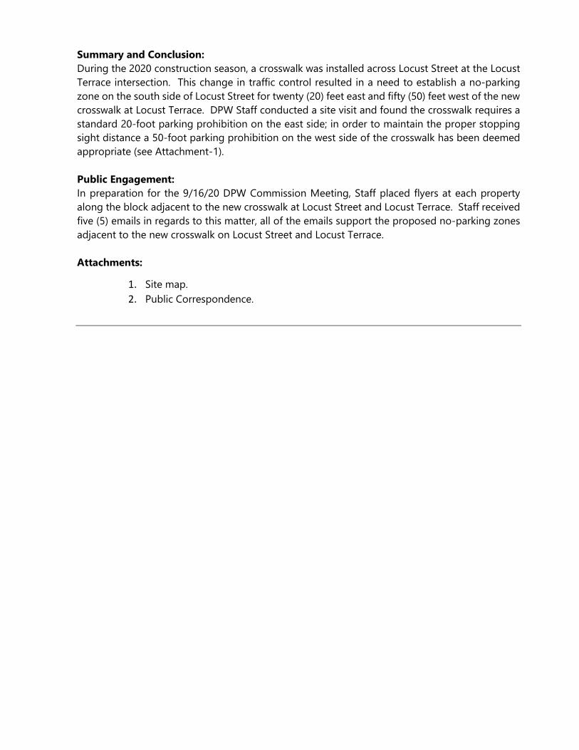
CITY OF BURLINGTON DEPARTMENT OF PUBLIC WORKS 645 Pine Street, Suite A Post Office Box 849 Burlington, VT 05402-0849 802.863.9094 VOICE 802.863.0466 FAX 802.863.0450 TTY www.burlingtonvt.gov/dpw Chapin Spencer DIRECTOR OF PUBLIC WORKS M E M O R A N D U M To: Tenzin Chokden, Clerks Office From: Chapin Spencer, Director Date: September 10, 2020 Re: Public Works Commission Agenda Please find information below regarding the next Commission Meeting. Date: September 16, 2020 Time: 6:30 – 9:00 p.m. Due to current social distancing measures, this meeting will be held entirely virtually. To view the meeting: 1. CCTV YouTube Channel (streamed live) or on Burlington Telecom Channel 317 (not aired live). https://www.youtube.com/channel/UCJkWMLSqRNKLoyUZQiNoAcQ 2. Join via Zoom: https://us02web.zoom.us/j/83495330508 3. Call in for audio only: Phone number: 301-715-8592 Webinar ID: 834 9533 0508 To participate in public comment: 1. You must either join the meeting via the Zoom link above (strongly encouraged) or by calling via the call-in information above. 2. If signed in via Zoom, please use the “Raise Your Hand” feature. This will alert DPW staff that you wish to speak and will automatically add you to the queue. When it’s your turn to speak, your name will be called and you will be unmuted. 3. If you are calling in, please press *9 which will alert DPW staff that you wish to speak. When it’s your turn to speak, your phone # will be called out and you will be unmuted. 4. If you encounter any difficulties when attempting to speak during public forum, please email [email protected]. A G E N DA ITEM 1 Call to Order – Welcome – Chair Comments
-
Upload
khangminh22 -
Category
Documents
-
view
2 -
download
0
Transcript of Packet_15.pdf - City of Burlington, VT
CITY OF BURLINGTON
DEPARTMENT OF PUBLIC WORKS
645 Pine Street, Suite A
Post Office Box 849
Burlington, VT 05402-0849
802.863.9094 VOICE
802.863.0466 FAX
802.863.0450 TTY
www.burlingtonvt.gov/dpw
Chapin Spencer DIRECTOR OF PUBLIC WORKS
M E M O R A N D U M
To: Tenzin Chokden, Clerks Office
From: Chapin Spencer, Director
Date: September 10, 2020
Re: Public Works Commission Agenda
Please find information below regarding the next Commission Meeting.
Date: September 16, 2020
Time: 6:30 – 9:00 p.m.
Due to current social distancing measures, this meeting will be held entirely virtually. To view the meeting: 1. CCTV YouTube Channel (streamed live) or on Burlington Telecom Channel 317 (not aired live). https://www.youtube.com/channel/UCJkWMLSqRNKLoyUZQiNoAcQ 2. Join via Zoom: https://us02web.zoom.us/j/83495330508 3. Call in for audio only: Phone number: 301-715-8592 Webinar ID: 834 9533 0508 To participate in public comment: 1. You must either join the meeting via the Zoom link above (strongly encouraged) or by calling via the call-in information above. 2. If signed in via Zoom, please use the “Raise Your Hand” feature. This will alert DPW staff that you wish to speak and will automatically add you to the queue. When it’s your turn to speak, your name will be called and you will be unmuted. 3. If you are calling in, please press *9 which will alert DPW staff that you wish to speak. When it’s your turn to speak, your phone # will be called out and you will be unmuted. 4. If you encounter any difficulties when attempting to speak during public forum, please email [email protected].
A G E N DA
ITEM
1 Call to Order – Welcome – Chair Comments

2 5 Min Agenda
3 10 Min Public Forum (3 minute per person time limit)
4 5 Min Consent Agenda A No Parking Zone at the Locust Terrace Crosswalk B ADA Space Adjacent to 65 Main St C Appendix C Ordinance Updates for 194 St. Paul St. Parking D Franklin Square Ordinance Revisions
5 15 Min Winooski Ave Traffic Regulatory Changes
A Presentation, N. Losch
B Commissioner Discussion
C Public Comment
D Action Requested –Vote
6 30 Min North Ave & Cambrian Way Discussion
A Oral Communication, N. Baldwin
B Commissioner Discussion
C Public Comment
D Action Requested –None
7 20 Min Appeal – 31 N Prospect St – Failed Electrical Inspection
A Communication, W. Ward, T. Hennessey
B Communication, K. Ram
C Commissioner Discussion
D Public Comment
E Action Requested –Vote
8 20 Min Traffic Calming Program Revisions A Communication, N. Losch
B Commissioner Discussion
C Public Comment
D Action Requested –None
9 5 Min Approval of Draft Minutes of 7-15-2020
10 10 Min Director’s Report
11 10 Min Commissioner Communications
12 Adjournment & Next Meeting Date – October 21, 2020
Non-Discrimination
The City of Burlington will not tolerate unlawful harassment or discrimination on the basis of political or religious
affiliation, race, color, national origin, place of birth, ancestry, age, sex, sexual orientation, gender identity, marital
status, veteran status, disability, HIV positive status, crime victim status or genetic information. The City is also
committed to providing proper access to services, facilities, and employment opportunities. For accessibility
information or alternative formats, please contact Human Resources Department at (802) 540-2505.
City of Burlington Department of Public Works
Technical Services Engineering Division
645 Pine Street, Suite A Burlington, VT 05402
P 802-863-9094 / F 802-863-0466 / TTY 802-863-0450
www.burlingtonvt.gov/DPW
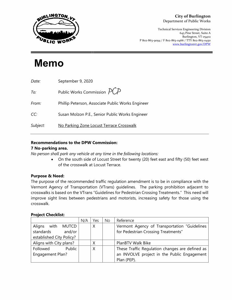
Date: September 9, 2020
To: Public Works Commission
From: Phillip Peterson, Associate Public Works Engineer
CC: Susan Molzon P.E., Senior Public Works Engineer
Subject: No Parking Zone Locust Terrace Crosswalk
Recommendations to the DPW Commission:
7 No-parking area.
No person shall park any vehicle at any time in the following locations:
On the south side of Locust Street for twenty (20) feet east and fifty (50) feet west
of the crosswalk at Locust Terrace.
Purpose & Need:
The purpose of the recommended traffic regulation amendment is to be in compliance with the
Vermont Agency of Transportation (VTrans) guidelines. The parking prohibition adjacent to
crosswalks is based on the VTrans “Guidelines for Pedestrian Crossing Treatments.” This need will
improve sight lines between pedestrians and motorists, increasing safety for those using the
crosswalk.
Project Checklist:
N/A Yes No Reference
Aligns with MUTCD
standards and/or
established City Policy?
X Vermont Agency of Transportation “Guidelines
for Pedestrian Crossing Treatments”
Aligns with City plans? X PlanBTV Walk Bike
Followed Public
Engagement Plan?
X These Traffic Regulation changes are defined as
an INVOLVE project in the Public Engagement
Plan (PEP).
Memo
PCP
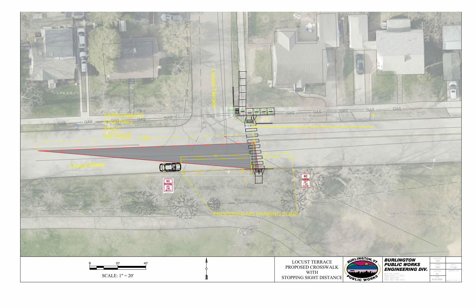
Summary and Conclusion:
During the 2020 construction season, a crosswalk was installed across Locust Street at the Locust
Terrace intersection. This change in traffic control resulted in a need to establish a no-parking
zone on the south side of Locust Street for twenty (20) feet east and fifty (50) feet west of the new
crosswalk at Locust Terrace. DPW Staff conducted a site visit and found the crosswalk requires a
standard 20-foot parking prohibition on the east side; in order to maintain the proper stopping
sight distance a 50-foot parking prohibition on the west side of the crosswalk has been deemed
appropriate (see Attachment-1).
Public Engagement:
In preparation for the 9/16/20 DPW Commission Meeting, Staff placed flyers at each property
along the block adjacent to the new crosswalk at Locust Street and Locust Terrace. Staff received
five (5) emails in regards to this matter, all of the emails support the proposed no-parking zones
adjacent to the new crosswalk on Locust Street and Locust Terrace.
Attachments:
1. Site map.
2. Public Correspondence.
GAS
GAS
GAS
GAS
GAS
GAS
GAS
GAS
GAS
GAS
GAS
GAS
GA
S
GA
S
GA
S
G
AS
50'
20'
75'
~80'3'
31'
47.5458
2%
2%
8.3% 8.3%5%
6.5%9%9%
8.3%
4%
155'
APPROXIMATE
STOPPING
SIGHT
DISTANCE
PROPOSED NO PARKING ZONE
Locust Stre
et
Locust T
errace
00 20' 40' PUBLIC WORKSBURLINGTON
ENGINEERING DIV.
LOCUST TERRACEPROPOSED CROSSWALK
WITHSTOPPING SIGHT DISTANCESCALE: 1" = 20'
AutoCAD SHX Text
CHECKED
AutoCAD SHX Text
DATE
AutoCAD SHX Text
OF
AutoCAD SHX Text
SHEET
AutoCAD SHX Text
DESIGNED
AutoCAD SHX Text
DRAWN
AutoCAD SHX Text
DRAWING NO.
AutoCAD SHX Text
BURLINGTON, VT 05401
AutoCAD SHX Text
(802) 863-0466 (Fax)
AutoCAD SHX Text
(802) 863-9094
AutoCAD SHX Text
645 PINE STREET
AutoCAD SHX Text
SCALE
AutoCAD SHX Text
1
AutoCAD SHX Text
1
AutoCAD SHX Text
1"=20'
AutoCAD SHX Text
PMP
AutoCAD SHX Text
PMP
AutoCAD SHX Text
SM
AutoCAD SHX Text
9/5/2020
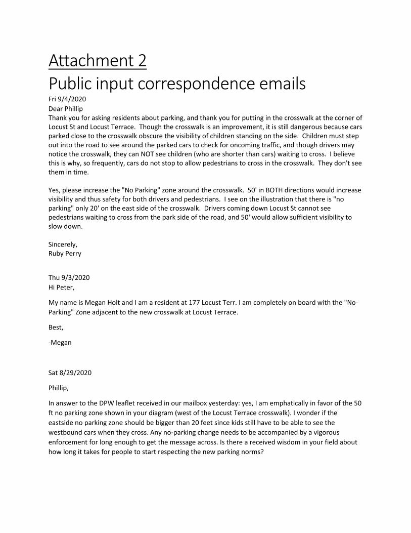
Attachment 2
Public input correspondence emails Fri 9/4/2020
Dear Phillip
Thank you for asking residents about parking, and thank you for putting in the crosswalk at the corner of
Locust St and Locust Terrace. Though the crosswalk is an improvement, it is still dangerous because cars
parked close to the crosswalk obscure the visibility of children standing on the side. Children must step
out into the road to see around the parked cars to check for oncoming traffic, and though drivers may
notice the crosswalk, they can NOT see children (who are shorter than cars) waiting to cross. I believe
this is why, so frequently, cars do not stop to allow pedestrians to cross in the crosswalk. They don't see
them in time.
Yes, please increase the "No Parking" zone around the crosswalk. 50' in BOTH directions would increase
visibility and thus safety for both drivers and pedestrians. I see on the illustration that there is "no
parking" only 20' on the east side of the crosswalk. Drivers coming down Locust St cannot see
pedestrians waiting to cross from the park side of the road, and 50' would allow sufficient visibility to
slow down.
Sincerely,
Ruby Perry
Thu 9/3/2020
Hi Peter,
My name is Megan Holt and I am a resident at 177 Locust Terr. I am completely on board with the "No-
Parking" Zone adjacent to the new crosswalk at Locust Terrace.
Best,
-Megan
Sat 8/29/2020
Phillip,
In answer to the DPW leaflet received in our mailbox yesterday: yes, I am emphatically in favor of the 50
ft no parking zone shown in your diagram (west of the Locust Terrace crosswalk). I wonder if the
eastside no parking zone should be bigger than 20 feet since kids still have to be able to see the
westbound cars when they cross. Any no-parking change needs to be accompanied by a vigorous
enforcement for long enough to get the message across. Is there a received wisdom in your field about
how long it takes for people to start respecting the new parking norms?
I also want to comment on the work that was done this summer further up the street (refiguring
crosswalks at Charlotte and Caroline Streets). I regret that no real traffic calming features (ex: speed
bumps) were included in the new design. My perception is that cars now go faster on Locust Street than
they did prior to the work. Suggestions/requests: more signs indicating the 25 mph speed limit (+
enforcement of that limit), possible additional traffic calming (bumps, not just paint and narrowing).
Thanks for getting the work done this summer. Now let's work together to make Locust Street safer for
pedestrians, bikers and car drivers.
Andrew Simon
54 Locust Street
Sat 8/29/2020
Hi Phillip,
I live at 52 Locust Street. We are so excited about the new cross walk. Thank you to you and the other
city employees who made that happen.
We strongly support the No Parking zone and would be happy for it to be the proposed size on the flyer
or perhaps even bigger. maybe even 100 feet towards Pine Street and 30 feet towards Shelburne Road?
Thanks for all you do and your consideration.
Leighton Johnson
Fri 8/28/2020
Thank you very much!
I had written originally that 20 feet on the southern side of the street was not enough space to keep
pedestrians safe, due to visibility issues on that hill coming up from Pine Street. Thank you very much
for looking into this and proposing a 50' no parking zone to increase the sightline appropriately for the
safety of all us, but especially the children.
Thank you again for all of the hard work you do for the city and residents.
Sincerely,
Emily Skoler

City of Burlington Department of Public Works
Technical Services Engineering Division
645 Pine Street, Suite A Burlington, VT 05402
P 802-863-9094 / F 802-863-0466 / TTY 802-863-0450
www.burlingtonvt.gov/DPW
Date: September 9, 2020
To: Public Works Commission
From: Phillip Peterson, Associate Public Works Engineer
CC: Susan Molzon P.E., Senior Public Works Engineer
Subject: Proposed Accessible (ADA) Parking Space adjacent to 65 Main Street
Staff recommends that the Commission adopt:
7A Accessible spaces designated.
No person shall park any vehicle at any time in the following locations, except automobiles
displaying special handicapped license plates issued pursuant to 18 V.S.A. § 1325, or any
amendment or renumbering thereof:
On the east side of South Champlain Street in the fourth parking space south of
Main Street.
Purpose & Need:
The purpose is to provide accessible parking on street as recommended by the Public Rights-of-
Way Accessibility Guidelines (PROWAG). The need for accessible parking in this location will be
close to several businesses which would benefit the disabled community in this area.
Project Checklist:
N/A Yes No Reference
Aligns with MUTCD
standards and/or
established City Policy?
X PROWAG
Aligns with City plans? X
Followed Public
Engagement Plan?
X These Traffic Regulation changes are defined as
an INVOLVE project in the Public Engagement
Plan (PEP).
Memo
PCP
Summary and Conclusion:
Staff received a request in July 2020 from a local business at 65 Main Street, to install an on-street
accessible parking space close to their business (see Attachemnt-1). The owner states the space
is necessary to give their disabled clients reasonable access to their office. Additionally other
residents and businesses in the area may need to utilize the ADA space; it is important to note,
this proposed ADA space will be the only ADA space on this segment of South Champlain Street.
Public Engagement:
In preparation for the 09/16/20 DPW Commission Meeting, Staff distributed flyers to the homes
and businesses on South Champlain Street and Main Street adjacent to 65 Main Street. Staff
received two (2) responses (see Attachment-2) from local residents; one via email and the other
via telephone. Both responses support the proposed placement of the ADA space.
Attachments:
1. Site map.
2. Public correspondence.

Main Street
EXISTING 3-HOUR
PARKING METERED
SPACE
PROPOSED ACCESSIBLE
(ADA) PARKING SPACE
South C
ham
plain S
treet
R7-8
00 30' 60' PUBLIC WORKSBURLINGTON
ENGINEERING DIV.PROPOSED ADA PARKING
ADJACENT TO65 MAIN STREETSCALE: 1" = 30' North
AutoCAD SHX Text
CHECKED
AutoCAD SHX Text
DATE
AutoCAD SHX Text
OF
AutoCAD SHX Text
SHEET
AutoCAD SHX Text
DESIGNED
AutoCAD SHX Text
DRAWN
AutoCAD SHX Text
DRAWING NO.
AutoCAD SHX Text
BURLINGTON, VT 05401
AutoCAD SHX Text
(802) 863-0466 (Fax)
AutoCAD SHX Text
(802) 863-9094
AutoCAD SHX Text
645 PINE STREET
AutoCAD SHX Text
SCALE
AutoCAD SHX Text
1
AutoCAD SHX Text
1
AutoCAD SHX Text
1"=30'
AutoCAD SHX Text
PMP
AutoCAD SHX Text
PMP
AutoCAD SHX Text
SM
AutoCAD SHX Text
9/9/2020

Attachment 2
Public input correspondence emails Tue 7/28/2020
Hi Jeff,
I’d like to request an on street parking space, be changed to an ADA accessible spot. I spoke to DPW
customer service and then sent me a neighborhood traffic request form.
Since this is a commercial office building, I wasn’t really sure how to fill it out. There are 5 companies in
the building, 2 of which are moving in 30-60 days. One of the companies’ clients are elderly, and they
have asked us to assist in finding a nearby spot.
If you look at this photo, the ADA access to the building is the ramp that is located between the 2
parking spaces. There aren’t any spots nearby, though.
Can you let me know how I can request this? I’m happy to speak to you or meet you on site as well.
Thanks in advance
Meg McGovern
Senior Associate, Broker
Designations: ABR
Certifications: PSA
Donahue & Associates
Public input correspondence Phone Calls Tue 8/25/2020
Associate Engineer Phillip Peterson received a phone call from Delilah Hall, a resident of South
Champlain Street; Ms. Hall supports the proposed ADA space.

City of Burlington Department of Public Works
Division of Parking and Traffic
645 Pine Street, Suite A
Burlington, VT 05402
802.863.9094 P
802.863.0466 F
802.863.0450 TTY
www.burlingtonvt.gov
Chapin Spencer DIRECTOR OF PUBLIC WORKS
Jeffrey A. Padgett, MBA ASSISTANT DIRECTOR for PARKING & TRAFFIC
An Equal Opportunity Employer This material is available in alternative formats for persons with disabilities. To request an accommodation, please
call 802.863.9094 (voice) or 802.863.0450 (TTY).
Date: September 16, 2020 To: Public Works Commission From: Jeffrey A. Padgett, MBA Assistant Director for Parking and Traffic C.C. Chapin Spencer, Director of Public Works Subject: Parking Lot Ordinance Update
194 St. Paul Street Lot Rate Update The attached proposed update to City Ordinance, Appendix C, Chapters 18 and 19 provides clarification and updates to:
terminology related to City Owned vs. City Managed Lots lot designations based on said clarification
These adjustments are not substantive but provide a streamlined legal structure that will better support future, potential public/private parking relationships. Building off of those updates, specifically at the 194 St Paul Street lot (beneath Eagles Landing), this update also formally incorporates:
hourly and monthly rates that were approved by City Council and agreed to with Champlain College. language that provides clear enforcement authority to the City.
These updates have been developed in direct coordination with the City attorney to ensure continuity of language and structure in Ordinance. Please let me know if you have any questions. Attachment: 1) Proposed Ordinance Language Update

CITY OF BURLINGTON
In the Year Two Thousand Twenty A Regulation in Relation to
It is hereby Ordained by the Public Works Commission of the City of Burlington as follows:
Rules and Regulations of the Traffic Commission— Section 18, Parking Facility Designations Section 19. Parking Rates— Clarification of lot terminology and designations; Addition of 194 St. Paul Street lot rates
Sponsor(s): Department of Public Works Action: ________________ Date: __________________ Attestation of Adoption: __________________________________ Phillip Peterson Associate Engineer, Technical Services
Published: ________________________ Effective: _________________________
That Appendix C, Rule and Regulations of the Traffic Commission, Section 18. Parking 1
Facility Designations, subs-sections (a)-(b) and Section 19. Parking Rates, sub-sections 2
(a)-(c), of the Code of Ordinances of the City of Burlington are hereby amended as 3
follows: 4
Section 18. Parking Facility Designations. 5
(a) Metered City-owned lot locations: 6
7
(1)—(6) As written. 8
9
(7) Reserved. The city-owned lot on the west side of Elmwood Avenue near 10
the intersection of Grant Street, known as the Elmwood Avenue Lot. 11
12
(8)—(10) Reserved. 13
(8) The city-owned lot located on Main Street that is adjacent to the metered 14
lot on the northeast corner of Main and Winooski. 15
16
(9) The city-owned lot at the intersection of College Street and Lake Street on 17
the northwest corner, known as the Pease Grain lot. 18
19
(10) Reserved. 20
21

Page 2 An Ordinance in Relation to Rules and Regulations of the Traffic Commission—Section 18, Parking Facility Designations Section 19. Parking Rates—Clarification of lot terminology and designations; Addition of 194 St. Paul Street lot rates
22
(b) Leased City-managed lot locations: 23
24
(1) The city-owned lot on the west side of Elmwood Avenue near the 25
intersection of Grant Street, known as the Elmwood Avenue Lot. 26
27
(2) The city-owned lot located on Main Street that is adjacent to the metered 28
lot on the northeast corner of Main and Winooski. 29
30
(3) The city-owned lot at the intersection of College Street and Lake Street on 31
the northwest corner, known as the Pease Grain lot. 32
33
(4) (1) The city-leased and managed lot located on St. Paul Street between 34
King Street and Maple Street, known as 194 St. Paul Street lot. 35
36
(5) (2) The city-leased and managed lot located on Pearl Street between 37
Hungerford Terrace and North Union Street, known as 247 Pearl Street. 38
39
(c)—(d) As written. 40
41
Section 19. Parking Rates. 42
(a) On-street Pparking meter spaces may be occupied for periods indicated by 43
depositing the following sums: 44
(1)—(6) As written. 45
46
(b) The rate of charge for parking in metered city-owned lots shall be as follows: 47
Location Rate per Hour 48
49
(1) Main Street and South Winooski Avenue, known as Jail Lot: One dollar and 50
fifty cents ($1.50) per hour; monthly permit rate is fifty-five dollars ($55). 51
52
Page 3 An Ordinance in Relation to Rules and Regulations of the Traffic Commission—Section 18, Parking Facility Designations Section 19. Parking Rates—Clarification of lot terminology and designations; Addition of 194 St. Paul Street lot rates
(2) College Street, east of the Fletcher Library, known as the College Street Lot. 53
College Street (Library): One dollar ($1.00) per hour for designated one-hour-54
maximum meters One-hour meters 1.00; forty cents ($0.40) per hour for 55
designated ten-hour-maximum meters. Ten-hour meters 0.40 56
57
(3) Pearl Street and Pine Street, known as the Pearl Street Lot: One dollar ($1.00) 58
per hour for designated three-hour-maximum meters One-hour meters 1.00; 59
forty cents ($0.40) per hour for designated ten-hour-maximum meters. Three-60
hour meters 1.00 Ten-hour meters 0.40 61
62
(4)—(5) As written. 63
64
(6) Reserved. Elmwood Avenue and Grant Street, known as the Elmwood 65
Avenue Lot: Monthly permit rate is fifty-five dollars ($55.00) per month. 66
67
(7) Reserved. Main Street adjacent to the metered parking lot located on the 68
northeast corner Main and Winooski: Monthly permit rate is sixty dollars 69
($60.00) per month. 70
71
(8)—(16) As written. 72
73
(c) The rate of charge for parking in leased city-managed lots shall be as follows, and 74
those vehicles without a vehicle tag displayed in the proper position will be removed 75
by wrecker at the owners expense: listed in sections (1) below. Vehicles parking at the 76
hourly rate and not properly registered with the parking facility, or vehicles parking at 77
a monthly-rate and not displaying a tag in the proper position, will be ticketed as set 78
forth in Burlington Code of Ordinances Sections 20-66(a),(c) and 20-104 or removed by 79
wrecker at the owner’s expense as set forth in Burlington Code of Ordinances Sections 80
20-75, 20-77 and 20-79. 81
82
Location Rates 83
(1) Elmwood Avenue and Grant Street: 84
Per month $55.00 85
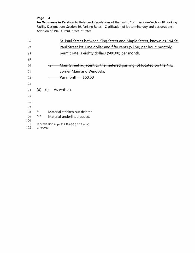
Page 4 An Ordinance in Relation to Rules and Regulations of the Traffic Commission—Section 18, Parking Facility Designations Section 19. Parking Rates—Clarification of lot terminology and designations; Addition of 194 St. Paul Street lot rates
St. Paul Street between King Street and Maple Street, known as 194 St. 86
Paul Street lot: One dollar and fifty cents ($1.50) per hour; monthly 87
permit rate is eighty dollars ($80.00) per month. 88
89
(2) Main Street adjacent to the metered parking lot located on the N.E. 90
corner Main and Winooski: 91
Per month $60.00 92
93
(d)—(f) As written. 94
95
96
97
** Material stricken out deleted. 98
*** Material underlined added. 99 100 JP & TPD: BCO Appx. C. § 18 (a)-(b); § 19 (a)-(c) 101 9/16/2020 102

September 10, 2020
TO: Public Works Commission
FROM: Nicole Losch, Senior Planner
Madeline Suender, Associate Engineer
RE: South Winooski Avenue Parking & Circulation Changes
Recommendations
Staff recommends that the Commission adopt amended regulations to allow for the implementation of the
Winooski Avenue Transportation Study short-term recommendations in the downtown area:
Appendix C §5 One-way streets designated
The following streets are hereby designated as one-way streets, and all traffic and travel thereon, except
pedestrians, shall pass in the directions indicated and not otherwise:
(1) – (29) As written.
(30) South Winooski Avenue, southerly from Maple King Street to St. Paul Street, with the
exception of bicycles traveling northbound in the designated contra-flow lane.
(31) – (42) As written.
Appendix C §7 No-parking areas
No person shall park any vehicle at any time in the following locations:
(1) - (148) As written.
(149) On the east side of South Winooski Avenue between King Main Street and Howard
Street
(150) - (151) As written.
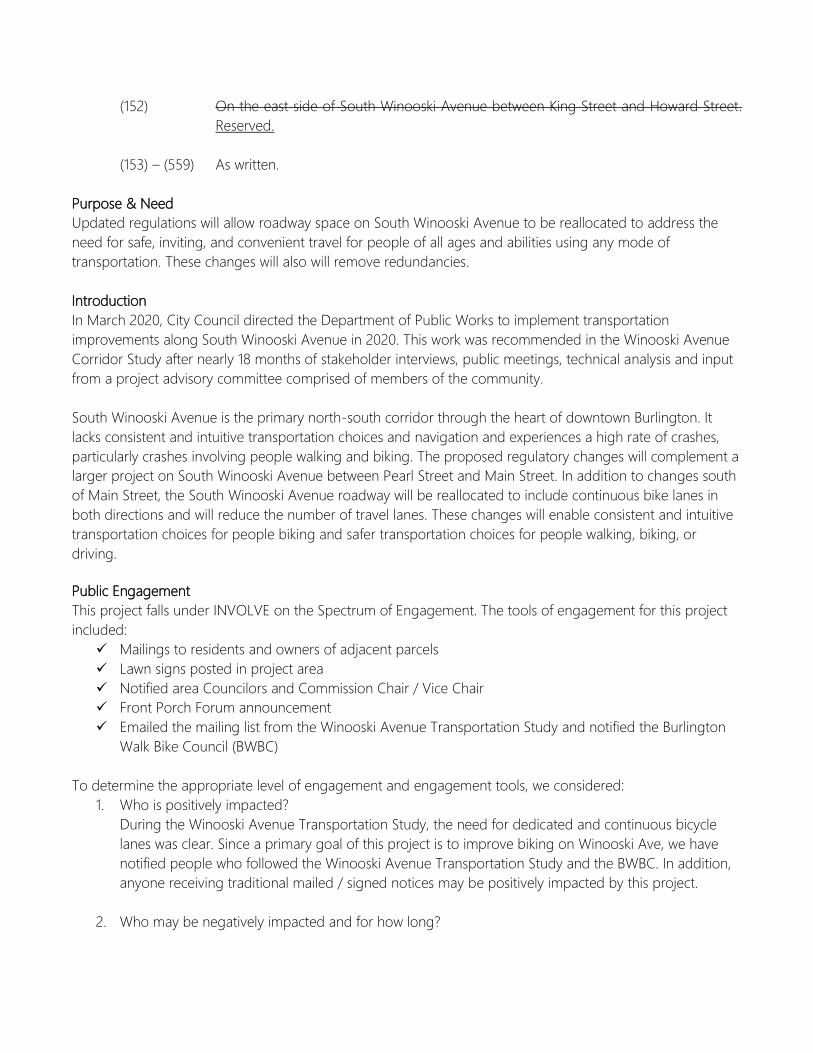
(152) On the east side of South Winooski Avenue between King Street and Howard Street.
Reserved.
(153) – (559) As written.
Purpose & Need
Updated regulations will allow roadway space on South Winooski Avenue to be reallocated to address the
need for safe, inviting, and convenient travel for people of all ages and abilities using any mode of
transportation. These changes will also will remove redundancies.
Introduction
In March 2020, City Council directed the Department of Public Works to implement transportation
improvements along South Winooski Avenue in 2020. This work was recommended in the Winooski Avenue
Corridor Study after nearly 18 months of stakeholder interviews, public meetings, technical analysis and input
from a project advisory committee comprised of members of the community.
South Winooski Avenue is the primary north-south corridor through the heart of downtown Burlington. It
lacks consistent and intuitive transportation choices and navigation and experiences a high rate of crashes,
particularly crashes involving people walking and biking. The proposed regulatory changes will complement a
larger project on South Winooski Avenue between Pearl Street and Main Street. In addition to changes south
of Main Street, the South Winooski Avenue roadway will be reallocated to include continuous bike lanes in
both directions and will reduce the number of travel lanes. These changes will enable consistent and intuitive
transportation choices for people biking and safer transportation choices for people walking, biking, or
driving.
Public Engagement
This project falls under INVOLVE on the Spectrum of Engagement. The tools of engagement for this project
included:
Mailings to residents and owners of adjacent parcels
Lawn signs posted in project area
Notified area Councilors and Commission Chair / Vice Chair
Front Porch Forum announcement
Emailed the mailing list from the Winooski Avenue Transportation Study and notified the Burlington
Walk Bike Council (BWBC)
To determine the appropriate level of engagement and engagement tools, we considered:
1. Who is positively impacted?
During the Winooski Avenue Transportation Study, the need for dedicated and continuous bicycle
lanes was clear. Since a primary goal of this project is to improve biking on Winooski Ave, we have
notified people who followed the Winooski Avenue Transportation Study and the BWBC. In addition,
anyone receiving traditional mailed / signed notices may be positively impacted by this project.
2. Who may be negatively impacted and for how long?
People who traditionally park on the east side of South Winooski Avenue may be impacted by the
removal of this parking. This would be a permanent change. RESIDENT ONLY parking may be
pursued between King St and Maple St in response to concerns about spillover onto this block of
unrestricted parking.
3. What are the main concerns, issues, and interests of the community?
The community’s vision for the Winooski Avenue Corridor includes:
• Traveling along and across Winooski Avenue will be safe, inviting, and convenient for people of all
ages and abilities using any mode of transportation.
• Walking and bicycling will be viable and enjoyable ways to travel this corridor. Improvements will
encourage active travel and alternatives to personal vehicle use.
• Businesses along and near Winooski Avenue will flourish with an activated streetscape and
convenient access.
• The mobility and parking needs will be balanced for property owners, residents, businesses
and the greater transportation system.
• The street can adapt to changes to the transportation system and land use
4. Will any individuals, institutions, or groups be disproportionally impacted?
People driving may perceive more negative impacts associated with this project south of Main Street,
where parking will be reduced and circulation will be impacted. People walking and biking may
perceive more positive impacts due to ease of travel.
5. Was the project recommended in earlier planning studies which included public engagement? Is
additional public input needed or required?
This project is a direct recommendation of the 2020 Winooski Avenue Transportation Study. In
accordance with DPW’s Public Engagement Plan, additional public input is needed since this project
would remove more than 3 parking spaces.
6. Are there any linguistic or cultural barriers to engaging with impacted residents?
There are no known linguistic or cultural barriers in the affected blocks of South Winooski Avenue.
Attachments & References
1. Public feedback
2. Map of recommended regulatory changes
3. Corridor concept plans available online: https://www.burlingtonvt.gov/dpw/WinAveImprovements
Winooski Ave Public Feedback
Hi DPW, Really glad to see this proposal hopefully come to fruition. As a regular bicyclist on South
Winooski with its beautiful north/south lanes, I will be very happy seeing those extended north. Even
better - all the way to Pearl, at least for now.
I’m wondering how you will address the lost parking spaces on South Winooski. I live on King St
between South Winooski and South Union. Non-residents/ people who work downtown park on King St
making it nearly impossible for the people who actually live here to park by our homes. The removal of
these metered spaces will exacerbate this problem. Please let me know the steps you are taking to ensure
bicyclists are safe, and folks who live here can park by our homes.


September 10, 2020
TO: Public Works Commission
FROM: Nicole Losch, Senior Planner
RE: Updated Traffic Calming Manual
Recommendations
This item is Informational only.
Purpose & Need
The purpose of the Traffic Calming program is to support connected, safe, affordable, and efficient
transportation choices. The Traffic Calming program needs to quickly respond to issues of speeding, crashes,
or truck traffic on neighborhood streets.
Introduction
Burlington’s Traffic Calming and Neighborhood Enhancement Program was established in the late 1990’s and
has not been updated since the early 2000’s. Requests are neighborhood-initiated and require 1/3 of the
neighborhood to support the request for traffic calming. Projects advance in the order they are received and
take many years to complete. An assessment was completed in 2019 that identified ways to prioritize traffic
calming projects on streets with demonstrable safety issues.
With support from Stantec, the Traffic Calming program has been updated and is now available for review.
Key features of the updated program include:
Removed the requirement for a neighborhood petition, making the program more equitable and
accessible to all residents
Thresholds for speeding, crashes, and truck volumes will determine when traffic calming should be
pursued
Traffic calming designs will target design speeds established in planBTV Walk Bike and the Burlington
Transportation Plan

Traffic calming design review will be streamlined by removing the neighborhood poll that allowed
residents to opt in or out of traffic calming improvements. This will make the program more equitable
for all streets that need to prioritize traffic safety improvements
These changes should streamline the process to deliver improvements and address traffic safety issues.
Considerations and Public Engagement
The following streets have active traffic calming requests (listed in the order they were received and not
including projects actively in design):
Scarff Avenue
Mansfield Avenue
Foster Street / Ferguson Avenue / Lyman Avenue / Morse Place
Cayuga Court
East Avenue
Bright Street
Pine Street
Austin Drive / South Cove Road / Dunder Road
Gosse Court
These streets received preliminary analysis to determine if they meet the new thresholds of speeding, crash
history, and truck traffic to warrant continuation in the traffic calming program. When the analysis has been
cross-checked by DPW engineering or data collection is complete, the person who initiated each traffic
calming request will be notified of their status under the new program.
This project falls under INFORM on the Spectrum of Engagement. While adopting new standards and policies
only requires it be posted online once final, additional tools of engagement have been applied since this is an
updated program with neighborhood significance. The tools of engagement for this project includes:
Notifications to City Councilors
Front Porch Forum announcement
Individual notices pending for any street on which a traffic calming petition has already been received
Informational guide posted on the DPW website
NPA attendance as requested
Attachments
Final draft Traffic Calming Manual
TRAFFIC CALMING MANUALBURLINGTON, VERMONT
SEPTEMBER 2020
EGohringer
Draft

Burlington City StaffNicole Losch
Elizabeth Gohringer
Laura Wheelock
Susan Molzon
Chapin Spencer
Norm Baldwin
Stantec Consultant TeamGreg Goyette
Mike Rutkowski
Timothy Tresohlavy
Erica Ortman
Jaquasha Colon
Dan Hemme
Dylan McKnight
Burlington Public Works Department645 Pine St Suite A
Burlington, VT 05401
(802) 863-9094
Thanks to the following of their involvement in reformatting this manual, adding the necessary elements to clarify the City’s programs for Traffic Calming and Neighborhood Enhancement.
ACKNOWLEDGEMENTS
“We want to create safer streets for everyone, and make walking and biking a viabe and enjoyable way to get around town." - PlanBTV
CONTENTS 01 02 03 04
Traffic Calming History in Burlington ivIntroduction 1Traffic Calming Evaluation Process 5Traffic Calming Methods & Treatments 11Resources & Contacts 27
Traffic Calming History in Burlington
i v 2 0 2 0 T R A F F I C C A L M I N G M A N U A L B u r l i n g t o n , V e r m o n t
TRAFFIC CALMING HISTORY IN BURLINGTON
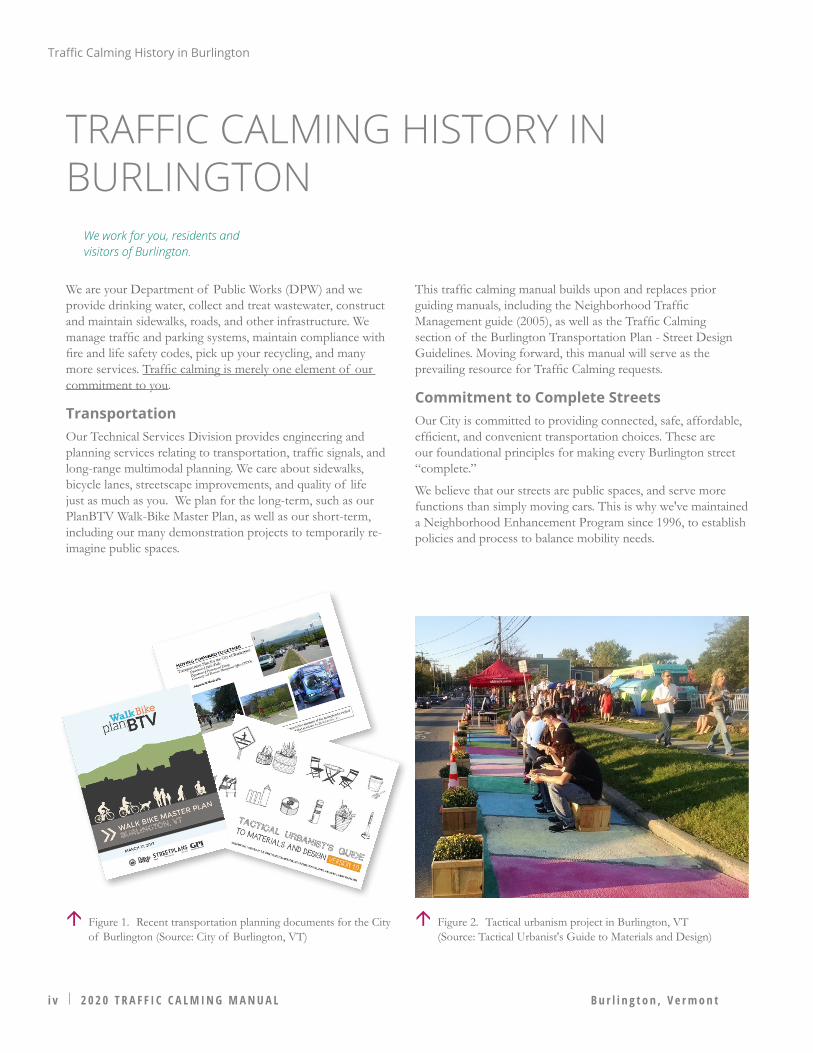
We are your Department of Public Works (DPW) and we provide drinking water, collect and treat wastewater, construct and maintain sidewalks, roads, and other infrastructure. We manage traffic and parking systems, maintain compliance with fire and life safety codes, pick up your recycling, and many more services. Traffic calming is merely one element of our commitment to you.
TransportationOur Technical Services Division provides engineering and planning services relating to transportation, traffic signals, and long-range multimodal planning. We care about sidewalks, bicycle lanes, streetscape improvements, and quality of life just as much as you. We plan for the long-term, such as our PlanBTV Walk-Bike Master Plan, as well as our short-term, including our many demonstration projects to temporarily re-imagine public spaces.
This traffic calming manual builds upon and replaces prior guiding manuals, including the Neighborhood Traffic Management guide (2005), as well as the Traffic Calming section of the Burlington Transportation Plan - Street Design Guidelines. Moving forward, this manual will serve as the prevailing resource for Traffic Calming requests.
Commitment to Complete StreetsOur City is committed to providing connected, safe, affordable, efficient, and convenient transportation choices. These are our foundational principles for making every Burlington street “complete.”
We believe that our streets are public spaces, and serve more functions than simply moving cars. This is why we've maintained a Neighborhood Enhancement Program since 1996, to establish policies and process to balance mobility needs.
Figure 2. Tactical urbanism project in Burlington, VT (Source: Tactical Urbanist's Guide to Materials and Design)
Figure 1. Recent transportation planning documents for the City of Burlington (Source: City of Burlington, VT)
We work for you, residents and visitors of Burlington.
B u r l i n g t o n , V e r m o n t
This Traffic Calming Manual represents an important step for the City of Burlington in its mission to provide safe, Complete Streets within the community. Building upon previous efforts to identify traffic calming measures suitable for construction, this manual provides the City of Burlington with:
1. Guidance regarding the appropriate use, design, and signing and/or pavement markings of traffic calming measures;
2. Procedures by which residents may request and the City may investigate and pursue traffic calming measures on its residential and collector streets.
This Guide focuses on traffic calming measures for existing streets. The goals of this program are:
• Protect existing residential neighborhoods through traffic and speed management
• Promote safe, comfortable, multimodal transportation• Provide acceptable leves of access, while minimizing
unnecessary traffic or excessive speeds.
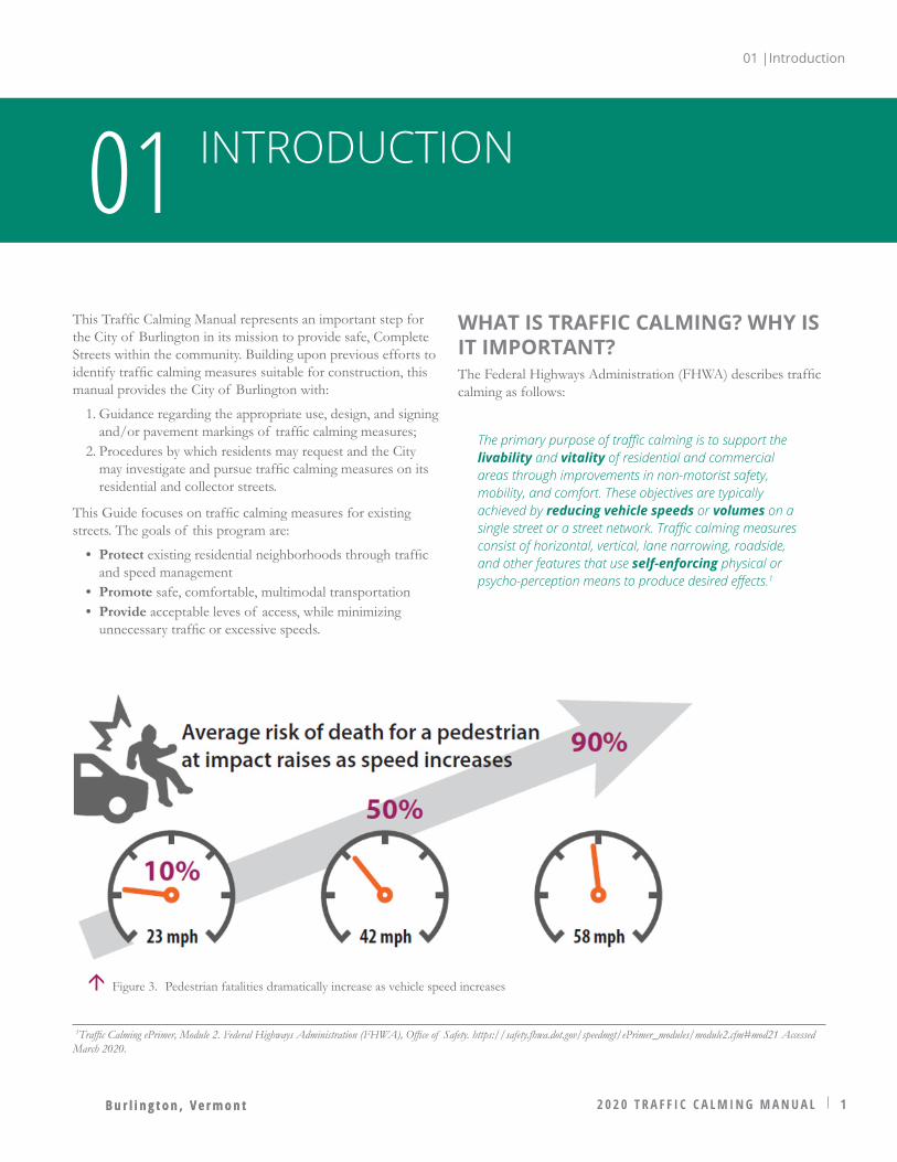
WHAT IS TRAFFIC CALMING? WHY IS IT IMPORTANT?The Federal Highways Administration (FHWA) describes traffic calming as follows:
The primary purpose of traffic calming is to support the livability and vitality of residential and commercial areas through improvements in non-motorist safety, mobility, and comfort. These objectives are typically achieved by reducing vehicle speeds or volumes on a single street or a street network. Traffic calming measures consist of horizontal, vertical, lane narrowing, roadside, and other features that use self-enforcing physical or psycho-perception means to produce desired effects.1
2 0 2 0 T R A F F I C C A L M I N G M A N U A L 1B u r l i n g t o n , V e r m o n t
INTRODUCTION01
1Traffic Calming ePrimer, Module 2. Federal Highways Administration (FHWA), Office of Safety. https://safety.fhwa.dot.gov/speedmgt/ePrimer_modules/module2.cfm#mod21 Accessed March 2020.
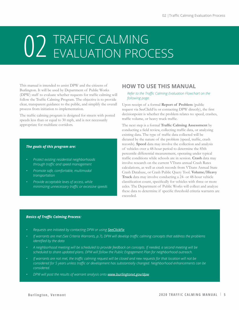
Figure 3. Pedestrian fatalities dramatically increase as vehicle speed increases
01 |Introduction
01 |Introduction
2 2 0 2 0 T R A F F I C C A L M I N G M A N U A L B u r l i n g t o n , V e r m o n t2 2 0 2 0 T R A F F I C C A L M I N G M A N U A L B u r l i n g t o n , V e r m o n t
Perception Reaction (feet)
Total Stopping Distance (feet)
Spee
d (M
PH)
20
117 196 313
30
40
74'
110'
148' FATAL
SERIOUS INJURY
LOW/MODERATE INJURY
Figure 5. Stopping distance and reaction time increase with speed. (Source: National Complete Streets Coalition)
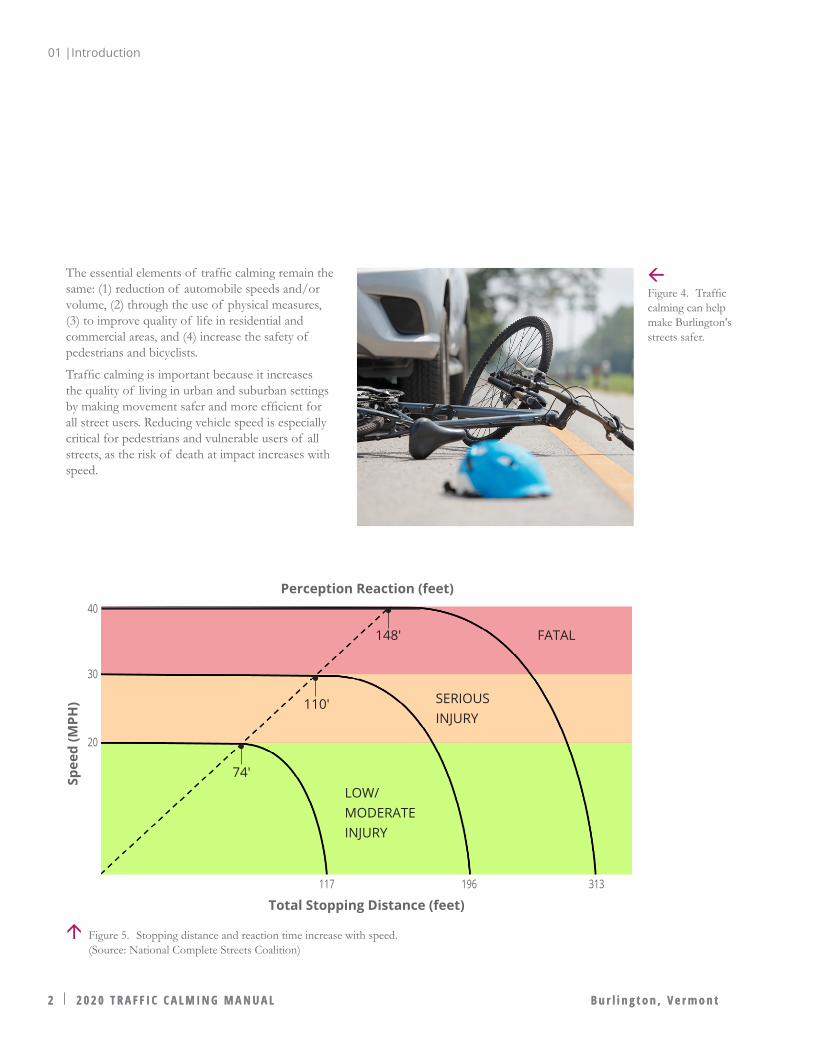
The essential elements of traffic calming remain the same: (1) reduction of automobile speeds and/or volume, (2) through the use of physical measures, (3) to improve quality of life in residential and commercial areas, and (4) increase the safety of pedestrians and bicyclists.
Traffic calming is important because it increases the quality of living in urban and suburban settings by making movement safer and more efficient for all street users. Reducing vehicle speed is especially critical for pedestrians and vulnerable users of all streets, as the risk of death at impact increases with speed.
Figure 4. Traffic calming can help make Burlington's streets safer.

01 |Introduction
2 0 2 0 T R A F F I C C A L M I N G M A N U A L 3B u r l i n g t o n , V e r m o n t 2 0 2 0 T R A F F I C C A L M I N G M A N U A L 3B u r l i n g t o n , V e r m o n t
WHAT IS NOT TRAFFIC CALMING?It's important to clarify potential treatments that will not be considered as traffic calming measures. Four common requests from residents include: stop sign installation requests, speed radar equipment installation, driver safety education, or speed limit enforcement efforts by local police. While stop signs and other traffic control signs are means by which traffic operations may be managed, they are not traffic calming devices because they are not self-enforcing. As regulatory traffic control devices, traffic control signs obligate the motorist to alter their driving behavior and reduce speed, but require enforcement by authorities in order to be effective rather than the operator’s voluntary modification of their behavior. Vehicle safety education is an essential requirement for obtaining a state drivers’ license, but is not in itself a traffic calming measure because it is not a physical treatment that is self-enforcing. For these reasons, requests of this nature will not be considered under the City's Traffic Calming Program.
Peripheral Vision at 40+ MPH
Peripheral Vision at 10 to 15 MPH
Figure 6. Diagrams (above and below) illustrating how driver vision narrows and widens at high and low speeds respectively. Studies show that driver behavior, including speed, is predicated on their peripheral vision, which decreases greatly at higher speeds.
What is "Self-Enforcing?"
Physical treatments (countermeasures) that are engineered to alter a motorists speed or direction of travel.

01 |Introduction
4 2 0 2 0 T R A F F I C C A L M I N G M A N U A L B u r l i n g t o n , V e r m o n t
HOW IS TRAFFIC CALMING DIFFERENT FROM NEIGHBORHOOD ENHANCEMENT?
• Traffic Calming: Physical, self-enforcing measures that will mitigate an issue that exceeds specific quantitative warrants for speed, crashes, and heavy traffic/truck traffic are considered traffic calming. Traffic calming measures will be evaluated in accordance with Chapter 2 of this manual.
• Neigborhood Enhancements: Issues or desired improvements at locations which do not meet the specific quantitative warrants for speed or crashes (e.g., maintenance, street trees, sidewalks, lighting, education, enforcement). The following are examples of neighborhood-led requests through other established programs within the City of Burlington:
• "Welcome to the Neighborhood" signs, planters, or other beautification (apply for Encumbance Permit through DPW)
• New tree requests through Burlington, Parks, Recreation and Waterfront• Street light improvements through Burlington Electric Department• Intersection murals (apply for an Encumbrance Permit through DPW)
The Traffic Calming Program addresses specific roadway deficiencies as demonstrated by data through proven countermeasures, and are guided by accepted engineering standards established by research administered and endorsed by Federal and State agencies.
A NOTE ON INTERSECTION MURALSIntersection murals have the potential to compromise safety of motorists, pedestrians, and bicyclists by interfering with, detracting from, or obscuring official traffic control devices, especially nearby crosswalks. Intersection murals will only be considered after careful review of their location, impact to nearby official traffic control devices, and the safety of the public. For more information, refer to the Manual on Uniform Traffic Control Devices, Frequently Asked Questions - Part 3 - Markings.
Figure 7. DPW employees installing traffic calming measures Figure 8. An artistic neighborhood enhancement installation in Burlington that serves to beautify the area and may calm traffic
B u r l i n g t o n , V e r m o n t 2 0 2 0 T R A F F I C C A L M I N G M A N U A L 5
TRAFFIC CALMING EVALUATION PROCESS02
This manual is intended to assist DPW and the citizens of Burlington. It will be used by Department of Public Works (DPW) staff to evaluate whether requests for traffic calming will follow the Traffic Calming Program. The objective is to provide clear, transparent guidance to the public, and simplify the overall process from initiation to implementation.
The traffic calming program is designed for streets with posted speeds less than or equal to 30 mph, and is not necessarily appropriate for multilane corridors.
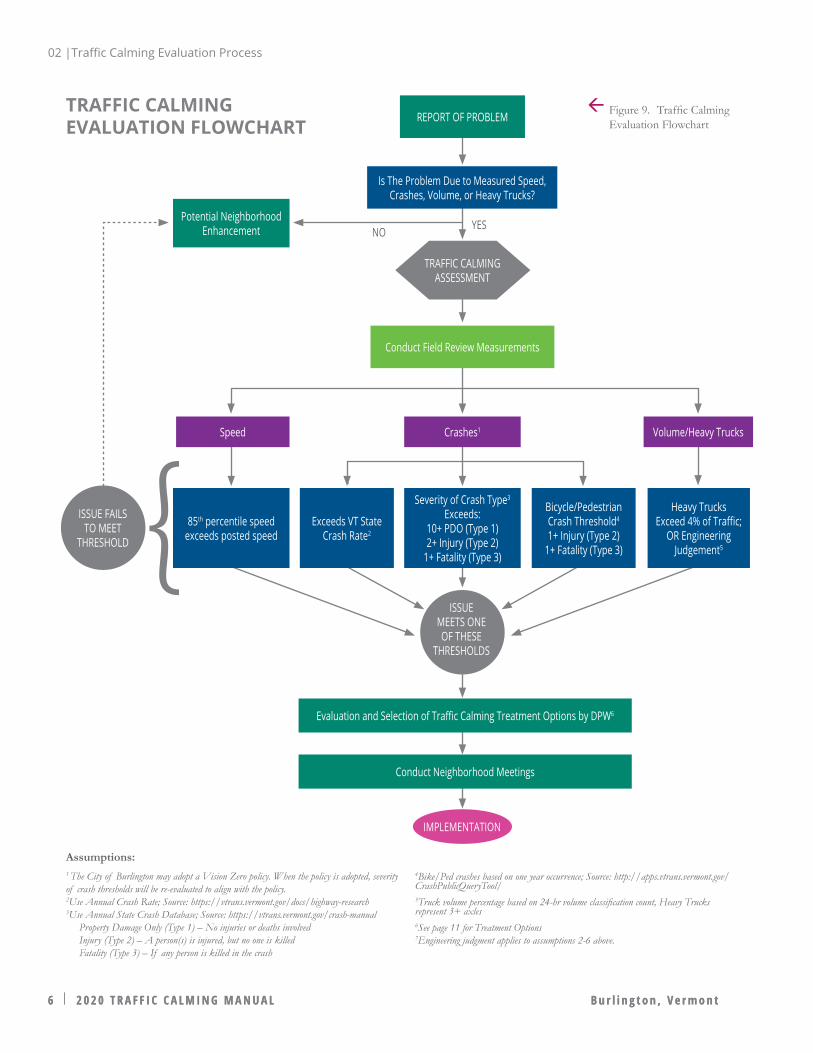
HOW TO USE THIS MANUALRefer to the Traffic Calming Evaluation Flowchart on the following page.
Upon receipt of a formal Report of Problem (public request via SeeClickFix or contacting DPW directly), the first decisionpoint is whether the problem relates to: speed, crashes, traffic volume, or heavy truck traffic.
The next step is a formal Traffic Calming Assessment by conducting a field review, collecting traffic data, or analyzing existing data. The type of traffic data collected will be dictated by the nature of the problem (speed, traffic, crash records). Speed data may involve the collection and analysis of vehicles over a 48-hour period to determine the 85th percentile differential measurement, operating under typical traffic conditions while schools are in session. Crash data may involve research on the current VTrans annual Crash Rates calculations, as well as crash records from VTrans Annual State Crash Database, or Crash Public Query Tool. Volume/Heavy Truck data may involve conducting a 24- or 48-hour vehicle classification count, specifically for vehicles with three or more axles. The Department of Public Works will collect and analyze these data to determine if specific threshold criteria warrants are exceeded.
The goals of this program are:
• Protect existing residential neighborhoods through traffic and speed management
• Promote safe, comfortable, multimodal transportation
• Provide acceptable leves of access, while minimizing unnecessary traffic or excessive speeds
Basics of Traffic Calming Process:
• Requests are initiated by contacting DPW or using SeeClickFix
• If warrants are met (See Criteria Warrants, p.7), DPW will develop traffic calming concepts that address the problems identified by the data
• A neighborhood meeting will be scheduled to provide feedback on concepts. If needed, a second meeting will be scheduled to share updated plans. DPW will follow the Public Engagement Plan for neighborhood outreach.
• If warrants are not met, the traffic calming request will be closed and new requests for that location will not be considered for 5 years unless traffic or development has substantially changed. Neighborhood enhancements can be considered.
• DPW will post the results of warrant analysis onto www.burlingtonvt.gov/dpw
02 |Traffic Calming Evaluation Process
02 |Traffic Calming Evaluation Process
6 2 0 2 0 T R A F F I C C A L M I N G M A N U A L B u r l i n g t o n , V e r m o n t6 2 0 2 0 T R A F F I C C A L M I N G M A N U A L B u r l i n g t o n , V e r m o n t
TRAFFIC CALMING EVALUATION FLOWCHART
Assumptions:1 The City of Burlington may adopt a Vision Zero policy. When the policy is adopted, severity of crash thresholds will be re-evaluated to align with the policy.2Use Annual Crash Rate; Source: https://vtrans.vermont.gov/docs/highway-research 3Use Annual State Crash Database; Source: https://vtrans.vermont.gov/crash-manual Property Damage Only (Type 1) – No injuries or deaths involved Injury (Type 2) – A person(s) is injured, but no one is killed Fatality (Type 3) – If any person is killed in the crash
85th percentile speed exceeds posted speed
Exceeds VT State Crash Rate2
Severity of Crash Type3 Exceeds:
10+ PDO (Type 1)2+ Injury (Type 2)
1+ Fatality (Type 3)
Bicycle/Pedestrian Crash Threshold4
1+ Injury (Type 2)1+ Fatality (Type 3)
Heavy Trucks Exceed 4% of Traffic;
OR Engineering Judgement5
Crashes1 Volume/Heavy Trucks
Potential Neighborhood Enhancement YESNO
Speed
ISSUE MEETS ONE OF THESE
THRESHOLDS
ISSUE FAILS TO MEET
THRESHOLD
IMPLEMENTATION
Conduct Field Review Measurements
REPORT OF PROBLEM
TRAFFIC CALMING ASSESSMENT
Is The Problem Due to Measured Speed, Crashes, Volume, or Heavy Trucks?
Evaluation and Selection of Traffic Calming Treatment Options by DPW6
Conduct Neighborhood Meetings
Figure 9. Traffic Calming Evaluation Flowchart
4Bike/Ped crashes based on one year occurrence; Source: http://apps.vtrans.vermont.gov/CrashPublicQueryTool/5Truck volume percentage based on 24-hr volume classification count, Heavy Trucks represent 3+ axles6See page 11 for Treatment Options7Engineering judgment applies to assumptions 2-6 above.

02 |Traffic Calming Evaluation Process
2 0 2 0 T R A F F I C C A L M I N G M A N U A L 7B u r l i n g t o n , V e r m o n t 2 0 2 0 T R A F F I C C A L M I N G M A N U A L 7B u r l i n g t o n , V e r m o n t
THRESHOLD CRITERIA WARRANTSWith the appropriate data collected, the next decision point is whether the reported problem meets or exceeds the established Criteria Warrants, which are minimum criteria for correction of a deficiency. These are listed in the column to the right.
An assessment that satisfies these warrants proceeds to the next decision point, consideration of methods and treatment options, presented in the next section. Cost-effective treatments will largely depend on the characteristics of the roadway, as not all traffic calming treatments will be effective on different streets. Further discussion of street typologies follows.
An assessment that does not satisfy these warrants will not advance for traffic calming treatments. New requests for traffic calming will not be advanced for 5 years unless there is a substantial change in traffic or development nearby. DPW will provide results of all assessments at www.burlingtonvt.gov/dpw.
Figure 10. Crashes in Burlington, VT from March 15, 2019 toApril 14, 2020 (Source: VTrans Public Crash Data Query Tool)
Criteria Warrants• Speed Warrant: The reported 85th percentile speed
differential measurement is greater than the posted speed.• Safety Warrant: Documented crash history along the
roadway:» Exceeds the annual Vermont State Crash Rate for streets
of similar roadway conditions (number of lanes, posted speed, and/or functional classification)
» In the last 5-years exceed:▪ 10 or more Type 1 crashes (property damage only) or,▪ Two (2) Type 2 crashes (injury) or,▪ One (1) Type 3 crashes (fatality)
» In the last year exceed:▪ One (1) Type 2 crashes (injury) involving pedestrian or
bicycle or,▪ One (1) Type 3 crashes (fatality) involving pedestrian
or bicycle• Heavy Trucks: The reported 24-hour traffic volume
classification count must:» Exceed 4% for heavy truck (three or more axles), or» Engineering judgment considering surrounding land use
context
Figure 11. Pedestrian priority and safety is paramount, especially on neighborhood streets.

02 |Traffic Calming Evaluation Process
8 2 0 2 0 T R A F F I C C A L M I N G M A N U A L B u r l i n g t o n , V e r m o n t
BURLINGTON STREET TYPES AND STREET NETWORK
Figure 12. Burlington Street Types and Street Network, 2011 City of Burlington Transportation Plan

02 |Traffic Calming Evaluation Process
2 0 2 0 T R A F F I C C A L M I N G M A N U A L 9B u r l i n g t o n , V e r m o n t
HOW?
· Ch
apte
r 3 · E
ngin
eerin
g74
Priority Streets for Speed ControlThe first recommended action on page 67 calls out the need to engineer and design city streets to self-enforce appropriate target speeds. The map on this page shows priority corridors for speed control and enforcement, increasing safety for everyone’s benefit. "Slow Zones" are areas where the street is designed and engineered for slow travel. That means designing for 85th percentile speeds to achieve 25 mph or less on major corridors, and 20mph or less on neighborhood and downtown streets.
N
Slow Zone PrioritiesCorridor Slow Zone: design for ≤ 25mph
Neighborhood Slow Zone: design for ≤ 20mph
Downtown Slow Zone: design for ≤ 20mph
PRIORITY STREETS FOR SPEED CONTROL Burlington's 2017 PlanBTV WalkBike called out the need to engineer and design streets to self-enforce appropriate target speeds. The following map from PlanBTV WalkBike shows priority corridors for speed control and enforcement, increasing safety for everyone's benefit. "Slow Zones" are areas where the street is designed and engineered for slow travel. That means designing for 85th percentile speeds to achieve 25 MPH or less on major corridors, and 20 MPH or less on neighborhood and downtown streets. (Source: PlanBTV WalkBike)
Figure 13. Priority Streets for Speed Control (Source: PlanBTV WalkBike)
02 |Traffic Calming Evaluation Process
1 0 2 0 2 0 T R A F F I C C A L M I N G M A N U A L B u r l i n g t o n , V e r m o n t
STREET TYPOLOGIESThis section describes the five street typologies included in the City of Burlington Transportation Plan, Adopted March 2011 and PlanBTV WalkBike adopted in 2017.
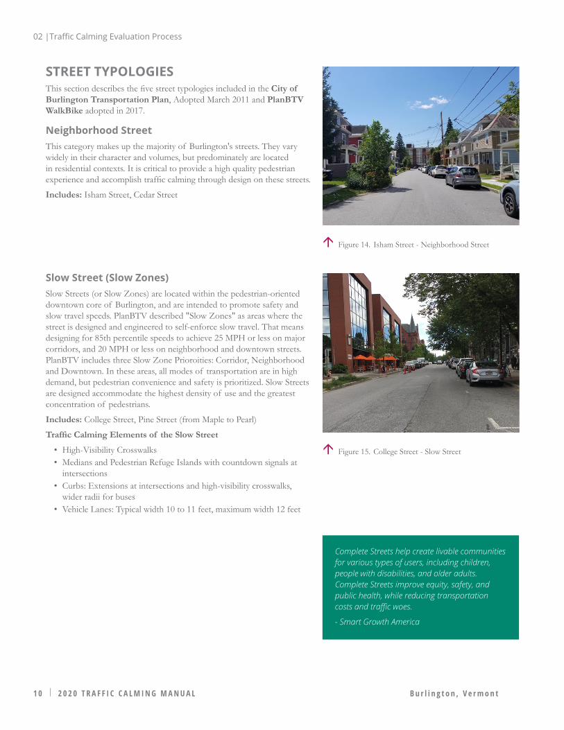
Neighborhood StreetThis category makes up the majority of Burlington's streets. They vary widely in their character and volumes, but predominately are located in residential contexts. It is critical to provide a high quality pedestrian experience and accomplish traffic calming through design on these streets.
Includes: Isham Street, Cedar Street
Figure 14. Isham Street - Neighborhood Street
Figure 15. College Street - Slow Street
Slow Street (Slow Zones)Slow Streets (or Slow Zones) are located within the pedestrian-oriented downtown core of Burlington, and are intended to promote safety and slow travel speeds. PlanBTV described "Slow Zones" as areas where the street is designed and engineered to self-enforce slow travel. That means designing for 85th percentile speeds to achieve 25 MPH or less on major corridors, and 20 MPH or less on neighborhood and downtown streets. PlanBTV includes three Slow Zone Prioroities: Corridor, Neighborhood and Downtown. In these areas, all modes of transportation are in high demand, but pedestrian convenience and safety is prioritized. Slow Streets are designed accommodate the highest density of use and the greatest concentration of pedestrians.
Includes: College Street, Pine Street (from Maple to Pearl)
Traffic Calming Elements of the Slow Street
• High-Visibility Crosswalks• Medians and Pedestrian Refuge Islands with countdown signals at
intersections• Curbs: Extensions at intersections and high-visibility crosswalks,
wider radii for buses• Vehicle Lanes: Typical width 10 to 11 feet, maximum width 12 feet
Complete Streets help create livable communities for various types of users, including children, people with disabilities, and older adults. Complete Streets improve equity, safety, and public health, while reducing transportation costs and traffic woes.
- Smart Growth America

02 |Traffic Calming Evaluation Process
2 0 2 0 T R A F F I C C A L M I N G M A N U A L 1 1B u r l i n g t o n , V e r m o n t
Bicycle StreetBicycle Streets, like Transit Streets, have the purposes of giving one mode of transportation priority over other modes. The 2017 PlanBTV WalkBike provided an updated network of Bicycle Streets from those provided in the 2011 Transportation Plan. The Bicycle Street functions to give bicycles priority treatment through improved signage and physical improvements to promote convenience and safety. Along with Slow Streets, Complete Streets, and shared-use paths, Bicycle Streets form a citywide network that will promote greater usage of bicycles as a mode of transportation.
Includes: North Street, Union Street, College Street, Intervale Road
Traffic Calming Elements of the Bicycle Street
• Crosswalks• On-Street Parking: Parallel or Angled• Bicycle Lanes: Preferable width 5 to 6 feet, minimum width 4 feet
outside of gutter• Vehicle Lanes: Typical width 10 to 11 feet, minimum width 10 feet
Transit StreetTransit Streets, like Complete Streets, facilitate travel to and through Burlington’s core and are main thoroughfares for the city. Transit Streets, however, differ from Complete Streets in that their purpose is to give transit a “leg up” on other modes of transportation by promoting efficient transit movement on these designated streets. Transit Streets transition from Complete Streets where bicycles are diverted to a parallel Bicycle Street or other path. These streets can promote significant economic development, especially within ¼-mile of a transit stop. Higher volumes of pedestrian traffic may be expected on Transit Streets.
Includes: Main Street, St. Paul Street (from Main to Howard), Pearl Street
Traffic Calming Elements of the Transit Street
• Corner Turning Radius: Minimum 60 foot radius• Vehicle Lanes: Typical width 10 to 11 feet, maximum width 12 feet
Complete StreetsComplete Streets are the main thoroughfares providing access into and through Burlington. These roadways typically have more travel lanes, wider rights-of-way, and higher traffic volumes and speeds. The goal of the Complete Street is to accommodate all modes as effectively as possible within the right-of-way.
Includes: North Avenue, Colchester Avenue
Traffic Calming Elements of the Complete Street
• High-Visibility Crosswalks• Medians & Pedestrian Refuge Islands• Curb extensions and wider radii for buses• On-Street Parking (if possible)• Buffered/Conventional Bike Lane: Preferable width 5 to 6 feet,
minimum width 4 feet outside of gutter• Vehicle Lanes: Typical width 10 to 11 feet, maximum width 12 feet
Figure 16. Flynn Avenue - Bicycle Street
Figure 17. Pearl Street - Transit Street
Figure 18. Park Street (Source: Google Street View)
03 |Traffic Calming Methods & Treatments
1 2 2 0 2 0 T R A F F I C C A L M I N G M A N U A L B u r l i n g t o n , V e r m o n t
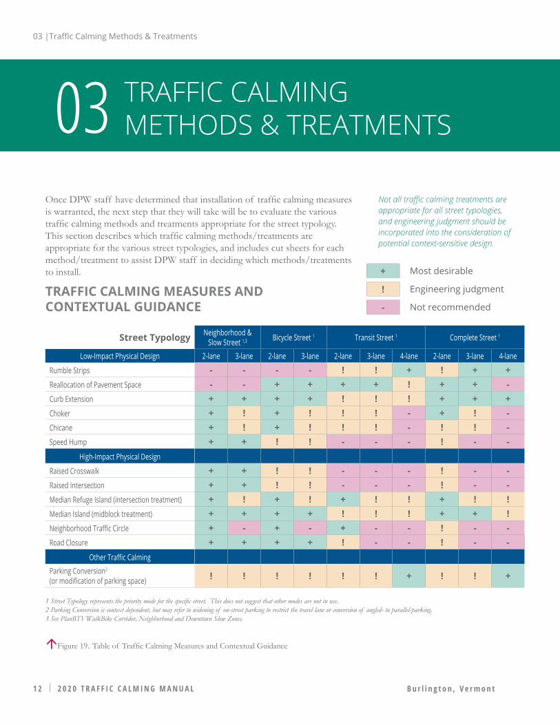
Once DPW staff have determined that installation of traffic calming measures is warranted, the next step that they will take will be to evaluate the various traffic calming methods and treatments appropriate for the street typology. This section describes which traffic calming methods/treatments are appropriate for the various street typologies, and includes cut sheets for each method/treatment to assist DPW staff in deciding which methods/treatments to install.
TRAFFIC CALMING METHODS & TREATMENTS03
Street Typology Neighborhood & Slow Street 1,3 Bicycle Street 1 Transit Street 1 Complete Street 1
Low-Impact Physical Design 2-lane 3-lane 2-lane 3-lane 2-lane 3-lane 4-lane 2-lane 3-lane 4-lane
Rumble Strips - - - - ! ! + ! + +Reallocation of Pavement Space - - + + + + ! + + -Curb Extension + + + + ! ! ! + + +Choker + ! + ! ! ! - + ! -Chicane + ! + ! ! ! - ! ! -Speed Hump + + ! ! - - - ! - -
High-Impact Physical Design
Raised Crosswalk + + ! ! - - - ! - -Raised Intersection + + ! ! - - - ! - -Median Refuge Island (intersection treatment) + ! + ! + ! ! + ! !Median Island (midblock treatment) + + + + ! ! ! + + !Neighborhood Traffic Circle + - + - + - - ! - -Road Closure + + + + ! - - ! - -
Other Traffic Calming
Parking Conversion2 (or modification of parking space) ! ! ! ! ! ! + ! ! +
1 Street Typology represents the priority mode for the specific street. This does not suggest that other modes are not in use.2 Parking Conversion is context dependent, but may refer to widening of on-street parking to restrict the travel lane or conversion of angled- to parallel-parking.3 See PlanBTVWalkBike Corridor, Neighborhood and Downtown Slow Zones.
+
!
-
Most desirable
Engineering judgment
Not recommended
Not all traffic calming treatments are appropriate for all street typologies, and engineering judgment should be incorporated into the consideration of potential context-sensitive design.
TRAFFIC CALMING MEASURES AND CONTEXTUAL GUIDANCE
Figure 19. Table of Traffic Calming Measures and Contextual Guidance

Plan View Detail
Oblique Angle Detail
Built Example - Source: National Complete Streets Coalition
C T B P LOW-IMPACT PHYSICAL DESIGN
DescriptionRumble strips are patterned sections of rough pavement or topical applications of raised material, perpendicular to the direction of travel, that cause vibration and noise when driven over by the operator of a motor vehicle. This noise and vibration is intended to direct the motorist’s attention back to the roadway. FHWA-approved treatments include white- and black-painted stripes. Avoid conflicts with driveways. Typical spacing is 50 - 100 feet apart.
Typical ConditionsSpeed: Generally appropriate for roadways with higher posted speed limits, such as transitions from freeways to lower class roadways.
Traffic & Volume: Generally appropriate for any traffic volumes and do not impair truck access, transit, or primary emergency response routes, not appropriate on bicycle routes.
CostRanges between $0.10 to $0.60 per linear foot dependent on:
• Project length • Availability and selection of materials• Roadway surface
Advantages and DisadvantagesAdvantages
• FHWA studies show 34% reduction in crashes on urban and suburban roads
• Relatively low cost• Relatively quick installation
Disadvantages
• Not effective on roadways with lower posted speeds• High noise levels generated by traffic
References• Burlington’s Intersection Design Vehicle Policy• Burlington's Engineering Standards• FHWA Traffic Calming ePrimer• ITE Traffic Calming Measures
RUMBLE STRIPS
Speed Reduction Potential -1 to -2 MPHBASIC
03 |Traffic Calming Methods & Treatments
03 |Traffic Calming Methods & Treatments
1 4 2 0 2 0 T R A F F I C C A L M I N G M A N U A L B u r l i n g t o n , V e r m o n t
C T B P LOW-IMPACT PHYSICAL DESIGN
DescriptionReallocation of pavement space can include removing and/or reconfiguring existing travel lanes or replacing lanes with other facilities such as bicycle lanes, on-street parking or transit uses for example.
Typical ConditionsSpeed: Generally appropriate for roadways with lanes in excess of 12 feet wide.
Traffic & Volume: Generally appropriate for all types of urban roadways and have been applied to roadways with daily maximum volumes from 15,000 - 25,000.
CostCan be designed internally and implemented with scheduled resurfacing making costs minimal.
Advantages & DisadvantagesAdvantages
• Lane removal can reduce higher speeds achieved through passing
• Can reduce crashes by 19-47%• Retains sufficient flow despite lane removal
Disadvantages
• No significant disadvantages
References• Burlington’s Intersection Design Vehicle Policy• Burlington's Engineering Standards• FHWA Traffic Calming ePrimer• ITE Traffic Calming Measures
REALLOCATION OF PAVEMENT SPACE
Plan View Detail (Roadway striping as lane diet)
Oblique Angle Detail (Conventional bike lanes as lane diet)
Built Example (Buffered bike lanes as a road/lane diet)
Speed Reduction Potential
-1 to -2 MPHBASIC
03 |Traffic Calming Methods & Treatments
2 0 2 0 T R A F F I C C A L M I N G M A N U A L 1 5B u r l i n g t o n , V e r m o n t
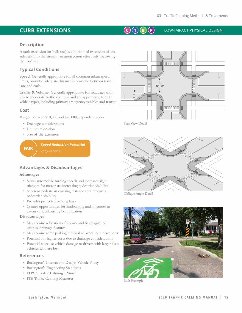
C T B P LOW-IMPACT PHYSICAL DESIGN
DescriptionA curb extension (or bulb out) is a horizontal extension of the sidewalk into the street at an intersection effectively narrowing the roadway.
Typical ConditionsSpeed: Generally appropriate for all common urban speed limits, provided adequate distance is provided between travel lane and curb.
Traffic & Volume: Generally appropriate for roadways with low to moderate traffic volumes, and are appropriate for all vehicle types, including primary emergency vehicles and transit.
CostRanges between $10,000 and $25,000, dependent upon:
• Drainage considerations• Utilities relocation• Size of the extension
Advantages & DisadvantagesAdvantages
• Slows automobile turning speeds and increases sight triangles for motorists, increasing pedestrian visibility
• Shortens pedestrian crossing distance and improves pedestrian visibility
• Provides protected parking bays• Creates opportunities for landscaping and amenities at
extensions, enhancing beautificationDisadvantages
• May require relocation of above- and below-ground utilities, drainage features
• May require some parking removal adjacent to intersections• Potential for higher costs due to drainage considerations• Potential to cause vehicle damage to drivers with larger class
vehicles who are lost
References• Burlington’s Intersection Design Vehicle Policy• Burlington's Engineering Standards• FHWA Traffic Calming ePrimer• ITE Traffic Calming Measures
CURB EXTENSIONS
Plan View Detail
Oblique Angle Detail
Built Example
Speed Reduction Potential
-3 to -4 MPHFAIR

03 |Traffic Calming Methods & Treatments
1 6 2 0 2 0 T R A F F I C C A L M I N G M A N U A L B u r l i n g t o n , V e r m o n t
C T B P LOW-IMPACT PHYSICAL DESIGN
DescriptionA choker is the narrowing of a roadway through the use of curb extensions or roadside islands. It can be created by a pair of curb extensions at a midblock location that narrows the street by widening the sidewalk or planting strip at that location. A choker can also be created through the use of roadside islands or through a curb extension with parking on the opposite side.
Typical ConditionsSpeed: Generally appropriate for all common urban speed limits, provided adequate distance is provided between travel lane and curb.
Traffic & Volume: Generally appropriate for roadways with low to moderate traffic volumes, and are appropriate for all vehicle types, including primary emergency vehicles and transit.
CostBetween $10,000 and $25,000 per extension, dependent upon:
• Drainage considerations• Utilities relocation• Size of the extension
Advantages and DisadvantagesAdvantages
• Opportunities for landscaping and amenities can significantly increase neighborhood and streetscape beautification
• Provides opportunity for a mid-block crosswalk• Provides protection for on-street parking• Applicable with or without dedicated bicycle facilities
Disadvantages
• May require relocation of drainage features and utilities• May require some parking removal• Potential for higher costs due to drainage considerations
References• Burlington’s Intersection Design Vehicle Policy• Burlington's Engineering Standards• FHWA Traffic Calming ePrimer• ITE Traffic Calming Measures
CHOKER
Plan View Detail
Oblique Angle Detail
Built Example
Speed Reduction Potential
-3 to -4 MPHFAIR
03 |Traffic Calming Methods & Treatments
2 0 2 0 T R A F F I C C A L M I N G M A N U A L 1 7B u r l i n g t o n , V e r m o n t
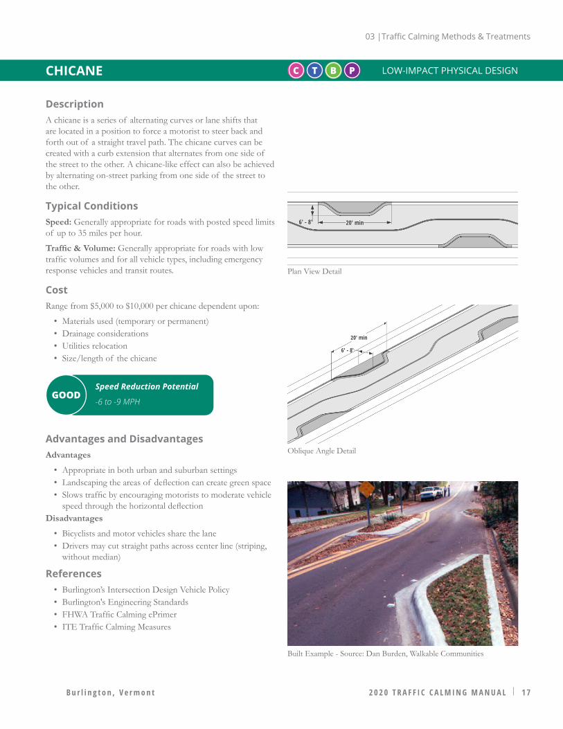
C T B P LOW-IMPACT PHYSICAL DESIGN
DescriptionA chicane is a series of alternating curves or lane shifts that are located in a position to force a motorist to steer back and forth out of a straight travel path. The chicane curves can be created with a curb extension that alternates from one side of the street to the other. A chicane-like effect can also be achieved by alternating on-street parking from one side of the street to the other.
Typical ConditionsSpeed: Generally appropriate for roads with posted speed limits of up to 35 miles per hour.
Traffic & Volume: Generally appropriate for roads with low traffic volumes and for all vehicle types, including emergency response vehicles and transit routes.
CostRange from $5,000 to $10,000 per chicane dependent upon:
• Materials used (temporary or permanent)• Drainage considerations• Utilities relocation• Size/length of the chicane
Advantages and DisadvantagesAdvantages
• Appropriate in both urban and suburban settings• Landscaping the areas of deflection can create green space• Slows traffic by encouraging motorists to moderate vehicle
speed through the horizontal deflectionDisadvantages
• Bicyclists and motor vehicles share the lane• Drivers may cut straight paths across center line (striping,
without median)
References• Burlington’s Intersection Design Vehicle Policy• Burlington's Engineering Standards• FHWA Traffic Calming ePrimer• ITE Traffic Calming Measures
CHICANE
Plan View Detail
Oblique Angle Detail
Built Example - Source: Dan Burden, Walkable Communities
Speed Reduction Potential
-6 to -9 MPHGOOD

03 |Traffic Calming Methods & Treatments
1 8 2 0 2 0 T R A F F I C C A L M I N G M A N U A L B u r l i n g t o n , V e r m o n t
Plan View Detail
Oblique Angle Detail
Built Example
DescriptionA speed hump is an elongated mound in the roadway surface extending across the travel way at a right angle to the traffic flow. It uses vertical deflection to create motorist discomfort and thereby reduces speed. Burlington DPW offers two sizes of speed humps, 14 feet or 22 feet wide, the larger size being more appropriate for higher volume streets. Typical placement is midblock and spaced 300 - 500 feet apart. Avoid conflicts with driveways.
Typical ConditionsSpeed: Generally not appropriate for roadways with a posted speed of 45 miles per hour or above.
Traffic & Volume: Not appropriate for truck access routes, transit routes, or primary emergency response routes; Appropriate for roads with grades below eight percent.
Variation: Speed Cushions can be used as a variation along primary emergency routes or transit routes.
CostBetween $2,000 - $4,000 dependent on drainage design
Advantages and DisadvantagesAdvantages
• Bicyclist safety is relatively unaffected • Typical traffic volume reductions of 20% (series of humps)• Crash rate reductions of approximately 40% are typical
Disadvantages
• When applied as a single treatment, little to no traffic volume reduction or diversion should be expected
• Increased noise levels from vehicles impacting the hump • Not appropriate for primary emergency vehicle routes or
streets providing access to a hospital or emergency medical services
• Not appropriate for transit routes or primary access routes for industrial or commercial sites
• Adequate stopping sight distance or warning signs provided• Snow plow damage to speed hump
References• Burlington’s Intersection Design Vehicle Policy• Burlington's Engineering Standards• FHWA Traffic Calming ePrimer• ITE Traffic Calming Measures
C T B P LOW-IMPACT PHYSICAL DESIGNSPEED HUMP
Speed Reduction Potential
-6 to -8 MPHGOOD

03 |Traffic Calming Methods & Treatments
2 0 2 0 T R A F F I C C A L M I N G M A N U A L 1 9B u r l i n g t o n , V e r m o n t
DescriptionA raised crosswalk is a raised area extending perpendicular to the roadway, accompanied by a pedestrian crosswalk on the raised surface, designed to physically limit the speed at which a vehicle can traverse it. Raised crosswalks may be installed at both midblock and intersections and ranges in height based on the roadway type. Refer to Burlington Crosswalk Guidelines. Crosswalks should not be installed solely for the purpose of traffic calming, they must also meet the warrants for a marked crosswalk or an enhanced crosswalk.
Typical ConditionsSpeed: Generally appropriate for roadways with posted speed limits up to 35 miles per hour.
Traffic & Volume: Not appropriate for primary emergency vehicle response routes, or roadways providing access to medical facilities.
CostRanges between $2,500 to $8,000 for asphalt table. Higher costs may be incurred for brickwork, stamped asphalt, concrete ramps, and other pedestrian crossing enhancements.
Advantages and DisadvantagesAdvantages
• Increased pedestrian connectivity creates a more walkable community
• Reduces speeds to between 25 to 35mph at the crosswalk• Bicycle safety relatively unaffected • When used in a series, traffic volume reductions of up to
20% observedDisadvantages
• Should not be located within 50-75 feet of bus stops• Not appropriate for primary emergency vehicle routes or
streets providing access to a hospital or medical services• Snow plow damage to raised crosswalk• Potential increase in noise and in traffic on adjacent streets
References• Burlington’s Intersection Design Vehicle Policy• Burlington's Engineering Standards• Burlington's Crosswalk Guidelines• FHWA Traffic Calming ePrimer• ITE Traffic Calming Measures
Plan View Detail
Oblique Angle Detail
Built Example - Source: Dan Burden, Walkable Communities
C T B P HIGH-IMPACT PHYSICAL DESIGNRAISED CROSSWALK
Speed Reduction Potential
-6 to -9 MPHGOOD
03 |Traffic Calming Methods & Treatments
2 0 2 0 2 0 T R A F F I C C A L M I N G M A N U A L B u r l i n g t o n , V e r m o n t
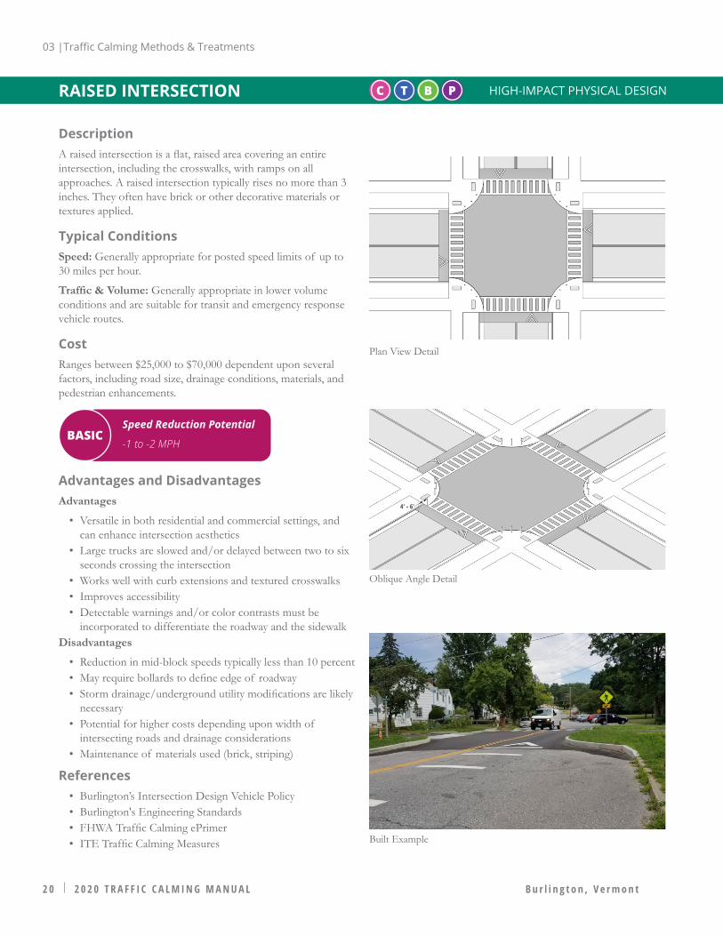
DescriptionA raised intersection is a flat, raised area covering an entire intersection, including the crosswalks, with ramps on all approaches. A raised intersection typically rises no more than 3 inches. They often have brick or other decorative materials or textures applied.
Typical ConditionsSpeed: Generally appropriate for posted speed limits of up to 30 miles per hour.
Traffic & Volume: Generally appropriate in lower volume conditions and are suitable for transit and emergency response vehicle routes.
CostRanges between $25,000 to $70,000 dependent upon several factors, including road size, drainage conditions, materials, and pedestrian enhancements.
Advantages and DisadvantagesAdvantages
• Versatile in both residential and commercial settings, and can enhance intersection aesthetics
• Large trucks are slowed and/or delayed between two to six seconds crossing the intersection
• Works well with curb extensions and textured crosswalks• Improves accessibility• Detectable warnings and/or color contrasts must be
incorporated to differentiate the roadway and the sidewalkDisadvantages
• Reduction in mid-block speeds typically less than 10 percent • May require bollards to define edge of roadway• Storm drainage/underground utility modifications are likely
necessary• Potential for higher costs depending upon width of
intersecting roads and drainage considerations• Maintenance of materials used (brick, striping)
References• Burlington’s Intersection Design Vehicle Policy• Burlington's Engineering Standards• FHWA Traffic Calming ePrimer• ITE Traffic Calming Measures
C T B P HIGH-IMPACT PHYSICAL DESIGNRAISED INTERSECTION
Plan View Detail
Oblique Angle Detail
Built Example
Speed Reduction Potential
-1 to -2 MPHBASIC
03 |Traffic Calming Methods & Treatments
2 0 2 0 T R A F F I C C A L M I N G M A N U A L 2 1B u r l i n g t o n , V e r m o n t
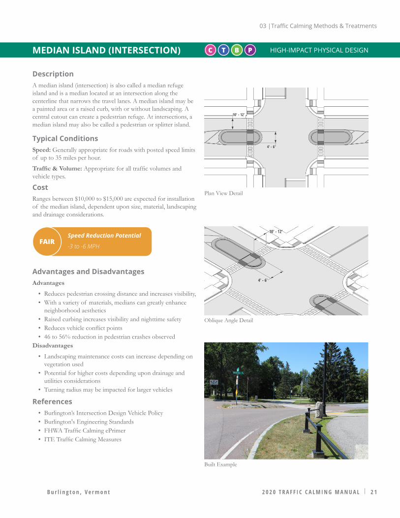
DescriptionA median island (intersection) is also called a median refuge island and is a median located at an intersection along the centerline that narrows the travel lanes. A median island may be a painted area or a raised curb, with or without landscaping. A central cutout can create a pedestrian refuge. At intersections, a median island may also be called a pedestrian or splitter island.
Typical ConditionsSpeed: Generally appropriate for roads with posted speed limits of up to 35 miles per hour.
Traffic & Volume: Appropriate for all traffic volumes and vehicle types.
CostRanges between $10,000 to $15,000 are expected for installation of the median island, dependent upon size, material, landscaping and drainage considerations.
Advantages and DisadvantagesAdvantages
• Reduces pedestrian crossing distance and increases visibility, • With a variety of materials, medians can greatly enhance
neighborhood aesthetics• Raised curbing increases visibility and nighttime safety• Reduces vehicle conflict points• 46 to 56% reduction in pedestrian crashes observed
Disadvantages
• Landscaping maintenance costs can increase depending on vegetation used
• Potential for higher costs depending upon drainage and utilities considerations
• Turning radius may be impacted for larger vehicles
References• Burlington’s Intersection Design Vehicle Policy• Burlington's Engineering Standards• FHWA Traffic Calming ePrimer• ITE Traffic Calming Measures
C T B PMEDIAN ISLAND (INTERSECTION)
Plan View Detail
Oblique Angle Detail
Built Example
HIGH-IMPACT PHYSICAL DESIGN
Speed Reduction Potential
-3 to -6 MPHFAIR

03 |Traffic Calming Methods & Treatments
2 2 2 0 2 0 T R A F F I C C A L M I N G M A N U A L B u r l i n g t o n , V e r m o n t
Built Example
DescriptionA median island (midblock) is a raised island located along the street centerline that narrows the travel lanes. Unlike the median refuge island, the median island is located at midblock locations. A median island may be a painted area or a raised curb (preferred), with or without landscaping, to further reduce the open feel of a street.
Typical ConditionsSpeed: Generally appropriate for roads with posted speed limits of up to 35 miles per hour.
Traffic & Volume: Appropriate for all traffic volumes and vehicle types.
CostRanges between $10,000 to $15,000 are expected for installation of the median island, dependent upon size, material, landscaping and drainage considerations.
Advantages and DisadvantagesAdvantages
• Can function as a midblock pedestrian refuge island • With a variety of materials, medians can greatly enhance
neighborhood aesthetics• Light crowning increases visibility and nighttime safety• Reduces vehicle conflict points
Disadvantages
• Bicyclist and motor vehicles share the lane• Landscaping maintenance costs • Potential for higher costs depending upon drainage and
utilities considerations• Can restrict driveway access where driveways are located
within the limits of the island• Damage to snow plows, damage from snow plows
References• Burlington’s Intersection Design Vehicle Policy• Burlington's Engineering Standards• FHWA Traffic Calming ePrimer• ITE Traffic Calming Measures
C T B PMEDIAN ISLAND (MIDBLOCK)
Plan View Detail
Oblique Angle Detail
HIGH-IMPACT PHYSICAL DESIGN
Speed Reduction Potential
-3 to -6 MPHFAIR
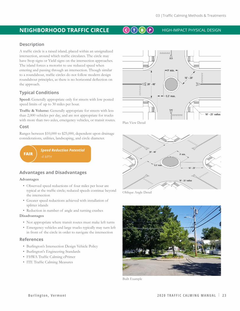
03 |Traffic Calming Methods & Treatments
2 0 2 0 T R A F F I C C A L M I N G M A N U A L 2 3B u r l i n g t o n , V e r m o n t
Built Example
DescriptionA traffic circle is a raised island, placed within an unsignalized intersection, around which traffic circulates. The circle may have Stop signs or Yield signs on the intersection approaches. The island forces a motorist to use reduced speed when entering and passing through an intersection. Though similar to a roundabout, traffic circles do not follow modern design roundabout principles, as there is no horizontal deflection on the approach.
Typical ConditionsSpeed: Generally appropriate only for streets with low posted speed limits of up to 30 miles per hour.
Traffic & Volume: Generally appropriate for streets with less than 2,000 vehicles per day, and are not appropriate for trucks with more than two axles, emergency vehicles, or transit routes.
CostRanges between $10,000 to $25,000, dependent upon drainage considerations, utilities, landscaping, and circle diameter.
Advantages and DisadvantagesAdvantages
• Observed speed reductions of four miles per hour are typical at the traffic circle; reduced speeds continue beyond the intersection
• Greater speed reductions achieved with installation of splitter islands
• Reduction in number of angle and turning crashesDisadvantages
• Not appropriate where transit routes must make left turns• Emergency vehicles and large trucks typically may turn left
in front of the circle in order to navigate the intersection
References• Burlington’s Intersection Design Vehicle Policy• Burlington's Engineering Standards• FHWA Traffic Calming ePrimer• ITE Traffic Calming Measures
C T B PNEIGHBORHOOD TRAFFIC CIRCLE HIGH-IMPACT PHYSICAL DESIGN
Plan View Detail
Oblique Angle Detail
Speed Reduction Potential
-4 MPHFAIR

03 |Traffic Calming Methods & Treatments
2 4 2 0 2 0 T R A F F I C C A L M I N G M A N U A L B u r l i n g t o n , V e r m o n t
DescriptionA full street closure is a physical barrier, whether at an intersection or midblock, that is placed across a street to close the street completely to through vehicle traffic. A full closure can be designed to allow bicyclists and pedestrians to pass through. An operational analysis shall be completed prior considering this treatment.
Typical ConditionsSpeed: Generally appropriate for all common urban posted speed limits, with adequate advance warning given to road users.
Traffic & Volume: Generally appropriate for roadways with low traffic volume, and are not appropriate for primary emergency vehicle response, truck, or transit routes.
CostRanges from as little as $1,500 to $10,000 depending upon method of closure chosen. Costs vary substantially dependent on treatment, and include potential considerations for drainage, construction, and restriping.
Advantages and DisadvantagesAdvantages
• Highest degree of traffic volume reduction• Increased pedestrian and bicyclist safety • Eliminates vehicle conflict points
Disadvantages
• Without design considerations (e.g., mountable curbs, removable delineators) restricts emergency response vehicles and thereby affects access and response time
• Reduces overall network connectivity• Adverse effects to property accessibility• Diverts traffic to other streets and may increase volume
elsewhere• Potential for high costs dependent upon degree of
integration with streetscape, drainage considerations
References• Burlington’s Intersection Design Vehicle Policy• Burlington's Engineering Standards• FHWA Traffic Calming ePrimer• ITE Traffic Calming Measures
C T B PROAD CLOSURE (FULL) HIGH-IMPACT PHYSICAL DESIGN
Plan View Detail
Oblique Angle Detail
Speed Reduction Potential N/A - Diverts trafficFAIR
Built Example
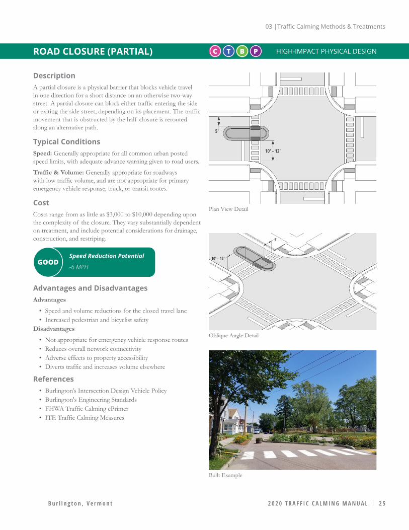
03 |Traffic Calming Methods & Treatments
2 0 2 0 T R A F F I C C A L M I N G M A N U A L 2 5B u r l i n g t o n , V e r m o n t
DescriptionA partial closure is a physical barrier that blocks vehicle travel in one direction for a short distance on an otherwise two-way street. A partial closure can block either traffic entering the side or exiting the side street, depending on its placement. The traffic movement that is obstructed by the half closure is rerouted along an alternative path.
Typical ConditionsSpeed: Generally appropriate for all common urban posted speed limits, with adequate advance warning given to road users.
Traffic & Volume: Generally appropriate for roadways with low traffic volume, and are not appropriate for primary emergency vehicle response, truck, or transit routes.
CostCosts range from as little as $3,000 to $10,000 depending upon the complexity of the closure. They vary substantially dependent on treatment, and include potential considerations for drainage, construction, and restriping.
Advantages and DisadvantagesAdvantages
• Speed and volume reductions for the closed travel lane• Increased pedestrian and bicyclist safety
Disadvantages
• Not appropriate for emergency vehicle response routes• Reduces overall network connectivity• Adverse effects to property accessibility• Diverts traffic and increases volume elsewhere
References• Burlington’s Intersection Design Vehicle Policy• Burlington's Engineering Standards• FHWA Traffic Calming ePrimer• ITE Traffic Calming Measures
C T B PROAD CLOSURE (PARTIAL) HIGH-IMPACT PHYSICAL DESIGN
Plan View Detail
Oblique Angle Detail
Speed Reduction Potential
-6 MPHGOOD
Built Example
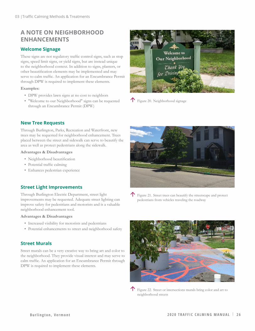
B u r l i n g t o n , V e r m o n t 2 0 2 0 T R A F F I C C A L M I N G M A N U A L 2 6
A NOTE ON NEIGHBORHOOD ENHANCEMENTSWelcome SignageThese signs are not regulatory traffic control signs, such as stop signs, speed limit signs, or yield signs, but are instead unique to the neighborhood context. In addition to signs, planters, or other beautification elements may be implemented and may serve to calm traffic. An application for an Encumbrance Permit through DPW is required to implement these elements.
Examples:
• DPW provides lawn signs at no cost to neighbors• "Welcome to our Neighborhood" signs can be requested
through an Encumbrance Permit (DPW)
New Tree RequestsThrough Burlington, Parks, Recreation and Waterfront, new trees may be requested for neighborhood enhancement. Trees placed between the street and sidewalk can serve to beautify the area as well as protect pedestrians along the sidewalk.
Advantages & Disadvantages
• Neighborhood beautification• Potential traffic calming• Enhances pedestrian experience
Street Light ImprovementsThrough Burlington Electric Department, street light improvements may be requested. Adequate street lighting can improve safety for pedestrians and motorists and is a valuable neighborhood enhancement tool.
Advantages & Disadvantages
• Increased visibility for motorists and pedestrians• Potential enhancements to street and neighborhood safety
Street MuralsStreet murals can be a very creative way to bring art and color to the neighborhood. They provide visual interest and may serve to calm traffic. An application for an Encumbrance Permit through DPW is required to implement these elements.
Figure 21. Street trees can beautify the streetscape and protect pedestrians from vehicles traveling the roadway
Figure 20. Neighborhood signage
Figure 22. Street or intersections murals bring color and art to neighborhood streets
03 |Traffic Calming Methods & Treatments

TRAFFIC CALMING RESOURCESVisit the Department of Public Works (DPW) Traffic Calming and Neighborhood Enhancement Program webpage for more information:
https://www.burlingtonvt.gov/DPW/Traffic-Calming-Neighborhood-Enhancement-Program
SOURCES, REFERENCES & STANDARDSThis Manual was created with reference to national standards for traffic calming and roadway design engineering, including the following:
• Federal Highways Administration (FHWA) Office of Safety. Traffic Calming ePrimer. Available: https://safety.fhwa.dot.gov/speedmgt/traffic_calm.cfm; Accessed March 2020. Last modified: February 15, 2017.
• Institute of Transportation Engineeers (ITE). Traffic Calming Measures Guide. Available: https://www.ite.org/technical-resources/traffic-calming/traffic-calming-measures/ ; Accessed March 2020. Last Modified:
• Federal Highways Administration (FHWA). Manual on Uniform Trafffic Control Devices (MUTCD). Available: https://mutcd.fhwa.dot.gov/kno_2009r1r2.htm; Accessed March 2020. Last Modified: March 30, 2020.
2 0 2 0 T R A F F I C C A L M I N G M A N U A L 2 7B u r l i n g t o n , V e r m o n t
RESOURCES & CONTACTS04
Traffic Calming Program
Insert general contact email
Insert general contact phone number
Figure 23. FHWA website for the Manual on Uniform Trafffic Control Devices
Figure 24. Top: FHWA webpage for the Traffic Calming ePrimer; Above: ITE webpage for the Traffic Calming Measures Guide.
04 |Resources & Contacts

Burlington Public Works Department645 Pine St Suite A
Burlington, VT 05401(802) 863-9094
Page 1
Burlington Department of Public Works Commission MeetingDraft Minutes, July 15, 2020
645 Pine St. – Main Conference RoomMeeting video link: https://www.cctv.org/watch-tv/programs/burlington-public-works-
commission-153
Commissioners Present: Tiki Archambeau (Chair); Brendan Hogan (Vice Chair); SolveigOverby; Peggy O’Neill-Vivanco, Pablo Bose; Jim Barr
Commissioners Absent: Chris Gillman
Item 1 – Call to Order – Welcome – Chair Comments
Director Spencer calls meeting to order at 6:31 p.m. and made opening comments.Tonight the Commission is voting for Chair, Vice Chair and Clerk.
Item 2 – Agenda
ACTION: Commissioner Barr made a motion to approve the agenda. CommissionerHogan seconded. Motion was unanimously approved.
Item 3 – Election of Chair, Vice Chair & Clerk
Director Spencer stated that the Commission needed to elect its Chair, Vice Chair andClerk at this first meeting of the new fiscal year. Commissioner Barr nominatedCommissioner Archambeau for Chair. Commissioner Archambeau thanked them fornomination but he stated he would like to nominate Commissioner Hogan.Commissioner Barr retracted his nomination. Commissioner O’Neill Vivanco thankedCommissioner Archambeau for his service and is glad he wants to share responsibilities.Commissioner Hogan is pleased to share the responsibilities in the role of Chairman andis willing to serve. Director Spencer asked the Commission to vote on the nomination ofCommissioner Hogan. Unanimous approval.
Director Spencer passed the gavel to newly-elected Chair Hogan. Chair Hogan asked forVice Chair nominees. Commissioner Barr nominated Commissioner Peggy O’Neill-Vivanco as Vice Chair. Commissioner Archambeau seconded. Unanimous approval.
Chair Hogan looks for nomination for Clerk. Commissioner Barr nominatedCommissioner Overby. Commissioner Overby is willing to do it and will follow up toget details on the role. Commissioner Bose seconded. Unanimous approval.
Item 4 – Public Forum
Tony Redington of 125 St. Paul Street talked about pedestrian safety. His expressedconcern regarding the traffic safety at the North Avenue / Cambrian Rise intersections.He stated that roundabouts were safer than traffic signals and that the projected vehicletraffic at the Cambrian Rise intersections should be within the capacity of a modern

Page 2
roundabout. He stated that DPW ended the discussion about a roundabout in this area andinstead supported the developer’s proposed traffic light.
Item 5 – Consent Agenda
A. Proposed Accessible Parking Space at 141 Manhattan Drive
ACTION: Commissioner Barr made a motion to accept the consent agenda.Commissioner Archambeau seconded. Unanimous approval
Item 6 – Integrated Planning Presentation – Jenna Olson, Water Resources Division
Policy & Programs Manager Jenna Olson presented an update on Water Resource’sIntegrated Plan initiative. The Integrated Plan will serve as the road map for addressingthe City's water quality challenges. This effort represents years of planning, modeling,engineering, and financial assessments to help Burlington not only achieve their waterregulatory goals, but to do so in the most cost-effective, and efficient way. The City mustreduce phosphorus from all sources by 63% by 2036 to meet state and federal regulatoryrequirement. To accomplish this goal, we currently are looking at several strategiesincluding: projects for the City’s three wastewater treatment plants, combined sewersystem improvements, enhanced storm water management, non-structural programs (suchas expanded street sweeping), and private property improvements. We are looking forcommunity feedback. The final product will guide the City's investments and actionsover the next ten to twenty years. More information is at:https://www.burlingtonvt.gov/dpw/water/integratedplan.
Commissioners Hogan, O’Neill-Vivanco, and Overby asked questions about onlineimpervious surface mapping, data collection and performance measurement, andengaging youth in the Drain Defender initiative. Commissioner O’Neill-Vivanco statedthat BHS students have to do 40 hours of community service before graduating and statedshe thought this would be a good way for some of these high school students to get theirhours in by helping to clean the catch basins.
ACTION: No action taken.
Item 7 – Appeal of Building Permit After the Fact Fee
Contractor Shawn Vance of GW Savage has appealed an after the fact fee for work beingdone prior to issuance of a permit. Director Ward of Permitting and Inspections providedan overview of the appeal summarizing the narrative in his written memorandum to theCommission that was included in the meeting packet.
A building permit was applied for October 28th and was issued on the 29th fordemolition on a residence that was damaged due to a structure fire.
Shawn Vance asked for the permit to be expedited 12 days before the zoningpermit was to be released so he would not have to lay off any workers.
Unfortunately, circumstances did not allow for this and an e-mail was sent to Seanon March 23 stating that work for the roof only could be done to keep the weatherelements from going inside the house.

Page 3
On March 24 there was an executive order from the Governor that only COVIDrelated repairs and emergency repairs could be done on any buildings.
On April 8th no action was taking place but work was done and a stop work orderwas issued. I went out and took photos and there were no workers on site.
On April 17th the Governor’s Order allowed for two workers on site and thebuilding permit was released.
Zoning staff on May 22nd stated conditions were met. On 6/1 the building permit was issued by Brad Biggie and included the penalty
for starting work.
Mr. Vance stated he wanted to secure the building. There was a delay in the insurancepayment. There was also asbestos removal that had to be done which his company is notable to do. They had to wait on the other company to come and do this. He submittedpermits at the end of February/beginning of March to get things done by April 1. Wecould not shut everything down and leave the building open. He stated he wanted toprotect the building occupants so they will not have to pay anything out of pocket.
Building Inspector Brad Biggie stated the building was secure from weather. The roofwas mostly intact and windows were boarded up. The building remained in thiscondition throughout winter. Brad stated the permit was specific for a roof cover andafter the roof was on then the windows and the trim were done. Brad stated that what hefound in April was window and siding work being done. Contractor went beyond theextension of the olive branch to put on the roof cover.
Commissioner Overby asked about what the conditions of the zoning permit were. Thezoning permit was not released until pre-release conditions were met. Mr. Vance statedhe sent over samples of what was being proposed. Sean stated they pulled the windowson the demo permits and there are other ways to waterproof but they were only gettingpaid once as the insurance stated they were no longer giving money for the project. Hestated that if it was not for COVID they would have been okay.
Building Inspector Biggie stated that on the March 26th a work order to stop work wasissued so they should not have been working on April 8th. Demoing out windows with noapproval and have a way to weather that in. The roof was the only thing approved forwork on the 8th. There were two or three guys pulling off siding and no permit wasauthorized for this work. Director Ward stated that in the report which was given to thecommission the building was made safe October 5th and it was no longer an emergency.They only had approval for the roof.
Commissioner Archambeau asked if we should go into executive session and DirectorWard stated that it was up to the commission. The Commission discussed whether theywanted assistance from the City Attorney.
Commissioner Barr makes a motion to deny the appeal but to deduct the value of thepermitted roof work in the calculation of the after the face fee. Commissioner O’Neill-Vivanco seconded. Commissioner Archambeau stated opposition to the motion.Commissioner Barr, Hogan, are O’Neill-Vivanco are in favor. CommissionersArchambeau, and Overby are opposed. Chair indicates that the motion fails.
Page 4
Commissioner Overby makes a motion to deny the appeal but to reduce the after the facefee by half. Commissioner Barr seconded. Commissioner Archambeau and O’Neill-Vivanco stated opposition to the motion. Commissioners Barr and Overby are in favor.Commissioners Archambeau, Hogan, and O’Neill-Vivanco are opposed. The motionfails.
ACTION: Commissioner Archambeau makes a motion to go into a deliberative session atthe end of the meeting. Commissioner Barr seconded. Archambeau, Barr, Hogan, Bose,O’Neill-Vivanco are all in favor. Commissioner Overby opposed. The motion passes.
Item 8 – Marketplace Garage Rate Implementation
Director Spencer introduced Jeff Padgett who, after a public search process, has beenhired as the Assistant Director overseeing the Parking and Traffic Division.
Assistant Director Padgett summarized the Commission’s approved rate changes andpolicy changes from the June meeting. The June motion included an implementation dateof July 1, 2020. However, for two important reasons this was not possible.1) The July 1, 2020 date did not provide the required 21 day public notice period require
for ordinance changes2) Due to the impacts of Covid-19, the Marketplace garage has not yet returned to its
historic stated of “overcapacity” and staff recognizes that this is not the time to makechanges to the business environment in the Downtown.
Assistant Director Padgett stated that he met with the Church Street MarketplaceCommission since the last DPW Commission meeting and they unanimously supportedthe replacement of 2 hours free in the Marketplace Garage in early 2021 with a freeparking program for restaurant and retail workers and a merchant validation program.Assistant Director Padgett stated that the Department was focused on standing up theseadditional programs by January 1, 2021.
ACTION: Commissioner Archambeau moved to adopt the following motion: To Suspendany immediate effort to publish and notice of the previously approved June 17, 2020updates to the Burlington Code of Ordinances, Appendix C, Chapter 19 Parking Rates,Sections (b) and (d), and instead publish and notice the updates according to thefollowing schedule:1) Holidays, as described in Appendix C, Chapter 19(d)(1), and amended by the Public
Works Commission on June 17, 2020, will be published and noticed to becomeeffective on approximately September 1, 2020.
2) Policy Updates, as described in Appendix C, Chapter 19(d)(2)-(6), and amended bythe Public Works Commission on June 17, 2020, will be published and noticed tobecome effective on approximately September 1, 2020.”
3) Parking Rates as described in Appendix C, Chapter 19(b)(8)-(10), and amended bythe Public Works Commission on June 17, 2020, will be published and noticed tobecome effective on approximately January 1, 2021.
Commissioner Barr seconded. Unanimous approval.
Item 9 – FY’21 Budget Update and Parking Enforcement Update

Page 5
Director Spencer stated that the City’s Fiscal Year 2021 budgets have been approved. Aspart of the City Council’s deliberations on the budgets and police reform, the decisionwas made to transfer Parking Enforcement from the Burlington Police Department toDPW. We are excited by the opportunity this presents and is asking that the transitionnot occur until we have time to go through a deliberate transition plan.
Assistant Director Padgett stated having this opportunity for parking enforcement atDPW is a good thing. He will be working on a potential roadmap in August and hopes tohave a broad conceptual plan to share with the respective Commissions for feedback.The goal would be to implement the plan over the fall and early winter so that ParkingEnforcement can transition to DPW on January 1, 2021. This is a preliminary timelineand is subject to change. This is just an update, no action is needed.
Commissioners Archambeau, Barr, Overby and O’Neill-Vivanco commented and askedquestions on the potential benefit, data-driven policy, and the importance of a customer-service focus.
ACTION: No action taken.
Item 10 – Approval of Draft Minutes of 6-17-2020
ACTION: Commissioner Archambeau made a motion to approve the June 17, 2020minutes with one modification at Commissioner Overby’s request – striking the lastsentence in the fifth bullet under Commissioner Communications. The sentence beingstruck read “Ordinance meeting making space continues and the ordinance language wasapproved through the rest of the season.” Commissioner Barr seconded. Unanimousapproval.
Item 11- Director’s Report
Director Spencer referred to the written Director’s Report in the packet and highlightedone item – the upcoming Champlain Parkway public hearing to get feedback on theLimited Scope Draft Supplemental Environmental Impact Statement focused on theMaple and King Street neighborhoods. The public hearing will be July 29th, 6:00pm. Itwill be hosted both in-person (at the 645 Pine St garage) and virtually. See the newproject website at www.champlainparkway.com for more detail.
Item 12 – Commissioner’s Communications
Commissioner Overby updated the Commission on her research on Cambrian Rise andlooks forward to the discussion at an upcoming meeting.
Commissioner Barr wants to applaud the DPW crews who promptly address servicerequests via SeeClickFix and are painting the roadway lines and markings.
Commissioner O’Neill-Vivanco brought up North Avenue / Institute Rd and how toenhance safety at this congested intersection. Given the occupancy limits on GMT buses,she hopes that many more kids will ride their bikes or walk to school – but wants to makesure the intersection is safe.
Page 6
Chair Hogan thanked the Commissioners for their support in electing him Chair.
Item 14 – Adjournment and Next Meeting Date – September 16, 2020
Commissioner Barr motion for adjournment. Commissioner O’Neill-Vivanco seconded.Unanimous approval. Meeting adjourned at 9:50 p.m.

CITY OF BURLINGTONDEPARTMENT OF PUBLIC WORKS
645 Pine Street, Suite ABurlington, VT 05401802.863.9094 VOICE802.863.0466 FAX802.863.0450 TTYwww.burlingtonvt.gov/dpw
To: DPW CommissionersFr: Chapin Spencer, DirectorRe: DPW Director’s ReportDate: September 10, 2020The September Public Works Commission meeting will be held online via Zoom.INTEGRATED PLANWe are at the key and final phase of developing the City’s Integrated Water Quality Plan. There willbe a series of 24 Integrated Plan outreach sessions over the next two weeks. The purpose of thesesessions is to collect the community’s input on the final selection of projects that will make up ourIntegrated Water Quality Plan. The final plan will directly inform how we prioritize our investmentsin wastewater and stormwater treatment moving forward, and will serve as the City’s regulatoryframework to meet our regulatory obligations to DEC and the EPA. The attached mailer is beingdistributed to approximately 18,000 residential addresses throughout Burlington and we will besending out two city-wide Front Porch Forum posts. Residents can come to a session or participateonline. We will offer translation services for the survey as needed. We welcome Commissionersparticipating and spreading the word. Contact: Jenna Olson, [email protected] PLACE DESIGN UPDATEThe City and UVM entered into an agreement on February 28, 2018 in order to set forth theUniversity of Vermont’s (UVM) financial commitment to the City with respect to the City's Ten-YearCapital Plan. As part of that agreement, the parties agreed to jointly advance investments in thehardscape and streetscape of University Place that would improve safety and accessibility forstudents, faculty, and residents. It anticipated four phases to the improvements, including conceptualdesign, final design and construction, regulation, and maintenance. We are currently in theconceptual design stage and are starting the public engagement process. The upcoming engagementopportunities will be listed on the project webpage soon:https://www.burlingtonvt.gov/DPW/UniversityPlaceStreetImprovements. Contact: Phillip Peterson,[email protected] ENFORCEMENT TRANSITIONAssistant Director Jeff Padgett is working regularly with Burlington Police Department to coordinatethe transition of Parking Enforcement operations to DPW – as was directed from the FY’21 budgetprocess. We are planning to take over management of the program in early 2021 but do not expectmajor changes in their office location or reorganization until months after the managementtransition. Contact: Jeff Padgett, [email protected] GARAGE PILOTWe are considering a fall 2020 pilot to test a new model for downtown garage operations. Due to theupcoming South Winooski Avenue lane changes, COVID-19 and related economic constraints, andwith potential operational opportunities in the garages – we seek to pilot a payment system similarto our on-street metered system. The pilot would have gates up and have customers pay viaParkMobile or at a pay-on-foot station using their license plate number. Enforcement team members

would confirm payment the same way they do for on-street parkers. We are considering this pilotfor mid-October and will share updated information with you at the Commission meeting. Contact:Jeff Padgett, [email protected] HALL PARK CONSTRUCTION & OPENINGDPW Technical Services team, with Senior Engineer Laura Wheelock’s leadership, has been theproject manager for the full-scale rehabilitation of City Hall Park and the project is nearing its finalphase. Stay tuned for news of an opening event in October that will also highlight the St Paul StreetGreat Streets project. These generational projects have made major improvements in stormwatermanagement, pedestrian accommodations, and place making. Contact: Rob Goulding,[email protected] OFFICE UPDATESThe lobby at 645 Pine Street is now open from 7am to 3pm Monday through Friday for walk incustomers. Customers are still encouraged to conduct business remotely as is feasible and we aremonitoring phones and SeeClickFix until 4:30pm on weekdays. Our Water Resources CustomerService area remains closed to the public to best protect Water Plant employees and the plant’soperations, but a drop off area at the front of the building is accessible for customers who cannotconduct business by phone or email. Contact: Chapin Spencer, [email protected] SEASON:We have worked diligently and safely and carry out many of our planned activities for thisconstruction season. Sidewalk and paving projects have progressed largely as planned – and we fullyexpect to meet our 3 mile sidewalk reconstruction target this year. Water Resources’ reliningprojects were substantially delayed though we are progressing with a number of stormwater andwastewater relining projects this fall. As usual, the public can always get information on ourConstruction Portal: https://www.burlingtonvt.gov/construction. Contact: Rob Goulding,[email protected] COLLECTIONAt their last meeting, the Council’s Transportation, Energy & Utilities Committee (TEUC) requestedDPW staff to evaluate the costs and operational considerations of having a consolidated collectionapproach for trash, recycling and organics be operated by the City with City staff. Our consultantevaluated a franchise model with private haulers – and now the TEUC has requested we study amunicipally run model. We will be working on this over the fall and winter and will come back to theTEUC in the spring with our results. Contact: Lee Perry, [email protected] free to reach out with any questions prior to Wednesday’s Commission meeting. Thank you.
CITY OF BURLINGTON
2020 INTEGRATED
WATER QUALITY PLAN
The Integrated Plan will guide how the City invests in stormwater
management, street sweeping / leaf collection, green infrastructure,
wastewater treatment, and grants to residents. Your input and
priorities are important in selecting options for the final Plan.
Please join us at an upcoming event or participate online—see
reverse for details.
Mpango uliyojumuishwa ataongoza jinsi mji utawekeza katika usimamizi
wa maji ya dhoruba, kufagiliwa kwa barabara, mkusanyo wa majani,
miundombinu ya kijani, matibabu ya maji taka, na ruzuku kwa wakaaji.
Maoni na vipaumbele vyako ni muhimu katika uchaguzi ya chaguo ya
mpango wa mwisho. Kuja kujiunga na sisi katika tukio ijayo ao kushiriki
mtandaoni kwenyi internet, angalia nyuma maelezo ya zaidi.
Le Plan intégré guidera la façon dont la Ville investit dans la gestion
des eaux pluviales, la collecte des rues et des feuilles, l’infrastructure
verte, le traitement des eaux usées et les subventions aux résidents.
Vos commentaires et vos priorités sont importants dans la sélection
des options pour le plan final. Venez vous joindre à nous lors d’un
événement à venir ou participez en ligne, voir le verso pour plus de
détails.
Qorshaha Isku-Dhafan ayaa hagi doona sida Magaaladu u maal gasho
maareynta biyaha daadadka, ururinta jidadka / caleen ururinta,
kaabayaasha cagaaran, daaweynta biyaha wasakhda ah, iyo deeqaha
dadka deegaanka ah. Fikirkaaga iyo mudnaantaadu waxay muhiim u
yihiin xulashada xulashooyinka qorshaha ugu dambeeya. Fadlan nagu
soo biir munaasabad soo socota ama ka qeyb gal khadka tooska ah
— ka eeg faahfaahinta wixii faahfaahin ah.
ပ ေါင့််းစုထ ်းသည ့် အစီအစဉ် (Integrated Plan) ဆ ုသည့်မ မမ ြို့အပန န
မ ု်းပေ၊န င့််းပေက ု စီမံခန ့်ခွ ြို့ ခခင့််း၊ လမ့််းမျ ်းပ ေါ်တွင့် တံမျက့်စည့််းလ ခခင့််း၊
သစ့်ေွက့်အမ က့်သ မ့််းခခင့််း၊ သဘ ဝ တ့်ဝန့််းကျင့်က ု ထ မ့််းသ မ့််းသည ့် အပခခခံ
အပဆ က့်အဦ်းမျ ်းတည့်ပဆ က့်ခခင့််း၊ ပေဆ ု်း သန ့်စင့်ခခင့််း၊ န င ့် ပနထ ုင့်သူမျ ်းက ု
ပငပွ က်းပထ က့် ံ မ မျ ်း တ ု တွင့် မည့်သ ု ေင့််းန ီ်းခမ ့်န မံည့် ဆ ုသည ့် အချက့်က ု
လမ့််းညွှန့်မ ပ ်းမည့် ခြစ့်သည့်။
एकीकृत योजना (Integrated Plan)ले आँधी-वर्ााको पानी व्यवस्थापन ,
बाटो सोहोने/ पात-पततिंगर सोहोने, हराभरा पूवााधार, फोहोरपानीको
उपचार, र बातसन्दाहरूलाई अनुदानमा शहरले कसरी लगानी गने भनेर तनदेशन तदनेछ। तपाइँको तबचार र प्राथतमक्ताहरू अन्तिम योजनाको लातग तबकल्पहरू छान्न महत्वपूर्ा छन्।कृपया आऊँदो कायाक्रममा
सामेल हुनूहोस् वा अनलाईनमा सहभागी हुनूहोस्-तवसृ्तत जानकारीको लातग पछाडी हेनुाहोस्।

You can provide feedback anytime between 9/14 and 9/25 by visiting the following link and completing the survey
Vous pouvez fournir des commentaires à tout moment entre le 14/09 et le 25/09 en visitant le lien suivant et en remplissant le sondage
Unaweza kutoa maoni wakati wowote kati ya 09/14 na 9/25 kwa kutembelea kiungo kinachofuata na kukamilisha uchunguzi
Waxaad ku siin kartaa jawaab celin waqti kasta inta u dhexeysa 9/14 iyo 9/25 adoo booqanaya xiriiriyaha soosocda kuna buuxi sahaminta
9/14 र 9/25 बीच कूनै पतन समयमा तलिंकको सवेक्षर् पूरा गरेर प्रतततक्रया जनाउन सकु्नहुन्छ
ဩဂတု့်လ ၈ ေက့်မ န ဝုင့်ဘ လ ၉ ပန အတွင့််း မည့်သည ့် အချ န့်မဆ ုပအ က့်ပြ ့်ခ ေါလင ့်က ု ဝင့်ပေ က့်၍ စစ့်တမ့််းက ု ပခြဆ ခုခင့််းခြင ့် သင ေ သပဘ ထ ်းမ တ့်ချက့်ပ ်းန ငု ့် ေါသည့်။
www.burlingtonvt.gov/DPW/water/IPsurvey
In-person options to learn more and participate Options en personne pour en savoir plus et participer Chaguzi ya kipekee kwa kujifunza zaidi na kushiriki
9/15/2020 | 15/09/2020
Oakledge Park | 10:00 a.m.-12:00 p.m.
Starr Farm Park | 10:00 a.m.-12:00 p.m.
Pomeroy Park | 1:00 p.m.-3:00 p.m.
Church Street @ City Hall | 1:00 p.m.-3:00 p.m.
9/16/2020 | 16/09/2020
Church Street @ City Hall | 10:00 a.m.-12:00 p.m.
Pomeroy Park | 10:00 a.m.-12:00 p.m.
Starr Farm Park | 1:00 p.m.-3:00 p.m.
Oakledge Park | 1:00 p.m.-3:00 p.m.
9/17/2020 | 17/09/2020
Oakledge Park | 3:00 p.m.-5:00 p.m.
Starr Farm Park | 3:00 p.m.-5:00 p.m.
Pomeroy Park | 6:00 p.m.-8:00 p.m.
Church Street @ City Hall | 6:00 p.m.-8:00 p.m.
9/21/2020 | 21/09/2020
Calahan Park | 10:00 a.m.-12:00 p.m.
Leddy Park | 10:00 a.m.-12:00 p.m.
Dewey Park | 1:00 p.m.-3:00 p.m.
Church Street @ City Hall | 1:00 p.m.-3:00 p.m.
9/23/2020 | 23/09/2020
Church Street @ City Hall | 10:00 a.m.-12:00 p.m.
Dewey Park | 10:00 a.m.-12:00 p.m.
Leddy Park | 1:00 p.m.-3:00 p.m.
Calahan Park | 1:00 p.m.-3:00 p.m.
9/25/2020 | 25/09/2020
Calahan Park | 3:00 p.m.-5:00 p.m.
Leddy Park | 3:00 p.m. -5:00 p.m.
Dewey Park | 6:00 p.m.-8:00 p.m.
Church Street @ City Hall | 6:00 p.m.-8:00 p.m.
Ikhtiyaaryada shaqsi ahaaneed ee waxbadan ka sii baran kana qaybgal
व्यन्तक्तगत रुपमा तसक्न र सहभागी बन्न तवकल्पहरू လူက ယု့်တ ုင့် ပလ လ သ ရ ၊ ေါဝင့်လ ု ေါကလည့််း