Agenda for the Planning Commission - Lebanon, Ohio
46
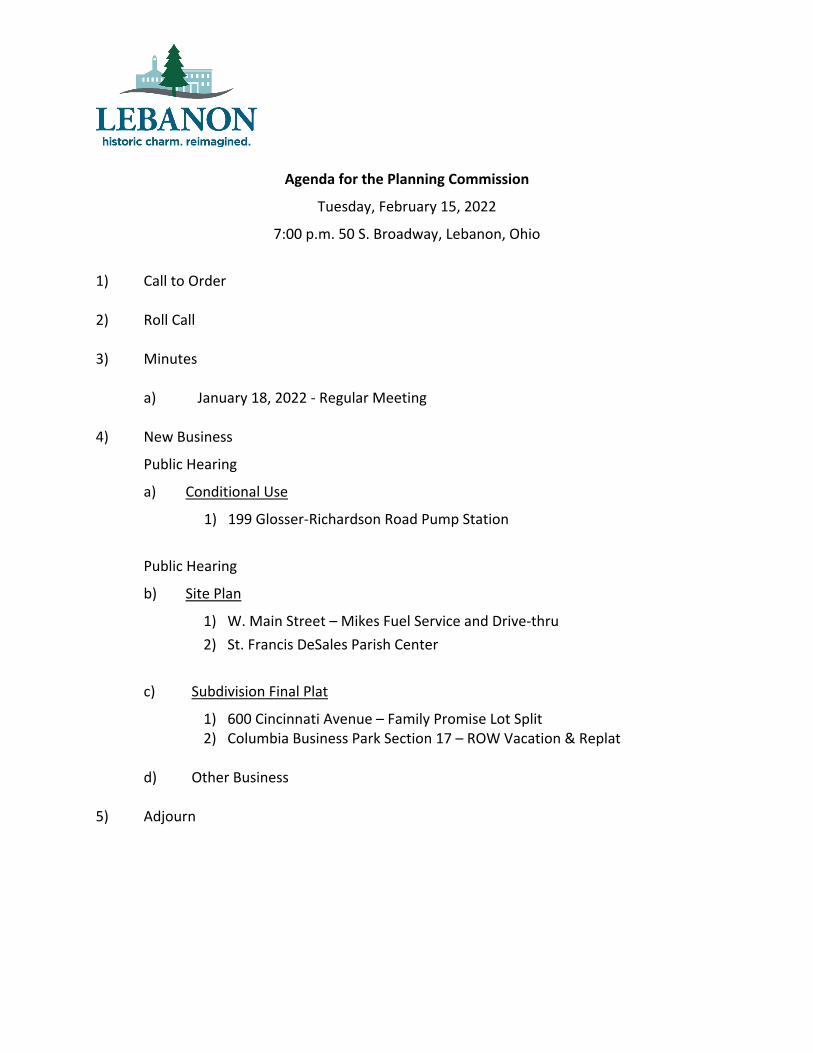
Agenda for the Planning Commission Tuesday, February 15, 2022 7:00 p.m. 50 S. Broadway, Lebanon, Ohio 1) Call to Order 2) Roll Call 3) Minutes a) January 18, 2022 - Regular Meeting 4) New Business Public Hearing a) Conditional Use 1) 199 Glosser-Richardson Road Pump Station Public Hearing b) Site Plan 1) W. Main Street – Mikes Fuel Service and Drive-thru 2) St. Francis DeSales Parish Center c) Subdivision Final Plat 1) 600 Cincinnati Avenue – Family Promise Lot Split 2) Columbia Business Park Section 17 – ROW Vacation & Replat d) Other Business 5) Adjourn
-
Upload
khangminh22 -
Category
Documents
-
view
1 -
download
0
Transcript of Agenda for the Planning Commission - Lebanon, Ohio
Agenda for the Planning Commission
Tuesday, February 15, 2022
7:00 p.m. 50 S. Broadway, Lebanon, Ohio
1) Call to Order
2) Roll Call
3) Minutes
a) January 18, 2022 - Regular Meeting
4) New Business
Public Hearing
a) Conditional Use
1) 199 Glosser-Richardson Road Pump Station
Public Hearing
b) Site Plan
1) W. Main Street – Mikes Fuel Service and Drive-thru 2) St. Francis DeSales Parish Center
c) Subdivision Final Plat
1) 600 Cincinnati Avenue – Family Promise Lot Split 2) Columbia Business Park Section 17 – ROW Vacation & Replat
d) Other Business
5) Adjourn
CITY OF LEBANON PLANNING COMMISSION MINUTES DATE: January 18, 2022 TIME: 7:00 p.m.
The meeting was called to order by Mr. Orosz. Members present were Mayor Messer, Amy Brewer, Bernie Uchtman, Tom Miller, and Jeff Aylor. Also present was Greg Orosz, City Planner.
A new Chairperson for the Commission was required to be elected.
Mrs. Brewer made a motion to nominate Mr. Aylor for Chair.
Mr. Uchtman seconded the motion.
Roll was called and the motion passed unanimously. Consideration of Minutes The meeting minutes for the December 15, 2021 regular meeting were reviewed and motioned for approval by Mr. Uchtman and seconded by Mr. Miller. The minutes were approved as written. Public Hearing Zoning Map Amendments for Neil Armstrong Way – Parcel: 12122000450
Mr. Orosz presented an overview Zoning Map Amendment requested by Fischer Homes on behalf of the property owner Bunnell Hill Development to rezone 9.148 acres, Parcel 12122860010, on Neil Armstrong Way, located at the southwest corner of Neil Armstrong Way and Franklin Road, from R-1CC (Residential One-CC) to R-1CC PUD.
The proposed rezoning request is to amend the parcel’s zoning to accommodate a regulatory/preliminary plan for 44 lots along with a detention pond and open space. The concept plan depicts the lots on 6.11 acres with a proposed open space of 2.3 acres. The plan shows 22 attached single-family buildings. The applicant is currently requesting a rezoning to R-1CC PUD to allow for alternative layout options other than what the R-1CC district would typically permit.
The applicant has submitted a concept plan with the map amendment application. The proposed development consists of both one-and two-story residential buildings. The primary rationale for the proposed PUD overlay is to permit 0’ side yard setback along the common wall of the attached units. Also, the applicant would like to reduce the required front and rear yard setback, at staff’s recommendation, to provide for at least 30’ buffer area along Neil Armstrong Way and a 10’ minimum buffer adjacent to the existing residential.
The proposed text amendment is to adjust due to changed conditions and changes necessary to advance the health, safety, and general welfare of the City. Based on the analysis, staff determined the proposed map amendment fulfills the approval criteria required the Lebanon Zoning Code.
Based on the analysis, staff finds the proposed Zoning Map Amendment requested by Fischer Homes on behalf of the property owner Bunnell Hill Development to rezone 9.148 acres, Parcel 12122860010, on Neil Armstrong Way from R-1CC (Residential One-CC) to R-1CC PUD fulfills the approval criteria required under Ch. 1132.05 (G) of the Lebanon Zoning Code.
CITY OF LEBANON PLANNING COMMISSION MINUTES DATE: January 18, 2022 TIME: 7:00 p.m.
Therefore, staff advised the Planning Commission to recommend approval of the Zoning Map Amendment, Concept Plan, and PUD Guidelines to City Council; subject to the following conditions:
1. All standards and concepts imposed herein or as represented on the PUD Concept Plan and/or the PUD Guidelines are a part of the regulatory requirements that will govern the PUD development.
2. Any standards found in the most recent City of Lebanon Official Zoning Code at the time of application that are not modified, varied, or addressed by this PUD approval shall continue to apply to the development.
3. A Regulatory Plan per §1132.05 shall be submitted prior to the approval of final plats. A full Preliminary Plan shall also be submitted concurrently with the Regulatory Plan.
The Public Hearing was opened at 7:15 by Mrs. Brewer and seconded by Mr. Uchtman.
Mrs. Nancy Bedwell, stated that she was not against the proposal, but her main concern is that she was told that multi-family development would no longer be permitted anywhere in the City.
Mr. Orosz said the current zoning district does allow for attached single family units as depicted in the plan.
The Public Hearing was closed at 7:18 by Mr. Miller and seconded by Mayor Messer.
Mayor Messer made a motion for approval and to recommend of the map amendment to City Council.
Mr. Miller seconded the motion.
Roll was called and the motion passed unanimously with staff conditions. CONDITIONAL USE R-2, Residential Two PUD 600 Cincinnati Avenue
Mr. Orosz presented an overview of the Review of a Conditional Use application for a Group Home in a recently rezoned Residential Two (R-2) PUD Overlay District. The property has been the Shaker Inn for decades with self-storage behind the motel. The Conditional Use for the property would allow for a Group Home scenario with institutional office and residential uses. The approximately 2.73 acres site that includes the Shaker Inn Motel will remain essentially the same. The motel sign will be removed, and landscaping installed along the frontage of Cincinnati Avenue. There will also be the addition of a black aluminum fence along the parking lot for safety reasons.
FPWC will use the northeastern portion of the Shaker Inn facility for a day center for children and adults to work with its staff. This space will also provide offices for Case Managers and Coordinators. The central portion of the facility, consisting of a registration office, on-site manager’s apartment, and storage will be the focal point for 24-hour supervision and
CITY OF LEBANON PLANNING COMMISSION MINUTES DATE: January 18, 2022 TIME: 7:00 p.m.
maintenance. The western portion of the facility, consisting of approximately 20 motel rooms will be used to temporarily house client families. Families will be served dinner and enjoy evening socialization/entertainment at the day center.
Based on staff’s analysis, the Conditional Use review complies with the approval criteria required under 1132.07 (D.). Therefore, staff recommended the Group Home for 600 Cincinnati Avenue, identified as a Conditional Use in the R-2 Zoning District in Table 1133-3, be approved; subject to the following conditions:
1. All applicable permits shall be issued by the City of Lebanon prior to the start of any building alteration or fence installation. Two original sets of the final plans shall be submitted for staff approval and signature.
2. A final plat must be approved for the splitting of the single lot into two development parcels of record.
3. Any variation from the approved plans may require additional review and approval by the Planning Commission and/or the Department of Planning and Development prior to making changes to the site.
The Public Hearing was opened at 7:25 by Mr. Uchtman and seconded by Mrs. Brewer.
With no one wishing to speak the Public Hearing was closed at 7:26 by Mr. Miller and seconded by Mayor Messer.
Mrs. Brewer made a motion for approval of the Conditional Use.
Mr. Miller seconded the motion.
Roll was called and the motion passed unanimously with staff conditions. SUBDIVISION FINAL PLAT Autumn Ridge Section 2-B
Mr. Orosz described the final plat for Autumn Ridge Section 2-B to develop the last section of Autumn Ridge, a total of 28 single-family residential lots on 12.9835 acres. Planning Commission approved a preliminary plan for the Autumn Ridge Subdivision on October 16, 2018, with final staff approval in July of 2019. The final plat complies with the layout, configuration, and density as provided in the approved preliminary plan.
All lots were reviewed under the minimum site development standards for the R-1B zoning district as required under Ch. 1134.02 (A.) The proposed single-family lots range from 13,502 S.F. to 38,405 S.F.
Based on the analysis, staff finds the final plat for Autumn Ridge Subdivision Section 2-B substantially complies with the approved preliminary plan and recommends the final plat be approved, subject to the following conditions:

CITY OF LEBANON PLANNING COMMISSION MINUTES DATE: January 18, 2022 TIME: 7:00 p.m.
1. The developer should work with staff on the placement of any excess street trees along the rear of Lot 8420 to screen the existing residence.
2. The final plat shall be recorded within sixty (60) days from the date of approval by the Lebanon City Council, as listed in Section 1117.04 (a)(4) of the Subdivision Regulations.
3. A reproducible Mylar of the recorded plat shall be provided to the City of Lebanon. Mayor Messer made a motion for approval of the Final Plat.
Mr. Miller seconded the motion.
Roll was called and the motion passed unanimously with staff conditions.
SUBDIVISION FINAL PLAT McBurney Woods
Mr. Orosz explained the final plat for McBurney Woods is to develop four single-family residential lots on 7.7162 acres. Planning Commission approved a preliminary plan for the McBurney Woods Subdivision on August 20, 2019, and a Preliminary Plan Extension on March 16, 2021. The final plat complies with the layout, configuration, and density as provided in the approved preliminary plan.
The final plat dedicates a 50' right-of-way (0.2876 ac.) for a short McBurney Drive extension ending in a cul-de-sac. The final plat will leave a reminder unplatted parcel of 20.9054 acres. All lots were reviewed under the minimum site development standards for the R-1A zoning district as required under Ch. 1134.02 (A.) The proposed single-family lots range from 1.3340 acres to 2.2893 acres.
Based on the analysis, staff finds the final plat for McBurney Woods complies with the approved preliminary plan and staff recommended the final plat be approved, subject to the following conditions:
1. The final plat shall be recorded within sixty (60) days from the date of approval by the Lebanon City Council, as listed in Section 1117.04 (a)(4) of the Subdivision Regulations.
2. A reproducible Mylar of the recorded plat shall be provided to the City of Lebanon. Mrs. Brewer made a motion for approval of the Final Plat.
Mr. Messer seconded the motion.
Roll was called and the motion passed unanimously with staff conditions.
OTHER BUSINESS Mr. Orosz gave an overview of the application on next month’s meeting.
Mr. Uchtman made a motion to adjourn the meeting. Mr. Miller seconded the motion.
Roll was called and the meeting was adjourned at 8:30 p.m.
__________________________________ _________________________________ SECRETARY – PLANNING COMMISSION CHAIRMAN – PLANNING COMMISSION

PLANNING COMMISSION STAFF REPORT February 15, 2022 Conditional Use Permit – Pump Station & EQ Improvements 199 Glosser-Richardson Road APPLICANT City of Lebanon
R E Q U E S T E D A C T I O N Conditional Use Review (Ch. 1132.07) to construct a new pump station and EQ improvements for a municipal facility.
CURRENT ZONING & USE Light Industrial (I-1) & Public Utility – Pump Station and EQ
D E S C R I P T I O N O F R E Q U E S T The City of Lebanon Public Works Department has submitted an application for facility improvements to the pump station and EQ basin on Glosser-Richardson Road. The wastewater pump station is classified as a public utility and permitted as a conditional use in the Light Industrial (I-1) zoning district subject to the requirements of Ch. 1135.02.
The pump station improvements are a major city project that recently received grant funding from the State due to its importance for the City and region. The enhancements consist of the construction of a precast concrete building with a brick façade to house the new pump station and extensive underground infrastructure. The access to the site will be maintained from Glosser-Richardson Road. A new parking lot and drive access will be constructed containing six parking spaces for technicians. An existing six-foot chain link fence will be replaced to enclose and secure the facility.
P U B L I C H E A R I N G N O T I F I C A T I O N A public hearing as required under Ch. 1132.04 (H.) has been scheduled. A public hearing notice was published on Sunday, January 16, 2022. A public hearing notice was mailed to all property owners within 500 feet of the subject property on Friday, January 14, 2022.
S T A F F A N A L Y S I S Existing Site Conditions and Physical Characteristics: The subject property encompasses three parcels and contains the City’s particulate wastewater separator and pump station. The facility complies with applicable development standards as required for a public utility in the Light Industrial Zone. The property is relatively flat with limited tree coverage south of the area designated for improvements.

Pup Station and EQ Improvements – Conditional Use Review 2/15/22
2
Surrounding Land Use: The property is zoned Light Industrial (I-1), as well as the adjoining properties to the south, east, and west. The property to the north is General Commercial.
Applicable Zoning Regulations: The location of the proposed building and overall improvement of the property as a public utility shall comply with the requirements set forth in Ch. 1135.02: Utilities Location. The requirements are as follows:
A. Such facilities shall be essential for the immediate area or for the proper functioning of the total utility system of which the element is a part.
B. A building or structure, except an enclosing fence, shall be set back at least 25 feet from any property line. The proposed plan places the building approximately 44’ from the right-of-way line.
C. Such facilities shall be enclosed by a protective fence as regulated by Section 1135.14 (Fencing). A fence will enclose the site.
D. Open spaces on the premises shall be suitably landscaped and maintained and a screening area according to Chapter 1138 (Landscaping and Buffering) of this chapter may be required in and along any yard. Heavy landscaping is discouraged on this site due to the number of utilities running through the area.
E. The storage of vehicles and equipment on the premises, unless enclosed or screened, shall be prohibited.
F. The surrounding area shall not be adversely affected by, and shall be protected from noise, odor, glare, dust, gas, smoke, and vibration by such suitable means and conditions as the planning commission may specify. The facility is located away from surrounding uses to minimize the impact.
G. To the maximum reasonable extent, buildings and structures should be as compatible in design as possible with the character of surrounding development. The proposed building will be brick.
S I T E P L A N

Pup Station and EQ Improvements – Conditional Use Review 2/15/22
3
A R C H I T E C T U R A L P L A N S
A brick façade has been added to the building to provide visual interest from Glosser-Richardson Road. The supporting infrastructure cannot contain significant architectural detail due to the necessary function of a facility of this nature. The site is in an Industrial District where this type of use is typically permitted. Staff recommends evergreen trees be added where feasible to screen the facility from the road.
C O N D I T I O N A L U S E C R I T E R I A
Section 1132.07 (D.) of the Lebanon Zoning Code requires, in order to approve a conditional use, the Planning Commission shall use the following review criteria. Staff’s findings for each criterion are provided as follows:
1. The use is in fact a conditional use as established within the applicable zoning district;
Finding: The facility is classified as a public utility and is an eligible conditional use as established under Ch.1135.02.

Pup Station and EQ Improvements – Conditional Use Review 2/15/22
4
2. The use will be harmonious with, and in accordance with, the purpose of this ordinance and consistent with the policies of the Lebanon Comprehensive Plan;
Finding: The public utility facility complies with the purpose and intent of the conditional use review as provided in Ch.1132.07. The conditional use is consistent with the policies of the Comprehensive Plan as a public utility is an eligible conditional use pursuant to Ch. 1135.02.
3. The use will conform to the general character of the neighborhood in which it will be located;
Finding: The use conforms to the general character of the area as the facility is compatible with the surrounding area.
4. The use complies with all applicable provisions of this ordinance including any use-specific provisions established in Chapter 1133 (Zoning Districts and Use Regulations);
Finding: The facility complies with the regulations as required in Ch. 1135.02 (A-G).
5. Will be designed, constructed, operated, and maintained so as to be harmonious and appropriate in appearance with the existing or intended character of the general vicinity, and will not change the essential character of the same area;
Finding: The facility will be in character with the surrounding area.
6. Will not create excessive additional requirements, at public cost, for public facilities and services and will not be detrimental to the economic welfare of the community;
Finding: The facility will not have any negative effect or create excessive additional requirements on public facilities or services or be detrimental to the economic welfare of the community.
7. That the proposed use at the particular location is necessary or desirable to provide a service or facility which will contribute to the general well being of the neighborhood or the community; and
Finding: The facility provides an essential public service that contributes to the general well-being of the community.
8. That such use will not be detrimental to the health, safety, or general welfare of persons residing or working in the vicinity, or injurious to property or improvements in the vicinity.
Finding: The facility provides an essential public service that supports the health, safety, and general welfare of the community. The facility is compatible with the surrounding area and will not have any negative effect or be detrimental to persons residing or working in the vicinity or injurious to property or improvements.
R E C O M M E N D A T I O N
Staff has determined that sufficient findings have been made to satisfy the criteria as required under Ch.1132.07 (D.) and Ch. 1135.02. Therefore, staff recommends the Conditional Use Review (Ch. 1132.07) to construct a New Pump Station and EQ improvements for municipal facilities at 199 Glosser-Richardson Road be approved; subject to the following conditions:
1. All plan interdepartmental comments shall be provided on revised plans for final staff approval prior to the zoning permit being issued for the project.
2. All applicable permits shall be issued by the City of Lebanon and the Warren County Building Department prior to the start of construction.

GLO
SSER
RD
PU
MP
STAT
ION
&EQ
UAL
IZAT
ION
BAS
IN19
9 G
LOSS
ER R
DLE
BAN
ON
, OH
450
36
CO
LUM
BIA
RD
BOO
STER
PU
MP
STAT
ION
3465
CO
LUM
BIA
RD
LEBA
NO
N, O
H 4
5036
WAS
TEW
ATER
TR
EATM
ENT
PLAN
T15
25 M
ASO
N-M
OR
RO
W-M
ILLG
RO
VE R
DLE
BAN
ON
, OH
450
36
EXIS
TIN
G 2
0" F
M
EXIS
TIN
G 2
0" F
M
EXIS
TIN
G 2
0" F
M
EXIS
TIN
G 2
0" F
M
P:\PR59364\Cadd\Sheets\G-01 TITLE.dwg 11/17/2021 10:24:26 AM Chris BowersPLOTTED: 11/18/2021 1:21:15 PM
CITY OF LEBANONGLOSSER RD PUMP STATION
AND EQ IMPROVEMENTS XX01G-0
1
TITL
E
MAU
NO
NE
XXX
CKDDES
PR59
364
NO
V 20
21
SHEE
T:O
F
SCAL
E:
APPR
OVE
D B
Y:
CH
ECKE
D B
Y:
DR
AWN
BY:
DES
IGN
ED B
Y:
DAT
E:
JOB
NO
:
NO:DESCRIPTIONDATEREVISIONS
525 VINE STREET,SUITE 1300CINCINNATI, OHIO 45202
SHEE
T ID
ENTI
FIC
ATIO
N
90%
REV
IEW
NO
T FO
RC
ON
STR
UC
TIO
NC
ITY
OF
LEBA
NO
NG
LOSS
ER R
D P
UM
P ST
ATIO
NAN
D E
Q IM
PRO
VEM
ENTS
VIC
INIT
Y M
AP
DA
RR
EN D
. OW
ENS,
PE,
SI
DIR
ECTO
R O
F PU
BLI
C W
OR
KS
MIK
E TO
NG
WW
TP S
UPE
RIN
TEN
DEN
T
EX. S
AN M
.H. C
EX. R
ETU
RN
PU
MPI
NG
STA
.
EX. H
/WEX
. 18"
STM
INV=
672
.72
EX. H
/WIN
V=67
0.08
- 24
"NIN
V= 6
70.2
6 - 3
0"N
W
EX. H
/W
EX. D
IVER
SIO
NC
HAM
BER
EX. S
AN M
.H. 1
EX. 1
5" S
AN (A
BAN
DO
N)
EX. 2
0" F
.M.
EX. A
IR &
VAC
UU
MR
ELEA
SE M
.H.
EX. 2
0" F
.M.
EX. P
UM
P ST
A.
EX. D
OU
BLE
GAT
E
EX H
/W
EX. W
ETW
ELL
EX. M
ETER
VAU
LT
EX. S
LID
E G
ATE EX
. SAN
M.H
. 2
EX E
LEC
. GAT
E KE
Y PA
D
EX G
AS L
INE
MAR
KER
EX. T
REA
TMEN
T PL
ANT
SIG
N
EX. F
ENC
E
EX G
ATE
OPE
RAT
OR
EX. T
RAN
SFO
RM
ERAN
D C
ON
C. P
AD
EX. C
LEAN
OU
T M
.H.
EX. S
TUB
&PL
UG
ON
42" S
AN
EX. V
ALVE
VAU
LTEX
. CO
NTR
OL
PAN
EL
EX. 1
2" E
Q D
RAI
N
INV=
670
.46
30" W
EXIS
T. E
Q B
ASIN
EX.18" STM
EX. 3
0" E
Q B
ASIN
GR
AVIT
Y IN
FLU
ENT
EX. 4
2" S
TM
EX. 42" STM
EX. 42" STM
EX. M
.H.
EX. M
.H.
EX. M
.H.
EX. 1
8" S
AN
EX. 1
8" S
AN
EX. 12" STM
EX. A
SPH
ALT
EX. 1
8" S
AN
EX.
33" S
AN
EX. 18" SAN
EX.
33" S
AN
EX.6
" FM
LIN
E EX. 24" OVERFLOW
EX. 8
" WM
EX. 8
" WM
EX.6" FM
EX. 30" SAN
EX. 3
6" IN
FLU
ENT
SEW
ER
EX. M
.H.
TOP=
680
.02
INV=
670
.31
- 30"
SIN
V= 6
70.3
2 - 3
0" W
EX. S
AN M
.H.
TOP=
681
.48
INV=
696
.25
- 15"
SIN
V= 6
65.8
8 - 3
3" E
INV=
665
.73
- 33"
WIN
V= 6
77.5
2 - 3
0" S
WIN
V= 6
73.9
7 - 6
" NEX
. 8' D
IA M
.H. B
Z:\Project\Lebanon\Glosser Road Design\Design Cad\C-01-03.dwg 11/19/2021 3:08:21 PM Greg AdamsPLOTTED: 11/19/2021 4:30:11 PM
CITY OF LEBANONGLOSSER ROAD PUMP STATION
AND EQ IMPROVEMENTS ###
4C-0
1
GR
PSEX
ISTI
NG
SITE
PLA
N
###
1"=2
0'
###
GW
AJC
F
PR59
364
NO
V 20
21
SHEE
T:O
F
SCAL
E:
APPR
OVE
D B
Y:
CH
ECKE
D B
Y:
DR
AWN
BY:
DES
IGN
ED B
Y:
DAT
E:
JOB
NO
:
NO:DESCRIPTIONDATEREVISIONS
020
'40
'
EX. 2
' DIA
. M.H
.G
RAT
E= 6
80.1
8IN
V.=
673.
14-1
2" N
6
72.9
2- 1
8" S
EX. 2
' DIA
. M.H
.G
RAT
E= 6
79.0
4IN
V.=
673.
08-1
2" S
IND
ICAT
ES M
ANH
OLE
S/PI
PELI
NES
TO
BE C
ON
STR
UC
TED
BY
OTH
ERS.
TH
ISC
ON
STR
UC
TIO
N M
AY O
R M
AY N
OT
BE B
UIL
T. C
ON
STR
UC
TIO
N M
AY B
EC
ON
CU
RR
ENT
WIT
H T
HIS
PR
OJE
CT.
TUR
TLE
CR
EEK
ABANDONED
OVERFLOW
APPR
OXI
MAT
E LO
CAT
ION
EXI
STIN
G B
UR
IED
CO
NC
RET
E FO
UN
DAT
ION
S/W
ALLS
(TYP
.)
EX. A
LUM
INU
M C
ANO
PY2-
EX.E
NG
INE
DR
IVEN
PU
MPS
2-EX
. HD
PE F
OR
CE
MAI
NS
EX.
EX.
EX.
EXEXEXEXEXEX.
EEEX.
EXEXEXEX.
EX.
EX.
EXEX.
EXEXEEEEXEXEXEXEEEXEEEXEXEEXEEEXEEEEEEX.
EEEEEEXEEEEEEXXXEXXEXEEEEX181181818188181181181818111181188818188188181818181188881888818818888888888888888888888888888888818888888811888888
"" S" S" S" S" S" S" S" S" SS"" S" S" SSSSS" S"" S" S"" SSSSS" S"" S" S" SSSS" S" SS" S" SSSS" S" S" S" SS" S" SSS" S" " SSSSSSS" SSSSSSSSSSSSSSSSSSSSSSSSSSSSSSSSAAAAAAAAAAAAAAAAAANANANAAAAAAAAAAANAAANANAANAAAAAANAANANNANANAAANANANANANANAAANANANAAAANAAAAANAANANANANANANNNNNNNANANNNNNAANNNNNNNANANNNNNNNNNNNNNNNN
EX.F
LOW
DIV
ERSI
ON
STR
UC
TUR
E
1.C
ON
TRAC
TOR
SH
ALL
REL
OC
ATE
EXIS
TIN
G E
NG
INE
DR
IVEN
PUM
PS A
ND
CAN
OPY
AS
REQ
UIR
ED. R
ELO
CAT
ION
SH
ALL
BE M
ADE
TO M
AIN
TAIN
SER
VIC
E, L
OC
ATIO
N T
O B
E PE
RTH
E D
IREC
TIO
N O
F C
ITY
OF
LEBA
NO
N. M
OD
IFIC
ATIO
NS
TOSU
CTI
ON
AN
D D
ISC
HAR
GE
MAI
NS
WIL
L BE
REQ
UIR
ED.
NO
TES:
(SEE
NO
TE 1
)
EX. ASPH. PATH
APR
OX.
LO
CAT
ION
EX.
ABAN
DO
NED
WAT
ERM
AIN
APR
OX.
LO
CAT
ION
EX.
ABAN
DO
NED
FO
RC
E M
AIN
APR
OX.
LO
CAT
ION
EX.
ABAN
DO
NED
WAT
ERM
AIN
EXIS
TIN
G P
SST
RU
CTU
RE
90%
REV
IEW
-N
OT
FOR
CO
NST
RU
CTI
ON
PRO
P. 1
04'~
30" S
AN@
0.9
6%
CO
NTR
ACTO
R S
HAL
L R
EMO
VE E
XIST
.H
/W A
ND
PIP
ING
AS
REQ
UIR
ED
PRO
P. H
/W F
= 67
3.50
SEE
DET
AIL
SHEE
T 10
PRO
P. 1
8" E
Q B
ASIN
PU
MPE
D IN
FLU
ENT
LOW
ER P
RO
P. 8
" WM
@PR
OP.
18" I
NFL
UEN
TC
RO
SSIN
G
EX. S
AN M
.H. C
EX. R
ETU
RN
PU
MPI
NG
STA
.
EX. H
/WEX
. 18"
STM
INV=
672
.72
EX. H
/WIN
V=67
0.08
- 24
"NIN
V= 6
70.2
6 - 3
0"N
W
EX. H
/W
EX. D
IVER
SIO
NC
HAM
BER
EX. S
AN M
.H. 1
EX. 1
5" S
AN (A
BAN
DO
N)
EX. 2
0" F
.M.
EX. A
IR &
VAC
UU
MR
ELEA
SE M
.H.
EX. 2
0" F
.M.
EX. P
UM
P ST
A.
EX. D
OU
BLE
GAT
E
EX H
/W
EX. W
ETW
ELL
EX. M
ETER
VAU
LT
EX. S
LID
E G
ATE EX
. SAN
M.H
. 2
PRO
POSE
D11
'~42
" @ 0
.20%
CO
NN
ECT
TOST
UBB
ED E
ND
EX E
LEC
. GAT
E KE
Y PA
D
EX G
AS L
INE
MAR
KER
EX. T
REA
TMEN
T PL
ANT
SIG
N
EX. F
ENC
E
EX G
ATE
OPE
RAT
OR
EX. T
RAN
SFO
RM
ERAN
D C
ON
C. P
AD
EX. C
LEAN
OU
T M
.H.
EX. S
TUB
&PL
UG
ON
42" S
AN
PRO
P. 6
' SAN
M.H
.TO
P= 6
80.6
3IN
V= 6
64.8
8 - 4
2" N
&SE
EX. V
ALVE
VAU
LTEX
. CO
NTR
OL
PAN
EL
PRO
P. M
HTO
P= 6
81.1
0
INV.
= 67
0.36
30"
NE
INV.
=67
1.00
2-6
" NW
EX. 1
2" E
Q D
RAI
N
INV=
670
.46
30" W
EXIS
T. E
Q B
ASIN
EX.18" STM
EX. 3
0" E
Q B
ASIN
GR
AVIT
Y IN
FLU
ENT
EX. 4
2" S
TM
EX. 42" STM
EX. 42" STM
EX. M
.H.
EX. M
.H.
EX. M
.H.
EX. 1
8" S
AN
EX. 1
8" S
AN
EX. 12" STM
EX. A
SPH
ALT
EX. 1
8" S
AN
* * *
EX.
33" S
AN
EX. 18" SAN
**
*
EX.
33" S
AN
FOR
DET
AIL
THIS
AR
EASE
E SH
EET
21
PRO
P. 6
" FM
LIN
EEX
.6" F
M L
INE
L
EX. 24" OVERFLOW
EX. 8
" WM
*
*
EX. 8
" WM
62'- 42" @ 0.21%
MH
NO
TES:
1. P
RO
CES
S P
IPIN
G T
O B
E R
EMO
VED
OR
ABA
ND
ON
ED S
HAL
LR
EMAI
N IN
SER
VIC
E AS
REQ
UIR
ED U
NTI
L N
EW P
UM
P ST
ATIO
NIS
OPE
RAT
ION
AL. A
LL B
UR
IED
EXI
STIN
G P
IPIN
G S
HO
W T
O B
EAB
AND
ON
ED S
HAL
L BE
FIL
LED
WIT
H G
EOFI
LL L
D C
ELLU
LAR
CO
NC
RET
E O
R E
QU
AL2.
PR
OC
ESS
PIPI
NG
INST
ALLE
D B
Y O
THER
S TO
BE
UN
BLO
CKE
DAN
D/O
R C
ON
NEC
TED
AS
REQ
UIR
ED T
O F
ACIL
ITAT
E N
EWPU
MP
STAT
ION
OPE
RAT
ION
.3.
SEE
DEM
OLI
TIO
N S
HEE
TS F
OR
DEM
OLI
TIO
N O
F EX
ISTI
NG
.4.
CO
NN
ECT
NEW
MAN
HO
LE T
O E
XIST
ING
30"
PIP
E W
ITH
ASE
CTI
ON
OF
THE
EXIS
TIN
G 3
0" P
IPE,
AN
D F
ERN
CO
CO
UPL
ING
REM
OVE
TO B
E R
EMO
VED
EX.6" FM
EX. 30" SAN
*
PRO
P. 2
-8" 4
5° D
I MJ
ELBO
WS
CO
NN
ECT
TO E
X. 8
" WM
EX. E
LEC
TRIC
SER
VIC
ETO
BE
MAI
NTA
INED
EX. 3
6" IN
FLU
ENT
SEW
ER
EX. M
.H.
TOP=
680
.02
INV=
670
.31
- 30"
SIN
V= 6
70.3
2 - 3
0" W
EX. S
AN M
.H.
TOP=
681
.48
INV=
696
.25
- 15"
SIN
V= 6
65.8
8 - 3
3" E
INV=
665
.73
- 33"
WIN
V= 6
77.5
2 - 3
0" S
WIN
V= 6
73.9
7 - 6
" N
E
* *EX
. 8' D
IA M
.H. B
Z:\Project\Lebanon\Glosser Road Design\Design Cad\C-01-03.dwg 11/19/2021 3:08:21 PM Greg Adams
CITY OF LEBANONGLOSSER ROAD PUMP STATION
AND EQ IMPROVEMENTS ###
5C-0
2
GR
PSPR
OPO
SED
SITE
PIP
ING
PLAN
###
1"=2
0'
###
GW
AJC
F
PR59
364
NO
V 20
21
SHEE
T:O
F
SCAL
E:
APPR
OVE
D B
Y:
CH
ECKE
D B
Y:
DR
AWN
BY:
DES
IGN
ED B
Y:
DAT
E:
JOB
NO
:
NO:DESCRIPTIONDATEREVISIONS
PRO
P. P
UM
P ST
A.BU
ILD
ING
020
'40
'
PRO
P. 2
4"-9
0° D
I MJ
ELBO
W
PRO
P. 2
4"x1
8" E
CC
. RED
UC
ERPR
OP.
MET
ERAN
D V
AULT
PRO
P. 2
4"-2
21 2°EL
BOW
REM
OVE
EX.
C.O
. & M
.H.
PRO
P. 2
0" T
EEPR
OP.
24"
x20"
RED
UC
ERPR
OP.
20"
PLU
G V
ALVE
S (2
TYP
.)PR
OP.
30"
22
1 2° E
LBO
W
PRO
P. 3
0" 2
2 1 2°
ELB
OW
SEE
SHEE
T 21
FO
RM
OR
E D
ETAI
L
PRO
P. O
VER
FLO
W W
EIR
EXIS
T. 8
" WM
PROP.
56'-3
0" D
I
INFL
UENT
@ 3.
32%
PRO
P. 3
0"~4
5° M
J-PE
ELBO
W IN
V= 6
68.5
PRO
P. 2
-8"-
45° D
I MJ
ELBO
WS
PRO
P. 8
"~45
° DI
MJ
ELBO
W IN
V= 6
68.5
PRO
P. 2
4"x1
8" E
CC
. RED
UC
ERPR
OP.
24"
PLU
G V
ALVE
PRO
P. 2
4" T
EEPR
OP.
24"
90°
DI M
J EL
BOW
PRO
P. 2
4" T
EEPR
OP.
24"
VAL
VEw
/BLO
CKI
NG
IND
ICAT
ES M
ANH
OLE
S/PI
PELI
NES
TO
BE C
ON
STR
UC
TED
BY
OTH
ERS.
PRO
P. 8
" DI
MJ
TEE
INV=
668
.5
PRO
P. 3
14'~
8" D
IW
ATER
MAI
N
L M
ON
OR
AIL
c
CB
CB
APPR
OXI
MAT
E LO
CAT
ION
EXI
STIN
G B
UR
IED
CO
NC
RET
E FO
UN
DAT
ION
S/W
ALLS
(TYP
.)
TUR
TLE
CR
EEK
CB
12" S
TM
12" S
TM12
" STM
MH
12" STM
PRO
P. B
OLL
ARD
STY
P. O
F 2
14'
PRO
P. T
RAN
SFO
RM
ER
PRO
P. G
ENER
ATO
RPR
OP.
12.
5'x3
2' C
ON
C. P
AD
PRO
P. 2
4"- D
I MJ
TEE
PRO
P. 2
4" P
LUG
VAL
VE
24" FMEX. ASPH. PATH
SHAL
L BE
ABAN
DO
NED
SEE
NO
TE 1
PRO
P. E
LEC
TRIC
AC
TUAT
EDPL
UG
VAL
VE W
ITH
EXT
ENSI
ON
STEM
PRO
P. 3
0"x1
8" D
IM
J TE
E w
/FER
NC
O
PRO
P. 1
8" D
I PIP
EPR
OP.
2-1
8" 4
5° D
I M
J EL
BOW
S
PRO
P. W
ATER
SER
V. C
ON
N.
SEE
DET
AIL
THIS
SH
T.
11 2" W
S
PLOTTED: 11/19/2021 4:30:22 PM
PRO
P. 1
1 2" W
ATER
SER
VIC
E
PRO
P. 1
1 2" V
ALVE
CU
RB
BOX
11 2" A
DAP
TER
REM
OVE
EX.
8" W
ATER
MAI
N
PRO
P. 4
" DI W
ATER
MAI
N
EX. 8
" WAT
ER M
AIN
PRO
P. 8
"x4"
DI R
EDU
CER
CO
NN
ECT
TO E
X.
WAT
ER S
ERVI
CE
CO
NN
ECTI
ON
DET
AIL
SCAL
E: N
.T.S
.
90%
REV
IEW
-N
OT
FOR
CO
NST
RU
CTI
ON
MH
PAD EL.= 681.75
BUIL
DIN
G L
OC
ATIO
NC
OO
RD
INAT
ES B
ASED
ON
NAD
83 S
OU
TH F
EET
NW
PIL
E C
ENTE
R
5
2614
5.46
21
1481
126.
7511
NE
PILE
CEN
TER
52
6139
.811
1
4811
76.5
364
SE P
ILE
CEN
TER
52
6115
.890
9
1
4811
73.8
212
SW P
ILE
CEN
TER
526
121.
5655
14
8112
3.82
91
LOC
ATIO
NN
OR
THIN
GEA
STIN
G
NO
TE: C
OO
RD
INAT
ES S
HO
WN
AR
E TO
CEN
TER
OF
PILE
S
AT
DES
CR
IBED
LO
CAT
ION
S. C
ON
TRAC
TOR
TO
VER
IFY
LOC
ATIO
NS
PRIO
R T
O S
ETTI
NG
PIL
ES.

E
1.00'
24.2
6'
Z:\Project\Lebanon\Glosser Road Design\Design Cad\C-01-03.dwg 11/19/2021 3:08:21 PM Greg AdamsPLOTTED: 11/19/2021 4:30:32 PM
CITY OF LEBANONGLOSSER ROAD PUMP STATION
AND EQ IMPROVEMENTS ###
6C-0
3
GR
PSPR
OPO
SED
PAVI
NG
, GR
ADIN
G&
DR
AIN
AGE
PLAN
###
1"=2
0'
###
GW
AJC
F
PR59
364
NO
V 20
21
SHEE
T:O
F
SCAL
E:
APPR
OVE
D B
Y:
CH
ECKE
D B
Y:
DR
AWN
BY:
DES
IGN
ED B
Y:
DAT
E:
JOB
NO
:
NO:DESCRIPTIONDATEREVISIONS
680 9
5 E/P
x68
0 83 E
/Px
680 7
5 E/P
x68
0 60 E
/Px
680 6
6 E/P
x
681 3
0 PR
x
680 4
8 E/P
x
682 0
3 E/P
xx
x
681
11 E
/Px
681 2
5 E/P
x68
2 00 T
/SLA
B
x
x68
1 50 E
/Px
020
'40
'
20'~1
8" S
TM@
0.5
0%
EX. 2
' DIA
. M.H
.G
RAT
E= 6
80.1
8IN
V.=
PLU
GG
ED-1
2" N
6
72.9
2- 1
8" S
GR
PST/
SLAB
= 68
2.0
EX. S
AN M
.H.
TOP=
680
.13
EX. S
AN M
.H.
TOP=
682
.07
EX. S
AN M
.H.
TOP=
681
.48
EX. G
ATE
x
EXIS
T. E
Q B
ASIN
PRO
P. M
ETER
VAU
LTSE
E D
ETAI
L SH
EET
9
EX. M
.H.
EX. M
.H.
EX. M
.H.
EX. S
AN M
.H.
TOP=
681
.14
EX. S
AN M
.H.
TOP=
681
.22
PRO
P. S
AN M
.H.
TOP=
680
.68
PRO
P. 2
4" F
OR
CE
MAI
N
REM
OVE
D
PRO
P. 8
" W.M
.
PRO
P. 2
0" F
M
PRO
P. 6
" FM
EX. R
ETU
RN
PUM
PIN
GST
ATIO
N
EX. GAS MAIN
EX. 18" STM
EX. 1
8" S
AN
682 2
5 E/P
x
EX. 15" SAN ABANDONED
EX. 1
8" S
AN
EX. 1
8" S
AN
EX. 3
3" S
AN
EX. P
LAN
T SI
GN
TO R
EMAI
N
x
x
682 4
8 E/P
x
x
681
48 E
/Px
x
x
681 0
0 PR
x
PRO
P. C
B 2-
2BG
RAT
E= 6
80.0
0IN
V.=
673.
58 -1
8" S
E
EX. 24" OVERFLOW
16'
12'
14.00'
PRO
P. S
TM. M
.H.
TOP=
681
.60
INV.
= 67
3.83
NIN
V.=
673.
73 W
PRO
P. C
B 2-
2BG
RAT
E= 6
79.7
0IN
V.=
674.
38
65'-12" RCP @ 0.55%
61'-1
2" R
CP
@ 0
.55% 67
3.39
12"
E67
3.02
18"
NW
SWAL
E @
1%
14'
C-1
C-2
C-3
C-4
135.54'
TUR
TLE
CR
EEK
ASPH
ALT
/ CU
RVE
DAT
AC
UR
VE
RAD
IUS
L
ENG
TH
N
OR
THIN
G
EAST
ING
C1
42
'
66.
31'
526
199.
84
1
4810
47.4
3
C2
35
'
55.
00'
526
192.
31
1
4810
51.6
1
C3
42
'
65.
94'
526
195.
93
1
4810
82.7
9
C4
35
'
55.
05'
526
189.
66
1
4810
74.8
4
C5
30
'
46.
81'
526
122.
82
1
4810
38.6
7
C6
15
'
23.
46'
526
063.
69
1
4810
16.7
2
C7
30
'
34.
41'
526
119.
95
1
4810
63.4
9
C8
10
0'
53.
53'
526
162.
70
1
4811
63.8
0
C9
18
'
21.
18'
526
055.
68
1
4812
13.9
8
C10
28'
9
.91'
526
068.
20
1
4812
11.9
2
C11
42'
21.
68'
526
116.
56
1
4812
19.9
8
C-5
C-6
C-7
C-8
C-9
C-10
C-11
S 6° 31'14" W ~ 70.76'
S 6°
31'
01"
E ~
35.
52'
APPR
OXI
MAT
E LO
CAT
ION
EXI
STIN
G B
UR
IED
CO
NC
RET
E FO
UN
DAT
ION
S/W
ALLS
(TYP
.)
PRO
P. A
SPH
ALT
PAVE
MEN
T
PRO
P. C
ON
C. P
ADSE
E G
RAD
ING
DET
AIL
LEFT
F/F=
682
.00
PRO
P. T
RAN
SFO
RM
ER
PRO
P. G
ENER
ATO
RPA
D E
L.=
681.
75
72'~1
8" S
TM @
0.5
0%PRO
P.SA
N M
.H.
TOP=
680
.72
GAR
AGE
ENTR
Y G
RAD
ING
DET
AIL
5' CONC WALK
F/F= 682.00
2%
EX. ASPH. PATH
5' C
ON
C.
WAL
K
5'
EXIS
TIN
G P
UM
P ST
ATIO
N B
UIL
DIN
G, P
IPIN
GEQ
UIP
MEN
T, S
TRU
CTU
RES
ETC
. REM
OVE
DIN
AR
EAS
TO R
EMAI
N E
ARTH
EN S
HAL
L BE
SEED
ED A
ND
SO
DD
ED P
ER C
ITY
STAN
DAR
DS.
REG
RAD
E AR
EAS
TO E
XIST
ING
ELE
VATI
ON
SU
NLE
SS O
THER
WIS
E SH
OW
N.
N 6° 31'14" E ~ 138.68'
EX. 6
" FM
EX. V
ALVE
VAU
LTEX
. SAN
M.H
.
PRO
P. C
B 2-
2BG
RAT
E= 6
80.0
4IN
V.=
673.
12 -
18" S
EIN
V.=
673.
22 -
18" N
W
PRO
P. A
SPH
ALT
PAVE
MEN
T
PRO
P. E
LEC
TRIC
GAT
E KE
Y PA
DPR
OP.
ELE
CTR
IC G
ATE
MO
TOR
PRO
P. E
LEC
TRIC
SLI
DIN
G G
ATE
PRO
P. E
LEC
TRIC
GAT
E LO
OP
681
24 E
/Px
681
34 E
/Px68
1 33
E/P
x
xx68
1 62
681
65
681.
90 T
/C
681.
40 E
/Px
681
26 E
/Px
681.
90 T
/C
681.
40 E
/P
x
x
x
R-1
R-2
CU
RVE
DAT
AR
-1R
= 3.
00' F
/CL=
4.7
2'N
= 52
6145
.25
E= 1
4811
22.1
5
xx
681.
90 T
/C
681.
63 E
/P
681.
90 T
/C
681.
83 E
/P
681.
90 T
/C
681.
57 E
/P 681.
90 T
/C
681.
74 E
/P
x
x
R-2
R=
2.50
' F/C
L= 3
.93'
N=
5261
29.7
2E=
148
1121
.57
PRO
P BO
LLAR
D
682.
00 T
/SLA
B
681.
25 E
/Px
681
11 E
/Px
F/C
ON
C. S
LAB
B/C
ON
C. W
ALK
14'
16'
681.
62 E
/Px
682.
34 E
/P
682 1
2 E/P
682.
34 E
/P
681
5x
683
27 x68
0 7x
680
5x
681.
90 T
/C
681.
40 E
/P
681.
90 T
/C
681.
40 E
/P
SCAL
E: 1
"= 5
'
LEG
END
x
682.
80 E
/PH
IGH
PO
INT
32'
682
12 E
/Px
682.
08 E
/P
682.
21 E
/P
681.
90 T
/C68
1.40
E/P
IND
ICAT
ES T
OP
OF
CU
RB/
WAL
K EL
EVAT
ION
IND
ICAT
ES E
DG
E O
F PA
VEM
ENT
ELEV
ATIO
N68
2 7 x
IND
ICAT
ES S
POT
ELEV
ATIO
N
680
681
681
682
682
682
683
681
682
680
x
x
xx
680 6
5 E/P68
1 00 E
/P68
0 50 E
/P
681 4
0 E/P
x
680 5
0 E/P
x
680 1
8 E/P
x
x
683
683
681
682.
00
682.
00
681 5
0 E/P
x
x68
1.10
680 9
0 E/P
x
682 4
0 E/P
x
x
681.
95
x68
0.54
SWAL
E @
0.4
3°
681
681
26 E
/Px
681 40 E/Px
681
2x
IND
ICAT
ES A
SPH
ALT
PAVE
MEN
T AR
EAIN
DIC
ATES
CO
NC
RET
E PA
VEM
ENT
AREA
90%
REV
IEW
-N
OT
FOR
CO
NST
RU
CTI
ON
PRO
P. S
TM. M
.H.
TOP=
681
.70
INV.
= 67
4.29
NW
INV.
= 67
4.19
S
17'-1
2" R
CP
@ 0
.55%
681 52 E/Px
CTR
.==C
TR.
EX. H
/WF=
672
.72
L
C-2
28'-4"
S83°
37'0
0"E
2
55.3
0'
S06°04'30"W 255.42'
N06°04'30"E 208.56'
N83
°37'
00"W
2
08.5
6'
S06°04'30"W 208.56'
18.16'
11.6
3'
24.5'
E
WWWWWWW
XX
XX
XX
XX
XX
X
X X X X X X X X X X
X X X X X
E
E
12'
Z:\Project\Lebanon\Glosser Road Design\Design Cad\C-04,05,11.dwg 11/19/2021 2:49:42 PM Greg AdamsPLOTTED: 11/19/2021 4:30:43 PM
CITY OF LEBANONGLOSSER ROAD PUMP STATION
AND EQ IMPROVEMENTS
C-0
4
CR
BSPR
OPO
SED
SITE
PIP
ING
PLAN
###
1"=1
0'
###
GW
AJC
F
PR59
364
NO
V 20
21
SHEE
T:O
F
SCAL
E:
APPR
OVE
D B
Y:
CH
ECKE
D B
Y:
DR
AWN
BY:
DES
IGN
ED B
Y:
DAT
E:
JOB
NO
:
NO:DESCRIPTIONDATEREVISIONS
010
'20
'
NEW BOOSTER PUMPSTATION F/F= 659.5
20" M
J W
YE
20" M
J PL
UG
VAL
VE
8' D
IA. M
ETER
VAU
LT M
.H.
SEE
DET
AIL
SHEE
T 9
20" F
LAN
GED
CH
ECK
VALV
E
20" R
ESTR
AIN
ED F
CA
BOTH
EN
DS
20" M
J PL
UG
VAL
VE
20" D
I MJ
TEE
20"x
12" D
I MJ
TEE
CO
NTR
ACTO
R S
HAL
L VE
RIF
Y LO
CAT
ION
OF
THE
EXIS
TIN
G 2
0" F
M A
ND
CO
NN
ECT
TOTH
E N
EW 2
0" F
.M. W
ITH
EBA
A IR
ON
MEG
A -
CO
UPL
ING
SER
IES
3800
OR
EQ
UAL
. SEE
NO
TE 2
6" 4
5° D
I MJ
ELBO
W T
YP. O
F 2
20" D
I MJ
TEE
(TYP
. OF
4)
20" D
I MJ
45° E
LBO
W (T
YP O
F 4) 20
"x12
" DI M
J W
YE
12" M
J PL
UG
VAL
VE
20" E
LEC
TRIC
PLU
GVA
LVE
(TYP
. OF
2)
10' x
10'
VAL
VE V
AULT
SEE
DET
AIL
SHEE
T 10
SEE
BOO
STER
STA
TIO
N P
LAN
S FO
RPI
PIN
G A
ND
EQ
UIP
MEN
T AB
OVE
F/F
ELEV
.
32.6
5'
59.97'
20" D
IP
20" D
IP
APPR
OXI
MAT
E LO
CAT
ION
EX.
20"
FM
CO
NTR
ACTO
R T
O V
ERIF
Y
60'
EX. W
OO
DEN
SPL
IT R
AIL
FEN
CE
(TO
BE
REM
OVE
D)
ASPH
ALT
DR
IVE
PAR
KIN
G A
REA
20" P
LUG
VAL
VE (T
YP. O
F 3)
APPR
OXI
MAT
E LO
CAT
ION
WAT
ERM
AIN
EXT
ENSI
ON
, BY
OTH
ERS
4'x5
' CO
NC
.PA
D
8" D
I WAT
ER M
AIN
TO
TH
ER
/W (B
Y O
THER
S)
EXIS
TIN
G S
LAB
EXIS
TIN
G B
UIL
DIN
G
C.O
.IN
V.6"
= 65
5.50
86 L
F~6"
SC
HED
ULE
80
@ 5
.0%
INV.
6"=
651
.5
CH
AIN
LIN
K FE
NC
E
EXIS
TIN
G C
ON
CR
ETE
RAM
P
TID
EFLE
X D
UC
KBIL
L
GR
IND
ER P
UM
P
+
62.5
'_
E/P
+
SPLA
SH P
AD 2
' x 4
'
FH
PRO
P. E
LEC
TRIC
GAT
E KE
Y PA
DPR
OP.
ELE
CTR
IC G
ATE
MO
TOR
PRO
P. E
LEC
TRIC
SLI
DIN
G G
ATE
PRO
P. E
LEC
TRIC
GAT
E LO
OPS
20" 9
0° D
I MJ
ELBO
W T
YP. O
F 2
6" D
I FLU
SH W
ATER
LIN
E
1-1/
4" G
RIN
DER
PUM
P D
ISC
HAR
GE
1-1/
4" 4
5° E
LBO
W(T
YP O
F 2)
28.5
'
27.5
' _
CO
NTR
ACTO
R S
HAL
L VE
RIF
Y LO
CAT
ION
OF
THE
EXIS
TIN
G 2
0" F
M A
ND
CO
NN
ECT
TOTH
E N
EW 2
0" F
.M. W
ITH
EBA
A IR
ON
MEG
A -
CO
UPL
ING
SER
IES
3800
OR
EQ
UAL
. SEE
NO
TE 2
1.AL
L BU
RIE
D P
IPIN
G S
HAL
L BE
RES
TRAI
NED
JO
INT.
2.PR
IOR
TO
CU
TTIN
G T
HE
EXIS
TIN
G 2
0' F
OR
CE
MAI
N A
T EA
CH
EN
DFO
R C
ON
NEC
TIO
N O
F N
EW P
IPIN
G ,
CO
NTR
ACTO
R S
HAL
L EM
PLO
YN
ECES
SAR
Y M
EAN
S TO
PR
EVEN
T SE
WER
DIS
CH
ARG
E AT
SIT
E. IF
CO
NTR
ACTO
R C
HO
OSE
S TO
UTI
LIZE
TH
E G
LOSS
ER R
OAD
EQU
ALIZ
ATIO
N B
ASIN
FO
R S
TOR
AGE
DU
RIN
G C
ON
NEC
TIO
N, A
MAX
IMU
M O
F 16
HO
UR
S W
ILL
BE A
LLO
WED
. DU
E TO
TH
E AL
IGN
MEN
TO
F TH
E EX
ISTI
NG
FO
RC
E M
AIN
, BLO
CKI
NG
OF
FLO
W IN
PIP
E W
ILL
BER
EQU
IRED
. CO
NTR
ACTO
R S
HAL
L SU
BMIT
DET
AILE
D IN
FOR
MAT
ION
ON
HO
W T
HIS
WIL
L BE
AC
CO
MPL
ISH
ED, (
FOLD
ING
PLU
G IN
SER
TIO
N,
FREE
ZIN
G M
ETH
OD
S ET
C.).
ALT
ERN
ATIV
ELY,
CO
NTR
ACTO
R C
ANBY
PASS
PU
MP
ARO
UN
D T
HE
CO
NN
ECTI
ON
PO
INTS
. LO
CAT
ION
FO
RTA
PS R
EQU
IRED
FO
R IN
SER
TIO
N P
LUG
S O
R B
YPAS
S LI
NE
ARE
NO
TSH
OW
N A
ND
SH
ALL
BE D
ETER
MIN
ED B
Y C
ON
TRAC
TOR
.
ABAN
DO
N E
XIST
ING
20"
PIP
E
GEN
ERAT
OR
PAD
9.5'
x23.
5'EL
EV.=
659
.50
TRAN
SFO
RM
ERPA
D 8
.5'x
8.5'
ELEV
.= 6
59.0
0
UTI
LITY
PAD
7.5'
x8.5
'EL
EV.=
659
.00
4" P
VC F
LOO
RD
RAI
N
5'
AC U
NIT
90%
REV
IEW
-N
OT
FOR
CO
NST
RU
CTI
ON
NO
TES:
59.06'
BUIL
DIN
G L
OC
ATIO
NC
OO
RD
INAT
ES B
ASED
ON
NAD
83 S
OU
TH F
EET
NW
CO
RN
ER
5
0916
3.29
71
1473
926.
8276
NE
CO
RN
ER
5091
60.0
734
147
3959
.321
7SW
CO
RN
ER
5
0910
3.61
41
147
3290
.906
5SE
CO
RN
ER
5091
00.3
904
14
7395
3.40
06
LOC
ATIO
NN
OR
THIN
GEA
STIN
G6"H
x8"W
x8'L
CO
NC
RET
E M
OW
STR
IP A
RO
UN
D B
LDG
. PER
IMET
ER
NO
TE: C
OO
RD
INAT
ES S
HO
WN
AR
E TO
OU
TER
BU
ILD
ING
FOU
ND
ATIO
N C
OR
NER
S. C
ON
TRAC
TOR
TO
VER
IFY
CO
OR
DIN
ATES
PR
IOR
TO
PO
UR
ING
FO
UN
DAT
ION
.
CB
12" RCP
H/W

EX. 20" F.M.
EX. 20" F.M.
C-2 28'-4"
N83
°37'
00"W
2
55.3
0'
S06°04'30"W 255.42'
S83°
37'0
0"E
2
55.3
0'
S06°04'30"W 119.25'
S06°04'30"W 255.42'
N06°04'30"E 208.56'
S83°
37'0
0"E
2
08.5
6'
N83
°37'
00"W
2
08.5
6'
S06°04'30"W 208.56'
18.16'
11.6
3'
24.5'
E
WW
WW
W
XX
XX
X
XX
XX
XX
E
E
50'
6'
BEG
IN T
APER
@ T
ANG
ENC
Y
12'
Z:\Project\Lebanon\Glosser Road Design\Design Cad\C-04,05,11.dwg 11/19/2021 2:49:42 PM Greg AdamsPLOTTED: 11/19/2021 4:30:48 PM
CITY OF LEBANONGLOSSER ROAD PUMP STATION
AND EQ IMPROVEMENTS
C-0
5
CR
BSPR
OPO
SED
PAVI
NG
, GR
ADIN
G&
DR
AIN
AGE
PLAN
###
1"=2
0'
###
GW
AJC
F
PR59
364
NO
V 20
21
SHEE
T:O
F
SCAL
E:
APPR
OVE
D B
Y:
CH
ECKE
D B
Y:
DR
AWN
BY:
DES
IGN
ED B
Y:
DAT
E:
JOB
NO
:
NO:DESCRIPTIONDATEREVISIONS
020
'40
'
EX. C
ULV
ERT
PRO
POSE
D 6
0'~1
2" R
CP
@0.
50%
(SEE
NO
TE 1
)
EXIS
TIN
G S
LAB
EXIS
TIN
GBU
ILD
ING
ASPH
ALT
/ CU
RVE
DAT
AC
UR
VE
RAD
IUS
N
OR
THIN
G
EAST
ING
C1
12.
5'
509
197.
31
1
4390
0.81
C
2
25'
5
0916
156
147
3967
.61
EXIS
T.C
ON
C.
RAM
P
PRO
POSE
D C
HAI
NLI
NK
FEN
CE
PRO
POSE
DG
RIN
DER
PU
MP
661
660
28.5
'
C-1
PRO
P. S
WAL
E @
2.5
%
659
658
658
659
657
78.7
'
E/P
PC
PT
TRU
CK
TUR
N T
APER
SCAL
E: 1
"= 2
0'
50' T
APER
660
659.
50 E
/Px
NEW BOOSTER PUMP STATION F/F= 659.5
20" F
M
20" F
M
12" FM
PRO
P. V
ALVE
VAU
LT65
9.50
E/P
x
MH
660.
50 E
/Px
x
660.
80 E
/P
659.
10 E
/Px
659.
42 F
/WAL
K
659.
25 E
/P
659.
79 E
/Px
660.
70 E
/Px
UTI
LITY
PAD
7.5'
x8.5
'EL
.= 6
59.0
0
TRAN
SFO
RM
ERPA
D 8
.5'x
8.5'
EL.=
659
.00
GEN
ERAT
OR
PAD
9.5
'x23
.5'
EL.=
659
.40
90%
REV
IEW
-N
OT
FOR
CO
NST
RU
CTI
ON
PRO
P. C
B 2-
2BG
RAT
E= 6
56.7
INV.
= 65
5.3
PRO
P. H
/W 2
-2B
PRO
P 12
" RC
PIN
V.=
655.
0
1.C
ON
TRAC
TOR
TO
VER
IFY
LOC
ATIO
N A
ND
DEP
TH O
F TH
E EX
ISTI
NG
FO
RC
EM
AIN
PR
IOR
TO
DR
IVE
PIPE
AN
D B
ASIN
INST
ALLA
TIO
N. A
NY
CO
NFL
ICT
FOU
ND
TO
EXI
ST T
HE
RES
OLU
TIO
N S
HAL
L BE
APP
RO
VED
BY
ENG
INEE
R.
NO
TE:


PLANNING COMMISSION STAFF REPORT February 15, 2022
Major Site Plan Big Mikes Fuel Service & Drive-through W. Main St. – Parcel 1212485001 OWNER Schueler Group Applicant: Mark Sullivan Project Manager Schueler Group Bunnell Hill Construction
CURRENT ZONING/USE GC, General Commercial - Vacant Lot
R E Q U E S T E D A C T I O N The applicant requests Planning Commission review for a Fuel Services and Drive-through facility with alternative use-specific standards and parking standards.
B A C K G R O U N D The applicant has submitted an application for major site plan review in accordance with Ch. 1132.06 of the Zoning Code to construct a gas station and drive-through facility on a vacant property located at W. Main Street and Neil Armstrong Way. The site encompasses 1.72 acres out of 9.9387 total acres for the parcel. There will be a vacant lot to the west and north of the proposed property owned by the same ownership group. North of the property is multi-family residential. To the east across Neil Armstrong Way is Newman Gasket.

Big Mikes Gas Station and Drive-Through – Major Site Plan Review 2/15/2022
Page 2 of 8
S T A F F A N A L Y S I S The site is zoned General Commercial (GC) and has frontage along W. Main Street. Fuel services and drive-through facilities are permitted in the GC zone with use-specific standards in Table 1133-4. The proposed layout meets most of the general zoning standards as the rear setback was increased from 35’ to 50’.
S I T E P L A N
Zoning Standard Proposed Front Yard Setbacks 50’ 60’ Side Yard Setback 25’one - 50’ total 85’ Rear Yard Setback 50’ 50’
Maximum Building Height 45’ 19’ Maximum Building Coverage 50% 16% (4,949 + 4,885 SF canopy = 9,834 SF)
Maximum Imperious 80% 65.5%

Big Mikes Gas Station and Drive-Through – Major Site Plan Review 2/15/2022
Page 3 of 8
Access Management – The proposed site will have a full access point from Neil Armstrong Way (SR 123) and another from W. Main Street. The access point on Neil Armstrong Way is currently being reviewed by the City Engineering Division and ODOT as the proposed entrance is closer to the intersection than the existing curb cut established by ODOT during the construction of the roadway. The access leads to drive aisles to access the drive-through on the west side of the building and around the sides to gain access to the front. This entrance will serve as the primary access point from Neil Armstrong Way for the remaining portion of the property and the current design depicts the future drive connecting to the center of the original parcel. Building Location - The site plan shows the proposed fuel pumps located along the W. Main Street frontage with the primary structure located in the rear. This proposed layout does not meet the following standards and the applicant is requesting an alternative layout to this use-specific standard. This is a newer amendment to the zoning code but is consistent with other provisions in the code where accessory structures are not permitted in the front yard.
Section 1133.13: Use Specific Regulations B.2: Fuel Services - In addition to the applicable provisions of this chapter, fuel services shall comply with the following:
b. Fuel pumps and related driveways and paved areas shall be erected in the side or rear yard not less than 30 feet from an existing or proposed street right of way.
Drive-through Facility - The development also contains a drive-through as part of the main structure. Drive-through facilities have the following use-specific standards which apply to this development scenario:
a. A drive-through facility shall be designed and located to minimize visual, traffic, and noise impacts on neighboring development. In addition to the applicable provisions of this chapter, any and all drive-through facilities shall comply with the following:
iii. The drive-through facility shall be oriented to face an alley, driveway, or interior parking area, and not a street. See Figure 1.
vi. The architectural design of drive-through facilities shall comply with Ch.1136 and 1140 as required.
b. In addition to the applicable provisions of this chapter, the following regulations shall apply to any and all drive-through facilities adjacent to a residential use or district:
i. Audible communication devices shall be a minimum of 100 feet from an adjacent residential use or district and/or a suitable acoustical barrier erected.
ii. Drive-through shall be located on the site to maximize the distance from residential uses or districts.
iii. Drive lanes designated for drive-through facilities shall not be located immediately adjacent to residential development.
iv. Drive-through facilities may only be operated between the hours of 7:00 a.m. and 9:00 p.m.
1137.06 Location and Access for Parking and Loading Areas – The applicant is also requesting a modification to aspects of the off-street parking. Specifically, the provision dealing with the location of the off-street parking. All the parking for the site is located in front of the building. All off-street parking and loading areas shall meet the following provisions unless otherwise provided for in other sections of this Ordinance.

Big Mikes Gas Station and Drive-Through – Major Site Plan Review 2/15/2022
Page 4 of 8
E.2: Parking lots shall be located, to the maximum extent feasible, to the rear and side of buildings in nonresidential districts. No more than 25% of the total off-street parking may be permitted in front of the building.
Off-street Parking – Fuel service facilities are required to provide two spaces per 1,000 SF of floor area plus one space per fuel pump. The building is 4,949 SF which requires 10 spaces and there are 8 pumps for a total of 18 required spaces. There are 17 spaces provided near the building and in front of the fuel pumps for additional parking. The Community Development Department may permit a reduction of the required number of spaces upon compliance with all other sections of this chapter. Off-street parking and loading may be permitted in the front (25% of total), side, or rear yards of permitted nonresidential uses, provided that off-street parking facilities shall be set back a minimum of ten feet from all lot lines. All parking as proposed is a minimum of ten feet from all property lines.
L A N D S C A P E P L A N
Tree Requirements - Street trees shall be required along any public street within the city. Required street trees can count toward the ten required canopy trees for the site. The plan depicts a mix of ornamental and shade six shade trees to fulfill the tree requirement along W. Main Street and most of Neil Armstrong Way. Three trees were added north up Neil Armstrong Way along the driveway entrance to meet the requirement as well as additional trees were added around the perimeter as noted in the previous report.
Landscaping Building Requirements: Overall Site Landscaping Requirements require that shrubs shall be placed around the building perimeter of the building, with emphasis on building foundations visible from the public right-of-way. The sides of the building have sufficient landscaping. However, the front of the building just has landscape islands along each side of the drive-through.

Big Mikes Gas Station and Drive-Through – Major Site Plan Review 2/15/2022
Page 5 of 8
Buffer Requirements: In the short term, the remainder of the property to the north is to remain vacant and a row of evergreen trees are proposed to block the view of the facility from the multi-family residential. The door of the drive-through units will be visible from the multi-family until the plantings grow. The evergreens are staggered, and two additional trees were added per staff’s request. The landscaping meets the general requirements and would provide a suitable design treatment for the facility and the street intersection.
Ground Signs: The ground sign must comply with the applicable location, size, and height requirements per Ch. 1139.08 (A) and should be worked into the landscape plan. Landscaping or two additional trees are required around any ground-mounted sign. A sign permit is required and subject to administrative review, independent of site plan approval.
Bike Trail: The plan depicts a proposed trail extension of the Neil Armstrong Way path along W. Main Street in front of the development. This will be a nice extension that will lead into planned western routes. The proposed bike trail shows conflicts with guy wires and anchors from a pole along W. Main St. This is a Duke Energy utility pole, and the development will need to coordinate the work with Duke Energy and the telecommunication companies attached to the Duke utility pole.
Drainage - The applicant is proposing to locate the detention facility on the western side of the property. The City Engineering Division and the WCSWCD are currently reviewing the SWPP and stormwater management for compliance with all regulations.
Photometric/ Lighting Plan - Outdoor lighting will need to comply with the requirements of Ch. 1135.12. Lighting shall not exceed 20’ and site lighting, including building and canopy fixtures, shall be fitted with house-side shields. All outdoor lighting shall be designed and located so that the maximum illumination measured in foot-candles at a property line does not exceed the standards in Table 1135-1.

Big Mikes Gas Station and Drive-Through – Major Site Plan Review 2/15/2022
Page 6 of 8
A R C H I T E C T U R A L D E S I G N G U I D E L I N E S The applicant is proposing a design for the main body of the building that meets the architectural guidelines. The drive-thru section of the structure did not meet the material standard for stone or brick façade. The applicant has updated the plans so a portion of the drive-thru on the front and side is stone as required.
Architectural Character – The building frontage along W. Main Street and Neil Armstrong Way has a base and body combination with brick as the main body of the building and a stone veneer base. Windows are provided on the building to break up the front façade.
Building Size, Height, and Scale – The principal building is 19’ tall and is within the allowable height. The roof for the buildings will be flat with a half circle entrance and peaked roof drive-through. The parapet roof shall be extended along the north elevation to maintain a consistent roofline.
A R C H I T E C T U R A L P L A N S
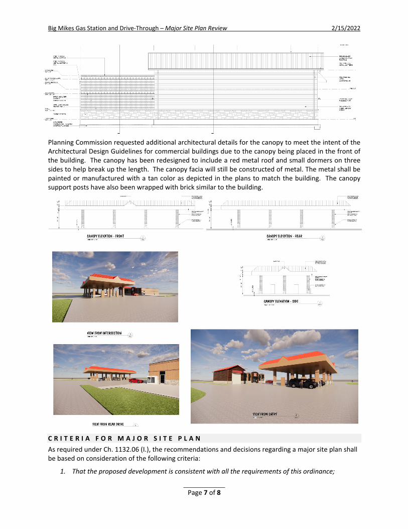
Big Mikes Gas Station and Drive-Through – Major Site Plan Review 2/15/2022
Page 7 of 8
Planning Commission requested additional architectural details for the canopy to meet the intent of the Architectural Design Guidelines for commercial buildings due to the canopy being placed in the front of the building. The canopy has been redesigned to include a red metal roof and small dormers on three sides to help break up the length. The canopy facia will still be constructed of metal. The metal shall be painted or manufactured with a tan color as depicted in the plans to match the building. The canopy support posts have also been wrapped with brick similar to the building.
C R I T E R I A F O R M A J O R S I T E P L A N As required under Ch. 1132.06 (I.), the recommendations and decisions regarding a major site plan shall be based on consideration of the following criteria:
1. That the proposed development is consistent with all the requirements of this ordinance;
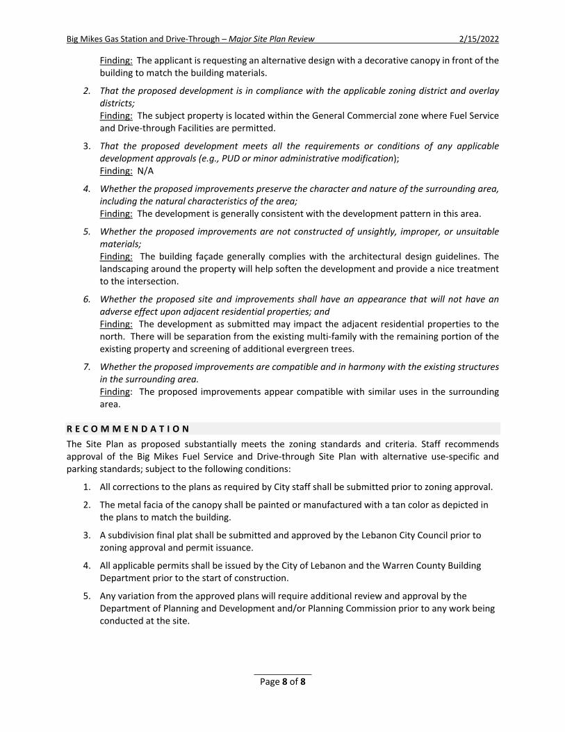
Big Mikes Gas Station and Drive-Through – Major Site Plan Review 2/15/2022
Page 8 of 8
Finding: The applicant is requesting an alternative design with a decorative canopy in front of the building to match the building materials.
2. That the proposed development is in compliance with the applicable zoning district and overlay districts; Finding: The subject property is located within the General Commercial zone where Fuel Service and Drive-through Facilities are permitted.
3. That the proposed development meets all the requirements or conditions of any applicable development approvals (e.g., PUD or minor administrative modification); Finding: N/A
4. Whether the proposed improvements preserve the character and nature of the surrounding area, including the natural characteristics of the area; Finding: The development is generally consistent with the development pattern in this area.
5. Whether the proposed improvements are not constructed of unsightly, improper, or unsuitable materials; Finding: The building façade generally complies with the architectural design guidelines. The landscaping around the property will help soften the development and provide a nice treatment to the intersection.
6. Whether the proposed site and improvements shall have an appearance that will not have an adverse effect upon adjacent residential properties; and Finding: The development as submitted may impact the adjacent residential properties to the north. There will be separation from the existing multi-family with the remaining portion of the existing property and screening of additional evergreen trees.
7. Whether the proposed improvements are compatible and in harmony with the existing structures in the surrounding area. Finding: The proposed improvements appear compatible with similar uses in the surrounding area.
R E C O M M E N D A T I O N The Site Plan as proposed substantially meets the zoning standards and criteria. Staff recommends approval of the Big Mikes Fuel Service and Drive-through Site Plan with alternative use-specific and parking standards; subject to the following conditions:
1. All corrections to the plans as required by City staff shall be submitted prior to zoning approval.
2. The metal facia of the canopy shall be painted or manufactured with a tan color as depicted in the plans to match the building.
3. A subdivision final plat shall be submitted and approved by the Lebanon City Council prior to zoning approval and permit issuance.
4. All applicable permits shall be issued by the City of Lebanon and the Warren County Building Department prior to the start of construction.
5. Any variation from the approved plans will require additional review and approval by the Department of Planning and Development and/or Planning Commission prior to any work being conducted at the site.

Fre
ezer
D 108.1
D 108.2
D 106.1
D 102.2
D 102.1
D 106.2
D 107
D 105D 103
D 101.1
A3.
22
3
1/8"
/ 1'
-0"
1/8"
/ 1'
-0"
D 101.2
A1.
1
1
©©
1

©©
A2.
1
1
A2.
1
2
1

©©
A2.
2
1
A2.
2
2
1
©©
A2.
3
2
A2.
3
1
A2.
3
3
A2.
3
5
A2.
3
4
A2.
3
6
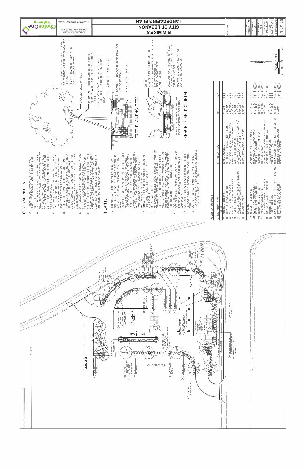
BIG MIKE'SCITY OF LEBANON
www.CHOICEONEENGINEERING.com
SIDNEY, OHIO 937.497.0200LOVELAND, OHIO 513.239.8554
LANDSCAPING PLAN

BIG MIKE'SCITY OF LEBANON
www.CHOICEONEENGINEERING.com
SIDNEY, OHIO 937.497.0200LOVELAND, OHIO 513.239.8554
PAVE
MEN
T ST
RIP
ING
NO
TES:
NO
TES:
DIMENSIONING AND PAVEMENT PLAN
HEA
VY D
UTY
ASP
HA
LT P
AVE
MEN
T
HEA
VY D
UTY
CO
NC
RET
E PA
VEM
ENT
PRO
POSE
D B
UIL
DIN
G
STA
ND
AR
D D
UTY
CO
NC
RET
E PA
VEM
ENT
CO
NC
RET
E SI
DEW
ALK
ASP
HA
LT B
IKEP
ATH

UTILITY PLAN
BIG MIKE'SCITY OF LEBANON
www.CHOICEONEENGINEERING.com
SIDNEY, OHIO 937.497.0200LOVELAND, OHIO 513.239.8554
DO
WN
SPO
UT
PIPI
NG
NO
TE:
UN
DER
DR
AIN
PIP
ING
NO
TE:
AS-
BU
ILT
DR
AW
ING
S N
OTE
:
CLE
AN
WA
TER
NO
TE:
CA
TCH
BA
SIN
NO
TE:
NO
TES:
WA
TER
MA
IN C
RO
SSIN
G S
EPA
RA
TIO
N N
OTE
:
LOC
ATE
EXI
STIN
G U
TILI
TIES
NO
TE:
ELEC
TRIC
AL/
MEC
HA
NIC
AL
NO
TE:
EXIS
TIN
G "
APP
RO
XIM
ATE
" A
ND
/OR
"PE
R P
LAN
S" U
ND
ERG
RO
UN
D U
TILI
TIES
NO
TE:
SAN
ITA
RY
LATE
RA
LS N
OTE
:
WA
TER
SER
VIC
ES N
OTE
:
GRADING PLAN
BIG MIKE'SCITY OF LEBANON
www.CHOICEONEENGINEERING.com
SIDNEY, OHIO 937.497.0200LOVELAND, OHIO 513.239.8554
NO
TES:
GR
AD
E TI
E IN
NO
TE:

PLANNING COMMISSION STAFF REPORT February 15, 2022
Major Site Plan – Parish Center St. Francis DeSales Catholic Church 20 DeSales Avenue AGENT Chris Hinkel Dryden Builders 1741 Thomas Paine Parkway Centerville, Ohio 45459
R E Q U E S T The applicant requests a Major Site Plan review (Ch. 1132.06) to construct a 9,730 S.F. Parish Center and associated site development on 1.56 acres out of the 9.59 total acres for the site.
CURRENT ZONING & USE Professional Office (PO) & Religious Place of Worship
DESCRIPTION OF REQUEST The applicant, Chris Hinkel, has submitted an application for a Major Site Plan to construct a new church parish center at 20 DeSales Avenue. The subject property is zoned Professional Office (PO), wherein a religious place of worship is a permitted use by right.
B A C K G R O U N D The existing St. Francis DeSales Catholic Church and school were dedicated in 1961. The property encompasses 9.5905 acres and serves the existing church parish and school. In 2001, a new 11,450 S.F. sanctuary and associated site amenities were constructed, including a parking lot expansion in anticipation of this proposed building.
P R O J E C T D E S C R I P T I O N The site plan shows the proposed building located in the center of the property with off-street parking to the south of the sanctuary. The building will have frontage on DeSales Avenue and gain access from the parking lot that currently serves the existing church and school facility. The proposed 9,730 S.F. parish center will contain offices, a conference room, and a 1,933 S.F. gathering area. The building materials will match the new church building materials. There is also a proposed courtyard between the new center and the existing building including a covered walkway linking the new building with the existing campus.

St. Francis DeSales Catholic Church - Major Site Plan 2/15/2022
2
E X I S T I N G C O N D I T I O N S Site Description and Existing Conditions – The location being developed for the new parish center is currently used as a baseball and soccer field. The site is relatively flat and has no tree coverage.
Current Zoning/Surrounding Zoning – The subject property is zoned Professional Office (PO). The surrounding properties to the north and south along N. Broadway are zoned PO, and the properties to the east and west are zoned R-1C.
Surrounding Land Use - The properties to the north and south are currently developed and operating as professional office uses. The properties to the east and west are single-family and two-family residential homes.
S I T E D E V E L O P M E N T P L A N S Building Location – The building meets the minimum front and rear yard setback requirements for the PO zone. The building is 181 feet from the front lot line along DeSales Avenue, 100+ feet from the rear lot line, and 112 feet from the side yard lot line. The minimum building setback requirement for the side yard in the PO zone is 15 feet. Access Management –The primary access to the site is via the main entrance from DeSales Avenue. The western entrance will be expanded slightly to allow for two-way traffic. The proposed improvements to the access drive and approach comply with required standards.
Internal Traffic Circulation – Internal traffic circulation flows effectively throughout the site with adequate parking and vehicular traffic lanes. The existing drive aisle widths as proposed comply with minimum requirements.
Off-street Parking – The off-street parking for the site complies with minimum requirements. The required off-street parking for the 720-seat sanctuary is 240 spaces, of which 240 spaces are provided with the recently completed work. The parish center will be utilized at different times than the sanctuary, creating an ideal shared parking scenario.
St. Francis DeSales Catholic Church - Major Site Plan 2/15/2022
3
Internal Pedestrian Circulation – The sanctuary is served with walkways along the entrances adjacent to the parking lot. Internal walkways connect the parking lot to the multiple buildings on the property.
Accessory Structures – A 40 feet x 40 feet playground area is proposed in the area currently occupied by the baseball field. The existing fence will be removed, and new fencing will be installed. The fence will be decorative black aluminum fencing, as this type of fencing is permitted within the front yard. Separate zoning permits are required for the playground and fencing.
Ground Signs – A sign permit is required for any additional signage and is subject to administrative review, independent of site plan approval.
Site Utility Plan - Adequate public utilities are available to the site with service from the City of Lebanon. The utility drawings were reviewed by the Engineering Department and respective utility providers.
S I T E G R A D I N G A N D D R A I N A G E P L A N Stormwater Detention – Two detention basins currently serve the property, one on the east and the other to the west of the sanctuary. One detention basin will be relocated to the south/front of the new center. The detention basins will incorporate a rain garden to provide stormwater quality measures. The stormwater calculations and system design are being reviewed by the Engineering Division.
Grading/Clearing – The overall grading of the site is minimal, with no significant grading activity taking place. The site will have an average finished grade of 847 feet.
L A N D S C A P I N G P L A N
Tree Preservation – No significant trees were identified within the site.
Building Landscape – The total amount of landscaping required for the structure is 27 shrubs along the front of the building and 12 shrubs along the sides. There is a mix of deciduous and evergreen shrubs around three sides of the building. There are also plantings under the covered walkway to link the buildings.
Street Trees - There are a total of 12 existing shade trees in front of the center along DeSales Avenue.
Screening – Buffer type “B” is required along the north property line to provide screening of the church facility from the adjacent residential homes. The applicant has been made aware of the requirements.

St. Francis DeSales Catholic Church - Major Site Plan 2/15/2022
4
Photometric/ Lighting Plan - The outdoor lighting will consist of two (2) multi-fixture pole lights and various building accent lighting along the soffits. The lights' design and illumination values at the property lines shall comply with Ch.1135.12.
A R C H I T E C T U R A L D E S I G N G U I D E L I N E S Architectural Character – The proposed building design is compatible with the established architectural character of the surrounding area.
Building Size, Height, and Scale – The proposed building design maintains a similar size, height, and scale as compared to the existing church facility and other nonresidential structures in the vicinity. The building size is 9,730 S.F. and has a building height of 26 feet at the tallest portion of the parish center's main gathering area.
Building Rooflines and Roof Shape – The proposed building has a gable roof with modified spire projections. The roof will have asphalt dimensioned shingles with wood trim. The roof design maintains visual continuity along the building facades.
Building Materials - The building walls are full brick and stone veneer with wood and metal trim. The window openings have a brick soldier course and cast stone sills. The building entry faces the courtyard which contains a covered walkway to link the existing building to the new center.
Building Colors – The building brick consists of various shades of beige and taupe. The building and roof trim are beige, taupe, and cream. The roof shingles are dark grey.
Wall Signs – No wall signs are proposed at this time. Any proposed wall signs along the front elevations shall comply with applicable location, size, and height requirements per Ch. 1139.08(B.). A sign permit is required and subject to administrative review, independent of site plan approval.
A P P R O V A L C R I T E R I A As required under Ch. 1132.06 (I.), the recommendations and decisions regarding a major site plan shall be based on consideration of the following criteria:
1. That the proposed development is consistent with all the requirements of this ordinance; Finding: The proposed development of the new parish center is consistent with the development standards and substantive requirements of the Zoning Code as determined by staff’s evaluation of the application and corresponding development plans.

St. Francis DeSales Catholic Church - Major Site Plan 2/15/2022
5
2. That the proposed development is in compliance with the applicable zoning district and overlay districts; Finding: The subject property is located within the Professional Office zoning district wherein a religious place of worship is a permitted use.
3. That the proposed development meets all the requirements or conditions of any applicable development approvals (e.g., PUD or minor administrative modification); Finding: The current lot configuration complies with applicable site development standards and subdivision regulations.
4. Whether the proposed improvements preserve the character and nature of the surrounding area, including the natural characteristics of the area; Finding: The proposed development is consistent with the development pattern of the area and is sustainable with the natural characteristics of the area.
5. Whether the proposed improvements are not constructed of unsightly, improper, or unsuitable
materials; Finding: The proposed improvements to the site, and building construction, meet or exceed the minimum development standards as required by the Zoning Code.
6. Whether the proposed site and improvements shall have an appearance that will not have an adverse effect upon adjacent residential properties; and Finding: The proposed site and improvements will have no apparent adverse impact on residential properties.
7. Whether the proposed improvements are compatible and in harmony with the existing structures in the surrounding area. Finding: The site improvements and building design complement the area and are compatible and in harmony with the existing structures.
R E C O M M E N D A T I O N Based on the analysis, staff has determined that sufficient findings have been made in accordance with the approval criteria required under Ch.1132.06 (I.). Therefore, staff recommends the major site plan for the proposed St. Francis DeSales Catholic Church Parish Center at 20 DeSales Avenue be approved subject to the following conditions:
1. All plan corrections as required by staff shall be provided prior to zoning and building permits being issued for the project.
2. All required permits shall be issued by applicable agencies prior to the start of construction


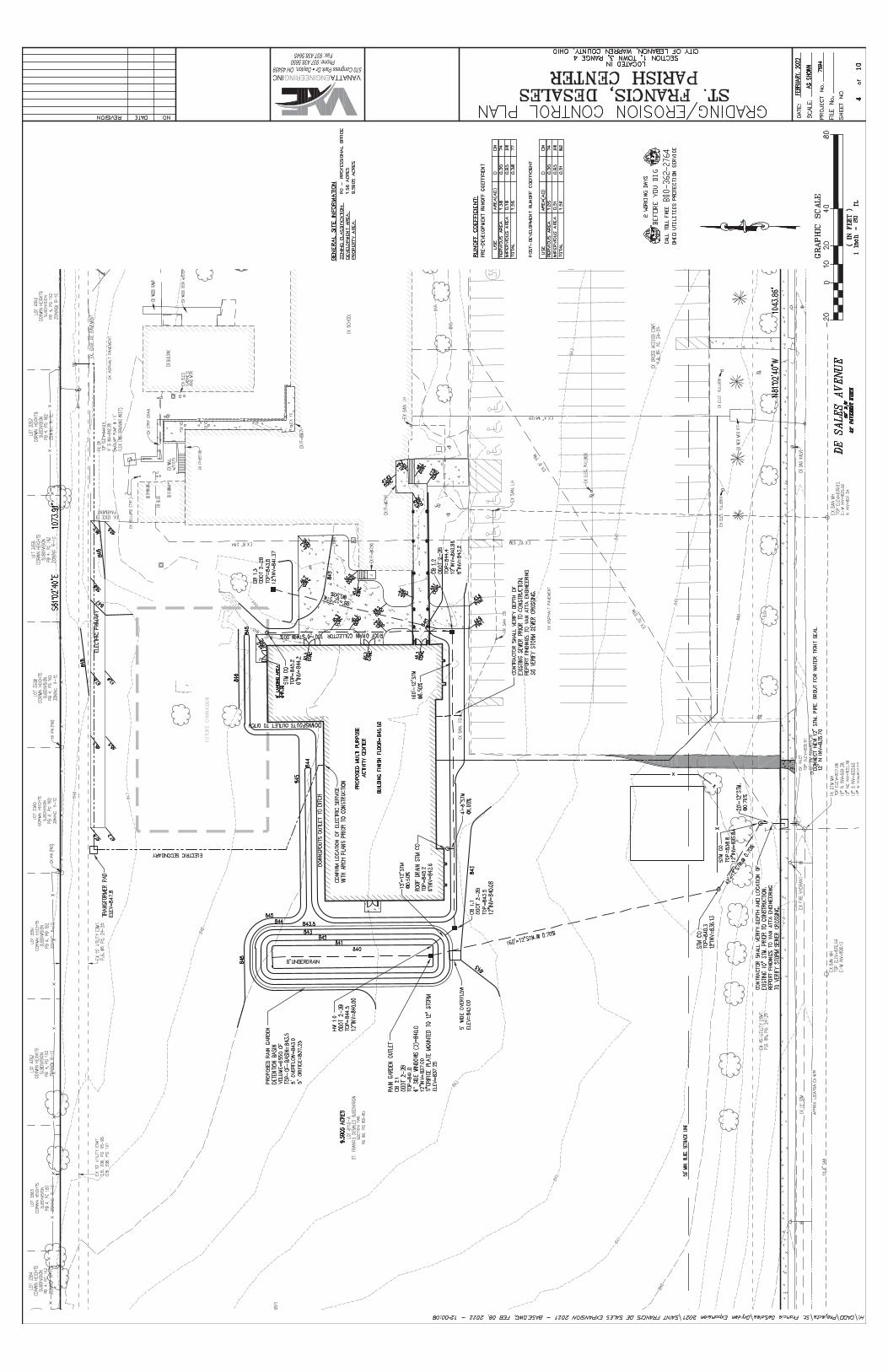

PLANNING COMMISSION STAFF REPORT February 15, 2022 FINAL PLAT
Bainum’s Run 600 Cincinnati Avenue – Lot Split PROPERTY OWNER ITS Lebanon, LLC Lebanon, Ohio 45036 REQUEST
Review and approval of a final plat for 600 Cincinnati Avenue as required in Chapter 1117.02 of the Subdivision Regulations. CURRENT ZONING
Residential Two (R-2) PUD & Light Industrial (L-1) PUD BACKGROUND
The plat creates a new lot of record intended to contain the Shaker Inn portion of the parcel. This will enable the applicant to complete a 2.2665-acre property transfer to Family Promise of Warren County while retaining the remainder of the site for self-storage. The final plat will divide 10.4564 acres into 8.1899 acres and 2.2665 acres with 0.4956 acres dedicated to Cincinnati Avenue ROW. STAFF ANALYSIS/FINDINGS
1. The final plat has been reviewed by staff and determined the plat is in accordance with the Map Amendment approved for the property and the approved Regulatory Plan.
2. The final plat complies with the applicable regulations as reviewed by the City staff.
STAFF RECOMMENDATION
Based on the analysis, staff recommends the final plat of Bainum’s Run be approved, subject to the following conditions:
1. The plat shall be recorded within sixty (60) days from the date of approval by Lebanon City Council
as required in Section 1117.04 (a)(4) of the Subdivision Regulations.
2. A reproducible mylar of the recorded plat shall be provided to the City of Lebanon.
Approved Denied Date of PC Action: ______________
CURRENT USE
Motel & Self-Storage

LOT
844
68.
1899
Acr
es
LOT
844
72.
2665
Acr
es
BA
INU
M'S
RU
N
PLANNING COMMISSION STAFF REPORT February 15, 2022 ROW VACATION FINAL PLAT
Columbia Business Park, Section 17 Grant Drive ROW Vacation & Consolidation Plat PROPERTY OWNER
City of Lebanon Lebanon, Ohio 45036 REQUEST
The City requests review and approval of the right-of-way vacation plat for a section of Grant Drive and a final plat of Columbia Business Park, Section 17, Lots 7859-A and Lot 7297 as required in Chapter 1117.02 of the Subdivision Regulations. CURRENT ZONING
Light Industrial (L-1) BACKGROUND
The City requests a right-of-way vacation plat for a section of Grant Drive to allow for an expansion of the FECON facility (3460 & 3425 Grant Drive) through the consolidation of two parcels they own that are separated by the ROW. A total of 8.3990 acres and 5.7459 acres will be consolidated with the 0.4484-acre right-of-way vacated to form 18.3491 acres as a single lot of record. A separate 0.1710 will be removed from lot 7859-A and combined with the adjacent Lot 8449 to form a 0.9553-acre lot of record for a City of Lebanon utility expansion on that parcel. 0.1862 acres will also be dedicated from that parcel to the Columbia Road ROW. STAFF ANALYSIS/FINDINGS
1. The vacation of the right-of-way has been reviewed by staff and determined that the expansion of the business park and the vacation of the right-of-way will not impact development patterns or government services.
2. The ROW vacation plat and final plat comply with the applicable regulations as reviewed by the City staff.
STAFF RECOMMENDATION
Based on the analysis, staff recommends the right-of-way vacation plat for a section of Grant Drive and a final plat of Columbia Business Park, Section 17, Lots 7859-A and Lot 7297, be approved subject to the following conditions:
1. The plat shall be recorded within sixty (60) days from the date of approval by Lebanon City Council
as required in Section 1117.04 (a)(4) of the Subdivision Regulations.
2. A reproducible Mylar of the recorded plat shall be provided to the City of Lebanon.
Approved Denied Date of PC Action :
CURRENT USE
Manufacturing

OF
PA
RT
OF
GR
AN
T D
RIV
ER
IGH
T-O
F-W
AY
VA
CA
TIO
N
(0.4
484
AC
RE
S)

CO
LUM
BIA
BU
SIN
ES
S P
AR
K, S
EC
TIO
N 1
7
LOT
8448
RE
PLA
T O
F LO
T 7
859-
AP
LAT
BO
OK
81,
PA
GE
S 7
3 &
74
AN
DR
EP
LAT
OF
LOT
729
7P
LAT
BO
OK
60,
PA
GE
S 2
3 &
24
BE
ING
A
LOT
8449