AGENDA CITY OF HALF MOON BAY PLANNING ...
309
ALL REMOTE/TELECONFERENCE MEETING (SEE DETAILS BELOW) Steve Ruddock, Chair Sara Polgar, Vice Chair James Benjamin, Planning Commissioner David Gorn, Planning Commissioner Rick Hernandez, Planning Commissioner AGENDA CITY OF HALF MOON BAY PLANNING COMMISSION MEETING TUESDAY, MARCH 23, 2021 7:00 PM This agenda contains a brief description of each item to be considered. Those wishing to address the Planning Commission on any matter not listed on the Agenda, but within the jurisdiction of the Planning Commission to resolve, may come forward to the podium during the Public Forum portion of the Agenda and will have a maximum of three minutes to discuss their item. Those wishing to speak on an agenda item are asked to fill out a speaker card. Speaker(s) will be called forward at the appropriate time during the agenda item in consideration. Please Note: Please Provide a Copy of Prepared Presentations to the Clerk Copies of written documentation relating to each item of business on the Agenda are on file in the Office of the City Clerk at City Hall and the Half Moon Bay Library where they are available for public inspection. If requested, the agenda shall be available in appropriate alternative formats to persons with a disability, as required by Section 202 of the Americans with Disabilities Act of 1990 (42 U.S.C. Sec. 12132.) Information may be obtained by calling 650-726-8271. In compliance with the Americans with Disabilities Act, special assistance for participation in this meeting can be obtained by contacting the City Clerk’s Office at 650-726-8271. A 48-hour notification will enable the City to make reasonable accommodations to ensure accessibility to this meeting (28 CFR 35.102-35.104 ADA Title II). http://hmbcity.com/ MEETING WILL CONCLUDE BY 10:30 PM UNLESS OTHERWISE EXTENDED BY SIMPLE MAJORITY VOTE OF THE PLANNING COMMISSION. 1
-
Upload
khangminh22 -
Category
Documents
-
view
1 -
download
0
Transcript of AGENDA CITY OF HALF MOON BAY PLANNING ...

ALL REMOTE/TELECONFERENCE MEETING(SEE DETAILS BELOW)
Steve Ruddock, ChairSara Polgar, Vice ChairJames Benjamin, Planning CommissionerDavid Gorn, Planning CommissionerRick Hernandez, Planning Commissioner
AGENDA
CITY OF HALF MOON BAYPLANNING COMMISSION MEETING
TUESDAY, MARCH 23, 20217:00 PM
This agenda contains a brief description of each item to be considered. Those wishing to address thePlanning Commission on any matter not listed on the Agenda, but within the jurisdiction of the PlanningCommission to resolve, may come forward to the podium during the Public Forum portion of the Agenda andwill have a maximum of three minutes to discuss their item. Those wishing to speak on an agenda item areasked to fill out a speaker card. Speaker(s) will be called forward at the appropriate time during the agendaitem in consideration.
Please Note: Please Provide a Copy of Prepared Presentations to the Clerk
Copies of written documentation relating to each item of business on the Agenda are on file in the Office ofthe City Clerk at City Hall and the Half Moon Bay Library where they are available for public inspection. Ifrequested, the agenda shall be available in appropriate alternative formats to persons with a disability, asrequired by Section 202 of the Americans with Disabilities Act of 1990 (42 U.S.C. Sec. 12132.) Information maybe obtained by calling 650-726-8271.
In compliance with the Americans with Disabilities Act, special assistance for participation in this meetingcan be obtained by contacting the City Clerk’s Office at 650-726-8271. A 48-hour notification will enable theCity to make reasonable accommodations to ensure accessibility to this meeting (28 CFR 35.102-35.104 ADATitle II).
http://hmbcity.com/
MEETING WILL CONCLUDE BY 10:30 PM UNLESS OTHERWISE EXTENDED BY SIMPLE MAJORITY VOTE OF THEPLANNING COMMISSION.
1

SPECIAL TELECONFERENCE/REMOTE MEETING PROTOCOLSIn accordance with Governor Newsom’s Executive Order No-29-20, this will be a teleconference meeting without aphysical location to help stop the spread of COVID-19. This meeting will be conducted entirely by remote participation,in compliance with the Governor's Executive Order N-29-20 allowing for deviation of teleconference rules required bythe Ralph M. Brown Act.
This meeting will be conducted via Zoom Webinar. Members of the public are welcome to login into the webinar asAttendees. During any public comment portions, attendees may use the “raise your hand” feature and will be calledupon and unmuted when it is their turn to speak. The meeting will also be streamed on Channel 27, on pacificcoast.tv
Please click the link below to join:
Click Here to Join Planning Commission Meeting
Webinar ID: 970 3497 2655
Passcode: 535759
Phone: 1-669-900-6833, 97034972655#,*535759#
PLEDGE OF ALLEGIANCE AND ROLL CALL APPROVAL OF MINUTES DRAFT MINUTES 03/09/2021
PC Minutes 03-09-2021 PUBLIC COMMENT 1. PUBLIC HEARING ITEMS 1.A PROJECT: COASTAL DEVELOPMENT PERMIT AMENDMENT OF PDP-012-10, PHASE 2 OF
NAPLES BEACH SEWER PROJECT, GRANADA COMMUNITY SERVICES DISTRICT.CITY FILE NO.: PDP-21-015RECOMMENDATION: FIND THAT THE PROPOSED MODIFICATIONS THAT ARE THE SUBJECTOF THIS COASTAL DEVELOPMENT PERMIT (CDP) AMENDMENT WILL NOT RESULT IN NEWIMPACTS OR INCREASE THE SIGNIFICANCE OF ENVIRONMENTAL IMPACTS PREVIOUSLYEVALUATED IN THE ADOPTED 2008 INITIAL STUDY/ MITIGATED NEGATIVE DECLARATION(IS/MND); AND, THEN APPROVE THIS CDP AMENDMENT WHICH MODIFIES PHASE 2 OFTHE PREVIOUSLY APPROVED CDP, FILE NO. PDP-012-010, BASED ON THE FINDINGS ANDEVIDENCE CONTAINED IN EXHIBIT A OF THE DRAFT RESOLUTION (ATTACHMENT 1), ANDSUBJECT TO THE CONDITIONS OF APPROVAL IN EXHIBIT B.PROJECT PLANNER: DOUG GARRISON, SENIOR PLANNER; [email protected]
STAFF REPORT Naples Beach Sewer Project
2

RESOLUTION - Naples Beach Sewer Project
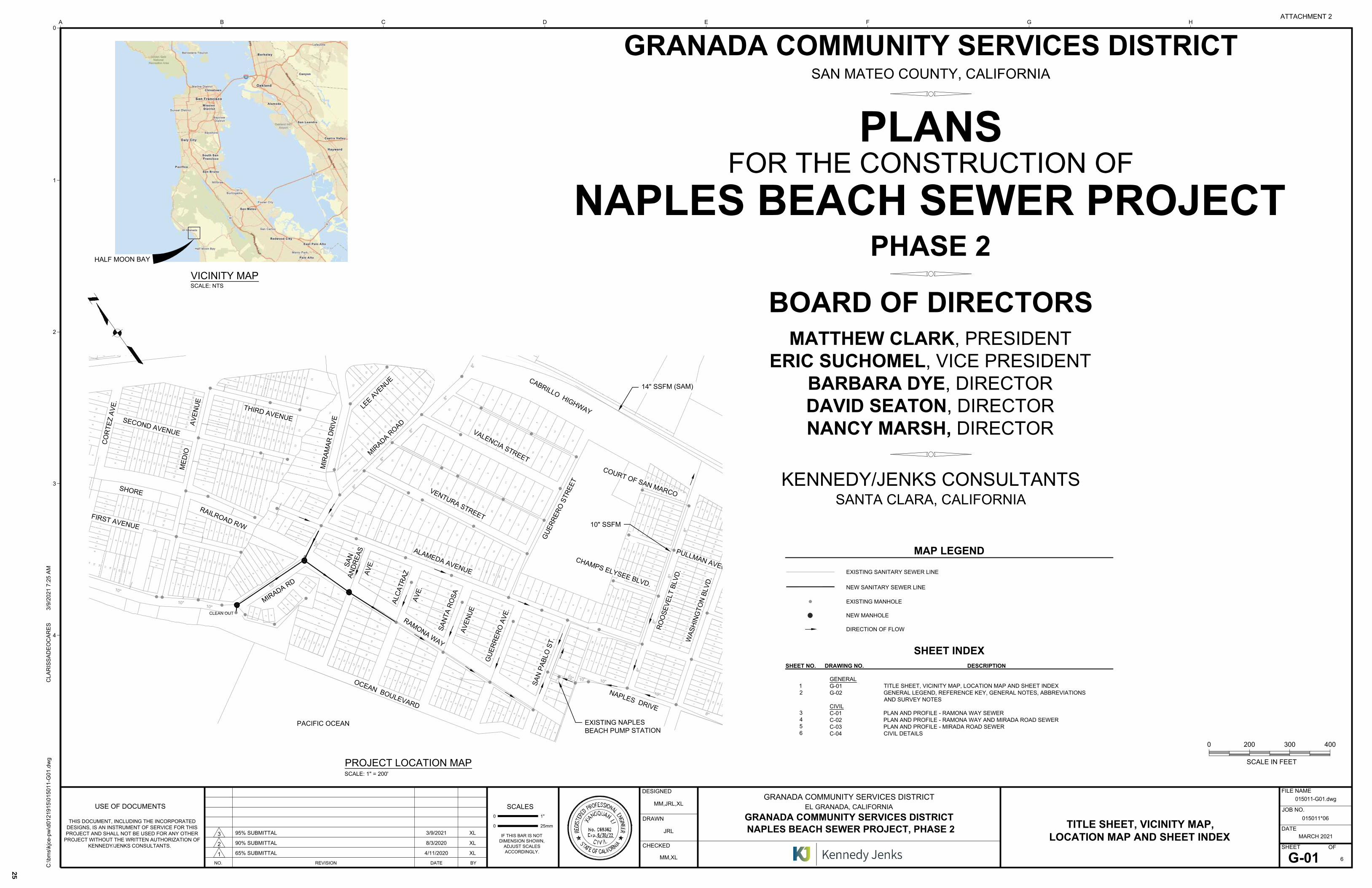
ATTACHMENT 2 - Plans
ATTACHMENT 3 - BRE Update
ATTACHMENT 4 - GCSD Application Letter March 5 2021
ATTACHMENT 5 - 2008 ISMND with BRE
ATTACHMENT 6 - 2010 Staff Report and Resolution
1.B PROJECT: 2021 MEASURE D RANKING RATIFICATION
RECOMMENDATION: ADOPT A RESOLUTION RATIFYING THE JANUARY 2021 MEASURE DALLOCATIONS FOR RESIDENTIAL UNITS OUTSIDE OF DOWNTOWN, BASED UPON THESCORES AND RANKINGS REQUIRED BY SUBDIVISION ORDINANCE, SECTION 17.06RESIDENTIAL DWELLING UNIT BUILDING PERMIT ALLOCATION SYSTEM AND ASIMPLEMENTED BY THE COMMUNITY DEVELOPMENT DIRECTOR.PROJECT PLANNERS: BRITTNEY COZZOLINO, ASSOCIATE PLANNER,[email protected] AND JILL EKAS, COMMUNITY DEVELOPMENT DIRECTOR;[email protected]
STAFF REPORT - 2021 Measure D Ranking Ratification
RESOLUTION - 2021 Measure D Ranking Ratification
EXHIBIT A - 2021 Measure D Ranking Summary
ATTACHMENT 2 - 2021 Measure D Scoring Criteria
DIRECTOR'S REPORT PLANNING COMMISSION COMMUNICATIONS ADJOURNMENT CORRESPONDENCE CORRESPONDENCE (SUBMITTED AFTER AGENDA PACKET WAS POSTED, PRIOR TO PLANNING
COMMISSION MEETING 03/23/21)
Item 1.B - Public Comments
3

March 9, 2021 Planning Commission Minutes Page 1 of 3
MINUTES
CITY OF HALF MOON BAY PLANNING COMMISSION
TUESDAY, MARCH 9, 2021
ALL REMOTE/VIRTUAL WEBINAR VIA ZOOM Chair Ruddock called the hearing to order at 7:03 PM PRESENT: Chair Ruddock, Commissioners Benjamin, Gorn, Hernandez, Polgar ABSENT: None PLEDGE OF ALLEGIANCE AND ROLL CALL
Chair Ruddock led the Pledge of Allegiance. APPROVAL OF MINUTES February 23, 2020 Motion to approve with the modification of the first comment under the Planning Commission Discussion that the draft ordinance would not interfere with property rights: strike “Need to address” from the beginning of the sentence. M/S: Benjamin/Polgar Roll Call Vote: 4-0-1 (yes: Ruddock, Polgar, Benjamin, Gorn; Abstain: Hernandez, he was absent at the February 23, 2021 meeting.) PUBLIC COMMENT
1) The Vartanians asked about the status of their Measure D application for an ADU. (Referred to staff.)
2) Timothy Pond, Junior accessory dwelling units (JADUs) should not be included as a whole unit in the calculation for Measure D allocations.
PLANNING COMMISSION BUSINESS 2020 Housing Element Annual Progress Report ACTION: Confirm receipt of the Housing Element Annual Report. Jill Ekas, Community Development Director, made presentation to the Planning Commission. Planning Commission Clarifying Questions / Discussion
The Planning Commission discussed Housing Element requirements including regulatory barriers impeding the production of affordable housing, as well as implications for not meeting production targets. A. Staff explained that both reducing barriers and production are required. Implications regarding housing production have been
4
March 9, 2021 Planning Commission Minutes Page 2 of 3
changing over time as State housing law is continuously updated. With the forthcoming Cycle 6 Housing Element, staff will provide more information about this going forward.
With respect to housing production, would the shelter help with the categories where needs are unmet? A. Staff agreed that it has potential to do so.
Why don’t the Coastside Inn rooms count as units contributing to the City’s Regional Housing Needs Allocation (RHNA); e.g. there are examples of transitional and supportive housing that count. A. Staff explained how the hotel rooms, which do not have kitchens, are being presented as an acquisition not counted toward RHNA; this approach was confirmed with the California Department of Community Development (HCD); further coordinated for consistency with San Mateo County Department of Housing, the San Mateo County 21 Element Group, and with other San Mateo County cities; and also subject to legal review by the City Attorney.
Public Comment None Motion to confirm the receipt of the 2020 Housing Element Annual Report. M/S: Benjamin/Hernandez Vote: 5-0 (yes: Ruddock, Polgar, Benjamin, Gorn, and Hernandez) PLANNING COMMISSION HEARING PROJECT: Addendum to the Adopted Mitigated Negative Declaration for the Coastal Development Permit, Use Permit, Architectural Review, and Parking Exception FILE No. PDP-19-059 LOCATION: 10 Stone Pine Road; John L. Carter Memorial Park Scott Phillips, Associate Planner, made the presentation to the Planning Commission. Planning Commission Clarifying Questions The Commission inquired about the status of the playground design (e.g. the slide and other creative approaches that could be incorporated into the design) relative to the addendum and design specifications of the light pole foundations. Staff confirmed the following:
The playground remains in the plans; the only change/Planning Commission consideration is correcting the record with respect to the height of the light poles.
The building permit plans will include a soil reports and structural requirements for the light poles.
Public Comment None Planning Commission Discussion Appreciate the diligence, attention to detail, and trying to get everything right. Supports the addendum and this process because respecting the process. Supports that not a
5
March 9, 2021 Planning Commission Minutes Page 3 of 3
significant adverse impact; understood that there would be a light pole for the performance space. Motion to approve project as presented and written in the Staff Report. M/S: Benjamin/Hernandez Vote: 5-0 (yes: Ruddock, Polgar, Benjamin, Gorn, and Hernandez) DIRECTOR REPORT
PC Updates: Administrative Action March 10, 2021 PC Meeting March 23, 2021: Measure D and Granada Sewer Items
PLANNING COMMISSION COMMUNICATIONS
Poplar Beach - Garbage cans were removed 6-9 months ago. Can we get garbage cans back? Staff explained that upcoming City Council meeting will include a report about Poplar Beach and preparations for the pending summer season.
ADJOURNMENT
Motion to adjourn M/S: Hernandez/Polgar Roll Call Vote: 5-0 (yes: Ruddock, Polgar, Benjamin, Gorn, and Hernandez) adjourned at 8:15 PM.
Respectfully Submitted: Approved: ____________________________ _________________________________ Bridget Jett, Planning Analyst Steve Ruddock, Chair *Meeting Attendance List – PC Mtg 03/09/2021
James Benjamin Carolyn Belknap Bridget Jett Timothy pond Jill Ekas Jo Chamberlain Sara Polgar Michelle Dragony David Gorn Vartanians Karen Decker chris PCT Live Thomas Bishop Winter King Scott Phillips Steve Ruddock PCT Monitor Rick Hernandez
6

BUSINESS OF THE PLANNING COMMISSION OF THE CITY OF HALF MOON BAY
AGENDA REPORT
For meeting of: March 23, 2021
TO: Honorable Chair and Planning Commissioners FROM: Jill Ekas, Community Development Director
Douglas Garrison, Senior Planner TITLE: File No. PDP-21-015, Coastal Development Permit Amendment of PDP-012-10,
Phase 2 of Naples Beach Sewer Project, Granada Community Services District ______________________________________________________________________________ RECOMMENDATION Find that the proposed modifications that are the subject of this Coastal Development Permit (CDP) Amendment will not result in new impacts or increase the significance of environmental impacts previously evaluated in the adopted 2008 Initial Study/ Mitigated Negative Declaration (IS/MND); and, then approve this CDP Amendment which modifies Phase 2 of the previously approved CDP, File No. PDP-012-010, based on the Findings and Evidence contained in Exhibit A of the Draft Resolution (Attachment 1), and subject to the Conditions of Approval in Exhibit B. PERMIT BACKGROUND In 2010, the City approved a CDP (PDP-012-010) which allowed the Granada Community Services District (District) to construct the Naples Beach Sewer Project, a two-phase sewer replacement project. The staff report, resolution and IS/MND are attached for reference (Attachments 4 and 5). Phase 1, the larger and more complex portion of the project, has been completed. It consisted of improvements to the Naples Beach Pump Station and new infrastructure. This has allowed the diversion of 90 percent of the sewage from an old sewer line attached to the bicycle/pedestrian bridge crossing Arroyo de en Medio Creek (Medio Creek). Although approved, Phase 2 has not yet been constructed and is the subject of the proposed CDP amendment. The Phase 2 project, as approved in 2010, would divert the remaining ten percent of wastewater flows from the bridge to a new section of sewer main located in Mirada Road and Ramona Way (an unimproved paper street). The original 2010 plan proposed retaining the sewer main on the bridge, but using it only as an emergency or short-term backup facility during maintenance of the primary sewer mains. Due to the deteriorating condition of the bridge, which was recently closed by San Mateo County, the District has now prioritized construction of Phase 2 and proposed an amendment to the original CDP to allow discontinuation of the approved use of the sewer main on the bridge as part of the maintenance backup system. The proposed amendment does not authorize or require the removal of the sewer main or bridge. San Mateo County has prepared plans for the removal of the bridge, including the sewer main. The County prepared an IS/MND, which was adopted by the Board of Supervisors on January 7, 2021 and has submitted a CDP application to the Coastal
7

Planning Commission Report PDP-21-015 Page 2 of 7 March 23, 2021
Commission. If the CDP for the replacement bridge is approved, this would allow removal and replacement of the Medio Creek Bridge. The decommissioned sewer main on the bridge will be removed as part of the County project. PROJECT DESCRIPTION The 2010 CDP approval included Phase 1 and Phase 2 of the Naples Beach Sewer Project. Phase 1 has been constructed and no modifications to this Phase are proposed. Phase 2 consists of: Replacement of the existing sewer main located within Ramona Way, an undeveloped paper street, from San Andreas Avenue to Alcatraz Avenue and then constructing a new section that will extend this main approximately 300 feet from Alcatraz Avenue to Mirada Road. A new section will be constructed within Mirada Road from the westernmost end of Mirada Road to approximately Alameda Avenue. It will connect to existing sewer mains at both ends and the new Ramona Way main will connect to it. All work will be performed using open trenching. The Project staging area is located on the southern shoulder of Mirada Way at Ramona Way. Parking will be limited to 4 vehicles. Workers will meet offsite and carpool to the site. Mirada Road from Highway 1 is the designated truck route. At least one heritage tree, a Monterey Pine, will be removed. Tree removal and replacement requirements are discussed later in this report.
Summary of Project
File Number PDP-21-015
Requested Permits/Approvals Amendment of Phase 2 of CDP PDP-12-010
Site Location Mirada Rd. and Ramona Way (paper street) from Mirada Rd. to Alcatraz Ave.
Applicant/Property Owner Granada Community Services District
Project Planner Douglas Garrison; (650) 712-5836; [email protected]
Zoning District N/A Paper Street
LCP Land Use Plan Designation Regional Public Recreation / Residential- Medium Density
Environmental Determination In 2008, Granada Sanitary District, the CEQA lead Agency, prepared an IS/MND that evaluated the full range of potential environmental effects related to the entire project, including both Phase 1 and 2. In 2020 and 2021, the City reviewed proposed Phase 2 construction with proposed modifications. Application materials include an update of the original 2008 Biological Resources Evaluation. Based on review of the complete record, the project will not result in an increase in the significance of any impact or new impacts that have not been previously evaluated and avoided or mitigated to a less than significant level. Consequently, no additional environmental review is required.
Heritage Trees 1 to 2 Monterey pines will be removed
Right of Appeal Located in the Coastal Commission Appeals area
8

Planning Commission Report PDP-21-015 Page 3 of 7 March 23, 2021
Figure 1. Site Location
9

Planning Commission Report PDP-21-015 Page 4 of 7 March 23, 2021
Site and Surrounding Properties Nearby uses are summarized below in Table 1.
Table 1. Surrounding Uses
Use Land Use Plan / Zoning
North Mirada Road and Single-Family dwellings located in San Mateo County (SMC)
SMC General Plan: Residential, Medium High Density / SMC Zoning: One Family Residential
South Undeveloped State Park land Regional Public Recreation / Open Space – Passive (OS-P)
East State Park and residential Residential - Medium Density / R-1-B-1
West State Park and residential Regional Public Recreation, Planned Development / OS-P, PUD
ANALYSIS The 2010 CDP application was reviewed and the project was found to conform with the General Plan, General Plan/Local Coastal Land Use Plan (LUP), the Zoning Code/LCP Implementation Plan, and the California Environmental Quality Act (CEQA). The proposed Amendment to the 2010 CDP does not alter these findings. Conformance with the General Plan The project as originally approved and with the proposed amendment, will not increase sewer capacity or extend service to new undeveloped areas. There will be no effect on housing or population. Construction impacts will be temporary and have been evaluated in the 2010 CDP and IS/MND and determined to be less than significant with the implementation of avoidance and mitigation measures. Through the proposed Amendment, the project now includes additional measures to further reduce effects on local roadways, coastal access and improve compatibility with neighboring uses. These include a designated truck route and limiting worker parking to four vehicles. Requirements established by the 2010 CDP Conditions of Approval still apply to the amended project and in some cases will be strengthened by new or revised conditions. Work within Mirada Road requires a traffic control plan and an encroachment permit. Condition No. B-3 of this Amendment Resolution is a new requirement to prepare and implement a Coastal Access Plan to minimize impacts to coastal access and recreation facilities during construction. Combined, these measures will further limit effects on traffic, safety and coastal access. All construction activities are required to comply with City noise standards. Conformance with the Local Coastal Program Land Use Plan (LUP) The LUP includes goals and policies to guide development and protect coastal resources. The project as originally approved and with the proposed amendment, will not permanently impede coastal access, obstruct views of scenic vistas or adversely affect environmental, historic,
10
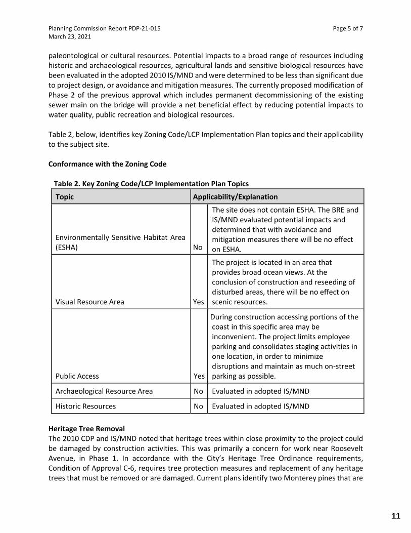
Planning Commission Report PDP-21-015 Page 5 of 7 March 23, 2021
paleontological or cultural resources. Potential impacts to a broad range of resources including historic and archaeological resources, agricultural lands and sensitive biological resources have been evaluated in the adopted 2010 IS/MND and were determined to be less than significant due to project design, or avoidance and mitigation measures. The currently proposed modification of Phase 2 of the previous approval which includes permanent decommissioning of the existing sewer main on the bridge will provide a net beneficial effect by reducing potential impacts to water quality, public recreation and biological resources. Table 2, below, identifies key Zoning Code/LCP Implementation Plan topics and their applicability to the subject site. Conformance with the Zoning Code Table 2. Key Zoning Code/LCP Implementation Plan Topics
Topic Applicability/Explanation
Environmentally Sensitive Habitat Area (ESHA) No
The site does not contain ESHA. The BRE and IS/MND evaluated potential impacts and determined that with avoidance and mitigation measures there will be no effect on ESHA.
Visual Resource Area Yes
The project is located in an area that provides broad ocean views. At the conclusion of construction and reseeding of disturbed areas, there will be no effect on scenic resources.
Public Access Yes
During construction accessing portions of the coast in this specific area may be inconvenient. The project limits employee parking and consolidates staging activities in one location, in order to minimize disruptions and maintain as much on-street parking as possible.
Archaeological Resource Area No Evaluated in adopted IS/MND
Historic Resources No Evaluated in adopted IS/MND
Heritage Tree Removal The 2010 CDP and IS/MND noted that heritage trees within close proximity to the project could be damaged by construction activities. This was primarily a concern for work near Roosevelt Avenue, in Phase 1. In accordance with the City’s Heritage Tree Ordinance requirements, Condition of Approval C-6, requires tree protection measures and replacement of any heritage trees that must be removed or are damaged. Current plans identify two Monterey pines that are
11

Planning Commission Report PDP-21-015 Page 6 of 7 March 23, 2021
in close proximity to the proposed work, as shown in the photograph below. Sheet C-01 of the plans indicate that Tree # 965 (on right) will have to be removed and that Tree #966 will be retained and will require protective measures. Staff notes that due to the close proximity of the two trees (approximately 6 feet apart), protecting Tree #966 may not be successful and anticipates that both trees may have to be replaced. State Parks ecologists have indicated that planting new Monterey pines in this location would not be consistent with long range goals of restoring coastal scrub habitat and would prefer to plant replacement trees in a nearby campground. Staff supports this approach. Figure 2. Heritage Trees
Environmental Review / California Environmental Quality Act (CEQA) In 2008, Granada Sanitary District, the CEQA lead Agency, prepared and adopted an IS/MND that evaluated the full range of potential environmental impacts related to the entire project, including both Phase 1 and 2. In 2010, the City relied, in part, on this IS/MND in determining that the project was consistent with local policies and regulations and approving the CDP. Pursuant to CEQA Guidelines section 15162, when a negative declaration has been adopted for a project, no subsequent EIR or negative declaration shall be prepared for that project unless it is determined that there will be new or more significant impacts associated with the project due to substantial changes to the project or substantial changes in the underlying circumstances. See also Pub. Resources Code § 21166. In 2020 and 2021, the City reviewed Phase 2 construction with
12

Planning Commission Report PDP-21-015 Page 7 of 7 March 23, 2021
proposed modifications. Application materials include an update of the original 2008 Biological Resources Evaluation. Based on review of the complete record, staff’s analysis concludes that the proposed amendments to the CDP will not result in an increase in the significance of any impact or cause new impacts that have not been previously evaluated and avoided or mitigated to a less than significant level. Consequently, no additional environmental review is required. Public Comments No comments have been received to date. Conclusion Based on the above analysis, staff concludes that the proposed project is does not expand the scope of the original 2010 CDP approval and is consistent with the General Plan, Local Coastal Program and the Zoning Code and conforms to the requirements of the California Environmental Quality Act. Staff recommends approval of the Amendment to Phase 2 of PDP-012-10 based on the recommended findings and conditions of approval contained in Exhibits A and B of the proposed Resolution. ATTACHMENTS 1. Draft Resolution with Findings and Evidence, Exhibit A and Conditions of Approval, Exhibit B. 2. Project Plans 3. Biological Resources Evaluation Update Memo 4. GCSD Supplemental Application Letter, dated March 5, 2021 5. 2008 Initial Study / Mitigated Negative Declaration with Biological Resource Evaluation 6. 2010 Staff Report and Resolution
13
ATTACHMENT 1
PLANNING COMMISSION RESOLUTION P-21-___ RESOLUTION FOR APPROVAL
PDP-21-015
Coastal Development Permit Amendment PDP-21-015 allowing modifications to Phase 2 of PDP-012-10, located in Mirada Road and a 20-foot wide strip of land located within Ramona Way (an unimproved paper street) and a portion of APN: 048-053-080, owned by California State Parks, bounded by Mirada Road and Alcatraz Avenue.
WHEREAS, in 2008 the Granada Community Services District prepared and adopted an
Initial Study and Mitigated Negative Declaration (IS/MND) that evaluated the potential environmental impacts that could result from the entire Naples Beach Sewer Project, including Phase 1 and Phase 2; and
WHEREAS, the IS/MND concluded that significant environmental effects would be
avoided or reduced to less-than-significant levels by implementation of avoidance and mitigation measures identified in the IS/MND; and
WHEREAS, on May 10, 2010, the Planning Director reviewed the Granada Community
Services District IS/MND and based in part on the evidence in the IS/MND approved PDP-012-10; and WHEREAS, an application was submitted requesting approval of a Coastal Development Permit Amendment to PDP-012-10; and
WHEREAS, the procedures for processing the application have been followed as required by law; and
WHEREAS, the Planning Commission conducted a duly noticed public hearing on March 23, 2021, at which time all those desiring to be heard on the matter were given an opportunity to be heard; and
WHEREAS, the Planning Commission considered all written and oral testimony
presented for consideration; and
WHEREAS, the City required an update to the project Biological Resources Evaluation in 2020 in support of the CDP Amendment application and determined that there has been no substantial change in baseline conditions that could cause an increase in the significance of previously identified impacts, new significant impacts or the effectiveness of approved avoidance and mitigation measures; and
WHEREAS, the Planning Commission has independently reviewed and considered the
entire record including the adopted 2008 IS/MND and updated BRE together with any comments and the responses to those comments prior to taking action on the Project; and
14

PDP-21-015 Planning Commission 3/23/2021
2
WHEREAS, the Planning Commission has reviewed the Coastal Development Permit Amendment in accordance with the Half Moon Bay Local Coastal Land Use Plan, Municipal Code Title 18 and the Coastal Act; and
WHEREAS, documents and other material constituting the record of the proceedings upon which the City’s decision and its findings are based are located at the City of Half Moon Bay Community Development Department, located at 501 Main Street, Half Moon Bay; and
WHEREAS, the Planning Commission finds the proposed CDP amendment (i.e., project
change) would not have any new or more significant impacts than were previously analyzed in the 2008 IS/MND, and therefore no additional environmental review is required; and
WHEREAS, the Planning Commission has made the required findings for approval of the project, set forth in Exhibit A to this resolution;
NOW, THEREFORE, BE IT RESOLVED that, based upon the Findings in Exhibit A and subject to the Conditions of Approval contained in Exhibit B, the Planning Commission approves the application (PDP-21-015).
PASSED AND ADOPTED by the City of Half Moon Bay Planning Commission at a duly noticed public hearing held on March 23, 2021.
AYES, NOES, ABSENT, ABSTAIN, APPROVED: ATTEST: __________________________ ________________________________ Steve Ruddock, Chair Jill Ekas, Community Development Director
15

PDP-21-015 Planning Commission 3/23/2021
3
EXHIBIT A FINDINGS AND EVIDENCE
Planning Commission Resolution P-20-___ PDP-21-015
Coastal Development Permit – Findings for Approval The required Coastal Development Permit Amendment for this project may be approved or conditionally approved only after the approving authority has made the following findings per Municipal Code Section 18.20.070: 1. Local Coastal Program – The development as proposed or as modified by conditions,
conforms to the Local Coastal Program.
Compliance: The project consists of an amendment to Phase 2 of an approved Coastal Development Permit (CDP). The project as modified is consistent with the General Plan, the Local Coastal Program, and the Zoning Code. In conformance with the Local Coastal Program, the proposed project will not impact sensitive environmental resources, block scenic views, or inhibit coastal access. . Coastal Act 30240(b) and Policy 3-3 (b): Development in areas adjacent to environmentally sensitive habitat areas shall be sited and designed to prevent impacts which would significantly degrade such areas and shall be compatible with the continuance of such habitat areas.
Compliance: A Biological Resource Evaluation (BRE) and an Initial Study / Mitigated
Negative Declaration (IS/MND) were prepared and served in part as the basis for the City
approving the project in 2010. In 2020, the City required that the BRE be updated to
evaluate any changes in baseline conditions. The site does not contain ESHA and it has
been determined that the project will not adversely affect nearby ESHA.
Coastal Act 30244: Where development would adversely impact archaeological or
paleontological resources as identified by the State Historic Preservation Officer,
reasonable mitigation measures shall be required.
Compliance: On November 14, 2006, Holman & Associates conducted a cultural resources
record study for the project and concluded no identified archaeological or paleontological
sites were located within the project area. With the incorporation of the mitigation
measures included in the 2008 IS/MND, the project is consistent with Chapter 6 of the LCP
and the Coastal Act and it would have a less than significant impact on cultural resources.
16
PDP-21-015 Planning Commission 3/23/2021
4
2. Growth Management System – The development is consistent with the annual population limitation system established in the Land Use Plan and Zoning Ordinance.
Compliance: The project does not include residential development and will not increase sewer system capacity or induce new population growth.
3. Zoning Provisions – The development is consistent with the use limitations and property development standards of the base district as well as the other requirements of the Zoning Ordinance.
Compliance: The project is located within a public right of way.
4. Adequate Services – The proposed development will be provided with adequate services and infrastructure in a manner that is consistent with the Local Coastal Program.
Compliance: The purpose of the project is to improve public infrastructure and services.
5. California Coastal Act – Any development to be located between the sea and the first public road parallel to the sea conforms to the public access and public recreation policies of Chapter 3 of the California Coastal Act.
Compliance: The Planning Commission previously made these findings, in approving PDP-17-010. This Amendment will not change impacts to public access. After construction is completed there will be no effects on public access or recreation. The project limits employee parking to 4 spaces, has a designated truck route and a single compact staging area to minimize construction related effects on traffic and parking. Relocating the existing sewer main, on the Medio Creek pedestrian and bike bridge will facilitate replacement of the bridge that was recently closed to the public due to unsafe conditions.
17

PDP-21-015 Planning Commission 3/23/2021
5
Environmental Review – Finding In 2008, the Granada Community Services District, acting as CEQA Lead Agency prepared and adopted an IS/MND that evaluated the full range of environmental impacts that could result from the Naples Beach Sewer Project. The evaluation included both Phase 1 and Phase 2. Environmental review of the project was conducted in compliance with the California Environmental Quality Act (CEQA). All potential impacts were determined to be less than significant or less than significant with the implementation of proposed avoidance and mitigation measures.
Pursuant to CEQA Guidelines section 15162, when a negative declaration has been adopted for a project, no subsequent EIR or negative declaration shall be prepared for that project unless it is determined that there will be new or more significant impacts associated with the project due to substantial changes to the project or substantial changes in the underlying circumstances. See also Pub. Resources Code § 21166.
The proposed modification of the project consists of not retaining the decommissioned sewer main located on the Medio Creek bridge that would only be used as a short term backup during future maintenance activities on other segments of the sewer system,. The bridge base is located on increasingly unstable coastal bluffs and in 2020 was closed to the public due to safety concerns. The proposed modification will be a potentially beneficial effect that could reduce potential impacts on biological resources, public recreation and water quality.
Evidence: Construction of Phase 2 was evaluated in the 2008 IS/MND. Potential impacts were determined to be less than significant with the implementation of mitigation measures. Due to the passage of time since the initial project approval in 2010, the City required that the project Biological Resources Evaluation be updated to identify any potential change in baseline conditions or other circumstances that could affect the previous less than significant impact findings. Based on review of the entire record, there is no substantial evidence that modifying the CDP to allow the District to stop using the existing sewer main that is attached to Medio Creek bridge will increase the significance of previously identified impacts or cause new impacts that have not been evaluated. Mitigation measures in the 2008 IS/MND and the 2010 CDP Resolution still apply and where applicable have been incorporated into the CDP Amendment Conditions of Approval.
18

PDP-21-015 Planning Commission 3/23/2021
6
EXHIBIT B CONDITIONS OF APPROVAL
Planning Commission Resolution P-21___ PDP-21-015
PDP-21-015 is an amendment to the previously approved Coastal Development Permit No. PDP-012-10. All Conditions and Mitigation Measures in that CDP Resolution (PDR-04-10) that pertain to construction of Phase 2 of the Naples Beach Sewer Project remain in effect and are incorporated by reference into this Amendment approval. In some instances, the original conditions have been modified in this CDP Amendment Resolution and new conditions have been added to enhance clarity and to better to comply with current standards and practices. A. The following Conditions apply to this project: 1. CONFORMANCE WITH THE PLANS. (This condition supersedes condition No.1 of 2010
Resolution) The project shall substantially conform to the Plans entitled “Plans for Construction of Naples Beach Sewer Line, Phase 2” dated 3/9/2021 except for any revisions required by this permit. (Planning)
2. EASEMENTS. Within 30 days after project completion, the permittee shall prepare and
submit an easement document including legal description and plot for any required easements for the project and utilities. Any and all applicable review fees shall be paid to the appropriate party. Upon review and acceptance of the easement(s), permittee shall record the easement(s) and provide a conformed copy to the City and the easement grantor(s).
B. The following Conditions shall be fulfilled prior to commencement of construction 1. SIGNED CONDITIONS OF APPROVAL. The applicant shall submit a signed copy of the
conditions of approval to the Community Development Department. (Planning)
2. ENCROACHMENT PERMIT. No construction activity shall occur and no pedestrian and vehicular traffic control shall be installed within the City right-of-way or affecting the City’s improvements prior to obtaining an encroachment permit from the City. All improvements constructed within the City right-of-way shall conform to City standards to the satisfaction of the City Engineer. Traffic control shall conform to Caltrans/MUTCD Standard Plans for Traffic Control in Construction and Maintenance Zones. The project will also require an encroachment permit from San Mateo County, a copy of the approved county permit shall be submitted to the City Engineer. (Engineering)
3. COASTAL ACCESS MANAGEMENT PLAN. The applicant shall submit a plan for maintaining
coastal access to the extent feasible during the construction period. The plan shall include, but not be limited to a schedule, public notification, detour routes, and information about alternate parking locations. The plan shall emphasize maintaining coastal access to the
19

PDP-21-015 Planning Commission 3/23/2021
7
California Coastal Trail at all times to the maximum extent feasible, and especially during higher use periods including weekends and Friday afternoons for the duration of the project. (Planning)
C. The following conditions shall apply during construction. 1. AIR QUALITY BEST MANAGEMENT PRACTICES. The project shall implement the
following standard BAAQMD dust control measures during all phases of construction on the project site: a. All active construction areas shall be watered twice daily or more often if
necessary. Increased watering frequency shall be required whenever wind speeds exceed 15 miles-per-hour.
b. Pave, apply water three times daily, or apply non-toxic soil stabilizers on all unpaved access roads and parking and staging areas at construction sites.
c. Cover stockpiles of debris, soil, sand, and any other materials that can be windblown. Trucks transporting these materials shall be covered.
d. All visible mud or dirt track-out onto adjacent public roads shall be removed using wet power vacuum street sweepers at least once per day or as often as necessary to keep them free of dust and debris associated with site construction. The use of dry power sweeping is prohibited.
e. Subsequent to clearing, grading, or excavating, exposed portions of the site shall be watered, landscaped, treated with soil stabilizers, or covered as soon as possible. Hydroseed or apply (non-toxic) soil stabilizers to inactive construction areas and previously graded areas inactive for 10 days or more.
f. Installation of sandbags or other erosion control measures to prevent silt runoff to public roadways.
g. Replanting of vegetation in disturbed areas as soon as possible after completion of construction.
h. Idling times shall be minimized either by shutting equipment off when not in use or reducing the maximum idling time to five minutes. Clear signage shall be provided for construction workers at all access points.
i. All construction equipment shall be maintained and properly tuned in accordance with manufacturer’s specifications. All equipment shall be checked by a certified mechanic and determined to be running in proper condition prior to operation.
j. Post a publicly visible sign with the telephone number and person to contact at the City of Half Moon Bay regarding dust complaints. This person shall respond and take corrective action within 48 hours. The BAAQMD’s phone number shall also be visible to ensure compliance with applicable regulations.
2. CONSTRUCTION STAGING AND MATERIAL STORAGE. Construction material shall not be
stored in the street right-of-way without issuance of a Temporary Encroachment Permit. The construction staging area is located on the southern shoulder of Mirada Way at
20

PDP-21-015 Planning Commission 3/23/2021
8
Ramona Way and parking is limited to 4 vehicles. Operation of the staging area shall minimize impacts on coastal access and adjacent residential properties. (Engineering and Planning)
3. CONSTRUCTION HOURS. Construction work shall be limited to the hours of 7:00 a.m. to
6:00 p.m. Monday through Friday. In order to maintain coastal hours, weekend work from 8:00 a.m. to 6:00 p.m. Saturdays; and 10:00 a.m. to 6:00 p.m. Sundays and holidays, as well as extended hours, are strongly discouraged. Such hours may be expressly authorized by the City Engineer in conformance with Section 14.40.020 of the Half Moon Bay Municipal Code in order to facilitate project completion. Weekend work may be prohibited during peak coastal recreation use periods, to be determined by the City. (Engineering)
4. NOTICE OF DISRUPTION. The permittee shall provide written notice to affected property
and business owners and a copy of such notice to the City Engineer a minimum of three business days prior to any planned disruption of pedestrian or vehicular traffic, parking, or public service facilities. If any access is to be restricted, a traffic control plan shall be required and may be subject to an encroachment permit. (Engineering)
5. RESTORATION OF STREETS. All work shall be undertaken in a manner that will prevent
damage to public streets and utilities and that will maintain streets free and clear of any construction materials, debris or mud. The permittee shall be responsible for restoring any damaged street improvements or utilities to the satisfaction of the City Engineer and/or San Mateo County Public Works Director. (Engineering)
6. TREE PROTECTION AND REPLACEMENT REQUIREMENTS. Tree protection measures shall be
implemented during construction and replacement trees shall be required for any removed
or damaged trees as follows:
a) Prior to commencement of construction, construction fencing shall be placed
around the drip line of all trees proposed for preservation.
b) No grading or other construction shall occur within the drip line of any tree
proposed for preservation unless necessary for project alignment.
c) No vehicle, equipment or materials shall be parked or stored within the drip line of
any tree proposed for preservation.
d) Any trees that are removed or damaged during project construction shall be
replaced with 24-inch box sized tree(s) on State Parks land, with species and location
subject to approval by the Community Development Director. (Planning/Building)
D. Mitigation Measures
Mitigation measures from the 2008 adopted IS/MND that are applicable to Phase 2 are incorporated into the conditions of approval by reference and shall be complied with prior to and during construction. In some cases, minor text changes have been
21
PDP-21-015 Planning Commission 3/23/2021
9
incorporated for consistency with current best practices and to clarify when the mitigation only applied to Phase 1 of the project which has been completed. Changes are included below.
Mitigation Measure BIO-1: To mitigate impacts to California red-legged frog (CRLF), all construction shall be scheduled to occur during the dry season (May 1 – October 31), if possible. For work conducted in either the wet or dry season, the following measures apply:
A USFWS approved CRLF biologist shall conduct a worker education program. All employees, contractors and subcontractors are required to attend. Granada Community Services District shall maintain an attendance record; and
At the end of each workday, all holes and trenches shall be covered with steel plates or backfilled to avoid trapping animals overnight.
Components of this mitigation measure that pertain to the culvert under Alameda Avenue are not applicable to Phase 2 of this Project because Phase 2 does not include construction activity within 100 feet of the culvert. However, if CRLF are observed at any time within or near the project work area, work shall be halted and a USFWS certified wildlife biologist shall be contacted for instructions on how to proceed. (Planning)
Mitigation Measure CUL-3: NOTE: The original language in this mitigation measure has been updated to incorporate currently recommended language to ensure compliance with State requirements:
The project shall comply with the requirements of California Health and Safety Code Section 7050.5 regarding the discovery of human remains: If human remains are encountered unexpectedly during construction demolition and/or grading activities, California Health and Safety Code Section 7050.5 requires that no further disturbance shall occur until the County Coroner has made the necessary findings as to origin and disposition pursuant to PRC Section 5097.98. In the event that human remains are discovered during excavation activities, the following procedure shall be observed:
a. Stop immediately and contact the County Coroner: 50 Tower Road, San Mateo, CA
94402, (650) 3120-5562 b. If the remains are determined to be of Native American descent, the Coroner has
24 hours to notify the NAHC. c. The NAHC would immediately notify the person it believes to be the most likely
22

PDP-21-015 Planning Commission 3/23/2021
10
descendent of the deceased Native American. d. The most likely descendent has 48 hours to make recommendations to the owner,
or representative, for the treatment or disposition, with proper dignity, of the human remains and grave goods.
F. Validity and Expiration of Permits
1. EFFECTIVE DATE. This site is located within the Coastal Appeal Zone. This permit shall take effect after expiration of the Coastal Commission appeal period, or if the permit is appealed to the Coastal Commission during the appeal period, it shall take effect after final Coastal Commission action. (Planning)
2. ACCURACY OF APPLICATION MATERIALS. The applicant shall be responsible for the completeness and accuracy of all forms and material submitted for this application. Any errors or discrepancies found therein may be grounds for the revocation or modification of this permit and/or any other City approvals.
3. EXPIRATION. The Coastal Development Permit (CDP) shall expire one year from its date
of final approval if the use/development has not commenced in conformance with this permit or the applicant has not obtained an extension of the permit.
4. PERMIT EXTENSION. The Community Development Director may, at the Director’s
discretion, approve a Minor Amendment for a single one-year extension of this permit based on a written request and fee submitted to the Director prior to expiration of the permit. Submittal of a Building Permit/Encroachment Permit/or other application with development plans prior to expiration of the permit shall constitute an extension of this permit until the building permit is issued or until the Community Development Director and/or City Engineer determines the applicant is no longer diligently pursuing the required building permit. Any other extension shall require approval of a Major Permit Amendment prior to expiration of the permit. Any Major Permit Amendment Application to extend the permit shall be filed a minimum of ninety (90) days prior to permit expiration to ensure adequate processing time. (Planning)
4. HOLD HARMLESS. The permittee agrees as a condition of approval of this application to
indemnify, protect, defend with counsel selected by the City, and hold harmless, the City, and any agency or instrumentality thereof, and its elected and appointed officials, officers, employees and agents, from and against an and all liabilities, claims, actions, causes of action, proceedings, suits, damages, judgments, liens, levies, costs and expenses of whatever nature, including reasonable attorney’s fees and disbursements (collectively, “Claims”) arising out of or in any way relating to the approval of this application, any actions taken by the City related to this entitlement, any review by the California Coastal Commission conducted under the California Coastal Act Public Resources Code Section 30000 et seq., or any environmental review conducted under
23

PDP-21-015 Planning Commission 3/23/2021
11
the California Environmental Quality Act, Public Resources Code Section 210000 et seq., for this entitlement and related actions. The indemnification shall include any Claims that may be asserted by any person or entity, including the permittee, arising out of or in connection with the approval of this application, whether or not there is concurrent, passive or active negligence on the part of the City, and any agency or instrumentality thereof, and its elected and appointed officials, officers, employees and agents. The permittee’s duty to defend the City shall not apply in those instances when the permittee has asserted the Claims, although the permittee shall still have a duty to indemnify, protect and hold harmless the City. (City Attorney).
OWNER’S/PERMITTEE’S CERTIFICATION: I have read and understand and hereby accept and agree to implement the foregoing conditions of approval of the Coastal Development Permit. APPLICANT: ___________________________________ ________________________ (Signature) (Date)
24
S
H
O
R
E
R
A
I
L
R
O
A
D
R
/
W
C
O
R
T
E
Z
A
V
E
.
S
E
C
O
N
D
A
V
E
N
U
E
F
IR
S
T
A
V
E
N
U
E
5
6
7
8
9
1
0
1
2
3
4
5
6
7
8
3
2
3
1
3
0
2
9
2
8
2
7
2
6
2
5
2
4
2
3
2
2
2
1
2
0
9
1
0
1
1
1
2
1
3
1
4
1
5
1
6
1
7
1
8
1
9
9
1
0
1
1
1
2
1
3
1
4
1
5
1
6
1
7
1
8
1
9
2
0
3
6
3
5
3
4
3
3
3
2
3
1
3
0
2
9
2
8
2
7
2
6
2
5
2
1
2
2
2
4
2
3
1
2
3
4
5
6
7
8
1
2
3
9
1
0
1
1
1
2
1
3
1
4
1
5
1
6
1
7
1
8
1
9
2
0
2
1
2
2
2
3
3
1
3
0
2
9
2
8
2
7
2
6
2
5
2
4
2
22
12
01
9
1
81
7
1
61
51
4
6
5
4
3
2
1
7
8
9
1
0
1
1
1
2
5
6
7
8
9
1
21
11
0
4
3
2
1
1
6
1
5
1
4
1
3
6
5
4
3
6
2
5
2
6
2
7
2
8
2
9
3
0
3
1
3
2
3
4
5
6
7
8
1
01
11
21
31
41
51
61
7
1
5
9
1
0
1
1
1
2
1
3
1
4
1
6
2
5
2
6
2
7
2
8
2
9
3
0
3
1
3
2
1
2
3
4
5
6
7
8
1
01
11
21
31
4
1
51
61
7
1
5
9
1
0
1
1
1
2
1
3
1
4
1
6
2
1
8
7
6
5
4
3
2
1
2
3
2
2
2
1
2
0
1
9
1
8
1
7
1
6
1
5
1
4
1
3
1
2
1
1
9
1
0
1
0
9
5
6
7
8
1
2
3
4
1
1
1
2
1
3
1
2
3
4
5
6
7
8
9
1
0
1
1
1
2
7
6
5
4
3
2
1
4
3
2
1
7
6
5
8
9
1
0
1
1
1
2
1
3
1
4
7
6
5
4
3
1
2
4
3
2
1
5
6
7
8
A
1
2
3
4
5
6
7
8
9
1
0
2
2
1
9
2
1
2
0
1
2
3
4
5
6
7
8
9
1
0
1
1
1
2
3
6
3
5
3
4
3
3
3
2
3
1
3
0
2
9
2
8
2
7
2
6
2
5
2
4
2
3
2
2
2
1
1
2
3
4
5
6
7
8
9
1
0
G
U
E
R
R
E
R
O
S
T
R
E
E
T
R
A
M
O
N
A
W
A
Y
O
C
E
A
N
B
O
U
L
E
V
A
R
D
P
U
L
L
M
A
N
A
V
E
.
7
6
5
4
3
2
1
1
6
1
7
1
8
1
9
2
0
2
1
8
9
1
0
1
1
1
2
1
3
1
4
1
55
4
3
2
1
6
7
8
9
1
0
6
7
8
9
1
0
1
1
1
2
1
3
1
2
3
4
5
1
4
1
5
1
6
1
7
1
8
1
2
3
4
5
6
7
8
9
1
0
1
1
1
2
1
3
5
6
7
8
9
1
0
1
1
1
2
4
3
2
1
4
1
3
1
2
3
4
5
6
7
8
9
1
0
1
1
1
2
1
3
1
4
1
5
9
8
7
6
5
4
3
2
1
1
0
1
1
1
2
1
3
1
4
1
5
1
6
1
7
1
8
2
1
3
4
5
6
7
8
9
1
0
1
2
3
6
5
1
0
9
8
7
6
5
4
3
2
1
1
2
3
4
5
1
8
1
7
1
6
1
5
1
4
6
7
8
9
1
0
1
1
1
2
1
3
1
2
3
4
5
6
7
8
2
0
1
9
1
8
1
7
9
1
0
1
2
3
4
5
6
7
8
2
0
1
2
3
4
5
6
7
8
9
1
0
1
1
1
2
1
3
1
4
1
5
1
6
1
2
8
7
6
5
4
3
1
6
1
5
1
4
1
3
1
2
1
1
1
0
9
3
4
5
6
7
8
2
1
9
1
0
1
1
1
2
1
3
1
4
1
5
1
6
3
4
5
6
7
2
1
1
6
1
7
1
8
1
9
2
0
2
1
8
9
1
0
1
1
1
2
1
3
1
1
8
2
3
4
5
1
4
1
5
1
6
1
7
1
3
1
2
1
1
1
0
9
8
7
6
1
1
8
2
3
4
5
1
4
1
5
1
6
1
7
1
3
1
2
1
1
1
0
9
8
7
6
1
1
8
2
3
4
5
1
4
1
5
1
6
1
7
1
3
1
2
1
1
1
0
9
8
7
6
1
2
1
1
1
0
4
5
6
7
8
9
1
8
1
7
1
6
1
5
1
4
1
3
1
2
1
1
1
0
9
8
7
6
8
4
5
6
7
8
9
1
0
1
1
1
2
1
3
1
4
1
5
1
6
1
7
1
8
1
9
2
0
2
1
2
2
2
3
2
5
2
4
3
1
3
0
2
9
2
8
2
7
2
6
2
5
2
4
1
2
3
4
5
6
7
2
3
2
2
2
1
2
0
1
9
1
8
1
7
1
6
1
5
1
4
1
3
1
2
1
1
1
0
9
8
1
2
3
4
5
6
7
8
9
1
0
1
1
1
2
1
3
1
4
1
5
1
6
1
7
1
8
1
9
2
0
2
1
2
2
2
3
2
4
2
5
1
2
3
4
5
6
7
8
9
1
0
1
1
G
9
C
A
B
R
I
L
L
O
H
I
G
H
W
A
Y
P
A
C
I
F
I
C
O
C
E
A
N
8
"
8"
1
0
"
10"
1
0
"
1
0
"
1
0
"
8
"
8
"
8
"
8
"
8
"
8
"
1
0
"
10"
1
0
"
8
"
8
"
8
"
8
"
1
0
"
C
H
A
M
P
S
E
L
Y
S
E
E
W
A
S
H
I
N
G
T
O
N
B
L
V
D
.
R
O
O
S
E
V
E
L
T
B
L
V
D
.
C
H
A
M
P
S
E
L
Y
S
E
E
B
L
V
D
.
C
O
U
R
T
O
F
S
A
N
M
A
R
C
O
N
A
P
L
E
S
D
R
I
V
E
S
A
N
P
A
B
L
O
S
T
.
G
U
E
R
R
E
R
O
A
V
E
.
A
V
E
N
U
E
S
A
N
T
A
R
O
S
A
A
L
A
M
E
D
A
A
V
E
N
U
E
V
E
N
T
U
R
A
S
T
R
E
E
T
V
A
L
E
N
C
I
A
S
T
R
E
E
T
M
I
R
A
D
A
R
O
A
D
L
E
E
A
V
E
N
U
E
M
IR
A
M
A
R
D
R
IV
E
T
H
IR
D
A
V
E
N
U
E
A
V
E
N
U
E
M
E
D
IO
CLEAN OUT
M
I
R
A
D
A
R
D
A
N
D
R
E
A
S
A
V
E
.
S
A
N
A
V
E
.
A
L
C
A
T
R
A
Z
EXISTING NAPLES
BEACH PUMP STATION
10" SSFM
14" SSFM (SAM)
015011-G01.dwg
G-01
MM,JRL,XL
JRL
MM,XL
2000
SCALE IN FEET
300 400
PACIFIC OCEAN
VICINITY MAP
SCALE: NTS
HALF MOON BAY
PROJECT LOCATION MAP
SCALE: 1" = 200'
TITLE SHEET, VICINITY MAP,
LOCATION MAP AND SHEET INDEX
4
3
2
1
0
0
USE OF DOCUMENTS
25mm
SCALES
1"
CHECKED
DESIGNED
DRAWN
0
Kennedy/Jenks Consultants
DATE
SHEET OF
FILE NAME
JOB NO.
D E F G HA B C
IF THIS BAR IS NOT
DIMENSION SHOWN,
ADJUST SCALES
ACCORDINGLY.
THIS DOCUMENT, INCLUDING THE INCORPORATED
DESIGNS, IS AN INSTRUMENT OF SERVICE FOR THIS
PROJECT AND SHALL NOT BE USED FOR ANY OTHER
PROJECT WITHOUT THE WRITTEN AUTHORIZATION OF
KENNEDY/JENKS CONSULTANTS.
NO. REVISION DATE BY
C:\b
ms\kjce
-p
w\d
01
21
91
5\0
15
01
1-G
01
.d
wg
CL
AR
IS
SA
DE
OC
AR
ES
3
/9
/2
02
1 7
:2
5 A
M
1
2
GRANADA COMMUNITY SERVICES DISTRICT
EL GRANADA, CALIFORNIA
GRANADA COMMUNITY SERVICES DISTRICT
NAPLES BEACH SEWER PROJECT, PHASE 2
015011*06
MARCH 2021
6
65% SUBMITTAL 4/11/2020 XL
90% SUBMITTAL 8/3/2020 XL
95% SUBMITTAL 3/9/2021 XL
3
BOARD OF DIRECTORS
SANTA CLARA, CALIFORNIA
KENNEDY/JENKS CONSULTANTS
FOR THE CONSTRUCTION OF
PLANS
SAN MATEO COUNTY, CALIFORNIA
GRANADA COMMUNITY SERVICES DISTRICT
NAPLES BEACH SEWER PROJECT
PHASE 2
MATTHEW CLARK, PRESIDENT
ERIC SUCHOMEL, VICE PRESIDENT
BARBARA DYE, DIRECTOR
DAVID SEATON, DIRECTOR
NANCY MARSH, DIRECTOR
SHEET INDEX
DRAWING NO.
GENERAL
G-01
G-02
CIVIL
C-01
C-02
C-03
C-04
TITLE SHEET, VICINITY MAP, LOCATION MAP AND SHEET INDEX
GENERAL LEGEND, REFERENCE KEY, GENERAL NOTES, ABBREVIATIONS
AND SURVEY NOTES
PLAN AND PROFILE - RAMONA WAY SEWER
PLAN AND PROFILE - RAMONA WAY AND MIRADA ROAD SEWER
PLAN AND PROFILE - MIRADA ROAD SEWER
CIVIL DETAILS
DESCRIPTION
1
2
3
4
5
6
SHEET NO.
EXISTING SANITARY SEWER LINE
NEW SANITARY SEWER LINE
MAP LEGEND
EXISTING MANHOLE
NEW MANHOLE
DIRECTION OF FLOW
ATTACHMENT 2
25
AutoCAD SHX Text
D
AutoCAD SHX Text
E
AutoCAD SHX Text
T
AutoCAD SHX Text
S
AutoCAD SHX Text
E
AutoCAD SHX Text
R
AutoCAD SHX Text
G
AutoCAD SHX Text
E
AutoCAD SHX Text
T
AutoCAD SHX Text
S
AutoCAD SHX Text
I
AutoCAD SHX Text
R
AutoCAD SHX Text
N
AutoCAD SHX Text
R
AutoCAD SHX Text
O
AutoCAD SHX Text
F
AutoCAD SHX Text
E
AutoCAD SHX Text
T
AutoCAD SHX Text
A
AutoCAD SHX Text
A
AutoCAD SHX Text
O
AutoCAD SHX Text
F
AutoCAD SHX Text
C
AutoCAD SHX Text
I
AutoCAD SHX Text
L
AutoCAD SHX Text
R
AutoCAD SHX Text
E
AutoCAD SHX Text
E
AutoCAD SHX Text
N
AutoCAD SHX Text
I
AutoCAD SHX Text
N
AutoCAD SHX Text
6/30/22
AutoCAD SHX Text
C69362
AutoCAD SHX Text
I
AutoCAD SHX Text
Exp.
AutoCAD SHX Text
C
AutoCAD SHX Text
I
AutoCAD SHX Text
V
AutoCAD SHX Text
No.
AutoCAD SHX Text
L
AutoCAD SHX Text
A
AutoCAD SHX Text
I
AutoCAD SHX Text
G
AutoCAD SHX Text
S
AutoCAD SHX Text
O
AutoCAD SHX Text
P
AutoCAD SHX Text
R
AutoCAD SHX Text
E
AutoCAD SHX Text
F
AutoCAD SHX Text
S
AutoCAD SHX Text
A
AutoCAD SHX Text
N
AutoCAD SHX Text
O
AutoCAD SHX Text
I
AutoCAD SHX Text
L
AutoCAD SHX Text
E

GENERAL LEGEND, REFERENCE KEY,
GENERAL NOTES, ABBREVIATIONS
AND SURVEY NOTES
01501106-G02.dwg
G-02
XL, MM
MM
JHR
GENERAL NOTES
REFERENCE KEY
SECTION CUT OR DETAIL CALLOUT
SECTION (LETTER)
DETAIL (NUMERAL)
NOT TO SCALE
DRAWING NUMBER
REFERENCED ON
NOTE:
1. THIS IS A GENERALIZED LEGEND SHEET. THIS CONTRACT MAY NOT USE ALL INFORMATION SHOWN.
1
C1
A
C3
C3
ATITLE
A
SECTION CUT OR DETAIL VIEW TITLE
SECTION (LETTER)
DETAIL (NUMERAL)
DRAWING NUMBER
REFERENCED ON
1. ALL SANITARY SEWERS SHALL BE CONSTRUCTED IN ACCORDANCE WITH THESE DRAWINGS AND
SPECIFICATIONS AND WITH THE STANDARD SPECIFICATIONS OF THE GRANADA COMMUNITY SERVICES
DISTRICT.
2. THE TYPES, LOCATIONS, SIZES AND/OR DEPTHS OF EXISTING UNDERGROUND UTILITIES AS SHOWN ON
THE TOPOGRAPHIC SURVEY WERE OBTAINED FROM SOURCES OF VARYING RELIABILITY. THE
CONTRACTOR IS CAUTIONED THAT ONLY ACTUAL EXCAVATION WILL REVEAL THE TYPES, EXTENT,
SIZES, LOCATIONS, AND DEPTHS OF SUCH UNDERGROUND UTILITIES. A REASONABLE EFFORT HAS
BEEN MADE TO LOCATE AND DELINEATE ALL KNOWN UNDERGROUND UTILITIES. HOWEVER, THE
ENGINEER CAN ASSUME NO RESPONSIBILITY FOR THE COMPLETENESS OR ACCURACY OF THE
DELINEATION OF SUCH UNDERGROUND UTILITIES WHICH MAY BE ENCOUNTERED, BUT WHICH ARE NOT
SHOWN ON THE SURVEY. UNDERGROUND UTILITY INFORMATION SHOWN HAS BEEN PERFORMED TO
QUALITY LEVEL "D" IN ACCORDANCE WITH GENERALLY ACCEPTED ENGINEERING PRINCIPLES AND
PRACTICES AS OUTLINED IN ASCE STANDARD AND GUIDELINE BULLETIN CI/ASCE 38-02.
3. THE CONTRACTOR SHALL TAKE PRECAUTIONARY MEASURES TO PRESERVE AND AVOID DAMAGE TO
EXISTING UTILITIES ENCOUNTERED. EXISTING UTILITY SERVICES TO HOUSES ARE NOT SHOWN ON THE
DRAWINGS. CONTRACTOR SHALL NOTIFY PG&E, AT&T, COMCAST, SAN MATEO COUNTY PUBLIC WORKS,
AT&T BROADBAND, COASTSIDE COUNTY WATER DISTRICT, CITY OF HALF MOON BAY, AND
UNDERGROUND SERVICE ALERT (USA) (800) 227-2600 BEFORE COMMENCING WORK.
4. CONTRACTOR SHALL VISIT ALL SEWER REPLACEMENT LOCATIONS IN THE FIELD PRIOR TO BIDDING.
5. CONTRACTOR SHALL COMPLY WITH CITY OF HALF MOON BAY COASTAL DEVELOPMENT PERMIT AND THE
STATE PARKS RIGHT-OF-ENTRY PERMIT REQUIREMENTS.
6. CONTRACTOR SHALL USE THE DESIGNATED STAGING AREA AS SHOWN ON THIS SHEET. NO OTHER
STAGING AREAS SHALL BE USED.
7. ALL UNDEVELOPED AREAS DISTURBED BY CONSTRUCTION ACTIVITIES SHALL BE RE-VEGETATED BY
BROADCASTING NATIVE VEGETATION SEEDS IN ACCORDANCE WITH CONSULTATIONS WITH STATE PARKS
AND CITY OF HALF MOON BAY REPRESENTATIVES.
8. TRUCK ACCESS FROM HIGHWAY 1 TO THE CONSTRUCTION SITE FOR DELIVERY OF MATERIALS AND
EQUIPMENT SHALL BE LIMITED TO MIRADA ROAD.
9. PARKING ON MIRADA ROAD FOR CONSTRUCTION WORKERS SHALL BE LIMITED TO 4 VEHICLES SO SOME
WORKERS MAY NEED TO PARK OFF SITE AND CARPOOL TO THE CONSTRUCTION SITE.
10. CONTRACTOR SHALL OBTAIN ENCROACHMENT PERMIT(S) FROM THE CITY OF HALF MOON BAY,
DEPARTMENT OF PUBLIC WORKS. CONTACT THE PERMIT DEPARTMENT AT (650) 726-8284 FOR
ENCROACHMENT PERMIT APPLICATION AND DETAILS.
11. EXISTING FLOWS MUST BE MAINTAINED BY CONTRACTOR AT ALL TIMES DURING CONSTRUCTION.
CONTRACTOR SHALL NOTIFY HOMEOWNERS OF ANY INTERRUPTION OF SEWER SERVICES PRIOR TO
ANY WORK ON EXISTING SEWER PIPES OR NEW CONSTRUCTION. SEWAGE FLOWS SHALL BE
MAINTAINED BY BYPASS PUMPING OR TEMPORARY CROSS CONNECTION FROM EXISTING MAIN TO NEW
MAIN.
12. THE CONTRACTOR SHALL AT ALL TIMES HAVE AT THE JOB SITE SUFFICIENT PUMPING MACHINERY READY
FOR IMMEDIATE USE. THE TRENCHES AND EXCAVATIONS SHALL BE KEPT ENTIRELY FREE FROM WATER
WHILE CONCRETE IS BEING POURED OR PIPE BEING LAID AND UNTIL THE CONCRETE HAS SET. WATER
SHALL BE DISPOSED OF IN SUCH A MANNER AS WILL NOT CAUSE INJURY TO PUBLIC OR PRIVATE
PROPERTY, NOR HARM PUBLIC HEALTH.
13. ALL EXISTING IMPROVEMENTS, INCLUDING BUT NOT LIMITED TO LANDSCAPING, DRIVEWAYS, CURB,
GUTTER, SIDEWALK, CULVERTS, DRAINS, AND MONUMENTS, SHALL BE RESTORED TO THE CONDITION IN
WHICH THEY WERE, OR BETTER, BEFORE THE START OF CONSTRUCTION. SEPARATE PAYMENT FOR
RESTORATION OF EXISTING IMPROVEMENTS WILL NOT BE MADE AND SHALL BE CONSIDERED AS
INCLUDED IN THE VARIOUS CONTRACT ITEMS OF THE WORK INVOLVED.
14. MANHOLES AND PIPE SHALL BE TESTED IN ACCORDANCE WITH SECTION C5 REFERENCE OF THE
TECHNICAL SPECIFICATIONS. THE MAIN SHALL ALSO BE INSPECTED BY TELEVISION CAMERA AND ANY
BREAKS, LEAKS, OR EXCESSIVE SAGS IN THE MAIN SHALL BE REPAIRED AT THE CONTRACTOR'S
EXPENSE.
15. THE CONTRACTOR SHALL COMPLY WITH ALL RELEVANT PROVISIONS OF FEDERAL, STATE AND LOCAL
CODES AND REGULATIONS IN REGARD TO TRAFFIC CONTROL. THE CONTRACTOR SHALL SUBMIT A
TRAFFIC CONTROL PLAN APPROVED BY THE CITY OF HALF MOON BAY PRIOR TO THE START OF WORK.
16. THE CONTRACTOR SHALL CONDUCT HIS OPERATIONS TO CAUSE THE LEAST POSSIBLE INCONVENIENCE
TO THE PUBLIC. THROUGHOUT THE PERFORMANCE OF THE WORK THE CONTRACTOR SHALL
CONSTRUCT AND ADEQUATELY MAINTAIN SUITABLE AND SAFE CROSSINGS OVER TRENCHES, DRIVEWAY
ACCESS AND MAINTAIN SUCH DETOURS AS ARE NECESSARY FOR PUBLIC PEDESTRIAN AND VEHICULAR
TRAFFIC.
17. CONTRACTOR SHALL MAINTAIN A CURRENT, COMPLETE, AND ACCURATE RECORD OF ANY KIND OF
CHANGES TO THE CONSTRUCTION PROPOSED IN THE DRAWINGS AND SPECIFICATIONS FOR THE
PURPOSE OF PROVIDING THE ENGINEER WITH A BASIS FOR PREPARING RECORD DRAWINGS. NO
CHANGES SHALL BE MADE WITHOUT PRIOR WRITTEN APPROVAL OF THE ENGINEER.
GENERAL LEGEND ABBREVIATIONS
A
AASHTO AMERICAN ASSOCIATION OF STATE HIGHWAY AND TRANSPORTATION OFFICIALS
AB AGGREGATE BASE
AC ASPHALT CONCRETE
ACP ASBESTOS CEMENT PIPE
ACR ACCESSIBLE CURB RAMP
ALUM ALUMINUM
APN ASSESSOR'S PARCEL NUMBER
APPROX APPROXIMATE
ASTM AMERICAN SOCIETY FOR TESTING AND MATERIALS
B
BD, BDISK BRASS DISK
BLVD BOULEVARD
BOW BOTTOM OF WALL
C
CA CALIFORNIA
CB CATCH BASIN
CI CAST IRON
CIPP CURED-IN-PLACE PIPE
CL, C/L CENTERLINE
CNPT CONTROL POINT (SURVEY)
D
D/DIAM DIAMETER
DR DRIVE
DWY DRIVEWAY
E
(E) EXISTING
E EAST
EG EXISTING GRADE
EL ELEVATION
ELL ELBOW
EXIST EXISTING
F
FND FOUND
FT FOOT/FEET
G
G GAS
GCSD, GSD GRANADA COMMUNITY SERVICES DISTRICT
H
HDPE HIGH-DENSITY POLYETHYLENE
HWY HIGHWAY
I
ID IDENTIFICATION
INV INVERT
L
LF LINEAL FOOT/FEET
M
MAG MAGNETIC
MAX MAXIMUM
MIN MINIMUM
MON MONITORING
N
(N) NEW
N NORTH
NATL NATIONAL
NAVD NORTH AMERICAN VERTICAL DATUM
NE NORTHEAST
NO NUMBER
NTS NOT TO SCALE
NW NORTHWEST
P
PACP PIPELINE ASSESSMENT AND CERTIFICATION PROGRAM
PP POWER POLE
PVC POLYVINYL CHLORIDE
S
SAM SEWER AUTHORITY MID-COASTSIDE
SD STORM DRAIN
SDMH STORM DRAIN MANHOLE
SE SOUTHEAST
SHT SHEET
SSCO SANITARY SEWER CLEANOUT
SSMH SANITARY SEWER MANHOLE
ST STREET
STA STATION
SW SOUTHWEST
T
TC TOP OF CURB
TOW TOP OF WALL
TYP TYPICAL
V
VCP VITRIFIED CLAY PIPE
W
W WEST
WTR WATER
EXIST SANITARY SEWER
EXIST SANITARY SEWER TO BE ABANDONED
EXIST SANITARY SEWER TO BE DEMOLISHED
NEW SANITARY SEWER
EXIST WATER
EXIST GAS
EXIST STORM DRAIN
EXIST OVERHEAD POWER
EXIST BURIED POWER
EXIST CABLE TV
EXIST COMMUNICATION
EXIST RIGHT-OF-WAY CENTERLINE
EXIST PARCEL BOUNDARY
EXIST PROPERTY BOUNDARY
EXIST EASEMENT BOUNDARY
EXIST EASEMENT SEWER
EXIST FENCE LINE
EXIST CULVERT
EXIST WATER VALVE
EXIST HYDRANT
EXIST POWER POLE
EXIST GUYWIRE
EXIST SS CLEANOUT
EXIST MAILBOX
EXIST WATER METER
EXIST TREE
EXIST SD CATCH BASIN
EXIST SS MANHOLE
NEW SS MANHOLE
EXIST SD MANHOLE
EXIST SIGNAGE
CONCRETE IN SECTION
EXIST GRADE (UNDISTURBED EARTH)
FILL (BACKFILL, NATIVE FILL)
STEEL IN SECTION
EXIST STRUCTURE
SURVEY CONTROL POINT
SD SD SD SD
OH OH OH OH
UT UT UT UT
1. HORIZONTAL CONTROL WAS BASED ON A GPS SURVEY USING GNSS RTK METHODS
CONNECTED TO THE LEICA SMARTNET REAL TIME NETWORK TIED INTO CALIFORNIA STATE
PLANE COORDINATES NAD83, EPOCH 2014.75.
2. VERTICAL CONTROL AND ELEVATION VALUES SHOWN HEREON ARE ON NAVD 88 DATUM
BASED ON NGS/CSRC, DETERMINED BY GLOBAL NAVIGATION SATELLITE SYSTEM (GNSS)
SURVEY METHODS UTILIZING THE LEICA SMARTNET REAL TIME GNSS NETWORK (RTN).
SURVEY NOTES
4
3
2
1
0
0
USE OF DOCUMENTS
25mm
SCALES
1"
CHECKED
DESIGNED
DRAWN
0
Kennedy/Jenks Consultants
DATE
SHEET OF
FILE NAME
JOB NO.
D E F G HA B C
IF THIS BAR IS NOT
DIMENSION SHOWN,
ADJUST SCALES
ACCORDINGLY.
THIS DOCUMENT, INCLUDING THE INCORPORATED
DESIGNS, IS AN INSTRUMENT OF SERVICE FOR THIS
PROJECT AND SHALL NOT BE USED FOR ANY OTHER
PROJECT WITHOUT THE WRITTEN AUTHORIZATION OF
KENNEDY/JENKS CONSULTANTS.
NO. REVISION DATE BY
C:\b
ms\kjce
-p
w\d
01
21
91
5\0
15
01
10
6-G
02
.d
wg
CL
AR
IS
SA
DE
OC
AR
ES
3
/9
/2
02
1 9
:2
1 A
M
1
2
GRANADA COMMUNITY SERVICES DISTRICT
EL GRANADA, CALIFORNIA
GRANADA COMMUNITY SERVICES DISTRICT
NAPLES BEACH SEWER PROJECT, PHASE 2
015011*06
MARCH 2021
6
65% SUBMITTAL 4/11/2020 XL
90% SUBMITTAL 8/3/2020 XL
95% SUBMITTAL 3/9/2021 XL
3
DESIGNATED STAGING AREA
M
IR
A
D
A
R
O
A
D
RAMONA WAY
(PAPER STREET)
APPROXIMATE SCALE:
0
1"=60'
60 120
DESIGNATED STAGING AREA,
APPROX 0.16 AC
A
P
P
R
O
X
.
3
1
'±
A
P
P
R
O
X
1
4
6
'±
A
P
P
R
O
X
5
5
'±
ATTACHMENT 2 26
AutoCAD SHX Text
W
AutoCAD SHX Text
MB
AutoCAD SHX Text
S
AutoCAD SHX Text
S
AutoCAD SHX Text
D
AutoCAD SHX Text
E
AutoCAD SHX Text
T
AutoCAD SHX Text
S
AutoCAD SHX Text
E
AutoCAD SHX Text
R
AutoCAD SHX Text
G
AutoCAD SHX Text
E
AutoCAD SHX Text
T
AutoCAD SHX Text
S
AutoCAD SHX Text
I
AutoCAD SHX Text
R
AutoCAD SHX Text
N
AutoCAD SHX Text
R
AutoCAD SHX Text
O
AutoCAD SHX Text
F
AutoCAD SHX Text
E
AutoCAD SHX Text
T
AutoCAD SHX Text
A
AutoCAD SHX Text
A
AutoCAD SHX Text
O
AutoCAD SHX Text
F
AutoCAD SHX Text
C
AutoCAD SHX Text
I
AutoCAD SHX Text
L
AutoCAD SHX Text
R
AutoCAD SHX Text
E
AutoCAD SHX Text
E
AutoCAD SHX Text
N
AutoCAD SHX Text
I
AutoCAD SHX Text
N
AutoCAD SHX Text
6/30/22
AutoCAD SHX Text
C69362
AutoCAD SHX Text
I
AutoCAD SHX Text
Exp.
AutoCAD SHX Text
C
AutoCAD SHX Text
I
AutoCAD SHX Text
V
AutoCAD SHX Text
No.
AutoCAD SHX Text
L
AutoCAD SHX Text
A
AutoCAD SHX Text
I
AutoCAD SHX Text
G
AutoCAD SHX Text
S
AutoCAD SHX Text
O
AutoCAD SHX Text
P
AutoCAD SHX Text
R
AutoCAD SHX Text
E
AutoCAD SHX Text
F
AutoCAD SHX Text
S
AutoCAD SHX Text
A
AutoCAD SHX Text
N
AutoCAD SHX Text
O
AutoCAD SHX Text
I
AutoCAD SHX Text
L
AutoCAD SHX Text
E

(E
) 8
" S
S O
UT
: 2
2.3
7±
(E)
6" S
S, T
O B
E R
EM
OV
ED
PLACE 310.69' 6" SS S=0.00501
ST
A: 1
+0
0.0
0
(E
) M
H G
10
-0
8
RIM
: 3
0.5
2
6" S
S IN
: 2
2.4
2
6" S
S IN
: 2
2.4
2
ST
A: 3
+7
6.3
7
(E
) M
H G
10
-1
0
RIM
: 3
3.6
3
6" S
S IN
: 2
3.8
3
6" S
S O
UT
: 2
3.7
8
PLACE 272.37' 6" SS S=0.00501
1+00
2+00
3+004+00 5+00
(E) CONC,
PROTECT IN PLACE
STA: 1+00.00
(E) MH G10-08
PROTECT IN PLACE.
ALLOWANCE ITEM:
RECHANNELIZE MH INVERT,
SEE SPEC
N 2007457.37
E 5993845.79
STA: 3+76.37
REMOVE (E) MH G10-10
AND RE-CONSTRUCT A DEEPER (N) MH,
SEE DETAILS , , AND
N 2007709.98
E 5993733.67
C-04
1
C-04
3
C-04
4
C-04
5
PLAN AND PROFILE
RAMONA WAY SEWER
01501106-C-01.dwg
C-01
JRL
JRL
MM
1+00
MA
TC
HL
IN
E S
TA
SE
E S
HE
ET
C
-0
26
+0
0
PLAN
PROFILE
0
1"=20'
10 20 30
2+00 3+00 4+00 5+00
MA
TC
HL
IN
E S
TA
SE
E S
HE
ET
C
-0
26
+0
0
RAMONA WAY
(PAPER STREET)
S
A
N
A
N
D
R
E
A
S
A
V
E
A
L
C
A
T
R
A
Z
A
V
E
(N) SEWER TO
REPLACE (E) 6" SS
PROPOSED 6" SS
EXISTING GRADE UNPAVED
TREE 966,
PROTECT IN PLACE
1. (E) 6" SS SHALL BE EXPOSED DURING
CONSTRUCTION. ALL (E) LATERALS SHALL BE TIED
INTO THE (N) SS. NOT ALL (E) LATERALS ARE SHOWN.
2. WORK WITHIN RAMONA WAY SHALL COMPLY WITH
STATE PARKS RIGHT OF ENTRY PERMIT
REQUIREMENTS.
3. COMPLY WITH CITY OF HALF MOON BAY COASTAL
DEVELOPMENT PERMIT REQUIREMENTS.
NOTES
8083606556
121
15
20
25
35
40
45
50
30
55
EXISTING GRADE UNPAVED
15
20
25
35
40
45
50
30
55
100 20 30
HORIZ. 1"=20'
100 20 30
0
VE
RT
1
"=
5
'
54
21
3
4
3
2
1
0
0
USE OF DOCUMENTS
25mm
SCALES
1"
CHECKED
DESIGNED
DRAWN
0
Kennedy/Jenks Consultants
DATE
SHEET OF
FILE NAME
JOB NO.
D E F G HA B C
IF THIS BAR IS NOT
DIMENSION SHOWN,
ADJUST SCALES
ACCORDINGLY.
THIS DOCUMENT, INCLUDING THE INCORPORATED
DESIGNS, IS AN INSTRUMENT OF SERVICE FOR THIS
PROJECT AND SHALL NOT BE USED FOR ANY OTHER
PROJECT WITHOUT THE WRITTEN AUTHORIZATION OF
KENNEDY/JENKS CONSULTANTS.
NO. REVISION DATE BY
C:\b
ms\kjce
-p
w\d
01
21
90
8\0
15
01
10
6-C
-0
1.d
wg
C
LA
RIS
SA
DE
OC
AR
ES
3
/9
/2
02
1 7
:4
4 A
M
1
2
GRANADA COMMUNITY SERVICES DISTRICT
EL GRANADA, CALIFORNIA
GRANADA COMMUNITY SERVICES DISTRICT
NAPLES BEACH SEWER PROJECT, PHASE 2
015011*06
MARCH 2021
6
65% SUBMITTAL 4/11/2020 XL
90% SUBMITTAL 8/3/2020 XL
95% SUBMITTAL 3/9/2021 XL
3
276.37' BETWEEN MH C/L 314.67' BETWEEN MH C/L
TREE 965,
REMOVE
CALIFORNIA STATE PARKSCALIFORNIA STATE PARKS
60
'
CA
LIF
OR
NIA
S
TA
TE
P
AR
KS
15'
CALIFORNIA STATE PARKS
CALIFORNIA STATE PARKS
50
'
CA
LIF
OR
NIA
S
TA
TE
P
AR
KS
(E) 10' SEWER EASEMENT
ATTACHMENT 2
27
AutoCAD SHX Text
~
AutoCAD SHX Text
~
AutoCAD SHX Text
D
AutoCAD SHX Text
E
AutoCAD SHX Text
T
AutoCAD SHX Text
S
AutoCAD SHX Text
E
AutoCAD SHX Text
R
AutoCAD SHX Text
G
AutoCAD SHX Text
E
AutoCAD SHX Text
T
AutoCAD SHX Text
S
AutoCAD SHX Text
I
AutoCAD SHX Text
R
AutoCAD SHX Text
N
AutoCAD SHX Text
R
AutoCAD SHX Text
O
AutoCAD SHX Text
F
AutoCAD SHX Text
E
AutoCAD SHX Text
T
AutoCAD SHX Text
A
AutoCAD SHX Text
A
AutoCAD SHX Text
O
AutoCAD SHX Text
F
AutoCAD SHX Text
C
AutoCAD SHX Text
I
AutoCAD SHX Text
L
AutoCAD SHX Text
R
AutoCAD SHX Text
E
AutoCAD SHX Text
E
AutoCAD SHX Text
N
AutoCAD SHX Text
I
AutoCAD SHX Text
N
AutoCAD SHX Text
6/30/22
AutoCAD SHX Text
C69362
AutoCAD SHX Text
I
AutoCAD SHX Text
Exp.
AutoCAD SHX Text
C
AutoCAD SHX Text
I
AutoCAD SHX Text
V
AutoCAD SHX Text
No.
AutoCAD SHX Text
L
AutoCAD SHX Text
A
AutoCAD SHX Text
I
AutoCAD SHX Text
G
AutoCAD SHX Text
S
AutoCAD SHX Text
O
AutoCAD SHX Text
P
AutoCAD SHX Text
R
AutoCAD SHX Text
E
AutoCAD SHX Text
F
AutoCAD SHX Text
S
AutoCAD SHX Text
A
AutoCAD SHX Text
N
AutoCAD SHX Text
O
AutoCAD SHX Text
I
AutoCAD SHX Text
L
AutoCAD SHX Text
E

(E) 10" S
S A
CP
S=0.01291
PLACE 310.69' 6" SS S=0.00501
PLACE 357.83' 6" SS S=0.00501
(E
) W
(E
) E
(E
) G
(E
) C
AT
V
(E
) C
MN
(E
) W
(E
) C
AT
V
ST
A: 6
+9
1.0
4
MH
G
09
-1
0A
RIM
: 3
8.4
0
6" S
S IN
: 2
5.4
4
6" S
S IN
: 3
2.2
0
6" S
S O
UT
: 2
5.3
9
ST
A: 6
+8
7.5
1
(E
) M
H G
09
-1
0
ST
A: 1
0+
52
.8
8
MH
G
09
-0
9A
RIM
: 3
2.0
3
8" S
S IN
: 2
7.2
8
6" S
S O
UT
: 2
7.2
3
ST
A: 1
0+
54
±
(E
) M
H G
09
-0
9
AB
AN
DO
N IN
P
LA
CE
6
+
0
0
7+00
8+00
9+00
10+00
STA: 6+91.04
MH G09-10A
INSTALL MH PER DETAILS , , AND
N 2007997.25
E 5993605.25
STA: 10+52.88
MH G09-09A
INSTALL MH PER DETAILS
, , AND
N 2007987.39
E 5993243.54
C-04
2
C-04
3
C-04
4
C-04
5
C-04
2
C-04
3
C-04
4
C-04
5
PLAN AND PROFILE
RAMONA WAY AND MIRADA ROAD SEWER
01501106-C-02.dwg
C-02
XXX
XXX
XXX
6+00
MA
TC
HL
IN
E S
TA
SE
E S
HE
ET
C
-0
16
+0
0
PLAN
PROFILE
0
1"=20'
10 20 30
7+00 8+00 9+00 10+00
M
A
T
C
H
L
I
N
E
S
T
A
S
E
E
S
H
E
E
T
C
-
0
1
6
+
0
0
1. AFTER (N) SEWER AND LATERALS ARE IN
SERVICE, ABAN (E) 10" SS BETWEEN THE (N)
CLEAN OUT LATERAL NEAR RAMONA/MIRADA WAY
AND (E) MH G9-09. ABAN MH G9-09 IN PLACE. MH
FRAME AND COVER, CONE SHALL BE REMOVED.
FILL (E) MH G9-09 AND 10" SS WITH CONC SLURRY.
CONC STRENGTH SHALL BE 50 PSI OR LESS.
OBTAIN ENGINEER'S WRITTEN APPROVAL PRIOR TO
ABAN.
2. CCTV (E) 10" SS AND CONFIRM LATERAL LOCATIONS
PRIOR TO CONSTRUCTION. ALL LATERALS SHALL
BE TIED INTO THE (N) SS. NOT ALL (E)
LATERALS ARE SHOWN. MIRADA ROAD LATERAL
REPLACEMENT SEQUENCE SHALL BE IN THE
DIRECTION FROM MH G09-11B TO MH G09-09.
3. WORK WITHIN RAMONA WAY SHALL COMPLY WITH
STATE PARKS RIGHT OF ENTRY PERMIT
REQUIREMENTS.
4. COMPLY WITH CITY OF HALF MOON BAY COASTAL
DEVELOPMENT PERMIT REQUIREMENTS.
5. FOR MANHOLE TRENCHING ALONG MIRADA RD SEE,
DETAIL .
NOTES
(E) 10" SS,
SEE NOTE 1
PROPOSED 6" SS
MIRADA RD
R
A
M
O
N
A
W
A
Y
PROPOSED 6" SS,
SEE SHEET C-01
EXISTING GRADE PAVED
(E) GRADE UNPAVED
8'
(T
YP
.)
NO JOINTS
10' EA SIDE
OF WATER
SERV
241
MIRADA RD
239
MIRADA RD
225
MIRADA RD
201
MIRADA RD
15
20
25
35
40
45
50
30
55
15
20
25
35
40
45
50
30
55
100 20 30
HORIZ. 1"=20'
100 20 30
0
VE
RT
1
"=
5
'
54
21
3
4
3
2
1
0
0
USE OF DOCUMENTS
25mm
SCALES
1"
CHECKED
DESIGNED
DRAWN
0
Kennedy/Jenks Consultants
DATE
SHEET OF
FILE NAME
JOB NO.
D E F G HA B C
IF THIS BAR IS NOT
DIMENSION SHOWN,
ADJUST SCALES
ACCORDINGLY.
THIS DOCUMENT, INCLUDING THE INCORPORATED
DESIGNS, IS AN INSTRUMENT OF SERVICE FOR THIS
PROJECT AND SHALL NOT BE USED FOR ANY OTHER
PROJECT WITHOUT THE WRITTEN AUTHORIZATION OF
KENNEDY/JENKS CONSULTANTS.
NO. REVISION DATE BY
C:\b
ms\kjce
-p
w\d
01
21
90
8\0
15
01
10
6-C
-0
2.d
wg
C
LA
RIS
SA
DE
OC
AR
ES
3
/8
/2
02
1 1
0:1
6 A
M
1
2
GRANADA COMMUNITY SERVICES DISTRICT
EL GRANADA, CALIFORNIA
GRANADA COMMUNITY SERVICES DISTRICT
NAPLES BEACH SEWER PROJECT, PHASE 2
015011*06
MARCH 2021
6
65% SUBMITTAL 4/11/2020 XL
90% SUBMITTAL 8/3/2020 XL
95% SUBMITTAL 3/9/2021 XL
3
STA 10+54±
(E) MH G09-09
ABANDON IN PLACE,
SEE NOTE 1
C-04
6
C-04
7
MH G09-10
PROPOSED 6" SS,
SEE SHEET C-03
LOCATE (E) LATERAL AND
REPLACE WITH (N) LATERAL
314.67' BETWEEN MH C/L 361.84' BETWEEN MH C/L
C-04
6
C-04
6C-04
8
C-04
8
C-04
8
(E) 6" SS
C-04
6
C-04
8
LOCATE (E) LATERAL AND
REPLACE WITH (N) LATERAL
LOCATE (E) LATERAL AND
REPLACE WITH (N) LATERAL
C-04
6
SEWER LATERAL TABLE
NO.
APPROX.
STA
LATERAL
SIZE (IN)
LATERAL
LENGTH
3 8+02.80 4 18.46'
4 8+74.00 4 18.74'
5 9+31.10 4 24.19'
6 10+25.00 4 24.94'
7 10+52.88 4 43.91'
CALIFORNIA
STATE PARKS
CALIFORNIA
STATE PARKS
ATTACHMENT 2
28
AutoCAD SHX Text
VLT
AutoCAD SHX Text
VLT
AutoCAD SHX Text
VLT
AutoCAD SHX Text
VLT
AutoCAD SHX Text
VLT
AutoCAD SHX Text
VLT
AutoCAD SHX Text
VLT
AutoCAD SHX Text
VLT
AutoCAD SHX Text
CONC S/W
AutoCAD SHX Text
CONC S/W
AutoCAD SHX Text
DWY
AutoCAD SHX Text
DWY
AutoCAD SHX Text
DWY
AutoCAD SHX Text
DWY
AutoCAD SHX Text
AC PAVEMENT
AutoCAD SHX Text
4' WOOD FENCE
AutoCAD SHX Text
4' WIRE FENCE
AutoCAD SHX Text
CONC S/W
AutoCAD SHX Text
CONC S/W
AutoCAD SHX Text
DWY
AutoCAD SHX Text
DWY
AutoCAD SHX Text
DWY
AutoCAD SHX Text
DWY
AutoCAD SHX Text
~
AutoCAD SHX Text
~
AutoCAD SHX Text
~
AutoCAD SHX Text
~
AutoCAD SHX Text
~
AutoCAD SHX Text
~
AutoCAD SHX Text
~
AutoCAD SHX Text
~
AutoCAD SHX Text
~
AutoCAD SHX Text
~
AutoCAD SHX Text
~
AutoCAD SHX Text
~
AutoCAD SHX Text
~
AutoCAD SHX Text
W
AutoCAD SHX Text
AC PAVEMENT
AutoCAD SHX Text
~
AutoCAD SHX Text
D
AutoCAD SHX Text
E
AutoCAD SHX Text
T
AutoCAD SHX Text
S
AutoCAD SHX Text
E
AutoCAD SHX Text
R
AutoCAD SHX Text
G
AutoCAD SHX Text
E
AutoCAD SHX Text
T
AutoCAD SHX Text
S
AutoCAD SHX Text
I
AutoCAD SHX Text
R
AutoCAD SHX Text
N
AutoCAD SHX Text
R
AutoCAD SHX Text
O
AutoCAD SHX Text
F
AutoCAD SHX Text
E
AutoCAD SHX Text
T
AutoCAD SHX Text
A
AutoCAD SHX Text
A
AutoCAD SHX Text
O
AutoCAD SHX Text
F
AutoCAD SHX Text
C
AutoCAD SHX Text
I
AutoCAD SHX Text
L
AutoCAD SHX Text
R
AutoCAD SHX Text
E
AutoCAD SHX Text
E
AutoCAD SHX Text
N
AutoCAD SHX Text
I
AutoCAD SHX Text
N
AutoCAD SHX Text
6/30/22
AutoCAD SHX Text
C69362
AutoCAD SHX Text
I
AutoCAD SHX Text
Exp.
AutoCAD SHX Text
C
AutoCAD SHX Text
I
AutoCAD SHX Text
V
AutoCAD SHX Text
No.
AutoCAD SHX Text
L
AutoCAD SHX Text
A
AutoCAD SHX Text
I
AutoCAD SHX Text
G
AutoCAD SHX Text
S
AutoCAD SHX Text
O
AutoCAD SHX Text
P
AutoCAD SHX Text
R
AutoCAD SHX Text
E
AutoCAD SHX Text
F
AutoCAD SHX Text
S
AutoCAD SHX Text
A
AutoCAD SHX Text
N
AutoCAD SHX Text
O
AutoCAD SHX Text
I
AutoCAD SHX Text
L
AutoCAD SHX Text
E
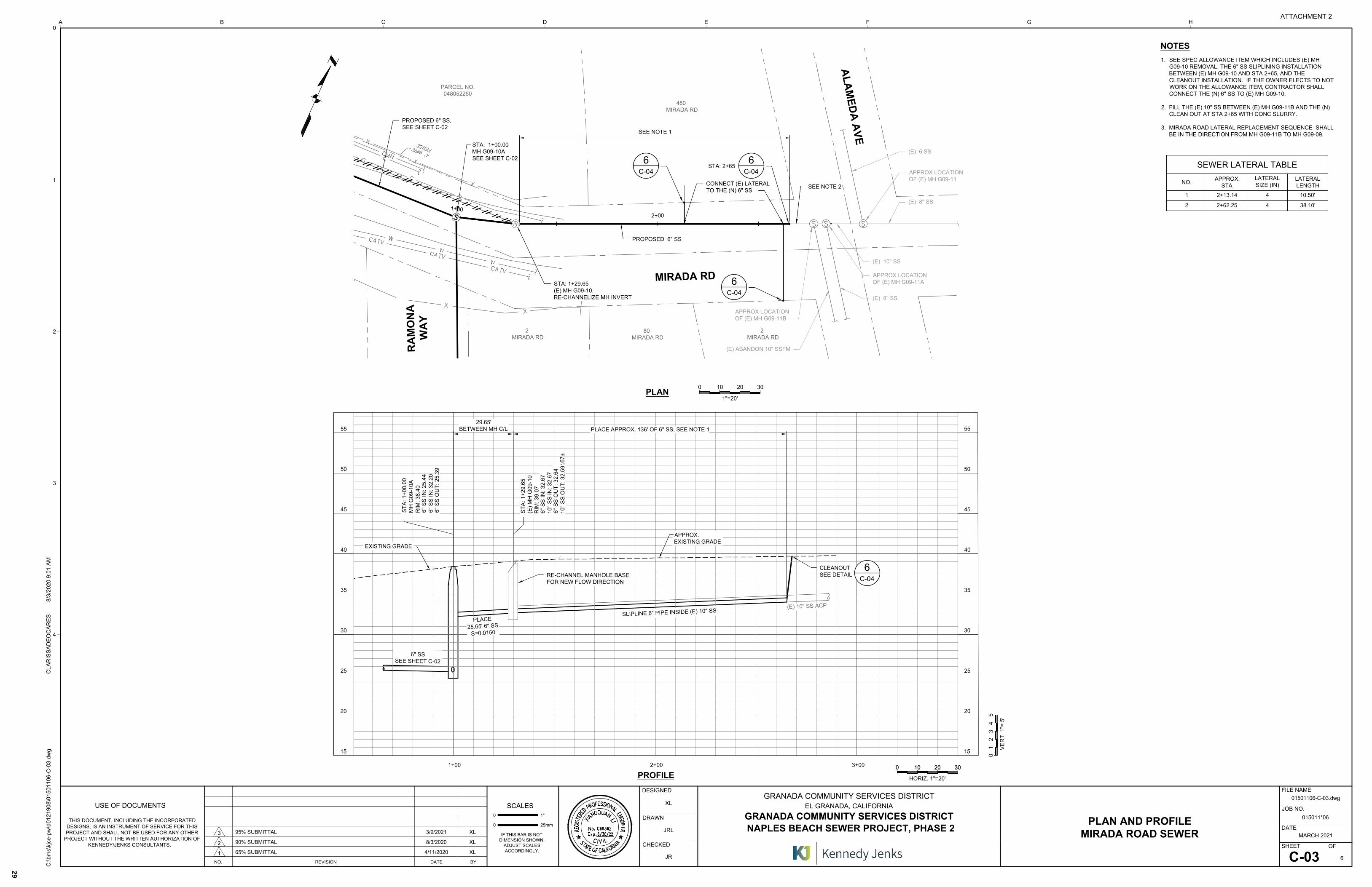
(E
) 1
0" S
S O
UT
: 3
2.6
7±
(E) 1
0" SS A
CP
6" SS
SEE SHEET C-02
SLIPLIN
E 6" PIP
E INSID
E (E) 1
0" SS
CLEANOUT
SEE DETAIL
PLA
CE
25.65' 6
" S
S
S=
0.0150
ST
A: 1
+0
0.0
0
MH
G
09
-1
0A
RIM
: 3
8.4
0
6" S
S IN
: 2
5.4
4
6" S
S IN
: 3
2.2
0
6" S
S O
UT
: 2
5.3
9
ST
A: 1
+2
9.6
5
(E
) M
H G
09
-1
0
RIM
: 3
9.0
7
6" S
S IN
: 3
2.6
7
10
" S
S IN
: 3
2.6
7
6" S
S O
UT
: 3
2.6
4
10
" S
S O
UT
: 3
2.5
9
C-04
6
RE-CHANNEL MANHOLE BASE
FOR NEW FLOW DIRECTION
1+
00
2+00
STA: 1+00.00
MH G09-10A
SEE SHEET C-02
PLAN AND PROFILE
MIRADA ROAD SEWER
01501106-C-03.dwg
C-03
XL
JRL
JR
1+00
PLAN
PROFILE
0
1"=20'
10 20 30
2+00 3+00
A
L
A
M
E
D
A
A
V
E
1. SEE SPEC ALLOWANCE ITEM WHICH INCLUDES (E) MH
G09-10 REMOVAL, THE 6" SS SLIPLINING INSTALLATION
BETWEEN (E) MH G09-10 AND STA 2+65, AND THE
CLEANOUT INSTALLATION. IF THE OWNER ELECTS TO NOT
WORK ON THE ALLOWANCE ITEM, CONTRACTOR SHALL
CONNECT THE (N) 6" SS TO (E) MH G09-10.
2. FILL THE (E) 10" SS BETWEEN (E) MH G09-11B AND THE (N)
CLEAN OUT AT STA 2+65 WITH CONC SLURRY.
3. MIRADA ROAD LATERAL REPLACEMENT SEQUENCE SHALL
BE IN THE DIRECTION FROM MH G09-11B TO MH G09-09.
NOTES
15
20
25
35
40
45
50
30
55
EXISTING GRADE
15
20
25
35
40
45
50
30
55
APPROX.EXISTING GRADE
MIRADA RD
480
MIRADA RD
2
MIRADA RD
80
MIRADA RD
2
MIRADA RD
RA
MO
NA
WA
Y
PARCEL NO.
048052260
PROPOSED 6" SS
STA: 2+65
(E) 10" SS
100 20 30
HORIZ. 1"=20'
100 20 30
0
VE
RT
1
"=
5
'
54
21
3
SEE NOTE 1
4
3
2
1
0
0
USE OF DOCUMENTS
25mm
SCALES
1"
CHECKED
DESIGNED
DRAWN
0
Kennedy/Jenks Consultants
DATE
SHEET OF
FILE NAME
JOB NO.
D E F G HA B C
IF THIS BAR IS NOT
DIMENSION SHOWN,
ADJUST SCALES
ACCORDINGLY.
THIS DOCUMENT, INCLUDING THE INCORPORATED
DESIGNS, IS AN INSTRUMENT OF SERVICE FOR THIS
PROJECT AND SHALL NOT BE USED FOR ANY OTHER
PROJECT WITHOUT THE WRITTEN AUTHORIZATION OF
KENNEDY/JENKS CONSULTANTS.
NO. REVISION DATE BY
C:\b
ms\kjce
-p
w\d
01
21
90
8\0
15
01
10
6-C
-0
3.d
wg
CL
AR
IS
SA
DE
OC
AR
ES
8
/3
/2
02
0 9
:0
1 A
M
1
2
GRANADA COMMUNITY SERVICES DISTRICT
EL GRANADA, CALIFORNIA
GRANADA COMMUNITY SERVICES DISTRICT
NAPLES BEACH SEWER PROJECT, PHASE 2
015011*06
MARCH 2021
6
65% SUBMITTAL 4/11/2020 XL
90% SUBMITTAL 8/3/2020 XL
95% SUBMITTAL 3/9/2021 XL
3
C-04
6
PROPOSED 6" SS,
SEE SHEET C-02
STA: 1+29.65
(E) MH G09-10,
RE-CHANNELIZE MH INVERT
CONNECT (E) LATERAL
TO THE (N) 6" SS
APPROX LOCATION
OF (E) MH G09-11B
SEE NOTE 2
APPROX LOCATION
OF (E) MH G09-11A
(E) 8" SS
(E) ABANDON 10" SSFM
(E) 8" SS
APPROX LOCATION
OF (E) MH G09-11
(E) 6 SS
PLACE APPROX. 136' OF 6" SS, SEE NOTE 1
29.65'
BETWEEN MH C/L
SEWER LATERAL TABLE
NO.
APPROX.
STA
LATERAL
SIZE (IN)
LATERAL
LENGTH
1 2+13.14 4 10.50'
2 2+62.25 4 38.10'
C-04
6
C-04
6
ATTACHMENT 2
29
AutoCAD SHX Text
4' WIRE FENCE
AutoCAD SHX Text
~
AutoCAD SHX Text
~
AutoCAD SHX Text
~
AutoCAD SHX Text
~
AutoCAD SHX Text
~
AutoCAD SHX Text
S
AutoCAD SHX Text
S
AutoCAD SHX Text
S
AutoCAD SHX Text
D
AutoCAD SHX Text
E
AutoCAD SHX Text
T
AutoCAD SHX Text
S
AutoCAD SHX Text
E
AutoCAD SHX Text
R
AutoCAD SHX Text
G
AutoCAD SHX Text
E
AutoCAD SHX Text
T
AutoCAD SHX Text
S
AutoCAD SHX Text
I
AutoCAD SHX Text
R
AutoCAD SHX Text
N
AutoCAD SHX Text
R
AutoCAD SHX Text
O
AutoCAD SHX Text
F
AutoCAD SHX Text
E
AutoCAD SHX Text
T
AutoCAD SHX Text
A
AutoCAD SHX Text
A
AutoCAD SHX Text
O
AutoCAD SHX Text
F
AutoCAD SHX Text
C
AutoCAD SHX Text
I
AutoCAD SHX Text
L
AutoCAD SHX Text
R
AutoCAD SHX Text
E
AutoCAD SHX Text
E
AutoCAD SHX Text
N
AutoCAD SHX Text
I
AutoCAD SHX Text
N
AutoCAD SHX Text
6/30/22
AutoCAD SHX Text
C69362
AutoCAD SHX Text
I
AutoCAD SHX Text
Exp.
AutoCAD SHX Text
C
AutoCAD SHX Text
I
AutoCAD SHX Text
V
AutoCAD SHX Text
No.
AutoCAD SHX Text
L
AutoCAD SHX Text
A
AutoCAD SHX Text
I
AutoCAD SHX Text
G
AutoCAD SHX Text
S
AutoCAD SHX Text
O
AutoCAD SHX Text
P
AutoCAD SHX Text
R
AutoCAD SHX Text
E
AutoCAD SHX Text
F
AutoCAD SHX Text
S
AutoCAD SHX Text
A
AutoCAD SHX Text
N
AutoCAD SHX Text
O
AutoCAD SHX Text
I
AutoCAD SHX Text
L
AutoCAD SHX Text
E

01501106-C-04.dwg
C-04
MM,JRL,XL
JRL
MM,XL
CIVIL DETAILS
4
3
2
1
0
0
USE OF DOCUMENTS
25mm
SCALES
1"
CHECKED
DESIGNED
DRAWN
0
Kennedy/Jenks Consultants
DATE
SHEET OF
FILE NAME
JOB NO.
D E F G HA B C
IF THIS BAR IS NOT
DIMENSION SHOWN,
ADJUST SCALES
ACCORDINGLY.
THIS DOCUMENT, INCLUDING THE INCORPORATED
DESIGNS, IS AN INSTRUMENT OF SERVICE FOR THIS
PROJECT AND SHALL NOT BE USED FOR ANY OTHER
PROJECT WITHOUT THE WRITTEN AUTHORIZATION OF
KENNEDY/JENKS CONSULTANTS.
NO. REVISION DATE BY
C:\b
ms\kjce
-p
w\d
01
21
90
8\0
15
01
10
6-C
-0
4.d
wg
C
LA
RIS
SA
DE
OC
AR
ES
3
/9
/2
02
1 7
:5
2 A
M
1
2
GRANADA COMMUNITY SERVICES DISTRICT
EL GRANADA, CALIFORNIA
GRANADA COMMUNITY SERVICES DISTRICT
NAPLES BEACH SEWER PROJECT, PHASE 2
015011*06
MARCH 2021
6
65% SUBMITTAL 4/11/2020 XL
90% SUBMITTAL 8/3/2020 XL
95% SUBMITTAL 3/9/2021 XL
3
ATTACHMENT 2
30
AutoCAD SHX Text
NOTE: 1. FRAME AND COVER SHALL BE D&L SUPPLY A-1024M, PHOENIX IRON WORKS P-1090 R/G, OR EQUAL. FRAME AND COVER SHALL BE D&L SUPPLY A-1024M, PHOENIX IRON WORKS P-1090 R/G, OR EQUAL. 2. FRAME AND COVER SHALL MEET OR EXCEED THE REQUIREMENTS OF AASHTO H-20 LOADING. FRAME AND COVER SHALL MEET OR EXCEED THE REQUIREMENTS OF AASHTO H-20 LOADING. 3. MANHOLE RIM SHALL BE 2" ABOVE (E) GRADE.MANHOLE RIM SHALL BE 2" ABOVE (E) GRADE.
AutoCAD SHX Text
NOTES: 1. FOR COVER 3' AND GREATER, PIPE MATERIAL SHALL BE PVC PSM SDR-26 FOR COVER 3' AND GREATER, PIPE MATERIAL SHALL BE PVC PSM SDR-26 OR HDPE SDR-17. 2. IF COVER IS LESS THAN 3', PIPE MATERIAL SHALL BE DUCTILE IRON. IF COVER IS LESS THAN 3', PIPE MATERIAL SHALL BE DUCTILE IRON. 3. FOR NEW LATERAL AND MAIN LINE INSTALLATIONS, PIPE MATERIAL SHALL BE FOR NEW LATERAL AND MAIN LINE INSTALLATIONS, PIPE MATERIAL SHALL BE THE SAME. 4. BOXES SHALL BE RAISED TO REROUTE RUNOFF AROUND THE BOX.BOXES SHALL BE RAISED TO REROUTE RUNOFF AROUND THE BOX.
AutoCAD SHX Text
REMOVE (E) LATERAL CONNECTION TO 10" S
AutoCAD SHX Text
DEPENDING ON LOCATION OF (E) LATERAL, A SECTION OF THE (E) 10" MAY NEED TO BE REMOVED FOR THE (N) LATERAL
AutoCAD SHX Text
(E) 10" S
AutoCAD SHX Text
(N) SEWER MAIN
AutoCAD SHX Text
CONNECTION TO MAIN BY: PVC PIPE-STANDARD WYE
AutoCAD SHX Text
REPLACE (E) LATERAL UP TO (N) PROPERTY LINE CLEANOUT
AutoCAD SHX Text
(N) LATERAL
AutoCAD SHX Text
PROPERTY LINE
AutoCAD SHX Text
MAX 45° BEND
AutoCAD SHX Text
PAVED AREA
AutoCAD SHX Text
UNPAVED AREA
AutoCAD SHX Text
12"
AutoCAD SHX Text
12"
AutoCAD SHX Text
12" OVERLAP
AutoCAD SHX Text
12" OVERLAP
AutoCAD SHX Text
GEOTEXTILE FABRIC
AutoCAD SHX Text
GEOTEXTILE FABRIC
AutoCAD SHX Text
MANHOLE FRAME AND COVER FOR NONPAVED AREA
AutoCAD SHX Text
SCALE: NTS
AutoCAD SHX Text
STANDARD MANHOLE
AutoCAD SHX Text
MANHOLE STEP
AutoCAD SHX Text
MANHOLE DROP INLET
AutoCAD SHX Text
CLEANOUT
AutoCAD SHX Text
PVC PIPE LATERAL RECONNECTION
AutoCAD SHX Text
TRENCH DETAIL
AutoCAD SHX Text
MANHOLE FRAME AND COVER FOR PAVED AREA
AutoCAD SHX Text
D
AutoCAD SHX Text
E
AutoCAD SHX Text
T
AutoCAD SHX Text
S
AutoCAD SHX Text
E
AutoCAD SHX Text
R
AutoCAD SHX Text
G
AutoCAD SHX Text
E
AutoCAD SHX Text
T
AutoCAD SHX Text
S
AutoCAD SHX Text
I
AutoCAD SHX Text
R
AutoCAD SHX Text
N
AutoCAD SHX Text
R
AutoCAD SHX Text
O
AutoCAD SHX Text
F
AutoCAD SHX Text
E
AutoCAD SHX Text
T
AutoCAD SHX Text
A
AutoCAD SHX Text
A
AutoCAD SHX Text
O
AutoCAD SHX Text
F
AutoCAD SHX Text
C
AutoCAD SHX Text
I
AutoCAD SHX Text
L
AutoCAD SHX Text
R
AutoCAD SHX Text
E
AutoCAD SHX Text
E
AutoCAD SHX Text
N
AutoCAD SHX Text
I
AutoCAD SHX Text
N
AutoCAD SHX Text
6/30/22
AutoCAD SHX Text
C69362
AutoCAD SHX Text
I
AutoCAD SHX Text
Exp.
AutoCAD SHX Text
C
AutoCAD SHX Text
I
AutoCAD SHX Text
V
AutoCAD SHX Text
No.
AutoCAD SHX Text
L
AutoCAD SHX Text
A
AutoCAD SHX Text
I
AutoCAD SHX Text
G
AutoCAD SHX Text
S
AutoCAD SHX Text
O
AutoCAD SHX Text
P
AutoCAD SHX Text
R
AutoCAD SHX Text
E
AutoCAD SHX Text
F
AutoCAD SHX Text
S
AutoCAD SHX Text
A
AutoCAD SHX Text
N
AutoCAD SHX Text
O
AutoCAD SHX Text
I
AutoCAD SHX Text
L
AutoCAD SHX Text
E
AutoCAD SHX Text
C-01
AutoCAD SHX Text
1
AutoCAD SHX Text
SCALE: NTS
AutoCAD SHX Text
C-02
AutoCAD SHX Text
2
AutoCAD SHX Text
SCALE: NTS
AutoCAD SHX Text
VAR
AutoCAD SHX Text
3
AutoCAD SHX Text
SCALE: NTS
AutoCAD SHX Text
VAR
AutoCAD SHX Text
4
AutoCAD SHX Text
SCALE: NTS
AutoCAD SHX Text
VAR
AutoCAD SHX Text
5
AutoCAD SHX Text
SCALE: NTS
AutoCAD SHX Text
VAR
AutoCAD SHX Text
6
AutoCAD SHX Text
SCALE: NTS
AutoCAD SHX Text
C-02
AutoCAD SHX Text
8
AutoCAD SHX Text
SCALE: NTS
AutoCAD SHX Text
C-02
AutoCAD SHX Text
7

Naples Beach Sewer Project Biological Resources Evaluation UpdateHALF MOON BAY, SAN MATEO COUNTY, CALIFORNIA
Prepared for:
Granada Community Services District 504 Avenue Alhambra Third Floor El Granada, CA 94018 (650) 726-7093
WRA Contact:
Leslie Lazarotti
Date:
November 2020
WRA Project No. 30012
ATTACHMENT 3
31

This page intentionally left blank.
ATTACHMENT 3
32

i
TABLE OF CONTENTS 1.0 INTRODUCTION .................................................................................................................. 5
1.1 Project Background ..................................................................................................... 6
1.2 Description of the Study Area ..................................................................................... 6
2.0 REGULATORY BACKGROUND .......................................................................................... 6
2.1 Special-Status Species ............................................................................................... 6
2.2 Sensitive Biological Communities ............................................................................... 7
2.3 Heritage Trees .......................................................................................................... 10
3.0 METHODS ......................................................................................................................... 11
3.1 Biological Communities ............................................................................................. 11
3.1.1 Non-sensitive Biological Communities .......................................................... 11
3.1.2 Sensitive Biological Communities ................................................................. 11
3.2 Special-Status Species ............................................................................................. 12
3.2.1 Literature Review .......................................................................................... 12
3.2.2 Site Assessment ........................................................................................... 13
4.0 RESULTS .......................................................................................................................... 13
4.1 Biological Communities ............................................................................................. 14
4.1.2 Non-sensitive Biological Communities .......................................................... 14
4.1.3 Sensitive Biological Communities ................................................................. 15
4.2 Potentially Jurisdictional Areas within the Study Area ............................................... 15
4.3 Special-Status Species ............................................................................................. 16
4.3.1 Special-Status Plant Species ........................................................................ 16
4.3.2 Special-Status Wildlife Species ..................................................................... 16
4.4 Heritage Trees .......................................................................................................... 20
5.0 SUMMARY AND RECOMMENDATIONS........................................................................... 20
5.1 Biological Communities and Heritage Trees .............................................................. 22
5.2 Special-Status Species ............................................................................................. 22
5.2.1 Special-Status Plant Species ........................................................................ 22
5.2.2 Special-Status Wildlife Species ..................................................................... 22
6.0 REFERENCES .................................................................................................................. 24
ATTACHMENT 3
33

ii
LIST OF TABLES
Table 1. Description of CNPS Ranks and Threat Codes .............................................................. 7
Table 2. Biological Communities in the Study Area ................................................................... 14
LIST OF APPENDICES
Appendix A – Figures Appendix B – List of Observed Plant and Wildlife Species within the Study Area Appendix C – Potential for Special-Status Plant and Wildlife Species to Occur in the Study Area Appendix D – Study Area Photographs Appendix E – Study Area Heritage Tree Survey Table
ATTACHMENT 3
34

iii
LIST OF ACRONYMS AND ABBREVIATIONS
BRE Biological Resources Evaluation Cal-IPC California Invasive Plant Council CCC California Coastal Commission CCR California Code of Regulations CDFG California Department of Fish and Game CDFW California Department of Fish and Wildlife CESA California Endangered Species Act CEQA California Environmental Quality Act CFGC California Fish and Game Code City City of Half Moon Bay CFR Code of Federal Regulations CNDDB California Natural Diversity Database CNPS California Native Plant Society Corps U.S. Army Corps of Engineers CRLF California red-legged frog CWA Clean Water Act EPA Environmental Protection Agency ESHA Environmentally Sensitive Habitat Area FAC Facultative plant species FACU Facultative upland plant species FACW Facultative wetland plant species FESA Federal Endangered Species Act Inventory California Native Plant Society Inventory of Rare and Endangered Plants IS/MND Initial Study/ Mitigated Negative Declaration MBTA Migratory Bird Treaty Act NL/UPL Not listed/upland plant species NMFS National Marine Fisheries Service OBL Obligate wetland plant species RWQCB Regional Water Quality Control Board SFGS San Francisco garter snake TRA TRA Environmental Sciences, Inc. USFWS U.S. Fish and Wildlife Service USGS U.S. Geological Survey WBWG Western Bat Working Group WRA WRA, Inc.
LIST OF PREPARERS
Leslie Lazarotti - Senior Associate Biologist Liz Allen – Regulatory Permitting Specialist Gavin Albertoli – Certified Arborist and Biologist Brian Kearns - Wildlife Biologist
ATTACHMENT 3
35

iv
This page intentionally left blank.
ATTACHMENT 3
36

5
1.0 INTRODUCTION
This report serves as an update to the 2008 biological resource evaluation (BRE) prepared by TRA Environmental Sciences, Inc. (TRA 2008a) for the Naples Beach Sewer Project (Project), located in the City of Half Moon Bay (City) in San Mateo County (Figure 1). The 2008 BRE was prepared as an Appendix to the Project’s Initial Study/ Mitigated Negative Declaration (IS/MND; TRA 2008b) in compliance with the California Environmental Quality Act (CEQA). The 2008 BRE and CEQA evaluation analyzed the entire Project, which consists of two phases. Construction of Phase 1 was completed in 2012 and has no ongoing monitoring requirements; therefore, this update to the 2008 BRE only pertains to Phase 2 of the Project. On May 19, 2020 WRA, Inc. (WRA) conducted a site visit and subsequent assessment of plant, wildlife, and soil databases for Phase 2 of the proposed Project. All assessments included in this update to the 2008 BRE assessed the potential Project footprint (Project Area) and an approximately 50-foot buffer around this Area (Study Area). The Study Area was sized based on the proximity of private, developed, residential property immediately outside of the 50-foot buffer. The term “Study Area” is used to describe both the Project Area as well as the buffer area and associated roads and trails adjacent to the proposed Project Area. Areas within the 50-foot buffer that included front and back yards of adjacent residences were not included in the Study Area as no work associated with the Project is proposed in these areas. This report describes the results of the site visit, which assessed the Study Area for (1) the potential to support special-status plant or wildlife species and (2) the presence of other sensitive biological resources protected by local, state, or federal laws and regulations. The regulatory framework of this update to the 2008 BRE provided in Section 2.0 of this report. The methods used in the assessment are described in Section 3.0, and the results of the site visit are presented in Section 4.0. A summary of the sensitive biological resources observed or with potential to occur at the site is provided in Section 5.0. This update to the 2008 BRE provides general information on the potential presence of sensitive species and habitats. This BRE update is not an official protocol-level survey for listed species; however, if special-status species were observed during the site visit, their presence was recorded. Specific findings on the habitat suitability or presence of special-status species or sensitive habitats may require that protocol-level surveys be conducted for Project approval by local, state, or federal agencies. This assessment is based on information available at the time of the study and on site conditions that were observed on the date of the site visit. Findings outside of the Study Area were based on only visual observations during the site visit. 1.1 Project Background
Phase 2 of the Project proposes to install a new sewer main along a section of Mirada Road and an undeveloped paper street, Ramona Way. Both the Ramona Way sewer line and the Mirada Road sewer line planned to the west of Ramona Way would be installed using an open cut method. The small portion of the Mirada Road alignment that runs to the east of Ramona Way would be installed using the trenchless method. The work area for the Ramona Way sewer line installation would be about 24 feet wide, extending 6 feet to the west 18 feet to the east of the proposed sewer
ATTACHMENT 3
37

6
line. The work area for Mirada Road sewer line installation would be between the road’s center yellow striping and the road’s northern right-of-way line. 1.2 Description of the Study Area
The Study Area is located west of U.S. Highway 1 in the City along Ramona Way, an undeveloped “paper street” located between Mirada Road and Alcatraz Avenue, and along Mirada Road, a paved road with adjacent residential development. Ramona Way is highly disturbed and is consequently dominated by ruderal vegetation such as poison hemlock (Coniun maculatum), wild radish (Raphanus sativus), Himalayan blackberry (Rubus armeniacus), and field mustard (Brassica rapa). Several mature Monterey cypresses (Hesperocyparis macrocarpa) are located within this undeveloped portion of the Study Area.
2.0 REGULATORY BACKGROUND
The following sections explain the regulatory context of a BRE. While this report serves as an update to the 2008 BRE, this report includes all applicable laws and regulations that were applied to the field investigations and analysis of potential project impacts. The entirety of the regulatory backgrounded described herein was covered in the 2008 BRE.
2.1 Special-Status Species
Special-status species include plant and wildlife species that have been formally listed, are proposed as endangered or threatened, or are candidates for such listing under the federal Endangered Species Act (ESA) or the California Endangered Species Act (CESA). The ESA affords protection to federally listed species. The CESA affords protection to both state-listed species and those that are formal candidates for state listing. The federal Bald and Golden Eagle Protection Act also provides broad protections to both eagle species that in some regards are similar to those provided by ESA. In addition, California Department of Fish and Wildlife (CDFW) Fully Protected Species and Species of Special Concern, which are species that face extirpation in California if current population and habitat trends continue, are considered special-status species. Although CDFW Species of Special Concern generally have no special legal status, they are given special consideration under CEQA. Bat species are also evaluated for conservation status by the Western Bat Working Group (WBWG), a non-governmental entity. Bats named as a “High Priority” or “Medium Priority” species for conservation by the WBWG are typically considered special-status and also considered under CEQA. In addition to regulations for special-status species, most native birds in the United States (including non-status species) are protected by the California Fish and Game Code (CFGC; Sections 3503, 3503.5, and 3513), and guidance for protection is provided by the Migratory Bird Treaty Act of 1918. Under the CFGC, destroying active nests, eggs, or young is illegal. Plant species on the California Native Plant Society (CNPS) Rare and Endangered Plant Inventory with California Rare Plant Ranks (Rank) of 1, 2, and sometimes 3 are also considered special-status plant species and must be considered under CEQA. Rank 4 species and some Rank 3 species are typically only afforded protection under CEQA when such species are particularly
ATTACHMENT 3
38
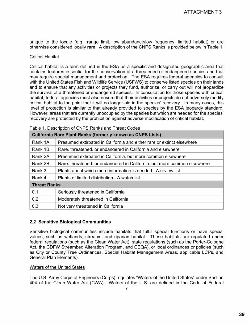
7
unique to the locale (e.g., range limit, low abundance/low frequency, limited habitat) or are otherwise considered locally rare. A description of the CNPS Ranks is provided below in Table 1.
Critical Habitat
Critical habitat is a term defined in the ESA as a specific and designated geographic area that contains features essential for the conservation of a threatened or endangered species and that may require special management and protection. The ESA requires federal agencies to consult with the United States Fish and Wildlife Service (USFWS) to conserve listed species on their lands and to ensure that any activities or projects they fund, authorize, or carry out will not jeopardize the survival of a threatened or endangered species. In consultation for those species with critical habitat, federal agencies must also ensure that their activities or projects do not adversely modify critical habitat to the point that it will no longer aid in the species’ recovery. In many cases, this level of protection is similar to that already provided to species by the ESA jeopardy standard. However, areas that are currently unoccupied by the species but which are needed for the species’ recovery are protected by the prohibition against adverse modification of critical habitat.
Table 1. Description of CNPS Ranks and Threat Codes California Rare Plant Ranks (formerly known as CNPS Lists) Rank 1A Presumed extirpated in California and either rare or extinct elsewhere Rank 1B Rare, threatened, or endangered in California and elsewhere Rank 2A Presumed extirpated in California, but more common elsewhere Rank 2B Rare, threatened, or endangered in California, but more common elsewhere Rank 3 Plants about which more information is needed - A review list Rank 4 Plants of limited distribution - A watch list Threat Ranks 0.1 Seriously threatened in California 0.2 Moderately threatened in California 0.3 Not very threatened in California
2.2 Sensitive Biological Communities
Sensitive biological communities include habitats that fulfill special functions or have special values, such as wetlands, streams, and riparian habitat. These habitats are regulated under federal regulations (such as the Clean Water Act), state regulations (such as the Porter-Cologne Act, the CDFW Streambed Alteration Program, and CEQA), or local ordinances or policies (such as City or County Tree Ordinances, Special Habitat Management Areas, applicable LCPs, and General Plan Elements).
Waters of the United States The U.S. Army Corps of Engineers (Corps) regulates “Waters of the United States” under Section 404 of the Clean Water Act (CWA). Waters of the U.S. are defined in the Code of Federal
ATTACHMENT 3
39
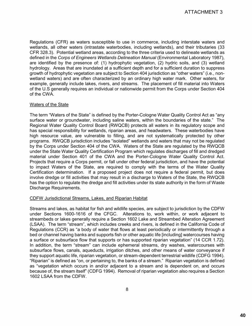
8
Regulations (CFR) as waters susceptible to use in commerce, including interstate waters and wetlands, all other waters (intrastate waterbodies, including wetlands), and their tributaries (33 CFR 328.3). Potential wetland areas, according to the three criteria used to delineate wetlands as defined in the Corps of Engineers Wetlands Delineation Manual (Environmental Laboratory 1987), are identified by the presence of: (1) hydrophytic vegetation, (2) hydric soils, and (3) wetland hydrology. Areas that are inundated at a sufficient depth and for a sufficient duration to suppress growth of hydrophytic vegetation are subject to Section 404 jurisdiction as “other waters” (i.e., non-wetland waters) and are often characterized by an ordinary high water mark. Other waters, for example, generally include lakes, rivers, and streams. The placement of fill material into Waters of the U.S generally requires an individual or nationwide permit from the Corps under Section 404 of the CWA. Waters of the State The term “Waters of the State” is defined by the Porter-Cologne Water Quality Control Act as “any surface water or groundwater, including saline waters, within the boundaries of the state.” The Regional Water Quality Control Board (RWQCB) protects all waters in its regulatory scope and has special responsibility for wetlands, riparian areas, and headwaters. These waterbodies have high resource value, are vulnerable to filling, and are not systematically protected by other programs. RWQCB jurisdiction includes “isolated” wetlands and waters that may not be regulated by the Corps under Section 404 of the CWA. Waters of the State are regulated by the RWQCB under the State Water Quality Certification Program which regulates discharges of fill and dredged material under Section 401 of the CWA and the Porter-Cologne Water Quality Control Act. Projects that require a Corps permit, or fall under other federal jurisdiction, and have the potential to impact Waters of the State, are required to comply with the terms of the Water Quality Certification determination. If a proposed project does not require a federal permit, but does involve dredge or fill activities that may result in a discharge to Waters of the State, the RWQCB has the option to regulate the dredge and fill activities under its state authority in the form of Waste Discharge Requirements. CDFW Jurisdictional Streams, Lakes, and Riparian Habitat Streams and lakes, as habitat for fish and wildlife species, are subject to jurisdiction by the CDFW under Sections 1600-1616 of the CFGC. Alterations to, work within, or work adjacent to streambeds or lakes generally require a Section 1602 Lake and Streambed Alteration Agreement (LSAA). The term “stream”, which includes creeks and rivers, is defined in the California Code of Regulations (CCR) as “a body of water that flows at least periodically or intermittently through a bed or channel having banks and supports fish or other aquatic life [including] watercourses having a surface or subsurface flow that supports or has supported riparian vegetation” (14 CCR 1.72). In addition, the term “stream” can include ephemeral streams, dry washes, watercourses with subsurface flows, canals, aqueducts, irrigation ditches, and other means of water conveyance if they support aquatic life, riparian vegetation, or stream-dependent terrestrial wildlife (CDFG 1994). “Riparian” is defined as “on, or pertaining to, the banks of a stream.” Riparian vegetation is defined as “vegetation which occurs in and/or adjacent to a stream and is dependent on, and occurs because of, the stream itself” (CDFG 1994). Removal of riparian vegetation also requires a Section 1602 LSAA from the CDFW.
ATTACHMENT 3
40

9
California Coastal Commission Environmentally Sensitive Habitat Areas The California Coastal Commission (CCC) and the Half Moon Bay Local Coastal Program (LCP) regulates the diking, filling, or dredging of wetlands within the coastal zone. Section 30121 of the Coastal Act defines “wetlands” as land “which may be covered periodically or permanently with shallow water and include saltwater marshes, freshwater marshes, open or closed brackish water marshes, swamps, mudflats, and fens.” In addition, the City LCP defines “wetlands” as an area where the water table is at, near, or above the land surface long enough to bring about the formation of hydric soils or to support the growth of plants, which normally are found to grow in water or wet ground. Wetlands do not include vernally wet areas where the soils are not hydric. The 1981 CCC Statewide Interpretive Guidelines state that hydric soils and hydrophytic vegetation “are useful indicators of wetland conditions,” but the presence or absence of hydric soils and/or hydrophytes alone are not necessarily determinative when the CCC identifies wetlands under the Coastal Act.
The boundaries of areas regulated by the Corps, CCC, and LCP are often not the same due to the differing goals of the respective regulatory programs and because these agencies use different definitions for determining the extent of wetland areas. For example, the Corps requires positive indicators for the presence of wetland hydrology, hydric soils, and a predominance of hydrophytic vegetation be present for an area to meet the Corps’ wetland definition. The CCC does not necessarily require that all three wetland indicators (wetland hydrology, hydric soils, and a predominance of hydrophytic vegetation) be present for an area to be determined to be a “wetland”; rather, the presence of hydric soils in the absence of a predominance of hydrophytes (or vice versa) could be sufficient for a positive wetland determination.
The CCC defines an environmentally sensitive habitat area (ESHA) as follows:
"Environmentally sensitive habitat area" means any area in which plant or animal life or their habitats are either rare or especially valuable because of their special nature or role in an ecosystem and which could be easily disturbed or degraded by human activities and developments.”
The CCC Guidelines contain definitions for specific types of ESHAs, including: wetlands, estuaries, streams and rivers, lakes, open coastal waters and coastal waters, riparian habitats, other resource areas, and special-status species and their habitats. For the purposes of this report, WRA has taken into consideration any areas that may meet the definition of any ESHA defined by the CCC guidelines or the City LCP.
ATTACHMENT 3
41

10
City of Half Moon Bay Local Coastal Program and Land Use Plan
The City Land Use Policies and Map constitute the Land Use Plan of the LCP. The Zoning Code (Title 18 of the Municipal Code, including Chapter 18.20, which regulates Coastal Development Permits) together with the Zoning District Map constitutes the Implementation Plan of the LCP. The primary goal of the LCP is to ensure that the local government’s land use plans, zoning ordinances, zoning maps, and implemented actions meet the requirements of the provisions and polices of the Coastal Act at the local level. Coastal Resource Conservation Standards are described in Chapter 18.38 of the LCP and define sensitive habitat and coastal resource areas for conservation to include: sand dunes; marine habitats; sea cliffs; riparian areas; wetlands, coastal tidelands and marshes, lakes, ponds, and adjacent shore habitats; coastal or off-shore migratory bird nesting sites; areas used for scientific study, refuges, and reserves; habitats containing unique or rare and endangered species; rocky intertidal zones; coastal scrub communities; wild strawberry habitat; and archaeological resources. Marine and water resources (including riparian habitats) are further defined in Chapter 3 of the Land Use Plan.
Other Sensitive Biological Communities Other sensitive biological communities not discussed above include habitats that fulfill special functions or have special values. Natural communities considered sensitive are those identified in local or regional plans, policies, regulations, or by the CDFW. CDFW ranks sensitive communities (alliances) as "threatened" or "very threatened" and keeps records of their occurrences in its California Natural Diversity Database (CNDDB; CDFW 2020). CNDDB vegetation alliances are ranked 1 through 5 based on NatureServe's (2020) methodology, with those alliances ranked globally (G) or statewide (S) as 1 through 3 considered sensitive. Impacts to sensitive natural communities identified in local or regional plans, policies, or regulations or those identified by the CDFW or USFWS must be considered and evaluated under CEQA (CCR Title 14, Div. 6, Chap. 3, Appendix G). Specific habitats may also be identified as sensitive in city or county general plans or ordinances. 2.3 Heritage Trees
City of Half Moon Bay Tree Ordinance Chapter 7.40, “Heritage Trees” (Tree Ordinance), of the City of Half Moon Bay Municipal Code stipulates regulations designed to preserve and protect heritage trees on private or City-owned property. Heritage trees are defined by the tree ordinance as any of the following:
• A tree located on public or private property, exclusive of eucalyptus, with a trunk diameter of twelve inches or more, or a circumference of at least thirty-eight inches measured at forty-eight inches above ground level.
• A tree or stand of trees so designated by resolution of the city council based on its finding of special historical, environmental or aesthetic value.
• A tree located within the public right-of-way along the entire length of Main Street or along Kelly Avenue between San Benito Street and Highway 1.
Any person desiring to remove one or more heritage trees, perform major pruning, or conduct any
ATTACHMENT 3
42

11
construction activity within the drip line of a heritage tree shall apply for a permit pursuant to procedures established by the city manager and shall pay a fee established by the city council. Mitigation in the form of tree replacement is required as a condition of removal authorization in accordance with specifications listed in Chapter 7.40.060 of the City’s Tree Ordinance (City 2020).
3.0 METHODS
On May 19, 2020 the Study Area was traversed on foot to determine (1) plant communities present within the Study Area, (2) if existing conditions provide suitable habitat for any special-status plant or wildlife species, and (3) if sensitive habitats including ESHAs are present. All plant and wildlife species encountered were recorded and are summarized in Appendix B. Prior to the site visit, aerial imagery (Google Earth 2020), the National Wetlands Inventory (USFWS 2020a), and the Soil Survey of San Mateo Area (USDA 1961) and an online soil survey (CSRL 2020) were reviewed to assess the potential for sensitive biological communities to occur in the Study Area. Plant nomenclature follows the Jepson eFlora (Jepson Flora Project 2020), except where noted. For cases in which regulatory agencies, CNPS, or other entities base rarity on older taxonomic treatments, precedence was given to the treatment used by those entities. 3.1 Biological Communities
Biological communities present in the Study Area were classified based on existing plant community descriptions described in A Manual of California Vegetation, Online Edition (CNPS 2020b; CDFW 2020). However, in some cases, it was necessary to identify variants of community types or to describe non-vegetated areas that are not described in the literature. Biological communities were classified as sensitive or non-sensitive as defined by the CEQA and other applicable laws and regulations (see Section 2.2, above). 3.1.1 Non-sensitive Biological Communities
Non-sensitive biological communities are those communities that are not afforded special protection under the CEQA or other state, federal, and local laws, regulations, and ordinances. However, these communities may provide suitable habitat for some special-status plant or wildlife species and are identified or described in Section 4.4 below.
3.1.2 Sensitive Biological Communities
Sensitive biological communities are defined as those communities that are given special protection under the CEQA or other applicable federal, state, and local laws, regulations, and ordinances. Applicable laws and ordinances are discussed above in Section 2.0. Special methods used to identify sensitive biological communities are discussed below.
The Study Area was also evaluated for the presence of other sensitive biological communities, including riparian areas, and sensitive plant communities recognized by CDFW. If observed, these sensitive biological communities were mapped and are described in Section 4.1 below.
Wetlands, Non-wetland Waters, and Riparian Vegetation
ATTACHMENT 3
43

12
The Study Area was surveyed to determine the potential presence of any wetlands, non-wetland waters, or riparian vegetation potentially subject to jurisdiction under the CWA, the Porter-Cologne Water Quality Control Act, the CFCG, and the California Coastal Act. The assessment was based primarily on the presence of wetland plant indicators, but also included any observed indicators of wetland hydrology or hydric soils. Any potential wetland areas were identified as areas dominated by plant species with a wetland indicator status1 of OBL, FACW, or FAC as provided on the Corps National Wetlands Plant List (Lichvar et al. 2016). Evidence of wetland hydrology can include direct (primary) indicators, such as visible inundation or saturation, algal mats, and oxidized root channels, or indirect (secondary) indicators, such as a water table within 2 feet of the soil surface during the dry season. Some indicators of wetland soils include dark colored soils, soils with a sulfidic odor, and soils that contain redoximorphic features as defined by the Corps Manual (Environmental Laboratory 1987) and Field Indicators of Hydric Soils in the U.S. (USDA 2018). Other Sensitive Biological Communities The Study Area was evaluated for the presence of other sensitive biological communities, including riparian areas and sensitive plant communities recognized by the CDFW. If present in the Study Area, these sensitive biological communities were mapped and are described below. 3.2 Special-Status Species
3.2.1 Literature Review
Potential occurrence of special-status species in the Study Area was evaluated by first determining which special-status species occur in the vicinity of the Study Area through a literature and database search. Database searches for known occurrences of special-status species focused on the Half Moon Bay, Hunters Point, Montara Mountain, San Francisco South, San Mateo, and Woodside U.S. Geological Survey 7.5-minute quadrangle maps. The following sources were reviewed to determine which special-status plant and wildlife species have been documented to occur in the vicinity of the Study Area:
• CNDDB records (CDFW 2020) • CNPS Inventory records (CNPS 2020a) • California Department of Fish and Game publication “California’s Wildlife, Volumes I-III”
(Zeiner et al. 1990) • A Field Guide to Western Reptiles and Amphibians (Stebbins and McGinnis 2012) • California Amphibian and Reptile Species of Special Concern (Thomson et al. 2016) • California Bird Species of Special Concern (Shuford and Gardali 2008) • Western Bat Working Group, species accounts (WBWG 2017) • eBird records (eBird 2020)
1 OBL = Obligate, always found in wetlands; FACW = Facultative wetland, usually found in wetlands; FAC = Facultative, equal occurrence in wetland or non-wetlands.
ATTACHMENT 3
44

13
• USFWS Information for Planning and Consultation (IPaC)(USFWS 2020b)
3.2.2 Site Assessment
This BRE update was conducted to determine if existing conditions provide suitable habitat for any special-status plant or wildlife species, and to see if the existing conditions vary from the conditions described in the 2008 BRE. The potential for each special-status species to occur in the Study Area was evaluated according to the following criteria:
• No Potential. Habitat on and adjacent to the site is clearly unsuitable for the species requirements (foraging, breeding, cover, substrate, elevation, hydrology, plant community, site history, disturbance regime).
• Unlikely. Few of the habitat components meeting the species requirements are present, and/or the majority of habitat on and adjacent to the site is unsuitable or of very poor quality. The species is not likely to be found on the site.
• Moderate Potential. Some of the habitat components meeting the species requirements are present, and/or only some of the habitat on or adjacent to the site is unsuitable. The species has a moderate probability of being found on the site.
• High Potential. All of the habitat components meeting the species requirements are present and/or most of the habitat on or adjacent to the site is highly suitable. The species has a high probability of being found on the site.
• Present. Species is observed on the site or has been recorded (e.g., CNDDB, other reports) on the site recently.
During the site assessment, WRA biologists identified the presence or absence of suitable habitat for each special-status species known to occur in the vicinity of the proposed Project to determine the potential of these special-status species to occur in the Study Area. This BRE update does not constitute a protocol-level survey and is not intended to determine the actual presence or absence of a species; however, if a special-status species was observed during the site visit, its presence was recorded and discussed. Appendix C presents the evaluation of potential for occurrence of each special-status plant and wildlife species known to occur in the vicinity of the Study Area with their habitat requirements, potential for occurrence, and rationale for the classification based on criteria listed above.
4.0 RESULTS
The following sections present the results and discussion of this BRE update within the Study Area. A list of observed plant and wildlife species is included as Appendix B. A list of special-status plant and wildlife species known to occur in the vicinity and an assessment of their potential to occur within the Study Area is included as Appendix C. Photographs of the Study Area are included as
ATTACHMENT 3
45

14
Appendix D. A table with all relevant information pertaining to surveyed heritage trees in the Study Area is provided in Appendix E. 4.1 Biological Communities
The Study Area contains seven biological communities including Monterey cypress grove, Monterey pine woodland, poison oak scrub, coyote brush scrub, non-native annual grassland, wild radish patches, and English ivy patches. The Study Area also contains developed land cover. All biological communities in the Study Area are depicted in Figure 6 of Appendix A. Acreage summations for biological communities are detailed in Table 2.
Table 2. Biological Communities in the Study Area
Biological Community
Type Biological Community or
Association Sensitivity Type Acreage
Non-Sensitive Communities Woodland Monterey cypress grove N/A 0.15
Woodland Monterey pine woodland N/A 0.10
Scrub Poison oak scrub N/A 0.01
Scrub Coyote brush scrub N/A 0.08
Grassland Non-native annual grassland N/A 0.27
Herbaceous Wild radish patches N/A 0.49
Herbaceous English ivy mats N/A 0.13
Developed (e.g., roadway, roads, trails)
Developed N/A 0.73
Total 1.96 4.1.2 Non-sensitive Biological Communities Monterey cypress grove. A row of mature Monterey cypress is present along the western edge of the Study Area. The trees are situated in an evenly spaced line adjacent to a fence line that separates the Study Area from residential homes. Due to the even spacing and location of the trees, these stands are presumed to have been planted. The understory is sparse in these stands and contains patches of bare ground, ripgut brome (Bromus diandrus), and ornamental plant species.
ATTACHMENT 3
46
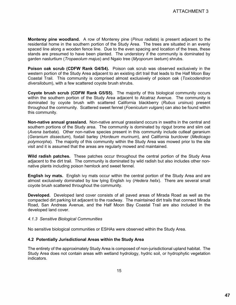
15
Monterey pine woodland. A row of Monterey pine (Pinus radiata) is present adjacent to the residential home in the southern portion of the Study Area. The trees are situated in an evenly spaced line along a wooden fence line. Due to the even spacing and location of the trees, these stands are presumed to have been planted. The understory if the community is dominated by garden nasturtium (Tropaeolum majus) and Ngaio tree (Myoporum laetum) shrubs. Poison oak scrub (CDFW Rank G4/S4). Poison oak scrub was observed exclusively in the western portion of the Study Area adjacent to an existing dirt trail that leads to the Half Moon Bay Coastal Trail. This community is comprised almost exclusively of poison oak (Toxicodendron diversilobum), with a few scattered coyote brush shrubs. Coyote brush scrub (CDFW Rank G5/S5). The majority of this biological community occurs within the southern portion of the Study Area adjacent to Alcatraz Avenue. The community is dominated by coyote brush with scattered California blackberry (Rubus ursinus) present throughout the community. Scattered sweet fennel (Foeniculum vulgare) can also be found within this community. Non-native annual grassland. Non-native annual grassland occurs in swaths in the central and southern portions of the Study area. The community is dominated by ripgut brome and slim oat (Avena barbata). Other non-native species present in this community include cutleaf geranium (Geranium dissectum), foxtail barley (Hordeum murinum), and California burclover (Medicago polymorpha). The majority of this community within the Study Area was mowed prior to the site visit and it is assumed that the areas are regularly mowed and maintained. Wild radish patches. These patches occur throughout the central portion of the Study Area adjacent to the dirt trail. The community is dominated by wild radish but also includes other non-native plants including poison hemlock and sweet fennel. English ivy mats. English ivy mats occur within the central portion of the Study Area and are almost exclusively dominated by low lying English ivy (Hedera helix). There are several small coyote brush scattered throughout the community. Developed. Developed land cover consists of all paved areas of Mirada Road as well as the compacted dirt parking lot adjacent to the roadway. The maintained dirt trails that connect Mirada Road, San Andreas Avenue, and the Half Moon Bay Coastal Trail are also included in the developed land cover.
4.1.3 Sensitive Biological Communities
No sensitive biological communities or ESHAs were observed within the Study Area.
4.2 Potentially Jurisdictional Areas within the Study Area
The entirety of the approximately Study Area is composed of non-jurisdictional upland habitat. The Study Area does not contain areas with wetland hydrology, hydric soil, or hydrophytic vegetation indicators.
ATTACHMENT 3
47

16
No wetlands or aquatic features potentially subject to jurisdiction by the Corps, RWQCB, or the CCC were identified within the Study Area. 4.3 Special-Status Species
4.3.1 Special-Status Plant Species
Based upon a review of the resources and databases given in Section 3.2, 29 special-status plant species have been documented in the vicinity of the Study Area. Appendix C summarizes the potential for occurrence for each of these special-status plant species to occur in the Study Area.
No special-status plant species were observed in the Study Area during the site visit. Of the 29 special-status species documented, none were determined to have a moderate or high potential to occur in the Study Area for one or more of the following reasons:
• Absence of specific soil types (e.g., serpentine soils) • Absence of suitable habitat (e.g., chaparral, valley grassland, riparian woodland, vernal
pools or wetlands) • Dominance of invasive, non-native species • Outside the geographic range of species (e.g., Study Area is below known elevation range) • Outside the known distribution of species (e.g., Study Area is too far north) • Portions of the Study Area occur within maintained areas that are routinely disturbed
4.3.2 Special-Status Wildlife Species
Based upon a review of the resources and databases given in Section 3.2, 29 special-status wildlife species have been documented in the vicinity of the Study Area. Appendix C summarizes the potential for occurrence for each of these special-status wildlife species to occur in the Study Area. Of the 29 species, three (3) have moderate potential to occur on the Study Area and are discussed in detail below. Other species are excluded from the Study Area due to the lack of required habitat features, such as:
• The presence of an obligate host plant; • Perennial aquatic features; • Riparian areas; • Areas with a thick understory; • Large contiguous stands of trees; • Caves or other cavities;
Species with Moderate Potential to Occur
San Francisco (saltmarsh) common yellowthroat (Geothlypis trichas sinuosa), USFWS Bird of Conservation Concern, CDFW Species of Special Concern. This subspecies of the common yellowthroat is found in freshwater marshes, coastal swales, riparian thickets, brackish marshes, and saltwater marshes. Their breeding range extends from Tomales Bay in the north, Carquinez Strait to the east, and Santa Cruz County to the south. This species requires thick, continuous cover such as tall grasses, tule patches, or riparian vegetation down to the water surface for
ATTACHMENT 3
48

17
foraging and prefers willows for nesting (Shuford and Gardali 2008). Although this species is more typically associated with nesting near open water, this species has a moderate potential to nest within the scrub and wild radish patch areas within the Study Area, and may forage in the open grassland areas.
White-tailed kite (Elanus leucurus), CDFW Fully Protected Species, LCP Unique Species. Kites occur in low elevation grassland, agricultural, wetland, oak woodland, and savannah habitats. Riparian zones adjacent to open areas are also used. Vegetative structure and prey availability seem to be more important than specific associations with plant species or vegetative communities. Lightly grazed or ungrazed fields generally support large prey populations and are often preferred to other habitats. Kite primarily feed on small mammals, although, birds, reptiles, amphibians, and insects are also taken. Nest trees range from single isolated trees to trees within large contiguous forests. Preferred nest trees are extremely variable, ranging from small shrubs (less than 10 ft. tall) to large trees (greater than 150 ft. tall) (Dunk 1995). Suitable foraging habitat is present in the grassland portions of the Study Area. Additionally, Monterey cypress and nearby other larger trees provide suitable nesting sites for this species. Given the presence of suitable nesting and foraging habitat within and in the vicinity of the Study Area, white-tailed kite has moderate potential to occur. Nesting Raptors, LCP Unique Species. Nesting raptors without protections as special-status species are specifically protected by the Half Moon Bay LCP as a unique species. Raptors typically nest in larger trees, cliff faces, or on large structures such as utility poles or transmission towers, and often forage in more open areas such as grasslands or low scrub. Potential raptor nesting habitat is present within the Study Area within Monterey Pine and Monterey Cypress woodlands, and foraging habitat is available within grasslands. Therefore, non-status raptors have moderate potential to nest within the Study Area. Species Unlikely to Occur
Monarch butterfly (Danaus plexippus). Winter Roosts Protected. Winter roost sites extend along the coast from northern Mendocino to Baja California, Mexico. Roosts are located in wind protected tree groves, with nectar and water sources nearby, and are often on south, southwest, or west facing slopes, which may provide more favorable temperature regimes and wind protection (Leong et al. 2004). Monarch butterflies typically arrive in mid-October to overwintering sites along the California coast and remain until late February or March (Jepsen et al. 2015). No documented roosts are known within the Study Area. The Monterey cypress stands within the Study Area do not provide suitable roost habitat because the single row of trees does not provide the necessary shelter. No large groves of trees are present on or nearby the Study Area that could provide sufficient thermoregulation or wind blocking to provide a likely winter roost site for this species. Therefore, monarch butterfly is unlikely to roost in the larger trees within the Study Area.
San Francisco tree lupine moth (Grapholita edwardsiana). City LCP Rare Species. San Francisco tree lupine moth was proposed for federal threatened status in 1978, just prior to the authoring of the City LCP. However, its status was never elevated to a listed species. The species occurs only on sandy northern San Francisco Peninsula sites and is associated with its larval host plant, tree lupine (Lupinus arboreus). Little is known about the species’ ecology; however the initial concern that led to the proposal of federal threatened status in 1978 was largely due to the
ATTACHMENT 3
49

18
degradation and loss of the sandy dune system of the host plant, tree lupine (USFWS 1978). However, later research showed that the tree lupine host plants recovered well from habitat disturbance and in some instances may have expanded their initial range, presumably to the benefit of the San Francisco tree lupine moth (USFWS 1986). The host plant for this species was not identified during site visits to the Study Area. Therefore, this species is unlikely to occur on the Study Area.
San Francisco garter snake (Thamnophis sirtalis tetrataenia), Federal Endangered, State Endangered, CDFW Fully Protected, LCP Rare Species. Historically, San Francisco garter snake (SFGS) occurred in scattered wetland areas on the San Francisco Peninsula from approximately the San Francisco County line south along the eastern and western bases of the Santa Cruz Mountains, at least to the Upper Crystal Springs Reservoir, and along the coast south to Año Nuevo Point, San Mateo County, and Waddell Creek, Santa Cruz County. The preferred habitat of the SFGS is a densely vegetated pond near an open hillside where they can sun themselves, feed, and find cover in rodent burrows; however, considerably less ideal habitats can be successfully occupied (USFWS 2006). Temporary ponds and other seasonal freshwater bodies are also used. Emergent and bankside vegetation such as cattails (Typha spp.), bulrushes (Scirpus spp.) and spike rushes (Juncus spp. and Eleocharis spp.) apparently are preferred and used for cover. The area between stream and pond habitats and grasslands or bank sides is used for basking; while nearby dense vegetation or water often provide escape cover. Snakes also use floating algal or rush mats as escape cover, if available.
There are two significant components to SFGS habitat: 1) ponds that support California red-legged frog (Rana draytonii, CRLF), American bullfrog (Lithobates catesbeiana), or the Sierran treefrog (Pseudacris sierra) and 2) surrounding upland that supports Botta's pocket gopher (Thomomys bottae) and the California meadow vole (Microtus californicus) (USFWS 2006). Ranid frogs are an obligate component of the SFGS's diet (USFWS 2006).
Specific information on the home range of SFGS documents this species to travel much shorter distances than other garter snake species, many of which travel over several kilometers between winter and summer sites. Studies at Año Nuevo State Reserve found the mean distance of female hibernacula to the Visitor Center Pond was 459 feet, with a maximum distance of 637 feet. Distances of greater than 637 feet have been reported, including an unconfirmed distance of approximately 1000 feet (McGinnis et al. 1987, Larson 1994). However, more recent studies at Año Nuevo State Reserve continue to confirm SFGS are regularly within 300 and 650 feet of foraging (pond) habitats and upland sites. Dispersal is rarely greater than this distance although not impossible if dispersal occurs in pursuit of prey (USFWS 2006), and during periods of heavy rain or shortly after, SFGS may make long-distance movements of up to 1.25 miles along drainages within the dense riparian cover; however, SFGS have not been documented to travel over open terrain (McGinnis 2001).
The intermittent steam adjacent to the Study Area to the North is the only aquatic habitat in the vicinity, and is only inundated for brief periods immediately after storm events. In the late spring through fall months, the Study Area is unlikely to support any prey items of SFGS, especially CRLF which are more heavily depended upon as a food source of SFGS (USFWS 2006). The intermittent stream and riparian habitats adjacent to the Study Area may support Sierran tree frogs; however, they would likely not support prey items beyond winter and early spring whereas SFGS are associated with permanently-inundated aquatic features. Frenchman’s Creek, located
ATTACHMENT 3
50

19
approximately 1-mile south of the Study Area, may seasonally support dispersing of SFGS prey species (including CRLF). However, the Study Area is separated from this potential habitat by a relatively large dispersal distance and several complete barriers to dispersal including residential development and large roads. The Study Area is also unlikely to provide upland habitat for SFGS, given the lack of aquatic features and lack of burrow systems that may support CRLF or other prey species. Therefore, SFGS are unlikely to occur within the Study Area.
California red-legged frog (Rana draytonii), Federal Threatened, CDFW Species of Special Concern, LCP Rare Species. The historic range of California red-legged frog (CRLF) extended along the coast from the vicinity of Point Reyes National Seashore, Marin County, California and inland from Redding, Shasta County southward to northwestern Baja California, Mexico (Jennings and Hayes 1994, Hayes and Krempels 1986). The current distribution of this species includes only isolated localities in the Sierra Nevada, northern Coast and Northern Traverse Ranges. It is still common in the San Francisco Bay Area and along the Central Coast and it is now believed extirpated from the southern Transverse and Peninsular Ranges (USFWS 2002).
There are four physical and biological features that are considered to be essential for the conservation or survival of this species. The features for CRLF include: aquatic breeding habitat; non-breeding aquatic habitat; upland habitat; and dispersal habitat (USFWS 2010). Aquatic breeding habitat consists of low-gradient fresh water bodies including natural and manmade (e.g., stock) ponds and pools in perennial streams (Jennings and Hayes 1994), marshes, lagoons, and dune ponds. Aquatic breeding habitat must hold water for a minimum of 20 weeks in most years. This is the average amount of time needed for egg, larvae, and tadpole development and metamorphosis so that juveniles can become capable of surviving in upland habitats (USFWS 2010). Optimal habitat is characterized by dense, shrubby riparian vegetation associated with deep (less than 2.3 feet), still, or slow-moving water (Hayes and Jennings 1986). Arroyo willow (Salix lasiolepis) seems to provide the most suitable riparian habitat structurally, although cattails and bulrushes also can provide suitable habitat. Although CRLF are found in ephemeral streams and ponds, populations cannot be maintained where all surface water disappears (Jennings and Hayes 1994).
Aquatic non-breeding habitat may or may not hold water long enough for this species to hatch and complete its aquatic life cycle, but it provides shelter, foraging, predator avoidance, and aquatic dispersal for juvenile and adult CRLF. These waterbodies include plunge pools within intermittent creeks; seeps; quiet water refugia during high water flows; and springs of sufficient flow to withstand the summer dry period. CRLF can use large cracks in the bottom of dried ponds as refugia to maintain moisture and avoid heat and solar exposure (Alvarez 2004). Non-breeding aquatic features enable CRLF to survive drought periods, and disperse to other aquatic breeding habitat (USFWS 2010).
Upland habitats include areas within 200 to 300 feet of aquatic and riparian habitat and are comprised of grasslands, woodlands, and/or vegetation that provide shelter, forage, and predator avoidance. These upland features provide breeding, non-breeding, feeding, and sheltering habitat for juvenile and adult frogs (e.g., shelter, shade, moisture, cooler temperatures, a prey base, foraging opportunities, and areas for predator avoidance). Upland habitat can include structural features such as boulders, rocks and organic debris (e.g. downed trees, logs), as well as small mammal burrows and moist leaf litter (USFWS 2010). Dispersal habitat includes accessible upland
ATTACHMENT 3
51
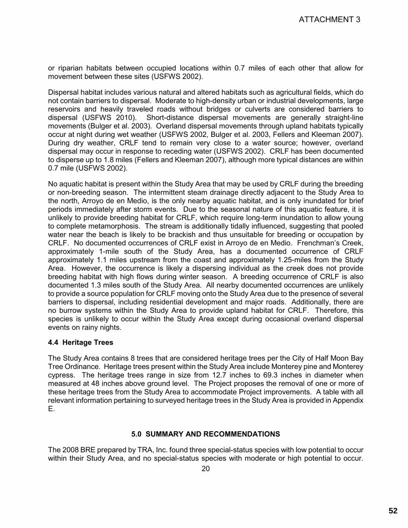
20
or riparian habitats between occupied locations within 0.7 miles of each other that allow for movement between these sites (USFWS 2002).
Dispersal habitat includes various natural and altered habitats such as agricultural fields, which do not contain barriers to dispersal. Moderate to high-density urban or industrial developments, large reservoirs and heavily traveled roads without bridges or culverts are considered barriers to dispersal (USFWS 2010). Short-distance dispersal movements are generally straight-line movements (Bulger et al. 2003). Overland dispersal movements through upland habitats typically occur at night during wet weather (USFWS 2002, Bulger et al. 2003, Fellers and Kleeman 2007). During dry weather, CRLF tend to remain very close to a water source; however, overland dispersal may occur in response to receding water (USFWS 2002). CRLF has been documented to disperse up to 1.8 miles (Fellers and Kleeman 2007), although more typical distances are within 0.7 mile (USFWS 2002).
No aquatic habitat is present within the Study Area that may be used by CRLF during the breeding or non-breeding season. The intermittent steam drainage directly adjacent to the Study Area to the north, Arroyo de en Medio, is the only nearby aquatic habitat, and is only inundated for brief periods immediately after storm events. Due to the seasonal nature of this aquatic feature, it is unlikely to provide breeding habitat for CRLF, which require long-term inundation to allow young to complete metamorphosis. The stream is additionally tidally influenced, suggesting that pooled water near the beach is likely to be brackish and thus unsuitable for breeding or occupation by CRLF. No documented occurrences of CRLF exist in Arroyo de en Medio. Frenchman’s Creek, approximately 1-mile south of the Study Area, has a documented occurrence of CRLF approximately 1.1 miles upstream from the coast and approximately 1.25-miles from the Study Area. However, the occurrence is likely a dispersing individual as the creek does not provide breeding habitat with high flows during winter season. A breeding occurrence of CRLF is also documented 1.3 miles south of the Study Area. All nearby documented occurrences are unlikely to provide a source population for CRLF moving onto the Study Area due to the presence of several barriers to dispersal, including residential development and major roads. Additionally, there are no burrow systems within the Study Area to provide upland habitat for CRLF. Therefore, this species is unlikely to occur within the Study Area except during occasional overland dispersal events on rainy nights.
4.4 Heritage Trees
The Study Area contains 8 trees that are considered heritage trees per the City of Half Moon Bay Tree Ordinance. Heritage trees present within the Study Area include Monterey pine and Monterey cypress. The heritage trees range in size from 12.7 inches to 69.3 inches in diameter when measured at 48 inches above ground level. The Project proposes the removal of one or more of these heritage trees from the Study Area to accommodate Project improvements. A table with all relevant information pertaining to surveyed heritage trees in the Study Area is provided in Appendix E.
5.0 SUMMARY AND RECOMMENDATIONS
The 2008 BRE prepared by TRA, Inc. found three special-status species with low potential to occur within their Study Area, and no special-status species with moderate or high potential to occur.
ATTACHMENT 3
52

21
The 2008 BRE concluded project activities would not be expected to affect biological resources at the site. This update to the 2008 BRE determined that two special-status species have moderate potential to occur within the Study Area (San Francisco common yellowthroat, and white-tailed kite), and four special-status species that are unlikely to occur (monarch butterfly, San Francisco tree lupine moth, San Francisco garter snake, and California red-legged frog). Both the 2008 BRE and this update determined that raptors, which are protected under the Half Moon Bay LCP as a unique species, have potential occur and that no ESHAs would be affected by the Project. The mitigation measures in the Project’s IS/MND and 2008 BRE remain applicable, with the exception of mitigation measures specific to Phase 1 of the Project, which has already been completed and is not considered in this update to the 2008 BRE. The remaining mitigations measure that apply to Phase 2 of the Project, as described in the original CEQA document, are as follows: Mitigation Measure BIO-1: To mitigate impacts to California red-legged frog (CRLF), all construction shall be scheduled to occur during the dry season (May 1 – October 31), if possible. For work conducted in either the wet or dry season, the following measures apply:
• Conduct a worker education program; and • At the end of each work day, all holes and trenches shall be covered with steel plates or
backfilled to avoid trapping animals overnight.
Components of this mitigation measure that pertain to the culvert under Alameda Avenue are not applicable to Phase 2 of this Project because Phase 2 does not include construction activity within 100 feet of the culvert. Mitigation Measure BIO-2: To mitigate impacts to nesting birds, if construction activities cannot occur outside of nesting bird season (February 15 through August 31 of any given year), a qualified biologist shall be hired by the District to conduct a pre-construction survey for nesting birds not more than 72 hours prior to the start of construction activities. The survey shall identify active nests and establish a disturbance buffer if nests are located. A minimum buffer of 50 feet is required by California Department of Fish and Game (CDFG) for songbird nests and a minimum 250 feet for raptor nests. Construction activity within an established buffer area is prohibited until nesting is complete. Work may occur if an adequate buffer, as determined by a qualified biologist in consultation with CDFG, can be established between the construction activity and the nest. The findings of the pre-construction survey shall be noted in a report or memo submitted to the Granada Community Sanity District. Based on the findings of this update to the 2008 BRE, these mitigation measures are adequate for the proposed Project, and no additional Mitigation Measures are needed. The following sections present recommendations for future studies and/or measures to avoid or reduce impacts to special status species and sensitive habitats
ATTACHMENT 3
53

22
5.1 Biological Communities and Heritage Trees The CCC and LCP generally prohibit land use or development, which would have significant adverse impact on ESHAs. The LCP defines specific criteria for allowable development areas in ESHAs, requires ESHA impacts to be minimized to the maximum extent feasible through siting and design, requires that mitigation measures implemented where impacts to ESHAs may occur. However, permitted uses allowed within ESHAs include the following: education and research, trails and scenic overlooks on public lands, and fish and wildlife management. As aforementioned, no ESHAs or sensitive biological communities were identified within the Study Area. Heritage Trees The Study Area contains eight trees that are considered heritage trees per the City Tree Ordinance. The proposed Project will require the removal of one heritage tree, an unhealthy Monterey pine. As such, a tree removal permit from the City would be necessary to remove any heritage trees in the Study Area. All conditions of tree removal permit approval outlined in the Tree Ordinance should be adhered to by the Project. The replacement tree species and the location of the replacement tree will be determined by State Parks ecologists, and will maximize environmental and recreational benefits.
The Project may also include construction activity within the drip line of one or more heritage trees. Per City ordinance, any construction activity planned for within the drip line of a heritage tree requires City approval of a Tree Protection Plan prepared by a certified arborist. All conditions for tree protection plan approval outlined in the Tree Ordinance shall be adhered to by the Project should construction activity occur within the dripline of one or more heritage trees.
5.2 Special-Status Species 5.2.1 Special-Status Plant Species
No special-status plant species were observed within the Study Area or have a moderate or high potential to occur within the Study Area due. Therefore, no impacts to special-status plant species will occur from implementation of the Project. 5.2.2 Special-Status Wildlife Species
The Study Area has moderate potential to support two (2) special-status wildlife species including white-tailed kite and San Francisco (saltmarsh) common yellowthroat. In addition, the Study Area has potential to support common nesting birds protected by the MBTA and CFGC, as well as nesting raptors which are protected as unique species under the Half Moon Bay LCP. The Project Area is not suitable to provide habitat for San Francisco dusky-footed woodrat. Bats Non-special status bats may utilize trees within Study Area for non-maternity roosting throughout the year. Hibernation in trees this proximate to the coast would not occur and trees would be potentially utilized only for day or night roosts. Potential impacts to non-special status bats may
ATTACHMENT 3
54
23
occur during vegetation removal, excavation, and general ground disturbing activities. These activities may potentially cause injury to or the death of special-status bat individuals.
• If the proposed Project plans include tree removal, felled trees shall lay undisturbed overnight before further tree moving (i.e. hauling offsite, chipping, etc.) can proceed.
Special-status and common nesting birds Special-status and non-special-status native birds are protected by the MBTA and CFGC. The Half Moon Bay LCP also provides additional protections for all raptors as unique species. Potential impacts to these species and their habitats could occur during the removal of vegetation or during ground-disturbing activities. These activities could result in the direct removal or destruction of active nests or may create audible, vibratory, and/or visual disturbances that cause birds to abandon active nests. In compliance with the MBTA and CFGC, a survey for active bird nests shall be conducted by a qualified biologist no more than 14 days prior to the start of proposed activities (vegetation removal, grading, or other ground-disturbing activities) during the nesting season (February 1 through August 15). The survey shall be conducted in a sufficient area around the work site to identify the location and status of any nests that could potentially be directly or indirectly affected by Project activities. Based on the results of the pre-construction nesting bird survey, a qualified biologist shall include the following measures: • If active nests of protected species are found within the Study Area or close enough to these
areas to affect nesting success, a work exclusion zone shall be established around each nest by a qualified biologist. Established exclusion zones shall remain in place until all young in the nest have fledged or the nest otherwise becomes inactive. Appropriate exclusion zone sizes vary dependent upon bird species, nest location, existing visual buffers, ambient sound levels, and other factors; an exclusion zone radius may be as small as 25 feet (for common, disturbance-adapted species) or as large as 250 feet or more for raptors. Exclusion zone size may also be reduced from established levels if supported with nest monitoring by a qualified biologist indicating that work activities are not adversely impacting the nest.
Wildlife Corridors
Wildlife movement between suitable habitat areas typically occurs via wildlife movement corridors. The primary function of wildlife corridors is to connect two larger habitat blocks, also referred to as core habitat areas (Beier 1992, Soulé and Terbough. 1999). The Study Area may currently function as a wildlife corridor due to its undeveloped nature. However, activities proposed for the Study Area will only temporarily impact the ability of wildlife to disperse through the Study Area. The Study Area is also surrounded by residential development on three sides, indicating that it likely is not used by species that are not already urban adapted. Additionally, areas of open space are present nearby that could provide similar corridors.
ATTACHMENT 3
55

24
6.0 REFERENCES
Alvarez, J. A. 2004. Rana aurora draytonii (California red-legged frog) Microhabitat. Herpetological Review 35:162-163.
Bulger, J.B., Scott, N.J., and Seymour, R.B. 2003. Terrestrial activity and conservation of adult California red-legged frogs Rana aurora draytonii in coastal forests and grasslands. Biological Conservation 110:85–95.
[CCC] California Coastal Commission. 1981. Statewide interpretive guidelines for wetlands and other wet environmentally sensitive habitat areas. Sacramento, California. December 16.
[CDFG] California Department of Fish and Game. 1994. A Field Guide to Lake and Streambed Alteration Agreements, Sections 1600-1607, California Fish and Game Code. Sacramento, California
[CDFW] California Department of Fish and Wildlife. 2020. California Natural Diversity Database (CNDDB). California Department of Fish and Wildlife. Biogeographic Data Branch, Vegetation Classification and Mapping Program, Sacramento, CA. Accessed May 2020.
[City] City of Half Moon Bay. 1993. City of Half Moon Bay Local Coastal Program Land Use Plan. Half Moon Bay, California. Online at: http://www.half-moon-bay.ca.us/; most recently accessed: May 2020.
[City] City of Half Moon Bay. 2020. Half Moon Bay Municipal Code: A Codification of the General Ordinances of the City of Half Moon Bay, California. Code Publishing Company, Seattle, Washington. Online at: http://www.codepublishing.com/CA/HalfMoonBay; accessed May 2020.
[CNPS] California Native Plant Society. 2020a. Inventory of Rare and Endangered Plants (online edition, v8-02). Sacramento, California. Online at: http://rareplants.cnps.org/; most recently accessed: May 2020.
[CNPS] California Native Plant Society. 2020b. A Manual of California Vegetation, Online Edition. California Native Plant Society, Sacramento, CA. Available at: http://www.cnps.org/cnps/vegetation/; accessed: May 2020.
[CSRL] California Soil Resources Lab. 2020. UC Davis Soils Laboratory. Available at: http://casoilresource.lawr.ucdavis.edu/drupal/. Most recently accessed: May 2020.
Dunk, J. R. 1995. White-tailed Kite (Elanus leucurus). In The Birds of North America, No. 178 (A. Poole and F. Gill, eds.). The Academy of Natural Sciences, Philadelphia, and The American Ornithologists’ Union, Washington, D.C.
eBird. 2020. View and explore data. Available at: https://ebird.org/ebird/explore. Most recently accessed May 2020.
Environmental Laboratory. 1987. Corps of Engineers Wetlands Delineation Manual. Department of the Army, Waterways Experiment Station, Vicksburg, Mississippi 39180-0631.
ATTACHMENT 3
56

25
Fellers, G. and P.M. Kleeman. 2007. California red-legged frog (Rana draytonii) movement and habitat use: Implications for conservation. Journal of Herpetology 41(2): 276-286.
Google Earth. 2020. Aerial Imagery 1993-2019. Most recently accessed May 2020.
Hayes, M. P. and D. M. Krempels. 1986. Vocal sac variation among frogs of the genus Rana from western North America. Copeia 1986(4):927-936.
Hayes, M. P. and M. R. Jennings. 1986. Decline of ranid frog species in western North America: Are bullfrogs (Rana catesbeiana) responsible? Journal of Herpetology 20(4):490-509.
Jennings, M. R. and M. P. Hayes. 1994. Amphibian and Reptile Species of Special Concern in California. Final report submitted to the California Department of Fish and Game, Inland Fisheries Division, Rancho Cordova, California. Contract No. 8023
Jepsen, S., D.F. Schweitzer, B. Young, N. Sears, M. Omes, and S. Hoffman Black. 2015. Conservation Status and Ecology of the Monarch Butterfly in the United States. Prepared for the U.S. Forest Service. Xerces Society for Invertebrate Conservation , Portland, OR.
Jepson Flora Project (eds.). 2020. Jepson eFlora. Online at: http://ucjeps.berkeley.edu/IJM.html; most recently accessed: May 2020.
Leong, K.L.H., W.H. Sakai, W. Bremer, D. Feuerstein, and G. Yoshimura. 2004. Analysis of the pattern of distribution and abundance of monarch overwintering sites along the California coastline. Pages 177-185 in The Monarch Butterfly: Biology and Conservation, K. Oberhauser and M. Solensky (eds). Cornell University Press, Ithaca, NY.
Lichvar, R.W., D.L. Banks, W.N. Kirchner, and N.C. Melvin. 2016. The National Wetland Plant List: 2016 wetland ratings. Phytoneuron 2016-30: 1-17. Published 28 April 2016. ISSN 2153 733X.
McGinnis, S.M. 1987. The distribution and feeding habitat requirements of the San Francisco garter snake (Thamnophis sirtalis tetrataenia). Final report for the California Department of Fish and Game. Sacramento, California. 13 pp.
McGinnis, S. M. 2001. Past and Present Habitats for the San Francisco Garter Snake and California Red-Legged Frog on the Original Cascade Ranch Property, With Additional Comments on Potential Movement Pathways and Suggestions for Critical Habitat Enhancement Measures. Unpublished.
Shuford, W.D. and Gardali, T., eds. 2008. California Bird Species of Special Concern: A ranked assessment of species, subspecies, and distinct populations of birds of immediate conservation concern in California. Studies of Western Birds 1. Western Field Ornithologists, Camarillo, California, and California Department of Fish and Game, Sacramento.
Stebbins, R.C., and S.M. McGinnis. 2012. Field Guide to Amphibians and Reptiles of California: Revised Edition. University of California Press.
ATTACHMENT 3
57

26
[TRA] TRA Environmental Sciences, Inc. 2008a. Biological Report. Naples Beach Sewer Project.
[TRA] TRA Environmental Sciences, Inc. 2008b. Naples Beach Sewer Project Initial Study/ Mitigated Negative Declaration.
Thomson, R.C., A.N. Wright, H.B. Shaffer. 2016. California Amphibian and Reptile Species of Special Concern. University of California Press. 408 pages.
[USDA] U.S. Department of Agriculture. 1961. Soil Survey San Mateo Area, California. Series 1954 No 13, Issued May 1961. Accessed online May 2020 at: http://www.nrcs.usda.gov/Internet/FSE_MANUSCRIPTS/california/CA637/0/sanmateo.pdf
[USDA] United States Department of Agriculture. 2018. Field Indicators of Hydric Soils in the United States: A Guide for Identifying and Delineating Hydric Soils, Version 8.2. L.M. Vasilas, G.W. Hurt, and J.F. Berkowitz (eds.). Natural Resources Conservation Service. In cooperation with the National Technical Committee for Hydric Soils, Fort Worth, TX.
[USFWS] U.S. Fish and Wildlife Service. 1978. Endangered and Threatened Wildlife and Plants: Proposed Endangered or Threatened Status or Critical Habitat for 10 Butterflies or Moths. Federal Register, Vol. 43, No. 128. 28938-28945.
[USFWS] U.S. Fish and Wildlife Service. 1986. Endangered and Threatened Wildlife and Plants; Findings on Pending Petitions and Description of Progress on Listing Actions. Federal Register, Vol. 51, No. 6. 996-999.
[USFWS] U.S. Fish and Wildlife Service. 2006. San Francisco Garter Snake (Thamnophis sirtalis tetrataenia) 5-Year Review: Summary and Evaluation. Sacramento Fish and Wildlife Office
[USFWS] U.S. Fish and Wildlife Service. 2010. Endangered and Threatened Wildlife and Plants: Revised Designation of Critical Habitat for California Red-legged Frog; Final Rule. Federal Register, Vol. 75, No. 51. 12815-12959.
[USFWS] U.S. Fish and Wildlife Service. 2020a. National Wetlands Inventory website. U.S. Department of the Interior, USFWS, Washington, D.C. http://www.fws.gov/wetlands/Data/Mapper.html. Most recently accessed: May 2020.
[USFWS] U.S. Fish and Wildlife Service. 2020b. IPaC - Information for Planning and Conservation Trust Resource Report. Sacramento Fish and Wildlife Office. Available online: http://ecos.fws.gov/ipac/. Most recently accessed May 2020.
[USGS] U.S. Geological Survey. 2015. Montara Mountain 7.5 minute quadrangle map.
[WBWG] Western Bat Working Group. 2017. Species accounts. Prepared by: Betsy C. Bolster. Available online at: http://wbwg.org/western-bat-species/. Most recently accessed May 2020.
ATTACHMENT 3
58

27
Zeiner, D. C., W. F. Laudenslayer, Jr., K. E. Mayer, and M. White. 1990. California's Wildlife, Volume I-III: Amphibians and Reptiles, Birds, Mammals. California Statewide Wildlife Habitat Relationships System, California Department of Fish and Game, Sacramento.
ATTACHMENT 3
59

This page intentionally left blank.
ATTACHMENT 3
60

APPENDIX A
FIGURES
ATTACHMENT 3
61

This page intentionally left blank.
ATTACHMENT 3
62
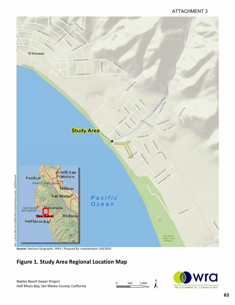
Path:
L:\Aca
d 2000
Files\
30000
\30012
\GIS\
ArcMa
p\Loca
tion_
202003
24.m
xd
Sources: National Geographic, WRA | Prepared By: mweidenbach, 6/8/2020
Study Area
P a c i f i cO c e a n
View Extent
Naples Beach Sewer ProjectHalf Moon Bay, San Mateo County, California 0 1,000500
Feet
Figure 1. Study Area Regional Location Map
ATTACHMENT 3
63

Path:
L:\Aca
d 2000
Files\
30000
\30012
\GIS\
ArcMa
p\Stud
yArea
_20200
622.m
xd
Sources: NAIP 2018 Aerial Imagery, WRA | Prepared By: mweidenbach, 6/22/2020
Naples Beach Sewer ProjectHalf Moon Bay, San Mateo County, California 0 10050
Feet
Figure 2. Study Area Map
Mirada RdAlameda Ave
Alcatraz Ave
San Andreas Ave
Study Area (1.96 ac)Project Area
ATTACHMENT 3
64

Mirada RdAlameda Ave
Alcatraz Ave
San Andreas AveDmA
DmB
Path:
L:\Aca
d 2000
Files\
30000
\30012
\GIS\
ArcMa
p\Soils
_2020
0622.m
xd
Sources: NAIP 2018 Aerial Imagery, WRA | Prepared By: mweidenbach, 6/22/2020
Naples Beach Sewer ProjectHalf Moon Bay, San Mateo County, California 0 10050
Feet
Figure 3. Study Area Soils Map
Study Area (1.96 ac)
DmA, Denison loam nearly level
DmB, Denison loam gently sloping
ATTACHMENT 3
65
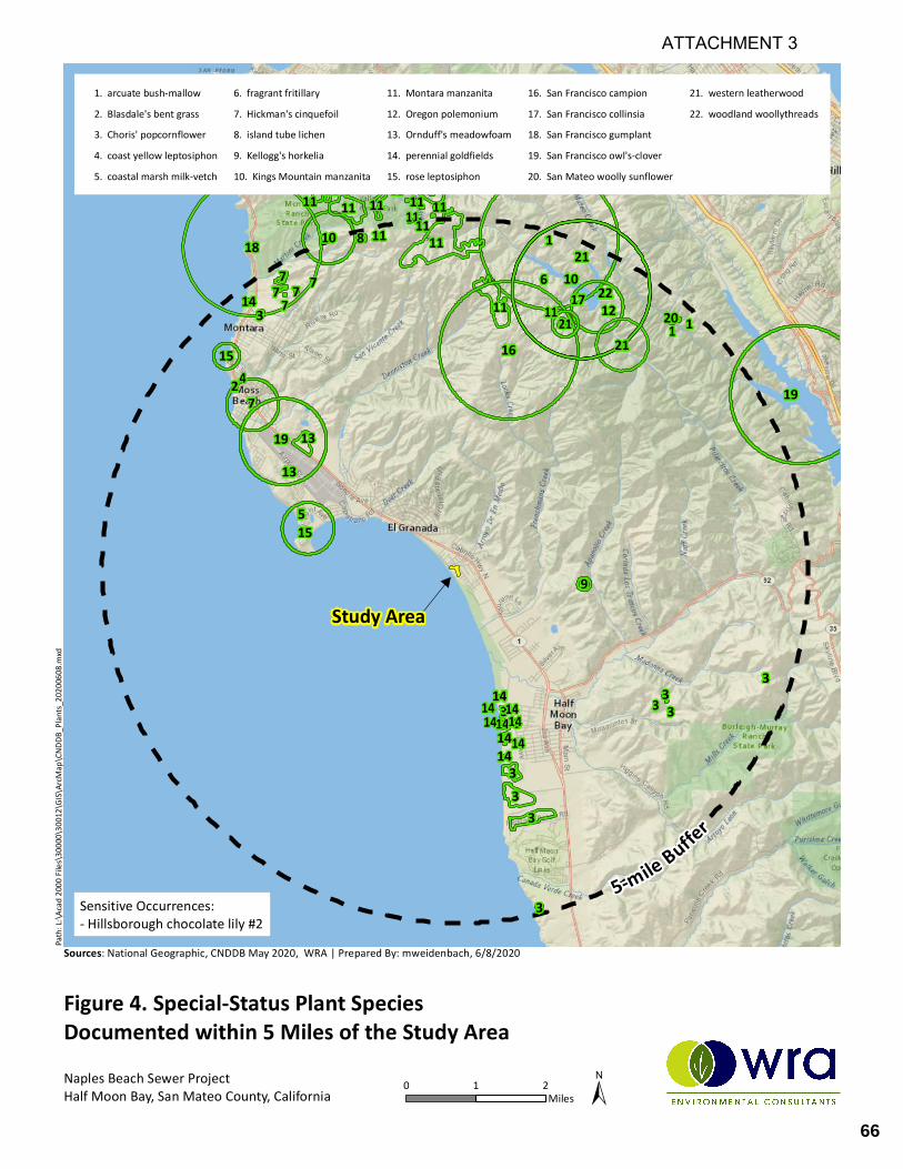
1 1
1
2
33
333 3
3
3
3
33
4
5
67
7777
7
8
9
10
10
1111
11
11 111111
1111
11
11
111111
1111
11
11
12
1313
14 1414
14141414
14
14
14
15
15 16
17
18
19
19
20
21
2121
22
Path:
L:\Aca
d 2000
Files\
30000
\30012
\GIS\
ArcMa
p\CND
DB_Pl
ants_2
02006
08.m
xd
1. arcuate bush-mallow2. Blasdale's bent grass3. Choris' popcornflower4. coast yellow leptosiphon5. coastal marsh milk-vetch
6. fragrant fritillary7. Hickman's cinquefoil8. island tube lichen9. Kellogg's horkelia10. Kings Mountain manzanita
11. Montara manzanita12. Oregon polemonium13. Ornduff's meadowfoam14. perennial goldfields15. rose leptosiphon
16. San Francisco campion17. San Francisco collinsia18. San Francisco gumplant19. San Francisco owl's-clover20. San Mateo woolly sunflower
21. western leatherwood22. woodland woollythreads
Study Area
5-m ile Buffer
Naples Beach Sewer ProjectHalf Moon Bay, San Mateo County, California 0 21
Miles
Figure 4. Special-Status Plant SpeciesDocumented within 5 M iles of the Study Area
Sources: National Geographic, CNDDB May 2020, WRA | Prepared By: mweidenbach, 6/8/2020
Sensitive Occurrences:- Hillsborough chocolate lily #2
ATTACHMENT 3
66
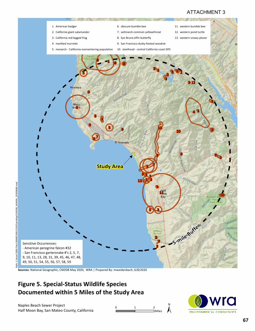
1
2
3
3
3
3
3
3
3
3
3
3 3
3
3
3
3
3
33
3
3
3
3
3
3
3
3
3
3
4
5
5
5
5
6
7
7
7
8 88
9
10
10
10
11
12
13
Path:
L:\Aca
d 2000
Files\
30000
\30012
\GIS\
ArcMa
p\CND
DB_W
ildlife
_20200
608.m
xd
1. American badger2. California giant salamander3. California red-legged frog4. marbled murrelet5. monarch - California overwintering population
6. obscure bumble bee7. saltmarsh common yellowthroat8. San Bruno elfin butterfly9. San Francisco dusky-footed woodrat10. steelhead - central California coast DPS
11. western bumble bee12. western pond turtle13. western snowy plover
Study Area
5-mile Buffer
Naples Beach Sewer ProjectHalf Moon Bay, San Mateo County, California 0 21
Miles
Figure 5. Special-Status Wildlife SpeciesDocumented within 5 Miles of the Study Area
Sources: National Geographic, CNDDB May 2020, WRA | Prepared By: mweidenbach, 6/8/2020
Sensitive Occurrences:- American peregrine falcon #32- San Francisco gartersnake #'s 2, 5, 7, 9, 10, 11, 13, 28, 31, 39, 45, 46, 47, 48, 49, 50, 51, 54, 55, 56, 57, 58, 59
ATTACHMENT 3
67

962963964965
966
968
974
970
Path:
L:\Aca
d 2000
Files\
30000\
30012
\GIS\A
rcMap
\Bioco
mms_2
020072
8.mxd
Sources: NAIP 2018 Aerial Imagery, WRA | Prepared By: JSChuster, 7/31/2020
Naples Beach Sewer ProjectHalf Moon Bay, San Mateo County, California 0 10050
Feet
Figure 6. Study Area Biological Communities
±
Mirada RdAlameda Ave
Alcatraz Ave
San Andreas Ave
Study Area (1.96 ac)Heritage Tree
Biological CommunitiesCoyote brush scrub (0.08 ac)Developed (0.73 ac)English ivy mats (0.13 ac)Monterey cypress grove (0.15 ac)Monterey pine woodland (0.10 ac)Non-native annual grassland (0.27 ac)Poison oak scrub (0.01 ac)Wild Radish patches (0.49 ac)
ATTACHMENT 3
68

APPENDIX B
LIST OF OBSERVED PLANT AND WILDLIFE SPECIES
ATTACHMENT 3
69

This page intentionally left blank.
ATTACHMENT 3
70

Appendix B. Plant and wildlife species observed during May 19, 2020 site visit. Scientific Name Common Name Origin Form Rarity Status1 CAL-IPC Status2 Wetland Status
(AW 2016)3
Arctotheca prostrata Prostrate cape weed
non-native (invasive)
annual, perennial herb
- Moderate -
Avena barbata Slim oat non-native (invasive)
annual, perennial grass
- Moderate -
Baccharis pilularis Coyote brush native shrub - - -
Brassica rapa Common mustard non-native (invasive)
annual herb - Limited FACU
Bromus diandrus Ripgut brome non-native (invasive)
annual grass - Moderate -
Carduus pycnocephalus ssp. pycnocephalus
Italian thistle non-native (invasive)
annual herb - Moderate -
Carpobrotus edulis Iceplant non-native (invasive)
perennial herb - High -
Cirsium vulgare Bullthistle non-native (invasive)
perennial herb - Moderate FACU
Claytonia parviflora ssp. parviflora
Miner's lettuce native annual herb - - FACU
Conium maculatum Poison hemlock non-native (invasive)
perennial herb - Moderate FACW
Convolvulus arvensis Field bindweed non-native perennial herb, vine
- - -
Crassula multicava ssp. multicava
Cape province pygmyweed
non-native perennial herb, shrub
- - -
Echium candicans Pride of madeira non-native (invasive)
shrub - Limited -
Equisetum arvense Common horsetail native fern - - FAC
Foeniculum vulgare Fennel non-native (invasive)
perennial herb - High -
Geranium dissectum Wild geranium non-native (invasive)
annual herb - Limited -
Hedera helix English ivy non-native (invasive)
vine, shrub - High FACU
Helminthotheca echioides Bristly ox-tongue non-native (invasive)
annual, perennial herb
- Limited FAC
Hesperocyparis macrocarpa Monterey cypress native tree Rank 1B.2* - -
Hirschfeldia incana Short-podded mustard
non-native (invasive)
perennial herb - Moderate -
Hordeum murinum Foxtail barley non-native (invasive)
annual grass - Moderate FACU
ATTACHMENT 3
71

Scientific Name Common Name Origin Form Rarity Status1 CAL-IPC Status2 Wetland Status (AW 2016)3
Lotus corniculatus Bird's foot trefoil non-native perennial herb - - FAC
Lysimachia arvensis Scarlet pimpernel non-native annual herb - - FAC
Medicago polymorpha California burclover
non-native (invasive)
annual herb - Limited FACU
Myoporum laetum Ngaio tree non-native (invasive)
tree, shrub - Moderate FACU
Oxalis pes-caprae Bermuda buttercup
non-native (invasive)
perennial herb - Moderate -
Pinus radiata Monterey pine native tree Rank 1B.1* - -
Plantago lanceolata Ribwort non-native (invasive)
perennial herb - Limited FAC
Raphanus sativus Wild radish non-native (invasive)
annual, biennial herb
- Limited -
Rosa californica California wild rose
native shrub - - FAC
Rubus ursinus California blackberry
native vine, shrub - - FAC
Rumex crispus Curly dock non-native (invasive)
perennial herb - Limited FAC
Salix lasiolepis Arroyo willow native tree, shrub - - FACW
Sambucus sp. - - - - - -
Silybum marianum Milk thistle non-native (invasive)
annual, perennial herb
- Limited -
Toxicodendron diversilobum Poison oak native vine, shrub - - FACU
Trifolium dubium Shamrock non-native annual herb - - UPL
Tropaeolum majus Garden nasturtium non-native annual herb, vine - - UPL
Vinca major Vinca non-native (invasive)
perennial herb - Moderate -
Zantedeschia aethiopica Callalily non-native (invasive)
perennial herb - Limited OBL
ATTACHMENT 3
72
All species identified using the Jepson eFlora [Jepson Flora Project (eds.) 2020]; nomenclature follows Jepson eFlora [Jepson Flora Project (eds.) 2020] *Special-status only within its native range. The Study Area is outside of the native range of this species. 1Rarity Status: The CNPS Inventory of Rare and Endangered Plants (CNPS 2020)
FE: Federal Endangered FT: Federal Threatened SE: State Endangered ST: State Threatened SR: State Rare Rank 1A: Plants presumed extinct in California Rank 1B: Plants rare, threatened, or endangered in California and elsewhere Rank 2: Plants rare, threatened, or endangered in California, but more common elsewhere Rank 3: Plants about which we need more information – a review list Rank 4: Plants of limited distribution – a watch list
2Invasive Status: California Invasive Plant Inventory (Cal-IPC 2020) High: Severe ecological impacts; high rates of dispersal and establishment; most are widely distributed ecologically. Moderate: Substantial and apparent ecological impacts; moderate-high rates of dispersal, establishment dependent on disturbance; limited- moderate distribution ecologically Limited: Minor or not well documented ecological impacts; low-moderate rate of invasiveness; limited distribution ecologically Assessed: Assessed by Cal-IPC and determined to not be an existing current threat 3Wetland Status: National List of Plant Species that Occur in Wetlands, California – Arid West (Lichvar et al. 2016) OBL: Almost always found in wetlands; FACW: Usually found in wetlands FAC: Equally found in wetlands and uplands FACU: Usually not found in wetlands UPL: Almost never found in wetlands NL: Not listed, assumed almost never found in wetlands NI: No information; not factored during wetland delineation
ATTACHMENT 3
73

This page intentionally left blank.
ATTACHMENT 3
74

APPENDIX C
POTENTIAL FOR SPECIAL-STATUS PLANT AND WILDLIFE SPECIES TO OCCUR IN THE STUDY AREA
ATTACHMENT 3
75

This page intentionally left blank.
ATTACHMENT 3
76

C-1
Appendix C. Potential for special-status plant and wildlife species to occur in the Study Area. List compiled from the California Department of Fish and Wildlife (CDFW) Natural Diversity Database (CDFW 2020), U.S. Fish and Wildlife Service (USFWS) Species Lists, and California Native Plant Society (CNPS) Electronic Inventory search of the Half Moon Bay, Montara Mountain, San Gregorio, La Honda, Woodside, and San Mateo USGS 7.5' quadrangles and a review of other CDFW lists and publications (Shuford and Gardali 2008, Thompson et al. 2016, Zeiner et al. 1990).
SPECIES STATUS* HABITAT POTENTIAL FOR OCCURRENCE** RECOMMENDATIONS
Plants
San Mateo thorn-mint
Acanthomintha duttonii
FE, SE, Rank 1B.1
Chaparral, valley and foothill grassland. Elevation ranges from 160 to 985 feet (50 to 300 meters). Blooms Apr-Jun.
Unlikely. Suitable habitat not present within Study Area. Study Area does not contain serpentine soils.
No further actions are recommended.
Blasdale's bent grass
Agrostis blasdalei
Rank 1B.2 Coastal bluff scrub, coastal dunes, coastal prairie. Elevation ranges from 0 to 490 feet (0 to 150 meters). Blooms May-Jul.
Unlikely. Suitable habitat not present within Study Area. The Study Area has been subject to previous and regular disturbance and is dominated by non-native invasive plant species.
No further actions are recommended.
Franciscan onion
Allium peninsulare var. franciscanum
Rank 1B.2 Cismontane woodland, valley and foothill grassland. Elevation ranges from 170 to 1000 feet (52 to 305 meters). Blooms (Apr)May-Jun.
Unlikely. Suitable habitat not present within Study Area. The Study Area has been subject to previous disturbance and is dominated by non-native invasive plant species.
No further actions are recommended.
bent-flowered fiddleneck
Amsinckia lunaris
Rank 1B.2 Coastal bluff scrub, cismontane woodland, valley and foothill grassland. Elevation ranges from 5 to 1640 feet (3 to 500 meters). Blooms Mar-Jun.
Unlikely. Suitable habitat not present within Study Area. The Study Area has been subject to previous disturbance and regular ongoing maintenance. Potential habitat is dominated by non-native invasive plant species.
No further actions are recommended.
ATTACHMENT 3
77

C-2
SPECIES STATUS* HABITAT POTENTIAL FOR OCCURRENCE** RECOMMENDATIONS
coast rockcress
Arabis blepharophylla
Rank 4.3 Broadleafed upland forest, coastal bluff scrub, coastal prairie, coastal scrub. Elevation ranges from 5 to 3610 feet (3 to 1100 meters). Blooms Feb-May.
Unlikely. Suitable habitat not present within Study Area. The Study Area has been subject to previous and regular disturbance and is dominated by non-native invasive plant species. Suitable rocky habitat is not present within the Study Area.
No further actions are recommended.
Anderson's manzanita
Arctostaphylos andersonii
Rank 1B.2 Broadleafed upland forest, chaparral, north coast coniferous forest. Elevation ranges from 195 to 2495 feet (60 to 760 meters). Blooms Nov-May.
No Potential. Suitable habitat not present within Study Area. Study Area is out of the species elevation range.
No further actions are recommended.
Montara manzanita
Arctostaphylos montaraensis
Rank 1B.2 Chaparral (maritime), coastal scrub. Elevation ranges from 260 to 1640 feet (80 to 500 meters). Blooms Jan-Mar.
Unlikely. Suitable habitat not present within Study Area. Study Area is out of the species elevation range. Suitable granitic outcrops are not present within the Study Area.
No further actions are recommended.
Kings Mountain manzanita
Arctostaphylos regismontana
Rank 1B.2 Broadleafed upland forest, chaparral, north coast coniferous forest. Elevation ranges from 1000 to 2395 feet (305 to 730 meters). Blooms Dec-Apr.
Unlikely. Suitable habitat not present within Study Area. Study Area is out of the species elevation range.
No further actions are recommended.
ocean bluff milk-vetch
Astragalus nuttallii var. nuttallii
Rank 4.2 Coastal bluff scrub, coastal dunes. Elevation ranges from 5 to 395 feet (3 to 120 meters). Blooms Jan-Nov.
Unlikely. Suitable habitat not present within Study Area. The Study Area has been subject to previous disturbance and regular ongoing maintenance. Potential scrub habitat is dominated by non-native invasive plant species.
No further actions are recommended.
ATTACHMENT 3
78

C-3
SPECIES STATUS* HABITAT POTENTIAL FOR OCCURRENCE** RECOMMENDATIONS
coastal marsh milk-vetch
Astragalus pycnostachyus var. pycnostachyus
Rank 1B.2 Coastal dunes (mesic), coastal scrub, marshes and swamps (coastal salt, stream sides). Elevation ranges from 0 to 100 feet (0 to 30 meters). Blooms (Apr)Jun-Oct.
Unlikely. Suitable habitat not present within Study Area. The Study Area has been subject to previous disturbance and regular ongoing maintenance. Potential scrub habitat is dominated by non-native invasive plant species.
No further actions are recommended.
Brewer's calandrinia
Calandrinia breweri
Rank 4.2 Chaparral, coastal scrub. Elevation ranges from 30 to 4005 feet (10 to 1220 meters). Blooms (Jan)Mar-Jun.
Unlikely. Suitable habitat not present within Study Area. The Study Area has been subject to previous disturbance and regular ongoing maintenance. Potential habitat is dominated by non-native invasive plant species.
No further actions are recommended.
Oakland star-tulip
Calochortus umbellatus
Rank 4.2 Broadleafed upland forest, chaparral, cismontane woodland, lower montane coniferous forest, valley and foothill grassland. Elevation ranges from 325 to 2295 feet (100 to 700 meters). Blooms Mar-May.
Unlikely. Suitable habitat not present within Study Area. The Study Area has been subject to previous disturbance and regular ongoing maintenance. Potential grassland habitat is dominated by non-native invasive plant species.
No further actions are recommended.
johnny-nip
Castilleja ambigua var. ambigua
Rank 4.2 Coastal bluff scrub, coastal prairie, coastal scrub, marshes and swamps, valley and foothill grassland, vernal pools margins. Elevation ranges from 0 to 1425 feet (0 to 435 meters). Blooms Mar-Aug.
Unlikely. Suitable habitat not present within the Study Area. Areas within the Study Area that are considered coastal scrub are frequently disturbed and dominated by non-native invasive plant species.
No further actions are recommended.
ATTACHMENT 3
79

C-4
SPECIES STATUS* HABITAT POTENTIAL FOR OCCURRENCE** RECOMMENDATIONS
pappose tarplant
Centromadia parryi ssp. parryi
Rank 1B.2 Chaparral, coastal prairie, meadows and seeps, marshes and swamps (coastal salt), valley and foothill grassland (vernally mesic). Elevation ranges from 0 to 1380 feet (0 to 420 meters). Blooms May-Nov.
Unlikely. Suitable habitat not present within the Study Area. The majority of the Study Area is dominated by non-native invasive plant species. There are no documented occurrences within 5-miles of the Study Area.
No further actions are recommended.
Point Reyes bird's-beak
Chloropyron maritimum ssp. palustre
Rank 1B.2 Marshes and swamps (coastal salt). Elevation ranges from 0 to 35 feet (0 to 10 meters). Blooms Jun-Oct.
No Potential. Suitable habitat not present within the Study Area. No wetland or streamside habitat is present within the Study Area. The Study Area has been subject to previous disturbance and is dominated by non-native invasive plant species.
No further actions are recommended.
San Francisco Bay spineflower
Chorizanthe cuspidata var. cuspidata
Rank 1B.2 Coastal bluff scrub, coastal dunes, coastal prairie, coastal scrub. Elevation ranges from 5 to 705 feet (3 to 215 meters). Blooms Apr-Jul(Aug).
Unlikely. Suitable habitat not present within the Study Area. Areas within the Study Area that are considered coastal scrub are frequently disturbed and dominated by non-native invasive plant species.
No further actions are recommended.
Franciscan thistle
Cirsium andrewsii
Rank 1B.2 Broadleafed upland forest, coastal bluff scrub, coastal prairie, coastal scrub. Elevation ranges from 0 to 490 feet (0 to 150 meters). Blooms Mar-Jul.
Unlikely. Suitable habitat not present within the Study Area. Areas within the Study Area that are considered coastal scrub are frequently disturbed and dominated by non-native invasive plant species.
No further actions are recommended.
Crystal Springs fountain thistle
Cirsium fontinale var. fontinale
FE, SE, Rank 1B.1
Chaparral (openings), cismontane woodland, meadows and seeps, valley and foothill grassland. Elevation ranges from 145 to 575 feet (45 to 175 meters). Blooms (Apr)May-Oct.
Unlikely. Suitable habitat not present within Study Area. Study Area does not contain serpentine soils.
No further actions are recommended.
ATTACHMENT 3
80

C-5
SPECIES STATUS* HABITAT POTENTIAL FOR OCCURRENCE** RECOMMENDATIONS
San Francisco collinsia
Collinsia multicolor
Rank 1B.2 Closed-cone coniferous forest, coastal scrub. Elevation ranges from 95 to 820 feet (30 to 250 meters). Blooms (Feb)Mar-May.
Unlikely. Suitable habitat not present within the Study Area. Areas within the Study Area that are considered coastal scrub are frequently disturbed and dominated by non-native invasive plant species.
No further actions are recommended.
clustered lady's-slipper
Cypripedium fasciculatum
Rank 4.2 Lower montane coniferous forest, north coast coniferous forest. Elevation ranges from 325 to 7990 feet (100 to 2435 meters). Blooms Mar-Aug.
No Potential. Suitable habitat not present within Study Area. Study Area is out of the species elevation range.
No further actions are recommended.
mountain lady's-slipper
Cypripedium montanum
Rank 4.2 Broadleafed upland forest, cismontane woodland, lower montane coniferous forest, north coast coniferous forest. Elevation ranges from 605 to 7300 feet (185 to 2225 meters). Blooms Mar-Aug.
No Potential. Suitable habitat not present within Study Area. Study Area is out of the species elevation range.
No further actions are recommended.
western leatherwood
Dirca occidentalis
Rank 1B.2 Broadleafed upland forest, closed-cone coniferous forest, chaparral, cismontane woodland, north coast coniferous forest, riparian forest, riparian woodland. Elevation ranges from 80 to 1395 feet (25 to 425 meters). Blooms Jan-Mar(Apr).
No Potential. Suitable habitat not present within Study Area. Study Area is out of the species elevation range.
No further actions are recommended.
California bottle-brush grass
Elymus californicus
Rank 4.3 Broadleafed upland forest, cismontane woodland, north coast coniferous forest, riparian woodland. Elevation ranges from 45 to 1540 feet (15 to 470 meters). Blooms May-Aug(Nov).
Unlikely. Suitable habitat not present within Study Area. Study Area does not contain suitable forested habitat.
No further actions are recommended.
ATTACHMENT 3
81

C-6
SPECIES STATUS* HABITAT POTENTIAL FOR OCCURRENCE** RECOMMENDATIONS
San Mateo woolly sunflower
Eriophyllum latilobum
FE, SE, Rank 1B.1
Cismontane woodland (often serpentine, on roadcuts), coastal scrub, lower montane coniferous forest. Elevation ranges from 145 to 1085 feet (45 to 330 meters). Blooms May-Jun.
No Potential. Suitable habitat not present within Study Area. Study Area is out of the species elevation range.
No further actions are recommended.
San Francisco wallflower
Erysimum franciscanum
Rank 4.2 Chaparral, coastal dunes, coastal scrub, valley and foothill grassland. Elevation ranges from 0 to 1805 feet (0 to 550 meters). Blooms Mar-Jun.
Unlikely. Suitable habitat not present within the Study Area. Areas within the Study Area that are considered coastal scrub are frequently disturbed and dominated by non-native invasive plant species.
No further actions are recommended.
minute pocket moss
Fissidens pauperculus
Rank 1B.2 North coast coniferous forest (damp coastal soil). Elevation ranges from 30 to 3360 feet (10 to 1024 meters).
No Potential. Suitable habitat not present within Study Area. The Study Area has been subject to previous disturbance and is dominated by non-native invasive plant species.
No further actions are recommended.
Hillsborough chocolate lily
Fritillaria biflora var. ineziana
Rank 1B.1 Cismontane woodland, valley and foothill grassland. Elevation ranges from 490 to 490 feet (150 to 150 meters). Blooms Mar-Apr.
Unlikely. Suitable habitat not present within the Study Area. Areas within the Study Area that are considered grassland are frequently disturbed and dominated by non-native invasive plant species.
No further actions are recommended.
Marin checker lily
Fritillaria lanceolata var. tristulis
Rank 1B.1 Coastal bluff scrub, coastal prairie, coastal scrub. Elevation ranges from 45 to 490 feet (15 to 150 meters). Blooms Feb-May.
Unlikely. Suitable habitat not present within the Study Area. Areas within the Study Area that are considered coastal scrub are frequently disturbed and dominated by non-native invasive plant species.
No further actions are recommended.
ATTACHMENT 3
82
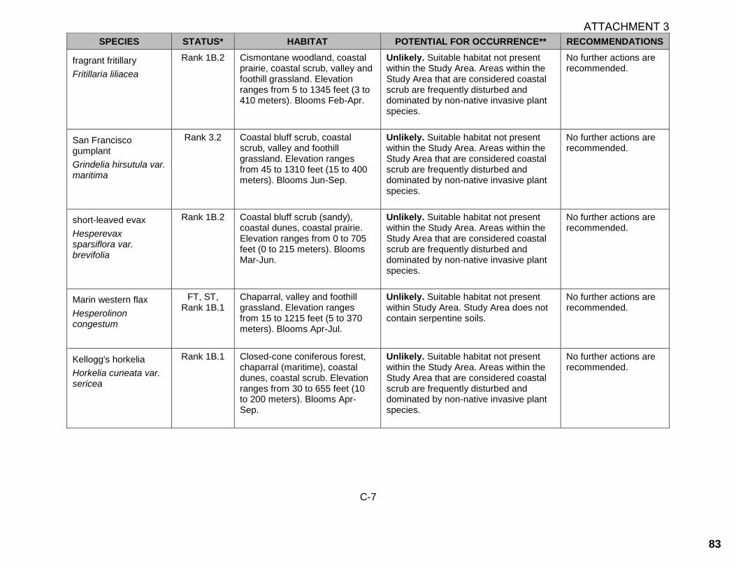
C-7
SPECIES STATUS* HABITAT POTENTIAL FOR OCCURRENCE** RECOMMENDATIONS
fragrant fritillary
Fritillaria liliacea
Rank 1B.2 Cismontane woodland, coastal prairie, coastal scrub, valley and foothill grassland. Elevation ranges from 5 to 1345 feet (3 to 410 meters). Blooms Feb-Apr.
Unlikely. Suitable habitat not present within the Study Area. Areas within the Study Area that are considered coastal scrub are frequently disturbed and dominated by non-native invasive plant species.
No further actions are recommended.
San Francisco gumplant
Grindelia hirsutula var. maritima
Rank 3.2 Coastal bluff scrub, coastal scrub, valley and foothill grassland. Elevation ranges from 45 to 1310 feet (15 to 400 meters). Blooms Jun-Sep.
Unlikely. Suitable habitat not present within the Study Area. Areas within the Study Area that are considered coastal scrub are frequently disturbed and dominated by non-native invasive plant species.
No further actions are recommended.
short-leaved evax
Hesperevax sparsiflora var. brevifolia
Rank 1B.2 Coastal bluff scrub (sandy), coastal dunes, coastal prairie. Elevation ranges from 0 to 705 feet (0 to 215 meters). Blooms Mar-Jun.
Unlikely. Suitable habitat not present within the Study Area. Areas within the Study Area that are considered coastal scrub are frequently disturbed and dominated by non-native invasive plant species.
No further actions are recommended.
Marin western flax
Hesperolinon congestum
FT, ST, Rank 1B.1
Chaparral, valley and foothill grassland. Elevation ranges from 15 to 1215 feet (5 to 370 meters). Blooms Apr-Jul.
Unlikely. Suitable habitat not present within Study Area. Study Area does not contain serpentine soils.
No further actions are recommended.
Kellogg's horkelia
Horkelia cuneata var. sericea
Rank 1B.1 Closed-cone coniferous forest, chaparral (maritime), coastal dunes, coastal scrub. Elevation ranges from 30 to 655 feet (10 to 200 meters). Blooms Apr-Sep.
Unlikely. Suitable habitat not present within the Study Area. Areas within the Study Area that are considered coastal scrub are frequently disturbed and dominated by non-native invasive plant species.
No further actions are recommended.
ATTACHMENT 3
83

C-8
SPECIES STATUS* HABITAT POTENTIAL FOR OCCURRENCE** RECOMMENDATIONS
Point Reyes horkelia
Horkelia marinensis
Rank 1B.2 Coastal dunes, coastal prairie, coastal scrub. Elevation ranges from 15 to 2475 feet (5 to 755 meters). Blooms May-Sep.
Unlikely. Suitable habitat not present within the Study Area. Areas within the Study Area that are considered coastal scrub are frequently disturbed and dominated by non-native invasive plant species.
No further actions are recommended.
island rock lichen
Hypogymnia schizidiata
Rank 1B.3 Closed-cone coniferous forest, chaparral. Elevation ranges from 1180 to 1330 feet (360 to 405 meters).
Unlikely. Suitable habitat not present within the Study Area. Areas within the Study Area that are considered chaparral are frequently disturbed and dominated by non-native invasive plant species.
No further actions are recommended.
coast iris
Iris longipetala
Rank 4.2 Coastal prairie, lower montane coniferous forest, meadows and seeps. Elevation ranges from 0 to 1970 feet (0 to 600 meters). Blooms Mar-May.
No Potential. Suitable habitat not present within Study Area. The Study Area has been subject to previous disturbance and is dominated by non-native invasive plant species.
No further actions are recommended.
perennial goldfields
Lasthenia californica ssp. macrantha
Rank 1B.2 Coastal bluff scrub, coastal dunes, coastal scrub. Elevation ranges from 15 to 1705 feet (5 to 520 meters). Blooms Jan-Nov.
Unlikely. Suitable habitat not present within the Study Area. Areas within the Study Area that are considered coastal scrub are frequently disturbed and dominated by non-native invasive plant species.
No further actions are recommended.
serpentine leptosiphon
Leptosiphon ambiguus
Rank 4.2 Cismontane woodland, coastal scrub, valley and foothill grassland. Elevation ranges from 390 to 3705 feet (120 to 1130 meters). Blooms Mar-Jun.
Unlikely. Suitable habitat not present within the Study Area. Areas within the Study Area that are considered coastal scrub are frequently disturbed and dominated by non-native invasive plant species.
No further actions are recommended.
ATTACHMENT 3
84

C-9
SPECIES STATUS* HABITAT POTENTIAL FOR OCCURRENCE** RECOMMENDATIONS
coast yellow leptosiphon
Leptosiphon croceus
SS, Rank 1B.1
Coastal bluff scrub, coastal prairie. Elevation ranges from 30 to 490 feet (10 to 150 meters). Blooms Apr-Jun.
Unlikely. Suitable habitat not present within the Study Area. Areas within the Study Area that are considered coastal scrub are frequently disturbed and dominated by non-native invasive plant species.
No further actions are recommended.
rose leptosiphon
Leptosiphon rosaceus
Rank 1B.1 Coastal bluff scrub. Elevation ranges from 0 to 330 feet (0 to 100 meters). Blooms Apr-Jul.
Unlikely. Suitable habitat not present within the Study Area. Areas within the Study Area that are considered coastal scrub are frequently disturbed and dominated by non-native invasive plant species.
No further actions are recommended.
Crystal Springs lessingia
Lessingia arachnoidea
Rank 1B.2 Cismontane woodland, coastal scrub, valley and foothill grassland. Elevation ranges from 195 to 655 feet (60 to 200 meters). Blooms Jul-Oct.
Unlikely. Suitable habitat not present within Study Area. Study Area does not contain serpentine soils.
No further actions are recommended.
woolly-headed lessingia
Lessingia hololeuca
Rank 3 Broadleafed upland forest, coastal scrub, lower montane coniferous forest, valley and foothill grassland. Elevation ranges from 45 to 1000 feet (15 to 305 meters). Blooms Jun-Oct.
Unlikely. Suitable habitat not present within the Study Area. Areas within the Study Area that are considered coastal scrub are frequently disturbed and dominated by non-native invasive plant species.
No further actions are recommended.
coast lily
Lilium maritimum
Rank 1B.1 Broadleafed upland forest, closed-cone coniferous forest, coastal prairie, coastal scrub, marshes and swamps (freshwater), north coast coniferous forest. Elevation ranges from 15 to 1560 feet (5 to 475 meters). Blooms May-Aug.
Unlikely. Suitable habitat not present within the Study Area. Areas within the Study Area that are considered coastal scrub are frequently disturbed and dominated by non-native invasive plant species.
No further actions are recommended.
ATTACHMENT 3
85

C-10
SPECIES STATUS* HABITAT POTENTIAL FOR OCCURRENCE** RECOMMENDATIONS
Ornduff's meadowfoam
Limnanthes douglasii ssp. ornduffii
Rank 1B.1 Meadows and seeps. Elevation ranges from 30 to 65 feet (10 to 20 meters). Blooms Nov-May.
Unlikely. Suitable habitat not present within Study Area. The Study Area does not include suitable mesic habitat.
No further actions are recommended.
San Mateo tree lupine
Lupinus arboreus var. eximius
Rank 3.2 Chaparral, coastal scrub. Elevation ranges from 295 to 1805 feet (90 to 550 meters). Blooms Apr-Jul.
Unlikely. Suitable habitat not present within Study Area. No shrubby lupines were observed within the Study Area.
No further actions are recommended.
Indian Valley bush-mallow
Malacothamnus aboriginum
Rank 1B.2 Chaparral, cismontane woodland. Elevation ranges from 490 to 5575 feet (150 to 1700 meters). Blooms Apr-Oct.
No Potential. Suitable habitat not present within Study Area. Study Area is out of the species elevation range.
No further actions are recommended.
arcuate bush-mallow
Malacothamnus arcuatus
Rank 1B.2 Chaparral, cismontane woodland. Elevation ranges from 45 to 1165 feet (15 to 355 meters). Blooms Apr-Sep.
Unlikely. Suitable habitat not present within the Study Area. Areas within the Study Area that are considered chaparral are frequently disturbed and dominated by non-native invasive plant species.
No further actions are recommended.
Davidson's bush-mallow
Malacothamnus davidsonii
Rank 1B.2 Chaparral, cismontane woodland, coastal scrub, riparian woodland. Elevation ranges from 605 to 3740 feet (185 to 1140 meters). Blooms Jun-Jan.
Unlikely. Suitable habitat not present within the Study Area. Areas within the Study Area that are considered coastal scrub and chaparral are frequently disturbed and dominated by non-native invasive plant species.
No further actions are recommended.
Hall's bush-mallow
Malacothamnus hallii
Rank 1B.2 Chaparral, coastal scrub. Elevation ranges from 30 to 2495 feet (10 to 760 meters). Blooms (Apr)May-Sep(Oct).
Unlikely. Suitable habitat not present within the Study Area. Areas within the Study Area that are considered coastal scrub and chaparral are frequently disturbed and dominated by non-native invasive plant species.
No further actions are recommended.
ATTACHMENT 3
86

C-11
SPECIES STATUS* HABITAT POTENTIAL FOR OCCURRENCE** RECOMMENDATIONS
marsh microseris
Microseris paludosa
Rank 1B.2 Closed-cone coniferous forest, cismontane woodland, coastal scrub, valley and foothill grassland. Elevation ranges from 15 to 1165 feet (5 to 355 meters). Blooms Apr-Jun(Jul).
Unlikely. Suitable habitat not present within the Study Area. Areas within the Study Area that are considered coastal scrub are frequently disturbed and dominated by non-native invasive plant species.
No further actions are recommended.
woodland woolythreads
Monolopia gracilens
Rank 1B.2 Broadleafed upland forest (openings), chaparral (openings), cismontane woodland, north coast coniferous forest (openings), valley and foothill grassland. Elevation ranges from 325 to 3935 feet (100 to 1200 meters). Blooms (Feb)Mar-Jul.
No Potential. Suitable habitat not present within Study Area. Study Area is out of the species elevation range.
No further actions are recommended.
Dudley's lousewort
Pedicularis dudleyi
SR, Rank 1B.2
Chaparral (maritime), cismontane woodland, north coast coniferous forest, valley and foothill grassland. Elevation ranges from 195 to 2955 feet (60 to 900 meters). Blooms Apr-Jun.
No Potential. Suitable habitat not present within Study Area. Study Area is out of the species elevation range.
No further actions are recommended.
white-rayed pentachaeta
Pentachaeta bellidiflora
FE, SE, Rank 1B.1
Cismontane woodland, valley and foothill grassland (often serpentine). Elevation ranges from 110 to 2035 feet (35 to 620 meters). Blooms Mar-May.
Unlikely. Suitable habitat not present within Study Area. Study Area does not contain serpentine soils.
No further actions are recommended.
Choris' popcornflower
Plagiobothrys chorisianus var. chorisianus
Rank 1B.2 Chaparral, coastal prairie, coastal scrub. Elevation ranges from 5 to 525 feet (3 to 160 meters). Blooms Mar-Jun.
Unlikely. Suitable habitat not present within the Study Area. Areas within the Study Area that are considered coastal scrub and chaparral are frequently disturbed and dominated by non-native invasive plant species.
No further actions are recommended.
ATTACHMENT 3
87

C-12
SPECIES STATUS* HABITAT POTENTIAL FOR OCCURRENCE** RECOMMENDATIONS
Oregon polemonium
Polemonium carneum
Rank 2B.2 Coastal prairie, coastal scrub, lower montane coniferous forest. Elevation ranges from 0 to 6005 feet (0 to 1830 meters). Blooms Apr-Sep.
Unlikely. Suitable habitat not present within the Study Area. Areas within the Study Area that are considered coastal scrub are frequently disturbed and dominated by non-native invasive plant species.
No further actions are recommended.
Hickman's cinquefoil
Potentilla hickmanii
FE, SE, Rank 1B.1
Coastal bluff scrub, closed-cone coniferous forest, meadows and seeps (vernally mesic), marshes and swamps (freshwater). Elevation ranges from 30 to 490 feet (10 to 149 meters). Blooms Apr-Aug.
Unlikely. Suitable habitat not present within the Study Area. Areas within the Study Area that are considered coastal scrub are frequently disturbed and dominated by non-native invasive plant species.
No further actions are recommended.
Lobb's aquatic buttercup
Ranunculus lobbii
Rank 4.2 Cismontane woodland, north coast coniferous forest, valley and foothill grassland, vernal pools. Elevation ranges from 45 to 1540 feet (15 to 470 meters). Blooms Feb-May.
No Potential. Suitable habitat not present within Study Area. Study Area is out of the species elevation range.
No further actions are recommended.
chaparral ragwort
Senecio aphanactis
Rank 2B.2 Chaparral, cismontane woodland, coastal scrub. Elevation ranges from 45 to 2625 feet (15 to 800 meters). Blooms Jan-Apr(May).
Unlikely. Suitable habitat not present within the Study Area. Areas within the Study Area that are considered coastal scrub and chaparral are frequently disturbed and dominated by non-native invasive plant species.
No further actions are recommended.
Scouler's catchfly
Silene scouleri ssp. scouleri
Rank 2B.2 Coastal bluff scrub, coastal prairie, valley and foothill grassland. Elevation ranges from 0 to 1970 feet (0 to 600 meters). Blooms (Mar-May)Jun-Aug(Sep).
Unlikely. Suitable habitat not present within the Study Area. Areas within the Study Area that are considered coastal scrub are frequently disturbed and dominated by non-native invasive plant species.
No further actions are recommended.
ATTACHMENT 3
88
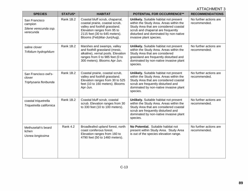
C-13
SPECIES STATUS* HABITAT POTENTIAL FOR OCCURRENCE** RECOMMENDATIONS
San Francisco campion
Silene verecunda ssp. verecunda
Rank 1B.2 Coastal bluff scrub, chaparral, coastal prairie, coastal scrub, valley and foothill grassland. Elevation ranges from 95 to 2115 feet (30 to 645 meters). Blooms (Feb)Mar-Jun(Aug).
Unlikely. Suitable habitat not present within the Study Area. Areas within the Study Area that are considered coastal scrub and chaparral are frequently disturbed and dominated by non-native invasive plant species.
No further actions are recommended.
saline clover
Trifolium hydrophilum
Rank 1B.2 Marshes and swamps, valley and foothill grassland (mesic, alkaline), vernal pools. Elevation ranges from 0 to 985 feet (0 to 300 meters). Blooms Apr-Jun.
Unlikely. Suitable habitat not present within the Study Area. Areas within the Study Area that are considered grassland are frequently disturbed and dominated by non-native invasive plant species.
No further actions are recommended.
San Francisco owl's-clover
Triphysaria floribunda
Rank 1B.2 Coastal prairie, coastal scrub, valley and foothill grassland. Elevation ranges from 30 to 525 feet (10 to 160 meters). Blooms Apr-Jun.
Unlikely. Suitable habitat not present within the Study Area. Areas within the Study Area that are considered coastal scrub are frequently disturbed and dominated by non-native invasive plant species.
No further actions are recommended.
coastal triquetrella
Triquetrella californica
Rank 1B.2 Coastal bluff scrub, coastal scrub. Elevation ranges from 30 to 330 feet (10 to 100 meters).
Unlikely. Suitable habitat not present within the Study Area. Areas within the Study Area that are considered coastal scrub are frequently disturbed and dominated by non-native invasive plant species.
No further actions are recommended.
Methuselah's beard lichen
Usnea longissima
Rank 4.2 Broadleafed upland forest, north coast coniferous forest. Elevation ranges from 160 to 4790 feet (50 to 1460 meters).
No Potential. Suitable habitat not present within Study Area. Study Area is out of the species elevation range.
No further actions are recommended.
ATTACHMENT 3
89
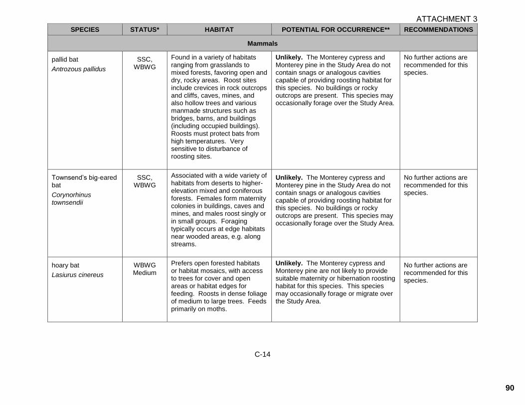
C-14
SPECIES STATUS* HABITAT POTENTIAL FOR OCCURRENCE** RECOMMENDATIONS
Mammals
pallid bat
Antrozous pallidus
SSC, WBWG
Found in a variety of habitats ranging from grasslands to mixed forests, favoring open and dry, rocky areas. Roost sites include crevices in rock outcrops and cliffs, caves, mines, and also hollow trees and various manmade structures such as bridges, barns, and buildings (including occupied buildings). Roosts must protect bats from high temperatures. Very sensitive to disturbance of roosting sites.
Unlikely. The Monterey cypress and Monterey pine in the Study Area do not contain snags or analogous cavities capable of providing roosting habitat for this species. No buildings or rocky outcrops are present. This species may occasionally forage over the Study Area.
No further actions are recommended for this species.
Townsend’s big-eared bat
Corynorhinus townsendii
SSC, WBWG
Associated with a wide variety of habitats from deserts to higher-elevation mixed and coniferous forests. Females form maternity colonies in buildings, caves and mines, and males roost singly or in small groups. Foraging typically occurs at edge habitats near wooded areas, e.g. along streams.
Unlikely. The Monterey cypress and Monterey pine in the Study Area do not contain snags or analogous cavities capable of providing roosting habitat for this species. No buildings or rocky outcrops are present. This species may occasionally forage over the Study Area.
No further actions are recommended for this species.
hoary bat
Lasiurus cinereus
WBWG Medium
Prefers open forested habitats or habitat mosaics, with access to trees for cover and open areas or habitat edges for feeding. Roosts in dense foliage of medium to large trees. Feeds primarily on moths.
Unlikely. The Monterey cypress and Monterey pine are not likely to provide suitable maternity or hibernation roosting habitat for this species. This species may occasionally forage or migrate over the Study Area.
No further actions are recommended for this species.
ATTACHMENT 3
90

C-15
SPECIES STATUS* HABITAT POTENTIAL FOR OCCURRENCE** RECOMMENDATIONS
fringed myotis
Myotis thysanodes
WBWG Associated with a wide variety of habitats including dry woodlands, desert scrub, mesic coniferous forest, grassland, and sage-grass steppes. Buildings, mines and large trees and snags are important day and night roosts.
Unlikely. The Monterey cypress and Monterey pine in the Study Area do not contain snags or analogous cavities capable of providing roosting habitat for this species. No buildings or rocky outcrops are present. This species may occasionally forage over the Study Area.
No further actions are recommended for this species.
big free-tailed bat
Nyctinomops macrotis
SSC, WBWG
Occurs rarely in low-lying arid areas. Requires high cliffs or rocky outcrops for roosting sites.
No Potential. The Study Area does not contain any high cliffs or rock outcroppings suitable for roosting. This species may migrate over the Study Area.
No further actions are recommended for this species.
San Francisco dusky-footed woodrat
Neotoma fuscipes annectens
SSC Forest habitats of moderate canopy and moderate to dense understory and in chaparral habitats. Constructs nests of shredded grass, leaves, and other material. May be limited by availability of nest-building materials.
Unlikely. The Monterey cypress and Monterey pine are unlikely to support this species due to the lack of understory. No other suitable densely vegetated areas with suitable nest building materials are present in the Study Area.
No further actions are recommended for this species.
salt-marsh harvest mouse
Reithrodontomys raviventris
FE, SE, CFP
Endemic to emergent salt and brackish wetlands of the San Francisco Bay Estuary. Pickleweed marshes are primary habitat; also occurs in various other wetland communities with dense vegetation. Does not burrow, builds loosely organized nests. Requires higher areas for flood escape.
No Potential. The Study Area does not contain saltmarsh habitat and is outside the range for this species.
No further actions are recommended for this species.
ATTACHMENT 3
91

C-16
SPECIES STATUS* HABITAT POTENTIAL FOR OCCURRENCE** RECOMMENDATIONS
American badger
Taxidea taxus
SSC Most abundant in drier open stages of most shrub, forest, and herbaceous habitats, with friable soils. Requires friable soils and open, uncultivated ground. Preys on burrowing rodents.
Unlikely. The Study Area lacks suitable dry habitat and receives a high level of disturbance via the train that runs through Ramona Way. Highway 1 is a barrier to dispersal from suitable habitat east of the Study Area.
No further actions are recommended for this species.
Guadalupe fur seal
Arctocephalus townsendi
FT, ST, CFP, LCP
Breed on Isla de Guadalupe off the coast of Mexico, occasionally found on San Miguel, San Nicolas, and San Clemente islands. Prefers shallow, nearshore island water with cool and sheltered rocky areas for haul-outs.
No Potential. The Study Area does not contain shore or ocean habitat.
No further actions are recommended for this species.
southern sea otter Enhydra lutris nereis
FT, CFP, MMC SSC,
LCP
Nearshore marine environments from about Año Nuevo, San Mateo County. To Point Sal, Santa Barbara County. Needs canopies of giant kelp and bull kelp for rafting and feeding. Prefers rocky substrates with abundant invertebrates.
No Potential. The Study Area does not contain shore or marine habitat.
No further actions are recommended for this species.
Birds
burrowing owl Athene cunicularia
SSC, BCC, LCP
Year-round resident and winter visitor. Occurs in open, dry grasslands and scrub habitats with low-growing vegetation, perches, and abundant mammal burrows. Preys upon insects and small vertebrates. Nests and roosts in old mammal burrows, most commonly those of ground squirrels.
Unlikely. The Study Area does not contain suitable burrow habitat and no ground squirrels or ground squirrel burrows were observed on the May 19 site visit. Burrowing owls are not known to breed in coastal San Mateo County (Shuford and Gardali 2008), but may winter where suitable burrows exist.
No further actions are recommended for this species.
ATTACHMENT 3
92

C-17
SPECIES STATUS* HABITAT POTENTIAL FOR OCCURRENCE** RECOMMENDATIONS
Short-eared owl
Asio flammeus
SSC, LCP Resident and mostly winter visitor to the region. Found in swamp lands, both fresh and salt; lowland meadows; irrigated alfalfa fields. Tule patches/tall grass needed for nesting/daytime seclusion. Nests on dry ground in depression concealed in vegetation.
No Potential. Short-eared owls are not known to breed in coastal San Mateo County (Shuford and Gardali 2008). Vegetation within the Study Area is generally not tall or dense enough for nesting or cover from predators. Additionally, the Study Area receives a high level of disturbance via agricultural activities, regular discing of fields, and a nearby public trail.
No further actions are recommended for this species.
double-crested cormorant
Phalacrocorax auritus
WL; Breeding
sites protected by
CDFW
Nesting colonies protected. Colonial nester on coastal cliffs, offshore islands, and along lake margins in the interior of the state. Nests along coast on sequestered islets, usually on ground with sloping surface, or in tall trees along lake margins.
No Potential. While this species may forage in the vicinity of the Study Area or occasionally roost on larger trees nearby, there are no suitable areas for the establishment of a nesting colony within the Study Area.
No further actions are recommended for this species.
American peregrine falcon
Falco peregrinus anatum
FD, SD, CFP, LCP
Year-round resident and winter visitor. Occurs in a wide variety of habitats, though often associated with coasts, bays, marshes and other bodies of water. Nests on protected cliffs and also on man-made structures including buildings and bridges. Preys on birds, especially waterbirds. Forages widely.
Unlikely. The Study Area lacks cliffs, banks, or tall buildings suitable of supporting nesting peregrines, and no foraging habitat is present. This species may occasionally fly over or forage on the Study Area.
No further actions are recommended for this species.
ATTACHMENT 3
93
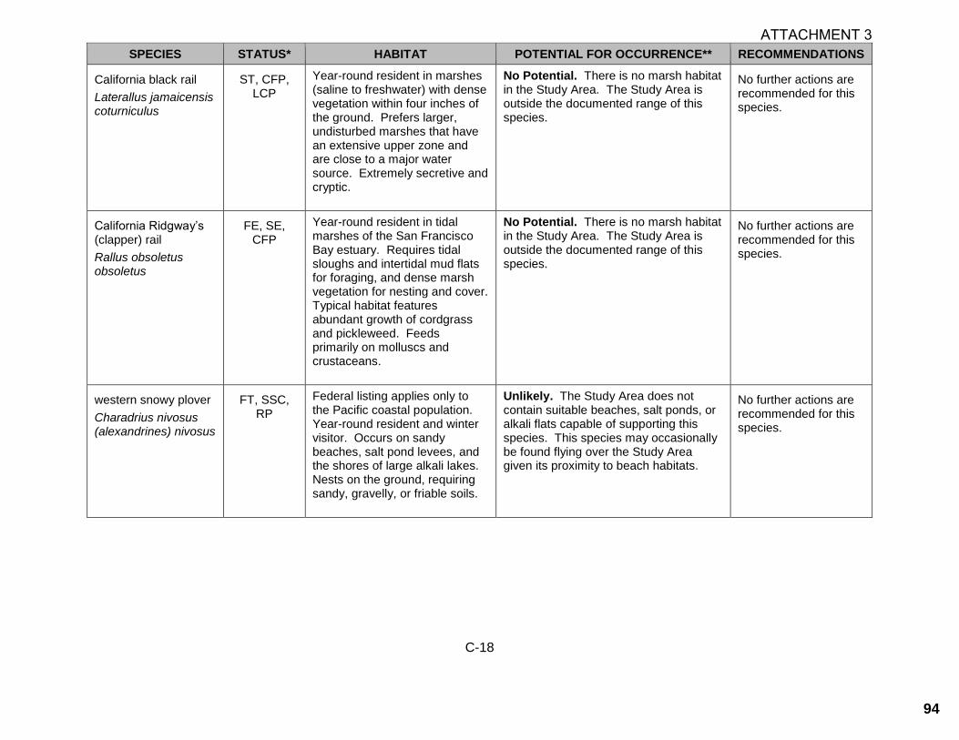
C-18
SPECIES STATUS* HABITAT POTENTIAL FOR OCCURRENCE** RECOMMENDATIONS
California black rail
Laterallus jamaicensis coturniculus
ST, CFP, LCP
Year-round resident in marshes (saline to freshwater) with dense vegetation within four inches of the ground. Prefers larger, undisturbed marshes that have an extensive upper zone and are close to a major water source. Extremely secretive and cryptic.
No Potential. There is no marsh habitat in the Study Area. The Study Area is outside the documented range of this species.
No further actions are recommended for this species.
California Ridgway’s (clapper) rail
Rallus obsoletus obsoletus
FE, SE, CFP
Year-round resident in tidal marshes of the San Francisco Bay estuary. Requires tidal sloughs and intertidal mud flats for foraging, and dense marsh vegetation for nesting and cover. Typical habitat features abundant growth of cordgrass and pickleweed. Feeds primarily on molluscs and crustaceans.
No Potential. There is no marsh habitat in the Study Area. The Study Area is outside the documented range of this species.
No further actions are recommended for this species.
western snowy plover
Charadrius nivosus (alexandrines) nivosus
FT, SSC, RP
Federal listing applies only to the Pacific coastal population. Year-round resident and winter visitor. Occurs on sandy beaches, salt pond levees, and the shores of large alkali lakes. Nests on the ground, requiring sandy, gravelly, or friable soils.
Unlikely. The Study Area does not contain suitable beaches, salt ponds, or alkali flats capable of supporting this species. This species may occasionally be found flying over the Study Area given its proximity to beach habitats.
No further actions are recommended for this species.
ATTACHMENT 3
94

C-19
SPECIES STATUS* HABITAT POTENTIAL FOR OCCURRENCE** RECOMMENDATIONS
marbled murrelet
Brachyramphus marmoratus
FT, SE Predominantly coastal marine. Nests in old-growth coniferous forests up to 30 miles inland along the Pacific coast, from Eureka to Oregon border, and in Santa Cruz/San Mateo Counties. Nests are highly cryptic, and typically located on platform-like branches of mature redwoods and Douglas firs. Forages on marine invertebrates and small fishes.
Unlikely. This Study Area does not contain old-growth redwood or fir habitats capable of providing nesting for marbled murrelets. Foraging occurs off-shore, though this species may fly-over the Study Area during daily commute between foraging and nesting grounds.
No further actions are recommended for this species.
bank swallow
Riparia riparia
ST Summer resident in riparian and other lowland habitats near rivers, lakes, and the ocean in northern California. Nests colonially in excavated burrows on vertical cliffs and bank cuts (natural and manmade) with fine-textured soils. Historical nesting range in southern and central areas of California has been eliminated by habitat loss. Currently known to breed in Siskiyou, Shasta, and Lassen Cos., portions of the north coast, and along Sacramento River from Shasta Co. south to Yolo Co.
No Potential. The Study Area has no cliffs or the extensive riparian banks required for this species to nest.
No further actions are recommended for this species.
San Francisco common yellowthroat
Geothlypis trichas sinuosa
SSC Resident of the San Francisco Bay region, in fresh and salt water marshes. Requires thick, continuous cover down to water surface for foraging; tall grasses, tule patches, willows for nesting.
Moderate Potential. This species may nest in wild radish stands within the Study Area, and is likely to forage within grassland habitats.
Work windows or pre-construction nesting bird survey during the breeding season. See section 5.2.2 for further recommendations.
ATTACHMENT 3
95

C-20
SPECIES STATUS* HABITAT POTENTIAL FOR OCCURRENCE** RECOMMENDATIONS
Alameda song sparrow
Melospiza melodia pusillula
SSC Year-round resident of salt marshes bordering the south arm of San Francisco Bay. Inhabits primarily pickleweed marshes; nests placed in marsh vegetation, typically shrubs such as gumplant.
No Potential. Alameda song sparrows are known to occur in marshes associated with the southern San Francisco Bay. This subspecies is not documented to occur on the Pacific Coast side of the San Francisco Peninsula.
No further actions are recommended for this species.
white-tailed kite
Elanus leucurus
CFP, LCP Year-long resident of coastal and valley lowlands. Preys on small diurnal mammals and occasional birds, insects, reptiles, and amphibians.
Moderate Potential. The Study Area contains grassland habitat suitable for foraging by this species. The Monterey cypress, Monterey pine, and tall shrubs in the Study Area are suitable for nesting.
Work windows or pre-construction nesting bird survey during the breeding season. See section 5.2.2 for further recommendations.
California least tern
Sterna antillarum browni
FE, SE, CFP, LCP
Nests along the coast from San Francisco bay south to northern Baja California. Colonial breeder on bare or sparsely vegetated, flat substrates: sand beaches, alkali flats, landfills, or paved areas.
No Potential. The Study Area does not contain suitable beaches, salt ponds, or alkali flats. Additionally, the Study Area is outside the documented nesting range of this species.
No further actions are recommended for this species.
California brown pelican Pelecanus occidentalis californicus
FD, SD, CFP, LCP
Nests colonially on coastal islands of small to moderate size which afford immunity from attack by ground-dwelling predators. Does not breed north of the Channel Islands. Winter visitor and post-breeding disperser to San Francisco Bay region.
Unlikely. Does not breed in the region, but may roost in or be observed flying over areas adjacent to the Study Area.
No further actions are recommended for this species.
northern harrier Circus hudsonius
SSC, LCP Coastal salt and freshwater marsh. Nest and forage in grasslands, from salt grass in desert sink to mountain cienagas. Nests on ground in shrubby vegetation, usually at marsh edge; nest built of a large mound of sticks in wet areas.
Unlikely. This species typically nests in grassland areas adjacent to wetlands where it typically forages. Although the Study Area contains grassland habitat, it is not of typical vegetation composition and structure to support nesting of this species. Individuals may be seen foraging on the Study Area.
No further actions are recommended for this species.
ATTACHMENT 3
96
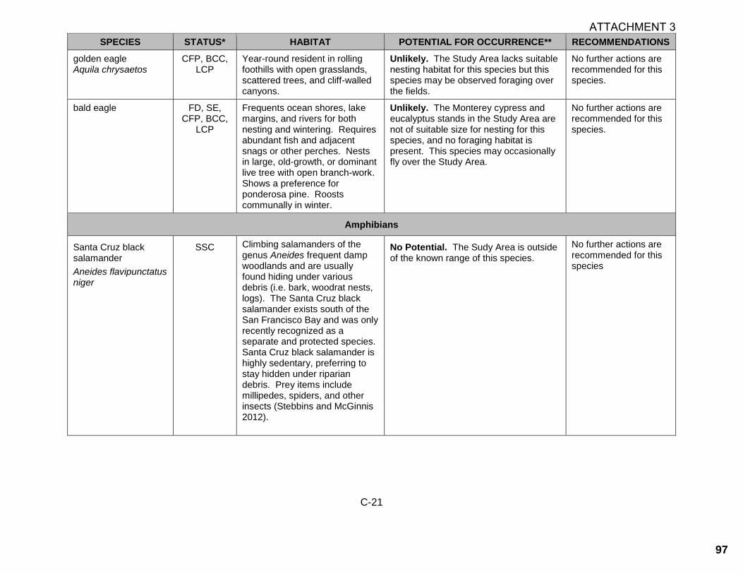
C-21
SPECIES STATUS* HABITAT POTENTIAL FOR OCCURRENCE** RECOMMENDATIONS
golden eagle Aquila chrysaetos
CFP, BCC, LCP
Year-round resident in rolling foothills with open grasslands, scattered trees, and cliff-walled canyons.
Unlikely. The Study Area lacks suitable nesting habitat for this species but this species may be observed foraging over the fields.
No further actions are recommended for this species.
bald eagle FD, SE, CFP, BCC,
LCP
Frequents ocean shores, lake margins, and rivers for both nesting and wintering. Requires abundant fish and adjacent snags or other perches. Nests in large, old-growth, or dominant live tree with open branch-work. Shows a preference for ponderosa pine. Roosts communally in winter.
Unlikely. The Monterey cypress and eucalyptus stands in the Study Area are not of suitable size for nesting for this species, and no foraging habitat is present. This species may occasionally fly over the Study Area.
No further actions are recommended for this species.
Amphibians
Santa Cruz black salamander
Aneides flavipunctatus niger
SSC Climbing salamanders of the genus Aneides frequent damp woodlands and are usually found hiding under various debris (i.e. bark, woodrat nests, logs). The Santa Cruz black salamander exists south of the San Francisco Bay and was only recently recognized as a separate and protected species. Santa Cruz black salamander is highly sedentary, preferring to stay hidden under riparian debris. Prey items include millipedes, spiders, and other insects (Stebbins and McGinnis 2012).
No Potential. The Sudy Area is outside of the known range of this species.
No further actions are recommended for this species
ATTACHMENT 3
97

C-22
SPECIES STATUS* HABITAT POTENTIAL FOR OCCURRENCE** RECOMMENDATIONS
California tiger salamander
Ambystoma californiense
FE/FT, ST, RP
Populations in Santa Barbara and Sonoma counties currently listed as endangered; threatened in remainder of range. Inhabits grassland, oak woodland, ruderal and seasonal pool habitats. Adults are fossorial and utilize mammal burrows and other subterranean refugia. Breeding occurs primarily in vernal pools and other seasonal water features.
No Potential. The Study Area is outside of the known range for this species.
No further actions are recommended for this species.
California giant salamander
Dicamptodon ensatus
SSC Occurs in the north-central Coast Ranges. Moist coniferous and mixed forests are typical habitat; also uses woodland and chaparral. Adults are terrestrial and fossorial, breeding in cold, permanent, or semi-permanent streams. Larvae usually remain aquatic for over a year.
No Potential. No coniferous forests or streams are present within the Study Area to support this species.
No further actions are recommended for this species.
California red-legged frog
Rana draytonii
FT, SSC, RP, LCP
Lowlands and foothills in or near permanent sources of deep water with dense, shrubby or emergent riparian vegetation. Requires 11 to 20 weeks of permanent water for larval development. Associated with quiet perennial to intermittent ponds, stream pools and wetlands. Prefers shorelines with extensive vegetation. Disperses through upland habitats after rains.
Unlikely. The nearest occurrence of CRLF to the Study Area is approximately 1.25 miles to the east along Frenchman’s Creek. Complete barriers to dispersal exist between this, as well as other nearby occurrences, and the Study Area, including US Highway 1. The only water bodies within or nearby the Study Area are tidally influenced, and thus do not provide suitable habitat for this species.
No further actions are recommended for this species.
ATTACHMENT 3
98

C-23
SPECIES STATUS* HABITAT POTENTIAL FOR OCCURRENCE** RECOMMENDATIONS
foothill yellow-legged frog
Rana boylii
SC (SE), SSC
West/Central Coast clade is a candidate for listing as endangered under the state ESA. Found in or adjacent to rocky streams in a variety of habitats. Prefers partly-shaded, shallow streams and riffles with a rocky substrate; requires at least some cobble-sized substrate for egg-laying. Needs at least 15 weeks to attain metamorphosis. Feeds on both aquatic and terrestrial invertebrates.
No Potential. No perennial streams with suitable substrate are present within or near the Study Area. This species is also not generally known from the area, being more typically found at higher elevations in the nearby coast range.
No further actions are recommended for this species.
Reptiles
western pond turtle
Actinemys marmorata
SSC Occurs in perennial ponds, lakes, rivers and streams with suitable basking habitat (mud banks, mats of floating vegetation, partially submerged logs) and submerged shelter.
Unlikely. The Study Area does not provide a permanent or intermittent water source for this species to inhabit and it has not been documented in the vicinity of the Study Area.
No further actions are recommended for this species.
San Francisco garter snake
Thamnophis sirtalis tetrataenia
FE, SE, CFP, RP,
LCP
Vicinity of freshwater marshes, ponds and slow moving streams in San Mateo County and extreme northern Santa Cruz County. Prefers dense cover and water depths of at least one foot. Upland areas near water are also very important.
Unlikely. The Study Area does not contain suitable freshwater aquatic habitat, including the permanent ponds generally preferred by this species. Additionally, there are no burrow systems within the Study Area. CRLF have also been determined to be unlikely to occur on the Study Area, which serves as the chief prey source for this species.
No further actions are recommended for this species.
ATTACHMENT 3
99

C-24
SPECIES STATUS* HABITAT POTENTIAL FOR OCCURRENCE** RECOMMENDATIONS
Fishes
steelhead - Central CA Coast DPS
Oncorhynchus mykiss irideus
FT Occurs from the Russian River south to Soquel Creek and Pajaro River. Also in San Francisco and San Pablo Bay Basins. Adults migrate upstream to spawn in cool, clear, well-oxygenated streams. Juveniles remain in fresh water for 1 or more years before migrating downstream to the ocean.
No Potential. The Study Area does not contain any aquatic habitats to support this species.
No further actions are recommended for this species.
longfin smelt
Spirinchus thaleichthys
FC, ST, SSC, RP
Euryhaline, nektonic and anadromous. Found in open waters of estuaries, mostly in middle or bottom of water column. Prefer salinities of 15 to 30 ppt, but can be found in completely freshwater to almost pure seawater.
No Potential. The Study Area does not contain estuarine habitat utilized by this species.
No further actions are recommended for this species.
tidewater goby
Eucyclogobius newberryi
FE, SSC Brackish water habitats along the California coast from Agua Hedionda Lagoon, San Diego County to the mouth of the Smith River. Found in shallow lagoons and lower stream reaches; requires fairly still but not stagnant water and high oxygen levels.
No Potential. The Study Area does not contain brackish water habitat utilized by this species.
No further actions are recommended for this species.
ATTACHMENT 3
100

C-25
SPECIES STATUS* HABITAT POTENTIAL FOR OCCURRENCE** RECOMMENDATIONS
Invertebrates
monarch butterfly
Danaus plexippus
Winter roosts
monitored by CDFW
Winter roost sites located in wind-protected tree groves (Eucalyptus, Monterey pine, cypress), with nectar and water sources nearby.
Unlikely. The trees within the Study Area are too exposed to provide the wind protection and temperature buffering needed for monarch winter roosting.
No further actions are recommended for this species.
San Francisco tree lupine moth
Grapholita edwardsiana
LCP Occurs only on sandy northern peninsula sites. Tree lupine (Lupinus arboreus) host the larvae of this species. This species is addressed in the City of Half Moon Bay LCP.
No Potential. This species’ host plant is absent from the Study Area.
No further actions are recommended for this species.
San Bruno elfin butterfly
Callophrys mossii bayensis
FE, LCP
Limited to the vicinity of San Bruno Mountain, San Mateo County. Colonies are located on in rocky outcrops and cliffs in coastal scrub habitat on steep, north-facing slopes within the fog belt. Species range is tied to the distribution of the larval host plant, Sedum spathulifolium.
No Potential. The Study Area is out of the known range and habitat type of this species and does not contain its larval host plant.
No further actions are recommended for this species.
mimic tryonia (California brackish water snail)
Tryonia imitator
LCP Occurs in brackish water, such as that of Pescadero Marsh.
No Potential. The Study Area does not contain brackish water or marsh habitat that could be utilized by this species.
No further actions are recommended for this species.
globose dune beetle
Coelus globosus
LCP Inhabitant of coastal sand dune habitat, from Bodega Head in Sonoma County south to Ensenada, Mexico. Inhabits foredunes and sand hummocks; it burrows beneath the sand surface and is most common beneath dune vegetation.
No Potential. The Study Area does not contain dune habitat utilized by this species.
No further action recommendations for this species.
ATTACHMENT 3
101

C-26
* Key to status codes: BCC U.S. Fish & Wildlife Service (USFWS) Birds of Conservation Concern CFP California Department of Fish and Wildlife (CDFW) Fully Protected Animal FC Federal Candidate FE Federal Endangered FT Federal Threatened LCP City of Half Moon Bay Local Coastal Program Rare, Endangered, or Unique Species RP Sensitive species included in a USFWS Recovery Plan or Draft Recovery Plan SE State Endangered SC State Candidate SSC California Department of Fish and Wildlife (CDFW) Species of Special Concern ST State Threatened Rank 1A California Native Plant Society (CNPS) Rank 1A: Plants presumed extirpated in California and rare or extinct elsewhere Rank 1B.1 California Native Plant Society (CNPS) Rank 1B.1: Plants rare, threatened or endangered in California and elsewhere
(seriously threatened in California) Rank 1B.2 California Native Plant Society (CNPS) Rank 1B.2: Plants rare, threatened, or endangered in California and elsewhere
(moderately threatened in California) Rank 2B.2 California Native Plant Society (CNPS) Rank 2B.2: Plants rare, threatened, or endangered in California, but more common
elsewhere (moderately threatened in California) Rank 4.3 California Rare Plant Rank 4.3: Plants of Limited Distribution - A Watch List (not very threatened in California) WBWG Western Bat Working Group Medium/High Priority Species WL CDFW Watch List **Potential species occurrence definitions: Present. Species was observed on the site during site visits or has been recorded (i.e. CNDDB, other reports) on the site recently. High Potential. All of the habitat components meeting the species requirements are present and/or most of the habitat on or adjacent to the site is highly suitable. The species has a high probability of being found on the site. Moderate Potential. Some of the habitat components meeting the species requirements are present, and/or only some of the habitat on or adjacent to the site is unsuitable. The species has a moderate probability of being found on the site. Unlikely. Few of the habitat components meeting the species requirements are present, and/or the majority of habitat on and adjacent to the site is unsuitable or of very poor quality. The species has a low probability of being found on the site. No Potential. Habitat on and adjacent to the site is clearly unsuitable for the species requirements (foraging, breeding, cover, substrate, elevation, hydrology, plant community, site history, disturbance regime).
ATTACHMENT 3
102

APPENDIX D
STUDY AREA PHOTOGRAPHS
ATTACHMENT 3
103

This page intentionally left blank.
ATTACHMENT 3
104

1
Photograph 3. Southeastern portion of the Study Area on Ramona Way showing high disturbance and proximity to residential development.
Photograph 1. A representative photo of the wild radish patches
which constitutes approximately 0.49 acre of the Study Area.
Photograph 4. The portion of Mirada Road where a new sewer line is proposed. Photo is facing west, with Ramona Way directly south.
Photograph 2. A representative photo of the English ivy mats which constitutes approximately 0.13 acre of the Study area. Photo is of the southwestern portion of the Study Area.
Appendix D. Study Area Photographs
All photographs taken on May 19, 2020 unless otherwise noted.
ATTACHMENT 3
105

2
Photograph 7: The sewer man-hole the end of Mirada Road
where the proposed sewer installation will end.
Photograph 5. The sewer man-hole located on Ramona Way
where sewer replacement is proposed.
Photograph 8: Photo of the poison oak scrub directly adjacent to the developed dirt trail along the western border of the Study Area.
Photograph 6. An engineer (pictured center) standing on Mirada
Road where new sewer manhole is planned to be located for the
new alignment.
Appendix D. Study Area Photographs
All photographs taken on May 19, 2020 unless otherwise noted.
ATTACHMENT 3
106
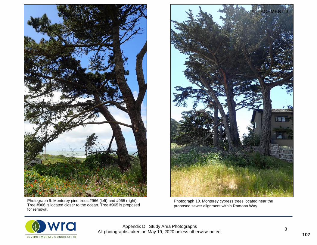
Appendix D. Study Area Photographs
All photographs taken on May 19, 2020 unless otherwise noted.3
Photograph 9: Monterey pine trees #966 (left) and #965 (right). Tree #966 is located closer to the ocean. Tree #965 is proposed for removal.
Photograph 10. Monterey cypress trees located near the
proposed sewer alignment within Ramona Way.
ATTACHMENT 3
107

This page intentionally left blank.
ATTACHMENT 3
108

APPENDIX E
STUDY AREA HERITAGE TREE SURVEY TABLE
ATTACHMENT 3
109

This page intentionally left blank.
ATTACHMENT 3
110

Tag ID Species Common Name Multi-stem Diamete Diamete Diamete Diamete Diamete
Total Diameter (inches)
Total Circumference
(inches) Ordinance Status Potential ImpactDripline (feet)
Height (feet) Condition Health Structure
962 Pinus radiata Monterey pine no 39.4 0.0 0.0 0.0 0.0 39.4 123.7 heritage tree No Impact 30 75 Fair Fair Fair963 Pinus radiata Monterey pine no 22.2 0.0 0.0 0.0 0.0 22.2 69.7 heritage tree No Impact 25 60 Fair Fair Fair964 Pinus radiata Monterey pine no 12.7 0.0 0.0 0.0 0.0 12.7 39.9 heritage tree No Impact 8 30 Poor Poor Poor965 Pinus radiata Monterey pine no 25.1 0.0 0.0 0.0 0.0 25.1 78.8 heritage tree Potential Removal 27 60 Fair Fair Fair966 Pinus radiata Monterey pine no 27.1 0.0 0.0 0.0 0.0 27.1 85.1 heritage tree Potential Removal 30 60 Fair Fair Poor968 Hesperocyparis macrocarpa Monterey cypress yes 20.6 19.2 8.0 0.0 0.0 47.8 150.1 heritage tree No Impact 25 40 Fair Fair Poor970 Hesperocyparis macrocarpa Monterey cypress no 69.3 0.0 0.0 0.0 0.0 69.3 217.6 heritage tree No Impact 30 70 Good Good Fair974 Hesperocyparis macrocarpa Monterey cypress no 26.0 0.0 0.0 0.0 0.0 26.0 81.6 heritage tree No Impact 15 80 Fair Fair Fair
Appendix E. Naples Beach Sewer Project, Half Moon Bay Tree Survey Table May 2020
E‐1
ATTACHMENT 3
111

GRANADA COMMUNITY SERVICES DISTRICT
504 Avenue A lhambra , 3 r d F loor ∼ P . O. Box 335 ∼ E l Granada, Ca l i forn ia 94018 Te leph one: (650) 726-7093 ∼ Facs imi le : (650) 726-7099 ∼ web : granada.ca .gov
Board of Directors
Matthew Clark, President
Eric Suchomel, Vice President
Barbara Dye, Director
Nancy Marsh, Director
David Seaton, Director
March 5, 2021
City of Half Moon Bay, Planning Department 501 Main Street Half Moon Bay, CA 94019
Re: Coastal Development Permit Application: Naples Beach Phase 2 Sewer Project Applicant: Granada Community Services District
To Whom It May Concern,
In accordance with discussions with Doug Garrisson of the HMB Planning Department, the Granada Community Services District (GCSD) wanted to confirm that in order to lessen the impact on residents near the construction area, the following requirements will be imposed on the construction contractor.
• All undeveloped areas disturbed by construction activities shall be revegetated bybroadcasting native vegetation seeds in accordance with consultations with State Parks andCity of Half Moon Bay representatives.
• Truck access from Highway 1 to the construction site for delivery of materials andequipment shall be limited to Mirada Road.
• Parking on Mirada Road for construction workers shall be limited to 4 vehicles so someworkers may need to park off site and carpool to the construction site.
Enclosed is the CDP application signed by GCSD as the applicant and by State Parks as the property owner for the portion of the project on undeveloped property along the former Ramona Way paper street.
Please let me know if you have any questions. Thanks.
Very truly your,
John H Rayner PE, District Engineer
encl: CDP Application
ATTACHMENT 4
112

)
ATTACHMENT 4
113

Please submit the following items with your application, unless otherwise directed by planning staff:
1. 6 Sets of 24 X 36 inch Plans* - Each set of plans shall be folded to approximately 8.5” X 11” and shall include:a. Site Plan Drawn to scale, indicating correct parcel dimensions using a topographic survey as the base map,
and showing all existing and proposed structures and trees. INCLUDE ALL OF THE FOLLOWING: Alocation map; grading contours and location of any drainage flows; all recorded utility and accesseasements; all existing and proposed utilities; centerline of the public right-of-way and any existing andproposed frontage improvements (sidewalk, curb, gutter); and any adjacent street rights-of-way, adjacentparcels, and adjacent building footprints.
b. Building Elevations Drawn to scale, showing north, south, east and west views of all proposed structures.Indicate existing grade, finished first floor and a roof ridgeline (highest point of the structure). Includemaximum building envelope lines, proposed colors and materials, and exterior lighting as applicable.
c. Building Floorplans Drawn to scale, detailing all habitable and non-habitable existing and proposed floorareas.
d. Preliminary Utilities, Grading and Drainage Plan Required for new residential and commercialprojects.
e. Landscape Plan Drawn to scale, showing all existing and proposed landscaping (include species name andheight), amount of irrigated landscape area, and all existing and proposed hardscape including all fencing,walls, (including height of these features) driveways and walkways. Additional information on irrigatedlandscaped areas may be requested to comply with Chapter 13.04 “Water Conservation in LandscapingRegulations” of the Municipal Code.
*Note: Additional sets may be required based on type of request and any requested revisions.
2. One (1) electronic set of dated project plans (.pdf format).
3. One (1) set of project plans reduced to 11 X 17 inches.
4. Photographic evidence and signed affidavit for the Site Posting Notice.
5. A Copy of a Title Report prepared within 90 days including a separate sheet identifying the legal description of thesubject site (include all APN’s associated with the subject site)
6. Written proof of water connection commitment from the Coastside County Water District.
7. Completed Stormwater Checklist for Small Projects or C.3 (if applicable).
8. Copy of Dwelling Unit Allocation Certificate (D) for projects including new residential units.
9. A signed Affidavit of Application Materials that is attached to this application packet.
10. For Parcel Map, Tentative Subdivision Map, Lot Line Adjustment and Lot MergerApplications, please ask for the corresponding supplemental forms requiring additional information.
11. A completed and signed City of Half Moon Bay Planning Department Permit Application Form.
12. TOPOGRAPHIC SURVEY REQUIRED: A detailed topographic survey shall be prepared and certified by alicensed surveyor or civil engineer properly registered to perform surveying and submitted with Planning Permitapplication plans. The survey shall include a baseline elevation datum point on the construction site, indicatingexisting grade prior to development. This datum point shall be permanent, marked, shall remain fixed in thefield, and shall not be disturbed throughout the Planning and Building Review process. Examples of datum pointsinclude: fire hydrants, manhole covers, survey markers, street curbs, etc. This datum point shall be shown on all ofyour site plans including revised/resubmitted plans. The footprint of the proposed structure(s) shall be drawn onplans with a roof plan. Specific elevation points at structure(s) corners and ridgeline shall be noted on the survey.The approved height of all projects developed in the City will be measured from existing grade as indicatedon the submitted topographical survey to the roof ridgeline (highest approved structure height) of thestructure.
ATTACHMENT 4
114

ATTACHMENT 4
115

ATTACHMENT 4
116

Page 2
504 Avenue A lhambra , 3 r d F loor ∼ P . O. Box 335 ∼ E l Granada, Ca l i forn ia 94018 Te leph one: (650) 726-7093 ∼ Facs imi le : (650) 726-7099 ∼ E -ma i l : gsdsani tary@comcast .ne t
ATTACHMENT 4
117

Naples Beach Sewer Project
Initial Study/Mitigated Negative Declaration
October 2008
Granada Sanitary District El Granada, California
118

Naples Beach Sewer Project
Initial Study/Mitigated Negative Declaration
October 2008
Prepared for:
Granada Sanitary District 504 Avenue Alhambra/ P.O. Box 335
El Granada, CA 94018
Prepared by:
TRA Environmental Sciences, Inc. 545 Middlefield Road, Suite 200
Menlo Park, CA 94025 (650) 327-0429
www.TRAenviro.com
119
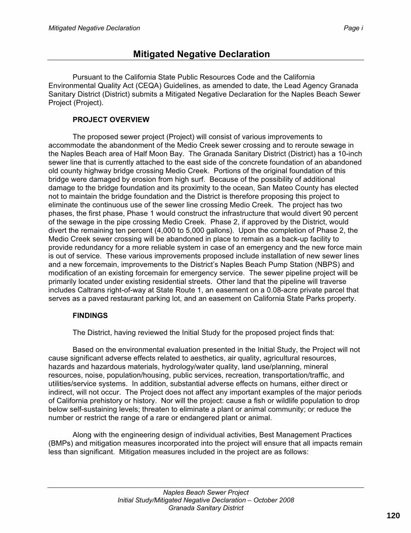
Mitigated Negative Declaration Page i
Naples Beach Sewer Project Initial Study/Mitigated Negative Declaration – October 2008
Granada Sanitary District
Mitigated Negative Declaration
Pursuant to the California State Public Resources Code and the California Environmental Quality Act (CEQA) Guidelines, as amended to date, the Lead Agency Granada Sanitary District (District) submits a Mitigated Negative Declaration for the Naples Beach Sewer Project (Project).
PROJECT OVERVIEW
The proposed sewer project (Project) will consist of various improvements to accommodate the abandonment of the Medio Creek sewer crossing and to reroute sewage in the Naples Beach area of Half Moon Bay. The Granada Sanitary District (District) has a 10-inch sewer line that is currently attached to the east side of the concrete foundation of an abandoned old county highway bridge crossing Medio Creek. Portions of the original foundation of this bridge were damaged by erosion from high surf. Because of the possibility of additional damage to the bridge foundation and its proximity to the ocean, San Mateo County has elected not to maintain the bridge foundation and the District is therefore proposing this project to eliminate the continuous use of the sewer line crossing Medio Creek. The project has two phases, the first phase, Phase 1 would construct the infrastructure that would divert 90 percent of the sewage in the pipe crossing Medio Creek. Phase 2, if approved by the District, would divert the remaining ten percent (4,000 to 5,000 gallons). Upon the completion of Phase 2, the Medio Creek sewer crossing will be abandoned in place to remain as a back-up facility to provide redundancy for a more reliable system in case of an emergency and the new force main is out of service. These various improvements proposed include installation of new sewer lines and a new forcemain, improvements to the District’s Naples Beach Pump Station (NBPS) and modification of an existing forcemain for emergency service. The sewer pipeline project will be primarily located under existing residential streets. Other land that the pipeline will traverse includes Caltrans right-of-way at State Route 1, an easement on a 0.08-acre private parcel that serves as a paved restaurant parking lot, and an easement on California State Parks property.
FINDINGS
The District, having reviewed the Initial Study for the proposed project finds that:
Based on the environmental evaluation presented in the Initial Study, the Project will not cause significant adverse effects related to aesthetics, air quality, agricultural resources, hazards and hazardous materials, hydrology/water quality, land use/planning, mineral resources, noise, population/housing, public services, recreation, transportation/traffic, and utilities/service systems. In addition, substantial adverse effects on humans, either direct or indirect, will not occur. The Project does not affect any important examples of the major periods of California prehistory or history. Nor will the project: cause a fish or wildlife population to drop below self-sustaining levels; threaten to eliminate a plant or animal community; or reduce the number or restrict the range of a rare or endangered plant or animal.
Along with the engineering design of individual activities, Best Management Practices (BMPs) and mitigation measures incorporated into the project will ensure that all impacts remain less than significant. Mitigation measures included in the project are as follows:
120

Mitigated Negative Declaration Page ii
Naples Beach Sewer Project Initial Study/Mitigated Negative Declaration – October 2008
Granada Sanitary District
Impact BIO-1: There is potential for California red-legged frog (CRLF), a Federally Threatened and California Species of Special Concern to travel through the site due to the site’s proximity to a known occurrence at Frenchman’s Creek, less than one mile from the project site. Coastal fog during the summer and non-seasonal runoff from the unnamed creek at Alameda Avenue both increase the possibility of CRLF movement outside known areas of occurrence.
Mitigation Measure BIO-1: If possible, all construction shall be scheduled to occur during the dry season (May 1- October 31). If work is scheduled during the dry season, the following measures apply:
Conduct a worker education program, and Conduct a single daytime survey for CRLF prior to work within 100 feet of the culvert under Alameda Avenue, and At the end of each work day, all holes and trenches shall be covered with steel plates or backfilled to avoid trapping animals overnight.
If any phase of construction for this project occurs during the rainy season (November 1 to April 30) the following measures shall apply:
Conduct a worker education program, and Conduct one nighttime and one daytime pre-construction survey for CRLF when construction activities approach within 100 feet of the culvert under Alameda Avenue, and At the end of each work day, all holes and trenches shall be covered or backfilled to avoid trapping animals overnight. A biologist shall check the site at the start of each day (a morning site check, prior to the start of construction activities) during the time that construction is located within 100 feet of the culvert crossing under Alameda Avenue.
A worker education program is essentially an informational meeting held prior to the start of all construction activities. The worker education program shall be conducted by a United States Fish and Wildlife (USFWS)-approved CRLF biologist and all construction staff (foreman, laborers, and equipment operators) shall be required to attend this meeting. The program shall inform the workers of CRLF protection status, identification, life history, avoidance measures, and reporting procedures (who to contact) if any CRLF are found on-site. A record of attendance shall be kept by the District.
The preconstruction nighttime survey for CRLF shall occur within 48 hours of the start of construction within 100 feet of the culvert crossing under Alameda Avenue. The daytime survey (also within 100 feet of the culvert crossing) shall occur the morning of and prior to the start of construction activities. The survey results shall be noted in a report or memo and submitted to the Granada Sanitary District within one week of the day survey. If CRLF are found at any time during construction, an USFWS-approved CRLF biologist shall be contacted for instructions on how to proceed.
Once construction has been scheduled, a biologist shall be hired to perform pre-construction surveys and/or regular morning site checks (according to dry or rainy season requirements as detailed above) and shall develop a monitoring plan prior to the start of construction activities. A copy of the plan shall be provided to the City.
121

Mitigated Negative Declaration Page iii
Naples Beach Sewer Project Initial Study/Mitigated Negative Declaration – October 2008
Granada Sanitary District
Effectiveness: This measure will avoid impacts to CRLF.
Implementation: The District shall incorporate this measure into building/grading permit plans and all construction contracts; District shall implement these measures
Timing: Prior to approval of final project plans
Monitoring: Granada Sanitary District building and permit plans and construction contracts
Impact BIO-2: The construction phase of the project could disturb nesting birds resulting in a violation of California Department of Fish and Game (CDFG) Code and the Migratory Bird Treaty Act and result in a significant impact. Therefore, the following mitigation measure is proposed:
Mitigation Measure BIO-2: If construction activities cannot occur outside of the nesting season (February 15 through August 31 of any given year), a qualified biologist will be hired by the District to conduct a pre-construction survey for nesting birds not more than 72 hours prior to the start of construction activities. The surveys shall identify active nests and establish a disturbance buffer if nests are located. A minimum buffer of 50 feet is required by CDFG for songbird nests and a minimum of 250 feet for raptor nests. Construction activity within an established buffer area is prohibited until nesting is complete. Work may occur if an adequate buffer, as determined by a qualified biologist in consultation with CDFG, can be established between the construction activity and the nest. The findings of the pre-construction survey shall be noted in a report or memo and submitted to the Granada Sanitary District.
Effectiveness: This measure will prevent potentially significant impacts to nesting birds through avoidance.
Implementation: District shall contract with a qualified biologist
Timing: Not more than 72 hours prior to the start of construction
Monitoring: The qualified biologist shall provide a report of monitoring results to the District and the City of Half Moon Bay (as a Responsible Agency)
Impact BIO-3: Trenching at the eastern end of Washington Boulevard could potentially damage one or more Monterey pine trees.
Mitigation Measure BIO-3: A certified arborist shall be consulted prior to the finalization of project plans. The avoidance and protection measures recommended by the arborist as necessary to avoid adversely impacting the Monterey pine trees near Washington Boulevard shall be implemented.
Effectiveness: This measure will prevent harming Monterey pine trees, identified as Unique Species according to the HMB Zoning Code.
Implementation: District shall contract with a certified arborist
Timing: Prior to approval of final project plans
122

Mitigated Negative Declaration Page iv
Naples Beach Sewer Project Initial Study/Mitigated Negative Declaration – October 2008
Granada Sanitary District
Monitoring: District; the certified arborist shall provide a report of recommendations to the District and the City of Half Moon Bay (as a Responsible Agency)
Impact CUL-1: Holman and Associates conducted an archaeological literature review and a visual inspection of the project site in November 2006 (Appendix B). The results of the literature review and visual inspection determined that the possibility of uncovering prehistoric and or historic materials at the site could not be ruled out. Therefore, the following mitigation measures are proposed:
Mitigation Measure CUL-1: The District shall retain the services of a qualified archaeological monitor to inspect the excavated pipeline route during construction and a full-time monitor for any work in the former railroad right-of-way (Ramona Way area). Unrecorded prehistoric archaeological resources could exist at any point along the pipeline right-of-way and there is a potential that excavation along the railroad right-of-way may uncover historic archaeological deposits associated with the construction and or short operation of the rail line itself.
In the event that any prehistoric and or historic deposits are encountered during earthmoving, it will be the responsibility of the project archaeologist to stop work within 50 feet of any discovery until a plan for the evaluation of the resource has been submitted to the City Planning Department for approval. Evaluation can take the form of limited hand excavation in order to demonstrate that the endangered resource is eligible for inclusion on the California Register of Historic Resources (CRHR).
Effectiveness: Implementation of monitoring during construction would prevent significant impacts by halting construction before damage is done and allowing the resources to be documented.
Implementation: The District shall hire qualified archaeologists to monitor the site during construction. This measure shall be incorporated into building permit plans and construction contracts; District shall implement these measures
Timing: Measures shall be in evidence in project plans prior to issuance of the Coastal Development Permit. Actual monitoring shall occur during ground disturbing activities.
Monitoring: Granada Sanitary District; the archaeological monitor shall provide a report of monitoring results to the Granada Sanitary District and the City of Half Moon Bay
Mitigation Measure CUL-2: If a historic or prehistoric resource is determined eligible for the Register, a plan for its mitigation should be submitted to the City Planning Department for approval before work is allowed to recommence in areas of archaeological sensitivity as defined by the project archaeologist. Mitigation can take the form of data retrieval through additional hand excavation inside areas of impact, coupled with recording and or removal of significant cultural materials and information for future analysis and reporting purposes.
123
Mitigated Negative Declaration Page v
Naples Beach Sewer Project Initial Study/Mitigated Negative Declaration – October 2008
Granada Sanitary District
Effectiveness: Implementation of a measure to determine eligibility of previously unrecorded cultural resources would ensure proper care and handling of these resources.
Implementation: The District shall incorporate these measures into building permit plans and construction contracts; District shall implement these measures
Timing: During construction
Monitoring: Granada Sanitary District; the Mitigation Plan shall be submitted for approval to the City prior to recommencement of work in archaeologically sensitive areas as defined by the project archaeologist.
Mitigation Measure CUL-3: In the event that Native American human remains are discovered, work will be stopped in the area defined by the project archaeologist until the County Coroner’s Office and Native American Heritage Commission (NAHC) have been notified. In the case of Native American remains, the NAHC will name a Most Likely Descendant (MLD) to advise the District in the preferred manner of exhumation, exposure, removal, and reburial of all human remains and associated grave goods.
Effectiveness: Suspension of work and notification of the County Coronor’s office and Native American Heritage Commission would ensure that any human remains and associated grave goods are properly handled.
Implementation: The District shall incorporate these measures into building permit plans and construction contracts; District shall implement these measures
Timing: During construction
Monitoring: Granada Sanitary District; the project archaeologist’s monitoring report shall demonstrate that this was accomplished
Impact HM-1: Soils containing hazardous levels of aerially deposited lead (ADL) could be encountered during tunneling activities near State Route 1. Improper handling of these materials could result in worker exposure or contamination.
Mitigation Measure HM-1: For the sites of the jacking and receiving pits for the tunneled crossing under State Route 1 and the easement required on parcel (APN 048-124-140): The District shall hire a consultant to perform testing for aerially deposited lead in soils in areas that are to be open cut excavated, adjacent to State Route 1.
1. Sample and test soils using a California Department of Health Services-certified analytical laboratory to determine lead content before disturbing the soils.
2. Determine how the soils must be treated based upon the result of the soil tests. Soil containing less than 1,575 parts per million (ppm) may be reused as long as it is placed at least two feet above the water table and covered with one foot of clean soil. Soil containing more than 1,575 ppm but less than 4,150 may be used as fill, as long as it is placed two feet above the water table and covered with pavement or similar cap.
3. Properly dispose of lead containing soil for which there is no on-site project use.
124

Mitigated Negative Declaration Page vi
Naples Beach Sewer Project Initial Study/Mitigated Negative Declaration – October 2008
Granada Sanitary District
4. Keep whatever lead containing soil that is dug up in the area of contamination and keep it covered with thick plastic until it is used.
5. Only reuse the soil within the area from which it came.
6. If lead is present, do no reuse the lead-containing soil where it could come into contact with workers, plants, and ground or surface water; and the soil must be put where it will be protected from erosion and runoff.
7. Keep records and provide detailed reports of lead to the California Department of Toxic Substances Control. Make copies of the records available to the public.
Effectiveness: Testing soils will ensure that if aerially deposited lead contamination is found, the contaminated soil is properly handled and/or disposed of.
Implementation: The District shall incorporate these measures into construction plans and contracts
Timing: Prior to the issuance of the Coastal Development Permit
Monitoring: Granada Sanitary District, a soil testing report shall be evidence that the mitigation was performed.
Impact HYD-1: Uncontrolled runoff from the construction site could impact nearby sensitive resources, including the Pacific Ocean and an unnamed blue line creek that crosses the pipeline alignment on Alameda Avenue just south of San Pablo Avenue.
Mitigation Measure HYD-1: The project is near the ocean and an unnamed blue line creek. Because the project requires trenching that could affect these resources, the following measures, as appropriate, shall be incorporated into project plans and construction specifications in order to protect water quality and prevent erosion: BMPs like the ones listed below are required to comply with the San Mateo County STOPPP National Pollutant Discharge Elimination System permit.
1) Install fiber rolls 2) Protect of storm drain inlets 3) Stockpile management 4) Spill control 5) Hazardous Materials/ Waste Management 6) Contaminated soil management (also in Mitigation Measure HAZ-1) 7) Paving operations measures 8) Vehicle and equipment cleaning and fueling 9) Hydroseeding 10) Dust (wind erosion) control
Effectiveness: Implementation of these BMPs will ensure water quality is preserved during construction and that the project does not violate the San Mateo Countywide STOPPP.
Implementation: The District shall incorporate these measures into construction plans and contracts.
Timing: These BMPs shall be in place during all phases of construction
125

Mitigated Negative Declaration Page vii
Naples Beach Sewer Project Initial Study/Mitigated Negative Declaration – October 2008
Granada Sanitary District
Monitoring: City of Half Moon Bay shall ensure these measures are shown on construction plans prior to the issuance of the Coastal Development Permit
Attached is the Initial Study prepared for the Project. The public can view the documents used in preparation of the Initial Study at the Granada Sanitary District, 504 Avenue Alhambra, El Granada, CA 94018.
126

Table of Contents Page i
Naples Beach Sewer Project Initial Study/Mitigated Negative Declaration – October 2008
Granada Sanitary District
Table of Contents 1.0 Introduction ...........................................................................................................................1
1.1 Introduction and Regulatory Guidance................................................................................11.2 Lead Agency .......................................................................................................................11.3 Purpose and Document Organization .................................................................................2
2.0 Project Description ...............................................................................................................3
2.1 Project Location and Site Description..................................................................................32.2 Project Objectives ...............................................................................................................32.3 Project Improvements .........................................................................................................32.4 Related Projects ................................................................................................................122.5 Permits and Approvals Required.......................................................................................122.6 Best Management Practices (BMPs) Incorporated Into the Project ..................................12
3.0 Environmental Checklist Form and Responses ..............................................................14
Background .............................................................................................................................14Environmental Factors Potentially Affected.............................................................................15Determination ..........................................................................................................................153.1 AESTHETICS....................................................................................................................163.2 AGRICULTURE RESOURCES.........................................................................................183.3 AIR QUALITY ....................................................................................................................203.4 BIOLOGICAL RESOURCES.............................................................................................243.5 CULTURAL RESOURCES................................................................................................343.6 GEOLOGY AND SOILS ....................................................................................................393.7 HAZARDS AND HAZARDOUS MATERIALS....................................................................423.8 HYDROLOGY AND WATER QUALITY.............................................................................463.9 LAND USE AND PLANNING.............................................................................................513.10 MINERAL RESOURCES.................................................................................................543.11 NOISE .............................................................................................................................553.12 POPULATION AND HOUSING.......................................................................................583.13 PUBLIC SERVICES ........................................................................................................593.14 RECREATION.................................................................................................................613.15 TRANSPORTATION/TRAFFIC .......................................................................................623.16 UTILITIES AND SERVICE SYSTEMS ............................................................................653.17 MANDATORY FINDINGS OF SIGNIFICANCE...............................................................67
4.0 References...........................................................................................................................69
Appendix A: TRA Environmental Sciences. Biological Survey. August 2008.
Appendix B: Holman and Associates. Archaeological Literature Review. November 2006.
Appendix C: Mitigation Monitoring and Reporting Plan
127

Table of Contents Page ii
Naples Beach Sewer Project Initial Study/Mitigated Negative Declaration – October 2008
Granada Sanitary District
List of Figures
Figure 1 Project Location ..............................................................................................................7 Figure 2 Naples Beach Project Key Map ......................................................................................8 Figure 3 Sheet 2 ...........................................................................................................................9 Figure 4 Sheet 3 .........................................................................................................................10 Figure 5 Sheet 4 .........................................................................................................................11
List of Photos
Photo 1. Sewer line over Medio Creek attached to the former county highway bridge .............12 Photo 2. Naples Beach Pump Station........................................................................................17 Photo 3. Unnamed creek looking upstream from the eastern side of Alameda Avenue (11/14/2006)................................................................................................................................25 Photo 4. View of the culvert from the eastern (upstream) side of Alameda Avenue (11/14/2006) ....................................................................................................................................................25 Photo 5. Parcel at the end of Washington Boulevard (11/14/2006)...........................................27 Photo 6. Ramona Way portion of sewer alignment (5/23/2007) ................................................27 Photo 7. Mirada Road with the undeveloped Ramona Way on the right. Phase 2 will construct and connect new sewer lines along Mirada Road and Ramona Way. (5/23/2007) ...................28 Photo 8. Alameda Avenue, looking east from Mirada Road. The new sewer line (approx. 300 feet long) installed under this portion of Alameda Avenue is part of Phase 1. (5/23/2007) .......28 Photo 9: Eastern Portion of Washington Boulevard....................................................................29
128

1.0 Introduction Page 1
Naples Beach Sewer Project Initial Study/Mitigated Negative Declaration – October 2008
Granada Sanitary District
1.1 Introduction and Regulatory Guidance
This Initial Study/Mitigated Negative Declaration (IS/MND) has been prepared by the project applicant and the Lead Agency, the Granada Sanitary District (District). The purpose of the Initial Study is to evaluate the potential environmental effects of the proposed abandonment of the Medio Creek sewer crossing, except for use as an emergency back-up facility, and redirection of sewage flow from the Naples Beach Pump Station in the City of Half Moon Bay, San Mateo County, California (Figures 1 and 2: Project Vicinity and Project Location) to the Sewer Authority Mid Coastside (SAM) Intertie Pipeline System.
Proposed project improvements include:
1. Installation of a new force main 2. Improvements to the Naples Beach Pump Station 3. Installation of two new sewer lines 4. Modification of the existing force main for emergency service
According to CEQA Guidelines Section 15070, a public agency shall prepare a proposed ND or a Mitigated ND when:
1. The IS shows that there is no substantial evidence, in light of the whole record before the agency, that the project may have a significant effect on the environment, or
2. The IS identifies potentially significant effects, but: - Revisions in the project plans made before a proposed Mitigated ND and IS are
released for public review would avoid the effects or mitigate the effects to a point where clearly no significant effects would occur, and
- There is no substantial evidence, in light of the whole record before the agency, that the project as revised may have a significant effect on the environment.
This document has been prepared in accordance with the California Environmental Quality Act (CEQA), Public Resources Code §21000 et seq., and the State CEQA Guidelines, California Code of Regulations (CCR) §15000 et seq.
1.2 Lead Agency
The lead agency is the public agency with principal responsibility for carrying out or approving the proposed project (CEQA Guidelines §15367). The lead agency for the proposed project is the Granada Sanitary District, the agency that would be approving the project. The contact person for the lead agency regarding the project is:
Chuck Duffy, General Manager Granada Sanitary District 504 Avenue Alhambra El Granada, CA 94018 (650) 726-7093 or (760) 479-4125 [email protected]
129

1.0 Introduction Page 2
Naples Beach Sewer Project Initial Study/Mitigated Negative Declaration – October 2008
Granada Sanitary District
The project is located within the City of Half Moon Bay’s Local Coastal Zone which requires City approval of a Local Coastal Program permit, therefore the City of Half Moon Bay is a Responsible Agency. Responsible Agencies are public agencies other than the lead agency that have discretionary approval power over the project (CEQA Guidelines §15381).
1.3 Purpose and Document Organization
The purpose of this document is to evaluate the potential environmental effects of the Naples Beach Project.
This document is organized as follows:
Chapter 1.0 – Introduction This chapter provides an introduction to the project and describes the purpose and organization of this document.
Chapter 2.0 – Project Description This chapter describes the project location, project area, and site description, objectives, characteristics and related projects. This chapter also contains descriptions of Best Management Practices (BMPs) and other mitigation incorporated into the project.
Chapter 3.0 – Environmental Checklist and Responses This chapter contains the Environmental (Initial Study) Checklist that identifies the significance of potential environmental impacts (by environmental issue) and a brief discussion of each impact resulting from implementation of the proposed project. This chapter also contains the Mandatory Findings of Significance.
Chapter 4.0 – References This chapter identifies the references and sources used in the preparation of this IS/MND.
Appendix A: TRA Environmental Sciences. Biological Survey. August 2008.
Appendix B: Holman and Associates. Archaeological Literature Review and Cultural Resources Inspection for the Granada Sanitary District, San Mateo County, California. November 2006.
Appendix C: Mitigation Monitoring and Reporting Plan (MMRP)
130
2.0 Project Description Page 3
Naples Beach Sewer Project Initial Study/Mitigated Negative Declaration – October 2008
Granada Sanitary District
2.1 Project Location and Site Description
The proposed sewer improvements will be made in the Medio Creek and Naples Beach area of the City of Half Moon Bay (City), San Mateo County, California (see Figures 1, 2, 3, and 4). The project location is generally bounded by Cabrillo Highway (State Route 1) to the east, Washington Boulevard to the south, the Pacific Ocean to the west and Mirada Road to the north. The proposed project does not extend beyond the California Department of Transportation (Caltrans) right-of-way, eastward of State Route 1.
2.2 Project Objectives
The project will install facilities necessary to accommodate the conversion of a sewer line crossing at Medio Creek for emergency use only. The Granada Sanitary District (District) has a 10-inch sewer line that is currently attached to the east side of the concrete foundation of an old county highway bridge crossing Medio Creek (see Photo 1). Portions of the original foundation of this bridge were damaged by erosion from high surf. Because of the possibility of additional damage to the bridge foundation and its proximity to the ocean, San Mateo County has elected not to maintain the bridge foundation and the District is therefore proposing this project to eliminate the continuous use of the sewer line crossing Medio Creek. The project improvements include the modification and installation of facilities in a residential area which are necessary to maintain sewer service to replace the continuous use of the sewer crossing at Medio Creek.
2.3 Project Improvements
The project will involve the underground installation of a new sewer force main to divert all of the sewage currently flowing in the sewer crossing at Medio Creek. It will also provide improvements to the existing Naples Beach Pump Station (NBPS) to accommodate the changes in pump requirements and update equipment. The project has two phases, the first phase, Phase 1 would construct the infrastructure that would divert 90 percent of the sewage in the pipe crossing Medio Creek. Phase 2, if approved by the District, would divert the remaining ten percent (4,000 to 5,000 gallons).
Existing sewer and force main facilities will be modified and left in place as back-up facilities to provide redundancy for a more reliable system in case the new force main is out of service. If back-up facilities were not left in place, any disruption of the new facilities could result in a sewage spill. The District estimates the frequency of having to use the back-up facilities to be once every ten years. The existing force main will be modified to serve as a back-up force main. The project will be phased to allow the NBPS, the new force main and a short section of new sewer to be completed before sewers are rerouted. The sewers and force main will be primarily located under existing residential streets. Other land that the pipeline will traverse includes Caltrans right-of-way at State Route 1, an easement through a paved restaurant parking lot on a 0.08-acre private parcel at the eastern end of Washington Boulevard (APN 048-124-140), and an easement on California Department of Parks and Recreation property (State Parks), a paper street known as Ramona Way located off Mirada Road.
131

2.0 Project Description Page 4
Naples Beach Sewer Project Initial Study/Mitigated Negative Declaration – October 2008
Granada Sanitary District
Proposed Phase 1 project elements include:
1) New Force Main (pressurized pipeline) – A new 10-inch force main will be installed underground at the NBPS then the alignment heads east under San Pablo Avenue, then south on Alameda Avenue, then east on Washington Boulevard to the Sewer Authority Mid-Coastside (SAM) Intertie Pipeline System (IPS) force main located on the east side of State Route 1. This length of pipe is roughly 1,600 feet. A Caltrans encroachment permit (for work within Caltrans right-of way) and an easement from an adjoining private parcel (on the west side of State Route 1) will be required to accommodate the new force main alignment to the east side of State Route 1 from Washington Boulevard. A “hot tap” connection will be made to the IPS force main and the connection will include a check valve to prevent backflow into the NBPS. Trenching for the pipeline will be approximately three feet wide and vary between five to eight feet deep.
The force main will be installed beneath State Route 1 and parcel APN 048-124-140, by tunneling and inserting a steel pipe sleeve lining through which the force main pipeline,will be inserted to avoid lane closures and disruption of parking on parcel APN 048-124-140. Tunneling beneath State Route 1 will be according to California Department of Transportation specifications to ensure the highway is not impacted by the pipeline installation or by future repair or replacement.
An unnamed blue line creek crosses under Alameda Avenue though a 48 inch culvert, just south of San Pedro Street. Trenching would begin on either side of the culvert then converge towards the culvert from either side. The culvert would be supported in place and shored during the excavation to prevent construction activities from disturbing the creek. Once a sufficient depth is reached on either side of the culvert and the distance between the opposing excavated lines is minimized, the pipeline would be pushed through from one side to the other, underneath the shored culvert and creek bed.
The District and the City of Half Moon Bay are considering entering into an agreement to share in the cost of paving the entire width of Washington Boulevard, following force main installation. However, paving the entire width of Washington Boulevard is not part of this project and is not covered in this Initial Study.
2) NBPS Improvements – The two existing 10 horsepower (HP) pumps will be replaced with 20 HP pumps to accommodate the higher pressure (head) required to discharge into the IPS force main. The new pumps will replace the existing pumps located in an underground vault. Electrical upgrades will include variable frequency drives (to allow motors to be started using the existing emergency generator), new pump controls and piping, and a magnetic flow meter to record flows to the IPS and stainless steel panels. Other improvements include painting or replacing the enclosure for the emergency generator, revising the piping into the wet well and several other similar minor upgrades.
3) New Sewer – A new gravity sewer line will be installed on Alameda Avenue to divert flow from the sewer that crosses Medio Creek and direct the flow to the NBPS. The new sewer line will connect to an existing manhole at the intersection of Mirada Road with a manhole located about 300 feet south on Alameda Avenue.
4) Existing Force Main – The existing force main along San Pablo Avenue and Alameda Avenue, beginning at the NBPS and discharging in the manhole at the intersection of
132

2.0 Project Description Page 5
Naples Beach Sewer Project Initial Study/Mitigated Negative Declaration – October 2008
Granada Sanitary District
Mirada Road and Alameda Avenue, will be modified to serve as a back up for the new force main in the event the new force main is out of service for maintenance or repair.
Phase 1 improvements may be divided into two separate construction projects; one for the pump station upgrades and the other to install the pipelines.
Phase 2 improvements, if approved by the District, will include:
1) A new sewer line will be constructed between the west end of Mirada Road and the intersection with Alameda Avenue. A branch will also be constructed on “Ramona Way” (a paper street owned by California State Parks) connecting the new Mirada Road sewer line to an existing sewer line at the west end of Alcatraz Avenue. The total length of new sewer is approximately 1,200 feet.
2) Existing Sewer –The sewer line in Mirada Road, east of Alameda Avenue and the sewer attached to the foundation of an abandoned (old county highway) bridge that crosses Medio Creek, will remain in place and serve as an emergency back-up in the event the new force main is out of service for maintenance or repair (estimated to occur once every ten years). If back-up facilities were not left in place, any disruption of the new facilities could result in a sewage spill. The Medio Creek sewer crossing would not be used if at some point in the future it is determined there is an eminent risk of collapse. The pipeline is monitored for structural integrity several times a year, usually after large winter storms.
At this time, funding for Phase 2 improvements has not yet been approved by the District as there are other environmental safety issues that have higher priority. Because funding for Phase 2 has not been approved yet, this Initial Study will also evaluate the potential environmental impacts should Phase 2 not be implemented or implementation is delayed between Phase 1 and Phase 2. If Phase 2 is not implemented, none of the Phase 2 improvements would be constructed and the remaining ten percent of waste water (4,000 to 5,000 gallons per day) would continue to flow through the pipeline over Medio Creek. The environmental factors that would be affected if Phase 2 is not implemented are biology and hydrology/water quality.
If more than three years have elapsed since the adoption of this CEQA document and funding for Phase 2 has still not been approved, the District shall reevaluate the project to confirm that the project remains in compliance with the most up to date environmental laws and applicable local policies.
Other project elements:
All disturbed areas not already covered with impermeable pavement will be reseeded and/or replanted with native or non-invasive plant species.
Roadside drainage areas/swales shall be avoided at all times during construction during the rainy season. No construction activities, including equipment storage or staging will occur in these areas.
Construction of Phase 1 is expected to last ten months and Phase 2 improvements will take approximately six months. Typical street construction will only close a street to through traffic during normal working hours. The City does not allow
133
2.0 Project Description Page 6
Naples Beach Sewer Project Initial Study/Mitigated Negative Declaration – October 2008
Granada Sanitary District
overnight street closures. In most cases, access to local traffic can be made from different ends of the street. Trash, mail delivery, and other deliveries will be accommodated. Construction operations will be sequenced to allow block-by-block construction and allow emergency access at all times. Right-of-way in the proposed project locations is estimated between 40 to 60 feet wide which provides more than enough room for trenching and vehicles. The construction and installation of the sewer pipeline will last for approximately five working days (may not be consecutive) in front of any given residence. Construction will not prevent residents from accessing their homes; however there will be some short-term disruptions of vehicular access to homes while sewer construction is in front of homes. Vehicular access will be restored at the end of each work day by placing steel plates over the trench. Residents on affected streets will be notified in advance of any street or lane closures which would prevent or restrict pedestrian or vehicular access to their homes.
If only the pipeline trench is paved along Washington Boulevard the acreage to be disturbed during construction is less than 0.20 acres. Acreage to be disturbed in Phase 2 is about 0.25 acres.
134

2.0 Project Description Page 7
Naples Beach Sewer Project Initial Study/Mitigated Negative Declaration – October 2008
Granada Sanitary District
Figure 1: Project Location
135

2.0 Project Description Page 8
Naples Beach Sewer Project Initial Study/Mitigated Negative Declaration – October 2008
Granada Sanitary District
Figure 2: Naples Beach Project Key Map
136

2.0 Project Description Page 9
Naples Beach Sewer Project Initial Study/Mitigated Negative Declaration – October 2008
Granada Sanitary District
Figure 3: Sheet 2
137

2.0 Project Description Page 10
Naples Beach Sewer Project Initial Study/Mitigated Negative Declaration – October 2008
Granada Sanitary District
Figure 4: Sheet 3
138

2.0 Project Description Page 11
Naples Beach Sewer Project Initial Study/Mitigated Negative Declaration – October 2008
Granada Sanitary District
Figure 5: Sheet 4
139

2.0 Project Description Page 12
Naples Beach Sewer Project Initial Study/Mitigated Negative Declaration – October 2008
Granada Sanitary District
Photo 1. Sewer line over Medio Creek attached to the former county highway bridge.
2.4 Related Projects
The Naples Beach Sewer Project may be constructed in conjunction with the City-sponsored repaving project on Washington Boulevard to minimize inconvenience to affected residents. The trench paving will occur after the force main on Washington Boulevard has been installed. The environmental impacts paving the entire width (traveled way) of Washington Boulevard is not covered in this Initial Study.
2.5 Permits and Approvals Required
Most of the sewer facilities will be located under existing City streets. Phase 1 installation of the eastern portion of the force main from Washington Boulevard to the opposite (eastern) side of State Route 1 will require an easement on private property (paved restaurant parking lot; parcel APN 048-124-140) and an encroachment permit for work in Caltrans right-of-way. Phase 2 will require an easement on State Parks property along the Ramona Way paper street. The project is also located in the Local Coastal Zone of the City’s Local Coastal Program and will therefore require a Local Coastal Program (LCP) permit from the City.
2.6 Best Management Practices (BMPs) Incorporated Into the Project
The following list contains measures that are incorporated into the project as appropriate to ensure that project-related environmental effects are minimized or avoided altogether. Successful implementation of these BMPs by the District will minimize impacts related to construction dust, increased carbon dioxide from construction vehicles, and noise impacts to sensitive receptors.
140
2.0 Project Description Page 13
Naples Beach Sewer Project Initial Study/Mitigated Negative Declaration – October 2008
Granada Sanitary District
Air Quality BMPs
The implementation of the following BMPs are recommended, as appropriate for all construction sites to minimize PM10 emissions during construction (BAAQMD 1999).
1) Water all construction areas at least twice daily. 2) Cover all trucks hauling soil, sand and other loose materials or require all trucks to
maintain at least two feed of freeboard. 3) Pave, apply water three times daily, or apply (non-toxic) soil stabilizers on all
unpaved access roads, parking areas, and staging areas at construction sites. 4) Sweep daily (with water sweepers) all paved access roads, parking areas, and
staging areas at construction sites. 5) Sweep daily (with water sweepers) if visible soil material is carried out onto adjacent
public streets.
Adherence of Project to City of Half Moon Bay’s Noise Ordinance
Noise from construction activities will be limited in accordance with the City of Half Moon Bay Noise Ordinance in Chapter 14.40 of the Municipal Code. The hours for permitted construction are 7:00 am to 6:00 pm Monday through Friday, 8:00 am to 6:00 pm on Saturday, and 10:00 am to 6:00 pm on Sunday and Holidays.
141

3.0 Environmental Checklist Form and Responses Page 14
Naples Beach Sewer Project Initial Study/Mitigated Negative Declaration – October 2008
Granada Sanitary District
Background
1. Project Title: Naples Beach Sewer Project
2. Lead Agency Name and Address: Granada Sanitary District, 504 Avenue Alhambra, PO Box 335, El Granada, CA 94018
3. Contact Person and Phone Number: Chuck Duffy, General Manager, Granada Sanitary District. (650) 726-7093 or (760) 479-4125.
4. Project Location: Alameda Avenue, Washington Boulevard, San Pablo Street, and Mirada Road, and Ramona Way, Half Moon Bay, CA
5. Project Sponsor’s Name and Address: Granada Sanitary District, see address listed above
6. General Plan Designation: Majority of the improvements occur within city streets, Residential
7. Zoning: Majority of the improvements will occur within city streets. R-1-B-1 (single family residential- minimum 6,000 sf lot), R-1 (single family residential- minimum 5,000 sf lot), Public facility- easement on California Department of Transportation right-of-way, Park- California State Parks easement on Half Moon Bay State Park land (Ramona Way).
8. Description of the Project: The proposed project improvements include the conversion and installation of certain facilities which are necessary to maintain sewer service in the project area. See Chapter 2.0, Project Description, of the Initial Study, for a complete project description.
9. Surrounding Land Uses and Setting: Land uses surrounding the project alignment include residential and California Department of Transportation (Caltrans) property land uses in the area east of Naples Beach in Half Moon Bay. Half Moon Bay State Park is located west beyond the residential area.
10. Other public agencies whose approval is required: The project is located within the City of Half Moon Bay’s Local Coastal Zone and thus is subject to the City’s Local Coastal Program (LCP). The project will require LCP permit approval. An encroachment permit will be required from the California Department of Transportation (Caltrans). An easement will be required through a paved restaurant parking lot on parcel APN 048-124-140, located at the eastern end of Washington Boulevard. Phase 2 requires an easement from the California Department of Parks and Recreation (State Parks) for an area in Half Moon Bay State Park (a paper street named Ramona Way).
142
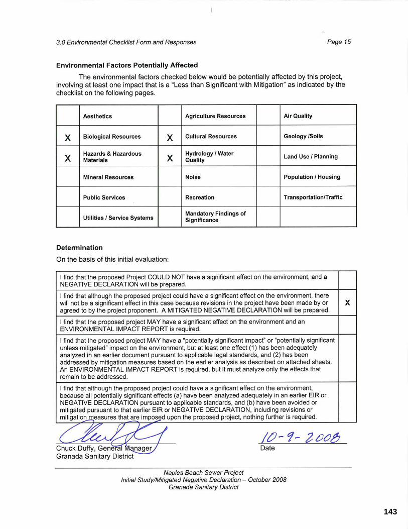
143

3.0 Environmental Checklist Form and Responses Page 16
Naples Beach Sewer Project Initial Study/Mitigated Negative Declaration – October 2008
Granada Sanitary District
3.1 AESTHETICSPotentially Significant
Impact
Less Than Significant
with Mitigation
Less Than Significant
Impact
NoImpact
Would the project:
a) Have a substantial adverse effect on a scenic vista?
b) Substantially damage scenic resources, including, but not limited to, trees, rock outcroppings, and historic buildings within a state scenic highway?
c) Substantially degrade the existing visual character or quality of the site and its surroundings?
d) Create a new source of substantial light or glare which would adversely affect day or nighttime views in the area?
Environmental Setting
The project is located in a residential area near Naples Beach, in the City of Half Moon Bay. Only the above ground electrical panels and a metal engine generator at the existing Naples Beach pump station (see Photo 2), are visible from the street or adjacent residences. All other sewer facilities will be located underground and therefore will not be visible from streets or residences. State Route 1 (also known as Cabrillo Highway on the coastside) in the vicinity of the project area is eligible for listing as a State Scenic Highway in the area, but is not yet officially designated. State Route 1 is identified as a Scenic Corridor in the City of Half Moon Bay (City) Local Coastal Program and various policies are in place to maintain the scenic resources along the corridor.
Discussion
Would the project:
a) Have a substantial adverse effect on a scenic vista?
b) Substantially damage scenic resources, including, but not limited to, trees, rock outcroppings, and historic buildings within a state scenic highway?
c) Substantially degrade the existing visual character or quality of the site and its surroundings?
d) Create a new source of substantial light or glare which would adversely affect day or nighttime views in the area?
Less Than Significant Impact (a-d). With the exception of rehabilitating the above ground electrical panels and a metal engine generator at the existing Naples Beach pump station all other sewer improvements will occur underground and will not be visible from street level. No new above ground structures are proposed. The only above ground improvements proposed are the rehabilitation (non-reflective painting) or replacement of existing electrical panels and a metal engine-generator enclosure at the Naples Beach Pump Station located within a chain link fenced area on San Pablo Avenue (Photo 2). There are no officially
144

3.0 Environmental Checklist Form and Responses Page 17
Naples Beach Sewer Project Initial Study/Mitigated Negative Declaration – October 2008
Granada Sanitary District
designated State Scenic Highways in the project area and no new lighting is proposed. Unpaved portions of new sewer alignment would be reseeded and restored to previous conditions following construction.
No night lighting is proposed at the pump station.
Photo 2. Naples Beach Pump Station
This photo shows the existing Naples Beach pump station. Existing electrical panels and a metal-engine generator enclosure will be rehabilitated (painted) or replaced in kind.
145

3.0 Environmental Checklist Form and Responses Page 18
Naples Beach Sewer Project Initial Study/Mitigated Negative Declaration – October 2008
Granada Sanitary District
3.2 AGRICULTURE RESOURCES Potentially Significant
Impact
Less Than Significant
with Mitigation
Less Than Significant
Impact
NoImpact
Would the project*:
a) Convert Prime Farmland, Unique Farmland, or Farmland of Statewide Importance (Farmland), as shown on the maps prepared pursuant to the Farmland Mapping and Monitoring Program of the California Resources Agency, to non-agricultural use?
b) Conflict with existing zoning for agricultural use, or a Williamson Act contract?
c) Involve other changes in the existing environment which, due to their location or nature, could result in conversion of Farmland, to non-agricultural use?
*In determining whether impacts to agricultural resources are significant environmental effects, lead agencies may refer to the California Agricultural Land Evaluation and Site Assessment Model (1997) prepared by the California Dept. of Conservation as anoptional model to use in assessing impacts on agriculture and farmland.
Environmental Setting
The linear pipeline project is located under streets within the City of Half Moon Bay, on an existing District easement on Caltrans property, an easement on private property (APN 048-124-140) through a restaurant parking lot adjacent to a residential area, on Caltrans property (requiring an encroachment permit), and on an easement from California Department of Parks and Recreation. Land adjacent to the eastern side of State Route 1 right-of-way is zoned A-1 agricultural, a designation specifically for floriculture (flower growing). This agricultural land is also mapped as Unique Farmland by the California Resources Agency.
Discussion
Would the project:
a) Convert Prime Farmland, Unique Farmland, or Farmland of Statewide Importance (Farmland), as shown on the maps prepared pursuant to the Farmland Mapping and Monitoring Program of the California Resources Agency, to non-agricultural use?
b) Conflict with existing zoning for agricultural use, or a Williamson Act contract?
c) Involve other changes in the existing environment which, due to their location or nature, could result in conversion of Farmland to non-agricultural use?
No Impact (a-c). The project improvements will be located either under City of Half Moon Bay streets, within an easement through a parcel with a paved parking area, on District property, within Caltrans State Route 1 right-of-way, or in an easement on California Department of Parks and Recreation property. No improvements will take place on property designated as Prime Farmland, Unique Farmland, Farmland of Statewide Importance or property for which there is a Williamson Act contract. The project does not result in the
146

3.0 Environmental Checklist Form and Responses Page 19
Naples Beach Sewer Project Initial Study/Mitigated Negative Declaration – October 2008
Granada Sanitary District
conversion of Farmland to non-agricultural use. Therefore, no adverse impacts to agricultural resources are anticipated.
147
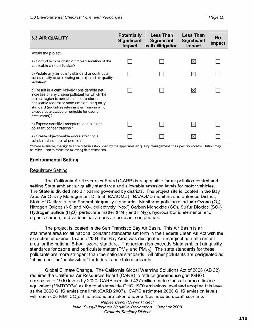
3.0 Environmental Checklist Form and Responses Page 20
Naples Beach Sewer Project Initial Study/Mitigated Negative Declaration – October 2008
Granada Sanitary District
3.3 AIR QUALITY Potentially Significant
Impact
Less Than Significant
with Mitigation
Less Than Significant
Impact
NoImpact
Would the project:
a) Conflict with or obstruct implementation of the applicable air quality plan?
b) Violate any air quality standard or contribute substantially to an existing or projected air quality violation?
c) Result in a cumulatively considerable net increase of any criteria pollutant for which the project region is non-attainment under an applicable federal or state ambient air quality standard (including releasing emissions which exceed quantitative thresholds for ozone precursors)?
d) Expose sensitive receptors to substantial pollutant concentrations?
e) Create objectionable odors affecting a substantial number of people?
*Where available, the significance criteria established by the applicable air quality management or air pollution control District may be relied upon to make the following determinations.
Environmental Setting
Regulatory Setting
The California Air Resources Board (CARB) is responsible for air pollution control and setting State ambient air quality standards and allowable emission levels for motor vehicles. The State is divided into air basins governed by districts. The project site is located in the Bay Area Air Quality Management District (BAAQMD). BAAQMD monitors and enforces District, State of California, and Federal air quality standards. Monitored pollutants include Ozone (O3),Nitrogen Oxides (NO and NO2, collectively “Nox”) Carbon Monoxide (CO), Sulfur Dioxide (SO2),Hydrogen sulfide (H2S), particulate matter (PM10 and PM2.5), hydrocarbons, elemental and organic carbon, and various hazardous air pollutant compounds.
The project is located in the San Francisco Bay Air Basin. This Air Basin is an attainment area for all national pollutant standards set forth in the Federal Clean Air Act with the exception of ozone. In June 2004, the Bay Area was designated a marginal non-attainment area for the national 8-hour ozone standard. The region also exceeds State ambient air quality standards for ozone and particulate matter (PM10 and PM2.5). The state standards for these pollutants are more stringent than the national standards. All other pollutants are designated as “attainment” or “unclassified” for federal and state standards.
Global Climate Change. The California Global Warming Solutions Act of 2006 (AB 32) requires the California Air Resources Board (CARB) to reduce greenhouse gas (GHG) emissions to 1990 levels by 2020. CARB identified 427 million metric tons of carbon dioxide equivalent (MMTCO2e) as the total statewide GHG 1990 emissions level and adopted this level as the 2020 GHG emissions limit (CARB 2007). CARB estimates 2020 GHG emission levels will reach 600 MMTCO2e if no actions are taken under a “business-as-usual” scenario.
148

3.0 Environmental Checklist Form and Responses Page 21
Naples Beach Sewer Project Initial Study/Mitigated Negative Declaration – October 2008
Granada Sanitary District
The 1990 GHG inventory includes the following gases: carbon dioxide (CO2), methane (CH4), nitrous oxide (N2O), sulfur hexafluoride (SF6), hydrofluorocarbons (HFCs) and perfluorocarbons (PFCs). Each GHG has a different capacity to trap heat in the atmosphere by absorbing infrared radiation. Almost 90% of the total GHG identified in the inventory is CO2.The majority of 1990 emissions are tied to fuel use activities such as electrical generation, transportation, and industrial operations (CARB 2007). CARB is starting to develop the Scoping Plan mandated by AB 32. Development of the Scoping Plan will include an analysis of potential emission reductions across all sectors. CARB is developing policy scenarios to describe a range of possible approaches to implementing AB 32, such as use of a carbon fee, use of a cap and trade program, or reliance on direct regulations on emission sources or industrial sectors.
Pursuant to Senate Bill 97 (Chapter 185, 2007) the Governor’s Office of Planning and Research (OPR) is in the process of developing CEQA guidelines “for the mitigation of greenhouse gas emissions or the effects of greenhouse gas emissions.” OPR is required to “prepare, develop, and transmit” the guidelines to the Resources Agency on or before July 1, 2009. The Resources Agency must certify and adopt the guidelines on or before January 1, 2010. Until guidelines are adopted by the Resources Agency, there are no standards in effect to measure the significance of a project’s contribution of greenhouse gas emissions to global climate change.
Existing Ambient Air Quality
The District operates a network of monitoring sites in the area and maintains a database of air quality data collected from these monitoring locations. The closest monitoring sites are in Redwood City, about 13 miles away and in San Francisco on Arkansas Street, about 19 miles away. Ambient air quality tends to be better along the coast as prevailing winds carry pollutants inland.
Sensitive Receptors
The closest sensitive receptors in the project vicinity are the residences on streets where sewer improvements are proposed. Sensitive receptors in this case are people that may have health problems. The most common air quality effects from construction sites are dust (PM10)and increased emissions from construction vehicles. These effects can be problematic for the young or old or those with asthma or emphysema.
Discussion
Would the project:
a) Conflict with or obstruct implementation of the applicable air quality plan?
Less Than Significant Impact. The Bay Area Air Quality Management District (BAAQMD) has implemented the Bay Area 2005 Ozone Strategy to achieve compliance with the State’s one-hour air quality standard for ozone emissions and reduce ozone and ozone precursor emissions. The project will not conflict or obstruct the implementation of this plan as it would not contribute to urban growth or introduce new sources of air pollutants into the basin. Therefore, the impact is considered less than significant.
149

3.0 Environmental Checklist Form and Responses Page 22
Naples Beach Sewer Project Initial Study/Mitigated Negative Declaration – October 2008
Granada Sanitary District
b) Violate any air quality standard or contribute to an existing or projected air quality violation?
Less Than Significant Impact. Construction equipment emits carbon monoxide and ozone precursors. These construction equipment emissions may affect localized air quality on a short-term basis during construction. However, because the project is small and the construction period for the project is about ten months for Phase 1 and six months for Phase 2 (the construction and installation of the sewer pipeline will last for approximately 5 working days (and may not be consecutive) in front of any given residence, construction emissions will not significantly contribute to violation of any air quality standard or significantly contribute to an existing or projected air quality violation. Construction emissions have been included in the emission inventory that is the basis for the regional air quality plans and are not expected to impede attainment or maintenance of ozone and carbon monoxide standards in the Bay Area (BAAQMD 1999).
Dust (PM10) is the other air quality issue related to construction. The BAAQMD has identified a set of feasible PM10 control measures for construction activities. These measures are incorporated into the project (see Project Description).
1) Water all construction areas at least twice daily. 2) Cover all trucks hauling soil, sand and other loose materials or require all trucks to
maintain at least two feed of freeboard. 3) Pave, apply water three times daily, or apply (non-toxic) soil stabilizers on all
unpaved access roads, parking areas, and staging areas at construction sites. 4) Sweep daily (with water sweepers) all paved access roads, parking areas, and
staging areas at construction sites. 5) Sweep daily (with water sweepers) if visible soil material is carried out onto adjacent
public streets.
These BMPs, if properly implemented, will ensure that construction-related air quality impacts are minimized.
The project will install and modify sewer facilities and modify sewers to convert the Medio Creek sewer crossing to be used for emergency use only. The project will not result in increased sewer capacity and because most of the sewer project is to be installed under existing residential streets, the project will not significantly contribute to existing or projected air quality violations. No long-term operational air quality impacts are expected to occur, thus the impact is considered less than significant.
c) Result in a cumulatively considerable net increase of any criteria pollutant for which the project region is non-attainment under an applicable federal or state ambient air quality standard (including releasing emissions which exceed quantitative thresholds for ozone precursors)?
Less Than Significant Impact. The San Francisco Bay Area is in non-attainment for ozone. The primary source of ozone precursors is motor vehicle exhaust emissions; however the project will not have any effect on vehicle trips and thus vehicle emissions. The project will cause carbon monoxide and dust emissions during construction which are already included in the emission inventory that is the basis for the regional air quality plans within the BAAQMD.The project will not result in urban growth or introduce new sources of air pollution; therefore the project will not result in cumulative air quality impacts.
150

3.0 Environmental Checklist Form and Responses Page 23
Naples Beach Sewer Project Initial Study/Mitigated Negative Declaration – October 2008
Granada Sanitary District
d) Expose sensitive receptors to substantial pollutant concentrations?
Less Than Significant Impact. The project will not result in an increase in population or result in a new source of stationary or ongoing permanent mobile emissions. Given the short duration, the nature of construction activities and implementation of BMPs (as listed in the project description of this document) to control dust that are consistent with BAAQMD requirements, the project will not expose sensitive receptors to substantial pollutant concentrations. Therefore, the impact is considered less than significant.
e) Create objectionable odors affecting a substantial number of people?
Less Than Significant Impact. The project would reduce the potential for odors overall because it will reduce the time the sewage is in the collection system which reduces the time allowed for the formation of odors. Therefore, the impact is considered less than significant.
151

3.0 Environmental Checklist Form and Responses Page 24
Naples Beach Sewer Project Initial Study/Mitigated Negative Declaration – October 2008
Granada Sanitary District
3.4 BIOLOGICAL RESOURCES Potentially Significant
Impact
Less Than Significant
with Mitigation
Less Than Significant
Impact
NoImpact
Would the project:
a) Have a substantial adverse effect, either directly or through habitat modifications, on any species identified as a candidate, sensitive, or special status species in local or regional plans, policies, or regulations, or by the California Department of Fish and Game or U.S. Fish and Wildlife Service?
b) Have a substantial adverse effect on any riparian habitat or other sensitive natural community identified in local or regional plans, policies, regulations or by the California Department of Fish and Game or US Fish and Wildlife Service?
c) Have a substantial adverse effect on federally protected wetlands as defined by Section 404 of the Clean Water Act (including, but not limited to, marsh, vernal pool, coastal, etc.) through direct removal, filling, hydrological interruption, or other means?
d) Interfere substantially with the movement of any native resident or migratory fish or wildlife species or with established native resident or migratory wildlife corridors, or impede the use of native wildlife nursery sites?
e) Conflict with any local policies or ordinances protecting biological resources, such as a tree preservation policy or ordinance?
f) Conflict with the provisions of an adopted Habitat Conservation Plan, Natural Community Conservation Plan, or other approved local, regional, or state habitat conservation plan?
Environmental Setting
The project improvements will involve trenching beneath existing city streets, an easement on a 0.08-acre parcel of private property (APN 048-124-140), State Route 1 right-of-way, and Ramona Way. Biological surveys of the project area were conducted on November 10th, 2006, November 14th 2006, and May 23rd, 2007 by TRA (see Appendix A, Biological Report). Based upon these field visits, no sensitive plants or wildlife were observed along the proposed project alignment.
There is a small unnamed creek (Photo 3) that crosses Alameda Avenue through a 48-inch culvert (Photo 4), just south of San Pablo Street. The force main will cross under this 48-inch culvert and will not require altering the culvert or work in the creek.
The vegetation upstream and downstream of the unnamed creek that crosses Alameda Avenue just south of San Pablo Street is heavily dominated by arroyo willow (Salix lasiolepis),
152

3.0 Environmental Checklist Form and Responses Page 25
Naples Beach Sewer Project Initial Study/Mitigated Negative Declaration – October 2008
Granada Sanitary District
Ngaio or Lollypop tree (Myoporum laetum), nasturtium (Tropaeolum majus), English ivy (Hederahelix) and horsetail (Equisetum arvense).
Photo 3. Unnamed creek looking upstream from the eastern side of Alameda Avenue (11/14/2006)
Photo 4. View of the culvert from the eastern (upstream) side of Alameda Avenue (11/14/2006)
153

3.0 Environmental Checklist Form and Responses Page 26
Naples Beach Sewer Project Initial Study/Mitigated Negative Declaration – October 2008
Granada Sanitary District
The Naples Beach pump station site is surrounded by a 6-foot chain link fence (see Photo 2). Vegetation at the site includes: nonnative weedy species such as bristly ox-tongue (Picris echioides), ice plant (Drosanthemum floribundum), Ngaio or Lollypop tree (Myoporum laetum), native horsetail (Equisetum arvense) and annual grasses.
The vegetation on the parcel at the eastern end of Washington Boulevard (see Photo 5) is dominated by mowed grass. Other vegetation in and around the site includes bristly ox-tongue (Picris echoides), wild radish (Raphanus sativus), pampas grass (Cortaderia selloana),clover species, California aster (Aster chilensis), rattlesnake grass (Briza maxima) and fennel (Foeniculum vulgare) among others. Trees within this area (Photos 5 and 9) include Monterey pine (Pinus radiata) a unique species according to Half Moon Bay Zoning Code 18.38.090. Tree removal to accommodate pipeline alignment is not anticipated. The area adjacent to State Route 1 on Caltrans property requiring and encroachment permit is disturbed and vegetated with mowed grass.
Ramona Way (Photo 6) is a paper street owned by the California Department of Parks and Recreation (Half Moon Bay State Park). This paper street is currently undeveloped and is highly disturbed. Consequently, vegetation is dominated by ruderal species such as wild radish, poison hemlock, (Conium maculatum), Himalayan blackberry (Rubus discolor), English ivy, wild oats (Avena sp.), field mustard (Brassica rapa), Malva sp., bristly ox-tongue, and cutleaf geranium (Geranium dissectum). Several Monterey cypresses (Cupressus macrocarpa) are present on the site.
All other improvements will occur within existing city streets. (Photos 7 and 8)
According to a search of the California Natural Diversity Database (CNDDB), special-status animal species known to occur near the study area include the California red-legged frog (CRLF) (Rana aurora draytonii) and monarch butterflies. The presence of CRLF on any of the sites that are part of the proposed project is unlikely given the distance from known occurrences (the nearest about one mile across developed land). In addition there is no suitable habitat present for the CLRF at the project site that would be affected by project activities (which are confined to existing streets near the unnamed creek). Monterey pine groves are habitat for over-wintering monarch butterflies; however, the Monterey pine trees at the parcel do not form a grove that would provide adequate shelter from the environment, therefore there are no anticipated impacts to monarch butterflies.
Further discussion on policies related to Half Moon Bay Zoning Code 18.38, Coastal Resource Conservation Standards and Half Moon Bay LCP Chapter 3, Environmentally Sensitive Habitat Areas of are contained in Chapter 3.9 Land Use.
154

3.0 Environmental Checklist Form and Responses Page 27
Naples Beach Sewer Project Initial Study/Mitigated Negative Declaration – October 2008
Granada Sanitary District
Photo 5. Parcel at the end of Washington Boulevard (11/14/2006)
Photo 6. Ramona Way portion of sewer alignment (5/23/2007)
155

3.0 Environmental Checklist Form and Responses Page 28
Naples Beach Sewer Project Initial Study/Mitigated Negative Declaration – October 2008
Granada Sanitary District
Photo 7. Mirada Road with the undeveloped Ramona Way on the right. Phase 2 will construct and connect new sewer lines along Mirada Road and Ramona Way. (5/23/2007)
Photo 8. Alameda Avenue, looking east from Mirada Road. The new sewer line (approx. 300 feet long) installed under this portion of Alameda Avenue is part of Phase 1.(5/23/2007)
156
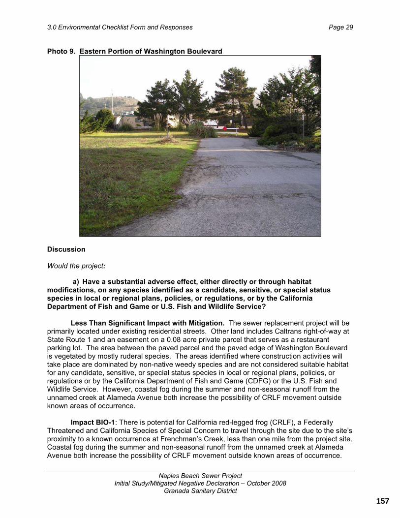
3.0 Environmental Checklist Form and Responses Page 29
Naples Beach Sewer Project Initial Study/Mitigated Negative Declaration – October 2008
Granada Sanitary District
Photo 9. Eastern Portion of Washington Boulevard
Discussion
Would the project:
a) Have a substantial adverse effect, either directly or through habitat modifications, on any species identified as a candidate, sensitive, or special status species in local or regional plans, policies, or regulations, or by the California Department of Fish and Game or U.S. Fish and Wildlife Service?
Less Than Significant Impact with Mitigation. The sewer replacement project will be primarily located under existing residential streets. Other land includes Caltrans right-of-way at State Route 1 and an easement on a 0.08 acre private parcel that serves as a restaurant parking lot. The area between the paved parcel and the paved edge of Washington Boulevard is vegetated by mostly ruderal species. The areas identified where construction activities will take place are dominated by non-native weedy species and are not considered suitable habitat for any candidate, sensitive, or special status species in local or regional plans, policies, or regulations or by the California Department of Fish and Game (CDFG) or the U.S. Fish and Wildlife Service. However, coastal fog during the summer and non-seasonal runoff from the unnamed creek at Alameda Avenue both increase the possibility of CRLF movement outside known areas of occurrence.
Impact BIO-1: There is potential for California red-legged frog (CRLF), a Federally Threatened and California Species of Special Concern to travel through the site due to the site’s proximity to a known occurrence at Frenchman’s Creek, less than one mile from the project site. Coastal fog during the summer and non-seasonal runoff from the unnamed creek at Alameda Avenue both increase the possibility of CRLF movement outside known areas of occurrence.
157

3.0 Environmental Checklist Form and Responses Page 30
Naples Beach Sewer Project Initial Study/Mitigated Negative Declaration – October 2008
Granada Sanitary District
Mitigation Measure BIO-1: If possible, all construction shall be scheduled to occur during the dry season (May 1- October 31). If work is scheduled during the dry season, the following measures apply:
Conduct a worker education program, and Conduct a single daytime survey for CRLF prior to work within 100 feet of the culvert under Alameda Avenue, and At the end of each work day, all holes and trenches shall be covered with steel plates or backfilled to avoid trapping animals overnight.
If any phase of construction for this project occurs during the rainy season (November 1 to April 30) the following measures shall apply:
Conduct a worker education program, and Conduct one nighttime and one daytime pre-construction survey for CRLF when construction activities approach within 100 feet of the culvert under Alameda Avenue, and At the end of each work day, all holes and trenches shall be covered or backfilled to avoid trapping animals overnight. A biologist shall check the site at the start of each day (prior to the start of construction activities) during the time that construction is located within 100 feet of the culvert crossing under Alameda Avenue.
A worker education program is essentially an informational meeting held prior to the start of all construction activities. The worker education program shall be conducted by a United States Fish and Wildlife (USFWS)-approved CRLF biologist and all construction staff (foreman, laborers, and equipment operators) shall be required to attend this meeting. The program shall inform the workers of CRLF protection status, identification, life history, avoidance measures, and reporting procedures (who to contact) if any CRLF are found on-site. A record of attendance shall be kept by the District.
The preconstruction nighttime survey for CRLF shall occur within 48 hours of the start of construction within 100 feet of the culvert crossing under Alameda Avenue. The daytime survey (also within 100 feet of the culvert crossing) shall occur the morning of and prior to the start of construction activities. The survey results shall be noted in a report or memo and submitted to the Granada Sanitary District within one week of the day survey. If CRLF are found at any time during construction, an USFWS-approved CRLF biologist shall be contacted for instructions on how to proceed.
Once construction has been scheduled, a biologist shall be hired to perform pre-construction surveys and/or regular morning site checks (according to dry or rainy season requirements as detailed above) and shall develop a monitoring plan prior to the start of construction activities. A copy of the plan shall be provided to the City.
Effectiveness: This measure will avoid impacts to CRLF.
Implementation: The District shall incorporate this measure into building/grading permit plans and all construction contracts; District shall implement these measures
Timing: Prior to approval of final project plans
158
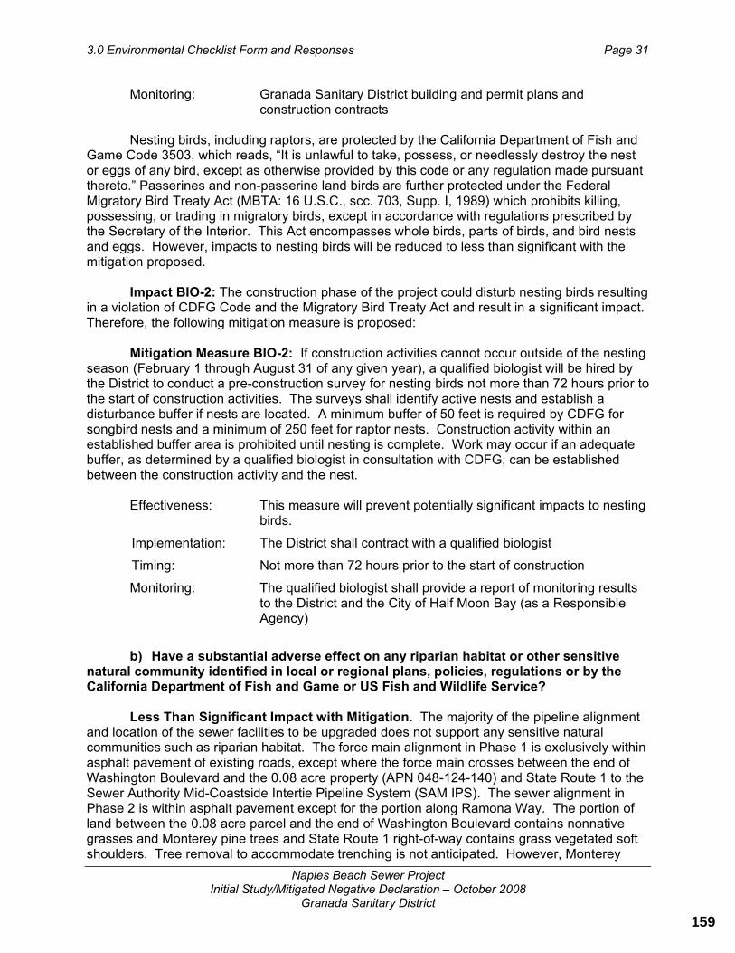
3.0 Environmental Checklist Form and Responses Page 31
Naples Beach Sewer Project Initial Study/Mitigated Negative Declaration – October 2008
Granada Sanitary District
Monitoring: Granada Sanitary District building and permit plans and construction contracts
Nesting birds, including raptors, are protected by the California Department of Fish and Game Code 3503, which reads, “It is unlawful to take, possess, or needlessly destroy the nest or eggs of any bird, except as otherwise provided by this code or any regulation made pursuant thereto.” Passerines and non-passerine land birds are further protected under the Federal Migratory Bird Treaty Act (MBTA: 16 U.S.C., scc. 703, Supp. I, 1989) which prohibits killing, possessing, or trading in migratory birds, except in accordance with regulations prescribed by the Secretary of the Interior. This Act encompasses whole birds, parts of birds, and bird nests and eggs. However, impacts to nesting birds will be reduced to less than significant with the mitigation proposed.
Impact BIO-2: The construction phase of the project could disturb nesting birds resulting in a violation of CDFG Code and the Migratory Bird Treaty Act and result in a significant impact. Therefore, the following mitigation measure is proposed:
Mitigation Measure BIO-2: If construction activities cannot occur outside of the nesting season (February 1 through August 31 of any given year), a qualified biologist will be hired by the District to conduct a pre-construction survey for nesting birds not more than 72 hours prior to the start of construction activities. The surveys shall identify active nests and establish a disturbance buffer if nests are located. A minimum buffer of 50 feet is required by CDFG for songbird nests and a minimum of 250 feet for raptor nests. Construction activity within an established buffer area is prohibited until nesting is complete. Work may occur if an adequate buffer, as determined by a qualified biologist in consultation with CDFG, can be established between the construction activity and the nest.
Effectiveness: This measure will prevent potentially significant impacts to nesting birds.
Implementation: The District shall contract with a qualified biologist
Timing: Not more than 72 hours prior to the start of construction
Monitoring: The qualified biologist shall provide a report of monitoring results to the District and the City of Half Moon Bay (as a Responsible Agency)
b) Have a substantial adverse effect on any riparian habitat or other sensitive natural community identified in local or regional plans, policies, regulations or by the California Department of Fish and Game or US Fish and Wildlife Service?
Less Than Significant Impact with Mitigation. The majority of the pipeline alignment and location of the sewer facilities to be upgraded does not support any sensitive natural communities such as riparian habitat. The force main alignment in Phase 1 is exclusively within asphalt pavement of existing roads, except where the force main crosses between the end of Washington Boulevard and the 0.08 acre property (APN 048-124-140) and State Route 1 to the Sewer Authority Mid-Coastside Intertie Pipeline System (SAM IPS). The sewer alignment in Phase 2 is within asphalt pavement except for the portion along Ramona Way. The portion of land between the 0.08 acre parcel and the end of Washington Boulevard contains nonnative grasses and Monterey pine trees and State Route 1 right-of-way contains grass vegetated soft shoulders. Tree removal to accommodate trenching is not anticipated. However, Monterey
159
3.0 Environmental Checklist Form and Responses Page 32
Naples Beach Sewer Project Initial Study/Mitigated Negative Declaration – October 2008
Granada Sanitary District
pines are identified as a Unique Species according to Half Moon Bay Zoning Code 18.38.090, and trenching could damage tree roots compromising the trees’ health. Therefore the following mitigation measure is proposed:
Impact BIO-3: Trenching at the end of Washington Boulevard could potentially damage one or more Monterey pine trees, identified as Unique Species according to the Half Moon Bay Zoning Code (18.38.090).
Mitigation Measure BIO-3: A certified arborist shall be consulted prior to the finalization of project plans. The avoidance and protection measures recommended by the arborist as necessary to avoid adversely impacting the Monterey pine trees near Washington Boulevard shall be implemented.
Effectiveness: This measure will prevent harming Monterey pine trees, identified as Unique Species according to the HMB Zoning Code.
Implementation: The District shall contract with a certified arborist
Timing: Prior to approval of final project plans
Monitoring: Granada Sanitary District; the certified arborist shall provide a report of recommendations to the District and Half Moon Bay (as a Responsible Agency)
The force main will be trenched (may be hand excavated) beneath a 48-inch culvert conveying water under Alameda Avenue (near San Pablo Avenue) from an unnamed blue-line creek (as shown on the Half Moon Bay USGS Quadrangle) with drainage primarily originating from the farming operations and an unnamed water feature on the eastern side of State Route 1 (about 0.5 mile northeast from State Route 1). The culvert and the flow within it will not require any alteration during trenching activities. All trenching activities are confined to the paved streets; therefore no riparian habitat associated with the culverted creek will be impacted by project activities.
Erosion and water quality control mitigation measures to ensure that storm water runoff from the project does not cause significant environmental impacts are listed in the Hydrology and Water Quality section of this document.
Under the full project (Phase 1 and Phase 2), the Medio Creek sewer crossing would be left in place to serve as a backup facility in case there is an emergency causing a disruption of service in the Naples Beach area. It is anticipated that this type of emergency might occur once every ten years. In addition, until funding for Phase 2 is approved, 4,000 to 5,000 gallons of sewage per day will continue to flow through the sewer crossing at Medio Creek.
There is a chance that the Medio Creek bridge could fail while carrying the remaining 4,000 to 5,000 gallons of sewage that would be diverted under Phase 2 or while the sewer crossing is in use during an emergency (under full project) and could result in a sewage spill. However, if the project were not implemented (Phase 1 at a minimum would be implemented) the resulting sewage spill would be much worse than if the project were not to occur at all (existing conditions). In addition, if the Medio Creek sewer crossing were not left in place as a backup facility (as under the full project, Phase 1 and Phase 2), any disruption of service in the Naples Beach area in could result in a sewage spill. As mentioned in the project description,
160

3.0 Environmental Checklist Form and Responses Page 33
Naples Beach Sewer Project Initial Study/Mitigated Negative Declaration – October 2008
Granada Sanitary District
the District monitors the pipeline for structural integrity several times a year, usually after large winter storms.
c) Have a substantial adverse effect on federally protected wetlands as defined by Section 404 of the Clean Water Act (including, but not limited to, marsh, vernal pool, coastal, etc.) through direct removal, filling, hydrological interruption, or other means?
No Impact. A biological survey found that there were no areas subject to ponding or areas that exhibited wetland plant species. Therefore, it was determined that there is an absence of federally protected wetlands on the alignment where construction activities will take place.
d) Interfere substantially with the movement of any native resident or migratory fish or wildlife species or with established native resident or migratory wildlife corridors, or impede the use of native wildlife nursery sites?
Less Than Significant Impact. The construction of the majority of the force main pipeline will be within existing residential streets and most of the pump station facility improvements will be located underground. Above ground improvements are very minor and include painting or replacing equipment box enclosures or panels at the existing pump station location. The sewer pipeline construction will traverse a 0.08 acre parcel and will also traverse the grass vegetated Caltrans right-of-way for State Route 1. There are no above ground features proposed that would block the movement of native resident or migratory fish or wildlife species or would be located in established native resident or migratory wildlife corridors or impede the use of native wildlife nursery sites. The continued operation of these sewer facilities would also not interfere with the movement of any native resident or migratory fish or wildlife species or with established native resident or migratory wildlife corridors, or impede the use of native wildlife nursery sites.
e) Conflict with any local policies or ordinances protecting biological resources, such as a tree preservation policy or ordinance?
No Impact. No trees will be removed as a result of the project. The project would not conflict with any local polices or ordinances protecting biological resources. A variety of policies contained in the Half Moon Bay LCP and General Plan apply to biological resources. The project was found in conformance with these policies (Appendix A).
f) Conflict with the provisions of an adopted Habitat Conservation Plan, Natural Community Conservation Plan, or other approved local, regional, or state habitat conservation plan?
No Impact. The proposed project will not conflict with any Habitat Conservation Plan or Natural Community Conservation Plan (HCP/NCCP). There are no HCP/NCCPs in effect covering the project area.
161

3.0 Environmental Checklist Form and Responses Page 34
Naples Beach Sewer Project Initial Study/Mitigated Negative Declaration – October 2008
Granada Sanitary District
3.5 CULTURAL RESOURCES Potentially Significant
Impact
Less Than Significant
with Mitigation
Less Than Significant
Impact
NoImpact
Would the project:
a) Cause a substantial adverse change in the significance of a historical resource as defined in §15064.5?
b) Cause a substantial adverse change in the significance of an archaeological resource pursuant to §15064.5?
c) Directly or indirectly destroy a unique paleontological resource or site or unique geologic feature?
d) Disturb any human remains, including those interred outside of formal cemeteries?
Environmental Setting
Cultural resources include prehistoric and historic archaeological sites, districts, and objects; standing historic structures, buildings, districts, and objects; and locations of important historic events or sites of traditional and/or cultural importance to various groups.
California Environmental Quality Act. The California Environmental Quality Act (CEQA) requires a review to determine if the project will have a significant effect on archaeological sites or properties of historic or cultural significance to a community or ethnic group eligible for inclusion on the California Register of Historic Places (CRHR). The CRHR (Section 5024.1) is a listing of those properties that are to be protected from substantial adverse change, and it includes properties that are listed, or have been formally determined to be eligible for listing in, the National Register of Historic Places (NRHP), State Historical Landmarks, and eligible Points of Historical Interest. A historical resource may be listed in the CRHR if it meets one or more of the following criteria:
it is associated with events that have made a significant contribution to the broad patterns of local or regional history, or the cultural heritage of California or the United States;
it is associated with the lives of persons important to local, California, or national history;
it embodies the distinctive characteristics of a type, period, region, or method of construction, or represents the work of a master or possesses high artistic values; or
it has yielded or has the potential to yield information important in the prehistory or history of the local area, California, or the nation.
Historical Resources. Public Resources Code (PRC) Section 21084.1 stipulates that any resource listed in, or eligible for listing in, the CRHR is presumed to be historically or culturally significant. Resources listed in a local historic register or deemed significant in a historical resource survey (as provided under PRC Section 5024.1g) are presumed historically or culturally significant unless the preponderance of evidence demonstrates they are not. A
162

3.0 Environmental Checklist Form and Responses Page 35
Naples Beach Sewer Project Initial Study/Mitigated Negative Declaration – October 2008
Granada Sanitary District
resource that is not listed in or determined to be eligible for listing in the CRHR, not included in a local register or historic resources, or not deemed significant in a historical resource survey may nonetheless be historically significant (PRC Section 21084.1). This provision is intended to give the Lead Agency discretion to determine that a resource of historic significance exists where none had been identified before and to apply the requirements of PRC Section 21084.1 to properties that have not previously been formally recognized as historic.
CEQA equates a substantial adverse change in the significance of a historical resource with a significant effect on the environment (PRC Section 21084.1) and defines substantial adverse change as demolition, destruction, relocation, or alteration that will impair historical significance (PRC Section 5020.1).
Archaeological Resources. Where a project may adversely affect a unique archaeological resource, PRC Section 21083.2 requires the Lead Agency to treat that effect as a significant environmental effect. When an archaeological resource is listed in or is eligible to be listed in the CRHR, PRC Section 21084.1 requires that any substantial adverse effect to that resource be considered a significant environmental effect. PRC Sections 21083.2 and 21084.1 operate independently to ensure that potential effects on archaeological resources are considered as part of a project's environmental analysis. Either of these benchmarks may indicate that a project may have a potential adverse effect on archaeological resources.
Half Moon Bay LCP Policies and Ordinances. Policy 6-4 of the Half Moon Bay LCP states that projects involving substantial excavation have the potential to destroy archaeological resources in areas designated on the Map of Potential Archaeological Resources, therefore surveys should be conducted and an opportunity be made to sample and salvage the site by a qualified archaeologist as part of the project. Half Moon Bay Ordinance 18.38.040 also specifies requirements for the identification, protection, and mitigation of archaeological resources.
Other California Laws and Regulations. Other state-level requirements for cultural resources management appear in the California PRC Chapter 1.7, Section 5097.5 “Archaeological, Paleontological, and Historical Sites,” and Chapter 1.75 beginning at Section 5097.9 “Native American Historical, Cultural, and Sacred Sites” for lands owned by the state or a state agency.
The disposition of Native American burials is governed by Section 7050.5 of the California Health and Safety Code and sections 5097.94 and 5097.98 of the PRC, and falls within the jurisdiction of the Native American Heritage Commission (NAHC).
Cultural Resources Archaeological Survey in Project Area. The project is located within an area where undeveloped sites are identified as potentially sensitive for archaeological resources (Half Moon Bay 1993). Homan and Associates, archaeological consultants conducted a literature review at the North West Information Center located at Sonoma State University to obtain information about recorded archaeological sites in and around the project area and any formal archaeological reports done for the area. The literature review results are documented in a letter dated November 14, 2006 (see Appendix B) which revealed that the project is located in an area of high archaeological sensitivity. There have been no formal archaeological surveys of the proposed project areas where new pipelines are proposed to be built, however, the literature review revealed one archaeological site less than a quarter mile from the project area. The archaeological site consists of a primarily earthen midden containing
163

3.0 Environmental Checklist Form and Responses Page 36
Naples Beach Sewer Project Initial Study/Mitigated Negative Declaration – October 2008
Granada Sanitary District
several human burials, bowl mortars, and other materials. The exact dimensions of the site were never determined as it is presumed to extend into already developed private property.
A visual field inspection for cultural resources was conducted on November 24, 2006 (See letter dated December 11, 2006 also in Appendix B). There was no evidence of prehistoric archaeological deposits observed at any of the locations inspected directly off the project pipeline rights-of-way or along the open section of the field (Ramona Way; previously the Ocean Shore Railroad right-of-way between Mirada Road and Alcatraz Avenue). This portion of the project area was heavily vegetated in late November, restricting visibility to about five percent of the ground surface. Where visible, the ground along the railroad right of way was littered with small pieces of ceramics and glass, dating from the time of construction and/or operation of the railroad.
The report concluded that there remains a moderate possibility for the discovery of both historic and prehistoric archaeological resources inside the project rights-of-way. Historic materials are evident on the surface of the portion of the new sewer line between Mirada Road and Alcatraz Avenue (see Figure 2). Prehistoric materials, primarily additional shell deposits similar to the materials found at the one archaeological site present within a quarter mile of the project area, could be found at any point along the proposed pipeline routes; the cursory examination of adjacent open lots did not provide sufficient coverage to rule out this possibility. The literature review and results of the visual field inspection are contained in Appendix B.
Discussion
Would the project:
a) Cause a substantial adverse change in the significance of a historical resource as defined in § 15064.5;
b) Cause a substantial adverse change in the significance of an archaeological resource pursuant § 15064.5;
c) Directly or indirectly destroy a unique paleontological resource or site or unique geologic feature; or,
d) Disturb any human remains, including those interred outside of formal cemeteries?
Less Than Significant Impact with Mitigation (a-d).
Impact CUL-1: Holman and Associates conducted an archaeological literature review and a visual inspection of the project site in November 2006 (Appendix B). The results of the literature review and visual inspection determined that the possibility of uncovering prehistoric and or historic materials at the site could not be ruled out. Therefore, the following mitigation measures are proposed:
Mitigation Measure CUL-1: The District shall retain the services of a qualified archaeological monitor to inspect the excavated pipeline route during construction and a full-time monitor for any work in the former railroad right-of-way (Ramona Way area). Unrecorded prehistoric archaeological resources could exist at any point along the pipeline right-of-way and there is a potential that excavation along the railroad right-of-way may uncover historic
164

3.0 Environmental Checklist Form and Responses Page 37
Naples Beach Sewer Project Initial Study/Mitigated Negative Declaration – October 2008
Granada Sanitary District
archaeological deposits associated with the construction and or short operation of the rail line itself.
In the event that any prehistoric and or historic deposits are encountered during earthmoving, it will be the responsibility of the project archaeologist to stop work within 50 feet of any discovery until a plan for the evaluation of the resource has been submitted to the City Planning Department for approval. Evaluation can take the form of limited hand excavation in order to demonstrate that the endangered resource is eligible for inclusion on the California Register of Historic Resources (CRHR).
Effectiveness: Implementation of monitoring during construction would prevent significant impacts by halting construction before damage is done and allowing the resources to be documented
Implementation: The District shall hire qualified archaeologists to monitor the site during construction. This measure shall be incorporated into building permit plans and construction contracts; District shall implement these measures
Timing: Measures shall be in evidence in project plans prior to issuance of the Coastal Development Permit. Actual monitoring shall occur during ground disturbing activities.
Monitoring: Granada Sanitary District; the archaeological monitor shall provide a report of monitoring results to the Granada Sanitary District and the City of Half Moon Bay
Mitigation Measure CUL-2: If a historic or prehistoric resource is determined eligible for the Register, a plan for its mitigation should be submitted to the City Planning Department for approval before work is allowed to recommence in areas of archaeological sensitivity as defined by the project archaeologist. Mitigation can take the form of data retrieval through additional hand excavation inside areas of impact, coupled with recording and or removal of significant cultural materials and information for future analysis and reporting purposes.
Effectiveness: Implementation of a measure to determine eligibility of previously unrecorded cultural resources would ensure proper care and handling of these resources.
Implementation: The District shall incorporate these measures into building permit plans and construction contracts; District shall implement these measures
Timing: During construction
Monitoring: Granada Sanitary District; the Mitigation Plan shall be submitted for approval to the City prior to recommencement of work in archaeologically sensitive areas as defined by the project archaeologist.
Mitigation Measure CUL-3: In the event that Native American human remains are discovered, work will be stopped in the area defined by the project archaeologist until the County Coroner’s Office and Native American Heritage Commission (NAHC) have been notified. In the case of Native American remains, the NAHC will name a Most Likely Descendant (MLD) to advise the District in the preferred manner of exhumation, exposure, removal, and reburial of all human remains and associated grave goods.
165

3.0 Environmental Checklist Form and Responses Page 38
Naples Beach Sewer Project Initial Study/Mitigated Negative Declaration – October 2008
Granada Sanitary District
Effectiveness: Suspension of work and notification of the County Coroner’s office and Native American Heritage Commission would ensure that any human remains and associated grave goods are properly handled.
Implementation: The District shall incorporate these measures into building permit plans and construction contracts; District shall implement these measures
Timing: During construction
Monitoring: Granada Sanitary District; the project archaeologist’s monitoring report shall demonstrate that this was accomplished
166

3.0 Environmental Checklist Form and Responses Page 39
Naples Beach Sewer Project Initial Study/Mitigated Negative Declaration – October 2008
Granada Sanitary District
3.6 GEOLOGY AND SOILS Potentially Significant
Impact
Less Than Significant
with Mitigation
Less Than Significant
Impact
NoImpact
Would the project:
a) Expose people or structures to potential substantial adverse effects, including the risk of loss, injury, or death involving:
i) Rupture of a known earthquake fault, as delineated on the most recent Alquist-Priolo Earthquake Fault Zoning Map issued by the State Geologist for the area or based on other substantial evidence of a known fault? Refer to Division of Mines and Geology Special Publication 42.
ii) Strong seismic ground shaking?
iii) Seismic-related ground failure, including liquefaction?
iv) Landslides?
b) Result in substantial soil erosion or the loss of topsoil?
c) Be located on a geologic unit or soil that is unstable, or that would become unstable as a result of the project, and potentially result in on- or off-site landslide, lateral spreading, subsidence, liquefaction or collapse?
d) Be located on expansive soil, as defined in Table 18-1-B of the Uniform Building Code (1994), creating substantial risks to life or property?
e) Have soils incapable of adequately supporting the use of septic tanks or alternative waste water disposal systems where sewers are not available for the disposal of waste water?
Environmental Setting
The California Geological Survey does not list the City of Half Moon Bay as a city affected by an Alquist-Priolo Earthquake Fault Zone (California Department of Conservation 2006); however, the nearest known major fault is the Northern San Gregorio Fault. This Fault is located off shore in the Pacific Ocean, about one mile west northwest from the site (http://gis.abag.ca.gov/?go=Fault_Map). The San Andreas Fault is located approximately five miles east of the project area.
The elevation of the site is approximately between 15 and 30 feet above mean sea level with the topography generally sloping to the southwest.
The pipelines will be manufactured from ductile, such as polyvinyl chloride (PVC), polyethylene or ductile iron, rather than brittle materials to resist seismic forces. A geotechnical report is being prepared for the project and all design recommendations from this report will be included in the project plans and specifications.
167

3.0 Environmental Checklist Form and Responses Page 40
Naples Beach Sewer Project Initial Study/Mitigated Negative Declaration – October 2008
Granada Sanitary District
Discussion
Would the project result in:
a) Expose people or structures to potential substantial adverse effects, including the risk of loss, injury, or death involving:
i) Rupture of a known earthquake fault, as delineated on the most recent Alquist-Priolo Earthquake Fault Zoning Map issued by the State Geologist for the area or based on other substantial evidence of a known fault? Refer to Division of Mines and Geology Special Publication 42.
No Impact. A review of available geologic maps for the project area indicates that the site is not located within an Alquist-Priolo Earthquake Fault Zone. The nearest known major fault is the Northern San Gregorio fault located off-shore in Half Moon Bay, about one mile from the site (http://gis.abag.ca.gov/?go=Fault_Map). The San Andreas Fault is located five miles to the east of the project area.
ii) Strong seismic ground shaking?
Less Than Significant Impact. The Naples Beach project will be located in the seismically active San Francisco Bay Region. Significant earthquakes have occurred in the San Francisco Bay Area and are believed to be associated with crustal movements along a system of subparallel fault zones that generally trend in a northwesterly direction. Strong ground-shaking at the project site will probably occur during the design life of the project as a result of a major earthquake on one of the active faults in the region. Above ground equipment will be secured to concrete slabs to resist failing during a seismic event. As mentioned above piping will be constructed from ductile materials to resist seismic forces. A geotechnical report will be prepared to refine these measures and will be incorporated into the project design.
iii) Seismic-related ground failure, including liquefaction?
Less Than Significant Impact. The area of the proposed project has been mapped as an area with moderate to high susceptibility to liquefaction during a seismic event on the San Andreas Fault (San Mateo County 2005b), but this is determined to have a less than significant impact because the facility proposed is required as infrastructure for a sewer utility and will not house people for residence or work. In addition, all design recommendations contained in the geotechnical report will be incorporated into project plans and specifications to minimize the impacts of seismic hazards such as recommending specific ductile pipe materials that resist seismic forces.
iv) Landslides?
No Impact. The possibility for landslides to occur at the site is negligible because there are no steep slopes in the area (San Mateo County 2005a).
b) Result in substantial soil erosion or the loss of topsoil?
Less Than Significant Impact. The majority of the project alignment is beneath asphalt or concrete paved streets and once constructed, they would be repaved. The trenched area between the undeveloped parcel (ANP 048-124-140) and the paved end of Washington Boulevard and along Ramona Way would be reseeded and erosion control measures placed on
168

3.0 Environmental Checklist Form and Responses Page 41
Naples Beach Sewer Project Initial Study/Mitigated Negative Declaration – October 2008
Granada Sanitary District
site once construction is completed to return trenched areas to pre-construction conditions (see the Project Description). Mitigation measure HYD-1 in the Hydrology and Water Quality section addresses erosion and protection of water quality during construction. Mitigation measure HAZ-1 addresses the safe handling, use, storage and disposal of soils containing hazardous levels of aerially deposited lead.
c) Be located on strata or soil that is unstable, or that would become unstable as a result of the project, and potentially result in on- or off-site landslide, lateral spreading, subsidence, liquefaction, or collapse?
Less Than Significant Impact. Impacts from geologic hazards such as slope instability, lurching, lateral spreading, or fault rupture are considered less than significant because the facilities proposed are located underground and will be unmanned. Therefore, the project will not result in significant risk to human life or property in the event of a strong seismic event.
The pipelines will be manufactured from ductile, such as polyvinyl chloride (PVC), polyethylene or ductile iron, rather than brittle materials to resist seismic forces. All design recommendations from the geotechnical report will be included in the project plans and specifications.
d) Be located on expansive soil, as defined in Table 18-1-B of the Uniform Building Code, creating substantial risks to life or property?
Less Than Significant Impact. The proposed sewer replacement project will be primarily under existing residential streets. Therefore, it would not include construction of habitable structures and is not expected to create substantial risks to life or property.
e) Have soils incapable of adequately supporting the use of septic tanks or alternative wastewater disposal systems where sewers are not available for the disposal of wastewater?
No Impact. The project does not propose the use or construction of septic tanks or alternative wastewater disposal systems.
169
3.0 Environmental Checklist Form and Responses Page 42
Naples Beach Sewer Project Initial Study/Mitigated Negative Declaration – October 2008
Granada Sanitary District
3.7 HAZARDS AND HAZARDOUS MATERIALS
Potentially Significant
Impact
Less Than Significant
with Mitigation
Less ThanSignificant
Impact
NoImpact
Would the project:
a) Create a significant hazard to the public or the environment through the routine transport, use, or disposal of hazardous materials?
b) Create a significant hazard to the public or the environment through reasonably foreseeable upset and accident conditions involving the release of hazardous materials into the environment?
c) Emit hazardous emissions or handle hazardous or acutely hazardous materials, substances, or waste within one-quarter mile of an existing or proposed school?
d) Be located on a site which is included on a list of hazardous materials sites compiled pursuant to Government Code Section 65962.5 and, as a result, would it create a significant hazard to the public or the environment?
e) For a project located within an airport land use plan or, where such a plan has not been adopted, within two miles of a public airport or public use airport, would the project result in a safety hazard for people residing or working in the project area?
f) For a project within the vicinity of a private airstrip, would the project result in a safety hazard for people residing or working in the project area?
g) Impair implementation of or physically interfere with an adopted emergency response plan or emergency evacuation plan?
h) Expose people or structures to a significant risk of loss, injury or death involving wildland fires, including where wildlands are adjacent to urbanized areas or where residences are intermixed with wildlands?
Environmental Setting
The project proposes to install a sewer line and force main and improve a pump station. Hazardous materials are not used in any significant amounts for the operation of these facilities that would result in an increased risk of exposure.
Regulatory Definition
A material is considered hazardous if it appears on a list of hazardous materials prepared by a federal, state, or local agency, or if it has characteristics defined as hazardous by such an agency. Chemical and physical properties such as toxicity, ignitability, corrosivity, and reactivity, cause a substance to be considered hazardous. These properties are defined in the California Code of Regulations (CCR), Title 22, Sections 66261.20-66261.24. A “hazardous waste” is any hazardous material that is discarded, abandoned, or to be recycled. The criteria
170
3.0 Environmental Checklist Form and Responses Page 43
Naples Beach Sewer Project Initial Study/Mitigated Negative Declaration – October 2008
Granada Sanitary District
that render a material hazardous also make a waste hazardous (California Health and Safety Code, Section 25117).
According to this definition, fuels, motor oil, and lubricants in use at a typical construction site and lead built up along roadways could be considered hazardous. Sewage is not considered a hazardous material as defined by California Health and Safety Code Section 25117.
Discussion
Would the project:
a) Create a significant hazard to the public or the environment through the routine transport, use, or disposal of hazardous materials?
Less Than Significant Impact. Heavy equipment using gas, diesel fuels, oils, and lubricants would be used on site during construction presenting a small potential for accidental spill of these materials. The transport, storage, safe handling and use of construction related hazardous materials would be in accordance with applicable federal, state, and local laws.
The operation of the project would not involve the use of hazardous materials except perhaps lubricants or oils in the pump station facility. The small quantities of these materials used at this existing facility do not present a significant hazard to the public or the environment.
b) Create a significant hazard to the public or the environment through
reasonably foreseeable upset and accident conditions involving the release of hazardous materials into the environment?
Less Than Significant Impact. Sewage is not considered a hazardous material according to the California Health and Safety Code Section 25117. The sewer pipeline and other facilities including the pump station will be located underground, a location that poses the least risk for a significant hazard to the public or the environment through reasonably foreseeable upset and accident conditions.
c) Emit hazardous emissions or handle hazardous or acutely hazardous materials, substances, or waste within ¼ mile of an existing or proposed school?
No Impact. The construction and operation of the proposed sewer facilities will not result in hazardous emissions, materials, substances or waste within ¼ mile of an existing or proposed school. The closest schools are El Granada School and the Wilkinson School located approximately 0.9 miles north of the project location.
d) Be located on a site which is included on a list of hazardous materials sites compiled pursuant to Government Code Section 65962.5 and, as a result, would it create a significant hazard to the public or the environment?
Less than Significant Impact with Mitigation. The nearest Cortese list site (compiled pursuant to Government Code Section 65962.5) is located about one mile south of the project site near Frenchman’s Creek. Project activities would not affect this site. A former leaking underground storage tank (LUST) site was located on the east side of State Route 1 across from Washington Boulevard, but cleaned up has been completed and the case is now closed (http://geotracker.swrcb.ca.gov/map/). Aerially deposited lead (ADL) could be present in soils
171

3.0 Environmental Checklist Form and Responses Page 44
Naples Beach Sewer Project Initial Study/Mitigated Negative Declaration – October 2008
Granada Sanitary District
adjacent to State Route 1 (from vehicle exhaust). During construction the lead in the soil can be disturbed and create a hazard to workers or the public if it is not handled properly. Incorporation of the following Mitigation Measure which lists ADL guidelines from the California Department of Toxic Substances Control, will avoid significant impacts from ADL.
Impact HM-1: Soils contaminated with aerially deposited lead (ADL) could be encountered during jack and boring activities near State Route 1. Improper handling of these materials could result in worker exposure or contamination.
Mitigation Measure HM-1: For the sites of the jacking and receiving pits for the tunneled crossing under State Route 1 and the easement required on parcel (APN 048-124-140): The District shall hire a consultant to perform testing for aerially deposited lead in soils in areas that are to be open cut excavated, adjacent to State Route 1.
1. Sample and test soils using a California Department of Health Services-certified analytical laboratory to determine lead content before disturbing the soils.
2. Determine how the soils must be treated based upon the result of the soil tests. Soil containing less than 1,575 parts per million (ppm) may be reused as long as it is placed at least two feet above the water table and covered with one foot of clean soil. Soil containing more than 1,575 ppm but less than 4,150 may be used as fill, as long as it is placed two feet above the water table and covered with pavement or similar cap.
3. Properly dispose of lead containing soil for which there is no on-site project use.
4. Keep whatever lead containing soil that is dug up in the area of contamination and keep it covered with thick plastic until it is used.
5. Only reuse the soil within the area from which it came.
6. If lead is present, do no reuse the lead-containing soil where it could come into contact with workers, plants, and ground or surface water; and the soil must be put where it will be protected from erosion and runoff.
7. Keep records and provide detailed reports of lead to the California Department of Toxic Substances Control. Make copies of the records available to the public.
Effectiveness: Testing soils will ensure that if aerially deposited lead contamination is found, the contaminated soil is properly handled and/or disposed of.
Implementation: The District shall incorporate these measures into construction plans and contracts
Timing: Prior to the issuance of the Coastal Development Permit
Monitoring: Granada Sanitary District, a soil testing report shall be evidence that the mitigation was performed.
172

3.0 Environmental Checklist Form and Responses Page 45
Naples Beach Sewer Project Initial Study/Mitigated Negative Declaration – October 2008
Granada Sanitary District
e) For a project located within an airport land use plan or, where such a plan has not been adopted, within two miles of a public airport or public use airport, would the project result in a safety hazard for people residing or working in the project area?
No Impact. The project site is about three miles southeast of the San Mateo County Half Moon Bay Airport. The project poses no safety hazard related to airport use to those working or residing in the area as all facilities will be located underground.
f) For a project within the vicinity of a private airstrip, would the project result in a safety hazard for people residing or working in the project area?
No Impact. There are no private airports within the vicinity of the project site.
g) Impair implementation of or physically interfere with an adopted emergency response plan or emergency evacuation plan?
No Impact. The project would not impair implementation of or physically interfere with an adopted emergency response plan or emergency evacuation plan. All new structures proposed will be located underground.
h) Expose people or structures to a significant risk of loss, injury or death involving wildland fires, including where wildlands are adjacent to urbanized areas or where residences are intermixed with wildlands?
No Impact. This project will install and reroute sewer facilities in an area that is currently developed as residential. It will not result in increased wildfire threat and will not change exposure to wildland fires.
173

3.0 Environmental Checklist Form and Responses Page 46
Naples Beach Sewer Project Initial Study/Mitigated Negative Declaration – October 2008
Granada Sanitary District
3.8 HYDROLOGY AND WATER QUALITY
Potentially Significant
Impact
Less Than Significant
with Mitigation
Less Than Significant
Impact
NoImpact
Would the project:
a) Violate any water quality standards or waste discharge requirements?
b) Substantially deplete groundwater supplies or interfere substantially with groundwater recharge such that there would be a net deficit in aquifer volume or a lowering of the local groundwater table level (e.g., the production rate of pre-existing nearby wells would drop to a level which would not support existing land uses or planned uses for which permits have been granted)?
c) Substantially alter the existing drainage pattern of the site or area, including through the alteration of the course of a stream or river, in a manner which would result in substantial erosion or siltation on- or off-site?
d) Substantially alter the existing drainage pattern of the site or area, including through the alteration of the course of a stream or river, or substantially increase the rate or amount of surface runoff in a manner which would result in flooding on- or off-site?
e) Create or contribute runoff water which would exceed the capacity of existing or planned stormwater drainage systems or provide substantial additional sources of polluted runoff?
f) Otherwise substantially degrade water quality?
g) Place housing within a 100-year flood hazard area as mapped on a federal Flood Hazard Boundary or Flood Insurance Rate Map or other flood hazard delineation map?
h) Place within a 100-year flood hazard area structures which would impede or redirect flood flows?
i) Expose people or structures to a significant risk of loss, injury or death involving flooding, including flooding as a result of the failure of a levee or dam?
j) Inundation by seiche, tsunami, or mudflow?
Environmental Setting
The length of the sewer installation is relatively flat and the majority is covered with road pavement, an impervious surface. The portions of force main and sewer construction not covered with impervious surfaces are the areas which require easements or encroachment permits: the Ramona Way portion, a portion of parcel (APN 048-124-140), Washington Boulevard right-of-way, and the crossing of Caltrans right-of-way. These areas, except for the paved portion of State Route 1, are almost entirely covered with vegetation. The receiving body of water for storm water runoff in the project area is the Pacific Ocean, about 0.1 mile west of
174

3.0 Environmental Checklist Form and Responses Page 47
Naples Beach Sewer Project Initial Study/Mitigated Negative Declaration – October 2008
Granada Sanitary District
the project site. General topography of the project site drains east to west. Storm drains divert runoff from Mirada Road to the ocean. The remaining city streets along the pipeline alignment are drained by vegetated swales adjacent to the roadway that ultimately drain to the ocean. The unnamed creek that crosses Alameda Avenue just south of San Pablo Avenue is believed to drain runoff from the eastern side of State Route 1 and a limited amount of runoff from the area on the western side of State Route 1.
Regulatory Setting
A variety of polices in the Half Moon Bay LCP address protection of sensitive marine resources and coastal water resources, including riparian areas. In addition, the LCP incorporates water quality protection polices of the Coastal Act (e.g. 30230, 30231). LCP policy 4-9 specifically requires development to address potential impacts from runoff and drainage.
The discharge of storm water from areas within San Mateo County is permitted by the San Mateo Countywide Storm Water Pollution Prevention Program’s (STOPPP) National Pollutant Discharge Elimination System (NPDES) Permit. The permit allows the county and all cities within the county to discharge storm water into San Francisco Bay and the Pacific Ocean. The approximate area of disturbance in Phase 1 is 0.2 acre and Phase 2 is 0.25 acre.
Discussion
Would the project:
a) Violate any water quality standards or waste discharge requirements?
Less Than Significant Impact. Improvements to reroute the sewer facilities would not violate water quality standards or waste discharge requirements. Pump station capacity will remain unchanged.
b) Substantially deplete groundwater supplies or interfere substantially with groundwater recharge such that there would be a net deficit in aquifer volume or a lowering of the local ground water table level (for example, the production rate of pre-existing nearby wells would drop to a level which would not support existing land uses or planned uses for which permits have been granted)?
Less Than Significant Impact. The project does not propose to extract groundwater. The sewer project will not interfere with groundwater discharge as the majority of the facilities are located under impermeable pavement. Pipeline locations in areas that are not covered by pavement would not prevent any water from percolating below it. No groundwater wells will be installed for the project.
c) Substantially alter the existing drainage pattern of the site or area, including through the alteration of the course of a stream or river, in a manner which would result in substantial erosion or siltation on- or off-site?
Less Than Significant Impact with Mitigation. The project will not alter existing drainage patterns such that substantial erosion or siltation would occur on- or off-site following construction. All non-impervious trenched areas would be repaved or reseeded. The project is shall to comply with the San Mateo Countywide STOPPP to protect water quality during construction.
175

3.0 Environmental Checklist Form and Responses Page 48
Naples Beach Sewer Project Initial Study/Mitigated Negative Declaration – October 2008
Granada Sanitary District
Impact HYD-1: Runoff from the construction site could impact nearby sensitive resources, including the Pacific Ocean and an unnamed blue line creek that crosses the pipeline alignment on Alameda Avenue just south of San Pablo Avenue.
Mitigation Measure HYD-1: The project is near the ocean and an unnamed blue line creek. Because the project requires trenching that could affect these resources, the following measures, as appropriate, be incorporated into project plans and construction specifications in order to protect water quality and prevent erosion: BMPs like the ones listed below are required to comply with the San Mateo County STOPPP NPDES permit.
1) Install fiber rolls 2) Protect of storm drain inlets 3) Stockpile management 4) Spill control 5) Hazardous Materials/ Waste Management 6) Contaminated soil management (also in Mitigation Measure HAZ-1) 7) Paving operations measures 8) Vehicle and equipment cleaning and fueling 9) Hydroseeding 10) Dust (wind erosion) control
Details concerning application, installation, inspection and maintenance of these measures are included in Appendix C.
Effectiveness: Implementation of these BMPs will ensure water quality is preserved during construction and that the project does not violate the San Mateo Countywide STOPPP.
Implementation: The District shall incorporate these measures into construction plans and contracts.
Timing: These BMPs shall be in place during all phases of construction
Monitoring: City of Half Moon Bay shall ensure these measures are shown on construction plans prior to the issuance of the Coastal Development Permit
d) Substantially alter the existing drainage pattern of the site or area, including through the alteration of the course of a stream or river, or substantially increase the rate or amount of surface runoff in a manner which would result in flooding on- or off-site?
Less Than Significant Impact. There are no streams or rivers in the project vicinity that would be altered by the project. The new force main will be trenched under an unnamed creek contained within a culvert that crosses Alameda Avenue. The culvert will remain in place without any alteration during the installation of the force main beneath it. Drainage patterns will be maintained and the amount of runoff would remain unchanged as the project does not propose new impermeable surfaces.
176
3.0 Environmental Checklist Form and Responses Page 49
Naples Beach Sewer Project Initial Study/Mitigated Negative Declaration – October 2008
Granada Sanitary District
e) Create or contribute runoff water which would exceed the capacity of existing or planned storm water drainage systems or provide substantial additional sources of polluted runoff?
Less Than Significant Impact. As stated above, drainage patterns will be maintained and the amount of runoff would remain unchanged as the project does not propose new impermeable surfaces.
f) Otherwise substantially degrade water quality?
Less Than Significant Impact with Mitigation. (See discussion c) above. Asmentioned in the Biology Section, under the full project (Phase 1 and Phase 2), the Medio Creek sewer crossing would be left in place to serve as a backup facility in case there is an emergency causing a disruption of service in the Naples Beach area. It is anticipated that this type of emergency might occur once every ten years. In addition, until funding for Phase 2 is approved, 4,000 to 5,000 gallons of sewage per day will continue to flow through the sewer crossing at Medio Creek.
There is a chance that the Medio Creek bridge could fail while carrying the remaining 4,000 to 5,000 gallons of sewage that would be diverted under Phase 2 or while the sewer crossing is in use during an emergency (under full project) and could result in a sewage spill. However, if the project were not implemented (Phase 1 at a minimum would be implemented) the resulting sewage spill would be much worse than if the project were not to occur at all (existing conditions). In addition, if the Medio Creek sewer crossing were not left in place as a backup facility (as under the full project, Phase 1 and Phase 2), any disruption of service in the Naples Beach area in could result in a sewage spill. As mentioned in the project description, the District monitors the pipeline for structural integrity several times a year, usually after large winter storms.
g) Place housing within a 100-year flood hazard area as mapped on a federal Flood Hazard Boundary or Flood Insurance Rate Map or other flood hazard delineation map?
No Impact. The project does not propose to build housing.
h) Place within a 100-year flood hazard area structures which would impede or redirect flood flows?
No Impact. The proposed project would not place structures in a manner that would impede or redirect flood flows within a 100-year flood hazard area (https://hazards.fema.gov). All new structures proposed would be located underground.
i) Expose people or structures to a significant risk of loss, injury or death involving flooding, including flooding as a result of the failure of a levee or dam?
Less Than Significant Impact. A portion of Alameda Avenue is located in a flood hazard area (ABAG 2003), but all project pipeline improvements will be installed underground. Therefore the project will not expose people or structures to an increased significant risk of loss, injury or death involving flooding.
177

3.0 Environmental Checklist Form and Responses Page 50
Naples Beach Sewer Project Initial Study/Mitigated Negative Declaration – October 2008
Granada Sanitary District
j) Expose people or structures to inundation by seiche, tsunami, or mudflow?
Less Than Significant Impact. The project is located in a coastal area that could be inundated in the event of a tsunami, but all sewer facilities will be located underground and will not increase exposure of people or structures to inundation. No new habitable structures will be built as a result of the proposed project; therefore the project will not result in increased numbers of people in the area that would be exposed to these catastrophic events.
178

3.0 Environmental Checklist Form and Responses Page 51
Naples Beach Sewer Project Initial Study/Mitigated Negative Declaration – October 2008
Granada Sanitary District
3.9 LAND USE AND PLANNING Potentially Significant
Impact
Less Than Significant
with Mitigation
Less Than Significant
Impact
NoImpact
Would the project:
a) Physically divide an established community?
b) Conflict with any applicable land use plan, policy, or regulation of an agency with jurisdiction over the project (including, but not limited to the general plan, specific plan, local coastal program, or zoning ordinance) adopted for the purpose of avoiding or mitigating an environmental effect?
c) Conflict with any applicable habitat conservation plan or natural community conservation plan?
Environmental Setting
On the west side of State Route 1, the project area is surrounded by residential land use. The area east beyond the State Route 1 right-of-way is designated A-1 agricultural (floriculture). However, as stated in the Agricultural Resources section of this document, all project improvements to the east of State Route 1 will take place within an existing District easement on Caltrans right-of-way and will not require or be located on land designated as agricultural. The force main crossing on the west side of State Route 1 will require a new encroachment permit from Caltrans. An easement through a paved restaurant parking lot will also be required from a private property owner (APN 048-124-140) at the eastern terminus of Washington Boulevard.
The project is located in the Local Coastal Zone of the City of Half Moon Bay’s Local Coastal Program (LCP) and will therefore require an LCP permit. This project has incorporated mitigation to adhere to the policies of the Half Moon Bay’s LCP to protect coastal resources, water quality and archaeological resources (see Chapter 3.4 Biological Resources, Chapter 3.5 Cultural Resources and Chapter 3.8 Hydrology/Water Quality Sections). Sewer facility LCP policies are discussed in Chapter 3.16 Utilities.
Discussion
Would the project:
a) Physically divide an established community?
No Impact. The project will not physically divide an established community. All sewer improvements will be made underground, with the exception of improvements to the existing Naples Beach Pump Station.
b) Conflict with any applicable land use plan, policy, or regulation of an agency with jurisdiction over the project (including, but not limited to the general plan, specific plan, local coastal program, or zoning ordinance) adopted for the purpose of avoiding or mitigating an environmental effect?
179

3.0 Environmental Checklist Form and Responses Page 52
Naples Beach Sewer Project Initial Study/Mitigated Negative Declaration – October 2008
Granada Sanitary District
Less Than Significant Impact. The project involves infrastructure modification and improvements. These activities do not conflict with any applicable land use plan, policy, or regulation.
An LCP permit is required because the project is located within the Local Coastal Zone. Per Chapter 3 of the LCP, Environmentally Sensitive Habitat Areas and Chapter 18.38.035 through 18.38.045 of the Half Moon Bay Zoning Code, Coastal Resource Conservation Standards, a biological report, (see Chapter 3.4 and Appendix A), and a cultural resources report (see Chapter 3.5 and Appendix B) were prepared for the project. A geological report is also being prepared for the project to determine specific pipe materials to be used (see Chapter 3.6).
No sand dunes (LCP Policy 3-14, Zoning Code 18.38.060) or sea cliffs (LCP Policy 3-19, Zoning Code 18.38.065) would be affected by the proposed project as none of these features are located along the proposed sewer alignments. Coastal access ways (Zoning Code 18.38.070) would not be affected as the facilities would be located underground. A creek and riparian corridor (LCP Policy 3-7 through 3-13, Zoning Code 18.38.075) crosses the sewer alignment on Alameda Avenue; however, the sewer alignment is contained completely within the traveled way and special techniques will be used to tunnel under the culverted section of the creek (see Chapter 3.4 Biological Resources).
No wetlands (Zoning code 18.38.080) or sensitive habitats (LCP Policy 3-1 through 3-5) would be affected as most of the project alignment is located under existing paved city streets and areas that are not paved (i.e. portion on Ramona Way and parcel at the north end of Washington Boulevard) were surveyed by a biologist and no wetlands or sensitive habitats were identified. These areas were also surveyed for rare, endangered species and none were identified (LCP Policy 3-21 through 3-36, Zoning Code 18.38.085).
Raptors are listed as a unique animal species according to Zoning Code 18.38.090; therefore Mitigation Measure Bio-1 requires pre-construction raptor surveys prior to commencement of construction activities if these activities are planned during the nesting season (see Chapter 3.4 Biological Resources). Monterey pines are identified as a unique plant species and are located near the project alignment at the northern end of Washington Boulevard. Therefore, Mitigation Measure Bio-2 requires consultation with a certified arborist to ensure the trees are adequately protected during construction. Other unique species listed in Chapter 18.38.090 such as sea mammals and California wild strawberry (also in LCP Policy 3-36) were not observed on site. A record of occurrence of CRLF was shown at Frenchman’s Creek about one mile of the project site according to a search of the CNDDB.
An easement through a paved restaurant parking lot is also required from the private property owner of the parcel at the eastern end of Washington Boulevard (APN 048-124-140) and an encroachment permit is required from Caltrans because the force main alignment crosses State right-of-way. Another easement is required from California Department of Parks and Recreation (CDPR) for the portion of the new sewer on Ramona Way off Mirada Road. The CDPR may grant an easement for sewer or other utility lines as allowed under California Public Resources Code 5012. None of these actions cause conflicts with existing land use plans, policies or agency regulations.
180
3.0 Environmental Checklist Form and Responses Page 53
Naples Beach Sewer Project Initial Study/Mitigated Negative Declaration – October 2008
Granada Sanitary District
c) Conflict with any applicable Habitat Conservation Plan or Natural Community Conservation Plan?
No Impact. There is no Habitat Conservation Plan or Natural Community Conservation Plan in place in Half Moon Bay (S. Flint, pers. comm. 2006).
181

3.0 Environmental Checklist Form and Responses Page 54
Naples Beach Sewer Project Initial Study/Mitigated Negative Declaration – October 2008
Granada Sanitary District
3.10 MINERAL RESOURCES Potentially Significant
Impact
Less Than Significant
with Mitigation
Less Than Significant
Impact
NoImpact
Would the project:
a) Result in the loss of availability of a known mineral resource that would be of value to the region and the residents of the state?
b) Result in the loss of availability of a locally-important mineral resource recovery site delineated on a local -general plan, specific plan or other land use plan?
Discussion
Would the project:
a) Result in the loss of availability of a known mineral resource that would be of value to the region and the residents of the state?
No Impact. There are no known mineral resources in the project area. Therefore there would be no loss of availability of a known mineral resource.
b) Result in the loss of availability of a locally-important mineral resource recovery site delineated on a local general plan, specific plan, or other land use plan?
No Impact. The project site is located in a developed residential area and will not result in the loss of availability of a locally-important mineral resource recovery site as delineated in the City of Half Moon Bay General Plan/Local Coastal Program, specific plan or other land use plans.
182

3.0 Environmental Checklist Form and Responses Page 55
Naples Beach Sewer Project Initial Study/Mitigated Negative Declaration – October 2008
Granada Sanitary District
3.11 NOISE Potentially Significant
Impact
Less Than Significant
with Mitigation
Less Than Significant
Impact
No
Impact
Would the project result in:
a) Exposure of persons to or generation of noise levels in excess of standards established in the local general plan or noise ordinance, or applicable standards of other agencies?
b) Exposure of persons to or generation of excessive groundborne vibration or groundborne noise levels?
c) A substantial permanent increase in ambient noise levels in the project vicinity above levels existing without the project?
d) A substantial temporary or periodic increase in ambient noise levels in the project vicinity above levels existing without the project?
e) For a project located within an airport land use plan or, where such a plan has not been adopted, within two miles of a public airport or public use airport, would the project expose people residing or working in the project area to excessive noise levels?
f) For a project within the vicinity of a private airstrip, would the project expose people residing or working in the project area to excessive noise levels?
Environmental Setting
Ambient noise sources in the project area are from traffic on State Route 1, coastside winds, and overflights from small aircraft at San Mateo County’s Half Moon Bay Airport (about two miles north of the project site). Operating hours for flights at the Half Moon Bay airport are from 6 am to 6 pm weekdays and 8 am to 6 pm on weekends. Because of the proximity to the ocean, winds can blow at all hours of the day and night, and serve to drown out other ambient noises such as traffic.
The City of Half Moon Bay has a noise ordinance (Chapter 14.40 of the City’s Municipal Code). Construction is allowed from 7:00 am to 6:00 pm Monday through Friday, 8:00 am to 6:00 pm on Saturday, and 10:00 am to 6:00 pm on Sunday and Holidays. The proposed project will conform to those hours of construction.
California Code of Regulations (13 CCR § 2485) prohibits diesel engine idling for greater than five minutes at any location.
Discussion
Would the project result in:
a) Exposure of persons to or generation of noise levels in excess of standards established in the local general plan or noise ordinance, or applicable standards of other agencies?
183

3.0 Environmental Checklist Form and Responses Page 56
Naples Beach Sewer Project Initial Study/Mitigated Negative Declaration – October 2008
Granada Sanitary District
Less Than Significant Impact. Construction noise is considered a less than significant impact because of the temporary nature of the noise and because the hours of construction are limited by the City’s Municipal Code to the hours of 7:00 am and 6:00 pm Monday through Friday, 8:00 am to 6:00 pm on Saturday, and 10:00 am to 6:00 pm on Sunday and Holidays. Since construction activities would move around the respective project areas as construction proceeds, it is unlikely that any one location would experience high noise levels continuously for extended periods of time. Construction equipment to be used includes a backhoe, front-end loader, dump trucks, and paving equipment. Smaller equipment used to cut the pavement and for compacting trench backfill will also be used. The noise levels for most of this equipment at 50 feet ranges from 80 dBA (decibels, A-weighted) to 90 dBA, with the backhoes being the loudest.
Once installed, the sewer facilities and pump station will not increase ambient noise levels as a result of operations. There is no noise associated with these facilities which are underground or enclosed within an underground concrete vault. No above ground facilities that would create noise are proposed.
b) Exposure of persons to or generation of excessive ground borne vibration or ground borne noise levels?
Less Than Significant Impact. The installation of the project will result in noise from construction machinery and vehicles and could temporarily expose persons to some groundborne vibration and noise. Construction is expected to last ten months beginning in March 2009. Phase 1 of the project may be separated into two construction bid packages with the pump station improvements in one package and the pipelines in the other. Construction related noise is temporary and therefore considered less than significant. No generation of ground borne vibration or ground borne noise is associated with sewer operations. Phase 2 construction is expected to last approximately six months and would not begin until after the easement is obtained for the portion along Ramona Way, a paper street on State Parks land.
c) A substantial permanent increase in ambient noise levels in the project vicinity above levels existing without the project?
Less Than Significant Impact. Project facilities are located underground and will not affect ambient noise.
d) A substantial temporary or periodic increase in ambient noise levels in the project above levels existing without the project?
Less Than Significant Impact. There will be temporary and periodic increases in the ambient noise levels at the site resulting from project construction. However, because the noise would be temporary, would move around the respective project areas as construction proceeds and would be limited to daytime hours per the City’s noise ordinance, the impact is considered less than significant.
e) For a project located within an airport land use plan or, where such a plan has not been adopted, within two miles of a public airport or public use airport, would the project expose people residing or working in the project area to excessive noise levels?
Less Than Significant Impact. The project site is within two miles of the San Mateo County’s Half Moon Bay Airport. The operation of the proposed sewer facilities does not produce noise and would not expose people residing or working in the area to excessive noise
184

3.0 Environmental Checklist Form and Responses Page 57
Naples Beach Sewer Project Initial Study/Mitigated Negative Declaration – October 2008
Granada Sanitary District
levels. There will be temporary and periodic increases in the ambient noise levels at the site resulting from project construction. However, because the noise would be temporary and limited to daytime hours per the City’s noise ordinance, the impact is considered less than significant.
f) For a project within the vicinity of a private airstrip, would the project expose people residing or working in the project area to excessive noise levels?
No Impact. The proposed project is not within the vicinity of a private airstrip.
185
3.0 Environmental Checklist Form and Responses Page 58
Naples Beach Sewer Project Initial Study/Mitigated Negative Declaration – October 2008
Granada Sanitary District
3.12 POPULATION AND HOUSING Potentially Significant
Impact
Less Than Significant
with Mitigation
Less Than Significant
Impact
NoImpact
Would the project:
a) Induce substantial population growth in an area, either directly (for example, by proposing new homes and businesses) or indirectly (for example, through extension of roads or other infrastructure)?
b) Displace substantial numbers of existing housing, necessitating the construction of replacement housing elsewhere?
c) Displace substantial numbers of people, necessitating the construction of replacement housing elsewhere?
Discussion
Would the project:
a) Induce substantial population growth in an area, either directly (for example, by proposing new homes and businesses) or indirectly (for example, through extension of roads or other infrastructure)?
No Impact. The sewer replacement project would not result in substantial population growth either directly or indirectly. The improvements to the sewer facilities are required to accommodate the conversion of the existing sewer line crossing at Medio Creek to an emergency backup facility, so the project merely allows existing service to be maintained in the area. Facilities to be installed will be sized to meet current needs. Existing force main and sewer facilities will remain in place to provide redundancy in the system to allow for uninterrupted service in the event the new force main fails or is out of service for maintenance. The capacity of the Naples Beach Pump Station will remain unchanged. In addition, local land use designations and zoning restrict substantial population growth in the area and within the City of Half Moon Bay.
No new residential development will occur as a result of the sewer project as the proposed improvements merely reroute sewer facilities in order to accommodate the deactivation of the sewer crossing on the Medio Creek overcrossing.
b) Displace substantial numbers of existing housing, necessitating the construction of replacement housing elsewhere?
No Impact. Activities associated with the proposed sewer project will not displace existing housing or necessitate the construction of replacement housing.
c) Displace substantial numbers of people, necessitating the construction of replacement housing elsewhere?
No Impact. The sewer project will not displace the local population or necessitate the construction of replacement housing.
186

3.0 Environmental Checklist Form and Responses Page 59
Naples Beach Sewer Project Initial Study/Mitigated Negative Declaration – October 2008
Granada Sanitary District
3.13 PUBLIC SERVICES Potentially Significant
Impact
Less Than Significant
with Mitigation
Less Than Significant
Impact
NoImpact
a) Would the project result in substantial adverse physical impacts associated with the provision of new or physically altered governmental facilities, need for new or physically altered governmental facilities, the construction of which could cause significant environmental impacts, in order to maintain acceptable service ratios, response times or other performance objectives for any of the public services:
i) Fire protection?
ii) Police protection?
iii) Schools?
iv) Parks?
v) Other public facilities?
Environmental Setting
The Half Moon Bay Police department is located about two miles south of the project site at 537 Kelly Avenue, Half Moon Bay. The Half Moon Bay Fire Station is located at 1191 Main Street, Half Moon Bay, about three miles south. The closest schools are Half Moon Bay High School (about 1.4 mi south) and Wilkinson and El Granada Schools (about 0.9 miles north). The local parks are Half Moon Bay State Beach, which is located about 0.1 mile west from Alameda Avenue, and Frenchman’s Creek Park, which is located about 0.5 mile south of the project site.
Discussion
a) Would the project result in substantial adverse physical impacts associated with the provision of new or physically altered governmental facilities or need for new or physical altered governmental facilities, the construction of which could cause significant environmental impacts, in order to maintain acceptable service ratios, response times, or other performance objectives for any of the public services:
i) Fire protection;
Less Than Significant Impact. The project consists of installation of sewer facilities. The project will not create a fire hazard or affect emergency access to the project site or adjacent properties. Contractors who will be installing the new sewer and associated facilities are required to allow emergency vehicles through at all times. Therefore, construction and operation of the project will not inhibit the local fire department to provide fire protection at the project locations.
Typical street construction will only close a street to through traffic during normal working hours. The City does not allow overnight street closures. In most cases, access to local traffic can be made from different ends of the street. Trash, mail delivery, and other deliveries will be accommodated. Trenching operations will be sequenced to allow block-by-block construction and allow emergency access. Construction will not block pedestrian access to any residences
187

3.0 Environmental Checklist Form and Responses Page 60
Naples Beach Sewer Project Initial Study/Mitigated Negative Declaration – October 2008
Granada Sanitary District
at any time. The construction and installation of the sewer pipeline will last for approximately 5 working days (may not be consecutive) in front of any given residence. Construction will not prevent residents from accessing their homes; however there will be some short term disruptions of vehicular access to homes while sewer construction is in front of homes. Vehicular access will be restored at the end of each work-day by placing steel plates over the trench. Street right-of-way in the proposed project locations varies between 40 and 60 feet wide which provides enough room for trenching and vehicles.
ii) Police protection;
Less Than Significant Impact. The project consists of installation of sewer facilities and will not require the provision or alteration of any police protection facilities or the need for new police protection. As stated above, contractors are required to allow emergency vehicle access at all times.
iii) Schools;
No Impact. The proposed project does not include the construction of any new housing units and will not induce population growth and therefore will not increase the need for additional schools.
iv) Parks;
No Impact. The proposed project would not require the provision or alteration of any recreational facilities or the need for new facilities. The project will not cause an increase in population, or result in a decrease in existing recreational opportunities. Therefore, the project will have no impact on parks.
v) Other public facilities?
No Impact. No other public facilities would be adversely affected by the proposed project.
188
3.0 Environmental Checklist Form and Responses Page 61
Naples Beach Sewer Project Initial Study/Mitigated Negative Declaration – October 2008
Granada Sanitary District
3.14 RECREATION Potentially Significant
Impact
Less Than Significant
with Mitigation
Less Than Significant
Impact
NoImpact
a) Would the project increase the use of existing neighborhood and regional parks or other recreational facilities such that substantial physical deterioration of the facility would occur or be accelerated?
b) Does the project include recreational facilities or require the construction or expansion of recreational facilities which might have an adverse physical effect on the environment?
Discussion
Would the project:
a) Increase the use of existing neighborhood and regional parks or other recreational facilities such that substantial physical deterioration of the facility would occur or be accelerated?
No Impact. The sewer project will not cause an increase in population or an increase in the use of existing neighborhood or regional parks or recreational facilities, nor result in substantial physical deterioration to any recreational facilities. Therefore, the project will have no impact on these recreational resources.
b) Include recreational facilities or require the construction or expansion of recreational facilities which might have an adverse physical effect on the environment?
No Impact. The project does not propose the construction or expansion of any recreational facilities. As a result, there will be no adverse physical effect on the environment resulting from the alteration or creation of any new or existing facilities.
189

3.0 Environmental Checklist Form and Responses Page 62
Naples Beach Sewer Project Initial Study/Mitigated Negative Declaration – October 2008
Granada Sanitary District
3.15 TRANSPORTATION/TRAFFIC Potentially Significant
Impact
Less Than Significant
with Mitigation
Less Than Significant
Impact
NoImpact
Would the project:
a) Cause an increase in traffic which is substantial in relation to the existing traffic load and capacity of the street system (i.e., result in a substantial increase in either the number of vehicle trips, the volume to capacity ratio on roads, or congestion at intersections)?
b) Exceed, either individually or cumulatively, a level of service standard established by the county congestion management agency for designated roads or highways?
c) Result in a change in air traffic patterns, including either an increase in traffic levels or a change in location that results in substantial safety risks?
d) Substantially increase hazards due to a design feature (e.g., sharp curves or dangerous intersections) or incompatible uses (e.g., farm equipment)?
e) Result in inadequate emergency access?
f) Result in inadequate parking capacity?
g) Conflict with adopted policies, plans, or programs supporting alternative transportation (e.g., bus turnouts, bicycle racks)?
Environmental Setting
Construction of Phase 1 is expected to last ten months and Phase 2 improvements will take approximately six months. Typical street construction will only close a street to through traffic during normal working hours. The City does not allow overnight street closures. In most cases, access to local traffic can be made from different ends of the street. Trash, mail delivery, and other deliveries will be accommodated. Trenching operations will be sequenced to allow block by block construction and allow emergency access. Construction will not block pedestrian access to any residences at any time. The construction and installation of the sewer pipeline will last for approximately 5 working days (may not be consecutive) in front of any given residence. Construction will not prevent residents from accessing their homes; however, there will be some short term disruptions of vehicular access to homes while sewer construction is in front of homes. Vehicular access will be restored at the end of each work day by placing steel plates over the trench. Street right-of-way in the proposed project locations varies between 40 and 60 feet wide.
Discussion
Would the project:
190

3.0 Environmental Checklist Form and Responses Page 63
Naples Beach Sewer Project Initial Study/Mitigated Negative Declaration – October 2008
Granada Sanitary District
a) Cause an increase in traffic which is substantial in relation to the existing traffic load and capacity of the street system (for example, result in a substantial increase in either the number of vehicle trips, the volume to capacity ratio on roads, or congestion at intersections); or,
b) Exceed, either individually or cumulatively, a level of service standard established by the county congestion management agency for designated roads or highways?
Less Than Significant Impact (a-b). The project consists of installation of sewer facilities in a residential area. There may be short-term local impacts on traffic during construction from construction workers, construction material deliveries to the site, and from temporary road closures. Construction is to be phased to allow block by block construction so that no one location would experience high traffic levels continuously for extended periods of time. The project may be planned in conjunction with the City’s repaving project on Washington Boulevard to minimize inconvenience to the affected residents on Washington Boulevard (a residential street, about 0.15 mile (800 feet) long) and other adjacent residential streets.
Given the temporary and short-term duration of the construction activities (ten months for Phase 1 and six months for Phase 2) and with construction activities moving around the respective project area as construction proceeds), increased traffic in a residential area is not considered significant. The project does not require any changes to roadway design nor will it permanently generate increased vehicle trips or traffic congestion.
c) Result in a change in air traffic patterns, including either an increase in traffic levels or a change in location that results in substantial safety risks?
No Impact. The proposed sewer project will not require or result in a change in air traffic patterns.
d) Substantially increase hazards due to a design feature (for example, sharp curves or dangerous intersections) or incompatible uses (for example, farm equipment)?
Less Than Significant Impact. The project will install a structure underground and will not affect roadway design or add incompatible land uses to the area. Tunneling beneath State Route 1 will be according to California Department of Transportation specifications to ensure the highway is not impacted by the pipeline installation.
e) Result in inadequate emergency access
Less Than Significant Impact. Construction contractors are required to allow emergency vehicles at all times. Emergency access will be determined by the City Engineer and City Police Chief and specified in the conditions of approval for the Coastal Development Permit.
f) Result in inadequate parking capacity; or,
g) Conflict with adopted policies, plans, or programs supporting alternative transportation (for example, bus turnouts, bicycle racks)?
No Impact (f-g). The sewer facilities are unmanned facilities and do not require parking.The project will not conflict with adopted alternative transportation plans or facilities related to
191

3.0 Environmental Checklist Form and Responses Page 64
Naples Beach Sewer Project Initial Study/Mitigated Negative Declaration – October 2008
Granada Sanitary District
alternative transportation (bus/train routes or facilities, bicycle routes, etc.). All trenched streets will be repaved.
192

3.0 Environmental Checklist Form and Responses Page 65
Naples Beach Sewer Project Initial Study/Mitigated Negative Declaration – October 2008
Granada Sanitary District
3.16 UTILITIES AND SERVICE SYSTEMS
Potentially Significant
Impact
Less Than Significant
with Mitigation
Less Than Significant
Impact
NoImpact
Would the project:
a) Exceed wastewater treatment requirements of the applicable Regional Water Quality Control Board?
b) Require or result in the construction of new water or wastewater treatment facilities or expansion of existing facilities, the construction of which could cause significant environmental effects?
c) Require or result in the construction of new storm water drainage facilities or expansion of existing facilities, the construction of which could cause significant environmental effects?
d) Have sufficient water supplies available to serve the project from existing entitlements and resources, or are new or expanded entitlements needed?
e) Result in a determination by the wastewater treatment provider which serves or may serve the project that it has adequate capacity to serve the project’s projected demand in addition to the provider’s existing commitments?
f) Be served by a landfill with sufficient permitted capacity to accommodate the project's solid waste disposal needs?
g) Comply with federal, state, and local statutes and regulations related to solid waste?
Environmental Setting
Chapter 10 of the Half Moon Bay LCP contains policies related to sewer facilities. Policies 10-17 through 10-21 and 10-23 deal with sewage treatment plant facilities and capacity. Policy 10-22 limits sewer connections to urban areas.
Would the project:
a) Exceed wastewater treatment requirements of the applicable Regional Water Quality Control Board;
No Impact. The project does not involve wastewater treatment and therefore would not exceed wastewater treatment requirements. The project will install facilities to maintain sewer service in the Naples Beach area. The amount or quality of wastewater produced in the project area will not change as a result of the project. The capacity of the pump station will remain unchanged.
b) Require or result in the construction of new water or wastewater treatment facilities or expansion of existing facilities, the construction of which could cause significant environmental effects;
193

3.0 Environmental Checklist Form and Responses Page 66
Naples Beach Sewer Project Initial Study/Mitigated Negative Declaration – October 2008
Granada Sanitary District
Less Than Significant Impact. The project involves installation and rerouting of existing of sewer facilities to compensate for the closing of the sewer crossing at Medio Creek. The project does not require or result in the construction of new water, sewer or waste water treatment facilities or expansion of existing facilities, and is not growth-inducing. The project is consistent with Policy 10-22 of the Half Moon Bay LCP as the new sewer facilities would service existing developed residential areas.
c) Require or result in the construction of new storm water drainage facilities or expansion of existing facilities, the construction of which could cause significant environmental effects;
Less Than Significant Impact. The majority of the sewer facilities will be located underground beneath areas already covered by impervious surfaces. Construction areas that are not already paved will be restored and reseeded. Therefore, the project will not create additional impervious surfaces that would negatively affect existing storm water drainage facilities.
d) Have sufficient water supplies available to serve the project from existing entitlements and resources, or are new or expanded entitlements needed;
Less Than Significant Impact. The project does not require potable or irrigation water to operate. No new water supplies are needed for this project. Temporary irrigation will be provided to establish replacement planting, if needed.
e) Result in a determination by the wastewater treatment provider which serves or may serve the project that it has adequate capacity to serve the project’s demand in addition to the provider’s existing commitments?
No Impact. The project does not result in increased amounts of wastewater requiring treatment. The project will install facilities to reroute and improve existing sewer lines. The existing service area will not be expanded or increased and the pump station capacity will remain unchanged.
f) Be served by a landfill with sufficient permitted capacity to accommodate the project’s solid waste disposal needs; or,
Less Than Significant Impact. The operation of the sewer facilities will not result in the production of solid waste requiring disposal. The project will not affect the capacity of the landfill that serves Half Moon Bay. Construction and demolition activities will comply with Chapter 14.50 of the Half Moon Bay Municipal Code, Requirement for Construction and Demolition Waste Recycling.
g) Comply with federal, state, and local statutes and regulations related to solid waste?
No Impact. The project will comply with federal, state and local regulations related to solid waste, including Chapter 14.50 of the Half Moon Bay Municipal Code as stated in f) above.
194

3.0 Environmental Checklist Form and Responses Page 67
Naples Beach Sewer Project Initial Study/Mitigated Negative Declaration – October 2008
Granada Sanitary District
3.17 MANDATORY FINDINGS OF SIGNIFICANCE
Potentially Significant
Impact
Less Than Significant
with Mitigation
Less Than Significant
Impact
NoImpact
a) Does the project have the potential to substantially degrade the quality of the environment, substantially reduce the habitat of a fish or wildlife species, cause a fish or wildlife population to drop below self-sustaining levels, threaten to eliminate a plant or animal community, substantially reduce the number or restrict the range of a rare or endangered plant or animal or eliminate important examples of the major periods of California history or prehistory?
b) Does the project have impacts that are individually limited, but cumulatively considerable? (“Cumulatively considerable” means the incremental effects of past projects, the effects of other current projects, and the effects of probably future projects as defined in Section 15130.)
c) Does the project have environmental effects which will cause substantial adverse effects on human beings, either directly or indirectly?
Discussion
a) Does the project have the potential to substantially degrade the quality of the environment, substantially reduce the habitat of a fish or wildlife species, cause a fish or wildlife population to drop below self-sustaining levels, threaten to eliminate a plant or animal community, substantially reduce the number or restrict the range of a rare or endangered plant or animal or eliminate important examples of the major periods of California history or prehistory?
Less Than Significant Impact with Mitigation. The project does not have the potential to degrade the quality of the environment or sensitive habitats or eliminate important examples of the major periods of California history or prehistory with the implementation of mitigation measures related to biology, cultural resources, hazardous materials, and hydrology.
b) Have impacts that are individually limited, but cumulatively considerable? (“Cumulatively considerable” means that the incremental effects of a project are considerable when viewed in connection with the effects of the past, current, and probable future projects.)
Less Than Significant Impact. The project will not have environmental effects that are individually limited but cumulatively considerable because it does not cause any long term or growth related impacts. The project will install the infrastructure required to reroute sewer waste water to accommodate the conversion of the sewer crossing at Medio Creek. The new facilities will be routed through previously disturbed or developed areas and will not increase the impervious surfaces or otherwise developed areas in Half Moon Bay.
c) Have environmental effects which will cause substantial adverse effects on human beings, either directly or indirectly?
195

3.0 Environmental Checklist Form and Responses Page 68
Naples Beach Sewer Project Initial Study/Mitigated Negative Declaration – October 2008
Granada Sanitary District
Less Than Significant Impact with Mitigation. As evaluated in this Initial Study, the proposed project would either have no impact or less-than-significant impacts on human beings, either directly or indirectly. Best Management Practices (BMPs) and/or mitigation measures incorporated in the project or recommended as mitigation will allow the project to avoid significant effects or reduce them to less then significant levels.
196

4.0 References Page 69
Naples Beach Sewer Project Initial Study/Mitigated Negative Declaration – October 2008
Granada Sanitary District
Association of Bay Area Governments (ABAG). 2003. ABAG Geographic Information Systems. Hazard Maps, FEMA Floodzones. http://gis.abag.ca.gov/?go=floodplain. Last accessed November 2006.
Association of Bay Area Governments (ABAG). 2001. ABAG Geographic Information Systems. Hazard Maps, Alquist-Priolo Earthquake Fault Zones. http://gis.abag.ca.gov/website/Fault_Map/viewer.htm. Last accessed November 2006.
Bay Area Air Quality Management District. 1999. CEQA Guidelines. Assessing the Air Quality Impacts of Projects and Plans. December.
Bay Area Air Quality Management District. 2005. Bay Area 2005 Ozone Strategy – Draft. September.
California Department of Conservation. 2006.http://www.consrv.ca.gov/CGS/rghm/ap/affected.htm. Updated May 2006. Accessed October 2006.
California Department of Toxic Substances Control. Cortese List website database. http://www.envirostor.dtsc.ca.gov/public/. Accessed August 2008.
City of Half Moon Bay. 2008. Half Moon Bay Municipal Code. http://www.codepublishing.com/CA/halfmoonbay/. Accessed July 2008.
City of Half Moon Bay. 1993. Local Coastal Program Land Use Plan. Amended 1993.
County of San Mateo. 2005a. Existing Landslides map. http://www.co.sanmateo.ca.us/vgn/images/portal/cit_609/11/15/436349078Landslide.pdf.May. Last accessed October 2006.
County of San Mateo. 2005b. Earthquake Liquefaction map, entire San Andreas Fault. http://www.co.sanmateo.ca.us/vgn/images/portal/cit_609/11/16/436349080liquefaction_Entire_San_Andreas.pdf. Last accessed October 2006.
Flint, Steve. Personal Communication. Interim Planning Director, Half Moon Bay. October 2006.
Holman and Associates. Archaeological Literature Review. November 2006.
Nagengast, Paul. Personal Communication. City Engineer, Half Moon Bay. October 2006.
State Water Resources Control Board. Leaking Underground Storage Tank Cleanup Sites. http://geotracker.swrcb.ca.gov/map/ last accessed August 2008.
TRA Environmental Sciences, Inc. Biological Report: Naples Beach Sewer Project. August 2008.
197

4.0 References Page 70
Naples Beach Sewer Project Initial Study/Mitigated Negative Declaration – October 2008
Granada Sanitary District
U.S. Department of the Interior, U.S. Geological Survey. Half Moon Bay Quadrangle California. 7.5 Minute Series (Topographic). 1997.
U.S. Department of Transportation, Federal Highway Administration. Special Report: Highway Construction Noise: Measurement, Prediction and Mitigation. Regan, Jerry A. and Charles A. Grant. Office of Environmental Policy.http://www.fhwa.dot.gov/environment/noise/highway/hcn06.htm. Last accessed November 2006.
198
Appendix A
Naples Beach Sewer Project Initial Study/Mitigated Negative Declaration – October 2008
Granada Sanitary District
Appendix A: TRA Environmental Sciences. Biological Survey. August 2008.
199

BIOLOGICAL REPORT
Naples Beach Sewer ProjectHalf Moon Bay, CA
Prepared for: Granada Sanitary District
El Granada, CA
Prepared by: TRA Environmental Sciences, Inc. 545 Middlefield Road, Suite 200
Menlo Park, CA 94025 (650) 327-0429
August 2008
200
Naples Beach Sewer Project Page 2Biological Field Survey
TRA Environmental Sciences, Inc. August 13, 2008
Naples Beach Sewer Project Biological Field Survey Results and Recommendations
1. Summary
This document presents findings of a survey of biological resources at the location of the proposed sewer improvements by the Granada Sanitary District east of the Naples Beach/Medio Creek area of the City of Half Moon Bay, San Mateo County, California. Sara Krier, TRA Associate Biologist, performed three site visits, November 10th and November 14th, 2006 and May 23rd, 2007. The proposed project is to install facilities necessary to accommodate the conversion of the sewer crossing at Medio Creek, for use as an emergency back up facility.
The Granada Sanitary District (District) has a 10-inch sewer line that is currently attached to the east side of the concrete foundation of an old county highway crossing Medio Creek. Portions of the original foundation of this bridge were damaged by erosion from high surf. Because of the possibility of additional damage to the bridge foundation and its proximity to the ocean, San Mateo County has elected not to maintain the bridge foundation and the District is therefore proposing this project to eliminate the continuous use of the sewer line crossing Medio Creek. The project improvements include the modification and installation of facilities in a residential area which are necessary to maintain sewer service to replace the continuous use of the sewer crossing at Medio Creek.
These activities are not expected to affect biological resources at the site, from either construction or operation of the facility. There is very low potential for special status species, such as raptors or California red-legged frog, to occur on site and with recommended measures no impacts to special-status species are anticipated.
2. Project Description
The project location is generally bounded by Cabrillo Highway (State Route 1) to the east, Washington Boulevard to the south, the Pacific Ocean to the west and Mirada Road to the north. The proposed project does not extend eastward of Highway 1 past the California Department of Transportation (Caltrans) right-of-way. There are two phases comprising this project. The project will involve the underground installation of a new sewer force main to divert the sewage currently flowing in the sewer crossing at Medio Creek. It will also provide improvements to the existing Naples Beach Pump Station (NBPS) to accommodate the changes in pump requirements and update equipment. All new lines and improvements are routed through a residential neighborhood and all proposed new construction will occur within existing streets except for two portions of the site. Trenching for the pipeline will be approximately three feet wide and vary between five to eight feet deep.
Phase 1
Phase 1 involves a new force main (pressurized pipeline) installed underground at the NBPS heading east under San Pablo Avenue, proceeding south along Alameda Avenue, then east down Washington to connect to the Sewer Authority Mid-Coastside (SAM) Intertie Pipeline System (IPS) force main on the east side of State Route 1 (Figure 3). Phase 1 will also include construction of a new gravity sewer line under Alameda Avenue to divert sewage from the Medio Creek crossing and channel it to the NBPS. The new sewer line will connect to an existing manhole at the intersection of Mirada Road with a manhole approximately 300 feet south on Alameda Avenue. The force main will be installed beneath State Route 1 and parcel APN 048-124-140, by tunneling and inserting a steel pipe sleeve lining through which the force main pipeline will be inserted. Tunneling beneath State Route 1 will be according to California Department of Transportation specifications to ensure the highway is not impacted by the pipeline
201

Naples Beach Sewer Project Page 3Biological Field Survey
TRA Environmental Sciences, Inc. August 13, 2008
installation or by future repair or replacement. During Phase 1, various improvements (replacing pumps, electrical upgrades, and painting and repair of panels on installation boxes) will be made to the NBPS.The NBPS is an enclosure surrounded by a 6-foot chain-link fence (Figure 4). The existing force main along San Pablo Avenue and Alameda Avenue, beginning at the NBPS and discharging in the manhole at the intersection of Mirada Road would be modified to serve as a backup facility in the event the new force main is out of service for maintenance or repair.
There is a small unnamed blue line creek as shown on the United Stated Geological Survey (USGS) Half Moon Bay 7.5 minute Quadrangle (1997) that crosses Alameda Avenue through a 48-inch culvert, just south of San Pablo Street. The force main will cross under this 48-inch culvert and will not require working in the creek or altering the culvert. Trenching would begin on either side of the culvert then converge towards the culvert from either side. The culvert would be supported in place and shored during the excavation to prevent construction activities from disturbing the creek. Once a sufficient depth is reached on either side of the culvert and the distance between the opposing excavated lines is minimized, the pipeline would be pushed through from one side to the other, underneath the shored culvert and creek bed.
Phase 2
Phase 2 is the construction of a new sewer line at the base of Mirada Road connecting to the newly built sewer line at Alameda Avenue (Figure 3). This sewer line will also connect to an existing sewer line at the west end of Alcatraz Avenue via Ramona Way, a paper street owned by California State Parks (Figures 7, 8 and 9). The existing sewer line attached to the old county highway crossing Medio Creek would be left in place to serve as an emergency backup facility.
3. Results
Phase 1
Non-native weedy species such as bristly ox-tongue (Picris echioides), ice plant (Drosanthemumfloribundum), native horsetail (Equisetum arvense), the Ngaio or Lollypop tree (Myoporum laetum) and annual grasses dominate the NBPS enclosure. Work in this enclosure will not result in significant biological impacts.
Where the force main crosses the unnamed blueline creek, the earth disturbance associated with construction adjacent to the creek has the potential for increasing sedimentation and impacting the water quality of the creek. Recommendations to control sedimentation and erosion this impact are discussed at the end of the document. Upstream and downstream, the creek is heavily vegetated with arroyo willow (Salix lasiolepis), Ngaio, nasturtium (Tropaeolum majus), English ivy (Hedera helix), and horsetail (Figure 5).
The 0.08 acre undeveloped area at the east end of Washington Avenue west of the restaurant parking lot has been disturbed in the past and is dominated by mowed grass (Figure 6). Vegetation within and surrounding this parcel is mostly nonnative and includes bristly ox-tongue, wild radish (Raphanus sativus), pampas grass (Cortaderia selloana), clover spp., California aster (Aster chilensis), rattlesnake grass (Briza maxima), and fennel (Foeniculum vulgare), among others. Trees within the undeveloped area include Monterey Pine (Pinus radiata). These trees have circumferences ranging from 2.2 feet to 5.7 feet at 2 feet above grade. Tree removal to accommodate construction is not anticipated. The easement adjacent to Highway 1 on Caltran’s property is vegetated with mowed grass. Tree removal to accommodate trenching is not anticipated. However, Monterey pines are identified as a Unique Species according to Half Moon Bay Zoning Code 18.38.090, and trenching could damage tree roots; thus, compromising the trees’ health.
202

Naples Beach Sewer Project Page 4Biological Field Survey
TRA Environmental Sciences, Inc. August 13, 2008
Phase 2
This undeveloped property along the “paper street,” Ramona Way, between Mirada Road and Alcatraz Avenue has been highly disturbed. Consequently, vegetation is dominated ruderal species such as wild radish, poison hemlock (Conium maculatum), Himalayan blackberry (Rubus discolor), English ivy, wild oats (Avena sp.), field mustard (Brassica rapa), Malva sp., bristly ox-tongue, and cutleaf geranium (Geranium dissectum). Several Monterey cypresses (Cupressus macrocarpa) border this undeveloped portion of the project site (Figure 7).
The weedy, undeveloped portion of the western end of the project site, Ramona Way, and the various trees throughout the project areas could serve as possible nesting habitat for birds.
Special Status Species
A search of the California Natural Diversity Database (CNDDB) revealed that several special status species have been recorded within a five-mile radius of the project site (Figure 2). To search a five mile radius, it was only necessary to search two quadrangles, the Half Moon Bay quadrangle and the Montara Mountain quadrangle (Table 1). These species and others with potential to occur on the site are considered in the analysis below.
There are several special-status animal species known to occur within five miles of the study area. Three species have a low potential for being near the project site. These include the California red-legged frog (Rana aurora draytonii), Monarch butterfly (Danaus plexippus) and the salt marsh common yellowthroat (Geothlypis trichas sinuosa).
California red-legged frogs require aquatic habitat for breeding, but can use a broader range of habitats outside of breeding season. Red-legged frogs are known to occur in grassland, riparian woodland, oak woodland, and coniferous forest but prefer quiet freshwater pools, slow-flowing streams, and freshwater marshes with heavily vegetated shores for breeding. These frogs stay near the shore hidden in vegetation rather than in open water. Red-legged frogs frequently occupy seasonal bodies of water, and in some areas these may be critical for persistence. It is speculated that CRLF may lie dormant during dry periods of the year or during drought. CRLF are thought to disperse widely during autumn, winter, and spring rains. Juveniles use the wet periods to expand outward from their pond of origin and adults may move between aquatic areas. Frogs disperse through many types of upland vegetation and use a broader range of habitats outside of breeding season. The unnamed creek culverted under Alameda Ave. would not provide adequate breeding habitat as the creek is intermittent and shallow. The nearest documentation of CRLF to the sewer improvements is approximately one mile away within the Frenchman’s Creek corridor. For this reason, pre-construction surveys and worker education seminars shall be performed and construction best management practices shall be used. To the greatest extent possible construction shall be limited to the dry season.
Monarch butterflies are known to over-winter in Eucalyptus, Monterey pine and Monterey cypress groves along the San Mateo County coast. An area within the nearby (less than one mile to the south) Frenchman’s Creek corridor harbors monarch butterflies during winters. The Monterey pine and Monterey cypress trees found on or next to the undeveloped portions of both Phase 1 and 2 of the project would not provide adequate shelter for over-wintering butterflies. These trees are too sparse and too exposed to ocean winds to provide sufficient protection.
The salt marsh common yellowthroat, a small insectivorous warbler, is a sedentary (non-migratory) subspecies of the Common Yellowthroat and has undergone a severe decline in its population over the past 100 years due to habitat loss and alteration (Guzy and Ritchison 1999; Goals Project 2000).
203

Naples Beach Sewer Project Page 5Biological Field Survey
TRA Environmental Sciences, Inc. August 13, 2008
Although not directly dependent on water, salt marsh common yellowthroats require the dense growth associated with wet situations and the associated high densities of insects. Optimal habitats are moist, dense woody swamps, salty, brackish, and freshwater marshes, coastal swales, and disturbed grasslands bordering waterlogged habitats (Goals Project 2000). The common yellowthroat also occupies the borders between these habitats. The CNDDB documents three occurrences within a five-mile radius of the sewer project site. The nearest documented occurrence is at Frenchman’s Creek and the farthest from the project site is at Princeton Marsh. The project site lies between these two occurrences. Due to the dense weedy vegetation which many songbirds prefer for nesting habitat, nesting bird surveys are recommended for the Ramona Way portion of Phase 2 if construction were to take place between February 15 and August 30.
204
Naples Beach Sewer Project Page 6Biological Field Survey
TRA Environmental Sciences, Inc. August 13, 2008
Table 1 - Special status plant and animal species that were considered for their potential to occur on site.
SpeciesListingStatus
General Habitat Potential to Occur
Within Project Boundaries
WILDLIFE
Alameda song sparrow (Melospiza melodia
pusillula)CSC
Fresh and brackish marshes of the San Francisco Bay.
None. Suitable habitat not present.
American badger (Taxideataxus)
CSCMost abundant in drier open stages
of shrub, forest, and herbaceous habitats, with friable soils.
None. Suitable habitat not present.
Bumblebee scarab beetle (Lichnanthe ursina)
CNDDB G2, S2
Inhabits coastal sand dunes from Sonoma County south to San
Mateo County; usually flies close to sand surface near the crest of
dunes
None. Suitable habitat not present.
California clapper rail (Rallus longirostris
obsoletus)FE, SE Salt and brackish marshes.
None. Suitable habitat not present.
California red-legged frog(Rana aurora draytonii)
FT, CSC
Lowlands and foothills in or near permanent sources of deep water with dense, shrubby or emergent
riparian vegetation.
Low. Some suitable non-
breeding habitat present.
Mission blue butterfly (Plebejus icarioides
missionensis)FE
Inhabits grasslands of the San Franciscan Peninsula.
None. Suitable habitat not present.
Pallid bat (Antrozous pallidus)
CSC
Deserts, grasslands, shrublands, woodlands, & forests. Most
common in open, dry habitats with rocky areas for roosting.
None. Suitable habitat not present.
San Bruno elfin butterfly (Incisalia mossii bayensis)
FE
Known from the steep north-facing slopes of the main ridge of
San Bruno Mountain. They do not occur at sea level and require their hostplant (Sedum spathulifolium).
None. Suitable habitat not present.
San Francisco garter snake (Thamnophis sirtalis
tetrataenia)FE, SE
Vicinity of freshwater marshes, ponds, and slow moving streams.
Prefers dense cover and water depths of at least one foot. Upland
areas near water are important.
None. There is no suitable breeding
habitat upstream or downstream from the project site.
Saltmarsh Common Yellowthroat (Geothlypis
trichas sinuosa)CSC
Fresh and brackish marsh; requires thick, continuous cover down to
the water’s edge for foraging; tall grasses, tule patches, willows for
nesting.
Medium. Nearby habitat suitable for
breeding.
Steelhead-Central California Coast esu (Oncorhynchus
mykiss irideus)FE
Moderate to fast flowing, well oxygenated, waters for breeding.
None. Suitable habitat not present.
205

Naples Beach Sewer Project Page 7Biological Field Survey
TRA Environmental Sciences, Inc. August 13, 2008
SpeciesListingStatus
General Habitat Potential to Occur
Within Project Boundaries
Monarch butterfly (Danaus plexippus)
None
Overwinter in blue gum (Eucalyptus globulus) and
Monterey pine (Pinus radiata)groves.
Low. The trees in the area are very
exposed. Roosting not likely.
PLANTSArcuate bush mallow
(Malacothamnus arcuatus)CNPS 1B
Ultramafic chaparral, gravelly alluvium.
None. Suitable habitat not present.
Choris’s popcorn-flower (Plagiobothrys chorisianus
var. chorisianus)CNPS 1B
Chaparral, coastal scrub, coastal prairie, mesic sites.
None. Suitable habitat not present.
Coast yellow leptosiphon (Leptosiphon croceus)
CNPS 1B Coastal bluff scrub, coastal prairie.None. Suitable
habitat not present. Coastal marsh milk vetch
(Astragalus pycnostachyus var. pycnostachyus)
CNPS 1B Coastal dunes, coastal salt
marshes. None. Suitable
habitat not present.
Crystal Springs lessingia (Lessingia arachnoidea)
CNPS 1B Coastal sage scrub, valley and foothill grasslands; serpentine
soils.
None. Suitable habitat not present.
Davidson’s bush mallow (Malacothamnus davidsonii)
CNPS 1B Coastal scrub, chaparral, riparian woodland; sandy washes, 180-
855m
None. Suitable habitat not present.
Fragrant fritillary (Fritillaria liliacea)
CNPS 1B Moist areas, often ultramafic, open
hills, in valley and foothill grasslands.
None. Suitable habitat not present.
Franciscan onion (Alliumpeninsulare var. franciscanum)
CNPS 1B Cismontane woodland, valley and
foothill grassland. Clay soils, often on serpentine. Dry hillsides.
None. Suitable habitat not present.
Franciscan thistle (Cirsium andrewsii)
CNPS 1B Coastal bluff scrub, broadleaved
upland forest, coastal scrub. None. Suitable
habitat not present. Hal’s bush mallow
(Malacothamnus hallii)CNPS 1B Mostly ultramafic chaparral
None. No suitable habitat present.
Hickman’s cinquefoil (Potentilla hickmanii)
FE, SE Open pine forests in marshy areas and on coastal bluffs, prairies, and
grassy meadows
None. Suitable habitat not present.
Hillsborough chocolate lily (Fritillaria biflora car.
Ineziana)CNPS 1B
Cismontane woodland, valley and foothill grasslands.
None. Suitable habitat not present.
Indian bush mallow (Malacothamnus
aboriginum)CNPS 1B
Cismontane woodland and chaparral, on granitic outcrops and
sandy bare soils.
None. Suitable habitat not present.
Kellogg’s horkelia (Horkelia cuneata ssp. sericea)
CNPS 1B Closed-cone coniferous forest,
coastal scrub, chaparral. None. Suitable
habitat not present. Kings Mountain manzanita
(Arctostaphylosregismontana)
CNPS 1B Granite or sandstone outcrops in
chaparral, coniferous and evergreen forests
None. Suitable habitat not present.
Montara Manzanita (Arctostaphylos
CNPS 1B Slopes and ridges in maritime
chaparral and coastal scrub None. Suitable
habitat not present.
206
Naples Beach Sewer Project Page 8Biological Field Survey
TRA Environmental Sciences, Inc. August 13, 2008
SpeciesListingStatus
General Habitat Potential to Occur
Within Project Boundaries
montaraensis)Pappose tarplant
(Centromadia parryi ssp. parryi)
CNPS 1B Coastal prairie, meadows and
seeps, coastal salt marsh valley and foothill grassland.
None. Suitable habitat not present.
Rose leptosiphon (Leptosiphon rosaceus)
CNPS 1B Coastal bluff scrub. None. Suitable
habitat not present. San Francisco Bay
spineflower (Chorizanthecuspidata var. cuspidata)
CNPS 1B Coastal bluff scrub, coastal dunes,
coastal prairie; sandy soil on slopes and terraces.
None. Suitable habitat not present.
San Francisco campion (Silene verecunda ssp.
verecunda)CNPS 1B
Coastal scrub, valley and foothill grassland, coastal bluff scrub,
chaparral, coastal prairie. Often on mudstone or shale.
None. Suitable habitat not present.
San Francisco collinsia(Collinsia multicolor)
CNPS 1B
Moist shady woodland, associated with California buckeye,
honeysuckle, ferns, coast live oak, poison oak
None. Suitable habitat not present.
San Francisco gumplant (Grindelia hirsutula var.
maritime)CNPS 1B
Coastal scrub, coastal bluff scrub, valley and foothill grassland.
None. Suitable habitat not present.
San Francisco owl’s clover (Triphysaria floribunda)
CNPS 1B Coastal prairie, valley and foothill
grassland.None. Suitable
habitat not present.
San Mateo woolly sunflower (Eriophyllus latilobum)
FE, SE, CNPS 1B
Cismontane woodland, Often on roadcuts; found on and off of
serpentine.
None. Suitable habitat not present.
Western Leatherwood (Dircaoccidentalis)
CNPS 1B
Cool, moist slopes in foothill woodland and riparian habitat.
Associated with California buckeye, coast live oak, California bay laurel, ferns, and poison oak.
None. Suitable habitat not present.
White-rayed pentachaeta (Pentachaeta bellidiflora)
FE, SE, CNPS 1B
Valley and foothill grassland; open, dry rocky slopes and grassy
areas, often on serpentine soils.
None. Suitable habitat not present.
COMMUNITIES
N/ACNDDB G3, S3.2
Northern coastal salt marsh None. Not present
on site.
N/ACNDDB G1, S1.2
Northern maritime chaparral None. Not present
on site.
N/ACNDDB G2, S2.2
Serpentine bunchgrass None. Not present
on site.
N/ACNDDB G1, S3.1
Valley needlegrass grassland None. Not present
on site. Notes: FE – Federal endangered; FT – Federal threatened; SE – State endangered; ST – State threatened; CSC – California species of special concern; CNPS 1B – Rare, threatened or endangered in California and elsewhere.
California Natural Diversity Database (CNDDB) Rankings: Global rank (G) reflects overall condition (rarity and endangerment) of an element throughout its range. G1 = Less than 6 Element Occurrences (EO) OR less than 1,000 individuals OR less than 2,000 acres
207
Naples Beach Sewer Project Page 9Biological Field Survey
TRA Environmental Sciences, Inc. August 13, 2008
G2 = 6 - 20 EOs OR 1,000 - 3,000 individuals OR 2,000 - 10,000 acres G3 = 21 - 100 EOs OR 3,000 - 10,000 individuals OR 10,000 - 50,000 acres State rank (S) reflects overall condition (rarity and endangerment) of an element within the State of California. S1 = Less than 6 Element Occurrences (EOs) OR less than 1,000 individuals OR less than 2,000 acres: S1.1 = Very threatened S1.2 = Threatened S2 = 6-20 EOs OR 1,000-3,000 individuals OR 2,000-10,000 acres: S2.1 = Very threatened S2.2 = Threatened S3 = 21-100 EOs OR 3,000-10,000 individuals OR 10,000-50,000 acres: S3.2 = Threatened
Based on the habitat observed on the undeveloped portions (ornamental plant species and limited native and non-native riparian vegetation) and in the fenced enclosure for the NBPS, the site provides limited habitat value for sensitive species. The unnamed creek/drainage ditch, an intermittent creek that runs under Alameda Avenue, may provide habitat for the California red-legged frog; though none were observed at the time of the site visit.
Due to the disturbed and ruderal existing conditions at the location of the proposed sewer improvement facilities, there is little potential for special-status plant species to occur on site, and thus no impact to special-status plant species is anticipated to occur as a result of the proposed project.
Policies of the Half Moon Bay Local Coastal Program and Zoning Code
A Half Moon Bay Local Coastal Program (LCP) permit is required because the project is located within the Local Coastal Zone. Policies from the LCP and Half Moon Bay Zoning Code concerning the conservation of coastal resources were reviewed for consistency as follows:
No sand dunes (LCP Policy 3-14, Zoning Code 18.38.060) or sea cliffs (LCP Policy 3-19, Zoning Code 18.38.065) would be affected by the proposed project as none of these features are located along the proposed sewer alignments. Coastal access ways (Zoning Code 18.38.070) would not be affected as the facilities would be located underground. A creek and riparian corridor (LCP Policy 3-7 through 3-13, Zoning Code 18.38.075) crosses the sewer alignment on Alameda Avenue; however, the sewer alignment is contained completely within the traveled way and special techniques will be used to tunnel under the culverted section of the creek.
No wetlands (Zoning code 18.38.080) or other sensitive habitats (LCP Policy 3-1 through 3-5) would be affected as most of the project alignment is located under existing paved city streets and areas that are not paved (i.e. the portion on Ramona Way and parcel at the east end of Washington Boulevard) were surveyed and no wetlands or sensitive habitats were identified. These areas were also surveyed for rare, endangered species and none were identified (LCP Policy 3-21 through 3-36, Zoning Code 18.38.085).
Raptors are listed as a unique animal species according to Zoning Code 18.38.090; therefore, a recommendation is made that requires pre-construction raptor surveys prior to commencement of construction activities if these activities are planned during the nesting season (see Section 4 Recommendations). Monterey pines are identified as a unique plant species and are located near the project alignment at the eastern end of Washington Boulevard. Therefore, a recommendation is made to require consultation with a certified arborist to ensure the trees are adequately protected during construction. Other unique species listed in Chapter 18.38.090 such as sea mammals, CRLF, and California wild strawberry (also in LCP Policy 3-36) were not observed on site. However, CRLF has been documented to occur at Frenchman’s Creek (about 1 mile away) according to the CNDDB; therefore, recommendations are made to avoid potential CRLF (see below).
208

Naples Beach Sewer Project Page 10Biological Field Survey
TRA Environmental Sciences, Inc. August 13, 2008
4. Recommendations
Nesting birds, including raptors, are protected by the California Department of Fish and Game (CDFG) Code 3503, which reads, “It is unlawful to take, possess, or needlessly destroy the nest or eggs of any bird, except as otherwise provided by this code or any regulation made pursuant thereto.” Passerines (songbirds) and non-passerine landbirds are further protected under the Federal Migratory Bird Treaty Act. As such, the CDFG typically recommends pre-construction surveys for nesting birds that could potentially be directly (actual removal of trees/vegetation) or indirectly (noise disturbance) impacted by construction-related activities. Construction disturbance during the breeding season could result in the incidental loss of fertile eggs or nestlings, or otherwise lead to nest abandonment. Disturbance that causes nest abandonment and/or loss of reproductive effort is considered a “taking” by the CDFG.
The weedy, undeveloped portion of the western end of the project site, Ramona Way, and the various trees throughout the project areas could serve as possible nesting habitat for birds. If construction is scheduled to take place during the nesting season (February 15 to August 31), pre-construction surveys for nesting birds shall be conducted. This measure shall apply to all construction occurring on the project site. The surveys shall identify active nests and establish a disturbance buffer if nests are found. Typically, a minimum buffer of 50 feet is required by CDFG for songbird nests and a minimum of 250 feet for raptor nests. Construction activity within an established buffer area is prohibited until nesting is complete.
The unnamed creek flowing under Alameda Avenue would not provide adequate breeding habitat for CRLF; however, there is the potential for CRLF to travel through the area because CRLF has been known to occur at Frenchman’s Creek, less than one mile from the project site (CNDDB 2008). For this reason, it is preferred that all construction shall occur during the “dry season” (May 1 to November 1) in order to minimize potential impacts to any migrating CRLF. If construction is scheduled to occur during the dry season, one daytime pre-construction survey shall be performed the morning of and prior to the start of construction activities within 100 feet of the culvert crossing under Alameda Avenue. If it is not possible to schedule construction during the dry season, a USFWS-approved CRLF biologist is required to be on-site during construction activities within 100 feet of the riparian corridor crossing at Alameda Avenue to monitor for CRLF and will check the site every morning prior to the start of that day’s construction. In addition, one nighttime pre-construction survey shall be required and will occur within 48 hours prior to the start of construction within 100 feet of the culvert crossing under Alameda Avenue. No matter what time of year construction takes place, a worker education program shall be conducted prior to the start of project activities by an USFWS-approved CRLF biologist to inform all construction staff (foreman, laborers and heavy equipment operators) of CRLF protection status, identification, life history, avoidance measures, and reporting protocol if a CRLF is detected. A USFWS-approved CRLF biologist shall be available on-call to visit the site in the event a CRLF is found. At the end of every work day, all holes and trenches should be covered with steel plates or backfilled to avoid animals being trapped overnight. Once construction has been scheduled, a biologist shall be hired to perform pre-construction surveys and/or regular morning site checks (according to dry or rainy season requirements as detailed above) and shall develop a monitoring plan prior to the start of construction activities.
Native and/or non-invasive species shall be used in landscaping in order to prevent negative impacts on nearby native habitats. The California Invasive Plant Council (Cal-IPC, 2006) has compiled a list of those species that are most invasive and pose the greatest threat to native vegetation.
To prevent harming Monterey pine trees, identified as a Unique Species according to the Half Moon Bay Zoning Code (18.38.090), a certified arborist shall be consulted prior to the finalization of project plans. The avoidance and protection measures recommended by the arborist as necessary to avoid adversely impacting the Monterey pine trees near Washington Boulevard shall be implemented.
209

Naples Beach Sewer Project Page 11Biological Field Survey
TRA Environmental Sciences, Inc. August 13, 2008
Erosion control methods and measures for the avoidance of stormwater pollution should be used where appropriate for all earth disturbances to control sediment and minimize potential water quality impacts. If more than one acre of ground will be disturbed by grading, the project is required by the Regional Water Quality Control Board to obtain coverage under the General Permit for Discharges of Storm Water Associated with Construction Activity (Construction General Permit, 99-08-DWQ). The Construction General Permit requires the development and implementation of a Storm Water Pollution Prevention Plan (SWPPP). However, it is anticipated that this project will affect less than one acre; therefore, BMPs shall be used and native plants species should be used for long-term erosion control. The City of Half Moon Bay should be consulted for recommendations on current stormwater pollution guidelines.
5. References
California Natural Diversity Database (CNDDB). Updated July 2008. California Department of Fish and Game. Sacramento.
Cal-IPC. 2006. California Invasive Plant Inventory. Cal-IPC Publication 2006-02. California Invasive Plant Council: Berkeley, CA. Available: www.cal-ipc.org.
Goals Project. 2000. Baylands Ecosystem Species and Community Profiles: Life histories and environmental requirements of key plants, fish and wildlife. Prepared by the San Francisco Bay Area Wetlands Ecosystem Goals Project. P.R. Olofson, editor. San Francisco Bay Area Regional Water Quality Control Board, Oakland, CA.
Guzy, M. J., and G. Ritchison. 1999. Common Yellowthroat (Geothlypis trichas). In The Birds of North America, No. 448 (A. Poole and F. Gill, eds.). The Birds of North America, Inc., Philadelphia, PA.
U.S. Fish and Wildlife Service. 2001. The California Red-legged Frog. http://endangered.fws.gov/features/rl_frog/rlfrog.html. Viewed May 2007.
U.S. Geological Society. Updated 1997. Half Moon Bay Quadrangle. 7.5 minute series.
210

Naples Beach Sewer Project Page 12Biological Field Survey
TRA Environmental Sciences, Inc. August 13, 2008
Figure 1— Location for the Naples Beach Sewer Project
211

Naples Beach Sewer Project Page 13Biological Field Survey
TRA Environmental Sciences, Inc. August 13, 2008
Figure 2 - CNDDB sensitive resources within 5 miles of project area
212

Naples Beach Sewer Project Page 14Biological Field Survey
TRA Environmental Sciences, Inc. August 13, 2008
Figure 3 – Medio Creek/Naples Beach Project
213

Naples Beach Sewer Project Page 15Biological Field Survey
TRA Environmental Sciences, Inc. August 13, 2008
Figure 4 – Existing Naples Beach pump station located at the western end of San Pablo Avenue, Half Moon Bay, CA. Naples Beach is about 300 feet to the right of this picture.
Figure 5 – Unnamed creek that flows under Alameda Avenue. This photo looks upstream of Alameda Avenue. The creek has minimal flow (Photo taken November 14, 2006).
214

Naples Beach Sewer Project Page 16Biological Field Survey
TRA Environmental Sciences, Inc. August 13, 2008
Figure 6 – Existing condition of the Phase 1 undeveloped property west of Highway 1. Highway 1 is approximately 150 feet directly in front of where this picture was taken.
Figure 7 – Existing condition of Phase 2’s undeveloped Ramona Way.
215

Naples Beach Sewer Project Page 17Biological Field Survey
TRA Environmental Sciences, Inc. August 13, 2008
Figure 8 – Existing condition of undeveloped portion of Phase 2 vegetated by ruderal vegetation.
Figure 9 – Existing conditions within the undeveloped portion of Phase 2.
216

Naples Beach Sewer Project Page 18Biological Field Survey
TRA Environmental Sciences, Inc. August 13, 2008
Figure 10 – Eastern end of Phase 2 from Medio Creek bridge.
Figure 11 – Mirada Road with the undeveloped Ramona Way on the right. Phase 2 will construct and connect new sewer lines along Mirada Road and Ramona Way.
217

Naples Beach Sewer Project Page 19Biological Field Survey
TRA Environmental Sciences, Inc. August 13, 2008
Figure 12 – Looking south at Mirada Road from the intersection of Mirada Road and Alameda Avenue.
Figure 13 – Alameda Avenue, looking east from Mirada Road. The new sewer line installed under Alameda Avenue is part of Phase 1.
218

Appendix B
Naples Beach Sewer Project Initial Study/Mitigated Negative Declaration – October 2008
Granada Sanitary District
Appendix B: Holman and Associates. Archaeological Literature Review. November 2006.
219

220

221

222

223

224

225

226

227

228

229
Appendix C
Naples Beach Sewer Project Initial Study/Mitigated Negative Declaration – October 2008
Granada Sanitary District
Appendix C: Mitigation Monitoring and Reporting Plan (MMRP)
230

Page 1
Naples Beach Sewer Project Mitigation, Monitoring and Reporting Plan – October 2008
Granada Sanitary District
This Mitigation, Monitoring and Reporting Plan (MMRP) has been prepared pursuant to CEQA Guidelines, which state the following:
“In order to ensure that the mitigation measures and project revisions identified in the Initial Study/Mitigated Negative Declaration are implemented, the Lead Agency [Granada Sanitary District (District)] shall adopt a program for monitoring or reporting on the revisions which it has required in the project and the measures it has imposed to mitigate or avoid significant environmental effects.” (§15097(a)) and;
“The Lead Agency may choose whether its program will monitor mitigation, report on mitigation, or both. “Reporting” generally consists of a written compliance review that is presented to the decision making body or authorized staff person. A report may be required at various stages during project implementation or upon completion of the mitigation measure. “Monitoring” is generally an ongoing or periodic process of project oversight. There is often no clear distinction between monitoring and reporting and the program best suited to ensuring compliance in any given instance will usually involve elements of both.” (§15097 (c))
Table 1, on the next page, lists the Impacts, Mitigation Measures, and Timing of the Mitigation Measure (when the measure will be implemented) related to the District’s Naples Beach Sewer Project. All of the mitigation measures listed here will be implemented by the District and/or City of Half Moon Bay or by their appointees.
According to CEQA Guidelines Section 15126.4 (a) (2), “Mitigation measures must be fully enforceable through permit conditions, agreements, or other legally-binding instruments. In the case of the adoption of a plan, policy, regulation, or other public project, mitigation measures can be incorporated into the plan, policy, regulation, or project design.” Therefore, all mitigation measures as listed in this MMRP will be adopted by the District’s Board of Directors when the project is approved.
231

App
end
ix C
. Miti
gat
ion
, Mon
itorin
g a
nd R
epo
rtin
g P
lan
P
age
2
Imp
ac
tM
itig
ati
on
Me
as
ure
Imp
lem
en
tati
on
&
Tim
ing
Mo
nit
ori
ng
Re
sp
on
sib
ilit
y V
eri
fie
dIm
ple
me
nta
tio
nB
IOL
OG
Y
Imp
ac
t B
IO-1
:T
he
re is
p
ote
ntia
l fo
r C
alifo
rnia
red
-le
gg
ed
fro
g (
CR
LF
), a
Fe
de
rally
T
hre
ate
ne
d a
nd
Ca
lifo
rnia
S
pe
cie
s o
f Sp
eci
al C
on
cern
to
tr
ave
l th
rou
gh
th
e s
ite d
ue
to
th
e
site
’s p
roxi
mity
to
a k
no
wn
o
ccu
rre
nce
at
Fre
nch
ma
n’s
C
ree
k, le
ss th
an
on
e m
ile f
rom
th
e p
roje
ct s
ite.
Co
ast
al f
og
d
uri
ng
th
e s
um
me
r a
nd
no
n-
sea
son
al r
uno
ff f
rom
th
e
un
na
me
d c
ree
k a
t A
lam
ed
a
Ave
nu
e b
oth
incr
ea
se t
he
p
oss
ibili
ty o
f C
RLF
mo
vem
ent
o
uts
ide
kn
ow
n a
rea
s o
f o
ccu
rre
nce
.
Mit
iga
tio
n M
ea
su
re B
IO-1
:If
po
ssib
le,
all
con
stru
ctio
n sh
all
be
sch
ed
ule
d t
o o
ccu
r d
uri
ng
th
e d
ry s
easo
n (
Ma
y 1
- O
cto
be
r 3
1).
If
wo
rk is
sc
he
du
led
du
rin
g t
he
dry
se
aso
n,
the
follo
win
g
me
asu
res
ap
ply
:
C
on
du
ct a
wo
rke
r e
du
catio
n p
rog
ram
, a
nd
C
on
du
ct a
sin
gle
da
ytim
e s
urv
ey
for
CR
LF
p
rio
r to
wo
rk w
ithin
10
0 fe
et
of
the
cu
lve
rt
un
de
r A
lam
eda
Ave
nu
e,
an
d
A
t th
e e
nd
of
ea
ch w
ork
day
, a
ll h
ole
s a
nd
tr
en
che
s sh
all
be
co
vere
d w
ith s
tee
l pla
tes
or
ba
ckfil
led
to
avo
id t
rap
pin
g a
nim
als
o
vern
igh
t.
If
an
y p
ha
se o
f co
nst
ruct
ion
fo
r th
is
pro
ject
occ
urs
du
rin
g t
he
rain
y se
aso
n
(No
vem
be
r 1
to
Ap
ril 3
0) t
he
fo
llow
ing
mea
sure
s sh
all
ap
ply
:
C
on
du
ct a
wo
rke
r e
du
catio
n p
rog
ram
, a
nd
C
on
du
ct o
ne
nig
htt
ime
an
d o
ne
da
ytim
e p
re-
con
stru
ctio
n s
urv
ey
for
CR
LF
wh
en
co
nst
ruct
ion
act
iviti
es
app
roa
ch w
ithin
10
0
fee
t o
f th
e c
ulv
ert
un
de
r A
lam
ed
a A
ven
ue,
a
nd
A
t th
e e
nd
of
ea
ch w
ork
day
, a
ll h
ole
s a
nd
tr
en
che
s sh
all
be
co
vere
d o
r b
ack
fille
d t
o
avo
id t
rap
pin
g a
nim
als
ove
rnig
ht.
A b
iolo
gist
sh
all
che
ck t
he
site
at
the
sta
rt o
f e
ach
da
y (a
mo
rnin
g s
ite c
hec
k, p
rio
r to
th
e
sta
rt o
f co
nst
ruct
ion
act
iviti
es)
du
ring
th
e
time
th
at
con
stru
ctio
n is
loca
ted
with
in 1
00
Imp
lem
en
tati
on
:T
he
Dis
tric
t sh
all
inco
rpo
rate
th
is
me
asu
re in
to
bu
ildin
g/g
rad
ing
p
erm
it p
lan
s a
nd
all
con
stru
ctio
n co
ntr
act
s; D
istr
ict
sha
ll im
ple
me
nt
the
se
me
asu
res.
Tim
ing
:P
rio
r to
a
pp
rova
l of
fina
l p
roje
ct p
lan
s
Mo
nit
ori
ng
:G
ran
ad
aS
an
itary
Dis
tric
t b
uild
ing
an
d p
erm
it p
lan
s a
nd
co
nst
ruct
ion
co
ntr
act
s
Init
ials
:__
__
___
__
Da
te:_
__
__
__
__
__
Na
ple
s B
eac
h S
ew
er P
roje
ct
Miti
gatio
n, M
oni
torin
g a
nd
Rep
ort
ing
Pla
n –
Oct
ober
20
08
Gra
nad
a S
anita
ry D
istr
ict
232

App
end
ix C
. Miti
gat
ion
, Mon
itorin
g a
nd R
epo
rtin
g P
lan
P
age
3
Na
ple
s B
eac
h S
ew
er P
roje
ct
Miti
gatio
n, M
oni
torin
g a
nd
Rep
ort
ing
Pla
n –
Oct
ober
20
08
Gra
nad
a S
anita
ry D
istr
ict
Imp
ac
tIm
ple
me
nta
tio
n &
T
imin
gM
on
ito
rin
gR
es
po
ns
ibil
ity
Ve
rifi
ed
Imp
lem
en
tati
on
Mit
iga
tio
nM
ea
su
re
fee
t o
f th
e c
ulv
ert
cro
ssin
g u
nde
r A
lam
ed
a
Ave
nu
e.
A w
ork
er
ed
uca
tion
pro
gra
m is
ess
en
tially
a
n in
form
atio
na
l me
etin
g h
eld
pri
or
to t
he
sta
rt o
f a
ll co
nst
ruct
ion
act
iviti
es.
T
he
wo
rke
r e
du
catio
n
pro
gra
m s
ha
ll b
e c
on
du
cte
d b
y a
Un
ited
Sta
tes
Fis
h a
nd
Wild
life
(U
SF
WS
)-a
pp
rove
d C
RL
F
bio
log
ist
and
all
cons
tru
ctio
n s
taff
(fo
rem
an
, la
bo
rers
, a
nd
eq
uip
me
nt
op
era
tors
) sh
all
be
re
quir
ed
to
att
en
d t
his
me
etin
g.
Th
e p
rog
ram
sh
all
info
rm th
e w
ork
ers
of
CR
LF
pro
tect
ion
st
atu
s, id
en
tific
atio
n,
life
his
tory
, a
void
an
ce
me
asu
res,
and
re
por
ting
pro
ced
ure
s (w
ho
to
co
nta
ct)
if a
ny
CR
LF
are
fo
un
d o
n-s
ite.
A r
eco
rd
of
att
en
da
nce
sh
all
be
ke
pt
by
the
Dis
tric
t.
Th
e p
reco
nst
ruct
ion
nig
htt
ime
su
rve
y fo
r C
RL
F s
ha
ll o
ccu
r w
ithin
48
ho
urs
of
the
sta
rt o
f co
nst
ruct
ion
with
in 1
00
fe
et
of
the
cul
vert
cr
oss
ing
un
de
r A
lam
ed
a A
ven
ue
. T
he
da
ytim
e
surv
ey
(als
o w
ithin
10
0 fe
et
of
the
cul
vert
cr
oss
ing
) sh
all
occ
ur
the
mo
rnin
g o
f a
nd
pri
or
to
the
sta
rt o
f co
nst
ruct
ion
act
iviti
es.
Th
e s
urv
ey
resu
lts s
hall
be
no
ted
in a
re
po
rt o
r m
em
o a
nd
su
bm
itte
d to
th
e G
ran
ad
a S
an
itary
Dis
tric
t w
ithin
o
ne
wee
k o
f th
e d
ay
surv
ey.
If
CR
LF
are
fo
un
d
at
an
y tim
e d
uri
ng
co
nst
ruct
ion
, a
US
FW
S-
ap
pro
ved
CR
LF
bio
log
ist
sha
ll b
e c
onta
cte
d f
or
inst
ruct
ion
s o
n h
ow
to
pro
cee
d.
On
ce c
onst
ruct
ion
ha
s be
en
sch
ed
ule
d,
a
bio
log
ist
sha
ll b
e h
ire
d t
o p
erf
orm
pre
-co
nst
ruct
ion
su
rve
ys a
nd
/or
reg
ula
r m
orn
ing
site
233
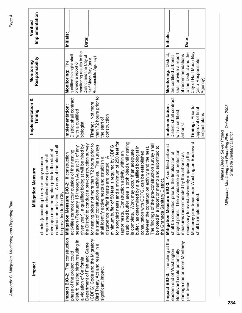
App
end
ix C
. Miti
gat
ion
, Mon
itorin
g a
nd R
epo
rtin
g P
lan
P
age
4
Na
ple
s B
eac
h S
ew
er P
roje
ct
Miti
gatio
n, M
oni
torin
g a
nd
Rep
ort
ing
Pla
n –
Oct
ober
20
08
Gra
nad
a S
anita
ry D
istr
ict
Imp
ac
t M
itig
ati
on
Me
as
ure
Imp
lem
en
tati
on
&
Tim
ing
Mo
nit
ori
ng
Re
sp
on
sib
ilit
y V
eri
fie
dIm
ple
me
nta
tio
nch
eck
s (a
cco
rdin
g t
o d
ry o
r ra
iny
sea
son
re
qui
rem
en
ts a
s d
eta
iled
ab
ove
) a
nd
sh
all
de
velo
p a
mo
nito
rin
g p
lan
pri
or
to t
he s
tart
of
con
stru
ctio
n a
ctiv
itie
s. A
co
py
of
the
pla
n s
ha
ll b
e p
rovi
de
d t
o t
he
City
.Im
pa
ct
BIO
-2:
Th
e c
on
stru
ctio
n
ph
ase
of
the
pro
ject
co
uld
d
istu
rb n
est
ing
bir
ds
resu
ltin
g in
a
vio
latio
n o
f C
alif
orn
ia
De
pa
rtm
en
t o
f F
ish
an
d G
am
e
(CD
FG
) C
od
e a
nd
th
e M
igra
tory
B
ird
Tre
aty
Act
and
re
sult
in a
si
gn
ifica
nt
imp
act
.
Mit
iga
tio
n M
ea
su
re B
IO-2
:If
co
nst
ruct
ion
a
ctiv
itie
s ca
nn
ot
occ
ur
outs
ide
of
the
ne
stin
g
sea
son
(Fe
bru
ary
15
th
rou
gh
Au
gu
st 3
1 o
f a
ny
giv
en
ye
ar)
, a
qu
alif
ied
bio
log
ist
will
be
hir
ed
by
the
Dis
tric
t to
co
nd
uct
a p
re-c
on
stru
ctio
n s
urv
ey
for
nes
ting
bir
ds
no
t m
ore
th
an
72
ho
urs
pri
or t
o
the
sta
rt o
f co
nst
ruct
ion
act
iviti
es.
T
he
su
rve
ys
sha
ll id
en
tify
act
ive
ne
sts
an
d e
sta
blis
h a
d
istu
rba
nce
bu
ffe
r if
ne
sts
are
loca
ted
. A
m
inim
um
bu
ffe
r o
f 5
0 f
eet
is r
eq
uir
ed b
y C
DF
G
for
son
gb
ird
ne
sts
and
a m
inim
um
of
25
0 f
ee
t fo
r ra
pto
r n
est
s.
Co
nst
ruct
ion
act
ivity
with
in a
n
est
ab
lish
ed
buf
fer
are
a is
pro
hib
ited
un
til n
est
ing
is c
om
ple
te.
Wo
rk m
ay
occ
ur
if a
n a
de
qu
ate
b
uff
er,
as
det
erm
ine
d b
y a
qu
alif
ied
bio
log
ist
in
con
sulta
tion
with
CD
FG
, ca
n b
e e
stab
lish
ed
b
etw
ee
n t
he
con
stru
ctio
n a
ctiv
ity a
nd
th
e n
est
.
Th
e f
ind
ing
s o
f th
e p
re-c
on
stru
ctio
n s
urv
ey
sha
ll b
e n
ote
d in
a r
ep
ort
or
me
mo
an
d s
ub
mitt
ed
to
th
e G
ran
ad
a S
an
itary
Dis
tric
t.
Imp
lem
en
tati
on
:D
istr
ict
shal
l co
ntr
act
w
ith a
qu
alif
ied
bio
log
ist
Tim
ing
: N
ot
mo
re
than
72
ho
urs
pri
or
to
the
sta
rt o
f co
nst
ruct
ion
Mo
nit
ori
ng
:T
he
qual
ified
bio
log
ist s
hall
pro
vide
a r
epo
rt o
f m
onito
ring
res
ults
to
the
Dis
tric
t and
the
City
of
Ha
lf M
oon
Bay
(as
a
Res
pon
sib
le A
genc
y)
Init
ials
:__
__
__
__
_
Da
te:_
__
__
__
__
__
Imp
ac
t B
IO-3
:T
ren
chin
g a
t th
e
ea
ste
rn e
nd
of
Wa
shin
gto
n
Bo
ule
vard
co
uld
po
ten
tially
d
am
ag
e o
ne
or
mo
re M
on
tere
y p
ine
tre
es.
Mit
iga
tio
n M
ea
su
re B
IO-3
:A
cer
tifie
d a
rbo
rist
sh
all
be
co
nsu
lted
pri
or
to t
he
fin
aliz
atio
n o
f p
roje
ct p
lan
s.
Th
e a
void
an
ce a
nd
pro
tect
ion
m
ea
sure
s re
com
me
nd
ed
by
the
arb
ori
st a
s n
ece
ssa
ry to
avo
id a
dve
rse
ly im
pa
ctin
g t
he
M
on
tere
y p
ine
tre
es
ne
ar
Wa
shin
gto
n B
ou
leva
rd
sha
ll b
e im
ple
me
nte
d.
Imp
lem
en
tati
on
:D
istr
ict
shal
l co
ntr
act
w
ith a
ce
rtifi
ed
a
rbo
rist
Tim
ing
: P
rio
r to
a
pp
rova
l of
fina
l p
roje
ct p
lans
Mo
nit
ori
ng
:D
istr
ict;
the
ce
rtifi
ed
arb
ori
st
sha
ll p
rovi
de a
re
po
rt
of
reco
mm
en
da
tion
s to
the
Dis
tric
t a
nd
th
e C
ity o
f H
alf
Moo
n B
ay
(as
a R
esp
onsi
ble
A
ge
ncy
)
Init
ials
:__
__
___
__
Da
te:_
__
__
__
__
__
234
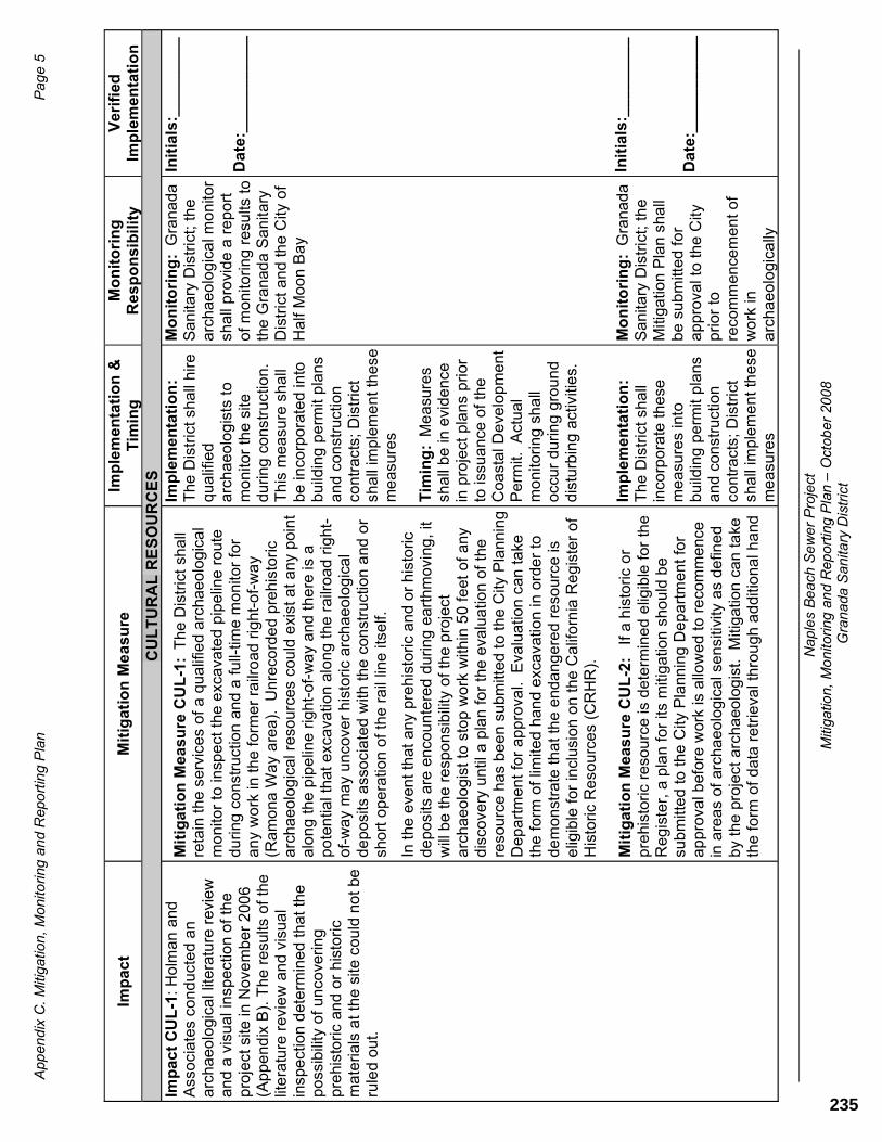
App
end
ix C
. Miti
gat
ion
, Mon
itorin
g a
nd R
epo
rtin
g P
lan
P
age
5
Na
ple
s B
eac
h S
ew
er P
roje
ct
Miti
gatio
n, M
oni
torin
g a
nd
Rep
ort
ing
Pla
n –
Oct
ober
20
08
Gra
nad
a S
anita
ry D
istr
ict
Imp
ac
t M
itig
ati
on
Me
as
ure
Imp
lem
en
tati
on
&
Tim
ing
Mo
nit
ori
ng
Re
sp
on
sib
ilit
y V
eri
fie
dIm
ple
me
nta
tio
nC
UL
TU
RA
L R
ES
OU
RC
ES
Im
pa
ct
CU
L-1
:Ho
lma
n a
nd
Ass
oci
ate
s co
nd
uct
ed
an
a
rch
ae
olo
gica
l lite
ratu
re r
evi
ew
a
nd
a v
isu
al i
nsp
ect
ion
of
the
p
roje
ct s
ite in
No
vem
be
r 2
00
6
(Ap
pe
nd
ix B
). T
he
re
sults
of
the
lit
era
ture
re
vie
w a
nd
vis
ua
l in
spe
ctio
n d
ete
rmin
ed
th
at
the
p
oss
ibili
ty o
f u
nco
veri
ng
p
rehi
sto
ric
and
or
his
tori
c m
ate
ria
ls a
t th
e s
ite c
ou
ld n
ot
be
ru
led
ou
t.
Mit
iga
tio
n M
eas
ure
CU
L-1
:T
he
Dis
tric
t sh
all
reta
in t
he
se
rvic
es
of
a q
ua
lifie
d a
rcha
eo
log
ica
l m
on
itor
to in
spe
ct t
he
exc
ava
ted
pip
elin
e r
ou
te
du
rin
g c
on
stru
ctio
n a
nd
a f
ull-
time
mo
nito
r fo
r a
ny
wo
rk in
th
e f
orm
er
railr
oa
d ri
gh
t-o
f-w
ay
(Ra
mo
na
Wa
y a
rea
).
Un
reco
rde
d p
reh
isto
ric
arc
ha
eo
log
ica
l re
sou
rces
co
uld
exi
st a
t a
ny
po
int
alo
ng
th
e p
ipe
line
rig
ht-
of-
wa
y a
nd
th
ere
is a
p
ote
ntia
l th
at e
xca
vatio
n a
lon
g t
he
rai
lro
ad
rig
ht-
of-
wa
y m
ay
un
cove
r h
isto
ric
arc
ha
eo
log
ica
l d
ep
osi
ts a
sso
cia
ted
with
the
co
nst
ruct
ion
an
d o
r sh
ort
op
era
tion
of
the
ra
il lin
e it
self.
In t
he e
ven
t th
at
an
y pr
eh
isto
ric
an
d o
r h
isto
ric
de
po
sits
are
en
cou
nte
red
du
rin
g e
art
hm
ovi
ng,
it w
ill b
e t
he
re
spo
nsi
bili
ty o
f th
e p
roje
ct
arc
ha
eo
log
ist
to s
top
wo
rk w
ithin
50
fe
et o
f a
ny
dis
cove
ry u
ntil
a p
lan
fo
r th
e e
valu
atio
n o
f th
e
reso
urc
e h
as
be
en
su
bmitt
ed
to t
he
City
Pla
nn
ing
D
ep
art
me
nt
for
ap
pro
val.
Eva
lua
tion
can
ta
ke
the
fo
rm o
f lim
ited
ha
nd
exc
ava
tion
in o
rde
r to
d
em
on
stra
te t
ha
t th
e e
nda
ng
ere
d r
eso
urc
e is
e
ligib
le f
or in
clu
sio
n o
n th
e C
alif
orn
ia R
eg
iste
r o
f H
isto
ric
Re
sou
rce
s (C
RH
R).
Mit
iga
tio
n M
eas
ure
CU
L-2
:If
a h
isto
ric
or
pre
hist
ori
c re
sou
rce
is d
ete
rmin
ed
elig
ible
fo
r th
e
Re
gis
ter,
a p
lan
fo
r its
miti
ga
tion
sh
ou
ld b
e
sub
mitt
ed
to
th
e C
ity P
lann
ing
De
pa
rtm
ent
fo
r a
pp
rova
l be
fore
wo
rk is
allo
we
d to
re
com
me
nce
in
are
as
of
arch
ae
olo
gic
al s
en
sitiv
ity a
s d
efin
ed
b
y th
e p
roje
ct a
rch
aeo
log
ist.
M
itig
atio
n c
an
ta
ke
the
form
of
da
ta r
etr
ieva
l th
rou
gh
ad
diti
on
al h
and
Imp
lem
en
tati
on
:T
he
Dis
tric
t sh
all
hir
e
qu
alif
ied
arc
ha
eo
log
ists
to
mo
nito
r th
e s
ite
du
rin
g c
on
stru
ctio
n.
T
his
me
asu
re s
ha
ll b
e in
corp
ora
ted
into
b
uild
ing
pe
rmit
pla
ns
an
d c
on
stru
ctio
n
con
tra
cts;
Dis
tric
t sh
all
imp
lem
en
t th
ese
m
ea
sure
s
Tim
ing
:M
ea
sure
s sh
all
be
in e
vid
en
ce
in p
roje
ct p
lan
s p
rio
r to
issu
an
ce o
f th
e
Co
ast
al D
eve
lop
me
nt
Pe
rmit.
A
ctu
al
mo
nito
rin
g s
ha
ll o
ccu
r d
uri
ng
gro
un
d
dis
turb
ing
act
iviti
es.
Imp
lem
en
tati
on
:T
he
Dis
tric
t sh
all
inco
rpo
rate
th
ese
m
ea
sure
s in
to
bu
ildin
g p
erm
it p
lan
s a
nd
co
nst
ruct
ion
co
ntr
act
s; D
istr
ict
sha
ll im
ple
me
nt
the
se
me
asu
res
Mo
nit
ori
ng
:G
ran
ad
aS
an
itary
Dis
tric
t; t
he
arc
ha
eo
log
ica
l mo
nito
r sh
all
pro
vide
a r
ep
ort
o
f m
on
itori
ng
re
sults
to
th
e G
ran
ada
Sa
nita
ry
Dis
tric
t a
nd
the
City
of
Ha
lf M
oo
n B
ay
Mo
nit
ori
ng
:G
ran
ad
aS
an
itary
Dis
tric
t; t
he
Miti
ga
tion
Pla
n s
ha
ll b
e s
ub
mitt
ed
fo
r a
pp
rova
l to
th
e C
ity
pri
or
to
reco
mm
en
cem
en
t o
f w
ork
in
arc
ha
eo
logi
cally
Init
ials
:__
__
__
__
_
Da
te:_
__
__
__
__
__
Init
ials
:__
__
__
__
_
Da
te:_
__
__
__
__
__
235

App
end
ix C
. Miti
gat
ion
, Mon
itorin
g a
nd R
epo
rtin
g P
lan
P
age
6
Na
ple
s B
eac
h S
ew
er P
roje
ct
Miti
gatio
n, M
oni
torin
g a
nd
Rep
ort
ing
Pla
n –
Oct
ober
20
08
Gra
nad
a S
anita
ry D
istr
ict
Imp
ac
t M
itig
ati
on
Me
as
ure
Imp
lem
en
tati
on
&
Tim
ing
Mo
nit
ori
ng
Re
sp
on
sib
ilit
y V
eri
fie
dIm
ple
me
nta
tio
ne
xca
vatio
n in
sid
e a
rea
s o
f im
pa
ct,
cou
ple
d w
ith
reco
rdin
g a
nd o
r re
mo
val o
f si
gn
ifica
nt c
ultu
ral
ma
teri
als
an
d in
form
atio
n f
or
futu
re a
na
lysi
s a
nd
re
po
rtin
g p
urp
ose
s.
Mit
iga
tio
n M
eas
ure
CU
L-3
:In
th
e e
ven
t th
at
Na
tive
Am
eri
can
hu
ma
n r
em
ain
s a
re d
isco
vere
d,
wo
rk w
ill b
e s
top
pe
d in
th
e a
rea
de
fine
d b
y th
e
pro
ject
arc
ha
eo
log
ist
un
til t
he
Co
un
ty C
oro
ne
r’s
Off
ice
an
d N
ativ
e A
me
rica
n H
eri
tag
e
Co
mm
issi
on
(N
AH
C)
ha
ve b
ee
n n
otif
ied
. I
n t
he
ca
se o
f N
ativ
e A
me
rica
n r
em
ain
s, t
he
NA
HC
will
n
am
e a
Mo
st L
ike
ly D
esc
en
da
nt
(ML
D)
to a
dvi
se
the
Dis
tric
t in
th
e p
refe
rred
ma
nn
er
of
exh
um
atio
n,
exp
osu
re,
rem
ova
l, a
nd
reb
uri
al o
f a
ll h
um
an
re
ma
ins
an
d a
sso
cia
ted
gra
ve g
oo
ds.
Tim
ing
:D
uri
ng
con
stru
ctio
n
Imp
lem
en
tati
on
:T
he
Dis
tric
t sh
all
inco
rpo
rate
th
ese
m
ea
sure
s in
to
bu
ildin
g p
erm
it p
lan
s a
nd
co
nst
ruct
ion
co
ntr
act
s; D
istr
ict
sha
ll im
ple
me
nt
the
se
me
asu
res
Tim
ing
:D
urin
g
con
stru
ctio
n
sen
sitiv
e a
rea
s a
s d
efin
ed
by
the
pro
ject
a
rch
ae
olo
gis
t.
Mo
nit
ori
ng
: G
ran
ad
a
Sa
nita
ry D
istr
ict;
th
e p
roje
ct a
rch
ae
olo
gis
t’s
mo
nito
rin
g r
ep
ort
sh
all
de
mo
nst
rate
th
at
this
w
as
acc
om
plis
he
d
Init
ials
:__
__
__
__
_
Da
te:_
__
__
__
__
__
HA
ZA
RD
OU
S M
AT
ER
IAL
S
Imp
ac
t H
M-1
:
So
ils c
on
tain
ing
h
aza
rdo
us
leve
ls o
f a
eri
ally
d
ep
osi
ted
lea
d (
AD
L)
coul
d b
e
en
cou
nte
red
du
rin
g t
un
nelin
g
act
iviti
es
ne
ar
Sta
te R
out
e 1
.
Imp
rop
er
ha
nd
ling
of
thes
e m
ate
ria
ls c
ou
ld r
esu
lt in
wo
rke
r e
xpo
sure
or
con
tam
ina
tion
.
Mit
iga
tio
n M
ea
su
re H
M-1
: F
or
the
site
s o
f th
e
jack
ing
an
d r
ece
ivin
g p
its f
or
the
tu
nn
ele
d
cro
ssin
g u
nd
er
Sta
te R
ou
te 1
an
d t
he
ea
sem
en
t re
qui
red
on
pa
rce
l (A
PN
04
8-1
24
-14
0):
T
he
D
istr
ict
sha
ll h
ire
a c
on
sulta
nt
to p
erf
orm
te
stin
g
for
ae
ria
lly d
ep
osi
ted
lea
d in
so
ils in
are
as
tha
t a
re t
o b
e o
pe
n c
ut
exc
ava
ted
, a
dja
cen
t to
Sta
te
Ro
ute
1.
1.
Sa
mp
le a
nd
te
st s
oils
usi
ng
a C
alif
orn
ia
De
pa
rtm
en
t o
f H
ea
lth S
erv
ice
s-ce
rtifi
ed
a
na
lytic
al l
ab
ora
tory
to
de
term
ine
lea
d
con
ten
t b
efo
re d
istu
rbin
g t
he
so
ils.
2.
De
term
ine
ho
w t
he
so
ils m
ust
be
tre
ate
d
ba
sed
up
on
th
e r
esu
lt o
f th
e s
oil
test
s.
Imp
lem
en
tati
on
:T
he
Dis
tric
t sh
all
inco
rpo
rate
th
ese
m
ea
sure
s in
to
con
stru
ctio
n p
lan
s a
nd
co
ntr
act
s
Tim
ing
: P
rio
r to
th
e
issu
an
ce o
f th
e
Co
ast
al D
eve
lop
me
nt
Pe
rmit
Mo
nit
ori
ng
: G
ran
ad
a
Sa
nita
ry D
istr
ict,
a s
oil
test
ing
re
po
rt s
ha
ll b
e
evi
de
nce
th
at
the
m
itig
atio
n w
as
pe
rfo
rme
d.
Init
ials
__
__
__
__
_
Da
te:_
__
__
__
__
__
236
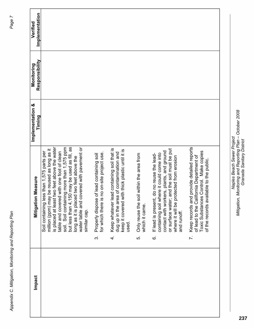
App
end
ix C
. Miti
gat
ion
, Mon
itorin
g a
nd R
epo
rtin
g P
lan
P
age
7
Na
ple
s B
eac
h S
ew
er P
roje
ct
Miti
gatio
n, M
oni
torin
g a
nd
Rep
ort
ing
Pla
n –
Oct
ober
20
08
Gra
nad
a S
anita
ry D
istr
ict
Imp
ac
tIm
ple
me
nta
tio
n &
T
imin
gM
on
ito
rin
gR
es
po
ns
ibil
ity
Ve
rifi
ed
Imp
lem
en
tati
on
Mit
iga
tio
nM
ea
su
re
So
il co
nta
inin
g le
ss t
ha
n 1
,57
5 p
art
s p
er
mill
ion
(p
pm
) m
ay
be
re
use
d a
s lo
ng a
s it
is p
lace
d a
t le
ast
tw
o f
ee
t a
bo
ve t
he
wa
ter
tab
le a
nd
cov
ere
d w
ith o
ne
fo
ot
of
cle
an
so
il.
So
il co
nta
inin
g m
ore
th
an
1,5
75
pp
m
bu
t le
ss t
ha
n 4
,15
0 m
ay
be
use
d a
s fil
l, a
s lo
ng
as
it is
pla
ced
tw
o f
ee
t a
bo
ve t
he
w
ate
r ta
ble
an
d c
ove
red
with
pa
vem
en
t o
r si
mila
r ca
p.
3.
Pro
pe
rly
dis
po
se o
f le
ad
con
tain
ing
so
il fo
r w
hic
h t
he
re is
no
on
-site
pro
ject
use
.
4.
Ke
ep
wh
ate
ver
lea
d c
on
tain
ing
so
il th
at
is
du
g u
p in
th
e a
rea
of
con
tam
ina
tion
an
d
kee
p it
co
vere
d w
ith t
hic
k p
last
ic u
ntil
it is
u
sed
.
5.
On
ly r
eu
se t
he
so
il w
ithin
th
e a
rea
fro
m
wh
ich
it c
am
e.
6.
If le
ad
is p
rese
nt,
do
no
re
use
th
e le
ad
-co
nta
inin
g s
oil
wh
ere
it c
ou
ld c
om
e in
to
con
tact
with
wo
rke
rs,
pla
nts
, a
nd
gro
un
d
or
surf
ace
wa
ter;
an
d t
he
so
il m
ust
be
pu
t w
he
re it
will
be
pro
tect
ed
fro
m e
rosi
on
a
nd
ru
no
ff.
7.
Ke
ep
re
cord
s a
nd
pro
vid
e d
eta
iled
re
po
rts
of
lea
d t
o t
he
Ca
lifo
rnia
De
par
tme
nt
of
To
xic
Su
bst
an
ces
Co
ntr
ol.
Ma
ke c
opie
s o
f th
e r
eco
rds
ava
ilab
le to
th
e p
ub
lic.
237

App
end
ix C
. Miti
gat
ion
, Mon
itorin
g a
nd R
epo
rtin
g P
lan
P
age
8
Na
ple
s B
eac
h S
ew
er P
roje
ct
Miti
gatio
n, M
oni
torin
g a
nd
Rep
ort
ing
Pla
n –
Oct
ober
20
08
Gra
nad
a S
anita
ry D
istr
ict
Imp
ac
t M
itig
ati
on
Me
as
ure
Imp
lem
en
tati
on
&
Tim
ing
Mo
nit
ori
ng
Re
sp
on
sib
ilit
y V
eri
fie
dIm
ple
me
nta
tio
nH
YD
RO
LO
GY
/WA
TE
R Q
UA
LIT
Y
Imp
ac
t H
YD
-1:
Un
con
tro
lled
run
off
fro
m t
he
con
stru
ctio
n s
ite
cou
ld im
pa
ct n
ea
rby
sen
sitiv
e
reso
urc
es,
incl
ud
ing
th
e P
aci
fic
Oce
an
and
an
un
na
me
d b
lue
lin
e c
ree
k th
at
cro
sse
s th
e
pip
elin
e a
lign
me
nt
on
Ala
me
da
A
ven
ue
just
so
uth
of
San
Pa
blo
A
ven
ue
.
Mit
iga
tio
n M
ea
su
re H
YD
-1:
Th
e p
roje
ct is
ne
ar
the
oce
an
an
d a
n u
nn
am
ed
blu
e li
ne
cre
ek.
B
eca
use
th
e p
roje
ct r
eq
uir
es
tre
nch
ing
th
at
cou
ld
aff
ect
th
ese
re
sou
rce
s, th
e f
ollo
win
g m
ea
sure
s,
as
ap
pro
pri
ate
, sh
all
be
inco
rpo
rate
d in
to p
roje
ct
pla
ns
an
d c
on
stru
ctio
n s
pe
cific
atio
ns in
ord
er
to
pro
tect
wa
ter
qu
alit
y a
nd
pre
ven
t e
rosi
on
: B
MP
s lik
e t
he
on
es
liste
d b
elo
w a
re r
eq
uir
ed
to
co
mp
ly
with
th
e S
an M
ate
o C
ou
nty
ST
OP
PP
Na
tion
al
Po
lluta
nt
Dis
cha
rge
Elim
ina
tion
Sys
tem
pe
rmit.
1)
Inst
all
fibe
r ro
lls
2)
Pro
tect
of
sto
rm d
rain
inle
ts
3)
Sto
ckp
ile m
an
ag
em
en
t 4
) S
pill
co
ntr
ol
5)
Ha
zard
ou
s M
ate
rial
s/ W
ast
e M
an
ag
em
en
t 6
) C
on
tam
ina
ted
soi
l ma
nag
em
en
t (a
lso
in
Miti
gat
ion
Me
asu
re H
AZ
-1)
7)
Pa
vin
g o
pe
ratio
ns
me
asu
res
8)
Ve
hic
le a
nd
eq
uip
me
nt
cle
an
ing
an
d f
ue
ling
9)
Hyd
rose
ed
ing
1
0)
Du
st (
win
d e
rosi
on
) co
ntr
ol
Imp
lem
en
tati
on
:T
he
Dis
tric
t sh
all
inco
rpo
rate
th
ese
m
ea
sure
s in
to
con
stru
ctio
n p
lan
s a
nd
co
ntr
act
s.
Tim
ing
:T
he
se B
MP
s sh
all
be
in p
lace
d
uri
ng
all
pha
ses
of
con
stru
ctio
n
Mo
nit
ori
ng
:C
ity o
f H
alf
Mo
on
Ba
y sh
all
en
sure
th
ese
m
ea
sure
s a
re s
ho
wn
o
n c
on
stru
ctio
n p
lan
s p
rio
r to
th
e is
sua
nce
of
the
Co
ast
al
De
velo
pm
en
t Per
mit
Init
ials
: _
__
__
___
Da
te:_
__
__
__
__
__
238

BUSINESS OF THE PLANNING DIRECTOR OF THE CITY OF HALF MOON BAY
AGENDA REPORT
For the meeting of: May 10, 2010
TO: Planning Director
FROM: Tonya Ward, Associate Planner
TITLE: PDP-012-10- Coastal Development Permit request for construction of a sanitary sewer force main within public rights of way and associated improvements to an existing pump station in the City of Half Moon Bay (Granada Sanitary District)
SECTION I: RECOMMENDED MOTION
The Planning Director moves to approve PDP-012-10, an application for a Coastal Development Permit to construct a sanitary sewer force main within public rights of way and associated improvements to an existing pump station, based upon the Findings and Evidence contained in Exhibit A of the Draft Resolution, and subject to the Conditions of Approval contained in Exhibit B.
SECTION II: PROJECT BACKGROUND & DESCRIPTION
The Granada Sanitary District (GSD) has an existing 10-inch sewer line attached to the east side of the concrete foundation of an old county highway bridge crossing Medio Creek (refer to project plans). Overtime, the bridge foundation has been compromised by high surf and erosion and the County of San Mateo has elected to discontinue its maintenance. Consequently, the GSD has proposed to eliminate the continuous use of the sewer line crossing Medio Creek by providing improvements and modification to existing facilities in a residential area which is currently served.
The applicant proposes to install a new force main, two new sewer lines, modify an existing force main for emergency service, and improve the District’s Naples Beach Pump Station (NBPS) located at San Pablo Avenue. The improvements are located primarily within the City of Half Moon Bay City street rights-of-way with other lands located within the Caltrans right-of-way at State Route 1 (north of Washington Blvd.) and on California State Parks property. The result of the sewer realignment and associated infrastructure improvements would accommodate the abandonment of the existing Medio Creek sewer crossing and reroute sewage to the Naples Beach area of the City.
ATTACHMENT 6
239

PDP- 012-10 Naples Beach Sewer Project 2 Planning Director May 10, 2010
A. Project Vicinity
Project Phasing The proposal has two phases, the first phase, Phase 1 would construct the infrastructure that would divert 90 percent of the sewage in the pipe currently crossing Medio Creek. Phase 2, if approved by the District, would divert the remaining ten percent (4,000 to 5,000 gallons).
Phase 1 Summary: A new, 10-inch force main (pressurized pipeline) would be installed at the existing Naples Beach Pump Station (NBPS) and directed east under San Pablo Avenue continuing south on Alameda Avenue, then east on Roosevelt Boulevard to the Sewer Authority Mid-Coastside (SAM) Intertie Pipeline System (IPS) force main located on the east side of State Route 1. The pipeline crossing of State Route 1 would be completed by “jack and bore method installation” and requires an encroachment permit from Caltrans. The District proposes the trenchless method of installing the pipelines to avoid disruptions when crossing under highways and waterways. Trenching for the pipeline, estimated at roughly 1,600 in linear feet, will be approximately three feet wide and vary between four to eleven feet deep depending on location. Construction of Phase 1 is expected to last ten months. The elements of this phase for each location are as follows:
PHASE 1
PHASE 2
ATTACHMENT 6
240

PDP- 012-10 Naples Beach Sewer Project 3 Planning Director May 10, 2010
Naples Beach Pump Station (NBPS) The two existing 10 horsepower (HP) pumps will be replaced with 20 HP pumps to accommodate the higher pressure (head) required to discharge into the IPS force main. Electrical upgrades include variable frequency drives (to allow motors to be started using the existing emergency generator), new pump controls and piping, and a magnetic flow meter to record flows to the IPS. Painting or replacing the enclosure for the emergency generator and other similar upgrades are anticipated.
B. Naples Beach Pump Station & Phase 1 Details
State Route 1
Naples Beach Pump Station (NBPS) at San Pablo Avenue
ATTACHMENT 6
241

PDP- 012-10 Naples Beach Sewer Project 4 Planning Director May 10, 2010
View of NBPS at San Pablo Avenue looking southeast
View of existing equipment at NBPS
ATTACHMENT 6
242
PDP- 012-10 Naples Beach Sewer Project 5 Planning Director May 10, 2010
San Pablo Avenue/Alameda AvenueThe existing force main along San Pablo Avenue and Alameda Avenue, beginning at the NPBS and discharging in the manhole at the intersection of Mirada Road and Alameda Avenue, will be modified to serve as a back up for the new force main in the event the new force main is out of service for maintenance or repair. Mirada Road/Alameda Avenue A new gravity sewer line will be installed on Alameda Avenue to divert flow from the sewer that crosses Medio Creek and direct the flow to the NBPS. The new sewer line will connect to an existing manhole at the intersection of Mirada Road with a manhole located about 300 feet south on Alameda Avenue. Phase 2 Summary: A new sewer line would be constructed between the west end of Mirada Road and the intersection with Alameda Avenue. A branch will be constructed on “Ramona Way” (a paper street owned by California State Parks) connecting the new Mirada Road sewer line to an existing sewer line at the west end of Alcatraz Avenue. The proposed length of this new sewer line is approximately 1,200 feet. The existing sewer line in Mirada Road, attached to the foundation of the abandoned highway bridge that crosses Medio Creek, will remain in place and serve as an emergency back-up in the event the new force main is out of service for maintenance or repair. Construction of Phase 2 is expected to last six months. C. Local Coastal Program Consistency Title 18.20.070(A) of the City’s Municipal Code requires that all development within the City must conform to the City’s Local Coastal Program. The specific policies of the City’s Local Coastal Program/Land Use Plan (LUP) identify the way in which specific land use planning issues of development should be addressed. On November 14, 2006, Holman & Associates conducted an initial cultural resources record study for the project and concluded no identified archaeological or paleontological sites were located within the project area. A second records request was performed on December 10, 2009 to evaluate the realignment from Washington Boulevard to Roosevelt Boulevard, but the survey was determined satisfied by the 2006 survey. With the incorporation of the mitigation measures included in the MND (see condition CUL 1-3), the project can be found to be consistent with Chapter 6 of the LCP, specifically policy 6-4, and it would have a less than significant impact upon the environment. In August 2008, TRA Environmental Sciences, Inc concluded in a biological report that no potential wetlands were observed on the project site or within the 200-foot study area. With the incorporation of the mitigation measures included in the MND (BIO 1-3), the project can be found consistent with Chapter 3 of the LCP, specifically policies 3-3 and 3-5, and it would have a less than significant impact upon the environment. The proposed project has been reviewed for compliance with the City Half Moon Bay LCP, Amended 1993, and has been found to be in conformance for the protection of biological resources. The proposed project does not interfere with coastal access or recreation policies because the hours of construction will be limited and open trenching will not be permitted on State Route 1. Additionally, prior to construction in the City streets, the District is required to
ATTACHMENT 6
243

PDP- 012-10 Naples Beach Sewer Project 6 Planning Director May 10, 2010
submit plans and construction bid documents addressing construction period impact for the City’s review and approval. An encroachment permit is required for work in City streets as well as work performed in the Caltrans rights-of-way. Though the project as constructed will not directly affect existing drainage facilities or natural drainage courses, the potential for impacts relating to Policies 4-8 and 4-9 exists should management of materials not be controlled properly. The City’s Public Works Director has conditioned the project to address the policies of Chapter 4. D. Compliance with Zoning Provisions: A Coastal Development Permit (CDP) is required for any project that meets the definition of Development in Section 18.20.020(C) of the Zoning Code unless it is explicitly exempt. The Planning Director is required to make all of the findings necessary for a Coastal Development Permit per Section 18.20.070 of the Zoning Code and all of the applicable policies of the Local Coastal Program. The project is located primarily within paved City rights-of-way and portions which traverse on state-owned property. The exception is a drainage ditch feature located on the east side of SR 1 that flows westerly before draining through a culvert under SR 1 that necessitated a biological evaluation in accordance with Chapter 18.38 of the Half Moon Bay Municipal Code. The biological assessment evaluated the effects of the proposed development to potential habitat within 100 feet and potential riparian areas within 200 feet and established mitigation measures to reduce potential impacts to sensitive species and habitat. The biological report concluded that the drainage ditch is not considered wetland or riparian habitat as it does not contain any of the species or habitat types designated as wetland or riparian in the LCP. The project, as proposed and conditioned, complies with all applicable policies of the City’s Local Coastal Program, allowing the Planning Director to make all of the findings under Section 18.20.070 of the Zoning Code necessary to grant approval of the requested Coastal Development Permit.
SECTION III: CALIFORNIA ENVIRONMENTAL QUALITY ACT (CEQA) COMPLIANCE The applicant has claimed Lead Agency status on this project with respect to California Environmental Quality Act (CEQA) compliance. Title 14 of the California Code of Regulations, Chapter 3, Article 4, Sections 15050 and 15051, presents the guidelines for determination of lead agency, which is the public agency responsible for preparing the CEQA document for a project. The section provides agencies and government bodies a short, but concise summary of the “Lead Agency Concept.” Where two or more public agencies will be involved with a project, the determination of which agency will be the Lead Agency is governed by the extent to which each of the agencies is involved, both in project approval, and in project implementation. TRA Environmental Sciences, Inc. prepared the required Initial Study/Mitigated Negative Declaration (IS/MND) October 2008 with the document indicating the procurement of an easement on private property adjacent to Washington Boulevard. The procurement of this easement was not successful and the pipeline alignment was rerouted from Washington Boulevard to Roosevelt Boulevard. An Addendum to this document was prepared in January
ATTACHMENT 6
244

PDP- 012-10 Naples Beach Sewer Project 7 Planning Director May 10, 2010
2010 to reflect the realignment of the pipeline and to consider the proposed changes to the original project. Based upon the Initial Study, four environmental factors would potentially be affected: biological resources, cultural resources, hazards, and hydrology. These resources include mitigation measures in the Initial Study/Mitigated Negative Declaration (IS/MND) that would reduce the potentially significant impacts to less than significant. The mitigation measures contained in the IS/MND serve to mitigate any and all potentially significant environmental impacts that have been established either by threshold of significance in the IS/MND, incorporated through comments received on the IS/MND by responsible agencies, or by direction of the Planning Director. All mitigation measures have been incorporated into the conditions of approval that accompany this report. Prior to approving the proposed project, the Planning Director shall consider the proposed MND together with any public comments received during the public review process. The Planning Director shall provide a recommendation for approval of the MND only if the Planning Director finds on the basis of the whole record including both initial study and any public comments received that all significant impacts on the environment have been mitigated to less than significant. SECTION V. CONCLUSION AND RECOMMENDATION Staff recommends approval of the project and has prepared recommended findings and conditions for approval of the project (Exhibits A and B of the proposed Resolution for Approval). The Planning Director will need to determine if he concurs with the analyses set forth in the findings and whether the conditions are appropriate and adequate for approval. The entitlement submitted for Planning Director consideration are consistent with the findings and mitigation measures in the MND and staff recommends Planning Director’s concurrence with the recommended motion as presented in this report. ATTACHMENTS: 1. Planning Director Draft Resolution of Approval with Findings of Evidence and
Conditions of Approval 2. Plan Set of the Project (Full-Size for Planning Directory only) 3. Initial Study/Mitigated Negative Declaration/Addendum and Biological Assessment
(Planning Director Only/Available to Public upon Request) 4. Public Comments Received from IS/MND, dated 2008 (Planning Director
Only/Available to Public upon Request)
ATTACHMENT 6
245

PDP- 012-10 Naples Beach Sewer Project 8 Planning Director May 10, 2010
PLANNING DIRECTOR RESOLUTION PDR- -10
RESOLUTION FOR APPROVAL PDP-012-10
A RESOLUTION OF THE PLANNING DIRECTOR TO ADOPT A MITIGATED NEGATIVE DECLARATION AND A MITIGATION MONITORING AND REPORTING PROGRAM, AND
COASTAL DEVELOPMENT PERMIT TO CONSTRUCT A SANITARY SEWER FORCE MAIN WITHIN PUBLIC RIGHTS-OF-WAY AND ASSOCIATED IMPROVEMENTS TO AN
EXISTING PUMP STATION IN THE CITY OF HALF MOON BAY
WHEREAS, the Granada Sanitary District submitted an application requesting approval of the construction of a new force main, two new sewer lines, modification of an existing force main for emergency service and improvements to the District’s Naples Beach Pump Station (NBPS) located in the City rights-of way, Caltrans rights-of-way and California State Parks property; and
WHEREAS, the procedures for processing the application have been followed as required by law; and
WHEREAS, the Planning Director conducted a duly noticed public hearing on the project on May 10, 2010, at which time all those desiring to be heard on the matter were given an opportunity to be heard; and
WHEREAS, the Planning Director considered all written and oral testimony presented for their consideration; and
WHEREAS, the project was determined to be subject to CEQA, and an Initial Study/Mitigated Negative Declaration (IS/MND) State Clearinghouse No. 2008102050 was prepared for the project by TRA Environmental Sciences, Inc/Granada Sanitary District as Lead Agency; and
WHEREAS, the MND was circulated for a public review between October 14, 2008
to November 12, 2008 and all those desiring to comment were given the opportunity; and
WHEREAS, pursuant to Section 150074(a) of the State CEQA Guidelines that the MND was presented to the Planning Director and that the Planning Director reviewed and considered the information contained in the MND; and
WHEREAS, the Planning Director has determined that the MND is complete, correct and adequate, and prepared in accordance with the California Environmental Quality Act (CEQA) and applicable with State and County Guidelines; and
WHEREAS, the Planning Director finds the mitigation measures identified in the MND, agreed to by the applicant, placed as conditions on the project, and identified as part of this public hearing, have been incorporated into the Mitigation Monitoring and Reporting Program in conformance with California Public Resources Code Section 21081.6; and
WHEREAS, the Planning Director has made the required findings for approval of the project, set forth in Exhibit A to this resolution;
ATTACHMENT 6
246

PDP- 012-10 Naples Beach Sewer Project 9 Planning Director May 10, 2010
NOW, THEREFORE, BE IT RESOLVED that, based upon the Findings in Exhibit A, and subject to the Conditions of Approval contained in Exhibit B, the Planning Director approves the application (PDP-012-10).
PASSED AND ADOPTED by the City of Half Moon Bay Planning Director at a duly noticed public hearing held on May 10, 2010. APPROVED: ATTEST: __________________________ ___________________________ Steve Flint, Planning Director Sigrid White
Secretary to the Planning Director
ATTACHMENT 6
247
PDP- 012-10 Naples Beach Sewer Project 10 Planning Director May 10, 2010
EXHIBIT A FINDINGS AND EVIDENCE
PDP-012-10 A RESOLUTION OF THE PLANNING DIRECTOR TO ADOPT A MITIGATED NEGATIVE DECLARATION AND A MITIGATION MONITORING AND REPORTING PROGRAM, AND COASTAL DEVELOPMENT PERMIT TO CONSTRUCT A SANITARY SEWER FORCE MAIN WITHIN PUBLIC RIGHTS-OF-WAY AND ASSOCIATED IMPROVEMENTS TO AN
EXISTING PUMP STATION IN THE CITY OF HALF MOON BAY Coastal Development Permit – Findings for Approval The required Coastal Development Permit for this project may be approved or conditionally approved only after the approving authority has made the following findings per Municipal Code Section 18.20.070: 1. Local Coastal Program Finding– The development as proposed or as modified by
conditions, conforms to the Local Coastal Program.
Planning Director Evidence: The proposed project consists of the phased construction of a sanitary sewer force main and associated infrastructure improvements within existing public rights-of-ways in the Medio Creek and Naples Beach area of the City of Half Moon Bay. The Director finds that the project (modification and installation of facilities in a residential area) are necessary to maintain sewer service to replace the continuous use of the sewer crossing at Medio Creek. The new sewer alignment and associated improvements will be constructed within existing paved City and State rights-of-way that will not interfere with the public’s access to any designated coastal trail, beach or sea. The project has been reviewed for conformance with all policies of the Coastal Land Use Plan and has been determined to be consistent.
Coastal Act § 30244: Where development would adversely impact archaeological or paleontological resources as identified by the State Historic Preservation Officer, reasonable mitigation measures shall be required. Policy 6-4: As a part of any Project to construct new roads, trails, sewer or water lines, or other public projects involving substantial excavation which could destroy archeological resources within areas designated on the Map of Potential Archaeological Resources, provision shall be made for an archaeological survey and the opportunity to sample and salvage the site by a qualified archaeologist as party of the construction Project.
Compliance: On November 14, 2006, Holman & Associates conducted an initial cultural resources record study for the project and concluded no identified archaeological or paleontological sites were located within the project area. A second records request was performed on December 10, 2009 to evaluate the realignment from Washington Boulevard to Roosevelt Boulevard, but the survey was determined satisfied by the 2006 survey. With the incorporation of the mitigation measures included in the MND (see condition CUL 1-3), the project can be found to be consistent with Chapter 6 of the LCP, specifically policy 6-4, and it would have a less than significant impact upon the environment.
ATTACHMENT 6
248

PDP- 012-10 Naples Beach Sewer Project 11 Planning Director May 10, 2010
Coastal Act § 30250: New residential, commercial or industrial development except as otherwise provided in this division, shall be located within, contiguous with, or in close proximity to, existing developed areas able to accommodate it, in other areas with adequate public services and where it will not have significant adverse effects, either individually or cumulatively, on coastal resources.
Compliance: The proposed development will install, modify and improve current
pressure for sewer lines within the existing Naples Beach neighborhood. The sewer lines will be located in the same developed City and Caltrans public right-of-ways not creating the need for expanded streets or highways. The project will not have significant adverse effects, either individually or cumulatively, on coastal resources.
Policy 7-4: Utilities shall continue to be placed underground in all new developments.
Compliance: The project proposes to install all of the replacement lines underground per Policy 7-4. Policy 4-8: No new permitted development shall cause or contribute to flood hazards. Policy 4-9: All development shall be designed and constructed to prevent increases in runoff that would erode natural drainage courses. Flows from graded areas shall be kept to an absolute minimum, not exceeding the normal rate of erosion and runoff from that of the undeveloped land. Storm water outfalls, gutters, and conduit discharge shall be dissipated. Compliance: The project is conditioned to insure that any trenching or repaving of the street will not negatively impact to drainage flow line of the street as required by the Public Works Department.
2. Growth Management System – The development is consistent with the annual
population limitation system established in the Land Use Plan and Zoning Ordinance.
Planning Director Evidence: The proposed project does not propose any new residential units; therefore, it is not subject to the City’s growth management system.
3. Zoning Provisions – The development is consistent with the use limitations and property
development standards of the base district as well as the other requirements of the Zoning Ordinance.
Planning Director Evidence: The project is a public service utility upgrade located
within paved rights-of-ways of residential and commercial zoned properties of the Medio Creek and Naples Beach neighborhood. Development standards are not established for public utility upgrades, however consistent with the residential and commercial uses established.
4. Adequate Services – Evidence has been submitted with the permit application that the
proposed development will be provided with adequate services and infrastructure at the time of occupancy in a manner that is consistent with the Local Coastal Program.
ATTACHMENT 6
249

PDP- 012-10 Naples Beach Sewer Project 12 Planning Director May 10, 2010
Planning Director Evidence: The County of San Mateo has discontinued the maintenance of the Medio Creek bridge at the existing sewer crossing. The proposed upgrade will provide improvements and modification to existing sewer facilities in a residential area which is currently served.
5. California Coastal Act – Any development to be located between the sea and the first
public road parallel to the sea conforms with the public access and public recreation policies of Chapter 3 of the California Coastal Act.
Planning Director Evidence: The proposed project will not restrict or otherwise
adversely affect public coastal access or public coastal recreational opportunities because the project proposes installation/realignment of sewer lines and associated improvements that, when operational, will not have any effect on access/recreation because they will not alter points of access or access ways, or opportunities for recreational opportunities and during project construction, conditions on project approval will ensure that any potential impacts are minimized to a level of insignificance.
Environmental Review – Findings 6. CEQA – The project is consistent with CEQA guidelines and will not have a significant
effect on the environment.
Planning Director Evidence: The project is not exempt from CEQA and an Initial Study/Mitigated Negative Declaration (MND) has been prepared. The IS/MND was circulated for public consideration and comment from October 14, 2008 through November 12, 2008. Following project approval, a Notice of Determination (NOD) will be posted by City staff with the County of San Mateo Office of the Recorder, consistent with CEQA requirements.
The mitigation measures contained in the IS/MND serve to mitigate any and all potentially significant environmental impacts that have been established either by threshold of significance in the IS/MND, incorporated through comments received on the IS/MND by responsible agencies, or by direction of the Planning Director. All mitigation measures have been incorporated into the conditions of approval that accompany this report.
The Planning Director finds on the basis of the whole record before it, that there is no substantial evidence that the project will have a significant effect on the environment and that the MND reflects the lead agency’s independent judgment and analysis.
ATTACHMENT 6
250

PDP- 012-10 Naples Beach Sewer Project 13 Planning Director May 10, 2010
EXHIBIT B CONDITIONS OF APPROVAL- PDP-012-10
Coastal Development Permit for the construction of a sanitary sewer force main within public rights of way and associated improvements to an existing pump station in the
City of Half Moon Bay Authorization: Approval of this permit authorizes the construction of a sanitary sewer force main, new sewer lines, modification of an existing force main for emergency service, and improvements to the District’s Naples Beach Pump Station as shown on plans identified with City date stamp of March 9, 2010, except as modified by the conditions of approval set forth herein. The following Conditions apply to this project:
1. CONFORMANCE WITH APPROVED PLANS. Development shall be in substantial conformance with the approved plans, with a City date stamp of March 9, 2010, except for any changes that may be required by these conditions of approval. The Planning Director shall review and approve any deviation from the approved plans. In the event that the Planning Director determines that any proposed changes warrant further Planning Director review and approval, the applicant shall submit the revised plans for consideration at a public hearing before the Planning Director. _______(Planning)
2. HALF MOON BAY ENCROACHMENT PERMIT. Before requesting any
construction in the City streets, the District shall submit plans and construction bid documents addressing the construction period impacts for the City’s review and approval. The District shall incorporate the City’s review comments in its bid documents and obtain an Encroachment Permit for its work in the City Streets. The District shall also provide the liability indemnification, liability insurance, securities, and fees as required by the City._______(Public Works)
3. CALTRANS ENCROACHMENT PERMIT. The applicant shall obtain an
encroachment permit from Caltrans prior to construction within the State ROW.______
4. PROJECT CONSTRUCTION DOCUMENTS. The applicant shall submit to the
City Engineer for review and approval project construction bid documents. The documents shall require maintenance of vehicular access to all properties at all times (except for certain minimum periods), no storage of construction material and equipment in the City street rights-of-way except for what would be used during work hours, covering of all trenches at the end of each work day, work completion in shorter segments to minimize public inconvenience and safety and work coordination with other public service providers. _______(Public Works)
5. PUBLIC NOTICES. The District shall provide periodic notices to all affected
property owners and area residents during construction and before its start. If streets are to be closed or detours implemented, then a Traffic Control Plan (TCP) is recommended. A TCP shall include provisions for advanced notification (i.e., signage) of the proposed detour routes, lane closures, and coordination with
ATTACHMENT 6
251

PDP- 012-10 Naples Beach Sewer Project 14 Planning Director May 10, 2010
emergency service providers. All construction shall be per the approved plans and permits and the applicable codes and standards. ______(Public Works/Planning)
6. CEQA MITIGATION MEASURES. The project shall comply with all applicable mitigation measures outlines in the Final MND (State Clearinghouse No. 2008102050) and comply with the timing of the measures outlined in the Mitigation Monitoring Reporting Program. _______(Public Works/Planning)
7. TRAFFIC CONTROL PLAN (TCP).The haul and detour routes shall be identified by the City’s Contractor and be approved by the City Engineer. The TCP should avoid residential streets at peak hours when possible. The TCP shall include provisions for advanced notification (i.e., signage) of the proposed detour routes, lane closures, and coordination with emergency service providers.________(Public Works)
8. STAGING AREA-WHEN APPLICABLE. In order to reduce construction impacts to the
residential and commercial uses adjacent to the project, the following provisions shall be adhered to:
• Access to residences and commercial buildings shall not be blocked at anytime. • Prior to the issuance of building permits or the commencement of grading,
whichever occurs first, the applicant shall submit a plan to, and obtain approval from the Planning Director and City Engineer, which includes the location of all construction staging areas.
• The staging area shall not be located on any private parcels without prior written consent from the owner.
• The staging area shall be located in an area that minimizes impacts to residences and environmental resources. _________(Public Works)
9. REGIONAL COORDINATION. The City or the City’s contractor shall coordinate with
state, regional, and local government agencies, public utilities, and special districts to encourage the use of public and private infrastructure facilities in a manner that is consistent with the policies of the California Coastal Act and the City of Half Moon Bay Local Coastal Program._________(Public Works/Planning)
10. DISCOVERY OF ARCHAELOGICAL RESOURCES. If historic or archaeological
resources are uncovered during grading activities, all work shall stop and the applicant shall retain a qualified archaeologist. At the applicant’s expense the qualified archaeologist will perform an archaeological reconnaissance and develop mitigation measures to protect archaeological resources. _____ (Public Works/Planning)
11. DISRUPTION OF UTILITIES. During construction underground utility alert services
(USA) shall be used to identify the location of all underground services and to avoid the unplanned disruption of pipes or services lines during excavation and other activities.______(Public Works)
12. RECYCLING OF WASTE MATERIALS. Concrete, asphalt, soil, and wood waste
materials shall be reused in the project or shall be recycled. ________(Public Works)
ATTACHMENT 6
252

PDP- 012-10 Naples Beach Sewer Project 15 Planning Director May 10, 2010
13. STORMWATER MANAGEMENT / EROSION CONTROL. During Construction the applicant shall minimize the transport and discharge of storm water from the project site by incorporation of the following measures into the construction site practices:
• Identify all storm drains, drainage swails and creeks located near the
construction site and make sure all subcontractors are aware of their locations to prevent pollutants from entering them. Use silt fence barrier, straw bale barrier, sand bags, brush or rock filter or other appropriate measures, as necessary to minimize the quantity of sediment laden runoff from the site. _____
• Stabilize any areas that have been stripped of vegetation, and maintain
erosion control measures between October 15 and April 15. _____
• Ensure that erosion control by re-vegetation is performed just prior to the rainy season unless on site irrigation is provided. Select seed to minimize fertilizer and water use. Limit watering to the amount and frequency, which can be absorbed on site. _____
• Avoid stockpiling of soils or materials, when rain is forecast. Cover with
a waterproof tarp during periods of rainy weather to control runoff. Monitor the site for minimization of erosion and sediment runoff every 24 hours during and after every storm event. Before it rains, sweep and remove materials from surfaces that drain to storm drains, creeks, or channels. _____
• Never clean brushes or rinse paint containers into a street, gutter, storm
drain, or creek. Recycle, return to supplier or donate unwanted water-based (latex) paint. Dried latex paint may be disposed of in the garbage. Unwanted paint (that is not recycled), thinners, and sludges must be disposed of as hazardous waste. _____
• Avoid cleaning, fueling, or maintaining vehicles on site, except in an area
designated to contain and treat runoff. Clean up leaks, drips, and other spills immediately so they do not contact stormwater. Never wash down pavement or surfaces where materials have spilled. Use dry cleanup methods whenever possible. _____
• Avoid mixing excess amounts of fresh concrete or cement mortar.
Whenever possible, return contents of mixer barrel to the yard for recycling. Dispose of small amounts of excess concrete, grout, and mortar in the trash. ____
• Practice source reduction. Reduce waste by only ordering the amount you
need to finish the job. Recycle leftover materials whenever possible. Materials such as concrete, asphalt, scrap metal, solvents, degreasers, cleared vegetation, paper, rock, and vehicle maintenance materials such as used oil, antifreeze, and batteries are recyclable. _____
ATTACHMENT 6
253

PDP- 012-10 Naples Beach Sewer Project 16 Planning Director May 10, 2010
• Inspect portable toilets for leaks. Do not place on or near storm drain outlets. Be sure the leasing company adequately maintains, promptly repairs, and replaces units as needed. _____ (Building)
14. EROSION CONTROL. The applicant shall provide for review by the City an Erosion
Control Plan to ensure that erosion is reduced to the maximum extent practicable, retain sediment on-site during and after construction. The plan shall be designed to minimize the potential sources of sediment, control the amount of runoff and its ability to carry sediment by diverting incoming flows and impeding internally generated flows, and retain sediment that is picked up on the project site through the use of sediment-capturing devices. The plan shall also limit application, generation, and migration of toxic substances, ensure the proper storage and disposal of toxic materials, apply nutrients at rates necessary to establish and maintain vegetation without causing significant nutrient runoff to surface waters. The Erosion Control Plan shall incorporate the Best Management Practices (BMPs) subject to the approval of the City Engineer.______(Public Works)
15. GRADING, MATERIALS, EQUIPMENT AND VEHICLE STORAGE. An erosion and
sediment control plan shall be submitted to the City Engineer and the City Planning Department for review and approval prior to issuance of a grading permit. No grading or preparation nor storage or placement of construction materials, equipment or vehicles shall take place prior to submittal and approval of building plans by the Public Works Department. Any earth movement on or off the site in excess of 50 cubic yards shall require the submittal of a grading plan for review and approval by the Public Works Department. Grading includes, but is not limited to, any leveling, scraping, clearing, grubbing or removal of surface area._______(Public Works)
16. HOURS OF CONSTRUCTION. The hours of construction shall be limited to 7:00
a.m. to 6:00 p.m. Monday through Friday, 8:00 a.m. to 6:00 p.m. Saturday, and 10:00 a.m. to 6:00 p.m. Sundays and Holidays. _____ (Public Works)
17. HAZARDOUS MATERIALS. Any materials deemed hazardous by the San Mateo
County Department of Health that are uncovered or discovered during the course of work under this permit shall be disposed in accordance with regulations of the San Mateo County of Health. _____ (Building/County Health)
18. CONSTRUCTION TRAILERS IF NEEDED. Temporary construction trailers are
permitted as accessory uses in conjunction with the development of this site, subject to the following conditions:
• The construction trailer shall be used as a temporary construction office only. • Neither sanitation facilities nor plumbed water is permitted within the trailer. • No overnight inhabitance of the construction trailer is permitted. • No construction trailers are permitted on site prior to encroachment permit
issuance.
19. COMPLETION OF FIRE DISTRICT REQUIREMENTS WHEN REQUIRED. All requirements of the Coastside Fire Protection District shall be met.
ATTACHMENT 6
254

PDP- 012-10 Naples Beach Sewer Project 17 Planning Director May 10, 2010
20. DAMAGE TO STREETS. All work shall be undertaken in a manner that will prevent damage to public streets and utilities and that will maintain streets free and clear of any construction materials, debris, or mud. The applicant shall be responsible for restoring any damaged street improvements or utilities to the satisfaction of the City Engineer. ______ (Public Works)
21. EFFECTIVE DATE. The Coastal Development Permit shall take effect after final
local action or 10 working days after receipt of the Notice of Final Action by the Coastal Commission for projects that are located in the Coastal Appeal Areas. The applicant/owner’s shall submit a signed copy of these conditions of approval to the Planning Department before they can obtain a grading permit. _____
22. ACCURACY OF APPLICATION MATERIALS. The applicant shall be responsible
for the completeness and accuracy of all forms and material submitted for this application. Any errors or discrepancies found therein may be grounds for the revocation or modification of this permit and/or any other City approvals. ____
23. EXPIRATION. The Coastal Development Permit shall expire on the latest
expiration date applicable to any other discretionary or ministerial permit or approval required for the development, including any extension granted for other permits or approvals. Should the development not require City permits or approvals other than a Coastal Development Permit, the Coastal Development Permit shall expire one year from its date of approval if the development has not begun during that time.
24. HOLD HARMLESS. The applicant agrees as a condition of approval of this
application to indemnify, protect, defend with counsel selected by the City, and hold harmless, the City, and any agency or instrumentality thereof, and its elected and appointed officials, officers, employees and agents, from and against an and all liabilities, claims, actions, causes of action, proceedings, suits, damages, judgments, liens, levies, costs and expenses of whatever nature, including reasonable attorney’s fees and disbursements (collectively, “Claims”) arising out of or in any way relating to the approval of this application, any actions taken by the City related to this entitlement, any review by the California Coastal Commission conducted under the California Coastal Act Public Resources Code Section 30000 et seq., or any environmental review conducted under the California Environmental Quality Act, Public Resources Code Section 210000 et seq., for this entitlement and related actions. The indemnification shall include any Claims that may be asserted by any person or entity, including the applicant, arising out of or in connection with the approval of this application, whether or not there is concurrent, passive or active negligence on the part of the City, and any agency or instrumentality thereof, and its elected and appointed officials, officers, employees and agents. The applicant’s duty to defend the City shall not apply in those instances when the applicant has asserted the Claims, although the applicant shall still have a duty to indemnify, protect and hold harmless the City. _____
ATTACHMENT 6
255

PDP- 012-10 Naples Beach Sewer Project 18 Planning Director May 10, 2010
25. PERMIT RUNS WITH THE LAND. The Coastal Development Permit runs with the land and the rights and obligations thereunder, including the responsibility to comply with conditions of approval, shall be binding upon successors in interest in the real property unless or until such permits are expressly abandoned.
OWNER’S/PERMITTEE’S CERTIFICATION: I have read and understand and hereby accept and agree to implement the foregoing conditions of approval of the Coastal Development Permit. APPLICANT: ___________________________________ ________________________ (Signature) (Date)
ATTACHMENT 6
256
BUSINESS OF THE PLANNING COMMISSION OF THE CITY OF HALF MOON BAY
AGENDA REPORT
For meeting of: March 23, 2021
TO: Chair Ruddock and Planning Commission FROM: Jill Ekas, Community Development Director Brittney Cozzolino, Associate Planner TITLE: 2021 Measure D Ranking Ratification ______________________________________________________________________________ RECOMMENDATION: Adopt a resolution ratifying the January 2021 Measure D allocations for residential units outside of downtown, based upon the scores and rankings required by Subdivision Ordinance, Section 17.06 Residential Dwelling Unit Building Permit Allocation System and as implemented by the Community Development Director. BACKGROUND: In 1999, the voters of Half Moon Bay adopted Measure D, a population growth control measure that restricted the number of new dwelling units the City could permit in any given year. Measure D divides these dwelling units between the “Downtown Area” (Downtown) and the rest of the City, with downtown defined as the area designated as the Downtown Half Moon Bay Redevelopment Survey Area in City Resolution No. C-91-98, November 3, 1998. Measure D further provided that the City allocate Measure D Certificates (Certificates) on the basis of the existing allocation system in the municipal code “or a subsequently modified allocation system.” The allocation system is set forth in Chapter 17.06 of the Municipal Code.1 The maximum number of Measure D Certificates, which represent allocations, is based on a maximum annual population increase of 1 percent over current population. Chapter 17.06 provides specific requirements for processing Measure D applications when the number of applications received between January 1 and January 31 is greater than the number of allocations available. In that situation, the Community Development Director must give each application a score based on the criteria set forth in Chapter 17.06. For applications other than subdivisions (e.g., single family homes, apartments and accessory dwelling units), the relevant criteria are listed in Section 17.06.120(I). The source of the Ordinance criteria is primarily from an early version of the GreenPoint residential building checklist, which was developed by a professional non-profit organization to help evaluate energy- and resource-efficient buildings. Each new dwelling unit requires an approved Certificate before other City permits may be applied for or issued. This year (2021), the City may issue up to 66 Certificates: 44 for development in Downtown and 22 for development in other areas (“outside of Downtown”). In January, the City
1 Measure D did not become effective until Municipal Code Chapter 17.06 was certified by the Coastal Commission
as part of the City’s Local Coastal Program in August 2009. Measure A remained in effect until this time.
257

March 23, 2021 2021 Measure D Ranking Ratification Page 2 of 7
received Certificate applications for 29 residential units outside of Downtown and no applications for Downtown. For the Certificates outside of Downtown, the City must score each application to determine which ones will receive Certificates. Once scored, the Code requires that the ranked applications be presented to the Planning Commission, which “may ratify or modify the final determination,” per Section 17.06.275. DISCUSSION: This is the first time in a number of years that the Planning Commission must ratify the Certificate allocations. In 2005, under the City’s previous residential growth limitation system (Measure A), the City received more requests than available allocations and a similar scoring process took place. In 2019, the number of applications exceeded the available allotment for outside of Downtown. However, this did not occur until mid-year, consequently scoring of the applications was not required. In September 2019, the City Council transferred twelve of the unused Downtown Certificates to be used for accessory dwelling units (ADUs) outside Downtown. Ten of these transferred Certificates were utilized for ADUs between September 2019 and the end of the year. In 2020, the City went through the scoring process and prepared a staff report for the Planning Commission to ratify the proposed rankings, as initially, more applications were received than Certificates were available. Following completion of the staff report, an application was withdrawn, which allowed all remaining applications to receive Measure D Certificates. This provided the Planning Commission and staff with an opportunity to hold a study session on the scoring process and provide feedback on staff implementation of the scoring criteria. Subsequently, in September 2020, the City Council transferred all ten of the remaining unused Downtown Certificates to be used for ADUs proposed outside of the Downtown area, prioritized according to affordability and readiness. The significantly higher number of applications in 2019 and 2020 are largely a result of changes to State ADU laws. In previous years, the City typically processed three or fewer ADU applications per year. Following certification of the City’s comprehensive update to the ADU ordinance in December 2018, interest in ADUs jumped, and applications followed. Significant new incentives to build ADUs under new State housing legislation followed in 2019 and 2020, and the City is in the process of updating the ADU ordinance again in response. The City is therefore required to apply the Chapter 17 scoring criteria for 2021 Measure D applications for outside of Downtown. Measure D requirements are codified in the City Subdivision Ordinance (Title 17), Section 17.06. Relevant sections of the ordinance include: Municipal Code § 17.06.105.
A. An application form for residential dwelling unit allocations shall be approved by the city council that incorporates all of the components of this chapter.
B. In the event that it is necessary to assign points for residential dwelling unit allocations based on the criteria specified in this chapter, the application for a residential dwelling
258

March 23, 2021 2021 Measure D Ranking Ratification Page 3 of 7
unit allocation shall include a site plan indicating the location of any surrounding development, the location and a detailed description of any infrastructure necessary to serve the site, and a description of the roadway providing access to the site.
All applicants were provided the City Council approved application and point scoring checklist that includes notes from the 2020 Measure D process (discussed further below). It was also strongly recommended that all applicants submit a plan set with their applications. Due to readily available information from Google Maps and other GIS tools, staff did not require all of the information specifically called for in Section 17.06.105.B cited above. Moreover, most of the applications are for ADUs. Pursuant to State law, the City does not have significant discretion in evaluating ADUs, and therefore some of the requested information is irrelevant. The checklist criteria are copied largely verbatim from Ordinance Section 17.06120.I. Section 17.06.120.I Points shall be allocated according to the community design criteria in this subsection which incorporate the concepts and principles of the “Build It Green” program and will rely on a certified GreenPointRater at the time that points are determined. The scoring criteria in 17.06.120.I subsections 1 through 6 appear to be consistent with early green building checklists developed by GreenPoint, an organization which originated in 2005. It should be noted that the GreenPoint Guides and Checklists have been updated multiple times since then. The most recent update, Version 8.0, went into effect on January 1, 2020. The City is limited to using the scoring criteria codified in the Ordinance, even though these may be outdated and, in some instances, superseded by newer GreenPoint checklists, current California Building Code energy efficiency standards, and State mandated water efficient landscaping regulations and stormwater runoff control regulations. Additionally, the GreenPoint guidance codified into the City’s Ordinance is not California specific and is intended to be widely applicable. Many of the criteria are oriented towards new subdivision developments located in geographic areas subject to much wider temperature extremes than found in Half Moon Bay. Thus, the 2021 Measure D application form was updated to not require responses to certain scoring criteria as discussed further below. Primary Goals of Measure D: Measure D was intended to limit annual population growth and to encourage the following sustainable development patterns and practices:
• Encourage infill development, where utilities and infrastructure are available with priority given to the downtown area.
• Discourage premature development of large areas of undeveloped rural land that may have agricultural or habitat value.
• Encourage higher density, clustered development, close to existing services and amenities.
• Encourage the reuse and recycling of building materials.
• Reduce energy and water use through building design and materials and landscaping.
259

March 23, 2021 2021 Measure D Ranking Ratification Page 4 of 7
Scoring Methodology: Applicants were required to submit the approved application form including the scoring checklist and a site plan. The Measure D Checklist and plans are intended to be used as a preliminary screening tool. Consequently, it was determined that a lower level of detail was appropriate than would be required for a project attempting to attain GreenPoint or LEED certification or similar designation. This would have required applicants to spend considerably more money in preparing fully developed construction level plans; such a requirement would have been especially contrary to the intent of State ADU laws. It would also be inconsistent with the intent of the Ordinance, which is to use the checklist as an initial project screening tool. Additionally, this would limit design flexibility later when the projects were evaluated as required for architectural review and Coastal Development Permit approval. The current approved checklist has only been used once previously (2020). Staff provided a “notes” column to help clarify the intent or scoring methodology of each criteria based on lessons learned from the 2020 Measure D scoring process. Specific challenges with the checklist noted in this evaluation period fall under two broad categories: (1) new laws and standards and (2) context. New Laws and Standards: In reviewing the checklist questions in 2020, staff discovered that several of the questions involve project improvements that are now required for all residential construction and others that would only differentiate applications in much hotter or colder climates. The 2020 GreenPoint checklist requires projects to exceed Title 24 energy efficiency standards. The checklist contained in the City’s Code, however, requires staff to award points for designs that are likely to be less efficient than required under current California Building Code, Title 24 standards. The same issue arises with respect to criteria governing water conservation: the checklist in the City’s Code requires staff to award points for measures that are either mandatory under our recently adopted Water Efficiency Landscape Ordinance (WELO, Chapter 13.04), or less efficient than those standards. Similarly, compliance with State and regional water quality and stormwater runoff regulations are applicable to construction projects and typically overlap with or are more restrictive than GreenPoint criteria. For all of these requirements, which are shown in grey in Attachment 2, all applicants would be treated equally, and for ease of use, the City has not scored these criteria. If scores for these criteria were to be included, the results would be the same. Context: All applications under consideration are for individual infill sites in areas that have already been subdivided. A number of the criteria, especially those about bicycle and pedestrian orientation, are more suited to subdivisions where bicycle and pedestrian facilities can be designed into the development. For the current applications, the sites are already part of a neighborhood context where in many cases bicycle and pedestrian access will improve over time as the Bicycle and Pedestrian Master Plan is implemented. These criteria are not significantly relevant to infill sites located outside Downtown. The landscaping criteria are also a challenge to apply fairly to the different types of units, especially ADUs and Junior ADUs (JADUs). This is because the City does not, nor can it, require new landscape plans for these units. Typically, ADUs and JADUs are proposed on already developed sites that have existing fencing, landscaping, and hardscaping. Thus, it was important to develop a way to apply these criteria so that ADUs and JADUs were not disadvantaged. In addition, as noted above, WELO and stormwater management regulations apply to all development. As a result, many of the landscape criteria are no longer relevant because they will be required of all projects. For all of these criteria, which are shown in
260

March 23, 2021 2021 Measure D Ranking Ratification Page 5 of 7
grey in Attachment 2, all applicants would be treated equally, and for ease of use, the City has not scored them. As noted above, if scores for these criteria were to be included, the results would be the same. Also, for certain specific landscape improvements (e.g. provision of a rain barrel), staff recommends awarding points for these items if applicants indicate they will be provided. In those cases, these improvements will be requirements of these projects through conditions of approval. In some cases, staff has recommended awarding points to ADU applications where the submitted plans and/or aerial images show that such improvements are existing. Interpretations: The interpretations developed through the 2020 Measure D scoring process seemed to significantly improve the 2021 Measure D application process. Staff identified several additional needs in reviewing the 2021 applications in order to fairly evaluate each application, as noted above. These clarifications are summarized in Attachment 2. Furthermore, such interpretations and clarifications, including cases where some criteria are not included in final scores, do not affect the outcome of rankings. State ADU Law: In 2019 and 2020, the state adopted changes to the State ADU laws to further encourage production of ADUs and JADUs. These changes further expanded the categories of “streamlined” ADUs, to which the City can impose only limited standards, and further restricted the City’s ability to apply development standards to other ADUs. As noted above, the City is currently in the process of updating its ADU ordinance to conform to these changes. In the interim, the City has evaluated the ADUs for which Certificates are sought pursuant to State ADU laws, as modified to implement the Coastal Act and the City’s LCP. Consequently, Certificates are proposed to be allocated to ADUs that do not comply with the City’s 2018 ADU ordinance. For instance, a number of proposed ADUs are larger than the 800 square foot maximum found in the 2018 ADU ordinance, as state law now requires that cities allow ADUs up to 1,000 square feet. Government Code 65852.2(c)(2)(B)(ii). Likewise, a proposed ADU is located in the Pacific Ridge (Dykstra Ranch) Planned Development district (111 Red Hawk Ct.). While the 2018 ADU ordinance did not allow ADUs in PDs, state law requires that the City allow such use. See Government Code 65852.2(a), (e). Some members of the public have previously questioned whether a PD zone should qualify as a “residential or mixed-use zone” under Section 65852.2(e). HCD has now clarified that this language “should be construed broadly to mean any zone where residential uses are permitted by-right or by conditional use.”2 Residential uses are permitted in the Pacific Ridge PD district, and thus ADUs are permitted pursuant to state law. Conclusion Generally, applications that included ADUs scored well and were ranked above the cutoff. Standalone homes (e.g. single-family residences or “SFRs”) without an ADU, particularly those that were located further from Downtown, did not score as well. Only one out of 18 ADU-only applications did not score above the cutoff, primarily due to its distance from public transit and walkable services. Originally, three applications included JADUs; however, each JADU was
2 See California Department of Housing and Community Development, Accessory Dwelling Unit Handbook (December 2020), available at https://www.hcd.ca.gov/policy-research/docs/ADU_December_2020_Handbook.pdf.
261

March 23, 2021 2021 Measure D Ranking Ratification Page 6 of 7
proposed as new floor area therefore do not qualify under the state definition of a JADU. These applicants have been notified that their JADU cannot be considered for a Measure D certificate at this time, and the requested allocations are not included in the scoring summaries below and attached. Project scoring and ranking are shown in a combined spreadsheet, Exhibit A of the resolution (Attachment 1). In summary, the applications and recommended awards include the following:
Project Type Number of Allocations Requested
Number of Allocations Recommended per Ranking
Single-family units 4 0
Single-family units with ADUs (each such application is for two allocations)
8 6
ADUs (with existing units) 17 16
Totals 29 22
Applicants who do not receive allocations at this time may request that City Council consider transfers in September, or may wait and apply again in January 2022. These include:
• 920 Railroad Ave. (ADU)
• Grove & 1st (SFR + ADU)
• 305 Granelli Ave. (SFR)
• Poplar & 4th (SFR)
• 775 3rd Ave. (SFR)
• 135 Kelly Ave. (SFR) Applicants for JADUs who did not qualify for allocations at this time are encouraged to submit redesigned proposals that comply with state law for transfer in September or allocation in 2022. Recommendation Review the attached Measure D scores and ranking and ratify the Community Development Director’s ranking determination; or upon reviewing the scorings, direct staff to prepare modifications. The Commission may also consider making recommendations to City Council with respect to their consideration for transferring allocations from within Downtown to outside Downtown this September. Next Steps Appeals: The decision of the Planning Commission may be appealed to the City Council within 10 business days of the Planning Commission decision. Updating ADU Ordinance: Staff recommends that as a future item the Planning Commission and City Council consider an update to the ADU ordinance that is consistent with recent State ADU laws.
262

March 23, 2021 2021 Measure D Ranking Ratification Page 7 of 7
Updating Measure D Ordinance: Staff recommends that as a future item the Planning Commission and City Council consider an update to the Measure D ordinance that streamlines the scoring and ranking language, clarifies the City Council September transfer process, provides more support for affordable housing units, including ADUs and JADUs, and is consistent with the 2020 Land Use Plan update, currently pending Coastal Commission certification. ATTACHMENTS:
1. Resolution with Exhibit A, Points Score and Ranking List 2. Summary of Municipal Code Section 17.06.120.I Scoring Criteria
263

ATTACHMENT 1
PLANNING COMMISSION RESOLUTION P-21-__ RATIFICATION OF THE 2021 MEASURE D ALLOCATION RANKING OUTSIDE OF DOWNTOWN
A RESOLUTION OF THE PLANNING COMMISSION OF THE CITY OF HALF MOON BAY RATIFYING
THE RANKING FOR 2021 MEASURE D APPLICATIONS FOR RESIDENTIAL UNIT ALLOCATIONS OUTSIDE OF DOWNTOWN
WHEREAS, in 1999 the voters of Half Moon Bay adopted Measure D, the Residential
Growth Initiative, which limits residential growth to no more than 1% per year; and
WHEREAS, as a part of the implementation of Measure D, the City of Half Moon Bay adopted and the Coastal Commission Certified the Residential Dwelling Unit Building Permit Allocation System Ordinance, Chapter 17.06 of the Half Moon Bay Municipal Code; and
WHEREAS, Chapter 17.06 established a process for ranking Measure D Certificate applications in the event that these applications exceed the number of residential allocations permitted in a given year; and
WHEREAS, on December 1, 2020, the City Council adopted Resolution C-2020-103, which
established the maximum residential growth allocation for 2021 as 44 in the Downtown area and 22 outside of Downtown; and
WHEREAS, prior to January 31, 2021, the City received no Measure D Certificate
applications for Downtown and 33 Measure D Certificate applications for outside of Downtown; and
WHEREAS, staff reviewed all Measure D Certificate applications and supporting
documents for outside of Downtown allocations and assigned points to each application according to the criteria stated in Chapter 17.06; and
WHEREAS, based on this review, the Community Development Director ranked all of the
applications; and WHEREAS, the Community Development Director forwarded this ranking together with
staff’s final determination of the points to the Planning Commission; and WHEREAS, the Planning Commission conducted a duly noticed public meeting on March
23, 2021, at which time all those desiring to be heard on the matter were given an opportunity to be heard; and
WHEREAS, the Planning Commission considered all written and oral public comment
presented for their consideration; and WHEREAS, the Planning Commission has found and determined that the Community
Development Director’s determination of the points and ranking for the Measure D allocations
264

Attachment 1
Resolution P-21-__
were correctly applied according to the rules set forth in Chapter 17.06.120 of the Half Moon Bay Municipal Code. NOW, THEREFORE BE IT RESOLVED, the Planning Commission ratifies the determination of the point allocations and ranking for the year 2021 Measure D Certificates by the Community Development Director, set forth in Exhibit A to this resolution.
PASSED AND ADOPTED by the City of Half Moon Bay Planning Commission at the regularly scheduled meeting on March 23, 2021.
AYES, NOES, ABSENT, ABSTAIN, APPROVED: ______________________________ ___________________________ Steve Ruddock, Chair Jill Ekas, Community Development Director
265

Project Address Unit Type
1. Infill Sites
(max. 65 points)
2. Home Size, Scaling,
and Clustering
(max. 30 points)
3. Design for Walking
and Bicycling
(max. 12 points)
4. Design for Safety and
Social Gathering (max.
10 points)
5. Design for Diverse
Households
(max. 15 points)
6. Landscaping
(max. 32 points)
Total
(max. 164
points)
Allocations
Awarded
8 Jenna Ln. SFR + ADU 63** 15 12 10 15 32 147 2
440 Central Ave. ADU 30 21 10 10 15 29 115 1
336 Valdez Ave. ADU 30 20 10 10 15 29 114 1
850 3rd Ave. ADU 30 20 12 10 15 27 114 1
344 Kelly Ave. ADU 30 20 11 10 15 27 113 1
640 Myrtle St. ADU 30 17.5 12 10 15 27 111.5 1
409 Ocean Ave. ADU 30 20 9 10 10 32 111 1
83 Ventura St. ADU 30 20 3 10 15 32 110 1
737 Mill St. ADU 30 20 12 10 10 27 109 1
786 Johnston St. ADU 30 20 12 10 15 22 109 1
1574 Spinnaker Ln. ADU 30 20 3 10 15 27 105 1
854 2nd Ave. ADU 30 20 8 10 10 27 105 1
111 Red Hawk Ct. ADU 25 20 3 10 15 19 102 1
30 Valencia St. ADU 30 20 3 10 10 29 102 1
708 Toulouse Ct. ADU 30 20 2 10 10 29 101 1
Miramontes & Potter SFR + ADU 30 15 11 10 15 20 101 2
Monte Vista Ln. SFR + ADU 30 15 11 10 15 20 101 2
316 Washington Ave. ADU 30 21 3 10 10 27 101 1
240 Myrtle St. ADU 30 20 6 10 10 22 98 1
305 Granelli Ave. SFR 30 15 11 10 5 27 98 0
920 Railroad Ave. ADU 25 20 2 10 10 27 94 0
Grove & 1st SFR + ADU 23 19.5 6 10 15 20 93.5 0
Poplar & 4th SFR 23 15 12 10 10 20 90 0
775 3rd Ave. SFR 28 7.5 11 5 5 32 88.5 0
135 Kelly Ave. SFR 27 5 5 0 10 30 77 0Total # Allocations
Requested: 29
Total #
Allocations 22
Scoring Criteria CategoriesExhibit A: 2021 Measure D Ranking
**The applicant for 8 Jenna Lane proposes the ADU to be below market rate (BMR). Absent a deed restriction or formal agreement, this application would still score above the threshold.
266

Project Address Unit Type
1. Infill Sites
(max. 65 points)
2. Home Size, Scaling,
and Clustering
(max. 30 points)
3. Design for Walking
and Bicycling
(max. 12 points)
4. Design for Safety and
Social Gathering (max.
10 points)
5. Design for Diverse
Households
(max. 15 points)
6. Landscaping
(max. 32 points)
Total
(max. 164
points)
Allocations
Awarded
8 Jenna Ln. SFR + ADU 63** 15 12 10 15 32 147 2
440 Central Ave. ADU 30 21 10 10 15 29 115 1
336 Valdez Ave. ADU 30 20 10 10 15 29 114 1
850 3rd Ave. ADU 30 20 12 10 15 27 114 1
344 Kelly Ave. ADU 30 20 11 10 15 27 113 1
640 Myrtle St. ADU 30 17.5 12 10 15 27 111.5 1
409 Ocean Ave. ADU 30 20 9 10 10 32 111 1
83 Ventura St. ADU 30 20 3 10 15 32 110 1
737 Mill St. ADU 30 20 12 10 10 27 109 1
786 Johnston St. ADU 30 20 12 10 15 22 109 1
1574 Spinnaker Ln. ADU 30 20 3 10 15 27 105 1
854 2nd Ave. ADU 30 20 8 10 10 27 105 1
111 Red Hawk Ct. ADU 25 20 3 10 15 19 102 1
30 Valencia St. ADU 30 20 3 10 10 29 102 1
708 Toulouse Ct. ADU 30 20 2 10 10 29 101 1
Miramontes & Potter SFR + ADU 30 15 11 10 15 20 101 2
Monte Vista Ln. SFR + ADU 30 15 11 10 15 20 101 2
316 Washington Ave. ADU 30 21 3 10 10 27 101 1
240 Myrtle St. ADU 30 20 6 10 10 22 98 1
305 Granelli Ave. SFR 30 15 11 10 5 27 98 0
920 Railroad Ave. ADU 25 20 2 10 10 27 94 0
Grove & 1st SFR + ADU 23 19.5 6 10 15 20 93.5 0
Poplar & 4th SFR 23 15 12 10 10 20 90 0
775 3rd Ave. SFR 28 7.5 11 5 5 32 88.5 0
135 Kelly Ave. SFR 27 5 5 0 10 30 77 0Total # Allocations
Requested: 29
Total #
Allocations 22
Scoring Criteria CategoriesExhibit A: 2021 Measure D Ranking
**The applicant for 8 Jenna Lane proposes the ADU to be below market rate (BMR). Absent a deed restriction or formal agreement, this application would still score above the threshold.
EXHIBIT A
267

ATTACHMENT 2 2021 Measure D Scoring Criteria
1
City of Half Moon Bay Municipal Code Section 17.06.120.I: Distribution of residential dwelling unit allocations
Maximum Points per Ordinance: 246 points Maximum Points per 2020 Clarifications: 164 points
Criteria shown with grey shading are not included in the scoring as described in the “Notes, Interpretations, etc.” column on the right, below.
Additional interpretations developed for the 2021 Measure D scoring process are highlighted in yellow.
Interpretations, including cases where some criteria are not included in final scores, do not affect the outcome of rankings.
Criteria Points Notes, Interpretations, etc.
1. Infill Sites (Maximum 70 Points) (Maximum 65 points per 2020 Interpretation)
a. Project is located in a built urban setting with utilities in place for ten years or more
5
“Built urban setting with utilities” requires all of the following for 5 points; otherwise 0 points:
Setting: At least half the sites in the subdivision are developed.
Zoning: Zoned for residential development (R-1, R-1-B-1, R-1-B-2, R-1-B-3), mixed-use development (C-D, C-R, C-G, C-VS), or planned development with approved PUD or Specific Plans that provide for residential development (PUD or PUDX)
Utilities: Municipal water and sewer service proximate (see “f” below with respect to roadway requirements)
268

ATTACHMENT 2 2021 Measure D Scoring Criteria
2
b. Project is located in a built urban setting and avoids environmentally sensitive areas
5
“Avoids environmentally sensitive areas” requires the project to fully avoid ESHA and be sited to conform with standard (not reduced) ESHA buffer requirements for 5 points; otherwise 0 points. For sites identified as including or located near potential ESHA as indicated by City mapping or other relevant sources, substantial evidence, such as a biological resources evaluation, is required to confirm ESHA avoidance and buffer requirements.
c. For each contiguous side of a building site adjacent to existing development (including across any public or private right-of-way)
5
Building sites that are located in a “built urban setting with utilities” (as defined in “a.” above), qualify for this criterion if the site abuts a public facility including public open space areas such as at a school or a City park. If all sides of the building site are contiguous to existing development, 5 points are awarded even if the site has only 4 sides. For ADUs proposed with an existing residence, all points awarded.
d. For each contiguous side of a building site for which residential dwelling units have been allocated, but development not completed under the provisions of this system (including across any public or private right-of-way)
5 Criterion is not specifically applicable to infill sites and is redundant with aspects of “a.” and “c.” above for these cases.
269

ATTACHMENT 2 2021 Measure D Scoring Criteria
3
e. Building site is located within one-half mile of a transit stop
5
All SamTrans bus stops qualify as major transit stops. This interpretation aligns with State Law guidance for accessory dwelling units. Almost every residentially zoned property in Half Moon Bay is located within one-half mile of a SamTrans bus stop and therefore most projects will qualify for this criterion.
f. Where there is an existing all-weather road surface providing vehicular access to the site constructed to city standards or otherwise acceptable to the city engineer
5 This may include both City streets and private streets.
g. Except for below market rate (BMR) housing, those applications for development on a site that meet all of the established development standards for the zoning district and no variance or other discretionary applications are required
5 Discretionary applications include variances and/or exceptions; they do not include coastal development permits, use permits, design or environmental review.
h. For those applications for development that provide BMR housing through deed restriction or other legally binding mechanism
35
“BMR housing” means that there is at least one unit deed restricted affordable for extremely low, very low, or low income households for a minimum of 55 years. All 35 points awarded for such a case.
270

ATTACHMENT 2 2021 Measure D Scoring Criteria
4
2. Home Size, Scale and Clustering (Maximum 30 Points)
a. Homes are clustered to preserve open space and natural features
5
For infill sites, “clustered” includes the following for 5 points:
• Multi-family development: Duplexes, triplexes, apartments, and condominiums
• Single-family development with an ADU
• ADUs after primary dwelling(s) established
Single-family development without an ADU does not qualify as “clustered,” and will receive 0 points.
New subdivisions: Refer to 17.06.200
b. Resource conservation achieved by increasing density
5 points plus one additional point
for every 5 du/ac greater than 10
du/ac
Density is calculated for each site, including both existing and new units. For projects that will result in a site density of at least 10 du/ac, 5 points awarded. Another point is awarded for each additional full 5 du/ac (e.g. 15 du/ac = 6 points, 20 du/ac = 7 points, 25 du/ac = 8 points, 30 du/ac = 9 points, 35 = du/ac 10 points); for example, a density of 22 du/ac will be awarded 7 points.
All sites with an ADU receive 5 points as a base even if under 10 du/ac; otherwise, no points for projects with less than 10 du/ac. Maximum 15 points available only for projects invoking full density bonus allowances resulting in 35 du/ac.
271

ATTACHMENT 2 2021 Measure D Scoring Criteria
5
c. Home Size Efficiency 5
Unit size is for living space in square feet (SF) and excludes covered or enclosed parking areas. For projects with more than one unit, the average unit size of all the units in the project shall be used for this criterion. Maximum size for an ADU pursuant to City draft ADU ordinance and Planning Commission draft Land Use Plan are guides for “home size efficiency:”
<= 1,000 SF living space: 5 points
1,001 – 2,000 SF living space: 2.5 points
>= 2,001 SF living space: 0 points
d. Building layout and orientation improve natural cooling and passive solar attributes
5
Examples of attributes that “improve natural cooling and passive solar” qualifying for this criterion include shading features on south and west sides of structures (deep eaves, covered porches, etc.); floor plans and window locations that allow for crossflow ventilation; maintenance of solar access to the rooftop. Most development in Half Moon Bay, because of its temperate climate, can qualify for this criteria with operable windows. Locational choices for ADUs are limited and therefore all ADUs qualify for the full 5 points.
272

ATTACHMENT 2 2021 Measure D Scoring Criteria
6
3. Design for Walking and Bicycling (Maximum 37 Points)
(Maximum 12 points per 2020 Interpretation)
a. Pedestrian access is provided to neighborhood services within one-half mile: community center; library; grocery store; school; day care; laundry; medical; entertainment/restaurants; post office; place of worship; bank: one point for each service within one-half mile
1 point for each service within 1/2
mile (up to 12 points)
One-half mile is measured as a radius from the subject site; walking distance is not computed.
b. Development is connected with a dedicated pedestrian pathway to places of recreational interest within one-half mile
5
The Half Moon Bay Bicycle and Pedestrian Master Plan identifies pedestrian pathways to, through, or proximate to all of Half Moon Bay’s residential neighborhoods. As a result, all applications would qualify for these 5 points, and thus this criterion does not provide a mechanism for ranking applications.
c. At least two of the following traffic-calming strategies are incorporated into the project:
Criteria 3.c.1 – 4 are superseded by the Half Moon Bay Bicycle and Pedestrian Master Plan for infill development. The Plan identifies improvements for a comprehensive bicycle and pedestrian network to, through, and/or proximate to all of Half Moon Bay’s residential neighborhoods.
1. Designated bicycle lanes are present on roadways
5
As stated above, superseded by the Bicycle and Pedestrian Master Plan, noting that the plan identifies cases where other types of bicycle improvements are more appropriate than bike lanes in a given neighborhood.
273

ATTACHMENT 2 2021 Measure D Scoring Criteria
7
2. Vehicle travel lanes are ten feet in width 5
As stated above, superseded by the Bicycle and Pedestrian Master Plan, noting that the plan includes guidelines with neighborhood context design options that may result in a variety of lane widths and associated bike and pedestrian improvements.
3. Street crossings closest to the site are located less than three hundred feet apart
5
As stated above, superseded by the Bicycle and Pedestrian Master Plan, noting that the Plan includes options for improvising linkages through large block subdivisions.
4. Streets have rumble strips, bulbouts, raised crosswalks or refuge islands
5
As stated above, superseded by the Bicycle and Pedestrian Master Plan, noting that it is often the case that traffic calming measures are implemented in locations where they are most needed to improve safety, etc. Many neighborhoods without traffic calming have low volume traffic and do not need such measures to achieve bike/pedestrian compatibility; furthermore, the Plan includes guidelines with a wide array of options for these types of improvements going beyond the options presented in the GreenPoints checklist.
274
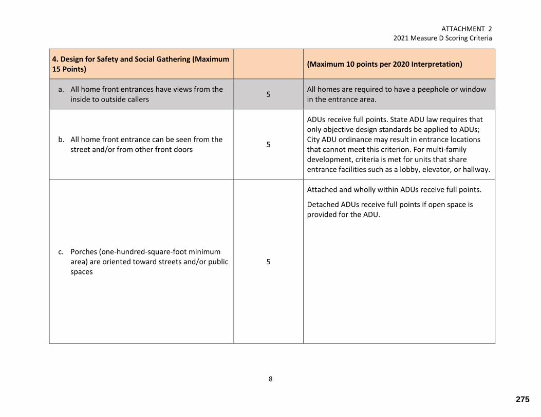
ATTACHMENT 2 2021 Measure D Scoring Criteria
8
4. Design for Safety and Social Gathering (Maximum 15 Points)
(Maximum 10 points per 2020 Interpretation)
a. All home front entrances have views from the inside to outside callers
5 All homes are required to have a peephole or window in the entrance area.
b. All home front entrance can be seen from the street and/or from other front doors
5
ADUs receive full points. State ADU law requires that only objective design standards be applied to ADUs; City ADU ordinance may result in entrance locations that cannot meet this criterion. For multi-family development, criteria is met for units that share entrance facilities such as a lobby, elevator, or hallway.
c. Porches (one-hundred-square-foot minimum area) are oriented toward streets and/or public spaces
5
Attached and wholly within ADUs receive full points.
Detached ADUs receive full points if open space is provided for the ADU.
275
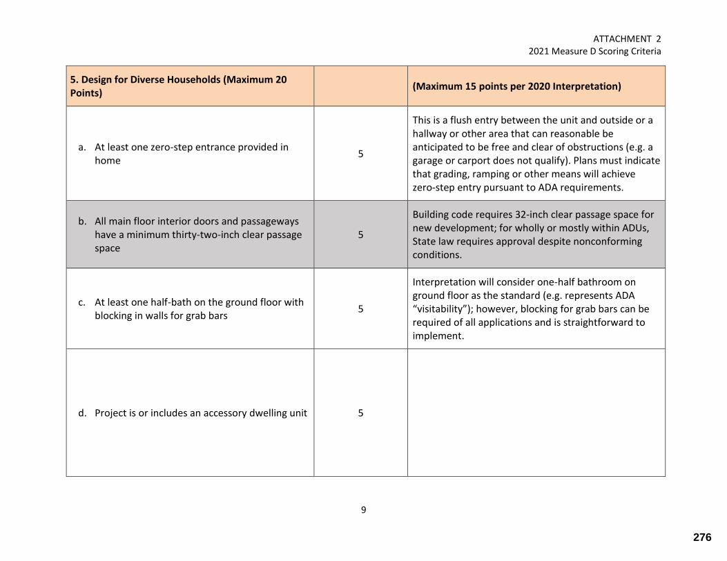
ATTACHMENT 2 2021 Measure D Scoring Criteria
9
5. Design for Diverse Households (Maximum 20 Points)
(Maximum 15 points per 2020 Interpretation)
a. At least one zero-step entrance provided in home
5
This is a flush entry between the unit and outside or a hallway or other area that can reasonable be anticipated to be free and clear of obstructions (e.g. a garage or carport does not qualify). Plans must indicate that grading, ramping or other means will achieve zero-step entry pursuant to ADA requirements.
b. All main floor interior doors and passageways have a minimum thirty-two-inch clear passage space
5
Building code requires 32-inch clear passage space for new development; for wholly or mostly within ADUs, State law requires approval despite nonconforming conditions.
c. At least one half-bath on the ground floor with blocking in walls for grab bars
5
Interpretation will consider one-half bathroom on ground floor as the standard (e.g. represents ADA “visitability”); however, blocking for grab bars can be required of all applications and is straightforward to implement.
d. Project is or includes an accessory dwelling unit 5
276

ATTACHMENT 2 2021 Measure D Scoring Criteria
10
6. Landscaping (Maximum 74 points per Ordinance) (Maximum 32 points per 2020 Interpretation)
a. Resource-Efficient landscaping is incorporated into site design that:
1. Meets California-Friendly Landscape Program requirements
4
All projects satisfy this criterion because WELO applies; awarding these points to every application will not help rank them; therefore, it is eliminated it from the calculation
2. Excludes any invasive plant species listed by the California Invasive Plan Council (CAL-IPC)
4 Standard condition of development approval; all projects will comply.
3. Excludes plant species that require periodic hedging or shearing
4
Criterion may conflict with coastal resource priorities, the Heritage Tree Ordinance, and desired screening between properties: e.g. this criterion may limit ability to establish natives, such as willows; furthermore, with Half Moon Bay’s highly favorable climate, many species of even modest sized plant materials will need pruning periodic pruning (e.g. dwarf fruit trees, roses, etc.). Although “hedging” and “shearing” suggest a particular form of pruning, this will be very difficult to discern at the planning stage because landscapers prune landscape materials in different ways.
4. Plant palette consists of at least 75% California natives, Mediterranean species or other appropriate adaptive species
2
All projects satisfy this criterion because WELO applies; awarding these points to every application will not help rank them; therefore, it is eliminated it from the calculation
277
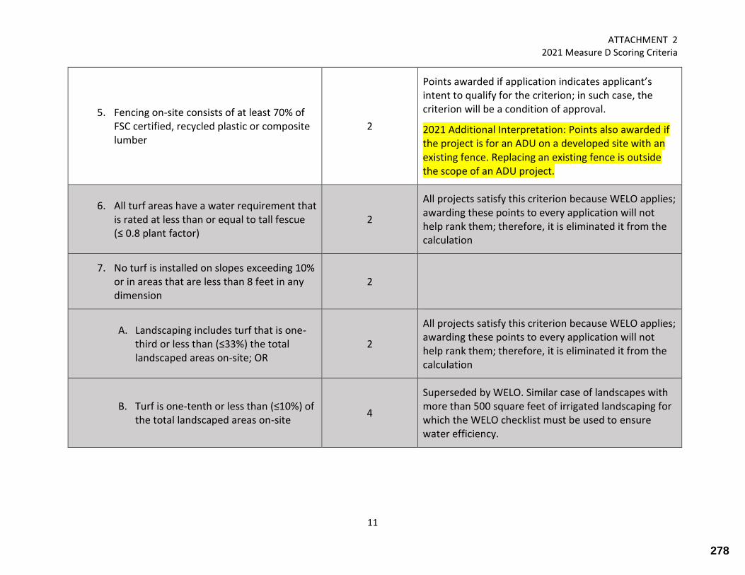
ATTACHMENT 2 2021 Measure D Scoring Criteria
11
5. Fencing on-site consists of at least 70% of FSC certified, recycled plastic or composite lumber
2
Points awarded if application indicates applicant’s intent to qualify for the criterion; in such case, the criterion will be a condition of approval.
2021 Additional Interpretation: Points also awarded if the project is for an ADU on a developed site with an existing fence. Replacing an existing fence is outside the scope of an ADU project.
6. All turf areas have a water requirement that is rated at less than or equal to tall fescue (≤ 0.8 plant factor)
2
All projects satisfy this criterion because WELO applies; awarding these points to every application will not help rank them; therefore, it is eliminated it from the calculation
7. No turf is installed on slopes exceeding 10% or in areas that are less than 8 feet in any dimension
2
A. Landscaping includes turf that is one-third or less than (≤33%) the total landscaped areas on-site; OR
2
All projects satisfy this criterion because WELO applies; awarding these points to every application will not help rank them; therefore, it is eliminated it from the calculation
B. Turf is one-tenth or less than (≤10%) of the total landscaped areas on-site
4
Superseded by WELO. Similar case of landscapes with more than 500 square feet of irrigated landscaping for which the WELO checklist must be used to ensure water efficiency.
278

ATTACHMENT 2 2021 Measure D Scoring Criteria
12
8. Shade trees of an appropriate species are integrated into the landscape
5
Points awarded if application indicates applicant’s intent to qualify for the criterion; in such case, the criterion will be a condition of approval.
2021 Additional Interpretation: Points also awarded if the project is for an ADU on a developed site with existing shade trees. New landscaping is outside the scope of an ADU project.
9. Plantings are arranged and grouped according to common water needs (hydrozoning)
5
All projects satisfy this criterion because WELO applies; awarding these points to every application will not help rank them; therefore, it is eliminated it from the calculation
10. Irrigation systems include high-efficiency components
A. System uses only low-flow drip, bubblers, or low-flow sprinklers
5
All projects satisfy this criterion because WELO applies; awarding these points to every application will not help rank them; therefore, it is eliminated it from the calculation
B. System includes smart (weather-based) controllers
5
All projects satisfy this criterion because WELO applies; awarding these points to every application will not help rank them; therefore, it is eliminated it from the calculation
279

ATTACHMENT 2 2021 Measure D Scoring Criteria
13
11. Non-plant landscape elements consist of at least 50% salvaged or recycled-content materials
5
Points awarded if application indicates applicant’s intent to qualify for the criterion; in such case, the criterion will be a condition of approval.
2021 Additional Interpretation: Points also awarded if the project is for an ADU on a developed site with existing non-plant landscape elements. New landscaping is outside the scope of an ADU project.
12. Outdoor lighting systems incorporate low-lighting elements, shielded fixtures and direct lighting downward to avoid light pollution and glare:
5 Standard condition of development approval
13. At least 50% of all non-roof impervious surfaces on-site consist of light-colored, high albedo materials (solar reflectance index ≤ 0.3) to reduce heat-island effects
5
Points awarded if application indicates applicant’s intent to qualify for the criterion; in such case, the criterion will be a condition of approval.
2021 Additional Interpretation: Points also awarded if the project is for an ADU on a developed site that appears to comply with the criterion (using information from submitted plans and/or GIS aerials). Such site improvements are outside the scope of an ADU project.
280

ATTACHMENT 2 2021 Measure D Scoring Criteria
14
14. At least 50% of all non-roof surfaces consist of pervious materials
10
“Pervious materials” include aggregate, pervious pavers, mulch, landscape areas, and others.
2021 Additional Interpretation: Points also awarded if the project is for an ADU on a developed site that appears to comply with the criterion (using information from submitted plans and/or GIS aerials). Such site improvements are outside the scope of an ADU project.
15. Rain water harvesting systems are provided on-site:
Either none or one of the following may be awarded based on application, but not both.
A. Less than 350 gallon capacity; OR 2 Points awarded if application indicates applicant’s intent to qualify for the criterion; in such case, the criterion will be a condition of approval.
B. Greater than 350 gallon capacity 5 Points awarded if application indicates applicant’s intent to qualify for the criterion; in such case, the criterion will be a condition of approval.
281

Sent: Tuesday, March 23, 2021 11:07 AM Subject: Statement from Casa Mira HOA to HMB Planning Commission for 3/23 Hearing Dear Jill, Our Casa Mira Board of directors would like to have the attached statement submitted to the City Planning Commission for its 3/23/21 meeting. Thanks, Bill Regan, Casa Mira Board Member “On behalf of the members of the Casa Mira HOA we want to be sure that the new sewer line would not prevent Ramona Way from functioning as a street in the future and would be available to serve any buildings which might eventually be located along the ocean side of Ramona Way.”
282

Ellis A. Schoichet AIA
Peninsula Building • 307 South “B” Street #12 • San Mateo CA 94401 • 650 • 343 • 3452
3/23/2021
Attn: Planning Commission and Planning Staff, City of Half Moon Bay Re: 2021 Measure ‘D’ Ranking Ratification
Dear Planning Commissioners and Staff,
This letter is respectfully submitted for consideration under Agenda item #1B. I’m an interested party whose application is subject to the outcome of this evening’s hearing, but I’m raising a question broader than any single project. The Staff recommendation in front of you tonight is based an assumption that bears questioning. ADUs (Accessory Dwelling Units) have been lumped together with conventional residential applications, combined and subjected to the limitations of the City’s Measure ‘D’ growth control regime together. In these notes I’ll suggest a different approach- that these two classes of applications should be considered separately as a matter of logic and law.
In recent years many have labored to find and implement effective strategies for addressing the shortage of housing in communities like Half Moon Bay and across the State. Enactment of the State’s 2019/2020 ADU legislation was a watershed moment, unlocking the production of additional residential units beyond those which might otherwise have been approved under pre-existing local regulations. The intent of the new laws is clearly stated in the HCD’s own ADU Handbook:
‘ADU law and recent changes intend to remove barriers, streamline approvals, and expand potential capacity for ADUs, recognizing their unique importance in addressing California’s housing needs.’
Missing from this, or any other official statement on the subject, is the intent to replace, offset, or limit the production of other types of residential units as a result of the State’s actions. As an Architect and a housing advocate myself, I’m 110% behind the ADU regulations- in both intent and execution. However, the results of the Measure ‘D’ allocation rankings before the Commission this evening are troubling. To me they are a misapplication of the hard-won State level regulatory relief. Intentionally or not, aggregating newly proposed ADUs with other types of residential units under the Measure ‘D’ growth allocation subverts the intent of the new State laws. Admirably, the City has received an increased number of applications for new ADU units this year. Less admirably, the abundance of ADU applications is cited here as justification for crowding out other applications that would have been allotted development certificates in the very recent past. The full increase in the number of residential units that should ideally result from the new State laws isn’t being realized.
In the case of my client specifically, a conventional single-family dwelling on an infill lot is slated for denial. In the case of tonight’s recommendation to the Commission- (4) single-family units applied, (0) single-family units allocated. The Commission should take note of this outcome and consider the proverbial writing on the wall. Something is wrong.
283

2
The significant increase in the number of proposed ADUs is a fabulous achievement, a testament to the power of the new State legislation. But pitting ADUs against conventional single-family homes and other types of residential units here in Half Moon Bay, or anywhere, is not a reasonable or healthy strategy for the long-term. It seems obvious that ADUs should be considered separate from and outside the Measure ‘D’ allocations if the new laws are to be implemented in good faith.
For myself, for my client, and perhaps for the Commissioners themselves, I respectfully request that Staff’s approach be re-examined. I ask that the Commission, Staff, and the City Attorney address the following specific question prior to ratifying the proposed Measure ‘D’ allocations:
Question: Is the City within its rights under AB 881 (Section 65852.2 (a) (2)) to include applications for ADUs under the Measure ‘D’ annual allocation and thereby create a zero-sum competition between ADUs and other types of residential units?
For reference, the text of AB 881 Section 65852.2 (a) (2) states:
The ‘ordinance’ referred to is AB 881, overriding local restrictions to encourage development of ADUs. The ‘local ordinance, policy, or program to limit residential growth’ would in this case be Measure ‘D’. The full text of AB 881 is attached to this letter for reference. The Section cited is highlighted on p. 4 of that .pdf.
In conclusion, please consider the following hypothetical: In some future year (maybe next year), the number of applications for ADUs in an area regulated by Measure ‘D’ will exceed the annual allocation even before any other type of residential unit is considered. Will the City then seek to deny some number of ADUs due to oversubscription of the Measure ‘D’ allocation? And isn’t this precisely what the new State laws have been enacted to prevent?
The trend for increasing numbers of ADUs is clear, and a reckoning will come soon. The simple and obvious fix for tonight and for the future is that ADUs must be treated differently, as intended in the State law. The Measure ‘D’ ranking and allocation should be applied to conventional applications as in the past, but applications for ADUs that meet the requirements of the State law should not be subject the Measure ‘D’ regime.
Thanks in advance for your time and attention to this important question. Best Regards, Ellis A. Schoichet AIA / EASA Architecture Working remotely until further notice- please use my cell number for quickest response: 650.387.0539
284
����������� ��� ��������������������������� �
�������������� !��"����#$��#���%�&'()*+'('(,
-
.//0123456733589:5;;<
=>?@ABCDEFG
HI-JKL-LM-JNOIPQ-ROSOJTQ-JIP-JPP-UOKLVMI-WXYX'Z'-M[-L\O-]MORINOIL-_MPOQ-ROTJLVI-LM-\MabVIZ
c-HSSRMOP-de-]MORIMR--fKLMdOR-(*Q-'()*Z-gVTOP-hVL\-UOKROLJRe-M[-ULJLO
-fKLMdOR-(*Q-'()*Z-i
jklmnjopmqkrstuvnkjwnrxmlknp
Hy-YY)Q-yTMMNZ-HKKObbMRe-PhOTTVI-aIVLbZ
&),-z\O-{TJIIVI-JIP-|MIVI-}Jh-SRMVPOb-[MR-L\O-KROJLVMI-M[-JKKObbMRe-PhOTTVI-aIVLb-de-TMKJT-MRPVIJIKOQ-MRQ-V[-J
TMKJT-JOIKe-\Jb-IML-JPMSLOP-JI-MRPVIJIKOQ-de-NVIVbLORVJT-JSSRMJTQ-VI-JKKMRPJIKO-hVL\-bSOKV[VOP-bLJIPJRPb-JIP
KMIPVLVMIbZ-~�VbLVI-TJh-RO�aVROb-L\O-MRPVIJIKO-LM-PObVIJLO-JROJb-h\ORO-JKKObbMRe-PhOTTVI-aIVLb-NJe-dO
SORNVLLOP-JIP-JaL\MRV�Ob-L\O-PObVIJLOP-JROJb-LM-dO-dJbOP-MI-KRVLORVJ-L\JL-VIKTaPObQ-daL-Vb-IML-TVNVLOP-LMQ-L\O
JPO�aJKe-M[-hJLOR-JIP-bOhOR-bORVKOb-JIP-L\O-VNSJKL-M[-JKKObbMRe-PhOTTVI-aIVLb-MI-LRJ[[VK-[TMh-JIP-SadTVK
bJ[OLeZ
z\Vb-dVTT-hMaTP-VIbLOJP-RO�aVRO-J-TMKJT-JOIKe-LM-PObVIJLO-L\ObO-JROJb-dJbOP-MI-L\O-JPO�aJKe-M[-hJLOR-JIP
bOhOR-bORVKOb-JIP-L\O-VNSJKL-M[-JKKObbMRe-PhOTTVI-aIVLb-MI-LRJ[[VK-[TMh-JIP-SadTVK-bJ[OLeZ-z\O-dVTT-hMaTP-JTbM
SRM\VdVL-J-TMKJT-JOIKe-[RMN-VbbaVI-J-KORLV[VKJLO-M[-MKKaSJIKe-[MR-JI-JKKObbMRe-PhOTTVI-aIVL-dO[MRO-VbbaVI-J
KORLV[VKJLO-M[-MKKaSJIKe-[MR-L\O-SRVNJRe-RObVPOIKOZ
&',-~�VbLVI-TJh-RO�aVROb-JI-MRPVIJIKO-SRMVPVI-[MR-L\O-KROJLVMI-M[-JKKObbMRe-PhOTTVI-aIVLbQ-Jb-PObKRVdOP-JdMOQ
LM-VNSMbO-bLJIPJRPb-MI-JKKObbMRe-PhOTTVI-aIVLbQ-VIKTaPVIQ-JNMI-ML\OR-L\VIbQ-TML-KMORJOZ-~�VbLVI-TJh-JTbM
RO�aVROb-baK\-JI-MRPVIJIKO-LM-RO�aVRO-L\JL-L\O-JKKObbMRe-PhOTTVI-aIVLb-dO-OVL\OR-JLLJK\OP-LMQ-MR-TMKJLOP-hVL\VIQ
L\O-TVVI -JROJ-M[-L\O-SRMSMbOP-MR-O�VbLVI-SRVNJRe-PhOTTVIQ-MR-POLJK\OP-[RMN-L\O-SRMSMbOP-MR-O�VbLVI-SRVNJRe
PhOTTVI-JIP-TMKJLOP-MI-L\O-bJNO-TML-Jb-L\O-SRMSMbOP-MR-O�VbLVI-SRVNJRe-PhOTTVIZ
z\Vb-dVTT-hMaTP-POTOLO-L\O-SRMVbVMI-JaL\MRV�VI-L\O-VNSMbVLVMI-M[-bLJIPJRPb-MI-TML-KMORJO-JIP-hMaTP-SRM\VdVL-JI
MRPVIJIKO-[RMN-VNSMbVI-RO�aVRONOILb-MI-NVIVNaN-TML-bV�OZ-z\O-dVTT-hMaTP-ROVbO-L\O-RO�aVRONOILb-[MR-JI
JKKObbMRe-PhOTTVI-aIVL-de-SRMVPVI-L\JL-L\O-JKKObbMRe-PhOTTVI-aIVL-NJe-dO-JLLJK\OP-LMQ-MR-TMKJLOP-hVL\VIQ-JI
JLLJK\OP-JRJOQ-bLMRJO-JROJQ-MR-JI-JKKObbMRe-bLRaKLaROQ-Jb-PO[VIOPZ
&�,-~�VbLVI-TJh-SRM\VdVLb-J-TMKJT-JOIKe-[RMN-RO�aVRVI-J-bOLdJK�-[MR-JI-O�VbLVI -JRJO-L\JL-Vb-KMIORLOP-LM-JI
JKKObbMRe-PhOTTVI-aIVL-MR-LM-J-SMRLVMI-M[-JI-JKKObbMRe-PhOTTVI-aIVLZ-~�VbLVI-TJh-RO�aVROb-L\JL-JI-JKKObbMRe
PhOTTVI-aIVL-L\JL-Vb-KMIbLRaKLOP-JdMO-J-JRJO-\JO-J-bOLdJK�-M[-IM-NMRO-L\JI-X-[OOLZ
z\Vb-dVTT-hMaTP-VIbLOJP-SRM\VdVL-J-bOLdJK�-RO�aVRONOIL-[MR-JI-O�VbLVI-TVVI -JROJ-MR-JKKObbMRe-bLRaKLaRO-MR-J
bLRaKLaRO-KMIbLRaKLOP-VI-L\O-bJNO-TMKJLVMI-JIP-LM-L\O-bJNO-PVNOIbVMIb-Jb-JI-O�VbLVI-bLRaKLaRO-L\JL-Vb-KMIORLOP
LM-JI-JKKObbMRe-PhOTTVI-aIVL-MR-LM-J-SMRLVMI-M[-JI-JKKObbMRe-PhOTTVI-aIVLZ-z\O-dVTT-hMaTP-JTbM-VIbLOJP-RO�aVRO-J
���� ���������������� �������������� ������������ ��������������� ���������� ����� ���¡�¢������
285
������������������ ������������������������������������ ��������������������������������������������
����������������������������� ���������������������� ���������������������������������������
�������������������������� ���������������������������������������������������������������� �����������
����������������������������������������������� ����������������� �� ����������������������������������
������������������������������������������������������������������������������ ��������������� �
������������������������������������������
������������������������ ��������������������������������� �������������������������������������� ���
������������������������������������������������������� �����������������������������������
�!�������������������������������������������������������������������������������������������� �����������
������������������������������������������������������������ ��"#$������������������ �������������
�������������������������������������������������������������������������������������������������� �
�������������������������������������������������������������������� ��%$����������� �������� �������
����������������������������������������� ����������������������&������������������������������� ������
���������������� ���'��� ������������������������������������ ����������������������� �������������������
���������������� �����������������������������������������&������������������������������� ���������
���������
�%����������������� �����������������������������'��������������������������������������������������������
��������� ������'����������������������� ��������������������������������������&���������������� ���� ��� �
�������������������������������������������� ������������������������������������������������������
�������������������&������������� ���� ����������������������������������������������������������
�������
��������������(������"��#$#!����������� �������������������������������������&����������������������
����������������
�)����������������� ���'���������������������������� �������������������������'������������������������
������������������������ ���� ���������������������������������������������������������������� ������
��������������������
����������������� ������������������������������� ������������������������������������������� ����
����� ����������� �������������������������� ������ ������������������������������� �����������������
��� ������������������������������� �������������������������������������������� ���������� �����
����� �������������������������� ������������ ��*!$����������������"�$$$��������������� �����������
������������������������� �������������� ���������������������������� ����������������������
�������� �������� �����������������������'��������������������������������'�����������������������
��� �����������������������������������������������������������������������������������������������
�������������'�������� �������� ����������� ����������������� ������ �����������������*$$�����������
����������������������� ���������������"%������� ��� �������� ����&�������������������������������
�*����������������� �����������������������������������������������������������������������������
������� �������������� �������������������������������������� ��"+#����������������������
�������������������� ������ ��������������������� �������������������������������������� ��"+#������������
��������������������������������������������������������� �������������
�,�������������������������������������������������������������������������������������������������������
��� ����'�����������&���������������������������������������������������������� ������� �������������
��� ��� �������������������������&��������������������������������������� ����������������������������
��������� ���� �������������������������������������������������
��������������������������������������������������������������������������������������� �����������������
�����&����'�������������� ���������-��"������������������������������������������������������������
����������� ����������������������������&������������������������������������������.��#��������� ������
���������������������������������� ���������������������������������������� ���'������������������
������������������������������������������������� ��� ����� ������.��/���������������������������������
��� ��� ������������������������������������������������������������� ��������������������������������.
���������������� ��#������������������������� ������������������������ ��� �����������������������
286

������������� ������������ ��������������������������������� ������������� ���������������� �� ��� �����
������������ ��� �������
������������������� ����������������������������������� ������ ����� ��� �� ������� ���������� �������������� �
������������������������ ���������������� �� �������������������������� ������������� ����
������������������������������������ ���������!�"���� ����� ���������������������������������� ����������
������������������ ����������������������"������������
������������������ ��� ������������������������������������������������� ���������������#��� ��������
$����������%��������#�!����������������� �&����������� ��������� �!������������������������ ��������
������������������������� �&���������� ��������������� ����������������������������������������������� ����
� ������������������������������������� �&��������� �������������������� ���������������������������
���� ���������������������������������'��� ������������������������������������ �!������������� ��� �����
���� ������������������������������������������ ��������������� ������������ ��� ���������������������
������� ��������� �����'�������������������� ������������ ������������������������������ �!�������� ���������
����������������������������������������������(�������������������������������������� ��������� ���������
����������������������������������� ��� ���������� ����������������������������������������� �&��������������
����)��� ����*��� �������������������������������!��������������������������� �!������ ���������������� �&�����
���� ������������������������������������������ �������� ���� �� ��� ����������������� ���� �������
� �!����������� �&����������� ����������������
��+����������������������������� ��,������� ��������������-��� �������� ��������������������������� ��
��������� ������������������������������� �!����������������������������!����������������� ������ ��� ���� �����
������������� �!����������������������������������� ��� ������������ ����������������������������������������
� �������� ����������� ��� �� ������������� �� ��� ������ �!����������� ������!�����������
��.�� ����������������� �� ��������������������������/�������0121+�+��������*�!� ������%����� ���������/3
�.��������� ���!�����������������������/3��.�� ���������������������������������������
��4��3����� ���������������������������������������� ������������������ ���������������������������������
�����"���������������� �� ���
��1�� ���%����� ����%����������� ��� ���������������� ��� ��������������������������������� ������� ��� ����
����������������������������/����� ��� �!����������������� ���� ����� ������������� ��� �������
�������������� �!������������ ��� ���������� ��� ���������������� ������������� ������
��0�� ����������������������������������������������� ��������������������� ����������� ������������������� �
���� ���������������������� ��������� ��� ������������������������������������ �� ��������
5���6����� ������)�� �� ������6������7������%��������6�������8�����9 �� ��6������
:;<=><?>@<=?A=:;<=B:C:<=?A=DC@EA?FGEC=H?=<GCD:=CB=A?@@?IBJ
KLMNOPQRST�/�������0121+�+��������*�!� ������%������������������ ���6
UVWVXTXT���������)���������������������� ���������� �!������ ������ ����������������� �������������������� ���
&��������������������"�������� ���������������� ���� �������������������������������������6
�)��#���������� ���������������� ��������������������������������� ��������� ������������������������ �������
������������������� ������������������������������������� ��������� ��� !����������������������
������� �������������������� ����������������������������)����������������������������� �!�������� �� �����
�� !������������������������������������� �� ����� ��� !����� �!��� � ��� ������������������������ ���������
�� !�������� ������������������ ������ ��������� ������������������������ �������
�3������(������������ ������������� �������������������������������� �������������������� �������������
�������������������� ������� ��� �!��������������&���������������������� ��������� �!������!� �������������
���� ����� ��� �������������������������%����� ����Y������ ����$���� ���Y��� ����� ����������� �������������������
��� �����������������������&��
287

����������������� ����������������� �������������������������������� ��������������������������
������� �����������������������������������
������������������������������ ���������������������������� ������������������������������������
�������������� ������������������������������������� ������������������������������������������
���������� � �������������!���� ���� ������������������
�"��#������������������������� ��������������������������������������� $
����%����������� ����������������������������������������� ���������� ��������������������������
�������������������������������
�����%���������!��������������� ��&���������������������������������������������������� ��� ��&�����
������� �
������%����������������� ����������������������������������������������������������������� �������
������� ���������� �������� � ������ ������������������������������������������������������
��������������������� ��������������� ����������������������������������������������� �������
������� �
�����'������������������ ��������������� ���������������������������������������������� �������������
�������()���������������������� ��������������� �
����%�������������������������������������������� ���������������������*�+))�����������
��������� �������� ������������������������������������������������������������������ ������
����������� ������� ����������������������� ������ �������������������������������������������������
���������������������������������������������� ���������������������������������������������
��������������������������������������� ������������� �����������������������������������������������
������������� ������������������������������� ��������������������������������������� �����������������
��������������������������������������������������������������������� ����������
�������,���� ������ ��������������������������������������������� �������������
�����-������� ����������������������������������������� ��������������� ��� ������������������
�����'������� ������������������������������� ������������������������������ ��������������������
������������������������%����������� ����������������������� �������������
�''��.�������������� ����� ����������������� ���������������������������� ����������� ������������� �
����������� ��������������������� ����������������� ������ �������������������� ������
��� ��� ������������������������� ��������� ��������������������������������������
�'''��%����������������������������������������� ������� ������������
�����/����� � ��������������������������� ������������������������������������������������������������
���������������� �������������������������������������� ���������������� ������������������������
������������������� ����� ����������
�+��%�������������������� ���������������������������������������������������������������� �����������
���������� ������
�0��-������������������������������������������� ������������������������������� ���������� �
���������������������������������������������������������� �������������� �1�������2(3)*����2(3)2���
������������������� ����� �����������������������������������������%������������ � �����������
������������������������������������������ ������������������������������� �������������2)��������
����������������� ����������������������������������������������������� ��� ��&�������������������
������� �������������'������������������������������������������������ �������������������������������
�������� ���������������������������������������������� ��&������������� ��������������������������
����������������� ����������������������������������������������� ��������������������������
������� ������������������������� � ��������������������������������������������������� ��&������������� �
�������������������������������������������� ������������������������������ ���������� �����������
����������������������������������� ��'��������������������������������2)&������������������� ��������
����������������������������-������ ����������� �������������� ��������������������������������������
288
ellis
Highlight

��������������������� ���������������� �������������� �������������������� ��������������� ���
��������������� ���������� ��������������������������������������������������������������� �����
�� �!���"��� ���������� ������ ���������������������������������� �����#����������� ��������������������
������ ������������������#����������� ��������������������������������������������������������������
�������������������������������������������� ����������������������������������������������������
���������������$�������������������������"�������������������������������#�������%����������� ����
�������"��� ����������������� ������������������������������������$�����������������#����������
��������������#������������������������ �������������������������������������������#���������
��#����������������������������������������� ��������������������������� ���������������������������
���������������������
�& �'����������������������������������� ������������#�����#����������������������#���� ���������������
�����������������#������
�( �)����#����������#����������"������������������������� �������������������������������������
���������������� ��������������*��������������������������������������������������"��� ��� ��+�����
������ ��'���������������������������������������������������#������������#�����������������
������ ���������+�����������$����������"������������������ �����������$�������������������#����������
�������������������� �������,�������
�- �!�������� ������������������*��� ������������� ���������������������������������������������������
��������������������#��������������������������������������� �������������������������������������
��������������������#������
�. �!������������������ ��������������������������#�����������#������������#������������������������
����������#���� ��������������#����������������"��������������#��������������������������������
������������������#������������#�����������������������������������������"��� � ����������������*���
��� �������������������)������������������ ��������������#���������������������������������������
����������������������� ��������������������� �����
�# �/������������ ������������������������������������ ������ ����������������� ������������������
�����#�������� ��������������������������������������������������������������� �������������������
��#����������������� ������������������������������������������������������������������������
��������������������#�������� ��)��������� �� ����������������������������������������������������
������ ����������0��������������������� ���������(������������������������������ ��������������
���������������������������������"��� ��� ��+������������������������� ������������%����������
��������������������������������������� ����������0��������������������� ���������#����������������
���������������������������� ��+������������ ���������������������� �� ������������������� ������
��������������������������������������� �����������0��������������������� ��������������������
� ��������������������������������������������������� ��+������������ ��#����������������������������
���������������� ��������0��������������������� ���������������#����������������������������
��������������������������� ��%����������������$������������������(�+�������������������#���������������
������������������
�� ��� ���#0����������� ������ ����������� �������������#���������������"���������*����$��������
����#��������������������������������������� ������
�� �'���������� ����� ������ ����������� ������������������#���#���������������������������� 1
�! �!��������$���������� ����$������������������������������������������������������� ��������
���#�������������������
�2 �!���"�����$���������� ����$������������������������������������������������������� ����������
��������������������������� 1
� �.&���$����������
� ��������$��������������������������������� ������������������������������#�������
�3 �!�������������������"�����*������������������������� �������*��#�������������������� �������
�������������"��� �������������� ����������������������� ���������������������������������������������
�*������������������������������������� ���������������������������������.����$�������������������
289

������������������������� ���������������������������������������������������������������������
������������������������������������������������
������������������������������������������������������������������������������������������
����������������������������������������������������������������������������������������������������������
��������������������������������������������
� �� �������������������������������������������������������������������������������������
�!�� ������������������������������������������������������������������������������������������������
�"�� ��������������������������������������������������#������������������������������������������������
�$��%��������������������������������&������������������������������������������������������������
�'��%������������������������������������������������������������������������������
����� �������������������������������������������������������������������������������������������������������
��������������������������������������������#�������(�������������������������������
�)��*����������������������������������+������������������������������������������������������#�������������
��������������������������������������������
���� ����������������������������+������������������������������������������������������������������������
�������������#���������������������������������������������������������������������������������#�������������
�������� ',��&������������������������������������������������#�������������������������)�
�#������������������������������������������#�����������������������������������������������������
�������������������
����� ������������#���������������������������������#�����������������������������
������ ���������������������������������������������������������
����� ��+���������������������������������������������&������������-�������'.'!�!!�
�/��*�������������������������������������������������������������#��������������������������������
�����������������������������������#������������������������������ �������������������������������
��������������+�������������������������������������������������������)���)��������������������������
������������������������������������������������
����)���������������������������������������.,,��&���������
�����)����������������� ������
�0��������1��������������������������������������������������#����������������������������������������
���������������������������������������������������������������������������������������������������
���������������������������������������������������������������������������������
�����)��������������������������������������������������������������������#�����������������������������
����������������!'��������������#�������������������������������
�2����������������������������������������������������������������������#����������������
��������������������������������������������������������������+������������������� ���������������
�������������������������������
�!��)������������������������&�������������������������������������������������������������������������������
����������������������������������+�����������������������������������������������������������(�����
����������
�"�� ���������������������������������������������&�������������������������������������������������������
��&������������������������������
�$��)���������������������&��������������������������������������������������������������������������
�����������������������",������
�'��)��������������������&��������������������������������������������������������������������������
�����������������������������������������������������������������������������������������������290

����������������� ����������������������������������
������������������ ���������������������������������������������������������� �������
�������������������������������������������������� ������ ������������������������� �����������
����������� ������������������������������������������������������ ������������������ ��
� �������������������� ������ �������������������� �����������������������������������
������������!���������������������������"���� ���� �� � �����#��
������$����������������������������������������������������� ������ �����������������
%������&��� ��������'�������������%������(��� ��������'������������
���)�������������������������� ���������� ������������������������������������������������ �
��������������������������������������������������������������������������������������������
�������������������������������������������������������������������*�� �����������
�)�$���������������������������� ����� ����������)������������������� �����������������
������������������������������������������������"�������������������������������������������
��������������� ������������������������������������������ ������������������������
�������������������������������������������������������������������*�� ����� ��
�+�$������������������������������������ ����� ����������)������������������� �����������
��������������������������������������������� ����"���������������������������������������
����������������������������������������%�����������'���������,����������� �� �
�� -����������������������������������������� ������������������ �����������������
�������������������� ������������������#������� ���������� ����.�������������������
���������� �!����������������������.������������� ����������������������������
���!����������������� ����������������������������������������������������"���� ���������
������������������������������
������)����������������� ������������������������������������� ���������������
/����� ����0�������%� ����/������ ��������������������������)��������������
����������������� �� ���� ���������������������������������������������������� �����
���������������
����)�1���������� �����������������������2���������������� ���������������������
������ ��������������������������������������������������������������� ���� ��������
���,������������������������� �������3���������������������#�� ������������
�+�!��������������������������������� ��� ���������� ������������� ����������)��������
�����������������4
���) ���������������� ������������������
����)����������������������������!����������������������������������������������������
������������.�������������������������� ����������������������� ��������������������������
�������������������� ���
�,��)�1��������������������� ������������������������������� ��2���������������
��������������������������.�������������������������� ������������������������������
��������� ��2����������������� ��������������������������� ����������)������5���������
�����������������������������������
�+�+���������������)������5����������������������������������������������������� �� ��
������������������������������������������� �������������������� ����������������(�
���������������
���!�������� �� ���������������� ����������������������� ��� ������� ������������������
���������� ����������������� ������������������������������������������!������������������
��������������� �������������� -�����%������,�&��� ��������'�������,6����7������
/������,��!������
�-�)������������������������������� � ��4
291

�������������� ������������������������������������������������������� �������������������������������
������������������������������������������������������������������ ���������������������������
�������������������������������������������������������������������������������������������������������
������������������� ��������������������� ����������� ����!������������������������ ������������������������
������� ���"
��������������������������������������#�������$%&'���������(����������#������)���
�*�����������������������������������#�������'++$�������(����������#������)���
�,������������������������������������������������������������������������ ������������������������
���
�-���.�����������������������������!���!������������ �����������������������!���������������������!������
����������������������������������������
�/���.�������������������������������������������������� ��������������� ����������
�&���0���������1�������������������������������������������������������������������� ���
������1��������������
�2���3������ ���������������� �������������!��������������������������������������������������
����������������������� ������������
�$���3������ ����������������� ���������������������!4�������������������������������������������
�5���������������������
�'���3�!���������������������������������������!�������������������!��������������������� ����������!���
�����������!���������������! �������������������������������������������������������������������
�������������!�����������!����
�%���6�������������������������� ���������!���������������������� �����������������������
���������������!���������������
����������������������������������������������������������������������� ������������!�������������������
�������������������������������������������� �������
����0���������������������������!����������������������������� ��������������������������������������
������)��������)�������������%$2��7�������,+������������ ����#������-++++��������3�!����8������
)��������������������������������������������!���5�������������!�������������������������������
����������������������������� �������������
����6�������������������������������������������9���������,+,&��������������������������������
:;<=>?=@=�#������2&'&,�,�������A��������)�������������������"
B@C@D=D=����������������������������!����������������������������������������� ��������������������
1��������� ������� ��������������������� �����������������������6�������������������������������� ���"
����7�������������� ����������4���������������������������� ������������� �����������������!�����������
6�������������������������!��!��������������5������� ���������� ��������������������������
��������� ������������������������ �������!�������������������������������������������� ������� �
��������������������� ������������� ������� ������������������������������5������� ���������� �
��������!����������������������� ������������� �����������������!�����������
�*�������������������������������� ���������������������������!�����������������������������������
���!�������������������������������� ������������1�����������������������������������������������������
������������������������������������)��������8���������(������8��������6������������������������������
�5������������������������1��
�����0� �������������������������������������������������������������������5����������������������
� ������������������� ����������4����������
�)��3������������������� �������������������������������� �!������������������������ ��������
��������� ����������������������������������������� ��������������������������������������������������� ���
292

������������������������ �������� ���������������������
����������������������� �������������������������������������������������
���������������� ����������������������� ����������������������� ����������������������� ��
������������ ��� ����������������������� �����
�������������������� ���������������!������������������� ����������� ����������� ������ ���������� ��
��������� ��������
������������������ ��������������������������� ������������ ������������������� ����������������
�������������� ��������� ���������������������������������������������������� ����� ����
���������� ����������������� ��������� ������ ���������������������������� ����������������
��������
�� ��"�������������������������� ����������������������������������� ��������� ���������������������
����� �#$����������������������������� ��������
� ���������������������� ����� ��������� ��������������������������� �%�&$$�����������
� ���'����������������������� �������(������������������������������������������ �������������
� ����'�������)�������������� ����������������� �������������������������������������������� ���
����������������� ������������ ����������������������������������������� ��� �������������� �������
������������������������������� ��������������� �������)���������������������������������� ��� ��
����������������������� �������������� ��������������������������� ��� ������������������������������
����������������� ��������������������� ������������ �������������������������������
� �����*�������� ������ ������������������������� ����� � ��������������������
�����+��� ����������������������������������� ��������� �������������������������� ���������� �
�����"��,)�������������������������� ���������������������������� ������)�������������������
�������������������� ����������� ������������������������������� � � ����� ����)�������
� ����
�""��-����������)������������������� ���������)���������������� ������� ���������������������������
�� ����)������������������������ �������� �������)������������)�������� ����)����������
����������� ����������������������������������������������� ��������������� �������
�"""���������������������������������������� �������������������� ������ ������� � ������� ��
�����.�������������������� �� ��)��������������� �������� �������(�������������������������������
���������� ������������������ ��� �������������� �����������������������������������������������
����������������)������������������ �
������+�������� ������������������������������� ������ � ����������)����������������������� �������
�������� �����
�&������� ����������������������� �� ������������������������������ ������������������������������
��� ������������
�/��+������������������������������ ����������������(������������� �������������������������� �� ��
��� � ��������������������� ����������� ������������������������ ����0�������1#2$%���1#2$1�����
������ ������������������������������ ���������������������������������������������������������
�������������������������������� ����������������(������������� ��������������������1$� ����������
���������������������� ������������ ���������������������������������������!������������������� �������
������������"���������������������������������������� ����������������(������������� ���������������
�������� ������������������������������������������!������ ������������������������������������������
������������������������������������������������ �������������������(������������� ������������������
���������������������������������������������������������������������!������ ��������������������������
�������������������� ���������������(������������� �������������������������� �� ��������� ���������
� �������������"����������������������� ���������1$! ����������� �������������� ������������ �������
�����+����������������������������������������������������� ������������������������������ ���
������������� ������������ �������� ������������ � ������������������������������ �������������
293

��������������� ������������ ��������� ����������������� ���������������������������������� ��������� �
���������� ��������������������������������������� ������������ ������ ������������������������� ���
� ��������� ������� ������������� ������������������������������������������ ����� ��� �����
� ��������� � ���� ������� ��������������������� ����� �����������������������������������������
������������������ ���������������� ������������������������� ���� ������������������������
� ��������������������������������������������������� ���� �������������� ����������������
������������ ������� ������������� ������������������������������������������������� ����������
���������������������
���� ����� �������� ������������������ � �������������������������� ����������� ������������������������ ����
������� ������� ��������������
�!��"������������������������������������ ���������������������������������������� �����
����� ������������������������������������� ������� �������������#����������������� �����������
���� ������ ���������� ������������������������������������� ��������������������������� #�������
���� ���������������������������������� ���� ��������� ��� ����������� � ��������� ������� ����
$%�����
�&�����������������������������'������� ��������� ����� �������������� �� ���������������� ����� ����
��� �� ������������������������ ����������������� ����������������������� �������� ������������
����������������������������
�(���������� ����������������������� ��������������������������������������������� ������ ���
����� �������������������������������� ��������������������������������� ���������������������
���������������������������������� ������������������������������������������ ������������'�����
������������ ��������"�������� �������������������������������� ��������������������������������
� ������������������ �� �� ���������� ���������� ����
����)��������������������������������������� ������������ ���������� ���������������������� �����
������������������ ����������������������� ����� ������ ������������ ����������������� ��������
����������������������������������� ����� ������ ����������������������� ��������������� ����� �
�������� ���������������������"����� ����������������������������������������� ������������ �
�������������� ���*���� ������ ���������������������!%������ �������������������������� ��������
������������������������� �������������������#�������� ��������������������������������������� ��
�������������� ������������ ���������������� ���*���� ������ �������������������������������� ��
�������������� ���������������#������������������������������� ����������������������������������
�� ���������������� ��������� ���������������� ����*���� ������ ������������������������� �����
������������������ ����������������� ����������������#������������������������������������� ������
����� ���������������� �*���� ������ ��������������������������������� �������� �����������
��� ����� �� ������� ������ �������������������� �����������������!%#���������� �������������������� ���
�� ���������������������������������������������������������������������������������!%��������
����������������������������� �����
�����+��,��*������� �� �����-������������������������������������������������������'�� ���� ����
�� ����������������������������� ���������������
�-�� ������������� �� �����+������������������������������������� ���������������������������.
����������������� ��������� ���� ������� ����� ������������ �������������� �����������������
� ������������������������
�/��������������� ��������� ���� ������� ����� ������������ �������������� �������������������
����������� ����������������.
����(�%���� ������
�����+�%%%���� �������� ��������� ������������������� �������� ������������� ����
�0��������� ���������� ����������'���� ��������� �����������������'���������������� ������������
� ������� ��������� ��� ������������� ���������������� ��������� �� ��� ������������������������������
�'����� ����� ��������� ������������������������������ ������������(%%���� ����������� �
������������������������+!��������������������� #������������ �� ��� ������1��������� �������
���������������������� ���������������������� ��
294

���������������� ������������������������ ��������������������������������������������� �������
��������������� ����������������������������������������������������������� �����������������������
������� ��������������������������� ���������
���������������������� ����������������������������������������� ��������������������������
� �������������������� �������������������������������������������������������� ������������������������
�!�������������������� �������������������������������"���� �����������������������������������������
�#��$������������������ ��������������%���������������������������������������������������������� ������
�&��$������������������������������������������������������������������������ ������
�������������������� ������������������������������������������ ��������������������������������������������
������������� ��������������������������������"������'�������������������������������� �
�(��)������������������ ���������*��������������������� ��������������������������������"���� ��� ���������
������� ���������������������� �������
���������������������� ���������*��������������������� ������������������������������������� ���������
������� �����"���� ������������� ����������������� �����������������������������������������"�������������
����������&+�%����������������������������������������������"���� �������������������(�
�"����������������������������������������"���� ������������������������������������������������
�� �������� ���
����������������"��������������������������������"���� ��� ����������������� �
��������������������������������������������������������������
��������*��������������������� �����������������������%������������,�������-&.& � �
�/��)�������������������������������������������� �������������������"��������������������������������
�����������������������������������"���� ��� ����������������� �������������������� ������������
���������������*��������������������� ������������������������ �����(���(�������� �����������������
�������� �������������������������������� ������
����(���������������������������������������������.++�%����������
�����(��� �����������������-������
�0������1����������������������� ���������������������������"���� �������������������� �����������������
�������������������������������� �������������������������� ������������������������ ������������
������������ ��� ��������������������������������������� �������������������� �
�����(�������� ������������������������������������������ ����������������"���� �������������������� ����
���������������� &����������������"���� �������������������� ������
�2���������������������������������� �����������������������������������������"���� ������������
������� ���������������������������������������������� �����������*����������� ������������-���������������
������������������������������
� ��(�������� ���������������%�����������������������������������������������������������������������������������
��������������������� �����������*��������������������� ������������������������������������ �'����
����������
�!�����������������������������������������������%��������������������������� �������������������������
��%������������������������������
�#��(�������� �����������%��������������������������������������� �������������������������������������
����������������� �������!+�����
�&��(�������� �����������%������������������������������������������������������������������������ �����
���������������������������������������������������������������������������������������������������������
��������������������������������������������������+������
295

������������� ������ ������������� ������������������������������������ ���� ������ �����������������
����������� ������������������������������� ���������������������������� ���������������������������������
���� ����������������������������������������������� ������������������� ������ �������������������� ����
��������� �� ������ ������������������� ����� ������ �������������� ����������� �� ������ ��������
������������ �!������ �� �������������� ����"�������������������������#�
��������$�������� ������������������������������� �������������������� �������� ��������� ��������
%������&�����������������'���������������� �%������(�����������������'�������������
����)���������� ���������������������������� ��� ��������������������������� �������������������������������
������������ ���������������������������������������������������������������������������������������� ���
�������� ������������������������������ ������������������������� ����������������*������� �������
�+���)��)���������������������� �����������������������������������������������������������������
������������������������� ��������������������(&��"��������� �)������������������� ���������������
����������������(&��"������������������������������ �����������������������������������"������������������
�������� ������������
�,��$��������������������������-����������.����������������������������-���.��� ����� ���
�� ��������������'���������������/��������������������� ������������� ����'���������0(( �-1���������.� ��
��������� �������������������������������������������� ��������������������������� ����������������
�����������
�0��$�������������� ������������� ������ ����������������)����������������������� �������������������
��������������� ���������������������������������������"����������������������������������������������������
����������� ��������������������������� ��������������� ����������������������������� ������������������
�������������������������������� ������������������������� ����������������*����������
�&��$�������������� ����������������������� ������ ����������������)����������������������� �������������
��������������������� �����������������������������������"����������������������������������������� �������
������������������� ��������������� ����������� �%������������'�����������+����������������������
��2���������������������������������������������������������������������������� ���������������
�������� ����������������� ���������������"����������������������������� ����������/�����������3$4�
��������� ����� �������4�������5��������%� ��� ���� ��� ������� �������1�������������)�����������
5���������� �6���������7����������������������������������� �!������������������������/��� ���
���������������������� �������������
����!��������� ���������������������������������������������� ��������������������"���������������
����������������������� ������������
�������)��������������������������������������� �������� ���� �������������� ����������������
3�������������8�������� �%���������3�������������������� ���������� ������ �)������ ������������
�� ����������� ������������������������������� ��������������������������������������� ��������������
�������������
�����)��1����� ������������� ��������������������9��� ������� �������������������������������
��������������������������������������� ���������� �������������������������������������������������
����+�� ������������ ���������� �������������:��������������������������#� �������������
�,��!����������������������� ��������� ������ �������� ���������������������������������)���� ����
���������������������;
����)��� ������ ������������������������������
�����) ��������� ������������������� �!������������������������ ����� ��������������������� ���������
�� ������������/������������������������������������������������ ����������������������������� �����
������ ���������� ���������
�+���)��1������������������ ����������� ������ ����������������������� ���������9���� ������� ������
� ����������������������� �����/����������������������� ������������������������������� �� �����
��� ���������9���� �������� ��������������������������������������� ���������������)��������<����������
������������������������������������������
296

������������������ ����������������� �� �������������������������������������� ��������������
��������� � �������������������������������������������������� � ����������������������������� �
�������������������!
���" ����������������������������������������������������������������������������������������
���������������������� ��������������������������������������� ��� �������!�" �����������������
���������� ���������������������#�����$ �����%!&������������� �'�������%(������)�������
*�����%����"����!
�#������������ ��������� ��������������������+
����,��������������������-������������� ������������ ����������������������� �����������������
�������������������������������������������������������������������� ����������������.����������
��������!�/�� ���������������������������������������������������������0������������������ ������
���������� �������1�������������������������������������������!�������������������������������������
����������+
������������������!
������������������ �����������������'������2�� ���� ��3��� �����'�����$���!
����,�����������������-����������������� ������������������������������������������������ ������
��!
�%��,4����������-� ��� ��������������������������'������ 5&2!����� ��3��� �����'�����$���!
�(��,6��������-������� �������� ��������������������������������������������������������������
�������������������������������������������!
�&��,6�����������-�������������������������������������� � ������������������� ������!
�7��,8�� ��� ���-� ��� ����������������������� ���'�����7&&25!&!
� ��,8������������9�����������-���������� ����������������������������� �������������������
�������9�������������!
�2��,)���������-����������� ���� ����������������������� ���0�������.����������������������
����������� ����������������������!
�5��,)���������������-����������������� ���� �����#�������������������������� ������� �
��:������������������!
�����,)���������-���������������������������������������������������������������� ���� �������
�������������������������������������� ����������������������� ��� �����������������������.���������
������������������� �������!
�����,"���������0��-������� ������������������������������0�������������������������� ���������
������������������� ���������� ��!
�0������������������ ���������������������������������������������������������������������� ��������������
��������������������������������� ����������������!
����8� ����� ��������� �������������������������������������������������������� �������������������
��� ��$��������$�������������5 7��*�������������������� �'�����%��������� ��)�����;��������
$�������.���� �� ������������������� ������������:������� ���������� ����������������������������
����������������������������������������!
�������������������������������������������������������������������������������:������������ ������
�����������������������������'�����7&&2%!������#������� ��9������� ������������������������
� � �������!
����/��������������������������������������������������������� �'������ 57������$ �����&����)��
�!&����*������%���� ��3��� �����'�����$��������������������������������������������������� �����������
������������������������������:���������������������������������������������������������������������� ���
�����������������������������������������#���������������� �'������ 52�!������ ��3��� �����'����
$���+297

��������������� ��������������������������������������������
��������������� ��������������������������������������������������������������� ���������������������������
������� ������������������������� ��������������������� �������������� ����������������� ��������
������������������������������������ ��
����������������������������������������������������������� ���� ���������� ������������� �
!"#$%&$�'������( ) ������� � �������*+��������, �������� -
./0/&$&$���������1���������������������� ����������+� �������������������������� ��������������������
2�� �������������3������������������������������ ������������ ������������������-
�1��4���������������������������� ������������������������������������� ���������������������������� �
���� �������������������������� �������� ����������������� ��������+������ �������������
������� ����������������������������� ��������������
�5������6������� �� ���������� ����������������������� �������������������� �������7������������
�����7����� ����������������������+�������8������2�������������� ���� �� ���������+����� +������������
���������������������������� ��������,���������9���������:������;�������������� �� �������������� �
��������������������������2��
�����<�������� ����������������������������������� �������������������7�����������������������������
������������������ ��������������� ������
�,��;�+� �������������� ������������� �����8��� �������������� �����������������������������
������� �������������������� ���� ������������� ���������������������� �����������������������������
�����8��������������������� �2����� �������������������
�4��9������������������ �������������������������������������������-
������������������������� ���������������������������� ��������������������� �������������+���
��������������������������� �����
��������������2�� �������������3�������������������������� ������ �������� ����8�����������3������
��������
����������������� ����������������������������� ����������� ����������������� ����8�������������
�������������� ����������� �������������������������������������������������������� ������ ����
�������� ����8�������������� ���������� ������ ������������������������ ����8�������������
��������
��+��6��������������8�������������� ��������������������������������������� �������� ��������������������
�8��� � �����������������8�������������� ��������
�+������������������������� ������ �������� ����������������������8��� ������������������
�+���<������������������������� ��������������������������������������������� �������������
�+����<������7���������������� ��������8��������+������������������������������������������������ ���
����������������� ����������� �������������8������������������������+���� ������������� �������
����������������������������� ���������������� ��������7�������������������������������� ���� �����
����������������������� �������������� �������������������������+���� ���������8����������������������
����������������� ��������������������� ����������� �������������8���������������
�+�����=�������� ����� ��������������������������� ������ � ����������������������
��8��1���+����������������������������������������+���������� �������������������� ������������ �
�8���6��;��7�������������������������� ����������������������8��� �������7�����������������������
�� ����������+����������������������������+� � ������ ������7�������� ��+�����
�66��>������������7�������������������� ���������7���������������� �������� ����������������������������
��� ������7��������������������� ���������� ����������7������������7����������� ������7��������
����������� ������������������������������������������������ �������������� �����
298

������������������� ������������ ��������������������� ����������� �����
�������� ������������������������������� �������������������������� ��� �� ���� ������������ �������� ���
�������������� ��� �������� ���������� �������������� ��� ������������� ������ ����� ��������
�������������������� ������������������
�!���������� ������ �������� ��������� ������������ ���� ��������� ����������������������������
������ ����������
�"��#��������������� ���������� �������������� ��� ��������� ����������������� ��� ��������
�� ���������� ������������������������� ������������������ ��� �������� �� ��$����� �%&'()����%&'(%���
��������� ��������� ���������� ��������� �������������������������������������� ���� ��������
� ������������ ���������� �������������� ��� ��������� ����������������� ��� �������� �%(���������
����������������� ����������������������������� ������������� ������� ���� ��*����������������
���� ��� ������������������������������ ���������� �������������� ��� ��������� ����������������� �
� ������������������������������������ ����������� ����� ��*��������� ��� ��������������������� �
�� ������������� ��� ������������������� ���������������������� ��� ������������ ������������
���� ��� ���� ��������������� ���� �������� ������������������� �������������� ����� ��*��������� ��
��������������� ��������������������������� ��� �������� ����������������� ��� ����������� �������
����������������� ����������������� �������������� ���� ����������������%(*�������������������������
���������������������������#������ ��������������������������������������������������� ����������������
�� ��� ������������������� ��������� ������!(()+(!�,�����$����� ��������-����������� ���� �����
�������������� ������� �� �� ������ ������������������������������ ���� �������������� ��� ���
�.��# ������� ������ �������� � ������������ ���� �������������� ��� ������������ ������ ���������
���� ������ ������������������� �������������� �������������������� ������� ���� ������
�������� �������������������������������� ��� ���� ����� ���� ����� ����������� �������������
�������� �������� ������ �������������� ���������������������������������� ���������������� ����������� ��
��� ������� ��������������� ��� ������� ������������������������� ������ ��������������������� �����
���� ��������� �� ������� �������� �������������������������� ���������������� �����
���������� ������������������������������� ��� ������ ���� ��� ��������� ��������� ����� ������
������������������������ �
�&��/��������������� ��������������������� �������������������������� ����������� ����������������
�������� ������������������� �
�%���#����������������� ������������������������ �������������� ������������������������������
������������� ��� ���� �����0� ������������� ������������ ������������������������� ���� ��*����
���� ���/�������� ��� �������������� ����������������� ���������������� �������������������������������
���������������������������1��������� �������� ����� ����� �������������������������� ���������
���������� ����� �������������� ��� ����������� ���������2 ����)��!(!&�������� ��� ��*����� ��������
�� ����������������������������������� ������������� ������ �"(�����
�1��/�������� �� �������������#��������� ������ ���������� ��� ��*����� ���� ������ ��� �
������������� ��� ������������������� �2 ����)��!(!(�����2 ����)��!(!&������ �������������������
�� ���������������������������� �� ��� ��*����� ���� ������ ��
�3��#������ �������� ������0� � ������ �������� ���� ����� ������������������������������������
�������������� ���������������������� ���� �������������� ��� �������������������� ������� ����� ������
����������� �������������������� �
�4��# �������������� ��� ��������� ������������������������ �������������������� �����������������
�������������� �� ����� �������� ����������������������������� ������������������� ������������
������� ���������������������������� ���������������� ����� ����������������� ���� ���� � ��0� � �
����� ��� ������������������������������� ��� ������ �������� ��������� ������������ ���� ����
���� ����������������������������������� ����������
������� ������� ���������� ���������� ����� �������� � ��������������� ��� ����� ������ ��
��������������� ������������� �������� ���������������������� �������������� ��� �������� ���������
���������� ����������� ������������������������������������� ��� ������������������������� ��
������������ ��������������� ����������������� ���� ���������� ������������ ���������� ���������
���� ��� ��������� ����������������� ��� �������� �%(��������������������������� ������������
���������������� ������������� ������� ���� ��*��������������������� ��� ����������������������299

������������������������������ ������������������������������ ���������������������� ������������
������������������������������������� ���������������������������������������� ����������������
������������������������������� ������������������������������� �����������������������������
������������������������������������������������������������ ������������������������������������
�������� ���������������������������� ������������������������������� ��������������������
������������������������������������������������� ����������� ���������� ������������� ������
��� ������� ����
����� ��!������������������"���������������������������������������� ���#������������$��������
�������������� ��� � ���� ��������� �������������
�"��%���������� ������������� ���������������������������������������� �������������������������&
�'��'�������������������������������������������� ��� ���� ��������� ����������������
��������������������������
�(��'���#���������������������������������������� ��� ���� ��������� �������������������
����������������������������&
����)*����������
����� ��������������������������� ��������������������� �������������� ����
�+��'�������������������#�������$��������������� ���������������$���� ��������������������
����� ���#������������� ��������������������������������������������������������� ������������
��$��������������� ��� ���� � ������������� �����������������������)��������������������
���������������������������� ������������������������������ ��� ����� ������,��������������� ���
����������������������������� ������������ � ��
� ��%���������� ��������������������������������������������������� ��� ����� �������������
�������� �������������������� ������������ �������������������������������,�������� � ���������������
�������������������������������������������&
� ��-���������� �������������������� �����������������������,���� ������������������������
�"��-���������� �������������������� �������������������������� ��������������������������������� �������
�.��-���������� ������������������������������ ���#��������������� �����������������������
�/��0������������,��������������� ������������ ������������������������������ ������������
�*��0����������������������������� ���������������,��������������� ������������
���� ��%���������� ������� ����������������� �����������������������������������������������������������������
��������� �������������������� ����������# ����$�����������������������������&
�'��1���������� �������������� ������������������ ������������������������������ ���#�������������
������� �����������������������������������&
����-���������� ���������������������������� ������������������������������ �����������������������
���������#������������������������������ �������������������������� ���������� ����#��������������
�������� *�������������� ����������������� ���������������#�����������������������'�
#������������ ������������� ���������������#����������������������������������� ����������� �����
�������� �����
�����-�����������#���������������������� ���#�������������������� �������
������-���� ��� ��������,���������������������� �������
�����-���������������� ���������������������������������������!�������*)*"�""�
�(��1�� ���� �������������������������� ����������������� �������#� ������������ ��� �����
�����,����������������������� ���#�������������������� ��������-���������� �����������������
������ ���������������������� ������������ ���� ����������������'���'�������������������������
������������� ��������������������� �����������&
300

����������������������������� ��� ���������� ���������������
����������������������� ����������
�������������������������������� ��� ��������� ���������� ���������� ������������������� ������������������
������������� �!��������"�� ����� �"�!��� �������������"������������"�!���������"������������"�������"
!����� ��"���������"��������� �����������������������!����� ����� ������������� ���
���������������� ������������������������� ����������������� ��� �������� �� ������� ������������������� ��� �
������������������#$����� �������������� ������������������� ��� ����
�%��&���������� �������������������� ��� ��������������������� ����������������� ������� ������������
������ �"�!���������������������������������������� ��� �������!'�������������������������������� ����(
������������ ����������!��)��
�#������������� ��������� ��������"�������� ����� ����� ������������ ����������������������� �������������
��� ���������������� ��� �������'� ������������������ ��� ��"������������ ��� � �� ��� ��*� � �
�� ����� ��
�+��,���� ��������� ��������� )���������� ���!���������� �� ���������������� ��� �������� )������� ��
������������������������ ���
�-������������� ��������������� �������� ��������������������������� ����������������������� ��� ����
���� ���(���������"���!'������������������ ���������������������!�� ���� �����
�$������������� ����������������������� ������������������������� ��� ��������������� ������������!�� ����
!������������ ������ �+�������
��������������� ������������"������������������������ ��������������������� ���������������� ��� ��
�� ���������� �� ���������������� ��������"������������ ��������������������� ����������� ������"��"������
��������� ����������!�� ���������"������ ������������������
�.��&��������� �� ����!�� ���� ������ �������������"������������ ��������������������� ���� � ���!��/�����"
#���"��� ��� ������������ �������������������� ��� ����� ������������������ ������������������� ���������
�� ����������������������� ������ ������� ���������������� ��� ����������������!���� ������������"�� �����
���������� ������ ����� �"�!��� �������������"������ "��� ������ �"�� ������������� ������ ��������������
������ ��� �����,�������� ����������� ���� ������������� ���� ��� �����������*��
�������0������������������� ������� ������������������ ��� ����������!�������� ���� ������� �������
�������$������� �� �������1����� ��������� ���������.������� �� �������1����� �����#��
�#����������������� ��� ���������� ���!���� �������!������������� ��"����������������"���������������� ����!�
�� �������� ������������������������������ ���� ����� ����������������������������������"�� ����� ������
� ��������� ���"�� ������������������������ ��� ��������� ��������������� ����� ���(������������ ��
����0��� ���������������� ��� ��������!���� ���!������������������������������!�� ���� ����"��������
��� ��"����������������"���������������� ������� �������������������� ������ �������� ��������������������
�� ����� ���������!����� �������������������� ��� ���� ���������������������������������� ����� �����
��������������"�� ������������������������ ��� ��������� ��������������� ����� ���(�����������
�2��0��� ���������������� ��� ����������� ��������!���� ���!������������������������������!�� ���� ����"
����������� ��"����������������"���������������� ������������� ����������������������� ����� ��������
!����� �������������������� ��� ���� ����������������� ����� �������1����� �����+"������� ����� �����!�
��!'����������� ����� ��������������������������������!��������� �����������!��� ��������������
��������������� ��� ��"�!�������� �������������*�������� ��!������������!� ��������"���� �����������
�������������,��������������������� ������������������ �!������������ ��� ��������� ����
����,���������� ������ ��������������������������������� �������������������������� ��������� ��������
������ ���� ���������������� ��� ���
������������������� �����������!�������������������� � ���������������� �������!�� ���� �����������
%������ ����3���� ��� ������� ����%� ������ ������� �������������������� ������������� ����
��� � ��"������������ ��������!��������� �� �� ������������������� ����������������������� � �����������
���������������� �
301
���������������� ��������������������������������� ����������������������������������������
�� ������������������������������������������� �������������������������� ��������������������
���������������� ���������������������� ��������������� ������������� � ���������������!
�"��#������������������������� ����������������������� ������� �������������� �� ����������������
��������������������$
������������ ��������������������������������!
�������������� ��������������������!�#����������������������������������������� �������������������
� �����������%��������� ������������������������������������ �����������������������������������
������������������� ����!
������������������������������������������ ��������� �������������� ���������������� �������
������� ����������������������%������������ ��������� ����������������������������������� �����
����� ��������������������� ������������������������������������������������������ ���&� �������
������������������������������������������!
�"��"�� ������������������ ���&� ��������������������������������������������������������� ��������
����� ����� ������������������������ �����������������������������������������'���� ��(����()�
���'���� ��(������!
����#���� ��������� ����������������� � ���������������������������� ������� ��� �� �� ��
��������������� ���� �������� ���� � ������������� ������� �����������������!�#��������������
�� �������������������������� ��������*������+���� ��!,�����������������-������((�.������/� ��(���
0�������������#�����!
�*�������������������������������������� ������$
�(��1������ �������������2����������������� �������� �������������������������� �����������
�������������������������� ����� ��� �� ���������������������������������� ������ �%�������� ��� �
����!����������������� ������� ����������� ��������������������������������������������������������
�� ��������������3�������� ������������������������ ��������������!���������� �������������������������
������������$
��������������������������������-������()4,5!(�������6��������-�����+�!
�"������������� ����������������-������(5��)�������6��������-�����+�!
����1������ ���� ���� 2���������� ���� ��������������� �����������������������������������������
���!
����17������� �2������������ �� ����������� ������������������������������������������������������
�������������� ���� ����������� ���� ���� !
�.��17����������2����������������������� ��������������������� ��� �������� ���� � !
�,��18������� ����� ��������������2�������������������� ������������ �� �������������������� ������
�� ��� ����������� �!
�9��1/��������2������������������������������ ������� ��������������%����� ������� �������
�� ���������������� �������������!
�)��1/ �����������2�����������������������������*��������� ������������������������������
:�� ������� �� �������!
�5��1/������� �����2���������������������������������������������������������� �� ��������������� ����������
����������������� ��������������������� ��� ������� ����� ��������������� ������� ��� ��������%� �����
���� ����������������������!
�4��1#������ ����2���������������� ��� ������������� ��� ������� ������� ����������� ������������
��������������������������� !
������������������������������������ ����������������������� ���������� ����������������� ���������������
��������� ����������������������� ����� ��� ��������!
302

������������������� ������������� �������������������������������������������������������� ���������� ����
�������������������������� �������������������� �� �!!� �������"� ����# ���������$���� �%����� ��
�����&��' ��������������� �������!�����������������(������������������� ������������ ��������������!��
���!�������� ����������� ������������������)
�!��*������ ������������ �!��������������+�������&�� �,)
-./012030�"� �����,4,�)������������������5����!�������&��������6
73832020������������� ����� ��!��&��������� �&����������������� ����������� ��������������������������
9�����������������:��!�������!������!�������������������������)�*�������� �����������������������������6
����������������������������;������ ������������� ����� ��������� �������������������!���������!�����)
*���������������������!���������������������(�� ������������������������� �����������!�� ����
� ��������������������������� �������������� �������)����� ����� �������������������������������������
����� ��������� ����������������� ����������������������� �������������������������(�� �������������������
����� �������������������������������� �������������������!���������!�����)
�<������=!����������������� ������������������������� ����&��������������!�������&����>�&������&
����� >&����� ���&��� ���� ������������&�!�'�!�!���9����������&����������������������������������!�� ����
������������������������������������������������%����������?������ �%����� ��)�*������������������������ ����
��(����!������!��!�!�������9�)
������������������ ���������&����� ����� ��!������� ��������!��������>����(����!������������ ������
������������� ���������������;������ ���)
����$������������� ��������������������������' �������������������������������������������� �����
� ����������������������� ����&���������� ������������������������������������������������ ������������
�����'������������������9�����������������������)
����%�(���������� ���������������������� �!���������������������������6
����*���� ������������������!������������������������!��������!���������� �&�����!����������������
���������� �������������������!��������!���������� �)
�����*����������9�����������������:��!�������!������!������������������������������ �������������������
�'�����������)
������*���� �������������������������������� ������&������ ����������&������������������'��������!���
������&�� ��������� ���������&�������������������!���������&������� ����������� ������������ �������!
�����������������'��������!���������������� �������������!��������������������������'��������!���
������)
�����=��������������'��������!����������&������������������������������� ����� ��������������������������
�' ����, ���� �����������'��������!����������)
����*������������������������������ ����� ����������������������������' �����&� ��(���������)
�����������������������������(�������� �;� ������������� ����� ���������� �����������������)
�������������� >������������(�������������'������������������� ����������� �������������� ����� ����� �����
������!���� �����������������!����!������������'��������� ������������� �������������� �������������
������������������������� �����������������&����������� >������!���������������������!�����������������
��������������������(������������� ����������������������������� �����������!����'��������� ������������
���� ����� ����� ������������!���� �����������������!����!������������'��������� ����)
�������@� ���������� ������(����!���������������������� �����������&���������������)
��'�������������������� �������������� ���������������������������������������!������������&������(�����)
�'���=��$��>����(����!��������� �����������������������������' ����������>����� ������� ������
������������������������!&���� �������������)�*�������� ���!����������������������!����>�����
��������)
303
����������������� ������������� ���� �������������� ������� �������� �������������������������������
��������� ������������ � ��� �� ������������������� ��� �������������������������� ��� �����
��� �������������� � ��� ������� ������������ �������� ������� ������������ � ����
�������� ����������������������������������������� ����� ������� ������ ��� ������ � � �������
�� ����������������������������������� ������������ ������ ���� ����� ���� ���� ��������������� �����
���������������� ����� �������������������������������� ����� �����������������������������!� ������
���������������� ����������������
�� ��"������������ ����� ����������������!� ��������� ��� ���� ������ ��������������!� ���������
� ������� ����
�#�������� ��������������������� ���� ������� ��� ������������������� �������� ������������������ � �
�� ��� ����������
�$��"��� ���� ��� ����������������������� ����� ������� �� ���������������� ����� �������������� �������
������� � ��� ������ ������� ���� �������� ���������� �������� ������� ���%�� ���&'()*����&'()&�������
��������� ����������� ������ ������������� ���������� �������� ��������� �� ���������������������
����� ��� ��������������������������� ����� ������� �� ���������������� ����� ��� �� ��&)�������������
��������������������� �������������� ��� ��� ������ ������ �� ���� ���+��� ���������� ��� ������� ��
������������������� ���� ��� ��������������������������� ����� ������� �� ���������������� ����� �� �
���� ����� ������� ���� ��� ����������������� ���+��� ������� ������������������� �� ������������
�������� ����������� ���� ��� ����������������������� ����� �������� �� ���������������� ����� ����� �
����� �� ���������������������� ���� ��� ������������������ ���+��� ������� ������������� ��� ��
������������������������ ����� ����� �� ���������������� ����� �������������� ����� ������� ���� �����
�� �������� ������������ ������!����������������&)+����� ��� ������������������������� ��������
������"������������������������������� ������ ������������ ���������� �������� ����������� ����� ��
���������������� ���������� ���������� ������������� �������������� ���������������������� ����� ��
�,��"��� �� ������ ���������� ���������� ���������������������� ����� ���������������������������������
���� ������ ������������������������������������� ����������������������� ������������� � ��� ��
��� � ���������������������������������� ����� ����������������� ����������� ���� �������������
��� � ���������!� ����������������� ���������������� ����� ��� ���� ������ � � ��������������������
�������� �� ���������������� ����� ����� ������������ �������������!� ����������� ������ � � ��������
��� ������������������������ ����������������������������������������������������� ���� ���� �
���� � � ��������������������������������� ����� ����������������� ����������������������� ���������
���� ��� ����� ����� ���
�'��-���������������� �������� ������������� ����������������� ������������������� ���������� �� ����� ����
������� ��������� ������ � � ���
�&���"���� ������ � � �������� ���������� ����������������������������� ����������������������������
������������� ����� ���������������� ������������������� �� ���� ���+��� ������� ����-����� � ����
����������������������������� ��� ���� ������ � � ������������������� ������������������ �����
������������.����������������������!� ������� ������������� �� ������������������ ������ � � �������
�������+�������������������������������������������������������������$)������
�.��-��� ������� ���������������"��������������������������� �����������+���������!� ����������
������������� ����� ���� ���������/�������*��#)#)�����/�������*��#)#'����� ����� ���� ����������
������������� � �������� ��� ����������+���������!� �����
�0��"���������������������� ���1�� ������ ��������������������� �������������� � ��������������
�������� � ������ ��������������� ���������������������� ����� �� ��������� � ����������� ������ ��
���� � ��� ��������� ������ � � ���
�2��"��������������� ����� ��������������������� ������ � � ����������������������������������������
����������� �� ����������������������� �������������������������� �������������������� ��� �� �
��������������������������������� ��� ����������� ������ ������ ������� �� �����������������1�� ��
�� ���� �������������������������������� ����� ������������������ ���� ������� ��� ���������������
��� �������� ������������������ � ���� ��� ����������
304

������������������� ������������������������������������������������ ��������������������������
������������������������������������������������������������������������� ����������������������������
������������������������ ������������������������������������������������ �������������������
������������������������������������������������������ ��������������������������������������������
����������������������������� ������������������������� ��������������������������� �����������
����������������������������������������������� ���� ����������� �����������������!������������
����������������������������� ������������������������������ ���������������������������������������
������������������������������ ���� ������������������������������������� ��� ���� �������������
������������������������������� �������������������������������� ��������������������������������
����� ��������������������������������������������������� ���� ���������������������������������������
������� ���������������������������� �������������������������������������������� �������
����������� ���������������������!�����������������"����������� �������� �� �����������������������������
��������������� ��!�������������� ���������������������������������������������������� ������
��������������������������������
�����#��$��������������������%������������� ��� �������������������������������������&����"���������
������������������������������������ ��������������
�%��'�������������������������#������������� ������������������ ������������ ������������(
�)��)����������"�������������"������������������������������������������������� �����������������
��������������������� ������
�*��)����������"�������������"������������������������������������������������� ��������������������
���������������������������(
����+,���"����������
�����#������"����������������������� ��������������������������������������������
�-��)� ��������������������������&��������������� ����������������&������������������������������
������������������������ ��������������������������������������������������������������������
��&�����������������������������������������������������������������������+����"���������������
����������������������������#������������������������� ����������������� ����������.��������������������
��������������������������������������������
����'���������������� �������������������� �������������������������������������������������
������� ����������������������������������������������������������������.���������������������������
����������������� ����������������������(
�#������������� ������������������������������� ����������.�����������������������������
�%������������� �������������������������������������������� ������������� ������������������������������
�/������������� ��������������������������������������������������� ����������������������� �����������
�0�������� ����������.������������������"����������������������������������������������� �������������
�,�����������������������������������������������������.�������������� �������������
�����#��'��������������������������������������������������������� ��������������� ��������������������
����������������������������������������������� ����&�������������� ������������(
�)��1���������� ���������������������������� ������������������������������������������������� ����
��������������������������� (
��������������� ���������������������������� ������������������������������������������������� ����
��������������������������������� ���� ����������������� ����������������� ������������������������
���������#,���"������������ �������������� �������������������������������������� ������������)�
����������� ��������� ������������������������������������� ��������������������������������������
�������������������
����������������������������������������������������������������� ���� ��������
������������������������������.���������������������������������� �
305
�������������� ��������������������������������������������������������������������
� ��!����� ����"�������������"� ���������������������� �����������#��������$���������� ���� ��� ��
���% �&������ ���������� ��������������#�����������$� ������������������ ��������������������� ��%�
���%��������� ������ ��������������������������%������%� � �� ����'���'���� �� ������ ������������
������������������������ �������������������(
����'���� �������� �� ������ ����������������� ��))��� ��������
�����'������������� �������*�������
�+������,������� �������������������������������������������#����������� ������������������������ �� ��
������� ����� %����� ��"�������"�%���������������"����� ��������"�%�����������"�� �� ��� ��"� �����"
% ������"����� � ���"����� ���������������������� ���%�������� � �����������������
�����'���� �� ������� ��� ����� ���� ������ �������������������������� ��#����������� ������������� ��� �
�� ��� ����������������������������#����������� �����������������
�-��.���������� ����� ����������������������� �� ������ ������ ������� ��� �� ��#����������� ����
�������"�%�� ������ ������������ ������� ������������� �� ����%�������� �����������������*������� �����$
������� ��� ��� ����������% �&��
����'���� �� ������� ������������"� �� ��������������������� �� ����� ����� �������� ����� ��������������� ���
��� � ����������������������� ������ �������������������"����������������������������/���
���������
�0��������� �� ����������������&������� ������%������������ � ���������������������������&����� �����
�������������������� ������������
�1��'���� �� ������ ������������������ ���������������������� ������������������ ���������������������
������$� ��������"��%��������������������������� � �� �����������%��������� ��
����'���� �� ������� ������������ �� ���� ��������� ����������������������� ������� �����������%�������
%������ �������������� �0)�� ���
����'���� �� ������ ��������"� ��� ���������� ����� �������� �������������� ��� � �������������������
����������� �������� ������� �����������"� ������� ������������������������������ ���������� ��"���"�������
������ ���������� ��%��������������"������������ ���*)��� ���
�2��.�������� �����%������������ ��� � �� ����*�� ���� �� ������� ��� �� ������� ����� ���%��3���*"
�)*�"������������������ ����� ����� ���������������������������� ������������������������ ����������� ���
�������� �������� ����� ��������������� � ���������������������� �����������%������ � �� ����*�"� ��� �
��������� � ����������"�%���������������"������"�����������"� ������������� � ������� ��� ��������
��������������������� � ������ �������������������������������������/��
�����*��4������ �������������������������� ����������������������� ���%�������������� ����� �������
+� �������������������������������)))�� ��+� �����2�������������������������)*���
����'� ���������������������� ������%������������%�� ���� �� ����"������ ����������"����� ���������� ������
%�� ������������ ��������������������� ��� ��������������������� � ������� �����������������"�������
� ���� ���������������"���������� ��������������������� ����������������� ���������$� �������������
�0���'��'���� �� ����"������ ����������"����� ���������� ������ ������������� ����� �������������
�������������� � ��������������������������� �2�)��� ���������'����� ���������� ��������� � ��������
��������������2�)��� ������������������ ���%���� �������������� ���������� ������������� ������� ���������
���� ��������������
� ��4�������������������� � �� ��"�5��� ������6�� ������� ����� ��� �����������5���6������������
�%���������%��������������)))"��#������� ����� �������������������������������������122��57�� ������6�����
��������� ������������������ � ������� ������ �����%�� ���� �� ����"������ ����������"����� ���
������ ����
�1��4��� � ��������������������������%������%� � �� ����'������ � �� ����*������%�����������"� ���� �
����"������ ����������"����� ���������� ������ ����������������� ����� �������� ��� ���������� � ���������
306

��������������������������� ���������������������������� ��������������������������������������������
��������� ������������� ������������������������������������������ �������������������������
��������������������������������� ���������������������������������� ���������������� ��������������������������
�����������������������������������������������������������������������������������������������������
��������� ���������������������������� ��������� ������������� �!�������""#�$��� ������������������
���%������������������������������������ ������ ���� ����������������������� ������������� ����������
������������������������������������ ����������������������� ���������������������������&�����������'�(�
���������������������� ��(�������)������� ��������������������� ������ ��*��������������������������
)�����������+�� ������,��������������� ������������������������- ����������� ������ �������&������ �
����������������������������� �����������
����- �������������������������� ����� ���������������������������������������������������������������� �
������������������������������������
� ������������������� ������������������� ���������������������������������������������������� �
'�������������.����������� ��������'������������� ���"#�����������������������������������������
������������ �������������������������������������������� ������������������� �� ���� �������������������
��� �� �����������
�/������*��� �������������������� ���� �����������0����������������������������� �� ������������� �
������������ ��������� ����������������� ����������� ��������������� ���������������������������
� ���$#��������������������� ��������������������1��������� ������������� ���2������ �����������
�3��- ������������� ������������ ������������������� ������������������������������������ ���������� �
����������� ���������4
����������� ����������������������� �� �����������
������������ ��������������� ����� �������- ������������� ��������������������������������������������� �
����������� ����&������ ����������� ��������������������� ���� ����������������������� �� ������������������
� ��������������� �������������
�$������*��� ��������������������������������������������������������� ������������0����������������������
��������������������� �����������&��������� ���������� ����������������������� �� �������������������������
� ������������0������������� �������������� ��������� �������������������������� ����������5������� ��
� ���������������������������������������
�3��3���������������� ����������5������� ���� ����������������������������������������� ���������������
���������� �� ���������������������������������������������������� �� �������������������6���������/#�7�
����6���������/#/#�
����- ��������������������������������������������������������������������������������������������������
� ����������������������� ������������������������������������������� ����� ������������- �������������������
������������� ��������������������������%������� ������$������������������ �!���������$8#�����)��������
'��������$����-����/�
�%�������������� ������������� ��������������������4
����9��������������������:��������������� ������������� ��������������������������� �������������������
����������������������������������������������������������������������������� ����������������&�������������
�����������*��� �������������������������������������������������������������1������������������������ ������
���������� �����������������������������������������������������������������������������������������
� ���������4
����������������������
�3����������������� �������������������!��������;##7����� ��.��� �����!����� ����
�/��9������������������:�������������������� ���������������������������������������������������� ������
���
�$��9<�������������:� ���� �����������������������������!��������7=�;������� ��.��� �����!����� ����
307

������������� ������������������������������������������������������������������������������������
�����������������������������������������
�������������� ���������������������������������������������������������������������
���������������� ��������������������������������� ����������!"���
�#��#�������������������������������� �������$%"�!�$��������&�������� �����'����
�(��#������������������������������� �������$!))%��������&�������� �����'����
�%����������������*�������������� �������+���������+�������������+��+������������������������������
��������*�������������
�!���,����� �������+��������������������������������������-������.�������������������������
�������������������������������������
�"���,��+������������ �����������������������������/��������+������++������������������������
��0��������������+���������
�$)���,������������ ������������������������������������������������������+���������������������������+�����
�����������������������������������������������������+������������������������������������.����������
��������������������+������
�$$���1�����+�-�� ������������������������������������+�-�������������������������������������
����������������+�������������������
�-��#���������������������������������������������+����������������������������������������������������
��������������������������+������������+��������������
��������������������������������������������������+������������������������������������������������++�������
�������'��������'�����#������$"%���2��������3)����������������� �������4))))���������,������5��������
'�������.��+���������������������������������������0��������������+�����������������������������+����
+������++������������������������������������
����#������������������������������������������������+��+���������������������0���������������������
���+����������������������������� ����������!4�$�����/�������������*��������������+�������������+�����
�������������������
����6���������������������������+����������#�������$����������������� �������$%"�)�����'�+���������,��
$������2��������$4��������&�������� �����'���������������������������������������������+��+���$������3�
��������������������+�����0�������������������������������������������������������������������������
����������������������������������������/����������+����������� �������$%"!)�$3��������&�������� ����
'���7
�$��1�����������������������������������������8�����$��3)3)�
�3��1���������������������������������������������8�����$��3)3)�����������/�������������������������������
������������������������������������������+��������������������������������������������������������
���+����������������������0������������
����1�������������������������+����������8�����$��3)3��
9:;<=><� ��������$������3���������������������+������������������� ���������!�3�3��������?����������'���
+��+�������������������������� �����(����$4��1������������������������������������������+�����������$������������
�������������������������������������������8�����$��3)3)���3����������������� ���������!�3�3�������
?����������'���������4��������������������������� �����(����$4��������������� ��������$����3������������������
������������+�������
9:;<=@<�����������������������0�����������������+���������� ������������#�������A666�(��������'�������
'������������������������������������������������������������������������������������������������������
�������������������������������������������������������������������������������������������+����������
���������������������������������������� �������$%�����������?����������'��������������������������������
�������������������������� ������������#�������A666�(��������'��������'������������
308

������������� ���������� ���������� ������������ ��������������� ���������������������������������
��������� ��!��������"�#������$������� ������������ ���%����������������������������������������
� ����������� �� �����������������&������'(�������$����������$�� ��������!������������������������ ����
����� ������������ ����������������������� !
309