Aga Khan Trust complete FINAL_29Juni_rl.indd
29
The Aga Khan Historic Cities Programme STRATEGIES FOR URBAN REGENERATION
-
Upload
khangminh22 -
Category
Documents
-
view
4 -
download
0
Transcript of Aga Khan Trust complete FINAL_29Juni_rl.indd

The Aga Khan Historic Cities Programme
S T R AT E G I E S F O R U R B A N R E G E N E R AT I O N

110 111
GILGIT-BALTISTAN PAK ISTAN

112 113
Gilgit-Baltistan, spread over 69,930 square kilometres, brings together a land of
majestic mountain ranges and deep gorges with raging rivers and a heterogen-
eous population of a million whose origins are lost in the myths of antiquity.
Defi ning the region are the Karakoram Mountains and the Indus River with its
several tributaries, with the Himalayas extending in the south and the Hindu
Kush range in the east while the Pamirs cordon the north.
It is home to the high mountain valleys of Hunza and Baltistan, located in the
upper catchment area of the Indus River and deep within the Karakoram, where
nature with its peaks, glaciers, rivers and streams is omnipresent. Terraced fi elds
draw water from a great distance through extremely well-engineered irrigation
channels, attesting to efforts to make the best use of nature under harsh living
conditions.
The location of the region is sensitive and strategic because of its boundaries
with Afghanistan (Wakhan territory), with China and with Indian-held Kashmir.
The construction of the Karakoram Highway (KKH), connecting Islamabad with
Kashgar over the Khunjerab Pass (over 4700 metres), added to its importance,
while the construction of further roads connecting Skardu with the KKH has
given this region even more signifi cance. The hydroelectric power potential of
the Indus river system in Gilgit-Baltistan is another reason for the region’s sig-
nifi cance.
The area may be perceived as impenetrable, but it has historically provided
conduits for trade between Central Asia and South Asia, with some of the
strands of the Silk Road passing through it. This vast mountainous region is
populated by heterogeneous communities and tribes of fairly distinct ethnic and
linguistic groups, deriving their origin from Aryan, Scythian, Mongolian, Tibetan,
Turanian and Caucasian stock.
The earliest forms of religion reaching this region seem to be Hinduism, in
time supplanted by Buddhism, before the spread of Islam between the ninth
and the fourteenth centuries. The languages spoken in the region are Shina
around Gilgit, and Balti, a form of Tibetan in Baltistan. People of Hunza and
Nagar speak Buruskaski. Other languages or dialects spoken in Gilgit-Baltistan
are Wakhi, Khowar, Turki, Kashmiri and Gujri. Urdu is understood and spoken in
almost all areas, while English is gaining ground, particularly with the young.
Gilgit-Baltistan Area Programme
Programme Scope / Objectives
The goal of the programme is sustainable
development through culture and strategic
investments. These are social, economic and
institutional processes that aim to protect,
manage and promote cultural heritage as an
integral part of sustainable development. The
hope is to enable effective and participatory
community stewardship of heritage and envir-
onmental resources, and to create income
and enterprise opportunities for communities
based on proactive cultural heritage man-
agement. This has entailed the restoration
of monuments and the improvement of living
conditions through housing, sanitation, local
capacity building, revival of arts and crafts, and
the creation of new employment and income
opportunities.
Karakoram
Highway
To Kashgar
Karakoram
Highway
Kharmang
Skardu
Gupis
Khorog
Astor
Ganish
AltitKarimabad
Khaplu
Shigar
Chilas
Gilgit
Gahkuch
D E O S A I
P L A I N S
W A K H A N
T E R R I T O R Y
H U N Z A - N A G A R
Gultari
G I L G I T
B A L T I S T A N
A F G H A N I S TA N
TA J I K I S TA N
I N D I A
C H I N A
N O R T H W E S T
F R O N T I E R
Khunjerab Pass
PA
M I R S
HI N
D
U K
US
H
K A R A K O R A M
I n d
us R
i ve
r
Gi l
gi t
R
i ve r
Shi g
ar R
i ve
r
Hu
nz
a R
ive
r
P R O V I N C E
P A K I S TA N
HI M
AL A Y A S
Indus River
PAK ISTAN G I LG I T- BALT ISTAN ARE A PROGR AM M E
FEATURED CASE STUDIES
BALTIT FORT ALTIT FORT SHIGAR FORT
KHAPLU PALACE HUNZA VILLAGES REHABILITATION
1 2 3
4 5
PAKISTAN
12
3
4
5
50 kmIntervention areas 1 Baltit Fort 5 Hunza Villages Rehabilitation 3 Shigar Fort 2 Altit Fort 4 Khaplu Palace
Preceding pages:
A view through a pair of carved wooden
windows in Khaplu Palace to the valley and
the Karakoram Mountains beyond.

114 115
Over time these peoples developed life styles that meshed fully with local environmental
conditions. Frugality, self-dependence, optimal use of resources, and community en-
deavour emerged as their bedrock. The mountainous terrain is such that barely 1.5 per
cent of the land is available for habitation. Water, though running in mighty rivers, was too
far down to be readily harnessed. Streams were tapped and brought to parcels of land
such as alluvial fans for seasonal crops through ingenious water channels. Only ‘useful’
trees were planted and looked after, with the apricot being a favourite, while quick-
growing poplar was preferred for use in construction. The insuffi ciency of precipitation
and the consequent lack of natural forests, particularly in Hunza, coupled with the burden
of creating stone from huge rocks and the scarcity of available land resulted in the con-
struction of multi-purpose single-room dwellings. These, typically, have a storeroom
attached, and are made of mud and stone with no chimney or window, only a square
hole in the centre of the roof over a fi replace where the cooking was done. Walls are tied
in at various levels by wooden beams. A typical Hunza house presents a unique archi-
tectural design combining space, security and comfort, with a second storey for summer
use. These houses clustered together to form settlements built on barren land that was
of no use for the cultivation of crops. Their small size helped conserve energy required
for heating as well as other resources. The cluster was also intended to provide security,
as protective walls and watchtowers witness.
The fi rst habitations in Hunza are reported to be those of Ganish, Altit and Baltit
(since 1960 Karimabad), where khuns (fortifi ed settlements) were formed, and water
from the Ultar was taken to irrigate land. Over time watchtowers were added and the forts
at Altit and Baltit took their present form. Skilled artisans from Baltistan reportedly carried
out the work.
With easier access to and from Kashmir and having historical links with Tibet, Bal-
tistan developed at a faster pace than Hunza. It generally also has bigger open spaces
compared to Hunza, and has better resources in terms of land, or tree cover. Of the fi ve
valleys of Baltistan, Shigar is perhaps the most attractive. The valley is fertile with abundant
water. Situated at an elevation of over 2440 metres, Shigar and the Shigar River drains
the waters of the glaciers, feeding into the Indus. The Baltoro glacier, one of the largest in
the Karakoram, begins at the north-west end of the valley. This is the main route for
mountaineers headed to K2 and the Gasherbrums.
The other important valley in the area is Khaplu, which has borders with Ladakh (Indian-
held territory). The average elevation of this valley is 2740 metres. Mountaineers on their
way to the Masherbrums and the Saltoro range have to pass through Khaplu. Traditional
housing here shows a great range in the use of timber, and has larger spaces as well as
two-storey structures that use innovative wooden pillars. The palaces and forts are better
developed and places of religion also testify to the rich architectural heritage that is
regionally standard. A number of these forts or palaces, though relocated to lower sites
during the Dogra regime, offered opportunities for restoration and adaptive reuse.
Our inventory of important cultural buildings in Gilgit-Baltistan includes eight major
forts and palaces and nearly twenty minor ones; forty-fi ve khanqahs (Sufi retreats), 150
mosques, over fi fty archaeological sites, thirty important tombs and fi fty traditional polo
grounds. Gilgit-Baltistan contains a very rich and pluralistic heritage – representative of
Muslim cultures, but also of Buddhist and Hindu infl uences.
As mentioned, strands of the Silk Road passed through the Hunza and Indus valleys.
Commerce, art, skills, ideas, religious faiths, languages and technology passed between
East and West through these mountains. The cross-fertilization that occurred facilitated
PAK ISTAN G I LG I T- BALT ISTAN ARE A PROGR AM M E
Altit Fort is typical of building construction
in the Gilgit-Baltistan area, with reinforcing
cribbage structures at the corners and
horizontal cators stabilizing the walls.
Opposite page:
Baltit Fort in 1996, after restoration, looks
out over the Hunza Valley.

116 117
The revival of traditional crafts, such as weaving
and embroidery, has been an important part
of the socio-economic programmes. Trades
such as carpentry have been fostered, and
the handing down of household traditions has
been encouraged.
cultural development necessitating the involvement of local partner organizations, such
as the Town Management Societies, the Karakoram Area Development Organization
and the Baltit Heritage Trust, proved essential to building ownership and sustainability in
the future for these projects.
Between 1992 and the present, not only have the three forts of Baltit, Altit and Shigar
been conserved and put to use for the benefi t of the communities, but work on Khaplu
Palace is continuing, with completion expected in 2012. Sixteen historic settlements have
been rehabilitated, a number of monuments and houses have been stabilized, and
seven public buildings built, demonstrating traditional construction techniques and the
use of local building materials. Two major enterprises were established: one in Hunza for
embroidery and rugs, and one in Baltistan for apricot kernel oil and production of wood
products (carving, construction and furniture). These efforts were backed up with the
establishment of a number of new institutions.
an unprecedented exchange of ideas and the development of a unique culture, which
deserves to be preserved and shared.
The cultural enclaves of central Hunza, Shigar and Khaplu were focused upon for
Area Development, as these offered a suffi cient level of heritage that could collectively
permit a discernible improvement in the quality of life. Landmark monuments provided
the centrality while the traditional settlements and the heritage and traditions surrounding
these forts or palaces allowed for community-based conservation and rehabilitation
efforts. The fact that these cultural enclaves were rapidly being transformed from a rural
to an urban setting underscored the need to ensure that cultural heritage and values
informed the inevitable transition to modernity.
Conservation work started with the most identifi able landmark buildings, such as the
Baltit and Altit forts in central Hunza, and Shigar Fort and Khaplu Palace in Baltistan.
These forts or palaces, through their gifting by the mirs and rajas, transformed private
hereditary assets into public resources that benefi t local communities.
The experience of conservation of Baltit Fort, and rehabilitation of the traditional set-
tlement just below it, indicated that meaningful restoration work needs to be associated
with rehabilitation of traditional settlements as well as promotion of building techniques
that can thus have an area development effect.
Conservation of the Fort/Palace and the improvement of living conditions in the
adjoining settlements was started simultaneously in Shigar and Khaplu, while in Altit,
community-based built-environment upgrading and rehabilitation – a process for con-
serving historic villages and settlements by providing basic sanitation, water supply,
electrifi cation and street paving – was undertaken. Community spaces were restored
prior to the conservation of the Fort itself. Economic empowerment of the community
involving the revival of skills, particularly those of masons and carpenters, and the creation
of modern skills, such as engaging young men and women in documentation functions,
were part of the process.
It became clear that a broad range of activities was needed to complement these
efforts, including the revival of arts and crafts through an enterprise process. Meaningful
PAK ISTAN G I LG I T- BALT ISTAN ARE A PROGR AM M E
Phasing 1991 Y ongoing
Baltit Fort
conservation
starts
Work on ‘Karimabad Conceptual
Development Plan’ initiated
‘Karakoram Handicraft
Develop ment Project’ (KHDP)
for revival of traditional crafts
starts; Baltit Fort inaugurated
and handed over to Baltit
Heritage Trust in September;
rehabilitation of Ganish Khun
Village initiated
First demonstration
projects of restoration
of Amburiq Mosque in
Shigar and Syed Mir
Mohammed Astana in
Khaplu initiated
Emergency
stabilization
of Shigar Fort
Conservation
of Shigar
Fort begins
‘Baltistan Enterprise
Development and
Arts Revival’ (BEDAR)
programme starts;
rehabilitation of Altit
Khun Village begins
Rehabilitation
of Shigar
settlements
started
Rehabilitation
of Khaplu
settlements
started
Shigar Fort
Residence
completed
Conservation of
Khaplu Palace and
Altit Fort commenced;
BEDAR handed over
to Baltistan Culture
and Development
Foundation (BCDF)
Altit Fort
conservation
completed
1991 1993 1995 1997 1999 2001 2003 2005 2007 2009

118
Background
BRIEF HISTORY OF PROGRAMME AREA
Hunza, nestling in the shadows of the Karakorams, fi rst
gained notoriety and fame from its location, the posses-
sion of which was coveted by the two expanding rival
empires during the 19th century in Asia: Russia under
the czar in Central Turkistan advancing towards the
Indian borders, and the British Indian empire expand-
ing to the north. In 1842 Sikhs who held Kashmir as
part of their domain entered Gilgit, opening the way for
the Dogra rulers to get a foothold in the region. The
latter had acquired Kashmir after the British had bro-
ken the Sikhs’ power in the Punjab and the treaty of
Amritsar was signed, in accordance with which Kashmir
(which included the territories of Baltistan and Astore)
was transferred in 1846 to Maharaja Gulab Singh, the
Dogra chief from Jammu. Realizing its strategic impor-
tance, in 1876 this area was taken away from the maha-
raja under a treaty by the British. The region was directly
administered by the British, while Baltistan continued
to be administered by Kashmir State as part of Ladakh,
which was conquered by Sikh and Dogra troops before
1842. In December 1891 a successful campaign was
conducted against Hunza/Nagar. The main battle was
fought at a place called Nilt in Nagir. In 1935 the Govern-
ment of India arranged with the maharaja of Jammu
and Kashmir a lease for 60 years whereby all the territory
except Baltistan and Astore areas would be adminis-
tered by the British Raj. In 1947 (independence of India
and Pakistan) the whole area was returned under the
control of the maharaja of Jammu and Kashmir who
appointed a Governor in Gilgit with military garrisons
in Gilgit and Baltistan. On 31 October 1947 the control
of the Jammu and Kashmir administration was wrested
from the maharaja’s representative in Gilgit and his
troops were routed by a successful ‘War of Liberation’
in favour of Pakistan. On the request and invitation
from the people of Gilgit-Baltistan, the Government of
Pakistan took over the administration in mid November
1947, which in 1948 was extended to Baltistan following
its liberation.
Challenges
DEMOGRAPHICS
In 1974 the overall population for Gilgit-Baltistan was
estimated to be half a million, now estimated to be one
million. The rate of population growth is estimated to
be 2.5%. Gilgit and Skardu are the main towns with
populations estimated at a 100,000 each.
ENVIRONMENTAL CONCERNS
The construction of the Karkoram Highway (KKH)
which connected Islamabad to Kashgar, and the con-
struction of other roads linking all the major towns with
Gilgit, also opened the area up to outside infl uences.
The ease of having construction materials at hand, such
as cement and corrugated iron sheets, had a major
negative impact, as, rather than relying on local materials
such as stone, poplar wood and mud bricks that were
suitable for the extreme climatic conditions, these so-
called modern constructions started to encroach into
the area. Arresting this trend and steering design and
construction to respect local materials and traditional
construction techniques is an area of focus for AKTC
work in Hunza and Baltistan.
Signifi cant Issues and Impact
MASTER PLANNING PROCESS
In Hunza, the process was based on participatory inputs.
Meetings and detailed follow-ups by experts with the
community and with government planning depart-
ments were held and options explored, resulting, in the
case of Karimabad, in the ‘Karimabad Conceptual Devel-
opment Plan’. In Shigar, with the community and govern-
ment representatives on board and in collaboration with
other agencies such as World Conservation Union
(IUCN), land-use plans were generated.
BASELINE STANDARDS
These relied on ‘Aga Khan Rural Support Programme’
(AKRSP) surveys in most cases for data on the socio-
economic conditions. For physical surveys, teams
were trained locally and employed. Some of these
teams, especially women-based ones, were further
supported and have since 2005 been carrying out
excellent survey work.
SOCIO-ECONOMIC INITIATIVES
The fi rst initiative was the Swiss-funded ’Karakoram
Handicraft Development Programme’ (KHDP), with a
focus on reviving the traditional art of embroidery work,
which has since been subsumed by the Karakoram
Area Development Organization (KADO) in Hunza.
KHDP was initiated in 1996 as an action-research pro-
gramme, when the community in Hunza, the Swiss
Development Cooperation Agency (SDC) and AKCS-P
decided to revive crafts and promote enterprise and
economic development with a special focus on women.
The success of the action-research phase in 1996 and
the formation of a regional body – KADO as a local
institutional body representing Hunza Valley – offered
AKCS-P the opportunity to transfer the operational re-
sponsibility for KHDP to KADO in a staggered manner.
Capacity building for KADO during the early phase of
the project, especially in administrative and fi nancial
skills, facilitated this handover. KHDP allowed 3000
women, working out of their homes, to enhance their
incomes through production of embroidery work – a
craft which Hunza women had prided themselves on
for over generations but which was dying out. In Baltis-
tan, a similar organization, the ’Baltistan Enterprise
Development and Art Revival’ (BEDAR) was set up by
the Baltistan Culture Foundation (BCF) and AKCS-P with
funding from the SDC. BEDAR is the Urdu word for
“awakening” and was chosen for its symbolic connota-
tions with regard to the resurrection of traditional values.
Initiated in July 2003, BEDAR selected a number of prod-
uct lines. Of these, woodwork has achieved the best re-
sults, while responding to a local and regional demand
using the comparative advantage strategy to effect. In
woodworks, woodcarving and production of jalis (perfor-
ated screens) – a traditional skill that was recently on the
verge of extinction – have been revived by appren ticing
young trainees with ustads (masters) and the products
are being sold in the markets. The small workshop was
expanded and now furniture and construction carpentry
are the main products. This allows for substitution of im-
ported goods, since furniture items were trucked in all the
way from Islamabad, a road journey of two days. Produ-
cing local poplar-wood furniture of a reasonable standard
in Baltistan helps the local economy. The large numbers
of poplars planted with the help of AKRSP are becoming
an economic resource, and plenty of wood-related em-
ployment opportunities are emerging.
QUALIT Y OF LIFE
In order to meet the ever increasing needs for proper
sanitation systems, an initial project was conceived
and launched in Karimabad to cater for the needs of
people living in the historic settlements. Based on
positive results, these efforts were extended and
through a community-led initiative the historic villages of
Karimabad, Ganish and Altit now have these facilities. In
Baltistan, the Shigar community preferred to use trad-
itional community toilets; these have been improved
through better design and better locations. In Altit, Shigar
and Khaplu clean drinking-water projects were launched
that provide water for the restored landmark monument
while also supplying water to the adjoining settlements.
Partners
COMMUNIT Y PARTNERS
Karimabad Town Management Society, Altit Town Man-
agement Society, Ganish Khun Heritage and Social
Welfare Society, Shigar Town Management and Devel-
opment Society, Khaplu Town Management and Devel-
opment Society, Karakoram Area Development Organ-
ization, Baltistan Culture and Development Foundation.
Authoritative Framework
Frameworks – known as ‘Terms of Partnership’ (TOP) –
were negotiated for each of the project interventions
with the benefi ciary community. These TOPs laid down
the roles with AKCS-P invariably having technical respon-
sibility while the community would be responsible for the
social aspects and for subsequent use of the project.
Opposite page:
The carved wood balcony of Khaplu Fort,
which is being transformed into a guest house,
is undergoing restoration.

120 121
aaaaa'
Project Scope / Objectives
The physical conservation of Baltit Fort was con-ceived to meet several interrelated objectives. The fi rst of these was to restore and reuse the Fort as a museum and cultural centre and to protect and manage the built environment of Karimabad. A sec-ond objective was to train local people in conserva-tion and related disciplines, establishing a pool of professionals capable of undertaking future restor-ation projects. Third, the project is meant to serve as a demonstration of excellence in conservation and to stimulate awareness and understanding of the signifi cance of restoration and reuse of similar monuments.
1 Baltit Fort 2 Karimabad 3 Visitor Parking
2
3
1
100 m
Baltit FortG I LG IT-BALT ISTAN , PAK ISTAN
Baltit Fort not only towers over Karimabad, but is also the sentinel of the Hunza
Valley. Under the protective presence of the Fort, the houses of the traditional
settlements of the old Baltit (now Karimabad) Village are gathered along the
slopes beneath it. The Fort forms the backdrop and the focus to these settle-
ments. Restoration and reuse of the 700-year-old Baltit Fort as a cultural and
historical museum, and the conservation of its context, the historic settlement of
Karimabad, are best seen within the perspective of changes that started in the
second half of the twentieth century with the independence of Pakistan and ac-
celerated from the 1970s onwards.
Many of the traditional social conventions that held the community together
in the past had been weakened fi rst with the abolishment of the mir in 1974 and
then when Hunza, which had remained largely insulated from external forces,
was opened up in 1979 with the construction of the Karakoram Highway (KKH)
that links Islamabad to Kashgar.
It was recognized that, if not managed properly, forces of change resulting
from development could spoil the impressive natural setting and the cultural
heritage that was Karimabad’s major resource. Preservation of the outstanding
physical and environmental qualities was deemed essential to the well-being of
central Hunza. The peaks of the Ultar, Rakaposhi and others, the terraced fi elds,
the irrigation channels, the clustered settlements, the wealth of historic buildings
and the rich cultural heritage needed to be protected and made to act as drivers
for development.
The rapid change from a secluded rural area into a semi-urban one, with the
attendant issues of infrastructure, traffi c, commercial activities, tourism and new
construction modes, all affected the physical environment and charm of Kar-
imabad. These facts needed to be taken into account as part of the programme
that had started with the restoration of Baltit Fort.
Baltit Fort had been abandoned in the early 1950s and a new palace con-
structed where the mir had moved with his family. In the 1980s the Fort was
fragile and if it had been permitted to collapse Hunza would clearly have lost its
major landmark and an important part of its cultural identity. However, before
conservation work could be started, it needed to be transferred from private to
The restored Baltit Fort seen from the south-west.
Opposite page:
A view of Baltit Fort’s southern facade from
below highlights its early 20th-century wooden
additions.
PAK ISTAN G I LG I T- BALT ISTAN ARE A PROGR AM M E BALT I T FORT

122 123
public ownership. The mir on behalf of his family graciously decided to gift the Fort and
the land surrounding it to the newly formed Baltit Heritage Trust (BHT) enabling a physical
programme of works to be initiated.
From the beginning it was intended that the conservation should retain the historic
character and appearance of the Fort. The restoration of missing features would be
based on sound archaeological evidence. It was also realized that if the restored Fort
were to enhance and promote cultural values of a living culture it needed to contribute to
economic opportunities for the residents and to generate suffi cient income to sustain
operation and maintenance costs. Accordingly, the main uses selected for the restored
Fort were those of a museum and active cultural centre.
While work started on Baltit Fort, a strategic framework for the orderly physical growth
and development of Karimabad, and for the maintenance of its environmental and cul-
tural assets, home to a population of around 5000, was developed, resulting from the
analysis of its situation in 1992, and leading to the development of the ‘Karimabad
Conceptual Development Plan’ (KCDP).
Although the plan for Karimabad, as conceived in the KCDP, is still not enforceable
by law, it increased the awareness of the community about the issues at stake, leading to
a participatory development process and the need for a community-based institution. In
order to anchor this process in the local community, the Karimabad Town Management
Society (KTMS), a democratically elected body, was formed and registered under the
Social Welfare Societies’ Law. The KTMS promotes community involvement in planning
efforts in Karimabad and also exercises infl uence on development projects that advance
the KCDP land use, infrastructure and road planning components. The KTMS has also
attracted donor funding for a sanitation project that has enabled full coverage to
Karimabad and the lower village of Ganish. This was in line with the earlier pilot project
of rehabilitation and sanitation project for a portion of Khurukshal Village that had
succeeded in bringing people back to old settlements that were being abandoned.
With increased interest from the community and awareness about the need to plan
for development and channel change, Karimabad is in far better shape now than it
would have been without the KTMS. There is a new attitude towards the local environ-
ment that helps to preserve the farming terraces and encourages the introduction of
improved standards of health and hygiene, while reviving sound traditional construction
techniques.
PAK ISTAN G I LG I T- BALT ISTAN ARE A PROGR AM M E BALT I T FORT
Opposite page:
Pathways lead up to the entry of Baltit Fort
after restoration. The village of Karimabad
appears at the base of the structure.
10 m
Right, a latitudinal section of Baltit Fort
and, below, fl oor plans of the roof (top),
the upper level and the bottom level.
10 m
124
Background
BRIEF HISTORY OF PROJECT SITE
Baltit Village is one of the three oldest known settle-ments in Hunza, the others being Ganish and Altit. Under the protective presence of the Fort, the houses of the traditional settlements of old Baltit (now Karimabad) Village are gathered up the slopes beneath it. Baltit Fort is dramatically located at the top of a natural amphi-theatre formed by terraced slopes, and the site was carefully chosen to control the irrigation channels that emanate out of Ultar. It is a remarkably complex building resulting from more than 700 years of ‘organic growth’, starting possibly from a watchtower and an adjoining building. Traditional stories mention that it was never captured by outside powers until the advent of the British in 1991 after having defeated the joint Hunza-Nagir forces at Nilt, when Baltit Fort was opened up and the British took control.
Challenges
PROJECT RISKS
This was the fi rst major project of its kind ever in Gilgit-Baltistan, where restoration expertise and skills were not available. Consequently, international expertise was called in for the conservation.
DEMOGRAPHICS
The historic settlements immediately below the Fort were being abandoned as households realized that rather than living in cramped and unsanitary condi-tions it was preferable to move to lands available in the orchards and terraces, where new housing could be constructed to meet needs of the increasing family size.
AVAILABILIT Y OF DRINKING WATER
AND PROPER SANITATION FACILITIES
Traditionally the sources of water are the irrigation channels that tap the Ultar. The water in these chan-nels was very carefully monitored to ensure judicious distribution, particularly during early spring when new crops were in need. Also it was ensured that these channels would not be polluted and no direct washing of clothes, bathing or throwing of rubbish would occur, as well as runoffs from fi elds into these channels. How-ever, with changes leading to the establishment of the fi rst piped water lines and the abolishment of the Mirdom, this restraint disappeared, resulting in the water channels no longer being clean. Also the traditional system of sanitation was being abandoned for modern systems by setting up crude cesspits.
ENVIRONMENTAL CONCERNS
A road was planned to go through the historic settle-ment that would have affected most of the households and would certainly have led to the total abandonment of the settlement.
BUILDING CONDITIONS
Baltit Fort was in a state of advanced decay, with the roof resembling a patchwork of holes. Rainwater was able to fl ow freely into all parts of the building and even down into the lowest storeys. Most of the timberwork had rotted, while renders were reduced to piles of soil collected on the fl oors. Many walls were tilting and others had settled because they did not have foundations or sat on the loose morraine soil.
Signifi cant Issues and Impact
DATA COLLECTION/SURVEYS
A number of surveys were completed for the ‘Kari ma bad Conceptual Development Plan’ in the mid 1990s, in the physical and housing realms, as well as building typolo-gies, demographics and economic conditions. For sanitation needs, surveys to determine routes and meet future needs were carried out. After restoration and its opening, Baltit Fort attracted large numbers of visitors (around 20,000), which, though, have declined sharply after “9.11” (11.09.2001). However, even in 2009 around 3500 foreign visitors and 8000 domestic visitors paid for access to Baltit Fort.
MASTER PLANNING PROCESS
The ‘Karimabad Conceptual Development Plan’ was commissioned in 1992, when it was realized that the traditional settlements were being abandoned, with the consequent implication of building new houses in the terraced land, resulting in the charm of the bowl of Karimabad being dotted with unappealing new con-structions in concrete and at the cost of the farming ter-races and orchards. New haphazard road constructions were being planned that would destroy old settlements and also lay Karimabad open to all sorts of commercial exploitation, taking away its charm and balance. The multi-faceted planning process had a number of objec-tives, including establishment of a representative local institutional body – the Karimabad Town Management Society – allowing for conservation of both the traditional settlements and the scenic environment and establishing an adequate road and service infrastructure to provide for appropriate land-use patterns while responding to a growth in population and changing economic trends.
PLANNING ISSUES
Abolition of Hunza State in 1974 led to an institutional vacuum, as no proper authority took over the respon-sibilities of the Mirdom that had existed since then. Further, the anomalous status of Gilgit-Baltistan within Pakistan has not allowed for a system of governance that responds to local needs. This was all compounded by the fact that Karimabad was not treated as a town or municipality, further affecting planning for its develop-ment. Thus, patchwork development projects imple-mented through annual development plans have been the norm. It is only in late 2009 that a deputy commis-sioner has been placed in Karimabad, and a more formal planning process is expected to start.
HISTORIC BUILDINGS/MONUMENTS CONSERVED
In addition to Baltit Fort, fi ve historic houses in its vicinity, two mosques – including the Hanging Mosque on the pathway to the Fort – and the historic watermill that used to be the ground storey of the watchtower, as well as another watchtower, have been restored. For the Fort, remedies were found by putting a temporary pro-tective cover on the roof, while structural problems of the foundations and load-bearing walls were tackled fi rst, allowing for conservation of the architectural fabric and fi nishes later. Timber elements were procured and inserted at the identifi ed critical intervention points, while modern interventions were also inserted for extra structural strengthening, such as synthetic polyurethane reinforcement meshes and polymer anchor cables. Add-itional importance was given to preserving the timber lacing and cribbage work, as a means of demonstrating the value of this unique engineering and construction
system in resisting earthquakes and of reviving trad-itional local skills and crafts.
CONTRACTING METHODS
The Aga Khan Planning and Building Services (AKP& BS), then known as the Aga Khan Housing Board, was contracted to carry out work on Baltit Fort under the supervision of AKTC. Work on Baltit Fort and the rehabili-tation of the historic settlements around it engaged over 200 unskilled persons.
QUALIT Y OF LIFE
With support from the community a modern sanitation system has been laid to cater for all the residents of Karimabad as well as Ganish, covering 1000 house-holds. Piped water schemes have also been imple-mented, while the local community is encouraged to move animals to their fi elds.
LESSONS LEARNED
This being the fi rst conservation and rehabilitation project brought a wealth of learning to other projects that were taken up subsequently. One major develop-ment was the bringing together of the conservation and rehabilitation processes so that planning and imple-mentation were further improved.
Partners
PUBLIC PARTNERS
Government of Pakistan represented on the Baltit Heri-tage Trust.
COMMUNIT Y PARTNERS
The community of Karimabad.
Donors
PUBLIC PARTNERS
Government of Norway, Aga Khan Foundation, Euro-pean Union, Getty Foundation, Sumitomo Foundation, Silver Jubilee.
Authoritative Framework
Agreement signed in 1991 with the Baltit Heritage Trust for the restoration of the Fort and its return to the Baltic Heritage Trust for its future safekeeping and use.
PAK ISTAN G I LG I T- BALT ISTAN ARE A PROGR AM M E BALT I T FORT
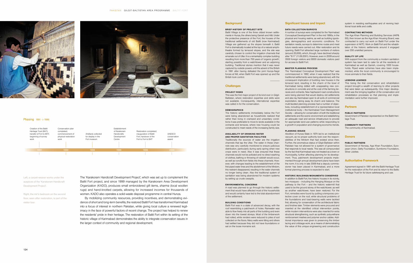
The ‘Karakoram Handicraft Development Project’, which was set up to complement the
Baltit Fort project, and since 1999 managed by the Karakoram Area Development
Organ ization (KADO), produces small embroidered gift items, sharma (local woollen
rugs) and hand-knotted carpets, allowing for increased incomes for thousands of
women. KADO also operates a solid-waste disposal programme in central Hunza.
By mobilizing community resources, providing incentives, and demonstrating evi-
dence of short and long-term benefi ts, the restored Baltit Fort has transformed Karimabad
into a focus of interest in northern Pakistan, while giving local culture a renewed legit-
imacy in the face of powerful factors of recent change. The project has helped to renew
the residents’ pride in their heritage. The restoration of Baltit Fort within its setting of the
historic village of Karimabad demonstrates the ability to integrate conservation issues in
the larger context of community and regional development.
Left, a carpet-weaver works under the
auspices of the ‘Karakoram Handicraft
Development Project’.
Right, the mir’s bedroom on the second
fl oor, seen after restoration, is part of the
visitor tour.
Establishment of Karakoram Handicrafts Development Centre
Artefacts collected for display in the Fort museum
1994
Phasing 1991 Y 1996
Creation of the Baltit Heritage Trust (BHT); transfer of Fort to BHT; beginning of survey work
Conservation plan completed; commencement of physical restoration work
1991 1992 2004
UNESCO conservation award
1995 1996
Restoration completed; inauguration of Baltit Fort; handover of the Fort to Fort to BHT

126 127
Project Scope / Objectives
The scope of activities in the case of Altit Fort in-cluded documentation of the highest standards and development of a conservation plan that followed a strategy aimed at pursuing a ‘purist’ approach. An-other goal was to fully tie the surrounding Altit Village to the Fort through social and economic bonds.
1 Altit Fort 2 Altit Village 3 Water Tank 4 Garden
1
2
3
4
50 m
Altit FortG I LG IT-BALT ISTAN , PAK ISTAN
Altit Fort is another of the great landmark monuments of Gilgit-Baltistan. Indeed,
the shikari (watchtower) is some three hundred years older than the fi rst phase
of Baltit Fort, making it the oldest surviving standing structure in the western Hima-
layas. Arguably, it is also the most spectacularly sited fort, built on the very edge
of the main Hunza gorge. It sits above 200-metre-high sheer cliffs and precipi-
tous slopes that cascade down towards the river. Its importance stems from the
control it exercised on the upstream communication routes.
The conservation strategy for Altit Fort was to preserve it in its ‘found’, state.
Most conservation works therefore related to mending structural defects, stabil izing
existing walls, reattaching render to the wall substrate, replacing some roofs,
treating wood decay and providing a nominal amount of lighting. However, for
the walls that were too unstable, the infi ll was removed to allow them to be
jacked back to more vertical positions and the stone and/or adobe soil blocks
replaced in their original positions – making use of detailed survey drawings
and photographs. This rather purist concept, an exciting objective in its own
right, is signifi cantly different from solutions applied to Baltit Fort, Ganish Village
and Shigar Fort.
The conservation strategy for Altit Fort also extended to the associated his-
toric garden, to the north of the Fort. Today, the garden is being kept as it is.
When one enters the garden it is like stepping back in time.
But before starting conservation of Altit Fort, it was decided to fi rst rehabili-
tate Altit settlement, in order to allow for heritage-related values to take root more
fi rmly, while reducing negative commercial pressures. The formation of the Altit
Town Management Society (TMS), with a general body including forty per cent
of women members and long deliberations about the impact of development,
led to a clearer realization by the Altit community of the need to be proactive and
involved in the cultural development process. As a result, the interventions in the
environmental context, that is, in relation to the historic settlement, the ancient
Fort and the built-up or agricultural land, took place under a citizen-managed
land-use programme, prior to the monument conservation project.
Built on rocky, unproductive terrain, the settlement refl ects traditional values
of land use and conservation in a region scarce in agricultural land. Its historic
Altit Fort is located among the snow-capped
mountains of Central Hunza .
Opposite page:
A view of the valley and Altit Village with
the Fort in the background.
PAK ISTAN G I LG I T- BALT ISTAN ARE A PROGR AM M E ALT I T FORT

128
Background
BRIEF HISTORY OF PROJECT SITE
Located in close proximity to the historic areas of Gan-ish and Karimabad, Altit is said to be one the earliest settlements of this region: most scholars agree that it was established in the 15th century AD. Altit’s historic value lies in its having been the fi rst capital of the ruling mirs of Hunza. The elders remember that the village once had a fortifi cation and eleven shikaris (watchtowers), presently buried under the rubble of memory. The original fortifi ed settlement (khun) of Altit is located at the base of the Fort, protecting its approaches.
Challenges
SITE CONDITIONS
The site of the Fort, with one side overhanging the cliff, limited the number of people who could be employed gainfully at any one time. Also, access to the east wall was not possible without putting up scaffolding. The installation of scaffolding on the cliff side was technic-ally extremely challenging.
ENVIRONMENTAL CONCERNS
At the start of the project the dilapidated condition of the houses, their small size and the unsanitary atmos-phere (due to a lack of modern facilities and to the practice of keeping livestock inside the house) had prompted many settlement residents to relocate out-side the settlement. This, in turn, led to further neglect of the physical structures. Since the completion of the project, however, structural improvements to the exterior of many houses, together with the provision of piped drinking water, safer underground electrifi cation and proper sewage facilities, have led many families to move back into their ancestral homes.
BUILDING CONDITIONS
The Fort was in an advanced state of decay. On the western side, it overlooked Altit Village. The danger of wall collapse onto the village was a real possibility, averted through emergency measures of tying and buffering the bulging walls of the Fort.
Signifi cant Issues and Impact
PLANNING ISSUES
At the urging of AKCS-P, residents have relocated their animals to pens outside the settlement, making the houses more spacious and more sanitary. AKCS-P has also provided technical support to families wishing
to renovate the insides of their homes using traditional materials and often incorporating elements of traditional craftwork.
COMMUNIT Y INVOLVEMENT/PROGRAMME
In the process of rehabilitating and upgrading the set-tlement, local traditions of community participation and collective labour were drawn upon, reinforcing the community’s awareness of and pride in its heritage and the potential for self-sustainability. Skilled crafts-men from the community were recruited to train the volunteer unskilled labour in traditional crafts and techniques. Traditional social and political practices have been strengthened as former settlement resi-dents have moved back into their ancestral homes, bringing the settlement back to the critical mass re-quired for healthy sociability and democratic decision making. The Altit Town Management Society (TMS) draws on culturally sanctioned values and modes of collective discussion and decision making in its activ-ities, creating continuity with the political traditions of the area. The Altit TMS also oversees the collection of revenue from the project benefi ciaries – the settlement residents – for the maintenance of improvements and services. The revenue is collected monthly, generating a total of PKR 17,000 per month from 150 households. The maintenance has proved entirely fi nancially self-sustaining, even generating revenue for future improve-ments. Monthly expenditures for maintenance come to PKR 6000, providing PKR 11,000 in monthly savings. In addition, the Altit TMS is already charging visitor entry fees to the rehabilitated Altit Village, thus generating additional funds.
VOCATIONAL TRAINING/CAPACITY BUILDING
The settlement and improvements are the common property of the resident community. For the physical upkeep of the structures and services, the Altit TMS is able to draw on the expertise of those villagers who were given training during the course of the project.
QUALIT Y OF LIFE
Provision of clean drinking water using the technical expertise of the ‘Water and Sanitation Extension Pro-gramme’ (WASEP) for all the residents of Altit Village, besides providing water to the educational institutions, has created a clean and hygienic village, where it is reported that sickness and disease have reduced con-siderably. All settlement homes now include a separate washroom.
LESSONS LEARNED
Providing tangible benefi ts to the local communities prior to carrying out work on a landmark project is
most helpful in allaying their concerns and also reducing commercial tendencies.
Partners
COMMUNIT Y PARTNERS
The community of Altit.
Donors
Government of Norway, Government of Japan.
Authoritative Framework
In 2001 the owner Prince Amin Khan graciously gifted Altit Fort to AKDN while a sizeable portion of the orchard garden was purchased. The Tourism Promotion Services is to manage the Khabasi Café opened up in the summer house, while the Women Social Enterprise in collaboration with Altit TMS and with AKCS-P oversight are responsible for Altit Fort itself and the garden.
Phasing 1999 Y 2009
Elders of Altit invite Aga Khan Trust for rehabilitation project
Rehabilitation work commenced in Altit Village
Gifting of the Fort by the owner Prince Amin Khan; formation of Altit Town Management Society; stabilization measures on the roof applied
Completion of the fi rst phase of rehabilitation; formulation of plans for conservation of Altit Fort
Physical conservation work initiated on Altit Fort
Sanitation project for other settlements of Altit starts
Sanitation system and Altit Fort conservation projects complete
1999 200920012000 2004 2006 2008
D-23
dwellings exemplify indigenous architectural forms, building techniques and materials
well adapted to an environment whose hazards include earthquakes and bitterly cold
winters. In addition, the historic settlement, with its compact design and common spaces,
supports a culture of cooperation, respect and mutual interdependence that is one of
Hunza’s most unique and valuable assets.
By the late 1990s, the core settlement of Altit was being abandoned by its residents,
largely because of unsanitary living conditions and the inadequacy of houses to support
modern life. A consequence of this process was the building of new houses in the sur-
rounding farmland, where families with the fi nancial means could create dwellings with
modern facilities and greater living space. The newer houses, with their cement-block
construction and rudimentary sanitation systems, contributed to an increase in pollution
and a decrease in social cohesion. Moreover, the new construction came at the detriment
of the verdant farming terraces and centuries-old fruit orchards that cover the surrounding
hillsides. The physical condition of the khun became increasingly dilapidated and its
common spaces and historic houses were neglected.
Keeping in view the historic, cultural and architectural value of the village, an inter-
vention was conceived that would enhance the value of the old settlement and demon-
strate that people can sustain life at contemporary standards in harmony with the
traditional built environment. The rehabilitation process included the piping of clean
drinking water into each dwelling, the introduction of a modern sanitation system in diffi cult
mountain terrain and the underground electrifi cation of the settlement. In addition, the
project undertook the revitalization of common public spaces, improvements to the exterior
of the historic houses and the paving of lanes and cul-de-sacs with stone. The project
was accomplished with a high level of community participation, and succeeded in
changing the attitudes of the people towards the settlement, bringing many families back
into their historic residences. It also created a new attitude towards the natural environ-
ment, and has thereby nearly stopped the demolition of historic buildings and the random
construction of new houses in the scenic farming terraces. In addition to establishing new
standards of health and hygiene, it has revived traditional crafts and building techniques
developed over centuries.
PAK ISTAN G I LG I T- BALT ISTAN ARE A PROGR AM M E ALT I T FORT
Right, a drawing of the north facade of
Altit Fort, which is built on the very edge
of the main Hunza gorge.
Above, the Fort has three main levels:
from the top, fl oor plans of level 1, level 2
and level 2B.
10 m
10 m
A detail of a column in a communal kitchen
in Altit Village displays exquisite carving.
130 131
Project Scope / Objectives
The objectives for the Shigar Fort project were the
restoration and reuse of the most outstanding land-
mark monument in Shigar, leading to a revival of
pride, identity and skills for the community. Also at
stake was heightening the awareness of the impor-
tance and relevance of cultural and architectural
heritage in the present; the initiation of conditions
for socially responsible tourism and economic
development of the area; and fi nally, the creation of
revenues for the maintenance of the Fort, as well as
for the community.
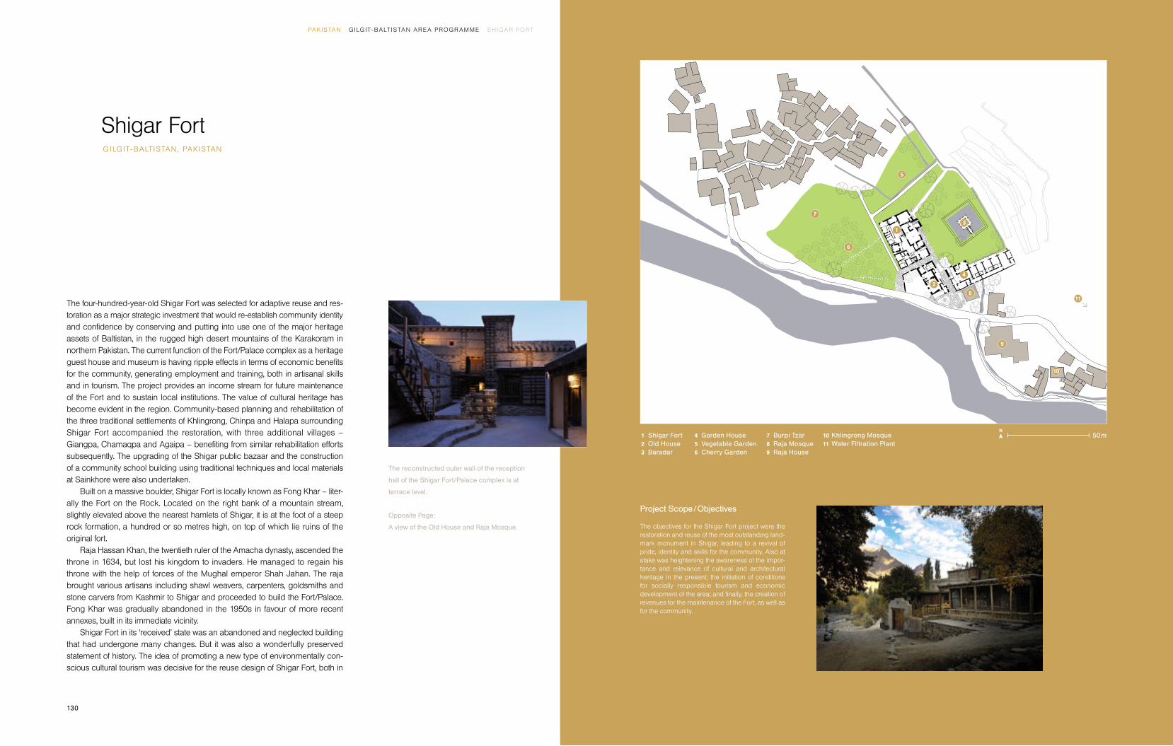
1 Shigar Fort
2 Old House
3 Baradar
4 Garden House
5 Vegetable Garden
6 Cherry Garden
7 Burpi Tzar
8 Raja Mosque
9 Raja House
10 Khlingrong Mosque
11 Water Filtration Plant
1
2
3
4
5
6
7
8
9
10
11
50 m
Shigar Fort G I LG IT-BALT ISTAN , PAK ISTAN
The four-hundred-year-old Shigar Fort was selected for adaptive reuse and res-
toration as a major strategic investment that would re-establish community identity
and confi dence by conserving and putting into use one of the major heritage
assets of Baltistan, in the rugged high desert mountains of the Karakoram in
northern Pakistan. The current function of the Fort/Palace complex as a heritage
guest house and museum is having ripple effects in terms of economic benefi ts
for the community, generating employment and training, both in artisanal skills
and in tourism. The project provides an income stream for future maintenance
of the Fort and to sustain local institutions. The value of cultural heritage has
become evident in the region. Community-based planning and rehabilitation of
the three traditional settlements of Khlingrong, Chinpa and Halapa surrounding
Shigar Fort accompanied the restoration, with three additional villages –
Giangpa, Chamaqpa and Agaipa – benefi ting from similar rehabilitation efforts
subsequently. The upgrading of the Shigar public bazaar and the construction
of a community school building using traditional techniques and local materials
at Sainkhore were also undertaken.
Built on a massive boulder, Shigar Fort is locally known as Fong Khar – liter-
ally the Fort on the Rock. Located on the right bank of a mountain stream,
slightly elevated above the nearest hamlets of Shigar, it is at the foot of a steep
rock formation, a hundred or so metres high, on top of which lie ruins of the
original fort.
Raja Hassan Khan, the twentieth ruler of the Amacha dynasty, ascended the
throne in 1634, but lost his kingdom to invaders. He managed to regain his
throne with the help of forces of the Mughal emperor Shah Jahan. The raja
brought various artisans including shawl weavers, carpenters, goldsmiths and
stone carvers from Kashmir to Shigar and proceeded to build the Fort/Palace.
Fong Khar was gradually abandoned in the 1950s in favour of more recent
annexes, built in its immediate vicinity.
Shigar Fort in its ‘received’ state was an abandoned and neglected building
that had undergone many changes. But it was also a wonderfully preserved
statement of history. The idea of promoting a new type of environmentally con-
scious cultural tourism was decisive for the reuse design of Shigar Fort, both in
The reconstructed outer wall of the reception
hall of the Shigar Fort/Palace complex is at
terrace level.
Opposite Page:
A view of the Old House and Raja Mosque.
PAK ISTAN G I LG I T- BALT ISTAN ARE A PROGR AM M E SH IGAR FORT

132 133
Left, views of the Old House and Fort; right, individual
guest rooms in Shigar Fort Residence.
10 m
was refurbished and extended to offer seven additional guestrooms that are more ‘con-
ventional’ and modern in character, that is, larger and more practical than the average
guestroom in the Fort. However, most of the rooms overlook the garden and therefore
have a charm of their own. Offering two alternate accommodations enables the complex
to cater for different tastes and types of clients.
Beyond its architectural and environmental merits, this project is the fi rst attempt to
achieve a wider cultural development initiative in Gilgit-Baltistan based on the promotion
of a new type of culturally and ecologically sensitive tourism. The location of Shigar on
the access route towards some of the highest mountains in the world and the metalled
road between Skardu and Shigar facilitates marketing of the guest-house complex.
Guests have the opportunity to engage in short treks in the vicinity, or to indulge in trout
fi shing. They can climb Shigar rock, visit the hot springs at Chutron (two hours from
Shigar), visit monuments in Shigar and Skardu, or take day-tours to Khaplu, Kiris and
Kharmang, or Deosai.
The development of local institutional capabilities has been vigorously pursued by
the Aga Khan Cultural Services-Pakistan (AKCS-P), resulting in the formation of the Shigar
Town Management and Development Society (TMDS), an active partner for all projects
and activities in Shigar. The TMDS as an institution that consolidates and brings together
the thinking of the Shigar community on matters related to culture and tourism has been
an essential mechanism, acting as a bridge and allowing for the articulation and discussion
of views, while also allowing for information and news to reach the community in a con-
sidered and comprehensive manner.
The project provided an opportunity to act as a catalyst for a comprehensive im-
provement of the local economy, generating direct and indirect employment opportun-
ities. Situated in the immediate proximity of a poor and unskilled village population, it was
thought the Shigar Fort Residence project could raise the quality of life in the villages
surrounding it, and boost economic enterprises in the bazaar area. This process was
accompanied by a proactive village upgrading and rehabilitation programme that has
reached almost twenty-fi ve per cent of the households of Shigar’s two union councils.
First- and second-fl oor plans after
conversion into Shigar Fort Residence.
terms of providing new opportunities to residents and of ensuring fi nancial self-sustain-
ability for the restored building.
The adaptive reuse plan for the Fort was predicated on transforming it into an exclu-
sive thirteen-room guest house with the grand audience hall and anterooms serving as
a museum of Balti woodcarving and local living traditions. The guestrooms – some
rather small, others having a comfortable suite character – retain the authentic character
of the Fort/Palace as much as possible. Modern furniture and equipment in the rooms is
minimal. Many guestrooms feature original or restored woodwork complemented by
traditional craft objects and artefacts from the region. Accommodation is geared to an
international clientele of connoisseurs, who look for a special experience.
The “Old House”, located at the entry of the compound, has been redesigned and
converted to cater for all service functions, including a reception area and museum tick-
eting. Inside, the building accommodates a kitchen and ground-fl oor restaurant with
outdoor sitting space and an upper-fl oor lounge with balcony overlooking the stream, a
meeting room and administration facilities. The Garden House, with no historic features,
PAK ISTAN G I LG I T- BALT ISTAN ARE A PROGR AM M E SH IGAR FORT
Settlement plan for the area around
the Shigar Fort/Palace complex.
SHIGAR STREAM
100 m
Restoration of traditional houses
Restoration of religious buildings and tombs
Improvement of streets
Upgrading of commercial buildings
CHINPA SETTLEMENT
SHIGAR FORT
KHLINGRONG
SETTLEMENT
HALAPA SETTLEMENT
ASTANA SETTLEMENT
POLO
FIELD
BAZAAR

134
Background
BRIEF HISTORY OF PROJECT SITE
Fong Khar is the last remaining structure associated
with the ruling Amacha family, which claims to have
ruled Shigar for 32 generations. Sources describe the
Amachas as having their origins in the “Hamacha”
tribe of Ganish, Hunza. The present raja, Mohammad
Ali Shah Saba, believes that the Amacha originally be-
longed to China. Buddhist ruins in the vicinity of Shigar
Fort testify to the lengthy human occupation of the site.
Challenges
PROJECT RISKS
Since this was the fi rst major project of its type in
Baltistan, in order to create credibility and trust with the
local community and demonstrate the procedures and
benefi ts of culturally relevant rehabilitation, the restora-
tion of Amburiq Mosque in Shigar, selected in consul-
tation with the community, was carried out in 1998. The
result of this conservation impressed the community
signifi cantly, paving the way for the restoration of Shi-
gar Fort.
DEMOGRAPHICS
The two union councils of the town of Shigar, Marapi
and Murkunja, collectively make up a total population
size of around 10,000 and 1240 households spread
over 21 villages. Rehabilitation projects have had a dir ect
impact on almost 400 households with a population of
around 3300 in eight villages.
HOUSEHOLD ECONOMY
In general household economy depends on agriculture,
with some seasonal tourism-related activities when
locals provide portering services. Shigar Fort Residence
employs 25 local staff out of a total of 28.
STATUS OF HEALTH AND EDUCATION
Education has been recognized by the Shigar com-
munity as the most important element for improving
their lives. After a visit to Hunza by the Shigar TMDS,
the top priority it identifi ed was education.
AVAILABILIT Y OF DRINKING WATER
AND PROPER SANITATION FACILITIES
Like other valleys, provision of clean drinking water
remains a major area of concern. Although there are
a number of piped water systems, these carry un-
treated water.
BUILDING CONDITIONS
During the past two to three centuries Shigar Fort had
already undergone many transformations and adap-
tions. As found in 1998, it was in a partially ruined con-
dition, with some of the former rooms serving as cow-
sheds and a new ramp access leading directly into the
former reception room.
Signifi cant Issues and Impact
PLANNING ISSUES
A combined museum/guest-house option was selected
for Shigar Palace that allowed AKCS-P to develop a
different restoration philosophy, complementing the
approach applied to Baltit Fort. The reuse aims helped
to carry out a more proactive policy of consolidation,
restitution and reconstruction based on the evidence
uncovered during the consolidation process. All efforts
have been made to preserve the patina of older elements,
and newer elements and fi nishes have been executed
to be in sympathy with this age value.
HISTORIC BUILDINGS/MONUMENTS CONSERVED
The positive impact of the conservation of Shigar Fort
translated into practical action by the Shigar community.
In one case the shrine of one of the saints in Shigar
was restored by the community itself, winning a UNESCO
award of merit. The larger community has started work
on a Jamia Masjid using traditional design, materials
and construction techniques.
NEW BUILDING FACILITIES
The Abruzzi Higher Secondary School Building has
been built, designed to be compatible with local con-
ditions and optimizing local materials. The most im-
portant aspect is that this is designed to be a school
for both boys and girls, quite a transformation for a
society considered conservative.
COMMUNIT Y INVOLVEMENT/PROGRAMME
The Shigar TMDS is the main forum for the community,
which is spread over 20 villages/settlements and has a
population of around 12,000 people in 1500 house-
holds. The establishment of the Shigar TMDS, with
both a community development and planning function,
brought the village upgrading operations into a far
stronger relationship with the monument conservation
project. It was from the villages of Khlingrong, Chinpa
and Halapa, where village upgrading had fi rst occurred,
that most of the workers in the Fort project were drawn
and continue to be drawn as the working staff of Shigar
Fort Residence. Furthermore, in 2009 PKR 3 million
($40,000) worth of purchases was made locally of gro-
ceries, fruit and vegetables, meat and poultry, thus
helping to provide an economic boost to the local
economy. Transport needs for Residence guests was
met locally, with a sum of PKR 560,000 going to local
transporters. 10% of this revenue was provided to
Shigar TMDS.
VOCATIONAL TRAINING/CAPACIT Y BUILDING
Ten carpenters were trained in the art of carving and
jali (perforated screen) work, besides reviving the skills
of cribbage construction. Also fi ve young women were
trained in the fi eld of documentation, including survey
work.
LESSONS LEARNED
In order for local community institutions to have sus-
tainability, the recourse to viable restoration and reuse
projects, such as Shigar Fort Residence, are critical.
Also utilizing the strengths of AKDN agencies provides
synergies. The role of Tourist Promotion Services (TPS)
in managing the Residence exceedingly well is a case
in point.
Partners
COMMUNIT Y PARTNERS
The community of Shigar.
Donors
Government of Norway, Aga Khan Foundation, Inter-
national Union for Conservation of Nature, Governments
of Germany, Japan, Greece, Spain and Pakistan, Ameri-
can Express.
Authoritative Framework
Raja Azam Khan and his father Raja Mohammad Ali
Shah Saba gifted the main Fort building and the land
it sits on to AKDN in 1999, while the Old House and
lands around it were purchased. The Garden House
was taken on a six-year lease with access to the Ama-
cha garden in exchange for building a house built for
the Raja. The Tourism Promotion Services has been
managing Shigar Fort Residence as a guest house
since 2008.
Phasing 1999 Y 2009
Gifting of the Fort by the
owner Raja Azam Khan
Rehabilitation work on the
settlements of Khlingrong,
Chinpa and Halapa
Rehabilitation work in
settlements completed
Completion of Shigar
Fort restoration and
opening to visitors
Work on school
completed
Work on Shigar community
school started and
rehabilitation of three more
settlements; Shigar
Fort Residence under TPS
management
Start of physical
conservation work
Rehabilitation
work completedWork on Shigar Bazaar
1999 2000 20032001 2002 2005 20092007 2008
The restored Khilingrong Mosque stands
near the Shigar Fort/Palace complex.

136 137
Project Scope / Objectives
The Palace complex is being conserved or devel-
oped as part of a reuse project that will turn the
property into an up-scale hotel – a 21-bed residential
retreat. The aim of the project is to develop a tourism
circuit based on cultural heritage and to generate
economic and employment opportunities for locals.
1 Palace
2 Darbar House
3 Chaman House
4 Wankoo
5 Stables
6 Ra Tzar House
7 Ra Tzar Garden
8 Chaoni Tzar Garden
1
2
34
5
6
7
8
10 m
Khaplu PalaceG I LG IT-BALT ISTAN , PAK ISTAN
Khaplu is the easternmost part of Baltistan, with the Shyok River, a tributary of the
Indus River dividing the valley. The steeply sloped valley has less land available
than other valleys in Baltistan. However, in terms of architectural heritage and
cultural expression it arguably has more treasures than Shigar, possibly as a
result of its proximity to both Leh in Ladakh and Srinagar in Kashmir.
In Baltistan, a region rich in cultural heritage, Khaplu Palace is the fi nest
surviving royal residence. Built by the Yabgo Raja Daulat Ali Khan in 1840, it
replaced an earlier fort constructed 600 metres above the present location, of
which little now remains. As a former seat of royal government, the Palace is
exemplary in terms of its building typology and aesthetic and structural qualities.
Following the inauguration of the restored Baltit Fort in 1996, His Highness
the Aga Khan visited Baltistan where he emphasized the role of culture in devel-
opment and environmental management in an address to a large gathering,
This led to an invitation to the Aga Khan Cultural Services-Pakistan (AKCS-P) to
extend its activities to Baltistan. An exploratory expert mission was sent to Baltistan
in 1997 to visit over eighty sites. This was followed up by systematic inventories
in 1998 and following years establishing that the cultural heritage of Baltistan
was worthy of international recognition.
Among the pilot projects that were implemented by AKCS-P in Baltistan, in
Khaplu the upgrading of a typical traditional house, the construction of a com-
munity building and the restoration of the astana (or tomb and shrine of a vener-
ated saint) of Syed Mir Mohammed were initiated in 1998. The surveys had
established Khaplu Palace and Shigar Fort as the two landmark buildings with
outstanding historic and architectural merit. While work following a successful
dialogue with the raja of Shigar and the community was started on Shigar Fort,
in the case of Khaplu the understanding for its restoration was reached when
the benefi ts of restoration and reuse of Shigar Fort became visible in 2005.
Rehabilitation of the historic settlements of Hunduli and Banpi was initiated
in 2002, using simple, low-cost interventions such as improved composting, the
creation of community latrines and of places for washing clothes, as well as
bathrooms for men and women. Piped water delivery was improved and stone
paving of the pathways and streets was put in place. Meanwhile the establishment
The north facade of Khaplu Palace features
projections in wood.
Opposite page:
The interior of the projecting room on
the upper fl oor.
PAK ISTAN G I LG I T- BALT ISTAN ARE A PROGR AM M E K HAPLU PAL ACE

138 139
Top, distinctive features of Khaplu Palace
are the rooms projecting out from the north
facade (left) and the wooden balconies
on the south facade (right).
Left and above, an extended elevation
of the complex and a north elevation of
Khaplu Palace.
10 m
10 m
of the Khaplu Town Management and Development Society (TMDS) as the local com-
munity institution, along the same lines as the TMS bodies nurtured in Hunza, allowed for
local ownership of the development.
In 2005 Khaplu Palace itself was gifted by the rajas Zakria Ali Khan and Nasir Ali
Khan to the Aga Khan Development Network (AKDN) and its agencies, the Aga Khan
Foundation (AKF) and AKCS-P, to facilitate the conservation of Khaplu Palace as a heri-
tage site. In addition to direct benefi t through a share in the profi ts (30%), the local
economy also benefi ts through employment, purchase of local goods wherever possible
and the stimulation of tourism services in the town. As was the case in Shigar, increased
visitor numbers resulted from this work.
The reuse plan drawn up for Khaplu Palace has at its core the intent to operate the
site as a guest house and restaurant similar in nature to Shigar Fort. The use of the complex
for a number of complimentary purposes is central to the reuse plan and future fi nancial
sustainability of Khaplu Palace and Residence (KPR).
Khaplu Palace complex can be grouped into four main areas. The Palace (Yabgo
Khar) is four storeys high including the basement, and has been used as a seat of
govern ance, grain store and royal residence. From the outside, the building appears to
be one structural unit but detailed examination of the internal structure suggests that it
was built during a number of different construction phases. Its form and internal organ-
ization are strongly infl uenced by the Kashmiri manor-house typology, with rooms
arranged in a rectangular grid around a central courtyard.
Given its signifi cance, the Palace is being treated as a Grade 1 listed building. Six
rooms at the rear of the fi rst and second fl oors are being adapted with minimum com-
promise of conservation standards, to provide guest suites with modern comforts. The
more historically signifi cant rooms at the front of the building that were used by the raja
as living and reception spaces are being incorporated into an interpretative museum
open to the public.
There are also ceremonial gardens (Chaoni Tzar, Ra Tzar) – two formally organized
garden spaces adjacent to the Palace – and historic landscape. The Chaoni Tzar, which
forms a key part of the ceremonial entrance sequence, was (according to an account by the
raja) formerly laid out as a chahar-bagh Persian garden, with geometrical areas separated
by watercourses. In more recent times it was used as a ceremonial gathering space beneath
the Palace where the raja could preside over celebrations and hold court.
Left, carpentry workshops prepared
workers for erecting house frames.
Right, a stone fl oor is being laid in one
of the complex’s buildings.
PAK ISTAN G I LG I T- BALT ISTAN ARE A PROGR AM M E K HAPLU PAL ACE

140
Background
BRIEF HISTORY OF PROJECT SITE
Until the creation of Pakistan in 1947, the territory of
Baltistan was under the suzerainty of the Dogra maharaja
of Kashmir. Khaplu was ruled by the Yabgo family of
local rajas for a thousand years or more. Khaplu Palace
was the family’s residence as well as its seat of power
and was built in the fi rst half of the 19th century when
the region had just fallen under the control of the Dogra
rulers of Kashmir. In 1840, when the Dogras annexed
the territory under Zorawar Singh, all the rajas in the
Baltistan region were ordered to dismantle their ancient
fortresses, many of which were located on strategic de-
fensive heights. As a consequence, new palaces came
to rise lower down in the valleys, including the one at
Khaplu. Abandoned by the family in the late 1970s, the
building had been decaying for several years.
LANDSCAPE
The town of Khaplu is in reality a group of rural settle-
ments scattered about on an ancient alluvial fan along
the course of the Shyok River some 90 kilometres up-
stream from its confl uence with the Indus River. Watered
by the Ghanche stream, this natural terrain has been
turned over the centuries into an oasis of fertile terraced
fi elds and apricot orchards.
Challenges
SITE CONDITIONS
The site is a series of agricultural terraces that long
pre-date the construction of the Palace and its satellite
buildings. The historicity of these terraces was a value
that had to be protected and enhanced through appro-
priate treatment of the vegetation contained by them.
HOUSEHOLD ECONOMY
In general household economy depends on agriculture,
with some seasonal tourism-related activities when locals
provide portering services.
AVAILABILIT Y OF DRINKING WATER
AND PROPER SANITATION FACILITIES
The downstream village of Doksa will be provided with
clean drinking water and it is expected, as demon-
strated in Shigar, that water-borne and gastrointestinal
diseases will be reduced to statistical insignifi cance in
this village.
INFRASTRUCTURE
Infrastructure services have aimed at providing clean
drinking water from the fi ltration unit established for the
project to the Doksa community down the slope. Infra-
structure development has raised issues of confl ict,
related also to future employment opportunities, which
were resolved by realignment, relocation of certain
services, and changing their specifi cations.
BUILDING CONDITIONS
Most buildings that tend to the ‘monument’ status are
built in stone or mud-block infi ll in a framework of
heavy timber cribbage and seismic ties. Structurally
the main Palace building posed serious challenges in
being founded on cultural fi ll with the bearing strata in
full access of a basement space. Decay of timber
elem ents and rainwater and irrigation water ingress
had resulted in serious decay of the building fabric and
its timber elements. More modest buildings are built
generally in massed rubble masonry or mud-block
construction reinforced with horizontal timber ties and
vertical poplar ka’as (columns embedded in masonry)
or khewphang (vertical columns traversing more than
one fl oor). Internally walls are provided with a thick
plaster render of mud and straw which provides build-
ings with adequate insulation during the bitter winter
months. Typically these techniques are not used any
longer at the popular level, having been replaced by
concrete blocks, reinforced concrete and corrugated
sheet steel – all without any insulation – leading to
numerous health and social issues.
Signifi cant Issues and Impact
PLANNING ISSUES
As elsewhere, a voluntary civil society organization, the
Khaplu Town Management and Development Society
(TMDS), was helped into existence. Community-related
issues, including land-use control, are partially regulated
with the help of the Khaplu TMDS. However, since
Khaplu is the headquarters of the Ghanche District, the
Town Committee mandated by the Local Government
Act also exists, and works in the same defi cient manner
as many such institutions in the public sector do. The
Khaplu TMDS acts as a civil society balancing institution
making up for many such defi ciencies.
HISTORIC BUILDINGS/MONUMENTS CONSERVED
Among the main accomplishments is the conservation
and recycling for reuse of the main Palace building,
Yabgo Khar; the Darbar Khar, a building added on one
of the terraces in 1929; and Hjta Khang, the old sta-
bles. Reconstruction of Chamanstar Khang, one of the
older ancillary buildings, and demolition of the latest
residential outhouse from about the 1960s and their
replacement by a new designed structure, Ra’astar
Khang, providing the majority of guestrooms. The Pal-
ace itself is being treated with great respect for its au-
thenticity and its original fabric, composed as it is with
source material from two or three older buildings. The
reuse of the building has been kept as much as pos-
sible similar to its original residential use. Mechanical
services are being installed with sensitive consider-
ation for the building form and built fabric. Of the 21
guestrooms being created, only six are located in the
Palace building, the remaining being housed in the
ancillary blocks.
NEW BUILDING FACILITIES
The new buildings on the complex comprise Ra’astar
Khang and the services blocks. Ra’astar Khang will
offer nine of the 15 guestrooms outside Yabgo Khar,
and has been designed as a new functional building
but in the traditional material of natural stone and
earthen mortars, laced with timbers for seismic stabil-
ity. The two service blocks are located on land well
removed from the main complex, and comprise the
laundry building, which also includes a small cafeteria
for staff, and the standby power building, which will
house the standby generators, the transformer sub-
station as well as living accommodation for six staff.
COMMUNIT Y INVOLVEMENT/PROGRAMME
Through the Khaplu TMDS, the community is benefi tting
from employment of labour at the construction site of the
project. The Tourist Promotion Services has already
started the process of selecting a cadre of employees
who will work as trained hotel staff in the complete project.
VOCATIONAL TRAINING/CAPACIT Y BUILDING
About 30 staff drawn from the community is being
trained in the hospitality trade as cooks, waiters,
housekeeping staff, watch and ward staff, in mechan-
ical equipment operation and maintenance, and other
miscellaneous roles. During construction, hundreds
from the local community have been employed as
skilled and unskilled workers, many being trained as
masons, carpenters, plumbers and electricians.
Partners
COMMUNIT Y PARTNERS
The community of Khaplu.
Donors
Government of Norway, Government of Japan.
Authoritative Framework
The main Palace building and the Darbar was be-
queathed to AKDN. The ancillary buildings and the
open land area were purchased by AKDN. One of the
contiguous terraces has been leased for 25 years to
retain control over further development. Additional
land was purchased in the vicinity to establish service
facilities. The property will be managed and operated
as a residence guest house by the Tourist Promotion
Services.
Phasing 2006 Y 2011
Landscaping of complex;
upgrading and restoration
of Hasri Khang; adaptive
reuse and conservation of
the Palace building; fi nal
operation and monitoring of
complex services; opening
of Khaplu Palace
Construction of
services block and
completion work
on Darbar Khar and
ancillary residential
buildings
Completion of
infrastructure system
Completion of
architectural and
structural
documentation of
Palace building
Commencement of
work on documentation,
demolition and
reconstruction of
ancillary residential
buildings
Commencement of documentation
and emergency stabilization of
Khaplu Palace building; beginning
of physical work on Darbar Khar
and ancillary buildings
2006 2007 20102008 2009 2011
The complex of Khaplu Palace
can be seen in its dramatic natural
environment.

142 143
While conservation of Baltit Fort, the fi rst project of the Aga Khan Trust for Culture
(AKTC) in the area, was undertaken it was determined that in order for the socio-
economic benefi ts to be fully realized, thus allowing for community ownership of
the process, the living conditions and overall welfare of the inhabitants of
Karimabad would also have to be improved. Thus the Karimabad project under-
taken as of 1992 was the fi rst AKTC initiative using multiple inputs for community-
based rehabilitation, village planning and area development.
Subsequent to the loss of the traditional institutional structures in 1974, with
the abolishment of the Mirdom and the opening up of the KKH road that linked
Pakistan with China in 1979, the physical environment in Hunza experienced a
negative phase. Traditional wisdom called for the use of scarce land for agricul-
ture, fruit growing and cash crops while ‘dead’ land was employed for housing,
but these lessons were cast aside. This negative development had started to
affect Karimabad as the traditional settlements in the neighbourhood of the Fort
were being abandoned, mostly because of prevailing unsanitary living condi-
tions and the inadequacy of the houses to support the desired standard of
modern life.
New housing built on the open farm terraces with only rudimentary sanitary
waste disposal was not only marring the physical scenic beauty but also redu-
cing productive farm land. To steer this development away from these negative
aspects, following discussions with the inhabitants of Karimabad, a framework
for physical growth and for the maintenance of its environmental and cultural
assets was formulated. This called for: the establishment of a representative
local institutional base, the Karimabad Town Management Society (TMS), which
could resolve upcoming social and community issues; the rehabilitation of the
traditional settlements and their architectural heritage; a more balanced land-
use development catering for future growth either by enlarging the existing set-
tlements or by developing new sites suitable from an environmental and cultural
sensibility; and the planning and setting up of service infrastructure to support
the proposed land use.
An aerial view of a settlement
in the Hunza Valley.
Opposite page:
Elders dancing in the rehabilitated jataq, or
community space, in Altit Village.Project Scope Objectives
The aims of this project include improving living
conditions in central Hunza, while protecting and
retaining the natural and physical setting that is the
attraction of the area. The conservation of its archi-
tecturaland cultural heritage is a clear goal, together
with the rehabilitation of its traditional settlements
through insertion of modern services (such as
sanitation, water supply, paved pathways). These
actions demonstrate the applicability of traditional
housing, fostering responsible community-based
institutions, and reviving traditional skills in crafts,
while developing capacities in non-traditional areas
for women.
1 Ali Gohar House
2 Tower
3 Kuyukutz Mosque
4 Rupikutz Mosque
5 Mamurukutz Mosque
6 Yarikutz Mosque
7 Kuyukutz Mosque
8 Shalkutz Mosque
9 Tower
10 Tower
11 Water System Improvements
Hunza Villages Rehabilitation G I LG IT-BALT ISTAN , PAK ISTAN
PAK ISTAN G I LG I T- BALT ISTAN ARE A PROGR AM M E H U NZ A V I L L AGES REHAB I L I TAT ION
10 m

144
Background
BRIEF HISTORY OF PROJECT SITE
The historic settlements of Ganish, Altit and Baltit are in
central Hunza. A strand of the old Silk Route runs
through Ganish where within walking distance are found
the Sacred Rocks at Haldeikish, testimony to the many
cultures, traders and travellers that traversed this route.
The human effort to carve out a living in this incredibly
beautiful yet harsh terrain, in harmony with the natural
environment, led to the development of a mountain cul-
ture among the Hunzokutz which is visible in the many
forts and fortifi ed villages, the terraced farming lands, the
irrigation channels that were constructed, the intricate
water supply system that was implemented, the trad-
itions and festivals that were adopted, the folklore and the
language – Burushaski – the diet, dance and music, and
the arts and crafts. The combination of the cultural heri-
tage and the physical environment provide an enclave
that is worthy of recognition as a world heritage site.
Challenges
DEMOGRAPHICS
The three villages of Karimabad, Ganish and Altit with
their many settlements have a population of 11,000
with 1400 households.
ENVIRONMENTAL CONCERNS
The centuries-old harmony of human habitation and
natural environment is being eroded by the construc-
tion of scattered housing in the productive terraced
farmlands. A large number of these new houses use
concrete blocks and large glass windows, alien to the
traditional wisdom of using local materials, such as
stone, poplar wood, mud adobe bricks and small-
sized living spaces, and of being south facing, as well
as importantly being built on so-called dead land that
could not be made productive.
ACCESS TO OPEN SPACE
The Karimabad bowl-shaped land confi guration en-
ables wonderful scenic vistas. These vistas, because of
commercial pressures on the scarce land, have been
blocked as multi-storey buildings have come up in the
main Karimabad Bazaar. The buildings on the lower
side obscure these views. In an effort to provide visual
corridors and prevent the feeling of traversing any other
bazaar in Pakistan, a number of ‘viewpoint’ areas were
acquired that have been retained to provide openings
for people to absorb and get a wide-open feeling.
Signifi cant Issues and Impact
DATA COLLECTION/SURVEYS
Surveys and data collection were centred on Karimabad.
As the programme spread, village surveys and topo-
graphic surveys have also been done, through locally
trained women and men.
MASTER PLANNING PROCESS
The ‘Karimabad Conceptual Development Plan’ was
formulated through a very interactive process with the
community, village organizations and government de-
partments. Expertise and research work was also
done through fi eld work carried out by the Aga Khan
Program for Islamic Architecture, where students from
MIT and Harvard participated in the early 1990s.
HISTORIC BUILDINGS/MONUMENTS CONSERVED
The major forts of Baltit and Altit have been conserved.
The fortifi ed settlement of Ganish Khun has been fully
rehabilitated, including recently the Ali Gohar House;
so too the historic settlements of Karimabad and Altit.
The various conservation and rehabilitation projects
have so far won four UNESCO Asia-Pacifi c Awards for
Cultural Heritage in central Hunza.
NEW BUILDING FACILITIES
In an attempt to demonstrate the modern usage of trad-
itional construction techniques and materials, a number
of new buildings have been constructed. These are the
Amin Khan House, the Altit TMS building, the Altit gallery
building, the Darbar in Aliabad, the offi ce building in
Karimabad, which houses the Karimabad TMS, and
the model house in the ‘Cluster Housing Project’. The
latter and some other buildings that have used trad-
itional building materials and construction techniques,
relying on local materials thus also supporting the local
economy, have been much appreciated by the com-
munities. Already one sees greater use of locally avail-
able poplar wood, thus cutting down on deforestation,
as well as use of local building mat erials in some of the
new housing and buildings now being constructed.
VOCATIONAL TRAINING/CAPACIT Y BUILDING
The decision to restore the historic Baltit Fort as a mu-
seum and cultural centre in the early 1990s was the
fi rst major step that triggered the process of revival of
traditional construction style and skills. The few master
masons and carpenters then available were recruited,
together with young apprentices under the supervision
of international consultants and professional staff. This
strategy of developing technical and skilled capacities
in conservation and rehabilitation has been followed
since the beginning of the Baltit Fort restoration with 14
master carpenters and 23 master masons now prac-
ticing, some with 15 years of experience in conservation
and rehabilitation. The Women Social Enterprise (WSE)
has enabled 12 young women with school education,
previously trained in technical documentation of heritage
assets, now to work with master carpenters, masons,
electricians and plumbers. These young women trainees
are receiving both on-the-job practical training from
master artisans as well as basic theoretical under-
standing from professional staff, such as engineers,
architects and consultants.
QUALIT Y OF LIFE
Health indicators are much improved with the provision
of proper modern sanitation systems through the cover-
age of the 1400 households of Karimabad, Ganish and
Altit. Interestingly the treated effl uents are being used
for growing crops in the areas of the Hunza River bank
with excellent harvests reported.
Partners
COMMUNIT Y PARTNERS
Karakoram Area Development Organization, Karimabad
Town Management Society, Ganish Khun Heritage and
Social Welfare Society, Altit Town Management Society.
Donors
Governments of Norway, Japan and Spain, Swiss Agency
for Development Cooperation, Aga Khan Foundation,
European Union.
Authoritative Framework
The underlying agreement for all community-based
rehabilitation and enterprise projects is that communities
would drive the project implementation, while AKCS-P
would provide technical assistance and fi nancial over-
sight. On completion the communities would take
responsibility for the management of the concerned
individual projects.
Phasing 1992 Y ongoing
Expert team
instituted to
study issues
Pilot housing improvement
programme started in Karimabad
Rehabilitation programme
extended to Ganish
Land for ‘Cluster Housing
Project’ and Karimabad Bazaar
Viewpoints acquired and
sanitation plan implemented
Sanitation plan
implemented
for Chumerkhun
and Sheraz
Rehabilitation
programme
initiated in Altit
Bulk of rehabilitation
works completed
in Karimabad, Ganish
and Altit
Master planning for Cluster
Housing project initiated
with construction of a
model house to follow
1992 2006200420022000199819961994
The rehabilitation programme was extended to the historic village of Ganish initially and
then spread to the villages of Chumerkhun, Sheraz and Altit. To sustain improvement in
the quality of life brought about by these projects, Town Management Societies (TMS)
were instituted following the Karimabad model in Ganish and Altit, with the charge of
taking full responsibility for the rehabilitation projects in the settlements. In addition to the
restoration and rehabilitation efforts, focus on reviving traditional skills, generating new
employment opportunities through revival of arts and crafts, and training in non- trad-
itional skills for women was also implemented.
Revival of the marketing of traditional crafts, such as weaving, embroidery and rug
making, was also made possible through partnering with local organizations, such as
the Karakoram Area Development Organization (KADO). Other KADO activities include
the Hunza Environmental Committee which looks after the collection and disposal of
waste in central Hunza. Another initiative is the Hunza Arts and Culture Forum, established
to revive and promote music through apprenticeship of young students with masters in the
old traditions, and production of indigenous musical instruments.
At the request of the Ganish community, the rehabilitation programme was extended
to Ganish, one of the oldest villages in Hunza, an example of a traditional fortifi ed settle-
ment. Initiatives started with the conservation of an architectural ensemble of the four
family mosques of Yarikutz, Rupikutz, Kuyukutz and Mamurukutz, organized around a
historic open community space, the jataq – formerly the site of ritual and ceremonial
activities. The programme was then extended to cover the whole historic village with its
three other mosques, two shikaris (watchtowers), the historic village water reservoir and
a number of historic houses. Sanitation and water supply schemes were also instituted.
A concealed electric supply system was installed and the village lanes were stone-paved
to complete the environmental upgrading.
Residential development outside the historic areas has allowed for the revival of sound
building techniques based on tradition, drawing upon the experiences and research into
appropriate forms of traditional cluster housing. This helps to provide a viable social setting,
where inter-generational interaction is possible and encouraged, and where security of the
individual and the family is ensured.
Left, the restored jataq, or community
space, in Altit.
Right, the traditional, fl at-roofed houses
adjacent to the Fort on which one can see
plates of apricots drying in the sun.
PAK ISTAN G I LG I T- BALT ISTAN ARE A PROGR AM M E H U NZ A V I L L AGES REHAB I L I TAT ION

146 147
LAHORE PAK ISTAN

148 149
This once fortifi ed city is located in the north-west area of metropolitan Lahore,
the capital of the province of the Punjab, and measures about 2.5 square kilo-
metres. This historic core of Lahore has a concentration of monuments and
buildings that refl ect cultural diversity in architecture. Despite a dynamic and
tumultuous past spanning several centuries, this area has retained much of its
historic urban form.
The Walled City of Lahore project was initiated in 2006 by the Government
of the Punjab and the World Bank. The following year the Aga Khan Trust for
Culture (AKTC) entered a ‘Public-Private Partnership Agreement’ (PPP) with the
provincial government to provide technical and fi nancial assistance for the project
and to undertake to build capacities in urban heritage conservation. In early
2008 AKTC signed a ‘Memorandum of Association’ with the World Bank. The
Historic Cities Programme (HCP) has provided strategic planning services for
the entire historic city while extending professional assistance for a pilot urban
rehabilitation project that is integrated in a city-wide strategic framework for con-
servation and redevelopment.
The World Heritage Site of Lahore Fort (the Shahi Qila) and other equally
spectacular monuments from the Mughal period, such as Badshahi Mosque (1683),
Wazir Khan Mosque (1634) and the Wazir Khan Hammam, lend their splendour
to the city. Additionally, several structures from the Sikh period and British colonial
sites add to the city’s charm, highlighting the importance the city held for a sequence
of empires that ruled over South Asia. At present, the city possesses nearly two
thousand buildings of signifi cant architectural merit. Despite the lack of appropriate
regulatory mechanisms pertaining to building demolition and construction, the
Walled City is physically distinct, marked off from the surrounding colonial period
city by the Circular Garden and the Circular Road.
In 1959 an excavation at Lahore Fort revealed the city’s pre-Muslim occupa-
tion, dating back almost 1500 years. In the early eleventh century AD, Lahore
became the seat of Sufi learning under Ali ibn Usman Hajweri, known as Data
Ganj Bakhsh by his devotees. Lahore was subsequently conquered by the
Ghaznavids under Sultan Mahmud in 1026, commencing the Muslim phase of
its political history. Under the Mughal dynasty (1526–1789), Lahore fl ourished as
an important provincial city periodically substituting for the Mughal capitals at
Agra and Delhi. From 1789 onwards, Lahore was ruled by the Sikhs until the
Lahore Area Programme
Programme Scope / Objectives
The Lahore Walled City project focused on
the rehabilitation of the historic urban fabric
and included the conservation of architectural
heritage. Landmark monuments as well as
public and private buildings were concerned,
as was the improvement of infrastructure ser-
vices in neighbourhoods and the living con-
ditions of the residents. It also aimed at re-
habilitating public (open) spaces within and
around the area.
PAK ISTAN L AHORE ARE A PROGR AM M E
FEATURED CASE STUDIES
SHAHI GUZARGAH
1
WAZIR KHAN MOSQUE
2
1
Intervention area 1 Shahi Guzargah 2 Wazir Khan Mosque
CIRCULAR ROAD
LAHORE FORTBADSHAHIMOSQUE
CIRCULAR ROAD
2
500 m
Preceding pages:
A view of Kotwali Bazaar looks west along
the north facade of Wazir Khan Mosque.

150 151
British annexation of the Punjab in 1849. In 1947 a substantial part of the Old City was
destroyed as a result of communal strife and arson associated with the Partition of the
South Asian subcontinent. This area is now home to intense commercial pressures re-
sulting in the piecemeal demolition of the historic residential fabric.
The ‘Strategic Plan’ developed by HCP for the Walled City aims to redefi ne the city’s
role as a heritage site within Metropolitan Lahore. Promoting heritage-sensitive urban
design, infrastructure improvement and residential land use, the Area Development
framework integrates both landmark monuments and historic neighbourhoods. The
framework provides for increasing residents’ capacities to engage in the revitalization of
the city and for generating opportunities for income. These broad priorities are being
pursued at three levels.
The Walled City is surrounded by regional transportation functions that support local
commercial markets. The ‘Strategic Plan’ proposes the gradual relocation of such metro-
politan functions to more suitable sites elsewhere in Lahore in conjunction with associ-
ated land use such as wholesale and warehousing. This is being considered by the
Punjab Government.
The Plan promotes the re-establishment of residential and other functions compat-
ible with the city’s historic character and makes provisions for reclaiming green areas in
and around the Walled City. Special attention is being given to the restoration of the
monumental complexes (and open spaces associated with them) and other architectural
heritage as well as upgrading and expanding public utilities in neighbourhoods.
A legislative initiative is now underway to develop new planning and regulative pro-
cesses. The framework also outlines building regulations in order to check the uncontrolled
demolitions of historic building stock and their conversion into commercial entities.
The Plan outlines strategies for consolidating residential use and rehabilitating building
stock. The overriding focus of attention concentrates on revalorizing mohallas in their
historic and topographic context. Pilot initiatives integrate facade improvement, infra-
structure upgrading and (historic) home improvement. Community-driven initiatives are
also encouraged through training of local youth in spatial mapping and building trade
skills as well as incentives for home improvement to owners through technical support.
Accompanying these efforts routine advice has been given to the Government of the
Punjab on planning, legislative and administrative issues. Baseline surveys comprise a
topographical map at the scale of the Walled City, an inventory of all 22,800 properties
and a socio-economic survey of 1757 households across the city. An operational Geo-
graphic Information System (GIS) is in place.
PAK ISTAN L AHORE ARE A PROGR AM M E
Sutar Mandi Chowk.
Opposite page:
The west facade of Naunihal Singh Haveli.
Phasing 2007 Y 2010
Neighbourhood demonstration
project through pilot home
improvements initiated;
GIS database assembly
Wazir Khan Mosque project
preparation study; neighbourhood
demonstration infrastructure project
commences; Shahi Guzargah
project implementation continues
‘Memorandum of Understanding’ signed
with the World Bank; several types of
surveys begin, including assembly of a
base map, building inventory,
environmental quality assessment
20102008 2009

Background
BRIEF HISTORY OF PROGRAMME AREA
Lahore Walled City is the historic core of Lahore and began on the banks of the River Ravi at least 1500 years ago. In the early 11th century AD, Lahore be-came a seat of Muslim Sufi learning under Ali b. Usman Hajweri. Not soon after, in 1026, Lahore was con-quered by the Ghaznavids under Sultan Mahmud. The centuries under the Delhi Sultanates (1187–1526) were turbulent, and physical evidence of the city’s eminence from this period is scarce. Under the Mughals (1526–1789), Lahore was an important provincial city and several important monuments were built, including the World Heritage Site of Lahore Fort, the Mosque of Wazir Khan (1634) and the Badshahi Mosque (1683). From 1789 Lahore was under the control of the Sikhs until the British annexation of the Punjab in 1849. The colonial period saw the destruction of the city’s fortifi ca-tions and its gates, and the establishment of important institutions and the architecture associated with them outside the historic core. In 1947 signifi cant areas of the Walled City were destroyed by arson and looting, leaving an indelible mark in the form of commercial develop-ments that replaced what was lost. The new markets continue to expand agressively at the cost of the historic fabric. However, some 2000 non-monumental buildings of architectural merit still survive.
Challenges
PROGRAMME RISKS
The project seeks to address many existing condi -tions – physical, socio-economic, cultural and admin-istrative. The single most imporant challenge it faces is the continued lack of an enabling administrative and governance apparatus, being mitigated by certain legis-lative and administrative steps being taken by the Gov-ernment of the Punjab. Other challenges are related to this, such as the unimpeded demolition of the historic building stock and its replacement by commercial structures.
SITE CONDITIONS
The historic city is an artifi cial mound, 2.6 km 2 in area, with a rise of some 15 metres. The city is densely packed with nearly 23,000 parcels of land, and gross residential density is in the range of 550 persons per hectare. The city is surrounded by major inter-regional rail and road transporation functions in a symbiotic relationship with the regional markets inside the historic precincts.
DEMOGRAPHICS
According to the last census conducted in 1998, the Walled City’s population stood at 160,000. However, a declining trend is in place due to increasing commer-cialization and loss of the residential fabric. In spite of this, the Walled City remains one of the most densely populated localities in the metropolis.
HOUSEHOLD ECONOMY
The Walled City is home to some of the poorest people in metropolitan Lahore and the lack of suitable job op-portunities is a major concern amongst households – especially those who continue to educate their children. Common sources of income include employment as salesmen, vendors, daily wage earners and/or owners of small shops.
STATUS OF HEALTH AND EDUCATION
Common illnesses comprise diabetes and blood pres-sure, asthma, hepatitis B and typhoid. AKCS-P has intro-duced monthly health awareness sessions to address frequent concerns among women. Most public-sector
schools are overcrowded, and lack playing areas and adequate sanitation facilities.
AVAILABILIT Y OF DRINKING WATER
AND PROPER SANITATION FACILITIES
Drinking water is of poor quality with high traces of faecal contamination. Lack of appropriate measures to treat the water supply at source further exacerbates the problem. During the summer, signifi cant parts of the Walled City suffer from water scarcity.
ENVIRONMENTAL CONCERNS
Prevailing environmental conditions negatively impact the quality of life of residents. Improvement in the ser-vices infrastructure and the enforcement of land-use controls are expected to improve the currently unac-ceptable health and environmental conditions.
INFRASTRUCTURE
The 150-year-old reservoir built at the city’s highest point and some of the water mains of the old water supply network are still relied upon, and are part of a pressurised grid augmented by some 16 tube wells, dotted around the city. Failure of pressure in the system results in contamination and insuffi cient supply, leading to consumers installing small centrifugal pumps on the supply lines. The drainage system is mainly covered-over open drains, many large open drains on one or both sides of the main thoroughfares, and main sewers in some bazaars. It is a mixed sewage and storm- water system. The electrical and the telecommunication distri-bution systems need much reorganization and updating to acceptable standards. A city-wide programme of infrastructure development and guidelines for imple-mentation have been prepared. These aim to improve the water supply system, introduce a new drainage system separating storm water from sewage, and rationalize the electrical and telecommunication distribution system, all at standards well above the prevailing ones.
ACCESS TO OPEN SPACE
The Circular Garden, established in 1912, has been heavily overrun by public and private sector unauthor-ized buildings, and by strip-commerce along Circular Road. Urban squares have also been overrun by un-authorized commerce.
BUILDING CONDITIONS
Most buildings are founded on cultural debris and structural failure is endemic. To stem this, it is proposed to provide a new drainage system that stops the perco-lation of water into the foundation-bearing soil.
OPEN SPACES
The Circular Garden along the Walled City serves as the main open space. However, it has been subjected to routine encroachments by commercial enterprises as well as public institutions.
Signifi cant Issues and Impact
DATA COLLECTION/SURVEYS
Topographical surveys using EDM/CAD technology could only be carried out at night, owing to traffi c con-ditions. Inventory of 22,800 individual buildings, recording some 172 attributes, is now part of a GIS database.
MASTER PLANNING PROCESS
Strategic Plan completed in February 2008, now due for a review and update.
PLANNING ISSUES
Ownership titles for properties are non-existent owing to land subdivision not having been recorded during
colonial times; absence of land-use regulation; collapse of municipal governance; no clear demarcation of the municipal limits of the historic area; metropolitan and regional planning inadequacies negatively impact on Lahore Walled City.
HISTORIC BUILDINGS/MONUMENTS CONSERVED
AKTC and AKCS-P are carrying out the conservation of Wazir Khan Mosque. A home in one of the lanes of the Old City has been conserved as a demonstration project.
NEW BUILDING FACILITIES
A new urban infi ll building has been designed and site access is being negotiated.
COMMUNIT Y INVOLVEMENT/PROGRAMME
Community-based organizations have been formed based on discreet components of the urban morphology. One of the communities is currently directly involved in the conservation and upgrading of its neighbourhood.
VOCATIONAL TRAINING/CAPACIT Y BUILDING
Skills enhancement training programmes related to building trades and spatial documentation have been initiated in the project area. The programme provides on-the-job training for local youth – both male and female.
CONTRACTING METHODS
For large projects, national competitive bidding proced-ure; material and labour contracts for intermediate and small projects; labour only contracts with material pur-chased by AKTC; employed labour and hired unskilled labour with material purchased by AKTC.
NEW TECHNOLOGIES INTRODUCED
GIS; EDM/CAD real-time surveying and documenting techniques, with photo-orthorectifying software; SSPS analysis.
RELEVANT CODES/STANDARDS ADOPTED
International codes being recommended by consultants engaged by AKTC. Recommendations and guidelines prepared by AKTC being introduced.
LESSONS LEARNED
This is the fi rst HCP project based on a ‘Public-Private Partnership’ framework approach. While the Government of the Punjab facilitates many aspects of the project that would otherwise be extremely diffi cult, the project has been characterized by changing levels of mutual understanding of its nature, purpose and philosophy, owing mainly to varying political and administration personalities that AKTC has had to work with.
Partners
PUBLIC PARTNERS
Government of the Punjab.
COMMUNIT Y PARTNERS
Several community-based organizations at the scale of micro neighbourhoods.
Authoritative Framework
‘Public-Private Partnership Framework Agreement’ was signed between AKTC and the Government of the Punjab on 2 July 2007. ‘Memorandum of Understanding’ between the World Bank and AKTC was signed on 6 March 2008.
The north-eastern minaret
of Wazir Khan Mosque seen
from Chitta Gate.

154 155
Tomb
PIPE FROM WATER PUMP
PIPE GOING TO OVERHEAD TANK
UP
WASHROOM
Store
Project Scope / Objectives
This project aims to rehabilitate the main bazaar thoroughfares as well as residential urban fabric in an integrated manner. This entails urban design work, infrastructure upgrading and historic building stock rehabilitation. Urban open spaces are to be rehabilitated and key landmark monuments located in the main thoroughfares are also to be restored as individual projects. The neighbourhood demonstra-tion project involves testing of proposed designs on which basis the larger pilot project will be imple-mented.
Intervention corridors 1 Delhi Gate
2 Wazir Khan Hammam
3 Neighbourhood Rehabilitation
Programme
4 Muhammadi Mohallah
5 Shahi Guzargah
6 Wazir Khan Chowk
7 Wazir Khan Mosque
8 Begum Shahi Mosque
9 Baoli Bagh
10 Sonehri Mosque
109
8
76
5
4
3
21
5
5
100 m
Shahi Guzargah LAHOR E , PAK ISTAN
The ‘Pilot Urban Rehabilitation and Infrastructure Improvement Project’ is being
jointly implemented with the Government of the Punjab in one section of the
Walled City of Lahore and constitutes eleven per cent of the Old City’s footprint.
The project, as initially conceived by the World Bank and the Punjab Govern-
ment, aimed to rehabilitate a historic thoroughfare (starting at the Delhi Gate –
one of the city’s thirteen entrances and leading up to the Royal Fort) by putting
services underground. Presently, this route comprises some of the major com-
mercial centres serving the metropolis and the region. With the collaboration of the
Historic Cities Programme (HCP), the project now has a broader set of goals. It
comprises comprehensive regeneration of the area as heritage urbanism with
special emphasis on the conservation of the historic residential areas associated
with the bazaars, and includes the conservation of the main monuments and
urban open spaces associated with them. This entails urban design, infrastructure
upgrading, monument conservation and historic urban fabric rehabilitation with
participation by the communities that constitute the residential areas.
Part of the site also represents a signifi cant expansion of the area of the fortifi ed
city brought about by the addition of a new wall in the sixteenth century by the
Mughal emperor Akbar (1542–1605). The site of Wazir Khan Mosque (see p. 160)
used to be outside the old walls, and when the Mosque was constructed in 1634 it
was one of the fi rst to be inside Emperor Akbar’s new walls. The urban open spaces
associated with this monument are to be rehabilitated as part of the project.
The urban design aspect focuses on improving the visual and sensory features
of the urban environment in conjunction with the rationalization and improvement
of the visible elements of services infrastructure. The Aga Khan Trust for Culture
(AKTC) is facilitating the improvement of bazaar facades (1.5 kilo-metres in
length) and street surface improvement, the design and development of open
spaces that have been heavily encroached upon by commercial entities, the
provision of civic amenities and tourist facilities, urban landscaping, street furniture
and related facilities including signage.
Regarding services infrastructure, AKTC has prepared an integrated infra-
structure conceptual design for the Walled City as a whole. This conceptual design
provides guidelines and parameters for the detailed design of infrastructure and
Infrastructural problems plague
Sutar Mandi Chowk.
Opposite page:
Delhi Gate, one of the thirteen entrances
to the Walled City.
PAK ISTAN L AHORE ARE A PROGR AM M E SHAH I GUZ ARGAH

156 157
The rehabilitation strategy involves intensive social and technical extension work, and
aims at setting a precedence for urban environmental rehabilitation. It addresses the
socio-economic dynamics of the context with on-the-job training in various traditional
building trade skills targeting local youth in the project area, who work alongside master
craftsmen in masonry, carpentry, plumbing and electrical works.
The programme has three well-defi ned but interlinked components. First, facade
improvement: since infrastructure elements such as electricity and telecom lines can
only be attached to rehabilitated facades that can effectively bear the stresses of physical
support, facade rehabilitation is considered an investment in the public realm. Intervening
in house facades entails a modicum of structural consolidation and necessarily means
engaging with the inner workings of a house too. A close relationship is thus developed
between the owner-occupant of a house and the implementing agency, in this case
AKCS-P, one that also encourages homeowners to make their own investments in under-
taking home repairs. Second, infrastructure upgrading: this provides for improved waste
and storm-water disposal where possible, systems for improved solid waste disposal,
subsurface layout of gas pipes and new (re)organized electrical, telephone and television
cable distribution networks. It is expected that better drainage facilities will reduce the
extent of leakage or seepage into the bearing strata of the soil, therefore complementing
efforts at structural consolidation of the surrounding buildings. Third, home improvement:
this component addresses building problems in the internal spaces of a house and
includes, to varying degrees, structural repairs and consolidation, replacement of dilapidated
and/or dysfunctional installations, non-structural architectural intervention and fi nishes.
Left, drainage upgrading is being
undertaken in Shahi Guzargah.
Right, restoration work is being done
on original brickwork.
allows for a higher degree of design and implementation control at the level of the project
area. Upgrading and improvement of infrastructure for water supply, sewage disposal,
storm-water disposal, electricity, telecommunications and natural gas in the pilot project
pose a different range of problems at various levels of delivery. Standards and details of the
infrastructure include carefully thought out solutions responding to the myriad problems
posed by the special physical and geographical context of the Walled City.
The ‘Neighbourhood Rehabilitation Programme’ constitutes a key component of the
‘Pilot Urban Rehabilitation and Infrastructure Improvement Project’. It proposes a holistic
approach to urban rehabilitation with sustainable yet quality standards for the services
infrastructure, and the structural consolidation and revalorization of the historic building
stock. A strategy sensitive to the historic urban fabric has been developed and is being
implemented in a residential lane off Delhi Gate Bazaar – Gali Surjan Singh and its cul-de-
sac offshoot, Koocha Charakh Garan. Together, these two streets comprise twenty-fi ve
residential buildings housing approximately 150 people. The locality was chosen primarily
because it represents the average conditions of infrastructure, building obsolescence,
and the admixture of historic and contemporary houses among the historic neighbour-
hoods in the area.
The survey and documentation done by the Aga Khan Cultural Services-Pakistan
(AKCS-P) in the project area revealed that, by and large, homeowners are willing to
undertake home repair and maintenance works in small interventions in accordance
with their income levels. However, the lack of adequate technical knowledge and necessary
skills poses serious limitations on the scope of the work. A home restoration project carried
out in 2008 demonstrated the full range of problems associated with building decay and
mobilized the street community to take part in the project.
A courtyard detail of an old haveli
in a state of decay.

158
Background
BRIEF HISTORY OF PROJECT SITE
The project site comprises those neighbourhoods of the historic city through which the route taken by Mughal royalty, from the entrance to the city to the gates of the royal palace, passes. This route now consists of some of the major commercial centres of the metropolis.
Challenges
SITE CONDITIONS
Neglect and inadequacy of the existing services infra-structure and the task of transforming it to meet ac-ceptable standards is one of the biggest challenges of the project, particularly when seen in relation to the complex morphology of the Walled City. The state of the historic building stock is another key challenge, as a vast majority of the buildings refl ect structural failure, traceable to foundation failure and bad plumbing which results in water seepage into the building fabric.
DEMOGRAPHICS
Approximately 8000 people live in the Shahi Guzargah project area. The neighbourhood demonstration project serves close to 150 people residing in the residential lanes, Gali Surjan Singh and Koocha Charakh Garan. The majority of residents are homeowners.
HOUSEHOLD ECONOMY
Lahore Walled City is home to some of the poorest people in metropolitan Lahore and a lack of job oppor-tunities is a major concern. Common sources of income include employment as salesmen, vendors, daily wage earners, piece-rate workers (especially in the case of women), and/or small shops owned by residents. Socio-economic profi les of residents in Gali Surjan Singh and Koocha Charakh Garan are not much different from the rest of the Walled City.
STATUS OF HEALTH AND EDUCATION
Common illnesses comprise diabetes and blood pres-sure, asthma, hepatitis B and typhoid. In collaboration with the Aga Khan Health Service, AKCS-P has intro-duced monthly health awareness sessions and medical camps for residents in the project area and surrounding localities. Most public-sector schools are overcrowded, and lack playing areas and adequate sanitation facilities.
AVAILABILIT Y OF DRINKING WATER
AND PROPER SANITATION FACILITIES
Drinking water is of poor quality with high traces of faecal contamination. Lack of appropriate measures to treat the water supply at source further exacerbates the problem. During the summer, signifi cant parts of the Walled City suffer from water scarcity.
ENVIRONMENTAL CONCERNS
Improvement in the services infrastructure and the en-forcement of land-use controls are expected to improve the currently unacceptable living conditions.
ACCESS TO OPEN SPACE
No open spaces suitable for women and children exist in the immediate vicinity of the Shahi Guzargah project area or the neighbourhood project site.
BUILDING CONDITIONS
Most buildings are founded on cultural debris and structural failure is endemic. A majority of the buildings are taken over by commercial enterprises resulting in signifi cant deterioration. Homeowners continue to alter houses according to their needs but changes are gen-erally inappropriate in the light of the age and condition of the buildings.
Signifi cant Issues and Impact
DATA COLLECTION/SURVEYS
A full inventory of buildings has been completed and made a part of the GIS system. A topographical map of the area has been completed. Buildings displaying architectural merit are in the process of being docu-mented. A 12% sample of households has been surveyed for establishing income and poverty levels and prevailing quality of life conditions. For the purposes of the demon-stration project, detailed home documentation for all the houses in the two streets has been carried out along with the survey of existing services infrastructure. Baseline data pertaining to the socio-economic profi le of all the households in the two streets have been compiled.
MASTER PLANNING PROCESS
The demonstration project is one of several ‘Local Development Frameworks’ that have been planned for the Walled City. It represents the full range of policies and interventions envisaged at this scale in the ‘Strategic Plan’ prepared by HCP.
PLANNING ISSUES
Governance, land use and zoning control are lacking. Necessary legislative frameworks to regulate building constuction are not in place. Traffi c reorganization is in need of planning. Heritage conservation, urban design and rehabilitation of neighbourhoods and open spaces require an integrated approach.
HISTORIC BUILDINGS/MONUMENTS CONSERVED
A number of monuments are part of the project area. Monuments being targeted for conservation include Wazir Khan Mosque, the Sonehri (Golden) Mosque and the Maryam Zamani (Begum Shahi) Mosque. A single historic house (just over 100 years old) in Koocha Charakh Garan – the neighbourhood demonstration project area – was conserved in 2008. Rehabilitation of fi ve additional historic houses are underway in the same locality.
NEW BUILDING FACILITIES
An ‘urban infi ll’ building has been designed and is part of the project. This will give back the scale and physical volume of a missing portion of the streetscape; create opportunities for appropriate level of commerce of a type aimed at visitors; and house certain infrastructure elements such as transformers and one tube well. Other new buildings are planned to manage the urban space outside the city’s perimeters.
COMMUNIT Y INVOLVEMENT/PROGRAMME
Community-based organizations (CBOs) have been created in small units related to the topo-morphological characteristics of the neighbourhoods. These help in resolving local issues of confl ict, in speaking to indi-vidual stakeholders, and in propagating the desirable values in development participation.
VOCATIONAL TRAINING/CAPACIT Y BUILDING
Youth residing in the project area are participating in the ‘Skills Enhancement Programme’ pertaining to building trades and spatial documentation. The pro-gramme provides on-the-job training to both males and females.
CONTRACTING METHODS
National competitive bidding under the guidelines of the World Bank. In the case of the neighbourhood demonstration project, material purchased and labour hired directly by AKTC; supervised by AKTC staff.
NEW TECHNOLOGIES INTRODUCED
EDM/CAD real-time surveying and documenting tech-niques, with photo-orthorectifying software; data analysis with GIS and SPSS. New standards for the infrastructure distribution networks have been introduced.
RELEVANT CODES/STANDARDS ADOPTED
Recommendations and guidelines prepared by AKTC being introduced.
QUALIT Y OF LIFE
In collaboration with the Aga Khan Health Service, AKCS-P has introduced monthly health awareness sessions and medical camps for residents in the pro ject area and surrounding localities.
Partners
PUBLIC PARTNERS
Government of the Punjab.
Donors
The World Bank, German Foreign Ministry.
Authoritative Framework
‘Public-Private Partnership Framework Agreement’ was signed between AKTC and the Government of the Punjab on 2 July 2007.
10 m
Above, a bird’s-eye view of Sunehri Masjid (Golden Mosque),
Rang Mahal, in the Walled City (left) and a detail of a ruined facade
in Chehal Bibiyan Mohalla (right).
Below, elevations of Guzargah neighbourhood rehabilitation projects,
before and after intervention.
PAK ISTAN L AHORE ARE A PROGR AM M E SHAH I GUZ ARGAH

160 161
Project Scope / Objectives
AKTC is working on the conservation of Wazir Khan Mosque and providing planning assistance towards the reorganization of the space in front of the Mosque with the objective of improving the quality of the urban environment. Goals are the relocation of infrastructure underground and the return of the Mosque to its original urban setting.
Wazir Khan Mosque LAHOR E , PAK ISTAN
Wazir Khan Mosque is the centrepiece of a historic urban ensemble in the
Walled City of Lahore. The Mosque was built in 1634 by Hakim Alimuddin who
was granted the title of Wazir Khan on Shah Jahan’s accession to the Mughal
throne in 1628. It is founded on the site of an old Sufi convent – associated with
the saint Syed Ishaq Gazruni (d. AD 1284 / AH 786) – between the limits of the
Old City and the new city walls built a century earlier by Shah Jahan’s grand-
father, Emperor Akbar. In this still developing space, the Mosque complex was an
ambitious and unprecedented piece of urban design. The grave of Syed Ishaq
Gazruni was included in the fabric of the Mosque. At the time of its construction
it was considered the largest mosque within the fortifi cations of Lahore and
superseded the Begum Shahi Mosque (constructed by Emperor Jahangir in
1614) as the congregational mosque of the city.
Wazir Khan Mosque is located at a distance of about 260 metres from the
Delhi Gate on the route to Lahore Fort and is surrounded by the thick urban
fabric of the Walled City. The physical context comprises the Chowk (a square
urban open space), Chitta Gate and the buildings fronting the square and the
bazaar. The houses on the south side defi ne the southern limits of the Mosque
and street defi nes the border between the Mosque and the urban fabric on the
west side. On the northern side the bazaar opens up at a fork to form the Kotwali
Chowk, which was the space in front of the Mughal-period city police station, the
kotwali, no longer existing. Historically, as part of the thoroughfare connecting Delhi
Gate and Lahore Fort, Wazir Khan Mosque, together with its square, formed a
singularly important element punctuating the urban fabric of the Walled City.
Of the fourteenth-century Sufi establishment nothing but three grave sites
remain. Of these the grave of Syed Ishaq Gazruni was made part of the fabric of
the Mosque, and is accessed by a staircase in the main courtyard, marked by
an elaborate pavilion. The original level of his grave is about 2.5 metres below
the level of the Mosque’s courtyard.
The Mosque’s layout comprises a large quadrangular plan, with the heavily
built prayer chamber housing fi ve in-line domed cells located at the qibla end of
the courtyard. The main building of the Mosque and its inner courtyard is sup-
plemented by a bazaar with two rows of shops – intended for calligraphers and
The eastern facade of the main prayer chamber
of Wazir Khan Mosque, seen from the courtyard.
Opposite page:
Scaffolding has been erected to enable a
thorough documentation of the building.
PAK ISTAN L AHORE ARE A PROGR AM M E WA Z IR K HAN M OSQ U E
10 m

162 163
Above, Wazir Khan Mosque is located in
a heavily built-up environment.
Below, the east-west section of the Mosque.
10 m
Above right, the eastern facade of the main
prayer chamber of Wazir Khan Mosque
while a detail, on the left, shows the intricate
tile-work on the same facade.
book binders – at right angles to the axial direction upon entering the courtyard. The
Chowk, a square open forecourt outside the Mosque, was part of a conscious attempt at
formal urban design and an immediate precursor to other great urban compositions of
Shah Jahan’s time.
The chief architectural and artistic characteristic of the Mosque resides in its profuse
surface decoration both on the exterior and in the interior. On the exterior, the decoration
comprises a combination of fi ne exposed brickwork and a framework of plaster render
with a thin layer of faux brickwork. This forms the overriding frame for dramatically coloured
glazed-tile mosaics in fl oral and arboreal motifs as well as depicting calligraphic quotations
from the Qur’an, the Hadith and other verses. Interior surfaces, entirely covered by fresco-
work, have been touched up or painted over down the centuries by successive attempts
at ‘restoration’, so much so that no original work appears to exist any longer. Of the delicate
Mughal surface ornaments and decorative techniques, the most vividly displayed are the
glazed-tile mural decoration and calligraphy which, despite its chromatic exuberance,
recalls Safavid monuments in Isfahan (Iran), built only a few years before, and earlier
Timurid architectural antecedents.
The Mosque has undergone serious damage. Heavy ingress of rain and waste water
has damaged the fl oor of the rooms and the courtyard. Inappropriate commercial activity
in the shops on the main facade poses a hazard to the building’s fabric.
The four minarets, thirty-six metres in height from the street, have leaned out to varying
but not alarming degrees. The movement of the two minarets adjacent to the main prayer
chamber has caused cracks in the arches and roof structure of the end bays. Structural
investigations suggest successive earthquakes as the cause of this behaviour. That the
cracks existed prior to 1971 is confi rmed from the record of repair work begun at that time.
Since March 2009 major architectural and damage documentation of the Mosque
complex has been under way. Detailed electronic documentation of the building provides
the basis for examining the nature and extent of damage and for assessing the extent of
conservation measures. Geotechnical investigations have been completed and meas ures
to carry out structural consolidation of the monument are being designed. Assessment
of the building and the condition of its foundations indicate that major structural cracks
are not related to ongoing structural behaviour. A programme for the conservation of the
Mosque, to be implemented in several stages, is being developed.

164
Background
BRIEF HISTORY OF PROJECT SITE
Wazir Khan Mosque was built in 1634 by Hakim Alimuddin Ansari, the famous governor of the region under Emperor Shah Jahan. When still Prince Khurram, Shah Jahan had employed Hakim Alimuddin as his court physician. Upon ascending the throne, Shah Jahan appointed him governor of Lahore with the title Wazir Khan. A 14th-century Sufi convent associated with Syed Ishaq Gazruni existed on the site of the Mosque. The monument is noteworthy for its rich glazed-tile decorations.
Challenges
PROJECT RISKS
The minarets of the Mosque have leaned outwards. The base of the two western minarets, attached to the main prayer chamber, have induced structural cracks in the chamber. Structural investigations suggest that in all likelihood the cracks developed as a result of successive earthquakes. The conservation and restor-ation of the surface decorations in the Mosque, including its tile revetments, are costly and time-intensive oper-ations and will require sustainable development of the appropriate skills. Pilot projects for key decorative crafts are proposed to be initiated. These are fresco murals, ceramic tiles and lime plasters. For post-conservation monitoring and maintenance, appropriate capacity in the maintenance agency is proposed to be developed.
SITE CONDITIONS
The diagonal connection from Chitta Gate to the gate leading out of the square on the north-eastern corner of the Mosque has now been transformed into a bazaar as a result of encroaching shops. A detailed survey has revealed that most of the shops, fronting the square on its eastern and northern sides, have encroached into the square. Some fragments of the original 17th-century shops on the perimeter of the square are nested deep within the new structures. The historical openness of the square has been seriously sacrifi ced to low-value structures. Increasing presence of commercial activities during the last four decades has resulted in ill-maintained shops and structures that have ultimately distorted the form of the open space and the monument.
INFRASTRUCTURE
The project aims to improve the existing infrastructure in the Mosque complex. Water supply, rain and waste water disposal, gas supply and electrifi cation have all created serious problems since their introduction during past restoration efforts. An example of the negative im-pact is the settlement in the courtyard fl oor in various locations due to the heavy ingress of water resulting from inadequate drainage.
BUILDING CONDITIONS
As the street level has risen over the centuries most of the original shops on the northern side, rented out to an assortment of businesses, have lost accessibility from the steet and currently exist as storage space for shops built onto the face of the Mosque and encroach into the street space. Commercial activity, such as steel fabrication in the shops (on the main facade on the eastern side), is a huge threat to the structure of the Mosque. The Mosque has undergone serious damage due to inadequate maintenance and care.
Signifi cant Issues and Impact
DATA COLLECTION/SURVEYS
Since March 2009 major architectural and damage documentation of the Mosque complex is underway. Geotechnical investigations have been completed and measures to carry out structural consolidation of the monument are being designed.
MASTER PLANNING PROCESS
At the end of the documentation and analysis stage a master conservation plan is being prepared.
PLANNING ISSUES
The problems of building control and the regulation of the urban fabric, widespread in the Walled City, are equally applicable to the Wazir Khan Mosque complex. Equally important is how the present capacities for the protection and administration of the architectural heritage and levels of conservation skills presently available can be made more effective and sustainable.
HISTORIC BUILDINGS/MONUMENTS CONSERVED
A conservation programme for the Mosque is being developed and will be implemented over several stages. In the fi rst stage structural and architectural investigations have been carried out.
COMMUNIT Y INVOLVEMENT/PROGRAMME
An initiative to involve the local community in the pro-cess of documentation and enhancing building skills has already been started and will be extended during the restoration of the Mosque.
CONTRACTING METHODS
The work will be carried out by employing skilled and unskilled workers, and the project management will be carried out by AKTC staff. Building contractors in the fi eld of conservation do not exist in Pakistan.
NEW TECHNOLOGIES INTRODUCED
Real-time EDM/CAD documentation and photo-rectifi -cation software has been used for the fi rst time in a pro tected monument in Pakistan.
RELEVANT CODES/STANDARDS ADOPTED
The ‘International Charter for the Conservation and Res-toration of Monuments and Sites’ (the Venice Charter), 1964, is the principal document for the documentation and restoration of the monumental complex.
LESSONS LEARNED
The conservation of Wazir Khan Mosque and the rehabili-tation of its Chowk are part of a larger Area Develop-ment Project in the Walled City of Lahore. It is part of a local development framework comprising the rehabili-tation of the surrounding urban fabric and open space. The thrust of the project is aimed at urban regeneration and the economic uplift of the residential communities living in the neighbourhood of the project and offers lessons in conservation planning and methodology and capacity building.
Partners
PUBLIC PARTNERS
Government of the Punjab, Planning and Development Department, Sustainable Development of the Walled City of Lahore Project, Awqaf Department.
Donors
Kaplan Foundation Fund.
Authoritative Framework
‘Public-Private Partnership Framework Agreement’ was signed between AKTC and the Government of the Punjab in 2007. In 2009 formal permission to proceed was obtained from the Awqaf Department – the custodian of the property.
Opposite page:
The interior of the
main prayer chamber,
looking north, and,
on the left, a detail of
a courtyard facade.