admiralty notices to mariners
122
For UKHO use only 220403 Notices 282 -- 410/20 ADMIRALTY NOTICES TO MARINERS Weekly Edition 03 16 January 2020 (Published on the ADMIRALTY website 6 January 2020) CONTENTS I Explanatory Notes. Publications List II ADMIRALTY Notices to Mariners. Updates to Standard Nautical Charts III Reprints of NAVAREA I Navigational Warnings IV Updates to ADMIRALTY Sailing Directions V Updates to ADMIRALTY List of Lights and Fog Signals VI Updates to ADMIRALTY List of Radio Signals VII Updates to Miscellaneous ADMIRALTY Nautical Publications VIII Updates to ADMIRALTY Digital Services For information on how to update your ADMIRALTY products using ADMIRALTY Notices to Mariners, please refer to NP294 How to Keep Your ADMIRALTY Products Up--to--Date. Mariners are requested to inform the UKHO immediately of the discovery of new or suspected dangers to navigation, observed changes to navigational aids and of shortcomings in both paper and digital ADMIRALTY Charts or Publications. The H--Note App helps you to send H--Notes to the UKHO, using your device’s camera, GPS and email. It is available for free download on Google Play and on the App Store. The Hydrographic Note Form (H102) should be used to forward this information and to report any ENC display issues. H102A should be used for reporting changes to Port Information. H102B should be used for reporting GPS/Chart Datum observations. Copies of these forms can be found at the back of this bulletin and on the UKHO website. The following communication facilities are available: NMs on ADMIRALTY website: Web: admiralty .co.uk/msi Searchable Notices to Mariners: Web: www.ukho.gov .uk/nmwebsearch Urgent navigational information: e--mail: [email protected] Phone: +44(0)1823 353448 +44(0)7989 398345 Fax: +44(0)1823 322352 H102 forms (see back pages of this Weekly Edition) e--mail: [email protected] Post: UKHO, Admiralty Way, Taunton, Somerset, TA1 2DN, UK All other enquiries/information e--mail: [email protected] Phone: +44(0)1823 484444 (24/7) Crown Copyright 2020. All rights Reserved. Permission is not required to make analogue or PDF copies of these Notices, but such copies may not be sold without the permission of the UKHO. For permission to sell copies of the Notices or to make (non--PDF) digital copies please email [email protected] .uk
-
Upload
khangminh22 -
Category
Documents
-
view
0 -
download
0
Transcript of admiralty notices to mariners

For UKHO use only 220403
Notices282 -- 410/20
ADMIRALTYNOTICES TO MARINERS
Weekly Edition 0316 January 2020
(Published on the ADMIRALTY website 6 January 2020)
CONTENTS
I Explanatory Notes. Publications List
II ADMIRALTY Notices to Mariners. Updates to Standard Nautical Charts
III Reprints of NAVAREA I Navigational Warnings
IV Updates to ADMIRALTY Sailing Directions
V Updates to ADMIRALTY List of Lights and Fog Signals
VI Updates to ADMIRALTY List of Radio Signals
VII Updates to Miscellaneous ADMIRALTY Nautical Publications
VIII Updates to ADMIRALTY Digital Services
For information on how to update your ADMIRALTY products using ADMIRALTY Notices toMariners, please refer to NP294 How to Keep Your ADMIRALTY Products Up--to--Date.
Mariners are requested to inform the UKHO immediately of the discovery of new or suspecteddangers to navigation, observed changes to navigational aids andof shortcomings in bothpaperand digital ADMIRALTY Charts or Publications.The H--Note App helps you to send H--Notes to the UKHO, using your device’s camera, GPS andemail. It is available for free download on Google Play and on the App Store.TheHydrographic Note Form (H102) should be used to forward this information and to report anyENC display issues.H102A should be used for reporting changes to Port Information.H102B should be used for reporting GPS/Chart Datum observations.Copies of these forms can be found at the back of this bulletin and on the UKHO website.
The following communication facilities are available:NMs on ADMIRALTY website: Web: admiralty.co.uk/msiSearchable Notices to Mariners: Web: www.ukho.gov.uk/nmwebsearchUrgent navigational information: e--mail: [email protected]
Phone: +44(0)1823 353448+44(0)7989 398345
Fax: +44(0)1823 322352H102 forms(see back pages of this Weekly Edition)
e--mail: [email protected]: UKHO, Admiralty Way, Taunton,
Somerset, TA1 2DN, UKAll other enquiries/information e--mail: [email protected]
Phone: +44(0)1823 484444 (24/7)
Crown Copyright 2020. All rights Reserved. Permission is not required to make analogue or PDF copiesof these Notices, but such copies may not be sold without the permission of the UKHO. For permission tosell copies of the Notices or to make (non--PDF) digital copies please [email protected]

I
1.2
GUIDANCE NOTES FOR THE USE OF ADMIRALTY NOTICES TO MARINERSON THE UKHO WEBSITE
The Weekly Notices to Mariners (NM) updates for paper Charts and Publications can be accessed via admiralty.co.uk/msi or the searchable NM Website www.ukho.gov.uk/nmwebsearch The latest digital NM Weekly update is available 10 days prior to the paper publication date; there are no subscription fees for access to the UKHO Notices to Mariners Website.
NB: The NM database includes historical NM data from 1 January 2000, for NMs prior to 2000 the Cumulative List of Notices to Mariners (NP234B-00) must be used.
Software required:
Adobe Acrobat Reader (Version 6.0 or later). Reader software can be obtained direct from the Adobe website (www.adobe.com).
SEARCHABLE NOTICES TO MARINERS
Enter the www.ukho.gov.uk/nmwebsearch website and select the search option that you require following the on screen instructions:
Search NMs by - Chart Number onlySearch NMs by - Chart Number + Previous NM Number/YearSearch NMs by - Chart Number + Between Previous and Present DatesSearch for Single NM by NM Number/Year
To view the NM, NM Note or full-colour NM Blocks, click on the relevant link.
NOTICES TO MARINERS ON-LINE
Enter the admiralty.co.uk/msi website, and then select Notices to Mariners. This will give you access to the following range of Notice to Mariners services:
- ADMIRALTY NM Web Search- Weekly NMs- NM Block, Notes and Diagrams- Annual NMs- Cumulative NM List
FURTHER GUIDANCE NOTES
For further details of the online NM facilities please see the NM Guidance Notes on the website, additional detail includes:
File content and descriptionPC and printer specifications
CUSTOMER SERVICE
If you experience any difficulties, please contact the UKHO Customer Services Team in the UK on:
Tel: +44 (0) 1823 484444 (office hours Monday-Friday 6am-10pm GMT and an on call service for emergency permits operated 24/7)Email: [email protected]
Our Singapore team can also be contacted outside of UK hours on:Tel: +65 6424 4200
Wk03/20

ADMIRALTY NOTICES TO MARINERS
Planning for the future
Plan with ADMIRALTY Maritime Data Solutions, brought to you by the United Kingdom Hydrographic Offi ce.
© Crown Copyright 2020. All rights reserved. Correct at the time of publishing.
Admiralty Way, Taunton, Somerset
TA1 2DN, United Kingdom
Telephone +44 (0)1823 484444
gov.uk/ukho
Find out more about our market-leading
ADMIRALTY Maritime Data Solutions:
admiralty.co.uk
are trademarks of the Secretary of State for Defenceand
Wk03/20

EXPLANATORY NOTES
Dating Weekly Notices are dated for the Thursday appropriate to the week that the printed version is despatched from the UKHO. They are available earlier from the UKHO website.
Section I - Publications List At the beginning of the Publications List is an index of ADMIRALTY Charts affected by the Publications List. Thereafter there are a number of standard lists which contain details and announcements concerning charts and publications relevant for the particular Weekly Notice. Full details of how to use the various lists contained in Section I are available in NP294.
Special Announcements and Errata are occasionally included at the end of this Section.
Section IA - Temporary and Preliminary (T&P) Notices A list of T&P Notices in force (along with a list of those cancelled during the previous month), is included in the Weekly NM each month (see below).
Section IB - Current Nautical Publications Information about Publications including the current edition numbers is included in the Weekly NM at the end of March, June, September and December.
Section II - Updates to Standard Nautical Charts The notices in Section II give instructions for the updating of standard nautical charts and selected thematic charts in the ADMIRALTY series. Geographical positions refer to the horizontal datum of the current edition of each affected chart which is stated in the notice alongside the appropriate chart number. Positions are normally given in degrees, minutes and decimals of a minute, but may occasionally quote seconds for convenience when plotting from the graduation of some older-style charts. Where Leisure Products are referred to different horizontal datums from the standard nautical charts for that geographical area, positions in the notices cannot be plotted directly on these products. Bearings are true reckoned clockwise from 000° to 359°; those relating to lights are from seaward. Symbols referred to are those shown in NP5011. Depths and heights are given in metres or fathoms and/or feet as appropriate for the chart being updated (abbreviated where necessary to m, fm and ft respectively). Blocks and notes accompanying notices in Section II are placed towards the end of the section.
T&P Notices. These are indicated by (T) or (P) after the notice number and are placed at the end of Section II. They are printed on one side of the paper in order that they may be cut up and filed. To assist in filing, the year is indicated after thenotice number and an in-force list is published monthly. Information from these notices is not included on charts before issue; charts should be updated in pencil on receipt. Associated diagrams are reproduced with Blocks at the end of Section II.
Original Information. A star (*) adjacent to the number of a notice indicates that the notice is based on original information.
Section III - Navigational Warnings NAVAREA I Navigational Warnings in force at the specified time quoted in the header are reprinted in Section III. It is recommended that this reprint should be kept in a file or book, followed by subsequent weekly reprints. Only the most convenient ADMIRALTY Chart is quoted. The full text of all Warnings in force is included in Weeks 1, 13, 26 and 39 each year.
Section IV - Sailing Directions Updates to all Sailing Directions are given in Section IV of ADMIRALTY Notices to Mariners. Those in force at the end of the year are reprinted in NP247(2) Annual Summary of ADMIRALTY Notices to Mariners Part 2. A list of updates in force is published in Section IV of the Weekly Edition quarterly. Full details of how to keep Sailing Directions up-to-date can be found in NP294 How to Keep Your ADMIRALTY Products Up-to-Date.
Section V - Lights Updates to all the List of Lights are given in Section V and may be published in an earlier edition than the chart-updating notice. The entire entry for each light updated will be printed (including minor changes) and an asterisk (*) will denote whichcolumn contains a change. In the case of a new light, or where a new sequence is added below the main light, an asterisk (*) will appear under all columns. All Section V entries are intended to be cut out and pasted into the appropriate volume. It is emphasised that the List of Lights is the primary source of information on lights and that many alterations, especially those ofa temporary but operational nature, are promulgated only as updates to the List of Lights. Light positions should be regarded as approximate and are intended to indicate the relative positions of lights only. Charts should be consulted for a more authoritative position. When a light is affected by a separate chart-updating notice, its Light List number is always included in the relevant text contained in Section II. The range of a light is normally the nominal range, except when the responsible authority quotes luminous or geographical range - see special remarks for ranges used by each country.
Wk03/20

a
b
Wk03/20

I
denotes chart available in the ADMIRALTY Raster Chart Service series.
1.6
[03/20]ADMIRALTY Charts affected by the Publication List
ADMIRALTY Charts International Charts
54 INT 1061
107 INT 1482
510 INT 1508
518 INT 1852
562 INT 3172
806 INT 3173
898 INT 3670
1008 INT 5363
1145
1190 ADMIRALTY Publication
1201
1206 NP 286(6)
1214
1249
1253
1255
1256
1270
1281
1289
1350
1501
1537
1555
1563
1716
2376
2635
2641
3148
3190
3230
8152
IN 213
IN 2022
IN 2078
JP 1057A
JP 1057B
Wk03/20

I
denotes chart available in the ADMIRALTY Raster Chart Service series.
1.7
ADMIRALTY CHARTS AND PUBLICATIONS NOW PUBLISHED AND AVAILABLE
NEW EDITIONS OF ADMIRALTY CHARTS AND PUBLICATIONS
New Editions of ADMIRALTY Charts published 16 January 2020
Chart Title, limits and other remarks Scale Folio 2020 Catalogue
page
54 China - Hainan Dao, Yangpu and Approaches.
Includes significant safety-related information as follows: changes to
coastline, depths and pilotage.
Note: On publication of this New Edition former Notice 6208(P)/19 is
cancelled.
1:35,000
47 76
518
INT 3172
International Chart Series, Mediterranean Sea, Spain - East Coast,
Approaches to Valencia.
A Pobla de Farnals.
B Port-Saplaya.
Includes significant safety-related information as follows: new access
channels, anchor berths, submarine cable and maritime limits, and changes
to pilot boarding places and harbour limits. (A modified reproduction of
INT3172 published by Spain.)
Note: This chart is to be deleted from the list of charts affected by Notice
6117(P)/19.
1:25,000
1:10,000
1:10,000
25 42
562
INT 3173
International Chart Series, Mediterranean Sea, Spain - East Coast, Valencia.
Includes significant safety-related information as follows: new anchorages
and anchor berths and changes to fairway, TSS and pilot boarding place. (A
modified reproduction of INT3173 published by Spain.)
Note: This chart is to be deleted from the list of charts affected by Notice
6117(P)/19.
1:10,000
25 42
806 China - Huang Hai, Rizhao Gang, Shijiu Gangqu and Approaches.
Includes significant safety-related information as follows: changes to
anchorages and buoyage.
Note: This chart is to be deleted from the list of charts affected by Notice
6149(P)/19.
1:25,000
52 82
Wk03/20

I
denotes chart available in the ADMIRALTY Raster Chart Service series.
1.8
ADMIRALTY CHARTS AND PUBLICATIONS NOW PUBLISHED AND AVAILABLE
NEW EDITIONS OF ADMIRALTY CHARTS AND PUBLICATIONS
New Editions of ADMIRALTY Charts published 16 January 2020 (continued)
Chart Title, limits and other remarks Scale Folio 2020 Catalogue
page
898 Ports on the East Coast of Korea.
A Ulsan and Mipo.
B Pohang and Approaches.
C Mukho.
Includes significant safety-related information as follows: depths, buoyage
and coastline.
Note: On publication of this New Edition former Notice 128(P)/20 is
cancelled. This chart remains affected by Notice 6717(T)/19.
1:25,000
1:35,000
1:15,000
52 84
1008 Korea - West Coast, Gunsan Hang and Approaches.
Includes significant safety-related information as follows: changes to depths
and buoyage.
Note: On publication of this New Edition former Notice 6244(P)/19 is
cancelled.
1:30,000
52 82
1201 China - Huang Hai, Guanhe Kou to Rizhao Gang.
Includes significant safety-related information as follows: changes to
anchorages and buoyage.
Note: This chart is to be deleted from the list of charts affected by Notice
6149(P)/19.
1:120,000
52 82
1270
INT 5363
International Chart Series, Korea - West Coast, Ando to Incheon Hang.
Includes significant safety-related information as follows: changes to depths,
tidal streams and fish havens.
Note: On publication of this New Edition former Notice 6249(P)/19 is
cancelled.
1:75,000 52 82
1350
INT 1482
International Chart Series, France - North Coast, Dunkerque and
Approaches.
Includes changes to depths, wrecks and aids to navigation. (A modified
reproduction of INT1482 published by France.)
1:20,000
9 24
Wk03/20

I
denotes chart available in the ADMIRALTY Raster Chart Service series.
1.9
ADMIRALTY CHARTS AND PUBLICATIONS NOW PUBLISHED AND AVAILABLE
NEW EDITIONS OF ADMIRALTY CHARTS AND PUBLICATIONS
New Editions of ADMIRALTY Charts published 16 January 2020 (continued)
Chart Title, limits and other remarks Scale Folio 2020 Catalogue
page
1501 China - Yellow Sea, Approaches to Dongjiakou Gangqu and Shijiu Gangqu.
Includes significant safety-related information as follows: changes to depths,
coastline, anchorage areas and buoyage.
Note: This chart is to be deleted from the list of charts affected by Notice
6149(P)/19.
1:80,000
52 82
1563
INT 3670
International Chart Series, Lebanon, Beyrouth (Beirut) and Approaches.
A Beyrouth (Beirut).
B Port de Joûnié.
Includes changes to port developments, coastline and cables. (A modified
reproduction of INT3670 published by France.)
Note: This chart is to be deleted from the list of charts affected by Notice
5058(P)/17.
1:30,000
1:12,500
1:10,000
30 46
2376 Taiwan - West Coast, Kao-Hsiung.
Includes significant safety-related information as follows: new turning
areas, wrecks, V-AIS, spoil ground and changes to depths, coastline,
buoyage and anchorage area.
Note: This chart remains affected by Notices 4823(T)/18 and 4270(T)/19.
This chart is to be deleted from the list of charts affected by Notices
4141(T)/19 and 6237(P)/19.
1:20,000
50 80
3190 United States - Gulf of Mexico, Louisiana, Calcasieu Pass and Approaches to
Lake Charles.
A
B
C
D
E
Includes significant safety-related information as follows: changes to depths,
project depths, dredged depths and channels.
Note: This chart remains affected by Notice 4250(T)/19. This chart is to be
deleted from the list of charts affected by Notice 6209(P)/19.
1:50,000
1:50,000
1:50,000
1:25,000
1:25,000
83 122
Wk03/20

I
denotes chart available in the ADMIRALTY Raster Chart Service series.
1.10
ADMIRALTY CHARTS AND PUBLICATIONS NOW PUBLISHED AND AVAILABLE
NEW EDITIONS OF ADMIRALTY CHARTS AND PUBLICATIONS
New Editions of ADMIRALTY Charts published 16 January 2020 (continued)
Chart Title, limits and other remarks Scale Folio 2020 Catalogue
page
3230 Taiwan - West Coast, Approaches to Kaohsiung.
Includes significant safety-related information as follows: new wrecks, V-
AIS, spoil ground and changes to depths, coastline, buoyage and anchorage
area.
Note: On publication of this New Edition former Notice 6723(P)/19 is
cancelled. This chart remains affected by Notice 4823(T)/18. This chart is to
be deleted from the list of charts affected by Notices 4141(T)/19 and
6237(P)/19.
1:60,000
50 80
8152 Port Approach Guide Qingdao.
Includes changes to depths, coastline and buoyage.
Note: On publication of this New Edition former Notice 6041(P)/19 is
cancelled. This chart remains affected by Notice 6157(T)/19. This chart is to
be deleted from the list of charts affected by Notices 5455(P)/16 and
3782(P)/17.
-
52 144
ADMIRALTY Publications
NP No. Title and other remarks Date Remarks
NP286(6) ADMIRALTY List of Radio Signals.
Pilot Services, Vessel Traffic Services and Port Operations.
North East Asia and Russia (Pacific Coast).
First Edition 2020.
ISBN Number: 978-0-70-774-4889
16/01/2020 Updated to Week 45/19
(07/11/19)
First updates in NM week 03/20.
The 2019/20 Edition of NP286(6)
is cancelled.
Wk03/20

I
denotes chart available in the ADMIRALTY Raster Chart Service series.
1.11
ADMIRALTY CHARTS AND PUBLICATIONS TO BE PUBLISHED
ADMIRALTY CHARTS TO BE PUBLISHED 30 JANUARY 2020
New Editions of ADMIRALTY Charts
Chart
Title, limits and other remarks
Scale
Charts to be
WITHDRAWN
Folio
107 England - East Coast, Approaches to the River Humber.
Includes significant safety-related information as follows: new
windfarm, buoys, cables, piles and depths.
1:75,000 107 7
510 Ecuador, Puerto Marítimo de Guayaquil.
Includes significant safety-related information as follows: changes
to depths, lights, recommended tracks and anchorage areas.
1:12,500 510 98
1145
INT 1852
International Chart Series, Spain - North Coast, Santander.
Includes changes to buoyage, coastline and wrecks. (A modified
reproduction of INT1852 published by Spain.)
1:15,000 1145
INT 1852
17
1190
INT 1508
International Chart Series, England - East Coast, Flamborough
Head to Blakeney Point.
Includes significant safety-related information as follows: new
windfarm, buoys, cables and depths.
1:150,000 1190
INT 1508
7
1206 China - Bo Hai and Yellow Sea, Bohai Haixia.
Includes general updating throughout.
1:150,000 1206 52
1214 Kuwait, Khalīj al Kuwayt.
Mīnā' Ash Shuwaykh.
Includes significant safety-related information as follows: new
bridge, pipeline and buoyage.
1:50,000
1:25,000
1214 40
1249 China - Bo Hai, Dalian Wan to Qinhuangdao Gang .
Includes general updating throughout.
1:300,000 1249 52
1253 China - Huang Hai, Lianyungang to Qingdao Gang .
Includes general updating throughout.
1:300,000 1253 52
1255 China - Yellow Sea, Chengshan Jiao to Laotieshan Xijiao.
Includes general updating throughout.
1:300,000 1255 52
1256 China and Korea, Bo Hai and Northern Part of the Yellow Sea.
Includes general updating throughout.
1:900,000 1256 52
Wk03/20

I
denotes chart available in the ADMIRALTY Raster Chart Service series.
1.12
ADMIRALTY CHARTS AND PUBLICATIONS TO BE PUBLISHED
ADMIRALTY CHARTS TO BE PUBLISHED 30 JANUARY 2020
New Editions of ADMIRALTY Charts (continued)
Chart
Title, limits and other remarks
Scale
Charts to be
WITHDRAWN
Folio
1281 China - East Coast, Outer Approaches to Dafeng Gang and
Yangkou Gang.
Includes general updating throughout.
1:250,000 1281 52
1289 China - Yellow Sea, Weihai Gang to Shidao Gang.
Includes changes to depths and coastline.
1:150,000 1289 52
1537 China - South China Sea, Dafangji to Nanpeng Liedao.
Includes general updating throughout.
1:120,000 1537 47
1555 South China Sea, Dafangji Dao to Hong Kong.
Includes general updating throughout.
1:300,000 1555 47
1716 China - Taiwan Strait, Nanri Qundao to Shenhu Wan.
Includes general updating throughout.
1:120,000 1716 50
2635
INT 1061
International Chart Series, United Kingdom and Ireland, Scotland
West Coast.
Includes Omission of Detail Areas and changes to depths from the
latest British Government surveys.
1:500,000 2635
INT 1061
5
2641 China - Bo Hai, Jingtang Gangqu.
Includes changes to depths, coastline and a new restricted area.
1:30,000 2641 52
3148 United States - Gulf of Mexico, Florida, St Joseph and St Andrew
Bays.
St Andrew Bay.
Includes significant safety-related information as follows: changes
to channel names, channel limits and project depths.
1:80,000
1:40,000
3148 83
Wk03/20

I
denotes chart available in the ADMIRALTY Raster Chart Service series.
1.13
CHARTS TO BE AVAILABLE 30 JANUARY 2020
New Charts
Reproductions of Indian Government Charts
Chart
Title, limits and other remarks
Scale
Charts to be
WITHDRAWN
Folio
IN213 India - West Coast, Ratnāgiri to Vengurla.
15° 44´·25 N.— 17° 05´·00 N., 72° 46´·00 E.— 73° 40´·00 E.
A new chart providing improved coverage from Ratnāgiri to
Vengurla. (A modified reproduction of Chart 213 published by
India.)
1:150,000 - 41
IN2022
INT 7345
International Chart Series, India - West Coast, Approaches to
Mormugao.
15° 36´·90 N.— 15° 16´·20 N., 73° 22´·00 E.— 73° 55´·00 E.
A new chart providing improved coverage of the approaches to
Morrmugao. (A modified reproduction of INT7345 published by
India.) This chart is included in the International Chart Series.
1:60,000 492 41
IN2078
INT 7346
International Chart Series, India - West Coast, Port of Mormugao.
15° 27´·90 N.— 15° 23´·55 N., 73° 43´·75 E.— 73° 50´·60 E.
A new chart providing improved coverage of the Port of
Morrmugao. (A modified reproduction of INT7346 published by
India.) This chart is included in the International Chart Series.
1:12,500 492 41
New Editions
Reproductions of Japan Coast Guard Charts
Chart
Title, limits and other remarks
Scale
Charts to be
WITHDRAWN
Folio
JP1057A Nippon, Honshu - South Coast, Atsumi Wan, Northern Part of
Mikawa Ko.
1:15,000 JP1057A 53
JP1057B Nippon, Honshu - South Coast, Atsumi Wan, Southern Part of
Mikawa Ko.
1:15,000 JP1057B 53
Wk03/20

I
denotes chart available in the ADMIRALTY Raster Chart Service series.
1.14
ADMIRALTY CHARTS AND PUBLICATIONS PERMANENTLY WITHDRAWN
ADMIRALTY Charts
Chart to be
WITHDRAWN
Main Title
On publication of
New Chart/New Edition
54 China - Hainan Dao, Yangpu and Approaches. 54
518
INT 3172
International Chart Series, Mediterranean Sea, Spain - East Coast, Approaches to
Valencia.
518
INT 3172
562
INT 3173
International Chart Series, Mediterranean Sea, Spain - East Coast, Valencia. 562
INT 3173
806 China - Huang Hai, Rizhao Gang, Shijiu Gangqu and Approaches. 806
898 Ports on the East Coast of Korea. 898
1008 Korea - West Coast, Gunsan Hang and Approaches. 1008
1201 China- Huang Hai, Guanhe Kou to Rizhao Gang. 1201
1270
INT5363
Korea - West Coast, Ando to Incheon Hang. 1270
INT5363
1350
INT 1482
International Chart Series, France - North Coast, Dunkerque and Approaches. 1350
INT 1482
1501 China - Yellow Sea, Approaches to Dongjiakou Gangqu and Shijiu Gangqu. 1501
1563
INT 3670
International Chart Series, Lebanon, Beyrouth (Beirut) and Approaches. 1563
INT 3670
2376 Taiwan - West Coast, Kao-Hsiung. 2376
3190 United States - Gulf of Mexico, Louisiana, Calcasieu Pass and Approaches to
Lake Charles.
3190
3230 Taiwan - West Coast, Approaches to Kao-Hsiung. 3230
8152 Port Approach Guide Qingdao. 8152
Wk03/20

2.1
II
GEOGRAPHICAL INDEX
(1) Miscellaneous . . . . . . . . . . . . . . . . . . . . . . . . . . . . . . . . . . . . . . . . . . . . . . . . . . . . . . . . . . . . . . . . . . . . . . . . . . . . . .
(2) British Isles . . . . . . . . . . . . . . . . . . . . . . . . . . . . . . . . . . . . . . . . . . . . . . . . . . . . . . . . . . . . . . . . . . . . . . . 2.7 – 2.9
(3) North Russia, Norway, The Færoe Islands and Iceland . . . . . . . . . . . . . . . . . . . . . . . . . . . . . . . . . . . . . . . . . . . . . .
(4) Baltic Sea and Approaches . . . . . . . . . . . . . . . . . . . . . . . . . . . . . . . . . . . . . . . . . . . . . . . . . . . . . . . . . 2.10 – 2.13
(5) North Sea and North and West Coasts of Denmark, Germany, Netherlands and Belgium . . . . . . . . 2.13 – 2.15
(6) France and Spain, North and West Coasts, and Portugal . . . . . . . . . . . . . . . . . . . . . . . . . . . . . . . . . . 2.15 – 2.16
(7) North Atlantic Ocean. . . . . . . . . . . . . . . . . . . . . . . . . . . . . . . . . . . . . . . . . . . . . . . . . . . . . . . . . . . . . . . . . . . . . . . . .
(8) Mediterranean and Black Seas. . . . . . . . . . . . . . . . . . . . . . . . . . . . . . . . . . . . . . . . . . . . . . . . . . . . . . . 2.16 – 2.21
(9) Africa, West Coast and South Atlantic . . . . . . . . . . . . . . . . . . . . . . . . . . . . . . . . . . . . . . . . . . . . . . . . . . . . . . 2.21
(10) Africa, South and East Coasts, and Madagascar . . . . . . . . . . . . . . . . . . . . . . . . . . . . . . . . . . . . . . . . . . . . . . . . . . . .
(11) Red Sea, Arabia, Iraq and Iran. . . . . . . . . . . . . . . . . . . . . . . . . . . . . . . . . . . . . . . . . . . . . . . . . . . . . . . 2.22 – 2.23
(12) Indian Ocean, Pakistan, India, Sri Lanka, Bangladesh and Burma . . . . . . . . . . . . . . . . . . . . . . . . . . . . . . . . . 2.23
(13) Malacca Strait, Singapore Strait and Sumatera . . . . . . . . . . . . . . . . . . . . . . . . . . . . . . . . . . . . . . . . . . . . . . . . . . . . .
(14) China Sea with its West Shore and China . . . . . . . . . . . . . . . . . . . . . . . . . . . . . . . . . . . . . . . . . . . . . . 2.24 – 2.29
(15) Japan . . . . . . . . . . . . . . . . . . . . . . . . . . . . . . . . . . . . . . . . . . . . . . . . . . . . . . . . . . . . . . . . . . . . . . . . . . 2.29 – 2.30
(16) Korea and the Pacific Coasts of Russia . . . . . . . . . . . . . . . . . . . . . . . . . . . . . . . . . . . . . . . . . . . . . . . . 2.30 – 2.31
(17) Philippine Islands, Borneo and Indonesia except Sumatera . . . . . . . . . . . . . . . . . . . . . . . . . . . . . . . . 2.31 – 2.33
(18) Australia and Papua New Guinea . . . . . . . . . . . . . . . . . . . . . . . . . . . . . . . . . . . . . . . . . . . . . . . . . . . . 2.33 – 2.36
(19) New Zealand . . . . . . . . . . . . . . . . . . . . . . . . . . . . . . . . . . . . . . . . . . . . . . . . . . . . . . . . . . . . . . . . . . . . . . . . . . 2.36
(20) Pacific Ocean . . . . . . . . . . . . . . . . . . . . . . . . . . . . . . . . . . . . . . . . . . . . . . . . . . . . . . . . . . . . . . . . . . . . . . . . . . . . . . .
(21) Aleutian Islands, Alaska and West Coast of North America including Mexico . . . . . . . . . . . . . . . . . . . . . . . . . . . .
(22) West Coasts of Central and South America . . . . . . . . . . . . . . . . . . . . . . . . . . . . . . . . . . . . . . . . . . . . . . . . . . 2.37
(23) Antarctica. . . . . . . . . . . . . . . . . . . . . . . . . . . . . . . . . . . . . . . . . . . . . . . . . . . . . . . . . . . . . . . . . . . . . . . . . . . . . . . . . .
(24) East Coast of South America and The Falkland Islands . . . . . . . . . . . . . . . . . . . . . . . . . . . . . . . . . . . . . . . . . 2.37
(25) Caribbean Sea, West Indies and the Gulf of Mexico. . . . . . . . . . . . . . . . . . . . . . . . . . . . . . . . . . . . . . . . . . . . 2.38
(26) East Coast of North America and Greenland . . . . . . . . . . . . . . . . . . . . . . . . . . . . . . . . . . . . . . . . . . . . . . . . . 2.39
(27) T & P Notices . . . . . . . . . . . . . . . . . . . . . . . . . . . . . . . . . . . . . . . . . . . . . . . . . . . . . . . . . . . . . . . . . . . 2.41 – 2.57
Wk03/20

II
INDEX OF NOTICES AND CHART FOLIOS
Notice No. Page Admiralty Chart Folio Notice No. Page Admiralty Chart Folio282 2.33 66283 2.34 63284 2.34 65285 2.35 65286(P)/20 2.43 34287 2.35 66288 2.35 65289 2.10 10290 2.10 10291 2.10 10292 2.10 10293 2.24 47294(P)/20 2.49 50295 2.24 50296 2.11 10297 2.37 95298 2.36 64299(P)/20 2.49 50300 2.37 98301(P)/20 2.49 47302(P)/20 2.42 30303 2.31 48304(P)/20 2.46 43305 2.32 47, 48306 2.21 20307 2.25 47308 2.16 30309(T)/20 2.41 10310(T)/20 2.56 65311(T)/20 2.56 65312 2.36 72313 2.29 53314 2.30 53315 2.30 54316 2.30 54317 2.30 54318(T)/20 2.55 53319(T)/20 2.55 54320(T)/20 2.55 54321 2.11 10322* 2.7 1, 7, 9323 2.15 17324* 2.7 8325* 2.7 2326 2.17 29327 2.38 88328 2.11 11329 2.13 9330 2.37 95331 2.25 47332 2.23 38333 2.25 47334 2.15 16335 2.11 11336 2.12 11337(T)/20 2.51 47338 2.39 81
339 2.39 19, 81, 82, 86340 2.22 40341 2.32 48342* 2.14 7343(P)/20 2.51 52344(P)/20 2.52 47345* 2.18 18346 2.21 34347(P)/20 2.41 7348 2.37 98349 2.22 32350 2.14 9351 2.14 9352 2.30 52353* 2.38 86354 2.31 52355 2.31 56356(P)/20 2.56 36, 86357 2.26 50358 2.12 9, 10359 2.26 47360 2.18 24361(T)/20 2.53 47362 2.26 47363 2.19 27364(T)/20 2.53 50365 2.22 40366(P)/20 2.42 27367(T)/20 2.43 31368(T)/20 2.43 26369 2.12 11370(T)/20 2.55 52371 2.37 95372(T)/20 2.57 86, 87373(T)/20 2.41 1374(T)/20 2.53 2, 47375 2.27 52376 2.19 29377 2.27 47378(T)/20 2.57 87379(P)/20 2.54 50380 2.12 11381 2.27 50382 2.19 29383* 2.8 7384 2.28 50385 2.14 9386* 2.8 1, 7, 9387 2.32 46388* 2.9 6, 7389 2.20 29390* 2.9 7391 2.20 28, 29392 2.31 52393(T)/20 2.54 47394 2.28 50395 2.16 18
2.2Wk03/20

II
INDEX OF NOTICES AND CHART FOLIOS
Notice No. Page Admiralty Chart Folio Notice No. Page Admiralty Chart Folio396 2.29 52397(P)/20 2.54 50398(P)/20 2.42 9399 2.22 40400 2.29 52401 2.21 31402 2.13 10403 2.31 52404 2.29 52405 2.16 18406 2.23 40407* 2.15 7, 13408 2.33 46, 47, 60409* 2.9 8410* 2.9 1
2.3Wk03/20

II
INDEX OF CHARTS AFFECTED
Admiralty Chart No. NoticesAdmiralty Chart No. Notices
84 304P90 304P
107 347P110 385116 329118 368T120 329142 345144 345175 388190 388224 326246 302P263 349264 349265 349272 407273 407323 322, 386346 377481 378T483 378T487 353, 356P489 353, 356P491 372T520 371566 330583 353, 356P584 353, 356P585 372T593 372T594 372T618 372T711 332712 332832 290881 290882 355889 380913 352932 387956 369958 321983 341
1004 326, 3891005 3261025 3531036 344P1039 344P1040 3911046 374T1052 356P1055 3911056 3821059 344P, 361T1065 354, 370T1066 4081095 3911099 3911100 344P, 361T1152 3251170 3231176 3251182 3251190 347P1200 3901252 3751258 4031259 354
Wk03/20
Admiralty Chart No. Notices
1261 3331263 3961264 3961280 3751286 3751304 3811312 4081336 3051374 3591402 3581405 4071406 322, 3861407 3881448 3451492 366P1503 3421545 3631610 322, 3861633 398P1636 3761698 4101719 294P, 299P1724 3061748 3031760 3841792 3841901 373T1962 3841965 301P, 3071967 373T2014 4022015 289, 3212016 356P2018 309T2040 309T2052 3832100 3032107 3582122 3602123 3602151 3242195 3272211 3362227 3282282 4012284 367T, 4012288 309T2318 3482319 3002376 379P2409 379P2443 4062444 4062449 322, 3862452 2912470 4082563 3382632 3082637 2962653 4002657 4042662 4002665 4002678 2922679 2892693 3832695 3832710 3392801 339
Admiralty Chart No. Notices
2.4

II
INDEX OF CHARTS AFFECTED
Admiralty Chart No. Notices
2816 4022861 3382865 3392872 4083101 3463178 4063220 4053221 4053230 379P3232 3573274 374T3337 4093391 3923427 3343429 3343446 3623447 3623449 2953453 2953482 3053488 293, 3313518 365, 3993548 2973631 398P3634 3953635 4053658 364T3727 374T3734 3403736 3403737 3403757 4083819 3363824 3353834 3053875 301P, 393T3881 301P, 393T3882 301P3962 3713989 293, 331, 337T3990 293, 337T4011 3394012 3394013 3394128 3944137 286P4138 286P4400 3394403 3394508 305, 4085507 3898096 286P8097 398P8166 304P8185 343P8216 397P8258 344P8259 344P8260 344P
AustralianChart No. Notices
Aus 130 284Aus 138 284Aus 154 310TAus 155 285, 310TAus 171 311T
Admiralty Chart No. Notices
Admiralty Chart No. NoticesAus 328 283Aus 357 288Aus 485 284Aus 487 288Aus 490 282Aus 754 298Aus 781 284Aus 795 311TAus 796 311TAus 801 288Aus 802 288Aus 814 287Aus 818 282Aus 819 282
GermanChart No. Notices
DE 7 350DE 47 351DE 50 398PDE 87 398P
JapaneseChart No. Notices
JP 70 318TJP 101A 320TJP 104 315, 317JP 131 316JP 132 315JP 153 317JP 1051 318TJP 1052 318TJP 1086 313JP 1108 317JP 1146 319TJP 5510 314
New ZealandChart No. Notices
NZ 6422 312
InternationalChart No. Notices
INT 11 339INT 12 339INT 13 339INT 400 339INT 403 339INT 508 305, 408INT 550 305INT 552 293, 331INT 1045 398PINT 1188 335INT 1201 289, 321INT 1202 309TINT 1218 309TINT 1219 402INT 1235 290INT 1236 290INT 1242 369INT 1251 336INT 1298 292
AustralianChart No. Notices
2.5Wk03/20
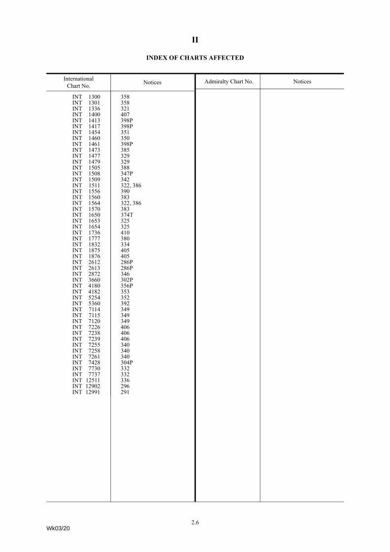
II
INDEX OF CHARTS AFFECTED
Admiralty Chart No. Notices
INT 1300 358INT 1301 358INT 1336 321INT 1400 407INT 1413 398PINT 1417 398PINT 1454 351INT 1460 350INT 1461 398PINT 1473 385INT 1477 329INT 1479 329INT 1505 388INT 1508 347PINT 1509 342INT 1511 322, 386INT 1556 390INT 1560 383INT 1564 322, 386INT 1570 383INT 1650 374TINT 1653 325INT 1654 325INT 1736 410INT 1777 380INT 1832 334INT 1875 405INT 1876 405INT 2612 286PINT 2613 286PINT 2872 346INT 3660 302PINT 4180 356PINT 4182 353INT 5254 352INT 5360 392INT 7114 349INT 7115 349INT 7120 349INT 7226 406INT 7238 406INT 7239 406INT 7255 340INT 7258 340INT 7261 340INT 7428 304PINT 7730 332INT 7737 332INT 12511 336INT 12902 296INT 12991 291
InternationalChart No. Notices
Wk03/20
Admiralty Chart No. Notices
2.6

II322* ENGLAND - South East Coast - Depths.Source: British Government Survey
Chart 323 (INT 1564) [ previous update 6297/19 ] ETRS89 DATUM
Replace depth, 209, with depth, 207 51° 12´·51N., 1° 43´·19E.
Chart 1406 [ previous update 269/20 ] WGS84 DATUM
Insert depth, 207 (a) 51° 12´·51N., 1° 43´·19E.Delete depth, 21, close S of: (a) above
Chart 1610 (INT 1511) [ previous update 6651/19 ] ETRS89 DATUM
Replace depth, 209, with depth, 207 51° 12´·51N., 1° 43´·19E.
Chart 2449 [ previous update 269/20 ] WGS84 DATUM
Replace depth, 209, with depth, 207 51° 12´·51N., 1° 43´·19E.
324* ENGLAND - East Coast - Depth.Source: Port of London Authority
Chart 2151 (Panel A, Continuation at same scale) [ previous update 6502/19 ] ETRS89 DATUM
Replace depth, 46, with depth, 42 51° 30´·210N., 0° 10´·305E.
325* WALES - South Coast - Depths.Source: Trinity House
Chart 1152 [ previous update 5942/19 ] ETRS89 DATUM
Insert depth, 43, and extend 5m contour E to enclose (a) 51° 24´·23N., 3° 08´·42W.Delete depth, 5, close W of: (a) aboveInsert depth, 44, enclosed by 5m contour 51° 24´·36N., 3° 08´·36W.
depth, 43 (b) 51° 24´·43N., 3° 08´·55W.Delete depth, 5, close W of: (b) aboveInsert depth, 09, and extend 2m contour SE to enclose (c) 51° 24´·66N., 3° 06´·13W.Delete depth, 12, close W of: (c) above
Chart 1176 (INT 1654) [ previous update 5942/19 ] ETRS89 DATUM
Insert depth, 43, and extend approximate 5m contour E to enclose (a) 51° 24´·23N., 3° 08´·42W.Delete depth, 5, close W of: (a) aboveInsert depth, 44, enclosed by 5m contour 51° 24´·36N., 3° 08´·36W.
depth, 43 (b) 51° 24´·43N., 3° 08´·55W. Delete depth, 5, close W of: (b) aboveInsert depth, 33 (c) 51° 25´·05N., 3° 08´·36W.Delete depth, 39, close NE of: (c) aboveInsert depth, 09, and extend approximate 2m contour SE to enclose (d) 51° 24´·66N., 3° 06´·13W.Delete depth, 12, close W of: (d) above
2.7Wk03/20

II
Chart 1182 (INT 1653) [ previous update New Edition 23/05/2019 ] ETRS89 DATUM
Insert depth, 43, and extend approximate 5m contour E to enclose (a) 51° 24´·23N., 3° 08´·42W.Delete depth, 5, close W of: (a) aboveInsert depth, 44, enclosed by 5m contour (b) 51° 24´·36N., 3° 08´·36W.Delete depth, 53, close SE of: (b) aboveInsert depth, 43 (c) 51° 24´·43N., 3° 08´·55W.Delete depth, 5, close W of: (c) aboveInsert depth, 33 (d) 51° 25´·05N., 3° 08´·36W.Delete depth, 39, close NE of: (d) aboveInsert depth, 09, and extend approximate 2m contour SE to enclose (e) 51° 24´·66N., 3° 06´·13W.Delete depth, 12, close NW of: (e) above
383* ENGLAND - East Coast - NM Block. Depth. Drying heights.Source: Trinity House
Chart 2052 (INT 1560) [ previous update 6651/19 ] ETRS89 DATUM
Insert drying height, 27 51° 58´·59N., 1° 23´·34E.
Chart 2693 (INT 1570) [ previous update 6394/19 ] ETRS89 DATUM
Insert the accompanying block, centred on: 51° 58´·8N., 1° 23´·5E.drying height, 06, and extend 0m low water line S to enclose (a) 52° 02´·23N., 1° 27´·66E.
Delete depth, 02, close N of: (a) above
Chart 2695 (Panel C, Rivers Ore and Alde) [ previous update New Edition 12/12/2019 ] ETRS89 DATUM
Replace drying height, 01, with drying height, 06 52° 02´·23N., 1° 27´·66E.
386* ENGLAND - South East Coast - Depth.Source: British Government Survey
Chart 323 (INT 1564) [ previous update 322/20 ] ETRS89 DATUM
Replace depth, 29, with depth, 285 51° 20´·23N., 1° 52´·18E.
Chart 1406 [ previous update 322/20 ] WGS84 DATUM
Replace depth, 29, with depth, 285 51° 20´·23N., 1° 52´·18E.
Chart 1610 (INT 1511) [ previous update 322/20 ] ETRS89 DATUM
Replace depth, 29, with depth, 285 51° 20´·23N., 1° 52´·18E.
Chart 2449 [ previous update 322/20 ] WGS84 DATUM
Replace depth, 29, with depth, 285 51° 20´·23N., 1° 52´·18E.
325* WALES - South Coast - Depths. (continued)
2.8Wk03/20

II
388* SCOTLAND - East Coast - Buoyage.Source: Neart na Gaoithe Offshore Wind Ltd
Chart 175 [ previous update 6583/19 ] ETRS89 DATUM
Insert EfFl(5)Y.20s MB156° 18´·44N., 2° 15´·96W.
EfFl(5)Y.20s MB256° 14´·34N., 2° 12´·11W.
Chart 190 [ previous update 6583/19 ] ETRS89 DATUM
Insert EfFl(5)Y.20s MB156° 18´·44N., 2° 15´·96W.
EfFl(5)Y.20s MB256° 14´·34N., 2° 12´·11W.
Chart 1407 (INT 1505) [ previous update 6583/19 ] ETRS89 DATUM
Insert EfFl(5)Y.20s MB156° 18´·44N., 2° 15´·96W.
EfFl(5)Y.20s MB256° 14´·34N., 2° 12´·26W.
390* ENGLAND - East Coast - Buoyage.Source: Port of Boston Ltd
Chart 1200 (INT 1556) (Panel B, Approaches to Boston) [ previous update 50/20 ] ETRS89 DATUM
Insert CbFl.G.3s No 13N (a) 52° 56´·48N., 0° 06´·71E.
Delete CbFl.G.6s No 13N , close NW of:(a) above
409* ENGLAND - East Coast - Light.Source: Port of London Authority
Chart 3337 [ previous update 5259/19 ] ETRS89 DATUM
Delete ·{ 51° 29´·163N., 0° 01´·484W.
410* ENGLAND - South Coast - Buoy.Source: Port of Dover
Chart 1698 (INT 1736) [ previous update New Edition 19/12/2019 ] ETRS89 DATUM
Replace G;Fl(4)Y.20s withGVVqQ(6)+LFl.15s51° 07´·058N., 1° 19´·652E.
2.9Wk03/20

II
289 POLAND - Depths.Source: ENC PL4MAP36
Chart 2015 (INT 1201) [ previous update 6036/19 ] WGS84 DATUM
Insert depth, 119 54° 01´·55N., 14° 15´·07E.
Chart 2679 [ previous update 6724/19 ] WGS84 DATUM
Insert depth, 129 (a) 54° 02´·49N., 14° 14´·73E.Delete depth, 144, close S of: (a) aboveInsert depth, 119 (b) 54° 01´·55N., 14° 15´·07E.Delete depth, 14, close S of: (b) aboveInsert depth, 102 53° 58´·06N., 14° 15´·74E.
290 SWEDEN - East Coast - Buoyage.Source: Swedish Notice 785/14479/19
Chart 832 (INT 1236) [ previous update 3725/19 ] WGS84 DATUM
Insert JVq (a) 59° 16´·04N., 18° 55´·63E.Delete Jb close SW of:
(a) aboveReplace Jd with JmU 59° 15´·85N., 18° 57´·18E.
Chart 881 (INT 1235) [ previous update 3725/19 ] WGS84 DATUM
Insert JVq (a) 59° 16´·04N., 18° 55´·63E.Delete Jb close SW of:
(a) aboveReplace Jd with JmU 59° 15´·85N., 18° 57´·18E.
291 POLAND - Lights.Source: Polish Notice 49/544/19
Chart 2452 (INT 12991) (Panel A, Continuation of Szczecin) [ previous update 6682/19 ] WGS84 DATUM
Amend light to, Iso.G.10s 53° 28´·437N., 14° 36´·327E. light to, Iso.R.10s 53° 28´·429N., 14° 36´·319E.
292 POLAND - Lights.Source: Polish Notice 49/545/19
Chart 2678 (INT 1298) (Panel, Port Trzebiez) [ previous update 6543/19 ] WGS84 DATUM
Insert ¶ Q.G.5m1M53° 39´·722N., 14° 30´·953E.53° 39´·655N., 14° 31´·068E.
2.10Wk03/20

II
296 POLAND - Buoyage.Source: Polish Notice 49/539/19
Chart 2637 (INT 12902) (Panel, Motława Marina) [ previous update 6381/19 ] WGS84 DATUM
Delete J]bb1 54° 21´·01N., 18° 39´·51E.
Cb3 54° 20´·99N., 18° 39´·55E.
Cb5 54° 20´·95N., 18° 39´·57E.
321 SWEDEN - South Coast - Buoy. Light.Source: Swedish Notice 785/14380/19
Chart 958 (INT 1336) [ previous update New Edition 14/11/2019 ] WGS84 DATUM
Delete ¶ Fl.R.3s55° 25´·04N., 13° 49´·00E.
Chart 2015 (INT 1201) (Panel B, Ystad) [ previous update 289/20 ] WGS84 DATUM
Insert JdFl.R.3s(a) 55° 25´·040N., 13° 49´·011E.
Delete ¶ Fl.R.3s8m9M, close W of:(a) above
328 ESTONIA - Buoy.Source: ENC EE60931D
Chart 2227 [ previous update New Edition 18/04/2019 ] WGS84 DATUM
Delete JmU 59° 28´·46N., 24° 44´·01E.
335 FINLAND - Saaristomeri - Submarine cable.Source: Finnish Notice 34/288/19
Chart 3824 (INT 1188) [ previous update 5025/19 ] WGS84 DATUM
Insert submarine cable,É, joining: 60° 07´·63N., 22° 17´·82E.60° 07´·62N., 22° 17´·86E.60° 07´·63N., 22° 17´·90E.60° 07´·67N., 22° 17´·94E.60° 08´·10N., 22° 17´·87E.60° 08´·23N., 22° 18´·08E.
2.11Wk03/20

II
336 FINLAND - South Coast - Buoy.Source: Finnish Notice 34/286/19
Chart 2211 (INT 12511) [ previous update 2530/19 ] WGS84 DATUM
Replace JW with JW{ 59° 57´·18N., 24° 21´·45E.
Chart 3819 (INT 1251) [ previous update 6377/19 ] WGS84 DATUM
Replace JW with JW{ 59° 57´·18N., 24° 21´·45E.
358 DENMARK - East Coast - Buoyage. Radar beacon.Source: Danish Chart Correction 49/597/19Note: Radar beacon remains unchanged on Chart 2107.
Chart 1402 (INT 1300) [ previous update 6522/19 ] WGS84 DATUM
Insert CFl(3)G.10s(a) 57° 24´·7N., 10° 36´·1E.
radar beacon, Racon(T), at light-buoy (a) aboveDelete HZIso.4s, and associated Radar Beacon, Racon (T), close
NW of: (a) above
Chart 2107 (INT 1301) [ previous update 6095/19 ] WGS84 DATUM
Replace HZIso.4s withCFl(3)G.10s57° 24´·71N., 10° 36´·08E.
369 SWEDEN - East Coast - Buoy.Source: Swedish Notice 786/14554/19
Chart 956 (INT 1242) (Panel B, Gävle) [ previous update 5182/19 ] WGS84 DATUM
Delete Jd 60° 40´·730N., 17° 10´·140E.
380 SWEDEN - East Coast - Depths. Alongside depths.Source: Swedish Notice 786/14585/19
Chart 889 (INT 1777) (Panel G, Hargshamn) [ previous update 6345/19 ] WGS84 DATUM
Insert depth, 67 60° 10´·310N., 18° 29´·050E.depth, 81 60° 10´·220N., 18° 28´·720E.alongside depth, (116) 60° 10´·180N., 18° 28´·930E.
Replace alongside depth, (79), with alongside depth, (84) 60° 10´·237N., 18° 28´·605E.
Chart 889 (INT 1777) [ previous update 6345/19 ] WGS84 DATUM
Insert depth, 75, enclosed by 10m contour 60° 11´·58N., 18° 41´·16E.depth, 131, and extend 15m contour SW to enclose 60° 10´·16N., 18° 36´·68E.
Replace sounding out of position, 5, with sounding out of position, 44 60° 11´·63N., 18° 41´·57E.
2.12Wk03/20

II
402 POLAND - Wreck.Source: Polish Notice 50/559/19
Chart 2014 (INT 1219) [ previous update 6315/19 ] WGS84 DATUM
Insert 25,Wk54° 22´·53N., 15° 25´·80E.
Chart 2816 [ previous update 6315/19 ] WGS84 DATUM
Insert 25,Wk54° 22´·5N., 15° 25´·8E.
329 NETHERLANDS - Depths. Drying height.Source: Netherlands Notices 50/430/19 and 51-52/438/19Note: This update is included in New Edition 128, published 9 January 2020.
Chart 116 (INT 1477) [ previous update 4439/19 ] WGS84 DATUM
Insert depth, 69 51° 25´·03N., 3° 39´·19E.
Chart 120 (INT 1479) [ previous update 5341/19 ] WGS84 DATUM
Insert depth, 69 51° 25´·03N., 3° 39´·19E.depth, 28, and extend 5m contour NE to enclose 51° 25´·99N., 4° 00´·15E.depth, 1, and extend 2m contour NE to enclose (a) 51° 25´·66N., 4° 00´·92E.
Delete depth, 15, close W of: (a) aboveInsert depth, 11, and extend 2m contour W to enclose 51° 23´·05N., 4° 02´·74E.
Chart 120 (INT 1479) (Panel A, Continuation to Nauw van Bath) [ previous update 5341/19 ] WGS84 DATUM
Insert drying height, 06 , extend 0m low water line SE to enclose (a) 51° 22´·39N., 4° 06´·69E.Delete depth, 17, close NE of: (a) aboveReplace depth, 28, with depth, 21 51° 22´·87N., 4° 05´·59E.
2.13Wk03/20

II
342* NORTH SEA - United Kingdom Sector - Depths.Source: British Government Survey
Chart 1503 (INT 1509) [ previous update 151/20 ] ETRS89 DATUM
Insert depth, 187 (a) 53° 20´·46N., 1° 09´·54E.Delete depth, 19, close E of: (a) aboveInsert depth, 10, enclosed by 10m contour (b) 53° 21´·47N., 1° 03´·64E.Delete depth, 103, close S of: (b) aboveInsert depth, 77, and extend 10m contour N to enclose (c) 53° 22´·23N., 1° 01´·94E.Delete depth, 106, close N of: (c) aboveInsert depth, 113 (d) 53° 26´·69N., 1° 01´·58E.Delete depth, 115, close SE of: (d) aboveInsert depth, 152 (e) 53° 32´·40N., 0° 59´·67E.Delete depth, 18, close W of: (e) aboveInsert depth, 98, enclosed by 10m contour (f) 53° 33´·06N., 1° 00´·13E.Delete depth, 11, close SE of: (f) aboveInsert depth, 164 (g) 53° 33´·76N., 0° 56´·83E.Delete depth, 171, close S of: (g) aboveInsert depth, 156 (h) 53° 37´·38N., 0° 57´·93E.Delete depth, 162, close SE of: (h) above
350 GERMANY - North Sea Coast - Wreck.Source: German Notice 50/7/19
Chart DE 7 (INT 1460) [ previous update 5400/19 ] WGS84 DATUM
Insert 11!,ÃWk53° 37´·63N., 8° 07´·93E.
351 GERMANY - North Sea Coast - Depths.Source: German Notice 50/47/19
Chart DE 47 (INT 1454) [ previous update 6695/19 ] WGS84 DATUM
Insert depth, 72 (a) 53° 44´·15N., 9° 26´·49E.Delete depth, 77, close W of: (a) aboveInsert depth, 96, enclosed by 10m contour (b) 53° 43´·91N., 9° 27´·09E.Delete depth, 126, close S of: (b) above
385 NORTH SEA - Netherlands Sector - Depth.Source: Netherlands Notice 51-52/439/19
Chart 110 (INT 1473) [ previous update New Edition 21/11/2019 ] WGS84 DATUM
Replace depth, 49, with depth, 42 51° 42´·31N., 3° 33´·45E.
2.14Wk03/20
II
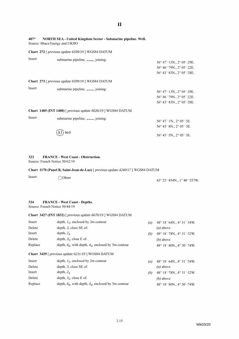
407* NORTH SEA - United Kingdom Sector - Submarine pipeline. Well.Source: Ithaca Energy and UKHO
Chart 272 [ previous update 6599/19 ] WGS84 DATUM
Insert submarine pipeline,È, joining: 56° 47´·13N., 2° 05´·29E.56° 46´·79N., 2° 05´·22E.56° 43´·83N., 2° 05´·28E.
Chart 273 [ previous update 6599/19 ] WGS84 DATUM
Insert submarine pipeline,È, joining: 56° 47´·13N., 2° 05´·29E.56° 46´·79N., 2° 05´·22E.56° 43´·83N., 2° 05´·28E.
Chart 1405 (INT 1400) [ previous update 6026/19 ] WGS84 DATUM
Insert submarine pipeline,È, joining: 56° 47´·1N., 2° 05´·3E.56° 43´·8N., 2° 05´·3E.
81, Well56° 43´·5N., 2° 05´·3E.
323 FRANCE - West Coast - Obstruction.Source: French Notice 50/62/19
Chart 1170 (Panel B, Saint-Jean-de-Luz) [ previous update 4240/17 ] WGS84 DATUM
Insert åObstn43° 23´·854N., 1° 40´·357W.
334 FRANCE - West Coast - Depths.Source: French Notice 50/44/19
Chart 3427 (INT 1832) [ previous update 6670/19 ] WGS84 DATUM
Insert depth, 15, enclosed by 2m contour (a) 48° 18´·64N., 4° 31´·34W.Delete depth, 3, close SE of: (a) aboveInsert depth, 24 (b) 48° 18´·78N., 4° 31´·32W.Delete depth, 35, close E of: (b) aboveReplace depth, 66, with depth, 44, enclosed by 5m contour 48° 18´·80N., 4° 30´·74W.
Chart 3429 [ previous update 6211/19 ] WGS84 DATUM
Insert depth, 15, enclosed by 2m contour (a) 48° 18´·64N., 4° 31´·34W.Delete depth, 3, close SE of: (a) aboveInsert depth, 24 (b) 48° 18´·78N., 4° 31´·32W.Delete depth, 35, close E of: (b) aboveReplace depth, 66, with depth, 44, enclosed by 5m contour 48° 18´·80N., 4° 30´·74W.
2.15Wk03/20

II
395 PORTUGAL - West Coast - Buoyage.Source: Portuguese Notice 11/236/19
Chart 3634 [ previous update 4972/19 ] WGS84 DATUM
Replace Gf;Fl.Y.2·5s withGf; 41° 27´·36N., 8° 49´·85W.Delete Gf; 41° 26´·92N., 8° 47´·74W.
405 PORTUGAL - West Coast - Legend. Fog signal.Source: Portuguese Notices 11/235/19 and 11/238/19
Chart 3220 (INT 1875) [ previous update 1826/19 ] WGS84 DATUM
Insert legend, Area liable to change, centred on: 38° 39´·185N., 9° 17´·255W.Delete fog signal, Horn Mo(B)30s, at light 38° 39´·628N., 9° 17´·933W.
Chart 3221 (INT 1876) [ previous update 2294/16 ] WGS84 DATUM
Insert legend, Area liable to change, centred on: 38° 39´·185N., 9° 17´·255W.Delete fog signal, Horn Mo(B)30s, at light 38° 39´·628N., 9° 17´·932W.
Chart 3635 [ previous update 5259/17 ] WGS84 DATUM
Delete fog signal, Horn Mo(B)30s, at light 38° 39´·64N., 9° 17´·95W.
308 TURKEY - South Coast - Depths. Wreck.Source: Turkish Chart 334Note: This update is included in a New Edition of Chart 246, to be published early 2020.
Chart 2632 [ previous update 6430/19 ] WGS84 DATUM
Insert depth, 119, and extend 20m contour SE to enclose (a) 36° 32´·2N., 35° 34´·1E.Delete depth, 155, close NW of: (a) above
19, Wk36° 44´·4N., 35° 46´·6E.
2.16Wk03/20

II
326 TURKEY - Marmara Denizi - Buoy. Submarine cables. Light.Automatic Identification System.
Source: Turkish Lights List, Turkish Notices 49/230/19 and 49/231/19
Chart 224 [ previous update 3757/19 ] WGS84 DATUM
Insert submarine cable, É, joining:40° 42´·8N., 27° 19´·0E.40° 37´·9N., 27° 26´·0E.40° 36´·8N., 27° 28´·4E.40° 36´·8N., 27° 32´·1E.and40° 33´·0N., 27° 32´·4E.40° 35´·5N., 27° 33´·0E.
Delete GYoFl(2)10s and associated Automatic Identification System,
AIS 40° 32´·7N., 27° 16´·2E.
Chart 1004 [ previous update 4098/19 ] WGS84 DATUM
Insert submarine cable, É, joining: 40° 35´·47N., 27° 32´·89E.40° 35´·14N., 27° 32´·89E.40° 33´·11N., 27° 32´·30E.40° 31´·96N., 27° 31´·32E.and40° 30´·31N., 27° 31´·58E.40° 29´·19N., 27° 35´·15E.40° 28´·92N., 27° 35´·15E.and40° 42´·76N., 27° 18´·98E.40° 37´·89N., 27° 25´·98E.40° 36´·82N., 27° 28´·36E.40° 36´·83N., 27° 32´·08E.
Delete GYoFl(2)10s and associated Automatic Identification System,
AIS 40° 32´·70N., 27° 16´·17E.
Chart 1005 [ previous update 5389/19 ] WGS84 DATUM
Insert submarine cable, É, joining:40° 35´·48N., 27° 32´·90E.40° 35´·28N., 27° 32´·90E.40° 33´·11N., 27° 32´·30E.40° 31´·96N., 27° 31´·32E.and40° 30´·31N., 27° 31´·58E.40° 29´·19N., 27° 35´·15E.40° 28´·92N., 27° 35´·15E.and40° 36´·83N., 27° 32´·03E.40° 36´·82N., 27° 28´·36E.40° 37´·89N., 27° 25´·97E.
Amend light to, Fl.R.3s2M & Fl.G.3s2M 40° 54´·16N., 27° 28´·14E.
2.17Wk03/20
II
345* GIBRALTAR - Depths.Source: UKHO
Chart 142 [ previous update 4351/19 ] WGS84 DATUM
Insert depth, 46, and extend 5m contour E to enclose 36° 08´·75N., 5° 20´·15W. depth, 45, and extend 5m contour E to enclose (a) 36° 08´·95N., 5° 20´·12W.
Delete depth, 56, close N of: (a) aboveInsert depth, 92, and extend 10m contour E to enclose 36° 08´·73N., 5° 20´·01W.
Chart 144 [ previous update 4712/19 ] WGS84 DATUM
Insert depth, 47, enclosed by 5m contour (a) 36° 08´·637N., 5° 20´·169W.Delete depth, 58, close S of: (a) aboveInsert depth, 46, enclosed by 5m contour (b) 36° 08´·748N., 5° 20´·154W.Delete depth, 62, close S of: (b) aboveInsert depth, 24 (c) 36° 08´·832N., 5° 20´·259W.Delete depth, 33, close N of: (c) aboveInsert depth, 45, enclosed by 5m contour (d) 36° 08´·951N., 5° 20´·119W.Delete depth, 58, close S of: (d) aboveInsert depth, 92, and extend 10m contour E to enclose 36° 08´·727N., 5° 20´·011W.
Chart 1448 [ previous update 4712/19 ] WGS84 DATUM
Insert depth, 47, and extend 5m contour E to enclose 36° 08´·64N., 5° 20´·17W.depth, 46, and extend 5m contour E to enclose 36° 08´·75N., 5° 20´·15W.depth, 45, and extend 5m contour SE to enclose (a) 36° 08´·95N., 5° 20´·12W.
Delete depth, 56, close N of: (a) aboveInsert depth, 92, and extend 10m contour E to enclose 36° 08´·73N., 5° 20´·01W.
360 ITALY - Sicilia - Light-beacon.Source: Italian Notice 25.9/19
Chart 2122 [ previous update 3441/19 ] WGS84 DATUM
Delete TÜFl(5)Y.20s5M37° 28´·6N., 12° 55´·5E.
Chart 2123 [ previous update 2935/19 ] WGS84 DATUM
Delete TlÜFl(5)Y.20s5M37° 28´·6N., 12° 55´·4E.
2.18Wk03/20

II
363 ITALY - East Coast - Restricted areas.Source: Italian Notice 25.11/19
Chart 1545 [ previous update 4271/15 ] WGS84 DATUM
Delete limit of restricted area,ÇÅÇ and associated symbols,
Å, joining:40° 38´·703N., 17° 57´·183E.40° 39´·024N., 17° 58´·133E.40° 39´·010N., 17° 58´·138E.and40° 38´·993N., 17° 58´·621E.40° 38´·966N., 17° 58´·912E.and40° 38´·968N., 17° 58´·917E.40° 39´·454N., 17° 59´·431E.and40° 39´·442N., 17° 59´·446E.40° 39´·352N., 17° 59´·582E.40° 39´·344N., 17° 59´·591E.40° 39´·318N., 17° 59´·651E.40° 39´·299N., 17° 59´·808E.
376 GREECE - Aegean Sea Coast - Wreck.Source: Greek Notice 11/208/19
Chart 1636 (Panel, Alexandroúpoli) [ previous update 3576/19 ] ED50 DATUM
Delete ® 40° 50´·61N., 25° 53´·39E.
382 TURKEY - West Coast - Legends. Harbour limit.Source: Turkish Notice 50/236/19
Chart 1056 [ previous update 5291/19 ] WGS84 DATUM
Insert harbour limit, pecked line, joining: (a) 37° 13´·06N., 27° 10´·12E.(b) 37° 13´·06N., 27° 21´·03E.
37° 06´·08N., 27° 29´·36E.legend, Güllük Harbour Limit, along N side of: (a)-(b) abovelegend, Bodrum Harbour Limit, along S side of: (a)-(b) above
2.19Wk03/20

II
389 TURKEY - Marmara Denizi - Anchorage areas.Source: Turkish Notice 50/235/19
Chart 1004 [ previous update 326/20 ] WGS84 DATUM
Delete limit of anchorage area, pecked line, and associated legend,
½No 4, joining:40° 32´·68N., 26° 56´·04E.40° 31´·40N., 26° 56´·50E.40° 30´·00N., 26° 53´·00E.40° 31´·27N., 26° 52´·41E.
limit of anchorage area, pecked line, and associated legend,
½ No 5, joining:40° 30´·25N., 26° 49´·86E.40° 29´·05N., 26° 50´·50E.40° 27´·35N., 26° 46´·00E.40° 28´·50N., 26° 44´·27E.
Chart 5507 [ previous update 6504/19 ] WGS84 DATUM
Delete limit of anchorage area, pecked line, and associated legend,
½Passenger and dry cargo, joining:40° 32´·70N., 26° 56´·04E.40° 31´·41N., 26° 56´·50E.40° 30´·00N., 26° 53´·00E.40° 31´·27N., 26° 52´·41E.
limit of anchorage area, pecked line, and associated legend,
½Unrestricted, joining:40° 30´·24N., 26° 49´·85E.40° 29´·05N., 26° 50´·49E.40° 27´·35N., 26° 46´·00E.40° 28´·50N., 26° 44´·27E.
391 GREECE - Aegean Sea Coast - Wreck.Source: Greek Notice 11/207/19
Chart 1040 [ previous update 5217/19 ] WGS84 DATUM
Insert ^ 36° 42´·87N., 26° 52´·04E.
Chart 1055 [ previous update 3728/19 ] WGS84 DATUM
Insert ^ 36° 42´·87N., 26° 52´·04E.
Chart 1095 [ previous update New Edition 21/11/2019 ] WGS84 DATUM
Insert ^ 36° 42´·9N., 26° 52´·0E.
Chart 1099 [ previous update 3728/19 ] WGS84 DATUM
Insert ^, out of position36° 42´·9N., 26° 52´·0E.
2.20Wk03/20

II
401 ROMANIA - Depths.Source: ENC RO405002
Chart 2282 (Panel A, Mangalia to Midia) [ previous update 4172/19 ] WGS84 DATUM
Insert depth, 98, enclosed by 10m contour (a) 44° 11´·32N., 28° 41´·47E.Delete depth, 126, close S of: (a) aboveInsert depth, 96, enclosed by 10m contour 44° 09´·76N., 28° 40´·76E.
Chart 2284 [ previous update 4101/19 ] WGS84 DATUM
Insert depth, 98, enclosed by 10m contour 44° 11´·32N., 28° 41´·47E.depth, 96, enclosed by 10m contour 44° 09´·76N., 28° 40´·76E.depth, 182, enclosed by 20m contour 44° 06´·57N., 28° 41´·82E.
306 GUINEA BISSAU - NM Block. Depths. Buoy. Light. Anchorage area.Source: ENC PT566310
Chart 1724 (Panel, Bissau) [ previous update 4580/19 ] WGS84 DATUM
Insert the accompanying block, centred on: 11° 50´·7N., 15° 34´·5W.
Chart 1724 [ previous update 4580/19 ] WGS84 DATUM
Insert limit of anchorage area, pecked line, joining: 11° 50´·45N., 15° 34´·05W.11° 51´·50N., 15° 32´·70W.11° 51´·15N., 15° 32´·45W.11° 50´·10N., 15° 33´·80W.
Replace depth 62, with depth 48, enclosed by 5m contour (a) 11° 49´·99N., 15° 34´·85W.Delete GrWVQ(3)5s M, close SE of:
(a) above
¶ Iso.R11° 50´·26N., 15° 35´·26W.
346 IVORY COAST - Buoy.Source: French Notice 50/163/19Note: Chart 3101 is to be deleted from the list of charts affected by Notice 5780(P)/19.
Chart 3101 (INT 2872) (Panel A, Approaches to Port d’Abidjan) [ previous update 40/19 ] WGS84 DATUM
Insert G\dOc.R.6s5° 14´·64N., 3° 59´·83W.
2.21Wk03/20

II
340 BAHRAIN - Buoy.Source: ENC BH51501B
Chart 3734 (INT 7261) [ previous update 6531/19 ] WGS84 DATUM
Replace Cb]Q.G K1A withCb]K1A 26° 10´·629N., 50° 42´·792E.
Chart 3736 (INT 7258) [ previous update 6531/19 ] WGS84 DATUM
Replace Cb]Q.G K1A withCb]K1A 26° 10´·629N., 50° 42´·792E.
Chart 3737 (INT 7255) [ previous update 6531/19 ] WGS84 DATUM
Replace Cb]Q.G K1A withCb]K1A 26° 10´·63N., 50° 42´·79E.
349 DJIBOUTI - Wreck.Source: French Notice 50/195/19Note: Former Notice 3661(T)/19 is cancelled.
Chart 263 (INT 7120) [ previous update New Edition 30/05/2019 ] WGS84 DATUM
Insert 14,Wk11° 38´·041N., 43° 07´·473E.
Chart 264 (INT 7115) [ previous update 933/19 ] WGS84 DATUM
Insert 14,Wk11° 38´·04N., 43° 07´·47E.
Chart 265 (INT 7114) [ previous update 1036/19 ] WGS84 DATUM
Insert 14,Wk11° 38´·04N., 43° 07´·47E.
365 OMAN - Buoy. Legend.Source: ENC OM50007C
Chart 3518 (Panel E, Qalhāt LNG and OMIFCO Terminals) [ previous update 6243/19 ] WGS84 DATUM
Amend light-buoy to, Fl(5)Y.10s 22° 38´·85N., 59° 27´·06E.Delete legend, Works in progress (2005), centred on: 22° 38´·96N., 59° 26´·25E.
399 OMAN - Buoyage.Source: ENC OM400255
Chart 3518 (Panel B, Port Sultan Qāboos and Muscaţ (Masqaţ)) [ previous update 365/20 ] WGS84 DATUM
Insert BdFl(3)R.10s No123° 37´·598N., 58° 34´·862E.
Amend designation of No1 light-buoy to PSQ No1 23° 37´·618N., 58° 34´·679E.
Chart 3518 (Panel A, Muscaţ (Masqaţ) to Mīnā’ al Faḩl) [ previous update 365/20 ] WGS84 DATUM
Insert BdFl(3)R.10s No123° 37´·60N., 58° 34´·86E.
2.22Wk03/20

II
406 UNITED ARAB EMIRATES - Obstruction.Source: Petroleum Ports Authority
Chart 2443 (INT 7238) [ previous update 6540/19 ] WGS84 DATUM
Insert 21%, Obstn25° 00´·73N., 53° 10´·12E.
Chart 2444 (INT 7239) [ previous update 6584/19 ] WGS84 DATUM
Insert 21%, Obstn25° 00´·73N., 53° 10´·12E.
Chart 3178 (INT 7226) [ previous update 6584/19 ] WGS84 DATUM
Insert 21%, Obstn25° 00´·73N., 53° 10´·12E.
332 INDIAN OCEAN - Mauritius - Depths.Source: ENC IN32527M
Chart 711 (INT 7737) [ previous update 5178/18 ] WGS84 DATUM
Insert depth, 128 (a) 19° 37´·97S., 57° 45´·73E.Delete depth, 187, close SW of: (a) aboveInsert depth, 121 (b) 19° 47´·35S., 57° 48´·39E.Delete depth, 154, close SW of: (b) aboveInsert depth, 142, and extend 20m approximate contour N to enclose (c) 19° 55´·82S., 57° 37´·48E.Delete depth, 35 , close SW of: (c) aboveInsert depth, 182, and extend 20m approximate contour S to enclose 19° 54´·51S., 57° 39´·61E.
depth, 72, and extend 100m approximate contour SW to enclose (d) 19° 48´·88S., 57° 44´·48E.
Delete depth, 82, close NE of: (d) above
Chart 712 (INT 7730) [ previous update New Edition 28/03/2019 ] WGS84 DATUM
Insert depth, 128 (a) 19° 38´·0S., 57° 45´·7E.Delete depth, 132, close E of: (a) aboveInsert depth, 72 (b) 19° 48´·9S., 57° 44´·5E.Delete depth, 82, close N of: (b) aboveInsert depth, 121 (c) 19° 47´·4S., 57° 48´·4E.Delete depth, 154 , close W of: (c) aboveInsert depth, 142, and extend 20m contour N to enclose 19° 55´·8S., 57° 37´·5E.
depth, 182, and extend 20m contour S to enclose 19° 54´·5S., 57° 39´·6E.
2.23Wk03/20

II
293 VIETNAM - Single Point Mooring. Light.Source: VMS-North chart 40013
Chart 3488 (INT 552) [ previous update 168/20 ] WGS84 DATUM
Amend light to, Fl(4)20M 19° 22´·6N., 105° 55´·6E.
Chart 3989 [ previous update 6716/19 ] WGS84 DATUM
Insert ¼{ SPM19° 21´·6N., 106° 06´·0E.
Amend light to, Fl(4)30s154m20M 19° 22´·2N., 105° 55´·9E.
Chart 3990 [ previous update 5399/19 ] WGS84 DATUM
Insert ¼{ SPM19° 21´·6N., 106° 06´·0E.
Amend light to, Fl(4)30s154m20M 19° 22´·2N., 105° 55´·9E.
295 CHINA - East Coast - Virtual aid to navigation. Light.Source: Chinese Notice 48/1563-1564/19
Chart 3449 [ previous update 6505/19 ] CGCS 2000 DATUM
Insert symbol, Virtual aid to navigation, isolated danger topmark, V-AIS 24° 22´·23N., 118° 10´·37E.
Delete ¶ Fl(2)6s22m7M24° 24´·45N., 118° 03´·97E.
Chart 3453 [ previous update 4878/19 ] CGCS 2000 DATUM
Delete ¶ Fl(2)6s22m7M24° 24´·45N., 118° 03´·97E.
2.24Wk03/20

II
307 VIETNAM - Depth. Buoyage. Recommended routes. Radar beacon. Automatic Identification System.Legend.
Source: VMS-North Chart 50007
Chart 1965 [ previous update 5353/19 ] WGS84 DATUM
Insert depth, 29, and extend 5.4m contour SE to enclose 20° 39´·07N., 106° 47´·90E.
HZwMo(A)6s NT0(a) 20° 43´·35N., 106° 55´·11E.
centreline of recommended route, pecked line, joining: 20° 40´·25N., 107° 00´·54E.20° 42´·84N., 106° 58´·54E.
HZwMo(A)6s HP0(b) 20° 39´·14N., 107° 01´·40E.
radar beacon, Racon(M), at HP0 light-buoy (b) aboveAutomatic Identification System, AIS, at HP0 light-buoy (b) above
Delete HZwMo(A)6s 20° 40´·96N., 106° 59´·00E.
(c) 20° 41´·90N., 106° 57´·40E.centreline of two-way recommended route, pecked line, joining: (c) above
(a) abovecentreline of two-way recommended route, pecked line, and associated legend 163°- 343°, joining: 20° 42´·84N., 106° 58´·54E.
20° 41´·19N., 106° 59´·01E.
331 VIETNAM - Light.Source: VMS-North chart 40015
Chart 3488 (INT 552) [ previous update 293/20 ] WGS84 DATUM
Amend light to, Fl(4)20M 18° 06´·9N., 106° 25´·3E.
Chart 3989 [ previous update 293/20 ] WGS84 DATUM
Amend light to, Fl(4)20s205m20M 18° 07´·1N., 106° 25´·5E.
333 VIETNAM - Wrecks.Source: VMS-South Chart VN3GR001
Chart 1261 [ previous update 116/20 ] WGS84 DATUM
Insert ´ 10° 19´·70N., 107° 03´·79E.
´Wks10° 20´·07N., 107° 02´·51E.
2.25Wk03/20

II
357 TAIWAN - Depths. Wrecks.Source: UKHO
Chart 3232 [ previous update 6700/19 ] WGS84 DATUM
Insert depth, 131, enclosed by 20m contour 22° 54´·78N., 120° 06´·08E.depth, 141 (a) 22° 52´·81N., 120° 08´·70E.
Delete depth, 19, close NW of: (a) aboveInsert 18%,Wk
22° 47´·52N., 120° 09´·28E.depth, 196, enclosed by 20m contour 22° 46´·76N., 120° 08´·85E.
18",Wk22° 45´·69N., 120° 09´·86E.
15Ó,Wk22° 45´·22N., 120° 10´·96E.
´ 22° 45´·83N., 120° 12´·64E.22° 41´·70N., 120° 13´·86E.22° 40´·14N., 120° 14´·48E.
depth, 105 22° 36´·89N., 120° 08´·23E.
359 MALAYSIA - Peninsular Malaysia, East Coast - Buoy.Source: Marine Department, Malaysia Notice 192/19Note: Former Notice 5575(T)/18 is cancelled.
Chart 1374 (Panel B, Pelabuhan Kemaman) [ previous update 817/19 ] WGS84 DATUM
Move BdFl.R.3s No 4, from:4° 14´·32N., 103° 28´·36E.
to: 4° 14´·31N., 103° 28´·27E.
362 MALAYSIA - Peninsular Malaysia, East Coast - Buoy.Source: Marine Department, Malaysia Notice 193/19
Chart 3446 [ previous update 4475/19 ] WGS84 DATUM
Move FpLFl , from:5° 20´·39N., 103° 10´·30E.
to: 5° 21´·41N., 103° 09´·70E.
Chart 3447 [ previous update 4475/19 ] WGS84 DATUM
Move FpLFl , from:5° 20´·39N., 103° 10´·30E.
to: 5° 21´·41N., 103° 09´·70E.
2.26Wk03/20

II
375 CHINA - Bo Hai - Wrecks.Source: Chinese Notice 49/1589/19
Chart 1252 [ previous update 6630/19 ] CGCS 2000 DATUM
Replace 13),Wk with ´2 Wks40° 22´·04N., 121° 51´·71E.
Chart 1280 [ previous update 3566/19 ] CGCS 2000 DATUM
Insert ´ 40° 22´·03N., 121° 51´·56E.
GvYFl(2)5s 40° 21´·97N., 121° 51´·48E.
Chart 1286 [ previous update 160/20 ] CGCS 2000 DATUM
Insert ´ 40° 22´·03N., 121° 51´·56E.
GvYFl(2)5s 40° 21´·97N., 121° 51´·48E.
377 CHINA - South Coast - Buoyage. Virtual aids to navigation.Source: Chinese Notice 49/1600/19
Chart 346 [ previous update New Edition 21/11/2019 ] CGCS 2000 DATUM
Insert virtual aid to navigation, starboard lateral topmark, V-AIS (a) 22° 58´·95N., 113° 32´·29E.Delete CbFl.G.4s No 8, close N of:
(a) aboveReplace Cb Fl.G.4s No 12, with virtual aid to navigation, starboard
lateral topmark, V-AIS 22° 59´·22N., 113° 32´·19E.
381 CHINA - East Coast - Submarine power cable.Source: Chinese Notice 49/1596/19
Chart 1304 [ previous update 224/20 ] WGS84 DATUM
Insert submarine power cable, ÉÊÉ, joining:30° 01´·34N., 121° 40´·49E.30° 01´·80N., 121° 41´·36E.30° 03´·87N., 121° 43´·74E.30° 04´·51N., 121° 45´·75E.30° 04´·62N., 121° 49´·41E.
2.27Wk03/20

II
384 CHINA - South Coast - Lights. Automatic Identification Systems.Source: Chinese Notice 49/1599/19
Chart 1760 [ previous update 58/20 ] WGS84 DATUM
Delete ¶ Mo(U)15s9m10M23° 16´·3N., 117° 01´·3E.
¶ Mo(U)15s9m4M23° 15´·3N., 117° 01´·3E.
¶ Mo(U)15s7m10M23° 13´·0N., 116° 58´·9E.
Chart 1792 [ previous update 6628/19 ] CGCS 2000 DATUM
Delete ¶ Mo(U)15s9m10M and associated Automatic Identification
System, AIS 23° 16´·28N., 117° 01´·25E.
¶ Mo(U)15s9m4M23° 15´·28N., 117° 01´·25E.
¶ Mo(U)15s7m10M and associated Automatic Identification
System, AIS 23° 12´·95N., 116° 58´·93E.
Chart 1962 [ previous update 6628/19 ] WGS84 DATUM
Delete ¶ Mo(U)15s9m10M23° 16´·3N., 117° 01´·3E.
¶ Mo(U)15s9m4M23° 15´·3N., 117° 01´·3E.
¶ Mo(U)15s7m10M23° 13´·0N., 116° 58´·9E.
394 CHINA - South Coast - Pilot boarding places. Obstruction.Source: Hong Kong Notices 25/53-54/19
Chart 4128 [ previous update 5840/19 ] WGS84 DATUM
Insert  22° 33´·50N., 114° 20´·20E.22° 29´·70N., 114° 26´·54E.22° 28´·08N., 114° 27´·67E.
 out of position22° 32´·80N., 114° 23´·60E.
8"+ Obstn22° 27´·19N., 114° 16´·40E.
Delete  22° 34´·08N., 114° 20´·58E.22° 33´·98N., 114° 23´·63E.22° 26´·83N., 114° 28´·58E.
2.28Wk03/20

II
396 CHINA - Bo Hai - Light. Buoyage.Source: Chinese Notice 49/1594/19
Chart 1263 [ previous update 2143/19 ] CGCS 2000 DATUM
Insert ¶ Iso.4s5M37° 40´·22N., 120° 13´·45E.
Move Gd\Fl(2)R.6s No 102, from:37° 40´·35N., 120° 13´·02E.
to: 37° 40´·10N., 120° 13´·26E.
Chart 1264 [ previous update New Edition 15/11/2018 ] CGCS 2000 DATUM
Insert ¶ Iso.4s8m5M37° 40´·218N., 120° 13´·450E.
Gd\Fl(2)R.6s No 10237° 40´·100N., 120° 13´·262E.
Delete formerGd\Fl(2)R.6s No 10237° 40´·348N., 120° 13´·020E.
400 CHINA - Bo Hai - Note.Source: Chinese Notices 49/1610(T)-1612(T)/19
Chart 2653 [ previous update 5344/19 ] CGCS 2000 DATUM
Insert the accompanying note, BUOYAGE, centred on: 39° 04´·65N., 118° 07´·04E.
Chart 2662 [ previous update 6665/19 ] CGCS 2000 DATUM
Insert the accompanying note, BUOYAGE, centred on: 38° 56´·143N., 117° 42´·749E.
Chart 2665 [ previous update 3616/19 ] CGCS 2000 DATUM
Insert the accompanying note, BUOYAGE, centred on: 39° 02´·106N., 117° 47´·233E.
404 CHINA - Bo Hai - Note.Source: Chinese Notice 49/1613(T)/19
Chart 2657 [ previous update 3494/19 ] CGCS 2000 DATUM
Insert the accompanying note, BUOYAGE, centred on: 38° 58´·28N., 118° 45´·94E.
313 JAPAN - Honshū - NM Block.Source: Japanese Notice 50/1019/19Note: Former Notice 2689(T)/17 is cancelled.
Chart JP 1086 [ previous update 5616/19 ] WGS84 DATUM
Insert the accompanying block, centred on: 35° 35´ 48"N., 140° 05´ 41"E.
2.29Wk03/20

II
314 JAPAN - Honshū - NM Block.Source: Japanese Notice 50/1020/19Note: Former Notice 6139(P)/19 is cancelled.
Chart JP 5510 [ previous update 1613/19 ] WGS84 DATUM
Insert the accompanying block, centred on: 35° 26´·2N., 139° 42´·0E.
315 JAPAN - Seto Naikai - NM Blocks.Source: Japanese Notice 50/1021/19
Chart JP 104 [ previous update 3249/19 ] WGS84 DATUM
Insert the accompanying block, centred on: 34° 06´ 54"N., 132° 59´ 30"E.
Chart JP 132 [ previous update 3249/19 ] WGS84 DATUM
Insert the accompanying block, centred on: 34° 06´ 55"N., 132° 59´ 10"E.
316 JAPAN - Seto Naikai - Jetties.Source: Japanese Notice 50/1030/19
Chart JP 131 [ previous update 5005/19 ] WGS84 DATUM
Insert jetty, single firm line, joining: 34° 38´ 49·2"N., 134° 58´ 04·5"E.34° 38´ 47·0"N., 134° 58´ 02·5"E.and34° 38´ 40·8"N., 134° 58´ 18·4"E.34° 38´ 38·4"N., 134° 58´ 16·7"E.
317 JAPAN - Seto Naikai - Vertical clearance.Source: Japanese Notice 50/1032/19
Chart JP 104 [ previous update 315/20 ] WGS84 DATUM
Amend vertical clearance to, abt 46m 34° 13´ 14·3"N., 133° 08´ 34·7"E.
Chart JP 153 [ previous update 6606/19 ] WGS84 DATUM
Amend vertical clearance to, abt 46m 34° 13´·10N., 133° 08´·62E.
Chart JP 1108 [ previous update 4218/19 ] WGS84 DATUM
Amend vertical clearance to, abt 46m 34° 13´·09N., 133° 08´·63E.
352 KOREA - West Coast - Wreck.Source: Korean Notice 50/1180/19
Chart 913 (INT 5254) [ previous update 257/20 ] WGS84 DATUM
Insert 8"+ Wk36° 31´·37N., 126° 16´·31E.
2.30Wk03/20

II
354 KOREA - South Coast - Light.Source: Korean Notice 50/1175/19
Chart 1065 [ previous update 127/20 ] WGS84 DATUM
Amend light to, Fl(3)G.8s9M 35° 03´·22N., 128° 59´·01E.
Chart 1259 (Panel B, Busan) [ previous update 108/20 ] WGS84 DATUM
Amend light to, Fl(3)G.8s10m9M 35° 03´·22N., 128° 59´·02E.
355 KOREA - East Coast - Buoyage.Source: Korean Notice 50/1173/19
Chart 882 (Panel, Donghae (Tonghae)) [ previous update 6562/19 ] WGS84 DATUM
Insert Gd:Fl(2)R.6s E37° 29´·837N., 129° 09´·020E.
Delete G;f Fl(4)Y.8s E37° 29´·657N., 129° 08´·945E.
392 KOREA - South Coast - Wreck.Source: ENC KR3G3E00
Chart 3391 (INT 5360) [ previous update 252/20 ] WGS84 DATUM
Delete 10%,Wk34° 51´·67N., 128° 16´·45E.
403 KOREA - West Coast - Radar beacon.Source: ENC KR3F2K00
Chart 1258 [ previous update 205/20 ] WGS84 DATUM
Delete radar beacon, Racon(Y), at light-beacon 37° 03´·60N., 126° 04´·50E.
303 MALAYSIA - Sarawak - Buoy.Source: Royal Malaysian Navy
Chart 1748 [ previous update 6655/19 ] WGS84 DATUM
Delete BdFl.R.4s3° 11´·89N., 113° 01´·36E.
Chart 2100 [ previous update 6655/19 ] WGS84 DATUM
Delete BdFl.R.4s3° 11´·89N., 113° 01´·35E.
2.31Wk03/20

II
305 MALAYSIA - Sarawak - Wreck.Source: ENC MY3C0723
Chart 1336 [ previous update 6533/19 ] WGS84 DATUM
Insert ® Rep(2019) 2° 14´·1N., 109° 51´·0E.
Chart 3482 (INT 550) [ previous update 247/20 ] WGS84 DATUM
Insert ® Rep(2019) 2° 14´·1N., 109° 51´·0E.
Chart 3834 [ previous update 6510/19 ] TIMBALAI 1948 DATUM
Insert ® Rep(2019) PA 2° 14´·09N., 109° 50´·78E.
Chart 4508 (INT 508) [ previous update 168/20 ] WGS84 DATUM
Insert ® Rep(2019) 2° 14´·1N., 109° 51´·0E.
341 PHILIPPINE ISLANDS - Luzon - Buoy.Source: Philippine Notice 11/68/19 and NAMRIANote: Former Notice 6412(T)/19 is cancelled.
Chart 983 [ previous update 4688/18 ] WGS84 DATUM
Delete DddFl(2)R.4s (sync)14° 46´·60N., 120° 13´·17E.
387 INDONESIA - Jawa - Wreck. Buoyage.Source: Indonesian Notices 51/681-685/19
Chart 932 (Panel A, Pelabuhan Tanjungpriok) [ previous update 5956/19 ] WGS84 DATUM
Delete Cb 6° 06´·518S., 106° 51´·676E.
Bd 6° 06´·518S., 106° 51´·761E.
® 6° 05´·397S., 106° 52´·707E.
R 6° 04´·972S., 106° 53´·051E.symbol, blue and yellow emergency wreck marking light-buoy, Al.Fl.BuY.6s 6° 04´·629S., 106° 52´·480E.
Chart 932 (Panel B, Approaches to Pelabuhan Tanjungpriok) [ previous update 5956/19 ] WGS84 DATUM
Delete symbol, blue and yellow emergency wreck marking light-buoy, Al.Fl.BuY.6s 6° 04´·62S., 106° 52´·48E.
2.32Wk03/20

II
408 INDONESIA - Kalimantan - Wreck.Source: Indonesian Notice 9/127(P)/19 and UKHONote: Former Notice 1570(T)/19 is cancelled.
Chart 1066 [ previous update 5895/19 ] WGS84 DATUM
Insert ´Masts Rep (2019)2° 35´·2S., 109° 14´·6E.
Chart 1312 [ previous update 6424/19 ] WGS84 DATUM
Insert ´Masts Rep (2019)2° 35´·2S., 109° 14´·6E.
Chart 2470 [ previous update 6424/19 ] WGS84 DATUM
Insert ´Masts Rep (2019)2° 35´·2S., 109° 14´·6E.
Chart 2872 [ previous update 4739/19 ] WGS84 DATUM
Insert ´Masts Rep (2019)2° 35´·2S., 109° 14´·6E.
Chart 3757 [ previous update 4739/19 ] WGS84 DATUM
Insert ´Masts Rep (2019)2° 35´·18S., 109° 14´·55E.
Chart 4508 (INT 508) [ previous update 305/20 ] WGS84 DATUM
Insert ´ 2° 35´·2S., 109° 14´·5E.
282 AUSTRALIA - Queensland - Wreck.Source: Australian Notice 25/1306/19Note: Former Notice 3408(T)/16 is cancelled.
Chart Aus 490 [ previous update 5886/19 ] WGS84 DATUM
Insert 30, Wk23° 57´·3S., 152° 06´·9E.
Chart Aus 818 [ previous update 5886/19 ] WGS84 DATUM
Insert 30, Wk23° 57´·34S., 152° 06´·90E.
Chart Aus 819 [ previous update 3261/19 ] WGS84 DATUM
Insert 30, Wk23° 57´·34S., 152° 06´·90E.
2.33Wk03/20

II
283 AUSTRALIA - Western Australia - Submarine pipelines.Source: Australian Notice 25/1313/19
Chart Aus 328 [ previous update 100/20 ] WGS84 DATUM
Delete submarine pipeline, È, joining:20° 42´·4S., 114° 59´·0E.20° 43´·3S., 114° 59´·0E.and20° 44´·0S., 114° 58´·4E.20° 43´·6S., 114° 58´·6E.and20° 43´·8S., 114° 59´·3E.20° 43´·6S., 114° 58´·9E.
284 AUSTRALIA - South Australia - Foul. Wreck.Source: Australian Notice 25/1318/19
Chart Aus 130 [ previous update 6472/19 ] WGS84 DATUM
Insert « 34° 49´·24S., 138° 20´·28E.Delete 14&, Wk
34° 49´·60S., 138° 20´·45E.
Chart Aus 138 [ previous update 2973/18 ] WGS84 DATUM
Insert « 34° 49´·237S., 138° 20´·280E.
Chart Aus 485 [ previous update 5524/19 ] WGS84 DATUM
Insert « (a) 34° 49´·2S., 138° 20´·3E.Delete 14&, Wk close SE of:
(a) above
Chart Aus 781 [ previous update 46/20 ] WGS84 DATUM
Insert « (a) 34° 49´·24S., 138° 20´·28E.Delete 14&, Wk close SE of:
(a) above
2.34Wk03/20

II
285 AUSTRALIA - Victoria - Light-beacon. Beacons.Source: Australain Notice 25/1321/19
Chart Aus 155 [ previous update 5155/19 ] WGS84 DATUM
Insert TÜlFl.Y.2s(a) 37° 56´·40S., 144° 59´·77E.
Delete K, close NE of:(a) above
KlÜ 37° 55´·76S., 144° 47´·24E.
K¨h 37° 56´·14S., 144° 59´·63E.
Chart Aus 155 (Panel, Sandringham) [ previous update 5155/19 ] WGS84 DATUM
Delete K 37° 56´·389S., 144° 59´·832E.
287 AUSTRALIA - Queensland - Buoyage. Depth.Source: Australian Notice 25/1305/19
Chart Aus 814 [ previous update 65/20 ] WGS84 DATUM
Insert DfFl.Y.3s FAD27° 55´·79S., 153° 45´·20E.27° 59´·27S., 153° 31´·75E.
(a) 27° 05´·80S., 153° 34´·18E.Delete depth, 95, close N of: (a) aboveInsert DfFl.Y.3s FAD
(b) 27° 48´·41S., 153° 37´·47E.Delete D;fFl.Y.3s, close S of:
(b) aboveReplace D;fFl.Y.3s with DfFl.Y.3s
27° 17´·01S., 153° 37´·67E.
288 AUSTRALIA - Victoria - Lights.Source: Australian Notice 25/1319/19
Chart Aus 357 [ previous update 280/20 ] WGS84 DATUM
Amend range of light to, 15M 38° 57´·0S., 146° 42´·3E.39° 07´·8S., 146° 25´·5E.39° 13´·7S., 146° 32´·4E.
2.35Wk03/20

II
Chart Aus 487 [ previous update 280/20 ] WGS84 DATUM
Amend range of light to, 15M 38° 57´·0S., 146° 42´·3E.39° 07´·8S., 146° 25´·4E.39° 13´·7S., 146° 32´·3E.38° 54´·4S., 145° 55´·3E.
Chart Aus 801 [ previous update 1592/18 ] WGS84 DATUM
Amend range of light to, 15M 38° 54´·42S., 145° 55´·35E.
Chart Aus 802 [ previous update 53/20 ] WGS84 DATUM
Amend range of light to, 15M 39° 07´·79S., 146° 25´·46E.38° 57´·05S., 146° 42´·35E.39° 13´·70S., 146° 32´·36E.38° 54´·43S., 145° 55´·36E.
298 AUSTRALIA - Western Australia - Buoyage.Source: Australian Notice 25/1317/19
Chart Aus 754 [ previous update 61/20 ] WGS84 DATUM
Insert DfFAD (Nov - Jun)31° 43´·98S., 115° 10´·50E.31° 42´·00S., 115° 07´·02E.31° 42´·00S., 115° 10´·50E.31° 37´·02S., 115° 07´·98E.32° 06´·78S., 115° 09´·60E.32° 06´·84S., 115° 06´·96E.
312 NEW ZEALAND - South Island - Depth. Legend. Danger line. Obstruction.Source: New Zealand Notice 25/89/19
Chart NZ 6422 (Panel, Timaru Harbour) [ previous update 5961/17 ] WGS84 DATUM
Insert depth, 44 44° 22´·920S., 171° 15´·690E.danger line, dotted line, joining: 44° 22´·895S., 171° 15´·670E.
44° 22´·900S., 171° 15´·705E.44° 22´·935S., 171° 15´·695E.
legend,Obstn, centred on: 44° 22´·925S., 171° 15´·720E.
Chart NZ 6422 [ previous update 5961/17 ] WGS84 DATUM
Insert 4$+ Obstn44° 22´·92S., 171° 15´·69E.
288 AUSTRALIA - Victoria - Lights. (continued)
2.36Wk03/20

II
300 COLOMBIA - Pacific Ocean Coast - Buoy.Source: Colombian Notice 275/19
Chart 2319 [ previous update 2821/19 ] WGS84 DATUM
Delete I[bFl.G.3s ’19’3° 48´·29N., 77° 12´·30W.
348 COLOMBIA - Pacific Ocean Coast - Depths.Source: Colombian Chart 150
Chart 2318 [ previous update 4276/19 ] WGS84 DATUM
Insert depth, 25, and extend 5m contour NW to enclose (a) 3° 53´·41N., 77° 20´·18W.Delete depth, 47, close S of: (a) above
297 URUGUAY - NM Block. Light.Source: ENC UY400706
Chart 3548 (Panel B, Fray Bentos) [ previous update 6680/19 ] WGS84 DATUM
Amend light to, Fl.Y.5s5M 33° 06´·662S., 58° 18´·997W.
Chart 3548 (Panel A, Continuation to Fray Bentos) [ previous update 6680/19 ] WGS84 DATUM
Insert the accompanying block, centred on: 33° 07´·9S., 58° 21´·2W.
330 BRAZIL - South Coast - Depth.Source: UKHONote: Former Notice 3190(P)/15 is cancelled.
Chart 566 [ previous update 4980/19 ] WGS84 DATUM
Insert depth, 59 22° 52´·92S., 43° 08´·21W.
371 BRAZIL - North Coast - Wreck.Source: UKHO and Brazilian Notice 18/148(T)/15Note: Former Notice 5556(T)/15 is cancelled.
Chart 520 [ previous update 6201/19 ] WGS84 DATUM
Insert ´ 3° 13´·5N., 50° 45´·0W.
Chart 3962 [ previous update 215/20 ] WGS84 DATUM
Insert ´ 3° 13´·5N., 50° 45´·0W.
2.37Wk03/20

II
327 COLOMBIA - Caribbean Sea Coast - Depths.Source: Colombian Chart 606
Chart 2195 [ previous update 71/20 ] WGS84 DATUM
Insert depth, 74 (a) 11° 36´·8N., 73° 00´·4W.Delete depth, 87, close N of: (a) aboveInsert depth, 59 (b) 11° 38´·9N., 72° 54´·6W.Delete depth, 8, close NE of: (b) aboveReplace depth, 78, with depth, 72 11° 38´·3N., 72° 57´·9W.
353* WEST INDIES - Leeward Islands - Wrecks. Obstruction. Depths. Buoyage.Source: US Navy, SCASPA Seaports Limited, St Kitts & Nevis National Register & UKHO
Chart 487 (Panel D, Basseterre Bay) [ previous update 6720/19 ] WGS84 DATUM
Insert 9#+ Wk17° 17´·37N., 62° 43´·21W.
5Ó+ Wk(a) 17° 16´·65N., 62° 41´·90W.
Delete depth, 128, close W of: (a) aboveReplace depth, 137 with 13, Obstn
17° 17´·03N., 62° 42´·86W.
Chart 487 [ previous update 6720/19 ] WGS84 DATUM
Insert G;fFl.Y17° 16´·82N., 62° 44´·80W.
5Ó+ Wk17° 16´·65N., 62° 41´·90W.
Replace depth, 137 with 13, Obstn17° 17´·03N., 62° 42´·86W.
Chart 489 [ previous update 6720/19 ] WGS84 DATUM
Insert G;fFl.Y17° 16´·82N., 62° 44´·80W.
5Ó+ Wk17° 16´·65N., 62° 41´·90W.
GXsQ(9)15s17° 11´·00N., 62° 41´·04W.
Replace depth, 137 with 13, Obstn17° 17´·03N., 62° 42´·86W.
Chart 583 [ previous update 5646/19 ] WGS84 DATUM
Insert GXsQ(9)15s17° 11´·00N., 62° 41´·00W.
Chart 584 [ previous update 6007/19 ] WGS84 DATUM
Insert GXsQ(9)15s17° 11´·00N., 62° 41´·00W.
Chart 1025 (INT 4182) [ previous update 6007/19 ] WGS84 DATUM
Insert GXsQ(9)15s17° 11´·0N., 62° 41´·0W.
2.38Wk03/20

II
338 UNITED STATES OF AMERICA - East Coast - Buoy. Automatic Identification System.Source: US Coast Guard District 5 LNM 50/12214/19
Chart 2563 [ previous update 4120/19 ] NAD83 DATUM
Insert GfFl.Y.4s ’SKJ’(a) 38° 40´·85N., 74° 45´·93W.
Automatic Identification System, AIS, at light-buoy (a) above
Chart 2861 [ previous update 4021/19 ] NAD83 DATUM
Insert GfFl.Y.4s ’SKJ’(a) 38° 40´·8N., 74° 45´·9W.
Automatic Identification System, AIS, at light-buoy (a) above
339 UNITED STATES OF AMERICA - East Coast - Wrecks. Obstructions.Source: ENC US3GA10M
Chart 2710 [ previous update 4821/19 ] WGS84 DATUM
Delete ´ 30° 06´·5N., 80° 23´·8W. 31° 41´·9N., 79° 59´·4W.32° 09´·6N., 79° 50´·5W.32° 16´·0N., 79° 26´·9W.
+ Obstns31° 48´·4N., 79° 34´·0W.
å 31° 44´·5N., 79° 39´·0W.
Chart 2801 [ previous update 6589/19 ] NAD83 DATUM
Delete ´ 31° 53´·41N., 80° 51´·27W.
´PA31° 49´·01N., 80° 50´·01W.
Chart 2865 [ previous update 4237/19 ] NAD83 DATUM
Delete ´ PA30° 06´·5N., 80° 24´·0W.31° 42´·1N., 79° 58´·8W. 32° 09´·6N., 79° 50´·6W.32° 16´·1N., 79° 27´·0W.
+ Obstn PA31° 48´·3N., 79° 34´·1W.31° 44´·1N., 79° 38´·9W.
Chart 4011 (INT 11) [ previous update 6668/19 ] WGS84 DATUM
Delete + Obstn PA31° 43´·1N., 79° 39´·9W.
2.39Wk03/20

II
Chart 4012 (INT 12) [ previous update 6234/19 ] WGS84 DATUM
Delete + Obstn PA31° 42´·8N., 79° 38´·9W.
Chart 4013 (INT 13) [ previous update 2370/19 ] WGS84 DATUM
Delete + Obstn PA31° 43´·0N., 79° 39´·3W.
Chart 4400 (INT 400) [ previous update 153/20 ] WGS84 DATUM
Delete + Obstn PA31° 44´·3N., 79° 39´·4W.
´ 31° 42´·3N., 79° 58´·5W.
Chart 4403 (INT 403) [ previous update 5674/19 ] WGS84 DATUM
Delete + Obstn PA31° 44´·0N., 79° 39´·2W.
´ 31° 41´·4N., 80° 00´·3W.
339 UNITED STATES OF AMERICA - East Coast - Wrecks. Obstructions. (continued)
2.40Wk03/20

II
347(P)/20 ENGLAND - East Coast - Depths.
Source: British Government Survey 1. Depths less than charted exist within the area of Outer Dowsing. The most significant are as follows:
2. Mariners are advised to navigate with caution in the area. 3. Charts 107 and 1190 will be updated by NM following New Edition publication on 30 January 2020.4. Chart 1503 will be updated by Notice to Mariners.
(ETRS89 DATUM)
Charts affected - 107 - 1190 (INT 1508)
373(T)/20 ENGLAND - South Coast - Works. Vertical clearance. Bridge.
Source: Queen’s Harbour Master, Plymouth1. Maintenance work is taking place at Laira Road bridge, centred on position: 50° 22´·11N., 4° 06´·50W.2. For the duration of the works the vertical clearance will be reduced by approximately 2·6m3. Mariners are advised to navigate with caution in the area and consult the local port authorities for the latest information.
(ETRS89 DATUM)
Charts affected - 1901 - 1967
309(T)/20 POLAND - Measuring instruments. Buoyage.
Source: Polish Notices 49/541-542(T)/191. Survey gauges, marked by yellow light-buoys, Q.Y, exist in the following positions:
2. Mariners are advised to navigate with caution in the area.(WGS84 DATUM)
Charts affected - 2018 (INT 1202) - 2040 (INT 1218) - 2288
Depth Position 18·8m 53° 37´·27N., 0° 40´·91E.15·6m 53° 37´·38N., 0° 57´·93E.16·4m 53° 33´·76N., 0° 56´·83E.9·8m 53° 33´·06N., 1° 00´·13E.15·2m 53° 32´·40N., 0° 59´·67E.9·5m 53° 24´·35N., 0° 55´·42E.7·7m 53° 22´·23N., 1° 01´·94E.18·7m 53° 20´·46N., 1° 09´·54E.10m 53° 21´·47N., 1° 03´·64E.11·3m 53° 26´·69N., 1° 01´·58E.8m 53° 22´·47N., 1° 01´·51E.
Designation Position Z1 54° 51´·58N., 18° 04´·01E.Z2 54° 51´·59N., 18° 08´·30E.LK1 54° 49´·12N., 17° 46´·89E.LK2 54° 49´·89N., 17° 46´·60E.
2.41Wk03/20

II
398(P)/20 NORTH SEA - German Sector - Vessel traffic services.
Source: Netherlands Notice 51-52/433(P)/19 and German Hydrographic Office1. As of 1 January 2020, VTS Centre ‘Ems Traffic’ can be reached on VHF Channel 74, for entry beyond an approximate line
joining light-buoys in the following positions:
2. The new VHF channel will replace all existing channels currently used for ‘Ems Traffic’.3. For full details refer to Admiralty List of Radio Signals Vol 6.4. Charts will be updated when further information becomes available.
(WGS84 DATUM)
Charts affected - 1633 (INT 1417) - 3631 (INT 1461) - 8097 - DE 50 (INT 1045) - DE 87 (INT 1413)
302(P)/20 TURKEY - South Coast - Depths.
Source: Turkish Chart 3341. Depths less than charted exist within İskenderun Körfezi. The most significant are as follows:
2. Mariners are advised to navigate with caution in the area.3. These changes will be included in a New Edition of Chart 246 to be published early 2020.
(WGS84 DATUM)
Chart affected - 246 (INT 3660)
366(P)/20 ITALY - East Coast - Maximum authorised draughts.
Source: Italian Notice 25.12/191. Changes to maximum authorised draughts have occurred in the Canale S.Leonardo between positions
45° 20´·457N., 12° 17´·778E. and 45° 22´·066N., 12° 15´·349E.2. Mariners are advised to navigate with caution in the area and consult the local port authorities for the latest information.3. Charts will be updated when full details are available.
(WGS84 DATUM)
Chart affected - 1492
Buoy Type Designation Characteristic Position Safe Water Westerems Iso.4s AIS 53° 36´·95N., 6° 17´·74E.Safe Water Riffgat Iso.8s 53° 38´·96N., 6° 27´·07E.Safe Water Osterems Iso.4s 53° 41´·78N., 6° 36´·23E.
Depth Position 11·9m 36° 32´·17N., 35° 34´·11E.9·1m 36° 33´·07N., 35° 33´·28E.15·7m 36° 33´·74N., 35° 36´·22E.17·6m 36° 36´·12N., 35° 39´·81E.
2.42Wk03/20

II
367(T)/20 ROMANIA - Buoyage.
Source: Romanian Notice 11/256(T)/191. The following light-buoys have been temporarily moved:
(WGS84 DATUM)
Chart affected - 2284
368(T)/20 ITALY - West Coast - Works.
Source: Italian Notice 25.14(T)/191. Works are taking place in the vicinity of position 44° 05´·276N., 9° 52´·157E.2. Mariners are advised to navigate with caution in the area.
(WGS84 DATUM)
Chart affected - 118
286(P)/20 NAMIBIA - Works. Dredged area. Channel. Buoyage. Lights. Traffic flow direction. Anchorage areas. Pilot boarding places. Virtual aids to navigation. Radar beacons.Dredged area.
Source: South African Charts 1004 and 10051. Pier construction works associated with the oil tanker berth in the vicinity of position 22° 54´·491S., 14° 31´·387E. have
been completed.2. Details of the routeing measures and anchorages are shown in the accompanying diagram.3. A new dredged channel, marked by light-buoys and with a maintained depth of 16m, has been established, bounded by the
following positions:
4. A new leading line, bearing 151° has been established with the following lights:
Buoy Former position New position Fl.R.3s 44° 08´·40N., 28° 40´·22E. 44° 08´·48N., 28° 40´·13E.Fl.G.3s 44° 08´·53N., 28° 40´·36E. 44° 08´·42N., 28° 40´·20E.
22° 54´·561S., 14° 31´·466E.22° 51´·241S., 14° 29´·523E.22° 51´·170S., 14° 29´·661E.22° 54´·421S., 14° 31´·741E.
Characteristic Position F.G.17M 22° 55´·135S., 14° 31´·937E. (rear)F.G.17M 22° 54´·620S., 14° 31´·628E. (front)
2.43Wk03/20

II
5. New routeing measures have been established in the approaches to Walvis Bay. The limits are as follows:a. New lanes for inbound traffic, direction of traffic flow 151°, and outbound traffic, direction of traffic flow 331°
b. New lanes for inbound traffic, direction of traffic flow 90°, and outbound traffic, direction of traffic flow 270°
c. New lanes for inbound traffic, direction of traffic flow 122°, and outbound traffic, direction of traffic flow 302°
d. New lanes for inbound traffic, direction of traffic flow 150°, and outbound traffic, direction of traffic flow 330°
6. A circular anchoring prohibited area, radius 0·7M has been established, centred on a safe water light-buoy, LFl.10s Fairway, in position 22° 50´·585S., 14° 29´·222E.
7. The No. 2 anchorage area, centred on 22° 53´·193S., 14° 28´·131E., has been removed. This has been replaced by two new anchorage areas, bounded by the following positions:
8. Anchorage area No. 1 Shallow Draught, has been replaced by anchorage area No. 2 Shallow Draught, bounded by the following positions:
9. Anchorage area designation, No. 3 DW has been amended to No.1 DW DG Cargo, centred on position 22° 50´·646S., 14° 30´·752E.
10. New pilot boarding places have been established in the following positions:
286(P)/20 NAMIBIA - Works. Dredged area. Channel. Buoyage. Lights. Traffic flow direction. Anchorage areas. Pilot boarding places. Virtual aids to navigation. Radar beacons.Dredged area. (continued)
22° 47´·925S., 14° 27´·206E.22° 50´·195S., 14° 28´·553E.22° 49´·868S., 14° 29´·217E.22° 47´·596S., 14° 27´·865E.
22° 50´·963S., 14° 28´·563E.22° 50´·960S., 14° 25´·770E.22° 50´·210S., 14° 25´·772E.22° 50´·209S., 14° 28´·562E.
22° 52´·626S., 14° 28´·748E.22° 52´·995S., 14° 29´·370E.22° 52´·739S., 14° 29´·540E.22° 52´·374S., 14° 28´·920E.
22° 52´·148S., 14° 30´·420E.22° 52´·864S., 14° 30´·876E.22° 52´·709S., 14° 31´·152E.22° 51´·989S., 14° 30´·698E.
Designation PositionNo. 3 22° 52´·400S., 14° 27´·198E.
22° 52´·400S., 14° 27´·950E.22° 53´·129S., 14° 29´·200E.22° 53´·697S., 14° 29´·198E.22° 53´·699S., 14° 27´·001E.22° 53´·106S., 14° 27´·001E.
No. 4 Small Vessel 22° 53´·699S., 14° 27´·001E.22° 53´·697S., 14° 29´·198E.22° 54´·699S., 14° 29´·198E.22° 54´·699S., 14° 27´·801E.22° 54´·242S., 14° 27´·001E.
22° 51´·348S., 14° 30´·698E.22° 51´·348S., 14° 31´·649E.22° 51´·954S., 14° 31´·649E.22° 52´·459S., 14° 31´·398E.22° 52´·459S., 14° 31´·021E.22° 51´·952S., 14° 30´·698E.
22° 50´·182S., 14° 28´·775E.22° 50´·758S., 14° 28´·671E.
2.44Wk03/20

II
11. The pilot boarding place in position 22° 51´·402S., 14° 29´·699E. has been removed.12. New lights have been established in the following positions:
13. Virtual aids to navigation (V-AIS) marking the multi-purpose berths have been established in the following positions:
14. The radar beacon, Racon(D) at light, in position 22° 53´·518S., 14° 26´·123E. has been amended to Racon(P).15. A radar beacon, Racon(N), has been established at the Spit light-buoy in position 22° 51´·553S., 14° 26´·870E.16. Mariners are advised to navigate with caution in the area.17. These and other changes will be included in the next New Edition of Charts 4137 and 4138 to be published early 2020, and
in the next New Edition of Chart 8096.(WGS84 DATUM)
Charts affected - 4137 (INT 2612) - 4138 (INT 2613) - 8096
286(P)/20 NAMIBIA - Works. Dredged area. Channel. Buoyage. Lights. Traffic flow direction. Anchorage areas. Pilot boarding places. Virtual aids to navigation. Radar beacons.Dredged area. (continued)
Characteristic Position F.R.13m3M 22° 56´·976S., 14° 28´·852E.F.R.13m3M 22° 56´·744S., 14° 28´·969E.F.G.13m3M 22° 56´·853S., 14° 29´·227E.F.R.13m5M 22° 54´·275S., 14° 31´·264E.
22° 57´·269S., 14° 29´·217E.22° 57´·209S., 14° 29´·355E.22° 57´·149S., 14° 29´·493E.22° 57´·089S., 14° 29´·629E.
2.45Wk03/20

II
304(P)/20 BANGLADESH - Depths. Drying heights. Islets. Wrecks. Platform. Restricted areas. Buoyage. Submarine pipeline. Jetties. Signal station. Lights. Leading lights. Beacons. Landmarks. Tide gauge. Pontoons. Piers. Automatic Identification Systems.Virtual aids to navigation.
Source: Bangladeshi Charts 3001, 7510, 35001, UKHO, BHNOC Notices 15/19 and 41/19 and ENC BD3074251. There are numerous changes to existing charted detail within Chittagong and its approaches.2. Depths less than charted exist within the approaches to Chittagong. The most significant depths are as follows:
3. Depths within Anchorage A (22° 15´·70N., 91° 44´·30E.) in the approaches to Karnaphuli River can be up to 0·8m shoaler than charted.
4. Depths within Anchorage B (22° 13´·15N., 91° 43´·65E.) in the approaches to Karnaphuli River can be up to 1·1m shoaler than charted.
5. New islets exist in the following positions:
6. Stranded wrecks exist in the following positions:
7. A dangerous wreck exists in position 21° 36´·76N., 89° 27´·54E.8. A platform, FSRU, with circular limit of restricted area, radius 1300m (0·7M), has been established in position
21° 32´·07N., 91° 49´·13E.
Depth Position Drying 0·8m 22° 19´·91N., 91° 30´·96E.Drying 1·4m 22° 17´·94N., 91° 28´·82E.Drying 3·9m 22° 21´·36N., 91° 28´·50E.Drying 4·3m 22° 16´·63N., 91° 23´·04E.Drying 0·6m 22° 13´·15N., 91° 24´·27E.Drying 2m 22° 18´·09N., 91° 44´·76E.Drying 3m 22° 19´·15N., 91° 44´·54E.Drying 2·3m 22° 16´·29N., 91° 45´·59E.Drying 2·9m 22° 28´·35N., 91° 22´·86E.Drying 0·2m 22° 32´·42N., 91° 24´·55E.Drying 1m 22° 01´·27N., 91° 50´·56E.3·2m 22° 15´·15N., 91° 31´·05E.5·9m 22° 26´·68N., 91° 37´·90E.3·4m 22° 13´·77N., 91° 29´·75E.1·8m 22° 12´·96N., 91° 28´·23E.4·1m 22° 12´·78N., 91° 47´·40E.6·1m 22° 12´·21N., 91° 47´·64E.3·9m 22° 11´·35N., 91° 28´·75E.5·9m 22° 07´·32N., 91° 49´·30E.2·5m 21° 56´·95N., 91° 51´·49E.3·7m 21° 52´·44N., 91° 46´·43E.4·7m 21° 52´·25N., 91° 54´·24E.3·7m 21° 52´·45N., 91° 46´·43E.
9·8m 21° 13´·94N., 91° 21´·39E.2·1m 20° 37´·10N., 92° 12´·87E.
21° 42´·69N., 90° 41´·33E.21° 46´·02N., 90° 35´·26E.21° 39´·94N., 90° 48´·36E.
21° 14´·83N., 91° 46´·69E.21° 44´·38N., 90° 32´·35E.21° 23´·05N., 91° 30´·80E.22° 25´·47N., 91° 07´·40E.21° 49´·60N., 91° 50´·20E.21° 45´·91N., 91° 29´·46E.
2.46Wk03/20

II
9. The following new light-buoys have been established:
10. The following light-buoys have been moved:
11. The light-buoy in position 21° 57´·00N., 91° 52´·30E. has been replaced by a green conical light-buoy, Fl.G.5s.12. A submarine pipeline has been laid between positions 22° 14´·35N., 91° 49´·02E. and 22° 14´·11N., 91° 49´·40E.13. New jetties have been constructed within an area bounded by the following positions:
14. Numerous mooring buoys exist within Karnaphuli River.15. Lights have been established in the following positions:
16. The light-buoy in position 22° 12´·45N., 91° 43´·83E. has been amended to Fl(2)R.3s.17. The lights, F.R.21m and F.R.28m, in positions 22° 19´·61N., 91° 49´·82E. and 22° 19´·72N., 91° 49´·96E. have been
extinguished.18. The leading lights, Q.11m and Q.18m, in positions 22° 15´·40N., 91° 50´·29E. and 22° 15´·35N., 91° 50´·31E. have been
removed.19. The light, Aero Al.Fl.WG.10s in position 22° 15´·46N., 91° 49´·66E. has moved to position 22° 14´·83N., 91° 49´·06E.20. The elevation of Kutubdia Island light in position 21° 51´·90N., 91° 50´·53E. , has been amended to 54m.21. Unlit beacons have been established in the following positions:
22. A tide gauge has been established in position 22° 18´·11N., 91° 47´·79E.23. The wreck in position 22° 13´·67N., 91° 45´·11E. has been removed. The special light-buoy, Fl.3s, marking the wreck, has
also been removed.24. The wreck in position 22° 12´·69N., 91° 44´·30E. has been removed. The special light-buoy, Fl(2)5s, marking the wreck,
has also been removed.
304(P)/20 BANGLADESH - Depths. Drying heights. Islets. Wrecks. Platform. Restricted areas. Buoyage. Submarine pipeline. Jetties. Signal station. Lights. Leading lights. Beacons. Landmarks. Tide gauge. Pontoons. Piers. Automatic Identification Systems.Virtual aids to navigation. (continued)
Designation Buoy Type Characteristic Position Fl(2)G.6s 22° 14´·88N., 91° 38´·28E.
P-4 Port lateral Fl.R.6s 21° 57´·31N., 91° 51´·20E.S-3 Starboard lateral Fl.G.5s 21° 56´·20N., 91° 52´·90E.S-2 Starboard lateral Fl.G.5s 21° 55´·07N., 91° 54´·14E.P-3 Port lateral Fl.R.5s 21° 50´·17N., 91° 54´·08E.No 9 Starboard lateral Fl.G.3s 22° 15´·65N., 91° 50´·33E.No 11 Starboard lateral Fl.G.3s 22° 15´·91N., 91° 50´·15E.No 13 Starboard lateral Fl.G.3s 22° 16´·30N., 91° 49´·51E.MAISKHALI Fairway Mo(A) 21° 27´·52N., 91° 48´·07E.Authority Buoy Special LFl.G.6s 22° 12´·26N., 91° 38´·62E.
Designation Characteristic Former Position New PositionNo 1 Fl.G.3s 22° 12´·69N., 91° 47´·55E. 22° 12´·72N., 91° 47´·61E.No 10 Fl.R.3s 22° 15´·55N., 91° 50´·12E. 22° 15´·55N., 91° 50´·09E.No 12 Fl.R.3s 22° 15´·75N., 91° 50´·09E. 22° 15´·78N., 91° 50´·06E.
22° 14´·72N., 91° 49´·37E.22° 14´·63N., 91° 49´·49E.22° 14´·45N., 91° 49´·28E.22° 14´·55N., 91° 49´·22E.
Characteristic Position * LFl.R.6s 22° 13´·14N., 91° 47´·63E.* LFl.G.6s 22° 12´·69N., 91° 47´·64E.
22° 15´·38N., 91° 50´·34E.22° 15´·41N., 91° 50´·33E.
2.47Wk03/20

II
25. The following wrecks have been removed:
26. A stranded wreck, PA, in position 22° 21´·05N., 91° 37´·82E. has been removed.27. The lit stranded wreck, Fl(2)10s15m4M, in position 22° 09´·07N., 91° 37´·87E. has been removed.28. The following light-buoys have been removed:
29. The designation of light-buoy No 9 in position 22° 17´·11N., 91° 47´·85E. has been amended to No 15.30. The radio masts, JULDIA FS (55)SS(Storm) 2 Radio Masts, in position 22° 14´·11N., 91° 50´·33E. have been removed.31. Military restricted areas, containing pontoons and piers have been established, bounded by the following positions:
32. Automatic Identification Systems, AIS, and Virtual aids to navigation, V-AIS, have been established within the Karnaphuli River between the following positions:
33. Mariners are advised to navigate with caution in the area.34. Charts will be updated when full details are available.35. Former Notice 6513(P)/19 is cancelled.
* Indicates new or revised entry.(WGS84 DATUM)
Charts affected - 84 (INT 7428) - 90 - 8166
304(P)/20 BANGLADESH - Depths. Drying heights. Islets. Wrecks. Platform. Restricted areas. Buoyage. Submarine pipeline. Jetties. Signal station. Lights. Leading lights. Beacons. Landmarks. Tide gauge. Pontoons. Piers. Automatic Identification Systems.Virtual aids to navigation. (continued)
22° 18´·74N., 91° 48´·89E.22° 07´·62N., 91° 45´·27E.22° 15´·51N., 91° 45´·26E.22° 19´·08N., 91° 49´·27E.
Designation Characteristic Position Fl(2)5s 22° 18´·24N., 91° 43´·17E.
Wreck Marker Fl(2)G.6s 22° 17´·04N., 91° 36´·57E.No 4 Fl.R.3s 22° 14´·20N., 91° 49´·07E.No 7 Fl.3s 22° 15´·98N., 91° 50´·11E.SS Buoy Fl.R.6s 22° 18´·42N., 91° 31´·97E.Authority Buoy Fl.6s 22° 16´·38N., 91° 36´·94E.Authority Buoy Fl(2)G.6s 22° 14´·35N., 91° 39´·73E.
22° 14´·56N., 91° 49´·23E.22° 14´·47N., 91° 49´·32E.22° 14´·54N., 91° 49´·40E.22° 14´·60N., 91° 49´·45E.22° 14´·66N., 91° 49´·48E.22° 14´·73N., 91° 49´·38E.and22° 16´·87N., 91° 47´·78E.22° 16´·88N., 91° 47´·79E.22° 16´·99N., 91° 47´·73E.22° 17´·23N., 91° 47´·65E.22° 17´·35N., 91° 47´·63E.22° 17´·34N., 91° 47´·62E.
22° 12´·71N., 91° 47´·61E.22° 17´·11N., 91° 47´·85E.
2.48Wk03/20

II
294(P)/20 CHINA - South Coast - Virtual aid to navigation.
Source: Chinese Notice 48/1564/191. A virtual aid to navigation (V-AIS), isolated danger topmark, has been established in position 24° 22´·23N., 118° 10´·37E.2. Chart 1719 will be updated by NM following New Edition publication on 9 January 2020.
(CGCS 2000 DATUM)
Chart affected - 1719
299(P)/20 CHINA - East Coast - Buoyage. Channel. Virtual aid to navigation.
Source: UKHO1. A buoyed channel has been established between the following positions:
2. A virtual aid to navigation (V-AIS), isolated danger topmark, has been established in position 24° 26´·12N., 118° 30´·63E.3. Chart 1719 will be updated by NM following New Edition publication on 9 January 2020.
(CGCS 2000 DATUM)
Chart affected - 1719
301(P)/20 VIETNAM - Channels. Buoyage. Depths. Port developments. Bridges. Works. Harbour limit. Swinging circle.
Source: VMS-North Charts 50007, 500081. There are numerous changes to charted detail in Hai Phong and its approaches, the most significant are as follows:2. A new dredged channel has been established in the approaches to Hai Phong, it commences at the safe water buoy for Luong
Hai Phong now in position 20° 39´·14N., 107° 01´·40E.. The buoyed channel has been amended between positions 20° 39´·14N., 107° 01´·40E. and 20° 48´·34N., 106° 54´·47E.
3. * A turning circle, radius 350m, has been established centred on position 20° 48´·12N., 106° 54´·64E.4. The Luong Nam Trieu buoyed channel, in the approaches to Hai Phong, now commences at the safe water buoy which has
moved to position 20° 43´·35N., 106° 55´·12E. A new dredged channel has been established along this route.5. A new dredged channel has been established in Song Chanh between positions 20° 50´·16N., 106° 52´·75E. and
20° 54´·82N., 106° 50´·07E.6. There are numerous uncharted dangers and depths less than charted which exist throughout the area, outside of the newly
established dredged channels.7. * Depths less than charted exist within Hai Phong and the approaches. The most significant are as follows:
8. * Arryo light-beacon in position 20° 49´·91N., 106° 49´·27E. has been destroyed. An obstruction exists in its place marked by a south cardinal buoy and associated V-AIS, S2, Q(6)+LFl.15s in position 20° 49´·88N., 106° 49´·29E. and lateral buoy, BD2, Fl.R.5s in position 20° 49´·93N., 106° 49´·28E.
9. * The vertical clearance of the overhead power cable joining positions 20° 48´·28N., 106° 54´·27E. and 20° 48´·35N., 106° 54´·48E. is reduced to 50m.
10. There are numerous changes to buoyage and aids to navigation throughout the area.
24° 29´·99N., 118° 31´·32E.24° 31´·92N., 118° 27´·81E.
Depth Position 2·9m 20° 39´·07N., 106° 47´·90E.4·4m 20° 39´·65N., 106° 49´·71E.6·3m 20° 39´·64N., 106° 50´·83E.6·8m 20° 39´·29N., 106° 50´·85E.9·7m 20° 39´·33N., 106° 52´·94E.6·7m 20° 48´·91N., 106° 51´·38E.6·2m 20° 52´·39N., 106° 42´·92E.6·8m 20° 52´·22N., 106° 40´·47E.
2.49Wk03/20

II
11. Port developments are taking place at Ðao Ðinh Vu in an area bounded by the following positions:
12. Port developments are taking place adjacent to Luong Hai Phong in an area marked by special light buoys and bounded by the following positions:
13. * Port developments have taken place in the Song Chanh in an area bounded by the following positions:
14. * A bridge has been constructed joining positions 20° 52´·14N., 106° 40´·88E. and 20° 51´·97N., 106° 40´·88E.15. *A bridge has been constructed with a vertical clearance of 12m joining positions 20° 48´·41N., 106° 50´·85E. and
20° 48´·36N., 106° 47´·91E. Cardinal beacons have been established marking the channel as follows:
16. * Works are in progress to the west of Ðao Cat Ba in an area marked by special light buoys and bounded by the following positions:
17. A new Harbour Limit, Quang Yen, has been established, joining the following positions:
18. Mariners are advised to navigate with caution in the area and consult the local port authorities for the latest information.
301(P)/20 VIETNAM - Channels. Buoyage. Depths. Port developments. Bridges. Works. Harbour limit. Swinging circle. (continued)
20° 49´·66N., 106° 48´·11E.20° 49´·66N., 106° 49´·49E.20° 49´·03N., 106° 49´·98E.20° 46´·65N., 106° 50´·31E.20° 46´·57N., 106° 47´·18E.20° 47´·30N., 106° 47´·16E.
20° 48´·31N., 106° 54´·26E.20° 48´·34N., 106° 54´·34E.20° 47´·62N., 106° 54´·80E.20° 46´·97N., 106° 55´·18E.20° 43´·30N., 106° 57´·98E.20° 43´·00N., 106° 57´·55E.20° 46´·51N., 106° 54´·84E.20° 47´·87N., 106° 53´·88E.
20° 50´·88N., 106° 52´·01E.20° 50´·95N., 106° 52´·11E.20° 50´·87N., 106° 52´·32E.20° 51´·16N., 106° 52´·18E.20° 51´·08N., 106° 51´·91E.
Type Characteristic Position East Cardinal VQ(3)10s 20° 48´·41N., 106° 50´·33E.West Cardinal VQ(9)10s 20° 48´·41N., 106° 50´·50E.
20° 48´·61N., 106° 53´·57E.20° 48´·72N., 106° 53´·97E.20° 48´·88N., 106° 53´·80E.20° 48´·81N., 106° 53´·48E.and
20° 48´·64N., 106° 54´·90E.20° 48´·60N., 106° 54´·71E.20° 48´·75N., 106° 54´·55E.20° 48´·83N., 106° 54´·82E.
20° 50´·04N., 106° 52´·19E.20° 50´·12N., 106° 52´·46E.20° 50´·07N., 106° 53´·10E.20° 50´·57N., 106° 53´·10E.and20° 51´·39N., 106° 52´·74E.20° 52´·28N., 106° 51´·67E.
2.50Wk03/20

II
19. *These changes will be included in New Editions of Charts 3881, 3882 & 3875 to be published early 2020.20. Former Notices 2214(T)/17, 2956(T)/18, 4029(T)/18, 761(P)/19 and 3860(T)/19 are cancelled.
* Indicates new or revised entry(WGS84 DATUM)
Charts affected - 1965 - 3875 - 3881 - 3882
337(T)/20 VIETNAM - Wreck.
Source: VMS-North Notice 292(T)/191. A wreck exists in position 19° 17´·6N., 105° 49´·5E.2. Mariners are advised to navigate with caution in the area.
(WGS84 DATUM)
Charts affected - 3989 - 3990
343(P)/20 CHINA - Bo Hai - Radio reporting lines. Notes.
Source: Chinese VTS Guide 20191. There have been amendments to the Dalian and Dayao Wan VTS.2. The inbound and outbound radio reporting line has been extended to a 13M radius from Dasanshan Dao Light (
38° 51´·86N., 121° 49´·54E.) and renamed Dalian VTS.3. Updated Section: Reporting Information Box, Dalian and Dayao Wan Vessel Traffic Service (VTS), AREA:
Replace:(1)An arc of 12 n miles radius centred on Dasanshan Dao Lt (38° 51´·86N., 121° 49´·54E.)(2) An arc of 20 n miles radius centred on Laotieshan Lt (38° 43´·62N., 121° 08´·03E.)With:(1)An arc of 13 n miles radius centred on Dasanshan Dao Lt (38° 51´·86N., 121° 49´·54E.)(2) An arc of 20 n miles radius centred on Laotieshan Lt (38° 43´·62N., 121° 08´·03E.)
4. Full details of all changes are included in section VI for Dalian (Admiralty List of Radio Signals Vol.6(6), NP286(6)) issued week 52/19 and NM56/20 issued week 01/20.
Chart affected - 8185
301(P)/20 VIETNAM - Channels. Buoyage. Depths. Port developments. Bridges. Works. Harbour limit. Swinging circle. (continued)
2.51Wk03/20

II
344(P)/20 VIETNAM - Buoyage. Beacons. Depths. Light. Automatic Identification Systems. Virtual aids to navigation. Wrecks. Overhead cables. Vertical clearances.Harbour limits.
Source: VMS-South Chart VN3GR0011. Numerous changes to buoyage and beacons have taken place within the approaches to Ho Chi Minh City and Vung Tau to
Song Thi Vai.2. Depths less than charted exist within Song Sai Gon, Song Thu Vai and the approaches to Vung Tau. The most significant
are as follows:
3. A light, LFl.WRG.10s7M, has been established in position 10° 26´·77N., 106° 45´·15E.4. Automatic Identification Systems, AIS, have been established in the following positions:
5. Virtual aids to navigation, V-AIS, have been established in the following positions:
6. Dangerous wrecks exist in the following positions:
7. Harbour limits have been established for Vung Tau, Tien Giang and Ho Chi Minh.8. The vertical clearance of the overhead power cables is reduced to 45m joining the following positions:
9. Mariners are advised to navigate with caution in the area and consult the local port authorities for the latest information.10. These changes will be included in New Editions of Charts 1036, 1039, 1059 and 1100 to be published early 2020.
Depth Position 6·9m 10° 45´·39N., 106° 44´·90E.13·8m 10° 31´·54N., 106° 56´·26E.5·9m 10° 45´·57N., 106° 43´·38E.11·3m 10° 46´·64N., 106° 44´·50E.8·5m 10° 37´·38N., 106° 51´·32E.8·4m 10° 35´·45N., 106° 51´·53E.8·3m 10° 35´·01N., 106° 50´·95E.14·9m 10° 36´·16N., 107° 01´·26E.12·2m 10° 17´·45N., 107° 04´·80E.6m 10° 36´·81N., 106° 51´·80E.8·5m 10° 36´·50N., 106° 51´·96E.
10° 38´·45N., 107° 00´·93E.10° 31´·21N., 107° 00´·50E.10° 29´·32N., 106° 44´·85E.10° 27´·24N., 106° 45´·89E.10° 22´·58N., 106° 50´·08E.10° 17´·95N., 106° 54´·07E.10° 17´·51N., 106° 54´·92E.
10° 14´·75N., 107° 07´·69E.10° 13´·44N., 107° 07´·69E.10° 16´·94N., 107° 04´·11E.10° 16´·94N., 107° 06´·11E.10° 15´·41N., 107° 06´·11E.10° 13´·94N., 107° 06´·11E.10° 13´·94N., 107° 04´·12E.10° 15´·41N., 107° 04´·11E.
10° 20´·22N., 107° 02´·36E.10° 20´·07N., 107° 02´·51E.10° 32´·80N., 106° 50´·99E.10° 19´·70N., 107° 03´·79E.
10° 38´·43N., 106° 49´·04E.10° 38´·27N., 106° 48´·76E.and10° 37´·22N., 106° 46´·41E.10° 37´·22N., 106° 46´·02E.
2.52Wk03/20

II
11. Chart 1261 will be updated by Notice to Mariners.12. Former Notice 6002(T)/19 is cancelled.
(WGS84 DATUM)
Charts affected - 1036 - 1039 - 1059 - 1100 - 8258 - 8259 - 8260
361(T)/20 VIETNAM - Wreck.
Source: Hydropac 4173/191. A dangerous wreck has been reported in position 10° 24´·84N., 107° 02´·39E.2. Mariners are advised to navigate with caution in the area.
(WGS84 DATUM)
Charts affected - 1059 - 1100
364(T)/20 TAIWAN - Obstruction. Buoyage.
Source: UKHO1. A caisson marked by two yellow light-buoys, Fl.Y.4s, exists in position 25° 09´·04N., 121° 22´·17E.
(WGS84 DATUM)
Chart affected - 3658
374(T)/20 THAILAND - Gulf of Thailand Coast - Buoyage.
Source: Thai Notice 33(T)/2562(2019) and Thai HO 1. Buoyage in the approaches to Sattahip Commercial Port between positions 12° 35´·32N., 100° 54´·19E. and
12° 37´·80N., 100° 54´·80E. , has been temporarily withdrawn. 2. Mariners are advised to navigate with caution in the area.
(WGS84 DATUM)
Charts affected - 1046 - 3274 (INT 1650) - 3727
344(P)/20 VIETNAM - Buoyage. Beacons. Depths. Light. Automatic Identification Systems. Virtual aids to navigation. Wrecks. Overhead cables. Vertical clearances.Harbour limits. (continued)
2.53Wk03/20

II
379(P)/20 TAIWAN - Depths. Wrecks. Foul.
Source: UKHO1. There have been numerous changes to depths in the approaches to Kao-Hsiung, the most significant of which are as follows:
2. Wrecks with known depths have been identified in the following positions:
3. Dangerous wrecks exist in the following positions:
4. A foul exists in position 22° 30´·50N., 120° 14´·90E.5. These changes will be included in New Editions of Charts 2376, 3230 and 2409 to be published early 2020.
(WGS84 DATUM)
Charts affected - 2376 - 2409 - 3230
393(T)/20 VIETNAM - Wreck.
Source: VMS-North Notice 304(T)/191. A dangerous wreck exists in position 20° 40´·26N., 106° 48´·72E.2. Mariners are advised to navigate with caution in the area.
(WGS84 DATUM)
Charts affected - 3875 - 3881
397(P)/20 CHINA - East Coast - Radar beacon.
Source: Chinese Notice 21/673/191.
2. Former Notice 3433(P)/19 is cancelled.
Chart affected - 8216
Depth Position 13·1m 22° 54´·78N., 120° 06´·08E.14·1m 22° 52´·82N., 120° 08´·70E.19·6m 22° 46´·76N., 120° 08´·85E.116m 22° 37´·51N., 120° 08´·57E.105m 22° 36´·89N., 120° 08´·23E.324m 22° 32´·77N., 120° 05´·44E.362m 22° 31´·82N., 120° 05´·39E.309m 22° 31´·07N., 120° 07´·24E.
Known Depth Position 20·4m 22° 54´·01N., 120° 06´·12E.18·5m 22° 47´·52N., 120° 09´·28E.18·2m 22° 45´·69N., 120° 09´·86E.15·7m 22° 45´·22N., 120° 10´·96E.
22° 45´·83N., 120° 12´·64E.22° 41´·70N., 120° 13´·86E.22° 40´·15N., 120° 14´·48E.
Update Feature Position Delete radar beacon, Racon(Y), at light 30° 18´·72N., 122° 01´·39E.
2.54Wk03/20

II
318(T)/20 JAPAN - Honshū - Obstruction.
Source: Japanese Notice 50/5595(T)/191. An obstruction, depth 19m exists in position 34° 33´·36N., 137° 08´·10E.
(WGS84 DATUM)
Charts affected - JP 70 - JP 1051 - JP 1052
319(T)/20 JAPAN - Seto Naikai - Obstruction.
Source: Japanese Notice 50/5597(T)/191. An obstruction, anchor, length 2·5m exists in position 34° 34´ 59"N., 135° 26´ 46"E.
(WGS84 DATUM)
Chart affected - JP 1146
320(T)/20 JAPAN - Seto Naikai - Works.
Source: Japanese Notice 50/5598(T)/191. Breakwater removal works are taking place, until 30 March 2020, within an area bounded by the following positions:
2. Former Notice 3024(T)/19 is cancelled.(WGS84 DATUM)
Chart affected - JP 101A
370(T)/20 KOREA - South Coast - Buoyage.
Source: Korean Notice 50/1184(T)/191. Special light-buoys, Fl(4)Y.8s, have been established in the following positions:
(WGS84 DATUM)
Chart affected - 1065
34° 40´ 57"N., 135° 13´ 42"E.34° 40´ 58"N., 135° 13´ 51"E.34° 41´ 06"N., 135° 13´ 49"E.34° 41´ 03"N., 135° 13´ 29"E.
Designation Position A 34° 59´·91N., 128° 56´·46E.B 35° 00´·17N., 128° 56´·83E.
2.55Wk03/20

II
310(T)/20 AUSTRALIA - Victoria - Dredged area. Works.
Source: Australian Notice 25/1345(T)/191. Dredging and survey operations are being conducted in the vicinity of the following locations:
2. The Yarra River will be temporarily closed to large commercial vessels from 0800 to 1300 hrs and 2300 to 0400 hrs. Port working vessels, small commercial vessels and recreational vessels are able to transit with caution.
3. Mariners are advised to navigate with caution in the area. (WGS84 DATUM)
Charts affected - Aus 154 - Aus 155
311(T)/20 AUSTRALIA - Tasmania - Scientific instruments.
Source: Australian Notice 25/1346(T)/19 1. Subsurface scientific instruments exist in the following positions:
(WGS84 DATUM)
Charts affected - Aus 171 - Aus 795 - Aus 796
356(P)/20 WEST INDIES - Leeward Islands - Lights.
Source: SCASPA Seaports Limited, St Kitts and Nevis National Register and UKHO1. Numerous changes to lights have taken place within the Port of Basseterre.2. The lights in the following positions have been changed to:
Area Position Swanson Dock 37° 48´·80S., 144° 54´·80E.Yarra River 37° 49´·50S., 144° 54´·16E.Webb Dock 37° 50´·70S., 144° 54´·40E.Gellibrand Pier and Swing Basin 37° 51´·80S., 144° 54´·86E.Williamstown Channel 37° 51´·60S., 144° 55´·00E.Port Melbourne Channel 37° 55´·00S., 144° 55´·58E.Station Pier 37° 50´·70S., 144° 55´·86E.
Position Remarks 43° 04´·01S., 147° 33´·77E. 28m below surface43° 10´·20S., 147° 33´·30E. 43m below surface
Characteristic Position Fl.5s2M 17° 17´·48N., 62° 42´·69W.Fl.R.10s3M 17° 17´·10N., 62° 42´·67W.Fl(2)G.10s5M 17° 17´·33N., 62° 44´·09W.Iso.5s3M 17° 17´·23N., 62° 43´·37W.Fl.23M & F.R 17° 18´·76N., 62° 42´·15W.Fl(3)G.5s1M 17° 17´·55N., 62° 43´·50W.
2.56Wk03/20

II
3. The following lights have been established:
4. The following lights have been removed:
5. Mariners are advised to navigate with caution in the area and consult the local port authorities for the latest information.6. These and other changes will be included in the next New Editions of the Charts affected.
(WGS84 DATUM)
Charts affected - 487 - 489 - 583 - 584 - 1052 - 2016 (INT 4180)
372(T)/20 WEST INDIES - Leeward Islands - Works.
Source: French Notice 50/18(T)/191. Cable laying operations are being conducted by the vessel, Pierre de Fermat, within an area bounded by the following
positions:
2. Mariners are advised to navigate with caution in the area and maintain a safe distance from the vessel.(WGS84 DATUM)
Charts affected - 491 - 585 - 593 - 594 - 618
378(T)/20 WEST INDIES - Trinidad and Tobago - Buoy.
Source: Trinidad and Tobago Ministry of Works and Transport Navigational Warning 105/191. Middle Channel light-buoy, Fl.G.3s, in position 10° 03´·85N., 61° 58´·75W. is temporarily unlit.2. Mariners are advised to navigate with caution in the area.
(WGS84 DATUM)
Charts affected - 481 - 483
356(P)/20 WEST INDIES - Leeward Islands - Lights. (continued)
Characteristic Position F.2M 17° 17´·40N., 62° 43´·26W.F.2M 17° 17´·42N., 62° 43´·22W.F.2M 17° 17´·42N., 62° 43´·19W.Fl.9M 17° 22´·20N., 62° 51´·74W.F.2M 17° 17´·14N., 62° 42´·64W.Fl.R.10s5M 17° 17´·15N., 62° 42´·60W.Iso.5s3M 17° 17´·27N., 62° 43´·37W.Iso.5s3M 17° 17´·30N., 62° 43´·37W.
Characteristic Position Q.R.6m5M 17° 17´·66N., 62° 43´·61W.F.G.11m2M 17° 17´·37N., 62° 42´·53W.
15° 52´·0N., 61° 36´·0W.16° 02´·0N., 61° 34´·0W.16° 15´·0N., 61° 16´·0W.16° 18´·0N., 61° 04´·0W.15° 57´·0N., 61° 20´·0W.
2.57Wk03/20

To accompany Notice to Mariners 400/20
On Chart 2653
BUOYAGELight buoys shown on this chart may bewithdrawn or replaced by unlit buoys in thewinter.
To accompany Notice to Mariners 400/20
On Chart 2662
BUOYAGELight buoys shown on this chart may bewithdrawn or replaced by unlit buoys in thewinter.
To accompany Notice to Mariners 400/20
On Chart 2665
BUOYAGELight buoys shown on this chart may bewithdrawn or replaced by unlit buoys in thewinter.
To accompany Notice to Mariners 404/20
On Chart 2657
BUOYAGELight buoys shown on this chart may bewithdrawn or replaced by unlit buoys in thewinter.
Wk03/20

To accompany Notice to Mariners 286(P)/20
Wk03/20

To accompany Notice to Mariners 297/20. Image Size (mm) 88.9 by 96
Wk03/20

To accompany Notice to Mariners 306/20. Image Size (mm) 206.7 by 176.4
Wk03/20
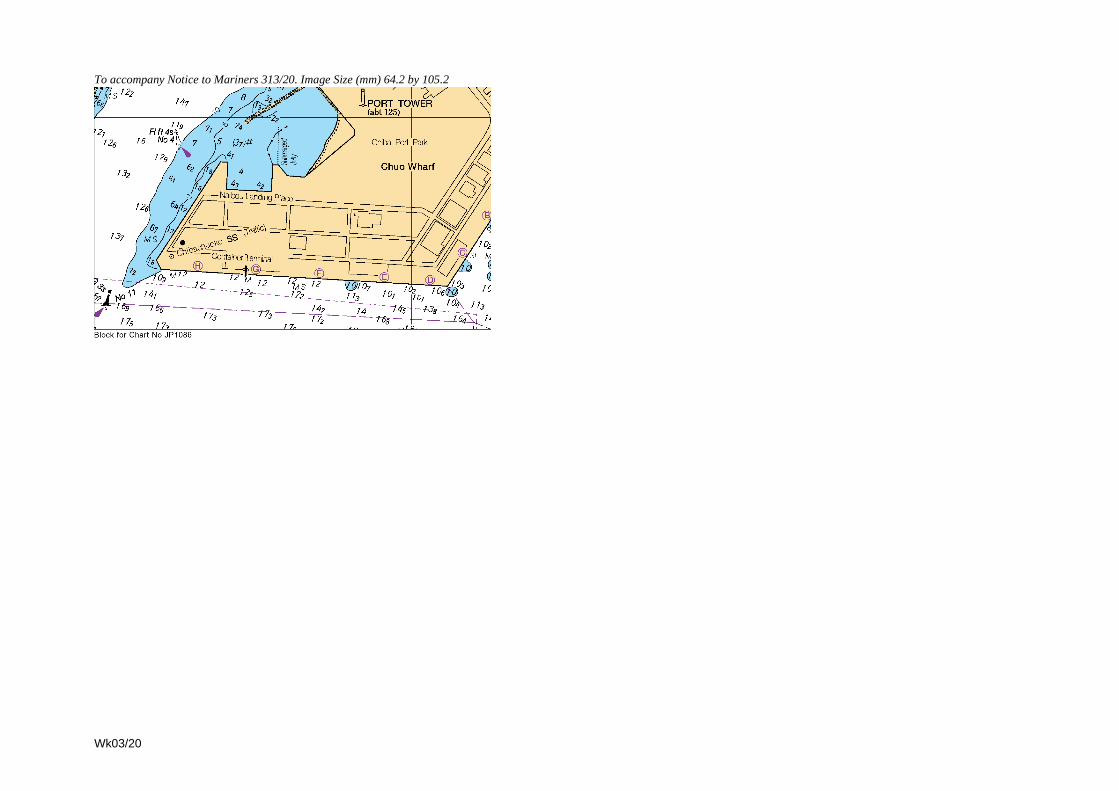
To accompany Notice to Mariners 313/20. Image Size (mm) 64.2 by 105.2
Wk03/20

Wk03/20
To accompany Notice to Mariners 314/20. Image Size (mm) 60.1 by 73.5

To accompany Notice to Mariners 315/20. Image Size (mm) 113.1 by 83.3
Wk03/20

Wk03/20
To accompany Notice to Mariners 315/20. Image Size (mm) 95.5 by 75.3

To accompany Notice to Mariners 383/20. Image Size (mm) 87.5 by 76.5
Wk03/20

III
3.1
NAVIGATIONAL WARNINGS
See The Mariner’s Handbook (2016 Edition). It is recommended that the warnings reprinted below should be kept in a file or
book, followed by subsequent weekly reprints. Only the most convenient ADMIRALTY Chart is quoted. All warnings issued
within the previous 42 days are broadcast via SafetyNET and/or NAVTEX.
The complete texts of all in-force NAVAREA I warnings, including those which are no longer being broadcast, are
available from www.admiralty.co.uk/RNW. Additionally, a quarterly cumulative list of the complete text of all in-force
NAVAREA I Warnings is included in Section III of the Weekly NM Bulletin in Weeks 1, 13, 26 and 39 each year.
Alternatively, these may be requested by e-mail from NAVAREA I Co-ordinator at: [email protected]
The RNW web page also contains a link to the IHO website which allows direct access to all the other NAVAREA
Co-ordinators around the world who have made their NAVAREA warnings available on the web.
----------------------------------------------------------------------------------------------------------------------------------------------------------
Weekly Edition 3, published on the UKHO website 06 January 20.
----------------------------------------------------------------------------------------------------------------------------------------------------------
Navarea I (NE Atlantic) Weekly Edition 3
The following NAVAREA I warnings were in force at 060500 UTC Jan 20.
2019 series: 127 175 197 208.
2020 series: 001 002
207 Cancelled Cancel 204/19.
208 SOUTH-WESTERN APPROACHES TO THE BRITISH ISLES. Chart GB 2649 (INT 1063).
1. ODAS light-buoy K1, 48-43.5N 012-29.1W, reported adrift in 49-21.1N 009-53.7W at 300800 UTC Dec 19.
2. Cancel 207/19.
2020 series:
001 1. Navarea I warnings in force at 031000 UTC Jan 20. 2. Cancel 206/19.
002 1. RIGLIST. Correct at 060500 UTC Jan 20.
Southern North Sea: 51N to 55N
53-00.6N 002-11.2E Seafox 4 ACP Leman Gas Field
53-14.0N 003-14.5E 590021
53-28.4N 004-29.5E Ensco 121 ACP L11-B-PA
53-33.0N 001-04.6E Energy Endeavour ACP Pickerill A
53-45.2N 003-55.0E Prospector 1 ACP K6-GT
53-49.0N 004-30.8E Prospector 5 ACP L5A-D
53-52.2N 001-12.5E Ensco 123
53-56.4N 002-44.8E Noble Hans Deul ACP Chiswick
54-03.0N 002-29.5E Ensco 100 ACP Ketch Gas Field
54-16.1N 002-19.4E Ensco 92 ACP 44/22A-M
54-24.4N 002-48.9E Maersk Resolve ACP D12-B
North Sea: 55N to 60N, East of 5W
55-29.0N 005-06.7E Noble Sam Turner ACP Dan Oil Field
55-43.4N 004-48.0E Maersk Guardian ACP Tyra Gas Field
56-15.0N 003-20.9E Maersk Invincible ACP Valhall Oil Field
56-16.8N 003-24.0E Maersk Reacher ACP Valhall Oil Field
56-21.8N 004-08.7E Rowan Viking
56-38.9N 002-13.3E Noble Sam Hartley
56-43.5N 002-12.5E Ensco 120 ACP Jasmine Gas Field
56-49.1N 003-08.1E Maersk Interceptor
56-50.9N 001-35.7E Ocean Endeavor
56-58.0N 001-52.2E Rowan Gorilla 5 ACP Franklin Gas Field
57-05.5N 000-57.6E Ocean Valiant
57-06.6N 002-50.8E Maersk Integrator ACP Ula Oil Field
57-11.7N 001-54.8E Maersk Highlander ACP u/c Pierce Oil Field Westward
57-48.6N 000-58.3W Maersk Innovator ACP Buzzard Oil and Gas Field
57-50.7N 000-54.7W COSL Pioneer
57-57.0N 001-12.9E Paragon MSS1
57-57.4N 001-50.7E Rowan Gorilla 7 ACP Armada Gas Field
58-19.5N 000-41.9E Transocean 712
58-45.8N 001-12.6E Noble Houston Colbert
58-46.9N 001-54.2E West Phoenix
58-50.7N 001-44.6E Rowan Stavanger ACP Gudrun Oil and Gas Field
59-02.2N 002-13.5E Maersk Intrepid
Wk03/20

III
3.2
59-16.1N 002-17.0E Leiv Eiriksson
59-20.2N 002-21.8E Deepsea Bergen
59-23.0N 001-35.1E Ocean Patriot
59-35.4N 001-03.4E Noble Lloyd Noble ACP u/c Mariner Oil Field
59-47.6N 002-10.9E Deepsea Nordkapp
Norwegian Sea: 60N to 65N, East of 5W
60-24.7N 004-03.3W Deepsea Aberdeen
60-34.5N 003-26.5E West Hercules
60-44.4N 003-34.8E Songa Equinox
60-48.0N 003-27.0E Transocean Endurance
60-52.6N 003-29.5E COSL Promoter
61-23.8N 002-06.9E Transocean Norge
61-28.6N 002-12.2E Transocean Spitsbergen
64-51.9N 006-50.3E Transocean Enabler
South and West Coasts of the British Isles.
53-37.9N 003-10.6W Irish Sea Pioneer ACP Lennox Oil/Gas Field
53-49.0N 003-33.6W Borr Ran ACP South Morecambe Gas Field.
NOTES:
A. Rigs are protected by a 500 metre safety zone.
B. ACP - Adjacent to Charted Platform; u/c - under construction
C. For Rigs located North of 65N, East of 5W, refer to Navarea XIX Warnings or visit www.navarea-xix.no
2. Cancel 205/19.
Wk03/20

IV
4.1
[03/20]UPDATES TO ADMIRALTY SAILING DIRECTIONS
NP2 Africa Pilot Volume 2 (2017 Edition)
Republic of South Africa -- Saldanha Bay —Directions
265
After Paragraph 9.138 2 line 6 Insert:
SE of North Bay Point (330227S 175629E),fringed with rocks. North Bay (330190S175673E) is entered between North Bay PointandMarcus Island (below). The greater part of thebay is encumbered with marine farms andexposed to the swell, and heavy breakers occurfor a considerable distance offshore. BarrackRock and Blink Klip Rock lie 2½ cables SE, and1¼ miles E, respectively, of North Bay Point.Thence:
South African Notice 11/69(T)/19[NP2--No 23--Wk 03/20]
Republic of South Africa -- Saldanha Bay —Anchorage
266
Paragraph 9.143 4 lines 1--9 Delete
Paragraph 9.143 5 line 1 Replace by:
4 Salamanderpunt. Anchorage may be obtained in...
South African Notice 11/69(T)/19[NP2--No 24--Wk 03/20]
NP6SouthAmericaPilot Volume 2 (2019 Edition)
Chile -- Canal Mayne — Traffic regulations
357
Paragraph 8.38 1--2 Replace by:
1 In Paso Summer (8.41), between Punta Ernesto(521972S 733723W) and Islote Hozven Light,4 miles NNW, no vessel may overtake any othervessel, nor pass another vessel proceeding in theopposite direction. North bound vessels have priority.South bound vessels must wait N of Islote Hozven(521648S 734066W) until the N bound vessel haspassed. Only vessels with a maximum draught of735 m or a UKC of 075 m are authorised to use thepassage.
2 For further details on reporting and procedures, seeADMIRALTY List of Radio Signals Volume 6(7).
Chilean Notice 12/19; Derrotero 3003 X--4--38[NP6--No 2--Wk 03/20]
Chile -- Canal Gray — Traffic regulations
359
Paragraph 8.50 1 Replace by:
1 In Canal Gray, between Islote Penacho Verde(522404S 734142W) and Islote Hozven Light,(521648S 734066W), no vessel may overtake anyother vessel, nor pass another vessel proceeding inthe opposite direction. North bound vessels havepriority. South bound vessels must wait for N boundvessels to pass before entering Canal Gray.
2 In good visibility, transit may also be authorisedduring twilight. Use of the passage is authorised forvessels not exceeding 230 m LOA or 12 m draught.
For full details on reporting and procedures seeADMIRALTY List of Radio Signals Volume 6(7).
Chilean Notice 12/19; Derrotero 3003 X--4--38[NP6--No 3--Wk 03/20]
Chile -- Canal Picton — Traffic regulations
422
After Paragraph 9.57 Insert:
Traffic regulations9.57a
1 In Paso Picton (9.63) between Islote Tang(492617S 752665W) and Islote Verde (492226S752857W) no vessel may overtake any other vessel,nor pass another vessel proceeding in the oppositedirection. North bound vessels must wait for S boundvessels to pass before entering Paso Picton.
Only vessels with a maximum draught ot 60 m or aUKC of 10 m are authorised to use the passage.Vessels with a draught close to 6 m should transit athigh tide or rising mid--tide. For further details onpilotage, reporting and procedures see ADMIRALTYList of Radio Signals Volume 6(7).
Chilean Notice 12/19; Derrotero 3003 IX--2--62[NP6--No 4--Wk 03/20]
NP7SouthAmericaPilot Volume 3 (2018 Edition)
Ecuador – Guayaquil — Directions; wreck
334
Paragraph 11.77 1 lines 1--3 Replace by:
1 From a position about 10 miles SW of PuntaChapoya (23847S 802612W), the track leads E tothe Sea Light Buoy (safe water) (24465S802488W) passing N of a dangerous wreck(24535S 802583W). Thence it continues E andthen SE through a channel marked by leading...
ENC EC401070 Ed 4000 [NP7--No 63--Wk 03/20]
Wk03/20

IV
4.2
NP20 Baltic Pilot Volume 3 (2019 Edition)
Sweden -- Luleå -- Sandöleden — Regulations
463
Paragraph 11.129 4 lines 2--3 Replace by:
Vessels greater than 300 gt or 45 m in length are notpermitted to pass each other in Sandöleden.
Swedish Notice 785/14546/19[NP20--No 53--Wk 03/20]
NP21 Bay of Bengal Pilot (2019 Edition)
India -- East coast -- Visºkhapatnam — Depths
87
Paragraph 2.173 including existing Section IV NoticeWeek 20/19 Replace by:
1 The following depths are maintained by dredging(see 2.197):
Outer channel, 220 m;Approach to the outer turning circle, 210 m;Outer turning circle, 210 m;Approach to General Cargo Berth, 200 m;Inner Channel and inner turning basin, 161 m;Inner Harbour, from 107 to 161 m.
2 Caution. Maintained depths are subject to silting.The port authority should be contacted for the latestinformation.
Indian Notice 23/247/19 [NP21--No 13--Wk 03/20]
NP27 Channel Pilot (2018 Edition)
England -- South coast -- Saint Austell Bay —Directions; shoal
107
After Paragraph 4.72 2 line 7 Insert:
ESE of an isolated shoal (501738N 44116W),with a depth of 115 m.
Clinton Marine Survey [NP27--No 28--Wk 03/20]
NP30 China Sea Pilot Volume 1 (2018 Edition)
Vietnam – Dao Phu Quoc – Directions; wreck
141
Paragraph 4.256 3 line 8 Replace by:
...100637N 1041037E. A second dangerous wreck(100640N 1041380E), position approximate, liesabout 3¼ miles farther E.
Hydropac 3999/19 [NP30--No 113--Wk 03/20]
Vietnam -- West coast -- Quan--Dao Hai Tac —Vertical clearance
144
After Paragraph 4.266 3 line 3 Insert:
Vertical clearance. An overhead power cable(102069N 1042372E), supported by pylons, spansthe channel between Mui Nai (4.235) and Hon Doc;vertical clearance unknown.
Several overhead power cables span the channelsbetween the islands; vertical clearances unknown.
Vietnamese Notice 288/19 [NP30--No 105--Wk 03/20]
Vietnam -- West coast -- Quan--Dao Hai Tac —Vertical clearance
145
After Paragraph 4.275 3 line 5 Insert:
Vertical clearance. See 4.266.
Vietnamese Notice 288/19 [NP30--No 106--Wk 03/20]
Vietnam -- Vung Tau — Anchorages; wrecks
167
After Paragraph 5.90 2 line 12 Insert:
Caution. Numerous dangerous wrecks lie withinsome anchorages and pilot waiting areas.
Vietnamese Chart VN3GR001/16[NP30--No 112--Wk 03/20]
Vietnam -- East coast -- Approaches to Quy Nhon— Directions; wreck
185
After Paragraph 5.262 1 line 2 Insert:
ENE of a dangerous wreck (134537N1092168E), thence:
Hydropac 4011/19 [NP30--No 107--Wk 03/20]
Vietnam – Gulf of Tonkin – Nghi Son —Anchorages; pilotage; restricted and
prohibited areas
202
Paragraph 6.60 lines 1--2 Replace by:
1 Outer anchorages. Designated anchorages arecentred on:
192261N 1055291E.191784N 1055653E.
Pilotage. A pilot boarding area, swept to a depth of105 m (2018), has been established centred on191914N 1055233E, radius 1 mile.
Pilots for the SPM berth board within an area,radius 1 mile, centred on 191875N 1060715E.
2 Restricted area. A marine reserve (192080N1055455E) encompasses the waters of Hon Mé(6.69) and the islets nearby. For details on restrictionscontact the local authorities.
Wk03/20

IV
4.3
Prohibited areas. Anchoring and fishing areprohibited within an area encompassing the SPMberth and its pipelines.
Unauthorised vessels are not allowed to enter anarea, 5 cables in radius, centred on the SPM berth.
Vietnamese Chart 40013/2017[NP30--No 114--Wk 03/20]
Vietnam – Gulf of Tonkin – Nghi Son —Directions; wreck
202
Paragraph 6.62 1 line 4 Replace by:
...(191663N 1055065E), passing NE of a dangerouswreck (191630N1055075E)marked by TD Light Buoy(isolated danger). Thence the track continues...
Vietnamese Chart 40013/2017[NP30--No 115--Wk 03/20]
Vietnam – Gulf of Tonkin – Nghi Son — Berths
202
After Paragraph 6.63 1 line 8 Insert:
2 Refinery and Petrochemical Terminal. Four berthsin total. The outer berths, 230 m in length, are thelongest.
SPM Berth. It has been reported that vessels up to300 000 dwt can be accommodated.
Vietnamese Chart 40013/2017[NP30--No 116--Wk 03/20]
Vietnam – Gulf of Tonkin – Hon Mé —Anchorages
203
Paragraph 6.69 3 lines 1--7 Replace by:
3 Marine reserve. See 6.60.Anchorages. See 6.60.
Vietnamese Chart 40013/2017[NP30--No 117--Wk 03/20]
Vietnam -- Gulf of Tonkin -- Approaches toSong Ca — Anchorage
205
After Paragraph 6.88 3 line 6 Insert:
Anchorage. A designated anchorage area(195781N 1061444E) is situated SE of Cua LacGiang; mud, depths from 11 to 13 m.
Vietnamese Notice 290/19 [NP30--No 108--Wk 03/20]
Vietnam -- Approaches to Haiphong —Vertical clearances
207
Paragraph 6.102 1--2 including existing Section IV NoticesWeeks 22/19 and 24/19 Replace by:
1 The following overhead cables span the mainapproach channel:
Across Luong Hai Phong (204831N 1065445E),with a vertical clearance of 50 m at the centrelineand 42 m E of the channel.
Across the canal bisecting DaoHaNam (204840N1065240E), with a vertical clearance of 55 m.
A bridge (204837N 1065041E) spans Cua NamTrieu (6.90) with a vertical clearance of 12 m.
Bach Dang Bridge (205089N 1064595E) spansBach Dang with a vertical clearance of 45 m.
2 Bridges spanning Song Cam have verticalclearances as follows:
BINH Bridge (205253N 1064005E) — 22 m.KIEN Bridge (205480N 1063741E) — 25 m.
Overhead cables spanning Song Cam have verticalclearances as follows:
At 205284N 1063857E — 22 m;At 205467N 1063742E — 25 m.
Vietnamese Chart 50008/19 [NP30--No 109--Wk 03/20]
Vietnam -- Approaches to Haiphong —Directions; pilotage; buoyage
209
Paragraph 6.116 1 lines 1--13 Replace by:
1 From the vicinity of 203900N 1065150E in thepilot boarding area (6.105), 2½ miles ESE of HonDau, the track leads E passing:
S of a stranded wreck (203978N 1065225E); adangerous submergedwreck lies closeNW. Theyare marked by a light buoy (isolated danger);Thence:
Nof a dangerouswreck (203800N1065570E). Asecond dangerous wreck (203763N1065687E), position approximate, reported(1999) lies 1 mile ESE.
The track then continues to the vicinity of HP0 LightBuoy (safe water) (203914N 1070140E), SE of theentrances to both Luong Hai Phong and Luong NamTrieu.
Paragraph 6.117 1--2 Replace by:
1 Main channel. From the above position, the trackthen leads NW through a channel marked by lightbuoys (lateral), passing:
NE of a dangerous wreck (204650N 1065560E),position approximate.
2 Leading Lights A and B:Dao Cong Front Light A (white beacon) (204992N1065345E).
Dao Cong Rear Light B (similar structure)(5½ cables from front light).
Wk03/20

IV
4.4
Paragraph 6.118 1--4 Replace by:
1 From the vicinity of HP0 Light Buoy (safe water)(203914N 1070140E) the track leads WNW,passing:
Clear of NT0 Light Buoy (safe water) (204335N1065512E), thence:
Between NT1 and NT2 Light Buoys (lateral)(204385N 1065430E), marking the entranceof the channel.
2 The channel, marked by light buoys (lateral), thencontinues WNW and NNW, passing beneath a bridge(6.102) to a position off the W entrance to Luong HaiPhong Canal (6.117).
3 Useful marks:Den Aval Light Beacon (white column, black bands,12 m in height) (204579N 1065118E).
Den Bai Cat Beacon (green, lattice) (204662N1064987E).
(Directions continue at 6.119)
Vietnamese Chart 50007/19 [NP30--No 110--Wk 03/20]
Vietnam -- Approaches to Haiphong —Anchorages and moorings
209--210
Paragraph 6.120 1--3 including existing Section IV NoticeWeek 34/18 Replace by:
1 Luong Hai Phong. There are seven anchorages inLuong Hai Phong, numbered BG3 to BG9, in a line onthe E side of the fairway.
Two additional anchor berths lie up to 5 cables N ofBG3 Anchorage.
2 Luong Pha Rung. Designated anchorages aresituated on both sides of the fairway.
Mooring buoys for deeper--draught vessels up to15 000 gt discharging to lighters are availableupstream of BINH Bridge (205253N 1064005E).
Vietnamese Chart 50008/19 [NP30--No 111--Wk 03/20]
NP31 China Sea Pilot Volume 2 (2019 Edition)
Philippines -- Luzon -- San Fernando — SeaoilBangar Bulk Terminal
202
After Paragraph 10.51 Insert:
Seaoil Bangar Bulk Terminal10.51a
1 General information. Bangar Bulk Terminal(165313N 1202422E), a sub--port of San Fernando(10.25), handles petroleum products. It comprises aT--head jetty fronting a storage facility consisting ofseveral tanks. The terminal is operated by SeaoilPhilippines Incorporated.
Pilotage is available during daylight hours and pilotsboard at anchor or in the vicinity of 165307N1202245E. Tugs are compulsory and remainsecured for the duration of the vessel’s stay.
2 It is reported (2019) that due to the steep gradientof the seabed, vessels are subjected to moderate toviolent rolling whilst alongside.
Directions. The berth is approached directly fromseaward; with the use of the port anchor and tugassistance, vessels are berthed starboard side to.
Anchorage can be obtained in the vicinity of165250N 1202280E in depths of more than 30 m,sand, mud and clay.
3 Berth. The T --head jetty is designed toaccommodate 50 000 dwt vessels with a maximumLOA of 230 m and maximum arrival draught of1360 m at MLLW.
Other facilities. MedicalSupplies. Provisions.
Bangar Bulk Terminal Handbook[NP31--No 16--Wk 03/20]
NP35 Indonesia Pilot Volume 3 (2017 Edition)
Indonesia -- Timor -- Teluk Kupang -- Pulau Kera— Directions; light
90
After Paragraph 3.57 1 line 3 Insert:
Pulau Kera Light (white GRP tower, 20 m in height)(100529S 1233320E), if approaching from Wor N.
Indonesian Notice 50/665/19 [NP35--No 7--Wk 03/20]
Indonesia -- Timor -- Teluk Kupang -- Pulau Kera— Directions; light
92
After Paragraph 3.79 1 line 9 Insert:
Pulau Kera Light (100529S 1233320E) (3.57).
Indonesian Notice 50/665/19 [NP35--No 8--Wk 03/20]
Indonesia -- Timor -- Teluk Kupang -- Pulau Kera— Directions; light
93
Paragraph 3.82 2 lines 3--4 Replace by:
...of 84 m, fronting Pulau Kera (3.77). Pulau Kera Light(3.57) is exhibited from the W side of the...
Indonesian Notice 50/665/19 [NP35--No 9--Wk 03/20]
Indonesia -- Timor -- Teluk Kupang -- Pulau Kera— Directions; light
94
After Paragraph 3.94 1 line 8 Insert:
Pulau Kera Light (100529S 1233320E) (3.57).
Indonesian Notice 50/665/19 [NP35--No 10--Wk 03/20]
Indonesia -- Timor -- Teluk Kupang -- Pulau Kera— Directions; light
95
After Paragraph 3.104 1 line 6 Insert:
Pulau Kera Light (100529S 1233320E) (3.57).
Indonesian Notice 50/665/19 [NP35--No 11--Wk 03/20]
Wk03/20

IV
4.5
Indonesia -- Timor -- Teluk Kupang -- Pulau Kera— Directions; light
96
After Paragraph 3.110 3 line 5 Insert:
Pulau Kera Light (100529S 1233320E) (3.57).
Indonesian Notice 50/665/19 [NP35--No 12--Wk 03/20]
NP40 Irish Coast Pilot (2019 Edition)
Northern Ireland -- Larne — Pilotage
212
Paragraph 7.136 1 line 7 Replace by:
...545267N 54768W, 1 mile N of Larne No 1 LightBuoy.
Port of Larne Harbour Master [NP40--No 5--Wk 03/20]
NP49 Mediterranean Pilot Volume 5(2018 Edition)
Turkey -- ™skenderun Körfezi —Outer anchorages
183
Paragraph 5.250 including existing Section IV NoticeWeek 50/19 Replace by:
1 Several designated anchorage areas lie at the headof ™skenderun Körfezi. Anchorages within the portlimits of ™skenderun (see also 5.268) are as follows:
No 4 (364573N 360800E); vessels not carryingdangerous cargo and naval vessels.
No 5A (364940N 360740E); vessels carryingdangerous cargo and quarantine.
No 5B (365130N 360530E); vessels carryingdangerous cargo.
2 Anchorages within the port limits of Botaî are asfollows:
No 1 (364938N 355967E); vessels carryingdangerous cargo and quarantine.
No 2 (364900N 355450E); unrestrictedanchorage.
3 No 3 (365260N 360090E); unrestrictedanchorage.
No 4 (364685N 355329E); unrestrictedanchorage.
Turkish Notice 49/232/19 [NP49--No 42--Wk 03/20]
Turkey -- ™skenderun Körfezi — Pilotage
183
Paragraph 5.252 including existing Section IV NoticeWeek 50/19 Replace by:
1 Pilotage is compulsory for all foreign flaggedvessels over 500 gt. Pilot boarding stations within theport limits of Iskenderun are as follows:
No 1 (363720N 361000E) (5.287).No 2 (364070N 361050E).No 3 (364650N 360960E).No 4 (364800N 360500E).
2 Pilot boarding stations for Botaî are as follows:No 1 (365250N 355880E).No 2 (365135N 355730E).No 3 (365030N 355640E).No 4 (364700N 355600E).
Pilots may board within a 5 cable radius of theabove positions.
3 For further information see ADMIRALTY List ofRadio Signals Volume 6(3).
Turkish Notice 49/232/19 [NP49--No 43--Wk 03/20]
Turkey -- ™skenderun Körfezi -- ™sdemir —Pilotage
186
Paragraph 5.269 1 lines 1--5 Replace by:
1 See 5.252.
Turkish Notice 49/232/19 [NP49--No 44--Wk 03/20]
NP67 West Coasts of Spain and Portugal Pilot(2018 Edition)
Portugal – Arquipélago dos Açores – Ilha deSanta Maria — Directions; light
242
Paragraph 8.71 1 lines 9--10 Replace by:
Airport Control Tower (365841N 250992W).
Paragraph 8.72 1 lines 3--5 Delete
Portuguese Notice 11/234/19 [NP67--No 15--Wk 03/20]
NP70 West Indies Pilot Volume 1(2018 Edition)
Cuba -- North coast -- Puerto de Cárdenas —Controlling depths
172
Paragraph 7.91 1 line 2 For 56 m Read 23 m
Paragraph 7.91 1 line 4 For 51 m Read 25 m
Cuban Chart 11842 (2019) [NP70--No 38--Wk 03/20]
Wk03/20

IV
4.6
Cuba -- North coast -- Puerto de Cárdenas —Anchorages
172 -- 173
Paragraph 7.92 1--3 Replace by:
1 Port operations. Vessels are only allowed to enteror depart in daylight. A speed restriction of 6 knapplies when passing through the channels.
Pilotage is compulsory; pilots (7.114) board offMatanzas.
2 Tugs are compulsory.Regulations concerning entry:
Traffic in the channel is one way only.In Canal de los Barcos vessels entering must giveway to laden vessels leaving the port.
Cuban Chart 11842 (2019) [NP70--No 39--Wk 03/20]
NP71 West Indies Pilot Volume 2(2017 Edition)
Saint Kitts and Nevis -- The Narrows —Directions
206
Paragraph 5.271 1--2 Replace by:
1 The Narrows. Local authorities recommend vesselspass NW of Booby Islet (5.266) and Cow Rocks whenusing the Narrows.
From a position about 4 cables N of Booby Islet,the recommended route leads generally SW, passing:
NWof Booby Islet (171360N 623662W), thence:Clear of a 58 m patch (171373N 623698W),thence:
NW of a 55 m patch (171313N 623672W),thence:
SE of a 55 m patch (171345N 623742W),thence:
2 NW of Cow Rocks (171283N 623726W),marked by a light beacon (isolated danger),lying near the middle of the channel, at theNW extremity of a broad spit, with depths of37 m, extending NW from the coast of Nevis,thence:
Correspondence St. Kitts and Nevis[NP71--No 55--Wk 03/20]
Wk03/20

V
UPDATES TO ADMIRALTY LIST OF LIGHTS AND FOG SIGNALS
NP74, Vol A Edition 2019/20. Weekly Edition No. 3, Dated 16 January 2020.Last Updates: Weekly Edition No. 2, dated 09 January 2020.
A0620·5 - Crosshouse Beacon(GB:ABP)
50 54·04 N1 23·19 W
Oc R 5s 5 2 Red & on red pile structure
Marks power cable. Private. TE; replaced by yellow spherical light buoy with × topmark Fl Y 4s close by (T) 2019
*
A4539 - Ardrossan Harbour. Lighthouse Pier. Breakwater
55 38·42 N4 49·57 W
3 F R(vert) . . . . . . The harbour and marina are closed. Unreliable (T) 2019
- - - - . . 3 F G(vert) . . . . . . The harbour is closed but the marina is open. Unreliable (T) 2019
- - - - . . 3 F RRG(vert) . . . . . . The harbour is open but the marina is closed. Unreliable (T) 2019
*
WEST COAST. SEVERN ESTUARY. BRIDGWATER BAY. RIVER PARRETT
A5579·85 Remove from list; deleted
WEST COAST. SEVERN ESTUARY. BRIDGWATER BAY. RIVER PARRETT
A5579·86 Remove from list; deleted
Wk03/205.1
NP75, Vol B Edition 2019/20. Weekly Edition No. 3, Dated 16 January 2020.Last Updates: Weekly Edition No. 2, dated 09 January 2020.
B3278·13NO, , 109553
- Vassøykalven 58 59·33 N5 47·64 E
F G 6 2·1 Post7
Floodlit
* * * * *
B3804NO, , 160700
- Fleslandsskjeret 60 17·62 N5 12·01 E
Oc(3)WRG 10s 4 W4·3R3·2G3·2
Column5
G357°-018·6°(21·6°), W018·6°-019·6°(1°), R019·6°-025·4°(5·8°), G025·4°-031·3°(5·9°), W031·3°-042·6°(11·3°), R042·6°-120·2°(77·6°), G120·2°-173·8°(53·6°), W173·8°-187·2°(13·4°), R187·2°-189·9°(2·7°)
* * *
Wk03/205.1
NP76, Vol C Edition 2019/20. Weekly Edition No. 3, Dated 16 January 2020.Last Updates: Weekly Edition No. 2, dated 09 January 2020.
ZATOKA POMORSKA. ŚWINOUJŚCIE TO SZCZECIN. ODRA RIVER. ROZTOKA ODRZAŃSKA
C2724·2 - Port Trzebież 53 39·66 N14 31·07 E
Q G 5 1
* * * * * * * *
ZATOKA POMORSKA. ŚWINOUJŚCIE TO SZCZECIN. ODRA RIVER. ROZTOKA ODRZAŃSKA
C2724·3 - Port Trzebież. Groyne. Root
53 39·72 N14 30·95 E
Q G 5 1
* * * * * * * *
Wk03/205.1

V
NP76, Vol C Edition 2019/20 continued.
C2768·6PL, 521, 0960
- Dębina Island. Basen Żeglarski. N Side. Entrance
53 28·44 N14 36·33 E
Iso G 10s 3 3 Green mast
*
C2768·61PL, 521, 0962
- Dębina Island. Basen Żeglarski. S Side. Entrance
53 28·43 N14 36·32 E
Iso R 10s 4 3 Red mast
*
GULF OF GDAŃSK. HEL PORT
C2980 Remove from list; deleted
GULF OF GDAŃSK. HEL PORT
C2982 Remove from list; deleted
Wk03/205.2
NP77, Vol D Edition 2019/20. Weekly Edition No. 3, Dated 16 January 2020.Last Updates: Weekly Edition No. 2, dated 09 January 2020.
D0872FR, LA, 44190
- La Plate 48 02·37 N4 45·58 W
Q(9)W 15s 17 8 $ on yellow 8-sided tower, black band23
*
D1562·6ES, I, 01496·2
- Training Wall. Head 43 26·35 N4 02·18 W
Fl(4)R 11s 9 5 Red post9
(fl 0·5, ec 1·5) x 3, fl 0·5, ec 4·5
*
NORTH COAST. PUERTO DE GIJÓN
D1596ES, I, 01750
- Cabo de Torres 43 34·31 N5 41·96 W
Fl(2)W 10s 80 18 White 8-sided tower and dwelling12
fl 0·4, ec 2·1, fl 0·4, ec 7·1
*
D1723·91ES, I, 03686
- Punta Langosteira. Breakwater. Head
43 20·75 N8 32·00 W
Fl(4)R 12s . . 7 Red cylindrical tower (fl 0·5, ec 1·5) x 3, fl 0·5, ec 5·5
- - - - . . AIS . . . . . . MMSI No 992242179*
D1742ES, I, 03900
- Cabo Finisterre 42 52·94 N9 16·32 W
Fl W 5s 142 23 8-sided tower and dwelling17
fl 0·3
- - . . Siren(2) 60s . . . . . . bl 2, si 6, bl 2, si 50- - . . Racon . . . . . . ALRS Vol 2 Station 67800
- - . . AIS . . . . . . MMSI No 992242117*
D1793ES, I, 04095
- Punta Focha 42 41·98 N9 01·59 W
Fl W 5s 28 4 White tower and round building5
fl 0·5
*
D1830·4ES, I, 04285
- Puerto de Pobra do Caramiñal. Breakwater. Head
42 36·29 N8 55·85 W
Fl(3)G 9s 9 5 Green and white tower6
(fl 0·5, ec 1·5) x 2, fl 0·5, ec 4·5
*
D1838·5ES, I, 04393
- As Sinas. Jetty 42 34·60 N8 48·58 W
Q R 1s . . 1 Red post, white bands
*
Wk03/205.2

V
NP77, Vol D Edition 2019/20 continued.
D1843·7ES, I, 04322
- Rianxo. T-Wharf. S Head 42 39·12 N8 49·28 W
Fl(4)R 11s . . 1 Red and white post (fl 0·5, ec 1·5) x 3, fl 0·5, ec 4·5.TE 2019
*
D1873·7ES, I, 04719
- Puerto de Aldán. Breakwater. Posts. Head
42 16·93 N8 49·39 W
Fl(3)R 9s . . 5 White post, red band (fl 0·5, ec 1·5) x 2, fl 0·5, ec 4·5
* * * * * * * *
D1893·1ES, I, 05181
- Canido. Ldg Lts 116·9°. Rear. 356m from front
42 11·62 N8 47·83 W
Oc G 4s 13 3 White &, with black ,, on metal tower9
ec 1
* *
D2003PT, I, 13
- Moledo. Ldg Lts 099·3°. Front. On beach
41 51·01 N8 51·97 W
Oc R 5s 12 6 White column, red bands3
ec 2
*
D2003·1PT, I, 13·1
- Moledo. Ldg Lts 099·3°. Rear. 24m from front
41 51·01 N8 51·95 W
Oc R 5s 15 6 White post, red bands7
ec 2
*
D2006PT, I, 18
- Âncora. W Pier. Head 41 48·81 N8 52·22 W
Fl(2)R 5s 12 9 White tower, red bands8
fl 0·5, ec 1, fl 0·5, ec 3.Range 3M (T) 2019
*
D2056·2PT, I, 94·1
- Canal da Embocadura. Aveiro. Entrance. Ldg Lts 060·6°. Front. N Pier
40 38·81 N8 45·04 W
Oc R 3s 8 9 Orange post, green bands6
ec 1.Vis 5° each side of leading line
- - - - - - - . . By day . . 4*
D2059·168PT, I, 99·76
- Canal de Mira. BS4. Marine Farm
40 36·83 N8 44·69 W
Fl Y 2s . . 0·5 × on yellow beacon fl 0·5.Sync with D2059·169
* * * * * * * *
D2059·169PT, I, 99·73
- Canal de Mira. BS1. Marine Farm
40 37·04 N8 44·68 W
Fl Y 2s . . 0·5 × on yellow beacon fl 0·5.Sync with D2059·168
* * * * * * * *
D2076PT, I, 127
- São Martinho do Porto. Ponta de Santo António
39 30·64 N9 08·59 W
LFl R 6s 32 9 White column, red bands
fl 2.TE 2019
*
D2105PT, I, 176
- Ericeira. N Pier. Head 38 57·80 N9 25·41 W
Fl(3)R 12s 11 6 Red column, white bands5
(fl 0·5, ec 2·5) x 2, fl 0·5, ec 5·5.TE; works in progress (T) 2019
*
D2126PT, I, 210
- Forte de São Lourenço. Bugio
38 39·63 N9 17·93 W
Fl G 5s 27 12 Red cupola on white column on building14
fl 1
* * * * * * * *
WEST COAST. RIO TEJO. PORTO DE LISBOA. CALA DAS BARCAS
D2134·62 Remove from list; deleted
D2150·4PT, I, 382
- Albarquel 38 30·66 N8 54·79 W
Iso R 2s 17 6 On fort
*
Wk03/205.3

V
NP77, Vol D Edition 2019/20 continued.
WEST COAST. SINES
D2160PT, I, 401
- Cabo de Sines 37 57·57 N8 52·82 W
Fl(2)W 15s 55 26 White tower and dwelling28
fl 0·5, ec 4·5, fl 0·5, ec 9·5.Obscured 001°-003°(2°).Obscured 004°-007°(3°)
- - . . By day . . 20*
D2160·3PT, I, 408
- Ldg Lts 357·3°. Front. Testa do Cais. Dolphin
37 56·76 N8 53·01 W
Iso G 6s 17 10 Green lantern on post6
G245°-042°(157°)
*
D2160·34PT, I, 407·3
- Berth's 4 and 5. Pier. Berth 4. S End. No 4
37 56·85 N8 53·03 W
F R 6 3 Post
*
D2160·35PT, I, 407·4
- Berth's 4 and 5. Pier. Berth 5. S End. No 5
37 56·85 N8 53·00 W
F R 6 3 Post
*
D2160·358PT, I, 407·6
- Petro-chemical Terminal. Jetty. E Head. No 10
37 56·89 N8 52·79 W
F R 5 3 Post
*
D2162PT, I, 423
- Rio Mira. Entrance. Milfontes
37 43·17 N8 47·41 W
Fl W 3s 22 10 White lantern on hut5
fl 1.Storm Signals. TE 2019
*
D2355·5ES, I, 10149
- Fishing Harbour. Outer Breakwater. Head
36 36·91 N6 21·10 W
Q(6)G 12s . . 3 Green post
* *
D2375·3ES, I, 10420
- La Cabezuela. Industrial Plant. Pier. Head
36 31·71 N6 15·54 W
Fl R 2·5s 7 3 Red truncated pyramidal tower3
fl 0·5
*
D2391ES, I, 10644
- No 3 36 22·65 N6 12·66 W
Fl(4)G 11s . . 3 Green % on green beacon
(fl 0·5, ec 1·5) x 3, fl 0·5, ec 4·5
*
SOUTH COAST
D2420ES, II, 20110
- Punta Carnero 36 04·62 N5 25·58 W
Fl(4)WR 20s 42 W16R13
Round masonry tower and white building19
(fl 1·5, ec 2) x 3, fl 1·5, ec 8.W018°-325°(307°), R325°-018°(53°) over Bajos La Perla and Las Bajas
- - . . AIS . . . . . . MMSI No 992242148*
D2598FR, LC, 19490
ES, I, 13610
- Jetée Transversale Nord 32 18·77 N9 15·09 W
Fl R 4s 9 6 Red post5
* *
D2619ES, I, 13795
FR, LC, 20650
Cap Juby (Tarfaya) 27 54·98 N12 56·41 W
Fl(3)W 15s 70 25 Masonry tower14
TE 2019
*
D2626ES, I, 13860
FR, LC, 21000
El Cabiño 26 25·49 N14 10·90 W
Fl(3)W 12s 35 9 White round tower, black bands32
(fl 0·4, ec 2·6) x 2, fl 0·4, ec 5·6
* *
Wk03/205.4
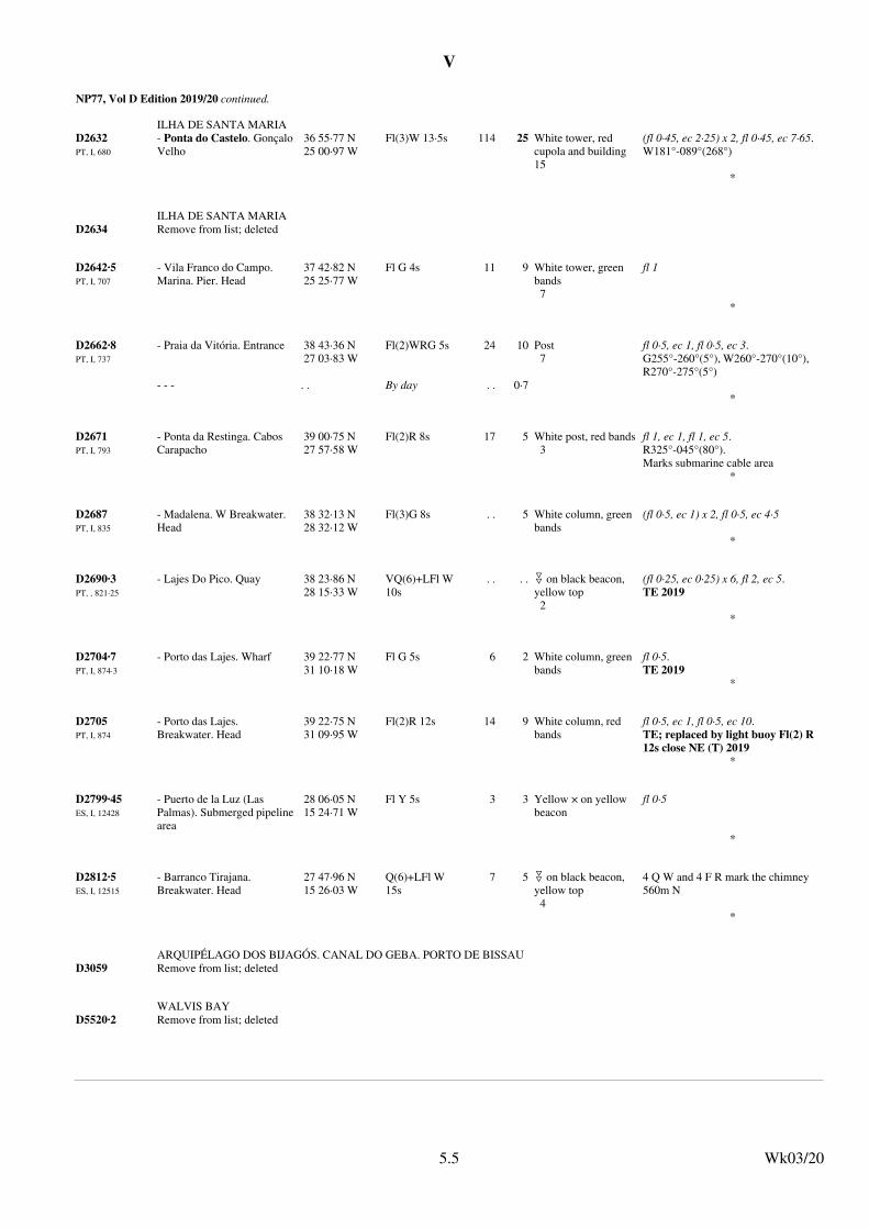
V
NP77, Vol D Edition 2019/20 continued.
ILHA DE SANTA MARIA
D2632PT, I, 680
- Ponta do Castelo. GonçaloVelho
36 55·77 N25 00·97 W
Fl(3)W 13·5s 114 25 White tower, red cupola and building15
(fl 0·45, ec 2·25) x 2, fl 0·45, ec 7·65.W181°-089°(268°)
*
ILHA DE SANTA MARIA
D2634 Remove from list; deleted
D2642·5PT, I, 707
- Vila Franco do Campo. Marina. Pier. Head
37 42·82 N25 25·77 W
Fl G 4s 11 9 White tower, green bands7
fl 1
*
D2662·8PT, I, 737
- Praia da Vitória. Entrance 38 43·36 N27 03·83 W
Fl(2)WRG 5s 24 10 Post7
fl 0·5, ec 1, fl 0·5, ec 3.G255°-260°(5°), W260°-270°(10°), R270°-275°(5°)
- - - . . By day . . 0·7*
D2671PT, I, 793
- Ponta da Restinga. Cabos Carapacho
39 00·75 N27 57·58 W
Fl(2)R 8s 17 5 White post, red bands3
fl 1, ec 1, fl 1, ec 5.R325°-045°(80°).Marks submarine cable area
*
D2687PT, I, 835
- Madalena. W Breakwater. Head
38 32·13 N28 32·12 W
Fl(3)G 8s . . 5 White column, green bands
(fl 0·5, ec 1) x 2, fl 0·5, ec 4·5
*
D2690·3PT, , 821·25
- Lajes Do Pico. Quay 38 23·86 N28 15·33 W
VQ(6)+LFl W 10s
. . . . " on black beacon, yellow top2
(fl 0·25, ec 0·25) x 6, fl 2, ec 5.TE 2019
*
D2704·7PT, I, 874·3
- Porto das Lajes. Wharf 39 22·77 N31 10·18 W
Fl G 5s 6 2 White column, green bands
fl 0·5.TE 2019
*
D2705PT, I, 874
- Porto das Lajes. Breakwater. Head
39 22·75 N31 09·95 W
Fl(2)R 12s 14 9 White column, red bands
fl 0·5, ec 1, fl 0·5, ec 10.TE; replaced by light buoy Fl(2) R 12s close NE (T) 2019
*
D2799·45ES, I, 12428
- Puerto de la Luz (Las Palmas). Submerged pipelinearea
28 06·05 N15 24·71 W
Fl Y 5s 3 3 Yellow × on yellow beacon
fl 0·5
*
D2812·5ES, I, 12515
- Barranco Tirajana. Breakwater. Head
27 47·96 N15 26·03 W
Q(6)+LFl W 15s
7 5 " on black beacon, yellow top4
4 Q W and 4 F R mark the chimney 560m N
*
ARQUIPÉLAGO DOS BIJAGÓS. CANAL DO GEBA. PORTO DE BISSAU
D3059 Remove from list; deleted
WALVIS BAY
D5520·2 Remove from list; deleted
Wk03/205.5

V
NP78, Vol E Edition 2019/20. Weekly Edition No. 3, Dated 16 January 2020.Last Updates: Weekly Edition No. 1, dated 02 January 2020.
E0073·2ES, II, 21800
Puerto de Vélez. Harbour Breakwater. Head
36 44·79 N4 04·25 W
Fl G 5s 9 5 Green and white truncated conical tower4
fl 0·5
*
E0140·5ES, II, 23958
- Puerto Tomás Maestre. Inner Breakwater. N
37 44·94 N0 44·73 W
Fl R 5s 7 3 Red tower2
fl 0·5.Numerous buoys Q R, Q G and Fl Y 1M occasionally mark passing channels and floating nets in the vicinity of marinas in Mar Menor between June and October. TE 2019
*
E0176ES, II, 25200
Cabo de la Nao 38 43·97 N0 13·82 E
Fl W 5s 122 23 White 8-sided tower and white building20
fl 0·2.W190°-049°(219°)
*
E0394·88ES, II, 29213·2
- Inner Wharf. SE Corner 41 11·17 N1 36·45 E
Fl R 5s 3 1 Red & on red post2
fl 0·5.TE 2019
* *
E0401·59ES, II, 29680·13
- S Breakwater. SW Corner 41 17·77 N2 09·18 E
VQ(3)W 5s 14 3 * on black beacon, yellow band
Topmark missing (T) 2019
*
E0434·72ES, II, 30382
- Villa Olímpica. Submerged Breakwater. Bocana. Head
41 22·95 N2 12·03 E
Fl(3)G 8s 6 5 Green post (fl 0·5, ec 1) x 2, fl 0·5, ec 4·5
*
E0435ES, II, 30420
- Sant Adriá de Besós 41 25·50 N2 14·31 E
VQ(3)W 5s . . 3 * on black post, yellow band
Destroyed (T) 2019
*
E1104·25 - Approaches to Oristano 39 52·63 N8 28·48 E
Fl(5)Y 20s 5 3 × on yellow beacon (fl 1, ec 1) x 4, fl 1, ec 11.Private
* * * * * * * *
E1928·8 Remove from list; deleted
E2173IT, , 3580
Gallipoli. Seno del Canneto. W Breakwater. Head
40 03·18 N17 58·79 E
Fl R 5s 6 3 Red post4
fl 1.TE 2019
*
Wk03/205.6
NP79, Vol F Edition 2019/20. Weekly Edition No. 3, Dated 16 January 2020.Last Updates: Weekly Edition No. 2, dated 09 January 2020.
F1685·78 - Banyan 1 13·35 N103 41·58 E
Fl(2)W 10s 11 5 Black # on black beacon, red band
*
F1695 - Sebarok 1 11·87 N103 48·43 E
Fl R 5s 8 5 Red beacon See F1694·9
- - . . AIS . . . . . . MMSI No 995630022*
Wk03/205.6

V
NP79, Vol F Edition 2019/20 continued.
F1718·7 - Outer Shoal 1 15·02 N103 51·81 E
Fl G 5s 8 5 Green buoyant beacon with % topmark
* *
F3114 - Cua Soirap. 26A 10 26·77 N106 45·15 E
LFl WRG 10s . . 7 Red and white beacon
* * * * * * * *
DUNG QUAT
F3200 - Van Ca. Headland 15 25·45 N108 47·92 E
Fl(3)W 10s 32 16 White round concretetower, red bands on yellow building14
(fl 0·5, ec 1) x 2, fl 0·5, ec 6·5
* *
F3218·8 Ky Loi. D4. Dir Lt 210·3°. Rear
18 04·47 N106 25·38 E
Fl W 5s
* * * * * * * *
F3218·9 Ky Loi. D3. Dir Lt 210·3°. Front
18 04·59 N106 25·45 E
Fl W 5s
* * * * * * * *
F3219 Mui Ron 18 07·13 N106 25·84 E
Fl(4)W 20s 205 20 Grey column16
W102°-332°(230°)
* * *
HON MÉ
F3225 - Hon Mé 19 22·12 N105 55·85 E
Fl(4)W 30s 154 20 Grey concrete tower18
* * *
Wk03/205.7
NP80, Vol G Edition 2019/20. Weekly Edition No. 3, Dated 16 January 2020.Last Updates: Weekly Edition No. 2, dated 09 January 2020.
G1672CL, 3007, 360
- Isla Doña Sebastiana. Ldg Lts 285·7°. Front
41 44·71 S73 48·28 W
Fl Y 5s 21 14 Yellow × on yellow GRP tower4
fl 1.Y275°-295°(20°)
- - - - . . AIS . . . . . . MMSI No 997251042* * * * * * * *
G1672·1CL, 3007, 361
- Isla Doña Sebastiana. Ldg Lts 285·7°. Rear. 1320m from front
41 44·55 S73 49·04 W
Fl W 5s 29 10 White GRP tower, red bands14
fl 1.W225°-167°(302°)
- - - - - . . AIS . . . . . . MMSI No 997251043* * * * * * * *
G4651US, VI, 10660
- Stella. Ldg Lts 307·2°. Front
46 11·28 N123 07·46 W
Fl G 2·5s 8 . . Red U black stripe, on framework tower, on pile structure
Visible all around, higher intensity 1·5° each side of rangeline
*
G4734·69US, VI, 15815
- Cow Point Reach. G Ldg Lts 120·1°. Rear. 582m from front
46 57·25 N123 49·88 W
Iso W 6s 10 . . Red U, black stripe, on framework tower
Vis 4° each side of rangeline
*
Wk03/205.7
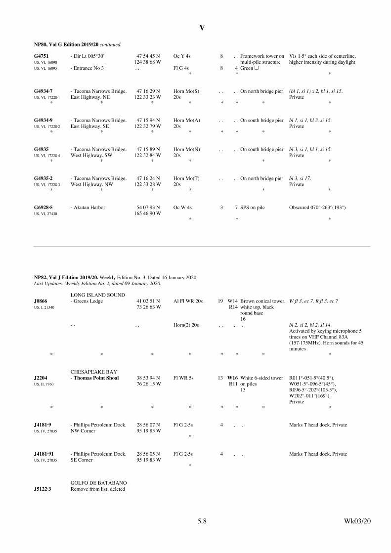
V
NP80, Vol G Edition 2019/20 continued.
G4751US, VI, 16090
US, VI, 16095
- Dir Lt 005°30′ 47 54·45 N124 38·68 W
Oc Y 4s 8 . . Framework tower on multi-pile structure
Vis 1·5° each side of centerline, higher intensity during daylight
- Entrance No 3 . . Fl G 4s 8 4 Green &* * *
G4934·7US, VI, 17228·1
- Tacoma Narrows Bridge. East Highway. NE
47 16·29 N122 33·23 W
Horn Mo(S) 20s
. . . . On north bridge pier (bl 1, si 1) x 2, bl 1, si 15.Private
* * * * * * * *
G4934·9US, VI, 17228·2
- Tacoma Narrows Bridge. East Highway. SE
47 15·94 N122 32·79 W
Horn Mo(A) 20s
. . . . On south bridge pier bl 1, si 1, bl 3, si 15.Private
* * * * * * * *
G4935US, VI, 17228·4
- Tacoma Narrows Bridge. West Highway. SW
47 15·89 N122 32·84 W
Horn Mo(N) 20s
. . . . On south bridge pier bl 3, si 1, bl 1, si 15.Private
* * * * * *
G4935·2US, VI, 17228·3
- Tacoma Narrows Bridge. West Highway. NW
47 16·24 N122 33·28 W
Horn Mo(T) 20s
. . . . On north bridge pier bl 3, si 17.Private
* * * * * *
G6928·5US, VI, 27430
- Akutan Harbor 54 07·93 N165 46·90 W
Oc W 4s 3 7 SPS on pile Obscured 070°-263°(193°)
* * *
Wk03/205.8
NP82, Vol J Edition 2019/20. Weekly Edition No. 3, Dated 16 January 2020.Last Updates: Weekly Edition No. 2, dated 09 January 2020.
LONG ISLAND SOUND
J0866US, I, 21340
- Greens Ledge 41 02·51 N73 26·63 W
Al Fl WR 20s 19 W14R14
Brown conical tower,white top, black round base16
W fl 3, ec 7, R fl 3, ec 7
- - . . Horn(2) 20s . . . . . . bl 2, si 2, bl 2, si 14.Activated by keying microphone 5 times on VHF Channel 83A (157·175MHz). Horn sounds for 45 minutes
* * * * * * * *
CHESAPEAKE BAY
J2204US, II, 7760
- Thomas Point Shoal 38 53·94 N76 26·15 W
Fl WR 5s 13 W16R11
White 6-sided tower on piles13
R011°-051·5°(40·5°), W051·5°-096·5°(45°), R096·5°-202°(105·5°), W202°-011°(169°).Private
* * * * * * * *
J4181·9US, IV, 27035
- Phillips Petroleum Dock. NW Corner
28 56·07 N95 19·85 W
Fl G 2·5s 4 . . . . Marks T head dock. Private
*
J4181·91US, IV, 27035
- Phillips Petroleum Dock. SE Corner
28 56·05 N95 19·83 W
Fl G 2·5s 4 . . . . Marks T head dock. Private
*
GOLFO DE BATABANO
J5122·3 Remove from list; deleted
Wk03/205.8

V
NP82, Vol J Edition 2019/20 continued.
J5162CU, P2101, 1163
- Cayo Cruz. E Side 22 28·11 N82 16·83 W
Fl G 4s 4 3 Green & on green GRP tower on pile
* * * *
J5304 - Pelican Spit 17 56·75 N76 50·65 W
Fl R 5s 6 4 Red beacon TE; replaced by light buoy Fl R 5s close S (T) 2019
*
J5669KN, , 1032
Basseterre. Belle Tete 17 22·20 N62 51·74 W
Fl W . . 9 Tower
* * * * * * * *
J5672KN, , 1010
FR, LD, 03000
Basseterre. Saint Fort Thomas
17 17·33 N62 44·09 W
Fl(2)G 10s 20 5
* * * * *
J5672·12 Basseterre. Port Zante. Cruise Ship Terminal. Dolphin
17 17·40 N62 43·26 W
F W . . 2
* * * * * * * *
J5673·13 Basseterre. Port Zante. Cruise Ship Terminal. Dolphin
17 17·42 N62 43·22 W
F W 4 2 Metal mast1
* * *
J5673·131 Basseterre. Port Zante. Cruise Ship Terminal. Dolphin
17 17·42 N62 43·19 W
F W . . 2
* * * * * * * *
J5673·14KN, , 1015
Basseterre. Port Zante. Cruise Ship Terminal. Outer Dolphin
17 17·23 N62 43·37 W
Iso W 5s . . 3
* * * *
J5673·143KN, , 1016
Basseterre. Port Zante. Cruise Ship Terminal. Dolphin
17 17·27 N62 43·37 W
Iso W 5s . . 3
* * * * * * * *
J5673·145KN, , 1017
Basseterre. Port Zante. Cruise Ship Terminal. Dolphin
17 17·31 N62 43·37 W
Iso W 5s . . 3
* * * * * * * *
J5673·19 Basseterre. Port Zante. Cruise Ship Terminal. Marina. W Breakwater. Head
17 17·55 N62 43·50 W
Fl(3)G 5s . . 1 Metal mast
* * * * *
J5673·21 Remove from list; deleted
J5673·5KN, , 1014
Basseterre. Texaco Tanker Berth
17 17·48 N62 42·69 W
Fl W 5s . . 2
* * *
J5673·8KN, , 1012
Basseterre. Fort Smith. Saint Kitts. Deepwater Port Outer Dolphin
17 17·10 N62 42·66 W
Fl R 10s 4 3
* *
Wk03/205.9

V
NP82, Vol J Edition 2019/20 continued.
J5673·9KN, , 1013
Basseterre. Fort Smith. Saint Kitts. Deepwater Port Dolphin
17 17·14 N62 42·64 W
F W . . 2
* * *
J5674 Remove from list; deleted
J5674·5KN, , 1011
Basseterre. Fort Smith. Saint Kitts. Deepwater Port
17 17·15 N62 42·60 W
Fl R 10s . . 5 Metal mast
* * * * * * * *
J5675KN, , 1030
FR, LD, 03060
Basseterre 17 18·76 N62 42·15 W
Fl W . . 23 Tower
- . . F R* * * *
J6048 Puerto Cabezas. Bragman Bluff
14 01·30 N83 23·10 W
Fl W 2·5s 70 5 . . Private
*
J6500VE, , V5012
- Morro de Robledal(VE)
11 02·60 N64 22·63 W
Fl W 8s 82 18 Orange 6-sided GRP tower, white band12
fl 1
*
J6501VE, , V5007-1
- Punta Faragoza(VE)
11 07·53 N63 56·04 W
Fl W 8s 85 20 Orange concrete tower, white band23
fl 1
*
J6525VE, , V5016
- Main Breakwater. Head (Sur de Guiria)
10 33·98 N62 17·32 W
Fl R 9s 10 9 Red round concrete tower, white band8
fl 1
* *
J6526VE, , V5017
- Secondary Breakwater. Head (Norte de Guiria)
10 34·08 N62 17·43 W
Fl G 9s 6 9 Green round concretetower, white band4
fl 1
* * *
J6872·1 - Entrance. VB2 5 57·03 N55 11·84 W
Iso R 4s . . . . Red beacon Damaged (T) 2019
* * * * * * * *
Wk03/205.10
NP83, Vol K Edition 2019/20. Weekly Edition No. 3, Dated 16 January 2020.Last Updates: Weekly Edition No. 52, dated 26 December 2019.
K3180 - Inner Cutting. N End. Trinity Inlet. Ldg Lts 013°. Front
16 54·15 S145 47·28 E
F Bu . . . . Black pile Bu005·5°-020·5°(15°)
- - - - - - . . Fl G 3s* *
K3180·1 - Inner Cutting. N End. Trinity Inlet. Ldg Lt 013°. Rear
16 53·94 S145 47·33 E
F Bu . . . . Black pile Bu005·5°-020·5°(15°)
- - - - - - . . Fl G 3s* *
Wk03/205.10

V
NP83, Vol K Edition 2019/20 continued.
K3304·38 - Middle Channel. Elbow Bank Reach Ldg Lts 264°33′. Front
17 26·71 S140 45·25 E
F Bu . . 5 White % on black metal pile with platform
Bu257·05°-272·05°(15°).TE 2019
- - - - No 9 . . Fl G 4s . . 3 Green % on same structure
G266·05°-263·05°(357°).Topmark missing (T) 2019
*
K3401·6 Cape Gourdon 4 23·16 S145 19·34 E
Fl(3)W 9s 16 10 White framework tower19
(fl 0·3, ec 1) x 2, fl 0·3, ec 6·1.TE 2019
*
MILNE BAY. KAWANASAUSAU (CHINA) STRAIT. NORTH ENTRANCE
K3452 - Isulailai Point 10 33·65 S150 41·70 E
Fl(2)W 5s 17 9 White framework tower4
fl 0·5, ec 1, fl 0·5, ec 3.W167°-031°(224°).TE 2019
*
K3459·1 - Vabukori. Ldg Lts 054·30°.Rear. 445m from front
9 29·79 S147 11·33 E
Oc W 6s 90 10 2 white U with black S between, on white square concrete tower7
ec 1·5.W309°-101°(152°).TE 2019
*
Wk03/205.11
NP84, Vol L Edition 2019/20. Weekly Edition No. 3, Dated 16 January 2020.Last Updates: Weekly Edition No. 1, dated 02 January 2020.
L1094NO, , 387600
- Krossnesfjord. Haukomkin 63 08·86 N8 15·29 E
Oc WRG 6s 6 W 9R 7G 6
Small hut3
G063°-076°(13°), W076°-083°(7°), R083°-243°(160°), W243°-254°(11°), G254°-264°(10°).TE; to be removed (P) 2019
*
L3058NO, , 778400
Kleivheia 68 17·19 N13 34·24 E
Iso WRG 6s 38 W8·9R7·3G7·3
Framework tower6
G032·1°-036·4°(4·3°), W036·4°-039·1°(2·7°), R039·1°-060·3°(21·2°), G060·3°-061·9°(1·6°), W061·9°-185·4°(123·5°), R185·4°-238·4°(53°)
* * * *
L3071NO, , 779200
Sørvestre Borgværskjær 68 19·16 N13 46·43 E
Fl RG 3s 8 G4·6R4·6
Post4
fl 1.G071·7°-140·4°(68·7°), R140·4°-071·7°(291·3°)
* *
L4303NO, , 995850
Sundodden. Akselsundet(NO)
77 45·44 N14 32·59 E
Fl WRG 5s 14 W8·1R6·6G6·6
Post5
R255°-287·7°(32·7°), W287·7°-301·5°(13·8°), G301·5°-015·2°(73·7°), W015·2°-038·1°(22·9°), R038·1°-076°(37·9°).TE 2019
*
Wk03/205.11

V
NP85, Vol M Edition 2019/20. Weekly Edition No. 3, Dated 16 January 2020.Last Updates: Weekly Edition No. 2, dated 09 January 2020.
M4149·3KR, 410, 3308·5
KR, 410, 4142·5
KR, 410, 4699·2
Uduam 37 03·57 N126 04·42 E
Fl(2)W 10s 12 6 Black # on black beacon, red band17
- . . AIS . . . . . . MMSI No 994401034* * * * * * * *
M4354·8KR, 410, 2054
- Inner Breakwater. Head 35 03·23 N128 59·01 E
Fl(3)G 8s 10 9 White round concretetower9
*
SAKISHIMA GUNTO. MIYAKO RETTO. MIYAKO SHIMA
M4736·98 Remove from list; deleted
SAKISHIMA GUNTO. MIYAKO RETTO. MIYAKO SHIMA
M4737·14 Remove from list; deleted
SAKISHIMA GUNTO. MIYAKO RETTO. MIYAKO SHIMA
M4737·15 Remove from list; deleted
SAKISHIMA GUNTO. MIYAKO RETTO. IRABU SHIMA
M4737·83 Remove from list; deleted
SAKISHIMA GUNTO. MIYAKO RETTO. IRABU SHIMA
M4737·84 Remove from list; deleted
SAKISHIMA GUNTO. MIYAKO RETTO. IRABU SHIMA
M4737·86 Remove from list; deleted
KUMANO NADA. GOKASHO KO
M6032·6 Remove from list; deleted
M7348·5JP, 411, 0792
- 34 53·77 N132 03·44 E
Iso G 6s 14 5 White round concretetower10
* * * * * * * *
Wk03/205.12
NP86, Vol N Edition 2019/20. Weekly Edition No. 3, Dated 16 January 2020.Last Updates: Weekly Edition No. 1, dated 02 January 2020.
N4896·3TR, , 21360
Barbaros. Fisherman's Harbour. Main Breakwater. Head
40 54·15 N27 28·14 E
Fl G 3s 9 2 White concrete tower, green stripe7
fl 1
* * * * * * *
N4896·4TR, , 21360·5
Barbaros. Minor Breakwater.Head
40 54·19 N27 28·10 E
Fl R 3s 9 2 White concrete tower, red stripe7
* * * * * *
N4899·3TR, , 21293
Silivri. Main Breakwater 41 04·37 N28 14·30 E
Fl G 5s 6 5 White concrete tower5
fl 1
- - . . AIS . . . . . . MMSI No 992711045* * * * * * * *
Wk03/205.12

V
NP86, Vol N Edition 2019/20 continued.
N5019RO, , 2
Port Mangalia. NE Breakwater. Head
43 47·94 N28 36·03 E
Fl W 4s 23 10 Metal framework tower21
fl 1·5
- - - . . Horn Mo(U) 40s
. . . . . . (bl 1·5, si 1) x 2, bl 5, si 30.Horn Mo(M)17s (T) 2019
*
N5816·2TR, , 10373·5
Denizkonak. Minor Breakwater. Head
41 57·25 N33 09·35 E
Fl G 3s 12 5 Galvanised steel tower10
fl 1
* * * * * * * *
N5816·3TR, , 10373
Denizkonak. Fishing Harbour. Main Breakwater. Head
41 57·29 N33 09·32 E
Fl R 3s 15 5 Galvanised steel tower12
fl 1
* * * * * * * *
N5872·2TR, , 32863
- S Breakwater. Head 36 47·09 N34 38·52 E
Fl R 3s 7 3 White metal tower, red band6
fl 1
- - - . . AIS . . . . . . MMSI No 992711236* * * *
N5872·4TR, , 32863·5
- S Breakwater. Elbow. Dir Lt 220°12′
36 47·04 N34 38·11 E
Dir Fl WR 5s 11 W 5R 3
White metal tower6
fl 0·5.Fl W219°-221·5°(2·5°).Fl R221·5°-219°(357·5°)
* * *
N5873TR, , 32864
- E Breakwater. Head 36 47·23 N34 38·55 E
Fl G 3s 7 3 White metal tower, green band6
fl 1
- - - . . AIS . . . . . . MMSI No 992711237* * * *
Wk03/205.13
NP87, Vol P Edition 2019/20. Weekly Edition No. 3, Dated 16 January 2020.Last Updates: Weekly Edition No. 2, dated 09 January 2020.
LEMEN LIEDAO. NAN'AO DAO. APPROACHES
P3587·92 Remove from list; deleted
LEMEN LIEDAO. NAN'AO DAO. APPROACHES
P3587·925 Remove from list; deleted
LEMEN LIEDAO. NAN'AO DAO. APPROACHES
P3587·93 Remove from list; deleted
LEMEN LIEDAO. NAN'AO DAO. APPROACHES
P3587·95 Remove from list; deleted
XIAMEN GANG AND APPROACHES
P3612·2 Remove from list; deleted
P3897·3CN, G101, 1445·15
- Longkou Gang. Xigang. No6
37 40·22 N120 13·45 E
Iso W 4s 8 5 Black beacon, white bands6
* * * * * * * *
Wk03/205.13

V
NP88, Vol Q Edition 2020/21. Weekly Edition No. 3, Dated 16 January 2020.Last Updates: Weekly Edition No. 2, dated 09 January 2020.
Q1076·3 - E Mole(ID)
6 04·87 S106 53·04 E
Lit . . . . White beacon
* * * * * * * *
BROWSE ISLAND
Q1642·3 - FPSO Prelude 13 47·18 S123 19·05 E
Mo(U)W 11s . . 15
- - . . Racon . . . . . . ALRS Vol 2 Station 87170* * * * * * * *
Q1642·5 - Ichthys Explorer 13 56·34 S123 17·87 E
Mo(U)W 15s . . 15
- - . . Racon . . . . . . ALRS Vol 2 Station 87160*
Q1755·5 Green Head. Outer Ldg Lts 105·5°. Rear. 180m from front
30 04·43 S114 58·12 E
Iso W 4s 27 10 White U on post
* * * *
Q1755·6 Green Head. Outer Ldg Lts 105·5°. Front
30 04·40 S114 58·01 E
Q W 19 10 White U on post
* * * * *
Wk03/205.14

VI
6.1
VI
6.1
UPDATES TO ADMIRALTY LIST OF RADIO SIGNALSWeekly Edition No. 3 dated 16 January 2020
The ADMIRALTY List of Radio Signals diagrams included in the paper version of the weekly Notice to Mariners (SectionVI) are printed in black and white. If required, a colour version of these diagrams can be downloaded fromwww.admiralty.co.uk/maritime-safety-information. To obtain the colour versions select View and download NMs – selectWeekly – select Year – select Week – go to Selected Week Content – select File (for example:NP286(3)–WK01–14–PAGE149_Week01_2020.pdf)
Silivri Main Breakwater Lt 41°04′·37N 28°14′·30E 992711045 Real 6 7 8 12 14 21 25 26
(former update 15/19)Turkish Bulletin 50/19 (RSDRA2019000307000) 3/20
VOLUME 2, NP282(1), 2019/20Published Wk 13/19
(Last Updates: Weekly Edition No. 2 dated 09 January 2020)
AUTOMATIC IDENTIFICATION SYSTEM (AIS)
PAGE 150, TURKEY (Marmara Denizi), below Seddülbahir South Breakwater Lt.Insert:
(former update 50/19)Chinese Notice 49/1599/19 (RSDRA2019000306951) 3/20
(former update 50/19)Chinese Notice 49/1599/19 (RSDRA2019000306951) 3/20
Lianhua Shan No 8 22°58′·95N 113°32′·29E 994136715 Broadcasts every 3 minutes Virtual
Lianhua Shan No 12 22°59′·22N 113°32′·19E 994136714 Broadcasts every 3 minutes Virtual
Chinese Notice 49/1600/19 (RSDRA2019000306951) 3/20
Skipjack Wind Met Buoy SKJ 38°40′·85N 74°45′·93W 993663004 Real
United States Coast Guard Bulletin 50/19 (RSDRA2019000301030) 3/20
VOLUME 2, NP282(2), 2019/20Published Wk 13/19
(Last Updates: Weekly Edition No. 2 dated 09 January 2020)
AUTOMATIC IDENTIFICATION SYSTEM (AIS)
PAGE 132, CHINA.Le Men Lt Bn No 1.Delete entry
PAGE 132, CHINA.Le Men Lt Bn No 2.Delete entry
PAGE 132, CHINA, below Lianhua Shan Lt Float.Insert:
PAGE 200, UNITED STATES (Atlantic Coast), below Shinnecock Inlet Approach Lt Buoy SH.Insert:
Wk03/20

VI
6.2
VI
6.2
VOLUME 3, NP283(1), 2020Published Wk 50/19
(Last Updates: Weekly Edition No. 2 dated 09 January 2020)
SÃO TOMÉ AND PRÍNCIPE
INTERNET WEATHER SERVICES
Empresa, National Port Administrationwww enaport.st/PT/mares-e-meteorologia General weather synopsis and tidal information for São Tomé and Príncipe.
National Port Administration website (RSDRA2019000307369) 3/20
RADIO WEATHER SERVICES AND NAVIGATIONAL WARNINGS
PAGE 189, after RUSSIA (Caspian Sea), NAVTEX - ASTRAKHAN.Insert:
Insert: diagram on page 6.4
Shanghai Maritime Safety Administration correspondence (RSDRA2019000305350) 3/20
SHANGHAI (XSG) 31°06′·00N 121°32′·00E
4170
8302
12382
16559
Diagram page 79
Map Areas
1000 n miles radius from Shanghai
Schedule
XSG broadcast schedule and maual amendments 0000(08)
120/576
24 hour marine weather forecast 0025(08)
48 hour marine weather forecast 0050(08)
72 hour marine weather forecast 0115(08)
Tropical cyclone forecast 0230(08)
24 hour 500hPa and surface forecast 0255(20)
48 hour 500hPa and surface forecast 0320(20)
72 hour 500hPa and surface forecast 0345(20)
24 hour wave height forecast 0410(20)
48 hour wave height forecast 0435(20)
Continued on next page
VOLUME 3, NP283(2), 2019/20Published Wk 50/18
(Last Updates: Weekly Edition No. 1 dated 02 January 2020)
RADIO-FACSIMILE
PAGE 79, after SHANGHAI.
PAGE 79, above SYDNEY (CANADIAN COAST GUARD).Insert:
Wk03/20

VI
6.3
VI
6.3
SHANGHAI (XSG) (Continued)
72 hour wave height forecast 0500(20)
120/576
24 hour ocean curent forecast 0525(20)
48 hour ocean current forecast 0550(20)
72 hour ocean current forecast 0615(20)
Surface analysis 0730(08)
24 hour surface forecast 0755(08)
48 hour surface forecast 0820(08)
Tropical cyclone forecast 0845(14) 1425(20)
Tropical cyclone forecast 2025(02)
Shanghai Maritime Safety Administration correspondence (RSDRA2019000305350) 3/20
VI
6.2
VOLUME 3, NP283(1), 2020Published Wk 50/19
(Last Updates: Weekly Edition No. 2 dated 09 January 2020)
SÃO TOMÉ AND PRÍNCIPE
INTERNET WEATHER SERVICES
Empresa, National Port Administrationwww enaport.st/PT/mares-e-meteorologia General weather synopsis and tidal information for São Tomé and Príncipe.
National Port Administration website (RSDRA2019000307369) 3/20
RADIO WEATHER SERVICES AND NAVIGATIONAL WARNINGS
PAGE 189, after RUSSIA (Caspian Sea), NAVTEX - ASTRAKHAN.Insert:
Insert: diagram on page 6.4
Shanghai Maritime Safety Administration correspondence (RSDRA2019000305350) 3/20
SHANGHAI (XSG) 31°06′·00N 121°32′·00E
4170
8302
12382
16559
Diagram page 79
Map Areas
1000 n miles radius from Shanghai
Schedule
XSG broadcast schedule and maual amendments 0000(08)
120/576
24 hour marine weather forecast 0025(08)
48 hour marine weather forecast 0050(08)
72 hour marine weather forecast 0115(08)
Tropical cyclone forecast 0230(08)
24 hour 500hPa and surface forecast 0255(20)
48 hour 500hPa and surface forecast 0320(20)
72 hour 500hPa and surface forecast 0345(20)
24 hour wave height forecast 0410(20)
48 hour wave height forecast 0435(20)
Continued on next page
VOLUME 3, NP283(2), 2019/20Published Wk 50/18
(Last Updates: Weekly Edition No. 1 dated 02 January 2020)
RADIO-FACSIMILE
PAGE 79, after SHANGHAI.
PAGE 79, above SYDNEY (CANADIAN COAST GUARD).Insert:
Wk03/20

VI
6.4
Sha
ngha
i
1000
nm
SHA
NG
HA
I IND
EX OF M
AP A
REA
S V001 20/12/19
150°
140°
130°
120°
110°
100°
90°
80°
10°
100°
110°
120°
130°
140°
20°
30°
40°
10°
20°
30°
40°
Sha
ngha
iIn
dex
of M
ap A
reas
VI
6.1
UPDATES TO ADMIRALTY LIST OF RADIO SIGNALSWeekly Edition No. 3 dated 16 January 2020
The ADMIRALTY List of Radio Signals diagrams included in the paper version of the weekly Notice to Mariners (SectionVI) are printed in black and white. If required, a colour version of these diagrams can be downloaded fromwww.admiralty.co.uk/maritime-safety-information. To obtain the colour versions select View and download NMs – selectWeekly – select Year – select Week – go to Selected Week Content – select File (for example:NP286(3)–WK01–14–PAGE149_Week01_2020.pdf)
Silivri Main Breakwater Lt 41°04′·37N 28°14′·30E 992711045 Real 6 7 8 12 14 21 25 26
(former update 15/19)Turkish Bulletin 50/19 (RSDRA2019000307000) 3/20
VOLUME 2, NP282(1), 2019/20Published Wk 13/19
(Last Updates: Weekly Edition No. 2 dated 09 January 2020)
AUTOMATIC IDENTIFICATION SYSTEM (AIS)
PAGE 150, TURKEY (Marmara Denizi), below Seddülbahir South Breakwater Lt.Insert:
(former update 50/19)Chinese Notice 49/1599/19 (RSDRA2019000306951) 3/20
(former update 50/19)Chinese Notice 49/1599/19 (RSDRA2019000306951) 3/20
Lianhua Shan No 8 22°58′·95N 113°32′·29E 994136715 Broadcasts every 3 minutes Virtual
Lianhua Shan No 12 22°59′·22N 113°32′·19E 994136714 Broadcasts every 3 minutes Virtual
Chinese Notice 49/1600/19 (RSDRA2019000306951) 3/20
Skipjack Wind Met Buoy SKJ 38°40′·85N 74°45′·93W 993663004 Real
United States Coast Guard Bulletin 50/19 (RSDRA2019000301030) 3/20
VOLUME 2, NP282(2), 2019/20Published Wk 13/19
(Last Updates: Weekly Edition No. 2 dated 09 January 2020)
AUTOMATIC IDENTIFICATION SYSTEM (AIS)
PAGE 132, CHINA.Le Men Lt Bn No 1.Delete entry
PAGE 132, CHINA.Le Men Lt Bn No 2.Delete entry
PAGE 132, CHINA, below Lianhua Shan Lt Float.Insert:
PAGE 200, UNITED STATES (Atlantic Coast), below Shinnecock Inlet Approach Lt Buoy SH.Insert:
Wk03/20

VI
6.5
VI
1
VOLUME 6, PART 1, NP 286(1), 2019/20Published Wk 16/19
––––––––––––––––––(Last Updates: Weekly Edition No. 50 dated 12 December 2019)
PAGE 465, UNITED KINGDOM (Northern Ireland), LARNE, Pilots, PROCEDURE, Section (4).Delete and replace by:
(4) Pilot boards in position 54°53′·15N 5°47′·68W (1 n mile N of No 1 Lt buoy).
(Former update 27/19)
Port of Larne, (RSDRA2019000307782), 3/20
––––––––––––––––––––––––––––––
VOLUME 6, PART 2, NP 286(2), 2019/20Published Wk 21/19
––––––––––––––––––(Last Updates: Weekly Edition No. 2 dated 9 January 2020)
PAGE 253, NORWAY, BORG HARBOUR, Pilots, PROCEDURE, section (1).Delete and replace by:
(1) Pilotage is compulsory for all vessels.
Kystverket correspondence, (RSDRA2019000307692), 03/20
PAGE 253, NORWAY, BREVIK, Pilots, PROCEDURE, section (1).Delete and replace by:
(1) Pilotage is compulsory for all vessels.
Kystverket correspondence, (RSDRA2019000307692), 03/20
PAGE 266, NORWAY, HORTEN, Pilots section.Delete and replace by:
PilotsCONTACT DETAILS:
Call: Horten Pilot Booking CentreVHF Channel: Ch 16; 13Telephone: +47 33 034970
HOURS: H24
PROCEDURE:(1) Pilotage is compulsory(2) Pilot ordering: Vessels should send order for Pilots 24h before arrival using Safe Sea Net (see GENERAL NOTES, REPORTING - SAFE SEA NET (SSN)), or directly to Horten Pilot Booking Centre by fax, telephone or VHF Ch 13 stating IMO SRS Items: ALPHA, HOTEL, INDIA, OSCAR, PAPA, UNIFORM and X-RAY (including reason for call and whether one or two Pilots are required). Use of the Pilot Booking Centre may incur additional charges. telephone or VHF Ch 13 stating IMO SRS Items: ALPHA and HOTEL.(3) Vessels should send con rmation for Pilots 2h before arrival, to Horten Pilot Dispatch Centre by telephone or VHF Ch 13 stating IMO SRS Items: ALPHA and HOTEL.
continued on next column
(4) Pilot boards in the following positions:(a) 59°04′·50N 10°34′·50E (b) 59°07′·60N 10°43′·20E (c) 59°03′·10N 10°47′·00E (d) 59°01′·70N 10°51′·10E (e) 58°58′·60N 11°02′·70E (f) 59°00′·00N 10°25′·00E
NOTES:(1) Horten Pilot Booking Centre is co-located with Horten Vessel Traffi c Service Centre.(2) Order for Pilots can be sent via the agent.
(Former update 21/19)
Kystverket correspondence, (RSDRA2019000307692), 3/20
PAGE 282, NORWAY, MOSS, Pilots, PROCEDURE, section (1).Delete and replace by:
(1) Pilotage is compulsory for all vessels.
Kystverket correspondence, (RSDRA2019000307692), 3/20
––––––––––––––––––––––––––––––
VOLUME 6, PART 6, NP 286(6), First Edition, 2020Published Wk 3/20
––––––––––––––––––(First Updates to publication Wk 3/20)
The 2019/20 edition is cancelled
PAGE ii, RECORD OF UPDATES, NEW EDITION, First Updates box.Insert:
This edition was published in week 3/20. The rst Weekly Notice to Mariners was issued in week 3/20.
UKHO 3/20
PAGE 25, CHINA, DALIAN, Dalian Wan, diagram DALIAN VESSEL TRAFFIC SERVICE (including DAYAO WAN VTS).Delete and replace by diagram DALIAN VESSEL TRAFFIC SERVICE (including DAYAO WAN VTS) on page 6.8
Chinese VTS Guide 2019, (RSDRA2019000283168), 3/20
PAGE 27, CHINA, DALIAN, Dalian Wan, Vessel Traffi c Service, AREA, section (1).Delete and replace by:
(1) An arc of 13 n miles radius centred on Dasanshan Dao Lt (38°51′·86N 121°49′·54E)
Chinese VTS Guide 2019, (RSDRA2019000283168), 3/20
PAGE 34, CHINA, FUJIAN - COASTAL VESSEL TRAFFIC SERVICE, diagram FUZHOU VESSEL TRAFFIC SERVICE.Delete diagram FUZHOU VESSEL TRAFFIC SERVICE and replace by diagram on page 6.9
Chinese Bulletin 46/19, (RSDRA2019000287766), 3/20
Wk03/20

VI
6.6
VI
2
PAGE 37, CHINA, FUJIAN - COASTAL VESSEL TRAFFIC SERVICE, Fuzhou Vessel Traffi c Service, PROCEDURE, section (2) (d).Delete and replace by:
(d) Songxia Harbour, Jiangyin Harbour and Haitan Strait:(i) North Reporting Line: An arc of radius 10 n miles, bearing 310°-150°,
centred on Zhupai Yu Lt (25°42′·87N 119°43′·39E)(ii) South Reporting Line: Lines commencing at 25°15′·00N 119°45′·00E
running due W to 25°14′·98N 119°29′·89E, and due N to Haitan Dao(e) Nanri Channel and Xinghua Wan:
(i) Xinghua Wan South No.1: A line joining positions 25°09′·72N 119°16′·50E, 25°07′·10N 119°22′·05E and 25°09′·48N 119°31′·08E
(ii) Xinghua Wan South No.2: A line joining positions 25°19′·22N 119°20′·63E, 25°19′·77N 119°23′·07E and 25°16′·47N 119°30′·55E
Chinese Bulletin 46/19, (RSDRA2019000287766), 3/20
PAGE 44, CHINA, GAOLAN, diagram ZHUHAI VESSEL TRAFFIC SERVICE.Delete diagram ZHUHAI VESSEL TRAFFIC SERVICE and replace by diagram on page 6.10
Chinese Notice 1530/19, (RSDRA2019000294426), 3/20
PAGE 45, CHINA, GAOLAN, Vessel Traffi c Service, REPORTING LINES.Delete and replace by:
REPORTING LINES:Reporting lines have been established as follows:(1) Western Reporting Line: From position 21°45′·00N 113°07′·00E northwards to the coastline.(2) Southern Reporting Line: From position 21°45′·00N 113°07′·00E to position 21°45′·00N 113°23′·74E.(3) Eastern Reporting Line: From position 21°45′·00N 113°23′·74E to position 21°59′·00N 113°27′·00E.(4) Northern Reporting Line: From position 21°59′·00N 113°27′·00E to position 21°54′·32N 113°16′·73E.
Chinese Notice 1530/19, (RSDRA2019000294426), 3/20
PAGE 78, CHINA, LIANYUNGANG, Pilots, PROCEDURE, section (2).Delete and replace by:
(2) Pilot boards in the following positions:(a) Anchorage area No 1: 34°49′·47N 119°37′·78E(b) No 1: 34°47′·31N 119°40′·40E(c) No 1: 34°46′·46N 119°33′·90E(d) No 2: 34°47′·73N 119°37′·33E(e) No 3: 34°49′·58N 119°41′·71E(f) No 4: 34°51′·76N 119°46′·93E(g) No 6: 34°44′·93N 119°34′·10E(h) No 7: 34°48′·39N 119°42′·09E(i) No 8: 34°51′·24N 119°49′·76E
Chinese Chart 12581, (RSDRA2019000262831), 3/20
PAGE 100, CHINA, QINHUANGDAO, Vessel Traffi c Service, PROCEDURE, section (1), table.Delete:
Entering VTS Area 15 n miles from Nan Shan Tou Lt
Vessel’s name, nationality, and intended navigation
and replace by:
Entering VTS Area 19 n miles from Nan Shan Tou Lt
Vessel’s name, nationality, and intended navigation
Chinese VTS Guide 2019, (RSDRA2019000295153), 3/20
PAGE 117, CHINA, SHENZHEN, Pilots, PROCEDURE, section (2) (b).Delete and replace by:
(b) Eastern Port Area:(i) Shenzhen Port No 5 Anchorage: 22°34′·74N 114°19′·40E(ii) Dongbu Harbour LNG Terminal: 22°28′·08N 114°27′·67E (see NOTE (2))(iii) Dongbu Harbour LNG Terminal Quarantine Anchorage: 22°30′·26N
114°27′·82E(iv) Dapeng Wan Kou No 1 Quarantine Anchorage: 22°24′·60N 114°34′·00E(v) 22°29′·70N 114°26′·54E(vi) 22°32′·80N 114°23′·60E(vii) 22°33′·50N 114°20′·20E
Hong Kong Notice 53/19, (RSDRA2019000306193), 3/20
PAGE 118, CHINA, SHENZEN, diagram SHENZEN (EAST) VESSEL TRAFFIC SERVICE.Insert Pilot boarding position symbols in positions 22°29′·70N 114°26′·54E, 22°32′·80N 114°23′·60E and 22°33′·50N 114°20′·20E.
Hong Kong Notice 53/19, (RSDRA2019000306193), 3/20
PAGE 137, CHINA, YANGPU, Hai-Nan Tao, Pilots, PROCEDURE, section (2).Delete and replace by:
(2) Pilot boards in the following positions:(a) Circle of radius 1 n mile (Quarantine anchorage No 1) centred on position
19°51′·00N 108°56′·28E(b) Circle of radius 1 n mile (Quarantine anchorage No 2) centred on position
19°49′·00N 108°56′·28E(c) Circle of radius 1 n mile (Quarantine anchorage No 3) centred on position
19°47′·00N 108°56′·28E(d) No 3: 19°45′·40N 109°08′·00E (Anchorage No 8)(e) No 5: 19°44′·40N 109°02′·60E(f) No 6: 19°40′·80N 109°08′·80E (Anchorage No 13)(g) No 8: 19°46′·81N 109°02′·00E (Anchorage No 5)(h) No 9: 19°43′·61N 109°08′·20E (Anchorage No 10)
Chinese Chart 16561, (RSDRA2019000262843), 3/20
Wk03/20

VI
6.7
VI
2
PAGE 37, CHINA, FUJIAN - COASTAL VESSEL TRAFFIC SERVICE, Fuzhou Vessel Traffi c Service, PROCEDURE, section (2) (d).Delete and replace by:
(d) Songxia Harbour, Jiangyin Harbour and Haitan Strait:(i) North Reporting Line: An arc of radius 10 n miles, bearing 310°-150°,
centred on Zhupai Yu Lt (25°42′·87N 119°43′·39E)(ii) South Reporting Line: Lines commencing at 25°15′·00N 119°45′·00E
running due W to 25°14′·98N 119°29′·89E, and due N to Haitan Dao(e) Nanri Channel and Xinghua Wan:
(i) Xinghua Wan South No.1: A line joining positions 25°09′·72N 119°16′·50E, 25°07′·10N 119°22′·05E and 25°09′·48N 119°31′·08E
(ii) Xinghua Wan South No.2: A line joining positions 25°19′·22N 119°20′·63E, 25°19′·77N 119°23′·07E and 25°16′·47N 119°30′·55E
Chinese Bulletin 46/19, (RSDRA2019000287766), 3/20
PAGE 44, CHINA, GAOLAN, diagram ZHUHAI VESSEL TRAFFIC SERVICE.Delete diagram ZHUHAI VESSEL TRAFFIC SERVICE and replace by diagram on page 6.10
Chinese Notice 1530/19, (RSDRA2019000294426), 3/20
PAGE 45, CHINA, GAOLAN, Vessel Traffi c Service, REPORTING LINES.Delete and replace by:
REPORTING LINES:Reporting lines have been established as follows:(1) Western Reporting Line: From position 21°45′·00N 113°07′·00E northwards to the coastline.(2) Southern Reporting Line: From position 21°45′·00N 113°07′·00E to position 21°45′·00N 113°23′·74E.(3) Eastern Reporting Line: From position 21°45′·00N 113°23′·74E to position 21°59′·00N 113°27′·00E.(4) Northern Reporting Line: From position 21°59′·00N 113°27′·00E to position 21°54′·32N 113°16′·73E.
Chinese Notice 1530/19, (RSDRA2019000294426), 3/20
PAGE 78, CHINA, LIANYUNGANG, Pilots, PROCEDURE, section (2).Delete and replace by:
(2) Pilot boards in the following positions:(a) Anchorage area No 1: 34°49′·47N 119°37′·78E(b) No 1: 34°47′·31N 119°40′·40E(c) No 1: 34°46′·46N 119°33′·90E(d) No 2: 34°47′·73N 119°37′·33E(e) No 3: 34°49′·58N 119°41′·71E(f) No 4: 34°51′·76N 119°46′·93E(g) No 6: 34°44′·93N 119°34′·10E(h) No 7: 34°48′·39N 119°42′·09E(i) No 8: 34°51′·24N 119°49′·76E
Chinese Chart 12581, (RSDRA2019000262831), 3/20
PAGE 100, CHINA, QINHUANGDAO, Vessel Traffi c Service, PROCEDURE, section (1), table.Delete:
Entering VTS Area 15 n miles from Nan Shan Tou Lt
Vessel’s name, nationality, and intended navigation
and replace by:
Entering VTS Area 19 n miles from Nan Shan Tou Lt
Vessel’s name, nationality, and intended navigation
Chinese VTS Guide 2019, (RSDRA2019000295153), 3/20
PAGE 117, CHINA, SHENZHEN, Pilots, PROCEDURE, section (2) (b).Delete and replace by:
(b) Eastern Port Area:(i) Shenzhen Port No 5 Anchorage: 22°34′·74N 114°19′·40E(ii) Dongbu Harbour LNG Terminal: 22°28′·08N 114°27′·67E (see NOTE (2))(iii) Dongbu Harbour LNG Terminal Quarantine Anchorage: 22°30′·26N
114°27′·82E(iv) Dapeng Wan Kou No 1 Quarantine Anchorage: 22°24′·60N 114°34′·00E(v) 22°29′·70N 114°26′·54E(vi) 22°32′·80N 114°23′·60E(vii) 22°33′·50N 114°20′·20E
Hong Kong Notice 53/19, (RSDRA2019000306193), 3/20
PAGE 118, CHINA, SHENZEN, diagram SHENZEN (EAST) VESSEL TRAFFIC SERVICE.Insert Pilot boarding position symbols in positions 22°29′·70N 114°26′·54E, 22°32′·80N 114°23′·60E and 22°33′·50N 114°20′·20E.
Hong Kong Notice 53/19, (RSDRA2019000306193), 3/20
PAGE 137, CHINA, YANGPU, Hai-Nan Tao, Pilots, PROCEDURE, section (2).Delete and replace by:
(2) Pilot boards in the following positions:(a) Circle of radius 1 n mile (Quarantine anchorage No 1) centred on position
19°51′·00N 108°56′·28E(b) Circle of radius 1 n mile (Quarantine anchorage No 2) centred on position
19°49′·00N 108°56′·28E(c) Circle of radius 1 n mile (Quarantine anchorage No 3) centred on position
19°47′·00N 108°56′·28E(d) No 3: 19°45′·40N 109°08′·00E (Anchorage No 8)(e) No 5: 19°44′·40N 109°02′·60E(f) No 6: 19°40′·80N 109°08′·80E (Anchorage No 13)(g) No 8: 19°46′·81N 109°02′·00E (Anchorage No 5)(h) No 9: 19°43′·61N 109°08′·20E (Anchorage No 10)
Chinese Chart 16561, (RSDRA2019000262843), 3/20
VI
3
PAGE 330, RUSSIA (Paci c Coast), OKHOTSK, Rybnyy Port.Delete entry and replace by:
OKHOTSK, Rybnyy Port 59°21′N 143°11′EUNCTAD LOCODE: RU OHO
PilotsCONTACT DETAILS:
Call: Lotsman-OkhotskVHF Channel: Ch 11; 13
HOURS: H24
PROCEDURE:(1) Pilotage is compulsory for all vessels.(2) Pilot ordering: Vessels should send request for Pilot to the Hr Mr 72h, 48h and 4h in advance.(3) Pilot boards in position 59°19′·31N 143°08′·93E.
Ship Traffi c Management SystemAREA:The Ship Control and Management System (STCMS) covers the area of the seaport and approaches bounded by the following positions:(1) 59°21′·70N 143°14′·30E(2) 59°16′·50N 143°14′·20E(3) 59°16′·50N 143°01′·80E(4) 59°18′·20N 143°01′·80E
CONTACT DETAILS:Call: Okhotsk-32VHF Channel: Ch 16; 11
PROCEDURE:(1) Vessels heading for and departing from the seaport shall request permission from the STCMS for entry/exit on VHF Ch 11.(2) Vessels sailing in the waters of the seaport and approaches shall provide the STCMS with the following information on VHF Ch 11:
(a) Berthing/unberthing(b) Commencement and termination of ship’s movement(c) Pilot embarkation/disembarkation
(3) On entry to the inner harbour of the seaport vessels should advise:(a) Vessel’s draught(b) ETA to berth or anchorage position
PortCONTACT DETAILS:
Hr MrCall: Okhotsk-32VHF Channel: Ch 11
Port State Control InspectionCall: Okhotsk-32VHF Channel: Ch 11
Freight Terminal DispatcherCall: Okhotsk-31VHF Channel: Ch 11
TugsCall: MB-371 UelenVHF Channel: Ch 11; 13
HOURS: H24
PROCEDURE:(1) Information on vessels calling at the seaport shall be transmitted to the Hr Mr via the Internet at www.portcall.marinet.ru.(2) Vessels inside the port should maintain a continuous listening watch on VHF Ch 11.
continued on next column
TRANSMISSION OF NAVIGATIONAL, HYDROLOGICAL AND METEOROLOGICAL INFORMATION:(1) Hydrometeorological information for vessels within the port shall be transmitted on VHF Ch 11. (2) The Hr Mr shall transmit urgent nautical and hydrometeorological information as well as storm warnings to vessels at berths or anchorages of the port on VHF Ch 11. (3) When vital messages and storm warnings are received, vessels shall acknowledge receipt.
Russian Federation Ministry of Transport, (RSDRA2019000262815), 3/20
PAGE 378, VIETNAM, HAI PHONG, Port, below PROCEDURE section.Insert:
REPORTING POINTS:(1) Vessels are required to report as follows:
(a) On entry or exit from VTS limits of Hai Phong water(b) At the Pilot station. (For vessels not taking a Pilot report when passing Lt Buoy
0 of Lach Huyen channel)(c) When passing Lt Buoys 13 and 14 of Lach Huyen channel 20° 46′·52N 106°
55′·66E(d) When passing Lt Buoy buoy 45 of Bach Dang channel 20° 50′·54N 106°
46′·35E(2) Vessels must also report when commenicing or completing maneuvering or when leaving a wharf, mooring buoy area or anchorage area within the VTS area.
Vietnamese Hydrographic Offi ce, (RSDRA2019000307365), 3/20
––––––––––––––––––––––––––––––
Wk03/20

VI
6.8
See
Lar
ger
Sca
le D
iagr
am
Dal
ian
Con
tain
erTe
rmin
al
Da
lia
nG
an
g
La
oti
esh
an
Sh
uid
ao
Da
yao
Wa
n
HO
Hua
ngba
i Zui
Dal
ian
Laot
iesh
an L
t
Das
ansh
an D
ao
DA
LIA
NV
ES
SE
L T
RA
FF
IC S
ER
VIC
E(in
clud
ing
DAY
AO
WA
N V
TS
)
Pilo
t Boa
rdin
g P
ositi
ons
Lim
its o
f VT
S A
reas
20 n miles
13 n miles
39°
39°
121°
122°
121°
122°
30´
30´
30´
30´
V6(4)DALIAN1 V006 05/12/19
Wk03/20

VI
6.9
FUZHOUVESSEL TRAFFIC SERVICE
Reporting Lines
Pilot Boarding Positions
Fuzhou InternationalContainer Terminal
25°15´·00N119°45´·00E
Zhupai Yu Lt.Songxia
Fuzhou
Minjiang Kou
Xinghua Wan
Luoyuan
Qixing Jiao Lt.
10´
50´
40´
30´
20´
10´
20´
30´
26°
119°
10´
50´
40´
30´
20´
10´
10´ 20´ 30´
119°30´
40´ 50´
10´ 20´ 40´ 50´
20´
30´
26°
V6(6)FUZH
OU
V006 11/12/19
5 nm
10 n
m
Kemen Jiao Lt.
Wk03/20

VI
6.10
113°30´ 35´25´20´15´10´05´
113°30´ 35´25´20´15´10´05´
ZHUHAIVESSEL TRAFFIC SERVICE
Reporting Line
Pilot Boarding Position
15´
10´
05´
55´
50´
45´
15´
10´
05´
55´
50´
45´
22°00´
22°00´
Zhuhai
Jiuzhou
Macao
Gaolan
V6(6)ZHU
HA
I V002 11/12/19
VI
6.1
UPDATES TO ADMIRALTY LIST OF RADIO SIGNALSWeekly Edition No. 3 dated 16 January 2020
The ADMIRALTY List of Radio Signals diagrams included in the paper version of the weekly Notice to Mariners (SectionVI) are printed in black and white. If required, a colour version of these diagrams can be downloaded fromwww.admiralty.co.uk/maritime-safety-information. To obtain the colour versions select View and download NMs – selectWeekly – select Year – select Week – go to Selected Week Content – select File (for example:NP286(3)–WK01–14–PAGE149_Week01_2020.pdf)
Silivri Main Breakwater Lt 41°04′·37N 28°14′·30E 992711045 Real 6 7 8 12 14 21 25 26
(former update 15/19)Turkish Bulletin 50/19 (RSDRA2019000307000) 3/20
VOLUME 2, NP282(1), 2019/20Published Wk 13/19
(Last Updates: Weekly Edition No. 2 dated 09 January 2020)
AUTOMATIC IDENTIFICATION SYSTEM (AIS)
PAGE 150, TURKEY (Marmara Denizi), below Seddülbahir South Breakwater Lt.Insert:
(former update 50/19)Chinese Notice 49/1599/19 (RSDRA2019000306951) 3/20
(former update 50/19)Chinese Notice 49/1599/19 (RSDRA2019000306951) 3/20
Lianhua Shan No 8 22°58′·95N 113°32′·29E 994136715 Broadcasts every 3 minutes Virtual
Lianhua Shan No 12 22°59′·22N 113°32′·19E 994136714 Broadcasts every 3 minutes Virtual
Chinese Notice 49/1600/19 (RSDRA2019000306951) 3/20
Skipjack Wind Met Buoy SKJ 38°40′·85N 74°45′·93W 993663004 Real
United States Coast Guard Bulletin 50/19 (RSDRA2019000301030) 3/20
VOLUME 2, NP282(2), 2019/20Published Wk 13/19
(Last Updates: Weekly Edition No. 2 dated 09 January 2020)
AUTOMATIC IDENTIFICATION SYSTEM (AIS)
PAGE 132, CHINA.Le Men Lt Bn No 1.Delete entry
PAGE 132, CHINA.Le Men Lt Bn No 2.Delete entry
PAGE 132, CHINA, below Lianhua Shan Lt Float.Insert:
PAGE 200, UNITED STATES (Atlantic Coast), below Shinnecock Inlet Approach Lt Buoy SH.Insert:
Wk03/20

VII
7.1
UPDATES TO MISCELLANEOUS ADMIRALTY NAUTICAL PUBLICATIONS
There are no updates to miscellaneous Nautical Publications this week
Wk03/20

VIII
8.1
Wk 03/20
ADMIRALTY DIGITAL SERVICES
1. ENC / ECDIS and AVCS
a) Safety Notice
For a graphical way to establish that the ECDIS is correctly displaying the new symbols introduced in IHO S-52 Presentation Library
Edition 4.0 the mariner can check ECDIS Chart 1. ECDIS Chart 1 is a legend of the entire set of symbols that may be used within an
ENC and is installed on all type-approved ECDIS systems. See iho.int for further information. ECDIS Systems have been required to
use Presentation Library edition 4.0 since 1st September 2017 and previous editions are no longer SOLAS compliant.
b) ENCs temporarily withdrawn from AVCS
To review a cumulative list of ENCs temporarily withdrawn from AVCS, please visit the ‘Updates’ tab on:
admiralty.co.uk/AVCS
c) ENC Readme.txt file
The README.TXT file located within the ENC_ROOT folder on the latest AVCS discs contains important safety related information
relating to the use of ENCs in ECDIS. The file is also available on the support tab at admiralty.co.uk/avcs.
This file is updated on a regular basis and should be consulted to ensure that all related issues are taken into consideration.
d) Temporary & Preliminary Notices to Mariners (T&P NMs) in ENCs
The use of T&P NM information is considered an essential part of keeping navigational charts up to date.
The latest confirmed status of T&P NM information in the ENCs that are available in ADMIRALTY services is shown in the ENC-
T&P-NM-Status.pdf file in the INFO folder on the service media and at: admiralty.co.uk/ENC-TP-NMs
ADMIRALTY Information Overlay (AIO) shows ADMIRALTY paper T&Ps where they are not already included in the ENCs. Most
countries now include temporary information in their ENCs.
Further guidance can be found in the INFO folder on AIO discs.
e) Important notice regarding AVCS CD Service
From WK14/19, AVCS is only available by download or on the weekly DVDs.
For more information, please contact your ADMIRALTY Chart Agent.
f) Important notice for users of AVCS and ARCS Online Updating Services (AVCS OUS and ARCS OUS)
The email service for AVCS OUS was withdrawn at the end of February 2019 due to technology infrastructure changes at UKHO.
Email calls to AVCS OUS will receive an auto-response that asks the customer to resubmit their data request online by http. Please
contact your ADMIRALTY Distributor if support is required for use of the http service.
Due to the technology updates at UKHO, the ARCS Online Updating Service was withdrawn in July 2019.
2. ADMIRALTY Products Supporting Digital Navigation
i. ADMIRALTY ENC and ECDIS Maintenance Record (NP133C). This publication is designed to hold paper records on ENC
and ECDIS maintenance to assist information management and support inspections. Please note that V2.0 is the current
edition.
ii. ADMIRALTY Guide to ENC Symbols Used in ECDIS (NP5012). A companion to the ADMIRALTY Guide to Symbols and
Abbreviations Used on Paper Charts, NP5011. The 2nd edition of NP5012 includes the changes highlighted in the new S-52
standards and the new presentation library 4.0.
iii. ADMIRALTY Guide to the Practical Use of ENCs (NP231). Supports ECDIS training on the interpretation and use of ENC
data.
iv. ADMIRALTY Guide to ECDIS Implementation, Policy and Procedures (NP232). Provides clear guidance for any individual
or organisation responsible for the introduction of ECDIS, in particular those involved in the development of detailed ECDIS
operating procedures.

VIII
8.2
Wk 03/20
v. ADMIRALTY Port Approach Guides. Information from a range of official ADMIRALTY charts and publications on one
chart, helping bridge crews to plan for particular approaches and to support Master Pilot Exchange. Expanding coverage of
some of the world's most complex approaches, including Antwerp, Rotterdam and the Panama Canal. More information is
available at admiralty.co.uk/port-approach-guides
3. ADMIRALTY Digital Publications (ADP)
ADP V19 is available on the ADP Weekly Update DVD.
The UKHO only supports ADP V18 and V19. Users of older versions of ADP should upgrade to a supported version at their earliest
convenience. ADP V18 and V19 are the only versions that allow users to receive tidal updates as they are made available.
ADMIRALTY TotalTide (ATT): German Tidal Stations predicted on LAT
The TotalTide application computes predictions for all German tidal stations based on Lowest Astronomical Tide (LAT).
Mariners using charts which refer to Mean Low Water Springs (MLWS) in German waters, must deduct 0.5m from all predicted tidal
heights for these ports before applying them to the depths on those charts to determine the correct predicted depth of water. This advice
will also be contained in the ‘Notes’ tab on the Prediction Windows in TotalTide for each German tidal station.
For information: Please note that there will not be a 2020 ADP release.
Historically we have made new versions of the ADP software available in December of each year however, there will be no commercial
release of ADP this year. Previous versions have been released with yearly updates to tidal data and non-essential bug fixes however, as
tidal data is now updated weekly there is no need for us to release a new version of the software at this time.
The supported ADP versions continue to remain at V18 and V19.
The ADP software and the Data updates can still be downloaded from weekly ADP and AENP Update DVDs.
Users can also download ADP directly on the Distributors FTP Site at ftp://ukho.gov.uk
For information: Ensure that Activation Key Requests and Update Data Requests for ADP are sent to [email protected]
4. Status of ADMIRALTY Digital Services
Update status table
Product Last issue date/Week Reissue Date/Week
i. ADMIRALTY Vector Chart Service (AVCS) Base CD download 05 December 2019 - 49
ii. ADMIRALTY Information Overlay (AIO) Base CD 04 October 2018 - 40
iii. ADMIRALTY Raster Chart Service (ARCS) Regional disc 1 01 August 2019 - 31 23 January 2020 - 04
ADMIRALTY Raster Chart Service (ARCS) Regional disc 2 31 October 2019 - 44
ADMIRALTY Raster Chart Service (ARCS) Regional disc 3 12 September 2019 - 37
ADMIRALTY Raster Chart Service (ARCS) Regional disc 4 26 September 2019 - 39
ADMIRALTY Raster Chart Service (ARCS) Regional disc 5 12 December 2019 - 50
ADMIRALTY Raster Chart Service (ARCS) Regional disc 6 22 August 2019- 34 06 February 2020 - 06
ADMIRALTY Raster Chart Service (ARCS) Regional disc 7 18 July 2019 - 29 20 February 2020 - 08
ADMIRALTY Raster Chart Service (ARCS) Regional disc 8 17 October 2019 - 42
ADMIRALTY Raster Chart Service (ARCS) Regional disc 9 21 November 2019 - 47
ADMIRALTY Raster Chart Service (ARCS) Regional disc 10 23 May 2019 - 21
ADMIRALTY Raster Chart Service (ARCS) Regional disc 11 23 August 2018 – 34
Small-scale Planning Charts
ADMIRALTY Vector Chart Service (AVCS) DVDs and ADMIRALTY Information Overlay (AIO) CDs are issued
weekly and contain all base and update data available at the time of issue.

VIII
8.3
Wk 03/20
5. Supported ADMIRALTY Software Versions
Product Supported Versions
ADP V18, V19
ADMIRALTY e-Reader 1.3
ADMIRALTY Planning Station 3.4
ADMIRALTY gateway 4.2, 4.4
NavPac and Compact Data 3.4, 4.0
If you are using an unsupported version, contact your Chart Agent to upgrade to the latest version as soon as possible.

HYDROGRAPHIC NOTE FOR PORT INFORMATION
(To accompany Form H.102)
H.102A(V7.0 Jan 2013)
Reporting Port Information affecting ADMIRALTY Products
NAME OF PORT
APPROXIMATE POSITION Latitude Longitude
GENERAL REMARKS
Principal activities and trade. Latest population figures and date.
Number of ships or tonnage handled per year.
Maximum size of vessel handled.
Copy of Port Handbook (if available).
ANCHORAGES
Designation, depths, holding ground, shelter afforded.
PILOTAGE
Authority for requests.
Embark position.
Regulations.
DIRECTIONS
Entry and berthing information.
Tidal streams.
Navigational aids.
TUGS
Number available.
WHARVES
Names, numbers or positions & lengths.
Depths alongside.
CARGO HANDLING
Containers, lighters, Ro-Ro etc.
REPAIRS
Hull, machinery and underwater.
Shipyards.
Docking or slipping facilities.(Give size of vessels handled or dimensions)
Divers.

HYDROGRAPHIC NOTE FOR PORT INFORMATION
(To accompany Form H.102)
H.102A(V7.0 Jan 2013)
RESCUE AND DISTRESS
Salvage, Lifeboat, Coastguard, etc.
SUPPLIES
Fuel.(with type, quantities and methods of delivery)
Fresh water. (with method of delivery and rate of supply)
Provisions.
SERVICES
Medical.
Ship Sanitation.
Garbage and slops.
Ship chandlery, tank cleaning, compass adjustment, hull painting.
COMMUNICATIONS
Nearest airport or airfield.
Port radio and information service. (with frequencies and hours of operating)
PORT AUTHORITY
Designation, address, telephone, e-mail address and website.
VIEWS
Photographs (where permitted) of the approaches, leading marks, the entrance to the harbour etc.
ADDITIONAL DETAILS
NOTES:
1. Form H.I02A lists the information required for ADMIRALTY Sailing Directions and has been designed to help thesender and the recipient. The sections should be used as an aide-memoir, being used or followed closely,whenever appropriate. Where there is insufficient space on the form an additional sheet should be used.
2. Reports which cannot be confirmed or are lacking in certain details should not be withheld. Shortcomingsshould be stressed and any firm expectation of being able to check the information on a succeeding voyage shouldbe mentioned.

HY
DR
OG
RA
PH
IC N
OT
E F
OR
GN
SS
OB
SE
RV
AT
ION
S A
GA
INS
T C
OR
RE
SP
ON
DIN
G B
RIT
ISH
AD
MIR
AL
TY
C
HA
RT
PO
SIT
ION
S
(To a
ccom
pany F
orm
H.1
02)
H.1
02B
(V7
.0 J
an
201
4)
Ch
art
/EN
C in
use
(SE
E N
OT
E 3
a)
Tim
e/D
ate
of
Ob
se
rva
tio
n
Lati
tud
e/L
on
git
ud
e o
f p
osit
ion
read
fro
m
GN
SS
Rec
eiv
er
(on
WG
S8
4)
(SE
E N
OT
E 3
c)
Ad
dit
ion
al
Info
rmati
on
/Rem
ark
s
(SE
E N
OT
E 3
d)
La
titu
de
/Lo
ng
itu
de
of
po
sit
ion
re
ad
fr
om
Ch
art
/EC
DIS
(S
EE
NO
TE
3b
) N
um
ber
/ E
NC
Ed
itio
n D
ate
&N
M / E
NC
u
pd
ate
sta
tus

HY
DR
OG
RA
PH
IC N
OT
E F
OR
GN
SS
OB
SE
RV
AT
ION
S A
GA
INS
T C
OR
RE
SP
ON
DIN
G B
RIT
ISH
AD
MIR
AL
TY
C
HA
RT
PO
SIT
ION
S
(To a
ccom
pany F
orm
H.1
02)
H.1
02B
(V7
.0 J
an
201
4)
NO
TE
S:
1.
This
fo
rm
is
desig
ned
to
assis
t in
th
e
report
ing
of
observ
ed
diffe
rences
betw
een
WG
S84
datu
m
and
the
geodetic
datu
m
of
British
AD
MIR
ALT
Y
Chart
s
by
mariners
, in
clu
din
g
yachts
men
and
should
be
subm
itte
d
as
an
accom
panim
ent
to
Form
H
.102
(full
instr
uctio
ns
fo
r th
e r
endering o
f data
are
on F
orm
H.1
02).
W
he
re t
he
re is in
su
ffic
ien
t sp
ace
on
the
fo
rm a
n a
dd
itio
na
l sh
ee
t sh
ou
ld b
e u
sed.
2.
Ob
jecti
ve o
f G
NS
S D
ata
Co
llecti
on
The U
K H
ydro
gra
phic
Off
ice w
ould
appre
cia
te t
he
re
po
rtin
g o
f G
lob
al
Na
vig
atio
n S
ate
llite
Syste
ms (
GN
SS
) p
ositio
ns,
refe
ren
ce
d t
o W
GS
84 d
atu
m,
at
identifiable
locations o
r fe
atu
res o
n B
ritish A
DM
IRA
LT
Y C
hart
s.
Such o
bserv
ations c
ould
be u
sed t
o c
alc
ula
te p
ositio
nal shifts
betw
een W
GS
84 d
atu
m a
nd t
he
ge
od
etic d
atu
m f
or
those B
ritish A
DM
IRA
LT
Y C
ha
rts w
hic
h it
ha
s n
ot
ye
t b
ee
n p
ossib
le t
o c
om
pu
te t
he
ap
pro
pria
te s
hifts
. T
hese
would
be incorp
ora
ted in f
utu
re
ne
w e
ditio
ns o
r new
chart
s a
nd p
rom
ulg
ate
d b
y P
relim
ina
ry N
otice
s t
o M
arin
ers
in
th
e in
terim
.
It i
s u
nre
alis
tic t
o e
xpect
that
a s
eries o
f re
port
ed W
GS
84 p
ositio
ns r
ela
ting t
o a
giv
en c
hart
will
enable
it
to b
e r
efe
renced
to
th
at
da
tum
with
th
e a
ccu
racy
required f
or
geodetic p
urp
oses.
Nevert
hele
ss,
this
pro
vid
es a
dequate
accura
cy f
or
genera
l navig
ation,
consid
ering t
he p
ractical
limits t
o t
he
pre
cis
ion
of
0.2
mm
(p
rob
ably
the b
est
possib
le u
nder
ideal conditio
ns –
ve
sse
l a
lon
gsid
e,
go
od
lig
ht,
sh
arp
div
ide
rs e
tc),
th
is r
ep
rese
nts
10
me
tre
s o
n t
he
gro
un
d a
t a
ch
art
sca
le o
f 1:5
0.0
00.
It is c
lear
that
users
pre
fer
to h
ave s
om
ein
dic
atio
n o
f th
e m
ag
nitu
de
an
d d
ire
ctio
n o
f th
e p
ositio
na
l sh
ift,
to
ge
the
r w
ith
an
asse
ssm
en
t o
f its lik
ely
accu
racy,
rath
er
than b
e i
nfo
rmed t
hat
a d
efinitiv
e a
nsw
er
cannot
be f
orm
ula
ted.
Consequently,
where
a W
GS
84 v
ers
ion h
as n
ot
yet
been p
roduced,
many c
hart
s n
ow
ca
rry a
ppro
xim
ate
shifts
rela
ting W
GS
84 d
atu
m t
o t
he
ge
od
etic d
atu
m o
f th
e c
ha
rt.
Fu
rth
er
ob
se
rva
tio
ns m
ay e
na
ble
th
ese
va
lue
s t
o b
e r
efin
ed
with
gre
ate
r co
nfidence.
3.
Deta
ils r
eq
uir
ed
a.
It is e
ssential th
at
the c
hart
num
ber,
ed
itio
n d
ate
an
d its
co
rre
ction
al sta
te (
late
st
NM
) a
re s
tate
d.
Fo
r E
NC
s,
ple
ase
sta
te t
he E
NC
nam
e a
nd late
st
u
pd
ate
ap
plie
d.
b.
Positio
n (
to 2
decim
al pla
ces o
f a m
inu
te)
of
ob
se
rva
tio
n p
oin
t, u
sin
g c
ha
rt g
raticu
le o
r, if
un
gra
du
ate
d,
rela
tive
po
sitio
n b
y b
ea
rin
g/d
ista
nce
fro
m
pro
min
ent
chart
ed f
eatu
res (
navig
atio
n lig
hts
, tr
ig.
poin
ts, ch
urc
h s
pire
s e
tc.)
.
c.
Positio
n (
to 2
decim
al pla
ces o
f a m
inu
te)
of
ob
se
rva
tio
n p
oin
t, u
sin
g G
NS
S R
ece
ive
r. C
on
firm
th
at
GN
SS
po
sitio
ns a
re r
efe
ren
ce
d t
o W
GS
84
da
tum
.
d.
Inclu
de G
NS
S r
eceiv
er
model and a
eri
al ty
pe
(if k
no
wn
). A
lso
of in
tere
st:
va
lue
s o
f P
DO
P,
HD
OP
or
GD
OP
dis
pla
ye
d (
ind
ica
tio
ns o
f th
eo
retica
l qualit
y o
f positio
n f
ixin
g d
ependin
g u
pon t
he d
istr
ibution o
f sate
llite
s o
verh
ead)
and a
ny o
ther
com
ments
.

HYDROGRAPHIC NOTE H.102 INSTRUCTIONS (V9.0 Dec 2017)1. Mariners are requested to notify the United Kingdom Hydrographic Office (UKHO) when new or suspected dangers to
navigation are discovered, changes observed in aids to navigation, or corrections to publications are seen to be necessary.Mariners can also report any ENC display issues experienced. The Mariner's Handbook (NP100) Chapter 4 gives general instructions. The provisions of international and national laws should be complied with when forwarding such reports.
2. Accurate position or knowledge of positional error is of great importance. Where latitude and longitude have been used to specifically position the details of a report, a full description of the method used to obtain the position should be given. Where possible the position should be fixed by GPS or Astronomical Observations. A full description of the method, equipment, time, estimated error and datum (where applicable) used should be given. Where the position has been recorded from a smart phone or tablet, this is to be specifically mentioned. When position is defined by sextant angles or bearings (true or magnetic to be specified), more than two should be used to provide a redundancy check. Where position is derived from Electronic Position Fixing (e.g. LORAN C) or distances observed by radar, the raw readings of the system in use should be quoted wherever possible. Where position is derived after the event, from other observations and / or Dead Reckoning, the methodology of deriving the position should be included.
3. Paper Charts: A cutting from the largest scale chart is often the best medium for forwarding details, the alterations and additions being shown thereon in red. When requested, a new copy will be sent in replacement of a chart that has been used to forward information, or when extensive observations have involved defacement of the observer's chart. If it is preferred to show the amendments on a tracing of the largest scale chart (rather than on the chart itself) these should be in red as above, but adequate details from the chart must be traced in black ink to enable the amendments to be fitted correctly.
4. ENCs: A screen shot of the largest scale usage band ENC with the alterations and additions being shown thereon in red. If it is to report an issue with the display of an ENC, a screen shot of the affected ENC should be sent along with details ofthe ECDIS make, model or age and version in use at the time.
5. When soundings are obtained The Mariner's Handbook (NP100) should where possible be consulted. It is important to ensure that full details of the method of collection are included with the report. This should include but not limited to:
(a) Make, model and type of echo sounder used.(b) Whether the echo sounder is set to register depths below the surface or below the keel; in the latter case the vessel's
draught should be given.(c) Time, date and time zone should be given in order that corrections for the height of the tide may be made where
necessary, or a statement made as to what corrections for tide have already been made.(d) Where larger amounts of bathymetric data have been gathered, only those areas where a significant difference to
the current chart or ENC should be specifically mentioned on the H102. The full data set may also be sent in, with an additional note added to this effect. If no significant differences are noted, the bathymetric data may still be ofuse, and sent in accordingly. Where full data sets are included, a note as to the data owner and their willingness for the data to be incorporated into charts and ENCs included.
6. F be taken that the correct range scale and appropriate gate width are in use. Older electro-mechanical echo sounders frequently record signals from echoes received back after one or more rotations of the stylus have been completed. Thus, with a set whose maximum range is 500m, an echo recorded at 50m may be from depths of 50m, 550m or even 1050m. Soundings recorded beyond the set's nominal range can usually be recognised by the following:
(a) the trace being weaker than normal for the depth recorded;(b) the trace passing through the transmission line;(c) the feathery nature of the trace.
As a check that apparently shoal soundings are not due to echoes received beyond the set's nominal range, soundings should be continued until reasonable agreement with charted soundings is reached. However, soundings received after one or more rotations of the stylus can still be useful and should be submitted if they show significant differences from charted depths.
7. Reports which cannot be confirmed or are lacking in certain details should not be withheld. Shortcomings should be stressed and any firm expectation of being able to check the information on a succeeding voyage should be mentioned.
8. Reports of shoal soundings, uncharted dangers and aids to navigation out of order should, at the mariner's discretion, also be made by radio to the nearest coast radio station. The draught of modern tankers is such that any uncharted depth under 30 metres or 15 fathoms may be of sufficient importance to justify a radio message.
9. Changes to Port Information should be forwarded on Form H.102A and any GPS/Chart Datum observations should be forwarded on Form H.102B together with Form H.102. Where there is insufficient space on the forms additional sheets should be used.
10. Reports on ocean currents, magnetic variations and other marine observations should be made in accordance withThe Mariner's Handbook (NP100) Chapter 4 with forms also available at admiralty.co.uk/MSI.
Note. - An acknowledgement or receipt will be sent and the information then used to the best advantage which may mean immediate action or inclusion in a revision in due course; for these purposes, the UKHO may make reproductions of any material supplied. When a Notice to Mariners is issued, the sender's ship or name is quoted as authority unless (as sometimes happens) the information is also received from other authorities or the sender states that they do not want to be named by using the appropriate tick box on the form. An explanation of the use made of contributions from all parts of the world would be too great a task and a further communication should only be expected when the information is of outstanding value or has unusual features.

Hydrographic Note H.102Reporting information affecting ADMIRALTY Maritime Products & Services
For emergency information affecting safety of life at sea forward to: [email protected] alternatively contact T: +44 (0)1823 353448 (direct line) +44 (0)7989 398345 (mobile) F: +44 (0)1823 322352For new information affecting all ADMIRALTY Charts and Publications forward to: [email protected] form H.102 and instructions are available online: admiralty.co.uk/msi
Date Ref. numberName of ship or sender IMO number
Address and general locality
E-mail / Tel / Fax of sender
Subject
Position(see Instruction 2)
Latitude Longitude
GPS Datum Accuracy
ADMIRALTY Charts affected Edition
Latest Weekly Edition of Notices to Mariners (NMs) heldReplacement copy of chart number(see Instruction 3)
IS / IS NOT required
ENCs affected
Latest update disk applied Week:
Make, model and or age of ECDIS if applicablePublications affected (e-NP / DP number, edition number)Date of latest supplement/update, page & Light List number etc.Details of anomaly / observation:
Name of observer / reporter
H.102A submitted Yes No H.102B submitted Yes No
Tick box if not willing to be named as source of this information
Alternatively use our H-Note App located here:admiralty.co.uk/H-note