A Lifestyle Change Program for Weight Loss, Diabetes Prevention ...
Upload
independentCategory
view
0download
0
Page 1
Developing a Common Spatial Data Infrastructurebetween state and Local Government – An Australian case study
Steve Jacoby1, Jessica Smith2, Lisa Ting3 and Ian Williamson4
1Director, Land Information GroupLand Victoria, Department of Natural Resources & Environment
2nd floor, 121 William Street, Melbourne 3000Victoria, Australia
+61 3 9269 4546 (T)+61 3 9269 4500 (F)
Department of Geomatics, The University of Melbourne, Victoria 3010, Australia2PhD Candidate
[email protected] Candidate
[email protected] of Surveying and Land Information
+61 3 8344 4431 (T)+61 3 9347 4128 (F)
Abstract
Over the last decade a number of countries and states have successfully established completespatial data infrastructures (SDIs) incorporating core digital map bases such as the cadastre orland parcel layer, topography, hydrology, road networks and administrative boundaries. Thesehave usually been based on the amalgamation of national or state mapping and cadastral orland registration systems. At the same time many cities or Local Governments world-widehave established their own SDIs although they are more commonly referred to as geographicinformation systems. However in most cases the relationship between the Local Governmentand the national or state systems is at best poor. The result is that in many cases LocalGovernment does not use the state SDI. This presents many difficulties in establishing state ornational data sets, particularly where Local Government is responsible for controlling ormaintaining the integrity of specific land related data in the state SDI.
This paper describes the successful establishment of a partnership between 78 LocalGovernment authorities and a State government in Australia. This successful partnership hasresulted in the State providing and updating the basic SDI for Local Government and LocalGovernment in turn providing land parcel and property data to the State government. This hasresulted in significant improvements being made to the core map bases in the State SDI (suchas the increased integrity of the state street address file), a marked reduction in duplicativemapbase maintenance activity (particularly by Local Government) and increased adoption ofGIS technologies by Local Government with the beginnings of considerable flow-on benefitsto the community being observed. The authors believe that this is a useful model whichfacilitates the SDI concept becoming a reality and which has generic application in manycountries world-wide.
Page 2
Keywords
Spatial data infrastrutures (SDI), geographic information systems (GIS), partnerships,custodianship, cadastral data, local government, state government, re-engineering
Introduction
Over the last decade a number of countries and states have successfully established completespatial data infrastructures (SDIs) incorporating core digital map bases such as the cadastre orland parcel layer, topography, hydrology, road networks and administrative boundaries. Themajor challenge in establishing these SDIs has been the integration of the traditional nationalor state mapping systems with the spatial cadastre or land parcel layer since these systems areusually based on different projections and administered in different government departments(Williamson et al, 1998; Mooney and Grant, 1997). The integration of these two usuallydisparate data sets at a state or national level continues to be a challenge in most countriesacross Western Europe, many jurisdictions in North America, as well as many countries worldwide.
At the same time many cities or Local Governments world-wide have established their ownSDIs although they are more commonly referred to using the generic term of geographicinformation systems (Suwanarat et al, 2000). Successful examples are common, particularlyin North America and are well documented in annual conferences such as those organised bythe North American Urban and Regional Information Systems Association (URISA) and theAustralasian Urban and Regional Information Systems Association (AURISA). However inmost cases the relationship between the Local Government and the national or state systems isat best poor. The result is that in many cases Local Government does not use the state SDI.This presents a whole range of difficulties in establishing state or national data sets,particularly where Local Government is responsible for controlling or maintaining theintegrity of many land related or property data sets. Important examples of this LocalGovernment data includes street addresses, land valuation or land tax data, and proposedsubdivisions of land. While the benefits of a close working relationship between state andLocal Governments are recognised within the SDI concept (see below), the number ofsuccessful partnerships between these two levels of government is not common.
This paper describes the successful establishment of a partnership between 78 LocalGovernment authorities and the State Government of Victoria in Australia facilitated by theProperty Information Project (PIP). This partnership has resulted in the State providing andupdating the basic SDI for Local Government and Local Government in turn providing landparcel and property data to the State Government. This has resulted in significantimprovements being made to the core map bases in the State SDI (such as the increasedintegrity of the state street address file), a marked reduction in duplicative mapbasemaintenance activity (particularly in Local Government) and the increased adoption of GIStechnologies by Local Government, with the beginnings of considerable flow-on benefits tothe community being observed.
The authors believe that a detailed review of the Property Information Project is justified dueto its success in bringing two levels of government into a cooperative partnership in supportof the establishment of a comprehensive State SDI. In order to examine the PIP, the paper

Page 3
reviews general trends in SDI development and briefly describes the SDI vision for theVictorian State Government. The success, benefits and future plans for PIP are outlined.
General Trends in SDI Development
Following the early activities in the 1990s of the US Federal Geographic Data Committee,many countries throughout the world are recognising the importance of spatial informationand the related infrastructure required for its management to ensure effective decision making.Spatial data infrastructures (SDIs) consisting of policies, standards and procedures aim toprovide an environment that encourages co-operation in data production and sharing (FederalGeographic Data Committee 2000; Rajabifard, Williamson et al. 2000). The numerouspolitical and administrative levels evident in a single nation have resulted in the developmentof SDIs at a variety of scales from corporate and Local Government levels through tostate/provincial and national levels. On an even wider scale, a need has also beendemonstrated for regional (multi-national) and global SDIs (Rajabifard et al, 2000).
Despite differences in scale, the underlying objective of SDIs is to ensure users of spatial datawill be able to acquire consistent datasets to meet their requirements. In many instances, as isthe case for the Australian SDI, the data will be collected and maintained by a variety ofauthorities with the SDI itself being made up of data held on independently maintainedsystems linked by common standards and policies (AUSLIG 2000).
The diverse nature of the administrative distinctions between nations means that there is notyet a clear agreement on what “spatial data infrastructure” and “geographic informationinfrastructure” efforts should or should not include (Coleman and McLaughlin 1998). Onsrud(1998) identifies that there are significant variations in infrastructure developmentsparticularly in regard to legal, economic, scale and organisational considerations. Despitethese variations, there are commonalities, most evident in regard to metadata, core data,standards and clearinghouse concepts which are recognised as constituent components ofSDIs at a national level.
The structure of central (state and national) and Local Governments has a profound impact onthe distribution of responsibilities for the collection of geographic information and theattitudes towards access to public information (Masser 1998). However, often non-governmental groups are more closely involved in the driving force behind SDI development.Thus the key features of the initiatives and their status with respect to government need to beidentified and the relationship and responsibilities to government ascertained.
The development of an SDI as a networked, distributed enterprise requires new relationshipsand partnerships among different levels of government and between public and private sectorentities to be established. These partnerships allow and require organisations to assumeresponsibilities that may differ to those of the past (Tosta 1997).
SDI activities in North America and Australia have focussed on encouraging communicationand partnerships among the diverse collectors and users of geospatial data. The Victorian SDIis a useful working example of the communication strategies required and is a goodillustration of a strategy to involve Local Government as an active partner in achieving acomprehensive state SDI.

Page 4
The Victorian Spatial Data Infrastructure Vision
As background, Australia consists of eight jurisdictions (six States and two Territories), withVictoria being the smallest of the mainland States by area. At 227,420 km2 it accounts foronly 3% of the country’s area, but with a population of 4.8million is Australia’s second mostpopulous State (see Table 1).
Areakm2
Population RoadsKm
Dwellings† LandParcels
Properties LocalGovt’s
Victoria(% of total)
227,4203%
4.8M25%
155,07919%
1.75M25%
2.4M 2.3M 78
Australia 7,692,030 19M 802,600 6.95M 11M - 750† Housing (separate houses, flats, apartments etc)
Table 1 – Victoria - Australia Comparisons (ABS 1999)
Officially settled in the mid 1830s, Victoria’s land administration system significantlybenefited from the introduction of the Torrens system of land title registration (1862) which isstill in force today. Land is broadly classed as freehold (in private ownership) or Crown land(managed by the State). The latter includes National and State parks, forests and a range ofother reserves set aside for public purposes. Approximately one third of Victoria’s area isCrown land, although this represents only 70,000 of the 2.4 million land parcels in the State.Significant efforts have been made since the early 1980s towards modernisation andautomation of land administration in the State with one of the most recent actions being theformation of Land Victoria in 1996. This brought into one agency all mapping, surveying,land titling, valuation and Crown land management services.
A key outcome from one of the largest geospatial information requirements studies everconducted by an Australian State Government was, in part, a description and prioritisation ofthe fundamental data sets essential to the establishment of a Spatial Data Infrastructure (SDI)(OGDC, 1993a). A major challenge emerged from the detailed specification of what thestudy determined to be the most critical data set; the digital cadastral database. In order tofulfill the requirements of users, it was recommended that the database must include arepresentation of all land properties attributed by their ‘street address’ and ‘Council (LocalGovernment) property number’ and include proposed development applications tocompliment the record of approved land parcels as issued by the Titles Office.
Whilst Land Victoria, the State Government agency responsible for this key dataset, hadready access to approved legal land parcels via the Titles Office, it did not have access toproposed developments or authoritative information about properties including streetaddresses which are allocated by the State’s 78 Local Governments. This need led to thedevelopment of the Property Information Project (PIP).
PIP is an important part of Land Victoria's vision: “By the year 2002 customers will be ableto point to a piece of land on an electronic map and have all the information relevant to thatpiece of land at their fingertips”. (Figure 1).

Page 5
Land rights, interests
& easements
Mapping & survey
information
Health &Hospitals
Click here!
Provider #3
Click here!
Provider #2
Click here!
Provider #1
T itleT itleT itleT itle
Ownership &
occupant details
Auctions /Land Sales
& Valuations
Transport / Infrastructure
Council Rates& other
information
Planning zones & restrictions
Crime Statistics
Education /Schools
Things wehaven’t yetthought of...
?
Natural Resources
Environmental Information
Figure 1 – Schematic of Land Victoria’s ‘Point and Click’ Vision
The establishment of a comprehensive Spatial Data Infrastructure is seen as the key torealising this goal. Land Victoria’s fourth geospatial strategic plan in the past ten years (LandVictoria 1999), focuses on the development of eight fundamental datasets in conjunction witha number of other targeted strategies. The fundamental datasets identified by the strategy are:Geodetic Control; Cadastral; Address; Administrative; Transportation; Elevation; Hydrology;and Imagery. Importantly, this is an industry strategy involving not just Land Victoria but alllevels of Government within Victoria, the private sector and academia.
The participation of Local Government is seen as particularly critical to the success of thestrategy. Local Government is a key user and producer of these datasets, in its functions asstrategic planners and providers of public amenities for their local area, as well as to dialoguewith the local community, private sector, state and other local governments. For example, halfof the fundamental datasets in the State SDI are dependent upon Local Government as theresponsible authority for the creation of land information (eg addresses, road names, suburband locality definitions) or for the timely notification of approvals relating to the changingstatus of land information (eg proposed land developments, approvals, certifications, etc, inthe cadastral theme). As a key user of all of the fundamental datasets identified in thestrategy, Local Government is also able to play a major role in shaping the entire SDI andproviding feed back on its effectiveness.
Recognising the intrinsic value of Local Government’s participation in the creation and moreimportantly the on-going maintenance role of the State’s geospatial infrastructure, LandVictoria conceived the Property Information Project (PIP) based on a co-operative model andcommenced implementation of its first stages in 1997.
In 1992, the State Government of Victoria commissioned Tomlinson Associates Ltd todevelop a strategic framework for GIS development in the State. Taking over 18 months, thisstudy was the most significant conducted in Victoria and remains one of the mostcomprehensive ‘whole-of-Government’ reviews ever undertaken (OGDC, 1993a).

Page 6
The Tomlinson review assessed 61 information products in State Government made up of 270datasets. The datasets were also assessed against a number of criteria including theirfrequency of use and contribution to downstream benefits. On virtually all measures thedigital cadastral mapbase came through as the highest priority geospatial dataset for the State(see Table 2).
Dataset Use(as a % of the sample)
Comparative Rank Value
1. State Digital Cadastral Mapbase 36% 7.12. Digital Road Centreline Network 28% 4.83. Digital Topographic Mapbase (1:100,000 scale) 33% 3.94. Planning Zones & Controls Layer 21% 3.85. Digital Topographic Mapbase (1:25,000 scale) 26% 3.1
Table 2 - Five highest priority geospatial datasets based upon frequency of use andaggregated downstream benefits (OGDC 1993a, Appendix 4.1)
As early as 1993, a clear consensus was forming as to the content and quality that would berequired in a State-wide digital cadastral mapbase to support modern land administrationsystems:
• an authoritative State-wide coverage of the distribution of land units in the State, withstandards for accuracy, quality and data transfer;
• clear, current, and correct identification of both parcel and property land units;• supporting land unit attributes, eg area and dimensions, with other attributes accessible
via linkages to various agency databases;• centralised data set maintenance and the communication of updates to land unit
boundaries, unit identifiers and related attributes;• support for the communication of land information between agencies; and,• the ability to perform topologic (spatial) analyses.
(OGDC 1993b, pp. 45-6)
The obstacles to be overcome in achieving these goals may be broadly grouped under theheadings of custodianship, and outsourcing, re-engineering and on-going maintenance.The single largest barrier to implementing the recommendations of the Tomlinson report withrespect to the cadastral mapbase in the early 1990’s was that there was not a single custodianresponsible for this database. This was not resolved until May 1994 when a negotiatedagreement between the State and Melbourne Water Corporation (MWC) placed the cadastralmapbase under the control of Land Victoria. (Note: Numerous organisational reforms over thelast five years have seen responsibility for the core geospatial datasets reside with a number ofoffices in the Victorian State Government, including Survey & Mapping Victoria, Office ofGeographic Data Co-ordination, Geographic Data Victoria, Geospatial Information and theLand information Group. The umbrella agency for these groups became Land Victoria whichfor simplicity will be used in this paper to describe the responsible agency.). Prior to this,cadastral mapping of the Melbourne metropolitan area involving approximately 15,000 km2
and 1.5 million parcels of land had been performed by MWC.
During the latter half of 1994, digital cadastral mapping of all rural areas (approximately 0.9million parcels) was completed. Victoria was the last Australian State to achieve full digitalcadastral coverage, primarily because it committed to complete its cadastral mapping at

Page 7
reasonably large scales, a minimum of 1:2,500 in rural townships and 1:25,000 in all otherareas including deserts and highlands.
In becoming custodian for the entire cadastral mapbase for the State, Land Victoria faced anumber of significant challenges. The State had been focused on its task of completing theinitial cadastral mapping of rural Victoria and had invested little effort into the on-goingmaintenance of this data set. It was now faced with having to maintain 2.4 million landparcels and add to it at least 50,000 new parcels each year.
Land Victoria assessed its existing operational capacity as being unable to meet the demandsof this new activity and a decision was made to outsource the management and on-goingmaintenance of the cadastral map base to the private sector. Land Victoria would remain ascustodian and owner of all intellectual property. It would play a key role in specifying theservice and data quality standards required to be met by the contractor but it would notprescribe specific technology (especially hardware and GIS software). Following an openpublic tender, an initial contract for management and maintenance of the Melbournemetropolitan component of the cadastral mapbase was let and after this successful trial theentire mapbase was outsourced, again via public tender for a period of three years, with afurther three year option subject to satisfactory performance of the contract.
This outsourcing gave Land Victoria the opportunity to re-engineer critical aspects of how theState’s digital cadastral data would be structured and to specify new functional requirements.Major features to be provided for in the re-engineered mapbase were:
• All spatial data to be stored in a single database, not in a proprietary GIS;• Land parcels and properties were to be catered for, and their relationship correctly
modelled;• Proposed land parcels must also be catered for in the database;• The cadastral base must be topologically structured (polygonised);• All data must be uniquely identified and time stamped (data would be retired – never
deleted from the database);• The cadastral database must be capable of providing incremental or ‘change-only’ updates
to users.
Of the technical reforms made to the cadastral mapbase, the introduction of ‘property’ and‘parcel’ as entities and the establishment of three key linkages: street address; Council (LocalGovernment) property number; and, a standard parcel identifier have been significant. It isthese linkages or ‘foreign keys’ that provide the connectivity between the cadastral mapbaseand ‘other’ databases as expressed in Land Victoria’s vision (above). Ensuring that theselinkages function correctly requires the relationships between the main entities (parcel andproperty) to be correctly understood and managed. The following brief description of landparcels and properties expands on how this important inter-relationship operates in Victoria.
Land Parcels
The land parcel in the Victorian cadastral system (as in most Torrens registration of titlesystems) is typically the smallest land unit capable of transfer and is often used as the basicspatial unit in land information systems. A significant advantage in using the land parcel asthe basic spatial unit is that they are usually very accurately described through the cadastralsurvey requirements of the Torrens system for the purposes of title registration.

Page 8
Victoria’s land parcels are described by a lot number referenced to a plan (see Figure 2).Land is either freehold or Crown, with a land title typically referring to one or more freeholdland parcels.
Another major advantage in basing a land information system on land parcels is that the LandTitles Office becomes the primary source for virtually all changes that occur in the systemthrough the processes of subdivision and consolidation of parcels. All Australian digitalcadastral mapbases depend upon ready access to, and supply of parcel change informationfrom their respective Land Titles Offices. This is essential to maintain the current status ofthe cadastral map.
Properties
A property describes land under common occupation particularly for the purposes of rating,billing or habitation. Properties, rather than land parcels are used predominantly as the basicrecord by Local Governments, utilities (water, power, telecommunications), postal andelectoral authorities.
Whilst there is a strong correlation between parcels and properties, the relationship may be‘many to many’. A typical urban configuration would see a direct correlation between theparcel and property (in Victoria, with its highly urbanised population approximately 75% ofits land records would be in this ‘one to one’ form). A common example of where manyparcels make up one property occurs in more rural areas, typically with farms. The reverse(many properties on one parcel) is a less frequent occurrence, an example may be a shoppingcomplex owned by a developer which has numerous tenants or occupants.
The importance of managing properties, as well as parcels, in the cadastral mapbase emergedthrough analysis of the contents of the rural and metropolitan mapbases and by studying theflow of land information through the Victorian cadastral system which was conducted as partof the re-engineering effort. Examples of key supporting evidence for the inclusion ofproperty in the cadastral database include:
• The metropolitan mapbase was originally compiled by Melbourne Water Corporation(MWC), one of the State’s largest utilities with extensive business systems dependentupon high quality land information. The base record used by MWC is the ‘street address’.
PROPERTY INFORMATION• Street Address• Council Property Number
PARCEL INFORMATION• Lot / Plan Number• Crown Land or Freehold Land
Figure 2 –Parcel & Property Information

Page 9
In effect the ‘basic spatial unit’ in the metropolitan and urban areas was the property, notthe parcel.
• A number of Local Governments have since the late 1980s acquired a copy of the digitalcadastral mapbase under licence from Land Victoria. Very few Local Governments havealso taken up the maintenance service from Land Victoria usually choosing to maintain alocal copy of the mapbase themselves. A key reason for this is the substantial effortrequired to match the cadastral mapbase with Local Government’s property basedinformation systems: resupply of the cadastral mapbase as part of a maintenance servicewould necessitate constant rematching.
• Local Government, not State Government in Victoria (and most of Australia) is theresponsible authority for the allocation of street address information, including housenumbers, most road and suburb names. This key piece of information is seen increasinglyas fundamentally important to a range of existing and new users, particularly those outsideof the traditional land administration disciplines. If Land Victoria hopes to grow thenumber of users of its cadastral data, particularly in the general and business community,it is essential to secure a consistent supply of current State-wide property information.
By including ‘parcel’ and ‘property’ as entities in the cadastral mapbase and ensuring the(sometimes complex) relationships that exist between them were able to be managed, LandVictoria had significantly improved the database’s capability. But it is important to note thatthis was only a technical reform which created an improved data structure. The real challengewas how to populate that database with quality parcel and property information and ensure itseffective maintenance. This resulted in the Property Information Project.
The Property Information Project
The objectives of the Property Information Project (PIP) were to establish a commongeospatial infrastructure between Local and State Government based around the digitalcadastral mapbase. The outcome planned from PIP was to completely map for the first timeall of Victoria’s properties, to store these spatially in the cadastral mapbase together with theirrelationships to land parcels. This would be done in alliance with the State’s 78 LocalGovernments over an initial two year period. This establishment phase was planned totransition into an on-going maintenance regime which would be secured by a data exchangeagreement between the State and each of the Local Governments.
Land Victoria’s proposal was a simple one: the State would provide funding (approximatelyUS$3M State-wide) to match or reconcile the Council’s rating database with the cadastralmapbase - creating the property layer; each Council would be allowed use of the mapbase atno charge; and Land Victoria would provide the Council with a fully maintained copy of thecadastral mapbase at a frequency to be agreed. In return, Council was asked to agree to:adopt one version of the cadastral mapbase (Land Victoria’s); allow key property informationowned by Council to be incorporated into the mapbase; and provide Land Victoria with earlyadvice of all proposed plans of subdivision and changes to property information (for example,new street addresses) to fuel the maintenance process.
The most important characteristic of the project was that a Local Government’s involvementis voluntary. From Land Victoria’s perspective, this was also PIP’s greatest risk. Withoutlegislative support, the success of the project depended upon Councils agreeing to join andremain in the project based solely on the project’s merits.

Page 10
Project Stages
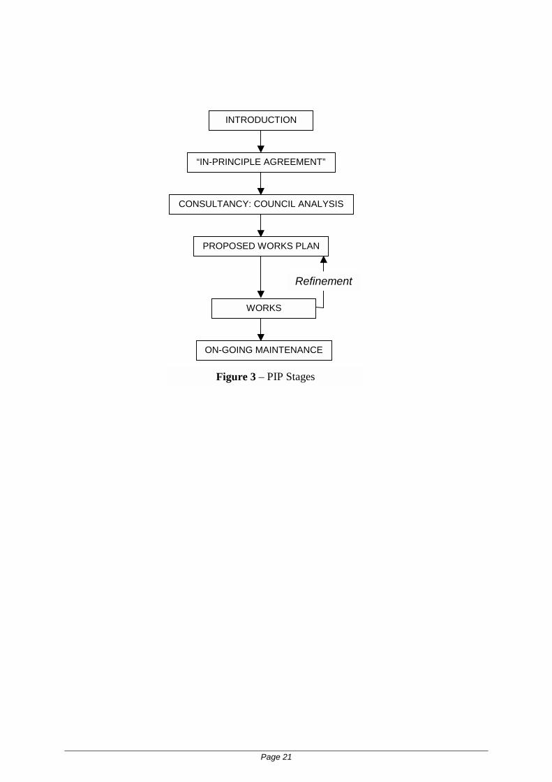
From the outset of PIP it was clear that effective communications between Land Victoria andthe 78 Local Governments in the State would be essential to the project’s success. A majorcommitment was made to face-to-face meetings in the first few months of the project,following up on a letter of introduction and a project ‘kit’ sent to each Council’s ChiefExecutive Officer. A formal presentation was made to every Local Government in the Statebetween July and December 1997. The objective of this step was to establish a key contact ineach Council and to seek Council’s ‘in-principle’ agreement to proceed to the next stage ofthe project (see Figure 3).
A dedicated project team was established in Land Victoria and as each Council came into theproject a ‘liaison’ officer from Land Victoria was assigned. As questions and issues began toemerge from the Councils about various aspects of the project, these were documented in‘Fact Sheets’ and a regular newsletter was established to aid communications. A dedicated e-mail address was also established for PIP. The high level of communication developed in thisintroductory period remains a feature of the project today.
The first few stages were designed to presentthe project as a very low-risk to Councils andto engender their support for PIP. By ‘gating’the project in this manner, particularly inseeking ‘in-principle’ agreement at a veryearly stage the objective was to gain seniorendorsement as well as to highlight andaddress any barriers or issues that a Councilmay have with the project.
In the third stage Land Victoria funded a brieffact-finding consultancy. This confidentialstudy was designed to identify the currentstatus of each Council with respect to its useof GIS and to try and ascertain its futuredirections. This analysis took between twodays and a week to perform. The outcome ofthe study demonstrated a number ofsignificant differences between LocalGovernments across the State beyond theobvious variations of geography, populationor land use. In particular, major differenceswere found in the knowledge andunderstanding of GIS technology and the
extent to which Local Government saw GIS being utilised in its future operations. Aninteresting example of these variations may be seen where Local Governments choose toorganisationally locate their GIS activities. Whilst most saw GIS as an extension of its ITdepartments, there appears to be a trend to establish ‘stand-alone’ GIS departments ascorporate units. The more traditional location of GIS activities was as an adjunct toengineering, planning or rating functions (refer to Figure 4).
INTRODUCTION
“IN-PRINCIPLE AGREEMENT”
CONSULTANCY: COUNCIL ANALYSIS
PROPOSED WORKS PLAN
WORKS
ON-GOING MAINTENANCE
Refinement
Figure 3 – PIP Stages

Page 11
The analysis stage resulted in an excellent understanding of the priorities and technicalcapability of each Council. This information was used to design a program of works. Themain focus of the works program was around the reconciliation of property and parcelinformation. This task to establish the property layer in the cadastral mapbase involvesautomatic matching of spatial records in the Council’s rating database with attributesavailable in the cadastral mapbase. This would usually generate a match rate of between 50%and 80%. Refined automatic matching and manual record reconciliation would follow. Theavailable funding typically enabled PIP to establish a 90% to 95% match rate at the end of thecontracted works stage. Data may remain unmatched for a number of reasons with theseunmatched records being identified as part of the PIP program and prioritised for furtherinvestigation. In many cases they may not be resolved without a title search or fieldexamination which may be scheduled as part of Council’s other activities or dealt with if andwhen they arose as part of on-going maintenance.
Data reconciliation was not the only task undertaken as part of the Works program. Otheractivities that were undertaken include the allocation of addresses to properties, theidentification of Crown land and its inclusion in Council’s rating database and theestablishment of processes to aid the on-going maintenance of the cadastral mapbase.
It was not unusual for there to be several iterations of the proposed Works program betweenLand Victoria and a Council. The final program also details the level of funding to beprovided by Land Victoria and indicates how the works are to be completed. In manyinstances, the works programs were tailored to compliment tasks already underway withinCouncil. In many cases, Councils indicated a preference to undertake aspects of the workthemselves. Alternatively, Land Victoria would tender the work to a panel of private sectorproviders especially established as part of PIP.
Importantly, at this point, all works and their funding are specified in a contract to beexecuted by the State and the Council. This agreement explicitly details each party’s tasksand responsibilities including the on-going supply of information from Council to LandVictoria and Land Victoria’s provision of the updated cadastral mapbase back to Council(schedules in the Contract specify formats, frequencies, etc). The term of the agreement wasthree years. A number of Councils expressed concern on this point and sought significantlylonger terms. In recognition of this, Land Victoria amended the agreement to a ‘rolling threeyear term’ to be renewed every 12 months.
IT36%
GIS28%
Engineering19%
Planning10%
Other7% Figure 4 –
Departmental location ofGIS units in LocalGovernment

Page 12
Progress to Date
The focus of the project in the first twelve months was clearly on the introductory stage with53 Councils agreeing ‘in-principle’ to enter PIP by June 1998 and all Councils agreeing byDecember 1998 (see Figure 5).
Contracts began being signed by Councils in the latter half of 1998 with 46 in place by theend of that year. Upon signing, funding to commence work on the agreed Works Programbecame available, which in turn led to reconciled property data being loaded into the cadastralmapbase, quality assured and finally a Council entering the on-going maintenance phase.
As at August 2000, a total of 71 Councils had entered formal contracts with Land Victoria, 58Councils had completed data reconciliation activities and 53 had entered the on-goingmaintenance phase.
Figure 5 – Progress of PIP – number of Local Governments reaching key milestones
Lessons Learnt
Local Government’s involvement in GIS and acceptance of the State’s previous geospatialstrategies has been mixed. Without legislative support requiring agencies to adopt the State’sgeospatial strategy, progress is dependent upon co-operation between participants based uponmutual advantage. Clearly, unless participants derive value or benefit from these initiativesthere will be limited involvement and a lack of commitment.
Benefits of PIP to Local Government
The diversity of Local Government in Victoria with respect to GIS approach andimplementation which has been highlighted in this paper also results in a mix of benefits forrespective Councils. Clearly there are direct benefits for Local Government in the project.The most obvious relate to licence fees, monetary assistance with data reconciliation and on-going maintenance of the cadastral mapbase.
Prior to the PIP initiative, Local Government was treated identically to any other prospectiveuser or licensee of the State’s cadastral mapbase. Licence fees for initial access were chargedand for an average sized Council these would be around US$30,000. Approximately one
16
53
78 78 78 78 78 78
21
46
56
6670 71
78
4
43
56
62
69 71
78
7
18
39
58
78
0
10
20
30
40
50
60
70
Dec 97 Jun 98 Dec 98 Jun 99 Dec 99 Jun 00 Dec 00 Jun 01
Loca
l Gov
ernm
ents
"in-principle" agreementPIP contract signedprogram of works underwayongoing maintenance
PIP Milestones

Page 13
third of the State’s Local Governments were not utilising the mapbase in any form – the initiallicence fees were a major barrier to entry for many users. But there was also a degree ofuncertainty amongst many Local Governments about the best way to introduce GIS. PIPprovided a structured and well supported approach that was seen by Councils as vendorindependent and a lower risk path to GIS implementation.
PIP also brought some capital funding to assist mostly in the data reconciliation stage whichresulted in the establishment of the property layer. Based upon agreed recommendations inthe Works program between US$10,000 and US$25,000 was made available to Councils forthese tasks. One of the Councils which has completed the reconciliation phase reported‘finding’ 400 land parcels which were not included in their property database, which whenamended generated an additional US$65,000 pa income for that particular Council (increasingtheir annual budget 3%).
Beyond the establishment phase and particularly for half of the State’s Local Governmentswhich were already involved in maintaining their own copy of the cadastral mapbase the mainbenefit is in free on-going maintenance. Comparisons are difficult between Councils forreasons already cited, however, one metropolitan Council reported to have had reduced thelabour allocated to cadastral maintenance by 30 hours per month following the introduction ofthe full PIP maintenance regime. If the experience of that Council was averaged acrossVictoria the potential saving in duplicated activity would be approximately 17 person yearspa. Given the higher degree of change in the urban compared with rural areas the projectteam believes the savings from duplicated effort would be around half of that figure, ie 8person years pa.
Numerous benefits were also identified during the consulting stage of PIP, which fall into thegeneral categories of administration, decision making, operations management and servicedelivery:
1. Administration
• rates information is more complete and accurate through correct identification of allproperties and land parcels within properly defined Council boundaries;
• costs of acquiring and maintaining high quality property information are minimal becauseof Land Victoria's entry assistance to Councils and on-going maintenance of integratedmap data;
• higher quality information creates possibilities for generating income through sellinginformation;
• improved staff productivity and customer satisfaction due to quick access to quality,electronic information;
• comprehensive, quality information provides protection against loss of staff with 'localknowledge';
• all properties within the municipality are allotted street addresses, benefiting a range ofCouncil and general services from emergency response to goods delivery;
• all Crown land within a municipality is correctly defined;• electronic, high quality map information provides consistent up-to-date maps across the
Council's operations;• electronic information minimises data duplication; and• contract management is made easier.

Page 14
2. Decision making
• produces better analysis of development applications; and• provides better response to potential business investors.
3. Operations management
• assists in asset management and planning;• facilitates better development of tourism areas;• helps environment management;• helps align open spaces with resident needs; and• assists in achieving statutory compliance (to AAS27 standard) for asset management and
strategic asset planning.
4. Service delivery
• quick access to quality, electronic information provides better responses to enquiries andimproved customer service;
• electronic information can create opportunities for council to provide remote access forinformation customers such as surveyors; and
• higher quality information helps identify and track service levels, boosting development ofcustomer service charters.
(Land Victoria 1997)
Additional Benefits of PIP to State Government
In addition to PIP providing the means to populate the State’s re-engineered cadastralmapbase and deliver a key component of Victoria’s SDI, there are numerous other benefits tothe State that are emerging. There are presently over 500 agencies and organisations usingthe State’s cadastral mapbase. Many of them have a critical need for up-to-date property data,including planners, valuers, estate agents and other land professionals. Perhaps the mostcritical users of all are the State’s emergency services (fire, police and ambulance) whichutilise address data in their computer aided dispatch system. Clearly all of these users willbenefit significantly from the current, secure, higher quality data generated through PIP.
By adopting a centralised data maintenance model in PIP, Land Victoria has also been able tosignificantly decrease the amount of duplicative maintenance activity that was occurringacross Local Government and ensure that an agreed standard of data quality is achieved (thereare currently only four Councils maintaining the mapbase by other means compared to 37 in1997 – see Figure 6).
Whilst PIP cannot claim to be the sole factor in introducing digital mapping and GIS to LocalGovernment in the last two years, it has been a significant contributor particularly in ruralVictoria where communities tend to be more sparse, widely dispersed and their localgovernments generally more poorly resourced. Also, these rural communities often need thespatial data for better land management and agri-business. This opportunity has proven to beof significant interest to the State’s growing geospatial information industry keen to providefurther value added services.

Page 15
0
10
20
30
40
50
60
Start of project 24 13 37 4Dec 00 7 3 4 71
Not Using Vicmap Property
Non-maintained
Use
Maintained by Others
Maintained by Land Victoria
To date, this paper has discussed the Property Information Project’s primary relationshipbetween Local Government and the State Government (Land Victoria). The successfulcompletion of the project and establishment of a fully maintained mapbase in conjunctionwith all Local Governments in the State provides an excellent opportunity to leverage PIP intoother areas and improve the flow of information to a wider group of stakeholders andinvestigate opportunities for broader scale process re-engineering.
Future Developments for the Property Information Project
The current forecasts for PIP plan to have signed agreements in place with all 78 Councils byFebruary 2000 and for all to have entered on-going maintenance by July 2001. This willremain the project’s highest priority, however, a number of other developments are beingpursued in parallel. By broadening the scope of PIP beyond the immediate relationshipbetween Local and State Government and mapping the information flows through the landdevelopment cycle it is clear that there are a number of other stakeholders that would benefitfrom a common geospatial infrastructure being established (see Figure 8).
These stakeholders include developers and survey consultants who frequently collect digitaldata as part of their operations but are then required under existing procedures to providehardcopy plans and forms to Local Government. There is a clear preference amongst surveyconsultants and Local Government for this information to move around digitally according toa standard. As a consequence PIP has identified a sub-project to establish a protocol for thetransfer of digital spatial data dealing with proposed plans of subdivision. It is proposed thatthis data, with Council’s approval, could be submitted directly to Land Victoria for inclusionin the cadastral mapbase (see Figure 3 – Step 3). Upon entering the data, Council and otherinterested parties, particularly referral authorities such as Water Boards and other utilities maybe advised electronically of the development significantly shortening the time involved inprocessing this information. A discussion paper on this subject is currently being developedby Land Victoria and progress can be monitored on our web site:http://www.land.vic.gov.au/SPEAR
Figure 6 –Change in LocalGovernment’sutilisation of thecadastral mapbase1997 to 2000

Ultimately, PIP represents a fundamental institutional arrangement from which to build thevision of a spatial data infrastructure that will properly support the complexity of decision-making demanded by the challenges that sustainable development poses for dialogue betweenevery level of community, private sector and government.
C
PIP Establishment StageA Master copy of the State’s Digital Cadastral MapbaseB Duplicate or ‘Mirror’ copy of the Cadastral Mapbase held by CouncilC Key Linkages (Council Property Number) exist between the mapbase and Council’s Property or
Rates Database
Information Flows1. Land Developers in conjunction with Surveyors prepare Proposed Plan of Subdivision2. Proposed Plan of Subdivision in Digital Form (geometry only)3. PPS is transferred electronically to Land Victoria for entry into the State’s Digital Cadastral
Mapbase4. Local Govt. is notified of the Development Application electronically5. Referral Authorities are notified of the Development Application electronically (mapbase
maintenance)6. Referral Authorities provide Local Government with input on the Development Application7. Local Govt. Certifies the Development Application for lodgement electronically at the Land Titles
Office8. Plan is Registered at the Land Titles Office and all interested parties are notified electronically9. Other users of the Geospatial Infrastructure monitor, or are advised as changes / transactions occur
LANDVICTORIA
LocalGovernment
2 way maintenance
Developers
Survey Consultants
Proposed Planof Subdivision
Digital Transfer
Mapbase Copies
ReferralAuthorities
Digital Transfer
Land TitlesOffice
Freehold (&Crown Land)
LAND VICTORIA
Registered Plan
Certified Plan - Lodged Digitally
Data Access / DistributionValue Add(Private Sector) Geospatial
InformationUsers GI Applications
RatesDatabase
MapbaseMirror
MapbaseMaster
8
5
7
6B
4
32
1
99
Mapbase Maintenance
Registered Plan Notification
A
Figure 7 – Property Information Project, Stakeholders and Information Flows
Page 16

Page 17
Conclusions
A significant number of the general trends in SDI development are reflected in the Victorianinitiatives towards developing a common spatial data infrastructure to better support publicand private sector activities.
Land Victoria has as one of its goals the achievement of a high quality Spatial DataInfrastructure for the State Government of Victoria. A major component of that infrastructureis the digital cadastral mapbase, which it has been consolidated and updated. Another majorcomponent is the property information data, which was dispersed among 78 LocalGovernment authorities. Over the last five years, Land Victoria has managed to ensure asingle custodian for the digital cadastral database and re-engineer its technical content andstructure through outsourcing. It has also, through the Property Information Project achievedmutual institutional co-operation with Local Government that in turn achieves a definitive,secure and reliable source of property information for the use of all Victorians.
The development of single custodianship has had significance from a technical perspective inthat this also paves the way for improved uniformity of standards of metadata, fundamentaldatasets, administrative policies as well as accessibility issues. Together, these aspects willform the foundations for the interoperability of datasets and the healthy growth of the spatialdata infrastructure.
Whilst much remains to be done (there is significant scope for improved processes to bedeveloped in related areas and the diversity of stakeholders expanded), the basis of theproject’s success will be the common SDI formed between State and Local Governmentthrough a continued cooperative partnership approach.
In the final analysis, the success of an initiative like PIP is essential to the establishment of aneffective spatial data infrastructure. Together with progressive legal and institutionalinfrastructure to assure equitable access, an effective spatial data infrastructure has thepotential to form an important supportive pillar for good governance and to facilitate theinformed dialogue that is necessary for sustainable development.
Acknowledgement
The authors wish to gratefully acknowledge the support of Land Victoria (LV) of theVictorian Government in the preparation of this article. The authors also acknowledge thesupport of the Australian Research Council (ARC) (Grants C19700324 and C49930403) insupporting the research mentioned in the paper and the assistance provided by their colleaguesat the Department of Geomatics, the University of Melbourne in the preparation of the paperhttp://www.geom.unimelb.edu.au/research/SDI_research/ . However, the views expressed inthe paper are those of the authors and do not necessarily reflect the views of LV and the ARC.
References
ABS (1999). Pocket Year Book of Australia. Canberra: Australian Bureau of Statistics.
AUSLIG (2000). Australian Spatial Data Infrastructure <http://www.auslig.gov.au/asdi/> (12August, 2000).

Page 18
Coleman, D. J. and McLaughlin, J. (1998). “Defining global geospatial data infrastructure(GGDI): Components, stakeholders and interfaces.” Geomatica Vol. 52, No. 2, pp. 129-43.
Federal Geographic Data Committee (2000). Federal Geographic Data Committee<http://www.fgdc.gov/> (3 August 2000).
Mooney, J. D. and Grant, D. M. (1997) The Australian Spatial Data Infrastructure. InFramework of the World, edited by D. Rhind. (Cambridge: GeoInformation International), pp.187-201.
Land Victoria (1997). Property Information Project Fact Sheet No 1. Land Victoria,Department of Natural Resources and Environment.
Land Victoria (1999). Victorian Geospatial Information Strategy 2000-2003. Land Victoria,Department of Natural Resources and Environment.
Masser, I. (1998). An International Overview of Geospatial Information Infrastructures:Lessons to be Learnt for the NGDF<http://www.ngdf.org.uk/Pubdocs/General/mass7.98.htm> (14 August 2000).
OGDC (1993a). GIS Strategy Report 1993, State Government of Victoria StrategicFramework for GIS Development. Victoria, Australia: Tomlinson Associates Ltd - Office ofGeographic Data Coordination, Department of Treasury and Finance.
OGDC (1993b). Report No 2, GIS Planning - Land Status and Assets Management, StateGovernment of Victoria Strategic Framework for GIS Development. Victoria, Australia:Tomlinson Associates Ltd - Office of Geographic Data Coordination, Department of Treasuryand Finance.
Onsrud, H. J. (1998). A global survey of national spatial data infrastructure activities<http://www.spatial.maine.edu/~onsrud/gsdi/surveysum.htm> (2 August, 2000).
Rajabifard, A., Williamson, I., et al. (2000). From local to global SDI initiatives: a pyramid tobuilding blocks. 4th Global Spatial Data Infrastructure Conference, Cape Town, South Africa.
Tosta, N. (1997). Building national spatial data infrastructures: Roles and Responsibilities<http://www.gisqatar.org.qa/conf97/links/g1.html> (17 February, 1999).
Suwarnarat, K., Karuppannan, S., Haider, W., Yaqub, H.W., Escobar, F.E., Bishop, I., Yates,P.M. and Williamson, I.P., 2000. Spatial Data Infrastructures for Cities in DevelopingCountries: Lessons from the Bangkok Experience, Cities. 17(2) 85-96.
Williamson, I. P., Chan, T. O., and Effenberg, W. W. (1998) Development of spatial datainfrastructures - lessons learned from the Australian digital cadastral databases. Geomatica,52(2), 177-187.

Page 19
Land rights, interests
& easements
Mapping & survey
information
Health &Hospitals
Click here!
Provider #3
Click here!
Provider #2
Click here!
Provider #1
T itleT itleT itleT itle
Ownership & occupant details
Auctions /Land Sales
& Valuations
Transport / Infrastructure
Council Rates& other
information
Planning zones & restrictions
Crime Statistics
Education /Schools
Things wehaven’t yetthought of...
?
Natural Resources
Environmental Information
Figure 1 – Schematic of Land Victoria’s ‘Point and Click’ Vision

Page 20
PROPERTY INFORMATION• Street Address• Council Property Number
PARCEL INFORMATION• Lot / Plan Number• Crown Land or Freehold Land
Figure 2 – Parcel & Property Information
Page 21
INTRODUCTION
“IN-PRINCIPLE AGREEMENT”
CONSULTANCY: COUNCIL ANALYSIS
PROPOSED WORKS PLAN
WORKS
ON-GOING MAINTENANCE
Refinement
Figure 3 – PIP Stages

Page 22
IT36%
GIS28%
Engineering19%
Planning10%
Other7%
Figure 4 – Departmental location of GIS units in Local Government

Page 23
Figure 5 – Progress of PIP – number of Local Governments reaching key milestones
16
53
78 78 78 78 78 78
21
46
56
6670 71
78
4
43
56
62
69 71
78
7
18
39
58
78
0
10
20
30
40
50
60
70
Dec 97 Jun 98 Dec 98 Jun 99 Dec 99 Jun 00 Dec 00 Jun 01
Loca
l Gov
ernm
ents
"in-principle" agreementPIP contract signedprogram of works underwayongoing maintenance
PIPMilestones

Page 24
0
10
20
30
40
50
60
Start of project 24 13 37 4Dec 00 7 3 4 71
Not Using Vicmap Property
Non-maintained
Use
Maintained by Others
Maintained by Land Victoria
Figure 6 – Change in Local Government’s utilisation of the cadastral mapbase 1997 to 2000

C
Page 25
Figure 7 – Property Information Project, Stakeholders and Information Flows
PIP Establishment StageA Master copy of the State’s Digital Cadastral MapbaseB Duplicate or ‘Mirror’ copy of the Cadastral Mapbase held by CouncilC Key Linkages (Council Property Number) exist between the mapbase and Council’s Property or
Rates Database
Information Flows10. Land Developers in conjunction with Surveyors prepare Proposed Plan of Subdivision11. Proposed Plan of Subdivision in Digital Form (geometry only)12. PPS is transferred electronically to Land Victoria for entry into the State’s Digital Cadastral
Mapbase13. Local Govt. is notified of the Development Application electronically14. Referral Authorities are notified of the Development Application electronically (mapbase
maintenance)15. Referral Authorities provide Local Government with input on the Development Application16. Local Govt. Certifies the Development Application for lodgement electronically at the Land Titles
Office17. Plan is Registered at the Land Titles Office and all interested parties are notified electronically18. Other users of the Geospatial Infrastructure monitor, or are advised as changes / transactions occur
LANDVICTORIA
LocalGovernment
2 way maintenance
Developers
Survey Consultants
Proposed Planof Subdivision
Digital Transfer
Mapbase Copies
ReferralAuthorities
Digital Transfer
Land TitlesOffice
Freehold (&Crown Land)
LAND VICTORIA
Registered Plan
Certified Plan - Lodged Digitally
Data Access / DistributionValue Add(Private Sector) Geospatial
InformationUsers GI Applications
RatesDatabase
MapbaseMirror
MapbaseMaster
8
5
7
6B
4
32
1
99
Mapbase Maintenance
Registered Plan Notification
A
Copyright © 2022 FDOKUMEN


![Successful weight loss maintenance in Portugal and in the USA: comparing results from two National Registries [portuguese]](https://static.fdokumen.com/doc/165x107/63311274f4e961c184054d3d/successful-weight-loss-maintenance-in-portugal-and-in-the-usa-comparing-results.jpg)