Achaemenid Sattagydia and the geography of Vivana's campaign (DB III, 54-75)
13
. .... ··- "'-' .· ·- ..... -.,,,.-- .. · ....... . _ ... __ .. -- - ·-- ·-· ·-· ... .. · OF THE ·-·· ROYAL ASIATIC SOCIETY . OF GREAT BRITAIN & IRELAND PUBLISHED· BY THE RO-YAL ASIATIC SOCIETY OF a RE • .\°T BRIT'l .iN Ii IREL A N·D-, wi TH WHICH-· is I NCO. RPORATED · THE - SOCIETY- OF ltlBLICA1. - ARCH..£- oLOGY--- - " -- - -·- No. 2 ··· f 982
-
Upload
independent -
Category
Documents
-
view
4 -
download
0
Transcript of Achaemenid Sattagydia and the geography of Vivana's campaign (DB III, 54-75)

. ~. -- .... ··-"'-' . · ·- ..... -.,,,.-- ·~---.. .. · ....... . _ ... __ . . -- ~-.. - ·--·-· ·-· ... .. ·
JOURNAL ~-
OF THE ·-··
ROYAL ASIATIC SOCIETY . OF GREAT BRITAIN & IRELAND
PUBLISHED· BY THE RO-YAL ASIATIC SOCIETY OF
a RE • .\°T BRIT'l.iN Ii IREL AN·D-, wiTH WHICH-·is I NCO.RPORATED
·THE- SOCIETY- OF ltlBLICA1.- ARCH..£-oLOGY-- - - "-- - -·- ~--
No. 2··· f 982
... -· ----· -'* 0 .c.:-3-.-
--
CONTENTS.
NOTES .... ... . ... · ..•.. .
- . - ...... ....,,___ .. -·· .•o.~....,,. .,.. -~-~ .. -=
PAGE 99
FLEMING, DAVID: Achaemenid Sattagydia and the geography of Vivana's campaigns (DB III, 54-75) . . . . . . . . . . . . . . . . . . . . . . . . . . . . . . . . . . . 102
GUTAS, DIMITRI: The present state, and future tasks, of Graeco-Arabic studies: remarks apropos H. Daiber's Aetius A~abus . . . . . . . . . . . . . . . . . 113
MORGAN, D. 0 .: Who ran the Mongol Empire? . · . . . . . • . . . . • • . . 124
MOCHIRI, MALEK IRADJ: A Sasanian-type coin of ,Xazid b. Mu'awia - . . . . . . 137
BAILEY, H. W.: Two Kharo~ihI inscriptions ...• .. .. : .. · . 149 .
. . - . . COWAN, H.K. J. : Th_e ~chehnese san1a' and the Thai kl_:?_:n p~t . ... .. .. . _ . .. . . 156
REVIEWS OF BOOKS (See Annual Index)
ANNIVERSARY MEEJ:ING ~ , .• . ..
"'"=~_,. ANNUAL" INDEX
-----~-~----,,_- ...._--0• --- ---·· __,,_ . __________ ..,. _____ -~
LIST OF FELLOWS .. . . . • .
16.1 .. - . . - ·--
177
238
.. ---.. ----,,..~------>- ------· -~ . . •. . . at end
-r- •r '"#-:---• r --~ , ,_._ ~-.....-...-. - ---.-- .. .-, ·--·~- - --~
~-
. .f
ACHAEMENID SATTAGYDIA AND THE GEOGRAPHY OF VIVANA'S CAMPAIGN (DB III, 54-75)
By DAVID FLEMING
Much of the work that is attempted in the field of early Iranian historical geography is by necessity hypothetical, since there are no explicit descriptions of the spatial nature of political control in Iran before the accounts of Greek writers of the 5th century B.C. and later. The actual geography of Iran is however so precisely delimited that careful study of available accounts, when linked with a knowledge of the local topography of any area under investigation, will allow the student to suggest reconstructions for the scenes of various actions. In this case, I shall propose a possible geographical framework for a sequence.of events that is recorded in the inscription of Darius I at Behistun, and which has not been satisfactorily localized before. Tentative as it is, the reconstruction seems to clarify a passage that dealt with events of the greatest importance for subsequent Achaemenid history.
There are problems in the location of the Achaemerud provinces, since the earliest record (the inscription of Darius I at Behistun)1 does not describe the geography of the campaigns conducted by Darius between 522 B.C. and 521 B.C., merely the sequence of events. The geographical mentions in the Elamite texts from Persepolis2 are similarly vague, since they mention the names. of places as. destinations or centres without saying where they were. Obviously, at the time it was not felt necessary to clarify such statements, since the general locations must have been well known to those concerned. Most of the regions named as provinces of the Achaemenid empire have now been located, either by reference to Greek writers or by the survival of the earlier name into later periods (for example, the Old Persian [OP] names Suguda and Uviirazmiy from Central Asia became the classical Sogdia and Chorasmia and the Arabic Sughd and Khwiirazm; or Gandara and Hindu§ the later Gandhara and Sind, now in Pakistan). The province of Sattagydia has however defied precise location, and has floated uneasily between two small areas of hills and valleys, one in modern Afghanistan, and the other in modern Pakistan. In each case the impression one has is that the locations have been made faute de mieux; but arguments may now be advanced for preferring the Pakistan to the Afghan location.
Sat~agydia, OP E>atagu~, Elamite h.Sattala.d, Babylonian KUR Sattagil, is an area not much mentioned in the ancient records, but was already part of the Achaemenid empire at the time of the seizure of the throne by Darius, since it is mentioned in the Behistun inscription (DB) both as part of the empire3 and as one of the lands that revolted at the news of his accession.4 Its reconquest by pro-Darian forces is not mentioned either in the OP text or the Elamite, but it is indirectly mentioned in the Babylonian version DB/Bab 84. 5 There Darius

GEOGRAPHY OF VIV ANA'S. CAMPAIGN (DB III, 54-75) 103
ends an account of the campaign of his Arachosian satrap Vivana with the words Sa anaku ina KUR Sattagu u KUR Aruhatti epuSu "which I did in Sattagydia and Arachosia". The subsequent mentions in Achaemenid documents of Sattagydia are confined to the imperial lists of Darius I and his son Xerxes;6
the labels attached to the throne-bearers on the tomb of Darius I at Naqsh-i Rustam;7 and the kneeling figure on the statue of Darius I in Egyptian style that was found at Susa.8 Apparently the Sattagydians were not represented on the Apadana frieze at Persepolis ,9 so that the only representations are the Naqsh-i Rustam tomb and the statue of Darius I.
Each of these representations shows (the Naqsh-i Rustam relief clearly, the Darius statue rather less so) that the Sattagydian was dressed in the same manner as the Gandaran,10 the Indian,11 and the Makan12 from the shores of the Indian Ocean, each of whom was definitely a citizen of the empire's south-eastern quarter. The costume consisted of a loincloth, and in the Naqsh-i Rustam reliefs the Sattagydian wore a sword over his shoulder. The inference that is drawn from this is that the Sattagydians, as known to the Achaemenid sculptors, were closely connected with the other three peoples of the hot, arid lands of the western Indus and the coast of the Indian Ocean. One should therefore seek to locate Sattagydia somewhere along the Indus river, or perhaps in Baluchistan.
The Sattagydians (Greek ~arra')Vocu) were mentioned by Herodotus (III, 91) as members of the 14th taxation district, grouped with the Gandarans, Dadykai, and Aparytai, and paying the very modest tribute of 170 talents a year. They are not mentioned as part of the army of Xerxes at Doriscus, 13 and by the time that Strabo compiled his geography with information from Eratosthenes. (3rd century B.C.), Sattagydia was no longer noticed between the Hindu Kush and the Indus river. 14 The land is not mentioned in the accounts of the conquests of Alexander in the east, and seems either to have disappeared, or to have been completely absorbed by another district.
It is certain that the Sattagydians were a south-eastern people, as. revealed by the tomb reliefs and the Darius statue, and one may also be sure that theirs was not a particularly prosperous area, since they were joined with three other groups in a very small tribute region. One may further as.sume, on the basis of the evidence already mentioned, that they were closely connected with Gandhara, the area of the lower Kabul river valley around the ancient city of Pushkalavati (modern Chlirsada, to the north-east of Peshawar in Pakistan).15
Two locations for the Sattagydians have been proposed: the first is the area of the confluence of the Ghorband and Panjshir rivers in Afghanistan, and perhaps to the west; whilst the second is the area of the middle Indus, around the modern city of Bannu (seen. 29, below).16
The location in the central mountains of Afghanistan was first proposed by Marquart, 17 who placed Sattagydia in the Kiih-i Blibli and upper Helm and region
104 GEOGRAPHY OF VIVANA'S CAMPAIGN (DB III, 54-75)
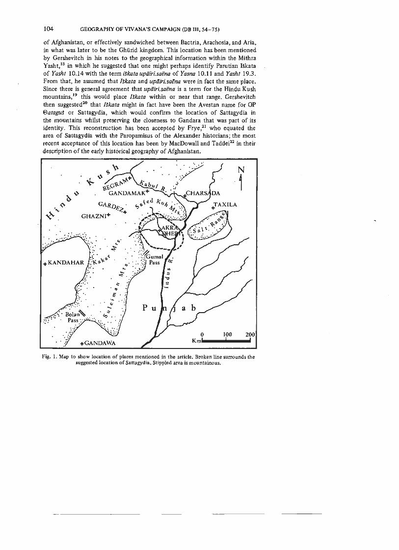
of Afghanistan, or effectively sandwiched between Bactria, Arachosia, and Aria, in what was later to be the Ghiirid kingdom. This location has been mentioned by Gershevitch in his notes to the geographical information within the Mithra Yasht, 18 in which he suggested that one might perhaps identify Parutian !Skata of Yasht 10.14 with the term Wcata upiiiri.saena of Yasna 10.11 and Yasht 19.3 . From that, he assumed that Ukata and upiiiri.sai!na were in fact the same place. Since there is general agreement that upiiiri.sai!na is a term for the Hindu Kush mountains,19 this would place Ukata within or near that range. Gershevitch then suggested20 that /Skata might in fact have been the Avestan name for OP 8ataguS or Sattagydia, which would · confirm the location of Sattagydia in the mountains whilst pres.erving the closeness to Gandara that was part of its identity. This reconstruction has been accepted by Frye,21 who equated the area of Sattagydia with the Paropamisus of the Alexander historians; the most recent acceptance of this location has been by MacDowall and Taddei22 in their description of the early historical geography of Afghanistan.
·7··.·· .. . .. . ....
N
,· 1
0 100 200
+GANDAWA
Km._ _____ _
Fig. 1. Map to show location of places mentioned in the article. Broken line surrounds the suggested location of Sattagydia. Stippled area is mountainous.

GEOGRAPHY OF VIV ANA'S CAMPAIGN (DB 111, 54-75) 105
There is however much evidence against this particular reconstruction. On practical grounds it is very unlikely that Sattagydia could have been in the Hindu Kush, since the only representations of the inhabitants23 show them virtually naked, while Bactrians, Arachosians, and Arians were all heavily muffled in the trousers, turbans, and long-sleeved and skirted coats24 appropriate to the inhabitants of at least the foothills of the mountains of central Afghanistan. Rather, the garments of the Sattagydians were better suited to the low hot lands inhabited by the Indians, Makans, and Gandarans.
0°n historical grounds it is incorrect to assume with Frye25 that Sattagydia was the land known to the Achaemenid empire as Parauparasaena or the Paropamisus. In the texts of DB there is a clear demonstration that Parauparasaena and Sattagydia were separate,26 and that the Parauparasaena of the Babylonian version was the Gandara of the OP version,27 so that Sattagydia and the Paropamisus cannot be identified.
An altogether more attractive location for Sattagydia is in the region of the middle Indus. This would make the clothing of the Sattagydians more plausible, whilst preserving the close relationship with the Gandarans. Herzfeld proposed that Sattagydia should be located in the Punjab,28 although his reasons for this were purely linguistic - and perhaps not correct. Schmidt marked his map of the Achaemenid empire29 to show the Sattagydians west of the middle Indus, but made no further comments. Excavations at Tulamba, near Multan,30 have
· shown that the material culture at least of the I st millennium B.C. on the eastern side of the Indus bore no rel_ation to the cultures further west;31 so that the Achaemenid provinces in that region were most probably confined at the minimum to the western side of the river.
One is left with only one suitable area, that of the basin around Bannu, to the north of the modern city of Dera Ismail Khan on the middle Indus. There is here a small basin which extends from the Suleiman mountains in the west to the Indus river in the east, and which is crossed by the Tochi and Kurram rivers. The boundaries may have extended across the Indus as far east as the Jhelum river south of the Salt Range, and then the Chenab river after its junction with the Jhelum, but this region is the Thal desert and was probably not inhabited in antiquity.32 The ancient capital of this area has not been identified with any certainty, but survey work in the Bannu basin has revealed only one site that is a likely candidate, that of Akra Dheri.33 This site is the traditional centre of the Bannu area, 34 and is linked with pre-Islamic legends of the Iranian heroes of the Shiihniima. 35 It stands near both the Kurram and Tochi rivers, and four great routes from the Indus region to the west pass close by, on their ways to the Khyber, Kurram, Gumal, and Bolan passes36 and thence to Ghazni, Gardez, and Kandahar. The site has a huge citadel mound very like that of Kandahar, where recent excavations have yielded Achaemenid material;37 whilst surface collections at Akra Dheri have included In do-Greek and Kushan coins. 38

l 06 GEOGRAPHY OF VIV ANA'S CAMPAIGN (DB IH, 54-75)
Stein identified the site as the only likely location for the capital of the Bannu area: an assumption that was based partly on his own observations and partly on the testimony of the Chinese travellers Fa-hsien and Hsiian-tsang, who left detailed descriptions of their pilgrimages to India in the 5th and 7th centuries A.D., and both of whom passed through the Bannu area. This would, when linked to its location, make it an attractive candidate for an Achaemenid regional capital.
Such a location for Sattagydia on the western side of the middle Indus, but still contiguous with the areas of Gandara and Arachosia, will shed more 1ight on the conduct of the campaign against the lieutenant of Vahyazdata that was led by Vivana, satrap of Arachosia, in the year of warfare that accompanied the seizure of the throne by Darius in 522 B.C. As Toynbee has pointed out,39
the campaign of Vahyazdata of Yautiya was the most dangerous threat that Darius faced in his war, and the adherence of the satrap Vivana to Darius a vital factor in the eventual success of the Darian faction. Vivana had to fight three separate battles in order to defeat the rebels completely, a fact that makes clear that the struggle between these two factions was both bitter and evenlybalanced. Now, although Sattagydia revolted when Darius made his claim, it was subdued40 and retained; this is important when considering the geography of the campaign. The Babylonian text of DB recorded that, of the three battles that the satrap Vivana had to fight to defeat the rebels, the first and third (at KapiSakaniS41 and at ArSada42
) were in the province of Arachosia, but that the second battle was at Gandatamaki (OP Gadutava43 and Elamite Kandumaka44
),
which is not given a location in the OP text, is stated to have been in Sattagydia in the Babylonian version,45 and in the Elamite version is said to have been in Arachosia.46 Herzfeld located this place at Gandawa, south of Quetta in Baluchistan,47 whilst Von Voigtlander has advanced the suggestion that it could have been the place in eastern Afghanistan now known as Gandamak.48 Both scholars have of course relied upon resemblances between ancient and modern names that have not been corroborated by local or textual evidence, and are therefore of limited authority. Of the two theories, that of Herzfeld is virtually impossible, since it involves some remarkable geographical contortions, and that of Von Voigtlander is hardly more plausible, despite its initial attractiveness. For Herzfeld's proposal to have been correct would have involved two armies in a chase over the whole of eastern and southern Afghanistan in the winter, whilst Von Voigtlander's proposal requires that the two rival armies sat more or less still for two months, which, given the apparent ferocity of the campaign, would seem unlikely.
The first battle fought between the loyal satrap Vivana and the forces of Vahyazdata's lieutenant was at KapiSakaniS on 29 December 522 B.C;49 the site is described in the Babylonian and Elamite versions of DB as having been "in Arachosia". 50 The majority of scholars place this site at or near Begram in

GEOGRAPHY OF VIV ANA'S CAMPAIGN (DB III, 54-75) 107
north-eastern Afghanistan, at the junction of the Ghorband and Panjshir rivers and about 50 kilometres north of modern Kabul.st This opinion is based on Pliny's mention of the destruction of Capisa in Capisene by Cyrus the Great.s2
Although this extension of Arachosia so far north into Afghanistan contradicts the apparent location of at least part of the satrapy of Gandara or Parauparasaena in the southern foothills of the Hindu Kush, it is clear that ancient ideas of the geography of the area were not uniform.s3 Bernard has advanced a suggestion54
that in fact the Capisa destroyed by Cyrus was the Old City at Kandahar, which is stated to be "not unattractive" by Fraserss and would certainly place Capisa/ KapiSakaniS in the Achaemenid province of Arachosia; but against this it must be pointed out that the excavations through the fortification walls of Old Kandahar did not yield any evidence of a sack in the very early phases of the site's history. Nor, it should be said, did the excavations at Begram56 produce evidence of a destruction by external forces. On the other hand, at Begram so far as revealed by the excavations, there was no evidence of occupation before the 3rd century B.C. The implication may be that an earlier settlement was simply not found by the excavators, and leaves open the question of 6th-century. B.C. occupation in the region of 6egram. Certainly, in the light of the scheme here proposed, it is more plausible to have the initial encounter between the forces of Vivana and of Vahyazdata's lieutenant in the general region of the Kah-i Daman.
The second battle between the rival forces was fought on 21 February 521 B.C. s7 at Gadutava. One must first consider the plausibili~y of the two locations of Gadutava proposed by Herzfeld and by Von Voigtlander. Herzfeld proposed to locate Gadutava at or near the modern town of Gandawa, to the south of Quetta, but this location is plainly impossible for two reasons, the first geographical and the second chronological. In geographical terms a location of Gadutava in Sattagydia at Gandawa in Baluchistan would have required that Vahyazdata's lieutenant escape from his first battle at KapiSakaniS (irrespective of whether it was in modern Capisa or at modern Kandahar) by travelling through the Bolan pass whilst pursued by the forces of Vivana, and then doubling back into the satrapy of Arachosia for the third battle over the same route following the second battle with Vivana. It is extremely unlikely that Vivana would have left the Bolan pass unguarded behind his own forces, and just as unlikely that Vahyazdata's lieutenant would have sought to fight his way back through the pass if defeated by Vivana, when he could have escaped into the Indian sub-continent. There is only the word of Darius in DB to say that Vivana was winning, but were he losing to the Vah.yazdatan forces the Herzfeld proposal would make even less sense. In chronological terms Herzfeld 's proposal is also untenable, as the passes would probably have been snow-bound, which would have made the troop movements much less easy.s8 From the Kuh-i Daman valley to Gandawa is no less than 800 kilometres across at least

108 GEOGRAPHY OF VIV ANA'S CAMPAIGN (DB III, 54-75)
two mountainous areas, whatever the route; we do not know the sizes. of the forces involved, but the problems of moving large bodies of men and animals through unfriendly terrain in the winter when fodder would have been very scarce would seem to preclude this particular alternative. A location of the city of KapiSakaniS at Old Kandahar would do nothing to resolve the problem of the passage of the Bolan pass by the two armies, and can be discounted.
The proposal made by Von Voigtlander59 that ancient Gadutava may be the modern town of Gandamak east of Kabul is more tempting, although it poses a chronological problem that is the reverse of that raised by Herzfeld's proposal, since Gandamak is at most 150 kilometres, over reasonably easy country, from the Kuh-i Daman valley. Just as it is hard to imagine the two rival armies marching the 800 or so kilometres through the winter from the first to the second battle as Herzfeld contends, so it is difficult to envisage the two rivals taking two months to encounter one another after the first engagement, if all the ground that they had to cover could have been crossed in two or three weeks. In addition, the placing of Gadutava in the vicinity of Kabul would fix Sattagydia there, which as noted above would not be possible in view of the general consensus that the Kabul river valley for the whole of its length was part of Gandara.60
If, however, one accepts the location of Sattagydia in the Bannu basin, the pattern of the whole campaign becomes clearer. The first battle took place in the Kuh-i Daman valley north of Kabul, to which Vahyazdata's lieutenant may indeed have come from the region of the rebellious satrapy of Sattagydia (for all one knows, the lieutenant may have been the satrap of Sattagydia). On being defeated by Vivana, the lieutenant escaped with his forces through the snow over the passes to the Bannu basin, where he might have counted on help from the Sattagydians. Vivana followed as quickly as the weather would allow, since he realised that whilst the presence of a rebel army in a second rebel state was doubly dangerous, the defeat of that army would probably bring the state to heel and thereby serve two purposes with one action.61 The second battle took place therefore somewhere in the Bannu basin; the remnants of the forces of Vahyazdata's lieutenant then sought to escape westwards, probably across the Gumal pass, and thence back to Vahyazdata's homeland of Yautiya in southern Iran.62 The only practicable route would take them past the fortress of Old Kandahar; whether this fortress was63 or was not64 the site of Arsada (the location of the third and last battle between the two forces) is not important for this reconstruction. Both Kandahar, however named, and ArSada were in Arachosia.65
It will be seen that this proposed location of Sattagydia allows what is in my opinion the least implausible reconstruction of the actions of Vivana and Vahyazdata's lieutenant in 522-1 B.C. It is a pity there is no record whether Darius suitably rewarded the man who had prevented the splitting of the

GEOGRAPHY OF VIV ANA'S CAMPAIGN (DB III, 54-75) 109
eastern empire, and preserved for the Achaemenids the conduit through which the wealth of the Indian sub-continent was to flow to western Asia. ·
A final question here is the disparity between the Babylonian account on one hand and the Elamite on the other. The former put Gadutava in Sattagydia, while the latter put it in Arachosia. This discrepancy in texts that in all other respects match, and were apparently intended to , could have been due to the earlier use of Elarnite as the language of record-keeping in the Achaemenid empire. Insofar as is known, the records of the Achaemenid administration from before the conquest of Babylon in 539 B.C. were kept in Elamite, since this was the only written language available to the court of Cyrus II (the Great) before that date.66 To this pre-539 B.C. period are ascribed the eastern conquests of Cyrus II, although there is very little evidence on which to base this belief.67
If records were compiled of the pre-539 B.C. conquests of the eastern portions of the empire, as gazetteers for the central civil service, the names and locations would naturally have been stored in the Elamite archives. Any conquests or modification subsequent to 539 B.C. would probably have been recorded in the simpler Babylonian or Aramaic, so that more recent information of political geography in the east would have been found in either the Babylonian archives or the Aramaic libraries. These repositories could not have had Achaemenid material as early as that of the Elamite archives, so that even the earlier Babylonian texts would have modified the information held in the older Elamite records. Thus, when geographical information and detail was sought for the different versions of the DB inscription, the Elamite could have been compiled from records composed mainly before 539 B.C., whilst the Babylonian would have had access to more recent information from the Babylonian archives. The OP text was the last of the three to be compiled and carved, and was probably an abridged rendering of the Elamite;68 as OP was not an administrative language, it had no archives to fall back on.
This suggestion, that the use of Elamite dated from before the conquest of Babylon, and that the use of Babylonian came after, implies that Sattagydia was made part of the empire after that conquest. If Gadutava were known at all in the pre-539 B.C. empire, it must have been on the very eastern fringe of Arachosia, and consequently recorded as such. That would explain its inclusion in Arachosia, rather than Sattagydia, in the Elamite text of the Behistun inscription.
NOTES
1 The major edition of the Old Persian (OP) text of the Behistun inscription is that of R. G. Kent , Old Persian: grammar, texts, lexicon, second edition, New Haven, 1953, 116-35. The Elamite text has been published by L. W. King and R. C. Thompson, The sculptures and inscriptions of Darius the Great on the rock of Behistun in Persia, London, 1907, and by S. H. Weissbach , Die Keilinschriften der Achiimeniden , Leipzig, 1911

llO GEOGRAPHY OF VIV ANA'S CAMPAIGN (DB Ill, 54-75)
(reprinted Leipzig, 1968). There are important comments on parts of the Elamite text by G. G. Cameron, 'The Elamite version of the Behistun inscription", Journal of Cuneiform Studies, XIV, 1960, 59-68. The definitive version of the Babylonian text is now that of Elizabeth von Voigtlander, The Bisitun inscription of Darius the Great: Babylonian version, London, 1978 (Corpus Inscriptionum Iranicarum, Pt. I, Vol. II, Texts I).
In the notes below, the abbreviation DB + column and line-number refers to the OP version of the text, while DB/Bab + line-number refers to Von Voigtlander, and DB/El+ section and line-number to King and Thompson. Following Kent, names from the OP texts are printed without the use of diacritics.
2 G. G. Cameron, Persepolis Treasury Tablets, Chicago, 1948; R. T. Hallock, Persepolis fortification tablets, Chicago, 1969; idem, "Selected fortification texts", Cahiers de la Delegation Archeologique Fran<;aise en Iran, VIII, 1978, 109-36.
3 DB I, 16-17; DB/Bab 6; DB/El 1.14. 4 DB II, 7-8;DB/Bab 4l;DB/El 2.3. 5 Von Voigtlander, 37 and 59. •DB, DNa, DSe, DPe and XPh, cf. Kent, Old Persian. 'G. Walser, Die Volkerschaften aufden Reliefs von Persepolis, Berlin, 1966 . Falttafel 1
at end of the volume for the Naqsh-i Rustam tomb reliefs. • M. D. Roaf, 'The subject peoples on the base of the statue of Darius", Cahiers DAFI,
IV, 73-160 . For the Sattagydian seep. 116, carved figure 10. •Walser, Volkerschaften, 89 (Herzfeld having abandoned his identification with
Delegation XIV); E. F. Schmidt,Persepolis I, Chicago, 1953. '°Walser, Vi5lkerschaften, Falttafel 1.12. 11 Walser, Volkerschaften, Falttafel 1.13; Roaf, 145, no. 24. 12 Walser, Volkerschaften, Falttafel 1.29; Roaf, 144, no. 23. 13 Herodotus, VII, 67-70. 14 Strabo, XV, 2, 9. 15 Sir Mortimer Wheeler, Charsada: a metropolis of the North· West Frontier , London,
1962; The opening chapter contains a review of the evidence identifying this site with the ancient Pushkalavati.
16 Other locations that might be proposed for Sattagydia, simply from a consideration of the map, are (i) Taxila-Bhir Mound; (ii) the region round Sibi in Baluchistan; or (iii) the Gardez region in eastern Afghanistan. There are objections to each of these. Taxila (for which the fullest account is that of the excavator, J. Marshall, Taxiliz, 3 vols., Cambridge, 1951) was far too large and rich, even in the late 6th and early 5th centuries B.C., to have been paying only a portion of the meagre annual tribute of 170 talents that Herodotus mentions for Sattagydia. Whether Taxila was part of the fabulously rich satrapy of Hi"dus is outside this enquiry, although it is noteworthy that whilst "Indians" fought against Alexander at Gaugamela as Achaemenid troops under the satrap Barsaentes, the various rulers of the Punjab and the middle Indus seem to have opposed Alexander more as independent chiefs, rather than as agents of any imperial state. I think that if Taxila ever was part of the Achaemenid empire, it was a loose subjection that did not take the form of the standard satrapy; in my opinion, the traditional location of Hi"dus in the region of Sind stands, and the enormous annual tribute of 360 talents of gold dust was the result of transit trade from the centre of India. The Sibi region is poor, but too far south of Gandara; it was, in a later century at least, under the control of the satrap of Arachosia (Arrian, Anabasis, III, 8; Quintus Curtius, IX, 7, 14). The Gardezregion of eastern Afghanistan is too high to have allowed the scanty clothing shown in the reliefs to have been worn with any degree of comfort.
17 J. Marquart, Untersuchungen zur Geschichte von Eran, Heft II, Leipzig, 1905, 175. 18 I. Gershevitch, The Avestan hymn to Mithra, London, 1959, 174-5. Although
Gershevitch was concerned with linguistic, rather than geographical, arguments, he does identify a particular geographical locality for Avestan !Skata = OP Sattagydia, which was that proposed by Marquart. Even if !Skata was Sattagydia, the location in the Hindu Kush is invalidated by the evidence of the clothing in the sculpted reliefs, and the extreme difficulty of reconciling a location in the central part of the Hindu Kush with any plausible reconstruction of Vivana's campaign.

GEOGRAPHY OF VIV ANA'S CAMPAIGN (DB III, 54-7 5) 111
19 Marquart, 73-4. 20 TheAvestan hymn to Mithra, 174-5. 21 R. N. Frye, The heritage of Persia, London, 1962, 47. 22 D. W. MacDowall and M. Taddei, "The early historic period: Achaemenids and
Greeks'', in N. Hammond and F. R. Allchin (ed.) The archaeology of Afghanistan from the earliest times to the Timurid period, London, 1978, 187 and figure 4.1.
23 Above, n. 7 and 8. 24 Walser, Volkerschaften, Fa!ttafel 1.5; 1.6; 1.10. 25 The heritage of Persia, 4 7. 26 DB/Bab 6, in listing the lands of the empire, included both KURpa-ar-u-pa-ra-e-sa-an-na
and KUR sa-at-ta-gu-u in the same line, Von Voigtlander, 12 and 54. 27 In DB/Bab 6 the only difference from the OP text DB I, 16-17 is that the Ga"dara
of the OP version is represented by Parauparasaena of the Babylonian. Since all the other names of the two lists match directly one may assume that these do as well. Support for this reconstruction comes from the parallelism of OP Armina (DB I, 15) and Babylonian Urartu (DB/Bab 6), an illustration of the same region having two different names.
28 E. E. Herzfeld, The Persian empire, Wiesbaden, 1968, 341-3. 29 Schmidt, Persepolis I, Figure 2. 30 M. R. Mughal, "Excavations at Tulamba, West Pakistan", Pakistan Archaeology, IV,
1967, 13-152. 31 Mughal, 55. 32 As first stated by Herodotus, III, 97. 33 Dr. F. R. Allchin, personal communication. 34 H. G. Raverty, Notes on Afghanistan and Baluchistan, London, 1888, 425. 35 Raverty, 312. 36 Punjab Government, Gazetteer of the Bannu District ( 1883-4), Calcutta, 28 . An early
historical appreciation of the importance of that whole region of the middle Indus for links with Afghanistan is that of A. Burnes, Cabool: a personal na"ative of a journey to, and residence in that city in the years 1836, 7, and 8, London, 1843, 287.
37 D. Whitehouse, "Excavations at Kandahar, 1974: first interim report", Afghan Studies, I, 1978, 9-39; A. McNicoll, "Excavations at Kandahar, 1975: second interim report", Afghan Studies, I, 1978, 41-66; S. W. Helms, "Old Kandahar excavations 1976: preliminary report",Afghan Studies, II, 1979, 1-8.
38 M. A. Stein, Report on the archaeological survey work in the North-West Frontier Province and Baluchistan for the period from January 2nd, 1904, to March 31st, 1905, Peshawar, 1905, 7-10.
39 A. J . Toynbee, A study of history, VII, London, 1954, 639-40. 40 See n. 3, above. 41 DB/Bab 80 (Von Voigtlander, 35 and 59). 42 DB/Bab 83 (Von Voigtlander, 36 and 59). 43 DB III 66 ••Not lrdu~aka as proposed by Cameron in jcs, XIV, 1960, 66. He has himself cor-
• rected his former opinion to Kandumaka in Von Voigtlander, 36, notes to I. 81. •
5 DB/Bab 81 (Von Voigtlander 35-6 and 59). 46 Cameron in JCS, XIV, 1960, 66, note to DB/El 3.27-8. 47 The Persian empire, 334. 48 p. 36, notes to DB/Bab 81. 49 OP, 13 Anamaka (DB III, 63); Babylonian, 13 Tebet (DB/Bab 81); Elamite, 13
Anamaka (DB/El 3.24-5). 50 DB/Bab 81; DB/El 3 .24-5. 51 W.W. Tarn, The Greeks in Bactria and India, second edition, London, 1951, 460-2. 52 Natural History VI, 92. 53 For example, Ptolemy VI, 18, 4 put both Kapisa and Ga[n)zaka in the Paropamisus,
although it is virtually certain that Ga[n]za:ka (the later Ghazni) has at no time been counted as of the Hindu Kush/Paropamisus. Herzfeld's suggestion (The Persian empire, 337) that the Paropamisus was the highland part of the area known as Gandara is borne

112 GEOGRAPHY OF VIV ANA'S CAMPAIGN (DB III, 54-75)
out by a comparison of the different parts of the Behistun inscription; see n. 27 , above.
•• P. Bernard, "Une probleme de toponymie antique dans I'Asie centrale : Jes noms anciens de Qandahar", Studio lranica , III, 1974, 171-85 ; seep. 180.
"P. M. Fraser, "The son of Aristonax at Kandahar'', Afghan Studies, II, 1979, 9-21; seep. 17 n. 26.
56 J. Hackin, Recherches archeologiques iz Begram, Paris, 1939, Nouvelles recherches archeologiques iz Begram, Paris, 1954.
"OP 7 Viyakhna, DB III , 68; Babylonian 7 Adar, DB/Bab 82 ; Elamite 7 Viyakhna, DB/El 3.29.
58 Raverty, Notes on Afghanistan and Baluchistan, 72. 59 p. 36. 60 If Gadutava was in Arachosia and not in Sattagydia , as is stated in DB/El 3.27-28,
Gandamak could to some observers have been the site of the battle, as neither the extent of Achaemenid Gandara into the upper Kabul river valley, nor the northward boundary of Achaemenid Arachosia, has been defined with precision. It is certainly conceivable that the two rival armies manoeuvred around each other in the snow for two months between battles, but given the apparent ferocity and urgency of the struggle it is unlikely that much time would have been wasted on careful movements. In any case, such a reconstruction faces the same criticism as that of Henfeld : in order to be in Arachosia for the third battle of the series it would have been necessary for Vahyazdata 's lieutenant. to nave fought back up the Kabul valley and past Ghazni, and Vivana would no more -have left his rear unpro-tected here than in the Bolan pass. . _ -
61 Which probably happened in some way, as Darius recorded that Sattagyaia has submitted, DB/Bab 84 ; see note 5, above.
62 Herzfeld, The Persian empire, 300, and Toynbee, 611, both located the Yautiya/ Outioi in south-<:entral Iran, in the region later known as Uiristlin.
63 As proposed by W. Hinz, Neue Wege im Altpersischen , Wiesbaden, 1973 , 61. 64 Bernard, Studio lranica , III , 1974, 178 n . 23. 65 The evidence for the identification of the Old City of Kandahar with the City of the
Arachosians has been summarized by Fraser, Afghan Studies, II , 1979, 17, n. 26 . The location of Ar5ada in Arachosia is mentioned in DB III , 72, DB/Bab 83 , DB/EI 3.31.
66 Even if OP cuneiform did exist before Darius I, it does not seem to have been used for record-keeping or administrative work, and so may be discounted in this context .
67 See most recently D. Stronach , Pasargadae , Oxford , 1978, 283-95. 68 Von Voigtlander, 7 .