Accelerating Infrastructure Investment Facility in India ...
62
PUBLIC. This information is being disclosed to the public in accordance with ADB’s Access to Information Policy. Environmental and Social Due Diligence Report Project Number: 47083-004 January 2022 INDIA: Accelerating Infrastructure Investment Facility in India – Tranche 3 Shamlaji Expressway Private Limited (Part 5 of 34) Prepared by India Infrastructure Finance Company Limited for the India Infrastructure Finance Company Limited and the Asian Development Bank.
-
Upload
khangminh22 -
Category
Documents
-
view
2 -
download
0
Transcript of Accelerating Infrastructure Investment Facility in India ...

PUBLIC. This information is being disclosed to the public in accordance with ADB’s Access to Information Policy.
Environmental and Social Due Diligence Report
Project Number: 47083-004 January 2022
INDIA: Accelerating Infrastructure Investment Facility in India – Tranche 3 Shamlaji Expressway Private Limited (Part 5 of 34)
Prepared by India Infrastructure Finance Company Limited for the India Infrastructure Finance Company Limited and the Asian Development Bank.

PUBLIC. This information is being disclosed to the public in accordance with ADB’s Access to Information Policy.
This environmental and social due diligence report is a document of the borrower. The views expressed herein do not necessarily represent those of ADB's Board of Directors, Management, or staff, and may be preliminary in nature. In preparing any country program or strategy, financing any project, or by making any designation of or reference to a particular territory or geographic area in this document, the Asian Development Bank does not intend to make any judgments as to the legal or other status of any territory or area.

73°30'0"E
73°30'0"E
73°20'0"E
73°20'0"E
73°10'0"E
73°10'0"E
73°0'0"E
73°0'0"E
72°50'0"E
72°50'0"E
72°40'0"E
72°40'0"E23
°50
'0"N
23
°40
'0"N
23
°40
'0"N
23
°30
'0"N
23
°30
'0"N
23
°20
'0"N
23
°20
'0"N
23
°10
'0"N
23
°10
'0"N
µ
0 5,400 10,800 16,200 21,600 27,000 m
Figure No. : 3.7
False Colour Composite Map
1. Survey of India Toposheets
2. Layout Plan Provided by PP
3. Google Satellite Imagery, 2018
4. Data Provided by FAE (LU)
1. ArcGIS 10.1, 2. ERDAS Imagine, 3. Global Mapper
© 2018
No National Park, Wildlife Sanctuary, Biosphere Reserves, Wild Life Corridors
exists within 10 km from Project Site.
Legend
Project Site
10km Buffer

EIA
SIX-LANNING OF SHAMLA JI TO MOTACHILODHA SECTION OF NH-8
FROM KM 401.200 TO KM 494.410 (LENGTH 93.210 KM) IN THE STATE OF
GUJARAT UNDER NHDP PHASE –V (PACKAGE-VI) ON HYBRID ANNUITY
MODE
BASELINE
ANALYSIS
CHAPTER- 03
CONCESSIONAIRE AUDIT CONSULTANT P A G E | 3-8
SHAMLA JI EXPRESSWAY PVT. LTD. INSITU ENVIRO CARE
D. NIMAR SANDSTONE
These occur SE of Pavagadh hill and were used in the construction of the Champaner Fort at the foot
of Pavagadh. The rocks are Pinkish sandstone with Jasper pebbles associated with ferruginous
conglomeratic beds containing pebbles of quartz and chalcedony. Contour map and Slope / Elevation
map of the study area are shown as Figure 3.4 and Figure 3.5.
3.8. LAND-USE DETAILS The objective of assessing the land use details of the area is to know the existing land use pattern of
the area and to know about the land that can be used for the proposed development activities in the
study area. It also enables to envisage the scenario emerging due to the increase in demand for land
with increase in population and the impacts arising due to the interface with various project activities.
Methodology: The land use / land cover map is prepared by adopting the interpretation techniques of
the satellite image in combination with collateral data such as Survey of India topographical maps and
census records. Image classification has been done by using visual interpretation techniques and digital
classification using the image processing software’s. The various activities for preparation of Land-
use (LU)/Land cover (LC) include pre-processing, rectification, enhancements and classifying the
satellite data for assessing the change in LU/LC due to proposed developmental activities. The imagery
is interpreted, and ground verification was done for corrections. The final map is prepared after ground
truthing of the study area. The different land use/land cover categories in the study area has been
carried out based on the NRSC land use / land cover classification system.
Interpretation Technique: Standard on screen visual interpretation procedure was followed. The
various Land use / Land cover classes interpreted along with the Survey of India topographical maps
during the initial rapid reconnaissance of the study area. The physiognomic expressions conceived by
image elements of Color, tone, texture, size, shape, pattern, shadow, location and associated features
are used to interpret the FCC imagery. Image interpretation keys were developed for each of the LU/LC
classes in terms of image elements.
FCC imagery (Digital data) of April 2017 was used for interpretation for the relevant land use classes.
On screen visual interpretation coupled with supervised image classification techniques are used to
prepare the land use classification.
➢ Digitisation of the study area (10 km radius from the plant site) from the Survey of India Toposheet
maps.
➢ Satellite Data Selection: In the present study the Landsat satellite image with Toposheet no. F43A10,
F43A11, F43A12, F43A14, F43A15, F43A16, F43B1, F43B2, F43B3, F43B5, F43B6, F43B7, F43B9,
F43B10 have been procured and interpreted using the ERDAS imaging software adopting the necessary
interpretation techniques.
➢ Satellite data interpretation and vectorization of the resulting units.
➢ Field checking and ground truth validation

EIA
SIX-LANNING OF SHAMLA JI TO MOTACHILODHA SECTION OF NH-8
FROM KM 401.200 TO KM 494.410 (LENGTH 93.210 KM) IN THE STATE OF
GUJARAT UNDER NHDP PHASE –V (PACKAGE-VI) ON HYBRID ANNUITY
MODE
BASELINE
ANALYSIS
CHAPTER- 03
CONCESSIONAIRE AUDIT CONSULTANT P A G E | 3-9
SHAMLA JI EXPRESSWAY PVT. LTD. INSITU ENVIRO CARE
Composition of final LU/LC map
3.9. LAND-USE OF THE STUDY AREA The 10.0 km land-use map is given in Figure 3.6 with superimposed on FCC Imagery and shown as
Figure 3.7. and pie-diagram of the study area is shown as Figure 3.8.
Table 3-2: Land-use Classification of the Study Area S. No. Land-use Classification Area in Hectare Area in % 1. Forest 7945 3.6
2. Sandy Area 5624 2.5
3. Built-up 6556 3.0
4. Agriculture Land 115414 52.3
5. Fallow Land 43297 19.6
6. Open Scrub 12026 5.5
7. Waste Land 26993 12.2
8. Waterbody 2761 1.3
Total 220616 100.0 Source: SOI Toposheet-F43A10, F43A11, F43A12, F43A14, F43A15, F43A16, F43B1, F43B2, F43B3, F43B5, F43B6,
F43B7, F43B9, F43B10 and Satellite Imagery of Project Area, Landsat LISS-III Satellite Imagery, Google earth Inc.,
USA
Figure 3.8 Pie-diagram of Study Area (10.0 km radius)
Source: SOI Toposheet-F43A10, F43A11, F43A12, F43A14, F43A15, F43A16, F43B1, F43B2, F43B3, F43B5, F43B6,
F43B7, F43B9, F43B10 and Satellite Imagery of Project Area, Landsat LISS-III Satellite Imagery, Google earth Inc.,
USA
Forest
3.6%
Sandy
Area
2.6%
Builtup
3.0%
Agriculture
Land
53.0%
Fallow Land
19.9%
Open Scrub
5.5%Waste Land
12.4%

EIA
SIX-LANNING OF SHAMLA JI TO MOTACHILODHA SECTION OF NH-8
FROM KM 401.200 TO KM 494.410 (LENGTH 93.210 KM) IN THE STATE OF
GUJARAT UNDER NHDP PHASE –V (PACKAGE-VI) ON HYBRID ANNUITY
MODE
BASELINE
ANALYSIS
CHAPTER- 03
CONCESSIONAIRE AUDIT CONSULTANT P A G E | 3-10
SHAMLA JI EXPRESSWAY PVT. LTD. INSITU ENVIRO CARE
3.10. SOIL ENVIRONMENT To assess the baseline status of soil quality in the study area for tree plantation, filtration/percolation
of water, ground water scenario etc. total 3 soil samples were collected. The samples were collected
by ramming an augur into the soil up to 30-cm depth. The sealed samples were sent to laboratory for
analysis. Soil samples were analyzed as per the standard methods prescribed in “Soil Chemical Analysis” (M.L. Jackson, 1967). The soil quality as analyzed from the collected samples is given in
Table 3.3 and the locations are shown in Figure 3.9.
Table 3-3: Soil Quality of the Study Area Parameters Unit Chiloda Pantij Shamlaji
Location Code S-1 S-2 S-3
Coordinates 23° 13' 34.7" N 72° 44' 05.0" E
23° 26' 46.7" N 72° 50' 50.5" E
23° 40' 53.2" N 73° 23' 33.1" E
pH ---- 7.42 8.01 7.59
Electrical Conductivity µmhos /cm 369.2 482.1 615.2
Moisture % 13.2 15.1 19.5
Soil texture ---- Sandy Loam Sandy Loam Sandy Clay Loam
Clay % 13 15 21
Silt % 23 29 13
Sand % 64 56 66
Infiltration Rate cm/hr 1.53 1.54 1.49
Bulk density gm/cm3 1.47 1.46 1.51
Porosity % 44.7 45.1 43.2
Nitrogen as N kg/ha 169 158 187
Phosphorus as P kg/ha 36 54 62
Potassium as K kg/ha 117 132 127
Organic Carbon % 0.19 0.27 0.50
Organic matter % 0.32 0.46 0.87
Source: Rajasthan Environmental Testing Lab, Bhiwadi Alwar
The samples were analysed as per the standard methods prescribed in Department of Agriculture &
Cooperation Ministry of Agriculture, Government of India” & IS 2720. The important properties analysed for soil are bulk density, porosity, infiltration rate, pH and organic matter, kjehldal Nitrogen,
Phosphorous and Potassium. The standard classification of soil and physico-chemical characteristics
of the soils is presented below in Table 3.4.
Table 3-4: Soil Standards Sl. No. Soil Test Classification
1. pH <4.5 Extremely acidic
4.51- 5.50 Very strongly acidic

"
"
"
SH-59
NH-76ASH-55
SH-138
NH-8C
SH-192
SH-145
SH-141
SH-5
NH-8
Sabarmati River
Khari
Nadi
Hathmati
River
Meshwa
River
Kajan
Nadi
Bok
Nadi
Ghuvai
Nadi
RF
RF
RF
RF
RF
RF
RF
RF
RF
RF
RF
RF
RF
RF
Hathrol RF
RF
RF
RF
RF
RF
RF
RF
RF
RFRF
RFRF
RF
RF
RF
RFRF
RF
RF
RF
RF
RF
RF
RF
RF
RF
ValadFirozpura
PabhupuraVankanerda
Galudan
Vaodara
VadodaraLal
Raisan
Shahpur
Dholakuva
RandesanLavarpur
Dabhoda
Dabhoda
MagodiPrantiya
RampuraVAsan
Indroda
GandhiNagar
Palaj Isanpura
Mota
Nandol
SanodaSalki
Anguthla
Alampur
Mahudra
Dharisana
Halisa
DhanapLakhawara
Pethapur
FatehpuraBhundiya
Dasela
GiyodJhalundara
Nana
Dhanlol
Kanthapura
Bilmana
OlampuraBoriya
Pimpario
Vasha
ChekhlioJakhora
Chhala
Kanpur
Babra
MudhasanaBhatia
ChakhlaSukhad
Pindarda
Aluwa
Sadra Motipura Chandrala
GhadkanMuwadiPunadra
Tantarda
Rampura
KesarpurKarolMajraArjanpura
GramBharti Madhogadh
BobhaSitwaraBoria
Tajpur
Wadwasa
Balisana
KhariAmarpur
BadarRaslod
UnchhaOranMeraijPoara
Krishnanagar
AmbadGunma Anwarpura
BakarpurLalpur
MoraliJenpur
Ghadi
JiwanpuraPallasarAminpur
Wadrad
KamalpurGalesaraGokulnagar
Rangpur
HimatpuraKotPogiu
JhinjwaMahadevpura
AmbawaraWaghrota
PiludraWaghpur
Wachlowas
MahuriSonasan
SonasanSongadh
Rampura
Mauchha
Fatehpur
Mota
NikodaMota
NikodiyaAsroda
NananpurDalpur
MoyadJuna
Sangpur
GedRuppara Jawanpura
Hajipur GadhodaPurai Bavsar
Sakrodiya
Timpa
Kampa
Thumra
HadiolBoriaJitodKundol
Sahebapur
Palajpur
Hapa
KathwadAgiyol
GamdiKaranpur
KanknolNawalpurNawaagar
Satnagar Mahetapura
Himatnagar
Berna Gambhoi
LalpurVavdi
SurpurNawaPanpurMeharpura
Liol
MotiDemai
GhorwadaRajpur
Amrapura
Hansalpur
Vakhtapur DhabalKaniyol
Manorpur
Wamoj
Kump
Jambudi
Rudha
KhanusaHamirgadh
Khed
Bhavpur
Rupal
Kampa
Kumpa
Kampa
Pedhmala
Rupal
Sadha
Rajpur
Survana
Bankhor
Himatpur
ChandnaniVasna
SiholiMankdi
Punasan
Dhuleta
Hunj
Vagadi
Bhukhadera
Adpodara
Paliyapur
Wantda
Khambasar
JawanpurGadhade
Bamna
Kheroj
Kampa
Janali
Rajendrnagar
Wantada
LalpurSampur
Sajapur
Medhsan
JalampurRakhial
Gokharva
Sardoi
Bolundra
Bamanwad
Gadada
Khiloda
Khiloda
Kheroj
KheradiVanjar
Kaleka
BhetaliVankaner
Dhamboliya
Nayara
Kampa
Nandisan
NaniIsarol
Vartha
Jambusar
Bhilkuva
Jitpur
Titoi
Kushki
Kheransha
Shamalpur
Palia
Shamlaji
DevniMori
Ghanta
Lusadia
Samera
Panibar
S-1
S-2
S-3
73°30'0"E
73°30'0"E
73°20'0"E
73°20'0"E
73°10'0"E
73°10'0"E
73°0'0"E
73°0'0"E
72°50'0"E
72°50'0"E
72°40'0"E
72°40'0"E23
°50
'0"N
23
°40
'0"N
23
°40
'0"N
23
°30
'0"N
23
°30
'0"N
23
°20
'0"N
23
°20
'0"N
23
°10
'0"N
23
°10
'0"N
µ
0 5,400 10,800 16,200 21,600 27,000 m
Figure No. : 3.9
Soil Sampling Location Map
1. Survey of India Toposheets
2. Layout Plan Provided by PP
3. Google Satellite Imagery, 2018
4. Data Provided by FAE (LU)
1. ArcGIS 10.1, 2. ERDAS Imagine, 3. Global Mapper
© 2018
No National Park, Wildlife Sanctuary, Biosphere Reserves, Wild Life Corridors
exists within 10 km from Project Site.
Legend
" Soil Sampling Location
State Boundary
Major Roads
Railway
Project Site
10km Buffer
Sandy Area
Forest
Waterbody
RAJ
GUJARAT

EIA
SIX-LANNING OF SHAMLA JI TO MOTACHILODHA SECTION OF NH-8
FROM KM 401.200 TO KM 494.410 (LENGTH 93.210 KM) IN THE STATE OF
GUJARAT UNDER NHDP PHASE –V (PACKAGE-VI) ON HYBRID ANNUITY
MODE
BASELINE
ANALYSIS
CHAPTER- 03
CONCESSIONAIRE AUDIT CONSULTANT P A G E | 3-11
SHAMLA JI EXPRESSWAY PVT. LTD. INSITU ENVIRO CARE
Sl. No. Soil Test Classification 5.51-6.0 moderately acidic
6.01-6.50 slightly acidic
6.51-7.30 Neutral
7.31-7.80 slightly alkaline
7.81-8.50 moderately alkaline
8.51-9.0 strongly alkaline
9.01 very strongly alkaline
2
Salinity Electrical Conductivity
(mmhos/cm) (1 ppm = 640
mmho/cm)
Upto 1.00 Average
1.01-2.00 harmful to germination
2.01-3.00 harmful to crops (sensitive to salts)
3 Organic Carbon
Upto 0.2: very less
0.21-0.4: less
0.41-0.5 medium,
0.51-0.8: on an average sufficient
0.81-1.00: sufficient
>1.0 more than sufficient
4 Nitrogen (Kg/ha)
Upto 50 very less
51-100 less
101-150 good
151-300 Better
>300 sufficient
5 Phosphorus (Kg/ha)
Upto 15 very less
16-30 less
31-50 medium,
51-65 on an average sufficient
66-80 sufficient
>80 more than sufficient
6 Potash (Kg/ha)
0 -120 very less
120-180 less
181-240 medium
241-300 average
301-360 better
>360 more than sufficient
Source: Handbook of Agriculture, Indian Council of Agriculture Research, New Delhi
Observations: The soil was Sandy Loam to Sandy Clay Loam in the study area. The pH was ranges
7.42 to 8.01 which was slightly alkaline to moderately alkaline as per ICAR guideline. The
conductivity was varying from 369.2 µmhos/cm to 615.2 µmhos/cm in the study area which is meeting

EIA
SIX-LANNING OF SHAMLA JI TO MOTACHILODHA SECTION OF NH-8
FROM KM 401.200 TO KM 494.410 (LENGTH 93.210 KM) IN THE STATE OF
GUJARAT UNDER NHDP PHASE –V (PACKAGE-VI) ON HYBRID ANNUITY
MODE
BASELINE
ANALYSIS
CHAPTER- 03
CONCESSIONAIRE AUDIT CONSULTANT P A G E | 3-12
SHAMLA JI EXPRESSWAY PVT. LTD. INSITU ENVIRO CARE
to average soil quality. The organic carbon of the study area was less to sufficient in term of fertility.
Overall the soil quality was good having the good bulk density, porosity and infiltration rate. The land
was good in term of fertility for leguminous plants.
3.11. WATER ENVIRONMENT
3.11.1. HYDRO-GEOLOGY OF THE STUDY AREA The hydrogeology has been taken from the Technical Report Series, Ground Water, Brochure
Gandhinagar District Gujarat Compiled by R. K. Verma, Assistant Hydrogeologist, Government of
India Central Ground Water Board West Central Region Ahmedabad, March 2014 and Technical
Report Series, Ground Water, Brochure Sabarkantha District Gujarat Compiled by K. M. Nayak,
Assistant Hydrogeologist, Government of India Central Ground Water Board West Central Region
Ahmedabad, April 2014.
The district forms a part of Cambay basin and is occupied by quaternary alluvium comprising mainly
of sand, gravel, silt clay and Kankar etc. The ONGC has established that the thickness of alluvium in
the North Gujarat is about 700 m. However. As per the studies carried out by CGWB under UNDP
Project the Miocene formations were encountered within 611 m at the deepest borehole drilled in the
district at Sardhao. There is a sequence pf alternating layers of granular sandy and clayey horizons, the
uppermost granular zone varies in thickness from 5 to 65 m. it is underlain by a thick clay bed followed
by alternating sequence of arenaceous and argillaceous horizons. The granular horizons occurring at
various depths forms potential aquifers. The aquifer system of the district is described below. Aquifer
System Geological survey of India during its studies had identified three confined aquifers within a
depth of 600 m in the adjoining Mahesana district. These were designated as “A”, “B” and “C” aquifers. Subsequently, the studies carried out by CGWB under UNDP project, which also covered
the northern part of Gandhinagar district, a multi-aquifer system was established. A total of 7 aquifers
zones, each separated by aquiclude of varying thickness, were identified as “A”, “B”, “C”, “D”, “E”, “F” and “G”. Of these first five i.e. “A to E” represents Quaternary alluvium, whereas, last two i.e. “F & G” represents Miocene sediments. A brief discussion of these aquifers is given in table. The thickness of quaternary alluvium is limited in the eastern part and all the aquifers are not developed in
this part. Moreover, identification of different aquifers also becomes very difficult in the eastern part
due to limited thickness of aquiclude. However, the aquifer system is well developed in the western
part. The aquifers in the entire district are the southward and eastward extension of those identified in
the UNDP Project area.
The aquifer “A” in the district occurs as phreatic and semi-confined aquifer. The thickness varies from
less than 25 m in the east to more than 80 m in the western part. Most of the dug wells and shallow
tubewells tap this aquifer. However, over the years it has gone dry and at present occurs as saturated
zone only near Sabarmati River and in the eastern parts of Dahegam & Gandhinagar Talukas. The
aquifer “B” and “C” which occurs within a depth of about 225 m, are the most exploited aquifer in the

EIA
SIX-LANNING OF SHAMLA JI TO MOTACHILODHA SECTION OF NH-8
FROM KM 401.200 TO KM 494.410 (LENGTH 93.210 KM) IN THE STATE OF
GUJARAT UNDER NHDP PHASE –V (PACKAGE-VI) ON HYBRID ANNUITY
MODE
BASELINE
ANALYSIS
CHAPTER- 03
CONCESSIONAIRE AUDIT CONSULTANT P A G E | 3-13
SHAMLA JI EXPRESSWAY PVT. LTD. INSITU ENVIRO CARE
district and most of the tubewells constructed tap these aquifers. Aquifer “D” is also being developed in some parts of the district particularly in Mansa and Kalol Talukas. The deeper aquifers, i.e., “E”, “F” and “G” are required to be properly explored and tested for future use. The depth of most prolific and most exploited aquifers in the district range from about 50 m to more than 300 m. The depth of
tubewells gradually increases from east to west. The Dug-cum-bore wells and shallow tubewells
(<100m) are feasible in the eastern part. However, in the western part only deep tubewells are feasible.
The feasible depth of tube wells ranges from less than 100 m in the eastern part to more than 300 m in
parts of Mansa Taluka. The tubewells tap all potential zones upto the depth constructed. The aquifers
being tapped are “B and/or C” in major part of the district. However, aquifer “A” and “D” are also being developed either in isolation or in combination of other aquifers in the eastern and western parts
respectively.
Geologically, Sabarkantha district is the manifestation of diverse geological extension from Lower
Proterozoic to Holocene. The oldest formation in the area is Aravallis Supergroup comprises of various
meta-sediments belongs to Lower Proterozoic. The rock types encountered in the area are sedimentary,
meta-sedimentary, volcanic and metamorphic rocks. Among the different rock types, the rocks of
Aravallis and Delhi Super group cover a large area in the northern and eastern part of the district. The
regional stratigraphic is established by the Geological Survey of India is as follows. (Geological map
of Sabarkantha district)
THE ARAVALLI SUPERGROUP
The rocks of the Aravalli Supergroup occupy by mainly the eastern part of the district and are
represented by the Goran and the Shamlaji Formation of the Jharol Group and Kadana formation of
the Lunavada Group. These comprises of highly folded Phyllite, chlorite-mica schist, quartzite,
garnetiferous mica schist, calc-amphibolite schist, feldspathic-mica schist and meta graysubwacke.
At places, serpentinite and talc-carbonate rocks of the Rakhabdev Ultramafic suite are seen. Around
Vadali, Khedbrahma and Golwada many hills of Calc-gneiesses trend north, north-east to south, south
west. These are generally complicated in their formation and bending. General strikes are NNE-SSW
and dip is steep. At places, gneisses are intruded by aplite veins. Crystalline dolomites occur as an
intercalated sequence within the meta sediments and constitutes an important lithological unit. They
have restricted occurrence at Bhanmer, Kendon valley and Jesangpur. Dolomitic limestone occurs as
a narrow band within mica schist around Bamanwada and Sunak.
The quartzites are fine grained to medium grained and thin bedded. The quartzites occur as scattered
isolated outcrops near Meru, Bhanmer and Kheradi. Mica schists, chlorite schist and biotite gneisses
are exposed east of Golwada. Phyllites are thinly foliated and hard to friable.
DELHI SUPERGROUP
The northern part of the district is mainly occupied by the rocks belonging to the Kelwara and Antalia
Formation of Gogunda group and Todgarh Formation of the Kumbhargarh Group of the Delhi

EIA
SIX-LANNING OF SHAMLA JI TO MOTACHILODHA SECTION OF NH-8
FROM KM 401.200 TO KM 494.410 (LENGTH 93.210 KM) IN THE STATE OF
GUJARAT UNDER NHDP PHASE –V (PACKAGE-VI) ON HYBRID ANNUITY
MODE
BASELINE
ANALYSIS
CHAPTER- 03
CONCESSIONAIRE AUDIT CONSULTANT P A G E | 3-14
SHAMLA JI EXPRESSWAY PVT. LTD. INSITU ENVIRO CARE
Supergroup. They comprise of quartzite, biotite schist, calc-biotite schist, phyllite, calc-gneiss, calc-
schist, marble and biotite gneiss/migmatite.
The rocks belonging to Aravalli and Delhi Super groups are strongly deformed under atleast three
phases of deformation. The regional trend of the beds and foliation vary from NNE – SSW to NE –
SW with steep dips on either side. Epidiorite, hornblende schist, amphibolites, pyroxene granulite and
gabbro of the Phulad Ophiolite suites are found north of the Songarh. The area in the north is intruded
by the Sendra – Ambaji granite. Godhra granite (CA 955 Ma) is exposed in the central part, granite,
quartz vein and quartz porphyry, quartz vein and dolerite belonging belonging to the Malani Igneous
suite are observed around Idar.
HIMMATNAGAR FORMATION
Conglomerate, variegated sandstone, shale, clay stone, and chert belonging to the Himmatnagar
formation of Mesozoic age are found in and around Himmatnagar. They are exposed up to Arsodia, in
south they occur as scattered outcrop, especially near Wantra, Viravada etc on the hill top.
The conglomerate ais not always seen at the base of the Himmatnagar formation. It is however well
exposed in the river cuttings near Arsodia. The pebbles in the conglomerate are mostly of quartzites
pebbles. Near Arsodia, between the basal conglomerate and Himmatnagar sandstone, there are several
band of variegated clays. Sandstones are generally loosely aggregated, but at several places it is also
compact. There are several bands of shale with in sandstones.
LAMETA FORMATION
Lameta formation, consisting of variegated clay, banded chert and limestone of upper cretaceous age
are seen in the southern and southeastern part of the district.
3.11.2. AQUIFER PARAMETERS During exploratory drilling in vindhyan limestone (upper Bhander limestone) are also not promising
as in village Garhakota, a 58.3-meter-thick zone of Bhander limestone was encountered in the depth
range of 18.7 to 77.0 mbgl. This was underlain by 107.70-meter-thick Ganurgarh shales followed by
Rewa sandstone up to the drilled depth of 185 mbgl.
Figure 3.4: Study Area Map
Figure 3.5: Contour Map
Figure 3.6: Slope / Elevation Map
Figure 3.7: Land-use Map
Figure 3.8: FCC Imagery
Figure 3.8: Pie-diagram of the Study Area
Figure 3.9: Soil Sampling Location
Figure 3.10: Drainage Pattern Map
Figure 3.11: Water Sampling Locations
Figure 3.12: Air Monitoring Station
Figure 3.13: Noise Monitoring Station

EIA
SIX-LANNING OF SHAMLA JI TO MOTACHILODHA SECTION OF NH-8
FROM KM 401.200 TO KM 494.410 (LENGTH 93.210 KM) IN THE STATE OF
GUJARAT UNDER NHDP PHASE –V (PACKAGE-VI) ON HYBRID ANNUITY
MODE
BASELINE
ANALYSIS
CHAPTER- 03
CONCESSIONAIRE AUDIT CONSULTANT P A G E | 3-15
SHAMLA JI EXPRESSWAY PVT. LTD. INSITU ENVIRO CARE
Figure 3.10 Hydrogeology of the Sabarkantha District
Figure 3.11 Hydrogeology of the Gandhi Nagar District
Source: Technical Report Series, Ground Water, Brochure Gandhinagar District Gujarat Compiled by R. K. Verma,
Assistant Hydrogeologist, Government of India Central Ground Water Board West Central Region Ahmedabad, March
2014 and Technical Report Series, Ground Water, Brochure Sabarkantha District Gujarat Compiled by K. M. Nayak,
Assistant Hydrogeologist, Government of India Central Ground Water Board West Central Region Ahmedabad, April
2014

Sabarmati River
KhariNadi
HathmatiRiver
MeshwaRiver
Kajan
Nadi
BokNadi
GhuvaiNadi
RF
RF
RF
RF
RF
RF
RF
RF
RF
RF
RF
RF
RF
RF
Hathrol RF
RF
RF
RF
RF
RF
RF
RF
RF
RFRF
RFRF
RF
RF
RF
RFRF
RF
RF
RF
RF
RF
RF
RF
RF
RF
ValadFirozpura
PabhupuraVankanerda
Galudan
Vaodara
VadodaraLal
Raisan
Shahpur
Dholakuva
RandesanLavarpur
Dabhoda
Dabhoda
MagodiPrantiya
RampuraVAsanIndroda
GandhiNagar
Palaj Isanpura
MotaNandol
SanodaSalki
VadvasaAnguthla
Chiloda
Alampur
Mahudra
Dharisana
HalisaDhanapLakhawara
Pethapur
FatehpuraBhundiya
Dasela
GiyodJhalundara
Nana
Dhanlol
Kanthapura
Bilmana
OlampuraBoriya
Pimpario
Vasha
ChekhlioJakhora
Chhala
Kanpur
Babra
MudhasanaBhatia
ChakhlaSukhad
Pindarda
Aluwa
Sadra Motipura Chandrala
GhadkanMuwadiPunadra
Tantarda
Rampura
KesarpurKarolMajraArjanpura
GramBharti Madhogadh
BobhaSitwaraBoria Tajpur
Wadwasa
Balisana
KhariAmarpur
BadarRaslod
UnchhaOranMeraijPoara
Krishnanagar
AmbadGunma Anwarpura
BakarpurLalpur
MoraliJenpur
GhadiJiwanpuraPallasar
Aminpur
Wadrad
PrantijKamalpur
GalesaraGokulnagar
Rangpur
HimatpuraKotPogiu
JhinjwaMahadevpura
AmbawaraWaghrota
PiludraWaghpur
Wachlowas
MahuriSonasan
SonasanSongadh
Rampura
Mauchha
Fatehpur
Mota
NikodaMota
NikodiyaAsroda
NananpurDalpur
MoyadJuna
Sangpur
GedRuppara Jawanpura
HajipurGadhoda
Purai BavsarSakrodiya
Timpa
Kampa
ThumraHadiolBoriaJitodKundol
Sahebapur
Palajpur
Hapa
KathwadAgiyol
GamdiKaranpur
KanknolNawalpurNawaagar
Satnagar Mahetapura
HimatnagarBerna Gambhoi
LalpurVavdi
SurpurNawaPanpurMeharpura
Liol
MotiDemai
GhorwadaRajpur
Amrapura
Hansalpur
Vakhtapur DhabalKaniyol
Manorpur
Wamoj
Kump
Jambudi
Rudha
KhanusaHamirgadh
Khed
Dhundar
Bhavpur
Rupal
Kampa
Kumpa
Kampa
Pedhmala
Rupal
Sadha
Rajpur
Survana
Bankhor
Himatpur
ChandnaniVasna
SiholiMankdi
Punasan
Dhuleta
Hunj
Vagadi
Bhukhadera
Adpodara
Paliyapur
Wantda
Khambasar
JawanpurGadhade
Bamna
Kheroj
Kampa
Janali
Rajendrnagar
Wantada
LalpurSampur
Sajapur
Medhsan
JalampurRakhial
Gokharva
Sardoi
Bolundra
Bamanwad
Gadada
Khiloda
Khiloda
Kheroj
KheradiVanjar
Kaleka
BhetaliVankaner
Dhamboliya
Nayara
Kampa
Nandisan
NaniIsarol
Vartha
Jambusar
BhilkuvaJitpur
Titoi
Kushki
Kheransha
Shamalpur
Palia
Shamlaji
DevniMori
Ghanta
Lusadia
Samera
Panibar
73°30'0"E
73°30'0"E
73°20'0"E
73°20'0"E
73°10'0"E
73°10'0"E
73°0'0"E
73°0'0"E
72°50'0"E
72°50'0"E
72°40'0"E
72°40'0"E23
°50
'0"N
23
°40
'0"N
23
°40
'0"N
23
°30
'0"N
23
°30
'0"N
23
°20
'0"N
23
°20
'0"N
23
°10
'0"N
23
°10
'0"N
µ
0 5,400 10,800 16,200 21,600 27,000 m
Figure No. : 3.12
Drainage Pattern Map
1. Survey of India Toposheets
2. Layout Plan Provided by PP
3. Google Satellite Imagery, 2018
4. Data Provided by FAE (HG)
1. ArcGIS 10.1, 2. ERDAS Imagine, 3. Global Mapper
© 2018
No National Park, Wildlife Sanctuary, Biosphere Reserves, Wild Life Corridors
exists within 10 km from Project Site.
Legend
Streams
State Boundary
Project Site
10km Buffer
Builtup
Sandy Area
Waterbody
Forest

"
"
"
"
"
"
SH-141
SH-5
NH-8
SH-59
NH-76A
SH-55
SH-138
NH-8C
SH-192
SH-145
Sabarmati River
Khari
Nadi
Hathmati
River
Meshwa
River
Kajan
Nadi
Bok
Nadi
Ghuvai
Nadi
RF
RF
RF
RF
RF
RF
RF
RF
RF
RF
RF
RF
RF
RF
Hathrol RF
RF
RF
RF
RF
RF
RF
RF
RF
RFRF
RFRF
RF
RF
RF
RFRF
RF
RF
RF
RF
RF
RF
RF
RF
RF
ValadFirozpura
PabhupuraVankanerda
Galudan
Vaodara
VadodaraLal
Raisan
Shahpur
Dholakuva
RandesanLavarpur
Dabhoda
Dabhoda
Prantiya
RampuraVAsan
Indroda
GandhiNagar
Palaj
Nandol
SanodaSalki
Anguthla
Alampur
Mahudra
Dharisana
Halisa
DhanapLakhawara
Pethapur
FatehpuraBhundiya
Dasela
GiyodJhalundara
Nana
Dhanlol
Kanthapura
Bilmana
OlampuraBoriya
Pimpario
Vasha
ChekhlioJakhora
Chhala
Kanpur
Babra
MudhasanaBhatia
ChakhlaSukhad
Pindarda
Aluwa
Sadra Motipura Chandrala
GhadkanMuwadiPunadra
Tantarda
Rampura
KesarpurKarolMajraArjanpura
GramBharti Madhogadh
BobhaSitwaraBoria
Tajpur
Wadwasa
Balisana
KhariAmarpur
BadarRaslod
UnchhaOranMeraijPoara
Krishnanagar
AmbadGunma Anwarpura
BakarpurLalpur
MoraliJenpur
Ghadi
JiwanpuraPallasarAminpur
Wadrad
KamalpurGalesaraGokulnagar
Rangpur
HimatpuraKot JhinjwaMahadevpura
AmbawaraWaghrota
PiludraWaghpur
MahuriSonasan
SonasanSongadh
Rampura
Mauchha
Fatehpur
Mota
NikodaMota
NikodiyaAsroda
NananpurDalpur
MoyadJuna
Sangpur
GedRuppara Jawanpura
Hajipur GadhodaPurai Bavsar
Sakrodiya
Timpa
Kampa
Thumra
HadiolBoriaJitodKundol
Sahebapur
Palajpur
Hapa
KathwadAgiyol
GamdiKaranpur
KanknolNawalpur
Nawaagar
SatnagarMahetapura
Himatnagar
Berna Gambhoi
LalpurVavdi
SurpurNawaPanpurMeharpura
Liol
MotiDemai
GhorwadaRajpur
Amrapura
Hansalpur
Vakhtapur DhabalKaniyol
Manorpur
Wamoj
Kump
Jambudi
Rudha
KhanusaHamirgadh
Khed
Bhavpur
Rupal
Kampa
Kumpa
Kampa
Pedhmala
Rupal
Sadha
Rajpur
Survana
Bankhor
Himatpur
ChandnaniVasna
SiholiMankdi
Punasan
Dhuleta
Hunj
Vagadi
Bhukhadera
Adpodara
Paliyapur
Wantda
Khambasar
JawanpurGadhade
Bamna
Kheroj
Kampa
Janali
Rajendrnagar
Wantada
LalpurSampur
Sajapur
Medhsan
JalampurRakhial
Gokharva
Sardoi
Bolundra
Bamanwad
Gadada
Khiloda
Khiloda
Kheroj
KheradiVanjar
Kaleka
BhetaliVankaner
Dhamboliya
Nayara
Kampa
Nandisan
NaniIsarol
Vartha
Jambusar
Bhilkuva
Jitpur
Titoi
Kushki
Kheransha
Shamalpur
Palia
DevniMori
Ghanta
Lusadia
Samera
Panibar
GW-1
GW-2
GW-3
GW-4
SW-1
SW-2
73°30'0"E
73°30'0"E
73°20'0"E
73°20'0"E
73°10'0"E
73°10'0"E
73°0'0"E
73°0'0"E
72°50'0"E
72°50'0"E
72°40'0"E
72°40'0"E23
°50
'0"N
23
°40
'0"N
23
°40
'0"N
23
°30
'0"N
23
°30
'0"N
23
°20
'0"N
23
°20
'0"N
23
°10
'0"N
23
°10
'0"N
µ
0 5,400 10,800 16,200 21,600 27,000 m
Figure No. : 3.13
Water Sampling Location Map
1. Survey of India Toposheets
2. Layout Plan Provided by PP
3. Google Satellite Imagery, 2018
4. Data Provided by FAE (LU)
1. ArcGIS 10.1, 2. ERDAS Imagine, 3. Global Mapper
© 2018
No National Park, Wildlife Sanctuary, Biosphere Reserves, Wild Life Corridors
exists within 10 km from Project Site.
Legend
" Ground Water Sampling Location
" Surface Water Sampling Location
State Boundary
Major Roads
Railway
Project Site
10km Buffer
Sandy Area
Forest
Waterbody
RAJ
GUJARAT

EIA
SIX-LANNING OF SHAMLA JI TO MOTACHILODHA SECTION OF NH-8
FROM KM 401.200 TO KM 494.410 (LENGTH 93.210 KM) IN THE STATE OF
GUJARAT UNDER NHDP PHASE –V (PACKAGE-VI) ON HYBRID ANNUITY
MODE
BASELINE
ANALYSIS
CHAPTER- 03
CONCESSIONAIRE AUDIT CONSULTANT P A G E | 3-16
SHAMLA JI EXPRESSWAY PVT. LTD. INSITU ENVIRO CARE
There were several shale bands in the depth range of 30 and 52 m bgl in the limestone. The limestone
also contained solution cavities in the depth range of 18-22 m bgl. A well assembly tapping the zone
between 53 and 69 m bgl was lowered in the bore hole. During PYT, the discharge obtained was only
0.7 lps for a drawdown of 28.21 meters after 100 minutes.
All the zones were in jointed/amydaloidal basalt. The yield of the first and second zones tested together
was only 3.2 lps. The transmissivity was 36.3 m2/day. The yield of the second and third zones tested
together was 16.3 lps and the transmissivity was 432/day.
The borehole at Nirtala was drilled down to 88.68 m bgl and the vindhyan sandstone were struck at 52
m bgl. water was struck at two depths, between 42-42.5 m bgl in jointed basalt and at the basalt
vindhyan contact at 52-52.5 m bgl. these zones tested together yielded 0.64 lps of water and the
transmissivity value was only 0.3 m2/day. Similarly, at Sabda the depth drilled was 85-94 m bgl. the
vindhyan basement was struk at 54.2 m bgl. the water bearing zones were at 48.0 -57.3 m bgl in jointed
basalt and at 54.2-54.7 m bal at the basalt vindhyan contact.
3.12. WATER LEVELS
3.12.1. PRE-MONSOON (MAY 2012) The ground water level during the pre-monsoon period (May 2012) ranged from 7.55 to 59.40 mbgl.
The shallowest Water level of 7.55 mbgl was recorded at Dahegam and the deepest water level of 59.4
m was recorded at Amrapur. The range of ground water level in the district is given as below.
3.12.2. POST- MONSOON (NOV. 2012) The ground water level during the post-monsoon period (November 2012) ranged from 6.27 to 59.17
mbgl. The shallowest Water level of 6.27 mbgl was recorded at Dahegam and the deepest water level
of 59.17 m was recorded at Amrapur.
3.13. DRAINAGE PATTERN The entire district is a part of North Gujarat Alluvial plain with neither hill features nor any prominent
natural water bodies. The Sabarmati, the Khari and the Meshwo are important rivers of the district.
One of the most important feature of the drainage of the district is lack of any definite drainage system
in the western part and other is artificial drainage i.e. The Narmada Canal System. The Sabarmati
River, which flows through the district in north- south direction, is the principal river of the district.
The Sabarmati flows through the central part of Gandhinagar taluka. The Sabarmati was once a
perennial river, however, after construction of dam near Dharoi, it is generally dry during lean periods
except for a small channel of flow due to water released from Dharoi dam. Recently water from
Narmada canal is being fed to the river and the river retains water downstream of Narmada canal. The
drainage pattern will be according to the elevation as depicted in drainage pattern map given (Figure 3.12).
EIA
SIX-LANNING OF SHAMLA JI TO MOTACHILODHA SECTION OF NH-8
FROM KM 401.200 TO KM 494.410 (LENGTH 93.210 KM) IN THE STATE OF
GUJARAT UNDER NHDP PHASE –V (PACKAGE-VI) ON HYBRID ANNUITY
MODE
BASELINE
ANALYSIS
CHAPTER- 03
CONCESSIONAIRE AUDIT CONSULTANT P A G E | 3-17
SHAMLA JI EXPRESSWAY PVT. LTD. INSITU ENVIRO CARE
3.14. METHODOLOGY FOR SAMPLING & ANALYSIS Two surface water samples were collected from the available identified water bodies during the Post-
Monsoon Season (November 2018). Four ground water sources were examined for physico-chemical
and heavy metals to access the effect of the already ongoing activities on surface and ground water.
Water sampling locations are depicted in Figure 3.13. Analyses of the samples were carried out as per
established standard methods and procedures prescribed by CPCB, IS 3025 Codes and APHA 22nd
edition, 2012. Samples for chemical analysis were collected in glass/plastic sterilized water bottles.
Samples collected for metal content were acidified with 1 ml HNO3. Parameters like dissolved oxygen
(DO) and pH were analyzed at the time of sample collection. The basic precautions were taken care to
avoid any contamination during the sampling. The analysis methodology is given in Table 3.5.
Table 3-5: Analytical Procedure S. No. Parameters Analytical Method Reference
1 pH pH meter IS: 3025 (Part-11)
2 Turbidity Nephelo Meter IS: 3025 (Part-10)
3 Conductivity (at 25 C) Conductivity meter APHA 22st edition, 2510 B:2012
4 Total Dissolve Solids Gravimetric IS: 3025 (Part-16)
5 Alkalinity as CaCO3 Titrimetrically IS: 3025 (Part-23)
7 Total Hardness as CaCO3 Titrimetrically IS: 3025 (Part-21)
8 Calcium as Ca Titrimetrically IS: 3025 (Part-40)
9 Magnesium as Mg Calculation APHA 22st edition,3500 Mg B:2012
10 Sodium Flame Photometric APHA 22ndedition, 3500 Na B:2012
11 Potassium Photometric APHA 22nd edition,3500 K- B:2012
12 Chloride as Cl Argentometric IS: 3025 (Part-32)
13 Sulphate as SO4 Turbidimetric IS: 3025 (Part-24)
14 Nitrate as NO3 Spectrophotometric IS: 3025 (Part-34)
15 Phosphate Spectrophotometric IS: 3025 (Part-31)
16 Fluoride as F Ion-meter APHA 22ndedition,4500 F- D:2012
17 Phenolic compound as
C6H5OH
Spectrophotometric IS: 3025 (Part-43)
18 Cyanide Spectrophotometric IS: 3025 (Part-27)
19 Dissolve Oxygen Winkler Method IS: 3025 (Part-38), RA, 2009
20 Oil & Grease Gravimetric IS: 3025 (Part 39), 1991 (RA, 2003)
21 Arsenic AAS IS: 3025 (Part-37)
22 Cadmium AAS IS: 3025 (Part-41)
23 Total Chromium AAS IS: 3025 (Part-52)
24 Iron AAS IS:3025 (Part-53), RA, 2009
25 Copper AAS IS: 3025 (Part-42)
26 Lead AAS IS: 3025 (Part-47)
EIA
SIX-LANNING OF SHAMLA JI TO MOTACHILODHA SECTION OF NH-8
FROM KM 401.200 TO KM 494.410 (LENGTH 93.210 KM) IN THE STATE OF
GUJARAT UNDER NHDP PHASE –V (PACKAGE-VI) ON HYBRID ANNUITY
MODE
BASELINE
ANALYSIS
CHAPTER- 03
CONCESSIONAIRE AUDIT CONSULTANT P A G E | 3-18
SHAMLA JI EXPRESSWAY PVT. LTD. INSITU ENVIRO CARE
S. No. Parameters Analytical Method Reference
27 Manganese AAS IS: 3025 (Part-59)
28 Mercury AAS IS: 3025 (Part-48)
29 Zinc AAS IS: 3025 (Part-49)
30 Dissolved Oxygen - IS: 3025 (Part-38) 1989 (RA-2009)
31 Chemical Oxygen Demand - IS: 3025 (Part-58) 1989 (RA-2012)
32 Biological Oxygen Demand - IS: 3025 (Part-44) 1989 (RA-2009)
33 Total Coliform MPN Method IS: 1622: 1981
Source: Rajasthan Environmental Testing Lab, Bhiwadi Alwar
The error in ion-balance computation, considering the relationship between the total cations (Ca++,
Mg++, Na+, K+) and the total anions (NO3-, SO4
--, HCO3- and Cl-) for each set of complete analyses of
water sample, is observed to be within the range of acceptability (±2%) used in most laboratories
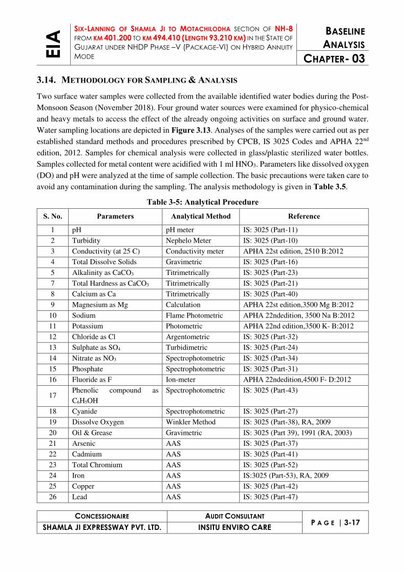
(APHA 22ndEdtn). The analyze details of ground water is given in Table 3.6.
Table 3-6: Ground Water Characteristics Parameters Unit Chiloda Pranjit Motipura Shamlaji IS 10500 :2012
Location GW-1 GW-2 GW-3 GW-4
Acc
epta
ble l
imits
Perm
issib
le li
mits
Co-ordinates
23° 1
3' 3
4.7"
N
72° 4
4' 0
5.0"
E
23° 2
6' 4
6.7"
N
72° 5
0' 5
0.5"
E
23° 4
0' 5
3.2"
N
73° 2
3' 3
3.1"
E
23° 3
5' 1
3.6"
N
72° 5
9' 1
2.2"
E
pH -- 7.82 7.69 7.64 7.92 6.5-8.5 NR
Conductivity µS/cm 1163.0 1052.0 958.4 989.5 $ $
Total Dissolve Solids mg/l 712 642 591 612 500 2000
Alkalinity as CaCO3 mg/l 324.6 306.5 298.5 248.5 200 600
Total Hardness as CaCO3 mg/l 344.1 316.8 298.6 322.0 300 600
Calcium as Ca mg/l 97.5 91.5 87.5 71.0 75 200
Magnesium as Mg mg/l 24.5 21.5 19.5 35.2 30 100
Sodium mg/l 68 56 42 47 $ $
Potassium mg/l 6 9 12 11 $ $
Bicarbonate mg/l 324.6 306.5 298.5 248.5 $ $
Chloride as Cl mg/l 159.5 141.2 109.5 165.4 250 1000
Sulphate as SO4 mg/l 10.5 8.5 11.2 24.1 200 400
Nitrate as NO3 mg/l 16.4 2.3 1.6 1.9 45 NR
Fluoride as F mg/l 0.64 0.16 0.16 0.31 1.00 1.5
Phenolic compound as
C6H5OH mg/l BDL BDL BDL BDL 0.001 0.002
Cyanide mg/l BDL BDL BDL BDL 0.05 NR
Aluminum mg/l BDL BDL BDL BDL 0.03 0.2

EIA
SIX-LANNING OF SHAMLA JI TO MOTACHILODHA SECTION OF NH-8
FROM KM 401.200 TO KM 494.410 (LENGTH 93.210 KM) IN THE STATE OF
GUJARAT UNDER NHDP PHASE –V (PACKAGE-VI) ON HYBRID ANNUITY
MODE
BASELINE
ANALYSIS
CHAPTER- 03
CONCESSIONAIRE AUDIT CONSULTANT P A G E | 3-19
SHAMLA JI EXPRESSWAY PVT. LTD. INSITU ENVIRO CARE
Parameters Unit Chiloda Pranjit Motipura Shamlaji IS 10500 :2012 Location GW-1 GW-2 GW-3 GW-4
Acc
epta
ble l
imits
Perm
issib
le li
mits
Co-ordinates
23° 1
3' 3
4.7"
N
72° 4
4' 0
5.0"
E
23° 2
6' 4
6.7"
N
72° 5
0' 5
0.5"
E
23° 4
0' 5
3.2"
N
73° 2
3' 3
3.1"
E
23° 3
5' 1
3.6"
N
72° 5
9' 1
2.2"
E
Arsenic mg/l BDL BDL BDL BDL 0.01 0.05
Cadmium mg/l BDL BDL BDL BDL 0.003 NR
Chromium as Cr+6 mg/l BDL BDL BDL BDL 0.05 NR
Iron mg/l 0.15 0.18 0.18 0.21 0.3 NR
Copper mg/l BDL BDL BDL BDL 0.05 1.5
Lead mg/l BDL BDL BDL BDL 0.01 NR
Manganese mg/l BDL BDL BDL BDL 0.1 0.3
Mercury mg/l BDL BDL BDL BDL 0.001 NR
Zinc mg/l 2.6 1.6 2.1 1.2 5 15
Source: Rajasthan Environmental Testing Lab, Bhiwadi Alwar
OBSERVATIONS & INTERPRETATIONS: The physical parameters were meeting to the acceptable limits of drinking water as TDS was varying
from 591 mg/l to 712 mg/l. Parameters as pH, Na, K are also complying to acceptable limit of drinking
water standard 10500:2012. The chemical parameters were analyzed as alkalinity, calcium, hardness,
chloride, Sulphate, fluoride and nitrate etc. all the parameters were meeting to the permissible limits
of drinking water standards IS 10500:2012 at all locations. The heavy metals were also analyzed, only
metals were detected as iron & zinc which was meeting to the acceptable limits of drinking water
standard 10500:2012 and other metals were below to the detection limits of laboratory.
3.15. SURFACE WATER QUALITY The analyze details of surface water is given in Table 3.7.
Table 3-7: Surface Water Characteristics Parameters Unit Prantij Shamlaji Water
Quality Criteria as per CPCB
Location Code - SW-1 SW-2
Co-Ordinates - 23° 26' 47.3" N 72° 50' 49.4" E
23° 40' 52.4" N 73° 23' 34.2" E
Turbidity NTU 24 31 $
pH -- 7.28 8.94 Class A
Conductivity µS/cm 876.5 1098 $
Total Dissolve Solids mg/l 492 765 $
Alkalinity as CaCO3 mg/l 92.3 210.8 $

EIA
SIX-LANNING OF SHAMLA JI TO MOTACHILODHA SECTION OF NH-8
FROM KM 401.200 TO KM 494.410 (LENGTH 93.210 KM) IN THE STATE OF
GUJARAT UNDER NHDP PHASE –V (PACKAGE-VI) ON HYBRID ANNUITY
MODE
BASELINE
ANALYSIS
CHAPTER- 03
CONCESSIONAIRE AUDIT CONSULTANT P A G E | 3-20
SHAMLA JI EXPRESSWAY PVT. LTD. INSITU ENVIRO CARE
Parameters Unit Prantij Shamlaji Water Quality
Criteria as per CPCB
Location Code - SW-1 SW-2
Co-Ordinates - 23° 26' 47.3" N 72° 50' 49.4" E
23° 40' 52.4" N 73° 23' 34.2" E
Total Hardness as CaCO3 mg/l 109.9 102.7 $
Calcium as Ca mg/l 31.5 21.2 $
Magnesium as Mg mg/l 7.6 12.1 $
Sodium mg/l 97 168 $
Potassium mg/l 6 13 $
Bicarbonate mg/l 92.3 210.8 $
Chloride as Cl mg/l 168.5 194.5 $
Sulphate as SO4 mg/l 22.6 52.8 $
Nitrate as NO3 mg/l 1.9 2.4 $
Fluoride as F mg/l 0.32 0.18 $
Phenolic compound as C6H5OH mg/l BDL BDL $
Cyanide mg/l BDL BDL $
Aluminium mg/l BDL BDL $
Arsenic mg/l BDL BDL $
Cadmium mg/l BDL BDL $
Chromium as Cr+6 mg/l BDL BDL $
Iron mg/l 0.19 0.31 $
Copper mg/l BDL BDL $
Lead mg/l BDL BDL $
Manganese mg/l BDL BDL $
Mercury mg/l BDL BDL $
Zinc mg/l 3.2 1.9 $
Dissolve Oxygen mg/l 5.1 5.7 Class B & C
COD mg/l 10.2 8.7 $
BOD, 27°C 3 days mg/l 4.2 6.1 Below E
Total Coliforms MPN/100ml >950 >950 Class B & C
Source: Rajasthan Environmental Testing Lab, Bhiwadi Alwar $- Not Specified Standard
The water quality criteria as per CPCB is given in Table 3.8.
Table 3-8: CPCB Water Quality Criteria Designated Best Use Class of water Criteria
Drinking Water Source
without conventional
treatment but after
disinfection
A Total Coliforms Organism MPN/100ml shall be 50 or less
pH between 6.5 and 8.5
Dissolved Oxygen 6mg/l or more
Biochemical Oxygen Demand 5 days 20°C 2mg/l or less
Outdoor bathing
(Organised)
B Total Coliforms Organism MPN/100ml shall be 500 or less
pH between 6.5 and 8.5

EIA
SIX-LANNING OF SHAMLA JI TO MOTACHILODHA SECTION OF NH-8
FROM KM 401.200 TO KM 494.410 (LENGTH 93.210 KM) IN THE STATE OF
GUJARAT UNDER NHDP PHASE –V (PACKAGE-VI) ON HYBRID ANNUITY
MODE
BASELINE
ANALYSIS
CHAPTER- 03
CONCESSIONAIRE AUDIT CONSULTANT P A G E | 3-21
SHAMLA JI EXPRESSWAY PVT. LTD. INSITU ENVIRO CARE
Designated Best Use Class of water Criteria Dissolved Oxygen 5mg/l or more
Biochemical Oxygen Demand 5 days 20°C 3mg/l or less
Drinking water source
after conventional
treatment and
disinfection
C Total Coliforms Organism MPN/100ml shall be 5000 or less
pH between 6 to 9
Dissolved Oxygen 4mg/l or more
Biochemical Oxygen Demand 5 days 20°C 3mg/l or less
Propagation of Wild life
and Fisheries
D pH between 6.5 to 8.5
Dissolved Oxygen 4mg/l or more
Free Ammonia (as N) 1.2 mg/l or less
Irrigation, Industrial
Cooling, Controlled
Waste disposal
E pH between 6.0 to 8.5
Electrical Conductivity at 25°C micro mhos/cm Max.2250
Sodium absorption Ratio Max. 26
Boron Max. 2mg/l
Below-E Not Meeting A, B, C, D & E Criteria
OBSERVATIONS & INTERPRETATIONS: The physical parameters were analyzed as turbidity, pH, TDS, Na and K. The turbidity was observed
very good in both ponds & rivers/nallahs. The chemical parameters were analyzed for Alkalinity, Total
Hardness, Calcium, Magnesium, Chloride, Bicarbonate, Sulphate, Nitrate, Fluoride, DO and COD
were analyzed. Dissolved oxygen & BOD were observed accorded to Class B & E as per CPCB water
quality criteria. The heavy metals were also analyzed in the surface water. Only iron & zinc were
detected. Other parameters were below to the detection limits. Total coliform was meeting to the Class
C of water quality criteria as defined by CPCB.
3.16. METEOROLOGICAL CONDITION Post-Monsoon Season starts from middle of November to end of February. March to May constitute
summer season and the monsoon season starts from second week of June to end of September.
Maximum rainfall occurs along the south western boundary of the district and decreases towards the
north and slightly towards the east. The normal annual rainfall of the district is 740.6 mm. During Post-
Monsoon Season the January is the coldest months with the temperature falling as low as 12.0oC and
max up to 28.10 C. During the month of May, temperature goes up to 38.70 C (max.).
The meteorological data was taken from Ahmedabad IMD station for the study period is very useful
for proper interpretation of the baseline information as well as for input prediction models for air
quality dispersion. Historical data on meteorological parameters will also play an important role in
identifying the general meteorological regime of the region.

EIA
SIX-LANNING OF SHAMLA JI TO MOTACHILODHA SECTION OF NH-8
FROM KM 401.200 TO KM 494.410 (LENGTH 93.210 KM) IN THE STATE OF
GUJARAT UNDER NHDP PHASE –V (PACKAGE-VI) ON HYBRID ANNUITY
MODE
BASELINE
ANALYSIS
CHAPTER- 03
CONCESSIONAIRE AUDIT CONSULTANT P A G E | 3-22
SHAMLA JI EXPRESSWAY PVT. LTD. INSITU ENVIRO CARE
3.17. METEOROLOGICAL DATA RECORDED AT IMD, AHMEDABAD The meteorological data is collected from the IMD station at Ahmedabad, which is the nearest IMD
station to the project site. The data collected from IMD includes wind speed, wind direction (recorded
in sixteen directions), temperature, relative humidity, atmospheric pressure; rainfall and cloud cover
over a period of 30 years from the year 1971 to 2000. All these parameters were recorded twice a day
viz at 08.30 and 17.30 hours. The monthly maximum, minimum and average values are collected for
all the parameters like wind speed, rainfall, temperature are presented in Table 3.11 and wind-rose
pattern is given as Figure 3.14 as per IMD, Ahmedabad.
Table 3-9: Climatology and Meteorology of Study Area as per IMD, Ahmedabad (1971-2000)
Month Temp (oC) (Daily) Humidity (%) Rainfall Wind Speed
Max Min. Average 08:30 05:30 mm kmph January 28.1 12.0 20.1 64 35 1.9 6.0
February 30.5 14.0 22.3 57 28 1.0 6.4
March 35.7 19.1 27.4 50 21 0.5 7.0
April 39.7 23.7 31.7 57 22 2.7 8.0
May 41.6 26.5 34.1 66 25 10.2 11.3
June 38.7 27.3 33.0 75 45 95.1 11.8
July 33.5 25.7 29.6 85 69 281.3 10.0
August 32.0 24.9 28.5 87 71 234.6 8.7
September 33.8 24.3 29.1 82 60 95.8 7.2
October 35.7 21.3 28.5 67 41 12.3 4.8
November 32.8 16.6 24.7 58 37 4.3 4.8
December 29.4 13.2 21.3 61 37 0.8 5.5
YEAR 34.3 20.7 27.5 67 41 740.6 7.6 Source: Climatological Table 1971 – 2000, Indian Meteorological Department, Govt. of India, New Delhi
Table 3-10: Wind Variability of Study Area as per IMD, Ahmedabad (1971-2000) Month N/360 NE/45 E/90 SE/135 S/180 SW/225 W/270 NW/315 CALM/0 SEASON
DEC 12 27 33 1 0 0 0 3 24
Winter
24 17 17 2 1 1 1 15 22
JAN 16 21 22 1 1 0 2 7 30
31 16 10 2 1 2 4 25 9
FEB 13 16 16 2 0 1 4 17 31
24 10 9 2 3 5 11 30 6
Total 120 107 107 10 6 9 22 97 122
MAR 10 8 12 2 1 2 11 33 21 Sum
mer
15 5 4 2 2 8 18 39 7
APR 6 1 4 1 3 8 21 45 11
9 1 1 2 4 13 30 34 6

EIA
SIX-LANNING OF SHAMLA JI TO MOTACHILODHA SECTION OF NH-8
FROM KM 401.200 TO KM 494.410 (LENGTH 93.210 KM) IN THE STATE OF
GUJARAT UNDER NHDP PHASE –V (PACKAGE-VI) ON HYBRID ANNUITY
MODE
BASELINE
ANALYSIS
CHAPTER- 03
CONCESSIONAIRE AUDIT CONSULTANT P A G E | 3-23
SHAMLA JI EXPRESSWAY PVT. LTD. INSITU ENVIRO CARE
Month N/360 NE/45 E/90 SE/135 S/180 SW/225 W/270 NW/315 CALM/0 SEASON
MAY 2 0 0 2 8 28 30 28 2
4 1 1 2 10 29 31 20 2
Total 46 16 22 11 28 88 141 199 49
JUN 1 0 1 5 15 40 23 9 6
Monsoon
1 0 1 5 24 36 21 7 5
JUL 0 0 0 2 14 52 17 4 11
0 1 1 5 18 41 19 5 10
AUG 1 0 0 1 8 45 26 8 11
2 0 1 3 11 38 23 8 14
SEP 2 1 2 3 6 19 28 25 14
5 2 2 3 9 25 21 15 18
Total 12 4 8 27 105 296 178 81 89
OCT 10 8 14 6 2 2 5 16 37
P. Monsoon
14 9 10 6 4 6 5 14 32
NOV 13 21 29 3 1 0 0 3 30
20 13 19 3 1 1 2 9 32
DEC 12 27 33 1 0 0 0 3 24
24 17 17 2 1 1 1 15 22
Total 93 95 122 21 9 10 13 60 177
YEAR 7 9 11 2 5 16 14 16 20 A
nnual
12 6 6 3 7 17 16 19 14
Total 19 15 17 5 12 33 30 35 34
Rainfall: The total average annual rainfall was found to be 740.6 mm of which average 7.0 mm rainfall
during the winter period, 13.4 mm for summer period, 706.8 mm for monsoon period and 17.4 mm for
post monsoon period in a year.
Temperature: The area showed moderate temperature through the all seasons, with the maximum
average temperature recorded at 41.6°C in the month of May and the minimum average temperature
of 12.1°C in January.
Relative Humidity: The Relative Humidity was maximum during the monsoon season with the month
of August recording the highest average at 87%.
Wind Speed and Direction: The maximum wind speed was found to be 11.8 kmph in the month of
June and minimum wind speed was found to be 4.8 kmph in the month of October & November. The
predominant wind direction at the IMD station was from NE followed by SW and W.

EIA
SIX-LANNING OF SHAMLA JI TO MOTACHILODHA SECTION OF NH-8
FROM KM 401.200 TO KM 494.410 (LENGTH 93.210 KM) IN THE STATE OF
GUJARAT UNDER NHDP PHASE –V (PACKAGE-VI) ON HYBRID ANNUITY
MODE
BASELINE
ANALYSIS
CHAPTER- 03
CONCESSIONAIRE AUDIT CONSULTANT P A G E | 3-24
SHAMLA JI EXPRESSWAY PVT. LTD. INSITU ENVIRO CARE
3.18. AIR ENVIRONMENT The baseline studies on air environment include identification of specific air pollution parameters and
their existing levels in ambient air. The ambient air quality with respect to the core and buffer zone of
10 km radius around the proposed project site forms the baseline information. The sources of air
pollution in the region are mostly due to vehicular traffic, dust arising from unpaved village road and
domestic fuel/biomass burning. The quantification of impacts of the proposed solar project on the
ambient air quality requires to evaluate the existing ambient air quality of the area.
Monitoring was conducted for the following parameters: (i) Particulate Matter 10 (PM10), (ii)
Particulate Matter (PM2.5), (iii) Sulphur Dioxide (SO2), (iii) Nitrogen Dioxide (NO2) and (iv) Carbon
Monoxide (CO).
It was ensured that the equipment was placed at a height of at least 3m to 4m above the ground level
at each monitoring station, for negating the effects of windblown ground dust. Also, distance of the
sampler to any air flow obstacle i.e. buildings, must be more than two times the height of the obstacle
above the sampler has been ensured. The equipment was placed at open space free from trees and
vegetation which otherwise act as a sink of pollutants resulting in lower levels in monitoring results.
Monitoring has been carried out as per the latest CPCB and MoEF&CC guidelines and notifications.
3.19. POLLUTION & PREVENTIVE MEASURES The sampling locations for ambient air quality were established based on the following considerations:
(i) Meteorological conditions including wind direction; (ii) Topography of the study area; and (iii) Representativeness of regional background air quality for obtaining baseline status;
Annual Wind Patterns Post Monsoon Wind Patterns
Figure 3.14 Wind Pattern Variability as per IMD-Ahmedabad (Gujarat)

EIA
SIX-LANNING OF SHAMLA JI TO MOTACHILODHA SECTION OF NH-8
FROM KM 401.200 TO KM 494.410 (LENGTH 93.210 KM) IN THE STATE OF
GUJARAT UNDER NHDP PHASE –V (PACKAGE-VI) ON HYBRID ANNUITY
MODE
BASELINE
ANALYSIS
CHAPTER- 03
CONCESSIONAIRE AUDIT CONSULTANT P A G E | 3-25
SHAMLA JI EXPRESSWAY PVT. LTD. INSITU ENVIRO CARE
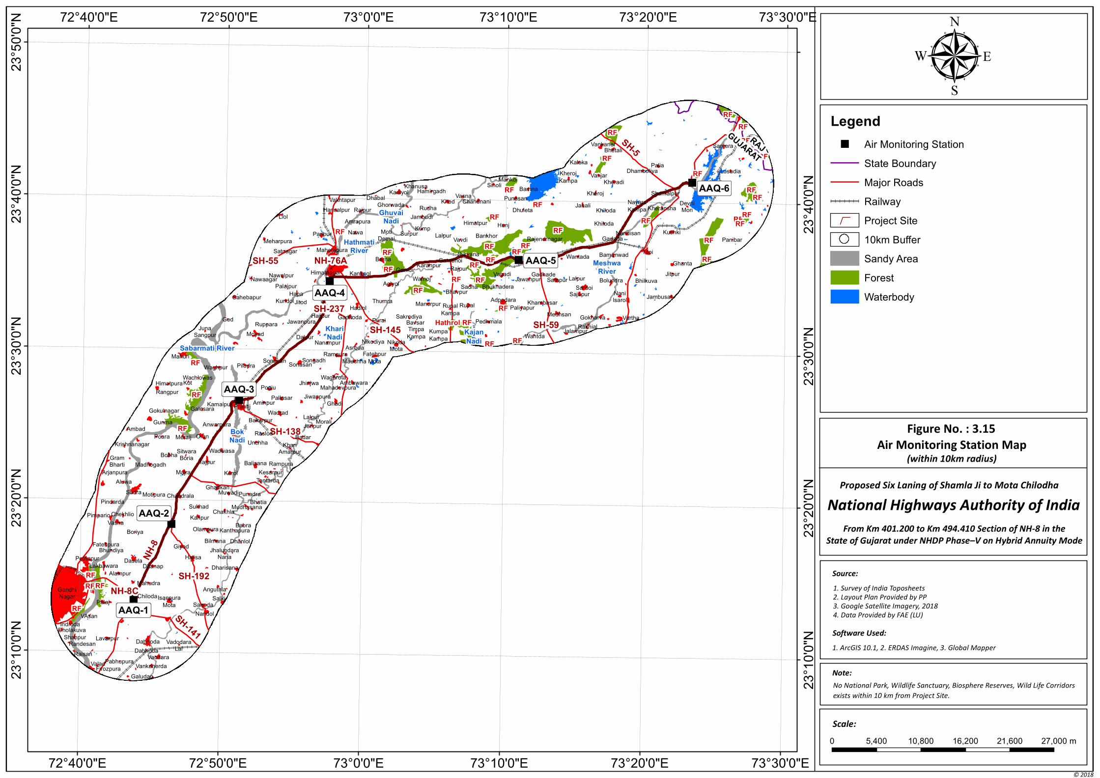
Five Ambient Air Quality Monitoring (AAQM) Stations were selected. Criteria used for designing the
network were principally governed by the wind rose pattern & coverage factor calculation of
windblown for Post-Monsoon Season and the accessibility of the selected sites. Attempts were made
to locate most of the AAQ stations in predominant downwind direction with respect to the project site.
Logistic considerations such as accessibility, security, and availability of reliable power supply etc.
were also examined while finalizing the stations. Monitoring Locations are marked in Figure 3.15.
3.19.1. DURATION OF SAMPLING The monitoring has been carried out at a frequency of two samples per week at each of five locations,
adopting a continuous 24-hour continuous schedule for Particulate Matter, Sulphur Dioxide and
Nitrogen Dioxide except CO for one hour.
3.19.2. SAMPLING & ANALYSIS TECHNIQUES With a view to collect the samples, Envirotech Make Calibrated Respirable Dust Samplers (RDS-APM
460 BL) along with Gaseous attachment and Fine Particulate Matter (FPS-APM 550) were used. The
instruments were well capable of drawing air at a flow rate of 1 to 1.3 m3/min with very little pressure
drop for RDS and the impactor system of FPS is designed to operate at an air flow rate of 1m3/hr.
Filter papers (8”x10” GF for PM10 and 46.2 dia. PTFE for PM2.5) were used for the collection of PM10 and PM2.5. SO2 was collected by drawing air at a flow-rate of 0.5 liters per minute (lpm)
through an absorbing solution i.e., Sodium tetrachloromercurate (TCM) (West and Gaeke Method)
and NO2 was collected by drawing air at a flow rate of 0.4 lpm through the mixture of absorbing
solutions i.e. sodium hydroxide and sodium arsenite (Jacobs and Hochheiser Method). Carbon
Monoxide samples were collected on 1 hourly base in Mylar bags and analyzed by Non-Dispersive
Infra-Red Spectroscopy (NDIR). This is to allow a comparison with the present revised standards
mentioned in the latest Gazette Notification of the Central Pollution Control Board (November 2009).
The analysis methodology for relevant parameters is given in Table 3.13. Table 3.14 is shown the
monitoring locations.
Table 3-11: Sampling and Analytical Methodology Sl. No. Parameter Methodology
1 Particulate Matter 10 (µg/m3) IS 5182, Part 23, Respirable Dust Sampler 460 BL
(Gravimetric method)
2 Particulate Matter 2.5 (µg/m3) CPCB Guideline, APM 550 Fine Particulate Sampler
(Gravimetric method)
3 Sulphur Dioxide (µg/m3) West and Gaeke Method
4 Nitrogen Dioxide (µg/m3) IS 5182, Part 6, Jacob & Hochheiser modified
5 Carbon monoxide (mg/m3) IS 5182, Part 10, Non-dispersive Infrared Absorption method

EIA
SIX-LANNING OF SHAMLA JI TO MOTACHILODHA SECTION OF NH-8
FROM KM 401.200 TO KM 494.410 (LENGTH 93.210 KM) IN THE STATE OF
GUJARAT UNDER NHDP PHASE –V (PACKAGE-VI) ON HYBRID ANNUITY
MODE
BASELINE
ANALYSIS
CHAPTER- 03
CONCESSIONAIRE AUDIT CONSULTANT P A G E | 3-26
SHAMLA JI EXPRESSWAY PVT. LTD. INSITU ENVIRO CARE
3.20. AIR QUALITY Consolidated values of ambient air quality for the said parameters is given in Table 3.12 & 3.13. The
locations-wise air quality details are given in separate document which is enclosed as Annex 3.4.
Table 3-12: Statistical Values of AAQ Location Code Parameter Minimum Maximum Standard Deviation Percentile 98 Mean
AAQ1
Particulate Matter 10
PM10 (µg/m3)
127.5 148.5 7.7 148.3 137.8
AAQ2 119.5 144.5 8.5 144.0 133.0
AAQ3 122.5 157.5 11.4 156.2 139.0
AAQ4 118.2 135.5 5.2 135.0 127.7
AAQ5 124.0 146.2 8.2 145.5 134.7
AAQ6 118.7 135.2 5.4 134.8 128.0
AAQ1
Particulate Matter 2.5
PM2.5 (µg/m3)
48.5 57.5 3.5 57.4 53.1
AAQ2 45.5 57.5 3.7 57.1 51.1
AAQ3 48.5 62.5 4.7 61.8 54.4
AAQ4 45.0 56.5 3.3 56.0 51.1
AAQ5 48.5 57.5 3.8 57.5 53.3
AAQ6 46.5 55.5 3.0 55.2 51.1
AAQ1
Sulphur Di Oxides
SO2 (µg/m3)
8.5 13.2 1.7 13.2 11.3
AAQ2 7.5 13.4 2.1 13.4 11.2
AAQ3 7.9 14.8 2.3 14.6 10.9
AAQ4 9.8 13.2 1.3 13.2 11.8
AAQ5 9.1 12.4 1.3 12.4 10.7
AAQ6 9.3 12.4 1.1 12.3 10.5
AAQ1
Oxides of Nitrogen
NOx (µg/m3)
13.9 18.5 1.8 18.5 16.5
AAQ2 14.5 19.5 1.5 19.3 17.2
AAQ3 13.2 19.5 2.1 19.4 16.4
AAQ4 14.5 20.1 1.8 20.0 17.4
AAQ5 13.2 17.5 1.5 17.5 15.8
AAQ6 12.7 19.5 2.0 19.2 16.0
AAQ1
Carbon Monoxide
CO (mg/m3)
0.69 1.34 0.22 1.33 1.05
AAQ2 0.78 1.31 0.19 1.30 1.06
AAQ3 1.11 1.48 0.12 1.46 1.26
AAQ4 1.07 1.36 0.10 1.35 1.21
AAQ5 1.08 1.32 0.09 1.32 1.21
AAQ6 0.97 1.24 0.09 1.24 1.12
Table 3-13: Consolidated 98th Percentile Values of AAQ Location
Code Location
Name Location Co-
Ordinates PM10
(µg/m3) PM2.5
(µg/m3) SO2
(µg/m3) NOx
(µg/m3) CO
(mg/m3) AAQ-1 Chiloda 23° 13' 29.2" N 148.3 57.4 13.2 18.5 1.33
"
"
"
"
"
"
SH-141
SH-5
NH
-8
SH-59
NH-76ASH-55
SH-138
NH-8C
SH-192
SH-145
SH-237
Sabarmati River
Khari
Nadi
Hathmati
River
Meshwa
River
Kajan
Nadi
Bok
Nadi
Ghuvai
Nadi
RF
RF
RF
RF
RF
RF
RF
RF
RF
RF
RF
RFRF
RF
Hathrol RF
RF
RF
RF
RF
RF
RF
RF
RF
RFRF
RFRF
RF
RF
RF
RFRF
RF
RF
RF
RF
RF
RF
RF
RF
RF
ValadFirozpura
PabhupuraVankanerda
Galudan
Vaodara
VadodaraLal
Raisan
Shahpur
Dholakuva
RandesanLavarpur
Dabhoda
Dabhoda
VAsan
Indroda
GandhiNagar
PalajIsanpura
Mota
Nandol
SanodaSalki
AnguthlaChiloda
Alampur
Mahudra
Dharisana
Halisa
DhanapLakhawara
Pethapur
FatehpuraBhundiya
Dasela
GiyodJhalundara
Nana
Dhanlol
Kanthapura
Bilmana
OlampuraBoriya
Pimpario
Vasha
ChekhlioKanpur
Babra
MudhasanaBhatia
ChakhlaSukhad
Pindarda
Aluwa
Sadra Motipura Chandrala
GhadkanMuwadiPunadra
Tantarda
Rampura
KesarpurKarolMajraArjanpura
GramBharti Madhogadh
BobhaSitwaraBoria
Tajpur
Wadwasa
Balisana
KhariAmarpur
BadarRaslod
UnchhaOranMeraijPoara
Krishnanagar
AmbadGunma Anwarpura
BakarpurLalpur
MoraliJenpur
Ghadi
JiwanpuraPallasarAminpur
WadradPrantijKamalpur
GalesaraGokulnagar
Rangpur
HimatpuraKotPogiu
JhinjwaMahadevpura
AmbawaraWaghrota
PiludraWaghpur
Wachlowas
MahuriSonasan
SonasanSongadh
Rampura
Mauchha
Fatehpur
Mota
NikodaMota
NikodiyaAsroda
NananpurDalpur
MoyadJuna
Sangpur
GedRuppara Jawanpura
Hajipur GadhodaPurai Bavsar
Sakrodiya
Timpa
Kampa
Thumra
HadiolJitodKundol
Sahebapur
Palajpur
Hapa
Agiyol
GamdiKaranpur
KanknolNawalpurNawaagar
Satnagar Mahetapura
Himatnagar
Berna Gambhoi
LalpurVavdi
SurpurNawaPanpur
Meharpura
Liol
MotiDemai
GhorwadaRajpur
Amrapura
Hansalpur
Vakhtapur DhabalKaniyol
Manorpur
Wamoj
Kump
Jambudi
Rudha
KhanusaHamirgadh
Khed
Bhavpur
Rupal
Kampa
Kumpa
Kampa
Pedhmala
Rupal
Sadha
Rajpur
Survana
Bankhor
Himatpur
ChandnaniVasna
SiholiMankdi
Punasan
Dhuleta
Hunj
Vagadi
Bhukhadera
Adpodara
Paliyapur
Wantda
Khambasar
JawanpurGadhade
Bamna
Kheroj
Kampa
Janali
Rajendrnagar
Wantada
LalpurSampur
Sajapur
Medhsan
JalampurRakhial
Gokharva
Sardoi
Bolundra
Bamanwad
Gadada
Khiloda
Khiloda
Kheroj
KheradiVanjar
Kaleka
BhetaliVankaner
Dhamboliya
Nayara
Kampa
Nandisan
NaniIsarol
Vartha
Jambusar
Bhilkuva
Jitpur
Titoi
Kushki
Kheransha
Shamalpur
Palia
DevniMori
Ghanta
Lusadia
Samera
Panibar
AAQ-1
AAQ-2
AAQ-3
AAQ-4
AAQ-5
AAQ-6
73°30'0"E
73°30'0"E
73°20'0"E
73°20'0"E
73°10'0"E
73°10'0"E
73°0'0"E
73°0'0"E
72°50'0"E
72°50'0"E
72°40'0"E
72°40'0"E23
°50
'0"N
23
°40
'0"N
23
°40
'0"N
23
°30
'0"N
23
°30
'0"N
23
°20
'0"N
23
°20
'0"N
23
°10
'0"N
23
°10
'0"N
µ
0 5,400 10,800 16,200 21,600 27,000 m
Figure No. : 3.15
Air Monitoring Station Map
1. Survey of India Toposheets
2. Layout Plan Provided by PP
3. Google Satellite Imagery, 2018
4. Data Provided by FAE (LU)
1. ArcGIS 10.1, 2. ERDAS Imagine, 3. Global Mapper
© 2018
No National Park, Wildlife Sanctuary, Biosphere Reserves, Wild Life Corridors
exists within 10 km from Project Site.
Legend
" Air Monitoring Station
State Boundary
Major Roads
Railway
Project Site
10km Buffer
Sandy Area
Forest
Waterbody
RAJ
GUJARAT
EIA
SIX-LANNING OF SHAMLA JI TO MOTACHILODHA SECTION OF NH-8
FROM KM 401.200 TO KM 494.410 (LENGTH 93.210 KM) IN THE STATE OF
GUJARAT UNDER NHDP PHASE –V (PACKAGE-VI) ON HYBRID ANNUITY
MODE
BASELINE
ANALYSIS
CHAPTER- 03
CONCESSIONAIRE AUDIT CONSULTANT P A G E | 3-27
SHAMLA JI EXPRESSWAY PVT. LTD. INSITU ENVIRO CARE
Location Code
Location Name
Location Co-Ordinates
PM10
(µg/m3) PM2.5
(µg/m3) SO2
(µg/m3) NOx
(µg/m3) CO
(mg/m3) 72° 43' 49.6" E
AAQ-2 Chhala 23° 18' 26.1" N
72° 46' 26.2" E
144.0 57.1 13.4 19.3 1.30
AAQ-3 Motipura 23° 26' 39.6" N
72° 51' 07.5" E
156.2 61.8 14.6 19.4 1.46
AAQ-4 Prantij 23° 34' 34.2" N
72° 57' 28.7" E
135.0 56.0 13.2 20.0 1.35
AAQ-5 Raigarh 23° 36' 07.3" N
73° 10' 57.0" E
145.5 57.5 12.4 17.5 1.32
AAQ-6 Shamlaji 23° 41' 20.8" N
73° 23' 16.6" E
134.8 55.2 12.3 19.2 1.24
Standards for 24 Hours Monitoring except CO for 1 Hour Monitoring NAAQS 2009 100 60 80 80 4
Source: Rajasthan Environmental Testing Lab, Bhiwadi Alwar,
Source: Gazette of India Notification, dated 18th Nov 2009
* Annual Arithmetic Means of minimum 104 measurements in a year at a site taken twice a week 24 hourly at uniform
intervals, ** 24 hourly or 8 hourly or 1 hourly monitored values, as applicable shall be complied with 98% of the time
in a year. 2% of the time they may exceed the limits but not on two consecutive days of monitoring,
For CO 1 hourly standard is being considered.
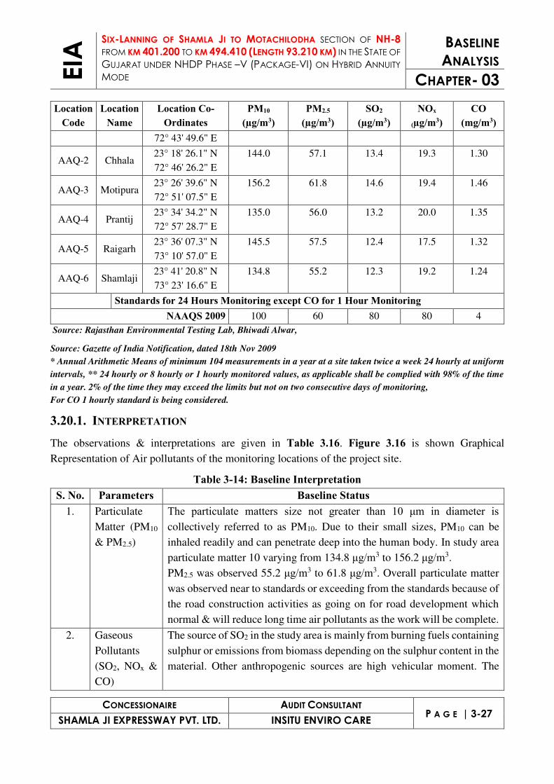
3.20.1. INTERPRETATION The observations & interpretations are given in Table 3.16. Figure 3.16 is shown Graphical
Representation of Air pollutants of the monitoring locations of the project site.
Table 3-14: Baseline Interpretation S. No. Parameters Baseline Status
1. Particulate
Matter (PM10
& PM2.5)
The particulate matters size not greater than 10 μm in diameter is collectively referred to as PM10. Due to their small sizes, PM10 can be
inhaled readily and can penetrate deep into the human body. In study area
particulate matter 10 varying from 134.8 μg/m3 to 156.2 μg/m3.
PM2.5 was observed 55.2 μg/m3 to 61.8 μg/m3. Overall particulate matter
was observed near to standards or exceeding from the standards because of
the road construction activities as going on for road development which
normal & will reduce long time air pollutants as the work will be complete.
2. Gaseous
Pollutants
(SO2, NOx &
CO)
The source of SO2 in the study area is mainly from burning fuels containing
sulphur or emissions from biomass depending on the sulphur content in the
material. Other anthropogenic sources are high vehicular moment. The

EIA
SIX-LANNING OF SHAMLA JI TO MOTACHILODHA SECTION OF NH-8
FROM KM 401.200 TO KM 494.410 (LENGTH 93.210 KM) IN THE STATE OF
GUJARAT UNDER NHDP PHASE –V (PACKAGE-VI) ON HYBRID ANNUITY
MODE
BASELINE
ANALYSIS
CHAPTER- 03
CONCESSIONAIRE AUDIT CONSULTANT P A G E | 3-28
SHAMLA JI EXPRESSWAY PVT. LTD. INSITU ENVIRO CARE
S. No. Parameters Baseline Status primary sources of NO2 in the study area are motor vehicles, electric
utilities and residential sources that burn fuels.
SO2 was varying from 12.4 μg/m3 to 14.6 μg/m3 & NOx was observed 17.5
μg/m3 to 20.0 μg/m3 in study area. CO was observed from 1.24 mg/m3 to
1.46 mg/m3 in study area.
All the parameters are complying to the standards as defined by CPCB.

EIA
SIX-LANNING OF SHAMLA JI TO MOTACHILODHA SECTION OF NH-8
FROM KM 401.200 TO KM 494.410 (LENGTH 93.210 KM) IN THE STATE OF
GUJARAT UNDER NHDP PHASE –V (PACKAGE-VI) ON HYBRID ANNUITY
MODE
BASELINE
ANALYSIS
CHAPTER- 03
CONCESSIONAIRE AUDIT CONSULTANT P A G E | 3-29
SHAMLA JI EXPRESSWAY PVT. LTD. INSITU ENVIRO CARE
Figure 3.16 Graphical Representation of Air Pollutants
3.21. NOISE ENVIRONMENT
3.21.1. AMBIENT NOISE LEVEL MONITORING STATIONS In the present study, sound pressure levels (SPL) was measured by a sound level meter (Model:
Envirotech Make SLM 100). Since loudness of sound is important for its effects on people, the
dependence of loudness upon frequency must be considered in noise impact assessment. This has been
achieved using A-weighting filters in the noise measuring instrument which gives a direct reading of
approximate loudness. A-weighted equivalent continuous sound pressure level (Leq) values have been
computed from the values of A-weighted sound pressure level measured with the help of noise meter.

"
"
"
"
"
"
SH-141
SH-5
NH-8
SH-59
NH-76ASH-55
SH-138
NH-8C
SH-192
SH-145
Sabarmati River
Khari
Nadi
Hathmati
River
Meshwa
River
Kajan
Nadi
Bok
Nadi
Ghuvai
Nadi
RF
RF
RF
RF
RF
RF
RF
RF
RF
RF
RF
RFRF
RF
Hathrol RF
RF
RF
RF
RF
RF
RF
RF
RF
RFRF
RFRF
RF
RF
RF
RFRF
RF
RF
RF
RF
RF
RF
RF
RF
RF
ValadFirozpura
PabhupuraVankanerda
Galudan
Vaodara
VadodaraLal
Raisan
Shahpur
Dholakuva
RandesanLavarpur
Dabhoda
Dabhoda
MagodiPrantiya
RampuraVAsan
Indroda
GandhiNagar
Palaj Isanpura
Mota
Nandol
SanodaSalki
AnguthlaChiloda
Alampur
Mahudra
Dharisana
Halisa
DhanapLakhawara
Pethapur
FatehpuraBhundiya
Dasela
GiyodJhalundara
Nana
Dhanlol
Kanthapura
Bilmana
OlampuraBoriya
Pimpario
Vasha
ChekhlioJakhora Kanpur
Babra
MudhasanaBhatia
ChakhlaSukhad
Pindarda
Aluwa
Sadra Motipura Chandrala
GhadkanMuwadiPunadra
Tantarda
Rampura
KesarpurKarolMajraArjanpura
GramBharti Madhogadh
BobhaSitwaraBoria
Tajpur
Wadwasa
Balisana
KhariAmarpur
BadarRaslod
UnchhaOranMeraijPoara
Krishnanagar
AmbadGunma Anwarpura
BakarpurLalpur
MoraliJenpur
Ghadi
JiwanpuraPallasarAminpur
WadradPrantij
KamalpurGalesaraGokulnagar
Rangpur
HimatpuraKotPogiu
JhinjwaMahadevpura
AmbawaraWaghrota
PiludraWaghpur
Wachlowas
MahuriSonasan
SonasanSongadh
Rampura
Mauchha
Fatehpur
Mota
NikodaMota
NikodiyaAsroda
NananpurDalpur
MoyadJuna
Sangpur
GedRuppara Jawanpura
Hajipur GadhodaPurai Bavsar
Sakrodiya
Timpa
Kampa
Thumra
HadiolJitodKundol
Sahebapur
Palajpur
Hapa
KathwadAgiyol
GamdiKaranpur
KanknolNawalpurNawaagar
Satnagar Mahetapura
Himatnagar
Berna Gambhoi
LalpurVavdi
SurpurNawaPanpur
Meharpura
Liol
MotiDemai
GhorwadaRajpur
Amrapura
Hansalpur
Vakhtapur DhabalKaniyol
Manorpur
Wamoj
Kump
Jambudi
Rudha
KhanusaHamirgadh
Khed
Bhavpur
Rupal
Kampa
Kumpa
Kampa
Pedhmala
Rupal
Sadha
Rajpur
Survana
Bankhor
Himatpur
ChandnaniVasna
SiholiMankdi
Punasan
Dhuleta
Hunj
Vagadi
Bhukhadera
Adpodara
Paliyapur
Wantda
Khambasar
JawanpurGadhade
Bamna
Kheroj
Kampa
Janali
Rajendrnagar
Wantada
LalpurSampur
Sajapur
Medhsan
JalampurRakhial
Gokharva
Sardoi
Bolundra
Bamanwad
Gadada
Khiloda
Khiloda
Kheroj
KheradiVanjar
Kaleka
BhetaliVankaner
Dhamboliya
Nayara
Kampa
Nandisan
NaniIsarol
Vartha
Jambusar
Bhilkuva
Jitpur
Titoi
Kushki
Kheransha
Shamalpur
Palia
Shamlaji
DevniMori
Ghanta
Lusadia
Samera
Panibar
N-1
N-2
N-3
N-4
N-5
N-6
73°30'0"E
73°30'0"E
73°20'0"E
73°20'0"E
73°10'0"E
73°10'0"E
73°0'0"E
73°0'0"E
72°50'0"E
72°50'0"E
72°40'0"E
72°40'0"E23
°50
'0"N
23
°40
'0"N
23
°40
'0"N
23
°30
'0"N
23
°30
'0"N
23
°20
'0"N
23
°20
'0"N
23
°10
'0"N
23
°10
'0"N
µ
0 5,400 10,800 16,200 21,600 27,000 m
Figure No. : 3.17
Noise Monitoring Station Map
1. Survey of India Toposheets
2. Layout Plan Provided by PP
3. Google Satellite Imagery, 2018
4. Data Provided by FAE (LU)
1. ArcGIS 10.1, 2. ERDAS Imagine, 3. Global Mapper
© 2018
No National Park, Wildlife Sanctuary, Biosphere Reserves, Wild Life Corridors
exists within 10 km from Project Site.
Legend
" Noise Monitoring Station
State Boundary
Major Roads
Railway
Project Site
10km Buffer
Sandy Area
Forest
Waterbody
RAJ
GUJARAT

EIA
SIX-LANNING OF SHAMLA JI TO MOTACHILODHA SECTION OF NH-8
FROM KM 401.200 TO KM 494.410 (LENGTH 93.210 KM) IN THE STATE OF
GUJARAT UNDER NHDP PHASE –V (PACKAGE-VI) ON HYBRID ANNUITY
MODE
BASELINE
ANALYSIS
CHAPTER- 03
CONCESSIONAIRE AUDIT CONSULTANT P A G E | 3-30
SHAMLA JI EXPRESSWAY PVT. LTD. INSITU ENVIRO CARE
3.21.2. FREQUENCY & PARAMETERS OF SAMPLING Noise levels were recorded continuous for 24 hours at an interval of 60 minutes during the day and
night times to compute the day equivalent, night equivalent and day-night equivalent level. The noise
level was monitored once during the study period at each monitoring location. The noise level is
recorded in dB(A). The important parameters measured are Leq, Lday, and Lnight.
3.21.3. NOISE MONITORING LOCATIONS Assessment of ambient noise levels is an important parameter in preparation of impact assessment
report. Noise levels are more annoying in the night time particularly in the residential area. The
environmental impact of noise can have several effects varying from annoyance to hearing loss
depending on loudness of noise levels. The monitoring for noise levels were done in five locations
keeping considering the population and traffic of the area. These locations are given in Figure 3.17.
3.21.4. METHOD OF MONITORING At each location, noise monitoring has been carried out once during study period over a period of 24
hours to obtain Leq values at uniform time intervals of 1 hour. In each hourly time interval Leq values
have been computed from SPL readings taken at uniform time intervals of 10 minutes. For each
location, day and night time Leq values have then been computed from the hourly Leq values such that
comparison could be made with the national ambient noise standards. Day time Leq was computed
from the hourly Leq values between 6.00AM - 10.00PM and night time Leq from the hourly Leq values
between 10.00PM- 6.00AM. The Noise standards is given in Table 3.15.
Table 3-15: Ambient Noise Standards Area Code Type of Area
Limits in dB(A) Leq* Day (06:00hrs to 20:00hrs) Night (20:00hrs to 06:00hrs)
A Industrial Area 75 70
B Commercial Area 65 55
C Residential Area 55 45
D Silence Zone 50 40
* Silence zone is defined as an area up to 100 meters around such premises as hospitals, educational institutions and
courts. The silence zones are to be declared by the competent authority
3.21.5. AMBIENT SOUND PRESSURE LEVEL IN STUDY AREA An analysis of the different Leq data obtained during the study period has been made. Variation was
noted during the day-time as well as night-time. The results are presented in Table 3.16.

EIA
SIX-LANNING OF SHAMLA JI TO MOTACHILODHA SECTION OF NH-8
FROM KM 401.200 TO KM 494.410 (LENGTH 93.210 KM) IN THE STATE OF
GUJARAT UNDER NHDP PHASE –V (PACKAGE-VI) ON HYBRID ANNUITY
MODE
BASELINE
ANALYSIS
CHAPTER- 03
CONCESSIONAIRE AUDIT CONSULTANT P A G E | 3-31
SHAMLA JI EXPRESSWAY PVT. LTD. INSITU ENVIRO CARE
Table 3-16: Ambient Noise Quality of Study Area
Noise Locations/Codes
Co-Ordinates Category of Area
Day Time in dB(A) Night Time in dB(A)
L Max
L Min
L eq
L Max
L Min
L eq
Chiloda N-1 23° 13' 29.2" N
72° 43' 49.6" E Res./Com. 60.2 39.2 54.0 39.9 29.1 35.7
Chhala N-2 23° 18' 26.1" N
72° 46' 26.2" E Res./Com. 62.1 40.1 56.3 38.3 30.2 35.0
Prantij N-3 23° 26' 39.6" N
72° 51' 07.5" E
Res./Com. 58.9 32.6 52.9 35.4 29.8 33.3
Motipura N-4 23° 34' 34.2" N
72° 57' 28.7" E
Res./Com. 60.8 38.2 55.5 38.1 29.2 34.4
Raigarh N-5 23° 36' 07.3" N
73° 10' 57.0" E
Res./Com. 58.5 38.3 55.4 39.7 29.4 36.3
Shamlaji N-6 23° 41' 20.8" N
73° 23' 16.6" E
Res./Com. 56.0 33.9 52.0 38.8 29.0 35.9
Source: Rajasthan Environmental Testing Lab, Bhiwadi Alwar
The Sound Pressure Level recorded during the daytime on all locations varies from 52.0 dB(A) to 56.3
dB(A) and during night-time varying from 33.3 dB(A) to 36.3 dB(A). The noise level was found well
within prescribed standards due to absence of any major noise generating activities in the area.

EIA
SIX-LANNING OF SHAMLA JI TO MOTACHILODHA SECTION OF NH-8
FROM KM 401.200 TO KM 494.410 (LENGTH 93.210 KM) IN THE STATE OF
GUJARAT UNDER NHDP PHASE –V (PACKAGE-VI) ON HYBRID ANNUITY
MODE
BASELINE
ANALYSIS
CHAPTER- 03
CONCESSIONAIRE AUDIT CONSULTANT P A G E | 3-32
SHAMLA JI EXPRESSWAY PVT. LTD. INSITU ENVIRO CARE
Figure 3.18 Noise Quality (Day Time & Night Time) in Study Area
3.22. BIOLOGICAL ENVIRONMENT Biological environment comprises all biotic components of an area including flora and fauna in the
region, details of forests and wildlife sanctuaries in the region, with list of endangered species. Flora
and fauna consist information on various species of trees, plants, shrubs, crops and natural vegetation,
animal, birds etc. Flora and fauna are important components of the environment. They are organized
into natural communities with natural dependencies among their members and show various responses
and sensitivities to anthropogenic activities.
Ecological study of an area is essential to assess the viability of the environment in terms of its
resources or habitat and helps to understand that how organisms contribute to sustain the ecology of
the area. In Environment Impact Assessment (EIA) the main objective of such ecological study is to
assess the degree of effect by the proposed project on the biological environment and report for the
project and to formulate mitigation measures for the possible impacts, if any on biological
environment.
3.22.1. FOREST IN THE STUDY AREA The proposed project area falls in Rjasthan& Gujarat Plain and Hill Regions zone which possess Semi-
arid to dry sub humid. Such climatic conditions provide opportunity to the flora for the. Such
environment forces vegetation and animal to adapt to reduce moisture loss from the surface with the
changes in the morphological structures as per the climate of the region.
3.22.2. METHODOLOGY The study of floral diversity was carried out to assess the available plant resources and obtaining a
broad representation of the existing floristic variations in the study area. From the view point of the
assessment of the impact of the proposed project on the ecological setting, observations are made

EIA
SIX-LANNING OF SHAMLA JI TO MOTACHILODHA SECTION OF NH-8
FROM KM 401.200 TO KM 494.410 (LENGTH 93.210 KM) IN THE STATE OF
GUJARAT UNDER NHDP PHASE –V (PACKAGE-VI) ON HYBRID ANNUITY
MODE
BASELINE
ANALYSIS
CHAPTER- 03
CONCESSIONAIRE AUDIT CONSULTANT P A G E | 3-33
SHAMLA JI EXPRESSWAY PVT. LTD. INSITU ENVIRO CARE
within study area of the project. This biodiversity assessment was carried out in the form of a
reconnaissance survey to enlist the flora and fauna of the study area.
All species of plants were identified and listed with the help of the residents to know their vernacular
names and further available literatures from forest department and other secondary resources were also
consulted.
In case of fauna, mammals were recorded through direct sighting in the area during the survey.
Nocturnal animals were listed through indirect reporting like sign survey, pellets observation etc. Birds
were identified through direct sighting and calls. Moreover, secondary resources from forest
department were also studied as well as the local people were enquired about the presence of faunal
species of the area.
3.23. DESCRIPTION OF BIODIVERSITY OF THE STUDY AREA
3.23.1. FLORA The project road starts from Rajasthan/Gujarat Border at Km 401+200 of NH-8 and ends near
Ahmedabad (km 494+400 of NH 8). The road passes through the Aravali, Sabarkantha, Gandhinagar
and Ahmedabad District of Gujarat. The existing road is part of the NH-8 from km 401+200 to km
494+400 near Ahmadabad. The widening of existing two lane section to six lane will be concentric
with 3 lanes of 3.5m width and 1.5m paved shoulder on each side and a median.
To assess the existing baseline ecological status and the likely impact of on biological resources,
terrestrial ecological survey of the project corridor have been carried out with reference to listing of
species and ecological conditions of the corridors.
As per revised classification of the Indian Forest by Champion and Seth, the natural Forest of the tract
(except that of Aravallis) has been placed in sub-ground 6-B i.e. Northern Tropical Thorn Forest. The
major plant species along the road are Babul, Lucina, Khair, Neem, Amaltas, Khejri, Shisham, Kikar,
Safeda etc., but survival rates are very poor. It is also found that road side plantation in the state of
Rajasthan is declared as protected forest, so that permission from the forest department is mandatory
for felling of any tree along the road.
There is no endangered /endemic flora or fauna within the study area.
Roadside trees will have an important impact pertaining to this project. This adverse implication needs
to be taken into consideration with compensatory plantation along the proposed alignment. The road
stretch has multiple rows of various species on either side such as Babool, Lucina, Neem, Siris,
Shisham, Kikar, Safeda etc. and dominant species is Lucina. Entire linear plantation along the road
(within ROW) is notified as protected forest. The project road also passes through some blocks of
Reserve Forest and notified protected forest.

EIA
SIX-LANNING OF SHAMLA JI TO MOTACHILODHA SECTION OF NH-8
FROM KM 401.200 TO KM 494.410 (LENGTH 93.210 KM) IN THE STATE OF
GUJARAT UNDER NHDP PHASE –V (PACKAGE-VI) ON HYBRID ANNUITY
MODE
BASELINE
ANALYSIS
CHAPTER- 03
CONCESSIONAIRE AUDIT CONSULTANT P A G E | 3-34
SHAMLA JI EXPRESSWAY PVT. LTD. INSITU ENVIRO CARE
The flora in the study corridor is represented by social forestry in the agriculture land, trees along the
project road. As per the Govt. of India Forest (Notifications), section, 29 of the Indian Forest Act,
1927, strips of forest or waste lands whether under trees grow or not on either side of the all roads,
canals and railways are declared as protected forest. Under this notification all strips of Government
waste lands have been demarcated by boundary pillars for the management and maintenance of trees,
grow or not as either side of all Roads, Canals and Railways. The natural vegetation of the study area
may be broadly noted under three types i.e.
▪ The vegetation along water bodies
▪ Avenue trees exist along the project road
▪ Social Forestry in agriculture land
The project site falls in tropical dry deciduous forest of Aravalli range. The forest vegetation includes
the grasses, shrubs and thorny trees. A detailed survey of trees falling along the project has been
conducted with respect to girth size, type of species in 60-meter-wide strip to assess the degree of
impacts on the flora due to widening of six lanes of existing four lane highway. The list of common
tree species in the project area is given below.
Table 3-17: List of Flora along Project Road
S No. Tree Common name Family 1 Acacia auriculiformis Benth. Autralian acacia Fabaceae
2 Acacia catechu Khair Fabaceae
3 Acacia nilotica (Benth.) Brenan Baval Mimosoideae
4 Aegle marmelos Bili Rutaceae
5 Ailanthus excelsa Roxb. Arduso Simaroubaceae
6 Albizia lebbeck (L.) Benth. Kalo siris Mimosoideae
7 Alstonia scholaris (L.) R. Br. Saptaparni Apocynaceae
8 Annona squamosa L. Sitaphal Annonaceae
9 Azadirachta indica A.Juss. Limdo Meliaceae
10 Bauhinia purpurea Kachnar Fabaceae
11 Bauhinia racemosa Ashitro Fabaceae
12 Bismarckia nobilis Bismarck Palm Arecaceae
13 Bombax ceiba Shimdo Malvaceae
14 Butea monosperma (Lam.) Taub. Kesudo Fabaceae
15 Carica papaya L. Papaya Caricaceae
16 Cassia fistula L. Garmalo Subfamily:
17 Casuarina equisetifolia L. Saru Casuarinaceae
18 Cocos nucifera L. Nariyal Arecaceae
19 Delonix elata(L) Gamble Pilo gulmohar Caesalpinioideae
20 Ehretia laevis Roxb. Datrango Ehretiaceae
21 Ficus benghalensis L. Vad Moraceae
22 Ficus religiosa Pipdo Moraceae
23 Hyophorbe lagenicaulis (L.H.Bailey) H.E.Moore Bottle Palm Arecaceae

EIA
SIX-LANNING OF SHAMLA JI TO MOTACHILODHA SECTION OF NH-8
FROM KM 401.200 TO KM 494.410 (LENGTH 93.210 KM) IN THE STATE OF
GUJARAT UNDER NHDP PHASE –V (PACKAGE-VI) ON HYBRID ANNUITY
MODE
BASELINE
ANALYSIS
CHAPTER- 03
CONCESSIONAIRE AUDIT CONSULTANT P A G E | 3-35
SHAMLA JI EXPRESSWAY PVT. LTD. INSITU ENVIRO CARE
S No. Tree Common name Family 24 Leucaena leucocephala (Lam.)de Wit Pardesi baval Mimosoideae
25 Madhuca longifolia(J.Konig) J.F.Macbr. Mahudo Sapotaceae
26 Millettia peguensis Moulmein rosewood Faboideae
27 Moringa oleifera Lam. Saragavo Moringaceae
28 Murraya koenigii (L.) Spreng. Mitho limdo Rutaceae
29 Peltophorum pterocarpum (DC.)K.Heyne Sonmohar Caesalpinioideae
30 Phoenix sylvestris (L.) Roxb. Khajuri Arecaceae
31 Pongamia pinnata (L.) Pierre Karanj Faboideae
32 Prosopis cineraria (L.) Druce Khijado Mimosoideae
33 Prosopis juliflora (Sw.) DC. Gando baval Mimosoideae
34 Psidium guajava L. Jamphal Myrtaceae
35 Pterospermum acerifolium (L.)Willd. Muchkund Malvaceae
36 Senna siamea (Lam.) H.S.Irwin & Barneby Kaashid Caesalpinioideae
37 Spathodea campanulata P.Beauv. Spathodea Bignoniaceae
38 Syzygium cumunii Jambudo Myrtaceae
39 Tabebuia roseaDC. Pink Tabebuia Bignoniaceae
40 Tamarindus indica L. Amli Caesalpinioideae
41 Tectona grandis L.f. Saag Verbenaceae
42 Terminalia catappa L. Deshi badam Combretaceae
Table 3-18: Shrubs found in the Study Area SN Botanical Name Local Name Family 1 Alternanthera dentata L. Lal menhdi Amaranthaceae
2 Calotropis gigantea (L.) Dryand. Safed Ankdo Apocynaceae
3 Calotropis procera (Aiton) Dryand. Ankdo Apocynaceae
4 Capparis decidua (Forssk.) Edgew. Kerdo Capparaceae
5 Dendrophthoe falcata (L.f)Ettingsh Vaando Loranthaceae
6 Euphorbia neriifolia L. Thor Euphorbiaceae
7 Hibiscus rosa-sinensis L. Jasud Malvaceae
8 Ipomoea carnea Jacq. Naphatio Convolvulaceae
9 Ixora coccinea L. Ixora Rubiaceae
10 Jatropha integerrima Jacq. Spicy Jatropha Euphorbiaceae
11 Lantana camara L. Tantaniyu Verbenaceae
12 Lawsonia inermis L. Mendhi Lythraceae
13 Nerium oleander L. Lal Karan Apocynaceae
14 Opuntia elatior Mill Hathio thor Opuntiaceae
15 Pandanus odorifer (Forssk.) Kuntze Kevda Pandanaceae
16 Ricinus communis L. Divel Euphorbiaceae
17 Tabernaemontana divaricata (L.) R.Br. Chandni Apocynaceae
18 Tecoma stans (L.) Juss. Ex Kunth. Tecoma Bignoniaceae
19 Thuja occidentalis L. Vidya Cupressaceae
20 Ziziphus nummularia (Burm.f.) Wight & Arn. Chani bor Rhamnaceae

EIA
SIX-LANNING OF SHAMLA JI TO MOTACHILODHA SECTION OF NH-8
FROM KM 401.200 TO KM 494.410 (LENGTH 93.210 KM) IN THE STATE OF
GUJARAT UNDER NHDP PHASE –V (PACKAGE-VI) ON HYBRID ANNUITY
MODE
BASELINE
ANALYSIS
CHAPTER- 03
CONCESSIONAIRE AUDIT CONSULTANT P A G E | 3-36
SHAMLA JI EXPRESSWAY PVT. LTD. INSITU ENVIRO CARE
Table 3-19: Herbs & Grasses found in the Study Area
SN Botanical Name Local Name Family 1 Abelmoschus moschatus Medik. Jungli bhindo Malvaceae
2 Abutilon indicum (L.) Sweet Kanski Malvaceae
3 Achyranthes aspera L. Anghedi Amaranthaceae
4 Asparagus racemosus Willd Satavari Asparagaceae
5 Barleria prionitis L. Pilo kantasheliyo Acanthaceae
6 Catharanthus roseus (L.) G.Don Barmasi Apocynaceae
7 Chorchorus capsularis L. Chunch Malvaceae
8 Cyanthillium cinereum (L.) H.Rob. Sahdevi Asteraceae
9 Datura innoxia Mill. Dhaturo Solanaceae
10 Datura metel Ganthovalo Solanaceae
11 Eclipta prostrata (L.) L. Bhangro Asteraceae
12 Euphorbia hirta L. Dudhli Euphorbiaceae
13 Gaillardia pulchella Foug Gaillardia Asteraceae
14 Hymenocallis littoralis(Jacq.) Salisb. Spider lily Amaryllidaceae
15 Indigofera linnaei Ali. Gali Faboidae
16 Parthenium hysterophorus Gazargas Asteraceae
17 Sida cordifolia L. Bala Malvaceae
18 Tephrosia purpurea (L.) Pers. Sarphankho Faboidae
19 Tridex procumbens (L.) Pardeshi bhangro Asteraceae
20 Typha angustifolia L. Gha Bajariyu Typhaceae
21 Xanthium strumarium L. Gadariyu Asteraceae
Table 3-20: Agricultural Crops found in Study Area
SN Scientific Name Family Vernacular Name 1 Triticum aestivum Poaceae Gehu
2 Oryza sativa Poaceae Chokha
3 Sorghum vulgare Poaceae Bajra
4 Sorghum bicolor Poaceae Jowar
5 Gossypium herbaceum Malvaceae Kapas
6 Cuminum cyminum Apiaceae Jiru
3.23.2. FAUNA OF THE STUDY AREA Table 3-21: Mammals in Study Area
SN Common Name Scientific Name Vernacular Name Status 1 Blue bull Boselaphus tragocamelus Nilgai LC/ III
2 Jackal Canis aureus Makadi LC/ II
3 Five striped palm squirrel Funambulus penanti Khiskoli LC
4 Chinkara Gazella bennettii Chinkara LC
5 Indian Hare Lepus nigricollis Khargosh LC/ IV
6 Pale Hedgehog Paraechinus micropus - LC/ II
7 Indian Flying fox Pteropus giganteus Udan lomdi LC/ V

EIA
SIX-LANNING OF SHAMLA JI TO MOTACHILODHA SECTION OF NH-8
FROM KM 401.200 TO KM 494.410 (LENGTH 93.210 KM) IN THE STATE OF
GUJARAT UNDER NHDP PHASE –V (PACKAGE-VI) ON HYBRID ANNUITY
MODE
BASELINE
ANALYSIS
CHAPTER- 03
CONCESSIONAIRE AUDIT CONSULTANT P A G E | 3-37
SHAMLA JI EXPRESSWAY PVT. LTD. INSITU ENVIRO CARE
SN Common Name Scientific Name Vernacular Name Status 8 Hanuman langur Semnopithecus entellus Vandra LC/ II
9 Grey musk shrew Suncus murinus Chhuchhundar LC/ IV
Status IUCN Status/Schedule as per Wildlife Protection Act, 1972 Abbreviations: LC = Least Concerned; NT = Near Threatened,
Table 3-22: Birds Species found in the Study Area
SN Common Name Scientific Name Vernacular Name Status 1 Shikra Accipiter badius - LC/ R/ I
2 Common myna Acridotheres tristis - LC/ R/ IV
3 Common Kingfisher Alcedo atthis Lagothi LC/ R/ IV
4 House Swift Apus affinis - LC/ R
5 Pond heron Ardeola grayii - LC/ R / IV
6 Cattle egret Bulbucus ibis - LC/ R/ IV
7 Crow- pheasant Centropus sinensis - LC/ R
8 Oriental Magpie Robin Copsychus saularis Daiyad LC/ R
9 Indian Roller Coracias benghalensis Nilkant LC/RM
10 Common crow Corvus splendens Kagdo LC/ R/ V
11 Indian tree pie Dendrocitta vagabunda Khakhedo LC/ R/ V
12 Black drongo Dicrurus adsimilis - LC/ R/ IV
13 Little egret Egretta garzetta - LC/ R/ IV
14 Black winged kite Elanus caeruleus - LC/ R
15 Indian koel Eudynamys scolopaceus Koyal LC/ R
16 White throated Halcyon smyrensis - LC/ R/ IV
17 Blank-winged stilt Himantopus himantopus - LC/ R/ IV
18 Coppersmith barbet Megalaima haemacephala - LC/ R/ IV
19 Median Egret Mesophoyx intermedia - LC/ R
20 Black kite Milvus migrans - LC/ R
21 White Wagtail Motacilla alba - LC/M
22 Yellow wagtail Motacilla flava melanogrisea Matano pilakya LC/M
23 Purple sunbird Nectarinia asiatica Phul chakli LC/ R
24 Golden oriole Oriolus oriolus Peelak LC/ R
25 Tailor bird Orthotomus sutorius Darjido LC/ R
26 House sparrows Passer domesticus - LC/ R
27 Rose ringed Psittacula krameri - LC/ R/ IV
28 Red vented bulbul Pycnonotus cafer Bulbul LC/ R/ IV
29 Indian robin Saxicoloides fulicatus - LC/ R
30 Spotted dove Streptopelia chinensis Vana holi LC/R
31 Indian ring dove Streptopelia decaocto Dhol LC/R
32 Common babbler Turdoides caudatus Sheradi LC/R
33 Jungle babbler Turdoides striatus Vana laledo LC/ R/ IV

EIA
SIX-LANNING OF SHAMLA JI TO MOTACHILODHA SECTION OF NH-8
FROM KM 401.200 TO KM 494.410 (LENGTH 93.210 KM) IN THE STATE OF
GUJARAT UNDER NHDP PHASE –V (PACKAGE-VI) ON HYBRID ANNUITY
MODE
BASELINE
ANALYSIS
CHAPTER- 03
CONCESSIONAIRE AUDIT CONSULTANT P A G E | 3-38
SHAMLA JI EXPRESSWAY PVT. LTD. INSITU ENVIRO CARE
SN Common Name Scientific Name Vernacular Name Status 34 Red-wattled lapwing Vanellus indicus Titodi LC/ R
*Status: IUCN Status/ Migratory Status/ Schedule as per Wildlife Protection Act, 1972 Abbreviations: R = Resident; M = Migrant; RM = Resident Migrant, LC = Least Concerned ; NT = Near Threatened
Table 3-23: Reptiles in the Study Area
SN Common Name Scientific Name Vernacular Name Status 1 Common skink Mabuya carinata Sani mashi LC/ IV
2 Indian cobra Naja naja Nag NT/ II
3 Checkered keelback Xenochrophis piscator Dendu LC/ II
4 Sand Boa Eryx johnii - LC/ IV
5 Common rat snake Ptyas mucosus Dhaman LC/ IV
6 Fan-throated lizard Sitana ponticeriana - NT
11 Common skink Mabuya carinata Sani mashi LC/ IV
*Status: IUCN Status/ Migratory Status/ Schedule as per Wildlife Protection Act, 1972 Abbreviations: R = Resident; M = Migrant; RM = Resident Migrant, LC = Least Concerned; NT = Near Threatened
Table 3-24: Amphibians in the Study Area
Sl Scientific Name Common Name Schedule
1 Euphllyctis cyanophlytis Skipper Frog IV
2 Bufo melanostictus Common Indian Toad IV
*Status: IUCN Status/ Migratory Status/ Schedule as per Wildlife Protection Act, 1972 Abbreviations: R = Resident; M = Migrant; RM = Resident Migrant, LC = Least Concerned; NT = Near Threatened
Table 3-25: Butterflies in the Study Area
SN Scientific Name Common Name
1 Acraea violae Tawny coster
2 Catopsilia pomona Common emigrant
3 Cepora Nerissa Common Gull
4 Graphium doson Common Jay
5 Papilio demoleus Common Lime
6 Papilio polytes Common Mormon
7 Pachliopta aristolochiae Common Rose
8 Pareronia hippia Common wanderer
9 Chilades parrhasius Indian cupid
10 Delias eucharis Indian Jezebel
11 Lampides boeticus Pea blue
12 Danaus chrysippus Plain tiger

EIA
SIX-LANNING OF SHAMLA JI TO MOTACHILODHA SECTION OF NH-8
FROM KM 401.200 TO KM 494.410 (LENGTH 93.210 KM) IN THE STATE OF
GUJARAT UNDER NHDP PHASE –V (PACKAGE-VI) ON HYBRID ANNUITY
MODE
BASELINE
ANALYSIS
CHAPTER- 03
CONCESSIONAIRE AUDIT CONSULTANT P A G E | 3-39
SHAMLA JI EXPRESSWAY PVT. LTD. INSITU ENVIRO CARE
SN Scientific Name Common Name
13 Danaus genutia Striped tigers
14 Graphium agamemnon Tailed Jay
15 Ixias marianne White Orange tip
16 Ixias pyrene Yellow Orange tip
Table 3-26: Insects in Study Area
SN Scientific Name Common Name
1 Mylabris sp. Beetle
2 Camponotus compressus Black ant
3 Gryllus bimaculatus Field cricket
4 Conocephalus sp. Grasshopper
5 Apis dorsata Honey bee
6 Gryllus domecticus House cricket
7 Musca domestica House fly
8 Anopheles sp. Mosquito
9 Acridium sp. Pigmy locust
10 Oecophylla smaragdina Red ant
11 Orthetrum sp. Skimmer dragonfly
12 Gerris lacustris Water strider
Table 3-27: Inland Water Fishes
SN Local Name 1 Catla
2 Rohu
3 Mrigal
4 Kalbasu
5 Murrel
6 Mullet
7 Fel
8 Levta
9 Hilsa
Source: As reported by local fishermen

EIA
SIX-LANNING OF SHAMLA JI TO MOTACHILODHA SECTION OF NH-8
FROM KM 401.200 TO KM 494.410 (LENGTH 93.210 KM) IN THE STATE OF
GUJARAT UNDER NHDP PHASE –V (PACKAGE-VI) ON HYBRID ANNUITY
MODE
BASELINE
ANALYSIS
CHAPTER- 03
CONCESSIONAIRE AUDIT CONSULTANT P A G E | 3-40
SHAMLA JI EXPRESSWAY PVT. LTD. INSITU ENVIRO CARE
Casia tora Flacourtia indica
Barleria cuspidata Anaphalis contortis
Capparis grandis Butea monosperma

EIA
SIX-LANNING OF SHAMLA JI TO MOTACHILODHA SECTION OF NH-8
FROM KM 401.200 TO KM 494.410 (LENGTH 93.210 KM) IN THE STATE OF
GUJARAT UNDER NHDP PHASE –V (PACKAGE-VI) ON HYBRID ANNUITY
MODE
BASELINE
ANALYSIS
CHAPTER- 03
CONCESSIONAIRE AUDIT CONSULTANT P A G E | 3-41
SHAMLA JI EXPRESSWAY PVT. LTD. INSITU ENVIRO CARE
Sonchus arvensis Parthenium histerophorous
Ziziphus nummularia Calotropis procera
Acacia nilotica

EIA
SIX-LANNING OF SHAMLA JI TO MOTACHILODHA SECTION OF NH-8
FROM KM 401.200 TO KM 494.410 (LENGTH 93.210 KM) IN THE STATE OF
GUJARAT UNDER NHDP PHASE –V (PACKAGE-VI) ON HYBRID ANNUITY
MODE
BASELINE
ANALYSIS
CHAPTER- 03
CONCESSIONAIRE AUDIT CONSULTANT P A G E | 3-42
SHAMLA JI EXPRESSWAY PVT. LTD. INSITU ENVIRO CARE
Acridotheres tristis Sturnus pagodarum
Passer domesticus Ardeola grayii

EIA
SIX-LANNING OF SHAMLA JI TO MOTACHILODHA SECTION OF NH-8
FROM KM 401.200 TO KM 494.410 (LENGTH 93.210 KM) IN THE STATE OF
GUJARAT UNDER NHDP PHASE –V (PACKAGE-VI) ON HYBRID ANNUITY
MODE
BASELINE
ANALYSIS
CHAPTER- 03
CONCESSIONAIRE AUDIT CONSULTANT P A G E | 3-43
SHAMLA JI EXPRESSWAY PVT. LTD. INSITU ENVIRO CARE
Vanellus indicus Pycnonotus cafer
Merops orientalis Corvus splendens
Upupa epops Streptopelia senegalensis
Psittacula krameri Dendrocitta vagabunda

EIA
SIX-LANNING OF SHAMLA JI TO MOTACHILODHA SECTION OF NH-8
FROM KM 401.200 TO KM 494.410 (LENGTH 93.210 KM) IN THE STATE OF
GUJARAT UNDER NHDP PHASE –V (PACKAGE-VI) ON HYBRID ANNUITY
MODE
BASELINE
ANALYSIS
CHAPTER- 03
CONCESSIONAIRE AUDIT CONSULTANT P A G E | 3-44
SHAMLA JI EXPRESSWAY PVT. LTD. INSITU ENVIRO CARE
3.23.3. FOREST The project road passes through the Aravali, Sabarkantha, Gandhinagar and Ahmedabad District of
Gujarat. The forest covers of the state of Rajasthan, based on satellite data of the year 2003, is 15,826
sq. Km in a whole which constitute 4.62 % of total geographical area of the state and the forest cover
of the Gujarat is 14946 sq. km which constitute 7.62 % of the total geographical area of the state.
As the project site exiting in the eastern part of Gujarat and part of section in South-eastern of
Rajasthan, therefore, entire project site have the vegetation endemic to dry region. There is no
Mangrove vegetation and areas of sand dunes along the project road are reported.
3.23.4. NATIONAL PARKS, WILDLIFE SANCTUARIES & BIOSPHERE RESERVE The road does not traverse through any wildlife Sanctuary, National Park or Biosphere in the study
area.
3.24. SOCIO-ECONOMIC ENVIRONMENT
3.24.1. ARCHAEOLOGICAL / HISTORICAL / RELIGIOUS STRUCTURES There are no archaeological sites / monuments or historical places in the project area within 60 m of
corridor. The project highway traverses through a number of settlements and is dotted with religious
and cultural properties, which though not of archaeological significance are nevertheless, very
significant to the community. A View of religious structure presence along the project corridor is
depicted in Figure.
Kali TempleMahadev Temple
Temple Mahadev Temple
View of Religious and Cultural Property along Project Road

EIA
SIX-LANNING OF SHAMLA JI TO MOTACHILODHA SECTION OF NH-8
FROM KM 401.200 TO KM 494.410 (LENGTH 93.210 KM) IN THE STATE OF
GUJARAT UNDER NHDP PHASE –V (PACKAGE-VI) ON HYBRID ANNUITY
MODE
BASELINE
ANALYSIS
CHAPTER- 03
CONCESSIONAIRE AUDIT CONSULTANT P A G E | 3-45
SHAMLA JI EXPRESSWAY PVT. LTD. INSITU ENVIRO CARE
3.24.2. SEISMICITY The project area does not have any history of severe earthquake damage. As per state wise seismic
zonation (Seismic Zoning Map IS: 2000), the project road falls in Ajmer Aravali, Saharkantha,
Gandhinagar and Ahemdabad districts. The project area falls under seismic zone I, II and III, means
that project road falls under very low to moderate damage risks zone.
3.24.3. HUMAN HEALTH The survey of human health problems along the road suggests that inhabitants of urban areas mostly
complain about the increase in respiratory illness in the form of asthma, recurrence of cold and cough.
There was no acute diseases are reported in the project area due to road construction and operation.
3.24.4. GENERAL ECONOMIC CONDITION The project area represents rural as well as industrial and economy is mainly based on agricultural/
industries. The main cereal crops are wheat, barley, maze, millet, gram and Pulses. Majority of people
living in the project area belong to the middle and lower middle class. Caste hierarchy seems to exist
in the social strata. Primary occupation of the people living along the project highway is
agriculture/industries and transport related activities. Activities also include services like small
workshops, dhabas, spare parts of automobile etc.
3.24.5. ANIMAL HUSBANDRY Cows, buffaloes, goats and sheep’s are the main livestock of the project area.
3.24.6. ROAD SAFETY Human safety is an important issue along the road as road is used by pedestrians, cyclists, animals,
herdsmen as well as bullock carts, scooters, cars, buses, vehicles carrying hazardous industrial goods
and trucks. These combinations create hazardous conditions for all the road users. Poor pavement
structure and lack of warning / informatory signs and incidental parking particularly in urban stretches
seem to be the reasons for accidents on the road. The number of serious accidents is correlated with
the total number of accidents involving heavy vehicles. It has been observed that accidents involving
trucks and buses constitute about 80% of the total accidents.
3.24.7. ECONOMIC DEVELOPMENT 3.24.7.1. MINERAL DEVELOPMENT
No mining or mineral development activities found along the project corridor.

EIA
SIX-LANNING OF SHAMLA JI TO MOTACHILODHA SECTION OF NH-8
FROM KM 401.200 TO KM 494.410 (LENGTH 93.210 KM) IN THE STATE OF
GUJARAT UNDER NHDP PHASE –V (PACKAGE-VI) ON HYBRID ANNUITY
MODE
BASELINE
ANALYSIS
CHAPTER- 03
CONCESSIONAIRE AUDIT CONSULTANT P A G E | 3-46
SHAMLA JI EXPRESSWAY PVT. LTD. INSITU ENVIRO CARE
3.24.7.2. SOCIAL IMPACT ASSESSMENT
The preceding exercise has helped in identifying the potential social issues along the corridor.
The outputs coupled with the results of preliminary community consultation, which was carried out
at selected locations along the project corridors helped in identifying the potential social issues.
3.24.7.3. PROJECT INFLUENCE STATE – RAJASTHAN
Located in northwest India, Rajasthan borders Punjab in the north, Haryana and Uttar Pradesh in the
northeast, Madhya Pradesh in the east and Gujarat in the south. On the western side, it shares a long
stretch of border with the neighboring country Pakistan. Demographic profile of Rajasthan State is
given in Table 3.28.
Table 3-28: Demographic Profile of Rajasthan State
Description Total
Total Rural Urban
No. of Household 9317675 7054434 2263241
Total Population 56507188 43292813 13214375
Total Population (Male) 29420011 22426640 6993371
Total Population (Female) 27087177 20866173 6221004
Population (0-6 years) (Total) 10651002 8587389 2063613
Population (0-6 years) (Male) 5579616 4486277 1093339
Population (0-6 years) (Female) 5071386 4101112 970274
Schedule Caste (Total) 9694462 7739926 1954536
Schedule Caste (Male) 5067679 4042156 1025523
Schedule Caste (Female) 4626783 3697770 929013
Schedule Tribe (Total) 7097706 6717830 379876
Schedule Tribe (Male) 3650982 3445719 205263
Schedule Tribe (Female) 3446724 3272111 174613
Literate (Total) 27702010 19205424 8496586
Literate (Male) 18047157 12946326 5100831
Literate (Female) 9654853 6259098 3395755
Illiterate (Total) 28805178 24087389 4717789
Illiterate (Male) 11372854 9480314 1892540

EIA
SIX-LANNING OF SHAMLA JI TO MOTACHILODHA SECTION OF NH-8
FROM KM 401.200 TO KM 494.410 (LENGTH 93.210 KM) IN THE STATE OF
GUJARAT UNDER NHDP PHASE –V (PACKAGE-VI) ON HYBRID ANNUITY
MODE
BASELINE
ANALYSIS
CHAPTER- 03
CONCESSIONAIRE AUDIT CONSULTANT P A G E | 3-47
SHAMLA JI EXPRESSWAY PVT. LTD. INSITU ENVIRO CARE
Description Total
Total Rural Urban
Illiterate (Female) 17432324 14607075 2825249
Total Worker (Total) 23766655 19856423 3910232
Total Worker (Male) 14695802 11379536 3316266
Total Worker (Female) 9070853 8476887 593966
Main Worker (Total) 17436888 13962042 3474846
Main Worker (Male) 12841318 9771540 3069778
Main Worker (Female) 4595570 4190502 405068
Main Worker Cultivator (Total) 9582029 9407373 174656
Main Worker Cultivator (Male) 6210884 6089141 121743
Main Worker Cultivator (Female) 3371145 3318232 52913
Main Worker Agricultural Laborer (Total) 1008417 965480 42937
Main Worker Agricultural Laborer (Male) 654162 623075 31087
Main Worker Agricultural Laborer (Female) 354255 342405 11850
Main Worker Household Industry (Total) 501312 317220 184092
Main Worker Household Industry (Male) 373083 235591 137492
Main Worker Household Industry (Female) 128229 81629 46600
Main Other Worker (Total) 6345130 3271969 3073161
Main Other Worker (Male) 5603189 2823733 2779456
Main Other Worker (Female) 741941 448236 293705
Marginal Worker (Total) 6329767 5894381 435386
Marginal Worker (Male) 1854484 1607996 246488
Marginal Worker (Female) 4475283 4286385 188898
Marginal Worker Cultivator (Total) 3558037 3514001 44036
Marginal Worker Cultivator (Male) 851842 842224 9618
Marginal Worker Cultivator (Female) 2706195 2671777 34418
Marginal Worker Agricultural Laborer (Total) 1515302 1471086 44216

EIA
SIX-LANNING OF SHAMLA JI TO MOTACHILODHA SECTION OF NH-8
FROM KM 401.200 TO KM 494.410 (LENGTH 93.210 KM) IN THE STATE OF
GUJARAT UNDER NHDP PHASE –V (PACKAGE-VI) ON HYBRID ANNUITY
MODE
BASELINE
ANALYSIS
CHAPTER- 03
CONCESSIONAIRE AUDIT CONSULTANT P A G E | 3-48
SHAMLA JI EXPRESSWAY PVT. LTD. INSITU ENVIRO CARE
Description Total
Total Rural Urban
Marginal Worker Agricultural Laborer (Male) 401170 386076 15094
Marginal Worker Agricultural Laborer (Female) 1114132 1085010 29122
Marginal Worker Household Industry (Total) 176679 129471 47208
Marginal Worker Household Industry (Male) 46445 33689 12756
Marginal Worker Household Industry (Female) 130234 95782 34452
Marginal Other Worker (Total) 1079749 779823 299926
Marginal Other Worker (Male) 555027 346007 209020
Marginal Other Worker (Female) 524722 433816 90906
Non Worker (Total) 32740533 23436390 9304143
Non Worker (Male) 14724209 11047104 3677105
Non Worker (Female) 18016324 12389286 5627038
Source: Census Record 2001
3.24.8. DEMOGRAPHIC PROFILE Rajasthan is the eighth largest State in India. According to the Census Records 2001, population of
Rajasthan is 56507188 contributing to 5.49% of the total country’s population. Of this, 43292813 are
males and 13214375 are females. Percentage of Scheduled Caste and Scheduled Tribe population is
17.16 per cent and 12.56 per cent, respectively. Similar, proportion at India level is 17.16% and 8.2%,
respectively. Sex ratio i.e. number of females per 1000 males for the State is 921 as compared to 933
at India level.
The population density of Rajasthan is 165 persons per sq.km, little less than half of that of India.
Rajasthan ranks 24th in population density amongst all the States in India.
3.24.8.1. PROFILE OF PROJECT INFLUENCE DISTRICT
3.24.8.1.1. ARAVALLI DISTRICT
The district has been named for the Aravalli Hills that run across Gujarat and Rajasthan. It is one of 7
new districts in the state whose formation has been approved by the Government of Gujarat. The
Aravalli district consists of the talukas of Khedbrahma, Idar, Vadali, Bhiloda and Vijaynagar talukas
of Sabarkantha district and the newly constituted taluka of Poshina. The district is predominantly tribal
and its formation, announced in the run up to the Assembly elections in Gujarat in 2012, was seen as
an attempt by the ruling Bharatiya Janata Party government to woo tribal voters Aravalli District (also
Aravali) is a district in the state of Gujarat in India that came into being on January 26, 2013, becoming
the 29th district of the state.

EIA
SIX-LANNING OF SHAMLA JI TO MOTACHILODHA SECTION OF NH-8
FROM KM 401.200 TO KM 494.410 (LENGTH 93.210 KM) IN THE STATE OF
GUJARAT UNDER NHDP PHASE –V (PACKAGE-VI) ON HYBRID ANNUITY
MODE
BASELINE
ANALYSIS
CHAPTER- 03
CONCESSIONAIRE AUDIT CONSULTANT P A G E | 3-49
SHAMLA JI EXPRESSWAY PVT. LTD. INSITU ENVIRO CARE
Aravalli district is carved out of Sabarkantha district having geographical area of 3,217.19 sq. km. and
became twenty ninth district of Gujarat State on August 15, 2013. Aravalli district consists of Modasa,
Malpur, Dhansura, Meghraj, Bhiloda and Bayad taluka of former Sabarkantha district. The headquarter
offices are located at Modasa. Meghraj, Malpur and Bhiloda are tribal dominated talukas. The district
includes 676 villages and 295 village panchayats. Geographically it lies over the Ahmedabad district,
which comes between 23.20‟ to 23.62‟ degree at Northern latitude and 73.24‟ to 73.37‟ degree at Eastern latitude side.
Table 3-29: Important Statistics of Aravalli District
Description Details Gujarat State Aravalli District
Number of Villages Total 18,225 676
Inhabited 17,843 NA
Uninhabited 382 NA
Number of Towns Statutory 195 2
Census 153 10
Total 348 12
Number of Households Normal 1,22,48,428 1,89,008
Institutional 36,925 NA
Houseless NA NA
Population Total Persons 6,04,39,692 9,54,384
Males 3,14,91,260 4,88,112
Females 2,89,48,432 4,66,272
Rural Persons 3,46,94,609 9,13,404
Males 1,77,99,159 4,66,981
Females 1,68,95,450 4,46,423
Table 3-30: Demographic Profile of Gujarat State
Description Details Gujarat State Gandhinagar District
Urban Persons 2,57,45,083 40,980
Males 13692101 21,131
Females 1,20,52,982 19,849
Percentage Urban 42.59632 12.17

EIA
SIX-LANNING OF SHAMLA JI TO MOTACHILODHA SECTION OF NH-8
FROM KM 401.200 TO KM 494.410 (LENGTH 93.210 KM) IN THE STATE OF
GUJARAT UNDER NHDP PHASE –V (PACKAGE-VI) ON HYBRID ANNUITY
MODE
BASELINE
ANALYSIS
CHAPTER- 03
CONCESSIONAIRE AUDIT CONSULTANT P A G E | 3-50
SHAMLA JI EXPRESSWAY PVT. LTD. INSITU ENVIRO CARE
Description Details Gujarat State Gandhinagar District Population
Area (in sq Km.) 196244 3,217
Density of population (Persons per sq Km.)
308 323
Sex Ratio (Number of females per 1000
males)
Total 919 953
Rural 949 NA
Urban 880 NA
Literates Number % Number %
Persons 4,10,93,358 78.03164 6,81,672 65.5505
Males 2,34,74,873 85.75022 4,00,281 38.4915
Females 1,76,18,485 69.67531 2,81,391 27.0589
Scheduled Castes Persons 40,74,447 6.741343 57,593 5.5382
Males 21,10,331 6.701323 29,574 2.8439
Females 19,64,116 6.784879 28,019 2.6943
Scheduled Tribes Persons 89,17,174 14.75384 2,11,488 20.3370
Males 45,01,389 14.29409 1,06,102 10.2046
Females 44,15,785 15.25397 1,05,368 10.1324
Total Workers (Main and Marginal)
Number % Number %
Persons
2,47,67,747
40.97927
4,48,209
46.9632
Males 1,80,00,914 57.16162 2,71,961 28.4960
Females 67,66,833 23.37547 1,76,248 18.4672
(i) Main Workers
Number % Number %
Persons 2,03,65,374 82.22538 3,14,049 30.1994
Males 1,65,67,695 92.03808 2,36,036 22.6976
Females 37,97,679 56.12196 78,013 7.5018
(ii) Marginal Workers
Number % Number %
Persons 44,02,373 17.77462 1,34,160 14.0572
Males 14,33,219 7.961923 35,925 3.7642
EIA
SIX-LANNING OF SHAMLA JI TO MOTACHILODHA SECTION OF NH-8
FROM KM 401.200 TO KM 494.410 (LENGTH 93.210 KM) IN THE STATE OF
GUJARAT UNDER NHDP PHASE –V (PACKAGE-VI) ON HYBRID ANNUITY
MODE
BASELINE
ANALYSIS
CHAPTER- 03
CONCESSIONAIRE AUDIT CONSULTANT P A G E | 3-51
SHAMLA JI EXPRESSWAY PVT. LTD. INSITU ENVIRO CARE
Description Details Gujarat State Gandhinagar District
Females 29,69,154 43.87804 98,235 1.2930
Non-Workers Persons 3,56,71,945 59.02073 5,06,175 53.0368
Males 1,34,90,346 42.83838 2,16,151 22.6482
Females 2,21,81,599 76.62453 2,90,024 30.3887
Category of Workers Persons 54,47,500 21.99433 1,60,330 15.4176
(i) Cultivators Males 42,44,449 23.57907 1,42,915 13.7429
Females 12,03,051 17.77864 17,415 1.6747
(ii)Agricultural Labourers
Persons 68,39,415 27.6142 65,773 6.3248
Males 36,49,591 20.27448 41,781 4.0177
Females 31,89,824 47.1391 23,992 2.3071
(iii)Workers in household industry
Persons 3,43,999 1.388899 2,531 2.2434
Males 2,10,561 1.169724 1,712 0.1646
Females 1,33,438 1.971942 819 0.788
(iv) Other Workers Persons 1,21,36,833 49.00257 85,415 8.2136
Males 98,96,313 54.97673 49,628 4.7723
Females 22,40,520 33.11032 35,787 3.4413
Table 3-31: Important Statistics of Gujarat State
Industrial Scenario during 2014-15 Type of Enterprises
(Enterprises including Manufacturing & Service Sector)
No. of Registered
units
Total Investment Rs. In Lacs
Employment
Micro 11 326.57 148
Small 8 2764.56 110
Medium 2 3104.50 26
3.24.8.1.2. SABARKANTHA DISTRICT
General Characteristics of the District
The district is situated between 23.03 and 24.30 North Latitude and between 72.43 to 73.39 East
longitude. the district is bounded by Panchmahals district in the east, by Ahmedabad, Kheda and
EIA
SIX-LANNING OF SHAMLA JI TO MOTACHILODHA SECTION OF NH-8
FROM KM 401.200 TO KM 494.410 (LENGTH 93.210 KM) IN THE STATE OF
GUJARAT UNDER NHDP PHASE –V (PACKAGE-VI) ON HYBRID ANNUITY
MODE
BASELINE
ANALYSIS
CHAPTER- 03
CONCESSIONAIRE AUDIT CONSULTANT P A G E | 3-52
SHAMLA JI EXPRESSWAY PVT. LTD. INSITU ENVIRO CARE
Gandhinagar district in the South and Banasakantha and Mehsana in the West and Rajsthan state in
the North. total geographical area of the district is 7390 Sq.Km which is 4.2% of the Gujarat state.
ADMINISTRATIVE SET UP - The headquarter of Sabarkantha district is at Himatnagar and two
sub division Himatnagar & modasa. There are 8 township, 13 taluks and 1372 villages in the district.
the district collector is the overall administrative head. major Deptt., & Offices situated at district
headquarter at Himatnagar taluka.
An official Census 2011 detail of Sabarkantha, a district of Gujarat has been released by Directorate
of Census Operations in Gujarat. Enumeration of key persons was also done by census officials in
Sabarkantha District of Gujarat.
In 2011, Sabarkantha had population of 2,428,589 of which male and female were 1,244,231 and
1,184,358 respectively. In 2001 census, Sabarkantha had a population of 2,082,531 of which males
were 1,069,554 and remaining 1,012,977 were females. Sabarkantha District population constituted
4.02 percent of total Maharashtra population. In 2001 census, this figure for Sabarkantha District was
at 4.11 percent of Maharashtra population.
There was change of 16.62 percent in the population compared to population as per 2001. In the
previous census of India 2001, Sabarkantha District recorded increase of 18.25 percent to its
population compared to 1991.
Table 3-32: Demographic Profile of Sabarkantha District
Description 2011 2001
Population 24.29 Lakhs 20.83 Lakhs
Actual Population 2,428,589 2,082,531
Male 1,244,231 1,069,554
Female 1,184,358 1,012,977
Population Growth 16.62% 18.25%
Area Sq. Km 7,394 7,394
Density/km2 328 282
Proportion to Gujarat Population 4.02% 4.11%
Sex Ratio (Per 1000) 952 947
Child Sex Ratio (0-6 Age) 903 879
Average Literacy 75.79 66.65
Male Literacy 86.44 80.42
Female Literacy 64.69 52.30

EIA
SIX-LANNING OF SHAMLA JI TO MOTACHILODHA SECTION OF NH-8
FROM KM 401.200 TO KM 494.410 (LENGTH 93.210 KM) IN THE STATE OF
GUJARAT UNDER NHDP PHASE –V (PACKAGE-VI) ON HYBRID ANNUITY
MODE
BASELINE
ANALYSIS
CHAPTER- 03
CONCESSIONAIRE AUDIT CONSULTANT P A G E | 3-53
SHAMLA JI EXPRESSWAY PVT. LTD. INSITU ENVIRO CARE
Description 2011 2001
Total Child Population (0-6 Age) 345,490 324,716
Male Population (0-6 Age) 181,529 172,786
Female Population (0-6 Age) 163,961 151,930
Literates 1,578,734 1,171,555
Male Literates 918,625 721,203
Female Literates 660,109 450,352
Child Proportion (0-6 Age) 14.23% 15.59%
Boys Proportion (0-6 Age) 14.59% 16.15%
Girls Proportion (0-6 Age) 13.84% 15.00%
Sabarkantha District Literacy rate
Average literacy rate of Sabarkantha in 2011 were 75.79 compared to 66.65 of 2001. If things are
looked out at gender wise, male and female literacy were 86.44 and 64.69 respectively. For 2001
census, same figures stood at 80.42 and 52.30 in Sabarkantha District. Total literate in Sabarkantha
District were 1,578,734 of which male and female were 918,625 and 660,109 respectively. In 2001,
Sabarkantha District had 1,171,555 in its district.
Sabarkantha District sex ratio
With regards to Sex Ratio in Sabarkantha, it stood at 952 per 1000 male compared to 2001 census
figure of 947. The average national sex ratio in India is 940 as per latest reports of Census 2011
Directorate. In 2011 census, child sex ratio is 903 girls per 1000 boys compared to figure of 879 girls
per 1000 boys of 2001 census data.
Sabarkantha District Child population

EIA
SIX-LANNING OF SHAMLA JI TO MOTACHILODHA SECTION OF NH-8
FROM KM 401.200 TO KM 494.410 (LENGTH 93.210 KM) IN THE STATE OF
GUJARAT UNDER NHDP PHASE –V (PACKAGE-VI) ON HYBRID ANNUITY
MODE
BASELINE
ANALYSIS
CHAPTER- 03
CONCESSIONAIRE AUDIT CONSULTANT P A G E | 3-54
SHAMLA JI EXPRESSWAY PVT. LTD. INSITU ENVIRO CARE
In census enumeration, data regarding child under 0-6 age were also collected for all districts including
Sabarkantha. There were total 345,490 children under age of 0-6 against 324,716 of 2001 census. Of
total 345,490 male and female were 181,529 and 163,961 respectively. Child Sex Ratio as per census
2011 was 903 compared to 879 of census 2001. In 2011, Children under 0-6 formed 14.23 percent of
Sabarkantha District compared to 15.59 percent of 2001. There was net change of -1.36 percent in this
compared to previous census of India.
Sabarkantha District Houseless
In 2011, total 1,343 families live on footpath or without any roof cover in Sabarkantha district of
Gujarat. Total Population of all who lived without roof at the time of Census 2011 numbers to 7,096.
This approx 0.29% of total population of Sabarkantha district.
Category wise Population distribution
The total number of SC and ST family members in the district are 1,25,462 and 3,28,243 respectively.
In Khedbrahma & Poshina, the ST populace is to the tune of 15.91% (of total population in the district),
highest of all the talukas, followed by Vijaynagar (05.86%). In case of SC population, the maximum
persons are in Idar taluka (03.00%) followed by Himatnagar (02.43%). Other tehsils have less than
01% of SC population.
3.24.8.1.3. GANDHINAGAR DISTRICT
Gandhinagar district lies between 72.3`-73.7` East (Longitude) to 23.0`-23.6` North (Latitude) on the
World Map. Geographical area of the district is 2,163.48 sq. km.
Gandhinagar is a capital city of Gujarat State. And, it is hardly 20 km away from Ahmedabad city. It
is well connected with Ahmedabad city by rail, road and international airport. It has seven Special
Economic Zones and ten Industrial Estates along with creative IT Park and Gujarat International

EIA
SIX-LANNING OF SHAMLA JI TO MOTACHILODHA SECTION OF NH-8
FROM KM 401.200 TO KM 494.410 (LENGTH 93.210 KM) IN THE STATE OF
GUJARAT UNDER NHDP PHASE –V (PACKAGE-VI) ON HYBRID ANNUITY
MODE
BASELINE
ANALYSIS
CHAPTER- 03
CONCESSIONAIRE AUDIT CONSULTANT P A G E | 3-55
SHAMLA JI EXPRESSWAY PVT. LTD. INSITU ENVIRO CARE
Finance Tech City (GIFT); which are backbone and peacock feathers which keep pulses of economic
heart of the district for persistent economic growth and in improving the living standard in the district.
Population
Gandhinagar district is the 20th most populated district in the State. In Gandhinagar district, Sub-
district Gandhinagar has the highest population (560497) whereas sub-district Mansa has the lowest
(206567). Among villages of Gandhinagar district, Dabhoda village of Subdistrict Gandhinagar is the
most populated villages with population 13891 and Rampura village of Kalol sub-district has the
lowest population of 227.
Sex Ratio
Gandhinagar district has a sex ratio of 923 (no. of females per 1000 males). Among sub-districts,
Dehgam has the highest sex ratio (950) and Kalol has the lowest sex ratio (906). Gandhinagar has child
sex ratio of 847. Dehgam has the highest child sex ratio of 879 and Mansa has the lowest child sex
ratio of 823.
Literacy
Average literacy rate of Gandhinagar in 2011 were 84.16 compared to 76.59 of 2001. If things are
looked out at gender wise, male and female literacy were 92.01 and 75.76 respectively. For 2001
census, same figures stood at 87.74 and 64.58 in Gandhinagar District. Total literate in Gandhinagar
District were 1,030,494 of which male and female were 582,686 and 447,808 respectively. In 2001,
Gandhinagar District had 879,834 in its district.
Economic Activity
The economy of the district is basically dependent on agriculture as 43.65% workers are engaged in
agricultural activities. Food processing, Electronics and textiles are major industries concentrating in
Gandhinagar district in which workers are engaged in Gandhinagar is a potential hub for IT sector.
Table 3-33: Demographic Profile of Gandhinagar District
Description 2011 2001
Population 13.92 Lakhs 13.34 Lakhs
Actual Population 1,391,753 1,334,455
Male 723,864 697,999
Female 667,889 636,456
Population Growth 4.29% 21.73%
Area Sq. Km 2,140 2,140
Density/km2 650 617
Proportion to Gujarat Population 2.30% 2.63%

EIA
SIX-LANNING OF SHAMLA JI TO MOTACHILODHA SECTION OF NH-8
FROM KM 401.200 TO KM 494.410 (LENGTH 93.210 KM) IN THE STATE OF
GUJARAT UNDER NHDP PHASE –V (PACKAGE-VI) ON HYBRID ANNUITY
MODE
BASELINE
ANALYSIS
CHAPTER- 03
CONCESSIONAIRE AUDIT CONSULTANT P A G E | 3-56
SHAMLA JI EXPRESSWAY PVT. LTD. INSITU ENVIRO CARE
Description 2011 2001
Sex Ratio (Per 1000) 923 912
Child Sex Ratio (0-6 Age) 847 813
Average Literacy 84.16 76.59
Male Literacy 92.01 87.74
Female Literacy 75.76 64.58
Total Child Population (0-6 Age) 167,377 185,696
Male Population (0-6 Age) 90,604 102,406
Female Population (0-6 Age) 76,773 83,290
Literates 1,030,494 879,834
Male Literates 582,686 522,575
Female Literates 447,808 357,259
Child Proportion (0-6 Age) 12.03% 13.92%
Boys Proportion (0-6 Age) 12.52% 14.67%
Girls Proportion (0-6 Age) 11.49% 13.09%
3.24.8.1.4. AHEMDABAD DISTRICT
Ahmedabad District is one of the developed district of the Vibrant Gujarat. It is located in the middle
region of Gujarat and lies between 21’-58’ to 23’-3’ North latitudes, 71’-37’ to 72’-50’ East Longitudes. The District is surrounded on the north by Mehsana and Gandhinagar district, on the South
by Gulf of Cambay and Bhavnagar district, on the East by Kheda district and on the West by
Surendranagar district. The total Geographical area of Ahmedabad District is 8087.59 Sq.K.M.
EIA
SIX-LANNING OF SHAMLA JI TO MOTACHILODHA SECTION OF NH-8
FROM KM 401.200 TO KM 494.410 (LENGTH 93.210 KM) IN THE STATE OF
GUJARAT UNDER NHDP PHASE –V (PACKAGE-VI) ON HYBRID ANNUITY
MODE
BASELINE
ANALYSIS
CHAPTER- 03
CONCESSIONAIRE AUDIT CONSULTANT P A G E | 3-57
SHAMLA JI EXPRESSWAY PVT. LTD. INSITU ENVIRO CARE
An official Census 2011 detail of Ahmadabad (Ahmedabad), a district of Gujarat has been released by
Directorate of Census Operations in Gujarat. Enumeration of key persons was also done by census
officials in Ahmadabad District of Gujarat.
Ahmedabad district is located in Central Gujarat. It comes under Seismic Zone- III. Ahmedabad is one
of the industrially developed district in the state of Gujarat having Large,Micro,Small and medium
scale industries of various types. A large number of industries related to textiles, chemicals, machinery,
metal products, pharmaceutical, engineering, plastics, electrical appliances, electronics, passenger cars
etc. are located in the district. A well developed infrastructure, prudent industrial policy of the state
government and a peaceful industrial atmosphere have been the vital factors which have contributed
to the industrial growth in the district.
In 2011, Ahmadabad had population of 7,214,225 of which male and female were 3,788,051 and
3,426,174 respectively. In 2001 census, Ahmadabad had a population of 5,816,519 of which males
were 3,074,556 and remaining 2,741,963 were females. Ahmadabad District population constituted
11.94 percent of total Maharashtra population. In 2001 census, this figure for Ahmadabad District was
at 11.48 percent of Maharashtra population.
There was change of 24.03 percent in the population compared to population as per 2001. In the
previous census of India 2001, Ahmadabad District recorded increase of 27.25 percent to its population
compared to 1991
Table 3-34: Demographic Profile of Ahmedabad District
Description 2011 2001
Population 72.14 Lakhs 58.17 Lakhs
Actual Population 7,214,225 5,816,519
Male 3,788,051 3,074,556
Female 3,426,174 2,741,963
Population Growth 24.03% 27.25%
Area Sq. Km 8,107 8,107
Density/km2 890 719
Proportion to Gujarat Population 11.94% 11.48%
Sex Ratio (Per 1000) 904 892
Child Sex Ratio (0-6 Age) 857 836
Average Literacy 85.31 79.50
Male Literacy 90.74 87.31
Female Literacy 79.35 70.83

EIA
SIX-LANNING OF SHAMLA JI TO MOTACHILODHA SECTION OF NH-8
FROM KM 401.200 TO KM 494.410 (LENGTH 93.210 KM) IN THE STATE OF
GUJARAT UNDER NHDP PHASE –V (PACKAGE-VI) ON HYBRID ANNUITY
MODE
BASELINE
ANALYSIS
CHAPTER- 03
CONCESSIONAIRE AUDIT CONSULTANT P A G E | 3-58
SHAMLA JI EXPRESSWAY PVT. LTD. INSITU ENVIRO CARE
Description 2011 2001
Total Child Population (0-6 Age) 842,518 769,666
Male Population (0-6 Age) 453,790 419,249
Female Population (0-6 Age) 388,728 350,417
Literates 5,435,760 4,012,140
Male Literates 3,025,463 2,318,295
Female Literates 2,410,297 1,693,845
Child Proportion (0-6 Age) 11.68% 13.23%
Boys Proportion (0-6 Age) 11.98% 13.64%
Girls Proportion (0-6 Age) 11.35% 12.78%
Literacy
Average literacy rate of Ahmadabad in 2011 were 85.31 compared to 79.50 of 2001. If things are
looked out at gender wise, male and female literacy were 90.74 and 79.35 respectively. For 2001
census, same figures stood at 87.31 and 70.83 in Ahmadabad District. Total literate in Ahmadabad
District were 5,435,760 of which male and female were 3,025,463 and 2,410,297 respectively. In 2001,
Ahmadabad District had 4,012,140 in its district.
Sex – Ratio
With regards to Sex Ratio in Ahmadabad, it stood at 904 per 1000 male compared to 2001 census
figure of 892. The average national sex ratio in India is 940 as per latest reports of Census 2011
Directorate. In 2011 census, child sex ratio is 857 girls per 1000 boys compared to figure of 836 girls
per 1000 boys of 2001 census data.

EIA
SIX-LANNING OF SHAMLA JI TO MOTACHILODHA SECTION OF NH-8
FROM KM 401.200 TO KM 494.410 (LENGTH 93.210 KM) IN THE STATE OF
GUJARAT UNDER NHDP PHASE –V (PACKAGE-VI) ON HYBRID ANNUITY
MODE
BASELINE
ANALYSIS
CHAPTER- 03
CONCESSIONAIRE AUDIT CONSULTANT P A G E | 3-59
SHAMLA JI EXPRESSWAY PVT. LTD. INSITU ENVIRO CARE
Child Population
In census enumeration, data regarding child under 0-6 age were also collected for all districts including
Ahmadabad. There were total 842,518 children under age of 0-6 against 769,666 of 2001 census. Of
total 842,518 male and female were 453,790 and 388,728 respectively. Child Sex Ratio as per census
2011 was 857 compared to 836 of census 2001. In 2011, Children under 0-6 formed 11.68 percent of
Ahmadabad District compared to 13.23 percent of 2001. There was net change of -1.55 percent in this
compared to previous census of India.
Houseless
In 2011, total 3,902 families live on footpath or without any roof cover in Ahmadabad district of
Gujarat. Total Population of all who lived without roof at the time of Census 2011 numbers to 13,869.
This approx 0.19% of total population of Ahmadabad district.
Chapter-4.
AnticipAted
EnvironmEntal
Impacts
Assessment &
Mitigation
Measures

EIA
SIX-LANNING OF SHAMLA JI TO MOTA CHILODHA SECTION OF NH-8
FROM KM 401.200 TO KM 494.410 (LENGTH 93.210 KM) IN THE STATE OF
GUJARAT UNDER NHDP PHASE –V (PACKAGE-VI) ON HYBRID ANNUITY
MODE
IMPACT &
MITIGATIONS
CHAPTER- 04
CONCESSIONAIRE AUDIT CONSULTANT P A G E | 4-1
SHAMLA JI EXPRESSWAY PVT. LTD. INSITU ENVIRO CARE
4. ANTICIPATED ENVIRONMENTAL IMPACTS ASSESSMENT AND
MITIGATION MEASURES
4.1. INTRODUCTION
This chapter assesses the nature, type and magnitude of the potential impacts likely on the various
relevant physical, biological and cultural environmental components along the project corridor. For
the assessment of impacts, the baseline information based on the field visits and the primary surveys
of the various environmental components carried out. The description of the impacts on the individual
components has been structured as per the discussion in Chapter 3: Baseline Environmental Profile
of this report.
The impacts of the project are expected to be mostly direct and confined to the PROW. Only at critical
locations where the engineering, environmental and social aspects have warranted a shift from the
existing alignment, realignments have been proposed. The impacts on the various environmental
attributes during construction as well as operation and mitigate measures have been discussed.
Interaction of the project activities with environmental attributes is presented as activity-impact matrix
is given in Table 4.1.
Table 4.1: Activity-Impact Identification Matrix
Sl.
No. Activities
Physical
Environment
Biological
Environment Geology
Topography
Air Water Noise Flora Fauna Natural
Drainage Soil
A. Construction Phase
1 Labour Camp
Activities -ve/T
2 Quarrying -ve/T -ve/T -ve/T -ve/T -ve/P
3 Material Transport &
Storage -ve/T -ve/T
4 Earthwork -ve/P -ve/T -ve/T
5 Pavement Works -ve/T -ve/T -ve/T -ve/T -ve/T -ve/P
6 Use of Construction
Equipment -ve/T -ve/T -ve/T -ve/T
7 Plantation +ve/P +ve/P +ve/P
8 Drainage Works +ve/P
9 Toll Plaza
Construction -ve/T -ve/T
10 Culvert & Bridge
Construction -ve/T -ve/T -ve/P
11 Stripping of Topsoil -ve/T