
A two-step process for the reflooding of the Mediterranean after the Messinian Salinity Crisis
29
A twostep process for the reflooding of the Mediterranean after the Messinian Salinity Crisis Franc ¸ois Bache, *, †, ‡ Speranta-Maria Popescu, § Marina Rabineau, ¶ Christian Gorini, *, † Jean-Pierre Suc,*,† Georges Clauzon,** Jean-Louis Olivet,†† Jean-Loup Rubino,‡‡ Mihaela Carmen Melinte-Dobrinescu,§§ Ferran Estrada,¶¶ Laurent Londeix,*** Rolando Armijo,§ Bertrand Meyer,*,† Laurent Jolivet,††† Gwe ´nae ¨l Jouannic,‡‡‡ Estelle Leroux,¶,†† Daniel Aslanian,†† Antonio Tadeu Dos Reis,§§§ Ludovic Mocochain,¶¶¶ Nikola Dumurdz ˇanov,**** Ivan Zagorchev,†††† Vesna Lesic ´,‡‡‡‡ Dragana Tomic ´,‡‡‡‡ M. Namık C ¸ ag ˘ atay,§§§§ Jean-Pierre Brun,¶¶¶¶ Dimitrios Sokoutis,***** Istvan Csato,††††† Gu ¨ lsen Ucarkus§§§§ and Ziyadin C ¸ akır§§§§ *UPMC Univ, Paris 06, UMR 7193, ISTEP, F-75005, Paris, France †CNRS, UMR 7193, ISTEP, F-75005, Paris, France ‡GNS Science, P.O. BOX 30368, Lower Hutt 5040, New Zealand §Laboratoire de Tectonique, Institut de Physique du Globe de Paris (UMR 7154 CNRS), Paris Cedex, France ¶IUEM, Domaines oce´aniques (UMR 6538), 1 place Nicolas Copernic, 29280, Plouzane´, France **C.E.R.E.G.E. (UMR 6635), Universite´ Paul Ce´zanne, Europoˆle de l’Arbois, BP 80, 13545, Aix-en- Provence Cedex 04, France ††IFREMER, Ge´osciences marines, LGG, BP 70, 29280, Plouzane´ Cedex, France ‡‡TOTAL, TG/ISS, CSTJF, Avenue Laribeau, 64018, Pau Cedex, France §§National Institute of Marine Geology and Geoecology, 23-25 Dimitrie Onciul street, P.O. Box 34-51, 70318, Bucharest, Romania ¶¶Instituto de Ciencias del Mar de Barcelona, C.S.I.C., Paseo Juan de Borbon s/n, 08039, Barcelona, Spain ***Universite´ Bordeaux 1, UMR 5805 CNRS ‘EPOC’, avenue des Faculte´s, 33405, Talence cedex, France †††ISTO (UMR 6113), Universite´d’Orle´ans, 45071, Orle´ans Cedex 2, France ‡‡‡Universite´ Paris-Sud, Laboratoire IDES, UMR 8148, Orsay, F-91405, France §§§Departamento de Oceanografia Geologica/UERJ-Brazil, Rua Sa˜o Francisco Xavier, 524, 48 Andar, Maracan˜a, Rio de Janeiro RJ CEP, 20.550-900, Brazil ¶¶¶Laboratoire de Ge´ologie (UMR 8538), Ecole Normale Supe´rieure, 24 rue Lhomond, 75231, Paris, Cedex 05, France ****Sts. Cyril and Methodius University, Faculty of Mining and Geology, Goce Delcˇev 89, 2000, S ˇ tip, Republic of Macedonia ††††Geological Institute, Bulgarian Academy of Sciences, 1113, Sofia, Bulgaria ‡‡‡‡Geolomagnetic Institute, Kraljice Natalije 45, 11000, Belgrad, Republic of Serbia §§§§Istanbul Technical University, School of Mines and Eurasia Institute of Earth Sciences, Maslak, 34469, Istanbul, Turkey ¶¶¶¶Ge´osciences Rennes (UMR 6118), Universite´ Rennes 1, 35042, Rennes Cedex, France *****ISES, Vrije Universiteit Amsterdam, 1081, HV Amsterdam, The Netherlands †††††Department of Geology, Collin College, 2800 Spring Creek Pkwy, Plano, TX, 75075, USA ABSTRACT The Messinian Salinity Crisis is well known to have resulted from a significant drop of the Mediter- ranean sea level. Considering both onshore and offshore observations, the subsequent reflooding is generally thought to have been very sudden. We present here offshore seismic evidence from the Gulf of Lions and re-visited onshore data from Italy and Turkey that lead to a new concept of a two- step reflooding of the Mediterranean Basin after the Messinian Salinity Crisis. The refilling was first moderate and relatively slow accompanied by transgressive ravinement, and later on very rapid, pre- serving the subaerial Messinian Erosional Surface. The amplitude of these two successive rises of sea level has been estimated at 500 m for the first rise and 600–900 m for the second rise. Evaporites from the central Mediterranean basins appear to have been deposited principally at the beginning of the first step of reflooding. After the second step, which preceeded the Zanclean Global Stratotype Section and Point, successive connections with the Paratethyan Dacic Basin, then the Adriatic Correspondence: F. Bache, GNS Science, P.O. BOX 30368, Lower Hutt 5040, New Zealand. E-mail: [email protected] © 2011 The Authors Basin Research © 2011 Blackwell Publishing Ltd, European Association of Geoscientists & Engineers and International Association of Sedimentologists 1 Basin Research (2011) 23, 1–29, doi: 10.1111/j.1365-2117.2011.00521.x EAGE
-
Upload
independent -
Category
Documents
-
view
2 -
download
0
Transcript of A two-step process for the reflooding of the Mediterranean after the Messinian Salinity Crisis
A twostepprocess for the refloodingof theMediterraneanafter theMessinian Salinity CrisisFrancois Bache,*,†,‡ Speranta-Maria Popescu,§Marina Rabineau,¶ Christian Gorini,*,†Jean-Pierre Suc,*,†Georges Clauzon,** Jean-Louis Olivet,†† Jean-Loup Rubino,‡‡MihaelaCarmen Melinte-Dobrinescu,§§ Ferran Estrada,¶¶ Laurent Londeix,***Rolando Armijo,§BertrandMeyer,*,† Laurent Jolivet,†††Gwenael Jouannic,‡‡‡Estelle Leroux,¶,††Daniel Aslanian,††AntonioTadeu Dos Reis,§§§ Ludovic Mocochain,¶¶¶Nikola Dumurdzanov,**** Ivan Zagorchev,††††VesnaLesic,‡‡‡‡Dragana Tomic,‡‡‡‡M. Namık Cagatay,§§§§ Jean-Pierre Brun,¶¶¶¶Dimitrios Sokoutis,***** Istvan Csato,†††††Gulsen Ucarkus§§§§ and Ziyadin Cakır§§§§
*UPMC Univ, Paris 06, UMR 7193, ISTEP, F-75005, Paris, France†CNRS, UMR 7193, ISTEP, F-75005, Paris, France‡GNS Science, P.O. BOX 30368, Lower Hutt 5040, New Zealand§Laboratoire de Tectonique, Institut de Physique du Globe de Paris (UMR 7154 CNRS), Paris Cedex, France¶IUEM, Domaines oceaniques (UMR 6538), 1 place Nicolas Copernic, 29280, Plouzane, France**C.E.R.E.G.E. (UMR 6635), Universite Paul Cezanne, Europole de l’Arbois, BP 80, 13545, Aix-en-
Provence Cedex 04, France††IFREMER, Geosciences marines, LGG, BP 70, 29280, Plouzane Cedex, France‡‡TOTAL, TG/ISS, CSTJF, Avenue Laribeau, 64018, Pau Cedex, France§§National Institute of Marine Geology and Geoecology, 23-25 Dimitrie Onciul street, P.O. Box 34-51,
70318, Bucharest, Romania¶¶Instituto de Ciencias del Mar de Barcelona, C.S.I.C., Paseo Juan de Borbon s/n, 08039, Barcelona, Spain***Universite Bordeaux 1, UMR 5805 CNRS ‘EPOC’, avenue des Facultes, 33405, Talence cedex, France†††ISTO (UMR 6113), Universite d’Orleans, 45071, Orleans Cedex 2, France‡‡‡Universite Paris-Sud, Laboratoire IDES, UMR 8148, Orsay, F-91405, France§§§Departamento de Oceanografia Geologica/UERJ-Brazil, Rua Sao Francisco Xavier, 524, 48 Andar,
Maracana, Rio de Janeiro RJ CEP, 20.550-900, Brazil¶¶¶Laboratoire de Geologie (UMR 8538), Ecole Normale Superieure, 24 rue Lhomond, 75231, Paris, Cedex
05, France****Sts. Cyril and Methodius University, Faculty of Mining and Geology, Goce Delcev 89, 2000, Stip,
Republic of Macedonia††††Geological Institute, Bulgarian Academy of Sciences, 1113, Sofia, Bulgaria‡‡‡‡Geolomagnetic Institute, Kraljice Natalije 45, 11000, Belgrad, Republic of Serbia§§§§Istanbul Technical University, School of Mines and Eurasia Institute of Earth Sciences, Maslak, 34469,
Istanbul, Turkey¶¶¶¶Geosciences Rennes (UMR 6118), Universite Rennes 1, 35042, Rennes Cedex, France*****ISES, Vrije Universiteit Amsterdam, 1081, HV Amsterdam, The Netherlands†††††Department of Geology, Collin College, 2800 Spring Creek Pkwy, Plano, TX, 75075, USA
ABSTRACT
The Messinian Salinity Crisis is well known to have resulted from a significant drop of the Mediter-
ranean sea level. Considering both onshore and offshore observations, the subsequent reflooding is
generally thought to have been very sudden. We present here offshore seismic evidence from the
Gulf of Lions and re-visited onshore data from Italy and Turkey that lead to a new concept of a two-
step reflooding of the Mediterranean Basin after the Messinian Salinity Crisis. The refilling was first
moderate and relatively slow accompanied by transgressive ravinement, and later on very rapid, pre-
serving the subaerial Messinian Erosional Surface. The amplitude of these two successive rises of sea
level has been estimated at � 500 m for the first rise and 600–900 m for the second rise. Evaporites
from the central Mediterranean basins appear to have been deposited principally at the beginning of
the first step of reflooding. After the second step, which preceeded the Zanclean Global Stratotype
Section and Point, successive connections with the Paratethyan Dacic Basin, then the Adriatic
Correspondence: F. Bache, GNS Science, P.O. BOX 30368,Lower Hutt 5040, New Zealand. E-mail: [email protected]
© 2011 The AuthorsBasin Research © 2011 Blackwell Publishing Ltd, European Association of Geoscientists & Engineers and International Association of Sedimentologists 1
Basin Research (2011) 23, 1–29, doi: 10.1111/j.1365-2117.2011.00521.x
EAGE
foredeep, and finally the Euxinian Basin occurred, as a consequence of the continued global rise in
sea level. A complex morphology with sills and sub-basins led to diachronous events such as the
so-called ‘Lago Mare’.This study helps to distinguish events that were synchronous over the entire
Mediterranean realm, such as the two-step reflooding, from those that were more local and diachro-
nous. In addition, the shoreline that marks the transition between these two steps of reflooding in the
Provence Basin provides a remarkable palaeogeographical marker for subsidence studies.
INTRODUCTION
The almost complete desiccation of the Mediterranean
Sea in the Messinian resulted in the deposition of thick
evaporites in the central basins (Hsu et al., 1973; Rouchy& Caruso, 2006) and the cutting of deep fluvial canyons
(Chumakov, 1973; Clauzon, 1973, 1978, 1980a, 1982,
1990; Savoye & Piper, 1991) (Fig. 1). The termination of
the Messinian Salinity Crisis (MSC), i.e. the reflooding of
the Mediterranean Basin, is classically considered to have
been very sudden (Hsu et al., 1973; Clauzon & Cravatte,
1985; Pierre et al., 1998; Blanc, 2002; Lofi et al., 2003).The generally accepted age for this event is that of the
Zanclean Global Stratotype Section and Point (GSSP) at
5.332 Ma (Table 1; Hilgen & Langereis, 1993; van Cou-
vering et al., 2000; Lourens et al., 2004). Offshore, thisvery rapid event is reflected by the sharp contact between
the Messinian evaporites and Zanclean mudrocks (Cita
et al., 1978) or the Zanclean prograding sediments down-
lapping directly on the Messinian Erosional Surface
(MES) (Lofi et al., 2003). Onshore, this contact is oftenreflected by the prograding sedimentary filling of Gilbert-
type fan deltas within the Zanclean rias without any on-
lapping transgressive parasequence (Fig. 2; Clauzon,
1990). In the earliest Pliocene, the Mediterranean Basin
was starved of terrigenous sediments (Cita et al., 1978,1999a), which concentrated within the rias. In several rias
from southern France and northeastern Spain, the clayey
bottomset beds of the Gilbert-type fan deltas have been
dated by foraminifers from the Sphaeroidinellopsis Acme
Zone (Civis, 1977; Clauzon & Cravatte, 1985; Zheng &
Cravatte, 1986) in agreement with the nannofossil record
(Matias I Sendra, 1990). The Gilbert-type fan deltas have
been identified as infilling Messinian fluvial canyons all
around the Mediterranean Basin and in adjacent territo-
ries as illustrated in Fig. 1.
The question of the suddenness of the Mediterranean
reflooding has been reopened since a progressive refloo-
ding of the Mediterranean was advocated by Krijgsman
et al. (1999a), possibly preceding the earliest Zanclean
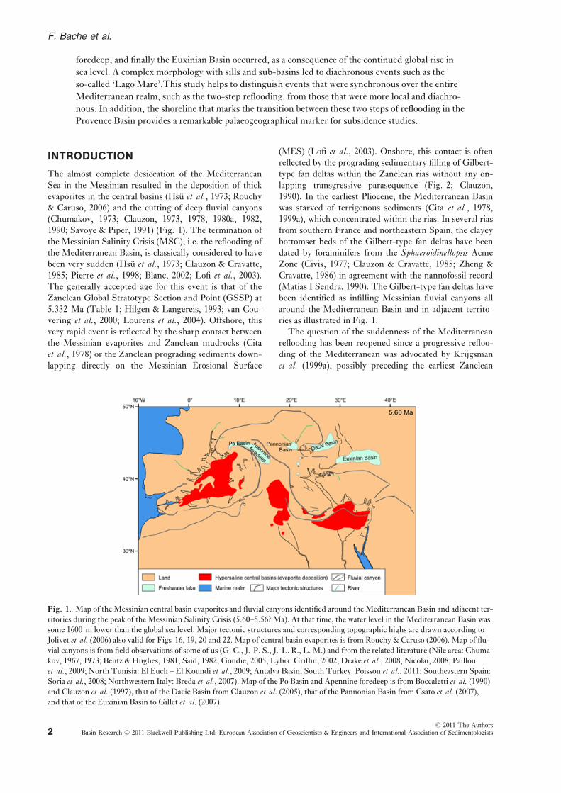
Fig. 1. Map of the Messinian central basin evaporites and fluvial canyons identified around the Mediterranean Basin and adjacent ter-
ritories during the peak of the Messinian Salinity Crisis (5.60–5.56? Ma). At that time, the water level in the Mediterranean Basin was
some 1600 m lower than the global sea level. Major tectonic structures and corresponding topographic highs are drawn according to
Jolivet et al. (2006) also valid for Figs 16, 19, 20 and 22. Map of central basin evaporites is from Rouchy & Caruso (2006). Map of flu-
vial canyons is from field observations of some of us (G. C., J.-P. S., J.-L. R., L. M.) and from the related literature (Nile area: Chuma-
kov, 1967, 1973; Bentz & Hughes, 1981; Said, 1982; Goudie, 2005; Lybia: Griffin, 2002; Drake et al., 2008; Nicolai, 2008; Paillou
et al., 2009; North Tunisia: El Euch – El Koundi et al., 2009; Antalya Basin, South Turkey: Poisson et al., 2011; Southeastern Spain:Soria et al., 2008; Northwestern Italy: Breda et al., 2007). Map of the Po Basin and Apennine foredeep is from Boccaletti et al. (1990)and Clauzon et al. (1997), that of the Dacic Basin from Clauzon et al. (2005), that of the Pannonian Basin from Csato et al. (2007),and that of the Euxinian Basin to Gillet et al. (2007).
© 2011 The AuthorsBasin Research © 2011 Blackwell Publishing Ltd, European Association of Geoscientists & Engineers and International Association of Sedimentologists2
F. Bache et al.
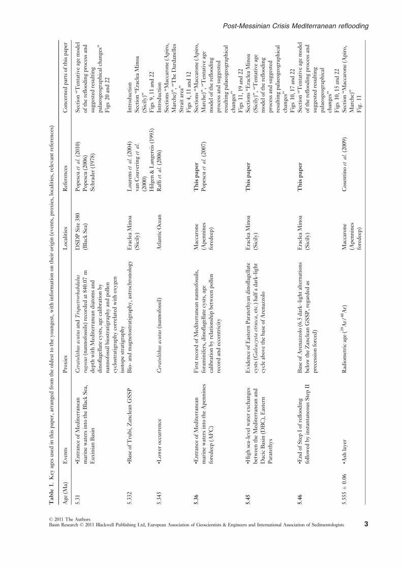
Table
1.Key
ages
usedinthispaper,arrangedfrom
theoldesttotheyoungest,withinform
ationon
theirorigin
(events,proxies,localities,relevantreferences)
Age
(Ma)
Events
Proxies
Localities
References
Concerned
partsofthispaper
5.31
•Entrance
ofMediterranean
marinewatersintotheBlack
Sea,
EuxinianBasin
CeratolithusacutusandTriquetrorhabdulus
rugosus(nannofossils)recorded
at840.07
m
depth
withMediterraneandiatomsand
dinoflagellatecysts,agecalibration
by
nannofossilbiostratigraphyandpollen
cyclostratigraphycorrelated
withoxygen
isotopestratigraphy
DSDPSite380
(Black
Sea)
Popescu
etal.(2010)
Popescu
(2006)
Schrader
(1978)
Section
“Tentative
agemodel
oftherefloodingprocessand
suggestedresulting
palaeogeographicalchanges”
Figs20
and22
5.332
•BaseofTrubi,ZancleanGSSP
Bio-andmagnetostratigraphy,astrochronology
Eraclea
Minoa
(Sicily)
Lourenset
al.(2004)
vanCouveringet
al.
(2000)
Hilgen&Langereis(1993)
Introduction
Section
“Eraclea
Minoa
(Sicily)”
Figs9,11
and22
5.345
•Low
eroccurrence
Ceratolithusacutus(nannofossil)
AtlanticOcean
Raffiet
al.(2006)
Introduction
Sections“M
accarone(Apiro,
Marche)”,“T
heDardanelles
Straitarea”
Figs4,11
and12
5.36
•Entrance
ofMediterranean
marinewatersintotheApennines
foredeep(AFC)
Firstrecord
ofMediterraneannannofossils,
foraminifers,dinoflagellatecysts,age
calibration
byrelationship
betweenpollen
record
andeccentricity
Maccarone
(Apennines
foredeep)
Thispaper
Popescu
etal.(2007)
Sections“M
accarone(Apiro,
Marche)”,“T
entative
age
modelofthereflooding
processandsuggested
resultingpalaeogeographical
changes”
Figs11,19
and22
5.45
•Highsea-levelwater
exchanges
betweentheMediterraneanand
DacicBasin
(DBC),Eastern
Paratethys
Evidence
ofEastern
Paratethyandinoflagellate
cysts(G
aleacystaetrusca,etc.)halfadark-light
cycleabovethebaseofArenazzolo
Eraclea
Minoa
(Sicily)
Thispaper
Sections“E
raclea
Minoa
(Sicily)”,“T
entative
age
modelofthereflooding
processandsuggested
resultingpalaeogeographical
changes”
Figs10,17
and22
5.46
•Endof
StepIof
reflooding
follow
edbyinstantaneousStepII
Baseof
Arenazzolo(6.5dark–lightalternations
belowtheZancleanGSSP,regarded
as
precessionforced)
Eraclea
Minoa
(Sicily)
Thispaper
Section
“Tentative
agemodel
oftherefloodingprocessand
suggestedresulting
palaeogeographical
changes”
Figs10,15
and22
5.555±0.06
•Ash
layer
Radiometricage(39Ar/
40Ar)
Maccarone
(Apennines
foredeep)
Cosentinoet
al.(2009)
Section
“Maccarone(Apiro,
Marche)”
Fig.11
© 2011 The AuthorsBasin Research © 2011 Blackwell Publishing Ltd, European Association of Geoscientists & Engineers and International Association of Sedimentologists 3
Post-Messinian Crisis Mediterranean reflooding
(Cavazza & Decelles, 1998; Cornee et al., 2006). The
problem also arises when considering the Sicilian Caltan-
issetta Basin (Fig. 3), a piggy-back basin located at that
time some 150–200 km northward of its present-day posi-
tion (Boccaletti et al., 1990; Casero, 2004; Jolivet et al.,2006). The interpretation of the environmental setting of
the basin is controversial, representing either a deep Med-
iterranean central basin that was subsequently uplifted
(Hsu et al., 1973; Krijgsman et al., 1999a; Rouchy & Car-
uso, 2006; Roveri & Manzi, 2006; Krijgsman & Meijer,
2008; Roveri et al., 2008a,b), assuming synchronism of
these evaporites with those of the Mediterranean central
basins; or a marginal (even though relatively deep)
domain (Brolsma, 1975; Butler et al., 1995; Clauzon
et al., 1996; Popescu et al., 2009) assuming that the evap-
orites in this basin are older than those of the central
basins. This question has been discussed for a long time
(Hsu et al., 1973) and is still intensely debated (e.g. Rou-
chy & Caruso, 2006; CIESM, 2008). Recent data acquired
offshore Tunisia (Sicily Strait) support the hypothesis
that the Caltanissetta Basin was rather a marginal basin
even if it deepens significantly from North to South (El
Euch – El Koundi et al., 2009).A very rapid process for the Mediterranean reflooding
after the MSC was until now considered satisfactory as
finer resolution data based on biostratigraphy or seismic
data were not available. This paper reviews recent off-
shore seismic evidence from the Gulf of Lions and its
relationship with boreholes (Bache et al., 2009) showingtwo types of erosional surfaces in regressive and trans-
gressive conditions, respectively. We re-visited and com-
pleted recently published onshore data documenting the
post-MSC marine transgression in different palaeoenvi-
ronmental contexts, particularly from Italy (Sicily: Lon-
deix et al., 2007; Popescu et al., 2009; Marche: Popescu
et al., 2007) and Turkey (Melinte-Dobrinescu et al.,2009) (Fig. 3). Several published and new age determina-
tions will be repeatedly used in this article. To help the
reader, they have been summarized in Table 1, pointing
out which event they date and how and where they have
been obtained within the relative literature. Nannofossils
have been intensively used for defining the chronostrati-
graphic position of the exposed sections considered here
(see Popescu et al., 2007; Melinte-Dobrinescu et al.,2009) following the chart shown in Fig. 4 (Berggren
et al., 1995; Raffi et al., 2006), in which the two steps in
deposition of the Messinian evaporites proposed by Clau-
zon et al. (1996) are indicated, a distinction which is now
widely accepted (CIESM, 2008; Ryan, 2011). After dis-
playing data from the Gulf of Lions that illustrate a
post-MSC reflooding of the Mediterranean in two steps,
we discuss the extension of this model to the eastern basin
and its potential chronology. We then consider the geody-
namic causes and attempt to quantify the associated
sea-level changes, leading to a revision of the late Messini-
an–early Zanlcean eustatic events in the Mediterranean
region (see the map of Fig. 3 for most of the localities
cited in the article).Table1(continued)
Age
(Ma)
Events
Proxies
Localities
References
Concerned
partsofthispaper
5.60
•Halitein
centralbasins
•Secondsea-levelfall(>1000
m)
•Closure
oftheRifian
corridor
16–17precessioncycles
ofPrimaryLow
er
Gypsum
Continuousdinoflagellatecystand
pollenrecords(chronologicallycalibratedby
bio-,magnetostratigraphyandoxygen
isotope
stratigraphy)indicatingincreasedcoastal
conditionsattheAtlanticoutletof
theRifian
corridor
Apennines
foredeep,Sorbas
Sale(Atlantic
Morocco)
CIESM
etal.(2008)
Krijgsm
anet
al.(1999b)
Warnyet
al.(2003)
Section
“Maccarone(Apiro,
Marche)”
Fig.1and22
5.96
•Evaporites
inmarginalbasins
•Beginningof
theMSC
•Firstsea-levelfall(ca.150m)
Bio-andmagnetostratigraphy,astrochronology
ofthefirstevaporites
Sorbas(SESpain),
Sicily
Krijgsm
anet
al.(1999b)
Gautier
etal.(1994)
Section
“Eraclea
Minoa
(Sicily)”
Fig.22
Agesin
boldcharactersaresuggestedin
thispaper.For
ages
correspondingto
severalevents(5.96and5.6Ma),thelatter
areindicated
from
theoldest(atthebottom)to
theyoungest(atthetop).Therelevantpartsof
this
paperareindicated.
© 2011 The AuthorsBasin Research © 2011 Blackwell Publishing Ltd, European Association of Geoscientists & Engineers and International Association of Sedimentologists4
F. Bache et al.

OFFSHOREDATA
The Western Mediterranean potentially records any con-
nection with the Atlantic Ocean due to its location near
the Strait of Gibraltar. Within the Western Mediterra-
nean, the Gulf of Lions is exceptional in that its Neogene
sedimentary strata have not been significantly deformed
except for salt-related tectonics in the deep basin (Gaul-
lier, 1993; Dos Reis et al., 2008) and no significant post-
sedimentation uplift has occurred in the deep basin. This
area can thus be considered as a good reference for sea-
level variations in the whole Mediterranean Basin. In
addition, the Gulf of Lions has been characterized by a
relatively high total subsidence rate, which has continu-
ously created accomodation space (Steckler & Watts,
1980; Bessis, 1986; Burrus, 1989; Rabineau et al., 2005;Bache et al., 2010). This configuration, together with the
availability of numerous offshore data (seismic profiles,
boreholes), has permitted accurate descriptions of the
transition between the Messinian halite identified in the
central Mediterranean basins and the Zanclean prograd-
ing sediments (Gorini, 1993; Lofi, 2002; Lofi et al., 2005;Bache, 2008; Lofi & Berne, 2008; Bache et al., 2009).Here, we will review these observations.
(a)
(b) (c)
(d) (e)
Fig. 2. Gilbert-type fan deltas (Gilbert, 1885, 1890) need a significant accommodation space. This was provided by erosion and very
fast flooding in the case of the Mediterranean in early Zanclean time. (a) Characteristic organization of Zanclean Gilbert-type fan del-
tas (Clauzon, 1990). They are composed of a prograding subaqueous part (clayey bottomset beds and conglomeratic to sandy foreset
beds, the sedimentary dip of which may reach 30–35°) and an aggrading subaerial part (conglomeratic to sandy almost horizontal top-
set beds often affected by significant alteration). Two key chronological surfaces bound them: the Messinian Erosional Surface at the
base (1), and the abandonment surface at the top (3). The diachronous subaqueous-continental (i.e. marine-continental in this case
study) transition is sandwiched between the foreset beds and the topset beds (2), corresponding to a condensed layer (often a lignite).
(b) Carros Breccia (Nice, SE France) overlain by an iron crust (indicated by the arrow). (c) Breccias of Salzidere (Bandirma, Turkey,
southern coastline of the Marmara Sea) overlain by an iron-rich crust (indicated by the arrow). (d) Coarse fluvial deposit with
reworked blocks ofMessinian gypsumwithin theMessinian fluvial canyon atGarrucha (Vera Basin, southeastern Spain). (e) Coarse flu-
vial deposit with reworked blocks ofMessinian gypsumwithin theMessinian fluvial canyon at San Ippolito (Volterra area, Central Italy).
© 2011 The AuthorsBasin Research © 2011 Blackwell Publishing Ltd, European Association of Geoscientists & Engineers and International Association of Sedimentologists 5
Post-Messinian Crisis Mediterranean reflooding

Seismic profiles
Three key surfaces intercalated between the precrisis
Miocene and the Pliocene deposits can be identified in the
Gulf of Lions (Fig. 5).
The first key-surface (‘f’ on Fig. 5) is the ‘MES’ also
named ‘Margin Erosional Surface’ by Lofi & Berne
(2008). This surface corresponds to the discordant contact
between theMiocene deposits (‘a’ on Fig. 5) and the over-
lying prograding Pliocene and Pleistocene sequence (‘g’
on Fig. 5). This pervasive erosional surface has long been
identified in the Rhone Valley (Denizot, 1952; Clauzon,
1973, 1982) and on the Gulf of Lions shelf (Ryan & Cita,
1978; Gennesseaux & Lefebvre, 1980; Lefebvre, 1980;
Gorini, 1993; Guennoc et al., 2000; Dos Reis, 2001; Lofi,
2002; Dos Reis et al., 2005, 2008; Lofi et al., 2005). Map-
ping of this surface shown in Fig. 6 revealed a pattern of
up to fifth order dendritic drainage and represents a sub-
aerial landscape (Gennesseaux & Lefebvre, 1980; Gorini
et al., 1993; Guennoc et al., 2000; Lofi et al., 2005).
Beneath the shelf, the sudden reflooding at the end of the
MSC is supported by the Zanclean prograding sediments
downlapping directly on the MES (Lofi et al., 2003). TheMES therefore represents the preserved subaerial land-
scape just before reflooding, which is generally dated at
5.332 Ma (Table 1; see also the ‘Introduction’). The land-
scape corresponding to the onset of the drawdown has not
been preserved on the shelf because of uninterrupted sub-
aerial exposure during theMessinian drawdown.
The second key-surface is the ‘Basal Erosional Surface’
(BES) (‘b’ on Fig. 5), which corresponds to the discor-
dant contact between precrisis Miocene deposits and
the syn-crisis detrital deposits (Maillard et al., 2006). Atthe present time, a controversy exists concerning its
Fig. 3. Location map of the studied areas with most of the main localities cited in the text and in Table 1. The map was created using
GeoMapApp System developed by Haxby et al. (2010). 1, Gulf of Lions (seismic profiles and boreholes), details are given in Fig. 5; 2,
Eraclea Minoa in the Caltanissetta Basin (onshore sections); 3, Maccarone (onshore section near Apiro); 4, Dardanelles Strait area
(onshore sections).
Fig. 4. Chronostratigraphy and nanno-
plankton biostratigraphy of the Late
Miocene and Early–Middle Pliocene.
Ages of stages, polarity chrons refer to
Lourens et al. (2004), NN zonation to
Berggren et al. (1995) and Raffi et al.(2006), age of nannoplankton events to
Raffi et al. (2006). The grey strips corre-spond to the generally accepted (CIESM,
2008) two steps of the MSC (Clauzon
et al., 1996). See also Melinte-Dobrine-
scu et al. (2009) for more details concern-
ing this nannoplankton chart.
© 2011 The AuthorsBasin Research © 2011 Blackwell Publishing Ltd, European Association of Geoscientists & Engineers and International Association of Sedimentologists6
F. Bache et al.

significance. On the basis of detailed mapping of this sur-
face, Bache (2008) and Bache et al. (2009) considered the
‘BES’ as the marker of the Messinian drawdown in the
basin (‘b’ on Fig. 5). In contrast, Lofi & Berne (2008)
interpreted this surface as a pre-MSC discordance related
to sub-marine slope canyon erosional systems and placed
the ‘BES’ higher in the Miocene series. A full discussion
concerning the consequences of these interpretations is
beyond the scope of this article, but can be found in Bache
et al. (2009).Finally, the third surface (planation surface ‘e’ on
Fig. 5) is a straight and smooth surface that is locally con-
formable with the underlying precrisis series (between 64
and 90 km from the coast on Fig. 5), but that is also
locally erosional (90–100 km; Fig. 5) as it truncates the
underlying syn-crisis series (Bache, 2008; Bache et al.,2009). Above this surface, sedimentary units are charac-
terized by onlap termination of seismic reflectors in the
deepest part and downlap termination in the shallower
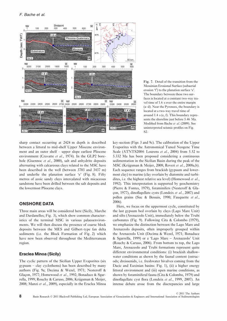
part (Figs 5 and 7). The limit between the MES and the
planation surface ‘e’ is clear and occurs at a constant two-
way travel time of 1.6 s over most of the shelf (Figs 5–7).Towards the basin, the limit of salt deposition represents
the maximum extent of erosion. The planation surface ‘e’
thus extends over 50 km, from the shelf to the basin
(Fig. 6).
Boreholes
Boreholes located on the shelf (Fig. 6) show that the
MES truncates Miocene sediments and underlies the ear-
liest Pliocene sediments (Cravatte et al., 1974; Gorini
et al., 1993; Guennoc et al., 2000; Lofi et al., 2003). Theyoungest Miocene sediments were found in the Tramon-
tane1 well and were dated as Tortonian (Cravatte et al.,1974), i.e. between 11.61 and 7.25 Ma (Lourens et al.,
2004). The record of the Upper Miocene sediments is
missing, having been removed by subaerial erosion during
the MSC. The amplitude of erosion during the MSC
reaches at least 1 km in the central part of the Languedoc
shelf (Lofi et al., 2005; Bache, 2008; Bache et al., 2009).Boreholes Autan1 and GLP2 drilled on the slope
(Fig. 6) cross-surface ‘e’ respectively in its landward and
seaward areas (Fig. 5). In the Autan1 borehole, a very
Fig. 5. Line drawing and details of seismic lines perpendicular and parallel to the margin of the Gulf of Lions showing the major key
surfaces related to the Messinian Salinity Crisis. Location of seismic profiles on Fig. 6. See uninterpreted seismic profile on Fig. S1.
Fig. 6. Subsurface mapping of the basal Pliocene of the Gulf of
Lions showing the limits between the various topographic zones
(from the basin to the margin: halite, planation surface ‘e’, Mes-
sinian Erosional Surface) and location of line drawings shown in
Figs 5 and 8. Boreholes: Ca, Calmar; Ci, Cicindelle; Si, Siroc-co1;Mi, Mistral1; Tra, Tramontane1; Ra, Rascasse1; Au1,Autan1; CAg, Cap d’Agde1; Can, Canet1.
© 2011 The AuthorsBasin Research © 2011 Blackwell Publishing Ltd, European Association of Geoscientists & Engineers and International Association of Sedimentologists 7
Post-Messinian Crisis Mediterranean reflooding
sharp contact occurring at 2424 m depth is described
between a littoral to mid-shelf Upper Miocene environ-
ment and an outer shelf – upper slope earliest Pliocene
environment (Cravatte et al., 1974). In the GLP2 bore-
hole (Guennoc et al., 2000), salt and anhydrite deposits
alternating with calcareous clays related to the MSC have
been described in the well (between 3703 and 3437 m)
and underlie the planation surface ‘e’ (Fig. 8). Fifty
metres of azoic sandy clays intercalated with micaceous
sandstone have been drilled between the salt deposits and
the lowermost Pliocene clays.
ONSHOREDATA
Three main areas will be considered here (Sicily, Marche
and Dardanelles; Fig. 3), which show common character-
istics of the terminal MSC in various palaeoenviron-
ments. We will then discuss the presence of coarse block
deposits between the MES and Gilbert-type fan delta
sediments (i.e. the Block Formation of Fig. 2) which
have now been observed throughout the Mediterranean
region.
EracleaMinoa (Sicily)
The cyclic pattern of the Sicilian Upper Evaporites (six
gypsum – clay cyclothems) has been described by many
authors (Fig. 9a; Decima & Wezel, 1971; Nesteroff &
Glacon, 1977; Homewood et al., 1992; Bonaduce & Sgar-
rella, 1999; Rouchy & Caruso, 2006; Krijgsman & Meijer,
2008; Manzi et al., 2009), especially in the Eraclea Minoa
key-section (Figs 3 and 9c). The calibration of the Upper
Evaporites with the Astronomical Tuned Neogene Time
Scale (ATNTS2004: Lourens et al., 2004) from 5.52 to
5.332 Ma has been proposed considering a continuous
sedimentation in the Sicilian Basin during the peak of the
MSC (Krijgsman & Meijer, 2008; Roveri et al., 2008a,b).Each sequence ranges from brackish (gypsum and lower-
most clay) to marine (clay overlain by diatomite and turbi-
dites, i.e. the highest relative sea level) (Homewood et al.,1992). This interpretation is supported by geochemistry
(Pierre & Fontes, 1979), foraminifers (Nesteroff & Gla-
con, 1977), dinoflagellate cysts (Londeix et al., 2007) andpollen grains (Suc & Bessais, 1990; Fauquette et al.,2006).
Here, we focus on the uppermost cycle, constituted by
the last gypsum bed overlain by clays (Lago Mare Unit)
and silts (Arenazzolo Unit), immediately below the Trubi
carbonates (Fig. 9). Following Cita & Colombo (1979),
we emphasize the distinction between the Lago Mare and
Arenazzolo deposits, often improperly grouped within
the Arenazzolo Unit (Decima & Wezel, 1971; Bonaduce
& Sgarrella, 1999) or a ‘Lago Mare – Arenazzolo’ Unit
(Rouchy & Caruso, 2006). From bottom to top, the Lago
Mare, Arenazzolo and Trubi formations represent quite
different environmental conditions: (i) brackish shallow-
water conditions as shown by the faunal content (ostrac-
ods; dreissenids, i.e. freshwater bivalves coming from the
Dacic and Euxinian basins: Fig. 1), (ii) a higher energy
littoral environment and (iii) open marine conditions, as
shown by foraminiferal fauna (Cita & Colombo, 1979) and
dinoflagellate cyst flora (Londeix et al., 1999, 2007). Anintense debate arose from the discrepancies and large
(a)
(b)
(d) (e)(f)
(c)
Fig. 7. Detail of the transition from the
Messinian Erosional Surface (subaerial
erosion ‘f’) to the planation surface ‘e’.
The boundary between these two sur-
faces is located at a constant two-way tra-
vel time of 1.6 s over the entire margin
(a–d). Near the Pyrenees, the boundary is
located at a two-way travel time of
around 1.4 s (e, f). This boundary repre-
sents the shoreline just before 5.46 Ma.
Modified from Bache et al. (2009). Seeuninterpreted seismic profiles on Fig.
S2.
© 2011 The AuthorsBasin Research © 2011 Blackwell Publishing Ltd, European Association of Geoscientists & Engineers and International Association of Sedimentologists8
F. Bache et al.

uncertainties about the palaeo-water depth estimates for
the Trubi deposition. Using quantitative studies on ben-
thic foraminifers, Brolsma (1978) proposed 100–1000 m,
whereas Cita & Colombo (1979) proposed 1400–2400 m,
using benthic foraminifers and the sharp sedimentary
contrast between the uppermost Messinian and lower-
most Zanclean deposits, in both exposed sections and
DSDP (Deep Sea Drilling Project) wells. Disagreement
also concerns the location of the most significant environ-
mental change. Cita & Gartner (1973) and Cita et al.(1999b) proposed the location of the environmental break
at the base of the Trubi, emphasizing the presence of a
sharp and even unconformable contact. Brolsma (1975)
interpreted the Arenazzolo Unit as a transitional interval
leading to the Trubi conditions and proposed locating the
environmental break between the Lago Mare and Are-
Fig. 8. Ligo 54 profile crossing the
GLP2 borehole. The erosional nature of
the planation surface ‘e’ and the trans-
gressive nature of sediments deposited
above it are outlined by arrows. The
50 m of azoic sand described in the
GLP2 borehole could correspond to the
transgressive sands eroded from
upstream by the wave erosion (planation
surface ‘e’). Location of seismic profiles
on Fig. 6. See uninterpreted seismic pro-
file on Fig. S3.
(a)
(b)
(d)
(e)
(f)
(g)(c)
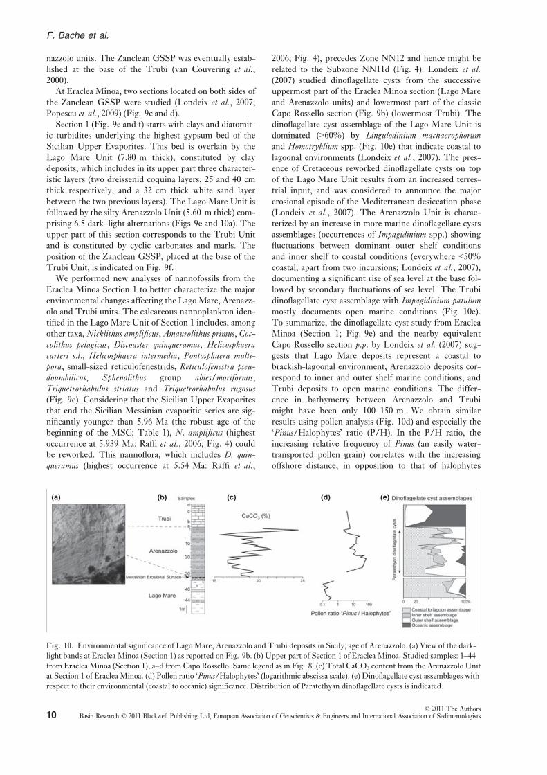
Fig. 9. Eraclea Minoa (southern Sicily). (a) Simplified classical stratigraphic succession of the Tortonian to Zanclean Sicilian series
(Decima &Wezel, 1971). (b) Location of Eraclea Minoa and Capo Rossello in Sicily. (c) Location map of the two studied sections at
Eraclea Minoa. (d) View of the eastern part of the Eraclea Minoa succession with location of Sections 1 and 2, and of the Zanclean
Stage GSSP. (e) Eraclea Minoa Sections 1 and 2 compared: the grey surface shows the missing part (eroded) of Lago Mare in Section
2. Nannoplankton data according to A. Di Stefano (pers. comm.) and our own results. (f) View of Section 1. The white box corre-
sponds to the girdled stratigraphic interval in (a). (g) View of Section 2.
© 2011 The AuthorsBasin Research © 2011 Blackwell Publishing Ltd, European Association of Geoscientists & Engineers and International Association of Sedimentologists 9
Post-Messinian Crisis Mediterranean reflooding
nazzolo units. The Zanclean GSSP was eventually estab-
lished at the base of the Trubi (van Couvering et al.,2000).
At Eraclea Minoa, two sections located on both sides of
the Zanclean GSSP were studied (Londeix et al., 2007;Popescu et al., 2009) (Fig. 9c and d).
Section 1 (Fig. 9e and f) starts with clays and diatomit-
ic turbidites underlying the highest gypsum bed of the
Sicilian Upper Evaporites. This bed is overlain by the
Lago Mare Unit (7.80 m thick), constituted by clay
deposits, which includes in its upper part three character-
istic layers (two dreissenid coquina layers, 25 and 40 cm
thick respectively, and a 32 cm thick white sand layer
between the two previous layers). The Lago Mare Unit is
followed by the silty Arenazzolo Unit (5.60 m thick) com-
prising 6.5 dark–light alternations (Figs 9e and 10a). The
upper part of this section corresponds to the Trubi Unit
and is constituted by cyclic carbonates and marls. The
position of the Zanclean GSSP, placed at the base of the
Trubi Unit, is indicated on Fig. 9f.
We performed new analyses of nannofossils from the
Eraclea Minoa Section 1 to better characterize the major
environmental changes affecting the Lago Mare, Arenazz-
olo and Trubi units. The calcareous nannoplankton iden-
tified in the Lago Mare Unit of Section 1 includes, among
other taxa,Nicklithus amplificus, Amaurolithus primus, Coc-colithus pelagicus, Discoaster quinqueramus, Helicosphaeracarteri s.l., Helicosphaera intermedia, Pontosphaera multi-pora, small-sized reticulofenestrids, Reticulofenestra pseu-doumbilicus, Sphenolithus group abies/moriformis,Triquetrorhabulus striatus and Triquetrorhabulus rugosus(Fig. 9e). Considering that the Sicilian Upper Evaporites
that end the Sicilian Messinian evaporitic series are sig-
nificantly younger than 5.96 Ma (the robust age of the
beginning of the MSC; Table 1), N. amplificus (highestoccurrence at 5.939 Ma: Raffi et al., 2006; Fig. 4) couldbe reworked. This nannoflora, which includes D. quin-queramus (highest occurrence at 5.54 Ma: Raffi et al.,
2006; Fig. 4), precedes Zone NN12 and hence might be
related to the Subzone NN11d (Fig. 4). Londeix et al.(2007) studied dinoflagellate cysts from the successive
uppermost part of the Eraclea Minoa section (Lago Mare
and Arenazzolo units) and lowermost part of the classic
Capo Rossello section (Fig. 9b) (lowermost Trubi). The
dinoflagellate cyst assemblage of the Lago Mare Unit is
dominated (>60%) by Lingulodinium machaerophorumand Homotryblium spp. (Fig. 10e) that indicate coastal to
lagoonal environments (Londeix et al., 2007). The pres-
ence of Cretaceous reworked dinoflagellate cysts on top
of the Lago Mare Unit results from an increased terres-
trial input, and was considered to announce the major
erosional episode of the Mediterranean desiccation phase
(Londeix et al., 2007). The Arenazzolo Unit is charac-
terized by an increase in more marine dinoflagellate cysts
assemblages (occurrences of Impagidinium spp.) showing
fluctuations between dominant outer shelf conditions
and inner shelf to coastal conditions (everywhere <50%coastal, apart from two incursions; Londeix et al., 2007),documenting a significant rise of sea level at the base fol-
lowed by secondary fluctuations of sea level. The Trubi
dinoflagellate cyst assemblage with Impagidinium patulummostly documents open marine conditions (Fig. 10e).
To summarize, the dinoflagellate cyst study from Eraclea
Minoa (Section 1; Fig. 9e) and the nearby equivalent
Capo Rossello section p.p. by Londeix et al. (2007) sug-gests that Lago Mare deposits represent a coastal to
brackish-lagoonal environment, Arenazzolo deposits cor-
respond to inner and outer shelf marine conditions, and
Trubi deposits to open marine conditions. The differ-
ence in bathymetry between Arenazzolo and Trubi
might have been only 100–150 m. We obtain similar
results using pollen analysis (Fig. 10d) and especially the
‘Pinus/Halophytes’ ratio (P/H). In the P/H ratio, the
increasing relative frequency of Pinus (an easily water-
transported pollen grain) correlates with the increasing
offshore distance, in opposition to that of halophytes
(a) (b) (c) (d) (e)
Fig. 10. Environmental significance of Lago Mare, Arenazzolo and Trubi deposits in Sicily; age of Arenazzolo. (a) View of the dark-
light bands at Eraclea Minoa (Section 1) as reported on Fig. 9b. (b) Upper part of Section 1 of Eraclea Minoa. Studied samples: 1–44from Eraclea Minoa (Section 1), a–d from Capo Rossello. Same legend as in Fig. 8. (c) Total CaCO3 content from the Arenazzolo Unit
at Section 1 of Eraclea Minoa. (d) Pollen ratio ‘Pinus/Halophytes’ (logarithmic abscissa scale). (e) Dinoflagellate cyst assemblages with
respect to their environmental (coastal to oceanic) significance. Distribution of Paratethyan dinoflagellate cysts is indicated.
© 2011 The AuthorsBasin Research © 2011 Blackwell Publishing Ltd, European Association of Geoscientists & Engineers and International Association of Sedimentologists10
F. Bache et al.
(plants restricted to coastal environments) (Suc et al.,1995). We interpret the abrupt and intense changes in
the pollen ratio P/H (Fig. 10d) as indicating that the
rise in sea level preceding Arenazzolo corresponds to a
significant increase in the distality at the locality. On the
other hand, the continuing process of sea-level rise at
the base of Trubi apparently did not coincide with an
increased distality. Accordingly, palynological data
(dinoflagellate cysts and pollen grains) support the inter-
pretation that the most significant break in marine influ-
ence occurred between the Lago Mare and Arenazzolo
units. We must indicate that Eastern Paratethyan dino-
flagellate cysts (Galeacysta etrusca mostly) are regularly
recorded from 60 cm above the base of Arenazzolo prac-
tically up to its top (Fig. 10e; Londeix et al., 2007;
Popescu et al., 2009).Section 2 (Fig. 9e and g) is markedly different from
Section 1: the Lago Mare Unit is significantly thinner
(1.50 m thick only) and truncated at its top, ending with a
single residual 2 cm thick coquina layer rich in dreisse-
nids; the Arenazzolo Unit (same thickness as at Section 1)
clearly onlaps the Lago Mare clays (Fig. 9g) and, accord-
ing to our new nannofossil analyses, contains typical ‘Plio-
cene’ specimens, Helicosphaera selli and Discoasterasymmetricus, while Ceratolithus acutus was not recorded(Fig. 9e). We therefore conclude that the upper part of
the Lago Mare of Section 1 has been eroded in Section 2,
and that the erosional contact between Arenazzolo and
Lago Mare should correspond to the MES (Fig. 9e) and,
hence, the peak of the MSC with the major sea-level
drawdown.
Here, we consider that desiccation of the Mediterra-
nean is not expressed by intensely marked erosion, prob-
ably because the locality occupied an interfluvial
position in a semi-arid area with limited erosion and
condensed sedimentation (Suc & Bessais, 1990; Fau-
quette et al., 2006) as known in other peri-Mediterra-
nean localities (Vera Basin, Cuevas de Almanzora
section: Clauzon, 1980b; Dardanelles Strait area, Intepe
section: Melinte-Dobrinescu et al., 2009). However, sig-
nificant and coeval erosion is suggested by several off-
shore wells in the area such as Zagara 1 and Venere 1
(Fig. 3) and by seismic profiles where Lower Pliocene
deposits immediately overlie the Upper Miocene, so-
called Terravecchia (VI.D.E.P.I. Database: fttp://www.
videpi.com/mappa.php). This interpretation is also sup-
ported by the offshore data from Tunisia, which indicate
that the dramatic sea-level drop that caused evaporite
deposition in the Mediterranean central basins and the
cutting of fluvial canyons on their margins occurred
after the deposition of a thick marginal evaporitic suc-
cession similar to the Sicilian series (Fig. 9a; El Euch –El Koundi et al., 2009).
The 6.5 dark–light alternations observed at Section 1
within the Arenazzolo Unit (Figs 9e and 10a and b; see
also: Decima & Wezel, 1971; : fig. 9), already indicated by
Brolsma (1975) at Capo Rossello, resemble the preces-
sion-related carbonate cycles of the overlying Trubi
(Hilgen & Langereis, 1989). To clarify the cause of the
dark–light alternations of the Arenazzolo Unit, we esti-
mated its CaCO3 content by measurement of the escaped
CO2 as reaction to HCl using a Bernard calcimeter. The
values are shown in Fig. 10c: on the whole, dark bands
correspond to higher carbonate contents, with a more reli-
able relationship in the upper Arenazzolo. Although vari-
ations in Arenazzolo CaCO3 only fluctuate between 15%
and 25%, at a lower level than in the Trubi (60–80%:
Hilgen & Langereis, 1989), in the same way, we speculate
that the dark–light alternations can be similarly used as a
chronometer to estimate by precession-tuning the age of
the base of Arenazzolo on the basis of the continuity in
sedimentation between Arenazzolo and Trubi (Londeix
et al., 2007).
Maccarone (Apiro,Marche)
The Maccarone section (Figs 3 and 11a) belongs to the
reference area for the Apennine foredeep, where reworked
marginal gypsum is observable beneath a thick clayey-
turbiditic series (the Di Tetto Formation) devoid of
foraminifers in its lower part (Carloni et al., 1974; Pope-scu et al., 2007), i.e. the p-ev1b sequence of Roveri et al.(2001) (Fig. 11a). This formation is overlain by the Co-
lombacci clay-limestone alternations and topped by the
Lower Zanclean open-marine Argille Azzurre (>700 m in
thickness within the foredeep, 210 m at Maccarone
located on the edge of the foredeep) (Roveri & Manzi,
2006). The Maccarone section benefits from three precise
ages near its base and top (Fig. 11a): (i) an ash layer first
dated at 5.51 ± 0.05 Ma using 39Ar/40Ar (Odin et al.,1997), but recently, re-dated at 5.555 ± 0.06 Ma
(Table 1; Cosentino et al., 2009) as considered in Fig. 11,and (ii) the evidence of the C3n.4n (i.e. Thvera) normal
palaeomagnetic Chron (Gennari et al., 2008), the base
and top of which are respectively dated at 5.235 and
4.997 Ma (Lourens et al., 2004). As a consequence, the
base of the Argille Azzurre Formation, just preceding the
Sphaeroidinellopsis Acme (Zone MPl1), is reasonably
dated at 5.332 Ma by Gennari et al. (2008). This chrono-logical calibration of the section has been recently
strenghtened by Popescu et al. (2007) who recorded the
first evidence of C. acutus at 133 m in the section
(Fig. 11a), the marker of the nannoplankton Subzone
NN12b (Fig. 4) whose Lowest Occurrence is dated at
5.345 Ma (Table 1; Raffi et al., 2006). Popescu et al.(2007) demonstrated that the increased distance from pal-
aeoshoreline indicated by a sudden doubling of disaccate
pollen grains at ca. 110 m in the section (Fig. 11a; Bertin-
i, 1992, 2006) was caused by the entrance of marine waters
into the Apennine foredeep, almost coeval with the earli-
est influx of Paratethyan surface waters. The above-men-
tioned age model of the section (Fig. 11a) allows us to
propose a new cyclostratigraphy, based on the pollen
record studied by Bertini (1992, 2006), which differs from
that of Roveri & Manzi (2006) and Gennari et al. (2008).We use the pollen ratio (SE/AE) ‘Subtropical Elements/
© 2011 The AuthorsBasin Research © 2011 Blackwell Publishing Ltd, European Association of Geoscientists & Engineers and International Association of Sedimentologists 11
Post-Messinian Crisis Mediterranean reflooding

Altitudinal Elements’, i.e. mostly Taxodiaxeae plus other
subtropical plants (Engelhardia, Nyssa, Arecaceae, Cyrill-aceae-Clethraceae, etc.) vs. the Cedrus–Tsuga–Abies–Piceaaltitudinal forest complex (Fig. 11b). The curve expresses
the amount of pollen grains of low-altitude thermophilous
forests (i.e. SE) relative to those of coniferous forests
growing in significantly cooler conditions at higher alti-
tude (i.e. AE). Maxima of SE in the pollen records repre-
sent spreading of thermophilous forests during warmer
phases, while maxima of AE correspond to descents of the
altitudinal forest belts as a response to cooler phases, mak-
ing this index very useful for climate reconstructions at
the foot of high mountains (Popescu, 2001). It is estab-
lished that, in contrast to Late Pleistocene, Pliocene and
Early Pleistocene cooling phases occurred during times of
high eccentricity and the warmer phases correspond to
low eccentricity (Li et al., 1998). This relationship was
applied to a well-dated long section by Popescu (2001)
and Popescu et al. (2006a), who correlated the highest
values of the SE/AE ratio with minima of eccentricity
and its lowest values with maxima of eccentricity. Consid-
ering the time-window 5.60–5.30 Ma that corresponds to
deposition of the Maccarone section, it is worth noting
that three eccentricity minima (warmer phases) appear at
5.592, 5.486 and 5.378 Ma respectively (Fig. 11c; Laskar
et al., 2004). In-between, the highest value of the SE/AEratio is directly correlated with the lowermost minimum
of eccentricity at 5.378 Ma, consistent with the first
occurrence of C. acutus at 5.345 Ma (Fig. 11a). Then, the
underlying maxima of SE/AE are correlated with the suc-
cessive minima of eccentricity (at 5.486 and 5.592 Ma)
and the inserted minima of SE/AE are correlated with
the maxima of eccentricity (at 5.428 and 5.533 Ma)
(Fig. 11b and c).
The Dardanelles Strait area
In this area, two kinds of sedimentary records have been
observed (Fig. 12; Melinte-Dobrinescu et al., 2009). AtIntepe (Fig. 12a), an apparently continuous section
(Fig. 12b), with bay to lagoon environments and a con-
stant nannoflora allows, by using the first appearance of
C. acutus (at 5.345 Ma; Table 1) (Fig. 12b and c), the
precise location of the MSC below this point. A thin
bed of lignite was observed below a thin rubefied (i.e.
fired) clayey bed transformed into porcellanite. This
contact (Fig. 12b and c) has been interpreted as evi-
dence of local emersion and correlated with the peak of
the MSC (Melinte-Dobrinescu et al., 2009). These
authors correlated the lignite with the marginal evapor-
ites (the first step of the MSC; Clauzon et al., 1996).However, a few hundred metres northwards, Melinte-
Dobrinescu et al. (2009) pointed out thick sandy foreset
beds (dipping at 25° to the West) of a Gilbert-type fan
delta, with clayey bottomset beds exposed along the
northern shoreline of the Dardanelles Strait at
Seddulbahir where the first appearance of C. acutus (i.e.at 5.345 Ma; Table 1) has been recorded (Fig. 12b and
Fig. 11. Maccarone (Apiro, Marche). (a) Litho-, bio- and chronostratigraphy. Ages of palaeomagnetic Chron C3n.4n and of the base
of Zanclean are from Lourens et al. (2004), age of the Lowest Occurrence of Ceratolithus acutus is from Raffi et al. (2006). Age(5.36 Ma) in bold characters is the estimated age of the entrance of marine waters into the Apennine foredeep. Lithology from Popescu
et al. (2007). Magnetostratigraphy: Messinian sediments (G. Napoleone, pers. comm.), Zanclean sediments (Gennari et al., 2008). (b)Pollen ratio ‘Subtropical Elements (SE)/Altitudinal Elements (AE)’ (logarithmic abscissa scale) from Bertini (1992, 2006), plotted on
the log of the Maccarone section. (c) Eccentricity curve between 5.62 and 5.30 Ma (Laskar et al., 2004), plotted on the orbital time-
scale. Uncertainty on the age of the ash is indicated by the grey range.
© 2011 The AuthorsBasin Research © 2011 Blackwell Publishing Ltd, European Association of Geoscientists & Engineers and International Association of Sedimentologists12
F. Bache et al.
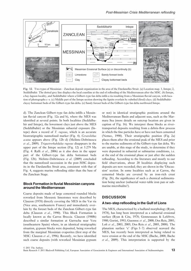
d). The Zanclean Gilbert-type fan delta infills a Messin-
ian fluvial canyon (Fig. 12a and b), where the MES was
identified at several points. In both localities (Seddulba-
hir and Intepe), the lowermost clays just above the MES
(Seddulbahir) or the Messinian subaerial exposure (In-
tepe) show a record of T. rugosus, which is an accurate
biostratigraphic nannofossil marker (Fig. 4). Ceratolithusacutus appears above (Fig. 12b–d) (Melinte-Dobrinescu
et al., 2009). Triquetrorhabdulus rugosus disappears in the
upper part of the Intepe section (Fig. 12) at 5.279 Ma
(Fig. 4: Raffi et al., 2006) as it also does in the upper
part of the Gilbert-type fan delta bottomset beds
(Fig. 12b). Melinte-Dobrinescu et al. (2009) concluded
that the nannofossil succession in the post-MSC depos-
its in the Dardanelles Strait area, consistent with that of
Fig. 4, suggests marine reflooding older than the base of
the Zanclean Stage.
Block Formation in fluvial Messinian canyonsaround theMediterranean
Coarse deposits made of large cemented rounded blocks
reworked from Mesozoic limestones were described by
Clauzon (1978) directly covering the MES in the Var ria
(Nice area, southeastern France) and immediately over-
lain by the foreset beds of the Zanclean Gilbert-type fan
delta (Clauzon et al., 1990). This Block Formation is
locally known as the Carros Breccia. Clauzon (1980b)
described a similar formation at Garrucha near Vera
(southeastern Spain) where, in an identical stratigraphic
situation, gypsum blocks were deposited, being reworked
from the marginal Messinian evaporites (first step of the
MSC: Clauzon et al., 1996). Recently, we have identifiedsuch coarse deposits (with reworked Messinian gypsum
or not) in identical stratigraphic positions around the
Mediterranean Basin and adjacent seas, such as the Mar-
mara Sea (more details on outcrop location are given in
caption of Fig. 16). We interpret those blocks as river-
transported deposits resulting from a debris-flow process
in which the fine particles have or have not been cemented
(Nemec, 1990). Their stratigraphic position (Fig. 2a)
places them after the erosional peak of the MES and prior
to the marine sediments of the Gilbert-type fan delta. We
are unable, at this stage of the study, to determine if they
were deposited in subaerial or submarine conditions, i.e.
at the end of the erosional phase or just after the sudden
reflooding. According to the literature and mostly to our
field observations, about 20 localities displaying such
deposits are now recorded; they are shown in the ‘Discus-
sion’ section. In some localities such as at Carros, the
cemented blocks are covered by an iron-rich crust
(Fig. 2b), the significance of such a chemical sedimenta-
tion being unclear (subaerial water-table iron pan or sub-
marine microbialite?).
DISCUSSION
A two-step reflooding in the Gulf of Lions
The MES, characterized by a badland morphology (Ryan,
1978), has long been interpreted as a subaerial erosional
surface (Ryan & Cita, 1978; Gennesseaux & Lefebvre,
1980; Gorini, 1993; Guennoc et al., 2000; Dos Reis, 2001;
Lofi et al., 2003, 2005; Dos Reis et al., 2005, 2008). Theplanation surface ‘e’ (Figs 5–7) observed seaward the
MES, has recently been interpreted as being related to
wave erosion at the end of the MSC (Bache, 2008; Bache
et al., 2009). This interpretation is supported by the
(a)
(c)
(b)
(e)
(d)
Fig. 12. Two types of Messinian – Zanclean deposit organization in the area of the Dardanelles Strait. (a) Location map. 1, Intepe; 2,
Seddulbahir. The dotted grey line displays the local coastline at the end of reflooding of the Mediterranean after the MSC. (b) Intepe,
a bay-lagoon locality, and Seddulbahir where a Gilbert-type fan delta infils a ria resulting from a Messinian fluvial canyon, with loca-
tion of photographs c–e. (c) Middle part of the Intepe section showing the lignite overlain by rubefied (fired) clays. (d) Seddulbahir:
clayey bottomset beds of the Gilbert-type fan delta. (e) Sandy foreset beds of the Gilbert-type fan delta northward Intepe.
© 2011 The AuthorsBasin Research © 2011 Blackwell Publishing Ltd, European Association of Geoscientists & Engineers and International Association of Sedimentologists 13
Post-Messinian Crisis Mediterranean reflooding
smooth aspect of surface ‘e’ over a large horizontal dis-
tance, by the erosional truncations of the underlying ser-
ies, and also by the onlap termination of the overlying
series (Figs 5 and 7), which are all characteristic features
of transgressive surfaces (Cattaneo & Steel, 2003; Catu-
neanu, 2006). Past analogues of such transgressive sur-
faces are known in southeastern France (Champion et al.,2000). These surfaces, related to Miocene transgressions,
present an almost horizontal smooth morphology over
large distance (Fig 13a and b), which may be compared
with the planation surface ‘e’ highlighted in this study.
Wave erosion is essentially contained between the surf
zone and the limit of fair-weather wave base, which is
usually located between 10 and 20 m depth (Demarest &
Kraft, 1987; Abbott, 1998; Catuneanu, 2006) and can
reach up to 40 m depth in the case of extreme wave
energy, such as in the Canterbury Plains in New Zealand
(Leckie, 1994). Sunamura (1987) also calculated a maxi-
mum theoretical depth of 40 m offshore Japan. In the case
of extreme storm waves, the wave base can reach 70 m to
maximum depth of 200 m in the Irish Sea and New-
foundland (Cattaneo & Steel, 2003; Guillocheau et al.,2009). Consequently, surfaces abraded by wave ravine-
ment during a landward shift of the shoreline can be used
to estimate the associated increase in bathymetry. For this
purpose, we need to estimate their slope at the time of
their formation (see below the ‘Quantification of the two
steps’ section).
Storm events can erode clean sands from the shoreface
and deposit them further offshore (between the fair-
weather wave base and the storm wave base). These
deposits are often enriched in micas and intercalated
between offshore silty-clay deposits (Guillocheau et al.,2009). The 50 m of azoic deposits found in the GLP2 well
(Fig. 8), corresponding to an alternation of fine to med-
ium micaceous sandstone with subrounded to subangular
grains and silty calcareous clays, could be the result of
such events. In the Gulf of Lions, wave action has thus
reworked the previous deposits and also reshaped the sub-
aerial unconformity into a typical planation surface. This
early transgression must have been relatively slow to
enable wave erosion, removal of material and smoothing
of the surface.
The contact between badland morphology and the pla-
nation surface ‘e’, at constant TWT (two-way time) depth
throughout the Gulf of Lions (Fig. 7), has been inter-
preted as indicating the location of the palaeoshoreline
at the end of the wave erosion phase and just before the
very rapid reflooding of the Mediterranean (Bache, 2008;
Bache et al., 2009). Numerous representative analogues
of this situation can be found in areas where wave action
affects the present-day shoreline (Fig. 13c and d).
A major transition in the variations of the relative sea
level and a two-step reflooding can thus be proposed.
First, a slow landward migration of the shoreline
smoothed the distal subaerial relief of the deepest part of
the MES, and reworked previous regressive deposits
(Step I; Fig. 5); and second, very rapid reflooding ‘froze’
the remaining subaerial surface (MES) without further
erosion or deposition because it suddenly became out of
the range of wave action (Step II; Fig. 5).
Can the two-step refloodingscenario beextended to the scale of the entireMediterranean?
The evidence of Gilbert-type fan deltas within several
Zanclean rias (Dardanelles area as described above: Melin-
(a)
(c)
(d)(b)
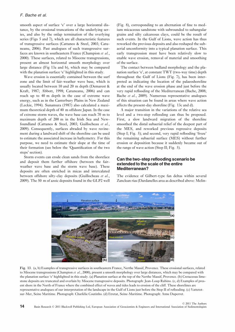
Fig. 13. (a, b) Examples of transgressive surfaces in southeastern France, Nerthe Massif, Provence. These erosional surfaces, related
to Miocene transgressions (Champion et al., 2000), present a smooth morphology over large distances, which may be compared with
the planation surface ‘e’ highlighted in this study. (a) Planation surface at the top of the Nerthe Massif, Provence. (b) Cretaceous lime-
stone deposits are truncated and overlain by Miocene transgressive deposits. Photograph: Jean-Loup Rubino. (c, d) Examples of pres-
ent shore in the North of France where the combined effect of waves and tides leads to erosion of the cliff. These shorelines are
representative analogues of our interpretation of the landscape in the Gulf of Lions just before the Step II of reflooding. (c) Vattetot-
sur-Mer, Seine Maritime. Photograph: Charlelie Coutinho. (d) Etretat, Seine-Maritime. Photograph: Anne Duperret.
© 2011 The AuthorsBasin Research © 2011 Blackwell Publishing Ltd, European Association of Geoscientists & Engineers and International Association of Sedimentologists14
F. Bache et al.

te-Dobrinescu et al., 2009; Antalya Basin in southwestern
Turkey: Poisson et al., 2011; many other localities
observed by some of us in the northern Aegean, Cyprus
and Syria) suggests that both the Western and Eastern
Mediterranean basins reflooded in a similar way. One
question that arises about the slow reflooding phase (Step
I) is whether it is only restricted to the Western Mediter-
ranean (Provence-Algiers Basin) or whether it concerned
the whole Mediterranean Basin. In the Western Mediter-
ranean, erosional surfaces (Garcia et al., 2011) or submar-
ine terraces (Estrada et al., 2011) have already been linkedwith a two-step reflooding scenario. In the Eastern Medi-
terranean, a comparable wave ravinement surface can be
observed off the Nile Delta in the interfluves bordering
the Abu Madi canyon, where it contrasts sharply with the
lowermost part of the canyon fill (Dalla et al., 1997). Aseries of flat ravinement surfaces have also been identified
in the Levantine Basin and ascribed to wave erosion (Ber-
toni & Cartwright, 2006;: see their fig. 14 and text p. 112).
These surfaces have been interpreted as the effect of
repeated phases of base-level change during the MSC.
The location of these ravinement surfaces, landward of a
subaerial surface linked to the peak of the Mediterranean
Sea-level fall during the Messinian desiccation event (Ber-
toni & Cartwright, 2007), suggests a formation during a
reflooding process. The hypothesis of a formation during
a regressive trend seems unlikely because in this case, sub-
aerial erosion would have erased the previous topography.
As a consequence, a question arises concerning the
Sicily sill, which today separates the two Mediterranean
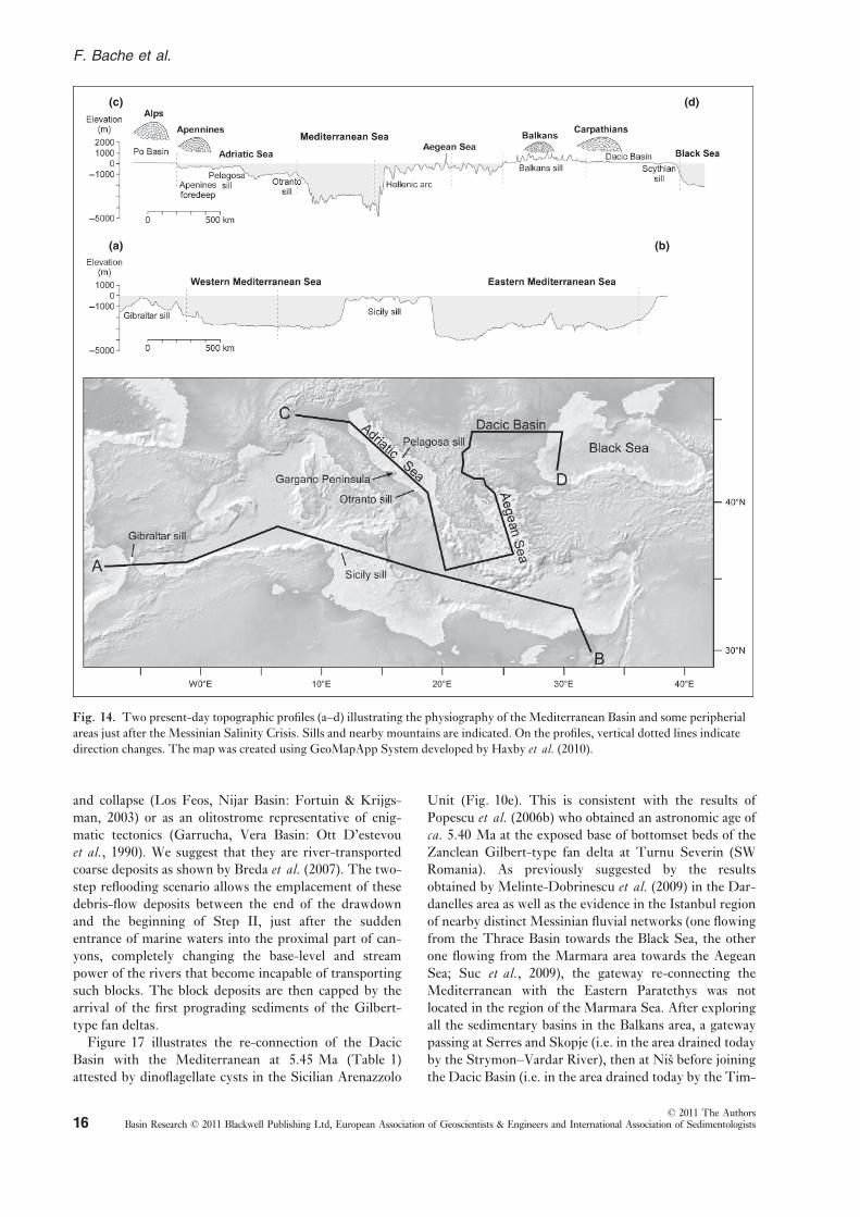
basins (ca. 100 m in bathymetry: Fig. 14, profile AB) and
controls their water exchanges (Astraldi et al., 1999). Pal-aeotectonic reconstructions (Jolivet et al., 2006) suggestthat a wider space existed between Tunisia and the Italian
Peninsula during theTortonian and earlyMessinian times,
before the opening of the South Tyrrhenian Sea in the
Pliocene and subsequent appearance of the Etna volcano in
the Mid-Pleistocene. The precise limits and the depth of
this probably wider strait are difficult to estimate, although
it was likely to bemuch deeper than what it is today (Jolivet
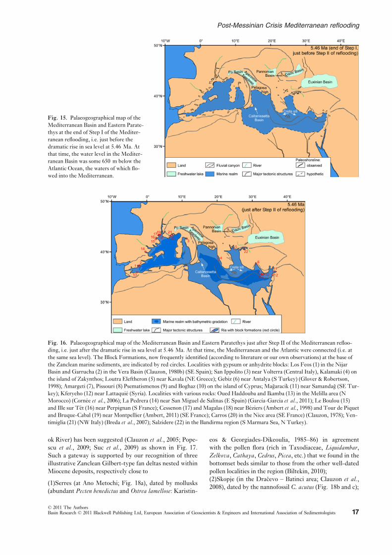
et al., 2006). The map shown in Fig. 15 gives a hypotheti-
cal idea about the palaeogeography of the Mediterranean
and surrounding regions at the end of Step I of reflooding
despite the lack of information on the palaeoshoreline
location other than for theGulf of Lions (Fig. 6).
Tentative agemodelof the refloodingprocessand suggested resultingpalaeogeographical changes
If the palaeogeography at the end of Step I of reflooding is
highly hypothetical (Fig. 15), that after Step II is well-
controlled as mapping the early Zanclean marine deposits
is achieved inland (see the most recent map published by
Jolivet et al., 2006). The map after Step II (Fig. 16) has
been significantly completed thanks to some recent publi-
cations (Soria et al., 2008; Clauzon et al., 2009; El Euch –El Koundi et al., 2009; Melinte-Dobrinescu et al., 2009;
Poisson et al., 2011) and to the intensive field investiga-
tions of some of us (G. C., J.-P. S., J.-L. R., L. M.).
The above-mentioned data collected in Sicily (Eraclea
Minoa), in the Apennine foredeep (Maccarone) and in the
Dardanelles Strait, support that the reflooding of the
Mediterranean Basin (i.e. Step II) was completed signifi-
cantly before 5.332 Ma as suggested by previous studies
(Cavazza & Decelles, 1998; Cornee et al., 2006). The clas-sical reflooding at 5.332 Ma (Zanclean GSSP; van Cou-
vering et al., 2000) must be now seriously questioned
because of new convergent data obtained from high-reso-
lution studies in deposits just overlying the MES (Cornee
et al., 2006; Melinte-Dobrinescu et al., 2009), from the
Sicilian Arenazzolo Formation wrongly considered as
exclusively composed of reworked microfossils (Londeix
et al., 2007), and from an extensive nannofosil research in
the Apennine foredeep (Popescu et al., 2007, 2008).
Using cyclostratigraphy and astrochronology, it is possi-
ble to date this event in Sicily and in the Apennine fore-
deep. If we apply to the 6.5 dark–lights alternations of theArenazzolo Unit the same quasi-period as evidenced in
the Trubi (i.e. 20 kyr), its duration should be of about
130 kyr. That would date its base, and hence Step II of
the Mediterranean reflooding, at 5.46 Ma (Table 1), an
age consistent with the basal bottomset beds of the Dar-
danelles Gilbert-type fan delta preceding the first appear-
ance of C. acutus (Fig. 12b) dated at 5.345 Ma (Fig. 4).
In the Apennine foredeep, using the established relation-
ship between the pollen ratio SE/AE and eccentricity
(Fig. 11b and c), the arrival of marine waters at Macca-
rone can be dated at 5.36 Ma (Fig. 11; Table 1; Popescu
et al., 2007). The slightly delayed entrance of marine
waters into the Apennine foredeep is consistent with its
potential status as an isolated perched freshwater basin
during the peak of the MSC (Fig. 1) (Clauzon et al.,1997, 2005).
The precise age and duration of Step I of reflooding are
at the moment impossible to estimate. It is constrained
between 5.60 Ma, the consensual age of the sea-level
drawdown in the Mediterranean (CIESM, 2008) and the
above-proposed age at 5.46 Ma for the sudden Step II of
reflooding. Another key-age can be deduced from the dat-
ing of the base of the Arenazzolo Unit at 5.46 Ma: the
first influx of Paratethyan waters after the MSC at
5.45 Ma (Table 1) indicated by dinoflagellate cysts half a
dark–light cycle above the base of Arenazzolo (Fig. 10e).With respect to the available ages (Table 1), it is possi-
ble to propose interpretative palaeogeographical maps at
successive times between 5.46 and 5.30 Ma. At 5.46 Ma,
fluvial canyons were suddenly filled by marine waters that
transformed them into rias, but the connection which
existed with the Dacic Basin prior to the MSC through
the Balkans (Popescu et al., 2009) has not been re-estab-
lished (Fig. 16). In many places, a Block Formation (with
or without reworked Messinian marginal evaporites) is
sandwiched between the MES and Gilbert-type fan delta
deposits as shown on Fig. 2a. Such deposits have been
interpreted as submarine slumps caused by dissolution
© 2011 The AuthorsBasin Research © 2011 Blackwell Publishing Ltd, European Association of Geoscientists & Engineers and International Association of Sedimentologists 15
Post-Messinian Crisis Mediterranean reflooding
and collapse (Los Feos, Nijar Basin: Fortuin & Krijgs-
man, 2003) or as an olitostrome representative of enig-
matic tectonics (Garrucha, Vera Basin: Ott D’estevou
et al., 1990). We suggest that they are river-transported
coarse deposits as shown by Breda et al. (2007). The two-step reflooding scenario allows the emplacement of these
debris-flow deposits between the end of the drawdown
and the beginning of Step II, just after the sudden
entrance of marine waters into the proximal part of can-
yons, completely changing the base-level and stream
power of the rivers that become incapable of transporting
such blocks. The block deposits are then capped by the
arrival of the first prograding sediments of the Gilbert-
type fan deltas.
Figure 17 illustrates the re-connection of the Dacic
Basin with the Mediterranean at 5.45 Ma (Table 1)
attested by dinoflagellate cysts in the Sicilian Arenazzolo
Unit (Fig. 10e). This is consistent with the results of
Popescu et al. (2006b) who obtained an astronomic age of
ca. 5.40 Ma at the exposed base of bottomset beds of the
Zanclean Gilbert-type fan delta at Turnu Severin (SW
Romania). As previously suggested by the results
obtained by Melinte-Dobrinescu et al. (2009) in the Dar-
danelles area as well as the evidence in the Istanbul region
of nearby distinct Messinian fluvial networks (one flowing
from the Thrace Basin towards the Black Sea, the other
one flowing from the Marmara area towards the Aegean
Sea; Suc et al., 2009), the gateway re-connecting the
Mediterranean with the Eastern Paratethys was not
located in the region of the Marmara Sea. After exploring
all the sedimentary basins in the Balkans area, a gateway
passing at Serres and Skopje (i.e. in the area drained today
by the Strymon–Vardar River), then at Nis before joining
the Dacic Basin (i.e. in the area drained today by the Tim-
(a)
(c)
(b)
(d)
Fig. 14. Two present-day topographic profiles (a–d) illustrating the physiography of the Mediterranean Basin and some peripherial
areas just after the Messinian Salinity Crisis. Sills and nearby mountains are indicated. On the profiles, vertical dotted lines indicate
direction changes. The map was created using GeoMapApp System developed by Haxby et al. (2010).
© 2011 The AuthorsBasin Research © 2011 Blackwell Publishing Ltd, European Association of Geoscientists & Engineers and International Association of Sedimentologists16
F. Bache et al.
ok River) has been suggested (Clauzon et al., 2005; Pope-scu et al., 2009; Suc et al., 2009) as shown in Fig. 17.
Such a gateway is supported by our recognition of three
illustrative Zanclean Gilbert-type fan deltas nested within
Miocene deposits, respectively close to
(1)Serres (at Ano Metochi; Fig. 18a), dated by mollusks
(abundant Pecten benedictus and Ostrea lamellose: Karistin-
eos & Georgiades-Dikeoulia, 1985–86) in agreement
with the pollen flora (rich in Taxodiaceae, Liquidambar,Zelkova, Cathaya, Cedrus, Picea, etc.) that we found in thebottomset beds similar to those from the other well-dated
pollen localities in the region (Biltekin, 2010);
(2)Skopje (in the Dracevo – Batinci area; Clauzon et al.,2008), dated by the nannofossil C. acutus (Fig. 18b and c);
Fig. 16. Palaeogeographical map of the Mediterranean Basin and Eastern Paratethys just after Step II of the Mediterranean refloo-
ding, i.e. just after the dramatic rise in sea level at 5.46 Ma. At that time, the Mediterranean and the Atlantic were connected (i.e. at
the same sea level). The Block Formations, now frequently identified (according to literature or our own observations) at the base of
the Zanclean marine sediments, are indicated by red circles. Localities with gypsum or anhydrite blocks: Los Feos (1) in the Nijar
Basin and Garrucha (2) in the Vera Basin (Clauzon, 1980b) (SE Spain); San Ippolito (3) near Volterra (Central Italy), Kalamaki (4) on
the island of Zakynthos; Loutra Eleftheron (5) near Kavala (NE Greece); Gebiz (6) near Antalya (S Turkey) (Glover & Robertson,
1998); Amargeti (7), Pissouri (8) Psematismenos (9) and Boghaz (10) on the island of Cyprus; Magaracik (11) near Samandag (SE Tur-
key); Kferyeho (12) near Lattaquie (Syria). Localities with various rocks: Oued Haddouba and Ikamba (13) in the Melilla area (N
Morocco) (Cornee et al., 2006); La Pedrera (14) near San Miguel de Salinas (E Spain) (Garcıa-Garcıa et al., 2011); Le Boulou (15)and Ille sur Tet (16) near Perpignan (S France); Cessenon (17) andMagalas (18) near Beziers (Ambert et al., 1998) and Tour de Piquetand Bruque-Cabal (19) near Montpellier (Ambert, 2011) (SE France); Carros (20) in the Nice area (SE France) (Clauzon, 1978); Ven-
timiglia (21) (NW Italy) (Breda et al., 2007); Salzidere (22) in the Bandirma region (S Marmara Sea, N Turkey).
Fig. 15. Palaeogeographical map of the
Mediterranean Basin and Eastern Parate-
thys at the end of Step I of the Mediter-
ranean reflooding, i.e. just before the
dramatic rise in sea level at 5.46 Ma. At
that time, the water level in the Mediter-
ranean Basin was some 650 m below the
Atlantic Ocean, the waters of which flo-
wed into the Mediterranean.
© 2011 The AuthorsBasin Research © 2011 Blackwell Publishing Ltd, European Association of Geoscientists & Engineers and International Association of Sedimentologists 17
Post-Messinian Crisis Mediterranean reflooding

(3)Nis (at Gabrovacka Reka), dated by nannofossils (C.acutus and T. rugosus) (Fig. 18d).
The delayed invasion of Mediterranean waters into the
Dacic Basin was probably caused by the crossing of a sill,
here called the Balkans sill, which we tentatively locate
east of Skopje (Fig. 17). At Dracevo (Skopje), the mar-
ine-continental transition of the Gilbert-type fan delta, i.
e. the marker of the early Zanclean coastline, is today at
395 m altitude (Clauzon et al., 2008). This value providesan idea of the post-Pliocene uplift.
On the basis of the eccentricity tuning of the pollen
record from the Maccarone section, it is possible to date
at 5.36 Ma the arrival of marine waters into the Apen-
nine foredeep (Fig. 11) and hence the re-connection of
this lake with the Mediterranean Sea (Fig. 19). The Pel-
agosa high was probably the obstacle that isolated this
lake during the peak of the MSC (instead of the Otranto
high proposed by Clauzon et al., 2005). This is sup-
ported by the evidence of the Colombacci Formation
(affected by influxes of marine waters) only to the north
of the Gargano Peninsula (which today is the coastal
expression of the Pelagosa sill; Fig. 14, profile CD).
This assumption is in agreement with the presence of
marine fishes within the Colombacci Formation in the
region of Ancona (Carnevale et al., 2006). The Pelagosa
sill is today 160 m deep (Fig. 14, profile CD; Gacic
et al., 2002). At that time, marine waters had not yet
invaded the entire Po Plain (Fig. 19; Mary et al., 1993;Channell et al., 1994; Sprovieri et al., 2007; Violanti
et al., 2011).
(a)
(b)
(c)
Ceratolithus acutus
(d)
Fig. 18. Zanclean Gilbert-type fan del-
tas in the Balkans. (a) Serres (Ano Meto-
chi): foreset beds of the Zanclean
Gilbert-type fan delta nested within the
Miocene piedmont alluvial fan; (b, c)
Zanclean Gilbert-type fan delta near
Skopje: (b) foreset beds at Dracevo; (c)
bottomset beds at Batinci; (d) Nis: bot-
tomset beds of the Zanclean Gilbert-type
fan delta at Gabrovacka Reka.
Fig. 17. Palaeogeographical map of the
Mediterranean Basin and Eastern Parate-
thys at 5.45 Ma (after the second step of
the Mediterranean reflooding) when the
Mediterranean Sea and Dacic Basin re-
connected due to continuing rise of global
sea level.
© 2011 The AuthorsBasin Research © 2011 Blackwell Publishing Ltd, European Association of Geoscientists & Engineers and International Association of Sedimentologists18
F. Bache et al.
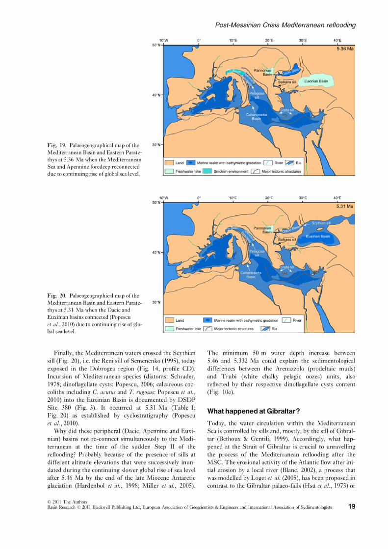
Finally, the Mediterranean waters crossed the Scythian
sill (Fig. 20), i.e. the Reni sill of Semenenko (1995), today
exposed in the Dobrogea region (Fig. 14, profile CD).
Incursion of Mediterranean species (diatoms: Schrader,
1978; dinoflagellate cysts: Popescu, 2006; calcareous coc-
coliths including C. acutus and T. rugosus: Popescu et al.,2010) into the Euxinian Basin is documented by DSDP
Site 380 (Fig. 3). It occurred at 5.31 Ma (Table 1;
Fig. 20) as established by cyclostratigraphy (Popescu
et al., 2010).Why did these peripheral (Dacic, Apennine and Euxi-
nian) basins not re-connect simultaneously to the Medi-
terranean at the time of the sudden Step II of the
reflooding? Probably because of the presence of sills at
different altitude elevations that were successively inun-
dated during the continuing slower global rise of sea level
after 5.46 Ma by the end of the late Miocene Antarctic
glaciation (Hardenbol et al., 1998; Miller et al., 2005).
The minimum 50 m water depth increase between
5.46 and 5.332 Ma could explain the sedimentological
differences between the Arenazzolo (prodeltaic muds)
and Trubi (white chalky pelagic oozes) units, also
reflected by their respective dinoflagellate cysts content
(Fig. 10e).
What happenedat Gibraltar?
Today, the water circulation within the Mediterranean
Sea is controlled by sills and, mostly, by the sill of Gibral-
tar (Bethoux & Gentili, 1999). Accordingly, what hap-
pened at the Strait of Gibraltar is crucial to unravelling
the process of the Mediterranean reflooding after the
MSC. The erosional activity of the Atlantic flow after ini-
tial erosion by a local river (Blanc, 2002), a process that
was modelled by Loget et al. (2005), has been proposed in
contrast to the Gibraltar palaeo-falls (Hsu et al., 1973) or
Fig. 20. Palaeogeographical map of the
Mediterranean Basin and Eastern Parate-
thys at 5.31 Ma when the Dacic and
Euxinian basins connected (Popescu
et al., 2010) due to continuing rise of glo-bal sea level.
Fig. 19. Palaeogeographical map of the
Mediterranean Basin and Eastern Parate-
thys at 5.36 Ma when the Mediterranean
Sea and Apennine foredeep reconnected
due to continuing rise of global sea level.
© 2011 The AuthorsBasin Research © 2011 Blackwell Publishing Ltd, European Association of Geoscientists & Engineers and International Association of Sedimentologists 19
Post-Messinian Crisis Mediterranean reflooding

a major tectonic event (Krijgsman & Garces, 2004). This
is supported by the distance of 30 km separating the strait
from the sill that shifted westward as a consequence of
this erosion. Recently, Garcia-Castellanos et al. (2009)
proposed that the Atlantic flow directly cut the Gibraltar
channel in a cataclysmic way. Campillo et al. (1992) andthen Garcia-Castellanos et al. (2009) documented the
presence in the central Alboran Sea of a major palaeo-
channel, wich constitutes the relic of a major gateway
between the Atlantic Ocean and the Mediterranean Basin.
Step I of reflooding relates to an early stage of (subaer-
ial or marine) erosion at Gibraltar resulting in the
entrance of Atlantic waters in moderate quantity whatever
its proposed duration (26 years: Blanc, 2002; 100–3000 years: Garcia-Castellanos, 2009), that anyway
appears greatly insufficient with regard to the events that
occurred during this time-interval:
(1) as a consequence of the erosion at Gibraltar, the
volume of entering Atlantic waters should have
progressively increased; we estimate that the total
volume of water in the Mediterranean Basin at the
end of Step I could represent 25% of its capacity;
(2) in the same way, the progressive sea-level rise
would form the planation surface.
Step II of reflooding (Fig. 16) is the sudden, fast and
massive entrance of Atlantic waters into the Mediterra-
nean Basin as the immediate response to the collapse of
the sill suggested by Blanc (2002) and Garcia-Castellanos
et al. (2009), with similar proposed duration (respectively
10–11 years and a few months to 2 years). The Mediter-
ranean physiography at the time when this rapid influx
started is sketched out in Fig. 15. From a rough estimate,
including a final catastrophic sea-level rise of 600–900 m,
we conclude that ca. 50% of the water volume of the
Mediterranean Basin entered it just after the collapse as
opposed to the 90% proposed by Garcia-Castellanos et al.(2009).
The sea-floor topography of the Western Alboran
Basin as deduced from seismic lines and structural maps
(Alvarez-Marron, 1999; Comas et al., 1999; Mauffret
et al., 2007) seems to have been made of successive small
basins at increasing depths from West to East and still
infilled by marine waters during the peak of the MSC,
into which the Atlantic continuously overflowed, feeding
the abyssal plains farther East after their almost com-
plete desiccation. Such a physiography could explain
how the Mediterranean biota (molluscs, echinids, bry-
ozoans, etc.) recovered so quickly after the crisis from
some Alboran potential refuge basins, providing a possi-
ble response to this nagging question pointed out by pal-
aeontologists (Neraudeau et al., 2001; Neraudeau, 2007).
This hypothesis is expressed on the map of Fig. 1. Col-
lapse at Gibraltar would have occurred at 5.46 Ma,
probably as hypothesized by Blanc (2002) as the result
of a significant threshold in the erosion intensity. At that
time, the Atlantic water channel through the Gibraltar
area would suddenly become a wide strait and the sill
would have acquired its approximate present-day mor-
phology. The flow of Atlantic waters across the basins of
the sill would have instantaneously supplied the entire
Mediterranean Sea with preserved marine endemic ben-
thic organisms.
Quantificationof the twosteps
The increase in bathymetry during the two steps of re-
flooding can be estimated. For this purpose, the palaeo-
shoreline identified between the badland morphology and
the planation surface ‘e’ provides a distinct point of refer-
ence. The palaeoshoreline is located at a present-day
depth of 1.6 s (TWTT) in the whole Gulf of Lions mar-
gin (Fig. 5). We estimate this point at a depth between
1800 and 2100 m taking into account the seismic veloci-
ties (Sonic from e-logs) and respective depths found in
the nearby Autan1 and Rascasse boreholes. The original
depth of the palaeoshoreline can be estimated by subtract-
ing the Pliocene and Quaternary subsidence from its pres-
ent-day depth (Fig. 21). Rabineau et al. (2006), using
Pliocene and Quaternary geometries on the shelf, esti-
mated this subsidence at around ca. 215 m Ma�1 at ca.62 km from the coast in the same area. Considering the
age of 5.46 Ma for the end of Step I of reflooding
(Table 1 and above), ca. 1200 m of subsidence are
obtained at this point. We can conclude that the palaeo-
shoreline was located between 600 m (1800–1200 m) and
900 m (2100–1200 m) below the present sea level at
5.46 Ma. The palaeoshoreline represents the seaward
boundary of the MES, which has been preserved during
the second step of reflooding. The rapid increase in
bathymetry during this second reflooding step thus
amounted to between 600 and 900 m.
The increase in bathymetry during the first step of
reflooding may also be estimated. We have thus deduced
the initial depth of the seaward limit of observation of
the planation surface ‘e’. This point is located at a maxi-
mum distance of 112 km from the coast, at around 3 s
(TWTT). We also estimate its depth, taking into
account the respective velocities and depths of the
GLP2 well and ESP 202 seismic profile, between 3000
and 3400 m. Extrapolating the total subsidence calcu-
lated by Rabineau et al. (2006) towards the basin with a
linear trend (Fig. 21), we obtain a total subsidence of ca.430 m Ma�1 at ca. 112 km from the coast. Considering
the age at 5.46 Ma (Table 1), a subsidence of ca.2300 m is obtained at this point. This limit was thus
localized between 700 m (3000–2300 m) and 1100 m
(3400–2300 m) below the present sea level at 5.46 Ma.
The shoreline displacement, during which the planation
surface ‘e’ formed (Step I), occurred between two points
respectively located at 1.6 s TWTT (600–900 m) and
3 s TWTT (700–1100 m) depth before the onset of Pli-
ocene subsidence. The maximum increase in bathymetry
during this step was thus around 500 m (1100–600 m)
and the corresponding maximum slope value of the
planation surface ‘e’ was 1%. This estimate was made
© 2011 The AuthorsBasin Research © 2011 Blackwell Publishing Ltd, European Association of Geoscientists & Engineers and International Association of Sedimentologists20
F. Bache et al.

considering an extrapolation of shelf tilting towards
the basin as calculated by Rabineau et al. (2006),
and it is thus a maximum value. Assuming that the min-
imum value of this slope was 0%, the total increase in
bathymetry for the two-step reflooding is estimated
between 600 m (600 m for the second step and 0 m for
the first step with a slope value of 0%) and 1100 m
(600 m for the second step and 500 m for the first step) in
the earliest Pliocene. A relative sea-level curve can be pro-
posed for the Gulf of Lions according to this calculation
(Fig. 22).
The rate of sea-level rise for the second step of the post-
MSC reflooding can be estimated around 60 m kyr�1 (at
least 600 m in at most 10 000 years). This high rate shows
that this transgression was catastrophic and must be
related to a special event at Gibraltar (see above). Due to
uncertainties on the timing of the first step of reflooding,
the corresponding rate cannot be estimated. However,
contrasted rates for the two steps of the post-MSC refloo-
ding may explain why the rugged regressive MES has
been preserved landward of 1.6 s TWTT and erased by
wave erosion seaward of it.
Fig. 22. Variation of the Mediterranean sea level in the Gulf of Lions between 6 and 5.30 Ma encompassing the Messinian Salinity
Crisis, with special attention to the reflooding phase. Successive major changes are estimated with respect to present-day sea level
(noted ‘0’). A two-step process is highlighted: the first step (? – 5.46 Ma) is characterized by a relative sea-level rise (500 m at the
most). A first transgression flattened previous topography to build a remarkable ravinement surface (slope value between 0% and 1%);
the second step (at 5.46 Ma) corresponds to an ultra-rapid Mediterranean sea-level rise contained between 600 and 900 m in ampli-
tude. Just after this outstanding and sudden rise in sea level, Arenazzolo deposition began. After Gilbert-type fan delta sediments
began to infill the rias, successive connections of the Mediterranean Basin with adjacent basins formed as global sea level continued to
rise: with the Dacic Basin (Eastern Paratethys) at 5.45 Ma, with the Apennine foredeep at 5.36 Ma, at last with the Euxinian Basin
(Eastern Paratethys) at 5.31 Ma (see Figs 17–20).
Fig. 21. Estimate of the initial position
of the palaeoshoreline and of the plana-
tion surface ‘e’ at the beginning of the
Pliocene. The Pliocene and Quaternary
total subsidence is deduced from Rabi-
neau et al. (2006).
© 2011 The AuthorsBasin Research © 2011 Blackwell Publishing Ltd, European Association of Geoscientists & Engineers and International Association of Sedimentologists 21
Post-Messinian Crisis Mediterranean reflooding

Deposition of the central evaporites (Lower, Mobile
and Upper units: Lofi et al., 2011; total thickness: up to
2800 m) requires a continuous input of marine water at
the beginning of Step I of reflooding, before the brine
concentration reached a critical threshold (Fig. 22). How-
ever, it is not excluded that some halite was deposited ear-
lier, i.e. during the sea-level drawdown, and was mixed
with detrital deposits. In fact, it can be assumed that two
phases are distinguishable and in close succession (Bache
et al., 2009): (i) the main erosion phase coeval with the
sea-level drop and deposition of detrital material in the
almost desiccated basin and (ii) deposition of the major
part of evaporites during the beginning of Step I of refloo-
ding, a phase during which fluvial erosion continued on
lands and margins. Using modelling, Govers (2009) sug-
gested that most of the evaporites were deposited before
sea-level drop. Our data contradict this conclusion
because the MES and related detrital products underlie
the central basin evaporites (Bache et al., 2009; Montad-
ert et al., 2011), which thus formed after sea-level lower-
ing. Also using modelling, Meijer & Krijgsman (2005)
concluded that there were repeated desiccations and
re-fillings of the Mediterranean, based on the supposed
correspondence of the exposed Sicilian Upper Evapor-
ites and the Upper Unit in the central basins. We
oppose this hypothesis too on the basis of the observed
relationships between seismic units in the central basins
(Bache et al., 2009; Montadert et al., 2011). Duration
of evaporite deposition in the central basins, especially
the thick halite, was probably brief (<50 000 years in
our scenario) in agreement with general assumptions
(Lugli et al., 2008), but impossible to define more pre-
cisely (Fig. 22).
The transition from massive halite to the Upper evapo-
ritic Unit marks the dilution of Mediterranean waters that
increased during the following ‘dilution event’, generally
pointed out as belonging to the ‘Lago Mare’ episode (Cita
et al., 1990; Iaccarino & Bossio, 1999; Rouchy et al.,2001), an assumption clarified by Clauzon et al. (2005)who distinguished two kinds of ‘Lago Mare’ episodes that
occurred during three major distinct events (Fig. 22).
Two of these so-called ‘Lago Mare’ events correspond
with surface water exchanges between the Mediterranean
and Dacic Basin (Eastern Paratethys) through the Balkans
gateway, attested by Mediterranean nannoplankton in the
Dacic Basin (Drivaliari et al., 1999; Clauzon et al., 2005;Snel et al., 2006) and conversely Paratethyan dinoflagel-
late cysts in the Mediterranean (Londeix et al., 2007;
Popescu et al., 2007, 2009). Such events, called ‘Lago
Mare’ 1 and 3, occurred during high sea levels, respec-
tively just before the desiccation phase and just after Step
II of reflooding (Fig. 22). In some exposed sections, they
can follow each other in a pseudo-stratigraphic continu-
ity, such as at Eraclea Minoa (Fig. 9e; Londeix et al.,2007; Popescu et al., 2009) and Intepe (Fig. 12b; Melin-
te-Dobrinescu et al., 2009). ‘Lago Mare’ 2 is known as a
brief dilution event, which seems to characterize the cen-
tral basins only. Being evidenced by ostracods and geo-
chemical measurements only (see, e.g., Pierre et al.,2006), it could correspond to increased run-off preceding
more significant marine water input. Its duration remains
unknown and these sediments necessitate new research
studies, especially to complete their micropalaeontological
content (nannofossils, dinoflagellate cysts), for decipher-
ing their exact origin.
It should be noted that this process of Mediterranean
reflooding in two steps after the MSC is unrelated to the
debate about scenarios of this dramatic episode, which
focuses on the chronological position of evaporitic bodies
and fluvial erosion (Rouchy & Caruso, 2006).
CONCLUSION
Considering offshore observations in the Gulf of Lions, a
two-step reflooding of the Western Mediterranean Basin
is proposed for the end of the MSC (Fig. 22):
(1) Step I (5.56? – 5.46 Ma) is characterized by a rela-
tively moderate and slow sea-level rise (500 m at
the most) leading to the landward migration of the
shoreline. This first transgression, which was
accompanied by the flattening effect of waves and
tides, flattened previous highs and formed a
remarkable ravinement surface. It resulted from
the beginning of a progressively increasing erosion
of the Gibraltar barrier.
(2) Step II (instantaneous at 5.46 Ma) was particularly
sudden and dramatic, resulting from the collapse of
the Gibraltar channel. It caused the so-called ‘Plio-
cene Deluge’, being dated prior to the Zanclean
GSSP by onshore studies. This violent sea-level
rise of 600–900 m flooded the largest part of fluvial
canyons, which were suddenly transformed into
rias (as attested by numerous Gilbert-type fan del-
tas), contributing to preserve the MES all around
the Mediterranean and the palaeoshoreline evi-
denced in the Gulf of Lions.
Such a scenario seems to have also been the case in the
Eastern Mediterranean Basin, which requires a more
detailed research.
We suggest that central basin evaporites were mostly
deposited during the beginning of Step I of reflooding.
After Step II of rapid Atlantic reflooding of the Meditera-
nean, sea-level rise slowly but regularly continued as a
result of the global rise in sea level and the successive con-
nections between the Mediterranean and the Dacic Basin
(at 5.45 Ma), the Adriatic foredeep (at 5.36 Ma), the
Euxinian Basin (at 5.31) and finally the Po Plain were
established.
In summary, the events that occurred during the MSC
appear to have been characterized by high complexity,
some being synchronous at the scale of the entire Medi-
terranean, others diachronous with respect to environ-
mental or regional conditions such as the so-called ‘Lago
Mare’ events, which had a dual nature.
© 2011 The AuthorsBasin Research © 2011 Blackwell Publishing Ltd, European Association of Geoscientists & Engineers and International Association of Sedimentologists22
F. Bache et al.

Many new geological aspects may be addressed as a
consequence of this work. First of all, the key surfaces
observed in the Gulf of Lions provide remarkable points
of reference. It will be necessary to correlate them at the
scale of the whole Western Mediterranean, as well as
within the Eastern Basin. Secondly, as two-step refloo-
ding of the Mediterranean has never been considered
before, the quantification of the steps will help constrain
future models of reflooding as well as subsidence studies
(post-Messinian vertical movements). Finally, kinematic
studies can be conducted to confirm the existence of
Messinian sills within the Mediterranean Basin (Sicily –Tunisia area for example) and their influence on its refloo-
ding history.
ACKNOWLEDGEMENTS
A. Di Stefano (University of Catania) provided some
information on nannoplankton from Eraclea Minoa. Posi-
tive comments on the manuscript were made by J. Lofi.
Two reviewers, W. Cavazza and an anonymous one, and
the Editor of Basin Research, P. van der Beek, are greatly
acknowledged for their scrupulous examination of our
manuscript and their comments and recommendations,
which helped us to significantly improve it. We also thank
R. Herzer (GNS Science) for his language corrections
and comments on the manuscript. This work is a contri-
bution to ANR ‘EGEO’ Project, to CNRS/INSU
‘Actions Marges’ Project (AMEDITER), and to ‘Bassins
neogenes et manteau en Mediterranee’ (TerMEx CNRS/
INSU).
SUPPORTING INFORMATION
Additional Supporting Information may be found in the
online version of this article:
Figure S1.Uninterpreted seismic profiles of Fig. 5.
Figure S2.Uninterpreted seismic profiles of Fig. 7.
Figure S3.Uninterpreted seismic profiles of Fig. 8.
Please note: Wiley-Blackwell are not responsible for the
content or functionality of any supporting materials sup-
plied by the authors. Any queries (other than missing
material) should be directed to the corresponding author
for the article.
REFERENCESABBOTT, S.T. (1998) Transgressive systems tracts and onlap
shellbeds from mid-Pleistocene sequences, Wanganul Basin,
New Zealand. J. Sedim. Res., 68, 253–268.ALVAREZ-MARRON, J. (1999) Pliocene to Holocene structure of
the Eastern Alboran Sea (Western Mediterranean). In:
Leg 161 (Ed. by R. Zhan, M.C. Comas & A. Klaus) Proc.Ocean Drill. Progr., 161, 345–355.
AMBERT, P. (2011) Messinian and Pliocene continental forma-
tions in the Montpellier region and their geological context:
geodynamic consequences in the Georges Clauzon model
(1996). Bull. Soc. Geol. France, 182 (2), 79–85.AMBERT, P., AGUILAR, J.-P. & MICHAUX, J. (1998) Evolution
geodynamique messino-pliocene en Languedoc central: le
paleo-reseau hydrographique de l’orb et de l’Herault (Sud de
la France). Geodin. Acta, 11(2–3), 139–146.ASTRALDI, M., BALOPOULOS, S., CANDELA, J., FONT, J., GACIC,
M., GASPARINI, G.P., MANCA, B., THEOCHARIS, A. & TINTORE,
J. (1999) The role of straits and channels in understanding the
characteristics of Mediterranean circulation. Progr. Oceanogr.,44, 65–108.
BACHE, F. (2008) Evolution Oligo-Miocene des Marges du MicroOcean Liguro-Provencal. PhD Thesis, Universite de Bretagne
Occidentale, Brest. Available at: http://tel.archives-ouvertes.
fr.
BACHE, F., OLIVET, J.-L., GORINI, F., RABINEAU, M., BAZTAN, J.,
ASLANIAN, D. & SUC, J.-P. (2009) Messinian erosional and
salinity crises: view from the Provence Basin (Gulf of Lions,
Western Mediterranean). Earth Planet. Sci. Lett., 286, 139–157.
BACHE, F., OLIVET, J.-L., GORINI, F., ASLANIAN, D., LABAILS, C.
& RABINEAU, M. (2010) Evolution of rifted continental mar-
gins: the case of the Gulf of Lions (Western Mediterranean
Basin). Earth Planet. Sci. Lett., 292, 345–356.BENTZ, F.P. & HUGHES, J.B. (1981) New reflection seismic
evidence of a Late Miocene Nile Canyon. In: The GeologicalEvolution of the River Nile (Ed. by R. Said), pp. 131–146.
Appendix C, Springer-Verlag, New York – Heidelberg –Berlin, 131–146.
BERGGREN, W.A., KENT, D.V., SWISCHER, C.C. III & AUBRY,
M.-P. (1995). A revised Cenozoic geochronology and chro-
nostratigraphy. In: Geochronology, Time Scales and GlobalStratigraphic Correlation: A Unified Temporal Framework foran Historical Geology (Ed. by W.A. Berggren, D.V. Kent, M.-
P. Aubry & J. Hardenbol) Spec. Publ., Soc. Econ. Paleontol.Mineral., 54, 141–212.
BERTINI, A. (1992) Palinologia ed Aspetti Ambientali del VersanteAdriatico Dell’Appennino Centro-Settentrionale Durante il Mes-siniano e lo Zancleano. PhD Thesis, University of Florence,
Florence.
BERTINI, A. (2006) The northern Apennines palynological
record as a contribute for the reconstruction of the Messinian
palaeoenvironments. Sedim. Geol., 188–189, 235–258.BERTONI, C. & CARTWRIGHT, J.A. (2006) Controls on the basin-
wide architecture of late Miocene (Messinian) evaporites on
the Levant margin (Eastern Mediterranean). Sedim. Geol.,188–189, 93–114.
BERTONI, C. & CARTWRIGHT, J.A. (2007) Major erosion at the
end of the Messinian Salinity Crisis: evidence from the
Levant Basin, Eastern Mediterranean. Bas. Res., 19, 1–18.BESSIS, F. (1986) Some remarks on the study of subsidence of
sedimentary basins: application to the Gulf of Lions margin
(Western Mediterranean).Mar. Pet. Geol., 3, 37–63.BETHOUX, J.P. & GENTILI, B. (1999) Functioning of the Medi-
terranean Sea: past and present changes related to freshwater
input and climate changes. J. Mar. Syst., 20, 33–47.BILTEKIN, D. (2010) Vegetation and Climate of North Anatolianand North Aegean Region Since 7 Ma According to Pollen Anal-
© 2011 The AuthorsBasin Research © 2011 Blackwell Publishing Ltd, European Association of Geoscientists & Engineers and International Association of Sedimentologists 23
Post-Messinian Crisis Mediterranean reflooding
ysis. PhD Thesis, Universite Claude Bernard – Lyon 1 and
Istanbul Technical University, Istanbul.
BLANC, P.-L. (2002) The opening of the Plio-Quaternary
Gibraltar Strait: assessing the size of a cataclysm. Geodin.Acta, 15, 303–317.
BOCCALETTI, M., CIARANFI, N., COSENTINO, D., DEIANA, G.,
GELATI, R., LENTINI, F., MASSARI, F., MORATTI, G., PESCATO-
RE, T., RICCI LUCCHI, F. & TORTORICI, L. (1990) Palinspastic
restoration and paleogeographic reconstruction of the peri-
Tyrrhenian area during the Neogene. Palaeogeogr. Palaeocli-matol. Palaeoecol., 77, 41–50.
BONADUCE, G. & SGARRELLA, F. (1999) Paleoecological interpre-
tation of the latest Messinian sediments from southern Sicily
(Italy).Mem. Soc. Geol. It., 54, 83–91.BREDA, A., MELLERE, D. & MASSARI, F. (2007) Facies and pro-
cesses in a Gilbert-delta-filled incised valley (Pliocene of Ven-
timiglia, NW Italy). Sedim. Geol., 200, 31–55.BROLSMA, M.J. (1975) Lithostratigraphy and foraminiferal
assemblages of the Miocene-Pliocene transitional strata of
Capo Rossello and Eraclea Minoa (Sicily, Italy). Proc. Kon.Neder. Akad. Van Wetensch. B, 78, 341–380.
BROLSMA, M.J. (1978) Quantitative foraminiferal analysis and
environmental interpretation of the Pliocene and topmost
Miocene on the South coast of Sicily. Utrecht Micropaleontol.Bull., 18, 1–143.
BURRUS, J. (1989) Review of geodynamic models for exten-
sional basins; the paradox of stretching in the Gulf of
Lions (northwest Mediterranean). Bull. Soc. Geol. France,8, 377–393.
BUTLER, R.W.H., LICKORISH, W.H., GRASSO, M., PEDLEY, H.M.
& RAMBERTI, L. (1995) Tectonics and sequence stratigraphy
in Messinian basins, Sicily: constraints on the initiation and
termination of the Mediterranean salinity crisis. Geol. Soc.Am. Bull., 107 (4), 425–439.
CAMPILLO, A.C., MALDONADO, A. & MAUFFRET, A. (1992)
Stratigraphic and tectonic evolution of the western Alboran
Sea: late Miocene to recent. Geomar. Lett., 12, 165–172.CARLONI, G.C., FRANCAVILLA, F., BORSETTI, A.M., CATI, F.,
D’ONOFRIO, S., MEZZETTI, R. & SAVELLI, C. (1974) Ricer-
che stratigrafiche sul limite Miocene-pliocene nelle Marche
centro-meridionali. Giornale di Geologia, ser. 2a, 39(2), 363–392.
CARNEVALE, G., CAPUTO, D. & LANDINI, W. (2006) Late Mio-
cene fish otoliths from the Colombacci Formation (Northern
Apennines, Italy): implications for the Messinian ‘Lago-mare’
event. Geol. J., 41, 1–19.CASERO, P. (2004) Structural setting of petroleum exploration
plays in Italy. Ital. Geol. Soc., Spec. Vol. 189–199.CATTANEO, A. & STEEL, R.J. (2003) Transgressive deposits: a
review of their variability. Earth-Sci. Rev., 62 (3–4), 187–228.CATUNEANU, O. (2006) Principles of Sequence Stratigraphy. 1stedn, Elsevier, Amsterdam.
CAVAZZA, W. & DECELLES, P.G. (1998) Upper Messinian silici-
clastic rocks in southeastern Calabria (southern Italy): palaeo-
tectonic and eustatic implications for the evolution of the
central Mediterranean region. Tectonophysics, 298, 223–241.CHAMPION, C., CHOUKROUNE, P. & CLAUZON, G. (2000) La
deformation post-miocene en Provence Occidentale. Geodin.Acta, 13, 67–85.
CHANNELL, J.E.T., POLI, M.S., RIO, D., SPROVIERI, R. & VILLA,
G. (1994) Magnetic stratigraphy and biostratigraphy of Plio-
cene “argille azzurre” (Northern Apennines, Italy). Palaeo-geogr. Palaeoclimatol. Palaeoecol., 110, 83–102.
CHUMAKOV, I.S. (1967) Pliocene and Pleistocene deposits of the
Nile Valley in Nubia and Upper Egypt (in Russian). Trans.Geol. Inst. Acad. Sci. USSR, 170, 5–111.
CHUMAKOV, I. (1973) Geological history of the Mediterranean
at the end of the Miocene-the beginning of the Pliocene
according to new data. In: Leg 13 (Ed. by W.B.F. Ryan &
K.J. Hsu, et al.) Init. Rep. Deep Sea Drill. Proj., 13(2),
1241–1242.CIESM (ANTON, J., CAGATAY, M.N., DE LANGE, G., FLECKER,
R., GAULLIER, V., GUNDE-CIMERMAN, N., HUBSCHER, C.,
KRIJGSMAN, W., LAMBREGTS, P., LOFI, J., LUGLI, S., MANZI,
V., MCGENITY, T.J., ROVERI, M., SIERRO, F.J. & SUC, J.-P.)
(2008) Executive summary. In: The Messinian Salinity CrisisFrom Mega-Deposits to Microbiology – A Consensus Report (Ed.by F. Briand) CIESMWorkshop Monographs, 33, 7–28.
CITA, M.B. & COLOMBO, L. (1979) Sedimentation in the latest
Messinian at Capo Rossello (Sicily). Sedimentology, 26, 497–522.
CITA, M.B. & GARTNER, S. (1973) Studi sul Pliocene e uli strati
di passaggio dal Miocene al Pliocene IV. The stratotype Zan-
clean foraminiferal and nannofossil biostratigraphy. Riv. Ital.Paleont., 79 (4), 503–558.
CITA, M.B., RACCHETTI, S., BRAMBILLA, R., NEGRI, M., COLOM-
BAROLI, D., MORELLI, L., RITTER, M., ROVIRA, E., SALA, P.,
BERTARINI, L. & SANVITO, S. (1999a) Changes in sedimenta-
tion rates in all Mediterranean drillsites document basin evo-
lution and support starved basin conditions after early
Zanclean flood.Mem. Soc. Geol. It., 54, 145–159.CITA, M.B., RIO, D. & SPROVIERI, R. (1999b) The Pliocene Ser-
ies: chronology of the type Mediterranean record and stan-
dard chronostratigraphy. In: The Pliocene: Time of Change(Ed. by J.H. Wrenn, J.-P. Suc & S.A.G. Leroy) Amer. Assoc.Stratigr. Palynol. Found., 49–63.
CITA, M.B., SANTAMBROGIO, S., MELILLO, B. & ROGATE, F.
(1990) Messinian paleoenvironments: new evidence from the
Tyrrhenian Sea (ODP Leg 107). In: Leg 107 (Ed. by K.A. Ka-
stens & J. Mascle, et al.) Init. Rep. Deep Sea Drill. Proj., Sci.Res., 107, 211–227.
CITA, M.B., WRIGHT, R.C., RYAN, W.B.F. & LONGINELLI, A.
(1978) Messinian paleoenvironments. In: Leg 42A (Ed. by K.
Hsu & L. Montadert, et al.) Init. Rep. Deep Sea Drill. Proj.,Sci. Res., 42(1), 1003–1025.
CIVIS, J. (1977) Estudios de los Foraminiferos del afloramiento
pliocenico de Can Albareda (Barcelona), analisis paleogeologi-
co et biostratigrafico. Stud. Geol., 13, 105–126.CLAUZON, G. (1973) The eustatic hypothesis and the Pre-Plio-
cene cutting of the Rhone Valley. In: Leg 13 (Ed. by W.B.F.
Ryan & K.J. Hsu) Init. Rep. Deep Sea Drill. Proj., 13(2),1251–1256.
CLAUZON, G. (1978) The Messinian Var canyon (Provence,
Southern France) – paleogeographic implications.Mar. Geol.,27, 231–246.
CLAUZON, G. (1980a) Le canyon messinien de la Durance (Prov-
ence, France): une preuve paleogeographique du basin pro-
fond de dessiccation. Palaeogeogr. Palaeoclimatol. Palaeoecol.,29, 15–40.
CLAUZON, G. (1980b) Revision de l’interpretation geodynamique
du passage miocene-pliocene dans le bassin de Vera (Espagne
meridionale): les coupes d’Antas et de Cuevas del Almanzora.
Riv. Ital. Paleont., 86 (1), 203–214.CLAUZON, G. (1982) Le canyon messinien du Rhone: une preuve
decisive du “desiccated deep-basin model” (Hsu, Cita et
Ryan, 1973). Bull. Soc. Geol. France, Ser. 7, 24(3), 597–610.
© 2011 The AuthorsBasin Research © 2011 Blackwell Publishing Ltd, European Association of Geoscientists & Engineers and International Association of Sedimentologists24
F. Bache et al.
CLAUZON, G. (1990) Restitution de l’evolution geodynamique
neogene du bassin du Roussillon et de l’unite adjacente des
Corbieres d’apres les donnees ecostratigraphiques et paleo-
geographiques. Paleobiol. Cont., 17, 125–155.CLAUZON, G. & CRAVATTE, J. (1985) Revision chronostratigraph-
ique de la serie marine pliocene traversee par le sondage
Canet (Pyrenees orientales): apports a la connaissance du
Neogene du Roussillon. C. R. Acad. Sci. Paris, Ser. 2, 301,1351–1354.
CLAUZON, G., RUBINO, J.-L. & CASERO, P. (1997) Regional
modalities of the Messinian Salinity Crisis in the framework
of two phases model. In: Neogene Basins of the MediterraneanRegion: Controls and Correlation in Space and Time (Ed. by
M. Grasso & F. Lentini), pp. 44–46. R.C.M.N.S. Inter.-
Coll., Catania, Program and Abstracts.
CLAUZON, G., SUC, J.-P., AGUILAR, J.-P., AMBERT, P., CAPPETTA,
H., CRAVATTE, J., DRIVALIARI, A., DOMENECH, R., DUBAR, M.,
LEROY, S., MARTINELL, J., MICHAUX, J., ROIRON, P., RUBINO,
J.-L., SAVOYE, B. & VERNET, J.-L. (1990) Pliocene geodynam-
ic and climatic evolutions in the French Mediterranean
region. Paleontologia i Evolucio, Spec. Vol. 2, 132–186.CLAUZON, G., SUC, J.-P., GAUTIER, F., BERGER, A. & LOUTRE,
M.-F. (1996) Alternate interpretation of the Messinian salin-
ity crisis: controversy resolved? Geology, 24 (4), 363–366.CLAUZON, G., SUC, J.-P., POPESCU, S.-M., MARUNTEANU, M.,
RUBINO, J.-L., MARINESCU, F. & MELINTE, M.C. (2005) Influ-
ence of the Mediterranean sea-level changes over the Dacic
Basin (Eastern Paratethys) in the Late Neogene. The Medi-
terranean Lago Mare facies deciphered. Bas. Res., 17, 437–462.
CLAUZON, G., SUC, J.-P., DUMURDZANOV, N., MELINTE-
DOBRINESCU, M.C. & ZAGORCHEV, I. (2008) The Pliocene
Gilbert-type fan delta of Dracevo (Skopje area, Republic of
Macedonia): paleogeographic inference. Geol. Macedonica,2, 21–28.
CLAUZON, G., SUC, J.-P., MELINTE-DOBRINESCU, M.C., JOUAN-
NIC, G., JOLIVET, L., RUBINO, J.-L., POPESCU, S.-M., GORINI,
C., BACHE, F. & ESTRADA, F. (2009) New insights from the
Andalusian Sorbas and Vera basins. Acta Nat. Ateneo Parm.,45 (1–4), 334–335.
COMAS, M.C., PLATT, J.P., SOTO, J.I. & WATTS, A.B. (1999)
The origin and tectonic history of the Alboran Basin:
Insights from leg 161 results. In: Leg 161 (Ed. by R. Zhan,
M.C. Comas & A. Klaus) Proc. Ocean Drill. Progr., 161,
555–580.CORNEE, J.-J., FERRANDINI, M., SAINT MARTIN, J.P., MUNCH, P.,
MOULLADE, M., RIBAUD-LAURENTI, A., ROGER, S., SAINT
MARTIN, S. & FERRANDINI, J. (2006) The late Messinian ero-
sional surface and the subsequent reflooding in the Mediterra-
nean: new insights from the Melilla–Nador basin (Morocco).
Palaeogeogr. Palaeoclimatol. Palaeoecol., 230, 129–154.COSENTINO, D., CIPOLLARI, P., FARANDA, C., FLORINDO, F., GEN-
NARI, R., GLIOZZI, E., GROSSI, F., LAURENZI, M.A., LO MAS-
TRO, S., SAMPALMIERO, G. & SPROVIERI, M. (2009) Integrated
analyses of the Maccarone section (northern Apennines,
Italy). 13eme Congres RCMNS Naples. Acta Nat. AteneoParm., 45(1–4), 338–339.
CRAVATTE, J., DUFAURE, P., PRIM, M. & ROUAIX, S. (1974) Les
sondages du Golfe du Lion: stratigraphie, Sedimentologie.
Notes et Memoires de la Compagnie Francaise des Petroles, 11,209–274.
CSATO, I., KENDALL, C.G.StC. & MOORE, P.D. (2007) The
Messinian problem in the Pannonian Basin, Eastern Hungary
– Insights from stratigraphic simulations. Sedim. Geol., 201,111–140.
DALLA, S., HARBY, H. & SERAZZI, M. (1997) Hydrocarbon explo-
ration in a complex incised valley fill: an example from the late
Messinian Abu Madi Formation (Nile Delta Basin, Egypt).
Lead. Edge, 16, 1819–1824.DECIMA, A. & WEZEL, F. (1971) Osservazioni sulle evaporiti
messiniane della Sicilia centro-meridionale. Riv. Min. Sicil.,130–132, 172–187.
DEMAREST, J.M. & KRAFT, J.C. (1987) Stratigraphic record of
Quaternary sea levels: implications for more ancient strata. In:
Sea-Level Fluctuation and Coastal Evolution (Ed. by D. Num-
medal, O.H. Pilkey & J.D. Howard) SEPM Spec. Publ., 41,223–240.
DENIZOT, G. (1952) Le Pliocene dans la vallee du Rhone. Rev.Geogr. Lyon, 27, 327–357.
DOS REIS, A.T. (2001). La Tectonique Salifere et son Influence surL’architecture Sedimentaire Quaternaire de la Marge du Golfedu Lion – Mediterranee Occidentale. PhD Thesis, Universite
Pierre et Marie Curie, Paris.
DOS REIS, A.T., GORINI, C. & MAUFFRET, A. (2005) Implications
of Salt-sediment interactions for the Architecture of the Gulf
of Lions deep-water sedimentary systems –Western Mediter-
ranean Sea.Mar. Petr. Geol., 22 (6–7), 713–746.DOS REIS, A.T., GORINI, C., WEIBULL, W., PEROVANO, R., ME-
PEN, M. & FERREIRA, E. (2008) Radial gravitacional gliding
indicated by subsalt relief and salt-related structures: the
example of the gulf of Lions, western Mediterranean. Braz. J.Geophy., 26 (3), 347–365.
DRAKE, N.A., EL-HAWAT, A.S. & SALEM, M.J. (2008) The
Development, Decline and Demise of the As Sahabi River
System over the Last Seven Million Years. Garyounis Sci.Bull. (Spec. Issue), 5, 95–109.
DRIVALIARI, A., TICLEANU, N., MARINESCU, F., MARUNTEANU,
M. & SUC, J.-P. (1999) A Pliocene climatic record at Ticleni
(Southwestern Romania). In: The Pliocene: Time of Change(Ed. by J.H. Wrenn, J.-P. Suc & S.A. G Leroy) Amer. Assoc.Stratigr. Palynol. Found., 103–108.
EL EUCH – EL KOUNDI, N., FERRY, S., SUC, J.-P., CLAUZON, G.,
MELINTE-DOBRINESCU, M.C., SAFRA, A. & ZARGOUNI, F.
(2009) Messinian deposits and erosion in northern Tunisia.
Inferences on the Sicily Strait during the Messinian Salinity
Crisis. Terra Nova, 21, 41–48.ESTRADA, F., ERCILLA, G., GORINI, C., ALONSO, B., VAZQUEZ, J.
T., GARCIA-CASTELLANOS, D., JUAN, C., MALDONADO, A., AM-
MAR, A. &ELABBASSI,M. (2011) Impact of Atlantic water inflow
into the Alboran Basin at the time of the Zanclean flooding.
Geo.Mar. Lett., in press. DOI 10.1007/s00367-011-0249-8.
FAUQUETTE, S., SUC, J.-P., BERTINI, A., POPESCU, S.-M.,
WARNY, S., BACHIRI TAOUFIQ, N., PEREZ VILLA, M.-J., CHI-
KHI, H., SUBALLY, D., FEDDI, N., CLAUZON, G. & FERRIER, J.
(2006) How much did climate force the Messinian salinity cri-
sis? Quantified climatic conditions from pollen records in the
Mediterranean region. Palaeogeogr. Palaeoclimatol. Palaeo-ecol., 238, 281–301.
FORTUIN, A.R. & KRIJGSMAN, W. (2003) TheMessinian of the Ni-
jar Basin (SE Spain): sedimentation, depositional environments
and paleogeographic evolution.Sedim. Geol., 160, 213–242.GACIC, M., POULAIN, P.-M., ZORE-ARMANDA, M. & BARALE, V.
(2002) Overview. In: Physical oceanography of the AdriaticSea. Past, present, future (Ed. by B. Cushman-Roisin, M.
Gacic, P.-M. Poulain & A. Artegiani), pp. 1–44. Kluwer Aca-
demic Publishers, Dordrecht, The Netherlands.
© 2011 The AuthorsBasin Research © 2011 Blackwell Publishing Ltd, European Association of Geoscientists & Engineers and International Association of Sedimentologists 25
Post-Messinian Crisis Mediterranean reflooding
GARCIA, M., MAILLARD, A., ASLANIAN, D., RABINEAU, M.,
ALONSO, B., GORINI, C. & ESTRADA, F. (2011) The Catalan
margin during the Messinian Salinity Crisis: physiography,
morphology and sedimentary record. Mar. Geol., 284, 158–174.
GARCIA-CASTELLANOS, D., ESTRADA, F., JIMENEZ-MUNT, I.,
GORINI, C., FERNANDEZ, M., VERGES, J. & DE VICENTE, R.
(2009) Catastrophic flood of the Mediterranean after the Mes-
sinian salinity crisis.Nature, 462, 778–781.GARCIA-GARCIA, F., CORBI, H., SORIA, J.M. & VISERAS, C. (2011)
Architecture analysis of a river flood-dominated delta during
an overall sea-level rise (early Pliocene, SE Spain). Sedim.Geol., 237, 102–113.
GAULLIER, V. (1993) Diapirisme Salifere et Dynamique Sedimen-taire Dans le Bassin Liguro-Provencal. PhD Thesis, Universite
de Rennes, Rennes.
GAUTIER, F., CLAUZON, G., SUC, J.-P., CRAVATTE, J. & VIOLAN-
TI, D. (1994) Age et duree de la crise de salinite messinienne.
C. R. Acad. Sci. Paris, Ser. 2, 318, 1103–1109.GENNARI, R., IACCARINO, S.M., DI STEFANO, A., STURIALE, G.,
CIPOLLARI, P., MANZI, V., ROVERI, M. & COSENTINO, D.
(2008) The Messinian – Zanclean boundary in the Northern
Apennine. Stratigraphy, 5 (3–4), 307–322.GENNESSEAUX, M. & LEFEBVRE, D. (1980) Le Golfe du Lion et le
Paleo-Rhone messinien. Geol. Medit., 7, 71–80.GILBERT, G.K. (1885) The topographic features of lake shores.
U.S. Geol. Survey Rep., 5, 75–123.GILBERT, G.K. (1890) Lake Bonneville.Monogr. U.S. Geol. Sur-vey, 1, 1–438.
GILLET, H., LEROCILAIS, G. & REHAULT, J.-P. (2007) Messinian
event in the black sea: evidence of a Messinian erosional sur-
face.Mar. Geol., 244, 142–165.GLOVER, C. & ROBERTSON, A. (1998) Neotectonic intersection of
the Aegean and Cyprus tectonic arcs: extensional and strike-
slip faulting in the Isparta Angle, SW Turkey. Tectonophysics,298, 103–132.
GORINI, C. (1993) Geodynamique D’une Marge Passive: Le Golfedu Lion (Mediteranee Occidentale). PhD Thesis, Universite
Paul Sabatier, Toulouse.
GORINI, C., LE MARREC, A. & MAUFFRET, A. (1993) Contribu-
tion to the structural and sedimentary history of the Gulf of
Lions (Western Mediterranean) from the ECORS profiles,
industrial seismic profiles and well data. Bull. Soc. Geol.France, 164, 353–363.
GOUDIE, A.S. (2005) The drainage of Africa since the Creta-
ceous. Geomorphology, 67, 437–456.GOVERS, R. (2009) Choking the Mediterranean to dehydration:
the Messinian salinity crisis. Geology, 37 (2), 167–170.GRIFFIN, D.L. (2002) Aridity and humidity: two aspects of the
late Miocene climate of North Africa and the Mediterranean.
Palaeogeogr. Palaeoclimatol. Palaeoecol., 182, 65–91.GUENNOC, P., GORINI, C. & MAUFFRET, A. (2000) Histoire
geologique du Golfe du Lion et cartographie du rift oligo-
aquitanien et de la surface messinienne. Geol. France, 3, 67–97.
GUILLOCHEAU, F., DABARD, M.P., ROBIN, C. & LOI, A. (2009)
Les depots de tempetes. Des domaines marins ouverts aux milieuxrestreints. Vol. 65 Livre Association des Sedimentologues
Francais, Rennes. 102 pp.
HAXBY, W.F., MELKONIAN, A.K., COPLAN, J., CHAN, S.-M. &
RYAN, W.B.F. (2010) GeoMapApp freeware software, v.2.3.
Lamont-Doherty Earth Observatory, Palisades, http://jgs.
geoscienceworld.org/cgi/content/full/168/2/333.
HARDENBOL, J., THIERRY, J., FARLEY, M.B., JACQUIN, T., DE GRA-
CIANSKY, P.-C. & VAIL, P.R. (1998) Mesozoic and Cenozoic
sequence chronostratigraphic framework of European Basins.
In: Mesozoic and Cenozoic sequence stratigraphy of EuropeanBasins (Ed. by P.-C. De Graciansky, J. Hardenbol, T. Jac-
quin, & P.R. Vail), SEPM Spec. Publ., 60, 3–13.HILGEN, F.J. & LANGEREIS, C.G. (1989) Periodicities of CaCO3
cycles in the Pliocene of Sicily: discrepancies with the
quasi-periods of the Earth’s orbital cycles? Terra Nova, 1,409–415.
HILGEN, F.J. & LANGEREIS, C.G. (1993) A critical re-evaluation
of the Miocene/Pliocene boundary as defined in the Mediter-
ranean. Earth Planet. Sci. Lett., 118, 167–179.HOMEWOOD, P., GUILLOCHEAU, F., ESCHARD, R. & CROSS, T.A.
(1992) Correlations haute resolution et stratigraphie geneti-
que: une demarche integree. Bull. Centres Rech. Explor.-Prod.Elf-Aquitaine, 16, 357–381.
HSU, K.J., CITA, M.B. & RYAN, W.B.F. (1973) The origin of the
Mediterranean evaporites. In: Leg 13 (Ed. by W.B.F. Ryan &
K.J. Hsu et al.), Init. Rep. Deep Sea Drill. Proj., 13, 1203–1231.IACCARINO, S. & BOSSIO, A. (1999) Paleoenvironment iof upper-
most Messinian sequences in the Western Mediterranean
(Sites 974, 975, and 978). In: Leg 161 (Ed. by R. Zahan, M.C.
Comas & A. Klaus), Proc. Ocean Drill. Progr., Sci. Results,161, 529–541.
JOLIVET, L., AUGIER, R., ROBIN, C., SUC, J.-P. & ROUCHY, J.M.
(2006) Lithospheric-scale geodynamic context of the Messini-
an salinity crisis. Sedim. Geol., 188–189, 9–33.KARISTINEOS, N.K. & GEORGIADES-DIKEOULIA, E. (1985-86) The
marine transgression in the Serres Basin. Ann. Geol. Pays Hel-len., Ser. 1, 33, 1.
KRIJGSMAN, W. & GARCES, M. (2004) Palaeomagnetic con-
straints on the geodynamic evolution of the Gibraltar Arc.
Terra Nova, 16, 281–287.KRIJGSMAN, W., HILGEN, F.J., MARABINI, S. & VAI, G.B. (1999a)
New paleomagnetic and cyclostratigraphic age constraints on
the Messinian of the Northern Apennines (Vena del Gesso
Basin, Italy).Mem. Soc. Geol. It., 54, 25–33.KRIJGSMAN, W., HILGEN, F.J., RAFFI, J., SIERRO, F.J. & WILSON,
D.S. (1999b) Chronology, causes and progression of the
Messinian salinity crisis.Nature, 400, 652–655.KRIJGSMAN, W. & MEIJER, P.TH. (2008) Depositional environ-
ments of the Mediterranean “Lower Evaporites” of the Mes-
sinian salinity crisis: constraints from quantitative analyses.
Mar. Geol., 253, 73–81.LASKAR, J., ROBUTEL, P., JOUTEL, F., GASTINEAU, M., CORREIA,
A.C.M. & LEVRARD, B. (2004) A long term numerical solution
for the insolation quantities of the Earth. Astron. Astrophys.,428, 261–285.
LECKIE, D.A. (1994) Canterbury Plains, New Zealand – implica-
tions for sequence stratigraphic models. Bull. Am. Assoc. Pet-rol. Geol., 78, 1240–1256.
LEFEBVRE, D. (1980) Evolution Morphologique et Structurale duGolfe du Lion. Essai de Traitement Statistique des Donnees. PhDThesis, Universite Pierre et Marie Curie, Paris.
LI, X.S., BERGER, A., LOUTRE, M.-F., MASLIN, M.A., HAUG, G.
H. & TIEDEMANN, R. (1998) Simulating late Pliocene North-
ern Hemisphere climate with the LLN-2D model. Geophys.Res. Lett., 25, 915–918.
LOFI, J. (2002) La Crise de Salinite Messinienne: Consequences Di-rectes et Differees sur L’evolution Sedimentaire de la Marge duGolfe du Lion. PhD Thesis, Universite des Sciences et Tech-
niques, Lille.
© 2011 The AuthorsBasin Research © 2011 Blackwell Publishing Ltd, European Association of Geoscientists & Engineers and International Association of Sedimentologists26
F. Bache et al.
LOFI, J., RABINEAU, M., GORINI, C., BERNE, S., CLAUZON, G., DE
CLARENS, P., DOS REIS, T., MOUNTAIN, G.S., RYAN, W.B.F.,
STECKLER, M. & FOUCHET, C. (2003) Plio-Quaternary pro-
grading clinoform wedges of the Western Gulf of Lions conti-
nental margin (NW Mediterranean) after the Messinian
Salinity Crisis.Mar. Geol., 198, 289–317.LOFI, J., GORINI, C., BERNE, S., CLAUZON, G., DOS REIS, A.T.,
RYAN, W.B.F. & STECKLER, M.S. (2005) Erosional processes
and paleo-environmental changes in the western gulf of Lions
(SW France) during the Messinian salinity crisis. Mar. Geol.,217, 1–30.
LOFI, J. & BERNE, S. (2008) Evidences for Pre-Messinian sub-
marine canyons incisions on the Gulf of Lions Miocene
slope (Western Mediterranean). Mar. Petr. Geol., 25 (8),
804–817.LOFI, J., SAGE, F., DEVERCHERE, J., LONCKE, L., MAILLARD, A.,
GAULLIER, V., THINON, I., GILLET, H., GUENNOC, P. &
GORINI, C. (2011) Refining our knowledge of the Messinian
Salinity Crisis records in the offshore domain through
Multi-site seismic analysis. Bull. Soc. Geol. France, 182 (2),
163–180.LOGET, N., VAN DEN DRIESSCHE, J. & DAVY, P. (2005) How did
the Messinian Salinity Crisis end? Terra Nova, 17, 414–419.LONDEIX, L., BENZAKOUR, M., DE VERNAL, A., TURON, J.-L. &
SUC, J.-P. (1999) Late Neogene dinoflagellate cyst assem-
blages from the Strait of Sicily, Central Mediterranean Sea:
paleoecological and biostratigraphical implications. In: ThePliocene: Time of Change (Ed. by J.H. Wrenn, J.-P. Suc & S.
A. G Leroy) Amer. Assoc. Stratigr. Palynol. Found., 65–91,Dallas.
LONDEIX, L., BENZAKOUR, M., SUC, J.-P. & TURON, J.-L. (2007)
Messinian palaeoenvironments and hydrology in Sicily
(Italy): the dinoflagellate cyst record.Geobios, 40, 233–250.LOURENS, L.J., HILGEN, F.J., LASKAR, J., SHACKLETON, N.J. &
WILSON, D. (2004) The neogene period. In: A Geological TimeScale (Ed. by F. Gradstein, J. Ogg & A. Smith), pp. 409–440,Cambridge University Press, Cambridge.
LUGLI, S., MANZI, V. & ROVERI, M. (2008) New facies interpre-
tation of the Messinian evaporites in the Mediterranean.
CIESMWorkshop Monogr, 33, 67–72.MAILLARD, A., GORINI, C., MAUFFRET, A., SAGE, F., LOFI, J. &
GAULLIER, V. (2006) Offshore evidence of polyphase erosion
in the Valencia basin (Northwestern Mediterranean): scenario
for the Messinian Salinity Crisis. Sedim. Geol., 188–189, 69–91.
MANZI, V., LUGLI, S., ROVERI, M. & SCHREIBER, C. (2009) A new
facies model for the Upper Gypsum of Sicily (Italy): chrono-
logical and palaeoenvironmental constraints for the Messinian
salinity crisis in the Mediterranean. Sedimentology, 56, 1937–1960.
MARY, C., IACCARINO, S., COURTILLOT, V., BESSE, J. & AISSAOUI,
D.M. (1993) Magnetostratigraphy of Pliocene sediments from
the Stirone River (Po Valley). Geophys. J. Int., 112, 359–380.MATIAS I SENDRA, I. (1990) Els Nannofossils Calcaris del Plioce dela Mediterrania Nord-Occidental. PhD Thesis, University of
Barcelona, Barcelona.
MAUFFRET, A., AMMAR, A., GORINI, C. & JABOUR, H. (2007) The
Alboran Sea (Western Mediterranean) revisited with a view
from the Moroccan Margin. Terra Nova, 19, 195–203.MEIJER, P.Th. & KRIJGSMAN, W. (2005) A quantitative analysis
of the desiccation and re-filling of the Mediterranean during
the Messinian Salinity Crisis. Earth Planet. Sci. Lett., 240,510–520.
MELINTE-DOBRINESCU, M.C., SUC, J.-P., CLAUZON, G., POPE-
SCU, S.-M., ARMIJO, R., MEYER, B., BILTEKIN, D., CAGATAY,
M.N., UCARKUS, G., JOUANNIC, G., FAUQUETTE, S. & CAKIR,
Z. (2009) The Messinian Salinity Crisis in the Dardanelles
region: chronostratigraphic constraints. Palaeogeogr. Palaeo-climatol. Palaeoecol., 278, 24–39.
MILLER, K.G., KOMINZ, M.A., BROWNING, J.V., WRIGHT, J.D.,
MOUNTAIN, G.S., KATZ, M.E., SUGARMAN, P.J., CRAMER, B.
S., CHRISTIE-BLICK, N. & PEKAR, S.F. (2005) The Phaneoro-
zoic record of global sea-level change. Science, 310, 1293–1298.
MONTADERT, L., NICOLAIDES, S., SEMB, P.H. & LIE, Ø. (2011)
Petroleum systems offshore Cyprus. In: Petroleum Systems ofthe Tethyan Region (Ed. by L. Marlow, C. Kendall & L. Yose)
Amer. Assoc. Petrol. Geol., Spec. Publ., in press.NEMEC, W. (1990) Aspects of sediment movement on steep delta
slopes. Spec. Publs int. Ass. Sediment., 10, 29–73.NERAUDEAU, D. (2007) Les bioaccumulations neogenes (calcaires
a algues, faluns) d’Europe occidentale et leurs relations avec la
crise messinienne. C. R. Palevol., 6, 59–71.NERAUDEAU, D., GOUBERT, E., LACOUR, D. & ROUCHY, J.M.
(2001) Changing biodiversity of Mediterranean irregular echi-
noids from the Messinian to the Present-Day. Palaeogeogr.Palaeoclimatol. Palaeoecol., 175, 43–60.
NESTEROFF, W. & GLACON, G. (1977) Le caractere rythmique
des evaporites messiniennes en Mediterranee orientale (coupe
d’Eraclea Minoa, Sicile). Bull. Soc. Geol. France, Ser. 7, 19,489–500.
NICOLAI, C. (2008) Tracing the As Sahabi Channel System in
the Ajdabita Trough, Central Sirt Basin, Lybia. GaryounisSci. Bull. (Spec. issue), 5, 85–94.
ODIN, G.S., RICCI LUCCHI, F., TATEO, F., COSCA, M. & HUNZI-
KER, J.C. (1997) Integrated stratigraphy of the Maccarone
section, Late Messinian (Marche region, Italy). In: MioceneStratigraphy – An Integrated Approach (Ed. by A. Montanari,
G.S. Odin & R. Coccioni), pp. 529–544, Elsevier, Amster-
dam.
OTT D’ESTEVOU, P., MONTENAT, C. & ALVADO, J.-C. (1990) Le
basin de Vera –Garrucha. Doc. Trav. IGAL, 12–13, 165–187.PAILLOU, P., SCHUSTER, M., TOOTH, S., FARR, T., ROSENQVIST,
A., LOPEZ, S. & MALEZIEUX, J.-M. (2009) Mapping of a major
paleodrainage system in eastern Lybia using orbital imaging
radar: the Kufrah River. Earth Planet. Sci. Lett., 277, 327–333.
PIERRE, C., CARUSO, A., BLANC-VALLERON, M.-M., ROUCHY, J.
M. & ORSZAG-SPERBER, F. (2006) Reconstruction of the paleo-
environmental changes around the Miocene–Pliocene bound-ary along a West–East transect across the Mediterranean.
Sedim. Geol., 188–189, 319–340.PIERRE, C. & FONTES, J.-C. (1979) Oxygene 18, carbone 13, deu-
terium et soufre 34: marqueurs geochimiques de la diagenese
et du paleomilieu evaporitiques du Messinien de la Mediter-
ranee.Bull. Mus. Nat. Hist. Nat. Paris,Ser. 4, Sect. C, 1, 3–18.PIERRE, C., ROUCHY, J.-M. & BLANC-VALLERON, M.-M. (1998)
Sedimentological and stable isotope changes at the Messini-
an/Pliocene boundary in the Eastern Mediterranean (Holes
968A, 969A, and 969B). In: Leg 160 (Ed. by A.H.F. Robert-
son & K.-C. Emeis et al.) Proc. Ocean Drill. Progr., Sci.Results, 160, 3–8.
POISSON, A., ORSZAG-SPERBER, F., KOSUN, E., BASSETTI, M.A.,
MULLER, C., WERNLI, R. & ROUCHY, J.M. (2011) The Late
Cenozoic evolution of the Aksu basin (Isparta angle; SW
© 2011 The AuthorsBasin Research © 2011 Blackwell Publishing Ltd, European Association of Geoscientists & Engineers and International Association of Sedimentologists 27
Post-Messinian Crisis Mediterranean reflooding

Turkey). New insights. Bull. Soc. Geol. France, 182 (2),
133–148.POPESCU, S.-M. (2001) Repetitive changes in Early Pliocene veg-
etation revealed by high-resolution pollen analysis: revised
cyclostratigraphy of southwestern Romania. Rev. Palaeobot.Palynol., 120, 181–202.
POPESCU, S.-M. (2006) Late Miocene and early Pliocene envi-
ronments in the southwestern Black Sea region from high-
resolution palynology of DSDP Site 380A (Leg 42B). Palaeo-geogr. Palaeoclimatol. Palaeoecol., 238, 64–77.
POPESCU, S.-M., BILTEKIN, D., WINTER, H., SUC, J.-P., MELIN-
TE-DOBRINESCU, M.C., KLOTZ, S., COMBOURIEU-NEBOUT, N.,
RABINEAU, M., CLAUZON, G. & DEACONU, F. (2010) Pliocene
and Lower Pleistocene vegetation and climate changes at the
European scale: long pollen records and climatostratigraphy.
Quat. Intern., 219, 152–167.POPESCU, S.-M., MELINTE, M., SUC, J.-P., CLAUZON, G.,
QUILLEVERE, F. & SUT}o-SZENTAI, M. (2008) Marine re-
flooding of the Mediterranean after the Messinian Salinity
Crisis predates the Zanclean GSSP. Reply to the “Com-
ment to, ‘Earliest Zanclean age for the Colombacci and
uppermost Di Tetto formations of the “latest Messinian”
northern Apennines: new palaeoenvironmental data from
the Maccarone section (marche Province, Italy)’ by Popescu
et al. (2007) Geobios 40 (359-373)” authored by Roveri
et al. Geobios, 41, 657–660.POPESCU, S.-M., DALESME, F., JOUANNIC, G., ESCARGUEL, G.,
HEAD, M.J., MELINTE-DOBRINESCU, M.C., SUT}o-SZENTAI,
M., BAKRAC, K., CLAUZON, G. & SUC, J.-P. (2009) Galea-cysta etrusca complex, dinoflagellate cyst marker of Para-
tethyan influxes into the Mediterranean Sea before and
after the peak of the Messinian Salinity Crisis. Palynology,33 (2), 105–134.
POPESCU, S.-M., KRIJGSMAN, W., SUC, J.-P., CLAUZON, G., MA-
RUNTEANU, M. & NICA, T. (2006b) Pollen record and inte-
grated high-resolution chronology of the Early Pliocene Dacic
Basin (Southwestern Romania). Palaeogeogr. Palaeoclimatol.Palaeoecol., 238 (1–4), 78–90.
POPESCU, S.-M., SUC, J.-P. & LOUTRE, M.-F. (2006a) Early Plio-
cene vegetation changes forced by eccentricity-precession.
Example from Southwestern Romania. Palaeogeogr. Palaeocli-matol. Palaeoecol., 238 (1–4), 340–348.
POPESCU, S.-M., SUC, J.-P., MELINTE, M., CLAUZON, G., QUIL-
LEVERE, F. & SUT}o-SZENTAI, M. (2007) Earliest Zanclean age
for the Colombacci and uppermost Di tetto formations of the
“latest Messinian” northern Apennines: new palaeoenviron-
mental data from the Maccarone section (Marche Province,
Italy). Geobios, 40 (3), 359–373.RABINEAU, M., BERNE, S., ASLANIAN, D., OLIVET, J.-L., JOSEPH,
P., GUILLOCHEAU, F., BOURILLET, J.-L., LEDREZEN, E. &
GRANJEON, D (2005) Sedimentary sequences in the Gulf of
Lions: a record of 1000,000 years climatic cycles. Mar. Pet.Geol., 22, 775–804.
RABINEAU, M., BERNE, S., OLIVET, J.-L., ASLANIAN, D., GUILLO-
CHEAU, F. & JOSEPH, P. (2006) Paleo sea levels reconsidered
from direct observation of paleoshoreline position during Gla-
cial Maxima (for the last 500,000 yr). Earth Planet. Sci. Lett.,252, 119–137.
RAFFI, I., BACKMAN, J., FORNACIARI, E., PALIKE, H., RIO, D.,
LOURENS, L. & HILGEN, F. (2006) A review of calcareous nan-
nofossil astrobiochronology encompassing the past 25 million
years. Quat. Sci. Rev., 25, 3113–3137.
ROUCHY, J.M. & CARUSO, A. (2006) The Messinian salinity crisis
in the Mediterranean basin: a reassessment of the data and an
integrated scenario. Sedim. Geol., 188–189, 35–67.ROUCHY, J.-M., ORSZAG-SPERBER, F., BLANC-VALLERON, M.-M.,
PIERRE, C., RIVIERE, M., COMBOURIEU-NEBOUT, N. & PANAY-
IDES, I. (2001) Paleoenvironmental changes at the Messinian-
Pliocene boundary in the Eastern Mediterranean (southern
Cyprus basins): significance of the Messinian Lago-Mare. Se-dim. Geol., 145, 93–117.
ROVERI, M., BASSETTI, M.A. & RICCI LUCCHI, F. (2001) The
Mediterranean Messinian salinity crisis: an Apennine fore-
deep perspective. Sedim. Geol., 140, 201–214.ROVERI, M. & MANZI, V. (2006) The Messinian salinity crisis:
looking for a new paradigm? Palaeogeogr. Palaeoclimatol. Pal-aeoecol., 238, 386–398.
ROVERI, M., MANZI, V., GENNARI, R., IACCARINO, S.M. & LUGLI,
S. (2008a) Recent advancements in the Messinian stratigra-
phy of Italy and their Mediterranean-scale implications. Boll.Soc. Paleontol. Ital., 47 (2), 71–85.
ROVERI, M., LUGLI, S., MANZI, V. & SCHREIBER, C. (2008b) The
Messinian Sicilian stratigraphy revisited: new insights for the
Messinian salinity crisis. Terra Nova, 20, 483–488.RYAN, W.B.F. (1978) Messinian badlands on the southeastern
margin of the Mediterranean Sea.Mar. Geol., 27, 349–363.RYAN, W.B.F. (2011) Geodynamics responses to a two-step
model of the Messinian salinity crisis. Bull. Soc. Geol. France,182 (2), 73–78.
RYAN, W.B.F. & CITA, M.B. (1978) The nature and distribution
of Messinian erosional surface – indication of a several kilo-
meter-deep Mediterranean in the Miocene. Mar. Geol., 27,193–230.
SAID, R. (1982) The geological evolution of the River Nile in
Egypt. Z. Geomorph., 26 (3), 305–314.SAVOYE, B. & PIPER, D.J.W. (1991) The Messinian event on the
margin of the Mediterranean Sea in the Nice arc, southern
France.Mar. Geol., 97, 279–304.SCHRADER, H.-J. (1978) Quaternary through Neogene history of
the Black Sea, deduced from the paleoecology of diatoms, sili-
coflagellates, ebridians, and chrysomonads. In: Leg 42B (Ed.
by D.A. Ross & Y.P. Neprochnov et al.) Init. Rep. Deep SeaDrill. Proj., 42(2), 789–901.
SEMENENKO, V.N. (1995)Geological events at the Miocene/Plio-
cene boundary in the Eastern Paratethys. Geol. Soc. Greece,4(Spec. Publ.), 264–268.
SNEL, E., MARUNTEANU, M., MACALET, R., MEULENKAMP, J.E.
& VAN VUGT, N. (2006) Late Miocene to Early Pliocene chro-
nostratigraphic framework for the Dacic Basin, Romania. Pal-aeogeogr. Palaeoclimatol. Palaeoecol., 238 (1–4), 107–124.
SORIA, J.M., CARACUEL, J.E., CORBI, H., DINARES-TURELL, J.,
LANCIS, C., TENT-MANCLUS, J.E., VISERAS, C. & YEBENES, A.
(2008) The Messinian–early Pliocene stratigraphic record in
the southern Bajo Segura Basin (Betic Cordillera, Spain):
implications for the Mediterranean salinity crisis. Sedim.Geol., 203, 267–288.
SPROVIERI, R., DI STEFANO, E., BONOMO, S., TAMBURINI, F. &
MCKENZIE, J. (2007) The Messinian – Pliocene boundary in
the north Italy. Geophys. Res. Abstracts, 9, 06041.STECKLER, M.S. & WATTS, A.B. (1980) The Gulf of Lion: subsi-
dence of a young continental margin.Nature, 287, 425–429.SUC, J.-P. & BESSAIS, E. (1990) Perennite d’un climat thermo-
xerique en Sicile, avant, pendant, apres la crise de salinite
messinienne. C. R. Acad. Sci. Paris, Ser. 2, 310, 1701–1707.
© 2011 The AuthorsBasin Research © 2011 Blackwell Publishing Ltd, European Association of Geoscientists & Engineers and International Association of Sedimentologists28
F. Bache et al.
SUC, J.-P., CLAUZON, G., ARMIJO, R., MEYER, B., MELINTE-DOB-
RINESCU, M.C., POPESCU, S.-M., LERICOLAIS, G., GILLET, H.,
CAGATAY,M.N., JOUANNIC, G., BRUN, J.-P., SOKOUTIS, D., U-
CARKUS, G. & CAKIR, Z. (2009) The Messinian Salinity Crisis
in the Northeastern Aegean – Black Sea region. 13rd RCMNS
Congress, Naples.ActaNat. Ateneo Parm., 45(1/4), 116–117.SUC, J.-P., VIOLANTI, D., LONDEIX, L., POUMOT, C., ROBERT, C.,
CLAUZON, G., TURON, J.-L., FERRIER, J., CHIKHI, H., CAMBON,
G. & GAUTIER, F. (1995) Evolution of the Messinian Mediter-
ranean environments: the Tripoli Formation at Capodarso
(Sicily, Italy). Rev. Palaeobot. Palynol., 87, 51–79.SUNAMURA, T. (1987) Coastal cliff erosion in Nii-Jima Island,
Japan: present, past and future. In: International Geomorphol-ogy 1986 Part I. First International Conference on MorphologyProceedings (Ed. by V. Gardiner), Wiley, Chichester, pp.
1199–1212.VAN COUVERING, J.A., CASTRADORI, D., CITA, M.B., HILGEN, F.
J. & RIO, D. (2000) The base of the Zanclean Stage and of the
Pliocene Series. Episodes, 23 (3), 179–187.
VIOLANTI, D., DELA PIERRE, F., TRENKWALDER, S., LOZAR, F.,
CLARI, P., IRACE, A. & D’ATRI, A. (2011) Biostratigraphic and
palaeoenvironmental analyses of the Messinian/Zanclean
boundary and Zanclean succession in the Moncucco quarry
(Piedmont, Northwestern Italy). Bull. Soc. Geol. France, 182(2), 149–162.
WARNY, S., BART, P.J. & SUC, J.-P. (2003) Timing and progres-
sion of climatic, tectonic and glacioeustatic influences on the
Messinian Salinity Crisis. Palaeogeogr. Palaeoclimatol. Palaeo-ecol., 202, 59–66.
ZHENG, Z. & CRAVATTE, J. (1986) Etude palynologique du Plio-
cene de la Cote d’Azur (France) et du littoral ligure (Italie).
Geobios, 19 (6), 815–823.
Manuscript received 15 July 2010; In revised form 18 June2011; Manuscript accepted 01 July 2011.
© 2011 The AuthorsBasin Research © 2011 Blackwell Publishing Ltd, European Association of Geoscientists & Engineers and International Association of Sedimentologists 29
Post-Messinian Crisis Mediterranean reflooding