Knowledge management in Iran aerospace industries: a study on critical factors
Upload
khangminh22Category
view
3download
0

6en
3:
L I E> RARYOF THE
U N IVLRSITYOf ILLI NOIS
590. 5Fl
*. 53-54
BiOLOat

The person charging ^S Ubwry from
?*»»?- orUforethe
^«.^estampedbe1ow
underHninfl»* °°
.UinUsa| from
The«, r^Tji on- n,oy result * ~—
L161-O-1096


O. 5 &
in
A STUDY OF THE MAMMALS OF IRAN
RESULTING FROM THE STREET EXPEDITION
OF 1962-63
DOUGLAS M. LAY
!
FIELDIANA: ZOOLOGYVOLUME 54
Published by
FIELD MUSEUM OF NATURAL HISTORY
OCTOBER 31, 1967
FEB *£*LIBRARY


FIELDIANA: ZOOLOGYA Continuation of the
ZOOLOGICAL SERIES
of
FIELD MUSEUM OF NATURAL HISTORY
VOLUME 54
FIELD MUSEUM OF NATURAL HISTORY
CHICAGO, U.S.A.
1967


A STUDY OF THE MAMMALS OF IRAN
RESULTING FROM THE STREET EXPEDITION
OF 1962-63


A STUDY OF THE MAMMALS OF IRAN
RESULTING FROM THE STREET EXPEDITION
OF 1962-63
DOUGLAS M. LAYStreet Expedition Fellow
Thomas J. Dee Fellow of Field Museum of Natural History
Department of Anatomy, University of Chicago
FIELDIANA: ZOOLOGYVOLUME 54
Published by
FIELD MUSEUM OF NATURAL HISTORY
OCTOBER 31, 1967

Edited by Edward G. Nash
Patricia M. Williams
Zoological Editor, Joseph Curtis Moore
Library of Congress Catalog Card Number: 67-20767
PRINTED IN THE UNITED STATES OF AMERICABY FIELD MUSEUM PRESS

CONTENTS
PAGE
General Introduction 7
Acknowledgements 8
Expedition 10
Personnel 10
Equipment 10
Methods 10
The Country 12
Location 12
Physical Geography 12
Climate 17
Vegetation 18
Population 19
Special Terms 19
Earlier Faunal Studies 20
Narrative of the Expedition Routes 22
Northwest Circuit 22
Eastern Circuit 29
Central and Southwestern Circuit 40
Central Desert Circuit 48
Descriptive Gazetteer of Expedition Localities 51
Ahram 51
Chah Ali Khan 53
Chalus 54
Daryacheh-I-Famur 57
Dasht 61
Doab 64
Fahraj 68
Faraman 69
Galatappeh 70
Gorgan 74
Iranshahr 78
Jahrom and Juyom 81
Karkheh River 83
Kerman 86
Khvoy 87
Maku 88
Qayen 91
Rezaiyeh 91
Sama 96
3

4 FIELDIANA: ZOOLOGY, VOLUME 54
PAGE
Sarab 100
Semnan 101
Shahrabad Kaur 104
Torbat-I-Haidariyeh 106
Varangrud 107
Zabol 108
Accounts of Species Collected 113
Erinaceus 118
Hemiechinus 119
Paraechinus 120
Neomys 121
Crocidura 122
Suncus 129
Talpa 130
Rousettus 131
Rhinopoma 132
Taphozous 134
Rhinolophus 135
Asellia 139
Triaenops 139
Myotis 140
Pipistrellus 142
Nyctalus 144
Eptesicus 144
Vespertilio 146
Barbastella 146
Miniopterus 147
Ochotona 150
Lepus 151
Funambulus 155
Spermophilus 156
Calomyscus 157
Cricetulus 158
Mesocricetus 160
Arvicola 160
Microtus 161
Ellobius 168
Gerbillus 171
Tatera 174
Meriones 175
Rhombomys 182
Apodemus 184
Rattus 186
Mus 187
Acomys 188
Nesokia 189
Glis 191
Dryomys 194
Jaculus 195

LAY: THE MAMMALS OF IRAN 5
PAGE
Allactaga 197
Alactagulus 200
Hystrix 201
Canis 201
Vulpes 204
Ursus 207
Mustela 208
Vormela 208
Martes 209
Meles 210
Lutra 211
Herpestes 212
Hyaena 213
Felis 214
Acinonyx 219
Lynx 220
Equus 221
Sus 223
Cervus 224
Capreolus 224
Gazella 225
Capra 226
Ovis 228
Appendix of Other Species Reported from Iran 231
Summary 241
Gazetteer of Localities Cited in the Text 243
References 263
Index 275


INTRODUCTION
Iran's geographical location makes it a proverbial bridge between
the Middle East and India, and parts of central Asia. Palaearctic
mammal species comprise the majority of the forms known to make
up its fauna; however, in the southern parts of the country species
typical of the Indian and Ethiopian realms occur.
At the inception of the Street Expedition to Iran a rather com-
plete knowledge of the mammal species inhabiting the country ex-
isted. Even so, many of these species were very poorly represented
in collections and knowledge of their habits and the nature of the
country was either unknown or only poorly recorded. There was
a distinct need for skeletal and alcoholic material of many Iranian
forms in order that the systematic relationships of these forms could
be studied in greater detail and comparative material could be pro-
vided for the identification of mammal bones rapidly accumulatingfrom the current boom in archaeological exploration in Iran and near-
by areas of Iraq, Turkey, and Afghanistan. No single comprehensivecollection of mammals from Iran had ever been made and Iranian
specimens accessible to American students were exceedingly scant.
The object of the Street Expedition thus became procurement of
a representative collection of all typical Iranian mammals, including
as much life-history data as was feasibly obtainable during the field
work.
The expedition remained in the field more than seven months,mid-June 1962 until mid-February 1963, during which time most of
the important distributional and zoogeographical areas were visited.
The mammal collection included slightly over 1700 specimens, repre-
senting 97 species, in addition to other material, such as birds, rep-
tiles, amphibians, fishes, and miscellaneous invertebrates.
The present paper provides: a narrative itinerary paying partic-
ular attention to the nature of the country traversed between collect-
ing localities; a detailed account of the ecological situation at each
collecting locality; an annotated list of species obtained by the expe-
dition in which all previous locality records are summarized for each
7

8 FIELDIANA: ZOOLOGY, VOLUME 54
species; a list of species reliably reported from Iran but not collected
by the Street Expedition; a gazetteer of all Iranian localities from
which specimens are known.
Much remains to be learned concerning the distribution, system-
atic relationships and natural history of Iranian mammals, and it is
hoped that this study will provoke greater efforts toward a more
complete knowledge of this very interesting fauna.
Acknowledgements
I wish to acknowledge my indebtedness to William S. Street and
Janice Kergan Street whose combined enthusiasm for the further-
ment of scientific knowledge of Middle Eastern mammals was re-
sponsible for the expedition to Iran. Having found that collections
of study specimens of mammals from Iran then available for research
in American museums were extremely limited, Mr. and Mrs. Street
supported and led an expedition to Iran for the Field Museum of
Natural History. They provided for an Expedition Fellowship to
enable a graduate student in Mammalogy to share in the observation
of ecological relationships and collection of specimens with proper
data, and to have six months at the museum for study of the speci-
mens and the writing of a report on the results of the expedition.
We had been told of baffling barriers to free access to many parts
of Iran but the successful acquisition of specimens for this studyattests to the help we received from many enthusiastic persons in
Iran, as well as to the diplomacy of Mr. Street in gaining access to
all parts of the country. (See Field Museum of Natural History
Bulletin, November and December of 1962, January of 1963.) I amfortunate to have been selected for that fellowship and to have shared
this grand experience with them. Throughout the expedition work-
ing with Mr. and Mrs. Street remained a real pleasure.
First among those who were helpful in the work of the expedition
was the Game Council of Iran headed by H.I.H. Prince Abdul Reza,
its president; Eskandar Firouz, Treasurer; M. Riahi, Secretary; and
Mohammad Shadloo, Chief of Inspectors. These men encouragedthe support of their entire staff throughout Iran, headed by Colonel
Golosorky, Director, and Khosrow Sariri, Adjutant Chief of In-
spectors. The Game Council members appreciated our problemsand to them we are particularly grateful. In addition, we wish to
single out General Jahanbani who opened many areas to us in Ba-

LAY: THE MAMMALS OF IRAN 9
luchistan and advised us generously from his tremendous knowledge
gained through a lifetime of experience there.
Through Mr. Street's membership on the National AdvisoryBoard of CARE, and his interest in CARE's work in Iran, we were
fortunate to have the assistance of Frank Goffio, Executive Director,
and the CARE organization in Iran for logistic support in the forward-
ing of shipments and the warehousing of the expedition's materials.
Drs. M. Baltazard and M. Bahmanyar of the Institut Pasteur de
l'lran made many of the facilities of that institution available to us,
generously donated a small but important collection of mammals to
the Field Museum of Natural History, and helped us in many other
ways for which we are extremely grateful.
We wish to acknowledge the courtesies extended us by the Amer-ican Embassy in Tehran.
We are indebted to Mr. Frank Jenks, then President of the Inter-
national Harvester Company for his interest in the success of our
expedition, manifested by donating an International Carryall as one
of the expedition's vehicles. It served us very well indeed.
We are grateful to Reverend and Mrs. 0. C. Burris of the Fara-
man Orphanage near Kermanshah, for their hospitality to us duringour brief stay there.
I am indebted to Dr. In Cho Chung, then of the Field Museum of
Natural History Botany Department, for providing the identifica-
tions used here of the plants collected in Iran.
To the following persons who have made available to me mate-
rials entrusted to their care, I wish to express sincere thanks: Dr.
Kurt Bauer, Naturhistorische Museum Vienna; Dr. D. H. Johnson,United States National Museum; Dr. D. H. Harrison, Kent, Eng-land; Mr. J. E. Hill, British Museum (Natural History); Dr. X.
Misonne, Institut Royale de Sciences Naturelle de Belgique; Dr. E.
Nevo, Saar Galil, Israel; Dr. F. Petter, Museum National d'Histoire
Naturelle, Paris; Dr. C. A. Reed, Peabody Museum, Yale Univer-
sity; Dr. Ernst Schuz, Staatlichen Museum fiir Naturkunde, Stutt-
gart; Dr. R. Van Gelder, American Museum of Natural History.
Dr. Joseph Curtis Moore has critically read the manuscript in its
entirety and his suggestions have materially improved the report.
Any errors appearing in this report are solely attributable to me.
During the course of the preparation of the report Mr. Philip Hersh-
kovitz and Dr. Moore have patiently provided counsel and have
been a constant source of encouragement for me.

10 FIELDIANA: ZOOLOGY, VOLUME 54
I am grateful for support by a Thomas J. Dee Fellowship of the
Field Museum of Natural History during six months (February-
July 1964) of the preparation of this report.
The Expedition
Personnel
Mr. Street, the leader of the expedition, Mrs. Street, and I, as
the expedition fellow, composed the American contingent. After
arrival in Iran, Mr. Street employed a full-time driver-interpreter,
Mr. Nicolai Haroutounian, and cook, Mr. Bahram Najafi. Follow-
ing the initial six weeks in the field, Mr. Street hired Mr. Ali Niquito assist in the preparation of specimens. The expedition engagedadditional local hunters, guides, and camp help as needed and as
available at the collecting localities.
Equipment
Two International Harvester C130 Carryall trucks provided our
transportation. These vehicles were especially equipped with heavyduty chassis, 4-wheel drive, oversize tires, power winch, and a quarter-
inch steel storage platform and rack the full length of the outside top.
These trucks gave us a dependable mobility without which the ac-
complishments of the expedition could not have been achieved.
We camped throughout Iran and employed two 12' x 12' and one
9' x 9' umbrella tents, two 7' x 7' wall tents, and various fly arrange-ments.
Methods
The principal goal of the Street expedition was to obtain a geo-
graphically representative collection of Iranian mammals, including
complete skeletons of as many species as possible, and whole alcoholic
specimens of nearly all of the small species. To best accomplish this
we employed a variety of methods. The following pattern became a
standard procedure at each new camp. Mr. and Mrs. Street, with
the aid of local hunters and guides, sought the larger species of mam-mals. I trapped to obtain small mammals. Museum special snap
traps and rat-size snap traps were employed daily. Mole traps, vari-
ous sizes of steel traps, Sherman live traps, and Japanese mist nets
were used for species that would, or might, be missed with snap traps.
We all participated in night hunting, on foot with 6-volt headlightsand by truck using two 12-volt spotlights. Our technique of huntingfrom the truck seems worthy of elaboration. In the hubs of each of

LAY: THE MAMMALS OF IRAN 11
the two spare tires that were mounted horizontally on a rack above
the cab, we placed cushions. One person sat on a cushion in each tire
(see cover FMNH Bull. 33, no. 11). From this vantage point the
surrounding country could be scrutinized with the 12-volt light while
the driver used the headlights and spotlights of the truck to watchfor animals on the road. Mammals detected in shotgun range were
collected. Carnivores seen out of range we attempted to lure into
gun range, frequently with success, by using predator calls. If this
failed, the animal was often approached on foot and collected. The
truck-top hunting method proved highly successful for collecting
jerboas, hares, jackals, foxes and wild cats.
At each collecting locality we located camp near a village. Oneof the expedition's first objectives was to spread the word among the
villagers that any animal brought to us would be purchased. Althoughthe "common" species usually composed the major part of specimens
acquired in this manner, it seldom failed that some specimens of the
more elusive species were brought in.
Another aim was to record observations on the ecology of the
parts of the country through which we traveled and especially where
we collected. To this end we kept notes, took photographs and
attempted to collect examples of the predominant plants at virtually
every collecting locality.
We took and recorded the following external measurements for
specimens to be preserved dry:
Total length—The greatest length from the anteriormost tip of
the nose to posteriormost tip of the last caudal vertebra whenthe animal was placed flat in prone position.
Tail length—Greatest length of tail vertebrae.
Hind foot length—Greatest length between the posteriormost ex-
tension of the calcar (heel) and the tip of the claw on the
longest toe.
Ear length—The distance between the most proximal point of the
anterior notch and the most distal point of the tip.
Forearm length (taken for bats only)—The greatest length be-
tween the posteriormost point of the elbow and the anterior-
most point of the wrist taken with the wing in retracted
position.
See Hall and Kelson (1959, pp. 104(M1) for illustrations of the
method for taking the first four of these measurements.

12 FIELDIANA: ZOOLOGY, VOLUME 54
Weights were recorded for most of the specimens weighing less
than three kilograms. Both Mr. and Mrs. Street participated in
taking and recording measurements and weights. Ectoparasites were
saved from representatives of the majority of species collected.
Stomach contents and the female reproductive tract were grossly
examined and the findings recorded.
The Country
Location
Iran, frequently referred to synonymously as Persia in this paper,
lies in the Middle East between 25° 06' and 39° 46' N latitude and44° 01' and 63° 16' E longitude. In the north from east to west, Iran
borders on the Turkmen SSR, the Caspian Sea, Azarbaijan SSR,Armenian SSR, and Nakhichevan ASSR. The Persian and Omangulfs bound Iran on the south. From north to south, the eastern
frontier borders on the Turkmen SSR, Afghanistan and W. Pakistan,while Turkey and Iraq abut Iran on the west. Iran has an average
length of approximately 1302 km. and an average width of about
1023 km. The total land area approximates 1,625,000 sq. km., which
is nearly as large as the portion of the United States east of the Mis-
sissippi River, or as Queensland, or as Italy, Spain, France, andBritish Isles combined.
Physical Geography
Iran occupies the western and larger part of a vast highland (ca.
2,722,500 sq. km.) known as the Iranian or Persian Plateau. This
plateau rises between the valley of the Indus River in the east andthe Tigris River in the west and comprises an important section of
the great Alpine-Himalayan (Euro-Asiatic) Mountain fold. TheArmenian and East Turkish highlands connect the plateau with the
Taurus Range of southern Turkey. The Caucasus Mountains repre-
sent the northwesternmost extension of the plateau proper. The
Paropamisus and Hindu Kush Ranges link it with the Himalayason the east, and the plateau terminates along the Persian and Omangulfs and the Arabian Sea on the south.
Orography constitutes an important factor in the physical geog-
raphy of the plateau. Intensive uplift and orogenic folding, begin-
ning about the Middle Miocene raised a large part of the present
plateau from beneath a Miocene sea (Furon, 1941). Basically the
plateau now consists of a peripheral mountainous zone and an en-
closed central basin area. This central basin region, however, should

LAY: THE MAMMALS OF IRAN 13
not be considered a flat, featureless plain. During our travel on the
plateau, mountains were never absent from view, although it seems
possible that mountains might not be visible from the center of the
Dasht-i-Kavir basin. The principal ranges in Iran are the Elburz
along the north end of the Iranian Plateau, the Zagros along the west
side of the plateau, and their southern extension, the Makran.
The Zagros fold system forms the western and southwestern scarp
of the plateau. One can consider this range to originate with Mt.
Ararat in Northeast Turkey and extend southeast to and along the
Persian Gulf. Along the Gulf of Oman these mountains merge im-
perceptibly into the Mekran range. The Zagros system segregates
structurally into three sections. The area north of the 35th Parallel
consists of fault blocks which are associated with Mts. Ararat and
Sabalan, the principal cones of considerable volcanism. The great
erosion of mountains in this area resulted in the evolution of several
interior basins, some in Turkey, some in Iran. The Lake Urmiah
basin of Iran constitutes the largest of these (Blanchard, 1929).
The second section, the central Zagros, consists of a region of
parallel ridges which attains a breadth of at least 322 km. between
the 27th and 32nd parallels. Throughout this vertical anticlinorium,
overthrust and erosion have left the oldest rocks at the highest ele-
vations and transition into progressively younger strata occurs in
descent. Axes of the majority of the Zagros folds lie oriented north-
west to southeast. The average height declines to the southeast, but
peaks 3046 m. and higher appear throughout the range (Blanchard,
1929; Furon, 1941).
The third section of the Zagros, the Mekran range, is considered
to originate approximately at the Strait of Hormoz (see map p. 14)
and may be distinguished from the main Zagros chiefly by the east-
west directed axes of its folds. This range continues east along the
Arabian Sea to the Indus River valley where it joins the northeast-
southwest oriented folds of Sulieman range in West Pakistan (Blan-
chard, 1929).
The Elburz Mountains rise in a crescent along the southern end
of the Caspian Sea. In the west, these mountains originate in the
Armenian massif, as do the Zagros. This range is relatively narrow,
being approximately 120 km. in breadth at its widest point just east
of Tehran. The Elburz reach their greatest heights (3075 m.-4310 m.)
in the central portion of the crescent culminating in Mt. Demavend,a 5666 m. volcanic peak, then gradually diminish in height to the


56 58 60
USSR
62 64
38
v r
i
Khorassan
AFGHANISTAN
26
-34
-32
/
/'
\
30
Kerman
\ W PAKISTAN
28
-26
54 56 58
anian Information Center, New York. ca. 1960.

16 FIELDIANA: ZOOLOGY, VOLUME 54
east (down to ca. 2130 m.) and terminate along the Atrak River
valley north of Bojnurd. Although the confluence of this systemwith that of the Kopet Dagh range on the north side of the Atrak
Valley might be claimed, the folds of this latter system orient pre-
dominantly northwest-southeast, and the Atrak Valley is properly
accepted as the eastern end of the Elburz (Blanchard, 1929). The
Kopet Dagh Range lies along Iran's northeast border with the Turk-
men SSR. Southeast of Mashhad, the Kopet Dagh merge into the
Paropamisus Mountains of Afghanistan, which in turn link with the
Hindu Kush system in the northwest part of that country.
Two great internal basins lie within the mountainous rim of the
Iranian plateau, the Iranian basin, composed principally of the
Dasht-i-Kavir and Dasht-i-Lut depressions, and the Hirmand, or
Seistan, Basin. Iran's eastern frontier passes for all practical pur-
poses between these depressions. The entire Iranian basin and the
westernmost end of the Hirmand Basin rest inside Iran. A series
of disjunct mountain ranges with axes oriented roughly northeast-
southwest rise out of the plateau between Torbat-i-Haidariyeh,Khorassan Province and Zahedan, Kerman Province and separatethe Iranian and Hirmand depressions.
Internal depressions form a common feature of the eastern half
of Iran. Broad gravel-covered detritus slopes decline gently awayfrom peripheral mountain ranges, while finer deposits such as silt andsand accumulate in the central part of these depressions. The low-
est areas receive the drainage of the surrounding highlands and are
frequently covered with shallow lakes, usually salty, when there is
precipitation. Throughout most of the basin country precipitation
usually comes in amounts too small to maintain these lakes for longerthan two or three months annually before evaporation and percola-
tion transform these lakes into "kavirs", the Persian term for an area
in which a dry salty crust covers soft mud. Fields of mobile sand
dunes usually characterize the southern ends of these basins.
St. John (1876, p. 4) provides the following data regarding the
drainage of Iran's 610,000 sq. mi.= 1,580,000 sq. km. 1
Into the ocean 130,000 sq. mi.= 337,000 sq. km.
Into Caspian and Aral Seas. . . . 100,000 sq. mi.= 259,000 sq. km.
Into Seistan Lake 40,000 sq. mi.= 103,500 sq. km.
Into Lake Urmiah 20,000 sq. mi.= 51,750 sq. km.
Into interior drainage 320,000 sq. mi.= 830,000 sq. km.
1 This is 18,000 sq. mi. less than the present estimate of the total area.

LAY: THE MAMMALS OF IRAN 17
Despite any correction that St. John's figures may or may not
need, I think they correctly suggest that about 60 per cent of the
area of Iran drains internally.
Skirting the plateau are the relatively narrow Caspian Sea and
Persian-Oman Gulf coastal plains and the Turkmen and Khuzistan
plains. A small portion of the Turkmen plains extends into northern
Iranian territory along the southeast coast of the Caspian Sea. These
plains are geographically and ecologically part of the Kara KumDesert. The Khuzistan plains, a geographical part of Mesopotamia,lie at the head of the Persian Gulf.
Climate
The prevailing winds flow either from the northwest or southeast
over Iran. The location of the Black Sea to the northwest and the
Arabian Sea to the southeast and the general northwest-southeast
axes of the mountain ranges, which tend to guide the air currents
passing over them, largely determine wind direction (St. John,
1876, pp. 6-7). Radiant energy from the sun heats a stratum of air
on the plateau which is replaced by cooler air flowing in from over
the seas when the warm air expands and rises. Because the area to
the northwest usually remains cooler than the area to the southeast,
the northwest wind tends to be most prevalent. The southeast wind
bears rain, though in very meager quantity, to most of Iran. Therainclouds coming from the Black and Caspian Seas occasionally
manage to cross the Armenian and Elburz massifs respectively, and
provide additional moisture to the plateau.
Bobek (1952) shows in his annual rainfall map of Iran that mostof the eastern two-thirds of the country receives less than 300 mm.of rain annually and that over half of this area receives less than
100 mm. annually. To make matters worse, precipitation does not
come regularly in those thirsty parts. Tehran has recorded annual
precipitation extremes of 100 mm. to more than 500 mm., while
Bushere has recorded even greater extremes (Ganji, 1955). Whenwe visited Zahedan, the principal city of Iranian Baluchistan (East-
ern Kerman Province), which is located near the central portion of
a small basin, the governor-general commented that rain had not
fallen in the last four years and added that when it did rain last, the
rapid runoff from the bare surrounding heights flooded the city.
Rain, when it comes to eastern Persia, usually falls in a downpourand the majority of the moisture flows rapidly down swollen freshets
to the nearest basin, there to evaporate (St. John, 1876).

18 FIELDIANA: ZOOLOGY, VOLUME 54
The heaviest precipitation falls on the northern slopes of the
Elburz, where the annual amount varies from 750 mm. along the
coastal plain to in excess of 2000 mm. at the highest elevations
(Ganji, 1955).
The next best watered area is the crest of the Zagros Mountain
Range between Shiraz, Fars Province and Rezaiyeh, Azarbaijan
Province where the highest peaks usually manage to garner from 750
to 1000 mm. The northwestern part of the country (Azarbaijan,
Kurdistan, and Lurestan Provinces) is, by comparison with the east-
ern parts, well watered, receiving an average of about 500 mm. annu-
ally. Except for the northern slope of the Elburz, the major portion
of precipitation falls on the plateau from December to March (Ganji,
1955).
The Elburz and Armenian massifs prevent any maritime influence
on the climate of the plateau during summer or winter. The north-
east highlands, however, do not rise high enough to prevent the cold
air from central Asia from flowing onto the plateau in winter. Con-
sequently, Iran experiences a continental climate, with very hot, drysummers and a rapid transition to very cold, relatively dry, winters.
The maritime influence of the Arabian Sea along the coastal plain of
the Persian Gulf and the Gulf of Oman and 80 to 160 km. inland
maintains a mild winter climate in this region (Ganji, 1955).
Vegetation
Lush deciduous forests clothe the northern slopes of the Elburz
crescent. The altitude these forests reach seems oddly related to
the height of the Elburz. They exist up to 2590 m. in the central
part of the range, but where the overall altitude of the range drops
considerably in the northwestern (c.f. the Talish Mountains, averagealtitude ca. 2000-2500 m.) and northeastern projections of this range
(average altitude ca. 2000 m.) the forest reaches only 1220 m. to
1525 m.
Stunted oak forest occurs on the crest of the Zagros Mountains
from the Iran-Turkey border west of Rezaiyeh southeast to Shiraz.
Broadly speaking, such growth usually exists only at elevations of
about 2150 m. or higher. Scattered remnants of scrub oak forest as
low as 925 m. suggest that such vegetation formerly occurred over a
wider area than it does at present.
Exclusive of riverine Tamarisk thickets in the southern one-half
of Iran, sparse, xeric plant life characterizes the country.

LAY: THE MAMMALS OF IRAN 19
Population
Approximately 19 million people, excluding nomads, populate
Iran, some 80 per cent of them rural and 20 per cent urban. Fairly
dense rural population centers exist in the better watered areas of
the country. The rural area along the Caspian coastal plain, where
population density exceeds 38 per sq. km. (=100 per sq. mi.) consti-
tutes the most heavily populated area in Iran. The provinces of
Azarbaijan, Ghilan, Mazanderan, Khuzistan, the part of Khorassan
around Mashhad, and the area of Tehran and vicinity are well pop-ulated. The central, southern, and eastern (south of Mashhad) parts
of the country, with the exception of the Hirmand River delta in
Seistan, support a very sparse population.
The great majority of the populace do not possess modern fire-
arms. This boon to wildlife has allowed most species to maintain
natural populations presumably of about range-carrying capacity in
many parts of the country.
Special Terms
The following words used in the text require definition:
Qanat—The ingenious system employed by Persians to obtain
and transport water in an arid area is termed a qanat. This method
by which water is channeled over distances of 5 to 60 km. with in-
significant loss in volume, consists of a "mother well" located at the
base or lower slopes of mountains, a series of vertical shafts sunk 15
to 20 m. apart between the well and the place where the water is
needed, and a horizontal underground tunnel dug to connect the ver-
tical shafts at a level enabling the water to flow naturally and unex-
posed to the desiccating atmosphere at the surface. Calculation of the
slope between water level in the "mother well" and the elevation of
the place near or on the plain where water is needed determines the
depth at which the horizontal duct must be dug to bring the water
to the surface exactly at the desired spot.
Dasht—Dasht translated from the Persian literally means "a flat
place" and is frequently employed to refer to the seemingly flat cen-
tral parts of interior basins.
Jube—Surface irrigation ditches that channel water from diverted
streams are termed jubes. Because the flood plains of these streams
are, in most cases, narrow, the higher-bordering areas are in demandin order to increase the area under cultivation. Due to the relatively
short length and sharp downward pitch of virtually all Iranian

20 FIELDIANA: ZOOLOGY, VOLUME 54
streams, jube systems for watering areas above the level of the stream
flood plain must originate upstream. In many areas of Iran, several
jube ditches may be constructed to water the entire area between the
flood plain and about 60 meters above it.
Track—A poorly defined roadway that leads across unaltered ter-
rain infrequently traveled by automobile.
Earlier Faunal Works
The four columns of Table 1 permit convenient comparison of
species known in the major works dealing with the mammal fauna of
Iran from Blanford's (1876) Zoology of Eastern Persia through Eller-
man and Morrison-Scott's (1951) Checklist of Palearctic and Indian
Mammals and Misonne's (1959) Analyse Zoogeographique des Mam-miferes de L'Iran to the present paper. Each column is arranged in
the phylogenetic order used by Simpson (1945), with a single species
to the line. All four columns are organized so that each numberedline refers to a single species (e.g., Erinaceous europaeus). The exist-
ence of more than one specific name in the same line of a column rep-
resents my opinion on synonymy of these names and the applicablename in such cases is that provided in column four. In those cases
where names in column four differ from the Ellerman and Morrison-
Scott Checklist, the reasons for each difference are provided in the
appropriate species account in the present work.
The Ellerman and Morrison-Scott Checklist (1951) endeavors to
include all the named forms of recent mammals in the area concerned
from 1758 through 1946. Although their checklist includes the mam-mals of Iran, it gives virtually no information on each species other
than its name, what subspecies it includes, and the countries where it
occurs. The other works, however, have treated the mammals of
Iran more intensively. Blanford (1876) was the first worker to treat
the whole mammalian fauna of Iran, and his book contains accounts
of what are presently considered 66 different species (Table 1, column
one). Misonne (1959) was the next worker to attempt complete cov-
erage of the mammalian fauna of Iran. His taxonomy follows that
of the Ellerman and Morrison-Scott Checklist with only two excep-tions. Misonne lists 112 species from Iran which I reduce to 106.
Misonne included one species, Vespertilio murinus (see species ac-
count p. 146) incorrectly and failed to take into account six species
recorded by earlier workers. This paper lists 125 species from Iran
of which 10 species are shown for the first time to occur in Iran.

LAY: THE MAMMALS OF IRAN 21
These 10, with the two reported by Harrison (1963), represent the
only additions to the fauna since 1959V
1 For comment on the status of a paper published by Etemad (1963) that lists
two species as new to Iran, see species accounts of Rhinolophus euryale (p. 136)and Myotis capaccinii (p. 141).

NARRATIVE OF THE EXPEDITION ROUTES
The expedition's routes conveniently divide into four trips out of
Tehran. Brief periods in Tehran of reprovisioning, repairs, shippingout the acquired collections, and rest separated these four journeys.
Each trip sampled a different major part of Iran, and for the reader's
convenience the following accounts are divided into lesser partsheaded by the names of provinces in which we worked. For localities
mentioned, I provide the elevation above or below mean sea level in
meters (m.). Transliterations of Persian place names have producedseveral spellings for particular places. The application of a variety
of names to one locality on different maps and in the literature in-
creases the burden on the student interested in problems of animal
distribution, and I have attempted to ease the study of Iranian mam-mals by providing synonymies of such names in the gazetteer (p. 227).
Elevations are those provided in approximation (in most cases) bythe U. S. Army Map Service, Iran-Iraq Map Series K501, or re-
corded by us in the field with an altimeter accurate to the nearest
100 feet (30.48 m.). Distances are provided in kilometers (km.) and
may be divided by 1.61 for conversion to miles. The accompany-ing map, figure 2, shows the routes taken by the expedition in Iran.
Description of the areas where the expedition camped and col-
lected is intentionally brief. A detailed account of the collecting
localities follows under the heading, Descriptive Gazetteer of Expedi-tion Localities.
The Northwest Circuit
Tehran Province (July 17-August 13, 1962)
The American members of the Field Museum of Natural History
Expedition to Iran, W. S. and J. K. Street and myself, arrived in
Tehran (1157 m.) July 17, 1962, and spent the period from arrival
until July 31 carrying out the numerous final details of preparation
necessary to get the expedition out of Tehran into the field. OnJuly 31, we left Tehran in the expedition's two trucks and drove west
on the plateau (ca. 1220 m.) along the southern foothills of the Elburz
Mountain Range. To the south of this route a rolling, sparsely vege-tated plateau, interrupted occasionally by small mountain ridges that
22

LAY: THE MAMMALS OF IRAN 23
rise 300 to 600 m. above plateau level, stretches to the horizon. From
Karaj (1310 m.), a small town located 40 km. west of Tehran, weascended the treeless, nearly barren southern slope of the Elburz
range. Reaching Gach Sar (2130 m.), only a few kilometers from the
pass over the divide, we turned off the main highway and went a
short distance east to the Varang River. Here, about 3.2 km. south-
west of the village called Varangrud 1
(2740 m.), our party camped.The next morning, August 1, the expedition loaded its equipmentonto 17 mules and two horses and traveled some 25 km. up the Va-
rang River valley, which cut between high rocky ranges, to an unin-
habited place known locally as Doab 2(3323 m.). With this place as
a base of operations until August 10, we collected in the grassy stream
beds, slopes scantily covered with low (0.3 m.) woody-stemmedplants, and alpine meadows. On August 10, I moved from Doab
approximately 18 km. downstream to collect in an area of rocky but
cultivated fields that lay about 2.5 km. north of Varangrud village.
The Streets moved by pack animals from Doab August 11 to the site
of our July 31 camp, and on August 12 proceeded by truck across the
crest of the Elburz on the Chalus road.
Mazanderan Province (August 12-September 8, 1962)
About 20 km. down the northern slope (2430 m.) the Streets
viewed the first forest seen by expedition members in Iran. This
forest occurs all the way down onto the coastal plain. The partydid not continue to the coast at this time, but turned east about
20 km. south of the sea and set up camp east of the Chalus
road near the village of Sama (1150 m., and not the village of Samawest of the road which was mapped in error as camp no. 2 in the
Field Museum of Natural History Bulletin for December, 1962, p. 7),
located in a highly cultivated area along a stream surrounded bydensely forested mountain slopes. I continued observation 2.5 km.north of Varangrud village through August 13 and joined the partynear Sama on August 14. We collected mammals in the several habi-
tats of the Sama area until August 29 when we drove down to Chalus,a town situated at the edge of the Caspian Sea (—24 m.) on the
narrow coastal plain.
On August 30 we moved to a site 6 km. west of Chalus (— 24 m.)
near a large, second-growth forest, and camped at the edge of the
1 Rud is the Persian word for "river."
2 Doab is Persian for "two streams."

24 FIELDIANA: ZOOLOGY, VOLUME 54
Caspian Sea. Most of the coastal plain we saw was cultivated. Wecollected in this vicinity until September 8.
Ghilan Province (September 9 and 10, 1962)
The expedition set out in a westward direction on September 9
along the narrow coastal plain to Rasht, where the plain widens con-
siderably, then to Bandar-e-Pahlavi (—24 m.), the sturgeon and
caviar processing center of Iran. Numerous reed bed marshes exist
along the sea coast in this area, while a few kilometers northwest of
Bandar-e-Pahlavi thickets of low, thorny bushes occasionally blotch
the scantily grass-covered sand dunes bordering the sea. Our cara-
van camped for the night approximately 30 km. northwest of the
latter city.
On September 10 our group moved north along the narrow thicket-
covered coastal plain on the road to Astara ( —24 m.). Forests cloaked
the slopes of the Talish Mountains, a branch of the Elburz, visible in
the west over the full length of this leg of the journey. From Astara
to Ardabil the road traversed the Talish range, and in this passage weclimbed through lush deciduous forest to an altitude of about 945 m.
Azarbaijan Province (September 10-October 7, 1962)
The forest then diminished until replaced by grass, and at
the summit (nearly 1525 m.) we encountered a plant communityresembling an alpine one: low green grass and numerous other low
plants in flower. Shortly after crossing the summit, we descended
about 500 m. into much drier, nearly barren, clay hills with cobble-
sized rocks frequently covering the surface. The Talish Mountainsand prominent associated spurs rose visibly to the east and south
while Kuhha-ye-Sabalan, a dormant volcanic cone, reared promi-
nently in the west. As in much of Azarbaijan, low clumps of xeric
vegetation grew thinly in the uncultivated areas. Night overtook us
just north of Sarab (548 m.), but we drove on to camp at a well
20 km. west of this town. Here traps in a hay field yielded a
few specimens. September 11 the expedition drove through a simi-
larly dry, rocky country to Bostanabad (518 m.) and Tabriz (ca.
427 m.) . Leaving Tabriz for Marand (ca. 427 m.) our party traveled
through and along the edge of the barren salt flats that lie on the
east side of the northern part of Lake Urmiah. This terrain continued
unchanging for about 45 km. when we climbed a low pass over rockyterrain and down again to Marand. From Marand our group pro-
ceeded in a west-northwest direction. Here a wide level area of large
salt flats, a few marshes with reeds, and scattered low (0.3-0.5 m.)

LAY: THE MAMMALS OF IRAN 25
green xeric plants extended to our north. A high rocky mountain
range to the south paralleled our route. That night we bivouacked
29 km. east of Khvoy in a salt flat beside a salty stream. Only one
kilometer west of this stream rose low rolling hills where a few speci-
mens were trapped.
September 12 we broke camp at sun-up, drove to Khvoy, and
then turned south over rather level, sparsely vegetated terrain. Some20 km. south of Khvoy the mountains, referred to in the previous
paragraph as paralleling our route to the south, connected with the
main Zagros range to the west. As we approached these heights,
600 to 750 m. high, the grade from the plain steepened abruptly and
the characteristic sandy clay gradually gave place to rocks. As we
passed over the divide the nearer part of Lake Urmiah came into
view. A broad flat basin stretched from the white salt shores of LakeUrmiah to the Zagros range some 30 km. to the west. At various
points, spurs of these mountains reach out and interdigitate with the
plain. We descended the rocky southern slope and entered the arid,
sparsely vegetated basin. A mountain finger 30 km. to the south took
on a blacker hue as we approached. After skirting this mountain
ridge, the road passed very close to Lake Urmiah for some 15 km.
Salt flats stretch barren and white from the lake edge for a distance
of several hundred meters, then merge into less salty areas where a
type of low, chenopodiaceous vegetation grows well. This chenopod
growth in turn grades into tall (0.5 m.) scattered clumps of grass on
its salty perimeter which eventually is transformed into a green,
grass-covered, closely-grazed savannah. Here and there we passedwater holes, often characterized by bubbling, sulphurous gases. Bedsof tall, dense grass usually surrounded these springs. The green pas-
ture-like area is perhaps from 0.5 to 1 km. wide and characterized byan alkaline soil. It merges on its outer fringes into a drier, morebarren area that stretches westward to meet the rocky debris slopes
nearer the mountains. Several monadnock mountains composed, at
least partly, of a granitic rock and shale rise in isolation along the
edges of Lake Urmiah. The basin extends south along the edge of
the lake reaching its maximum width a few kilometers north of
Rezaiyeh (1310 m.), then gradually narrowing to the south.
The afternoon of September 12 we pitched camp about 10 km.
southwest of Rezaiyeh on the Rud-e-Bardeh Sur in country composedof high rugged hills that form a part of the Zagros range.
Clay and rocks generally make up the surface of the lower portionsof these hills. The highly cultivated river valley contains rather lush

38'
44 r.

60.
USSR
¥Circuits
First
Second
Third
Fourth
Tehran
Doab
VarangrudSama
Chalus
Sarab
KhvoyRezaiyeh
Maku
Mianeh
QazvinSemnan
Sang-i-sar
GorganPahlavi Dezh
Dasht
Shahrabad Kaur
Torbat-e-Heydariyeh
MahnehZabol
Zahedan
Iranshahr
Geh
Fahraj
Kerman
Galatappeh
Pol-iAbgineh
Shahpur Cave
Jahrom
JuyomAhramShush
Faraman
Chah Ali Khan
-38
-34
-,30
j
West
Pakistan
,Js
-26

28 FIELDIANA: ZOOLOGY, VOLUME 54
vegetation. The expedition collected both in valleys and hills until
September 25 when our entourage retraced the route north along the
lake to Khvoy. From Khvoy we traveled northward across more of
the flat basin previously described (p. 25), but soon began a slow up-
grade through a series of low hills characterized by wide, dry, stream
beds. Some 30 to 35 km. north of Khvoy we turned to the northwest
and passed over a high, rolling, plateau area, covered with the usual
low, xeric vegetation. This rolling area lies between the Aras River, 30
-40 km. to the north, and a high, rocky range of the Zagros to the
southwest. From this plain Mount Ararat rises in clear view approxi-
mately 60 km. to the northwest. Twenty kilometers west across this
terrain, our party descended through a series of completely bare, red
clay and shale hills into an area with indications of past and present
volcanic activity. At the brink of the clay hills we saw that the valley
before us contained extensive piles of only slightly weathered lava.
Several outflows of steaming hot water near the road were reminders
of the dormant volcanism of the area. We crossed this wide valley
and entered the narrow pass that cut between two massive, rather
flat-topped limestone mountains about 10 km. east of Maku. Maku(913 m.) nestles against the side of the mountain on the north bankof the Zangmar River and from a distance resembles an ancient
pueblo dwelling. Our party set up camp at the edge of a large, rockybut cultivated, wheatfield on the western edge of town north of the
river. On the other side of the mountain to our north, lay a wide plain
composed of alluvial soil and weathered lava that stretched north-
westward into Turkey as far as Mount Ararat. Great heaps of rough,
black lava lay piled down the sides and around the base of this well-
known mountain. We collected and observed in the mountains,
plains, along streams, and in caves through October 5, and on
October 6 broke camp for the trip to Tehran. Leaving Maku wereached Kvoy about noon.
From Khvoy we retraced our earlier route to Marand, Tabriz, and
Bostanabad. From Bostanabad the road led southwest through an
area of low hills and mountains composed of clay and rock and usu-
ally separated from one another by deep, narrow valleys. This coun-
try presents a barren appearance and is known locally as "the countryof a thousand valleys." We spent the night beside a small stream
approximately 150 km. east of Bostanabad. To our north loomed a
range of high, snow-capped peaks, a branch of the Elburz. At day-
break, October 7, the party continued in a southwesterly direction

LAY: THE MAMMALS OF IRAN 29
toward Mianeh (335 m.). A few kilometers west of this town we
passed through the last of the "thousand" hills. The few streams
through these hills showed a salt crust along their edges. FromMianeh the road continued southwest down a wide (15-19 km.) val-
ley between two parallel mountain ranges, the range on the north
was part of the Elburz chain and the range to the south consisted
of an isolated mountain fold. This valley (at Zanjan 487 m.) was
dry and barren except close beside the Zanjan and Abhar Rivers that
course along it, the former flowing in a northwesterly direction to join
the Safid Rud system which drains into the Caspian Sea; the latter
in a southwesterly direction draining into the interior of the plateau.
This valley exhibited uniform features over the entire distance of
approximately 250 km. from Mianeh to Seyah Dahan (ca. 389 m.).
At Seyah Dahan our route joined the paved highway that runs from
Tehran to Baghdad, Iraq. The 60 km. from this junction to Qazvin
(389 m.) brings one out onto a more level, extensively cultivated por-
tion of the plateau. The high Elburz lay to our north all the wayfrom Qazvin to Tehran. We arrived in Tehran the night of October 7.
The Eastern Circuit
(Northeast, East, Southeast, and South Central Iran)
Damghan Province (October 14-17, 1962)
We spent the period of October 8 to 13 in Tehran. On October 14
the expedition left Tehran for Semnan (1279 m.). The road passedsoutheast from Tehran some 60 km. before turning eastward, then
curved northeast 220 km. to Semnan. The plateau becomes drier to
the east. Semnan lies in barren country at the northern edge of the
Dasht-i-Kavir Basin. We camped 5.6 km. north of Semnan beside
the only perennial stream in the area and collected from October 15
to 17 along the stream, in the nearby hills, and in the Elburz Moun-tains to the north. South of camp a broad gravel plain sloped gentlysouthward. Near Semnan this plain graded into the clay and sand
of the desert. Several kilometers south of Semnan salt occurred in
crystalline form on the surface of the ground. North of camp lay
low, rocky hills that built up into steep, rocky mountains about 10 km.
distant. The expedition left the Semnan area on October 18 and
drove about 15 km. southwest from town before turning northwest
to cross one of the ridges of the Elburz so as to reach the pass at
Firuzkuh (ca. 2130 m.) some 80 km. to the northwest.

30 FIELDIANA: ZOOLOGY, VOLUME 54
Mazanderan Province (October 18)
Within a distance of about 30 km. from Semnan we first crossed
a stretch of bare pebble plain, continuous with that described north
of Semnan, then passed through a transition area where more vegeta-
tion existed, gaining altitude constantly until we reached an elevation
of about 2500 m. Here the vegetation resembled the low, Astragulus-
dominated association we noted at Doab (p. 65) and on the northern
slope of the mountains north of Semnan. The road then droppedsome 300 m. and paralleled a small river valley northwest between
rather barren rocky mountain ridges. Thirty kilometers further in
this direction it intersected the Tehran-Firuzkuh highway a few
kilometers southwest of the Firuzkuh pass. A very wide valley,
vegetated much like Doab, led up to this pass. Considerable soil
exists in the center of the valley, but this grades to rock and scree
outward from the center and up along the center toward the peaks.
At about 2500 m. we crossed through Firuzkuh Pass and started downthe northern slope. The situation changed immediately. Clouds
hung against the northern side of these mountains and rain fell. The
vegetation appeared similar to that observed on the route from GachSar to Chalus. Every scrap of utilizable ground appeared to be under
cultivation. About 15 km. south of Shahi (ca. m.) we broke out
onto the coastal plain, which in this region attains a breadth of 30 to
35 km. In this region farming accounts for virtually the entire area.
The width of the coastal plain narrows along lines from Shahi north-
west to Chalus and northeast to Behshahr, until at the latter two
localities it is only a few (3-7) kilometers wide. From Shahi weturned northeast and drove 32 km. to Sari. The 82 km. stretch from
Sari to Behshahr passes generally in a northeast direction, which
alters to a more easterly one in the 150 km. journey from the latter
city to Gorgan. Near Kord Kuy the broad, flat, Turkmen plains
become visible to the north and northeast. During the entire course
of the trip from Sari to Gorgan the road follows along the northern
edge of the forest-covered foothills of the Elburz and the southern
limit of the agrarian coastal plain, dotted by occasional woodlots.
Gorgan Province (October 19-31, 1962)
Our party arrived in Gorgan shortly after dark and spent the
night in town. On October 18 we moved approximately 16 km. east-
southeast of this city and camped near the village of Qarnabad, which
rests at the lower edge of the forest on the northern slopes of the foot-
hills. From October 19 to 30 our collections and observations grew

LAY: THE MAMMALS OF IRAN 31
Fig. 3. Cupressus forest on upper slopes of Elburz Mountains about 15 km. west
of Shahrabad Kaur.
steadily in the forest along its lowest levels, in the transitional and
cultivated situations on the slope below the forest, and in the desert-
like Turkmen Plain. On October 31 the expedition left Gorgan and
drove northeast following the juncture of the Turkmen Plain and the
slopes of the Elburz.
Khorassan Province (November 1-18, 1962)
At Gonbad-i-Kavus the road turned east away from the TurkmenPlain to begin a gentle climb up the Gorgan River valley. For a dis-
tance of some 50 km. along the road the mountains (ca. 500 m.) bore
dense hardwood forest, except on the many cliff facings which becamemore numerous as the mountains grew higher. Next in succession
came a region forested mainly by oak with a partly open floor that
gave it a park-like appearance. Undergrowth grew densely alongside
the river bed.
Having passed through about 20 km. of this beautiful oak forest
we entered an edaphic transitional vegetation zone. This zone first
occurred along the river bed at an elevation around 1000 m. The
clumps of low, thorny bushes that denote this edaphic zone increased
in density with altitude while the oak forest decreased and disap-
peared. The areas between shrub clumps were covered with dense

32 FIELDIANA: ZOOLOGY, VOLUME 54
brown grass (0.2-0.3 m. high). As we progressed higher, thinly scat-
tered evergreens grew in a zone of perhaps 200 m. in elevation above
the thorny brush; above the zone of evergreen trees only low grass
or bare rock existed. A high snow-capped mountain range, Kuh-i
Almeh, reared loftily to the north, and to the south lay a series of low
rolling hills covered thinly with clumps of low, rounded plants. Sev-
eral broad, flat basins surrounded by low hills occur in the vicinity.
We camped in one of these dashts near Dasht (937 m.), which derives
its name from the environs, from the night of October 31 until the
morning of November 2. During this time we collected in a variety
of habitats in the surrounding area. From Dasht our caravan movedabout 60 km. east-northeast and camped a few kilometers south of
Shahrabad Kaur village (915 m.). Ranges of rugged, rocky moun-tains that are distinctly separated from adjacent ranges by extensive
areas of flat and gently rolling plain (913-1523 m.) characterize this
region. Xeric vegetation consisting mainly of large Artemesia growson these inter-ridge dashts. Here and there, usually along the north
faces of these mountains, grow areas of the same low scrub found on
the slope north of Dasht. We collected mammals from November 3
to 13 in the mountains, fields, plains, and scrub areas in the vicinity
of our camp.
November 14 our party left the Shahrabad Kaur area and drove
about 30 km. northeast down a broad river valley surrounded
by mountain ranges (800 m.) before turning southeast toward Boj-
nurd. We climbed steadily southeastward over low, rounded moun-tains covered with thin grass up to a level of 1400 m. From this
vantage point we viewed Bojnurd (300 m.) 15 km. away in a wide
dasht encircled by high mountain ranges.
The expedition left Bojnurd traveling northwest along a tributary
of the Atrak River which passed through a gorge in the mountain
range lying northeast of that city. After driving about 11 km., wereached the Atrak and turned east-southeast up this river valley.
To the north rose the high, rocky, Kopet Dagh Mountains and a
lower range, the Aleh Dagh, lay to the south. The country alongthis part of the Atrak valley appeared rocky and barren, with little
vegetation outside the river valley. About 18 km. west-northwest
of Shirvan (ca. 1096 m.) at an altitude of about 1004 m. we entered
a wide (10-11 km.) valley that stretched southwest past Shirvan to
Quchan (ca. 1150 m.). On both sides of this broad valley rose the
mountain ranges which stretched the entire 60 kilometers to Quchan;west of this town the mountains are named Kuh-i-Shah Jehan. Scant

LAY: THE MAMMALS OF IRAN 33
vegetation characterized this valley; grass often covered low rises,
lending them a steppe-like appearance. We covered the 140 km.
from Quchan to Mashhad (1000 m.) after dark, but moonlight on the
landscape made possible a few observations. The valley became gen-
erally wider (15-25 km.) as we progressed toward Mashhad and
mountain ranges continued to flank it on both sides. About one-third
of the distance between Quchan and Mashhad the Kuh-i-Shah
Jehan terminates and another range, Kuh-i-Binalud, rises and stret-
ches southeast to Mashhad. Dry grass appeared to cover some of the
low, gently rolling hills between Quchan and Mashhad. Near Mash-had this valley widened and became nearly flat. We arrived in
Mashhad about 9:00 p.m. and spent the night. The next day,
November 15, we reprovisioned and serviced the trucks and early
the next morning, November 16, we left Mashhad and drove in a
south -southeast direction. A few kilometers outside of this city the
highway turned south then southwest away from the flat plain sur-
rounding Mashhad. Arid barrenness, the most apparent change we
noticed, typified the surrounding country. The local inhabitants
cultivated small plots along a few intermittent streams and irrigated
a few others by means of qanats, but outside such places few plants
grew. Indeed, we found all of the country from here to southern
Baluchistan (eastern Kerman Province) desiccated. The eastern re-
gion of Iran from Mashhad south to Geh remains fairly uniform
physiographically and is especially characterized by many small
mountain ranges, usually with northwest-southeast axes, which rise
out of the flat plateau. This plateau was widely separated from the
nearest escarpments by interior basins.
Traveling south -southwest from the Mashhad valley (1000 m.)
we climbed gradually up to 1370 m. where we crossed a steep, narrow
(21 km. wide) mountain range (2440 m.) to a broad basin (1530 m.).
Twenty kilometers across this stretch to the south rose another low
(1825 m.) and narrow (11 km.) mountain range, oriented east-to-
west. Descending the southern slope we drove onto the flat area
north of Torbat-e-Heydariyeh (ca. 1430 m.). Southwest of this city
the road gradually dropped to about 910 m. where a pebble-strewn,
sandy, clay plain stretched as far as the eye could see to the east,
west, and south—its apparent evenness broken occasionally by low
gravel hills. Vegetation did not exist in most places, and grew scan-
tily in those few areas of its occurrence. In such an area 43 km.
southwest of Torbat-e-Heydariyeh the expedition camped for the
night and trapped on the pebble plain, around dirt masses thrown

34 FIELDIANA: ZOOLOGY, VOLUME 54
up by digging qanats and along the diked edges of a few dry, bare
fields which paralleled the dry bed of an intermittent stream.
We broke camp November 17 and drove 73 km. south across this
basin, which graded from time to time into areas of sand, to Juy-mand. Along the sandy edges near the center of this basin xeric
vegetation grew fairly thickly. Thirty kilometers north of Juymand(1140 m.) we crossed the widest (24 km.) and last basin in this area.
A few kilometers south of Juymand lies a high, rugged, rocky moun-tain range oriented northwest to southeast. The road passed around
the eastern edge of this range to the small town of Khidri (1680 m.),
then turned sharply to the east to pass between an intermittent
river valley on the north and a mountain range on the south.
Forty-eight kilometers south-southeast of Khidri the road crossed
the lower parts of the eastern end of this range. We camped for the
night in these desiccated hills 7 km. north of Qayen (1446 m.) and
collected around the abundant rock outcrops and undercut claybanks. The farther south we traveled the drier the country became.
We broke camp the morning of November 18 and descended to
Qayen. Leaving this town, we drove 34 km. south to Rum (1721 m.) .
The expedition traversed xeric plateau (1675 m.), the generally level
surface interrupted in many places by low mountains. From Rumwe proceeded 17 km. in a south-southeast direction before ascendinga high, dry, rocky, mountain range. At 2100 m. we stopped and col-
lected pikas in an area of idle gardens surrounded by rock walls. Thelittle vegetation present in this area stood dried and withered. Just
south of this place the road reached the height of its ascent and about
20 km. farther, at the end of the descent, we arrived at the city of
Birjand (1523 m.).
Kerman Province (November 18-December 9, 1962)
The road from Birjand to Zahedan (1430 m.) traversed rather
uniform terrain in its course of 446 km. Eight kilometers northwest
of Shusp (1370 m.), a small town located about 157 km. southeast of
Birjand, we encountered an area approximately 22 km. by 28 km.of pure sand. Here we observed a unique situation. Large, dense
clumps of dry brown grass (1-2 m.) and some xeric plants containing
chlorophyll covered this entire tract. After passing Shusp, we con-
tinued to Zahedan through the most barren country yet observed,
which consisted of low, rough, rocky mountains rising out of flat,
pebble-strewn plain. About 160 km. north of Zahedan the road broke
out of the mountains and hills to the north and passed along the
eastern edge of a black, rocky, mountain range (Kuh-i-Malak Siah)

LAY: THE MAMMALS OF IRAN 35
Fig. 4. Barren country about 1500 km. north of Zahedan is typical of vast areas
in eastern Kerman Province.
to an oasis village, Humuk (760 m.), about 50 km. north of Zahedan.
Over this entire course the broad gravel plain, virtually devoid of
plant life, stretched to the eastern horizon. A small stream sustained
an area of fruit trees, date palms, and gardens at Humuk. From the
oasis we continued south and on ascending the mountain range, with
which Kuh-i-Malak Siah connects, the city of Zahedan came into
view. Our party spent the afternoon and night in Zahedan repairing
one of the trucks and late the morning of November 20 left Zahedanfor Zabol, Seistan 1
(335 m.). In journeying to Seistan we returned
83 km. north over the road to Birjand before turning onto the road
that passed northeast across the wide plain that stretches to the east
from Kuh-i-Malak Siah. We found this plain almost covered with
pebbles and practically devoid of vegetation. About 32 km. after
turn-off we threaded between extensive barchan sand dunes for several
kilometers. Having passed this area of mobile dunes, the party con-
tinued approximately 20 km. northeast across pebble plain. About48 km. southwest of Zabol the road left this higher plain and de-
scended about 215 m. into the Seistan basin. This basin graded from
pebble-strewn areas supporting little vegetation along the edges of
1 Seistan is commonly used in reference to the entire Hirmand River delta
region within the territorial boundaries of Iran.

36 FIELDIANA: ZOOLOGY, VOLUME 54
the higher plain into dry, sandy, clay tracts interiorly, which were
covered with a fine layer of sand that tended to accumulate in low
piles (0.5 m.) and which were continuously shifted and reshaped bythe wind. Those areas watered by the Hirmand River supported
considerable vegetation. Beyond the low areas along the river chan-
nels this growth, however, tended to concentrate around the edges of
dry, irrigated fields and consisted primarily of xeric plants. Grass
existed only along the banks of irrigation ditches or well-watered
pastures.
We arrived at Zabol late that afternoon and spent the night. Date
palms, citrus trees, and flowers gave Zabol a tropical aspect. Novem-ber 21 the expedition drove to a locality 24 km. southwest of Zabol
and set up camp about 2 km. east of the dry bed of Daryacheh
(Lake)-ye-Seistan, collecting in the fields and around the lake bed
through November 24. On November 25 our party returned to
Zahedan over the route on which we had come, and reprovisioned
there November 26. On November 27 we left Zahedan for Iranshahr
(550 m.), approximately 250 km. due south. The road led southeast
from Zahedan across a wide gravel-covered basin and climbed to pass
between two granitic mountains. Beyond these mountains the road
passed along a broad, flat plain (1670 m.) largely covered with peb-bles. Low, circular mounds of earth topped with woody-stemmedxeric plants (Artemesial) typified areas along this route. Generally,
this plateau region appears similar to the areas described south of
Mashhad. Wide tracts of more or less level, rocky country, support-
ing low, bushy plants, similar to those observed between Bojnurdand Mashhad in the northern part of the country, separate mountain
ranges. The only active volcano in western Asia (Huntington, 1903,
p. 232) Kuh-i-Taftan, rises 54 km. north of Khash and towers above
all nearby peaks. About 38 km. northwest of Khash the road passedwithin 18 km. of Kuh-i-Taftan. At this distance we observed steam
blowing from the summit.
The road continued south from Khash across rocky steppes about
14 km. before turning southwest. Travelling in this direction for
34 km., we approached a black, saw-toothed mountain range. A few
kilometers before reaching this ridge the road descended steeply into
a canyon-like river bed. Travelling along this river bed we descended
520 m. from the higher plateau to a lower one through a well-
watered region relative to the parts of this region previously crossed.
A striking change in vegetation occurred about half way down this
slope, and was most evident along water courses and stream beds.

LAY: THE MAMMALS OF IRAN 37
Around springs and along beds of both perennial and intermittent
streams thick clusters of a palmetto-like plant varied in density from
scattered clumps to impenetrable masses covering substantial areas.
Tall (1-2 m.) grass usually occurred with these palmetto-like associ-
ations. Along the intermittent, rocky stream beds, grew the first
naturally occurring trees {Acacia sp.?) that we had seen south of
Shahrabad Kaur in northern Iran. These trees, always widely dis-
persed, looked rather stunted and never exceeded the height of 6
to 9 m. Scattered clumps of thorny shrubs (1-2 m.) grew in the
areas between them.
From the place where we left the higher platau, through most of
the 127 km. to Iranshahr, the road followed the dry Karavandar
river bed. Forty kilometers north of Iranshahr at Damin this small
river and another joined to form the Bampur River. At this point
water flowed through both. Irrigated plots along the Bampur River
supported considerable gardens. Away from the river bed, barren,
rocky desert supported a paucity of xerophyllic vegetation. Somber
black mountains formed the ubiquitous background of this region.
These features characterize the terrain from 50 km. south of Khash
to Iranshahr. We reached Iranshahr after dark and camped 18 km.
west of town and collected in the fields, desert, mountains, gardens,
and along the river in this vicinity from November 28 through De-
cember 5.
On November 30 I travelled to Geh (314 m.), a small town ap-
proximately 125 km. south-southwest of Iranshahr. The journey byroad, however, covered approximately 240 km. In the vicinity of
Bampur (546 m.), located 22.5 km. west of Iranshahr, the countryabove the river valley flattens into gently rolling pebble desert. Here
and there, usually in eroded gulleys, scattered vegetation occurred.
After fording the Bampur River several kilometers west of Bampur,the road paralleled the river about 15 km. before turning south across
pebble flats. These pebble flats soon became dotted by irregularly-
sized mounds of sandy soil (1.0-1.5 m. high) bearing leafless, woody-stemmed plants. Distances between these piles varied from few to
many meters. After crossing this habitat, the road passed throughan area of high sand dunes, then along a dry, sand-filled stream bed
for a distance of about 16 km. before reaching low, pebble-coveredhills. In this part of Iran there is no regular road maintenance and
the stream beds are easiest to travel, so we drove along the track
of one stream bed after another for most of the remaining trip
(125 km.) to Geh. Shortly after leaving the sand-filled stream bed

38 FIELDIANA: ZOOLOGY, VOLUME 54
and crossing the low rolling hills, we entered another stream bed,
along the edges of which grew thickets of low, green trees. Althoughnot oaks, these bore resemblance to the live oak of North America
(Quercus virginiana) . By leaving traps to be picked up the following
afternoon, December 1, around these tree clusters we collected a few
specimens. For 69 km. the road paralleled the same small stream.
It flowed south about 24 km., then west to skirt around an escarp-
ment. The country we passed through on this route consisted pri-
marily of barren rocky desert; however, in several places people eke
out a living by growing dates in small irrigated groves along the
stream. Eventually it coursed southward through a group of ruggedmountains. The road followed along this treacherous canyon-like
water gap, flanked on both sides by nearly vertical rock mountains.
The only signs of life existed along the edges of this stream bed.
Occasional thickets of tall grass (2-3 m.) covered fair-sized tracts, or
disjunct date palms and other green vegetation grew in areas of suffi-
cent soil accumulation. We followed along this river for 36 km. until
the road climbed out onto a very dry, rocky plain (675 m.) sand-
wiched between mountains and thinly covered with desiccated vege-tation. Six and a half kilometers farther east we entered another
river bed, dry except for a few scattered pools, and travelled 17 km.south to Geh where we spent the night of November 30. I spent the
morning of December 1 collecting in the extensive date palm grovesaround this village. These palms, the grass that grows beneath them,and the shrubs and other plants associated with the grove, gave a
tropic-like verdure to the area, yet scarcely 50 m. outside of this
watered garden it is arid. We left Geh about noon December 1 andreturned to Iranshahr that afternoon.
After breaking camp at Iranshahr on December 6 we drove north
to Zahedan, but I stopped 37 km. south of this city to set traps, which
procured a few specimens around the rock outcrops on the southern
edges of the mountains south of Zahedan. About mid-morning of
December 7, accompanied by two Iranian assistants, I left Zahedanand drove west toward Bam.
Leaving Zahedan, we travelled northwest up a wide valley be-
tween high, rocky mountains to Nosratabad (1151 m.), a small town
situated in open, dry plain. Just west of this town we crossed a small
mountain chain and passed southwest across the southern end of the
Dasht-i-Lut. Once out onto the barren, rocky stretches of this great
desert, the only mountains, in addition to those just crossed, con-
sisted of a few visible very far to the south and southwest. Vegeta-

LAY: THE MAMMALS OF IRAN 39
tion became extremely scarce as we travelled west. Some 70 km.
east (by way of the road) of Fahraj (ca. 1000 m.) we crossed a
hamada 30 to 40 km. wide, supporting no visible life. Only occa-
sional gentle rises broke the monotonous flatness of this desert, the
only one of its kind we saw in Iran. Continuing beyond this re-
gion, the highway paralleled a small stream some 20 km. into the
city of Fahraj. This rivulet cut a deep gorge (ca. 20 m.) through the
desert, rendering its water virtually inaccessible for irrigation pur-
poses. However, along either side of this stream chenopodiaceous
vegetation seemed to grow much more abundantly than in areas far-
ther from the banks. Perhaps a greater amount of subsurface water
accounted for this phenomenon. We camped that night at Fahrajon the north bluff overlooking this waterway and collected specimensin sandy situations, in gulleys, and around adobe walls. The countrybetween Fahraj and Bam (1065 m.) consisted of more or less uniform,
rocky, dry plain. Dates and citrus flourished under irrigation. Bamranks as the citrus center of Iran. Considerable water seemed avail-
able for irrigating many large orchards in the vicinity of Bam. Out-
side this city along the road to Kerman, large, irrigated fields produce
grain and alfalfa. These areas stretched to the barren, rocky slopes
of the low mountains to the north and a high mountain range, Kuh-i-
Hezaran, that rose in the south, oriented northwest to southeast in a
long chain.
From Bam the road passed northwest between these two rangesand climbed steadily to a pass at 2350 m. As we ascended the rocky
slopes, snow became visible on the high peaks in the southwest. The
landscape along the approach to the pass became increasingly vege-
tated with low xeric growth. Reaching the pass, we found frozen soil
and the remains of a light snowfall. Kerman lies approximately94 km. northwest of this place. We descended to Mahan (1945 m.),
a small town situated near the edge of the broad, flat basin of Ker-
man. We spent the night of December 8 in Kerman, the city world-
renowned for rug making. I collected a few rodents in a vegetatedarea of the basin several kilometers east of town and took several bats
from a deep rock fissure in the low mountain a few hundred meters
east of the city. On December 9 we drove on to Yazd, about 310 km.
northwest of Kerman. The road led us southwest out of Kermanacross the lower part of the basin. Its appearance, similar to that of
a dried lake bottom, led us to suppose that water stands here duringsome part of the year. After crossing this part of the basin, we turned
northwest over dry plateau and the country along the route to Yazddiffered little from that between Mashhad and Birjand.

40 FIELDIANA: ZOOLOGY, VOLUME 54
Yazd Province (December 9), Damghan and Isfahan Province (Decem-ber 10-12), Tehran Province (December 12, 1962)
We arrived in Yazd after dark during a howling dust storm and
spent the night. December 10 we left this city and drove to Nain
(1570 m.), a small town 160 km. northwest of Yazd and 137 km. east
of Isfahan. The terrain we traversed from Yazd to Isfahan was typ-
ical of the central plateau. We spent the night of December 11 in
Isfahan and the morning of December 12 drove via Saveh to Tehran.
The Central and Southwest Circuit
Isfahan Province (December 18-25, 1962)
The expedition remained in Tehran from December 12 through 17,
and December 18 drove south to Qom (975 m.). Enroute we crossed
wide, rolling plain from which rose occasional groups of low moun-tains (up to 1825 m.). Low xeric plants sparsely covered most of
this region. After we had crossed the first mountain range some70 km. south-southwest of Tehran, the lake of Qom came into view.
This shallow body of salt water lay in the center of a large basin that
covered many square kilometers. The road proceeded up the QomRiver valley southeast for a short distance before it swung west
around the northern end of the high mountain ranges that extended
in an unbroken chain from Qom to far southeast of Isfahan. Reach-
ing the west side of this range, we turned south toward Isfahan. The
highway passed over plain flanked west and east by high mountains,
many of them snow capped. The usual xeric vegetation grew thinly
on this very rocky terrain. We reached Isfahan that afternoon and
spent the night. The morning of December 19 our party left Isfahan
and drove 60 km. north to the small town of Morcha Khurt (1645 m.).
From there we followed a track east across rolling plain toward the
mountains and camped near an old stone caravansarai, known as
Galatappeh, in low foothills some 38 km. east-northeast of MorchaKhurt. We collected in the mountains and plains in this vicinity
through December 24. December 25 the expedition broke camp anddrove south toward Persepolis. Our caravan continued across typ-ical plateau country (such as described above for our route between
Qom and Isfahan) until we reached a high mountain (2745 m.) ap-
proximately 130 km. south of Isfahan. A uniform growth of woody-stemmed plants (Artemesial) blanketed the mountain top. These
plants grew larger and more densely than any plants seen at the lower
altitudes between Isfahan and the pass. Darkness overtook us on

LAY: THE MAMMALS OF IRAN 41
the long descent of the southern slope of this range. The altitude
drops from this high point (2745 m.) to Shiraz (1525 m.) very grad-
ually. From this pass the road descended gently through 80 km. of
dry, rocky country to Abadeh (2435 m.) and continued 70 km. on
through similar environment to Deh Bid (2285 m.).
Fars Province (December 26-January 13, 1963)
From Deh Bid the highway principally followed the heavily culti-
vated Pulvar River valley 130 km. to Persepolis. We spent the night
of December 25 and morning of December 26 at this famous ruin,
located on the side of a rocky mountain overlooking the 21 km.-wide
Pulvar River valley. The Pulvar is perhaps the largest perennial
stream in this region of Iran and its diverted waters irrigate the valley.
Shiraz lies approximately 33 km. southeast of the Pulvar valley
across a low, gravelly mountain range and is situated at the north-
western edge of a wide, flat basin. We entered Shiraz the after-
noon of December 26 and spent the night, leaving the next morn-
ing for Kazerun (812 m.). Over this 105 km. trip westward, we ob-
served an increasing divergence from the type of vegetation we had
come to consider characteristic of central plateau.
For a distance of several kilometers our party travelled across the
flat Shiraz basin and followed the road that wound through a series
of low, rocky hills between high mountain ranges to the north and
south. Passing westward and gaining altitude, we noticed an in-
crease in vegetation. Low hills were scantily covered with grass,
thistles, and scattered thorny bushes 3.5-4.0 m. high. On the higher
slopes scattered stunted oaks grew.
After a few kilometers the road made a slight descent into the
Rud-i-Mand River valley (ca. 1825 m. at this point). For the next
18 km. the road paralleled this river upstream between gently rising
hills on the north and a long, mesa-like mountain on the south. Ver-
tical cliffs of this mountain presented an unbroken, unclimbable face
along the several kilometers of its northern and western sides. Thick-
ets of thorny bushes grew between the bases of these cliffs and the
river to the north. Low, hardwood forest covered the flattened dome-like top of the mountain and thin patches of snow lay on the groundbeneath the trees.
A little farther west the road turned south across a rounded basin
named Dasht-i-Arzhan, surrounded on all sides by high, rocky moun-tains. A cat-tail marsh enclosed a small lake in the southwest corner

42 FIELDIANA: ZOOLOGY, VOLUME 54
of this dasht. Most of the ground not under cultivation possessed a
thick cover of grass.
The road passed out of the southwest corner of the basin and im-
mediately began a sharp ascent to 2440 m. Throughout most of this
ascent, the road climbed through stunted oak forest. Low oaks,
Quercus aegilopifolia, perhaps averaging 5-6 m. in height and usually
standing apart, comprised the principal large vegetation, with the
ground beneath these trees rather heavily covered with grass, vines,
and thistles. We learned from a local inhabitant that this same area
15 to 20 years earlier supported a forest of larger oak trees and denser
growth than at present. Blanford (1876, pp. 30-31) quotes a descrip-
tion of this same area by Major O. St. John who stated that in 1867
thick forest grew there. The demand for building materials, fire-
wood, and charcoal seemingly brought about the destruction of muchof the original oak forest. Few, if any, of the trees we observed would
support a man 20 feet above the ground, as would those in MajorSt. John's description. From the summit (2440 m.), we viewed Lake
Famur a short distance southwest across a low mountain ridge.
Descending the steep western slope of this range, the expedition
travelled through oak forest down to about 1220 m. From this level
to the oak-forested valley below (915 m.) a transition area of sparser
vegetation existed. The leafless Prunus spartoides grew as one of the
more typical plants and oak was almost absent. From above, this
valley appeared rather thickly forested, but on reaching it, we dis-
covered that the trees stood widely separated and that the ground
supported a fair cover of grass. The road angled 8 km. across this
vale, then made a treacherous drop to the Kazerun valley (853 m.) .
Going down, we noticed a marked change in ecological conditions.
Large clumps of green moss and clusters of leafy green vines grew on
the rocky cliffs around available surface moisture. Viewed from a
distance, the countryside appeared as dry as the truly more xeric parts
of Iran, but closer examination revealed moist soil and denser
vegetation.
Large, shallow Lake Famur lies approximately 14 km. southeast
of Kazerun. The expedition pitched camp near the northwestern
edge of this body of water on December 27 and collected in the sur-
rounding valley and mountains through January 4, 1963. During the
period of December 30-January 2 the Streets remained at this campwhile a guest and I took one of the vehicles into the former provinceof Lar (south central Iran), now Fars, primarily to investigate re-
ports of large bat caves in that area.

LAY: THE MAMMALS OF IRAN 43
We returned to Shiraz on December 30 and proceeded from there
on a 156 km. trip southwest to Jahrom. Shiraz lies in a basin roughly
shaped like a "U," surrounded on all sides by mountains, with the
city located at the base of the "U." A mountain range leading south-
east rises between the arms of this "U." Low, marshy salt flats oc-
cupy the portions of the plain on either side of the northern end of
this range. From Shiraz the road passed 24 km. down the center
of the "U" to the north end of this range then turned to the west side
and skirted along its lower slopes for 35 km. to the Rud-i-Mand River
valley which cuts across the west arm of the "U" from the west. Theroad then paralleled this river 50 km. southeast. A fairly completecover of low xeric vegetation grew on the slopes along the bases of a
mountain chain and considerable grass and a few low trees grew alongthe lower stream bed though the amount of vegetation in these areas
varied. Outside the canyon-like river bed the inhabitants of the re-
gion cultivated date palms and citrus where water was available. Ap-
proximately 31 km. northwest of Jahrom the Rud-i-Mand River
changed course to the northwest and passed around a high, east-west
oriented mountain ridge. The road climbed out of the valley at this
point and led around the eastern edge of this mountain onto a broad,
flat, very dry, gravel plain. The oasis of Jahrom with its extensive
date and citrus groves lay a few kilometers to the south. We reached
this city after dark, spent the night, and the following morning, De-
cember 31, set out to explore the vicinity. We found a number of bats
in some of the old houses in town and in shallow caves along a canyon.We searched the waste lands southwest of Jahrom which were very
dry and rocky and consist of the usual alternating ranges and plain.
Low, xeric plants grew here. Along a few stream beds, where only
some stagnant pools existed, grass and thorny shrubs appeared rather
plentiful.
The night of December 31 we drove 68 km. southeast to Juyom(ca. 1065 m.). During most of this trip (53 km.) the road more or
less followed a dry stream bed between mountain ridges and was little
more than a widened path following a course of least resistance.
Tamarisk sp. thickets occasionally broke the uniformity of the desic-
cated rocky land along the stream. Just north of Juyom the road-
way entered a dasht. Juyom lies a few kilometers west of the road
across an area of low, clay, spoil mounds of the numerous qanatswhich supply water to the environs of this town. Arriving about
midnight we spent the remainder of the night in town and the next
morning, January 1, acquired a guide to direct us to the village of

44 FIELDIANA: ZOOLOGY, VOLUME 54
Ahmad Mahmoudi. To reach this village we went around a low
(100 m.), long (several kilometers), rocky ridge southwest of Juyomand turned west up a wide (about 8 km.), flat area limited by high,
rugged mountains lying to its north, south, and west. A ditch bi-
sected this flat into east and west portions. Tracts covered uniformly
by dried xeric plants, areas liberally sprinkled with rocks the size of
grapefruit, plots formerly and presently cultivated, and both moist
and dry-cracked salt flats occurred in this drab plain. After driving
some 32 km. west, we turned north and drove 3 km. to Ahmad Mah-
moudi, situated at the base of the mountains at the northern edge of
the plain. To accomplish this we passed over a low, isolated, rock
hillock that lay parallel to, and about 2 km. south of, the highmountain range. Irrigation of the basin between these elevated areas
by means of an artesian well produced lush green fields of various
crops unique in this area. We collected specimens in several of the
caves explored in the high range. Our threesome returned to Juyomin the late afternoon. Enroute from Juyom to Jahrom we stoppedat the point where the road enters the mountains to collect a speci-
men of Capra hircus. We arrived in Jahrom shortly after dark and
spent the night there. January 2 we continued explorations in the
vicinity of Jahrom and in the early afternoon returned to Shiraz.
We returned to the main camp at Lake Famur January 3.
The expedition moved camp January 5 from Lake Famur to Ah-
ram, a small village located at the western edge of the Persian Gulf
coastal plain about 36 km. east of Bushehr (0 m.) . One of the rough-
est mountain crossings that we experienced in Iran occurred on the
route between Kazerun and Borazjan. After leaving Lake Famurwe drove to Kazerun, then 17 km. northwest to the Shahpur River
(ca. 850 m.). The road then turned south away from this river
and climbed up through a narrow valley (ca. 913 m.) flanked bymountains on the east and west. Ephemeral grass, the result of re-
cent showers, had sprung up covering all but the rocks on these
mountains. The road next turned west and descended precipitously
to the Shahpur River valley (525 m.). We crossed an oval plateau
dotted with date groves before beginning the descent through the last
portion of mountains separating this area from the coastal plain.
The first and steepest part of this descent zig-zagged down the side
of one mountain to the salty Dalaki River (300 m.), which cut below
high rocky crags.
The gradual descent to the coastal plain along this valley followed
a 6 km. course out of the mountains. A large percentage of the

LAY: THE MAMMALS OF IRAN 45
outer (toward the coast) and lower portions of these mountains were
of clay and bore more vegetation than the higher inland areas. Pass-
ing from the mountains onto the coastal plain, the road crossed a
gently sloping, gravel debris shelf which gradually gave way to flat
sandy plain that sloped imperceptibly to the sea. A paucity of vege-
tation and numerous hot springs distinguish the debris slope. This
slope reached maximum width a few kilometers south of Borazjan,where it stretched almost 15 km. seaward. The coastal plain also
attained its greatest breadth (ca. 48 km.) near Borazjan, perhapsbecause of the nearby presence of the mouth of the Dalaki River.
This plain narrowed to approximately 38 km. at Bushehr and farther
south at Ahram to about 24 km., where a long (90 km.), narrow (13-
15 km.), mountain range rose along the edge of the Persian Gulf
separating the coastal plain from the gulf. From Borazjan we drove
to Bushehr, a small seaport situated on a sandy spit. Virtu-
ally no variation in habitat exists on this peninsula, so our partymoved inland and pitched camp at the small town of Ahram located
about 45 km. southeast of Bushehr. Date groves, cultivated plots,
vast stretches of coastal plain, debris slope, and low, rounded foot-
hills of very high (1200 m.) rock mountains that seemed to spring
vertically from the plain, occurred in the immediate vicinity. Wemade collections in this area from January 6 through 11. The expe-
dition broke camp January 12 and returned to Kazerun. Several
kilometers west of that city the road forked and we followed the
branch leading 160 km. northwest to Behbehan. This stretch of road
is fairly new and does not appear on maps printed prior to 1960.
Leaving the Kazerun valley, we crossed the Shahpur River and fol-
lowed the valley of one of its tributaries, probably the Shekastan
River. For the next 50 to 75 km. we drove along a wide valley be-
tween rocky mountain ridges. The smoothly-rounded tops and even
slopes lay cluttered with large boulders. Widely scattered, usually
single, oak trees grew in the valley, on the slopes, and on the moun-tain top. These trees possibly persist as remnants of a once flourish-
ing forest. Much of this valley is cultivated. Fresh green grass,
evidence of recent rains, carpeted several disjunct areas through this
region and indicated localized showers. Other places, seemingly iden-
tical ecologically, lay barren and brown. I noted several caves in the
mountains on both sides of the valley. A much higher snow-capped
range loomed to the northeast beyond the low mountains borderingthat side of the valley. About sundown we left this valley and en-
tered a maze of low, rocky hills. There are large oil extraction and

46 FIELDIANA: ZOOLOGY, VOLUME 54
pipeline operations over the entire distance of several hundred kilom-
eters from these hills to Ahvaz and Abadan. Continuing throughthis barren hills district we reached Behbehan where we stopped for
the night. The next morning, January 13, our party resumed the
northwest trek toward Ahvaz. The low clay and conglomerate hills
persisted some distance west beyond Behbehan followed by an area
of sandstone protuberances. A few areas west of Behbehan had also
received showers recently and flaunted a light cover of new grass,
but outside such areas few plants existed. North of these sandstone
prominences rose higher mountain ranges of the Zagros.
Khuzistan Province (January 13-January 21, 1963)
Eventually the highway reached the sandy Khuzistan Plain that
stretched south to the Persian Gulf and west to the Karun-Tigris-
Euphrates River valleys. This road passed through areas of shifting
sand on its way west along the southern face of sandstone hills.
These tracts had recently received showers and lay clad with a thin
grass, masking the otherwise desert appearance. Twenty or 30 km.
farther west the mountain range and bordering sandstone hills veered
sharply to the north and soon faded from sight as we drove west
across the low rises in the flat sandy plain. Here, for the first time
during our journey across Iran, we lost sight of mountains. In cross-
ing this territory we observed considerable dried vegetation, verylittle cultivated land, and large numbers of domestic sheep and goats.
The expedition arrived in Ahvaz in the afternoon and spent the
night there. The next morning, January 14, our group drove south
over the Karun flood plain along the east side of this river. Waterstood in scattered low-lying areas indicating recent rains. A uniform
cover of low plants and dry grass blanketed the area except for bare
places where water probably stands during the wetter periods of the
year. Having traversed some 61 km. of such plain we turned south-
east off the main road onto a track across these flats, where, after a
few kilometers, the low plants gave way to bare dry areas. Farther
along in a dried marsh we observed a large wolf, Cams lupus, walk-
ing nonchalantly through tall grass. Continuing through this area,
which during some seasons becomes inundated by meter-depth water,
our party arrived at a village situated in an area slightly higher than
the marsh about 21 km. east of the highway. Low, green grass cov-
ered the perimeter of this region and a little farther north and east
vast date groves grew. A maze of broad ditches about 3 to 4 m.
deep, much deeper than any seen in any other date groves, supplied

LAY: THE MAMMALS OF IRAN 47
water to these trees. Though this place held promise of a few mam-malian species, we desired a more accessible area offering a greater
variety of habitats. Therefore, we retraced our path across the marsh
and took a southwest course across bare, damp flats and intersected
the Ahvaz-Abadan Highway 16 km. north of Abadan. We paralleled
a large-diameter, heavily-weighted oil pipeline over most of this jaunt,
another indication that this area probably floods to a rather high
level at least part of the year. Reaching Abadan we drove 13 km.
north to Khorramshahr, the modern seaport of Iran. Our party left
this city after dark and drove north along the west side of the Karunto Ahvaz, then continued another 75 km. farther north and crossed
to the west side of the Karkheh River, which more or less paralleled
the Karun but did not join it. Several kilometers northwest of this
crossing we lost the track and slept on the open plain. The following
morning, January 14, we re-located the track and proceeded to a
small village located 16 km. south of Shush (76 m.) at the western
edge of the Karkheh River flood plain. We collected in the flood plain
and surrounding desert from January 15 to 20. We left this camp at
noon January 21 and returned to the highway connecting Ahvaz and
Shush, then turned north to the latter city. Between this famous
archeological site and Andimeshk (152 m.), there is a gradual altera-
tion to drier and rockier conditions in the plain. At Andimeshkmountains are visible to the north, west, and east, and 16 km. north
of this town the road passed into rocky hills. Bright green plants
flourished along several streams but negligible vegetation grew amongthe desiccated rock areas. The road continued through 39 km. of
such terrain to the Karkheh River valley.
Lurestan Province (January 20-25, 1963)
Through the remainder of the 156 km. to Khurramabad (1026 m.),
the road paralleled the courses of the Karkheh and Kashgan Rivers.
High rocky ranges of the Zagros surrounded these rivers. We cov-
ered most of the distance along the stream beds to Khurramabadafter dark, and it was not possible to make botanical observations.
Our party left this town the morning of January 22 and drove to
Kermanshah, a city located 150 km. to the northwest, but 180 km.
via the highway. This stretch traversed broad valleys between moun-tains. During the trek north from Khurramabad the temperaturebecame noticeably colder, the mountains snow-capped, and we noted
ice along several streams. After reprovisioning in Kermanshah wedrove 24 km. southwest to the village of Faraman, located on the

48 FIELDIANA: ZOOLOGY, VOLUME 54
Qareh Su River. We headquartered in the Faraman orphanage andcollected in fields and thickets along the river, and in the low hills
of this area from late afternoon of January 22 until the morning of
January 25. We then drove via Bisitun, Hamadan, and Qazvin to
Tehran, arriving around 2:00 a.m. The country we passed throughconformed to the usual terrain of the high plateau, but seemingly wasbetter watered than areas farther to the east. We arrived at Hama-dan after dark, after crossing several high mountain ranges enroute.
A drizzling rain in Hamadan changed to a howling snowstorm as wecrossed the last high mountain range of the Zagros on the way to
Qazvin. We continued northeast past this range, across the plateau,
in the only downpour we witnessed south of the Caspian slopes.
The Central Desert Circuit
Tehran Province (January 27-28, 1963)
We spent January 26 and most of the 27th in Tehran reprovision-
ing and selecting a light load of equipment for our final field trip.
Late in the afternoon of January 27 our party left Tehran, driving
first to Varamin, a small town located 42 km. to the southwest, then
84 km. in the same direction across part of the northeastern extension
of the Dasht-i-Kavir Basin to an old caravansarai named Shah Abbas,after the Persian king who, about 350 years ago, had many such
hostels constructed at convenient intervals along the trade routes of
Persia. Irrigated fields of alfalfa, wheat, tomatoes, and other crops
abounded from Tehran to the edge of the desert, about 19 km. south-
west of Varamin.
The country became progressively drier and nearly devoid of
plants from Varamin to Shah Abbas. After crossing a flat south-
west of Varamin, the track continued through low, bright-rust, yel-
low, red, brown, blue, green, and black hills. These blended hues
create an indescribably beautiful landscape. The more commonplants consisted principally of dry Artemesia sp. and Prunus spar-
toides. The old Shah Abbas caravansarai was at the northern edgeof a tall (ca. 2000 m.) mountain named Siah Kuh. 1 A few kilometers
up the mountainside from this old rest-house, a deep, clear, perennial
spring furnishes water for the shepherds, their flocks of sheep and
goats, and probably some of the wild animals inhabiting this terri-
tory. Grass covered the area around this spring and the small stream
it formed, while cat-tails grew along the stream edge. This small area
1 Siah Kuh means "black mountain" in Persian.

LAY: THE MAMMALS OF IRAN 49
was an unusual exception. The miles of country surrounding this
mountain did not support enough plant life to maintain animals as
unparticular about their food as domestic sheep and goats. All of the
several hundred such animals observed by us in this area were ex-
ceedingly thin, and numerous individuals had starved to death. Our
party arrived at the caravansarai near midnight and remained there
for the night. The next morning, January 28, we proceeded toward
a mountain range 135 km. to the southwest. To reach this range wedrove 170 km., picking our way across country where not even tracks
existed. Over this entire route ranges jutted up, isolated from other
nearby ranges by sloping plain. The brilliant colors described above
attracted our attention here also. Immediately west of Siah-Kuh
a salt flat occurred in the center of a small basin. After skirting this
particular low spot, we crossed a long, rock-strewn, incipient pene-
plain to another kavir. 1
Passing around the north and western radius
of this kavir, our safari passed through dense growth of several vari-
eties of chenopods unlike any observed elsewhere in Iran. This
growth covered several hectares.
Damghan Province (January 28-31, 1963)
A well, Chah Shur, dug in this area reached briny subsurface
water about 1.5 m. down. From this basin we proceeded up onto
high plain formed by debris slopes between two ranges and followed
a dry water course to the vicinity of the mountain range where we
planned to camp. We drove up the gulley-eroded, debris slope to a
slightly brackish well, Chah Ali Khan, dug in a little valley between
two rocky ridges. Completion of this 170 km. trip required 10 hours.
Our average of 17 km. (=10.6 miles) per hour serves to partially in-
dicate the ruggedness of the terrain traversed. We attempted, with
some success, to collect in this desiccated place from January 29
through the morning of January 31. Our party left for Siah Kuhthat morning and arrived late that same night.
February 1 we returned to Tehran and stayed there through Feb-
ruary 15, working on the many details concerned with concluding the
expedition. We planned to drive to Paris when all of our matters
in Tehran were cleared and on February 16 we left Tehran for Maku.That night we camped at the identical spot west of Mianeh described
on page 28. I trapped a few specimens along the road embankmentnear this camp. The next morning we drove through Tabriz and
Khvoy to Maku, arriving about dark. February 18 we crossed into
1 The Persian word kavir refers to salt flats, usually the moist ones.

50 FIELDIANA: ZOOLOGY, VOLUME 54
Turkey, ending the W. S. and J. K. Street Expedition of the Field
Museum of Natural History to Iran.

DESCRIPTIONS OF EXPEDITION LOCALITIES
Detailed descriptions are provided here of 26 of the immediate
areas in which most of the Street Expedition's mammal specimenswere collected. They are arranged alphabetically for easy reference
from the species accounts, with dates to assist in referring from these
descriptions to those in the Narrative of the Expedition Routes.
Ahram: The Persian Gulf Coastal Plain and Mountainous
Edge of the Iranian Plateau
January 5-January 11, 1963 (Altitude 60 m.)
The expedition camped at Ahram, a small town located about
61 km. southeast of Bushehr. Four kilometers to the east, the first
step of the Zagros range rose abruptly from the coastal plain (91 m.)
to 1218 m. At the base of the mountains a series of rounded hills
(91 m.) reaches about one kilometer seaward. Debris slope extended
about 3 km. toward the Persian Gulf from the lower edges of these
hills and joined the ostensibly flat, sandy, coastal plain. Ganji (1955)
maps these coastal regions as receiving less than 20 cm. annual rain-
fall, and the mountains 20-30 cm. Warm days and cool nights pre-
vailed during our stay. Prolonged drought had created shortages of
grass severe enough to distress the shepherds and their flocks.
Three communities existed in the area. The sandy coastal plain
had the lowest community altitudinally. It extended from sea level
to approximately 60 m. elevation. The portion of this close alongthe Persian Gulf lacked plant life. Several kilometers inland Cheno-
podiaceae form the predominant cover. Salsola, Haloxylon, and un-
identified forms, commonly represented this family here. Densityof this cover varied. On the plain near Ahram chenopods formed a
thin, uniform coat, except on salt or alkali-encrusted flats, which re-
mained bare. A relatively high water table existed here. Moist sand
usually lay at the surface or beneath a dry crust 2 to 3 cm. thick.
A few gulleys drained this area of the plain and a trickle of salt water
appeared in the bottom of primary channels. Jaculus jaculus inhab-
ited these expanses. We collected Vulpes vulpes as they hunted these
51

52 FIELDIANA: ZOOLOGY, VOLUME 54
flats by night. Late in the afternoons Gazella subgutturosa emergedfrom daytime retreats to browse here. A fresh skin of Felis catus
libycus that we purchased form a local hunter probably came from
this plain.
Another community existed in the territory between the above
one and the mountains, which consisted of detritus slope approxi-
mately 3 km. wide, seemingly produced by alluvial activity, and a
series of hills about 1 km. wide which paralleled the mountains.
These hills may have persisted as remnants of an earlier coastal plain
that lay at least 30 m. above the present lower plain. Erosion has
exposed the sedimentary composition of these hills. Sedimentaryrock strata beneath tilted up toward the mountains, indicating that
these raised beaches no longer parallel the present one. Hot sulphur
springs flowed onto the surface in several widely separated places
along the outer edge of this hilly belt. Alhagi, Lycium, Zizyphus,
and several kinds (unidentified) of Cruciferae, provided a represen-
tation of the straggly plants growing in this dried out area. Meriones
crassus and Gerbillus nanus inhabited these desolate places and wealso noted that Hyaena hyaena, Vulpes vulpes, and Canis aureus
coursed over them after dark.
Small streams flowed seaward from the mountains. These pro-
vided mineral-tainted moisture for a strip of date groves and gardenson the fringe of the debris slope at the edge of the sandy coastal plain.
Most of the villages are in close proximity to this fertile strip. Dates
account for a large portion of the agricultural economy here, but not
to the exclusion of grain and garden crops. In the village date groves
and gardens we found Tatera indica rampant and Mus musculus al-
most as common. Aids dug one Nesokia indica from its burrow in
a date orchard. Herpestes edwardsi frequents these gardens diurnally .
Vulpes vulpes and Canis aureus hunt and scavenge this zone after
dark. We received one leveret hare and a badly decomposed Parae-
chinus hypomelas from the environs of Ahram. Pipistrellus kuhli fre-
quented the villages and date groves at twilight.
Jagged mountains rose almost vertically, delineating the relatively
narrow coastal plain from the plateau. Clay surfaced the lower parts
of these heights with thick crust overlying a powdery subsurface.
Thousands of small holes, some large enough for a man to crawl into,
pocked these clay facings. Each evening at dusk many Triaenops
persicus began their crepuscular and nocturnal flights near these
pocked inclines. Some of these holes, though none explored by us,
probably served as roosts for these bats. At higher elevations shale

LAY: THE MAMMALS OF IRAN 53
and boulders surfaced these mountains. Plant life appeared almost
entirely absent in these desiccated places. This habitat seemed iden-
tical with that occupied by Meriones persicus and Calomyscus bail-
wardi in other areas (e.g., Kazerun). A survey of several such boulder-
strewn slopes revealed evidence of habitation, at least by Calomyscus
bailwardi, but traps yielded no specimens. Herds of Capra hircus and
Ovis orientalis restricted their activities to the high mountain reaches,
and, as we had learned elsewhere in Iran, the goats frequented the
cliff facings and sheep the less precipitous surfaces. One indigenous
trapper informed us that in times past he had trapped the "shah
rubah" (=Vulpes cana) and marten (=Martesfoinat
!) in these lonely
escarpments. Our efforts and those of this trapper failed to producethese species during our brief stay.
Chah Ali Khan: The Western Edge of the Dasht-I-Kavir
January 28-30, 1967 (Altitude 1614 m.)
Chah Ali Khan 1
lay 61 km. northwest of Anarak and 68 km. north-
east of Ardestan in the low mountains along the western boundaryof the great eastern basin country. Ganji (1955) indicated that this
area receives about 10 cm. of precipitation annually. It is not sur-
prising then that we found the region desiccated. The surroundingsviewed from atop one of the mountain peaks reflected a beautiful and
awesome emptiness. Finely weathered black, green, and turquoise-
colored rock fanned out onto the plain from the mountains like ex-
tended Maypole ribbons. Plants grew thinly everywhere. The great-
est amount of vegetation, though far short of densities considered
abundant in country with greater rainfall, grew along the temporarywater courses. We collected the following plants along the upper
portion of the debris slope where the mountains meet the plain:
Halacenemon strobilaceum, Salsola, Artemesia, unidentified Composi-
tae, Convovulus, unidentified Cruciferae, Acantholiumt , and Prunus
spartoides.
We set up camp by the slightly brackish well called Ali Khan and
located within low, rocky hills around the base of a high (ca. 650 m.)
rock escarpment. An extensive trapline operated for small mammalsin this area for three nights did not catch a single mammal, even
though pains were taken to place traps in the recesses most likely to
house rodents. Indeed, signs of occupancy appeared in several places,
but the xeric conditions preserve old signs remarkably well. In a
1 The Persian word chah means "well."

54 FIELDIANA: ZOOLOGY, VOLUME 54
crevice beneath an overhang of shale strata, pellets of some owl
contained skeletal remains of Meriones crassus and Lepus capensis.
One member of our party frightened a hare from its resting place, but
did not collect it. The animal had taken refuge under a large, dry,
xeric plant growing along the edge of a gully. Such plants grew com-
monly, but not thickly, along the dry stream beds.
We observed an individual and a group of five wild asses, Equushemionus, on the plain and two small groups of Gazella gazella. Themountains were as ruggedly rocky as any we had explored and sup-
ported many wild Capra hircus. We collected two specimens of this
species from a group feeding above a small seep of water. Several
such places where water seeped from rock strata and vegetation grewto a stage luxuriant for this locality existed along the several meters
of the resultant water course. Prunus spartoides was the common
plant here. We did not see wild sheep, Ovis orientalis, in the area
but Mr. Khosrow Sariri gave us specimens that he had collected
there at an earlier date.
At Chah Shur,1 88.6 km. northwest of camp, we noted large num-
bers of rodent burrows in an area covered by dense chenopod growthof Salsola, Seidlitzia, and Sueda. These holes appeared to be about
the size of those produced by the giant gerbil Rhombomys opimus.
Seemingly recent tracks of hyaena appeared in mud around the shal-
low salt well described on page 49. As a light shower fell for about
half an hour after dark, two jerboas crossed the road between the well
and Shah Abbas, 61 km. to the north. These jerboas occur in areas
of rocky plain that bear some vegetation. On the night of January 27,
as we made our way south from Varamin to Shah Abbas, we collected
two Jaculus blanfordi and one Vulpes rilppeli in an area of low clay
hills roughly 32 km. north of the Shah Abbas caravansarai.
Chalus: The Caspian Coastal Plain
September 31-October 8, 1962 (Altitude -8 m.)
The expedition pitched camp 6 km. west of Chalus at the edge of
a grass-covered, sandy plain overlooking the Caspian Sea (— 24 m.)
and its sand beach. Rice paddies covered most of the narrow (2.5-
3.5 km.), rich, coastal plain. This entire expanse was once forest;
only a few scattered second-growth woods remained. Small hum-
mocks, yet forested, rose disjunctly out of the flat fields. Lush for-
ests clothed the northern slopes of the mountains looming in the
1 The word shur means "salty."

LAY: THE MAMMALS OF IRAN 55
south. Many streams cut across this plain on their way seaward
from these mountains. Where the plain was narrowest these streams
rushed down boulder-filled beds to the sea, and in wider regions
slowed to meander, forming sand and mud bars. The Caspian coast
appears tropical with its cultivated palms and citrus groves. This
district has a recorded average annual temperature of 63.5° F. and
receives heavy rainfall, between 100 and 200 cm. annually (Ganji,
1955), in addition to the water available from the mountain streams.
Four plant communities occurred here.
A littoral zone prevailed along the Caspian Sea coast. The Cas-
pian seal, Phoca caspica, intermittently frequents this area, as does
the common otter, Lutra lutra, according to statements made by the
local populace. An ecotone between this situation and the forest 150
to 250 m. inland showed a transition from grass, thistle, and sand
burrs to thickets of boxwood, Buxus servirens, 1.8 to 3.5 m. high.
Serried moss draped the limbs and trunks of these shrubs and car-
peted the sandy ground beneath. Sus scrofa took refuge in these
dense growths and the mole, Talpa caeca, burrowed beneath them.
The tract of forest approximately 12 km. west of Chalus, though
probably not virgin, has reached maturity. We noted a few giantoaks (1.8 to 2.4 m. diameter), which probably persist as primevalremnants. Beech, hornbeam (Carpinus), and oak, in that order of
abundance, comprised the principal trees. These, averaging approxi-
mately 50 to 75 cm. in diameter, formed a leafy canopy 21 to 30 m.
high, which little direct sunlight penetrated. A litter of decom-
posing leaves rested on the sandy, humus-covered floor. Ferns,
mosses, violets, trailing commelinaceous plants (spiderwort?), and
patches of Ruscus aculeatus grew on the forest floor, the first three
species generally around rotting logs. Patches of Buxus stood dis-
junctly beneath the more open portions of the forest canopy. Mostof the trees exhibited a veneer of moss, and many were hollow. Thebeech and hornbeam bore abundant seed which may account for the
presence of many fat dormice, Glis glis. Acorns and wild figs evi-
dently lured herds of wild Sus scrofa that rooted up large areas of
ground. Talpa caeca had pushed up tell-tale burrows everywhere wewent in the entire forest. Jungle cats, Felis chaus, frequented these
woods. Shrews, Crocidura russula, inhabited abandoned buildingsat the forest edge, but traps in the forest yielded none. This habitat
seemed suitable for Apodemus sylvaticus, but we failed to acquire any.
Mimosa and thorny locust trees laced with spiny Smilax-Uke vines
made up the principal vegetation where subclimax forests existed on

56 FIELDIANA: ZOOLOGY, VOLUME 54
Fig. 5. Caspian coastal plain south of Chalus. Coastal plain pasture lookingtoward the forested northern slopes of the Elburz. The animals are water buffalo.
the coastal plain here. Dense undergrowth abounded in such situa-
tions. Sus scrofa also inhabited these areas.
Deforested land, the major part of the coastal plain, consisted of
both cultivated and fallow areas. The principal crops produced were
rice, tea, and cotton, in that order of abundance, but rice productionfar outstripped all other crops in the vicinity of Chalus. Dense
thickets of weeds and blackberries grew around the peripheries of
many of these fields. Mus musculus, Rattus rattus, and Rattus nor-
vegicus inhabited these thickets and the nearby, often contiguous,
villages. Occasionally, Nesokia indica and/or Talpa caeca inhabited
dry rice fields.
Fallow tracts lay overgrown by weeds and vines that often reached
1.8 m. in height. Elderberry (Sambucus) and hogweed grew with
blackberry and other Rosaceae as common plants in the more open
areas, and thickets of young beech and locust laced with blackberryexisted in many places. After three days of rain, water stood 5 to
15 cm. over these flats. Several nights trapping around thickets and
old buildings produced only Crocidura russula. Several old barns
housed Lesser Horseshoe bats, Rhinolophus hipposideros, which
coursed the roads and forest clearings at night. Canis aureus occu-

LAY: THE MAMMALS OF IRAN 57
pied this habitat day and night and Sus scrofa paused randomly to
root as it passed between forest and cultivated fields.
During our stay temperatures approached 90° F. on clear daysand fell at night to around 70° F. Humidity remained high (average
80-90%) with heavy dew forming each night. One weather front,
moving inland from the sea, dumped several centimeters of rain on
the coastal plain during three days.
Daryacheh-I-Famur: Mountain and Basin Country
in the Southern Zagros
December 27-January 4, 1963 (Altitude 762 m.)
Our entourage pitched camp near the north shore of Lake Famurbeneath the towering, anticlinal, limestone fold bounding the north
side of this elongate valley, the Kazerun, which attains an averagewidth of 9 km. over its length of approximately 68 km. A similar
mountainous fold delineates the south side. Lake Famur is just
north of the center of this valley. Temperatures climbed into the
high 80's (F.) or low 90's during the warmest part of the day and
descended into the 60's at night. Clear weather prevailed for the
most part, but on several occasions clouds filled the sky. Early one
morning a trace of rain fell in camp, and considerably heavier pre-
cipitation wet the high (2437 m.) Zagros a few kilometers to the north-
east. Ganji (1955) mapped the valley in a 30 cm. per annum zone
and the Zagros to the northeast in a 40 to 50 -f cm. zone. This dif-
ferential precipitation presumably accounts for the Quercus agilopi-
folia forest atop the Zagros and its absence in the Kazerun valley.
The slow temperature descent after sundown suggested a rather high
humidity, though we did not measure it.
Two communities appeared in the vicinity of this camp. Thelimestone mountains supported one. These well-weathered, rapidly
decaying protuberances shed boulder, cobble, and pebble into the
lacustrine valley below. Scattered depressions and cracks accumu-lated sufficient soil to support small quantities of grass, weeds, occa-
sional green-leafed vines, or even a rare Prunus spartoides. Scree
slopes supported greater quantities of this vegetation. Huge boulders,
many cracks, and small holes or pockets provided bountiful cover
for mammals. Ccdomyscus bailwardi, Tatera indica, Meriones persi-
cus, and Acomys cahirinus were in the area, the first two species oc-
curring much more commonly than the latter two. Vulpes vulpes,

58 FIELDIANA: ZOOLOGY, VOLUME 54
Fig. 6. View of part of Lake Famur showing cattail beds and mud flat surround-
ing the lake. The expedition camp appears near the center of the picture at the edgeof the cattails.
Felis chaus, and Hystrix indica den in crevices and small caves in
these situations.
Valleys exhibited another community to which lacustrine, fluvial,
and rolling hill physiography contributed.
Prolonged drought had shrunken Lake Famur to extremely low
proportions at the time of our investigations. The local populacestated that a rock beach 1 to 3 m. above the lake level constituted
the shores during normal times. A water line visible on limestone
strata several meters above this rock shore implied an even greater
expanse in the recent geological past. Numerous springs fed into the
lake from the base of the adjacent limestone cliffs. Tall cat-tails
(ca. 3 m.) grew out of the mud flats ringing the lake. Between these
cat-tails and the water lay a strip of muck. Cat-tail beds extended
out to the water's edge in places along the north side of the lake, at
the foot of the mountains. The lake attained a depth exceeding sev-
eral centimeters where the influx of spring water swept sediment
out into the lake creating depths of about 1 m. Thousands of carpswam slowly about or darted in schooled unison. These attracted
flocks of gulls, herons, kingfishers, pelicans, and cormorants, while
hundreds of shore waders, ducks, coots, and flamingoes sought food

LAY: THE MAMMALS OF IRAN 59
on the rich mud flats. Many of these birds roosted among the cat-
tails, others on the banks. That Felts chaus, Vulpes vulpes, and owls
tax these flocks for many meals, seemed implied by carcasses we ob-
served. Although otters supposedly inhabited the lake, we observed
none. Many Pipistrellus kuhli hawked over the lake at twilight. Sev-
eral other sizes of bats coursed the lake after nightfall, but they eluded
our nets and guns.
Immediately peripheral to the cat-tail beds local farmers had
painstakingly cleared the abundant small boulders and cobble from
the rich lacustrine soil and piled them as walls around the edges of
plots. To insure the effectiveness of these as barriers to livestock,
they placed spiny Prunus and other spiked plants atop these walls.
Tomatoes, cucumbers, and melons made up the principal crops grownin such places. Tatera indica and Calomyscus bailwardi were trapped
along these walls.
Large grain fields covered the low rolling hills over most of the
valley from Lake Famur to Kazerun. Date and citrus groves grewwhere permanent water supplies existed. Isolated Prunus or the date
palm provided the few shade trees of this area. Centaurea, Astragu-
lus, and Acantholium are a few of the more common plants which
grew in uncultivated areas or along thorn and rock rows. Tatera in-
Fig. 7. Lake Famur valley showing cleared plots and mountainous rim.

60 FIELDIANA: ZOOLOGY, VOLUME 54
dica predominated in these valley expanses and, to our surprise, Calo-
myscus bailwardi lived here also. Mus musculus and Tatera indica
were abundant in and around villages. Vulpes vulpes, Canis aureus,
Sus scrofa, and Hystrix indica evidently foraged over this country by
night.
The Shahpur River valley seldom exceeded 300 m. in width.
Where orange orchards or cultivated fields did not exist along its
banks, a rather dense growth of low hardwood trees, shrubs, and tall
grass occurred. Tracks in the sandy mud accumulations revealed
that a mongoose had passed along the river's edge. We found one
Herpestes edwardsi dead in the road near the Shahpur River. Foot-
prints of a large rat, perhaps Nesokia indica, also appeared here.
Nineteen kilometers northwest of Kazerun the ruins of the an-
cient city of Shahpur crumble on the spot where it once guarded the
entrance to a narrow (6.5 km.), long, cut between two high moun-tains. Near the top of the northwest rim (467 m. above the river)
and midway up along the valley, Shahpur's huge cave surveys the
entire valley from a strategic position. This cave was the largest
visited by us in Iran. The 45 m. wide, 15 m. high entrance openeddown into a chamber approximately 91 m. long and 45 m. wide and30 to 45 m. high. Water dripping from the ceiling accumulated in
ancient grooves cut by man into the limestone floor. The water waschanneled to several large rectangular storage pools, also cut out of
the rock floor. Four other orifices opened off this room. Two dry,
tunnel-like chambers more or less paralleled each other about 50 m. off
the back of this room in a line that leads further into the mountain.
These chambers eventually tapered off and terminated. Both remain-
ing chambers exited from the right side of the central chamber. Oneof these, a circular hole, led horizontally, from near the entrance
toward the outer cliff, at an angle roughly 45° away from the en-
trance. It was a room some 45 m. long and interrupted by a massive
central column. The fourth recess opened off the main upper roomat a right angle to the main entrance. An almost vertical, slippery
precipice was the only access to a circular room roughly 45 m. ver-
tically below the floor of the main room. This high-ceilinged (ca.
23 m.), chamber, 30 m. in diameter, housed a colony of some 500
Rhinolophus euryale and Miniopterus schreibersi, in a ratio of approxi-
mately three of the former species to one of the latter. Numeroussmall inter-connected tunnels led down from this last chamber toward
the Shahpur valley side where we entered the cave. To this point the
cave possessed a cool (ca. 60°-65° F.), moist atmosphere. Paralleling

LAY: THE MAMMALS OF IRAN 61
the valley, another steep, slippery incline ascended to a level some15 m. higher and terminated in a small 9 by 9 m. chamber with a
ceiling 1-1.5 m. high. A temperature of approximately 80° F. con-
trasted this small portion to the rest of the cave. A colony of about
30 Myotis capaccinnii occupied the ceiling of this space.
Wells in the valley near camp consisted of round holes of 1 to
2 m. diameter penetrating down to ground water at about the level
of Lake Famur. Dependent on topography, these varied in depthfrom 3 to 10 m. A ring of piled or cemented rocks, both covered
and uncovered, surrounded each orifice. A colony of Myotis capac-
cinnii lived in one of the deeper shafts. We took some 50 individuals
from it. The mummified remains of 50 to 100 Asellia tridens lay in
a pile on the floor of an abandoned mud house located south of the
lake. A man from this same vicinity brought three Rhinopoma hard-
wickei, but, in our absence, the camp help failed to obtain details of
the origins of these bats. Each night we heard, but were only able
to glimpse, large bats that behaved in the manner of freetails, and
which may have been Tadarida taeniotis.
Dasht: The Wooded Northeastern Elburz Slopes and
Rain Shadow Country to their South
October 31-November 2, 1962 (Altitude 944 m.)
Dasht, type locality of Meriones persicus gurganensis, Meriones
iranensis, Microtus arvalis khorkoutensis, Rhombomys opimus sodalis
and virtual type locality of Calomyscus elburzensis, derives its namefrom the proximity of a large "dasht." The expedition campedat 940 m. in a part of the basin situated east of this village. Theheadwaters of the Gorgan River flowed from the side of the ridge
which formed the eastern limit of the basin. Low clay hills rose
around the outer margins and met the lower slopes of the surround-
ing mountain ridges. Cool, rainy weather brought moderately steady
precipitation in sufficient quantity to raise the small Gorgan River
above its banks, inundating large parts of this basin and transform-
ing the remainder into a pool of mud.
Three communities existed in the vicinity of Dasht. One was a
mature oak forest on suitable portions of northern slopes of the moun-tains which rose northwest of Dasht. Species of Quercus dominated
only as the large trees, and Parrotia persica and Crataegus seemed to
prevail among the lower growing trees. At the time of our visit, oak

62 FIELDIANA: ZOOLOGY, VOLUME 24
trees showed a range of color between dark green and bright yellow.
Many of the lower plants prevailing in cutover and extremely rockyareas had already shed their foliage. Leaves and scanty grass littered
the floor beneath large oaks, and grass and low herbaceous plants
covered small open areas. Decaying logs provided shelter for Croci-
dura leucodon, Crocidura suaveolens and Apodemus sylvaticus. A copi-
ous acorn crop seemed to furnish part sustenance for an apparently
profuse population of Apodemus sylvaticus, and rootings beneath oaks
suggested that Sus scrofa also consumed these morsels. Parrotia per-
sica and Paliurus aculeatus seemed to replace Quercus on rocky slopes.
Bare vertical rock escarpments commonly interrupted the forest com-
munity. Palirus aculeatus and tall, thick grass (0.5 m.) covered the
rockiest inclines up to about 1370 m., above which thin grass and
occasional Juniperus grew on the rock strewn surface. At elevations
of approximately 700 to 800 m. oak forest gave way to the altitudi-
nally lower Fagus-Carpinus dominated forest.
We observed a small cat, probably Felis chaus, and Sus scrofa in
these woods and found horns of both wild sheep and goats on a gametrail in the forest. According to accounts of resident hunters and
game council officials, bear, leopard, tiger, marten, roe deer, red deer
and wild sheep occured here. Kennion (1911), and Ilkhani Shadloo
(personal communication) reported the collection of tiger in this
vicinity.
Forest existed up to approximately 1600 m. in this northeastern
tip of the crescent-shaped Elburz range. The orographic barrier to
the prevailing northerly winds formed by these mountains (Ganji,
1955) causes precipitation as these air currents rise. Thus, low-lying
plains to the north and rainshadow districts to the east and south
receive little moisture. Further northeast two factors influence pre-
cipitation. First, the prevailing winds have not passed over the Cas-
pian Sea picking up moisture, and second, the height of the Elburz
has declined, resulting in diminished precipitation and forest.
A second community existed on the drier southern slopes of these
mountains. Numerous rock outcrops characterized the steep ridges
and small boulders (150-250 mm. in diameter) surfaced the more gentle
lower slopes. A paucity of scattered grass clumps, thistle and plantsof xeric affinity denoted this biome. Small patches of Paliurus aculea-
tus persisted in ecotone between this drier habitat and the deciduous
forest. We found Meriones persicus, Calomyscus bailwardi, Apodemussylvaticus and Cricetulus migratorius here. These animals seemed to
prefer places strewn with large boulders around rock outcrops.

LAY: THE MAMMALS OF IRAN 63
A third community occurred in the basins. These generally are
landlocked, but the Dasht basin possessed an outlet via the GorganRiver valley and part of it, unlike most in Iran, received a steady
Fig. 8. Dasht camp. Camp as viewed from the south southwest. The grassyarea around camp which lies in the central part of the basin is typical habitat of
Microtus socialis.
supply of fresh water from this river. Grass, sagebrush-like plants,
and thistle covered much of the eastern ramus of this basin furnishing
pasture for domestic sheep, goats and cattle. Additionally, grain
fields covered large tracts. Large colonies of Microtus socialis occu-
pied these pastures. Low clay hills scantily clad with the chenopodSalsola ringed the basin. Great numbers of Rhombomys opimus and
its seemingly less common cohabitant Meriones libycus inhabited
these hills.
We took a single hibernating Vespertilio murinus from its refuge
in the attic of a house in Dasht.
A small herd of Gazella subgutturosa ranged over this dasht and
adjacent hills and we glimpsed foxes on several occasions during our
brief stay.

64 FIELDIANA: ZOOLOGY, VOLUME 54
Doab: The High Elburz
August 1-10, 1962 (Altitude 3320-4000 m.)
The expedition's first camp, Doab, nestled in a 3321 m. valley
beside a cold, rushing stream surrounded by steep, towering, rocky
peaks. A short distance downstream this rivulet joined another,
hence the name Doab, Persian for "two waters." This country in
the heart of the central Elburz mountains impresses one with ruggedvastness. Vegetation here, although without trees, lends a verdure
seldom seen on the vast Iranian plateau to all but the bare rocks of
the area. Everywhere mountains rose steeply to heights above3960 m., often at angles steeper than 45 degrees. Tops of bare rock
cliffs rested beneath a cover of loose rock. Those areas immediatelyunder such crags usually retained huge boulders shed from above.
Rock size becomes progressively smaller down these inclines. Scree
accumulations formed unstable covers on many grades. Thousands
of domestic sheep and goats grazed here.
Several plant communities existed in this region. One lush type
straggled along stream beds where water was adequate to nurture it.
In relatively level places at Doab the streams had formed meanders :
the greater force of the current on the outer side of a curve cut high
banks, and calmer flow deposited low banks on the inside. On the
inside of most bends in the stream these flat areas of alluvial soil had
grown to 50 to 100 m. long and 20 to 30 m. wide. Here carpets of
green grass grew, kept short by constant grazing. Rodent runs and
burrows, exhibiting much evidence of use, honeycombed the groundin the least accessible portions of the stream edge community which
supported dense, high plants. Canna, Campanula, Cousinia, Ligu-
laria, Tragopogon, Bromus, and a nettle flourished as common plants
in this relatively undisturbed part of the community. If grazing of
the more accessible parts of this community did not occur, the entire
stream bed area would probably support such tall, thick growth.Near a rock outcrop about 1.5 km. northeast of camp a dense bed
of Ligularia, which proved a favorite rodent haunt, grew along the
course of a spring-fed brook. Many springs located along the outer
portions of the stream valley fed the stream. Around these springs
and along their streamlets grew thick moss and delicate plants, such
as Polygonum, adapted to wet soil. The following small mammals in-
habited this community: Microtus arvalis, Apodemus sylvaticus,
Microtus nivalis and Cricetulus migratorius.
In the ecotone between the verdant stream bed and drier slopes
Salvia and Chichorium were two dominant plants.

LAY: THE MAMMALS OF IRAN 65
Fig. 9. Doab camp in the crest of the Elburz. Sheep crossing the streambed
community (lower right hand corner to middle foreground) to pass through the
clay-slope community (elevation about 3300 m).
A second community occurred on the slopes above the area with
a high water table produced by the stream. These slopes varied in
the amount and size of stone present at the surface, and the abun-
dance of rocks in any given area inversely affected the plant density.
Thistle, Cousinia, Chickorium, Salvia, Thymus, Astragulus, nettle-
weed, and grasses grew to heights of 0.3-0.5 m. The numerous rocks
at the surface prevented the formation of a vegetation blanket cover-
ing these slopes; thus, plants seldom occupied more than a small
(0.25 sq. m.) area. Large outcrops of rock strata, the long axes of
which usually followed the direction of the slope, protruded in manyplaces. There were large cracks in them and weathered rock frag-
ments collected in piles along their bases. Cracks in these outcropsfostered only a few plants, but enough soil had accumulated around
the rocks piled along their bases to support a considerable flora. The
ample vegetative cover and the shelter provided by piles of rock frag-
ments scattered down the slopes and around outcrops created a habi-
tat utilized by Apodemus sylvaticus, Microtus nivalis, Cricetulus mi-
gratorius, and Calomyscus bailwardi, in that order of apparentabundance. Less-rocky clay slopes differed little from the rocky

66 FIELDIANA: ZOOLOGY, VOLUME 54
Fig. 10. The clay-slope community in the Elburz Mountains (elevation about4000 m.) about 5 km. east of Doab camp. The vegetation darkening the mountain-side beyond the horse is largely Astragulus.
slopes but provided substrate for an almost uniform blanket of
Thymus, Astragulus, and Stellaria, which grew dome-shaped, each
dome usually 0.25 to 0.30 m. high in the center. Achillea, Potentilla,
Pedicularis, Trifolium, Cousinia, and grasses associated closely with
the above-mentioned plants. Achillea, Potentilla and Pedicularis
present a spiny external surface, and individual plants occupied as
much as 0.3 sq. m. The outer spiny leaves, woody stems, and dried
under-leaves appeared to provide excellent cover for mice, and several
mice nests and numerous well-used runways attested to their use as
such. Microtus arvalis and Apodemus sylvaticus appeared com-
monly, and Microtus nivalis and Cricetulus migratorius less com-
monly, in these clay slope communities. Thymus, Astragulus, and
Stellaria, with their bushy tops and large, woody roots, furnished fuel
for the fires of the migratory shepherds who inhabited these highlandsin the summer. During the months from May through mid-Sep-tember sheep and goats constantly grazed this plant community and
laced its landscape with innumerable, randomly-crisscrossed paths.
Below the bare cliffs so common to this region, large boulders
surface considerable areas of the clay slopes. In these places pro-
portionately less of the clay slope vegetation subsisted. Low grass,

LAY: THE MAMMALS OF IRAN 67
scattered legumes, Achillea, a whitish-leaved plant, and scattered
thistles grew in such situations. Calomyscus bailwardi and some Mi-
crotus nivalis inhabited these rocky abodes or subcommunities within
the clay slope community.
At approximately 3650 m. and higher the situation became very
complex. We found the clay-slope community, rock strewn cirques
supporting clumps of grass (Bromus) 0.5-0.75 m. tall, an alpine
community, and bare rock peaks closely associated here. Mr. and
Mrs. Street observed that the clay-slope community persisted to
elevations of at least 3810 m. Between 3504 and 3657 m., however,I detected a change in the composition of the clay-slope community,
though the diagnostic Thymus, Astragulus, and Stellaria persisted to
the edge, but not into a cirque, at 3657 m. The floor of the cirque
lay covered with fine rock out of which grew clumps of Bromus. Mr.
and Mrs. Street found the alpine community among scattered snow-
fields at approximately 4000 m. Here, Mrs. Street collected examplesof Tragopogon, Sedum, Jasmium, and Oxyria. They advised me that
the alpine community intergraded at a lower elevation with the clay-
slope community.
Fig. 11. Bromus in cirque basin (elevation about 4000 m) about 3 km. south
of Doab camp.

68 FIELDIANA: ZOOLOGY, VOLUME 54
We observed large boulders, or boulder fields, probably glacial
eratics, scattered about in some of the high cirque basins, far from
the nearest rock outcrops. In an area of this type located in the
ecotone between the clay-slope and Bromus basin communities, in-
vestigation revealed numerous rodent burrows, runways, and feces
under and around large rocks and plants; traps yielded one Microtus
nivalis. We caught several Microtus arvalis in the clay-slope com-
munity at altitudes near 3810 m.
Herds of wild sheep, Ovis ammon, roamed over all this countryabout Doab. We observed these animals in, or crossing through, all
the communities described above. Wild goats, Capra hircus, on the
contrary, seemed to restrict their abode to the high rocky cliffs.
During our sojourn at Doab we observed temperatures rangingfrom near freezing at night to about 80° F. at midday. Tempera-tures rose to 80° F. and above on a few clear days, while on several
overcast days they hung between 50° F. and 60° F. Nights were in-
variably cold. Several weather fronts pushing south from the CaspianSea enshrouded the higher peaks with fog, and hail and light rain
fell in camp. On one occasion a brief, heavy shower caused the small
mountain stream to overflow its banks. Snow covers this entire
area from October through March. Several glacial ice masses, which
had persisted through summer, occurred near camp, the lowest at
about 3200 m.
Fahraj : In the Southern Edge of the Dasht-I-Lut
December 7, 1962 (Altitude ca. 701 m.)
My party of three, having left in advance of the expedition at
Zahedan, camped at the outskirts of Fahraj. Fahraj was built on
both sides of the small Fahraj Rud that cut a deep gorge along its
northeasterly course to the Dasht-i-Lut basin. The inhabitants man-
aged to obtain enough water to irrigate a few date palms, yet grass
and reeds grew lush in the lower stream bed, where at this time the
flow of water had diminished to a trickle. We trapped eight Gerbillus
nanus and two Tatera indica around a series of weather-worn mudWalls and gullies. Scanty grass and weeds covered the area and ro-
dent runs showed clearly in the little-disturbed sand. Traps alongthe river bed and in the date grove yielded no specimens.
Some 10-20 km. to the east we traversed a sandy area vegetated
only by chenopods. Brief examination of this tract indicated that

LAY: THE MAMMALS OF IRAN 69
rodents existed there, but in very scattered groups. Time did not
allow us to sample this association
Faraman: The Qareh Su Valley in the
Central Zagros Mountains
January 23-25, 1963 (Altitude 1249 m.)
Faraman village lay approximately 23 km. southeast of Kerman-shah on the banks of the Qareh Su (Su= River). This small river
pursued a writhing course south through the Zagros and flowed into
the Karkheh in Khuzistan. The area around Faraman was
typical of the apparently rather homogeneous area surrounding
Zagros. Steep mountain ridges rose to heights of 2437 to 3350 m.
The intervening spaces contained stream valleys, high hills, rolling
plain, or any combination of these. Snow capped the highest peaks.
Mild, cloudy weather reigned during our stay. Light showers trans-
formed the newly plowed fields into expanses of gummy mud. Ganji
(1955) shows that this area receives between 40 to 50 cm. of pre-
cipitation annually. Although the stay was brief, our observations
denote much concerning the local fauna. Perhaps three communities
existed in these environs.
Low, thin, oak forest, similar to that described at Dasht-i-Arzhan
(p. 42) vegetates the mountain slopes around 1675 m. and above.
We did not sample this community, but the local residents described
bear and wolves as occurring there. The villagers exploited the oaks
for firewood.
An artificial community was maintained by man in the irrigated
tracts planted in poplar and willow which paralleled the stream. In
many of the terraced irrigation ditches that water this area the water
table was very high, and blackberry thickets and other coarse growthcovered their bog-like floors. We caught Crocidura russula, Musmusculus, and Cricetulus migratorius in these ditch-bottom bogs. Awildcat, Felis catus, which we shot along the stream's edge, had an
Arvicola terrestris in its stomach. We also recognized burrows and
runs of this species. Otter, Lutra lutra, inhabited the Qareh Su andI found one of their trails leading from the river bank into a briar
and reed patch. In the vicinity of Faraman the Qareh Su was a river
90-100 feet wide, swift flowing, rock-bottomed, and possessing small
willow-covered islands. We flushed several Lepus capensis from the
outer edges of these riparian thickets during daylight hours.

70 FIELDIANA: ZOOLOGY, VOLUME 54
Another community occurred in the vertical space between the
preceding two, and consisted of high, steep-sided hills surrounded bylow, rolling country. The rolling country, though rocky, contained
sufficient soil for cultivation; consequently large areas were plantedin grain crops. The evenly-rounded hills supported considerable low
vegetation and served to pasture thousands of domestic sheep and
goats. Shale outcrops protruded in many places. These slopes gen-
erally contained a high percentage of rock at the surface. Sprawlingnetworks of dirt mounds denoted Ellobius fuscocapillus colonies along
the bases and lower parts of these hills. A herd of 12 to 15 wild Ovis
ammon, which we observed on several occasions, ranged widely
over these hills at this time of year. Wolves, Canis lupus, inhabited
the area, and the local populace frequently reported seeing them.
We did not observe any live individuals but salvaged a specimenshot by a hunter several days prior to our arrival.
Specimens of Meriones persicus and Cricetulus migratorius attest
that these rodents live among the rock outcrops, and this habitat
seemed suitable for Calomyscus bailwardi; however, we failed to ob-
tain positive evidence.
Our party collected Lepus capensis and Vulpes vulpes by head-
lighting in the newly cultivated wheat fields. We commonly ob-
served both species in such places.
A single bat, Pipistrellus kuhli, flew into the building in which wehad set up our field headquarters and was collected.
According to local reports, gazelles, probably Gazella subgutturosa,
occur in the area.
Galatappeh: The Edge of the Isfahan Basin
Influenced by the Zagros Mountains
December 18-25, 1962 (Altitude 2010 m.)
The Street Expedition camped at Galatappeh village, 58 km.north-northeast of Isfahan among the low, outlying ridges associ-
ated with the high chain that runs from Qom southeast to Kerman.
Throughout this distance, these mountains were separated from the
nearest western ranges by a wide plain which, southeast of Isfahan,
we noted to be characterized by numerous small salt basins. This
plain stood approximately 1523 m. above mean sea level. The con-
tiguous mountains rose amid their own wastes, which streamed downonto the plain in great screes. Many low (300-600 m.), narrow, elon-

LAY: THE MAMMALS OF IRAN 71
Fig. 12. Mountains east of Galatappeh. The mountainside in the immediate
foreground is habitat of Meriones persicus and Calomyscus bailwardi.
gated mountains rose as islands in the plain. Their connections with
the principal range had eroded away and become subsequently buried
under scree from the mother range, which attained an elevation of
3870 m. in Kuh-i-Khargiz, 32 km. north of Galatappeh. Ganji (1955)
shows this region as receiving 10 to 20 cm. annual precipitation—the
heights of the Zagros, principally to the west, get 40 to 60 cm. Al-
though this vicinity impinged upon the eastern arid basin zone, the
cloud-reaching Zagros locally countered the aridness of this region,
creating an area that expressed vegetative conditions intermediate
between 40-60 cm. and 10 cm. of rain. During our stay we observed
for the most part clear, pleasantly cool days, and cold nights with
light freezes. When we arrived, the remnants of a light snow had
not disappeared on the north slopes of a ridge south of Galatappeh,and snow still capped the higher peaks.
The relatively poor biota of this region seemed distributed as two
communities. Outlying elongate ridges and major mountain masses
bear one of these. All show the consequences of weathering by their
extensive cloaks of shale scree and bare, decaying limestone. Vege-tation grew thinly except along water courses, which carry water
only when the snows melt. Smoothed limestone, shale strata worn

72 FIELDIANA: ZOOLOGY, VOLUME 54
smooth, and large boulders broken away from bed rock typified these
runs. Thin soil had accumulated in places, particularly along the
edges, and Cousinia, Festuca, Boissera pumilo, Hordem, Elymus, Bro-
mus, and Peganum hormala seemed to grow well in it. Calomyscusbailwardi occurred as the most common mammal species in this com-
munity followed by Meriones persicus, then Cricetelus migratorius.
The first two of these species confined their habitat to these rockysituations. Wild Capra hircus appeared to range over all the moun-tains of the area visited by us, even into areas above snowline, but
regularly frequented rugged cliff facings. We found Ovis ammononly on the higher rolling slopes near snowline. Diffuse xeric plants
vegetated these high slopes.
The plain between these two mountain ranges sustained the other
community. Gravel-covered debris slopes inclined gently away from
the eastern and western ranges meeting in a common level middle
ground. This incipient peneplain had accumulated very thick gravel
deposits near the mountains. Freshets have dispersed these particles
far out onto the plain ;in fact, the advances from the opposite ranges
have met in a few places. These areas, viewed from afar, appeared
perfectly smooth; however, innumerable shallow freshet beds that
alter course with each storm broke the surface and served as the
agencies for distributing gravel into the basins. Widely scattered
clumps of xeric plants (e.g., Artemesia and Peganum) straggled in the
silt-saturated gravel. Fine alluvial deposits existed only in the cen-
tral portions of the basin, for example, as around Isfahan. Outside
these central deposits water became a scarce commodity. Several
brackish springs existed in the Galatappeh area, each flowing to a fruit
orchard, e.g., pomegranate and cherry, where evaporation crusted the
surface with alkaline residues.
Jaculus blanfordi inhabited the open gravel outwash plain. Meri-
ones crassus lived here also but more often frequented those areas
surfaced by low gravel-content substrate. Lepus capensis ranged
widely over these tracts. Gazella subgutturosa reportedly existed in
small herds, and we collected one young male on the plain. In a
sheltered watercourse in one of the small mountains out in the plain
we picked up the horn of an older male. We sighted foxes each night
but failed to collect a specimen. Cricetulus migratorius utilized the
niche usually occupied by Mus musculus in the villages.
To our surprise, Meriones persicus appeared to be the only mam-mal denizen of two small limestone caves in the area. Exploration of
the virtually horizontal duct of the qanat supplying water to Gala-

Fig. 13. Basin habitat 4 km. south of Galatappeh. Jaculus blanfordi andMeriones crassus normally inhabited the habitat in the foreground.
Fig. 14. Camp, 16 km. east southeast of Gorgan. View is south towards the
Elburz Mountains. Note deciduous forest on north slope behind camp.
73

74 FIELDIANA: ZOOLOGY, VOLUME 54
tappeh provided a single Rhinolophusferrumequinum. Water approx-
imately 0.3 m. deep flowed through this duct hollowed from com-
pacted gravel at least 10 m. below the surface. The water, channeled
several kilometers from the mountains, remained warm and main-
tained a humid, warm atmosphere within the duct.
Gorgan: The Caspian Forest, the Turkmen Plains, and
the ecotone between
October 19-31, 1962 (Altitude -8 m. to ca. 305 m.)
The city of Gorgan (116 m.) lies 32.5 km. east of the Caspian Sea
between two distinct communities. North of town the Turkmen
plains extend into Russian Turkestan, and south the Elburz Moun-tains begin their steep ascent reaching heights of 2742 m. within
20 km. The desert plains sharply contrast with the forest-clad
mountains.
Our party camped 16 km. east-southeast of Gorgan at the forest
edge (305 m.). From this base we worked the forest, the plains to
the north, and the ecotone between. Warm, balmy weather persisted
throughout our stay, except for three cool, rainy days that drenched
the forest and enshrouded our campsite with dense fog. Consider-
ably less rain fell on the Turkmen plains and, due to their low alti-
tude, clouds passed high over them. Bobek (1952) shows that annual
pricipitation in the forest varies between 1000-2000 mm. dependenton elevation, whereas it alters between 200 mm. at the Atrak River to
750 mm. at the southernmost extension of the plain a few kilometers
north of Gorgan. Day and night temperatures remained noticeably
higher on the low plains than at camp. Winds prevailed from the
north. Many small streams gravitated rapidly down rock-bottomed
beds to the plain, where they flowed into slow-moving, larger streams
which crossed the plain west to the Caspian or became diverted into
irrigation systems.
Forests grew on these northern slopes of the eastern Elburz be-
tween approximately 300 and 2500 m. This forest community dif-
fered little in general appearance from the forest at Sama. Both
cut-over and mature forest existed. The mature forest consisted of
Quercus, Fagus, and Carpinus, with examples of the beech and horn-
beam outnumbering those of the oak. During this time, the lower
forest remained predominantly green, but light gold tinted the woods
above approximately 900 m. Trees 0.5-1.0 m. in diameter formed a

LAY: THE MAMMALS OF IRAN 75
high, dense canopy sheltering open floor. Occasional fallen trees left
openings in this canopy beneath which tangles of blackberry vines
(Rubus) prevailed, until second growth trees rose to fill these gaps.
Rotting logs, surrounded by weeds and Rubus, randomly littered the
floor which otherwise lay under rotting leaves and low-growing her-
baceous plants. Fallen logs and hollow trees provided haunts for
Apodemus sylvaticus and Crocidura russula. One Neomys anomalus
came from alongside a small stream. A fresh skin of the marten,Maries martes, purchased from a Gorgan fur dealer was said to have
come from a forested area near this city. I found the skull of a bad-
ger, Meles meles, within the forest. Local people described Glis glis,
Ursus arctos, Felis pardus, Cervus elaphus, and Capreolus capreolus as
living in the forest, but our search for them yielded no supportingevidence. Hystrix indica evidently roamed both forest and field. Musmusculus penetrated woodland fringes but was conspicuously absent
within the woods. Canis aureus, Felis chaus, Sus scrofa, and Lepus
capensis appeared to utilize the woods as a daytime refuge and
emerged to forage through fields and around villages by night.
Clearing land for agricultural purposes has eliminated most forest
below approximately 304 m. Woods probably grew down the north-
ern Elburz slopes to the edge of the Turkmen plain (slightly higher
than the present level of the Caspian Sea) in earlier times. Goodwin
(1940, p. 1) intimates that this was the case when he visited the area
in 1938. This cleared area now consisted of pastures, cotton and rice
fields, and fallow areas divided by thorny hedgerows and interrupted
by thicket-bounded water courses. There are occasional small wood-
lots, but about ninety per cent of the land is cleared. Though forest
no longer exists, the mammal fauna of this area showed a closer alli-
ance with the forest fauna than with that of the plains to the north.
In this agricultural area we found Mus musculus and Apodemus syl-
vaticus abundant. Nesokia indica inhabited stream edge or irrigation
ditch edge situations up to the forest level. Mus musculus, Apode-mus sylvaticus, Rattus rattus, and Rattus norvegicus abounded in vil-
lages. Twenty traps placed for a single night in one house in Qarnabad
village, located 1 km. north of camp, yielded 28 specimens of these
four species, with Rattus rattus and Mus musculus represented in
largest numbers. A few bats flew along the forest edge and over
certain open fields, but we collected none of these. An otter skin,
Lutra lutra, was purchased from a Gorgan fur dealer, who said it origi-
nated from a small stream 13.8 km. east of town. Jackals, wild pigs,
and hares frequented these cleared areas in large numbers at night.

76 FIELDIANA: ZOOLOGY, VOLUME 54
A few kilometers north of Gorgan, the mountain slope met the flat
Turkmen plain where another flora and fauna existed. During early
and mid-Pleistocene times (Huntington, 1903; Furon, 1941) this area
lay submerged beneath the Aralo-Caspian Sea which gradually dimin-
ished leaving these plains exposed between the two present-day seas.
Altitude varies between —15 and +15 m. mean-world-sea-level. Auniform community occurred on the plains and the undulating hills
(50 m.) which rose sporadically from them. Chenopodiaceae 0.3-
0.6 m. high dominated this community. These plants grew in dis-
junct clumps over most of this territory, but were absent principally
from low-lying moist places and hills. The desert appeared daubed
almost equally with the reddish hue of Salicornia, the green of Sal-
sola, and light brown of the saline, friable, sandy-clay soil. Other
chenopods growing here were Halostochys and Gamanthus. The spiny
legume, Alhagi, occurred commonly but diffusely scattered through-out this area. Hedgehogs, Hemiechinus auritus; shrews, Crocidura
sauveolens and Suncus etruscus; jerboa, Alactaga elater and Alactagu-
lus pumilio; porcupine, Hystrix indica; badger, Meles meles; wildcats,
Felis catus; and foxes, Vulpes vulpes, inhabited the plain.
Hills, invariably dry, supported less vegetation than plains, thoughoccasional clumps of Salsola existed mainly in ravines and dry water
courses. Above these lower places dry lichens provided the only
vegetative cover on these hills. In these elevations Rhombomys opi-
mus and Meriones libycus maintained large integrated colonies and
Vulpes vulpes visited these environs.
Eptesicus serotinus and Pipistrellus pipistrellus roosted in the attics
of buildings in the Turkomen village of Pahlavi Dezh, situated on
the banks of the Gorgan River 19 km. north of Gorgan. We shot
several Pipistrellus pipistrellus and single examples of Miniopterusschreibersi and Myotis mystacinus as they flew over a pool in the
Qareh Su drainage on the plains 9 km. north of Gorgan. Large
bats, very possibly Eptesicus serotinus, also passed over the pond in
their rounds, but efforts to collect them did not succeed.
Any ecotone between the Turkmen desert and the forest com-munities did not survive as such, due to agricultural endeavors in
the zone and adjacent portions of the two biomes. The descent from300 m. to the plains below mean sea level occurred gradually over
8-20 km. and local people have converted this territory into farm-
land. Modern irrigation methods have produced fertile fields in the
desert as far as 9 km. north of Gorgan. Species of both major com-munities ranged into this broad interbelt. Forest forms which ranged

Fig. 15. Turkoman plain about 5 km. north of Pahlavi Dezh. View looking south
towards the Elburz Mountains. Chenopodiaceae, saltworts, comprise most of the
vegetation in this photograph and predominate as the principal plants of this regionof the plain.
Fig. 16. Turkomen plain about 25 km. north of Pahlavi Dezh. Habitat of Rhom-bomys opimm-Meriones libycus colonies. The darkness of parts of these hills is dueto the presence of dried lichens. Note paucity of vegetation.
77

78 FIELDIANA: ZOOLOGY, VOLUME 54
into this zone are enumerated above. Plains species which occurred
here include Vulpes vulpes, Lepus capensis, and Felis catus. Canis
aureus seemed to characterize this disturbed zone, for its range seemed
to us almost confined to this area, though it did frequent the edges of
both natural communities.
Iranshahr: Edge of the Jaz Murian Basin in
Southern Iranian Baluchistan (Kerman Province)
November 28-December 5, 1962 (Altitude 549 m.)
The expedition camped 18 km. west of Iranshahr, an oasis town
situated in the extreme eastern edge of the Jaz Murian depression.
This inland basin typically received the discharges of streams drain-
ing the surrounding highlands, principally as temporary freshets.
These formed a central lake whose contents would have readily
evaporated into the dry atmosphere, but like the Seistan basin, this
one contained a body of fresh water fed by a perennial river,
the Bampur. Annual rainfall within this basin reputedly averaged10 cm., while the surrounding mountains are thought to receive 15-20
cm. (Ganji 1955) . This region seemingly showed the lowest humidityof all the places we visited in Iran. An abrupt drop in temperaturefrom above 80°F. at mid-afternoon into the 50's shortly after sunset,
and the chaffing and cracking of one's exposed, unoiled skin, attested
to this low humidity. A gravel-covered alluvial terrace rose about
1 km. north of the present Bampur River bed.
Four closely related biotic communities exist in this area. One of
these prevailed in the Bampur River valley. This stream flowed
within a bed cut deeply into underlying strata and, although it
achieved an average width of 30 m., its depth seldom exceeded 1 m.
Sandy meander necks sloped from stream edge to the delimiting
bluffs. Thickets of salt-crusted Tamarisk clothed these moister areas
with trees ranging up to 0.1-0.2 m. in diameter and 9-10 m. high.
High sand dunes topped by scattered Acacia generally paralleled
the river, obscuring the gravel layer at the bottom of the former
flood plain except along vertically eroded bluffs. Gravel plain flanked
these sandy areas out to the old fluviatile terrace. A lowhead damacross the Bampur Rud at a place 5.2 km. southwest of Iranshahr
raised the water level sufficiently to provide irrigation downstream.
Thus, considerable portions of the valley west to Bampur, situated
18.5 km. downstream, were cultivated. Outside these cultivated

LAY: THE MAMMALS OF IRAN 79
Fig. 17. A date grove near Iranshahr.
areas, but with the floodplain between the outer fluvial terraces, low
Acacia, Gymnocarpus decanter, and Haloxylon predominated in thick
but scattered clumps. Gerbillus nanus seemed the most commonoccupant of this niche and Meriones libycus resided here also. Wesaw a jerboa, probably Jaculus blanfordi, cross the road in a bare,
gravelly area just west of Iranshahr.
Tatera indica occupied the Tamarisk thickets of the meander
necks, and we acquired one Vulpes vulpes there. Traplines run
among the Acacia on the dunes for two consecutive nights yielded
no mammals.
Within the cultivated fields we obtained Nesokia indica, Musmusculus, and Vulpes vulpes.
Date grove oases accounted for a small fraction of the cultivated
area. These gardens, carefully grown around all perennial water
sources, provided the principal sustenance for man in this vicinity.
Tracts varied in size from one to about fifty acres, and each tract was
subdivided into small plots of about 10 sq. m. Deep irrigation ditches
carrying a constant flow of water ringed each little plot, and date
palms lined these life-giving arteries at intervals of 3 to 5 m.
Water was diverted as needed into the small central plot where citrus
or vegetables grew. Nesokia indica appeared to thrive along the

80 FIELDIANA: ZOOLOGY, VOLUME 54
banks of these ditches. Mus musculus was another common occu-
pant. Herpestes edwardsi, undisturbed by man, was found here also.
The people who work these gardens declared that sloth bears, Sele-
narctos thibetanus, raid the groves during the season that the dates
ripen for food. Although we did not observe Funambulus pennantiin the groves around Iranshahr, these squirrels occur commonly in
the oasis at Geh, 118 km. to the south.
The portions of the Jaz Murian basin outside the Bampur valley
to the limiting mountain ridges showed another community. This
association consisted for the most part of gravel-covered plain, called
hamada, devoid of vegetation but for diffuse plants growing in deep
gullies. Gazella gazella ranged widely over these stretches. Deep,wind-blown sand surfaced vast portions, particularly those lying north
of the mountainous rim of the basin to the south and southwest of
Iranshahr and Bampur. Our maps showed these conditions over
large areas of this basin which we did not explore. We saw Gazella
gazella in these dunes and collected Jaculus blanfordi and Gerbillus
nanus within one such tract.
The vicinity 25 km. southwest of Bampur was a region of flat,
black-gravel hamada. Silt mounds of uniform height (ca. 1.0-1.5 m.)but varied size, invariably topped with thick, leafless, woody-stemmedplants, rose randomly from this plain. Two explanations for this
phenomenon seem possible: either the plants hold these mounds as
remnants of an earlier lacustrine deposit, now largely deflated; or
they accumulate this soil by forming a resistance to eolian forces.
The silty nature of these mounds suggests the former hypothesis.
Jaculus blanfordi and Gerbillus nanus inhabited this silty moundarea on the hamada.
Another association existed in the jagged mountain escarpmentsof this region which represent the extreme southeastern limits of the
Zagros range. These heights of black rock usually rose about 900 m.
above the plain. Plants grew meagerly over these desiccated alti-
tudes. Numerous dry water courses filled with rock extended from
the mountains toward the basin center. Clusters of 2.0-2.5 m. tall
palmetto-like palms often forming thick, impenetrable barriers, and
scattered Acacia trees were confined to these stream beds. We found
patches of grass 3 m. tall associated with these palm thickets in
moister areas.
These mountains were the habitat of Ovis amnion, Felis par-
dus (two individuals seen by two of our hunters but uncollected),
Selenarctos thibetanus, Hyaena hyaena, Vulpes vulpes, and occasional

LAY: THE MAMMALS OF IRAN 81
Fig. 18. Outer edge of the Jaz Murian basin looking north from the expedition
camp 18 km. west of Iranshahr.
Canis aureus. Unfortunately, time did not allow sampling of the
small mammal fauna of this community.
Jahrom and Juyom: Caves in Central Fars
December 31-January 2, 1963 (Altitude 1127 m.)
Our primary interest in visiting this region stemmed from reports
that large caves housing "thousands" of bats existed near Jahrom.
Beyond the limits of the oasis towns and villages of this district ex-
isted some of the most desolate country of Iran, an area that Ganji
(1955) maps as receiving less than 20 cm. of annual precipitation.
During our visit daytime temperatures stood in the pleasantly warmrange and at night, due to the extreme dryness of the atmosphere,
rapid radiation resulted in much cooler temperatures, probably be-
tween 40° and 50° F. The country consisted of rolling hamada and
rocky mountains, both exceedingly desiccated. Flat-topped lime-
stone mesas dissected by canyons rose about 4 km. west of Jahrom.
We explored one of the canyons that reportedly contained several
caves. A small stream, ephemeral with local rains, wound along the
vertex of the V-shaped lower portion of this ravine. Nearly vertical

82 FIELDIANA: ZOOLOGY, VOLUME 54
walls rose 30 to 50 m. above the V, and rimmed the canyon. Several
of the numerous small caves we found in this exposed limestone
housed bats. In one cave a large orifice led up to and terminated in
an apex 15-20 m. above the bottom of the opening. The apical
chamber was totally dark and over 80° F. in contrast to indirect light
and cool temperatures approaching the 50° to 60° F. of the lower
chamber. A group of 15-20 Rousettus aegyptiacus occupied this hot-
house, but flew outside when disturbed. One Rhinopoma hardwickei
roosted in the lower, cooler portion of this cave. Another bat of this
species inhabited a small dome-shaped cavity. Two of the Rousettus
aegyptiacus fled some 200 m. to another cavern, but hung in nearlyfull light at the top of the high entrance. Investigation of the cool,
dry interior of this cave revealed a fault crevice some 30 to 60 cm.
wide situated high and in the back. I eased into this passage, blockingit so that bats could not fly past, and managed to grab several
Rhinopoma hardwickei and could have readily caught all of the 30 or
so individuals present.
The lower portion of the canyon supported scanty plant life. Diag-nostic piles of vegetation in cracks and beneath boulders providedevidence that Meriones persicus and Calomyscus bailwardi inhabited
this place, even though we trapped no specimens.
Just after dusk the jackals (Canis aureus) around Jahrom set upa yowling chorus of such intensity that our first thoughts were that
the city would soon be overrun by them, but they did not intrude
upon us.
During the night of December 31, we saw several foxes and a wolf
in an area where a Tamarisk-covered stream bed paralleled the road
approximately midway between Jahrom and Juyom. We collected
a specimen of Capra hircus from a herd of 11 on a dry, rocky ridge
which paralleled the road 13 km. northeast of Juyom.
A series of small caves existed about 2 km. northeast of AhmadMahmoudi at the base of an overhanging limestone cliff. Watertrickled from the strata forming the roof as at Shahpur cave, andflowed by a series of ducts cut into the rock floors to several large
storage basins. Lush vegetation, at least for this area, flourished on
those slopes watered by considerable seepage. Beyond this small area
desolation resumed. Moss covered the limestone floors and walls ex-
posed to some sunlight. Numerous small cat-like tracks remained in
the dust under some of the ledges, and in a small cubbyhole of one
cave numerous bird feathers and bone fragments marked the spot of
some carnivore's favorite eating place. Remains of a Vulpes carta

LAY: THE MAMMALS OF IRAN 83
lay on the mountain slope near the reservoirs. The largest cave of
this series consisted of one room roughly 30 m. long and 15 to 20 m.
wide with an opening 15 m. wide by 5 m. high. The anterior half
was very dry, and, about halfway in, the floor inclined sharply toward
the rear. Water dripped from the ceiling creating a slippery coating
of mud and guano. A cluster of eight Rousettus aegyptiacus occupied
the largest of several cone-shaped pockets in the roof, and left the
cave upon disturbance. Uniformly moderate temperatures prevailed
in this cave. Fifteen to twenty Rhinopoma hardwickei hung scattered
across several dry posterior recesses. These bats declined to leave the
cave when disturbed, usually moving from the rear dry areas to sim-
ilar places in the front. We took a number of this species and one
individual, which seemed to be the only Rhinopoma microphyllum
present, in a small, dry chamber to the left of the main entrance.
Karkheh River: the Khuzistan Plain
January 15-20, 1963 (Altitude 30 m.)
Our group camped on the west bank of the Karkheh River near
the village of Sheik Ali Zamul, situated 18.5 km. south of Shush.
This vast plain, extralimital to, and below, the Iranian plateau and
physiographically a part of Mesopotamia, exhibits a variety of phys-
ical features. Marine sediments make up the Mesopotamian plains.
The rivers are of paramount influence in the physiography of this
region. The Tigris, Euphrates, Karun, Dez, and Karkheh cut across
the plains and confluently enter the Persian Gulf via the Shatt-al-
Arab. The area of this confluence comprises a vast delta at the head
of the Persian Gulf, but located largely in Iraq. Alluvial deposits
outside this part of the Mesopotamian plains are confined to rela-
tively narrow flood plains of these streams. Six meters below the
dry Khuzistan plains the Karkheh has cut a new, better-watered
flood plain sharply bounded by terraces. Ganji (1955) maps this
area as receiving less than 20 cm. of rain yearly. Annual floods and
irrigation dams partially compensate in the lower-lying portions. Out-
side of these lower places local people dry farm suitable tracts. Ganji
(1955) reports a mean annual temperature of 25° C. (77° F.) for
Ahvaz over a thirteen-year period. Khuzistan has acquired a repu-
tation for fiercely hot summers, but we experienced pleasantly warmweather during our winter sojourn. Daily baths in the cool waters
of the Karkheh River afforded an unusual luxury. Nightly tempera-

84 FIELDIANA: ZOOLOGY, VOLUME 54
Fig. 19. Karkheh River valley about 15 km. south of Shush. Tamarisk-Populuseuphraticus "jungle" along the river, which is the habitat of Dama mesopotamicaappears in background.
tures dropped several degrees lower in the lower floodplain than on
the higher surrounding desert plain and dense fog blanketed the low
floodplain several mornings.
Two biotic communities appeared in this region—one on the low,
present Karkheh floodplain consisted of the flat land periodically
inundated by the Karkheh and lay between alluvial terraces
approximately 6 m. high. Its width varies between 1.6 and 4.8 km.
Sandy loams comprised the upper substrate. The Karkheh meanders
through this area leaving numerous ox-bows, some filled with silt.
Haltenorth (1961) describes this area in his cursory ecological studyon Dama mesopotamica. Tamarisk-Populus euphraticus "jungle", as
it is called in the terminology of some authors (Hatt, 1959, p. 13),
grew along the stream. This growth reached heights of 9-12 m. and
at ground level formed an almost impenetrable thicket in areas un-
disturbed by man. Tamarisk seemed to predominate in low flats
along the river, but gave way to Populus euphraticus on the slightly
higher ground within the low floodplain. Such vegetation probablycovered the entire floodplain in the recent past. The resident Arabs
have cleared trees from large tracts to prepare this rich bottom land

LAY: THE MAMMALS OF IRAN 85
for cultivation of grain, melons, and other crops. Areas left fallow
along the stream edge soon took on Tamarisk cloaks, whereas slightly
higher tracts grew up in annuals and perennials, including Composi-
tae, and in spine-bearing vines and low, spiny shrubs. Idle irrigation
ditches crisscrossed these cultivated areas. Inhabiting the clearings
we found Hemiechinus auritus, Lepus capensis, Mus musculus, Ne-
sokia indica, Gerbillus nanus, Meriones crassus, Meriones libycus,
Hystrix indica, Sus scrofa, Vulpes vulpes, Canis aureus, and a species
of cat, which we never managed to collect. Herds of Sus scrofa seemed
to prefer the Tamarisk-Populus community, the floors of which ap-
peared as a single mass scar, so numerous were their rootings. This
community formed the habitat of the last remnants of Dama meso-
potamica (Haltenorth, 1961, see account of D. mesopotamica, p. 307),
but we did not observe this rare animal. Some Vulpes vulpes, Canis
aureus, and Felis chaus made their daytime refuges in these thickets.
Many Nesokia indica occupied large burrow systems in the Tamarisk
underbrush.
The Karkheh River attained an average width of around 90 m.in the vicinity of Shush in January, volume and consequent width
varying with the season. In one straight stretch at camp the water
depth varied between 1 and 1.65 m. Sand bars characterized low
banks, and vertical bluffs (6 m.), which exposed gravel strata below
3 m. thick silt deposits, characterized the high banks. Otter tracks
and slides appeared commonly along both high and low banks, but
our endeavors to collect them yielded no specimens. On several occa-
sions I noted bats flying over the river after sunset. Several bats
made daily crepuscular rounds over a shallow (avg. 0.3 to 0.5 m.)
ox-bow lake surrounded by poplars. We collected Pipistrellus kuhli
here, but our concentrated efforts to down a larger, Eptesicus-like
bat failed.
A desert community existed atop the terrace 6 m. above the
present flood plain. A drastic difference existed between these two
communities. Sand dunes often piled up along the edges of the ter-
race or bluff and may have extended 1 to 2 km. into the plain.
Vast dune fields lay on the open plain, which was also occasionally
interrupted by bare gravel hills. Other than a thin coat of ephemeral
grass, sprouted from dormant seeds by recent showers, a paucity of
vegetation characterized these sandy areas. Scarce clumps of leaf-
less, thorny Zizyphus grew where alluvial substrates remained un-
buried. Plant cover on the alluvial plains varied from virtual absence
for some stretches to wide tracts rather heavily vegetated by cheno-

86 FIELDIANA: ZOOLOGY, VOLUME 54
pods and xeric growth. Gerbillus cheesmani occurred only among the
sand dunes. Gerbillus nanus and Jaculus jaculus were the only
other rodents we found in this community. We noted, however,
many burrows, apparently abandoned, of the type associated with
large gerbils (e.g., Tatera, Meriones). We collected Hyaena hyaena,
Vulpes vulpes, Canis aureus, and Lepus capensis on this arid area.
We saw Gazella subgutturosa and Sus scrofa far out on the plain.
Canis lupus, too, supposedly was a common inhabitant of this area.
Kerman: A High Interior Basin
December 8, 1962 (Altitude 1766 m.)
Kerman lies at the edge of an unusual interior depression totally
inundated by low sand dunes. Investigation of parts of this basin
revealed few indications of rodent inhabitation, a fact probably in-
fluenced by sparse vegetation and ubiquitous shifting of sand bywind. Small, disjunct tracts of exposed silty substrate and, doubt-
less, the numerous spoil mounds of qanats, which led across this basin
from the surrounding mountains to the city, provided areas suitable
as rodent habitat. Thirteen kilometers southeast of Kerman an iso-
lated rock extrusion about 30 m. high interrupted the flatness of the
basin. Sand dunes surfaced the area north of this elevation, while
lacustrine deposits lay exposed to its south. Peganum hormala and
a few other xeric plants formed a scanty cover over this lacustrine
area and we found a small Meriones crassus colony associated with
the occurrence of these plants.
Ganji (1955) includes this region in his 10-20 mm. precipitation
zone but the high peaks to the south are in the 30 mm. range. Thesnow fields whitening these peaks figure importantly in the water
economy of this thirsty region.
About 60 m. up the side of a rock extrusion 1.5 km. east of this
city, a small cave opened southward. The opening divided into two
shallow chambers. The southeast chamber led down into a fissure
that varied in width between 0.6 and 2 m. I was unable to determine
the absolute depth of this fissure but it appeared to descent more than
50 m. below the 20 m. depth to which I penetrated. Silt deposited on
the ledges of the fissure faces suggested earlier presence of water.
The atmosphere within this parture was warm and dry in contrast to
the cool dryness of the paired upper chambers. Apparently the tem-
perature of these upper chambers fluctuated with outside tern-

LAY: THE MAMMALS OF IRAN 87
Fig. 20. Salt flat 29 km. east of Khvoy. Mountains to the south, scarcely dis-
cernable through clouds of a dust storm, separate this basin from the Lake Urmiahbasin.
peratures, wheras the mountain rock within this fissure, lacking a
direct exterior opening, maintained a nearly constant temperature byabsorbing radiant energy at a greater rate during the day than it
radiated at night. Seven Rhinolophus blasii were hibernating at a
depth of approximately 15-20 m. in this crevice.
Khvoy: A Salt Flat
(29 kilometers east of Khvoy)
September 11, 1962 (Altitude 1000 m.)
Late in the afternoon of September 11, the expedition halted be-
side a salty tributary of the Zonuz Chay (= river) (1000 m.) approxi-
mately 21 km. east of Khvoy and 8 km. north of Kuh-i-Mishab,one of the large mountains along the northern end of Lake Urmiah.
The surrounding area consisted of salt flats of fine, sandy clay, in most
places crusted by a parched coating that often reflected the white of
crystalline salt. These flats constitute part of the headwaters drain-
age of the Zonuz Chay, which eventually flows into the Aras River.
Plants largely of the family Chenopodiaceae grew in sporadic clumps

88 FIELDIANA: ZOOLOGY, VOLUME 54
over these flats and provided sustenance for small numbers of
domestic sheep and camels.
Trapping and digging burrows on the flat produced no specimens.
Approximately 1.5 km. west of camp rose a series of low (30-60 m.)hills. Just before daylight, September 12, I observed a jerboa, prob-
ably Allactaga williamsi, in an area near these hills at the western edgeof the flats. Bleached remains of a hedgehog (sp.?) lay on flat, salty
ground. Halfway up the nearest of the hills west of camp, water
seeped out of rock strata. Dense masses of tall, thick-stemmed grass
covered moist ground, and low grass, its flat leaves showing a large
amount of rhodophyll, dominated soggy areas. A trapline across
both types of vegetation produced single specimens of Crocidura rus-
sula and Apodemus sylvaticus along the outer edge of the thick-
stemmed grass.
Maku: Mountains, Plains, and Valleys of Northwest Iran
September 26-October 5, 1962 (Altitude 910 m.)
Maku lies near Iran's northwest frontiers with Turkey and Azar-
baijan SSR. Mt. Ararat (5164 m.), situated just within Turkey,towers majestically above the surrounding country. The arrival of
the first migrant ducks, harvest of ripened crops, and shedding of
leaves by wild shrubs and cultivated trees announced the advent of
fall. Temperatures rose into the 80's around mid-day, but became
quite cool by late afternoon. Rapid dissipation of solar heat from
the earth left a chill in night and early morning air. According to
Bobek (1952), this region receives 200-750 mm. of precipitation an-
nually dependent upon altitude; the higher places receive greater pre-
cipitation and lower altitudes receive less. The countryside, except
where irrigated, appeared monotonously dry. The expedition campedbetween a stubble field and series of irrigated gardens and pastures
2.5 km. west of Maku. The palisaded limestone mountain which
sheltered Maku reared up approximately 300 m. north of camp and
the Zangmar River lay about the same distance to the south.
Two communities existed within this area, one on the limestone
mountains. Generally thin grass, thistles, and a little xeric growth
comprised the vegetation on these heights. However, springs oc-
curred rather commonly around the bases of these mountains. These
usually produced sufficient water to afford luxuriant growth, varyingfrom moss, grass, vines, and weeds with an occasional low shrub sim-
ilar in appearance to Paliurus aculeatus, to at least one instance of

LAY: THE MAMMALS OF IRAN 89
dense, tall (1.8-3.0 m.) grass and scattered willows. This latter situa-
tion existed in the incipient portion of a deep gully. Vegetationextended down this rocky erosion feature 1 to 2 km. from the spring,
where the flow of water diminished to a trickle and then terminated,
evaporating and percolating into underlying substrate. From this
point out to the break through the cliffs walling this mountain,the canyon presented a desiccated mien. Sus scrofa occupiedthese patches of vegetation. Plants similar to Astragulus (rounded,
as described from Doab), thistles, scattered grass, and wild rose
bushes vegetated the scree-strewn slopes below the palisades. Calo-
myscus bailwardi and Meriones persicus occupied these scree slopes.
Maries foina supposedly inhabited this rugged, mountainous habitat
and Vulpes vulpes utilized some of the infinite number of cracks,
crevices, and shelters for refuge. The palisade cliffs, with copiousnarrow ledges and overhangs provided ideal situations for Capra hir-
cus, which persisted in large numbers in the area. Ovis ammon
reportedly ranged over the higher mountains in the vicinity, but our
efforts to collect them proved unsuccessful.
Numerous caves existed in these mountains. Four of the few ex-
plored by expedition members housed bats. For example, one of
these bat caverns occurred in the mountain south of the ZangmarRiver at the eastern edge of Maku. The mouth of this cavity gaped12-15 m. wide and 3 to 4 m. high. Dry sheep and goat manure of
domestic animals covered the floor. 1 This outer chamber narrowed
horizontally and vertically toward the rear, so that it became neces-
sary to crawl. Two continuations at the rear, estimated to be 46 m.
from the outside entrance and just large enough for a man to crawl
through, opened down into a large, cone-shaped, vertical chamber
approximately 23 to 25 m. wide. Water dropped from the ceiling
accumulating in a rounded depression to percolate through the lime-
stone floor. Fine droplets coated wall and ceiling surfaces and a mix-
ture of red clay and guano had accumulated on the floor. This roommaintained a noticeably cooler atmosphere than either the ante-
chamber or outside environment. The ceiling became cone-shaped30 to 50 m. above the floor and spiraled out of sight. Rhinolophus
euryale and Miniopterus schreibersi, the former greatly outnumberingthe latter, hung, until disturbed, on the walls in this part of the cave.
Approximately 6.5 km. east of Maku a few small caves existed in
the same mountain that sheltered the town. One consisted of several
1 Goats and sheep are commonly grazed in mixed flocks in Iran. During thewinter flocks are often bedded down for night in caves for protection from theweather and wolves.

90 FIELDIANA: ZOOLOGY, VOLUME 54
interconnected, cylindrical tunnels, which extended approximately45 m. into the mountain. These cool, dark tunnels were found to be
entirely dry. A solitary Rhinolophus ferrumequinum hung from the
ceiling of one darkened connecting tube.
Five miles northwest of town, about 150 m. up the northern face
of the same mountain, a small inconspicuous opening led into a low-
ceilinged chamber that continued about 25 m. straight into the moun-
tain, then angled sharply right 15 m. and ended. Stalactites, stalag-
mites, columns, and ridges of calcium carbonate along the floor indi-
cated former presence of water, but during our visit this cave was
totally dry. One Rhinolophus hipposideros had taken residence here.
Calcium carbonate coated bones, probably artiodactyl, rested at the
end of the cave. These suggest the former use of this recess as a den
by some carnivore.
Forty-three kilometers southeast of Maku a cave near the top of
a large limestone dome, between two mountain ridges, proved the
largest that I visited in this region. The entrance led immediatelyinto a large, high-ceilinged circular room (ca. 60 x 60 m.). A passageat the back of this chamber led down into a series of tunnels about
30 m. in length. Large cavities existed below these upper tunnels
but the small cracks connecting the two would not allow my passage.
Water dripped through the rear tunnels creating a cool, moist situa-
tion throughout the cavern. Great numbers of Miniopterus schrei-
bersi and at least one Rhinolophus euryale inhabited all parts of
this cave.
Another community occurred along stream beds which, as at Re-
zeiyeh, usually support agricultural endeavors. A wide plain coursed
by a stream, lay north of the mountain that sheltered our camp. Atintervals dams crossed the stream traversing this area and nourished
extensive beds of reed-like grass along its edges. Arvicola terrestris
abounded in this grass along with Crocidura russula and Apodemussylvaticus. This stream flowed southwest and emptied into the Zang-mar River about 7 km. west-northwest of Maku. The political
boundary places Mt. Ararat, whose lava-strewn base rose from the
plain described above, in Turkey. The Zangmar River cut a canyonin this mountainous area, but nearly 10 km. east of Maku broke out
from its mountain-narrowed course into a broad, flat plain that
stretched 38 km. east-northeast to the Aras River. Remnant heapsof lava flows persisted over large areas of this valley. Extensive irri-
gated tracts grew wheat and cotton, but otherwise the country was
desolately dry. We observed Cricetulus migratorius traversing a dry,

LAY: THE MAMMALS OF IRAN 91
flat part of this valley and Lepus capensis in newly-sprouted and
stubble fields. Vulpes vulpes appeared commonly in this valley, and
several large jirds, probably Meriones persicus or tristrami, were seen
here.
Qayen: Arid Foothills
(7 km. North of Qayen)
November 18, 1962 (Altitude 1492 m.)
Our party paused for the night of November 18 in desiccated
mountains 11 km. north of Qayen and pitched camp in a dry alkali-
crusted stream bed where plants straggled meagerly. Outside this
channel, vegetation existed in unbelievable paucity. Cracks in, and
depressions beneath, shale and conglomerate outcrops created excel-
lent shelters for small mammals, and we obtained four specimens,
two representatives of both Meriones persicus and Meriones crassus,
out of 150 traps placed in these situations. The battered remains of
a fox lay underneath a rock overhang walled up with stones to create
a sheep shelter. After dark we hunted by spotlight about 29 km.
south along the main road and returned without seeing a single mam-mal. That night, under clear skies, temperatures plunged to a frigid— 8° C. The following morning we noted burrows presumed to be
those of Ellobius fuscocapillus in the fields surrounding Qayen.
Rezaiyeh: The Lake Urmiah Basin and the
Eastern Flanks of the Zagros Mountains
September 12-25, 1962 (Altitude 1310 m.)
Rezaiyeh (1310 m.) lies on the western side of the Lake Urmiah
basin, 17 km. west of the lake edge and 40 km. east of the Turkish
frontier. The common point on the Turkish, Iraqi, and Iranian bor-
ders is approximately 51 km. southwest of this city. About 30 km.
west of the city stands the principal chain of the Zagros Mountains.
The territory northwest, north, northeast, east, and southeast of the
city is primarily level plain. Foothills of the Zagros occur in all the
other directions. This country appeared desiccated in most places.
Less precipitation, chiefly in the form of snow during the winter
months (200-500 mm.), falls in the basin than on the heights of the
Zagros (500-700 mm.) (Bobek, 1952). During our stay in the Re-
zaiyeh vicinity, daily temperatures rose into the 80's and fell at night

92 FIELDIANA: ZOOLOGY, VOLUME 54
Fig. 21 The Zagros Mountains about 40 km. south-southeast of Rezaiyeh.
to the high 50's. Trees took on autumn hues and began sheddingleaves. We experienced one very light, dust-settling, localized shower.
Our party camped in a small grassy pasture 10 km. southwest of
Rezaiyeh near Band village in the Bardeh Sur River valley. Within
a 30-mile radius of this site were four ecological communities.
The first community consisted of steep, sparsely-vegetated, rockyinclines. The outer foothills, though rising as high as 2400 m. and
steeply declivitous, generally presented a weather-rounded profile,
especially those which were lower and less rocky. Rock outcropswere frequent on the higher elevations of many of these fringe areas,
but clay comprised the substrate at most lower elevations. Local
people utilize many such rock-free areas to grow wheat. From our
trapping records it appears that Meriones persicus occupied the rockysituations and Meriones tristrami the clay inclines. The inhabitants
described Meles meles as occupying these areas, and we observed a
burrow system, which probably belonged to this species, located near
a large number of burrows, probably of Meriones tristrami. Vulpes
vulpes, Canis lupis, and Lepus capensis seemed to range over all the
country about camp. The habitat of Calomyscus bailwardi exists else-
where in such deserted rocky tracts, and this little mouse probablyoccurs here, but we failed to collect it.

LAY: THE MAMMALS OF IRAN 93
Approximately 33 km. south-southwest of Rezaiyeh we visited a
region of smoothly-rounded mountains covered with low, desiccated
grass. Stubble fields and tracts broken for planting wheat patch-
worked the mountainsides. Scattered acacia-like shrubs dotted the
lower slopes, and dense pockets of these plants grew in gullies in the
mountainsides. These thickets, according to the reliable accounts of
Mr. Jahangiri, the Iran Game Council representative here, providedshelter for Sus scrofa and Ursus arctos, though we did not observe
these species here. A small man-made room cut into solid rock housed
one Myotis blythi, and people who lived nearby stated that "thou-
sands" of bats sometimes occupy this refuge. Wild sheep and goats
reportedly range over this country and residents graze immense do-
mestic herds here.
Stream beds supported another association. Man has altered
natural conditions by channeling river water to irrigate riverside
vales and portions of their delimiting slopes, converting these into
gardens of alfalfa, hay, trees, grapes, and tobacco. Lutra Intra ranged
commonly through the Bardeh Sur River and the numerous irriga-
tion "jubes" channeled off it. Two forms of Mus musculus inhabited
this community. One occupied village dwellings and out-buildings,
the other lived free in the fields. Cricetulus migratorius, Erinaceous
europaeus, and Lepus capensis occur in this countryside. Arvicola
terrestris seemed to confine its range to stream or jubeside environ-
ments. Our party collected an example of Felis catus along the banks
of the Bardeh Sur River. We observed that Vulpes vulpes and Cants
lupis visited the fruiting vineyards nightly. Ellobius fuscocapillus
inhabited vast burrow systems in streamside fields.
North, east, and southwest of Rezeiyeh lay the flat Lake Urmiahbasin. This region showed diverse ecological conditions, briefly de-
scribed on page 25. Three granitic monadnocks rise 300-610 m.
above the lacustrine plain, two on the west shore and the other on
the east. We explored only the northern mountain on the west bankknown as Basket Mountain. Approximately 150 m. up the steep east
face was a unit of rock which had split, creating long, narrow cracks
which penetrated the rock at random angles. Toward the outer
edges, split-off rocks have weathered further, forming overhangs or
falling down the slopes as shingles. The scant vegetation consisted
of grass and thistle. Large numbers of Taphozous nudiventris re-
treated into these darkened cracks and isolated overhangs by day.
Two communities persisted on the flat plains of the former bed
of the shrunken lake. One, the salt flat community, occupied the

94 FIELDIANA: ZOOLOGY, VOLUME 54
Fig. 22. Basket Mountain 26 km. northeast of Rezaiyeh on the west bank of
Lake Urmiah, viewed as approached from the west. This portion of the Basin is
largely salt flat. Dark clumps of plants in foreground are Chenopodiaceae.
territory from the briny water's edge to 1.6-3.2 km. inland. Vegeta-tion did not exist along the shore, but Chenopodiacae and meager dry
grass grew farther inland. Some rodent burrows, probably Meriones
tristrami, existed in this area, and though we obtained no specimens
here, examples of this gerbil were acquired 2 or 3 km. to the west.
A few gaseous salt water springs bubbled from the base of Basket
Mountain. Rather dense growth of large-stemmed grass, similar to
that described as occurring 18 km. east of Khvoy, subsisted around
these springs and their water courses.
Landward from these salt flats the lake bed consisted of rich, culti-
vated land. Tobacco, grapes, wheat, and vegetables made up the
main products. Adobe walls encompassed most plots (0.5-7.0 acres
in area), but some wheat and tobacco fields were apparently consid-
ered too large to wall. Irrigation water came from deep wells or
streams descending from the Zagros. There were many villages in
this region. We found Meriones tristrami, Mus musculus, and Cri-
cetulus migratorius closely associated with grain fields and threshing
operations. We observed that Lepus capensis and Erinaceous euro-
paeus frequented stubble fields and pastures in the vicinity, and resi-
dents said that Erinaceous europaeus and Vulpes vulpes often find

Fig. 23. This view of an area of the extensively cultivated portion of the LakeUrmiah basin about 20 km. north of Rezaiyeh looks northwest toward a portionof the Zagros Mountains.
Fig. 24. Sama. This cultivated valley between forested mountain slopes re-
ceives constant irrigation from jube ditches. One can be discerned on the left side
of photograph as a ridge along the base of the slope. The stream bed lies to the
right side of the picture.
95

96 FIELDIANA: ZOOLOGY, VOLUME 54
sustenance in the vineyards during the grape season. We only veri-
fied that foxes eat grapes. Excavation of burrows in the bank of an
irrigation "jube" produced two Microtus arvalis. Toward the outer
limits, this basin became rocky and less suitable for cultivation.
These fringes maintained moderate amounts of vegetation, which
grew to heights of 0.5 m., but seldom blanketed the ground. Meriones
tristrami and Allactaga williamsi inhabited this territory, the former
apparently more common. Vulpes vulpes, Lepus capensis, Erina-
ceous europaeus, and Cricetulus migratorius also appeared here. This
rocky area terminated rather abruptly in the eastern flanks of the
Zagros.
Sama: The Forest on the Northern Slope of the Elburz
August 14-29, 1962 (Altitude 900-2400 m.)
The small, out-of-the-way village of Sama rests at approximately1280 m. in forest on the northern slopes of the Elburz range. Themountains were draped in most places with thick forest, and val-
leys patchworked with irrigated plots of nearly mature grain. For
13 km. to the south, the slopes rose toward the treeless heights of
the crest of the Elburz, and for 6 km. to the north the land surfaces
sloped down to a treeless valley at 900 m. North of this depression
a lesser (1672-2130 m.) mountain ridge jutted up, and its north
slope pitched sharply down to the Caspian Sea. Our camp lay 28 km.
south of the Caspian Sea and 37 km. north-northwest of Doab. This
region receives an annual rainfall of 1000-2000 mm. (Ganji, 1955)
which far exceeds that of most of Iran.
Seemingly, four plant communities existed in the environs of
Sama. Two and perhaps three of these resulted from man's endeavors.
The forest community, most extensive and characteristic of this
area, occurs between approximately 950 and 2440 m. Thick forest
composed mainly of beech, Fagus; elm, Ulmus; and oak, Quercus, in
that order of abundance, grew over the higher, less accessible, moun-tain reaches. We observed some virgin growth at elevations near
2400 m. In such places trees 1.8 m. in diameter appear commonly.The tops of the mountains remained smooth and rounded, though
they sloped steeply. Low plants, 10-15 cm. high, dead leaves, and
occasional rotting logs formed the floor cover in this park-like forest.
Ferns, mosses, blackberry vines, and grass grew luxuriantly along
water courses through the forest. Thickets of beech saplings and

LAY: THE MAMMALS OF IRAN 97
blackberry vines bearing many ripe berries flourished in openings
created by cutting of the forest to produce charcoal.
Streamlets produced by springs have cut deep ravines in the sides
of the mountains here. Springs that have not emitted enough water
to produce streams have created bogs. Grass and herbaceous plants
dominated and grew luxuriantly in these places, and we found numer-
ous rootings and wallows of wild hog, Sus scrofa, in them.
The local populace methodically trims the limbs of trees in woodlots near villages to provide fuel for cooking and heating, maintaining
these in disclimax.
There are surprisingly few mammals in this forest community.The species we observed here are: Sus scrofa, Ursus arctos, Cervus
elephus, Capreolus capreolus, Glis glis, Apodemus sylvaticus, Microtus
arvalis, shrews, as evidenced by predations upon trapped mice, and
Fig. 25. Another example of irrigation via jubes. This photograph lookingnorthwest from our camp was taken from several meters above the level of the
stream which lies to the right, out of view. Barren areas of mountainsides in back-
ground seemingly result from deforestation.

98 FIELDIANA: ZOOLOGY, VOLUME 54
several species of bats, though we collected none in this community.The jackal, Canis aureus, probably ranges into the forest occasionally.
Two man-made communities appeared on land formerly occupied
by forests. One of these existed along stream beds, which the local
inhabitants have cleared in its entire width between the steep slopes
of bordering hills. By terracing fields and damming and diverting
streams these people have channeled water to irrigate the gardens.
Two principal crops, rice, Oryza, and another grain of this genus,
locally called "arzan," flourished in these plots. Surface rocks cleared
from these fields lay in wall-like piles, overgrown principally with
thick blackberry vines bearing an abundant crop of ripe berries
around the terraced borders. House mice, Mus musculus, lived
abundantly within these confines.
The other man-made community existed on cleared hillsides above
the stream beds. Examination revealed that these areas were prob-
ably denuded of forest sometime in the past. At this date, the topsand higher reaches supported an almost uniform cover of thornyshrubs up to 2 m. high with trees characteristic of the forest scat-
tered liberally throughout. Descending from these heights the situ-
ations encountered in sequence were a thorny shrub zone where trees
did not exist and a zone where the thorn shrub grew very diffusely,
the rocky ground almost bare, but with scattered pockets of thick
shrub and trees. Villagers frequently cleared the latter zone either for
fuel or to build thorn fences. This area probably served as farmland
once but now no stream flows near enough to furnish irrigation water.
Stellaria (a different species from that at Doab), Erysimum, Thymus,
Marrabium, Dracocephallum, Astragulus (a different species from that
at Doab) , Pisun, Cousinia, and Acanthalium grew in this dry, rockyarea. We trapped Mus musculus and Apodemus sylvaticus under
thorn fences and around large boulders surrounded by considerable
shrub. Porcupine, Hystrix indica, often observed in this habitat,
dug dens under large boulders. Hares, Lepus capensis, frequentedthis situation as did Canis aureus.
Rattus rattus, Rattus norvegicus, Mus musculus, Cricetulus migra-
torius, and to some extent Canis aureus occurred in the villages.
A grassy association existed below 1065 m. The break between
this situation and the forest was sharp, with but a narrow ecotone
existing between. North of this arid-appearing zone the above de-
scribed mountain ridge rose to 1675-2130 m. On this range, forest
extended only a short distance down the southern slope from the
crest before giving way to grass land. It seems probable that the

LAY: THE MAMMALS OF IRAN 99
Fig. 26. Dry grassland 10 km. northwest and below the elevation of Sama. Notethe forest and forest-grassland ecotone interdigitations. Meriones persicus occupiedthis situation.
moisture-laden air moving south from the Caspian Sea loses precipi-
tation in rising to pass this obstacle. This air, having cleared the
barrier, continues south for several kilometers before encountering fur-
ther physiographic resistance. We observed that the clouds movingacross this northern range re-established contact with the mountain
surface around Sama at elevations of approximately 1200-1400 m.
This indicates that moisture-laden air tends to drop after clearing
the northern range.
Dryness and paucity of vegetation, other than a thin veneer of
grass, characterized this community, which occurs most commonlyon well-drained hilltops, hillsides, and steeper slopes. Valleys and
water courses extending into or through the grassy slope communitysupported galleries of forest or forest-grassland ecotone. Within this
grassy slope community at approximately 650 m., the cypress Cupres-sus grew in scattered stands. The Persian jird, Meriones persicus in-
habited this grassy slope association and the ecotone between it and
the forest. The road from Sama to the main Chalus-Tehran highway
eventually dropped to about 470 m. and followed the course of a trib-
utary of the Chalus River. Beautiful green rice fields spanned this
valley, but on the steep hillsides that bounded it thin grass and occa-
sional stunted cypress grew in the rocky clay soil.

100 FIELDIANA: ZOOLOGY, VOLUME 54
The ecotone between the arid grass slope and forest communitiesconsisted of low (1.2-2.0 m.) shrubs growing in clumps separated from
other clumps by grassy zones. Isolated oaks rose here and there out
of this scrub. This ecotone grew denser toward the forest, becomingvirtually impenetrable for man, but even there we found that grass,
growing thicker than that found in the grassy-slope community,paved the floor. We observed Meriones persicus and Apodemus syl-
vaticus within the forest-dominated portion of the ecotone. Lepuscapensis took refuge by day in the outer fringes of the ecotone and
foraged over the grassy slope during the night. We met three Ursus
arctos on a trail in the outer limits of the ecotone less than 75 m. from
the open grass.
We observed bats flying in many places around Sama. Large andsmall bats frequented certain places or traveled, seemingly errati-
cally, over all types of country. A pool in the stream near campproved a favorite spot for these mammals. We caught the bats
Nyctalus noctula, Pipistrellus pipistrellus, and Eptesicus nilssoni in a
mist net placed over this pool. Another net set in a small clearing
on a low bluff overlooking this stream yielded Myotis mystacinus and
Eptesicus serotinus. I observed one bat in a rock crevice in a cliff
surrounded by forest.
During our stay in this area temperatures remained warm. In
the hottest periods on clear days the mercury soared to near 90° F.
Night temperatures seldom, if ever, dropped to 50° F. We experi-
enced a wet weather front passing south from the Caspian Sea.
Clouds obscured the surrounding mountain tops, but though mist
drifted down almost constantly, little heavy rain fell in camp.
Sarab: The Hills of East Azarbaijan
(20 km. West of)
September 10, 1962 (Altitude 1705 m.)
Our party reached the interior of the plateau September 10, after
crossing the mountainous rim from Astara on the Caspian Sea, and
proceeded southwest toward Sarab (548 m.). Dry and barren rolling
clay hills characterize this part of Iran, which receives 300-500 mm.precipitation annually (Ganji, 1955). Several kilometers to the east
was a branch of the Elburz Mountains. Even xeric native vegetation
occurred scantily in this region, perhaps because dry farming opera-
tions occupied virtually all of the suitable land. Gardens prosperedaround villages where deep wells provided irrigation water.

LAY: THE MAMMALS OF IRAN 101
Fig. 27. Northwest Azarbaijan Province. The irrigated plots surrounded bywalls in foreground provide habitat very similar to that which we found occupied
by Microtus socialis 20 km. west of Sarab. Vast tracts of the apparently barren
country in the background are dry farmed for wheat during the spring and summer.
After dark our party observed several hares, Lepus capensis, one
of which we collected, and foxes, Vulpes vulpes, in the hills east of
Sarab. The expedition proceeded 20 km. west of Sarab and campednear a village surrounded by several acres of walled gardens. Mostof these grew short cropped grass or alfalfa, but tall (1 m.), dense
grass grew in a small plot. A large colony of Microtus socialis, which
feed on this vegetation, were within this enclosure. Traps yielded a
series of Microtus socialis and one Cricetulus migratorius. Numerousactive Ellobius burrows existed along the road between Ardabil and
Bostanabad. These usually occurred in fallow fields or around plowedfields.
Semnan: The Northern Fringe of the Great Salt Desert
October 15-17, 1962 (Altitude 1280 m.)
Semnan lay in one of the most barren environments imaginable,
situated between the virtually lifeless, salt-caked flats of the northern
Dasht-i-Kavir on the south, and naked rock debris that sloped gentlyto steep mountains, which appeared totally bare, to its north. The

102 FIELDIANA: ZOOLOGY, VOLUME 54
expedition camped 6.5 km. northwest of town where a small stream
left the hills to flow across the slope toward Semnan. Beyond this
stream's basin, which in places supported a growth of thistle, occa-
sional Tamarisk-Wke plants, and other desert plants, the surroundings
presented an image of desolation. On the rock plain one scrawny
plant per 15 sq. m. struggled out an existence. The stream, diverted
from its bed through a narrow (1-1.3 m.) ditch passing down across
the rock plain, supplied Semnan. For approximately 0.3 m. to either
side of the ditch, low green grass partially covered the clay banks.
Along these, several Nesokia indica had dug burrows, and we suc-
ceeded in uncovering one of these rats. Local inhabitants worked
small plots along the river before it passed out of the hills and into
the ditch. It seemed to me that the combined acreage under culti-
vation could not provide more than very poor subsistence for the
populace. Mus musculus occurred in this area, cohabiting with manin dwellings and living feral in the fields. Traps yielded one Apode-mus sylvaticus from this habitat. Three nights' trapping in the stream
basin, dry hills, and in the cracked, gully-washed area between,
yielded single specimens each of Cricetulus migratorius and Meriones
persicus from the last area.
Fig. 28. The south slope of the Elburz Mountains viewed from about 1 km.north of Semnan. Note the extreme aridity.

LAY: THE MAMMALS OF IRAN 103
The small town of Sang-e-Sar ("stony place"), located 12.5 km.
north of camp, lay at the southern limits of a series of very high
mountain ridges (rising to 2742 m.) of the Elburz range. Several
stream valleys, converted into wheatfields and gardens, surrounded
this town. In a weedy Cottonwood grove near Sang-e-Sar we saw
one hare. About 5 km. north of this small town a pronounced
vegetation change took place, particularly on the northern slopes of
the high ridges. A plant community similar to that found on the high
clay slopes (ca. 3300 m.) at Doab occupied the lower (1827 m.), less
rocky portions of these slopes. Several varieties of dome-shaped
plants like Astragulus of Doab and large leafy Verbasculum charac-
terized this area.
A different community prevailed on the rocky slopes. We found
scattered grass, Setania and Centaurea, occasional low rose vines,
thistles, lichens, and Verbasculum. Calomyscus bailwardi prevailed
in these areas and, though not trapped there, Meriones persicus prob-
ably inhabited them also. At higher altitudes (2132-3047 m.) scree
covered large areas along the bases of the ridges. Ochotona rufescens
was plentiful throughout this region, and we observed this species
along the road from Semnan to Firuzkuh at about 22 km. at 2437 m.
altitude and 29 km. at 2132 m. altitude, west of Sang-e-Sar. In the
valley 7.2 km. north-northwest of Sang-e-Sar the populace, in efforts
to create arable land, had placed most of the large surface rocks in
horizontal rows and created rough terraces. These rock walls provideshelter for large numbers of pikas. In addition, we found Apodemussylvaticus, Meriones persicus, and Calomyscus bailwardi inhabiting
these terraces. The extremely scattered vegetation in this area in-
cluded Setania, Centaurea, Cousinia, Aster, Malva, Polygonum, andVerbasculum. A row of widely separated, domestic walnut trees grew
along a dry irrigation jube.
I explored an abandoned mine with many branches, located 3.2
km. north-northwest of Sang-e-Sar roughly 304 m. up the southwest
slope of a high, dry mountain ridge. A lone Barbastella leucomelas
slept in one of the darkened tunnels.
Gazelles and onagers reportedly range over the dry hills and rock
plain north of the desert, but we observed none during our short stay.
We experienced clear, dry, cool days and nights. Midmorningto midafternoon temperatures rose into the 80's F. Late evenings,
nights, and early mornings were quite cool, especially in the alti-
tudinal range between 2132 and 2742 m.

104 fieldiana: zoology, volume 54
Shahrabad Kaur: The Northeastern Elburz Mountains
November 3-13, 1962 (Altitude 944 m.)
Shahrabad Kaur lay 70 km. east-northeast of Dasht among the
sharp ridges separated by basins in the northeastern Elburz. Cool,
clear days and nights occurred during the first week of our encamp-
ment, but a cold front from the north dumped rain below about
1220 m. and snow above this altitude during our final three dayshere. Snow sifted silently into camp as we packed to leave. Theenvirons consisted of rugged rock escarpments generally separated
from other such features by wide valleys or interior basins. This area
lay between the moist, forested heights north of Dasht and the desic-
cated interior to the south and east. Both flora and fauna reflected
this intermediacy. Two communities existed in this region.
Basins like that at Dasht, but generally drier, and their broad
peripheral slopes supported the first community. The local farmers
raise winter wheat in these basins and grow cotton in those havingan available water supply. Rock-strewn slopes characterized the
peripheries of these basins. Astragulus dominates such inclines not
converted to cultivation. We found Gazella subgutturosa, Vulpes
vulpes, and Lepus capensis abiding in both dashts and slopes, and a
stuffed Vormela peregusna skin purchased from a villager reportedly
came from dasht habitat. Scattered colonies of Meriones libycus and
Rhombomys opimus occurred in the peripheral slopes.
The location of our camp on a slope placed it midway between
basin and escarped ridge in an area of irrigated gardens. Weeds,
briars, and small trees flourished along jubes here. Large numbers of
Mus musculus, Apodemus sylvaticus and Cricetulus migratorius inhab-
ited these fringes along with fewer Crocidura leucodon, Crocidura
suaveolens, and Microtus socialis. Ellobius fuscocapillus maintained
extensive colonies in fallow wheatfields.
The other community existed on steep mountain slopes. Abun-
dant Astragulus and Artemesia mingled with Vorthemia persica, Cen-
taurea, Crisium, and Zizypus vegetated scree-strewn inclines, but
gave way to scrub assemblages of Acer, Juniperus, and Berberis or
Berberis, Zizypus, Parrotia persica in better watered areas. Scrub
associations, however, comprised relatively small portions of this
community. But Vorthemia and Centaurea, with occasional Cirsium
and Artemesia, grew in the shallow soil among the omnipresent rock
outcrops.

LAY: THE MAMMALS OF IRAN 105
Fig. 29. Shahrabad Kaur, 35 km. southwest of. Typical plateau country south-
east of the Elburz Mountains. View is south towards an isolated mountain chain
south of the principle Elburz range.
Calomyscus bailwardi, Apodemus sylvaticus, and Meriones persi-
cus seemed the principal mammal inhabitants of rocky outcrops,
although Cricetulus migratorius also frequented such habitat.
Hemiechinus auritus, Lepus capensis, Vulpes vulpes, and Canis lupis
at least venture into the edges of these high ridges, and the latter
two species may den among the rock outcrops. Leopard tracks ap-
peared commonly in the higher elevations, and we were able to pur-
chase a fresh skin. We sent the vendor to bring in the skeleton, and
he reported that on his arrival at the spot where the carcass lay, a
small cat and wolf were feeding on separate parts of the carcass. I
saw two wolves one night, one near a village, and the other crossing
one of the wide basins.
We observed that Ovis ammon roam this region in herds of ten
to thirty individuals. Wild Capra hircus seemed to prefer the numer-
ous cliff facings of these rugged mountains.
Large hibernating colonies of bats, predominantly Rhinolophusblasii but including considerable numbers of Rhinolophus ferrum-
equinum and Miniopterus schreibersi, occupied two qanats (one at
Chaman Bid, the other near Shahrabad Kaur) and a large limestone

106 FIELDIANA: ZOOLOGY, VOLUME 54
Fig. 30. This view of the overnight camp 43 km. southwest of Torbat-i-Heydari-
yeh looks north. The flat area of the basin surrounding the tents was habitat of
Meriones crassus.
cave in the mountain known locally as Ganjah Kuh, 1 which lay north
of Jochdi. Jochdi is 5 km. south and 25 km. east of Chaman Bid.
The cave (1220 m. high) opened into a narrow gorge that was vege-
tated with Acer, Juniperus, and Berberis. A tunnel roughly 6 m.
long and 1.5 m. high and wide led into a rounded room about 9 m.
by 9 m., beyond which was an elongated chamber roughly 16 m. by6 m. Water dropped constantly from the ceiling and collected in
clear pools on the floor. At the time of my visit, the snowline lay
barely 300 m. above this cave and outside temperatures hung near
freezing while cave temperature was noticeably warmer.
Torbat-I-Haidariyeh: Arid Pebble Plain
(43 km. Southwest of Torbat-I-Haidariyeh)
November 16, 1962 (Altitude 1029 m.)
Our party paused for the night on one of many stretches of flat
pebble plain common to the east Iranian plateau. Blanford (1876,
p. 450) describes these plains. Ganji (1955, pp. 271 and 275) classi-
1 The Persian Ganjah for treasure and Kuh for mountain are combined to
mean "treasure mountain."

LAY: THE MAMMALS OF IRAN 107
fies this region climatically as arid interior desert and notes that the
annual rainfall comes scantily and irregularly during the winter
months. The large sizes of the dry shallow stream beds in this area
indicated that much of the precipitation received flows in a torrent
to interior basins, there to evaporate. Long qanats channel meagerwater supplies from distant mountains, and villagers direct this life-
giving fluid into their alkalai-crusted fields. Some other fields lay
adjacent to the stream beds and apparently derived their annual
ration from these ephemeral rivulets in sufficient quantity to producea grain crop. The vast majority of the area of this country, however,remains hostile to man. We camped on undisturbed pebble desert,
not far from two small villages and their gardens.
Rodent burrows appeared in moderate numbers around qanat spoil
heaps and low terraces of the fields beside the dry stream channels.
Several active burrows existed in the bare pebble plain. Vegetation
grew thinly, where at all, on the plain. Alhagi sp. and Peganum hor-
mala occurred as the principal plants, mainly around the qanat piles
and streamside terraces. We trapped 12 Meriones crassus and three
Cricetulus migratorius on this clear night, during which the tempera-ture fell below 0° C.
Varangrud Village: The Elburz Mountains
August 10-13, 1962 (Altitude 2742 m.)
The Varang River valley, surrounded by rugged mountains,broadens considerably by the time it reaches Varangrud village about
25 km. (west) downstream from Doab. My camp, 2.5 km. north of
Varangrud at 2740 m., was approximately 580 m. lower than the
Doab camp. The xeric nature of the mountains and other areas out-
side the stream bed and the absence of general greenery indicated less
precipitation compared to the Doab vicinity. The mountainsides
and slopes around Varangrud supported scanty vegetation in con-
trast to Doab. The same type of clouds, which hung around the
higher peaks at Doab the morning I moved to Varangrud, easily
cleared the highest mountains visible from Varangrud. The higher
elevations of Doab apparently forced these clouds to rise and lose
their moisture, which accounted for greater precipitation.
Heavy grazing prevents the stream bed community from attain-
ing the degree of development observed at Doab. I found no indica-
tions of rodents inhabiting this community at Varangrud, perhapsdue to the thinner vegetative cover here. A very rocky slope lay
between the stream bed and the steeper rise of the mountainside.

108 FIELDIANA: ZOOLOGY, VOLUME 54
Scattered thistles and grass grew between the numerous rocks, and
the dormouse, Dryomys nitedula, inhabited this treeless situation.
In many places along this area water seepage created muddy bogsand these bogs supported luxurious grass, cropped short by domestic
sheep and goats. The earthen mounds of mole vole, Ellobius, bur-
rows appeared around the periphery of these moistened areas.
I devoted considerable study to a large field located in a hanging
valley of glacial till (?) abutting the west side of the river bed, but at
least 50 m. higher. A complex system of ditches served to irrigate
the field, which lay divided into a number of plots. Crops raised in-
cluded alfalfa, cow pea vetch, and wheat. Portions lay fallow; others
were undergoing harvest;still others supported fresh new crops. Rock
piles around the edges of the plots formed a network over the field.
Only those areas supporting young or immature crops received irriga-
tion water. The fallow portions exhibited a cover of weeds, thistles,
grass, and vines.
An active colony of Ellobius occurred over the entire field, as did
one of social voles, Microtus socialis. These species burrow exten-
sively and apparently prefer unirrigated areas. Apodemus sylvaticus
occurred around the rock pile borders. Vetch and alfalfa stacked
randomly about harvested tracts made refuges for the rodents.
One afternoon I investigated the fields around Varangrud village.
In this area irrigation permitted cultivation of the river valley and of
the slopes up the hill and mountainsides 30-60 m. above the lowest
level of the stream. The villagers grew alfalfa, vetch, wheat, vege-
tables, and trees (alder, cottonwood, willow) in small, irrigated plots.
Willows and cottonwoods line most of the usually water-filled prin-
cipal channels. This whole irrigated area provided a green luxuriance
that sharply contrasted with the dry, brown, mountainous back-
ground. Ellobius burrows occurred in these fields. My close exami-
nation revealed surprisingly few indications of rodents in this area
and traps yielded no specimens. Three shrews, Crocidura russula,
were trapped in an abandoned house, surrounded by weeds, on the
village outskirts.
Zabol: Seistan Plain and Hamun-I-Seistan Lake
(24 km. Southwest of Zabol)
November 21-24, 1962 (Altitude 335 m.)
Huntington (1903) discusses the geology, physiography, and cli-
mate of the Seistan basin and presents convincing evidence that until

LAY: THE MAMMALS OF IRAN 109
Fig. 31. Camp 24 km. southwest of Zabol. The basalt dome, Kuh-i-Khwajarising out of the dry bed of the Hamun-e-Seistan, can be seen west of the camp at
left of photograph.
recent time, a large body of water covered this and adjoining areas.
Since then this lake has diminished in size to the ephemeral Darya-
cheh-ye-Seistan of the present. The Hirmand River provides the
only source of water for this vast basin and irrigation uses virtually
all of the normal supply. But for one difference, as far as we observed,
Huntington's (1903) documented work remains accurately applicable
to the Seistan Basin of today: the changes effected by completion of
a dam across the Hirmand in Afghanistan during 1960. This facility
holds and diverts the annual spring flood originating in the HinduKush. Previously, the Daryacheh-ye-Seistan grew with the arrival
of this yearly replenishment and decreased often to total dryness, or
until the next spring flood. Huntington (1903) adds that on rare
occasions it remained dry over a two-year period. The lake had not
filled in the time since this dam's completion and by November 1962,
in the immediate surrounding country, human inhabitants, and doubt-
less many of the mammals that we sought, suffered from the drought.Should the Afghan dam remain effective over any considerable length
of time, the lake bed will likely become parched plain and an interest-
ing mammalian invasion should result.
The Street Expedition pitched camp in the lee of a mud wall and
row of Tamarisk planted for a windbreak approximately 24 km.

110 FIELDIANA: ZOOLOGY, VOLUME 54
southwest of Zabol and 7.2 km. east of an important local landmark,the basalt dome, Kuh-i-Khwaja, which rose 180 m. above the sur-
rounding reedy lake bed.
Occasional Tamarisk rows broke the desiccated appearance of this
area. Water issued only from broad holes dug 3-4 m. below the
ground surface. Seistan possesses a reputation for its dry, searing,
violent winds, particularly the "bad-i-sad o bist ruzah" or wind of
120 days. Huntington's (1903, p. 227) description provides appro-
priate background:
". . . In summer the northward prolongation of the trade winds combines with
the spirally inflowing winds which circle round the Asiatic center of low baro-
metric pressure far to the northeast, and guided by the north-northwest trend
of the mountains of Eastern Persia produces dry winds of the most extraordinary
strength and constancy. Holdich (1901, pp. 145, 334) describes their occurrence
in northwestern Afghanistan and northwestern Baluchistan, but they are most
violent at Sistan [sic], halfway between the two. According to the British mem-bers of the Sistan [sic] Arbitration Commission, this wind, called the Wind of
One Hundred and Twenty Days,' blows almost continuously day and night dur-
ing the four hottest months of the year, much of the time at the hurricane rate
of from 60 to 80 miles per hour. Dust and sand fill the air. The double peggedtents which withstand the blast make a noise like that of the rigging of a ship in
the wildest storm. The continual hum, flap, clatter, rattle, bang, make mental
work almost impossible. . . ."
Starting the second day and continuing through our four days of
encampment here in November, although far removed from the four
hottest months of the year, we experienced a wind that blew at a
constant velocity of probably 35-40 miles per hour, interrupted bystronger gusts, and with such strength that the clouds of dust and
sand limited our vision to about 100 m. Eolian transported particles
permeated all of our belongings. Inside our tents, which we kept as
tightly sealed as possible, a layer of dust 3 to 4 mm. deep accumu-
lated each day. Plants like tumbleweed rolled before the wind at
velocities that a running man could not match. We thought Hunt-
ington's (1903, p. 225) remarks upon Seistan as "a region shunned
by those who have dwelled in a happier land" wholly appropriate.
Two communities existed in the basin. The first of these con-
sisted of the desert presently confined to the uplifted periphery
(Huntington, 1903, p. 225) where the wind shifts sand dunes over
gravel-covered plain. We did not sample this habitat.
The dry lake bed may be considered a seasonally-changing com-
munity separate from the cultivated fields surrounding it. During
drought Sus scrofa and Canis aureus generally take diurnal refuge

LAY: THE MAMMALS OF IRAN 111
Fig. 82. Typical view of the Seistan plain seen to the east of camp 24 km. south-
west of Zabol. Tatera indica and Gerbillus nanus burrows abounded in such habitat,
particularly in areas as seen in the lower foreground.
among the vast community of reeds, and leave it by night to forage
in the fields.
The Hirmand delta, which centers about 20 kilometers east of
Zabol, covers approximately 1000 sq. km. divided into fields serviced
by a complex network of canals. We camped near the outer edge
of this delta, where no crops had been produced in two years because
of the water shortage. Vegetation varied, but generally grew con-
fined along the banks of the dry irrigation ditches; however, scattered
clumps defied the desiccating character of the winds and emanated
from the brick-hard plain. Alhagi sp. appeared to be one of the more
typical plants. These and others are collected by local inhabitants
and piled in large stacks for camel fodder. A thin layer of fine sand,
ever-present on the surface, constantly fluctuated with the wind, ac-
cumulating around obstacles such as plant clumps and walls. Theinhabitants constructed mud walls lined with Tamarisk sp. trees to
shelter many of their plots. Wind-driven sand constantly erodes
these walls. Consequently, cavities honeycomb their bases and pro-
vide shelter for insects, scorpions, lizards, snakes, Crocidura per-
grisea, Gerbillus nanus, and Mus musculus.

112 FIELDIANA: ZOOLOGY, VOLUME 54
Gerbillus nanus and Tatera indica possessed intricate runways and
doubtless dens, though none was investigated, beneath the protection
of the spiny fodder stacks. Several mice trapped and subsequently
partially eaten suggested that shrews also occurred in these places.
Large burrow systems showed in the hard bare ground, and both
Gerbillus nanus and Tatera indica occupied these. Our attempts to
excavate the burrows, however, proved unsuccessful due to the severe
dust storm and the rock-like ground.
Great numbers of hedgehogs, Hemiechinus megalotis wandered
over the plain by night.
We acquired two examples of Herpestes auropunctatus. Onecrossed the road in front of our truck, one afternoon, and the other
was caught in a hen house.
Foxes and jackals frequently made their presence known. Jackals
were noticed with greater frequency than were foxes, but althoughwe collected no foxes, several permitted observation at close range.
A small cave located on the southwest side of Kuh-i-Khwaja,created by a natural slide of weathered basalt, housed a colony of
approximately 200 Rhinopoma hardwickei in its bone-dry chambers.
On the opposite side of this basalt dome a lone specimen hung in a
darkened room, one of many existing about halfway up the eastern
side of the mountain which archeologists produced in excavating the
ancient village of Kaha-Kaha.

ACCOUNTS OF SPECIES COLLECTED
This section treats the 97 species of mammals known to occur in
Iran from specimens collected or obtained by the Street Expedition.
Each account begins with the accepted scientific name. The cita-
tion to the original description of the species and the type locality
are provided for each species. Localities at which each species is
known to occur in Iran are treated under the heading Distribution
and the four subheadings which appear under it as follows:
Previous Records: All distribution records for a species known to
be published prior to 1964. Records from several 1964 and 1965
papers have been assimilated into the text since its acceptance for
publication. Where two or more works obviously refer to the same
specimen (s), only the earliest is cited. The localities cited from litera-
ture are spelled as they originally appear, and have, except for places
not found, been assigned to province on the basis of the map pro-
vided on pages 14-15.
Street Expedition Specimens: This lists all specimens of a species
collected or obtained by the Street Expedition. Localities follow the
province in which they are located. All numbers not specifically noted
as "in alcohol, skin only, skull only, or skeleton only" refer to speci-
mens constituted by skin and skull. The word skeleton in parentheseswith or without a number indicates that the postcranial skeleton has
been preserved in addition to skin and skull.
Additional Specimens: Any Iranian specimen that I have studied
but which was not collected or purchased by, or presented to the
Street Expedition, and which is from a locality not found reportedfor this species in the literature, is here listed by locality, an abbre-
viation for the name of the museum in which it is preserved, and that
museum's specimen number for it (if available). The abbreviations
used are:
AMNH—American Museum of Natural History, New York
BM—British Museum (Natural History), London
FMNH—Field Museum of Natural History, ChicagoIGCM—Iran Game Council Museum, Tehran
IPI—Institute Pasteur de l'lran, Tehran
113

aoS
co
3 co
03 ^as -3— s-
5 03
03 03
^S3.50,3a> cjo 03as "a
s s
.22 ^Iw 2-
,2 a5 °
03.3 9to -tf
o s

aco-
u —
.— T3 ... w
5+e 2 2-cco Q.3 co o
« B.SJE *•§
.2 .2 co o. 03 2 M
a w Sb'Cg 03.2.2.2
C8 03 03 03
a
o.
a.2 co
cd o> cj
•g 03
03
33
cnE
5 c a; co
03 «JC.H3 C 073
2 33 co3 •~ t_
H O H
^ »' 22'Sfc.2;§
O 03
amtrtC» 41 M
C
3 o—- » »i
-eS3e«03 .3 3 3 s cj ts**"""*
03 03 C2 3 3 ,H
.2 33 33 co
-g SIS fc
zs o> 03 co
a.
'Zs
-
5 §<«
13 °
co
c s03 2e °3
.2 o a-
:g 03 .2 2
C3c,£?o2 "5 *c E 2 «<£ 3 »= 3 o> 3o: 03 -Q 3 _c 0)33 | O fc* —ccxi .2«
111o> >» coaco2s o 5a> *j co
>OPQ
S§ ga>
- = —il flj COU 0) oq
3 o 2' 1-
t m 3 *- T33 £ J
2 ? C" <- -
QJ CO
2 *-> c3 a o0.2-5B-S-fl
3 3
a &.§ g0) I.J3 2Q.3 co 3eo oj
-
CO
•—"3 — 03-*> O 'rt 3
S.2 I 2
N
X
3 O > « £
3 IS 2 O 2_2 D. OT .2
E C — P *>co 3 33 S o>
3 Sjs «-cfctaOUU
3is 2.2.2.5 .2rt
c5 fert.2 g-gTS3t.-Ci.o3f3 ---«S3«m M.S C
33 3a-m
as C
O 03i. CD03 ~-
P 3
.2 CO 03 2
11H83 >£.2
CO
w 5-. 03
C 0) CO
rt J3 2C w^3'
03 C3 —33 co
•3 *<— 0>
<1> CO
pq
03
§ a
•iS-0.2 s
03
203aS3
>
•-jj»
£oitco
iT3 03 co
3a .20> o.J w
£ .2 S 3 g 2t< 03 »i -= n! "3
ao£03a03
3c
03 ^§ "3eo.fijs co
a.203
W.2CC31- —'P 2-2f Ec co
"3
3a'C 03co 13*» CO/ .->>«E 03
03 2
IfC to
o I o
TT IO«Dt~CX3CT30>-'CMP3T}<»/5cet-CX1050'-i(MeC ^*ift<Ot^OOOiO'-iCNC3'1"Ccr>CO CO C0 CO CO CO -rf t}< Tf rj< tJ< Tf Tt Tf tJ< rf U5 10 irt »o lO if} iti iti Ki *n CO CO CD to CO CO c©
115

Ph
>o
3 a 2 aco
•
si illed s o3 R «
50 S. 9 co •*£ °Cfc£.5 2-£§3as > w £3
£ 3 o3
0) ^^3o 5
B
O O t>-cats
-t-> *3 •—
.2*3 o3
-S 3
co o3
|S£ oO CO
l. i'3'fl
|||1||§.|sss*^ a*g scn.2.3 oj
co >>— S3o *3
bo x o3
2 o,
a?3 >
oS? fl -
I
,J0
03 SI5 "
c£a§22 8
:
S 5.. 0:5*2 OW W C O 3
2 w» 3
wP
03
sco
M P ,„
9 3 a) 3 r
a> rt w833.5"E
53 .Q .3 £.3C as o3 a>
oi>> j
SCO -33 03
o 3 *-*
O o£-c a 03
bo co
ai 3•a•So3
2 fl
,2 .- "1-93 T3 .8 5" £
a a 55 s S» -a o
'S u o3 "a; c*j"3
to o3 22 >i
8£sbl
r3
5.8 a S55 'S a po a
|| f 8
1*9<jko
3>
rtoa°u « C o
2 88
<g CO
CflP
C35
T3 O
03^a c03 OSCO
oT3
3 M Elifem ^ 25,0.3as >co<U
ao
CO CO
•clii-gco fc 2 S.g-g
"2 y 5 fc;03 03 <D 253 Bjs
S. co
SCO3
bo co
CD 3>"3
o 3 Mpfi » nS-S2
rfl a 03
rt 2
-« 03
M g -a
2 fl
CO 03
S oO CO
ej d)
-3 l, Sc'fiC fc rt 9 3 -
C u d D ^m hw.2,3 oj
03
ll^||gM X 03
H « S,2 >>03
<3WO
3 >
3>
ICD
cu
03^1^-
ooCobt- «2 w3 3
mP
3 3
co +j
l&Ph cd
o
3
o
« lis
0> >H XJ^ CO
CO
33
5 22 E
.2 «3 sm a-s 2 R a9 b o 38- >>.&
co -S3T3co C
S1 «
•+J COco 3
o> 3
X eU
S.aco §>>o3WO
-. co
2 22 3a. a §
MB"Z.4VJ
ct>
3>
3 >»
PP
116

J2uO
Ha'GccOh
0)—
oaa
<
aoa

118 FIELDIANA: ZOOLOGY, VOLUME 54
IRSNB—Institute Royale Sciences Naturelles Beige, Brussels
KAUM—Karaj Agricultural University Museum, KarajMCZ—Museum of Comparative Zoology, Cambridge, Massachu-
setts
MHNP—Museum National d'Histoire Naturelle, Paris
NMV—Naturhistorisches Museum, Vienna
SMNS—Staatlichen Museum fur Naturkunde, Stuttgart
USNM—United States National Museum, WashingtonYPM—Yale Peabody Museum, New Haven, Connecticut
Range: An estimate of the probable range of the species in Iran is
given under this heading when the locality records provide a suffi-
cient basis. The locality data from recent faunal studies of countries
adjacent to Iran, which suggest that species recorded from Iran mayexist in areas of Iran where they presently are unknown are also
treated here.
The paragraph entitled Remarks may include any of the following
topics as appropriate: announcements of species first recorded here
to occur in Iran, comments regarding earlier records, what we learned
of the habits and habitat of the species of Iran, information regardingthe origin of certain specimens, and any other information originat-
ing from this study. Nonpregnancies reported imply only careful
visual examination at 10 X magnification in the fresh condition with-
out sectioning.
A category headed Taxonomic Remarks is provided in the accounts
of those species in which the taxonomy could be improved by obser-
vations made during this study.
Erinaceus europaeus Linnaeus European HedgehogErinaceus europaeus Linnaeus, 1758, Syst. Nat., 10th ed., 1, p. 52.
Type locality.—Sweden: South Gothland Island; Wamlingo.
Distribution.—Previous: None.
Street Expedition Specimens: Azarbaijan: Maku, 2; vicin-
ity of Rezaiyeh, 6.
Additional Specimens: Lurestan: city of Kermanshah, 1
(FMNH 92894); Bijaneh village, 1 (FMNH 92893).
Range : The above listing constitutes the first verifiable records
of this hedgehog to be reported from Iran. Vereshchagin (1959,
p. 645) maps an Iranian locality (seemingly Khvoy, Azarbaijan)

LAY: THE MAMMALS OF IRAN 119
for this species but as for all the Iranian localities he shows (for
this and all other species that he treats), he provides no further
information in his text. The records cited above, those mappedby Vereshchagin (loc. cit.) in Soviet territory, and those of Hatt
(1959, p. 26) from northeastern Iraq suggest that the range of
E. europaeus may penetrate most of Azarbaijan and extend
southeast through the Zagros mountains at least to Kerman-
shah, Lurestan.
Remarks.—These hedgehogs were common around Rezaiyeh. Sev-
eral specimens originated from the barren flats northeast of Rezaiyehand we acquired others from the gardens near our camp 10 km. south-
west of this city. Maku specimens came from gardens. Local inhab-
itants reported that these animals tend to congregate around gardensand vineyards and feed on snakes. Several individuals maintained in
captivity readily ate flesh of collected birds. Hedgehog tracks in the
dust often led to and from rock outcrops or piles, which possibly pro-
vided refuge. Females taken, three in mid-September and two in
early October, contained no embryos. Two individuals taken 10 km.
southwest of Rezaiyeh in mid-September were juveniles, one about
one-half, the other one-fourth, grown.
Hemiechinus megalotis Blyth Afghan HedgehogErinaceus megalolis Blyth, 1845, J. Asiat. Soc. Bengal, 14, p. 353 (footnote).
Type locality.—Afghanistan: Kandhar.
Distribution.—Previous: Satunin (1906, p. 182) Kerman: (Seistan) Hussein
Abad village.
Street Expedition Specimens: Kerman: 24 km. southwest
of Zabol, 17 (1 skeleton, 1 in alcohol).
Range: This hedgehog is presently recorded only from the
Seistan Basin.
Remarks.—A very large population of H. megalotis existed in the
vicinity of our camp in Seistan. When word spread that the expedi-tion paid premium prices for hedgehogs the local populace brought in
more than 50 specimens in two days. H. megalotis took refuge byday in shallow burrows in the ground or beneath mud walls or stacks
of camel thorn fodder. The only free-living individual that I ob-
served roamed across the open plain late one night. It did not seemthe least bit shy of my approach. Only when touched did it ball up,

120 FIELDIANA: ZOOLOGY, VOLUME 54
and then only partially. None of three females taken contained em-
bryos. A number of individuals maintained in captivity ate bird and
mouse flesh, but did not thrive on this diet.
Hemiechinus auritus Gmelin Long-eared HedgehogErinaceus auritus Gmelin, 1770, Nov. Comment. Acad. Sci. Petrop., 14, p. 519.
Type locality.—USSR: Astrakan Oblast; Astrakhan.
Distribution.—Previous: Satunin (1906, p. 184), Khorassan: Guljander. Mi-
sonne (1959, p. 23), Kurdistan: Aghbolagh Morched.
Street Expedition Specimens: Gorgan: 3.2 km. north of
Pahlavi Dezh, 2 (1 skin only). Khorassan: 3 km. south
of Shahrabad Kaur, 1; Khuzistan: 19.3 km. south of Shush, 1.
Additional Specimens: Khorassan : Mashhad, 1 (BM 8.6.10.1).
Qazvin: vicinity of Karaj, 4 mounted specimens (KAUM).
Range: These new specimens extend the known range of this
hedgehog over most of northeastern Iran and into Iranian
Khuzistan, although not unexpectedly, for it occurs widely in
the adjacent parts of Iraq (Hatt, 1959, p. 26). The specimenfrom south of Shush extends the range about 100 km. eastward
from Amara, the nearest of the Iraq localities given by Hatt
(loc. cit.).
Remarks.—We did not find H. auritus abundant anywhere in
Iran. Neither of two females collected 10 November and 20 Janu-
ary contained embryos. The Shush individual was taken from a
shallow burrow, evidently its own, in the Karkheh River flood plain.
We picked up two dried skin shells, one with the skull virtually in-
tact, on the Turkmen desert 3.2 km. north of Pahlavi Dezh. These
animals possibly fell prey to foxes, Vulpes vulpes, or wild cats, Felis
catus, which we found abundant in the area.
Paraechinus hypomelas Brandt Brandt's HedgehogErinaceus hypomelas Brandt, 1836, Bull. Sci. St. Petersburg, 1, p. 32.
Type locality.—Northern Persia.
Distribution.—Previous: Brandt (1836, p. 32 [orig. not seen]) Northern Persia
"Land der Turkmanner" [probably Turkman Plain north of
Gorgan], see Ognev, 1927, pp. 210-11. Blanford (1876, p. 27),

LAY: THE MAMMALS OF IRAN 121
Kerman: Dizak; Mahum; Kerman. Wroughton (1920, p. 317),
Kerman: Sib; Chabahar. Cheesman (1921, p. 579), Fars:
Shiraz. Thomas (1922b, p. 142), Persian Gulf: Tumb Island.
Street Expedition Specimens: Fars: vicinity of Ahram (par-
tial skin, complete skull and skeleton).
Additional Specimens: Kerman: Boliabad, 15 miles east of
Kerman (BM 13.11.19.1). Persian Gulf: Kharz Island (BM26.7.42).
Range: With the exception of Brandt's record from the Turk-
men plains (the species ranges widely in adjacent Turkmen
SSR, Ognev, 1928, pp. 155-156) all the other Iranian localities
lie south of the latitude of Kerman, Kerman. The wide dis-
tribution given for P. hypomelas by Ellerman and Morrison-
Scott (1951, p. 28) provides reason to believe that the range of
species possibly includes a larger part of Iran than presentlyknown.
Remarks.—The Street Expedition specimen was found in a mum-mified condition in a dry ditch.
Neomys anomalus Cabrera Water Shrew
Neomys anomalus Cabrera, 1907, Ann. Mag. Nat. Hist. (ser. 7), 20, p. 214.
Type locality.—
Spain: Madrid; San Martin de la Vega.
Distribution.—Previous: None.
Street Expedition Specimens: Gorgan: 16 km. ESE of
Gorgan, 1 (body in alcohol).
Range: This species is known in Iran only from the above
locality.
Remarks.—This specimen, the first of N. anomalus recorded from
Iran, was trapped beside a small, swift-flowing brook in deciduous
forest at an altitude of approximately 300 m. Vereshchagin (1959,
p. 646) maps the range of "Neomys fodiens Schr. (s. lato)" in Trans-
caucasia. His locality that seemingly is in Nakhichevan ASSR on
the upper part of the Nakhichevan Chay (= River] lies closest of all
his records to Iran. Two localities are shown for Kars District, Tur-
key at the headwaters of the Kura River near the village of Okam.Fourteen of the sixteen localities shown by Vereshchagin lie south of
the Caucasus Mountains. Ellerman and Morrison-Scott (1951, p. 61)

122 FIELDIANA: ZOOLOGY, VOLUME 54
consider that N. anomalus is the water shrew of Asia Minor and the
Mediterranean area. Ellerman and Morrison-Scott (op. cit.) and
Gromov, et al. (1963, p. 104) state that the southern limit of Neomysfodiens extends to northern Caucasia, skirting along the northern
edge of the Caucasus Mountains. It thus seems possible that Veresh-
chagin's (loc. cit.) Transcaucasian and Turkish localities and the
specimen Thomas (1905, p. 522) lists as N. fodiens from Turkey,25 miles north of Erzerum, represent N. anomalus, though I have not
examined the specimens. The Nakhichevan Chay Neomys locality,
closest of the places enumerated above, lies approximately 840 km.
(about 520 miles) west-northwest of the Iranian locality. Our Ira-
nian record now constitutes the easternmost point in the present
known range of N. anomalus.
Crocidura russula Hermann Common White-toothed Shrew
Suncus russulus Hermann, 1780, in Zimmermann, Geog. Gesch., 2, p. 382.
Type locality.—France: Bas-Rhin, near Strasbourg.
Distribution.—Previous: De Filippi (1863, p. 379), Tehran : Tehran. Thomas
(1907, p. 197), south coast of the Caspian Sea. Misonne (1959,
p. 24), Ghilan: Ramsar. Kurdistan: Akinlou.
Street Expedition Specimens: Mazanderan: 12 km. west
of Chalus, 9 (1 in alcohol); Varangrud, 3 (1 in alcohol). Gor-
gan: 16 km. east-southeast from Gorgan, 15 (4 in alcohol).
Azarbaijan: 2 km. west, 2 km. north of Maku, 1; 29 km. east
of Khvoy, 1; 37 km. south-southeast of Rezaiyeh, 1. Lure-
stan : Faraman village, 2.
Additional Specimens: Ghilan: Resht (BM 19.6.10.4 and
19.8.5.1); Tula Rud in Talish Mountains (BM 19.11.17.2).
Lurestan: Faraman, C. A. Reed field no. 514—specimen is
deposited in the Peabody Museum but is uncatalogued.
Range : Crocidura russula is presently known to range throughthe Elburz Mountains between Gorgan, Gorgan, and Rasht,
Ghilan; from several localities in Azarbaijan thence south
through the Zagros Mountains at least to Kermanshah, Lure-
stan. The numerous localities shown by Vereshchagin (1959,
p. 647) for Transcaucasia suggest that this shrew will be found
to occur much more widely in Iranian Azarbaijan.
Remarks.—This shrew was commonly taken around rotting logs
in the forest southeast of Gorgan. West of Chalus we caught C. rus-

LAY: THE MAMMALS OF IRAN 123
sula in abandoned or seldom used buildings along forest edge. In
one of these buildings two of these shrews were caught in a single
snap trap. The specimens trapped at Varangrud in the Elburz
Mountains at 2742 m. came from in and around an abandoned house
surrounded by a thicket of weeds. A very dense population of ant
lion-like insect larvae existed in the house at the time the shrews
were trapped there. The specimens from Azarbaijan localities were
all trapped in thick grass near water. Two of these specimenswere caught at the entrance of seemingly abandoned burrows of
Arvicola terrestris. The specimens from Faraman inhabited tangles
of blackberry vines in the marsh situation along the Qareh Su River
(see p. 69 text).
Taxonomic Remarks.—Oldfield Thomas (1907, p. 197) described
Crocidura russula caspica from the "south coast of the Caspian Sea,"
Iran, on the basis of a single specimen. Ellerman and Morrison-
Scott (1951, p. 80) remarked, "It is possible that this little-known
form represents C. lasiura." Misonne (1959, p. 24) states "Morrison-
Scott (1952 [sic], p. 80) suggere que cette form est en reality un repre-
sentant de C. lasiura; ceci est confirm^ par une serie de cinq speci-
mens que j'ai captures a Ramsar. ..." Misonne, however, fails to
say why his five specimens confirm that the shrew of the south Cas-
pian coast is C. lasiura, and he adds that the skulls of all five speci-
mens are broken.
The assertion that C. lasiura occurs in Asia Minor, the Caucasus,and northern Iran stems from Bobrinsky et al. (1944, pp. 57-58).
These authors state that C. lasiura is divided into two well-marked
subspecies: C. I. lasiura Dobson in the "eastern part of the range,"
shown in their map no. 8, and C. I. lasia Thomas in the "Irano-
Caucasus part of the range." The eastern part of the "range" is
limited to northeastern China and Korea some 6000 km. from the
western part, and no specimens have been recorded between the
eastern and western populations.
The problem, however, is more deeply rooted. Thomas (1906,
pp. 416-^417) had described another form, C. leucodon lasia from near
Trebizond, northeastern Turkey. Later, Thomas (1907, p. 199) de-
cided that C. leucodon lasia constituted a distinct species, and it thus
became C. lasia. Ognev (1928, pp. 327-334) agreed with Thomasthat C. lasia was a distinct species and provided the range for it in
Turkey, Caucasia, and northern Iran which Bobrinsky et al. later
(1944, p. 57) repeat for "C. I. [=lasiura] lasia." Ellerman and Mor-rison-Scott (1951, p. 84) followed Bobrinsky et al. (1944) in recogniz-

ccd
W
-a
•S O
is
<x>
I-c
o
£ .2grC
33 0)
a w
4-<
®

—s
ax
3 -3
09 GO
c 3O S
EE
sa 3
a
> -
a

126 FIELDIANA: ZOOLOGY, VOLUME 54
ing the southwest Asian form as C. lasiura lasia. Gromov et at. (1963,
p. 114) nevertheless treat this form as a subspecies of C. leucodon as
originally described.
I have compared three (BM 6.3.6.8, 6.3.6.207 and 6.3.6.208) of
the original seven specimens on which Thomas based his description
of C. leucodon lasia with Iranian specimens of C. leucodon from 5 km.north of Dasht (FMNH 96396, 96397), which lies 390 km. northeast
of the type locality of C. leucodon persica Thomas in an area which
seemingly is ecologically identical to the type locality, and from 3 km.south of Shahrabad Kaur (FMNH 96393, 96404 and 96408), which
lies about 70 km. east of Dasht in slightly drier country. Additional
comparisons of the C. leucodon lasia specimens were made with speci-
mens of Crocidura lasiura (FMNH 46030, 49924) from Kirin Province,
North Manchuria, China, as well as with C. leucodon leucodon from
Munich, Germany (FMNH 66218, 66224) and Nieder-Osterreich,Austria (FMNH 65383). In all the examples of the species C. leu-
codon the white underparts are clearly set off from the dark browndorsal region, the tails are sharply bicolor, and the white hairs cover
the dorsal parts of all four feet. The specimens of C. lasiura, in con-
trast, possess dark underparts not sharply set off from the darker
dorsal pelage, an indistinctly bicolor tail that is quite broad basally,
and dark brown hairs thickly covering the upper surfaces of fore andhind feet. These observations reveal that Thomas' (1907) original
placement of his subspecies lasia in the species leucodon was correct.
They also remove part of the basis for supposing C. lasiura to occur
in western Asia.
The available study material in 1951 and prior to that time wasless than now, and since Ellerman and Morrison-Scott (1951, p. 84)
had accepted the range that Bobrinsky et al. (1944, pp. 57-58) gavefor C. lasiura, it was logical that they suggest that C. russula caspica
might possibly represent C. lasiura, for it resembles C. lasiura more
closely than does C. leucodon lasia.
Before me is a series of 30 specimens of Crocidura russula from the
following four localities that span the south coast of the Caspian Sea :
Rasht, Ghilan Province (BM 19.6.10.4, 19.8.5.1); 12 km. west of
Chalus, Mazanderan Province (FMNH 96369-96377), 16 km. east-
southeast of Gorgan, Gorgan Province (FMNH 96381-96395); and
Ramsar, Ghilan Province (IRSNB 9871-9874, kindly sent to me byDr. X. Misonne) . The gray or white, thinly-haired fore and hind feet,
the comparatively scantily-haired tail, clearly distinguish these south
Caspian shrews from C. lasiura, in which total length and great-

LAY: THE MAMMALS OF IRAN 127
est length of skull average larger than those of C. russula. The lighter
underparts not sharply demarked from dark dorsal fur in this series
shows these specimens to be C. russula and not C. leucodon (Miller,
1912, pp. 89, 100; Ognev, 1928, pp. 304, 319).
In summary, the materials listed above as Crocidura leucodon
lasia Thomas do represent the species C. leucodon, and those listed
above as C. russula caspica Thomas represent the species C. russula.
Both of the preceding species are distinctly different from C. lasiura.
The range given by Gromov et al. (1963, p. 120) as Northeastern
China, the Korean peninsula and the Primorsk district of the USSRand not the two-parted range provided by Ellerman and Morrison -
Scott (1951, p. 84) is therefore correct for C. lasiura. 1
The measurements of Crocidura species in Iran provided in Ta-
ble 2 show that C. suaveolens is readily distinguished from C. leuco-
don on a size basis, C. leucodon being the larger in the four characters
listed, with no overlap. On a size and color basis C. suaveolens is verysimilar to C. pergrisea, but the latter has a much longer tail. C. rus-
sula is readily separable from the three preceding species by its lack
of a sharply bicolor pelage.
Crocidura leucodon Hermann Bicolor White-toothed ShrewSorex leucodon Hermann, 1780, in Zimmermann, Geog. Gesch., 2, p. 382.
Type locality.—Eastern France: Bas-Rhin; Strasbourg.
Distribution.—Previous: Thomas (1907, p. 198), Elburz Mountains near
Demavend, at 6500 feet. Ognev (1928, p. 334), Azarbaijan:Malla-Kala. Goodwin (1940, p. 2), Khorassan: Dasht.
Street Expedition Specimens: Gorgan: 14.5 km. north,
1.6 km. west of Gorgan, 2 (in alcohol). Khorassan: 4.8 km.north of Dasht, 2; 3 km. south of Shahrabad Kaur, 5 (1 in
alcohol) .
Range: This species ranges through the Elburz Mountainsfrom Mt. Demavend (at 6500 ft.) eastward to Shahrabad Kaur
(ca. 4500 ft.), across the Turkman Plain and is known from a
single locality in northern Azarbaijan. Hatt (1959, p. 27) re-
cords it from Sarsank, Iraq (see Remarks), on which basis one
might expect it to occur in adjacent areas of the Iranian Zagros.
1 Bobrinsky, et. al. (1965, pp. 75-76, map 15) show lasiura to occur only in theeastern Primorsk part of their 1944 range and recognize C. lasia as a species knownonly from the type locality.

128 FIELDIANA: ZOOLOGY, VOLUME 54
Remarks.—The two specimens from the Turkmen Plains north of
Gorgan were salvaged from the stomach of a wild cat, Felis catus.
Additional examples were trapped around fallen logs in deciduous
forest north of Dasht. At Shahrabad Kaur we trapped this species
in thick jube side growth around old burrows, probably of Arvicola.
Crocidura suaveolens and C. leucodon were taken together in the oak
forest at Dasht and Shahrabad Kaur. Females of leucodon trappedNovember 3, 5, and 7 contained no embryos.
Hatt (1959, p. 28) identified two shrews (FMNH 84446, 84447)
collected by Reed near Salahuddin, Iraq, as C. leucodon. These speci-
mens lack the sharp bicolor pattern of C. leucodon and are indistin-
guishable from C. russula of the adjacent parts of Lurestan and
Azarbaijan Provinces, Iran. These shrews represent C. russula and
are the first record of this species for Iraq.
Crocidura suaveolens Pallas
Lesser Bicolored White-toothed Shrew
Sorex suaveolens Pallas, 1811, Zoogr. Ross. As., 1, p. 133, pi. 9, fig. 2.
Type locality.—USSR: Crimea; Khersones.
Distribution.—Previous: Goodwin (1940, pp. 1-3), Gorgan: Dar Kaleh, ca.
40 km. east of Astrabad; Turkmen Plains, ca. 60 km. north-
east of Astrabad. Ognev and Heptner (1928, p. 259), Khoras-san: Tchai tributary of the Giurgen River in the vicinity of
St. Koundus.
Street Expedition Specimens: Khorassan: 4.8 km. north of
Dasht, 1; 3 km. south of Shahrabad Kaur, 2.
Additional Specimens: Gorgan: Dach Bouroun (MHNP754; 755).
Range : C. suaveolens occurs on the northern slopes of the east-
ern Elburz Mountains and in the Turkmen Plains.
Remarks.—Because we trapped this species alongside C. leucodon,
it apparently occupies the same habitat (cf. p. 128), but we took it
less frequently. Petter noted (on specimen labels) that the twoMHNP specimens he caught at Dach Bouroun were living in the
burrow systems of Rhombomys opimus. A female taken November 8
carried no embryos.
Harrison (1956b, p. 261) lists a specimen of C. suaveolens from
Bebaidi, Iraq near Amadia. If this identification is correct, one
might expect its range to continue into the adjacent Zagros region

LAY: THE MAMMALS OF IRAN 129
of Iran. Doubt as to its correctness stems from Harrison's descrip-
tion, "uniform dark brown above with a greyish belly, not sharply
delimited" and his failure to provide other than hind foot measure-
ments (11.4 mm.). I show in Table 2 that adult Iranian C. suaveolens
are usually smaller in total length and greatest length of skull (though
some overlap in these measurements exists) than adult C. russula,
and show a sharp line of demarcation between white ventrally and
dark gray brown dorsally. The tail of C. suaveolens is consistently
shorter than that of C. russula in the sample examined (cf . Table 2) .
Grayish belly not sharply delimited from the color of the upper parts
is characteristic of a series of C. russula (see species account, p. 127)
from the Zagros Mountains of Azarbaijan and Lurestan Provinces.
It seems very possible that Harrison's (loc. cit.) C. suaveolens will be
found to be a small C. russula.
Crocidura pergrisea Miller Pale Gray Shrew
Crocidura pergrisea Miller, 1913, Proc. Biol. Soc. Wash., 26, p. 113.
Type locality.—Kashmir, 9500 feet: Skoro Loomba; Shigar, Bal-
tizan.
Distribution.—Previous: Ognev (1921, p. 338), East Persia (Baluchistan).
Street Expedition Specimens: Kerman: (Seistan): 24 km.
southwest of Zabol, 6 (1 in alcohol).
Range: The vagueness of Ognev's (loc. cit.) record makes our
locality the only identifiable one for Iran. This species very
possibly occurs at least throughout the Iranian portion of the
Seistan Basin.
Remarks.—The series of this little known species was acquired bytrapping around the cracks and holes which abounded along the
bases of adobe walls. Scorpions, insects, spiders, lizards, snakes, and
mice utilized these also. A female taken November 24 was not
pregnant.
Suncus etruscus Savi Pygmy Shrew
Sorex etruscus Savi, 1822, Nuovo Giorn. de Litterati, Pisa, 1, p. 60.
Type locality.—
Italy: Pisa.
Distribution.—Previous: Goodwin (1940, p. 1), Gorgan: Dar Kaleh.

130 FIELDIANA: ZOOLOGY, VOLUME 54
Street Expedition Specimens: Mazanderan:14.5 km. north,
1.6 km. west of Gorgan, 1 (body in alcohol, skull separate).
Range: The two localities cited above constitute the only rec-
ords of this shrew from Iran. Hatt (1959, p. 27) summarizes
the Iraq records and, on the basis of these, one might expectthis shrew to range into Khuzistan. Satunin (1905b, p. 109) and
Vereshchagin (1959, p. 647) record this species from the
Mughan Steppe of Azarbaijan SSR, which lies adjacent to
Azarbaijan Province. As a small portion of the Mughan Steppelies within Iranian territory, this species might possibly occur
there.
Remarks.—We obtained our specimen, the second recorded from
Iran, from the stomach of a wild cat, Felis catus, which was shot in
the Turkmen Plain.
Talpa caeca Savi Mediterranean Mole
Talpa caeca Savi, 1822, Nuovo Giorn. de Letterati, Pisa, 1, p. 265.
Type locality.—
Italy: near Pisa.
Distribution.—Previous: Misonne (1959, p. 23), Ghilan: Khoman. Kurdi-
stan : Sakkez.
Street Expedition Specimens: Mazanderan: 12 km. west
of Chalus, 4 (1 body in alcohol, 1 skeleton). Ghilan : Mahallat,
1 (skin only, gift of Institute Pasteur) ; Khoman, 1 (skin only,
gift of Institute Pasteur).
Range: With the exception of Misonne's (loc. cit.) Kurdistan
record (which seems questionable—see Remarks), this mole is
known only from the coastal plain of the Caspian Sea from near
Astara (see Vereshchagin, 1959, p. 645, map of Talpa orientalis
[=T. c. orientalis according to Stein, 1960, p. 26]) southeast
to Chalus.
Remarks.—Mole burrows appeared virtually everywhere on the
floor of the mature forest and forest-littoral ecotone in the area 12 km.
west of Chalus where we collected this species. Further westward wenoted fresh mole burrows that possibly were made by this species in
tea fields 2 km. east of Langarud, Ghilan and in the sandy tracts
overgrown with scrub vegetation at several places along the road
between Hashtpar and Astara.

LAY: THE MAMMALS OF IRAN 131
The following information is recorded on the labels of the two
skins given us by the Institute Pasteur in Iran: free living, found
while digging in the fields near Khoman; free living, found while dig-
ging in the rice fields near Talech Mahalleh [=Mahallat].
In view of the discovery of the following species in Kurdistan, the
specimen Missone (loc. cit.) reported from Saggez may prove identi-
fiable with Talpa streetorum.
Talpa streetorum Lay 1 Street's Mole
Talpa streeti Lay, 1965, Fieldiana: Zool., 44, p. 227.
Type locality.—Iran: Kurdistan: Hezar Darreh.
Distribution.—Previous: Lay (1965, p. 227), Kurdistan Province: HezarDarreh.
Range: Known only from the type locality.
Rousettus aegyptiacus E. Geoffroy Southwest Asian Fruit Bat
Pteropus egyptiacus Geoffroy, 1810, Ann. Mus. Hist. Nat. Paris, 15, p. 96 (mis-
print), corrected to aegyptiacus in 1818, Description de l'Egypt, H. N. 2,
p. 134, pi. 3, fig. 2.
Type locality.—Egypt: Giza, Great Pyramid.
Distribution.—Previous: Blanford (1876, p. 19), Persian Gulf: Namak-dun, Island of Khism. Eisentraut (1959, p. 229), Iran:
Baluchistan.
Street Expedition Specimens: Fars: 1.6 km. west of Jah-
rom, 9 (1 skeleton, 2 in alcohol); Ahmad Mahmoudi, 2.
Range: The locality records given above and those of Eller-
man and Morrison-Scott (1951, p. 92) from Sind and Karachi,W. Pakistan indicate that R. aegyptiacus may range across
most of Iran east and south of Jahrom.
Remarks.—These bats roosted by day in limestone caves near
Jahrom and Ahmad Mahmoudi. At Jahrom a colony of about 15
individuals hung clustered in the hot, humid apical chamber of the
cave described on p. 82 of this text. These animals fled after slight
provocation. Two were later detected hanging in almost full light
1 The genitive plural ending orum corrects the inadvertent use of the genitivesingular in the original description.

132 FIELDIANA: ZOOLOGY, VOLUME 54
above the entrance of a cave some 200 m. distant from the one from
which they were first flushed. One of these took flight before we could
approach within gun range; the other was shot in flight. A smaller
colony of five or six bats occupied the highest retreat in the ceiling
of the large cave at Ahmad Mahmoudi (cf. p. 83). The stomachs
of all the above specimens were empty, though ripe oranges grew
abundantly nearby. Rhinopoma hardwickei shared both of the caves
occupied by R. aegyptiacus. Three females taken December 31 con-
tained no embryos.
The classification follows that of Eisentraut (1959).
Rhinopoma hardwickei Gray Lesser Rat-tailed Bat
Rhinopoma hardwickei Gray, 1831, Zool. Misc., 1831, p. 37.
Type locality.—India.
Distribution.—Previous: Thomas (1913, p. 90), Kerman: Seistan; Thomas
(1920b, p. 25), Sib. Wroughton (1920, p. 316), Kerman: Ispid
Lamin.
Street Expedition Specimens: Kerman (Seistan): 29 km.
southwest of Zabol (Kuh-i-Kwjah), 22 (13 in alcohol). Fars,4 km. WSW of Jahrom, 15 (6 in alcohol, 1 skeleton) ;
AhmadMahmoudi, 3; Lake Famur, 3.
Additional Specimens: Khuzistan : Besha Daraz (BM 36.14.
14.22-23) Iran: Baluchistan (SMNS 4604).
Range: As Bisheh Deraz lies at 32°48' north, and all of the
other localities cited above lie south of the 32nd Parallel, the
range of this species as now known extends across Iran south
of the 33rd Parallel.
Remarks.—Although this species is known from areas east and
west of Iran (Ellerman and Morrison-Scott, 1951, p. 102) it was here-
tofore known in Iran only from Iranian Baluchistan and Seistan.
The above material collected by the Street Expedition provides the
needed link to bridge this gap. These bats inhabited very dry, cool
caves, and dark subterranean portions of the village excavated byarchaeologists on Kuh-i-Khwaja. The colony observed November 22
at Kuh-i-Khwaja cave roosted in clusters. Individuals observed De-
cember 31 and January 1 invariably hung singly at Jahrom and
Ahmad Mahmoudi. The samples preserved from these places are
composed of approximately equal numbers of males and females.

LAY: THE MAMMALS OF IRAN 133
When alarmed or disturbed these bats swish their long, thin tails back
and forth over the back in pendulum-like motion. Single animals
inhabited small caves despite the occurrence nearby of aggregations
of many near Jahrom. No females examined from November 22 to
January 1 carried embryos. Every individual examined contained
heavy fat, but none appeared to be hibernating.
Taxonomic Remarks.—Rhinopoma hardwickei seianum
Rhinopoma muscatellum seianum Thomas, 1913, Ann. Mag. Nat. Hist. (ser. 8),
12, p. 90.
Type locality.—Iran: Seistan.
Rhinopoma pusillum Thomas, 1920, J. Bombay Nat. Hist. Soc, 27, p. 25.
Type locality.—Iran: Baluchistan; Sib.
Thomas described R. m. seianum and R. pusillum from single
specimens. Ellerman and Morrison-Scott (1951, p. 102) accept both
of these as subspecies of Rhinopoma hardwickei. I have comparedand measured these type specimens in the British Museum.
R. h. pusillum is alleged to be distinguishable from R. h. seianum
"by its small size, much smaller teeth and shorter tail" (Thomas,
1920b, p. 25). I noted on examination of the types of R. h. seianum
and pusillum that the molars of the former showed much wear, while
those of the latter showed little or no wear. This suggests that sei-
anum is based on an older individual than pusillum. External meas-
urements of a series of nine adult topotypes (means and extremes) of
R. h. seianum collected by the Street Expedition and followed byThomas' measurements of the type of seianum are (in mm.) : total
length 112.2 (104-124), 100; tail length 56.5 (52-63), 43. Four of
13 R. h. seianum adult topotypes that we preserved in alcohol
(FMNH 96472-3, 96476, 96480) have the following tail lengths: 42,
43, 45, 46. The remainder have tail lengths of or in excess of 50.
Cranial measurements of the same topotypic series (means and ex-
tremes), those of Thomas for the type of seianum, mine for the type
of seianum, those of Thomas for the type of pusillum, and mine for
the type of pusillum in that order are (in mm.) : greatest length of
skull, 16.2 (15.4-17.0), 16.3, 16.1, 15.5, 16.1; zygomatic breadth, 9.5
(9.1-9.9), 9.7, broken, 9.2, 9.5; length of maxillary tooth row C-M 3,
5.7 (5.5-5.9), 6.1, 5.8, 5.3; length M»-M 2, 2.9 (2.7-3.0), 3.0, not taken,
2.6, not taken. These data show R. h. pusillum to fit into the rangeof variation observed among the Street Expedition's topotypic series
of R. h. seianum in every character and even for the published cranial

134 FIELDIANA: ZOOLOGY, VOLUME 54
measurements of Thomas which differ from those taken by me andthat it should be considered a synonym of R. h. seianum.
Rhinopoma microphyllum Brunnich Greater Rat-tailed Bat
Vespertilio microphyllus Brunnich, 1782, Dyrenes Hist., 1, p. 50, pi. 6, figs. 1-4.
Type locality.—Arabia and Egypt.
Distribution.—Previous: Trouessart (1905, p. 372) lists Persia as part of the
range. Cheesman (1921, p. 575), Khuzistan: Telespid, 3200 ft.
Street Expedition Specimens: Fars: Ahmad Mahmoudi, 1.
Range: The above localities constitute the only records from
Persia.
Remarks.—Our specimen inhabited a dry chamber of the cave
at Ahmad Mahmoudi (cf. text p. 83) with a large number of R.
hardwickei. The animal could scarcely fly and was captured when it
fluttered weakly to the floor. This specimen, unlike its congeners of
the same cave showed no body fat. Careful exploration indicated
that this was the only R. microphyllum in the cave, although several
dozen R. hardwickei inhabited it.
Taphozous nudiventris Cretzschmar Naked-bellied Tomb Bat
Taphozous nudiventris Cretzschmar in Ruppell, 1830 vel 1831, Atlas Reise
Nordl. Afrika, Saugeth. 70, fig. 27b.
Type locality.—Egypt: Giza.
Distribution.—Previous: Cabrera (1901, p. 118), Khuzistan: Mohammerah.
Street Expedition Specimens: Azarbaijan: Basket Moun-
tain, 26 km. northeast of Rezaiyeh, 34 (13 in alcohol, 2 skel-
etons) .
Range: This tomb bat is presently known only from the two
localities cited above. Its abundant distribution in India south
of New Delhi (Brosset, 1962, p. 54) and Iraq (Hatt, 1959, p. 29)
suggests that it may occur more widely in Iran.
Remarks.—The specimens from near Rezaiyeh extend the known
range of this species approximately 440 km. north of the Iraq local-
ities given by Harrison (1956a, p. 1), which constitute, to the best
of my knowledge, the previous northernmost point in the range of
T. nudiventris.

LAY: THE MAMMALS OF IRAN 135
Large numbers of this bat roosted together in the interiormost
reaches of the narrow cracks in the granitic rock of Basket Mountain.
The periodic calling and squealing of colonies readily led us to their
locations and examples were obtained by grappling or prodding with
long sticks. Bats acquired in this manner and freed just before dusk
invariably returned to the cracks after a few short circles. Their
orientation clicks were clearly audible on the approach to the cracks.
Vocalizations from one group often elicited similar emissions from
neighboring cells. They emit loud shrill shrieks when handled.
Guano collected at the roosts contained the chitinous parts of small
insects. Large guano piles beneath several nearby open overhangs
suggest their use as roosts perhaps during the hot summer. Our
specimens caught September 19 and 21 all showed extensive fat. Of
more than 50 bats examined only two were females, neither pregnant.
Rhinolophus euryale Blasius Mediterranean Horseshoe Bat
Rhinolophus euryale Blasius, 1853, Arch. Naturgesch., 19 (1), p. 49.
Type locality.—
Italy: Milano.
Distribution.—Previous: None at the time this paper was accepted for publi-
cation. Etemad (1964, p. 653) has since reported a specimenfrom Isfahan: Mahallat. Aberdeen University (1965) lists
specimens from Isfahan : Kuh Rang Area.
Street Expedition Specimens: Azarbaijan: Maku, 21 (9 in
alcohol). Fars: Shahpur cave, 14 (6 in alcohol, 1 skeleton).
Range: This species is known in Iran only from the four local-
ities cited above.
Remarks.—The observed colonies of this species roosted in dense
clusters in moist caves. Specimens obtained in late September from
the group of about 200 in the cave near Maku had accumulated much
fat, the entire colony, however, remained active. The assemblage of
300 to 400 of these bats in Shahpur cave were fat but active in late
December. Perhaps they do not hibernate in the warmer environs
of the latter locality. In our samples, males and females occurred in
almost equal numbers at both places. A few Miniopterus schreibersi
roosted among the Maku colony of R. euryale but at Shahpur cave
these two species occurred in the ratio of approximately one M. schrei-
bersi to three R. euryale in completely integrated clusters. None of
the females grossly examined was pregnant.

136 FIELDIANA: ZOOLOGY, VOLUME 54
This constitutes the first record of the occurrence of this speciesin Iran. Etemad (1963, p. 309) wrongly lists this species from
Khorassan, Iran. He unscrupulously obtained a specimen collected
by this expedition. The specimen which Etemad reported was cap-tured at Shahpur cave in Fars Province in southwestern Iran several
hundred kilometers from Khorassan.
Rhinolophus blasii Peters Peters' Horseshoe Bat
Rhinolophus blasii Peters, 1866, Mber. Preuss. Akad. Wiss., 1866, p. 17.
Type locality.—Southeastern Europe.
Distribution.—Previous: None at the time this paper was accepted for publi-
cation. Aberdeen University (1965) has since listed specimensfrom Isfahan: Kuh Rang area. Etemad (1964, p. 653) has
reported a specimen from Isfahan : Mahallat.
Street Expedition Specimens: Khorassan: near Shahrabad
Kaur (Ganjah Kuh and Chaman Bid), 51 (30 in alcohol,
2 skeletons) . Kerman : 1.6 km. east of Kerman, 6 (1 in alcohol) .
Range: Known only from the above localities. This bat oc-
cupies a large range in the Middle East (Ellerman and Morri-
son-Scott, 1951, p. 120; Aellen, 1959, p. 370; Gromov et al,
1963, p. 136), thus it can be expected to occupy a larger rangein Iran.
Remarks.—These specimens represent the first records known cer-
tainly from Iran. Aellen (1955, p. 362; 1959, p. 370) includes south-
ern Iran in the range of this bat probably on the basis of Andersen's
(1905b, p. 192) record from the Mekran Coast. This locality could
have been in what is now West Pakistan as likely as in Iran.
Several colonies of 100 to 500 individuals were found to be hiber-
nating near Shahrabad Kaur in early November. One qanat aggre-
gation there contained only R. blasii, but another housed both blasii
and R. ferrumequinum. Ganjah Kuh cave (cf. text pp. 105-106)housed in excess of 500 bats of which R. blasii constituted the major-
ity. A number of Miniopterus schreibersi were scattered through the
compact cluster hanging from the ceiling, roughly one to every ten
R. blasii. The R.ferrumequinum in this cave kept well away from this
ceiling aggregation, and clung to vertical surfaces. Specimens from
these colonies became active when freed in our warm tents where
they fared well for several days. A group of six or eight usually hung

LAY: THE MAMMALS OF IRAN 137
together beneath my cot, while others hung separately. Most of the
day was passed in sleeping and preening, but at nightfall they flew
about the tent. Animals allowed to fly out the tent door returned
quickly, perhaps because of the coldness of the air. The Kermanseries were hibernating in a fault crack (cf . text p. 86) and individ-
uals hung spatially separated. All the hibernating chambers men-
tioned above were considerably warmer than the ambient temperatureoutside.
Rhinolophus hipposideros Bechstein Lesser Horseshoe Bat
Vespertilio hipposideros Bechstein, 1800, in Pennant, Vebers. Vierf. Thiere, 2,
p. 629.
Type locality.—France
Distribution.—Previous: Andersen (1905a, p. 138), Kerman: Jask. Kuz-
yakin (1950, p. 210), Azarbaijan : seemingly Rezaiyeh.
Street Expedition Specimens: Mazanderan: 12 km. west,
2 km. south of Chalus, 17 (2 in alcohol). Azarbaijan: 8 km.
northwest of Maku, 1.
Range : R. hipposideros is recorded from three widely separatedlocalities in Iran. I find no verification for Aellen's (1959,
pp. 366-367) statement that it has been found in northwest
Iran. Satunin (1905b, pp. 101-102), Vereshchagin (1959,
p. 648) and Kuzyakin (1950, pp. 209-210), however, record this
species from many localities in Transcaucasia, several of which
lie near the Iran-Soviet border. On the basis of the broad dis-
tribution given by Ellerman and Morrison -Scott (1951, p. 115),
the Soviet range shown by Kuzyakin (1950, p. 210), Chees-
man's (1920, p. 326) Iraq and Aellen's (1959, p. 336) Afghani-stan records, one surmises that this species will be found to
occur more widely in Iran.
Remarks.—The lesser horseshoe bats observed near Chalus roosted
by day in almost totally darkened lofts or rooms of little-used barns
and charcoal sheds, usually hanging individually, though in close
proximity to others. They always appeared very alert and could
not be caught by hand. Six of the 15 prepared skins bear the gray
juvenile pelage, but are virtually adult size. That only two of the
nine brown adults were males suggests that this may recently have
been a maternal colony. These bats emerged and began foraging at
dusk, usually along the forest edge and up and down the roads through

138 FIELDIANA: ZOOLOGY, VOLUME 54
the forest. Our observations suggest that this may have continued
well into the night. The Maku specimen hung nearly torpid entirely
alone in a limestone cave (see p. 90).
Rhinolophus ferrumequinum Schreber Greater Horseshoe Bat
Vespertilioferrum-equinum Schreber, 1774, Saugeth. 1, p. 174, pi. 62, upper figs.
Type locality.—France.
Distribution.—Previous: S. G. Gmelin (1774), Elburz Mountains [probablynear Rasht] (see Pallas, 1778, p. 125). Murray (1884, p. 98)
Fars: Bushire. Cheesman (1921, p. 575) Khorassan: Turbat-
i-Haidari. Fars: Shiraz.
Street Expedition Specimens: Azarbaijan: Maku, 2 (1 in
alcohol) . Khorassan : near Shahrabad Kaur (Gangah Kuh and
Chaman Bid), 21 (12 in alcohol). Isfahan: Galatappeh, 1.
Range: The above cited localities establish the range of this
bat as virtually all of Iran north of the latitude of Isfahan and
extending south to Shiraz. No records, however, exist from
southeastern Iran.
Remarks.—One individual taken near Maku hung alone in a very
dry tunnel; another specimen collected by a local boy came from "the
town." This species occurred in colonies around Shahrabad Kaur,and was hibernating in mid-November. One such colony occupiedthe horizontal duct of a qanat at Chaman Bid. The first collecting
foray into this place produced a few R. ferrumequinum and about
30 R. blasii. A later visit added 30 more bats, almost all ferrumequi-num. At Ganjah Kuh cave (cf . text p. 106) a few R. ferrumequinum
hibernated, but never hung in clusters. One R. ferrumequinum near
the tunnel's outside exit, where the temperature was 10° or 20° F.
colder than that deep inside, displayed unusual activity in flying
about. A single individual hibernated in a horizontal qanat duct
at Galatappeh. Water flowing from a warm subterranean source
through this duct maintained a warm moist environment in contrast
to the cold and aridity outside. The five females inspected contained
no embryos. Every animal examined was excessively fat.
Asellia tridens E. Geoffroy Trident Leaf-nosed Bat
Rhinolophus tridens Geoffroy, 1813, Ann. Mus. Hist. Nat. Paris, 20, p. 265.
Type locality.—
Egypt.

LAY: THE MAMMALS OF IRAN 139
Distribution.—Previous: Anderson, J. (1881, p. 113), Fars: Bushire. Blan-
ford (1888-91, p. 282), "Southern Persia."
Street Expedition Specimens: Fars: Rabatak, 9 (all mum-mies) ; Jahrom (5 skulls only, 2 mummies).
Additional Specimens: Khuzistan: Shush, 1 (collection of
R. E. Mumford). Kerman: Kerman, 3 (skulls only) (NMV8894-5, 8895-5, 8896-5); Seistan, 1 (BM 6.1.2.1); MekranCoast [Iran?] (BM 85.8.1368).
Range: The records provided above and those from southern
Iraq (Hatt, 1959, p. 30), southern W. Pakistan (Siddiqi, 1961,
p. 116) and southwest Afghanistan (Aellen, 1959, p. 370) sug-
gest that the range of the trident leaf-nosed bat should include
approximately the southern half of Iran.
Remarks.—We did not find this species alive. The guano and
mummies abundant in late December provide an indication that
these bats occupy seldom used or abandoned buildings. At Jahrom
they were said to be a nuisance in many houses and the people try to
eliminate the colonies by burning the bats. Jahrom residents stated
that the bats return every summer, which suggests that these mam-mals either migrate and/or hibernate. Nearly 100 mummies lay in
an abandoned mud house at Rabatak, some 50 of which were
brought to camp, many in nearly perfect condition. The pelages of
these individuals represented many gradations of color in the rangefrom pale brown to bright orange.
Triaenops persicus Dobson Persian Leaf-nosed Bat
Triaenops persicus Dobson, 1871, J. Asiat. Soc. Bengal, 40 (2), p. 455, pi. 18.
Type locality.—Iran: Fars: Shiraz (about 4,750 ft.).
Distribution.—Previous: Dobson (1871, p. 459), Fars: near Shiraz.
Street Expedition Specimens: Fars: Ahram, 16 (1 skeleton,
5 in alcohol).
Range: T. persicus is known only from the above two localities,
which presently comprise the eastern limits of the range of this
genus.
Remarks.—These bats emerged at dusk and were observed flying
over the country around Ahram, desert and garden. Much darting

140 FIELDIANA: ZOOLOGY, VOLUME 54
and turning characterized their rapid flight, but specimens were notice-
ably wary of mist nets and when caught seldom remained entangled
longer than 30 seconds. These bats may possibly roost in the cavities
of the clay foothills (cf. text p. 52), in cracks in the loose bark of
date palms, or in the narrow spaces between the bases of the palm'sleaves. None of the females examined January 6-11 was pregnant.
Myotis mystacinus Kuhl Whiskered Bat
Vespertilio mystacinus Kuhl, 1819, Ann. Wetterau Ges. Naturk., 4 (2), p. 202.
Type locality.—Germany.
Distribution.—Previous: Satunin (1909b, p. 284), Gorgan: Astrabad. Bianki
(1917, p. viii), Gorgan: Ashur-ade. Harrison (1963, p. 302),
Azarbaijan: Gutur Su.
Street Expedition Specimens: Gorgan: 8 km. north of Gor-
gan, 1. Mazanderan : Sama, 1. Azarbaijan: 2 km. west of
Maku, 1; 10 km. and 18 km. southwest of Rezaiyeh, 2.
Range: The above cited localities establish the Iranian rangeof this species as an extremely northern part of the countrywith southern limits about at Gorgan, Sama, and Rezaiyeh.
However, the similarity of the Zagros Mountain country south
of Rezaiyeh to that which we observed around Kermanshah,Lurestan and Khurramabad, Lurestan suggests that this bat
may be found to range farther to the south.
Remarks.—All five of the specimens captured flew low over and
along streams or lagoons. We never observed their arrival to forage
until dark, when they appeared in considerable numbers. Females
were taken one each in mid-August and late September, but neither
contained embryos. The individual caught 10 km. south of Rezaiyehroosted alone in a dimly lit water-powered grist mill that was oper-
ated daily.
Myotis capaccinii Bonaparte Long-fingered Bat
Vespertilio capaccinii Bonaparte, 1837, Faun. Ital., 1, fasc. 20.
Type locality.—Italy.
Distribution.—Previous: None.
Street Expedition Specimens: Fars: 5 km. southeast of
Pol-i-Abgineh, 36 (19 in alcohol, 1 skeleton).

LAY: THE MAMMALS OF IRAN 141
Range: This species is recorded in Iran only from the above
locality.
Remarks.—These specimens represent the first of this species to
be reported from Iran. They came from a large colony that roosted
in a vertical well shaft. These bats also occupied the hot chamber
(cf. text p. 61) of Shahpur cave. Several wary individuals hung
singly, and two groups, located by their periodic squeaking, were
jammed into shallow small-mouthed pockets in the ceiling.
Etemad (1963, p. 309) reported a specimen of this species from
Fars Province. The exact locality of its origin is provided above.
He unethically obtained the specimen, together with the specimenof Rhinolophus euryale, which we had deposited with the Institute
Pasteur of Iran with the understanding that it would not be pub-lished upon.
Myotis blythi Tomes Lesser Mouse-eared Bat
Vespertilio blythii Tomes, 1857, Proc. Zool. Soc. London, 1857, p. 53.
Type locality.—India: Rajputana; Nasirabad.
Distribution.—Previous: Dobson (1871, p. 461) and Cheesman (1921, p. 576),
Fars: Shiraz. Thomas (1905, p. 521), Isfahan: Derbent, 50
miles west of Isfahan, 6500 ft. Khuzistan: near Telespid.
Thomas (1907, p. 197) Ghilan: Elburz Mountains near Resht,
400 ft. Kuzyakin (1950, p. 246) maps three localities near the
southeast extent of the Caspian Sea, one each in Mazanderan,
Gorgan and Khorassan Provinces. Coon (1952, p. 244), Maz-anderan: Hotu cave near Beshahr. Harrison (1963, p. 301)
Azarbaijan: Guter-Su. Aberdeen University (1965) Isfahan:
Kuh Rang area.
Street Expedition Specimens: Azarbaijan: 4 km. west of
Maku, 1; 22 km. south southeast of Rezaiyeh, 1.
Range: The localities provided above define the present known
range of M. blythi as roughly encompassing Azarbaijan, thence
southward through the Zagros Mountains to Shiraz, and the
Caspian coastal provinces of Ghilan and Mazanderan.
Remarks.—Both specimens roosted alone in very dry, shallow
caves, one man-made. The accounts of the local populace, and guano
deposits at various shelters, lend credence to their statements that

142 FIELDIANA: ZOOLOGY, VOLUME 24
large numbers of this species inhabit the Rezaiyeh area during the
summer. We observed large bats, possibly this species, flying 15-30
feet above the ground over the streamside associations at Maku and
Rezaiyeh.
The classification followed for this species is that of Harrison and
Lewis (1961).
Pipistrellus pipistrellus Schreber Common Pipistrelle
Vespertilio pipistrellus Schreber, 1774, Saugeth., 1, p. 167, pi. 54.
Type locality.—France.
Distribution.—Previous: Thomas (1907, p. 197), South coast of Caspian Sea.
Vereshchagin (1959, p. 651), Azarbaijan: [seemingly Khvoy].
Street Expedition Specimens: Mazanderan: Sama, 2 (1 in
alcohol). Gorgan: 8 km. north of Gorgan, 3; 4.8 km. west of
Pahlavi Dezh, 9 (6 mummies, 1 skull only).
Additional Specimens: Mazanderan: Barfurush (BM 27.10.
26.6-8, 10-16). Khorassan: Gombad-i-Kabous (SMNH4052-5).
Range : The range of the Pipistrelle as delimited by the above
localities seems to encompass northern Azarbaijan, the south
coast of the Caspian Sea and the Turkmen Plains.
Remarks.—These pipistrelles were very common at the above lo-
calities but difficult to collect. Attempts to net this species over a
lagoon 8 km. north of Gorgan failed; however, shooting by spotlight
produced a number of individuals the majority of which proved unfiit
for preservation as specimens. These bats, with E. serotinus, roost
in attics beneath tin roofs at Pahlavi Dezh. In late October we found
only two live animals in six attics, but mummies were abundant.
Pipistrellus kuhli Kuhl Kuhl's Pipistrelle
Vespertilio kuhlii Kuhl, 1819, Ann. Wetterau. Ges. Naturk., 4 (2), p. 199.
Type locality.—Trieste (Italian-Yugoslavian border).
Distribution.—Previous: De Filippi (1865, p. 343), southern Persia. Dobson
(1871, pp. 460-461), Fars: Shiraz. Blanford (1876, p. 23),
Kerman: Bampur, 1800 ft.; Kerman. Fars: Niriz. Thomas
(1905, pp. 520-21 and abstract p. 24), Khuzistan: Ahwaz; Diz-

LAY: THE MAMMALS OF IRAN 143
ful. Isfahan: Derbent. Thomas (1907, p. 196), Tehran: Teh-
ran. Satunin (1909b, pp. 283, 284), Khorassan: Badzhistan;
Nusi. Kerman: Ismailabad; Meigun. Khuzistan: Nasrieh.
Cheesman (1920, p. 327), Khuzistan: Shuster. Cheesman
(1921, p. 574), Fars: Kamarij Dashtistan. Werner (1929,
p. 238), Tagi-abad.
Street Expedition Specimens: Azarbaijan: 2 km. west of
Maku, 2 (1 in alcohol). Lurestan: Faraman village, 1. Khuz-istan: 19.3 km. south of Shush, 1. Fars: Ahram, 3; 5 km.southeast Pol-i-Abgineh, 31 (15 in alcohol, 1 skeleton); Shah-
pur cave, 3.
Additional Specimens: Khuzistan : Ahwaz (BM 5.10.4.7-11).
Fars: Jarghun (BM 25.10.4.1); Bandamir (BM 25.10.4.4).
Kerman: Iranshahr (BM 52. 1467); Jiroft (SMNS 5055-6);Seistan (BM 81.13.1).
Range: If the locality shown by Kuzyakin (1950, p. 360) in
northeastern Iran is based on a bona fide specimen, this bat's
range seems to include the entire area of Iran with the excep-tions of the south coast of the Caspian Sea, northern slopes of
the Elburz Mountains, and the Turkmen plains.
Remarks.—These small bats were common at Lake Famur where
they fed on insects at dusk. By day they took refuge in small caves
in the surrounding mountains, where rarely more than one or two
individuals occupied the same recess. Six or eight hung separately in
the hot chamber of Shahpur cave loosely associated with Myotis capac-
cinii. At Ahram we observed these pipistrelles flying about the date
groves, while 19 km. south of Shush they flew over and around the
Karkheh River and ox-bow lakes and perhaps fed on the abundant
mosquito population. The Faraman specimen flew into our prepara-tion room via an open window and lit on the wall shortly after
nightfall. Large numbers flew over the Zangmar River nightly at
Maku. Females were taken from late December to mid-January but
none bore embryos.
Taxonomic Remarks.—Pipistrellus kuhli Kuhl, 1819
Vespertilio kuhlii Kuhl, 1819, Ann. Wetterau. Ges. Naturk., 4 (2), p. 199.
Type locality.—Trieste (Italian-Yugoslavian border).
Pipistrellus aladdin Thomas, 1905, Proc. Zool. Soc. London, 2, p. 521.
Type locality.—Iran: Isfahan Province; Derbent, 50 km. west of
Isfahan.

144 FIELDIANA: ZOOLOGY, VOLUME 54
Thomas (1905, p. 521) described Pipistrellus aladdin on the basis
of one specimen from Derbent (= Darband). Ellerman and Morrison-
Scott (1951, p. 166) placed this name in synonomy with P. coromandra
as "Pipistrellus (?) coromandra aladdin." Thomas (loc. cit.) states
"hinter edge of the wing from tip of the fifth finger backwards promi-
nently white, as in P. kuhlii [sic]," thus in the original description the
most diagnostic external character of P. kuhli in this part of its rangeis clearly described, whereas, this trait does not, to my knowledge,characterize P. mimus as suggested by Thomas (loc. cit.) or P.
coromandra which Ellerman and Morrison-Scott (loc. cit.) question-
ingly suggest. I examined the type specimen of P. aladdin at the
British Museum (N.H.) and compared it with specimens of P. kuhli
from Derbent and Shiraz and with P. coromandra specimens from
India. The type specimen of P. aladdin agrees in every respect with
the unique morphological skin characters of P. kuhli. P. aladdin
should become a junior synonym of P. kuhli.
Nyctalus noctula Schreber Noctule
Vespertilio noctula Schreber, 1774, Saugeth., 1, p. 166, pi. 52.
Type locality.—France.
Distribution.—Previous: Thomas (1907, p. 197), Ghilan: Resht, Southern
coast of Caspian Sea. Bianki (1917, p. viii), Gorgan: Ashref,
to the south of Astrabad Bay.
Street expedition specimens: Mazanderan: Sama, 3 (1 in
alcohol).
Range : The three localities from which this bat is recorded lie
on or near the Caspian Sea and the range can be considered as
the south coast of the Caspian Sea and the north slope of the
Elburz Mountains at least up to approximately 1300 m., the
altitude of Sama.
Remarks.—The one female examined August 20 for embryoscontained none. All these bats were caught in a mist net placed across
a pool behind a jube diversion dam in the mountain stream near camp(see Sama, p. 100).
Eptesicus serotinus Schreber Serotine
Vespertilio serotinus Schreber, 1774, Saugeth., 1, p. 167, pi. 53.
Type locality.—France.

LAY: THE MAMMALS OF IRAN 145
Distribution.—previous: De Filippi (1865, p. 343), Zanjan: Sarcham;
Zanjan. Qazvin: Qazvin. Dobson (1871, p. 459), Fars: Shiraz,
4500 ft. Vereshchagin (1959, p. 653), Azarbaijan: [seemingly
Khvoy]. Harrison (1963, p. 303), Azarbaijan: Guter Su.
street expedition specimens: Mazanderan: Sama, 1. Gor-
gan : Pahlavi Dezh, 12 (6 skulls only, 6 mummies) .
additional specimens: Qazvin: Karaj (KAUM, mounted
specimen) . Fars : Zurghum (BM topotype of E. s. shirazensis) .
range: The presently defined range of this bat includes the
Turkmen Plains, the Caspian provinces, northern Azarbaijan
Province, the plateau south of the Elburz from Karaj west to
Zanjan, and south to Fars. Harrison's (1956b, p. 262) records
from Iraqi Kurdistan suggest that the northern and southern
Iranian populations may meet in the Zagros Mountains.
Remarks.—One was netted at Sama, and other large bats, seem-
ingly serotines, were seen often in our searchlights during night
hunting around Sama. These bats roosted in attics beneath tin roofs
at Pahlavi Dezh, where we obtained one live individual which subse-
quently escaped and many mummies. The townsmen stated that
during the summer "thousands" occupied the attics which, with the
observations we made in October, suggests that these bats either
migrate or move to hibernating quarters for the winter.
Eptesicus nilssoni Keyserling and Blasius Northern Bat
Vespertilio nilssonii Keyserling and Blasius, 1839, Arch. Naturgesch., 5 (1),
p. 315.
Type locality.—Sweden.
Distribution.—previous: None.
street expedition specimens: Khorassan: Sama, 1.
range: This bat is known only from the above locality. Kuzya-kin (1950, p. 371) and Vereschagin (1959, p. 653) show its
occurrence in Transcaucasia, and Hatt (1959, p. 31) records it
from Baghdad, Iraq. These reports suggest that it possibly
ranges into the adjacent parts of Iran.
Remarks.—This specimen provides the first Iranian record. Wenetted it over a grassy bluff about 4 m. above the level of the moun-tain stream flowing beside it. A bat of similar appearance, which

146 FIELDIANA: ZOOLOGY, VOLUME 54
we failed to collect, roosted in the shelter formed by a fallen boulder
at the base of a cliff in second growth forest about 3 km. upstreamfrom where our specimen was caught. Myotis mystacinus and Epte-
sicus serotinus were netted in this same place.
Vespertilio murinus Linnaeus Particolored Bat
Vespertilio murinus Linnaeus, 1758, Syst. nat., 10th ed., 1, p. 32.
Type locality.—Sweden.
Distribution.—None at the time this paper was accepted for publication.
previous: Etemad (1964, p. 653) has since reported two speci-
mens from Isfahan: Mahallat.
street EXPEDITION SPECIMENS: Khorassan: Dasht, 1.
RANGE: V. murinus L. is known in Iran only from the above
localities.
Remarks.—This specimen provides the first record of occurrence
in Iran, although not unexpectedly, for both Kuzyakin (1950, p. 380)
and Vereshchagin (1959, p. 652) show its Soviet distribution at
numerous places near the northern border of Iran. Ellerman and
Morrison-Scott (1951, p. 152) list this bat from Persia apparently on
the basis of Dobson's (1871, p. 461) and Blanford's (1876, p. 20)
records; but Ellerman and Morrison-Scott (1951, p. 144) place
Vespertilio murinus Schreber as used by "Dobson, Blanford, and
earlier authors, but not of Linnaeus, 1758" in synonomy under
Myotis myotis. Such confusion possibly accounts for Kuzyakin (1950,
p. 384) and Gromov et al. (1963, p. 204) listing V. murinus from
Iran. Misonne (1959, p. 25) compounded Ellerman and Morrison-
Scott's error when citing Blanford's iloc. cit.) Vespertilio murinus
Schreb. as Vespertilio murinus murinus Linne\ All the previous
reports of Myotis myotis in Iran actually refer to Myotis blythi (see
Harrison and Lewis, 1961) .
The single specimen collected, roosted in the attic of a house andwas kept alive for three weeks during which it remained torpid,
always hanging from its cage top. When handled, this individual
made slow uncoordinated movements and never attempted flight.
This bat contained a large quantity of fat.
Barbastella leucomelas Cretzschmar Barbastelle
Vespertilio leucomelas Cretzschmar, 1876, in Riippel, Atlas Reise nordl. Afrika,
Saugeth., 73, pi. 28b.

LAY: THE MAMMALS OF IRAN 147
Type locality.—Arabia Petraea.
Distribution.—previous: None.
street expedition specimens: Damghan: Sang-e-Sar, 1.
RANGE: This barbastelle is known only from the above locality.
Kuzyakin (1950, p. 314) maps the occurrence of this species
in southern Turkmen SSR (Badghis) and in Transcaucasia;
thus its existence in northern Iran fits nicely into the geo-
graphical distribution and provides a means for supposition
that it possibly will be found to range throughout the Elburz
Mountains.
Remarks:—The single specimen of this species, which until nowwas unreported from Iran, roosted alone on the wall of an abandoned
mine shaft that opened about 1000 ft. up the side of a steep mountain
ridge located about 2 km. northeast of Sang-e-Sar. The animal, col-
lected October 16, was very fat and contained no embryos. Careful
search of the several shafts of this mine complex failed to produceother specimens.
Miniopterus schreibersi Kuhl Bent-winged Bat
Miniopterus schreibersi Kuhl, 1819, Ann. Wetterau. Ges. Naturk., 4 (2), p. 185.
Type locality.—Hungary: mountains of southern Bannat; Kulm-
bazar cave.
Distribution.—previous: Thomas (1907, p. 197), Southern coast of CaspianSea (probably near Bandar-i-Gaz [see Taxonomic Remarks]).
street expedition specimens: Khorassan: Ganjah KuhCave, 3 km. north of Jochdi, 9 (4 in alcohol). Gorgan: 8 km.north of Gorgan, 1. Azerbaijan : Maku, 2; 44 km. south-
east of Maku, 31 (16 in alcohol). Fars: Shahpur Cave, 8 (1
skeleton only) .
RANGE: The localities provided above segregate into two popu-lations: one occurring at the southeast end of the Caspian Sea
and ranging through the eastern Elburz Mountains and the
adjacent Kopet Dagh of southern Turkmen SSR (Kuzyakin,
1950, p. 292) ;the other ranging through the Zagros Mountains
from Maku in the extreme northwest corner of Azarbaijansoutheast to near Kazerun, Fars. Harrison's (1956b, p. 262)
Iraq locality falls about halfway between these last two

148 FIELDIANA: ZOOLOGY, VOLUME 54
Iranian records. This western population forms a continuation
of the Transcaucasian localities shown by Vereshchagin (1959,
p. 650). It seems possible that liaison between the western
(Transcaucasian-Zagros) and eastern (east Caspian-Elburz)
populations will be found to occur along the northern slopes of
the Elburz Mountains and the south Caspian coastal plain.
Remarks.—We made the majority of our observations on this
species in caves. A few M. schreibersi roosted among many Rhinolo-
phus euryale in the large, wet cave near Maku. Several hundred
inhabited the cave 44 km. southeast of Maku. Here many hung in
clusters from the ceiling, while several groups took refuge in small
cavities in the ceiling in essentially the same manner as described for
Myotis capaccinii. Although exceedingly fat, these bats remained
active on September 31. Eight kilometers north of Gorgan, about
9:00 P.M., October 31, we shot one as it flew about catching insects
over a lagoon. Bats of this species had entered hibernation when weexamined Ganjah Kuh cave, November 12. It should be noted, how-
ever, that this later locality lies 1220 m. higher than the TurkmenPlains. Because of the difference in ambient temperatures of these two
places one might expect that the M. schreibersi inhabiting the higher,
colder locality enter hibernation earlier. At Ganjah Kuh cave M.schreibersi were present in the ratio of about one-to-ten Rhinolophusblasii in a compact, unsegregated colony that numbered in excess of
500 bats. A similar situation prevailed at Shahpur cave, but Rhinolo-
phus euryale comprised the co-inhabitants, outnumbering M. schrei-
bersi by about three-to-one in an active colony of approximately 500
individuals.
Taxonomic Remarks.—Miniopterus screibersi schreibersi Kuhl (supra cit.)
Miniopterus schreibersi pallidus Thomas, 1907, Ann. Mag. Nat. Hist. (ser. 7),
20, p. 197.
Type locality.—Iran: southern shore of the Caspian sea. The type
specimen is labeled "S coast Caspian Sea 25 March 1907 R. B. Woos-man." The type specimen of Nesokia bailwardi Thos. 1907 is labeled
"Bandar-i-gaz, S coast of Caspian Sea 25 March 1907 R. B. Woos-nam." It seems probable that the type of M. s. pallidus was collected
in the vicinity of Bandar-i-Gaz on the southeast coast of the CaspianSea.
Miniopterus schreibersi pulcher Harrison, 1956, J. Mammal., 37 (2), pp. 61-62.
Type locality.—Iraq: Erbil Liwa; Ser Amadiya.

LAY: THE MAMMALS OF IRAN 149
Thomas (1907, p. 197) described the race M. s. pallidus from a
single specimen from the south coast of the Caspian Sea (probably
near Bandar-i-Gaz, supra cit.) and distinguished it from the nominate
race by its paleness. Kuzyakin (1950, p. 289) and the authority on
bats in Bobrinsky et al. (1944, p. 86) states that considerable seasonal
variation occurs in the pelage of this species and that the color of the
type of M. s. pallidus is a result of fading. Harrison (1956b, pp. 261-
262) described M. s. pulcher on the basis of three specimens from Ser
Amadia, Iraq (2) and Jerash, Jordan (1). He states (p. 262) "this
animal [the type] is similar to the typical form in all respects but
differs so strikingly in color that no specimen in the British Museumcollection approaches it ... It differs from the Type specimen of
M . s. pallidus ... as strikingly as that race differs from the typical
one." M. s. pulcher is supposedly lighter colored than M. s. pallidus.
Aellen (1959, pp. 377-378) possesses M. schreibersi specimens from
Switzerland that he says show the light coloration of M. s. pallidus
and to which, furthermore, he notes that some from Afghanistan
correspond. Harrison and Lewis (1961, p. 372) and Harrison (1963, p.
302) accept the opinions of Kuzyakin (1950, pp. 242, 268) as regards
the subspecific status of Myotis blythi oxygnathus and Myotis nattereri
araxenus, yet ignore Kuzyakin's views regarding M. schreibersi.
Dwyer (1963) published a careful and detailed study of molt sequenceand seasonal color change in the pelage in M. s. blepotis in New South
Wales, Australia. He recognizes and documents an exceptional color
change of an annual, natural fading of the pelage in this bat.
Lewis and Harrison (1962, p. 485) describe a specimen of "un-
usual pelage form" of which the presence of brown-colored pelage on
the head contrasts sharply with the gray pelage of the rest of the
body and relegate this specimen as "probably an expression of the
rufescent phase sometimes seen in this species." Dwyer (1963, p. 297)
specifically recognizes it as a molting individual. The above descrip-
tion, modified so that the brown color on the head is present in vary-
ing proportions, fits eight males collected by the Street Expedition
September 31 in a cave 43 km. southeast of Maku. The brown pelage
on their heads represents fresh new pelage and is virtually the same
color as the overall pelage color of M. s. schreibersi males from Cyprus
(FMNH 44249, date unknown) and France (FMNH 47761, April).
Six females from the same cave collection near Maku show only
old pelage well faded to gray. In these, molt was yet uninitiated.
Seven specimens were prepared from a large number of M.schreibersi collected December 29 at Shahpur Cave, Fars Province.

150 FIELDIANA: ZOOLOGY, VOLUME 54
Six females of this series represent the extreme of annual pelage fadingthat Harrison terms "pulcher" and show varying lightness. Themale has initiated molt and has reached approximately stage two of
Dwyer's diagram (1963, p. 292). Its fresh pelage is identical in color
with the typical M. s. schreibersi listed above (FMNH 44249 and
47761). The differences between the type of pelage characteristic of
males and that of females at Maku and Shahpur support Dwyer's
(1963, p. 294) observations that the sexes molt out of phase.
Constantine (1957, 1958a, 1958b) showed that considerable fadingtakes place annually in the pelage of three species of North American
bats and that certain cave atmospheric conditions tend to lend fur-
ther impetus to bleaching. M. schreibersi seems to dwell primarily in
caves in the Middle East and would perhaps be subjected to some
bleaching there. The observations of Constantine (1958b) on pelage
fading in cave environments are of a localized nature, whereas the
recorded changes of fading in M. schreibersi are of far too widespreada nature as to be attributable solely to localized cave conditions.
The evidence of molt presented by our Iranian series of M.schreibersi considered in the light of Constantine's (op. cit.) and
Dwyer's (op. cit.) data strongly suggests that pelage color changes
greatly in the period between molts. Unless fading can be eliminated
as possible cause of seemingly geographic differences, pelage color is
evidently therefore of no taxonomic value for defining subspecies of
this bat in Europe and the Middle East. M. s. pallidas Thomas and
M. s. pulcher Harrison represent different stages in the annual pelagecolor change of M. s. schreibersi Kuhl, and should be regarded as
synonyms of it.
Ochotona rufescens Gray Rufescent Pika
Lagomys rufescens Gray, 1842, Ann. Mag. Nat. Hist., 10, p. 266.
Type locality.—
Afghanistan: Kabul, near Baber's Tomb.
Distribution.—PREVIOUS: Blanford (1876, p. 83), Isfahan: Kohrud, 8-9000 ft.
Murray (1884, p. 100), Fars: Bushire (Pikas possibly exist in
the Zagros Mountains 25 km. west of Bushire [=Bushehr] but
certainly do not occur at Bushehr which is situated on a sandy
spit extending into the Persian Gulf). Misonne (1956b, p. 2),
Khorassan: Akhlamad. Mazanderan: 35 km. west of Firouz
Kuh. Isfahan: Mahallat.
street expedition SPECIMENS: Damghan: 7.2 km. north-
northwest and 9.6 km. northwest of Sang-e-Sar, 29 (5 in alco-

LAY: THE MAMMALS OF IRAN 151
hol, 4 skeletons); 29 km. west of Sang-e-Sar, 1. Khorassan:23 km. northwest Birjand, 4. Kurdistan: vicinity of Agbolagh
Morched, 1 (gift from Institute Pasteur, Iran).
additional specimens: Kerman: Lalazar Range, ca. 97 km.
southwest of Kerman (BM 4.6.14).
range: The areas of distribution listed above range over most
of Iran. These localities, with the nearby localities of KopetDagh Mountains west of Ashkhabad, 3000 ft. Turkmen SSR;(Thomas 1911, p. 762) and Mastung and Ziarat, Baluchistan
Province, West Pakistan (Siddiqi 1961, p. 177), suggest that
the rufescent pika inhabits all of the mountainous regions of
Iran.
Remarks—Large pika colonies were observed in high, dry, rocky
portions of the Elburz Mountains and the range north of Birjandin and around man-made rock terraces, walls, and slides. Hay piles or
stores in the rock terraces where burrows were constructed north-
northwest of Sang-i-Sar contained plants of which nine have been
identified at least to genus by Dr. In Cho Chung. These are: the
grass, Setania; asteraceous weeds, Centaurea and Aster; pepper grass,
Lepidium araba; chicory, Chicorium intybus; herbaceous weeds,Malva and Polygonum; woolly-leaved mulleins, Verbascum; thistle,
Cousinia. Piles of 5-15 walnuts, some of which were eaten, lay in
front of several burrows, and must have been transported from a
row of walnut trees 150-200 m. distant. Plant life was less luxuriant
near Birjand and camelthorn (Alhagi) and thistle apparently pro-
vided the mainstay of the pikas there. Meriones persicus, Calomyscus
bailwardi, and Apodemus sylvaticus were trapped in considerable
numbers in the pika colony northwest of Sang-i-Sar, where we also
captured a large viper, Vipera lebetina that had ingested an adult
Ochotona rufescens.
Lepus capensis Linnaeus Cape Hare
Lepus capensis Linnaeus, 1758, Syst. Nat., 10th ed., 1, p. 58.
Type locality.—Union of South Africa: Cape of Good Hope.
Distribution .—
PREVIOUS: Blanford (1876, p. 80), Kerman: Pishin. Thomas
(1905, p. 527), Kurdistan: Karun River, north of Ahwaz;Bunde Kil. Kennion (1911, p. 17), Kerman: Hirmand River
delta near Zabol (mentions shooting hares). Robinson (1918, p.
49), Khuzistan: between Ahwaz and Mohammerah, KarunRiver. Cheesman (1921, p. 575), Fars: Dasht-i-ArJan. Goodwin

152 FIELDIANA: ZOOLOGY, VOLUME 54
(1940, pp. 13-14), Gorgan: Dar Kaleh; main Kelah peninsula.
Tehran: near Tehran. Misonne (1959, p. 40), Gorgan:Bandar-i-Gaz. Kurdistan: Aghbolagh Morched. "Azarbaijan,la steppe de Moghan et la valine de 1'Araxe."
street expedition specimens: Azarbaijan: 14 km. and 16
km. east, and 24-30 km. northeast of Maku, 3; 24 km. north-
northeast, 14 km. east-northeast, and 37 km. south-southeast of
Rezaiyeh, 3; 10 km. southwest of Rezaiyeh, 2; 12 km. east of
Sarab, 1. Mazanderan: 4-15 km. north and northwest of
Sama, 6 (1 skeleton). Gorgan: 16 and 21 km. north of Pahlavi
Dezh, 2; 16 km. east-southeast of Gorgan, 7 (1 skeleton).
Khorassan: Shahrabad Kaur, 2 (1 skull only). Tehran:Robat Karim, 1. Lurestan: vicinity of Faraman village, 5 (1
skull only). Isfahan: vicinity of Galatappeh, 4. Damghan:Chah Ali Khan, 1 (mandibular ramus only). Khuzistan: 19
km. south of Shush, 3; 46 km. west of Shush, 1. Fars: 6 km.
northeast of Kazerun, 1; Ahram, 1.
additional specimens: Mazanderan: Mashed-i-Sar, (BM27.10.26.43). Khorassan: Gombad-i-Kabous (SMNS no cat.
no.).
RANGE: Hares occur throughout Iran, except for the higher
mountains of Iran and the dense forest on the northern slopes
of the Elburz.
Remarks.—Our observations suggest that these animals are more
numerous in northern, northwestern, and west-central Iran than
in the remainder of the country. We observed one live hare and re-
covered a complete mandibular ramus from an owl pellet near ChahAli Khan on the western edge of the Dasht-i-Kavir. We failed to
observe a single hare in the period from November 16 to December 8
during operations in southeastern Iran, though the local people as-
sured us hares existed there. There are earlier records in Blanford
(1876) and Kennion (1911).
Four females taken 28 miles west-southwest of Shush, January 20 ;
Faraman, January 22 (2) and 24 each bore single embryos, 120 mm.total length, and 15, 18, 17 mm. in crown-rump length, respectively.
Two others taken August 24 near Sama and September 10, 12 km.
west of Sarab, were lactating. We acquired leverets at Reziayeh,
about three-fourths grown and at Ahram, approximately one-fourth
grown.

LAY: THE MAMMALS OF IRAN 153
Our adult Iranian specimens show a considerable color variation
in single populations. The series from the edge of the Mazanderanforests are much darker than the population inhabiting the adjacentTurkmen plains to the north, but there seem to be no other dis-
tinguishing features between our specimens of these populations.
Petter (1959, 1961) provides, respectively, a revision of the Afri-
can hares and the European and Asiatic hares of the sub-genus
Lepus, based solely on the morphology of the groove on the anterior
surface of the large maxillary incisors. Later (1963) he introduces newelements in another revision of African hares in which, in addition to
his principle character of the incisive groove, the presence of inter-
parietal bones is used to a limited extent.
In attempting to use Petter's revisions I have found the following
objections.
1). The morphology of the incisive grooves, the character on
which the majority of Petter's conclusions are founded, is stated byC. J. Forsyth Major (1899, p. 466), whose work Petter (1959, p. 56)
quotes and appears to accept, to vary with the age of the animal.
Petter (1959, 1961, 1963) does not mention or seemingly consider the
possibility that the observed morphological differences may be
partly or wholly due to age, particularly in the study of single speci-
mens.
2). Hall (1951, pp. 181-182) presents evidence which shows that
elsewhere in this same holarctic subgenus Lepus (Lepus) the incisive
grooves vary (in Lepus californicus) geographically from very simple
ones to development at least as complicated as the most extreme
condition figured by Petter (1959, pp. 57, 64). Hall (loc. cit.) shows
further that although L. californicus is readily distinguishable from
sympatric L. townsendi by well-marked pelage characters, skulls of
L. californicus are indistinguishable from sympatric L. townsendi in
their range west of the Rocky Mountains; but that east of the RockyMountains a consistent difference in the shape of the incisive groovesdoes readily differentiate the skulls of these same two species of
hares. It would seem that so comprehensive a revision as Petter's
(1959, 1961, 1963), based almost solely on the same character, would
be obligated to discuss the potential pertinence of this variability
reported in the Nearctic Region. Petter (1959, 1961, 1963) does not.
3). Petter (1959, p. 64 fig. 5; 1963, p. 243, fig. 3) shows diagram-
matically some of the considerable variation that he recognizes to
exist within his definition of a single species, yet is apparently content
(1959, pp. 52-54; 1961, pp. 5, 7) to make broad taxonomic conclusions

154 FIELDIANA: ZOOLOGY, VOLUME 54
after examination of single type specimens (e.g. see treatment of
Lepus ruficaudatus 1961, pp. 7-8 and revised list of African hares
1959, pp. 53-54).
Because of the above, and other lesser, weaknesses in Petter's
(1959, 1961, 1963) revisionary work on Lepus, it has seemed better to
resort to earlier work.
Ellerman (in Ellerman and Morrison-Scott, 1951) provides a key
(derived from study of the Ethiopian and Palearctic hares in the
British Museum) utilizing length of palatal bridge, breadth of meso-
pterygoid space, and the ratio of the former to the latter, occipito-
nasal length, bullar length and certain obvious tail and neck colors.
No indication of the sample sizes used to reach his conclusions are
given.
Ellerman (op. cit., 1951, pp. 429, 434) lists three species L. ca-
pensis, L. europaeus, and L. arabicus from Persia, and his keys
distinguish these as follows (p. 426): Bullae; an average 16 per
cent and more of occipitonasal length separates L. arabicus from
both capensis and europaeus. L. europaeus is separated from L. capen-
sis as follows: "Larger animals; always averaging larger in size of
skull than the capensis group where the two occur together ... In
Palearctic and Indian regions, occipitonasal length averages 88 mmand more, more often over 90 mm. (europaeus group)." The average
occipitonasal length of L. capensis in the Palearctic and Indian re-
gions is normally 87 mm. and less.
Street Expedition specimens key out to both L. europaeus and L.
capensis. A sample of five specimens from Faraman, Lurestan, all keyto europaeus, mean and extremes of occipitonasal length are 96.0 mm.(93.1-100.1). Four specimens from Galatappeh, Isfahan, key to
capensis, 80.6mm. (78.9-82.2) . Six examples from Sama, Mazanderan,
key to both europaeus and capensis 88.3 mm. (77.4-94.7). Mean and
extremes of occipitonasal length of a series of eight specimens from
Gorgan, Gorgan, and vicinity are 85.7 mm. (79.4-89.5). Three speci-
mens from the vicinity of Shush, Khuzistan, measured 84.2, 88.0, and
91.5 mm. in occipitonasal length. It seems notable that no diagnostic
pelage or external features which will consistently separate L.
europaeus and L. capensis (sensu Ellerman) have to my knowledgebeen demonstrated. The specimens in the above mentioned series from
Sama, Gorgan, and Shush are so homogeneus in external appearancewithin each series that skins of animals with smaller skulls look identi-
cal to those of the specimens with larger skulls. Further, the skulls
of these specimens do not sort into small and large hares on the basis

LAY: THE MAMMALS OF IRAN 155
of occipitonasal length because the variation in this measurement
evenly bridges the break Ellerman employed for separating the
species. On the basis of Ellerman's (Ellerman and Morrison-Scott,
1951) criteria this Sama series is considered to provide evidence of
conspecificity.
Evidence concerning the morphological variability of the skull of
Lepus europaeus presented by Cabon-Raczynska (1965) after the
present paper was in press corroborates this conclusion. His studywas based on a series of 482 skulls of L. e. europaeus, all complete and
undamaged, collected at monthly intervals over the period of Decem-ber 1958 to February 1960 by a method stated to insure randomness.
The animals were collected chiefly in the southeastern part of Poznan,Poland.
That the length of the nasal bones increases with age of the
individuals even beyond general morphological adulthood is mani-
fested in the following statement based on data presented on pp.
269-271, 274, 276.
". . . the nasal bones . . . are subject to the greatest and most intensive growth.This process probably does not cease with the halting of the growth of the other
elements of the skull," p. 275, fig. 5.
Although Cabon-Raczynska does not use occipitonasal length in
his study, the evidence he presents concerning variation with age in
nasal bone length certainly seems sufficient to regard the use of
average differences in occipitonasal length untenable as a means for
distinguishing L. europaeus from L. capensis. L. europaeus hence be-
comes a junior synonym of L. capensis.
Ellerman (p. 422) states that he has provisionally referred L.
craspedotis Blanford from Iranian and West Pakistanian Baluchistan
to L. arabicus. I have examined no material pertinent to this.
Funambulus pennanti Wroughton Palm Squirrel
Funambulus pennanti Wroughton, 1905, J. Bombay Nat. Hist. Soc, 16 (3),
p. 411.
Type locality.-—India: Bombay Presidency; Surat District, Mand-
vi Taluka.
Distribution.—PREVIOUS: Blanford (1876, p. 50), Kerman: Pishin. Birula
(1912, p. 229) quotes Zarudny's notes as having seen striped
squirrels near Bahu Kelat, Kerman. Wroughton (1920, p. 318)
Kerman: Geh.

156 FIELDIANA: ZOOLOGY, VOLUME 54
street expedition specimens: Kerman: Geh, 15 (1 skeleton
only, 2 in alcohol).
range: This squirrel is known only from the above localities.
Its range seemingly encompasses only the extreme southwest
portion of Kerman Province.
Remarks.—Large numbers of palm squirrels inhabited the date
grove at Geh. On the single morning that we observed them, these
emerged from their nests in the cavities of Acacia and date palmtrees well past sun-up and after the chill of night faded away. Three
specimens were observed emerging from a cavity in a large Acacia
tree about 8:00 A.m. Until about 10:00 A.M. they fed on the buds
and leaves of date palms. Around 10:00 it seemed they began a rest-
ing period when hanging head down on the trunks and barking was
the characteristic behavior. Their light, gray color with longitudinal
stripes camouflaged them perfectly on the palm trunks. Their dis-
tinctive call resembles a high-pitched metallic click usually repeated
very rapidly. About noon the animals descended to the ground where
they seemed to move at random, pausing occasionally to dig. Whenalarmed they climbed the nearest tree and hid among the bases of the
leaves. These animals behaved as if accustomed to man. Herpestes
edwardsi and domestic cats may prey on the young of the palm squir-
rels but large raptors, very commonly observed in the gardens, mightexert more pressure on the adults. The two females taken December 1
in a series of more than 15 animals contained no embryos.
Spermophilus fulvus Lichtenstein Fulvous Ground Squirrel
Arctomys fulvus Lichtenstein, 1823, Eversmann Reise, p. 119.
Type locality.—USSR: Kirghizia; River Kuwandzaliur, east of
the Mugadsharz Mountains, north of the Sea of Aral.
Distribution.—
previous: Goeffroy (1834, pp. 155-156), Zanjan: Sultania
(original not seen). Blanford (1876, p. 51), parts of northwest
Persia, especially Sultanieh. Khorassan: Kafir-Kaleh hills, 30
miles south Meched. Satunin (1909a, p. 1), Khorassan:
Kutschan. Thomas (1915, p. 423), Khorassan: Meched 3000
ft. [this probably should read Kain District of Khorassan as
reads the label of the only specimen in the B.M., 8.12.21.1,
from this region of Iran]. Misonne (1959, p. 42), Khorassan:
Khadje Djarrah; Askanieh; Shartous; Kalate; Majdi Goli;

LAY: THE MAMMALS OF IRAN 157
Abousalt; Bagherabad [all located between Mashhad and
Fariman]. Kurdistan: Akinlou.
street expedition specimens: (All gifts of the Pasteur In-
stitute of Iran) Kurdistan: Uzondarreh, 2 (1 skin only). Noexact locality, 3 (1 in alcohol).
RANGE: Two disjunct populations of Spermophilus fulvus exist
in Iran. The eastern one exists in Khorassan Province with
records between 150 km. northwest and 290 km. south of
Mashhad. The western population according to Misonne (1959,
p. 42) is encompassed by a line connecting the cities of Hama-
dan, Bijar, Zanjan and Qazvin.
Remarks.—At the time of our visit to the areas of their occurrence
these animals had entered hibernation. The Institute Pasteur of Iran
gave us four specimens and a live animal captured in the summerof 1962 and maintained alive until February 13, 1963, when it was
in deep hibernation.
Calomyscus bailwardi Thomas Long-tailed Hamster
Calomyscus bailwardi Thomas, 1905, Abstr. Proc. Zool. Soc. London, 1905,
p. 23; and Proc. Zool. Soc. London, 1905, pp. 524-6.
Type locality.—Iran: Khuzistan; Mala-i-Mir.
Distribution.—previous. Thomas (1905, p. 524), Khuzistan: Mala-i-Mir, 70
miles northeast of Ahaz. Cheesman (1921, p. 580), Fars: 2
miles [sic] Shiraz, 5200 ft. Goodwin (1939, p. 1), Khorassan:
Degermatie. Ellerman (1948, p. 804), Fars: Persepolis. Aber-
deen University (1965) Isfahan: Zard Kuh.
street expedition specimens: Azarbaijan: 2 km. west
Maku, 7. Tehran: Doab, 7. Damghan: 7 km. northwest of
Sang-e-Sar, 4. Khorassan: 3 to 5 km. south of Shahrabad
Kaur, 9 (2 in alcohol); 4.8 km. north of Dasht, 2. Isfahan:
Galatappeh, 12 (1 skeleton, 1 in alcohol). Fars: 5 km. southeast
of Pol-i-Abgineh, 18 (1 skeleton, 4 in alcohol).
range. The localities recorded above lie in the Elburz and
Zagros Mountains. The southwestern Turkmen SSR record of
Kashkarov (1925, p. 43), the Afghanistan record of Ellerman
(1948, p. 804) and the W. Pakistan records of Thomas (1920a,
p. 939) suggest that Calomyscus bailwardi will be found to
inhabit most of Iran. The habitat of barren rocky mountainside

158 FIELDIANA: ZOOLOGY, VOLUME 54
in which we consistently trapped this species exists throughoutthe country.
Remarks.-—We repeatedly found Calomyscus bailwardi to inhabit
barren, dry, rocky hill, and mountain sides with scant vegetation.
The only exception to this that we observed was near Lake Famur,Fars, where the noticeably very high population may have resulted in
a spread of these mice out of ordinary habitat into the lacustrine
valley. The single long-tailed hamster nest found was built in a nar-
row horizontal crevice in rock strata on rocky outcrop at 11,000 ft.
It consisted of a ball of fine grass and sheep wool. Little piles of
cracked grass seed and occasional thistle buds under overhangingrocks characterized territory inhabited by Calomyscus. Some of the
empty husks saved from where these mice were trapped have been
identified for me as Bromus sp., a grass. Stomach contents appearedto be grass seeds.
The following reproductive data were recorded for females:
August 5, lactating, 4 uterine scars; October 3 and 4 (2 specimens)blood clots in 7 small uterine swellings each with no visible embryos;November 6 (2 specimens) blood clots in 2 and 7 uterine swellings
with no visible embryos; December 28 (2 specimens) both lactating
and each with 4 placental scars; December 29, blood clots in 2 uterine
swellings with no visible embryos.
Three half-grown males were trapped at Doab in early August.
The juvenile pelage of three specimens caught in early August is
dark gray dorsally and white ventrally.
Our series of 61 specimens of this little known genus comprisesthe largest presently known.
Cricetulus migratorius Pallas Gray Hamster
Mus migratorius Pallas, 1773, Reise Russ. Reich, 2, p. 703.
Type locality.—Western Siberia: Lower Ural River.
Distribution.—previous: De Filippi (1865, p. 344), Western Persia. Tehran:Tehran. Blanford (1876, p. 58), Isfahan: Kohrud. Fars:
Shiraz. Kerman : Mashish. Thomas (1905, p. 524), Kurdistan:Sakkez. Cheesman (1921, p. 578), Fars: Shiraz. Goodwin (1940,
p. 6), Gorgan: Turkmen Plains. Khorassan: Dasht. Ellerman
(1948, p. 806), Azarbaijan: Menzil. Misonne (1959, p. 48),
Azarbaijan: Astara. Zanjan: Soltanieh. Kurdistan: Sana-
ndaj; Sameleh; Kaleh Sefid; Nagadeh; Tuiserkhan; Aghbolagh

LAY: THE MAMMALS OF IRAN 159
Morched. Lurestan: Kermanshah. Aberdeen University
(1965). Isfahan: Zard Kuh.
STREET EXPEDITION SPECIMENS: Azarbaijan: 2 km. west of
Maku, 3, Mushabad, 24 km. north-northeast of Rezaiyeh, 3;
21.5 km. southwest of Rezaiyeh, 1; 20 km. west of Sarab, 1.
Tehran : Doab, 5; Tehran, 6. Mazanderan : Sama, 4. Gorgan :
16 km. southeast of Gorgan, 3. Damghan: 5.6 km. north of
Semnan, 1. Khorassan: 3 km. east of Dasht, 3, 3 km. south of
Shahrabad Kaur, 10 (1 in alcohol), 8 km. north of Mahneh, 3.
Lurestan: Faraman, 5 (1 in alcohol). Isfahan: Galatappeh, 7.
ADDITIONAL specimens: Khorassan [?] (uncatalogued speci-
men in B.M.).
range : The gray hamster occurs north and west of a line drawnfrom Shiraz to Kerman to Mashhad. It seems likely, however,that further sampling of the area south and east of this line
will show that C. migratorius occupies virtually the completeIranian plateau.
Remarks.-—Our expedition found these omnipresent hamsters
from sea level to 3656 m., in lush forest or desert, and living free or
commensally with man. We encountered these mice wandering in-
explicably in wide open, unprotected places on numerous nights. Wenoted more predation on this species by foxes and jackals than anyother single rodent species. When spotlighted in the open at night,
these hamsters virtually always stopped, remained motionless, and
were easily captured. C. migratorius invaded our cooking and dining
tents on several occasions. Live gray hamsters caged with Alactagulus
pumilio (jerboa), and Rana sp.? (frog), viciously killed and partially
ate these animals.
Pregnant females were taken August 18, November 2, November7 (2 specimens), December 20, and January 24 (2 specimens). Em-bryos and measurements for the specimens collected on these dates
are respectively: 7 (ca. 5 mm. each) , 4 blood clots in uterine swellings
with no visible embryos; 5 (21, 22, 22, 24, 24 mm.) and 4 (12, 12, 13,
14 mm.) ;7 (all 2 mm.) ; 5 (all 5 mm.) and 7 blood clots in right uterine
horn with no visible embryos.
Prior to this report Goodwin's record from Dasht constituted the
northeasternmost Iranian locality for this species. Our specimensfrom Mahneh and Shahrabad Kaur extend the known range some 75
km. ENE and 350 km. SE, respectively.

160 FIELDIANA: ZOOLOGY, VOLUME 54
Mesocricetus a unit us Waterhouse Golden Hamster
Cricetus auratus Waterhouse, 1839, Proc. Zool. Soc. London, 1839, p. 57.
Type locality.-—
Syria: Aleppo.
Distribution.—previous: De Filippi (1865, p. 344), Zanjan: Soltanieh. Eller-
man (1948, p. 805). Qazvin: Qazvin. Misonne (1959, p. 49),
Azarbaijan: hills bordering Moghan Steppes; Maragheh.
Zanjan : Soltanieh. Qazvin : Kazvin; Kamalabad. Kurdistan :
Aghbolagh Morched. Lurestan: Kermanshah. Vereschchagin
(1959, p. 673) maps a locality in Azarbaijan which seeminglyis Tabriz.
street expedition specimens: (All gifts of the Institute
Pasteur of Iran). Kurdistan : Aghbolagh Morched, 1; Akinlou,
1; no. data, 1.
range: The golden hamster is presently known from the
plateau northwest of a line connecting Kermanshah, Lurestanand Karaj, Qazvin.
Arvicola terrestris Linnaeus Water Vole
Mus terrestris Linnaeus, 1758, Syst. Nat., 10th ed., 1, p. 61.
Type locality.—Upsala, Sweden.
Distribution.—previous: De Filippi (1865, p. 344), Zanjan: Sultanieh-
Cabrera (1901, p. 118), Khuzistan: Chagajor. Thomas (1907,
pp. 200-201), Tehran: Elburz Mountains near Demavend.?Ghilan or Mazanderan : south coast of Caspian Sea. Misonne
(1959, p. 56), Ghilan: Astara; "frontier of the Talych" [Mtns.]
Zanjan: Soltanieh. Kurdistan: Akinlou; Gorveh; Kale Sefid;
Marivan; Sakkez, Tuiserkhan.
street expedition specimens: Azarbaijan: 2 km. west,
2 km. north of Maku, 1; 10 km. southwest Rezaiyeh, 8 (1 skull
only, 1 in alcohol). Kurdistan: Aghbolagh Morched, 1 (gift of
Institut Pasteur Iran).
additional specimens: Lurestan: Faraman (564, 573, 577
C. A. Reed field nos. of YPM material).
range: The water vole is recorded from the east central portionof the Elburz Mountains, virtually the entire northwestern part

LAY: THE MAMMALS OF IRAN 161
of Iran north of a line between Soltanieh and Saqqez, and south
through the Zagros approximately to the 32nd Parallel. It
seems likely that this species will be found to range throughthe western parts of the Elburz Mountains.
Remarks.—The local distribution of water voles seems to be de-
termined by streams and irrigation ditches and their individual
ranges seem confined to fluvatile situations. A. terrestris burrows that
we noted were dug into stream and jube banks and the animals
seemed to spend much of the day sitting at burrow entrances near the
water's edge or in thick grass floating on the surface of the water. In
September these rodents made runways where grass grew along the
banks, and grazed on green grass. In mid-September the shallow
streams around Rezaiyeh became very cold at night (ca. 40° F.) but
warmed (ca. 70° F.) during the day. The observed diurnal habits of
A. terrestris might be attributable to this temperature cycle. Thestomachs of wild cats, Felis catus, one collected at Faraman and
another 10 km. southwest of Rezaiyeh, each contained one Arvicola
terrestris.
A female collected September 17 was lactating.
It is interesting to note that the eastern limit of the range of
Arvicola terrestris virtually corresponds with the western limit of
Nesokia indica in Iran. The occupation by these two species of ex-
tremely similar ecological niches suggests the possibility here of
competitive exclusion between species of different subfamilies (Cri-
cetinae vs. Murinae, respectively).
Misonne (1959, pp. 48, 56) seems to question the validity of
Ellerman and Morrison-Scott's (1951, p. 678) decision to place
Nesokia argyropus Cabrera in synonomy under A. terrestris. Cabrera's
(1901, pp. 118-120) original description clearly shows by the presence
of five plantar tubercles that N. argyropus is, in fact, A. terrestris and
not N. indica, which possesses six tubercles.
Microtus nivalis Martins Snow Vole
Arvicola nivalis Martins, 1842, Rev. Zool., p. 331.
Type locality.—Switzerland: Bernese Oberland, Faulhorn.
Distribution.—previous: None at the time this paper was accepted for pub-lication. Aberdeen University (1965) has since reported this
species from Isfahan : Zard Kuh.

162 FIELDIANA: ZOOLOGY, VOLUME 54
street EXPEDITION SPECIMENS: Tehran: Doab and vicinity
(3047-3780 m.), 7 (1 body in alcohol, 2 skeletons).
range: The snow vole is presently known in Iran only from
the above localities.
Remarks.—These voles occurred in habitat seemingly identical to
that occupied by Microtus arvalis but trapping produced many more
specimens of M. arvalis than M. nivalis, and they seemed to be
feeding principally on different plants during our brief stay. Thesnow voles we caught had fed on the aromatic plants Chicorium sp.
and Pedicularis sp. One was caught feeding on our dried Ovis ammonskeletons.
A female taken August 7 contained five (4 mm. each) embryos.The series of seven specimens shows adult, three-quarter and one-
half grown animals.
These specimens provide the first record of the occurrence of this
species in Iran, though not unexpectedly, as Heptner (1939b, p. 193)
predicted its existence in the Elburz. Doab lies about 415 km. south-
east of the nearest Transcaucasian locality in the Talish Mountains
just north of the Persian border mapped by Vereshchagin (1959, p.
678) and approximately 570 km. west-southwest of the Kopet Daghlocality in the Turkmen SSR reported by Heptner (1939b, p. 192). It
seems very likely that the snow vole will be found to range throughoutthe higher portions of the Elburz Mountains. The Aberdeen Uni-
versity Expedition captured this species at 3367 m. on Zard Kuh,which suggests that M. nivalis may range southward throughout the
higher reaches of the Zagros Mountains.
Microtus arvalis Pallas Common Vole
Mus arvalis Pallas, 1778, Nov. Spec. Quad. Glir. Ord., p. 78.
Type locality.—Germany.
Distribution.—PREVIOUS: De Filippi (1865, p. 344), Tehran : Lar River valley
in Elburz Mountains. Cabrera (1901, p. 120), Khuzistan:
upper Karun River (referred to socialis below). Thomas (1907,
p. 202), Tehran: Elburz Mountains near Demavend. Good-
win (1940, p. 8), Khorassan: Dasht, Gouladah. Ellerman
(1948, p. 790), Isfahan: Derbert (referred to socialis below).
Elburz Mountains [on the basis of specimens from Pish Kuhwhich is in Ghilan Province] . Vereshchagin (1959, p. 680), maps

LAY: THE MAMMALS OF IRAN 163
at least three localities in Iranian Azarbaijan, seemingly Khvoy,Mt. Sahand west of Bostanabad, and Mt. Sabalan.
street expedition specimens: Tehran: Doab (3047-3800
m.), 18 (1 skeleton, 1 in alcohol). Mazanderan : 5 km. north-
east Sama, ca. 1830 m., 1. Azarbaijan: 24 km. north-northeast
Rezaiyeh near the village of Mushabad, ca. 1293 m., 2.
range: The range of Microtus arvalis as presently known in-
cludes the central and eastern parts of the Elburz Mountains
and approximately the province of Azarbaijan. Although as yet
unrecorded, this species will likely be found to occur in the
Western Elburz (cf. Taxonomic Remarks, for consideration of
Cabrera's and Ellerman's supra cit. records).
Remarks.—A large population of these voles occurred along the
grassy streamside situations at Doab and the more barren, higher
clay slopes. I observed that voles of this species inhabiting the stream-
side community fed extensively on a low, broad-leafed plant, Carina
sp. We observed numerous individuals that were active diurnally on
the higher, less lushly vegetated slopes. One specimen was captured in
a clearing in forest near Sama and the two animals from Mushabadwere dug from their burrow in the bank of an irrigation ditch in the
farmland of the Urmiah basin.
A female caught August 2 was lactating and showed four pla-
cental scars. Females taken August 4 contained three (3 mm. each)
and five (3, 3, 3, 3, 8 mm.) embryos. The series acquired at Doab in
early August contains specimens of nearly every size from very youngto adults.
The pelage of juveniles is noticeably grayer than that of adults.
Six adult specimens taken on the clay slopes at Doab (3048-3800 m.)are considerably lighter colored than the animals that inhabited the
stream side situation.
Taxonomic Remarks.—I have compared the specimen from Der-
bent (BM 5.10.4.58), which Ellerman (1948, p. 790) attributed to
M . a. mystacinus, directly with the FMNH series ofM . a. mystacinus,a topotype of this race (BM 7.7.14.33) from the Elburz Mountains
near Demavend, a specimen from Pish Kuh (BM 27.10.26.37) identi-
fied by Ellerman (loc. cit.) as M. a. mystacinus, and also with the
FMNH series of Microtus socialis, as well as one of the five M. s.
paradoxus that Ellerman (loc. cit.) examined. Mean and extreme tail
lengths of 20 Iranian arvalis are 33.3 (29-38) compared to 24.9 (19-
32) of 27 socialis. Mean and extreme ear lengths of the same Iranian

164 FIELDIANA: ZOOLOGY, VOLUME 54
arvalis are 11.8 (11-14) compared with 10.5 (8-14) for socialis. Both
series (arvalis and socialis) contain relatively equal numbers of indi-
viduals of equivalent age groups that vary from less than one-third
grown to adults. The auditory bullae of the Derbent specimen, a
young male, have been compared with specimens of equivalent size
of socialis in the FMNH Iran series and the largest arvalis in the
FMNH Iran series and found to resemble more closely in size and
shape those of socialis. The Derbent specimen is here regarded to
represent M. socialis because of its relatively short tail (27 mm.), its
small ears (8 mm.), and its enlarged auditory bullae.
At hand is one of the specimens (BM 20.7.7.1) on which Cabrera
(1901 p. 120) based his account, but it bears only measurements of
ear and hind foot lengths, and its skull consists of two fragments,
neither of which contain the auditory bullae. The short ear length (10
mm.) and the short tail (24 mm., vertebrae left in place) of this speci-
men lead me to question Cabrera's allotment of it to M. mystacinus
[=
arvalis]. It seems reasonable if not necessary to consider Cabrera's
(1901, p. 120) specimens from the upper Karun River, Khuzistan
Province to be M. socialis.
Microtus socialis Pallas Social Vole
Mus socialis Pallas, 1773, Reise Russ. Reich., 2, p. 705.
Type locality.—USSR: Grassy regions of desert by Ural River.
Distribution.—previous: Cabrera (1901, p. 120), Khuzistan: Alto [Upper]
Karoum [River] [see Taxonomic Remarks, Microtus arvalis].
Cheesman (1921, p. 580), Fars: Shiraz. Goodwin (1940, p. 8),
Khorassan: Dergermatie, Gouladah, Dasht. Ellerman (1948,
p. 787, 790), Ghilan: Pish Kuh. Kurdistan: Divandire. Isfa-
han: Derbent [see Taxonomic Remarks, Microtus arvalis].
Misonne (1959, p. 56), Azarbaijan: Moghan Steppes, Sakkez,
Maragheh; Nagadeh. Zanjan: Soltanieh. Kurdistan: Aghbo-
lagh Morched; Akinlou; Gorveh; Kaleh Sefid; Marivan; Samel -
leh; Sanandaj; Tuiserkhan. Lurestan: Kermanshah. Aberdeen
University (1965). Isfahan: Zard Kuh.
STREET expedition specimens: Azarbaijan: 20 km. west of
Sarab, 15 (2 skeletons, 2 in alcohol). Tehran: 2.5 km. north of
Varangrud, 4. Qazvin: Kamalabad, 7 (2 in alcohol, 1 skeleton,
gifts of IPI). Kurdistan: Aghbolagh Morched, 1 (in alcohol,

LAY: THE MAMMALS OF IRAN 165
gift of IPI). Khorassan: Dasht, 5; 3 km. south of Shahrabad
Kaur, 3 (2 in alcohol).
new specimens: Lurestan: near Bijaneh, 1 (skeleton, field
number 441, C. A. Reed in YPM).
range: The social vole appears to occur through the Elburz
Mountains east at least to Shahrabad Kaur; is known from five
localities in Azarbaijan, but on the basis of the wide distribu-
tion that Vereshchagin (1959, p. 680) shows of this species in
Transcaucasia it seems likely that this species will be found to
range more widely in Persian Azarbaijan; and occurs south
through the Zagros Mountains at least as far as Shiraz.
Remarks.—These voles occur in colonies in and around irrigated
fields examined at Sarab, Varangrud, Dasht, and 3 km. south of
Shahrabad Kaur. Burrows dug at Varangrud and Dasht were veryelaborate with many openings and tiered systems of subterranean
tunnels. The upper tunnel series in these was 15 to 25 cm. below
ground, the lower 38 to 61 cm. deep. Social voles were noted to feed
on alfalfa, grass, clover, and Carina sp. At Sarab they seemed to be
storing grass tassles, Bromus sp. seeds, and thistle buds in the bur-
rows.
One female caught September 11 showed blood clots in five small
uterine swellings, but no embryos were visible. A female trapped on
November 2 contained four (2 mm. each) embryos. Four half-grownanimals were caught on August 10. A series obtained on September 11
showed individuals ranging from one-fourth grown to adults.
Juveniles in the Street Expedition collection which show con-
siderable grey because they lack abundant brown guard hair molt
into adult pelage when they are about one-half adult size. Fresh
adult pelage is a rich, tawny brown with an admixture of black and a
lustrous sheen particularly on the back, whereas worn adult pelage
is much grayer and lacks any sheen.
Taxonomic Remarks.—Microtus socialis Pallas (supra cit.) .
Arvicola guenlheri Danford and Alston, 1880, Proc. Zool. Soc. London, 1880,
p. 62.
Type locality.—Turkey: Marash.
Microtus irani Thomas in Cheesman, 1921, J. Bombay Nat. Hist. Soc, 27,
p. 581.

166 FIELDIANA: ZOOLOGY, VOLUME 54
Type locality.—Iran : Fars Province; Shiraz.
The striking similarity of our Iranian series of M. socialis to
FMNH M. guentheri from central Turkey (Anatolia), stimulated
me to make critical examination of the relationships of these species.
Microtus socialis was described by Pallas in 1773 (supra cit.) and
information on this species has since been contributed periodically
by a number of authors. Ognev's (1950, pp. 366-401) summary of the
literature concerning this species (1773-1941) and study of 361
specimens is virtually monographic. Microtus guentheri was described
by Danford and Alston (1880, p. 62) from Marash, Turkey (Ana-
tolia). Since then the comparatively few papers dealing with M.
guentheri have been concerned largely with distribution and the
description of new subspecies. No definitive work such as Ognev's
(loc. cit.) for M . socialis exists for M. guentheri.
Neuhauser (1936, pp. 199, 201) proposed to distinguish Turkish
M. socialis, of which she possessed a single specimen, from a larger
sample of M. guentheri, on a difference in condylobasal length, "to
27.9" in the former and "to 31.1" in the latter.
Bate (1945a, p. 147), working with skulls recovered from owl
pellets in Syria, concludes that M. socialis exists in the highlands and
differs from the lowland form M . guentheri in depth and massiveness
of skull; she, however, provides no measurements.
Ellerman (1948, pp. 787-788) separates the two as species on the
basis of an average difference in the percentage that the length of the
auditory bullae constitutes of the occipitonasal length, which is less
than 30 per cent in M. guentheri (sample of 13) and greater than this
in M. socialis (sample of 3).
Ognev (1950, pp. 367, 399) refers M. guentheri to the "socialis
group" because of the similarity of these two forms in tooth row
structure, number of plantar tubercles, short tail, and color, and
makes the suggestion that M. guentheri is possibly only a subspecies
of M. socialis.
Gromov et al. (1963, p. 620) offer the opinion that M. socialis is
related to the similar but separate species of Asia Minor, M. guen-
theri.
The criterion of total length of the animal of 125 mm. or over in
combination with a mastoid breadth of 12.8 mm. or over is utilized to
assure selection of adult specimens from FMNH series of M. guen-
theri from Turkey and M . socialis from Iran.

LAY: THE MAMMALS OF IRAN 167
New data may be tried out on Neuhauser's (1936) criterion for
distinguishing the two forms. The mean and extremes of condylobasal
length of 11 adult specimens of M. guentheri from Abant, Bolu
Province, Turkey (5) and Lake Emir, Ankara Province, Turkey (6)
is 28.52 mm. (26.6-30.7) compared with 11 adult Iranian specimensof M. socialis from 3 km. south of Shahrabad Kaur (1), 3 km. east of
Dasht (4), Kamalabad (3), 20 km. west of Sarab (3) is 27.06 (25.5-
30.0). These data are in conflict with the criterion established byNeuhauser (1936, pp. 199, 201) for separating these species and
suggest that her means of separating these species (supra cit.) is
questionable.
Means and extremes of the length of auditory bulla divided bythe occipitonasal length of the 11 adult M. guentheri from Abant,
Turkey (5) and Lake Emir, Turkey (6) are 0.2705 mm. (0.254-0.302).
This ratio for single specimens from Aleppo, Syria, and Hasbeyis,
Palestine, is respectively 0.320 and 0.288 mm. Mean and extremes
of this ratio for the 11 adult specimens of M. socialis listed under
STREET EXPEDITION specimens and NEW specimens is 0.3062 mm.(0.298-0.323). These data show considerable overlap in the length of
the auditory bullae relative to the occipitonasal length of M. socialis
and M. guentheri whereas those of the small sample provided byEllerman (1948, pp. 788-789), three M. socialis and 13 M. guentheri,
did not.
The nature of the reported differences between M. socialis and
M . guentheri seem to be intraspecific and indicate Ognev's postula-
tion (loc. cit.) that M . guentheri represents only a subspecies of M.socialis to be correct.
Ognev and Heptner (1928, p. 263) remark that M. irani possesses
the same characteristics as M. socialis paradoxus. Argyropulo (1933,
p. 180) treated M. irani as a race of M. socialis. Ellerman (1948, p.
787) gives M. irani specific rank. Ognev (1950, p. 399) revises his
earlier opinion (Ognev and Heptner, 1928, p. 263) and states that it
is possible that M . irani is a synonym of M . mystacinus De Filippi (a
named form of Microtus arvalis) .
I have examined the four specimens of the type series of M. irani
in the British Museum and later compared one of that series (BM20.5.20.10) and one of the three skulls (BM 27.10.26.32) that Eller-
man (1948, p. 788) measured and listed as M. socialis with Street
Expedition specimens. By the standards listed above, specimen BM27.10.26.32 (total length 116 mm., mastoid breadth ca. 11.5 mm.) is

168 FIELDIANA: ZOOLOGY, VOLUME 54
a juvenile and corresponds well in size with Street Expedition juve-
niles collected at Sarab, Azarbaijan and Varangrud, Mazanderan.Because Ellerman's (loc. cit.) distinction between M. socialis andM. irani solely on a size basis, occipitonasal length not more than
24.3 mm. in the former and not less than 25.3 mm. in the latter, is
founded at least in part on juvenile specimens, it is subject to ques-tion. Occipitonasal length of three juveniles from Varangrud are 23.9,
24.2, and 25.2 mm. Means and extremes of six juveniles from Sarab
are 22.81 mm. (20.4-24.7) compared with those for three adults on the
basis of the criteria given above from the same place 25.2, 25.2, 25.0
mm. These data suggest that Ellerman's means of separating these
species are not valid. The only difference that I find betweenM . irani
and M. socialis is the lighter more rusty colored pelage of the latter,
which is only a few shades lighter than the color of most of the Street
Expedition M. socialis. Moreover, two of the specimens (FMNH97053-97054) from our Kamalabad series show this same light rust
color, which suggests that it may be a rather frequently occurringmutation of Iranian M. socialis.
I examined the type specimen of M. mystacinus [=M. arvalis
mystacinus], number 910 in the Turin Museum, mounted with skull
in skin, and cotypes in the British Museum, numbers 9.1.18.2 and
11.5.19.1, skins in alcohol with skulls extracted, as well as a large
series of M. arvalis from Doab, Pish Kuh, and the Lar (River) Valley.
The small skulls and long tails, dark colored above, readily dis-
tinguish M. arvalis as a separate species from M. irani. The nature of
the differences between M. irani and M. socialis seem too intraspecific
and indicate that M. irani is a form of M. socialis.
Ellobius fuscocapillus Blyth Mole Vole
Georychus fuscocapillus Blyth, 1842, J. Asiat. Soc. Bengal, 10, p. 928, nomen
nudum, 1843, J. Asiat. Soc. Bengal, 11, p. 887.
Type locality.—West Pakistan: Quetta.
Distribution.—previous: Thomas (1905, p. 526), Isfahan: Dumbeneh.Goodwin (1940, p. 9), Gorgan: Turkmen Plains, 60 km. east
[= northeast] of Astrabad. Ellerman (1948, p. 781), Qazvin:
Qazvin. Ognev (1950, p. 703) states "central Iran" seeminglyin reference to Dumbeneh which he cites on page 101. Misonne
(1959, p. 44), Khorassan: environs of Meched. Azarbaijan:
Nagadeh, near Djulfa. Zanjan: Soltanieh. Kurdistan: Akin-

LAY: THE MAMMALS OF IRAN 169
lou; Gorveh; Khaice Kandi; Marivan; Sakkez; Sameleh.
Qazvin: Kamalabad. Lurestan: Qasr-i-Chirine.
STREET EXPEDITION SPECIMENS: Azerbaijan : 4 km. southwest
of Rezaiyeh, 4; 37 km. south-southeast of Rezaiyeh, 2. Qazvin:Kamalabad, 2 (gifts of Pasteur Institute of Iran). Khorassan:5 km. south of Shahrabad Kaur, 5; Mashhad, 1 (gift of Pasteur
Institute of Iran). Kurdistan: Hezar Darreh, 5 (5 in alcohol,
gifts of the Pasteur Institute of Iran). Exact locality unknown,1.
additional specimens: Mazanderan: Lar River valley (BM45.8). Lurestan: Mahidasht (610, C. A. Reed field no., de-
posited in YPM).
RANGE: E . fuscocapillus seemingly ranges across all of Iran north
of 35° and southeast through the Zagros Mountains as far as
Khorramabad and Isfahan, with the exception of the forested
northern slopes of the Elburz Mountains and adjacent Caspiancoastal plain. In the eastern part of Iran this mole vole rangessouth from Mashhad at least as far as Qayen and possibly far-
ther south as specimens (BM 19.11.7.84-85) exist from Mach,Baluchistan (seemingly West Pakistan, 29° 52'N, 67° 20' E).
Remarks.—Mole voles occupied extensive burrow systems that
we observed at Faraman, Rezaiyeh, Maku, Varangrud, Shahrabad
Kaur, and Qayen, and which were usually established in or around
cultivated or grassy fields. However, we also noted them in verybarren peneplain and in the thin soil of rocky mountain sides. These
burrows consist of a complicated network of tunnels with numerous
openings characterized by pyramidal heaps of dirt at the surface.
Live mole voles allowed to wander freely frequently fell into holes,
over dropoffs, and into streams, an indication that they may have
poor vision. One individual began to excavate immediately on re-
lease. When released four others explored the surroundings five to
thirty minutes before beginning to burrow and one individual
showed no inclination to dig for over an hour. This last animal
covered between two and three hundred meters distance in this time,
during which it tumbled into a swift flowing stream and swam
readily across. A few minutes later it reswam this stream (about 9
m. wide) and on reaching dry ground scooped out a depression just
long and deep enough for its body, began to wallow in the loose drydirt rubbing its fur vigorously using the forefeet. As soon as it was
dry it again set out wandering, stopping only to sniff or nibble at a

170 FIELDIANA: ZOOLOGY, VOLUME 54
variety of plants, none of which it ate. Its normal gait was about 20
m. per minute, but occasionally increased to about 30 m. per minute.
In digging, mole voles use their proodont incisors as dirt looseningtools. Two individuals took 15 and 19 minutes to dig a tunnel in hard
soil deep enough to conceal their bodies. In beginning a burrow, a
depression long and wide enough for the animal's body (roughly 140
mm. long and 40 mm. wide) is hollowed out, then the mouse begins to
tunnel at one end of this depression. While digging, its hind feet are
braced tightly against the sides of the depression and push its
rigidly held body forward. As dirt is loosened by the incisors it is
simultaneously removed posteriorly to about the middle of the ani-
mal's body by the front feet. When a small pile accumulates beneath
it, the mole vole brings its hind legs forward and with two or three
powerful strokes throws this dirt backward out of the hole. Oneindividual observed enlarging its established burrow brought a heapof loose dirt up to the opening of a gently sloping tunnel and, posi-
tioned with its rear toward the burrow entrance, braced its front feet
and threw the dirt out into a pile with repeated strokes of its rear feet.
These animals may possibly bulldoze loose dirt with their flattened
rhinaria while within the burrows. The stomachs of E. fuscocapillus
contained what appeared to be finely chewed roots and tubers.
I noted fresh Ellobius burrows 2.5 km. north of Varangrud,Tehran Province, at 2742 m., at several points along the road from
Ardabil to Bostanabad and 37 km. southwest of Maku in Azarbaijan;
along the road between Khorramabad and Kermanshah, Lurestan
Province, from about 40 km. north of the former to the latter city;
and at Qayen in Khorassan.
Ognev (1950, pp. 701-706) concluded that E. lutescens is merelya subspecies of E. fuscocapillus. The cranial criteria which he gives
(pp. 703-704) as part of his basis for distinguishing between these
two subspecies are highly variable in our material and seemingly of
little value. Ognev (1950, p. 706) states that the color of lutescens
clearly distinguishes it from fuscocapillus. He had not seen E. woos-
mani Thomas and was at a loss as to with which it belonged. Ellerman
and Morrison-Scott (1951, p. 657) suggest that E. lutescens might well
represent a race of E. fuscocapillus but recognize the two as species.
Their criteria for distinguishing these forms cranially (sagittal crest
reaching or not reaching the lambdoid crest) does not constantly sep-
arate our Iranian material in which this trait seems to vary with the
age of the specimen, but which are separable on the basis of pelage
differences.

LAY: THE MAMMALS OF IRAN 171
The dorsal, orange-buff colored, winter pelage of E. fuscocapillus
is strikingly set off by the black mask of this species. The black area
begins anteriorly lateral to the nostrils and extends posteriorly sur-
rounding the eyes and on as far as the ears. The dorsal pelage of the
only two E. lutescens specimens (FMHN 97101. Dec. 12, 1949, C. A.
Reed 610, May 20, 1960, alt. 1200-1500 m.) in winter pelage that I
have seen is virtually identical to that of E. fuscocapillus except that
the black hair on the head is confined to a small area lateral to the
nostrils and extending posteriorly about half of the distance between
the nostrils and eyes. The summer pelage of E. lutescens is con-
siderably grayer than its buffy winter coat, due seemingly to greater
exposure of the slaty colored basal parts of the hairs. This black-buff
color relationship is identical to that of topotypes from Van, Turkeyof E. lutescens (FMNH 82162-3) and our Azarbaijan series. Theblack head area of two specimens from Kamalabad, about 40 km.
west of Tehran, extends posteriorly to about the level of the eyeswhile a specimen from the Lar valley, about 64 km. northeast of
Tehran (BM 45.8) represents fuscocapillus-type pelage.
The ranges of these races can seemingly be separated by a north-
east-southwest line extending from Tehran to Shushtar, Dembenehand Kermanshah. The present southernmost localities in the rangefrom which specimens exist and from which fuscocapillus and lutescens
types are respectively known lie approximately equidistant from this
line.
I have examined the type specimen of Ellobius woosmani Thomas
1905, from Dumbeneh. No character attributed to this form byThomas (1905), and none seen by me, distinguish it from our speci-
mens of E. f. fuscocapillus. The type locality of woosmani lies within
the geographic range above ascribed to E. f. fuscocapillus, andivoosmani is a synonym of that race.
Gerbillus nanus Blanford Baluchistan Gerbil
Gerbillus nanus Blanford, 1875, Ann. Mag. Nat. Hist., 16, p. 312.
Type locality.—
Gedrosia, further specified as Baluchistan [W.
Pakistan]: Saman Dasht by Blanford (1876, p. 72).>
Distribution.—PREVIOUS: Wroughton (1920, p. 319), Kerman: Chahabar.
Heptner (1940, p. 12), Kerman: 17-18 km. south-southwest of
Chah-i-Novar; Nodou, 20 km. southeast of Talab; Kour-ab;1 See Remarks.

172 FIELDIANA: ZOOLOGY, VOLUME 54
Chah-Basu. Petter et al. (1957, p. 114), Kerman: Nawar;Tasuki; Kouhak; Kahourak. Fars: Bandar Abbas.
street expedition specimens: Khuzistan: 19 km. south of
Shush, 13 (2 in alcohol). Fars: Ahram and environs, 3. Ker-man: Fahraj, 8; 18 km. west of Iranshahr, 8; 100 km. south of
Iranshahr, 6 (2 in alcohol); 24 km. southwest of Zabol, 11 (1
in alcohol).
range: This gerbil occurs southeast of a line drawn from Zabol
west of Bam and to Bandar Abbas in southeastern Iran and is
known from two localities in southwestern Iran (see above).Liaison between these two populations has not been shown.
Remarks.—This gerbil and Tatera indica were taken more com-
monly in the eastern half of Kerman Province than any other rodent.
Burrows which we examined existed in rather close proximity (aver-
age circa 0.5-1 m.) to one another 24 km. southwest of Zabol, 18 km.
west of Iranshahr, 100 km. south of Iranshahr, Fahraj, and 19 km.south of Shush. The types of environment where these burrows
existed varied considerably. Twenty-four kilometers southwest of
Zabol we found their burrows in areas totally devoid of vegetationin brick-hard soil, or under large piles of camel thorn (Alhagi sp.)
fodder. A few were found around the bases of adobe walls. Seventeen
kilometers west of Iranshahr G. nanus burrows were located beneath
low Gymnocarpus decanter bushes in friable sandy soil. One hundred
kilometers south of Iranshahr burrows were frequent beneath the
shelter of bushy thickets of trees (see p. 38) growing in pure sand.
At Fahraj burrows of G. nanus centered in an area of sandy soil that
supported a stand of salt wort. Near Ahram, Fars Province, we found
their burrows only on the rocky debris slope (e.g., p. 52); while 19
km. south of Shush, Khuzistan Province, burrows existed in the
Karkheh flood plain and in the sand dunes along the edge of the flood
plain (e.g., p. 85). In all five localities burrows occurred in colonies.
Near Zabol G. nanus and T. indica shared the colonial burrows
area. In these situations we found large and small burrows inter-
mingled, and in one area of about 37 sq. m. we counted thirty burrow
orifices. T. indica surely used only the larger burrows, but Gerbillus
nanus seemed to use both.
G. nanus occurred together with G. cheesmani in the sand dunes
west of the Karkheh River flood plain 19 km. south of Shush. As
determined by examination of stomach contents, G. nanus fed to
some extent on freshly sprouted grass in this area, but plant seeds
were abundant there also.

LAY: THE MAMMALS OF IRAN 173
In places (18 km. west of Iranshahr, 100 km. south of Iranshahr,
Fahraj, 19 km. south of Shush) we found well-established trails used
by these rodents. All trails seemed to have one character in common ;
they made use of all available shelter, whether it happened to be a
single small salt wort, or an adobe wall, or abrupt changes of level in
the ground surface.
A female trapped November 28 held four embryos (3, 4, 5, 5 mm.).Two females caught December 1 had two and four blood clots in
uterine swellings but with no visible embryos, while a third showed
three placental scars and was lactating. Immature animals were
acquired 24 km. southwest of Zabol in late November, at Fahraj in
early December and 19 km. south of Shush in early January.
Our specimens from 19 km. south of Shush and from Ahramestablish the range of G. nanus for the first time in southwestern Iran.
The Ahram series extends the known range of this species approxi-
mately 765 km. southwest of Ali Gharbi (Petter et al. 1957, p. 114),
the closest and only locality from which this species is reported for
Iraq, and narrows the hiatus between Ahram and Bandar Abbas, the
nearest of the east Iranian localities, to approximately 500 km. 1
The type locality, Saman Dasht, given by Blanford (1876, p. 72)
lies just inside W. Pakistan (see St. John, 1876, p. 23 and Blanford's
1876, p. 50 itinerary) and is not the Saman, 55 km. east of Geh, given
by Misonne (1959, p. 49).
Gerbillus cheesmani Thomas Cheesman's Gerbil
Gerbillus cheesmani Thomas, 1919, J. Bombay Nat. Hist. Soc, 26, p. 748.
Type locality.—
Iraq: near Basra.
Distribution.—previous: Heptner (1940, p. 10), Kerman: Rik-i-Malik; 17-18
km. south-southeast of Chah-i-Novar. Petter et al. (1957, p.
113), Kerman: Tasuki; Kahourak.
STREET expedition SPECIMENS: Khuzistan: 19 km. south of
Shush, 7 (1 in alcohol).
RANGE: This psammophylic gerbil is recorded from four locali-
ties in eastern Iran and one place in extreme western Iran.
1 On 14 June 1967 I examined specimens of G. nanus from Lake Habbaniya(no. 101180) and Basra, Iraq (no. 101182) in the University of Michigan mammalcollection. Hatt (1959, p. 87) reported tnese as G. dasyurus mesopotamiae.

174 FIELDIANA: ZOOLOGY, VOLUME 54
Remarks.-—We trapped these gerbils in sand dunes above the
Karkheh flood plain. The single female acquired on January 16 bore
no embryos.
Petter et al. (1957) refer to this species in Iran asGerbillus gerbillus
Olivier, but I retain the species Gerbillus cheesmani Thomas until a
critical revision shall show that these forms are really the same.
Tatera indica Hardwicke Indian Gerbil
Dipus indicus Hardwicke, 1807, Trans. Linn. Soc. London, 8, p. 279.
Type locality.—India: United Provinces between Benares and
Hardwar.
Distribution.—PREVIOUS: Blanford (1876, pp. 63, 65), Kerman: Pishin.
Khuzistan: Mound of Susa. Thomas (1905, p. 523), Khuzi-stan: Bunde-Kil, Karun River; Shush; Ram Hormuz; Mala-i-
Mir. Wroughton (1906, p. 496), Kerman: Seistan; Kerman.
Wroughton (1920, p. 319), Kerman: Chahbahar. Cheesman
(1921, p. 580), Fars: Akbarabad, near Shiraz. Heptner (1940,
pp. 15-16), Khorassan: Mudzhnabad. Khuzistan: Seba.
Kerman: ca. 30 km. south of Bandan; Nokadzh village; upperor middle Bampur River. Ellerman (1948, p. 799), Isfahan:
Dagja, 23 miles east of Isfahan. Petter et al. (1957, p. 115), Fars :
Bandar Abbas. Kerman: Hadjiabad; Kouhak; Tasuki; Ka-
hourak; Bam.
street expedition specimens: Lurestan: Qasr-i-Shirin, 2
(gifts of Institut Pasteur). Khuzistan: 19 km. south of Shush,4. Fars: 5 km. southeast of Pol-i-Abgineh, 11 (2 in alcohol);
7 km. north of Kazerun, 4; Ahram, 9 (1 in alcohol,). Kerman:25 km. southwest of Zabol, 18 (3 in alcohol); Iranshahr, 1; 13
km. west of Iranshahr, 2; Fahraj, 2.
additional specimens: Fars: Gach Qasa Guli on the Lukra
River, 60 miles north of Bushire (B.M. 47. 1126-7).
RANGE: Tatera indica seems to occur throughout the southern
half of Iran from sea level to approximately 1370 m. above sea
level.
Remarks.—Indian gerbils seem in most cases to occur in the in-
terior basins and the area along the coastal plain of southern Iran. Weusually found T. indica in colonies occupying large burrow systems,but they also reside in man-made shelters, such as fodder piles and

LAY: THE MAMMALS OF IRAN 175
stone fences or even dwellings. In Seistan Gerbillus nanus seemed to
live with T. indica in the latter's burrow systems. Clearly defined,
well-used trails spreading outward from burrow systems suggest that
these jirds follow established trails in their movements. Some
gerbils cannibalized trapped individuals of their own species and were
trapped by baiting the traps with fresh T. indica flesh. In a sandyarea along the Bampur River the home range of one animal, esti-
mated from clearly established trails, extended to at least an area of
250 sq. m. At Kazerun and vicinity the T. indica population had
reached dense proportions and these animals had presumably spreadinto the surrounding mountains; at least this was the only time weencountered the species in mountains. Many widespread burrows
19 km. south of Shush indicated that a dense population must also
have existed there, but our sampling revealed that only a thin pop-ulation remained.
A female taken January 1 bore five embryos (4, 4, 5, 7, 7 mm.). OnJanuary 7 and 8 we captured one-fifth and one-third grown individ-
uals.
Juvenile pelage is characterized by large amounts of gray and an
indistinctly marked tail in a specimen of 40 grams. Another of 63
grams shows about 80 per cent completion of molt into adult pelagewith the area along the middorsal portion of the back from the neck
to the rump as the last portion to retain the juvenile pelage.
Meriones persicus Blanford Persian Jird
Gerbillus persicus Blanford, 1875, Ann. Mag. Nat. Hist., 16, p. 312.
Type locality.—Iran: Isfahan Province; Qohrud. The type speci-
men has Central Persia on its label. Blanford (1876, p. 66) lists as
Qohrud north of Isfahan, 7000 ft., for a co-type. Chaworth-Mustersand Ellerman (1947, p. 482) incorrectly locate "Kohrud" as 150
miles north of Isfahan. The point 150 miles north of Isfahan lies in
salt desert where no permanent human habitations exist and is
certainly not the type of habitat where one would expect to find
M. persicus. A "Qohrud" situated at 7000 ft. at 33° 40'N, 51° 25'E
lies 72 miles almost due north of Isfahan and is surely the KohrudBlanford mentions. The type locality of M. persicus should be fixed
as this locality.
Distribution.—previous: Blanford (1876, p. 66), Kerman: near Kerman 6000
ft. Isfahan: Kohrud. Thomas (1905, p. 523), Khuzistan:

176 FIELDIANA: ZOOLOGY, VOLUME 54
Mala-i-Mir; Dopulan. Cheesman (1921, p. 577), Fars: Shiraz.
Goodwin (1939, p. 2), Khorassan: Dasht; (1940, p. 7), Der-
germatie. Heptner (1940, pp. 23-24), Khuzistan: Alkhorshir.
Kerman: Chah-i-Dura; Rud-i-Kasrkend, ca. 60 km. northeast
of Kasrkend. (This locality is cited wrongly if the specimen
Heptner cites is correctly labeled. According to Zarudny (1902,
p. vi) he was at Champ on April 3, the day the specimen was
collected. Champ lies about 53 km. northwest of Qasr-e-Qand,and the itinerary of Zarudny does not indicate that he went
northwest of Qasr-e-Qand.) Misonne (1959, pp. 51, 113, 139),
Azarbaijan: Chamar; Allah Yarlou; near Djulfa. Qazvin:
Qazvin; Kamalabad. Kurdistan: 17 villages in AghbolaghMorched-Akinlou vicinity. Golvan and Rioux (1961, pp. 535,
540, 541, 544, 546, 549), Azarbaijan: Boukan. Kurdistan:
Songhor; Saneh; Gorveh; Bizine. Lurestan: Kermanshah.
Aberdeen University (1965), Isfahan: Zard Kuh.
street EXPEDITION SPECIMENS: Azarbaijan: 2.5 km. north-
west Maku, 2; 5 km. southwest of Maku, 1; 10 km. southwest
Rezaiyeh, 10 (2 in alcohol) ;48 km. west Mianeh, 5. Qazvin :
vicinity of Qazvin, 7 (3 in alcohol, 1 skeleton) . Mazanderan :
10 km. northwest of Sama, 14 (2 in alcohol, 1 skeleton).
Damghan: 4.3 km. northwest of Sang-e-Sar, 4; 5.6 km. north
of Semnan, 1. Khorassan: 2 km. north of Dasht, 1; 3 km.
south of Shahrabad Kaur, 8; 11 km. north Qayen, 2. Kurdis-
tan: Akinlou-Aghbolagh Morched, 8 (1 in alcohol); Sameleh,1. Lurestan: Faraman, 5. Isfahan: 3.2 km. east of Sarvestan,
3. Fars, 5 km. southeast of Pol-i-Abgineh, 3.
additional SPECIMENS: Isfahan: Mahallat (MHNP 1254,
1296). Khorassan: Rabat-i-Qarebil (MHNP 3358).
RANGE: The Persian jird is not known to occur in the Caspian
forests, otherwise it seems to range over all of the plateau
portion of Iran.
Remarks.—Persian jirds generally inhabit barren, rocky hill
and mountain sides where they nest beneath boulders or in cracks in
exposed rock. However, where soft substrate is available in these
places, they burrow. This type of habitat appears to be shared with
Calomyscus bailwardi throughout the range, and shared further with
Apodemus sylvaticus in the drier portion of northern Iran. We found
M. persicus living in a small cave near Galatappeh of which at least

LAY: THE MAMMALS OF IRAN 177
100 sq. ft. of the interior 15-18 m. from the entrance lay covered (in
places) to depths in excess of 0.67 m. with a store of dry vegetable
material that the animals had brought into the cave. Cracked grass
seeds of Bromus macrostachys (?), Boissiera pumilo, Elymus sp.,
Hordeum sp. and Festuca sp. composed most of this mass, but seeds
of other plants were also present. A large number of burrows pierced
the clay floor in and around this heap. Similar piles were noted to be
stored in another cave in the vicinity and in rocky recesses near
Jahrom, in Fars Province.
Colonies of M. persicus occupied the dry grass community below
Sama (cf. pp. 98-99), which attracts particular interest because itis
a long, narrow community lying between extensive forests. A con-
centration of jirds occurred in a colony covering several acres on open
hillsides, but their burrows also existed in the edge of the forest and
animals were seen crossing a road that ran through the edge of the
forest. Animals of this colony fed largely on sand burrs, Medicago sp.,
and to a lesser extent on grass seeds, Bromus sp., The nest chambers
of the burrows in the Sama colony that we examined were lined with
great quantities of Medicago burrs, which had been masticated into a
very soft state. Hawks and owls hunted over this colony daily and
nightly and several of our traps disappeared. We observed scorpions,
tenebrionid beetles, toads, lizards and snakes utilizing the burrows.
None of the females taken August to January carried embryos.One trapped September 19 showed enlarged follicles in the ovaries.
A juvenile about one-sixth grown was caught October 4. An adult
female with two juveniles about one-half to two-thirds grown was
taken from its burrow September 19 and subadult animals were
caught in late August, early November and late January.
Our specimens make possible for the first time the inclusion of all
of northeastern eastern Iran in the range of this species. The series
from Sama constitutes the first known occurrence of this species
north of the crest of the Elburz Mountains, and, apparently, the first
account of this species not only existing near true deciduous forest,
but actually ranging into it.
Meriones libycus Lichtenstein Libyan Jird
Meriones libycus Lichtenstein, 1823, Verz. Doubl. Mus. Berlin, p. 5.
Type locality.—Egypt: near Alexandria.

178 FIELDIANA: ZOOLOGY, VOLUME 54
Distribution.-—previous: Blanford (1876, p. 70), Fars: Shiraz; Persepolis.
Lataste (1884, p. 90), Tehran: Teheran. Goodwin (1940, p.
7), Gorgan: Turkmen Plains. Khorassan: Dasht, Maravih.
Heptner (1940, pp. 26, 28, 30), Khorassan: Gulyander, Kuk-
hister, Aviz, Hussein-abad;Surun Well. Kerman: Dak-i-do
Well; Rik-i-Malik; Kyagur; Kaskin; Tag-i-dorokh plain;
Goarpusht; Duz-ab Well. Khuzistan: between the Tib River
and Kara Tepe [=Tappeh], ca. 120 km. east Amara, Iraq.
Ellerman (1948, p. 796), Qazvin: Kazvin. Ghilan: Elburz
Mountains [Chesnefli]. Khuzistan : northeast of Ahwaz. Petter
et al. (1957, p. 118), Khorassan: Gombad-i-Kabous; Dach
Bouroun; Rabat-i-Qarabil ; Bujnurd; Langarak. Kerman:Kouhak; Zahedan. Misonne (1959, pp. 53, 113, 139), Azerbai-
jan: Nagadeh; Meyandoab; Maragheh; Mughan [steppe].
Qazvin: Kazvin; Kamalabad. Kurdistan: 17 villages in
Aghbolagh Morched-Akinlou vicinity.
street expedition specimens: Qazvin: vicinity of Qazvin,
7; 25 km. northwest of Karaj, 4 (2 in alcohol); Kamalabad, 5.
Gorgan: 1.6 km. north of Pahlavi Dezh, 3; 40 km. north
Pahlavi Dezh, 7. Khorassan: 24 km. west of Robat-i-Qarabil,
3. Khuzistan, 19 km. south of Shush, 2. Kerman: 37 km.
south of Zahedan, 1; 17 km. west of Iranshahr, 2.
additional specimens: Fars: Rud-i-Mihran (BM 52.1479).
range: Meriones libycus occurs throughout Iran except alongthe forested northern slopes of the Elburz Mountains and
adjacent Caspian coastal plain.
Remarks.—In any given locality in its Iranian range M . libycus
seems to occur in the lower parts of the valleys and or basins. Fortykilometers north of Pahlavi Dezh and in the vicinity of Rabat-i-
Qarabil, M. libycus lived with large colonies of Rhombomys opimuswhere we found the former about in the proportion of one-to-three
Rhombomys. There appeared to be no conflict between the two
species. In the nest chamber of one burrow we found one adult M.
libycus and an adult female Rhombomys with nursling young. M.
libycus burrows were located beneath low Gymnocarpos decanter
shrubs west of Iranshahr in an area along the periphery of the
Bampur River flood plain.

LAY: THE MAMMALS OF IRAN 179
A female taken October 26 contained four embryos (4, 19, 21 and
22 mm) . Several animals half to three-fourths grown were capturedin late October.
Taxonomic Remarks.—Meriones libycus Lichtenstein (supra cit.)
Meriones iranensis Goodwin, 1939, Am. Mus. Novit. 1050, p. 3.
Goodwin (1939, p. 3) described Meriones iranensis from Dasht
and Maravih, Khorassan Province. Ellerman and Morrison-Scott
(1951, p. 647) were unable to identify this species from the original
description, and I examined the type specimen and found it indistin-
guishable from topotypical (AMNH) specimens of M. libycus and
others from 22 km. east of Dasht FMNH. M. iranensis Goodwin is
therefore now placed in synonymy with M. libycus Lichtenstein.
Type locality.—Iran: Khorassan: Dasht.
Meriones vinogradovi Heptner Vinogradov's Jird
Meriones vinogradovi Heptner, 1931, Zool. Anz., 94, p. 122.
Type locality.—Persian Azarbaijan.
Distribution.—previous: Heptner (1931, p. 122), Azarbaijan: no precise
locality. Petter (1955, p. 395), Azarbaijan: Nagadeh. Kurdi-
stan, Sakkez. Zanjan: Soltanieh. Misonne (1959, pp. 52, 139),
Azarbaijan: Djulfa; Moghan [steppe?]. Kurdistan: Aghbol-
agh Morched; Kale Send. Qazvin: Kazvin. Vereshchagin
(1959, p. 676) maps a locality in Azarbaijan Province near
Serab. Golvan and Rioux (1961, pp. 534, 541, 546, 549, 562),
Kurdistan: Aghbolagh Morched; Songhor; Gorveh; Bizine.
Qazvin: Kamalabad.
STREET EXPEDITION SPECIMENS: Kurdistan: Aghbolagh Mor-
ched, 8 (1 in alcohol). Qazvin: Qazvin, 9 (2 in alcohol, 2 skele-
tons). Tehran: Rachtagan, 3.
range: This species seemingly occupies the same general rangeas M. tristrami, but is known from fewer localities.
Remarks.—We did not collect this species in the field. The above
specimens were trapped by the Institut Pasteur of Iran and presentedto us alive in Tehran where we prepared them.
Meriones crassus Sundevall Sundevall's Jird
Meriones crassus Sundevall, 1842, K. Sv. Vetensk. Akad. Handl., 1842, p. 233,
pi. 2.

180 FIELDIANA: ZOOLOGY, VOLUME 54
Type locality.—Sinai : Fons Moses (Ain Musa) .
Distribution.—previous: Thomas (1905, p. 523), Khuzistan: Ahwaz. (1919b,
p. 270), Khuzistan: Mound of Susa. Heptner (1940, pp. 33,
36), Khuzistan: Ziarat Seid Hassan; 70 km. north of Amara,Iraq; Alkhorshir. Kerman: Tag-i-dorokh. Petter et al. (1957,
p. 118), Khorassan: Main; Rum. Kerman: Kouhak; Tasuki;Zahedan. Isfahan: Mahallat. Lurestan: Qasr-i-Shirin.
street expedition SPECIMENS: Qazvin: 25 km. northwest of
Karaj, 1. Khorassan : 8 km. north of Mahneh, 12 (2 in alcohol) ;
11 km. north of Qayen, 2. Isfahan: Galatappeh, 8. Damghan:Chah Ali Khan, 3 (partial skeletons of at least 3 specimans
salvaged from owl pellets). Khuzistan: 19 km. south of
Shush, 1. Kerman: 9.6 km. east of Kerman, 5; 37 km. south of
Zahedan, 1. Fars: Ahram and vicinity, 7. Exact locality un-
known, 4 (2 in alcohol, 2 skeletons).
RANGE : Meriones crassus exists in two disjunct populations. Oneoccurs throughout the Khuzistan Plain and south along the
Persian Gulf coastal plain to Ahram, and the other is presently
known from the eastern basin region.
Remarks: In the eastern basin portion of the range these jirds
occur in desolate areas, e.g. we observed thriving colonies on gravel
plain 11 km. north of Qayen that was virtually devoid of vegetation.
The burrows of these animals were located near the thinly distributed
plant Peganum hormala at Qayen, Kerman, and Isfahan, the seeds of
which provided their sustenance, judging from the caches in and
around their burrows. On two occasions in Kerman Province we
caught M. crassus in dessicated rocky foothills. At Galatappeh one of
these rodents had its nest under a large (man-made) fodder stack on
rock plain. Burrows excavated proved to be rather simple, with three
or four openings leading to a nest chamber sometimes located as muchas 2 m. below the surface of the ground. One or two animals were
found to occupy each active burrow that we excavated. Burrows
occurred more in sandy clay substrate than on rocky peneplain.
One-third to one-half grown animals were trapped in mid-Novem-ber and mid-December. Three adult females taken in mid-November
(2) and mid-December showed blood clots in uterine swellings (4, 4,
and 3, respectively) but no visible embryos.
Our new locality records from near Tehran and Kerman, together
with those of Petter et al. 1957, strongly suggest that M. crassus
inhabits the entire eastern basin region of Iran.

LAY: THE MAMMALS OF IRAN 181
Thomas (1919b, p. 270) quotes the collector Woosman's field
notes of February, 1905 as follows, "plentiful all along the flat coast
plain from Bushire to the Karun River" in reference to M. crassus.
Actual specimens have never, until now (Ahram, 40 km. east Bu-
shehr), been reported from Bushehr or vicinity, nor does the British
Museum (N.H.) possess specimens from this area.
Taxonomic Remarks.—Ellerman and Morrison-Scott's (1951, p.
647) allocation of Meriones zarudnyi Heptner to this species seems to
be questionable [cf. account of Meriones tristrami, below]. Misonne
(1959, p. 53) apparently on the basis of Ellerman and Morrison-
Scott's work includes Heptner's (1937, p. 191) Azarbaijan locality in
the range of this species.
Meriones tristrami Thomas Tristram's Jird
Meriones tristrami Thomas, 1892, Ann. Mag. Nat. Hist., 1, p. 148.
Type locality.—Israel: region of Dead Sea
Distribution.—previous: Heptner (1937, p. 191), Azarbaijan: Sharef Kha-neh. Ellerman (1948, p. 795), Qazvin: Qazvin. Fetter et al.
(1957, p. 117), Kurdistan: Sakkez. Misonne (1959, pp. 52,
139), Tehran: Shah Abdul Azim. Azarbaijan: Moghan[steppe?]; Djulfa. Kurdistan: Aghbolagh Morched; Kale
Send. Qazvin: Kazvin; Kamalabad. Golvan and Rioux (1961,
pp. 535, 541, 549), Azarbaijan: Boukan. Kurdistan: Bizin;
Songhor.
street expedition specimens: Azarbaijan: 24 km. north-
northeast (2) and 32 km. north (1) Rezaiyeh, 3; 10 km. south-
west Rezaiyeh, 5 (2 in alcohol). Kurdistan: AghbolaghMorched, 7. Qazvin: Karaj and vicinity, 14 (3 in alcohol),
Qazvin, 6 (1 in alcohol, 2 skeletons).
range : The range of M. tristrami seemingly includes the north-
western portion of the Iranian plateau northwest of a line
drawn from Tehran, Tehran to Aghbolagh Morched, Kur-
distan.
Remarks.—We observed these jirds in the Lake Urmiah basin and
surrounding clay slopes where numerous large burrow systems existed
in the soft alluvial soil. Several individuals were shot alongside
Allactaga williamsi. One animal was captured at a pile of freshly
threashed wheat. According to our colleagues in the Institut Pasteur

182 FIELDIANA: ZOOLOGY, VOLUME 54
in Iran, adults of this species will not tolerate the presence of another
individual of the same or any other rodent species when caged. Even
breeding pairs must be allowed only a brief time together lest one of
them be killed.
A mother and three almost half-grown young were taken from
their burrow on September 18.
Taxonomic Remarks.—Chaworth-Musters and Ellerman (1947,
p. 487) and Ellerman and Morrison-Scott (1951, p. 647) make M.
zarudnyi a subspecies of M. crassus, thus M. c. zarudnyi, but Hept-ner's original description (1937, pp. 191-192) and photographs of the
type skull suggest greater affinity to M. tristrami. Heptner (1937, p.
192) gives 41.8 mm. as the greatest length of the skull of the type.
Heptner's (1940) photographs of M. zarudnyi, P. charon (=M.crassus] and P. swinhoei [=M. crassus] suggest that M. zarudnyi is
not allied to M. crassus. Measurement of the greatest length of skull
of our Iranian series of M. tristrami consistently reach or slightly
exceed 41.8 mm. and the mean and extremes of the greatest length
of the 24 largest skulls of our series of 41 M. crassus, which consti-
tutes, to the best of my knowledge, the largest and geographically
most representative collection of this species from Iran, are 35.2 mm.(29.5-38.3), which suggests affinity of zarudnyi to M. tristrami. Thesize of the auditory bullae of M. zarudnyi suggests a closer affinity to
M. tristrami but exact identification of M. zarudnyi must await
study of the actual specimens.
After this paper was in press, the 1965 W. S. and J. K. Street
Expedition to Afghanistan obtained specimens of Meriones zarudynifrom that country. Examination of these specimens indicates that
this jird unquestionably constitutes a distinct species.
Rhombomys opimus Lichtenstein Great Jird
Meriones opimus Lichtenstein, 1823, Eversmann. Reise Buchara, p. 122.
Type locality.—Kazakstan SSR: Aral-Kara Kum (cf. Bobrinsky
et al. 1944).
Distribution.—previous: Goodwin (1939, p. 4), Khorassan: Dasht; Maravih.
Heptner (1940, pp. 38-39), Gorgan: Astrabad and slightly
farther to the west. Khorassan: Nardin; Farad, 120 km.
south of Gorgan. Isfahan: Djulfa. Kerman: Talab Well;
Chah-i-Navar. Ellerman (1948, p. 791), Khorassan: Meched
[a specimen BM 10.1.12.1 is labeled "Meched (Turbat-i-

LAY: THE MAMMALS OF IRAN 183
Haiseri)" which suggests that Torbat-e-Heydariyeh is the cor-
rect locality]. Petter et al. (1957, p. 119), Khorassan: Dach
Bouroun; Robat-i-Qarabil ; Sarakhs. Kerman: Tasuki; Gourg.
street expedition specimens: Gorgan: 40 km. north of
Pahlavi Dezh, 19 (3 in alcohol, 1 skeleton). Khorassan: 3 km.
east of Dasht, 6; 26 km. southwest of Shahrabad Kaur, 2.
RANGE: Rhombomys opimus inhabits the Turkmen plains, the
northwestern highlands from Dasht to Mashhad and possibly
the entire eastern basin region.
Remarks.—The R. opimus colonies which we observed north of
Pahlavi Dezh and in Khorassan Province were established in areas
where the chenopod, Salsola sp., grew abundantly. Large quantities
of this plant were noted in each of several burrows excavated at our
collecting localities near Dasht and north of Pahlavi Dezh. Meriones
libycus lived in these colonies with R. opimus and utilized the sameburrow systems. Rhombomys is seemingly totally diurnal in habit;
M. libycus is seemingly largely nocturnal in populations where it
exists alone. In the observed mixed colonies both species were active
only during the day. Gladkina and Mokeeva (1958) studied the re-
lationship of these species in Uzbekistan and found Rhombomys to be
strictly herbivorous, feeding on a wide variety of plants, whereas the
M. libycus of mixed colonies were granivorous, insectivorous and/orherbivorous. However, during the parts of the year seeds and insects
were not available, M. libycus became herbivorous, feeding on avail-
able plants. During October we noted that Salsola seemed to be the
principle food of both species in the Turkmen plains colonies.
Five and seven blood clots, but no visible embryos were noted in
the uterine horns of females taken October 25 and 26. Three such
clots were recorded for a female taken November 6. The eyes of a
single nursling, dug from a burrow on October 25, had not yet opened.
Heptner (1939a, p. 100) described Rhombomys opimus sargadensis
from southern Iran and gave the type locality as Talab Well, Iranian
Baluchistan, 160-170 km. north of the city of Dizak, collector: N. A.
Zarudny, January 21, 1901. This places Talab in West Pakistan,
though Heptner (1940, p. 40) states Talab lies on the Iran-WestPakistan border. Neither Heptner (1939a, p. 100), Ellerman and
Morrison-Scott (1951, p. 649), who list Talab in northeastern Persia,
nor Petter et al. (1957, p. 119), who give 28° 45' N, 61°40'E as
Talab 's co-ordinates, have adequately located this place. By tracing
Zarudny's 1901 itinerary on the K501 map series, Talab Well waslocated and its co-ordinates determined as 28° 30' N, 61° 50' E.

184 FIELDIANA: ZOOLOGY, VOLUME 54
Misonne (1959, p. 54) incorrectly cites Petter et al. (1957, p. 119)
as recording this species from 20 km. south of Shiraz.
We noted a large number of rodent burrows in a salt flat located
roughly 240 km. south of Tehran where the chenopods Salsola,
Seidlitzia, and Sueda composed the dominant vegetation. These were
possibly Rhombomys burrows, although we collected no specimens.
Apodemus sylvaticus Linnaeus Wood or Field Mouse
Mus sylvaticus Linnaeus, 1758, Syst. Nat., 10th ed., 1, p. 62.
Type locality.—Sweden, Upsala.
Distribution.—
previous: Blanford (1875, p. 311), Isfahan: Kohrud. Thomas
(1902, p. 491), Fars: near Sheoul. Thomas (1905, p. 524).
Khuzistan: Backtyari Mountains, 100 miles northeast of
Ahwaz. Thomas (1907, p. 199), Mazanderan: south coast of
Caspian Sea; Elburz Mountains near Damavend. Goodwin
(1940, p. 10), Gorgan: Dar Kaleh. Khorassan: Gouladah;Dasht. Ellerman (1948, p. 815) Ghilan: Ramsar. Aberdeen
University (1965), Isfahan: Zard Kuh.
street expedition specimens: Azarbaijan: 10 km. south of
Rezaiyeh, 1; 29 km. east of Khvoy, 1; 2 km. west, 2 km. north
of Maku, 1. Mazanderan: vicinity of Sama, 5 (1 in alcohol),
Doab, 13; 2.5 km. north of Varangrud, 1. Gorgan: 16 km.
southeast of Gorgan, 21 (2 in alcohol). Damghan: 7 km.
northwest of Sang-e-Sar, 3; 5.6 km. northwest of Semnan, 1.
Khorassan: 4.8 km. north of Dasht, 12; 3 to 5 km. south of
Shahrabad Kaur, 10 (2 in alcohol).
additional specimens: Lurestan: Kermanshah (572 of C. A.
Reed, atYPM).
RANGE : The present distribution of this mouse in Iran seems to
be confined to the Elburz Mountains and adjacent portions of
the Caspian Sea coastal plain and the Zagros Mountains from
Maku southeast at least to Shul.
Remarks.-—We found A. sylvaticus very abundant throughout the
eastern half of the Elburz Mountains but seemingly much less
numerous in the Zagros. We found nests of these wood mice in rotten
stumps and logs in the forest litter. Outside forests we found themin dwellings and among rocks and low xeric vegetation on barren hill
and mountain sides from about 900 to 3350 m. Pregnant and lac-

LAY: THE MAMMALS OF IRAN 185
tating females were taken August 2 through November 3. Embryosnumbered two to ten, averaging 5.4 for six specimens. We noted that
one large Felis chaus contained five A. sylvaticus in its stomach.
Taxonomic Remarks.—Goodwin (1940, pp. 9-10) listed specimensfrom Hairleigh (2), Dergermatie (5), Dasht (3), Khorassan Province
as A. sylvaticus chorassanicus and added that these pale-colored mice
inhabited rocky, arid mountain slopes and were not found in low-
lands or areas with dense vegetative cover. He identified specimensfrom Dar Kaleh (12), Gorgan Province, Gouladah (29, 12 in spirits),
Dasht (3), Khorassan Province as A. arianus. These specimens were
characterized as richly colored and inhabitants of forested countryfrom sea level to over 5000 ft. above sea level.
My conclusion after reading Goodwin's (loc. cit.) account is oppo-site that drawn by Ellerman (1948, p. 814). Goodwin clearly indicates
that the two forms of Apodemus occur in very different habitat, while
Ellerman interprets somehow that both forms occur together in north
Persia. The specimens identified by Goodwin as A. arianus seemed to
Ellerman (loc. cit.) ". . . possibly in reality a form of Jlavicollis."
Goodwin does not, as noted by Ellerman (p. 804), distinguish be-
tween arianus and sylvaticus principally on the basis of size. Good-
win notes that the tail of his A. sylvaticus exceeds head and bodylength and provides the following measurements of four adults : total
length 190, 215, 210, 180 mm.; tail length 103, 110, 120, 90 mm. re-
spectively. The only measurement distinguishing A. arianus from
his A. sylvaticus is tail length "about equal to or shorter than length
of head and body." The measurements of three adults are pro-
vided (in mm.) : total length 215, 210, 215; tail length 105, 100, 105,
respectively.
Larger series are available among the Street Expedition collec-
tion. Specimens with a total length of 185 mm. or greater were
treated as adults. Means and extremes of total length and tail length,
respectively, of richly colored forest forms from 16 km. south-south-
east of Gorgan, Gorgan (10) and Sama, Mazanderan (3) are respec-
tively 196 (188-209), 100 (92-108) and 206 (194-220), 105 (94-111).
Means and extremes of total lengths and tail lengths of light colored
inhabitants of rocky open habitat from Doab, Mazanderan (9), Dasht
(9) and Shahrabad Kaur (5), Khorassan are respectively: 199 (185-
212), 109 (97-118), 199 (186-218), 104 (95-120), 200 (188-213), 105
(99-116). These measurements show that among larger series the
ratio of head and body length to tail length does not suffice to sep-
arate these two forms.

186 FIELDIANA: ZOOLOGY, VOLUME 54
The pelage of A. arianus [=A. sylvaticus ssp.], Goodwin's formof the forest, is we agree, dark, and that of animals, A. sylvaticus
chorassanicus, living in habitat above the forest, light. Goodwin's
forms do not occur together, but their ranges meet near Dasht, at
the upper limits of the forest, and specimens from Dasht appearintermediate between the extremes. Forest and upland forms seem, onthis evidence, to represent ecological races situated like those de-
scribed by Neuhauser (1936, pp. 181-2) distributed along the Black
Sea coast of Turkey. It seems possible that the name A. s. dichrurus
Rafinesque (1814), applicable to the race occupying the forests of the
south and eastern coasts of the Black Sea in Turkey and Russia, will
also apply to the Caspian coastal race. These seemingly isolated
coastal regions are in reality bridged by the forests of the southern
slopes of the Caucasus Mountains.
Rattus rattus Linnaeus House Rat
Mus rattus Linnaeus, 1758, Syst. Nat., 10th ed., 1, p. 61.
Type locality.-—Sweden.
Distribution.—previous: Misonne (1956a) provides a summary of the distribu-
tion of Rattus rattus in Iran and the reader is referred to his
paper for the numerous localities that he provides. Misonnedoes not cite the following localities in works that preceded his
paper: Blanford (1876, p. 53), Ghilan: vicinity of Bandar-e-
Pavlavi. Wroughton (1920, p. 321), Kerman: Chahabar.
Thomas (1907, p. 199) south coast of Caspian Sea. Goodwin
(1940, p. 11), Gorgan: Dar Kaleh. Ellerman (1948, p. 811),
Tumb Island, Persian Gulf.
street expedition specimens: Gorgan: 16 km. east-south-
east of Gorgan, 7. Ghilan: Rasht, 1 (from I.P.I.) .
range: The range of Rattus rattus is essentially identical with
that of R. norvegicus (p. 187) .
Habits and Habitat.—Rattus rattus infested Qarnabad village near
our camp 16 km. east-southeast of Gorgan. Twenty traps placed in
one house of this village caught 28 of these rats in a single night. Weexamined but did not preserve a dead specimen of Rattus rattus
frugivorus on a street in Gorgan.
Remarks.—The remarks in the account of R. norvegicus (p. 187) on
the distribution along the Persian Gulf coastal plain apply equally to
the present species.

LAY: THE MAMMALS OF IRAN 187
Rattus norvegicus Berkenhaut Norwegian Rat
Mus norvegicus Berkenhaut, 1769, Outlines Nat. Hist. Great Britain and Ire-
land, 1, p. 5.
Type locality.—Great Britain.
Distribution.—PREVIOUS: Misonne (1956a) has summarized the distribution
in Iran.
STREET EXPEDITION specimens: Ghilan : Rasht, 1 (from I.P.I.)-
Mazanderan: Sama, 5. Tehran: Tehran, 2 (from I.P.I.) .
range: According to Misonne (1956a, p. 9) this species rangesover the Caspian Sea coastal plain from which it extends
southward up the major river valleys, the Turkmen Plains,
Tehran (isolated introduced population), the Khuzistan plains
and the entire length of the Persian Gulf coastal plain.
Remarks.—Our specimens from Sama were trapped in the village
gristmill.
The localities from which our specimens originated fall within
the area indicated by Misonne (1956a, p. 9) to be the range of
this species.
Rattus norvegicus has been reported from the following localities
along the coast of the Persian Gulf: Adaban, Khorammshar, Ahvaz,
Bushehr, and Bandar Abbas in Iran (Baltazard and Bahmanyar,1948, pp. 334-335; Misonne, 1956a, p. 3) and Gwadar, West Pakistan
(Blanford 1876, p. 53). All these localities are seaports, and the fact
that rats are frequently introduced into seaports needs no documen-tation here. However, Misonne's (1956a, pp. 3, 9) observation that
R. norvegicus occurs all along the Persian Gulf coast and throughoutthe Khuzistan plains lacks documentation ; and since we did not en-
counter it away from seaports there, I suggest that until evidence is
presented to show this range to be continuous the Norway rat be
regarded as occurring at and within the environs of each of the above-
cited seaports along the Persian Gulf and Strait of Hormoz.
Mus musculus Linnaeus House MouseMus musculus Linnaeus, 1758, Syst. Nat., 10th ed., 1, p. 62.
Type locality.—Sweden : Upsala.
Distribution.—previous: De Filippi (1865, p. 344), Fars: Shiraz. Blanford
(1876, pp. 56-57), Kerman: Pishin; Kalagan; Bampur; Dizak;

188 FIELDIANA: ZOOLOGY, VOLUME 54
Mashish. Thomas (1905, p. 523), Khuzistan: Deh-i-Diz;
Bachtyari Mountains, 100 miles northeast of Ahwaz. Isfahan :
30 miles south of Isfahan. Kurdistan: Sakiz. Thomas (1907,
p. 199), Mazanderan : south coast of Caspian Sea; Elburz
Mountains near Demavend, 6500 ft. Wroughton (1920, p. 320),
Kerman: Chahabar. Cheesman (1921, p. 578), Qazvin:Kasvin. Goodwin (1940, pp. 10-11), Gorgan: Kaleh Peninsula;
Turkmen Desert; Dar Kaleh. Khorassan: Dasht. Ellerman
(1948, pp. 812-13), Kerman: Seistan. Fars: Meluzil. Misonne
(1959, p. 47), Kurdistan: Akinlou.
street expedition SPECIMENS: Azarbaijan: 10 km. southwest
Rezaiyeh, 7; Mushabad, 9 (4 in alcohol). Mazanderan: 6km.west of Chalus, 5; Sama, 6 (2 skulls only). Gorgan: 40 km.north of Pahlavi Dezh, 2; 16 km. southeast of Gorgan, 10 (2
skulls only). Damghan: 5.6 km. north of Semnan, 4. Khoras-san: 3 km. east of Dasht, 1; 3 km. south of Shahrabad Kaur, 5.
Kerman: 24 km. soushwest of Zabol, 7; Geh, 2. Fars: 5 km.
east-southeast of Pol-i-Abgineh, 4; Ahram, 4. Khuzistan: 19
km. south of Shush, 2. Lurestan: Faraman, 13 (5 in alcohol).
range: The house mouse seems to range throughout most of
Iran, but it seems doubtful that these mice occur in the great
eastern desert basin or in the highest mountain reaches.
Remarks.—Free living and/or commensal forms of the house
mouse were caught at virtually all of our collecting localities. Speci-
mens taken south of the Elburz and east of the Zagros are very light
tan dorsally and white ventrally in both free living and commensal
populations, whereas although free living animals of the Zagros
Mountains retain white bellies, north of Kazerun they tend to become
darker dorsally. Commensals from the Zagros seem to be consistently
darker dorsally and ventrally. Our largest and darkest commensal
specimens originated from dwellings in the vicinity of Rezaiyeh.
Free living forms from the northern slopes of the Elburz and CaspianPlain are darker dorsally and ventrally than the plateau inhabitants.
The most striking difference between the two populations is the rusty-
buff ventral coloration of the coastal plain animals compared with
the white for those from the plateau.
Acomys demidiatus Cretzschmar Spiny Mouse
Mus demidiatus Cretzschmar, 1826, Ruppel Atlas, p. 37, taf. 13, fig. a.
Type locality.—Sinai.

LAY: THE MAMMALS OF IRAN 189
Distribution.—PREVIOUS: Wroughton (1920, p. 320), Kerman: Chahbar.
Ellerman (1948, p. 809), Fars: Bushire.
STREET expedition SPECIMENS: Fars: 5 km. southeast of Pol-i-
Abgineh, 4.
RANGE : The spiny mouse is known in Iran from the three locali-
ties provided above.
Remarks.—We trapped this species on a sparsely vegetated, rockymountainside overlooking the Lake Famur valley. Calomyscus bail-
wardi occurred in large numbers in the area inhabited by A. demi-
diatus.
Both Bushehr and Chah Bahar lie at sea level. The capture of
Acomys demidiatus near Pol-i-Abgineh (762 m.), situated over 110
km. northeast of Bushehr and on the plateau suggests that spiny
mice will be found to occur widely in southern Iran.
The use of demidiatus follows Setzer's (1959) revision of the Egyp-tian Acomys.
Nesokia indica Gray and Hardwicke Bandicoot Rat
Arvicola indica Gray and Hardwicke, 1832, Illustr. Ind. Zool., 1, pi. xi.
Type locality.—India.
Distribution.—previous: Blanford (1876, p. 59), Kerman: Kalagan. Thomas
(1907, p. 199), Gorgan: Bandar-i-Gaz. Goodwin (1940, p. 12-
13), Gorgan: Dar Kaleh; Turkmen Desert; Main Kaleh
Peninsula. Khorassan: Gouladagh. Ellerman (1948; p. 807),
Mazanderan: Mashed-i-Sar. Misonne (1959, p. 48), Qazvin:
Hessarek, near Karadj. Khorassan: Sabzwar. Isfahan: Ma-hallat. Lurestan: Qazr-i-Chirine. "Khuzistan."
street expedition specimens: Qazvin: vicinity of Karaj, 17
(1 in alcohol, 1 skeleton). Gorgan: 16 km. south-southeast of
Gorgan, 2. Damghan: 2.4 km. northwest of Semnan, 1.
Khuzistan: 19 km. south of Shush, 2. Fars: Ahram, 1. Ker-man: 24 km. southwest of Zabol, 1; Iranshahr, 2; 18 km. west
Iranshahr, 4.
ADDITIONAL SPECIMENS: Khorassan : Shah Pasand and vicin-
ity of Gombad-i-Kabous (MHNP 80, 81, 92, 360, 758); Langa-rak (MHNP 1343).

190 FIELDIANA: ZOOLOGY, VOLUME 54
range: Nesokia indica seemingly ranges over the eastern basin
region, the Turkmen plains, the southwestern Caspian coastal
plain, the Khuzistan plain and the Persian Gulf coastal plain
south at least to Bushehr.
Remarks.—All bandicoot rats that we observed seemed to confine
their activities to their burrow systems, which were usually limited to
stream-side situations. Each of the several burrow systems that we
dug out consisted of several-to-many tunnels (the openings of which
were kept plugged with loose dirt), a single enlarged nest chamberlined with finely chewed vegetation, and several enlarged, unlined
nest chambers. A single rat usually occupied each burrow. Finelychewed material that resembled roots and tubers composed the princi-
ple contents in the stomachs of most bandicoot rats that I examined.
All the bandicoots that we captured alive fought fiercely.
Females taken October 21, October 23, and January 20 showed
eight, two, and four swellings in the uterus, respectively, each with a
blood clot but no visible embryo. A female caught December 1 bore
two 16 mm. embryos. According to the records kept at the LP. I.,
the colony they maintain in Tehran breeds year round. Seven preg-
nant females that we prepared there in early February contained from
two to eight embryos.
Taxonomic Remarks.—Nesokia indica indica Gray and Hardwicke (supra cit.)
Nesokia bailwardi Thomas, 1907, Ann. Mag. Nat. Hist. (ser. 7), 20, p. 199.
Type locality.—Iran: Gorgan Province; Bandar-i-Gaz. Type, skin
and skull BM(NH) 7.7.14.20.
Nesokia buxtoni Thomas, 1919, J. Bombay Nat. Hist. Soc, 26 (2), p. 422.
Type locality.—
Iraq: Amara. Type, skin and skull (BM(NH)18.8.55.
Nesokia insularis Goodwin, 1940, Amer. Mus. Novit. 1082, p. 12.
Type locality.—Iran: Gorgan Province; east end Miyan Kaleh
Peninsula. Type, skin and skull AMNH 88845.
Molting specimens of Nesokia indica were trapped July 22,
October 23, November 30, and December 1. The Street Expeditionseries of 16 bandicoot rats from Karaj, Qazvin Province contains
molting and non-molting specimens that provide an indication of the
degree of variation which may exist in a local population of N. indica.
The variety of different pelage colors observed in this series appearsto be associated with molt and individual variation. Molting animals
are a darker grayish color and more thinly furred than non-molters

LAY: THE MAMMALS OF IRAN 191
because of the increased exposure of the dark colored basal portion
of the pile and contour hair.
Thomas (1907, p. 199) described N. bailwardi from a single speci-
men and said it differs from N. huttoni "by its larger size, more bowedskull and the heavier supra-orbital ridge, ..." Subsequently, Eller-
man and Morrison-Scott (1951, p. 619) placed N. bailwardi in
synonomy with N. indica indica. I examined the type specimen and
concur.
Thomas (1919a, pp. 422-3) described Nesokia buxtoni, which he
said was distinguished from all forms known at that time by "its
sandy coloration above and its whitish belly;" although he does not
state that direct comparisons were made. Street expedition specimens
fitting this description from 19 km. south of Shush (= 112 km. east of
Amara, Iraq, the type locality of buxtoni) are indistinguishable from
specimens with full pelage in the above mentioned Karaj series, as
well as specimens from Semnan, 16 km. southeast of Gorgan, and
Zabol. I therefore, consider N. buxtoni to be synonomous with N. i.
indica.
Goodwin (1940, p. 12) named N. insularis from a series of nine
specimens from the east end of Miyan Kaleh Peninsula, which at best
is only 20 km. across Astrabad Bay from Bandar-i-Gaz, Gorgan, the
type locality of N. bailwardi. The Miyan Kaleh Peninsula does not
stretch more than 70 km. from the mainland. The type specimen of
N. insularis is characterized as a dull-brownish-gray bandicoot with
short tail [measurements of three provided by Goodwin (loc. cit.) are
120, 120, 135 mm.; mean and extremes of the six specimens in the
Karaj series with complete tails are 109.3 mm. (100-126)]. The
pelage of the type specimen of N. insularis, which I examined provedto be that of a molting animal. No basis is seen for retaining insularis
as a subspecies.
Glis glis Linnaeus Edible Dormouse
Sciurus glis Linnaeus, 1776, Syst. Nat., 12th ed., 1, p. 87.
Type locality.—Germany.
Distribution.—previous: Gmelin, S. G. (1774, p. 379), Ghilan: Goodwin
(1940, pp. 1, 5), Khorassan: Gouladah. Gorgan: Dar
Kaleh. Taghizadeh (1946, p. 7), Ghilan: Roudbar. Ognev(1947, p. 467), Gorgan: Astrabad. Ellerman (1948, p. 775-6),
Ghilan: Resht, Elburz Mtns. [I presume that this refers to

192 FIELDIANA: ZOOLOGY, VOLUME 54
specimens BM 27.10.26.18-22 labeled Kuramabad, 400 m.,
Elburz, G. Heinrich.] Misonne (1959, p. 45), Mazanderan:Galander Talech. Ghilan: Ramsar.
street expedition specimens: Mazanderan: Sama and
vicinity; 12 (1 skeleton) ;12 km. west of Chalus, 7 (3 in alcohol).
Ghilan: Rezvandeh, 1 (gift of Pasteur Institute of Iran).
range: Glis glis ranges throughout the forested northern slopes
of the Elburz Mountains and forested regions of the Caspiancoastal plain.
Remarks.—We observed very dense populations of these dormice
in the vicinities of Sama and Chalus in middle and late August. Glis
glis began their activities at night shortly after dusk and ceased at
dawn during the period we spent in these areas (August 14 to Sep-
tember 8). They fed principally on beech nuts of the tree Fagus sp.
in the forest above Sama and on beech nuts and hornbeam seeds in
the coastal plain forest 12 km. west of Chalus. They inhabited
walnut orchards at Sama and fed on the nearly ripe walnuts. The
squeal-like calls of these rodents could be heard at any hour of the
night, but seemed to occur with greatest frequency shortly after the
animals' dusk emergence. I found them quite inquisitive and theywould allow one to approach to within about 10 m. before becomingalarmed. When disturbed, however, they began a saucy, rapid chat-
ter. A sharp sound, like a gun shot or a rock thrown through the
trees, aroused all dormice within earshot (seemingly as many as 20)
into a loud chattering chorus. Their feeding mannerisms closely
resembled those of the North American gray squirrel, Sciurus caroli-
nensis. Every specimen that we prepared showed a large amount of
subcutaneous fat. Fat dormice den in tree cavities, and the several
cavities which we chopped open, were lined with leaves. A nest
chopped open August 17 held an adult male and female and four
suckling young approximately one-fourth grown. The female escaped ;
but in subsequent captivity the male patiently tolerated the per-
sistent exploration of him for mammae by these young. One one-half
grown male was caught in its nest in a hollow tree August 21. Preg-
nant females, each containing ten embryos were acquired August 21
(16, 17, 18, 18, 19, 19, 20, 20, 20, 21 mm.) and September 2 (5, 7, 7, 7,
7, 8, 8, 8, 9, 9 mm) . Females taken September 2 and 3 possessed nine
and seven swellings in the uterine horns respectively, each with a
blood clot but no visible embryo. These data suggest the possibility
that breeding takes place throughout the nonhibernating season.

LAY: THE MAMMALS OF IRAN 193
The majority of our specimens taken in late August and early
September possess fresh winter pelage; however, two are in short
summer pelage. A specimen captured in early May by the I.P.I,
shows initiation of molt into summer pelage. Though the ventral
pelage is white in the majority (13) of our series, a bright russet
color is present in varying amounts in the ventral pelage in six speci-
mens.
The stomachs of a jungle cat, Felis chaus, and a tawny owl,
Strix aluco, which we collected and examined, each contained a single
adult Glis glis.
Misonne's statement (1959, p. 45) that the "Loir" [=Glis glis] is
abundant on the plateau and each autumn causes great damage to
the orchards there seems to be completely undocumented.
Taxonomic Remarks.—Glis glis persicus Erxleben
Sciurus persicus Erxleben, 1777, Syst. Regn. Anim., p. 417.
Type locality.—Iran: Ghilan Province.
Because the Province of Ghilan encompasses considerable terri-
tory, parts of which include arid, unforested habitat unsuitable for
the existence of Glis glis, it is proposed that the type locality of G. g.
persicus be restricted to Rasht. Erxleben assigned the name Sciurus
persicus to S. G. Gmelin's (1774, p. 379, fig. 43) description. S. G.
Gmelin spent a considerable portion of his stay in Ghilan Province
at Enzeli [= Bandar-e-Pahlavi] near Rasht and specimens of Glis glis
have since been reported from near this place (Ellerman, 1948, p. 776).
Myoxus glis caspius, Satunin, 1905, Zap. Kauk. Otd. Imp. Russ. Geog. Obsh.,
25 (3), p. 55. Emended to caspicus, Satunin, 1905, Isvesteya Kavk. Muz.,
2, p. 54.
Type locality.—Turkmen SSR: Chulii Gorge, near Askhabad.
Erxleben (1777, p. 417) assigned the name S. persicus to the
fat dormice of Ghilan Province. Satunin (1905a, p. 55) described
Myoxus glis caspicus on the basis of material from: Katar CopperMine, Zangezur District, Former Elizabethpol Province, Azarbai-
jan SSR; Shara Argun, Dagestan SSR; Lagodekh and Borzhomi,
Georgian SSR; and Chuli Gorge near Ashkhabad, Turkmen SSR.That Satunin was unaware that the animal S.G. Gmelin (loc. cit.)
described and figured as a squirrel was in reality the dormouse, Glis
glis, is obvious by his referral (1905b, p. 177) to it under the nameSciurus sp?. Ognev (1947, p. 47) limits the range of G. g. caspicus to
the southeast corner of Transcaucasia [vicinity of Lenkoran, Azarbai-

194 FIELDIANA: ZOOLOGY, VOLUME 54
jan SSR], northern Iran, and the Kopet Dagh [southwestern Turk-
men SSR] but does not mention S. persicus Erxleben. Ellerman
(1948, pp. 775-776) mentions only G. g. persicus from Iran, but Eller-
man and Morrison-Scott (1951, pp. 547-548) list both G. g. persicus
and caspius [sic] from Iran.
The oldest available name for this race is Glis glis persicus Erxle-
ben, 1777, and G. g. caspicus Satunin, 1905, represents a junior
synonym.
Dryomys nitedula Pallas Forest Dormouse
Mus nitedula Pallas, 1778, Nov. Spec. Quad. Glir. Ord., p. 88.
Type locality.—USSR: Region of Lower Volga.
Distribution.—previous: Blanford (1875, p. 311), Isfahan: Kohrud, 7000 ft.
Cabrera (1901, p. 118), Khuzistan: [?] Upper Karun; Chaga-
jor. Ellerman (1948, p. 777), Tehran: Tehran. Kerman:Mahum. Misonne (1959, p. 45), Kurdistan: Marivan; Same-leh. Aberdeen University (1965), Isfahan: Zard Kuh.
street expedition specimens: Kurdistan: (gifts from Insti-
tute Pasteur of Iran): Sameleh, 3; Gezardarreh, 1. Mazan-deran: 4 km. north of Varangrud, 2742 meters, 1 (skeleton).
ADDITIONAL specimens: Azarbaijan: Maragheh, (MHNP506).
range: The Transcaucasian localities (Vereschagin 1959, p. 666)
and the southwest Turkmen SSR locality (Ognev and Heptner,
1928, p. 265), when considered with the Tehran and Varangrud
records, suggest that this dormouse may range throughout the
Elburz Mountains. All the other localities lie within the ZagrosMountains from Maragheh, Azarbaijan southeast to Mahan,Kerman.
Remarks.—Although Dryomys nitedula is best known in Iran as
an inhabitant of gardens, we did not observe it in cultivated areas.
Our four specimens from Kurdistan are said to have come from
orchards, as were several mounted individuals that I saw in the
museum of the Karaj Agricultural University.
The specimen caught north of Varangrud lived among boulders
in an area with scant, low vegetation (see page 108, text). This
dormouse's stomach contained only insects, mostly Orthoptera (grass-
hoppers).

LAY: THE MAMMALS OF IRAN 195
Two round nests constructed of grass found in a thicket of the
thorny shrub (Parrotia persica south of Shahrabad Kaur in Khorassan
Province, closely resembled the nest pictured in plate IB of Nevo and
Amir (1964, p. 75). These nests contained rodent feces and were
possibly constructed by D. nitedula. Each nest, approximately 20
cm. in diameter, was built into a fork of a bush about 1 m. above the
ground, and a single entrance led to an oval chamber.
Jaculus jaculus Linnaeus Lesser Three-toed Jerboa
Mus jaculus Linnaeus, 1758, Syst. Nat., 10th ed., 1: p. 63.
Type locality.—Egypt: Giza pyramids.
Distribution.—PREVIOUS: Blanford (1875, p. 312), Kurdistan: Mohamrah.
Murray (1884, p. 99), Fars: Bushire; Tangistan. Cabrera
(1901, p. 120), Kurdistan: Shuster.
street expedition specimens: Kurdistan: 19 km. south of
Shush, 19 (7 in alcohol, 2 skeletons); 42 km. west of Shush, 1.
Fars: vicinity of Ahram, 7.
Range: Jaculus jaculus occupies the Khuzistan Plain and ap-
parently the Persian Gulf coastal plain southeast at least to
Ahram; however, there are no records of it between Khorram-shahr and Bushehr.
Remarks.—These jerboas occupy simple shallow burrows which
usually possess one or two openings leading one to two feet down to an
unlined slightly enlarged chamber. The earth was usually quite moist
at the nest chamber level in those we excavated. Newly sprouted grass
and saltwort (Chenopodiaceae) seemed to provide their principle
food source, judging from the nature of the material in the alimentarytracts examined. January 10 one female was dug from her burrow
with three juveniles equal in size to their mother but readily dis-
tinguishable from her by their lighter pelage. No other females taken
possessed young or embryos.
We made field observations on Jaculus jaculus from January6 to 11 at Ahram, Fars, and from January 15 to 20 in the vicin-
ity of 19 km. south of Shush. Temperatures at these localities dur-
ing the periods mentioned never reached freezing but dropped at
night to about 40° F. Field observations on the related species
Jaculus blanfordi were made December 2 near Bampur, Kerman,December 21-23 around Galatappeh, Isfahan and on January 27 and

196 FIELDIANA: ZOOLOGY, VOLUME 54
30 in the vicinity of 130-190 km. southeast of Tehran. Temperaturesat both of the latter places dropped to freezing and/or below on
nights that we observed or collected jerboas.
Several J. jaculus and one J. blanfordi that we kept alive for
periods of three to four days in cages kept in our tents entered a deep
lethargy daily from which prolonged handling (30 minutes to an hour)failed to rouse them. Each night these same animals became highlyactive. The female Jaculus jaculus and her three nearly grown youngdid not become torpid during three days in captivity. It seems likely
that this type of torpid diurnal behavior provoked Hatt's statement
(1959, p. 82) "Although jerboas [seemingly Jaculus jaculus] are com-
mon in Iraq, they were in hibernation during much of the season
[October 1952-March 1953] we were in the field. . . ." Hatt, however,failed to state how he determined that the jerboas were in hibernation.
Our observations on Jaculus in Iran certainly vitiate the suppositionthat jerboas of this genus hibernate under the conditions there.
Jaculus blanfordi Murray Greater Three-toed Jerboa
Jaculus blanfordi Murray, 1884, Ann. Mag. Nat. Hist., 14, p. 98.
Type locality.—Persia: Bushehr.
Distribution.-—PREVIOUS: Blanford (1876, p. 74), Tehran: Kum. Murray(1884, p. 98), Fars: Bushire; Tanjak; Tangistan [Dist.]. Eller-
man (1948, p. 771), Kerman: (Seistan) Camp Kohak. Petter
et al. (1957, p. 120), Khorassan: Maine.
street expedition specimens: Kerman: 24-48 km. south of
Bampur, 7 (1 in alcohol). Isfahan: 1.6-9.6 km. east of Sarves-
tan, 3 (1 in alcohol). Tehran: 124 and 130 km. southeast of
Tehran, 2 (2 skeletons).
additional SPECIMENS: Kerman: Jaz Murian (BM 52.1478).
range: The localities cited above include all that are known for
the complete range of this jerboa and indicate that, with the
exception of Bushehr and vicinity, the range of this species
presently seems to conform to the eastern basin region of Iran. 1
Remarks.—J. blanfordi inhabited very arid rocky basins at each
of the three localities where we captured it. In the Jaz Murian basin
this species lived in the sand dune and gravel plain areas. One animal
1 J. B. Mirza recently reported this species from Nushki, Pakistan (1965.Mammalia 29, pp. 208-209).

LAY: THE MAMMALS OF IRAN 197
was shot in an area of bare gravel more than 100 m. distant from the
nearest cover. We observed these animals abroad on nights when
temperatures consistently dropped below freezing. One animal cap-tured in late December and kept caged in my tent for three daysbecame torpid by day to the extent described for J. jaculus (p. 196,
text), yet was active each night. A female taken January 27 contained
three embryos measuring 19, 20, and 20 mm. A desert fox, Vulpes
rupelli, collected 130 km. southeast of Tehran contained remains of a
J. blanfordi in its stomach.
Our collections bring the total number of known specimens of
this little known species to 26. Blanford's from Kum (=Qom),which seems to have been overlooked by most recent authors (Eller-
man and Morrison-Scott, 1951; Petter et al., 1957; Misonne, 1959)
dealing with this species and our localities in Isfahan and Tehran
Provinces extend the known range over 675 km. west of Mahneh,Khorassan, the previous northernmost locality for this jerboa.
Ellerman (1948, p. 771), although recognizing J. blanfordi specifi-
cally, leaves some doubt as to the distinctness of this species from
Jaculus jaculus. However, the range of J. jaculus extends as far east
as Khuzistan, Iran, and the shores of the Persian Gulf near Bushehr.
Iran. Murray (1884, pp. 98-99) records both J. jaculus and J.
blanfordi from this area and provides measurements distinguishing
the two: length of hind foot, 66 mm. (J. blanfordi adult) and 55 mm.(J. jaculus adult). Measurements of Street Expedition specimensshow means and extremes of hind foot length of eight J. blanfordi
to be 68.6 mm. (62-75) and 19 J. jaculus 57.5 mm. (55-60). Ourevidence supports specific distinction, and the difference in length of
hind foot seems to provide a consistent means of distinguishing these
two species, including the area of supposed sympatry.
Allactaga elater Lichtenstein Small Five-toed Jerboa
Dipus elater Lichtenstein, 1825, Abh. Akad. Wiss. Berlin, 1825, p. 155.
Type locality.—Western Kazakstan (see Vinogradov, 1937, p. 119)
and not Eastern Kazakstan (see Bobrinsky, 1944) as cited by Eller-
man and Morrison-Scott (1951, p. 529).
Distribution.—previous: Blanford (1876, p. 77), Fars: Katur; Sarjan. Cabrera
(1901, p. 120), Khuzistan: Shuster. Wroughton (1920, p. 319),
Kerman: Surab. Goodwin (1940, p. 733), Khorassan: Turk-
men plains about 60 km. east [northeast] of Gurgan. Ellerman

198 FIELDIANA: ZOOLOGY, VOLUME 54
(1948, p. 733), Khorassan: Kain District. Tehran: Tehran.
Misonne (1959, p. 44), "tout l'Azarbaijan"; north slope of the
Elburz mountains, "descendant jusqu'a 650 m. dans la region
de Gorgan-Sharud." "Kurdistan." Siddiqui (1961, p. 189),
Kerman: Pishin.
STREET expedition specimens: Azarbaijan: ca. 40 km. south-
east of Maku, 1. Tehran: vicinity of Karaj, 2. Gorgan: 8-40
km. north of Gorgan, 12 (1 in alcohol). Khorassan: 21 km.
north of Gonbad-i-Kavus, 2.
additional specimens: Khorassan: Khorassan, 2 (uncata-
loged BM specimens collected by C. E. Yate who spent part of
1899 in Mashhad; Dach Bouroun (MHNP 1769, 108, 109, 110,
1355); Sabzevar (MHNP 1035, 1038) ; Serakhs (MHNP 1349);
Maine (MHNP 1350).
RANGE: This species seems to occur throughout Iran, with the
exception of the forested northern slopes of the Elburz Moun-tains.
Remarks.—We observed many active A. elater during cold nights
of late October. These animals seemed to be more abundant on the
higher parts of the Turkmen Plains where the soil is drier and sup-
ports more vegetation than the low, moist, salt-saturated areas.
Their burrows boast but a single opening, usually under a thick clumpof sandwort (Chenopodiaceae). Stomach contents indicated that
these jerboas fed on the chenopod Halostachys caspica. Females taken
October 25 and 26 each contained four embryos, respectively measur-
ing 14, 15, 15, 17 mm., and 21, 23, 24, 24 mm. One female taken
October 29 was lactating and a male about two-thirds grown was
taken October 26. This suggests a rather long breeding season.
Kolesnikov (1939, cited in Ognev, 1948, p. 217) observed that this
species in Turkmen SSR has three litters, spring (first pregnanciesnoted around the first of April), summer and fall, but did not present
dates of the summer or fall pregnancies. He found two to six (mean 5)
young to a litter. Animals that we captured alive and subsequently
caged were most active at night but did not become torpid during the
day.
A number of the 22 localities included by Misonne (1959) on his
distribution map of this jerboa seem to have been taken from Map VI
provided by Ognev (1948), most of which are difficult, if not impos-
sible, to identify exactly.

LAY: THE MAMMALS OF IRAN 199
I have not examined the specimens that Cabrera (1901, p. 120)
cites from Shuster. They are not identifiable to species from his ac-
count and are only provisionally included in this species account. The
possibility that his specimens might represent Allactaga euphratica
should be investigated before Khuzistan is definitely included within
the range of A. elater.
Allactaga williamsi Thomas Williams' Five-toed Jerboa
Allactaga williamsi Thomas, 1897, Ann. Mag. Nat. Hist., 20, p. 309.
Type locality.—Asia Minor (Turkey) : Kurdistan; Van.
Distribution.—PREVIOUS: Misonne (1959, p. 44), Qazvin: slopes of Elburz
mountains north of Qazvin. Azarbaijan: Djulfa; Moghansteppe. Kurdistan: Aghbolagh Morched. Vereshchagin (1959;
p. 668) maps a locality which seems to be about Azarbaijan:
Khvoy.
street expedition specimens: Tehran: Rachtagan, 1 (skele-
ton). Kurdistan: Kohnehezar, 1. Azarbaijan: 10 km. south-
west of Rezaiyeh, 3; 32 km. north of Rezaiyeh, 2.
additional specimens: Zanjan: Sultanieh (MHNP455).
range: All the localities cited above lie on the plateau north-
west of a line connecting Tehran and Aghbolagh Morched.
Remarks.—We found A. williamsi rather common along outer
edges of Lake Urmiah salt flats and in low hills around camp 10 km.
southwest of Rezaiyeh, where it was collected alongside Meriones
tristrami. Four females taken in mid-September bore no embryos. Aspecimen taken August 14 appeared to be molting into fresh pelage.
The stomachs of specimens collected in the vicinity of Rezaiyeh con-
tained finely chewed, fragrant weeds.
Taxonomic Remarks.—The skin and skull of the type and onlyknown specimen of Allactaga hotsoni Thomas from Kont, KermanProvince, bears striking resemblance to specimens of A. williamsi in
the British Museum (N.H.) from Shibar Pass, Afghanistan, with
which I briefly compared it, suggests that detailed study may show A.
hotsoni to be synonomous with A. williamsi.
Besides northwestern Iran, A. williamsi is known from eastern
Turkey, Transcaucasia (Ellerman, 1948, p. 774; Vereshchagin, 1959,
p. 668) and Shibar Pass, Afghanistan (Ellerman, 1948, p. 774). This
Afghanistan locality lies approximately 1500 km. east of Tehran, and

200 FIELDIANA: ZOOLOGY, VOLUME 54
it suggests that, particularly if A. hotsoni proves to be the same spe-
cies, this jerboa may occupy a much greater range than has yet been
determined.
Alactagulus pumilio Kerr Little Earth Hare
Dipus sibericus pumilio Kerr, 1792, Anim. Kingdom, p. 275.
Type locality. —USSR (?Kazakstan SSR) : Between Caspian Sea
and Irtish River.
Distribution.—previous: Petter et al. (1957, p. 119), Khorassan: DachBouroun.
street expedition specimens: Gorgan: from 1.6 km. south
to 32 km. north of Pahlavi Dezh, 12 (3 skeletons, 1 in alcohol).
Khorassan: 21 km. north of Gonbad-i-Kavus, 4.
range: Alactagulus pumilio is known from the above north-
eastern Iranian localities.
Remarks.—The first four sentences of Remarks on Allactaga
elater (p. 198, text) apply equally to this jerboa. The two species
seemed to occur together in the same habitat north of Pahlavi Dezhand at Gonbad-i-Kavus, without conflict. Four females taken Oc-
tober 22 and 26 contained three, four, six, and seven small blood
clots in swellings in the uterine horns, although no embryos were
visible. The individual with three clots was lactating.
A single specimen of this species (Petter et al., 1957, p. 119) taken
at Dacht Bouroun on the border between Turkmen SSR and Iran
provided the only previous basis for inclusion of this species in the
Iranian fauna. The sixteen specimens we collected extend its known
range into Iranian territory. Gromov et al. (1963, p. 403) state that
it has a wide distribution in the adjacent and seemingly ecologically
identical portion of the Turkmen SSR. This suggests that A. pumilio
may prove to range throughout the portion of the Turkmen plain that
lies in northeastern Iran
The latest review of Russian mammals (Gromov et al., 1963) em-
ploys the name Alactagulus acontion Pallas 1778 for this species.
Actually Pallas (1778, pp. 284, 295, fig. 25, no. 4) uses the name Musjaculus var. pygmaea, and Ellerman and Morrison Scott (1951, pp.
533-534) have correctly shown that pygmaea is preoccupied, and that
the earliest available name for this species is pumilio Kerr, 1792
(supra cit.).

LAY: THE MAMMALS OF IRAN 201
Hystrix indica Kerr Crested Porcupine
Hystrix cristala var. indica Kerr, 1792, Anim. Kingdom, p. 213. Based on Smellie's
Buffon, 1781, 7, pi. 206.
Type locality.—India.
Distribution.—previous: Blanford (1876, p. 80), Kerman: Jalk, 3000 ft.
Cheesman (1920, p. 342), Khuzistan: mound of Susa. Good-win (1940, p. 13), [?] Gorgan: Menzil. Misonne (1959, p. 43),
Azerbaijan: Moghan steppes, 15 km. west of Bilassoar.
Mazanderan: plain of Ramsar. Gorgan: Tirtash near
Behshahr.
street EXPEDITION SPECIMENS: Mazanderan: Sama, 3 (1
skeleton only). Gorgan: 14.5 km. north and 1.6 km. west of
Gorgan, 1; 16 km. east-southeast of Gorgan, 1. Khuzistan:20-25 km. south of Shush, 1 (skull only). Fars: 10 km. east of
Kazerun, 1.
range: The crested porcupine ranges through the Turkmen
Plains, the forested northern slopes of the Elburz Mountains,the Moghan steppe, the Khuzistan Plains, and the ZagrosMountains in the vicinity of Kazerun.
Remarks.—Porcupines were common in the forests at Sama and
Gorgan where they denned beneath boulders, in cracks between
exposed horizontal rock strata, or in burrows. They also occurred in
abundance on the Turkmen and Khuzistan Plains and at Kazerun.
We noted several active burrows atop several low hills north of
Pahlavi Dezh, Gorgan.
Misonne (1959, p. 43) states "Contrairement a l'opinion de Blan-
ford, le Pore-epic n'est pas repandu dans tout l'lran; il manquedans tout l'Ouest montagneux du pays." Field (1955, p. 60) records
this species from Jabal Baradust, Iraq, in the Zagros Mountains of
Iraqi Kurdistan just west of the Iranian border and ecologically
identical with the Iranian Zagros. Fields' record and ours from in the
Zagros Mountains at Kazerun suggest that this species possibly does
range through the Zagros Mountains in western Iran and casts somedoubt on the latter half of Misonne's generalization.
Ganis lupus Linnaeus Wolf
Canis lupus Linneaus, 1758, Syst. Nat., 10th ed., 1, p. 39.
Type locality.—Sweden.

202 FIELDIANA: ZOOLOGY, VOLUME 54
Distribution.—PREVIOUS: De Filippi (1865, p. 343), Qazvin: Qazvin. Elburz
Mountains. Blanford (1876, p. 37), Fars: high plateau along
Shiraz-Isfahan road near Dehbid and Asupas. Isfahan: near
Soh. Birula (1912, p. 240-1) quotes N. A. Zarudny's field
notes that wolves are distributed in eastern Persia from
Khorassan to the Persian Gulf and that they are serious pests
in Seistan and Baluchistan, as well as being found in Sargadand Khudian. Baltazard and Ghodssi (1953, p. 367), Zanjan:Zendjan. Misonne (1959, p. 27) "all of Azarbaijan Province,"
specifically; Mianeh; Moghan steppes; Djoulfa. "All of Kurdis-
tan Province," specifically: Kohneh Hezzar; Pir Badam;Aghbolagh Morched; Gazan Karreh; Shah Godar; Aghbach;Bach Goutaran; Kariz. "All of the Elburz."
street expedition specimens: Lurestan: Faraman, 1 (skele-
ton). Tehran: south of Tehran, 1 (skeleton).
range: Wolves seem to occur in all parts of Iran.
Remarks.—A member of our party saw a single wolf near our
Doab camp in the Elburz. We later encountered wolves at our camp10 km. southwest of Rezaiyeh, Azarbaijan where they came to the
vineyards nightly to feed on ripened grapes. At Shahrabad Kaur,Khorassan I observed two wolves one night and called one to within
35 m. with a predator call. Local inhabitants in this region reported
that wolves are not uncommon there. Mr. and Mrs. Street observed
three wolves to cross the road in front of their truck some 20 km.
north of Persepolis, Fars. I noted one on the road between Jahromand Juyom, Fars. Our entire party watched a large red individual in
broad daylight on a wide stretch of dry marsh east of Abadan,Khuzistan.
Canis aureus Linnaeus Jackal
Canis aureus Linnaeus; 1758, Syst. Nat., 10th ed., 1, p. 40.
Type locality.—Iran: Lar Province (former province presently
located within Fars Province at about 28° N, 54° E).
Distribution.—previous: Linnaeus (1758, p. 40), Fars (former Laristan
Province). De Filippi (1865, p. 343), Ghilan, Blanford (1876,
p. 37), Kerman: Bampur. "Common in parts of Persia, but
comparatively rare on the plateau, except in the neighborhoodof large cities, where it inhabits enclosed gardens, orchards,

LAY: THE MAMMALS OF IRAN 203
etc. . . . throughout the Caspian provinces." Thomas (1905, p.
522), Khuzistan: Shush. Birula (1912, pp. 243, 245), Khoras-san : near Damghan. Kerman : Bareng; Bampur River ;
Basman.
Cheesman (1920, p. 333), Fars, Shiraz. Goodwin (1940, p. 5),
Gorgan: Dar Kaleh. Misonne (1959, p. 28), Tehran: Tehran.
Qazvin: Kazvin. Gorgan: Bandar-i-Gaz ; Caspian coast.
STREET EXPEDITION SPECIMENS: Gorgan: 16 km. southeast of
Gorgan, 1; 8 km. north of Gorgan, 1; 10 km. east of Behshahr, 1.
Mazanderan: Sama and vicinity, 4 (1 skeleton). Khuzistan:35 km. south-southeast of Shush, 1. Fars: 24 km. north of
Kazerun, 1. Kerman: 24 km. southwest of Zabol, 1; 42 km.
north of Geh, 1.
additional specimens: Khuzistan : Gutvand village (FMNH92898). Ghilan: Gulega (SMNS 5.814); Rezvandeh (SMNS5.815-6); Sondian (SMNS 5.817); Kopurtschad (SMNS 5.818).
range: Jackals range along the north slopes of the Elburz
Mountains and Caspian coastal plain, and are known from three
places, Qazvin, Tehran, and Damghan along the southern base
of the Elburz Mountains. In the south they occur south of a
line drawn east to west from northern Khuzistan to Seistan.
Remarks.—Jackals were abundant along the forested slopes of the
Elburz from about 1230 m. down to sea level in Seistan and in
Khuzistan. They took refuge diurnally in thickets or dens dug in the
ground. Late each afternoon the jackals began a characteristic howl,
joining in one by one until the countryside rang with their chorus.
As day dawned they began a chorus which differed from that of the
early evening. These morning vocalizations consisted of a rapidly
repeated dog-like bark terminated with an initially loud but di-
minishing "br-ow-ow-ow-ow," all of which were repeated several
times.
Stomach contents of several jackals included grasshoppers, grapes,
blackberries, grain seed, dates, fresh water crabs, carrion, and one
Mus musculus. We observed one jackal carrying a chicken out of a
village. After dark they moved into the villages to scavenge and were
completely uninhibited either by human activity, which usually
dropped to a minimum at nightfall, or by the village dogs. Around
midnight we observed jackals at rest lying in and about the villages.
We counted between four and eight lying about Qarnabad village near
camp southeast of Gorgan on several successive nights. Many times
one or more responded to our predator calls, approaching within 1 to

204 FIELDIANA: ZOOLOGY, VOLUME 54
2 m. of our vehicles before stopping to look, and frequently did not
flee until we spoke.
Several half-grown pups that we collected at Sama in mid-Augustwere each out hunting alone.
An adult female taken August 16 was the first we obtained and is,
with the exception of the juveniles, the only specimen that we took
that had not completely molted into winter pelage.
We saw and heard jackals daily at our camps near Ahram and 19
km. south of Shush and at Jahrom.
Foxes, Vulpes vulpes, seem to replace the jackals in the northern
part of the plateau and might possibly exclude the jackal in some of
these parts. Foxes predominated on the Turkmen Plain north of Gor-
gan and jackals in the lower slopes of the Elburz Mountains, but
along the Persian Gulf coastal plain at Ahram and in the Khuzistan
plains south of Shush we noted jackals and foxes in approximately
equal numbers.
Vulpes vulpes Linnaeus Red Fox
Canis vulpes Linnaeus, 1758, Syst. Nat., 10th ed., 1, p. 40.
Type locality.—Sweden.
Distribution.—previous: De Filippi (1865, p. 343), "everywhere." Blanford
(1876, pp. 39, 41), Isfahan: Isfahan. Fars: mountains near
Shiraz; Bushire. Cabrera (1901, p. 118), Khuzistan: UpperKarun River. Thomas (1902, p. 489), Gorgan: Astrabad.
Thomas (1905, p. 522), Khuzistan: Bunde Kil, Karun River.
Birula (1912, pp.250, 257, 260), Khorassan : region of Choscht-
adan mountains and vicinity of Kerat; Chodsha-i-du-tshagi.
Kerman: Tangkanidan; Dshelallabad ; Sarbas; Gulmirun;
vicinity of Bahu Kelat. Khuzistan : lower Karun River. Chees-
man (1920, p. 334), Khuzistan: Ahwaz. Wroughton (1920, p.
318), Kerman: Shirwan; Bamgour; Chabahar. Goodwin (1940,
p. 4), Gorgan: Turkmen Desert. Misonne (1959, p. 29), Kur-distan: Aghbolagh Morched; Akinlou; Gazan Karreh. Gor-
gan: Tazehabad.
STREET expedition specimens: Azarbaijan: 2 km. west of
Maku, 1; 32 km. east of Khvoy, 1; 10-18 km. southwest of
Rezaiyeh, 6. Tehran : vicinity of Tehran, 1 (skeleton). Gorgan :
8 km. north of Gorgan, 1 (skeleton) ; 40 km. north of Pahlavi

LAY: THE MAMMALS OF IRAN 205
Dezh, 1 (skeleton). Khorassan: 3 km. south of Shahrabad
Kaur, 2; 80 and 89 km. northwest of Mashhad, 2; Lurestan:
Faraman, 2. Khuzistan: 5 km. northwest of Shush, 1; 19 km.
south of Shush, 5 (2 skeletons); 32 km. southwest of Shush, 1.
Fars: 40 km. northwest of Kazerun, 1; 3.2-6 km. east of Kaze-
run, 2; Pol-i-Abgineh, 1; Ahram and vicinity, 7 (1 skeleton).
Kerman : 13 km. west of Iranshahr, 1;6.4 km. east of Bampur,
1; 60 km. north of Geh, 1.
ADDITIONAL SPECIMENS: Qazvin: Qazvin (BM 20.2.24.1).
Tehran: Firuzkuh, 1 (SMNS no number). Khorassan:
Bojnurd, 1 (SMNS no number).
range: Except for the forested northern slopes of the Elburz
Mountains and most of the adjacent Caspian coastal plain, the
common fox occurs throughout Iran.
Remarks.—This species occurs abundantly throughout most of
Iran in a variety of habitat. The contents of 25 stomachs of Street
Expedition specimens revealed that these animals were feeding
largely on seasonal fruit (ripe grapes, apricots, and dates), insects
(grasshoppers, bettles and various insect larvae) and other inverte-
brata (chiefly centipedes). However, mice (Cricetulus migratorius,
Apodemus sylvaticus and Mus musculus were specifically identified)
and small birds (none identified), lizards, fish, fresh water crabs, grain
and carrion were occasionally noted. Twelve miles south of Shush
most of the foxes collected had fed on Tenebrionid beetle larvae, but
nightly evidence revealed their attempts to excavate the burrows of
jerboa, Jaculus jaculus, or gerbils, Gerbillus sp. Here and in eastern
Kerman Province foxes took a heavy toll of mice (principally
Gerbillus but some Tatera) from our traplines. Dens that we observed
were located in cracks of rock shelters along the bases of mountains
or dug in open plain.
None of 17 females taken September 17 to January 22 were preg-nant.
By comparison of original description and, in some instances,
typical and topotypic material with the Field Museum of Natural
History series of Iranian foxes, the following races based on the
Ellerman and Morrison-Scott checklist (1951, pp. 226-227) either do
occur, or conceivably can be recognized as occurring, in Persia:
Vulpes vulpes flavescens, V. v. pusilla, V. v. griffithi, V. v. alpherakyi,
and V. v. kurdistanica. Other middle eastern races, which I have not
taken time to check in detail, possibly exist in Iran. The amount of

206 FIELDIANA: ZOOLOGY, VOLUME 54
size (cranial and body) and pelage color variation that exists in our
series (42 specimens) is very extensive. After examination of the
Iranian material of V. vulpes in the Field Museum of Natural Historyfrom the point of view of geographic origin and variation within
series from single localities, it became obvious that the criteria estab-
lished for distinguishing several of the races recognized in the Eller-
man and Morrison-Scott checklist (1951, pp. 226-227) require critical
reappraisal.
Vulpes cana Blanford Blanford's Fox
Vulpes canus Blanford, 1877, J. Asiat. Soc. Bengal, 46 (2), p. 321.
Type locality.—W. Pakistan : Gwadar.
Distribution.—previous: Birula (1912, p. 267), Khorassan, Duruch.
STREET EXPEDITION SPECIMENS: Fars: vicinity of Shiraz, 3
(skins only).
additional specimens: Khuzistan : labeled "Farahan, Persia.
Bakhtiari Mountains, 36° N, 49° E." (BM 45.174-175). TheBakhtiari Tribal region centers in the Zagros Mountains at
32° N, 50° E. (Within this region there is a Faridan District
located at 32°50'N, 50WE. The co-ordinates provided on the
specimen label locate this place far to the north of Bakhtiari
territory. It seems likely that the locality Farahan is a corrup-
tion of Faridan, which lies in Bakhtiari country.)
range: Blanford's fox is known only from the three localities
given above.
Remarks.—This very pretty little fox is known locally as the king
(shah) or black (siah) fox (rubah). Its skins bring a price of $7 to
$15. About 8 km. north of Persepolis I observed V. cana at rather
close range on rocky mountainside and found partial remains of a
dead one near Ahmad Mahmoudi, both localities in Fars Province.
The skins, bought fresh from fur dealers, were rather common at fur
shops, particularly at Tehran. V. cana will probably be found to in-
habit mountains throughout Iran. This fox is so rare in scientific
collections that it has been recorded from but six localities outside
Iran. All these are limited to the Persian plateau, and it seems desir-
able to summarize them here: Uzbek SSR: Bokhara (Zhitkov, 1907,
p. 444). Turkmen SSR: Saramsakly, ca. 40 km. [sic] Germab,
(Ognev, 1931, p. 358). Afghanistan: Kandahar (Blanford, 1888-91,

LAY: THE MAMMALS OF IRAN 207
p. 151). W. Pakistan: Gwadar (Blanford, 1877, p. 321); Turbat;
Bajaur (Siddiqi, 1961, p. 140.)
Vulpes riippelli Schinz Sand Fox
Cants riippellii (sic] Schinz, 1825, Cuvier's Thierreich, 4, p. 508.
Type locality.—Sudan: Dongola.
Distribution.—previous: Birula (1912, p. 270), Kerman: Mekran (= Sara-
gad) District: Kala-i-bid.
street expedition specimens: Tehran: 130 km. southeast of
Tehran, 1 (skeleton).
additional SPECIMENS: Tehran: "salt desert" south of Tehran
1 (FMNH 42720 + skeleton). Kerman: Iranshahr (SMNS4125). Mazanderan : Firuzkuh (SMNS no number).
range: The five widely scattered localities provided above
suggest that V. riippelli occupies a wide range in the eastern
half of Iran.
Remarks.—Our specimen was taken at night in low hills at the
edge of the great central desert. Its stomach contained remains of one
jerboa, seemingly Jaculus blanfordi (several of which were noted in
this area), a lizard and a centipede.
Blanford's (1876, p. 41) Vulpes famelicus (=ruppelli) from Bush-
ehr, unidentifiable from his account, is identifiable by Schlater's (1878,
p. 392) description of the same specimens. The black backs of the ears
positively confirm these animals as Vulpes vulpes because backs of
the ears of V. riippelli are light tan or sandy brown.
Ursus arctos Linnaeus Brown Bear
Ursu8 arctos Linnaeus, 1758, Syst. Nat., 10th ed., I, p. 47.
Type locality.—Sweden.
Distribution.—previous: De Filippi (1865, p. 343), Elburz Mountains. Blan-
ford (1876, p. 47), Fars: Shiraz; Imanzadeh Ismail, 50 miles
north of Shiraz, "throughout the mountains of western and
northern Persia," Lonnberg (1925, p. 28), Mazanderan. Good-
win (1940, p. 3), Mazanderan: Chalus Kalandost. Misonne
(1959, p. 30), "a proximite de la route de Chalous, dans le
Elburz."

208 FIELDIANA: ZOOLOGY, VOLUME 54
street expedition specimens: Mazanderan : 6 kilometers
south of Sama, 1 (skeleton.)
additional specimens: Khorassan: Mt. Almeh, 1 (skull only
IGC). Lurestan: 1 (skull only IGC).
range: Brown bears range throughout the Elburz Mountains
and through the Zagros Mountains from Rezaiyeh south to
Shiraz.
Remarks.—Among bears we observed in the forests around Samain late August were two females, each with a pair of half-grown cubs.
The contents of fresh droppings suggested that bears were feeding
principally on wild fruit. Mr. Jahangiri, chief of the Iran GameCouncil in Rezaiyeh, stated that bears were common in the Zagros
Mountains west and south of that city. Mrs. 0. C. Burris of the
Famaman Orphanage treated the single survivor of two hunters
mauled in 1959 by a bear in the Zagros Mountains south of Faraman,Lurestan.
Mustela nivalis Linnaeus Weasel
Mustela nivalis Linnaeus, 1766, Syst. Nat., 12th ed., 1, p. 69.
Type locality.—Sweden :Vesterbotten Province.
Distribution.—previous: Cabrera (1901, p. 118), Khuzistan: Upper KarunRiver. Misonne (1959, p. 31), Kurdistan: Sameleh; Marivan;
Sakkez; Akinlou. Zanjan: Soltanieh.
street expedition specimens: Kurdistan: Hezar Darreh, 2
(1 skull only) ; Cheykhan, 1 (all three specimens presented to
the expedition by the Institut Pasteur of Iran).
range: The weasel's range as presently known includes the
Zagros Mountains between lines drawn from the upper KarunRiver north to Soltanieh and from Soltanieh to Saqqez. Thelocalities mapped by Vereshchagin (1959, p. 659) in Transcau-
casia and Thomas' (1905, p. 522) of Baibort, Turkey, suggest
that this species possibly will also be found to occur over all of
northwest Iran.
Remarks.—We did not observe this species in the field.
Vormela peregusna Guldenstaedt Marbled Polecat
Mustela peregusna Guldenstaedt, 1770, Nov. Comm. Acad. Sci. Imp. Petrop., 14 (1),
p. 441.

LAY: THE MAMMALS OF IRAN 209
Type locality.—Southern USSR: Banks of the river Don.
Distribution.—previous: Satunin (1905b, p. 126), Azarbaijan: Namin.Birula (1912, p. 274) states that he possessed no specimen but
that N. K. Zarudny's notes contain a description of it from
Seistan. Vereshchagin (1959, p. 657) maps three Iranian local-
ities that seem to me to represent Azarbaijan: Arbadil;
Sarab. Qazvin: Qazvin. Misonne (1959, p. 31), Kurdistan:
Sameleh; Khiace Kandi. Zanjan: Soltanieh.
STREET EXPEDITION SPECIMENS: Khorassan: Shahrabad Kaur,1 (skin only). Kurdistan: exact locality unknown, 2 (in alco-
hol, gift from Institut Pasteur of Iran).
additional specimens: Khorassan: Serakhs (BM 94.8.7.1).
Gorgan: Gorgan (BM 82.11.3.2). Kerman: Seistan (BM8.4.10.1).
range: The range of the Marbled-polecat is not well elucidated
but seems to include most of Persia north of Seistan.
Remarks.—We did not observe this species in natural habitat.
The man from whom the stuffed skin was purchased at Shahrabad
Kaur stated that this species was uncommon in the area.
Martes foina Erxleben Rock Martin
Mustela foina Erxleben, 1777, Syst. Regn. Anim., 1, 458.
Type locality.—Germany.
Distribution.—previous: Cheesman (1920, p. 334), Khuzistan: Pusht-i-Kuh
mountains. Ognev (1931 p. 633), Northern Persia. Misonne
(1959, p. 31), Gorgan: Bandar Shah.
street expedition specimens: Azarbaijan: Maku, 1 (skin
only). Kerman: vicinity of Zahedan, 7 (skins only).
range: This animal is known from the above widely scattered
localities. On the basis of the wide variety of habitat repre-
sented by these several localities, it seems that the rock marten
may possibly range throughout Iran.
Remarks.—We did not encounter this species in the field. A trap-
per at Ahram described an animal of which he catches several each
year and his description seemed almost unmistakably to be that of a
marten. Fresh tracks of an animal in the mountains near Ahmad

210 FIELDIANA: ZOOLOGY, VOLUME 54
Mahmoudi were possibly made by a marten. Blanford (1876, p. 44)
quotes O. St. John as having seen a weasel "half as big again as a
polecat" near Shahpur and "... that martens' skins are commonlysold at Isfahan, said to have come from the westward." All of these
notes may possibly refer to M. foina. Prime pelts in Tehran bring
more than twice the highest price paid in the provinces.
Vereshchagin (1959, p. 656) maps numerous localities in Armenian
SSR and Azarbaijan SSR along their border with Iran. On this basis
it might be supposed that rock marten may be found to range very
extensively in northwestern Iran. Ognev's (1931, p. 633) summary of
the range in the Turkmen SSR lists several localities along the Iranian
border which suggest occurrence of this marten in adjacent Khoras-
san Province. Hatt (1959, p. 41) lists several localities in Iraqi
Kurdistan which connotes existence of the species at least in the
ecologically similar portions of adjacent Lurestan Province.
Martes martes Linnaeus Pine Marten
Mustela martes Linnaeus, 1758, Syst. Nat., 10th ed., 1, p. 46.
Type locality.—Sweden: Upsala.
Distribution.—
previous: Ellerman and Morrison-Scott (1951, p. 245), Gor-
gan: Astrabad. Misonne (1959, p. 31), Gorgan: Bandar Shah.
street expedition SPECIMEN: Gorgan, Gorgan, 1 (skin only).
range : The pine marten is recorded only from the above locali-
ties centering around Gorgan. Game council inspectors at
Dasht told us of the existence of marten in the nearby forested
slopes of the Elburz Mountains. These observations indicate a
possibility that this species ranges throughout the forested
northern slopes of the Elburz.
Remarks.—On October 20 a fresh skin was bought from a Gorganfur merchant who stated that it was collected around October 1 in a
forested area 18 km. east of Gorgan.
Meles meles Linnaeus BadgerUrsus meles Linnaeus, 1758, Syst. Nat., 10th ed., 1, p. 48.
Type locality.—Sweden: Upsala.
Distribution.—previous: Blanford (1875, p. 310), Isfahan: Isfahan. Blan-
ford (1876, p. 44, 46), Fars: Abadeh; Dehbid. Goodwin (1940,

LAY: THE MAMMALS OF IRAN 211
p. 4), Khorassan: Gouladah. Misonne (1959, p. 32), Gorgan:Gumshun. Azarbaijan: Moghan steppe. Kurdistan: Akinlou.
street expedition SPECIMENS: Gorgan : 3.2 km. north of Pah-
lavi Dezh, 2 (1 skin only, 1 skull only), 16 km. southeast of
Gorgan, 1 (skull only). Azarbaijan: vicinity of Zanjan, 1
(skin only). Kurdistan: Akinlou, 1 (skeleton).
additional specimens: Lurestan: Faraman, 1 (FMNH92900).
RANGE: The localities provided above indicate that the badger
ranges through the Zagros Mountains from northern Fars at
least to Rezaiyeh. The Moghan steppe and Gorgan records are
presently widely separated from the Zagros population locali-
ties.
Remarks.—We observed active badger burrows in the hills 10 km.
southwest of Rezaiyeh, Azarbaijan; near Qarnabad village, in Gor-
gan; and on low hills in the Turkmen plains west of Pahlavi Dezh.
Each of these were systems provided with several large entrances.
Skeletal remains of a badger were found within the forest above Gor-
gan.
Lutra lutra Linnaeus Otter
Mustela lutra Linnaeus, 1758, Syst. Nat., 10th ed., 1, p. 45.
Type locality.—Sweden: Upsala.
Distribution.—previous: Blanford (1876, p. 43), Ghilan, Mazanderan andKhuzistan Provinces. Isfahan: Isfahan. Fars: Bandamir.
Birula (1912, p. 274), Kerman: (Seistan) Helmand River;
Neisar. Ognev (1931, p. 527), Tehran: Tehran. Misonne (1959,
p. 32), Gorgan: Bandar Shah. Ghilan: Fumen. Tehran:
Karadj.
street expedition specimens: Mazanderan: Tabiabad Rud,13.7 km. northeast of Gorgan, 1 (skin only). Ghilan: vicinity
of Astara, 1 (skin only). Azarbaijan: 19 km. southwest of
Rezaiyeh, 1 (skeleton). Lurestan: Faraman, 1 (skin only).
Fars: vicinity of Shiraz, 3 (2 skins only, 1 skeleton).
additional specimens: Ghilan: Bandar Pahlavi (SMNS5017-18). ? Province: Doruk River (BM 93.10.17.2).
range: Otters seem to occur in most of the perennial streams
in Iran.

212 FIELDIANA: ZOOLOGY, VOLUME 54
Remarks.—Otters were common in the streams and their adjoining
irrigation networks southwest of Rezaiyeh and at Faraman. Tracks
along sand and mud bars frequently revealed where otter had pausedto eat freshwater crabs or clams. Carp, too, were numerous in these
streams and likely afforded portions of the diet. Abundant tracks andslides existed along the banks of the Karkheh River 12 miles south
of Shush.
Herpestes edwardsi Geoffroy Gray Indian MongooseIchneumon edwardsii E. Geoffroy, 1818, Descr. Egypte, 2, p. 139.
Type locality.—"East Indies". Pocock's (1937, pp. 214, 222)
statement (not "1933" as stated by Ellerman and Morrison-Scott,
1951, p. 296) implies restriction of the type locality to either India:
Madras, Madras or India: Mysore, Dharwar.
Distribution.—previous: Birula (1912, p. 233), Kerman: Basman; Jalk;
Rask. Wroughton (1920, p. 317), Kerman: Quarquarsdan ;
Geh. Cheesman (1921, p. 577), Fars: Shiraz. Kerman:Qasrqard.
street expedition specimens: Fars: Ahram, 5; 24 km. north
of Kazerun, 1. Kerman: 18 km. west of Iranshahr, 4; Geh, 2.
additional specimens: ? Province: Manzoun Mirtum P. Gulf
(BM 47.1125).
range: H. edwardsi seems to occur in the portion of Iran south
of a line drawn from northern Khuzistan (ca. Dizful) to the city
of Kerman then to the city of Zahedan.
Remarks.—We did not observe the grey mongoose outside of date
groves and gardens. They seem to be completely diurnal and exit from
their burrows, usually located along the bases of adobe walls, well
after sunrise. At Geh they lay about in the sun in the morning before
feeding. The contents of eight stomachs examined were as follows:
blood only, 3; insects only, 1; 2 Rana cyanophlyctis (frog, Ranidae),
lizard, insects (mostly orthopterous and hemipterous), 1; 4 or 5
lizards and several orthopterous insects, 1; empty, 2. Mongoosesliving in date groves showed little fear of man and were easily ap-
proached. Local inhabitants brought several wild ones to us alive.
Collection of H. edwardsi at Kazerun and Ahram extends the
range of this species 85 km. west to the former town and 160 km.
southwest to the latter village from Shiraz. Ahram becomes the
westernmost locality in the known range of the species. Ahram's

LAY: THE MAMMALS OF IRAN 213
location on the coastal plain and Cheesman's (1920, p. 332) statement
"I chased but failed to secure a large mongoose near Maidan-i-
Naptun [Khuzistan]", which quite possibly represented this species
provide a basis for supposition that H. edwardsi will be found to range
over much of the Khuzistan plain.
Herpestes auropunctatus Hodgson Small Indian Mongoose
Mangusta auropunctata Hodgson, J. Proc. Asiatic Soc. Bengal, 5, p. 235.
Type locality.—
Nepal.
Distribution.—previous: Gray (1864, p. 554), Khuzistan: Mohammerah,(1869, p. 151), Khuzistan. Birula (1912, p. 229), Kerman:Dshelellabad (Seistan).
street expedition specimens: Kerman: 24 kilometers south-
west of Zabol, 2.
ADDITIONAL SPECIMENS: Kerman: Seistan (BM 8.1.13.3).
RANGE : In Iran this mongoose is known only from the two prov-inces given above which are located on the east and west
boundaries of southern Persia. No positive records exist from
the wide intervening area.
Remarks.—Both our specimens were abroad during the day whentaken. One entered a henhouse about 9:00 a.m. and was subdued
before killing any chickens. Its stomach was empty. The other crossed
in front of our car and tried to take refuge in a Tatera indica burrow.
Its stomach contained remains of a frog and a lizard.
Blanford (1876, pp. 42-43) cites St. John's notes of havingobtained "ichneumon," though apparently no specimens were pre-
served, in the neighborhood of Shiraz and Persepolis and arbitrarily
allocates these to H. persicus (=H. auropunctatus). Misonne (1959,
p. 39) asserts that St. John's specimens definitely represent H.
auropunctatus but cites no evidence in support of this. Specimens of
H. edwardsi from Shiraz (BM 36.7.20.35) and Kazerun (FMNH97853) suggest that St. John's "ichneumon" possibly representededwardsi. Khorramshahr, the nearest of the localities from which
H. auropunctatus, is recorded, lies about 430 km. west northwest of
Shiraz.
Hyaena hyaena Linnaeus Striped HyaenaCanis hyaena Linnaeus, 1758, Syst. Nat., 10th ed., 1, p. 40.

214 FIELDIANA: ZOOLOGY, VOLUME 24
Type locality.—Southern Persia: Laristan, Benna mountains,
mountains.
Distribution.—previous: Linnaeus (1758, p. 40) Fars (Laristan): Bennamountains. Blanford (1876, p. 42) Kerman: "common in
Baluchistan." Fars: Shiraz; Kazerun; Dehbid, 7500 ft. "[com-
mon] on the Persian plateau, and it extends throughout the
whole country to the Caucasus." Satunin (1905, p. 7), Khuzis-tan: Lower Karun River. Birula (1912, p. 237) Khuzistan:Seba on the Karun River four versts below Rakhmanie. This
refers to the specimen referred to by Satunin (loc. cit.) . Misonne
(1959, p. 32) states that this species inhabits all of Iran.
street expedition specimens: Kerman: 45 km. SW Iran-
shahr, 1 (skeleton) . Khuzistan : 19 km. W. Shush, 1 (skeleton) .
additional specimens: Mazanderan: no exact locality
(SMNS uncataloged skull of a young & ).
range: On the basis of known distribution records the striped
hyaena seems to occur across the southern half of Iran. The in-
formation provided by Ellerman and Morrison-Scott (1951),
Bobrinsky, et al. (1944), Sidiqi (1961), Vereschagin (1959), con-
cerning areas adjacent to Iran suggests that this species will be
found to range over most of Iran.
Remarks.—Both of our specimens had been killed by local men.
The one from 45 km. SW Iranshahr was killed with a rock as it fed
on a dead camel. Footprints, the size of which suggested that a
hyaena made them, were observed by our party at Chah Shur,
Damghan Province on January 28, 1963.
Felis catus Linnaeus Wild Cat
Felis catus Linnaeus, 1758, Syst. Nat., 10th ed., 1, p. 41.
Felis sylvestris Schreber, 1777, Saugeth., 3, p. 397.
Felis libica [sic] Forester, 1780, in Buffon's Nat. Vief. Thiere, 6, p. 313.
Type locality.—Sweden.
Distribution.—PREVIOUS: Blanford (1876, p. 35), Fars: near Shiraz; Kamaraj.Birula (1912, pp. 224, 228), Kerman: vicinity of Basman;
Bampur River (Zarudny observed but did not collect speci-
men). Zukowsky (1914, p. 130), Khorassan: 110 versts south of

LAY: THE MAMMALS OF IRAN 215
Geok Tepe, Turkmen SSR (=24 km. south-southeast of Shir-
van). Goodwin (1940, p. 5), Gorgan: Turkmen Desert near
Astrabad. Haltenorth (1953, p. 49), Gorgan: Astrabad.
Pocock (1951, pp. 124, 126), Fars: Persepolis. Khorassan:Meched. Misonne (1959, p. 33), Gorgan: vicinity of Bandar
Shah. Azerbaijan : Ardebil [I have been unable to locate the
original source of this record although Vereschagin (1959, p.
663) shows a locality presumably Ardabil]. Kerman: Kerman.
street expedition specimens: Gorgan: 1.6 to 6.4 km. south
of Pahlavi Dezh, 3 (2 skeletons). Azerbaijan: 10 km. south-
west of Rezaiyeh, 1 (skeleton). Lures tan : Faraman, 1 (skele-
ton). Fars: vicinity of Ahram, 1 (skin only).
RANGE: The only parts of Iran from which this cat is unre-
ported are the forested northern slopes of the Elburz Moun-tains and the Caspian coastal plain.
Remarks.—We noted these cats most commonly in the TurkmenPlains. The stomach of one female contained three shrews, two
Crocidura leucodon and one Suncus etruscus. The two specimens from
the Zagros Mountains [south of Rezaiyeh and Faraman] were col-
lected in riverine thickets not distant from villages. These had fed on
one unidentified mouse, one Arvicola terrestris, one small fringillid
bird, tomato, and large chunks of flesh. The skin purchased at Ahramwas said to have been collected on the coastal plain, a situation
similar ecologically to the Turkmen Plains.
Taxonomic Remarks.—Most recent students of the taxonomy of
the Felidae admit or accede to the probability that F. catus, F. sylves-
tris, and F. libyca are one and the same species (Schwarz, 1930,
p. 224; Pocock, 1951, pp. 6-8; Haltenorth, 1957, p. 91). As early
as 1869 Gray (p. 33) indicated that wild and domestic cats inter-
breed freely and since no characters have been demonstrated constant
in distinguishing these it seems appropriate if not necessary to use the
oldest available name, Felis catus Linnaeus, 1758 as originally sug-
gested by Schwarz (1930, p. 223).
Pelage.—Great variation in the shade of base color and shape and
dispersal of color patterns exists in the six skins of our specimens.
Felis chaus Guldenstaedt Jungle Cat
Felis chaus Guldenstaedt, 1776, Nov. Com. Acad. Petrop., 20, p. 483.
Type locality.—USSR: Terek River north of the Caucasus.

216 FIELDIANA: ZOOLOGY, VOLUME 54
Distribution.—previous: Blanford (1876, p. 36), Fars: Khist, northeast of
Bushire; Shahpur; near Borasjan; Karagatch (River). "Com-mon in Western Persia and on the Caspian . . ." Pocock (1951,
p. 152), Fars: Pir-i-Bam, 14.5 km. south of Shiraz. Kerman:
Gursala, [in] Jiruft [Dist.]; Seistan; 100 miles east of Bampur,south of Jebel Bariz Range. [Because the Jebal Berez Rangelies approximately 250 km. northwest of Bampur, it would
seem that 100 miles east is a mistake and should read 100 miles
west].
street expedition specimens: Gorgan: 4.8 km. east of
Aliabad, 1; 8 km. east-northeast, 1.2 km. south of Gorgan, 1
(skeleton). Mazanderan : 12 km. west, 1 km. south of
Chalus, 1 (skeleton). Fars: northeastern bank of Lake
Famur, 1 (skeleton).
ADDITIONAL SPECIMENS: Khuzistan: 6.4 km. west, 8 km. south
of Haft Tappeh (553 C. A. Reed, YPM material).
RANGE: The jungle cat is presently known in Iran from the
forested northern slopes of the Elburz Mountains and from
south of the 32nd parallel of latitude.
Remarks.—Felis chaus seems to confine its range in Iran to
forested or well vegetated situations. The stomach of one of these cats
contained only a single whole dormouse, Glis glis, that of another
held four Mus musculus and five Apodemus sylvaticus. We found
numerous catches of bird carcasses (largely Fulica atra [coot]) around
Lake Famur and trapped a large jungle cat there. These birds and a
variety of other species were in the habit of roosting on the banks of
the lake at night. Three jungle cats were observed walking along the
main road about 16 km. south of Gonbad-i-Kavus in mid-afternoon.
Though seemingly abundant in the forests, Felis chaus, according to
our observations, did not occur in the nearby Turkmen Plains, an
area inhabited by F. catus libycus.
A specimen collected October 25 was in the process of sheddingits deciduous canines. The mammary tissue of a female taken Septem-ber 8 had degenerated into narrow interrupted bands. From this it
appears that parturition may take place in the spring (April-May) or
early summer.
Specimens from southern Iran are slightly lighter than ones from
the northern forests.

LAY: THE MAMMALS OF IRAN 217
Felis pardus Linnaeus Leopard
Felts pardus Linnaeus, 1758, Syst. Nat., 10th ed., 1, p. 41.
Type locality.—Egypt.
Distribution.—PREVIOUS: Griffith, Smith, and Pidgeon (1827, p. 469) mention
specimens "brought from the Gulf of Persia." De Filippi (1865,
p. 343), Ghilan and Mazanderan Provinces. Blanford (1876, p.
34-35), throughout Persia and Baluchistan. Kennion (1911,
appendix I. p. 278), Kerman: Palang Kuh. Pocock (1927, p.
213-214), Gorgan: Gorgan. Kerman: Seistan; Perso-Baluch
border. Pocock (1930, p. 79), Fars: Mishun; Chak-i-Buzza Pa.
Khuzistan: Marsh Ao Gorge in the Pusht-i-Kuh range; north-
east of Dizful. Zukowsky (1964, p. 152), Fars: Miriz. Khoras-
san : Mastchid range north of Meched.
STREET EXPEDITION SPECIMENS: Kh orassail : about 8 km.
southeast of Shahrabad Kaur, 1 (skin only). Kerman: Damin,2 (skins only). Fars: Ahram, 1 (skin only).
range: Leopards occur throughout Iran.
Remarks.—Although we did not observe leopards in the field, wenoted fresh tracks on several occasions. Two of our hunters at
Iranshahr reported seeing two of these animals in the mountains
south of that town. At virtually every expedition camp, local hunters
reported leopards present in the vicinity and fresh skins were for
sale at Gorgan, Shiraz, and Kermanshah as well as the localities
cited for Street expedition specimens.
His Highness Prince Abdul Reza shot a female with two cubs in
the fall of 1962 on the National Almeh Hunting Preserve, Khorassan
Province. A cub skin purchased November 8 at Damin was said, and
appeared, to have been collected within the preceeding two months.
Leopards probably prey on wild sheep, goat, and pig, but at times
are said to feed on domestic animals. A shepherd brought us the fresh
skin of a large leopard he killed by poisoning the carcass of a leopard-
killed sheep of his flock.
Felis unci a Schreber Snow LeopardFelis uncia Schreber, 1776, Saugethier, 3, pi. 100 (1776) and text pp. 386, 586
(1777).
Type locality.—Fixed by Pocock (1930, p. 332) as the Altai Moun-tains [Mongolian Peoples Republic and Sinkiang and Kansu Prov-
inces, China].

218 FIELDIANA: ZOOLOGY, VOLUME 54
Distribution.—
PREVIOUS: Zarudny (1890 original not seen; see Ognev, 1935,
p. 267. Ognev possibly refers to Zarudny's field notes.) Khoras-
san : Serakhs.
street expedition specimens: PKhorassan: Kopet DaghMountains, 1 (skin only).
range: Unknown.
Remarks.—Our snow leopard skin was purchased from a Tehran
fur dealer who stated that he did not remember its exact source but
that he thought it had originated from the mountains east of Mash-had (Kopet Dagh Range). Ognev (1935, p. 267) reports on two
specimens from two localities in the Kopet Dagh mountains south and
west of Ashkhabad, Turkmen SSR, both of which lie in close prox-
imity to the Iranian border. Ognev (1935, p. 263) attempts to make a
case for rejection of Pocock's restriction of the type locality and for
replacing it with the southern slopes of the Kopet Dagh Mountains
adjacent to Iran. Much of the basis for his argument stems from the
remarks of Buffon (1761, pp. 151-152, 164). This last author providedthe description (pp. 151-152, pi. 13) to which Schreber (supra cit.)
assigned the name Felis uncia. Buffon remarks (p. 164) that the ounce
lives in Persia where it is called Youzze and is trained for hunting
gazelle, and he describes such a hunt in Hircania. But these remarks
of Buffon's clearly refer to the cheetah, Acinonyx jubata, which is even
today called Youzze-Palang in Iran ("palang" means leopard in
Farsi). Because the ranges given by Schreber (1777, p. 387) and
F. R. Gmelin (1788, p. 77) were obviously taken from Buffon's ac-
count and because Buffon's remarks about the Persian and Hircanian
ounce refer to the cheetah, it seems that Pocock (Joe. cit.) was com-
pletely justified in his restriction of the type locality to the Altai
Mountains, which he considered the first locality based on an actual
specimen.
Since Hamilton Smith figured an ounce in Griffith's The Class
Mammalia (1827, 2, p. 469) said to have been "brought from the
shores of the Persian Gulf" [Pocock (1930, p. 332) erroneously states
"alleged to have been captured on the shores of the Persian Gulf"],
rumors have persisted that this cat exists in southern Iran. Blanford
(1876, p. 35) states that he has seen ounce skins in London said to
have been brought from Persia, and he quotes 0. St. John's note of
his receipt of an ounce skin at Shiraz, Fars which supposedly was
native to the nearby countryside. Misonne (1959, p. 35) states that

LAY: THE MAMMALS OF IRAN 219
in one scene of a motion picture of the migration of the Qashgai tribe
in Fars Province an ounce skin is clearly visible among the tribal
baggage. Nevertheless, no bona fide specimen has ever been reported
from any part of Iran. The nearest known localities on record are
those from the Turkmen SSR cited above. The possibility that F.
uncia occurs in the Iranian Kopet Dagh seems much more likely than
does finding it in southern Iran.
Felis manul Pallas Manul Cat
Felis manul Pallas, 1776, Reise Russ. Reichs, 3, p. 692.
Type locality.—Buryat Mongol ASSR: Uda River, south of Lake
Baikal.
Distribution.—previous: Pocock (1951, p. 185), Khorassan: Meched.
street expedition specimens: Exact locality unknown, 1
(skin only).
range: This cat is recorded from Mashhad only.
Remarks.—The skin we have was purchased from a Tehran fur
dealer who did not recall its exact origin. Mr. Dowlat Shahi, owner
and manager of the Tehran zoo, told me that he has had two manulcats in the recent past but did not remember from which part of Iran
he had received them.
Acinonyx jubatus Schreber Cheetah
Felis jubata Schreber, 1776, Saugeth. 3, pi. 105 (1776), text, pp. 392, 586 (1777).
Type locality.—South Africa; Cape of Good Hope.
Distribution.—previous: De Filippi (1865, p. 343), Mazanderan. Birula
(1912, p. 223), Kerman: Rud-i-Kaskin near Bampur; Sargad
[Sargad is the district of Persian Baluchistan centering around
Zahedan}. Misonne (1959, p. 35) incorrectly says that Birula's
Shurab= Bampur. Birula clearly denotes his supposition that
Shur-ab was a synonym of Sargad when he placed the former
name in parentheses.
STREET expedition SPECIMENS: Kerman: Damin, 1 (skin
only).
range: The range of the cheetah seems to be largely determined
by the range of gazelle. Prior to 1940 this species probably

220 FIELDIANA: ZOOLOGY, VOLUME 54
existed over all the basin country of Iran; presently it seems
to be confined to the more secluded of these areas.
Remarks.—The advent of the jeep after World War II marked the
beginning of a decrease of these animals largely through slaughter of
their essential prey, the gazelle. We occasionally heard reports of
cheetah and saw a few skins for sale. Cheetah may still hold their
own in the more remote desert areas and perhaps the present curtail-
ment of gazelle hunting by the Iran Game Council will prove effec-
tive and cheetahs will stage a comeback.
Lynx lynx Linnaeus LynxFelis lynx Linnaeus, 1758, Syst. Nat., 10th ed., 1, p. 43.
Type locality.-—Sweden: near Upsala.
Distribution.—previous: I can find no verification for the citation of Persia byBobrinsky et al. (1944, p. 159) and Ellerman and Morrison-
Scott (1951, p. 308) for the range of this species.
STREET EXPEDITION SPECIMENS: Azarbaijan: vicinity of
Tabriz, 1 (skin only).
range: The lynx is presently known in Iran only from the
single locality provided above. Vereshchagin (1959, p. 662)
shows numerous localities in Transcaucasia. Bobrinsky et al.
(1944, p. 159 and map 31) show its occurrence in the KopetDagh Mountains of the Turkmen SSR, adjacent to Khorassan
Province northeastern Iran. Hatt (1959, pp. 47-48) reports it
from Kurdistan, Iraq. These places suggest that the lynx maypossibly be found to range across the Elburz Mountains of
northern Iran linking the Transcaucasian and Kopet Daghpopulations and to occur south through the Zagros Mountainsto approximately Kermanshah.
Remarks.—Earlier reports of the lynx from Iran are not satisfac-
torily documented by specimens. The specimen reported above was
bought from a Tehran fur dealer who stated with certainty that it
came from the vicinity of Tabriz. Lynx skins were abundant on the
Tehran fur market.
Lynx caracal Schreber Caracal
Felis caracal Schreber, 1776, Saugeth., pi. 110, text 3, pp. 413, 587 (1777).
Type locality.—South Africa: Capetown: Table Mountain.

LAY: THE MAMMALS OF IRAN 221
Distribution.—previous: Blanford (1876, p. 37), Khuzistan: Dizful. Birula
(1912, p. 223), Kerman: "Zarudny saw a cat in the mountains
along the Rud-i-Kaskin between Basman and Bampur that
resembled this species." Siddiqi (1961, p. 159), Kerman:Bampur.
STREET expedition SPECIMENS: Tehran: Siah Kuh, 1 (skin
only).
RANGE: The caracal lynx is known only from the above locali-
ties. The wide range that Ellerman and Morrison- Scott (1951,
p. 310) provide for this species suggests that it will be found to
occur more widely in Iran.
Remarks.—This specimen was shot by Mr. Khosrow Sariri in the
summer of 1959 when he observed two caracals together, one of
which escaped. Mr. Dowlatshahi, owner of the Tehran Zoological
Garden, stated that the caracal in the zoo in February 1963 had been
in captivity about three years, but that he no longer remembered its
exact origin in Iran.
Siah Kuh lies about half way between Dizful and the TurkmenSSR localities shown by Bobrinsky et al. (1944: map 30). The gapthat formerly separated northern from southern records can seem-
ingly be bridged by this locality. This locality and the one from
Bampur negate Misonne's (1959, p. 34) conjecture, "Le caracal
n'habite probablement pas le plateau persan." This skin is the third
reported from Iran.
Equus hemionus Pallas Half Ass; Persian Wild Ass
Equus hemionus Pallas, 1775, Nov. Comm. Acad. Sci. Petrop., 19, p. 394, pi. 7.
Type locality.—USSR: Transbaikailia (Dauria) Tarei-Nor (in
close proximity to the Mongolian border) .
Distribution.—previous: Pallas (1780, pp. 259-273), Tehran: mountainsabout Qazvin. Smith (1841, p. 351), Fars: between Yazdikhast
and Shulgastan (see also Harper, 1940, pp. 199-200). Blanford
(1876, p. 86), the 240 km. stretch between Khan-i-Khora, Fars
and Kulah Kazi, Isfahan. Lydekker (1916, pp. 14-15), Yazd.
Goodwin (1940, p. 17), Tehran: Siah Parde.
street expedition SPECIMENS: Damfthan: environs of Sem-
nan, 1 (skeleton). This specimen was a captive in the Tehranzoo.

222 FIELDIANA: ZOOLOGY, VOLUME 54
RANGE : The range of the half ass presently seems to conform to
the limits of the eastern basin region of Iran.
Remarks.—The large herds of half ass that existed over much of
the eastern basin two to three decades ago have disappeared from all
but its remotest regions. [Personal communication from Mr. Khosrow
Sariri, Chief Adjutant Iran Game Council. Mr. Sariri makes frequent
surveys around the great eastern desert and has been in touch with
the situation for many years.]
We observed half ass twice near Chah Ali Khan, DamghanProvince, a lone animal once, and a group of six. On each occasion
these animals fled to the rough gulley-dissected hills around the bases
of the mountains rising from the plain. The animal is well known in
Baluchistan, and according to local account migrates seasonally.
Harper (1940, pp. 189-199) reviews the taxonomy of Equus
onager, the northeastern Persian race of the onager, concluding this
name should date from Boddaert, 1785, because "... Zimmerman
(1780, p. 80) merely cites a polynomial from Brisson." Hershkovitz
(1949, p. 277) shows Zimmerman 1780 to be a binomial work. Zim-
merman (1780, p. 80) cites Brisson (1762, p. 62) which is not binomial
but modifies Brisson's word order to fit his own consistently binomial
scheme. Thus the correct name for the north Persian wild ass stands
as Equus hemionus onager Zimmerman, and the type locality must be
fixed. Harper (1940, p. 199) fixed the type locality of E. h. onagerBoddaert as "mountains about Kazvin" from Hablizl (1783, p. 93).
Groves (1964, p. 334) remarks "the mountains about Kazvin—sup-
posedly type locality of onager—contain no suitable wild ass coun-
try!" I have visited Qazvin three times. This city lies in flat basin,
which is a northwestern extension of the Dasht-i-Kavir Basin,
about 13 km. south of the Elburz Mountain escarpment. The sur-
rounding area is densely inhabited by man, and wild ass no longer oc-
cur in the vicinity, however, according to Pallas (1780, pp. 259-273)these animals doubtlessly did in the past. Their habits of taking ref-
uge in the rougher, higher country, bordering basins, is probably the
basis of Hablizl's observations of herds in the Qazvin mountain val-
leys. The physical structure of the Elburz system is such that "val-
leys"—water courses would be a more appropriate description
—open
directly onto the plain north of Qazvin. It is these erosions that wild
ass likely inhabited, though it is doubtful that they ever will again.
Thus™ Groves (1964, p. 334) is clearly in error, and Harper's (1940,
p. 199) restriction of type locality to Qazvin is in a general way ade-
quate. Because Equus hemionus normally inhabit open desert basin

LAY: THE MAMMALS OF IRAN 223
it seems necessary only to drop the emphasis from the "mountains"
and to restrict the type locality of E. h. onager Zimmerman to the
plain between Qazvin and the Elburz Mountains.
Sus scrofa Linnaeus Wild HogStts scrofa Linnaeus, 1758, Syst. Nat., 10th ed., 1, p. 49.
Type locality.—Germany.
Distribution.—previous: De Filippi (1865, p. 344), Forests of Ghilan and
Mazanderan Provinces. Blanford (1876, pp. 86-87), CaspianProvinces. Oak forests of Fars Province. Reedy swamps of
Khuzistan Province. Goodwin (1940, p. 15), Gorgan: Dar
Kaleh. Misonne (1959, p. 36), Kurdistan. Tehran: Tehran-
Qazvin region.
STREET EXPEDITION SPECIMENS: Azerbaijan: 4.8 km. north-
east of Maku, 1 (skeleton). Mazanderan: 5 km. east of Sama,1 (skeleton). Gorgan: 16 km. southeast of Gorgan, 4 (3 skele-
tons, 1 skull only). Kerman: 24-32 km. southwest of Zabol,
5 (5 skeletons).
ADDITIONAL SPECIMENS: Khuzistan: Shahur Rud on the
Ahvaz-Andimeshk Road (FMNH 92907-8) ;30 km. northwest
of Ahvaz (FMNH 92906). Lurestan: east of Kermanshah
(FMNH 92909-10); Naft-e-Shah (92905).
range: Wild hogs seem to occur throughout most of Iran,
being absent only from the most barren deserts.
Remarks.—These animals show a wide habitat tolerance in Iran,
that ranges from forest to semi-desert. We observed large populations
in the Caspian forests, where they fed in the forests and in cultivated
fields. The damage done to the fields brings great wrath upon them,
usually ineffectual, from the local farmers. We also noted large
populations in Seistan, where the animals retired to the reed beds of
the dry Hamum-i-Hirmand lake bed during the day, and along the
Karkheh River south of Shush where they inhabited the riverine
thickets. We observed wild pigs on dry open plain near Kazerun and
near the Iraq border west of Shush.
Several young pigs were trapped in "wells", literally pits with
vertical walls dug down eight to twelve feet to the subsurface water
level, in the Hamum lake bed of Seistan.

224 FIELDIANA: ZOOLOGY, VOLUME 54
Cervus elaphus Linnaeus Red Deer; Stag
Cervus elaphus Linnaeus, 1758, Syst. Nat., 10th ed., 1, p. 67.
Type locality.—Southern Sweden.
Distribution.—previous: Brooke (1874, p. 43), Ghilan: Talysh District.
Blanford (1876, p. 95), Caspian Provinces. Thomas (1907, p.
202), Mazanderan: Elburz Mountains near Demavend. Good-
win (1940, p. 15), Khorassan: Dasht; Gouladah. Gorgan:Dar Kaleh. Misonne (1959, p. 37), Gorgan: mountains south
of Bandar-i-Gaz.
street expedition specimens: Mazanderan: 9 km. south-
southwest of Sama, 2 (2 skeletons) .
range: The present Iranian range of C. elaphas is confined to
the forested northern slopes of the Elburz Mountains.
Remarks.—The red deer is a common inhabitant of the Caspianforest. Our specimens collected August 19 are an adult female and her
halfgrown spotted calf. Several males were observed below 900 m.
Breeding is said to occur from mid-September to about mid-October
and during this period the stags are hunted, for they are said to be
lured to imitations of stag bellowing.
Capreolus capreolus Linnaeus Roe Deer
Cervus capreolus Linnaeus, 1758, Syst. Nat. 10th ed., 1, p. 68.
Type locality.—Sweden.
Distribution.—PREVIOUS: Blanford (1876, p. 96) cites Pallas, S. G. Gmelin,Menetries and Eichwald as authorities for including Ghilan and
Mazanderan Provinces in the range. Cheesman and Hinton
(1923, pp. 608-9), Lurestan: Jowan Rud, 64 km. north of
Kermanshah; Kermanshah market. Misonne (1959, p. 37),
Gorgan : region south of Bandar-i-Gaz.
street EXPEDITION SPECIMENS: Mazanderan: 6 km. southeast
of Sama, 1 (skeleton) .
range : Roe deer occur throughout the forested northern slopes
of the Elburz Mountains and are known from the Zagros moun-tains of northern Lurestan Province. This certainly suggests
that the roe deer exists in the Zagros Mountains of western Iran.

LAY: THE MAMMALS OF IRAN 225
Remarks —Roe deer are abundant in the forest of the provinces
bordering the Caspian Sea. Officials of the Iran Game Council in-
formed us that they had received recent reports of the occurrence of
these deer from the mountains west of Kermanshah.
Gazella subgutturosa Guldenstaedt Goitered Gazelle
Antilope subgutturosa Guldenstaedt, 1780, Acta. Acad. Sci. Petrop. 1778, 1, p. 251.
Type locality.—Northwestern Persia.
Distribution.—previous: De Filippi (1865, p. 344), Qazvin: near Qazvin.Blanford (1876, p. 61), Isfahan: near Isfahan "... the com-
mon gazelle of Persia and is found everywhere away from the
forests of the Caspian and shores of the Gulf." Lydekker (1910,
p. 202) Kerman: Seistan. Lydekker and Blain (1914, p. 44),
Tehran: near Tehran. Cheesman (1921, p. 579), Fars: between
Khan-i-Zinian and Shiraz. Goodwin (1940, p. 16), Khorassan:
Gouladah, Turkman Desert. Tehran: Siah Parde. Misonne
(1959, p. 38), Azarbaijan: Moghan Steppes.
street expedition specimens: Khorassan: Dasht, 2 (2 skel-
etons). Isfahan: 5 kilometers west of Sarvestan, 1 (skeleton).
Fars: vicinity of Ahram, 2 (skeletons).
additional specimens: Tehran: salt desert south of Tehran
(FMNH 42717-19) . Khuzistan : near Gutvand village (FMNH92913-16); plain north of Ahvaz (FMNH 92919). Lurestan:
region of Saripol (FMNH 92917-18).
range: The range of the goitered gazelle includes all of Iran
except the forested north slope of the Elburz and adjacent
Caspian coast. By habit this gazelle does not occur in the
mountains proper but does (or did) range through most of
valleys between ranges.
Remarks.—This is the most common gazelle in Iran. Today,
however, the great herds of two and three decades ago have been
wantonly decimated by jeep hunting-—a practice in which the ani-
mals are unsportingly run down and slaughtered. The foresighted
judgment of the Iran Game Council in restricting hunting of this
animal is a step in the proper direction toward preserving this species;
however, enforcement of this ruling is extremely difficult.
We found these animals from sea level to well over 1500 m. Gazelle
inhabiting the coastal plain around Ahram took refuge by day in

226 FIELDIANA: ZOOLOGY, VOLUME 54
gullies cutting across coastal plain or among the low dissected foot-
hills along the base of the Zagros escarpment. These animals fed on
the plain in the late afternoon and early evening hours and probablyin the early morning. None of three females taken November 10 and
January 10 contained embryos.
Ellerman and Morrison-Scott (1951) erect a subgenus, Trache-
locelle, for G. subgutterosa, one of the characters of which is "normallyhornless females, or at most have mere rudiments of horns, whereas
females of other species have distinct horns." Two females from Gut-
vand, Khuzistan FMNH 92913 and 92915 possess small horns. Those
of the first measure 5 mm. but those of the latter are 24 mm. long and
7.1 mm wide at the base and fit the Ellerman and Morrison-Scott
(1951) description as "mere rudiments of horns."
Gazella gazella Pallas Chinkara
Antilope gazella Pallas, 1776, Misc. Zool. p. 7.
Type locality.—
Syria.
Distribution.—PREVIOUS: Blanford (1876:91), Kerman, Bampur; Jalk.
Lydekker (1908, p. 499), Khorassan, Kain. Misonne (1959,
p. 38) saw one of these gazelles at Tehran which was said to
have been caught near Semnan.
street expedition specimens: Kerman, ca. 15-25 km. south-
west of Bampur, 2 (1 skeleton). Damghan, 6 km. south of
Chah Ali Khan 1 (skeleton).
range: The specimen from Chah Ali Khan represents the
northwesternmost record of this species in Iran and confirms
Misonne's (1959, p. 38) information that it occurs in this partof Iran.
Habits and habitat.—We observed a pair of these animals in sand
dunes along the southwest edge of the Jaz Murian Basin and a groupof five on rocky incipient peneplain near Chah Ali Khan. The female
collected January 30 at the latter locality contained a 160 mm.embryo (total length).
Capra hircus Linnaeus Persian Wild Goat
Capra hircus Linnaeus, 1758, Syst. Nat., 10th ed., 1, p. 68. (Domestic goat of
Sweden)
Capra hircus aegagrus Erxleben, 1777, Syst. Tegn. Anim., p. 260. (Persian wild goat)
Type locality.—Dagestan ASSR : Caucasus Mountains in southern
region.

LAY: THE MAMMALS OF IRAN 227
Distribution.—previous: DeFilippi (1865, p.344), Elburz Mountains. Blanford
(1876, pp. 8990), Tehran, Shemiran, north of Tehran, 13,000
ft. Isfahan, Isfahan. Fars, Shiraz; Kuh-i-Barf near Shiraz;
hills near Bushire. Kerman, hills between Magas and Aptar,
east of Bampur. Kennion (1911, pp. 48, 58,268), Khorassan,
Kopet Dagh Mountains near Turkestan border; Chehel Dok-
toran mountain, Palang Kuh. Cheesman (1920, p. 346), Khu-
zistan, in Pusht-i-Kuh Mountains near Shushtar. Cheesman
(1921, pp. 578, 580), Fars, Siakh Range 10 miles south Shiraz;
Kalat, 30 miles northwest Shiraz; Kavar valley southeast
Shiraz. Goodwin (1940, p. 16), Khorassan, Hairleigh; Derger-matie. Misonne (1959, p. 38), Kurdistan, 60 km. southeast
Bidjar (saw horns).
STREET expedition specimens: Azarbaijan, 4.8 km. north-
east of Maku, 2 (2 skeketons). Mazanderan, Herzar Laa (6
km. east of Varangrud), 5 (5 skeletons); Doab, 1 (skull only).
Damghan, mountains north of Damghan, 1 (skeleton); ChahAli Khan, 2 (2 skeletons) ;
160 km. southeast Chah Ali Khan, 1
(skull only). Khorassan, vicinity of Shahrabad Kaur, 1 (skull
only). Isfahan, 6 and 9 km. northeast of Galatappeh, 5 (5
skeletons). Fars, vicinity of Shiraz, 1 (skin only); Juyom, 1
(skeleton) ;mountain escarpment 6.5 km. northeast of Ahram,
6 (6 skeletons).
additional specimens: Lurestan, Mt. Hadji Abad, 1 (FMNH92921); Mangalat, 2 (FMNH 92922-3); 26 km. north Tang-i-
Knist valley, 1 (FMNH 92924); mountains above Takhi-i-
Bustan, 1 (FMNH 92925).
RANGE: Wild goats seem to inhabit every mountain range in
Persia.
Remarks.—Wild goats exist to what we would estimate as near
range carrying capacity throughout the highlands of Iran. These
animals prefer, where available, steep, rugged cliff facings, but range
widely over the adjacent mountains to feed. Females with nearly
half-grown kids were taken August 11 in the high Elburz. Two fe-
males and two yearling males were collected from a small group near
Galatappeh on December 21. Females and yearlings (sex?) corn-
comprised a group of eleven seen near Juyum January 1. Large
groups with adults of both sexes present were viewed at Chah Ali
Khan on January 28 and 29. Here we noted that the very old "white"

228 FIELDIANA: ZOOLOGY, VOLUME 54
males were usually alone, remaining aloof from the herds which con-
tained several four to six year old males. During the breeding season
males acquire a pungent musky smell that lasts from about Novem-ber through January. A female collected January 29 at Chah Ali Khancontained a single 125 mm. embryo (total length, except head andneck remained arched).
Goats collected at Ahram were very thin, apparently due to
fodder shortage resulting from prolonged drought. A group of profes-
sional hunters, who sold the flesh of wild game locally, constantlyhunted these animals in the mountains east of Ahram. There was a
greater demand for sheep flesh than that of goat. Both, in the opinionof our whole party, are superb food.
Taxonomic Remarks.—Two subspecies, C. h. aegagrus and C. h.
blythi, are recognized by Ellerman and Morrison-Scott (1951) and
Heptner, Nasimovich, and Bannikov (1961), the latest revisors of
these groups. Erxleben (1777, p. 260) applied the name aegagrus with
a description to these goats in the Caucasus Mountains. Hume (1874,
p. 240) gave the name blythi to the Sind wild goat, without descrip-
tion, merely to distinguish it from C. severtzowi [= C. ibex severtzowi]
(see Lydekker, 1913, pp. 159-160). Lydekker (1913, p. 160) distin-
guished blythi from aegagrus as follows "it differs from . . . C. h.
aegagrus, by its smaller size, the slight development, or even absence,
of the knobs on the front edge of the horns, which are more closely
approximated at the tips, and apparently by the paler ground color
of the coat." Lydekker, however, provides no measurements for this
size distinction.
Summer pelage differs from that of winter in its lack of woollyunderfur and its bright fulvous brown coloration with a sharp black
middorsal stripe about 20 mm. wide and blackish facial markings.The winter pelage of C. hircus is much grayer with the dark markingsreduced in intensity. Males of five years and older are said to become
increasingly whiter each winter until they become almost solid white,
but for dark markings on the face and below the knees on all four
legs, dark middorsal stripe, and dark shoulder stripe. This was
pointed out to us in the field.
Ovis ammon Linnaeus Wild Sheep
Capra ammon Linnaeus, 1758, Syst. Nat., 10th ed., 1, p. 70.
Type locality.-—Kazakhstan SSR: Semipalatinsk Oblast; near
Ust' Kamenogorsk on the Irtish River.

LAY: THE MAMMALS OF IRAN 229
Distribution.—previous: Gmelin, S. G. (1774, p. 433), Elburz Mountains
[probably south of Rasht]. De Filippi (1865, p. 344), Elburz
Mountains. Blanford (1876, pp. 87-88), Tehran, Elburz
Mountains near Tehran. Fars, Shiraz. Kerman, Jalk; Dizak.
Guenther (1899, p. 374), Azarbaijan, Koyun Daghi Island.
Nasanov (1909:1080), Fars, Laristan. Nasanov (1910, p. 708),
Isfahan, environs of about 50 versts [sic] from Isfahan.
Mazanderan, environs of Demavend. Nasanov (1913, p. 25),
Gorgan, several places in mountains near [probably south or
southeast of] Gorgan. Khorassan, Nardin. Kennion (1911, pp.
28, 136, 168, 281), Khorassan, Bujnurd Hills, hills northeast
of Meched; Karadagh [near Kala-i-Nadiri, see p. 172]; Kain.
Kerman, hills near Lowari-Ab Well and Baluch Ab Well in
the Palang Kuh range [Kuh-i-Malek-Siah]. Lydekker (1913, pp.
83, 92), south flank of the Elburz. "Bujnurd, Ala Dagh,
Seistan, Persia" (p. 92) refers to a single specimen and is
obviously a combination of two widely separated localities.
Cheesman (1920, p. 345), Khuzistan, Baktyari [Mountains].
Cheesman (1921, pp. 578, 581), Fars, Dehnau, Baiza, Kuh-i-
Bamu. Sushkin (1925, p. 148), Azarbaijan, Kara Dagh Moun-tains [near Baba-Bagy; see Tsalkin, 1951, p. 246]; north of
Travriz [? misspelling of Tabriz]. Goodwin (1940, p. 16),
Khorassan, Hairleigh; Dergermatie. Tsalkin (1951, pp. 248,
304, 308, 309, 311), Khorassan, (?) Shakunizhree, N. Persia
[not located]. Damghan, near Shahrud. Khuzistan, Pusht-i-
Kuh. Kerman, Kaskin. Misonne (1959, p. 39), Kurdistan,
region of Akinlou.
street expedition specimens: Mazanderan, vicinity of
Doab, 11 (11 skeletons). Gorgan, Elburz Mountains 50 kmeast of Gorgan, 1 (skull only). Damghan, Elburz Mountainsnorth of Damghan, 4 (3 skeletons, 1 skull only), Shahrud, 1
(skull only), 79 km. northwest of Anarak, 3 (skulls only).
Khorassan, vicinity of Shahrabad Kaur, 6 (6 skeletons),
vicinity of Bojnurd, 6 (6 skulls only). Isfahan, 16 km. north-
east of Galatappeh, 4 (4 skeletons). Fars, 66 km. southeast of
Shiraz, 1 (skull + scalp) ;10 km. east of Ahram, 6 (2 skulls only,
1 skin only, 1 skeleton). Kerman, 45 km. southwest of Iran-
shahr, 4 (4 skeletons).
additional specimens: Lurestan, near Faraman village, 2
(skeletons only, specimens of C. A. Reed collection, YPM).
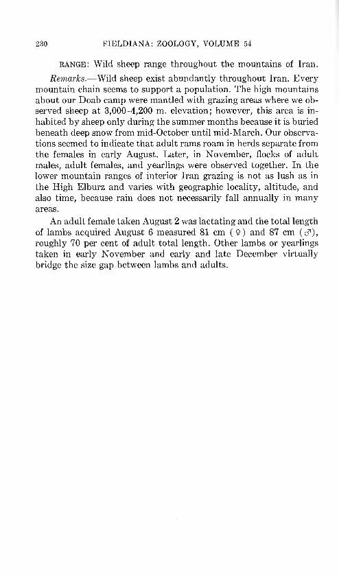
230 FIELDIANA: ZOOLOGY, VOLUME 54
range: Wild sheep range throughout the mountains of Iran.
Remarks.—Wild sheep exist abundantly throughout Iran. Everymountain chain seems to support a population. The high mountains
about our Doab camp were mantled with grazing areas where we ob-
served sheep at 3,000-4,200 m. elevation; however, this area is in-
habited by sheep only during the summer months because it is buried
beneath deep snow from mid-October until mid-March. Our observa-
tions seemed to indicate that adult rams roam in herds separate from
the females in early August. Later, in November, flocks of adult
males, adult females, and yearlings were observed together. In the
lower mountain ranges of interior Iran grazing is not as lush as in
the High Elburz and varies with geographic locality, altitude, and
also time, because rain does not necessarily fall annually in manyareas.
An adult female taken August 2 was lactating and the total length
of lambs acquired August 6 measured 81 cm (9) and 87 cm (cf),
roughly 70 per cent of adult total length. Other lambs or yearlings
taken in early November and early and late December virtually
bridge the size gap between lambs and adults.

APPENDIX OF OTHER SPECIES REPORTED FROM IRAN
This appendix provides a list of the 28 species previously re-
corded from Iran that were not represented among the 99 species
collected by the Street Expedition. These are included so that this
paper may provide complete coverage of the known mammalianfauna of Iran to date. For each species the following information is
recorded: scientific name; primary citation; type locality; distribu-
tion in Iran (the majority of the species treated here have been
recorded from a single locality and no attempt will be made to providethe areal range of these) ; remarks (this category is self-explanatory
where employed).
Paraechinus aethiopicus Ehrenberg Ethiopian HedgehogParaechinus aethiopicus Ehrenberg, 1833 in Hemprich and Ehrenberg, Symb.
Phys. Mamm. 2, sig K, recto.
Type locality.—Sudan : Dongola Desert.
Distribution.—previous: Thomas (1922, p. 144), Tanb Island, Persian Gulf.
new specimens: 8893 NMV, Kerman, Kuh-i-Hezar.
Remarks.—This specimen from Kuh-i-Hezar is allotted to this
species on the basis of its single-rooted P-3 - which is greatly reduced in
size (cf. Ellerman and Morrison-Scott, 1951, p. 27). This locality
marks the range of this species for the first time on the Persian main-
land and extends the range about 1250 km. east-southeast of Hatt's
(1959, p. 27) easternmost Iraq record of Baghdad and approximately500 km. northwest of Tanb Island in the Persian Gulf.
Sorex minimis Linnaeus Lesser ShrewSorex minutus Linnaeus, 1766, Syst. Nat., 12th ed., 1, p. 73.
Type locality.—USSR: Western Siberia; Barnaul.
Distribution.—previous: Goodwin (1940, p. 3), Khorassan, Dasht.
Tadarida teniotis Rafinesque European Free-tailed Bat
Cephalotes teniotis Rafinesque, 1814, Precis. Som. 12.
231

232 FIELDIANA: ZOOLOGY, VOLUME 54
Type locality.—
Sicily.
Distribution.—previous: Trouessart (1897, p. 104), Persia. Lewis and Har-
rison (1962, p. 477), Persia. These authors mention two alco-
holic specimens in the British Museum (N.H.). I examined twoalcoholic specimens . at that institution from Fars, Bushire
(97.11.10.2) and "Foot of the Elburz mountains" (10.8.12.5).
Remarks.—We frequently heard and occasionally glimpsed bats
that behaved much like Tadarida taeniotis at Ahram and Lake Famur,both localities in Fars. I have observed and collected this species in
southern Europe (Granada, Spain and Naples, Italy).
Myotis nattereri Kuhl Natterer's Bat
Vespertilio nattereri Kuhl, 1818, Ann. Wetterau Ges. Naturk. 4, no. 1, p. 33.
Type locality.—Germany: Hanau; Hessen.
Distribution.—previous: Harrison (1963, p. 302), Azarbaijan, Guter Su.
Myotis emarginatus Geoffroy Geoffroy's Bat
Vespertilio emarginatus Geoffroy, 1806, Ann. Mus. Hist. Nat. Paris 8, p. 198.
Type locality.—France: Ardennes; Givet, Charlemont.
Distribution.—previous: Blanford (1876, p. 20), Kerman, Jalk. Thomas
(1920a, p. 933), Kerman, Shastun near Dizak. Kuzyakin(1950, p. 267) maps a locality in Khorassan, seemingly near
Mashhad.
new specimens: 27.10.26.2^ BM from Mazanderan, Bar-
furush.
range : This bat is known from four widely scattered localities
in Iran, the scattered nature of which suggests that it may oc-
cur through a large part of the eastern half of Iran.
Pipistrellus nathusii Keyserling and Blasius
Vespertilio nathusii Keyserling and Blasius, 1839, Arch. Naturgesch. 5, no. 1 p. 320.
Type locality.—Germany: Berlin.
Distribution.—None in Iran.
Remarks.—Ellerman and Morrison-Scott (1951, p. 184) list
"?Persia" in the range of this bat. This species has not yet been co-
lected in Iran.

LAY: THE MAMMALS OF IRAN 233
Pipistrellus mimus Wroughton Indian Pygmy Pipistrelle
Pipistrellus mimus Wroughton, 1899, J. Bombay N. H. Soc, 12, p. 722.
Type locality.—West India: Surat Dist.: Mheskatri, Dangs.
Distribution.—PREVIOUS: Cheesman (1920, p. 576), Fars, Shiraz.
Range.—Cheesman did not mention whether comparisons be-
tween P. mimus and the very similar species P. pipistrellus were
made. Because this record represents a considerable range extension
for either P. mimus or P. pipistrellus than those provided by Ellerman
and Morrison-Scott (1951, pp. 163, 166) it would seem desirable
that this Shiraz series be re-examined.
Pipistrellus coromandra Gray Indian Pipistrelle
Scotophilia coromandra Gray, 1838, Mag. Zool. Bot., 2, p. 498.
Type locality.—India: Coromandel Coast; Pondicherry.
Distribution.—previous: Dobson (1871), p. 461), Fars, Shiraz.
Remarks.—Dobson (loc. cit.) states of these examples only"Several spirit specimens of immature individuals referable to this
species [Pipistrellus coromandra]." The possibility that these imma-ture specimens represent some species other than P. coromandra,
e.g. kuhli, mimus, pipistrellus, cannot be overlooked. No writer since
Dobson has mentioned further study of these specimens.
Eptesicus bobrinskoi Kuzyakin Bobrinsky's BatEptesicus bobrinskoi Kuzyakin, 1935, Bull. Soc. Nat. Moscow, 44, pp. 435-437.
Type locality.—Turkmen SSR: Tjulek wells in Aral Kara-Kum
Desert 65 km. east of Aralskoje More (city).
Distribution.—Harrison (1963, p. 303), Azarbaijan, Guter Su.
Eptesicus nasutus Dobson Sind BatVespcrugo (Vesperus) nasutus Dobson, 1877, J. Asiat. Soc. Bengal, 46, no. 2, p. 311.
Type locality.—India: Sind; Shikarpu.
Distribution.—previous: Thomas (1905, p. 520), Khuzistan, Ahwaz.
Eptesicus bottae Peters Bott's Serotine
Vesperus bottae Peters, 1869, Mber. Preuss. Akad. Wiss. p. 406.
Type locality.—Arabia: Yemen.
Distribution.—previous: Thomas (1905, p. 520) Khuzistan, Mala-i-Mir;
Telespid. Cheesman (1921, p. 574), Fars: Basht, 4000 ft.

234 FIELDIANA: ZOOLOGY, VOLUME 54
Otonycteris hemprichi Peters Hemprich's Long-eared Bat
Otonycteris hemprichi Peters, 1859, Mber. Preuss. Akad. Wiss., p. 223.
Type locality.—None.
Distribution.—previous: Satunin (1909b, p. 281), Kerman, Nukendzhaga.
Plecotus austriacus Fischer Long-eared BatPlecotus auritus austriacus Fischer, 1829, Synops. Mamm. p. 117.
Type locality.—
Austria, Vienna.
Distribution.—PREVIOUS: Peters (1866, p. 18), Persia. Harrison (1963, pp. 305-
6), Azarbaijan, Guter Su. Aberdeen University (1965, p. 6)
Isfahan, Kuh Rang area.
Vulpes corsac Linnaeus Corsac FoxCanis corsac Linnaeus, 1768, Syst. Nat., 12th ed., appendix to vol. 1, p. 223.
Type locality.—USSR: Steppes between the Ural and Irtish
Rivers.
Distribution.—previous: Misonne (1959, p. 30), Gorgan, Gumshun.
Selenarctos thibetanus G. Cuvier Asiatic Black BearUrsus thibetanus G. Cuvier, Ossements Foss. 4, p. 325.
Type locality.—Assam: Sylhet.
Distribution.—previous: Blanford (1876, p. 47) mentions the occurrence of a
black bear in Iranian Baluchistan. Birula (1912, p. 279) records
the following information from N. Zarudny's notes: KermanProvince: examined dead S. thibetanus in date grove at Rashid-
Khnom; saw bears at Tagab; frightened bear out of Tamarisk
thicket along the Rud-i-Zakhan; noted bear tracks, presum-
ably this species, along the Rud Khane-i-Kyagur between
Basman and Bampur.range: The Asiatic Black Bear is reported from the south-
eastern part of Kerman Province.
Remarks.—Although this bear undoubtedly ranges in southern
Kerman Province no specimen, it seems, has ever been preservedfrom Iran. Nearly all the men we talked with from Damin, Iran-
shahr, Bampur, and Geh were familiar with this black bear and were
in complete accord on the point that these bears frequent the date
groves in the vicinities of these towns annually when the dates ripen.

LAY: THE MAMMALS OF IRAN 235
Melivora capensis Schreber Honey BadgerVivera capensis Schreber, 1776, Saugethiere pi. 125, also 1777, 3, p. 450.
Type locality.—South Africa: Cape of Good Hope.
Distribution.—PREVIOUS: Thomas (1905:523), Khuzistan, Ram Hormuz.Cheesman (1920:335), I Aires tan, Baksai on the Iran-Iraqfrontier. Ognev (1931:503) cites "S. I. Bilkevich (1918)" as
recording the ratel from Atrek and Astrabad Provinces in Iran,
but I have been unable to locate Bilkevich 's original paper.
new specimens: 5201 SMNS, Khuzistan, on the road be-
tween Shush and Ahvaz.
range : The ratel or honey-badger is presently known from the
Khuzistan plains and the parts of Lurestan abutting the Tigris
river valley and seemingly, the Turkmen plains of the present
day Gorgan and Khorassan Provinces.
Felis leo Linnaeus Lion
Felis leo Linnaeus, 1758, Syst. Nat., 10th ed., 1, p. 41.
Type locality.—
Algeria: Constantine.
Distribution.—previous: Blanford (1876, pp. 30-31), states that lions oc-
curred abundantly from Khuzistan Province east into Fars
Province to 53° E. An encounter with a lioness in oak forest
south of Dasht-i Arjan in Fars is related. Sykes (1902, p. 319),
Fars, hills about Kazerun. Sykes (1910, 265), Khuzistan,along the banks of the rivers. Kinnear (1920, pp. 33-37),
Khuzistan, jungles of the Kurun River; Bakhtiyari Moun-
tains; Ram Hormuz plain; near Mt. Asemari; Suza; Dizful.
Champion Jones (1945, p. 230), Khuzistan, Karkheh River
gorge about 40 miles north of Dizful (sight record December
1941). Heany (1944, p. 44), Khuzistan, 40 miles northwest
of Dizful (sight record May 22, 1942).
Remarks.—No lion has been reported from Iran since May 1942
and it seems likely this species is now extinct there, however the
possibility that a few may still exist in the "jungles" of the Dez,
Karkheh and Karun river valleys should not be overlooked.
Felis tigris Linnaeus TigerFelis tigris Linnaeus, 1758, Syst. Nat., 10th ed., 1, p. 41.
Type locality.—India: Bengal.

236 FIELDIANA: ZOOLOGY, VOLUME 54
Distribution.—previous: De Filippi (1865, p. 343), Ghilan and MazanderanProvinces. Kennion (1911, pp. 243, 247), Gorgan, Elburz
mountains east of Gorgan. Khorassan, mountains along the
southern bank of the Gorgan River. Misonne (1959, p. 34),
Khorassan, near Dasht.
range: The above records and Satunin's (1905b, p. 146) from
the Talysh mountains of Azarbaijan SSR suggest that the tiger
occurs throughout the forest zone along the northern slope of
the Elburz mountains.
Phoca caspica Gmelin Caspian Seal
Phoca vitulina var. caspica Gmelin, 1788, Syst. Nat., 13th ed., 1, p. 64.
Type locality.—Caspian Sea.
Distribution.—previous: Confined to Caspian Sea (Ellerman and Morrison.
Scott, 1951, p. 330). These seals reportedly visit the Iranian
coast frequently but we failed to observe them. We did see a
specimen in the Tehran Zoo that was captured during the fall
of 1962 near Ramsar.
Dama mesopotamica Brooke Mesopotamian Fallow Deer
Cervus mesopotamicus Brooke, 1875, P.Z.S. p. 264.
Type locality.—Iran: "Khuzistan, Luristan".
Distribution.—PREVIOUS: Brooke (1875, p. 264), Khuzistan, Karun, Diz, and
Karkheh Rivers. Ellerman and Morrison-Scott (1951, p. 359),
Lurestan, Juanrud District north of Kermanshah. Haltenorth
(1961, pp. 22-23), Khuzistan, Harmala on the Dez River;
Ahmad Mollah on the Karkheh River.
range : This species seems to be confined to the ever shrinking
Tamarisk-Populus euphraticus riverine thickets along the Dez,Karkheh and Karun rivers in the vicinity of Shush. The status
of the population, if such presently exists, in the Jowan Rudvalley of Lurestan is unknown.
Remarks.—Mr. Khosrow Sariri, Chief adjutant of the Iran GameCouncil informed me (letter of May 27, 1963) that he with a party
sponsored by the Iran Game Council had captured two males and two
two females alive in the Karkheh and Dez River valleys near Shush
and that these animals have been transported to a Game Preserve

LAY: THE MAMMALS OF IRAN 237
near Sari in Mazanderan Province. Mr. Eskander Firouz, treasurer of
the Iran Game Council writes regarding D. mesopotamica in a letter
dated August 14, 1965: "we caught three more animals since last
winter [1964/65]—first a four-year old stag, which was consigned to
von Opel in Frankfort, then two (one of either sex), which were sent
to the Dasht-e-Naz Park near Sari. The mature female in the park
[captured in 1964] meanwhile gave birth to a fawn this year—and wethus have a total of seven fallow deer in this enclosure."
Gazella leptoceros Cuvier RhimAvtilope leptoceros Cuvier, 1842, in Geoffroy and Cuvier, Hist. Nat. Mamm., 4,
p. 72. Antilope a longues comes, 2, and pis. 373, 374.
Type locality.—"Semmaar" (probably the desert between Giza
and Wadi Natron, Lower Egypt, Flower 1932) .
Distribution.—previous: Cheesman (1920, p. 344), Khuzistan, Shushtar
and Ahwaz.
Ochotona daurica Pallas Daurian Pika
Lepus dauuricus Pallas, 1776, Reise Russ. Reichs., 3, p. 692.
Type locality.—USSR: Eastern Siberia: Kalusutai, Onon River.
Lagomys dauricus Buchner, 1890, Wiss. Res. Przewalski Cent. Asien Reisen, Zool.
Th., 1, Saugeth. 172. Emendation.
Distribution.—PREVIOUS: Thomas (1922a, p. 189), Kerman, Seistan.
Remarks.—Thomas (1922a, p. 189) described Ochotona curzoniae
seiana from a single alcoholic specimen received in an exchange with
the Indian Museum at Calcutta and subsequently prepared into a
skin and skull. Ellerman and Morrison-Scott (1951, p. 452) allocate
it to Ochotona daurica. After study of the type specimen in London I
agree that morphologically the specimen is more similar to daurica
than to any other Asian conie. However, Ochotona daurica is a steppedweller whose range encompasses the southeastern Altai and South-
ern Transbaikallia, USSR; Mongolia; and Chzhili, Shensi, Shansi,
and the western part of Kansu Provinces, China (Gromov et al. 1963,
p. 242), and the closest part of the range of this species, Koko Nor,
Mongolia, lies beyond the Himalayan Mountain escarpment east
northeast of Seistan approximately 2575 km. Furthermore, habitat
of daurica as described by Allen (1938, p. 552-553) does not exist in
Seistan.
Sciurus anomalus Guldenstaedt Persian SquirrelSciurm anomalus Guldenstaedt, 1785, Schreber, Saugethiere 4, p. 781.

238 FIELDIANA: ZOOLOGY, VOLUME 54
Type locality.—Georgian SSR: Sabeka, 25 km. southwest of
Kutais.
Distribution.—previous: Blanford (1876, p. 49), Fars, oak forest near
Shiraz. Cheesman (1920, p. 575), Fars, Kaluni 4200 ft.; Sisakht
6500ft.;Chinar6600ft.
range: This squirrel has been reported only from the above
cited places in Fars Province. Hatt's (1959, pp. 79-80) records
from numerous places in the forested and semi-forested ZagrosMountains of Iraqi Kurdistan provide a basis for suggesting
that this species will be found to occur elsewhere in the forested
elevations of the Zagros range in Iran.
Spermophilopsis leptodactylus Long-clawed Ground Squirrel
Arctomys leptodactylus Lichtenstein, 1823, Eversmann. Reise, p. 119.
Type locality.—Uzbekistan SSR : Karata, 140 versts northwest of
Bokhara.
Distribution.—previous: Petter, et al. (1957, p. 120), Khorassan, Serakhs.
Allactaga hotsoni Thomas Hotson's Jerboa
Allactaga hotsoni Thomas, 1920, J. Bombay Nat. Hist. Soc. 26 no. 4, p. 936.
Type locality.—Iran: Kerman; Kant [=Kont], 20 miles south-
west of Sib.
Distribution.—This species is known from a single specimen from
the type locality.
Remarks.—See account of Allactaga ivilliamsi. Siddiqi (1961, p.
189) incorrectly locates Kont in W. Pakistan. Kont lies well within
Iranian territory.
Rattus rattoides Hodgson Turkestan Rat
Mus rattoides Hodgson, 1845, Ann. Mag. Nat. Hist., (ser. 1) 15, p. 267.
Type locality.—
Nepal.
Distribution.—PREVIOUS: Etemad (1964, p. 652) recorded this species from
Iran. The captions of Figures 1 and 2 state that the specimenis from Moghan. The label on the specimen in Etemad's Fig-
ures 1 and 2 is unclear but seems to read "Moghan, 30 kilome-
ters S of Mashhad N.E. Iran." This would be in Khorassan
Province.

LAY: THE MAMMALS OF IRAN 239
Remarks.—The bodies of FMNH specimens, nos. 97518-19, of
Rattus norvegicus from Tehran, Tehran, are white ventrally, as
are the ventral halves of the bicolored tails. Numerous FMNHspecimens of R. norvegicus from Ngluko, Yunnan Province, China,
possess white-colored undersurfaces of the body and tail. Etemad
compared his specimen with only R. rattus. The pelage difference
between R. rattoides and R. norvegicus is that in the former the hairs
covering the ventral surfaces of the body are white from base to tip,
whereas these are gray basally in the latter. On the basis of the distri-
bution of R. rattoides in Uzbek SSR and Afghanistan it seems possible
that the species may occur in Iran, but, if R. rattoides is to be une-
quivocally recognized as a component of the Iranian fauna, the exact
nature of the coloration of the ventral hairs of the specimen from
Moghan must be ascertained with certainty. This cannot be ac-
complished from Etemad's account.
Meriones hurrianae Jerdon Indian Desert Jird
Gerbillus hurrianae Jerdon, 1867, Mamm. India, p. 186.
Type locality.—India: Punjab; Hissar.
Distribution.—previous: Blanford (1876, p. 68), Kerman, Bahukelat.
Wroughton (1920, p. 31), Kerman, Chabahar. Heptner (1940,
p. 20), Kerman, near Bahu Kelat. Petter et al. (1957, p. 116),
Fars, 60 kilometers north of Bandar Abbas on the route to
Kerman.
range: This jird ranges west across southern Kerman Province
to the southeast corner of Fars Province.
Remarks.—Misonne states (1959, p. 51) in error that Petter et al.
(1957, p. 116) found this species 200 km. west of Bandar Abbas on the
route to Lar.
Meriones meridianus Pallas Midday Jird
Mus meridianus Pallas, 1773, Reise Russ. Reiches, 2, p. 702.
Type locality.—Kazakstan SSR: Uralsk Region; near Novo-
Bogatinsk.
Distribution.—PREVIOUS: Heptner (1940, p. 32), Khorassan, Mandakhi;Rum. Petter et al. (1957, p. 117) Khorassan, Sarakhs.

240 FIELDIANA: ZOOLOGY, VOLUME 54
RANGE : The Iranian range of this species is so far limited to the
most northeastern Province.
Remarks.—The first two above localities lie on the Persian plateauand the last is located off it on the edge of the Kara Kum Desert.
Pitymys subterraneus de Silys Longchamps Pine Vole
Arvicola subterraneus de Silys Longchamps, 1836, Essai Monogr. sur les Cam-pagnols des environs de Liege, p. 10.
Type locality.—Belgium: Liege; Waremme.
Distribution.—
previous: Ellerman (1948, p. 784) records specimens from
Ghilan, Kuramabad.
Sotalia plumbea Cuvier Plumbeous Dolphin
Delphinus plumbeus Cuvier, 1829, Regne Anim., 1, p. 288.
Type locality.—India: Malabar.
Distribution.—previous: Murray (1884, p. 98) records two skulls from the
Persian Gulf coast in Fars, Bandar Lengeh.

SUMMARY
A narrative account cursorily describes the physiography and
general ecology observed along the routes taken in Iran by the W. S.
and J. K. Street Expedition. Separate from the narrative and ar-
ranged alphabetically by the name of the collecting locality, ecolog-
ical description of each of the places where the expedition paused to
study and collect tells what mammals were found in what sort of
biotic communities. A gazetteer is provided with the coordinates of,
or appropriate remarks on, every Iranian locality cited in the text.
The distribution data for Iran published before 1963, for each
of the 99 species represented by the 1719 mammal specimens ob-
tained by the expedition, and the 26 other species known from Iran
is summarized for the first time since 1876.
The following advances in taxonomic knowledge of mammal spe-
cies of southwest Asia beyond that presented by Ellerman and Mor-
rison-Scott (1951) and Misonne (1959) result from this study of col-
lections of the Street Expedition in relation to previously existing
materials:
Crocidura leucodon lasia Thomas, 1906, is in fact C. leucodon Her-
mann, 1780, and not C. lasiura Dobson, 1890.
Crocidura russula caspica Thomas, 1907, is in fact C. russula Her-
mann, 1780, and not C. lasiura Dodson, 1890.
Rhinopoma hardwickei pusillum Thomas, 1920, is shown to be
synonomous with R. h. seianwm Thomas, 1913.
Pipistrellus aladdin Thomas, 1905, is a synonym of P. kuhli kuhli
Kuhl, 1819.
Miniopterus schreibersi pallidus Thomas, 1907, and M. s. pulcher
Harrison, 1956, are shown to be junior synonyms of M . s. schrei-
bersi Kuhl, 1819.
Microtus guentheri Danford and Alston, 1880, and Microtus irani
Thomas, 1921, are synonymous with Microtus socialis Pallas,
1773.
241

242 FIELDIANA: ZOOLOGY, VOLUME 54
Ellobius lutescens is a subspecies of E. fuscocapillus.
The subspecies buxtoni Thomas, 1919, and insularis Goodwin, 1939,
are shown to be synonymous with Nesokia indica indica Gray and
Hardwicke, 1832.
Glis glis persicus Erxleben, 1777, is shown to be the oldest available
name for the south Caspian fat dormouse, and G. g. caspicus
Satunin, 1905, is a junior synonym.
Collecting efforts of the expedition are shown to have resulted in
discoveries in Iran of nine species not previously known to occur
there:
Erinaceous europaeus Eptesicus nilssoni
Neomys anomalus Vespertilio murinus
Talpa streetorum Barbastella leucomelas
Rhinolophus euryale Microtus nivalis
Rhinolopus blasii
One species entirely new to science, a mole of the family Talpidae,has been described from Hezar Darreh, Kurdistan, Iran and named
Talpa streetorum.

GAZETTEER
The compilation of the Iranian place names listed here was a
relatively easy task, whereas that of determining the correct location
of many of these proved more formidable. Some of this difficulty
stemmed from the varied transliterations of Persian names into Eng-
lish, French, Russian, Italian, and/or Spanish. By grace of mypersonal experience in Iran and acquisition of a cursory familiarity
with Farsi, as the Persian language is known, words often employedas pre- or suffixes (e.g. deh, rud, chah, which mean respectively vil-
lage, river, well) in transliterations have frequently provided clues
that facilitated location of obscure localities.
Most of the places from which mammal specimens have been pre-
served, even those visited by the earliest collectors (e.g., S. G. Gmelin,
1770-1772, De Filippi, 1863; St. John, 1869-71; Blanford, 1872; etc.),
have been accurately located. This accomplishment seems to be due
to (1) the stability of the names and locations of cities, towns, villages
and names of geographic features, at least during the relatively brief
recent period of Persia's more than 2,500 years of recorded history;
(2) the detailed itineraries or accounts provided by most collectors
of vertebrates in Iran, and (3) the excellent maps which are present-
ly available.
The maps and gazetteers provided in "The Times Survey Atlas
and Gazetteer of the Worlds," (J. G. Bartholomew ed.) London 1922;
its successor, "The Times Atlas of the World, Mid-Century Edition,"
(John Bartholomew ed.) London 1959; and "National GeographicAtlas of the World," (M. B. Grosvenor ed.) Washington 1963 are
satisfactory for locating the larger and more prominent towns, cities,
and geographic features but those found most useful were: "The
Army Map Service Iran-Iraq K501 Series, 1:253,440 (1941) and
K502 Series, 1:250,000 (compiled 1951) published by Corps of
Engineers, U. S. Army, Washington, D. C. and the World Aeronauti-
cal Chart, 1:1,000,000 4th revised edition (1958) published by Aero-
nautical Chart Service, U.S. Army Air Forces, Washington, D.C.
For the purpose of standardization, the names provided in this
gazetteer follow where possible those listed in the U.S. Board on
243

244 FIELDIANA: ZOOLOGY, VOLUME 54
Geographic Names Gazetteer 19, Iran (1956) published by the U.S.
Government Printing Office, Washington, D.C. Place names not
listed in Gazetteer 19 were cited from the K501 or 502 map series, the
World Aeronautical Chart, or the original literature in that order of
preference.
Many Persian place names enjoy wide usage throughout Iran
(e.g. over 120 different listings are given for Aliabad in the Gazetteer
19) . With the knowledge from the specimen label of who collected the
specimen and when, and with available knowledge of the collector's
itinerary, we have generally been able to locate the correct place when
specimens have been recorded from a locality the name of which is
used for more than one place.
In alphabetizing, place names of more than one word are treated
as if but a single word (e.g. Dehdez, Deh-i-Diz, Dehnan would come
properly in this order).
Because of the confusion involved in the various transliterations
of Persian place names, particularly to the unpracticed reader, I at-
tempt to provide the most common synonyms for the polynomiallocalities encountered in this study. Synonyms will be readily
recognized by a cross reference in the co-ordinate column. In the Ac-
counts of Species section in the subheading PREVIOUS under Distribu-
tion, I have attempted to list locality records spelled as they appearedin the original literature. Additionally, these places have been listed
with the appropriate Province. A large number of these localities as
originally spelled are synonyms to the name accepted by the U.S.
Board on Geographic Names, Gazetteer 19.
The -e-, -i-, -ye- of names such as Band-e-amir, Band-i-Qir,
Rudkhaneh-ye-Jask are synonomous in meaning. The Gazetteer 19,
however, does not indicate this nor does it standardize usage of any
single one of these.
The abbreviation ca. before co-ordinates indicates that the exact
locality of the place was not provided in Gazetteer 19 or found on anyof the maps used, but according to information provided in the pri-
mary literature should lie at or near the point given.
On occasions (e.g. Varang River) the English word "river" has
been substituted for the Persian equivalent, "rud." Though the
Gazetteer 19 lists the stream as Varund Rud, it is felt that replace-
ment of Rud with river will result in less confusion particularly for
those readers unfamiliar with Persian.
The province names accompanying the localities in the text pro-
vide, principally, a means whereby the reader may readily locate the

LAY: THE MAMMALS OF IRAN 245
approximate part of Iran in which the locality cited exists by referral
to map no. 1 on pp. 14-15. This map consists of a modification by meof a map published by A. H. Hamzavi, Iranian Information Center,
New York, ca. 1960 (exact date not provided).
GAZETTEER
Abadan, Khuzistan: 30°20'N 48°16'E
Abadeh, Fars: 31°10'N 52°38'E
Abhar River, Damghan: 36°02'N 49°45'E
Abousalt, Khorassan—village on the 64 km. route from Mashhad SW to Fariman
Abtar, Kerman: 27°14'N 60°53'E
Aghbolagh Morched, Kurdistan: 35°37'N 48°07'E
Aghdach, Kurdistan : (see Agh Dagh)Agh Dagh, Kurdistan: 37°23'N 48°33'E
Ahmad Mahmoudi, Fars: 28°20'N 53°42'E
Ahmad Mollah, Khuzistan—ca. 5 km. south of Shush, precise locality not found
Ahram, Fars: 28°52'N 51°16'E
Ahvaz, Khuzistan: 31°19'N 48°42'E
Ahwaz, Khuzistan: (see Ahvaz)Akbarabad (near Shiraz), Fars: 29°41'N 52°33'E
Akhlamad, Khorassan: 36°37'N 58°55'E
Akinlou, Kurdistan: 35°35'N 48°07'E
Ala Dagh Mountains, Azarbaijan—exact locality not determined, presumablyca. 38°30'N 46°15'E
Ala Dagh, Khorassan: (see Aleh Dagh)Alakhurshid, Khuzistan: (see Ala Khvorshid)Ala Khurshid, Khuzistan: (see Ala Khvorshid)Ala Khvorshid, Khuzistan: 31°32'N 49°52'E
Aleh Dagh Mtns., Khorassan: 37°07'-17'N 57°~30'-50'E
Aliabad, Gorgan: 36°54'N 54°52'E
Alkhorshir, Khuzistan: (see Ala Khvorshid)Allah Yarlou, Azarbaijan: 38°50'N 47°45'E
Anarak, Damghan: 33°20'N 53°42'E
Anbarabad, Kerman: 28°25'N 57°50'E
Andemeshk, Khuzistan: (see Andimeshk)Andimeshg, Khuzistan: (see Andimeshk)
Andimeshk, Khuzistan: 32°27'N 48°21'E
Aptar, Kerman: (see Abtar)Aras River: 39°56'N 48°20'E
Araxe River: (see Aras River)
Ardabil, Azarbaijan: 38°15'N 48°18'E
Ardebil, Azarbaijan: (see Ardabil)
Ardestan, Damghan: 33°45'N 52°30'E
Ashraf, Gorgan: (see Behshahr)
Ashurade, Gorgan: (see Ashuradeh-ye-Bozorg)
Ashuradeh-ye-Bozorg, Gorgan: 36°50'N 53°56'E
Askanieh, Khorassan—village on the 64 km. route from Mashhad SW to Fariman
Aspas, Fars: 30°40'N 52°24'E

246 FIELDIANA: ZOOLOGY, VOLUME 54
Astara, Ghilan: 38°26'N 48°52'E
Astrabad, Gorgan: (see Gorgan)Astrabad Province—former province now included in Gorgan Province, see
map pp. 14-15
Asupas, Fars: (see Aspas)Atrak Province—former province, probably located in the northern parts of the
present Gorgan and Khorassan Provinces.
Atrak River, Khorassan—flows west from Kopet Dagh north of Bojnurd to the
Caspian Sea
Aviz, Khorassan: 33°43'N 69°57'E
Baba Bagy, Azarbaijan—in Kara Dagh mountains, exact locality not found
Babol, Mazanderan: 36°34'N 52°42'E
Babol Sar, Mazanderan: 36°43'N 52°39'E
Bach Goutaran, Kurdistan—not located, but presumably in vicinity of Aghbo-lagh Morched
Backtyari Mtns., Khuzistan: (see Bakhtiari Mtns.)
Badzhistan, Khorassan: (see Bejestan)
Bagherabad, Khorassan: (see Bakhirabad)
Bagh-i-Shahi, Khuzistan: (see Baksai)Bahu Kalat, Kerman: 25°43'N 61°25'E
Bahukelat, Kerman: (see Bahu Kalat)Bahu Kelat, Kerman: (see Bahu Kalat)
Baiza, Fars: 30°03'N 52°50'E
Bakhirabad, Khorassan: 35°58'N 59°45'E
Bakhtiari Mtns., Khuzistan: 32°13'N 49°48'E
Baksai, Khuzistan: 32°53'N 46°21'E
Baktyari Mtns., Khuzistan: (see Bakhtiari Mtns.)Baluch Ab Well, Kerman, in Palang Kuh Mtn. range: 30°08'N 60°44'E
Baluchistan—eastern part of Kerman Province
Bam, Kerman: 29°06'N 58°21'E
Bamgour, Kerman: (see Bampur)Bamphur, Kerman: (see Bampur)Bampur, Kerman: 27°12'N 60°27'E
Bampur River (Rud), Kerman: 27°18'N 59°06'E
Band, Azarbaijan—village 10 km. SW Rezaiyeh
Bandamir, Fars: 29°47'N 52°51'E
Bandan, Kerman: 31°23'N 60°44'E
Bandar Abbas, Fars: 27°11'N 56°17'E
Bandar Abbas, Fars: 60 km. north of, along road to Kerman: 27°30'N 56°10'E
Bandar-e-Gaz, Gorgan: 36°47'N 53°59'E
Bandar-e-Lengeh, Fars: 26°33'N 54°53'E
Bandar-e-Pahlavi, Ghilan: 37°28'N 49°27'E
Bandar-e-Shah, Gorgan: 36°56'N 54°06'E
Bandar-i-Gaz, Gorgan: (see Bandar-e-Gaz)Bandar Lengeh, Fars: (see Bandar-e-Lengeh)Bandar Pahlavi, Ghilan: (see Bandar-e-Pahlavi)
Bandar Shah, Gorgan: (see Bandar-e-Shah)
Band-e-amir, Fars: (see Bandamir)
Band-i-Qir, Khuzistan: (see Band Qir)

LAY: THE MAMMALS OF IRAN 247
Band Qir, Khuzistan: 31°39'N 48°53'E
Bardeh Sur River, Azarbaijan: (see Rud-e-Bardeh Sur)
Bareng, Kerman: 31°08'N 61°12'E
Bar Farush, Mazanderan: (see Babol)
Barfurush, Mazanderan: (see Babol)
Basht, Fars: 30°21'N 51°09'E
Basket Mtn., Azarbaijan: 37°45'N 45°12'E
Basman, Kerman: 27°49'N 60°12'E
Behbehan, Fars: 30°35'N 50°14'E
Behshahr, Gorgan: 36°43'N 53°34'E
Bejestan, Khorassan: 34°31'N 58°10'E
Bendan, Kerman: (see Bandan)Bender Bouchire, Fars: (see Bushehr)
Bendun, Kerman: (see Bandan)Benna Mountains, Fars: not located
Berdesur Chay, Azarbaijan: (see Rud-i-Bardeh Sur)
Besha Daraz, Khuzistan: (see Bisheh Deraz)
Bid, Kerman: (see Kala-i-Bid)
Bidjar, Kurdistan: (see Bijar)
Bijaneh, Lurestan—7 km. E of Kermanshah
Bijar, Kurdistan: 35°52'N 47°36'E
Buistan, Khorassan: (see Bejestan)
Bilassoar, Azarbaijan: 39°21'N 48°20'E
Birdjand, Khorassan: (see Birjand)
Birjanah, Lurestan: (see Parchineh)
Birjand, Khorassan: 32°53'N 59°13'E
Birjaneh, Lurestan: (see Parchineh)Bisheh Deraz, Khuzistan: 32°48'N 46°58'E
Bisitan, Lurestan: (see Bisitun)
Bisitun, Lurestan: 34°23'N 47°26'E
Bisotun, Lurestan: (see Bisitun)
Bizine, Kurdistan: 35°40'N 48°37'E
Bojnurd, Khorassan: 37°28'N 57°19'E
Boliabad, Kerman—24 km. east of KermanBorasjan, Fars: (see Borazjan)
Borazjan, Fars: 29°16'N 51°12'E
Bostanabad, Azarbaijan: 37°50'N 46°50'E
Boukan, Azarbaijan: (see Bowkan)Bowkan, Azarbaijan: 36°31'N 46°12'E
Bujnurd, Khorassan: (see Bojnurd)
Bukan, Azarbaijan: (see Bowkan)Bunde-Kil, Khuzistan: (see Band Qir)
Bushehr, Fars: 28°59'N 50°50'E
Bushire, Fars: (see Bushehr)Camp Kohak, Kerman (in Seistan)
—not located
Chagajor, Khuzistan: (see Chagha Khur)Chagha Khur, Khuzistan: 31°55'N 50°53'E
Chahabar, Kerman: (see Chah Bahar)Chah Ali Khan, Damghan: 33°44'N 52°59'E
Chahbahar, Kerman: (see Chah Bahar)

248 FIELDIANA: ZOOLOGY, VOLUME 54
Chah Bahar, Kerman: 25°18'N 60°37'E
Chahbar, Kerman: (see Chah Bahar)Chah Basu, Kerman: 25°48'N 60°14'E
Chah-i-Dura, Kerman: ca. 27°40'N 60°15'E
Chahil Duktoran Range, Kerman: (see Chehil Duktaran Range)
Chah-i-Navar, Kerman: 30°15'N 61°04'E
Chah-i-Nodou, Khorassan: (see Nodou)Chah-i-Novar, Kerman: (see Chah-i-Navar)Chah Shur, Damghan: 34°10'N 52°20'E
Chak-i-Buzza Pa, Fars: (see Mishan)Chalus, Mazanderan: 36°38'N 51°26'E
Chalus Kalandost, Mazanderan—not located, but presumably in the general
area of Chalus
Chalus River, Mazanderan: 36°40'N 51°25'E
Chaman Bid, Khorassan: 37°25'N 56°38'E
Chamar, Azarbaijan: 38°55'N 45°30'E
Champ, Kerman: (see Chanf)
Chanf, Kerman: 26°38'N 60°29'E
Charman-i-bid, Khorassan: (see Chaman Bid)
Chehel Doktoran Range, Kerman: (see Chehil Duktaran Range)
Chehelgerd, Isfahan: 32°26'N 50°61'E
Chehil Duktaran Range, Kerman: 30°39'N 60°39'E
Chesmefli, Ghilan—in Elburz Mtns. of Ghilan Province, exact locality not de-
termined
Cheykhan, Kurdistan—not located
Chinar, Fars: 30°49'N 51°13'E
Chiraz, Fars: (see Shiraz)
Chodsha-i-du-tshagi, Khorassan: (see Khvajeh Dow Chahi)Choscht-adan Mtns., Khorassan: 34°34'N 60°33'E
Dach Bouroun, Gorgan: 37°35'N 54°49'E
Dacht, Khorassan: (see Dasht)
Dagja, Isfahan—not located, according to Ellerman (1948, p. 799) it lies 23 miles
east of Isfahan
Dak-i-do Well, Kerman: ca. 28°59'N 60°29'E
Dalaki River, Fars: 29°19'N 51°06'E
Damghan, Damghan: 36°09'N 54°22'E
Damin, Kerman: 27°25'N 60°55'E
Darband, Isfahan: ca. 32°44'N 51°13'E
Dar Kaleh, Gorgan—not precisely located, but according to Goodwin's descrip-
tion it should lie near our locality of Aliabad, GorganDaryacheh-i-Famur, Fars: (see Famur, Daryacheh-i-)
Daryacheh-i-Urmiah, Azarbaijan: (see Urmiah, Daryacheh-i-)
Daryacheh-ye-Seistan, Kerman: 31°00'N 61°15'E
Dasht, Khorassan: 37°19'N 56°01'E
Dasht-e-Arzhan, Fars: 29°39'N 51°58'E
Dasht-i-Arjan, Fars: (see Dasht-e-Arzhan)Dasht-i-Kavir, north part of Great Central Desert 34°N 56°E
Dasht-i-Lut, south part of Great Central Desert 31 °N 58°30'E
Dasht-i-Moghan, Azarbaijan: (see Moghan Steppe)

LAY: THE MAMMALS OF IRAN 249
Davar Panah, Kerman: 27°21'N 62°21'E
Degermatie, Khorassan: (see Dergermatie)Deh Bid, Fars: 30°38'N 53°11'E
Dehbid, Fars: (see Deh Bid)
Dehdez, Khuzistan: 31°43'N 50°17'E
Deh-i-Diz, Khuzistan: (see Dehdez)
Dehnau, Fars: 29°27'N 52°38'E
Demavend Mtn., Mazanderan: 35°56'N 52°08'E
Derbent, Isfahan: (see Darband)
Dergermatie, Khorassan: ca. 37°26'N 56°23'E
Dez River (Rud), Khuzistan: 31°39'N 48°52'E
Dezful, Khuzistan: 32°23'N 48°24'E
Divandarreh, Kurdistan: 35°55'N 47°02'E
Divandere, Kurdistan: (see Divandarreh)
Divandire, Kurdistan: (see Divandarreh)Diwan Darreh, Kurdistan: (see Divandarreh)Diz River, Khuzistan: (see Dez River)
Dizak, Kerman: (see Davar Panah)
Dizful, Khuzistan: (see Dezful)
Djoulfa, Azarbaijan: (see Jolfa, Azarbaijan)
Djulfa, Azarbaijan: (see Jolfa, Azarbaijan)
Djulfa, Isfahan: (see Jolfa, Isfahan)
DOAB, Mazanderan: 36°07'N 51°32'E
Dopulan, Khuzistan: (see Dow Polan)
Doruh, Khorassan: (see Duruh)Doruk River—not located
Dow Polan, Khuzistan: 3l°55'N 50°35'E
Dshalk, Kerman: (see Jalq)
Dshelellabad (Seistan), Kerman: vie. of 31°00'N 61°50'E
Dumbeneh, Isfahan—not located, Thomas (1905, p. 526) lists it as 50 mi. north of
Isfahan
DuPulan, Khuzistan: (see Dow Polan)
Duruch, Khorassan: (see Duruh)Duruh, Khorassan: 32°16'N 60°30'E
Duz Ab, Kerman: (see Zahedan)Duz Ab Well, Kerman: (see Zahedan)
Duzoab, Kerman: (see Zahedan)
Enzeli, Ghilan: (see Bandar-e-Pahlavi)
Esfahan, Isfahan: (see Isfahan)
Esmailabad, Kerman: 32°03'N 59°49'E
Fahraj, Kerman: 28°58'N 58°52'E
Fahraj Rud, Kerman: 28°58'N 58°52'E
Famur, Daryacheh-i-, Fars: 29°30'N 51°50'E
Farad, Damghan: (see Forat)
Farahan, Bakhtiari Mtns., Khuzistan: (see Faridan District)
Faraj, Kerman: (see Fahraj)
Faraman, Lurestan: 34°13'N 47°18'E
Faridan District, Khuzistan: 32°50'N 50°00'E

250 FIELDIANA: ZOOLOGY, VOLUME 54
Fariman, Khorassan: 35°43'N 59°53'E
Farimun, Khorassan: (see Fariman)Firouz Kuh, Mazanderan: (see Firuzkuh)
Firuzkuh, Mazanderan: 35°46'N 54°47'E
Forat, Damghan: 35°57'N 54°21'E
Frat, Damghan: (see Forat)
Fumen, Ghilan: (see Rasht)
Gach Qasa Guli, Fars: 29°47'N 50°32'E
Gach Sar, Mazanderan: 36°07'N 51°19'E
Galander Talech, Mazanderan: 36°48'N 54°16'E
Galatappeh, Isfahan: 33°13'N 51°45'E
Ganjah Kuh Mtn., Khorassan: 37°20'N 56°55'E
Garposht, Kerman: 27°07'N 60°30'E
Gazan Karreh, Kurdistan—10 km. northwest of Akinlou
Geh, Kerman: 26°13'N 60°12'E
Gezardarreh, Kurdistan: (see Hezar Darreh)
Ghazvin, Qazvin: (see Qazvin)
Girsafa, Kerman: (see Gursafa)
Giurgen River, Khorassan: (see Gorgan River)
Gizar Darreh, Kurdistan: (see Hezar Darreh)
Goarpusht, Kerman: (see Garposht)
Golandar, Khorassan—67 km. southeast of Birjand, not 75 km. southwest of
Birjand as stated by Heptner (1940, p. 28); 32°24'N 59°40'E
Golmiran, Kerman: 33°12'N 60°08'E
Gombad-i-Kabous, Khorassan: (see Gonbad-i-Kavus)
Gonbad-i-Kavus, Khorassan: 37°17'N 55°17'E
Gorg, Kerman: 29°30'N 59°43'E
Gorgan, Gorgan: 36°50'N 54°29'E
Gorgan River: 36°58'N 54°02'E
Gorveh, Kurdistan: 35°10'N 47°48'E
Gouladagh, Khorassan: ca. 37°37'N 55°53'E
Gouladah, Khorassan: (see Gouladagh)
Gourg, Kerman: (see Gorg)
Gulander, Khorassan: (see Golandar)
Gulega, Ghilan—not located but presumably in vicinity of Kopur Chal
Guljander, Khorassan: (see Golandar)
Gulmirun, Kerman: (see Golmiran)Gulu Dagh, Khorassan: (see Gouladagh)
Gulyander, Khorassan: (see Golandar)
Gumshan, Gorgan: 37°04'N 54°06'E
Gumshun, Gorgan: (see Gumshan)Gurg, Kerman: (see Gorg)
Gurgan, Gorgan: (see Gorgan)
Gursafa, Kerman: (see Kubid)
Gursala, Kerman—misspelling of Gursafa, see Kubid
Gutur Su, Azarbaijan: (see Kutur Su)
Gutvand, Khuzistan: 32°15'N 48°15'E
Gutwand, Khuzistan: (see Gutvand)
Gwargusht, Kerman: (see Garposht)

LAY: THE MAMMALS OF IRAN 251
Hadjiabad, Kerman: (see Sa'idabad)
Haft Tappeh, Khuzistan: ca. 32°04'N 48°20'E
Hairleigh, Khorassan:—not located
Hamadan, Hamadan: 34°48'N 48°30'E
Hamum-i-Hirmand (Seistan), Kerman: (see Daryacheh-ye-Seistan)Hard-al Mamlah, Khuzistan: 31°53'N 48°31'E
Harmala, Khuzistan: (see Hard-al Mamlah)Hashtpar, Ghilan: 37°48'N 48°55'E
Helmand River (Seistan), Kerman: (see Hirmand River)
Hessarek, Qazvin: 35°50'N 50°54'E
Hezar Darreh, Kurdistan: 35°25'N 47°07'E
Hezar Laa, Mazanderan—12 km. west of Doab or 6 km. east VarangrudHircania: (see Hyrcania)Hirmand Basin, Kerman: (see Seistan)
Hirmand River, Kerman: 31°12'N 61°34'E
Hormoz, Strait of: 26°34'N 56°15'E
Hotu Cave, south of Beshahr, Mazanderan: 36°43'N 53°34'E
Humuk, Kerman: 29°59'N 60°51'E
Hurmak, Kerman: (see Humuk)Hussein Abad (Seistan), Kerman: 30°48'N 61°24'E
Hussein Abad, Khorassan: 35°52'N 59°49'E
Hussein-abad, Khorassan: (see Hussein Abad)Hyrcania, a province of the ancient Persian Empire that corresponds essentially
to Gorgan and eastern Mazanderan provinces of modern Iran.
Imanzadeh Ismail, Fars: 30°20'N 52°40'E
Iranshahr, Kerman: 27°13'N 60°41'E
Isfahan, Isfahan: 32°40'N 51°38'E
Ismailabad, Kerman: (see Esmailabad)
Ispahan, Isfahan: (see Isfahan)
Ispid Lam in, Kerman:—not located
Izeh, Khuzistan: 31°50'N 49°50'E
Jahrom, Fars: 28°31'N 53°33'E
Jalk, Kerman: (see Jalq)
Jalq, Kerman: 27°36'N 62°41'E
Jarghun, Fars—There is no such place on the K501 map at the co-ordinates which
are on the specimen label. This is possibly a misspelling of Zarghum: 29°28'N
52°44'E
Jask, Kerman: 25°38'N 57°46'E
Javanrud, Lurestan: 34°48'N 46°30'E
Jaz Murian Basin, Kerman: 27°20'N 58°55'E
Jebal Barez Kuh, Kerman: 28°30'N 58°20'E
Jebal Bariz Range, Kerman: (see Jebal Barez Kuh)JlROFT Dist., Kerman: 27°45'N 58°00'E
Jochdi, Khorassan: 37°20'N 56°50'E
Jolfa, Azarbaijan: 38°57'N 45°38'E
Jolfa, Isfahan: 32°38'N 51°37'E
Jowan Rud, Lurestan: (see Javanrud)Juan Rud, Lurestan: (see Javanrud)

252 FIELDIANA: ZOOLOGY, VOLUME 54
Juimand, Khorassan: (see Juymand)Julfa, Azarbaijan: (see Jolfa)
Juymand, Khorassan: 34°20'N 58°41'E
Juyom, Fars: 28°10'N 53°52'E
Juyum, Fars: (see Juyom)
Kafir-Kaleh Hills, Khorassan: (see Kafir Qaleh Hills)
Kafir Qaleh Hills, Khorassan: ca. 35°51'N 59°38'E
Kaha Kaha (Seistan), Kerman: 30°57'N 61°15'E
Kahourak, Kerman: (see Kahurak)
Kahriz, Kurdistan: 33°36'N 49°20'E
Kahur, Kerman: (see Kyagur)
Kahurak, Kerman: 29°26'N 59°40'E
Kain, Khorassan: (see Qayen)Kain Dist., Khorassan—former district centering around QayenKair River, Kerman: (see Kalar River)
Kalagan, Kerman: 26°48'N 58°49'E
Kala-i-Bid, Kerman: 29°09'N 61°03'E
Kala-i-Nadiri, Kara Dagh Mtns., Khorassan: 37°00'N 59°46'E
Kalar River (Rud), Kerman: 25°22'N 60°12'E
Kalat, Fars: 29°48'N 52°19'E
Kalate, Khorassan—village along the 64 km. route from Mashhad to FarimanKaleh Peninsula, Gorgan: 36°50'N 47°23'E
Kaleh Sefid, Kurdistan: 34°50'N 47°23'E
Kale Sefid, Kurdistan: (see Kaleh Sefid)
Kaluni, Fars: 29°35'N 51°53'E
Kamalabad, Qazvin—ca. 20 km. south of Karaj
Kamaraj, Fars: 29°37'N 51°29'E
Kamaru, Fars: (see Kamaraj)Kamarij Dashtistan, Fars: (see Kamaraj)
Kamarj, Fars: (see Kamaraj)
Kant, Kerman: (see Kont)Kara Dagh Mtns., Azarbaijan: (see Qareh Dagh)Kara Dagh Mtns., Khorassan: 37°00'N 59°46'E
Karadj, Qazvin: (see Karaj)Karagatch River, Fars: (see Rud-i-Mand)Karaj, Qazvin: 35°48'N 50°59'E
Kara Tepe, Khuzistan: ca. 32°36'N 47°36'E
Karavandar River, Fars: 27°35'N 60°48'E
Kariz, Kurdistan: (see Kahriz)Karkheh River, Lurestan and Khuzistan Provinces: 31°31'N 47°55'E
Karoum River, Khuzistan: (see Karun River)
Karun River, Khuzistan: 27°08'N 56°48'E
Karwandar River, Fars: (see Karavandar River)
Kashan, Kerman: (see Jalq)
Kashgan River, Lurestan: 33°06'N 47°32'E
Kashkan River, Lurestan: (see Kashgan River)
Kaskin, Kerman: 27°30'N 60°22'E
Kasr-i-Chirine, Lurestan: (see Qasr-e-Shirin)
Kasrkend, Kerman: (see Qasr-e-Qand)

LAY: THE MAMMALS OF IRAN 253
Kasvin, Qazvin: (see Qazvin)
Katru, Fars: (see Qatruyeh)Kavar Valley (southeastern Shiraz), Fars: 29°11'N 52°44'E
Kayr River, Kerman: (see Kalar River)
Kazarun, Fars: (see Kazerun)
Kazbin, Qazvin: (see Qazvin)
Kazerun, Fars: 29°37'N 51°38'E
Kazvin, Qazvin: (see Qazvin)
Kerat, Khorassan: 34°34'N 60°33'E
Kerman, Kerman: 30°17'N 57°05'E
Kermanshah, Lurestan: 34°19'N 47°04'E
Khadje Abousalt, Khorassan: (see Abousalt)
Khadje Djarrah, Khorassan—village on 64 km. route from Mashhad southwestto Fairman
Khaice Kandi, Kurdistan:—not located
Khaneh-ye-Zenyan, Fars: 29°40'N 52°09'E
Khan-i-Khora, Fars: (see Khan-i-Khurreh)
Khan-i-Khurreh, Fars: 30°51'N 53°08'E
Khan-i-Zinian, Fars: (see Khaneh-ye-Zenyan)Kharg Island, Persian Gulf: (see Khark Island)
Khark Island, Persian Gulf: 29°15'N 50°20'E
Kharz Island, Persian Gulf: (see Khark Island)
Khash, Kerman: 28°14'N 60°14'E
Khest, Fars: 29°34'N 51°20'E
Khidri, Khorassan: 34°01'N 58°48'E
Khism Island: (see Qeshm)Khist, Fars: (see Khest)
Khoi, Azarbaijan: (see Khvoy)Khomam, Ghilan: 37°22'N 49°40'E
Khoman, Ghilan: (see Khomam)Khooy, Azarbaijan: (see Khvoy)Khorassan—occasionally used to refer to Mashhad
Khorramabad, Ghilan: 36°52'N 49°01'E
Khorramabad, Lurestan: (see Khurramabad, Lurestan)
Khorramshahr, Khuzistan: 30°25'N 48°11'E
Khoy, Azarbaijan: (see Khvoy)Khudian District of eastern Kerman Province—not located
Khurramabad, Lurestan: 33°30'N 48°20'E
Khuzistan (region): 30°30'N 50°00'E
Khvajeh Dow Chahi, Khorassan: 3l°53'N 62°31'E
Khvoy, Azarbaijan: 38°33'N 44°58'E
Khwaja-Ducha Ni, Khorassan: (see Khwaja Dow Chahi)
Kirman, Kerman: (see Kerman)Kohnehezar, Kurdistan—12 km. west of Akinlou
Kohneh Hezzar, Kurdistan: (see Kohnehezar)
Kohrud, Isfahan: (see Qohrud)Koneh Hessar, Kurdistan: (see Kohnehezar)
Kont, Kerman: 27°01'N 61°38'E
Kopet Dagh Mtns., Khorassan: 37°50'N 58°00'E
Kopur Chal, Ghilan: 37°32'N 49°14'E

254 FIELDIANA: ZOOLOGY, VOLUME 54
Kopurtschad, Ghilan: (see Kopur Chal)
Kord Kuy, Gorgan: 36°48'N 54°07'E
Kouhak (Seistan), Kerman: 31°00'N 61°45'E
Kour-ab, Kerman—this co-ordinate lies ca. 35 km. east northeast from where
Heptner (1940, p. 12) places it: 25°39'N 60°26'E
Koyun Daghi Island (in Lake Urmiah), Azarbaijan: (see Quyun, Jazireh-ye-)
Kubid, Kerman: 28°26'N 55°42'E
Kuhha-ye-Sabalan, Azarbaijan: (see Sabalan, Kuhha-ye-)
Kuh-i-Almeh, Khorassan: 37°21'N 56°06'E
Kuh-i-Asmari, Khuzistan: 31°43'N 49°35'E
Kuh-i-Bamu, Fars: 29°43'N 52°34'E
Kuh-i-Barf, Fars: 29°47'N 52°19'E
Kuh-i-Binalud Mtns., Khorassan: 36°15'N 59°00'E
Kuh-i-Hazaran, Kerman: (see Kuh-i-Hezaran)
Kuh-i-Hezar, Kerman: (see Kuh-i-Hezaran)
Kuh-i-Hezaran, Kerman: 29°30'N 57°18'E
Kuh-i-Hezar Masjid, Khorassan: (see Masjid Range)Kuh-i-Khargiz, Isfahan: 33°27'N 51°48'E
Kuh-i-Khoja, Kerman: (see Kuh-i-Khwaja)
Kuh-i-Khwaja, Kerman: 30°57'N 61°15'E
Kuh-i-Malak Siah Mtns., Kerman: 29°45'N 60°37'E
Kuh-i-Mishab, Azarbaijan: 38°21'N 45°30'E
Kuh-i-Shah Jehan Mtns., Khorassan: 37°00'N 58°00'E
Kuh-i-Taftan, Kerman: 28°36'N 61°06'E
Kuh Rang Area, Isfahan: (see Kuh Rang, Rud-e)Kuh Rang, Rud-e, Isfahan: 32°18'N 50°13'E
Kuhrud, Isfahan: (see Qohrud)
Kukhister, Khorassan: 37°07'N 59°30'E
Kulah Kazi, Isfahan: 32°23'N 51°49'E
Kula Qazi, Isfahan: (see Kulah Kazi)
Kum, Tehran: (see Qom)Kuramabad, Ghilan: (see Khorramabad, Ghilan)
Kutschan, Khorassan: (see Quchan)Kutur Su, Azarbaijan: 38°18'N 47°43'E
Kyagur, Kerman: 27°45'N 60°14'E
Lake Famur, Fars: (see Famur, Daryacheh-i-)
Lake Urmiah, Azarbaijan: (see Urmiah, Daryacheh-i-)
Lalazar Range, Kerman: (see Laleh Zar Kuh)Laleh Zar Kuh, Kerman: 29°24'N 56°46'E
Langarak, Khorassan: 36°11'N 60°02'E
Langarud, Ghilan: 36°11'N 50°10'E
Lar River, Tehran: 35°51'N 51°53'E
Laristan (former province) now in Fars: 26°30'N 54C00'E
Lowari Ab, Kerman (well): 60°48'N 30°05'E
Lukra River, Fars (60 miles north of Bushehr)—not located
Magas, Kerman: (see Zaboli)
Mahallat, Isfahan: 33°53'N 50°30'E
Mahan, Kerman: 30°05'N 57°18'E

LAY: THE MAMMALS OF IRAN 255
Mahidasht, Lurestan: (see Robat)
Mahneh, Khorassan: 34°59'N 58°51'E
Mahum, Kerman: (see Mahan)Mahun, Kerman: (see Mahan)
Maidan-i-Naptun, Khuzistan: (see Meydan-e-Naftuh)
Main, Khorassan: (see Mahneh)Maina, Khorassan: (see Mahneh)Maine, Khorassan: (see Mahneh)Main (Miyan) Kaleh Peninsula, Gorgan: (see Kaleh Peninsula)
Majdi Goli, Khorassan—village along the 64 km. route from Mashhad southwest
to Fariman
Maku, Azarbaijan: 39°17'N 44°31'E
Mala-i-Mir, Khuzistan: (see Izeh)
Malla Kala, Azarbaijan—not located
Mandakhi, Khorassan: (see Miandehi)
Mandehi, Khorassan: (see Miandehi)
Mandowab, Azarbaijan- (see Miandow Ab)Mangalat, Lurestan—village 17 km. northeast of Kermanshah
Manjil, Ghilan: 36°45'N 49°24'E
Manzoun Mirtum, Persian Gulf—not located
Marageh, Azarbaijan: (see Maragheh)
Maragheh, Azarbaijan: 35°14'N 49°43'E
Marand, Azarbaijan: 38°26'N 45°46'E
Maraveh, Khorassan: (see Maravih Tappeh)
Maravih, Khorassan: (see Maravih Tappeh)Maravih Tappeh, Khorassan: 37°55'N 55°57'E
Marivan, Kurdistan: 35°3l'N 46°10'E
Marsh Ao Gorge, Khuzistan—not located, but it lies somewhere in the Pusht-i-
Kuh range
Mashad, Khorassan: (see Mashhad)Mashed-i-Sar, Mazanderan: (see Babol Sar)
Mashhad, Khorassan: 36°18'N 59°36'E
Mashish, Kerman: (see Mashiz)
Mashiz, Kerman: 29°56'N 56°37'E
Masjid Range, Khorassan: 36°55'N 59°22'E
Mastchid Range, Khorassan: (see Masjid Range)
Meched, Khorassan: (see Mashhad)Meigan, Kerman: (see Meigun)Meigun, Kerman: 3l°49'N 59°28'E
Mekran Coast—coast along Gulf of Oman, roughly: 57°E - 62°E
Meluzil, Isfahan: 32°15'N 5l°45'E
Menzil, Ghilan: (see Manjil)
Meyandoab, Azarbaijan: (see Miandow Ab)Meyaneh, Azarbaijan: (see Mianeh)Meydan-e-Naftun, Khuzistan: 31°56'N 49°18'E
Meymeh, Rud Khaneh-ye-, Khuzistan: 32°05'N 47°16'E
Miandehi, Khorassan: 34°53'N 58°38'E
Miandow Ab, Azarbaijan: 36°58'N 46°06'E
Mianduab, Azarbaijan: (see Miandow Ab)Mianeh, Azarbaijan: 37°26 N 47°42'E

256 FIELDIANA: ZOOLOGY, VOLUME 54
Mijnabad, Khorassan: (see Mozhnabad)Mishan, Fars: 30°23'N 49°51'E
MlSHUN, Fars: (see Mishan)
Miyandeh, Khorassan- (see Miandehi)Miyan Kaleh Peninsula, Gorgan: (see Kaleh Peninsula)
Moghan Steppe, Azarbaijan: 39°35'N 48°00'E
Moghan, Khorassan—30 km. south of Mashhad—not located
Mohammerah, Khuzistan: (see Khorramshahr)
Mohamrah, Khuzistan: (see Khorramshahr)Morcha Khurt, Isfahan: 33°06'N 51°30'E
Morcheh Khvort, Isfahan: (see Morcha Khurt)
Mozhnabad, Khorassan: 34°07'N 60WEMt. Almeh, Khorassan: (see Kuh-i-Almeh)Mt. Asemari, Khuzistan: (see Kuh-i-Asmari)Mt. Demavend, Tehran: 35°56'N 52°08'E
Mt. Hadji Abad, Lurestan—about 25 km. north of KermanshahMt. Sabalan, Azarbaijan: (see Sabalan, Kuhha-ye-)Mt. Sahand, Azarbaijan: 37°13'N 46°16'E
Mt. Sakhend, Azarbaijan: (see Mt. Sahand)Mt. Savalan, Azarbaijan: (see Sabalan, Kuhha-ye-)
Mudzhnabad, Khorassan: (see Mozhnabad)Mughan Steppe, Azarbaijan: (see Moghan Steppe)
Mushabad, Azarbaijan: 37°44'N 45°12'E
Napt-e-Shah, Lurestan: 33°59'N 45°30'E
Nagadeh, Kurdistan: 36°56'N 45°22'E
Nain, Damghan: 32°52'N 53°05'E
Namin, Azarbaijan: 38°25'N 48°30'E
Namakdun, Island of Khism, Persian Gulf: 26°36'N 55°28'E
Nardin, Khorassan: 37°03'N 55°59'E
Nasrieh, Khuzistan: (see Ahvaz)
Nauk-i-Jahan, Kerman: 26°03'N 60°10'E
Nauzdar, Kerman: (see Neisar)
Nawar, Kerman: (see Chah-i-Navar)
Neisar, Kerman: 30°33'N 61°15'E
Neyriz, Fars: 29°12'N 54°19'E
Nikshahr, Kerman: (see Geh)
Niriz, Fars: (see Neyriz)
Nodou, Kerman: 28°28'N 62°09'E
Nokadzh Village, Kerman: 26°27'N 60°34'E
Nosratabad, Kerman: 29°54'N 59°59'E
Nukendzhaga, Kerman: (see Nauk-i-Jahan)
Nurabad, Kurdistan: (see Bizine)
Nusi, Khorassan: 35°48'N 58°26'E
Ouzundarreh, Kurdistan: (see Uzondarreh)
Pahlavi Dezh, Gorgan 37°01'N 54°30'E
Palang Kuh, Kerman: (see Kuh-i-Malak Siah)
Parchineh, Lurestan: 36°43'N 48°56'E

LAY: THE MAMMALS OF IRAN 257
Pasht Kuh, Ghilan: (see Pish Kuh)Persepolis, Fars: 29°57'N 52°52'E
PlR Badam, Kurdistan: 35°34'N 48°09'E
Pir-i-Bam, Fars: 29°31'N 52°28'E
Pishin, Kerman: 26°06'N 61°47'E
Pish Kuh, Ghilan: 36°55'N 49°08'E
Pc-l-i-Abgineh, Fars: 29°33'N 51°46'E
Posht Kuh, Khuzistan: (see Pusht-i-Kuh Mtns.)
Pulvar River, Fars: 29°51'N 52°46'E
Pusht-i-Kuh Mtns., Khuzistan: 32°48'N 47°12'E
Qain, Khorassan: (see Qayen)
Qara Agach River, Fars: (see Rud-i-Mand)
Qareh Dagh Mtns., Azarbaijan: 36°51'N 48°27'E
Qareh Su (River), Gorgan: 36°56'N 54°25'E
Qareh Su River, Lurestan: 34°10'N 47°21'E
Qarnabad, Gorgan: 36°47'N 54°35'E
Qasr-e-Qand, Kerman: 26°12'N 60°45'E
Qasr-i-Chirine, Lurestan: (see Qasr-i-Shirin)
Qasr-i-Shirin, Lurestan: 34°31'N 45°35'E
Qasrqard, Kerman: (see Qasr-e-Qand)
Qatruyeh, Fars: 29°09'N 54°43'E
Qayen, Khorassan: 33°44'N 59°11'E
Qazr-i-Chirine, Lurestan: (see Qasr-i-Shirin)
Qazvin, Qazvin: 36°16'N 50°00'E
Qeshm Island, Persian Gulf and Strait of Hormoz: 26°45'N 55°45'E
Qohrud, Isfahan: 33°40'N 51°25'E
QOM, Tehran: 34°39'N 50°54'E
Qom River, Tehran: 34°48'N 51°02'E
Quarnabad, Gorgan: (see Qarnabad)
Quarquarsdan, Kerman—probably a misprint of Qasrqand
Quchan, Khorassan: 37°06'N 58°30'E
Quyun, Jazireh-ye- (island in Lake Urmiah), Azarbaijan 37°28'N 45°38'E
Rabat-i-Qarebil, Khorassan: (see Robat-i-Qarabil)
Rabat Tah, Fars: (see Rabatak)
Rabatak, Fars: 29°23'N 51°51'E
Rachtagan, Tehran: 36°20'N 50°09'E
Ram Hormuz, Khuzistan: 31°16'N 49°36'E
Ramsar, Ghilan: 36°53'N 50°41'E
Rashid Khnom, Kerman—not located
Rasht, Ghilan: 37°16'N 49°36'E
Rask, Kerman: 26°13'N 61°25'E
Reg-i-Malik, Kerman- 28°44'N 61°39'E
Resht, Ghilan: (see Rasht)
Rezaiyeh, Azarbaijan: 37°33'N 45°04'E
Rezvandeh, Ghilan: 37°33'N 49°01'E
Rik-i-Malik, Kerman: (see Reg-i-Malik)
Robat, Lurestan: 34°16'N 46°48'E
Robat-i-Khakister, Khorassan: (see Kukhister)

258 FIELDIANA: ZOOLOGY, VOLUME 54
Robat-i-Qarabil, Khorassan: 37°19'N 56°26'E
Robat-i-Qareh Bil, Khorassan: (see Robat-i-Qarabil)
Robat Karim, Tehran: 35°28'N 51°05'E
Roudbar, Ghilan: (see Rudbar)Rudbar, Ghilan: 36°48'N 49°24'E
Rud-e-Bardeh Sur, Azarbaijan: 37°30'N 45°00'E
Rud-i-Kaskin, Kerman— 1.5 km. south of Kaskin
Rud-i-Kasrkend, Kerman: (see Qasr-e-Qand)
Rud-i-Mand, Fars: 28°11'N 51°17'E
Rud-i-Mehran, Fars: 26°52'N 55°24'E
Rud-i-Mihran, Fars: (see Rud-i-Mehran)Rud-i-Zakhan, Kerman—not located
Rud Khaneh-ye-Zangmar, Azarbaijan: (see Zangmar River)Rud Khane-i-Kyagur, Kerman: (see Kyagur)Rum, Khorassan: 33°26'N 59°11'E
Sabalan, Kuhha-ye-, Azarbaijan: 38°15'N 47°49'E
Sabzawar, Khorassan: (see Sabzevar)
Sabzevar, Khorassan: 36°13'N 57°42'E
Sabzwar, Khorassan: (see Sabzevar)Safid Rud, Ghilan: 37°00'N 59°49'E
Saghez, Kurdistan: (see Saqqez)
Sahneh, Kurdistan: (see Saneh)
Sa'idabad, Fars: 29°28'N 55°42'E
Sakiz, Kurdistan: (see Saqqez)
Sakkez, Kurdistan: (see Saqqez)
Sama, Mazanderan: 36°25'N 51°25'E
Sameleh, Kurdistan: 34°50'N 47°15'E
Samnan, Damghan: (see Semnan)Sanandaj, Kurdistan: 35°19'N 47°00'E
Saneh, Kurdistan: 34°29'N 47°41'E
Sang-e-Sar, Damghan: 35°43'N 53°19'E
Saqqez, Kurdistan: 36°14'N 46°16'E
Sarab, Azarbaijan: 38°00'N 46°34'E
Sarakhs, Khorassan: 36°32'N 61°11'E
Sarbas, Kerman: (see Sarbaz)
Sarbaz, Kerman: 26°39'N 61°15'E
Sar Cham, Damghan: 37°07'N 47°54'E
Sar-E-pol-e-Zahab, Lurestan: 34°28'N 45°52'E
Sargad, Kerman—Sargad is a district centering around Zahedan
Sari, Mazanderan: 36°34'N 53°04'E
Saripol, Lurestan: (see Sar-e-pol-e-Zahab)
Saripul, Lurestan: (see Sar-e-pol-e-Zahab)
Sarjan, Fars: (see Sa'idabad)
Sarvestan, Isfahan: 33°08'N 51°47'E
Saveh, Qazvin: 35°01'N 50°20'E
Seba, Khuzistan—vicinity of 26 km. south-southwest of AhvazSefid Rud, Ghilan: (see Safid Rud)Seistan (Region), Kerman: 30°30'N 62°00'E
Semnan, Damghan: 35°33'N 53°24'E

LAY: THE MAMMALS OF IRAN 259
Serab, Azarbaijan: (see Sarab)
Serakhs, Khorassan: (see Sarakhs)
Seyah Dahan, Qazvin: 36°04'N 49°43'E
Shah Abbas (caravansarai), Tehran: 34°44'N 52°11'E
Shah Abdul Azim, Tehran—exact locality not found but probably in vicinity of
35°30'N 51°25'E
Shah Godar, Kurdistan: 35°41'N 48°08'E
Shah Gudar, Kurdistan: (see Shah Godar)
Shahi, Mazanderan: 36°28'N 52°53'E
Shah Pasand, Khorassan: 37°05'N 55°10'E
Shahpur Cave, Fars: 29°48'N 51°37'E
Shahpur River, Fars: 29°39'N 51°03'E
Shahpur Ruin, Fars: 29°46'N 51°35'E
Shahrabad Kaur, Khorassan: 37°29'N 56°46'E
Shahriar, Tehran: (see Robat Karim)
Shahrud, Damghan: 36°25'N 55°01'E
Shahur Rud, Khuzistan: (see Shahvar Rud)Shahvar Rud, Khuzistan: 32°00'N 48°19'E
Shaku-nizhree, N. Persia: (not located)
Sharafkhaneh, Azarbaijan: 38°11'N 45°29'E
Sharef Khaneh, Azarbaijan: (see Sharafkhaneh)
Shartous, Khorassan—village along the 64 km. route from Mashhad southwest
to Fariman
Sharud, Damghan: (see Shahrud)Shatt-al-Arab (River), Khuzistan: 30°20'N 48°16'E
Shaur Rud, Khuzistan: (see Shahvar Rud)Shaustun, Kerman: 27°23'N 62°20'E
Sheik Ali Zamul, Khuzistan: 32°01'N 48°16'E
Shekastan River, Fars: 29°49'N 51°27'E
Shemiran, Tehran: 35°48'N 51°26'E
Sheoul, Fars: (see Shul)
Shikastan River, Fars: (see Shekastan)
Shiraz, Fars: 29°36'N 52°32'E
Shirvan, Khorassan: 37°24'N 57°55'E
Shirwan, Kerman: 27°22'N 61°52'E
Shul, Fars: 30°01'N 52°52'E
Shulgastan, Fars: (see Shurjestan)
Shulgistan, Fars: (see Shurjestan)
Shurjestan, Fars: 31°23'N 52°25'E
Shush, Khuzistan: 32°11'N 48°15'E
Shushtar, Khuzistan: 32°03'N 48°51'E
Shusp, Kerman: 31°48'N 60°01'E
Shustar, Khuzistan: (see Shushtar)
Shuster, Khuzistan: (see Shushtar)
Siah Kuh, Tehran: 34°38'N 52°16'E
Siah Parde, Tehran—south of Tehran, exact locality not found
Siakh Range, Fars—10 miles south of Shiraz, exact locality not found
Sib, Kerman: 27°15'N 62°05'E
Sirjan, Fars: (see Sa'idabad)
Sisakht, Fars: 30°47'N 51°33'E

260 FIELDIANA: ZOOLOGY, VOLUME 54
Sistan (Region), Kerman: (see Seistan)
Soh, Isfahan: 33°26'N 51°27'E
Soltanieh, Damghan: 36°26'N 48°48'E
Sondian, Ghilan—not located but presumably in vicinity of Kopur Chal
Songhor, Kurdistan: 34°47'N 47°36'E
Songor, Kurdistan: (see Songhor)
Sonqor, Kurdistan: (see Songhor)St. Koundous, Khorassan: (see Gonbad-i-Kavus)
Sultania, Azarbaijan: (see Soltanieh)
Sultanieh, Azarbaijan: (see Soltanieh)
Sultaniyeh, Azarbaijan: (see Soltanieh)
Surab, Kerman: 33°32'N 59°08'E
Surun (well), Khorassan: ca. 36°26'N 59°38'E
Susa (mound of), Khuzistan: (see Shush)
Suza, Khuzistan: (see Shush)
Tabiabad Rud, Mazanderan—13.7 km. east of Gorgan
Tabriz, Azarbaijan: 38°05'N 46°18'E
Tagab, Kerman—not located, very probably a misspelling of Talab
Taghistan, Fars—not 31°57'N 53°19'E as listed by Misonne, 1959, p. 96; see
Tangistan
Tagi-abad, Province?—not located
Tag-i-dorokh Plain, Kerman: 32°10'N 60°27'E
Tag-i-duruh Plain, Kerman: (see Tag-i-dorokh)
Takhi-i-Bustan, Lurestan: 34°23'N 47°08'E
Takht-i-Jamshid, Fars: (see Persepolis)
Talab (well), Kerman: 28°30'N 61°59'E
Telech Mahalleh, Ghilan: (see Mahallat)Talish Mtns., Ghilan and Azarbaijan: 38°42'N 48°18'E
Talysh Dist., Ghilan: vicinity of Talish Mtns.
Talysh Mtns.: (see Talish Mtns.)Tanb-e-Bozorg (island), Persian Gulf: 26°14'N 55°19'E
Tanb Island, Persian Gulf: (see Tanb-e-Bozorg)
Tang-i-Knist, Lurestan: 34°29'N 47°07'E
Tangistan (District), Fars: 28°43'N 51°11'E
Tangkanidan, Kerman: 29°03'N 61°07'E
Tanjak, Fars—not located, but the village is stated by Murray, 1884, p. 98 to be
in Tangistan
Tasuki, Kerman: 30°22'N 61°09'E
Tavriz, Azarbaijan: (see Tabriz)
Tazeabad, Gorgan: (see Tazehabad)
Tazehabad, Gorgan: 37°17'N 53°19'E
Teheran, Tehran: (see Tehran)
Tehran, Tehran: 35°40'N 51°26'E
Telespid, Khuzistan: 30°21'N 50°19'E
Tib River, Khuzistan: (see Meymeh, Rud Khaneh-ye-)Tir Tash, Mazanderan: 36°44'N 53°46'E
Tirtash, Mazanderan: (see Tir Tash)
Torbat-e-Heydariyeh, Khorassan: 36°15'N 59°13'E
Tuisarkan, Kurdistan: (see Tuysarkan)

LAY: THE MAMMALS OF IRAN 261
Tuiserkhan, Kurdistan: (see Tuysarkan)Tula Rud, Ghilan: 37°48'N 48°59'E
Tumb Island, Persian Gulf: (see Tanb-e-Bozorg)Tunb Island, Persian Gulf: (see Tanb-e-Bozorg)
Turbat-i-Haidari, Khorassan: (see Torbat-e-Heydariyeh)Turkmen Plain, Gorgan and Khorassan: 37°15'N 56°30'E
Turkmen Desert, Gorgan: (see Turkmen Plain)
Tuysarkan, Kurdistan: 34°33'N 48°27'E
Urmiah, Daryacheh-i-, Azarbaijan: 37°40'N 45°30'E
Uzondarreh, Kurdistan: 35°32'N 48°21'E
Uzun Darreh, Kurdistan: (see Uzondarreh)
Varamin, Tehran: 35°20'N 51°39'E
Varang River (Rud), Mazanderan: 36°07'N 51°22'E
Varangrud, Mazanderan: 36°07'N 51°22'E
Yazd, Yazd: 31°53'N 54°25'E
Yazd-e-Khvast, 31°31'N 52°07'E
Yazdikhast, Fars: (see Yazd-e-Khvast)
Yunsi, Khorassan: (see Nusi)
Zabol (Seistan), Kerman: 31°02'N 61°30'E
Zaboli, Kerman: 27°07'N 61°40'E
Zahedan, Kerman: 29°30'N 60°52'E
Zahidan, Kerman: (see Zahedan)Zangmar River, Azarbaijan: 39°17'N 44°50'E
Zanjan, Damghan: 36°40'N 48°29'E
Zanjan River, Damghan: 37°08'N 47°47'E
Zard Kuh, Isfahan: 32°22'N 50°04'E
Zardeh Kuh, Isfahan: (see Zard Kuh)Zarghum, Fars: 29°48'N 52°44'E
Zendjan, Damghan: (see Zanjan)Ziarat Seid Hassan, Khuzistan: ca. 32°30'N 47°05'E
ZlNJAN, Damghan: (see Zanjan)Zonuz Chay, Azarbaijan: 38°29'N 45°31'E
Zurghum. Fars: (see Zarghum)


REFERENCES
Aberdeen University
1965. Expedition to Iran Summer 1965. Preliminary Report. 19 pp. + 2
photographs (mimeo.).
Aellen, V.
1955. Rhinolophus blasii Peters (1866), chauve-souris nouvelle pour l'Afriquedu Nord. Mammalia, 19, pp. 361-366.
1959. Contribution l'etude de la faune d'Afghanistan 9. Chiropteres. Rev.Suisse de Zool., 66, no. 21, pp. 353-386, 1 fig.
Allen, G. M.1938. Natural History of Central Asia, Vol. XI, The Mammals of China and
Mongolia, Part 1. Amer. Mus. Nat. Hist., 1938, xxv + 620 pp., 22 maps,1 illus., 9 pis.
Andersen, K.
1905a. On some bats of the Genus Rhinolophus, with Remarks on their MutualAffinities, and Descriptions of Twenty-six new Forms. Proc. Zool. Soc. Lon-don, 1905. II, pp. 75-145, 2 pis., 1 fig.
1905b. On some new or little-known Bats of the genus Rhinolophus of the MuseoCivico, Genoa. Ann. Mus. Storia Nat. Genova, 42, pp. 173-195, 1 pi.
Anderson, J.
1881. Catalogue of Mammalia in the Indian Museum, Calcutta, Part I, xv +223 pp. Indian Museum Publ.
Argyropolo, A. J.
1933. Uber zwei neue palaarktische Wuhlmause. Zeits. Saugetierk., 8, pp. 180-
183, 3 figs.
Baltazard, M. and M. Bahmanyar1948. Presence du virus du typhus murin chez les rats des ports d'Abadan et
de Bender Bouchire. Bull. Soc. Pathol. Exot., 41, pp. 334-335.
Baltazard, M. and M. Ghodssi1953. Traitement des mordus par les loups enrages en Iran. Rev. Immum.,
17, pp. 366-371.
Bate, D. M. A.
1945a. Note on small mammals from the Lebanon mountains, Syria. Ann.Mag. Nat. Hist. (ser. 11), 12. pp. 141-158.
1945b. The Pleistocene mole of Sardinia. Ann. Mag. Nat. Hist. (ser. 11), 12,
pp. 448-461, 3 figs.
BlANKI, V.
1917-1921. Neizvestnyya v literature mestonakhozhdeniya russkikh Chiroptera(Notes on the Chiroptera of Russia). Ehzhegodnik Zool. Muz. Akad. Nauk,22, pp. viii-ix.

264 FIELDIANA: ZOOLOGY, VOLUME 54
Birula, A.
1912. Contributions a la classification et a la distribution geographique desmammiferes. III. Carnivores, recueillis dans la Perse par M.N.A. Zaroudnyen 1896, 1898, 1900-1901, 1903-1904. Ann. Mus. Zool. Acad. Imp. Sci.
St. Petersburg, 17, pp. 219-280, 3 pis.
Blanford, W. T.
1875. Descriptions of new Mammalia from Persia and Baluchistan. Ann. Mag.Nat. Hist. (ser. 4), 16, pp. 309-313.
1876. Eastern Persia, an account of the Journeys of the Persian BoundaryCommission 1870-71-72. Vol. II, The Zoology and Geology, vii + 516
pp., 28 pis., 1 map. London.
1877. Note on two species of Asiatic bears, the "Mamh" of Baluchistan andUrsus pruinosus Blyth of Tibet, and on an undescribed fox from Baluchistan.Jour. Asiat. Soc. Bengal, 46, pp. 315-323.
1888-1891. The Fauna of British India, including Ceylon and Burma. Mam-malia, v + xx, 617 pp., 199 figs. London.
Bobek, H.
1952. Beitrage zur Klima-okologischen Gliederung Irans. Erdkunde, 6, pp.68-81.
Bobrinsky, N. A., B. A. Kuznetsov, and A. P. Kuzyakin1944. Opredelitel Mlekopitaiushchikh SSSR. 440 pp., 256 figs., 32 illus., 62
maps. Moscow.1965. Second edition. 382 pp., 129 figs., Ill maps. Moscow.
Boddaert, P.
1785. Elenchus animalium, Vol. I ixxxviii + 174 pp. Rotterdam.
Brant, J. F.
1836. On Erinaceus hypomelas from northern Persia. Bull. Acad. Imp. Sci.
St. Petersburg, 1, p. 32.
Brisson, A. D.
1762. Regnum Animale in Classes IX. Distributum, sive Synopsis methodica,etc. 296 pp. Paris.
Brooke, V.
1874. On a new species of deer from Persia: Cervus caspicus. Proc. Zool. Soc.
London, 1874, pp. 42-43.
1875. On a new species of deer from Mesopotamia. Proc. Zool. Soc. London,1875, pp. 261-266, 1 pi.
Brosset, A.
1962. The bats of Central and Western India, Part 1. Jour. Bombay Nat.Hist. Soc, 59, no. 1, pp. 1-57, 11 maps, 3 pis.
Buffon, G. L.
1761. Histoire naturelle, generate et particuliere, avec la description du Cabi-net du Roi. Vol. IX, 375 pp., 47 pis. Paris.
Cabon-Raczynaska, K.
1964. Studies on the European Hare III. Morphological variability of theskull. Acta Theriologica, 9, pp. 249-287.
Cabrera, A.
1901. Viage del Sr. Martinez Escalera a Persia: Mammiferos. Bol. Soc. Espa-nola Hist. Nat., 1, pp. 117-121.
1925. Genera Mammalium. 232 pp., 18 pis. Madrid.

LAY: THE MAMMALS OF IRAN 265
Champion Jones, R. N.
1945. Occurrence of the lion in Persia. Jour. Bombay Nat. Hist. Soc, 45,p. 230.
Chaworth-Musters, J. L. and J. R. Ellerman1947. Revision of the genus Meriones. Proc. Zool. Soc. London, 117, pp. 478-
504.
Cheesman, R. E.
1920. Report on the Mammals of Mesopotamia. Jour. Bombay Nat. Hist.
Soc, 27, pt. 2, pp. 323-346.
1921. Report on a collection of Mammals made by Col. J. E. B. Hotson in
Shiraz, Persia. Jour. Bombay Nat. Hist. Soc, 27, pt. 3, pp. 573-581.
Cheesman, R. E. and M. Hinton1923. Note on the Roe Deer of Kurdistan. Ann. Mag. Nat. Hist. (ser. 9), 12,
pp. 608-609.
CONSTANTINE, D. G.
1957. Color variation and molt in Tadarida brasiliensis and Myolis velifer.
Jour. Mamm., 38, no. 4, pp. 461-466, 2 figs.
1958a. Color variation and molt in Mormoops megalophylla. Jour. Mamm.,39, no. 3, pp. 344-347, 1 fig.
1958b. Bleaching of hair pigment in bats by the atmosphere in caves. Jour.
Mamm., 39, no. 4, pp. 513-520.
Coon, C. S.
1952. Excavations in Hotu Cave, Iran Preliminary report. Proc. Amer. Phil-
Soc, 46, pp. 231-249.
Danford, C. G. and E. R. Alston1880. On the mammals of Asia Minor, Part 2. Proc. Zool. Soc. London, 1880,
pp. 50-64.
De Filippi, F.
1863. On Sorex (Crocidura) fumigatus from Teheran, Persia. Arch. Zool. Anat.Fisiol., 2, p. 377.
1865. Note di un viaggio in Persia nel 1862. viii + 396 pp. Milan.
Dobson, G. E.
1882-1890. Monograph of the Insectivora, systematic and anatomical, iv +172 pp., 28 pis. London.
1871. On a new genus and species of Rhinolophidae with descriptions of a newspecies of Vesperus, and notes on some other species of insectivorous bats fromPersia. Proc. Asiat. Soc. Bengal, 40, no. 2, pp. 455-461.
Dwyer, P. D.
1963. Seasonal changes in pelage of Miniopterus schreibersi blepolis (Chiroptera)in Northeastern New South Wales. Aust. Jour. Sci., 2, no. 3, pp. 290-300,3 figs.
ElSENTRAUT, M.1959. Der Rassenkreis Rousettus aegyptiacus E. Geoff. Bonner Zool. Beitrage,
10, Heft 1/4, pp. 218-235, 13 figs.
Ellerman, J. R.
1948. Key to the Rodents of Southwest Asia. Proc. Zool. Soc. London, 118,
pp. 765-817.
Ellerman, J. R. and T. C. S. Morrison-Scott1951. Checklist of Palaearctic and Indian Mammals. Brit. Mus. (N.H.)
Publ., 810 pp., folding map. London.

266 FIELDIANA: ZOOLOGY, VOLUME 54
Erxleben, I. C. P.
1777. Systema Regni Animalis, per Classes, Ordines, Genera, Species, Varie-tates. xlviii + 636 pp. Leipzig.
Etemad, E.
1963. Two new bats for Iran. Zeits. Saugetierk., 28, Heft 5, p. 309.
1964. On three new mammals from Iran. Mammalia, 28, no. 4, pp. 652-654,2 pis.
Field, Henry1955. Animals of Jebel Baradost, Iraq. Amer. Doc. Inst., Doc. No. 4427,
pp. 60-62.
Furon, R.1941. Geologie du plateau iranien (Perse, Afghanistan, B61outchistan). Mem.Mus. Nation. Hist. Nat., n.s., 7, pp. 177-414, 8 pis., 58 figs.
Ganji, M. H.1955. The climates of Iran. Bull. Soc. Geog. Egypte, 28, pp. 195-299.
Geoffroy, I.
1834. Mammiferes, pp. 1-160, in Beylanger. Voyage auz Indes-Orientales.xxxix + 535 pp. Paris.
Gladkina, T. S. and T. M. Mokeeva1958. Specific characteristics of specialized feeding habits of Rhombomys opimusand the red tailed gerbil in southern Uzbekistan. Tr. Vses. Nauchn. Issled.
Inst. Zashchity Rast., 12, pp. 74-92.
Gmelin, F. R. (=J. F.)
1788. Systema Naturae, 13 ed., 1, 500 pp. Leipzig.
Gmelin, S. G.
1774. Reise durch Russland. 508 pp., 57 illus. St. Petersburg.
Golvan, Y. J. and J. A. Rioux1961. Ecologie des Merions du Kurdistan Iranien. Ann. Parasitologic Hu-maine et Comparee, 36, no. 4, pp. 449-588, 60 figs.
Goodwin, G. G.1939. Five new rodents from the Eastern Elburz Mountains and a new race of
hare from Teheran. Amer. Mus. Novit., No. 1050, pp. 1-5.
1940. Mammals collected by the Legendre 1938 Iran Expedition. Amer. Mus.Novit., No. 1082, pp. 1-17.
Gray, J. E.
1864. A revision of the genera and species of Viverrine animals (Viverridae),founded on the collection in the British Museum. Proc. Zool. Soc. London,1864, pp. 502-579.
1869. Catalogue of carnivorous, pachydermatous, and edentate mammalia in
the British Museum, vii + 398 pp., 47 figs. London.
Griffith, E., C. H. Smith, and E. Pidgeon1827. The class Mammalia. 2, 510 pp., 68 pis. London.
Gromov, I. M., A. A. Gureev, G. A. Novikov, 1. 1. Sokolov, P. P. Strelkov andK. J. Chapskii under the general direction of I. I. Sokolov
1963. Mlekopitaushchie Fauny SSSR, 2 volumes, 2000 pp., 540 figs. Moscow.
Groves, C. P.
1964. Results of a multivariate analysis on the skulls of Asiatic wild asses; witha note on the status of Microhippus hemionus blanfordi Pocock. Ann. Mag.Nat. Hist. (ser. 13), 6, no. 66, pp. 329-337.

LAY: THE MAMMALS OF IRAN 267
GUENTHER, R. T.
1899. Contributions to the natural history of Lake Urmi, northwest Persia,and its neighbourhood. Linn. Soc. Jour. Zool., 27, pp. 345-453, 10 pis.
Hablizl, C.
1783. Bemerkungen in der Persischen Landschaft Gilan und auf den Gila-nischen Gebirgen. Neue Nordische Beytraege, 4, pp. 3-104. St. Petersburg.
Hall, E. R.
1951. A Synopsis of the North American Lagomorpha. Univ. Kansas Publ.Mus. Nat. Hist., 5, no. 10, pp. 119-202, 68 figs.
Hall, E. R. and K. R. Kelson1959. The mammals of North America. (2 vols.) xxx + 546 pp.; viii + 537
pp. New York.
Haltenorth, T.
1953. Die Wildkatzen der Alten Welt. 166 pp., 116 pis. Leipzig.
1957. Die Wildkatze. 100 pp., 25 abb. Munchen.1961. Lebensraum, Lebensweise und Vorkommen des Mesopotamischen Dam-
hirsches Cervus mesopotamicus Brooke, 1875. Saugetierk. Mittl., 9, pp. 15-39.
1963. Klassifikation der Saugetiere: Artiodactyla I (18). Handbuch der Zool-
ogie, 8, lief. 32, pp. 1-167, 16 tafel.
Harper, F. O.
1940. The nomenclature and type localities in certain old world mammals.Jour. Mamm., 21, no. 2, pp. 191-203.
Harrison, D. L.
1956a. Notes on some bats (Microchiroptera) from Iraq. Bonner Zool. Beit.
Heft 1-3, pp. 1-7, 5 figs.
1956b. Mammals from Kurdistan, Iraq, with description of a new bat. Jour.
Mamm., 37, no. 2, pp. 257-263, 1 fig., 1 pi.
1963. Report on a collection of bats (Microchiroptera) from N. W. Iran. Zeit.
Saugetierk., 28. no. 5, pp. 301-308, 3 figs.
Harrison, D. L. and R. E. Lewis1961. The large mouse-eared bats of the middle east, with description of a new
subspecies. Jour. Mamm., 42, no. 3, pp. 372-380, 3 pis.
Hatt, R. T.
1959. The mammals of Iraq. Mus. Zool. Univ. Mich., Misc. Publ. no. 106,113 pp., 6 pis., 1 map.
Heaney, G. F.
1944. Occurrence of the lion in Persia. Jour. Bombay Nat. Hist. Soc, 44,p. 467.
Heptner, W. G.
1931. Notizen iiber die Gerbillidae (Mammalia, Muridae) III. Zool. Anz., 94,
pp. 119-122.
1937. Notes on Gerbillidae (Mammalia, Glires), IX. Remarks on a new speciesof Meriones from Turkestan and on the Systematic position of the gerbils
belonging to the Meriones persicus Group. Bull. Mosk. Obshch. Isp. Prirody,Sect. Biol. N. S., 46, no. 4, pp. 189-193.
1939a. Notes sur les gerbilles (Mammalia, Glires), X. Contributions nouvellesa la distribution geographique et a la systematique de Rhombomys opimusLicht. Bull. Mosk. Obshch. Isp. Prirody, Sect. Biol. N.S. 48, no. 4, pp. 99-100.

268 FIELDIANA: ZOOLOGY, VOLUME 54
1939b. A new subspecies of vole from Turkestan. Ann. Mag. Nat. Hist.
(ser. 11), 4, pp. 192-193.
1940. Fauna der Gerbillidae (Mammalia, Glires) Persiens. Nouv. Mem. Soc.
Nat. Moscou, 20, 71 pp., 8 pis., 4 figs., 4 maps.
Heptner, W. G., A. A. Nasimovich, and A. G. Bannikov1961. Mammals of Soviet Union, Vol. 1, Artiodactyla and Perisodactyla.
776 pp., 252 figs., 6 illus.
Hershkovitz, Philip
1949. Status of names credited to Oken, 1816. Jour. Mamm., 30, no. 3,
pp. 289-301.
Holdich, T. H.
1901. The Indian Borderland. 397 pp. London.
Hume, A. O.
1874. Note on two apparently undescribed species of goat (Caprajerdoni, Caprablythi) from northern India, and a new species of dove (Turtur humilicr) fromthe Nicobar Islands. Proc. Asiat. Soc. Bengal, 1874, pp. 240-241.
Huntington, E.
1905. The basin of eastern Persia and Sistan. pp. 217-317, 3 pis., 25 figs. InPumpelly, R. W. ed. Explorations in Turkestan.
Kashkarov, D. N.
1925. Contributions to the knowledge of the rodents of Turkestan. Trans.Sci. Soc. Turkestan at the Central Asiatic Univ., Tashkent, 2, pp. 43-47.
Kennion, R. L.
1911. By mountain, lake, and plain, xiii -f 283 pp., 75 illus., frontispiece.London.
Kinnear, N. B.
1920. The past and present distribution of the lion in southeast Asia. Jour.
Bombay Nat. Hist. Soc, 27, no. 1, pp. 33-39.
Kuzyakin, A. P.
1950. Letuchie Mishi (Bats). 443 pp., 135 figs. Moscow.
Lataste, F.
1884. Description d'une espece nouvelle de gerbilline d'Arabie (Meriones longi-
frons). Proc. Zool. Soc, London, 1884, pp. 88-109.
Lay, D. M.1965. A new species of mole (Genus Talpa) from Kurdistan Province, Western
Iran. Fieldiana Zool., 44, no. 24, pp. 227-230.
Lewis, R. E. and D. L. Harrison1962. Notes on bats from the Republic of Lebanon. Proc. Zool. Soc. London,
138, pt. 3, pp. 473-486, 1 fig., 1 pi.
Linnaeus, C.
1758. Systema Naturae, 10th ed., 1, 823 pp. Stockholm.
Lonnberg, E.
1925. Om nagra daggdjur fran Persien. Fauna och Flora, 20, pp. 17-31, 3 figs.
Lydekker, R.
1898. Wild oxen, sheep and goats. 302 pp., 27 pis., 61 figs. London.
1907. On the Armenian wild sheep. Ann. Mag. Nat. Hist. (ser. 7), 20, pp. 121-122.

LAY: THE MAMMALS OF IRAN 269
1908. Notes on the gazelles of eastern Persia. The Field, no. 3, p. 499.
1910. The gazelles of Seistan. Nature, 80, pp. 201-202.
1913. Catalogue of the ungulate mammals, in the British Museum (NaturalHistory), Vol. 1, Artiodactyla. 249 pp., 55 figs. London.
1916. Catalogue of the ungulate mammals, in the British Museum (NaturalHistory), Vol. 5, Perissodactyla. 207 pp., 31 figs. London.
Lydekker, R. and G. Blaine1914. Catalogue of the ungulate mammals in the British Museum (Natural
History), Vol. 3, Artiodactyla. 283 pp., 50 figs. London.
Major, C. J. Forsyth1899. On fossil and recent Lagomorpha. Trans. Linn. Soc. London (ser. 2),
7, pp. 433-520, 3 pis.
Miller, G. S.
1912. Catalogue of the mammals of western Europe in the collection of theBritish Museum, xv + 1019 pp. London.
Misonne, X.
1956a. Repartition geographique actuelle de Raitus rattus Linne, 1758 et deRattus norvegicus Berkenhout, 1769 en Iran. Bull. Inst. Roy. Sci. Nat. Bel-
gique, 32, no. 49, pp. 1-11.
1956b. Notes sur les Ochotones de l'lran. Bull. Inst. Roy. Sci. Nat. Belgique,32, no. 54, pp. 1-7.
1959. Analyse Zoogeographique des Mammiferes de l'lran. Mem. Inst. Roy.Sci. Nat. Belgique, Deuxieme serie, Fasc. 59, 157 pp., 3 pis., 24 figs., 8 pp.distribution maps, 1 folding map.
Murray, J. A.
1884. Additions to the present knowledge of the vertebrate zoology of Persia.Ann. Mag. Nat. Hist. (ser. 5), 14, pp. 98-100.
Nasanov, N. V.
1909. Note preliminaire sur une nouvelle espece du mouton sauvage (Ovislaristanica) de la Perse meridionale. Bull. Acad. Imp. Sci. St. Petersburg(ser. 6), 3, pp. 1179-1180.
1910. Sur YOvis orientalis Pall. Bull. Acad. Imp. Sci. St. Petersburg (ser. 6),
4, no. 1, pp. 681-710, 1 pi., 12 figs.
1913. Ovis arcar et les formes voisines des moutons sauvages. Bull. Acad. Imp.Sci. St. Petersburg (ser. 6), 7, pp. 3-32, 6 pis., 8 figs.
1923. Distribution geographique des moutons sauvages du monde ancien. iv +255 pp., 19 pis., 65 figs., 1 map. Petrograd.
Nevo, E. and E. Amir1964. Geographic variation in reproduction and hibernation patterns of the
forest dormouse. Jour. Mamm., 45, no. 1, pp. 69-87, 5 figs., 2 pis.
Neuhauser, G.
1936. Die Muriden von Kleinasien. Zeits. Saugetierk., 11, pp. 161-236, fold-
ing map.
Ognev, S. I.
1921. Contributions to the systematics of the insectivorous mammals of Russia.Ann. Mus. Zool. Acad. Sci., St. Petersburg, 22, pp. 311-350.
1927. Zur Frage iiber die systematische Stellung einiger Vertreter der GattungParaechinus Trouessart. Zool. Anz., 69, no. 9/10, pp. 209-218.
1928. Mammals of eastern Europe and northern Asia, Vol. 1. xii + 631 pp.,284 figs. Moscow, Leningrad.
1931. Mammals of eastern Europe and northern Asia, Vol. 2. 775 pp., 202 figs.
Moscow, Leningrad.

270 FIELDIANA: ZOOLOGY, VOLUME 54
1935. The mammals of eastern Europe and northern Asia, Vol. 3. 752 pp.,299 figs., 19 maps. Moscow, Leningrad.
1947. The mammals of eastern Europe and northern Asia, Vol. 5. 809 pp.,340 figs., 13 maps. Moscow, Leningrad.
1948. The mammals of eastern Europe and northern Asia, Vol. 6. 559 pp.,260 figs., 12 maps. Moscow, Leningrad.
1950. The mammals of eastern Europe and northern Asia, Vol. 7. 706 pp.,347 figs., 15 maps. Moscow, Leningrad.
Ognev, S. I. and W. G. Heptner1928. Einige Mitteilungen iiber die Saugetiere des mittleren Kopet-Dag und
der anliegenden Ebene (Russisch-Turkestan). Zool. Anz., 75, pp. 258-266.
Pallas, P. S.
1778. Novae Species Quadrupedum e Glirium Ordine. 338 pp., 27 pis. Er-
langen.
1780 (vol. for 1777). Observations sur l'asne dans son etat sauvage ou sur le
veritable onagre des anciens. Acta Acad. Scient. Imp. Petropolitanae (ParsPosterior), pp. 258-277.
Peters, W.1866. liber einige neue oder weniger bekannte Flederthiere. Monatsb. Akad.
Wiss. Berlin, pp. 16-25.
Petter, F.
1955. Contribution a 1'etude de Meriones vinogradovi Heptner 1931 (Rongeurs,Gerbillidae). Mammalia, 19, no. 3, pp. 391-398, 2 figs.
1959. Elements d'une revision des lievres africans du sous-genre Lepus.Mammalia, 23, no. 1, pp. 41-67.
1961. Elements d'une revision des lievres europeens et asiatiques du sous
genre Lepus. Zeits. Saugetierk., 26, no. 1, pp. 1-11.
1963. Nouveaux elements d'une revision des lievres Africans. Mammalia, 27,no. 2, pp. 238-255.
Petter, F., B. Seydian, and P. Mostachfi
1957. Donnees nouvelles sur la repartition des Gerbillides et de quelques autres
rongeurs en Iran et en Irak. Mammalia, 21, no. 2, pp. 111-120, 1 fig.
Pocock, R. I.
1927. Description of two subspecies of leopards. Ann. Mag. Nat. Hist. (ser. 9),
20, pp. 213-214.
1930. The panthers and ounces of Asia. Jour. Bombay Nat. Hist. Soc, 34,
pp. 64-82, 307-336, 13 pis.
1937. The mongooses of British India, including Ceylon and Burma. Jour.
Bombay Nat. Hist. Soc, 39, pp. 211-245.
1951. Catalogue of the genus Felis. 190 pp., 8 figs. London.
Pumpelly, R. W., ed.
1905. Explorations in Turkestan. Carnegie Inst., Washington, publ. no. 26,324 pp., 174 figs., 6 pis.
Robinson, H. C.
1918. A new race of hare from the Persian frontier of Mesopotamia. RecordsIndian Museum, 15, pp. 49-50.
Satunin, K. H.
1905a. Neue und wenig bekannte Saugetiere aus dem Kaukasus und aus Trans-
kaspien. Mitt. Kauk. Mus., 2, pp. 45-69 (Russian), 70-86 (German).1905b. Die Saugetiere des Talyschgebietes und der Mughansteppe. Mitt.Kauk. Mus., 2, pp. 100-262 (Russian) pp. 263-394 (German), 4 pis., 1 map.

LAY: THE MAMMALS OF IRAN 271
1905c. Die Hyaenen Vorderasiens. Mitt. Kauk. Mus., 2, pp. 1-12 (Russian),pp. 12-24 (German), 4 pis.
1906. tJber neue wenig bekannte Igel des zoologischen Museums der Kaiser-lichen Akademie der Wissenschaften zu St. Petersburg. Ann. Mus. Zool.Acad. Imp. Sci. St. Petersburg, 11, pp. 167-190.
1909a. Uber einen neuen Ziesel aus Nordpersien (Cynomys concolor hypoleucos).Ann. Mus. Zool. Acad. Imp. Sci. St. Petersburg, 14, pp. 1-4.
1909b. Contributions to the knowledge of the mammals of the Caucasian dis-
trict and Transcaspian Oblast. Mitt. Kauk. Mus., 4. pp. 269-285 (Russian),pp. 286-300 (German).
SCHLATER, P.
1878. Exhibition and remarks upon a typical specimen of a new fox (Vulpescarta). Proc. Zool. Soc. London, 1878, p. 392.
Schreber, J. C. D.
1776-1777. Saugethiere, 3, pp. 283-376, pi. 100. Erlangen.
Schwarz, Ernst1930. Die wildkatze der Balearen. Zool. Anz., 91, pp. 223-224.
1948. Revision of the old world moles of the genus Talpa Linnaeus. Proc.Zool. Soc. London, 118, pp. 36-48.
Setzer, H. W.1959. The spiny mice (Acomys) of Egypt. Jour. Egypt. Pub. Health Assoc,
34, no. 3, pp. 93-101.
Siddiqi, M. S.
1961. Checklist of mammals of Pakistan with particular reference to the mam-malian collection in the British Museum (Natural History), London. Biolo-
gia, 7, no. 2, pp. 93-225.
Simpson, George Gaylord1945. The principles of classification and a classification of mammals. Bull.
Amer. Mus. Nat. Hist., 85, xvi + 350 pp.
Smith, C. Hamilton1841. Jardine's Naturalists' Library, 12, Mammalia, Horses, xv -f 335 pp.,
33 pis. Edinburgh.
St. John, O.
1876. Eastern Persia, Vol. I, The geography, with narratives edited by Sir
F. J. Goldsmid, lvii + 443 pp., 3 maps, 2 frontispieces. London.
Stockley, C. H.
1922. Notes on Lydekker's "Game animals of India." Jour. Bombay Nat. Hist.
Soc, 28, no. 1, pp. 529-533, 1 pi.
Sushkin, P. P.
1925. The wild sheep of the old world and their distribution. Jour. Mamm.,6, no. 3, pp. 145-157.
Sykes, P. M.1902. Ten thousand miles in Persia, or eight years in Iran. 481 pp. London.1910. Article in The Field, p. 265 (original not seen); see Kinnear (1920, p. 37).
Taghizadeh, F.
1946. Glis glis caspicus Satun. Bull. Minist're de Agriculture, Entomologie et
Phytopathologique Appliquees, Tehran no. 2, pp. 23-24, 3 figs, (in Persian).French summary, p. 7.

272 FIELDIANA: ZOOLOGY, VOLUME 54
Thomas, O.
1902. On five new mammals from Arabia and Persia. Ann. Mag. Nat. Hist,
(ser. 7), 10, pp. 487-491.
1905. On a collection of mammals from Persia and Armenia, presented to theBritish Museum by Col. A. C. Bailward. Proc. Zool. Soc. London, 1905, 2,
pp. 519-527.
1906. New insectivores and voles collected by Mr. A. Robert near Trebizond.Ann. Mag. Nat. Hist. (ser. 7), 17. pp. 415-421.
1907. On mammals from northern Persia presented to the National Museumby Col. A. C. Bailward. Ann. Mag. Nat. Hist. (ser. 7), 20, pp. 196-202.
1911. New mammals from Central and Western Asia, mostly collected by Mr.Douglas Carruthers. Ann. Mag. Nat. Hist. (ser. 8), 8, pp. 758-762.
1913. Some new Ferae from Asia and Africa. Ann. Mag. Nat. Hist. (ser. 8),
12, pp. 88-92.
1915. The geographical races of Citellus fulvus. Ann. Mag. Nat. Hist. (ser. 8),
15-, pp. 421-424.
1919a. A new species of Nesokia from Mesopotamia. Jour. Bombay Nat. Hist.
Soc, 26, pt. 2, pp. 422-423.
1919b. Notes on gerbils referred to the genus Meriones, with descriptions of
new species and subspecies. Ann. Mag. Nat. Hist. (ser. 9), 3, pp. 263-273.
1920a. Scientific results from the mammal survey. No. XXI. Jour. BombayNat. Hist. Soc, 26, pt. 4, pp. 933-940.
1920b. Scientific results from the mammal survey. No. XXII, A. A new batof the genus Rhinopoma from S. E. Persia. Jour. Bombay Nat. Hist. Soc,27, pt. 1, p. 25.
1922a. On some new forms of Ochotona. Ann. Mag. Nat. Hist. (ser. 9), 9,
pp. 187-193.
1922b. On some interesting hedgehogs from the Persian Gulf. Ann. Mag. Nat.Hist. (ser. 9), 9, pp. 142-144.
Trouessart, E. L.
1898. Catalogus Mammalium, tarn viventium quam fossilium. 2nd ed., Vol. I,
664 pp. Berlin.
1905. La faune des Mammiferes de l'Algerie, du Maroc, et de la Tunisie.Causeries Soc. Zool. France, pt. 1, pp. 353-451.
TSALKIN, V. I.
1951. Mountain sheep of Europe and Asia. Publ. Mosk. Obshch. Isp. Prirody,Zool. Ser., Issue 27 (XLII), 343 pp., 101 figs., 4 pis.
Vereshchagin, N. K.
1959. Mammals of Caucasia, history of the formation of the fauna. 703 pp.,218 figs., 23 graphs, 97 maps, 2 folding maps. Moscow-Leningrad.
Vinogradov, B. S.
1937. Tushkanchiki (Jerboas). Fauna SSSR, Mlekopitayoshchie (Mammals),3, no. 4. Zool. Inst. Akad. Nauk SSSR., N. S., no. 13, viii + 198 pp.
Werner, F.
1929. Beitrage zur Kenntnis der Fauna von Syrien und Persien. Zool. Anz.,81, no. 10, pp. 238-245.
Wroughton, R. C.
1906. Notes on the genus Taiera, with descriptions of new species. Ann. Mag.Nat. Hist. (ser. 7), 17, pp. 474-499.
1920. Bombay Natural History Society's mammal survey of India, Burma,and Ceylon. Report no. 32, Baluchistan. Jour. Bombay Nat. Hist. Soc,27, pp. 314-322.

LAY: THE MAMMALS OF IRAN 273
Zarudny, N.
1896. Itinerary of N. A. Zarudny in eastern Persia in 1896. Ann. Mus. Zool.Acad. Imp. Sci. St. Petersburg, 1, pp. xviii-xxi, Melkiya izvestiya.
1898. Itinerary of N. A. Zarudny in eastern Persia in 1898. Ann. Mus. Zool.Acad. Imp. Sci. St. Petersburg, 3, pp. v -
xii, Molkiya izvestiya.
1902. Itinerary of the Russian Imperial Geographical Society Expedition in
eastern Persia in 1900-1901. Ann. Mus. Zool. Acad. Imp Sci. St. Petersburg,7, pp. i-ix, Melkiya izvestiya.
1904. Itinerary of the expedition to western Persia in 1903-1904. Ann. Mus.Zool. Acad. Imp. Sci. St. Petersburg, 9, pp. xlv-li, Melkiya izvestiya.
Zeuner, F. E.
1963. A history of domesticated animals. 560 pp., illus. London.
Zhitkov, B. M.1907. Vulpes cana Blanf. aus dem russischen Reichsgebiet. Zool. Anz., 32,
pp. 444-448, 2 figs.
Zimmerman, E. U. W.1780. Geographische geschichte des Menschen. Band 2, 432 pp. Leipzig.
Zukowsky, L.
1914. Drei neue Kleinkatzenrassen aus Westasien. Arch. Nat., 80 Jharg.,Abt. A, Heft 10, pp. 124-142, 2 pis.
1964. Weitere Mitteilungen uber Persische Panther. Zool. Garten (N. F.), 28,no. 4, pp. 151-182.


INDEXNote: Localities and authors cited in the paragraph titled Distribution have
not been indexed. Italic page numbers refer to principal discussion.
Abadan, 46, 47
Abadeh, 41
Acacia, 37, 78, 79, 156
Acantholium, 53, 59, 98
Acer, 104, 106
Achillea, 66, 67
Acinonyx jubatus, 218, 219
Acomys cahirinus, 57
demidiatus, 188Aellen (1955), 136
Afghan hedgehog, 119Ahmad Mahmoudi village, 44, 82
Ahram, 44, 45, 51
Ahvaz, 46, 47
Alactagulus acontion, 200
pumilio, 76, 159, 200Aleh Dagh Mountains, 32
Alhagi, 52, 76, 107, 111, 151, 172
Allactaga elater, 76, 197, 200
euphratica, 199
hotsoni, 199, 200, 238urilliamsi, 88, 96, 181, 199
Allen (1938), 237
Anarak, 53Andersen (1905b), 136
Andimeshk, 47
Apodemus arianus, 185, 186
flavicollis, 185
sylvaticus, 55, 61, 62, 64, 65, 66, 75,
88, 90, 97, 98, 100, 102-105, 108,
151, 18k, 185, 186, 205, 216Ararat, see Mt. AraratAras River, 87, 90
Ardabil, 101
Ardestan, 53
Artemesia, 32, 36, 40, 48, 53, 72, 104
terrestris, 69, 90, 93, 128, 160, 215Arvicola guentheri, synonymy of, 165
Argyropulo (1933), 167Asellia tridens, 61, 188
Ass; Half ass, Persian wild, 221
Aster, 103, 151Astara 100
Astralagulus, 30, 59, 65-67, 89, 98, 103,104
Atrak River, 32, 74
Badger, 210
Baghdad, Iraq, 29
Baltazard & Bahmanyar (1948), 187
Baluchistan, definition, 33
Bam, 38, 39
Bampur, 37, 78
Bampur River, 37, 78
Bandar-e-Pahlavi, 24Band village, 92Barbastella leucomelas, 103, 1^6Bardeh Sur River, 92, 93Basins
Dasht-i-Kavir, 16, 53
Dasht-i-Lut, 16, 68
Hirmand, 16
Lake Urmiah, 91, 93
Seistan, 16, 35, 109
Basket Mountain 93Bats
Barbastelle, 146
Bent-winged Bat, 147
Bobrinsky's Bat, 233Bott's Serotine, 233Common Pipistrelle, 142
European Free-tailed Bat, 231
Geoffroy's Bat, 232Greater Horseshoe Bat, 138Greater Rat-tailed Bat, 134
Hemprich's Long-eared Bat, 234Indian Pipistrelle, 233Indian Pygmy Pipistrelle, 233Kuhl's Pipistrelle, 142Lesser Horseshoe Bat, 137Lesser Mouse-eared Bat, 141
Lesser Rat-tailed Bat, 132
Long-eared Bat, 234
Long-fingered Bat, 140Mediterranean Horseshoe Bat, 135Naked-bellied Tomb Bat, 134
Nathusius' Bat, 232Natterer's Bat, 232Northern Bat, 145Particolored Bat, 146Persian Leaf-nosed Bat, 139
Peter's Horseshoe Bat, 136
Sind Bat, 233Southwest Asian Fruit Bat, 131
Trident Leaf-nosed Bat, 138Whiskered Bat, 140
Bate (1945a), 166
275

276 FIELDIANA: ZOOLOGY, VOLUME 54
BearAsiatic Black Bear, 234Brown Bear, 207
Behbehan, 45, 46
Behshahr, 30
Berberis, 104, 106
Birjand, 34Blanford (1876), 106, 146, 152, 173, 187,
210, 213, 218Blanford (1888-91), 206
Boar, wild, 223Bobek (1952), 74, 88, 91
Bobrinsky et al. (1944), 123, 126, 149,221
Boddaert (1785), 222Boissera pumilo, 72, 177
Bojnurd, 32
Borazjan, 44, 45
Bostanabad, 24, 28, 101
Brisson (1762), 222
Bromus, 64, 67, 68, 72, 158, 165, 177
macrostachys, 177
Buffon (1761), 218Bushehr, 45, 51
Buxus, 55
servirens, 55
Cabon-Raczynska (1965), 155Cabrera (1901), 161, 164, 199
Calomyscus bailwardi, 53, 57, 59, 60-62,67, 70-72, 82, 89, 92, 103, 105, 151,157
Campanula, 64Cam's aureus, 52, 56, 60, 75, 78, 81, 82,
85, 86, 98, 110, 202lupus, 46, 70, 86, 92, 93, 105, 201
Canna sp., 64, 163, 165
Cape Hare, 151
Capra hircus, 44, 53, 54, 68, 72, 82, 89,105, 226
hircus aegagrus, 228hircus blythi, 228ibex severtzowi, 228severtzowi, 228
Capreolus capreolus, 75, 97, 22UCaracal, 220
Carpinus, 55, 74
Caspian, coastal plain, 30
Caspian Sea, 17Cats
Jungle Cat, 215Manul Cat, 219Wild Cat, 214
CavesJahrom, 82
Jochdi, 106
Juyum, 83
Kerman, 86
Kuh-i-Khwaja, 112
Maku, 89
Shahphur, 60
Centaurea, 59, 103, 104, 151
Cervus elaphus, 75, 97, 22UChah AH Khan (well), 49, 53
Chah Shur (well), 49, 54
Chalus, 23, 54
Chaman Bid, 105Chaworth-Musters & Ellerman (1947),
182Cheesman (1920), 213
Cheetah, 219
Chenopodiaceae, 87, 97
Chicorium, 64, 65, 162
intybus, 151
Climate, Continental type, 18
Constantine (1957, 1958a, 1958b), 150
Convovulus, 53
Cousinia, 64, 66, 72, 98, 103, 151
Crataegus, 61Cricetulus migratorius, 62, 64-66, 69, 70,
72, 90, 93, 94, 96, 98, 101, 102, 104,
105, 107, 158, 205
Crisium, 104Crocidura lasia, 123
lasiura, 123, 126lasiura lasia, 123, 126lasiura lasiura, 123
leucodon, 62, 104, 126, 127, 128, 214leucodon lasia, 123, 126, 127leucodon persica, 126
pergrisea, 111, 127, 129
russula, 55, 56, 69, 75, 88, 90, 108,
122, 126-129russula caspica, 123, 126, 127
suaveolens, 62, 76, 104, 127, 128, 129
Cupressus, 99
Dalaki River, 44Dama mesopotamica, 84, 236Damin, 37Danford & Alston (1880), 166
Daryacheh (Lake)-i-Famur, 57
Daryacheh-ye-Seistan, 36, 109
Dasht, definition of, 19Dasht (locality), 32, 61, 104
Dasht-i-Arzhan, 41Dasht-i-Kavir
Basin, 16, 53
Desert, 101Dasht-i-Lut
Basin, 16, 68
Desert, 38
hamada, 39DeerMesopotamian Fallow, 236
Red, stag, 224
Roe, 224Definition
Baluchistan, 33
dasht, 19
jube, 19
kavir, 16
qanat, 19Deh Bid, 41

INDEX 277
Dosort
Dasht-i-Lut, 38Dasht-i-Kavir, 101
Dez, 83
Doab, 23, 64, 103, 107Dobson (1871), 146
Dolphin, Plumbeaus, 240Dormice
Edible Dormouse, 191Forest Dormouse, 194
Dracocephallum, 98
Dryomys nitedula, 108, 19kDwyer (1963), 149, 150
Earlier faunal works, reviews of, 20Eisentraut (1959), 132Elburz Mountains, 13, 28, 29, 31, 74, 100Ellerman (1948), 163, 166, 185, 193, 194,
197 199Ellerman & Morrison-Scott (1951), 121-
123, 126, 127, 132, 133, 144, 146,
161, 170, 179, 181-183, 191, 194
197, 200, 205, 206/226, 228, 231,233, 237
Ellobius, 101, 108
fuscocapillus, 70, 91, 93, 104, 168, 170
lutescens, taxonomic status of, 170
woosmani, 170taxonomic status of, 171
Elymus, 72, 177
Eptesicus, 85bobrinskoi, 233bottae, 233nasutus, 233nilssoni, 100, 1U5serotinus, 76, 100, lkk, 146
Equus, hemionus, 54, 221fixation of type locality, 222
hemionus onager, 222
onager, 222Erinaceous europaeus, 93, 94, 96, 118Erxleben (1777), 193, 228
Erysimum, 98Etremad (1963), 136, 141
Euphrates River, 83
Euphrates River Valley, 46Expedition
collecting techniques, 10
duration, 7
equipment, 10
leader, 10no. of specimens collected, 7
Fagus, 74, 96, 192
Fahraj, 39, 68
Fahraj Rud, 68Famur Lake, 42Faraman, 47, 69Felis catus, 69, 76, 78, 93, 120, 127, 130,
161, 21kcatus libycus, 52, 216chaus, 55, 58, 59, 62, 75, 85, 193, 215leo, 235
libyca, 215manul, 219
pardus, 75, 80, 21 7
sylvestris, 215tigris, 235uncia, 217
Festuca, 72Field (1955), 201
Firuzkuh, 29, 103
Firuzkuh'pass, 30Forest
Chalus, 55
Elburz, northern slopes of, 18northeastern tip of, 62
Fagus-Carpinus, 62
Gorgan, 74
Sama, 96
Zagros, southern, 42Foxes
Blanford's Fox, 206Red Fox, 204Corsac Fox, 234
Fulica atra, 216Funambulus pennanti, 80, 155Furon (1941), 76
Gach Sar, 23
Galatappeh, 40, 70Gamanthus, 76
Ganjah Kuh, 106
Ganji (1955), 51, 53, 55, 57, 62, 69, 71,
78, 83, 86, 96, 100, 106Gazella gazella, 54, 80, 226
leptoceros, 237subgutturosa, 52, 63, 72, 86, 104, 225
Gazelles
Chinkara, 226Goitered Gazelle, 225
Rhim, 237Geh, 33, 37, 38, 80Gerbils
Baluchistan Gerbil, 171Cheesman's Gerbil, 173Indian Gerbil, 174
Gerbillus cheesmani, 86, 172, 173oerbillus 174
nanus, 52, 68, 79, 80, 85, 86, 110, 112,I7J-173
sp., 205Gladkina & Mokeeva (1958), 183Glis glis, 55, 75, 97, 191, 193, 216
glis persicus, 193, 194
Gmelin, F. R. (1788), 218
Gmelin, G. (1774), 193
Goat, Persian Wild, 226
Gochdi, 106Goodwin (1939), 179Goodwin (1940), 75, 185
Gorgan, 30, 74
Gorgan River, 76
headwaters, 61
Gorgan River Valley, description, 31
Gray (1869), 215

278 FIELDIANA: ZOOLOGY, VOLUME 54
Griffith (1827), 218
Gromov, et al. (1963), 122, 126, 127, 146,
166, 200, 237Ground SquirrelsFulvous Ground Squirrel, 156
Long-clawed Ground Squirrel, 238Groves (1964), 222
Gymnocarpus decanter, 79, 172, 178
Hablizl (1783), 222Halacenemon strobilaceum, 53
Half ass, 221Hall (1951), 153
Halostochys, 76
caspica, 198
Haloxylon, 51, 79Haltenorth (1957), 213Haltenorth (1961), 84
Hamadan, 48Hamsters
Golden Hamster, 160
Gray Hamster, 158
Long-tailed Hamster, 157
Harper (1940), 222Harrison (1956b), 128, 149Harrison (1963), 149Harrison & Lewis (1961), 142, 146, 149Hatt (1959), 84, 128, 196, 238
HedgehogsAfghan Hedgehog, 119Brandt's Hedgehog, 120
Ethiopian Hedgehog, 231
European Hedgehog, 118
Long-eared Hedgehog, 120Hemiechinus auritus, 76, 86, 105, 120
megalotis, 112, 119
Heptner (1937), 181, 182
Heptner (1939a), 183
Heptner (1939b), 162
Heptner (1940), 183
Heptner, Nasimovich & Bannikov(1961), 228
Herpestes auropunctatus, 112, 213
edwardsi, 52, 60, 80, 156, 212, 213
persicus (=H. auropunctatus), 213Hershkovitz (1949), 222Hirmand Basin, 16Hirmand Delta, 111
Hirmand River, 36, 109
Honey Badger, 235
Hordeum, 72
Humuk, 35
Huntington (1903), 76, 108-110Hyaena, Striped, 213
Hyaena hyaena, 52, 80, 86, 213
Hystrix indica, 58, 60, 75, 76, 85, 98, 201
Indus River, 12Internal basins, 16Iranian Plateau, 12
Iranshahr, 36-38, 78
Isfahan, 40, 70
Jackal, 202Jaculus blanfordi, 54, 72, 73, 79, 80, 195,
196
jaculus, 51, 86, 1 95, 197, 205Jahrom, 81
Jahrom, oasis, 43
Jasmium, 67Jaz Murian depression, 78Jerboas
Greater Three-toed Jerboa, 196Hotson's Jerboa, 238Lesser Three-toed Jerboa, 195Little Earth Hare, 200Small Five-toed Jerboa, 197Williams' Five-toed Jerboa, 199
JirdsGreat Jird, 182Indian Desert Jird, 239
Libyan Jird, 177
Midday Jird, 239Persian Jird, 175Sundevall's Jird, 179Tristram's Jird, 181
Vinogradov's Jird, 179
Jube, definition, 19
Juniperus, 62, 104, 106
Juymand, 34
Juyom, 43, 81
Kaha-Kaha, 112
Karai, 23Kara Kum Desert, 17Karavandar River, 37Karkheh River, 47, 69Karun River, 83Karun River valley, 46
Kashgan River, 67
Kavir, definition, 16
Kazerun, 44, 53, 57, 60Kazerun valley, 42, 45Kennion (1911), 62, 152
Kerman, 39, 70, 86
Kermanshah, 47, 69
Khash, 36
Khidri, 34
Khorramshahr, 47Khurramabad, 47Khuzistan Plain, 17, 46
Khvoy, 25, 28, 87, 94Kolesnikov (1939), 198
Kopet Dagh Mountains, 16, 32Kord Kuy, 30
Kuhha-ye-Sabalan, dormant volcano, 24
Kuh-i-Almeh, mountains, 32
Kuh-i-Binalud, mountains, 33
Kuh-i-Hezaran, mountains, 39
Kuh-i-Khargiz, 71
Kuh-i-Khwaja, basalt dome, 109, 110,112
Kuh-i-Malak Siah, mountains, 34
Kuh-i-Mishab, 87Kuh-i-Shah Jehan mountains, 32
Kuh-i-Taftan, active volcano, 36

INDEX 279
Kuzyakin (1950), 146, 149
Lake Urmiah basin, 91, 93LakesFamur, 57
Qom, 40Seistan, 36, 109
Urmiah, 25, 87Lar Province, 42
Leopard, 217Snow, 217
Lepidium araba, 151
Lepus arabicus, 154
californicus, 153
capensis, 54, 69, 70, 72, 75, 78, 85, 86,
91-94, 96, 98, 100, 101, 104, 105,
151, 154
craspedotis, 155
europaeus, 154
ruficaudatus, 154
toumsendi, 153Lewis & Harrison (1962), 149
Lingularia, 64
Lion, 235Lutra lutra, 55, 69, 75, 93, 211
Lycium, 52
Lydekker (1913), 228
Lynx, 220
Lynx caracal, 220lynx, 220
Mahan, 39
Major, C. J. Forsyth (1899), 153Makran Mountains, 13
Maku, 28, 49, 88
Malta, 103, 131
Marand, 24, 28
Marrabium, 98Martens
Pine Marten, 210Rock Marten, 209
Martes foina, 53, 89, 209martes, 75, 210
Mashhad, 33
Medicago sp., 177Meles meles, 75, 76, 92, 210Melivora capensis, 2S5Meriones, 86
crassus, 52, 54, 72, 73, 85, 86, 91, 106,
107, 179
hurrianae, 2S9iranensis, 61
taxonomic status of, 179
libycus, 63, 76, 77, 79, 85, 104, 177, 183
meridianus, 2S9persicus, 53, 57, 62, 70-72, 82, 89, 91,
92, 98-100, 102, 103, 105, 151, 175persicus gurganensis, 61
tristrami, 91, 92, 94, 96, 181, 182, 199
vinogradovi, 179
zarudnyi, 181, 185Mesocricetus auralus, 160
Mesopotamia, 17, 83
Mianeh, 29, 49Microtus arvalis, 64, 66, 68, 96, 97, 162,
163, 168arvalis khorkoutensis, 61
guentheri, 166, 167
irani, 165, 167, 168
synonymy of, 165
mystacinus, 164, 167, 168
nivalis, 64, 68, 161
socialis, 63, 101, 104, 108, 163, 161,166-168
socialis paradoxus, 163, 167Miller (1912), 127
Mimosa, 55
Miniopterus schreibersi, 60, 76, 89, 90,
105, 135, 136, H7schreibersi blepotis, 149schreibersi pallidus, 1U8, 149
synonymy of, 148schreibersi pulcher, H.8, 149
synonymy of, 148Misonne (1956a), 187Misonne (1959), 123, 131, 146, 161, 173,
181, 184, 197, 201, 213, 218, 221,239
MolesMediterranean Mole, 130Street's Mole, 131
MongooseGray Indian Mongoose, 212Small Indian Mongoose, 213
Morcha Khurt, 40Mountains
Aleh Dagh, 32
Elburz, 13, 28, 29, 31, 74, 100
Kopet Dagh, 16, 32
Kuh-i-Almeh, 32
Kuh-i-Binalud, 33
Kuh-i-Hezaran, 39Kuh-i-Malak Siah, 34Kuh-i-Shah Jehan, 32
Makran, 13
Siah Kuh, 48
Sulieman, 13
Talish, 18, 24
Zagros, 13, 46, 47, 48, 51, 69, 80, 91
Mount Ararat, 28, 88, 90MouseHouse Mouse, 187Wood or Field Mouse, 184
Spiny Mouse, 188
Murray (1884), 197Mus jaculus var. pygmaea, 200
musculus, 52, 56, 60, 69, 72, 75, 79, 80,
85, 93, 94, 98, 102, 104, 111, 187,
203, 205, 216Mustela nivalis, 208
Myotis blythi, 93, W, 146
blythi oxygnathus, 149
capaccinii, 61, 1^0, 143
emarginatus, 282
myotis, 146
mystacinus, 76, 100, UO, 146

280 FIELDIANA: ZOOLOGY, VOLUME 54
nattereri, 232nattereri araxenus, 149
Myoxus glis caspiits, 193
Neomys anomalus, 75, 121
fodiens, 121, 122Nesokia argyropus, 161
bailwardi, 190, 191taxonomic status of, 190
buxtoni, 190, 191taxonomic status of, 190
huttoni, 191
indica, 52, 56, 60, 75, 79, 85, 102, 161,189
indica indica, 191
insularis, 190, 191taxonomic status of, 190
Neuhauser (1936), 166, 167, 186Nevo & Amir (1964), 195
Noctule, 144
Nosratabad, 38
Nyctalus noctula, 100, l^h
Ochotona curzoniae seiana, 237
daurica, 237rufescens, 103, 150, 151
Ognev (1928), 121, 123, 127, 167
Ognev (1931), 206, 210Ognev (1935), 218
Ognev (1947), 193
Ognev (1948), 198
Ognev (1950), 166, 167, 170
Ognev & Heptner (1928), 167
Orthoptera, 194
Oryza, 98
Otonycleris hemprichi, 23kOtter, 211Ovis amnion, 53, 54, 68, 70, 72, 80, 89,
105, 162, 228Oxyria, 67
Pahlavi Dezh, 76Paliurus aculeatus, 62, 88Pallas (1773), 166Pallas (1778), 200Pallas (1780), 222
Pallasiomys charon, 182
swinhoei, 182Paraechinus aeihiopicus, 231
hypomelas, 52, 120Parrotia persica, 61, 62, 104, 195Pedicularis, 66, 162
Peganum, 72
hormala, 72, 86, 107
Persepolis, 41Persian Gulf, coastal plain, 44, 45Persian Plateau, 12Persian-Oman Gulf, 17Petter (1959), 153Petter (1961), 153Petter (1963), 153Petter et al. (1957), 173, 174, 180, 184,
197, 200, 239
Phoca caspica, 55, 236Pika
Daurian, 237
Rufescent, 150
Pipistrellus aladdin, 143, 144
synonymy of, 143
coromandra, 144, 233
kuhli, 52, 59, 70, 85, H2, 143
nathusii, 232mimus, 233
pipistrellus, 76, 100, 11$Pisun, 98
Pitymys subterraneus, 24.0
Plateau
drainage, 16
physical geography, 12
prevailing winds, 17Plecotus austriacus, 23bPocock (1930), 218Pocock (1951), 215
Polecat, Marbled, 208
Polygonum, 64, 103, 151
Populus euphraticus, 84
Porcupine, Crested, 201
Potentilla, 66
Prunus, 59Prunus spartoides, 42, 48, 53, 54, 57Pulvar River Valley, 41
Qanat, definition, 19
Qareh Su River, 48, 69, 76
Qarnabad, 30, 75
Qayen, 34, 91
Qazvin, 29, 48
Qom, 40, 70
Qom, lake, 40
Quchan, 32
Quercus, 61, 62, 74, 96
aegilopifolia, 42
agilops, 57
virginiana, 38
Rafinesque (1814), 186Rainfall
annual, 17source of, 17
Rana cyanophlyctis, 212
sp., 159
Rasht, 24Rats
Bandicoot Rat, 189
Norwegian Rat, 187House Rat, 186Turkestan Rat, 238
Ratlus norvegicus, 56, 75, 98, 187, 239
rattoides, 238rattus, 56, 75, 98, 186, 239
Rezaiyeh, 91
Rhinolophus blasii, 87, 105, 136
euryale, 60, 89, 90, 135
ferrumequinum, 74, 90, 105, 136, 138
hipposideros, 56, 90, 137

INDEX 281
Rhinopoma hardurickei, 61, 82, 83, 112,131
hardwickei seianum, 133
pusillum, 133
Rhombomys opimus, 54, 63, 76, 77, 104,128, 178, 182
opimus sargadensis, 183location of type locality, 183
opimus sodalis, 61
River ValleysEuphrates, 46
Gorgan, 31
Karun, 46
Palvar, 41
Rud-i-Mand, 41
Shahpur, 44
Tigris, 46
Varang, 107Rivers
Aras, 87, 90
Atrak, 32, 74
Bampur, 37, 78Bardeh Sur, 92, 93
Dalaki, 44
Euphrates, 83
Fahraj, 68
Gorgan, 76
headwaters, 61
Hirmand, 36, 109
Indus, 12
Karavandar, 37
Karkheh, 47
Kashgan, 47Rud-i-Mand, 43Sand Rud, 29
Shahpur, 45, 60
Shekastan, 45
Tigris, 83
Zangmar, 88, 90Rosaceae, 56Rousettus aegyptiacus, 82, 83, 131, 132Rubus, 75
Rum, 34Ruscus acelealus, 55
Sand Rud, river, 29
Salicornia, 76
Salsola, 51, 53, 54, 63, 76, 183, 184
Salvia, 64, 65
Sama, 23, 74, 96
Sambucus, 56
Sang-e-Sar, 103
Sarab, 24, 100Satunin (1905a), 193Satunin (1905b), 193, 236Schlater (1878), 207Schreber (1776), 218Schreber (1777), 218Schwarz (1930), 215Sciurus anomalus, 237
carolinensis, 192
persicus, 193
Seal, Caspian, 236Sedum, 67
Seidlitzia, 54, 184
Seistan, 35Seistan basin, 16, 35, 109Selenarctos thibetanus, 80, 28bSemnan, 29, 101
Setania, 103, 151
Serotine, 144
Seyah Dahan, 29Shah Abbas, caravan-sarai, 48, 54
Shahi, 30Shahpur, ancient city of, 60Shahpur, cave, 60
Shahpur River, 45, 60
Shahpur River valley, 44Shahrabad Kaur, 32, 104, 105Shatt-al-Arab, 83
Sheep, wild, 228Sheik Ali Zamul, village, 83Shekastan River, 45
Shiraz, 41, 43
Shirvan, 32Shrews
Bicolor White-toothed Shrew, 127Common White-toothed Shrew, 122Lesser Shrew, 231Lesser Bicolored White-toothed
Shrew, 128Pale Gray Shrew, 129
Pygmy Shrew, 129Water Shrew, 121
Shush, 47, 83Siah Kuh, mountains, 48
Smilax, 55Snow leopard, 217Sorex minutus, 281Sotalia plumbea, 2^0Spermophilus fulvus, 156
Spermophilopsis leptodactylus, 288
SquirrelsPalm Squirrel, 155Persian Squirrel, 237
St. John (1876), 173
Stellaria, 66, 67, 98Strix aluco, 193
Sueda, 51>, 184Sulieman Mountains, 13
Suncus etruscus, 76, 129, 215Sus scrofa, 55-57, 60, 62, 75, 85, 86, 89,
93, 97, 110, 228
Tabriz, 24, 28Tadarida teniotis, 61, 281Talish Mountains, 18, 24
Talpa caeca, 55, 56, ISOstreeti, emendation of, 131
streetorum, 181
Tamarisk, 78, 79, 82, 84, 85, 102, 109,
110, 111
Tamarisk-Populus euphraticus, 84
Taphozous nudiventris, 93, 13±

282 FIELDIANA: ZOOLOGY, VOLUME 54
Tatera, 204
indica, 52, 57, 59, 60, 68, 79, 86, 111,
112, 172,174,213Tehran, 29, 40, 48Thomas (1905), 122, 144
Thomas (1906), 123Thomas (1907), 123, 126, 149, 191
Thomas (1919a), 191
Thomas (1919b), 181
Thomas (1920b), 133
Thomas (1922a), 237"Thousand" hills, 29
Thymus, 65-67, 98
Tiger, 235
Tigris River, 83
Torbat-e-Heydariyeh, 33
Tragopogon, 64, 67
Triaenops persicus, 52, 139, 193
Trifolium, 66Turkmen plains, 17, 30, 31, 74, 76
Ulmus, 96Ursus arctos, 75, 93, 97, 100, 207
Varamin, 48, 54
Varang River Valley, 107
Varangrud, village, 23, 107
Verbasculum, 103, 151
Vereshchagin (1959), 121, 146, 162, 199,210
Verspertilio murinus, 63, H6Vipera lebetina, predator of Ochotona
rufescens, 151
Volcanos
Kuh-i-Taftan, active, 36
Kuhha-ye-Sabalan, dormant, 24
VolesCommon Vole, 162Mole Vole, 168Pine Vole, 240Snow Vole, 161Social Vole, 164Water Vole, 160
Vormela peregusna, 104, 208Vorthemia persica, 104
Vulpes cana, 53, 82, 206summary of known range, 206
corsac, 23Ufamelictts (=ruppelli), 207ruppelli, 54, 197, 207vulpes, 51, 52, 57, 59, 60, 70, 76, 78-
80, 85, 86, 89, 91-94, 96, 101, 103-105, 120, 20k, 206, 207
vulpes alpherakyi, 205vulpes flavescens, 205vulpes griffithi, 205
vulpes kurdistanica, 205
vulpes pusilla, 205
Weasel, 208Wolf, 201
Yazd, 39
Zabol, 35, 36, 108, 110
Zagros Mountains, 13, 46, 47, 48, 51, 69,
80, 91
Zahedan, 34, 35, 38, 68
Zangmar River, 88, 90
Zanjan, 29Zhitkov (1907), 206Zimmerman (1780), 222
Zizyphus, 52, 85, 104Zonuz Chay, 87


Publication 1031
7


Copyright © 2022 FDOKUMEN