
The Numerical Study of Low Level Jets Formation in South Eastern of Iran
6
Abstract—The presence of cold air with the convergent topography of the Lut valley over the valley’s sloping terrain can generate Low Level Jets (LLJ). Moreover, the valley-parallel pressure gradients and northerly LLJ are produced as a result of the large-scale processes. In the numerical study the regional MM5 model was run leading to achieve an appropriate dynamical analysis of flows in the region for summer and winter. The results of this study show the presence of summer synoptical systems cause the formation of north-south pressure gradients in the valley which could be led to the blowing of winds with the velocity more than 14 ms -1 and vulnerable dust and wind storms lasting more than 120 days. Whereas the presence of cold air masses in the region in winter, cause the average speed of LLJs decrease. In this time downslope flows are noticeable in creating the night LLJs. Keywords—Cold advection, Low Level Jet, MM5 Model, Pressure gradient I.INTRODUCTION N this paper, 2 previously undocumented northerly Low Level Jet (LLJ) events occurring in central and southern Iran in summer and winter are discussed. The Lut valley with the depth of 200 m from MSL, approximate length of 380 km and average width of 27 km is an extended valley oriented north-north west to south-southeast. The middle of the valley is located at 29.6 ˚N & 58.21 ˚E while descending southward to the Jaz Mourian dry lake by a pass. The interaction between the presence of meteorological conditions and Lut valley and Jaz Mourian dry lake topographic forcing are worthy of attention in developing LLJs [1]. The regional MM5 model with 12 km as coarse domain, 4 km as nest domain and Bam synoptic station as nest center is run and the outputs of Global Forecasting System (GFS) is considered as input for this model. The well-known examples include the gap wind LLJs observed in Cook Inlet and Shelikof Strait in Alaska [2]-[3], as well as in the Isthmus of Tehuantepec in Mexico [4]. These LLJs are noticeably terrain dependent since the jets are accelerated within the channels because of the channel-parallel pressure gradients [1]. The LLJ in the Lut Desert valley and the Jaz Murian dry Mehdi Salehi Barough, Science Department, Islamic Azad University, Garmsar Branch, Dasneshjoo st., Daneshgah sq., P.O.Box: 3582631167, Garmsar, Iran (Corresponding phone:+989125480375; Fax:+982324233841; e-mail: [email protected]). Saviz Sehat Kashani, ASMERC, Pajouhesh Blvd, Exit No.17, Tehran-Karaj Freeway, P.O.Box:14965-114, Tehran, Iran (e-mail: [email protected]) A.A. Bidokhti, Institute of Geophysics, University of Tehran, Iran (e-mail: [email protected]) A. Ranjbar, I.R. of Iran Meteorological Organization, Tehran, Iran (e-mail: [email protected]) lake is worthy of study because it may cause risky conditions by developing wind and dust storms in the region. II. MATERIALS AND METHODS A. Area of Study and Observations The meteorological data including air temperature, air pressure and wind velocity of Bam synoptic station were analyzed for the occurrence of LLJ events during the years 2005- 2007. On the next step two dominating case studies for LLJ formations in summer and winter were selected on the dates of 16-19 June 2006, and 21-23 February 2006 respectively. In the numerical study the regional MM5 model with a 12 km coarse domain and a 4 km nest domain was run. Bam synoptic station which is located in south east of Kerman Province was considered as nest center. B. The Seasonal Synoptical Case Study Fig. 1 (a) shows the surface map at 00:00 GMT 17 Jun.2006 demonstrating the development of the thermal low in comparison with 00:00 GMT 16 Jun.2006. Except the east part of the country, there is no pressure gradient. Moreover the high pressure that was located in Afghanistan one day earlier has been weakened. The data evaluation of Wind velocity of Bam synoptic station indicate the increase of 6hPa and 5hPa of pressure gradient at 06:00 GMT and 09:00 GMT, 17 Jun. 2006 respectively in comparison with the next day that the pressure gradient of southeastern of the country and the region has been decreased [5]. Fig. 1 (b) shows the surface map at 00:00 GMT 21 Feb. 2006 indicating a low pressure system with the center of 1005hPa in South Arabia and Persian gulf and a high pressure system with the center of 1030hPa dominating most parts of the country. At 00 GMT 21 Feb. 2006 the shift up of low pressure center resulting noticeable pressure gradients in center and north east of Iran and Afghanistan. The presence of this pressure centers causes the north-south pressure gradient in the region. The records of pressure difference for Bam synoptic station at 12:00 GMT and 15:00 GMT in comparison with the previous day at that time are 5hPa and 6hPa respectively [6]. At 00:00 GMT 23 Feb. 2006 the low pressure locating in south east and south of the country was strengthened gradually forming the center of 1010hPa.The influence of this system on the region was presented by the wind velocity of 14 ms -1 as a result of an increase of 6hPa of pressure difference at 15:00 GMT 23 Feb. 2006 in comparison with the same time on the next day that the northerly jets has been weakened. The Numerical Study of Low Level Jets Formation in South Eastern of Iran Mehdi Salehi Barough, Saviz Sehat Kashani, A.A. Bidokhti, A.Ranjbar I World Academy of Science, Engineering and Technology 70 2010 982
-
Upload
independent -
Category
Documents
-
view
0 -
download
0
Transcript of The Numerical Study of Low Level Jets Formation in South Eastern of Iran
Abstract—The presence of cold air with the convergent
topography of the Lut valley over the valley’s sloping terrain can generate Low Level Jets (LLJ). Moreover, the valley-parallel pressure gradients and northerly LLJ are produced as a result of the large-scale processes. In the numerical study the regional MM5 model was run leading to achieve an appropriate dynamical analysis of flows in the region for summer and winter. The results of this study show the presence of summer synoptical systems cause the formation of north-south pressure gradients in the valley which could be led to the blowing of winds with the velocity more than 14 ms-1 and vulnerable dust and wind storms lasting more than 120 days. Whereas the presence of cold air masses in the region in winter, cause the average speed of LLJs decrease. In this time downslope flows are noticeable in creating the night LLJs.
Keywords—Cold advection, Low Level Jet, MM5 Model, Pressure gradient
I.INTRODUCTION N this paper, 2 previously undocumented northerly Low Level Jet (LLJ) events occurring in central and southern Iran
in summer and winter are discussed. The Lut valley with the depth of 200 m from MSL, approximate length of 380 km and average width of 27 km is an extended valley oriented north-north west to south-southeast. The middle of the valley is located at 29.6 ˚N & 58.21 ˚E while descending southward to the Jaz Mourian dry lake by a pass. The interaction between the presence of meteorological conditions and Lut valley and Jaz Mourian dry lake topographic forcing are worthy of attention in developing LLJs [1]. The regional MM5 model with 12 km as coarse domain, 4 km as nest domain and Bam synoptic station as nest center is run and the outputs of Global Forecasting System (GFS) is considered as input for this model. The well-known examples include the gap wind LLJs observed in Cook Inlet and Shelikof Strait in Alaska [2]-[3], as well as in the Isthmus of Tehuantepec in Mexico [4]. These LLJs are noticeably terrain dependent since the jets are accelerated within the channels because of the channel-parallel pressure gradients [1]. The LLJ in the Lut Desert valley and the Jaz Murian dry
Mehdi Salehi Barough, Science Department, Islamic Azad University, Garmsar Branch, Dasneshjoo st., Daneshgah sq., P.O.Box: 3582631167, Garmsar, Iran (Corresponding phone:+989125480375; Fax:+982324233841; e-mail: [email protected]).
Saviz Sehat Kashani, ASMERC, Pajouhesh Blvd, Exit No.17, Tehran-Karaj Freeway, P.O.Box:14965-114, Tehran, Iran (e-mail: [email protected])
A.A. Bidokhti, Institute of Geophysics, University of Tehran, Iran (e-mail: [email protected])
A. Ranjbar, I.R. of Iran Meteorological Organization, Tehran, Iran (e-mail: [email protected])
lake is worthy of study because it may cause risky conditions by developing wind and dust storms in the region.
II. MATERIALS AND METHODS
A. Area of Study and Observations The meteorological data including air temperature, air
pressure and wind velocity of Bam synoptic station were analyzed for the occurrence of LLJ events during the years 2005- 2007. On the next step two dominating case studies for LLJ formations in summer and winter were selected on the dates of 16-19 June 2006, and 21-23 February 2006 respectively. In the numerical study the regional MM5 model with a 12 km coarse domain and a 4 km nest domain was run. Bam synoptic station which is located in south east of Kerman Province was considered as nest center.
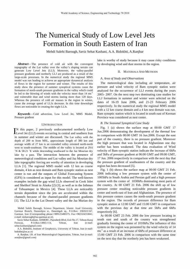
B. The Seasonal Synoptical Case Study Fig. 1 (a) shows the surface map at 00:00 GMT 17
Jun.2006 demonstrating the development of the thermal low in comparison with 00:00 GMT 16 Jun.2006. Except the east part of the country, there is no pressure gradient. Moreover the high pressure that was located in Afghanistan one day earlier has been weakened. The data evaluation of Wind velocity of Bam synoptic station indicate the increase of 6hPa and 5hPa of pressure gradient at 06:00 GMT and 09:00 GMT, 17 Jun. 2006 respectively in comparison with the next day that the pressure gradient of southeastern of the country and the region has been decreased [5].
Fig. 1 (b) shows the surface map at 00:00 GMT 21 Feb. 2006 indicating a low pressure system with the center of 1005hPa in South Arabia and Persian gulf and a high pressure system with the center of 1030hPa dominating most parts of the country. At 00 GMT 21 Feb. 2006 the shift up of low pressure center resulting noticeable pressure gradients in center and north east of Iran and Afghanistan. The presence of this pressure centers causes the north-south pressure gradient in the region. The records of pressure difference for Bam synoptic station at 12:00 GMT and 15:00 GMT in comparison with the previous day at that time are 5hPa and 6hPa respectively [6].
At 00:00 GMT 23 Feb. 2006 the low pressure locating in south east and south of the country was strengthened gradually forming the center of 1010hPa.The influence of this system on the region was presented by the wind velocity of 14 ms-1 as a result of an increase of 6hPa of pressure difference at 15:00 GMT 23 Feb. 2006 in comparison with the same time on the next day that the northerly jets has been weakened.
The Numerical Study of Low Level Jets Formation in South Eastern of Iran
Mehdi Salehi Barough, Saviz Sehat Kashani, A.A. Bidokhti, A.Ranjbar
I
World Academy of Science, Engineering and Technology 70 2010
982
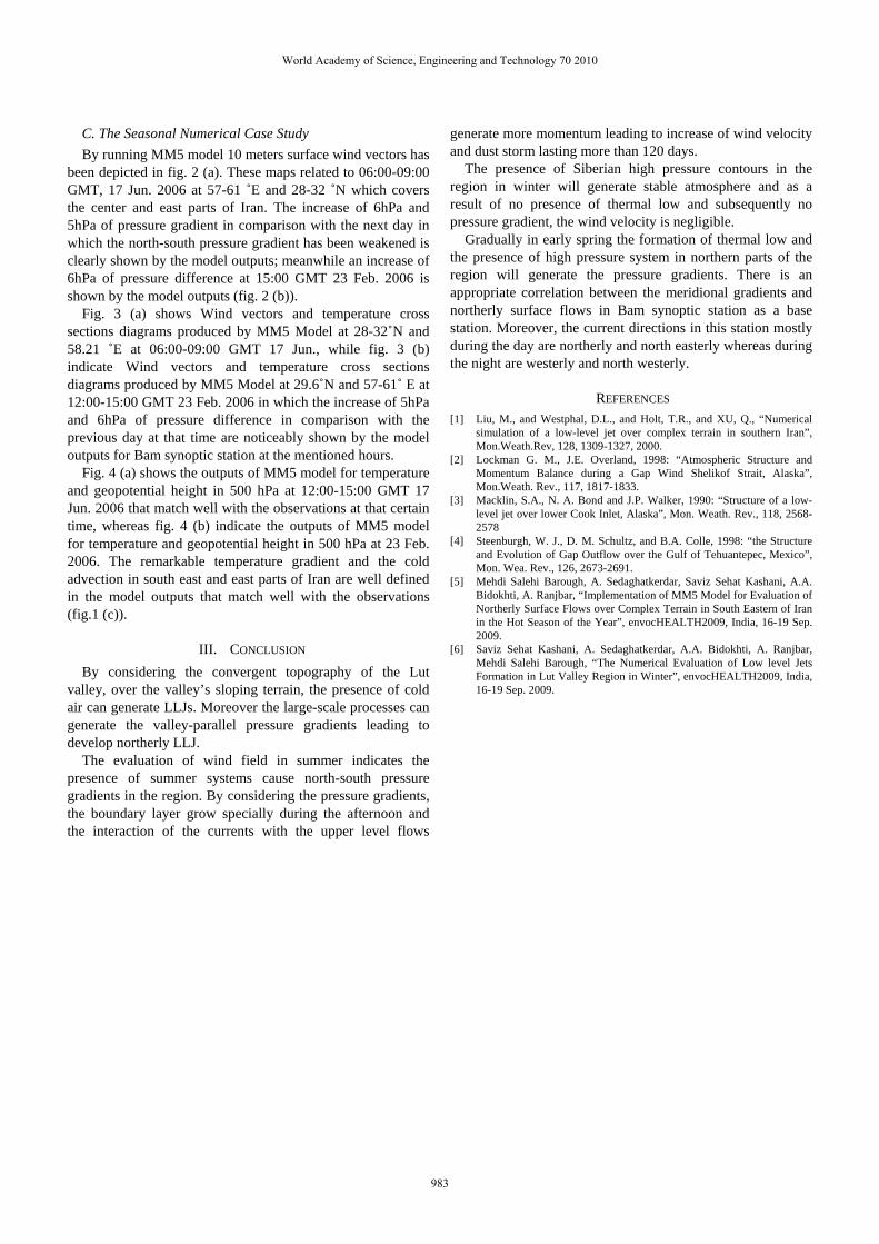
C. The Seasonal Numerical Case Study By running MM5 model 10 meters surface wind vectors has
been depicted in fig. 2 (a). These maps related to 06:00-09:00 GMT, 17 Jun. 2006 at 57-61 ˚E and 28-32 ˚N which covers the center and east parts of Iran. The increase of 6hPa and 5hPa of pressure gradient in comparison with the next day in which the north-south pressure gradient has been weakened is clearly shown by the model outputs; meanwhile an increase of 6hPa of pressure difference at 15:00 GMT 23 Feb. 2006 is shown by the model outputs (fig. 2 (b)).
Fig. 3 (a) shows Wind vectors and temperature cross sections diagrams produced by MM5 Model at 28-32˚N and 58.21 ˚E at 06:00-09:00 GMT 17 Jun., while fig. 3 (b) indicate Wind vectors and temperature cross sections diagrams produced by MM5 Model at 29.6˚N and 57-61˚ E at 12:00-15:00 GMT 23 Feb. 2006 in which the increase of 5hPa and 6hPa of pressure difference in comparison with the previous day at that time are noticeably shown by the model outputs for Bam synoptic station at the mentioned hours.
Fig. 4 (a) shows the outputs of MM5 model for temperature and geopotential height in 500 hPa at 12:00-15:00 GMT 17 Jun. 2006 that match well with the observations at that certain time, whereas fig. 4 (b) indicate the outputs of MM5 model for temperature and geopotential height in 500 hPa at 23 Feb. 2006. The remarkable temperature gradient and the cold advection in south east and east parts of Iran are well defined in the model outputs that match well with the observations (fig.1 (c)).
III. CONCLUSION By considering the convergent topography of the Lut
valley, over the valley’s sloping terrain, the presence of cold air can generate LLJs. Moreover the large-scale processes can generate the valley-parallel pressure gradients leading to develop northerly LLJ.
The evaluation of wind field in summer indicates the presence of summer systems cause north-south pressure gradients in the region. By considering the pressure gradients, the boundary layer grow specially during the afternoon and the interaction of the currents with the upper level flows
generate more momentum leading to increase of wind velocity and dust storm lasting more than 120 days.
The presence of Siberian high pressure contours in the region in winter will generate stable atmosphere and as a result of no presence of thermal low and subsequently no pressure gradient, the wind velocity is negligible.
Gradually in early spring the formation of thermal low and the presence of high pressure system in northern parts of the region will generate the pressure gradients. There is an appropriate correlation between the meridional gradients and northerly surface flows in Bam synoptic station as a base station. Moreover, the current directions in this station mostly during the day are northerly and north easterly whereas during the night are westerly and north westerly.
REFERENCES [1] Liu, M., and Westphal, D.L., and Holt, T.R., and XU, Q., “Numerical
simulation of a low-level jet over complex terrain in southern Iran”, Mon.Weath.Rev, 128, 1309-1327, 2000.
[2] Lockman G. M., J.E. Overland, 1998: “Atmospheric Structure and Momentum Balance during a Gap Wind Shelikof Strait, Alaska”, Mon.Weath. Rev., 117, 1817-1833.
[3] Macklin, S.A., N. A. Bond and J.P. Walker, 1990: “Structure of a low-level jet over lower Cook Inlet, Alaska”, Mon. Weath. Rev., 118, 2568-2578
[4] Steenburgh, W. J., D. M. Schultz, and B.A. Colle, 1998: “the Structure and Evolution of Gap Outflow over the Gulf of Tehuantepec, Mexico”, Mon. Wea. Rev., 126, 2673-2691.
[5] Mehdi Salehi Barough, A. Sedaghatkerdar, Saviz Sehat Kashani, A.A. Bidokhti, A. Ranjbar, “Implementation of MM5 Model for Evaluation of Northerly Surface Flows over Complex Terrain in South Eastern of Iran in the Hot Season of the Year”, envocHEALTH2009, India, 16-19 Sep. 2009.
[6] Saviz Sehat Kashani, A. Sedaghatkerdar, A.A. Bidokhti, A. Ranjbar, Mehdi Salehi Barough, “The Numerical Evaluation of Low level Jets Formation in Lut Valley Region in Winter”, envocHEALTH2009, India, 16-19 Sep. 2009.
World Academy of Science, Engineering and Technology 70 2010
983
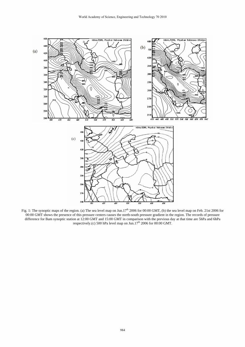
Fig. 1: The synoptic maps of the region. (a) The sea level map on Jun.17th 2006 for 00:00 GMT, (b) the sea level map on Feb. 21st 2006 for
00:00 GMT shows the presence of this pressure centers causes the north-south pressure gradient in the region. The records of pressure difference for Bam synoptic station at 12:00 GMT and 15:00 GMT in comparison with the previous day at that time are 5hPa and 6hPa
respectively.(c) 500 hPa level map on Jun.17th 2006 for 00:00 GMT.
World Academy of Science, Engineering and Technology 70 2010
984
Fig. 2: 10 meters Surface wind vectors diagrams produced by MM5 model at 57-61 ˚E and 28-32 ˚N. (a) On Jun.17th 2006 for 06:00-09:00
GMT. (b) On Feb. 23rd 2006 for 12:00-15:00 GMT.
World Academy of Science, Engineering and Technology 70 2010
985
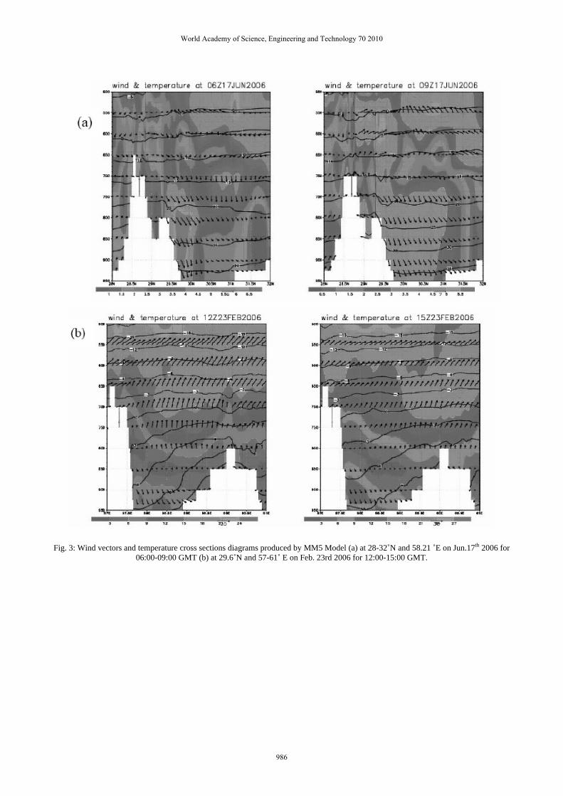
Fig. 3: Wind vectors and temperature cross sections diagrams produced by MM5 Model (a) at 28-32˚N and 58.21 ˚E on Jun.17th 2006 for
06:00-09:00 GMT (b) at 29.6˚N and 57-61˚ E on Feb. 23rd 2006 for 12:00-15:00 GMT.
World Academy of Science, Engineering and Technology 70 2010
986
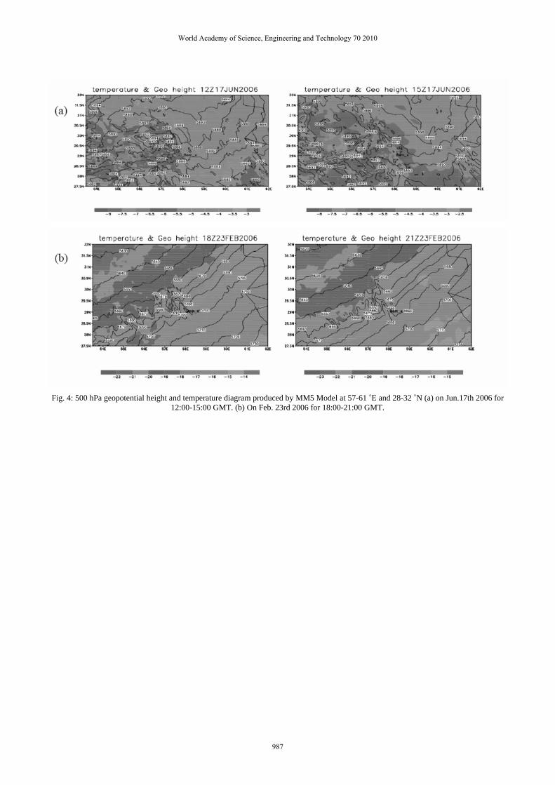
Fig. 4: 500 hPa geopotential height and temperature diagram produced by MM5 Model at 57-61 ˚E and 28-32 ˚N (a) on Jun.17th 2006 for
12:00-15:00 GMT. (b) On Feb. 23rd 2006 for 18:00-21:00 GMT.
World Academy of Science, Engineering and Technology 70 2010
987