
A Study of the Hydrodynamics of the Coastal Lagoon “Valli di Comacchio”
10
3 rd Int. Symp. on Shallow Flows, Iowa City, USA, June 4 - 6, 2012 1 A Study of the Hydrodynamics of the Coastal Lagoon “Valli di Comacchio” Dario Bernardi 1 , Valerio Caleffi 1 , Luca Gasperini 2 , Leonardo Schippa 1 , Alessandro Valiani 1 1 Dipartimento di Ingegneria, Università degli Studi di Ferrara, Italy E-mail: [email protected], [email protected], [email protected], [email protected] 2 CNR - ISMAR Consiglio Nazionale delle Ricerche – Istituto di Scienze Marine, Bologna, Italy E-mail: [email protected] Abstract This work presents a study of the hydrodynamics of the Comacchio coastal lagoon, located in the North-East of Italy. Looking forward to the building of an earth-gravel levee, which has the aim to split the basin in two parts to overcome fishing management difficulties, a comparison of the water circulation in the northern and larger basin before and after the levee construction is performed. An extensive on-field campaign to collect geographical data has been carried out before the implementation of a numerical model. The main hydrodynamics forcing are winds and tidal oscillations: a discussion of the results of the study is reported. 1. Introduction Comacchio lagoon (Valli di Comacchio in italian) is located between the small town of Comacchio and the Reno river, a few kilometers away from the Adriatic Sea coastline, in the Ferrara Province. It has nowadays an extension of about 130 km 2 and it is the largest wetland remaining after the massive work of drainage of the east region of the province. This one- hundred-years-long work was started in the '60s of the nineteenth century and has permitted the cultivation of more than 600 km 2 of land below the sea level. The site is now classified as protected natural park (Parco del Delta del Po Emilia-Romagna) and has a great environmental interest. Figure 1: location of the Comacchio lagoon. The dot-cross line indicates the province border.
Transcript of A Study of the Hydrodynamics of the Coastal Lagoon “Valli di Comacchio”

3rd Int. Symp. on Shallow Flows, Iowa City, USA, June 4 - 6, 2012
1
A Study of the Hydrodynamics of the Coastal Lagoon “Valli di Comacchio”
Dario Bernardi1, Valerio Caleffi1, Luca Gasperini2, Leonardo Schippa1, Alessandro Valiani1
1Dipartimento di Ingegneria, Università degli Studi di Ferrara, Italy
E-mail: [email protected], [email protected], [email protected], [email protected]
2CNR - ISMAR Consiglio Nazionale delle Ricerche – Istituto di Scienze Marine, Bologna, Italy
E-mail: [email protected]
Abstract
This work presents a study of the hydrodynamics of the Comacchio coastal lagoon, located in the North-East of Italy. Looking forward to the building of an earth-gravel levee, which has the aim to split the basin in two parts to overcome fishing management difficulties, a comparison of the water circulation in the northern and larger basin before and after the levee construction is performed. An extensive on-field campaign to collect geographical data has been carried out before the implementation of a numerical model. The main hydrodynamics forcing are winds and tidal oscillations: a discussion of the results of the study is reported. 1. Introduction
Comacchio lagoon (Valli di Comacchio in italian) is located between the small town of Comacchio and the Reno river, a few kilometers away from the Adriatic Sea coastline, in the Ferrara Province. It has nowadays an extension of about 130 km2 and it is the largest wetland remaining after the massive work of drainage of the east region of the province. This one-hundred-years-long work was started in the '60s of the nineteenth century and has permitted the cultivation of more than 600 km2 of land below the sea level. The site is now classified as protected natural park (Parco del Delta del Po Emilia-Romagna) and has a great environmental interest.
Figure 1: location of the Comacchio lagoon. The dot-cross line indicates the province border.
3rd Int. Symp. on Shallow Flows, Iowa City, USA, June 4 - 6, 2012
2
In Comacchio lagoon some works will be provided to overcome fishing management difficulties and improve water circulation, in the context of an European project for wetlands conservation and recovery (LIFE09NAT/IT/000110). In particular, the construction of a new earth-gravel levee along the Province boundary has been planned. The levee has the aim to split the main basin (Valle Fossa di Porto - Valle Lido di Magnavacca) in two parts of 83 and 7 km2, respectively, to separate the smaller southern area devoted to fish farming. The main purpose of this study is to provide a comparison between ante and post operam situation to verify that the levee building won't have any negative effect on water circulation in the northern basin. Further details on the present-day and future lagoon morphological features and water exchanges are given in the following sections. In order to investigate the hydrodynamics of a lagoon, different approaches may be used, depending on the scope of the work and on the phenomena under investigation. Hydrodynamics models based on shallow water equations often constitute the framework to be coupled with other models, aiming to describe water quality (Ferrarin and Umgiesser, 2005; Scroccaro et al., 2004), sediment deposition processes (Bergamasco et al., 2001), wind wave generation and propagation (Umgiesser et al., 2004; Carniello et al., 2005; Roland et al., 2009). All of them adopt finite elements numerical schemes. Other authors (Luyten et al. 1999, 2003, Marinov et al., 2005), have built and tested models following a different approach: variations of relevant ecological parameters, as salinity and temperature, are taken into account in the continuity and momentum equations through change in water density, forcing the model with surface heat fluxes and precipitations as well as with tidal oscillations and winds. This leads to a good representation of seasonal scale processes, and allows for long simulation durations (months or years); on the other hand, for feasibility reasons, longer time steps are required and less importance is given to an accurate small-scale spatial representation of currents in terms of velocity and water levels. Herein we focus on the hydrodynamic behavior that is essentially driven by the stresses exerted by the wind on the free surface and by the tidal oscillations, neglecting the effects related to the wind-generated wave. A Godunov-type high-order, robust numerical scheme based on unstructured grids is used to perform detailed simulations. An analysis of the meteorological data of the last five years has shown that precipitation and evaporation nearly compensate each other during a year-long hydrological cycle. Moreover, the time scale of a meaningful water level change due to precipitation or evaporation is very large (about a month) in comparison with the typical duration of the simulations considered in this study (few days). For these reasons precipitation and evaporation are not included in the model forces. Water level in the lagoon during the year usually ranges from -0.2 m to +0.2 m with respect to the mean sea level. Maximum water depth in the lagoon is about 2 m. 2. Field surveys and data collection
2.1 Bathymetry
The definition of the two numerical grids describing the topography of the lagoon before and after the levee construction has required the collection of the geographical data. A morphobathymetric and seismic reflection survey of the lagoon was carried out in the period February - March 2011. A vertical incidence echosounder operating at high frequency (200 kHz) was used, shortening the pulse length from 350 µs to 200 µs to lower the minimum depth range until 0.2 m, and cover the very shallow zones (Gasperini, 2005). Doing so, the
3rd Int. Symp. on Shallow Flows, Iowa City, USA, June 4 - 6, 2012
3
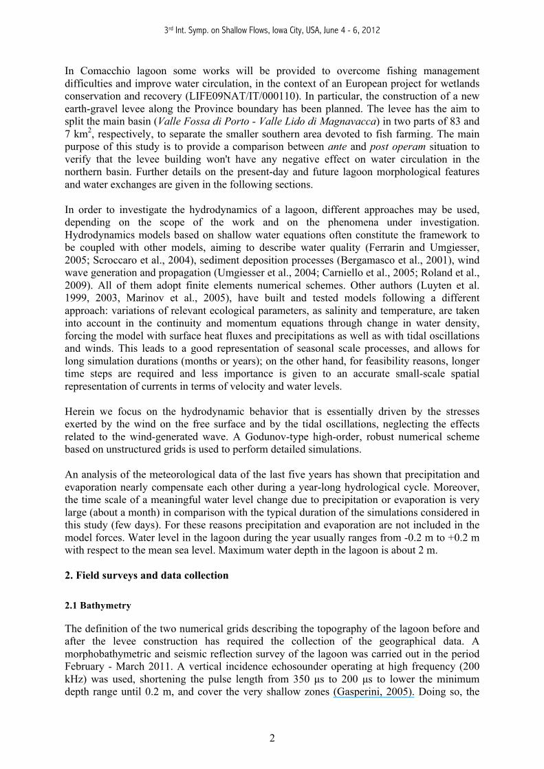
automatical bottom detection estimate of the instrument had to be switched off: the acquired raw data (echograms) were processed afterwards with a specific software (Gasperini and Stanghellini, 2009). Indeed, the presence of very soft and hydrated sediments makes the automatic depth estimation inaccurate. A GPS receiver provided the correct positioning with an acceptable error range (2 m). Tidal-effect corrections were introduced. Nearly 800 km of bathymetric profiles were collected, and more than 200 000 valid depth measures are now available. The bathymetry of the lagoon is reported in Fig. 2.
Figure 2. Bathymetric map obtained from field survey. (Datum: ED50)
In addition, satellite and aero-photogrammetric images were sufficient to correctly settle the geographical boundaries of the lagoon, excluding the dry zones (islands and peninsulas). Comparing the monitored bathymetry with information extracted from late '70s cartography, we may desume morphological evolution of the basin occurred during the last decades. The most significant change is a relevant subsidence of the lagoon bottom, due to gas and water withdrawal starting from the ‘80s, especially in the South-East zone (about 0.5 m). Moreover, deep dredging cuts that were evident in the proximity of the western boundary (Argine Agosta road), during the years have been completely filled up and flattened. 2.2 Tidal waves and hydraulic structures
The lagoon exchanges water with the outward waterbodies mainly through seven hydraulic structures (see Fig. 4). Among them, there are two siphons (Casalino and Case di Guardia), located in the South-West area, taking fresh water from Reno river into the basin, and five sluice gates operating between the lagoon and the channels, connecting the basin to the Adriatic Sea (Foce, Bellocchio, Scirocca, Pedona, Leonarda). Siphons provide a nearly constant, man regulated flow rate estimated in 1 m3s-1. Instead, flow through the gates is mainly driven by tidal waves. Tide excursion time series are available at the gauging station of Volta Scirocco, located just downstream the homonymous barrage devoted to prevent salt wedge in Reno River. The

3rd Int. Symp. on Shallow Flows, Iowa City, USA, June 4 - 6, 2012
4
simple synthetic tidal wave (1), based on a frequency analysis of collected data, has been used to assign the downstream water level time function at the outer gates.
( ) ( )⎟⎠
⎞⎜⎝
⎛ += επ
αη tT
at o2sin (1)
where η(t) is the wave level; a0 was set to 0.14 m; T=12 h is the period; and α e ε are proper corrections of the amplitude and of the phase of the tidal waves, respectively, introduced to take into account the mitigation effects of the channels (see Keulegan, 1967). We have α=0.13 e ε=0.2 h for the Foce gate and α=0.81 e ε=1.2 h for the Bellocchio gate. When open, gates work as a channel constriction because the lower side of the gate is always brought over the water surface. Information on geometrical features of the single gates have been collected to use the simple level-discharge relationship (Chow, 1959):
2222vm
mv ACAhgACAQ
−
Δ= (2)
Herein, Q is the discharge, C is a discharge coefficient, Am and Av are the wetted areas upstream and downstream, respectively, g is the gravity acceleration, Δh is the level drop through the constriction. Relationship (2) allows to settle the boundary conditions for gates. 2.3 Wind analysis
A two-year long series of wind speed and direction data, sampled using a time step of 10 minutes, has been collected at the Porto Garibaldi weather-station. The anemometer is 5 m above sea level. In this work, we do not consider sudden fluctuations of wind intensity; conversely, during simulations wind speed and direction are supposed to be constant, thus the wind regime is investigated and some representative events are chosen. The time interval to reach an equilibrium state of the lagoon was estimated in 7-8 hours: hence, data have been rearranged averaging the 10-minutes values to obtain hourly values of speed and direction (the wind rose is reported in Fig. 3). Winds blowing from West are dominant in frequency but not in intensity. Maximum speed is observed for winds blowing from North-East.
Figure 3. Wind rose

3rd Int. Symp. on Shallow Flows, Iowa City, USA, June 4 - 6, 2012
5
A statistical analysis of the wind velocity (w) has been performed fitting a 2-parameter Weibull distribution (usually adopted for wind) on each of the eight direction classes of data. Wind stress on water surface is related to w2 through a drag coefficient: so the same analysis has been carried out with w2 as random variable. )( 2wE for the directions East, West (interesting because opposites) and North-East are chosen as events for the simulations (see Table 1).
Direction N NE E SE S SW W NW [E(w2)]0.5, [m/s] 3.39 6.38 5.15 4.55 3.37 2.99 2.31 2.70
Table 1: square roots of expected values of w2 from Weibull distribution fitting
To observe the effects of a stronger wind, an extreme event is also considered, with speed corresponding to a cumulative Weibull distribution value of 95% in the North-East sector (the one with strongest winds).
Wind speed [m/s] Direction 6.4 NE 5.1 E 2.3 W
11.7* NE
Table 2: speed and direction of blowing of winds chosen for simulations. (*extreme event) 3. The numerical model The mathematical model used in this work is represented by the two-dimensional shallow water equations, SWE, (Toro, 2009):
⎟⎟⎠
⎞⎜⎜⎝
⎛+−=⎟
⎠
⎞⎜⎝
⎛ +∂∂
+∂∂
+∂∂
⎟⎟⎠
⎞⎜⎜⎝
⎛+−=
∂∂
+⎟⎠
⎞⎜⎝
⎛ +∂∂
+∂∂
=∂∂
+∂∂
+∂∂
hSSghghhv
yxuvh
tvh
hSSgh
yuvhghhu
xtuh
yvh
xuh
th
ywyfy
xwxfx
γ
τγ
τ
,,,0
22
,,,0
22
21
21
0
(3)
where h is the local water depth and (u,v) are the components of the velocity vector along the (x,y) coordinates. The source term includes the effects of bottom slope S0, friction slope Sf, and wind-induced stresses τw, in the x and y direction. Friction slope is computed as follows (being n Manning friction coefficient):
3/4
222
,3/4
222
, ;h
vuvnSh
vuunS yfxf+
=+
= (4)

3rd Int. Symp. on Shallow Flows, Iowa City, USA, June 4 - 6, 2012
6
Stresses on water surface due to wind (τx, τy) are related (see Eq. (5)) to the difference between wind velocity (with components wx, wy) and the water velocity (u,v) through a drag coefficient Cd . In (5), ρa is the air density, γ the unit weight of water, and h is the depth.
hvwuwvwC
h
hvwuwuwC
h
yxyadyw
yxxadxw
γ
ρ
γ
τ
γ
ρ
γ
τ
22,
22,
)()()(
)()()(
−+−−=
−+−−=
(5)
The drag coefficient is evaluated with a formulation proposed by Demirbilek et al. (1993) )035.01.1(10 3 wCd += − (6) A Godunov-type scheme is adopted to integrate the SWE (Toro, 2009) on unstructured grids. Starting from an integral form of Eqs. (3) the solution is discretized as piecewise-constant cell-centered values; the solution advances in time solving a Riemann problem at cell interfaces. To calculate fluxes, the well known HLLC approximate Riemann solver (Toro et al., 1994) has been selected. Discretization of bed slope source term is performed by the DFB procedure (Divergence Form For Bed Slope Source Term, Valiani and Begnudelli, 2004). Accuracy of the model has been raised to second-order in space using a MUSCL technique (van Leer, 1979) and in time applying a two steps Strong Stability Preserving Runge–Kutta method (Spiteri and Ruuth, 2002). Boundary conditions, either in the case of reflective or transmissive boundary, are imposed prescribing values of depth (or flow) in fictitious cells outside the domain. For non-reflective boundaries, the approach suggested by Sanders (2002) has been followed.
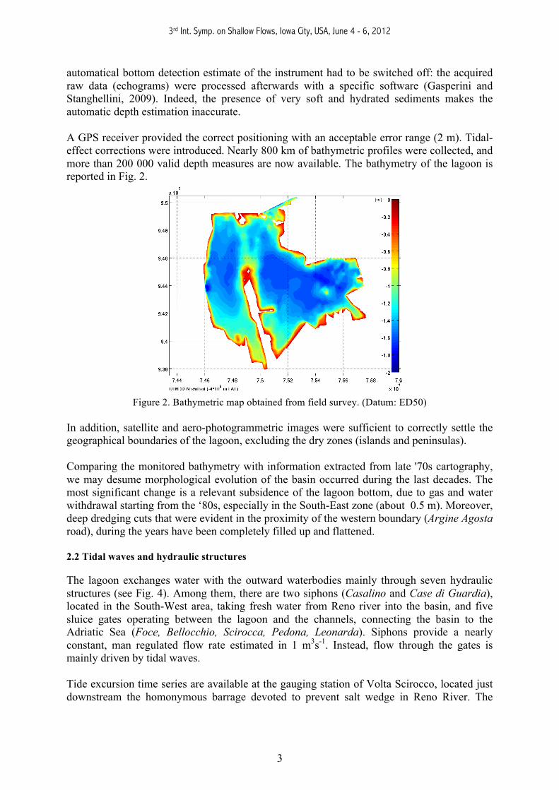
Figure 4. Numerical grid (configuration ante operam), with location of gates (pink dots) and siphons
(orange dots). The red line indicates the planned levee.
3rd Int. Symp. on Shallow Flows, Iowa City, USA, June 4 - 6, 2012
7
Two grids are considered. The first represents the whole basin (ante operam) and the second represents the basin part on the North of the levee (post operam, see Fig. 4). The two grids have 13189 and 11284 triangular elements, respectively. In both the cases, the numerical grids have non-uniform element sizes. Triangles are smaller near to the boundaries and the islands and their dimensions grow progressively toward the center of the lagoon. The element sizes are between 50 m and 200 m, approximately. This kind of grid refinement leads to a good compromise between accuracy and feasibility. 4. Simulations and results
Effects of wind, tidal waves, and siphons have been simulated separately. Simulations concerning tidal waves have a duration of 72 hours; those concerning siphon operations have a duration of about 12 hours, as well as those concerning wind. Longer simulation durations (for example to reproduce seasonal-scale processes) and combination of the effects are beyond the scope of this work. All simulations are carried out on both ante operam and post operam numerical grids: the three South gates (Leonarda, Pedona, Scirocca) are supposed to be open at the same time, whilst the opening of the two other gates (Foce and Bellocchio) is independent. After levee construction, however, gates Leonarda and Scirocca will be disconnected from the main basin. The two siphons work together as well. Four wind events have been simulated (see Section 2.3). Wind is undoubtedly the main factor that drives water circulation in the whole lagoon, while tidal waves at the gates considerably affect water speed only in a few hundred meters distance from the inlets (Fig. 5). Siphons’ effects on the hydrodynamic field, due to the small flow rate, are negligible. Due to wind-induced circulation, the water surface gradient is positive in the wind direction, and it is related to the wind intensity. The maximum simulated difference in water level at opposite borders of the lagoon is about 0.22 m. The complex geometry of the basin leads to a streamline pattern which is quite complicated, as it can be seen in Figs. 6 and 7. The model proves to reproduce the hydrodynamic field fairly well: the water moves in the same direction of wind in the peripheral and shallower zones, while currents with opposite direction are generated in the deeper central zones. In addition, in the case of winds coming from opposite directions (East-West), the layout of the vortices does not change while flow direction is reversed, as expected (Fig. 6). Averaged water velocity for the maximum wind speed is about 0.05 m/s, while during ordinary events it rarely exceeds 0.02 m/s. Maximum velocities arise near to the boundaries or in the narrow channels between borders and islands (see Fig. 8): for strongest winds, maximum values are nearly 0.3 m/s. A comparison of the results obtained in presence or absence of the levee has shown no noticeable variations in water circulation, except in the area directly affected by the presence of the embankment. However, in the post operam configuration, water incoming from gate Pedona is likely to stay longer in the area next to the inlet, where the modified flow pattern shows (in all simulated wind events) a single vortex quite isolated from the rest of the lagoon. It is necessary to underline that a key role for water replacement is played by siphons, that can decrease salinity rate.

3rd Int. Symp. on Shallow Flows, Iowa City, USA, June 4 - 6, 2012
8
|v| [m/s]
|V| max = 0.41 m/s
UTM 32 N shifted (-4*106 LAT)
7.54 7.545 7.55 7.555 7.56 7.565 7.57 7.575 7.58x 10⁵
9.41
9.415
9.42
9.425
9.43
9.435
9.44
x 105
0
0.05
0.1
0.15
0.2
0.25
0.3
0.35
0.4
Figure 5. Water velocity (detail of the South-East region): South gates open, high tide peak (water
entering the lagoon).
7.44 7.46 7.48 7.5 7.52 7.54 7.56 7.58 7.6x 10⁵
9.38
9.4
9.42
9.44
9.46
9.48
9.5x 10⁵ Flow lines t = 9.1 h
UTM 32 N shifted (-4*106 m LAT) 7.44 7.46 7.48 7.5 7.52 7.54 7.56 7.58 7.6
x 105
9.38
9.4
9.42
9.44
9.46
9.48
9.5
x 105 Flow lines t = 9.1 h
UTM 32 N shifted (-4*106 m LAT)
Figure 6. Flow lines for winds blowing from East (5.1 m/s) and W (2.3 m/s), respectively. 5. Conclusions In this work a finite volume hydrodynamic model based on shallow water equations was applied to the Comacchio coastal lagoon (Ferrara, Italy) to investigate the possible hydrodynamic field variations due to the forthcoming construction of a levee in the Southern zone of the lagoon. An extensive field survey has been carried out to achieve an up-to-date bathymetry map and this has noticeably increased the acquaintances about the present-day morphology of the site. With these data, two numerical unstructured grids with adequate resolution - corresponding to the two different layouts of the lagoon - have been implemented. The simulations have been planned considering wind stresses and tidal waves at the inlets as forces to the model.

3rd Int. Symp. on Shallow Flows, Iowa City, USA, June 4 - 6, 2012
9
Results have shown the strong prevalence of wind effects. On the contrary the presence of the levee does not affect the hydrodynamic pattern and water circulation in the lagoon, except in the very proximity of the levee structure.
7.44 7.46 7.48 7.5 7.52 7.54 7.56 7.58 7.6x 10⁵
9.38
9.4
9.42
9.44
9.46
9.48
9.5
x 105 Flow lines t = 8.7 h
WIND SPEED = 11.7 m/s
UTM 32 N shifted (-4*106 m LAT) 7.44 7.46 7.48 7.5 7.52 7.54 7.56 7.58 7.6
x 105
9.38
9.4
9.42
9.44
9.46
9.48
9.5
x 105 Flow lines t = 8.6 h
WIND SPEED = 11.7 m/s
UTM 32 N shifted (-4*106 m LAT)
Figure 7. Flow lines, wind blowing from North-East (11.7 m/s) before and after the building of the embankment.
Figure 8: Water velocity in the lagoon [m/s] due to wind (North-East, 11.7 m/s) before and after the building of the embankment.
Acknowledgements The authors wish to thank the Ente Parco del Delta del Po for the support during the field survey operations and for providing cartography and other material useful for this work. References Chow, V. T. (1959). Open-channel hydraulics. McGraw-Hill, New York..
3rd Int. Symp. on Shallow Flows, Iowa City, USA, June 4 - 6, 2012
10
Demirbilek, Z., Bratos, S., Thompson, E. (1993) Wind Products for Use in Coastal Wave and Surge Models. Miscellaneous Paper CERC – 93 -7, US Army Corps of Engineers. Gasperini, L. (2005) Extremely Shallow-Water Morphobathymetric Surveys: The Valle Fattibello (Comacchio, Italy) Testcase. Marine Geophysical Researches, Vol. 26, 97-107. Gasperini, L., Stanghellini, G. (2009) SeisPrho: an interactive computer program for processing and interpretation of high-resolution seismic reflection profiles. Computers and Geosciences, Vol. 35, 1497-1504. Luyten, P.J., Jones, J.E., Proctor, R. (2003) A Numerical Study of the Long- and Short- Term Temperature Variability and Thermal Circulation in the North Sea. Journal of Physical Oceanography, Vol. 33, 37-56. Keulegan, G. H. (1967). Tidal Flow in Entrances: Water Level Fluctuations of Basins in Communication with the Seas. Committee on Tidal Hydraulics Technical Bulletin No. 14, U.S. Army Engineers Waterways Experiment Station, Vicksburg, Mississippi. Roland, A., Cucco, A., Ferrarin, C., Hsu, T.W., Liau, J.M., Ou, S.H., Umgiesser, G., Zanke, U. (2009) On the development and verification of a 2-D coupled wave-current model on unstructured meshes. Journal of Marine Systems, Vol. 78, S244 - S254. Sanders, B. F., (2002) Non-reflecting boundary flux function for finite volume shallow-water models. Advances in Water Resources, Vol. 25, 192-202. Spiteri, R.J., Ruuth, S.J. (2002) A new class of optimal high-order Strong-Stability-Preserving time discretization methods. SIAM Journal of Numerical Analysis, Vol. 40, 469-491. Sroccaro, I., Matarrese, R., Umgiesser, G. (2004) Application of a finite element model to the Taranto Sea. Chemistry and Ecology, Vol. 20, Supp. 1, 205-224. Toro, E.F., Spruce, M., Speares, W (1994) Restoration of Contact Surface in the HLL Riemann Solver. Shock Waves, Vol. 4, 25-34. Toro, E. F.(2009) Riemann Solvers and Numerical Methods for Fluid Dynamics. Springer – Verlag, Berlin. Umgiesser, G., Sclavo, M., Carniel, S., Bergamasco, A. (2004) Exploring the bottom stress variability in the Venice Lagoon. Journal of Marine Systems, Vol. 51, 161-178. Valiani, A., Begnudelli, L. (2006) Divergence Form for Bed Slope Source Term in Shallow Water Equations. Journal of Hydraulic Engineering, Vol. 132, 652-665. Van Leer, B. (1979) Towards the Ultimate Conservative Difference Scheme, V. A Second Order Sequel to Godunov's Method. Journal of Computational Physics, Vol. 32, 101–136.