A Strategic Urban Development Plan of Greater Yangon
111
Japan International Cooperation Agency (JICA) Yangon City Development Committee (YCDC) April 2013 Nippon Koei Co., Ltd. NJS Consultants Co., Ltd. YACHIYO Engineering Co., Ltd. International Development Center of Japan Inc. Asia Air Survey Co., Ltd. ALMEC Corporation The Republic of the Union of Myanmar A Strategic Urban Development Plan of Greater Yangon The Project for the Strategic Urban Development Plan of the Greater Yangon FINAL REPORT I Part-II: The Master Plan EI JR 13-132 A Strategic Urban Development Plan of Greater Yangon FINAL REPORT I Part-II: The Master Plan April 2013 JICA
-
Upload
khangminh22 -
Category
Documents
-
view
3 -
download
0
Transcript of A Strategic Urban Development Plan of Greater Yangon

Japan International Cooperation Agency (JICA) Yangon City Development Committee (YCDC)
April 2013 Nippon Koei Co., Ltd.
NJS Consultants Co., Ltd.
YACHIYO Engineering Co., Ltd.
International Development Center of Japan Inc.
Asia Air Survey Co., Ltd.
ALMEC Corporation
The Republic of the Union of Myanmar A Strategic Urban Development Plan of Greater Yangon The Project for the Strategic Urban Development Plan of the Greater Yangon
FINAL REPORT I Part-II: The Master Plan
EI
JR
13-132
A Strategic Urban D
evelopment Plan of G
reater Yangon
FINA
L RE
PO
RT I P
art-II: The Master Plan
A
pril 2013 JICA

Yangon Region
Yangon City
Thilawa Port & SEZ
Htantabin T.S.
Hmawbi T.S.
Kyauktan T.S.
Thanlyin T.S.
Hlegu T.S.
Twantay T.S.
Taikkyi T.S.
Kayan T.S.
Thongwa T.S.
Kawhmu T.S.
Kungyangon T.S.
20km30km
0N
20km
MYANMAR
Yangon RegionGreater Yangon
CHINA
THAILAND
LAOS
INDIA
BANGLADESH
0 300km0 300km0
N20km
調査対象位置図
調査対象地域
ヤンゴン地域
ヤンゴン市
調査対象地域
Planning AreaGreater Yangon (Yangon City and Periphery 6 Townships)
Yangon Region
Yangon City
Planning Area

The Project for the Strategic Urban Development Plan of the Greater Yangon Final Report I
NIPPON KOEI CO., LTD., NJS CONSULTANTS CO., LTD.
YACHIYO ENGINEERING CO., LTD., INTERNATIONAL DEVELOPMENT CENTER OF JAPAN,
ASIA AIR SURVEY CO., LTD., and ALMEC CORPORATION
i
The Project for
The Strategic Urban Development Plan of the Greater Yangon
Final Report I < Part-II: The Master Plan >
The Final Report I consists of three parts as shown below, and this is Part-II.
1. Part-I: The Current Conditions
2. Part-II: The Master Plan
3. Part-III: Appendix
TABLE OF CONTENTS Page
< Part-I: The Current Conditions >
CHAPTER 1: Introduction 1.1 Background ............................................................................................................... 1-1 1.2 Objectives .................................................................................................................. 1-1 1.3 Study Period .............................................................................................................. 1-2 1.4 Organizational Structure ............................................................................................ 1-2 1.5 Formulation Methodology ......................................................................................... 1-2 1.6 Target Area of the Plan .............................................................................................. 1-3 1.7 Target Year of the Plan .............................................................................................. 1-3 1.8 A Framework of the Plan .......................................................................................... 1-4
CHAPTER 2: Review and Analysis of The Current Conditions and Regulatory
Framework 2.1 Review of the Current Environmental and Socioeconomic Conditions ................... 2-1 2.1.1 Environmental Conditions .......................................................................... 2-1 2.1.2 Socio-economy ......................................................................................... 2-20 2.1.3 Industrial Activity ..................................................................................... 2-38 2.1.4 Social Services .......................................................................................... 2-51 2.1.5 Disasters .................................................................................................. 2-106 2.2 Review of the Current Urban Planning and Land Use Issues ............................... 2-125 2.2.1 Legal and Regulatory Framework .......................................................... 2-125 2.2.2 History of Urban Planning ...................................................................... 2-135 2.2.3 Administrative Organization Framework ............................................... 2-141 2.2.4 Present Land Use .................................................................................... 2-162 2.2.5 Living Environment ................................................................................ 2-176 2.2.6 Urban Landscape and Heritages ............................................................. 2-183 2.2.7 Public Parks and Greenery ...................................................................... 2-188 2.3 Review of Current Infrastructure Conditions ........................................................ 2-197
The Project for the Strategic Urban Development Plan of the Greater Yangon Final Report I
NIPPON KOEI CO., LTD., NJS CONSULTANTS CO., LTD.
YACHIYO ENGINEERING CO., LTD., INTERNATIONAL DEVELOPMENT CENTER OF JAPAN,
ASIA AIR SURVEY CO., LTD., and ALMEC CORPORATION
ii
2.3.1 Urban Transport ...................................................................................... 2-197 2.3.2 Road Network ......................................................................................... 2-226 2.3.3 Railway ................................................................................................... 2-259 2.3.4 Ports and Logistics .................................................................................. 2-271 2.3.5 Water Supply ........................................................................................... 2-293 2.3.6 Sewerage and Drainage ........................................................................... 2-306 2.3.7 Power Supply .......................................................................................... 2-318 2.3.8 Solid Waste Management ........................................................................ 2-329 2.3.9 Telecommunications ............................................................................... 2-343 2.4 Review of Relevant Development Plans and Projects .......................................... 2-351 2.4.1 Urban Development Plans and Projects .................................................. 2-351 2.4.2 Infrastructure Projects ............................................................................. 2-357 2.5 Overall Analyses and Database Development ...................................................... 2-360 2.5.1 Household Interview Survey (HIS) ........................................................ 2-360 2.5.2 Updating Topographic Data and Creation of GIS Data .......................... 2-401
< Part-II: The Master Plan >
CHAPTER 3: Development Visions and Structure Plan 3.1 Development Visions ................................................................................................ 3-1 3.1.1 Necessity and Formulating Process of Development Visions .................... 3-1 3.1.2 Formulating Process of the Development Visions ...................................... 3-2 3.1.3 The Development Visions of Greater Yangon for 2040 .............................. 3-8 3.2 Socio-economic Framework ................................................................................... 3-15 3.2.1 Demographic Framework ......................................................................... 3-15 3.2.2 Economic Framework ............................................................................... 3-20 3.3 Economic Development Strategy ............................................................................ 3-23 3.3.1 Five-Year Economic Development Plan in Yangon Region ..................... 3-23 3.3.2 Basic Development Strategy for the Manufacturing Sector ..................... 3-24 3.3.3 Basic Development Strategy for the Commerce Sector ............................ 3-27 3.3.4 Basic Development Strategy for the Service Sector ................................. 3-28 3.4 Structure Plan for Greater Yangon .......................................................................... 3-30 3.4.1 Review of Existing Conceptual Plans ....................................................... 3-30 3.4.2 Points of Consideration for Urban Structure of the Greater Yangon ........ 3-32 3.4.3 Comparison of Asian Cities ...................................................................... 3-35 3.4.4 Urban Structure of Greater Yangon ........................................................... 3-37 3.4.5 Concept and Layout of Urban Functions and Infrastructures ................... 3-44
CHAPTER 4: An Urban Development Master Plan 4.1 An Urban Development Strategy .............................................................................. 4-1 4.1.1 Urban Development and Management ....................................................... 4-1 4.1.2 Living Environment .................................................................................. 4-30 4.1.3 Social Services .......................................................................................... 4-39 4.1.4 Urban Landscape and Heritages ............................................................... 4-45 4.1.5 Public Parks and Greenery ........................................................................ 4-56 4.2 Land Use Plan ......................................................................................................... 4-66 4.2.1 Necessity of a Land Use Plan ................................................................... 4-66 4.2.2 Land Evaluation ........................................................................................ 4-66
The Project for the Strategic Urban Development Plan of the Greater Yangon Final Report I
NIPPON KOEI CO., LTD., NJS CONSULTANTS CO., LTD.
YACHIYO ENGINEERING CO., LTD., INTERNATIONAL DEVELOPMENT CENTER OF JAPAN,
ASIA AIR SURVEY CO., LTD., and ALMEC CORPORATION
iii
4.2.3 Future Land Use ........................................................................................ 4-74 4.2.4 Outline of Proposed Land Use Zoning Scheme ........................................ 4-79 CHAPTER 5: Urban Infrastructure Development Strategy 5.1 Urban Transport ......................................................................................................... 5-1 5.1.1 Macro Traffic Demand Analysis for Land Transport Sector ....................... 5-2 5.1.2 Development Policy .................................................................................... 5-9 5.1.3 Development Goals and Target Effective Indicator .................................. 5-12 5.1.4 Preliminary Development Plan ................................................................. 5-12 5.2 Road Network ......................................................................................................... 5-20 5.2.1 Demand Analysis ...................................................................................... 5-20 5.2.2 Development Policy .................................................................................. 5-22 5.2.3 Development Goals and Target Effect Indicators ..................................... 5-26 5.2.4 Preliminary Development Plan ................................................................. 5-27 5.3 Railways .................................................................................................................. 5-47 5.3.1 Demand Analysis ...................................................................................... 5-47 5.3.2 Development Policy .................................................................................. 5-47 5.3.3 Development Goals and Target Effect Indicators ..................................... 5-51 5.3.4 Preliminary Development Plan ................................................................. 5-53 5.4 Ports and Logistics .................................................................................................. 5-63 5.4.1 Demand Analysis ...................................................................................... 5-63 5.4.2 Development Policy .................................................................................. 5-64 5.4.3 Development Goals and Target Effect Indicators ..................................... 5-67 5.4.4 Preliminary Development Plan ................................................................. 5-68 5.5 Water Supply ........................................................................................................... 5-74 5.5.1 Demand Analysis ...................................................................................... 5-75 5.5.2 Development Policy .................................................................................. 5-78 5.5.3 Development Goals and Target Effect Indicators ..................................... 5-79 5.5.4 Preliminary Development Plan ................................................................. 5-81 5.6 Sewerage and Drainage ........................................................................................... 5-90 5.6.1 Demand Analysis ...................................................................................... 5-91 5.6.2 Development Policy .................................................................................. 5-91 5.6.3 Development Goals and Target Effect Indicators ..................................... 5-92 5.6.4 Preliminary Development Plan ................................................................. 5-93 5.7 Power Supply ........................................................................................................ 5-101 5.7.1 Demand Analysis .................................................................................... 5-102 5.7.2 Development Policy ................................................................................ 5-104 5.7.3 Development Goals and Target Effect Indicators ................................... 5-109 5.7.4 Preliminary Development Plan ............................................................... 5-112 5.8 Solid Waste Management ...................................................................................... 5-120 5.8.1 Demand Analysis .................................................................................... 5-121 5.8.2 Development Policy ................................................................................ 5-129 5.8.3 Development Goals and Target Effect Indicators ................................... 5-131 5.8.4 Preliminary Development Plan ............................................................... 5-131 5.9 Telecommunication ............................................................................................... 5-148 5.9.1 Demand Analysis .................................................................................... 5-149 5.9.2 Development Policy ................................................................................ 5-153 5.9.3 Development Goals and Target Effect Indicators ................................... 5-155 5.9.4 Preliminary Development Plan ............................................................... 5-155
The Project for the Strategic Urban Development Plan of the Greater Yangon Final Report I
NIPPON KOEI CO., LTD., NJS CONSULTANTS CO., LTD.
YACHIYO ENGINEERING CO., LTD., INTERNATIONAL DEVELOPMENT CENTER OF JAPAN,
ASIA AIR SURVEY CO., LTD., and ALMEC CORPORATION
iv
CHAPTER 6: Urban Development and Management Programs 6.1 Capacity Development Plan ...................................................................................... 6-1 6.1.1 Issues of Administrative Works for Urban Planning and Development ..... 6-1 6.1.2 Future Expected Administrative Roles in Urban Planning and Development
and Prospect ................................................................................................ 6-7 6.1.3 Formulation of Capacity Development Plan ............................................. 6-12 6.2 General Principles for Urban Development Management Program ....................... 6-14 6.2.1 Good Governance ..................................................................................... 6-15 6.2.2 Stakeholder Involvement .......................................................................... 6-16 6.2.3 Public and Private Cooperation ................................................................ 6-17 6.2.4 Sustainability ............................................................................................. 6-18 6.3 Priority Programs for Urban Development and Management ................................ 6-20 6.3.1 Priority Programs for Urban Development Sector .................................... 6-20 6.3.2 Priority Programs for Urban Infrastructure Development Sector ............. 6-32 6.3.3 Economic, Environmental, and Social Considerations on the Priority
Programs ................................................................................................... 6-45 6.3.4 Project Implementation and Management ................................................ 6-50 6.3.5 Summary of Projects for Priority Programs .............................................. 6-75
CHAPTER 7: Strategic Environmental Assessment (SEA) 7.1 General ..................................................................................................................... 7-1 7.2 System of Environmental and Social Considerations in Myanmar ........................... 7-1 7.2.1 Legislation related to Environmental and Social Considerations ............... 7-1 7.2.2 Land Management in Myanmar .................................................................. 7-2 7.3 Strategic Environmental Assessment (SEA) ............................................................. 7-4 7.3.1 Definition of the “SEA” .............................................................................. 7-4 7.3.2 Significance of SEA .................................................................................... 7-4 7.3.3 Methodologies ............................................................................................. 7-4 7.3.4 Present Environmental Issues in Yangon City ............................................ 7-6 7.3.5 Review of the Development Visions and a Structure Plan ......................... 7-8 7.3.6 Preliminary Stakeholder Meeting ............................................................. 7-11 7.3.7 Environmental Scoping ............................................................................. 7-14 7.3.8 Evaluation Matrix of the Environmental Impact for Each Alternative ..... 7-16 7.3.9 Environmental Mitigation Plan ................................................................. 7-23 7.3.10 Environmental Monitoring Plan ............................................................... 7-23 7.4 Stakeholder Meeting................................................................................................ 7-24 7.4.1 First Stakeholder Meeting ......................................................................... 7-24 7.5 Conclusion and Recommendation ........................................................................... 7-27 7.5.1 Rationales for Conducting SEA for the Project ........................................ 7-27 7.5.2 Appropriateness of the Methodologies for the SEA ................................. 7-27 7.5.3 The Environmental and Social Considerations for Individual Projects .... 7-28
CHAPTER 8: Conclusions, Recommendations and Way Forward 8.1 Current Status of the Project ..................................................................................... 8-1 8.2 Conclusions and Recommendations .......................................................................... 8-4 8.2.1 Conclusions in Urban Development and Planning ..................................... 8-4 8.2.2 Conclusions in Urban Infrastructure Development .................................... 8-5 8.2.3 Recommendations ....................................................................................... 8-7 8.3 Upcoming Events ...................................................................................................... 8-9
The Project for the Strategic Urban Development Plan of the Greater Yangon Final Report I
NIPPON KOEI CO., LTD., NJS CONSULTANTS CO., LTD.
YACHIYO ENGINEERING CO., LTD., INTERNATIONAL DEVELOPMENT CENTER OF JAPAN,
ASIA AIR SURVEY CO., LTD., and ALMEC CORPORATION
v
< Part-III: Appendix >
Appendix 1 Infrastructure Development Concept from Chapter 5 1.1 Transport Sectors
1.2 Water Supply 1.3 Sewerage and Drainage 1.4 Power Supply 1.5 Solid Waste Management 1.6 Telecommunication Appendix 2 Results of Household Interview Survey Appendix 3 Updating Topographic Data and Creation of GIS Data
3.1 Field Verification Survey Final Report 3.2 A List of Features for Updating 50k GIS Database 3.3 A List of Feature Generation 1:10,000 GIS Database
Appendix 4 Macro Traffic Demand Analysis for Land Transport Sector Appendix 5 Materials for First Stakeholder Meeting 5.1 Invitation Letter for First Stakeholder Meeting 5.2 Attendee List of First Stakeholder Meeting
5.3 Minutes of Discussion on First Stakeholder Meeting

The Project for the Strategic Urban Development Plan of the Greater Yangon Final Report I
NIPPON KOEI CO., LTD., NJS CONSULTANTS CO., LTD.
YACHIYO ENGINEERING CO., LTD., INTERNATIONAL DEVELOPMENT CENTER OF JAPAN,
ASIA AIR SURVEY CO., LTD., and ALMEC CORPORATION
vi
LIST OF TABLES Page
Table 3.1.1: Urban Challenges and Difficulties Discussed in a Workshop held in December
2011 ........................................................................................................................ 3-2 Table 3.1.2: Results of the Household Interview Survey Question No. 93 ..................................... 3-5 Table 3.2.1: Assumption of Future Population Growth Rate ........................................................ 3-15 Table 3.2.2: Population Growth Rate of Major Cities in Neighboring Countries (1975-2000) .... 3-15 Table 3.2.3: Population Allocation by Each Township .................................................................. 3-18 Table 3.2.4: Labor Force in Three Alternatives ............................................................................. 3-19 Table 3.2.5: Labor Force Allocation by Township Group ............................................................. 3-20 Table 3.2.6: Population in the Major Cities in GMSs ................................................................... 3-20 Table 3.2.7: GRDP per Capita in Three Alternatives .................................................................... 3-21 Table 3.2.8: GRDP and GRDP/CAPITA in Three Alternatives ..................................................... 3-22 Table 3.2.9: Average Annual Growth Rate of GRDP and GRDP per Capita in Three
Alternatives ........................................................................................................... 3-22 Table 3.3.1: Projected Economic Growth in the Yangon Region (from 2011-12 to 2015-16) ...... 3-23 Table 3.3.2: Projected Growth Rate and Industrial Structure Change in the Three Major
Sectors .................................................................................................................. 3-24 Table 3.4.1: Comparison of Alternatives ....................................................................................... 3-31 Table 3.4.2: Development Volume of Thilawa SEZ ...................................................................... 3-33 Table 3.4.3: Actual Figures of Asian Cities ................................................................................... 3-35 Table 3.4.4: Comparison of the Alternatives ................................................................................. 3-39 Table 3.4.5: Evaluation of Alternatives in Three Criteria .............................................................. 3-41 Table 3.4.6: Population Projection of Greater Yangon .................................................................. 3-44 Table 3.4.7: Labor Force Allocation by Industrial Structure ......................................................... 3-45 Table 3.4.8: Existing Industrial Zones in Yangon ......................................................................... 3-46 Table 3.4.9: Estimated Labor Population in the New City Centers ............................................... 3-47 Table 3.4.10: Candidate Sites of Secondary CBD and Sub-centers .............................................. 3-48 Table 3.4.11: Candidate Sites for New Town Cores ...................................................................... 3-48 Table 4.1.1: Development Goals and Effect Indicators (Urban Development and Management) .. 4-4 Table 4.1.2: Existing Industrial Zones ........................................................................................... 4-11 Table 4.1.3: Candidate Sites of Secondary CBD & Sub-centers ................................................... 4-13 Table 4.1.4: Profile of Mindama Secondary CBD (1/2) ................................................................ 4-15 Table 4.1.5: Profile of Mindama Secondary CBD (2/2) ................................................................ 4-16 Table 4.1.6: Profile of Thilawa SEZ Sub-center (1/2) ................................................................... 4-17 Table 4.1.7: Profile of Thilawa SEZ Sub-center (2/2) ................................................................... 4-18 Table 4.1.8: Profile of Bago Riverside Sub-center (1/2) ............................................................... 4-19 Table 4.1.9: Profile of Bago Riverside Sub-center (2/2) ............................................................... 4-20 Table 4.1.10: Profile of Dagon Myothit Sub-center (1/2) ............................................................. 4-21 Table 4.1.11: Profile of Dagon Myothit Sub-center (2/2) ............................................................. 4-22 Table 4.1.12: Profile of Hlaing Tharya Sub-center (1/2) ............................................................... 4-23 Table 4.1.13: Profile of Hlaing Tharya Sub-center (2/2) ............................................................... 4-24 Table 4.1.14: Disasters in Greater Yangon .................................................................................... 4-26 Table 4.1.15: Population and Number of Families in Townships in the CBD Area ...................... 4-30 Table 4.1.16: Population and Number of Families in Townships in the Inner Urban Ring Area .. 4-30 Table 4.1.17: Population and Number of Families in Townships in the Suburbs .......................... 4-31 Table 4.1.18: Classification of Income (HIS) ................................................................................ 4-32

The Project for the Strategic Urban Development Plan of the Greater Yangon Final Report I
NIPPON KOEI CO., LTD., NJS CONSULTANTS CO., LTD.
YACHIYO ENGINEERING CO., LTD., INTERNATIONAL DEVELOPMENT CENTER OF JAPAN,
ASIA AIR SURVEY CO., LTD., and ALMEC CORPORATION
vii
Table 4.1.19: Number of Families (Class I – III) .......................................................................... 4-32 Table 4.1.20: Monthly Expenditure of Greater Yangon’s Family ................................................. 4-33 Table 4.1.21: Development Goals and Effect Indicators (Living Environment) ........................... 4-35 Table 4.1.22: Type of House (Class I-III) ...................................................................................... 4-36 Table 4.1.23: Types of Owner for Class I – III .............................................................................. 4-37 Table 4.1.24: Development Goals and Effect Indicators (Social Service) .................................... 4-40 Table 4.1.25: Development Goals and Effect Indicators (Urban Landscape and Heritage) .......... 4-47 Table 4.1.26: Development Goals and Effect Indicators (Public Parks and Greenery) ................. 4-57 Table 4.1.27: SDU of District Park and Pocket Park ..................................................................... 4-58 Table 4.1.28: Methods for Construction and Management of District Parks and Pocket Parks .... 4-59 Table 4.1.29: Area Estimation of Public Parks for Year 2030 ....................................................... 4-59 Table 4.1.30: Proposed Administrative Instrument and Green Space Coverage Ratio ................. 4-64 Table 4.2.1: New Development Area by Township ....................................................................... 4-73 Table 4.2.2: Definition of Land Use Category .............................................................................. 4-74 Table 4.2.3: Proposed Idea on Land Use Zoning Scheme ............................................................. 4-80 Table 5.1.1: Estimation of the Current Traffic Demands ................................................................ 5-3 Table 5.1.2: Vehicle Ownership by Per-capita Income .................................................................... 5-4 Table 5.1.3: Estimation of Traffic Demanded in 2040 .................................................................... 5-4 Table 5.1.4: Estimated Population (2040) ....................................................................................... 5-5 Table 5.1.5: Results of Macro Analyses for Cross-Sectional Traffic Demands .............................. 5-7 Table 5.1.6: Existing and Future Road Development Levels in Yangon ......................................... 5-8 Table 5.1.7: Necessary Car Lanes Calculated from the Cross-Sectional Traffic Demands ............. 5-9 Table 5.1.8: Development Goals and Effect Indicators (Urban Transport) ................................... 5-12 Table 5.1.9: TDM Measures .......................................................................................................... 5-14 Table 5.1.10: Basic Principle for Time-wise Development for Transport Sectors ........................ 5-16 Table 5.1.11: Investment Cost for Projects on Traffic System (Excluding Railway, Road, Port
and Logistics) ....................................................................................................... 5-17 Table 5.1.12: Implementation Schedule (Urban Transport) .......................................................... 5-19 Table 5.2.1: Future Lane Requirement at Main Cross Section ...................................................... 5-20 Table 5.2.2: Development Goals and Indicators (Road Network) ................................................ 5-26 Table 5.2.3: Basic Development Strategy by Classified Area ....................................................... 5-27 Table 5.2.4: Candidate Road Projects (Central Area) .................................................................... 5-28 Table 5.2.5: Candidate Road Projects (Existing Urban Area) ....................................................... 5-28 Table 5.2.6: Candidate Road Projects (New Urban Area) ............................................................. 5-30 Table 5.2.7: Candidate Road Projects (Logistics) ......................................................................... 5-30 Table 5.2.8: List of Proposed Projects ........................................................................................... 5-43 Table 5.2.9: Implementation Schedule (Road Network) ............................................................... 5-45 Table 5.3.1: Development Goals and Effect Indicators (Railway) ................................................ 5-51 Table 5.3.2: Mode Share of Railway Trips in Selected Developed Metropolitan Areas ............... 5-53 Table 5.3.3: Railway Transport Density in Tokyo Metropolitan Area ........................................... 5-53 Table 5.3.4: Required Railway Length calculated from Expected Railway Transport Density .... 5-53 Table 5.3.5: Comparison of Transit Capacity ................................................................................ 5-54 Table 5.3.6: Comparison of Alternative Network.......................................................................... 5-56 Table 5.3.7: List for Proposed Railway Projects ........................................................................... 5-57 Table 5.3.8: Implementation Schedule (Railway) ......................................................................... 5-62 Table 5.4.1: Summary of the President’s Instructions ................................................................... 5-64 Table 5.4.2: Development Goals and Effect Indicators (Port and Logistics) ................................ 5-67 Table 5.4.3: Development Goals and Effect Indicators ................................................................. 5-69

The Project for the Strategic Urban Development Plan of the Greater Yangon Final Report I
NIPPON KOEI CO., LTD., NJS CONSULTANTS CO., LTD.
YACHIYO ENGINEERING CO., LTD., INTERNATIONAL DEVELOPMENT CENTER OF JAPAN,
ASIA AIR SURVEY CO., LTD., and ALMEC CORPORATION
viii
Table 5.4.4: Implementation Schedule (Port and Logistics) ......................................................... 5-70 Table 5.4.5: Brief Explanation and Rationale of the Project ......................................................... 5-71 Table 5.5.1: Development Goals and Effect Indicators (Water Supply) ....................................... 5-79 Table 5.5.2: Water Supply Situation in Southeast Asian Countries ............................................... 5-80 Table 5.5.3: Basic Principles for a Time Wise Development ........................................................ 5-86 Table 5.5.4: Project Implementation Schedule (Water Supply) .................................................... 5-87 Table 5.6.1: Development Goals and Effect Indicators (Sewerage and Drainage) ....................... 5-93 Table 5.6.2: Basic Principles for Time Wise Development ........................................................... 5-98 Table 5.6.3: Project Implementation Schedule (Sewerage and Drainage) .................................... 5-99 Table 5.7.1: Forecast for Electrical Power Demand in Yangon City ........................................... 5-102 Table 5.7.2: Growth Rates in each Scenario ................................................................................ 5-103 Table 5.7.3: Electrical Power Demand in Yangon City in the Past Six Years ............................. 5-103 Table 5.7.4: Transmission and Distribution System Loss in YESB ............................................ 5-105 Table 5.7.5: Summary of Hydro Power Development Plans (Plan as of Sep, 2012) .................. 5-106 Table 5.7.6: Summary of Thermal Power Development Plans (Plan as of Nov, 2012) .............. 5-107 Table 5.7.7: Five years plan in YESB (2010/11-2015/16)........................................................... 5-109 Table 5.7.8: Development Goals and Effect Indicators ............................................................... 5-109 Table 5.7.9: Generating Capacity of Power Stations (Existing and Planned Power Stations) .... 5-110 Table 5.7.10: Balance of Electrical Power in Yangon City ......................................................... 5-110 Table 5.7.11: Problems in Organization, Managing, Operation and Maintenance in YESB ....... 5-112 Table 5.7.12: Power Demand of SEZ (Class A) .......................................................................... 5-117 Table 5.7.13: Expected Train Operation ...................................................................................... 5-118 Table 5.7.14: Standard Cost for Thermal Power Station ............................................................. 5-119 Table 5.7.15: Standard Cost for Substation (In Case of MEPE’s Direct Construction Work) ..... 5-119 Table 5.7.16: Standard Cost for Transmission Line (In case of MEPE’s Direct Construction
Work) .................................................................................................................. 5-119 Table 5.8.1: Target Solid Wastes Types in the Plan ..................................................................... 5-121 Table 5.8.2: Breakdown of Collected Solid Wastes by Types in Year 2011 (as Amount in Initial
Year) ................................................................................................................... 5-121 Table 5.8.3: Basis of Estimation for Solid Waste Generation ..................................................... 5-122 Table 5.8.4: Physical Composition of Solid Waste ...................................................................... 5-122 Table 5.8.5: Physical Composition of Solid Wastes in Asian Countries ..................................... 5-122 Table 5.8.6: Non-service Coverage and Illegal Dumping of Solid Wastes ................................. 5-123 Table 5.8.7: Waste Generation Rate of Domestic Waste ............................................................. 5-123 Table 5.8.8: Waste Generation Rate in Advanced Asian Cities ................................................... 5-124 Table 5.8.9: Amount of Industrial Waste from Thilawa SEZ ...................................................... 5-124 Table 5.8.10: Scenario of Effects of 3Rs and Treatment ............................................................. 5-127 Table 5.8.11: Amount in Waste Diversions ................................................................................. 5-128 Table 5.8.12: Amount of Wastes with Effects of 3Rs and Treatment Measures .......................... 5-128 Table 5.8.13: Projected Amount of Hazardous Waste ................................................................. 5-129 Table 5.8.14: Development Goals and Effect Indicators (Solid Waste Management) ................ 5-131 Table 5.8.15: Facilities of Sanitary Landfill ................................................................................ 5-132 Table 5.8.16: Evaluation of Candidate Site of Sanitary Landfill ................................................. 5-132 Table 5.8.17: Location of Final Disposal Site by 2040 [as preliminary] ..................................... 5-133 Table 5.8.18: Necessary Number of Vehicle and Equipment (Year 2018) .................................. 5-134 Table 5.8.19: Location of Waste Transfer Station [as preliminary] ............................................. 5-135 Table 5.8.20: Options of Waste Treatment .................................................................................. 5-135 Table 5.8.21: Hazardous Waste Treatment Facility[as preliminary] ........................................... 5-136 Table 5.8.22: Improvement applicable at the Present Final Disposal Sites ................................. 5-137
The Project for the Strategic Urban Development Plan of the Greater Yangon Final Report I
NIPPON KOEI CO., LTD., NJS CONSULTANTS CO., LTD.
YACHIYO ENGINEERING CO., LTD., INTERNATIONAL DEVELOPMENT CENTER OF JAPAN,
ASIA AIR SURVEY CO., LTD., and ALMEC CORPORATION
ix
Table 5.8.23: Examples of 3Rs Policies and Regulations ........................................................... 5-138 Table 5.8.24: Examples of Economic Instrument for 3Rs ........................................................... 5-138 Table 5.8.25: Concerned Organization and Roles ....................................................................... 5-141 Table 5.8.26: Basic Principle for time-wise Development .......................................................... 5-146 Table 5.8.27: Implementation Schedule (Solid Waste Management) .......................................... 5-147 Table 5.9.1: Forecasted Numbers of Fixed Telephones ............................................................... 5-149 Table 5.9.2: Actual Number of Fixed Telephone Subscribers ..................................................... 5-149 Table 5.9.3: Fixed Telephone Penetration Ratio (Five Asian Countries) .................................... 5-150 Table 5.9.4: Forecasted Number of Mobile Phones .................................................................... 5-151 Table 5.9.5: Actual Number of Mobile Phone Subscribers ......................................................... 5-151 Table 5.9.6: Mobile Phone Penetration Ratio (in Five Asian Countries) .................................... 5-151 Table 5.9.7: Development Goals and Effect Indicators (Telecommunication) ............................ 5-155 Table 5.9.8: Implementation Schedule (Telecommunication) ..................................................... 5-156 Table 6.1.1: Administrative Works for Urban Planning and Development (Current Situation) ...... 6-4 Table 6.1.2: Administrative Works for Urban Planning and Development (Future Proposal) (1) .. 6-8 Table 6.1.3: Administrative Works for Urban Planning and Development (Future Proposal) (2) 6-10 Table 6.1.4: Administrative Works for Urban Planning and Development (Future Proposal) (3) 6-12 Table 6.3.1: Sub Program of Urban Development and Management (List of Projects) ................ 6-20 Table 6.3.2: Sub Program of Social Service (List of Projects) ...................................................... 6-24 Table 6.3.3: Sub Program of Urban Landscape and Heritage (List of Projects) ........................... 6-26 Table 6.3.4: Sub Program of Public Parks and Greenery (List of Projects) .................................. 6-28 Table 6.3.5: Sub Program of Capacity Development (List of Projects) ........................................ 6-29 Table 6.3.6: Sub Program of Urban Transport (List of Projects) .................................................. 6-32 Table 6.3.7: Sub Program of Road Network (List of Projects) ..................................................... 6-33 Table 6.3.8: Sub Program of Railway (List of Projects) ............................................................... 6-35 Table 6.3.9: Sub Program of Port and Logistics (List of Projects) ................................................ 6-37 Table 6.3.10: Sub Program of Water Supply (List of Projects) ..................................................... 6-39 Table 6.3.11: Sub Program of Sewerage and Drainage (List of Projects) ..................................... 6-40 Table 6.3.12: Sub Program of Solid Waste Management (List of Projects) .................................. 6-41 Table 6.3.13: Sub Program of Telecommunication (List of Projects) ........................................... 6-44 Table 6.3.14: Features of Stock Effect by Sector Constituting the Priority Projects ..................... 6-45 Table 6.3.15: Investment Value of Priority Projects ...................................................................... 6-48 Table 6.3.16: Characteristics of the Priority Projects .................................................................... 6-48 Table 6.3.17: Investment Cost of Priority Project (Source: FRI-6.3) ............................................ 6-51 Table 6.3.18: List of Foreign Bank Offices in Union Government ............................................... 6-53 Table 6.3.19: Extraction of the Clause Relating to the Implementation of PPP ............................ 6-54 Table 6.3.20: Union Government Laws relating to PPP in General .............................................. 6-58 Table 6.3.21: Summary of PPP Modality ...................................................................................... 6-63 Table 6.3.22: Issues in Various Aspects ......................................................................................... 6-65 Table 6.3.23: Type-A: Public Work ............................................................................................... 6-67 Table 6.3.24: Type-B: Assignment of Service ............................................................................... 6-67 Table 6.3.25: Type-C: Construction with advanced finance by Private ........................................ 6-68 Table 6.3.26: Type-D: Hybrid PPP ................................................................................................ 6-68 Table 6.3.27: Type-E: Private Initiative PPP ................................................................................. 6-68 Table 6.3.28: Summary of Project Implementation and Management (Priority Project) .............. 6-69 Table 6.3.29: Summary of Project Implementation and Management (Priority Project) .............. 6-70 Table 6.3.30: Summary for Categories and Prospective Fund Source .......................................... 6-72

The Project for the Strategic Urban Development Plan of the Greater Yangon Final Report I
NIPPON KOEI CO., LTD., NJS CONSULTANTS CO., LTD.
YACHIYO ENGINEERING CO., LTD., INTERNATIONAL DEVELOPMENT CENTER OF JAPAN,
ASIA AIR SURVEY CO., LTD., and ALMEC CORPORATION
x
Table 6.3.31: Composition of Project Finance- Extraction of Risks ............................................. 6-73 Table 6.3.32: Summary of Projects for Priority Programs ............................................................ 6-75 Table 7.3.1: Environmental Impact Matrix for the Master Plan .................................................... 7-16 Table 7.3.2: Evaluation Matrix of the Environmental Impact ....................................................... 7-20 Table 7.3.3: Overall Environmental Monitoring Plan ................................................................... 7-24 Table 7.4.1: Numbers of Attendees for Each Organization ........................................................... 7-25 Table 7.4.2: Summary of Question and Answer Session ............................................................... 7-26 Table 8.1.1: Detailed Work Schedule .............................................................................................. 8-3

The Project for the Strategic Urban Development Plan of the Greater Yangon Final Report I
NIPPON KOEI CO., LTD., NJS CONSULTANTS CO., LTD.
YACHIYO ENGINEERING CO., LTD., INTERNATIONAL DEVELOPMENT CENTER OF JAPAN,
ASIA AIR SURVEY CO., LTD., and ALMEC CORPORATION
xi
LIST OF FIGURES Page
Figure 3.1.1: Formulating Process of the Development Visions ..................................................... 3-1 Figure 3.1.2: A Workshop to Discuss Visions by UPD ................................................................... 3-3 Figure 3.1.3: Results of the UPD-YCDC Workshop for the Development Visions ........................ 3-4 Figure 3.1.4: Results of HIS Question No. 96 ................................................................................. 3-6 Figure 3.1.5: The Development Visions of Greater Yangon for 2040 (Relational Structure) ......... 3-8 Figure 3.1.6: Location of Yangon in GMS .................................................................................... 3-10 Figure 3.1.7: Relationship of Development Visions and Sector Visions ....................................... 3-14 Figure 3.2.1: Methodology of Population Projection .................................................................... 3-16 Figure 3.2.2: Population Projection in Greater Yangon ................................................................. 3-17 Figure 3.2.3: Population Projection by Township Group .............................................................. 3-17 Figure 3.2.4: Labor Force Projection in Greater Yangon .............................................................. 3-19 Figure 3.2.5: GRDP Projection of Greater Yangon (Unit: US$ million) ....................................... 3-22 Figure 3.2.6: GRDP per Capita Projection of Greater Yangon (Unit: US$) .................................. 3-22 Figure 3.4.1: Review of Existing Conceptual Plans ...................................................................... 3-30 Figure 3.4.2: A Land Use Image of Thilawa SEZ ......................................................................... 3-32 Figure 3.4.3: Comparison of Asian Cities ..................................................................................... 3-36 Figure 3.4.4: Overview of Future Urban Structure ....................................................................... 3-37 Figure 3.4.5: Alternatives of Urban Structure of Greater Yangon ................................................. 3-40 Figure 3.4.6: Process to Select the Alternatives ............................................................................ 3-42 Figure 3.4.7: The Selected Urban Structure of Greater Yangon, “Sub-center with Green Isle
System” ................................................................................................................. 3-43 Figure 3.4.8: Population in 2040 (Left: Population Increase, Right: Total Population) ................ 3-44 Figure 3.4.9: Population Density (Left: 2011, Right: 2040).......................................................... 3-45 Figure 3.4.10: Proposal for the Type of City Centers .................................................................... 3-47 Figure 3.4.11: Proposed Conceptual Plan of City Center Function .............................................. 3-50 Figure 3.4.12: Proposed Conceptual Plan of Industrial Function.................................................. 3-51 Figure 3.4.13: Proposed Conceptual Plan of Green and Water Function ...................................... 3-52 Figure 3.4.14: Proposed Conceptual Plan of Road Network ......................................................... 3-54 Figure 3.4.15: Proposed Conceptual Plan of Railway Network .................................................... 3-55 Figure 3.4.16: Proposed Conceptual Plan of Logistics Network .................................................. 3-56 Figure 3.4.17: Conceptual Layout Plan of Urban Functions and Infrastructure (An Integrated
Conceptual Plan) .................................................................................................. 3-57 Figure 4.1.1: Basic Concept Plan of the CBD ................................................................................. 4-5 Figure 4.1.2: Historic Buildings Which Are Required Conservation and Re-utilization ................ 4-7 Figure 4.1.3: Nightscape in Asian City ........................................................................................... 4-8 Figure 4.1.4: Historic Urban Landscape along Yangon River ......................................................... 4-8 Figure 4.1.5: Proposal Idea for Existing Warehouse along Yangon River ...................................... 4-9 Figure 4.1.6: An Image of New Urban Development with TOD Policy ....................................... 4-10 Figure 4.1.7: Location of Existing Industrial Zones ...................................................................... 4-12 Figure 4.1.8: Location of Candidate Sites of the Secondary CBD and Sub-centers ..................... 4-14 Figure 4.1.9: Proposal for Cases of Allowing Special Plots .......................................................... 4-25 Figure 4.1.10: Concept of Compartmentalization of Low-lying Deltatic Areas ........................... 4-27 Figure 4.1.11: Current Situation of Income Based on Household Income Survey ....................... 4-32 Figure 4.1.12: Plan of House (Class I for Rent) ............................................................................ 4-37 Figure 4.1.13: Plan of House (Class II and Class III for Rent and Sale) ....................................... 4-37

The Project for the Strategic Urban Development Plan of the Greater Yangon Final Report I
NIPPON KOEI CO., LTD., NJS CONSULTANTS CO., LTD.
YACHIYO ENGINEERING CO., LTD., INTERNATIONAL DEVELOPMENT CENTER OF JAPAN,
ASIA AIR SURVEY CO., LTD., and ALMEC CORPORATION
xii
Figure 4.1.14: Case Study for the Layout of Educational and Medical Institutions...................... 4-38 Figure 4.1.15: Current Access to Public Transportation ................................................................ 4-43 Figure 4.1.16: Current Access to Religious Buildings .................................................................. 4-43 Figure 4.1.17: Proposal for Urban Renewal Zones in Yangon City by DHSHD .......................... 4-49 Figure 4.1.18: Heritage Conservation Area as Defined by YCDC ................................................ 4-49 Figure 4.1.19: Proposal for Heritage Conservation Area by YCDC ............................................. 4-50 Figure 4.1.20: Proposal for Chinatown Conservation Area by YCDC .......................................... 4-50 Figure 4.1.21: Proposal for Conservation Area by YHT ............................................................... 4-51 Figure 4.1.22: Major Visual Axes in Yangon City Area and Around Shwe Dagon Pagoda .......... 4-52 Figure 4.1.23: Defining Reserved Areas ....................................................................................... 4-53 Figure 4.1.24: Elevation of Shwe Dagon Pagoda and Proposal for the Height Limit by YCDC .. 4-53 Figure 4.1.25: Rendered Image of the CBD Area ......................................................................... 4-54 Figure 4.1.26: Image of Network of Green and Water .................................................................. 4-56 Figure 4.1.27: An Image of SDU of District Park and Pocket Park .............................................. 4-58 Figure 4.1.28: Basic Idea of Construction of New Public Parks ................................................... 4-60 Figure 4.1.29: Examples of Recommended Functions in Public Parks ......................................... 4-61 Figure 4.1.30: Japan’s Examples of Special Purpose Parks .......................................................... 4-62 Figure 4.2.1: Methodology on Land Evaluation ........................................................................... 4-67 Figure 4.2.2: Natural Condition in the Planning Area ................................................................... 4-68 Figure 4.2.3: Accessibility of the Planning Area ........................................................................... 4-69 Figure 4.2.4: Land Use of Under Developing and Agriculture ..................................................... 4-70 Figure 4.2.5: Land Suitability Evaluation ..................................................................................... 4-71 Figure 4.2.6: Integrated Land Suitability Evaluation .................................................................... 4-72 Figure 4.2.7: New Development Area ........................................................................................... 4-73 Figure 4.2.8: Future Land Use Map in 2025 ................................................................................. 4-75 Figure 4.2.9: Future Land Use Map in 2040 ................................................................................. 4-76 Figure 4.2.10: Dynamics of General Land Use in 2012, 2025 and 2040. ..................................... 4-77 Figure 4.2.11: Future Urban Structure and Land Use of Greater Yangon ..................................... 4-78 Figure 4.2.12: Proposed Idea on Land Use Zoning ....................................................................... 4-79 Figure 5.1.1: Infrastructure Development Concept ......................................................................... 5-1 Figure 5.1.2: Historical Change of the Number of Trips among the Transport Modes ................... 5-3 Figure 5.1.3: Ownership Ratio and Traffic Demand ....................................................................... 5-5 Figure 5.1.4: Simple Network and Zones for Estimation of Cross-Sectional Traffic Demand ....... 5-5 Figure 5.1.5: Concept of the Transit Oriented Development (TOD) ............................................. 5-14 Figure 5.2.1: Cross Sections for Checking Demand-Supply Gaps ................................................ 5-21 Figure 5.2.2: Linkage between Structure Plan and Road/ Railway Sector Vision ........................ 5-24 Figure 5.2.3: Example of Additional Lanes for BRT on an Existing 4-Lane Road ....................... 5-25 Figure 5.2.4: Example of Elevated Inner Road Alternative .......................................................... 5-29 Figure 5.2.5: Markings for Parking Prohibition at Curbstones ..................................................... 5-32 Figure 5.2.6: New Parking Spaces Proposed by YCDC ................................................................ 5-32 Figure 5.2.7: Layout of Roadside Parking Space by YCDC ......................................................... 5-33 Figure 5.2.8: Congestion at an Intersection ................................................................................... 5-33 Figure 5.2.9: Pedestrian Environment ........................................................................................... 5-34 Figure 5.2.10: Example of Checkpoints for Area Pricing System for CBD .................................. 5-36 Figure 5.2.11: Short-term Conceptual Infrastructure Layout Plan (Target Year: 2018) ................ 5-38 Figure 5.2.12: Mid-term Conceptual Infrastructure Layout Plan (Target Year: 2025) .................. 5-39 Figure 5.2.13: Long-term Conceptual Infrastructure Layout Plan (Target Year: 2035) ................ 5-40

The Project for the Strategic Urban Development Plan of the Greater Yangon Final Report I
NIPPON KOEI CO., LTD., NJS CONSULTANTS CO., LTD.
YACHIYO ENGINEERING CO., LTD., INTERNATIONAL DEVELOPMENT CENTER OF JAPAN,
ASIA AIR SURVEY CO., LTD., and ALMEC CORPORATION
xiii
Figure 5.2.14: Long-term Conceptual Infrastructure Layout Plan (Target Year: 2040) ................ 5-41 Figure 5.2.15: Long-term Conceptual Infrastructure Layout Plan (Additional Consideration) .... 5-42 Figure 5.2.16: Example of Phased Construction for Outer Ring Road ......................................... 5-44 Figure 5.3.1: Current Modal Share Rate and Travel Time ............................................................ 5-48 Figure 5.3.2: Usual Usage Rate and Service Level Evaluation of Yangon Circular Railway ....... 5-48 Figure 5.3.3: Desired Future Transport Services ........................................................................... 5-49 Figure 5.3.4: Evaluation of Future Transport Measures ................................................................ 5-49 Figure 5.3.5: Risk of Death by Transportation Mode .................................................................... 5-50 Figure 5.3.6: Energy Consumption Rate by Transportation Mode ................................................ 5-50 Figure 5.3.7: CO2 Emission Rate by Transportation Mode ........................................................... 5-50 Figure 5.3.8: Operational Speed and Maximum Transport Capacity by Mode ............................. 5-52 Figure 5.3.9: Relationship between Metropolitan Population and Railway Network Lengths ..... 5-54 Figure 5.3.10: Short-term Conceptual Infrastructure Layout Plan (Target Year: 2018) ................ 5-58 Figure 5.3.11: Medium-term Conceptual Infrastructure Layout Plan (Target Year: 2025) ........... 5-59 Figure 5.3.12: Long-term Conceptual Infrastructure Layout Plan (Target Year: 2035) ................ 5-60 Figure 5.4.1: Future Land Use Plan of the Port Area Plan ............................................................ 5-68 Figure 5.4.2: IWT Ferry and Private Ferries between Yangon City and Twante ........................... 5-72 Figure 5.4.3: Twante Area Embankment Damage ......................................................................... 5-73 Figure 5.4.4: Locations of Damages in Kan Gyi Kone Village ..................................................... 5-73 Figure 5.5.1: Infrastructure Development Concept ....................................................................... 5-74 Figure 5.5.2: Flow of Water Demand Forecast.............................................................................. 5-75 Figure 5.5.3: Projection of Population of Greater Yangon and Yangon City Up to 2040 ............. 5-76 Figure 5.5.4: Projection of Total Population and Service Population for Yangon City Up to
2040 ...................................................................................................................... 5-76 Figure 5.5.5: Projection of Domestic Water Consumption per Capita Up to 2040 ....................... 5-77 Figure 5.5.6: Per Capita Usage of Water in Other Asian Cities .................................................... 5-77 Figure 5.5.7: Estimated NRW Components .................................................................................. 5-80 Figure 5.5.8: Piped Water Supply Coverage ................................................................................. 5-82 Figure 5.5.9: Water Sources Allocation Plan and Balance Plan in 2040 ....................................... 5-82 Figure 5.5.10: Water Source and Demand Area in 2040 ............................................................... 5-83 Figure 5.5.11: Water Distribution Zoning and Reservoirs Plan in 2040 ....................................... 5-84 Figure 5.5.12: Water Supply System and Proposed WTPs in 2040 .............................................. 5-85 Figure 5.6.1: Infrastructure Development Concept ....................................................................... 5-90 Figure 5.6.2: Sewerage Plan in 2040 ............................................................................................. 5-94 Figure 5.6.3: Layout Plan of the Main Trunk of Sewerage Zone C1 ............................................ 5-95 Figure 5.6.4: Layout Plan of the Main Trunk of Sewerage Zone W1 ........................................... 5-95 Figure 5.6.5: Target of the Drainage Plan ..................................................................................... 5-96 Figure 5.6.6: Improvement Plan of Drainage Facilities ................................................................ 5-96 Figure 5.7.1: Infrastructure Development Policy (Power Supply) .............................................. 5-101 Figure 5.7.2: Annual Average Growth of Electricity Production and GDP for the Past Ten years
(2000 to 2009) in Asian Countries ...................................................................... 5-103 Figure 5.7.3: Transmission and Distribution System Losses in Asian Countries ........................ 5-106 Figure 5.7.4: Control Facility in Hlawgar Substation ................................................................. 5-111 Figure 5.7.5: 230kV Transmission Line and Power Station in Greater Yangon in 2012 ............. 5-113 Figure 5.7.6: 230kV Transmission Line and Power Station in Greater Yangon in 2018 ............. 5-114 Figure 5.7.7: 500kV and 230kV Transmission Line and Power Station in Greater Yangon in
2025 .................................................................................................................... 5-115 Figure 5.7.8: 500kV and 230kV Transmission Line and Power Station in Greater Yangon in
2040 .................................................................................................................... 5-116 Figure 5.8.1: Development Concept of Solid Waste Management ............................................. 5-120

The Project for the Strategic Urban Development Plan of the Greater Yangon Final Report I
NIPPON KOEI CO., LTD., NJS CONSULTANTS CO., LTD.
YACHIYO ENGINEERING CO., LTD., INTERNATIONAL DEVELOPMENT CENTER OF JAPAN,
ASIA AIR SURVEY CO., LTD., and ALMEC CORPORATION
xiv
Figure 5.8.2: Future Amount of Solid Waste Generation ............................................................ 5-125 Figure 5.8.3: Necessary Capacity of Final Disposal Site by 2040 without Reduction ................ 5-126 Figure 5.8.4: Waste Diversion and Reduction by Treatment ....................................................... 5-127 Figure 5.8.5: Capacity Demand of Final Disposal Site by Year 2040 with Waste Reduction
(Municipal Waste) .............................................................................................. 5-129 Figure 5.8.6: Short-term Infrastructure Layout Plan (Target Year: 2018~2024) ......................... 5-142 Figure 5.8.7: Middle-term Infrastructure Layout Plan 1 (Target Year: 2025~2030) ................... 5-143 Figure 5.8.8: Middle-term Infrastructure Layout Plan 2 (Target Year: 2031~2034) ................... 5-144 Figure 5.8.9: Long-term Infrastructure Layout Plan (Target Year: 2035~2040) ......................... 5-145 Figure 5.9.1: Telecommunications Development Concept.......................................................... 5-148 Figure 5.9.2: Forecast Formula for Fixed Telephone .................................................................. 5-150 Figure 5.9.3: Forecasted Number for Fixed Telephone ............................................................... 5-150 Figure 5.9.4: Adjusted Demand Forecast for Fixed Telephone ................................................... 5-150 Figure 5.9.5: Forecast Formula for Mobile Phones ..................................................................... 5-152 Figure 5.9.6: Forecasted Numbers for Mobile Phones ................................................................ 5-152 Figure 5.9.7: Adjusted Demand Forecast for Mobile Phones ..................................................... 5-152 Figure 5.9.8: Proposed Layout of NGN Core Facilities .............................................................. 5-156 Figure 6.1.1: Future Vision of Role Sharing between Administrative Organizations ..................... 6-5 Figure 6.1.2: Expected Subprograms for Capacity Development and Technical Assistance
According to Categories of Administrative Work ................................................ 6-13 Figure 6.2.1 Principles for Effective and Implementation of Urban Development Management
Program ................................................................................................................ 6-15 Figure 6.2.2: A Stakeholder Meeting in Yangon............................................................................ 6-16 Figure 6.2.3: Brochure of Urban Panning for Yangon .................................................................. 6-17 Figure 6.3.1: Union Government Infrastructure Financing Gap ................................................... 6-50 Figure 6.3.2: General Notion of PP ............................................................................................... 6-51 Figure 6.3.3: Procedure under FIL ................................................................................................ 6-56 Figure 6.3.4: Spectrum of PPP Agreements .................................................................................. 6-59 Figure 6.3.5: Public build and Public Operate .............................................................................. 6-59 Figure 6.3.6: Public Build and Private Operate (With Risk of Demand, or Without Risk of
Demand) ............................................................................................................... 6-60 Figure 6.3.7: BT/BLT .................................................................................................................... 6-60 Figure 6.3.8: BTO, BOT and BOO ............................................................................................... 6-61 Figure 6.3.9: BTO, BOT and BOO (Hybrid Modality) ................................................................. 6-61 Figure 6.3.10: Concession ............................................................................................................. 6-62 Figure 6.3.11: Joint Venture .......................................................................................................... 6-62 Figure 6.3.12: Global Road Related PPP Projects by Contract Type (1985-2004) ....................... 6-64 Figure 6.3.13: Distribution of Contract Types ............................................................................... 6-65 Figure 6.3.14: Procedure for PPP Project ...................................................................................... 6-74 Figure 7.3.1: Work Flow for SEA ................................................................................................... 7-6 Figure 7.3.2: Flowchart from the Drafting of the Development Vision Down to the Preparation
of the Structure Plans ............................................................................................ 7-11 Figure 7.3.3: Interviews to the Chief of Townships ...................................................................... 7-14 Figure 7.4.1: Stakeholder’s Meeting ............................................................................................. 7-25 Figure 8.1.1: Urban Development Program for Greater Yangon toward Balance, Inclusive and
Sustainable Growth (Image) ................................................................................... 8-1

The Project for the Strategic Urban Development Plan of the Greater Yangon Final Report I
NIPPON KOEI CO., LTD., NJS CONSULTANTS CO., LTD.
YACHIYO ENGINEERING CO., LTD., INTERNATIONAL DEVELOPMENT CENTER OF JAPAN,
ASIA AIR SURVEY CO., LTD., and ALMEC CORPORATION
xv
LIST OF ABBREVIATIONS
AADMER ASEAN Agreement on Disaster Management and Emergency Response ASEAN Association of Southeast Asian Nations ADB Asia Development Bank ADPC Asian Disaster Preparedness Center ADRC Asian Disaster Reduction Center ATCS Area Traffic Control System AWPT Asia World Port Terminal BAW Bo Aung Kyaw Wharf BES Business Establishment Survey BOT Build-Operate-Transfer CBD Central Business District CBDRR Community Based Disaster Risk Reduction CBM Compressed Bio Methane CIDA Canadian International Development Agency CNG Compressed Natural Gas DCA Department of Civil Aviation DDA Department of Development Affair DEP Department of Electric Power DHSHD Department of Human Settlement and Housing Development DMH Department of Meteorology and Hydrology, Ministry of Transport DPMC Disaster Preparedness Management Committees DSW Department of Social Welfare under the Ministry of Social Welfare DWT Dead Weight Tonnage ECFA Engineering Firms Association EIA Environmental Impact Assessment FDS Final Disposal Site FSD Fire Services Department FY Fiscal Year GDP Gross Domestic Products GIS Geographic Information System GMS Greater Mekong Subregion GPS Global Positioning System GRDP Gross Regional Domestic Product HDPE High Density Polyethylen HHWL Highest High Water Level

The Project for the Strategic Urban Development Plan of the Greater Yangon Final Report I
NIPPON KOEI CO., LTD., NJS CONSULTANTS CO., LTD.
YACHIYO ENGINEERING CO., LTD., INTERNATIONAL DEVELOPMENT CENTER OF JAPAN,
ASIA AIR SURVEY CO., LTD., and ALMEC CORPORATION
xvi
HIS Household Interview Survey ICD Inland Container Depot ID Irrigation Department, Ministry of Agriculture and Irrigation IPP Independent Power Producer ITS Intelligent Transport Systems ITU International Telecommunication Union IWT Inland Waterway Transport JETRO Japan External Trade Organization JICA Japan International Cooperation Agency JPY Japanese Yen LRT Light Rail Transit MAPDRR Myanmar Action Plan on Disaster Risk Reduction MCPT Ministry of Communication, Posts and Telegraphs MDPA Myanmar Disaster Preparedness Agency MEC Myanmar Economic Corporation MEPE Myanmar Electric Power Enterprise MES Myanmar Engineering Society METI Ministry of Economy, Trade and Industry of Japan MIP Myanmar Industrial Port MIPL Myanmar Integrated Port Limited MITT Myanmar International Terminals Thilawa MKRC Mobile Knowledge Resource Centre MLIT Ministry of Land, Infrastructure, Transport and Tourism MMK Myanmar Kyat MNPED Ministry of National Planning and Economic Development MOAI Ministry of Agriculture and Irrigation MOC Ministry of Construction MOE Ministry of Education (in section 2.1.4) MOE Ministry of Energy (in section 2.3.7 and 4.7) MOECF Ministry of Environmental Conservation and Forestry MOEP Ministry of Electric Power MOFA Ministry of Foreign Affairs MOH Ministry of Health MORT Ministry of Rail Transportation MOT Ministry of Transport MPA Myanmar Port Authority MPT Myanmar Posts and Telecommunications

The Project for the Strategic Urban Development Plan of the Greater Yangon Final Report I
NIPPON KOEI CO., LTD., NJS CONSULTANTS CO., LTD.
YACHIYO ENGINEERING CO., LTD., INTERNATIONAL DEVELOPMENT CENTER OF JAPAN,
ASIA AIR SURVEY CO., LTD., and ALMEC CORPORATION
xvii
MR Myanmar Railways MRT Mass Rapid Transit MS Myanmar Shipyards MSPL MPA-SMD Port Limited MSWRR Ministry of Social Welfare, Relief and Resettlement MWL Mean Water Level MPA Myanmar Port Authority NDML Natural Disaster Management Law NGO Non-Governmental Organization NMV Non-Motorized Vehicle ODA Official Development Assistance PCCD Pollution Control and Cleansing Department PPP Public Private Partnership PS Pumping Station PTD Post and Telecommunication Department PwD Persons with Disability RET Rangoon Electric Tramway and Supply Company RHC Rural Health Center ROB Road Flyover RRD Relief and Resettlement Department R.S. Railway Station RTAD Yangon Region Road Transport Administration Department RTC Road Transport Corporation RTK Real Time Kinematic SEA Strategic Environmental Assessment SEZ Special Economic Zone SHM Stakeholder Meeting SLORC the State Law and Order Restration Council SPW Sule Pagoda Wharf SRHC Sub-Rural Health Center SWM Solid Waste Management TOD Transit Oriented Development UFW Un-accounted For Water UMEHL Union of Myanmar Economic Holding Limited UMRT Urban Mass Rapid Transit UN United Nations UNDP United Nations Development Programme

The Project for the Strategic Urban Development Plan of the Greater Yangon Final Report I
NIPPON KOEI CO., LTD., NJS CONSULTANTS CO., LTD.
YACHIYO ENGINEERING CO., LTD., INTERNATIONAL DEVELOPMENT CENTER OF JAPAN,
ASIA AIR SURVEY CO., LTD., and ALMEC CORPORATION
xviii
UNESCO United Nations Educational, Scientific and Cultural Organization UNOSAT UNITAR’s Operational Satellite Applications Programme UPD Urban Planning Division US$ US Dollar USDA Union Solidarity and Development Association WHO World Health Organization WKRC Water Knowledge Resource Centre WTE Waste to Energy plants WTP Water Treatment Plant WV World Vision WWTP Wastewater Treatment Plant YESB Yangon city Electricity Supply Board YCDC Yangon City Development Committee YDDPMWC Yangon Division Disaster Preparedness Management Working Committee
CONVERSION RATE (AT MARCH 2013)
Source: JICA HP
1 MMK = 0.108 JPY, 1 JPY = 9.26 MMK
1 US$ = 91.84 JPY, 1 JPY = 0.01089 US$

The Project for the Strategic Urban Development Plan of the Greater Yangon Final Report I
NIPPON KOEI CO., LTD., NJS CONSULTANTS CO., LTD.
YACHIYO ENGINEERING CO., LTD., INTERNATIONAL DEVELOPMENT CENTER OF JAPAN,
ASIA AIR SURVEY CO., LTD., and ALMEC CORPORATION
xix
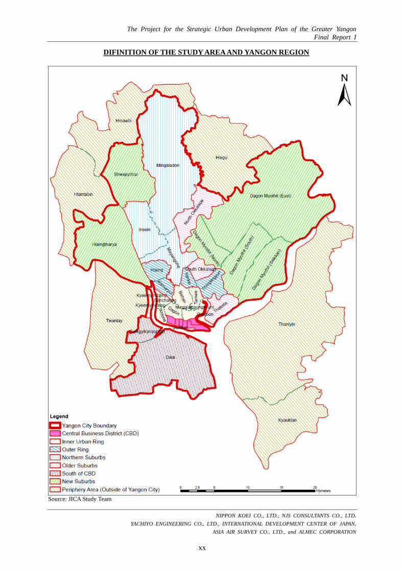
DIFINITION OF THE STUDY AREA AND YANGON REGION
Administrative Boundary Township Group Township Name Definition
Yangon Region
Yangon City
CBD
Latha
Whole area of those townships belongs to the target area The Greater
Yangon (Target Area)
Total 1,535 km2
Lanmadaw Pabedan Kyauktada Botahtaung Pazundaung
Inner Urban Ring
Ahlone Kyee Myin Daing Sanchaung Dagon Bahan Tarmwe Mingalar Taung Nyunt Seikkan Dawbon
Outer Ring
Kamaryut Hlaing Yankin Thingangyun
Northern SuburbsMayangone Insein Mingalardon
Older Suburbs North Okkalapa South Okkalapa Thaketa
South of CBD Dala Seikgyikhanaungto
New Suburbs
Shwe Pyi Thar Hlaing Tharyar North Dagon South Dagon East Dagon Dagon Seikkan
Periphery Area (Outside of Yangon City)
Kyauktan
Partial areas of each township belong to the target area
Thanlyin Hlegu Hmawbi Htantabin Twantay Taikkyi
(Outside of the Target Area)
Kawhmu Kungyangon Kayan Thongwa
Source: JICA Study Team
The Project for the Strategic Urban Development Plan of the Greater Yangon Final Report I
NIPPON KOEI CO., LTD., NJS CONSULTANTS CO., LTD.
YACHIYO ENGINEERING CO., LTD., INTERNATIONAL DEVELOPMENT CENTER OF JAPAN,
ASIA AIR SURVEY CO., LTD., and ALMEC CORPORATION
xx
DIFINITION OF THE STUDY AREA AND YANGON REGION
Source: JICA Study Team

The Project for the Strategic Urban Development Plan of the Greater Yangon Final Report I
NIPPON KOEI CO., LTD., NJS CONSULTANTS CO., LTD.
YACHIYO ENGINEERING CO., LTD., INTERNATIONAL DEVELOPMENT CENTER OF JAPAN,
ASIA AIR SURVEY CO., LTD., and ALMEC CORPORATION
xxi
THE STUDY IN PICTURES
Steering Committee (1st) (14th Aug 2012)
Technology Transfer Workshop (6th) (12th October 2012)
Kick-Off Seminar (14th Nov 2012)
Steering Committee (3rd) (9th Jan 2013)
Stakeholder Meeting (1st) (18th Jan 2013)
Seminar in Tokyo, Japan (21st March 2013)
Source: JICA Study Team

CHAPTER 3 Development Visions and Structure Plan
< Part-II: The Master Plan >

The Project for the Strategic Urban Development Plan of the Greater Yangon Final Report I
NIPPON KOEI CO., LTD., NJS CONSULTANTS CO., LTD. YACHIYO ENGINEERING CO., LTD., INTERNATIONAL DEVELOPMENT CENTER OF JAPAN,
ASIA AIR SURVEY CO., LTD., and ALMEC CORPORATION
3-1
CHAPTER 3: DEVELOPMENT VISIONS AND STRUCTURE PLAN
3.1 Development Visions
3.1.1 Necessity and Formulating Process of Development Visions
A development vision is an ideal future image of a city which can be attained through addressing problems and issues, catering to the citizens’ needs, and integrating foresight of the stakeholders and experts regarding urban planning, and other disciplines. Without setting clear development visions, it would be difficult to implement an integrated urban development plan efficiently. Consequently, the administration would come to a deadlock, as there are a number of concerned sectors playing important roles in developing, improving, and managing a large city.
In this context, it must be noted that the proposed development visions in this Final Report I were discussed and modified in the subsequent steps to reach the ultimate visions commonly shared by all stakeholders that are suitable for the future development of Greater Yangon. The development visions for Greater Yangon have been formulated clearly, through discussions not only with Yangon City Development Committee (YCDC) and Japan International Cooperation Agency (JICA) Study Team but also with other relevant government organizations and stakeholders through stakeholders meetings and the steering committee meetings. Moreover, the citizens’ needs analyzed by means of household interview survey were reflected in the development visions as well. The formulating process of the development visions is shown in Figure 3.1.1.
Source: JICA Study Team
Figure 3.1.1: Formulating Process of the Development Visions
(1) Review of Past Discussion
First Draft of Development Visions (with a structure plan)
Draft Final of Development Visions (with a structure plan)
2nd November 2012
(3) Result of Household Survey
(2) 1st Workshop by YCDC
Finalization of Development Visions (with a structure plan)
(4) 2nd Workshop by YCDC
2nd Steering Committee
9th January 2013 3rd Steering Committee
18th January 2013 Stakeholder Meeting
Discussion
Discussion
Discussion and Consensus
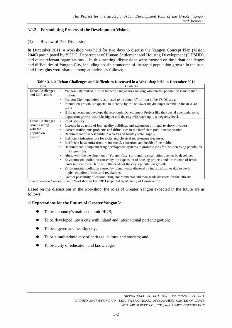
The Project for the Strategic Urban Development Plan of the Greater Yangon Final Report I
NIPPON KOEI CO., LTD., NJS CONSULTANTS CO., LTD. YACHIYO ENGINEERING CO., LTD., INTERNATIONAL DEVELOPMENT CENTER OF JAPAN,
ASIA AIR SURVEY CO., LTD., and ALMEC CORPORATION
3-2
3.1.2 Formulating Process of the Development Visions
(1) Review of Past Discussion
In December 2011, a workshop was held for two days to discuss the Yangon Concept Plan (Vision 2040) participated by YCDC, Department of Human Settlement and Housing Development (DHSHD), and other relevant organizations. In this meeting, discussions were focused on the urban challenges and difficulties of Yangon City, including possible outcome of the rapid population growth in the past, and foresights were shared among attendees as follows;
Table 3.1.1: Urban Challenges and Difficulties Discussed in a Workshop held in December 2011 Item Contents
Urban Challenges and Difficulties
• Yangon City ranked 73rd in the world megacities ranking wherein the population is more than 1 million.
• Yangon City population is estimated to be about 4.7 million in the YCDC area. • Population growth is expected to increase by 2% or 3% or maybe unpredictable in the next 30
years. • If the government develops the Economic Development Project like the special economic zone,
population growth would be higher and the city will reach up to a megacity level. Urban Challenges coming along with the population Growth
• Food Security. • Increase in quantity of low quality buildings and expansion of illegal territory invaders. • Current traffic jams problems and difficulties in the inefficient public transportation. • Requirement of accessibility to a clean and healthy water supply. • Inefficient infrastructure for a city and physical requirement weakness. • Inefficient basic infrastructure for social, education, and health of the public. • Requirement in implementing development systems to promote jobs for the increasing population
of Yangon City. • Along with the development of Yangon City, surrounding small cities need to be developed. • Environmental pollution caused by the expansion of housing projects and destruction of fertile
lands in order to catch up with the needs of the city’s population growth. • Environmental pollution caused by illegal waste disposal by industrial zones due to weak
implementation of rules and regulations. • Greater possibility of encountering environmental and man-made disasters for the citizens.
Source: Yangon Concept Plan in Workshop in Dec 2011 (reported by Ministry of Construction)
Based on the discussions in the workshop, the roles of Greater Yangon expected in the future are as follows:
<Expectations for the Future of Greater Yangon>
To be a country’s main economic HUB;
To be developed into a city with inland and international port integration;
To be a green and healthy city;
To be a multiethnic city of heritage, culture and tourism; and
To be a city of education and knowledge.

The Project for the Strategic Urban Development Plan of the Greater Yangon Final Report I
NIPPON KOEI CO., LTD., NJS CONSULTANTS CO., LTD. YACHIYO ENGINEERING CO., LTD., INTERNATIONAL DEVELOPMENT CENTER OF JAPAN,
ASIA AIR SURVEY CO., LTD., and ALMEC CORPORATION
3-3
(2) First Workshop to Discuss Visions by Urban Planning Division, YCDC
A workshop was held to discuss visions among the staff of Urban Planning Division (UPD), YCDC on September 11, 2012.
In the workshop, attendees were initially divided into three teams, and each team discussed future visions by sorting ideas and writing them on a number of small sheets of paper showing each attendee’s expectation for the future of Yangon. Then, each team presented their ideas. Dr. Kyaw Lat and the Team Leader of JICA Study Team commented on the presentations before the closing of the workshop.
Categorizing attendee expectation
papers and putting titles Giving presentations by all three teams Making visions in the workshop
Source: JICA Study Team Figure 3.1.2: A Workshop to Discuss Visions by UPD
Figure 3.1.3 shows the result of the workshop as divided in three groups. All expectations written by the attendees are included in the figure and were categorized into groups and were given new titles. Based on the results, the key themes that have become apparent are as follows:
<Expectations for the Future of Greater Yangon>
To be a city with good governance and law enforcement (Keywords: good governance, system, control, rule, etc.);
To be a city with economic growth (development economy, employment opportunity, etc.);
To be a city with green and culture (green, clean, public park, historical, heritage, culture, etc.);
To be a city with urban infrastructure (transportation, port and airport, water, electricity, waste, telecommunication, etc.); and
To be a city with living environment (living standard, health care, education, disaster risk, social, etc.).

The Project for the Strategic Urban Development Plan of the Greater Yangon Final Report I
NIPPON KOEI CO., LTD., NJS CONSULTANTS CO., LTD. YACHIYO ENGINEERING CO., LTD., INTERNATIONAL DEVELOPMENT CENTER OF JAPAN,
ASIA AIR SURVEY CO., LTD., and ALMEC CORPORATION
3-4
Source: JICA Study Team
Figure 3.1.3: Results of the UPD-YCDC Workshop for the Development Visions
Good Governance and Servants’ Facility Good governance Right man at the right place
Systematic Urban Land Use and Housing System Many housing area in Yangon Land-use same as Singapore Community owned and managed land and
housing system Housing financing system with low interest
rate
Green, Clean and Public Park We need more green area for higher living
standard Public accessible and recreational public park Clean and green city
Prevent Historical Heritage To maintain historical heritage To keep and maintain heritage building in our
country High-rise building Historical heritage will be good in the future
and attract tourism
Good Transportation To build sky train and UMRT system We hope transportation with no traffic To have restricted law for transportation Good railway system Systematic and convenient transit system
International Airport and Waterways System Port more international airports in Yangon
Good Water Supply All places in Yangon to use more pure water Water supply is always convenient for all
people Clean and pure water supply system Sufficient water supply system Good management and water supply
Good Drainage System To be improved drainage system
Good Solid Waste System Many places in Yangon will be clean and tidy To maintain the solid waste like Singapore People will obey the discipline for the solid
waste
Good Telecommunication Free Internet access and speedy To improve low connection Internet network more quickly and
conveniently Should solve telecommunication problem Good communication
Improved Living Standard Economic Development Reduce Commodity Price and high income Lower Poverty
Full Time Electricity Up to the rural area, electricity will have to be
convenient All places in Yangon to get 24 hours
Good Health Care and Education Free health care and education system Higher education Advanced education
Disaster Prevention Need to prevent the disaster prevention
Good Governance Clean and good government Good democracy system
To Lay Down the Law To draw the suitable law To renew the existing law
To Obey the Rule of YCDC To manage solid waste, other technical
support (Need) Belonging to solid waste, people will obey the
rules from YCDC
Rich Green City Keep green places Model city in Asia Clean and green city The most important city in South East Asian
countries To grow many plant and open spaces
To Maintain Historical Heritage To preserve historical heritage in Yangon like
other modern cities Conservation of historical heritage zone Prevention and renovation historical building
maintaining original style
Development Economics We should up-to-date the economic system for
international system Foreign investment Thilawa SEZ will lead economic growth Eliminate unemployment
Good Transportation Good bus lines Better local transportation Safety management for road Rapid bus system, circular railway system Easy commuter transportation (Railway, bus,
subway) To have local circular railway system
International Port
Sufficient Water Supply Accessibility of portable water Good water supply Clean, clear and pure Water treatment plant Good and systematic water supply system Many township get every time To distribute water to the whole city
Fulltime Electricity Hope to get for full time of the day Sufficient supply of electricity Good electricity
Telecommunication will be better Low cost telecommunication to contact the
whole country and worldwide We want to use mobile as oversea countries Good connection
To reconstruct the Good Drainage System To build clean waste canal with good drainage To improve the drainage system
Detail Planning for Disaster Risk Reduction More detail planning for disaster prevention Built-up disaster risk reduction to all level
Law and Good Governance Good government/ law institution Revised existing laws Good political management and reliable policy
in boundary area
Development Control Need for development control
Land Need own housing and land system
Green Prevent the green area Need green area for environment To be green, clean and disciplined Many more park Green Area, playground and park
Heritage and Culture Preservation of historical heritage Keep the historical heritage building As land mark of Myanmar Prevention of historical and heritage places
(Inya lake, Yangon University, RIT)
Employment Opportunity All people should have suitable job and
sufficient salary (International Salary) Development of garment factory More employment opportunities
Transportation More efficient circular train system Reliable transportation system Extend train station (sky train) Public use more convenient transportation eg.,
express train, sky train, underground railway Electronic ways Road maintenance Railway development Make convenient transportation system Sky bridge and more road spaces
Port More international airports More International and internal ports and
harbor
Drainage Good sufficient drainage system
Electricity Every time every season we get full power All places in Yangon will get ever Need full electricity
Telecommunication Free internet system and telecommunication Good connection for future Quick internet access Cheap telephone
Solid Waste Solid waste are recycled by plant Solid waste will reduce in Yangon Need Incinerator
Living Standard Perfect life As the metropolitan city Quality living standard 24 hour working city like other foreign country Junction City between India, China, ASEAN
and, west and east region City based on advanced technology, education,
agriculture, etc. Industry and commercial city Healthy and reliable environment To upgrade living standard
Education Many international institute for Myanmar
students Reliable and international education system International education
Social and Health Service for home-aged people More efficient, safe, and cheaper health care
system Free education and health care system More social service
Team A Team B Team C
Governance & Law
Green &
Culture Econom
y U
rban Infrastructure Living Environm
ent
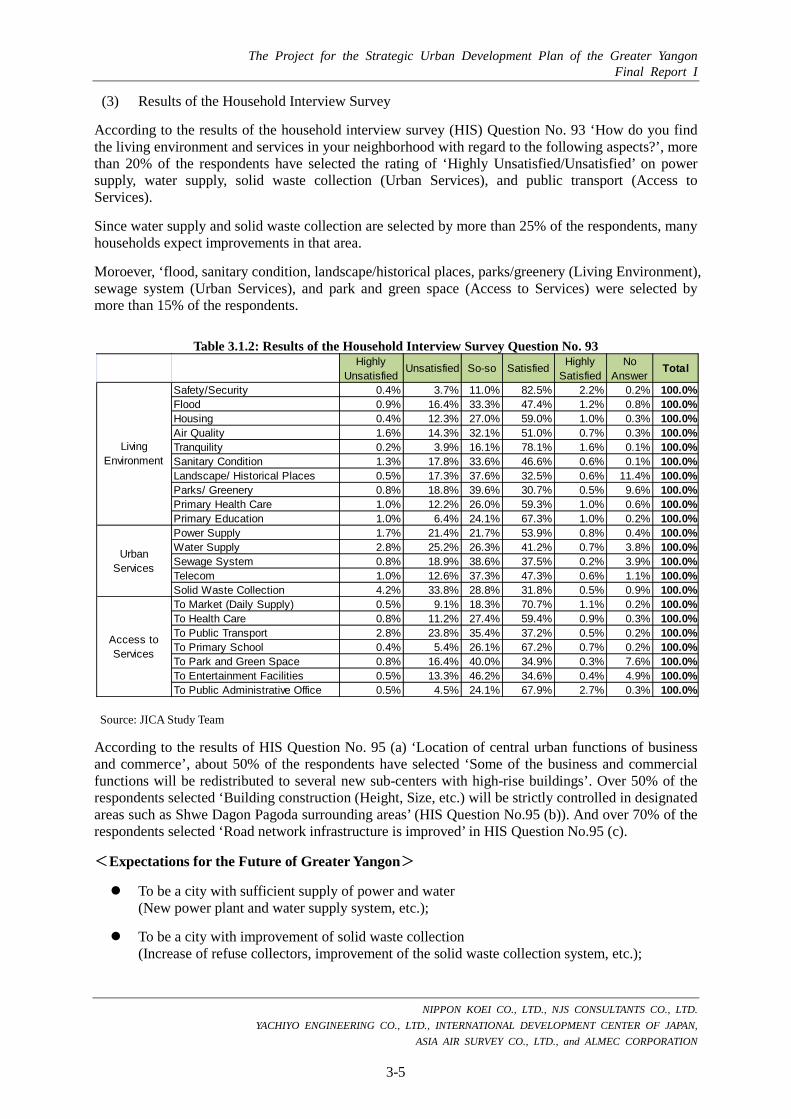
The Project for the Strategic Urban Development Plan of the Greater Yangon Final Report I
NIPPON KOEI CO., LTD., NJS CONSULTANTS CO., LTD. YACHIYO ENGINEERING CO., LTD., INTERNATIONAL DEVELOPMENT CENTER OF JAPAN,
ASIA AIR SURVEY CO., LTD., and ALMEC CORPORATION
3-5
(3) Results of the Household Interview Survey
According to the results of the household interview survey (HIS) Question No. 93 ‘How do you find the living environment and services in your neighborhood with regard to the following aspects?’, more than 20% of the respondents have selected the rating of ‘Highly Unsatisfied/Unsatisfied’ on power supply, water supply, solid waste collection (Urban Services), and public transport (Access to Services).
Since water supply and solid waste collection are selected by more than 25% of the respondents, many households expect improvements in that area.
Moroever, ‘flood, sanitary condition, landscape/historical places, parks/greenery (Living Environment), sewage system (Urban Services), and park and green space (Access to Services) were selected by more than 15% of the respondents.
Table 3.1.2: Results of the Household Interview Survey Question No. 93
According to the results of HIS Question No. 95 (a) ‘Location of central urban functions of business and commerce’, about 50% of the respondents have selected ‘Some of the business and commercial functions will be redistributed to several new sub-centers with high-rise buildings’. Over 50% of the respondents selected ‘Building construction (Height, Size, etc.) will be strictly controlled in designated areas such as Shwe Dagon Pagoda surrounding areas’ (HIS Question No.95 (b)). And over 70% of the respondents selected ‘Road network infrastructure is improved’ in HIS Question No.95 (c).
<Expectations for the Future of Greater Yangon>
To be a city with sufficient supply of power and water (New power plant and water supply system, etc.);
To be a city with improvement of solid waste collection (Increase of refuse collectors, improvement of the solid waste collection system, etc.);
HighlyUnsatisfied
Unsatisfied So-so Satisfied HighlySatisfied
NoAnswer
Total
Safety/Security 0.4% 3.7% 11.0% 82.5% 2.2% 0.2% 100.0%Flood 0.9% 16.4% 33.3% 47.4% 1.2% 0.8% 100.0%Housing 0.4% 12.3% 27.0% 59.0% 1.0% 0.3% 100.0%Air Quality 1.6% 14.3% 32.1% 51.0% 0.7% 0.3% 100.0%Tranquility 0.2% 3.9% 16.1% 78.1% 1.6% 0.1% 100.0%Sanitary Condition 1.3% 17.8% 33.6% 46.6% 0.6% 0.1% 100.0%Landscape/ Historical Places 0.5% 17.3% 37.6% 32.5% 0.6% 11.4% 100.0%Parks/ Greenery 0.8% 18.8% 39.6% 30.7% 0.5% 9.6% 100.0%Primary Health Care 1.0% 12.2% 26.0% 59.3% 1.0% 0.6% 100.0%Primary Education 1.0% 6.4% 24.1% 67.3% 1.0% 0.2% 100.0%Power Supply 1.7% 21.4% 21.7% 53.9% 0.8% 0.4% 100.0%Water Supply 2.8% 25.2% 26.3% 41.2% 0.7% 3.8% 100.0%Sewage System 0.8% 18.9% 38.6% 37.5% 0.2% 3.9% 100.0%Telecom 1.0% 12.6% 37.3% 47.3% 0.6% 1.1% 100.0%Solid Waste Collection 4.2% 33.8% 28.8% 31.8% 0.5% 0.9% 100.0%To Market (Daily Supply) 0.5% 9.1% 18.3% 70.7% 1.1% 0.2% 100.0%To Health Care 0.8% 11.2% 27.4% 59.4% 0.9% 0.3% 100.0%To Public Transport 2.8% 23.8% 35.4% 37.2% 0.5% 0.2% 100.0%To Primary School 0.4% 5.4% 26.1% 67.2% 0.7% 0.2% 100.0%To Park and Green Space 0.8% 16.4% 40.0% 34.9% 0.3% 7.6% 100.0%To Entertainment Facilities 0.5% 13.3% 46.2% 34.6% 0.4% 4.9% 100.0%To Public Administrative Office 0.5% 4.5% 24.1% 67.9% 2.7% 0.3% 100.0%
LivingEnvironment
UrbanServices
Access toServices
Source: JICA Study Team

The Project for the Strategic Urban Development Plan of the Greater Yangon Final Report I
NIPPON KOEI CO., LTD., NJS CONSULTANTS CO., LTD. YACHIYO ENGINEERING CO., LTD., INTERNATIONAL DEVELOPMENT CENTER OF JAPAN,
ASIA AIR SURVEY CO., LTD., and ALMEC CORPORATION
3-6
To be a city with construction of new roads, road network, and parking spaces (Ring road, new arterial roads, and off-street parking spaces, etc.);
To be a city with new building lots not submerged under water (Housing land development with retarding basin and development control of retarding basin, etc.);
To be a city with conservation and activity of heritage and conservation of historical and excellent view with pagoda (settle on Yangon landscape plan and regulation of landscape, etc.);
To be a city with construction of new sewage system; and
To be a city with construction of new parks and greenery.
Additionally, according to the results of HIS Question No. 96 ‘Suitable image for the future of Greater Yangon’, more than 2,500 respondents have selected ‘International/Global, Clean, Modern and Peaceful’. And further, about 1,000 respondents have selected ‘Safety, Economic, and Scientific/High-tech’.
<Expectations for the Future of Greater Yangon>
To be an international and global city (Keywords: foreign businesses, airport, sea port, inter-city cooperation, etc.);
To be a clean city (waste, water and sewerage, exhaust fumes, renewable energy, etc.);
To be a modern city (electric train, barrier-free, new buildings, etc.);
To be a peaceful and safe city (affluent society, safety society, etc.); and
To be a economic and scientific/high-tech city (foreign businesses, airport, sea port, industrial park, etc.).
Source: JICA Study Team Figure 3.1.4: Results of HIS Question No. 96

The Project for the Strategic Urban Development Plan of the Greater Yangon Final Report I
NIPPON KOEI CO., LTD., NJS CONSULTANTS CO., LTD. YACHIYO ENGINEERING CO., LTD., INTERNATIONAL DEVELOPMENT CENTER OF JAPAN,
ASIA AIR SURVEY CO., LTD., and ALMEC CORPORATION
3-7
(4) Second Workshop to Discuss Vision by Urban Planning Division, YCDC
Second workshop was held to discuss one slogan based on the development visions among the staff of Urban Planning Division (UPD), YCDC on February 8, 2013.
In the workshop, attendees put ideas out to set one slogan of future image of Greater Yangon based on for pillars of the development visions which has been discussing so far. The followings show the result of the workshop. All ideas were written by the attendees. Based on these ideas, one slogan “Yangon 2040 The Peaceful and Beloved Yangon -A City of Green and Gold-” has been formulated through the discussions.
<Collected Ideas of one Slogan for the Future of Greater Yangon>
- Green and Peaceful Yangon Land - Green city of Golden Land - Green, Clean and sustainable
Yangon - Green and clean around Yangon City - Green and peaceful Yangon Land - To a new Yangon city with green and
developed - Green and Beauty Yangon city - Try to upgrade the city’s landscape
into a green and prosperous state - Yangon steps forward with
international development - “Our Yangon city steps in catch with
the Global steps” - Green Paradise City - “Internationally comparable is
Yangon appearance” - Peaceful and Pleasant City
Yangon is a peaceful and pleasant city to live
- Newly green is Asia, Developed is Yangon areas
- To a green, developed and peaceful Yangon City
- Perfect Beauty Yangon Thee! - From a freshly green Yangon City to
a proudly wealthy nation - “Let’s try and give a hand to become
a development and peaceful Yangon City!
- Public satisfies in the future prosperity of the city
- Fresh & Pleasure Yangon Pastures! - Clean, developed and modernized
city - “Green beauty, Sophisticated
progress systematic Yangon’s Ethic” - “To a beautiful and developed
Yangon” - Growth with Standard of living
- Greater Yangon develops with the world for ages!
- “Steps forward with development to beautiful Golden Yangon City!”
- “Development measure Yangon is greater!”
- “Aiming to a perfect development for Yangon City”
- “Let’s step forward to a newly developed Yangon City”
- “All round development in Yangon City”
- “Upgraded City” - Yangon Beauty everlasting long term
shinny - All round progress, Brightly
peaceful, Yangon Delightful - Fashionably developed city is the
beauty of the Yangon city! - Perfect progress Yangon City! - Well disciplined, modernized
developed, stable laws, infrastructure upgraded portrait of the Golden Yangon City!
- “To a fresh developed Yangon City” - Clear progress, Yangon visual - Every once year, more peaceful
Yangon Region - “To a developed and progress city” - Keep the tradition for a green
developed Yangon perfection - “The future Ultimate Yangon” - Rebirth of Ancient City & Renew of
Urbanization - Modern green in the Nation, Golden
brightness in Yangon Region! - Yangon as the image of a public! - Neat and tidy freshly Green and
prosperously satisfy - Hub City of Myanmar - Live & loveable City
- The pleasant City of Asia, Yangon - “Clean and developed Yangon City” - “To a clean and developed Yangon - “Clean, Green, Progress, Better is
our Yangon” - “Grand beauty and clean progressing
Yangon City” - “Internationally developed and
peaceful Yangon City” - Golden Yangon is the best among the
Nation’s beautiest - “Grandly developed Yangon City” - New Version of Greater Yangon - Modern Beauty, green prosperous,
systematically clean is the Golden beauty of the Yangon City!
- “The perfect Golden Yangon” - “Our golden future with sustainable
development measure” - Golden features green colors,
Industrial global roar Clean and progress every grasp Moving forward Yangon steps.
- “Everything is green and updated peacefully quite and upgraded incomparable is Yangon status.
- Stepping forward with the ages develop for the golden city’s sake.
- Rainbow flatters for the city greater holding hands together for clear progress of the city better.
- “Good communication well developed, peacefully green, helping hands, the future of the golden Yangon.
(5) Stakeholder Meeting
First stakeholder meeting was held on 18th January 2013 at Meeting Hall of YCDC in order mainly to discuss and build consensus on development visions with a structure plan through selection among alternatives for future Greater Yangon by means of strategic environmental assessment (SEA) procedure. A total of 169 people attended the meeting. In the meeting, the development visions with the structure plan were basically accepted by the attendees as shown in the next page. The details of the stakeholder meeting are mentioned in Chapter 7.

The Project for the Strategic Urban Development Plan of the Greater Yangon Final Report I
NIPPON KOEI CO., LTD., NJS CONSULTANTS CO., LTD. YACHIYO ENGINEERING CO., LTD., INTERNATIONAL DEVELOPMENT CENTER OF JAPAN,
ASIA AIR SURVEY CO., LTD., and ALMEC CORPORATION
3-8
3.1.3 The Development Visions of Greater Yangon for 2040
In consideration of past discussions among YCDC, Ministry of Construction (MOC), and other relevant organizations, and outputs and discussion form the workshops with YCDC, household interview survey and the stakeholder meeting, one slogan and development visions are summarized as follows;
A slogan, “Yangon 2040 The Peaceful and Beloved Yangon –A City of Green and Gold”, expresses our goal of urban images which are “Peace” to be achieved by Myanmar democratization and “Beloved Yangon”. And the slogan also images rich green of natural environment and lighting gold of Shwe Dagon Pagoda.
Based on the slogan, four pillars of development visions are summarized into four main points: 1) to be an international hub city; 2) to be a comfortable city; 3) to be a well-managed infrastructure city; and 4) to be a city of good-governance.
Source: JICA Study Team
Figure 3.1.5: The Development Visions of Greater Yangon for 2040 (Relational Structure)

The Project for the Strategic Urban Development Plan of the Greater Yangon Final Report I
NIPPON KOEI CO., LTD., NJS CONSULTANTS CO., LTD. YACHIYO ENGINEERING CO., LTD., INTERNATIONAL DEVELOPMENT CENTER OF JAPAN,
ASIA AIR SURVEY CO., LTD., and ALMEC CORPORATION
3-9
The one slogan and four visions are detailed below:
(1) The Peaceful and Beloved Yangon - A City of Green and Gold-
Myanmar’s current government led by President Thein Sein is promoting the reforms of democratization and reconciliation with public. In workshop held for making visions, many attendees chose ‘peaceful’ for key word. According to the result of HIS, , more than 2,000 respondents have selected ‘Peaceful’ in the question of ‘Suitable image for future Yangon’. In future, many respondents of HIS have chose ‘Clean, Peaceful, International/Global, and Modern’. Because of this output is that citizens will want to beloved with foreign country’s people. And Myanmar has many cultural heritages and nature environments that have high potential for sightseeing resources. It is very important to be loved by foreign tourists. ‘Beloved Yangon’ is a very precious keyword.
In December 2011, a workshop was held for two days to discuss the Yangon Concept Plan (Vision 2040) participated by YCDC, Department of Human Settlement and Housing Development (DHSHD), and other relevant organizations. And they chose some keywords for future Yangon. ‘To be a green and healthy city’ is a one of their outputs. And in workshop held for making visions, ‘Green and Blue (water) ’ is very important keywords for concept. In future, for increasing population, some new districts will be constructed, then the new forests and lakes must be layout with the plan. This keyword ‘Green’ is very important for future planning. The Gold is a symbol color of Myanmar and Yangon, because of the symbol of Yangon ‘Shwe Dagon Pagoda’ and ‘Sule Pagoda’s color. Gold is a happy color of Myanmar’s citizen and their hope and dream are symbolized by gold color.
Then Green and Gold will give courage and dream to Yangon’s people for developing new city. And ‘Peaceful’ and ‘Beloved’ are catchphrases for foreign countries interesting Myanmar or Yangon City.
(2) To be an International Hub City
<Keywords from past discussions> International Gateway, Economical Development, Employment Opportunity, Center of Nation, Growth Center, Non-traditional Industry, etc.
Yangon is the largest city and an international gateway of Myanmar, which is currently a country with increasing attractiveness and growing world attention. Moreover, Yangon is the focal node city of the Greater Mekong Sub-region (GMS) economic corridors (East-West Economic Corridor, Western Economic Corridor, and Southern Economic Corridor) and Asian highways. To be ready to host the ASEAN summit in 2014 and the planned tariff elimination among ASEAN member nations in 2015, development visions shall be proposed for Yangon to be a HUB city. In addition, it will prepare the city to play an important role in the economic, social, and cultural aspects in consideration of the demarcation of Yangon with the capital city, Nay Pyi Taw.
In the future, Greater Yangon is expected to be an “International Hub City” with attractive and competitive urban functions where more people and companies (businesses) gather from surrounding areas. Also, when goods and people movement becomes freer, the international gateway functions for exports/imports and exchange of knowledge shall be improved, thereby leading to accelerated and sustainable economic development.

The Project for the Strategic Urban Development Plan of the Greater Yangon Final Report I
NIPPON KOEI CO., LTD., NJS CONSULTANTS CO., LTD. YACHIYO ENGINEERING CO., LTD., INTERNATIONAL DEVELOPMENT CENTER OF JAPAN,
ASIA AIR SURVEY CO., LTD., and ALMEC CORPORATION
3-10
Source: JICA Study Team
Figure 3.1.6: Location of Yangon in GMS
Yangon, Nay Pyi Taw, and Mandalay, which are the main cities of the country, will share their respective roles in the future in terms of economics, politics, culture, etc. Yangon will be the city with the largest economy in Myanmar even in the future, and both Yangon and Mandalay will be the gateway and base for tourism. Nay Pyi Taw will have its consolidated function as the capital of Myanmar. These main cities will be connected with highway and railway networks and form the main frame of the nation. According to the results of population projections, Yangon, Mandalay, and Ayeyarwady Region’s populations will be over 10 million in 2040. Myanmar union’s economics, politics, culture, and agriculture (Ayeyarwady Region) will be developed by increasing population. Dawei Special Economic Zone (SEZ) located in Tanintharyi Region will share the role of the industry. Thilawa and Dawei will be the strong sea ports and industrial zones of the Bay of Bengal. Sagaing, Mandalay Regions, and Kachin State will be developed through mining of mineral resources. Furthermore, Magway Region, Mon, and Shan States will be developed through mining of non-mineral resources. In the future, Kachin and Shan States will be developed into permanent forest estates. In order to create well-balanced development in the whole country, it is very important to construct the highway systems all over the country.
Greater Yangon has been, and will be expected to enhance the central functions of service, trade, and distribution. This means that Greater Yangon will further accommodate the increasing population and employment as the city with the largest economy in Myanmar. Developing the industrial and commercial sectors would need a labor force either by in-migration from other areas or a shift from the agricultural sector to the manufacturing and services sectors in the future.
In pursuit to becoming an international HUB city as one of the development visions for 2040, the development of Thilawa area shall be necessary and significant. Development of a special economic zone and an international port in Thilawa, located in Greater Yangon, shall play an important role as an industrial and logistic core area to accelerate economic growth and industrial promotion for Yangon

The Project for the Strategic Urban Development Plan of the Greater Yangon Final Report I
NIPPON KOEI CO., LTD., NJS CONSULTANTS CO., LTD. YACHIYO ENGINEERING CO., LTD., INTERNATIONAL DEVELOPMENT CENTER OF JAPAN,
ASIA AIR SURVEY CO., LTD., and ALMEC CORPORATION
3-11
and Myanmar. This shall contribute to, not only new job creation but also, economic development by means of attracting advanced manufacturing factories such as motor, electronic, and electrical assembly.
<Visions and Policies to be proposed in Sectors’ Strategies>
Development of Thilawa SEZ and Thilawa Area Port,
Vitalization and renewal of CBD, current urban center,
Decentralization of urban center’s functions by creation of new “Secondary CBD” and “Sub-centers” to avoid over-concentration at the existing CBD,
Supply of industrial parks and residences for foreign and domestic investors,
Establishment and improvement of law and services for foreign investors,
Development of the gateway and main destination of the tourism,
Consolidating the urban structure for promoting economic growth with intensive land use and efficient logistics system,
Establishment of efficient port terminal operating system,
Development of functional road network as urban backbones (logistic routes),
Increase people’ mobility through the effective public transport system led by the urban mass rapid transit (UMRT), and
Establishment of new airport system between Yangon and other cities in Myanmar.
(3) To be a Comfortable City
<Keywords from past discussions> Living Standard, Health Care, Rich Green, Multiethnic, Knowledge and Education, Heritage and Culture, Disaster Risk Reduction, etc.
Everyone who lives and works in Greater Yangon should be able to enjoy a more comfortable living in consideration of environmental and social aspects. Greater Yangon would be required to provide people and visitors with time and space for relaxation to be accommodated on rich green and water spaces and attractive historical and cultural landscapes.
Greater Yangon is expected to supply of houses more than 1 million units to accommodate the families in 2040. To achieve good living environment, housing supply will be one of the most important measures for Greater Yangon.
Currently, Yangon has 189 registered historical heritage buildings. However, some of these heritage buildings are in decrepit condition without much care and utilization. To be a comfortable city in the future, the characteristics of these historical heritages should be maintained and enhanced further. Greater Yangon also plays the role of an international gateway for visitors to popular domestic tourism destinations such as Bagan, Mandalay, Inle, Pyu heritage, etc. Succession of historical heritages for the future and enhancement of the required functions as an international gateway should be carried forward to the future.
Also, it is necessary to strengthen the function of education and knowledge for improving human resources. Human resources will be a key factor for foreign and domestic investors in making sound

The Project for the Strategic Urban Development Plan of the Greater Yangon Final Report I
NIPPON KOEI CO., LTD., NJS CONSULTANTS CO., LTD. YACHIYO ENGINEERING CO., LTD., INTERNATIONAL DEVELOPMENT CENTER OF JAPAN,
ASIA AIR SURVEY CO., LTD., and ALMEC CORPORATION
3-12
investment decisions to put their businesses in Greater Yangon. Therefore, it is recommended to enhance education and knowledge accumulation.
<Visions and Policies to be proposed in Sectors’ Strategies>
Supply of houses to accommodate the families in 2040,
Mitigation of disaster risks,
Maintenance of good relations in the community,
Provision of equal opportunity of education and healthy and secure living environment,
Urban regeneration with utilizing heritage buildings,
Improvement of green and water network,
Construction of new public parks and open spaces,
Provision of potable water to more citizens with appropriate volume, pressure and price,
Development of functional road network as urban backbones, and
Increase people’s mobility through the effective public transport system led by the urban mass rapid transit (UMRT).
(4) To be a Well-Managed Infrastructure City
<Keywords from past discussions> Transportation and Road, Railway, Port and Logistics, Electricity, Sewerage and Drainage, Water Supply, Solid Waste Management, Telecommunication, etc.
To achieve the vision of becoming an international HUB city, urban infrastructures should be the focal factors. To provide a safer, more reliable, and more convenient urban life and to realize economic development and industrialization, the vision of becoming a “well-managed infrastructure city” must be realized for the future, especially in transportation and road, electricity, and water supply.
For the future of Greater Yangon, the existing transportation system and facilities are inadequate as compared to what they should be. Consequently, it may be necessary to examine how to encourage more commuters to use the existing railway and/or whether to introduce the urban mass rapid transit (UMRT). Regarding electricity, improvement of power supply is one of urgent needs. Power demand is increasing by 7% annually and economic growth is projected to likewise increase by 7% to 10% annually in the current condition. It means that the pace of power demand and supply capacity is nearly equal. In Greater Yangon, which has a share of almost half of the domestic power demand, it is important to draw the appropriate vision and strategies of power supply and transmission for the future. In addition, urban infrastructure (water supply, sewerage, drainage, solid waste, and telecommunication) and social services (education, medical, public facility, and tourism) are in relatively lower level than neighboring countries. In this study, sustainable and reliable infrastructure development visions shall be proposed with consideration on effective O&M.
<Visions and Policies to be proposed in Sectors’ Strategies>
Realization of Environmental friendly and comfortable/ convenient transport system
Provision of potable water to more citizens with appropriate volume, pressure and price
Creation of clan water environment
Realization of stable electrical power supply of high quality and sufficient quantity

The Project for the Strategic Urban Development Plan of the Greater Yangon Final Report I
NIPPON KOEI CO., LTD., NJS CONSULTANTS CO., LTD. YACHIYO ENGINEERING CO., LTD., INTERNATIONAL DEVELOPMENT CENTER OF JAPAN,
ASIA AIR SURVEY CO., LTD., and ALMEC CORPORATION
3-13
Creation of a city with a sound material cycle with proper solid waste management
Creation of advanced information and communication society
(5) To be a City of Good-Governance
<Keywords from past discussions> Sustainability, Law, Rule and Regulation, Housing System, Good Governance, Systematic Land-Use, Leader of Nation, Development and Building Control, etc.
To establish a good city both for living and business, good governance is an indispensable key factor. To realize the urban plan to be formulated in this study, it is necessary to establish a system that will control and direct urban development and building constructions based on the land use plan. Since preparation and enactment of new laws take time, the tentatively enacted by-laws of Greater Yangon shall be examined. On the other hand, the necessity of legislating new laws is proposed for this Study.
<Visions and Policies to be proposed in Sectors’ Strategies>
Development of professional knowledge and experiences to create new urban environment and future citizen life
Enactment of law, by-laws about urban planning,
Ensure budget for construction of urban infrastructures,
Enactment of legislation in order to give preferential treatment to foreign companies, and
Rules in order to maintain and improve beautiful landscape (heritage) of Greater Yangon.

The Project for the Strategic Urban Development Plan of the Greater Yangon Final Report I
NIPPON KOEI CO., LTD., NJS CONSULTANTS CO., LTD. YACHIYO ENGINEERING CO., LTD., INTERNATIONAL DEVELOPMENT CENTER OF JAPAN,
ASIA AIR SURVEY CO., LTD., and ALMEC CORPORATION
3-14
Source: JICA Study Team Figure 3.1.7: Relationship of Development Visions and Sector Visions
Urban Infrastructure Development Strategy
Urban Development Strategy
Yangon 2040 The Peaceful and Beloved Yangon
- A City of Green and Gold -
To be an International HUB City
To be a Comfortable City
To be a Well-Managed Infrastructure City
To be a City of Good Governance
<Urban Development and Management> Realization of Sustainable Urban Development and Management in Consideration of Comfortable, Efficient and Environmental Friendly
<Social Service> Provision of Equal and Inclusive Social Services for All Citizens
<Living Environment> Realization of Living Environment that All Citizens can Enjoy Comfortable, Healthy and Cultured Living
<Urban Landscape and Heritage> Regeneration and Maintenance of Identical Urban Landscape so that Future Urban Development will Coexist with Historical and Cultural Heritage
<Public Parks and Greenery> Creation of Green Amenity Spaces to Realize Comfortable and Healthy Urban Life and Urban Development with Less Environmental Impacts
<Transportation and Port & Logistics> Realization of Environmental Friendly and Comfortable/ Convenient Transport System (High Mobility and Reliable Transportation System led by Modernized Urban Railway, and Contribution to Promote Planned New Urban Development)
<Water Supply> Provision of Potable Water to more Citizens with Appropriate Volume, Pressure and Price, and Realization of Sustainable Management
<Sewerage and Drainage> Creation of Clean Water Environment and Achievement of Safe City without Flood Damages
<Power Supply> Realization of Stable Electrical Power Supply of High Quality and Sufficient Quantity for Securing Advanced Urban Functions
<Solid Waste Management> Creation of a City with a Sound Material Cycle through “3R” Policies and its Execution
<Telecommunication> Creation of Advanced Information and Communication Society
Sector Visions Grand Visions for Yangon 2040
Sub-center with Green Isle System
City Center Function Creation of secondary CBD (Mindama)
& sub-centers Creation of new town cores
Industrial Function Currently 24 industrial zones with a
total area of 5,105ha are operating Development of Thilawa SEZ & others
Green and Agricultural Function Conservation of “North-South Green
Axis” with Hlawga protected area Development of Riverfront areas
Road Network Formation of a high capacity road
network for future traffic demands Construction of an outer ring road
Railway Network Development of 350km railway
network with new 5 UMRT lines Modernization of existing 3 lines
Logistics Network Construction of Thilawa Area Port Construction of Hanthawaddy new
international airport near Bago City
Urban Structure
Capacity Development Strategy Development of Professional Knowledge and
Experiences to Create New Urban Environment and Future Citizen Life

The Project for the Strategic Urban Development Plan of the Greater Yangon Final Report I
NIPPON KOEI CO., LTD., NJS CONSULTANTS CO., LTD. YACHIYO ENGINEERING CO., LTD., INTERNATIONAL DEVELOPMENT CENTER OF JAPAN,
ASIA AIR SURVEY CO., LTD., and ALMEC CORPORATION
3-15
3.2 Socio-economic Framework The JICA Study Team established appropriate socio-economic framework in Greater Yangon, the planning area, through the examination of various alternatives for socio-economic development from the viewpoint of different development scenarios.
3.2.1 Demographic Framework
(1) Three Demographic Alternatives for Greater Yangon
In the projection of the future population of Greater Yangon, JICA Study Team prepared three different scenarios using the examples from other Asian cities, e.g., the population growth rate in Bangkok was 2.61% (1975-2000), the rate in Hanoi was 2.75% (1975-2000), and the rate in Jakarta was 3.3% (1975-2000). These scenarios are low, middle, and high population growth scenarios, respectively. The differences of urban growth rates are described in the following table.
Table 3.2.1: Assumption of Future Population Growth Rate Population Growth
Scenario Assumption of Annual Growth Rate Remarks
Low Scenario 2.4% Less than the past trend of YCDC Middle Scenario 2.6% Past Trend of YCDC (Bangkok level) High Scenario 3.3% Jakarta level
Source: JICA Study Team
Table 3.2.2: Population Growth Rate of Major Cities in Neighboring Countries (1975-2000) City/Country Population Growth Rate
Bangkok/ Thailand 2.61% Hanoi/ Vietnam 2.75%
Jakarta/ Indonesia 3.30% Source: ‘World Urbanization Prospect (The 2001 Revision)’, World Bank
The population volume in Bangkok City was 6.7 million in 2011 while the population in Bangkok Metropolitan Area, consisting of not only Bangkok City but also the suburban area, was estimated to be more than 10 million by the National Economic and Social Development Board (NESDB). Industrial infrastructure in the eastern seaboard region such as road, railway, seaport, industrial port, power, water resource, etc., namely the ‘Eastern Seaboard Development Program (ESDP)’ has progressed remarkably from the 1980s era to the first half of the 1990s era. At the same period of the progress of ESDP, the rapid rising yen after the Plaza Accord of 1985 has made the Japanese to invest capital intensively in Thailand especially in the eastern seaboard region. Furthermore, the worldwide huge production base has been formed with a central focus on the eastern seaboard region. The appearance of huge production area has brought about absorbing redundant workers in Bangkok City that have moved from the rural areas, and has influenced the formation of Bangkok Metropolitan Area remarkably.
The period from the timing of the rapid rising yen to the present time is about 30 years which is the same as the projection period of the socio-economic framework. Therefore, JICA Study Team assumed that the future socio-economic scenario of Greater Yangon would be comparable to the past trend of the Bangkok Metropolitan Area.
In consideration of the abovementioned circumstances, the ‘Middle Scenario’ is the recommendable scenario to be adopted for deliberation through consultation with JICA Study Team and YCDC officers.

The Project for the Strategic Urban Development Plan of the Greater Yangon Final Report I
NIPPON KOEI CO., LTD., NJS CONSULTANTS CO., LTD. YACHIYO ENGINEERING CO., LTD., INTERNATIONAL DEVELOPMENT CENTER OF JAPAN,
ASIA AIR SURVEY CO., LTD., and ALMEC CORPORATION
3-16
(2) Methodology of Population Projection
The following figure shows the methodology of population projection in Greater Yangon. The method of population projection by each township in future was to allocate the increment of population growth based on the constitution rate of developable land area by each township.
Source: JICA Study Team Figure 3.2.1: Methodology of Population Projection
(3) Population Projection of Greater Yangon
In this Study, the Planning Area is set as Greater Yangon, which includes the area of Yangon City as well as the additional periphery area of six townships - Kyauktan, Thanlyin, Hlegu, Hmawbi, Htantabin, and Twantay.
The following figure and table show the population projection of Greater Yangon. JICA Study Team selected the ‘Middle Scenario’ of the three scenarios mentioned above as the recommendable scenario of Greater Yangon. The future population was estimated to be 11.73 million in 2040.
Total Projected population (Yangon +Periphery Area)
Current population by T/S
Total Current population (Yangon +Periphery Area)
Population Increase (Yangon +Periphery Area)
= -
Aggregation
Developable Land Area by T/S
Developable Land Ratio by T/S
Allocated Projected Population Increase by T/S
Projected Population by T/S

The Project for the Strategic Urban Development Plan of the Greater Yangon Final Report I
NIPPON KOEI CO., LTD., NJS CONSULTANTS CO., LTD. YACHIYO ENGINEERING CO., LTD., INTERNATIONAL DEVELOPMENT CENTER OF JAPAN,
ASIA AIR SURVEY CO., LTD., and ALMEC CORPORATION
3-17
Source: JICA Study Team
Figure 3.2.2: Population Projection in Greater Yangon
(4) Population Allocation for the Township
JICA Study Team reallocated the future population increase into each township in Greater Yangon based on the volume of developable area by township. The developable area consists of improved land, agricultural area, etc. The projected population is shown in the following figure by township groups, e.g., CBD, Inner Urban Ring, Outer Ring, Northern Suburbs, Older Suburbs, South of CBD, New Suburbs, and Periphery Area.
Source: JICA Study Team
Figure 3.2.3: Population Projection by Township Group
11,730,146
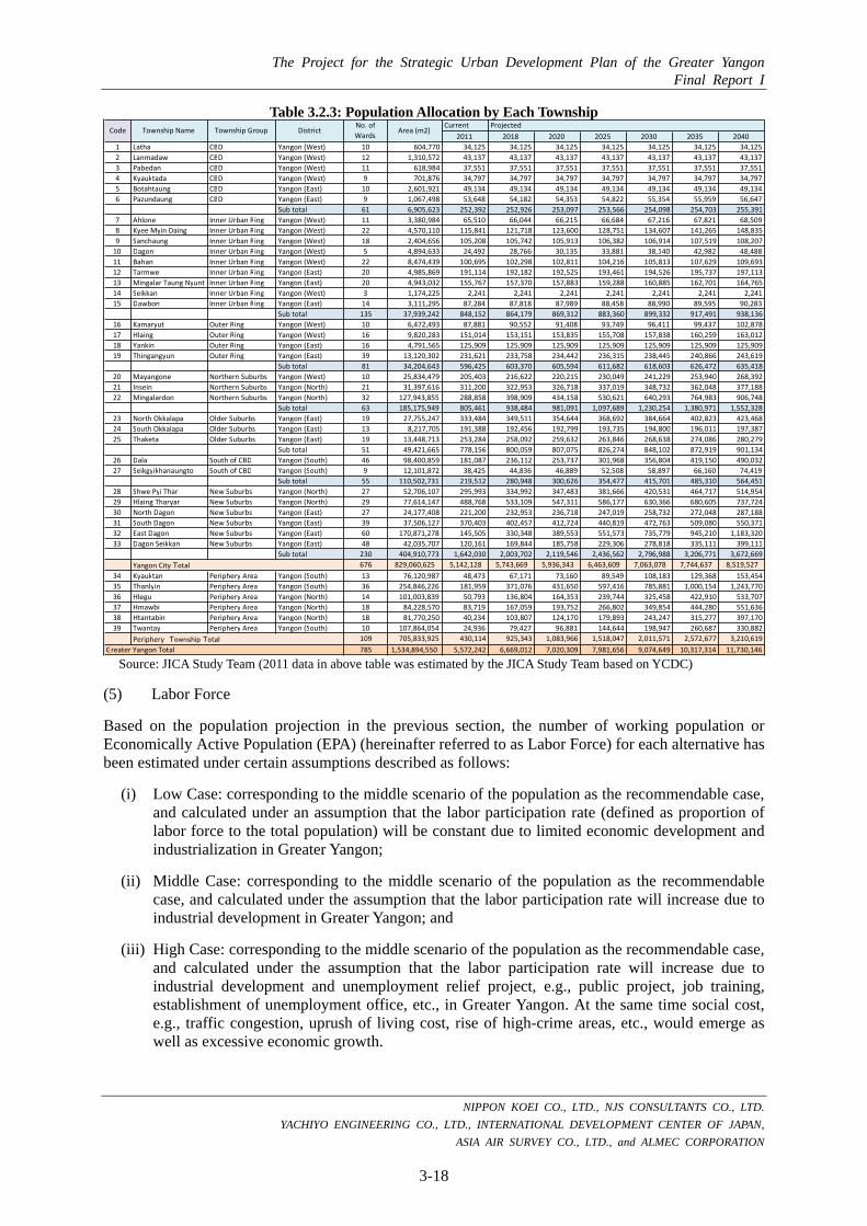
The Project for the Strategic Urban Development Plan of the Greater Yangon Final Report I
NIPPON KOEI CO., LTD., NJS CONSULTANTS CO., LTD.
YACHIYO ENGINEERING CO., LTD., INTERNATIONAL DEVELOPMENT CENTER OF JAPAN,
ASIA AIR SURVEY CO., LTD., and ALMEC CORPORATION
3-18
Table 3.2.3: Population Allocation by Each Township
Source: JICA Study Team (2011 data in above table was estimated by the JICA Study Team based on YCDC)
(5) Labor Force
Based on the population projection in the previous section, the number of working population or Economically Active Population (EPA) (hereinafter referred to as Labor Force) for each alternative has been estimated under certain assumptions described as follows:
(i) Low Case: corresponding to the middle scenario of the population as the recommendable case, and calculated under an assumption that the labor participation rate (defined as proportion of labor force to the total population) will be constant due to limited economic development and industrialization in Greater Yangon;
(ii) Middle Case: corresponding to the middle scenario of the population as the recommendable case, and calculated under the assumption that the labor participation rate will increase due to industrial development in Greater Yangon; and
(iii) High Case: corresponding to the middle scenario of the population as the recommendable case, and calculated under the assumption that the labor participation rate will increase due to industrial development and unemployment relief project, e.g., public project, job training, establishment of unemployment office, etc., in Greater Yangon. At the same time social cost, e.g., traffic congestion, uprush of living cost, rise of high-crime areas, etc., would emerge as well as excessive economic growth.
Current Projected
2011 2018 2020 2025 2030 2035 2040
1 Latha CBD Yangon (West) 10 604,770 34,125 34,125 34,125 34,125 34,125 34,125 34,125
2 Lanmadaw CBD Yangon (West) 12 1,310,572 43,137 43,137 43,137 43,137 43,137 43,137 43,137
3 Pabedan CBD Yangon (West) 11 618,984 37,551 37,551 37,551 37,551 37,551 37,551 37,551
4 Kyauktada CBD Yangon (West) 9 701,876 34,797 34,797 34,797 34,797 34,797 34,797 34,797
5 Botahtaung CBD Yangon (East) 10 2,601,921 49,134 49,134 49,134 49,134 49,134 49,134 49,134
6 Pazundaung CBD Yangon (East) 9 1,067,498 53,648 54,182 54,353 54,822 55,354 55,959 56,647
Sub total 61 6,905,623 252,392 252,926 253,097 253,566 254,098 254,703 255,391
7 Ahlone Inner Urban Ring Yangon (West) 11 3,380,984 65,510 66,044 66,215 66,684 67,216 67,821 68,509
8 Kyee Myin Daing Inner Urban Ring Yangon (West) 22 4,570,110 115,841 121,718 123,600 128,751 134,607 141,265 148,835
9 Sanchaung Inner Urban Ring Yangon (West) 18 2,404,656 105,208 105,742 105,913 106,382 106,914 107,519 108,207
10 Dagon Inner Urban Ring Yangon (West) 5 4,894,633 24,492 28,766 30,135 33,881 38,140 42,982 48,488
11 Bahan Inner Urban Ring Yangon (West) 22 8,474,439 100,695 102,298 102,811 104,216 105,813 107,629 109,693
12 Tarmwe Inner Urban Ring Yangon (East) 20 4,985,869 191,114 192,182 192,525 193,461 194,526 195,737 197,113
13 Mingalar Taung Nyunt Inner Urban Ring Yangon (East) 20 4,943,032 155,767 157,370 157,883 159,288 160,885 162,701 164,765
14 Seikkan Inner Urban Ring Yangon (West) 3 1,174,225 2,241 2,241 2,241 2,241 2,241 2,241 2,241
15 Dawbon Inner Urban Ring Yangon (East) 14 3,111,295 87,284 87,818 87,989 88,458 88,990 89,595 90,283
Sub total 135 37,939,242 848,152 864,179 869,312 883,360 899,332 917,491 938,136
16 Kamaryut Outer Ring Yangon (West) 10 6,472,493 87,881 90,552 91,408 93,749 96,411 99,437 102,878
17 Hlaing Outer Ring Yangon (West) 16 9,820,283 151,014 153,151 153,835 155,708 157,838 160,259 163,012
18 Yankin Outer Ring Yangon (East) 16 4,791,565 125,909 125,909 125,909 125,909 125,909 125,909 125,909
19 Thingangyun Outer Ring Yangon (East) 39 13,120,302 231,621 233,758 234,442 236,315 238,445 240,866 243,619
Sub total 81 34,204,643 596,425 603,370 605,594 611,682 618,603 626,472 635,418
20 Mayangone Northern Suburbs Yangon (West) 10 25,834,479 205,403 216,622 220,215 230,049 241,229 253,940 268,392
21 Insein Northern Suburbs Yangon (North) 21 31,397,616 311,200 322,953 326,718 337,019 348,732 362,048 377,188
22 Mingalardon Northern Suburbs Yangon (North) 32 127,943,855 288,858 398,909 434,158 530,621 640,293 764,983 906,748
Sub total 63 185,175,949 805,461 938,484 981,091 1,097,689 1,230,254 1,380,971 1,552,328
23 North Okkalapa Older Suburbs Yangon (East) 19 27,755,247 333,484 349,511 354,644 368,692 384,664 402,823 423,468
24 South Okkalapa Older Suburbs Yangon (East) 13 8,217,705 191,388 192,456 192,799 193,735 194,800 196,011 197,387
25 Thaketa Older Suburbs Yangon (East) 19 13,448,713 253,284 258,092 259,632 263,846 268,638 274,086 280,279
Sub total 51 49,421,665 778,156 800,059 807,075 826,274 848,102 872,919 901,134
26 Dala South of CBD Yangon (South) 46 98,400,859 181,087 236,112 253,737 301,968 356,804 419,150 490,032
27 Seikgyikhanaungto South of CBD Yangon (South) 9 12,101,872 38,425 44,836 46,889 52,508 58,897 66,160 74,419
Sub total 55 110,502,731 219,512 280,948 300,626 354,477 415,701 485,310 564,451
28 Shwe Pyi Thar New Suburbs Yangon (North) 27 52,706,107 295,993 334,992 347,483 381,666 420,531 464,717 514,954
29 Hlaing Tharyar New Suburbs Yangon (North) 29 77,614,147 488,768 533,109 547,311 586,177 630,366 680,605 737,724
30 North Dagon New Suburbs Yangon (East) 27 24,177,408 221,200 232,953 236,718 247,019 258,732 272,048 287,188
31 South Dagon New Suburbs Yangon (East) 39 37,506,127 370,403 402,457 412,724 440,819 472,763 509,080 550,371
32 East Dagon New Suburbs Yangon (East) 60 170,871,278 145,505 330,348 389,553 551,573 735,779 945,210 1,183,320
33 Dagon Seikkan New Suburbs Yangon (East) 48 42,035,707 120,161 169,844 185,758 229,306 278,818 335,111 399,111
Sub total 230 404,910,773 1,642,030 2,003,702 2,119,546 2,436,562 2,796,988 3,206,771 3,672,669
Yangon City Total 676 829,060,625 5,142,128 5,743,669 5,936,343 6,463,609 7,063,078 7,744,637 8,519,527
34 Kyauktan Periphery Area Yangon (South) 13 76,120,987 48,473 67,171 73,160 89,549 108,183 129,368 153,454
35 Thanlyin Periphery Area Yangon (South) 36 254,846,226 181,959 371,076 431,650 597,416 785,881 1,000,154 1,243,770
36 Hlegu Periphery Area Yangon (North) 14 101,003,839 50,793 136,804 164,353 239,744 325,458 422,910 533,707
37 Hmawbi Periphery Area Yangon (North) 18 84,228,570 83,719 167,059 193,752 266,802 349,854 444,280 551,636
38 Htantabin Periphery Area Yangon (North) 18 81,770,250 40,234 103,807 124,170 179,893 243,247 315,277 397,170
39 Twantay Periphery Area Yangon (South) 10 107,864,054 24,936 79,427 96,881 144,644 198,947 260,687 330,882
Periphery Township Total 109 705,833,925 430,114 925,343 1,083,966 1,518,047 2,011,571 2,572,677 3,210,619
785 1,534,894,550 5,572,242 6,669,012 7,020,309 7,981,656 9,074,649 10,317,314 11,730,146
No. ofWards
Area (m2)
Greater Yangon Total
Code Township Name Township Group District

The Project for the Strategic Urban Development Plan of the Greater Yangon Final Report I
NIPPON KOEI CO., LTD., NJS CONSULTANTS CO., LTD. YACHIYO ENGINEERING CO., LTD., INTERNATIONAL DEVELOPMENT CENTER OF JAPAN,
ASIA AIR SURVEY CO., LTD., and ALMEC CORPORATION
3-19
The following table shows the population and labor force projection in three different alternatives. The labor participation rate (proportion of labor force to the total population) was recorded at 50.8% in 2011. JICA Study Team assumes that the labor participation rate would be 50.8% in the low case throughout the term, and will improve gradually from 50.8% in 2011 to 55.0% in 2040 in the middle case, and from 50.8% in 2011 to 60.0% in 2040 in the high case. As a result, the labor force will be 5.96 million people in 2040 in the low case, 6.45 million people in the middle case, and 7.04 million people in the high case. The ‘Middle Case’ is recommendable to be adopted based on the consultation between JICA Study Team and YCDC officers.
The following figure shows the projection of labor force in three alternatives.
Table 3.2.4: Labor Force in Three Alternatives (Unit: Person) Year Low Case Middle Case High Case Remarks
2011 2,845,557 2,845,557 2,845,557 Actual 2018 3,387,858 3,667,957 3,535,956 Projected 2020 3,566,317 3,861,170 3,766,759 2025 4,054,681 4,389,911 4,409,177 2030 4,609,922 4,991,057 5,156,904 2035 5,241,195 5,674,522 6,026,734 2040 5,958,914 6,451,581 7,038,088
Source: JICA Study Team
Source: JICA Study Team
Figure 3.2.4: Labor Force Projection in Greater Yangon
(6) Labor Force Allocation by Industrial Category
Table 3.2.5 shows the Labor Force projection by industrial category. JICA Study Team selects the ‘Middle Scenario’ mentioned above as the recommendable scenario. JICA Study Team divided the future labor force volume into industrial category based on the present pattern in 2011. The table provided some implications of Greater Yangon in the future as follows:
• The fact that the share of primary industries rose from 1.9% in 2011 to 3.7% in 2040 could be interpreted that the demand for high value-added suburban agriculture might be raised due to the increase in the wealthy class population in Greater Yangon in the future in spite of the decrease in agricultural area;
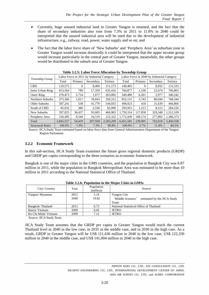
The Project for the Strategic Urban Development Plan of the Greater Yangon Final Report I
NIPPON KOEI CO., LTD., NJS CONSULTANTS CO., LTD. YACHIYO ENGINEERING CO., LTD., INTERNATIONAL DEVELOPMENT CENTER OF JAPAN,
ASIA AIR SURVEY CO., LTD., and ALMEC CORPORATION
3-20
• Currently, huge unused industrial land in Greater Yangon is retained, and the fact that the share of secondary industries also rose from 7.3% in 2011 to 11.8% in 2040 could be interpreted that the unused industrial area will be used due to the development of industrial infrastructure, e.g., railway, road, power, water supply and so on; and
• The fact that the labor force share of ‘New Suburbs’ and ‘Periphery Area’ as suburban zone in Greater Yangon would increase drastically it could be interpreted that the upper income group would increase particularly in the central part of Greater Yangon, meanwhile, the other groups would be distributed in the suburb area of Greater Yangon.
Table 3.2.5: Labor Force Allocation by Township Group
Township Group Labor Force in 2011 by Industrial Category Labor Force in 2040 by Industrial Category Total Primary Secondary Tertiary Total Primary Secondary Tertiary
CBD 119,573 0 8,400 111,173 140,465 0 8,932 131,533 Inner Urban Ring 653,564 789 17,359 635,416 784,877 1,338 22,674 760,865 Outer Ring 270,473 5,714 1,677 263,082 349,480 6,261 2,977 340,242 Northern Suburbs 375,366 1,011 18,043 356,312 852,131 3,743 80,044 768,344 Older Suburbs 587,241 538 41,770 544,933 498,923 418 31,639 466,866 South of CBD 85,932 386 2,556 82,990 293,951 1,213 8,512 284,226 New Suburbs 597,025 36,437 93,605 466,983 1,759,314 117,858 329,348 1,312,109 Periphery Area 156,385 9,544 24,519 122,322 1,772,439 108,174 277,892 1,386,373 Total 2,845,557 54,419 207,928 2,583,209 6,451,581 239,005 762,018 5,450,558 Structural Ratio 100.0% 1.9% 7.3% 90.8% 100.0% 3.7% 11.8% 84.5%
Source: JICA Study Team estimated based on labor force data from General Administration Department of the Yangon Region Parliament.
3.2.2 Economic Framework
In this sub-section, JICA Study Team examines the future gross regional domestic products (GRDP) and GRDP per capita corresponding to the three scenarios as economic framework.
Bangkok is one of the major cities in the GMS countries, and the population in Bangkok City was 6.87 million in 2011, while the population in Bangkok Metropolitan Area was estimated to be more than 10 million in 2011 according to the National Statistical Office of Thailand.
Table 3.2.6: Population in the Major Cities in GMSs City/ Country Year Population
(million) Source
Yangon/ Myanmar 2011 5.14 Yangon City 2040 10.82 ‘Middle Scenario’ estimated by the JICA Study
Team Bangkok/ Thailand 2011 6.73 National Statistical Office of Thailand Hanoi/ Vietnam 2009 6.45 JETRO Ho Chi Minh/ Vietnam 2009 7.12 JETRO Source: JICA Study Team
JICA Study Team assumes that the GRDP per capita in Greater Yangon would reach the current Thailand level in 2040 in the low case, in 2035 in the middle case, and in 2030 in the high case. As a result, GRDP in Greater Yangon will be US$ 111,436 million in 2040 in the low case, US$ 122,330 million in 2040 in the middle case, and US$ 141,004 million in 2040 in the high case.

The Project for the Strategic Urban Development Plan of the Greater Yangon Final Report I
NIPPON KOEI CO., LTD., NJS CONSULTANTS CO., LTD. YACHIYO ENGINEERING CO., LTD., INTERNATIONAL DEVELOPMENT CENTER OF JAPAN,
ASIA AIR SURVEY CO., LTD., and ALMEC CORPORATION
3-21
The assumption of economic growth from 2011 to 2016 is subject to the 5th National 5-year Plan (Planning Department Yangon Regional Office). And the growth rate of GRDP per capita is supposed to slow down to half of the past rate in each scenario after reaching the level of the whole Thailand.1
Japanese industry centering on machinery and transport equipment has grown increasingly global and borderless owing it to the shift of production to overseas locations in response to the appreciation of the yen after the Plaza Accord on exchange rate in 1985. Thailand is the biggest country to take over the Japanese industry in the world, and the Japanese industry lead Thailand’s economy to grow sustainably. It takes roughly 25 years to carry out the current level of the economy in Thailand. The ‘5th National 5 Year Plan (2011/12 to 2015/16)’ made by the Planning Department of Yangon Region Office, MNPED, has the future GRDP constitution projection by industrial categories, manufacturing sector, service sector, and trade sector, and only the GRDP share of the manufacturing sector was projected to increase. The industrial constitution of Yangon City is supposed to differ from the Yangon Region because the location of Yangon City is in the center of the Yangon Region. However, the industrial core in Yangon City in the future would be the manufacturing, service, and trade sectors. There are many issues that make an interception to realize sustainable economic growth. Issues that need to be overcome are expensive land rent, utilization of human resource development, and industrial infrastructure; e.g., power supply, water supply, transportation, etc. Industrial infrastructure and human resource development is projected to proceed robustly with the support from donors. Meanwhile, the issue of expensive land rent might be affected by supply quantity of the number of hotel/accommodation by private and land policy by the National Government.
‘Middle Case’ is recommendable to be adopted for the result of deliberation through consultation with the JICA Study Team and YCDC officers.
Table 3.2.7: GRDP per Capita in Three Alternatives
City/ Country Year GRDP/CAPITA (US$)
Average Annual Growth Rate of GRDP/CAPITA
(%)
Remarks
Yangon 2011 1,465 - Planning Department, Yangon Office, MNPED, Exchange rate: 856.5 (MMK/US$) (October 2012)
(Low Case) 2040 9,500 6.7 The GRDP per capita in Yangon would be accomplished in 2040.
(Middle Case) 2035 9,500 8.1 The GRDP per capita in Yangon would be accomplished in 2035, and after year 2036 the growth rate will slow down by half of the past rate.
(High Case) 2030 9,500 10.3 The GRDP per capita in Yangon would be accomplished in 2030 and after year 2031 the growth rate will slow down by half of the past rate.
Thailand 2011 9,500 - CIA Factbook, PPP basis Source: JICA Study Team
1
In general, developed country is defined by GDP per capita that is over USD 10,000 annually. The GDP per capita in whole of Thailand in 2011 was 9500 according to CIA Factbook, and the Thailand’s level of GDP per capita is just below the level of developed countries. The JICA Study Team assumed that the path of economic growth of Yangon City would fit a ‘logistics growth curve’ whose feature consists of two phases; one phase is to increase rapidly, and another phase is to increase gradually. The JICA Study Team set that GRDP per capita of Yangon would change the speed of economic growth to be slow after the achievement of the level of Thailand.

The Project for the Strategic Urban Development Plan of the Greater Yangon Final Report I
NIPPON KOEI CO., LTD., NJS CONSULTANTS CO., LTD. YACHIYO ENGINEERING CO., LTD., INTERNATIONAL DEVELOPMENT CENTER OF JAPAN,
ASIA AIR SURVEY CO., LTD., and ALMEC CORPORATION
3-22
Table 3.2.8: GRDP and GRDP/CAPITA in Three Alternatives
Low Case Middle Case High Case
Year
GRDP (US$ Mil.)
GRDP/CAP (US$)
GRDP (US$ Mil.)
GRDP/CAP (US$)
GRDP (US$ Mil.)
GRDP/CAP (US$) Remarks
2011 8,165 1,465 8,165 1,465 8,165 1,465 Actual 2018 20,209 3,030 21,241 3,185 23,011 3,450 Projected 2020 25,402 3,618 27,576 3,928 31,301 4,459
2025 40,617 5,089 46,176 5,785 55,707 6,979 2030 59,523 6,559 69,354 7,643 86,209 9,500
2035 82,844 8,030 98,014 9,500 111,018 10,760 2040 111,436 9,500 122,330 10,429 141,004 12,021 Source: JICA Study Team (2011 data in above table is estimated by the JICA Study Team based on YCDC)
Table 3.2.9: Average Annual Growth Rate of GRDP and GRDP per Capita in Three Alternatives GRDP GRDP per Capita Remarks
Low Case 8.8% 6.1% Period covered is from 2012 to 2040 Middle Case 9.2% 6.5% Period covered is from 2012 to 2040 High Case 9.7% 7.0% Period covered is from 2012 to 2040
Source: JICA Study Team
The following figures show the projection of GRDP and GRDP per capita in three alternatives in Greater Yangon.
Source: JICA Study Team
Figure 3.2.5: GRDP Projection of Greater Yangon (Unit: US$ million)
Source: JICA Study Team
Figure 3.2.6: GRDP per Capita Projection of Greater Yangon (Unit: US$)
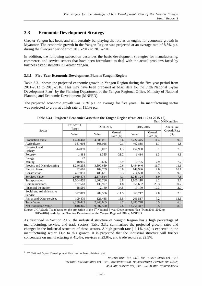
The Project for the Strategic Urban Development Plan of the Greater Yangon Final Report I
NIPPON KOEI CO., LTD., NJS CONSULTANTS CO., LTD. YACHIYO ENGINEERING CO., LTD., INTERNATIONAL DEVELOPMENT CENTER OF JAPAN,
ASIA AIR SURVEY CO., LTD., and ALMEC CORPORATION
3-23
3.3 Economic Development Strategy Greater Yangon has been, and will certainly be, playing the role as an engine for economic growth in Myanmar. The economic growth in the Yangon Region was projected at an average rate of 8.5% p.a. during the five-year period from 2011-2012 to 2015-2016.
In addition, the following subsection describes the basic development strategies for manufacturing, commerce, and service sectors that have been formulated to deal with the actual problems faced by business establishments in Greater Yangon.
3.3.1 Five-Year Economic Development Plan in Yangon Region
Table 3.3.1 shows the projected economic growth in Yangon Region during the five-year period from 2011-2012 to 2015-2016. This may have been prepared as basic data for the Fifth National 5-year Development Plan1 by the Planning Department of the Yangon Regional Office, Ministry of National Planning and Economic Development (MNPED).
The projected economic growth was 8.5% p.a. on average for five years. The manufacturing sector was projected to grow at a high rate of 11.1% p.a.
Table 3.3.1: Projected Economic Growth in the Yangon Region (from 2011-12 to 2015-16) Unit: MMK million
Sector
2010-2011 (Base) 2011-2012 2015-2016 Annual Av.
Growth Rate (%) Value Value Growth
Rate (%) Value Growth Rate (%)
Production Value 4,498,448 4,886,051 8.6 7,222,445 11.4 9.9 Agriculture 367,616 368,015 0.1 402,835 1.7 1.8 Livestock and Fishery 314,059 318,027 1.3 457,960 8.1 7.8
Forestry 1,888 1,355 -28.2 1,414 1.3 -4.8 Energy 22 Mining 18,915 19,656 3.9 10,795 7.9 -7.7 Process and Manufacturing 3,246,235 3,590,659 10.6 5,484,946 11.7 11.1 Electric Power 92,661 102,709 10.8 149,936 7.0 10.1 Construction 457,051 485,631 6.3 714,560 18.5 9.3 Services Value 2,089,474 2,174,864 4.1 3,043,124 8.0 7.8 Transportation 1,504,852 1,606,736 6.8 1,805,118 2.2 3.7 Communications 137,563 139,977 1.8 651,602 29.3 39.7 Financial Institution 18,560 12,160 -34.5 19,170 10.3 3.0 Social and Administrative Service 327,019 289,506 -11.5 360,717 7.0 2.0
Rental and Other services 109,479 126,485 15.5 206,517 7.2 13.5 Trade Value 2,230,423 2,446,605 9.7 2,985,778 6.5 6.0 Net Production Value 8,818,345 9,507,520 7.8 13,251,347 9.5 8.5
Source: JICA Study Team based on the projection of the 5th National 5-year Development Plan (from 2011-2012 to 2015-2016) made by the Planning Department of the Yangon Regional Office, MNPED
As described in Section 2.1.2, the industrial structure of Yangon Region has a high percentage of manufacturing, service, and trade sectors. Table 3.3.2 summarizes the projected growth rates and changes in the industrial structure of these sectors. A high growth rate (11.1% p.a.) is expected in the manufacturing sector. Due to this growth, it is projected that the industrial structure will further concentrate on manufacturing at 41.4%, services at 23.0%, and trade sectors at 22.5%.
1 5th National 5-year Development Plan has not been obtained yet.
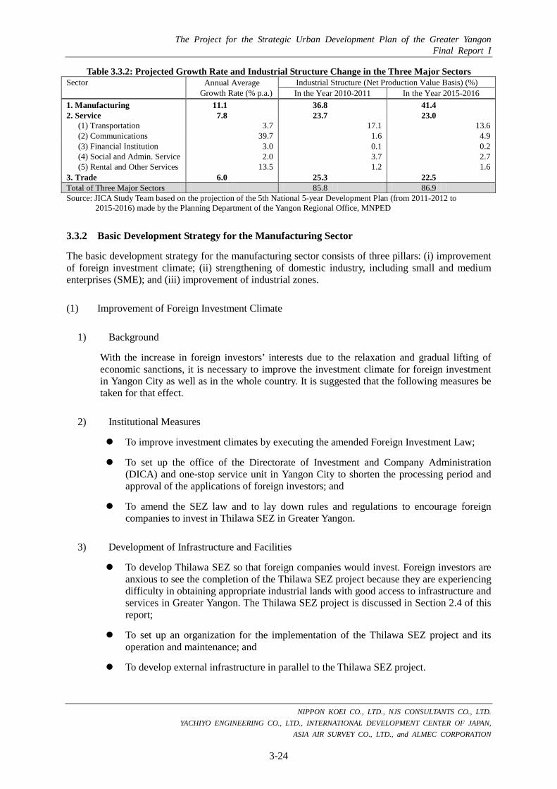
The Project for the Strategic Urban Development Plan of the Greater Yangon Final Report I
NIPPON KOEI CO., LTD., NJS CONSULTANTS CO., LTD. YACHIYO ENGINEERING CO., LTD., INTERNATIONAL DEVELOPMENT CENTER OF JAPAN,
ASIA AIR SURVEY CO., LTD., and ALMEC CORPORATION
3-24
Table 3.3.2: Projected Growth Rate and Industrial Structure Change in the Three Major Sectors Sector Annual Average
Growth Rate (% p.a.) Industrial Structure (Net Production Value Basis) (%) In the Year 2010-2011 In the Year 2015-2016
1. Manufacturing 11.1 36.8 41.4 2. Service 7.8 23.7 23.0 (1) Transportation 3.7 17.1 13.6 (2) Communications 39.7 1.6 4.9 (3) Financial Institution 3.0 0.1 0.2 (4) Social and Admin. Service 2.0 3.7 2.7 (5) Rental and Other Services 13.5 1.2 1.6 3. Trade 6.0 25.3 22.5 Total of Three Major Sectors 85.8 86.9 Source: JICA Study Team based on the projection of the 5th National 5-year Development Plan (from 2011-2012 to
2015-2016) made by the Planning Department of the Yangon Regional Office, MNPED
3.3.2 Basic Development Strategy for the Manufacturing Sector
The basic development strategy for the manufacturing sector consists of three pillars: (i) improvement of foreign investment climate; (ii) strengthening of domestic industry, including small and medium enterprises (SME); and (iii) improvement of industrial zones.
(1) Improvement of Foreign Investment Climate
1) Background
With the increase in foreign investors’ interests due to the relaxation and gradual lifting of economic sanctions, it is necessary to improve the investment climate for foreign investment in Yangon City as well as in the whole country. It is suggested that the following measures be taken for that effect.
2) Institutional Measures
To improve investment climates by executing the amended Foreign Investment Law;
To set up the office of the Directorate of Investment and Company Administration (DICA) and one-stop service unit in Yangon City to shorten the processing period and approval of the applications of foreign investors; and
To amend the SEZ law and to lay down rules and regulations to encourage foreign companies to invest in Thilawa SEZ in Greater Yangon.
3) Development of Infrastructure and Facilities
To develop Thilawa SEZ so that foreign companies would invest. Foreign investors are anxious to see the completion of the Thilawa SEZ project because they are experiencing difficulty in obtaining appropriate industrial lands with good access to infrastructure and services in Greater Yangon. The Thilawa SEZ project is discussed in Section 2.4 of this report;
To set up an organization for the implementation of the Thilawa SEZ project and its operation and maintenance; and
To develop external infrastructure in parallel to the Thilawa SEZ project.

The Project for the Strategic Urban Development Plan of the Greater Yangon Final Report I
NIPPON KOEI CO., LTD., NJS CONSULTANTS CO., LTD. YACHIYO ENGINEERING CO., LTD., INTERNATIONAL DEVELOPMENT CENTER OF JAPAN,
ASIA AIR SURVEY CO., LTD., and ALMEC CORPORATION
3-25
(2) Strengthening of the Domestic Industry, including SMEs
1) Background
Yangon City is leaning heavily towards an industry that is concentrated on the manufacturing sector such as the manufacture of food, fabricated metal products, rubber and plastic products, wearing apparel, wood and wood products, basic metal, and repair and installation of machinery and equipment.
However, the business environment of Myanmar’s manufacturing sector is not in a stable condition. A lot of factories have closed in the existing industrial zones in Yangon City. Most of them have closed their doors following profit losses due to a sudden downturn in product demand and/or higher costs of raw materials, fuel, shipping, land rental, etc.
With the relaxation and gradual lifting of economic sanctions and progress in the reduction and elimination of tariffs among ASEAN countries after 2015, competition among foreign companies is expected to increase. Under such situation, the existing domestic industries are seeking for survival.
They have difficulty in acquiring advanced technology to participate in new businesses and employment of skilled labors. Small and medium enterprises (SME) with less than 50 employees account for nearly 80% of the number of manufacturing industry enterprises, according to the Business Establishment Survey. It is particularly necessary to extend measures to enforce SMEs that have weak business structure.
2) Measures to be taken
It is recommended to conduct an industrial development study in Greater Yangon in order to formulate strategies to strengthen the domestic manufacturing sector. It is likely to include the following tasks:
To conduct a field survey of approximately 100 factories in the various subsectors such as food processing, garment, wood processing, machinery, metal working, electrical, and electronic industries in order to identify their problems;
To analyze the problems for each subsector;
To formulate strategies to strengthen each subsector; and
To propose projects and programs to realize the strategies.
(3) Improvement of Industrial Zones
1) Background
A large part of the industrial land in the existing industrial zones is left unused. Some land-use right owners merely bought the industrial land as an investment and are waiting for land price increases. They did not comply with the regulation that factories should be built within a specified duration. The Government has not yet developed a mechanism that will promote the sale and purchase of the rights to use and access unused land. Therefore, investors who are really in need of the appropriate land to build their own factories are having difficulty in purchasing the rights to use the unused land at a reasonable price.

The Project for the Strategic Urban Development Plan of the Greater Yangon Final Report I
NIPPON KOEI CO., LTD., NJS CONSULTANTS CO., LTD. YACHIYO ENGINEERING CO., LTD., INTERNATIONAL DEVELOPMENT CENTER OF JAPAN,
ASIA AIR SURVEY CO., LTD., and ALMEC CORPORATION
3-26
No matter how many industrial zones are developed, without an established mechanism, Greater Yangon will always be in short supply of industrial land. On the premise that such mechanism would be created, a structure plan for Greater Yangon is being worked out as discussed in Section 3.4.
The existing industrial zones have problems with infrastructure as shown in Section 2.1.3. These problems disrupt factory operations and reduce productivity. The industrial zones need stable power supply and enough YCDC pipe water supply. They also need to improve or adequately maintain the road and drainage system inside the industrial zones. Recently, YCDC issued a directive that requires the investors to install wastewater treatment facilities. Despite this, only a small number of factories have followed the directive. The government should support the upgrading of infrastructure in the industrial zones as necessary.
Solid waste collection is usually arranged by the management committee of industrial zones and fees are borne by factories. This often imposes a heavy burden on the factories. The industrial zone’s management committee has appealed to YCDC for support on solid waste collection. Factories sometimes object to bear the costs of solid waste collection and end up throwing the garbage out of the industrial zones. It is necessary for YCDC to support solid waste collection as well as strengthen the control over illegal dumping of wastes.
2) Measures to be taken
The government needs to take measures to increase transparency in industrial land transactions.
YCDC needs to support the solid waste collection from industrial zones. At the same time, people need to follow the rules and regulations on waste disposal.
It is recommended that a study on efficiency upgrading of industrial zones be conducted in Greater Yangon in order to formulate and realize strategies to: (i) promote sales and purchase of rights to use unused land, (ii) upgrade infrastructure, and (iii) improve operation and maintenance.
To set up an executive committee that will have the authority to settle problems within the industrial zones in Greater Yangon;
To conduct a field survey on existing industrial zones that have already been developed or are being developed to find out specific problems on infrastructure and operations and maintenance system;
To prepare draft strategies for each industrial zone;
To exchange views with various stakeholders as regards to the draft strategies for each industrial zone such as management committee, owners of land use right, developers, potential purchasers and YCDC;
To finalize strategies for each industrial zone;
To formulate projects and programs to realize the strategies; and
To select a priority project to conduct a preliminary feasibility study.

The Project for the Strategic Urban Development Plan of the Greater Yangon Final Report I
NIPPON KOEI CO., LTD., NJS CONSULTANTS CO., LTD. YACHIYO ENGINEERING CO., LTD., INTERNATIONAL DEVELOPMENT CENTER OF JAPAN,
ASIA AIR SURVEY CO., LTD., and ALMEC CORPORATION
3-27
3.3.3 Basic Development Strategy for the Commerce Sector
The basic development strategy for the traditional markets and modern commerce sector is described separately in this section. The traditional markets mean municipal markets, which carry on business for daily life of citizens from the past. Modern commerce sector means the new style shops such as shopping complex, supermarkets and convenience stores, which are gradually increasing after the year 2000.
(1) Basic Development Strategy for the Traditional Markets
1) Background
In Yangon City, there are about 170 traditional markets of varying sizes that are supervised by YCDC. In addition, there are a lot of traditional markets in the neighboring townships of Greater Yangon supervised by the Ministry for the Progress of the Border Areas and National Races Development Affairs. A lot of retail shops gather within these traditional markets to sell meat, fish, vegetables, dried foods, flowers, pet food, household goods, clothing, etc. They contribute to the lives of residents visiting these traditional markets.
Problems and issues facing the traditional markets and retail shops differ according to their location. There appears to have strong competition with supermarkets in some locations, or are prone to natural disaster in other locations. Retail shops in the markets appear to have problems on high transportation costs in some cases. Garbage are dumped on open land near the market area, however, there are also some markets in other places that are kept clean.
Recently, traffic is getting heavy. Delays in the transportation of commodities due to traffic congestions are hindrances of trade flows and the cause of high transport costs.
2) Measures to be taken
The location of a traditional market is mostly determined by government directive. YCDC and/or the Ministry for the Progress of the Border Areas and National Races Development Affairs need to formulate location planning of new traditional markets based on changes in population distribution in the long-term.
YCDC needs to take measures to reduce traffic congestions.
Regular inspection of cleanness is necessary for traditional markets and its adjoining areas.
(2) Basic Development Strategy for the Modern Commerce Sector
1) Background
The number of business establishments in the modern commerce sector has greatly increased in recent years. It includes 1) large shopping complexes such as Ocean Super Center, Super One Shopping Center, Junction Center, and Capital Shopping Mall, 2) supermarkets such as City Mart, Orange, and Victoria, and 3) convenience stores such as 108 Shop. According to the Business Establishment Survey (BES), about 70% of business establishments in the modern commerce sector were founded after 2000 and

The Project for the Strategic Urban Development Plan of the Greater Yangon Final Report I
NIPPON KOEI CO., LTD., NJS CONSULTANTS CO., LTD. YACHIYO ENGINEERING CO., LTD., INTERNATIONAL DEVELOPMENT CENTER OF JAPAN,
ASIA AIR SURVEY CO., LTD., and ALMEC CORPORATION
3-28
about 40% were founded after 2010. In addition, most of these companies have business expansion plans.
Traffic congestion may obstruct customer’s access to the modern establishments.
Frequent power blackouts increase fuel consumption costs for standby generators.
Under an upward trend, the business establishments are facing problems on skilled labor shortages and strong competition. For labor recruitment, they rely more on printed media such as newspapers and magazines and recruitment agencies than other sectors. They tend to put emphasis on employee training. BES revealed that about 85% of establishments are training employees with their own programs and more than 30% of establishments are outsourcing employee training programs to schools.
2) Measures to be taken
Modern commercial companies need to work out their business expansion plans based on the analysis of geographical distribution of potential customers and competitors’ trend.
YCDC needs to take measures to reduce traffic congestion. Modern commerce establishments need to provide enough parking space for customers. Otherwise, modern commerce establishments in the congested area may lose their customers.
The government needs to take measures to improve power supply.
Under an upward trend, the modern commerce sector would continue to have problems on skilled labor shortages and employee training. They need to continue to take measures to solve these problems.
3.3.4 Basic Development Strategy for the Service Sector
The basic development strategy for the service sector such as hotel, restaurant, bank, amusement, etc is described as follows.
(1) Background
The number of business establishments in the service sector has increased in recent years. According to BES, more than 60% of business establishments in the service sector were founded after 2000 and more than half of those establishments had business expansion plans.
Business establishments in the service sector commonly face problems of strong business competition and skilled labor shortages just like in the modern commerce sector. In addition, a lot of hotels responded in the BES that frequent power supply shortages is a problem. and the amusement industry responded that high fuel costs for standby generators is also a problem.
Banks are competing only against other domestic banks at present. However, they may begin to compete with foreign banks in 2015, when foreign banks will be allowed to operate or trade in Myanmar.
(2) Measures to be taken
Employees who can provide high-quality service is necessary to be competitive in the service sector. Comfortable hotel always provides high-quality service to guests. Therefore, they have to continue to address the issue on skilled labor employment and
The Project for the Strategic Urban Development Plan of the Greater Yangon Final Report I
NIPPON KOEI CO., LTD., NJS CONSULTANTS CO., LTD. YACHIYO ENGINEERING CO., LTD., INTERNATIONAL DEVELOPMENT CENTER OF JAPAN,
ASIA AIR SURVEY CO., LTD., and ALMEC CORPORATION
3-29
employee training. Banks require skilled labor and employee training, since they have to run new types of financing services.
With a significant increase in foreign guests, a lot of hotels have raised the room rates in Yangon City in recent years. Even the medium and economy classes of hotels have raised the room rates even it is beyond the quality of service. Under conditions of keen business competition, they cannot compete unless they reduce the room rates and/or increase the quality of service to match the high charges. In this way, it is expected that strong business competition will have a positive impact on customers by improving the quality of service and/or by bringing the rates down to a reasonable level.
It is expected that a stock exchange market will be established in Yangon City possibly with a support from the Tokyo Stock Exchange and Daiwa Institute of Research. Listing on a stock exchange market increases the capacity of the registered companies to raise funds. The government should continue to deregulate financial market. At the same time, the government should also support domestic banks to be able to compete with the forthcoming strong foreign banks.

The Project for the Strategic Urban Development Plan of the Greater Yangon Final Report I
NIPPON KOEI CO., LTD., NJS CONSULTANTS CO., LTD. YACHIYO ENGINEERING CO., LTD., INTERNATIONAL DEVELOPMENT CENTER OF JAPAN,
ASIA AIR SURVEY CO., LTD., and ALMEC CORPORATION
3-30
3.4 Structure Plan for Greater Yangon
3.4.1 Review of Existing Conceptual Plans
(1) Overview
Prior to the examination and discussion of a desirable structure plan in this Study, it is necessary to undertake a review of the existing conceptual plans. In December 2011, a workshop was held for two days to discuss the Yangon Concept Plan (Vision 2040). This workshop was participated in by YCDC, Department of Human Settlement and Housing Development (Ministry of Construction), and other relevant organizations. Before and after this meeting, both YCDC and MOC tried formulating their own conceptual plans respectively. The “Yangon City Development Conceptual Plan”, which includes the conceptual plan as shown at the left side of Figure 3.4.1, was drawn by YCDC and reportedly approved in the “Planning Commission Meeting” attended by the President and the Union Ministers on 14th August 2012. On the other hand, MOC also made the conceptual plan as shown at the right side of Figure 3.4.1. Each drawing seems to resemble the other, especially from the viewpoints of future urbanization volume in size and introduction of an outer ring road. On the other hand, there are some different points between the two drawings such as the presence or absence of an inner ring road and the next CBD areas. The YCDC plan has a secondary CBD at the Mindama area, but it does not have an inner ring road. Detailed comparisons are discussed in the next page.
In line with these past examinations, a structure plan will be formulated in this Study through discussions in the Steering Committee, and other opportunities.
YCDC Conceptual Plan MOC Conceptual Plan
Source: JICA Study Team based on the YCDC and MOC conceptual plans Figure 3.4.1: Review of Existing Conceptual Plans

The Project for the Strategic Urban Development Plan of the Greater Yangon Final Report I
NIPPON KOEI CO., LTD., NJS CONSULTANTS CO., LTD. YACHIYO ENGINEERING CO., LTD., INTERNATIONAL DEVELOPMENT CENTER OF JAPAN,
ASIA AIR SURVEY CO., LTD., and ALMEC CORPORATION
3-31
(2) Comparison of the Two Plans
In order to integrate the two plans into one in the Study, these were compared from the viewpoints of their characteristics and highlighting their good points, as shown in Table 3.4.1.
Table 3.4.1: Comparison of Alternatives
Items YCDC Concept Plan MOC Concept Plan
Urban Area Size of Urban Area
Size of urban area of YCDC plan is much larger than that of MOC, especially the next proposal in the Dala area which has an area of approximately 290 mi2.
MOC’s plan seems to aim for a more compact city than YCDC’s.
New Center City The YCDC plan proposed to create one “Secondary CBD” at Mindama, and two “Proposed CBDs” at Dagon Myothit and Hlaing Tharya.
The MOC plan proposed to create five “Sub-CBDs” at Mindama, East Dagon, Hlaing Tharya, Shwe Pyi Tar, and Mingaradon.
Industrial Zone The YCDC plan proposed several “Special Economic Zones”, namely Thilawa SEZ, Kyauktan SEZ, and Airport SEZ. Additionally, in East Dagon, an industrial or economic zone extension was proposed. Five existing industrial zones were designated at around 10-20 km distance from the city center.
The MOC plan seems to have about ten existing industrial zones except Thilawa SEZ.
Road and Transportation
Inner Ring Road The YCDC plan does not have an inner ring road.
The MOC plan proposed to create an inner ring road, making good use of existing roads such as Thanthumar Road, CBD Road, and Bayint Haung Road.
Outer Ring Road An outer ring road proposed by YCDC passes through the north of Hlawga Lake and center of Thilawa SEZ. For the most part other than above, it seems similar to MOC’s.
As mentioned in the left column, the outer ring road of MOC passes through the south of Hlawga Lake and north of Thilawa SEZ. Therefore, the ring size is smaller than YCDC’s.
Other Roads The YCDC plan proposed less new road constructions than MOC’s.
The MOC plan proposed several new road constructions, two roads heading to northeast, one heading to southwest, and one heading to west.
Bridge The YCDC plan proposed three new bridges between Thilawa and Dala, Thanlyin and East Dagon, and Hwawbi and Htantabin.
The MOC plan proposed to build a total of five more new bridges than YCDC’s. These are between not only Thilawa and Dala, Thanlyin and East Dagon, Hwawbi and Htantabin, but also Dala and CBD, and Twantay and CBD.
Railway Some new railways were proposed, including a monorail.
Not mentioned.
Nature Conservation
Green Area The YDCD plan aims to conserve five main green areas which are all located on the central hill.
The MOC plan also aims to conserve four main green areas which are located on the central hill.
Agricultural Area Not mentioned. Some areas outside of the outer ring road were designated as agricultural reserve and urbanization control area, such as East Dagon, Hlaing Tharya, and Dala.
Others Redevelopment zones are proposed in the plan, which are located on the suburbs such as Hlaing Tharya.
Shwe Dagon Pagoda and Sule Pagoda Preservation Zone were mentioned in the plan. Tourism promotion zones along the rivers were proposed.
Source: JICA Study Team

The Project for the Strategic Urban Development Plan of the Greater Yangon Final Report I
NIPPON KOEI CO., LTD., NJS CONSULTANTS CO., LTD. YACHIYO ENGINEERING CO., LTD., INTERNATIONAL DEVELOPMENT CENTER OF JAPAN,
ASIA AIR SURVEY CO., LTD., and ALMEC CORPORATION
3-32
3.4.2 Points of Consideration for Urban Structure of the Greater Yangon
(1) Development of Thilawa SEZ
Thilawa SEZ is located in Thanlying and Kyawktan Townships. Currently, the Ministry of Economy, Trade and Industry (METI) of Japan has conducted a study, namely the “Thilawa SEZ Development Study”. The study is aimed to formulate a master plan of Thilawa SEZ under the “Memorandum of Intent on the Cooperation for the Development of the Master Plan for the Thilawa”, which was agreed upon between the Ministry of National Planning and Economic Development of the Republic of the Union of Myanmar and the Ministry of Foreign Affairs and METI of Japan on 21st April 2012. In the master plan, the visions of Thilawa SEZ were set as enumerated below:
Visions 1. Growth Center by inducing FDI and utilizing the resources of the Greater Yangon Area 2. Trigger to create non-traditional industries in the nation by absorbing new technologies from
FDI and transferring them to the local business society 3. Core to diversify the industries of Myanmar by accumulating various types of industries in SEZ 4. International gateway in the regional and global supply chain by building up a firm
manufacturing base and creating efficient logistics system
In the master plan, a composite-purpose development scenario including manufacturing, residential and commercial land uses was proposed as one of the future development scenarios to be adopted.
Source: METI Study “The Basic Master Plan for the Thilawa SEZ”
Figure 3.4.2: A Land Use Image of Thilawa SEZ

The Project for the Strategic Urban Development Plan of the Greater Yangon Final Report I
NIPPON KOEI CO., LTD., NJS CONSULTANTS CO., LTD. YACHIYO ENGINEERING CO., LTD., INTERNATIONAL DEVELOPMENT CENTER OF JAPAN,
ASIA AIR SURVEY CO., LTD., and ALMEC CORPORATION
3-33
According to the forecasts in the master plan, the final development of Thilawa SEZ will have a resident population of 163,000, with a labor population for manufacturing of 204,000 and for commercial and business of 3,000, as shown in Table 3.4.2.
Table 3.4.2: Development Volume of Thilawa SEZ Items Volume
Development Area 2,400 ha Population (Resident) 163,000 persons
Population (Labor) 204,000 (for manufacturing) 3,000 (for commercial)
(2) Development of an Airport and Ports
1) Hanthawaddy New International Airport
The existing Yangon International Airport in Mingaladon in the north of Yangon, which has one runway, reached a total of 2.5 million passengers in 2011, i.e., 1.5 million international and 1 million domestic passengers. The average annual growth of passengers for Yangon International Airport was estimated to be around 18% from 2008 to 2011. Considering the past trend, air traffic forecast demand for Greater Yangon is estimated to reach 42.7 million passengers in 2040, according to the forecast of Myanmar Government. In light of the forecast, as the current airport capacity shall definitely be in short supply, a new international airport shall be necessary in the future. The Myanmar Government has a plan to construct a new international airport in Hanthawaddy located at about 65 km from Yangon, near Bago City. The new international airport is expected to start its operation around the year 2018, while the existing airport will need to expand its capacity up to then.
2) Thilawa Area Port
Currently, Yangon Port, a river port on the Yangon River, is composed of two port areas, i.e., Yangon Port in Yangon City (Yangon Main Port) and Yangon Port in Thilawa (Thilawa Area Port). The Thilawa Area Port will have some definite advantages for entrance, because it takes 12 hours to enter Thilawa Area Port from Elephant Point, while it takes 24 hours to reach Yangon Main Port due to the additional time spent waiting for the tidal cycle. Also, the hinterland conditions are much more favorable for Thilawa Area Port, which has wide spaces for operation and the SEZ in its hinterland. The total container throughput forecast is estimated to be more than 4 million TEUs annually in the high scenario in 2030. As the capacity of Yangon Main Port is limited up to less than 1 million TEUs, the main logistics function will have to shift to Thilawa Area Port gradually in the future.
(3) Development of Dala and Twantay Areas
Due to their location being near to Yangon CBD, Dala and Twantay areas are likely to have a latent potential for urban development in the future. Both areas, however, have setback for development, such as the lack of connecting bridges that would be costly to build and may involve extensive resettlement, and the low elevations which might inflict damages by flooding or high tides.
According to YCDC, some foreign investors are interested in developing these areas, and made proposals for the urban and housing development to the Myanmar side. Currently, it is still difficult to realize these projects because of the constraints mentioned above. Actually, one proposal in Twantay has been said to be withdrawn due to the land cost increase, which was more than what the developer had expected.
Source: METI Study “The Basic Master Plan for Thilawa”

The Project for the Strategic Urban Development Plan of the Greater Yangon Final Report I
NIPPON KOEI CO., LTD., NJS CONSULTANTS CO., LTD. YACHIYO ENGINEERING CO., LTD., INTERNATIONAL DEVELOPMENT CENTER OF JAPAN,
ASIA AIR SURVEY CO., LTD., and ALMEC CORPORATION
3-34
Although some difficulties exist, new development proposals for Dala and Twantay areas may be made by the developers again, and the development in these areas might be realized in the future.
(4) Improvement of the Central Business District (CBD)
1) Over-concentration, Traffic Congestions, and High Buildings
Currently, the urban central functions including administration, banking, business and commerce are located mainly in CBD. In parallel with this, the population density of the CBD has a strikingly high value of 365.5 persons/ha, and therefore, the living environment of the CBD should be improved, especially in terms of transportation and car parking, sewerage and other urban infrastructures. A large part of the buildings in the CBD have 6-8 stories with some exceptionally higher buildings having more than 20 stories.
Additionally, a new building project has just been started which reportedly has 38 stories. To avoid over-concentration and serious traffic congestions, high-rise buildings in the CBD should be either limited or thoroughly considered. In case that a high-rise building is planned, the building project should at least consider securing an appropriate access to one or more of the trunk roads, facilitating enough parking spaces in the plot, and providing green spaces.
2) Heritage Buildings
All in all, 40% of 189 heritage buildings designated by YCDC are concentrated in the CBD. By the relocation of the capital city to Nay Pyi Taw in 2006, some of the government offices moved to Nay Pyi Taw. Thus, former government buildings such as ministers’ offices are left almost vacant at this moment. These buildings should be used positively for their appropriate purposes, while being conserved and preserved in good condition.
3) Riverside Spaces
The CBD follows the planning disciplines of Montgomerie-Fraser with grid pattern road network and plenty of greenery. Although one of the main ideas of Montgomerie-Fraser was to allow a wide open space along the Yangon River, the open space in the strand had dissipated due to port development along the river. In light of the future movement that the logistics function will shift from Yangon Main Port to Thilawa Area Port, at least some parts of the open space along the Yangon River strand has to be recovered for the citizens of the Greater Yangon.

The Project for the Strategic Urban Development Plan of the Greater Yangon Final Report I
NIPPON KOEI CO., LTD., NJS CONSULTANTS CO., LTD. YACHIYO ENGINEERING CO., LTD., INTERNATIONAL DEVELOPMENT CENTER OF JAPAN,
ASIA AIR SURVEY CO., LTD., and ALMEC CORPORATION
3-35
3.4.3 Comparison of Asian Cities
In order to understand the scale and urban structure of Greater Yangon in the future, it is useful to compare this city with other similar cities in Asia such as Hanoi, Bangkok, Jakarta and Manila, and additionally Tokyo. The population of these cities is at around ten million people, similar with the expected population of Greater Yangon in 2040. The following points constitute the summary of the basic urban structure based on usual road and railway networks and urbanized area:
Hanoi, which is the capital city of Vietnam, has the second largest population of 6.5 million in the country. There are some sub-centers along the ring road of about 7-8 km radius. Urbanized area has expanded in all directions along the radial roads and railways around the city center.
Bangkok is the capital city of Thailand with a population of 8.4 million. This city is located at 25 km inland, and it has the largest airport in the world, which is located 25 km east of the city. The urbanized area has expanded towards the east and north. There is a metro line, an elevated railway (Bangkok Mass Transit System, BTS), and a ring road at about 15-20 km radius.
Jakarta is the capital city of Indonesia with a population of 9.8 million. Including its suburbs, its population is more than 24 million, which is the fourth largest in the world. There are two ring roads, one at about 5 km radius and the other at 10-18 km radius. Urbanized areas have expanded towards the east-west and south.
Manila is the capital city of the Philippines with a population of 12 million. Including its suburbs, its population is more than 20 million, which is the fifth largest in the world. This capital city has a special geographical feature of being sandwiched by two seas. Therefore, the urbanized area has expanded towards the north and south along with the radial road and railway. At the center of the city, there are some sub-centers connected by LRT, Metro Rail Transit (MRT), and a ring road, at about 7-8 km radius.
Tokyo metropolitan area is the largest city in the world with a population of more than 37 million. There are seven sub-centers in the 7-8 km radius within the first ring road, which is about 10 km from the center. There are other ring roads at the 20-km and 40-km radius. Urbanized area has expanded towards every direction, but mainly along the radial and ring railway network.
Table 3.4.3: Actual Figures of Asian Cities
Country Myanmar Vietnam Thailand Indonesia Philippines Japan City Yangon Hanoi Bangkok Jakarta Manila Tokyo
1 Population *(person) 4,457,000 6,500,000 8,426,000 9,769,000 11,862,000 37,217,000 2 Area (km2) 599 3,345 1,569 662 639 8,547 3 Density (persons/km2) 7,300 1,943 5,259 14,464 18,093 4,300
4 Ring Road (radius, km) In planning stage 7-8 km 15-20 km 10-18 km 7-8 km 10, 20, 40
km 5 Railway Ring/ Radial Ring/ Radial Radial Radial Ring/ Radial Ring/ Radial
6 Airport (distance and direction from CBD)
15 km north
20 km north
23 km east
20 km west
10 km south
17 km south
7 Urbanization Direction Mainly to the north All West, and
north East, west, and south
North and south All
8 Sub-center In planning stage Some Some Some 8 7
Source: * Population Division of the Department of Economic and Social Affairs of the United Nations Secretariat

The Project for the Strategic Urban Development Plan of the Greater Yangon Final Report I
NIPPON KOEI CO., LTD., NJS CONSULTANTS CO., LTD. YACHIYO ENGINEERING CO., LTD., INTERNATIONAL DEVELOPMENT CENTER OF JAPAN,
ASIA AIR SURVEY CO., LTD., and ALMEC CORPORATION
3-36
Through the comparison above, the following items can be pointed out:
Most of the cities have a city center and some sub-centers located at 7-8 km to 25 km around the center. Sub-centers function not only as junctions of commuting traffic, but also as offices, and commercial and recreational areas.
Most of the cities have some radial roads and one or two ring roads to connect each radial road. These ring roads are needed in order to avoid traffic congestion and also to bypass the through traffic in the city center.
Public transportations such as railways, autobuses, and LRTs are efficient ways to connect the city center, sub-center, and suburban residential areas. Without these systems, city centers will suffer from congestion, as what happened in Jakarta.
Yangon, Myanmar Hanoi, Vietnam Bangkok, Thailand
Jakarta, Indonesia Manila, Philippines Tokyo, Japan Source: JICA Study Team
Figure 3.4.3: Comparison of Asian Cities

The Project for the Strategic Urban Development Plan of the Greater Yangon Final Report I
NIPPON KOEI CO., LTD., NJS CONSULTANTS CO., LTD. YACHIYO ENGINEERING CO., LTD., INTERNATIONAL DEVELOPMENT CENTER OF JAPAN,
ASIA AIR SURVEY CO., LTD., and ALMEC CORPORATION
3-37
3.4.4 Urban Structure of Greater Yangon
(1) Overview of Future Urban Structure
In light of the past trends and considerations above, the urbanization of Greater Yangon is likely to extend outward, especially northwards and eastwards along the main roads No.4, No.1, No.3, and No.2, rather than southwards and westwards. Additionally, a new international airport in Hantawaddy, which is planned to start its operation in 2020, might accelerate this future trend.
The CBD, which is the center of Yangon, is likely to accommodate more urban functions in the future, especially for commercial and business uses on the basis of some ongoing development projects or proposals including that of high-rise buildings. This trend in the CBD will continue for a while, however, it should shift outwards such as in sub-centers to avoid over-concentration in the CBD in the future.
On the other hand, development of Thilawa SEZ and Thilawa Area Port might be of utmost importance in accelerating the economic growth for not only Greater Yangon but also Myanmar. It means that the southeast area, including Thanlyin and Kyawktan Townships, shall be developed much further in the future.
Although urbanization is likely to expand northwards and eastwards, it should be noted that Dala and Twantay areas have large potentials for urban development in the future, particularly for people with limited means for livelihood.
Source: JICA Study Team
Figure 3.4.4: Overview of Future Urban Structure

The Project for the Strategic Urban Development Plan of the Greater Yangon Final Report I
NIPPON KOEI CO., LTD., NJS CONSULTANTS CO., LTD. YACHIYO ENGINEERING CO., LTD., INTERNATIONAL DEVELOPMENT CENTER OF JAPAN,
ASIA AIR SURVEY CO., LTD., and ALMEC CORPORATION
3-38
(2) Alternatives of Urban Structure
An alternative urban structure of Greater Yangon can be elaborated by determining means as to how it accommodates the urban development issues. Greater Yangon shall be required to strengthen its urban economy functions, particularly commercial and business, industry and logistics, and to improve its living environment at the same time, under rapid population growth in the future. Alternative urban structures are examined taking into account the following factors:
(i) Urbanization pattern (decentralization or concentration on the city center)
(ii) Main urban function distribution (the city center, industrial area, residential area, etc.)
(iii) Green conservation (public park, protected area, highly productive agricultural area, etc.)
(iv) Transportation network (radial and ring trunk roads, railway, etc.)
Considering these four key factors, three alternatives of urban structure are examined as follows:
1) Sub-center System (Decentralized Urban Pattern)
This urban structure aims mainly for the decentralization of the city center. The current urban center, namely CBD, will have over-concentration both on its urban functions and population in the near future based on the past trend. This will cause serious urban problems such as perennial traffic jam, environmental pollutions, skyrocketing land prices, and others. To avoid over-concentration in the CBD, several “sub-centers” will be created as new business, commercial, industrial and/or residential centers with high-rise buildings. These sub-centers will be located at around 10-15km radius from the CBD. Led by the sub-centers’ development, urbanization will be promoted at these areas, namely the “sub-center growth belt”. Outside of the sub-center growth belt, urbanization will be followed by the market demands without any strict urban control measures. Green areas will be conserved properly such as the Hlawga protected area and Inya Lake.
2) Sub-center with Green Isle System (Decentralized Urban Pattern)
This urban structure aims for the decentralization of the urban center, which is the same as alternative-1. A few sub-centers will be created at areas within the 10-15 km radius from the CBD. Additionally, this urban structure aims to control urban expansion by means of creating an outer green belt in order to avoid continuous and extensive urban expansion with low density, and to supply urban infrastructures efficiently and effectively. Therefore, enhancement of the urban management capacity and introduction of a proper legal system will be necessary to a larger extent than for the other alternatives. An outer ring road will be provided and future urbanization along the outer ring road in the next step of development of the sub-centers growth belt will be promoted, namely an “outer ring growth belt”. Green areas, including high productive agricultural areas, will be conserved as much as possible to sustain a more comfortable living environment for the citizens.
3) Super CBD Single-core System (Centralized Urban Pattern)
This urban structure follows the market demands of urbanization naturally, which probably will occur along the main radial roads, such as No.5, No. 4, No.1, No.2, and No.6. Urban functions shall continue to be concentrated in the current CBD, and this will let the CBD expand larger and rise higher as “Super CBD”. On the other hand, suburban development will have minimum intervention, and green and agricultural areas will not be paid much attention due to less market demands for urbanization outside of the city’s main roads. As

The Project for the Strategic Urban Development Plan of the Greater Yangon Final Report I
NIPPON KOEI CO., LTD., NJS CONSULTANTS CO., LTD. YACHIYO ENGINEERING CO., LTD., INTERNATIONAL DEVELOPMENT CENTER OF JAPAN,
ASIA AIR SURVEY CO., LTD., and ALMEC CORPORATION
3-39
this structure essentially leaves the city to the market demand with little intervention, the initial cost to realize this urban structure will be lesser in comparison with other alternatives.
Table 3.4.4 shows the comparison among the alternatives in terms of the four key factors. The urban structure of the “super CBD single-core” is a policy-free and control-free system with minimum public interventions, while one of the “sub-centers” will need more public interventions to realize, but it may lead to a more functional city.
Table 3.4.4: Comparison of the Alternatives
Items Sub-center System (Decentralized Urban Pattern)
Sub-center with Green Isle System
(Decentralized Urban Pattern)
Super CBD Single-core System
(Centralized Urban Pattern) A) Urbanization
Pattern (decentralization or concentration on the urban center)
- Decentralizing certain urban functions from the city center, CBD, to new sub-centers to be developed
- Promoting urbanization in the sub-center growth belt at areas within the 10-15 km radius
- Following market demands of urbanization outside of the sub-center growth belt
- Decentralizing certain urban functions from the city center, CBD, to new sub-centers to be developed
- Promoting urbanization in the sub-center growth belt at areas within the 10-15 km radius
- Promoting urbanization in the outer ring growth belt along the outer ring road
- Centralizing all urban functions to CBD as single-core city center
- Following market demands of urbanization naturally, which probably will occur along the main radial roads, such as No.5, No. 4, No.1, No.2, and No.6
B) Main Urban Function Distribution (urban center, industrial area, residential area, etc.)
- Promoting to create new sub-centers, which will be located at areas within the 10-15 km radius from CBD, such as Mindama, Dagon Myothit, Thanlyin, Thilawa, and Hlaing Tharya (see Figure 3.4.5)
- Controlling CBD for it to be not an over-concentrated city center
- Promoting to create new sub-centers, which will be located at areas within the 10-15 km radius from CBD, such as Mindama, Dagon Myothit, Thanlyin, Thilawa, and Hlaing Tharya (see Figure 3.4.5)
- Controlling CBD for it to be not an over-concentrated city center
- Promoting the current CBD to expand larger and rise higher to be a “Super CBD”
C) Green Conservation (public park, protected area, high productive agricultural area, etc.)
- Conserving Hlawga protected area, Inya Lake, and other important green areas properly
- Designating urban planning area to control urban expansion
- Conserving Hlawga protected area, Inya Lake, and other green areas to make a “North South Green Axis”
- Conserving green areas and agricultural areas
- Taking priority of urban development activities over green conservation without any protection control measures
D) Transportation Network (radial and ring trunk roads, railway, etc.) -Infrastructure Development-
- Connecting the inner ring road by improving the existing roads or constructing elevated highways on the existing roads
- Increasing railway lines (including a sky train line and/or a monorail)
- Constructing the outer ring road
- Connecting inner ring roads by improving the existing roads or constructing elevated highways on the existing roads
- Increasing railway lines (including a sky train line and/or a monorail)
- Improving the existing radial main roads to promote urban expansion outward
- Increasing railway lines and train stations
- Establishing a sky train line and a monorail
Source: JICA Study Team

The Project for the Strategic Urban Development Plan of the Greater Yangon Final Report I
NIPPON KOEI CO., LTD., NJS CONSULTANTS CO., LTD. YACHIYO ENGINEERING CO., LTD., INTERNATIONAL DEVELOPMENT CENTER OF JAPAN,
ASIA AIR SURVEY CO., LTD., and ALMEC CORPORATION
3-40
Source: JICA Study Team
Figure 3.4.5: Alternatives of Urban Structure of Greater Yangon
Sub-center System (Upper left)
Sub-center with Green Isle System (Upper right)
Super CBD Single-core System (lower left)

The Project for the Strategic Urban Development Plan of the Greater Yangon Final Report I
NIPPON KOEI CO., LTD., NJS CONSULTANTS CO., LTD. YACHIYO ENGINEERING CO., LTD., INTERNATIONAL DEVELOPMENT CENTER OF JAPAN,
ASIA AIR SURVEY CO., LTD., and ALMEC CORPORATION
3-41
(3) Comparison of the Alternatives
To select the best system for Greater Yangon, three alternatives are compared considering five criteria, namely, traffic and travel time, living condition and life style, environmental consideration, cost for realization, and urban management capacity, as shown in Table 3.4.5.
Table 3.4.5: Evaluation of Alternatives in Three Criteria
Items Sub-center System
(Decentralized Urban Pattern)
Sub-center with Green Isle System
(Decentralized Urban Pattern)
Super CBD Single-core System
(Centralized Urban Pattern)
Public Benefit
Traffic Condition and Travel Time
GOOD Better mobility shall be maintained by decentralizing the city centers. Travel time shall be shorter due to the small distance between the working and living places.
GOOD The best mobility shall be maintained by decentralizing the city centers with the radial and ring transport networks. Travel time shall be shorter due to the small distance between the working and living places.
NOT GOOD Heavy traffic congestion problem shall occur in and around the super CBD. Travel time shall be longer due to the large distance between the working and living places.
Living Condition and Life Style
GOOD Living condition in CBD shall be maintained as its current conditions due to mitigating the concentration on CBD. More people shall live in the suburbs with better living condition and life style, such as larger housing space and short distance of working place, although the price of land is expected to increase further in the future.
GOOD Living condition in CBD shall be maintained as its current conditions due to mitigating the concentration on CBD. More people shall live in suburbs with better living condition and life style, such as larger housing space, short distance of working place, and easier access to public parks, although the price of land is expected to increase further in the future.
NOT GOOD People who live in CBD shall enjoy the urban life with easier access to urban functions, although the living condition will be more comfortable than the current condition due to heavy traffic, etc. Many people who work in CBD shall be required to go to the working place with longer travel time than with other alternatives. The natural environment in the suburbs is expected to be remained.
Environmental Consideration
NOT GOOD The inside portion of the sub-center growth belt green areas shall be conserved as much as possible, while urban development activities shall be prioritized outside of the growth belt.
GOOD To sustain a more comfortable living environment for the citizens, environmental matters shall be paid attention to as much as possible by means of green area conservation, etc.
NOT GOOD Less environmental consideration shall be done due to prioritizing the urban development activities.
Public Intervention
Cost to Realize NEEDED Initial investment cost shall be necessary for the transfer of urban functions to the new city centers and to facilitate urban infrastructures and utilities.
NEEDED MUCH Initial investment cost shall be necessary for the transfer of urban functions to the new city centers and to facilitate urban infrastructures and utilities.
NEEDED LITTLE No special investment shall be needed for this to be realized, because this urban system naturally follows the market demands of urbanization.
Urban Management Capacity
NEEDED To achieve this structure, more urban management capacity and legal system shall be necessary than with the current conditions.
NEEDED MUCH To achieve this structure, much more urban management capacity and legal system shall be necessary than with the current conditions.
NEEDED LITTLE Improvement of the current urban management capacity and legal system shall not be necessary.
Source: JICA Study Team

The Project for the Strategic Urban Development Plan of the Greater Yangon Final Report I
NIPPON KOEI CO., LTD., NJS CONSULTANTS CO., LTD. YACHIYO ENGINEERING CO., LTD., INTERNATIONAL DEVELOPMENT CENTER OF JAPAN,
ASIA AIR SURVEY CO., LTD., and ALMEC CORPORATION
3-42
(4) Urban Structure of Greater Yangon “Sub-center with Green Isle”
In the 2nd Steering Committee on 2nd November 2012, the future urban structure was discussed, and “a structure plan was basically accepted by the Chairman and other members of the Steering Committee to push the Study forward, in line with the preliminary ideas”, and also “regarding the structure plan, the 1st and 2nd alternatives which aim to establish the sub-centers seem to be more appropriate for the future Yangon. The Study shall be carried forward by the YCDC and JICA Study Team, together, based on today’s preliminary ideas”.
Additionally, an interview survey whose targets are the chief of the townships was conducted in the Study to discuss the alternatives of the urban structure in October 2012. According to the result of the survey, 29 chiefs (74%) preferred the plan of the “sub-centers with green isle system”, eight chiefs (21%) preferred the “sub-center system”, and two chiefs (5%) had no answer among the chiefs of the 39 townships.
Based on these, the JICA Study Team examined the urban structure in detail, focusing on mainly “sub-center with green isle system”, additionally “sub-center system”, through the discussion with YCDC, MOC and other relevant organizations after the 2nd Steering Committee. In the examination and discussion, the following points were additionally paid attention to:
Although the sub-center systems aim to avoid over-concentration in the CBD, it is likely that the CBD will need to accommodate more or less urban functions, especially commercial and business use with high-rise buildings, because the creation and function of sub-centers located at areas within the 10-15 km distance from the CBD will take time. Moreover, the urbanization pressure also increases rapidly.
To accommodate the future labor population which is expected to increase by 3.3 million, it will be necessary to create not only sub-centers, but also new town core areas located farther than the sub-centers. Development of Mindama will be the first priority among the sub-centers, and therefore, its name is changed to “Mindama Secondary CBD”.
In the sub-center systems, development in Dala and Twantay areas was not emphasized due to the constraints that these areas have. Considering the large potentials of these areas for development, Dala and Twantay areas will be positioned to an important rank in the future urban structure.
Source: JICA Study Team
Figure 3.4.6: Process to Select the Alternatives
Discussion Process
Alternative 1 Sub-center System
The Urban Structure of Greater Yangon
Alternative 2 Sub-center with
Green Isle System
Alternative 3 Super CBD
Single-core System
Discussion with YCDC, MOC and other relevant
organizations
“More appropriate” in the S/C
Preferred by 21% of the participants in the township interview
Preferred by 74% of the participants in the township interview
Additional Concerns
High-rise CBD Development
Dala and Twantay Development
Mindama Secondary CBD

The Project for the Strategic Urban Development Plan of the Greater Yangon Final Report I
NIPPON KOEI CO., LTD., NJS CONSULTANTS CO., LTD. YACHIYO ENGINEERING CO., LTD., INTERNATIONAL DEVELOPMENT CENTER OF JAPAN,
ASIA AIR SURVEY CO., LTD., and ALMEC CORPORATION
3-43
Source: JICA Study Team
Figure 3.4.7: The Selected Urban Structure of Greater Yangon, “Sub-center with Green Isle System”
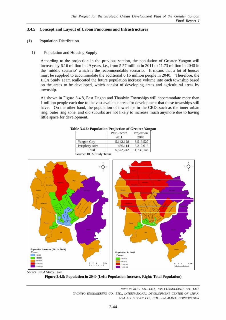
The Project for the Strategic Urban Development Plan of the Greater Yangon Final Report I
NIPPON KOEI CO., LTD., NJS CONSULTANTS CO., LTD.
YACHIYO ENGINEERING CO., LTD., INTERNATIONAL DEVELOPMENT CENTER OF JAPAN,
ASIA AIR SURVEY CO., LTD., and ALMEC CORPORATION
3-44
3.4.5 Concept and Layout of Urban Functions and Infrastructures
(1) Population Distribution
1) Population and Housing Supply
According to the projection in the previous section, the population of Greater Yangon will increase by 6.16 million in 29 years, i.e., from 5.57 million in 2011 to 11.73 million in 2040 in the ‘middle scenario’ which is the recommendable scenario. It means that a lot of houses must be supplied to accommodate the additional 6.16 million people in 2040. Therefore, the JICA Study Team reallocated the future population increase volume into each township based on the areas to be developed, which consist of developing areas and agricultural areas by township.
As shown in Figure 3.4.8, East Dagon and Thanlyin Townships will accommodate more than 1 million people each due to the vast available areas for development that these townships still have. On the other hand, the population of townships in the CBD, such as the inner urban ring, outer ring zone, and old suburbs are not likely to increase much anymore due to having little space for development.
Table 3.4.6: Population Projection of Greater Yangon Past Record Projection 2011 2040 Yangon City 5,142,128 8,519,527Periphery Area 430,114 3,210,619
Total 5,572,242 11,730,146Source: JICA Study Team
Source: JICA Study Team
Figure 3.4.8: Population in 2040 (Left: Population Increase, Right: Total Population)

The Project for the Strategic Urban Development Plan of the Greater Yangon Final Report I
NIPPON KOEI CO., LTD., NJS CONSULTANTS CO., LTD. YACHIYO ENGINEERING CO., LTD., INTERNATIONAL DEVELOPMENT CENTER OF JAPAN,
ASIA AIR SURVEY CO., LTD., and ALMEC CORPORATION
3-45
Although East Dagon Township and Thanlyin Township will accommodate a population of more than 1 million respectively as mentioned above, the future population density seems to be appropriate and the population densities of the CBD townships are still the highest as shown in Figure 3.4.9.
Source: JICA Study Team
Figure 3.4.9: Population Density (Left: 2011, Right: 2040)
2) Labor Population and Work Places Supply
According to the labor force projection in the previous section, it is assumed that the labor participation rate would increase gradually from 50.8% in 2011 to 55.0% in 2040 in the middle scenario. As a result, the labor force is expected to be 6.45 million persons in total.
Table 3.4.7: Labor Force Allocation by Industrial Structure
Labor Force in 2011 by Industrial Category Labor Force in 2040 by Industrial Category Total Primary Secondary Tertiary Total Primary Secondary Tertiary
Total 2,845,557 54,419 207,928 2,583,209 6,451,581 239,005 762,018 5,450,558 Structural Ratio 100.0% 1.9% 7.3% 90.8% 100.0% 3.7% 11.8% 84.5%
Source: JICA Study Team’s estimates based on labor force data from the General Administration Department of Yangon Region Parliament
As shown in Table 3.4.7, around 762,000 laborers shall engage in the secondary sector in 2040. Currently, the existing industrial zones in Greater Yangon have a total area of approximately 5100 ha with an estimated 40% occupancy rate. Assuming the average labor density of the existing industrial zones (140/ha) based on the current situation in Yangon City, the existing industrial zones will be able to accommodate the additional 238,000 laborers. Development of a new industrial zone is necessary including the advanced industrial zone on Thilawa SEZ, which is estimated to accommodate 218,000 laborers in the future. To accommodate another 98,000 laborers of the secondary sector, it is proposed that three new industrial zones with an

The Project for the Strategic Urban Development Plan of the Greater Yangon Final Report I
NIPPON KOEI CO., LTD., NJS CONSULTANTS CO., LTD. YACHIYO ENGINEERING CO., LTD., INTERNATIONAL DEVELOPMENT CENTER OF JAPAN,
ASIA AIR SURVEY CO., LTD., and ALMEC CORPORATION
3-46
area of about 250 ha each, 700 ha in total, shall be developed along the outer ring road with consideration of aiming for more efficient logistics.
Table 3.4.8: Existing Industrial Zones in Yangon
Name of Industrial Zone Developer Gross Land Area (ha)
Estimated Occupancy Rate (%)
Hlaing Tharyar (1-7) DHSHD 780 90 Shwe Thann Lyin Shwe Thann Lyin Co. 168 10 Mya Sein Yaung War War Win Co. 118 0 Anaw Yah Tar + Shwe Taung Mahar Shwe Taung Co. 315 0 Shwe Lin Ban DHSHD 445 50 Shwe Pyi Thar (1) DHSHD 136 70 Shwe Pyi Thar (2,3,4) DHSHD 400 50 War Ta Yar DHSHD 445 10 Thardu Kan TOSTA High Rise 195 10 Mingaladon Mingaladon Industrial Park Co. 89 90 Yangon Zaykabar Co. 400 90 Shwe Paukkan DHSHD 38 80 North Okkalapa DHSHD 45 90 South Okkalapa DHSHD 15 90 North Dagon YCDC 10 100 East Dagon DHSHD 202 40 East Dagon (extension) DHSHD 115 40 South Dagon (1) DHSHD 192 70 South Dagon (2) DHSHD 87 100 South Dagon (3) DHSHD 22 100 December December Co. 142 0 Dagon Seikkan DHSHD 490 70 Tharketa DHSHD 81 90 Thilawa Industrial Zone DHSHD 175 30 Total 5,105 Source: JICA Study Team
It should be noted that all laborers in the secondary sector will not work in the industrial zones, but some will work in small factories outside of the industrial zones. In this section, rough approximation of the required land area for industrial use is estimated to accommodate the future urban structure.
On the other hand, laborers in the tertiary sector will be more dispersed in the whole urban area than in the secondary sector. Thus, it is rather difficult to estimate the required land area for the tertiary sector. As shown in Table 3.4.7, 5.45 million laborers shall engage in this sector in 2040.
In the urban structure mentioned in the next section, “CBD”, “Secondary CBD”, “Sub-centers”, and “New Town Core Areas” will be the main work places for a lot of laborers in the tertiary sector. In case that estimation of the labor population follows the way it was mentioned in Table 3.4.9, 1.24 million laborers shall be accommodated in the new city center, which corresponds roughly to 25% of the total labor force in the tertiary sector in 2040.

The Project for the Strategic Urban Development Plan of the Greater Yangon Final Report I
NIPPON KOEI CO., LTD., NJS CONSULTANTS CO., LTD. YACHIYO ENGINEERING CO., LTD., INTERNATIONAL DEVELOPMENT CENTER OF JAPAN,
ASIA AIR SURVEY CO., LTD., and ALMEC CORPORATION
3-47
Table 3.4.9: Estimated Labor Population in the New City Centers Name Estimated Net Area Estimated Stories
of Building Estimated Net
Floor Area Estimated Number of
Labor Population Mindama (Secondary CBD) 80 ha (200 acre) 25 stories 500 ha 100,000 Bago Riverside (Sub-center) 120 ha (300 acre) 25 stories 750 ha 150,000 Thilawa SEZ (Sub-center) 50 ha (125 acre) 25 stories 300 ha 60,000 Dagon Myothit (Sub-center) 120 ha (300 acre) 25 stories 750 ha 150,000 Hlaing Tharyar (Sub-center) 120 ha (300 acre) 25 stories 750 ha 150,000 Hlegu (New Town Core) 200 ha (500 acre) 8-10 stories 450 ha 90,000 Hmawbi (New Town Core) 200 ha (500 acre) 8-10 stories 450 ha 90,000 East Dagon (New Town Core) 200 ha (500 acre) 8-10 stories 450 ha 90,000 Thanlyin (New Town Core) 200 ha (500 acre) 8-10 stories 450 ha 90,000 Dala (New Town Core) 200 ha (500 acre) 8-10 stories 450 ha 90,000 Twantay (New Town Core) 200 ha (500 acre) 8-10 stories 450 ha 90,000 Htantabin (New Town Core) 200 ha (500 acre) 8-10 stories 450 ha 90,000
Total 1,240,000 Note: *1 Commercial and business building lots shall be 25% (building coverage) of the whole site. *2: 200 persons/ha for commercial and business use. Source: JICA Study Team
(2) Urban Functions
1) City Center Function (Figure 3.4.11)
Not only the CBD, but also the other new area centers will play their roles as city centers in the future to accommodate a larger population. It is proposed that the new city centers should be divided into different types, namely as “CBD”, “Secondary CBD”, “Sub-centers”, and “New Town Core Areas”, depending on their distance from the CBD, development schedules, etc., as shown in Figure 3.4.10.
Source: JICA Study Team
Figure 3.4.10: Proposal for the Type of City Centers
(1) Secondary CBD and Sub-centers
As mentioned above, the creation of sub-centers is more recommendable according to the past discussions in this Study. At areas around 10-15 km radius from the city center, some suitable lands to create the sub-centers were found in the course of the discussions with YCDC. Those areas are basically owned by either public sectors, such as Ministry of Construction, YCDC and other organizations, or farmers. Distances between the neighboring sub-centers are set at about 10 km from each other. Although a deep and extensive study as well as surveys and negotiation with land owner(s) are necessary, the list of candidate sites was already made as shown in Table 3.4.10. Among the five candidate sites, Mindama, which is also called the “Secondary CBD”, is likely to have the first priority for development due to its location, maturity of discussion in Myanmar’s side.
CBD
Secondary CBD
Sub-centers
New Town Core Areas
Center
10-15 km
10-15 km
10-30 km
Mid and High-rise
High-rise
High-rise
Mid-rise
Short-term
Short-term
Short and Mid-term
Mid and Long-term
Type
1
1
4
7
Distance No. Height Schedule

The Project for the Strategic Urban Development Plan of the Greater Yangon Final Report I
NIPPON KOEI CO., LTD., NJS CONSULTANTS CO., LTD. YACHIYO ENGINEERING CO., LTD., INTERNATIONAL DEVELOPMENT CENTER OF JAPAN,
ASIA AIR SURVEY CO., LTD., and ALMEC CORPORATION
3-48
Table 3.4.10: Candidate Sites of Secondary CBD and Sub-centers
Name Township Location Land Ownership
Estimated Net Area for Commercial and
Business Use
Schedule
Short Mid Long
Mindama Secondary CBD Insein YCDC, Military, Ministry of
Agriculture, Defense Ministry 80 ha
(200 acre)
Thilawa SEZ Sub-center
Thanlyin and Kyauktan Ministry of Construction 50 ha
(125 acre)
Bago Riverside Sub-center Thanlyin Farm Lands 120 ha
(300 acre)
Dagon Myothit Sub-center
Dagon Myothit (North) Ministry of Sports 120 ha
(300 acre)
Hlaing Tharya Sub-center Hlaing Tharya Farm Lands 120 ha
(300 acre)
Source: JICA Study Team
(2) New Town Core Areas
New towns with large-scale residential areas will be necessary to accommodate the rapidly growing population of Greater Yangon. It is recommended that each new town shall have its own core area to make the distances between the living and working places short so that the travel time of people could be reduced as much as possible. The core areas will mainly have commercial and business functions, but some may have an industrial function. The following three conditions were contemplated, namely 1) to be along the inner side of the outer ring road, 2) to be along the railways, and 3) to be able to acquire large-scale land. Consequently, seven core areas of new towns are proposed. Each core area shall be dispersed around the railway stations so that these shall not be concentrated in one place.
Table 3.4.11: Candidate Sites for New Town Cores
Name Township Location Land Ownership
Estimated Net Area for Commercial and
Business Use
Schedule
Short Mid Long
Hlegu Hlegu Farm Lands 200 ha (500 acre)
Hmawbi Hmawbi Farm Lands 200 ha (500 acre)
East Dagon East Dagon Farm Lands 200 ha (500 acre)
Thanlyin Thanlyin Farm Lands 200 ha (500 acre)
Dala Dala Farm Lands 200 ha (500 acre)
Twantay Twantay Farm Lands 200 ha (500 acre)
Htantabin Htantabin Farm Lands 200 ha (500 acre)
Source: JICA Study Team
2) Industrial Function (Figure 3.4.12)
In Yangon City, 24 industrial zones are currently under operation with a total area of 5,105 ha, which include some unused lands inside them, as shown in the following table.
As mentioned in the previous section, the labor population of the secondary sector is estimated to increase by 554,000 from the present to 2040. Based on the current situation in Yangon City and the neighboring countries, labor population density per unit area is in the range of 150-200 labors/ha. The total industrial zone necessary for Greater Yangon, in addition to the unused area in the existing industrial zones and Thilawa SEZ, is estimated to be approximately 700 ha. It is recommended that new industrial zones should be allocated along the outer ring

The Project for the Strategic Urban Development Plan of the Greater Yangon Final Report I
NIPPON KOEI CO., LTD., NJS CONSULTANTS CO., LTD. YACHIYO ENGINEERING CO., LTD., INTERNATIONAL DEVELOPMENT CENTER OF JAPAN,
ASIA AIR SURVEY CO., LTD., and ALMEC CORPORATION
3-49
road because of its efficient logistics, and existing industrial lands for factories located within the 15-km distance from the CBD should be transferred outwards in the future.
3) Green and Water Functions (Figure 3.4.13)
According to the Yangon Regional Office of the Ministry of Agriculture and Irrigation, there are basically no agricultural areas that must be preserved in the future in Greater Yangon. Accordingly, urbanization could expand outwards gradually converting some of the agricultural lands, while some agricultural areas shall remain in the outskirts in 2040.
Green areas should be conserved mainly on the low hills which are a long and narrow spur in the central area, so as to make a so-called “Yangon North-South Green Axis”. In parallel with the urbanization in progress, new large-scale parks should be created to keep a good living environment and to conserve green and water areas, especially along the outer ring growth belt where there are wide areas of unused land for urbanization. Hlawga nature protected areas must play the most important role of being one of the keystones of the green functions on Greater Yangon’s future, especially as a wildlife habitat and water reservoir.
On the other hand, the riverside spaces, which are used extensively for logistics such as the sea port and area for containers handling, are generally not in good condition in terms of support facilities and working environment. In addition, the riverside spaces along the Yangon River, where the port facilities are currently located, are intended to allow a wide open space along the strand road from historical viewpoint. It is thus recommended to make better use of the riverside spaces for the support facilities and favorable working environment, especially along the Yangon River and Bago River, by means of creating waterfront spots. This could be achieved by either shifting the port and logistics functional areas to the Thilawa SEZ area, or raising the land use efficiency in these areas.

The Project for the Strategic Urban Development Plan of the Greater Yangon Final Report I
NIPPON KOEI CO., LTD., NJS CONSULTANTS CO., LTD. YACHIYO ENGINEERING CO., LTD., INTERNATIONAL DEVELOPMENT CENTER OF JAPAN,
ASIA AIR SURVEY CO., LTD., and ALMEC CORPORATION
3-50
Source: JICA Study Team
Figure 3.4.11: Proposed Conceptual Plan of City Center Function

The Project for the Strategic Urban Development Plan of the Greater Yangon Final Report I
NIPPON KOEI CO., LTD., NJS CONSULTANTS CO., LTD. YACHIYO ENGINEERING CO., LTD., INTERNATIONAL DEVELOPMENT CENTER OF JAPAN,
ASIA AIR SURVEY CO., LTD., and ALMEC CORPORATION
3-51
Source: JICA Study Team
Figure 3.4.12: Proposed Conceptual Plan of Industrial Function

The Project for the Strategic Urban Development Plan of the Greater Yangon Final Report I
NIPPON KOEI CO., LTD., NJS CONSULTANTS CO., LTD. YACHIYO ENGINEERING CO., LTD., INTERNATIONAL DEVELOPMENT CENTER OF JAPAN,
ASIA AIR SURVEY CO., LTD., and ALMEC CORPORATION
3-52
Source: JICA Study Team
Figure 3.4.13: Proposed Conceptual Plan of Green and Water Function

The Project for the Strategic Urban Development Plan of the Greater Yangon Final Report I
NIPPON KOEI CO., LTD., NJS CONSULTANTS CO., LTD. YACHIYO ENGINEERING CO., LTD., INTERNATIONAL DEVELOPMENT CENTER OF JAPAN,
ASIA AIR SURVEY CO., LTD., and ALMEC CORPORATION
3-53
(3) Urban Infrastructures
Regarding urban infrastructures, the details of concepts and plans are mentioned in Chapter 5, while the outline is written in this section for the road and transportation sectors, which relates more to the urban structure than the other sectors.
1) Road Network (Figure 3.4.14)
The future road network configuration and its capacities shall be determined by the future urban structure and land use plan. The results of the preliminary traffic demand forecast showed that quite large traffic demands will emerge not only from the north-south directions, but also from the east-west directions in the future when the proposed urban structure is realized. The existing road network cannot handle such large magnitude of traffic which will be generated from more than 10 million of population. Therefore, formation of a high capacity road network sufficient to accommodate future traffic demands will be needed to support and guide the targeted future urban development, in addition to public transport systems. Corresponding to the urban structure above, a new road network is proposed, characterized by the construction of an outer ring road, which is a circular highway passing at areas around 15-30 km radius from the CBD, and some other radial and ring roads.
2) Railway Network (Figure 3.4.15)
It is estimated that railway transport in Greater Yangon will operate with 6 million trips in 2040. According to the analyses mentioned in Chapter 5, the required railway network length for Greater Yangon in 2040 will be 350 km with 150 km tolerance. In case that the 350 km railway network is established in the future, not only the modernization of the three existing lines (122 km) but also construction of five new UMRT lines (232 km) will be required. The railway network covers all the future urban function areas appropriately and fits with the future urban structure, although the layout plan of new lines in Figure 3.4.15 is just tentative idea in this study. The network can also provide all the citizens with good access to any station within 5 km.
3) Logistics Network (Figure 3.4.16)
Considering logistics, it is expected that traffic and logistic volume will rapidly increase because of vast amount of urban expansion. In this context, it is necessary to relocate and strengthen urban logistics functions and facilities. Even in the future, Greater Yangon must be responsible for the commercial, business, trade and logistics center in Myanmar as current. Therefore it is necessary to carry cargos from overseas to nationwide smoothly, passing through Yangon without traffic congestion in urban area of Greater Yangon. It is obvious that Thilawa Area (Port and SEZ) will play a more important role in the future than at present. As earlier mentioned above, the main logistics function will gradually shift from Yangon Main Port to Thilawa Area Port in the future. Additionally, the Myanmar Government has a plan to construct a new international airport at the place called Hanthawaddy, located at 65km distance from Yangon, near Bago City. It means that the logistics network between the south-east area (direction to Thilawa) and north-east area (direction to the new international airport, Nay Pyi Taw, Mandalay and Bago) will be more important in the future than at present. In line of this context, logistic functions and facilities should be relocated outside of current urban center, such as along outer ring road to establish and strengthen efficient logistics, connecting to other large cities in Myanmar and ne international airport to be constructed.
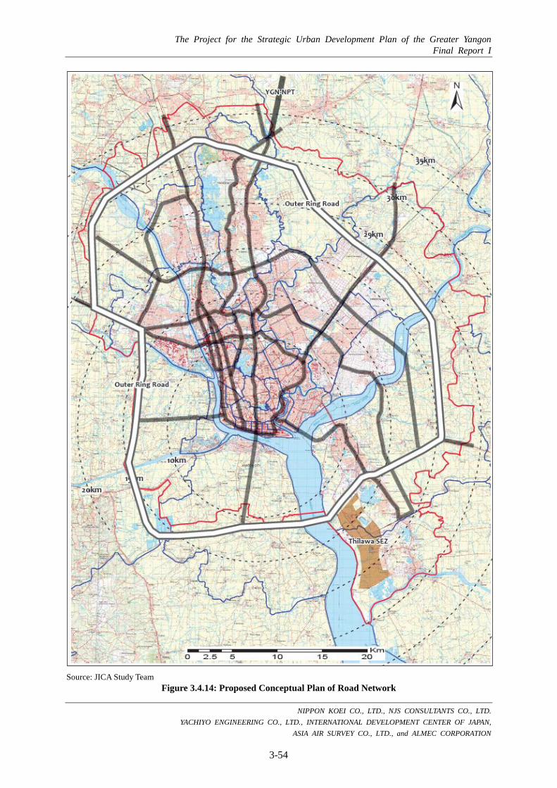
The Project for the Strategic Urban Development Plan of the Greater Yangon Final Report I
NIPPON KOEI CO., LTD., NJS CONSULTANTS CO., LTD. YACHIYO ENGINEERING CO., LTD., INTERNATIONAL DEVELOPMENT CENTER OF JAPAN,
ASIA AIR SURVEY CO., LTD., and ALMEC CORPORATION
3-54
Source: JICA Study Team
Figure 3.4.14: Proposed Conceptual Plan of Road Network
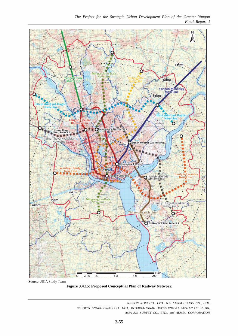
The Project for the Strategic Urban Development Plan of the Greater Yangon Final Report I
NIPPON KOEI CO., LTD., NJS CONSULTANTS CO., LTD. YACHIYO ENGINEERING CO., LTD., INTERNATIONAL DEVELOPMENT CENTER OF JAPAN,
ASIA AIR SURVEY CO., LTD., and ALMEC CORPORATION
3-55
Source: JICA Study Team
Figure 3.4.15: Proposed Conceptual Plan of Railway Network

The Project for the Strategic Urban Development Plan of the Greater Yangon Final Report I
NIPPON KOEI CO., LTD., NJS CONSULTANTS CO., LTD. YACHIYO ENGINEERING CO., LTD., INTERNATIONAL DEVELOPMENT CENTER OF JAPAN,
ASIA AIR SURVEY CO., LTD., and ALMEC CORPORATION
3-56
Source: JICA Study Team
Figure 3.4.16: Proposed Conceptual Plan of Logistics Network

The Project for the Strategic Urban Development Plan of the Greater Yangon Final Report I
NIPPON KOEI CO., LTD., NJS CONSULTANTS CO., LTD. YACHIYO ENGINEERING CO., LTD., INTERNATIONAL DEVELOPMENT CENTER OF JAPAN,
ASIA AIR SURVEY CO., LTD., and ALMEC CORPORATION
3-57
Source: JICA Study Team
Figure 3.4.17: Conceptual Layout Plan of Urban Functions and Infrastructure (An Integrated Conceptual Plan)
CHAPTER 4 An Urban Development Master Plan
< Part-II: The Master Plan >

The Project for the Strategic Urban Development Plan of the Greater Yangon Final Report I
NIPPON KOEI CO., LTD., NJS CONSULTANTS CO., LTD. YACHIYO ENGINEERING CO., LTD., INTERNATIONAL DEVELOPMENT CENTER OF JAPAN,
ASIA AIR SURVEY CO., LTD., and ALMEC CORPORATION
4-1
CHAPTER 4: AN URBAN DEVELOPMENT MASTER PLAN
An urban development master plan of this chapter is composed of three sections, namely “4.1 Urban Development Strategy”, “4.2 A Land Use Plan” and “4.3 Outline of Proposed Land Use Zoning Scheme” based on the development visions and structure plan of Chapter 3. The outline of proposed land use zoning scheme will be examined further through the discussion with Myanmar side in Phase II in line with this proposal. The urban development master plan is closely related to an urban infrastructure development strategy of Chapter 5 and a capacity development plan of Chapter 6.1.
4.1 An Urban Development Strategy
4.1.1 Urban Development and Management
(1) Development Policy
Sector Vision Realization of Sustainable Urban Development and Management in Consideration of Comfortable, Efficient and Environmental Friendly
Basic Policy
1) Realization of a Peaceful and Beloved City with Vitalization and Renewal of CBD and Enhancement of Rich Green and Water
(see the next sections, 4.1.2, 4.1.3, 4.1.4, and 4.1.5) 2) Realization of a City for Comfortable Living and Effective Working for All
Citizens as an Advanced Model for Myanmar (TOD and Smart-City Policy) 3) Decentralization of Urban Center’s Functions by Creation of New
“Secondary CBD” and “Sub-centers” to Avoid Over-concentration at the Existing CBD
4) Consolidating the Urban Structure for Promoting Economic Growth with Intensive Land Use and Efficient Logistics System to be an International HUB City
5) Mitigation of Disaster Risks base on Disaster Risk Analysis, Assessment and Management
6) Realization of Good Governance with Improvement of Management System in the Field of Urban Development and Management
The detailed explanations and background of each basic policy are given as below:
1) Realization of a Peaceful and Beloved City with Vitalization and Renewal of CBD, and Enhancement of Rich Green and Water.
As Greater Yangon is an international gateway of Myanmar because of its geographical location in GMS, the number of foreign tourists and investors has rapidly increased drastically after shifting to the civilian rule in 2011. As the current situation seems insufficient in light of huge demands and needs to be an international HUB city in the future, it is necessary to develop commercial and business functions, well-managed infrastructures, housing and accommodation facilities, a variety of services, and human capacities based on international

The Project for the Strategic Urban Development Plan of the Greater Yangon Final Report I
NIPPON KOEI CO., LTD., NJS CONSULTANTS CO., LTD. YACHIYO ENGINEERING CO., LTD., INTERNATIONAL DEVELOPMENT CENTER OF JAPAN,
ASIA AIR SURVEY CO., LTD., and ALMEC CORPORATION
4-2
standard. Development of tourism sector is also expected in order to emphasize identities of Yangon and to contribute in improving the living standards including those for urban poverties, as well as economic growth. Valuable cultural heritages which are located mainly in CBD should be preserved and utilized more to make Yangon more attractive. On the other hand, CBD seems to have more serious urban problems of transportation gradually due to over-concentration of population and economic activities. In this context, vitalization and renewal of CBD is necessary, avoiding further over-concentration.
In order to realize the development vision, peaceful and beloved city, to provide healthy and cultured living environment and proper social services for all citizens and to cherish and emphasize identities of Yangon and Myanmar are very important viewpoints.
To improve happiness of all citizens, provision of proper housing and equal and inclusive social services for all citizens will be required. Improvement of living environment of Greater Yangon must contribute to be peaceful and beloved Yangon (see the details in “4.1.2 Living Environment” and “4.1.3 Social Service”).
Placing a high value on the historical and cultural aspects of urban development and management shall contribute to establishing a stronger international competiveness in not only the tourism sector but also in business and commercial sectors in the long-term (see the details in “4.1.4 Urban Landscape and Heritage”).
Rich green and water which are forming Yangon’s charm should also be emphasized more through urban development in the future. To realize it, creation of amenity spaces by construction of public parks and improvement of greenery will be necessary (see the details in “4.1.5 Urban Landscape and Heritage”).
2) Realization of a City for Comfortable Living and Effective Working for all Citizens as an Advanced Model for Myanmar (TOD and Smart-City Policy)
The Greater Yangon is the largest city in Myanmar, whose population will increase by 6.16 million in 29 years, namely from 5.57 million in 2011 to 11.73 million in 2040. To ensure satisfaction of the citizens of Greater Yangon, it is essential to realize a city for comfortable living and effective working community.
For realization of comfortable living and working environment, it is recommendable to promote the TOD (Transit Oriented Development) policy for the new urban development area. The TOD policy will contribute to optimize the effectiveness and efficiency of public transportation system which is expected to shorten travel time between living and working areas.
For appropriate land use with more comfortable way of living, it is recommended that new large scale industrial zones are allocated along the outer ring road. Moreover, existing large scale industrial and logistic facilities located near residential lands in inner urban should be transferred and replaced outwards, and controlled in terms of emission of environmental pollutions for less negative impacts on living conditions. Relocation of public facilities and function should be also considered. More attention needs to be paid to the urban poor and minority people from the viewpoint inclusive of urban development and management.
As mentioned below, creation of proposed sub-centers and new town cores shall also contribute to decreasing the distance between working and living places, in order shorten their travel time, and to mitigate traffic jams, traffic pollution, and other relevant urban problems.

The Project for the Strategic Urban Development Plan of the Greater Yangon Final Report I
NIPPON KOEI CO., LTD., NJS CONSULTANTS CO., LTD. YACHIYO ENGINEERING CO., LTD., INTERNATIONAL DEVELOPMENT CENTER OF JAPAN,
ASIA AIR SURVEY CO., LTD., and ALMEC CORPORATION
4-3
3) Decentralization of Urban Center Functions by Creation of New “Secondary CBD” and “Sub-centers” to Avoid Over-concentration in the Existing CBD
Currently, urban center functions including administration, finance, business and commerce are located mainly in the CBD. The current CBD will be subject to over-concentration in terms both of urban functions and population in the near future, based on the past trend. Hence, this would cause serious urban problems such as perennial traffic jams, environmental pollutions, skyrocketing of prices of lands and others.
Although some urban functions, such as shopping centers, are transferring outside the CBD, it is essential to further promote decentralization of the urban center functions as compared to the past. To realize this, a “Secondary CBD” and several “Sub-centers” should be created for new businesses, commercial, industrial and/or residential centers in areas around 10-15 km radius from the current CBD.
It is recommended that the five or more sub-centers including a secondary CBD will be developed as new urban centers by the year 2040 in line with the objectives mentioned above. Construction of each center should be promoted not only by the public sector but also with a private initiative based on its characteristics. To promote these developments, it is necessary to allow special incentives for development activities of the secondary CBD and the sub-centers.
4) Consolidating the Urban Structure for Promoting Economic Growth with Intensive Land Use and Efficient Logistics System to be an International HUB City
The Greater Yangon is the largest city and an international gateway of Myanmar because the geographical location of Yangon is in the focal node of the Greater Mekong Sub-region (GMS) economic corridors, namely East-West Economic Corridor, Western Economic Corridor, and Southern Economic Corridor. Under this status, the Greater Yangon is required to establish a new and stable urban structure which contributes to the future economic growth as one of the most important players for economic development among domestic as well as international counterparts.
Promotion of more intensive land use by means of providing special incentives might be also necessary for strong economic growth, despite height of buildings should be somewhat restricted in consideration of continuity from the current regulation. Additionally, current CBD is required to be redeveloped as a more efficient and more attractive urban center in cooperation with secondary CBD and sub-centers to be developed.
A new port and a new airport in progress, namely Thilawa Area Port and Hanthawaddy International Airport, which will have larger capacities than existing ones, are necessary in the future to cope with rapidly increasing demands. These new hubs will contribute to more effective logistics and passenger traffic domestically and internationally.
5) Mitigation of Disaster Risks base on Disaster Risk Analysis, Assessment and Management
Human life comprises disaster risk on their usual activities because discontinuous and unstable conditions are among the aspects of nature. As described in “Section 2.1.5 Disaster” of this report, the Greater Yangon has potential risks of disasters. Such disaster risks should be managed by following three processes to protect human lives and properties, and to ensure efficient urban development.
a) Process-1: Disaster Risk Analysis

The Project for the Strategic Urban Development Plan of the Greater Yangon Final Report I
NIPPON KOEI CO., LTD., NJS CONSULTANTS CO., LTD. YACHIYO ENGINEERING CO., LTD., INTERNATIONAL DEVELOPMENT CENTER OF JAPAN,
ASIA AIR SURVEY CO., LTD., and ALMEC CORPORATION
4-4
In the disaster risk analysis, disaster risk factors are extracted and specified, by using available data/information, i.e. aspects analyzed include i) what kinds of events would be possible, ii) where would be the affected area, iii) what are the degree of their impacts, iv) what are their occurrence probability, v) who would be affected and vi) what are their damage scales.
b) Process-2: Disaster Risk Assessment
In the disaster risk assessment, extracted disaster risks are evaluated in terms of acceptability for the society. Based on the assessment, disaster measure should be studied if the disaster risks are evaluated as unacceptable.
c) Process-3: Disaster Risk Management
In disaster risk management, mitigation activities must correspond against disaster risks. Disaster risk communication, which involves exchanging and sharing of disaster risk information to build mutual agreement on management among stakeholders, is one of the most important procedures in disaster risk management. Study on disasters and their present measures in Chapter 2 of this report may be determined as one of the preliminary level disaster risk analysis.
6) Realization of Good Governance with Improvement of Management System in the Field of Urban Development and Management
Urban development and management shall be strengthened by the use of statistics that accurately illustrate current socio-economic conditions and level of urban services. To acquire such information, statistical data based on ward level are indispensable. Additionally, people’s opinion shall be concisely reflected more in an urban planning process. To make urban development and management system more efficient, “e-government” shall provide an efficient administration and an easy access to information for residents through computerization of administrative procedures. The administration procedure relating to a household such as household registration, payment to urban services and taxes, and so on should be computerized.
(2) Goals and Target Effect Indicators
For the purpose of evaluation of future urban development and management, and to confirm its outcomes, the following development goals and effect indicators are prepared:
Table 4.1.1: Development Goals and Effect Indicators (Urban Development and Management) Development Goal Effect Indicators (Qualitative)
a) Vitalization and Renewal of CBD Improvement of business, commercial and tourism activities
b) New Urban Development Increase of urban areas with TOD and smart-city policy
c) Relocation and Replacement of Facilities Less large-scale industrial and logistic facilities in inner urban area
d) New Urban Center Functions Creation of new secondary CBD and sub-centers
e) Disaster Risk Less damages by disasters
f) Efficient administration Computerized household registration system
Source: JICA Study Team

The Project for the Strategic Urban Development Plan of the Greater Yangon Final Report I
NIPPON KOEI CO., LTD., NJS CONSULTANTS CO., LTD. YACHIYO ENGINEERING CO., LTD., INTERNATIONAL DEVELOPMENT CENTER OF JAPAN,
ASIA AIR SURVEY CO., LTD., and ALMEC CORPORATION
4-5
(3) Strategy for Urban Development & Management
1) Vitalization and Renewal of CBD
In the Greater Yangon that continues to expand with population growth, while the decentralization of urban function is aimed at, current CBD area where urban activities through residences, commercials and business are concentrated will be also the future CBD as a core of the city of Yangon. In order to renew and revive the efficient CBD area with a vitality, disaster-resistant, functional and attractive urban space had to be realized.
In order to realize the CBD that citizens live at ease, realization of developments of urban facilities in consideration for disaster prevention is essential. Also in order to archive smooth urban activities, it is necessary to eliminate the traffic congestions in the CBD and to give efficient transport system In addition, for further value improvement of the CBD, while preserving the historic buildings and other various religious buildings, to utilize them as tourism resources and new urban functions is effective.
Through these comprehensive promotions, not only forming comfortable and attractive urban environment, but also forming the city with high international competitiveness in each sector such as tourism, commerce and business are expected. For vitalization and renewal of CBD, measures to be taken are proposed as follows:
Source: JICA Study Team
Figure 4.1.1: Basic Concept Plan of the CBD
(1) Development of disaster-resistant CBD

The Project for the Strategic Urban Development Plan of the Greater Yangon Final Report I
NIPPON KOEI CO., LTD., NJS CONSULTANTS CO., LTD. YACHIYO ENGINEERING CO., LTD., INTERNATIONAL DEVELOPMENT CENTER OF JAPAN,
ASIA AIR SURVEY CO., LTD., and ALMEC CORPORATION
4-6
The Greater Yangon has encountered a number of natural disasters in the past, such as large earthquakes in 1930’s, the cyclone in2008, and repeated floods, etc. Once a large-scale disaster occurs in the city where population and assets are concentrated, the city suffers tremendous losses and requires significant effort to normalize it. To develop a disaster-resistant CBD while foresee natural disaster, it is essential in order to increase the value of the city as well as to give assurance to civilian life.
a) The city strong to earthquakes / promotion of earthquake resistant building
YCDC has instructions of disable buildings in dangerous conditions by structural defects as “danger building”. These buildings are required to measure either carry out seismic enforcement or rebuild. In order to form an urban environment where citizens live at ease, promotions of the implementation of seismic evaluation of existing facilities is needed as well as the earthquake-resistance for public buildings as a disaster prevention center.
b) The city strong to fires / promotion of
In the high density built-up area of CBD, once fire occurs, there is a high risk of fire spread to the neighboring area. For the new structure, incombustible is required, and the existing structure, it is recommended to eliminate combustibles as much as possible. In addition, in order to perform firefighting effectively, proper installation of fire fighting water conservancy, such as fire hydrant or fire protection water tank, and also the installation of fire-fighting equipment in the building are required. Promotion of the facility development in consideration for disaster prevention is essential.
c) The city strong to floods / promotion of flood control measures
The center part of Yangon city that is surrounded by rivers and the sea level is low, has vulnerable to water damage. For flood control measures, for flood control measures, inland water measures and watershed measures are needed with consideration to the natural environment. For the prevention of flood damage in urban areas, implementations of the development of rainwater drainage facilities such as public sewerage system are required.
(2) Functional Traffic System in CBD
In order to ensure the efficiently urban activities, promoting traffic transport policies for implementing smooth traffic is required. Measures to resolve the traffic congestion and introduction of the new urban transport system within the CBD in conjunction with the metropolitan area are effective. On the other hand, in the construction of new public facilities such as stations and parking area, promoting the barrier-free for elderly and disabled is required as urban environment where every civilian can live comfortably. Following are strategies to achieve functional traffic system in CBD.
a) Improvement of the Parking Lot
In the urban area of Yangon, the number of cars is increasing day by day, and chronic traffic congestion is an urgent issue to be solved. There are different causes of congestion in the CBD such as lack of parking lots and heavy on-street parking and open-air stalls and vendors along the streets. Sufficient spaces for parking lots are necessary for the new construction as well as for existing buildings.
For the area with high population density, it is effective to develop a large parking area at the outer periphery of the CBD, either underground of a public square or beneath streets.
b) Limitation of Car Traffic in the CBD

The Project for the Strategic Urban Development Plan of the Greater Yangon Final Report I
NIPPON KOEI CO., LTD., NJS CONSULTANTS CO., LTD. YACHIYO ENGINEERING CO., LTD., INTERNATIONAL DEVELOPMENT CENTER OF JAPAN,
ASIA AIR SURVEY CO., LTD., and ALMEC CORPORATION
4-7
Together with the installation of parking lot, regulation to limit car traffic in the CBD is efficient. It is effective to reduce the entrance of vehicles by regulating the time constrains in order to implement measures to realize smooth traffic. Through the regulation to limit car traffic, implementation of urban space for people such as priority road for pedestrian that is not occupied by cars is expected in the historic conservation area or the shopping area in the CBD. Such restriction will be coupled with the enhancement of public transport, as mentioned below.
c) Development of the New Public Transport System
As urban transportation in a low-carbon society, new transport systems, such as Light Rail Transit (LRT), is generally recommended in order to facilitate the movement of people. Through the installation of park-and-ride system cooperation with local bus and installation of car parks, smooth traffic will be realized within the CBD area. Together with the traffic network of the entire metropolitan area, there is a need for a comprehensive review of the urban transportation systems.
(3) Formation of Attractive Urban Space
The attractiveness of the city of Yangon is in the specific urban landscape in each district through historic buildings in colonial era and various religious buildings left in CBD area. In order to develop this CBD area as the multicultural city, and to attract people at home and abroad, promoting the development plan utilizing these cultural resources which have high values as tourism resources is effective. In this CBD with cultural diversity, some potential resources of this city have to be discovered through tangible and intangible elements. Following are different aspects to improve attractiveness of the city of Yangon, mainly focusing on the tangible elements.
a) Conservation and Re-use of Heritage Building
One of the attractiveness of the city of Yangon is the diverse aspects of the urban spaces where different religious monuments and historic buildings of different ages are gathered in one place in the CBD. These buildings, which are also properties of the city, are facing different types of damages due to aging, natural disaster and arbitrary modification by the new owners. The conservation of the heritage buildings is inevitable, and the formulation of a comprehensive guideline such as a rule on height limitations and/or form-design is required.
In the CBD area, there are some heritage public buildings that were not fully utilized by the relocation of the capital. These former governmental facilities, which were built in the British colonial era, have great potentials to be reborn into a classic urban facility. For the improvement of the city, together with the conservation of the buildings, it is effective to convert their usages into another new context that will be utilized by the citizens.
Source: JICA Study Team
Figure 4.1.2: Historic Buildings Which Are Required Conservation and Re-utilization

The Project for the Strategic Urban Development Plan of the Greater Yangon Final Report I
NIPPON KOEI CO., LTD., NJS CONSULTANTS CO., LTD. YACHIYO ENGINEERING CO., LTD., INTERNATIONAL DEVELOPMENT CENTER OF JAPAN,
ASIA AIR SURVEY CO., LTD., and ALMEC CORPORATION
4-8
b) Promotion of the Tourism
In the CBD area, there are a number of precious tourism resources such as historic district around Sule Pagoda, China town with many shopping centers, etc. In order for tourists or citizens to enjoy these attractive urban spaces, it is recommended to develop attractive and comfortable urban spaces with high quality design. To create open spaces and pedestrian streets together with street trees, well designed street furniture and lighting, etc. is important to attract people to move within the urban space.
In addition, activities such as night markets or light-up historic buildings shall attract more people to visit the urban space at night. For the same purpose, it is effective to form attractive urban spaces in both day and night. Together with intangible activities such as cultural policy, invitation for the attractive events, development of tourist routes, etc, multilateral measures will be required for the development of tourism.
Source: JICA Study Team
Figure 4.1.3: Nightscape in Asian City
c) Development of the Waterfront
The growth of the city of Yangon cannot be separated from the Yangon River. Currently, this city, which has been developed as a mercantile city by the marine transport, does not have accessible waterfront for the people, as most of the area along the river is occupied by the port facilities such as container yards, etc. “The City of Water” is one of the original landscapes of this city. In order to revive the identical landscape along the riverside, it is desirable to open part of the waterfront area as public spaces through the installation of new urban facilities.
Source: JICA Study Team
Figure 4.1.4: Historic Urban Landscape along Yangon River
At the Sule Pagoda Wharf next to the historic district in the downtown area, together with the Seikkantha Park where there are some ferry terminals, it is effective to increase the attractiveness of the urban space through the installation of a new field for ivic activities. That is, some developments, such as reuse of old stone-made warehouses to serve as new commercial or cultural facilities with the installation of promenade along the river, and

The Project for the Strategic Urban Development Plan of the Greater Yangon Final Report I
NIPPON KOEI CO., LTD., NJS CONSULTANTS CO., LTD. YACHIYO ENGINEERING CO., LTD., INTERNATIONAL DEVELOPMENT CENTER OF JAPAN,
ASIA AIR SURVEY CO., LTD., and ALMEC CORPORATION
4-9
development of underground utility and infrastructure below the Strand Street to facilitate access from the downtown area , are expected.
Source: JICA Study Team
Figure 4.1.5: Proposal Idea for Existing Warehouse along Yangon River
(4) Implementation Method for the Urban Regeneration
To achieve above strategies, it is necessary to advance the planning with consideration for various rights. The following are necessary methods for the implementation of the redevelopment through the district planning for city induction, urban regeneration fund and right transfer.
a) Implementation of Urban Redevelopment
For redevelopment project of a huge-scale old building or a district, implementation of the project by cooperation of public-private will be effective. Through this method, new urban facilities, which could not be located in the CBD area, such as convention center and general hospitals can be located there. For the implementation of the project, 1) selection of the cooperated company, 2) definition of the public function in the objected development area, and 3) plan and implementation of the integrated plan with complement function for the public use such as hotel accommodation or office spaces, is needed for the additional new facilities in the CBD area. And also it is effective to provide benefits the same to those described above.
b) District Planning for City Induction
In the CBD area, there are a lot of buildings over fifty years. Therefore it can be considered that reconstruction will proceed in the near future. In order to maintain the good urban landscape in the CBD area, to set integrated rules will be effective. Through certain rules, public spaces such as sidewalks, parking lots and green space, and better skylines through height limitation can be ensured in the CBD area. In addition, while assuming the designation of this district plan, it is effective to provide benefits such as mitigation of the height restriction of the whole district, tax reduction measures and acceleration of the development approval etc.
c) Urban Regeneration Fund
The CBD is the area with high potential for the development in the future because of its high density population and concentrated locations of various facilities such as commercial, business and public-use buildings. In order to ensure funds for the redevelopment in the CBD area, to construct and use REIT (Real Estate Investment Trust) system as a method to gather the fund widely is effective.
d) Right Transfer
For implementation of the redevelopment project in the CBD area, an agreement between the land owner and floor owners of existing building is needed. For the fluent achievement of the
Historic
Build ing
Yangon River
Prom enadeProm enadeProm enadeProm enade New Facility New Public PlazaPublic Parking
Strand RoadBridgeUnderpass

The Project for the Strategic Urban Development Plan of the Greater Yangon Final Report I
NIPPON KOEI CO., LTD., NJS CONSULTANTS CO., LTD. YACHIYO ENGINEERING CO., LTD., INTERNATIONAL DEVELOPMENT CENTER OF JAPAN,
ASIA AIR SURVEY CO., LTD., and ALMEC CORPORATION
4-10
agreement process, it is effective to study various ways not only by providing the right as compensation payment as normal way but also by exchanging right such as providing housing in outside of the CBD.
2) Promotion of TOD (Transit Oriented Development) Policy
In light of the basic policy-2, promotion of TOD policy is recommendable in order to aims to optimize the effectiveness and efficiency of the public transportation system (railways, buses, bicycles, and so on). TOD refers to residential and commercial centers designed to maximize access by transit and non-motorized transportation, and with other features to encourage transit ridership.
Development of five (5) new UMRT lines is proposed to meet demand forecast of the future in the master plan. A typical TOD has a rail or bus station at its center, surrounded by relatively high-density development, with progressively lower density spreading outwards 0.5-2.0 km representing pedestrian scale distances. In light of the concept, the railway stations of UMRT lines will be the main centers of new urban development areas, namely “New Town Cores”.
Around the railway station, lead business, commercial and high-rise residential areas to form a dense urban area around the railway station. At the station, arterial roads will be connected with transit branch lines such as feeder buses. An idea of new urban development areas with TOD policy is summarized in Figure 4.1.6;
Source: JICA Study Team
Figure 4.1.6: An Image of New Urban Development with TOD Policy
3) Promotion of Smart-City Policy
In light of the basic policy-2, Yangon still has problem of inadequate infrastructure supply. Aiming to development visions, namely an international HUB city, a comfortable city, and a well-managed infrastructure city, it is necessary to strengthen fundamental infrastructure services. In the context, it is recommendable to promote smart-city policy that can cope with both infrastructure development and environmental consideration. Greater Yangon, the largest commercial and business city in Myanmar, should be Myanmar’s leading model city of smart-city policy. Development activities with advanced smart technologies, such as energy recycle (ex: photovoltaic power), next generation transportation system (ex: electric bus),

The Project for the Strategic Urban Development Plan of the Greater Yangon Final Report I
NIPPON KOEI CO., LTD., NJS CONSULTANTS CO., LTD. YACHIYO ENGINEERING CO., LTD., INTERNATIONAL DEVELOPMENT CENTER OF JAPAN,
ASIA AIR SURVEY CO., LTD., and ALMEC CORPORATION
4-11
energy management system (ex: CEMS, HEMS, BEMS) should be promoted by means of giving incentive to the developers.
4) Replacement and Relocation for Appropriate Land Use
In light of the basic policy-2, replacement and relocation of industrial and logistic facilities, and public facilities and functions is proposed for appropriate land use as follows.
(1) Appropriate Replacement of Industrial and Logistic Facilities
To realize both effective industrial promotion and proper living conditions of the citizens, it is essential to promote gradual relocation of industrial and logistic facilities, which are located near residential lands in the inner urban area up and its outskirts, in the long-term.
In Yangon, 24 industrial zones are currently under operation with a total area of 5,105 ha, which cover some unused lands as shown in Table 4.1.2 and Figure 4.1.7. The JICA Study Team proposed that new construction or expansion of large scale factories exceeding a certain threshold size, which are not located in these industrial zones, shall not be allowed in general urbanization area.
Table 4.1.2: Existing Industrial Zones Name of Industrial Zone Developer Status of Development Land Area (ha)
1 Hlaing Thar Yar IZ (1-7) DHSHD Completed in 1994-1997 780 2 Shwe Thann Lyin IZ Shwe Thann Lyin Co. Under Development 168 3 Mya Sein Yaung IZ War War Win Co. Under Development 118
4 Anaw Yah Tar IZ and Shwe Taung IZ Mahar Shwe Taung Co. Under Development 315
5 Shwe Lin Ban IZ DHSHD Completed in 2002 445 6 Shwe Pyi Thar IZ (1) DHSHD Completed in 1989 136 7 Shwe Pyi Thar IZ (2,3,4) DHSHD Completed in 1998-2000 400 8 War Ta Yar IZ DHSHD Completed in 2004 445 9 Thardu Kan IZ TOSTA High Rise Completed in 2002 195 10 Mingaladon IP Mingaladon Industrial Park Co. Completed in 1998 89 11 Yangon IP Zaykabar Co. Completed in 2000 400 12 Shwe Paukkan IZ DHSHD Completed in 1992-1993 38 13 North Okkalapa IZ DHSHD Completed in 1998 45 14 South Okkalapa IZ DHSHD Completed in 2001 15 15 North Dagon YCDC Completed 10 16 East Dagon IZ DHSHD Completed in 2000 202 17 East Dagon IZ (extension) DHSHD Completed 115 18 South Dagon IZ (1) DHSHD Completed in 1992 192 19 South Dagon IZ (2) DHSHD Completed in 1992 87 20 South Dagon IZ (3) DHSHD Completed in 1992 22 21 December IZ December Co. Under Development 142 22 Dagon Seikkan IZ DHSHD Completed in 1998-1999 490 23 Tharketa IZ DHSHD Completed in 1999 81 24 Thilawa IZ DHSHD Completed 175
Total 5,105 Note: DHSHD: Department of Human Settlement & Housing Development in the Ministry of Construction Source: JICA Study Team based on data obtained from DHSHD and others

The Project for the Strategic Urban Development Plan of the Greater Yangon Final Report I
NIPPON KOEI CO., LTD., NJS CONSULTANTS CO., LTD. YACHIYO ENGINEERING CO., LTD., INTERNATIONAL DEVELOPMENT CENTER OF JAPAN,
ASIA AIR SURVEY CO., LTD., and ALMEC CORPORATION
4-12
Source: JICA Study Team based on the data from YCDC map
Figure 4.1.7: Location of Existing Industrial Zones
(2) Relocation of Public Facilities and Functions
To lead and accelerate decentralization movement, public facilities which are currently located in CBD shall be relocated while public functions such as local administration and others shall be transferred to the secondary CBD or sub-centers. Through the relocation, it is also expected to provide a more effective public service compared to the current situations of isolated public facilities. Additionally, the sites where these public facilities moved out from CBD can be utilized for commercial or business use, which will lead to promotion of economic growth.
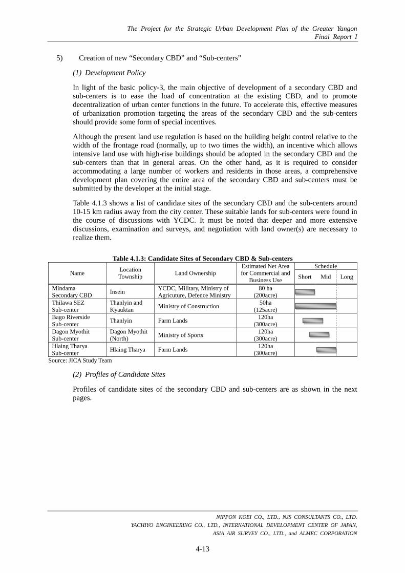
The Project for the Strategic Urban Development Plan of the Greater Yangon Final Report I
NIPPON KOEI CO., LTD., NJS CONSULTANTS CO., LTD. YACHIYO ENGINEERING CO., LTD., INTERNATIONAL DEVELOPMENT CENTER OF JAPAN,
ASIA AIR SURVEY CO., LTD., and ALMEC CORPORATION
4-13
5) Creation of new “Secondary CBD” and “Sub-centers”
(1) Development Policy
In light of the basic policy-3, the main objective of development of a secondary CBD and sub-centers is to ease the load of concentration at the existing CBD, and to promote decentralization of urban center functions in the future. To accelerate this, effective measures of urbanization promotion targeting the areas of the secondary CBD and the sub-centers should provide some form of special incentives.
Although the present land use regulation is based on the building height control relative to the width of the frontage road (normally, up to two times the width), an incentive which allows intensive land use with high-rise buildings should be adopted in the secondary CBD and the sub-centers than that in general areas. On the other hand, as it is required to consider accommodating a large number of workers and residents in those areas, a comprehensive development plan covering the entire area of the secondary CBD and sub-centers must be submitted by the developer at the initial stage.
Table 4.1.3 shows a list of candidate sites of the secondary CBD and the sub-centers around 10-15 km radius away from the city center. These suitable lands for sub-centers were found in the course of discussions with YCDC. It must be noted that deeper and more extensive discussions, examination and surveys, and negotiation with land owner(s) are necessary to realize them.
Table 4.1.3: Candidate Sites of Secondary CBD & Sub-centers
Name Location Township Land Ownership
Estimated Net Area for Commercial and
Business Use
Schedule
Short Mid Long
Mindama Secondary CBD Insein YCDC, Military, Ministry of
Agricuture, Defence Ministry 80 ha
(200acre)
Thilawa SEZ Sub-center
Thanlyin and Kyauktan Ministry of Construction 50ha
(125acre)
Bago Riverside Sub-center Thanlyin Farm Lands 120ha
(300acre)
Dagon Myothit Sub-center
Dagon Myothit (North) Ministry of Sports 120ha
(300acre)
Hlaing Tharya Sub-center Hlaing Tharya Farm Lands 120ha
(300acre)
Source: JICA Study Team
(2) Profiles of Candidate Sites
Profiles of candidate sites of the secondary CBD and sub-centers are as shown in the next pages.

The Project for the Strategic Urban Development Plan of the Greater Yangon Final Report I
NIPPON KOEI CO., LTD., NJS CONSULTANTS CO., LTD. YACHIYO ENGINEERING CO., LTD., INTERNATIONAL DEVELOPMENT CENTER OF JAPAN,
ASIA AIR SURVEY CO., LTD., and ALMEC CORPORATION
4-14
Source: JICA Study Team
Figure 4.1.8: Location of Candidate Sites of the Secondary CBD and Sub-centers

The Project for the Strategic Urban Development Plan of the Greater Yangon Final Report I
NIPPON KOEI CO., LTD., NJS CONSULTANTS CO., LTD. YACHIYO ENGINEERING CO., LTD., INTERNATIONAL DEVELOPMENT CENTER OF JAPAN,
ASIA AIR SURVEY CO., LTD., and ALMEC CORPORATION
4-15
Table 4.1.4: Profile of Mindama Secondary CBD (1/2) Name Mindama Secondary CBD
Basic Information Location Township Insein Township
Distance and direction from CBD 12 km northward (direct distance from Sule Pagoda)
Land Ownership YCDC, Military, Ministry of Agriculture, Defense Ministry
Estimated Net Area 80ha (200acre)
Current Conditions Land Use of the Site and its Surrounding Areas
Mindama Secondary CBD is located in Insein Township, northern suburban area of Yangon City. The area is relatively flat land with 12 to 13 m height. Midama Secondary CBD is currently utilized mainly as cultivated land, grass land, and open space (vacant lot). The surrounding areas are covered mainly with residential land. The area will have a development potential to be the new center of the Greater Yangon, which will serve not only commercial and business service functions but also administrative and trade functions based on its suitable location between the airport and current CBD.
Transportation - Pyay Road Development Framework
Main Land Use New CBD (Commercial, Business, Trade, Banking, etc.) Development Schedule Short-term (-2018) Estimated Volume of Development
100,000 (Labor population) 500ha (Net floor area)
Development Concept
Function and Role - Secondary CBD to decentralize urban functions in CBD - International trade, gateway, and business function - New administrative function
Main Facilities - Banking, financial, business, and commercial complex area - Trade and gateway area - Administration area - Medical and healthcare area - Mindama Railway Station (New lines, UMRT1 & UMRT2)
Expected Arterial Transport Network
- Pyay Road - UMRT1 (new railway line) - UMRT2 (new railway line)
Current Pictures

The Project for the Strategic Urban Development Plan of the Greater Yangon Final Report I
NIPPON KOEI CO., LTD., NJS CONSULTANTS CO., LTD. YACHIYO ENGINEERING CO., LTD., INTERNATIONAL DEVELOPMENT CENTER OF JAPAN,
ASIA AIR SURVEY CO., LTD., and ALMEC CORPORATION
4-16
Table 4.1.5: Profile of Mindama Secondary CBD (2/2) Current Satellite Image
Current Land Use Map
Source: JICA Study Team based on Geo Eye Satellite Image of 2012
1,000m
Defense Ministry
YCDC Military
Ministry of Agriculture
Defense Ministry
YCDC Military
Ministry of Agriculture

The Project for the Strategic Urban Development Plan of the Greater Yangon Final Report I
NIPPON KOEI CO., LTD., NJS CONSULTANTS CO., LTD. YACHIYO ENGINEERING CO., LTD., INTERNATIONAL DEVELOPMENT CENTER OF JAPAN,
ASIA AIR SURVEY CO., LTD., and ALMEC CORPORATION
4-17
Table 4.1.6: Profile of Thilawa SEZ Sub-center (1/2) Name Thilawa SEZ Sub-center
Basic Information
Location Township Thanlyin Township & Kyauktan Township
Distance and direction from CBD 17 km southeastward (direct distance from Sule Pagoda)
Land Ownership Ministry of Construction
Estimated Net Area 50 ha (125acre)
Current Conditions
Land Use of Surrounding Area
Thilawa SEZ sub-center is located in Thanlyin and Kyauktan Township, southeastern suburb area of the Greater Yangon. The area is relatively flat land with 4 to 5 m height. Lower flat land spread over at southern part of Thilawa area, where the area faces Yangon River. Thilawa is well known as one of the SEZs in Myanmar with Thilawa Area Port. Thilawa SEZ is currently utilized mainly as cultivated land, grass land, open space (vacant lot), and under developed land. Lower flat land is well cultivated as paddy field currently. Paddy field also serve as retention. The area is currently a sort of fringe area mixing urbanized area with agricultural area, as it consists of suburban residences and traditional village landscape. Villages are scattered at terrace or highland areas to avoid inundation in the rainy season.
Transportation - Thilawa Access Road - Thilawa Branch Line (existing railway line)
Development Framework
Main Land Use Industry, Commercial, Business and Academic & Research Development Schedule Short-term (-2018) & Mid-term (-2025) Estimated Volume of Development
60,000 (Labor population) 300ha (Net floor area)
Development Concept
Function and Role - Sub-center to decentralize urban functions in CBD - Advanced industrial and manufacturing function - Academic and research function
Main Facilities - Thilawa Special Economic Zone - Thilawa Area Port and container yards - Public research institutes area - R & D and IT software area - Thilawa Terminal Station (Existing line)
Expected Transportation - Thilawa Access Road - Thilawa Branch Line (existing railway line) - UMRT4 (new railway line)
Current Pictures

The Project for the Strategic Urban Development Plan of the Greater Yangon Final Report I
NIPPON KOEI CO., LTD., NJS CONSULTANTS CO., LTD. YACHIYO ENGINEERING CO., LTD., INTERNATIONAL DEVELOPMENT CENTER OF JAPAN,
ASIA AIR SURVEY CO., LTD., and ALMEC CORPORATION
4-18
Table 4.1.7: Profile of Thilawa SEZ Sub-center (2/2) Current Satellite Image
Current Land Use Map
Source: JICA Study Team based on Geo Eye Satellite Image of 2012
1,000m

The Project for the Strategic Urban Development Plan of the Greater Yangon Final Report I
NIPPON KOEI CO., LTD., NJS CONSULTANTS CO., LTD. YACHIYO ENGINEERING CO., LTD., INTERNATIONAL DEVELOPMENT CENTER OF JAPAN,
ASIA AIR SURVEY CO., LTD., and ALMEC CORPORATION
4-19
Table 4.1.8: Profile of Bago Riverside Sub-center (1/2) Name Bago Riverside Sub-center
Basic Information
Location Township Thanlyin Township
Distance and direction from CBD 13km eastward (direct distance from Sule Pagoda)
Land Ownership Farm Lands
Estimated Net Area 120ha (300acre)
Current Conditions
Land Use of Surrounding Area
Bago Riverside sub-center is located in Thanlyin Township, eastern suburbs area of the Greater Yangon. The area is flat land with 2 to 3 m height, along the riverbank of Bago River. Bago Riverside is currently connected to Yangon City with Thanlyin Bridge and Railway. Bago Riverside sub-center is currently utilized mainly as cultivated land and underdeveloped land. The surrounding areas consist mainly of residential land, cultivated land, and underdeveloped land.
Transportation - Thilawa Access Road - Thilawa Branch Line (existing railway line)
Development Framework
Main Land Use Commercial, Business, Residential and Recreation Development Schedule Short-term (-2018) Estimated Volume of Development
150,000 (Labor population) 750ha (Net floor area)
Development Concept
Function and Role - Sub-center to decentralize urban functions in CBD - Inland water logistics function - Waterfront amusement function - Business and commercial function - Residential function
Main Facilities - Waterfront amusement and hotel area - Business and commercial complex area for suburbs - Residential Area - Inland port area - Bago Riverside Station (Existing line)
Expected Transportation - Thilawa Access Road - Thilawa Branch Line (existing railway line) - UMRT1 (new railway line) - Bago River (inland waterway)
Current Pictures

The Project for the Strategic Urban Development Plan of the Greater Yangon Final Report I
NIPPON KOEI CO., LTD., NJS CONSULTANTS CO., LTD. YACHIYO ENGINEERING CO., LTD., INTERNATIONAL DEVELOPMENT CENTER OF JAPAN,
ASIA AIR SURVEY CO., LTD., and ALMEC CORPORATION
4-20
Table 4.1.9: Profile of Bago Riverside Sub-center (2/2) Current Satellite Image
Current Land Use Map
Source: JICA Study Team based on Geo Eye Satellite Image of 2012
1,000m

The Project for the Strategic Urban Development Plan of the Greater Yangon Final Report I
NIPPON KOEI CO., LTD., NJS CONSULTANTS CO., LTD. YACHIYO ENGINEERING CO., LTD., INTERNATIONAL DEVELOPMENT CENTER OF JAPAN,
ASIA AIR SURVEY CO., LTD., and ALMEC CORPORATION
4-21
Table 4.1.10: Profile of Dagon Myothit Sub-center (1/2) Name Dagon Myothit Sub-center
Basic Information
Location Township Dagon Myothit (North) Township
Distance and direction from CBD 13km northeastward (direct distance from Sule Pagoda)
Land Ownership Ministry of Sports
Estimated Net Area 120ha (300acre)
Current Conditions
Land Use of Surrounding Area
Dagon Myothit sub-center is located in Dagon Myothit (north) Township, northeastern suburban area of the Yangon City. The area is relatively flat land with 3 to 4 m height. Dagon Myothit sub-center is currently utilized mainly as sports field, cultivated land and underdeveloped land. The surrounding areas consist mainly of residential lands, and underdeveloped land.
Transportation - No.(2) Main Road - Yangon-Mandaley Main Line (existing railway line) - Thilawa Branch Line (existing railway line)
Development Framework
Main Land Use Commercial, Business and Recreation Development Schedule Middle-term (-2025) Estimated Labors 150,000 (Labor population)
750ha (Net floor area) Development Concept
Function and Role - Sub-center to decentralize urban functions in CBD - Logistics center for eastward and northward - Hotel & Sports function
Main Facilities - Hotel complex area - Sports and leisure area - Logistics center area - Dagon Myothit Station (Existing line and new line, UMRT1 & 3)
Expected Transportation - No.(2) Main Road (improved) - New Ring Road - Yangon-Mandaley Main Line (existing railway line) - Thilawa Branch Line (existing railway line) - UMRT1 (new railway line) - UMRT3 (new railway line)
Current Pictures

The Project for the Strategic Urban Development Plan of the Greater Yangon Final Report I
NIPPON KOEI CO., LTD., NJS CONSULTANTS CO., LTD. YACHIYO ENGINEERING CO., LTD., INTERNATIONAL DEVELOPMENT CENTER OF JAPAN,
ASIA AIR SURVEY CO., LTD., and ALMEC CORPORATION
4-22
Table 4.1.11: Profile of Dagon Myothit Sub-center (2/2) Current Satellite Image
Current Land Use Map
Source: JICA Study Team based on Geo Eye Satellite Image of 2012
1,000m

The Project for the Strategic Urban Development Plan of the Greater Yangon Final Report I
NIPPON KOEI CO., LTD., NJS CONSULTANTS CO., LTD. YACHIYO ENGINEERING CO., LTD., INTERNATIONAL DEVELOPMENT CENTER OF JAPAN,
ASIA AIR SURVEY CO., LTD., and ALMEC CORPORATION
4-23
Table 4.1.12: Profile of Hlaing Tharya Sub-center (1/2) Name Hlaing Tharya Sub-center
Basic Information Location Township Hlaing Tharya Township
Distance and direction from CBD 19km northwestward (direct distance from Sule Pagoda)
Land Ownership Farm Lands
Estimated Net Area 120ha (300acre)
Current Conditions Land Use of Surrounding Area
Tharya sub-center is located in Hlaing Tharya Township, northwestern suburb area of the Greater Yangon. The area is relatively flat land with 2 to 3 m height. Hlaing Tharya sub-center is currently utilized mainly as under developed land. The area is traditionally covered with paddy field however, the area is currently quickly urbanizing. The area is currently a sort of fringe area mixing urbanized area with agricultural area, so that the area has suburban residences and traditional village landscape. The surrounding areas consists mainly of residential land, cultivated land, and underdeveloped land.
Transportation - No.(5) Main Road Development Framework
Main Land Use Commercial, Business and Residential Development Schedule Middle-term (-2025) Estimated Labors 150,000 (Labor population)
750ha (Net floor area) Development Concept
Function and Role - Sub-center to decentralize urban functions in CBD - Logistics center for westward and southward - Business and commercial functions - Residential function
Main Facilities - Business and commercial complex areas for suburbs - Logistics center area - Residential area - Hlaing Thayar Station (New line, UMRT1)
Expected Transportation - No.(5) Main Road (improved) - New Ring Road - UMRT1 (new railway line)
Current Pictures

The Project for the Strategic Urban Development Plan of the Greater Yangon Final Report I
NIPPON KOEI CO., LTD., NJS CONSULTANTS CO., LTD. YACHIYO ENGINEERING CO., LTD., INTERNATIONAL DEVELOPMENT CENTER OF JAPAN,
ASIA AIR SURVEY CO., LTD., and ALMEC CORPORATION
4-24
Table 4.1.13: Profile of Hlaing Tharya Sub-center (2/2) Current Satellite Image
Current Land Use Map
Source: JICA Study Team based on Geo Eye Satellite Image of 2012
1,000m

The Project for the Strategic Urban Development Plan of the Greater Yangon Final Report I
NIPPON KOEI CO., LTD., NJS CONSULTANTS CO., LTD. YACHIYO ENGINEERING CO., LTD., INTERNATIONAL DEVELOPMENT CENTER OF JAPAN,
ASIA AIR SURVEY CO., LTD., and ALMEC CORPORATION
4-25
6) Promotion of Intensive Land Use (Spatial Plot Allowance)
In light of the basic policy-4, to promote economic growth from viewpoint of effective land use, it is recommended to allow a special incentive land use, namely more building height limitations, rather than in general, only when a development activity satisfies all required conditions under the building application/permission procedure by the Engineering Department (Building) of YCDC. The present land use regulation is based on the building height control relative to the width of the frontage road (normally, up to 2 times of the width). This general control shall be eased up and given special incentive only in case that the development activity satisfies the required conditions.
The JICA Study Team proposed the required conditions as follows:
Plot has minimum area requirement (for example, 5,000 m2),
Plot faces arterial road (for example, with minimum width 20 m) and provision of access road,
Plot has enough parking spaces for tenants (Parking space requirement must be specified for type of development),
Plot has open space with green and water (for example, 20% of plot area),
Plot has provision for water supply and sewerage treatment plant, and Plot has fireproof facilities.
Source: JICA Study Team
Figure 4.1.9: Proposal for Cases of Allowing Special Plots
Floor
Floor
5,000m2 area or more Parking
Modern facilities
Height limit will be higher
Fireproof
Floor
Plot (ST)
Footprint of building (SE) Floor (Ai) Height (H)
Totoal Floor (TF) = A1+ … + An
Ordinary Case Special Plot Allowance Case
20m width or more
Open space
<Proposal of an Example>

The Project for the Strategic Urban Development Plan of the Greater Yangon Final Report I
NIPPON KOEI CO., LTD., NJS CONSULTANTS CO., LTD. YACHIYO ENGINEERING CO., LTD., INTERNATIONAL DEVELOPMENT CENTER OF JAPAN,
ASIA AIR SURVEY CO., LTD., and ALMEC CORPORATION
4-26
7) Mitigation of Disaster Risks
In light of the basic policy-5, disaster risks in the Greater Yangon can be extracted using the available data /information as described in Table 4.1.14, however, detailed study on such disaster risks has been lacking.
Table 4.1.14: Disasters in Greater Yangon Category Disaster
Infrequent Disaster with Large Damage Earthquake Cyclone
Frequent Disaster with Small Damage Drainage Congestion Tidal Flood including Storm Surge Fire Thunder
Potential Disasters in Future Flood Inundation in and around newly Developed Areas Ultra Rapid/ Heavy Rainfall and Drought due to Climate Change Abnormal High Temperature due to Heat Island Phenomenon
Source: JICA Study Team
Based on the disasters above, initial ideas or recommendations on disaster measures in Greater Yangon are proposed as follows:
(1) Implementation of Detailed Analysis and Assessment of Disaster Risk
Some parts of detailed disaster risk of earthquake were analyzed by MES such as location of active fault and seismic scale with occurrence probability. However, impacts on both human life and property values are not analyzed e.g. simulation of fire spread during and after earthquake in urban area in Greater Yangon is not yet examined.
Disaster risk potential of river floods is unknown, and inland inundation condition with 100 year probable rainfall is also unknown. Such multi disaster risk should be analyzed during the next process of disaster management.
Based on the detailed analysis results, the acceptance of such events should be assessed thoroughly during discussions among stakeholders.
(2) Legal and Institutional Improvements
Disaster Prevention Plan of the Greater Yangon and Business Continuous Plan (BCP) of every organization should be prepared based on the detailed analysis and assessment of disaster risks. Besides, technical cooperation including technology transfer on inspection of seismic resilience of buildings from Japan can be one of the effective assistance. Establishment of a department for disaster public awareness in YCDC is desirable because they may be the closest public service authority in Yangon City.
Above mentioned initial ideas for disaster management highly require capacity developments of YCDC and related authorities.
(3) Structural Advices
The hereafter describes initial ideas of disaster management measures. These initial ideas may require further studies and discussion.
a) Compartmentalization of Low-lying Deltatic Areas:
Because of their locations and close proximity to CBD, some part of low-lying deltatic areas are expected to be developed. For example, Dala Township is located between CBD Yangon and Thilawa SEZ. If the area is connected by bridges to both CBD and Thilawa SEZ, it is
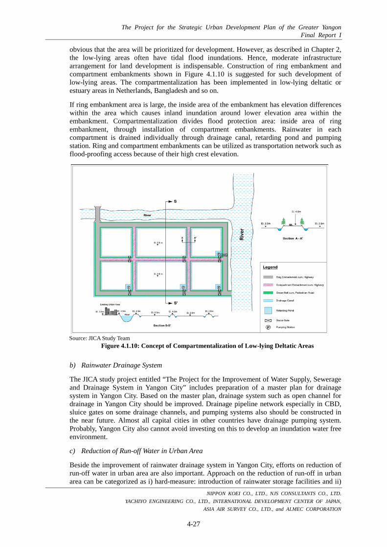
The Project for the Strategic Urban Development Plan of the Greater Yangon Final Report I
NIPPON KOEI CO., LTD., NJS CONSULTANTS CO., LTD. YACHIYO ENGINEERING CO., LTD., INTERNATIONAL DEVELOPMENT CENTER OF JAPAN,
ASIA AIR SURVEY CO., LTD., and ALMEC CORPORATION
4-27
obvious that the area will be prioritized for development. However, as described in Chapter 2, the low-lying areas often have tidal flood inundations. Hence, moderate infrastructure arrangement for land development is indispensable. Construction of ring embankment and compartment embankments shown in Figure 4.1.10 is suggested for such development of low-lying areas. The compartmentalization has been implemented in low-lying deltatic or estuary areas in Netherlands, Bangladesh and so on.
If ring embankment area is large, the inside area of the embankment has elevation differences within the area which causes inland inundation around lower elevation area within the embankment. Compartmentalization divides flood protection area: inside area of ring embankment, through installation of compartment embankments. Rainwater in each compartment is drained individually through drainage canal, retarding pond and pumping station. Ring and compartment embankments can be utilized as transportation network such as flood-proofing access because of their high crest elevation.
Source: JICA Study Team
Figure 4.1.10: Concept of Compartmentalization of Low-lying Deltatic Areas
b) Rainwater Drainage System
The JICA study project entitled “The Project for the Improvement of Water Supply, Sewerage and Drainage System in Yangon City” includes preparation of a master plan for drainage system in Yangon City. Based on the master plan, drainage system such as open channel for drainage in Yangon City should be improved. Drainage pipeline network especially in CBD, sluice gates on some drainage channels, and pumping systems also should be constructed in the near future. Almost all capital cities in other countries have drainage pumping system. Probably, Yangon City also cannot avoid investing on this to develop an inundation water free environment.
c) Reduction of Run-off Water in Urban Area
Beside the improvement of rainwater drainage system in Yangon City, efforts on reduction of run-off water in urban area are also important. Approach on the reduction of run-off in urban area can be categorized as i) hard-measure: introduction of rainwater storage facilities and ii)

The Project for the Strategic Urban Development Plan of the Greater Yangon Final Report I
NIPPON KOEI CO., LTD., NJS CONSULTANTS CO., LTD. YACHIYO ENGINEERING CO., LTD., INTERNATIONAL DEVELOPMENT CENTER OF JAPAN,
ASIA AIR SURVEY CO., LTD., and ALMEC CORPORATION
4-28
soft-measure: conservation of water body 1 and forest areas, regulation of wetlands development. In Japan, some large scale public buildings comprise rainwater collection and reuse system 2 e.g. the rainwater storage capacity of Edo-Tokyo museum and Sky-tree complex building is 2,635 m3 and 2,500 m3, respectively.
d) Crest Elevation of Highway and Railway
For catastrophic flood disasters, fundamental road network such as circumferential road should have a crest with enough elevation to maintain its function during and after the floods because the road network will be utilized for evacuation, rescue and food/water supply routes. In Bangladesh, crest elevations of national highway network are set higher than 50-year probable flood water level based on experienced difficulties of rescue/needs supply activities during and after the floods.
e) Regulation of Underground Development
Based on the JICA study survey results, it was concluded that there is no need for a traffic underpass system. This conclusion is reasonable since underpass structures require drainage system such as pumps. In Jakarta,and Indonesia, there were reported victims caused by drainage congestion in the underpass system. Pumping systems on the underpass in Jakarta malfunctioned during the flood occurrence, and rainfall ponds have developed in the underpass at the time of the accident. It is reasonable to mention that underground structures including underpass and underground parking lots on low elevation areas should be strictly regulated or prohibited for safety.
8) Improvement of Management System
In light of the basic policy-6, improvement of data management system is proposed to be a city of good governance as follows.
(1) Accurate Statistics of Wards
An urban development planning shall be strengthened by statistics that illustrate current socio-economic conditions and level of urban services accurately. To acquire that information, a statistic based on ward level is indispensable. However, current statistics reported by ward and township are not consistent. This is caused by a manually-calculated statistics and paper-based reports by ward officers. These systems should be elaborated through training of ward officers in terms of developing expertise in statistics, unification of statistics form, preparation of statistics manual, etc.
Training of ward officers as a statistic expert,
Unification of statistic form
Preparation of statistic manual
Computerization of statistic reports
Periodically submission of the report to Township office
Appropriate Aggregate Calculation by Township Office and YCDC
1 Hanoi City, Vietnam is enlarging flood storage function of existing lakes through JICA cooperation, and Phnom Penh City, Cambodia backfilled a large lake to develop new real estate with foreign developer. Both capital city has opposite direction of urban development. 2 Collected rainwater is used as water provision on garden, toilet, temperature conditioning system of building etc.

The Project for the Strategic Urban Development Plan of the Greater Yangon Final Report I
NIPPON KOEI CO., LTD., NJS CONSULTANTS CO., LTD. YACHIYO ENGINEERING CO., LTD., INTERNATIONAL DEVELOPMENT CENTER OF JAPAN,
ASIA AIR SURVEY CO., LTD., and ALMEC CORPORATION
4-29
(2) Updating and management of household information
People’s opinion shall be concisely reflected in the urban planning process. There are several measures to grasp people’s opinions, such as stakeholder meeting, household interview survey, mail survey, and so on. However, these activities should be repeated periodically to compare the change of people’s opinions and their current socio-economic conditions and urban issues. Therefore, data collected from those activities should be organized in a database, periodically updated and managed properly.
Establishment of household database, which includes people’s opinion acquired from workshops and sampling surveys
Periodical conduct of sampling surveys
Updating and analysis of changes
Utilization of the results to urban planning
(3) Establishment of E-government
E-government provides an efficient administration and an easy access to information for residents through computerization of administrative procedures. The administration procedure relating to a household such as household registration, payment to urban services and taxes, and so on should be computerized. The system will manage the information regarding household members, occupation, date of birth, connectivity to urban services, etc. Based on this system, obtaining statistics for ward shall become easy and accurate, and can be effectively utilized for urban planning. In addition, provision of administrative information through internet will help people access information easily, relieve the burden of government officers, and achieve efficient works.
Clarification of administrative works to be computerized
Computerization of household registration
Computerization of payment for urban services and taxes
Computerization of clarified works
Establishment of website to provide administrative information
Provision of payment system through internet