Yangon - Report on the implementation of the zoning plan - Apur
52
apur.org 1 - DIAGNOSTIC AND GIS REPORT PARIS-YANGON URBAN COOPERATION NOVEMBER 2017 DGRI - Délégation générale aux Relations Internationales YANGON - REPORT ON THE IMPLEMENTATION OF THE ZONING PLAN
-
Upload
khangminh22 -
Category
Documents
-
view
1 -
download
0
Transcript of Yangon - Report on the implementation of the zoning plan - Apur

apur.org
1 - Diagnostic anD gis report
Paris-Yangon Urban CooPeration
november 2017
DGRI - Délégation générale aux Relations Internationales
YANGON - REPORT ON THE IMPLEMENTATION OF THE ZONING PLAN

2
Directrice de la publication : Dominique ALBASous la direction de : Christiane BLANCOTÉtude réalisée par : Marion BEAUMONT, Alain BEAUREGARD, Julien BIGORGNE, Christiane BLANCOT, Marcelin BOUDEAU, Amandine MURE-RAVAUD (Apur), Daw Tin Tin Kyi, Daw Khaing Moe Nyunt, U Aung Kyaw Soe, Daw Aye Aye Mu, U Pyae Phyo Zaw, Daw Thuzar Aung, Daw Ohnmar Khin, U Thura Thetpan, Daw Htet Sandi Win, Daw Ei Phyo Wai (UPD)Photos et illustrations : Apur sauf mention contraireMise en page : Apurwww.apur.org
Summary
Foreword � � � � � � � � � � � � � � � � � � � � � � � � � � � � � � � � � � � � � � � � � � � � � � � � � � � � � � � � � � � � � � � � � � � � � � � � � � � 3
Why is it necessary to create a zoning plan for Yangon City ? � � � � � � � � � � � � � � � � � � 4The urban population is growing fast � � � � � � � � � � � � � � � � � � � � � � � � � � � � � � � � � � � � � � � � � � � � � � � � � � � � � � 4No precise rules and norms for management of urban development � � � � � � � � � � � � � � � � � � � � � � � � � � � � 4The necessity of creating urban planing documents suitable for a large metropolis Pre-project situation � � � � � � � � � � � � � � � � � � � � � � � � � � � � � � � � � � � � � � � � � � � � � � � � � 5
Method: programme activities and expected results � � � � � � � � � � � � � � � � � � � � � � � � � � � � � 6Zoning plan � � � � � � � � � � � � � � � � � � � � � � � � � � � � � � � � � � � � � � � � � � � � � � � � � � � � � � � � � � � � � � � � � � � � � � � � � � � 6Land plot GIS at the same time as activities 1 and 2 of the Zoning Plan � � � � � � � � � � � � � � � � � � � � � � � � � 7
Summary of the diagnostic made of the Hlaing Township pilot zone and issues identified � � � � � � � � � � � � � � � � � � � � � � � � � � � � � � � � � � � � � � � � � � � � � � � � � � � � � � � � � � � � � � � � � 8
Zoning plan diagnostic � � � � � � � � � � � � � � � � � � � � � � � � � � � � � � � � � � � � � � � � � � � � � � � � � � � � � � � � � � � � � � 14Work method � � � � � � � � � � � � � � � � � � � � � � � � � � � � � � � � � � � � � � � � � � � � � � � � � � � � � � � � � � � � � � � � � � � � � � � � �14Transformation process of the urban fabric � � � � � � � � � � � � � � � � � � � � � � � � � � � � � � � � � � � � � � � � � � � � � � � �18The deficiency of public infrastructures and services � � � � � � � � � � � � � � � � � � � � � � � � � � � � � � � � � � � � � � � �22Environmental issues � � � � � � � � � � � � � � � � � � � � � � � � � � � � � � � � � � � � � � � � � � � � � � � � � � � � � � � � � � � � � � � � � �28
GIS expertise report � � � � � � � � � � � � � � � � � � � � � � � � � � � � � � � � � � � � � � � � � � � � � � � � � � � � � � � � � � � � � � � � � 34Context � � � � � � � � � � � � � � � � � � � � � � � � � � � � � � � � � � � � � � � � � � � � � � � � � � � � � � � � � � � � � � � � � � � � � � � � � � � � � �34Plot documents at YCDC � � � � � � � � � � � � � � � � � � � � � � � � � � � � � � � � � � � � � � � � � � � � � � � � � � � � � � � � � � � � � � � �36Hlaing plot data analysis � � � � � � � � � � � � � � � � � � � � � � � � � � � � � � � � � � � � � � � � � � � � � � � � � � � � � � � � � � � � � � �38Work method for plot data initialization and update � � � � � � � � � � � � � � � � � � � � � � � � � � � � � � � � � � � � � � � � �44
ConCLUsion � � � � � � � � � � � � � � � � � � � � � � � � � � � � � � � � � � � � � � � � � � � � � � � � � � � � � � � � � � � � � � � � � � � � � � � � 51

Atelier pArisien d’urbAnisme 3
Yangon - report on tHe impLementation oF tHe Zoning pLan
Foreword
The study of a Pilot Zone as a basis for creating a Zoning Plan for Yangon began in early 2017.
In the context of the cooperation between the cities of Paris and Yangon, a first assessment has been made of existing documents and on those that are being prepared, carried out with the support of the French Development Agency.
More specifically, a work session was organised in May 2017 with the departments of YCDC to draw up a diagnosis, define the zoning plan method and test it. The methodology was presented and approved by the secretary of the YCDC in May 2017.
This work session has shown that it is necessary to give support and help in the drawing up of urban planing documents and norms enabling real management of urban development.
The cooperation between Paris and Yangon aims to provide the technical departments of the YCDC with tools enabling them:• To master urban development by using
urban documents valid for 10 years, with rules on which to base building permits.
• To create the conditions which provide inhabitants with a good level of services, this implies setting up a land policy based on a GIS that includes maps of land plots and the associated database (non-existent today) in order to manage the facilities and infrastructures needed for the city to function.
• To foresee the environmental dangers and to address the issues of climate change and energy economy.
The actions therefore culminate in the production of an official urban planing document, the production of norms and the setting up of an urban GIS of Greater Yangon, but also the training of personnel in order to enable them to design and make these documents and then to manage and develop them. This training could be carried out via a training/action method which consists in the close association of training and real production.

4
why is it necessary to create a zoning plan for Yangon City ?
1.
The urban population is growing fastIn a period when the urban population is growing fast, the rapidity and increasing number of building projects poses numerous problems. The excessively dense new buildings create uncomfortable and insalubrious conditions for neighbouring buildings. The non-respect of environmental constraints (notably the disappearance of vegetation and soil sealing) accentuates the risks of flooding during the summer monsoons in an area which is subject to numerous typhoons (an average of 27 per year) and which relies on the tides to drain away rainwater.
The rapid densification of the city requires infrastructures and public services (schools, medical centres…)
to accompany the arrival of new inhabitants. Yet no land is today reserved for setting these up. The road system does not have a sufficiently dense network nor the dimensions to provide a suitable service to new buildings.
It is necessary, on all levels and in all the fields of urban management, that technical services be reinforced in order to address present day issues. This involves different departments working together to provide transversal and shared management tools.
No precise rules and norms for management of urban developmentThe YRG and YCDC want to provide the region of Yangon with urban planing documents which establish a framework for urban development, and a solid foundation for applying building authority directives based on rules which are clear, precise and known by everyone. Today authorisation is given using rules which are very limited, unclear and not widely-known, which do not allow for the environment to be respected, nor for dangers to be avoided in a context where
the population, land speculation and the influx of capital and investors are all rapidly growing.
The YRG is determined to put in place short term rules and norms which are essential for supervising Yangon’s development. To achieve this the YCDC has begun to make a “zoning plan” aimed at the day to day management of building permits.

Atelier pArisien d’urbAnisme 5
Yangon - report on tHe impLementation oF tHe Zoning pLan
The necessity of creating urban planing documents suitable for a large metropolis Pre-project situation
Since 2010 the physiognomy of Yangon has changed rapidly as a result of a great number of new buildings being very densely constructed. After the Sakura tower and a number of high rise estates which were built in the heart of the city centre opposite the Maha Bandoola Park and on the Sule Pagoda Road, it is now in the area around Inya Lake and in all sectors of the city that there are more and more building works on large land plots which were previously very little built upon. No urbanism framework directives have regulated these new building complexes and the building permits have been given on a not very transparent basis. These building programmes occupy 90 to 100% of the land plots they are on, totally eradicating gardens and sealing the soil. Their density will bring about a new influx of car traffic on the road system which is ill-adapted to such intense traffic, thus increasing traffic jams which are already a cause for concern.
At the same time, in all the townships new building works are rapidly multiplying in response to the enormous demand for housing.
In this context, two kinds of urban planing documents are needed to guide and control the development of the city:• A Master Plan on the scale of Yangon
Region (YRG) to plan the new infrastructures to be created on the scale of the whole urbanised territory and to set out wider objectives concerning planning, economic development, and targets for quality of environment and landscape for the Yangon metropolis to be attained by 2030 (The Master Plan project drawn up in 2012 in co-operation
with the Japanese was a first draft of the Master Plan. The rapidity of current development will undoubtedly necessitate adapting it to the present situation in Yangon).
• A more precise Zoning Plan, aimed at managing construction on a daily basis. This plan should be designed as a tool for the YCDC technical services. It will include the main projects defined in the Master Plan.
It will define the regulations applicable to each land plot and site in the city. It will be a tool which will secure building rights for investors, builders and owners. It will be adjusted to suit the reality of each township. It will create land reserves for infrastructure projects (public space, transport, water, energy, drainage and sewerage…) and public facilities and services. It will ensure that the architectural and urban heritage is protected, and will protect the landscape, symbolic city sites, green spaces and lakes…

6
Method: programme activities and expected results
2.
Zoning plan
The activities of producing the zoning plan and training personnel will take place in three phases.
1/ Field surveys and making a land use map of present day Yangon, (zoning by type of urban fabric and by use for facilities, services and infrastructures).The survey covers:• Existing urban fabric and its
classification by type (small houses, villas, apartment blocks, industrial buildings, high-rise and high density areas…).
• Public highways (width, role in the general network of public roadways, tree plantations, public transport, in particular existing bus services…).
• Transport infrastructure.• Existing public facilities and
services: schools, universities, children’s playgrounds, health, culture, administration, technical services, transport (stations).
• Existing green spaces and natural sites: public and private green spaces, trees, bodies of water, rivers, water courses, canals…
• Economic functions: warehouses, factories and workshops, shops and markets, harbour activities.
• Particular features and monuments: religious buildings, notable or unusual edifices…
2/ Elaboration of the major orientations of the zoning plan, consultation for
the validation and writing of the key and main regulatory options of the “zoning plan” which translate the lines of orientation decided upon.
This part of the Zoning Plan contains:• A text presenting the aims of the
Zoning Plan.• A statement of the main lines of
orientation of Yangon urban policy.• The challenges facing the Zoning Plan
and its major components.• How it fits in with other urban planing
documents (if they exist).
3/ Elaboration of the Zoning Plan and graphic documents (1:5000 thematic maps and maps of each township).
Written documentThe written regulations set out for each zone: building heights, authorised land occupation and density levels, prohibited operations, authorised types of construction and their characteristics, (semi-detached or detached buildings, minimum distances between buildings), environmental norms: obligatory land occupation rights of planted areas, rainwater management…), the particular nature of each zone.
Survey legend
Atelier pArisien d’urbAnisme 7
Yangon - report on tHe impLementation oF tHe Zoning pLan
Main graphic documents • Land use and general zoning within
each zone: authorised building heights and rights of land occupation, prohibited uses and main authorised uses.
• Public spaces and infrastructures: protect existing public spaces against illegal occupation (existing roads (major and local), limits and width (in feet), existing railways to preserve). Create reserved plots and lands for new public spaces (roads, squares…); land reserves to widen roads (major and local) (in feet), land reserves to create new roads (major and local) (in feet), street line and building line – alignment, building line setback (in feet).
• Public facilities and services: reserve plots and land for public facilities and services, existing facilities and public services to conserve (plots), land reserves for new public facilities and services (education (schools and universities, libraries… ), sports, culture, kindergartens, health (hospitals, clinics, health centres… ), administration and public services (post offices, police…), sewage system, rain water system,
electricity…, railway stations, other…• Nature, water, vegetation-greening
Yangon: Preserve existing green areas and create new ones, existing public gardens and parks to preserve (plots), existing water bodies, (lakes, ponds, reservoirs) to preserve, reserves to create new green areas (plots or land), reserves to enlarge an existing green area (land and acreage), reserves to create new bodies of water (lakes, ponds, reservoirs for rain water) (in acres).
• Flood control: preserve river banks: indicate the coverage of the river bank, and its width (high and low tide), indicate areas liable to flooding…
• General building height and landscape: define the maximum height for constructions (in feet). Protect site and urban landscape, protection zones where the height of buildings is limited (in feet), protection zone in which any construction is prohibited.
• Protect monuments and heritage buildings: protected buildings, prohibited demolition (each building and plot).
Land plot GIS at the same time as activities 1 and 2 of the Zoning PlanA land plot map of the city of Yangon is essential in order to set up a Zoning Plan capable of managing construction and providing a framework for urban change on each plot.
This map will be useful for the Zoning Plan but it will also make it possible to guide land policies and make property ownership safe and secure. It has been created using a GIS (Geographic Information System) and will provide the YCDC with a modern management tool, easy to use as it can assemble all available data concerning a single plot (surface, occupation, name of owners…) in the form of digitized data, shareable between the technical services. The
YCDC GIS is in the process of being set up and now it is a question of speeding up its completion and defining the most efficient method for doing this.
Two actions need to be undertaken:1/ Definition and set up of the GIS.2/ Elaboration of the land plot map - first layer of the GIS as a basis for the Zoning Plan graphic documents and a land policy tool.
The final chapters of this report explain the actions needing to be undertaken based on the expert assessment made in July 2017 in Yangon by the person in charge of the Apur GIS.

8
Summary of the diagnostic made of the Hlaing Township pilot zone and issues identified
3.
An initial strategic diagnostic was made of a pilot township – Hlaing Township. It covered the whole of the territory of the township and a detailed survey was carried out of the whole township territory.
The survey (whose methods and results are set out in Chapter 4 of this report) which was carried out between May-July 2017 made it possible to get a
clear idea of the urban situation in the township, including its population and its built environment, and to map out the way land is used and the kinds of urban fabric to be found there.
In parallel with the land survey, a comparative analysis of the 2012 and 2016 aerial photographs has made it possible to understand the size and nature of the urban changes.
population denSity in hlaing townShip (2014)
0 0,5 miles© YCDC-APUR

Atelier pArisien d’urbAnisme 9
Yangon - report on tHe impLementation oF tHe Zoning pLan
2012 - Bodies of water and empty land
2012 - Empty land
2012 - Natural area near Inya Lake
2012 - Natural area
2016 - Backfilled land, water bodies disappeared
2016 - High density construction
2016 - Huge plots
2016 - Backfilled lot
© G
oogl
e ea
rth
© G
oogl
e ea
rth
© G
oogl
e ea
rth
© G
oogl
e ea
rth
© G
oogl
e ea
rth
© G
oogl
e ea
rth
© G
oogl
e ea
rth
© G
oogl
e ea
rth

10
In brief, the analysis is as follows:
1/ The density of construction is increasing rapidlyHlaing township is one of the most densely-populated townships in Yangon (apart from the city centre-“down town”) with 160,307 inhabitants in a territory of 10.17 km². However, this density is not spread evenly. The central area, closest to the railway line and wide avenues running north-south, is the densest. It is also there and in the southern section of the township, where there is a concentration of residents going about their daily business. In contrast, the western area is taken over by harbour facilities and low-density housing estates and the northern section by the university.It is these variations in density which make this township an attractive district of Yangon. The Zoning Plan must establish an acceptable future level of density for each sector of the township.
2/ Types of construction are changingThis township is made up of very diverse kinds of urban fabric. It houses both high-rise office and housing blocks, apartment blocks of 5 – 6 floors, neighbourhoods of luxury houses for those who are well-off, poorer districts with small houses and a precarious housing area. This social mix and the disparity in buildings make up the particular character of the township. However, current changes are tending to unify building construction, with two types predominating: 4 – 6 storey buildings on small land plots occupied until recently by houses, and groups of very densely-built high-rise buildings on large land plots which up to now have been undeveloped or hardly at all. The districts containing luxury houses are getting denser as existing buildings are extended over surrounding gardens.The Zoning Plan must lay down what kind of buildings can be permitted in the various zones of the township. In particular, it must
define the sectors to be protected from a too dense urbanisation: for example, the districts with luxury houses and small houses (should they be preserved?), the areas with precarious housing without drivable roads (should they be developed? moved? demolished?)… The Zoning Plan regulations should define the building coverage ratio and the siting, height and density of future construction on land plots.
3/ Buildings adapted to the climate are tending to disappear in favour of air-conditioned buildingsRecently-constructed buildings have to be air-conditioned in order to be habitable. This engenders higher energy consumption and presents a high risk in the event of power cuts.The Zoning Plan must establish rules ensuring that building design is suited to the climate of Yangon, uses less energy and is habitable in times of natural catastrophe or power cuts.
4/ Public space is highly sought afterHlaing township has few wide public roads. Those which exist run north-south and there is only one running east-west on the northern edge of the township. Current urban changes are increasing the density of construction along narrow streets, (less than 50 feet wide) and very narrow roads in the districts with small houses and precarious housing (less than 25 feet wide). Only a few streets are capable of ensuring city-scale traffic-flow. They are almost impassable in rush hours.Where large housing estates are concerned, roads have been closed and privatised, reducing the road network and creating huge inaccessible enclaves.The increase in density of buildings makes it vital to strengthen the road network by creating new streets and rationalising the existing network.The Zoning Plan must indicate the location of new streets and select streets to be widened and those to be re-opened. It must lay down parking regulations, in particular where
large development operations are concerned.
5/ The amount of traffic is increasing, traffic jams are more frequent, space to accommodate means of transport is reducingThe rapid increase in the number of cars in the city is the second most important risk factor both because of air pollution and the increased difficulty in getting around for the population. In fact, the increase in traffic jams could make it so difficult to get around the city that it could jeopardise its economic development and paralyse its most vital functions. For this reason, establishing a public transport system is a priority which the Zoning Plan must help to set up. It is a piece of luck that a circular railway already exists in Hlaing township. It must be protected and renovated so that it can play a role in transporting passengers around the whole city.
6/ There are no public parks or playgrounds for childrenThere are no public parks in Hlaing township. The presence of Inya Lake Park and the university campus go partway towards meeting the need for a green space for the eastern section of the township, but no neighbourhood parks or playgrounds exist in the township, in particular in the centre and west.The Zoning Plan must create reserves for public parks, playgrounds and sports grounds, drawing on existing green, open spaces available and the large land projects which could accommodate them.

Atelier pArisien d’urbAnisme 11
Yangon - report on tHe impLementation oF tHe Zoning pLan
2012 - Small houses
Wooden house, bio climatic house
Contrast betwen small houses and 6-7 storey collective housing
2016 - Houses become collective housing
Villa with natural ventilation
© G
oogl
e ea
rth
© G
oogl
e ea
rth

12
7/ Gardens, natural spaces and bodies of water are disappearing and being replaced by backfilled lands and buildingsIt is clear that since 2012 several large natural spaces have disappeared, some of which contained bodies of water into which rainwater could drain in the rainy season. The small streams which drained rainwater into the river are disappearing or have been blocked.In the luxury villas areas, building extensions and the replacement of the villas by buildings several floors high taking up the whole plot are reducing or eliminating gardens altogether. The ground in the remaining gardens has been sealed and turned into parking lots.Trees are disappearing both along the streets and avenues and also on plots of land. The Zoning Plan must protect private gardens and make it obligatory to reserve a part of the land plots to create new ones, ensure the ground is permeable and create new public green spaces. A norm requiring that every project include a reservoir for rainwater to avoid the risk of flooding and help cool the city must be included in the Zoning Plan. A plan should be drawn up concerning rainwater drainage and management of floodwater by reinstating the streams.
8/ Meeting the environmental challenges is crucial in a context affected by climate change and the multiplication of extreme climate eventsThe survey carried out on Hlaing Township has revealed some worrying risk factors affecting the population if these were to multiply in the city.The disappearance of vegetation, trees, natural spaces, water bodies and water courses which ensured that rain water would drain away, coupled with a rapid increase in the density of buildings and a sealing of the ground have led to fears that the temperature will rise in the city, the risk of flooding will grow in certain districts and it will be more and more difficult to control air quality
and rain water drainage during the heavy monsoon rains. The problem of household waste disposal needs to be addressed at the same time because every inadequate waste disposal policy worsens the risk of flooding through saturation of the drainage networks.A firm environmental policy must be developed as part of the Zoning Plan. It must play a regulatory role. The presence of nature in the city must be preserved and increased, and this must be a priority in the urban policy of Yangon in the face of investors who are developing increasingly dense, mineral dominated and nature-exclusive construction projects.
9/ The issuing of building permits without written regulations prevents proper control of constructionWithout an accurate and up-to-date land plot map, without written regulations, the services in charge of managing the issuing of building permits cannot fulfil their job. Housing estate plans and the calculation of land area are very difficult to manage without a cartographic tool. Refusing a building permit on the grounds of too high density or non-respect of the rights of neighbours are impossible to justify without written regulations defining surface ratios, land occupation rights and minimum distances between land boundaries. The presence of gardens, respect for trees and also the obligation to install drainage networks cannot be imposed in the absence of clear, official written regulations.This is the major challenge for the Zoning Plan: provide the public administration with the means to accomplish its mission.

Atelier pArisien d’urbAnisme 13
Yangon - report on tHe impLementation oF tHe Zoning pLan
2012 - Natural area near the university
2012 - Empty land, water body
Flooded area Stream with garbage and precarious housing on the stream
2016 - Housing for university, sealed soil
2016 - Backfilled lot for a car park
© G
oogl
e ea
rth©
Goo
gle
earth
© G
oogl
e ea
rth©
Goo
gle
earth

14
Zoning plan diagnostic4.
Work methodOur work consisted in gathering the different types of data we have collected, and crossing them through a technical tool, the Geographical Information
System. It enabled us to generate the mapping of the current urban situation in Hlaing Township and to form a digital data base.
Spatialanalysis
Urban fabric observationin field survey
Collaboration with otherdepartments and services
in YCDC
Crossing with datasurvey collected
by Hlaing Townshipoffice and wardsadministrators
Crossing with socio-economic
data from the 2014 Census
Collaboration withHlaing Township office
Collaboration withinternational actors
(AFD, JICA…)
Documentation reviewof institutionnal reports
Comparison exerciseof the 2012 and 2017
aerial photographsto identify the main
transformations
Socio-economicanalysis
GeographicalInformation System
data base
Urbangovernance
Field survey methodologyField survey is at the heart of our project and enables us to have a fine scale and comprehensive approach of the urban situation in Hlaing Township.
Our method corresponds to three levels of analysis:• A statement block by block by the type
of urban fabric.• A statement and localization of land use
for the public services and facilities in the whole township.
• On-field analysis of the transformations previously observed with the aerial photographs’ comparison exercise.
Between May and July 2017, a team of 5-8 people from Zoning and Land Use Section has gone to the field twice a week (Tuesday and Thursday) to make the inventory of urban fabric and land use. The perimeter was first divided into subzone according to the road network and an itinerary has been defined in order to cover all the areas.

ATELIER PARISIEN D’URBANISME 15
Yangon - report on tHe impLementation oF tHe Zoning pLan
the team of ycdc during the field Survey
Walking rather than driving for the survey was a way to have a more comprehensive approach and be able to discuss with the inhabitants. Furthermore, there are several zones of high density with small settlements and really narrow streets that are not accessible other than by walking.
Documentation and secondary data reviewThose data collected during the fi eld survey were completed by a documentation review, the conduct of interviews and collaborative working sessions.
A documentation review was done from institutional reports written by different international organizations and actors (UNDP, international cooperation actors, non-governmental organizations…) for urban issues in Yangon. We also combine the statistical data produced by the National Census of 2014 that we entered in our digital database, as such as the one produced by the different departments of YCDC and
Hlaing Township offi ces. However, most of the data are available at a Township level, except for the demographic population and public education facilities, and a statistical survey may be necessary at a ward scale to have a more precise statement.
A work of interviews and workshop sessions enable us to understand the distribution of roles and allocation of responsibilities within the YCDC and the urban governance in Yangon. The legal and strategical framework has been consulted, at a local, regional and Union level, including: the National Myanmar Building Code (Proposition of law 2016), the Yangon Master Plan (Region of Yangon), the Yangon Zoning Book (YCDC).
Implementation of digital data base: the Geographical Information System The crossing of all those data on Hlaing Township has been realized thanks to the implementation of a digital data base through a Geographical

16
Information System using ArcGIS. A base map has been provided from Paris Agency of Urban Planning, using an aerial photography (World View 3), updated (2016), precise (1:1000 maximal zoom) and with high resolution (30cm Resolution) that works without internet connection. It could serve as a basis for a fine scale and precise Zoning Map (1:2000) eventually by integrating plot data.
The Geographical Information System has been a privileged technical method to gather, organize, manage and analyze the disparate information we have collected on Hlaing Township. A technical assistance was conducted during the whole period with the junior urbanist as well as during a workshop session with Paris GIS expert, enhancing tools and skills to interprete the data. After the mapping of the different types of urban fabric we have
identified, we conducted geographical analysis, geoprocessing and spatial modelling. Those technical tools and capacities are needed to move towards a modernization of the local urban management.
The major challenges of urban development in Hlaing TownshipHlaing Township, located in West Yangon between Hlaing River and the Inya Lake, is one of the most densed township of Yangon City (except the downtown area), with its 160 307 inhabitants on a 10.17 km² surface area. The Township has the particularity of being very heterogeneous, in its urban landscape and fabric, its demographic composition as well as its socio-economic characteristics. It leads to significant inequalities and disparities from one area to another. The integrated method that we developed, based on a ground survey and a comparative analysis of the urban situation in 2012, enable us
current land uSe in hlaing townShip
0 0,5 miles© YCDC-APUR

Atelier pArisien d’urbAnisme 17
Yangon - report on tHe impLementation oF tHe Zoning pLan
Precarious settlement
Villa
Low rise collective building
Small houses and average houses
Middle rise collective building
Mixed zone middle density Huge plots
current land uSe - exampleS

18
to study and make a typology of urban zones according to their specifi c urban fabric as well as how they have changed.
The objective was to defi ne a typology that could refl ect the urban fabric and land use of the Township. With a focus on the shape of the urban fabric, we were more able to understand how the socio-economic transformations can affect the
tranSformation proceSS of the urban fabric in hlaing townShip
Transformation process of the urban fabric
built environment and urban landscape, in order to design morphological rules. An approach based on the building function lacks to refl ect the reality on the ground, which is characterized by a mix of urban activities. As such there is often a combination between residence and commerce in a same type of urban fabric or a same building, what we designated as an “urban mixed zone”.
We identifi ed three main transformation processes that we will present more in details as follow.
Large-scale development projects: high rise collective buildings and huge plotsWithin its heterogeneous urban fabric according to which the majority of the population lives in apartments (17 803 households out of 32 837 households, 2014 Census) Hlaing is characterized by a process of densifi cation and verticalization of the city that occurs at two levels. On the fi rst hand, we observe the multiplication of large-scale development projects on wide lots, for the most part situated on main roads. We identifi ed according to our fi eld survey 40 high rise buildings (more than 9 storey) built or in construction in 2017. Only 6 of those were already there in 2012, which means that 85% of the high rise buildings have been constructed between 2012 and 2017 in Hlaing Township. Two areas are particularly subject to those real estate projects:• The area running alongside Baho Road
and Insein Road, two main axis of the whole Yangon City as they ensure a high connection with other attractive sectors.
• The area situated on the riverside of the Inya Lake, including the university lands.
There is often a radical shift in the land use and urban landscape with those real estate developments. They may take the form of high rise condominiums or commercial use, inspired by international standards that are not always suitable for Yangon climate. Open space, vacant or underdeveloped lands that present a high natural coverage are a target for those real estate projects. It leads to a loss of large plots of vegetation and body of water that are more and more turning into soil sealing with a high lot coverage.

Atelier pArisien d’urbAnisme 19
Yangon - report on tHe impLementation oF tHe Zoning pLan
land uSe evolution 2012-2017 in hlaing townShip
0 0,5 miles
Uncontrolled subdivision of the plot up to 5 feet of width New high density building
© YCDC-APUR

20
Densification and verticalization in middle density areasOn a second hand, we can observe a densification and verticalization of the city at a small-scale, which is not the most spectacular and may be forgotten by a large-scale policy, but is the most widespread one. In what we qualified as middle density urban mixed zone, where there is a combination of commercial activities on the ground floor and residential functions on the upper floors, there is a progressive disappearance of the model of the average house. This urban fabric is however frequent, composing around 40% of the housing fabric, with 2665 bungalows or brick houses, 3494 semi-pacca houses and 7969 wooden houses (2014 Census). They are more and more replaced by middle rise collective buildings between three and eight storey. It’s even more obvious in housing allotments’ zone, due to the presence of a complete road network that could support a densification. As in every part of the city, the subdivision and densification of plots are a way of creating property and land value, without complying the building regulations, with sometimes an absurd width up to 5 feet for a low rise building.
We can observe a loss of vegetation and a soil waterproofing for all the lots that hosted previously average houses and are now being replaced by middle rise collective buildings. The building coverage greatly exceeds the total coverage of the surface, compared to non-built spaces and natural coverage. Band of trees on street line are increasingly scarce.
This densification process focuses on certain areas and is not spread in an homogeneous way. Hlaing Township is rather characterized by significant disparities within its territory, from a population density of 32 persons per hectare in Ward 15 to a population density of 585 persons per hectare in Ward 1 (Census 2014). As we can see in the map that represents the land use evolution between 2012 and 2017, the densification and verticalization process concentrates in the middle part of the township, between Baho Road and Insein Road, as well as at the east, close to the university lands.
New middle density building New middle density building and little house Little houses inside a block with middle density buildings around them
Atelier pArisien d’urbAnisme 21
Yangon - report on tHe impLementation oF tHe Zoning pLan
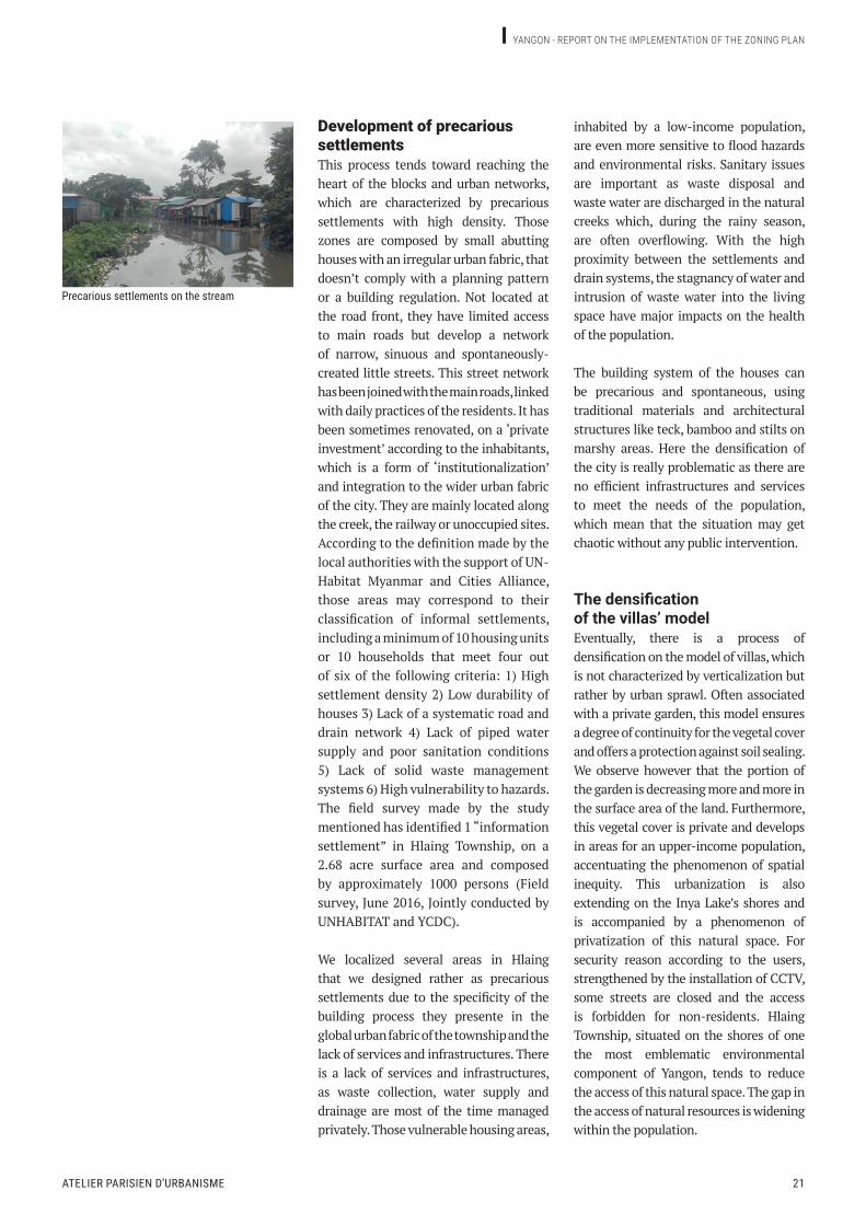
Development of precarious settlementsThis process tends toward reaching the heart of the blocks and urban networks, which are characterized by precarious settlements with high density. Those zones are composed by small abutting houses with an irregular urban fabric, that doesn’t comply with a planning pattern or a building regulation. Not located at the road front, they have limited access to main roads but develop a network of narrow, sinuous and spontaneously-created little streets. This street network has been joined with the main roads, linked with daily practices of the residents. It has been sometimes renovated, on a ‘private investment’ according to the inhabitants, which is a form of ‘institutionalization’ and integration to the wider urban fabric of the city. They are mainly located along the creek, the railway or unoccupied sites. According to the definition made by the local authorities with the support of UN-Habitat Myanmar and Cities Alliance, those areas may correspond to their classification of informal settlements, including a minimum of 10 housing units or 10 households that meet four out of six of the following criteria: 1) High settlement density 2) Low durability of houses 3) Lack of a systematic road and drain network 4) Lack of piped water supply and poor sanitation conditions 5) Lack of solid waste management systems 6) High vulnerability to hazards. The field survey made by the study mentioned has identified 1 “information settlement” in Hlaing Township, on a 2.68 acre surface area and composed by approximately 1000 persons (Field survey, June 2016, Jointly conducted by UNHABITAT and YCDC).
We localized several areas in Hlaing that we designed rather as precarious settlements due to the specificity of the building process they presente in the global urban fabric of the township and the lack of services and infrastructures. There is a lack of services and infrastructures, as waste collection, water supply and drainage are most of the time managed privately. Those vulnerable housing areas,
inhabited by a low-income population, are even more sensitive to flood hazards and environmental risks. Sanitary issues are important as waste disposal and waste water are discharged in the natural creeks which, during the rainy season, are often overflowing. With the high proximity between the settlements and drain systems, the stagnancy of water and intrusion of waste water into the living space have major impacts on the health of the population.
The building system of the houses can be precarious and spontaneous, using traditional materials and architectural structures like teck, bamboo and stilts on marshy areas. Here the densification of the city is really problematic as there are no efficient infrastructures and services to meet the needs of the population, which mean that the situation may get chaotic without any public intervention.
The densification of the villas’ modelEventually, there is a process of densification on the model of villas, which is not characterized by verticalization but rather by urban sprawl. Often associated with a private garden, this model ensures a degree of continuity for the vegetal cover and offers a protection against soil sealing. We observe however that the portion of the garden is decreasing more and more in the surface area of the land. Furthermore, this vegetal cover is private and develops in areas for an upper-income population, accentuating the phenomenon of spatial inequity. This urbanization is also extending on the Inya Lake’s shores and is accompanied by a phenomenon of privatization of this natural space. For security reason according to the users, strengthened by the installation of CCTV, some streets are closed and the access is forbidden for non-residents. Hlaing Township, situated on the shores of one the most emblematic environmental component of Yangon, tends to reduce the access of this natural space. The gap in the access of natural resources is widening within the population.
Precarious settlements on the stream

22
The deficiency of public infrastructures and services
the road network in hlaing townShip
0 0,5 miles© YCDC-APUR
The deficiency of the road networkBeyond the fact that the densification and verticalization of Hlaing Township is remodeling the urban landscape, we can note that the issue is more of a social order and of urban governance. As the urban population is increasing more and more and the city is densifying, there is a lack and failure of infrastructures to meet the needs of the population.
One of the main issues that the City of Yangon is challenging is the management of transport infrastructures that are more and more solicited by the rise of urban traffic. In Hlaing township, the hierarchy of the road network is incomplete and defective, affecting the flow management and thus the functioning of the city.
The field survey as well as data from the JICA Study Team enable us to conduct a classification of lanes according to their role in the road network and their uses. There are five structural arteries, with four north-south axis (Bayintnaung Road, Baho Road, Insein Road et Pyay Road) and one east-west road (Parami Road), supplemented with the railway network of the Circular line along Baho Road. Between 30 to 50 feet (10 to 15m) of width and four to six lanes, they are characterized by their significant role in the urban traffic of the entire Yangon City, ensuring a link with other townships and attractive sectors.
Irregular and fragmented, the rest of the road network is characterized by a lack of secondary roads. They ensure a

Atelier pArisien d’urbAnisme 23
Yangon - report on tHe impLementation oF tHe Zoning pLan
current land uSe - exampleS
Street in a precarious housing area Streets in a small houses areas
Main street in a mixed zone
Street in a middle density collective housing area
Main street in a villas’ area
Main avenue of Hlaing Township

24
connection between different areas but seem to experience difficulties to provide service road throughout the whole township. They are most of the time discontinuous and segmented when it is about to be linked with the five structural arteries, that have in this case rather a role of rupture than connectivity. Eventually, the spontaneous-created little streets present in the precarious settlements zone constitute an unplanned network for a local circulation, linked with the daily practices of the inhabitants. They are not observable on aerial photographs or on mapping.
Since the first land dividing in the 20th century, little and even no change has been taken over to improve the network, which is moreover largely affected by the densification and urban sprawl. When some housing allotments have been constructed with their streets, it was without any global strategy of linkage with the urban fabric. Hlaing Township is now a juxtaposition of urban fragments seriously altered by traffic congestion.
This issue is even more problematic as the urban extension on the other side of Hlaing River would involve the augmentation of river crossing capacity, planified by the Yangon Master Plan, and thus the construction of a bridge that could be built in Hlaing Township. The use of technologies to overcome natural constraints may imply a network development east to west. Thereby, by its strategic and intermodal location, we can expect that the traffic network will increase in the future in Hlaing Township. The boom of the car market in recent years results in an increase in car ownership that would affect even more urban traffic issues. According to the 2014 Census, approximately 18% of households in Hlaing Township own a motor vehicle. As seen previously, the population response to this weak public intervention is private and thus, based on particular interest. In precarious settlements area, some part of the street network has been sometimes renovated, which is a form of ‘institutionalization’
and integration to the wider urban fabric of the city, but still according to a private intervention.
Even where the road network seems complete as in housing allotments, there is a lack of public maintenance that can be seized by private interest. Eventually, in area inhabited by a higher-income population, we can observe cases of a real privatization of the street by a restricting or closing device to public access, as gate system. This is affecting even more the secondary road network which is yet inadequate.
In a township where there are only few, if any, public spaces, the street constitutes the sociability place for the population and provides the support for numerous social and commercial activities. As mentioned before, with a few playgrounds, the children turned to the street for their recreational practices. The use of the street generates a social dynamism and an implication of the population in the making of the city. However it has to be regulated in order to avoid the vulnerability of the population to injuries and the traffic congestion.

Atelier pArisien d’urbAnisme 25
Yangon - report on tHe impLementation oF tHe Zoning pLan
The lack of public servicesPublic facilities and services are insufficient and inadequate to the population increase and the densification of the city. With an estimated population growth rate of 2.6% per year (according to the City Planning and Land Use Administration Department of the YCDC), the Township may host more than 25 000 inhabitants between 2014 and 2020, with a total population projected to 186 918 persons for 2020 and around 241 743 for 2030.
The number of public schools doesn’t accommodate the current needs of the population composed by more than 36 614 young people aged between 0 and 17 years old (2014 Census). There are only two public health centers for a population of 160 307 people, one hospital in construction which will open in 2018, and one fire station for the whole township.
If we focus on education facilities, we observe that there is also a profound spatial disparity in the public services offer. According to the figures from the Township Education Office (start of the school year in April 2017), there are 593 students for 10 pre-schools (2 public pre-schools and 8 private), 4505 students for 27 primary schools, 4554 students for 7 middle schools and 3942 students for 4 high schools in the whole township. There are as well 382 students divided in four monastery schools.
Even if the student population from primary to high schools has decrease between 2012 and 2017 (growth rate of -6.4%), which is justified by the Township Office by changes of residence, we can expect an increase of the student population in the upcoming years. According to the growth of urban population in Yangon, we can project a student population of approximately 19 510 persons for 2030.
Through the GIS (ArcGIS), we made a spatial analysis in order to estimate the spatial distribution of schools according to the density of population in wards.
data about public education in hlaing townShip
sr School Name Area(acre) No. of teacher No. of student Teacher and student ratio
1 BEHS 1 1,26 39 674 01:172 BEHS 2 0,75 55 1695 01:133 BEHS 3 0,65 32 657 01:214 BEHS 4 0,54 39 916 01:23
Total 3,2 165 3942 01:24
sr School Name Area(acre) No. of teacher No. of student Teacher and student Ratio
1 BEMS 1 0,53 30 708 01:242 BEMS 3 1,02 13 252 01:193 BEMS 4 0,52 29 858 01:304 BEMS 5 0,65 20 362 01:185 BEMS 6 1,07 35 1191 01:346 BEMS 7 0,53 29 893 01:317 BEMS 8 1,09 20 290 01:15 Total 176 4554 01:25
sr No. of primary school Area(acre) No. of teacher No. of student Teacher and
student ratio1 27 0 186 4505 01:24
sr Pre school name Area(acre) No. of teacher No. of student Teacher and student ratio
1 Elite 0 3 57 01:192 Pyo Khinn 0 2 38 01:183 Wine Yin Kwin 0 2 40 01:194 Yin Tway Yadanar 0 3 57 01:195 A Nar Gat 0 4 76 01:186 Kha Yay 0 2 38 01:187 Myittar Pan 0 3 57 01:198 Hlaing 1 0 4 82 01:209 Hlaing 2 0 5 90 01:18
10 MiKhin KaLay 0 4 58 01:19 Total 32 593 01:18
monaStery School
sr Monastery school name Area(acre) No. of teacher No. of student Teacher and
student ratio
1 Kyankhinn kyaung (5 ward) 0 5 103 01:21
2 Myittarwardi (16 ward) 0 5 161 01:32
3 Aungthaitdi(12 ward) 0 5 51 01:17
4 Thiri zayyone (13 ward) 0 4 67 01:17
Total 19 382 01:20
child School entrance
sr5 years old Child school entrance School
entranceMale Female Total Male Female Total1 540 547 1087 540 547 1087 100 %
paSSing high School
sr5 years old Child school entrance
Total Candidature Pass % Total Candidature Pass %1 2196 2059 874 42,45 2264 2074 ? ?

26
public ServiceS and faciliteS - exampleSWe obtain the following map which shows the spatial inequality: the zone in blue corresponds to areas without any school, while there are situated in wards with a middle or high density of population.
All those existing facilities and services which don’t meet the needs of the current population won’t be able to face the population increase.
The university
Health centre
Security centre
Hindy temple
Buddhist temple
religiouS buildingS - exampleS

Atelier pArisien d’urbAnisme 27
Yangon - report on tHe impLementation oF tHe Zoning pLan
public ServiceS and faciliteS in hlaing townShip
0 0,5 miles
0 0,5 miles
© YCDC-APUR

28
Environmental issues
water SyStem and flood riSk area in hlaing townShip
0 0,5 miles
inya lake iS the main green park for hlaing townShip
© YCDC-APUR
As we said previously, a gradual disappearance of natural and green cover, remarkable between 2012 and 2017, can also be observed at two levels: on a large scale with the development of
commercial and residential projects on huge plots, and on a small scale the loss of green cover such as private gardens or band of trees in street lines.
Atelier pArisien d’urbAnisme 29
Yangon - report on tHe impLementation oF tHe Zoning pLan
Flooded plot during the raining season The stream during the raining season
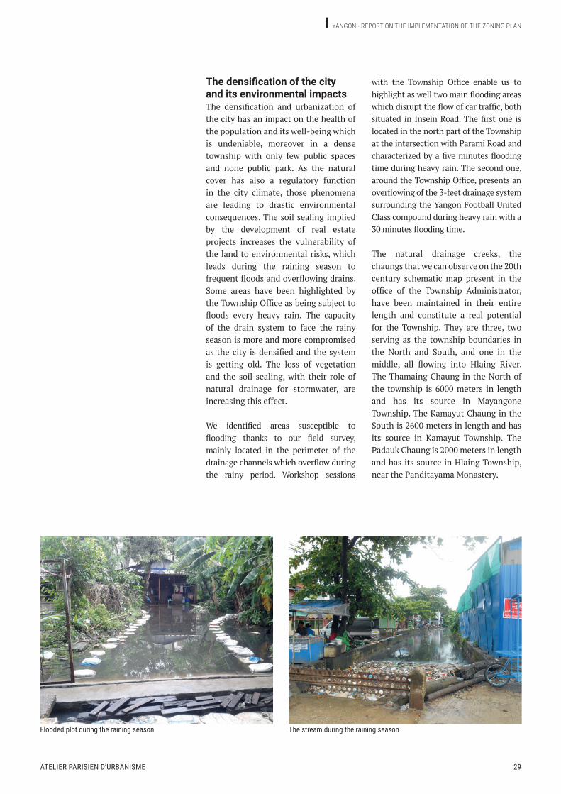
The densification of the city and its environmental impactsThe densification and urbanization of the city has an impact on the health of the population and its well-being which is undeniable, moreover in a dense township with only few public spaces and none public park. As the natural cover has also a regulatory function in the city climate, those phenomena are leading to drastic environmental consequences. The soil sealing implied by the development of real estate projects increases the vulnerability of the land to environmental risks, which leads during the raining season to frequent floods and overflowing drains. Some areas have been highlighted by the Township Office as being subject to floods every heavy rain. The capacity of the drain system to face the rainy season is more and more compromised as the city is densified and the system is getting old. The loss of vegetation and the soil sealing, with their role of natural drainage for stormwater, are increasing this effect.
We identified areas susceptible to flooding thanks to our field survey, mainly located in the perimeter of the drainage channels which overflow during the rainy period. Workshop sessions
with the Township Office enable us to highlight as well two main flooding areas which disrupt the flow of car traffic, both situated in Insein Road. The first one is located in the north part of the Township at the intersection with Parami Road and characterized by a five minutes flooding time during heavy rain. The second one, around the Township Office, presents an overflowing of the 3-feet drainage system surrounding the Yangon Football United Class compound during heavy rain with a 30 minutes flooding time.
The natural drainage creeks, the chaungs that we can observe on the 20th century schematic map present in the office of the Township Administrator, have been maintained in their entire length and constitute a real potential for the Township. They are three, two serving as the township boundaries in the North and South, and one in the middle, all flowing into Hlaing River. The Thamaing Chaung in the North of the township is 6000 meters in length and has its source in Mayangone Township. The Kamayut Chaung in the South is 2600 meters in length and has its source in Kamayut Township. The Padauk Chaung is 2000 meters in length and has its source in Hlaing Township, near the Panditayama Monastery.

30
They form the structuring network for both waste water management (domestic and industrial) and storm water management, flowing into Hlaing River. Walls protection and culverts can be found in urbanized areas, but they are sometimes open and non-ducted. They are more and more subject to overflowings, which can get even worse in the future with the densification of the township and the climate change.
During the rainy season, the concomitance between high tide and heavy rain results in frequent floods in some areas. Flood hazards can be nonetheless limited due to the presence of the Inya Lake and its 3.2 km² of surface area, which serves as a temporary storm water retention during heavy rains.
The tidal flow can also be altered by the accumulation of solid waste as the drainage channels are often used by the population as a waste disposal site.
The presence of industrial sites along their sides could also generate several pollutions for the surroundings as well as the water environment of Hlaing River, as it is the case for the Padauk Chaung. With some large-scale real estate development on the edges and soilsealing, the situation may become chaotic. The stagnancy of rainwater is a favorable environment for the development of pathogens and other noxious elements such as mosquitos. Therefore, it is necessary to preserve the well-functioning of drain system and avoid flood hazard as it could cause health and environmental risks as well as other urban damages.
It can even more increase the health and socioeconomic risks for a vulnerable population that is settled along the channels, without any safety distance and whose housing is affected by flooding.
Moreover, those natural issues are treated as environmental constraints
water SyStem and flood riSk area in hlaing townShip
0 0,5 miles© YCDC-APUR

Atelier pArisien d’urbAnisme 31
Yangon - report on tHe impLementation oF tHe Zoning pLan
Street with trees in a collective housing area
Natural plot near Inya LakeGardens and trees in villas’ area
Flooded plot during the raining season
green SpaceS - exampleS
32
that need to be dominated rather than being enhanced. The potential in water during the rainy season or solar energy during the dry season could be a resource to be valued.
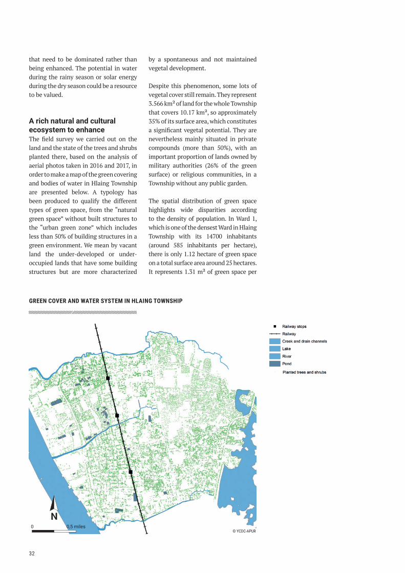
A rich natural and cultural ecosystem to enhanceThe field survey we carried out on the land and the state of the trees and shrubs planted there, based on the analysis of aerial photos taken in 2016 and 2017, in order to make a map of the green covering and bodies of water in Hlaing Township are presented below. A typology has been produced to qualify the different types of green space, from the “natural green space” without built structures to the “urban green zone” which includes less than 50% of building structures in a green environment. We mean by vacant land the under-developed or under-occupied lands that have some building structures but are more characterized
by a spontaneous and not maintained vegetal development.
Despite this phenomenon, some lots of vegetal cover still remain. They represent 3.566 km² of land for the whole Township that covers 10.17 km², so approximately 35% of its surface area, which constitutes a significant vegetal potential. They are nevertheless mainly situated in private compounds (more than 50%), with an important proportion of lands owned by military authorities (26% of the green surface) or religious communities, in a Township without any public garden.
The spatial distribution of green space highlights wide disparities according to the density of population. In Ward 1, which is one of the densest Ward in Hlaing Township with its 14700 inhabitants (around 585 inhabitants per hectare), there is only 1.12 hectare of green space on a total surface area around 25 hectares. It represents 1.31 m² of green space per
green cover and water SyStem in hlaing townShip
0 0,5 miles© YCDC-APUR

Atelier pArisien d’urbAnisme 33
Yangon - report on tHe impLementation oF tHe Zoning pLan
inhabitant, and in private areas, while international standards (World Health Organization) recommends a minimum of 9 m² per inhabitant.
At the west of the township, between Bayintnaung Road and Hlaing River, large sparse plots receive essentially port and industrial sites. Their future development is uncertain but they represent a real potential for projects the YCDC wants to promote, according to their prominent location on the riverside, close to main axis, and their availability. Less, if not at all, treated with care, those spaces enable the spontaneous development of a rich local flora and fauna within an urban area. The tropicality and humidity of the climate is a resource for the vegetal development that has to be enhanced.
Moreover, the spontaneous development of vegetation along the railway and the watercourses could form a natural green corridor. As well as the natural creeks, the natural river banks in the North part of the Township, mainly owned by the Government, constitute a resource for urban resilience. They are characterized by a marsh vegetation that also benefits to some animal species and can have a role of filtration for water pollution discharged by the creeks. Existing green corridors could be the support for a local strategy to enhance the sustainability
of the city. If a planning intervention is adopted, a compromise should be found to preserve the biodiversity of the area and avoid heavy infrastructures.
We identified 11 main types of trees and plants in Hlaing Township: Almond tree (Pan da), Mango tree (Tha Yet), Padauk tree (Pterocarpus indicus or macrocarpus, Pa Dauk), Neem or Margosa Tree (Azadirachta indica, Yay Ta Mar), Jackfruit Tree (Artocarpus heterophyllus, Pain Nae), Tamarind (Tamaricus indica, Man Gyi Pin), Banana Plant (Nga Pyaw), Peacock Flower Tree (Caesalpinia pulcherrima, Sein Pan Pin), Coconut Tree (Cocos nucifera, Ohn Pin), Betel Tree (Areca catechu, Kwon Pin), Golden Shower Tree (Cassia fistula, Ngu Wah). It is therefore an urban environment that presents a rich biodiversity and regulates climate effects that will be growing over the coming years.
Those vegetal resources can be sometimes valorized by religious compounds, which offer a landscape of a remarkable quality that has to be protected. With a religious architecture situated in a middle of a pond, they composed a ecosystem of biodiversity and cultural attractiveness for the urban area, forming a fusion between natural and building heritage as well as cultural richness.
Natural plot and agriculture near Inya Lake Buddhist temple on body of water near the railway

GIS expertise report5.
ContextThis report focuses on the specific analysis of documents and data relating to the vector plot map administered and digitized by the GIS section, based on the documents administered by the Land Administration Department (LAD). Following a second mission in October, the report was revised to include conclusions of workshops organized with the YCDC Departments, in particular with LAD GIS section.
The report also includes methodological elements to improve the data so it can be integrated fully in the elaboration the detailed zoning plan. As for the zoning plan, Hlaing Township will be used as the pilot area.
Vector plots are the most detailed elements in the GIS which can serve as the graphic reference for establishing detailed zoning for the zoning regulation map.
However, to be useful for this purpose:• They must be identified so that
ownership/use status can be associated.• They must be properly referenced
geographically and topologically coherent on all the YCDC perimeter so it can be used as a reference data layer, in coherence with other GIS reference data (orthophoto, road network, topography, administrative limits, etc.).
• Plots must be up to date, in coherence with plot mutations.
CoNTeXT: Paris/Yangon decentralized cooperation.oBJeCTIVe: diagnosis of the plot map of Yangon, methodology for plot data update.BUrMeSe PArTNer: YCdC.

Atelier pArisien d’urbAnisme 35
Yangon - report on tHe impLementation oF tHe Zoning pLan
Simplified Schema for pariS regulation map
exemple of Zoning map, coherent with plot data (pariS region)
Associated Road Network And parcel data
Parcels
Parcel ID
Regultation Perimeters
General zoning
Maximum Height of constructions
Visibility protection cones
Deficit in social dwelling
Protected heritage zones
Reserved areas for public facilities
Quarries
Other perimeters …
Gypsum
Parcel belongs to perimeter
Flooding zones
Parcel belongs to risk zone
Parcel belongs to perimeter
Parcel belongs to perimeter
Parcel belongs to perimeter
Parcel belongs to perimeter
Parcel belongs to perimeter
Road network
Street Address

36
Plot documents at YCDCSurvey Block MapsThe current numeric plot map is produced from survey paper maps. The maps were originally maintained by the state, National Housing, Town & Country Development Board. The first printed version of the plan dates from 1927–1928. Some maps were updated and reprinted 1955-1957, then for some maps, in 1988-1989. The YCDC recovered the paper maps and associated parcel registers in 1993. Since then, the YCDC is in charge of the updates to the plot map and land registers on its territory (33 Townships – 668 square km).
The parcel plan is divided by blocks. Each block has its associated paper map called Survey Block Map (SBM), in A1 format, produced at a 1/1200 scale (1 inch = 100 feet). It contains plot limits, and its associated identifier (block number – parcel number within block). A number of survey points are also present on the map around the block perimeter. The same survey control points appear on adjacent SBMs. They have two objectives: • Identify precisely a point on the field
(XY coordinate, Indian Grid System BIII projection) for performing the land surveys (which are then done by measurements relative to these control points). Plot limits can then be reported on the map.
• Have a reference for assembling adjacent block maps with one another.
The main problem identified with the survey control points is that no survey register was communicated by the State to the YCDC at the time the plot maps were given. Therefore, no XY coordinate information is apparently available, which is the basis for the GIS data. This register no longer exists and georeferencing the scanned maps with this method will not be possible.
Note that plot modifications (replotting and divisions) are redlined/marked directly on the SBM along with their
new identifier. All the available SBMs (it appears about 400 sheets were unusable or missing) were scanned and georeferenced on the basis of a 2012 satellite orthophoto (UTM47). Digitization is underway: 6 Townships are completed. They would also have to be analyzed in the next mission. Data for these townships were not given.
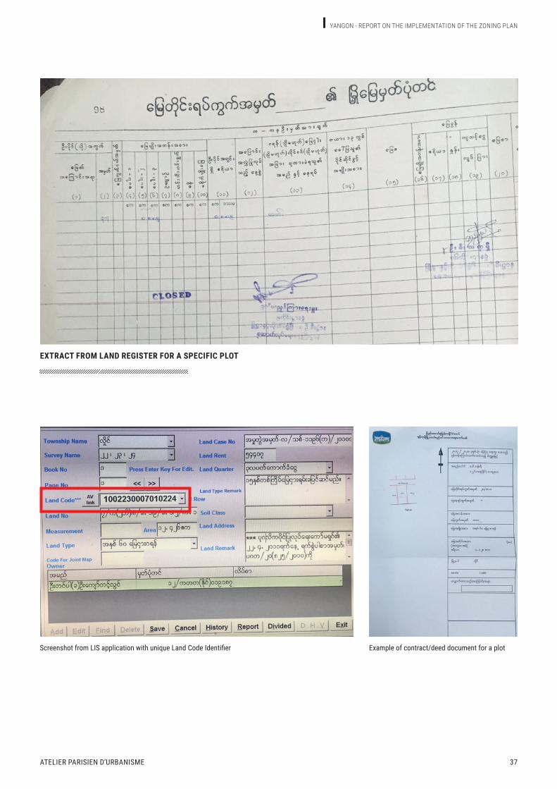
Paper Land Register/Computerized Land RollLand register (composed of one or several books by block map, one page per plot) contain for each plot its identifier surveyed dimensions, area, occupation, and owner. An exhaustive list of characteristics, is to be communicated.Data from the Land Register (paper version) associated with each plot are input in a computerized Land Roll using a separate specific application (LIS – Land Information System), developed in 2003 by local firm MCC (Myanma Computer Company1). The tool used to produce the contract/deed documents was developed in ArcView 3.x/Crystal Reports technology2.
Plot identification and link to land information system (LIS)Plot identification is the basis for connecting the plot maps with the land register. Plot identifier is composed of:• Survey block number.• Parcel number within block.
A graphic plot should always be correlated with an entry in the land register to establish ownership. This is applicable whether working of paper documents or digitized versions. Zoning plan project will require data from the LIS (Land Information System): Owner, land type, land rent. For technical considerations, the link to LIS is actually done through “Landcode”, and not plot ID. There will therefore have to be a “landcode – Plot ID” correspondence to be communicated and embedded in the GIS data.
1 - MCC is the ESRI product distributor for Myanmar�2 - The LIS application is no longer maintained or supported by MCC, nor is the associated ArcView 3�x GIS by ESRI� A new integrated version with ArcGIS Desktop would ideally have to be redeveloped with Reports Wizards� Connectivity with LIS may also be an issue, as the LIS database technology may not be supported�
Atelier pArisien d’urbAnisme 37
Yangon - report on tHe impLementation oF tHe Zoning pLan
extract from land regiSter for a Specific plot
Screenshot from LIS application with unique Land Code Identifier Example of contract/deed document for a plot

38
Hlaing plot data analysisData on Hlaing Township were given and analyzed (paper scans and GIS data for the 23 SBMs; note that transmitted scans were not georeferenced, which, was surprising considering that the shapefile data itself is georeferenced, is quite surprising. The October mission help to clarify this point. The problem comes from a missing step in the georefrencing procedure for the scan maps, which, among other flaws, did not call for storing georeferencing data with the
scans (“update Georeferencing” function ArcGIS). Parcel digitization for a block map was done within ArcGIS sessions/projects for which georeferencing information was temporarily stored within a session, and later lost as the sessions/projects were discarded. Plots were digitized in separate GIS files (ESRI shapefiles), one for each Survey Block Map. Some blocks may have two separate files when specific allotment maps exist.
moSaic of vector plot data on 23 hlaing SectorS

Atelier pArisien d’urbAnisme 39
Yangon - report on tHe impLementation oF tHe Zoning pLan
plot duplication and overlapS (in red)
Overlaps/GapsWithin a Block Map, plots should normally have no overlaps (and no gaps between adjacent plots), and plots from neighboring SBMs should be continuous (seamless).
When assembling data from all block shapefiles, analysis shows many plots are duplicated or overlapping (in some cases even within a same block). In addition, overlaps occur between adjacent block maps (see image below). Plots should also cover the whole township. In addition, the image also
shows that some areas are currently not covered.
Currently, plot overlaps are due to two main reasons:• Some plots are present both in their
“original” and “current” stat (although in separate block map data). Plots separation will therefore reduce overlaps due to this case.
• Important shifts in plots cause overlaps between block maps. Spatial adjustment process will greatly reduce these errors.

40
extract from Sbm n°22
SBM scan
Plot identification issuesOnce assembled (and including overlaps), there are total of 6588 graphic plots for Hlaing Township. 4209 have unique identifiers, 1909 plots do not have any identifiers. Therefore, approximately 1/3 of the plots cannot be linked with the land register information (owner, surveyed area, etc.). Note that further assessment of the digital land register and its application must also be done to analyze the specific content which is entered, and the degree of completion.
Graphic issues (update/georefrecing)A first analysis of the plan shows that several areas are outdated on the paper maps, even areas that do not appear to have moved recently. In addition, general georeferencing problems are observed but not in uniform manner (data not overlaid properly with respect to satellite image). This problem is apparent even on recent allotments which have been modified on the paper SBM.
© Y
CDC
• Plots are globally not updated.• New allotment is not updated on SBM.
Vector parcels are not respectful of existing parcel fabric, i.e. allotment map can divide existing plots in a random manner, not necessarily following the limits of existing plots.

Atelier pArisien d’urbAnisme 41
Yangon - report on tHe impLementation oF tHe Zoning pLan
Vector parcels on 2016 Satellite Orthophoto
© D
igita
l glo
be (W
orld
view
3)
© D
igita
l glo
be (W
orld
view
3)

42
extract from Sbm n°23
SBM scan
© Y
CDC

Atelier pArisien d’urbAnisme 43
Yangon - report on tHe impLementation oF tHe Zoning pLan
Vector parcels on 2016 Satellite Orthophoto
New allotment integrated as vector plots. Shifts are not uniform.
© D
igita
l glo
be (W
orld
view
3)
© D
igita
l glo
be (W
orld
view
3)

44
Work method for plot data initialization and updateThe method will globally consist in initializing two separate plot layers in the GIS:• A first plot layer reflecting the state of
the original plots on the SBMs: This layer will contain plots originally present on the SBMs upon reprint, whether they correspond or not to the physical reality on the field today. These include original plots which have been replotted/updated on the map, and for which a plot limit and identifier can be correctly interpreted. This will serve as a “historical” plot layer, reflecting the state of the plots before any new allotments and replotting were annotated on the paper map.
• Another, which will reflects the state of the current plots: This will contain plots present on the paper maps and which correspond to a physical reality on the field today, whether they are present on the paper SBMs, whether they have been identified from allotments marked on the paper maps, or whether they have been digitized from the aerial photograph.
It is important to note that the SBMs contain a mix of “old” plots and “recent” plots. The digitized version of the plots currently reflects this state. Therefore, it contains all of the plot limits, without distinction, whereas it is important to distinguish the original and the current state of the plots.
The two states will be initialized from plots which have already been digitized from the paper maps, and by doing an “overhaul” of these plots in the following sequence.
General StepsStep 1Correction and completion of missing plot identifiers on each block map. All plots should have an identifier which
can be correlated to at least one state. The identification process will rely on a dual identification/tagging system: “original” identifier, “current” identifier. Polygons can be dually tagged: these correspond to plots which will later appear both states. They include plots that have been replotted (grouped) or divided, in addition to those plots which have not been updated and correspond to the current physical situation (2016 orthophoto). After the spatial adjustment process is completed, these tag identifiers will be used for separation and generation the two plot layer states. A module was specifically developed for the assembly and state separation process. Recall that georeferencing information was not originally saved with the scan maps (see above). However, for this step, georeferencing information for the SBM scans, is needed to eventually correct/complete missing data (missing plots, missing plot ids). It must be coherent with the digitized vector plots. Therefore, for restoring original georefrencing on the scans, the procedure calls for defining 3 links created from recognizable scan points to their associated point on the vector data (usually a plot intersection).
Step 2Spatial adjustment/rectification of digitized plots on each block map: rectification using Worldview 3, 2016 aerial orthophoto (better quality than 2012 orthophoto). To facilitate the rectification process (as several technicians are working on the data), all plots (“original” and “recent”) are kept initially in the same layer (but separately by block). For this purpose a step by step tutorial was written describing the specific steps of the process and of the adjustment tools used.
Step 3Separation of “original” and “current” plots in two distinct layers. a specific script was developed which can be run
regularly, which assembles the block map data and constructs topology separately on each of the two assembled datasets (on the original block map data. This is useful in order to verify topology between block maps after the adjustment process of a block map (currently, poorly adjusted data results in parcel overlaps between block maps). As the modifications from each block map are done (from steps 1 and 2), they will be reflected in the resulting two layers assembled on the Township. In addition, as the block maps are being adjusted, the resulting two layers should contain less and less overlaps within each block map and between two adjacent block maps. Step 2 (performed on the individual block map data) and block map assembly/state separation (using script) can be repeated iteratively as many times as required, until there are no longer any plot overlaps within a block, and plot overlaps between two block maps is minimal.
Step 4To finalize the correction process, it will be easier to work directly on each of the two assembled township map layers (“old” and “current” state). In this case, map topology will be recreated regularly (using the Validate topology function within ArcGIS) to verify the evolution of the corrections. Priority will be given to the “current” state, since this will be state from which subsequent updates will be done.
Step 5Update of the “current” plot layer (see below).

Atelier pArisien d’urbAnisme 45
Yangon - report on tHe impLementation oF tHe Zoning pLan
SBM scan (n°3)
Step 1: correction and completion of miSSing plotS / miSSing plot identifierS
example of proceSS for a Specific block map
plots missing to be digitized“original” plots marked as
a single “new” plot
© Y
CDC

46
Image shows combined (« old » / « current ») plots before adjustment. Plots digitized on « loosely » georeferenced scan maps.
Image shows plots not coherent with orthophoto (in particular, main road is plotted as a straight line on SBM, whereas it actually should show a bend, like on the orthophoto).
Adjustment links are shown in green. Plots before the adjustment process (and before plot completion/update) are shown in yellow. Plots after the adjustment process (add plot completion/update) are shown in red.
Step 2: adjuStment proceSS
© D
igita
l glo
be (W
orld
view
3)
© Y
CDC
LAD
- GIS
SEC
TION
© Y
CDC
LAD
- GIS
SEC
TION

Atelier pArisien d’urbAnisme 47
Yangon - report on tHe impLementation oF tHe Zoning pLan
« Original » plots coherent with survey block map
« Original » plots coherent with survey block map
« Current » plots coherent with orthophoto
« Sep
arat
ion
»
Step 3: Separation proceSS
© D
igita
l glo
be (W
orld
view
3)
© D
igita
l glo
be (W
orld
view
3)
© Y
CDC
LAD
- GIS
SEC
TION

48
Specific caSeS for adjuStment proceSS: caSe where new allotmentS manually appended to map next to old plotS
SBM scan (n°21)
© Y
CDC

Atelier pArisien d’urbAnisme 49
Yangon - report on tHe impLementation oF tHe Zoning pLan
Vector plots Homogeneous zones for spatial adjustments
In this case, rectification tests which were done reveal that the rectification phase may not yield satisfactory results if applied on all the block map at once. At a large scale, new allotments (marked in darker black on the SBM) appear to have been surveyed precisely than neighbouring zones. However, when plotted on the SBM, they may have not been fitted properly relative to older neighbouring zones. By perfoming the spatial adjustment on each zone locally, this should result in lesser distortions globally.
To enable this process, a zoning tag (an additional field used for rectification) can be assigned the plots. the spatial adjustment procedure (see tutorial) can be applied only to a selected set of features (for example, only on the plots belonging to a specific zone, rather than the whole block map.
Each zone will be spatially adjusted separately (zone by zone) to the satellite image. An more important shift may be observed at the zone limits. However, since these limits usually correpond to important topographic elements (main roads, rivers, streams) which are not plotted and can absorb the shift, this should give better results globally.

50
caSe where no replotting done on paper mapS/no correlation poSSible with current State
SBM scan (n°23) Vector plots on orthophoto
© Y
CDC
© D
igita
l glo
be (W
orld
view
3)
The entire SBM cannot be correlated to elements on the satellite image. Digitized vector plots are identified as “original” and are left as is. This will result in an empty area (hole) in the “current” plot state, which will be “filled” in the update process (see below). Unless the plots can be correlated with
Update of “current” plot layerThe resulting two cleaned layers: “original” and “current” plot layer should have minimal distortion. However, in the “current” state, many zones will not be plotted (empty zones).The “current” layer will serve as basis for the regulation map of the zoning plan. Future updates will be done on this map:• If an apparent limit is visible on
orthophoto -> divide or merge plots as necessary.
• If no apparent limit : - If allotment map is available (Housing
Department) -> integrate, spatially adjust and verify this map with the orthophoto.
- If no allotment map is available -> field survey (theodolite, then digitize, or Total station). This will require
the implication of survey Department from Township. A specific analysis of this process/workflow will have to be detailed upon a next mission.
• Specific parcels which cannot be divided (where ownership not an issue for the zoning plan, i.e. “big plots”) are left as is.
In all cases, all new parcels must be identified according information in the Land Information System, in particular for identification of new ownership.

Atelier pArisien d’urbAnisme 51
Yangon - report on tHe impLementation oF tHe Zoning pLan
Initialization of a precise, updated, continuous GIS plot layer on Hlaing pilot TownshipCurrently, Land Administration Department has more of an administrative approach to its GIS, using it essentially to produce contract/deed documents, as illustrated previously. Following the workshops done in the October mission, the GIS Section is now conscious that a structured and continuous plot database is the cornerstone of a GIS Reference database, which can be used in coherence with other layers, not only with zoning data but alos with other reference data, and, very importantly, which can be shared with other Departments within YCDC. Furthermore, they now have a methodology to initialize a continuous, topologically coherent plot layer on the Hlaing pilot area. The associated personnel have shown motivation for the project, but are also conscious that it is a challenging task.
Considering the important digitization work already done, it was decided to work from data, and improve upon it, rather than start from scratch.
Results on Hlaing as a pilot Township will help assess the method, both in terms of delay and suitability, and if it can be applied for all of YCDC area.
Evolution of existing GIS InfrastructureIt is important to note that the methodology for the pilot was put in place using the existing computer infrastructure and tools at YCDC, taking into consideration its current limitations.
More specifically:• Lack of proper Internet connectivity,
therefore limiting access to online resources (data, maps) , a copy of 2016 orthophoto was extracted and locally installed, with some limitations in terms of resolution
• Lack of a shared, collaborative database which can be updated by several users simultaneously, therefore resulting in the implementation of a more constraining method for data update/corrections (using, as explained, an iterative approach, where updates are performed on separate block map datasets, later assembled and verified for topological errors)
• Lack of maintenance of existing tools GIS/LIS, resulting in the use of two separate environments. One with current, but unofficial/unlicensed (and therefore unsupported) ArcGIS licenses for data updates, and a separate environment linked to the LIS (ArcView 3.x), for the generation of administrative documents.
This therefore would call for a broader project (outside the scope of this specific cooperation project), with specific funding, in which the above issues would be addressed (internet connectivity is yet another issue). This would include among others, the acquisition of proper hardware (for GIS database server), software (GIS licensing, both for desktop and server environments), and technical assistance for installation/configuration (and training). In addition, a specific development/assistance would have to be included for the update of the LIS and its link with the GIS (ArcGIS connectivity).
CoNCLUSIoN

L’apur, atelier parisien d’urbanisme, est une association loi 1901 qui réunit autour de ses membres fondateurs, la ville de paris et l’État, les acteurs de la métropole du grand paris.ses partenaires sont :