A Military and Civilian Cemetery of the Mid to Late Tang Maritime Trade? Ground Penetrating Radar...
42
178 A Military and Civilian Cemetery of the Mid to Late Tang Maritime Trade? Ground Penetrating Radar (GPR) Surveys and Excavations at San Tau, North Lantau, Hong Kong Mick ATHA 1 Author Following a decade of archaeological work in Europe, spanning academia, professional practice and curatorial work, Dr Atha moved to Hong Kong in 2007 to take up a position with a local HIA consultancy firm. For the past three years his time has been split between teaching archaeology part-time for The Chinese University of Hong Kong and Hong Kong University SPACE, while researching and writing a book and running research projects examining various aspects of Hong Kong archaeology, in particular for the Hong Kong Archaeological Society. Dr Atha’s research interests are broad. He is deeply interested in inter-disciplinary landscape studies and is the Book Reviews Editor for the international journal Landscape Research. Primarily, though, he has a long-standing research focus on the use of integrated assessment methodologies — in particular using ground-based remote sensing (geophysics) with targeted excavation — for the investigation of multi-period archaeological sites and landscapes. Within that multi-period scope, Dr Atha has a particular fascination with the early historical archaeology of the Hong Kong — Pearl River Delta region, hence his interest in the Tang dynasty cemetery at San Tau and the pioneering use — in Hong Kong at least — of intra-site ground penetrating radar (GPR) with excavation-based ‘ground- truthing’. Abstract Recent investigations carried out on behalf of the Hong Kong Archaeological Society at the coastal backbeach site of San Tau, North Lantau have produced evidence for a regionally unique Tang dynasty inhumation cemetery with four distinct phases of military and civilian burials using different orientations. In this paper, I explore how the true character and extent of the cemetery only came to light as a result of the integrated use of ground penetrating radar (GPR) for site prospection and then high-resolution intra- site analysis, followed by ‘ground-truthing’ by excavation. The GPR surveys highlighted many interesting ‘targets’, which were tested in two seasons of excavation in 2011 and 2012. A total of nine mid-late Tang graves were excavated with four different burial 1 Department of Anthropology, The Chinese University of Hong Kong
Transcript of A Military and Civilian Cemetery of the Mid to Late Tang Maritime Trade? Ground Penetrating Radar...

178
A Military and Civilian Cemetery of the Mid to Late Tang Maritime Trade? Ground Penetrating Radar (GPR) Surveys and Excavations at San Tau, North Lantau, Hong Kong
Mick ATHA 1
Author
Following a decade of archaeological work in Europe, spanning academia,
professional practice and curatorial work, Dr Atha moved to Hong Kong in 2007 to take
up a position with a local HIA consultancy firm. For the past three years his time has been
split between teaching archaeology part-time for The Chinese University of Hong Kong
and Hong Kong University SPACE, while researching and writing a book and running
research projects examining various aspects of Hong Kong archaeology, in particular for
the Hong Kong Archaeological Society.
Dr Atha’s research interests are broad. He is deeply interested in inter-disciplinary
landscape studies and is the Book Reviews Editor for the international journal Landscape
Research. Primarily, though, he has a long-standing research focus on the use of integrated
assessment methodologies — in particular using ground-based remote sensing (geophysics)
with targeted excavation — for the investigation of multi-period archaeological sites and
landscapes. Within that multi-period scope, Dr Atha has a particular fascination with
the early historical archaeology of the Hong Kong — Pearl River Delta region, hence his
interest in the Tang dynasty cemetery at San Tau and the pioneering use — in Hong Kong
at least — of intra-site ground penetrating radar (GPR) with excavation-based ‘ground-
truthing’.
Abstract
Recent investigations carried out on behalf of the Hong Kong Archaeological Society
at the coastal backbeach site of San Tau, North Lantau have produced evidence for a
regionally unique Tang dynasty inhumation cemetery with four distinct phases of military
and civilian burials using different orientations. In this paper, I explore how the true
character and extent of the cemetery only came to light as a result of the integrated use
of ground penetrating radar (GPR) for site prospection and then high-resolution intra-
site analysis, followed by ‘ground-truthing’ by excavation. The GPR surveys highlighted
many interesting ‘targets’, which were tested in two seasons of excavation in 2011 and
2012. A total of nine mid-late Tang graves were excavated with four different burial
1 Department of Anthropology, The Chinese University of Hong Kong
179
orientations. Graves in the same phase respected one another, while those of different
phases were often intercutting. There was thus a clear progression in orientation over the
150-200 year span of the cemetery. Although no human remains survived, the analysis
of different grave orientations and grave goods assemblages revealed interesting patterns
that can be interpreted in terms of the identity, status, and even the stature of the interred
individuals. Most notably, a group of five graves with large iron tools and weapons —
the others had only small personal knives — all shared the same southeast-northwest
orientation and are thought to represent a military use of the cemetery towards the end of
the Tang dynasty. Two east-west orientated, probably civilian, graves revealed a previously
unreported pattern of intentional smashing of large pottery vessels, which may indicate a
mortuary ritual of some kind.
Although all pottery recovered came from Guangdong kilns, the copper alloy belt
fittings (buckles, strap-ends and kwa) were apparently not of South Chinese manufacture,
and either came south with the deceased individuals or were shipped south and traded
through Guangdong markets. Several graves included off-cuts of silver ingots, which were
not items of day-to-day currency but rather were used for higher-value transactions. Of
these, a lone SW-NE orientated grave, which represents the most recent phase of the
cemetery, was particularly richly furnished with ceramics and included a relatively large
triangular off-cut from an inscribed silver ingot minted in Duanzhou, western Guangdong
in the early Tang dynasty. It is proposed, based on the evidence for contrasting wealth,
status and identities at San Tau, that the cemetery was not used by local people but
was an ‘outsiders’ burial ground connected to the vibrant maritime trade at that time.
Merchant vessels arriving from the west would have passed by the cemetery as they sailed
up the north coast of Lantau Island, and may have used the sheltered anchorage of Tung
Chung Bay — immediately to the east of San Tau — on their way to the military base
at Tuen Mun, before sailing on up the Pearl River to the bustling entrepôt then existing
at Guangzhou. The San Tau discoveries are therefore perhaps one reflection of the Tuen
Mun-Tung Chung area’s importance for both civilian traders and their military protectors
during the Tang dynasty.

180
唐代中期至後期海上貿易的軍用及平民墓地?在香港大嶼山北部䃟頭以探地雷達(GPR)進行勘察及發掘
范文灝
論文提要
近年,我代表香港考古學會在大嶼山北部沿海後灘䃟頭遺址進行的調
查,為一個富有獨特地區特徵的唐代土葬墓地提供了可供佐證的資料。該
墓地橫跨四個截然不同的階段,以不同座向的墓葬為軍人與平民下葬。本
文將探討如何透過綜合使用探地雷達(GPR)進行遺址試掘,並以高解像
度遺址內部分析和「地面實況」的發掘下,將墓地的真正特質和涵蓋範圍,
完整地顯現出來。探地雷達勘察突顯了多項有趣的「目標」,促成了二零
一一及二零一二年發掘時的測試。遺址合共發掘出九個唐代中後期墓葬,
其中四個墓葬的座向各異:來自同一時期的墓葬座向相約,反之則多出現
縱橫交錯的情況。由此,我們可以清楚觀察墓地在橫跨一百五十至二百年
間所經歷的座向發展與變遷。雖然墓葬內並無人骨遺存,但透過分析不同
的墓葬座向和隨葬品,我們不難發現一些有趣模式,這些模式可按照墓主
的身份、地位、甚至身材進行詮釋。其中最值得留意的是一組五個的墓葬,
內有大型鐵製工具和武器隨葬 (其他墓葬只找到個人傍身用的小刀 ) 。由
於這些墓葬全部坐東南向西北,故被推斷為唐代末年的軍用墓地;而兩座
可能屬於平民的東西向墓葬,其大型陶器均刻意被砸碎。這種前所未見的
現象,很可能代表某種葬儀。
雖然所有出土陶器均來自廣東的陶窰,但銅合金的腰帶部件 ,例如腰
帶扣、腰帶尾和掛,似乎非產自華南。這些物品有可能由死者帶來南方,
又或是經海路運至南方、於廣東市場上出售的外地貨品。多座墓葬中均發
掘出一些銀錠切角(銀錠並非日常流通貨幣,一般只用於大額交易)。其
中一座獨據一方、坐西南向東北的墓葬,距今最近,其隨葬內容特別豐富,
包括大量陶瓷和較大的三角形銀錠切角;該銀錠於唐代初年於粵西端州鑄
造(有刻字)。根據財富、社會地位和身份的差異,推斷䃟頭遺址並非為
當地人所用,而是一外國人專用墓地。此發現與當時蓬勃興旺的海上貿易
有關。來自西方的商船在途經大嶼山北時應會經過該墓地。他們可能曾採
用東涌灣作避風停泊,該海灣位於䃟頭的東面。當商船在向上航行到達位
於珠江的興盛轉口港(當時位於廣州)時,便會經過位於屯門的軍事基地。
䃟頭的發現可以反映屯門及東涌一帶,在唐代時是平民商賈和為他們提供
保護的軍人的重要地點。
181
Mick ATHAA Military and Civilian Cemetery of the Mid to Late Tang Maritime Trade? Ground Penetrating Radar (GPR) Surveys and Excavations at San Tau, North Lantau, Hong Kong
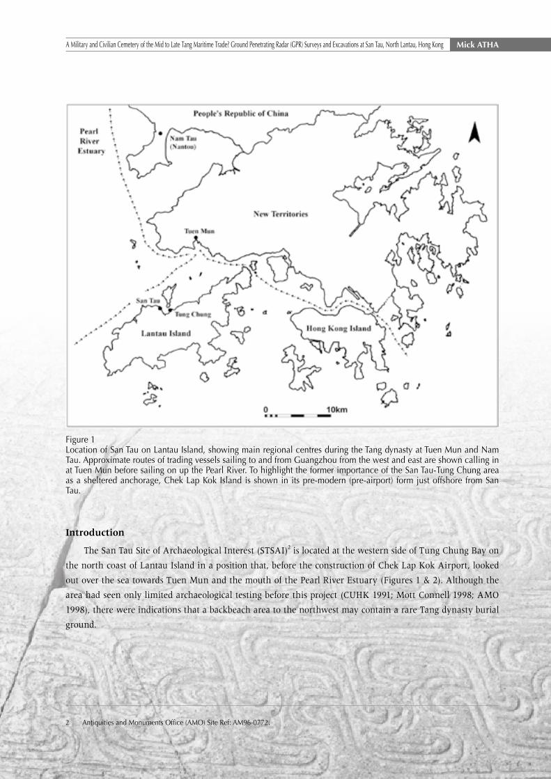
Figure 1Location of San Tau on Lantau Island, showing main regional centres during the Tang dynasty at Tuen Mun and Nam Tau. Approximate routes of trading vessels sailing to and from Guangzhou from the west and east are shown calling in at Tuen Mun before sailing on up the Pearl River. To highlight the former importance of the San Tau-Tung Chung area as a sheltered anchorage, Chek Lap Kok Island is shown in its pre-modern (pre-airport) form just offshore from San Tau.
Introduction
The San Tau Site of Archaeological Interest (STSAI)2 is located at the western side of Tung Chung Bay on
the north coast of Lantau Island in a position that, before the construction of Chek Lap Kok Airport, looked
out over the sea towards Tuen Mun and the mouth of the Pearl River Estuary (Figures 1 & 2). Although the
area had seen only limited archaeological testing before this project (CUHK 1991; Mott Connell 1998; AMO
1998), there were indications that a backbeach area to the northwest may contain a rare Tang dynasty burial
ground.
2 Antiquities and Monuments Office (AMO) Site Ref: AM96-0772.

182
范文灝 A Military and Civilian Cemetery of the Mid to Late Tang Maritime Trade? Ground Penetrating Radar (GPR) Surveys and Excavations at San Tau, North Lantau, Hong Kong
Figure 2San Tau Site of Archaeological Interest (thin black outline) with study area (thick black rectangle). (Source: based on 1:1000 mapping; Lands Department (2011a) © Hong Kong SAR Government)
When the author was commissioned by the Hong Kong Archaeological Society to identify a site with
research potential and direct a field investigation on their behalf, the San Tau backbeach was therefore an
obvious choice. The writer has a background in the use of archaeological geophysics for (intra-)site assessment
(e.g. see applications in Gaffney and Gater 2003) and wished to test its usefulness in Hong Kong conditions.
Fortunately it was possible to arrange collaboration with local ground penetrating radar (GPR) specialist Dr
Wallace Lai3, who with his team carried out GPR surveys for the San Tau project.
3 The Department of Land Surveying and Geo-Informatics, The Hong Kong Polytechnic Universit.

183
Mick ATHAA Military and Civilian Cemetery of the Mid to Late Tang Maritime Trade? Ground Penetrating Radar (GPR) Surveys and Excavations at San Tau, North Lantau, Hong Kong
4 ‘Backbeach’or‘backshore’deposits are a class of geological feature commonly found immediately behind and above Hong Kong’s many sandy bays. They are thought to have been created in antiquity by storm action (Wong and Shaw 2009:42) and usually evidence prehistoric and/or early historical activity.
In this paper, I explore how the true character and extent of the cemetery was brought to light through
the integrated use of ground penetrating radar (GPR) first for site prospection and then high-resolution intra-
site analysis, followed by ‘ground-truthing’ using excavation. The GPR surveys highlighted many interesting
‘targets’, which were tested in two seasons of excavation in 2011 and 2012 (Atha 2012; 2013). A total of ten
mid-late Tang dynasty graves with four different burial orientations were excavated, while a similar number
were more tentatively identified as features in plan and/or section but could not be fully investigated due to
the time constraints of the project.
I begin below by outlining the environmental, historical and archaeological background and then move
on to examine the project objectives and methodology used to achieve them. Next the GPR survey approach
and data are discussed, with a particular focus on the contrasting results produced by the two different survey
resolutions and modelling software employed. The two seasons’ findings are then synthesised and presented
in chronological order: working from the pre-cemetery Six Dynasties-Tang horizon, focusing mainly on the
four sub-phases of Tang dynasty burials, and then briefly mentioning the evidence for post-cemetery Northern
Song activity. The paper is rounded off with an interpretive discussion followed by a series of conclusions.
Landscape Setting
The bulk of the STSAI is located on a large, low-lying alluvial fan at the mouth of a short, steep-
sided valley with a large perennial stream (Figure 2). To north and east the alluvium is bordered by sandy
backbeach deposits4 with areas of estuarine mud and sand on the coast in between (Figure 3). Today the coast
is sheltered by Chek Lap Kok Airport and mangrove is rapidly developing, but when the northern backbeach
formed in antiquity the area faced the open sea and was fully exposed to northerly gales and high waves
during the passage of typhoons. The mountainous western and southern borders of the site are formed of fine
to medium grained granite, within which there are intrusions of quartz and basalt. Between the mountains
and the alluvium there is a wide band of eroded slope debris upon which the village of San Tau and hamlets
at Kau Liu and Tin Sam were sited (GEO 1994).

184
范文灝 A Military and Civilian Cemetery of the Mid to Late Tang Maritime Trade? Ground Penetrating Radar (GPR) Surveys and Excavations at San Tau, North Lantau, Hong Kong
Figure 3San Tau geology (Study Area as shown). Key: Qb = beach deposits including backbeach, Qd = slope debris, Qa = alluvium. Geotechnical Engineering Office (GEO 1994); © Hong Kong SAR Government
There are dramatic contrasts in topography, with the sea to the north and east and steep mountainsides
to the west and south. The alluvial fan has a surface elevation of 2.2m to 5m above Principal Datum (PD)5,
whereas the northern backbeach has a surface elevation of around 5-6m above PD. Behind the backbeach
the land rises onto the slope deposits, which have an elevation of about 12m PD in the hamlet of Kau Liu.
Given the topographic constraints of the San Tau area, it is not surprising that — beyond the settlement areas
— the modern 1:1000 map shows former agricultural fields on every patch of relatively accessible land, with
paddy fields on the alluvial fan, dry terraces stretching onto the lower hillsides, and even the backbeach was
formerly cultivated.
5 Principal Datum is at 1.23m below Hong Kong Mean Sea Level (Survey and Mapping Office 1995).
185
Mick ATHAA Military and Civilian Cemetery of the Mid to Late Tang Maritime Trade? Ground Penetrating Radar (GPR) Surveys and Excavations at San Tau, North Lantau, Hong Kong
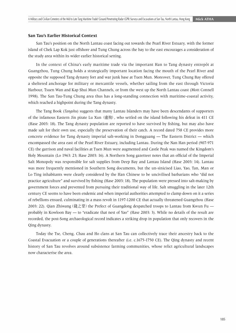
San Tau’s Earlier Historical Context
San Tau’s position on the North Lantau coast facing out towards the Pearl River Estuary, with the former
island of Chek Lap Kok just offshore and Tung Chung across the bay to the east encourages a consideration of
the study area within its wider earlier historical setting.
In the context of China’s early maritime trade via the important Han to Tang dynasty entrepôt at
Guangzhou, Tung Chung holds a strategically important location facing the mouth of the Pearl River and
opposite the supposed Tang dynasty fort and war junk base at Tuen Mun. Moreover, Tung Chung Bay offered
a sheltered anchorage for military or mercantile vessels, whether sailing from the east through Victoria
Harbour, Tsuen Wan and Kap Shui Mun Channels, or from the west up the North Lantau coast (Mott Connell
1998). The San Tau-Tung Chung area thus has a long-standing connection with maritime-coastal activity,
which reached a highpoint during the Tang dynasty.
The Tang Book (Tangshu) suggests that many Lantau Islanders may have been descendants of supporters
of the infamous Eastern Jin pirate Lu Xun (盧徇), who settled on the island following his defeat in 411 CE
(Hase 2003: 18). The Tang dynasty population are reported to have survived by fishing, but may also have
made salt for their own use, especially the preservation of their catch. A record dated 758 CE provides more
concrete evidence for Tang dynasty imperial salt-working in Dongguang — The Eastern District — which
encompassed the area east of the Pearl River Estuary, including Lantau. During the Nan Han period (907-971
CE) the garrison and naval facilities at Tuen Mun were augmented and Castle Peak was named the Kingdom’s
Holy Mountain (Lo 1963: 23; Hase 2003: 16). A Northern Song gazetteer notes that an official of the Imperial
Salt Monopoly was responsible for salt supplies from Deep Bay and Lantau Island (Hase 2003: 14). Lantau
was more frequently mentioned in Southern Song documents, but the un-sinicised Liao, Yao, Tan, Man or
Lo Ting inhabitants were clearly considered by the Han Chinese to be uncivilised barbarians who “did not
practice agriculture” and survived by fishing (Hase 2003: 18). The population were pressed into salt-making by
government forces and prevented from pursuing their traditional way of life. Salt smuggling in the later 12th
century CE seems to have been endemic and when imperial authorities attempted to clamp down on it a series
of rebellions ensued, culminating in a mass revolt in 1197-1200 CE that actually threatened Guangzhou (Hase
2003: 22). Qian Zhiwang(錢之望)the Prefect of Guangdong despatched troops to Lantau from Kwun Fu —
probably in Kowloon Bay — to “eradicate that nest of Yao” (Hase 2003: 3). While no details of the result are
recorded, the post-Song archaeological record indicates a striking drop in population that only recovers in the
Qing dynasty.
Today the Tse, Cheng, Chau and Ho clans at San Tau can collectively trace their ancestry back to the
Coastal Evacuation or a couple of generations thereafter (i.e. c.1675-1750 CE). The Qing dynasty and recent
history of San Tau revolves around subsistence farming communities, whose relict agricultural landscapes
now characterise the area.

186
范文灝 A Military and Civilian Cemetery of the Mid to Late Tang Maritime Trade? Ground Penetrating Radar (GPR) Surveys and Excavations at San Tau, North Lantau, Hong Kong
Archaeological Background
Before this present project, the Tang dynasty in Hong Kong was dominated archaeologically by numerous
backbeach sites with cylindrical, open-topped kiln structures, which in some locations survived as clusters or
‘complexes’ ten or more in number.6 They have conventionally been interpreted as lime kilns (e.g. Cameron
1993, Meacham 2009) or salt-lime kilns (e.g. Au & Tung 1998, Li 2009). The archaeological evidence suggests
to the writer that the latter interpretation is probably correct and salt was probably the primary product
while lime was a process-related by-product. Whatever the reality, the kilns clearly represent a major coastal
industry of the Six Dynasties-Tang period. No contemporary settlements have been found and mortuary
behaviour was identified only from the few coastal burials encountered as ones and twos,7 while formal
cemeteries were hitherto unknown.
Figure 41:1000 map showing study area boundary and locations of surveys and testing in this and previous projects. (Source: Lands Department (2011b); © Hong Kong SAR Government). NB: Original in colour.
Prior to the present project, three small-scale investigations had sampled the San Tau backbeach and their
locations are shown in Figure 4.
6 E.g. Yi Long on Lantau Island, Lo So Shing on Lamma Island and Sham Wan Tsuen on Chek Lap Kok: Cameron, H. 1979a; 1979b; 1994 respectively.
7 E.g. at Hai Dei Wan: Meacham 2009; Pui O (Meacham 1984); Sham Wan: Meacham 1978.

187
Mick ATHAA Military and Civilian Cemetery of the Mid to Late Tang Maritime Trade? Ground Penetrating Radar (GPR) Surveys and Excavations at San Tau, North Lantau, Hong Kong
North Lantau Survey
During the survey a test pit excavated at the eastern edge of the backbeach (square coded ‘TG1’ in Figure 4)
found only Qing dynasty finds and the area was interpreted as a recent sand dune (CUHK 1991).
Tung Chung & Tai Ho Comprehensive Feasibility Study
In 1997 a Cultural Heritage Impact Assessment (CHIA) project examined the backbeach using four 30cm
diameter hand-dug ‘small diameter probes’ (SDP - coded ‘TS1-4’ on Figure 4), among which TS2 was then
expanded into a ‘test square’ (‘TS-A’ in Figure 4).
Two SDPs — TS1 and TS2 — produced Tang and Song layers with pottery, while TS3 yielded just one
Tang dynasty sherd. Excavation of test square TS-A confirmed the existence of a Song cultural layer overlying
a far richer Tang deposit with frequent potsherds and a 62 Kaiyuan Tongbao coins. The latter discoveries were
interpreted as possible evidence for a Tang dynasty cemetery (Mott Connell 1998). Perhaps most notable, given
the good evidence for Tang dynasty activity, was the apparent absence of kiln debris in the area.
Second Territory Wide Survey (2nd TWS) 1997-8
During Hong Kong’s 2nd TWS, a 2m by 3m test pit was excavated a few metres to the west of TS-A (square
coded ‘AMO’ in Figure 4). A Song layer was again identified sealing a Tang dynasty horizon with two “early
Tang” burials with pottery, iron knives, belt fittings and a hairpin (AMO 1998). Although grave pits could not
be identified in plan, the excavators suggested that the inhumations had been laid out parallel to one another
with a north-south orientation (Ibid.). However, the arrangement of grave goods shown in the report suggests
that the western grave (M1), at least, was probably orientated north-west-southeast (see below discussion of
difficulties encountered in this present project when attempting to define grave outlines and orientations in
the loose sandy sediments).
As is typical in Hong Kong’s acidic soils, no human bone survived; however, the arrangement of grave
goods, in particular belt-fittings and a hairpin, can respectively provide indications as to the position of the
deceased person’s waist and head (see further discussion below).
Discussion
As mentioned above, Tang dynasty burials are extremely rare in Hong Kong, the overall number of early
historical graves is very low, and discoveries tend to occur as ones and twos. Therefore if the two burials
and cache of Kaiyuan Tongbao coins could be shown to form part of larger cemetery it would contribute
significantly to our understanding of Tang dynasty mortuary behaviour in Hong Kong.
The present project’s research methodology was therefore designed to identify, define and characterise
early historical funerary activity on the San Tau backbeach.

188
范文灝 A Military and Civilian Cemetery of the Mid to Late Tang Maritime Trade? Ground Penetrating Radar (GPR) Surveys and Excavations at San Tau, North Lantau, Hong Kong
Objectives
The project research design included a number of objectives, but essentially the aim was to establish
whether the San Tau backbeach was indeed a Tang dynasty cemetery and, if so, develop an understanding of
its character, extent, date range and phasing. Other objectives sought to also characterise the Song dynasty
activity and establish the degree of continuity of change exhibited between it and the underlying Tang
activity. Two further key aims were to provide a thorough field testing of GPR’s effectiveness as a prospection
and 3-D analytical tool in Hong Kong backbeach conditions, and use excavation ‘ground-truthing’ to develop
a predictive tool for future GPR application in archaeological site evaluations.
Methodology
Introduction
The two seasons of fieldwork in 2011 and 2012 were carried out within a 5m site grid and in both cases
involved GPR survey followed by excavation. The equipment used was an American-made GSSI SIR-20 GPR
unit with 400MHz and 900MHz antennas connected to a Leica GX1230 global positioning system (GPS),
which permitted continuous 3-D logging of GPR data.
Site Grid
A 100 metre by 50 metre survey grid comprising 200 five metre squares (A1 to J20) was established over
the flat backbeach area and sloping face of the debris flow deposits at its inland edge (Figure 4).
189
Mick ATHAA Military and Civilian Cemetery of the Mid to Late Tang Maritime Trade? Ground Penetrating Radar (GPR) Surveys and Excavations at San Tau, North Lantau, Hong Kong
Figu
re 5
2011
GPR
sur
vey
resu
lts w
ith 2
012
(10x
20m
) de
taile
d G
PR s
urve
y ar
ea (
thic
k bl
ack
outli
ne)
and
2011
and
201
2 tre
nche
s (th
in b
lack
ou
tline
s) s
uper
impo
sed.
(Sou
rce:
GPR
dat
a ki
ndly
pro
vide
d by
Dr W
alla
ce L
ai).
NB
Orig
inal
in c
olou
r.
190
范文灝 A Military and Civilian Cemetery of the Mid to Late Tang Maritime Trade? Ground Penetrating Radar (GPR) Surveys and Excavations at San Tau, North Lantau, Hong Kong
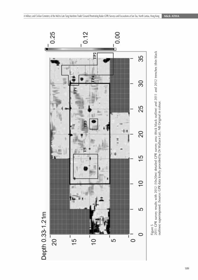
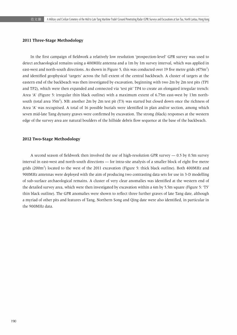
2011 Three-Stage Methodology
In the first campaign of fieldwork a relatively low resolution ‘prospection-level’ GPR survey was used to
detect archaeological remains using a 400MHz antenna and a 1m by 1m survey interval, which was applied in
east-west and north-south directions. As shown in Figure 5, this was conducted over 19 five metre grids (475m2)
and identified geophysical ‘targets’ across the full extent of the central backbeach. A cluster of targets at the
eastern end of the backbeach was then investigated by excavation, beginning with two 2m by 2m test pits (TP1
and TP2), which were then expanded and connected via ‘test pit’ TP4 to create an elongated irregular trench:
Area ‘A’ (Figure 5: irregular thin black outline) with a maximum extent of 6.75m east-west by 13m north-
south (total area 35m2). NB: another 2m by 2m test pit (T3) was started but closed down once the richness of
Area ‘A’ was recognised. A total of 16 possible burials were identified in plan and/or section, among which
seven mid-late Tang dynasty graves were confirmed by excavation. The strong (black) responses at the western
edge of the survey area are natural boulders of the hillside debris flow sequence at the base of the backbeach.
2012 Two-Stage Methodology
A second season of fieldwork then involved the use of high-resolution GPR survey — 0.5 by 0.5m survey
interval in east-west and north-south directions — for intra-site analysis of a smaller block of eight five metre
grids (200m2) located to the west of the 2011 excavation (Figure 5: thick black outline). Both 400MHz and
900MHz antennas were deployed with the aim of producing two contrasting data sets for use in 3-D modelling
of sub-surface archaeological remains. A cluster of very clear anomalies was identified at the western end of
the detailed survey area, which were then investigated by excavation within a 6m by 5.5m square (Figure 5: ‘T5’
thin black outline). The GPR anomalies were shown to reflect three further graves of late Tang date, although
a myriad of other pits and features of Tang, Northern Song and Qing date were also identified, in particular in
the 900MHz data.
191
Mick ATHAA Military and Civilian Cemetery of the Mid to Late Tang Maritime Trade? Ground Penetrating Radar (GPR) Surveys and Excavations at San Tau, North Lantau, Hong Kong
Figu
re 6
2012
GPR
sur
vey
data
with
six
‘tim
e-sl
ices
’ of 4
00M
Hz
data
to th
e le
ft an
d si
x of
900
MH
z to
the
right
. Tre
nch
T5 is
sho
wn
as a
whi
te s
quar
e an
d de
pth
rang
es fo
r ea
ch ti
me-
slic
e ar
e in
the
top
left-
hand
cor
ner o
f eac
h pl
ot.
(Sou
rce:
GPR
dat
a ki
ndly
sup
plie
d by
Dr W
alla
ce L
ai).
NB:
Orig
inal
in c
olou
r.

192
范文灝 A Military and Civilian Cemetery of the Mid to Late Tang Maritime Trade? Ground Penetrating Radar (GPR) Surveys and Excavations at San Tau, North Lantau, Hong Kong
GPR Survey Results
Introduction
As Figure 5 shows, the 2011 lower resolution survey provided good evidence for buried archaeology right
across the central backbeach, but the earlier generation of GPR software produced a plot full of ‘dendritic’
patterns, which were ‘artefacts’ of the processing rather than a true reflection of the size and shape of sub-
surface archaeological remains. In contrast in 2012, a newly-released state-of-the-art programme was used
to process the GPR survey data, which removed much of that ‘noise’ to produce 3-D images more accurately
reflecting the buried archaeological remains (Figure 6). The fundamental differences between the 400MHz
and 900MHz antennas is that the former has greater depth penetration (>2m) but reduced definition of
materials with lower conductivity (e.g. non-metals), whereas the latter is most effective in just the upper 1m
of deposits but is more sensitive to materials and deposits of lower conductivity and of smaller volume (size),
which proved extremely timely at San Tau and was a timely reminder that GPR is far more than a ‘glorified’
metal detector.
Comparing the 2011 and 2012 Results
Although the same basic GPR-GPS setup was used in both campaigns, the improved software produced
clearer — and therefore easier to interpret — results in 2012. Both the 2011 (Figure 5) and 2012 (Figure
6) GPR plots were originally in colour but unfortunately have had to be rendered as greyscale for these
conference proceedings. A difference to note is that the highest intensity responses appear black in the
2011 software but white in the 2012. In both figures the darker grey reflects the site background of sandy
backbeach deposits, while the lighter grey to black (2011) or lighter grey to white (2012) range of responses
respectively record the position of sub-surface features with moderate and high-very high conductivity and
‘reflection intensity’ compared to that sandy background. It will be noted that such moderate (lighter grey)
responses appear not only as ‘halos’ around the strongest reflections but also highlight lower intensity discrete
responses that were shown by excavation to be also of archaeological interest.
In 2011 the combined use of a 1m by 1m survey interval, 400MHz antenna and less sophisticated
software produced a relatively coarse survey plot, but this was perfectly adequate for the initial prospection
phase of GPR work. Whereas in contrast, 2012’s 0.5m by 0.5m survey interval, use of two different antennas,
and much-improved software produced detailed ‘time-slice’ data ideal for comparative intra-site analysis.
When one compares the 2012 400MHz (left) and 900MHz (right) data in Figure 6, there are some quite
striking differences apparent, which are meaningful from both an archaeological and geophysical research
perspective. What is most obvious, perhaps, is that while both antennas produced very strong reflections
when graves with clusters of metalwork were encountered (the strong diagonal string of reflections running
across T5), the 400MHz antenna failed to clearly define — or in some instances even register — near-surface
remains which, on excavation, proved to be significant Northern Song (e.g. pits filled with stones and/or kiln
debris) and Qing (e.g. stone-packed pits) features. In contrast many, but by no means all, of such features were
picked up and quite clearly defined by the 900MHz antenna, which was a significant result both in terms of
this project and future GPR application in Hong Kong.

193
Mick ATHAA Military and Civilian Cemetery of the Mid to Late Tang Maritime Trade? Ground Penetrating Radar (GPR) Surveys and Excavations at San Tau, North Lantau, Hong Kong
Excavation Results
Introduction
In the 2011 and 2012 site reports, in addition to the excavated graves there were also a number of other
elongated features identified in plan and/or section — many with Tang pottery and metalwork — that were
also given a ‘G’ prefix and labelled as ‘probable graves’. In the interests of clarity and focus in this published
presentation of the results, we will only discuss the excavated graves and these are relabelled with an ‘M’
prefix in accordance with Chinese archaeological conventions (i.e. M1-M10 inclusive).
NB: Table 1, which summarises the grave goods assemblages, shows the original and new labels used
for the ten graves discussed in this paper, so that anyone wishing to probe deeper into the site can ‘translate’
between the two.8
The combined results from Area ‘A’ and T5 are presented below in chronological order, beginning with
the pre-cemetery horizon (Phase 1) into which the Tang graves were cut, then working through the Tang
burials in phase order (Phase 2a-2d inclusive), and rounding off with a very brief mention of the Northern
Song pits and kiln debris of Phase 3.
NB: Feature dimensions are maxima and soil colour descriptions are standardised using Munsell Soil-
Colour Charts (Munsell 2009).
8 The full unpublished excavation reports can be found under‘Reports’on the HKAS website and are available for download as PDFs:
http://www.hkarch.org/main/index.php/en/

194
范文灝 A Military and Civilian Cemetery of the Mid to Late Tang Maritime Trade? Ground Penetrating Radar (GPR) Surveys and Excavations at San Tau, North Lantau, Hong Kong
Tabl
e 1
Com
paris
on o
f gra
ve g
oods
ass
embl
ages
(num
bers
in s
quar
e br
acke
ts ‘[
]’ ar
e ite
ms
foun
d in
dis
turb
ed c
onte
xts
but d
irect
ly a
bove
wha
t is
thou
ght t
o be
thei
r ‘pa
rent
’ fea
ture
)
Gra
ve ID
Stor
age
War
esTa
blew
ares
Iroin
Too
ls &
Wea
pons
Belt
Fitti
ngs
Silv
er
Hai
r-
Pin
Silv
er
Ingo
t
Off-
Cut
KYTB
Coi
nN
ewSi
teJa
rsW
ine
Jar
Basi
nC
ook
Pot
Bow
lC
upD
ish
Shor
t
Swor
d
Larg
e
Knife
Rapi
erC
leav
erA
dze
Axe
Har
p's
Fish
-
hook
Smal
l
Knife
Buck
Stra
p-
End
Kwa
M1
G6
12
11
41
M2
G1
1[1
][1
][1
][1
]4
M3
G3
See
M7
M4
G4
11
12
11
116
0
M5
G1
11
11
3+[2
][3
]
M6
G2
21
11
11
33
[2]
16
M7
G7
21
1
M8
G18
11+
[1]
11
M9
G19
11
11+
[14]
M10
G17
27
11
11
12

195
Mick ATHAA Military and Civilian Cemetery of the Mid to Late Tang Maritime Trade? Ground Penetrating Radar (GPR) Surveys and Excavations at San Tau, North Lantau, Hong Kong
Phase 1: Pre-Cemetery Cultural Horizon
All the Tang features were cut into basal backbeach deposits of yellowish brown (10YR 5/6) sand [Contexts
107, 203, 588] into which in Area ‘A’ there had been some downward ‘migration’ of Tang materials. In Area ‘A’
that was overlain by a layer of brown (10YR 4/3) sand [102b=404, 202d=206=216], and in T5 a dark yellowish
brown (10YR 3/4) layer [528=568], both of which contained Tang pottery and, in Area ‘A’ very occasional Jin-
Tang sherds (NB: see Jin-Tang jar in Grave M4 below). The darker colouration in T5 is probably as a result of
‘wash-down’ of ashy organic material from overlying Northern Song and Qing features.
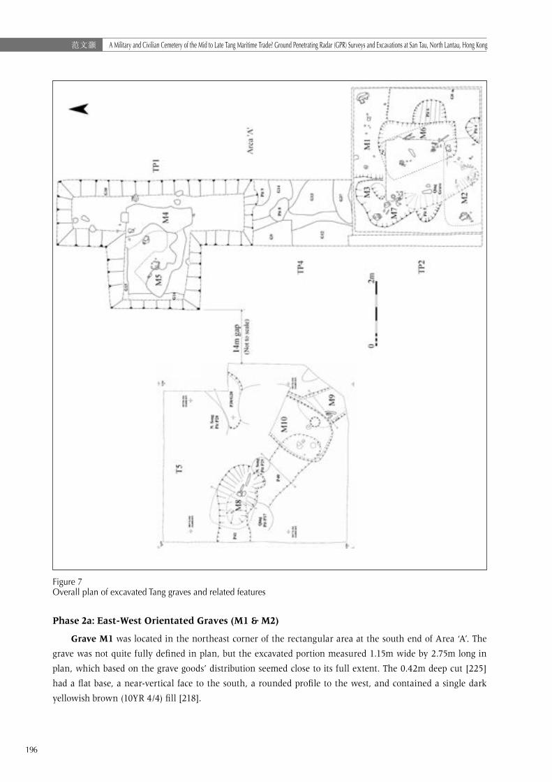
Phase 2: The Mid-Late Tang Cemetery
The above layer was cut by a series of inhumation burials — unfortunately with no skeletal remains —
that contained ceramic grave goods of consistently mid-late Tang date. As is commonly observed in multi-
phase cemeteries, at San Tau graves of the same orientation tended to respected one another and did not
overlap. As shown in the overall plan of Tang features (Figure 7), four sub-phases are suggested on the basis of
orientation and observed stratigraphic relationships between intercutting graves: first east-west (M1 and M2:
Phase 2a), next north-south (M3 and M4: Phase 2b), then northwest-southeast graves (Phase 2c), and finally
one of those was in turn cut by the only southwest-northeast grave found on site (Phase 2d). Phase 2a graves
are thought to be earlier than 2b based on the supposed surface outline of north-south grave M3 in TP4,
which seems to have removed any trace of the north-west corner of east-west grave M1 at that level.
As stratigraphic relationships between graves of different orientations were only demonstrated in the few
locations where graves intercut, the placement of all graves of shared alignment in the same phase assumes
that such orientations changed consistently through time and that all graves in each phase were more-or-
less contemporary. Several correlations between grave orientation and the types of mortuary offerings (grave
goods) they contained seem to indicate that quite different groups of people with contrasting identities made
use of the cemetery during its 150-200 year history.
Significant truncation of grave upper fills had apparently occurred as a result of Qing-20th-century
agricultural activity, which to the east was reported to have involved major flattening of the backbeach’s
sloping profile. Grave fills were consequently much shallower than they would have originally been and many
Tang grave goods were recovered from post-cemetery agricultural layers. In this paper I will concentrate on
the undisturbed portion of graves and the artefactual materials contained therein.
196
范文灝 A Military and Civilian Cemetery of the Mid to Late Tang Maritime Trade? Ground Penetrating Radar (GPR) Surveys and Excavations at San Tau, North Lantau, Hong Kong
Figure 7 Overall plan of excavated Tang graves and related features
Phase 2a: East-West Orientated Graves (M1 & M2)
Grave M1 was located in the northeast corner of the rectangular area at the south end of Area ‘A’. The
grave was not quite fully defined in plan, but the excavated portion measured 1.15m wide by 2.75m long in
plan, which based on the grave goods’ distribution seemed close to its full extent. The 0.42m deep cut [225]
had a flat base, a near-vertical face to the south, a rounded profile to the west, and contained a single dark
yellowish brown (10YR 4/4) fill [218].
197
Mick ATHAA Military and Civilian Cemetery of the Mid to Late Tang Maritime Trade? Ground Penetrating Radar (GPR) Surveys and Excavations at San Tau, North Lantau, Hong Kong
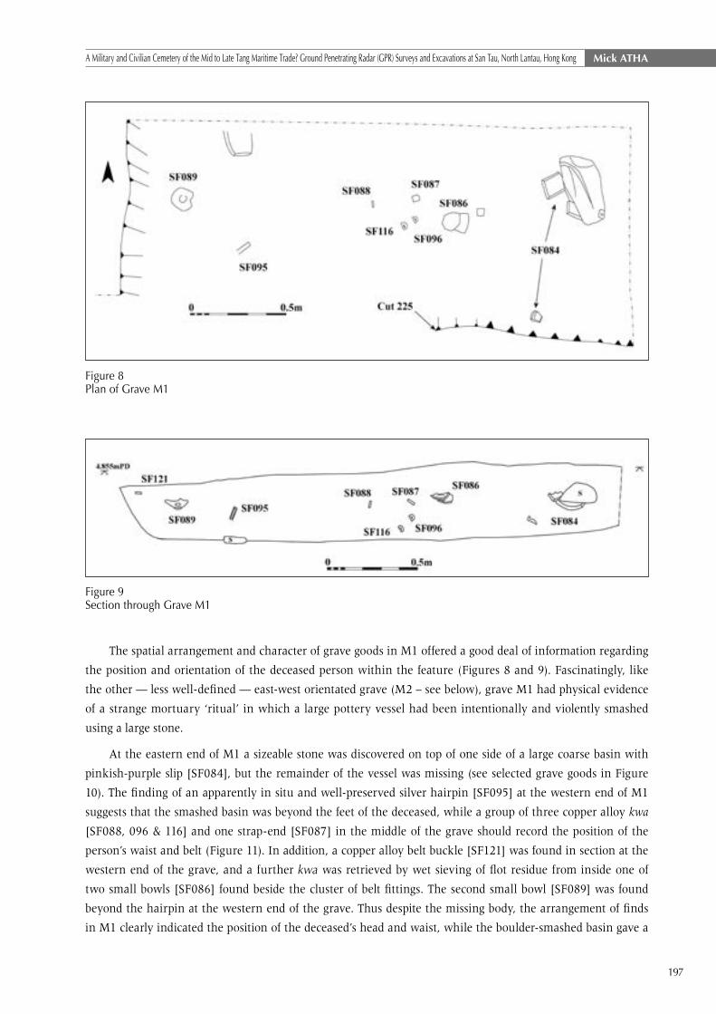
Figure 8Plan of Grave M1
Figure 9Section through Grave M1
The spatial arrangement and character of grave goods in M1 offered a good deal of information regarding
the position and orientation of the deceased person within the feature (Figures 8 and 9). Fascinatingly, like
the other — less well-defined — east-west orientated grave (M2 – see below), grave M1 had physical evidence
of a strange mortuary ‘ritual’ in which a large pottery vessel had been intentionally and violently smashed
using a large stone.
At the eastern end of M1 a sizeable stone was discovered on top of one side of a large coarse basin with
pinkish-purple slip [SF084], but the remainder of the vessel was missing (see selected grave goods in Figure
10). The finding of an apparently in situ and well-preserved silver hairpin [SF095] at the western end of M1
suggests that the smashed basin was beyond the feet of the deceased, while a group of three copper alloy kwa
[SF088, 096 & 116] and one strap-end [SF087] in the middle of the grave should record the position of the
person’s waist and belt (Figure 11). In addition, a copper alloy belt buckle [SF121] was found in section at the
western end of the grave, and a further kwa was retrieved by wet sieving of flot residue from inside one of
two small bowls [SF086] found beside the cluster of belt fittings. The second small bowl [SF089] was found
beyond the hairpin at the western end of the grave. Thus despite the missing body, the arrangement of finds
in M1 clearly indicated the position of the deceased’s head and waist, while the boulder-smashed basin gave a

198
范文灝 A Military and Civilian Cemetery of the Mid to Late Tang Maritime Trade? Ground Penetrating Radar (GPR) Surveys and Excavations at San Tau, North Lantau, Hong Kong
limit for their feet — a height of no more than 1.60m is thus indicated. The pottery and metalwork collectively
suggest a date in the mid-late Tang dynasty.
Figure 10Selection of grave goods from Grave M1 (cm scales)

199
Mick ATHAA Military and Civilian Cemetery of the Mid to Late Tang Maritime Trade? Ground Penetrating Radar (GPR) Surveys and Excavations at San Tau, North Lantau, Hong Kong
Figure 11Grave M1 bronze belt buckle, strap-end, rectangular kwa and D-shaped kwa.
Grave M2, which was identified in the south-west corner of the same area as M1 (see Figure 7),
had a cut that was impossible to define in plan due to an overlapping Qing grave and locally intense root
penetration, but based on artefactual evidence was almost certainly a second east-west orientated burial. The
approximately 0.30m deep grave cut was filled with brown sand [220]. At the western end of the grave was a
large angular stone that had apparently been dropped with some force onto a large storage jar, large fragments
of which were trapped underneath, while others had scattered along the length of the grave up to two metres
to the east. The patterning of sherds from the smashed pot gave a valuable clue as to the extent and orientation
of the grave, and the outline suggested by such evidence is plotted as a dashed line on Figure 7. Refitting
sherds from the pot were also found in the overlying Qing grave and Tang grave M6, which contained a large
portion of the pot’s shoulder and rim. The practice of intentionally smashing large pottery vessels placed at
one end of graves thus seems to be a feature of multiple graves at San Tau — its possible meaning is discussed
further below.

200
范文灝 A Military and Civilian Cemetery of the Mid to Late Tang Maritime Trade? Ground Penetrating Radar (GPR) Surveys and Excavations at San Tau, North Lantau, Hong Kong
Turning to the vessel itself, this dark grey lugged stoneware storage jar [SF117] is of typical south
Guangdong type and mid-late Tang in date (Figure 12). In addition to the jar, four corroded — probably
Kaiyuan Tongbao — coins [SF046 & SF052] were found nearby, while a collection of Tang materials found
in the Qing grave probably also originated in M2. The latter comprised an iron knife with probable sheath
fragments [SF041], a short rapier-like edgeless blade [SF045] and a harpoon [SF043], plus a large rimsherd
kiln waster [SF042] from a crackle-glazed late Tang bowl.
Figure 12SF117 Six-lugged dark grey slipped stoneware storage jar, South Guangdong type, dating to mid-late Tang dynasty (cm scale)
Also perhaps in this phase was east-west orientated Tang Pit P41, which was cut by Grave M8 and
extended west beyond the limit of excavation in T5. A single sherd of late Tang-early Northern Song pottery
was found in the feature. Whether P41 is in fact a grave is hard to confirm based on the excavated evidence,
but it is interesting to note the strong GPR response just outside the trench to the west, which may be related.
Phase 2b: North-South Orientated Graves (M3 & M4)
Grave M3 was positioned immediately to the west of M1 and they did not intercut at the lower level
observed in TP2; however, a short distance to the north in TP4 — and at a higher level — M3 does appear
to overlap the location where one might expect the upper fill of M1 to be. Grave M3 had itself been severely
truncated by two other graves — one also Tang dynasty in date and cutting across from the northwest (M7
– see below), and the other Qing and cutting into it from the south. It was consequently impossible to define
M3 in plan during excavation of the original test pit (TP2), within which it had been removed in antiquity (see
Figure 7). The surviving northern end of the grave was defined by a cut measuring just 0.75m wide, 0.95m
long, and 0.20m deep [205], which had a dark brown (10YR 3/3) sandy fill [202c].

201
Mick ATHAA Military and Civilian Cemetery of the Mid to Late Tang Maritime Trade? Ground Penetrating Radar (GPR) Surveys and Excavations at San Tau, North Lantau, Hong Kong
The relationship between M3 and intercutting grave M7 was rather unclear, but with a wider area of
exposure it seemed likely that many artefacts originally ascribed to M3 [102c] during the excavation of TP2,
were in reality grave goods intentionally placed in M7 — although some redeposition in M7 of materials from
M3 seems likely. Either way, all materials collected under context 202c can confidently be ascribed to the mid-
late Tang dynasty and are discussed below against Grave M7.
Grave M4 was identified some five metres north of M3 during the excavation of TP1. Significant
bioturbation and post-Tang agricultural activity made it impossible to define in plan the cut of M4 — or
adjacent Grave M5 — until a 0.05m thick organic-stained basal deposit [108] was identified against the
yellowish brown sand of the underlying layer [107] (see Figure 7). The dark greyish brown (10YR 4/2) silty
sand of layer 108 defined the base of a grave measuring around 1.00m wide by 2.05m long.
Deposit 108 actually produced just two sherds of Tang pottery, but a different picture emerged when the
trench was extended to the north and south (Figure 13).
Figure 13Plan of Grave M4. Second cup (SF026) found just west of cup SF080 during section straightening.
Straddling the northern limit of 108 was a rich assemblage of grave goods (see selected examples in
Figures 14 and 15) comprising 140 Kaiyuan Tongbao coins9 [SF058 & 059], an iron harpoon [SF092], a J-shaped
fishhook [SF58.28], a U-shaped silver hairpin [SF081], and a late Tang Shiwan ware spouted pottery vessel
[SF057.1] associated with a crackled glazed bowl [SF075]. Several sherds of a Jin dynasty or perhaps later red-
slipped round-bottomed jar with cord-impressed decoration below the belly and everted flaring rim were also
found at the northern end of G4 [SF018, 082 & 090].10 At the southern end of the grave was a pair of small
crudely made low-fired cups of mid-late Tang date [SF026 & SF080] with a further stack of 20 Kaiyuan Tongbao
coins (SF056). The hairpin is identical to the one from M1 and, although seemingly disturbed, probably
indicates that the deceased was interred with their head to the north. Seven nail fragments [SF032.2, 058.29,
9 The Kaiyuan Tongbao coins found in G4 are encrusted with corrosion products from iron objects found in association, which is a feature of the San Tau cemetery. Until properly cleaned and separated, the detailed identification of features and phasing suggested by Xu (1991) will not be possible.
10 See (Lam 1985: 130-131).
202
范文灝 A Military and Civilian Cemetery of the Mid to Late Tang Maritime Trade? Ground Penetrating Radar (GPR) Surveys and Excavations at San Tau, North Lantau, Hong Kong
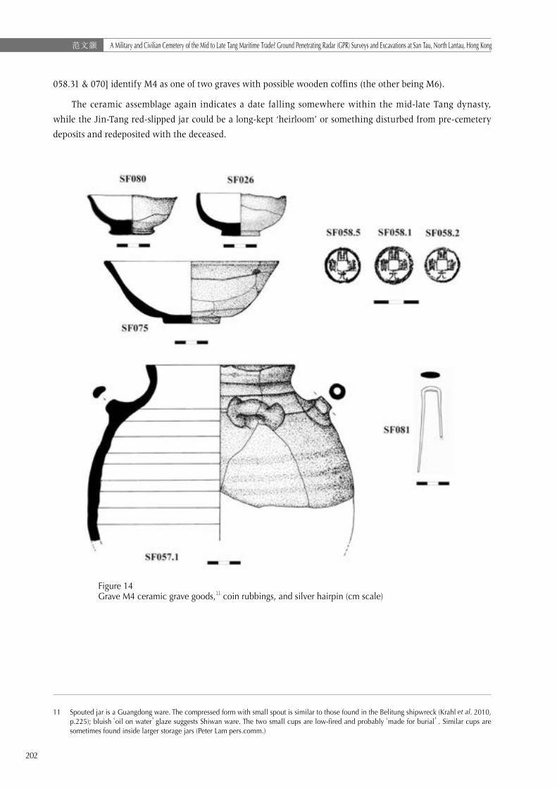
058.31 & 070] identify M4 as one of two graves with possible wooden coffins (the other being M6).
The ceramic assemblage again indicates a date falling somewhere within the mid-late Tang dynasty,
while the Jin-Tang red-slipped jar could be a long-kept ‘heirloom’ or something disturbed from pre-cemetery
deposits and redeposited with the deceased.
11 Spouted jar is a Guangdong ware. The compressed form with small spout is similar to those found in the Belitung shipwreck (Krahl et al. 2010, p.225); bluish‘oil on water’glaze suggests Shiwan ware. The two small cups are low-fired and probably‘made for burial’. Similar cups are sometimes found inside larger storage jars (Peter Lam pers.comm.)
Figure 14Grave M4 ceramic grave goods,11 coin rubbings, and silver hairpin (cm scale)

203
Mick ATHAA Military and Civilian Cemetery of the Mid to Late Tang Maritime Trade? Ground Penetrating Radar (GPR) Surveys and Excavations at San Tau, North Lantau, Hong Kong
Figure 15 Grave M4 iron harpoon SF092 (fused to coin)
Phase 2c: Northwest-Southeast Orientated Graves (M5, M6, M7, M8 & M9)
Grave M5, like adjoining Grave M4, was only recognised at a low level when the sub-rectangular outline
of its basal deposit [110], which measured approximately 1.10m wide by 2.20m long, provided a clear contrast
with the yellowish brown sand of the underlying layer [107] (see Figure 7). The basal deposits in M4 and M5
formed one continuous spread and their identical character made it impossible to determine which might be
the earlier feature.
Towards the northwest end of the grave was a large brownish-green glazed basin [SF018.1] in close
associated with a well-preserved iron axe-head [SF017] (Figures 16 & 17). A number of copper alloy belt
fittings were recovered from M5 comprising a D-shaped kwa [SF037] and two D-shaped kwa bottom
plates [SF007 & 008], a D-shaped strap end [SF019], and a belt-buckle ring fragment [SF016]. A number
of fragmentary iron objects were also recovered, comprising a possible scabbard fragment [SF015] and a
collection of blade fragments [SF126] recovered from underneath the large basin. In addition, two further
rectangular kwa [SF097 & SF006] and three trapezoidal silver objects — possibly ingot off-cuts or decorative
inlays for leatherwork — [SF076, SF094.1 & SF094.2] were found at the edge of M5 but adjacent to another
suspected grave identified only in section.

204
范文灝 A Military and Civilian Cemetery of the Mid to Late Tang Maritime Trade? Ground Penetrating Radar (GPR) Surveys and Excavations at San Tau, North Lantau, Hong Kong
Figure 16 Grave M5 Iron Axe SF017
Figure 17Grave M5 ceramic, copper alloy and silver grave goods (cm scales).

205
Mick ATHAA Military and Civilian Cemetery of the Mid to Late Tang Maritime Trade? Ground Penetrating Radar (GPR) Surveys and Excavations at San Tau, North Lantau, Hong Kong
The large basin dates Grave M5 to the mid-late Tang dynasty, but it is the sole vessel of that type found so
far at San Tau, which makes its association with the only iron axe on site all the more interesting.
Grave M6 is one of the more finds-rich burials on site, but it could not be identified in plan during the
initial 2m by 2m excavation of TP2 until clusters of grave goods were encountered in the south-east corner
of the pit. As there was no obvious colour difference between the fill and surrounding sediment, an attempt
was made to define the remainder of the cut following subtle textural contrasts. However, due to intense
bioturbation and a Northern Song pit (P6) to the east, this proved unsuccessful and the supposed north-
south orientation of the grave was shown to be erroneous by the shared alignment of three long-bladed iron
weapons that eventually confirmed the grave’s true northwest-southeast layout. Nonetheless, the excavated
outline measuring 1.10m wide by 2.40m long seems about the right overall size, while an estimation of the
correct alignment was achieved by rotating the grave about its southwest corner to align with the long blades
(see dashed outline in Figure 18). The truncated 0.24m deep cut [204] had a single dark brown (10YR 3/3)
sandy fill [202b].
Figure 18 Grave M6 plan of grave goods with as excavated ‘cut’ (hachures) and approximated true outline of grave (dashed line).

206
范文灝 A Military and Civilian Cemetery of the Mid to Late Tang Maritime Trade? Ground Penetrating Radar (GPR) Surveys and Excavations at San Tau, North Lantau, Hong Kong
Figure 19Grave M6 sectional view showing relative positions of grave goods
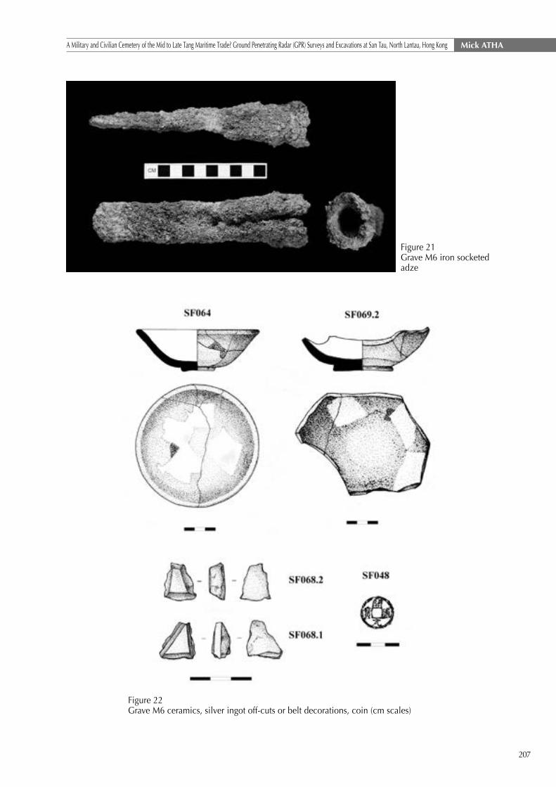
The deceased was laid to rest with a remarkable collection of iron weapons (see Figures 18-22): to the
south was a long rapier-like stabbing weapon [SF021.2] and three small iron knives [SF021, SF072 & SF073]
with associated scabbard fragments [SF074], plus a harpoon head [SF073.2]; while down the east side of the
grave was a large knife [SF65.1], a short sword [SF065.2] and an adze-head [SF065.3] in close association
and perhaps originally bound together. A pair of Kaiyuan Tongbao coins [SF048] was found near the latter
cluster. Towards the south-west corner of the grave was a further grave goods group comprising: a cluster of
reused prehistoric sherds [SF022] on top of a stoneware lug handle [SF027: refitting with SF117], a stack of 14
Kaiyuan Tongbao coins [SF063], a complete mid-late Tang green crackle glazed bowl [SF064], and a number of
large grey-slipped stoneware sherds [SF061] that also refitted with SF117 in M2. Three D-shaped kwa (SF011,
SF031 & SF044) were found across the northern half of the grave. To the northwest were an inverted bowl
[SF069.2] and a square-sectioned rectangular stone that may have used as a pillow for the deceased. Lastly,
at the supposed northern edge of the grave cut was a pair of trapezoidal silver objects [SF068.1 & 2] that
again are either ingot off-cuts or maybe belt decorations. Here again a scattering of six nail fragments [SF050,
067.1 & 067.2] perhaps indicate the use of a wooden coffin. The ceramics suggest a date in the mid-late Tang
dynasty.
Figure 20 Grave M6 large iron blades (from top): short sword, large knife and rapier.
207
Mick ATHAA Military and Civilian Cemetery of the Mid to Late Tang Maritime Trade? Ground Penetrating Radar (GPR) Surveys and Excavations at San Tau, North Lantau, Hong Kong
Figure 21 Grave M6 iron socketed adze
Figure 22 Grave M6 ceramics, silver ingot off-cuts or belt decorations, coin (cm scales)
208
范文灝 A Military and Civilian Cemetery of the Mid to Late Tang Maritime Trade? Ground Penetrating Radar (GPR) Surveys and Excavations at San Tau, North Lantau, Hong Kong
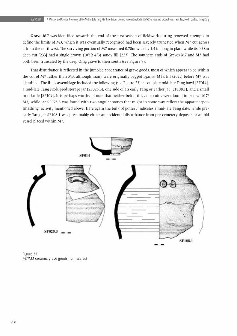
Grave M7 was identified towards the end of the first season of fieldwork during renewed attempts to
define the limits of M3, which it was eventually recognised had been severely truncated when M7 cut across
it from the northwest. The surviving portion of M7 measured 0.70m wide by 1.45m long in plan, while its 0.38m
deep cut [233] had a single brown (10YR 4/3) sandy fill [223]. The southern ends of Graves M7 and M3 had
both been truncated by the deep Qing grave to their south (see Figure 7).
That disturbance is reflected in the jumbled appearance of grave goods, most of which appear to be within
the cut of M7 rather than M3, although many were originally bagged against M3’s fill (202c) before M7 was
identified. The finds assemblage included the following (see Figure 23): a complete mid-late Tang bowl [SF014],
a mid-late Tang six-lugged storage jar [SF025.3], one side of an early Tang or earlier jar [SF108.1], and a small
iron knife [SF109]. It is perhaps worthy of note that neither belt fittings nor coins were found in or near M7/
M3, while jar SF025.3 was found with two angular stones that might in some way reflect the apparent ‘pot-
smashing’ activity mentioned above. Here again the bulk of pottery indicates a mid-late Tang date, while pre-
early Tang jar SF108.1 was presumably either an accidental disturbance from pre-cemetery deposits or an old
vessel placed within M7.
Figure 23M7/M3 ceramic grave goods. (cm scales)

209
Mick ATHAA Military and Civilian Cemetery of the Mid to Late Tang Maritime Trade? Ground Penetrating Radar (GPR) Surveys and Excavations at San Tau, North Lantau, Hong Kong
Figure 24 Plan of Grave M8 showing position of iron blades and ceramics
Grave M8 was at first very difficult to define in plan, due mainly to its disturbance and truncation by
three overlying Northern Song pits (P34, P35 & P36), and the presence of an earlier east-west orientated Tang
pit (P41), which extended beyond the limit of excavation to the west. With some difficulty M8’s irregular
sub-oval outline — approximately 1.25m wide by 2.00m long — was eventually defined in plan (see Figure
24). Although the darker outline of M8 seemed to overlay and cut P41, the disturbance nevertheless leaves
the northwest end of the grave somewhat speculative. The 0.24m deep cut [577] was rounded in profile with
gently sloping sides and an almost flat base. Along the middle of the grave was a 0.24m deep dark greyish
brown (10YR 4/2) upper fill [576a], while towards the edges was a brown (10YR 4/3) primary fill [576b]. The
dark colouration of 576a may be the organic residue of the body or, given its rather mottled ashy appearance,
might reflect burning relating to the funerary rite.
Upon excavation two grave goods clusters were noted (see Figures 25 and 26): to the northwest was a
complete Tang bowl [SF169] — a similar bowl was found directly above in Northern Song pit P36 — while to
the southeast was a 40cm-long heavy-bladed cleaver [SF170], a smaller 21cm knife [SF171], and a red-slipped
late Tang jar base [SF172.1] associated with several angular stones. All pottery was Guangdong made and the
grave can be ascribed a late Tang date.

210
范文灝 A Military and Civilian Cemetery of the Mid to Late Tang Maritime Trade? Ground Penetrating Radar (GPR) Surveys and Excavations at San Tau, North Lantau, Hong Kong
Figure 25Grave M8 ceramic grave goods. (cm scale)
Figure 26 Grave M8 iron cleaver SF170 (above) and knife SF171 (below). (cm scale)
Grave M9 was located in the southeast corner of T5 and continued beyond the limit of excavation in
that direction (time prevented fuller excavation). It again proved troublesome to define, being cut by later
southwest-northeast Tang grave M10, while M9 and M10 were also truncated by overlying Northern Song pits
P32 and P33, both of which included disturbed Tang dynasty finds. The excavated portion was an elongated
D-shape in plan and measured roughly 1.15m wide by 1.35m long (see Figure 7). In profile the 0.17m deep cut
[581] had a gently undulating base and sloping sides, and had a brown (10YR 4/3) sandy fill [580].
211
Mick ATHAA Military and Civilian Cemetery of the Mid to Late Tang Maritime Trade? Ground Penetrating Radar (GPR) Surveys and Excavations at San Tau, North Lantau, Hong Kong
Figure 27 Grave M9 large and small iron knives and socketed adze
Down the grave’s southwest side was a cluster of three iron objects (see Figure 27) comprising a 34.5cm
large knife [SF168.1] that was fused by corrosion to a 14.5cm long socketed adze [SF168.2], together with a
16cm long blade [SF168.3]. To the single Kaiyuan Tongbao coin [SF167] found within the grave can be added 14
others found directly above M9 in Northern Song layer 555. A small assemblage of fragmentary Guangdong-
made pottery was datable to the late Tang-early Northern Song period.
Also perhaps in this same phase, but slightly overlapped by Grave M8 to the north, was an elongated
northwest-southeast orientated sub-oval ‘grave-like’ feature Pit P40, which produced fragmentary Tang
ceramics but no clusters convincing enough to be labelled ‘grave goods’. However, the south-eastern end of
P40, which might be a likely place to find such evidence, was cut by later Grave M10. It is therefore possible
that some of the exceptionally rich collection of grave goods in M10 may have originated in P40.
Phase 2d: Southwest-Northeast Orientated Graves (M10; Pit P37)
Grave M10 was the only confirmed grave with a southwest-northeast orientation and was unquestionably
later than Grave M9, which it overlay and truncated. Like M9 the grave had suffered truncation by Northern
Song pits P32 and P33, while the grave’s north-eastern end had been cut away by a deeper pit of the same date
(P31). All three pits yielded redeposited Tang materials. Grave M10 was the largest example excavated and had
an elongated D-shaped plan with rounded south-western end (Figure 28) and dimensions of 1.60m wide by
1.85m long (originally perhaps 2.20-2.30m long). In section the grave’s 0.25m deep cut [557] had a rounded
profile — deeper down the northwest side and shallower to the southeast — which had a single dark brown
(10YR 3/3) sandy fill [556].

212
范文灝 A Military and Civilian Cemetery of the Mid to Late Tang Maritime Trade? Ground Penetrating Radar (GPR) Surveys and Excavations at San Tau, North Lantau, Hong Kong
Figure 28 Grave M10 showing grave goods in base of fill and secondary Pit P37
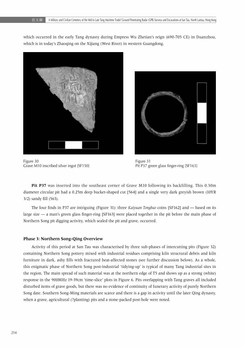
Grave M10’s rich grave goods assemblage included the following special finds (Figures 29-31): a triangular
off-cut from an inscribed silver ingot [SF150]; two stacks of six Kaiyuan Tongbao coins [SF158 & 160]; six late
Tang bowls [SF152, SF154, SF156/157, SF161, SF189 & SF190]; a small late Tang cup [SF153]; one late Tang-
early Northern Song bowl [SF155]; two late Tang storage jars — one a base only, the other four-lugged and
nearly complete — [SF191 & SF192]; a late Tang dish base [SF159]; and a fragment of large iron knife [SF151].
A cylindrical fired clay kiln bar and chunk of kiln debris were also recovered. The twenty Northern Song
pottery sherds in M10 may reflect disturbance, but the grave appears to be latest Tang-early Northern Song in
date.

213
Mick ATHAA Military and Civilian Cemetery of the Mid to Late Tang Maritime Trade? Ground Penetrating Radar (GPR) Surveys and Excavations at San Tau, North Lantau, Hong Kong
The rich burial assemblage recovered from M10 arguably marks it out as the highest status grave so
far excavated at San Tau. The silver ingot is of special interest as its vertical inscription’s four surviving
characters — (萬歲..端州)12 “Wan”, “Sui”, “Duan” & “Zhou” — appear to record the date and place of minting,
Figure 29 Grave M10 ceramic and metal grave goods; P37 glass finger-ring (cm scales)
12 ‘Wan Sui’probably refers to the Wu Zhou (690-705CE) reign titles「萬歲登封」(‘Wan Sui Deng Feng’) (695CE) or 「萬歲通天」(‘Wan Sui Tong Tian’)(696CE).
214
范文灝 A Military and Civilian Cemetery of the Mid to Late Tang Maritime Trade? Ground Penetrating Radar (GPR) Surveys and Excavations at San Tau, North Lantau, Hong Kong
which occurred in the early Tang dynasty during Empress Wu Zhetian’s reign (690-705 CE) in Duanzhou,
which is in today’s Zhaoqing on the Xijiang (West River) in western Guangdong.
Figure 30 Grave M10 inscribed silver ingot [SF150]
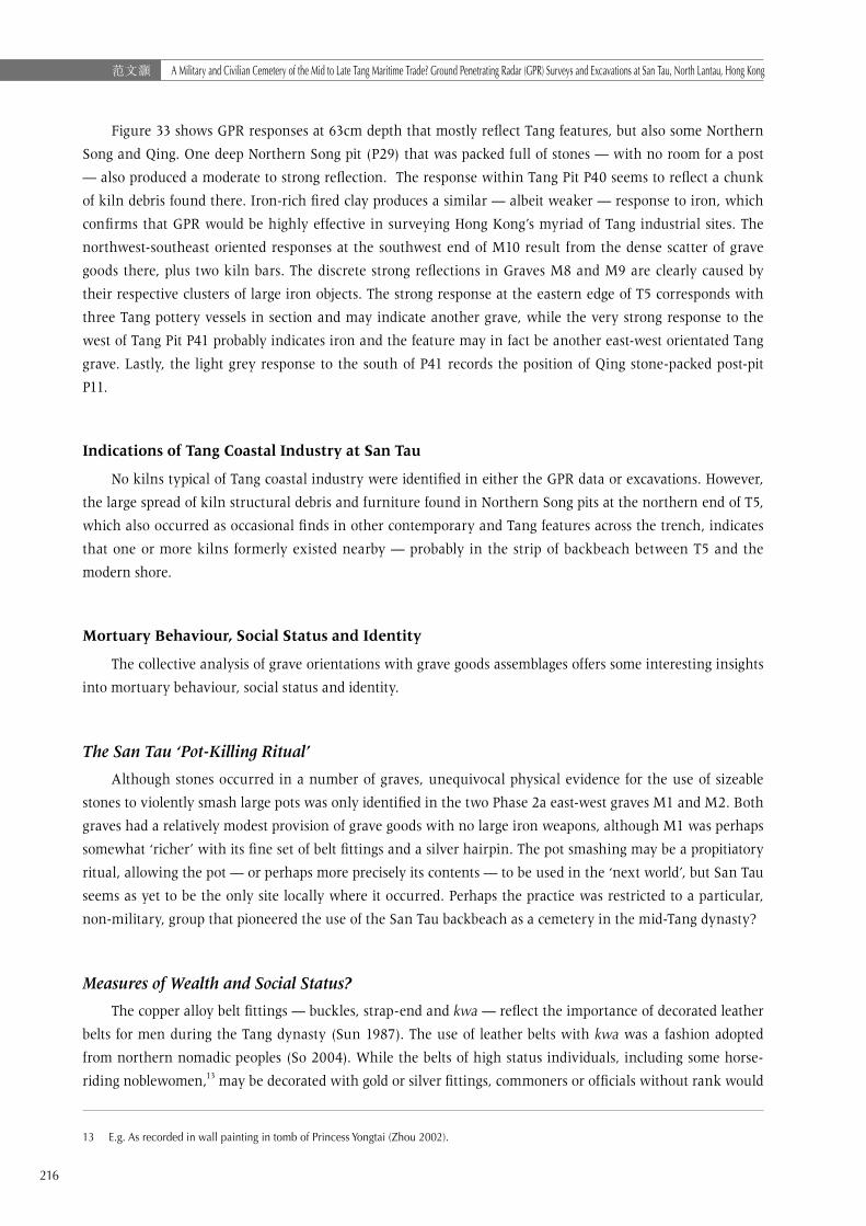
Figure 31 Pit P37 green glass finger-ring [SF163]
Pit P37 was inserted into the southeast corner of Grave M10 following its backfilling. This 0.30m
diameter circular pit had a 0.25m deep bucket-shaped cut [564] and a single very dark greyish brown (10YR
3/2) sandy fill (563).
The four finds in P37 are intriguing (Figure 31): three Kaiyuan Tongbao coins [SF162] and — based on its
large size — a man’s green glass finger-ring [SF163] were placed together in the pit before the main phase of
Northern Song pit digging activity, which sealed the pit and grave, occurred.
Phase 3: Northern Song-Qing Overview
Activity of this period at San Tau was characterised by three sub-phases of intercutting pits (Figure 32)
containing Northern Song pottery mixed with industrial residues comprising kiln structural debris and kiln
furniture in dark, ashy fills with fractured heat-affected stones (see further discussion below). As a whole,
this enigmatic phase of Northern Song post-industrial ‘tidying-up’ is typical of many Tang industrial sites in
the region. The main spread of such material was at the northern edge of T5 and shows up as a strong (white)
response in the 900MHz 19-39cm ‘time-slice’ plots in Figure 6. Pits overlapping with Tang graves all included
disturbed items of grave goods, but there was no evidence of continuity of funerary activity of purely Northern
Song date. Southern Song-Ming materials are scarce and there is a gap in activity until the later Qing dynasty,
when a grave, agricultural (?planting) pits and a stone-packed post-hole were noted.

215
Mick ATHAA Military and Civilian Cemetery of the Mid to Late Tang Maritime Trade? Ground Penetrating Radar (GPR) Surveys and Excavations at San Tau, North Lantau, Hong Kong
Figure 32T5 large Northern Song pits and small Qing pits and post-holes (down left)
Discussion
GPR Results and Excavation ‘Ground-Truthing’
This project has shown that the homogenous sediments of backbeach sites provide ideal conditions for
GPR discrimination of archaeological remains, which at San Tau extend across the entire northern backbeach.
Moreover, for a site such as San Tau with around 1m of stratified deposits and discrete clusters of artefacts
within a layering of features, the 900MHz antenna proved to be much more effective and versatile than the
400MHz.
Figure 33 900MHz GPR ‘time-slice’ data at 63cm depth with Tang features
216
范文灝 A Military and Civilian Cemetery of the Mid to Late Tang Maritime Trade? Ground Penetrating Radar (GPR) Surveys and Excavations at San Tau, North Lantau, Hong Kong
Figure 33 shows GPR responses at 63cm depth that mostly reflect Tang features, but also some Northern
Song and Qing. One deep Northern Song pit (P29) that was packed full of stones — with no room for a post
— also produced a moderate to strong reflection. The response within Tang Pit P40 seems to reflect a chunk
of kiln debris found there. Iron-rich fired clay produces a similar — albeit weaker — response to iron, which
confirms that GPR would be highly effective in surveying Hong Kong’s myriad of Tang industrial sites. The
northwest-southeast oriented responses at the southwest end of M10 result from the dense scatter of grave
goods there, plus two kiln bars. The discrete strong reflections in Graves M8 and M9 are clearly caused by
their respective clusters of large iron objects. The strong response at the eastern edge of T5 corresponds with
three Tang pottery vessels in section and may indicate another grave, while the very strong response to the
west of Tang Pit P41 probably indicates iron and the feature may in fact be another east-west orientated Tang
grave. Lastly, the light grey response to the south of P41 records the position of Qing stone-packed post-pit
P11.
Indications of Tang Coastal Industry at San Tau
No kilns typical of Tang coastal industry were identified in either the GPR data or excavations. However,
the large spread of kiln structural debris and furniture found in Northern Song pits at the northern end of T5,
which also occurred as occasional finds in other contemporary and Tang features across the trench, indicates
that one or more kilns formerly existed nearby — probably in the strip of backbeach between T5 and the
modern shore.
Mortuary Behaviour, Social Status and Identity
The collective analysis of grave orientations with grave goods assemblages offers some interesting insights
into mortuary behaviour, social status and identity.
The San Tau ‘Pot-Killing Ritual’
Although stones occurred in a number of graves, unequivocal physical evidence for the use of sizeable
stones to violently smash large pots was only identified in the two Phase 2a east-west graves M1 and M2. Both
graves had a relatively modest provision of grave goods with no large iron weapons, although M1 was perhaps
somewhat ‘richer’ with its fine set of belt fittings and a silver hairpin. The pot smashing may be a propitiatory
ritual, allowing the pot — or perhaps more precisely its contents — to be used in the ‘next world’, but San Tau
seems as yet to be the only site locally where it occurred. Perhaps the practice was restricted to a particular,
non-military, group that pioneered the use of the San Tau backbeach as a cemetery in the mid-Tang dynasty?
Measures of Wealth and Social Status?
The copper alloy belt fittings — buckles, strap-end and kwa — reflect the importance of decorated leather
belts for men during the Tang dynasty (Sun 1987). The use of leather belts with kwa was a fashion adopted
from northern nomadic peoples (So 2004). While the belts of high status individuals, including some horse-
riding noblewomen,13 may be decorated with gold or silver fittings, commoners or officials without rank would
13 E.g. As recorded in wall painting in tomb of Princess Yongtai (Zhou 2002).
217
Mick ATHAA Military and Civilian Cemetery of the Mid to Late Tang Maritime Trade? Ground Penetrating Radar (GPR) Surveys and Excavations at San Tau, North Lantau, Hong Kong
use bronze or iron (Wang 1986). All the San Tau belt fittings are bronze and many are very well made and not
locally produced.
While Kaiyuan Tongbao coinage was the currency of daily small-scale transactions, it is extremely
interesting to note that in Lingnan, silver ingots — and presumably off-cuts as well — were also used as
currency for larger transactions and inter-regional trading (Ma 2003).14 So how do we judge the relative
wealth and status of different people interred at San Tau? For example, the individual buried in north-south
Grave M4 was provided with 160 Kaiyuan Tongbao coins, a silver hairpin, and a fine spouted jar with two cups,
but had no ingot off-cuts or belt fittings. Whereas the person in Grave M10 had around one tenth that number
of coins, but was buried with a large off-cut from a silver ingot and many ceramic tablewares. Both seem
wealthy in their own way and both were apparently civilians, but the overall impression is that the person
in M10 perhaps had a higher status in life. The connection of silver with inter-regional trade is particularly
interesting when considering the larger socio-economic context of the San Tau cemetery.
Military Men with a Maritime Connection?
The consistent correlation between northwest-southeast orientation and long-bladed iron weapons in
Graves M6, M8 & M9 — two also with iron adzes and shorter knives — supports the notion of a ‘male-military’
phase (2c) of cemetery use. This connection between grave orientation and large iron tools-weaponry is
repeated in Grave M5, where a well-preserved iron axe was found beside an unusually large pottery basin.
That combination of grave goods is thus far unique but arguably fits the ‘male-military’ profile.
The presence of iron adzes alongside large bladed weapons in M6 and M9 is intriguing and may represent
a distinctive ‘toolkit’ used by some members of the military community. The iron adze is a tool associated
with wood working and shaping, rather than tree felling, and may have been a common piece of equipment
carried by maritime-focused Tang soldiers, perhaps war junk crew members? Another connection to the sea
is provided by the iron harpoon in M6, but two further harpoons occurred with the burials in M4 and in M2,
both of which may be those of civilians.
The Mystery of the Final Burial
Despite the possibility of redeposition of artefacts from underlying Pit P40, southwest-northeast grave
M10 is nevertheless the largest, latest and, as suggested above, perhaps the wealthiest burial yet found. The
deceased was laid to rest with nine items of ceramic tableware plus two storage jars — the latter presumably
with food offerings — 14 Kaiyuan Tongbao coins, and the inscribed silver ingot. The later insertion into the
backfilled grave of three further Kaiyuan Tongbao coins and a man’s green glass finger-ring was perhaps the
deliberate and touching act of a close friend or loved one towards someone whose higher status in life was
carefully marked out in death.
14 The Lingnan Dao 嶺南道 (including Duanzhou – the location inscribed on the San Tau piece), was known for its silver production and consumption during the Tang dynasty (Shi 2000). Da (2008) suggests that ingots were cut down to make them a specific value for payments.
218
范文灝 A Military and Civilian Cemetery of the Mid to Late Tang Maritime Trade? Ground Penetrating Radar (GPR) Surveys and Excavations at San Tau, North Lantau, Hong Kong
Conclusions
This project has clearly demonstrated the usefulness of GPR in the prospection and intra-site analysis of
Hong Kong’s archaeologically-rich backbeach sites, and indicates its wider potential in sandy sites throughout
China and the wider Southeast and East Asian region. The 900MHz antenna is, in particular, capable of
discriminating a range of feature and artefact types within multi-period backbeach sites. Ferrous and non-
ferrous metalwork, fired clay, stone, and even dense pottery clusters all seem detectable by the GPR and,
given time and resources, can be modelled in 3-D for future application as a predictive tool in Hong Kong site
evaluation and intra-site research.
In terms of the excavated remains, the exclusive use of Guangdong ceramics as grave goods at San Tau
reflects the general pattern of consumption throughout Tang dynasty Hong Kong. Pottery is a utilitarian and
bulky commodity and its sourcing from within the local region is to be expected. In contrast, the copper
alloy belt fittings, which were apparently worn by soldier and civilian alike, were probably not of local
manufacture, but were traded through Lingnan markets or travelled south with the people buried at San Tau.
The silver ingot off-cuts suggest wealth and status well above that of the ordinary indigenous population.
Clear phasing is demonstrated by intercutting graves, while variability in funerary traditions is evident in
grave orientation, mortuary rituals (i.e. pot smashing or not), and the combinations of goods interred. No clear
continuity of funerary activity beyond the Tang dynasty was observed, but the presence of quite typical Six-
Dynasties-Tang kiln debris in later deposits indicates the possibility of industrial activity at San Tau pre-dating
and/or contemporary with the cemetery.
As noted above, during the Tang dynasty the cemetery occupied a strategically important location
overlooking the important maritime trade routes focused on the Pearl River Estuary and the major commercial
centre at Guangzhou. The important military base at Tuen Mun was a short war junk trip to the north, while
the safe anchorage of Tung Chung Bay lay just to the east.
The cemetery may therefore have been reserved for the use of seafarers, soldiers and merchant-travellers
passing through or patrolling the area by boat. Several distinct groups from different walks of life, each with
their own traditions, but ultimately united in death and laid to rest overlooking the busy sea lanes they
navigated in life.
References
AMO. Second Territory Wide Survey of Hong Kong: North Lantau Survey. Unpublished fieldwork report, 1998.
Atha, M. Archaeological Investigation at San Tau, Lantau Island. Unpublished site report, 2012.
Atha, M. Further Archaeological Investigations at San Tau, Lantau Island. Unpublished site report, 2013.
Au, K. F. & Tung, P.M., “Ancient Salt-Working in the Hong Kong Shenzhen Region”. Journal of the Hong Kong Archaeological Society (JHKAS), Volume XIV(1998), pp. 81-87.
Cameron, H.,“Yi Long.” JHKAS, Volume VII(1979a), pp. 118-124.
Cameron, H.,“Lo So Shing.” JHKAS, Volume VII(1979b), pp. 125-129.
Cameron, H.,“Tang dynasty lime kilns.” JHKAS, Volume 13(1993), pp. 103-108.
Cameron, H. Discussion of Tang lime kilns at Sham Wan Tsuen. In W. Meacham (ed) Archaeological investigations on Chek Lap Kok Island. Hong Kong: Hong Kong Archaeological Society, 1994, pp. 223-230.
CUHK, North Lantau Archaeological Investigation. Unpublished fieldwork report, 1991.
Da, Jin. “On the boat-shaped ingot”〈船形銀鋌考〉, China Numismatics 《中國錢幣》, Beijing : Zhongguo jin rong za zhi chu ban she (北京 : 中國金融雜誌出版社 ), 2008 (3), pp. 15-20.

219
Mick ATHAA Military and Civilian Cemetery of the Mid to Late Tang Maritime Trade? Ground Penetrating Radar (GPR) Surveys and Excavations at San Tau, North Lantau, Hong Kong
Gaffney, C. F. & J. A. Gater. Revealing the buried past: geophysics for archaeologists. Stroud: Tempus, 2003.
Geotechnical Engineering Office (GEO). 1:20,000 Scale HGM20 Series Map of Solid and Superficial Geology, Sheet 9: Tung Chung. Hong Kong: Hong Kong SAR Government, 1994.
Hase, P.H. Salt in Hong Kong. Unpublished article, 2003.
Krahl, R., Guy, J., Wilson, J.K. and Raby, J. (Eds). Shipwrecked: Tang treasures and monsoon winds. Washington D.C.: Smithsonian, 2010.
Lam, P. (Ed.). Archaeological finds from the Jin to the Tang periods in Guangdong. Hong Kong: Guangdong Provincial Museum and The Art Gallery, CUHK, 1985.
Lands Department. 1:1000 Map Series HP1C, Sheet 9-DE-2D. Hong Kong: Hong Kong SAR Government, 2011a.
Lands Department. 1:1000 Map Lot Index Plan, Sheets 9-SE-2C, 2D, 7A & 7B. Hong Kong: Hong Kong SAR Government, 2011b.
Li, L.L. 2009. “Studies on 5-10th-century brine kilns in Hong Kong.” JHKAS Volume XVI (2003-2008), pp.94-103.
Lo, H.L. Hong Kong and its external communications before 1842. Hong Kong: Institute of Chinese Culture, 1963.
Ma, Quanwu. “Preliminary study on Tang dynasty silver ingots in Guangxi”〈廣西唐代銀鋌粗論〉, Journal of Guangxi Financial Research 《廣西金融研究》, Nanning: Guangxi jin rong xue hui 廣西金融學會 , 2003(S2), pp. 18-21.
Meacham, W. Sham Wan, Lamma Island: an archaeological site study. Hong Kong Archaeological Society, Journal Monograph III. Hong Kong: HKAS, 1978.
Meacham,W. “Pui O”. Journal of the Hong Kong Archaeological Society, 10(1984), pp. 60-69.
Meacham, W. Archaeological investigations on Chek Lap Kok Island. Hong Kong Archaeological Society, Journal Monograph IV. Hong Kong: HKAS, 1994.
Meacham, W. The archaeology of Hong Kong. Hong Kong: Hong Kong University Press, 2009.
Mott Connell Ltd. Agreement No. CE 1/97 Remaining development in Tung Chung and Tai Ho Comprehensive Feasibility Study, Working Paper No. WP12 Historical, Archaeological & Cultural Heritage Impact Assessment. Unpublished report, 1998.
Munsell. Munsell Soil Colour Charts. Munsell: Grand Rapids, MI, 2009.
Shi, Xiaoqun 師小群. “A Tang dynasty silver ingot in Shaanxi History Museum” 〈陜西歷史博物館征集一件唐代銀鋌〉, China Numismatics 《中國錢幣》, Beijing : Zhongguo jin rong za zhi chu ban she (北京 : 中國金融雜誌出版社 ), 2000 (1), pp. 61.
So, J. F. (Ed.) Noble Riders from Pines and Deserts: The artistic legacy of the Qidan. Hong Kong: Museum of Art, The Chinese University of Hong Kong, 2004.
Sun, Ji. “Ancient leather belts of China”, in The Thirtieth Anniversary of the cultural relics publishing house: treatises on archaeology and culture. Beijing: Cultural Relics Publishing House, 1987.
Survey and Mapping Office. Explanatory Notes on Geodetic Datums in Hong Kong. Hong Kong: Lands Department, HKSAR Government, 1995.
Wang, R.X. “Preliminary discussion on belt buckles”. Kaogu 1(1986), pp. 65-75.
Wong, J.C.F. & Shaw, R., High-level coastal deposits in Hong Kong. GEO Report No.243. Hong Kong: Geotechnical Engineering Office, HKSAR Government, 2009.
Xu, Diankui. “Preliminary discussion on the phasing of Tang Kai Yuan Tong Bao”, Kaogu 6(1991), pp. 555-561.
Zhou Xun. Ancient Chinese Costumes, Shaanxi: Shaanxi Peoples’ Publishing, 2002.
Acknowledgements
This project was commissioned by the Hong Kong Archaeological Society and funded by a subvention provided by the Government of the Hong Kong SAR. Their support is gratefully acknowledged. The writer was ably assisted in the field and post-excavation by Kennis Yip and Kathy Chan (2011). Dr Wallace Lai and his team carried out the GPR surveys and provided data used in this paper. Finds photos were taken by Kathy Chan (2011) and Wan Yiu-ming (2012), Kennis Yip produced the artefact drawings, Paul Harrison cleaned and reported on the metalwork, and Professor Peter Lam kindly examined the ceramics. This project was only made possible with the invaluable support of a large number of volunteers, including HKAS committee and ordinary members, and the writer’s students from the Chinese University of Hong Kong. Lastly, the kindness and support of the San Tau villagers are sincerely acknowledged.