A Land of Thousand Tumuli – An Archaeological Survey in the Region of El Gol, south of the 5th...
21
-
Upload
independent -
Category
Documents
-
view
3 -
download
0
Transcript of A Land of Thousand Tumuli – An Archaeological Survey in the Region of El Gol, south of the 5th...

2013 Aus der Archäologie
59
Friederike Jesse, Manuel Fiedler & Baldur Gabriel
A Land of Thousand Tumuli -An Archaeological Survey in the Region of El Gol,
south of the 5th Nile Cataract, North Sudan
Introduction
Despite the enormous increase of archaeological work in different areas of the Sudan, the region of the 5th Nile Cataract remained relatively untouched (Fig. 1). Only few expeditions reached this area during the 19th and 20th century. Among the early travellers were Johann Ludwig Burckhardt (1814), Frédéric Caillaud (1822), Joseph Russegger (1836) and the members of the Prussian Expedition led by Carl Richard Lepsius (1844) but only ethnographic observations or descriptions of the main town, Ber-ber, can be found in their accounts. Even when the railway on the eastern bank of the Nile was built at the end of the 19th century almost no archaeological observations were made or published. In 1926, the former governor of Berber Province, Henry Cecil Jackson who described a journey between the 4th and 5th Nile Cataract gives some first archaeological information1 and was the stimulus for the explora-tions of O.G.S. Crawford in the Middle Nile regi-on made in 1951 and 1952. For a rather long time his observations were the only and most detailed ones regarding the archaeology of this area.2 Further archaeological investigations took place in the early 1970s with different activities of the University of Khartoum, mainly in training projects for students.3 In 2001, The Archaeological National Joint Project to the 5th Cataract Region (ANJP) made survey roughly between N 18° 34’ and N 18° 18’ (the area between Fotouar and Abu Haraz) and then con-ducted also some excavations, for example at Abu Haraz.4 In the beginning of the 21st century a Polish team based at the Adam Mickiewicz University in Poznan started the project “Fortresses of Sudan” concentrating on the rich architectural remains - especially fortifications - in the Middle Nile.5
1 Jackson 1926.2 Crawford 1953.3 El-Amin & Edwards 2000, 44.4 Osman et al. 2003.5 Drzewiecki et al. 2008; Drzewiecki 2012; Drzewiecki &
The current plans to construct a dam at Shereiq on the 5th Nile Cataract which will cause the flooding of large parts of the Middle Nile brought the whole region back into the focus of archaeology. Different archaeological missions started working in the 5th Cataract region among them the “El Gol Project” of the University of Münster headed by Prof. Dr. Angelika Lohwasser. A first preliminary survey was carried out in February and March 2013 and the results will be reported in this paper.6
Stepnik 2012.6 The survey took place between the 25th of February and
the 16th of March 2013 and was funded by the Deutsche Forschungsgemeinschaft (DFG).
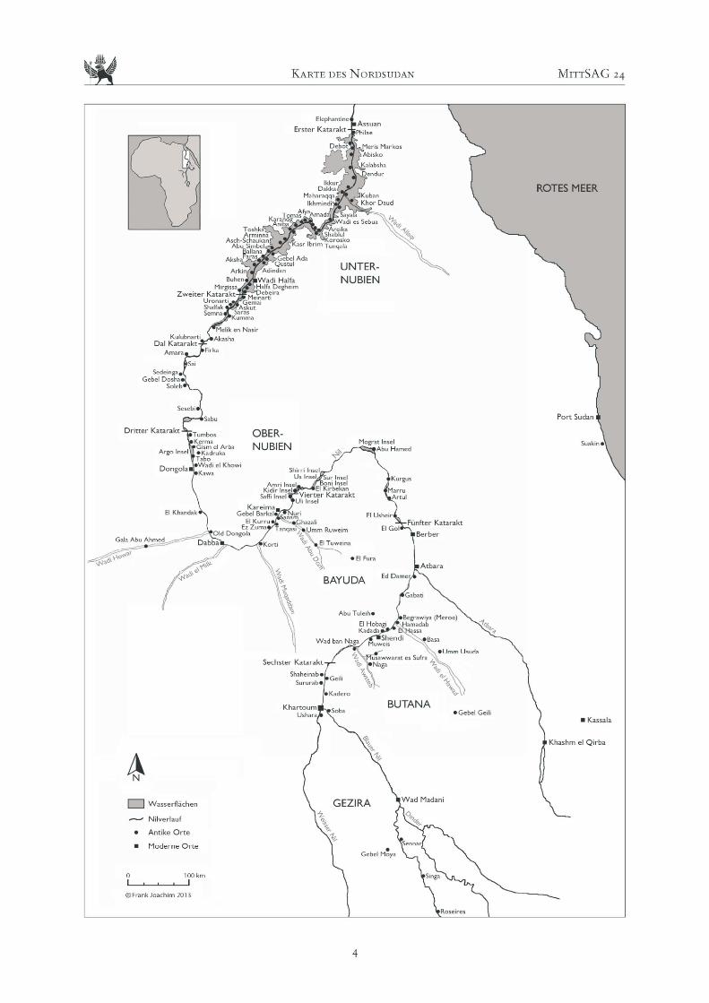
Fig. 1: The location of the study area.
Aus der Archäologie MittSAG 24
60
The area of research and somemethodological issues
The area of research of the El Gol Project is situated south of N 18° 20’. Whereas the northern boundary of the concession area is well fixed by two wadis east and west of the Nile, the southern border as well as the western border were, in accordance with the National Corporation for Antiquities and Museums (NCAM), not definitely determined. Finally, survey was conducted up to Abu Haraz in the south (see Fig. 1).7
The aim of the preliminary survey was a first documentation and investigation of the cultural relics in the area of the river Nile south of N 18° 20’ with a special focus on the western bank. Not only to get a better idea of the archaeological potential of the region but also to see if there are cultural features which would allow for a comparative study of this part of the Nile Valley and the Wadi Abu Dom area in the Bayuda desert where the University of Münster’s “W.A.D.I.” project is already working since several years.8 All activities in the El Gol area were there-fore connected logistically and scientifically with the W.A.D.I. project of the University of Münster.
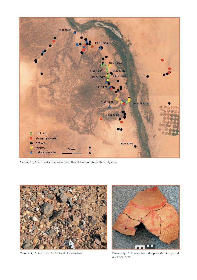
Located about 400 km north of Khartoum, the study area stretches on both sides of the Nile south of the 5th Nile Cataract. Whereas the western bank is characterised by the flood plain followed by ancient gravel terraces and then the hilly ground of the jebel (Jebel Umm Arafibiya according to Russian maps), the eastern bank shows ample flat gravel plains with nearly no distinctive features in the landscape. On the west bank Jebel Nakharu (Colour-Fig. 5) with its medieval fortification is certainly the most pro-minent site9 and on the east bank it is the Kushite temple of Dangeil, opposite to Jebel Nakharu, where the sandstone-quarries for the temple have been located.10
In preparation of the field work the area had been scanned by Google Earth. About 200 points located between N 18° 06’ and N 18° 20’ had been listed and marked for ground checks in the field.11 Large
7 Seen the planned construction of a dam at Shereiq at the 5th Nile Cataract it was initially intended to concentrate the survey in areas which are in danger to be flooded. As it was not possible to find agreements with the local authorities especially around Abu Kurrun to work in their communities, we focused on the areas south of El Gol including communities such as El Bawga and up to Abu Haraz.
8 e.g. Lohwasser 2011; 2012. 9 Crawford 1961, 17-19.10 Anderson & Mohamed Ahmed 2010, 15.11 Gabriel in press.
scale satellite images had been printed for about a hundred of these points to facilitate the ground check. Walking survey is, however, indispensable as several types of cultural relics are invisible on satellite images such as for example Palaeolithic or Neolithic sites, rock art stations or quarries. They can only be registered and identified in the field. Three weeks in February and March 2013 were therefore considered for ground checks and walking survey.12 Besides the systematic visit of points already located via satellite image, the foothills of Jebel Umm Arafibiya and two valley systems in the northern part of the study area were surveyed by car and walking. For the recording of the sites in the field a hand-held computer (“Trimble Juno 2”) was used which was linked to the “W.A.D.I.” project’s data-base.13 Alto-gether 114 sites have been recorded with this system, covering the time span between the Palaeolithic and the Islamic period. Besides countless stone tumuli, some habitation sites and rock art stations have been described.
Results
The 114 archaeological sites recorded during the survey are mainly situated on the west bank of the Nile (106 sites) as this was the main area of research (Colour-Fig. 5). More than half of all sites (65 sites, 57 %) are graves, 20 sites (17.5 %) have been classi-fied as habitation sites, 12 sites (10.5 %) show stone features and at eight localities (7 %) rock art was discovered. Among the remaining nine sites there is for example the fortress of Jebel Nakharu, two sandstone quarries and a few sites which do not allow for a detailed denomination. The majority of the sites are situated on the old terraces of the Nile (65 sites, 57 %) or on ridges or hills (30 sites, 26.3 %). Often small khors are present in the vicinity.
Stone age sites
Palaeolithic artefacts are scattered on the large gravel terraces of the Nile, but no indications for ancient habitation or workshop sites could be found. The only exception might be the area of site ELG 13/59
12 The field team assembled Dr. Manuel Fiedler (archaeo-logist), Prof. Dr. Baldur Gabriel (geo-archaeologist), Dr. Friederike Jesse (prehistorian) and Sami El Amin (inspector of NCAM). For the first few days also Prof. Dr. Angelika Lohwasser (egyptologist) and Tim Karberg, M.A. (archaeologist) participated in the field work.
13 see Rosenberger 2011.
2013 Aus der Archäologie
61
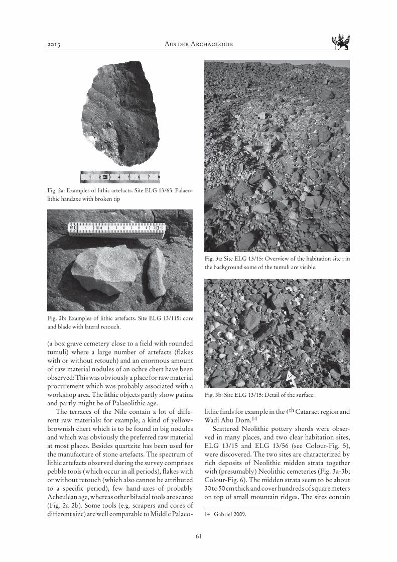
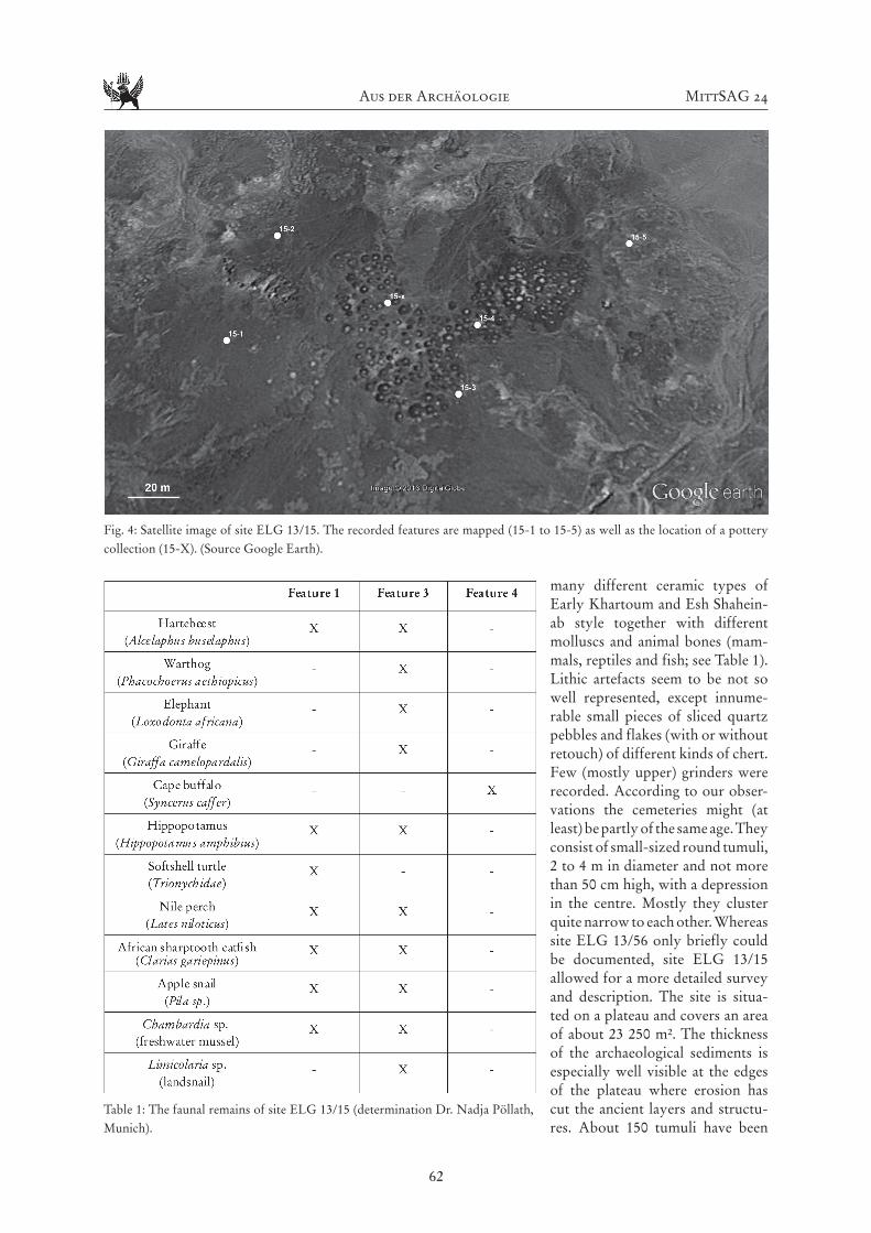
(a box grave cemetery close to a field with rounded tumuli) where a large number of artefacts (flakes with or without retouch) and an enormous amount of raw material nodules of an ochre chert have been observed: This was obviously a place for raw material procurement which was probably associated with a workshop area. The lithic objects partly show patina and partly might be of Palaeolithic age.
The terraces of the Nile contain a lot of diffe-rent raw materials: for example, a kind of yellow-brownish chert which is to be found in big nodules and which was obviously the preferred raw material at most places. Besides quartzite has been used for the manufacture of stone artefacts. The spectrum of lithic artefacts observed during the survey comprises pebble tools (which occur in all periods), flakes with or without retouch (which also cannot be attributed to a specific period), few hand-axes of probably Acheulean age, whereas other bifacial tools are scarce (Fig. 2a-2b). Some tools (e.g. scrapers and cores of different size) are well comparable to Middle Palaeo-
lithic finds for example in the 4th Cataract region and Wadi Abu Dom.14
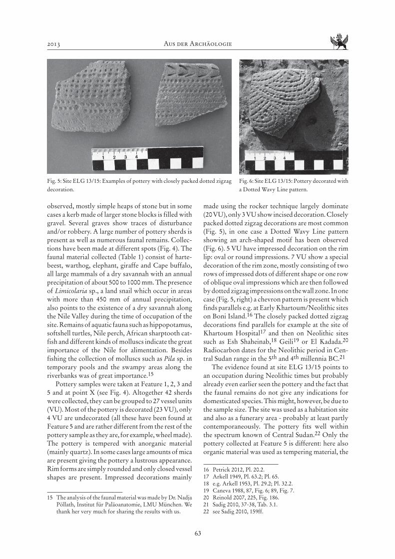
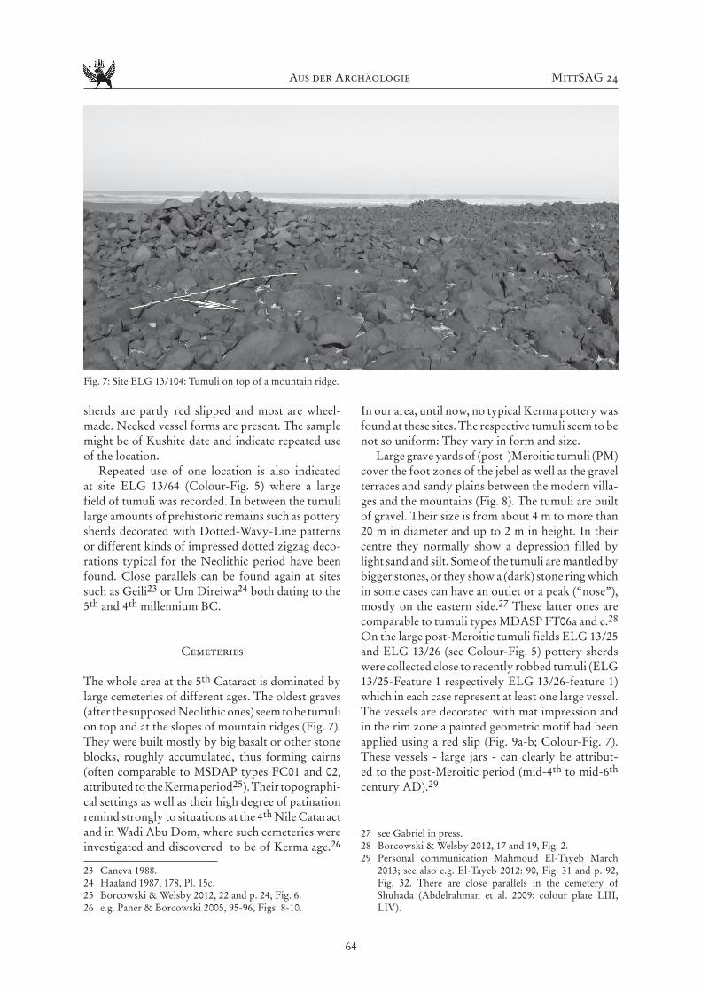
Scattered Neolithic pottery sherds were obser-ved in many places, and two clear habitation sites, ELG 13/15 and ELG 13/56 (see Colour-Fig. 5), were discovered. The two sites are characterized by rich deposits of Neolithic midden strata together with (presumably) Neolithic cemeteries (Fig. 3a-3b; Colour-Fig. 6). The midden strata seem to be about 30 to 50 cm thick and cover hundreds of square meters on top of small mountain ridges. The sites contain
14 Gabriel 2009.
Fig. 2a: Examples of lithic artefacts. Site ELG 13/65: Palaeo-lithic handaxe with broken tip
Fig. 2b: Examples of lithic artefacts. Site ELG 13/115: core and blade with lateral retouch.
Fig. 3a: Site ELG 13/15: Overview of the habitation site ; in the background some of the tumuli are visible.
Fig. 3b: Site ELG 13/15: Detail of the surface.
Aus der Archäologie MittSAG 24
62
many different ceramic types of Early Khartoum and Esh Shahein-ab style together with different molluscs and animal bones (mam-mals, reptiles and fish; see Table 1). Lithic artefacts seem to be not so well represented, except innume-rable small pieces of sliced quartz pebbles and flakes (with or without retouch) of different kinds of chert. Few (mostly upper) grinders were recorded. According to our obser-vations the cemeteries might (at least) be partly of the same age. They consist of small-sized round tumuli, 2 to 4 m in diameter and not more than 50 cm high, with a depression in the centre. Mostly they cluster quite narrow to each other. Whereas site ELG 13/56 only briefly could be documented, site ELG 13/15 allowed for a more detailed survey and description. The site is situa-ted on a plateau and covers an area of about 23 250 m². The thickness of the archaeological sediments is especially well visible at the edges of the plateau where erosion has cut the ancient layers and structu-res. About 150 tumuli have been
Fig. 4: Satellite image of site ELG 13/15. The recorded features are mapped (15-1 to 15-5) as well as the location of a pottery collection (15-X). (Source Google Earth).
Table 1: The faunal remains of site ELG 13/15 (determination Dr. Nadja Pöllath, Munich).
2013 Aus der Archäologie
63
observed, mostly simple heaps of stone but in some cases a kerb made of larger stone blocks is filled with gravel. Several graves show traces of disturbance and/or robbery. A large number of pottery sherds is present as well as numerous faunal remains. Collec-tions have been made at different spots (Fig. 4). The faunal material collected (Table 1) consist of harte-beest, warthog, elephant, giraffe and Cape buffalo, all large mammals of a dry savannah with an annual precipitation of about 500 to 1000 mm. The presence of Limicolaria sp., a land snail which occur in areas with more than 450 mm of annual precipitation, also points to the existence of a dry savannah along the Nile Valley during the time of occupation of the site. Remains of aquatic fauna such as hippopotamus, softshell turtles, Nile perch, African sharptooth cat-fish and different kinds of molluscs indicate the great importance of the Nile for alimentation. Besides fishing the collection of molluscs such as Pila sp. in temporary pools and the swampy areas along the riverbanks was of great importance.15
Pottery samples were taken at Feature 1, 2, 3 and 5 and at point X (see Fig. 4). Altogether 42 sherds were collected, they can be grouped to 27 vessel units (VU). Most of the pottery is decorated (23 VU), only 4 VU are undecorated (all these have been found at Feature 5 and are rather different from the rest of the pottery sample as they are, for example, wheel made). The pottery is tempered with anorganic material (mainly quartz). In some cases large amounts of mica are present giving the pottery a lustrous appearance. Rim forms are simply rounded and only closed vessel shapes are present. Impressed decorations mainly
15 The analysis of the faunal material was made by Dr. Nadja Pöllath, Institut für Paläoanatomie, LMU München. We thank her very much for sharing the results with us.
made using the rocker technique largely dominate (20 VU), only 3 VU show incised decoration. Closely packed dotted zigzag decorations are most common (Fig. 5), in one case a Dotted Wavy Line pattern showing an arch-shaped motif has been observed (Fig. 6). 5 VU have impressed decoration on the rim lip: oval or round impressions. 7 VU show a special decoration of the rim zone, mostly consisting of two rows of impressed dots of different shape or one row of oblique oval impressions which are then followed by dotted zigzag impressions on the wall zone. In one case (Fig. 5, right) a chevron pattern is present which finds parallels e.g. at Early Khartoum/Neolithic sites on Boni Island.16 The closely packed dotted zigzag decorations find parallels for example at the site of Khartoum Hospital17 and then on Neolithic sites such as Esh Shaheinab,18 Geili19 or El Kadada.20 Radiocarbon dates for the Neolithic period in Cen-tral Sudan range in the 5th and 4th millennia BC.21
The evidence found at site ELG 13/15 points to an occupation during Neolithic times but probably already even earlier seen the pottery and the fact that the faunal remains do not give any indications for domesticated species. This might, however, be due to the sample size. The site was used as a habitation site and also as a funerary area - probably at least partly contemporaneously. The pottery fits well within the spectrum known of Central Sudan.22 Only the pottery collected at Feature 5 is different: here also organic material was used as tempering material, the
16 Petrick 2012, Pl. 20.2.17 Arkell 1949, Pl. 63.2; Pl. 65.18 e.g. Arkell 1953, Pl. 29.2; Pl. 32.2.19 Caneva 1988, 87, Fig. 6; 89, Fig. 7.20 Reinold 2007, 225, Fig. 186.21 Sadig 2010, 37-38, Tab. 3.1.22 see Sadig 2010, 159ff.
Fig. 5: Site ELG 13/15: Examples of pottery with closely packed dotted zigzag decoration.
Fig. 6: Site ELG 13/15: Pottery decorated with a Dotted Wavy Line pattern.
Aus der Archäologie MittSAG 24
64
sherds are partly red slipped and most are wheel-made. Necked vessel forms are present. The sample might be of Kushite date and indicate repeated use of the location.
Repeated use of one location is also indicated at site ELG 13/64 (Colour-Fig. 5) where a large field of tumuli was recorded. In between the tumuli large amounts of prehistoric remains such as pottery sherds decorated with Dotted-Wavy-Line patterns or different kinds of impressed dotted zigzag deco-rations typical for the Neolithic period have been found. Close parallels can be found again at sites such as Geili23 or Um Direiwa24 both dating to the 5th and 4th millennium BC.
Cemeteries
The whole area at the 5th Cataract is dominated by large cemeteries of different ages. The oldest graves (after the supposed Neolithic ones) seem to be tumuli on top and at the slopes of mountain ridges (Fig. 7). They were built mostly by big basalt or other stone blocks, roughly accumulated, thus forming cairns (often comparable to MSDAP types FC01 and 02, attributed to the Kerma period25). Their topographi-cal settings as well as their high degree of patination remind strongly to situations at the 4th Nile Cataract and in Wadi Abu Dom, where such cemeteries were investigated and discovered to be of Kerma age.26
23 Caneva 1988.24 Haaland 1987, 178, Pl. 15c.25 Borcowski & Welsby 2012, 22 and p. 24, Fig. 6.26 e.g. Paner & Borcowski 2005, 95-96, Figs. 8-10.
In our area, until now, no typical Kerma pottery was found at these sites. The respective tumuli seem to be not so uniform: They vary in form and size.
Large grave yards of (post-)Meroitic tumuli (PM) cover the foot zones of the jebel as well as the gravel terraces and sandy plains between the modern villa-ges and the mountains (Fig. 8). The tumuli are built of gravel. Their size is from about 4 m to more than 20 m in diameter and up to 2 m in height. In their centre they normally show a depression filled by light sand and silt. Some of the tumuli are mantled by bigger stones, or they show a (dark) stone ring which in some cases can have an outlet or a peak (“nose”), mostly on the eastern side.27 These latter ones are comparable to tumuli types MDASP FT06a and c.28 On the large post-Meroitic tumuli fields ELG 13/25 and ELG 13/26 (see Colour-Fig. 5) pottery sherds were collected close to recently robbed tumuli (ELG 13/25-Feature 1 respectively ELG 13/26-feature 1) which in each case represent at least one large vessel. The vessels are decorated with mat impression and in the rim zone a painted geometric motif had been applied using a red slip (Fig. 9a-b; Colour-Fig. 7). These vessels - large jars - can clearly be attribut-ed to the post-Meroitic period (mid-4th to mid-6th century AD).29
27 see Gabriel in press.28 Borcowski & Welsby 2012, 17 and 19, Fig. 2.29 Personal communication Mahmoud El-Tayeb March
2013; see also e.g. El-Tayeb 2012: 90, Fig. 31 and p. 92, Fig. 32. There are close parallels in the cemetery of Shuhada (Abdelrahman et al. 2009: colour plate LIII, LIV).
Fig. 7: Site ELG 13/104: Tumuli on top of a mountain ridge.

2013 Aus der Archäologie
65
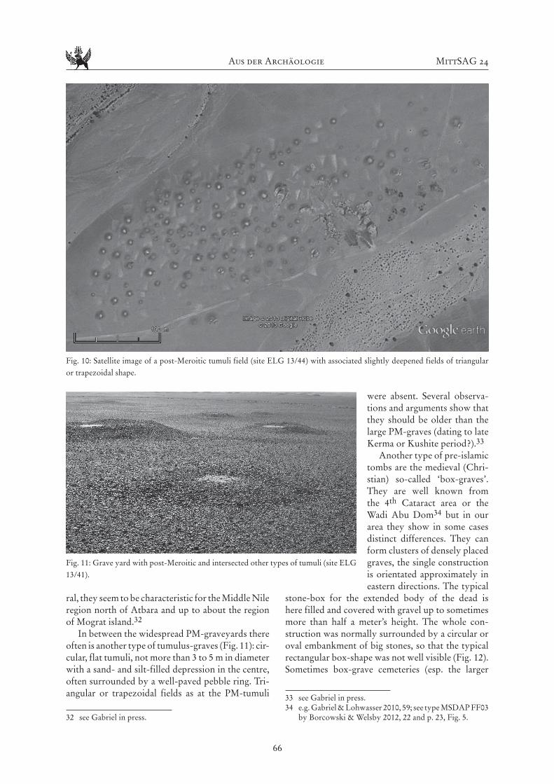
Most of the PM-tumuli are accompanied by slightly deepened fields of triangular or trapezoidal shape, orientated to the centre of the tumulus (Fig. 10). Their size corresponds to the size of the respective tumulus. Obviously, the material for constructing the burial mound was taken out of these fields. They must have had an important meaning in funeral customs as well, since they cover large areas of the cemeteries and were, as far as we could see, never touched by later building activities within the ceme-
teries. Areas void of any gravel material associated with large fields of tumuli have been observed also much further up in the north at site PL_Korta_1130 or at the cemetery of Hagar el-Beida 431 but, in gene-
30 Drzewiecki et al. 2008, 16, Fig. 12.31 Chłodnicki 2010, 38-39, Figs. 10-11. On the aerial picture
the triangular fields which are orientated towards the tumuli are clearly visible. They have been interpreted as the area of extraction of the gravel for the building of the corresponding tumulus (Chłodnicki 2010, 39).
Fig. 8: A post-Meroitic grave yard (site ELG 13/40).
Fig. 9: Pottery from the post-Meroitic period: a) site ELG 13/25, Feature 1; b) site ELG 13/25.
Aus der Archäologie MittSAG 24
66
ral, they seem to be characteristic for the Middle Nile region north of Atbara and up to about the region of Mograt island.32
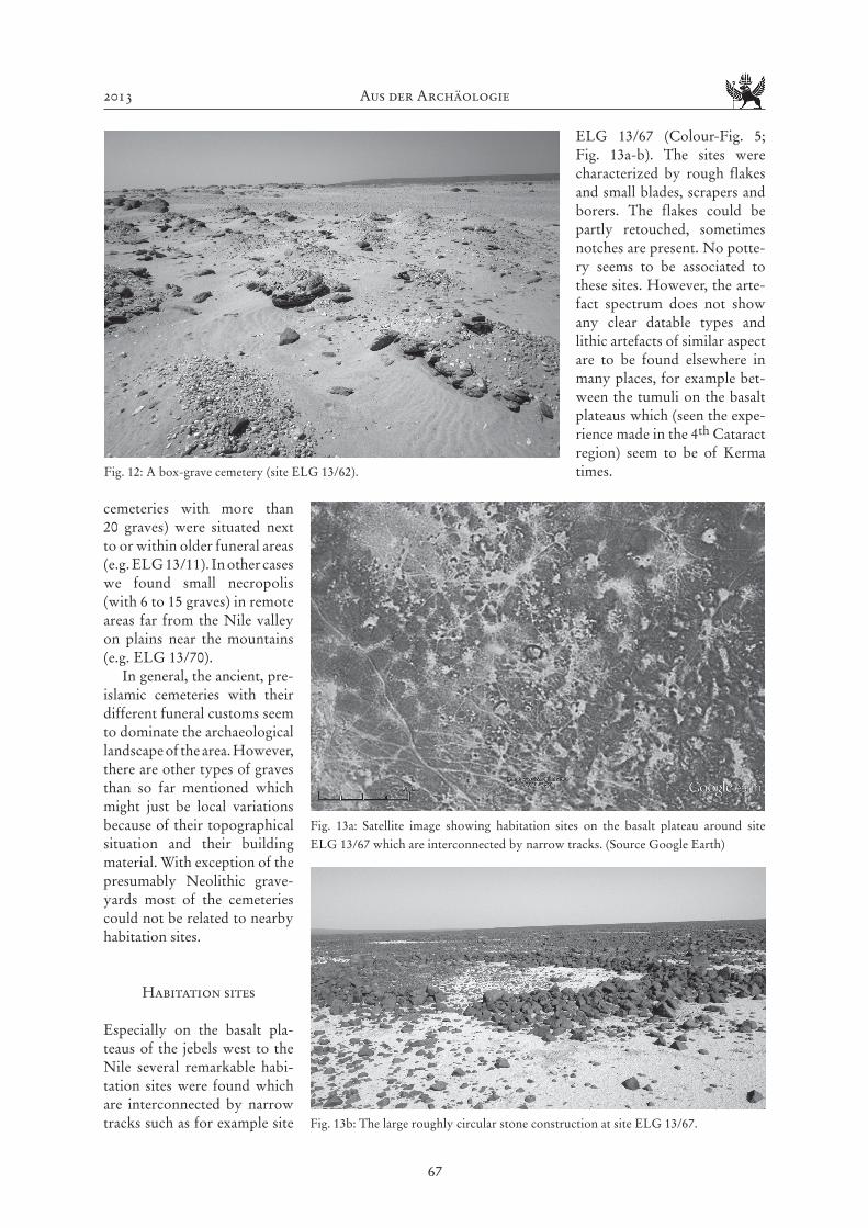
In between the widespread PM-graveyards there often is another type of tumulus-graves (Fig. 11): cir-cular, flat tumuli, not more than 3 to 5 m in diameter with a sand- and silt-filled depression in the centre, often surrounded by a well-paved pebble ring. Tri-angular or trapezoidal fields as at the PM-tumuli
32 see Gabriel in press.
were absent. Several observa-tions and arguments show that they should be older than the large PM-graves (dating to late Kerma or Kushite period?).33
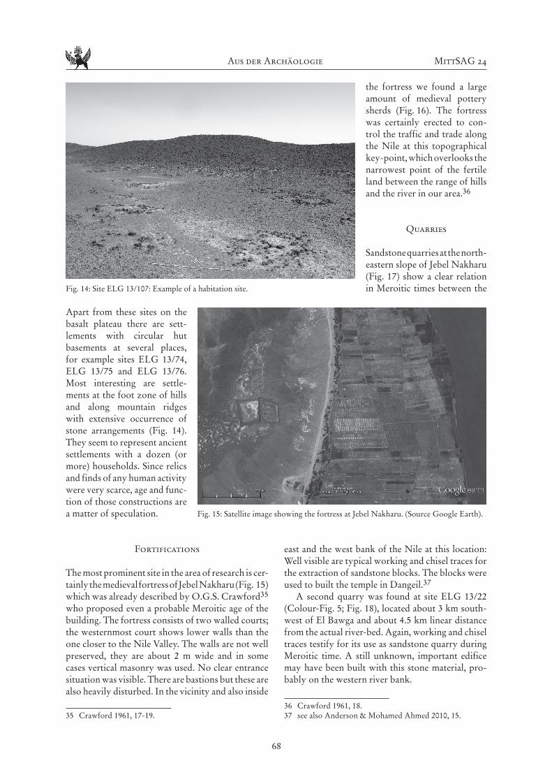
Another type of pre-islamic tombs are the medieval (Chri-stian) so-called ‘box-graves’. They are well known from the 4th Cataract area or the Wadi Abu Dom34 but in our area they show in some cases distinct differences. They can form clusters of densely placed graves, the single construction is orientated approximately in eastern directions. The typical
stone-box for the extended body of the dead is here filled and covered with gravel up to sometimes more than half a meter’s height. The whole con-struction was normally surrounded by a circular or oval embankment of big stones, so that the typical rectangular box-shape was not well visible (Fig. 12). Sometimes box-grave cemeteries (esp. the larger
33 see Gabriel in press.34 e.g. Gabriel & Lohwasser 2010, 59; see type MSDAP FF03
by Borcowski & Welsby 2012, 22 and p. 23, Fig. 5.
Fig. 10: Satellite image of a post-Meroitic tumuli field (site ELG 13/44) with associated slightly deepened fields of triangular or trapezoidal shape.
Fig. 11: Grave yard with post-Meroitic and intersected other types of tumuli (site ELG 13/41).
2013 Aus der Archäologie
67
cemeteries with more than 20 graves) were situated next to or within older funeral areas (e.g. ELG 13/11). In other cases we found small necropolis (with 6 to 15 graves) in remote areas far from the Nile valley on plains near the mountains (e.g. ELG 13/70).
In general, the ancient, pre-islamic cemeteries with their different funeral customs seem to dominate the archaeological landscape of the area. However, there are other types of graves than so far mentioned which might just be local variations because of their topographical situation and their building material. With exception of the presumably Neolithic grave-yards most of the cemeteries could not be related to nearby habitation sites.
Habitation sites
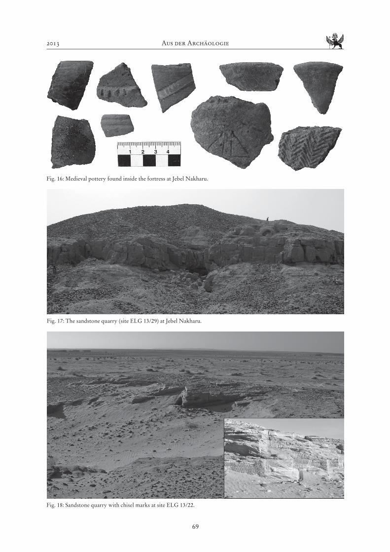
Especially on the basalt pla-teaus of the jebels west to the Nile several remarkable habi-tation sites were found which are interconnected by narrow tracks such as for example site
ELG 13/67 (Colour-Fig. 5; Fig. 13a-b). The sites were characterized by rough flakes and small blades, scrapers and borers. The flakes could be partly retouched, sometimes notches are present. No potte-ry seems to be associated to these sites. However, the arte-fact spectrum does not show any clear datable types and lithic artefacts of similar aspect are to be found elsewhere in many places, for example bet-ween the tumuli on the basalt plateaus which (seen the expe-rience made in the 4th Cataract region) seem to be of Kerma times.Fig. 12: A box-grave cemetery (site ELG 13/62).
Fig. 13a: Satellite image showing habitation sites on the basalt plateau around site ELG 13/67 which are interconnected by narrow tracks. (Source Google Earth)
Fig. 13b: The large roughly circular stone construction at site ELG 13/67.
Aus der Archäologie MittSAG 24
68
Apart from these sites on the basalt plateau there are sett-lements with circular hut basements at several places, for example sites ELG 13/74, ELG 13/75 and ELG 13/76. Most interesting are settle-ments at the foot zone of hills and along mountain ridges with extensive occurrence of stone arrangements (Fig. 14). They seem to represent ancient settlements with a dozen (or more) households. Since relics and finds of any human activity were very scarce, age and func-tion of those constructions are a matter of speculation.
Fortifications
The most prominent site in the area of research is cer-tainly the medieval fortress of Jebel Nakharu (Fig. 15) which was already described by O.G.S. Crawford35 who proposed even a probable Meroitic age of the building. The fortress consists of two walled courts; the westernmost court shows lower walls than the one closer to the Nile Valley. The walls are not well preserved, they are about 2 m wide and in some cases vertical masonry was used. No clear entrance situation was visible. There are bastions but these are also heavily disturbed. In the vicinity and also inside
35 Crawford 1961, 17-19.
the fortress we found a large amount of medieval pottery sherds (Fig. 16). The fortress was certainly erected to con-trol the traffic and trade along the Nile at this topographical key-point, which overlooks the narrowest point of the fertile land between the range of hills and the river in our area.36
Quarries
Sandstone quarries at the north-eastern slope of Jebel Nakharu (Fig. 17) show a clear relation in Meroitic times between the
east and the west bank of the Nile at this location: Well visible are typical working and chisel traces for the extraction of sandstone blocks. The blocks were used to built the temple in Dangeil.37
A second quarry was found at site ELG 13/22 (Colour-Fig. 5; Fig. 18), located about 3 km south-west of El Bawga and about 4.5 km linear distance from the actual river-bed. Again, working and chisel traces testify for its use as sandstone quarry during Meroitic time. A still unknown, important edifice may have been built with this stone material, pro-bably on the western river bank.
36 Crawford 1961, 18.37 see also Anderson & Mohamed Ahmed 2010, 15.
Fig. 14: Site ELG 13/107: Example of a habitation site.
Fig. 15: Satellite image showing the fortress at Jebel Nakharu. (Source Google Earth).
2013 Aus der Archäologie
69
Fig. 16: Medieval pottery found inside the fortress at Jebel Nakharu.
Fig. 17: The sandstone quarry (site ELG 13/29) at Jebel Nakharu.
Fig. 18: Sandstone quarry with chisel marks at site ELG 13/22.

Aus der Archäologie MittSAG 24
70
Rock art
Rock art is locally restricted to adequate rock-sur-faces. While such features have been found at seve-ral, rare sandstone-outcrops, they are missing for example on the basalt plateau and on schist. Some
larger sites (e.g. ELG 13/20, ELG 13/23 and ELG 13/87) with a wide variety of engravings (camels, bovids, human figures, sandals, crosses, stars, geo-metric forms etc.; see Fig. 19) and other features (e.g. handmills, cup marks, games boards and Arabic inscriptions) could be found.
The engravings are often difficult to read: Thin straight lines, geometrical figures, pictograms or variable traces occur, sandal pictures are quite com-mon, and modern Arabic inscriptions are present at all places. Not only via the represented motifs but also seen the different intensity of patina, the sites can be interpreted as being of various age: Neolithic engravings seem to be absent and the bulk of the engravings seems to be of Meroitic or Christian times seen the frequent representations of camels (with or
Fig. 19: Rock engravings at site ELG 13/87.
Fig. 20a: Rock art at site ELG 13/23: Camel with rider. Fig. 20b: Representation of a church.
2013 Aus der Archäologie
71
without riders; Fig. 20a) or of churches (Fig. 20b). Parallels to the rock art can be found in many other areas of the Sudan such as for example the region of the 4th Nile Cataract38 or the Wadi Abu Dom.39 The normally ubiquitous depictions of cattle40 are astonishingly only seldom present in the study area.
Other remarkable surface traits
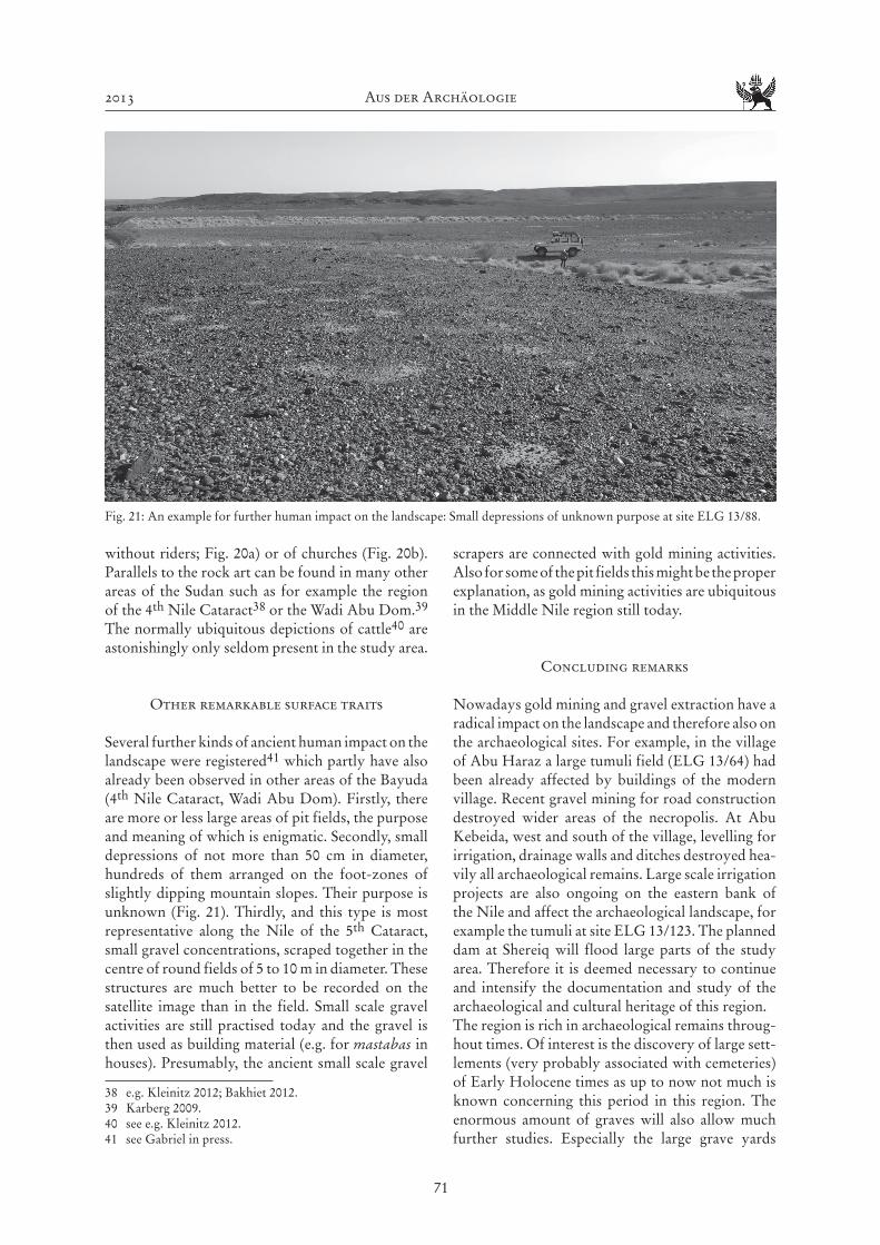
Several further kinds of ancient human impact on the landscape were registered41 which partly have also already been observed in other areas of the Bayuda (4th Nile Cataract, Wadi Abu Dom). Firstly, there are more or less large areas of pit fields, the purpose and meaning of which is enigmatic. Secondly, small depressions of not more than 50 cm in diameter, hundreds of them arranged on the foot-zones of slightly dipping mountain slopes. Their purpose is unknown (Fig. 21). Thirdly, and this type is most representative along the Nile of the 5th Cataract, small gravel concentrations, scraped together in the centre of round fields of 5 to 10 m in diameter. These structures are much better to be recorded on the satellite image than in the field. Small scale gravel activities are still practised today and the gravel is then used as building material (e.g. for mastabas in houses). Presumably, the ancient small scale gravel
38 e.g. Kleinitz 2012; Bakhiet 2012.39 Karberg 2009.40 see e.g. Kleinitz 2012.41 see Gabriel in press.
scrapers are connected with gold mining activities. Also for some of the pit fields this might be the proper explanation, as gold mining activities are ubiquitous in the Middle Nile region still today.
Concluding remarks
Nowadays gold mining and gravel extraction have a radical impact on the landscape and therefore also on the archaeological sites. For example, in the village of Abu Haraz a large tumuli field (ELG 13/64) had been already affected by buildings of the modern village. Recent gravel mining for road construction destroyed wider areas of the necropolis. At Abu Kebeida, west and south of the village, levelling for irrigation, drainage walls and ditches destroyed hea-vily all archaeological remains. Large scale irrigation projects are also ongoing on the eastern bank of the Nile and affect the archaeological landscape, for example the tumuli at site ELG 13/123. The planned dam at Shereiq will flood large parts of the study area. Therefore it is deemed necessary to continue and intensify the documentation and study of the archaeological and cultural heritage of this region. The region is rich in archaeological remains throug-hout times. Of interest is the discovery of large sett-lements (very probably associated with cemeteries) of Early Holocene times as up to now not much is known concerning this period in this region. The enormous amount of graves will also allow much further studies. Especially the large grave yards
Fig. 21: An example for further human impact on the landscape: Small depressions of unknown purpose at site ELG 13/88.
Aus der Archäologie MittSAG 24
72
might give good chances of dealing with ancient societies and their structure such as the relationship between elites and the “normal” folk. No systematic field-work survey could take place in areas of nowa-days villages, gardens and fields during this season. If ancient settlements could be mainly situated along the river or close to ancient cultivated land is also a question for future research.
Bibliography
Abdelrahman, Mohamed Farouk, Sokary, Ahmed & Bushara, Murtada (2009), Shuhada Rescue Archaeo-logical Project (SRAP) and el-Misaktab in the Shendi region. Sudan & Nubia 13: 107-113.
Anderson, J. & Salah eldin Mohamed Ahmed (2010), Excavations in the Temple Precinct of Dangeil, Sudan. Bookleteer.
Arkell, A.J. (1949), Early Khartoum. London-New York-Toronto.
Arkell, A.J. (1953), Shaheinab. London-New York-Toronto.
Bakhiet, Fawzi Hassan (2012), Rock art on Boni Island: Preliminary report on the 2006 and 2007 field seasons. In: H.-P. Wotzka (ed.), Proceedings of the Third Inter-national Conference on the Archaeology of the Fourth Nile Cataract. University of Cologne, 13-14 July 2006. Africa Praehistorica 22, Köln: 217-224.
Borcowski, Z. & D. Welsby (2012), The Merowe Dam Archaeological Salvage Project (MDASP): Provisional type seris of monuments. In: H.-P. Wotzka (ed.), Pro-ceedings of the Third International Conference on the Archaeology of the Fourth Nile Cataract. University of Cologne, 13-14 July 2006. Africa Praehistorica 22, Köln: 15-32.
Caneva, I. (ed.) (1988), El Geili. The history of a middle Nile environment 7000 B.C. - A.D. 1500. BAR Inter-national Series 424, Oxford.
Chłodnicki, M. (2010), Archaeological Research between Es-Sadda and Shemkhiya 2005-2006. GAMAR 6: 31-40.
Crawford, O.G.S. (1953), Field Archaeology of the Middle Nile Region. Kush 1: 2-29.
Crawford, O.G.S. (1961), Castles and Churches in the Middle Nile Region. Sudan Antiquities Service, Occa-sional Papers 2, Khartoum.
Drzewiecki, M., P. Maliński & W. Rączkowski (2008), Fortresses of Sudan: following O.G.S. Crawford. Pre-liminary report. Khartoum. http://sudan.archeo.edu.pl/images/storage/Preliminary_report_season_2008.pdf (accessed May 2013).
Drzewiecki, M. (2012), Fortresses of Sudan, 2012. Prelimi-nary Report. Khartoum. http://sudan.archeo.edu.pl/
images/storage/FORTRESSES_OF_SUDAN_2012_PRELIMINARY_REPORT.pdf (accessed December 2012).
Drzewiecki, M. & T. Stepnik (2012), Fortresses of the Sudan Project. Abu Sideir case study. Sudan & Nubia 16: 96-99.
El-Amin, Yousif, M. & D.N. Edwards (2000), Archaeo-logical Survey in the Fifth Cataract Region. Sudan & Nubia 4: 44-50.
El-Tayeb, M. (2012), Funerary traditions in Nubian Early Makuria. GAMAR 9 (Monograph Series 1), Gdansk.
Gabriel, B. (2009), Zum Paläolithikum in der nördlichen Bayuda (Sudan) - Beobachtungen am 4. Nilkatarakt und im Wadi Abu Dom. Der Antike Sudan. MittSAG 20: 117-130.
Gabriel, B. (in press), Kulturhistorische Landschaftsele-mente am 5. Nilkatarakt/Nordsudan nach Google-Earth-Bildanalysen mit Anmerkungen nach Ground-check (GC).
Gabriel, B. & A. Lohwasser (2010), Google Earth and Groundcheck: Beispiele aus dem Wadi Abu Dom (Bayuda, N-Sudan). Der antike Sudan. MittSAG 21: 51-62.
Haaland, R. (1987), Socio-economic differentiation in the Neolithic Sudan. BAR International Series 350, Cam-bridge.
Jackson, H.C. (1926), A Trek in Abu Hamed District. Sudan Notes and Records 9: 1-35.
Karberg, T. (2009), Die Felskunst im unteren Wadi Abu Dom. Der antike Sudan. MittSAG 20: 131-140.
Kleinitz, C. (2012), Rock art in the Fourth Nile Cataract: An overview. In: H.-P. Wotzka (ed.), Proceedings of the Third International Conference on the Archaeology of the Fourth Nile Cataract. University of Cologne, 13-14 July 2006. Africa Praehistorica 22, Köln: 33-50.
Lohwasser, A. (2011), Das Projekt Wadi Abu Dom Itine-rary (W.A.D.I.), Kampagne 2011. Der antike Sudan. MittSAG 22: 59-68.
Lohwasser, A. (2012), A Survey in the Western Bayu-da: The Wadi Abu Dom Itinerary Project (W.A.D.I.). Sudan & Nubia 16: 109-117.
Osman, Ali Mohamed, Sadig, Azhari Mustafa & Abd El Mageed, Mohammed Ahmed (2003), The Archaeolo-gical National Joint Project (ANJP) to the 5th Cataract Region. Dar Al Anwar. Syria. (in Arabic).
Paner, H. & Z. Borcowski (2005), Gdańsk Archaeological Museum Expedition. A summary of Eight Seasons Work at the Fourth Cataract. GAMAR 4: 89-115.
Petrick, B. (2012), The Cologne Fourth Cataract project 2005 field season on Boni Island. In: H.-P. Wotzka (ed.), Proceedings of the Third International Conference on the Archaeology of the Fourth Nile Cataract. Univer-sity of Cologne, 13-14 July 2006. Africa Praehistorica 22, Köln: 117-128.
2013 Aus der Archäologie
73
Reinold, J. (2007), La nécropole néolithique d’el-Kadada au Soudan central. Vol. 1: Les cimetières A et B (NE-36-O/3-V-2 et NE-36-O/3-V-3) du kôm principal. Paris.
Rosenberger, M. (2011), Konzeption und prototypische Umsetzung eines Graphical User Interface (GUI) für die GIS-konforme Felddatenerfassung historisch-geographischer Raumdaten mittels ArcPad im Sudan. Unpublished Diploma thesis, Institute of Geography, Westfälische Wilhelms-Universität Münster, Münster.
Sadig, Azhari Mustafa (2010), The Neolithic of the Middle Nile Region. An Archeology of Central Sudan and Nubia. Kampala.
Zusammenfassung
Im Februar und März 2013 fand ein erster archäolo-gischer Survey im Gebiet um El Gol im Bereich des 5. Nilkatarakts statt. Während der etwa dreiwö-chigen, von der Universität Münster organisierten Kampagne wurde das Gebiet südlich von N 18° 20‘ bis etwa auf die Höhe von Abu Haraz (siehe Abb. 1) durch ein vierköpfiges Team begangen. Es bestand aus einem Geoarchäologen, zwei Archäologen und einem Vertreter von NCAM. Zur Vorbereitung waren umfassende Satellitenbildstudien durchge-führt worden, die etwa 200 Punkte im Gebiet zwi-schen N 18° 06‘ und N 18° 20‘ erfasst hatten. Ein Teil
davon wurde gezielt während des Survey angesteuert, um die Satellitenbildinformationen durch Ground-checks zu überprüfen. Parallel dazu wurden weitere Fundplätze aufgenommen, die - wie Felsbildstatio-nen oder prähistorische Siedlungsplätze - nicht über Satellitenbilder aufgespürt werden können.
Insgesamt 114 Fundplätze wurden dokumen-tiert, von denen über die Hälfte (57 %) Gräber unterschiedlicher Zeitstellung sind. Siedlungsplätze machen 17,5 % aus, Steinsetzungen verschiedenster Art 10,5 %. Schließlich stellen 7 % der Fundstellen Felsbildplätze dar, wobei ausschließlich Gravierun-gen registriert wurden. Die Zeitspanne der archäo-logischen Fundstätten reicht vom Paläolithikum bis in islamische Zeit.
Neben den teils weit ausgedehnten Friedhöfen der post-meroitischen Zeit war die Entdeckung prä-historischer Siedlungsplätze mit sehr guter Befund-erhaltung von besonderem Interesse. Am Fundplatz ELG 13/15 (Colour-Fig. 5; Abb. 3-6) konnten neben Keramikscherben des frühen und mittleren Holo-zäns auch eine reichhaltige Fauna dokumentiert wer-den (siehe Tabelle 1).
Die Planung eines Staudamms im Bereich des 5. Nilkatarakts würde zur Überflutung eines Groß-teils der begangenen Region führen, so dass weitere archäologische Untersuchungen in diesem bislang kaum bekannten Bereich des sudanesischen Niltals dringend geboten sind.