Collisional stopping considering the induced potential created by ions in a free-electron gas

Lithos 124 (2011) 144–157
Contents lists available at ScienceDirect
Lithos
j ourna l homepage: www.e lsev ie r.com/ locate / l i thos
A geophysical model of the Variscan orogenic root (Bohemian Massif):Implications for modern collisional orogens
Alexandra Guy a,b,⁎, Jean-Bernard Edel b, Karel Schulmann b, Čestmir Tomek c, Ondrej Lexa d
a Charles University, Faculty of Mathematics and Physics, Department of Geophysics, V Holešovičkách 3, 180 00 Prague 8, Czech Republicb IPGS-EOST, UMR 7516, Université de Strasbourg, 1 rue Blessig, 67084 Strasbourg, Francec Czech Geological Survey, Klarov 3, 11821, Prague, Czech Republicd Institute of Petrology and Structural Geology, Charles University, Albertov 6, 128 43 Prague, Czech Republic
⁎ Corresponding author. IPGS-EOST, UMR 7516, UnBlessig, 67084 Strasbourg, France.
E-mail address: [email protected] (A. Guy).
0024-4937/$ – see front matter © 2010 Elsevier B.V. Adoi:10.1016/j.lithos.2010.08.008
a b s t r a c t
a r t i c l e i n f oArticle history:Received 29 January 2010Accepted 5 August 2010Available online 13 August 2010
Keywords:Gravimetric modelFelsic orogenic lower crustContinental indentationSeismic profilesBohemian MassifVariscan Orogeny
A new model of the structure and composition of the Variscan crust in the Bohemian Massif is proposedbased on 3D gravity modelling, geological data, seismic refraction (CEL09) and reflection (9HR) sections. TheBohemian Massif crust is characterized by a succession of positive and negative anomalies of about 60–80 km wavelength for nearly constant Moho depths. The south-western part of the Bohemian Massif displaysa large negative Bouguer anomaly corresponding to high grade rocks (granulites and migmatites) of thePalaeozoic crustal root represented by the Moldanubian domain. The adjacent Neo-Proterozoic Bruno-Vistulian microcontinent displays an important gravity high reflecting mafic and intermediate medium grademetamorphic and magmatic rocks. The deep crustal boundary between the root domain and the Bruno-Vistulian microcontinent is represented by a strong gradient located 50 to 70 km westwards from the surfaceboundary between these units indicating that the high density basement rocks are covered by a thin sheet oflow density granulites and migmatites. North-west from the Moldanubian domain occurs an importantgravity high corresponding to the Neo-Proterozoic basement of the Teplá-Barrandian Unit limited in thenorth by southeast dipping reflectors of the Teplá suture which is characterized by high density eclogites andultramafics. The footwall of the suture corresponds to low density felsic crust of the Saxothuringianbasement. The reflection and refraction seismics and gravity modelling suggest a complex lithologicalstructure of the Moldanubian domain marked by a low density 5–10 km thick lower crustal layer locatedabove the Moho, a 5–10 km thick heavy mafic layer, a 10 km thick mid-crustal layer of intermediate densityand a locally developed 2–5 km thick low density layer at the surface. The low density lower crust correlateswell with low P-wave velocities in the range 6.0–6.4 km s−1 in the CEL09 section. This complex geophysicalstructure and surface geology are interpreted as a result of Carboniferous partial overturn of low densitylower crust and high and intermediate density crust in the area of central root and by viscous extrusion oflow density orogenic lower crust over the high density Bruno-Vistulian continent. Comparison of these datawith geophysical profiling of the Andean and the Tibetan plateaus suggests that modern orogenic systemsreveal comparable deep crustal geophysical pattern. Based on these similarities we propose that the Variscanroot represents a deep crustal section of above mentioned plateaus, which may have develop by the sameorogenic process.
iversité de Strasbourg, 1 rue
ll rights reserved.
© 2010 Elsevier B.V. All rights reserved.
1. Introduction
The composition and structure of crustal layers forming thickorogenic roots in collisional orogens remain a matter of discussionthanks to complexity of geophysical data and derived geodynamicalmodels (Rudnick, 1995; Rudnick and Fountain, 1995). Based on thegeodynamic context and reflection seismic results, twodifferent types ofhot modern orogens are distinguished: (1) the Andean type, where
oceanic crust subducts beneath a continental lithosphere. This processcreates a Franciscan type accretionary wedge, a magmatic arcestablished on the continental crust and a large continental plateau;(2) the Tibetan type where continental crust underthrusts anothercontinent following an oceanic subduction stage. This orogen alsocreates a thick continental plateau and complexmetamorphic structuresin front of the continental accretionarywedge. These two fundamentallydifferent processes allow explanation of the structure of 300 km oforogen adjacent to the suture but fail to explain the orogenic fabric inmore distal parts of a thick orogenic root underneath the plateau.
In the central Andes, the ANCORP'96 seismic reflection profileshows strong reflectors called “bright spots” located at 15–30 km
145A. Guy et al. / Lithos 124 (2011) 144–157
depth underneath the surface of Altiplano which coincide with a lowvelocity zone of 5.9 km/s to 6.1 km/s in seismic refraction profiles(Patzwahl et al., 1999) and a zone of low resistivity located at mid-crustal depths (Schilling and Partzsch, 2001; Oncken et al., 2003). TheAndes are also marked by an exceptionally high negative Bougueranomaly underneath the plateau (~−300 ⋅10−5 mGal) and high heatflow (~100–125 mW/m²) along the ANCORP section (Oncken et al.,2006). All these data indicate that the Altiplanomiddle crust coincideswith a partially molten dominantly felsic zone with up to 30%distributed melt (Schilling and Partzsch, 2001). This means that theimportant heat flow in the Andes is not associated with underplatingof the root by basaltic magmas as is suggested for a range of otherorogens (Götze and Kirchner, 1997; Springer, 1999).
The Tibetan Plateau shows similar geophysical features such asbright spots in reflection seismics (Nelson et al., 1996) anda lowvelocityand resistivity zone at mid-crustal depths (Makovsky and Klemperer,1999). Gravity surveys of the Himalaya–Tibet orogen show a large scalenegative Bouguer anomaly of less than −500 mGal and elevated heatflow reaching, locally, 150 mW/m2 (Hu et al., 2000). These featuresindicate that a partially molten mid-crustal layer similar to thatproposed for theAndes also exists beneath the southern Tibetanplateau(Schilling and Partzsch, 2001). However, there is no detailed study thatshows the relation between the partially molten mid-crustal layer andthe composition of rocks located at the bottom of the root, i.e. close toMoho depth. Some studies have suggested that the orogenic lowercrustal material has to be felsic to intermediate in composition due tothe high gravity potential of rocks underneath the Tibetan plateau (e.g.Le Pichonet al., 1997). Inorder to solve theproblemof exceptionally lowdensity felsic crust at depths of 60 km, Chemenda et al. (2000) proposeda model of underthrusting of Indian continental crust underneath theTibetan crust, thereby replacing lithospheric mantle with felsic buoyantlower crust. By contrast, for the Andes the problem is solved by theinjection of felsic lower crust from the Brasilian shield region (Lamb andHoke, 1997) into the central parts of the orogen. However, in general,the origin of negative gravity anomalies, the composition of orogeniclower crust and its connection to a partially molten zone at the mid-crustal depths remains unresolved.
The Bohemian Massif represents a deeply eroded section of a largehigh-T orogen allowing observation of the structure of fossil orogenicroot similar to the Tibetan or the Altiplano plateau (Dörr and Zulauf,2010). In the current outcrops K-feldspar-kyanite bearing granulitemassifs (18–20 kbar/800–1000 °C) are common, associated withfelsic migmatites of Carboniferous age (Štípská and Powell, 2005;O'Brien, 2008). These HP–HT units are surrounded by middle crustalrocks represented by metagreywackes, amphibolites and subordinatemetapelites (8–10 kbar, 650 °C). Locally, these supra-crustal rocks arewell preserved being separated from adjacent middle and lowercrustal material by crustal scale normal faults (Pitra et al., 1994; Zulaufet al., 2002a, Dörr and Zulauf, 2010). In order to explain theexhumation of Saxonian HP granulites Weber and Behr (1983)proposed a model of ‘diapiric folding’. In their model the deepgranulitic layer tends to amplify and pierce through the weakermiddle crust during crustal shortening, to form a large scale steep foldbringing HP rocks to middle crustal levels. In contrast, several authorshave proposed that the HP granulites and associated migmatites wereexhumed to supra-crustal depths in the form of “diapiric” extrusionsfrom the depth of the Moho (Štípská et al., 2004; Schulmann et al.,2005; Franěk et al., 2006). Indeed, based on numerical modelling,Gerya et al. (2001) shown that the exhumation of granulites and otherfelsic lower crustal rocks occur during gravitational redistributionprocesses. Therefore, it is explicitly inferred that the orogenic lowercrust was felsic during Carboniferous times, forming an allochthonousbody underneath the Variscan crust (Behr, 1978; Behr et al., 1984;Weber, 1984). Following these postulates two questions arise: wheredo the felsic granulites come and; is there any correlation between thefelsic granulites at the surface and the deep crustal source?
A detailed network of gravimetric data from the Bohemian Massif(Polanský and Škvor, 1975; Ibrmajer, 1981; Plaumann, 1983, 1987)shows an important negative gravimetric anomaly corresponding tothe Moldanubian Zone, which is interpreted as a fossil Carboniferousorogenic root (Schulmann et al., 2009). In addition, seismic reflectionand refraction studies show unexpectedly inhomogeneous lowercrust with low P-wave velocities in this area. In this paper, weinterpret the gravimetric data in the light of seismic sections andgeological observations. An attempt is made to explain these data interms of existence of a felsic lower crustal layer which underplatedstandard mafic lower crust by tectonic process. We propose aconnection between this residual felsic lower crust and HP felsicgranulite bodies at the surface via a gravity redistribution processwhich operated during the Carboniferous. Finally, it is proposed thatthe geophysical structure of the Moldanubian crust can provide a keyinsight into interpretation of modern collisional orogens such as Tibetand Andes.
2. Geology of the Bohemian Massif
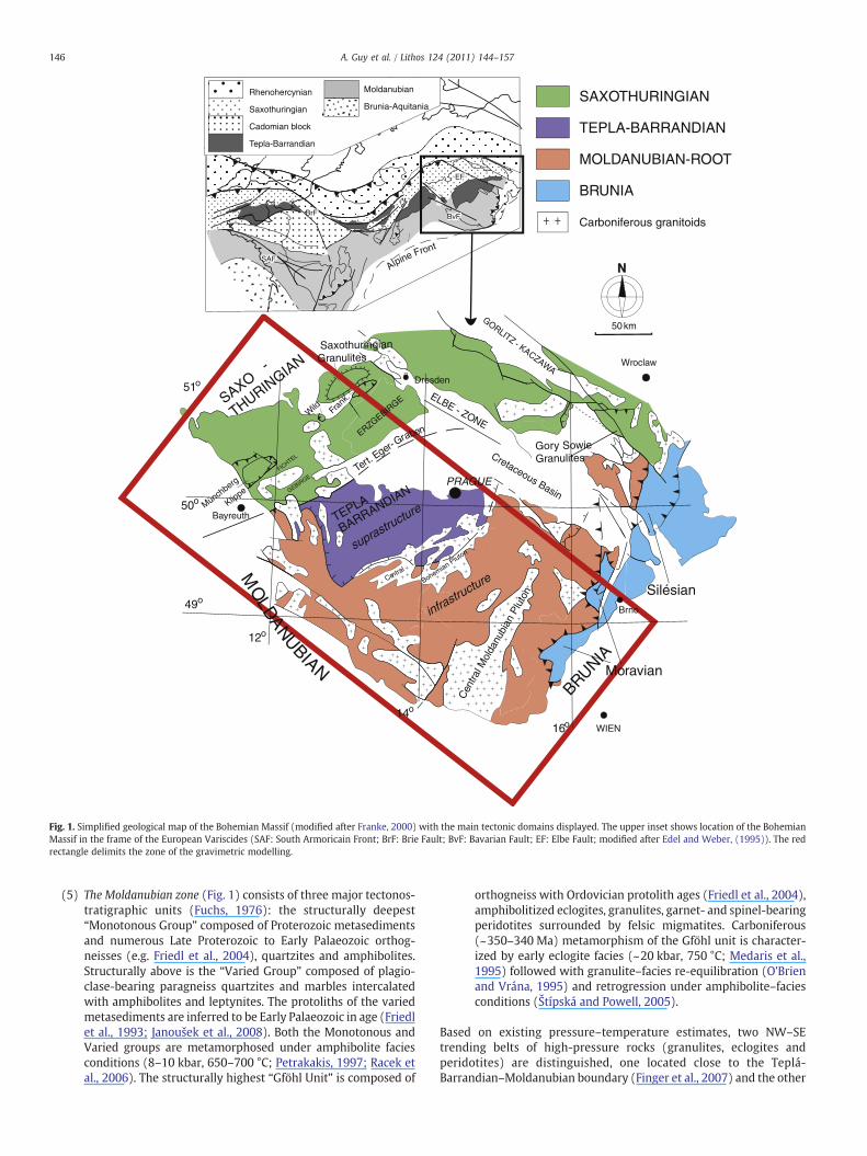
The Bohemian Massif is a large Palaeozoic belt located at theeastern termination of the Variscan belt. It is generally divided intofour major tectonic domains (Suess, 1926; Kossmat, 1927): theSaxothuringian, the Teplá-Barrandian, the Moldanubian and themicrocontinent Bruno-Vistulian (Fig. 1). The geology of the BohemianMassif is briefly characterized as follows:
(1) The Saxothuringian domain (Fig. 1) contains Neoproterozoicpara-autochthonous rocks (~580–550 Ma) and allochthonousLate Ordovician to Devonian distal and proximal marginsequences (Franke, 2000) containing relics of MORB-typeOrdovician metabasites eclogitized during the Devonian(~395 Ma; Schmädicke et al., 1995). Later Carboniferousunderthrusting of the Saxothuringian continental rocks under-neath the Teplá-Barrandian domain to the east was responsiblefor the eclogitization of continental crust (Massonne, 2006) at~340 Ma associated with the exhumation of deeply buriedrocks in form of crustal scale nappes (Konopásek andSchulmann, 2005).
(2) The boundary between the Saxothuringian–Teplá-Barrandian ischaracterized by a relic Devonian oceanic suture which is wellpreserved in the Mariánské Lázně Complex (Kastl and Tonika,1984; Zulauf, 1997). This complex is represented by serpenti-nites, amphibolites, eclogites and metagabbros of Cambrian(~540 Ma; Timmermann et al., 2004) and Ordovician(~496 Ma; Bowes and Aftalion, 1991) protolith ages metamor-phosed at eclogites facies conditions during Devonian (410 and370 Ma; Beard et al., 1995; Dallmeyer and Urban, 1998). Thewestern boundary of the oceanic suture is marked by thepresence of felsic granulites of the Egger graben (Zulauf et al.,2002b).
(3) The Teplá-Barrandian domain (Fig. 1) consists of Neoproterozoicarc-related volcano-sedimentary rocks overlain by siliceousblack shales and a flyshoid sequence. The Neoproterozoicbasement is unconformably overlain by Lower Cambrian clasticsediments, Upper Cambrian volcanic and sediments of theLower Palaeozoic (Ordovician to Middle Devonian) PragueBasin (Havlíček, 1981). The whole sequence is folded by steepfolds presumably of Late Devonian age (Zulauf, 2001).
(4) The Central Bohemian Plutonic Complex occurs on the boundarybetween the Teplá-Barrandian and the Moldanubian domains.It consists of Late Devonian (~354 Ma) calc-alkaline tonalites,granodiorites, trondhjemites, quartz diorites and gabbros in thewest (Janoušek et al., 2004) and Early Carboniferous (~349–346 Ma, Holub et al., 1997) high-K calc-alkaline plutonic bodiesin the southeast.
Carboniferous granitoids
SAXOTHURINGIAN
MOLDANUBIAN-ROOT
TEPLA-BARRANDIAN
BRUNIA
50 km
NN
50o
49o
51o
WIEN
Cretaceous Basin
Gory SowieGranulites
GORLITZ - KACZAWA
Silésian
Wroclaw
ELBE - ZONE
FICHTEL
Wild Fr
ank.
GEBIRGE
Münchberg
Klippe
THURINGIA
N
SAXO-
Bayreuth
Dresden
12o
CentralMO
LDA
NUBIAN
14o
16o
Moravian
PRAGUE
Brno
Tert. E
ger-Graben
TEPLA-
BARRANDIAN
SaxothuringianGranulites
ERZGEBIRGE
Cen
tral M
olda
nubi
an P
luto
n
Bohemian Pluton
BRUNIAinfra
structure
suprastructure
KrBvFBvFBvFBrFBrFBrF
TFTF
SAFSAFSAF
EFEFEF
Rhenohercynian
Saxothuringian
Cadomian block
Tepla-Barrandian
Moldanubian
Brunia-Aquitania
Alpine Front
Fig. 1. Simplified geological map of the Bohemian Massif (modified after Franke, 2000) with the main tectonic domains displayed. The upper inset shows location of the BohemianMassif in the frame of the European Variscides (SAF: South Armoricain Front; BrF: Brie Fault; BvF: Bavarian Fault; EF: Elbe Fault; modified after Edel and Weber, (1995)). The redrectangle delimits the zone of the gravimetric modelling.
146 A. Guy et al. / Lithos 124 (2011) 144–157
(5) The Moldanubian zone (Fig. 1) consists of three major tectonos-tratigraphic units (Fuchs, 1976): the structurally deepest“Monotonous Group” composed of Proterozoic metasedimentsand numerous Late Proterozoic to Early Palaeozoic orthog-neisses (e.g. Friedl et al., 2004), quartzites and amphibolites.Structurally above is the “Varied Group” composed of plagio-clase-bearing paragneiss quartzites and marbles intercalatedwith amphibolites and leptynites. The protoliths of the variedmetasediments are inferred to be Early Palaeozoic in age (Friedlet al., 1993; Janoušek et al., 2008). Both the Monotonous andVaried groups are metamorphosed under amphibolite faciesconditions (8–10 kbar, 650–700 °C; Petrakakis, 1997; Racek etal., 2006). The structurally highest “Gföhl Unit” is composed of
orthogneiss with Ordovician protolith ages (Friedl et al., 2004),amphibolitized eclogites, granulites, garnet- and spinel-bearingperidotites surrounded by felsic migmatites. Carboniferous(~350–340 Ma) metamorphism of the Gföhl unit is character-ized by early eclogite facies (~20 kbar, 750 °C; Medaris et al.,1995) followed with granulite–facies re-equilibration (O'Brienand Vrána, 1995) and retrogression under amphibolite–faciesconditions (Štípská and Powell, 2005).
Based on existing pressure–temperature estimates, two NW–SEtrending belts of high-pressure rocks (granulites, eclogites andperidotites) are distinguished, one located close to the Teplá-Barrandian–Moldanubian boundary (Finger et al., 2007) and the other
147A. Guy et al. / Lithos 124 (2011) 144–157
rimming the easternmargin of the BohemianMassif (Schulmann et al.,2008). These belts alternate with medium-pressure units representedby the Varied and Monotonous groups, which also form wide NW–SEtrending belts. The deformation history in the Moldanubian domainreveals early (~350–340 Ma) vertical NNE–SSW trending fabrics,associated with crystallization of high-pressure mineral assemblages(Franěk et al., 2006; Tajčmanová et al., 2006). These are reworked byflat lying deformation fabrics (~335–325 Ma) that are associated withmedium- to low-pressure and high-temperaturemineral assemblages(e.g. Hasalová et al., 2008; Štípská et al., 2008). The Moldanubianmetamorphic units were intruded by numerous and voluminousanatectic plutons loosely grouped into the Moldanubian (or SouthBohemian) Plutonic Complex. These are mostly felsic–intermediate,two-mica granitic to granodioritic intrusions emplaced at 331–323 Ma(Gerdes et al., 2003).
(6) The Moldanubian–Bruno-Vistulian continental transition zoneis represented by a zone of intense deformation and Barrovianstyle inverted metamorphism of continental Bruno-Vistulianderived rocks of the Moravo–Silesian Zone (Suess, 1926). TheMoravo–Silesian Zone itself is characterized by two nappescomposed of orthogneiss derived from Bruno-Vistulian at thebottom and a metapelite sequence at the top. The progrademetamorphism of the Moravian nappes is interpreted as aresult of continental underthrusting and occurred at 340–325 Ma (Dallmeyer et al., 1992; Fritz et al., 1996).
(7) The Bruno-Vistulian basement domain (Fig. 1) of Dudek (1980)contains a 680 Ma old intermediate to mafic crust, intruded by550 Ma old granites (Finger et al., 2000). This basement isunconformably overlain by shallow marine Lower Devonian
CEL099H
R
CMPCMP
MOLDANUBIAN
MOLDANUBIAN
CBPCBP
SAXOTHURINGIANSAXOTHURINGIAN
PRAGUE
50°
48°
12° 14°
TEPLA-BARRANDIAN
TEPLA-BARRANDIAN
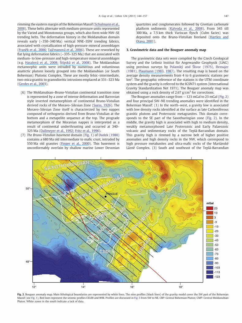
Fig. 2. Bouguer anomaly map. Main lithological boundaries are represented by white lines.Massif (see Fig. 1). Red lines represent the seismic profiles CEL09 and 9HR. Profiles are discuPluton. White zones in the south indicate a lack of data.
quartzites and conglomerates followed by Givetian carbonateplatform sediments (Kalvoda et al., 2008). From 345 till300 Ma, a 7.5 km thick Variscan flysch (Culm facies) wasdeposited onto the Bruno-Vistulian foreland (Hartley andOtava, 2001).
3. Gravimetric data and the Bouguer anomaly map
The gravimetric data sets were compiled by the Czech GeologicalSurvey and the Leibniz Institut für Angewandte Geophysik (LIAG)using previous surveys by Polanský and Škvor (1975), Ibrmajer(1981), Plaumann (1983, 1987). The resulting map is based on theaverage density measurements from 4 to 6 gravimetric stations perkm2. The geographic reference of the stations is the UTM coordinatesystem and the gravity is referred to the IGSN71 system (InternationalGravity Standardization Net 1971). The Bouguer anomaly map wasobtained using a rock density of 2.67 g/cm3 for corrections.
The Bouguer anomalies range from−123 mGal to 23 mGal (Fig. 2)and four principal SW–NE trending anomalies were identified in theBohemian Massif: (1) In the north–west, a gravity low is associatedwith low density rocks identified at the surface as late Carboniferousgranitic plutons and Proterozoic metagranites. This domain corre-sponds to the SE part of the Saxothuringian zone (Fig. 2). In themiddle, the gravity high is associated with high to medium density,weakly metamorphosed Late Proterozoic and Early Palaeozoicvolcanic and sedimentary rocks of the Teplá-Barrandian domain.This gravity high is rimmed by a narrow belt of higher positiveanomalies and high density rocks in the NW, which correspond tohigh pressure metabasites and ultra-mafic rocks of the MariánskéLázně Complex. (3) South and southeast of the Teplá-Barrandian
BRUN
IA
BRUN
IA
MOLDANUBIAN
MOLDANUBIAN
mGal
23
13
3
-3
-13
-23
-33
-43
-53
-63
-73
-83
-93
-103
-113
-123
16° 18°
The nine profiles (black lines) of the gravity model cover the SW part of the Bohemianssed in Fig. 5 from SW to NE. CBP: Central Bohemian Pluton; CMP: Central Moldanubian
148 A. Guy et al. / Lithos 124 (2011) 144–157
basement, a gravity low is associated with low to medium densityrocks, mainly composed of granites and high grade gneissescharacteristic of the Moldanubian domain (Fig. 2); (4) Furthersouth–east a large gravity high occurs and can be correlated withhigh density rocks of the Pan-African Bruno-Vistulian basement(Dudek, 1980). The western part of the gravity high is marked bypresence of migmatites and granulite facies rocks at the surface whichled Schulmann et al. (2008) to propose that these Moldanubian rockscover the high density Bruno-Vistulian basement in form of a thinnappe. The strong gravity gradient located 50 to 70 km west of thegeological Moldanubian–Bruno-Vistulian boundary is interpreted as adeep crustal boundary between the Carboniferous orogenic root andBruno-Vistulian basement promontory (Schulmann et al., 2008).
In order to image the deep structure of the Bohemian Massif, a 3Dgravity model was computed. Nine, ~400 km long and 20 km spacedprofiles were drawn perpendicular to the NE–SW striking gravitygradients. These lines are sub-parallel to the seismic 9HR and CEL09profiles, which were used to constrain gravity modelling (Fig. 2). Theobjective of this work is to estimate the spatial distribution of majortectonic contacts and volumes of the continental crust at depth.Therefore the model is limited to a maximum depth of 45 km and the20 km spacing between profiles exclude modelling of smallanomalies.
4. Gravity modelling: constraints and methodology
The gravitymodelling is constrained by a surface geological map at1:500 000 scale (Cháb et al., 2008), density measurements (Hroudaand Chlupáčová, 1993; Chlupáčová and Švancara, 1994), reflectionand refraction seismic sections (Tomek et al., 1997; Růžek et al.,2007). Because, the detailed description of 9HR seismic line isdiscussed elsewhere (Tomek et al., 1997; Tomek, 2007) we reportonly major geometrical features depicted from this profile here.
4.1. Seismic constraints
The seismic reflection profile 9HR (Tomek et al., 1997) is located inthe south-western part of the BohemianMassif (Fig. 2). About 200 kmlong and NW–SE striking, the line starts at the southern part of theSaxothuringian domain, and crosses successively the Teplá-Barran-dian domain, the Central Bohemian Pluton (CBP), high grade gneisses,migmatites and granulites of the Moldanubian domain and termi-nates before reaching the Central Moldanubian Pluton (CMP) (Fig. 2).The orientation of the profile differs by about 25° from the orientationof the gravity profiles which were drawn perpendicular to the meanstrike of principal geological boundaries. In order to constrain thegravity modelling, we use a line drawing of a time-migrated section.Consequently, the starting model was established using the seismicline where the shape and dip of units can be approximated by majorreflective boundaries.
Two belts of southeast dipping reflectors underneath the Teplá-Barrandian domain form dominant features of the seismic section. Theupper reflector crosscuts the surface in the area of the MariánskéLázně Complex and coincides with the Devonian Teplá suture zone.The lower belt of reflectors can be followed towards northwestbeneath the weakly reflective uppermost crust that consists ofgranites (Karlsbad and Nejdek–Eibenstock granites) and metamor-phic rocks of the southern Saxothuringian domain. These reflectorscorrespond to Carboniferous eclogitic units that are interpreted as atrace of the Carboniferous Saxothuringian suture (Konopásek andSchulmann, 2005). Another belt of southeast-dipping reflectors hasbeen identified in the deep crust of the northernMoldanubian domain(Fig. 3). The Teplá-Barrandian as well as the northern and centralMoldanubian upper crusts are characterized by bending of highlyreflective horizons with a mean wavelength of 30 km. In contrast, the
southernmost part of the section, where outcrop the Moldanubiangranulites are exposed, is weakly reflective.
Twomajor subvertical discontinuities bound the Teplá-Barrandiandomain. In the north, the strong reflections of the Devonian suturecontrast with the nearly transparent, mostly granitic Saxothuringianupper crust. In the south, the Teplá-Barrandian/Moldanubian bound-ary is marked by the oppositely dipping reflectors of the Teplá-Barrandian and Moldanubian domains. The reflectors bound theCentral Bohemian Pluton. The fault zone, that marks the Teplá-Barrandian/Moldanubian boundary, appears to shift the highlyreflective Teplá-Barrandian domain upwards by 6–7 km (Fig. 3b).This contrasts with field observations, which show a predominantlystrike slip component (Scheuvens and Zulauf, 2000). In the wholesection but particularly in the Moldanubian part, the middle crust ischaracterized by subhorizontal horizons.
The 700 km long refraction section CEL09 runs nearly parallel tothe gravity sections (Hrubcová et al., 2005; Hrubcová and Geissler,2009). However, in this study we consider only the part of thereinterpreted section (Růžek et al., 2007) which coincides with thegravity sections 4 and 5 in Figs. 2 and 5. The most striking feature ofthe P-wave velocity section is the low velocity of the lower crust of theMoldanubian domain and, to a lesser extent, of the deep crustunderneath northern Teplá-Barrandian (Fig. 3). In contrast, theSaxothuringian and Bruno-Vistulian lower crust show conventionalvelocities in the range 7–7.5 km/s. The Moho topography shows agentle dip towards SE from 35 to 37 km, with a slight minimumlocated under the Teplá–Barrandian–Moldanubian boundary (Figs. 3dand 4a). Comparison of the Moho topography derived from seismicsections with the Bouguer anomalies shows a positive correlationbetween the gravity low and the thickened Moldanubian crust(Fig. 4). This is not valid for the Teplá-Barrandian and Bruno-Vistulianwhich are also characterized by a thick crust but which show gravityhighs of large wavelengths. This means that the large anomalies aremainly due to density contrasts within the continental crust and notto crustal thickness variations.
4.2. Density constraints
In general, the density measurements on granites at the surfacecan be extrapolated at depth for large homogeneous bodies with amoderate error. This is impossible for lithologically heterogeneousmetamorphic units because rocks of markedly different density cancoexist within the same unit. For instance, it is particularly difficult toattribute a mean density to the association of banded felsic gneissesand amphibolites which are of different density. Therefore, theconstraints on the densities for deep, large bodies of highlymetamorphosed layered units are often poor and seismic velocitiesand the geological conceptual models have to be taken into account.
The density assignments consider measurements from previouswork (Table 1): Ondra and Hanák (1984), Chlupáčová and Švancara(1994). According to Ondra and Hanák (1984) the granitic rocks of theMoldanubian domain show densities in the range 2.63 to 2.70 g cm−3.For paragneiss and Mg–K syenites the densities are higher, between2.70 and 2.80 g cm−3. A density of 2.66 g cm−3 is attributed to thegranulite rocks cropping out in the southern Moldanubian domain(Franěk et al., 2007). Concerning the Teplá-Barrandian and Saxothur-ingian domains, results of Hrouda and Chlupáčová (1993) are used.The densities range from 2.62 g cm−3 for granitoids and 2.88 g cm−3
for metabasites of the Mariánské Lázně Complex. Density values forthe Bruno-Vistulian microcontinent take into account a Neoproter-ozoic age of this domain, outcrop geology and conceptual model ofFinger et al. (2000). Consequently, we propose a stratified crustalmodel marked by mafic lower crust with a density of 2.92 g cm−3 anda middle crust with 2.85 g cm−3.
At a crustal scale, rock densities vary for one type of rock andtherefore, it is required that the density of each unit is approximated,

5.8
8
6.2
5.8
8
6.2
BruniaVertical exageration: 1
0
-10
-20
-30
-40km
400 km350300250200150100500
MoldanubianTepla BarrandianSaxothuringian0
-10
-20
-30
-40km
400 km35030025020 0150100500
Granites Granulites Felsic lower crust suture rocks Saxothuringian basement Barrandian Moldanubian metamorphic rocks Brunia basement
Sa xo -thuringian
2,74
2,85
3,20
2,87
2,80 2,732,85
2,82
2,78
2,75 2,63
2,84
2,76 2,742,68
2,85
2,72
2,70 2,92
3,10
2,70
2,88
c) gravity model (section 5)
CBP CMP
4
8
12sec
0 50 100 150 200 km
0
NW SEgranulites
4
8
12sec
0 50 100 150 200 km
0
6.0 7.0 8.0 km/sec
b) reflection seismic section 9HR
d) refraction seismic section CEL09
12° 14° 16°
48°
50°TBTB
BrBr
MDMD
STST
CBP
CMP
CEL09
9HR
a)
5
TB
Br
MD
ST
M
Fig. 3. Comparison of the gravity model with the CEL09 seismic refraction section and the 9HR seismic reflection section. (a) Location of the nine gravimetric modelling profiles andthe seismic reflection and refraction profiles. (b) Interpretation of the time migrated 9HR seismic reflection section (modified after Tomek, unpublished report), the vertical scale isin seconds. (c) Section 4 of the gravity model. (d) P-wave velocities are derived from the CEL 09 refraction section (Růžek et al., 2007), the vertical scale is in km.
149A. Guy et al. / Lithos 124 (2011) 144–157
taking into account the variations of lithology with depth. Therefore,an estimation of an average density at a kilometric scale is determined,keeping in mind that the most accurate gravity model has the lowestdensity contrasts from one structure to another. For example, anintermediate density between the density values of the top(~2.63 g cm−3) and the density values of the suture (~2.88 g cm−3)is taken since the middle crust is a stretched mix of the top layers andthe bottom layers. The density of 2.84 g cm−3 of the undefinedstructure in the middle crust of the Moldanubian domain isdetermined with this method in order to obtain the lowest densitycontrast. Table 1 summarizes density ranges and values approximatedand used in the 3D gravimetric model.
4.3. Modelling
We used the IGMAS (Interactive Gravity and Magnetic ApplicationSystem) software for the 3D gravity modelling (Götze, 1984; Götzeand Lahmeyer, 1988; Schmidt and Götze, 1998, 1999). The modelcovers an area of ~400 km×160 km and reaches 45 km in depth. Thegeological bodies are modelled in 3D by polyhedrons with triangularsurfaces which connect the vertices of two successive, parallel verticalsections. The input model is established according to the orientationof main geological boundaries on the surface, the horizontal gradientsof the vertical derivatives of the Bouguer anomaly map and thegeometry of the main seismic units of the 9HR section (Fig. 6). Aseismic unit is characterized by its reflectivity and by the dip and theshape of the reflective belts. The spacing between the profiles (20 km)and the depth of the model (45 km), excludes fine modelling of the
near surface. In order to facilitate the location of the granulites in themodel and the interpretation in terms of exhumation model proposedby Franěk et al. (2006), we introduced a small low density bodyrepresenting the low density felsic granulites.
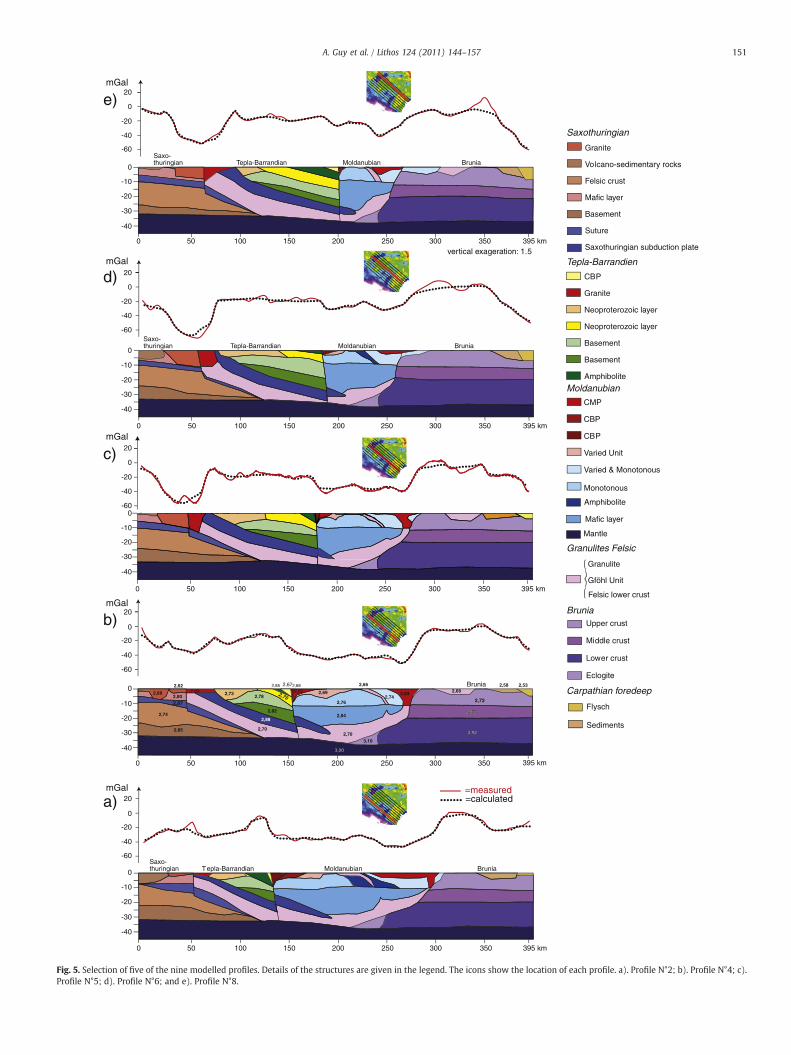
5. Results of the gravity modelling
Among the ninemodelled profiles only five representative sectionsare shown in Fig. 5. The gravity low of the Moldanubian domain andthe strong gravity gradient betweenMoldanubian domain and Bruno-Vistulian microcontinent are well resolved. The gravity highs on bothsides of the Moldanubian gravity low are also well modelled exceptfor few short wavelength anomalies. The misfits between measuredand calculated anomalies are explained by small near-surface maficstructures or by a sedimentary cover of small area extension (Fig. 6a).The histogram of gravity differences showing the misfit between themeasured and computed anomalies of the study area reveals acorrelation coefficient of 0.98, which is an acceptable average for thisregional gravity model (Fig. 6b).
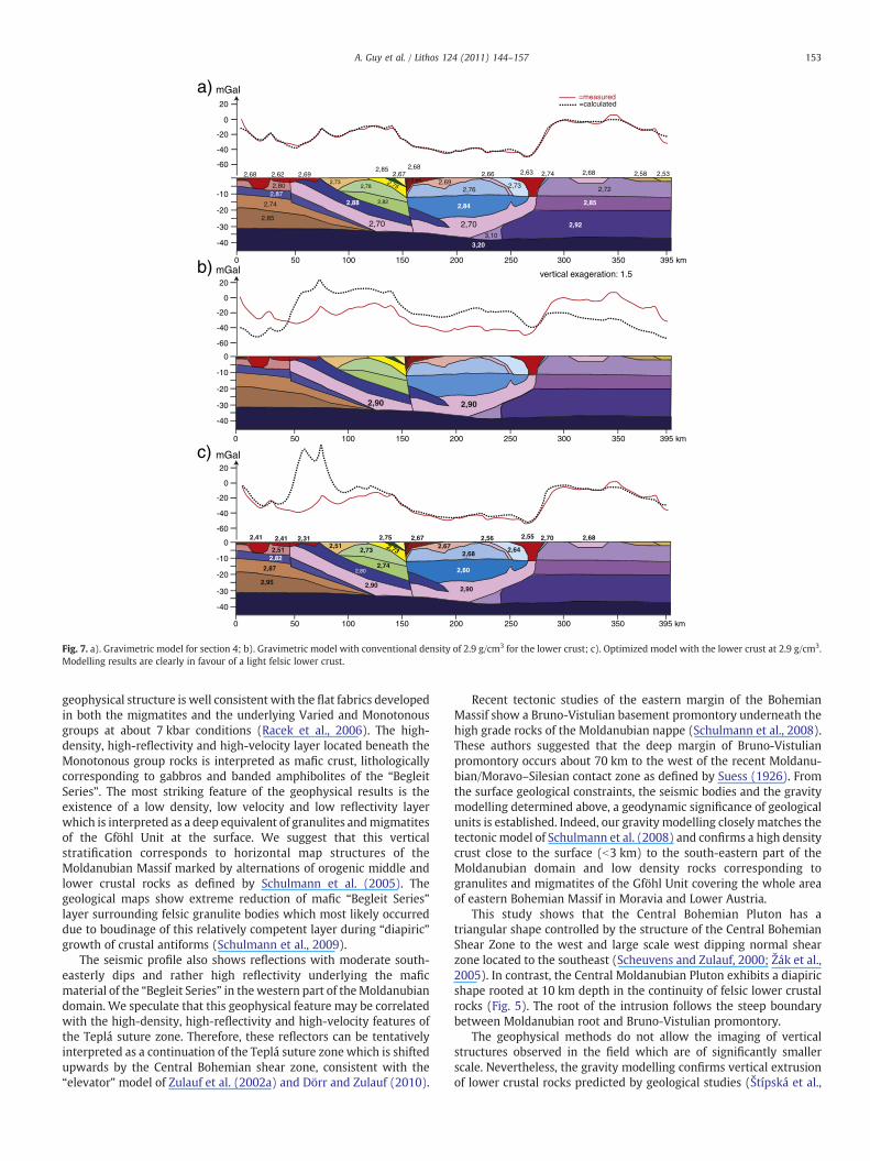
The necessity to attribute unconventional low densities to thelower crust is one of the most striking results of the gravity modelling.This is demonstrated in Fig. 7 in which three different models ofSection 4 are presented. In Fig. 7b a conventional density of 2.9 g cm−3
was attributed to the Moldanubian lower crust. This classical model ofcrustal stratification (e.g. Hrubcová et al., 2005) shows a major misfitbetween modelled and measured data. Fig. 7c shows the optimizedmodel still with a lower crust at 2.9 g cm−3. Thismodelwas optimizedby decreasing the density of upper crustal units in the Moldanubian

50°
48°
12° 14° 16°
50°
48°
12° 14° 16°
a)
b)
-45 km -25 km DEPTH
Gravimetric values33 mGal -123 mGal
Fig. 4. (a) Map of the Moho depth and (b) map of the Bouguer anomalies with contours(in white) of the main geological units.
Table 1Densities of rocks used for the modelling.
Geological units Lithologies Densities [g cm−3]
SaxothuringianGranite 2.62–2.68Felsic layer 2.72Mafic layer 2.8Basement 2.88Carboniferous suture 2.87subduction plate 2.88
Teplá-BarrandianGranite 2.69Neoproterozoïque layer 2.73–2.75Basement 2.78–2.82Amphibolite layer 2.85Central Bohemian pluton 2.65–2.68
MoldanubianCentral Moldanubian pluton 2.63Monotonous group and varied Un 2.69–2.76Mafic layer-amphibolite 2.82–2.84Granulite felsic 2.66–2.70
BruniaUpper crust 2.72Middle crust 2.85Lower crust 2.92Eclogite 3.1
Carpathian ForedeepFlysch 2.53Sediments 2.58
Mantle 3.2
150 A. Guy et al. / Lithos 124 (2011) 144–157
domain, which is in contradiction to the presence of high densityamphibolites and gneisses of theVaried andMonotonous groups at thesurface. In addition, themodel reveals extremelyhighmisfit in the areaof the Teplá suture because, here, the postulated dense lower crustcomes to the surface. This strong positive effect can only be reduced byusing unrealistically low densities values for the lower crustal rocks ofthe Teplá suture (Fig. 7c). In addition, the presence of a low densitylower crust is supported by low seismic velocities in the range 6.0–6.4 km/s in the 20–30 km depth range revealed by the seismicrefraction section beneath the Moldanubian domain (Růžek et al.,2007; Fig. 3d). Experimental studies of Christensen and Mooney(1995) shows that such low seismic velocities correspond to felsicgranulites (6.25 to 6.50 km/s) in contrast to mafic, garnet-bearinggranulites of common lower crust which reveal velocities in the range6.5 to 7.25 km/s. Theminimum in seismic velocities in the area of deep
Saxothuringian crust and underneath the northern Saxothuringiansuture zone may indicate similar low density material (Fig. 3d).
The other main results derived from gravity modelling are asfollows:
• The southern Saxothuringian upper crust is characterized byintermediate and low density rocks consisting of felsic metamorphicrocks and up to 10 km thick granitic rocks (see also previous modelsby Polanský, 1978; Hecht et al., 1997).
• The southeast dipping Teplá suture zone is characterized by a meandensity of 2.88 g cm−3 due to the association of ultramafic rocks,gabbros and eclogites.
• The Barrandian basement shows intermediate to high densitieswhich correlate with Neoproterozoic metasedimentary and meta-volcanic units.
• The southern limit of the low to intermediate density CentralBohemian Pluton dips to the NWwhile the northern pluton's limit isparallel to the vertical Teplá-Barrandian/Moldanubian boundary.
• The intermediate density Moldanubian upper crust corresponds tolow density migmatites, while deeper rocks of Varied andMonotonous groups show higher mean density. The modellingsuggests the existence of a dense layer below the Monotonousgroup and above the deepest low density lower crustal layer. Thisunit is underlain by a ~5–10 km thick weakly reflective and lowdensity unit which shows similar geophysical characteristics to thegranulite–migmatite layer at the erosion surface.
• The low density (2.63 g cm−3) Central Moldanubian Pluton shows alenticular shape root parallel to the Moldanubian/Bruno-Vistulianboundary.
• In theMoldanubian granulite area, the weak gravity low is modelledwith small bodies with thickness not exceeding 3 km. In contrast thesmall gravity highs which surround the lows require the presence ofsignificant amounts of dense amphibolites.
• Between the Central Moldanubian Pluton and the Moldanubian/Bruno-Vistulian surface boundary, the Moldanubian low to inter-mediate density rocks are reduced to a thin layer (3 km max)forming a Moldanubian nappe overlying the dense Bruno-Vistulianbasement rocks. The main Moldanubian/Bruno-Vistulian boundaryis located beneath the Central Moldanubian Pluton. It is responsible
20
-20
-40
0
-60
395 km350300250200150100500
0
-40
-30
-20
-10
BruniaMoldanubianTepla-BarrandianSaxo-thuringian
20
-20
-40
0
-60
20
-20
-40
0
-60
0
-40
-30
-20
-10
BruniaMoldanubianTepla-BarrandianSaxo-thuringian
350300250200150100500
0
-40
-30
-20
-10
BruniaMoldanubianTepla-BarrandianSaxo-thuringian
395 km
a)
b)
d)
e)
Saxothuringian
Basement
Felsic crust
Suture
Saxothuringian subduction plate
Mafic layer
Volcano-sedimentary rocks
Granite
Tepla-Barrandien
Granite
Basement
Neoproterozoic layer
Basement
CBP
Neoproterozoic layer
Amphibolite
Lower crust
Eclogite
Middle crust
Upper crust
Brunia
Sediments
Flysch
Carpathian foredeep
Amphibolite
CMP
CBP
CBP
Varied Unit
Varied & Monotonous
Monotonous
Moldanubian
Mafic layer
Mantle
Felsic lower crust
Granulites Felsic
Granulite
Gföhl Unit
2,67
mGal
mGal
mGal
350300250200150100500
0
-40
-30
-20
-10
Brunia
2,87
2,652,682,85
2,72
2,74
2,85
3,203,20
2,62
2,682,80
2,69 2,73
2,82
2,78 2,752,69 2,63
2,84
2,742,76
2,662,68
2,852,85
2,70 2,922,92
3,10
2,58 2,53
2,88
2,70
395 km
=measured =calculated
vertical exageration: 1.5
20
-20
-40
0
-60
c)mGal
Saxo -thuringian
0
-40
-30
-20
-10
20
-20
-40
0
-60
mGal
350300250200150100500 395 km
350300250200150100500 395 km
Fig. 5. Selection of five of the nine modelled profiles. Details of the structures are given in the legend. The icons show the location of each profile. a). Profile N°2; b). Profile N°4; c).Profile N°5; d). Profile N°6; and e). Profile N°8.
151A. Guy et al. / Lithos 124 (2011) 144–157

%
b) Histogram of gravity differences
Correlation Coeff.: 0.98
Standard deviation: 3.01 mGal
0
50
0 50 100 150 200 250 300 350
100
150
-10mGal
-8-6-4-2024681012
a) Residual map
Fig. 6. Statistics of the gravity model. (a) Residual map and (b) histogram of gravity differences for the whole 9 profiles (correlation coefficient 0.98).
152 A. Guy et al. / Lithos 124 (2011) 144–157
for the prominent horizontal gradient in the gravity map (Fig. 2).This gradient results from lithological contrast between Bruno-Vistulian and Moldanubian lower crust and presence of CentralMoldanubian Pluton in supra-crustal level.
Fig. 5 shows the distribution of crustal layers thickness and shapefrom SW to NE. The southernmost profiles exhibit (~10 km) thick andcontinuous felsic lower crust in the Moldanubian domain whichprogressively decreases in thickness and extent towards northeast. Inthe north, the felsic lower crust is almost absent being replaced bythick mafic (high density) lower crust. This is consistent with theseismic refraction profile of Hrubcová et al. (2005) who report a highvelocity for the lower crust from the northern part of theMoldanubiandomain, while Růžek et al. (2007) suggest a low velocity deep lowercrust in the southern Moldanubian domain.
6. Geological interpretation
The geophysical structure of the Teplá-Barrandian and Saxothur-ingian domains is discussed elsewhere (Tomek et al., 1997; Tomek,2007; Babuska et al., 2009). Nevertheless, we define here the salientfeatures of the gravimetric and seismic results that are necessary tounderstand the structure of the Moldanubian domain.
Our results allow estimation of the thickness of the Teplá-Barrandian Unit which reaches a maximum depth of 15 km to theeast, confirming the values proposed by Zulauf et al. (2002a,b, 2009).The Teplá-Barrandian basement is underlain by high density maficand ultramafic rocks of the Devonian Teplá suture which typifies thecharacter of lower crust in this area (Fig. 8). Importantly, the maficlower crustal material is underlain by a low density layer of variablethickness which outcrops in the area of Eger granulite belt (Zulauf etal., 2002a). This is the crust, which directly overlies the Moho in theeast, while in the west it has a form of east dipping sheet lying aboveheavy and intermediate rocks of Saxothuringian domain (Fig. 8). The
deep structure of the Saxothuringian–Teplá–Barrandian boundary fitsthe model of Konopásek and Schulmann (2005) and Zulauf et al.(2002b) who suggested an outflow of a granulite channel in the areaof Eger granulites. The granulite channel is structurally coherent withcoevally exhumed eclogitic Saxothuringian crust during Carbonifer-ous times.
Recent geological studies of the Moldanubian domain showsystematic alternations of steep belts of deep orogenic lower crustwith parallel middle crustal belts (Štípská et al., 2004; Schulmann etal., 2005). These studies suggest that the structure of theMoldanubiandomain is governed by process of vertical material transfer similar togravity overturn. In this, the structurally deepest rocks (20 kbar,900 °C peak conditions) occur in cores of NE–SW trending antiformssurrounded by NE–SW trending mid-crustal synforms (10 kbar,650 °C peak conditions). In detail, the antiforms are cored by felsicgranulites and rimmed by thick mafic lower crust of so called “BegleitSeries” outcropping mostly in Lower Austria (Fuchs, 1976). Themiddle crustal synforms are cored by rocks of the Varied groupsurrounded by gneiss and schist of the Monotonous group. If the largescale fold structure of the Moldanubian domain is unfolded, anoriginal vertical stratification of Moldanubian crust can be establishedwith felsic granulites occurring at the greatest depth, overlain bymafic “Begleit series” in themiddle andMonotonous and Varied grouprocks at upper crustal levels. Similar dome like structures cored byfelsic HP granulites are also described in the Saxothuringian domainand Vosges (Franke, 2000; Schulmann et al., 2002) indicating a similarcharacter of the orogenic lower crust in eastern Variscides.
The Moldanubian domain structure can also be interpreted usingseismic section 9HR which shows a weakly reflective and low densitylayer close to the surface corresponding to the subhorizontalmigmatite and granulite layer of the Gföhl Unit in south Bohemia(Franěk et al., 2006, 2010). The highly reflective and intermediatedensity layer located underneath the Gföhl migmatites corresponds tosurface outcrops of the Varied and Monotonous groups. This
20
0
-20
-40
-60
20
0
-20
-40
-60
-10
-20
-30
-40
395 km350300250200150100500
2,74
2,85
3,20
2,62
2,87
2,68
2,80
2,69 2,672,73 2,65
2,682,85
2,82
2,782,75 2,69
2,63
2,84
2,74
2,762,73
2,66 2,68
2,85
2,72
2,70 2,92
3,10
2,58 2,53
2,70
a)
20
0
-20
-40
-60
0
-10
-20
-30
-40
395 km350300250200150100500
2,87
2,95
2,41
2,82
2,41
2,51
2,312,51
2,672,75
2,74
2,732,73 2,67
2,55
2,80
2,70
2,682,64
2,56 2,68
2,90
2,80
2,90
c)
0
-10
-20
-30
-40
395 km350300250200150100500
2,902,90
b)
mGal
mGal
mGal
2,88
vertical exageration: 1.5
=measured =calculated
Fig. 7. a). Gravimetric model for section 4; b). Gravimetric model with conventional density of 2.9 g/cm3 for the lower crust; c). Optimized model with the lower crust at 2.9 g/cm3.Modelling results are clearly in favour of a light felsic lower crust.
153A. Guy et al. / Lithos 124 (2011) 144–157
geophysical structure is well consistent with the flat fabrics developedin both the migmatites and the underlying Varied and Monotonousgroups at about 7 kbar conditions (Racek et al., 2006). The high-density, high-reflectivity and high-velocity layer located beneath theMonotonous group rocks is interpreted as mafic crust, lithologicallycorresponding to gabbros and banded amphibolites of the “BegleitSeries”. The most striking feature of the geophysical results is theexistence of a low density, low velocity and low reflectivity layerwhich is interpreted as a deep equivalent of granulites andmigmatitesof the Gföhl Unit at the surface. We suggest that this verticalstratification corresponds to horizontal map structures of theMoldanubian Massif marked by alternations of orogenic middle andlower crustal rocks as defined by Schulmann et al. (2005). Thegeological maps show extreme reduction of mafic “Begleit Series”layer surrounding felsic granulite bodies which most likely occurreddue to boudinage of this relatively competent layer during “diapiric”growth of crustal antiforms (Schulmann et al., 2009).
The seismic profile also shows reflections with moderate south-easterly dips and rather high reflectivity underlying the maficmaterial of the “Begleit Series” in the western part of theMoldanubiandomain. We speculate that this geophysical feature may be correlatedwith the high-density, high-reflectivity and high-velocity features ofthe Teplá suture zone. Therefore, these reflectors can be tentativelyinterpreted as a continuation of the Teplá suture zone which is shiftedupwards by the Central Bohemian shear zone, consistent with the“elevator” model of Zulauf et al. (2002a) and Dörr and Zulauf (2010).
Recent tectonic studies of the eastern margin of the BohemianMassif show a Bruno-Vistulian basement promontory underneath thehigh grade rocks of the Moldanubian nappe (Schulmann et al., 2008).These authors suggested that the deep margin of Bruno-Vistulianpromontory occurs about 70 km to the west of the recent Moldanu-bian/Moravo–Silesian contact zone as defined by Suess (1926). Fromthe surface geological constraints, the seismic bodies and the gravitymodelling determined above, a geodynamic significance of geologicalunits is established. Indeed, our gravity modelling closely matches thetectonic model of Schulmann et al. (2008) and confirms a high densitycrust close to the surface (b3 km) to the south-eastern part of theMoldanubian domain and low density rocks corresponding togranulites and migmatites of the Gföhl Unit covering the whole areaof eastern Bohemian Massif in Moravia and Lower Austria.
This study shows that the Central Bohemian Pluton has atriangular shape controlled by the structure of the Central BohemianShear Zone to the west and large scale west dipping normal shearzone located to the southeast (Scheuvens and Zulauf, 2000; Žák et al.,2005). In contrast, the Central Moldanubian Pluton exhibits a diapiricshape rooted at 10 km depth in the continuity of felsic lower crustalrocks (Fig. 5). The root of the intrusion follows the steep boundarybetween Moldanubian root and Bruno-Vistulian promontory.
The geophysical methods do not allow the imaging of verticalstructures observed in the field which are of significantly smallerscale. Nevertheless, the gravity modelling confirms vertical extrusionof lower crustal rocks predicted by geological studies (Štípská et al.,
Mantel
Saxothuringian Lower crust
Saxothuringian Middle crust
Saxothuringian Upper crust
+
+
+
++
++
+
++
++
+
++
++
+
+
+
Eclogites Brunia
Granitoids
Gföhl unit
Felsic lower crustGranulites
Culm ForedeepSediments
Brunia Upper crustParagneiss, migmatites, micaschists
Brunia Middle crust
Brunia Lower crust
AmphibolitesMoldanubian Mafic lower crust
Devonian Suture Zone
Tepla-Barrandian Middle crust
Suture Zone
Tepla-Barrandian Lower crust
Moldanubian Middle and Upper crust(Monotonous and Varied)
NE
Profile 8
Profile 6
Profile 4
Profile 2
0-5
-10-15-20-25-30-35-40
z [km]
395350300250200150100500 x [km]
Vertical exageration: 2
++
++
+
++
+
+
+
++
++ +
+
+
++
++
+
+
+
++
++
+
++
+
++
+
++
+
++
+
++
++
++
++
+ +++
+
++
++
++
++
++
++
+
++
++
++
++
+
++
+
++
++
+
++
++
+
++
++
+
++
++
+
+
++
++++
+
++
+
+
+
++
++
++
+
+
++
++
++
++
++
+
+
++
++
++
++
++
+
++
++
++
+
+
++
++
+
+
+
+
++
++
++
+
++
++
++
+
++
++
+
++
+
+
+
++
++
+
++
++
++
+
++
++
++
+
++
++
++
++
++
++
++
++
++
++
++
++
++
++
++
++
+
+
++
++
++
++
++
++
+
++
++
++
++
++
++
++
++
++
++
++
++
+
++
+
++
+
++
++
++
++
+
++
++
++
++
+
++
++
++
+
+
++
++
++
++
++
++
++
++
++
++
++
++
++
++
++
++
++
+
++
++
++
+
++
+
+
++
++
++
++
++
++
++
++
++
++
++
++
++
++
++
++
++
++
++
++
++
++
+
++
++
++
+
++
++
++
+
+
+
++
++
+
++
++
++
++
+
++
++
++
++
++
++
++
++
++
++
++
++
++
++
++
++
++
++
++
++
++
++
+
++
++
++
++
++
++
++
++
++
++
++
++
++
++
++
++
++
++
++
++
+
++
++
+
+
++
++
+
++
++
++
+
++
++
++
++
++
++
++
++
++
++
++
++
+
++
++
++
++
++
++
++
++
++
++
++
++
++
++
++
++
++
++
++
++
++
++
++
++
++
++
++
++
++
++
++
+
+
++
++
+
++
++
++
++
+
++
++
++
+
+
++
++
++
++
++
++
++
++
++
++
++
++
++
++
++
++
++
++
++
++
++
++
+
++
++
++
++
+
+
+
++
++
+
++
++
++
++
++
+
++
++
++
++
++
++
+
++
++
++
++
++
++
++
++
++
++
++
++
++
+
+
++
++
++
++
++
++
++
++
++
++
++
++
++
++
++
++
+
++
++
++
++
++
++
++
++
++
++
++
++
++
++
++
++
++
++
++
+
+
+
++
+
++
++
+
++
++
++
+
++
++
++
++
++
++
++
++
++
++
++
++
++
++
++
++
++
++
++
++
+
++
++
++
++
++
++
++
++
++
++
++
++
++
++
++
++
++
++
++
++
+
+
+
++
++
++
+
+
++
++
++
++
++
++
++
++
++
++
++
++
++
++
++
++
++
++
++
+
++
++
++
++
++
++
++
++
++
++
++
++
++
++
++
++
++
++
++
++
++
++
++
++
++
++
++
++
++
+
++
++
++
++
++
+
++
+
++ +
+
++
+ ++
++
+
++
++
++
++
++
++
+
++
++
++
++
++
++
++
++
++
++
++
++
+
++
+
++
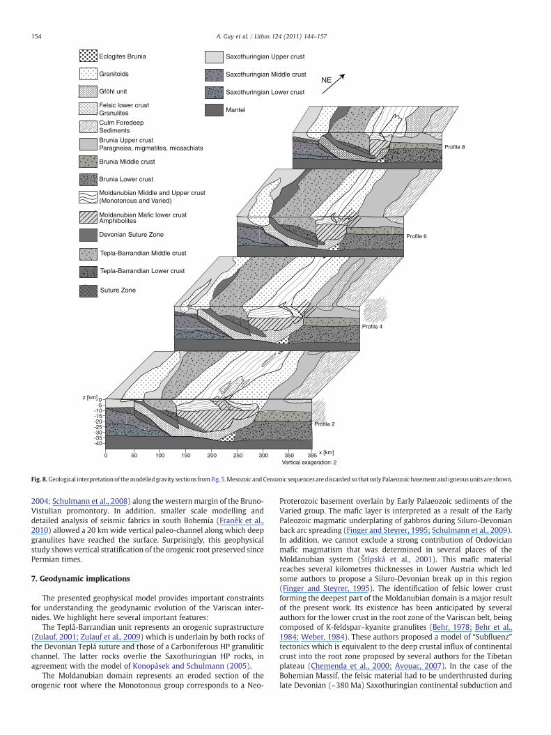
Fig. 8. Geological interpretationof themodelledgravity sections fromFig. 5.Mesozoic andCenozoic sequences are discarded so thatonlyPalaeozoic basement and igneous units are shown.
154 A. Guy et al. / Lithos 124 (2011) 144–157
2004; Schulmann et al., 2008) along the westernmargin of the Bruno-Vistulian promontory. In addition, smaller scale modelling anddetailed analysis of seismic fabrics in south Bohemia (Franěk et al.,2010) allowed a 20 kmwide vertical paleo-channel along which deepgranulites have reached the surface. Surprisingly, this geophysicalstudy shows vertical stratification of the orogenic root preserved sincePermian times.
7. Geodynamic implications
The presented geophysical model provides important constraintsfor understanding the geodynamic evolution of the Variscan inter-nides. We highlight here several important features:
The Teplá-Barrandian unit represents an orogenic suprastructure(Zulauf, 2001; Zulauf et al., 2009) which is underlain by both rocks ofthe Devonian Teplá suture and those of a Carboniferous HP granuliticchannel. The latter rocks overlie the Saxothuringian HP rocks, inagreement with the model of Konopásek and Schulmann (2005).
The Moldanubian domain represents an eroded section of theorogenic root where the Monotonous group corresponds to a Neo-
Proterozoic basement overlain by Early Palaeozoic sediments of theVaried group. The mafic layer is interpreted as a result of the EarlyPaleozoic magmatic underplating of gabbros during Siluro-Devonianback arc spreading (Finger and Steyrer, 1995; Schulmann et al., 2009).In addition, we cannot exclude a strong contribution of Ordovicianmafic magmatism that was determined in several places of theMoldanubian system (Štípská et al., 2001). This mafic materialreaches several kilometres thicknesses in Lower Austria which ledsome authors to propose a Siluro-Devonian break up in this region(Finger and Steyrer, 1995). The identification of felsic lower crustforming the deepest part of the Moldanubian domain is a major resultof the present work. Its existence has been anticipated by severalauthors for the lower crust in the root zone of the Variscan belt, beingcomposed of K-feldspar–kyanite granulites (Behr, 1978; Behr et al.,1984; Weber, 1984). These authors proposed a model of “Subfluenz”tectonics which is equivalent to the deep crustal influx of continentalcrust into the root zone proposed by several authors for the Tibetanplateau (Chemenda et al., 2000; Avouac, 2007). In the case of theBohemian Massif, the felsic material had to be underthrusted duringlate Devonian (~380 Ma) Saxothuringian continental subduction and
155A. Guy et al. / Lithos 124 (2011) 144–157
collision underneath the Teplá-Barrandian crust which is part ofArmorica (Schulmann et al., 2009). The subsequent thermal weaken-ing by changes in deformation mechanisms and melting of theMoldanubian root is responsible for rheological collapse of theorogenic root. Consequently, vertical material transfer occurred,responsible for partial exhumation of the deepest Moldanubianrocks to the surface. The exhumation mechanism is similar to diapiricascent accompanied with intrusion of several crustal and mantlederived granitoids plutons (Franěk et al., 2006). The proposed conceptis fundamentally similar to that of Perchuk (1989) and Perchuk et al.(1992) who was the first to propose gravitational redistributionmodel for the formation and exhumation of granulites. Thus the originof intensely deformed felsic granulitic layer in the middle-lower crustcan be related to the mechanical gravitational separation andmergingof smaller scale layers of relatively felsic rocks. Numerical modellingof such merging processes was published by Perchuk et al. (1992),Weinberg and Shmelling (1992) and more recently by Gerya et al.(2004).
The presented model of the deep structure of the Moldanubiandomainhas important consequences for theorigin of active orogenswitha thick and hot root, such as in the Andes and Tibet. Attachment to themafic crust of felsic lower crust due to the underthrusting of the Indianlithospheric crust underneath Tibetwas predicted in the analoguemodelof Chemendaet al. (2000). In thismodel, thepresenceofhigh topographyis explained by low densitymaterial in the root domain (Le Pichon et al.,1997). Indeed, the crust of Tibet is marked by intermediate density crustin the depth range of 0–35 km (2.7–2.8 g/cm3) and low to intermediatedensities of crust in the depth range 40–60 km (2.8–2.9 g/cm3) (Hetényiet al., 2007). It is this crustal level which is interpreted as a tectonically-underplated Indian upper crust underneath Tibetan crust (Hetényi et al.,2007). The densities at 60–40 kmdepth correspond to those of granite ata temperature of 800 °C and a pressure in the range of 18–20 kbar asshown by petrological modelling (Le Pichon et al., 1997; Goffé et al.,2003). The protolith of felsic granulites is most likely a granite andtherefore the densities estimated for Tibetan lower crust correspond togranulites of granitic or granodioritic composition (Štípská and Powell,2005). Only rocks in the depth range of 60–75 km show modelleddensities of 3.3 g/cm3 and are interpreted as eclogitized Indian lowercrust of mafic composition. Ourmodelling shows that high density rockscoinciding with an east dipping reflector underneath the Tepla-Barrandian domain correspond to a relic of the Saxothuringian suturezone, rich in eclogites and peridotites (Konopásek and Schulmann,2005).
Here we show, that in the Variscan belt the low density orogeniclower crust at Moho depths is still present in theMoldanubian domainand is connected with subsurface extrusions by narrow verticalchannels (e.g. Franěk et al., 2006; Schulmann et al., 2008). Thesubsurface lateral spreading of partially molten lower crust occurredat pressures of 4 to 8 kbar (Štípská et al., 2004, 2008) whichcorresponds to 15–26 km depths. This crustal level of one partiallymolten rocks may correspond to the low resistivity and low velocityzone located underneath the Tibetan plateau and the Altiplano in theAndes as shown by geophysical surveys. The mechanism of extrusionof deep orogenic lower crust is similar to gravity overturns (Gerya etal., 2001) and may well explain emplacement of hot lower crustalmaterial and its spreading underneath a rigid lid (Burg et al., 1994).Therefore, even if the Variscan crust shows normal thickness reducedby later extensional processes, the gravity low, P-wave velocitypattern and rock assemblage in the area of the Moldanubian domainmay reflect a relic of thick orogenic root (and plateau) such as existtoday in large active collisional orogens. Finally, geological andgeophysical observations reveal extrusion of high grade partiallymolten mass over the basement promontory in a geometry whichmarkedly resembles to indentation of the Altiplano lower crust bycrust of the Brasilian shield (Lamb and Hoke, 1997). Therefore, theBohemian Massif represents a unique example where deep structure
of Andean and Tibetan-like plateaus can be studied and successfullymodelled.
8. Conclusion
The distribution and shape of geophysically-constrained bodiescombined with modern structural, petrological and other geologicaldata from the Bohemian Massif can be interpreted as follows:
(1) Felsic lower crust occurs underneath a thickmafic layer and theintermediate Monotonous and Varied group rocks of theMoldanubian domain. This less dense, low reflectivity felsiclayer is interpreted as an allochthonous body resulting fromunderthrusting of Saxothuringian crust underneath the Gond-wana derived continent. The process can be analogue to thatproposed by Chemenda et al. (2000) for the formation ofTibetan lower crust. The overlying mafic unit is interpreted asan autochthonous sheet resulting from Early Palaeozoicbasaltic underplating of rifted Proterozoic (Monotonousgroup) crust in sense of Finger and Steyrer (1995).
(2) The Bruno-Vistulian continent represents a deep crustalpromontory replacing 70 km of weak continental root andcan be compared to the Brasilian shield indenting the Andeanroot in the area of the eastern Cordillera. The orogenic lowercrust is extruded over the Bruno-Vistulian basement promon-tory in the shape of a thin migmatitic nappe similar to thatproposed by Beaumont et al. (2001). In the west, a similargranulite channel underneath the Teplá-Barrandian supras-tructure was identified, coinciding with vertical extrusion offelsic granulites in the Eger valley (Zulauf et al., 2002a;Konopásek and Schulmann, 2005). The steep boundarybetween the Teplá-Barrandian and Moldanubian zone isinterpreted in terms of major vertical elevation of the orogeniclower crust supporting the Dörr and Zulauf (2010) elevatortectonics model.
(3) The horizontal layer of felsic granulites and migmatitesoccurring at the current erosion surface is derived from thedeep lower crustal felsic layer and was exhumed by mecha-nism similar to gravitationnal overturns. In Carboniferoustimes, this migmatitic layer was located at a depthcorresponding to 5–8 kbar and most likely corresponded tothe zone of partial melting inferred from geophysics in Andesand Tibet.
Acknowledgements
This study was financially supported by European consortiumMarie Curie fellowship in the frame of the c2c (=crust to core) project(MRTN-CT-2006-035957). ANR project “LFO in orogens” is acknowl-edged. We would like also to thank Maria Chlupáčová and FrantisekHrouda, for their help with density data and precious advices.Constructive reviews of Gernold Zulauf, Taras Gerya and RichardWhite are gratefully acknowledged.
References
Avouac, J.P., 2007. Dynamic processes in extensional and compressional settings—mountain building: from earthquakes to geological deformation. In: Schubert, G.,Watts, A.B. (Eds.), Treatise on Geophysics, vol. 6. Elsevier, pp. 377–439.
Babuska, V., Fiala, J., Plomerová, J., 2009. Bottom to top lithosphere structure andevolution of western Eger rift (Central Europe). International Journal of EarthSciences 1–17.
Beard, B.L., Medaris Jr., L.G., Johnson, C.M., Jelínek, E., Tonika, J., Riciputi, L.R., 1995.Geochronology and geochemistry of eclogites from the Mariánské Lázně Complex,Czech Republic: implications for Variscan orogenesis. Geologische Rundschau 3,552–567.
Beaumont, C., Jamieson, R.A., Nguyen, M.H., Lee, B., 2001. Himalayan tectonicsexplained by extrusion of a low-viscosity crustal channel coupled to focus surfacedenudation. Nature 414, 738–742.
156 A. Guy et al. / Lithos 124 (2011) 144–157
Behr, H.J., 1978. Subfluenz-Prozesse im Grundgebirges-Stockwerk Mitteleuropas.Deutsche Geologische Gesellschaft Zeitschrift 129, 283–318.
Behr, H.J., Engel, W., Franke, W., Giese, P., Weber, K., 1984. The Variscan belt in Central-Europe—main structures, geodynamic implications, open questions. Tectonophy-sics 109 (1–2), 15–40.
Bowes, D.R., Aftalion, M., 1991. U–Pb zircon isotopic evidence for early Ordovician andLate Proterozoic units in the Mariánské Lázně Complex, Central-EuropeanHercynides. Neues Jahrbuch für Mineralogie Monatshefte 7, 315–326.
Burg, J.-P., Van Den Driessche, J., Brun, J.-P., 1994. Syn- to post-thickening extension:mode and consequences. Comptes Rendus—Academie des Sciences, Serie II:Sciences de la Terre et des Planètes 319, 1019–1032.
Cháb, J., Stráník, Z., Eliáš, M., 2008. Geological map of the Czech Republic 1/500000.Czech Geological Survey, Prague.
Chemenda, A.I., Burg, J.P., Mattauer, M., 2000. Evolutionary model of the Himalaya–Tibet system: geopoem based on new modeling, geological and geophysical data.Earth and Planetary Science Letters 174, 397–409.
Chlupáčová, M., Švancara, J., 1994. Hustotní model geologické stavby podél geotraverzu9HR a nadstavbové zpracování tíhového pole západní části Českého masívu, č01028/02-b. Czech Geological Survey report.
Christensen, N.I., Mooney, W.D., 1995. Seismic velocity structure and composition ofthe continental crust: a global view. Journal of Geophysical Research 100 (B6),9761–9788.
Dallmeyer, R.D., Urban, M., 1998. Variscan versus Cadomian tectonothermal activity innorthwestern sectors of the Teplá-Barrandian zone, Czech Republic: constraintsfrom 40Ar/39Ar ages. International Journal of Earth Sciences 87 (1), 94–106.
Dallmeyer, R.D., Neubauer, F., Höck, V., 1992. Chronology of late Paleozoic tecto-nothermal activity in the southeastern Bohemian Massif, Austria (Moldanubianand Moravo–Silesian zones): 40Ar/39Ar mineral age controls. Tectonophysics 210(1–2), 135–153.
Dörr, W., Zulauf, G., 2010. Elevator tectonics and orogenic collapse of a Tibetan-styleplateau in the European Variscides: the role of the Bohemian shear zone.International Journal of Earth Sciences 99 (2), 299–325.
Dudek, A., 1980. The crystalline basement block of the Outer Carpathians inMoraviaRozpravy. Českosloven-ské Akademie Věd 90, 1–85.
Edel, J.B., Weber, K., 1995. Cadomian terranes, wrench faulting and thrusting in theCentral-Europe Variscides — Geophysical and geological evidence. GeologischeRundschau 84 (2), 412–432.
Finger, F., Steyrer, H.P., 1995. A tectonic model for the eastern. Variscides: indicationsfrom a chemical study of amphibolites in the southeastern Bohemian Massif.Geologica Carpathica 46, 137–150.
Finger, F., Hanžl, P., Pin, C., von Quadt, A., Steyrer, H.P., 2000. The Bruno-Vistulian:Avalonian Precambrian sequence at the eastern end of the central EuropeanVariscides? Geological Society of London. Special Publication 179, 103–112.
Finger, F., Gerde, A., Janoušek, V., Ren, M., Riegier, G., 2007. Resolving the Variscanevolution of theMoldanubian sector of the BohemianMassif: the significance of theBavarian and the Moravo–Moldanubian tectonometamorphic phases. Journal ofGeosciences 52 (1–2), 9–28.
Franěk, J., Schulmann, K., Lexa, O., 2006. Kinematic and rheological model ofexhumation of high pressure granulites in the Variscan orogenic root: exampleof the Blansky´ les granulite, Bohemian Massif, Czech Republic. Mineralogy andPetrology 86, 253–276.
Franěk, J., Schulmann, K., Lexa, O., Tomek, C., Edel, J. B., 2007. Exhumation of HP–HTlower-crustal rocks in frame of multiple deformations in the centre of Variscancollisional orogen, South Bohemian Moldanubian domain of the Bohemian Massif.Unpublished PhD. Thesis, Universities of Prague and Strasbourg.
Franěk, J., Schulmann, K., Lexa, O., Tomek, Č., Edel, J. B., 2010. Amodel of syn-convergentextrusion of orogenic lower crust in the core of the Variscan belt: implications forexhumation of HP rocks in large hot orogens. Lithos, (this volume).
Franke, W., 2000. The mid-European segment of the Variscides: tectonostratigraphicunits, terrane boundaries and plate tectonic evolution. Geological Society SpecialPublication 179, 35–56.
Friedl, G., von Quadt, A., Ochsner, A., Finger, F., 1993. Timing of the Variscan orogeny inthe Southern Bohemian Massif (NE Austria) deduced from new U–Pb zircon andmonazite dating. Terra Abstracts 5, 235–236.
Friedl, G., Finger, F., Paquette, J.-L., von Quadt, A., McNaughton, N.J., Fletcher, I.R., 2004.Pre-Variscan geological events in the Austrian part of the BohemianMassif deducedfrom U–Pb zircon ages. International Journal of Earth Sciences 93, 802–823.
Fritz, H., Dallmeyer, R.D., Neubauer, F., 1996. Thick-skinned versus thin-skinned thrusting:Rheology controlled thrust propagation in the Variscan collisional belt (Thesoutheastern Bohemian Massif, Czech Republic—Austria). Tectonics 15, 1389–1413.
Fuchs, G., 1976. Zur Entwicklung der Böhmischen Masse. Jahrbuch GeologischenBundelsanstalt 129, 41–49.
Gerdes, A., Friedl, G., Parrish, R.R., Finger, F., 2003. High-resolution geochronology ofVariscan granite emplacement—the South Bohemian Batholith. Journal of the CzechGeological Society 48 (1–2), 53–54.
Gerya, T.V., Maresch, W.V., Willner, A.P., Van Reenen, D.D., Smit, C.A., 2001. Inherentgravitational instability of thickened continental crust with regionally developedlow- to medium-pressure granulite facies metamorphism. Earth and PlanetaryScience Letters 190, 221–235.
Gerya, T.V., Perchuk, L.L., Maresch, W.V., Willner, A.P., 2004. Inherent gravitationalinstability of hot continental crust: implication for doming and diapirism ingranulite facies terrains. In: Whitney, D., Teyssier, C., Siddoway, C.S. (Eds.), GneissDomes in Orogeny: Geological Society of America Special Paper, 380, pp. 97–115.
Goffé, B., Bousquet, R., Henry, P., Le Pichon, X., 2003. Effect of the chemical compositionof the crust on the metamorphic evolution of orogenic wedges. Journal ofMetamorphic Geology 21 (2), 123–141.
Götze, H.J., 1984. Über den Einsatz interaktiver Computergraphik im Rahmen 3-dimensionaler Interpretationstechniken in Gravimetrie und Magnetik. Habilita-tions-Schrift, 121 Seiten, Technische Universität Clausthal.
Götze, H.-J., Kirchner, A., 1997. Interpretation of gravity and geoid in the Central Andesbetween 20° and 29° S. Journal of South American Earth Sciences 10 (2), 179–188.
Götze, H.-J., Lahmeyer, B., 1988. Application of three-dimensional interactive modelingin gravity and magnetics. Geophysics 53 (8), 1096–1108.
Hartley, A.J., Otava, J., 2001. Sediment provenance and dispersal in a deep marineforeland basin: the Lower Carboniferous Culm Basin, Czech Republic. Journal of theGeological Society 158, 137–150.
Hasalová, P., Janoušek, V., Schulmann, K., Štípská, P., Erban, V., 2008. From orthogneissto migmatite: geochemical assessment of the melt infiltration model in the GföhlUnit (Moldanubian Zone, Bohemian Massif). Lithos 102 (3–4), 508–537.
Havlíček, V., 1981. Development of a linear sedimentary depression exemplified by thePrague Basin (Ordovician–Middle Devonian; Barrandian area–central Bohemia),Sb. Journal of Geological Sciences 35, 7–48.
Hecht, L., Vigneresse, J.L., Morteani, G., 1997. Constraints on the origin of zonation of thegranite complexes in the Fichtelgebirge (Germany and Czech Republic): evidencefrom a gravity and geochemical study. Geologische Rundschau 86.
Hetényi, G., Cattin, R., Brunet, F., Bollinger, L., Vergne, J., Nábělek, J.L., Diament, M., 2007.Density distribution oft he India plate beneath the Tibetan plateau: geophysical andpetrological constraints on the kinetics of lower-crustal eclogitization. Earth andPlanetary Science Letters 264, 226–244.
Holub, F.V., Cocherie, A., Rossi, P., 1997. Radiometric dating of granitic rocks from theCentral Bohemian Plutonic Complex (Czech Republic): constraints on thechronology of thermal and tectonic events along the Moldanubian–Barrandianboundary. Comptes Rendus de l'Academie de Sciences—Serie IIa: Sciences de laTerre et des Planètes 325 (1), 19–26.
Hrouda, F., Chlupáčová, M., 1993. Geologicky model západní části Českého masívu vevazbě na ultrahluboky VRT (KTB-1) V SRN. Czech Geological Survey report.
Hrubcová, P., Geissler, W.H., 2009. The crust–mantle transition and the Moho beneaththe Vogtland/West Bohemian region in the light of different seismic methods.Studia Geophysica et Geodeatica 53, 275–294.
Hrubcová, P., Środa, P., Špičák, A.A., Guterch, A., Grad, M., Keller, G.R., Brueckl, E., Thybo, H.,2005. Crustal and uppermost mantle structure of the Bohemian Massif based onCELEBRATION2002data. Journal ofGeophysical Research, B: SolidEarth110 (11), 1–21.
Hu, S., He, L., Wang, J., 2000. Heat flow in the continental area of China: a new data set.Earth and Planetary Science Letters 179, 407–419.
Ibrmajer, J., 1981. Geological interpretation of gravity maps of Czechoslovakia.Geophysical synthesis in Czechoslovakia, Bratislava, pp. 135–148.
Janoušek, V., Braithwaite, C., Bowes, D., Gerdes, A., 2004. Magma mixing in the genesisof Hercynian calc-alkaline granitoids: an integrated petrographic and geochemicalstudy of the Sázava intrusion, Central Bohemian Pluton, Czech Republic. Lithos 78,67–99.
Janoušek, V., Vrána, S., Erban,V., Vokurka, K.,Drábek,M., 2008.Metabasic rocks in thevariedgroup of the Moldanubian zone, southern Bohemia—their petrology, geochemicalcharacter and possible petrogenesis. Journal of Geosciences 53 (1), 31–64.
Kalvoda, J., Babek, O., Fatka, O., Leichmann, J., Melichar, R., Nehyba, S., Spacek, P., 2008.Brunovistulian terrane (Bohemian Massif, Central Europe) from late Proterozoic tolate Paleozoic: a review. International Journal of Earth Sciences 97 (3), 497–518.
Kastl, E., Tonika, J., 1984. The Mariánské Láznì metaophiolite complex (West Bohemia).Krystalinikum 7, 59–76.
Konopásek, J., Schulmann, K., 2005. Contrasting Early Carboniferous field geotherms:evidence for accretion of a thickened orogenic root and subducted Saxothuringiancrust (Central European Variscides). Journal of the Geological Society 162 (3),463–470.
Kossmat, F., 1927. Gliederung des varistischen Gebirgsbaues. Abhandlungen Säch-sischen Geologischen Landesamts 1, 1–39.
Lamb, S., Hoke, L., 1997. Origin of the high plateau in the Central Andes, Bolivia, SouthAmerica. Tectonics 16 (4), 623–649.
Le Pichon, X., Henry, P., Goffé, B., 1997. Uplift of Tibet: from eclogites to granulites—implications for the Andean Plateau and the Variscan belt. Tectonophysics 73 (1–2),57–76.
Makovsky, Y., Klemperer, S.L., 1999. Measuring the seismic properties of Tibetan brightspots: evidence for free aqueous fluids in the Tibetan middle crust. Journal ofGeophysical Research, Solid Earth 104 (B5), 10795–10825.
Massonne, H.-J., 2006. Early metamorphic evolution and exhumation of felsic high-pressure granulites from the north-western Bohemian Massif. Mineralogy andPetrology 86 (3–4), 177–202.
Medaris Jr., L.G., Beard, B.L., Johnson, C.M., Valley, J.W., Spicuzza, M.J., Jelínek, E., Mísâr,Z., 1995. Garnet pyroxenite and eclogite in the Bohemian Massif: geochemicalevidence for Variscan recycling of subducted lithosphere. Geologische Rundschau84 (3), 489–505.
Nelson, K.D., Zhao, W., Brown, L.D., Kuo, J., Che, J., Liu, X., Klemperer, S.L., Makovsky, Y.,Meissner, R., Mechie, J., Kind, R., Wenzel, F., Ni, J., Nabelek, J., Leshou, Chen, Tan,Handong, Wei, Wenbo, Jones, A.G., Booker, J., Unsworth, M., Kidd, W.S.F., Hauck, M.,Alsdorf, D., Ross, A., Cogan, M., Wu, C., Sandvol, E., Edwards, M., 1996. Partiallymolten middle crust beneath Southern Tibet—synthesis of project INDEPTH results.Science 74, 1684–1688.
O'Brien, P.J., 2008. Challenges in high-pressure granulite metamorphism in the era ofpseudosections: reaction textures, compositional zoning and tectonic interpretationwith examples from the Bohemian Massif. Journal of Metamorphic Geology 26 (2),235–251.
O'Brien, P.J., Vrána, S., 1995. Eclogites with a short-lived granulite facies overprint in theMoldanubian Zone, Czech Republic: petrology, geochemistry and diffusionmodeling of garnet zoning. Geologische Rundschau 84 (3), 473–488.

157A. Guy et al. / Lithos 124 (2011) 144–157
Oncken, O., Sobolev, S., Stiller, M., Asch, G., Haberland, C., Mechie, J., Yuan, X., Lüchen, E.,Giese, P., Wigger, P., Lueth, S., Scheuber, E., Götze, H.-J., Brasse, H., Buske, S., Yoon,M.-K., Shapiro, S., Rietbrock, A., Chong, G., Wilke, H.-G., Gonzales, G., Bravo, P.,Vieytes, H., Martinez, E., Rössling, R., Ricaldi, E., 2003. Seismic imaging of aconvergent continental margin and plateau in the central Andes (AndeanContinental Research Project 1996 (ANCORP'96). Journal of Geophysical Research108 (7) (art. No. 2328).
Oncken, O., Hindle, D., Kley, J., Elger, K., Victor, P., Schemmann, K., 2006. Deformation ofthe central Andean Upper Plate System—facts, fiction, and constraints for plateaumodels. In: Oncken, O., et al. (Ed.), The Andes. Springer Verlag, pp. 3–27.
Ondra, P., Hanák, J., 1984. Densities of principal rock types of the Moldanubicum onCzechoslovak territory. Geofyzika, Casopis pro mineralogii ageologii 29 (1).
Patzwahl, R., Mechie, J., Schulze, A., Giese, P., 1999. Two-dimensional velocity models ofthe Nazca plate subduction zone between 19.5° S and 25° S from wide-angleseismic measurements during the CINCA95 project. Journal of GeophysicalResearch, B: Solid Earth 104, 7293–7317.
Perchuk, L.L., 1989. P–T-fluid regimes of metamorphism and related magmatismwith specific reference to the Baikal Lake granulites. In: Daly, S., Yardley, D.W.D.,Cliff, B.O. (Eds.), Evolution of Metamorphic Belts: Geological Society (London)Special Publication, 43, pp. 275–291.
Perchuk, L.L., Podladchikov, Yu.Yu., Polaykov, A.N., 1992. Geodynamic modeling ofsome metamorphic processes. Journal of Metamorphic Geology 10, 311–318.
Petrakakis, K., 1997. The eclogites in the Monotonous series of the Moldanubian zoneand the theory of thermal pulses: a discussion. International Journal of EarthSciences 86 (3), 710–715.
Pitra, P., Burg, J.P., Schulmann, K., Ledru, P., 1994. Late Orogenic extension in theBohemian Massif—petrostructural evidence in the Hlinsko Region. GeodinamicaActa 7, 15–30.
Plaumann, S., 1983. Die Schwerekarte 1:500 000 der Bundesrepublik Deutschland(Bouguer-Anomalien), Blatt Nord. Geologischen Jahrbuch E 27, 3–16.
Plaumann, S., 1987. Karte der Bouguer-Anomalien in der Bundesrepublik Deutschland1:1 500 000. Geologischen Jahrbuch E 40, 3–7.
Polanský, J., 1978. Geophysikalische Erforschung des Gebirges Slavkovský les. Journal ofGeological Sciences CSSR 15, 7–27.
Polanský, J., Škvor, V., 1975. Structural–tectonic problems of north-western Bohemia(Summary of Czech. Text). Sborník geologických věd or Journal of GeologicalSciences 13, 47–64.
Racek, M., Štípská, P., Pitra, P., Schulmann, K., Lexa, O., 2006. Metamorphic record ofburial and exhumation of orogenic lower and middle crust: a new tectonothermalmodel for the Drosendorf window (Bohemian Massif, Austria). Mineralogy andPetrology 86, 221–251.
Rudnick, R.L., 1995. Making continental crust. Nature 378 (6557), 571–578.Rudnick, R.L., Fountain, D.M., 1995. Nature and composition of the continental crust—a
lower crustal perspective. Reviews of Geophysics 33 (3), 267–309.Růžek, B., Hrubcová, P., Novotný, M., Špičák, A., Karousová, O., 2007. Inversion of travel
times obtained during active seismic refraction experiments CELEBRATION 2000,ALP 2002 and SUDETES 2003. Studia Geophysica et Geodaetica 51, 141–164.
Scheuvens, D., Zulauf, G., 2000. Exhumation, strain localization, and emplacement ofgranitoids along the western part of the central Bohemian shear zone (BohemianMassif). International Journal of Earth Sciences 89 (3), 627–651.
Schilling, F.R., Partzsch, G.M., 2001. Quantifying partial melt fraction in the crustbeneath the Central Andes and the Tibetan Plateau. Physics and Chemistry of theEarth 26 (4), 239–246.
Schmädicke, E., Mezger, K., Coscz, M.A., et al., 1995. Variscan Sm–Nd and Ar–Ar ages ofeclogite–facies rocks from the Erzgebirge, Bohemian Massif. Journal of Metamor-phic Geology 13 (5), 537–552.
Schmidt, S., Götze, H.-J., 1998. Interactive visualization and modification of 3D modelsusing GIS functions. Physics and Chemistry of the Earth 23, 289–295.
Schmidt, S., Götze, H.-J., 1999. Integration of data constraints and potential fieldmodelling—an example from Southern Lower Saxony, Germany. Physics andChemistry of the Earth 24, 191–196.
Schulmann, K., Schaltegger, U., Ježek, J., Thompson, A.B., Edel, J.B., 2002. Thickening andsynconvergent exhumation of thermally weakened and thinned curst :Variscanorogen in western Europe. American Journal of Sciences 302, 856–879.
Schulmann, K., Kröner, A., Hegner, E., Wendt, I., Konopásek, J., Lexa, O., Štípská, P., 2005.Chronological constraints on the pre-orogenic history, burial and exhumation of
deep-seated rocks along the eastern margin of the Variscan orogen, BohemianMassif, Czech Republic. American Journal of Sciences 305, 407–448.
Schulmann, K., Lexa, O., Štípská, P., Racek, M., Tajčmanová, L., Konopásek, J., Edel, J.B.,Peschler, A., Lehmann, J., 2008. Vertical extrusion and horizontal channel flow oforogenic lower crust: key exhumation mechanisms in large hot orogens? Journal ofMetamorphic Geology 26, 273–297.
Schulmann, K., Konopásek, J., Janoušek, V., Lexa, O., Lardeaux, J.-M., Edel, J.-B., Štípská,P., Ulrich, S., 2009. An Andean type Palaeozoic convergence in the BohemianMassif.Geoscience 341, 266–286.
Springer, M., 1999. Interpretation of heat-flow density in the Central Andes.Tectonophysics 306, 377–395.
Štípská, P., Powell, R., 2005. Does ternary feldspar constrain the metamorphicconditions of high-grade meta-igneous rocks? Evidence from orthopyroxenegranulites, Bohemian Massif. Journal of Metamorphic Geology 23, 627–647.
Štípská, P., Schulmann, K., Thompson, A.B., Ježek, J., Kröner, A., 2001. Thermo-mechanical role of a Cambro-Ordovician paleorift during the Variscan collision:the NE margin of the Bohemian Massif. Tectonophysics 332, 239–253.
Štípská, P., Schulmann, K., Kröner, A., 2004. Vertical extrusion and middle crustalspreading of omphacite granulite: a model of syn-convergent exhumation(Bohemian Massif, Czech Republic). Journal of Metamorphic Geology 22, 179–198.
Štípská, P., Schulmann, K., Powell, R., 2008. Contrasting metamorphic histories of lensesof high-pressure rocks and host migmatites with a flat orogenic fabric (BohemianMassif, Czech Republic): a result of tectonic mixing within horizontal crustal flow?Journal of Metamorphic Geology 26, 623–646.
Suess, F.E., 1926. Intrusionstektonik und Wandertektonik im variszischen Grundge-birge. Verlag von Gebrüder Borntraeger, Berlin, p. 268.
Tajčmanová, L., Konopásek, J., Schulmann, K., 2006. Thermal evolution of the orogeniclower crust during exhumation within a thickened Moldanubian root of theVariscan belt of Central Europe. Journal of Metamorphic Geology 24, 119–134.
Timmermann, H., Štědrá, V., Gerdes, A., Noble, S.R., Parrish, R.R., Dörr, W., 2004. Theproblem of dating high-pressure metamorphism: a U–Pb isotope and geochemicalstudy on eclogites and related rocks of the Mariánské Lázně Complex, CzechRepublic. Journal of Petrology 45 (7), 1311–1338.
Tomek, Č., 2007. Central parts of the Bohemian Massif revisited: new interpretation ofdeep reflection seismic line 9HR in West and South Bohemia. Géologie de la France2, 165.
Tomek, Č., Dvořáková, V., Vrána, S., 1997. Geological interpretation of the 9HR and503 M seismic profiles in western Bohemia. Geological model of western Bohemiarelated to the KTB borehole in Germany. Czech Geological Survey, pp. 43–51.
Weber, K., 1984. Variscan events: early Palaeozoic continental rift metamorphism andlate Palaeozoic crustal shortening. Geological Society, London, Special Publications14, 3–22.
Weber, K., Behr, H.J., 1983. Geodynamic interpretation of the Mid-European Variscides.Intracontinental Fold Belts, pp. 427–469.
Weinberg, R.B., Shmelling, H., 1992. Polydiapirs: multiwavelength gravity structures.Journal of Structural Geology 14, 425–436.
Žák, J., Holub, F.V., Verner, K., 2005. Tectonic evolution of a continental magmatic arc fromtranspression in the upper crust to exhumation ofmid-crustal orogenic root recordedbyepisodically emplacedplutons: theCentral BohemianPlutonicComplex (BohemianMassif). International Journal of Earth Sciences 94 (3), 385–400.
Zulauf, G., 1997. Constriction due to subduction: evidence for slab pull in the MarianskeLazne complex (central European Variscides). Terra Nova 9 (5–6), 232–236.
Zulauf, G., 2001. Structural style, deformation mechanisms and paleodifferential stressalong an exposed crustal section: constraints on the rheology of quartzofeldspathicrocks at supra- and infrastructural levels (Bohemian Massif). Tectonophysics 332,211–237.
Zulauf, G., Bues, C., Dörr, W., Vejnar, Z., 2002a. 10 km minimum throw along the WestBohemian shear zone: evidence for dramatic crustal thickening and hightopography in the Bohemian Massif (European Variscides). International Journalof Earth Sciences 91, 850–864.
Zulauf, G., Dörr, W., Fiala, J., Kotková, J., Maluski, H., Valverde-Vaquero, P., 2002b.Evidence for high-temperature diffusional creep preserved by rapid cooling oflower crust (North Bohemian shear zone, Czech Republic). Terra Nova 14, 343–354.
Zulauf, G., Zulauf, J., Bornemann, O., Kihm, N., Peinl, M., Zanella, F., 2009. Experimentaldeformationof a single-layer anhydrite inhalitematrix under bulk constriction. Part 1:Geometric and kinematic aspects. Journal of Structural Geology 31 (4), 460–474.
Copyright © 2022 FDOKUMEN