Characteristics of drought indices and rainfall in Lake Chad Basin
Upload
independentCategory
view
1download
0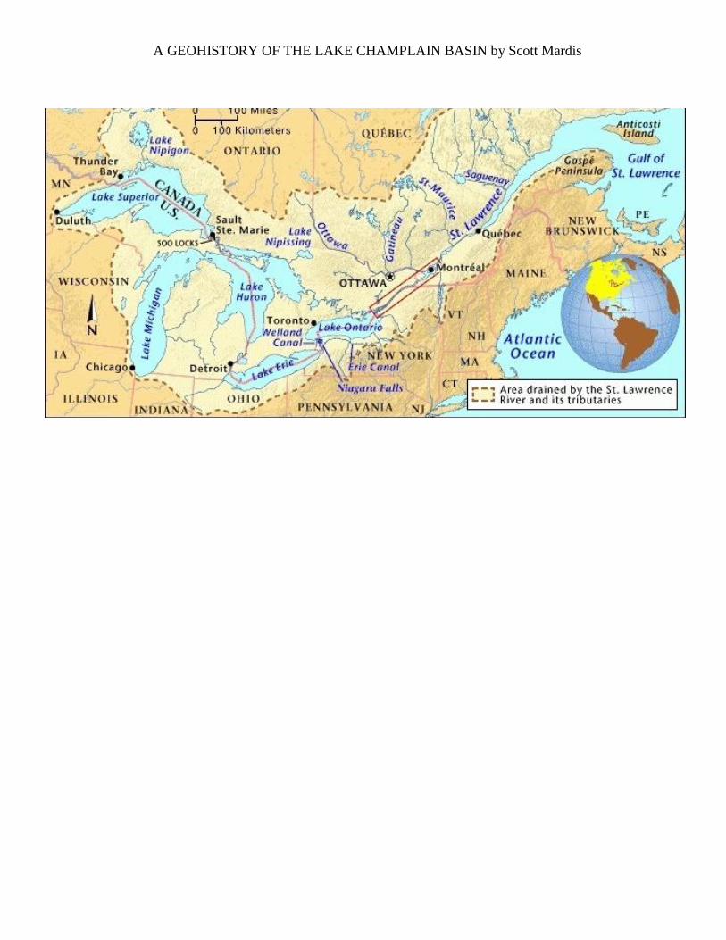
A GEOHISTORY OF THE LAKE CHAMPLAIN BASIN by Scott Mardis
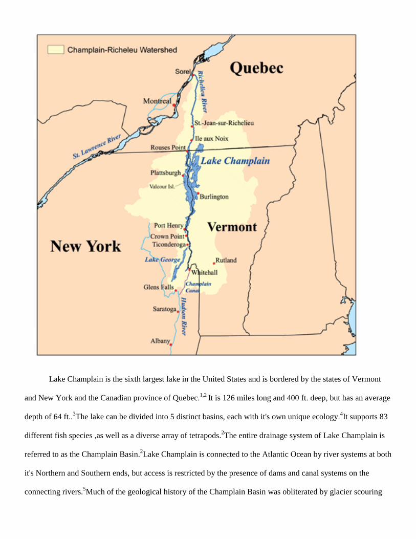
Lake Champlain is the sixth largest lake in the United States and is bordered by the states of Vermont
and New York and the Canadian province of Quebec.1,2
It is 126 miles long and 400 ft. deep, but has an average
depth of 64 ft..3The lake can be divided into 5 distinct basins, each with it's own unique ecology.
4It supports 83
different fish species ,as well as a diverse array of tetrapods.2The entire drainage system of Lake Champlain is
referred to as the Champlain Basin.2Lake Champlain is connected to the Atlantic Ocean by river systems at both
it's Northern and Southern ends, but access is restricted by the presence of dams and canal systems on the
connecting rivers.5Much of the geological history of the Champlain Basin was obliterated by glacier scouring
during the Wisconsin glaciations (110,000-10,000 years ago or Kya) 4 but the missing chapters may be inferred
by the geology of surrounding regions.
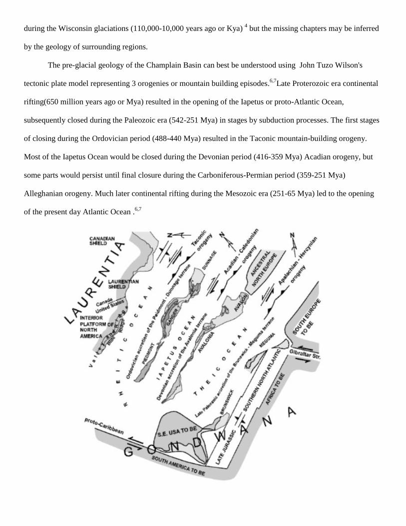
The pre-glacial geology of the Champlain Basin can best be understood using John Tuzo Wilson's
tectonic plate model representing 3 orogenies or mountain building episodes.6,7
Late Proterozoic era continental
rifting(650 million years ago or Mya) resulted in the opening of the Iapetus or proto-Atlantic Ocean,
subsequently closed during the Paleozoic era (542-251 Mya) in stages by subduction processes. The first stages
of closing during the Ordovician period (488-440 Mya) resulted in the Taconic mountain-building orogeny.
Most of the Iapetus Ocean would be closed during the Devonian period (416-359 Mya) Acadian orogeny, but
some parts would persist until final closure during the Carboniferous-Permian period (359-251 Mya)
Alleghanian orogeny. Much later continental rifting during the Mesozoic era (251-65 Mya) led to the opening
of the present day Atlantic Ocean .6,7
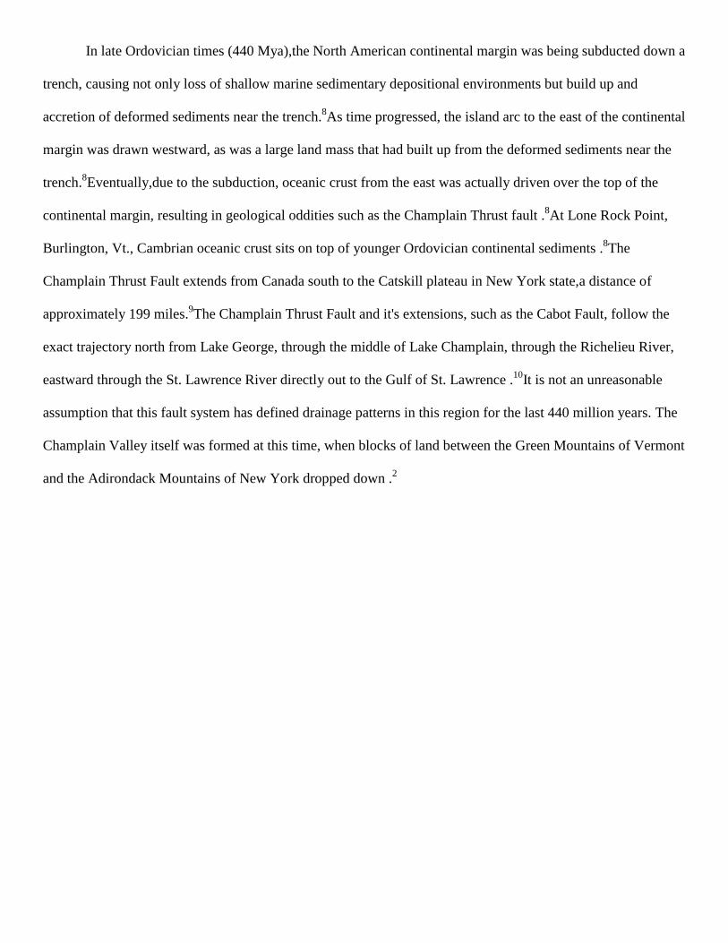
In late Ordovician times (440 Mya),the North American continental margin was being subducted down a
trench, causing not only loss of shallow marine sedimentary depositional environments but build up and
accretion of deformed sediments near the trench.8As time progressed, the island arc to the east of the continental
margin was drawn westward, as was a large land mass that had built up from the deformed sediments near the
trench.8Eventually,due to the subduction, oceanic crust from the east was actually driven over the top of the
continental margin, resulting in geological oddities such as the Champlain Thrust fault .8At Lone Rock Point,
Burlington, Vt., Cambrian oceanic crust sits on top of younger Ordovician continental sediments .8The
Champlain Thrust Fault extends from Canada south to the Catskill plateau in New York state,a distance of
approximately 199 miles.9The Champlain Thrust Fault and it's extensions, such as the Cabot Fault, follow the
exact trajectory north from Lake George, through the middle of Lake Champlain, through the Richelieu River,
eastward through the St. Lawrence River directly out to the Gulf of St. Lawrence .10
It is not an unreasonable
assumption that this fault system has defined drainage patterns in this region for the last 440 million years. The
Champlain Valley itself was formed at this time, when blocks of land between the Green Mountains of Vermont
and the Adirondack Mountains of New York dropped down .2
In late Permian times (251 Mya),the breakup of the supercontinent Pangaea began as the North
American and European/African plates began to rift apart .11
The rifting apart of these continental plates
proceeded sequentially from south to north, reversing the docking pattern seen in the Alleghanian orogeny, and
spanned the entire Mesozoic era (251-65 Mya).11
Geologic evidence of these processes can be found throughout
New England in the form of igneous intrusions( related to intraplate magmatism ) and much block faulting, as
well .6, 11
The Mesozoic igneous rocks of New England have been classified into four distinct provinces, based
on differences in their ages, physical aspects and petrology .11
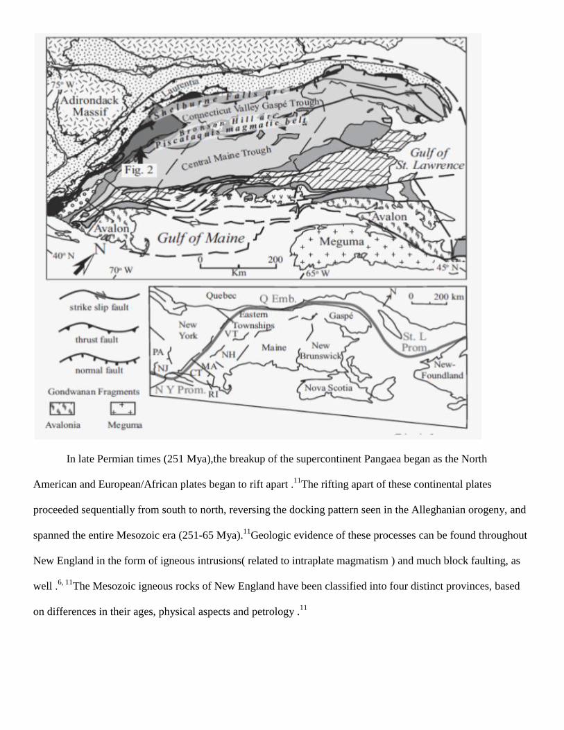
One Mesozoic igneous province of New England is the New England-Quebec province.11
The
Champlain Basin sits within the New England-Quebec province and contains many early Cretaceous period
(135-115 Mya) dikes and faults .7, 11
One notable Mesozoic igneous feature of the Champlain Basin is Barber
Hill,a large syenitic dome, located in Charlotte, Vt. .11, 12
It has been suggested that the Champlain Basin may
have been close to the continental margin during this time period (135-115 Mya).12, 13
The presence of the
mineral monchiquite, associated with oceanic crust, in lamprophyre dikes in Williston, Vt. may reinforce this
idea .7It has been speculated that Mesozoic rifting in the Champlain Basin, in addition to creating new faults,
may have reactivated older faults underneath Lakes Champlain and Lake George (south of Lake Champlain),
significantly deepening the lake basins through block faulting.14
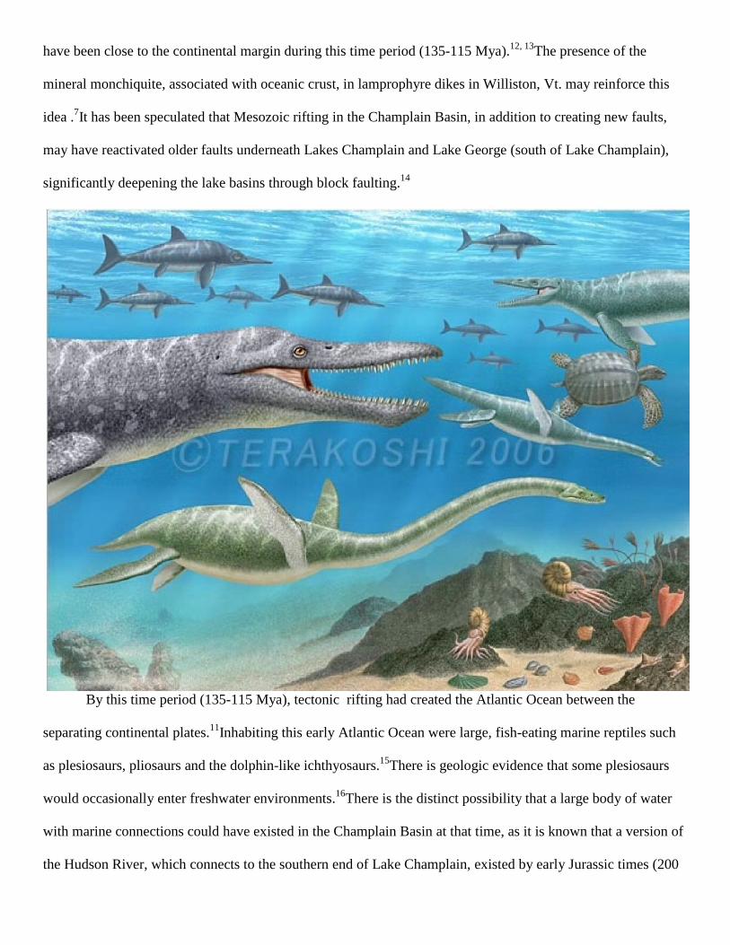
By this time period (135-115 Mya), tectonic rifting had created the Atlantic Ocean between the
separating continental plates.11
Inhabiting this early Atlantic Ocean were large, fish-eating marine reptiles such
as plesiosaurs, pliosaurs and the dolphin-like ichthyosaurs.15
There is geologic evidence that some plesiosaurs
would occasionally enter freshwater environments.16
There is the distinct possibility that a large body of water
with marine connections could have existed in the Champlain Basin at that time, as it is known that a version of
the Hudson River, which connects to the southern end of Lake Champlain, existed by early Jurassic times (200
Mya).17
In addition, plesiosaur fossils have been found in New Jersey, indicating their presence in the vicinity of
the mouth of the Hudson River.18
If a large body of water with marine connections through the Hudson River
existed in the Champlain Basin during the Cretaceous period (146-65 Mya), it is possible it could have
occasionally been visited by those remarkable fossil animals, the plesiosaurs.
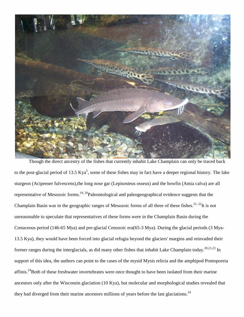
Though the direct ancestry of the fishes that currently inhabit Lake Champlain can only be traced back
to the post-glacial period of 13.5 Kya5, some of these fishes may in fact have a deeper regional history. The lake
sturgeon (Acipenser fulvescens),the long nose gar (Lepisosteus osseus) and the bowfin (Amia calva) are all
representative of Mesozoic forms.19, 20
Paleontological and paleogeographical evidence suggests that the
Champlain Basin was in the geographic ranges of Mesozoic forms of all three of these fishes.21, 22
It is not
unreasonable to speculate that representatives of these forms were in the Champlain Basin during the
Cretaceous period (146-65 Mya) and pre-glacial Cenozoic era(65-3 Mya). During the glacial periods (3 Mya-
13.5 Kya), they would have been forced into glacial refugia beyond the glaciers' margins and reinvaded their
former ranges during the interglacials, as did many other fishes that inhabit Lake Champlain today.20,21,23
In
support of this idea, the authors can point to the cases of the mysid Mysis relicta and the amphipod Pontoporeia
affinis.24
Both of these freshwater invertebrates were once thought to have been isolated from their marine
ancestors only after the Wisconsin glaciation (10 Kya), but molecular and morphological studies revealed that
they had diverged from their marine ancestors millions of years before the last glaciations.24
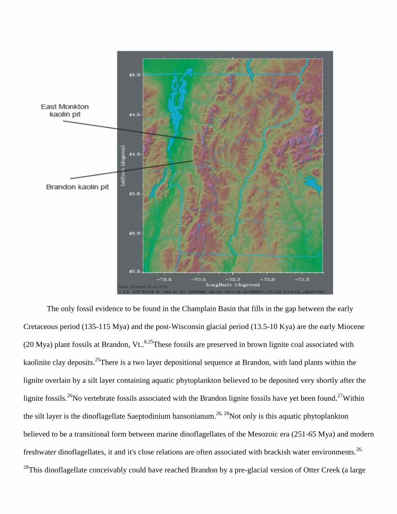
The only fossil evidence to be found in the Champlain Basin that fills in the gap between the early
Cretaceous period (135-115 Mya) and the post-Wisconsin glacial period (13.5-10 Kya) are the early Miocene
(20 Mya) plant fossils at Brandon, Vt..8,25
These fossils are preserved in brown lignite coal associated with
kaolinite clay deposits.25
There is a two layer depositional sequence at Brandon, with land plants within the
lignite overlain by a silt layer containing aquatic phytoplankton believed to be deposited very shortly after the
lignite fossils.26
No vertebrate fossils associated with the Brandon lignite fossils have yet been found.27
Within
the silt layer is the dinoflagellate Saeptodinium hansonianum.26, 28
Not only is this aquatic phytoplankton
believed to be a transitional form between marine dinoflagellates of the Mesozoic era (251-65 Mya) and modern
freshwater dinoflagellates, it and it's close relations are often associated with brackish water environments.26,
28This dinoflagellate conceivably could have reached Brandon by a pre-glacial version of Otter Creek (a large
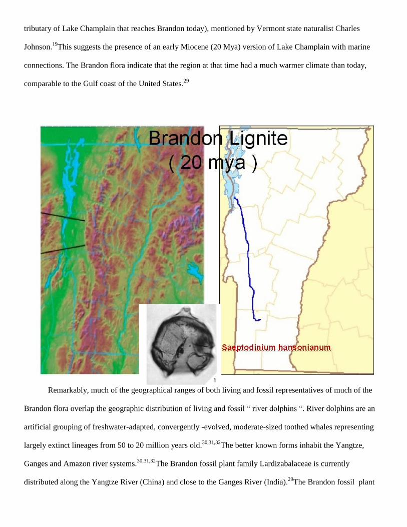
tributary of Lake Champlain that reaches Brandon today), mentioned by Vermont state naturalist Charles
Johnson.19
This suggests the presence of an early Miocene (20 Mya) version of Lake Champlain with marine
connections. The Brandon flora indicate that the region at that time had a much warmer climate than today,
comparable to the Gulf coast of the United States.29
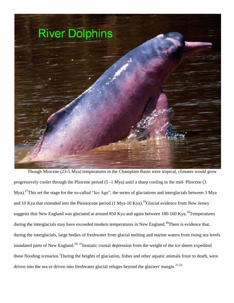
Remarkably, much of the geographical ranges of both living and fossil representatives of much of the
Brandon flora overlap the geographic distribution of living and fossil “ river dolphins “. River dolphins are an
artificial grouping of freshwater-adapted, convergently -evolved, moderate-sized toothed whales representing
largely extinct lineages from 50 to 20 million years old.30,31,32
The better known forms inhabit the Yangtze,
Ganges and Amazon river systems.30,31,32
The Brandon fossil plant family Lardizabalaceae is currently
distributed along the Yangtze River (China) and close to the Ganges River (India).29
The Brandon fossil plant
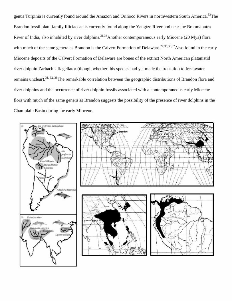
genus Turpinia is currently found around the Amazon and Orinoco Rivers in northwestern South America.33
The
Brandon fossil plant family Illiciaceae is currently found along the Yangtze River and near the Brahmaputra
River of India, also inhabited by river dolphins.31,34
Another contemporaneous early Miocene (20 Mya) flora
with much of the same genera as Brandon is the Calvert Formation of Delaware.27,35,36,37
Also found in the early
Miocene deposits of the Calvert Formation of Delaware are bones of the extinct North American platanistid
river dolphin Zarhachis flagellator (though whether this species had yet made the transition to freshwater
remains unclear).31, 32, 38
The remarkable correlation between the geographic distributions of Brandon flora and
river dolphins and the occurrence of river dolphin fossils associated with a contemporaneous early Miocene
flora with much of the same genera as Brandon suggests the possibility of the presence of river dolphins in the
Champlain Basin during the early Miocene.
Though Miocene (23-5 Mya) temperatures in the Champlain Basin were tropical, climates would grow
progressively cooler through the Pliocene period (5 -1 Mya) until a sharp cooling in the mid- Pliocene (3
Mya).27
This set the stage for the so-called “Ice Age”, the series of glaciations and interglacials between 3 Mya
and 10 Kya that extended into the Pleistocene period (1 Mya-10 Kya).19
Glacial evidence from New Jersey
suggests that New England was glaciated at around 850 Kya and again between 180-160 Kya.39
Temperatures
during the interglacials may have exceeded modern temperatures in New England.40
There is evidence that,
during the interglacials, large bodies of freshwater from glacial melting and marine waters from rising sea levels
inundated parts of New England.39, 41
Isostatic crustal depression from the weight of the ice sheets expedited
these flooding scenarios.1During the heights of glaciation, fishes and other aquatic animals froze to death, were
driven into the sea or driven into freshwater glacial refuges beyond the glaciers' margin.21,23
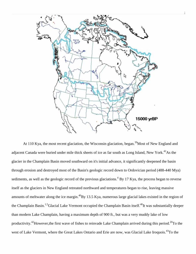
At 110 Kya, the most recent glaciation, the Wisconsin glaciation, began.39
Most of New England and
adjacent Canada were buried under mile thick sheets of ice as far south as Long Island, New York.42
As the
glacier in the Champlain Basin moved southward on it's initial advance, it significantly deepened the basin
through erosion and destroyed most of the Basin's geologic record down to Ordovician period (488-440 Mya)
sediments, as well as the geologic record of the previous glaciations.4 By 17 Kya, the process began to reverse
itself as the glaciers in New England retreated northward and temperatures began to rise, leaving massive
amounts of meltwater along the ice margin.40
By 13.5 Kya, numerous large glacial lakes existed in the region of
the Champlain Basin.1,5
Glacial Lake Vermont occupied the Champlain Basin itself.40
It was substantially deeper
than modern Lake Champlain, having a maximum depth of 900 ft., but was a very muddy lake of low
productivity.42
However,the first wave of fishes to reinvade Lake Champlain arrived during this period.20
To the
west of Lake Vermont, where the Great Lakes Ontario and Erie are now, was Glacial Lake Iroquois.43
To the
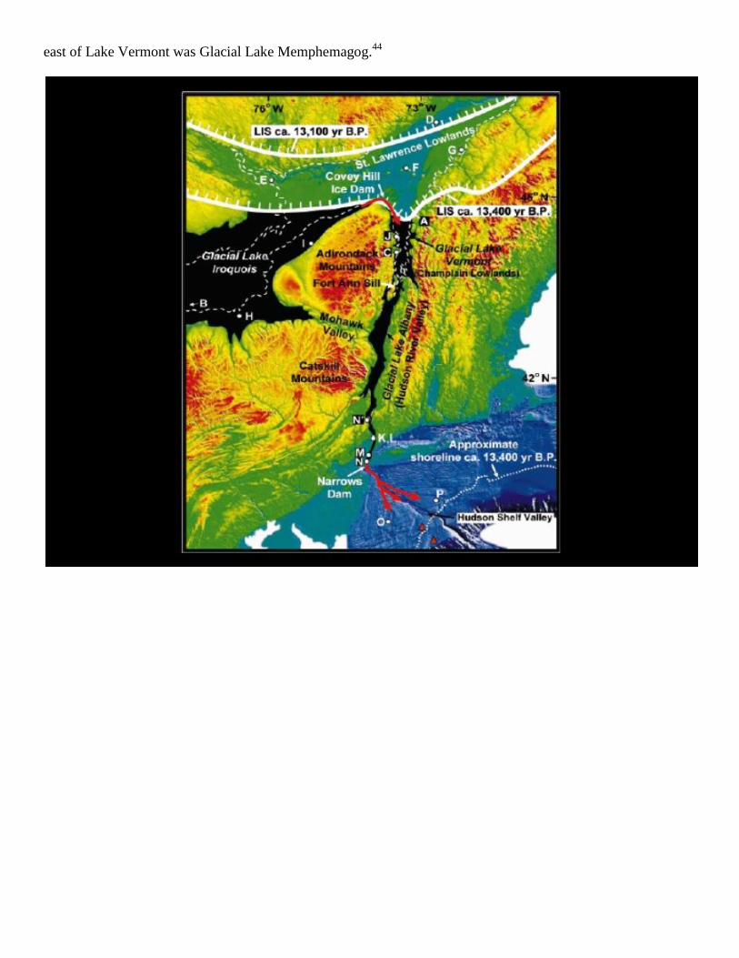
east of Lake Vermont was Glacial Lake Memphemagog.44
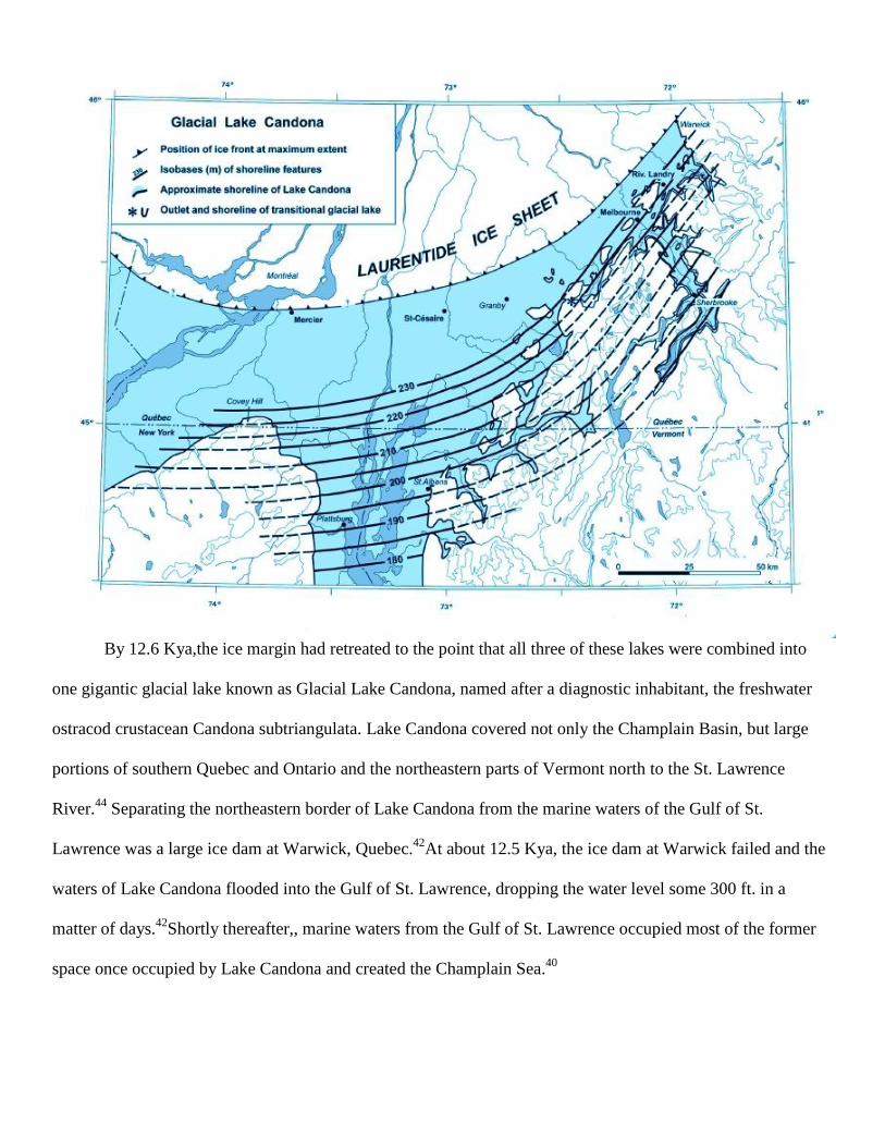
By 12.6 Kya,the ice margin had retreated to the point that all three of these lakes were combined into
one gigantic glacial lake known as Glacial Lake Candona, named after a diagnostic inhabitant, the freshwater
ostracod crustacean Candona subtriangulata. Lake Candona covered not only the Champlain Basin, but large
portions of southern Quebec and Ontario and the northeastern parts of Vermont north to the St. Lawrence
River.44
Separating the northeastern border of Lake Candona from the marine waters of the Gulf of St.
Lawrence was a large ice dam at Warwick, Quebec.42
At about 12.5 Kya, the ice dam at Warwick failed and the
waters of Lake Candona flooded into the Gulf of St. Lawrence, dropping the water level some 300 ft. in a
matter of days.42
Shortly thereafter,, marine waters from the Gulf of St. Lawrence occupied most of the former
space once occupied by Lake Candona and created the Champlain Sea.40
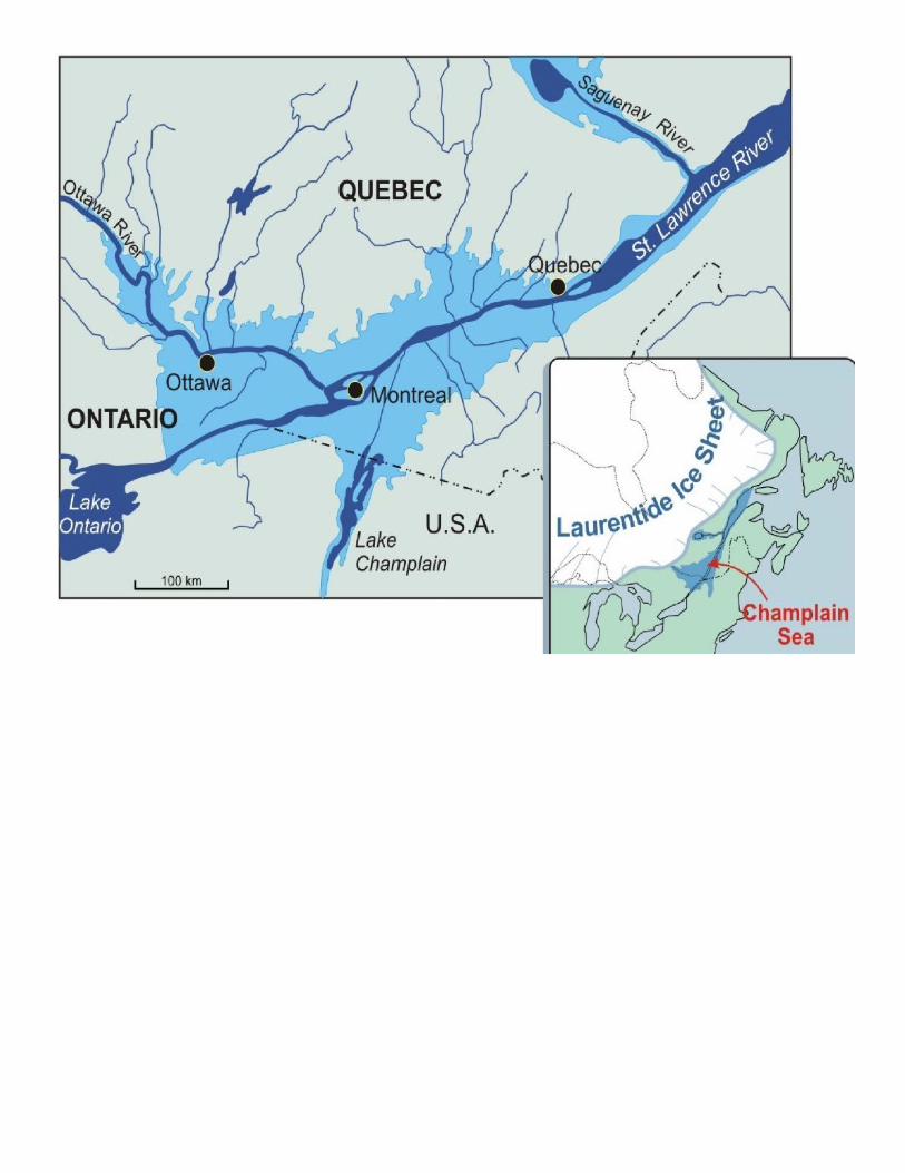
The picture above shows a recreation of the contours of the Champlain Sea and adjacent contemporary
glacial lakes at 11.5 Kya. As depicted above, the Champlain Basin was only a small fiord in a sea that was
mostly located in southern Quebec and Ontario.1The St. Lawrence River east of Warwick, Quebec to the Gulf
of St. Lawrence is referred to as the Goldthwait Sea, technically a separate body of water.45
At it's western
margins, the Champlain Sea was connected to the large Glacial Lake Algonquin, which occupied the space of
the modern day Great Lakes.1Lake Algonquin was in turn connected to Glacial Lake Agassiz, the largest glacial
lake ever documented.1, 46
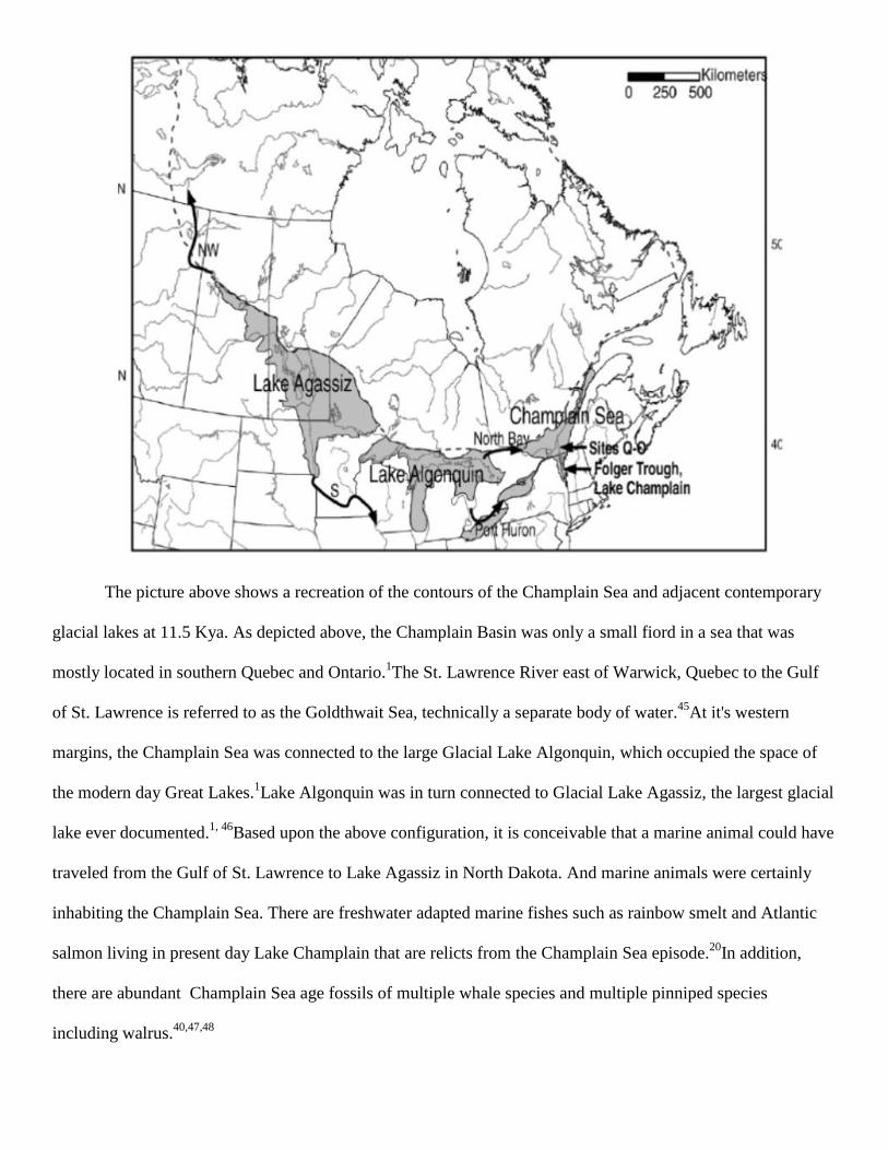
Based upon the above configuration, it is conceivable that a marine animal could have
traveled from the Gulf of St. Lawrence to Lake Agassiz in North Dakota. And marine animals were certainly
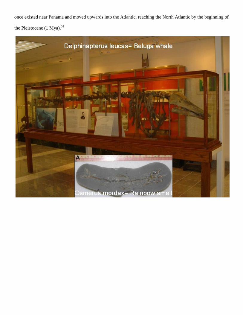
inhabiting the Champlain Sea. There are freshwater adapted marine fishes such as rainbow smelt and Atlantic
salmon living in present day Lake Champlain that are relicts from the Champlain Sea episode.20
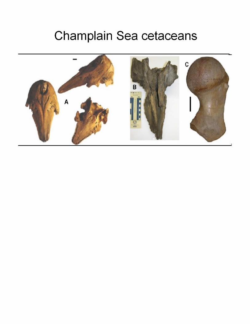
In addition,
there are abundant Champlain Sea age fossils of multiple whale species and multiple pinniped species
including walrus.40,47,48
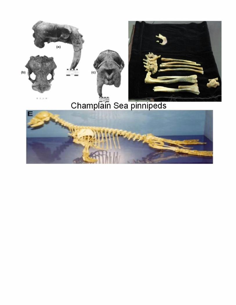
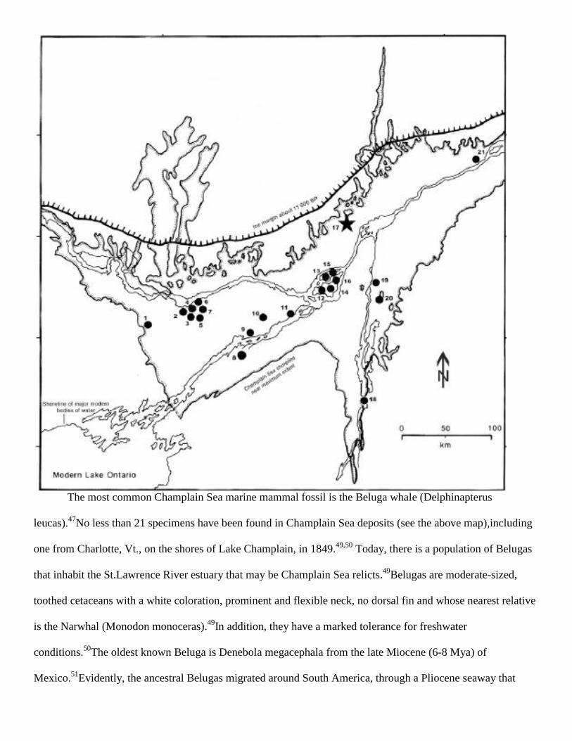
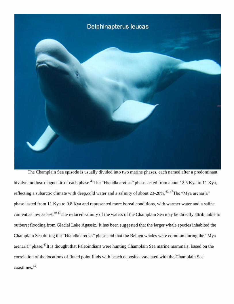
The most common Champlain Sea marine mammal fossil is the Beluga whale (Delphinapterus
leucas).47
No less than 21 specimens have been found in Champlain Sea deposits (see the above map),including
one from Charlotte, Vt., on the shores of Lake Champlain, in 1849.49,50
Today, there is a population of Belugas
that inhabit the St.Lawrence River estuary that may be Champlain Sea relicts.49
Belugas are moderate-sized,
toothed cetaceans with a white coloration, prominent and flexible neck, no dorsal fin and whose nearest relative
is the Narwhal (Monodon monoceras).49
In addition, they have a marked tolerance for freshwater
conditions.50
The oldest known Beluga is Denebola megacephala from the late Miocene (6-8 Mya) of
Mexico.51
Evidently, the ancestral Belugas migrated around South America, through a Pliocene seaway that
once existed near Panama and moved upwards into the Atlantic, reaching the North Atlantic by the beginning of
the Pleistocene (1 Mya).51
The Champlain Sea episode is usually divided into two marine phases, each named after a predominant
bivalve mollusc diagnostic of each phase.40
The “Hiatella arctica” phase lasted from about 12.5 Kya to 11 Kya,
reflecting a subarctic climate with deep,cold water and a salinity of about 23-28%.40, 47
The “Mya arenaria”
phase lasted from 11 Kya to 9.8 Kya and represented more boreal conditions, with warmer water and a saline
content as low as 5%.40,47
The reduced salinity of the waters of the Champlain Sea may be directly attributable to
outburst flooding from Glacial Lake Agassiz.1It has been suggested that the larger whale species inhabited the
Champlain Sea during the “Hiatella arctica” phase and that the Beluga whales were common during the “Mya
arenaria” phase.47
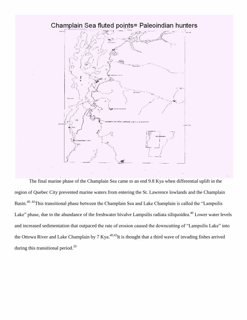
It is thought that Paleoindians were hunting Champlain Sea marine mammals, based on the
correlation of the locations of fluted point finds with beach deposits associated with the Champlain Sea
coastlines.52
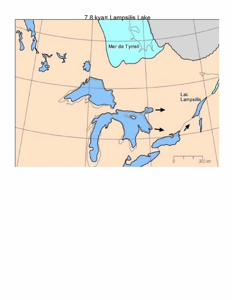
The final marine phase of the Champlain Sea came to an end 9.8 Kya when differential uplift in the
region of Quebec City prevented marine waters from entering the St. Lawrence lowlands and the Champlain
Basin.40, 42
This transitional phase between the Champlain Sea and Lake Champlain is called the “Lampsilis
Lake” phase, due to the abundance of the freshwater bivalve Lampsilis radiata siliquoidea.40
Lower water levels
and increased sedimentation that outpaced the rate of erosion caused the downcutting of “Lampsilis Lake” into
the Ottowa River and Lake Champlain by 7 Kya.40,42
It is thought that a third wave of invading fishes arrived
during this transitional period.20
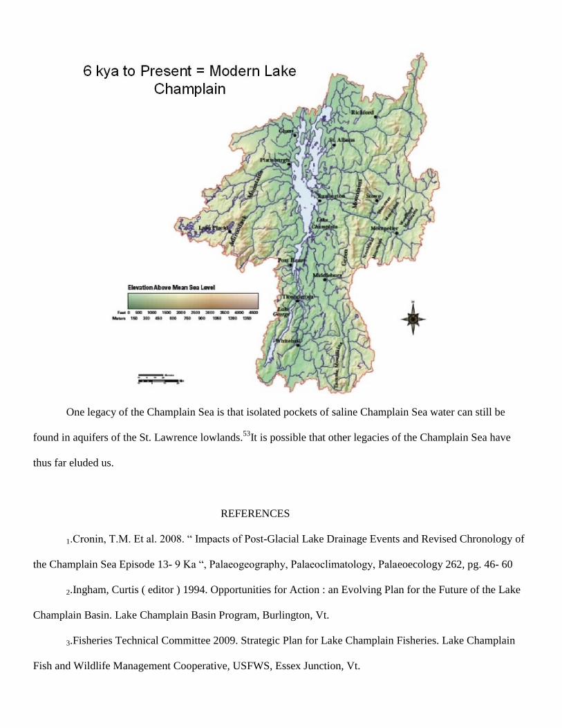
One legacy of the Champlain Sea is that isolated pockets of saline Champlain Sea water can still be
found in aquifers of the St. Lawrence lowlands.53
It is possible that other legacies of the Champlain Sea have
thus far eluded us.
REFERENCES
1.Cronin, T.M. Et al. 2008. “ Impacts of Post-Glacial Lake Drainage Events and Revised Chronology of
the Champlain Sea Episode 13- 9 Ka “, Palaeogeography, Palaeoclimatology, Palaeoecology 262, pg. 46- 60
2.Ingham, Curtis ( editor ) 1994. Opportunities for Action : an Evolving Plan for the Future of the Lake
Champlain Basin. Lake Champlain Basin Program, Burlington, Vt.
3.Fisheries Technical Committee 2009. Strategic Plan for Lake Champlain Fisheries. Lake Champlain
Fish and Wildlife Management Cooperative, USFWS, Essex Junction, Vt.
4.Myer, G. E. and Gruendling, G. K. 1979. Limnology of Lake Champlain. Lake Champlain Basin
Study. Burlington, Vt.
5. Marsden, J. Ellen and Hauser, Michael 2009. “ Exotic Species in Lake Champlain “ , Journal of Great
Lakes Research, 35, pg. 250- 265
6.Van Diver, Bradford B. 1985. Roadside Geology of Vermont and New Hampshire, Mountain Press
Publishing Co., Missoula, Montana
7.Whitehead, Melissa 2008. The Petrographic and Geochemical Analysis of Lamprophyre Dikes in
Williston, Vermont: Unpublished Senior thesis, Middlebury College, Middlebury, Vermont. 82 pg.
8.Doolan, Barry 1996. “ The Geology of Vermont “, Rocks and Minerals, 71 ( 4 ), pg. 218- 225
9.Stanley, Rolfe S. 1987. “ The Champlain Thrust Fault, Lone Rock Point, Burlington, Vt. “, in Roy,
D.C. ( editor ), Northeastern Section of the Geological Society of America: Geological Society of America
Centennial Field Guide , 5, pg. 225- 228
10.McWilliams, Cory K. et al. 2010. “ Silurian- Devonian age and Tectonic setting of the Connecticut
Valley- Gaspe Trough in Vermont Based on U-Pb SHRIMP Analyses of Detrital Zircons “, American Journal
of Science, 310, pg. 325- 363
11.McHone, J. G. and Butler, J. R. 1984. “ Mesozoic Igneous Provinces of New England and the
Opening of the North Atlantic Ocean “ , Geological Society of America Bulletin, 95, pg. 757- 765
12.McHone, J.G. and McHone, N. W. 1999. “ The New England- Quebec Igneous Province in Western
Vermont “ in Doolan, Barry ( editor ) , Field Guide for the New England Intercollegiate Geological Conference:
Burlington, Vermont, Trip C-4, pg. C5-1- C5-17
13.McHone, J. G. 1982. “ Mesozoic Rifting in Northern New England “ , Geological Society of America
Abstracts with Programs, 4 ( 1-2 ), pg. 40
14.Stanley, Rolfe S. 1980. “ Mesozoic Faults and their Environmental Significance in Western Vermont
“, Vermont Geology, 1, pg. 22- 32
15.Bakker, Robert T. 1986. The Dinosaur Heresies. William Morrow and Co., New York
16. Vandermark, Deborah et al. 2006. “ Late Cretaceous Plesiosaur Teeth from Axel Heiberg Island,
Nanuvat, Canada “, Arctic, 59 ( 1 ), pg. 79- 82
17.Sirkin, Les and Bokuniewicz, Henry 2006. “ The Hudson River Valley: Geological History,
Landforms and Resources “, in Levinton, Jeffrey S. and Waldman, John R. ( editors ), The Hudson River
Estuary, Cambridge University Press, pg. 13- 23
18.Parris, D. C. 1974. “ Additional Records of Plesiosaurs from the Cretaceous of New Jersey “, Journal
of Paleontology, 48, pg. 32- 35
19.Johnson, Charles W. 1980. The Nature of Vermont. The University Press of New England, Hanover,
New Hampshire and London, England
20.Langdon, R. W. et al. 2006. Fishes of Vermont. Vermont Department of Fish and Wildlife,
Waterbury, Vt.
21.Choudhury, Anindo and Dick, Terry A. 1998. “ The Historical Biogeography of Sturgeons (
Osteichthyes, Acipenseridae ): a Synthesis of Phylogenetics, Palaeontology and Palaeogeography “, Journal of
Biogeography, 25, pg. 623- 640
22.Friedman, Matt et al. 2003. “ Fossil Fishes from the High Canadian Arctic: Further Evidence of
Extreme Warmth During the Late Cretaceous ( Turonian- Coniacian ) “, Cretaceous Research, 24, pg. 615- 632
23.Wilson, Chris C. and Mandrak, Nicholas E. 2004. “ History and Evolution of Lake Trout in Shield
Lakes: Past and Future Challenges “, in Ryder, R. A., Steadman, R. J., and Gunn, J.M. ( editors ), Boreal Shield
Watersheds: Lake Trout Ecosystems in a Changing Environment. CRC Press LLC. pg. 21-35
24.Lee, C. E. and Bell, M. A. 1999. “ Causes and Consequences of Recent Freshwater Invasion by
Saltwater Animals “, Trends Ecol. Evol., 14, pg. 284- 288
25.Schuele, Ethel M. 1996. “ Vermont‟s Geologic History as Told by It‟s Fossils “, Rocks and Minerals,
71 ( 4 ), pg. 226- 230
26.Evitt, W. R. 1974. “ Restudy of an Oligocene Dinoflagellate from Vermont “, Geoscience and Man, 9,
pg. 1- 6
27.Tiffney, Bruce H. and Traverse, Alfred 1994. “ The Brandon Lignite ( Vermont ) is of Cenozoic, not
Mesozoic Age! “, Northeastern Geology, 16 ( 3- 4 ), pg. 215- 220
28.Batten, David J. et al. 1999. “ Palaeoenvironmental Significance of a Monospecific Assemblage of
Dinoflagellate Cysts from the Miocene Clarkia Beds, Idaho, U.S.A. “, Palaeogeography, Palaeoclimatology,
Palaeoecology 153, pg. 161- 177
29. Tiffney, Bruce H. 1993. “ Fruits and Seeds of the Brandon Lignite. VII. Sargentodoxa (
Sargentodoxaceae ) “, American Journal of Botany, 80 ( 5 ), pg. 517- 523
30.Cassens, Insa et al. 2000. “ Independent Adaptation to Riverine Habitats Allowed Survival of Ancient
Cetacean Lineages “, Proceedings of the National Academy of Sciences, U.S.A., 97, pg. 11343- 11347
31.Hamilton, Healy et al. 2001. “ Evolution of River Dolphins “, Proceedings of the Royal Society of
London B, 268, pg. 549- 558
32.Geisler, Jonathan H. et al. 2011. “ A supermatrix analysis of genomic, morphological and
paleontological data from crown Cetacea “, BMC Evolutionary Biology, 11, 112
33.Tiffney, Bruce H. 1979. “ Fruits and Seeds of the Brandon Lignite. III. Turpinia ( Staphyleaceae ) “,
Brittonia, 31 ( 1 ), pg. 39-51
34.Tiffney, Bruce H. and Barghoorn, Elso S. 1979. “ Flora of the Brandon Lignite. IV. Illiciaceae “,
American Journal of Botany, 66 ( 3 ), pg. 321- 329
35.Groot, J.J. 1992. “ Plant Microfossils of the Calvert Formation of Delaware “, Delaware Geological
Survey Report of Investigations, 50, pg. 1- 6
36.Tiffney, Bruce H. 1994. “ Re- Evaluation of the Age of the Brandon Lignite ( Vermont, U.S.A. )
Based on Plant Megafossils “, Review of Palaeobotany and Palynology, 82 ( 3- 4 ), pg. 299- 315
37.Traverse, Alfred 1994. “ Palynofloral Geochronology of the Brandon Lignite of Vermont, U.S.A. “,
Review of Palaeobotany and Palynology, 82 ( 3- 4 ), pg. 265- 297
38.Bohaska, David J. 1998. “ Marine Mammals of the lower Miocene Pollack Farm Site, Delaware “ in
Benson, R. N. ( editor ), Geology and Paleontology of the lower Miocene Pollack Farm Site, Delaware:
Delaware Geological Survey Publication No. 21, pg. 179- 191
39.Ridge, John C. 2004. “ The Quaternary Glaciation of Western New England with Correlations to
Surrounding Areas “ in Ehlers, J. and Gibbard, P.L. ( editors ), Quaternary Glaciations: Extent and Chronology.

Part II: North America, Elsevier, Boston, pg. 169- 199
40.Milner, Andrew and Ryan, Michael 2006. Late Pleistocene Vertebrates Along the Northwestern
Margin of the Champlain Sea. Fieldtrip Guidebook for 66th
Annual Meeting of the Society of Vertebrate
Paleontology. 43 pg.
41.Sirkin, Les 1996. Western Long Island Geology. Watch Hill: The Book and Tackle Shop Publishers
42.Wright, Steven F. 2003. Glacial Geology of the Burlington and Colchester 7.5- minute Quadrangles,
Northern Vermont. Vermont Geological Survey, Waterbury, Vermont
43.Donnelly, Jeffrey P. et al. 2005. “ Catastrophic Meltwater Discharge Down the Hudson Valley: A
Potential Trigger for the Intra- Allerod Cold Period “, Geology, 33 ( 2 ), pg. 89- 92
44.Parent, Michel and Occhietti, Serge 1999. “ Late Wisconsinan Deglaciation and Glacial Lake
Development in the Appalachians of Southeastern Quebec “, Geographie Physique et Quaternaire, 53 ( 1 ), pg.
117- 135
45.Occhietti, Serge et al. 2001. “ Paleoenvironments de la Mer de Champlain dans la Region de Quebec,
Entre 11, 300 et 9750 BP: Le Site de St. Nicholas “, Geographie Physique et Quaternaire, 55 ( 1 ), pg. 23- 46
46.Teller, J.T. et al. 2002. “ Freshwater Outbursts to the Oceans from Glacial Lake Agassiz and Their
Role in Climate Change During the Last Deglaciation “, Quaternary Science Reviews, 21, pg. 879- 887
47.Harington, C.R. 1977. “ Marine Mammals of the Champlain Sea and the Great Lakes “, Annals of the
New York Academy of Sciences, 288, pg. 508- 537
48.Harington, C.R. 1988. “ Marine Mammals of the Champlain Sea and the Problem of Whales in
Michigan „, in Gadd, N.R. ( editor ), The Late Quaternary Development of the Champlain Sea Basin:
Geological Association of Canada, Special Paper 35, pg. 225- 240
49.Harington, C.R. et al. 2006. “ Felix: A Late Pleistocene White Whale ( Delphinapterus leucas )
Skeleton from Champlain Sea Deposits at St. Felix- de- Valois, Quebec”, Geographie Physique et Quaternaire,
60 ( 2 ), pg. 183- 198
50.Howe, Jeff 1993. The Charlotte Whale. Perkins Museum of Geology, University of Vermont. 5 pg.
51.Lambert, Olivier and Gigase, Pierre 2007. “ A monodontid cetacean from the early Pliocene of the
North Sea “, Bulletin de l‟Institute royal des Sciences naturelles de Belgique, Sciences de la Terre, 77, pg. 197-
210
52.Loring, Steven 1980. “ Paleo- Indian Hunters and the Champlain Sea: A Presumed Association “,
Man in the Northeast, 19, pg. 15- 41
53
.Cloutier, Vincent et al. 2010. “ Desalination of a Sedimentary Rock Aquifer System Invaded by
Pleistocene Champlain Sea and Processes Controlling Ground Water Geochemistry “, Environ. Earth Sci., 59,
pg. 977- 994
Copyright © 2022 FDOKUMEN