An Icelandic freshwater radiocarbon reservoir effect: Implications for lacustrine 14C chronologies

(This is a sample cover image for this issue. The actual cover is not yet available at this time.)
This article appeared in a journal published by Elsevier. The attachedcopy is furnished to the author for internal non-commercial researchand education use, including for instruction at the authors institution
and sharing with colleagues.
Other uses, including reproduction and distribution, or selling orlicensing copies, or posting to personal, institutional or third party
websites are prohibited.
In most cases authors are permitted to post their version of thearticle (e.g. in Word or Tex form) to their personal website orinstitutional repository. Authors requiring further information
regarding Elsevier’s archiving and manuscript policies areencouraged to visit:
http://www.elsevier.com/copyright
Author's personal copy
Holocene lacustrine fluctuations and deep CO2 degassing in the northeastern LakeLangano Basin (Main Ethiopian Rift)
Marco Benvenuti a,b,⇑, Marco Bonini b, Franco Tassi a, Giacomo Corti b, Federico Sani a,b, Andrea Agostini a,Piero Manetti a,b, Orlando Vaselli a
a Dipartimento di Scienze della Terra, Università di Firenze, Via G. La Pira 4, 50121 Firenze, Italyb C.N.R, Istituto di Geoscienze e Georisorse, UOS Firenze, Via G. La Pira 4, 50121 Firenze, Italy
a r t i c l e i n f o
Article history:Received 24 October 2011Received in revised form 14 August 2012Accepted 2 September 2012Available online 20 September 2012
Keywords:Main Ethiopian RiftHoloceneLacustrine fluctuationsCarbon geochemistryActive tectonics
a b s t r a c t
This work reports the results of an integrated investigation on Holocene faulted deposits exposed on thenortheastern Lake Langano in the central sector of the Main Ethiopian Rift (MER). The Lake Langano ispart of a closed basin and thus it is highly sensitive to climate fluctuations. The present study exploredthe foot of the Haroresa escarpment, where coarse-grained slope deposits interbedded with thin lakeshore shell-rich coarse sands are well exposed. Stratigraphical analysis of these deposits, integrated withradiocarbon dating carried out on lacustrine gastropod Melanoides tubercolata shells, points to significantlake level fluctuations forced mainly by climate oscillations. These have been interplaying during theearly and middle Holocene with a structurally-controlled threshold separating an embayment of the LakeLangano to the south, from the small perched Lake Haro Bu-a basin to the north. Significant differences inthe 13C/12C isotopic ratio have been identified in the M. tubercolata shells collected on the opposite sidesof such a threshold. The time-space variations of the isotopic signature of the shells are referred to themutual relationships between the two main different CO2 sources (i.e., microbial activity and deep man-tle degassing) dissolved in the lake water.
� 2012 Elsevier Ltd. All rights reserved.
1. Introduction
Researches on the Late Pleistocene–Holocene evolution of theLakes Region in the Main Ethiopian Rift (Ethiopia), have concurredto update regional models of hydrologic responses to global cli-matic changes, providing a reference for the late Quaternary palae-oclimatology of the tropics (Street-Perrott and Perrott, 1990; Gasseand Van Campo, 1994). Along with such a palaeoclimatic rele-vance, the MER is also a zone characterized by active tectonic pro-cesses and intense hydrothermal activity (Gianelli andTeklemariam, 1993; Chernet, 2011). In such a dynamic setting, cli-matic, tectonic and magmatic-related processes may have exerteda concurrent and complex control on the Late Quaternary geomor-phic and depositional dynamics. We focus on the northern coast ofLake Langano where lacustrine shells-bearing deposits and theirradiogenic and stable carbon isotopic signature record Holocene,climate-driven, lake level fluctuations in the frame of a local activetectonic setting.
2. Hydrologic evolution of the Lakes Region
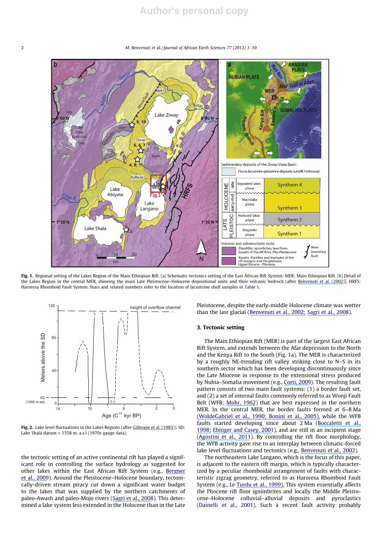
The Lakes Region includes lakes Ziway, Langano, Abiyata andShala that developed since the Late Pleistocene (Street, 1979; Ben-venuti et al., 2002) within the fault-controlled Main Ethiopian Riftdepression (Fig. 1). Classically, the Holocene Ziway–Shala lake fluc-tuations (Street, 1979; Gasse and Street, 1978; Gillespie et al.,1983; Alessio et al., 1996; Fig. 2) have been considered a suitableproxy for the switching off and on of the monsoonal regime, as aregional response to global cooling and warming trends (Street-Perrott and Perrott, 1990; Gasse and Van Campo, 1994). Between10 and 5 ky (conventional 14C ages), the lakes experienced an over-all high-level status abruptly interrupted by short arid pulses. Theearly-middle Holocene (5–10 ky) wetter period coincides in thesubarid tropics with a climatic optimum attesting to a relativelystable monsoonal circulation over East Africa. Short-lived aridpulses are related to a weakened monsoonal circulation which, insome cases, correlated quite well with global cooling events (Ben-venuti et al., 2002). Since 5 ky to Present, the lakes progressivelyreduced in size due to increasing aridity. The progressive hydrolog-ical deficit over the Lakes Region during the late Holocene (post-5 ky) may be related to increasing warming over the last1000 years. Despite the evolution of the Ziway–Shala lacustrinesystem has been generally referred to a dominant climatic control,
1464-343X/$ - see front matter � 2012 Elsevier Ltd. All rights reserved.http://dx.doi.org/10.1016/j.jafrearsci.2012.09.001
⇑ Corresponding author at: Dipartimento di Scienze della Terra, Università diFirenze, Via G. La Pira 4, 50121 Firenze, Italy. Tel.: +39 0552757516; fax: +39055218628.
E-mail address: [email protected] (M. Benvenuti).
Journal of African Earth Sciences 77 (2013) 1–10
Contents lists available at SciVerse ScienceDirect
Journal of African Earth Sciences
journal homepage: www.elsevier .com/locate / ja f rearsc i
Author's personal copy
the tectonic setting of an active continental rift has played a signif-icant role in controlling the surface hydrology as suggested forother lakes within the East African Rift System (e.g., Bergneret al., 2009). Around the Pleistocene–Holocene boundary, tectoni-cally-driven stream piracy cut down a significant water budgetto the lakes that was supplied by the northern catchments ofpaleo-Awash and paleo-Mojo rivers (Sagri et al., 2008). This deter-mined a lake system less extended in the Holocene than in the Late
Pleistocene, despite the early-middle Holocene climate was wetterthan the last glacial (Benvenuti et al., 2002; Sagri et al., 2008).
3. Tectonic setting
The Main Ethiopian Rift (MER) is part of the largest East AfricanRift System, and extends between the Afar depression to the Northand the Kenya Rift to the South (Fig. 1a). The MER is characterizedby a roughly NE-trending rift valley striking close to N–S in itssouthern sector which has been developing discontinuously sincethe Late Miocene in response to the extensional stress producedby Nubia–Somalia movement (e.g., Corti, 2009). The resulting faultpattern consists of two main fault systems: (1) a border fault set,and (2) a set of internal faults commonly referred to as Wonji FaultBelt (WFB; Mohr, 1962) that are best expressed in the northernMER. In the central MER, the border faults formed at 6–8 Ma(WoldeGabriel et al., 1990; Bonini et al., 2005), while the WFBfaults started developing since about 2 Ma (Boccaletti et al.,1998; Ebinger and Casey, 2001), and are still in an incipient stage(Agostini et al., 2011). By controlling the rift floor morphology,the WFB activity gave rise to an interplay between climatic-forcedlake level fluctuations and tectonics (e.g., Benvenuti et al., 2002).
The northeastern Lake Langano, which is the focus of this paper,is adjacent to the eastern rift margin, which is typically character-ized by a peculiar rhomboidal arrangement of faults with charac-teristic zigzag geometry, referred to as Haroresa Rhomboid FaultSystem (e.g., Le Turdu et al., 1999). This system essentially affectsthe Pliocene rift floor ignimbrites and locally the Middle Pleisto-cene–Holocene colluvial–alluvial deposits and pyroclastics(Dainelli et al., 2001). Such a recent fault activity probably
Fig. 1. Regional setting of the Lakes Region of the Main Ethiopian Rift. (a) Schematic tectonics setting of the East African Rift System; MER: Main Ethiopian Rift. (b) Detail ofthe Lakes Region in the central MER, showing the main Late Pleistocene–Holocene depositional units and their volcanic bedrock (after Benvenuti et al. (2002)). HRFS:Haroresa Rhomboid Fault System. Stars and related numbers refer to the location of lacustrine shell samples in Table 1.
14 10 6 2 0
D
S e h t
e v o b a s r e t e
M
0
40
80
120
? ? ?
?
?
Age (C kyr BP) 14
SD(1558 m asl)
height of overflow channel
Fig. 2. Lake level fluctuations in the Lakes Regions (after Gillespie et al. (1983)). SD:Lake Shala datum � 1558 m. a.s.l (1970s gauge data).
2 M. Benvenuti et al. / Journal of African Earth Sciences 77 (2013) 1–10
Author's personal copy
controlled the emplacement and circulation of hydrothermal fluidsassociated with the Aluto-Langano geothermal field (Gianelli andTeklemariam, 1993), where volcano-tectonic activity is also docu-mented by satellite imagery analysis (Biggs et al., 2011).
The tectonic evolution of the MER was preceded by intense vol-canic activity, which started with the eruption of Oligocene (�30–35 Ma) voluminous flood basalts (e.g., Mohr and Zanettin, 1988;Ebinger et al., 1993; WoldeGabriel et al., 1990; Chernet et al.,1998; Fig. 1). Subsequent magmatism was marked by a second epi-sode of pre-rift flood basalts at 8–12 Ma (Abebe et al., 2005; Boniniet al., 2005), followed by the eruption of widespread rhyoliticignimbrites (Rift Floor ignimbrites or Nazret Pyroclastic Rocks ofAbebe et al., 2005; Fig. 3) that marked the onset of rift activity inthe Late Miocene. After this widespread Mio-Pliocene volcanism,the Quaternary magmatic activity mostly localized in the rift floor,with products showing a typical bimodal composition given byalternating basaltic (e.g., Wonji basaltic activity; Wonji Basalts ofAbebe et al., 2005; Fig. 3) and rhyolitic (e.g., Aluto-Bericcio prod-ucts; Bora-Bericha Rhyolites of Abebe et al., 2005; Fig. 3) activitymostly associated with the WFB faulting.
4. Stratigraphic and paleogeographic setting of the LateQuaternary continental deposits
Following to the seminal studies of Street (1979), Gasse andStreet (1978) and Gillespie et al. (1983), in the last decade a strati-graphic revision of the Late Quaternary succession, covering Plio-cene–early Quaternary volcanic and volcaniclastic deposits(Abebe et al., 2005), allowed to trace four unconformity-boundedunits (ISSC, 1994; synthems 1–4) over the Lakes Region that recordmajor stages in the lake evolution (Fig. 1b; Benvenuti et al., 2002).In the northern Lake Langano area, the Late Pleistocene–Holocene
lacustrine succession overlies reddish alluvial–colluvial conglom-erates, sandstones and mudstones ascribed to the latest MiddlePleistocene (Coltorti et al., 2002).
The synthems composing the Late Quaternary deposits arebriefly described from bottom to top (see Fig. 1). Synthem 1 con-sists of colluvial, fluvio-deltaic, lacustrine gravels, sands, and muds,diatomites and volcaniclastic materials, deposited during the lastglacial period, ca. 100,000 to 22,000 yrs BP (Megalake phase; Ben-venuti et al., 2002; Fig. 1). This latter lake system expanded duringwetter interstadials and contracted during the drier stadials. Syn-them 2 is dominated by alluvial–colluvial and volcaniclastic depos-its accumulated during the last full glacial and late glacial, ca.22,000–10,000 yrs BP when arid conditions brought to severeshrinking of the lakes (Reduced Lake Phase, Benvenuti et al.,2002; Fig. 1). Synthem 3 consists of colluvial, fluvio-deltaic, lacus-trine gravels, sands, and muds, diatomites, and volcaniclasticmaterials recording the early-middle Holocene, ca. 10,000–5000 yrs BP (Macrolake phase of Benvenuti et al. (2002); Fig. 1).This lake system, smaller than the former Megalake, underwentfrequent level fluctuations (Benvenuti et al., 2002; Benvenutiet al., 2005) with a maximum lake surface elevation of about1670 m above sea level (Street, 1979; Laury and Albritton, 1975;Benvenuti et al., 2002). Synthem 4 consists of colluvial, fluvial, del-taic and lacustrine sediments accumulated over the last 5000 yearswhen Macrolake progressively split into the present four lakes(Separated Lakes Phase of Benvenuti et al. (2002); Fig. 1).
5. The Haroresa road cross-section
In February 2007, a shallow ditch excavated along the steepslope delimiting the eastern escarpment of a faulted block on thenortheastern coast of the Lake Langano (Haroresa escarpment;
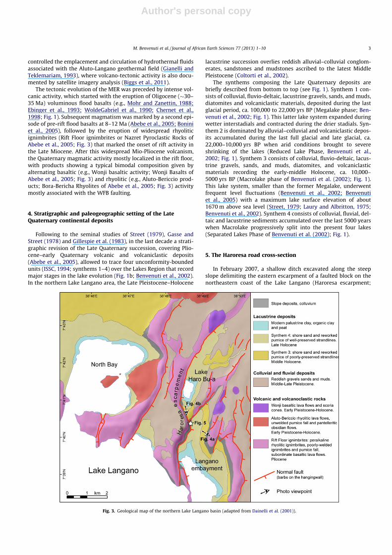
Fig. 3. Geological map of the northern Lake Langano basin (adapted from Dainelli et al. (2001)).
M. Benvenuti et al. / Journal of African Earth Sciences 77 (2013) 1–10 3
Author's personal copy
Figs. 3, 4a and 5) allowed the direct observation and sampling of afew meter thick clastic succession recording a mix of slope andlacustrine depositional settings (Fig. 3). The excavation alsobrought to light a fault zone through-going these deposits, whichwas also surveyed in February 2009 (Fig. 5a and b).
5.1. Structural setting
The northeastern corner of the Lake Langano lies within theHaroresa Rhomboid Fault System (HRFS), which has resulted fromthe intersection between two fault trends: a dominant NNE to NE-trending fault set, and a minor N-to-NNW-trending fault set. Thesefault systems gave rise to horst, graben and half-graben structuresmainly trending around NNE to NE, with the principal river coursesflowing within the elongated depressions. The northeastern LakeLangano corner is influenced by both HRFS fault sets (Fig. 3). Inthe Haroresa-Haro Bu-a area, the dominant NNE- to NE-trendingand southeast-dipping normal faults produce several major north-west-dipping tilted blocks forming a series of 0.5- to 3-km-widehalf-grabens (Figs. 3 and 4b; Le Turdu et al., 1999). These depres-sions are filled by Quaternary sediments or are occupied by smalllakes or swamps onlapping onto the major bounding fault scarps,such as for the Haroresa and Haro Bu-a escarpments (Figs. 3 and4). The fault scarps are 50–150 m-high, generally steep (>60�),and exhibit a fresh morphology (Fig. 4).
The Lake Haro Bu-a is located in the overlapping zone betweentwo NNE-trending faults that join southwestward into a singlefault, which is magnificently exposed by the Haroresa road cross-section. The fault separates the Pliocene rift floor ignimbrite onthe fault footwall from the clastic succession made of coarsegrained slope debris and lacustrine deposits bearing abundant Mel-anoides tubercolata shells (see below). The fault zone is character-ized by closely spaced shear planes affecting the Holocene clasticsuccession (Fig. 5a and b), thereby demonstrating ongoing fault
activity that is also coherent with its prominent morpho-tectonicsignature (Fig. 4).
The fault planes record evident striations that allowed the mea-surements of a number of good quality fault-slip data. The stria-tions show a main pure to slight oblique-slip kinematics that isconsistent with a local ca. E–W-trending Holocene extension direc-tion (Fig. 5a). In agreement with these results, fault-slip data col-lected at sites distributed on this sector of the eastern rift marginindicate an overall N100�E-directed Quaternary extension (Agos-tini et al., 2011). These data accord well with previous paleostressdeterminations carried out on the same rift margin (Bonini et al.,2005; Pizzi et al., 2006) as well as with the results of geodetic anal-yses (Bilham et al., 1999; Stamps et al., 2008).
5.2. Geomorphology and stratigraphy
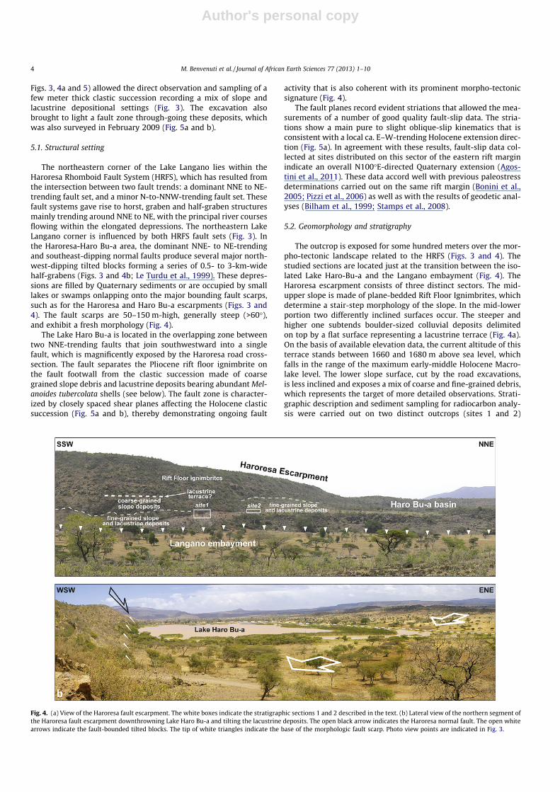
The outcrop is exposed for some hundred meters over the mor-pho-tectonic landscape related to the HRFS (Figs. 3 and 4). Thestudied sections are located just at the transition between the iso-lated Lake Haro-Bu-a and the Langano embayment (Fig. 4). TheHaroresa escarpment consists of three distinct sectors. The mid-upper slope is made of plane-bedded Rift Floor Ignimbrites, whichdetermine a stair-step morphology of the slope. In the mid-lowerportion two differently inclined surfaces occur. The steeper andhigher one subtends boulder-sized colluvial deposits delimitedon top by a flat surface representing a lacustrine terrace (Fig. 4a).On the basis of available elevation data, the current altitude of thisterrace stands between 1660 and 1680 m above sea level, whichfalls in the range of the maximum early-middle Holocene Macro-lake level. The lower slope surface, cut by the road excavations,is less inclined and exposes a mix of coarse and fine-grained debris,which represents the target of more detailed observations. Strati-graphic description and sediment sampling for radiocarbon analy-sis were carried out on two distinct outcrops (sites 1 and 2)
Fig. 4. (a) View of the Haroresa fault escarpment. The white boxes indicate the stratigraphic sections 1 and 2 described in the text. (b) Lateral view of the northern segment ofthe Haroresa fault escarpment downthrowning Lake Haro Bu-a and tilting the lacustrine deposits. The open black arrow indicates the Haroresa normal fault. The open whitearrows indicate the fault-bounded tilted blocks. The tip of white triangles indicate the base of the morphologic fault scarp. Photo view points are indicated in Fig. 3.
4 M. Benvenuti et al. / Journal of African Earth Sciences 77 (2013) 1–10
Author's personal copy
separated by a saddle separating the Langano embayment from theLake Haro-Bu-a (see location in Fig. 4a).
5.2.1. Site 1The clastic succession exposed at site 1 on the hangingwall of
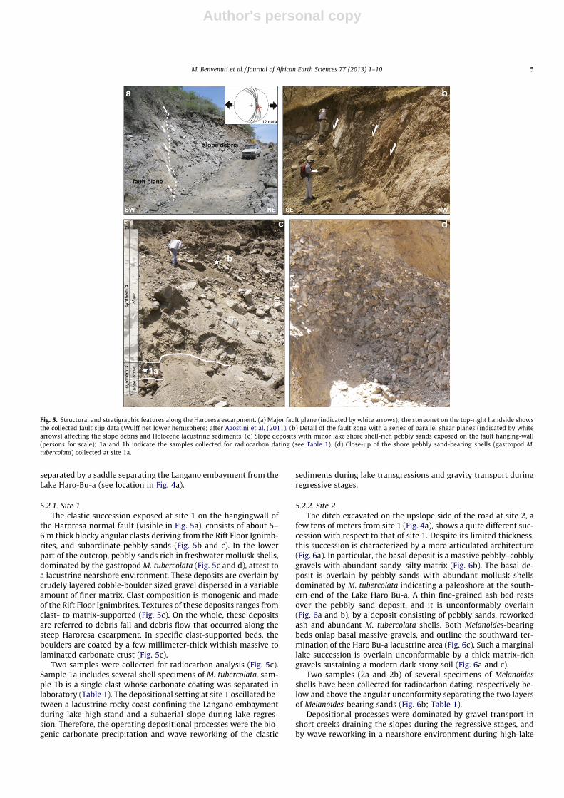
the Haroresa normal fault (visible in Fig. 5a), consists of about 5–6 m thick blocky angular clasts deriving from the Rift Floor Ignimb-rites, and subordinate pebbly sands (Fig. 5b and c). In the lowerpart of the outcrop, pebbly sands rich in freshwater mollusk shells,dominated by the gastropod M. tubercolata (Fig. 5c and d), attest toa lacustrine nearshore environment. These deposits are overlain bycrudely layered cobble-boulder sized gravel dispersed in a variableamount of finer matrix. Clast composition is monogenic and madeof the Rift Floor Ignimbrites. Textures of these deposits ranges fromclast- to matrix-supported (Fig. 5c). On the whole, these depositsare referred to debris fall and debris flow that occurred along thesteep Haroresa escarpment. In specific clast-supported beds, theboulders are coated by a few millimeter-thick withish massive tolaminated carbonate crust (Fig. 5c).
Two samples were collected for radiocarbon analysis (Fig. 5c).Sample 1a includes several shell specimens of M. tubercolata, sam-ple 1b is a single clast whose carbonate coating was separated inlaboratory (Table 1). The depositional setting at site 1 oscillated be-tween a lacustrine rocky coast confining the Langano embaymentduring lake high-stand and a subaerial slope during lake regres-sion. Therefore, the operating depositional processes were the bio-genic carbonate precipitation and wave reworking of the clastic
sediments during lake transgressions and gravity transport duringregressive stages.
5.2.2. Site 2The ditch excavated on the upslope side of the road at site 2, a
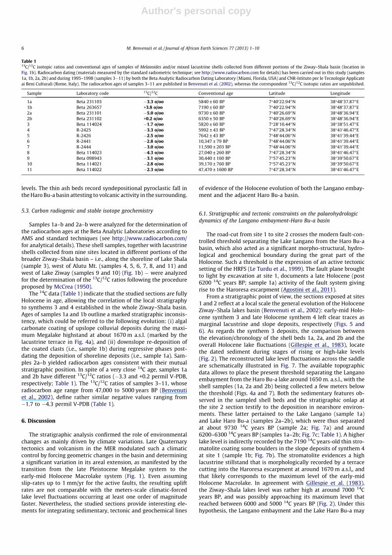
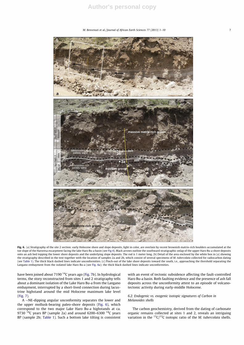
few tens of meters from site 1 (Fig. 4a), shows a quite different suc-cession with respect to that of site 1. Despite its limited thickness,this succession is characterized by a more articulated architecture(Fig. 6a). In particular, the basal deposit is a massive pebbly–cobblygravels with abundant sandy–silty matrix (Fig. 6b). The basal de-posit is overlain by pebbly sands with abundant mollusk shellsdominated by M. tubercolata indicating a paleoshore at the south-ern end of the Lake Haro Bu-a. A thin fine-grained ash bed restsover the pebbly sand deposit, and it is unconformably overlain(Fig. 6a and b), by a deposit consisting of pebbly sands, reworkedash and abundant M. tubercolata shells. Both Melanoides-bearingbeds onlap basal massive gravels, and outline the southward ter-mination of the Haro Bu-a lacustrine area (Fig. 6c). Such a marginallake succession is overlain unconformable by a thick matrix-richgravels sustaining a modern dark stony soil (Fig. 6a and c).
Two samples (2a and 2b) of several specimens of Melanoidesshells have been collected for radiocarbon dating, respectively be-low and above the angular unconformity separating the two layersof Melanoides-bearing sands (Fig. 6b; Table 1).
Depositional processes were dominated by gravel transport inshort creeks draining the slopes during the regressive stages, andby wave reworking in a nearshore environment during high-lake
Fig. 5. Structural and stratigraphic features along the Haroresa escarpment. (a) Major fault plane (indicated by white arrows); the stereonet on the top-right handside showsthe collected fault slip data (Wulff net lower hemisphere; after Agostini et al. (2011). (b) Detail of the fault zone with a series of parallel shear planes (indicated by whitearrows) affecting the slope debris and Holocene lacustrine sediments. (c) Slope deposits with minor lake shore shell-rich pebbly sands exposed on the fault hanging-wall(persons for scale); 1a and 1b indicate the samples collected for radiocarbon dating (see Table 1). (d) Close-up of the shore pebbly sand-bearing shells (gastropod M.tubercolata) collected at site 1a.
M. Benvenuti et al. / Journal of African Earth Sciences 77 (2013) 1–10 5
Author's personal copy
levels. The thin ash beds record syndepositional pyroclastic fall inthe Haro Bu-a basin attesting to volcanic activity in the surrounding.
5.3. Carbon radiogenic and stable isotope geochemistry
Samples 1a–b and 2a–b were analyzed for the determination ofthe radiocarbon ages at the Beta Analytic Laboratories according toAMS and standard techniques (see http://www.radiocarbon.com/for analytical details). These shell samples, together with lacustrineshells collected from nine sites located in different portions of thebroader Ziway–Shala basin – i.e., along the shoreline of Lake Shala(sample 3), west of Alutu Mt. (samples 4, 5, 6, 7, 8, and 11) andwest of Lake Ziway (samples 9 and 10) (Fig. 1b) � were analyzedfor the determination of the 13C/12C ratios following the procedureproposed by McCrea (1950).
The 14C data (Table 1) indicate that the studied sections are fullyHolocene in age, allowing the correlation of the local stratigraphyto synthems 3 and 4 established in the whole Ziway–Shala basin.Ages of samples 1a and 1b outline a marked stratigraphic inconsis-tency, which could be referred to the following evolution: (i) algalcarbonate coating of upslope colluvial deposits during the maxi-mum Megalake highstand at about 1670 m a.s.l. (marked by thelacustrine terrace in Fig. 4a), and (ii) downslope re-deposition ofthe coated clasts (i.e., sample 1b) during regressive phases post-dating the deposition of shoreline deposits (i.e., sample 1a). Sam-ples 2a–b yielded radiocarbon ages consistent with their mutualstratigraphic position. In spite of a very close 14C age, samples 1aand 2b have different 13C/12C ratios (�3.3 and +0.2 permil V-PDB,respectively; Table 1). The 13C/12C ratios of samples 3–11, whoseradiocarbon age range from 47,000 to 5000 years BP (Benvenutiet al., 2002), define rather similar negative values ranging from�1.7 to �4.3 permil V-PDB (Table 1).
6. Discussion
The stratigraphic analysis confirmed the role of environmentalchanges as mainly driven by climate variations. Late Quaternarytectonics and volcanism in the MER modulated such a climaticcontrol by forcing geometric changes in the basin and determininga significant variation in its areal extension, as manifested by thetransition from the late Pleistocene Megalake system to theearly-mid Holocene Macrolake system (Fig. 1). Even assumingslip-rates up to 1 mm/yr for the active faults, the resulting upliftrates are not comparable with the meters-scale climatic-forcedlake level fluctuations occurring at least one order of magnitudefaster. Nevertheless, the studied sections provide interesting ele-ments for integrating sedimentary, tectonic and geochemical lines
of evidence of the Holocene evolution of both the Langano embay-ment and the adjacent Haro Bu-a basin.
6.1. Stratigraphic and tectonic constraints on the palaeohydrologicdynamics of the Langano embayment-Haro Bu-a basin
The road-cut from site 1 to site 2 crosses the modern fault-con-trolled threshold separating the Lake Langano from the Haro Bu-abasin, which also acted as a significant morpho-structural, hydro-logical and geochemical boundary during the great part of theHolocene. Such a threshold is the expression of an active tectonicsetting of the HRFS (Le Turdu et al., 1999). The fault plane broughtto light by excavation at site 1, documents a late Holocene (post6200 14C years BP; sample 1a) activity of the fault system givingrise to the Haroresa escarpment (Agostini et al., 2011).
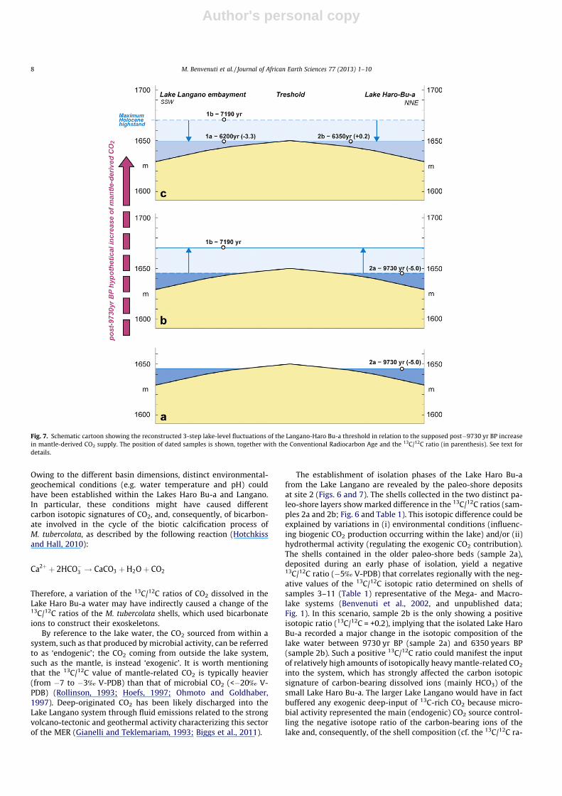
From a stratigraphic point of view, the sections exposed at sites1 and 2 reflect at a local scale the general evolution of the HoloceneZiway–Shala lakes basin (Benvenuti et al., 2002): early-mid Holo-cene synthem 3 and late Holocene synthem 4 left clear traces asmarginal lacustrine and slope deposits, respectively (Figs. 5 and6). As regards the synthem 3 deposits, the comparison betweenthe elevation/chronology of the shell beds 1a, 2a, and 2b and theoverall Holocene lake fluctuations (Gillespie et al., 1983), locatethe dated sediment during stages of rising or high-lake levels(Fig. 2). The reconstructed lake level fluctuations across the saddleare schematically illustrated in Fig. 7. The available topographicdata allows to place the present threshold separating the Langanoembayment from the Haro Bu-a lake around 1650 m. a.s.l., with theshell samples (1a, 2a and 2b) being collected a few meters belowthe threshold (Figs. 4a and 7). Both the sedimentary features ob-served in the sampled shell beds and the stratigraphic onlap atthe site 2 section testify to the deposition in nearshore environ-ments. These latter pertained to the Lake Langano (sample 1a)and Lake Haro Bu-a (samples 2a–2b), which were thus separatedat about 9730 14C years BP (sample 2a; Fig. 7a) and around6200–6300 14C years BP (samples 1a–2b; Fig. 7c; Table 1). A higherlake level is indirectly recorded by the 7190 14C years-old thin stro-matolite coating some boulders in the slope deposits of synthem 4at site 1 (sample 1b; Fig. 7b). The stromatolite evidences a highlacustrine stillstand that is morphologically recorded by a terracecutting into the Haroresa escarpment at around 1670 m a.s.l,, andthat likely corresponds to the maximum level of the early-midHolocene Macrolake. In agreement with Gillespie et al. (1983),the Ziway–Shala lakes level was rather high at around 7000 14Cyears BP, and was possibly approaching its maximum level thatreached between 6000 and 5000 14C years BP (Fig. 2). Under thishypothesis, the Langano embayment and the Lake Haro Bu-a may
Table 113C/12C isotopic ratios and conventional ages of samples of Melanoides and/or mixed lacustrine shells collected from different portions of the Ziway–Shala basin (location inFig. 1b). Radiocarbon dating (materials measured by the standard radiometric technique; see http://www.radiocarbon.com for details) has been carried out in this study (samples1a, 1b, 2a, 2b) and during 1995–1998 (samples 3�11) by both the Beta Analytic Radiocarbon Dating Laboratory (Miami, Florida, USA) and CNR-Istituto per le Tecnologie Applicateai Beni Culturali (Rome, Italy). The radiocarbon ages of samples 3–11 are published in Benvenuti et al. (2002), whereas the correspondent 13C/12C isotopic ratios are unpublished.
Sample Laboratory code 13C/12C Conventional age Latitude Longitude
1a Beta 231103 �3.3 o/oo 5840 ± 60 BP 7�40022.9400N 38�48037.8700E1b Beta 263657 +3.8 o/oo 7190 ± 60 BP 7�40022.9400N 38�48037.8700E2a Beta 231101 �5.0 o/oo 9730 ± 60 BP 7�40026.6900N 38�48036.9400E2b Beta 231102 +0.2 o/oo 6350 ± 50 BP 7�40026.6900N 38�48036.9400E3 Beta 114024 �1.7 o/oo 5820 ± 60 BP 7�28010.4400N 38�38051.4700E4 R-2425 �3.3 o/oo 5992 ± 43 BP 7�47028.3400N 38�41046.4700E5 R-2426 �2.5 o/oo 7642 ± 43 BP 7�48044.0600N 38�41039.4400E6 R-2441 �2.8 o/oo 10,347 ± 79 BP 7�48044.0600N 38�41039.4400E7 R-2444 �3.0 o/oo 11,590 ± 203 BP 7�48044.0600N 38�41039.4400E8 Beta 114023 �4.3 o/oo 27,040 ± 260 BP 7�47028.3400N 38�41046.4700E9 Beta 098943 �3.1 o/oo 30,440 ± 160 BP 7�57045.2300N 38�39050.6700E10 Beta 114021 �2.8 o/oo 39,170 ± 760 BP 7�57045.2300N 38�39050.6700E11 Beta 114022 �2.3 o/oo 47,470 ± 1600 BP 7�47028.3400N 38�41046.4700E
6 M. Benvenuti et al. / Journal of African Earth Sciences 77 (2013) 1–10
Author's personal copy
have been joined about 7190 14C years ago (Fig. 7b). In hydrologicalterms, the story reconstructed from sites 1 and 2 stratigraphy tellsabout a dominant isolation of the Lake Haro Bu-a from the Langanoembayment, interrupted by a short-lived connection during lacus-trine highstand around the mid Holocene maximum lake level(Fig. 7).
A �NE-dipping angular unconformity separates the lower andthe upper mollusk-bearing paleo-shore deposits (Fig. 6), whichcorrespond to the two major Lake Haro Bu-a highstands at ca.9730 14C years BP (sample 2a) and around 6200–6300 14C yearsBP (sample 2b; Table 1). Such a bottom lake tilting is consistent
with an event of tectonic subsidence affecting the fault-controlledHaro Bu-a basin. Both faulting evidence and the presence of ash falldeposits across the unconformity attest to an episode of volcano-tectonic activity during early-middle Holocene.
6.2. Endogenic vs. exogenic isotopic signatures of Carbon inMelanoides shells
The carbon geochemistry, derived from the dating of carbonateorganic remains collected at sites 1 and 2, reveals an intriguingvariation in the 13C/12C isotopic ratio of the M. tubercolata shells.
Fig. 6. (a) Stratigraphy of the site 2 section: early Holocene shore and slope deposits, light in color, are overlain by recent brownish matrix-rich boulders accumulated at thetoe slope of the Haroresa escarpment facing the lake Haro Bu-a basin (see Fig 4). Black arrows outline the southward stratigraphic onlap of the upper Haro Bu-a shore depositsonto an ash bed topping the lower shore deposits and the underlying slope deposits. The rod is 1 meter long. (b) Detail of the area enclosed by the white box in (a) showingthe stratigraphy described in the text together with the location of samples 2a and 2b, which consist of several specimens of M. tubercolata collected for radiocarbon dating(see Table 1). The thick black dashed lines indicate unconformities. (c) Pinch-out of the lake shore deposits toward the south, i.e., approaching the threshold separating theLangano embayment from the isolated lake Haro Bu-a (see Fig. 4a); the thick black dashed lines indicate unconformities.
M. Benvenuti et al. / Journal of African Earth Sciences 77 (2013) 1–10 7
Author's personal copy
Owing to the different basin dimensions, distinct environmental-geochemical conditions (e.g. water temperature and pH) couldhave been established within the Lakes Haro Bu-a and Langano.In particular, these conditions might have caused differentcarbon isotopic signatures of CO2, and, consequently, of bicarbon-ate involved in the cycle of the biotic calcification process ofM. tubercolata, as described by the following reaction (Hotchkissand Hall, 2010):
Ca2þ þ 2HCO�3 ! CaCO3 þH2Oþ CO2
Therefore, a variation of the 13C/12C ratios of CO2 dissolved in theLake Haro Bu-a water may have indirectly caused a change of the13C/12C ratios of the M. tubercolata shells, which used bicarbonateions to construct their exoskeletons.
By reference to the lake water, the CO2 sourced from within asystem, such as that produced by microbial activity, can be referredto as ‘endogenic’; the CO2 coming from outside the lake system,such as the mantle, is instead ‘exogenic’. It is worth mentioningthat the 13C/12C value of mantle-related CO2 is typically heavier(from �7 to �3‰ V-PDB) than that of microbial CO2 (<�20‰ V-PDB) (Rollinson, 1993; Hoefs, 1997; Ohmoto and Goldhaber,1997). Deep-originated CO2 has been likely discharged into theLake Langano system through fluid emissions related to the strongvolcano-tectonic and geothermal activity characterizing this sectorof the MER (Gianelli and Teklemariam, 1993; Biggs et al., 2011).
The establishment of isolation phases of the Lake Haro Bu-afrom the Lake Langano are revealed by the paleo-shore depositsat site 2 (Figs. 6 and 7). The shells collected in the two distinct pa-leo-shore layers show marked difference in the 13C/12C ratios (sam-ples 2a and 2b; Fig. 6 and Table 1). This isotopic difference could beexplained by variations in (i) environmental conditions (influenc-ing biogenic CO2 production occurring within the lake) and/or (ii)hydrothermal activity (regulating the exogenic CO2 contribution).The shells contained in the older paleo-shore beds (sample 2a),deposited during an early phase of isolation, yield a negative13C/12C ratio (�5‰ V-PDB) that correlates regionally with the neg-ative values of the 13C/12C isotopic ratio determined on shells ofsamples 3–11 (Table 1) representative of the Mega- and Macro-lake systems (Benvenuti et al., 2002, and unpublished data;Fig. 1). In this scenario, sample 2b is the only showing a positiveisotopic ratio (13C/12C = +0.2), implying that the isolated Lake HaroBu-a recorded a major change in the isotopic composition of thelake water between 9730 yr BP (sample 2a) and 6350 years BP(sample 2b). Such a positive 13C/12C ratio could manifest the inputof relatively high amounts of isotopically heavy mantle-related CO2
into the system, which has strongly affected the carbon isotopicsignature of carbon-bearing dissolved ions (mainly HCO3) of thesmall Lake Haro Bu-a. The larger Lake Langano would have in factbuffered any exogenic deep-input of 13C-rich CO2 because micro-bial activity represented the main (endogenic) CO2 source control-ling the negative isotope ratio of the carbon-bearing ions of thelake and, consequently, of the shell composition (cf. the 13C/12C ra-
Fig. 7. Schematic cartoon showing the reconstructed 3-step lake-level fluctuations of the Langano-Haro Bu-a threshold in relation to the supposed post�9730 yr BP increasein mantle-derived CO2 supply. The position of dated samples is shown, together with the Conventional Radiocarbon Age and the 13C/12C ratio (in parenthesis). See text fordetails.
8 M. Benvenuti et al. / Journal of African Earth Sciences 77 (2013) 1–10

Author's personal copy
tios of the roughly coeval samples 1a and 2b; Table 1). In otherterms, the isolation of the Lake Haro Bu-a, in combination withthe recorded variation in the 13C/12C ratio in the M. tubercolatashells collected within the Lake Haro Bu-a basin (samples 2a and2b), have allowed the recognition of a significant variation in thetectono-magmatic activity in this rift portion during early-middleHolocene times.
The effects of evaporative processes operating in the differentsized Lakes Langano and Haro Bu-a cannot be invoked to explainthe difference between the isotopic values of the samples 1a and2b, because a very different carbon isotopic signature of shellshas been recorded during the two distinct isolation events of theLake Haro Bu-a (i.e., samples 2a and 2b; cf. Fig. 7a with 7c). Asfor as the 13C/12C ratio of stromatolites (sample 1b) is concerned,this cannot be directly compared with those of the M. tubercolatashells, because the carbon isotope fractionation related to the bio-calcification processes of these two types of living organisms maybe different.
From the above discussion, we interpret the presented data asevidence that the input of deep exogenic CO2 into the geothermalsystem of the Lake Langano increased between 9730 years BP(sample 2a; Fig. 7a) and 6350 years BP (sample 2b; Fig. 7c). Thenetwork of rift faults described in the area has been shown to con-sist of several active structures, which thus represent the mostlikely candidate that accomplished such a supposed post-9730 year BP transfer increase of mantle fluids to shallower levels.
7. Concluding remarks
This integrated work has allowed to put forward the followingmain points:
(1) Geochemical and radiocarbon dating of lacustrine shells,corroborated by detailed stratigraphic field analysis, haveallowed reconstructing local variations in Lake Langano levelduring early-middle Holocene (5–10 ky), which accord with,and may refine, the reconstructed regional hydrologicfluctuations.
(2) Local active faults may bear a two-fold importance by pro-viding both (1) the topographic frame onto which the lakelevel fluctuations have been operating, and (2) potential dee-ply-rooted fault-controlled pathways exploited by ascendingfluids.
(3) Finally, the present work may offer a case history in whichlake-level fluctuations modulated by climatic forcing com-bine with variations in the supply of CO2-rich fluids sourcedfrom the mantle up-through active faults.
Acknowledgments
Research supported by CNR Funds (RSTL No. 105 ‘‘Evoluzionedella parte Nord del rift Afroarabico e distribuzione regionale dellegeorisorse’’; P.I.M. Bonini).
References
Abebe, T., Manetti, P., Bonini, M., Corti, G., Innocenti, F., Mazzarini, F., 2005.Geological map (scale 1:200,000) of the northern Main Ethiopian Rift and itsimplication for the volcano-tectonic evolution of the rift. Geological Society ofAmerica Map and Chart Series, MCH094.
Agostini, A., Bonini, M., Corti, G., Sani, F., Manetti, P., 2011. Distribution ofquaternary deformation in the central Main Ethiopian Rift. East Africa,Tectonics, 30, TC4010. http://dx.doi.org/10.1029/2010TC002833.
Alessio, M., Allegri, L., Belluomini, G., Benvenuti, M., Cerasoli, M., Improta, S., Manfra,L., Sagri, M., Ventra, D., 1996. Le oscillazioni tardo-quaternarie del Lago Shala(Rift Etiopico): Analisi dell’evoluzione ambientale dall’integrazione di evidenzemorfologiche, sedimentarie e cronologiche. Il Quaternario 9, 387–392.
Benvenuti, M., Carnicelli, S., Belluomini, G., Dainelli, N., Di Grazia, S., Ferrari, G.A.,Iasio, C., Sagri, M., Ventra, D., Atnafu, Balemwald, Kebede, Seifu, 2002. TheZiway–Shala lake basin (main Ethiopian rift, Ethiopia): a revision of basinevolution with special reference to the Late Quaternary. Journal of African EarthSciences 35, 247–269.
Benvenuti, M., Carnicelli, S., Ferrari, G., Sagri, M., 2005. Depositional processes inlatest Pleistocene and Holocene ephemeral streams of the Main Ethiopian Rift(Ethiopia). In: Blum, M.D., Marriott, S.B., Leclair, S.F. (Eds.), FluvialSedimentology VII, Special Publication, International Association ofSedimentologists, vol. 35. Blackwell, Oxford, UK, pp. 277–294.
Bergner, A.G.N., Strecker, M.R., Trauth, M.H., Deino, A., Gasse, F., Blisniuk, P.,Dühnforth, M., 2009. Tectonic and climatic control on evolution of rift lakes inthe Central Kenya Rift, East Africa. Quaternary Science Reviews 28, 2804–2816.
Biggs, J., Bastow, I.D., Keir, D., Lewi, E., 2011. Pulses of deformation reveal frequentlyrecurring shallow magmatic activity beneath the Main Ethiopian Rift.Geochemistry, Geophysics, Geosystems 12, Q0AB10. http://dx.doi.org/10.1029/2011GC003662.
Bilham, R., Bendick, R., Larson, K., Mohr, P., Braun, J., Tesfaye, S., Asfaw, L., 1999.Secular and tidal strain across the main Ethiopian rift. Geophysical ResearchLetters 26, 2789–2792.
Boccaletti, M., Bonini, M., Mazzuoli, R., Abebe, B., Piccardi, L., Tortorici, L., 1998.Quaternary oblique extensional tectonics in the Ethiopian Rift (Horn of Africa).Tectonophysics 287, 97–116.
Bonini, M., Corti, G., Innocenti, F., Manetti, P., Mazzarini, F., Abebe, T., Pecskay, Z.,2005. Evolution of the Main Ethiopian Rift in the frame of Afar and Kenya riftspropagation. Tectonics 24, TC1007. http://dx.doi.org/10.1029/2004TC001680.
Chernet, T., 2011. Geology and hydrothermal resources in the northern Lake Abayaarea (Ethiopia). Journal of African Earth Sciences 61, 129–141.
Chernet, T., Hart, W.K., Aronson, J.L., Walter, R.C., 1998. New age constraints on thetiming of volcanism and tectonism in the northern Main Ethiopian Rift-southern Afar transition zone (Ethiopia). Journal of Volcanology andGeothermal Research 80, 267–280.
Coltorti, M., Corbo, L., Sacchi, G., 2002. New evidence for the Late Pleistocene andHolocene climatic changes in the Lake Region. In: Dramis, F. (Ed.), Proceedingsof the Symposium: IAG International Geomorphologist Association. ‘ClimateChanges, Active Tectonics and Related Geomorpologic Effects in High MountainBelts and Plateaux’, Addis Ababa, 9–10.12.2002, pp. 30–35.
Corti, G., 2009. Continental rift evolution: from rift initiation to incipient break-upin the Main Ethiopian Rift, East Africa. Earth Science Reviews 96, 1–53.
Dainelli, N., Benvenuti, M, Sagri, M., 2001. Geological Map of the Ziway–Shala LakesBasin (Ethiopia), Scale 1:250,000. DB-Map Firenze.
Ebinger, C.J., Casey, M., 2001. Continental breakup in magmatic provinces: anEthiopian example. Geology 29, 527–530.
Ebinger, G.J., Yemane, T., Woldegabriel, G., Aronson, J.L., Walter, R.C., 1993. LateEocene–Recent volcanism and faulting in the Southern Main Ethiopian Rift.Journal of Geological Society of London 150, 99–108.
Gasse, F., Street, F.A., 1978. Late Quaternary lake-level fluctuations andenvironments of the Northern Rift Valley and Afar region (Ethiopia andDjibuti). Palaeogeography, Palaeclimatology and Palaeoecology 24, 279–325.
Gasse, F., Van Campo, E., 1994. Abrupt post-glacial climate events in West Asia andNorth Africa monsoon domains. Earth and Planetary Sciences Letters 126, 435–456.
Gianelli, G., Teklemariam, M., 1993. Water-rock interaction processes in the Aluto-Langano Geothermal field (Ethiopia). Journal of Volcanic and GeothermalResearches 56, 429–445.
Gillespie, R., Street-Perrot, A.F., Switsur, R., 1983. Post-glacial arid episodes inEthiopia have implications for climate prediction. Nature 306, 680–683.
Hoefs, J., 1997. Stable Isotope Geochemistry, fourth ed. Springer, Verlag, Berlin,Germany, p. 201.
Hotchkiss, E.R., Hall, R.O., 2010. Linking calcification by exotic snails to streaminorganic carbon cycling. Oecologia 163, 235–245.
ISSC – International Subcommission on Stratigraphic Classification, 1994. A Guideto Stratigraphic Classification, Terminology, and Procedure, second ed. IUGS,Boulder.
Laury, R.L., Albritton, C.C., 1975. Geology of the Middle Stone Age archaeologicalsites in the Main Ethiopian Rift Valley. Geological Society of America Bulletin86, 999–1011.
Le Turdu, C., Tiercelin, J.J., Gibert, E., Travi, Y., Lezzar, K., Richert, J., Massault, M.,Gasse, F., Bonnefille, R., Decobert, M., Gensous, B., Jeudy, V., Tamrat, E.,Mohamed, M.U., Martens, K., Balemwal, A., Chernet, T., Williamson, D., Taieb,M., 1999. The Ziway–Shala lake basin system, Main Ethiopian Rift: influence ofvolcanism, tectonics, and climatic forcing on basin formation andsedimentation. Palaeogeography, Palaeclimatology and Palaeoecology 150,135–177.
McCrea, J.M., 1950. On the isotopic chemistry of carbonates and a paleotemperaturescale. The Journal of Chemical Physics 186, 849–857.
Mohr, P.A., 1962. The Ethiopian Rift System. Bullettin of the GeophysicalObservatory Addis Ababa 5, 33–62.
Mohr, P., Zanettin, B., 1988. The Ethiopian flood basalt province. In: Macdougall, J.D.(Ed.), Continental Flood Basalts. Kluwer Academic, Dordrecht, pp. 63–110.
Ohmoto, H., Goldhaber, M.B., 1997. Sulfur and carbon isotopes. In: Barnes, H.L.(Eds.), Geochemistry of Hydrothermal Ore Deposits. John Wiley & Sons, pp.517–611.
Pizzi, A., Coltorti, M., Bekele, A., Disperati, L., Sacchi, G., Salvini, R., 2006. The Wonjifault belt (Main Ethiopian Rift): structural and geomorphological constraints andGPS monitoring. Geological Society of London, Special Publication 259, 191–208.
M. Benvenuti et al. / Journal of African Earth Sciences 77 (2013) 1–10 9

Author's personal copy
Rollinson, H.R., 1993. Using Geochemical Data: Evaluation, Presentation,Interpretation. Longman, UK, 352pp.
Sagri, M., Bartolini, C., Billi, P., Ferrari, G., Benvenuti, M., Carnicelli, S., Barbano, F.,2008. Latest Pleistocene and Holocene river network evolution in the EthiopianLakes Region. Geomorphology 94, 79–97.
Stamps, D.S., Calais, E., Saria, E., Hartnady, C., Nocquet, J.M., Ebinger, C.J., Fernandes,R.M., 2008. A kinematic model for the East African rift. Geophysical ResearchLetters 35, L05304.
Street, F.A., 1979. Late Quaternary Lakes in the Ziway–Shala Basin, SouthernEthiopia. Ph.D. Thesis, Univ. Cambridge, 457pp.
Street-Perrott, F.A., Perrott, R.A., 1990. Abrupt climate fluctuations in the tropics:the influence of Atlantic Ocean circulation. Nature 343, 607–612.
WoldeGabriel, G., Aronson, J.L., Walter, R.C., 1990. Geology, geochronology, and riftbasin development in the central sector of the Main Ethiopia Rift. GeologicalSociety of America Bulletin 102, 439–458.
10 M. Benvenuti et al. / Journal of African Earth Sciences 77 (2013) 1–10
Copyright © 2022 FDOKUMEN