Evaluation of Lake Shkoder, Lake Ohrid and Prespa Lake Shores on the Rural Development in Albania
8
Global Advanced Research Journal of Geography and Regional Planning (ISSN: 2315-5018) Vol. 2(9) pp. 193-200, December, 2013 Available online http://garj.org/garjgrp/index.htm Copyright © 2013 Global Advanced Research Journals Full Length Research Paper Evaluation of Lake Shkoder, Lake Ohrid and Prespa Lake Shores on the Rural Development in Albania Sevda Çetinkaya 1 and Çağlar Kıvanç Kaymaz 2 1 Universityof Mustafa Kemal, Faculty of Education, Hatay-TURKEY. 2 University of Atatürk, Faculty of Art, Department of Geography, Erzurum-TURKEY. Accepted 15 December, 2013 Albania, which is a Balcan country, is famous for its natural beauties especially its lakes. Although it is located in an area with a great potential in tourism, for many years it hasn’t been able to make use of this potential in a fertile way. Rural and urban settlement on the lakeshores have not only surrounded the lakeshores but also created great problems in terms of land use. In order to solve these problems initially fit for purpose shore use policies should be enhanced. By this means it will play a role in preserving the natural heritage, forwarding it to the next generations and enhancing development of the country. Firstly, the developmental differentialities between the lakeshores and the inner parts of Albania should be got rid of and then in order to provide the rural development, Shkoder, Ohrid, and Prespa lakes should be made the best of. Therefore, in this study both the evaluation of these lakes in terms of tourism activities and some suggestions and evaluations about the future sustainable tourism actions have been dealt with. Keywords: Rural development. Sustainable development. Agriculture. Ecotourism. INTRODUCTION Countries cause to have gulfs between regions, departments, and localities due to the uneven distribution of the present resources necessary for the economical development, and not using them fruitfully. More than half of the world population maintain a life in the rural areas of underdeveloped countries where sources cannot be made much of, the health requirements are inefficient and where primitive agricultural work is done. With its simplest definition rural developmen t is a study aimed at improving the *Corresponding Author’s Email: [email protected] rural environmental requirements which bring negatives to human life. (Tolunayve Akyol, 2006). Within the economical activities of rural areas agricultural activities come first. Additionally, natural sources (mountains, lakes, rivers, fauna-flora characteristics, etc.) and socio-cultural values constitute an important potential. Sustainable development will be possible by developing these sources and values in different ways and by making them attractive so that they can be subject to eco tourism. Although sea, sand, and sun are still important tourism activities for vacationers, especially people living in big cities have started to look for areas where they can have alternative recreation activities. This situation caused to
Transcript of Evaluation of Lake Shkoder, Lake Ohrid and Prespa Lake Shores on the Rural Development in Albania

Global Advanced Research Journal of Geography and Regional Planning (ISSN: 2315-5018) Vol. 2(9) pp. 193-200, December, 2013 Available online http://garj.org/garjgrp/index.htm Copyright © 2013 Global Advanced Research Journals
Full Length Research Paper
Evaluation of Lake Shkoder, Lake Ohrid and Prespa Lake Shores on the Rural Development in Albania
Sevda Çetinkaya1 and Çağlar Kıvanç Kaymaz2
1Universityof Mustafa Kemal, Faculty of Education, Hatay-TURKEY.
2University of Atatürk, Faculty of Art, Department of Geography, Erzurum-TURKEY.
Accepted 15 December, 2013
Albania, which is a Balcan country, is famous for its natural beauties especially its lakes. Although it is located in an area with a great potential in tourism, for many years it hasn’t been able to make use of this potential in a fertile way. Rural and urban settlement on the lakeshores have not only surrounded the lakeshores but also created great problems in terms of land use. In order to solve these problems initially fit for purpose shore use policies should be enhanced. By this means it will play a role in preserving the natural heritage, forwarding it to the next generations and enhancing development of the country. Firstly, the developmental differentialities between the lakeshores and the inner parts of Albania should be got rid of and then in order to provide the rural development, Shkoder, Ohrid, and Prespa lakes should be made the best of. Therefore, in this study both the evaluation of these lakes in terms of tourism activities and some suggestions and evaluations about the future sustainable tourism actions have been dealt with. Keywords: Rural development. Sustainable development. Agriculture. Ecotourism.
INTRODUCTION Countries cause to have gulfs between regions, departments, and localities due to the uneven distribution of the present resources necessary for the economical development, and not using them fruitfully.
More than half of the world population maintain a life in the rural areas of underdeveloped countries where sources cannot be made much of, the health requirements are inefficient and where primitive agricultural work is done. With its simplest definition rural developmen t is a study aimed at improving the *Corresponding Author’s Email: [email protected]
rural environmental requirements which bring negatives to human life. (Tolunayve Akyol, 2006).
Within the economical activities of rural areas agricultural activities come first. Additionally, natural sources (mountains, lakes, rivers, fauna-flora characteristics, etc.) and socio-cultural values constitute an important potential. Sustainable development will be possible by developing these sources and values in different ways and by making them attractive so that they can be subject to eco tourism. Although sea, sand, and sun are still important tourism activities for vacationers, especially people living in big cities have started to look for areas where they can have alternative recreation activities. This situation caused to
194. Glo. Adv. Res. J. Geogr. Reg. Plann. make the rural areas behind the shores more attractive and an important market for ecotourism activities. Countries and regions who use their sources well will show a development in getting the biggest lot from this market.
Development in underdeveloped countries requires concentrating on basic economical issues like using the sources effectively, developing productive life, providing industrialization, speeding up technological developments on one hand and on the other increasing agricultural fertility, improving substructure opportunities, and solving people’s education, health and nutrition problems. Countryside are like closed economies which have their own operating structures. Since the interchange mechanism that combines the production and consumption market has not developed enough the majority of the production in rural areas is used for their own consumption needs(Tolunayve Akyol, 2006). Thus, one of the pioneer targets of rural development is to pass from closed economy to open economy in other words to open the closed doors. Within this process sustainable development becomes prominent. Sustainable development can be defined as keeping the balance between human and nature without using up the natural sources and leaving the new generations enough sources to feed their needs and develop. Though sustainable development has many dimensions, social, economical, ecologic, cultural and spatial dimensions are more prominent.
The different development level of rural and urban areas can be balanced and social welfare can be provided by having many dimensions of rural development and by having humans in the center of this development and by taking into consideration and mobilizing the communal-social dynamics.
Three main elements become prominent in the European Union rural development policies as well. Increasing the level of welfare, varying the production apart from agriculture, preserving the nature and its sources and providing its sustainability.
Rural tourism is one of the most important and prominent sectors in rural development. The variety and richness of natural and cultural values in rural areas offers an important potential for the development of tourism and recreation activities. Rural tourism is the basic means of rural development. Rural tourism has an economical and socio-cultural effect on rural development. The effect of rural tourism on rural development is proportioned with the effective use of the historical, natural, cultural, and agricultural sources. Rural tourism constitutes employment and income opportunities for rural areas. Rural tourism also positively effects preserving the traditional architectural style (Özdemir, 2012).
MATERIAL AND METHOD Though this study aims at evaluating the rural development of Shkoder, Ohrid and Prespa lakeshores in Albania, it mainly focuses on ecotourism opportunities.Therefore, literature review has been done and both the topography and the land use maps have been formed with the help of geographical information systems. In addition to this, field study has been done to investigate the present potential and by working on the acquired maps the ecotourism features that can be used in developing the lakeshores have been found out and suggestions have been made. Location and General Characteristics Albania which has an important place within the Balcans, a mountainous area (Atalay, 2002), is located between the southeast approximately 39° 38' (Konispol Village- Sarande), South and 42° 39' (Vermosh Village-M.Madhe District) north lattitude and 19° 16'(SazanVillage- Vlore) West and 21° 40' (Vernik Village, Vlore District) east longitude. It covers an area of 28.748 km². 1.350 km² of these are wetland area (http://www.instat.gov.al/).
The total border length of Albania is 1.094 km. 657 km of this pass through land 316 km of it pass through the sea 48 km of it pass through the rivers and 73 km of it pass through lake surfaces (http://www.instat.gov.al/). It is neighbor to Montenegro (172 km) from the North, Kosovo (112 km) from the northeast, Republic of Macedonia (151 km) from the east, Adriatic Sea from the West and İyonSea from the southwest. In addition to the shores in Albania, lakes are also important source values in terms of tourism. Lake Shkoder is neighbor to Montenegro from the northwest, Lake Ohrid is neighbor to the Republic of Macedonia, and Lake Prespa is on the borders of Macedonia and Greece and the borders of the country go over these lakes.
Albania is a mountainous and rugged country. On the east of the country you can see an important branch of the Alps which are the Dinar Alps ranging from the North to the South. In the region shaped by the Alpine folding during the middle of the tertiary, hilly blocks were roughly split towards the northwest-southeast direction. In general the elevation decreases from east to west and low plains take place along the Adriatic coast. Lakes have also been formed in the inner parts in lower areas. Korabi (2.751 m), Jezerca (2.694 m), Radohima (2.570 m), Gramozi (2. 523 m), Gjallica e Lumes (2.487 m), Nemerçka (2.485 m), Tomorri (2.417 m), Koritniku (2.396 m), Mali iThate (2.287m) are only some of the important mountains. (http://www.instat.gov.al/).

Cetinkaya and Kaymaz 195
Figure 1. Topographic map of Albania. Albania is counted as one of the important fresh water
reserves in Europe. Drini, Semani, Vjosa, Shukumbini, Mati and Erzeni are the rivers that have an irregular and mixed regime (snow-rain) due to its having the features of the Mediterranean climate. Apart from these there are a lot of small brooks that take their sources from the high hilly blocks in the east. Besides there are a lot of natural lakes. Some of them are Lake Shkoder (368 km²), Lake Ohrid (362 km²), Lake Prespa (285 km²) and Lake Butrinti (16 km²).
Generally characteristics of Mediterranean climate are seen in the West shores and South parts of Albania. It is dry and hot in summers warm and rainy in winters. Depending on the elevation, the temperature and rainfall conditions may vary in the north and inner parts. Alpine climate is felt in these areas. It is relatively rainy in summers and compared with the shore and southern areas relatively severe in winters. (Özey, 2010).
Temperature values around the lakes decrease to below zero in winters and go up to 20°C in summers (Table1.).
There are many forests in the country which is rich in terms of vegetation cover, an important source value in rural development. %50 of the forests are large-leafed trees dominated by oaks and beech trees and %17 of the forests are needle-leaved trees dominated by pine trees.Bush formation constituted of marquis has a %33 lot. When evaluated from the point of view of diversity, Albania has a rich vegetation cover of approximately 3.220 species. %29 of these are plants that grow in Europe, %47 that grow in the Balkans and the rest are Mediterranean types of plants. European type plants grow more in the central areas and Mediterranean type plants grow more in the southern areas.
In Albania climate, surface features, and elevation play an important role in the soil types and their
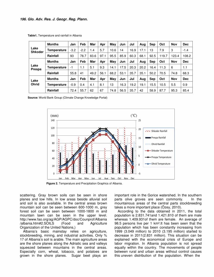
196. Glo. Adv. Res. J. Geogr. Reg. Plann. Table1. Temperature and rainfall in Albania
Lake Shkoder
Months Jan Feb Mar Apr May Jun Jul Aug Sep Oct Nov Dec
Temperature -3.2 -2.2 1.4 5.7 10.6 14 16.9 17.1 13 7.9 3 -1.4
Rainfall 93 78.7 83.6 97.1 95.5 85.9 60.3 68.1 92.5 119.7 123.4 108.2
Lake Prespa
Months Jan Feb Mar Apr May Jun Jul Aug Sep Oct Nov Dec
Temperature -1 1.1 5.1 9.3 14.1 17.5 20.3 20.2 16.4 11.3 6 1.1
Rainfall 55.8 41 49.2 56.1 68.2 53.1 35.7 35.1 50.2 70.5 74.8 68.3
Lake Ohrid
Months Jan Feb Mar Apr May Jun Jul Aug Sep Oct Nov Dec
Temperature -0.9 0.4 4.1 8.1 13 16.3 19.2 19.1 15.5 10.5 5.5 0.9
Rainfall 72.4 55.7 62 67 74.8 56.5 35.7 42 58.9 87.7 95.3 85.4
Source: World Bank Group (Climate Change Knowledge Portal)
Figure 2. Temperature and Precipitation Graphics of Albania. scattering. Gray brown soils can be seen in shore planes and low hills. In low areas beside alluvial soil arid soil is also available. In the central areas brown mountain soil can be seen between 600-1000 m, grey forest soil can be seen between 1000-1800 m and mountain lawn can be seen in the upper level. http://www.fao.org/ag/AGP/AGPC/doc/Counprof/Albania/albania.htm#2.SOILS (Food and Agriculture Organization of the United Nations,)
Albania’s basic mainstay relies on agriculture, stockbreeding, mining, and industrial activities. Only % 17 of Albania’s soil is arable. The main agriculture areas are the shore planes along the Adriatic sea and valleys squeezed between mountains in the central areas. Especially corn, wheat, tobacco, and potatoes are grown in the shore planes. Sugar beet plays an
important role in the Gorice watershed. In the southern parts olive groves are seen commonly. In the mountainous areas of the central parts stockbreeding takes a more important place (Özey, 2010).
According to the data obtained in 2011, the total population is 2.831.741and 1.421.810 of them are male whereas 1.409.931of them are female. An average of 98.5 persons live per 1 km².It has been seen that the population which has been constantly increasing from 1999 (3.049 million) to 2010 (3.195 million) started to decrease in 2011(2.831 million). This situation can be explained with the economical crisis of Europe and labor migration. In Albania population is not spread equally within the country. The movements of people between rural and urban areas without control causes this uneven distribution of the population. When the
lllllllll
-5
0
5
10
15
20
25
0
20
40
60
80
100
120
140
Jan Feb Mar Apr May Jun Jul Aug Sep Oct Nov Dec
Shkoder Rainfall
Prespa Rainfall
Ohrid Rainfall
Shkoder Temperature
Prespa Temperature
Ohrid Temperature
(mm) (°C)

Cetinkaya and Kaymaz 197
Photo 1. A view of Lake Shkoder (by Edguri and Spartak SOKOLI). distribution of population in rural and urban areas is investigated it can be seen that more people live in urban areas. Urban population is 1.521.907 and rural population is 1.309.834. It takes the attention that rural population is seen more intensely in working areas. Located on the shore of Lake Shkoder, one of the important cities, Shkoder, has a population of 217.375. Out of these 96.328 are living in the city center and121.047 are living in rural areas. The total population of Malesie Madhe, a district of Shkoder, has a population of 36.085. 3.606 (female 2.158, male 1.448) out of these are living in urban areas and 32.479 of them are living in rural areas. It is seen that the balance between males and females in rural areas is almost the same whereas in the cities females are twice more than males. The city Korçe in Prespa watershed has a population of 220.438. 88.358 out of them are living in the city whereas 132.080 are living in rural areas. The total population of Devoll is 33.779 and 8.049 out of them are living in the city center whereas 25.730 of them are living in rural areas. In Progradec , the Ohrid watershed rural habitation is 70.562 (2009). 27.385 out of these live in cities whereas 43.177 live in rural areas. In both rural and urban areas the male-female population is close in number. (http://www.instat.gov.al/). General Characteristics of the Lakes Lake Skhoder Lake Shkoder is the biggest and deepest tectonic lake of the Balkans located in the Northwestern part of the country, one-third of which is within the borders of Albania and two-third of which is within the borders of Montenegrin (Photo 1.).The watershed area of Skadar/Shkodra Lake has a surface of 5.179 km², 1.027 km² of which are within the Albanian territory
(http://findpdf.net/pdf-viewer/THE-STRATEGIC-ACTION-PLAN-SAP-FOR SKADARSHKODRA.html)(Lake Skadar/Shkodra Integrated Ecosystem Management Project, The Strategic Action Plan (SAP) For Skadar/Shkodra Lake Albania & Montenegro, 2007).
The city Shkoder is one of the important cities in the territory and it is located on the southeastern part of the lake. Being a historical city and having the castle it plays an important role in improving tourism activities. As can be seen from the map (Figure 3.) showing landuse around Shkodra, the southern shores are surrounded with narrowshorelines and behind them Taraboshi (651m) mountain. Parts of blocks facing the lake are naked and remnants of forests can be seen on the southern part. On the east and northeast parts of the lake shorelines are widening and used as agricultural areas. Bahçellek could be a center of attraction. It is the place where the rivers Bojana and Drin come across. Bojana is the river which drains the water of the lake. View terraces that can be put on the mountain slopes of Taraboshi and walking and cycling tracks along the shore will create a quiet holiday opportunity for people who are looking for natural areas. Also paragliding, hunting and fishing are among the activities that can be done. With the bird species it shelters the lake can become a bird sanctuary. In terms of wildlife it is an important source value. Beside these the lakeshores are suitable places for one-day recreation activities. Lake Ohrid Lake Ohrid which is a tectonic lake has been formed 2-3 million years ago (Stankovic 1960). The lake is 31km long, 14.5 km wide and its square is 358 km². The average depth is 164 m and the deepest place is 289 m. Located in the southeastern part of the country,

198. Glo. Adv. Res. J. Geogr. Reg. Plann.
Figure 3. Lake Shkoder’s general landuse map
Photo 2. A view from Lake Ohrid (by Klodjan Lazi). 229.9 km² of Lake Ohrid stay within the boundaries of Macedonia (Naumoski 2000). Although the touristic activities on the Macedonian side are very developed, touristic activities on the Albanian side are insufficient.
The eastern shore of the lake is within the Galichica National Park. This makes the historical city Ohrid an important source value for tourism (Photo 2.). Taking precautions about protecting the nature on the Albanian
side will contribute to the development of the rural tourism. As can be seen from the map (Figure 4.) about landuse along Lake Ohrid and Prespa, forest areas have an extensive coverage. Slopes behind the shores of Lake Ohrid have a rich vegetation cover. This is a very important source in improving rural tourism in the area. Except for Progradec, housing around the lake is experienced as small villages, the most outstanding of

Cetinkaya and Kaymaz 199
Figure 4. General landuse map of Lake Ohrid and Prespa
Photo 3. A view from Lake Prespa (by Janny). which are Lin peninsula and village. Activities like swimming and the other water sports, fishing, boat trips, scenery views, wild life, amateur hunting, bird watching will contribute to the development of tourism in the area. Local handicrafts and local food can be brought into prominence through festivals, fairs and contests. Prespa Lake Prespa Lake which is separated from Ohrid Lake by a
mountain is 853 m above the sea level. Prespa Lake is formed of two lakes called little and big Prespa lakes. Big Prespa Lake has a surface area of 190 km² and 38.8 km² out of it are within the boundaries of Albania (Photo 3.). The surface area of Little Prespa that is within the boundaries of Albania is 4.3 km². The formation of Lake Prespa is similar to the formation of Lake Ohrid. The rural settlement around Lake Prespa earn their living with fishing and agricultural activities. Prespa is under protection as a national park.
200. Glo. Adv. Res. J. Geogr. Reg. Plann. http://portal.unesco.org/.../11032790451ohrid...report.../ohrid+prespa+report+august+2004.pdf. (UNESCO, 2004).
Eco tourism activities in terms of rural development could be suggested for the region around Lake Prespa which is cleaner and more virgin when compared to the other lakes. The unspoiled nature with its rich flora and fauna have produced a suitable setting for activities like trekking and line fishing. Walking and cycling tracks and forestland could be opened to nature lovers. Mali iThate is an important elevation of the area and rises between Lake Prespa and Ohrid. Paragliding could be done from the slopes of this mountain. Thus they can be part of alternative tourism activities. RESULTS AND SUGGESTIONS This study focuses more on using tourism in rural development.
Although it has not been used sufficiently, the tourism sector provides important opportunities in regard to the development of the country. In spite of the virgin lakeshores, the mountainous areas, and historical buildings, the in competencies of substructure and lack of safe transportation limits tourism opportunities. Macedonia, Greece, and Montenegrin, who are on the other side of the lake, can use the lakeshores to develop their tourism more than Albania.
The suggestions for rural development are to improve rural tourism and alternative tourism activities, utilize the present historical and cultural potential, provide the practicability of the natural geographical elements (especially mountains, lakes, rivers, and forests) to the present needs, provide the opportunities (paragliding, hobby gardens, local handycraft and food) to do activities related to different age groups and interests, improve organic agriculture and alternative agriculture activities and disseminate them in the area, prepare tourism destinations which include all these characteristics and advertise and to take precautions to protect the natural environment while doing all these. Thus, unemployment which is the main problem in rural areas and migration along with its problems will be partly solved.
As a result of the development in both modern agriculture and tourism new employment areas will emerge.
The most important result is that the differences
between rural-urban, division-area and localities in terms of the rate of development and the socio-cultural differences will decrease conspicuously. REFERENCES Naumoski, TB (2000). Phosphorus loading of Lake Ohrid (In
Macedonian). Ph.D. Dissertation, University of Ciryl and Metodij, NSF, Biology Department. [online] <http://www.google.com.tr/url?sa=t&rct=j&q=naumoski%2C%20t.%20b.%202000.%20phosphorus%20loading%20of%20lake%20ohrid%20(in%20macedonian).%20ph.d.%20dissertation%2C%20university%20of%20ciryl%20and%20metodij%2C%20nsf%2C%20biology%20department.&source=web&cd=1&cad=rja&ved=0CCwQFjAA&url=http%3A%2F%2Fwww.ilec.or.jp%2Feg%2Flbmi%2Fpdf%2F19_Lake_Ohrid_27February2006.pdf&ei=w1XAUMuNKorLtAaamIGYCA&usg=AFQjCNF1jLWIyzqSnig9Ki8vxpYS5TWW6g> [Accessed 16 September 2012].
Özdemir S (2012). Kırsal Kalkınmada TurizmdenYararlanma Olanakları: Gökçeada Örneği. KMÜ Sosyalve Ekonomik Araştırmalar Dergisi. 14 (23): 19-21.
Özey R (2010). Ülkeler Coğrafyası. Aktif Yayınevi, İstanbul. Stankovic S (1960). The Balkan Lake Ohrid and its Living World.
MonographiaeBiologiae Vol. IX. Uitgeverij Dr. W. Junk: Den Haag, the Netherlands. [online] <http://onlinelibrary.wiley.com/doi/10.1002/iroh.19610460315/abstract> [Accessed 17 September 2012].
Tolunay A, veAkyol A (2006). KalkınmaveKırsalKalkınma: TemelKavramlarveTanımlar. Isparta: SDÜ Orman Fakültesi Dergisi. Seri: A, Sayı: 2, s.116-127.
Internet Resources <http://www.instat.gov.al/> [Accessed 14 September 2012]. <http://www.fao.org/ag/AGP/AGPC/doc/Counprof/Albania/albania.htm
#2.SOILS>[Accessed 15 September 2012]. <http://sdwebx.worldbank.org/climateportal/index.cfm?page=country_
historical_climate&ThisRegion=Europe&ThisCCode=ALB#>[Accessed 17 September 2012].
<http://portal.unesco.org/.../11032790451ohrid...report.../ohrid+prespa+report+august+2004.pdf.> [Accessed 17 September 2012 ].
<http://findpdf.net/pdf-viewer/THE-STRATEGIC-ACTION-PLAN-SAP-FOR-SKADARSHKODRA.html.>[Accessed 19 September 2012 ].