A Fast Semi-Inverse Approach to Detect and Remove the ...
14
A Fast Semi-Inverse Approach to Detect and Remove the Haze from a Single Image Codruta O. Ancuti, Cosmin Ancuti, Chris Hermans, Philippe Bekaert Hasselt University - tUL -IBBT, Expertise Center for Digital Media, Wetenschapspark 2, Diepenbeek, 3590, Belgium Abstract. In this paper we introduce a novel approach to restore a single image degraded by atmospheric phenomena such as fog or haze. The presented algorithm allows for fast identification of hazy regions of an image, without making use of expensive optimization and refine- ment procedures. By applying a single per pixel operation on the original image, we produce a ’semi-inverse’ of the image. Based on the hue dis- parity between the original image and its semi-inverse, we are then able to identify hazy regions on a per pixel basis. This enables for a simple estimation of the airlight constant and the transmission map. Our ap- proach is based on an extensive study on a large data set of images, and validated based on a metric that measures the contrast but also the structural changes. The algorithm is straightforward and performs faster than existing strategies while yielding comparative and even better results. We also provide a comparative evaluation against other recent single image dehazing methods, demonstrating the efficiency and utility of our approach. 1 Introduction In outdoor environments, light reflected from object surfaces is commonly scat- tered due to the impurities of the aerosol, or the presence of atmospheric phe- nomena such as fog and haze. Aside from scattering, the absorption coefficient presents another important factor that attenuates the reflected light of distant objects reaching the camera lens. As a result, images taken in bad weather con- ditions (or similarly, underwater and aerial photographs) are characterized by poor contrast, lower saturation and additional noise. Image processing applications commonly assume a relatively transparent transmission medium, unaltered by the atmospheric conditions. Outdoor vision applications such as surveillance systems, intelligent vehicles, satellite imaging, or outdoor object recognition systems need optimal visibility conditions in or- der to detect and process extracted features in a reliable fashion. Since haze degradation effects depend on the distance, as disclosed by previous studies [1, 2] and observed as well in our experiments (see Fig. 1), standard contrast en- hancement filters such as histogram stretching and equalization, linear mapping, or gamma correction are limited to perform the required task introducing ha- los artifacts and distorting the color. The contrast degradation of a hazy image
-
Upload
khangminh22 -
Category
Documents
-
view
1 -
download
0
Transcript of A Fast Semi-Inverse Approach to Detect and Remove the ...
A Fast Semi-Inverse Approach to Detect and
Remove the Haze from a Single Image
Codruta O. Ancuti, Cosmin Ancuti, Chris Hermans, Philippe Bekaert
Hasselt University - tUL -IBBT,Expertise Center for Digital Media, Wetenschapspark 2, Diepenbeek, 3590, Belgium
Abstract. In this paper we introduce a novel approach to restore asingle image degraded by atmospheric phenomena such as fog or haze.The presented algorithm allows for fast identification of hazy regionsof an image, without making use of expensive optimization and refine-ment procedures. By applying a single per pixel operation on the originalimage, we produce a ’semi-inverse’ of the image. Based on the hue dis-parity between the original image and its semi-inverse, we are then ableto identify hazy regions on a per pixel basis. This enables for a simpleestimation of the airlight constant and the transmission map. Our ap-proach is based on an extensive study on a large data set of images,and validated based on a metric that measures the contrast but alsothe structural changes. The algorithm is straightforward and performsfaster than existing strategies while yielding comparative and even betterresults. We also provide a comparative evaluation against other recentsingle image dehazing methods, demonstrating the efficiency and utilityof our approach.
1 Introduction
In outdoor environments, light reflected from object surfaces is commonly scat-tered due to the impurities of the aerosol, or the presence of atmospheric phe-nomena such as fog and haze. Aside from scattering, the absorption coefficientpresents another important factor that attenuates the reflected light of distantobjects reaching the camera lens. As a result, images taken in bad weather con-ditions (or similarly, underwater and aerial photographs) are characterized bypoor contrast, lower saturation and additional noise.
Image processing applications commonly assume a relatively transparenttransmission medium, unaltered by the atmospheric conditions. Outdoor visionapplications such as surveillance systems, intelligent vehicles, satellite imaging,or outdoor object recognition systems need optimal visibility conditions in or-der to detect and process extracted features in a reliable fashion. Since hazedegradation effects depend on the distance, as disclosed by previous studies [1,2] and observed as well in our experiments (see Fig. 1), standard contrast en-hancement filters such as histogram stretching and equalization, linear mapping,or gamma correction are limited to perform the required task introducing ha-los artifacts and distorting the color. The contrast degradation of a hazy image

2 Codruta Ancuti et al.
Foggy image Histogram equalization Local contrast stretching Our result
Fig. 1. Standard techniques limitations. From left to right: initial foggy images, his-togram equalization, local contrast stretching and our restored result.
is both multiplicative and additive. Practically, the haze effect is described bytwo unknown components: the airlight contribution and the direct attenuationrelated to the surface radiance. The color ambiguity of the radiance is due tothe additive airlight, which increases exponentially with the distance. Enhancingthe visibility of such images is not a trivial task, as it poses an inherently under-constrained problem. A reliable restoration requires an accurate estimation ofboth the true colors of the scene and the transmission map, closely related tothe depth-map.
Recently, there has been an increased interest in the vision and graphicscommunities in dehazing single images [1–5]. In this paper we introduce an al-ternative approach to solve this challenging problem. Our technique is based onthe remark that the distance from the observer to the scene objects is highly cor-related with the contrast degradation and the fading of the object colors. Morespecifically, by an extensive study it has been disclosed an important differencebetween hazy and non-hazy image regions, by performing a per pixel comparisonof the hue values in the original image to their values in a ’semi-inversed’ image.This ’semi-inversed’ image version is obtained by replacing the RGB values ofeach pixel on a per channel basis by the maximum of the initial channel value(r, g or b) and its inverse (1 − r,1 − g or 1 − b), followed by an image-widerenormalization. This observation has been validated on a large set of images,and allows for the detection of the hazy image regions by applying only a singlesimple operator. This facilitates the estimation of the airlight constant color,and enables us to compute a good approximation of the haze-free image using alayer-based approach.Contributions. This paper introduces the following three main contributions:- first of all, we introduce a novel single image algorithm for the automatic de-tection of hazy regions.- secondly, our approach works on a per pixel basis. This makes it suitable forparallelization, and allows us to retain sharp detail near edges.- finally, our layer-based fusion dehazing strategy yields comparative and evenbetter restored results than the existing approaches but performs faster beingsuitable for real-time applications.

A Fast Semi-Inverse Approach to Detect and Remove the Haze 3
2 Related Work
An important area of applications for dehazing algorithms can be found in multi-spectral remote sensing applications, where specialized sensors installed on satel-lites capture a specific band of the reflected light spectrum. Due to aerosol im-purities and cloud obstruction, the recorded images require specific processingtechniques [6, 7] to recover the original information.
Many haze-removal techniques have used additional information in orderto facilitate the search for a solution to this underconstrained problem. Somemethods [8, 9] employ multiple images of the same scene, taken under variousatmospheric conditions or combined with near-infrared version [10]. Polarizationmethods [11–13] exploit the fact that airlight is partially polarized. By takingthe difference of two images of the same scene under different polarization an-gles, it becomes possible to estimate the magnitude of the polarized haze lightcomponent. Another category of techniques assume a known model of the scene.Narasimhan and Nayar [14] employ a rough approximated depth-map obtainedby user assistance. Deep Photo [15] uses the existing georeferenced digital ter-rain and urban models to restore foggy images. By using an iterative registrationmethod, they align the 3D model with the outdoor images, producing the depthmap required by the restoration process.
Recently, several single image based methods [1–5] have been introduced.The method of Fattal [1] uses a graphical model that solves the ambiguity ofairlight color based upon the assumption that image shading and scene trans-mission are locally uncorrelated. The approach of [5] proposed a related methodwith [1] solution. This method models the image with a factorial MRF andcomputes the albedo and depth independently like two statistically independentlatent layers. In Tan’s approach [2], the restoration aims to maximize the localcontrast. He et al. [3] employ the dark channel image prior, based on statisticalobservation of haze-free outdoor images, in order to generate a rough estimationof the transmission map. Subsequently, due to the fact that they approximatethe scene using patches of a fixed size, a matting strategy is required in orderto extrapolate the value into unknown regions, and refine the depth-map. Tareland Hautiere [4] introduced a contrast-based enhancing approach to remove thehaze effects, aimed at being faster than the previous approaches.
3 The Optical Model
The optical model used in this paper is similar to the one employed in previoussingle image dehazing methods [1–4], initially described by Koschmieder [16].For the sake of completeness, a brief description of this model is presented inthe following section.
When examining an outdoor scene from an elevated position, features grad-ually appear to become lighter and fading as they are closer towards the hori-zon. Only a percentage of the reflected light reaches the observer as a resultof the absorption in the atmosphere. Furthermore, this light gets mixed withthe airlight [16] color vector, and due to the scattering effects the scene color is

4 Codruta Ancuti et al.
atmosphere
Distance (Depth)
Object radiance
Direct transmission
Airlight
scattering
camera
Fig. 2. Optical model.
shifted (illustrated in Fig. 2). Based on this observation, the captured image ofa hazy scene Ih is represented by a linear combination of direct attenuation Dand airlight A contributions:
Ih = D +A = I ∗ t (x) +A∞ ∗ (1− t (x)) (1)
where Ih is the image degraded by haze, I is the scene radiance or haze-free image, A∞ is the constant airlight color vector and t is the transmissionalong the cone of vision. This problem is clearly ill-posed, and requires us torecover the unknowns I, A∞ and t(x) from only a single input image Ih. In ahomogeneous atmosphere, the transmission t is considered to be modulated as:
t (x) = exp(−β ∗ d(x)) (2)
where β is the attenuation coefficient of the atmosphere due to the scatteringand d represents the distance to the observer.
From equation 1, it becomes apparent that the chrominance attenuationbecomes increasingly influenced by the airlight, as the optical depth increases:
AD =
A∞ ∗ (1− t(x))
I ∗ t(x) (3)
Theoretically, if the transmission and the airlight are known the haze-free imagecan be easily computed:
I = A∞ − (A∞ − Ih) /t(x) (4)
4 Haze Detection
The dark object method [6] is a well-known technique within the remote sensingcommunity, where it is employed to remove haze from homogeneous scenes. Morerecently, He et al. [3] have presented a new derivation of this approach, calledthe dark channel strategy. A disadvantage of this new method is its inability toproperly preserve edges, which is caused mainly by the employed erosion filterduring the stage of computing the dark channel. In order to recover the refined

A Fast Semi-Inverse Approach to Detect and Remove the Haze 5
Fig. 3. Haze detection. The first row shows the original hazy images I. In the secondrow, we show the yielded semi-inversed image Isi. Finally, in the third row, we label thepixels identified as not under the influence of haze with a blue mask. In these regions,the intensity of the blue color is proportional with the hue disparity.
transmission map and the latent image, this patch-based approach requires acomplex postprocessing stage. By employing the dark channel prior [3], it hasbeen shown that each patch of a natural image contains at least one point that isdark for non-sky or haze-free regions. The validity of this observation is mainlymotivated by the fact that natural images are colorful and full of shadows [3]).
In this work we introduce a novel per pixel method that aims at generalizingthe previous dark-channel approach. During our experiments, in which we ana-lyzed a large set of natural images degraded by haze, we have observed that inhaze-free and non-sky images, pixels in the neighborhood of dark pixels have alow intensity value in at least one color channel (r, g or b). On the dark channel,patches representing sky and hazy regions contain high values, as the local min-imal intensity of such patches is high. Similarly, it has been observed that pixelsin sky or hazy areas have high values in all color channels. These observationsconfirm the assumption that values in hazy image patches vary smoothly, exceptat depth discontinuities.
Based on these observations, we introduce a direct haze detection algorithmthat operates in a pixel-wise manner. We create a semi-inversed image Isi(x) =[Ir
si, Igsi, Ib
si
]. This image can be obtained by replacing the RGB values of each
pixel x on a per channel basis by the maximum of the initial channel value and

6 Codruta Ancuti et al.
Fo
gg
yim
ag
es
Ha
ze-f
ree
ima
ge
sSky
ima
ge
s
Fig. 4. Results from applying our haze detection procedure on a large data set of im-ages. Overall, haze-free images contain 96% pixels labeled as haze-free (masked in blue),while hazy and sky images are characterised by a significant decrease in haze-free pixels(less than 13%).
its inverse:
Irsi(x) = max
x∈I[Ir(x), 1− Ir(x)]
Igsi(x) = max
x∈I[Ig(x), 1 − Ig(x)] (5)
Ibsi(x) = max
x∈I[Ib(x), 1 − Ib(x)
]
where Ir(x), Ig(x) and Ib(x) represent the RGB channels of a considered imagepixel x. Because the operations performed in equation 5 map the range of allpixels of the semi-inversed image Isi onto the range [0.5, 1], renormalization isrequired.
The reason of hue disparity is due to the image characteristics that have beenpreviously described. In haze-free areas since at least one-channel is characterizedby small values the operation will replace that value with its inverse. In regionsof sky or haze since all values are characterized by high values, the max operationwill return the same values. Therefore, by this direct hue comparison of the semi-inverse with the original image version, we are able to find pixels that need tobe restored while conserving a similar color appearance with the original one.
As illustrated in Fig. 3, this simple operation produces a semi-inversed imageIsi in which hazy areas are rendered with enhanced contrast, while the unalteredareas appear as the inverse of the initial image. To identify the regions affected by
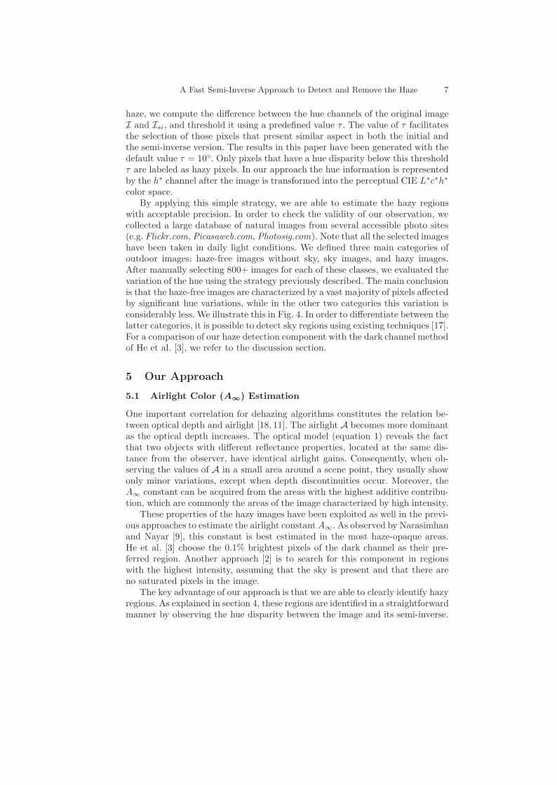
A Fast Semi-Inverse Approach to Detect and Remove the Haze 7
haze, we compute the difference between the hue channels of the original imageI and Isi, and threshold it using a predefined value τ . The value of τ facilitatesthe selection of those pixels that present similar aspect in both the initial andthe semi-inverse version. The results in this paper have been generated with thedefault value τ = 10◦. Only pixels that have a hue disparity below this thresholdτ are labeled as hazy pixels. In our approach the hue information is representedby the h∗ channel after the image is transformed into the perceptual CIE L∗c∗h∗
color space.By applying this simple strategy, we are able to estimate the hazy regions
with acceptable precision. In order to check the validity of our observation, wecollected a large database of natural images from several accessible photo sites(e.g. Flickr.com, Picasaweb.com, Photosig.com). Note that all the selected imageshave been taken in daily light conditions. We defined three main categories ofoutdoor images: haze-free images without sky, sky images, and hazy images.After manually selecting 800+ images for each of these classes, we evaluated thevariation of the hue using the strategy previously described. The main conclusionis that the haze-free images are characterized by a vast majority of pixels affectedby significant hue variations, while in the other two categories this variation isconsiderably less. We illustrate this in Fig. 4. In order to differentiate between thelatter categories, it is possible to detect sky regions using existing techniques [17].For a comparison of our haze detection component with the dark channel methodof He et al. [3], we refer to the discussion section.
5 Our Approach
5.1 Airlight Color (A∞) Estimation
One important correlation for dehazing algorithms constitutes the relation be-tween optical depth and airlight [18, 11]. The airlight A becomes more dominantas the optical depth increases. The optical model (equation 1) reveals the factthat two objects with different reflectance properties, located at the same dis-tance from the observer, have identical airlight gains. Consequently, when ob-serving the values of A in a small area around a scene point, they usually showonly minor variations, except when depth discontinuities occur. Moreover, theA∞ constant can be acquired from the areas with the highest additive contribu-tion, which are commonly the areas of the image characterized by high intensity.
These properties of the hazy images have been exploited as well in the previ-ous approaches to estimate the airlight constantA∞. As observed by Narasimhanand Nayar [9], this constant is best estimated in the most haze-opaque areas.He et al. [3] choose the 0.1% brightest pixels of the dark channel as their pre-ferred region. Another approach [2] is to search for this component in regionswith the highest intensity, assuming that the sky is present and that there areno saturated pixels in the image.
The key advantage of our approach is that we are able to clearly identify hazyregions. As explained in section 4, these regions are identified in a straightforwardmanner by observing the hue disparity between the image and its semi-inverse.

8 Codruta Ancuti et al.
Fig. 5. Layer-based dehazing. Top line: the initial foggy image; the rough transmissionmap that corresponds to I0; the result of a naive method which simply pastes all layersLi upon each other, introducing artifacts; the result of our method, which applies softblending of the layers. Middle line: the mask regions for each layer. Bottom line:the computed layers Li.
In order to mask the most haze-opaque areas, we perform the same procedure,but with the intensity of the semi-inverse increased by a factor ξ (with a defaultvalue of ξ = 0.3). During our experiments, we found that for images where thesky is present, the resulted mask contains mostly the sky region, which decreasesthe searching space. The extraction of the airlight color vector A∞ is performedby determining the brightest pixel only in the positive (unmasked) region (seeFig. 3). The winning value of A∞ is extracted from the original foggy image fromthe same location as the brightest pixel. This approach has shown to be morerobust than only searching for the most brightest pixels in the entire image.
5.2 Layer-based Dehazing
The contrast within an dehazed image is directly correlated with the estimatedairlight A and the inferred transmission t(x) at each point. Due to the physicaladditive property of the airlight (see equation 1), it is possible to estimate thedirect attenuation D once the A∞ is known, by varying A = A∞ ∗ (1− t (x)) inall possible values of its range [2]. Previous approaches have introduced manyconstraints and cost functions that favor certain image characteristics based onlocal image patches, thus limiting this range, and making it possible to computean approximate transmission map. In previous strategies, the transmission mapis commonly refined further using an energy minimization approach, based onthe assumption that for local neighborhoods the airlight shows only very minordeviations (an assumption that breaks down at depth discontinuities). The main
A Fast Semi-Inverse Approach to Detect and Remove the Haze 9
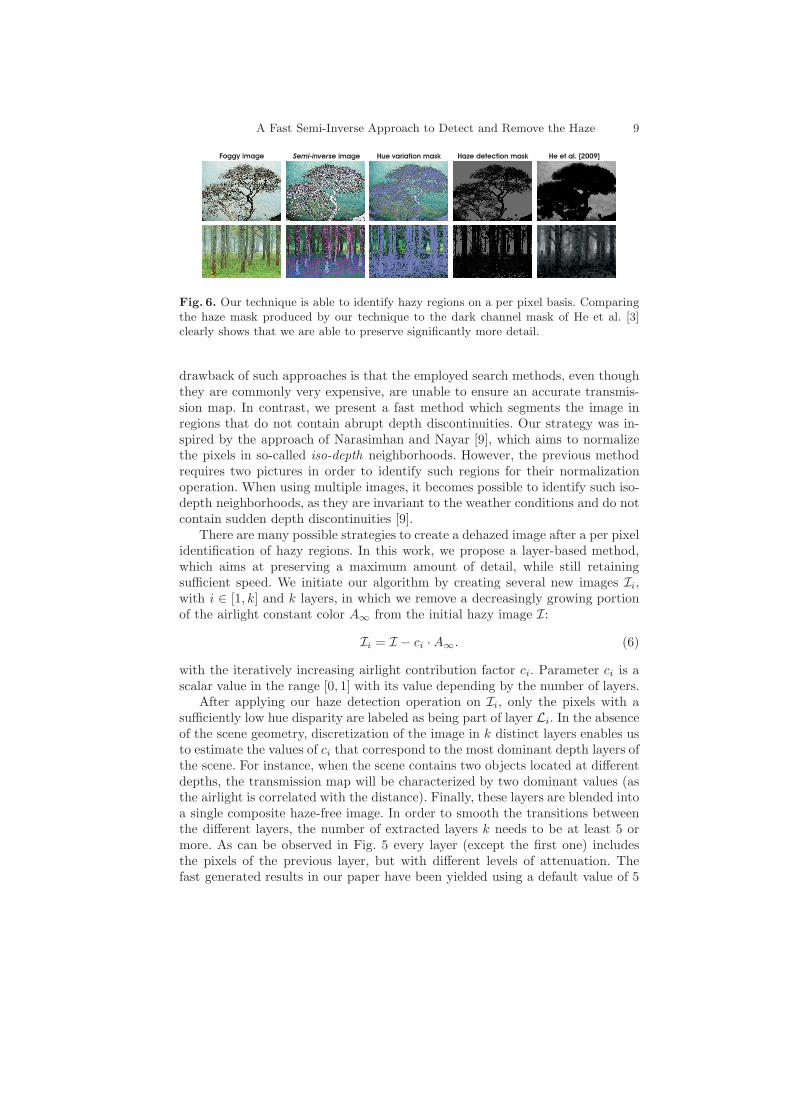
Foggy image Semi-inverse image He et al. [2009]Haze detection maskHue variation mask
Fig. 6. Our technique is able to identify hazy regions on a per pixel basis. Comparingthe haze mask produced by our technique to the dark channel mask of He et al. [3]clearly shows that we are able to preserve significantly more detail.
drawback of such approaches is that the employed search methods, even thoughthey are commonly very expensive, are unable to ensure an accurate transmis-sion map. In contrast, we present a fast method which segments the image inregions that do not contain abrupt depth discontinuities. Our strategy was in-spired by the approach of Narasimhan and Nayar [9], which aims to normalizethe pixels in so-called iso-depth neighborhoods. However, the previous methodrequires two pictures in order to identify such regions for their normalizationoperation. When using multiple images, it becomes possible to identify such iso-depth neighborhoods, as they are invariant to the weather conditions and do notcontain sudden depth discontinuities [9].
There are many possible strategies to create a dehazed image after a per pixelidentification of hazy regions. In this work, we propose a layer-based method,which aims at preserving a maximum amount of detail, while still retainingsufficient speed. We initiate our algorithm by creating several new images Ii,with i ∈ [1, k] and k layers, in which we remove a decreasingly growing portionof the airlight constant color A∞ from the initial hazy image I:
Ii = I − ci ·A∞. (6)
with the iteratively increasing airlight contribution factor ci. Parameter ci is ascalar value in the range [0, 1] with its value depending by the number of layers.
After applying our haze detection operation on Ii, only the pixels with asufficiently low hue disparity are labeled as being part of layer Li. In the absenceof the scene geometry, discretization of the image in k distinct layers enables usto estimate the values of ci that correspond to the most dominant depth layers ofthe scene. For instance, when the scene contains two objects located at differentdepths, the transmission map will be characterized by two dominant values (asthe airlight is correlated with the distance). Finally, these layers are blended intoa single composite haze-free image. In order to smooth the transitions betweenthe different layers, the number of extracted layers k needs to be at least 5 ormore. As can be observed in Fig. 5 every layer (except the first one) includesthe pixels of the previous layer, but with different levels of attenuation. Thefast generated results in our paper have been yielded using a default value of 5

10 Codruta Ancuti et al.
layers and the values for ci: [0.2; 0.4; 0.6; 0.8; 1]. To obtain the haze-free imageI0, the layers are blended in the descending order of the airlight contribution. Anaive approach would consist of simply copying the pixels from each layer on thenext, but this might generate unpleasing artifacts due to small discontinuities(see Fig. 5). In order to remove such undesirable transitions artifacts, each layerwill contribute a small percentage onto the next layer, according to the followingequation:
I0 =
k∑
i=1
χiLi. (7)
where the scalar parameter χi weights the contribution of the layers pixels,increasing exponentially according with the layer number. Splitting the inputimage into non-uniform neighborhoods that contains approximately uniformairlight generates good results, even when using only a single image. In compar-ison, algorithms that are based upon fixed-size patches may introduce artifactsbecause these uniform patches do not consider the intensity distribution of thesmall region. Moreover, our straightforward pixel based strategy is computation-ally effective overcoming the existing single image dehazing approaches (see thenext section for comparative processing times).
6 Discussion
6.1 Haze Detection
As we have stated in the introduction, we believe to be the first to present analgorithm for per pixel haze detection. It could be stated that the algorithm ofHe et al. [3], an extension of the dark object technique common in the remotesensing community [6], could also be regarded as a method for haze area de-tection. However, in order to create the dark channel, their technique employsa patch-based approach which is unable to properly preserve any detail. Whentaking a closer look at Fig. 6, the patch-like structure of the dark channel imagesimmediately becomes apparent. The black regions associated with haze-free ar-eas do not reflect the true haze-free area borders. It is important to note thatthese transitions need to be recovered properly, as edges between two regionscharacterized by large illumination differences can generate prominent halo arti-facts. This is the result of using patches with a constant dimension, which do notconsider the intensity distribution of the small region. In constrast, our methodemploys a pixel-wise multi-layer strategy, which decomposes the image in regionsthat are characterized by small illumination transitions. This approach does notsuffer from halo artifacts, because the regions are non-uniform and respect theimage intensity distribution.
6.2 Haze Removal
We have tested our approach on a large data set of natural hazy images. Fig-ure 7 illustrates results (our dehazed image and the computed transmission map)

A Fast Semi-Inverse Approach to Detect and Remove the Haze 11
Foggy images Our result Transmission Tan [2008]
Kratz & Nishino [2009]
He et al. [2009]
Fig. 7. Comparative haze removal results. From left to right: initial foggy images, ourrestored results, our estimated transmissions (depth map) and the corresponding resultsobtained by Tan [2] , He et al. [3] and Kratz and Nishino [5] respectively.
obtained for three foggy images by our technique, compared to the methods ofTan [2],He et al. [3] and Kratz and Nishino [5]. All the figures presented in thispaper and supplementary material contain the original restored images providedby the authors. As can be observed, we are able to enhance the images whileretaining even very fine details. Furthermore, our method accurately preservesthe color of the objects in the scene. Another set of images is provided in Fig. 9,where the top lines show comparative results obtained by the techniques of Fat-tal [1], He et al. [3], Tarel and Hautiere [4] and our method. It should be notedthat in the discussion above, we have limited ourselves to images in which thescene is sufficiently illuminated. Even though the method performs generallywell, for poorly lit scenes (an extreme case of such problem), like previous singleimage dehazing techniques, our approach may have trouble to accurately detecthazy regions. This limitation is due to the hypothesis of the considered opti-cal model that assumes that regions characterized by small intensity variationscontain no depth discontinuities.
As previously mentioned our approach has the advantage to perform fasterthan related algorithms. Our method implemented on CPU (Intel 2 Duo 2.00GHz) processes an 600×800 image in approximately 0.013 seconds being suitablefor real-time outdoor applications. In comparison, the technique of Tarel andHautiere [4] processes an 480 × 600 image in 0.2 seconds. However, as can beobserved in Fig. 8 the patch-based method of Tarel and Hautiere [4] risks tointroduce artifacts close to the patch transitions but also to distort the globalcontrast. The method of Tan [2] requires more than 5 minutes per image whilethe technique of Fattal [1] computes an 512 × 512 image in 35 seconds. The

12 Codruta Ancuti et al.
Foggy image Kopf et al. [2008] Tarel & Hautiere [2009] Our result
Fig. 8. From left to right: initial foggy image, the result obtained by Deep Photo [15]that employs additionally an approximated 3D model of the scene, the result of Tareland Hautiere [4] and our result.
algorithm of He et al. [3] takes approximately 20 seconds per image while thecomputation times of the techniques of Kratz and Nishino [5] were not reported.
6.3 Evaluating Dehazing Methods
Since there is no specialized evaluation procedure of the dehazing techniques wesearched the recent literature for an appropriate method for this task. Tarel andHautiere [4] evaluate the quality of dehazing techniques based on a visibilityresaturation procedure [19]. Because this procedure only applies to grayscaleimages and is mainly focused on finding the most visible edges, we searched fora more general method that is able to perform a pixelwise evaluation of thedehazing process.
In this work, we have employed the Image Quality Assessment (IQA) qual-ity measure introduced recently by Aydin et al. [20], which compares imageswith radically different dynamic ranges. This metric, carefully calibrated andvalidated through perceptual experiments, evaluates both the contrast and thestructural changes yielded by tone mapping operators. The IQA metric is sensi-tive to three types of structural changes: loss of visible contrast (green) - con-trast that was visible in the reference image is lost in the transformed version,amplification of invisible contrast (blue) - contrast that was invisible in the ref-erence image becomes visible in the transformed image, and reversal of visiblecontrast (red) - contrast visible in both images, but with different polarity. Asa general interpretation, contrast loss (green) has been related with image blur-ring, while contrast amplification (blue) and reversal (red) have been connectedto image sharpening.
Since these modifications are closely related to our problem, we have foundthis measure to be more appropriate as a means to evaluate the resaturation ofhazy regions after applying different dehazing techniques.
Figure 9 shows the comparative results of applying the IQA metric on twofoggy images and their dehazed versions, using the method of Fatal [1], He etal. [3], Tarel and Hautiere [4] and ours. The bottom-left table of Fig. 9 dis-plays the comparative ratios of the (colored) pixels yielded by the IQA measure

A Fast Semi-Inverse Approach to Detect and Remove the Haze 13
Fattal [2008] He et al. [2009] Tarel and Hautiere [2009] Our resultFoggy image
90-100
80-90
70-80
60-70
50-60
LossLoss Ampl Revers
Probability Scales(%)
Image quality metric
Fatal [2008]
He et al. [2009]
Tarel et al. [2009]
Our result
LOSS (%) AMPL (%) REVERS (%)
0.03 2.9 8.3
2.1 0.23 0.17
2.3 1.2 6.8
1.7 0.21 7.7
Fig. 9. Evaluation of the results using the IQA metric. The top two lines present thecomparative results obtained by Fattal [1], He et al. [3], Tarel and Hautiere [4] and ourmethod. The bottom two lines show the results after applying the IQA between initialimage and the restored version. The left bottom table presents the ratio of the colorpixels (with a probability scale higher than 70%) counted for each method.
when applied to the results of the considered dehazing methods. Following therecommendation of Aydin et al. [20], in order to reduce the possibility of mis-classification, only the pixels with a probability scale higher than 70% have beenconsidered. Based on the results from the table, it becomes clear that comparedwith the other techniques, the structural changes yielded by our algorithm aremore closely related to sharpening operations (blue and red pixels) and lessrelated with blurring (green pixels).
7 Conclusions
In this work, we have presented a single-image dehazing strategy which does notmake use of any additional information (e.g. images, hardware, or available depthinformation). Our approach is conceptually straightforward. Based on a per pixelhue disparity between the observed image and its semi-inverse, we are able to

14 Codruta Ancuti et al.
identify the hazy regions of the image. After we have identified these regions,we are able to produce a haze-free image using a layer-based approach. Theprocessing time of our technique is very low, even when compared to previousmethods who were designed and optimized for speed. In the future, we will beinvestigating a more comprehensive optical model, as well as extending our workto the problem of video dehazing.
References
1. Fattal, R.: Single image dehazing. SIGGRAPH, ACM Transactions on Graphics(2008)
2. Tan, R.T.: Visibility in bad weather from a single image. In IEEE Conference onComputer Vision and Pattern Recognition (2008)
3. He, K., Sun, J., Tang, X.: Single image haze removal using dark channel prior. InIEEE Conference on Computer Vision and Pattern Recognition (2009)
4. Tarel, J.P., Hautiere, N.: Fast visibility restoration from a single color or gray levelimage. In IEEE International Conference on Computer Vision (2009)
5. Kratz, L., Nishino, K.: Factorizing scene albedo and depth from a single foggyimage. In: IEEE International Conference on Computer Vision. (2009)
6. Chavez, P.: An improved dark-object subtraction technique for atmospheric scat-tering correction of multispectral data. Remote Sensing of Environment (1988)
7. Moro, G.D., Halounova, L.: Haze removal and data calibration for high-resolutionsatellite data. Int. Journal of Remote Sensing (2006)
8. Narasimhan, S., Nayar, S.: Chromatic Framework for Vision in Bad Weather. In:In IEEE Conference on Computer Vision and Pattern Recognition. (2000)
9. Narasimhan, S., Nayar, S.: Contrast Restoration of Weather Degraded Images.IEEE Trans. on Pattern Analysis and Machine Intell. (2003)
10. Schaul, L., Fredembach, C., Ssstrunk, S.: Color image dehazing using the near-infrared. In IEEE Int. Conf. on Image Processing (2009)
11. Treibitz, T., Schechner, Y.Y.: Polarization: Beneficial for visibility enhancement?In IEEE Conference on Computer Vision and Pattern Recognition (2009)
12. Shwartz, S., Namer, E., Schechner, Y.: Blind haze separation. In IEEE Conferenceon Computer Vision and Pattern Recognition (2006)
13. Namer, E., Shwartz, S., Schechner, Y.: Skyless polarimetric calibration and visi-bility enhancement. Optic Express (2009) 472–493
14. Narasimhan, S., Nayar, S.: Interactive de-wheathering of an image using physicalmodels. ICCV Workshop CPMVC (2003)
15. Kopf, J., Neubert, B., Chen, B., Cohen, M., Cohen-Or, D., Deussen, O., Uytten-daele, M., Lischinski, D.: Deep photo- Model-based photograph enhancement andviewing. In: ACM Transactions on Graphics. (2008)
16. Koschmieder, H.: Theorie der horizontalen sichtweite. In: Beitrage zur Physik derfreien Atmosphare. (1924)
17. Tao, L., Yuan, L., Sun, J.: SkyFinder: Attribute-based Sky Image Search. SIG-GRAPH, ACM Transactions on Graphics (2009)
18. R.C.Henry, S.Mahadev, Urquijo, S., Chitwood, D.: Color perception through at-mospheric haze. Opt. Soc. Amer. A 17 (2000) 831–835
19. Hautiere, N., Tarel, J.P., Aubert, D., Dumont, E.: Blind contrast enhancementassessment by gradient ratioing at visible edges. Img. Anal. and Stereology (2008)
20. Aydin, T.O., Mantiuk, R., Myszkowski, K., Seidel, H.S.: Dynamic range indepen-dent image quality assessment. In: SIGGRAPH, ACM Trans. Graph. (2008)