A Biological Assessment of the Aquatic Ecosystems of the Río ...
161
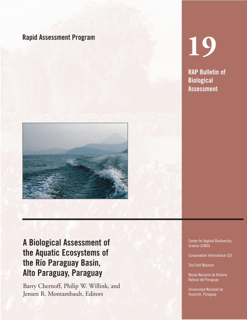
19 Rapid Assessment Program RAP Bulletin of Biological Assessment A Biological Assessment of the Aquatic Ecosystems of the Río Paraguay Basin, Alto Paraguay, Paraguay Barry Chernoff, Philip W. Willink, and Jensen R. Montambault, Editors Center for Applied Biodiversity Science (CABS) Conservation International (CI) The Field Museum Museo Nacional de Historia Natural del Paraguay Universidad Nacional de Asunción, Paraguay
-
Upload
khangminh22 -
Category
Documents
-
view
3 -
download
0
Transcript of A Biological Assessment of the Aquatic Ecosystems of the Río ...
19Rapid Assessment Program
RAP Bulletin ofBiologicalAssessment
A Biological Assessment of the Aquatic Ecosystems of the Río Paraguay Basin, Alto Paraguay, ParaguayBarry Chernoff, Philip W. Willink, and Jensen R. Montambault, Editors
Center for Applied BiodiversityScience (CABS)
Conservation International (CI)
The Field Museum
Museo Nacional de HistoriaNatural del Paraguay
Universidad Nacional deAsunción, Paraguay
CONSERVATION PRIORITIES: THE ROLE OF RAP
Our planet faces many serious environmental problems, among them global climate change, soil erosion, and pollution.At Conservation International (CI), we believe that there is one problem that surpasses all others in terms of importancebecause of its irreversibility, the extinction of biological diversity. Conservation efforts still receive only a tiny fractionof the resources, both human and financial, needed to get the job done. As a result of this, we must use availableresources efficiently, applying them to those places with the highest concentrations of diversity that are at mostimmediate risk of disappearing.
CI uses a strategic approach for setting conservation investment priorities. At a global level, we have targeted the“hotspots”, twenty-five areas that hold a third or more of all terrestrial diversity and are at a great risk. Our globalpriorities also focus on major tropical wilderness areas and the “mega-diversity” country concept, which highlights theimportance of the national entities that harbor high biodiversity. We are now undertaking a series of priority-settingexercises for other major categories of ecosystems, among them marine systems, freshwater aquatic systems, deserts,and dry forests.
The next level of priority setting is the bioregional workshop, a process where experts assemble their combinedknowledge of an area to map regional conservation priorities using CI’s geographic information system (CIGIS). Wehave also taken a taxon-based approach, working with the Species Survival Commission of IUCN to produce actionplans for key groups of organisms.
These priority-setting exercises provide the scientific underpinning for urgent conservation decisions in hotspotregions. Although the hotspots we have identified occupy less than 3-4 percent of the land surface of the planet, theystill cover several million square kilometers, only small areas of which have been properly inventoried. To fill the gapsin our regional knowledge, CI created the Rapid Assessment Program (RAP) in 1989.
RAP assembles teams of international and host-country experts to generate first-cut assessments of the biologicalvalue of poorly known areas. An area’s importance can be characterized by its total biodiversity, its degree of ende-mism, the uniqueness of an ecosystem, and the degree of risk of extinction. As a conservation tool, RAP precedes long-term scientific inventory.
When satellite images of an area targeted for a RAP assessment are available, the team consults them prior to a tripto determine the extent of forest cover and likely areas for exploration. Once in-country, the scientists make overflightsin small planes or helicopters to identify forest types and points for field transects. Ground travel often requires acombination of vehicles, boats, pack animals, and foot travel to get the team to remote sites where few, if any, roadsexist. Trips last from two to eight weeks.
On each trip, in-country scientists form a central part of the team. Local experts are especially critical to under-standing areas where little exploration has been undertaken. Subsequent research and protection of habitats following aRAP trip depends on the initiatives of local scientists and conservationists.
The RAP concept was born during a field trip by Murray Gell-Mann of the MacArthur Foundation, Spencer Beebe,one of CI’s founders, and the late Ted Parker, former leader of the RAP team. RAP was founded with funding from theJohn D. and Catherine T. MacArthur Foundation’s World Resources and Environment Program, headed by Dan Martin.
RAP reports are available to the host governments of the countries being surveyed and to all interested conserva-tionists, scientists, institutions, and organizations. We hope that these reports will catalyze effective conservationaction on behalf of our planet’s biological diversity, the legacy of life that is so critical to us all.
Russell A. Mittermeier Jørgen Bent ThomsenPresident Vice President for Conservation Biology
19Rapid Assessment Program
RAP Bulletin ofBiologicalAssessment
A Biological Assessment of theAquatic Ecosystems of the Río Paraguay Basin, Alto Paraguay, Paraguay
Barry Chernoff, Philip W. Willink, and Jensen R. Montambault, Editors
Center for Applied BiodiversityScience (CABS)
Conservation International (CI)
The Field Museum
Museo Nacional de HistoriaNatural del Paraguay
Universidad Nacional deAsunción, Paraguay
RAP Bulletin of Biological Assessment is published by:Conservation InternationalCenter for Applied Biodiversity ScienceDepartment of Conservation Biology1919 M Street NW, Suite 600Washington, DC 20036USA202-912-1000 tel202-912-1030 faxwww.conservation.orgwww.biodiversity science.org
Editors: Barry Chernoff, Philip W. Willink, and Jensen R. MontambaultDesign/Production: Kim MeekMaps: Mark DenilCover photographs: Kim AwbreyTranslations:
Spanish: Gina Fognani and Jensen R. MontambaultPortuguese: Yuri LeiteGuaraní: Sara Musinsky
Conservation International is a private, non-profit organization exempt from federal income tax under section 501 c(3) of theInternal Revenue Code.
ISBN: 1-881173-40-2© 2001 by Conservation InternationalAll rights reserved.Library of Congress Control Number: 2001087008
The designations of geographical entities in this publication, and the presentation of the material, do not imply the expressionof any opinion whatsoever on the part of Conservation International or its supporting organizations concerning the legal statusof any country, territory, or area, or of its authorities, or concerning the delimitation of its frontiers or boundaries.
Any opinions expressed in the RAP Bulletin of Biological Assessment are those of the writers and do not necessarily reflectthose of Conservation International or its co-publishers.
RAP Bulletin of Biological Assessment was formerly RAP Working Papers. Numbers 1–13 of this series were published underthe previous series title.
Suggested citation: Chernoff, B., P.W. Willink, and J.R. Montambault (eds.). 2001. A biological assessment of the RíoParaguay basin, Alto Paraguay, Paraguay. RAP Bulletin of Biological Assessment 19. Conservation International, Washington,DC.
Funding for this AquaRAP study and publication was generously provided by The Rufford Foundation and The GiulianiFamily Foundation.
Printed on recycled paper.
RAP Bulletin of Biological Assessment Nineteen September 2001 1
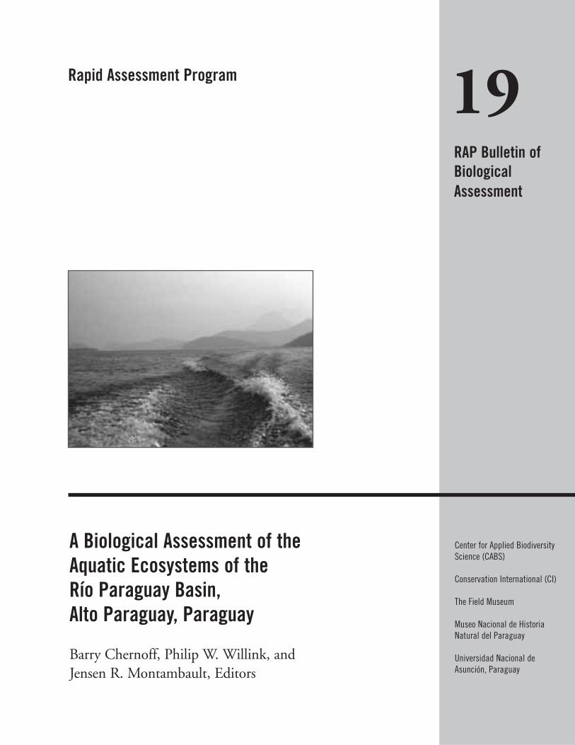
The Río Paraguay is 2,550 kilometers long and its basin cov-ers 1,100,000 kilometers2—the second largest in SouthAmerica. The Río Paraguay begins in the highlands of south-western Brasil and subsequently flows south along thePantanal, the world’s largest wetland. The Río Paraguay ishome to thousands of species of plants and animals, many ofwhich are endemic to the Río Paraguay basin. At the sametime, the Río Paraguay is the lifeblood of many communitiesof humans who depend upon the Río Paraguay for food, fortransportation, for recreation, for their livelihoods, and fortheir cultures. Additionally, the Río Paraguay brings impor-tant nutrients for the soils with the incoming floods andremoves salts that accumulate in flood-plain soils with thereceding floodwaters. In short, the Río Paraguay and its riverbasin serve as critical habitat for the both humans and allother biological organisms upon which the human popula-tion often depends for existence.
Despite its size, the Río Paraguay is a relatively shallowriver. This fact, coupled with its numerous meanders, meansthat the Río Paraguay is not easily or efficiently navigated bylarge ocean-going vessels. To remedy the navigational situa-tion and to give land-locked Bolivia access to the sea via theRío Paraguay, the Hidrovia Project proposes to straightenand to deepen the Río Paraguay. In order to investigate thepotential effects of Hidrovia upon the biodiversity and theaquatic habitats of the Río Paraguay, a team of 15 scientists,2 logistical coordinators and one internet correspondentundertook an AquaRAP expedition to the Río Paraguay forthree weeks in September 1997. The team was comprised ofindividuals from Paraguay, Brazil, Bolivia and the UnitedStates. The scientists were specialists in aquatic and terrestrialbotany, decapod crustaceans, macro-invertebrates, ichthyolo-gy, and limnology—including water chemistry and plankton.The AquaRAP team contained both established scientistsand students. The expedition focused primarily upon thebiological and conservation value of the region and how
integrated solutions can work to preserve the maximumamount of biodiversity in the face of current and futurethreats. Additionally, the AquaRAP was featured on televisionin the United States in an episode of Bill Kurtis’ NewExplorer’s Series, entitled “River in Peril.”
The organization of this report begins with an executivesummary, which includes a brief overview of the physical andterrestrial characteristics of the region, as well as summariesof the technical reports of the scientific disciplines, and con-cludes with recommendations for a conservation strategy. Wethen present the biological results from botany, limnology,decapod crustaceans and fishes. The last chapter highlightsthe commonalities among different floral or faunal elementsin relation to geography and ecology. The disciplinary reportsare written as scientific papers, each self-contained with itsown literature citations for ease of use. After the scientificpapers, we include a glossary of terms and then the appen-dices with much of the raw data.
We would like to explain our use of the terms diversityand species richness. In vernacular usage diversity, when usedin the context of biological organisms, refers to the numbersof and variety of types of species, organisms, taxa, etc. In theecological literature, diversity takes on a slightly different,more specific meaning, referring to the number of entities incombination with their relative abundances. In this volumediversity is used in two ways: (i) in the general, vernacular,sense we occasionally refer to the “diversity of organisms”,meaning the number of and variety of organisms; but (ii) inthe ecological sense, we refer to “low or high diversity”,meaning “diversity” as calculated from a specific formula.Note that in the vernacular usage, diversity is never modifiedby high or low or used in a comparative way. From the eco-logical literature, the term species richness means the numberof species. We use species richness in several chapters (e.g.,Chapter 7) when referring to the number of species presentin a habitat or river basin.
Preface
This report is intended for decision makers, environmen-tal managers, governmental and non-governmental agencies,students and scientists. The novel information and analysespresented herein have two aims: (i) to present a compellingcase and cogent strategy for conservation efforts within theregion; and (ii) to provide scientific data and analyses thatwill stimulate future scientific research of this critical region.We have attempted in this volume not simply to present aninventory of the organisms that we encountered during ourexpedition but rather to use that information to evaluate
conservation strategies under different scenarios of environ-mental threat (e.g., Chapter 7). We welcome comments andcriticisms as we continue to evolve AquaRAP and the meth-ods used for evaluating conservation strategies from biologi-cal data.
Barry ChernoffPhilip W. WillinkJensen R. Montambault
Rapid Assessment Program2 CONSERVATION INTERNATIONAL
RAP Bulletin of Biological Assessment Nineteen September 2001 3
Chapter 1 ..........................................................................................49Geographic Overview of the Río Paraguay Basin, Departamento Alto Paraguay, Paraguay Philip W. Willink, Jaime Sarmiento, Barry Chernoff, Mônica Toledo-Piza, Darío Mandelburger, and Mirta Medina
Chapter 2 ..........................................................................................53Terrestrial Flora of the Upper and Lower Río Paraguay Basin and the Río Apa Sub-basin, Paraguay Hamilton Beltrán
Chapter 3 ..........................................................................................56Evaluation of the Aquatic Floral Diversity in the Upper and Lower Río Paraguay Basin, Paraguay María Fátima Mereles
Chapter 4 ..........................................................................................61Water Quality, Phytoplankton, and Benthic Invertebrates of the Upperand Lower Río Paraguay Basin, Paraguay Francisco Antonio R. Barbosa, Marcos Callisto Faria Pereira,and Juliana de Abreu Vianna
Chapter 5 ..........................................................................................68Diversity, Distribution, and Habitats of the Macro-invertebrate Fauna ofthe Río Paraguay and Río Apa, Paraguay, with Emphasis on DecapodCrustaceans Célio Magalhães
Table of Contents
Preface ................................................................................................1
Participants and Contributors ............................................................6
Organizational Profiles ........................................................................9
Acknowledgements ............................................................................11
Report at a Glance ............................................................................12
Informe a un vistazo (Español) ..........................................................14
Resumo do Relatório (Português) ....................................................16
Mombe’u (Guaraní) ............................................................................18Petei Techauka Pya’e Ysyry Paraguai Pe Gua
Executive Summary ..........................................................................20
Resumen Ejecutivo (Español) ............................................................28
Sumário Executivo (Português) ........................................................37
Images of the AquaRAP Expedition ....................................................47
Satellite Image of the Río Paraguay Basin, Departamento AltoParaguay, Paraguay ..........................................................................48
Chapter 6 ..........................................................................................73Diversity and Abundance of Fishes in the Upper and Lower Río Paraguay Basin and the Río Apa Sub-basin, Paraguay Mônica Toledo-Piza, Barry Chernoff, Darío Mandelburger,Mirta Medina, Jaime Sarmiento, and Philip W. Willink
Chapter 7 ..........................................................................................80Testing Hypotheses of Geographic and Habitat Partitioning of Fishes in the Río Paraguay, ParaguayBarry Chernoff, Philip W. Willink, Mônica Toledo-Piza, Jaime Sarmiento, Mirta Medina, and Darío Mandelberger
Chapter 8 ..........................................................................................99Congruence of Diversity Patterns among Fishes, Invertebrates, and Aquatic Plants within the Río Paraguay Basin, Paraguay Barry Chernoff, Philip W. Willink, Antonio Machado-Allison, María Fátima Mereles, Célio Magalhães, Francisco Antonio R. Barbosa, Marcos Callisto Faria Pereira, and Mônica Toledo-Piza
Glossary............................................................................................108
APPENDIX 1 ....................................................................................112Terrestrial plants recorded on transects during the AquaRAP expedition to Departamento Alto Paraguay, Paraguay, in September 1997 Hamilton Beltrán
APPENDIX 2 ....................................................................................116Terrestrial plants collected apart from transects during the AquaRAP expedition to Departamento Alto Paraguay, Paraguay, in September 1997 Hamilton Beltrán
APPENDIX 3 ....................................................................................120Common names of some aquatic plants identified during the AquaRAP expedition to Departamento Alto Paraguay, Paraguay, in September 1997 María Fátima Mereles
APPENDIX 4 ....................................................................................121Localities where aquatic plants were sampled during the AquaRAP expedition to Departamento Alto Paraguay, Paraguay, in September 1997 María Fátima Mereles
APPENDIX 5 ....................................................................................122Aquatic plants collected in the Río Paraguay basin, Paraguay María Fátima Mereles
APPENDIX 6 ....................................................................................128Aquatic plants collected in the Río Apa sub-basin, Paraguay María Fátima Mereles
APPENDIX 7 ....................................................................................129Localities where water quality and benthic macro-invertebrates were assessed during the AquaRAP expedition to Departamento Alto Paraguay, Paraguay, in September 1997 Francisco Antonio R. Barbosa, Marcos Callisto Faria Pereira,Pablo Moreno Souza Paula, and Juliana de Abreu Vianna
Rapid Assessment Program4 CONSERVATION INTERNATIONAL

APPENDIX 8 ....................................................................................130Benthic fauna recorded from Departmento Alto Paraguay, Paraguay during the AquaRAP expedition Francisco Antonio R. Barbosa, Marcos Callisto Faria Pereira,Pablo Moreno Souza Paula, and Juliana de Abreu Vianna
APPENDIX 9 ....................................................................................132Sediment types, richness (R), eveness (E), and diversity (H') indices of Shannon-Wiener (base 2), total density (D (individuals/m2)), and characteristic genera of ChironomidaeFrancisco Antonio R. Barbosa, Marcos Callisto Faria Pereira,Pablo Moreno Souza Paula, and Juliana de Abreu Vianna
APPENDIX 10 ....................................................................................133Specific composition of the macro-invertebrate fauna collected during the AquaRAP expedition to the Río Paraguay and Río Apa,September 1997 Célio Magalhães
APPENDIX 11 ....................................................................................138Distribution of the decapod crustacean and mollusc fauna according to the habitat sampled during the AquaRAP expedition to the Río Paraguay and Río Apa, September 1997 Célio Magalhães
APPENDIX 12 ....................................................................................139Fish collection localities of the AquaRAP expedition to Departamento Alto Paraguay, Paraguay, in September 1997 Barry Chernoff, Darío Mandelburger, Mirta Medina, MônicaToledo-Piza, and Jaime Sarmiento
APPENDIX 13 ....................................................................................143List of fishes and the subregions where they were collected during the AquaRAP expedition to Departamento Alto Paraguay,Paraguay, in September 1997 Barry Chernoff, Darío Mandelburger, Mirta Medina, Mônica Toledo-Piza, and Jaime Sarmiento
APPENDIX 14 ....................................................................................149Geographic distribution of fish species collected during the AquaRAP expedition to Departmento Alto Paraguay, Paraguay Mônica Toledo-Piza
RAP Bulletin of Biological Assessment Nineteen September 2001 5
Rapid Assessment Program6
Participants and Contributors
Antonio Machado AllisonInstituto de Zoologia TropicalFacultad de CiénciasUniversidad Central de VenezuelaCaracas 1041-A, VenezuelaEmail: [email protected]
Kim Awbrey (coordinator) 318 Yale AvenueNew Haven, CT 06515Email: [email protected]
Francisco Antonio R. Barbosa (limnology)Universidade Federal de Minas Gerais, ICBDepartamento de Biologia GeralLaboratório de LimnologiaCaixa Postal 486CEP 30.161-970, Belo Horizonte, MG BrasilFax: 55-31-499-2567Email: [email protected]
Hamilton Beltrán (terrestrial botany)Museo de Historia NaturalAv. Arenales 1256Apdo. 14-0434Lima 14, PerúEmail: [email protected]
Barry Chernoff (ichthyology/editor)Department of ZoologyField Museum1400 South Lake Shore DriveChicago, IL 60605 USAFax: 312-665-7932Email: [email protected]
Karen Elizeche (botany)Ciéncias AgrociasUniversidad Nacional de AsunciónAsunción, Paraguay
Glenda Fábregas (coordinator) Center for Applied Biodiversity ScienceConservation International1919 M Street, NW, Suite 600Washington, DC 20036 USAFax: 202-912-0772Email: [email protected]
Bolívar Garcete (invertebrate zoology)Facultad de Ciéncias Exactas y NaturalesUniversidad Nacional de AsunciónAsunción, Paraguay
Arlo Hanlin Hemphill (web correspondent)Fundación Jatun Sacha Pasaje Eugenio Santillan N34-248 y MaurianUrbanización RumipambaCasilla Postal #17-12-867Quito, EcuadorFax: 593-2-432240Email: [email protected]
Célio Magalhães (invertebrate zoology)Instituto Nacional de Pesquisas da AmazoniaCoordenacao de Pesquisas em Biologia AquaticaCaixa Postal 478CEP: 69.011-970, Manaus, AM BrasilFax: 55-92-643-3146Email: [email protected]
CONSERVATION INTERNATIONAL
RAP Bulletin of Biological Assessment Nineteen September 2001 7
Darío Mandelburger (ichthyology) Sección IctiologíaMuseo Nacional de Historia Natural del ParaguaySucursal 1 CampusCiudad Universitaria, Central XISan Lorenzo, ParaguayEmail: [email protected]
Mirta Medina (ichthyology) Sección IctiologíaMuseo Nacional de Historia Natural del ParaguaySucursal 1 CampusCiudad Universitaria, Central XISan Lorenzo, ParaguayEmail: [email protected]
María Fátima Mereles (aquatic botany)Departmento de BotánicaFacultad de Ciencias QuímicasUniversidad Nacional de AsunciónP.O. Box PY 11001-3291Campus UNA—ParaguayFax: 595-21-58-5564Email: Marí[email protected]
Jensen R. Montambault (editor) Conservation International1919 M Street, NW, Suite 600Washington, DC 20036Fax: 202-912-0772Email: [email protected]
Gladys Arzamendia de Montiél (limnology)JubiladaUniversidad Nacional de AsunciónParaguay
Debra Moskovits (coordinator) Environmental and Conservation ProgramsField Museum1400 South Lake Shore DriveChicago, IL 60605-2496 USAFax: 312-665-7440Email: [email protected]
Alexis Narvaez (ichthyology/genetics)FACEN, Universidad Nacional de AsunciónP.O. Box PY 11001-3291Campus UNA—ParaguayFax: 595-21-58-5564Email: [email protected]
Marcos Callisto Faria Pereira (limnology)Universidade Federal de Minas Gerais, ICBDepartmento de Biologia GeralLaboratório de LimnologiaCaixa Postal 486CEP 30.161-970 Belo Horizonte, MG Brasil
Jaime Sarmiento (ichthyology)Museo Nacional de Historia NaturalCalle 26, Cota CotaCasilla 8706La Paz, BoliviaFax: 591-277-0876Email: [email protected]
Mônica Solaga (aquatic botany)Facultad de Ciéncias Exactas y NaturalesUniversidad Nacional de AsunciónAsunción, Paraguay

Rapid Assessment Program8 CONSERVATION INTERNATIONAL
Jørgen Thomsen (coordinator) Conservation International1919 M Street, NW, Suite 600Washington, DC 20036Email: [email protected]
Mônica Toledo-Piza (ichthyology) Departamento de ZoologiaInstituto de BiociênciasUniversidade de São PauloCaixa Postal 11461CEP: 05422-970, São Paulo, SP BrasilEmail: [email protected]
Juliana de Abreu Vianna (limnology)Universidade Federal de Minas Gerais, ICBDepartmento de Biologia GeralLaboratório de LimnologiaCaixa Postal 486CEP 30.161-970 Belo Horizonte, MG Brasil
Sérgio Villanueva (ichthyology)Facultad de Ciéncias Exactas y NaturalesUniversidad Nacional de AsunciónAsunción, Paraguay
Philip W. Willink (editor)Department of ZoologyField Museum1400 South Lake Shore DriveChicago, IL 60605 USAFax: 312-665-7932Email: [email protected]
Pablo Moreno Souza Paula (limnology)Universidade Federal de Minas Gerais, ICBDepartmento de Biologia GeralLaboratório de LimnologiaCaixa Postal 486CEP 30.161-970 Belo Horizonte, MG Brasil
RAP Bulletin of Biological Assessment Nineteen September 2001 9
Conservation International
Conservation International (CI) is an international, nonprof-it organization based in Washington, DC. CI believes thatthe Earth’s natural heritage must be maintained if future gen-erations are to thrive spiritually, culturally, and economically.Our mission is to conserve the Earth’s living heritage, ourglobal biodiversity, and to demonstrate that human societiesare able to live harmoniously with nature.
Conservation International1919 M Street, NW, Suite 600Washington, DC 20036 USA1-800-406-2306202-912-0772 (fax)http://www.conservation.org/http://www.biodiversityscience.org/xp/CABS/research/rap/aquarap/equaran.xml
Field Museum
The Field Museum (FMNH) is an educational institutionconcerned with the diversity and relationships in nature andamong cultures. Combining the fields of Anthropology,Botany, Geology, Paleontology and Zoology, the Museumuses an interdisciplinary approach to increasing knowledgeabout the past, present, and future of the physical earth, itsplants, animals, people, and their cultures. In doing so, itseeks to uncover the extent and character of biological andcultural diversity; similarities and interdependencies so thatwe may better understand, respect, and celebrate nature andother people. Its collections, public learning programs, andresearch are inseparably linked to serve a diverse public ofvaried ages, backgrounds, and knowledge.
Field Museum1400 South Lake Shore DriveChicago, IL 60657 USA312-922-9410312-665-7932 (fax)http://www.fieldmuseum.org/
Organizational Profiles
10 CONSERVATION INTERNATIONAL
Museo Nacional de Historia Natural del Paraguay
The Museo Nacional de Historia Natural del Paraguay is ayoung institution created in the 1980’s, but has recorded alarge part of the flora and fauna of Paraguay. It is a technicalbranch of the new Secretary of the Environment ofParaguay; therefore it oversees some of the activities corre-sponding to the investigation of the biodiversity of the coun-try. With sections dedicated to ichthyology, ornithology, her-petology, mammalogy, botany, and environmental education,each area contains specialists that are trained for their tasks.The goal of the Museo Nacional de Historia Natural delParaguay is to obtain the best information possible on theflora and fauna of the country in order to realize a sustain-able use of the existing resources.
Museo Nacional de Historia Natural del ParaguaySucursal 1 CampusCiudad Universitaria, Central XISan Lorenzo, Paraguay
Department of Botany, Faculty of Chemical Sciences,Universidad Nacional de Asunción, Asunción, Paraguay
The Department of Botany has a mission to produce studiesin the areas of taxonomy, ecology, and ethnobotany, includ-ing the study of medicinal plants. The herbarium, which isthe largest in Paraguay, contains 70,000 specimens. There isthe Jardín de Aclimatación in which native forest species arecultivated. The department also publishes a botanical scien-tific journal, ROJASIANA.
The Faculty of Chemical Sciences carries out educationand research at the highest level. On the Faculty, a number ofinvestigators have been awarded the National Prize forScience (Paraguay) as well as honorable mentions.
The Universidad Nacional de Asunción was founded atthe end of the 1900’s and is the largest university withinParaguay. The University pursues education and scientificresearch in such diverse disciplines as the natural sciences,social sciences, and medical sciences. The main campus islocated in the capitol, Asunción, while smaller affiliate cam-puses are located in other parts of the country.
Departmento de BotánicaFacultad de Ciencias QuímicasUniversidad Nacional de AsunciónP.O. Box PY 11001-3291Campus UNA—Paraguay595-21-58-5564 (fax)
Rapid Assessment Program
RAP Bulletin of Biological Assessment Nineteen September 2001 11
This AquaRAP expedition was a success due to the hardwork of many individuals, and the first among them wasKim Awbrey. Kim, then AquaRAP Coordinator, used hervision and skills to overcome all hurdles. Darío and RobertoTonañez expertly handled logistics during the expedition. Wewould like to thank Karen Elizeche (assistant terrestrialbotanist, Ciéncias Agrocias-Universidad Nacional deAsunción), Bolívar Garcete (assistant invertebrate zoologist,Facultad de Ciencias Exactas y Naturales, UniversidadNacional de Asunción), Mônica Soloaga (assistant aquaticbotanist, Facultad de Ciencias Exactas y Naturales,Universidad Nacional de Asunción), and Sérgio Villaneuva(assistant ichthyologist, Facultad de Ciencias Exactas yNaturales, Universidad Nacional de Asunción) for their helpin conducting field work, as well as Coronel Carlos Giménezwho was our pilot in Paraguay.
Mary Ann Rogers (Field Museum) and Kevin Swagel(Field Museum) provided invaluable assistance during theprocessing and cataloging of fishes in Chicago. ChristinaCanales (Field Museum) and Anna Lucia Benítez (FieldMuseum) entered data and conducted literature searches.Anna Chlumsky (Field Museum) formatted the botanytables in the appendices. The limnology team would like tothank Rosa María Menéndez (UNA) and Gladys Arza-mendia de Montiél (UNA) for information on zoo- andphytoplankton.
This report is published as part of ConservationInternational’s series RAP Bulletin of Biological Assessment,and the publishing team would like to thank the followingmembers for consistent high quality and hard work whichmakes these reports a reality: Leeanne E. Alonso andAnthony Rylands for excellent editing and suggestions; GinaFognani, Adilson Salvador, and Fátima Mereles for assistingwith the Spanish translation; Yuri Leite, Mônica Harris, andErika Guimarães for assistance with the Portuguese transla-tion; Sara Musinsky for coordinating translations in Guaraní;Mark Denil for creating the maps; John Musinsky for provid-ing satellite imagery; and Debby Moskovitz for her assistanceon photo identification.
The fieldwork and AquaRAP program was fundedthrough the generosity of The Rufford Foundation.Equipment used in the field and laboratory to analyze dataand produce the final report was provided by thoughtful giftsfrom the following: Comer Science and EducationFoundation, Jay Fahn, Joan and Selma Goldstein, and Davidand Janet Shores. Innovative web broadcasts from the fieldwere supported by assistance from Brevard CommunityCollege. The publication of this report was made possible bythe generous support of The Giuliani Family Foundation.Lastly, we express our sincerest gratitude to John McCarter,Russ Mittermeier, and Peter Seligmann for their continuingsupport of the AquaRAP program.
Acknowledgements
12 CONSERVATION INTERNATIONAL
A Biological Assessment of the Aquatic Ecosystems ofthe Río Paraguay Basin, Alto Paraguay, Paraguay
1) Dates of Study:AquaRAP Expedition: September 4 –18, 1997
2) Description of Location:The AquaRAP expedition took place in the country ofParaguay and surveyed the section of the Río Paraguaybetween the Río Negro to the north, and the Río Aquidabánto the south. This area is located between two globallyunique ecosystems, the Pantanal to the northeast, and theChaco to the west. The Río Paraguay is a large river with lowbanks. The surrounding countryside is seasonally flooded,creating extensive wetlands and numerous small lakes thatare often abandoned river channels. Portions of the Río Apaand Riacho La Paz tributary were also explored. The Río Apais a medium-sized river with alternating rapids and pools. Itshigh banks limit the extent of flooding.
3) Reason for AquaRAP Study:This region was the focus of an AquaRAP expeditionbecause while the area is sparsely populated, poorly surveyed,and has experienced relatively little human disturbance, it iscurrently faced with a large development project: theHidrovia Paraguay-Paraná. The Hidrovia Project proposes todredge and channel extensive portions of the Río Paraguaywatershed, altering water flow and the seasonal floodingcycles. These modifications could be disastrous to the aquaticecosystems. Human population levels, cattle ranching, andagriculture in the region are also increasing. An assessmentwas necessary to document the aquatic diversity and the stateof the aquatic ecosystems in order to determine sustainableconservation and development strategies for the region.
4) Major Results:The northern-most section of the Río Paraguay, in the coun-try of Paraguay, is currently in good health. Human popula-tion levels are low, as are the number of farms and cattleranches. Fisheries are underutilized. The life-histories ofaquatic organisms are highly dependent upon seasonal flood-ing of the Río Paraguay. The floods also create the highaquatic habitat heterogeneity observed during the expedition.The Río Apa is presently in good health. Water quality ishigh, human population levels are relatively low, and agricul-ture, cattle ranching, and logging are minimal. The lower RíoApa near the junction with the Río Paraguay is similar, butthe upper Río Apa is ecologically distinct. Its steeper gradientand high sand banks place it apart. A distinct flora and faunareflect this habitat separation.
5) Number of species:Terrestrial plants: 198 speciesAquatic plants: 187 speciesShrimps and crabs: 13 speciesSnails and mussels: 10 speciesChironomidae: 26 speciesAquatic insects (not
including Chironomidae): 85 speciesOther aquatic
invertebrates: 10 ordersFishes: 173 species
6) New records for Paraguay:Aquatic plants: Phyllanthus fluitans
(Euphorbiaceae)Shrimps and crabs: Pseudopalaemon sp.
(for Río Paraguay basin)Fishes: 5 species
Report at a Glance
Rapid Assessment Program
RAP Bulletin of Biological Assessment Nineteen September 2001 13
7) New species discovered:Chironomidae: Possibly manyShrimps and Crabs: Possibly 1 new shrimp,
Pseudopalaemon sp.Fishes: Two species: Triportheus n. sp. A
and Heptapterus n. sp.
8) Conservation Recommendations:It is critical to prevent large- and small-scale disruptions ofthe seasonal flooding of the Río Paraguay, which wouldresult in loss of wetlands and thereby devastate the aquaticbiodiversity. Conservation of portions of both the RíoParaguay and the Río Apa is recommended. The area sur-veyed by the AquaRAP expedition is particularly attractivefor the establishment of conservation areas because there arefewer people here than in the more heavily populated regionsof the Río Paraguay to the south. Cooperation betweenParaguay, Brasil, and Bolivia is encouraged since thesedrainages cross the country boundaries.
14 CONSERVATION INTERNATIONAL
Una Evaluación Rápida de los Ecosistemas Acuáticos dela cuenca del Río Paraguay, Alto Paraguay, Paraguay.
1. Fecha de estudioExpedición AquaRAP: 4–18 de septiembre, 1997.
2. Descripción del sitio:La expedición AquaRAP se llevó a cabo en Paraguay; seinventarió la sección del Río Paraguay entre el Río Negro alnorte y el Río Aquidabán más al sur. Esta área está ubicadaentre dos ecosistemas que son únicos a nivel global: elPantanal al noreste y el Chaco al oeste. El Río Paraguay es unrío muy grande con barrancas relativamente bajas, dejandouna importante área de inundación durante el periodo deaguas altas, en donde se forman humedales muy extensos ylagunas pequeñas pero numerosas, las que son originaria-mente cauces abandonados del río. Porciones del Río Apa yel tributario riacho La Paz también fueron investigados. ElRío Apa es un río de tamaño medio que alterna entre rápidosy cursos de agua. Sus barrancas altas limitan la extensión delas inundaciones.
3. Razones para el estudio AquaRAPLa región fue el enfoque de una expedición RAP debido aque mientras la zona está muy poco habitada y ha tenido rel-ativamente muy poca perturbación humana, está confrontadacon un proyecto muy grande de desarrollo: la HidrovíaParaguay-Paraná. El proyecto Hidrovía se propone dragar ycanalizar porciones muy extensas de la cuenca del RíoParaguay, cambiando la corriente del agua y los ciclos tempo-rales de inundación. Estas modificaciones pueden causar undesastre en el ecosistema acuático. Los niveles de poblaciónhumana, la ganadería y la agricultura en la región también seencuentran en aumento. Una evaluación fue necesaria para
documentar la diversidad acuática y así poder delinear unaestrategia de conservación y desarrollo sostenible para la zona.
4. Resultados mayoresLa sección más nórdica del Río Paraguay en Paraguay, todavíase encuentra en buen estado. Los niveles de poblaciónhumana son aún bajos, al igual que el número de haciendaspara la ganadería. Los recursos de pesqueros son muy pocoutilizados por la población. La vida natural de los organismosacuáticos depende de las inundaciones del Río Paraguay. Lasinundaciones producen también la alta heterogeneidad dehábitats acuáticas que se observó durante la expedición.
El Río Apa se encuentra en buen estado. La calidad delagua está buena y el nivel de la población humana está relati-vamente bajo; la agricultura, la ganadería y la deforestaciónson mínimas. El bajo Río Apa, en las cercanías de su desem-bocadura con el Río Paraguay es bastante parecido a éste; sinembargo, el Río Apa más arriba tiene una ecología distinta.Su grado de elevación más marcado y sus altos barrancos dearena lo distinguen. Una flora y fauna distinta a la del RíoParaguay refleja esta separación de hábitat.
5. Número de especiesPlantas terrestres: 198 especiesPlantas acuáticas: 187 especiesCamarones y cangrejos: 13 especiesCaracoles y mejillones: 10 especiesChironomidae: 26 especiesInsectos acuáticos: 85 especies
(sin contar con Chironomidae)
Otros invertebrados acuáticos: 10 ordenes
Peces: 173 especies
Informe a un vistazo (Español)
Rapid Assessment Program
RAP Bulletin of Biological Assessment Nineteen September 2001 15
6. Nuevos registros para el ParaguayPlantas acuáticas: Phyllanthus fluitans
(Euphorbiaceae)Camarones y cangrejos: Pseudopalaemon sp. (para la
cuenca del Río Paraguay)Peces: 5 especies
7. Nuevas especies descubiertasChironomidae: Posiblemente muchosCamarones y cangrejos: Posiblemente 1 camarón,
Pseudopalaemon sp.Peces: 2 especies: Triportheus n. sp. A
y Heptapterus n. sp.
8. Recomendaciones para la ConservaciónEs importante prevenir las perturbaciones causadas por lasinundaciones temporarias del Río Paraguay a escalas másamplias y restringidas, porque la pérdida de los humedalesdevastaría la biodiversidad acuática. La conservación de por-ciones en ambos Ríos (Paraguay y Apa) es una resultante dela expedición. Las áreas estudiadas por la expediciónAquaRAP fueron muy apropiadas para establecer áreas con-servadas, debido a que hay menos población en la porcióndel Río Alto Paraguay que en las áreas más al sur del mismo,las que se encuentran ya más pobladas. La cooperación entreel Paraguay, Brasil, y Bolivia debe ser alentada porque estacuenca cruza la frontera de los tres países.
16 CONSERVATION INTERNATIONAL
Levantamento Biológico dos Ecossistemas Aquáticos daBacia do Rio Paraguai, Paraguai
1) Período do Estudo:Expedição AquaRAP: 4 a 18 de setembro de 1997.
2) Descrição da Área:A expedição AquaRAP foi realizada no Paraguai e explorou o trecho do Rio Paraguai entre os rios Negro ao norte eAquidabán ao sul. Essa área se localiza entre dois ecossis-temas únicos, o Pantanal ao nordeste e o Chaco ao oeste. O Rio Paraguai é um rio de grande porte e com margensbaixas. A região é sazonalmente inundada, criando extensasáreas alagadas e um grande número de pequenos lagos quemuitas vezes são braços mortos de rio. Partes do Rio Apa edo tributário Riacho de La Paz também foram exploradas. O Rio Apa é um rio de médio porte que alterna corredeiras e remansos com poços mais profundos. Suas margens altaslimitam a extensão das cheias e alagados marginais.
3) Justificativa para o AquaRAP:Essa região foi enfocada pela expedição AquaRAP por seresparsamente povoada e pouco pesquisada, ter sofrido distúr-bios antrópicos relativamente pequenos e estar sujeita a umprojeto de desenvolvimento: a Hidrovia Paraguai-Paraná. O Projeto Hidrovia pretende dragar e canalizar grandesporções da bacia do Rio Paraguai, alterando o fluxo de águae os ciclos sazonais de cheias. Essas modificações poderão serdesastrosas para os ecossistemas aquáticos. A populaçãohumana, assim como a pecuária e a agricultura têm aumen-tado na região. Um estudo documentando a diversidadeaquática e as condições do ecossistema aquático tendo comoobjetivo determinar estratégias de conservação e desenvolvi-mento sustentáveis para a região torna-se, portanto, funda-mentalmente necessário.
4) Principais Resultados:O extremo nordeste do Rio Paraguai, em território Paraguaio,encontra-se atualmente em boas condições ambientais. Osníveis populacionais humanos são baixos, assim como o nú-mero de fazendas agrícolas e pecuárias. A pesca é sub-utiliza-da. A biologia dos organismos aquáticos depende muito dasinundações sazonais do Rio Paraguai. Essas cheias tambémcriam grande heterogeneidade de habitats aquáticos observa-da durante a expedição.
O Rio Apa também se encontra em boas condições ambi-entais. A qualidade da água é alta, os níveis populacionaishumanos são relativamente baixos e a agricultura, pecuária eretirada de madeira são mínimas. O baixo Rio Apa é similarao Rio Paraguai, mas a parte alta do Rio Apa é ecologica-mente distinta. Seu relevo íngreme e bancos de areia altos sãocaracterísticos, fazendo com que sua fauna e flora sejam dis-tintas.
5) Número de Espécies:Plantas terrestres: 198 espéciesPlantas aquáticas: 187 espéciesCamarões e caranguejos: 13 espéciesCaramujos e mexilhões: 10 espéciesChironomidae: 26 espéciesInsetos aquáticos (excluindo Chironomidae): 85 espéciesOutros invertebrados aquáticos: 10 ordensPeixes: 173 espécies
6) Novos registros para o Paraguai:Plantas aquáticas: Phyllanthus fluitans
(Euphorbiaceae)Camarões e caranguejos: Pseudopalaemon sp.
(para a bacia do Rio Paraguai)Peixes: 5 espécies
Resumo do Relatório (Português)
Rapid Assessment Program
RAP Bulletin of Biological Assessment Nineteen September 2001 17
7) Espécies novas descobertas:Chironomidae: Provavelmente muitasCamarões e caranguejos: Provavelmente 1 novo camarão,
Pseudopalaemon sp.Peixes: 2 espécies: Triportheus n. sp. A
e Heptapterus n. sp.
8) Recomendações para conservação:É fundamental prevenir distúrbios em pequena e grandeescala das inundações sazonais do Rio Paraguai que podemresultar na perda de áreas inundáveis e, portanto, devastaçãoda biodiversidade aquática. Recomenda-se a conservação departes do Rio Paraguai e do Rio Apa. A área pesquisada pelaexpedição AquaRAP é particularmente atraente para aimplantação de unidades de conservação, pois a populaçãohumana nesse local é menor do que aquela nas regiões do RioParaguai situadas mais ao sul, que são densamente povoadas.Deve ser estabelecida uma cooperação entre o Paraguai, Brasile Bolívia, pois esses cursos d’água cruzam as fronteiras dessespaíses.
18 CONSERVATION INTERNATIONAL
AquaRap guata: Septiembre 4–18, 1997
Tenda:AquaRap guata o che chapo Paraguai pe; o je hecha ha o jeipapa oiva Ysyry Paraguai pe, tenda o pytaba mokôi vevambytépe, Ysyry Negro yvate vo ha Ysyry Aquidabán yvygo-tyo. Ko tenda opyta mokôi tekoha apytépe ndaipóri va hae-cueraicha gua mamové ko yvy ári: Pantanal peteî yke peyvate-kuarahyreike pe (al noreste) ha Chaco kuarahyresê (aloeste).
Ysyry Paraguai tucha ha yby tenda ijerere ikarape, upearepetei tenda guasu o jagarrapa ysyry oky iterei vove, aveituchukua ha heta yno’ô asâi rupi ysyry taperepe. Avei YsyryApa pehengue ha Ysyry La Paz oñe kundaha. Ysyry Apatuichakue vy oñe moambue va pya’e ha mbegue syry pe. Ybytenda ijerere i yvate gui o choco ysyry pono isarambi haituchu kua.
Maerâpa oñembo’euka AquaRapOje japo RAP guata Ko tenda pe oguerekojaguere pokaoikova pype ha no ñembyai byi guiteriei ko’a§apeve, ko’á§ao ñembo rovái peteî jejaporâ tuicha iterei va: Tape ysyryParaguai-Parana (Hidrovía Paraguay-Paraná). Jejaporâ TapeYsyry jo’o se ha oi pe’a se heta pehengue oî va Ysyry Paraguigu˝pe, moambue ysyry syry ha y guasu ára, ko moambueikatu o gueru geta mbae bai tekoha ysyry gu˝pe guape.Yvypóra, ñemitÿ kuaa, (ganadería) avei o kakuaa. Peteî jehecha ha je papa te kotee vacue o je kuaa ha§ua mbae pa oîy gu˝pe ha upea rupi cha juhu ha§ua peteî moatâ tekohañangareko ha táva kakuaa.
Guata rire o je kuaaYsyry Paragui yvate yto, Paragui pe, i poraiterei gueteri.Tenda tekove gua ipoka, avei nda hetai gueteri yby vakatenda. Tetâ gua ndai porui guasu pira. Tekove y gu˝pe gua
oikoteve y muasâi yv˝ari ysyry pukukuévo. Y muasâi rupioiko ve heta y tekove renda o je hecha vakue guata hape.
Ysyry Apa iporâ gueteri. Y ipoti ha tenda gua ipoka gue-teri; ñemitÿ kuaa, tenda vaka ioko ha, ha yvyra takâ ñe kytîipoka. Ysyry Apa ha Ysyry Paraguai o che choapy hape ypyrupi upeicha avei; ko’”te i mboyp”iri Ysyry Apa oguerekotekoha ndo choguaiva maavea pe. Tenda Ysyry pukukuévoyvate ha i yvyku’i. Peteî ka’aguy ha ka’aguy mymba ndochoguai Ysyry Paraguai gua pe, u peare jai kuaa oî ha mokôitekoha.
Papaha:Plantas terrestres: 198 especiesPlantas acuáticas: 187 especiesCamarones y cangrejos: 13 especiesCaracoles y mejillones: 10 especiesChironomidae: 26 especiesInsectos acuáticos: 85 especies(sin contar con
Chironomidae)Otros invertebrados
acuáticos: 10 ordenesPeces: 173 especies
6. Nuevos registros para el ParaguayPlantas acuáticas: Phyllanthus fluitans
(Euphorbiaceae)Camarones y cangrejos: Pseudopalaemon sp.
(para la cuenca del Río Paraguay)
Peces: 5 especies
7. Nuevas especies discubiertasChironomidae: Posiblemente muchosCamarones y cangrejos: Posiblemente 1 camarón,
Pseudopalaemon sp.
Mombe’u (Guaraní)
Petei Techauka Pya’e Ysyry Paraguai Pe Gua
Rapid Assessment Program
RAP Bulletin of Biological Assessment Nineteen September 2001 19
Peces: 2 especies: Triportheus n. sp. Ay Heptapterus n. sp.
Porânguereko tekoha ñangareko raTekotevê jai kuaa ha ja choko opaite mbae o mbo marâ va(guaiva) Ysyry Paraguai muasâi yby ari, o ñehundi ro ybyykue, tuyu kua, oñehundita avei heta y mymba. Tekoha ñan-gareko mokôi veva Ysyry pe Paraguai ha Apa ñande mboeAquaRap jeguata. Tenda AquaRap o kundaha haguepe i porâo je ñangareko agua, i nandi ve gui yvypóra gui Alto Paraguingotyo, tenda opytava yvygotyo ve o guereko hetave tekovekuera. Tekotevê Paraguai, Brasil ha Bolivia o mba’apo varaoñondivepa o ñangareko ha gua ha o ñe mo porâve hague koYsyry ohasava mbohapy veva ypyrupi.
20 CONSERVATION INTERNATIONAL
Introduction
The Río Paraguay is a large, meandering river that, whenmerged with the Río Paraná, forms the second largest riverbasin in South America (Map 1). The size of the watershedbelies the fact that the Río Paraguay is a relatively shallowriver, discharging its share of only 314 kilometers3 of waterper year for the entire Paraguay-Paraná basin. This is lowcompared to the Río Orinoco basin which discharges morethan four times that value (Gleick, 1998). The Río Paraguay,which has its headwaters in the Planalto do Mato Grosso inBrasil, flows through the Pantanal wetland and along theeastern border of the Chaco, dividing the country ofParaguay (Map 1). The Río Paraguay is a critical aquaticresource for the people of Paraguay and Brasil, not onlybecause of its rich biodiversity, but also because of humandependence upon the fisheries resources and freshwater forconsumption and agriculture.
The biodiversity of the Río Paraguay represents an inter-esting transition between tropical Amazonian rivers to thenorth and temperate habitats to the south. Geological distur-bances over the past 90 million years have provided opportu-nities for rivers and their inhabitants to switch back andforth between the Amazon and Paraguay basins (Heckman,1998:31–32; Lundberg et al., 1998). The similarity of theaquatic flora and fauna to that of the Amazon is believed tobe due to headwater exchanges between the Ríos Guaporéand Arinos (both of the Amazon) and the headwaters of theRío Paraguay during flooding (Pearson, 1937; Roberts,1972; Lowe-McConnell, 1975:47,85; Bonetto, 1986a,b).Past and present aquatic connections help explain the pres-ence of species in Paraguay which are commonly foundalong the Atlantic coast or to the south in Argentina andUruguay. With the addition of endemism, the assemblages oforganisms in the Río Paraguay are unique (Heckman,1998:31–33).
Characterization of the flora and fauna of the RíoParaguay is critical to document the aquatic diversity and thestate of the aquatic ecosystems in order to determine sustain-able conservation and development strategies for the region.Threats can take many shapes, but the principal cause forconcern is the planned Hidrovia (Paraguay-Paraná) Project.The Hidrovia (“hidrovia” means waterway) is a projectdesigned to make 3,400 kilometers (2,100 miles) of the RíoParaguay and Río Paraná navigable to barges and large shipsby dredging, straightening bends, digging new channels, anddestroying rock outcroppings. The area affected will extendfrom Cáceres, Brasil on the Río Paraguay, downstream to themouth of the Río Paraná at the Atlantic Ocean (Map 1).Many of the river modifications would be in the Pantanal(Lourival et al., 1999; Switkes, 1996a,b,c; WWF, 2001) withthe intention of facilitating the year-round transportation ofprincipally soybeans and iron ore. Argentina, Uruguay,Paraguay, Bolivia, and Brasil are involved in the project(Moore, 1997; Heckman, 1998:497).
Unintended environmental consequences of the projectcould include draining and drying of large sections of thePantanal wetlands, decreased flooding in the upper parts ofthe Río Paraguay watershed, and increased flooding down-stream (Switkes, 1996b,c, 1997). Salinization of certain trib-utaries, contamination of drinking waters, and increased riskof oil spills due to increased river traffic are probable conse-quences to this project. The economic benefits are believed tohave been overestimated because existing road traffic andpotential competition with railroads were not taken intoaccount (Switkes, 1996c, 1997; Moore, 1997; Heckman,1998:497–498).
Habitat destruction and conversion is not restricted to theHidrovia Project. Population levels in Paraguay are increas-ing, along with agriculture, forestry, and cattle ranching.These activities are usually most intense near settlements andtransportation routes, such as roads and waterways. Agri-
Executive Summary
Rapid Assessment Program
RAP Bulletin of Biological Assessment Nineteen September 2001 21
culture and cattle ranching involve burning and clearing of large tracts of land. When unrestrained and conducted over long periods of time, this modification of thehabitat will jeopardize the biodiversity in a given area andincrease erosion.
The AquaRAP ExpeditionIn response to the Hidrovia Project and other threats, a mul-tidisciplinary, multinational team of scientists undertook anAquatic Rapid Assessment Program (AquaRAP) expeditionalong the Río Paraguay with the goals of: (i) describing thebiological and environmental aspects of the aquatic ecosys-tems before the implementation of any large scale modifica-tions, and (ii) determining, if possible, the potential changesto the aquatic resources in response to perceived threats. Theexpedition took place between September 4 and 18, 1997,and surveyed the section of the Río Paraguay between theRío Negro, to the north, and the Río Aquidabán, to thesouth (Map 1). Portions of the Río Apa and Riacho La Paztributary were also investigated. To allow for comparisons,the area surveyed was divided into five regions: Río Negro,Upper Río Paraguay (upstream from Cerritos Pão de Açúcar,approximately 21° 26’S, 57° 55’ W), Lower Río Paraguay(downstream from Cerritos Pão de Açúcar), Río Apa, andRiacho La Paz (Map 1). Terrestrial vegetation, aquatic vege-tation, physical and chemical water characteristics, plankton,aquatic macro-invertebrates, and fishes were assessed. Theseinventories, in light of the proposed Hidrovia Project andother factors, will be used as a basis for conservation andfuture research recommendations in the area.
The South American Aquatic Rapid Assessment Program(AquaRAP) is a multinational, multidisciplinary programdevoted to identifying conservation priorities and sustainablemanagement opportunities for freshwater ecosystems inLatin America. AquaRAP’s mission is to assess the biologicaland conservation value of tropical freshwater ecosystemsthrough rapid inventories, and to report the informationquickly to local policy makers, conservationists, scientists,and international funding agencies. AquaRAP is a collabora-tive program managed by Conservation International andthe Field Museum.
At the core of AquaRAP is an international steering com-mittee composed of scientists and conservationists fromseven countries (Bolivia, Brasil, Ecuador, Paraguay, Perú,Venezuela, and the United States). The steering committeeoversees the protocols for rapid assessment and the assign-ment of priority sites for rapid surveys. AquaRAP expedi-tions, which involve major collaboration with host countryscientists, also promote international exchange of informa-tion and training opportunities. Information gathered inAquaRAP expeditions is released through ConservationInternational’s RAP Bulletin of Biological Assessment designedfor local decision-makers, politicians, leaders, and conserva-
tionists, who can set conservation priorities and guide actionthrough funding in the region.
An assessment of the current biodiversity in the RíoParaguay and Río Apa was critical before large scale modifica-tions were made to the region. This part of Paraguay hasbeen woefully under-sampled. Most of the collections madein the past were done in the vicinity of large population cen-ters. Additional information was necessary to allow for therecognition of management opportunities. The following sec-tion summarizes the observations made during the AquaRAPexpedition. Please see the chapters themselves for moredetailed information. Chapter summaries appear after theabovementioned synthesis, which is then followed by recom-mended conservation and research initiatives.
Overall Summary
The AquaRAP expedition increased our knowledge of theregion, which, prior to the expedition, was limited toforestry inventories, hydrologic and salinization studies (RíoVerde), some littoral vegetation studies, and sporadic fishcollections. This expedition compiled concurrent botanical,limnological, invertebrate, and ichthyological data. Inte-gration of this information allowed us to assemble a compre-hensive view of the entire aquatic ecosystem. Based on thiscomprehensive view, we make the observations and recom-mendations below.
Río ParaguayThe northern-most section of the Río Paraguay, in the coun-try of Paraguay, is located between two major habitat typesfound nowhere else in the world, the Pantanal and theChaco. The Pantanal is the world’s largest wetland, renownedfor its tremendous flocks of birds and large numbers ofcaiman, capybara, deer, anteaters, and other large fauna. Theopen terrain makes it an animal-watcher’s paradise. TheChaco is a vast plain of rugged beauty dominated by grassesand scrub-brush. Water is scarce, being replenished only bythe seasonal rains and floods. The Chaco flora and fauna,which includes jaguars, rheas, deer, maned wolves, anacondasand other snakes such as boas and rattlesnakes, anteaters,tapirs, peccaries including the taguá (Catagonus wagneri—previously thought to have been extinct) (Sowls, 1997), andgroups of birds, many migratory, is similar to those of thePantanal. These creatures have become adapted to the harshconditions and are surprisingly numerous. Numbers anddiversity of organisms are higher along rivers and marshes(Weil et al., 1984:17–19). The global uniqueness of thePantanal and Chaco and their dependence on specific hydro-logical phenomena make them very amenable to aquatic con-servation initiatives, provided that these regions have notbeen damaged severely by human activities.
22 CONSERVATION INTERNATIONAL
The area studied by the AquaRAP expedition is currentlyin good health. The local people are heavily dependent uponthe water for survival, but human population levels and thenumber of farms and cattle ranches are low. Productivity ishigh, with aquatic macrophytes responsible for the majorityof primary production and decomposition which bringnutrients to the river. Fisheries are underutilized. No directcontamination of the water was noted. Unfortunately, thissituation is likely to change.
Population levels are expected to rise. There is currentlyroom for development in the region, but unregulated growthwill cause unnecessary long-term problems. Impact studiesare critical to determine how to maintain farms and fisheriesat sustainable levels. Additional agricultural farms and cattleranches will increase erosion and result in the loss of valuablespecies, as is already occurring near Bahía Negra. Commer-cial and residential water pollution, with subsequenteutrophication and health problems, is likely. Precautions,such as maintaining riparian vegetation to limit erosion, andwaste treatment of used water, must be taken to avoid thesenegative outcomes. Commercial and tourist fishing pressuremay increase, and the reproductive and growth rates of thefishes involved should be considered when drafting legisla-tion. If population dynamics are ignored, then it is only amatter of time before fisheries collapse. In general, morework needs to be done on the ecology of the region to deter-mine sustainable levels of agriculture and fisheries.
Perhaps the greatest threat comes from a proposed pro-ject, the Hidrovia Paraguay-Paraná, designed to make theRío Paraguay navigable to large, ocean-going ships. Theexact impact of the Hidrovia Project is unknown (see pp.50). Portions of the Pantanal wetlands near the headwatersof the Río Paraguay are anticipated to dry out, and floodingis expected to increase downstream (Lourival et al., 1999;Switkes, 1996b,c, 1997; WWF, 2001). The extent of thehydrological impact on the study area is difficult to predict,but either consequence will alter the current distribution andcomposition of aquatic communities. The fact that the fullextent of the damage from dredging and channeling cannot,or is not being predicted, is reason enough for concern.
Decreased flooding and the resulting loss of wetlands will be devastating to aquatic communities. The dominantecological phenomenon of the region is the seasonal flood-ing, with local aquatic and semi-aquatic organisms adaptedto the periodic inundations. These inundations redistributenutrients, facilitating the growth of vegetation in wetlands.Many plants also depend on floods to disperse their seeds(Goulding, 1980). Rising water levels are known to serve ascues for the reproductive migrations of several commercially-valuable species of fish and, for many organisms, the majori-ty of their annual growth occurs during periods of flooding(Lowe-McConnell, 1975; Goulding, 1980; Bonetto, 1986b).Inundated areas act as nurseries and shelters for many speciesof fishes and invertebrates (Bonetto, 1986b; Nakatani et al.,
1997). Disruption of flooding will dramatically decreasehabitat heterogeneity, biodiversity, and biomass.
Effects of the Hidrovia Paraguay-Paraná will not be limit-ed to the aquatic ecosystem. The number of individual fisheswill decrease, spelling disaster for fisheries, as well as birds,mammals, and reptiles which rely on aquatic macro-inverte-brates and fishes for food. Downstream, increased floodingwill destroy existing cropland and force the resettlement ofpeople living too close to the river.
Río ApaThe Río Apa is presently in good health. Water quality ishigh and human population levels are relatively low.Agriculture, cattle ranching, and logging are present in thearea. The river provides clean water and food for local com-munities and for various birds, reptiles, and mammals.
Although the lower Río Apa is similar to the RíoParaguay, the upper part of the river is ecologically distinct,with a steeper gradient and sand banks. A different flora andfauna reflect this habitat distinctness. Efforts should be madeto set aside areas in the upper and lower reaches of the river.By saving representative samples of the Río Apa and the RíoParaguay, the habitat heterogeneity and biodiversity of theentire region can be maintained.
With its steep banks and unconsolidated soil, the Río Apais particularly susceptible to erosion. Riparian vegetation iscurrently holding much of the soil in place. This natural andeffective anti-erosion measure is threatened by logging andslash-and-burn agriculture, both of which remove the muchneeded vegetation.
Erosion can cause multiple problems. One is the loss ofvaluable topsoil, eventually resulting in decreased crop yields.Agriculture will then be sustained only with the use of fertil-izers. Fertilizers will be washed into the river and eutrophica-tion will occur. Another problem is the silting of the river.Too much erosion will cause the Río Apa to become turbid,no longer possessing unique habitats, and subsequentlyreducing the regional habitat heterogeneity and biodiversity.
Lack of regulation is the primary reason that slash-and-burn agriculture and logging are threats. If steps are nottaken to limit habitat destruction, particularly along the river,long term siltation and erosion problems will occur. Regula-tions concerning the types of trees that can be harvested willalso ensure the long-term economic success of the region andprevent the extinction of valuable timber species such asAmburana caerensis. With an appropriate management plan,it may be possible to sustain productivity while still main-taining the biological integrity of the aquatic ecosystem.
The Hidrovia Project will impact the lower Río Apa in amanner similar to that discussed above for the Río Paraguay.The hydrological consequences on the upper Río Apa areunclear because it is elevated above the Río Paraguay. There isa possibility that groundwater will drain more quickly, reduc-ing the river size without groundwater input. Under this sce-
Rapid Assessment Program
RAP Bulletin of Biological Assessment Nineteen September 2001 23
nario, populations of aquatic organisms will decrease, buthabitat types and diversity will not be expected to changeunless the volume of flow drops substantially. Increasedflooding is not anticipated in the upper Río Apa.
Chapter Summaries
Geographic OverviewThe Río Paraguay is 2,550 kilometers (1,580 miles) long andits basin covers 1,100,000 kilometers2 (420,000 miles2)(Bonetto, 1986a). It begins in the highlands of Planalto doMato Grosso, referred to as Chapada dos Parecis, in south-western Brasil, and subsequently flows south along thePantanal, the world’s largest wetland (Map 1). After exitingthe Pantanal, the Río Paraguay splits the country of Paraguayinto western and eastern halves before merging with the RíoParaná. Together, the Ríos Paraguay and Paraná form the sec-ond largest watershed in South America.
Though water levels in the rivers depend on the amountof rainfall, the relationship is not quite so simple. In thePantanal, much of the rain falls during the summer months,but the low gradient and flooding of the wetlands maintainsthe water in Brasil. This water is slowly released, pulsingsouthward. According to Ferreira et al. (1994), peak waterlevels occur, on average, in the Río Paraguay basin as follows: in the northern Pantanal—February to March; at Corumbá—April to May; and at the mouth of the RíoApa—July to August. This hydrological phenomenon tem-pers the magnitude of downstream flooding. Even thoughwater levels can change up to 4 meters (13 feet) in theBrasilian Pantanal, the Río Paraguay rises only 1.5 meters (5 feet) at Asunción (Weil et al., 1984:15).
The Río Paraguay, in northern Paraguay, is a large, mean-dering river flowing through relatively flat terrain. Waterlevel fluctuations and the flat terrain result in widespreadflooding and frequent changes in the course of the river.Oxbow lakes and abandoned channels are common, and theriver’s banks are lined with forests and palm stands. These areroutinely flooded for several months each year. Large massesof floating vegetation (e.g., Eichhornia sp., camalotes), knownas floating meadows, are common. Rock outcroppings nearCerritos Pão de Açúcar form a natural bottleneck, slowingthe free flow of water downstream.
The Río Apa differs from the Río Paraguay in that it is asmaller river with cascades and waterfalls. The bottom is pre-dominantly sand and the banks are high and well defined.Accumulations of tree trunks and branches are common.Habitat diversity in the Río Apa is lower than in the RíoParaguay, and water levels can change rapidly in response torains.
The Riacho La Paz can be described as a headwaterstream with a course that alternates between riffles and pools.
The river bottom is sand and rock, and water levels here, likein the Río Apa, can change rapidly in response to rains.Overall habitat diversity is low.
Terrestrial VegetationTwelve variable transects were established to assess the terres-trial vegetation along the Río Paraguay and the Río Apa(Map 2). General collections were also made of plants notencountered on the transects. A total of 198 plant specieswere identified. There were five basic types of habitats alongthe Río Paraguay: seasonally inundated palm stands ofCopernicia alba, non-flooded palm stands of C. alba, modi-fied forests of Schinopsis balansae, forested hills, and Chacoforests.
Seasonally inundated palm stands are very common alongthe Upper Río Paraguay. They are dominated by C. alba, butshrubs, lianas, and grasses are also abundant. The non-flood-ed palm stands of C. alba are often burned and convertedinto pasture. The result is a modified palm stand with abun-dant pioneer shrubs which modify this type of formation,such as: Acacia caven, Prosopis ruscifolia, and Mimosa pellita,among others. The modified forests of S. balansae were com-posed of a shrub-like layer of Coccoloba aff. guaranitica,Tabebuia nodosa, Ziziphus mistol, Pseudobombax sp., Coper-nicia alba, Caesalpinia paraguariensis, and Prosopis ruscifolia.
The forested hills are out of reach of the floods and thesoil drains rapidly. The flora is therefore similar to that foundin areas with little water. Trees tend to be small and grassesephemeral. Chaco forests are similar, with trees reaching 9 to12 meters in height. The undergrowth is dominated by spinyshrubs and grasses.
There are three basic types of habitats along the Río Apa:riparian vegetation, semi-deciduous forests, and cerradão.The riparian vegetation borders the Río Apa and is floodedduring high waters. The semi-deciduous forests can be divid-ed into three stories: the highest level is composed of trees 25to 30 meters in height; the intermediate level is composed oftrees between 15–20 meters in height and made up of Crotonurucurana, Trichilia sp., and Astronium fraxinifolium; andthe understory is made of a few bushes up to 1 meter inheight forming thickets. Many of the species are deciduous,but during the rain events, this habitat would resemble a rainforest. Cerradão formations are furthest from the river, wherelarger trees are uncommon.
Overall, the terrestrial vegetation adjacent to the rivers islargely influenced by the fluctuations in water levels and theseasonality of the rains. Burning and habitat conversion,principally for cattle ranching, have had a significant impacton the region. Evidence for this is that pristine vegetationwas not encountered during the expedition. Excess deforesta-tion is accelerating erosion, resulting in major sedimentationof the Río Paraguay.
24 CONSERVATION INTERNATIONAL
Aquatic VegetationAquatic vegetation was sampled at 31 localities along the RíoParaguay and seven localities along the Río Apa (Map 2). Atotal of 147 species were identified along the Río Paraguayand 50 species along the Río Apa, for a grand total of 187aquatic plant species.
The flooded banks of the Río Paraguay were dominatedby a “mosaic of vegetation.” The components of this “mosa-ic” were forests of Schinopsis balansae, savanna-palm standsof Copernicia alba, flooded lowlands, and shoreline vegeta-tion. In the Río Paraguay, we focused on the shoreline vege-tation. This vegetation was subdivided into semi-lotic, shore-line, swamp, and sand bank habitats. Species were catego-rized according to their life style: epiphytic, free-floating,liana, marsh, rooted semi-submergent, or submergent.
Habitats with slow-flowing water are found where the riveroverflowed its banks. These habitats are much more diversethan one would expect by chance, and probably account forthe majority of aquatic floral diversity within the study area.This high diversity may be related to the dynamics of thewater levels and nutrient cycles. Shoreline habitats are relative-ly poor in aquatic vegetation, possibly because the constantmovement of water hinders the growth of many species.
Swamps are highly variable. Some, with little sediment,could better be described as “floating meadows”. Others,usually in areas sheltered from the wind, currents and inmore advanced stages of development, possess an appreciableamount of substrate. The number of species in a given area isroughly proportional to the amount of substrate.
Sand bank habitats are generally less rich in species, prob-ably due to the poor quality of nutrients in their soils.However, the plant species encountered are very distinctiveand characteristic of these sites.
The aquatic floral diversity of the Río Apa is much lowerthan that of the Río Paraguay. This is probably due to thehigh current velocity, lack of habitat diversity, preponderanceof sand, and large numbers of trunks and branches through-out the channel. The more diverse environments are foundin some of the tributaries.
Water Quality and Benthic Macro-invertebratesWater quality was assessed at 35 localities (Fig. 4.1). Thewaters of the Río Paraguay were generally slightly acidic (pH6.0–6.5), with low oxygen levels (<6.0 mg/L), low electricalconductivity (60–100 µS/cm), and temperatures rangingbetween 24–27° C. The waters of the Río Apa were neutralto slightly alkaline (pH 7.27–7.96), with variable levels ofdissolved oxygen (4.2–7.13 mg/L), high electrical conductiv-ity (163–376 µS/cm), and temperatures ranging between22–29° C.
The phytoplankton communities were relatively diverse,and included representatives several algae groups, includingChlorophyta, Euglenophyta, Chrysophyta, Bacillariophyta,and Cyanophyta. Benthic macro-invertebrates were collected
at 33 sites. Chironomidae (Diptera) larvae and Oligochaetawere the dominant groups at 27 of the sites, representing52% and 35% of the recorded organisms. Odonata,Trichoptera, Ephemeroptera, Chaoboridae, Ceratopogonidae,Corixidae, Conchostraca, Planaria, Nematoda, Hirudinea,Copepoda, Ostracoda, Bivalvia, and Gastropoda were collect-ed less frequently.
Among the Chironomidae larvae, 26 taxa were identified.Some may be undescribed species. The diversity of benthicmacro-invertebrates is high compared to other watersheds inSouth America. The majority of the genera are typical forherbaceous marshes, ponds, lakes, and slow moving portionsof streams and rivers. Areas rich in decomposing vegetationexhibited a low diversity.
Overall, there was little evidence for direct contaminationof the waters. The only exceptions were near Bahía Negra,where the burning and clearing of land could result in ero-sion and eutrophication.
Macro-invertebratesThe aquatic macro-invertebrate fauna was surveyed at 54 col-lecting stations along the upper course of the Río Paraguay,between the mouth of the Río Negro and the mouth of theRío Aquidabán, and along the middle section of the Río Apa.The collecting efforts were directed towards an assessment ofthe decapod crustacean fauna, but other groups were inciden-tally collected. Sampled habitats included beaches of river,backwaters, lagoons, rapids, flooded plains, floating vegeta-tion, submerged litter, and cryptic habitats. Collections werequalitative only and performed with seine nets, dip nets,traps, and by hand.
Thirteen species of decapod crustaceans were found: sixspecies of Palaemonidae and one of Sergestidae shrimps, andsix species of Trichodactylidae crabs. The occurrence ofPseudopalaemon sp. is the first record of this genus in the RíoParaguay basin, and is probably a new species. The shrimpMacrobrachium amazonicum and the crabs Trichodactylusborellianus and Sylviocarcinus australis were the most frequentspecies. The aquatic insect fauna was the richest in numberof species, with 83 species in 34 families and ten orders.Coleoptera, Hemiptera, and Odonata were most often col-lected. Mollusks were an important group with regard toabundance and biomass, with at least seven species ofGastropoda and three species of Bivalvia. Other less represen-tative groups included periphytic and parasitic crustaceans(Conchostraca, Ostracoda, Amphipoda, Isopoda, andBranchiura), annelids and platyhelminth worms.
FishesTwo teams of ichthyologists sampled fishes at a combinedtotal of 111 localities (Map 2). During the AquaRAP expedi-tion, 136 fish species were collected in the Río Paraguay, 85in the Río Apa, and 35 in the Riacho La Paz, for a grandtotal of 173 species.
Rapid Assessment Program
RAP Bulletin of Biological Assessment Nineteen September 2001 25
Characiformes made up 54% of the fish fauna in the RíoParaguay. They belong to a variety of trophic categories,including herbivores, insectivores, mud-feeders, piscivores,and omnivores. Siluriformes (catfishes) and Perciformes (pri-marily cichlids) were the next most abundant groups.Piranhas (Serrasalmus spp.) were common and many fish hadpiranha bites. Some fishes (e.g., pacus, anostomids) feed onfruits and seeds, and depend on floods. Flooded forests areoften used as nursery areas by many species of fishes, includ-ing commercially important species. Many taxa (e.g.,Lepidosiren paradoxa, Synbranchus marmoratus, Callichthy-idae) possess adaptations for breathing air. These are impor-tant for survival through the dry season. Only the eggs sur-vive through the dry season in a number of species known asannual fishes (e.g., Rivulus sp.).
The diversity of fishes was lower in the Río Apa than inthe Río Paraguay, probably because of the lower habitat het-erogeneity. Characiformes, Siluriformes, and Perciformeswere still the dominant taxa. Many species collected in theRío Apa were not collected in the Río Paraguay, highlightingthe distinctiveness of the two basins. Several species ofSiluriformes were found amidst the cover of logjams. Schoolsof Salminus, Brycon, and Prochilodus were observed migratingupstream.
Geographic and Habitat Partitioning of FishesThe 173 species of freshwater fishes collected during theAquaRAP expedition to the Río Paraguay were analyzed todetermine if any distributional patterns existed within theregion collected. The region was divided into five sub-regions and also into 10 macro-habitats. Two null hypotheseswere tested and rejected: (i) that fishes are randomly dis-tributed with respect to sub-region; and (ii) that fishes arerandomly distributed with respect to macro-habitat. Theresults showed that a strong sub-regional effect was evidentsuch that two distributional elements were present consistingof: (i) an association between the Río Paraguay and RíoNegro sub-regions and (ii) Río Apa and Riacho La Paz sub-regions. The analysis of distributions with respect to macro-habitats also reveals two components. The first relates thebeach and main channel faunas to the macro-habitats inun-dated during seasonal flooding, such as flooded forests andlagoons. The assemblage associated with the flooding cycleaccounts for more than 75% of the fishes collected. The sec-ond component, comprised of habitats found within the RíoApa and the Riacho La Paz (e.g., clear water, rapids, etc.),has a relatively sharp boundary with respect to the RíoParaguay showing more than a 50% turnover in fauna.These results show that core conservation areas must be des-ignated to include areas were the seasonal cycle of flooding isunimpeded and the area of inundation is relatively unmodi-fied. In addition, the Río Apa and Riacho La Paz represent ahighly threatened area because of high rates of land conver-
sion, aridity, and the fact that much of the fauna cannot berecolonized from nearby water sources.
Congruence of Diversity Patterns among Fishes, Invertebrates, andAquatic Plants
Null hypotheses concerning random distributions ofspecies with respect to sub-regions and macro-habitats withinthe Río Paraguay are tested with data from 131 species ofmacro-crustaceans and benthic invertebrates and 186 speciesof aquatic plants. The patterns are compared to the results forthe distributions of fishes presented by Chernoff et al.(2001). The invertebrate data demonstrate the identical pat-tern among sub-regions as evident in the fish distributions.The results support the recognition of two zones: (i) the RíoParaguay zone containing the Upper and Lower Río Paraguayand the Río Negro; and (ii) the Río Apa zone containing theRío Apa and the Riacho La Paz. For all data sets, the RíoParaguay zone has higher species richness than the Río Apazone. The boundary between the two zones is abrupt, whichis also supported by the plant data. Only 11 of 186 species ofplants were found in both zones. There is no congruence ofpattern among macro-habitats. Both invertebrate and plantdata sets contain many values that are not different frommean random similarities. The fish data set provides anunambiguous pattern of habitats within the Río Paraguayzone tied together in relation to inundation of habitats dur-ing the flood cycle. The invertebrate set provides one clusterthat is consistent with the general principal. The plant dataset demonstrates a relationship among shore and sand habi-tats that experience greater currents than do other macro-habitats. The plants found in backwater habitats had littlesimilarity to other macro-habitats. Based on these observa-tions, it is concluded that significant habitat within each ofthe two zones needs to be preserved to maintain a large por-tion of the biodiversity.
Recommended Conservation and Research Activities
The basis for recommended conservation and research initia-tives can be found in the executive summary and the chaptersof this report. Many require international cooperationbecause the drainage systems originate in and flow throughseveral countries, with some organisms (e.g., migratory fish-es) routinely crossing national boundaries. Recommendationsare listed in order of priority.
• Conserve portions of both the Río Paraguay and the RíoApa, not just one or the other. Emphasis should be placedon the Upper Río Paraguay-Río Negro and the Río Apa-Riacho La Paz, because together these two areas representa significant proportion of the diversity within the region.The area surveyed by the AquaRAP expedition is particu-larly attractive for the establishment of preserves because
26 CONSERVATION INTERNATIONAL
there are fewer people there than in the more heavilypopulated, southern Paraguay. Cooperation betweenParaguay, Brasil, and Bolivia is encouraged since thesedrainages cross country boundaries. Specific attentionshould also be given to the Río Apa above Puerto SanCarlos because tree species diversity is high, there havebeen few modifications to the ecosystem, and the soil issandy and not fit for cattle ranching.
• Prevent large- and small-scale disruptions of the seasonalflooding. Interference or serious reduction of the floodcycle and inundated habitats will result in loss of wet-lands (i.e., habitats for aquatic plants and invertebrates,nursery areas for fishes, etc.) and may result in up to a50% loss of aquatic plant and fish species in the basin.Damming, dredging, straightening channels, and clearingrock outcroppings could all influence flooding.
• Study the impact of agricultural farms and cattle rancheson the environment. Determine levels of sustainableyield. Draft land-use legislation regulating slash-and-burnagriculture, logging, and human settlement. Prevent thelogging of tree species in danger of being over-harvested.
• Conserve riparian vegetation. This will help to preventerosion and maintain a source of nutrients for the aquaticsystems. Reforestation programs should be implementedin riparian areas already damaged. Small streams, lagoons,flooded forests, and backwaters should not be overlookedas they demonstrate the highest vegetative diversity.
• Limestone areas should be conserved for their high water quality, and the Río Verde is under severe threat of salinization.
• There is no congruence among the fishes, invertebrates,and aquatic plants with respect to their distributionsbetween macro-habitats. As a result, samples of all macro-habitats must be preserved to maintain the majority of species.
• Assess the reproductive and growth rates of commercialspecies of fishes, especially dorado, Salminus maxillosus.Determine levels of sustainable yield and adjust legislationaccordingly. Monitor catches of fishes. International coop-eration is required because fishes cross country borders.
• In its proposed state, the Hidrovia Project poses a majorthreat to the aquatic biodiversity of the Río Paraguaybasin. The reduction of the number of fishes in theregion will have important socio-economic consequences(e.g., loss or reduction of fisheries) in addition to theintrinsic value of biodiversity. If the Hidrovia Project isimplemented, plans should be made ahead of time to
attempt to find adequate refugia within which the majori-ty of the biodiversity can be self-supporting. For fishes,the Río Paraguay beach macro-habitat acts as a source forother macro-habitats from which recolonization could bepossible. Some organisms, such as crabs and shrimps, arerelatively easy to breed in captivity. Most species can becollected and maintained as “recolonization stocks” for alater date. This will help to preserve the uniqueness of theParaguayan populations.
• Continue surveying the flora and fauna of the region.Ecological and systematic studies would be particularlyvaluable. Hydrological studies are also needed.
• Aquarium fishes (e.g., cichlids, tetras [characids], armoredcatfish [loricariids]) were collected during the expedition,particularly along Río Apa beaches and clear water macro-habitats. Unrestricted large-scale harvesting of thesespecies would destroy their populations, as has occurredin some other areas of South America. After determiningpopulation sizes and conducting impact studies, it may bepossible for local fishermen to implement a sustainable-yield fishery for aquarium fishes.
Literature Cited
Bonetto, A.A. 1986a. The Paraná River system. In Davies,B.R. and K.F. Walker (eds.). The ecology of river systems. Dordrecht, Netherlands: Dr. W. Junk Publishers.Pp. 541–555.
Bonetto, A.A. 1986b. Fish of the Paraná system. In Davies,B.R. and K.F. Walker (eds.). The ecology of river systems. Dordrecht, Netherlands: Dr. W. Junk Publishers.Pp. 573–588.
Chernoff, B., P.W. Willink, M. Toledo-Piza, J. Sarmiento, M.Medina, and D. Mandelburger. 2001. Testing hypothesesof geographic and habitat partitioning of fishes in the RíoParaguay, Paraguay. In Chernoff, B., P. W. Willink, andJ.R. Montambault, (eds.). A biological assessment of theaquatic ecosystems of the Río Paraguay basin, Departa-mento Alto Paraguay, Paraguay. RAP Bulletin of Bio-logical Assessment No. 19. Washington, DC: Conserva-tion International. Pp. 80–98.
Ferreira, C.J.A., B.M.A. Soriano, S. Galdino, and S.K.Hamilton. 1994. Anthropogenic factors affecting watersof the Pantanal wetland and associated rivers in the upperParaguay basin of Brazil. In Barbosa, F.S.R. (ed.). ActaLimnologica Brasiliensia, volume V, workshop: Brazilianprogramme on conservation and management on inland
Rapid Assessment Program
RAP Bulletin of Biological Assessment Nineteen September 2001 27
waters. Fundacão Biodiversitas—Sociedade Brasileira deLimnologia, Belo Horizonte, Brasil. Pp. 135–148.
Gleick, P. H. 1998. The world’s water. The Biennial Reporton Freshwater Resources. Washington, DC: Island Press.308pp.
Goulding, M. 1980. The fishes and the forest. Berkeley:University of California Press. 280pp.
Heckman, C.W. 1998. The Pantanal of Poconé: biota andecology in the northern section of the world’s largest pris-tine wetland. Boston: Kluwer Academic Publishers.622pp.
Lowe-McConnell, R. H. 1975. Fish communities in tropicalfreshwaters: their distribution, ecology and evolution.New York: Longman. 337pp.
Lourival, R. F. F., Silva, C. J, Calheiros, D. F., Albuquerque,L. B., Bezerra, M. A. O., Boock, A., Borges, L.M.R., Bo-ulhosa, R.L.P., Campos, Z., Catella, A. C., Damasceno,G. A. J., Hardoim, E.L., Hamilton, S.K., Machado, F.A.,Mourão, G. M., Nascimento, F.L., Nougueira, F.M.B.,Oliveira, M.D., Pott, A., Silva, M.C., Silva, V.P., Struss-mann, C., Takeda, A. M. and Tomás, W. M. (1999). Osimpactos da Hidrovia Paraguai-Paraná sobre a biodiversi-dade do Pantanal - Uma discussão multidisciplinar. In Anais do II Simpósio sobre recursos naturais e sócio-econômicos do Pantanal. Corumbá - MS, Brasil,517–534 pp.
Lundberg, J.G., L.G. Marshall, J. Guerrero, B. Horton,M.C.S.L. Malabarba, and F. Wesselingh. 1998. The stagefor neotropical fish diversification: a history of tropicalSouth American rivers. In Malabarba, L.R., R.R. Reis,R.P. Vari, Z.M.S. Lucena, and C.A.S. Lucena (eds.).Phylogeny and classification of neotropical fishes. PortoAlegre, Brasil: EDIPUCRS. Pp.13–48.
Moore, D. 1997. Hidrovia studies called profoundly flawed.World Rivers Review 12. 3pp.
Nakatani, K., G. Baumgartner, and M. Cavichioli. 1997.Ecologia de ovos e larvas de peixes. In Vazzoler, A. E. A.M., A. A. Agostinho, and N. S. Hahn (eds.). A planíciede inundação do alto Rio Paraná: aspectos físicos, biológi-cos e socioeconómicos. Brasil: Editora da UniversidadeEstadual de Maringa. Pp. 281–306.
Pearson, N.E. 1937. The fishes of the Beni-Mamoré andParaguay basins, and a discussion of the origin of theParaguayan fauna. Proceedings of the California Academyof Science, 23:99–114.
Roberts, T.R. 1972. Ecology of fishes in the Amazon andCongo basins. Bulletin of the Museum of ComparativeZoology, 143:117–147.
Sowls, Lyle. 1997. Javelinas and other peccaries: their biology,management, and use. 2nd Ed. Arizona: Texas A & MUniversity Press.
Switkes, G. 1996a. Belated public access to Hidrovia studiesallowed. World Rivers Review, 10. 1pp.
Switkes, G. 1996b. Design chosen for first phase of Hidrovia.World Rivers Review, 11. 1pp.
Switkes, G. 1996c. Hidrovia plans propose heavy engineering for world’s largest wetlands. World RiversReview, 11. 2pp.
Switkes, G. 1997. Hydrologists condemn Hidrovia environ-mental studies. World Rivers Review, 12. 1pp.
Weil, T.E., J.K. Black, H.I. Blutstein, D.S. McMorris, F.P.Munson, and C. Townsend. 1984. Paraguay: a countrystudy. Superintendent of Documents, Washington DC:U.S. Government Printing Office. 318pp.
WWF 2000. Retrato da Navegação no Alto Rio Paraguai.Relatório da Épedição Técnica Realizada entre os dias 3 e14 de novembro de 1999 no Rio Paraguai entre Cáceres(MT) e Porto Murtinho (MS). Washington DC: WorldWildlife Fund.
28 CONSERVATION INTERNATIONAL
Introducción
El Río Paraguay es un río grande y con muchos meandrosque, cuando se une con el Río Paraná aguas abajo, se formala segunda cuenca más grande de América del Sur (Mapa 1).El tamaño de la cuenca oculta el hecho de que el RíoParaguay es relativamente muy poco profundo, descargandosu porción de sólo 314 km3 de agua anual para la cuencaParaguay-Paraná completa. Esta cantidad de agua es bajacomparada con la cuenca del río Orinoco que descarga másde cuatro veces este valor (Gleick, 1998). El Río Paraguay, elcual tiene su cabecera en el planalto del estado de MatoGrosso en Brasil, corre por el humedal del Pantanal alrededorde la frontera oriental del Chocó y más abajo dividiendo alParaguay en dos (Mapa 1). El Río Paraguay es un recursoacuático muy importante para la población de Paraguay, nosólo por su riqueza en biodiversidad, sino también por ladependencia humana en los recursos de pesquería, el aguadulce para el consumo humano y el riego para la agricultura.
La biodiversidad del Río Paraguay representa una transi-ción interesante entre los ríos tropicales amazónicos al nortey los hábitats templados del sur. Las perturbaciones geológi-cas que ocurrieron hace 90 millones de años, han creadooportunidades para que tanto los ríos como las poblacionesexistentes en sus cercanías cambiaran de cuencas entre losRíos Amazona y Paraguay (Heckman, 1998: 31–32;Lundburg et al., 1998). Se supone que la similaridad entre laflora y fauna acuática existente en ambos pótamos es debidoa intercambios del agua en las cabeceras de los ríos Guaporéy Arinos (los dos son de la cuenca amazónica) y las cabecerasdel Río Paraguay durante los períodos de inundación(Pearson, 1937; Roberts, 1972; Lowe-McConnell, 1975:47,85; Barnetto, 1986 a,b). Conexiones acuáticas del pasadoy del presente nos ayudan a explicar la presencia de especiesen Paraguay que se encuentra con frecuencia en la costa
atlántica o al sur de Argentina y Uruguay. Inclusivo losendemismos, la cuenca del Río Paraguay es un hábitat conasamblea de flora y fauna muy particular y único.
La caracterización de la flora y fauna del Río Paraguay esmuy importante para documentar la diversidad acuática y elestado del ecosistema acuático y así poder determinar estrate-gias de conservación y desarrollo sostenibles para la región.Las amenazas pueden tomar muchas formas, pero la principaly más preocupante es el Proyecto planificado HidrovíaParaguay-Paraná. La Hidrovía (“Hidrovía” quiere decir vía deagua), es un proyecto diseñado para canalizar 3,400 kilómet-ros de agua entre dos ríos: Paraguay y Paraná y poder hacer-los navegables por barcazas grandes y barcos de gran calado,para lo cual el dragado constante, la rectificación de mean-dros y la desaparición de los lechos rocosos son parte delProyecto. El área afectada se extenderá desde Cáceres, Brasilen el Río Paraguay, hasta la desembocadura del Río Paraná enel océano Atlántico (Mapa 1). Muchas de las modificacionesrealizadas en el río estarán en el Pantanal (Switkes, 1996a,b,c), con la intención de facilitar el transporte principal-mente de soja y hierro todo el año. Los países integrantes delProyecto son: Argentina, Uruguay, Paraguay, Bolivia, y Brasil(Moore, 1997; Heckman, 1998: 497).
Las consecuencias no previstas en el Proyecto podríaincluir: el desecamiento de grandes áreas del Pantanal y labajada del nivel de las inundaciones en la parte superior delRío Paraguay y su consecuente aumento la parte inferior delrío (Lourival et al., 1999; Switkes, 1996 b,c, 1997; WWF,2001). La salinización de algunos tributarios del RíoParaguay, la contaminación del agua potable y un mayor ries-go de derrames de petróleo y sus derivados, causados por unmayor tráfico en el río, son también consecuencias probablesde este Proyecto. Se cree que los beneficios económicos hansido exagerados debido a que no se han tomado en cuenta eltransporte por carreteras y el potencial de competición con
Resumen Ejecutivo (Español)
Rapid Assessment Program
RAP Bulletin of Biological Assessment Nineteen September 2001 29
los ferrocarriles regionales (Switkes, 1996c, 1997; Moore,1997; Heckman, 1998: 497– 498).
La destrucción y conversión de hábitats no está restringi-do al proyecto Hidrovía. En efecto, los niveles de poblaciónestán subiendo en Paraguay, conjuntamente con la agricul-tura, la explotación forestal y la ganadería. Estas actividadesusualmente son más intensas en las cercanías de las comu-nidades, las carreteras y los ríos. La agricultura y la ganaderíainvolucran además procesos de quema y deforestación defranjas grandes de vegetación natural. Cuando este proceso esconstante, a largo plazo esta modificación del hábitat puedeponer en peligro la biodiversidad además de aumentar losprocesos de erosión.
La Expedición AquaRAPPara tratar de evaluar las consecuencias del Proyecto Hidrovíay otras amenazas, un equipo multidisciplinario e interna-cional se hizo cargo de la expedición de Evaluación Rápidade Ecosistemas Acuáticos (AquaRAP) en la cuenca del ríoAlto Paraguay con los objetivos de: (i) describir los aspectosbiológicos y ambientales previos a las modificaciones a granescala y (ii) determinar, si fuera posible, los cambios poten-ciales en los recursos acuáticos debidos a las amenazas. Laexpedición se llevó a cabo entre el 4 y el 18 de septiembre de1997 y se incluyó la sección del Río Paraguay entre el RíoNegro, al norte y el río Aquidabán, al sur (Mapa 1). Porci-ones del Río Apa y el tributario riacho La Paz tambiénfueron investigados. Para realizar mejor las comparaciones alo largo del río, el área de la expedición fue dividida en cincoregiones: Río Negro, río Alto Paraguay (la parte superior delrío desde el cerro Pão de Açúcar al norte), Río Apa y riachoLa Paz (Mapa 1). Fueron evaluadas: la vegetación terrestre, lavegetación acuática, las características del agua, tanto físicascomo químicas, el plancton, los macro-invertebrados acuáti-cos y los peces. Los resultados de estas evaluaciones puedenser tomadas en cuenta como base para las propuestas derecomendaciones respecto del Proyecto Hidrovía y otras ame-nazas, así como para la planificación de futuras actividadesde investigación y conservación en el área.
El equipo científico fue internacional y multidisciplinario.Participaron equipos de Bolivia, Brasil, Perú, Paraguay,Venezuela y los Estados Unidos. Los científicos fueron espe-cialistas en el área de botánica (vegetación terrestre y acuáti-ca), crustáceos, macro-invertebrados, genética de pobla-ciones, ictiología y limnología, incluyendo química del aguay plancton. El equipo AquaRAP se conformó tanto por cien-tíficos como por estudiantes locales. Si bien la expediciónenfocó especialmente el valor biológico y de conservación dela región, se contemplaron también las amenazas actuales yfuturas a las que se enfrentará esta región. La expediciónademás evaluó la metodología y los protocolos empleadospara una evaluación rápida en los ecosistemas acuáticos.
El Programa de Evaluación Rápida de EcosistemasAcuáticos de Sudamérica es un programa internacional y
multidisciplinario cuyo objetivo es el de determinar áreas pri-oritarias de conservación y de uso sostenible en ecosistemasde agua dulce en América Latina. Su función es evaluar elvalor biológico y la necesidad de conservación de ecosistemasacuáticos tropicales por medio de inventarios rápidos y hacerllegar los resultados sin demora a los responsables sean políti-cos, científicos, conservacionistas y agencias internacionales.AquaRAP es un programa de colaboración entreConservación Internacional (CI) y the Field Museum.
La estructura de AquaRAP es la de un Comité conforma-do por un equipo internacional de científicos de siete países(Bolivia, Brasil, Ecuador, Paraguay, Perú, Venezuela, y losEstados Unidos). El Comité revisa y controla el protocolo ylos parámetros utilizados para la selección de las áreas priori-tarias de conservación para las evaluaciones rápidas. Las expe-diciones, las cuales implican una mayor colaboración entrelos científicos de América Latina, también promueven unintercambio internacional y oportunidades de capacitación.La información recogida en las expediciones de AquaRAP esrepartida por medio de una serie de Publicaciones deEvaluación Rápida realizada por Conservación Internacionalen Washington y que fuera diseñada para los responsables delas decisiones locales, los políticos, los líderes y los conserva-cionistas en general, quienes pueden imponer prioridades deconservación y guiar las acciones a través de los fondos quellegan a la región.
Una evaluación de la biodiversidad en los ríos Paraguay yApa fueron muy importantes antes de hacerse modificacionesa gran escala en la zona. Esta parte de Paraguay lastimosa-mente, es muy poco conocida por la ciencia. La mayor partede las colecciones en el pasado, fueron hechas en la cercaníade los centros de población, con énfasis en la región Oriental,sobre la margen izquierda del Río Paraguay. Informacionesadicionales fueron necesarias para entender mejor las oportu-nidades de manejo sostenible. La sección que sigue da unresumen de las observaciones realizadas durante la expediciónAquaRAP; una información más detallada se tiene en cadauno de los capítulos; los resúmenes de los mismos se encuen-tran después de la síntesis mencionada anteriormente, segui-dos de las recomendaciones de las actividades de investi-gación y conservación.
Resumen
La expedición AquaRap ayudó a aumentar los conocimientossobre la región, debido a que antes de que se realizara dichaexpedición los conocimientos sobre la misma se limitabanúnicamente a inventarios forestales, estudios hidrológicos yalgunos estudios sobre la salinidad de los suelos. Esta expedi-ción recopiló datos actualizados sobre botánica, limología,ictiología e invertebrados. El poder integrar esta nueva infor-mación nos permite hacer un enfoque más general y com-prensivo del ecosistema acuático en su totalidad. Basado en
30 CONSERVATION INTERNATIONAL
este enfoque general, hacemos las observaciones y recomen-daciones en la sección siguiente.
Río ParaguayLa sección más nórdica del Río Paraguay en Paraguay, estáubicada entre el Pantanal y el Chaco, que son dos tipos dehábitats que no se pueden encontrar en ninguna otra partedel planeta. El Pantanal es el humedal más grande delmundo y es reconocido por sus bandadas de pájaros, susnumerosos caimanes, carpinchos (capibaras), ciervos, ososhormigueros y otras formas de animales. La planicie abiertahace que éste sea un paraíso para poder observar a dichosanimales. El Chaco es una enorme sabana de belleza sinigual, cubierta de pastizales, bosques xeromorfos y mator-rales. El agua es escasa y solamente se reabastece durante elverano y el periodo de inundaciones estaciónales. La flora y fauna del Chaco incluyen a: jaguares, pumas, ñandúes,ciervos, manadas de zorros, anacondas y otro tipo de serpi-entes como la yarará y la cascabel, osos hormigueros, tapires,carpinchos pecaríes, incluyendo el taguá (Catagonuswagneri—al que se creía ya extinto) (Sowls, 1997), y nu-merosas bandadas de aves, muchas migratorias y semejantes alas del Pantanal, los que se han podido adaptar a las durascondiciones del terreno y sorprendentemente son muynumerosas. La cantidad y diversidad de estos organismos esmayor a lo largo de los ríos y pantanos (Weil et al., 1984:17–19). La originalidad de ambos ecosistemas a nivel global(Pantanal Chaco) y su dependencia con los fenómenoshidrológicos, hacen que estos sean muy favorables para lasiniciativas de conservación en ambientes acuáticos a condi-ción de que estas regiones no hayan sido severamentedañadas por actividades las humanas.
El área que fuera estudiada por la expedición AquaRAP seencuentra en buen estado. Los habitantes de la región depen-den muchísimo del agua para poder vivir; el área presentabajo número de pobladores, agricultores y ganaderos. La pro-ductividad es alta en cuanto a las macrófitas acuáticas y ellasson las responsables de la descomposición de la materiaorgánica y posterior transformación y producción de nutri-entes para las aguas del río. Los recursos de pesquería sonmuy poco utilizados por la población. No se encontró con-taminación directa en el agua. Desafortunadamente estasituación probablemente pueda cambiar.
Se espera que el número de habitantes crezca. Las posibil-idades de desarrollo en la región y el crecimiento descontro-lado pueden causar problemas innecesarios a largo plazo. Essumamente importante que se realicen estudios sobre elimpacto que pueda ocasionar el mantener la producciónganadera y pesquera a niveles sostenibles. En efecto, el au-mento de la agricultura y la ganadería aumentan la erosióndel suelo, con la cual se pierden especies ictícolas muy vali-osas a nivel comercial, así como ya está ocurriendo cerca deBahía Negra. La contaminación de las aguas en el futuro, através de la industria y los habitantes, pueden causar
eutrofización y problemas de salud a sus residentes. Es suma-mente importante como medida preventiva el mantenerla vegetación ribereña, con el objeto de limitar la erosión
y así mantener menos turbias las aguas y también tratar a las aguas negras. Hay posibilidades de que se ejerza presiónsobre cantidad de pesca comercial y turística, las cuales tienen un impacto en la reproducción y crecimiento de lospeces y es necesario que se tenga en consideración este puntocuando se estén escribiendo nuevas leyes. Si se ignora ladinámica de la población ictícola, solo es cuestión de tiempopara que la pesca sufra un colapso. En general es necesarioque se realicen en la región más trabajo de investigación en el área ecológica para así poder determinar con más exactitud los niveles de sostenimiento agrícolas versus recur-sos pesqueros.
Quizás el peligro más grande a corto plazo es el ProyectoHidrovía Paraguay-Paraná, el cual habilitará a embarcacionesde gran calado y furgones de barcazas a navegar por el RíoParaguay. Todavía no se sabe cual sería el impacto exacto queeste Proyecto podría causar a dicha región. (ver Mapa 1) Sinembargo se anticipa que algunas partes del Pantanal en lascercanías del Río Paraguay se secarán y aumentarán las inun-daciones en las áreas más bajas del río (Lourival et al., 1999;Switkes, 1996b,c, 1997; WWF, 2001). Es muy difícil poderpredecir el impacto hidrológico que habrá en el área endonde se realizó el estudio pero de cualquier manera las con-secuencias alterarán la distribución actual y la composiciónde las comunidades acuáticas. La realidad es que es muy difí-cil predecir el daño que tendrá en su totalidad el dragar ycanalizar el río, pero esto es ya suficiente para estar preocupa-dos. La reducción en las inundaciones y como resultado, lapérdida de las áreas de humedales sería devastador para lascomunidades acuáticas. El fenómeno ecológico dominante enla región son las inundaciones estaciónales, con organismoslocales acuáticos y semi-acuáticos que se adaptan a los perío-dos de inundación. Estas inundaciones redistribuyen losnutrientes y facilita el crecimiento de la vegetación de loshumedales. Muchas plantas dependen de las inundacionespara dispersar sus semillas (Goulding, 1980). El ascenso delos niveles del agua también sirven como señal para la repro-ducción de muchas especies comerciales de peces de granvalor, en los que para muchos de los organismos, el mayorcrecimiento ocurre durante la época de inundaciones (Lowe-McConnell, 1975; Goulding, 1980; Bonetto, 1986b). Lasáreas inundadas actúan como refugio para muchas especies depeces e invertebrados. La interrupción de las inundacionesdisminuirá dramáticamente la heterogeneidad del hábitats, labiodiversidad y la biomasa.
Los efectos de la Hidrovía Paraguay-Paraná no se limi-tarán solamente al ecosistema acuático; en efecto, el númerode individuos de peces se verá reducido y esto sería un desas-tre para la población que vive de ello. Aves, mamíferos y rep-tiles que cuentan con macroinvertebrados acuáticos y pecespara su alimentación, también se verán afectados. Las inun-
Rapid Assessment Program

RAP Bulletin of Biological Assessment Nineteen September 2001 31
daciones aguas abajo del Río Paraguay destruirá las tierrasaptas para cultivo y forzará a la población que vive cerca delrío a tener que migrar.
Río ApaEl Río Apa se presenta en buenas condiciones. La calidad delagua es alta y los niveles de población todavía son bajos. Laactividad de los habitantes de la región es la agricultura, laganadería y la explotación forestal. El río provee agua limpiay comida para las comunidades locales y varias aves, reptiles,y mamíferos.
Aunque la parte baja del Río Apa, cercana a su desembo-cadura en el Río Paraguay es similar a este último, la partealta del río es ecológicamente diferente, con barrancos emp-inados con afloramientos de bancos arenosos. Una flora yfauna diversa reflejan la diferencia del hábitat entre ambosríos. Deberían hacerse esfuerzos para que ciertas áreas de laparte baja y parte alta del río sean conservados. La hetero-geneidad de la región así como su biodiversidad podrán sermantenidas únicamente si se pueden conservar ciertas áreasde ambos ríos.
Con sus barrancos empinados y suelos no consolidados,el Río Apa es muy susceptible a la erosión. La vegetaciónribereña ha ayudado a mantener el suelo en buen estado.Esta manera natural y efectiva de mantener los suelos estáamenazada por la explotación forestal en la que la tala de losárboles y las quemas para la preparación de los suelos agríco-las, remueven la vegetación natural necesaria para la protec-ción de los suelos.
La erosión puede causar muchos problemas. Uno de elloses la pérdida de la capa superior del suelo lo cual eventual-mente deja un suelo menos apto para la producción de lacosecha. Esto tendrá un impacto en la agricultura la cual so-lamente se podrá sostener por medio del uso de fertilizantes.Estos finalmente serán arrastrados al río, pudiendo a largoplazo causar eutrofización en algunas áreas del río. Otro pro-blema más grave y de menor plazo es que el nivel de sedi-mentos en el río puede subir, lo que aumentaría la erosión yhará que las aguas del río se pongan turbias, lo cual afectaráeste hábitat muy particular y único y consecuentemente severá reducida la heterogeneidad regional, tanto del hábitatcomo de la biodiversidad.
Una de las primeras razones por la cual la tala, quema y la explotación de los bosques pone en peligro al área es por la falta de buenas y estrictas regulaciones o leyes. Si no se toman medidas para limitar y controlar la destrucción delhábitat, especialmente las áreas de la ribera del río, se pro-ducirían problemas a largo plazo al aumentar los niveles delsedimento y la erosión. Reglas o leyes que aseguren o indi-quen cuáles tipos de árboles se pueden cortar asegurarán alargo plazo a la región éxitos económicos y se podrán pre-venir la extinción de valiosas maderas como es la de Ambu-rana caerencis, el “trébol”. Con un plan de mantenimientoadecuado existe la posibilidad de mantener la productividad
mientras se mantenga la integridad biológica del ecosistemaacuático.
El Proyecto Hidrovía tendrá un impacto en la parte bajadel Río Apa casi de la misma manera como lo planteado parael Río Paraguay. Las consecuencias hidrológicas en la partealta del Río Apa son poco claras debido a que el río seencuentra más elevado que el Río Paraguay. Existe la posibili-dad de que las aguas subterráneas drenen con más rapidezreduciendo el tamaño del río. Dentro de este escenario, laspoblaciones de organismos acuáticos se verían reducidas pero los tipos de hábitats y la diversidad no sufrirían cambiosa menos que el volumen de la corriente del río baje sustan-cialmente. No se anticipan inundaciones en la parte alta delRío Apa.
Resumen de Capítulos
Descripción GeográficaEl Río Paraguay tiene una extensión de 2,550 kilómetros(1,580 millas) y su cuenca llega a cubrir un área de1,100,000 kilómetros cuadrados (Bonetto, 1986a). El ríocomienza en la parte del Planalto de Mato Grosso denomina-do Chapada dos Parecis en la parte sudoeste de Brasil y sub-secuentemente navega hacia el sur a lo largo del Pantanal, elhumedal más grande del mundo (mapa 1). Luego de salir delPantanal, el Río Paraguay se transforma en límite con elBrasil, hacia el este y el Chaco paraguayo al oeste y luego dela desembocadura del Río Apa, el Río Paraguay divide al país(Paraguay) en dos regiones naturales muy distintas: laOccidental o Chaco y la Oriental. Mas al sur, el Río Paraguayse une al Río Paraná y juntos forman la segunda cuenca másgrande de América del Sur.
A pesar de que el nivel de los ríos depende de la cantidadde lluvias, la relación no es tan simple. En el Pantanal las llu-vias ocurren durante los meses de verano, pero las pendientesbajas y las inundaciones de los humedales hace que el agua semantenga en esta parte por varios meses. Esta agua lenta-mente va corriendo hacia el sur. De acuerdo con Ferreira etal. (1994) el promedio de los niveles más altos de las aguas dela cuenca del Río Paraguay ocurren de la siguiente manera:en la parte noreste del Pantanal desde febrero a marzo; enCorumbá desde abril a mayo y en la desembocadura del RíoApa desde julio a agosto. Este fenómeno hidrológico altera lamagnitud de la corriente del río aguas abajo. Aunque el nivelde las aguas en el Pantanal al norte puede llegar a cambiarhasta 4 metros (13 pies), el Río Paraguay cerca de Asunciónsolamente llega a elevarse 1.5 metros (5 pies), (Weil et at.,1984:15)
En la parte norte del Paraguay, el Río Paraguay es comouna enorme serpiente que va atravesando terrenos relativa-mente planos. El nivel de fluctuación de las aguas conjunta-mente con las planicies hacen que se extiendan las inunda-ciones, las cuales afectan el curso del río. Es muy común
32 CONSERVATION INTERNATIONAL
encontrar lagunas y canales a través del río así como lasconexiones de los bancos arenosos con los bosques y los pal-mares. Las formaciones mencionadas son rutinariamenteinundadas durante varios meses del año, dependiendo estode la altura de las mismas. Masas enormes de vegetaciónflotante (por ejemplo: Eichhornia sp., “camalotes”), son tangrandes que se conocen mejor como “praderas flotantes”, o“embalsados”. El afloramiento de rocas en el área de los cer-ros (como: Pão de Açúcar), forman un embotellamiento nat-ural que retrasa el flujo del agua río abajo.
La diferencia entre el Río Apa y el Río Paraguay es que esmas pequeño y presenta cascadas (rápidos); el sedimento pre-dominante en el fondo es la arena y sus barrancos son másaltos y están bien definidos. Es muy común ver la acumu-lación de troncos y ramas de los árboles en el canal del río.La diversidad del hábitat en el Río Apa es menor a la del RíoParaguay y el nivel de las aguas puede cambiar muy rápida-mente, dependiendo esto de las lluvias.
El riacho La Paz se puede describir como la de un río maspequeño con un curso cambiante entre rizos y pozos, conabundantes meandros. El fondo de este es rocoso y el sedi-mento predominante es la arena; el nivel de las aguas del ríoes similar a las del Río Apa es decir, cambia con rapidezdependiendo de las lluvias. En general presenta una diversi-dad de hábitat bastante baja.
La Vegetación Terrestre12 variables transectos fueron establecidos para el estudio dela vegetación terrestre a lo largo del Alto Río Paraguay y RíoApa. Las colecciones generales fueron hachas también enotras partes fuera de los transectos. Un total de 198 especiesde plantas fueron identificadas. Se encontraron 5 tipos bási-cos de hábitats a lo largo del Río Paraguay: de inundaciónestacionarais, manchones de palmares de Copernicia alba,manchones de palmares no inundados de Copernicia alba,bosques modificados de Schinopsis balansae, bosques sobremesetas y el bosque xerófito chaqueño.
Los manchones de palmares de inundaciones estaciónalesson muy comunes a lo largo del Alto Río Paraguay. Laespecie dominante es Copernicia alba pero además arbustos,lianas y herbazales son también abundantes. Los manchonesno inundados de palmares de Copernicia alba son a menudomodificados y convertidos en pastos. El resultado es un mod-ificado que contiene abundantes arbustos pioneros que modi-fican este tipo de formación como ser: Acacia caven, Prosopisruscifolia, y Mimosa pellita entre otras. El bosque modificadode Schinopsis balansae estaba compuesto por arbustos como:Coccoloba guaranitica, Ziziphus mistol, Prosopis ruscifolia,Caesalpinia paraguariensis, Copernicia alba y Pseudobombax sp.
La altura de los árboles están en relación con las inunda-ciones y los suelos drenados rápidamente; es por esta razónque la flora establecida es similar con aquellas de pequeñasáreas inundadas. Los árboles tienden a ser pequeños y las
hierbas efímeras. El bosque chaqueño es similar, con árbolesalcanzando 9–12 metros de altura. El sotobosque se encuen-tra dominado por arbustos espinosos y herbazales.
Se han encontrado 3 tipos básicos de hábitats a lo largodel Río Apa: la vegetación ripiaría o marginal, el bosquesemi-deciduo y el cerradón. La vegetación marginal seencuentra en los bordes del Río Apa y su área de inundación,durante el periodo de “aguas altas”.
El bosque semi-deciduo puede estar dividido en 3 pisosde vegetación: el del piso más alto, compuesto por árboles de25–30 metros de altura; el piso intermedio de árboles entre15–20 metros de altura, tales como: Croton urucurana, Tri-chilia sp, Astronium fraxinifolium y el piso más bajo donde seencuentran algunos arbustos hasta 1 metro de altura o más,formando matas o arbustales poco densos (matorrales).
Muchas de las especies son deciduas y cuando se originanlluvias, los cerradones se asemejan a un bosque húmedo,debido a la densidad de árboles. Las formaciones de cer-radones son las que se encuentran más lejanas del río, dondelos grandes árboles son raros y poco frecuentes.
Por encima de todo eso, la vegetación terrestre adjacente alos ríos se encuentra muy influenciada por las fluctuacionesdel agua (crecientes anuales) y tiempos lluviosos.Las modifica-ciones de los hábitats, debido principalmente a los incendios y a la ganadería, han tenido y tienen un impacto significativoen la región. Evidencias de la vegetación prístina no fueron encontradas en la región durante la expedición.
La deforestación excesiva acelera los procesos de erosión,resultando una mayor sedimentación en el Río Paraguay.
La Vegetación AcuáticaLa vegetación acuática fue muestreada en 31 localidades a lolargo del Alto Río Paraguay (Mapa 2). Un total de 147especies fueron identificadas a lo largo del Río Paraguay y 50 especies a lo largo del Río Apa, haciendo un total de 197especies de plantas relacionadas directamente con el agua.
A lo largo del Río Paraguay, la vegetación dominante es lade un “mosaico de vegetación” compuesto por: los bosquessemi inundables de Schinopsis balansae, las sabanas hidromór-ficas de Copernicia alba (sabanas palmares) y la vegetaciónacuática ubicada en las depresiones con agua permanente(lagunas).
Los hábitats más comunes para la vegetación acuática hansido divididos en: la vegetación de ambientes semi-lóticos,vegetación de pantanos, lagunas, bancos arenosos y losembalsados. Las especies fueron categorizadas según su estilo de vida en: epifitas, lianas, flotantes libres, emergentes,sumergidas, enraizadas en el fango y la vegetación palustre de los embalsados y ambientes inundables temporariamenteen general.
Los hábitats mixtos con corrientes muy lentas de agua(ambientes semi-lóticos), aparecen en donde el río penetrasobre los barrancos e inunda temporariamente los suelos;
Rapid Assessment Program
RAP Bulletin of Biological Assessment Nineteen September 2001 33
estos hábitats resultaron ser mucho más diversos de lo espera-do y probablemente se han constituido en las áreas másdiversas para la flora acuática dentro del área de estudio.
Esta alta diversidad podría estar relacionada por ladinámica del agua y el ciclo de los nutrientes. Las depre-siones inundadas temporariamente son relativamente pobres en vegetación, posiblemente debido a que el con-stante movimiento de las aguas impida el crecimiento demuchas especies.
Los embalsados son muy variables; constituyen grandesmasas de vegetación flotante, algunos con un sustrato o suelocon sedimentos muy escasos que podrían ser mejor descrip-tos como “pastizales de vegetación flotante”. Otros desarrol-lados usualmente en áreas más protegidas contra los vientos,se encuentran en un estado más avanzado de desarrollo, conun apreciable sustrato como suelo. El número de especies deestos embalsados es proporcional al espesor del sustrato.
Los bancos arenosos tienen un número generalmente bajoen número de especies, probablemente debido a la pobrezade nutrientes en los suelos, lixiviados por la acción del agua.Sin embargo, las especies encontradas en estos ambientes sonmuy distintas y características, diferentes a los demás hábi-tats, de ahí su importancia.
El Río Apa presenta una diversidad mucho menor en suflora acuática que el Río Paraguay; esto es debido probable-mente a que la velocidad de subida y bajada de las aguas delrío es mucho mayor, lo que produce una carencia en la diver-sidad de hábitats con preponderancia de las arenas (aflo-ramiento de pequeños bancos de arena) y un gran númerode troncos y ramas flotando sobre el canal del río.
Los hábitats más diversos fueron los encontrados enalgunos de los tributarios de este río.
Calidad del Agua y Macro-Invertebrados BénticosSe evalúo la calidad del agua de 35 localidades (Figura 4.1).Las aguas del Río Paraguay son por lo general ligeramenteácidas (pH 6.0–6.5) con un nivel de oxígeno bajo, (<6.0mg/L), con baja conductividad eléctrica (60–100 µS/cm) ycon temperaturas que van de los 24 hasta los 27 centígrados.Las aguas del Río Apa son neutras a poco alcalinas (pH7.27–7.96), con niveles variables de oxígeno (4.2–7.13mg/L), alta conductividad eléctrica (163-376 µS/cm), y tem-peraturas que oscilan entre los 22 a los 29 centígrados.
Las comunidades de fitoplancton eran relativamentediversas e incluían representantes de varios grupos de ellasincluyendo Chlorophyta, Euglenophyta, Chrysophyta,Bacillariophyta, y Cyanophyta. Se recolectaron macro-inver-tebrados bénticos en 33 lugares. Chironomidae (Diptera) lar-vae y Oligochaeta fueron los grupos dominantes de 27 de loslugares así representando el 52% y 35% de los organismosregistrados. Se recolectaron con menos frecuencia Odonata,Trichoptera, Ephemeroptera, Chaoboridae, Ceratopo-gonidae, Corixidae, Conchostraca, Planaria, Nematoda,Hirudinea, Copepoda, Ostracoda, Bivalvia, y Gastropoda.
Entre las Chironomidae larvae, se pudieron identificar 26taxa, algunas pueden ser especies aún no descriptas. La diver-sidad de macro-invertebrados bénticos es comparable a la deotras cuencas en Sudamérica. La mayoría de los géneros sontípicos de los humedales herbáceos, estanques, lagos y por-ciones del río que tienen movimiento lento. Las áreas ricas enmateria orgánica presentan una baja diversidad. En total haymuy poca evidencia de que exista directa contaminación delas aguas. La única excepción podría ser cerca del pueblo(pequeña ciudad) de Bahía Negra donde la deforestación y laquema podrían traer como resultado la erosión yeutrofización, a largo plazo.
Macro-invertebradosSe examinaron los macro-invertebrados de 54 estaciones a lolargo de la parte alta del Río Paraguay entre la boca del RíoNegro y la boca del río Aquidabán, y a través de la mitad delRío Apa. Los esfuerzos colectivos fueron dirigidos hacia laevaluación de la fauna crustáceo decápodo pero otros gruposfueron accidentalmente recogidos. Los tipos de hábitatsmuestreados fueron los siguientes: playas, aguas estancadas,lagunas, rápidos, terrenos aluviales, vegetación flotante(embalsados), vegetación sumergida y otros hábitats nodefinidos. La recolección fue cualitativa y se llevó a cabo sola-mente con redes de jábega, redes profundas, trampas y conlas manos.
Se encontraron 13 especies de crustáceos decápodos: seisespecies del camarón Palaemonidae y una especie de Seges-tidae, y seis especies de cangrejos Trichodactylidae. Se encon-tró por primera vez en la cuenca del Río Paraguay la presen-cia de la especie Pseudopalemon sp. y probablemente sea unanueva especie. Las especies que se encontraron con más fre-cuencia fueron la del camarón Macrobrachium amazonicumy los cangrejos Trichodactylus borellianus y Sylviocarnicus aus-trales. La fauna de insectos acuáticos fue la más numerosa con83 especies de 34 familias y diez ordenes. Las especies máscolectadas fueron Coleoptera, Hemiptera y Odonata. Losmoluscos ocuparon un grupo importante con respecto al laabundancia de biomasa con por lo menos siete especies deGastropoda y tres especies de bivalvia. Otros grupos quefueron menos típicos eran los crustáceos periphyticos y para-siticos (Conchostraca, Ostracoda, Amphipoda, Isopoda yBranchiura), gusanos annelis y platyhelmith.
PecesDos grupos de ictiólogos tomaron muestras de los peces enun total de 111 localidades (Mapa 2). Durante la expediciónde AquaRAP se recogieron del Río Paraguay 136 especies depeces, 85 en el Río Apa y 35 en el riacho La Paz con unasuma total de 173 especies.
Los Characiformes constituyen el 54% de toda la faunade peces del Río Paraguay. Ellos pertenecen a una variedad decategorías trópicas, incluyendo a los herbívoros, los insec-tívoros, los que se alimentan del lodo, los que comen peces y
34 CONSERVATION INTERNATIONAL
los omnívoros. La próxima categoría más abundante fue lade los Siluriforms (bagre) y Perciformes (primeramente cich-lids). Fue muy común encontrar pirañas (Serrasalmus spp.) yademás se encontraron muchos peces que presentaban mordi-das de ellas. Alguno de los peces (por ejemplo pacus y anos-tomids) se alimentan de frutas y semillas dependiendo de lasinundaciones. Las inundaciones forestales son casi siempreáreas utilizadas como criadero para muchas especies de pecesincluyendo especies comerciales muy importantes. Muchastaxa (por ejemplo: Lepidosiren paradoxa, Synbranchus mar-moratus, Callichthyidae) poseen adaptaciones para poder res-pirar aire; estas adaptaciones son muy importantes para podersobrevivir durante los meses de sequía. Solamente los huevossobreviven de los meses de sequía en muchas de las especiesconocidas como peces anuales (por ejemplo: Rivulus sp.).
En el Río Apa se encontró una diversidad más baja que ladel Río Paraguay, esto es debido a que probablemente existenuna heterogeneidad más baja de hábitat. Las taxa dominantesfueron los Characiformes, Siluriformes y los Perciformes.Muchas de las especies que se recolectaron en el Río Apa nofueron recolectadas en el Río Paraguay, por lo que se destacala diferencia entre ambas cuencas. Muchas especies deSiluriformes se encontraron en medio de los troncosflotantes. Se observaron varios cardúmenes de Saminus,Brycon y Prochilodus, los que migraban aguas arriba del río.
División de Peces por la Geografía y el HábitatFueron analizas las 173 especies de peces de agua dulce quese recolectaron durante la expedición AquaRAP en el RíoParaguay para poder determinar si existe dentro de la regiónpatrones de distribución. La región fue dividida en cincosub-regiones y también en diez macro hábitats. Se exami-naron y se rechazaron dos hipótesis nulas: (i) que los pesca-dos se distribuyen en las sub-regiones al azar, y (ii) que lospescados se distribuyen al azar con respecto al macro hábitat.Los resultados mostraron que había un efecto sub regionaldebido a que dos elementos de distribución están presentelos cuales consistían en (i) la asociación de las sub-regionesentre el Río Paraguay y Río Negro (ii) y las sub-regiones delRío Apa y riacho La Paz. Se encontraron dos componentesen los análisis de distribución con respecto al macro hábitat.El primer componente se relaciona con las playas y con losprincipales canales de fauna y macro hábitats que se inundandurante la época de crecientes así como en los bosques inun-dados y lagunas. Un 75% del total de especies fueronrecolectados en el Río Paraguay, hecho que se relaciona conel periodo de inundaciones. El 50% de los peces encontradosen el Río Apa son diferentes a los del Río Paraguay, debido asus condiciones físicas como aguas más claras, presencia derápidos, etc.).
Estos resultados muestran que el foco de conservaciónpara dichas áreas debe también aquellas hasta donde lleganlos ciclos de las inundaciones. Adicionalmente el Río Apa yel riacho La paz representan una área altamente amenazada
debido a que existe un alto nivel de modificación de las tier-ras para la agricultura; por otro lado, no se han podidorealizar buenas colecciones en esta área.
Congruencia de patrones de diversidad entre los peces, invertebradosy plantas acuáticasLa hipótesis nula que se refiere a la distribución al azar de las especies con respecto a las sub-regiones y a los macrohábitats del Río Paraguay fueron examinados con datos de131 especies de macro crustáceos e invertebrados bénticos y 186 especies de plantas acuáticas. Los patrones fueron com-parados a los resultados de distribución de pescados presenta-dos por Chernoff et al. (2001). Los datos de los invertebradosdemostraron patrones idénticos a aquellos de las sub-regionescomo evidencia en la distribución de pescados. Los resultadosapoyan el reconocimiento de dos zonas: (i) la del Río Para-guay, zona que se extiende desde el Alto Paraguay hasta el sur,incluyendo el Río Negro; (ii) la del Río Apa, zona que con-tiene el Río Apa y el riacho La Paz. El conjunto de datosdemuestra que para ambas zonas, la del Río Paraguay con-tiene más cantidad y riqueza de especies comparada con ladel Río Apa. Los limites entre las dos zonas son muy difer-entes y esto se comprueba por medio de los datos aportadospor las plantas. Solamente once de 186 especies de plantasfueron encontradas en las dos zonas. No ha habido congru-encia entre los patrones entre los macro hábitats. Ambosdatos, los de invertebrados y los de plantas contienen muchosvalores que no son diferentes a los del promedio de las simi-laridades al azar. Los datos de los peces proveen un patrónambiguo en los hábitats dentro que corresponden a la zonadel Río Paraguay.
Actividades Recomendadas para la Conservación eInvestigación Científica
Las recomendaciones para las actividades de conservación einvestigación puede ser encontradas en el resume ejecutivo yen los capítulos de este informe. Muchas de estas requieren lacooperación internacional porque las cuencas tienen su orí-genes y vías también por otros países; otra razón es que lospeces migratorios no tienen fronteras y se transladan de unpaís a otro. Se presentan aquí algunas recomendaciones, enorden de prioridad.
• Conservar porciones de ambos Ríos (Paraguay, Apa), nosolamente una de ellas. Se debe poner énfasis en la zonadel río Alto Paraguay-Río Negro y el Río Apa-riacho LaPaz, porque estas dos zonas representan una porción signi-ficativa para la diversidad dentro la región. El área estudia-da por la expedición AquaRAP es muy apropiada parahacer reservas porque hay menos población en esta áreaque aguas abajo. La cooperación entre Paraguay, Brasil y
Rapid Assessment Program
RAP Bulletin of Biological Assessment Nineteen September 2001 35
Bolivia debe ser alentada porque estas cuencas cruzan susfronteras. Atención especial se debe al Río Apa arriba dePuerto San Carlos porque la diversidad de especies deárboles es alta, el ecosistema de esta zona ha sido muypoco modificado, y los suelos son arenosos y así no sonapropiados para la ganadería.
• Prevenir el nivel de las inundaciones temporales a difer-entes escalas (mayor y menor). La reducción significativade las inundaciones resultaría en la pérdida de loshumedales, lo que equivale también a la pérdida de hábi-tats para las plantas, invertebrados acuáticos, áreas de cri-aderos de peces, etc.; finalmente esto podría resultar enuna pérdida de casi el 50% de las especies de plantasaquáticas y peces en la cuenca. La construcción de presas,canales en el río, rectificación de meandros y pulverizan-do las rocas podrían afectar a las inundaciones naturales.
• Estudiar el impacto que tiene la agricultura y la ganaderíaen el medio ambiente. Determinar los niveles de cosechasostenible. Escribir una legislación apropiada para el usode los suelos y regular los métodos agrícolas que se valende la deforestación y la quema para la preparación de lossuelos. Prevenir el corte comercial de las especies arbóreasque están en peligro de extinción.
• Conservar la vegetación ribereña. Esto ayudaría a prevenirla erosión y mantener la fuente de nutrientes para los sis-temas acuáticos. Programas de reforestación deben serimplementados en áreas ribereñas que ya se encuentrandañadas. Hábitats como ríos muy pequeños, lagunas,bosques inundables, y aguas estancadas deben ser toma-dos en cuenta porque representan la diversidad de veg-etación más alta.
• Áreas de piedra caliza deben ser conservadas por su cali-dad de agua muy buena, y el Río Verde está muy ame-nazado de ponerse salinizado.
• La distribución de peces, invertebrados, y plantas acuáti-cas no es constante en los macrohábitats. Por lo tanto, sedeben preservar muestras de todos los tipos de hábitatspara mantener la mayoría de las especies existentes.
• Evaluar el nivel reproductivo y de crecimiento de lasespecies comerciales de los peces, especialmente el dorado,Salminus maxillosus. Determinar los niveles de cosechasostenible y ajustar la legislación de acuerdo de lo que seencuentra. Regular la cosecha de los peces. La coop-eración internacional debe realizarse porque los pecescruzan las fronteras entre paises.
• Tal como está propuesto, el Proyecto Hidrovía es unaamenaza muy fuerte contra la biodiversidad de la cuencadel Río Paraguay. La reducción del número de peces en laregión tendrá consecuencias muy importantes en elcampo socio-económico (e.g,. se perdería o reduciría lapesca comercial) además de bajar el valor esencial de labiodiversidad. Si el Proyecto Hidrovía se lleva a cabo talcomo está previsto, se debe planificar de antemano unrefugio adecuado dentro del cual la biodiversidad puedesostenerse. Las playas del Río Paraguay es un macrohábi-tat que funciona como fuente para otros macrohábitats endonde la población de peces podrían reproducirse. Sepuede hacer criaderos de algunos organismos, como loscangrejos y los camarones, con una facilidad relativa. Lamayoría de las especies pueden ser colectadas y man-tenidas como “banco de recolonización” para cuando selas necesite. Estas actividades ayudarían a la preservaciónde las poblaciones de Río Paraguay, las que son únicas enel mundo.
• Continuar las investigaciones de la flora y la fauna de laregión. Tanto los estudios ecológicos como los sistemáti-cos serían muy valiosos. Estudios hidrológicos tambiénson necesarios.
• Peces para acuarios (e.g., cichlidium, characidium, lori-cariids), fueron colectados durante la expedición, en lasplayas del Río Apa y microhábitats de agua clara en par-ticular. La cosecha a gran escala y no restringida destru-irían estas poblaciones, como ya ha ocurrido en otras áreas de Sudamérica. Luego de determinar los tamaños de poblaciones y de hacer los estudios de impacto pobla-cional, puede ser posible que los pescadores locales imple-menten la pesquería sostenible de estas especies de pecesutilizadas en los acuarios.
Literatura Citada
Bonetto, A.A. 1986a. The Paraná River system. In Davies,B.R. and K.F. Walker (eds.). The ecology of river systems. Dordrecht, Netherlands: Dr. W. Junk Publishers.Pp. 541–555.
Bonetto, A.A. 1986b. Fish of the Paraná system. In Davies,B.R. and K.F. Walker (eds.). The ecology of river systems. Dordrecht, Netherlands: Dr. W. Junk Publishers.Pp. 573–588.
Chernoff, B., P.W. Willink, M. Toledo-Piza, J. Sarmiento, M.Medina, and D. Mandelburger. 2001. Testing hypothesesof geographic and habitat partitioning of fishes in the
36 CONSERVATION INTERNATIONAL
Río Paraguay, Paraguay. In Chernoff, B., P. W. Willink,and J.R. Montambault, (eds.). A biological assessment ofthe aquatic ecosystems of the Río Paraguay basin, Depar-tamento Alto Paraguay, Paraguay. RAP Bulletin ofBiological Assessment No. 19. Washington, DC:Conservation International. Pp. 80–98.
Ferreira, C.J.A., B.M.A. Soriano, S. Galdino, and S.K.Hamilton. 1994. Anthropogenic factors affecting watersof the Pantanal wetland and associated rivers in the upperParaguay basin of Brazil. In Barbosa, F.S.R. (ed.). ActaLimnologica Brasiliensia, volume V, workshop: Brazilianprogramme on conservation and management on inlandwaters. Fundacão Biodiversitas—Sociedade Brasileira deLimnologia, Belo Horizonte, Brasil. Pp. 135–148.
Gleick, P. H. 1998. The world’s water. The Biennial Reporton Freshwater Resources. Washington, DC: Island Press. 308pp.
Goulding, M. 1980. The fishes and the forest. Berkeley:University of California Press. 280pp.
Heckman, C.W. 1998. The Pantanal of Poconé: biota and ecology in the northern section of the world’s largest pristine wetland. Boston: Kluwer AcademicPublishers. 622pp.
Lowe-McConnell, R. H. 1975. Fish communities in tropicalfreshwaters: their distribution, ecology and evolution.New York: Longman. 337pp.
Lourival, R. F. F., Silva, C. J, Calheiros, D. F., Albuquerque,L. B., Bezerra, M. A. O., Boock, A., Borges, L.M.R., Bo-ulhosa, R.L.P., Campos, Z., Catella, A. C., Damasceno,G. A. J., Hardoim, E.L., Hamilton, S.K., Machado, F.A.,Mourão, G. M., Nascimento, F.L., Nougueira, F.M.B.,Oliveira, M.D., Pott, A., Silva, M.C., Silva, V.P., Struss-mann, C., Takeda, A. M. and Tomás, W. M. (1999). Osimpactos da Hidrovia Paraguai-Paraná sobre a biodiversi-dade do Pantanal - Uma discussão multidisciplinar. In Anais do II Simpósio sobre recursos naturais e sócio-econômicos do Pantanal. Corumbá - MS, Brasil,517–534 pp.
Lourival, R.F.F. et al. 1996. Os impactos da HidroviaParaguai-Paraná sobre a biodiversidade do Pantanal—uma discussão multidisciplinar. In Anais do II Simpósiosobre Recurusos Naturais e Sócio-econômicos doPantanal. Corumbá, MS, Brasil. 497pp.
Lundberg, J.G., L.G. Marshall, J. Guerrero, B. Horton,M.C.S.L. Malabarba, and F. Wesselingh. 1998. The stage
for neotropical fish diversification: a history of tropicalSouth American rivers. In Malabarba, L.R., R.R. Reis,R.P. Vari, Z.M.S. Lucena, and C.A.S. Lucena (eds.).Phylogeny and classification of neotropical fishes. PortoAlegre, Brasil: EDIPUCRS. Pp.13– 48.
Moore, D. 1997. Hidrovia studies called profoundly flawed.World Rivers Review 12. 3pp.
Nakatani, K., G. Baumgartner, and M. Cavichioli. 1997.Ecologia de ovos e larvas de peixes. In Vazzoler, A. E. A.M., A. A. Agostinho, and N. S. Hahn (eds.). A planíciede inundação do alto Rio Paraná: aspectos físicos, biológi-cos e socioeconómicos. Brasil: Editora da UniversidadeEstadual de Maringa. Pp. 281–306.
Pearson, N.E. 1937. The fishes of the Beni-Mamoré andParaguay basins, and a discussion of the origin of theParaguayan fauna. Proceedings of the California Academyof Science, 23:99 –114.
Roberts, T.R. 1972. Ecology of fishes in the Amazon andCongo basins. Bulletin of the Museum of ComparativeZoology, 143:117–147.
Sowls, Lyle. 1997. Javelinas and other peccaries: their biology,management, and use. 2nd Ed. Arizona: Texas A & MUniversity Press.
Switkes, G. 1996a. Belated public access to Hidrovia studiesallowed. World Rivers Review, 10. 1pp.
Switkes, G. 1996b. Design chosen for first phase of Hidrovia.World Rivers Review, 11. 1pp.
Switkes, G. 1996c. Hidrovia plans propose heavy engineeringfor world’s largest wetlands. World Rivers Review, 11.2pp.
Switkes, G. 1997. Hydrologists condemn Hidrovia environ-mental studies. World Rivers Review, 12. 1pp.
Weil, T.E., J.K. Black, H.I. Blutstein, D.S. McMorris, F.P.Munson, and C. Townsend. 1984. Paraguay: a countrystudy. Superintendent of Documents, Washington DC:U.S. Government Printing Office. 318pp.
WWF 2000. Retrato da Navegação no Alto Rio Paraguai.Relatório da Épedição Técnica Realizada entre os dias 3 e 14 de novembro de 1999 no Rio Paraguai entreCáceres (MT) e Porto Murtinho (MS). Washington DC:World Wildlife Fund.
Rapid Assessment Program
RAP Bulletin of Biological Assessment Nineteen September 2001 37
Introdução
O Rio Paraguai é um rio de grande porte com muitos mean-dros e quando encontra o Rio Paraná, forma a segundamaior bacia fluvial da América do Sul (Mapa 1). O tamanhodessa bacia contradiz o fato do Rio Paraguai possuir águasrelativamente rasas, descarregando somente 314 km3 de águapor ano na bacia do Paraguai-Paraná. Este volume é pequenose comparado ao da bacia do Río Orinoco, que deságua mais de quatro vezes esse volume (Gleick, 1998). O RioParaguai, que nasce nos Planaltos Mato-grossenses, fluiatravés das áreas inundáveis do Pantanal e ao longo da borda leste do Chaco, dividindo o país do Paraguai (Mapa1). O Rio Paraguai é um recurso aquático fundamental para as populações do Paraguai e do Brasil, não somente pela sua grande diversidade, mas também pela dependênciahumana dos recursos pesqueiros e da água doce para o consumo e agricultura.
A biodiversidade nas áreas de influência do Rio Paraguairepresenta uma transição interessante entre rios tropicais daAmazônia ao norte e hábitats temperados do sul. Atividadesgeológicas nos últimos 90 milhões de anos forneceram oportunidades para que os rios e seus habitantes mudassemda bacia Amazônica para a do Paraguai e vice-versa (Heck-man, 1998:31–32; Lundberg et al., 1998). Acredita-se que asimilaridade da flora e fauna aquáticas em relaçãó àquelas da Amazônia é conseqüência de intercâmbios nas nascentesentre os rios Guaporé e Arinos (ambos na Amazônia) e asnascentes do Rio Paraguai durante épocas de enchentes(Pearson, 1937; Roberts, 1972; Lowe-McConnell, 1975: 47,85; Bonetto, 1986a, b). Conexões aquáticas tanto no passadoquanto no presente ajudam a explicar a presença de espéciesno Paraguai que são freqüentemente encontradas ao longo dacosta Atlântica, ou ao sul na Argentina e Uruguai. Quandosomados a esses fatos o endemismo, conclui-se que a biotado Rio Paraguai é única (Heckman, 1998: 31–33).
A caracterização da flora e fauna é um passo fundamentalna documentação da diversidade aquática e da situação ambi-ental do ecossistema aquático, de modo que estratégias deconservação e desenvolvimento sustentável possam ser desen-volvidas na região. As ameaças aparecem em muitas formas,mas a principal causa de preocupação é o Projeto Hidrovia(Paraguai-Paraná). A hidrovia é um projeto que pretendetransformar 3.400 km do rios Paraguai e Paraná navegáveispara barcas e grandes navios através de dragagem, correção decurvas, escavação de novos canais e destruição de afloramen-tos rochosos. A área afetada iria de Cáceres, Mato Grosso, noRio Paraguai, rio-abaixo atingindo a foz do Rio Paraná noOceano Atlântico (Mapa 1). Muitas das modificações fluviaisocorreriam no Pantanal (Lourival et al., 1999; Switkes,1996a, b, c; WWF, 2001) com a intenção de facilitar o trans-porte, principalmente de soja e minério de ferro, durantetodo o ano. Argentina, Uruguai, Paraguai, Bolívia e Brasilestão envolvidos nesse projeto (Moore, 1997; Heckman,1998: 497).
As conseqüências ambientais do projeto incluiriam oescoamento e transformação de grandes extensões doPantanal em áreas secas, diminuição do volume de enchentesnas áreas próximas da nascente do Rio Paraguai e aumentodo volume de enchentes nas áreas próximas da foz (Switkes,1996b, c, 1997). A salinização de alguns tributários, contam-inação da água potável e o aumento no risco de derramamen-tos de óleo devido ao aumento do tráfego, são conseqüênciasprováveis desse projeto. Acredita-se que os benefícios eco-nômicos tenham sido superestimados, pois o tráfego rodo-viário existente e a competição potencial com as estradas deferro não foram levados em consideração (Switkes, 1996c,1997; Moore, 1997; Heckman, 1998: 497–498).
A destruição e modificação do hábitat não estão restritasao Projeto Hidrovia. A população do Paraguai tem aumenta-do, em conjunto com a agricultura, silvicultura e pecuária.Essas atividades são geralmente mais intensas nas proximi-
Sumário Executivo (Português)

38 CONSERVATION INTERNATIONAL
dades de áreas de colonização e vias de transporte, comoestradas e hidrovias. A agricultura e pecuária envolvem quei-madas e desmatamento de vastas porções de terra. Quandoirrestritas e conduzidas por um período prolongado, essasmodificações ambientais ameaçam a biodiversidade em deter-minadas áreas e aumentam a erosão.
A Expedição AquaRAPEm resposta ao Projeto Hidrovia e outras ameaças, umaequipe multidisciplinar e multinacional de cientistas embar-cou em uma expedição de Levantamento Rápido de Eco-ssistemas Aquáticos (AquaRAP) ao longo do Rio Paraguaicom os seguintes objetivos: (i) descrever as características bio-lógicas e ambientais do ecossistema aquático antes da imple-mentação de qualquer modificação em grande escala e (ii)determinar, se possível, as modificações potenciais nos recursosaquáticos em resposta às ameaças recebidas. A expedição foirealizada entre os dias 4 e 18 de setembro de 1997 e amostroua porção do Rio Paraguai entre os rios Negro ao norte eAquidabán ao sul (Mapa 1). Partes do Rio Apa e do tributárioRiacho La Paz também foram pesquisadas. A área estudada foidividida em cinco regiões de forma a permitir comparações:Rio Negro, Alto Rio Paraguai (à montante do Morro Pão deAçúcar, aproximadamente 21° 26’S, 57° 55’ W), baixo RioParaguai (à jusante do Morro Pão de Açúcar), Rio Apa eRiacho La Paz (Mapa 1). Foram estudados a vegetação ter-restre e aquática, as características físicas e químicas da água, oplâncton, os macroinvertebrados aquáticos e os peixes. Essesinventários serão utilizados como base para a conservação efuturas recomendações de pesquisa na área, levando-se emconsideração o Projeto Hidrovia e outros fatores.
O Programa de Levantamento Rápido de EcossistemasAquáticos da América do Sul é multinacional, multidisci-plinar e voltado à identificar prioridades de conservação eoportunidades de manejo sustentável para os ecossistemas de água doce na América Latina. A missão do AquaRAP éidentificar o valor biológico e de conservação dos ecossis-temas de água doce através de inventários rápidos, e de divul-gar as informações rapidamente para órgãos locais de fiscal-ização, conservacionistas, cientistas e agências internacionaisde fomento. O AquaRAP é um programa gerenciado pelaConservation International em colaboração com o ChicagoField Museum.
O núcleo do AquaRAP consiste de um comitê diretorinternacional composto por cientistas e conservacionistas de sete países (Bolívia, Brasil, Ecuador, Paraguai, Peru, Vene-zuela e Estados Unidos). O comitê diretor supervisiona osprotocolos de levantamento rápido e a indicação de locaisprioritários para tais levantamentos. As expedições doAquaRAP, que envolvem extensas colaborações com cientis-tas dos países onde elas se realizam, também promovem atroca de informações e oportunidades de treinamento em umâmbito internacional. As informações obtidas nas expediçõesdo AquaRAP são divulgadas através do RAP Bulletin of Bio-
logical Assessment da Conservation International, projetadopara administradores, políticos, líderes e conservacionistasque podem definir prioridades de conservação e direcionarações através de financiamentos na região.
Uma avaliação da biodiversidade atual nos rios Paraguai eApa se torna crucial antes que modificações em larga escalaaconteçam na região. Essa parte do Paraguai tem sido lamen-tavelmente sub-amostrada, sendo que a maioria das coleçõesfeitas no passado vem da vizinhança de grandes centros pop-ulacionais. Informações adicionais são necessárias para permi-tir a identificação de oportunidades de manejo. A seçãoseguinte resume as observações feitas durante a expediçãoAquaRAP. Para informações mais detalhadas, consulte os tex-tos integrais dos capítulos. Após a síntese mencionada acima,apresenta-se um resumos dos capítulos, seguido das recomen-dações de atividades de conservação e pesquisa.
Sumário Geral
A expedição AquaRAP proporcionou um melhor conheci-mento da região: antes dessa expedição ele se restringia ainventários florestais, estudos hidrológicos e de salinização(Rio Verde), alguns estudos da vegetação litorânea e coletasesporádicas de peixes. O AquaRAP compilou simultanea-mente dados botânicos, limnológicos, de invertebrados e icti-ológicos. A integração desses dados forneceu uma visãoabrangente do ambiente aquático. É com base nessa visão quefazemos as observações e recomendações abaixo.
Rio ParaguaiO extremo norte do Rio Paraguai, no país do Paraguai, selocaliza entre dois hábitats que não são encontrados em nenhuma outra parte do mundo, o Pantanal e o Chaco. O Pantanal é a maior área inundável do mundo, renomadopelos seus incríveis bandos de aves e grande número dejacarés, capivaras, veados, tamanduás e outros animais degrande porte. A paisagem aberta faz dele o paraíso dos obser-vadores de animais. O Chaco é uma vasta planície de belezasingular, dominada por gramíneas e arbustos cerrados. A águaé escassa, sendo fornecida somente pelas chuvas e enchentessazonais. A fauna do Chaco inclui onças, emas, veados,lobos-guarás, sucuris e outras serpentes, como as cascavéis,além de tamanduás, antas, porcos-do-mato (incluindo otaguá, que acreditava-se estar extinto) e grupos de aves,muitas delas migratórias e similares àquelas do Pantanal.Esses animais tornaram-se adaptadas às condições árduas esão surpreendentemente numerosos. A abundância e diversi-dade de organismos é mais alta ao longo de rios e pântanos(Weil et al., 1984: 17–19). A singularidade global doPantanal e do Chaco e a sua dependência de fenômenoshidrológicos específicos, torna-os adequados à iniciativas deconservação do ecossistema aquático, dado que essas regiõesnão foram severamente destruídas por atividades antrópicas.
Rapid Assessment Program
RAP Bulletin of Biological Assessment Nineteen September 2001 39
A área estudada pela expedição AquaRAP está atualmenteem boas condições ambientais. Os moradores locais depen-dem muito da água para sobrevivência, mas os níveis popula-cionais humanos e o número de fazendas são baixos. A pro-dutividade é alta, com macrófitas aquáticas sendo respon-sáveis pela maioria da produção primária e decomposiçãoque traz nutrientes para o rio. A pesca é sub-utilizada e nen-huma contaminação direta da água foi observada. Infeliz-mente, no entanto, essa situação provavelmente mudará.
Há expectativa de crescimento populacional. Existeespaço atualmente para o desenvolvimento na região, mas ocrescimento desordenado poderá causar problemas a longoprazo. Estudos de impacto são fundamentais na determi-nação de como manter fazendas e a pesca em níveis susten-táveis. Novas fazendas agrícolas e pecuárias aumentarão aerosão e resultarão na perda de espécies valiosas, como já estáacontecendo próximo à Bahia Negra. É provável que ocorrapoluição comercial e residencial da água, com subseqüenteeutrofização e problemas de saúde. Precauções, tais como amanutenção da vegetação ciliar para limitar a erosão e otratamento da água utilizada, precisam ser tomadas de modoa evitar essas conseqüências negativas. A pressão da pescacomercial e turística poderá aumentar e as taxas de repro-dução e crescimento dos peixes envolvidos devem ser consid-eradas quando a legislação tiver sendo elaborada. Se adinâmica populacional for ignorada, será somente umaquestão de tempo antes que os recursos pesqueiros entrem encolapso. No geral, pesquisas adicionais sobre a ecologia daregião são necessárias para determinar os níveis sustentáveisde agricultura e pesca.
A maior ameaça ambiental provavelmente vem do projetoda Hidrovia Paraguai-Paraná, que objetiva fazer do RioParaguai uma via navegável para navios de porte oceânico. Oimpacto exato do Projeto Hidrovia é desconhecido (vejaMapa 1). Prevê-se que partes das áreas inundáveis doPantanal próximas às cabeceiras do Rio Paraguai irão secar eque as enchentes em direção à foz irão aumentar (Lourival etal., 1999; Switkes, 1996b,c, 1997; WWF, 2001). É difícilpredizer a dimensão do impacto hidrológico na área de estu-do mas, quaisquer que sejam essas conseqüências, a dis-tribuição e composição das comunidades aquáticas atuaisseriam alteradas. O simples fato dos danos resultantes da dra-gagem e canalização não poderem ser, ou não estarem sendoestimados, constitui razão suficiente para preocupação.
A diminuição das enchentes e a resultante perda de áreasalagáveis seria devastadora para as comunidades aquáticas. Ofenômeno ecológico dominante na região é a enchentesazonal, com organismos aquáticos e semi-aquáticos adapta-dos às inundações periódicas. Essas inundações redistribuemos nutrientes, facilitando o crescimento da vegetação nasáreas alagáveis. Muitas plantas também dependem dasenchentes para dispersar suas sementes (Goulding, 1980). O aumento do nível da água serve como um sinal para amigração reprodutiva de várias espécies comercialmente
valiosas de peixes e, para muitos organismos, a maioria do crescimento anual acontece durante períodos de cheia(Lowe-McConnell, 1975; Goulding, 1980; Bonetto, 1986b).Áreas inundadas servem de berçário e abrigo para muitasespécies de peixes e invertebrados (Bonetto, 1986b; Nakataniet al., 1997). A interrupção das enchentes diminuiria dra-maticamente a heterogeneidade, biodiversidade e biomassa do hábitat.
Os efeitos da Hidrovia Paraguai-Paraná não seriam limita-dos aos ecossistemas aquáticos. A abundância de peixesdiminuiria, com efeitos desastrosos tanto para a pesca, quantopara as aves, mamíferos e répteis que dependem de peixes naalimentação. O aumento das inundações à jusante destruiriaplantações existentes, forçando o deslocamento das popu-lações ribeirinhas.
Rio ApaO Rio Apa encontra-se atualmente em boas condições ambi-entais. A qualidade da água é alta e os níveis populacionaishumanos são relativamente baixos. A agricultura, pecuária esilvicultura são atividades presentes na região. O rio forneceágua limpa e alimento para comunidades locais e para váriasaves, répteis e mamíferos.
Apesar do baixo Rio Apa ser similar ao Rio Paraguai, aparte alta do rio é distinta ecologicamente, com margensíngremes e bancos de areia. Essas diferenças no hábitat fazemcom que a fauna e flora sejam distintas. Devem ser tomadasmedidas no sentido de reservar áreas nas porções alta e baixado rio. A heterogeneidade do hábitat e a biodiversidade daregião toda podem ser mantidas através da conservação deamostras representativas dos rios Apa e Paraguai.
Com seus bancos íngremes e solo enfraquecido, o RioApa se mostra particularmente susceptível à erosão. A vege-tação ciliar protege grande parte do solo. Essa medida efetivae natural anti-erosão é ameaçada por desmatamentos e a agri-cultura de coivara, pois ambos removem a vegetação.
A erosão pode causar problemas múltiplos. Um deles é aperda do valioso solo superficial, por fim resultando nadiminuição da produtividade agrícola, que então teria de sermantida através do uso de fertilizantes. Esses fertilizantes seri-am escoados para o rio, resultando em eutrofização. Outroproblema é a sedimentação do rio. A erosão em excesso fariacom que o Rio Apa se tornasse túrbido, não mais possuindohábitats singulares e, em conseqüência, reduzindo a hetero-geneidade do hábitat e a biodiversidade regional.
A falta de regulamentação é o principal fator que faz comque a agricultura de coivara e a retirada de madeira sejamameaças. Se medidas que limitem a destruição do hábitat,principalmente ao longo do rio, não forem tomadas, proble-mas de sedimentação e erosão irão ocorrer a longo prazo. Aregulamentação dos tipos de árvore que podem ser retiradosgarantiria o sucesso econômico da região a longo prazo e pre-veniria a extinção de madeiras valiosas, como a Amburanacaerensis. Com um plano de manejo adequado, talvez seja
40 CONSERVATION INTERNATIONAL
possível manter a produtividade e ao mesmo tempo preservara integridade biológica do ecossistema aquático.
O Projeto Hidrovia impactaria o baixo Rio Apa de umamaneira similar àquela discutida acima para o Rio Paraguai.As conseqüências hidrológicas no alto Rio Apa não são claraspois esta região se encontra há uma altitude superior à do RioParaguai. Existe a possibilidade de que o lençol freático drenemais rapidamente, reduzindo o tamanho do rio sem aumentono lençol. Nesse caso, as populações de organismos aquáticosdiminuiriam, mas não esperamos que os tipos de hábitat e adiversidade se alterem, a não ser que o volume de fluxodiminuísse substancialmente. O aumento das enchentes nãoestá previsto para o alto Rio Apa.
Sumário dos Capítulos
Contexto GeográficoO Rio Paraguai tem 2.550 km de comprimento e sua baciacobre 1.100.000 km2 (Bonetto, 1986a). Ele nasce na Cha-pada dos Parecis, Mato Grosso e em seguida flui em direçãosul ao longo do Pantanal, a maior área inundável do mundo(Mapa 1). Depois de sair do Pantanal, o Rio Paraguai divideo país do Paraguai em duas metades, uma leste e outra oeste,antes de se juntar ao Rio Paraná. Juntos, os rios Paraná eParaguai formam a segunda maior bacia hidrográfica daAmérica do Sul.
Apesar dos níveis de água dos rios dependerem da quanti-dade de chuvas, a relação entre essas duas variáveis não é tãosimples assim. No Pantanal, grande quantidade de chuvasocorre durante os meses do verão, mas a pouca inclinação doterreno e o enchimento das áreas inundáveis mantêm a águano Brasil. Essa água é liberada aos poucos, indo em direçãoao sul. De acordo com Ferreira et al. (1994), os picos do nívelde água ocorrem na bacia do Rio Paraguai, em média, daseguinte maneira: no Pantanal do norte - de fevereiro amarço; em Corumbá—de abril a maio; e na foz do RioApa—de julho a agosto. Esse fenômeno hidrológico atenua amagnitude das cheias à jusante. Apesar do nível da águapoder alcançar até 4 metros no Pantanal, o Rio Paraguai sobesomente 1,5 metros em Assunção, no Paraguai (Weil et al.,1984:15).
O Rio Paraguai é um rio de grande porte com muitosmeandros no norte do Paraguai, escoando através de um ter-reno relativamente plano. As flutuações nos níveis de água em conjunto com o terreno plano resultam em enchentesextensas e mudanças freqüentes no cursos dos rios. Braçosmortos e canais abandonados são comuns e as margens do rio são ocupadas por florestas e carandazais. Esses ficamrotineiramente inundados durante muitos meses a cada ano. Grandes massas de vegetação flutuante (e.g., Eichorniasp.), conhecidos como “ balseiros” são comuns. Os aflo-ramentos rochosos próximos ao Morro Pão de Açúcar for-
mam um gargalo natural, diminuindo o fluxo d’água ajusante.
O Rio Apa difere do Rio Paraguai por ser um rio menorcom cascatas e quedas d’água. O leito é predominantementearenoso e as margens são altas e bem definidas. É comum oacúmulo de troncos e galhos de árvores. A diversidade dohábitat no Rio Apa é menor do que no Rio Paraguai e osníveis de água podem mudar rapidamente em resposta àschuvas.
O Riacho La Paz pode ser descrito como um curso d’águade cabeceira que alterna cascatas e poças. O leito do rio éarenoso e pedregoso e o seu nível de água pode mudar rapi-damente em resposta às chuvas, assim como o do Rio Apa. Adiversidade geral de hábitats é baixa.
Vegetação TerrestreDoze transectos foram estabelecidos para o estudo da vege-tação terrestre ao longo dos rios Paraguai e Apa (Mapa 2).Também foi realizada uma coleta geral das plantas nãoencontradas nos transectos. Foram identificadas 198 espéciesde plantas no total. Existem cinco tipos básicos de hábitat aolongo do Rio Paraguai: carandazais de Copernicia alba inun-dados sazonalmente, carandazais de C. alba não-inundáveis,matas alteradas de Schinopsis balansae modificadas, florestasde morro e florestas de Chaco.
Carandazais inundados sazonalmente são muito comunsao longo do alto Rio Paraguai. Eles são dominados por C.alba, mas arbustos, lianas e gramíneas também são abun-dantes. Os carandazais de C. alba não-inundáveis são geral-mente queimados e transformados em pastagens. O resultadoé um carandazal alterado com arbustos pioneiros abundantesque mudam esse tipo de formação, tais como: Acacia caven,Prosopis ruscifolia e Mimosa pellita, dentre outros. As florestasalteradas de S. balansae são compostas de uma camada dotipo arbustiva de Coccoloba aff. guaranitica, Tabebuia nodosa,Ziziphus mistol, Pseudobombax sp., Copernicia alba,Caesalpinia paraguariensis e Prosopis ruscifolia.
As florestas de morro estão fora do alcance das inundaçõese o solo drena rapidamente. A flora é portanto similar àquelaencontrada nas áreas com pouca água. As árvores tendem aser pequenas e as gramíneas efêmeras. As florestas de Chacosão semelhantes, com árvores que alcançam 9 a 12 metros dealtura. O sub-bosque é dominado por arbustos espinhosos egramíneas.
Existem três tipos básicos de hábitat ao longo do Rio Apa: vegetação ciliar, florestas semi-decíduas, e cerradão. A vegetação ciliar margeia o Rio Apa e é inundada durante as cheias. As florestas semi-decíduas podem ser divididas emtrês níveis: o mais alto é composto de árvores com 25 a 30metros de altura; o intermediário possui árvores com alturaentre 15 e 20 metros constituído de Croton urucurana, Tri-chilia sp. e Astronium fraxinifolium; e o sub-bosque constitui-se de poucos arbustos com menos de 1 metro de altura for-mando moitas. Muitas das espécies são decíduas, mas durante
Rapid Assessment Program
RAP Bulletin of Biological Assessment Nineteen September 2001 41
as chuvas, esse hábitat lembra uma floresta úmida. As for-mações de Cerradão estão mais distantes do rio, ondegrandes árvores são raras.
Como um todo, a vegetação terrestre adjacente aos rios émuito influenciada pelas flutuações no nível da água e pelasazonalidade das chuvas. Queimadas e alterações do hábitat,principalmente para a pecuária, têm tido um impacto signi-ficativo na região. Uma evidência disso é o fato de que nãoforam encontradas áreas com vegetação primitiva durante aexpedição. O desmatamento excessivo está acelerando aerosão, resultando em sedimentação massiva do RioParaguai.
Vegetação AquáticaA vegetação aquática foi amostrada em 31 localidades aolongo do Rio Paraguai e sete ao longo do Rio Apa (Mapa 3).Um total de 147 espécies foi identificado no Rio Paraguai e50 no Rio Apa, perfazendo um total de 187 espécies de plan-tas aquáticas.
As margens inundadas do Rio Paraguai são dominadaspor um “mosaico de vegetação”. Os componentes desse“mosaico” são florestas de Schinopsis balansae, cerrado-caran-dazal de Copernicia alba, baixadas inundáveis e vegetação demargem. No Rio Paraguai foi enfocada a vegetação demargem. Essa vegetação foi sub-dividida em hábitats semi-lóticos, de margem, de brejo e de bancos de areia. As espéciesforam categorizadas de acordo com o modo de vida: epífita,flutuante-livre, liana, brejo, semi-submersa enraizada, ou sub-mersa.
Os hábitats com águas de fluxo lento são encontradosonde o rio inunda suas margens. Esses hábitats são muitomais diversos do que seria esperado aleatoriamente, eprovavelmente são responsáveis pela maioria da diversidadeda flora aquática na área de estudo. Essa alta diversidadepode ser relacionada à dinâmica dos níveis da água e dos cic-los de nutrientes. Os habitats de margem são relativamentepobres em termos de vegetação aquática, provavelmente devi-do ao movimento constante da água que impede o cresci-mento de muitas espécies.
Os brejos são altamente variáveis. Alguns deles, compouco sedimento, podem ser melhor descritos como“baseiros”. Outros, geralmente em áreas protegidas do ventoe de correntes e em um estado mais adiantado de desenvolvi-mento, possuem uma quantidade significativa de substrato.O número de espécies em uma dada área é aproximadamenteproporcional à quantidade de substrato.
Os hábitats de banco de areia são em geral menos ricosem espécies, provavelmente devido à baixa qualidade denutrientes no solo. No entanto, as espécies de plantas encon-tradas são muito distintas e características desses locais.
A diversidade da flora aquática do Rio Apa é muito maisbaixa do que a do Rio Paraguai. Isso é provavelmente conse-qüência da alta velocidade da corrente, da falta de diversi-dade do hábitat, da preponderância da areia e do grande
número de troncos e galhos no curso d’água. Os ambientesmais diversos são encontrados em alguns dos tributários.
Qualidade da Água e Macroinvertebrados BentônicosA qualidade da água foi examinada em 35 localidades (Fig.4.1). As águas do Rio Paraguai são em geral levemente ácidas(pH 6,0–6,5), com baixos níveis de oxigênio (<6,0 mg/L),baixa condutividade elétrica (60–100 µS/cm) e temperaturasentre 24–27° C. As águas do Rio Apa são naturalmente umpouco alcalinas (pH 7,27–7,96), com níveis variáveis deoxigênio dissolvido (4,2-7,13 mg/L), alta condutividadeelétrica (163–376 µS/cm) e temperaturas que variam entre22–29° C.
As comunidades fitoplanctônicas são relativamente diver-sas, incluindo representantes de vários grupos de algas, taiscomo Chlorophyta, Euglenophyta, Chrysophyta, Bacilla-riophyta e Cyanophyta. Os macroinvertebrados bentônicosforam coletados em 33 localidades. Larvas de Chironomidae(Diptera) e Oligochaeta foram os grupos dominantes em 27 localidades, representando 52% e 35% dos organismosregistrados. Odonata, Trichoptera, Ephemeroptera, Chao-boridae, Ceratopogonidae, Corixidae, Conchostraca, Planaria,Nematoda, Hirudinea, Copepoda, Ostracoda, Bivalvia eGastropoda foram coletados com menor freqüência.
Dentre as larvas de Chironomidae, 26 taxa foram identifi-cados. Alguns podem representar espécies não descritas. Adiversidade de macroinvertebrados bentônicos é alta quandocomparada à de outras bacias da América do Sul. A maioriados gêneros são típicos de brejos herbáceos, poças, lagos epartes de córregos e rios com movimento lento. Áreas ricas emvegetação em decomposição exibiram uma baixa diversidade.
Como um todo, observamos poucas evidências de con-taminação direta das águas. As únicas exceções foram emáreas próximas à Baia Negra, onde queimadas e desmatamen-tos poderão resultar em erosão e eutrofização.
MacroinvertebradosA fauna de macroinvertebrados aquáticos foi pesquisada em54 localidades de coleta ao longo da cabeceira do Rio Para-guai, entre a foz do Rio Negro e a foz do Rio Aquidabán, eao longo da seção intermediária do Rio Apa. Os esforços decoleta foram direcionados para o estudo da fauna decrustáceos decápodas, mas outros grupos foram incidental-mente coletados. Os hábitats amostrados incluem praias flu-viais, águas paradas, lagoas, corredeiras, planícies alagadas,vegetação flutuante, serrapilheira submersa e hábitats crípti-cos. As coletas foram somente qualitativas e realizadas comredes de arrastão e de imersão, armadilhas e manualmente.
Foram encontradas treze espécies de crustáceos decápodas:seis espécies de camarões Palaemonidae e uma de Sergestidaee seis espécies de caranguejo Trichodactylidae. A ocorrênciade Pseudopalaemon sp. consiste no primeiro registro dessegênero na bacia do Rio Paraguai, sendo provavelmente umaespécie nova. O camarão Macrobrachium amazonicum e os
42 CONSERVATION INTERNATIONAL
caranguejos Trichodactylus borellianus e Sylviocarcinus australisforam as espécies mais comuns. A fauna de insetos aquáticosfoi a mais rica em número de espécies, com 83 espécies em34 famílias e dez ordens. Coleoptera, Hemiptera e Odonataforam coletados mais freqüentemente. Os moluscos são umgrupo importante em termos de abundância e biomassa, compelo menos sete espécies de Gastropoda e três de Bivalvia.Outros grupos menos representativos incluem os crustáceosperifíticos e parasitas (Conchostraca, Ostracoda, Amphipoda,Isopoda e Branchiura), anelídeos e platelmintos.
PeixesDuas equipes de ictiólogos amostraram peixes em um totalde 111 localidades (Mapa 3b). Durante a expedição doAquaRAP, 136 espécies de peixes foram coletadas no RioParaguai, 85 no Rio Apa e 35 no Riacho La Paz, perfazendoum total de 173 espécies.
Os Characiformes contribuem com 54% da fauna depeixes do Rio Paraguai. Eles pertencem à uma variedade decategorias tróficas, incluindo herbívoros, insetívoros, pis-cívoros, onívoros e os que se alimentam de matéria orgânicano fundo dos cursos d’água. Os Siluriformes (bagres) e Perciformes (principalmente ciclídeos) foram o segundogrupo mais abundante. As piranhas (Serrasalmus spp.) foram comuns e muitos peixes tinham marcas de mordidasde piranhas. Alguns peixes (e.g., pacus, anostomídeos) se alimentam de frutas e sementes e dependem das cheias.Florestas inundadas são muitas vezes utilizadas comoberçários por muitas espécies de peixes, incluindo algumasimportantes comercialmente. Muitos taxa (e.g., Lepidosirenparadoxa, Synbranchus marmoratus, Callichthyidae) possuemadaptações para respirar ar, que são importantes para a sobre-vivência durante a estação seca. Somente os ovos sobrevivema estação seca em várias espécies, conhecidas como peixesanuais (e.g., Rivulus sp.).
A diversidade de peixes foi mais baixa no Rio Apa do queno Rio Paraguai, provavelmente devido à baixa heterogenei-dade do hábitat. Characiformes, Siluriformes e Perciformesforam ainda os taxa dominantes. Muitas espécies coletadasno Rio Apa não foram coletadas no Rio Paraguai, ressaltandoa distinção dessas duas bacias. Muitas espécies deSiluriformes foram encontradas sob troncos flutuantes.Cardumes de Salminus, Brycon e Prochilodus foram observa-dos migrando rio-acima.
Partição Geográfica e do Hábitat dos PeixesAs 173 espécies de peixes de água-doce coletadas durante aexpedição do AquaRAP no Rio Paraguai foram analisadaspara se determinar a existência de algum padrão de dis-tribuição dentro da região coletada. A região foi dividida em5 sub-regiões e em 10 macrohábitats. Duas hipóteses nulasforam testadas e rejeitadas: (i) que os peixes estão distribuí-dos aleatoriamente com relação à sub-região; e (ii) que ospeixes estão distribuídos aleatoriamente com relação ao
macrohábitat. Os resultados mostraram que um forte efeitosub-regional foi evidente, sendo que dois elementos de dis-tribuição estavam presentes, consistindo de: (i) uma associ-ação entre as sub-regiões do Rio Paraguai e do Rio Negro e(ii) uma associação entre as sub-regiões do Rio Apa e RiachoLa Paz. A análise das distribuições com respeito aos macro-hábitats também revelou dois componentes. O primeiro rela-ciona as faunas das praias e dos principais cursos d’água comos macrohábitats inundados durante cheias sazonais, como asflorestas alagadas e lagoas. O grupo associado ao ciclo dasinundações é responsável por mais de 75% dos peixes coleta-dos. O segundo componente, composto de hábitats encon-trados no Rio Apa e Riacho La Paz (e.g., águas claras, corre-deiras, etc.), possui um limite relativamente nítido em relaçãoao Rio Paraguai, havendo uma substituição de mais de 50%da fauna. Esses resultados mostram que o cerne das áreas deconservação precisa incluir áreas onde o ciclo anual de en-chentes não seja impedido e que a área de inundação não sejamuito perturbada. Além disso, o Rio Apa e o Riacho La Pazrepresentam áreas muito ameaçadas pelas altas taxas de con-versão de terras e de aridez, e pelo fato da recolonizaçãofaunística a partir de fontes de água próximas não ser possível.
Congruência dos Padrões de Diversidade entre Peixes, Invertebradose Plantas AquáticasForam testadas hipóteses nulas com relação à distribuiçãoaleatória das espécies em relação às sub-regiões e macrohábi-tats no Rio Paraguai, a partir de dados referentes a 131 espé-cies de macrocrustáceos e invertebrados bentônicos e 186espécies de plantas aquáticas. Os padrões foram comparadosaos resultados para distribuição de peixes apresentados porChernoff et al. (2001). Os dados referentes aos invertebradosdemonstram um padrão idêntico entre sub-regiões, como éevidente na distribuição dos peixes. Os resultados apóiam oreconhecimento de duas zonas: (i) a zona do Rio Paraguaicontendo o alto e baixo Rio Paraguai e o Rio Negro; e (ii) azona do Rio Apa, contendo o Rio Apa e o Riacho La Paz.Em todos os conjuntos de dados, a zona do Rio Paraguaipossui riqueza maior de espécies do que a zona do Rio Apa.O limite entre as duas zonas é abrupto, fato esse apoiadotambém pelos dados botânicos. Somente 11 das 186 espéciesde plantas foram encontradas em ambas as zonas. Não existecongruência nos padrões entre macrohábitats. Os dados deinvertebrados e de plantas contêm muitos valores que nãodiferem da similaridade média encontrada aleatoriamente. Osdados de peixes apresentam um padrão inequívoco de hábi-tats dentro da zona do Rio Paraguai atrelado à inundação dehábitats durante o ciclo das cheias. O conjunto de dados ref-erente aos invertebrados forma um grupo que é consistentecom o princípio geral. Os dados botânicos demonstram umarelação entre hábitats de margem e areia que estão expostos àcorrentes maiores do que outros macrohábitats. As plantasencontradas em hábitats de água parada possuem poucas sim-ilaridades com outros macrohábitats. Com base nessas obser-
Rapid Assessment Program
RAP Bulletin of Biological Assessment Nineteen September 2001 43
vações conclui-se que porções significativas de hábitat dentrode cada uma das duas zonas precisa ser preservada de modo amanter uma grande parte da biodiversidade.
Recomendações de Atividades de Pesquisa eConservação
A justificativa para as recomendações das atividades depesquisa e conservação se encontram no sumário executivo enos capítulos desse relatório. Muitas dessas recomendaçõesrequerem cooperação internacional pois os cursos d’água seoriginam e fluem através de vários países, sendo que algunsorganismos (e.g., peixes migratórios) cruzam fronteiras inter-nacionais com freqüência. As recomendações estão listadasem ordem de prioridade.
• Conservar áreas tanto do Rio Paraguai quanto do RioApa e não somente um ou outro. As regiões do alto RioParaguai-Rio Negro e do Rio Apa-Riacho de La Pazdevem ser enfatizadas, pois juntas elas representam umaparte significativa da diversidade regional. A área explora-da pela expedição AquaRAP é especialmente atrativa parao estabelecimento de reservas, pois a população humananesse local é menor do que aquela nas regiões do RioParaguai situadas mais ao sul, que são mais densamentepovoadas. Deve ser estabelecida uma cooperação entre oParaguai, Brasil e Bolívia, pois esses cursos d’água cruzamas fronteiras desses países.
• Prevenir distúrbios de grande e pequena escala no ciclosazonal de cheias. A interferência ou redução drástica dociclo de cheias e dos hábitats inundados resultará naperda de áreas alagáveis (i.e., hábitats para plantas e inver-tebrados aquáticos, áreas de berçário para peixes, etc.) epode resultar numa perda de 50% das espécies de plantasaquáticas e peixes da bacia. O represamento, a dragagem,a correção de curvas e a eliminação de afloramentosrochosos poderá influenciar as inundações.
• Avaliar o impacto das fazendas agrícolas e pecuárias nomeio ambiente. Determinar níveis sustentáveis de pro-dução. Elaborar legislações de uso da terra e de agricul-tura de coivara, retirada de madeira e ocupação humana.Prevenir a retirada de madeiras ameaçadas pela exploraçãodescontrolada.
• Conservar a vegetação ciliar. Essa medida ajuda a prevenira erosão e manter a fonte de nutrientes para o meioaquático. Programas de reflorestamento devem ser imple-mentados nas áreas ribeirinhas que já se encontram dani-ficadas.
• Não existe congruência entre os peixes, invertebrados eplantas aquáticas em relação à distribuição entre macro-hábitats. Como resultado, amostras de todos os macro-hábitats devem ser preservadas para manter a maioria dasespécies.
• Estimar as taxas de reprodução e crescimento de espéciescomerciais de peixes. Determinar os níveis sustentáveis deexploração e adaptar a legislação de acordo com essesníveis. Uma cooperação internacional se faz necessária,pois os peixes cruzam as fronteiras.
• Da forma que foi proposto, o Projeto Hidrovia consistenuma grande ameaça à biodiversidade aquática da baciado Rio Paraguai. A redução do número de peixes naregião teria conseqüências sócio-econômicas importantes(e.g., perda ou redução da pesca) além do valor intrínsecoda biodiversidade. Caso o Projeto Hidrovia seja imple-mentado, devem ser planejados, com antecedência, refú-gios onde a maioria da biodiversidade possa se sustentar.No caso dos peixes, as praias do Rio Paraguai servemcomo uma fonte a partir da qual a recolonização para out-ros macrohábitats se faz possível. Alguns organismos,como caranguejos e camarões, se reproduzem com certafacilidade em cativeiro. A maioria das espécies pode sercoletada e mantida como “estoques de recolonização” parao futuro. Isto ajudaria a preservar a singularidade das pop-ulações paraguaias.
• Continuar pesquisando a flora e a fauna da região.Estudos de sistemática e ecologia são especialmentevaliosos, mas estudos hidrológicos também sãonecessários.
• Peixes de aquário (e.g., ciclídeos, caracídeos, loricariideos)foram coletados durante a expedição, especialmente aolongo das praias do Rio Apa em macrohábitats de águaclara. A captura irrestrita em larga escala dessas espéciesdestruiria suas populações, como aconteceu em outrasáreas na América do Sul. Talvez a exploração sustentáveldesses peixes por pescadores locais seja possível, depoisque o tamanho das populações seja determinado e estudosde impacto sejam executados.
Literatura Citada
Bonetto, A.A. 1986a. The Paraná River system. InDavies, B.R. and K.F. Walker (eds.). The ecology of riversystems. Dordrecht, Netherlands: Dr. W. Junk Publishers.Pp. 541–555.
Bonetto, A.A. 1986b. Fish of the Paraná system. InDavies, B.R. and K.F. Walker (eds.). The ecology of river
44 CONSERVATION INTERNATIONAL
systems. Dordrecht, Netherlands: Dr. W. Junk Publishers.Pp. 573–588.
Chernoff, B., P.W. Willink, M. Toledo-Piza, J. Sarmiento,M. Medina, and D. Mandelburger. 2001. Testinghypotheses of geographic and habitat partitioning of fish-es in the Río Paraguay, Paraguay. In Chernoff, B., P. W.Willink, and J.R. Montambault, (eds.). A biologicalassessment of the aquatic ecosystems of the Río Paraguaybasin, Departamento Alto Paraguay, Paraguay. RAPBulletin of Biological Assessment No. 19. Washington,DC: Conservation International. Pp. 80–98.
Ferreira, C.J.A., B.M.A. Soriano, S. Galdino, and S.K.Hamilton. 1994. Anthropogenic factors affecting watersof the Pantanal wetland and associated rivers in the upperParaguay basin of Brazil. In F.S.R. Barbosa, (ed.). ActaLimnologica Brasiliensia, volume V, workshop: Brazilianprogramme on conservation and management on inlandwaters. Fundação Biodiversitas-Sociedade Brasileira deLimnologia, Belo Horizonte, Brasil. Pp. 135–148.
Gleick, P. H. 1998. The world’s water. The Biennial Reporton Freshwater Resources. Washington, DC: Island Press.308pp.
Goulding, M. 1980. The fishes and the forest. Berkeley:University of California Press. 280pp.
Heckman, C.W. 1998. The Pantanal of Poconé: biota and ecology in the northern section of the world’s largest pristine wetland. Boston: Kluwer AcademicPublishers. 622pp.
Lowe-McConnell, R. H. 1975. Fish communities in tropicalfreshwaters: their distribution, ecology and evolution.New York: Longman. 337pp.
Lourival, R. F. F., Silva, C. J, Calheiros, D. F., Albuquerque,L. B., Bezerra, M. A. O., Boock, A., Borges, L.M.R., Bo-ulhosa, R.L.P., Campos, Z., Catella, A. C., Damasceno,G. A. J., Hardoim, E.L., Hamilton, S.K., Machado, F.A.,Mourão, G. M., Nascimento, F.L., Nougueira, F.M.B.,Oliveira, M.D., Pott, A., Silva, M.C., Silva, V.P., Struss-mann, C., Takeda, A. M. and Tomás, W. M. (1999). Osimpactos da Hidrovia Paraguai-Paraná sobre a biodiversi-dade do Pantanal - Uma discussão multidisciplinar. In Anais do II Simpósio sobre recursos naturais e sócio-econômicos do Pantanal. Corumbá - MS, Brasil,517–534 pp.
Lundberg, J.G., L.G. Marshall, J. Guerrero, B. Horton,M.C.S.L. Malabarba, and F. Wesselingh. 1998. The stagefor neotropical fish diversification: a history of tropical
South American rivers. In L.R. Malabarba, R.R. Reis, R.P.Vari, Z.M.S. Lucena, and C.A.S. Lucena (eds.).Phylogeny and classification of neotropical fishes. PortoAlegre, Brasil: EDIPUCRS. Pp.13–48.
Moore, D. 1997. Hidrovia studies called profoundly flawed.World Rivers Review 12. 3pp.
Nakatani, K., G. Baumgartner, and M. Cavichioli. 1997.Ecologia de ovos e larvas de peixes. In A. E. A. Vazzoler,M., A. A. Agostinho, and N. S. Hahn (eds.). A planíciede inundação do alto Rio Paraná: aspectos físicos, biológi-cos e socioeconómicos. Brasil: Editora da UniversidadeEstadual de Maringa. Pp. 281–306.
Pearson, N.E. 1937. The fishes of the Beni-Mamoré andParaguay basins, and a discussion of the origin of theParaguayan fauna. Proceedings of the California Academyof Science, 23:99–114.
Roberts, T.R. 1972. Ecology of fishes in the Amazon andCongo basins. Bulletin of the Museum of ComparativeZoology, 143:117–147.
Sowls, L. 1997. Javelinas and other peccaries: their biology,management, and use. 2nd Ed. Arizona: Texas A & MUniversity Press.
Switkes, G. 1996a. Belated public access to Hidrovia studiesallowed. World Rivers Review, 10. 1pp.
Switkes, G. 1996b. Design chosen for first phase of Hidrovia.World Rivers Review, 11. 1pp.
Switkes, G. 1996c. Hidrovia plans propose heavy engineering for world’s largest wetlands. World RiversReview, 11. 2pp.
Switkes, G. 1997. Hydrologists condemn Hidrovia environ-mental studies. World Rivers Review, 12. 1pp.
Weil, T.E., J.K. Black, H.I. Blutstein, D.S. McMorris, F.P.Munson, and C. Townsend. 1984. Paraguay: a countrystudy. Superintendent of Documents, Washington DC:U.S. Government Printing Office. 318pp.
WWF 2000. Retrato da Navegação no Alto Rio Paraguai.Relatório da Epedição Técnica realizada entre os dias 3 e 14 de novembro de 1999 no Rio Paraguai entreCáceres (MT) e Porto Murtinho (MS). Washington DC:World Wildlife Fund.
Rapid Assessment Program

RAP Bulletin of Biological Assessment Nineteen September 2001 45
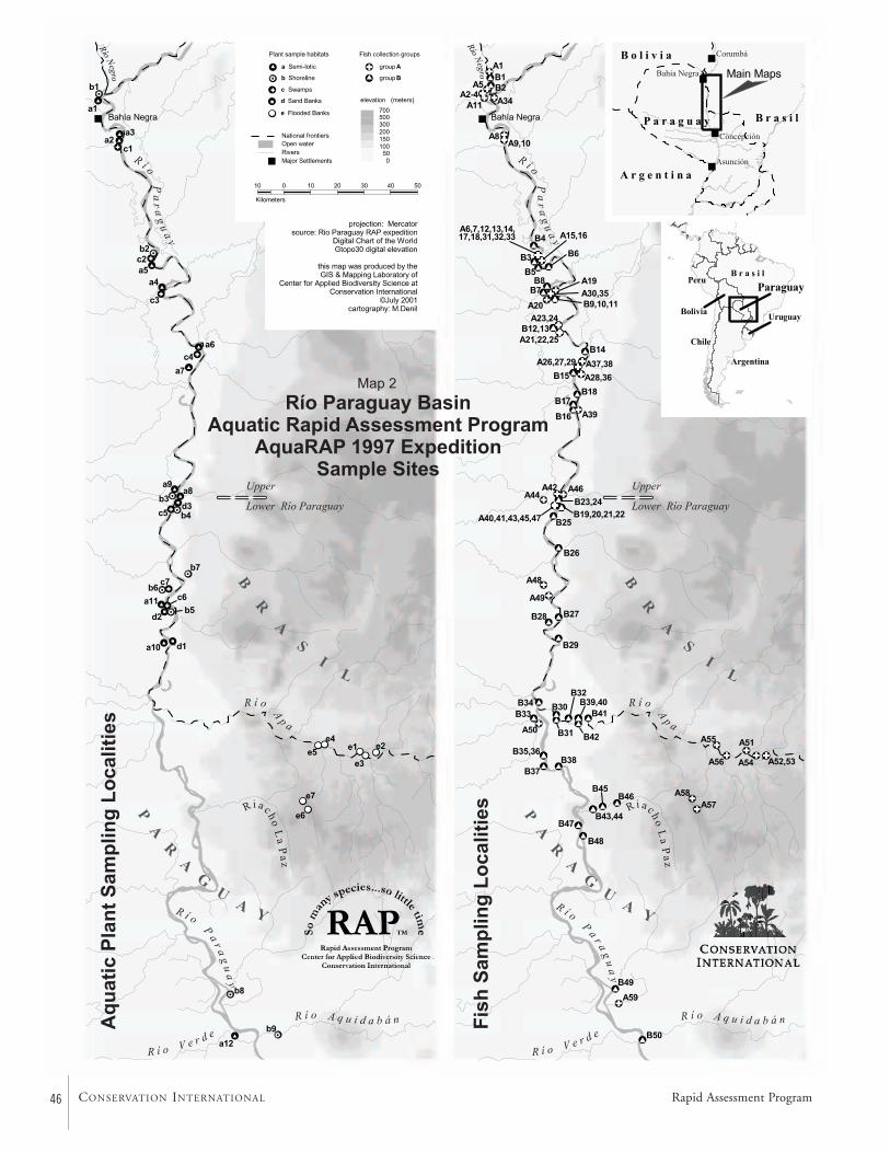
46 CONSERVATION INTERNATIONAL Rapid Assessment Program
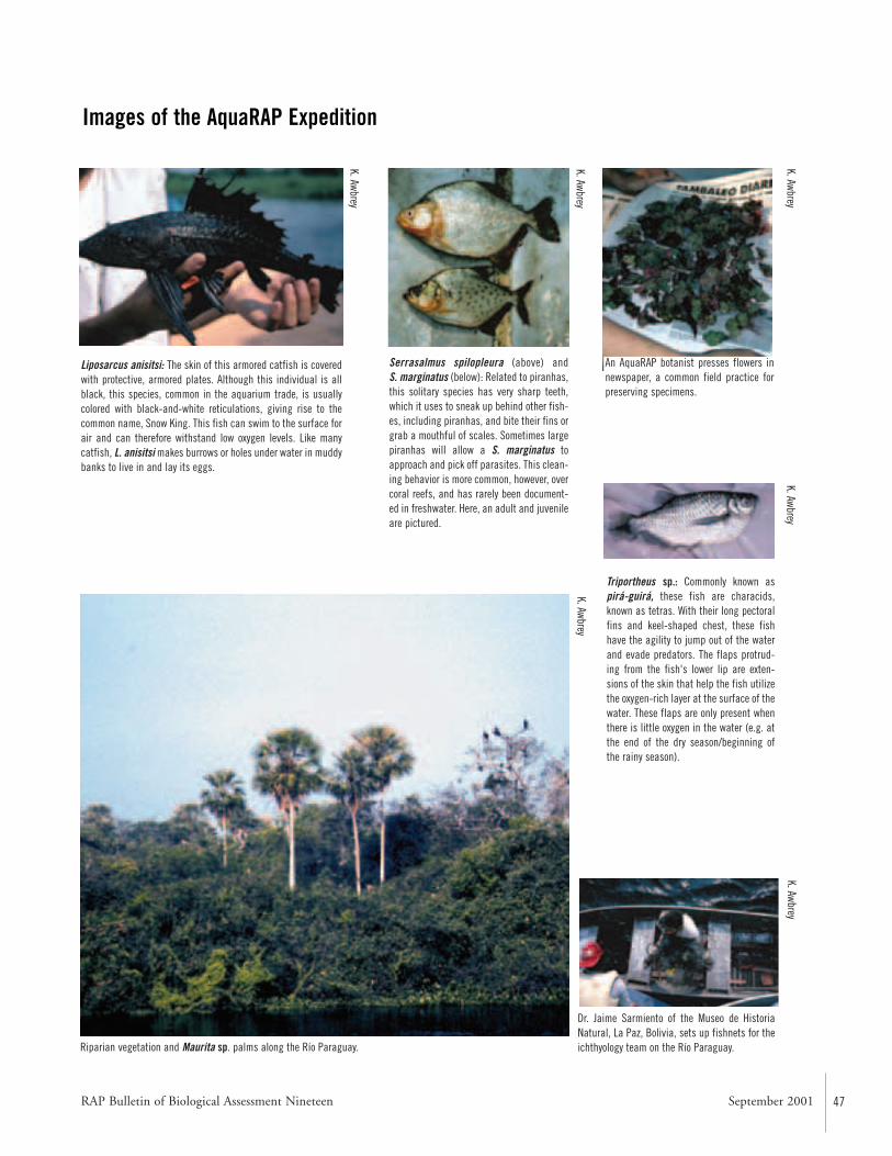
RAP Bulletin of Biological Assessment Nineteen September 2001 47
Images of the AquaRAP Expedition
Liposarcus anisitsi: The skin of this armored catfish is coveredwith protective, armored plates. Although this individual is allblack, this species, common in the aquarium trade, is usuallycolored with black-and-white reticulations, giving rise to thecommon name, Snow King. This fish can swim to the surface forair and can therefore withstand low oxygen levels. Like manycatfish, L. anisitsi makes burrows or holes under water in muddybanks to live in and lay its eggs.
Serrasalmus spilopleura (above) and S. marginatus (below): Related to piranhas,this solitary species has very sharp teeth,which it uses to sneak up behind other fish-es, including piranhas, and bite their fins orgrab a mouthful of scales. Sometimes largepiranhas will allow a S. marginatus toapproach and pick off parasites. This clean-ing behavior is more common, however, overcoral reefs, and has rarely been document-ed in freshwater. Here, an adult and juvenileare pictured.
An AquaRAP botanist presses flowers innewspaper, a common field practice forpreserving specimens.
Triportheus sp.: Commonly known aspirá-guirá, these fish are characids,known as tetras. With their long pectoralfins and keel-shaped chest, these fishhave the agility to jump out of the waterand evade predators. The flaps protrud-ing from the fish's lower lip are exten-sions of the skin that help the fish utilizethe oxygen-rich layer at the surface of thewater. These flaps are only present whenthere is little oxygen in the water (e.g. atthe end of the dry season/beginning ofthe rainy season).
Dr. Jaime Sarmiento of the Museo de HistoriaNatural, La Paz, Bolivia, sets up fishnets for theichthyology team on the Río Paraguay.Riparian vegetation and Maurita sp. palms along the Río Paraguay.
K. AwbreyK. Awbrey
K. AwbreyK. Awbrey
K. Awbrey
K. Awbrey
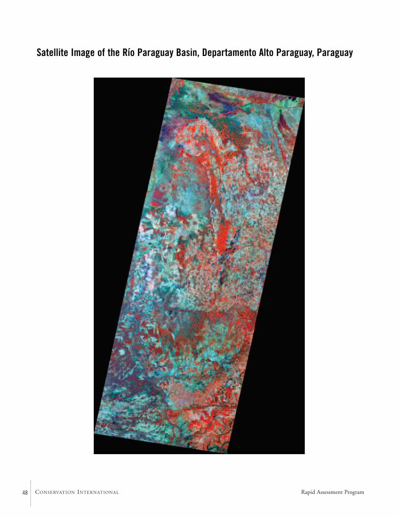
48 CONSERVATION INTERNATIONAL
Satellite Image of the Río Paraguay Basin, Departamento Alto Paraguay, Paraguay
Rapid Assessment Program
RAP Bulletin of Biological Assessment Nineteen September 2001 49
Abstract
The Río Paraguay is 2,550 kilometers (1,580 miles) long and its basin covers 1,100,000 kilometers2 (420,000 miles2;Bonetto, 1986a). It begins in the highlands of Planalto doMato Grosso in southwestern Brasil, and subsequently flowssouth along the Pantanal, the world’s largest wetland (Map 1).After exiting the Pantanal, the Río Paraguay splits the countryof Paraguay into western and eastern halves before mergingwith the Río Paraná. Together, the ríos Paraguay and Paranáform the second largest watershed in South America.
Though water levels in the rivers depend upon theamount of rainfall, the relationship is not quite so simple. In the Pantanal, much of the rain falls during the summermonths, but the low gradient and flooding of the wetlandsmaintains the water in Brasil. This water is slowly releasedand it moves as a pulse southward. According to Ferreira etal. (1994), peak water levels in the Río Paraguay basin occur,on average, in February to March in the northern Pantanal,April to May at Corumbá, and July to August at the mouthof the Río Apa. This hydrological phenomenon tempers themagnitude of downstream flooding. Even though water lev-els can change up to 4 meters (13 feet) in the BrazilianPantanal, the Río Paraguay rises only 1.5 meters (5 feet) atAsunción (Weil et al., 1984:15).
The Río Paraguay in northern Paraguay is a large, mean-dering river which flows through relatively flat terrain. Waterlevel fluctuations and the flat terrain result in widespreadflooding and frequent changes in the course of the river.Oxbow lakes and abandoned channels are common. Forestsand palm stands line the river’s banks. These are routinelyflooded for several months each year. Large masses of float-ing vegetation (e.g., Eichhornia sp.) known as floating mead-ows are common. Rock outcroppings near Cerritos Pão deAçúcar form a natural bottleneck, slowing the free flow ofwater downstream.
The Río Apa differs from the Río Paraguay in that it is asmaller river with cascades and waterfalls. The bottom is predominantly sand and the banks are high and well defined.Accumulations of tree trunks and branches are common.Habitat diversity in the Río Apa is lower than in the RíoParaguay. Water levels can change rapidly in response torains.
The Riacho La Paz can be described as a headwaterstream whose course alternates between riffles and pools. Thebottom is sand and rock. Water levels can change rapidly inresponse to rains. Habitat diversity is low.
Introduction
To understand the biology of organisms, it is necessary to befamiliar with the environmental variables to which they are,or potentially may be, exposed. This holds true for aquaticorganisms, since geology, topography of the land, hydrology,climate, and other environmental features influence their dis-tributions and life histories. This chapter will briefly describesome of the environmental features of the area surveyed bythe 1997 AquaRAP expedition.
The Río Paraguay itself is 2,550 kilometers (1,580 miles)long, and its basin covers 1,100,000 kilometers2 (420,000miles2) (Bonetto, 1986a). It flows into the Río Paraná, whichextends 4,000 kilometers (2,500 miles) and combines withthe Río Paraguay to cover 2,800,000 kilometers2 (1,100,000miles2) with a yearly discharge of 500,000,000 meters3
(16,800,000,000 feet3) (Bonetto, 1986a). Together, the ríosParaguay and Paraná form the second largest watershed inSouth America.
The Río Paraguay begins in the highlands of plan-alto ofthe southwestern state of Mato Grosso in Brasil. It almostimmediately flows into the Pantanal, the world’s largest wet-land, which covers approximately 140,000 kilometers2
CHAPTER 1
Geographic Overview of the Río Paraguay Basin, Departamento Alto Paraguay, Paraguay
Philip W. Willink, Jaime Sarmiento, Barry Chernoff, Mônica Toledo-Piza, Darío Mandelburger, and Mirta Medina
50 CONSERVATION INTERNATIONAL
(54,000 miles2), reaches 250 kilometers (155 miles) in width,and occupies portions of Brasil, Bolivia, and Paraguay(Bonetto, 1986b; Ferreira et al., 1994; Hamilton et al.,1997; Heckman, 1998:1). The Río Paraguay flows throughelevations 80 to 150 meters (260 to 480 feet) (Ferreira et al.,1994), and the region is essentially the amalgamation ofnumerous alluvial fans. It is here in the Pantanal that the RíoParaguay grows in size due to the influx of the ríos Cuiab,São Lourenço, Taquarí, Negro, and Aquidauana among oth-ers. The majority of the Pantanal is encircled by the Serrados Parecis, the Plan-alto of Mato Grosso, Serra deMaracajú, and other uplands with elevations exceeding 250meters (800 feet) (Ferreira et al., 1994). A low point can befound south of Corumbá, Brasil, where the Río Paraguayenters the country of Paraguay.
The Río Paraguay forms the border between northernParaguay and Brasil (Map 1). To the east can be found thesouthern vestiges of the Pantanal: specifically the Pantanal deNabilique (Map 1). To the west is the Chaco, a flat, dryexpanse with little in terms of topography (Weil et al.,1984:11). Streams, rivers, and swamps appear during therainy season, but the majority disappear during the dry sea-son. The swamps which remain are typically saline.
South of the Río Apa, the Río Paraguay divides the coun-try of Paraguay into two regions. The east (known asParaguay oriental) can be subdivided into two generalregions. The eastern edge, which borders Brasil, is the ParanáPlateau. This plateau is flat, with many forested areas andserves as the area of origin for many of the easternParaguayan rivers, such as the Río Apa. These rivers flowwestward, descend rapidly off the plateau, then slowly windthrough the rolling countryside between the Paraná Plateauand the Río Paraguay. Over 90% of the human populationin this area lives within Oriental Paraguay (Weil et al.,1984:11–12). The west (known as Paraguay occidental) is adamper portion of the Chaco where substantial swamps andseveral large, permanent rivers exist (Weil et al., 1984:11).
South of Asunción, where the Río Pilcomayo joins theRío Paraguay, the Río Paraguay forms the border betweenArgentina and southern Paraguay (Map 1). There is littletopography in southern Paraguay, and swamps are commonand widespread (Weil et al., 1984:12). At the southern tip ofParaguay, the Río Paraguay joins the Río Paraná. The RíoParaná continues southward through Argentina, eventuallymerging with the Río Uruguay to form the Río de La Platawhich passes Buenos Aires, Argentina, and Montevideo,Uruguay, before emptying into the Atlantic Ocean.
Geology
Western Paraguay is a relatively flat expanse of land locatedbetween the Precambrian Brazilian Shield immediately to theeast and the Late Cretaceous Andes distantly to the west.
From the Late Cretaceous to the Middle Miocene (approxi-mately 90 to 12 million years ago), the exact courses of the rivers in Western Paraguay are difficult to reconstruct.The region was generally part of a proto-Paraná watershed or sea. At other times, the region likely drained into a paleo-Amazon-Orinoco basin, which emptied into what is now theCaribbean (Lundberg et al., 1998). During the Late Miocene(about 11 million years ago), an episode of Andean upliftresulted in subsidence of the land immediately to the east of the Andes. The Atlantic Ocean flowed into this depres-sion, creating the Paranan Sea. This sea stretched to northernArgentina and possibly southern Bolivia, including westernParaguay. The ocean retreated around 9 million years ago(Marshall and Lundberg, 1996; Lundberg et al., 1998).Western Paraguay was subsequently covered by soil erodedfrom the Andes and the Brazilian Shield (Weil et al.,1984:20; Marshall and Lundberg, 1996; Horton andDeCelles, 1997). The region is now part of the Paraná water-shed, with the Michicola Arch in Southern Bolivia formingthe local basis for the drainage divide between the Amazonand Paraguay basins (Lundberg et al., 1998).
Climate and River Levels
Paraguay’s climate can best be described as subtropical.Summer lasts from October to March, when the region’sweather is dominated by warm, humid air coming from theAmazon basin. Cold, dry air from the south, called “surazos”,dominate the winter weather (Weil et al., 1984:12–14;Killeen, 1998). In eastern Paraguay, temperatures can reach40° C in the summer and dip below freezing in the winter,although monthly averages range from 18° to 29° C. Temp-eratures are always high in the Chaco, even during the winter(Weil et al., 1984:14).
Rainfall varies across the region, but is concentratedbetween October and March. The Chaco receives 500 to1,000 millimeters (20 to 40 inches) a year; much of it evapo-rates immediately due to the high temperatures. Asunciónhas recorded 560 to 2,100 millimeters (22 to 82 inches),with the Paraná Plateau experiencing up to 3,300 millimeters(130 inches) in a single year (Weil et al., 1984:14–15). Theseare probably extreme values. The Pantanal receives about1,100 millimeters (43 inches) annually (Schaller andCrawshaw, 1982; Heckman, 1998:45–49; but see Hamiltonet al., 1997 for a slightly higher estimate). Typical yearly pre-cipitation for the region surveyed by the AquaRAP expeditionappears to be 1,100 to 1,400 millimeters (43 to 55 inches)(Heckman, 1998:48).
Though water levels in the rivers depend upon theamount of rainfall, the relationship is not quite so simple. Inthe Pantanal, much of the rain falls during the summermonths, but the low gradient and flooding of the wetlandsmaintains the water in Brasil. This water is slowly released
Rapid Assessment Program
RAP Bulletin of Biological Assessment Nineteen September 2001 51
and it moves as a pulse southward. According to Ferreira etal. (1994), peak water levels in the Río Paraguay basin occur,on average, in February to March in the northern Pantanal,April to May at Corumbá, and July to August at the mouthof the Río Apa. This hydrological phenomenon tempers themagnitude of downstream flooding. Even though water lev-els can change up to 4 meters (13 feet) in the BrazilianPantanal, the Río Paraguay rises only 1.5 meters (5 feet) atAsunción (Weil et al., 1984:15). This hydrological phe-nomenon helps temper the magnitude of downstream flood-ing. This provides graphic evidence for the interconnected-ness and continuity of aquatic systems.
Although much of the land is flat, there are some placesof higher elevation, such as near Cerritos Pão de Açúcar (21°26’ S, 57° 55’ W). The rock outcroppings near this locationact as a bottleneck; slowing the free flow of water down-stream, causing the floodplain to be wider upstream fromCerritos Pão de Açúcar.
The combination of the pulse of water, generally lowtopography, and occasional rock outcroppings results in seasonal flooding that affects large areas adjacent to the RíoParaguay. The entire Pantanal, which stretches from near theheadwaters of the Río Paraguay to the Río Apa, is floodedevery year. Portions of the Chaco desert become swamps andflowing rivers (Weil et al., 1984:14).
Habitats of the Río Paraguay
Due to the size of the river and relatively large water levelfluctuations in an area with flat terrain, the Río Paraguay cre-ates a vast flooded plain that results in the formation of ahigh diversity of habitats.
Broad fringes of vegetation associated with the numeroustributaries (river branches, streams, backwaters) are foundalong the length of the main channel of the Río Paraguay.These tributaries can be, depending upon the season, of con-siderable widths and depths. Banks are poorly defined (onlyin some sections can one see the top part of the banks), andthe bottom is basically unconsolidated clay-sand. Small sandbeaches were found on rare occasions.
A characteristic element of the river is the presence oflarge areas occupied by tremendous quantities of floatingvegetation like Eichhornia sp., floating Cyperaceas orGramineas, and water hyacinth beds. The floating meadowsoccupy large areas and are generally found in slow currents,stream outlets, and small rivers, forming compact masses offloating vegetation that can obstruct navigation. The RíoParaguay is also characterized by vast seasonally floodedplains, creating flooded forests habitats and inundated palmstands. During the expedition, many of these areas were cov-ered with more than 2 meters of water.
Due to intense fluvial dynamics, the river valley includesnumerous abandoned branches and meanders that form
oxbow lakes of different sizes and maintain different degreesof communication with the principal river. Due to their flu-vial origin, most of these lakes have a half moon shape.Frequently, because of increased settling of sediments, theyhave a lighter color than the main river and are often associ-ated with, especially in shallower areas, floating or rootingherbaceous vegetation. These lakes are in different stages ofsuccession, with some cases exhibiting abundant vegetationand others with vast surfaces of open water. The stage isdependent upon the degree of contact with the main riverand their water supply. The depth depends on the level ofsuccession, and can vary from a few meters to depths similarto the main channel.
Habitats of the Río Apa
The Río Apa basin includes numerous streams that originatein the lowlands and oxbow lakes with different degrees ofconnectivity to the main river. These lakes are in stages ofvarying succession related to their distance from the Río Apa.Generally within the study area, the Río Apa is a meanderingriver with well defined banks covered by a 20 meter high for-est. The bottom is usually sandy and large sand beaches arecommon. The river is approximately 20–25 meters wide and1 meter deep in the dry season. It is characterized by thealternation of deeper pools with slower moving water andshallower areas with more rapid currents. The river is usuallydeeper and the water moves slower in the meanders.
The Río Apa differs from the Río Paraguay by the pres-ence of various waterfalls and rapids, such as the rapidsupstream of San Carlos and a waterfall located near the out-let. The rapids constitute a 500 meter section with numerousrocks in a shallow area with a very strong current, makingnavigation difficult. The waterfalls downstream constitute aninsurmountable obstacle for navigation that can only be cir-cumvented through a side channel.
Furthermore, due to a shallower depth and a higher fre-quency of woods along the banks, there are commonly largeaccumulations of trees and branches in the river. These fur-nish an important habitat for many species of aquatic insects,crustaceans, molluscs, and fishes (primarily Siluriformes) thatlive in trunk cavities or among submerged branches.
In the Río Apa, rapid fluctuations in water levels, or flashfloods, can occur due to rains anytime of the year. Water drainage is faster than in the Río Paraguay because of the steeper inclination, which results in a reduced capacityfor water accumulation. In the lower part of the Río Para-guay during the growth stage of a flashflood, a “water retention” phenomenon can occur, producing inverted current flows.
In general, the smaller system size, predominance of sand,and existence of a less developed flood plain causes a lowerdiversity of habitats in the Río Apa than in the Río Paraguay.
52 CONSERVATION INTERNATIONAL
Habitats of the Riacho La Paz
Hydrologically, the Riacho La Paz can be described as a smallbasin which originates in a mountainous area and emptiesinto the Río Paraguay. It flows for about 60 kilometers (38miles) and its basin encompasses approximately 1,600 kilo-meters2 (625 miles2) (Map 1).
The upper parts of Riacho La Paz correspond to a minorfluvial system, with well-defined banks of consolidated sandand rocks. In the stream-bed, water flows over rocks alternat-ing with small, round pebbles and sand. The channel is lessthan 10 meters wide, is generally less than 1 meter deep, andalternates between stretches of rapid currents in shallowerareas and slower currents in deeper areas. Small logjams canbe found that provide shelter for some species.
As with other systems, Riacho La Paz possesses a highly seasonal regime with a low water period from May to October–November, and a high water period fromNovember to March. However, like other systems that origi-nate in the nearby mountains, the regime is “flashier”, withquick changes in water level in response to precipitation.
The upper part of the Riacho La Paz is characterized bylow habitat diversity.
Literature Cited
Bonetto, A.A. 1986a. The Paraná River system. In Davies,B.R. and K.F. Walker (eds.). The ecology of river systems. Dordrecht, Netherlands: Dr. W. Junk Publishers.Pp. 541–555.
Bonetto, A.A. 1986b. Fish of the Paraná system. In Davies,B.R. and K.F. Walker (eds.). The ecology of river systems. Dordrecht, Netherlands: Dr. W. Junk Publishers.Pp. 573–588.
Ferreira, C.J.A., B.M.A. Soriano, S. Galdino, and S.K.Hamilton. 1994. Anthropogenic factors affecting waters of the Pantanal wetland and associated rivers in the upperParaguay basin of Brazil. In Barbosa, F.S.R. (ed.). ActaLimnologica Brasiliensia, volume V, workshop: Brazilian programme on conservation and management on inlandwaters. Fundacão Biodiversitas—Sociedade Brasileira deLimnologia, Belo Horizonte. Pp. 135–148.
Hamilton, S.K., S.J. Sippel, D.F. Calheiros, and J.M.Melack. 1997. An anoxic event and other biogeochemicaleffects of the Pantanal wetland on the Paraguay River.Limnology and Oceanography, 42:257–272.
Heckman, C.W. 1998. The Pantanal of Poconé: biota andecology in the northern section of the world’s largest pris-tine wetland. Boston: Kluwer Academic Publishers.622pp.
Horton, B.K. and P.G. DeCelles. 1997. The modern forelandbasin system adjacent to the Central Andes. Geology,25:895–898.
Killeen, T.J. 1998. Introduction. In Killeen, T.J. and T.S.Schulenberg (eds.). A biological assessment of ParqueNacional Noel Kempff Mercado, Bolivia. RAP WorkingPapers 10. Washington DC: Conservation International.Pp. 43–51.
Lundberg, J.G., L.G. Marshall, J. Guerrero, B. Horton,M.C.S.L. Malabarba, and F. Wesselingh. 1998. The stagefor neotropical fish diversification: a history of tropicalSouth American rivers. In Malabarba, L.R., R.R. Reis,R.P. Vari, Z.M.S. Lucena, and C.A.S. Lucena (eds.).Phylogeny and classification of neotropical fishes. PortoAlegre, Brasil: EDIPUCRS. Pp.13– 48.
Marshall, L.G. and J.G. Lundberg. 1996. Miocene depositsin the amazonian foreland basin. Science, 273:123–124.
Schaller, G.B. and P.G. Crawshaw, Jr. 1982. Fishing behaviorof Paraguayan Caiman (Caiman crocodilus). Copeia,1982:66–72.
Weil, T.E., J.K. Black, H.I. Blutstein, D.S. McMorris, F.P. Munson, and C. Townsend. 1984. Paraguay: a country study. Washington DC: Superintendent ofDocuments, U.S. Government Printing Office. 318pp.
Rapid Assessment Program
RAP Bulletin of Biological Assessment Nineteen September 2001 53
Abstract
Twelve variable transects were established to assess the terres-trial vegetation along the Río Paraguay and the Río Apa(Map 2). General collections also were made of plants notencountered on the transects. A total of 198 plant specieswere identified. There were five basic types of habitats along the Río Paraguay: seasonally inundated palm stands of Copernicia alba (carandá’y), non-flooded palm stands ofC. alba, modified forests of Schinopsis balansae, forested hills,and Chaco forests.
The seasonally inundated palm stands are very commonalong the Upper Río Paraguay. They are dominated by C. alba, but shrubs, lianas, and grasses are also abundant.The non-flooded palm stands of C. alba often are burnedand converted into pasture. The result is a forest comprisedalmost solely of small C. alba, grasses, and cypresses. Themodified forests of S. balansae were composed of a shrub-likelayer of Coccoloba aff. guaranitica, Tabebuia nodosa, Ziziphusmistol, Pseudobombax sp., Copernicia alba, Caesalpiniaparaguariensis, and Prosopis ruscifolia.
The forested hills are out of reach of the floods and thesoil drains rapidly. The flora is therefore similar to that foundin areas with little water. Trees tend to be small and grassesephemeral. Chaco forests are similar, with trees reaching 9 to12 meters in height. Spiny shrubs and grasses compose theundergrowth.
There are three basic types of habitats along the Río Apa:riparian vegetation, semideciduous forests, and cerradão. The riparian vegetation borders the Río Apa and is floodedduring high waters. The semideciduous forests can be divid-ed into three stories: the highest level is composed of trees 25 to 30 meters in height; the intermediate level is made upof Croton urucurana, Trichilia sp., and Astronium fraxinifoli-um; and the understory is merely a few bushes. Many of thespecies are deciduous, but during the rainy season this
habitat would resemble a rain forest. Cerradão formations arefurthest from the river, where larger trees are uncommon.
Overall, the terrestrial vegetation adjacent to the rivers islargely influenced by the fluctuations in water levels and theseasonality of the rains. Burning and habitat conversion,principally for cattle ranching, have had a significant impacton the region. Evidence for this is that pristine vegetationwas not encountered during the expedition. Excess deforesta-tion is accelerating erosion, resulting in major sedimentationof the Río Paraguay.
Methods
We used the variable transect method (R.B. Foster, N.C.Hernández E., E.K. Kakudidi, and R.J. Burnham, unpub-lished manuscript). A total of 12 transects were established(Appendix 1, Map 2). In each of them we counted 20 indi-viduals. We established two categories, >5 centimeter diame-ter at breast height (DBH) and >15 centimeter DBH. Wealso recorded those with >30 centimeter DBH in some cases.General collections of plants that were not encountered onthe transects were also made (Appendix 2). A total of 302plant collections were deposited in the Herbario delParaguay—Facultad de Ciencias Químicas (UNA) and TheField Museum in Chicago (FMNH).
Río Paraguay Floral Habitats
Seasonally Inundated Palm Stands of Copernicia albaThese are very common along the length of the RíoParaguay, from Bahía Negra to Los Cerritos. These palmstands occupy low plains areas on both sides of the river thatare flooded for the majority of the year. It is sufficient for theriver to rise only a few centimeters in order for the flooding
CHAPTER 2
Terrestrial Flora of the Upper andLower Río Paraguay Basin and the Río Apa Sub-basin, Paraguay
Hamilton Beltrán
54 CONSERVATION INTERNATIONAL
to reach three or four kilometers inland. It appears that thesmall hills located in Los Cerritos act like natural containersof the river, with the bed of the river and subsequent flood-ing wider to the north and narrower to the south.Ecologically, this habitat is closely tied to other forms ofaquatic life (zooplankton, fishes), which use this zone forfeeding, refuge, and growth of juveniles.
This community is composed of a homogenous arboreallayer dominated by Copernicia alba (Transects 1, 2) (Appen-dix 1), with vigorous individuals reaching 10 to 12 meters inheight. Occasionally, there are other trees like Aporosella cha-coensis. The presence of shrubs, vines, and grasses increasesthe diversity and density. Additional important speciesencountered, besides the dominants, are various fabaceas(Acacia spp., Caesalpinia spp.), Pacourina edulis, Mikaniascandens, Phyla reptans, and species of Borreria, Cissus,Waltheria, Alternanthera, Combretum, and Echinodorus.
Non-flooded Palm Stands of Copernicia albaSome C. alba palm stands are not exposed to regular flood-ing. The vegetation is modified, and it may be better to call it savanna vegetation. These areas are burned and sub-sequently converted to pasture for cattle. The end result is aforest almost completely of Copernicia alba, with each indi-vidual small in size. In some cases, one encounters individ-uals of Prosopis ruscifolia (vinal) and Prosopis vinalillo (vin-alillo). These are left to supply shade for the cattle. A pro-fuse herbaceous vegetation of grasses and cypresses is alsopresent.
Modified forests of Schinopsis balansaeThese disturbed, shrub-like forests do not exceed 12 metersin height and are dominated by Coccoloba aff. guaranitica,Tabebuia nodosa, Ziziphus mistol, Pseudobombax sp., Coper-nicia alba, Caesalpinia paraguariensis, and Prosopis ruscifolia.This last species is common in disturbed environments. Theundergrowth is dominated by various poaceas and species ofcaraguat, Bromelia balansae and Aechmea distichantha, amongothers.
The presence of “forest islands” surrounded by watershould be noted. These are forests of Schinopsis balansae,which probably developed in depressed areas that are floodedwhen the river swells. Species that can endure periodic inun-dations are found here. Examples are Tabebuia heptaphylla,Coccoloba sp., Cathormion polyanthum, Genipa americana,and Celtis pubescens.
Forested hillsOn the stretch of the Río Paraguay between Fuerte Olimpoand Los Cerritos, small promontories of rock (hills) ofapproximately 150 meters in height are easily distinguishedfrom a distance. On these hills the rocks are exposed, the soilis shallow, and drainage is rapid. The hills are covered byvegetation adapted to long periods of little water (e.g.,
species of Cnidosculos, Jatropha, Carica). Here we encoun-tered the first and only Cactaceae, Stetsonia coryne, of theentire expedition. The growth of grasses is ephemeral anddependent upon the seasonal rains. The height of the trees (5 centimeter DBH) does not surpass 12 meters (Transects 6,7, 8) (Appendix 1). The dominant species are Cordia glabra-ta, Astronium urundeuva, Stetsonia coryne, and Pseudobombaxsp. Infrequently, there are the spiny palms Acrocomia totaiand a Myrtacea. There is a high species richness of deciduousshrub species, some of them spiny like Celtis sp., Randia sp.,Cnidosculos albomaculatus, Jatropha grossidentata, and variousMalvaceae.
Chaco ForestsThis vegetation occupies flat areas that are not flooded. Theseforests are more frequent to the south, and are commonlydeforested. Physiognomically, it is considered one unit. It isdifficult to discern layers in a shrub forest with a height of 9 to 12 meters. One species does not dominate, but Tabebuianodosa (labón) and Pseudobombax are more frequent.Between the lower stems of the trees grows a tangle of spinyshrubs with many shoots that make the forest difficult towalk through. Dominant species are Coccoloba “glabra” andCoccoloba “pubescente”. The forest floor is covered by grassesand bromeliads (caraguat).
Río Apa Floral Habitats
Riparian vegetationThis vegetation is immediately above the high banks of theriver and is flooded during the high-water season. Three veg-etation levels are recognized. The first one is composed ofInga marginata, Guadua sp., Ficus sp., Vitex megapotamica,and Astronium urundeuva. The second level is composed ofTriplaris aff. guaranitica, Genipa americana, Croton urucu-rana, Cecropia aff. pachystachya, Acrocomia sp., Guazumaulmifolia, and Crataeva tapia. The third is composed ofsmaller species, such as Salix humboldtiana, Rapanea sp.,Attalea guaranitica, and Eugenia sp.
The undergrowth is sparse with abundant lianas likeCombretum sp., Arrabidaea corallina, and Smilax sp. Alongtributaries, like the Arroyo Blandengue, the riparian forest is similar, with Peltophorun dubium in the first level, andHygrophylla sp., Cyperus sp., Heliotropium sp., and Eleocharissp. along the shore.
Semideciduous ForestsThis type of vegetation is very close to the Río Apa. It isabove sandy substrate that is topographically level with occa-sional depressions. The characteristic of this formation is thatmany species are deciduous, but in times of rain it wouldhave certain structural similarity to the rain forests. One canclearly discern three levels: the highest with 25–30 meter
Rapid Assessment Program
RAP Bulletin of Biological Assessment Nineteen September 2001 55
trees with luxuriously leafed branches and some emergents(Vitex megapotamica, Hymenaea sp., Patagonula americana),the intermediate of juveniles and medium trees (Croton uru-curana, Trichilia sp., Astronium fraxinifolium), and the lowestof a few bushes. In this type of forest, it is possible to ascer-tain that the majority of the diversity is due to tree speciesand that there has been little disturbance.
CerradãoThis vegetative formation is a little further from the riverwhere the terrain is level and sandy. The dominant fauna isdeciduous, with a canopy no more than 10 meters in height.Large trees are not common. Very dense formations areexclusively of Eugenia sp. and Pouteria sp. In the soil, there isno growth of herbaceous vegetation except for caraguatá(Bromelia spp.).
Recommended Conservation and Research Activities
• The basin of the Río Apa and nearby areas (principallyRío Arriba de Puerto San Carlos) should be a high priori-ty for conservation for the following reasons: the diversityof tree species is high, there have been few modificationsto the ecosystem, and the soil is sandy and not fit for cattle ranching or agriculture.
• Continued removal of the vegetative cover will accelerateerosion, resulting in major sedimentation of the RíoParaguay. Steps to preserve riparian vegetation are needed.Reforestation programs are also encouraged.
• The terrestrial vegetation adjacent to the Río Paraguayand some effluents (e.g., the Río Aquidabán and the Río Apa) is largely influenced by seasonal fluctuations inwater level. Habitat alterations that affect flooding willhave a major impact on the native flora, and should beprevented.
• Many years of human intervention have modified to some degree the vegetative cover due to the inclination toburn the vegetation with subsequent introduction of cattle. Evidence for this is that pristine vegetation was not encountered during the expedition. Continued unreg-ulated slash-and-burn agriculture is discouraged, andsome areas should be set aside so they may return to theirnatural condition.
56 CONSERVATION INTERNATIONAL
Abstract
Aquatic vegetation was sampled at 31 localities along the RíoParaguay and seven localities along the Río Apa (Map 2). Atotal of 147 species were identified along the Río Paraguayand 50 species along the Río Apa, for a grand total of 187aquatic plant species.
The flooded banks of the Río Paraguay were dominatedby a “mosaic of vegetation”. The components of this“mosaic” are forests of Schinopsis balansae, savanna-palmstands of Copernicia alba, flooded lowlands, and shorelinevegetation. In the Río Paraguay, we focused on the shore-line vegetation. This vegetation was subdivided into semi-lotic, shoreline, swamp, and sand bank habitats. Specieswere categorized according to their life style: epiphytic, free floating, liana, marsh, rooted semi-submergent, or submergent.
Habitats with slow flowing water are found where theriver overflowed its banks. These habitats are much morediverse than one would expect by chance, and probablyaccount for the majority of aquatic floral diversity within the study area. This high diversity may be related to thedynamics of the water levels and nutrient cycles. Shorelinehabitats are relatively poor in aquatic vegetation, possiblybecause the constant movement of water hinders the growthof many species.
Swamps are highly variable. Some, with little sediment,could better be described as “floating meadows”. Others,usually in areas sheltered from the wind and currents and inmore advanced stages of development, possess an appreciableamount of substrate. The number of species in a given area isroughly proportional to the amount of substrate.
Sand bank habitats are generally less rich in species, prob-ably due to the poor quality of nutrients in their soils.However, the plant species encountered are very distinctiveand characteristic of these sites.
The aquatic floral diversity of the Río Apa is much lowerthan that of the Río Paraguay. This is probably due to thehigh current velocity, lack of habitat diversity, preponderanceof sand, and large numbers of trunks and branches through-out the channel. The more diverse environments are found insome of the tributaries.
Introduction
The Pantanal is an immense sedimentary plain that is alteredconstantly by periodic inundations. The northern portion inBrasil is called the Pantanal Mato-Grossense. The southernlimit reaches to the vicinity of the mouth of the Río Negroand its confluence with the Río Nabileque. Others considerthe Pantanal de Nabileque, which extends from the RíoNegro to the Río Apa, to be part of the entire Pantanal com-plex (Cabrera and Willink, 1976; Adamoli, 1982). It isapproximately 680 kilometers in a straight line from Cáceres,Brasil to the Río Apa.
The region of the Upper Río Paraguay is a large area oflevel plain with a variable geomorphology. This level plainhas been and continues to be a site of alluvial depositionarriving from a variety of rivers, like the Paraguay and itstributaries that form the basin. Basically, the entire region isinfluenced by the following three factors. The first factor isthe highly unstable hydrological system, influenced almostcompletely by the almost lack of slope of the terrain in thenortheast-southwest direction; and an unstable hydrologicalregime of the rivers characterized by a temporary, sharpinflux of water during summer. This results in a strongmeandering plain determined by the geomorphology of thealluvial terrain. The normal, annual flood cycle determinedby seasonal cycles of rainfall is the second factor, and thethird consists of the heterogeneity of soils, includingQuaternary soils of alluvial origin.
CHAPTER 3
Evaluation of the Aquatic FloralDiversity in the Upper and Lower Río Paraguay Basin, Paraguay
María Fátima Mereles
Rapid Assessment Program
RAP Bulletin of Biological Assessment Nineteen September 2001 57
The Vegetation of the Littoral Zone of the Upper RíoParaguay
The physiognomy of the vegetative formations of the UpperRío Paraguay and the Pantanal de Nabileque, bordering thestudy area, is similar to that of the littoral vegetative forma-tions of the Chaco. The flooded banks of the Río Negro,north of Bahía Negra, Paraguay, are dominated by a vegeta-tion mosaic (Mereles and Aquino-Shuster, 1990). This vegeta-tion mosaic is typical of the damper regions of the Chaco and consists of forests of Schinopsis balansae (Anacardiaceae),savanna-palm stands of Copernicia alba (Arecaceae), andflooded lowlands with a variety of aquatic-marsh vegetationdependent upon the geomorphology of the terrain and per-meability of the soils. These conditions are essentially con-stant along the length of the Río Paraguay from the RíoNegro to the border of the Provincia de Santa Fé, Argentina.Vegetation mosaics occupy practically the entire flood plainsof the primary rivers of the Chaco basin, including: the RíoParaguay, the Río Pilcomayo (from northern Chaco,Paraguay to southern Chaco, Argentina), and the RíoBermejo (Argentinian Chaco).
As long as the forests of Schinopsis balansae and the palmstands of Copernicia alba are found over clay soils, which arestructured and impermeable, they will likely be subject toperiodic flooding. The time period of inundation is depen-dent upon two factors: the intensity of the rains and theswelling of the rivers, particularly the Río Paraguay, whoseswelling is subject also to the quantity of rain falling in thePantanal region to the north.
Forests flooded for 3–6 months of the year are dominat-ed by Schinopsis balansae, also known as the quebracho colorado. Where this habitat converges with others in theregion, like the xerophytic Chaco (Spichiger et al., 1995) andthe Floresta Estacional Residual (Velos and Goes-Filho,1982), other species become common. Examples of some ofthese other species are Caesalpinia paraguariensis, Gleditsiaamorphoides, Prosopis nigra, Enterolobium contortisiliquum,Lonchocarpus fluvialis (Leguminosae), Phyllostylon rham-noides, Ziziphus mistol (Rhamnaceae), Chlorophora tinctoria(Moraceae), Trithrinax biflabellata, Syagrus romanzoffiana(Arecaceae), Diplokeleba floribunda, Magonia pubescens(Sapindaceae), Tabebuia heptaphylla, T. nodosa (Bignonia-ceae), Astronium urundeuva, Schinus fasciculatus (Anacard-iaceae), Maytenus ilicifolia (Celastraceae), and Crataeva tapia(Capparaceae) among others (Mereles et al., 1992).
The palm stands of Copernicia alba occupy large areaswithin the mosaic of vegetation. The canopy is composedsolely of Copernicia alba, except where the savanna-palmstands have been modified by human activity, such as raisingcattle. This has occurred over large areas of the Chaco and
along the littoral zone. In these cases, the palm stands havebeen invaded by very aggressive leñosas of the familyFabaceae (e.g., Prosopis ruscifolia, Geoffroea decorticans, andAcacia caven) (Mereles and Degen, 1997).
Under natural conditions, the palm stands of Coperniciaalba are very open and one can observe additional species likeMimosa hexandra (Fabaceae), Croton urucurana (Euphor-biaceae), and Thevetia bicornuta (Apocynaceae). In lowerareas with permanent water, large concentrations of herba-ceous rizomatozas like Cyperus giganteus, Scirpus californicus(Cyperaceae), and Typha domingensis (Typhaceae) can be fre-quently observed. These permanent water conditions aremore common near the outlet of the Río Nabileque into theRío Paraguay.
Palm stands can possess a very rich herbaceous layer thatalternates between aquatic-marsh and terrestrial species. Thisresults in high variability, and is due to the periodic flooding.Some of the more common species in this layer are Aeschy-nomene sensitiva, A. falcata, Dischollobium pulchellum, Nep-tunia prostrata (Leguminosae), Byttneria filipes (Sterculiaceae),Commelina diffusa (Commelinaceae), Caperonia palustis (Eu-phorbiaceae), Eragrostis hypnoides, Leersia hexandra (Poaceae),Eupatorium candolleanum, Pterocaulum furfurescens (Co-mpositae), Fimbristylis complanata, Eleocharis elegans, E. nodu-losa (Cyperaceae), Heliotropium procumbens (Boraginaceae),Mayaca sellowiana (Mayacaceae), Ipomoea carnea spp. fistulosa(Convolvulaceae), Pavonia moronguii, Cienfuegosia drumondii(Malvaceae), Juncus densiflorus (Juncaceae), and Phyla reptans(Verbenaceae) among others (Mereles et al., 1992).
In the third component of the mosaic, the flooded lowlands, one generally finds shelter for aquatic vegetation.These lowlands are often the remainders of old meanders ofthe Río Paraguay, its tributaries, or simply depressions in theterrain that remain flooded for most to all of the year. Inmany cases, species like Pistia stratiotes, Eichhornia crassipes,Azolla sp., or Salvinia sp. among others form large masses offloating vegetation.
Savannas of Tabebuia aurea are interspersed among theformations described above. These are usually over very permeable and less structured soils that are composed moreof sand than clay (Chodat and Vischer, 1977). Sapium subg-landulosum, Cecropia pachystachya, Thevetia bicornuta, andByrsonima intermedia are species typically found growing insandy soils, particularly if the area has been disturbed.
Finally, there is the shoreline vegetation. Common aquaticspecies can be divided into four different types: free floating,rooted on the shore, semi-submerged, and completely sub-merged. Each varies in function and type of aquatic habitat.The objective of this study was to determine the richness ofthe shoreline flora.
58 CONSERVATION INTERNATIONAL
Methods
For the Río Paraguay, Río Napegue, and Río Aquidabán,only plants within the aqueous portion of the river-bed weresampled. Exceptions were at those sites where shoreline vege-tation was partially covered by high-water, in which casethese plants (including lianas and the epiphytes) were includ-ed. The diversity of habitats encountered along the length ofthe river in the area of study (habitat heterogeneity) wasassessed. Representative plant specimens for each habitatwere collected. Quantitative methods were not utilized. Floraalong the shore was sampled by the terrestrial botany team(Beltrán, 2001).
Due to the paucity of aquatic vegetation in the Río Apa,the flooded banks were sampled with rapid transects between500 and 800 meters inland from the shore. The vegetationfurther away was sampled by the terrestrial botany team.Specimens not collected on a transect, but found in the samearea and considered informative were collected as well. Treeswith a diameter at breast height greater than 10 centimeterswere included in the count and collected if believed neces-sary, following the variable transect method (R.B. Foster,N.C. Hernández E., E.K. Kakudidi, and R.J. Burnham,unpublished manuscript).
Five duplicates for the majority of aquatic and marshplants were collected. The first set of collections was deposit-ed in the Herbario del Departamento de Botánica de laFacultad de Ciencias Químicas de la Universidad Nacionalde Asunción (FCQ). The second set was deposited in TheField Museum in Chicago (FMNH). The third set was de-posited in the Museo de Historia Natural de la UniversidadNacional Mayor de San Marcos, Lima (USM). Additionalsets were placed in FCQ. A list of common names of someof the plants identified on the expedition are provided inAppendix 3.
Floral Diversity along the Río Paraguay
Four distinct habitat types were documented along theshoreline of the Río Paraguay, each of which is describedbelow.
1) Semi-lotic habitatThis habitat is often encountered when rising waters havesurpassed the height of the banks and overflowed the shore-line, inundating vegetative formations that are periodicallycovered by water (e.g., the savanna-palm stands of Coper-nicia alba (Arecaceae)). Under these conditions, there is the possibility of a very gentle current. The current velocityis normal along the shore, but varies inland depending upon the shoreline morphology. Where small cavities form,the water becomes almost completely dammed at the sur-face, but continues to move along the bottom. This main-
tains constant water clarity in the habitat, permitting the passage of light up to a meter in some places. Other areas arecompletely stagnant.
We assume that one would find semi-lotic conditions inareas where water has overflowed the banks due to seasonalflooding. These habitats are much more diverse than onewould expect by chance, and probably account for the major-ity of aquatic floral diversity within the study area. This highdiversity may be related to the dynamics of the waters in rela-tion to their nutrients.
In a large number of cases, these flooded habitats arepalm stands of Copernicia alba. In other cases, they are ripari-an forests. When comparing the two, the flooded palmstands possess a richer biodiversity.
Twelve localities considered semi-lotic were sampled(Appendix 4, Map 2). Twenty-nine free-floating species, sixrooted semi-submergent species, five submergent species, one epiphytic species, and 21 marsh species (includes lianas,rooted semi-submergents, and others) were collected(Appendix 5).
2) Shoreline habitatThis habitat was relatively poor in aquatic vegetation and wasfairly consistent among the sites sampled. The constantmovement of the water currents along the shore limits thedevelopment of many species. Most plant species subsist bytaking root, and may be anything from grasses to trees. Therewas very little floating vegetation.
Nine localities considered shoreline were sampled (Appen-dix 4, Map 2). Four free-floating species, 44 rooted semi-submergent species, and eight liana species were collected(Appendix 5).
3) Swamp habitatThis habitat is highly variable and very common along theentire length of the Upper Río Paraguay (Mereles, 1989).Some are more homogenous and almost without substrate(false soil), such as the “floating meadows” (large aggregationsof floating vegetation). Others possess an appreciable amountof soil, facilitating the growth of shrubs and small trees.Species richness is proportional to the development andamount of soil (Mereles et al., 1992).
The area is teeming with examples of the first substrate-less stage (“floating meadows” in particular), probably dueto the combination of strong winds and surface currentsthat break up the shoots of the species which form the base of the swamps. However, in places protected from the current and wind, such as streams and old meanderingspresently isolated from the rivers, one is able to encountermore advanced stages containing considerable amounts of substrate. A larger variety of species are found at thesesites.
Eichhornia crassipes and E. azurea (Pontederiaceae) (espe-cially E. crassipes) constitute pioneering species for the
Rapid Assessment Program
RAP Bulletin of Biological Assessment Nineteen September 2001 59
swamps due to the tight joining of their shoots and ability tobe dispersed with the aid of water currents.
In some swamps, arboreal vegetation is abundantly repre-sented by Aporosella chacoensis, Bauhinia bauhinioides, andCrataeva tapia. These species can grow normally if the depthof substrate in the swamp is at least one meter.
Seven localities considered swamps were sampled(Appendix 4, Map 2). Eighteen free-floating species, tenlianas, two submergents, and 24 rooted semi-submergentspecies were collected (Appendix 5).
4) Sand bank habitatThese are generally less rich in diversity, probably due to thepoor quality of nutrients in their soils. However, the speciesencountered are very distinctive and characteristic of thesesites. Some sites are large and accumulate water in the interi-or, forming small ponds with muddier soil that is enrichedby the decomposition of organic material. Some species per-sist here, but are absent nearby where the soil is constantlyleached by the water and contains only sand.
It is interesting to note that sand banks are scarce up-stream from the San Alberto bank. This is probably due tothe strength of the current and the width of the river.
Three localities considered sand banks were sampled(Appendix 4, Map 2). Two free floating species, 21 rootedsemi-submergent species, and four lianas were collected(Appendix 5).
Floral Diversity in the Río Apa Sub-basin
Seven localities, each classified as a flooded bank, were sam-pled in the Río Apa (Appendix 4, Map 2). Twenty-eightaquatic plant species were collected on the flooded banks,and 22 species were collected along the shore, for a total of50 species (Appendix 6). The floral diversity of the Río Apasub-basin is much lower than the Upper and Lower RíoParaguay. Various factors are responsible for this, includingthe following:
• The Río Apa is a typical plains river, with a meanderingcourse and depths of no more than one meter. Water lev-els can increase and decrease rapidly. Current velocity issignificantly higher than the Río Paraguay, and two rapids(small cascades) are in the vicinity.
• The lack of habitat diversity was congruent with thescarcity of aquatic plants. For example, we rarely encoun-tered marshes. The microhabitats present in the RíoParaguay were practically nonexistent in the Río Apa,being replaced by flooded banks where aquatic speciesrarely grow.
• Sand banks are very abundant. They appear to have been formed recently, hindering prolonged growth of vegetation.
• The presence of wooden debris like trunks and branchesthroughout the channel increases the current at somebends. This prevents the formation of appropriate habitatsfor the growth of plants. Tributaries supported a greaterdiversity of plants, but this did not carry into the Río Apaproper because the tributaries are of little volume and areunable to penetrate the Río Apa. This results in the for-mation of small ponds at the outlet of the tributaries. Thewater in these small ponds is stagnant and sufficiently tur-bid to prevent the growth of macrophytes.
In conclusion, the heterogeneity of habitats for thegrowth of aquatic plants is very low. The richer environmentsare found in some of the tributaries.
Recommended Conservation and Research Activities
• The highest diversity of aquatic plants is found in areaswhere water has overflowed the banks due to seasonalflooding. Seasonal fluctuations in water level play animportant role in the local nutrient cycles and dispersal ofspecies. Habitat modifications that disrupt seasonal flood-ing should be prevented.
• In the Río Apa sub-basin, tributaries supported a higherdiversity of aquatic plants than the Río Apa proper. Thesesmall streams are easy to overlook, and are also easy todestroy. They should not be ignored when conservationdecisions are made.
• Additional surveys of aquatic plants need to be conductedat different times during the year, particularly when thewater levels are not as high as during this AquaRAP expedition.
60 CONSERVATION INTERNATIONAL
Literature Cited
Adamoli, J. 1982. Vegetação do Pantanal. In Allem, A.A. andF.M. Valls (eds.). Recursos Forrageiros Nativos doPantanal Mato-Grossense. Brasília: Empresa Brasileira dePesquisa Agropecuária-EMBRAPA. Centro Nacional deRecursos Genéticos e Biotecnología e Centro de PasquisaAgropecuária do Pantanal.
Cabrera, A. and A. Willink. 1976. Biogeografía de AméricaLatina. Organización de Estados Americanos (O.E.A.),Serie Biología, 13:72–74.
Chodat, R. and W. Vischer. 1977. La végétation duParaguay, (Historiae Naturalis Classica). In Cramer, J.(ed.)., Reimpresión de Edición. Vaduz. 588pp.
Mereles, F. 1989. Estudios de la vegetación dentro delmosaico bosque-sabana palmar- vegetación hidrófita en elChaco boreal, Paraguay. Unpublished Ph.D. Thesis.Switzerland: Université de Genéve.
Mereles, F. and L. Aquino-Shuster. 1990. Los humedales enel Paraguay: breve reseña de su vegetación. La RevistaCrítica, 3:49–66.
Mereles, F. and R. Degen. 1997. Leñosas colonizadoras eindicadoras de sitios modificados en el Chaco boreal,Paraguay. Rojasiana, 4:25–83.
Mereles, F., R. Degen, and N. Lopez de Kochalcka. 1992.Breve reseña de los humedales en el Paraguay.Amazoniana, 13:305–316.
Spichiger, R., R. Palese, A. Chautems, and L. Ramella. 1995.Origin, affinities and diversity hot spots of theparaguayan dendrofloras. Candollea, 50:517–537.
Rapid Assessment Program
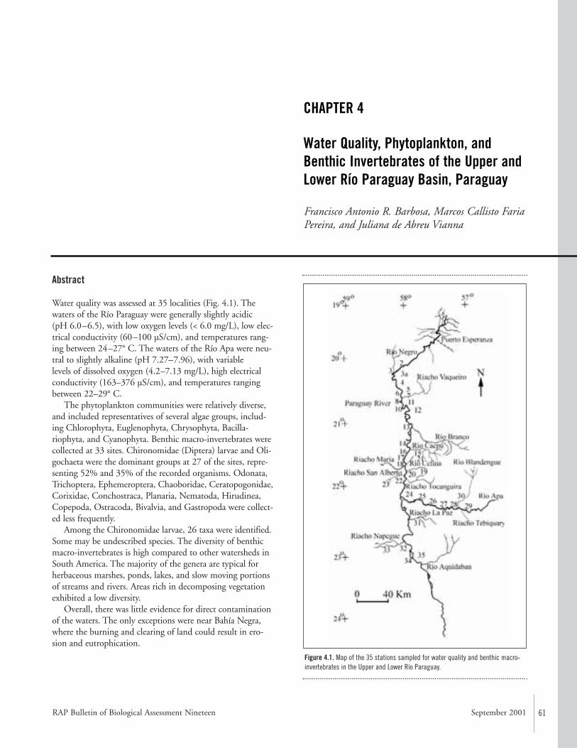
RAP Bulletin of Biological Assessment Nineteen September 2001 61
Abstract
Water quality was assessed at 35 localities (Fig. 4.1). Thewaters of the Río Paraguay were generally slightly acidic (pH 6.0–6.5), with low oxygen levels (< 6.0 mg/L), low elec-trical conductivity (60–100 µS/cm), and temperatures rang-ing between 24–27° C. The waters of the Río Apa were neu-tral to slightly alkaline (pH 7.27–7.96), with variable levels of dissolved oxygen (4.2–7.13 mg/L), high electricalconductivity (163–376 µS/cm), and temperatures rangingbetween 22–29° C.
The phytoplankton communities were relatively diverse,and included representatives of several algae groups, includ-ing Chlorophyta, Euglenophyta, Chrysophyta, Bacilla-riophyta, and Cyanophyta. Benthic macro-invertebrates werecollected at 33 sites. Chironomidae (Diptera) larvae and Oli-gochaeta were the dominant groups at 27 of the sites, repre-senting 52% and 35% of the recorded organisms. Odonata,Trichoptera, Ephemeroptera, Chaoboridae, Ceratopogonidae,Corixidae, Conchostraca, Planaria, Nematoda, Hirudinea,Copepoda, Ostracoda, Bivalvia, and Gastropoda were collect-ed less frequently.
Among the Chironomidae larvae, 26 taxa were identified.Some may be undescribed species. The diversity of benthicmacro-invertebrates is high compared to other watersheds inSouth America. The majority of the genera are typical forherbaceous marshes, ponds, lakes, and slow moving portionsof streams and rivers. Areas rich in decomposing vegetationexhibited a low diversity.
Overall, there was little evidence for direct contaminationof the waters. The only exceptions were near Bahía Negra,where the burning and clearing of land could result in ero-sion and eutrophication.
CHAPTER 4
Water Quality, Phytoplankton, andBenthic Invertebrates of the Upper andLower Río Paraguay Basin, Paraguay
Francisco Antonio R. Barbosa, Marcos Callisto FariaPereira, and Juliana de Abreu Vianna
Figure 4.1. Map of the 35 stations sampled for water quality and benthic macro-invertebrates in the Upper and Lower Río Paraguay.
62 CONSERVATION INTERNATIONAL
Introduction
The loss of biodiversity in aquatic ecosystems has receivedless attention than that in terrestrial ecosystems, despiteknowledge of their physical, chemical, and biological degra-dation. The current state of aquatic habitats is clearlydemonstrated by the increase in water-borne diseases (partic-ularly in the tropics), decreasing fishery production, anddiminishing water quality for human consumption, irriga-tion systems, and recreation. Furthermore, according toMaster (1990), there are more aquatic organisms classified asrare to extinct (34% of fish, 75% of unionid mussels, and65% of crayfish) than terrestrial ones (c. 11% to 14% ofbirds, mammals, and reptiles). Aquatic systems maintain aconsiderable biodiversity that is being lost mainly as a consequence of habitat deterioration.
The introduction of the watershed as the unit of study(Rigler and Peters, 1995) was of paramount importance indemonstrating that the implementation of conservationpractices for terrestrial environments does not automaticallyinclude adequate protection of aquatic habitats (Junk, 1983;Barbosa, 1994). Despite this focus on watersheds, it is stillunclear if the best conservation option is to consider the pro-tection of total diversity of a given area or to focus on thehighest possible number of rare species (see Pimm andLawton, 1998). It is important to consider diversity in adynamic context, including not only the preservation of thebiotic elements but also the basic processes responsible fortheir maintenance (Norton and Ulanowicz, 1992).Furthermore, as suggested by Tundisi and Barbosa (1995),the adoption of the watershed as the conservation unit isfundamental since it integrates the multiple uses of naturalresources and their surrounding social, economic, and cultural factors.
The primary objective of this paper is to summarizelimnological data recorded during the 1997 AquaRAPexpedition to the Upper and Lower Río Paraguay(20°09’7.9”S, 58°10’11.4”W) and to the sub-basin of the Río Apa (22°06’S, 57(55’W) (Fig. 4.1, Appendix 7).Small tributaries within these areas, namely the ArroyosBlandengue, Tebicuary, and Riacho La Paz, were also sampled. A total of 35 localities were visited during thisperiod for which water temperature, pH, dissolved oxygen and electrical conductivity were measured in situ.Benthic macro-invertebrates were collected at 54 samplingstations.
The Upper Río Paraguay is characterized by the presenceof several types of habitats among which floating meadowsformed by several aquatic macrophytes, coastal areas domi-nated by flooded palms (Copernicia alba), and litoral vegeta-tion dominated by Schinopsis balansae are the most common.The Lower Río Paraguay is dominated by floating meadowsas well, but there were also vegetated sandy banks, smallstreams, and sandy/muddy beaches.
Material and Methods
Except for total alkalinity measurements and benthicorganism identification, all variables were measured in situ.The samples for the physio-chemical measurements were collected at each site from below the surface (0.20 meterdepth) with a plastic jar. The type of water, distance from theshore, depth, substrate type and vegetation were recorded.For the physio-chemical (water quality) characterization ofthe waters, the following variables were measured: water temperature (°C), electrical conductivity (µS/cm), pH, anddissolved oxygen (mg/L and % saturation). Total alkalinitywas determined after titration with 0.1N H2SO4.
For the plankton samples, a 20 µm plankton net was usedto filter 2 x 40 liters of sub-surface water at each site.Sediment samples were collected in triplicate using anEkman-Birge dredge in such a way that 1 meter2 was coveredat each site. Samples were then rinsed through a 250 µmmesh and fixed in formalin. In the laboratory, the sampleswere washed through 1.0 and 0.50 millimeter mesh sieves,sorted under a stereomicroscope, and the organisms pre-served in 70% ethanol. For identification, chironomid larvaewere prepared using 10% lactophenol slides and theirmouthparts examined under a 400x microscope.
Results and Discussion
Water QualityThe water in the Río Paraguay is generally slightly acidic (pH 6.0–6.5), with low oxygen levels (<6.0 mg/L), electricalconductivity ranging between 60–100 µS/cm, and tempera-tures ranging between 24 –27°C (Table 4.1). No direct contamination could be observed at the sampling areas, thuswe characterize the waters to be of good quality.
The water within the sub-basin of the Río Apa deservesspecial attention. It is generally neutral to slightly alkaline (pH7.27–7.96), with temperatures varying between 22–28.9°C,variable levels of dissolved oxygen (4.2–7.13 mg/L), and highelectrical conductivity (163–376 µS/cm) (Table 4.1).
This limestone area possesses waters of high quality, par-ticularly at the headwaters that constitute water sources ofparamount importance for the maintenance of the presentaquatic biodiversity.
Plankton CommunitiesFrom a preliminary observation it can be stated that the phy-toplankton communities were relatively diverse. Species ofChlorophyta, Euglenophyta, Chrysophyta, Bacillariophytaand Cyanophyta were recorded. The zooplankton is mainlydominated by Rotifera (Lecane acus, Lecane flexilis, Lecanesp., Filinia sp., Conochilus sp., Polyarthra remata), plus someCopepoda (mainly nauplius), Cladocera, and Protozoa.Detailed identification at the specific level is under way.
Rapid Assessment Program
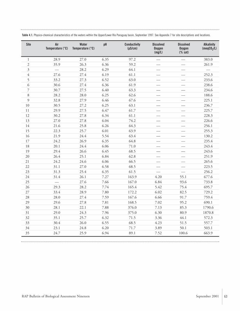
63
1 28.9 27.0 6.35 97.2 — — 383.02 35.9 26.3 6.36 59.2 — — 261.93 — 28.2 6.29 64.1 — — —4 27.6 27.4 6.19 61.1 — — 252.35 33.2 27.3 6.52 63.0 — — 233.66 30.6 27.4 6.36 61.9 — — 238.67 30.7 27.5 6.40 63.3 — — 234.68 28.2 28.0 6.25 62.6 — — 188.69 32.8 27.9 6.46 67.6 — — 225.1
10 30.5 27.2 6.25 63.1 — — 236.711 29.9 27.5 6.47 61.7 — — 225.712 30.2 27.8 6.34 61.1 — — 228.313 27.0 27.8 6.04 74.2 — — 226.614 21.6 25.8 6.26 64.3 — — 256.115 22.3 25.7 6.01 63.9 — — 255.316 21.9 24.4 5.54 63.4 — — 130.217 24.2 26.9 6.35 64.8 — — 235.418 20.1 24.4 6.06 71.0 — — 243.419 29.4 26.6 6.45 68.5 — — 243.620 26.4 25.1 6.84 62.8 — — 251.921 24.2 24.6 6.06 66.5 — — 265.622 31.1 27.0 6.58 68.5 — — 223.523 31.3 25.4 6.35 61.5 — — 256.224 31.4 26.1 7.27 163.9 4.20 55.1 677.625 — 27.6 7.66 167.0 6.84 93.6 733.826 29.3 28.2 7.74 165.4 5.42 75.4 695.727 33.4 28.9 7.80 172.2 6.02 82.5 729.228 28.0 27.4 7.59 167.6 6.66 91.7 759.429 29.6 27.8 7.81 168.5 7.02 95.2 690.130 28.1 22.1 7.88 376.0 7.13 85.3 1790.631 29.0 24.3 7.96 375.0 6.30 80.9 1870.832 35.1 25.7 6.32 71.5 3.36 44.1 572.333 30.4 26.0 6.55 68.5 4.23 51.5 557.734 23.1 24.8 6.20 71.7 3.89 50.1 503.135 24.7 25.9 6.94 89.1 7.52 100.6 663.9
Table 4.1. Physico-chemical characteristics of the waters within the Upper/Lower Río Paraguay basin, September 1997. See Appendix 7 for site descriptions and locations.
Site Air Water pH Conductivity Dissolved Dissolved AlkalinityTemperature (°C) Temperature (°C) (µS/cm) Oxygen Oxygen (meqCO2/L)
(mg/L) (% sat)
RAP Bulletin of Biological Assessment Nineteen September 2001
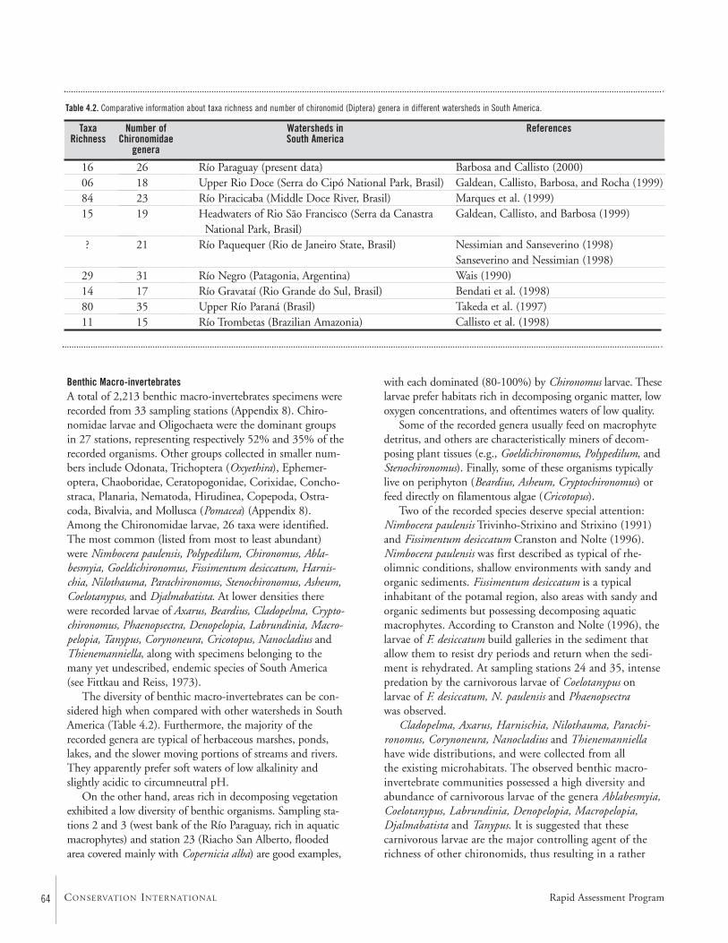
Benthic Macro-invertebratesA total of 2,213 benthic macro-invertebrates specimens wererecorded from 33 sampling stations (Appendix 8). Chiro-nomidae larvae and Oligochaeta were the dominant groupsin 27 stations, representing respectively 52% and 35% of therecorded organisms. Other groups collected in smaller num-bers include Odonata, Trichoptera (Oxyethira), Ephemer-optera, Chaoboridae, Ceratopogonidae, Corixidae, Concho-straca, Planaria, Nematoda, Hirudinea, Copepoda, Ostra-coda, Bivalvia, and Mollusca (Pomacea) (Appendix 8).Among the Chironomidae larvae, 26 taxa were identified.The most common (listed from most to least abundant)were Nimbocera paulensis, Polypedilum, Chironomus, Abla-besmyia, Goeldichironomus, Fissimentum desiccatum, Harnis-chia, Nilothauma, Parachironomus, Stenochironomus, Asheum,Coelotanypus, and Djalmabatista. At lower densities therewere recorded larvae of Axarus, Beardius, Cladopelma, Crypto-chironomus, Phaenopsectra, Denopelopia, Labrundinia, Macro-pelopia, Tanypus, Corynoneura, Cricotopus, Nanocladius andThienemanniella, along with specimens belonging to themany yet undescribed, endemic species of South America(see Fittkau and Reiss, 1973).
The diversity of benthic macro-invertebrates can be con-sidered high when compared with other watersheds in SouthAmerica (Table 4.2). Furthermore, the majority of therecorded genera are typical of herbaceous marshes, ponds,lakes, and the slower moving portions of streams and rivers.They apparently prefer soft waters of low alkalinity andslightly acidic to circumneutral pH.
On the other hand, areas rich in decomposing vegetationexhibited a low diversity of benthic organisms. Sampling sta-tions 2 and 3 (west bank of the Río Paraguay, rich in aquaticmacrophytes) and station 23 (Riacho San Alberto, floodedarea covered mainly with Copernicia alba) are good examples,
with each dominated (80-100%) by Chironomus larvae. Theselarvae prefer habitats rich in decomposing organic matter, lowoxygen concentrations, and oftentimes waters of low quality.
Some of the recorded genera usually feed on macrophytedetritus, and others are characteristically miners of decom-posing plant tissues (e.g., Goeldichironomus, Polypedilum, andStenochironomus). Finally, some of these organisms typicallylive on periphyton (Beardius, Asheum, Cryptochironomus) orfeed directly on filamentous algae (Cricotopus).
Two of the recorded species deserve special attention:Nimbocera paulensis Trivinho-Strixino and Strixino (1991)and Fissimentum desiccatum Cranston and Nolte (1996).Nimbocera paulensis was first described as typical of rhe-olimnic conditions, shallow environments with sandy andorganic sediments. Fissimentum desiccatum is a typicalinhabitant of the potamal region, also areas with sandy andorganic sediments but possessing decomposing aquaticmacrophytes. According to Cranston and Nolte (1996), thelarvae of F. desiccatum build galleries in the sediment thatallow them to resist dry periods and return when the sedi-ment is rehydrated. At sampling stations 24 and 35, intensepredation by the carnivorous larvae of Coelotanypus on larvae of F. desiccatum, N. paulensis and Phaenopsectrawas observed.
Cladopelma, Axarus, Harnischia, Nilothauma, Parachi-ronomus, Corynoneura, Nanocladius and Thienemanniellahave wide distributions, and were collected from all the existing microhabitats. The observed benthic macro-invertebrate communities possessed a high diversity andabundance of carnivorous larvae of the genera Ablabesmyia,Coelotanypus, Labrundinia, Denopelopia, Macropelopia,Djalmabatista and Tanypus. It is suggested that these carnivorous larvae are the major controlling agent of therichness of other chironomids, thus resulting in a rather
16068415
?
29148011
Table 4.2. Comparative information about taxa richness and number of chironomid (Diptera) genera in different watersheds in South America.
26182319
21
31173515
Río Paraguay (present data)Upper Rio Doce (Serra do Cipó National Park, Brasil)Río Piracicaba (Middle Doce River, Brasil)Headwaters of Rio São Francisco (Serra da Canastra
National Park, Brasil)Río Paquequer (Rio de Janeiro State, Brasil)
Río Negro (Patagonia, Argentina)Río Gravataí (Rio Grande do Sul, Brasil)Upper Río Paraná (Brasil)Río Trombetas (Brazilian Amazonia)
Barbosa and Callisto (2000)Galdean, Callisto, Barbosa, and Rocha (1999)Marques et al. (1999)Galdean, Callisto, and Barbosa (1999)
Nessimian and Sanseverino (1998)Sanseverino and Nessimian (1998)Wais (1990)Bendati et al. (1998)Takeda et al. (1997)Callisto et al. (1998)
Taxa Number of Watersheds in ReferencesRichness Chironomidae South America
genera
Rapid Assessment Program64 CONSERVATION INTERNATIONAL
RAP Bulletin of Biological Assessment Nineteen September 2001 65
high diversity in comparison with other aquatic systems inSouth America (e.g., Nolte, 1989; Strixino and Trivinho-Strixino, 1991; Higuti et al., 1993; Nessimian, 1995;Nessimian and Sanseverino, 1995; Callisto et al., 1998).
A tentative classification of the studied areas basedupon benthic macro-invertebrate diversity
Although the present results were obtained from a single survey (at the end of the rainy season), they provide a firstassessment of water quality as well as the structure and distri-bution of the benthic macro-invertebrate communities forthe area. Furthermore, the study also allowed us to identifyeleven types of microhabitats. They are silt and clay, silt, finesand, silt with mosses, silt with filamentous algae, silt withmacrophyte detritus, coarse sand with plant debris, fine par-ticulate organic matter, coarse particulate organic matter,aquatic macrophytes, and filamentous algae. It must bepointed out that the sampling period was rather atypical,with higher water levels than usual for this time of the year.
Based on the diversity index (H; Shannon-Wiener) ofChironomidae larvae and the recorded substrate types(Appendix 9), Barbosa and Callisto (2000) suggested threemajor divisions along the Upper/Lower Río Paraguay in rela-tion to their benthic macro-invertebrate community diversi-ty. This information should be considered when makingconservation decisions.
(a) Areas of high diversity: with an H’ > 3.0 and representedin this survey by sampling stations 30 and 31, locatedrespectively in the streams Blandengue and La Paz. Herethe highest number of microhabitats was found includ-ing, sand, gravel, periphyton, aquatic mosses, and a standof Cabomba sp. These are relatively well-protected areaswith riparian vegetation and no significant human influ-ences recorded.
(b) Areas of intermediate diversity: 1.8 < H’ < 3.0, repre-sented by sampling stations 2, 3A, 5, 6, 10, 15, 18, 26,27, 28, and 29, which are flooded areas or areas rich inaquatic macrophytes with sediments rich in organic mat-ter in distinct decomposition stages, receiving both alloc-thonous (riparian vegetation) and autocthonous (aquaticmacrophytes, mosses and filamentous algae) contribu-tions.
(c) Areas of low diversity: with an H’ < 1.8 and representedby sampling stations 3, 4, 7, 8, 12, 14, 17, 21, 22, 23,24, 25, 31A, and 35. The sediments found here aremainly formed by silt and clay, but silt and filamentousalgae, silt and aquatic mosses, fine sand and organic mat-ter in deep decomposition stage also occur. These areasshow low diversity of microhabitats.
Recommended Conservation and Research Activities
• Overall, the Río Paraguay basin is relatively well pre-served, with the exception of the northern part near BahíaNegra. This area is primarily threatened as a consequenceof disorganized land use resulting in widespread deforesta-tion in order to form pasture land. Erosion is a directconsequence, thus affecting the water and its living com-munities. Furthermore, the burning of natural vegetation,particularly large areas of Copernicia alba (palm trees),constitutes another considerable threat that may result ineutrophication of these waters. Habitat impact studiesneed to be conducted to determine how to manage theland properly.
• Limestone areas possess waters of high quality. Steps needto be taken to preserve these sites.
• The diversity of macro-invertebrates can be consideredhigh when compared with other watersheds in SouthAmerica. Most of these species are found in habitats creat-ed by seasonal flooding. Habitat modifications that dis-rupt the annual changes in water level should be prevent-ed. An example of habitat modification is the HidroviaParaguay-Paraná, which will affect directly the seasonalflooding regime of the Río Paraguay and indirectly otherstreams within the watershed, resulting in the loss of cer-tain habitats and their communities.
• The Río Verde is under severe threat of salinization.
Literature Cited
Barbosa, F.A.R. (ed.). 1994. Workshop: Brazilian programmeof conservation and management of inland waters. ActaLimnologica Brasiliensia, Belo Horizonte. 222pp.
Barbosa, F.A.R. and M. Callisto. 2000. Rapid assessment ofwater quality and diversity of benthic macro-invertebratesin the Upper and Middle Río Paraguay using the Aqua-RAP approach. Verhandlungen der InternationalenVereinigung für Theoretische und AngewandteLimnologie 27: (in press).
Bendati, M.M.A., C.R.M. Maizonave, E.D. Olabarriaga, and R.M. Rosado. 1998. Use of the benthic macroin-vertabrate community as a pollution indicator in theGravataí River (RS, Brazil). Verhandlugen derInternationalen Vereinigung für Theoretische undAngewandte Limnologie, 26:2019–2023.
66 CONSERVATION INTERNATIONAL
Callisto, M., F.A. Esteves, J.F. Gonçalves Jr., and J.J.F. Leal.1998. Impact of bauxite tailings on the distribution ofbenthic macrofauna in a small river (`igarapé`) in centralAmazonia, Brazil. Journal of Kansas EntomologicalSociety, 71:447– 455.
Cranston, P.S. and U. Nolte. 1996. Fissimentum, a newgenus of drought-tolerant Chironomini (Diptera:Chironomidae) from the Americas and Australia.Entomological News 107:1–15.
Fittkau, E.J. and J. Reiss. 1973. Amazonische Tanytarsini(Chironomidae, Diptera) I. die riopreto-gruppe der gattung Tanytarsus. Studies on the Neotropical Fauna,8:1–16.
Galdean, N., M. Callisto, and F.A.R. Barbosa. 1999. Benthicmacroinvertebrates of the head-waters of river SãoFrancisco (National Park of Serra da Canastra, Brazil).Travaux Museum Natl. Hist. Nat. Grigore Antipa, vol.XLI: 455–464
Galdean, N., M. Callisto, F.A.R. Barbosa, and L.A. Rocha.2000. Lotic ecosystems of Serra do Cipó, southeastBrazil: water quality and a tentative classification basedon the benthic macroinvertebrate community. AquaticEcosystem Health and Management, 3:545–552.
Higuti, J., A.M. Takeda, and A.C. Paggi. 1993. Distribuiçãoespacial das larvas de Chironomidae (Insecta, Diptera) do Rio Baía (MS-Brasil). Revista UNIMAR, 15(supple-ment):65–81.
Junk, W.J. 1983. Ecology of swamps on the middle Amazon.In Gore, A.J.P. (ed.). Mires: swamps, bog, fen and moor.Amsterdam: Elsevier Scientific Publishing Company. Pp. 269–294.
Marques, M.M.G.S.M., F.A.R. Barbosa, and M. Callisto.1999. Distribution and abundance of Chinomidae(Diptera, Insecta) in an impacted watershed in south-eastBrazil. Revista Brasileira de Biologia, 59:1–9.
Master, L. 1990. The imperiled status of North Americanaquatic animals. Biodiversity Network News (NatureConservancy), 3:1-2,7-8.
Nessimian, J.L. 1995. Composição da fauna de invertebra-dos bentônicos em um brejo entre dunas no litoral doEstado do Rio de Janeiro, Brasil. Acta LimnologicaBrasiliensia, 7:41–59.
Nessimian, J.L. and A.M. Sanseverino. 1995. Structure anddynamics of chironomid fauna from a sand dune marshin Rio de Janeiro State, Brazil. Studies on NeotropicalFauna and Environment, 30:207–219.
Nessimian, J.L. and A. Sanseverino. 1998. Trophic functionalcharacterization of chironomidae larvae (Diptera:Chironomidae) in a first order stream at the mountainregion of Rio de Janeiro State, Brazil. Verhandlungen derInternationalen Vereinigung für Theoretische undAngewandte Limnologie, 26:2115–2119.
Nolte, U. 1989. Observations on neotropical rainpools(Bolivia) with emphasis on Chironomidae (Diptera).Studies on Neotropical Fauna and Environment,24:105–120.
Norton, B.G. and R.E. Ulanowicz. 1992. Scale and biodiversity policy: a hierarchical approach. Ambio,21:244–249.
Pimm, S.L. and J.H. Lawton. 1998. Planning for biodiversity.Science 279:2068–2069.
Rigler, H.F. and R.H. Peters. 1995. Science and limnology:excellence in ecology. New York: Ecology Institute.245pp.
Sanseverino, A. and J.L. Nessimian. 1998. Habitat prefer-ences of Chironomidae larvae in an upland stream ofAtlantic Forest, Rio de Janeiro State, Brazil. Verhan-dlungen der Internationalen Vereinigung für Theoretischeund Angewandte Limnologie, 26:2141–2144.
Strixino, G. and S. Trivinho-Strixino. 1991. Chironomidae(Diptera) associados a sedimentos de reservatórios: signifi-cado dos diferentes povoamentos. An. Sem. Reg. Ecol.,6:151–168.
Takeda, A., G.Y. Shimizu, and J. Higuti. 1997. Variaçõesespaço-temporais da comunidade zoobêntica. In Vazzoler,A.E.A.M., A.A. Agostinho, and N.S. Hahn (eds.). Aplanície de inundação do alto rio Paraná: aspectos físicos,biológicos e socioeconômicos. Ed. Universidade Estadualde Margingá. Pp. 158–177.
Trivinho-Strixino, S. and G. Strixino. 1991. Duas novasespécies de Nimbocera Reiss (Diptera, Chironomidae) doEstado de São Paulo, Brasil. Revista Brasileira deEntomologia, 35:173–178.
Rapid Assessment Program
RAP Bulletin of Biological Assessment Nineteen September 2001 67
Tundisi, J.G. and F.A.R. Barbosa. 1995. Conservation ofaquatic ecosystems: present status and perspectives. InTundisi, J.G., C.E.M. Bicudo, and T. Matsumura-Tundisi (eds.). Limnology in Brazil. Rio de Janeiro:BAS, BlS.
Wais, I.R. 1990. A checklist of benthic macroinvertabrates ofthe Negro River basin, Patagonia, Argentina, including anapproach to their functional feeding groups. ActaLimnologica Brasiliensia, 3:829–845.
68 CONSERVATION INTERNATIONAL
Abstract
The aquatic macro-invertebrate fauna was surveyed at 54collecting stations along the Upper Río Paraguay, betweenthe mouth of the Río Negro and Río Aquidabán, and alongthe middle section of the Río Apa. The collecting effortswere directed towards an assessment of the decapod crus-tacean fauna, but other groups were incidentally collected.Sampled habitats included river beaches, backwaters,lagoons, rapids, flooded plains, floating vegetation, sub-merged litter, and cryptic habitats (such as in submergedlogs, among dead leaves, and between and under stones inthe bottom of streams). Collections were qualitative only andperformed with seine nets, dip nets, traps, and by hand.
Thirteen species of decapod crustaceans were found: sixspecies of Palaemonidae and one of Sergestidae shrimps, andsix species of Trichodactylidae crabs. The occurrence ofPseudopalaemon sp. is the first record of this genus in the Río Paraguay basin, and is probably a new species. Theshrimp Macrobrachium amazonicum and the crabs Tricho-dactylus borellianus and Sylviocarcinus australis were the mostfrequent species. The aquatic insect fauna was the richest innumber of species, with 83 species in 34 families and tenorders. Coleoptera, Hemiptera, and Odonata were most often collected. Molluscs were an important group in regardsto abundance and biomass, with at least seven species ofGastropoda and three species of Bivalvia. Other less repre-sentative groups included periphytic and parasitic crustaceans(Conchostraca, Ostracoda, Amphipoda, Isopoda, andBranchiura), annelids, and platyhelminth worms.
Introduction
The macro-invertebrate collecting effort of this AquaRAPexpedition was directed mainly to assess the decapod crus-
tacean fauna. Other groups, such as molluscs, insects, peri-phytic and parasitic crustaceans, annelid and plathyhelminthworms, were also collected, but sampling was either incom-plete or superficial, and therefore a detailed evaluation of thatfauna was not possible. The results and a discussion are pre-sented below, with emphasis on the decapod crustaceans.
The freshwater shrimp and crab fauna of Paraguay is notvery well-studied, although sporadic citations indicate thepresence of most of the species that occur in the entireParaguay and Lower Paraná river basins. The main originalrecords of this group in Paraguay were made by Stimpson(1861), Nobili (1896), Rathbun (1906), Hansen (1919),Bott (1969), Rodríguez (1992), and Magalhães and Türkay(1996b). Kochalka (1996) listed the species present in theNational Museum of Natural History of Paraguay, but didnot provide information on the locations where the speci-mens were collected. Based on these citations, six species ofcrabs and six species of shrimps are known for the country.Even so, information about the distribution of these speciesin Paraguayan territory and the main habitats occupied bythem are still scattered and imprecise. Therefore, the result ofthe AquaRAP expedition represents an important contribu-tion to the knowledge of the fauna in a poorly surveyed areaof the country.
Methods
Sampling was done mainly during the day time, using a dipnet, a seine net (mesh size: 5 millimeters), and traps. Nightsampling, using a flash light, was performed to capture crabsalong the shoreline. Specimens were fixed and preserved in70% ethyl alcohol. Independent of the collecting methodsand the sampling period, the samples were bulked accordingto the sub-basins considered in Appendix 10 and accordingto the habitats specified in Appendix 11. The Cerritos Pão de
CHAPTER 5
Diversity, Distribution, and Habitats ofthe Macro-invertebrate Fauna of theRío Paraguay and Río Apa, Paraguay,with Emphasis on Decapod Crustaceans
Célio Magalhães
Rapid Assessment Program
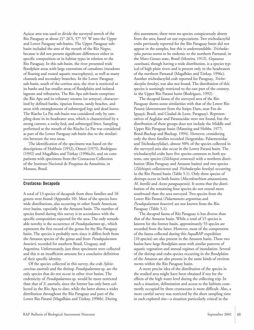
RAP Bulletin of Biological Assessment Nineteen September 2001 69
Açúcar area was used to divide the surveyed stretch of theRío Paraguay at about 21° 26’S, 57° 55’ W into the Upperand Lower Paraguay sub-basins. The Upper Paraguay sub-basin included the area of the mouth of the Río Negro,because it did not present significant differences either inspecific composition or in habitat types in relation to the Río Paraguay. In this sub-basin, the river presented widefloodplain areas with large extensions of camalotes (meadowsof floating and rooted aquatic macrophytes), as well as manychannels and secondary branches. In the Lower Paraguaysub-basin, south of the cerritos area, the river is restricted toits banks and has smaller areas of floodplains and isolatedlagoons and tributaries. The Río Apa sub-basin comprisesthe Río Apa and its tributary streams (or arroyos), character-ized by defined banks, riparian forests, sandy beaches, andareas with entanglements of submerged logs and dead leaves.The Riacho La Paz sub-basin was considered only by sam-pling done in its headwater area, which is characterized by astrong current, a rocky bed, and submerged litter. Samplingperformed at the mouth of the Riacho La Paz was consideredas part of the Lower Paraguay sub-basin due to the similari-ties between the two areas.
The identification of the specimens was based on thedescriptions of Holthuis (1952), Omori (1975), Rodríguez(1992) and Magalhães and Türkay (1996a,b), and on com-parisons with specimens from the Crustacean Collection of the Instituto Nacional de Pesquisas da Amazônia, inManaus, Brasil.
Crustacea: Decapoda
A total of 13 species of decapods from three families and 10genera were found (Appendix 10). Most of the species havewide distributions, also occurring in other South Americanriver basins, especially in the Amazon basin. The number ofspecies found during this survey is in accordance with thespecific composition expected for the area. The only remark-able novelty is the occurrence of Pseudopalaemon sp., whichrepresents the first record of the genus for the Río Paraguaybasin. The species is probably new, since it differs both fromthe Amazon species of the genus and from Pseudopalaemonbouvieri, recorded for southern Brasil, Uruguay, andArgentina. Unfortunately, just three specimens were collectedand this is an insufficient amount for a conclusive definitionof their specific identity.
Of the species collected in this survey, the crab Sylvio-carcinus australis and the shrimp Pseudopalaemon sp. are theonly species that do not occur in other river basins. Theendemicity of Pseudopalaemon sp. would be more restrictedthan that of S. australis, since the former has only been col-lected in the Río Apa to date, while the latter shows a widerdistribution throughout the Río Paraguay and part of theLower Río Paraná (Magalhães and Türkay, 1996b). During
this assessment, there were no species conspicuously absentfrom the area, based on our expectations. Two trichodactylidcrabs previously reported for the Río Paraguay basin did notappear in the samples, but this is understandable. Trichodac-tylus parvus seems to be endemic to the northern Pantanal, inthe Mato Grosso state, Brasil (Moreira, 1912). Goyazanacastelnaui, though having a wide distribution, is a species typ-ical of high plain rivers and is present only in the headwatersof the northern Pantanal (Magalhães and Türkay, 1996c).Another trichodactylid crab reported for Paraguay, Tricho-dactylus kensleyi, was also not found. The distribution of thisspecies is seemingly restricted to the east part of the country,in the Upper Río Paraná basin (Rodríguez, 1992).
The decapod fauna of the surveyed area of the RíoParaguay shows some similarities with that of the Lower RíoParaná (downstream from the Itaipu Dam, near Foz doIguaçú, Brasil, and Ciudad de Leste, Paraguay). Represen-tatives of Aeglidae and Parastacidae were not found, but thedistribution of these groups does not include the Middle andUpper Río Paraguay basin (Manning and Hobbs, 1977;Bond-Buckup and Buckup, 1994). However, consideringonly the three families recorded (Sergestidae, Palaemonidaeand Trichodactylidae), almost 50% of the species collected inthe surveyed area also occur in the Lower Paraná basin. Thetrichodactylid crabs have five species common to both sys-tems, one species (Zilchiopsis oronensis) with a northern distri-bution (Ríos Paraguay and Amazon basins) and two species(Zilchiopsis collastinensis and Trichodactylus kensleyi) occurringin the Río Paraná basin (Table 5.1). Only three species ofshrimps occur in both basins (Macrobrachium amazonicum,M. borellii and Acetes paraguayensis). It seems that the distri-bution of the remaining four species do not extend moresouthward than the area surveyed. Two species from theLower Río Paraná (Palaemonetes argentinus andPseudopalaemon bouvieri) are not known from the RíoParaguay (Table 5.1).
The decapod fauna of Río Paraguay is less diverse thanthat of the Amazon basin. While a total of 15 species isknown for the former basin, approximately 53 species arerecorded from the latter. However, most of the componentsof the fauna collected during this AquaRAP expedition (10 species) are also present in the Amazon basin. These twobasins have large floodplain areas with similar patterns ofaquatic vegetation and annual regimes of inundation. Severalof the shrimp and crabs species occurring in the floodplainsof the Amazon are also present in the same kinds of environ-ments within the Río Paraguay basin.
A more precise idea of the distribution of the species inthe studied area might have been obtained if not for theeffects of the high water level during the collecting trip. Insuch a situation, delimitation and access to the habitats com-monly occupied by these crustaceans is more difficult. Also, amore careful survey was restricted by the short sampling timein each explored site—a situation particularly critical in the
70 CONSERVATION INTERNATIONAL
Riacho La Paz headwaters, which were limited to a single,short, daytime sampling.
The specific composition with regards to the sub-basins(Appendix 10) shows that Trichodactylus borellianus, Sylvio-carcinus australis and Macrobrachium amazonicum were themost frequent species, the former being the only species pre-sent in all the sub-basins. Appendix 10 indicates a larger diver-sity of shrimps in the Lower Río Paraguay. In this area, onlytwo species were not present: Macrobrachium brasiliense (prob-ably due to the absence or impossibility of sampling its prefer-ential habitat) and Pseudopalaemon sp., restricted to the RíoApa sub-basin. In the Upper Río Paraguay sub-basin, only M.amazonicum was found. There was no significant differenceamong the Upper and Lower Río Paraguay sub-basins withrespect to crabs. Valdivia camarani and Poppiana argentinianadid not appear in the samples of the Lower Río Paraguay, butthese are apparently not very frequent species and theirabsence should be related to the sampling restrictions men-tioned above. These restrictions could also have caused of theabsence of the shrimps Macrobrachium jelskii and Palaemonetesivonicus in the Upper Paraguay sub-basin samples.
The lower species richness in the Río Apa and Riacho LaPaz sub-basins could be explained by the characteristics ofthose aquatic systems. Basically, they do not have the largefloodplain areas and the extensive meadows of aquatic vegeta-tion. The decapod fauna present is mainly that which occu-pies cryptic habitats, and the Riacho La Paz was exploredonly very briefly, in limited headwaters area. Even so, it isunlikely that species other then T. borellianus, M. brasiliense,and, perhaps, S. australis, occur there, because the others arenot typical of such fast flowing, rocky bed environments.
The three more abundant species in the collections wereMacrobrachium amazonicum,Trichodactylus borellianus, andDilocarcinus pagei. These species occurred in a great variety ofhabitats, being particularly common among the roots of thefloating vegetation that forms the large extensions of macro-phytes banks (camalotes), especially Eichhornia crassipes, E.azurea, and Paspalum stoloniferum. The shrimps were presenteither in the main channel of the Río Paraguay or in its sev-eral lateral branches, both among the macrophytes banks andalong the sandy-muddy beaches. Macrobrachium amazon-icum and D. pagei were also found in lagoons and in floodedforest areas. Trichodactylus borellianus was also found in fastflowing areas and in cryptic habitats, such as in submergedlogs, among dead leaves, and between and under stones inthe bottom of streams, and also in terrestrial environments,under stones or other objects close to the shoreline. Macro-brachium amazonicum also occurred in the Río Apa. How-ever, its abundance was much lower than that of the RíoParaguay due to the absence of floating vegetation. In theformer sub-basin, it was found in sandy-muddy beaches andamong submerged litter.
Most of the decapod species, especially the crabs, werefound along the shoreline of the Río Paraguay, either in gen-tle cliff banks or on sandy-muddy beaches (Appendix 11).Some, however, had a more restricted occurrence. Theshrimp Palaemonetes ivonicus was found in small numbersassociated with the floating vegetation in an isolated lagoon.A species commonly found among the roots of aquaticmacrophytes, its absence in environments such as the mainriver could perhaps be due to seasonal factors. These factorscould also explain the occasional occurrence of M. jelskii andM. borellii. Acetes paraguayensis is typically a pelagic shrimp,and its occurrence in the channel of the Río Paraguay wasforeseeable; however, the capture of some specimens in isolat-ed lagoons was occasional. The predominance of the shrimpM. brasiliense in the Río Apa and Riacho La Paz sub-basins,and its probable absence in the Río Paraguay habitats, can beunderstood by its preference for cryptic habitats found moretypically in the rivers and fast flowing streams bordered bythe riparian forest of those sub-basins. The crabs occurred inmarginal areas (banks or beaches), associated or not with theaquatic vegetation. In such habitats, the crab Sylviocarcinusaustralis was found in both the Río Paraguay sub-basins andthe Río Apa sub-basin. Its absence from the Riacho La Paz
Table 5.1. Comparative list of the decapod crustacean species (Palaemonidae,Sergestidae, Trichodactylidae) collected in the Upper Río Paraguay by the AquaRAPexpedition (September, 1997) with those reported for the Lower Río Paraná basin.Distribution data from Stimpson (1861), Nobili (1896), Rathbun (1906), Hansen(1919), Bott (1969), Rodríguez (1992), and Magalhães and Türkay (1996b).
Taxon Río Paraguay Lower Río Paraná
PalaemonidaeMacrobrachium amazonicum ■ ■
Macrobrachium borellii ■ ■
Macrobrachium brasiliense ■ —Macrobrachium jelskii ■ —Palaemonetes ivonicus ■ —Palaemonetes argentinus — ■
Pseudopalaemon bouvieri — ■
Pseudopalaemon sp. ■ —Sergestidae Acetes paraguayensis ■ ■
TrichodactylidaeDilocarcinus pagei ■ ■
Poppiana argentiniana ■ ■
Sylviocarcinus australis ■ ■
Trichodactylus borellianus ■ ■
Trichodactylus kensleyi — ■
Valdivia camerani ■ ■
Zilchiopsis collastinensis — ■
Zilchiopsis oronensis ■ —
Rapid Assessment Program
RAP Bulletin of Biological Assessment Nineteen September 2001 71
sub-basin is probably due to sampling restrictions. The sam-ples of Pseudopalemon sp., Poppiana argentiniana, andValdivia camerani were too low to allow any inference con-cerning their preferential habitats.
The shrimp Macrobrachium amazonicum was the mostabundant species in the collections, occurring in several habi-tats. A species that includes a larval development with severalfree-swimming planktotrophic zoea larvae, its proliferation isrelated to a reasonable planktonic-rich environment and con-siderable aquatic macrophyte growth, essential for the feed-ing and the protection of the species in that phase of its lifecycle (Magalhães and Walker, 1988; Collart Odinetz, 1991).The wide distribution and abundance of M. amazonicum inthe Río Paraguay sub-basins reflects the wealth of this aquat-ic system. In the Río Apa sub-basin, lacking in floatingmacrophytes, its occurrence suggests that even this systempresents a reasonable productivity, capable of sustaining asignificant population of this shrimp.
It is known that shrimps and crabs make up a part of thediet of several groups of fishes, including the large catfishes(Siluriformes) (Goulding and Ferreira, 1984), some of whichare valued for game fishing. It was verified that indigenouspopulations use this resource, capturing the crabs to sell asbait for game fishermen. These crustaceans are also prey ofcaimans, turtles, mammals, and aquatic birds, which suggeststhat they play an important role in the food web of thisaquatic ecosystem.
Other Macro-invertebrates
Although the sampling efforts were mainly directed towarddecapod assessment, other macro-invertebrate groupsappeared incidentally in the collections (Appendix 10).Among the crustaceans, specimens of Conchostraca,Ostracoda, and Amphipoda (Hyallelidae: Hyallela pernix)were found associated with the aquatic vegetation, mainlyEichhornia azurea and E. crassipes, making up part of theperiphytic community. As such, they were only captured inthe Río Paraguay sub-basins and not in the Río Apa andRiacho La Paz sub-basins, where such habitats were notavailable. Two species of a crustacean fish ectoparasite(Branchiura: Dolops spp.) were found on “dorado”(Characidae: Salminus maxillosus) and on “piranha”(Serrasalmidae: Pygocentrus nattereri).
The molluscs were one of the main macro-invertebrategroups collected, both in terms of abundance and biomass.At least seven species (five families) of gastropods and threespecies (two families) of bivalves were found. The most fre-quent species were the gastropods Pomacea canaliculata(Ampullariidae) and Biomphalaria sp. (Planorbidae). Theformer only occurred in the Río Paraguay sub-basins, whilethe latter was also found in the Río Apa sub-basin. The
bivalves of the family Mycetopodidae were more frequent inthe Río Apa sub-basin, although at least one species,Anodontites crispatus tenebricosus, occurred in the Lower RíoParaguay sub-basin.
The floating and rooted aquatic vegetation representedthe main habitat exploited by the molluscs in the RíoParaguay sub-basins. They were commonly found in themeadows of floating macrophytes, and were also present inthe vegetation banks along the shoreline, in the swamps, andin the flooded forest areas. In the Río Apa sub-basin, theywere found along marginal areas, in the submerged litter, andeven in cryptic habitats, such as holes in submerged logs.
The aquatic insect fauna was the richest in number ofspecies. In all, 83 species in 34 families and ten orders werefound, among which Coleoptera, Hemiptera, and Odonatawere the most representative. Inferences on the preferentialhabitats and the distribution areas were affected by the irreg-ular sampling efforts. In spite of this, a larger species richnessin the Upper Río Paraguay sub-basin was noted, probablydue to the largest extensions of aquatic vegetation meadowsoccurring in that area. Some of the species listed in Appendix10 are not considered aquatic and they were collected bychance. This is the case of some Coleoptera groups that canlive on rock substrates close to the shoreline (such as someCarabidae) or associated with the emerged portion of themacrophytes (such as Lampyridae, Chrysomellidae, andCurculionidae). Also, the capture of some Scarabaeidae,whose representatives are saprophagous, could have beenoccasional.
Recommended Conservation and Research Activities
• Decapod and macro-invertebrate diversity in the RíoParaguay was highest in habitats with floating and rooted aquatic vegetation. These habitats are dependentupon seasonal floods. Habitat modifications that disrupt the annual changes in water levels should be prevented.
• Habitat heterogeneity in the Río Apa is low. Most of thedecapod and macro-invertebrate diversity is associatedwith cryptic habitats (i.e., submerged logs), which provideopportunities for cover and foraging. These habitats needto be conserved.
• Shrimps and crabs are a food source for some game fishes.Indigenous populations capture crabs and sell them asbait to fishermen. At the moment, capture of specimens isnot believed to represent a risk to the natural reserve ofthis species in the environment, but small-scale breedingof this species could be developed into additional incomefor the local population.
72 CONSERVATION INTERNATIONAL
• Crabs and shrimps are relatively easy to breed in captivity.If an environmental disaster were imminent, then speci-mens could be collected and maintained as “recoloniza-tion stocks” for a later date. This would help to preservethe uniqueness of the Paraguayan populations.
Literature Cited
Bond-Buckup, G. and L. Buckup. 1994. A família Aeglidae(Crustacea, Decapoda, Anomura). Arquivo Zoologia, SãoPaulo, 32:159–346.
Bott, R. 1969. Die süsswasserkrabben Süd-Amerikas undihre stammesgeschichte. Eine revision derTrichodactylidae und der Pseudothelphusidae östlich derAnden (Crustacea, Decapoda). Abhandlungen derSenckenbergischen Naturforschenden Gesellschaft,518:1–94.
Collart Odinetz, O. 1991. Strategie de reproduction deMacrobrachium amazonicum en Amazonie centrale(Decapoda, Caridea, Palaemonidae). Crustaceana,61:253–270.
Goulding, M. and E. Ferreira. 1984. Shrimp-eating fishesand a case of prey switching in Amazon rivers. RevistaBrasileira de Zoologia, 2:85–97.
Hansen, H.J. 1919. The Sergestidae of the SibogaExpedition. Siboga Expedition, 38:1–65.
Holthuis, L.B. 1952. A general revision of the Palaemonidae(Crustacea Decapoda Natantia) of the Americas. II. Thesubfamily Palaemonidae. Occasional Papers, AllanHancock Foundation, 12:1–396.
Kochalka, J.A. 1996. Lista de invertebrados de Paraguaypertenecientes a las colecciones del Museo Nacional de Historia Natural del Paraguay: Clase Crustacea. InRomero Martinez, O. (ed.). Colecciones de Flora y Faunadel Museo Nacional de Historia Natural del Paraguay.Museo Nacional de Historia Natural del Paraguay.Dirección de Parques Nacionales y Vida Silvestre—Subsecreteria de Estado de Recursos Naturales y MedioAmbiente — Ministério de Agricultura y Ganadería,Asunción. Pp. 112–113.
Magalhães, C. and M. Türkay. 1996a. Taxonomy of theNeotropical freshwater crab family Trichodactylidae I.The generic system with description of some new generaCrustacea: Decapoda: Brachyura). Senckenbergiana bio-logica, 75:63–95.
Magalhães, C. and M. Türkay. 1996b. Taxonomy of theNeotropical freshwater crab family Trichodactylidae II.The genera Forsteria, Melocarcinus, Sylviocarcinus, andZilchiopsis (Crustacea: Decapoda: Brachyura).Senckenbergiana biologica, 75:97–130.
Magalhães, C. and M. Türkay. 1996c. Taxonomy of theNeotropical freshwater crab family Trichodactylidae III.The genera Fredilocarcinus and Goyazana (Crustacea:Decapoda: Brachyura). Senckenbergiana biologica,75:131–142.
Magalhães, C. and I. Walker. 1988. Larval development andecological distribution of Central Amazonian palaemonidshrimps (Decapoda: Caridea). Crustaceana, 55:279–292.
Manning, R.B. and H.H. Hobbs, Jr. 1977. Decapoda. In Hurlbert, S.H. (ed.). Biota Acuática de SudaméricaAustral. San Diego: San Diego State University. Pp. 157–162.
Moreira, C. 1912. Crustacés du Brésil. Mémoires de laSociété Zoologique de France, 25:145–154.
Nobili, G. 1896. Viaggio del Dott. A. Borelli nella RepublicaArgentina e nel Paraguay. Bollettino dei Musei diZoologia ed Anatomia Comparata della Università diTorino, 11(222):1– 4.
Omori, M. 1975. The systematics, biogeography, and fisheryof epipelagic shrimps of the genus Acetes (Crustacea,Decapoda, Sergestidae). Bulletin Ocean ResearchInstitute, 7:1–91. Tokyo: University of Tokyo.
Rathbun, M.J. 1906. Les crabes d’eau douce (Potamonidae).Nouv. Archs Mus. Hist. Nat., Paris 8:33–122.
Rodríguez, G. 1992. The freshwater crabs of America: family Trichodactylidae and supplement to the familyPseudothelphusidae. Collection Faune Tropicale, 31,Editions ORSTOM, Paris. 189pp.
Stimpson, W.W. 1861. Notes on certain decapod Crustacea.Proceedings of the Academy of Natural Sciences ofPhiladelphia, 13:372–375.
Rapid Assessment Program
RAP Bulletin of Biological Assessment Nineteen September 2001 73
Abstract
Two teams of ichthyologists sampled fishes at a combinedtotal of 111 localities (Map 2). During the AquaRAP expedi-tion, 136 fish species were collected in the Río Paraguay, 85 in the Río Apa, and 35 in the Riacho La Paz, for a grandtotal of 173 species.
Characiformes made up 54% of the fish fauna in the RíoParaguay. They belong to a variety of trophic categories,including herbivores, insectivores, mud-feeders, piscivores,and omnivores. Siluriformes (catfishes) and Perciformes (pri-marily cichlids) were the next most abundant groups.Piranhas (Serrasalmus spp.) were common and many fishexhibited piranha bites. Some fishes (e.g., pacus, anostomids)feed on fruits and seeds, and depend on floods to reach aplentiful supply of food. Flooded forests are often used asnursery areas by many species of fishes, including commer-cially important species. Many taxa (e.g., Lepidosiren para-doxa, Synbranchus marmoratus, Callichthyidae) possess adap-tations for breathing air, which is important for survivalthrough the dry season. Only the eggs of other species,known as annual fishes (e.g., Rivulus sp.), survive throughthe dry season.
The diversity of fishes was lower in the Río Apa than inthe Río Paraguay, probably because of the lower habitat het-erogeneity. Characiformes, Siluriformes, and Perciformeswere still the dominant taxa. Many species collected in theRío Apa were not collected in the Río Paraguay, highlightingthe distinctiveness of the two basins. Several species ofSiluriformes were found amidst the cover of logjams. Schoolsof Salminus, Brycon, and Prochilodus were observed migratingupstream.
Introduction
Based on an intensive exploration of the ichthyofauna duringthe previous and present centuries, a series of publications onParaguay fishes were produced (Perugia, 1891; Boulenger,1895, 1897, 1900; Eigenmann and Kennedy, 1903; Eigen-mann et al., 1907). Limited studies were conducted until thelate 1980’s, and it is estimated that approximately 600 fishspecies live in the La Plata drainage (Bonetto, 1986). Thecountry of Paraguay is believed to contain 450 species (Lowe-McConnell, 1975:47), with the greatest diversity (300 species) in the north and decreasing to 200 species atthe southern end (Bonetto, 1986). This high biodiversity inParaguay as compared to neighboring countries (excludingBrasil) (Lowe-McConnell, 1975:47) can be partially attribut-ed to two factors: (i) northern Paraguay is a continuation of the species rich Pantanal, and (ii) an apparent distinctionbetween the Río Paraguay fauna and Río Paraná fauna, possi-bly due to the independent histories of the two rivers thatmay have later been combined into one drainage by a “cap-ture event” (Lowe-McConnell, 1975:48).
Since approximately 1990, the Museo Nacional deHistoria Natural del Paraguay (MNHN-P), the GenevaMuseum, and the Swedish Museum of Natural History,Stockholm (NRM), have been maintaining permanent pro-grams in Paraguay. Although these programs are directedtowards the knowledge of general fauna, they have produceda significant volume of information about ichthyology.Collection efforts made by these programs (and earlier collec-tors) usually concentrated on the area of the Río Paraguayand its tributaries between the mouths of Ríos Apa andParaná. Samples originating from the northern Río Paraguayare much more scattered and come from few localities alongthis portion of the river. Consequently the collections madein the northern Río Paraguay by the AquaRAP expeditionrepresent an important contribution to the knowledge of
CHAPTER 6
Diversity and Abundance of Fishes inthe Upper and Lower Río ParaguayBasin and the Río Apa Sub-basin,Paraguay
Mônica Toledo-Piza, Barry Chernoff, DaríoMandelburger, Mirta Medina, Jaime Sarmiento, andPhilip W. Willink
74 CONSERVATION INTERNATIONAL
Paraguayan ichthyology, by providing information from pre-viously poorly collected areas and thus complementing infor-mation from other collections. It is imperative to have thisinformation in order to make qualified conservation andmanagement decisions.
Methods
During the AquaRAP expedition, 15 prospective stationswere established (10 in the Río Paraguay (including one inthe Río Negro), two in the Río Apa, three in the Riacho LaPaz and small streams in the region close to Concepción),from which a total of 111 fish localities were sampled(Appendix 12, Map 2). The period of stay at each stationwas generally 24 hours, except in the Río Apa zone wherethe period of stay was three days.
Two working teams composed of two ichthyologists, oneassistant, and a motorist were established for the fish sam-pling operations, and each team had a motorboat. Samplingin the Río Paraguay proper was very limited due to unusual-ly high water levels. This resulted in a decreased availabilityof both beaches and appropriate areas for trawling.
In the few shallower areas (beaches, riparian forests, orsome palm stands), collecting was accomplished with seinesof different sizes (approximately 5 meters long by 1.8 metershigh, with small mesh). Seining was executed in areas free ofvegetation, but more frequently in areas with floating mead-ows, palm stands, or flooded forests. Occasionally, due to thehigh water level, the seines were stretched between two boatsand dragged along the surface, enclosing a portion of thefloating vegetation, which was then hoisted to one of theboats for detailed inspection. In other cases, the nets weredragged to the beach with the aid of one of the boats.
Gill nets 42 meters long by 2 meters high, with five meshsizes between 10 to 60 millimeters, were used. The nets wereusually set at dawn and collected between 6 –8 am the fol-lowing day. Nets were checked once at night and then in thefollowing morning. Gill nets were set in areas of floodedforests, flooded palm stands, and coves that usually borderedfloating meadows (Eichhornia sp. and Cyperaceae).
In the main river channel (depth > 5 meters) we used atrawl with an anterior opening of 1 by 3 meters, 20 millime-ter mesh, in which the posterior end had a fine mesh collection sleeve. Runs were done with a motorboat overclean bottoms (free from debris) for 5 minute periods. Hook and line (fishing rod) was also utilized, mainly nearthe edges of the river and next to floating meadows. In someshallower areas with vegetation, hand nets (entomologicalnets) were used.
Fishes were preserved in 10% formalin solution. All spec-imens captured at the same place and time were maintainedseparately from all other collected specimens. All materialwas wrapped and shipped to Chicago for sorting, identifica-
tion, and enumeration in the Division of Fishes, Departmentof Zoology, Field Museum (FMNH). Fifty percent of thespecimens are housed in the MNHN-P, San Lorenzo,Paraguay; the remaining specimens were shared among theparticipating institutions: FMNH; Museu Zoologia doUniversidade de São Paulo, São Paulo, Brasil; and MuseoNacional de Historia Natural, La Paz, Bolivia.
The identifications were made in a careful but relativelyrapid fashion. General works such as Eigenmann and Myers(1929) or Géry (1977) were used but preference was alwaysgiven to systematic revisions (e.g., Vari, 1992; Mago-Leccia,1994) and recent species descriptions (Mahnert and Géry,1988), if available. In many cases specimens were comparedto types or historic material referenced in the literature andhoused at the FMNH. However, identification to the level ofspecies or even genus was not always possible. To do sowould represent a less than scholarly approach to the taxono-my. Instead we rely upon morphospecies—the number of distinguishable entities present in our samples. This bears the assumption that such discernable entities or morphos-pecies are putative taxonomic entities (i.e., species). We werecareful to check for sexual and ontogenetic differences. Allspecimens were examined critically and identified to theirlowest taxonomic level (Appendix 13).
Río Paraguay
The area studied included a portion of the Río Paraguay,between Bahía Negra on the Bolivian border and Concep-ción. The northern extent was the Río Negro, near its outletinto the Río Paraguay. The southern extent was the RíoAquidabán and Río Napegue. In the region of RiachoMosquito (near the Río Apa outlet), some sampling wasdone in Chaco streams to the west of the Río Paraguay.Collecting in the Río Paraguay was difficult due to unusuallyhigh water levels, resulting in a decreased availability of bothbeaches and appropriate areas for trawling.
During the AquaRAP expedition, 136 different fishspecies were collected in the Río Paraguay (Appendix 13).This corresponds to 79% of the species collected during theentire expedition. Of the 136, 74 (54%) are Characiformes,40 (29%) are Siluriformes, and 11 (8%) are Perciformes.Similar to the results for the entire expedition, most of thespecies collected in the Río Paraguay belonged to the familyCharacidae (56), followed by Loricariidae (17), Pimelodidae(12), and Cichlidae (11).
Characiformes included representatives from a wide range of trophic categories: such as herbivores, insectivores,mud-feeders, piscivores, and omnivores. The most commonspecies in our collection were the characid species Holo-shesthes pequira, Hyphessobrycon eques, Moenkhausia dichroura,M. sanctaefilomenae, Aphyocharax anisitsi, A. dentatus, andAstyanax paraguayensis. They are all small-bodied species and
Rapid Assessment Program

RAP Bulletin of Biological Assessment Nineteen September 2001 75
were collected in shallow water habitats such as beaches,backwaters, and flooded forests.
Piscivores included the toothed predators Acestrorhynchuspantaneiro and Rhaphiodon vulpinus. The latter speciesexceeded 70 centimeters in length and was collected in themain channel of the Río Paraguay. Acestrorhynchus pantaneirowas collected in areas of standing water in flooded forestsand lagoons. Piranhas (Serrasalmus) constituted the largestnumber of specimens collected in the main channel of theRío Paraguay. Many of the fishes collected with gill nets hadtheir bodies damaged to varying extents by piranha bites,indicating a high density of piranhas in the area. Fishes ofthe family Erythrinidae, represented by the predators Hopliasmalabaricus and Erythrinus erythrinus, were collected in different habitats such as beaches, lagoons, and floodedforests. The large food and sport fish, Salminus maxillosus, is a piscivore that was restricted in our collections to themain channel.
Mud-feeders are represented by the sábalo (carimbatá)(Prochilodus lineatus), a dominant species in the Río Paraguayand important source of human food (Mago-Leccia, 1972 inLowe McConnell, 1975:113). In some areas they constitutebetween 50 and 60% of the total fish biomass (Bonetto,1986). Other mud-feeders include members of the familyCurimatidae, represented in this study by the generaCurimatella, Potamorhina, Psectrogaster, and Steindachnerina.Curimatids were collected in the majority of the habitatssampled. The mud-feeders play an important role in speed-ing the nutrient recycling and increasing the productivity inthe habitats where they occur, acting in the initial phases ofthe mineralization of organic matter and providing bacteriawith a substrate easier to decompose (Gneri and Angelescu,1951 in Agostinho et al., 1997).
Insectivores included the relatively small species of thegenera Astyanax, Moenkhausia, and Roeboides. They play an important role as forage for the piscivores (Agostinho et al., 1997). Roeboides paranenesis is interesting for havingmany mammiliform teeth entirely external to the mouth and pointed forward, a specialization for scale-eating.Arthropods are ingested in order to complement their diet (Sazima, 1983).
The pacus, represented by species of the genera Myleus,Metynnis, and Mylossoma, are herbivores feeding on fruitsand seeds. Also present in the study area is the pacu, Colos-soma mitrei (collected by fisherman, not present in our collection), which can reach large sizes and are consideredexcellent eating. Species of Leporinus and Schizodon (familyAnostomidae) also feed largely on fruits, seeds, leaves, andalgae. Leporinus friderici also feeds on fishes, although to aminor extent, and appears to be omnivorous (Goulding,1980:172; Agostinho et al., 1997).
The Siluriformes comprise 30% of the collected speciesbeing represented by the families Ageneiosidae, Aspredinin-dae, Auchenipteridae, Callichthyidae, Doradidae, Loricarii-
dae, and Pimelodidae. Some species are of commercial value,having been seen in the local market at Concepción, andinclude species of the family Pimelodidae such as Paulicealutkeni, Pseudoplatystoma coruscans, P. fasciatum, andDoradidae, such as Oxydoras kneri and Pterodoras granulosus.
Fishes of the family Loricariidae are bottom dwelling cat-fishes living on the substrate, which may take the form ofsubmerged tree trunks, rocks, pebbles, sand, or even muddybottoms of still waters. They are flattened and almost entirelycovered by bony scutes and have ventral, suctorial mouthsthat, along with a set of rasping teeth, provide the means by which they are able to feed on algae, detritus, small crustaceans, and insect larvae. Nine loricariid genera werecollected in Río Paraguay. Otocinclus was the most commonloricariid, represented by three species in our collection. Theyare small herbivorous catfishes, most frequently living in closeassociation with aquatic macrophytes and terrestrial marginalgrasses extending into the water column. They are typicallyfound in locations characterized by clear, well oxygenatedwater of moderate flow (Schaeffer, 1997). They were usuallypresent in relatively large number of individuals, along theRío Paraguay, in habitats such as beaches, backwaters, flood-ed forests, and under floating vegetation. Liposarcus anisitsi(zapato) was the biggest loricariid collected with a large num-ber of individuals collected in the main channel of the RíoNegro, near its outlet into Río Paraguay. These fish can reachsignificant sizes and play an important role in subsistencefishing. Rineloricaria, Hypoptopoma, and Loricariichthys werealso relatively frequent being found in shallow water habitatssuch as beaches, backwaters, flooded forests, and also underfloating vegetation.
Fishes of the family Callichthyidae are usually small insize and have the ability to supplement their oxygen intakeby gulping atmospheric air and swallowing it into their guts where the oxygen is extracted. This process allows callichthyids to survive in waters with little dissolved oxygenand increase their oxygen consumption during periods ofstress, even allowing them to move out of the water whensearching for favorable environments. The diet of mostspecies consists of worms and insect larvae rooted out of softsandy or muddy material with the use of their barbels. Theyare represented in our collection by Corydoras hastatus andMegalechis thoracata.
Ostariophysans are also represented by the Gymnoti-formes, characterized by the presence of electric organs andelongate bodies with a long anal fin. They are mostly noctur-nal fishes, some being crepuscular such as Eigenmannia (themost abundant gymnotiform in our collections). They feedmostly on aquatic insects (particularly Chironomidae) andsmaller crustacea (Mago-Leccia, 1994:14).
Cyprinodontiformes are usually small, and some species,characterized by the development of their fins and colors, arequite important to aquarists and commercial trade (e.g.,Cynolebias, Pterolebias). These species are usually associated
76 CONSERVATION INTERNATIONAL
with marshes habitats, of which we sampled only one exam-ple during the expedition (Riacho Mosquito, a Chaco streamthat feeds into the Río Paraguay south of the mouth of theRío Apa), and captured one specimen of Rivulus sp. Withinthis group we find the aforementioned annual fishes, whichwith the first rain will develop quickly and reproduce beforethe next season.
Synbranchidae is represented in the collection by Synbranchus marmoratus. This eel-like fish is most commonin lentic situations and is capable of withstanding low oxy-gen levels by “breathing” air. Under extreme conditions,they are capable of moving over land to search for a morehospitable locality.
Perciformes are represented by the Cichlidae. Cichlids,popular among aquarists, were usually collected in lentic sys-tems. The largest species is the apaiari (serepapa) (Astronotuscrassipinnis). Species of Apistogramma (A. borellii, A. comm-brae, and A. trifasciata) were the most abundant, followed byCrenicichla lepidota and Cichlasoma dimerus. The diet ofApistogramma and Cichlasoma includes a wide spectrum ofitems such as, plants, fruits, and insects, with the diet ofCrenicichla tending to be more carnivorous (Knöppel, 1970).
Lepidosiren paradoxa is the only species of lungfish in theneotropics. They were usually associated with the vegetationin floating meadows, and often found over muddy bottoms.Lungfish are dependent on atmospheric oxygen, and arecapable of building burrows in which to aestivate whenwater levels drop. These adaptations allow them to survivethe periodic flooding and drying of the wetlands.
Cartilaginous fishes were represented by the stingrays(Potamotrygon spp.). The spine in their tails can cause painfulwounds that take a long time to heal, and they have beenreported to reach 1.5 m in disc diameter (Bonetto, 1986).
Few species are represented in our collection by only oneindividual, including the pimelodids Hemisorubim platyrhyn-chos, Sorubim lima, Pinirampus pirinampu, and the Ageneio-sidae species Ageneiosus cf. brevifilis. These species, togetherwith Salminus maxillosus, Rhaphiodon vulpinus, Plagioscionsp., and Pellona sp., were only collected in the main channelof the Río Paraguay. Their apparent limited abundance wasmost likely due to the use of collection methods inappropri-ate for these particular species. Juveniles of a few otherspecies collected in the main channel, such as Serrasalmusmarginatus, Hypostomus sp., and Mylossoma sp., were collect-ed in shallow water habitats—flooded forests, for example.Species at different stages of development were collected,such as Lepidosiren paradoxa, Acestrorhynchus pantaneiro,Synbranchus marmoratus, and Hoplias malabaricus. In onelagoon at Estancia Cerrito (21° 27’ S; 57° 55’ W), fish larvae were associated with the roots of the aquatic plantEichhornia. Nakatani et al. (1997) studied the ecology of fishlarvae in the Río Paraná basin, and pointed out the impor-tance of flooded areas for the initial developmental stagesand growth of many fish species.
Río Apa
In the lower part of the Río Apa, some collections were madebetween the outlet into the Río Paraguay and the rapids. Themiddle part was sampled between the outlet of the RiachoBlandengue and the rapids in the San Carlos area. To a lesserdegree, samples were collected in some tributaries like RiachoBlandengue and Riacho Toro Paso.
During the expedition, 85 different fish species were col-lected in the Río Apa (Appendix 13). Of these, 49 are Chara-ciformes (58%), 28 are Siluriformes (33%), and 4 are Perci-formes (5%). Most of the species collected belong to thefamilies Characidae (37), Loricariidae (15), Pimelodidae (7),and Cichlidae (4).
Several of the species collected in the Apa had not beencollected in the Paraguay, despite the intensive work previ-ously done in the Paraguay. They are probably speciesrestricted to smaller systems. A similar result can be seen inthe University of Michigan Museum of Zoology (UMMZ)and NRM collections. Among the species collected byAquaRAP only in the Río Apa, some are represented by veryfew specimens (5). These include the characiforms Leporinusfriderici acutidens, L. striatus, Clupeacharax anchoveoides,Jupiaba acanthogaster, and Thorachocharax stelatus; and thesiluriforms Bunocephalus doriae, Tatia aulopigia, Callichthyscallichthys, Corydoras aeneus, Corydoras ellisae, Pseudcetopsisgobioides, Pimelodella laticeps, and Imparfinis minutus. Thelatter species was collected at the region of the rapids aboveSan Carlos, on rocks in the middle of the river subject tostrong currents.
Other species were collected in relatively higher numbers,such as Piabarchus analis. The genus Piabarchus was poorlyknown until recently, being rare in collections. Based onmaterial collected by the joint programs between theMNHN-P and the Geneva Museum, Mahnert and Géry(1988) redescribed P. analis and described a new species, P.torrenticula. The genus is restricted to the Río Paraguay basin.
Xenurobrycon macropus is the only representative of theGlandulocaudine collected in the present study, and it is one of the most interesting examples of miniaturization.Maximum known body length is around 20 millimeters and they reach sexual maturity at 12 millimeters (Weitzmanand Vari, 1988). Glandulocaudines are also interesting forhaving internal fertilization. The males of all glandulocau-dine species have caudal glands and certain scales on the tail modified as different kinds of pumping mechanisms.The caudal glands are assumed to produce pheromones thatare dispersed through the pumping mechanisms duringcourtship (Weitzman and Fink, 1985). In one of the locali-ties over 500 specimens of Xenurobrycon macropus were collected at once.
Other common fishes in our collection were representa-tives of the genera Astyanax, Moenkhausia, Aphyocharax, andHoloshesthes.
Rapid Assessment Program
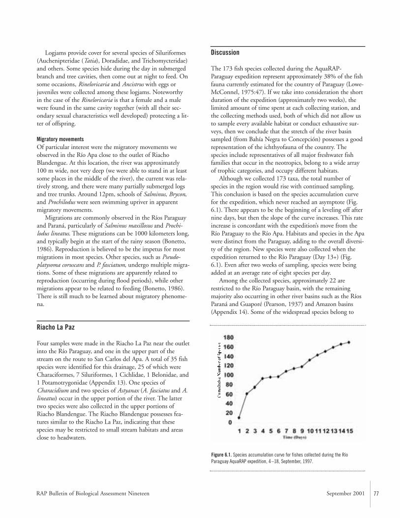
RAP Bulletin of Biological Assessment Nineteen September 2001 77
Logjams provide cover for several species of Siluriformes(Auchenipteridae (Tatia), Doradidae, and Trichomycteridae)and others. Some species hide during the day in submergedbranch and tree cavities, then come out at night to feed. Onsome occasions, Rineloricaria and Ancistrus with eggs orjuveniles were collected among these logjams. Noteworthyin the case of the Rineloricaria is that a female and a malewere found in the same cavity together (with all their sec-ondary sexual characteristics well developed) protecting a lit-ter of offspring.
Migratory movementsOf particular interest were the migratory movements weobserved in the Río Apa close to the outlet of RiachoBlandengue. At this location, the river was approximately100 m wide, not very deep (we were able to stand in at leastsome places in the middle of the river), the current was rela-tively strong, and there were many partially submerged logsand tree trunks. Around 12pm, schools of Salminus, Brycon,and Prochilodus were seen swimming upriver in apparentmigratory movements.
Migrations are commonly observed in the Ríos Paraguayand Paraná, particularly of Salminus maxillosus and Prochi-lodus lineatus. These migrations can be 1000 kilometers long,and typically begin at the start of the rainy season (Bonetto,1986). Reproduction is believed to be the impetus for mostmigrations in most species. Other species, such as Pseudo-platysoma coruscans and P. fasciatum, undergo multiple migra-tions. Some of these migrations are apparently related toreproduction (occurring during flood periods), while othermigrations appear to be related to feeding (Bonetto, 1986).There is still much to be learned about migratory phenome-na.
Riacho La Paz
Four samples were made in the Riacho La Paz near the outletinto the Río Paraguay, and one in the upper part of thestream on the route to San Carlos del Apa. A total of 35 fishspecies were identified for this drainage, 25 of which wereCharaciformes, 7 Siluriformes, 1 Cichlidae, 1 Belonidae, and1 Potamotrygonidae (Appendix 13). One species ofCharacidium and two species of Astyanax (A. fasciatus and A.lineatus) occur in the upper portion of the river. The lattertwo species were also collected in the upper portions ofRiacho Blandengue. The Riacho Blandengue possesses fea-tures similar to the Riacho La Paz, indicating that thesespecies may be restricted to small stream habitats and areasclose to headwaters.
Discussion
The 173 fish species collected during the AquaRAP-Paraguay expedition represent approximately 38% of the fishfauna currently estimated for the country of Paraguay (Lowe-McConnel, 1975:47). If we take into consideration the shortduration of the expedition (approximately two weeks), thelimited amount of time spent at each collecting station, andthe collecting methods used, both of which did not allow usto sample every available habitat or conduct exhaustive sur-veys, then we conclude that the stretch of the river basinsampled (from Bahía Negra to Concepción) possesses a goodrepresentation of the ichthyofauna of the country. Thespecies include representatives of all major freshwater fishfamilies that occur in the neotropics, belong to a wide arrayof trophic categories, and occupy different habitats.
Although we collected 173 taxa, the total number ofspecies in the region would rise with continued sampling.This conclusion is based on the species accumulation curvefor the expedition, which never reached an asymptote (Fig.6.1). There appears to be the beginning of a leveling off afternine days, but then the slope of the curve increases. This rateincrease is concordant with the expedition’s move from theRío Paraguay to the Río Apa. Habitats and species in the Apawere distinct from the Paraguay, adding to the overall diversi-ty of the region. New species were also collected when theexpedition returned to the Río Paraguay (Day 13+) (Fig.6.1). Even after two weeks of sampling, species were beingadded at an average rate of eight species per day.
Among the collected species, approximately 22 arerestricted to the Río Paraguay basin, with the remainingmajority also occurring in other river basins such as the RíosParaná and Guaporé (Pearson, 1937) and Amazon basins(Appendix 14). Some of the widespread species belong to
Figure 6.1. Species accumulation curve for fishes collected during the RíoParaguay AquaRAP expedition, 4–18, September, 1997.

78 CONSERVATION INTERNATIONAL
poorly studied genera and many of them probably constitutespecies complexes. Revisionary studies on these groups may reveal the existence of more species endemic to the RíoParaguay basin. In addition, some of the taxa identified as sp. 1, 2, etc. (Appendix 13) may represent new, yet unde-scribed, species.
Although we have not performed an exhaustive survey ofthe fish fauna to allow a detailed comparison among differ-ent habitats and portions of the sampled area, some informa-tive preliminary observations were obtained. Examples are:differences in the species collected in the Ríos Apa, Paraguay,and headwater streams (Riacho La Paz), and differences bothtaxonomic and in the life stages of the individuals collectedin the various habitats (e.g., flooded forest, main channel,lagoons, rapids, log jams, and headwater streams). The latterindicates that specific habitats are critical for the survival ofspecific stages during a species life cycle reinforcing theimportance of the conservation of areas that includes a widerepresentation of habitats in order to insure the survival ofthe species.
The migratory movements observed also show the highdependency of the fish fauna on the hydrological cycle of the basin as a whole. Currently there is no available informa-tion about migration patterns of the fish populations in the area we studied. Although detailed studies are necessaryour observation of migration movements of a few commer-cially important species in the Río Apa indicates that thisriver probably plays an important role in the life cycle ofthose fish populations. As emphasized by Goulding (1980),it is important to have a broad view of the fish fauna asopposed to seeing the fishes and their environment withinthe restricted and static framework of a particular area ortime period.
Recommended Conservation and Research Activities
• Assess the reproductive and growth rates of commercialspecies of fishes. Determine levels of sustainable yield andadjust legislation accordingly. Monitor catches of fishes.International cooperation is required because fishes crosscountry borders.
• Aquarium fishes (e.g., cichlids, tetras [characids], armoredcatfish [loricariids]) were collected in the study area.Unrestricted large-scale harvesting of these species woulddestroy their populations, as has occurred in some otherareas of South America. After determining populationsizes and conducting impact studies, it may be possiblefor local fishermen to implement a sustainable yield fish-ery for aquarium fishes.
• Migrations of Salminus, Brycon, and Prochilodus wereobserved in the Río Apa; hence this river appears to play
an important role in the life history of these commerciallyimportant fishes. Studies need to be conducted to learnmore about these migrations. Regulations that protectthese migrations need to be created and enforced.
• Habitats and species in the Río Apa are distinct from theRío Paraguay. Portions of both areas need to be managedin order to maximize the conservation of the entireregion’s biodiversity.
• Within a species, individuals at different life stages werecollected in the various habitats (e.g., flooded forest, mainchannel, lagoons, rapids, log jams, and headwaterstreams). This indicates that specific habitats are criticalfor the survival of specific stages during a species life cyclereinforcing the importance of the conservation of areasthat includes a wide representation of habitats in order toensure the survival of the species.
• Prevent large- and small-scale disruptions of the seasonalflooding. Disruptions of flooding would result in the lossof wetlands (i.e., nursery areas for fishes, etc.) and devas-tate biodiversity.
Literature Cited
Agostinho, A. A., N. S. Hahn, L. C. Gomes, and L. M. Bini.1997. Estrutura trafica. In Vazzoler, A. E. A. M., A. A.Agostinho, and N. S. Hahn (eds.). A planície de inundag-co do alto Rio Paraná: aspectos físicos, biológicos e socioe-conômicos. Editora da Universidade Estadual de Maringa.Pp. 229–248.
Bonetto, A.A. 1986. Fish of the Paraná system. In Davies,B.R. and K.F. Walker (eds.). The ecology of river systems.Dr. W. Junk Publishers, Dordrecht, Netherlands. Pp.573–588.
Boulenger, G.A. 1895. Description of two new SouthAmerican characinoid fishes. Annals and Magazines ofNatural History, 6:9–12.
Boulenger, G.A. 1897. Viaggio del Dr. Alfredo Borelli nelChaco boliviano e nella Republica Argentina. III.Poissons. Bollettino dri Musei di Zoologia ed AnatomiaComparata della Università di Torino, 12:1– 4.
Boulenger, G.A. 1900. Viaggio del Dott. Alfredo Borelli nelMato Grosso e nel Paraguay. III. Liste des poissonsrecueillis a Urucum et a Carandasinho, pres de Corumba.Bollettino dri Musei di Zoologia ed Anatomia Comparatadella Universit. di Torino, 15:1– 4.
Rapid Assessment Program
RAP Bulletin of Biological Assessment Nineteen September 2001 79
Eigenmann, C.H. and C.H. Kennedy. 1903. On a collectionof fishes from Paraguay, with synopsis of the Americangenera of cichlids. Proceedings of the Academy of NaturalSciences of Philadelphia, 55:497–537.
Eigenmann, C.H., W.L. McAtee, and D.P. Ward. 1907. Onfurther collections of fishes from Paraguay. Annals of theCarnegie Museum, 4:110–157.
Eigenmann, C.H. and G.S. Myers. 1929. The AmericanCharacidae. Memoirs of the Museum of ComparativeZoology, 43:429–574.
Géry, J. 1977. Characoids of the world. Neptune City, NewJersey: T.F.H. Publications. 672pp.
Goulding, M. 1980. The fishes and the forest. Berkeley:University of California Press. 280pp.
Knöppel, H.-A. 1970. Food of central amazonian fishes:contribution to the nutrient-ecology of amazonian rain-forest-streams. Amazoniana, 2:257–352.
Lowe-McConnell, R. H. 1975. Fish communities in tropicalfreshwaters: their distribution, ecology and evolution.New York: Longman. 337pp.
Mago-Leccia, F. 1994. Electric fishes of the continentalwaters of America. Fundacion para el Desarrollo de lasCiencias Fisicas, Matematicas y Naturales (FUDECI) Vol.XXIX. Caracas, Venezuela. 206pp.
Mahnert, V. and J. Géry. 1988. Les genres Piabarchus Myerset Creagrutus Günther du Paraguay, avec la description dedeux nouvelles espèces (Pisces, Ostariophysi, Characidae).Revue Francaise d’Aquariologie, 15:1–8.
Nakatani, K., G. Baumgartner, and M. Cavichioli. 1997.Ecologia de ovos e larvas de peixes. In Vazzoler, A. E. A.M., A. A. Agostinho, and N. S. Hahn (eds.). A planíciede inundagco do alto Rio Paraná: aspectos físicos,biológicos e socioeconômicos. Editora da UniversidadeEstadual de Maringa. Pp. 281–306.
Pearson, N.E. 1937. The fishes of the Beni-Mamoré andParaguay basins, and a discussion of the origin of theParaguayan fauna. Proceedings of the California Academyof Science, 23:99–114.
Perugia, A. 1891. Appunti supra alcuni peci Sud-americaniconservati nel Museo Civico di Storia Naturale diGenova. Annali Museo Civico di Storia Naturale diGenova, 10:605–657.
Sazima, I. 1983. Scale-eating in characoids and other fishes.Environmental Biology of Fishes, 9:87–101.
Schaeffer, S. 1997. The Neotropical cascudinhos: systematicsand biogeography of the Otocinclus catfishes (Siluriformes:Loricariidae). Proceedings of the Academy of NaturalSciences of Philadelphia, 148:1–120.
Vari, R.P. 1992. Systematics of the Neotropical characiformgenus Curimatella Eigenmann and Eigenmann (Pisces:Ostariophysi) with summary comments on theCurimatidae. Smithsonian Contributions to Zoology,533:1– 48.
Weitzman, S. H. and S. V. Fink. 1985. Xenurobryconin phy-logeny and putative pheromone pumps in glandulocau-dine fishes (Teleostei: Characidae). SmithsonianContributions to Zoology, 421:1–120.
Weitzman, S. H. and R. P. Vari. 1988. Miniaturization inSouth American freshwater fishes: an overview and discus-sion. Proceedings of the Biological Society of Washington,101:444 – 465.
80 CONSERVATION INTERNATIONAL
Abstract
The 173 species of freshwater fishes collected during theAquaRAP expedition to the Río Paraguay were analyzed todetermine if any distributional patterns existed within theregion collected. The region was divided into five subregionsand also into 10 macro-habitats. Two null hypotheses weretested and rejected: (i) that fishes are randomly distributedwith respect to sub-region; and (ii) that fishes are randomlydistributed with respect to macro-habitat. The results showthat a strong subregional effect was evident such that twodistributional elements were present: an association betweenthe Río Paraguay and Río Negro subregions, and an associa-tion between the Río Apa and Riacho La Paz subregions.The analysis of distributions with respect to macro-habitatsalso reveals two components. The first relates the beach andmain channel faunas to the macro-habitats that are inundat-ed during seasonal flooding, such as flooded forests andlagoons. The assemblage associated with the flooding cycleaccounts for more than 75% of the fishes collected. The sec-ond component comprises habitats found within the RíoApa and the Riacho La Paz (e.g., clear water, rapids, etc.).This Río Apa-Riacho La Paz component has a relativelysharp boundary with respect to the Río Paraguay with morethan a 50% turnover in fauna. These results show that coreconservation areas must be set up within situations in whichthe seasonal cycle of flooding is unimpeded and the area ofinundation is relatively unmodified. Also, the Río Apa-Riacho La Paz represents a highly threatened area because ofhigh rates of land conversion in the region, aridity, and thefact that much of the fauna cannot be recolonized fromnearby water sources.
Introduction
The fishes of the Río Paraguay comprise a rich assemblagewith more than 250 species documented from the entire riverbasin (Bonetto, 1986; Lowe-McConnell, 1987). Toledo-Pizaet al. (2001) collected 173 species in the Río Paraguaybetween Concepción and the Río Negro. Based on observa-tions made during the expedition, we were able to divide theregion of the AquaRAP survey into five subregions: RíoNegro, Upper Río Paraguay, Lower Río Paraguay, Río Apaand Riacho La Paz (Map 2). Furthermore, we were able torecognize 10 macro-habitats (e.g., beaches, flooded forests,rapids, etc.) within which the fishes were captured. There aremany trenchant threats to the aquatic ecosystems of the RíoParaguay (e.g., Hidrovia, land conversion, etc.) and thispaper will explore what the consequences of the threatsmight be given the distributions of fishes with respect to thesubregions and macro-habitats.
A pattern of heterogeneous distribution by the fisheswithin the Río Paraguay with respect to subregions andmacro-habitats would have important ramifications for con-servation recommendations. For example, if the fauna werehomogeneously distributed then a core conservation areacould be established that might effectively protect the vastmajority of the species. However, as the distribution of thespecies either among subregions or among macro-habitatsbecomes increasingly distinct and patchy, then a single corearea, apart from the entire region, may not provide thedesired level of protection. Chernoff et al. (1999) demon-strated how we can use information on the relative hetero-geneity of distributions among sub-regions or among macro-habitats to predict possible faunal changes in response to spe-cific environmental threats and that such analyses be carriedout within the framework of a rapid assessment program.
CHAPTER 7
Testing Hypotheses of Geographic andHabitat Partitioning of Fishes in the RíoParaguay, Paraguay
Barry Chernoff, Philip W. Willink, Mônica Toledo-Piza, Jaime Sarmiento, Mirta Medina, and Darío Mandelberger
Rapid Assessment Program
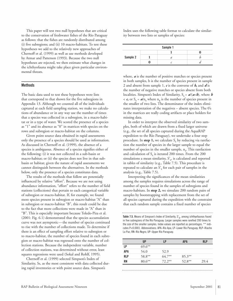
RAP Bulletin of Biological Assessment Nineteen September 2001 81
This paper will test two null hypotheses that are criticalto the conservation of freshwater fishes of the Río Paraguayas follows: that the fishes are randomly distributed among (i) five subregions; and (ii) 10 macro-habitats. To test thesehypotheses we add to the relatively new approaches ofChernoff et al. (1999) as well as use methods developed by Atmar and Patterson (1993). Because the two nullhypotheses are rejected, we then estimate what changes inthe ichthyofauna might take place given particular environ-mental threats.
Methods
The basic data used to test these hypotheses were lists that correspond to that shown for the five subregions inAppendix 13. Although we counted all of the individualscaptured at each field sampling station, we make no calcula-tions of abundance or in any way use the number of timesthat a species was collected in a subregion, in a macro-habi-tat or in a type of water. We scored the presence of a speciesas “1” and its absence as “0” in matrices with species on therows and subregion or macro-habitat on the columns.
Given point source data obtained in rapid assessmentsonly the presence of a species should be used as information.As discussed in Chernoff et al. (1999), the absence of aspecies is ambiguous. Absence of a species signifies either ofthe following: (i) it was not collected in a sub-basin ormacro-habitat; or (ii) the species does not live in that sub-basin or habitat; given the nature of rapid assessments wecannot distinguish between the alternatives. In the methodsbelow, only the presence of a species constitutes data.
The results of the methods that follow are potentiallyinfluenced by relative “effort”. Because we are not usingabundance information, “effort” refers to the number of fieldstations (collections) that pertain to each categorical variableof subregion or macro-habitat. If, for example, we foundmore species present in subregion or macro-habitat “A” thanin subregion or macro-habitat “B”, this result could be dueto the fact that more collections were made in “A” than in“B”. This is especially important because Toledo-Piza et al.(2001: Fig. 6.1) demonstrated that the species accumulationcurve was not asymptotic—the number of species continuedto rise with the number of collections made. To determine ifthere is an effect of sampling effort relative to subregion orto macro-habitat, the number of species found in each subre-gion or macro-habitat was regressed onto the number of col-lection stations. Because the independent variable, numberof collection stations, was determined without error, leastsquares regressions were used (Sokal and Rohlf, 1995).
Chernoff et al. (1999) selected Simpson’s Index ofSimilarity, Ss, as the most consistent with data collected dur-ing rapid inventories or with point source data. Simpson’s
Index uses the following table format to calculate the similar-ity between two lists or samples of species:
where, a is the number of positive matches or species presentin both samples, b is the number of species present in sample2 and absent from sample 1, c is the converse of b, and d isthe number of negative matches or species absent from bothlocalities. Simpson’s Index of Similarity, Ss = a/(a+b), where b< c, or Ss = a/ns where ns is the number of species present inthe smaller of two lists. The denominator of the index elimi-nates interpretation of the negatives – absent species. The 0’sin the matrices are really coding artifacts or place holders formissing data.
In order to interpret the observed similarity of two sam-ples, both of which are drawn from a fixed larger universe(e.g., the set of all species captured during the AquaRAPexpedition to the Río Paraguay), we undertake a four stepprocedure. In step 1, we calculate Ss by reducing via rarefac-tion the number of species in the larger sample to equal thenumber of species in the smaller sample, ns. This rarefactionand calculation of Ss is iterated 200 times. From the 200simulations a mean similarity, S’s, is calculated and reportedin tables of similarity (e.g., Table 7.5). This procedure isrepeated to calculate an S’s for each pair of samples in theanalysis (e.g., Table 7.5).
Interpreting the significances of the mean similaritiesamong the samples requires simulations across the range ofnumber of species found in the samples of subregions andmacro-habitats. In step 2, we simulate 200 random pairs ofsamples by bootstrapping with replacement from the set ofall species captured during the expedition with the constraintthat each random sample contains a fixed number of species
Sample 11 0
Sample 2 1 a b0 c d
Table 7.5. Means of Simpson’s Index of Similarity, S’s, among ichthyofaunas foundin five subregions of the Río Paraguay. Larger samples were rarefied 200 times tothe size of the smaller samples. Index values are reported as percentages. ** indi-cates P<0.0001. Abbreviations: APA–Río Apa; LP–Lower Río Paraguay; RLP–RiachoLa Paz; RN–Río Negro; UP–Upper Río Paraguay.
UP LP APA RLPLP 69.6**APA 54.0 52.9RLP 58.8** 64.7** 85.3**RN 80.6** 72.2** 52.8** 29.4
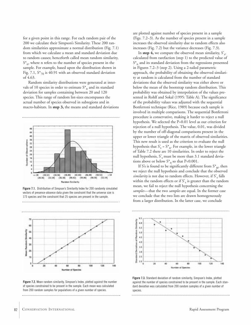
82 CONSERVATION INTERNATIONAL
for a given point in this range. For each random pair of the200 we calculate their Simpson’s Similarity. These 200 ran-dom similarities approximate a normal distribution (Fig. 7.1)from which we calculate a mean and standard deviation dueto random causes; henceforth called mean random similarity,S*n, where n refers to the number of species present in thesample. For example, based upon the distribution shown inFig. 7.1, S*70 is 40.91 with an observed standard deviationof 4.63.
Random similarity distributions were generated at inter-vals of 10 species in order to estimate S*n and its standarddeviation for samples containing between 20 and 120species. This range of random list-sizes encompasses theactual number of species observed in subregions and inmacro-habitats. In step 3, the means and standard deviations
are plotted against number of species present in a sample(Figs. 7.2–3). As the number of species present in a sampleincreases the observed similarity due to random effects alsoincreases (Fig. 7.2) but the variance decreases (Fig. 7.3).
In step 4, we compare the observed mean similarity, S’s,calculated from rarefaction (step 1) to the predicted value ofS*n and its standard deviation from the regressions presentedin Figures 7.2–3 (step 2). Using a 2-tailed parametricapproach, the probability of obtaining the observed similari-ty at random is calculated from the number of standarddeviations that the observed similarity was either above orbelow the mean of the bootstrap random distribution. Thisprobability was obtained by interpolation of the values pre-sented in Rohlf and Sokal (1995: Table A). The significanceof the probability values was adjusted with the sequentialBonferroni technique (Rice, 1989) because each sample isinvolved in multiple comparisons. The sequential Bonferroniprocedure is conservative, making it harder to reject a nullhypothesis. We selected the P=0.01 level as our criterion forrejection of a null hypothesis. The value, 0.01, was dividedby the number of off-diagonal comparisons present in theupper or lower triangle of the matrix of observed similarities.This new result is used as the criterion to evaluate the nullhypothesis that S’s = S*n. For example, in the lower triangleof Table 7.2 there are 10 similarities. In order to reject thenull hypothesis, S’s must be more than 3.1 standard devia-tions above or below S*n so that P<0.001.
If S’s is found to be significantly different from S*n, thenwe reject the null hypothesis and conclude that the observedsimilarity is not due to random effects. However, if S’s fallswithin the random effects or if S’s is greater than the randommean, we fail to reject the null hypothesis concerning thesamples—that the two samples are equal. In the former casewe conclude that the two lists are drawn homogeneouslyfrom a larger distribution. In the latter case, we conclude
Figure 7.1. Distribution of Simpson’s Similarity Index for 200 randomly simulatedvectors of presence-absence data given the constraint that the universe size is173 species and the constraint that 25 species are present in the sample.
Figure 7.2. Mean random similarity, Simpson’s Index, plotted against the numberof species constrained to be present in the sample. Each mean was calculatedfrom 200 random samples for populations of a given number of species.
Figure 7.3. Standard deviation of random similarity, Simpson’s Index, plottedagainst the number of species constrained to be present in the sample. Each stan-dard deviation was calculated from 200 random samples of a given number ofspecies.
Rapid Assessment Program
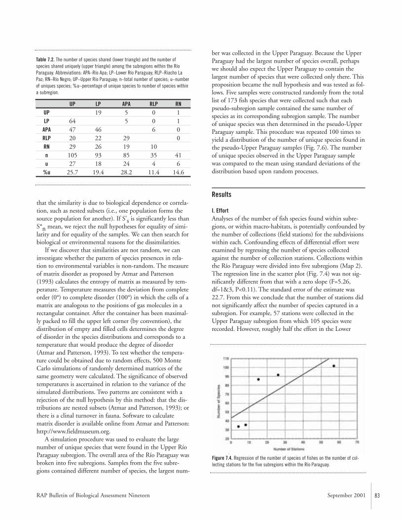
RAP Bulletin of Biological Assessment Nineteen September 2001 83
that the similarity is due to biological dependence or correla-tion, such as nested subsets (i.e., one population forms thesource population for another). If S’s is significantly less thanS*n mean, we reject the null hypotheses for equality of simi-larity and for equality of the samples. We can then search forbiological or environmental reasons for the dissimilarities.
If we discover that similarities are not random, we caninvestigate whether the pattern of species presences in rela-tion to environmental variables is non-random. The measureof matrix disorder as proposed by Atmar and Patterson(1993) calculates the entropy of matrix as measured by tem-perature. Temperature measures the deviation from completeorder (0°) to complete disorder (100°) in which the cells of amatrix are analogous to the positions of gas molecules in arectangular container. After the container has been maximal-ly packed to fill the upper left corner (by convention), thedistribution of empty and filled cells determines the degreeof disorder in the species distributions and corresponds to atemperature that would produce the degree of disorder(Atmar and Patterson, 1993). To test whether the tempera-ture could be obtained due to random effects, 500 MonteCarlo simulations of randomly determined matrices of thesame geometry were calculated. The significance of observedtemperatures is ascertained in relation to the variance of thesimulated distributions. Two patterns are consistent with arejection of the null hypothesis by this method: that the dis-tributions are nested subsets (Atmar and Patterson, 1993); orthere is a clinal turnover in fauna. Software to calculatematrix disorder is available online from Atmar and Patterson:http://www.fieldmuseum.org.
A simulation procedure was used to evaluate the largenumber of unique species that were found in the Upper RíoParaguay subregion. The overall area of the Río Paraguay wasbroken into five subregions. Samples from the five subre-gions contained different number of species, the largest num-
ber was collected in the Upper Paraguay. Because the UpperParaguay had the largest number of species overall, perhapswe should also expect the Upper Paraguay to contain thelargest number of species that were collected only there. Thisproposition became the null hypothesis and was tested as fol-lows. Five samples were constructed randomly from the totallist of 173 fish species that were collected such that eachpseudo-subregion sample contained the same number ofspecies as its corresponding subregion sample. The numberof unique species was then determined in the pseudo-UpperParaguay sample. This procedure was repeated 100 times toyield a distribution of the number of unique species found inthe pseudo-Upper Paraguay samples (Fig. 7.6). The numberof unique species observed in the Upper Paraguay samplewas compared to the mean using standard deviations of thedistribution based upon random processes.
Results
I. EffortAnalyses of the number of fish species found within subre-gions, or within macro-habitats, is potentially confounded bythe number of collections (field stations) for the subdivisionswithin each. Confounding effects of differential effort wereexamined by regressing the number of species collectedagainst the number of collection stations. Collections withinthe Río Paraguay were divided into five subregions (Map 2).The regression line in the scatter plot (Fig. 7.4) was not sig-nificantly different from that with a zero slope (F=5.26,df=1&3, P<0.11). The standard error of the estimate was22.7. From this we conclude that the number of stations didnot significantly affect the number of species captured in asubregion. For example, 57 stations were collected in theUpper Paraguay subregion from which 105 species wererecorded. However, roughly half the effort in the Lower
Figure 7.4. Regression of the number of species of fishes on the number of col-lecting stations for the five subregions within the Río Paraguay.
UP LP APA RLP RNUP 19 5 0 1LP 64 5 0 1
APA 47 46 6 0RLP 20 22 29 0RN 29 26 19 10n 105 93 85 35 41u 27 18 24 4 6
%u 25.7 19.4 28.2 11.4 14.6
Table 7.2. The number of species shared (lower triangle) and the number ofspecies shared uniquely (upper triangle) among the subregions within the RíoParaguay. Abbreviations: APA–Río Apa; LP–Lower Río Paraguay; RLP–Riacho LaPaz; RN–Río Negro; UP–Upper Río Paraguay; n–total number of species; u–numberof uniques species; %u–percentage of unique species to number of species withina subregion.
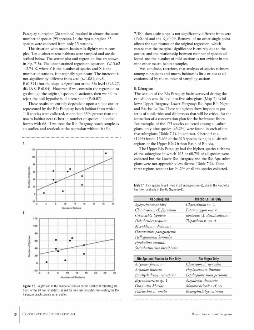
84 CONSERVATION INTERNATIONAL
Paraguay subregion (26 stations) resulted in almost the samenumber of species (93 species). In the Apa subregion 85species were collected from only 15 stations.
The situation with macro-habitats is slightly more com-plex. Ten distinct macro-habitats were sampled and are de-scribed below. The scatter plot and regression line are shownin Fig. 7.5a. The unconstrained regression equation, Y=15.62+ 2.74 X, where Y is the number of species and X is thenumber of stations, is marginally significant. The intercept isnot significantly different from zero (t=1.081, df=8,P<0.311) but the slope is significant at the 5% level (F=6.27,df=1&8, P<0.04). However, if we constrain the regression togo through the origin (0 species, 0 stations), then we fail toreject the null hypothesis of a zero slope (P<0.07).
These results are entirely dependent upon a single outlierrepresented by the Río Paraguay beach habitat from which110 species were collected, more than 35% greater than themacro-habitat next richest in number of species – floodedforests with 68. If we treat the Río Paraguay beach sample asan outlier, and recalculate the regression without it (Fig.
7.5b), then again slope is not significantly different from zero(P<0.44) and the R2=0.09. Removal of no other single pointaffects the significance of the original regression, whichmeans that the marginal significance is entirely due to theoutlier, and the relationship between number of species col-lected and the number of field stations is not evident in thenine other macro-habitat samples.
We, conclude, therefore, that analyses of species richnessamong subregions and macro-habitats is little or not at allconfounded by the number of sampling stations.
II. SubregionsThe section of the Río Paraguay basin surveyed during theexpedition was divided into five subregions (Map 2) as fol-lows: Upper Paraguay; Lower Paraguay; Río Apa; Río Negro;and Riacho La Paz. These subregions show important pat-terns of similarities and differences that will be critical for theformation of a conservation plan for the freshwater fishes.For example, of the 173 species collected among all subre-gions, only nine species (=5.2%) were found in each of thefive subregions (Table 7.1). In contrast, Chernoff et al.(1999) found 15.6% of the 313 species living in all six sub-regions of the Upper Río Orthon Basin of Bolivia.
The Upper Río Paraguay had the highest species richnessof the subregions in which 105 or 60.7% of all species werecollected but the Lower Río Paraguay and the Río Apa subre-gions were not appreciably less diverse (Table 7.2). Thesethree regions account for 94.2% of all the species collected.
Figure 7.5. Regression of the number of species on the number of collecting sta-tions for the 10 macrohabitats (a) and for nine macrohabitats (b) treating the RioParaguay beach sample as an outlier.
Table 7.1. Fish species found living in all subregions (n=9), only in the Riacho LaPaz (n=4) and only in the Río Negro (n=6).
A
B
All SubregionsAphyocharax anisitsiCharacidium cf. fasciatumCrenicichla lepidotaHoloshesthes pequiraMoenkhausia dichrouraOdontostilbe paraguayensisPsellogrammus kennedyiPyrrhulina australisSteindachnerina brevipinna
Río Apa and Riacho La Paz OnlyAstyanax fasciatusAstyanax lineatusBrachychalcinus retrospinaBryconamericus sp. 1Otocinclus MaríaePiabarchus cf. analis
Riacho La Paz OnlyCharacidium sp. 2Potamotrygon histrixRoeboides cf. descalvadensisTriportheus n. sp. A
Río Negro OnlyCheirodon cf. stenodonHoplosternum littoraleLepthoplosternum pectoraleMegalechis thoracataMonotocheirodon cf. sp.Rhamphichthys rostratus
Rapid Assessment Program
85
The Río Negro and Riacho La Paz accounted for only 10species not found in the other subregions (Table 7.2). This isnot surprising because collections were not made far abovethe mouths of these tributaries to the Río Paraguay.
What is surprising, however, is the number of speciesuniquely found in the Upper Río Paraguay, Lower RíoParaguay and Río Apa subregions that range between19.4–28.2% of their samples (Tables 7.1–7.4). A relativelyhigh percentage would be expected from the Río Apa subre-gion because it constitutes a very different subregion and setof habitats than are found in the Río Paraguay subregions.While some of the fishes collected only in the Río Apa, suchas Pimelodella laticeps and Thoracocharax stellatus, are proba-bly transients, others such as Imparfinis minutus, Jupiabaacanthogaster, and Xenurobrycon macropus, are not.
The interpretation of the number of unique species in theRío Paraguay subregions is somewhat problematic. Could therelatively high numbers be due to random effects? That is, if
community composition was entirely random, how manyunique species should we expect in a sample of any givensize. This was evaluated by simulating 100, random, five-subregion communities such that the number of species pre-sent for each simulated subregion matched exactly the num-bers observed: 105, 93, 85, 35, and 41. For the set of ran-dom samples of the size of the Upper Río Paraguaysubregion (Fig. 7.6) we find a mean of 15.7 unique species ±3.3 species. The observed value of 27 unique species is 3.4standard deviations above the mean (P<0.0002); significantlymore than expected by random processes. The fact that mostof the species collected only in the Upper Río Paraguay areknown to have much larger distributions may indicate thatthis region is not necessarily unique but rather influenced bythe greater diversity found in the northern portions of thebasin, including the Pantanal (Bonetto, 1986).
The numbers of unique species found in the Río Apa andin the Lower Río Paraguay are also greater than one wouldexpect due to random chance given the entire sample ofspecies collected during the expedition. The number ofunique species (n=18) collected in the Lower Río Paraguaycontains many species that are clearly artifacts such as: Pota-motrygon motoro, Serrasalmus elongatus, S. spilopleura,
Apteronotus albifronsBunocephalus doriaeCallichthys callichthysCheirodon sp. 1Clupeacharax anchoveoidesCorydoras aeneusCorydoras cf. ellisaeCurimatella dorsalisJupiaba acanthogasterFarlowella paraguayensisHeptapterus sp. (nov.?)Hypostomus sp. 3Imparfinis minutusLeporinus friderici acutidensLeporinus striatusOdontostilbe sp.Pimelodella laticepsPoptella paraguayensisPseudocetopsis gobioidesPseudohemiodon laticepsRoeboides prognathusTatia aulopygiaThoracocharax stellatusXenurobrycon macropus
Upper Río Paraguay OnlyAnadoras grypusAncistrus sp.Astronotus crassipinnisBrycon sp.Chaetobranchopsis australeCharacidium sp. 1Charax sp.Cheirodon sp. 3Cheirodontinae sp.Cichlasoma sp.Cochliodon sp. 1Crenicichla sp.Crenicichla cf. vittataDoras eigenmanniDoras sp.Hemiodus orthonopsHoloshesthes pequiraHyphessobrycon maxillarisHypostomus sp. 2Lepidosiren paradoxaLeporinus fridericiLoricaria sp. 1Megalechis thoracataMylossoma duriventrePiaractus mitreiPimelodella sp.Salminus maxillosus
Lower Río Paraguay OnlyAgeneiosus cf. brevifilisBryconamericus exodonCharax stenopterusGaleocharax guloHemigrammus cf. tridensHyphessobrycon sp. 1Hyphessobrycon sp. 2Leporinus cf. obtusidensMicrocharacidium sp.Pimelodus blochiiPimelodus maculatusPinirampus pirinampuPotamotrygon motoroRivulus sp.Serrasalmus cf. elongatusSerrasalmus spilopleuraSorubim lima
Table 7.3. Fish species collected only in the Upper (n=27) and Lower (n=18) portions of the Río Paraguay, respectively.
Table 7.4. Fish species collected only in the Río Apa (n=24).
RAP Bulletin of Biological Assessment Nineteen September 2001
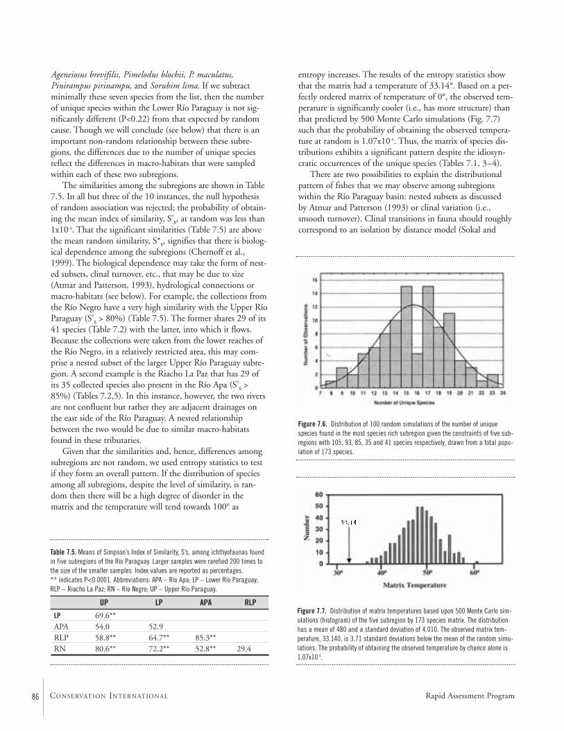
Ageneiosus brevifilis, Pimelodus blochii, P. maculatus,Pinirampus pirinampu, and Sorubim lima. If we subtractminimally these seven species from the list, then the numberof unique species within the Lower Río Paraguay is not sig-nificantly different (P<0.22) from that expected by randomcause. Though we will conclude (see below) that there is animportant non-random relationship between these subre-gions, the differences due to the number of unique speciesreflect the differences in macro-habitats that were sampledwithin each of these two subregions.
The similarities among the subregions are shown in Table7.5. In all but three of the 10 instances, the null hypothesisof random association was rejected; the probability of obtain-ing the mean index of similarity, S’s, at random was less than1x10-4. That the significant similarities (Table 7.5) are abovethe mean random similarity, S*s, signifies that there is biolog-ical dependence among the subregions (Chernoff et al.,1999). The biological dependence may take the form of nest-ed subsets, clinal turnover, etc., that may be due to size(Atmar and Patterson, 1993), hydrological connections ormacro-habitats (see below). For example, the collections fromthe Río Negro have a very high similarity with the Upper RíoParaguay (S’s > 80%) (Table 7.5). The former shares 29 of its41 species (Table 7.2) with the latter, into which it flows.Because the collections were taken from the lower reaches ofthe Río Negro, in a relatively restricted area, this may com-prise a nested subset of the larger Upper Río Paraguay subre-gion. A second example is the Riacho La Paz that has 29 ofits 35 collected species also present in the Río Apa (S’s >85%) (Tables 7.2,5). In this instance, however, the two riversare not confluent but rather they are adjacent drainages onthe east side of the Río Paraguay. A nested relationshipbetween the two would be due to similar macro-habitatsfound in these tributaries.
Given that the similarities and, hence, differences amongsubregions are not random, we used entropy statistics to testif they form an overall pattern. If the distribution of speciesamong all subregions, despite the level of similarity, is ran-dom then there will be a high degree of disorder in thematrix and the temperature will tend towards 100° as
entropy increases. The results of the entropy statistics showthat the matrix had a temperature of 33.14°. Based on a per-fectly ordered matrix of temperature of 0°, the observed tem-perature is significantly cooler (i.e., has more structure) thanthat predicted by 500 Monte Carlo simulations (Fig. 7.7)such that the probability of obtaining the observed tempera-ture at random is 1.07x10⁻⁴. Thus, the matrix of species dis-tributions exhibits a significant pattern despite the idiosyn-cratic occurrences of the unique species (Tables 7.1, 3–4).
There are two possibilities to explain the distributionalpattern of fishes that we may observe among subregionswithin the Río Paraguay basin: nested subsets as discussed by Atmar and Patterson (1993) or clinal variation (i.e.,smooth turnover). Clinal transitions in fauna should roughlycorrespond to an isolation by distance model (Sokal and
Figure 7.6. Distribution of 100 random simulations of the number of uniquespecies found in the most species rich subregion given the constraints of five sub-regions with 105, 93, 85, 35 and 41 species respectively, drawn from a total popu-lation of 173 species.
Figure 7.7. Distribution of matrix temperatures based upon 500 Monte Carlo sim-ulations (histogram) of the five subregion by 173 species matrix. The distributionhas a mean of 480 and a standard deviation of 4.010. The observed matrix tem-perature, 33.140, is 3.71 standard deviations below the mean of the random simu-lations. The probability of obtaining the observed temperature by chance alone is1.07x10-4.
Rapid Assessment Program86 CONSERVATION INTERNATIONAL
LP 69.6**APA 54.0 52.9RLP 58.8** 64.7** 85.3**RN 80.6** 72.2** 52.8** 29.4
Table 7.5. Means of Simpson’s Index of Similarity, S’s, among ichthyofaunas foundin five subregions of the Río Paraguay. Larger samples were rarefied 200 times tothe size of the smaller samples. Index values are reported as percentages. ** indicates P<0.0001. Abbreviations: APA – Río Apa; LP – Lower Río Paraguay;RLP – Riacho La Paz; RN – Río Negro; UP – Upper Río Paraguay.
UP LP APA RLP
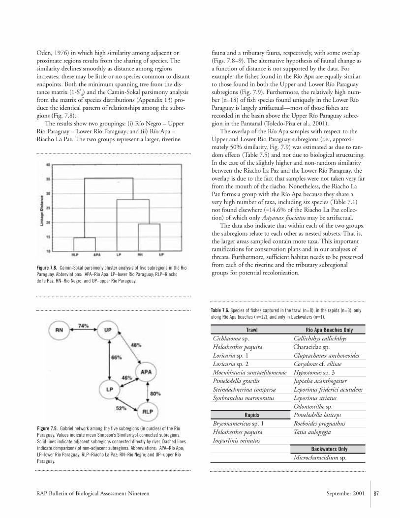
RAP Bulletin of Biological Assessment Nineteen September 2001 87
Oden, 1976) in which high similarity among adjacent orproximate regions results from the sharing of species. Thesimilarity declines smoothly as distance among regionsincreases; there may be little or no species common to distantendpoints. Both the minimum spanning tree from the dis-tance matrix (1-S’s) and the Camin-Sokal parsimony analysisfrom the matrix of species distributions (Appendix 13) pro-duce the identical pattern of relationships among the subre-gions (Fig. 7.8).
The results show two groupings: (i) Río Negro – UpperRío Paraguay – Lower Río Paraguay; and (ii) Río Apa –Riacho La Paz. The two groups represent a larger, riverine
fauna and a tributary fauna, respectively, with some overlap(Figs. 7.8–9). The alternative hypothesis of faunal change asa function of distance is not supported by the data. Forexample, the fishes found in the Río Apa are equally similarto those found in both the Upper and Lower Río Paraguaysubregions (Fig. 7.9). Furthermore, the relatively high num-ber (n=18) of fish species found uniquely in the Lower RíoParaguay is largely artifactual—most of those fishes arerecorded in the basin above the Upper Río Paraguay subre-gion in the Pantanal (Toledo-Piza et al., 2001).
The overlap of the Río Apa samples with respect to theUpper and Lower Río Paraguay subregions (i.e., approxi-mately 50% similarity, Fig. 7.9) was estimated as due to ran-dom effects (Table 7.5) and not due to biological structuring.In the case of the slightly higher and non-random similaritybetween the Riacho La Paz and the Lower Río Paraguay, theoverlap is due to the fact that samples were not taken very farfrom the mouth of the riacho. Nonetheless, the Riacho LaPaz forms a group with the Río Apa because they share avery high number of taxa, including six species (Table 7.1)not found elsewhere (=14.6% of the Riacho La Paz collec-tion) of which only Astyanax fasciatus may be artifactual.
The data also indicate that within each of the two groups,the subregions relate to each other as nested subsets. That is,the larger areas sampled contain more taxa. This importantramifications for conservation plans and in our analyses ofthreats. Furthermore, sufficient habitat needs to be preservedfrom each of the riverine and the tributary subregionalgroups for potential recolonization.
Figure 7.8. Camin-Sokal parsimony cluster analysis of five subregions in the RioParaguay. Abbreviations: APA–Rio Apa; LP–lower Rio Paraguay; RLP–Riachode la Paz; RN–Rio Negro; and UP–upper Rio Paraguay.
Figure 7.9. Gabriel network among the five subregions (in curcles) of the RíoParaguay. Values indicate mean Simpson’s Similarityof connected subregions.Solid lines indicate adjacent subregions connected directly by river. Dashed linesindicate comparisons of non-adjacent subregions. Abbreviations: APA–Río Apa;LP–lower Río Paraguay; RLP–Riacho La Paz; RN–Río Negro; and UP–upper RíoParaguay.
TrawlCichlasoma sp.Holoshesthes pequiraLoricaria sp. 1Loricaria sp. 2Moenkhausia sanctaefilomenaePimelodella gracilisSteindachnerina conspersaSynbranchus marmoratus
RapidsBryconamericus sp. 1Holoshesthes pequira Imparfinis minutus
Río Apa Beaches OnlyCallichthys callichthysCharacidae sp.Clupeacharax anchoveoidesCorydoras cf. ellisaeHypostomus sp. 3Jupiaba acanthogasterLeporinus friderici acutidensLeporinus striatusOdontostilbe sp.Pimelodella laticepsRoeboides prognathusTatia aulopygia
Backwaters OnlyMicrocharacidium sp.
Table 7.6. Species of fishes captured in the trawl (n=8), in the rapids (n=3), onlyalong Río Apa beaches (n=12), and only in backwaters (n=1).
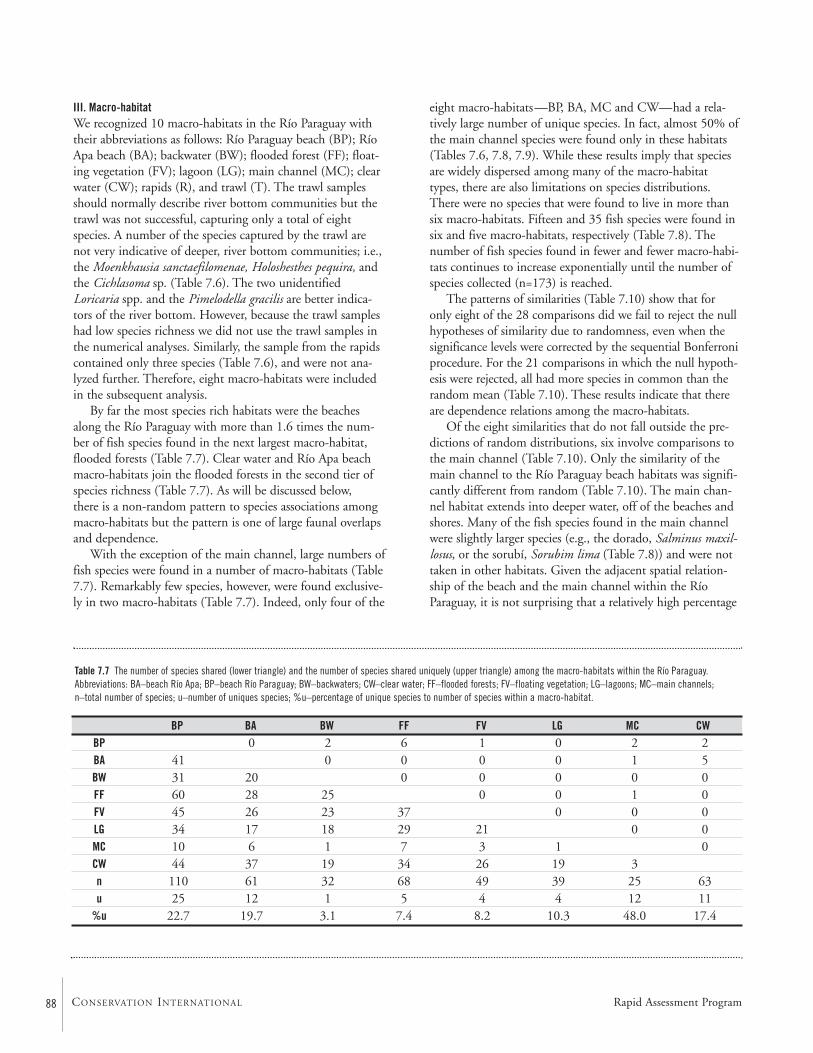
88 CONSERVATION INTERNATIONAL
III. Macro-habitatWe recognized 10 macro-habitats in the Río Paraguay withtheir abbreviations as follows: Río Paraguay beach (BP); RíoApa beach (BA); backwater (BW); flooded forest (FF); float-ing vegetation (FV); lagoon (LG); main channel (MC); clearwater (CW); rapids (R), and trawl (T). The trawl samplesshould normally describe river bottom communities but thetrawl was not successful, capturing only a total of eightspecies. A number of the species captured by the trawl arenot very indicative of deeper, river bottom communities; i.e.,the Moenkhausia sanctaefilomenae, Holoshesthes pequira, andthe Cichlasoma sp. (Table 7.6). The two unidentifiedLoricaria spp. and the Pimelodella gracilis are better indica-tors of the river bottom. However, because the trawl sampleshad low species richness we did not use the trawl samples inthe numerical analyses. Similarly, the sample from the rapidscontained only three species (Table 7.6), and were not ana-lyzed further. Therefore, eight macro-habitats were includedin the subsequent analysis.
By far the most species rich habitats were the beachesalong the Río Paraguay with more than 1.6 times the num-ber of fish species found in the next largest macro-habitat,flooded forests (Table 7.7). Clear water and Río Apa beachmacro-habitats join the flooded forests in the second tier ofspecies richness (Table 7.7). As will be discussed below, there is a non-random pattern to species associations amongmacro-habitats but the pattern is one of large faunal overlapsand dependence.
With the exception of the main channel, large numbers offish species were found in a number of macro-habitats (Table7.7). Remarkably few species, however, were found exclusive-ly in two macro-habitats (Table 7.7). Indeed, only four of the
BP BA BW FF FV LG MC CWBP 0 2 6 1 0 2 2BA 41 0 0 0 0 1 5BW 31 20 0 0 0 0 0FF 60 28 25 0 0 1 0FV 45 26 23 37 0 0 0LG 34 17 18 29 21 0 0MC 10 6 1 7 3 1 0CW 44 37 19 34 26 19 3n 110 61 32 68 49 39 25 63u 25 12 1 5 4 4 12 11
%u 22.7 19.7 3.1 7.4 8.2 10.3 48.0 17.4
Table 7.7 The number of species shared (lower triangle) and the number of species shared uniquely (upper triangle) among the macro-habitats within the Río Paraguay.Abbreviations: BA–beach Río Apa; BP–beach Río Paraguay; BW–backwaters; CW–clear water; FF–flooded forests; FV–floating vegetation; LG–lagoons; MC–main channels;n–total number of species; u–number of uniques species; %u–percentage of unique species to number of species within a macro-habitat.
eight macro-habitats—BP, BA, MC and CW—had a rela-tively large number of unique species. In fact, almost 50% ofthe main channel species were found only in these habitats(Tables 7.6, 7.8, 7.9). While these results imply that speciesare widely dispersed among many of the macro-habitattypes, there are also limitations on species distributions.There were no species that were found to live in more thansix macro-habitats. Fifteen and 35 fish species were found insix and five macro-habitats, respectively (Table 7.8). Thenumber of fish species found in fewer and fewer macro-habi-tats continues to increase exponentially until the number ofspecies collected (n=173) is reached.
The patterns of similarities (Table 7.10) show that foronly eight of the 28 comparisons did we fail to reject the nullhypotheses of similarity due to randomness, even when thesignificance levels were corrected by the sequential Bonferroniprocedure. For the 21 comparisons in which the null hypoth-esis were rejected, all had more species in common than therandom mean (Table 7.10). These results indicate that thereare dependence relations among the macro-habitats.
Of the eight similarities that do not fall outside the pre-dictions of random distributions, six involve comparisons tothe main channel (Table 7.10). Only the similarity of themain channel to the Río Paraguay beach habitats was signifi-cantly different from random (Table 7.10). The main chan-nel habitat extends into deeper water, off of the beaches andshores. Many of the fish species found in the main channelwere slightly larger species (e.g., the dorado, Salminus maxil-losus, or the sorubí, Sorubim lima (Table 7.8)) and were nottaken in other habitats. Given the adjacent spatial relation-ship of the beach and the main channel within the RíoParaguay, it is not surprising that a relatively high percentage
Rapid Assessment Program
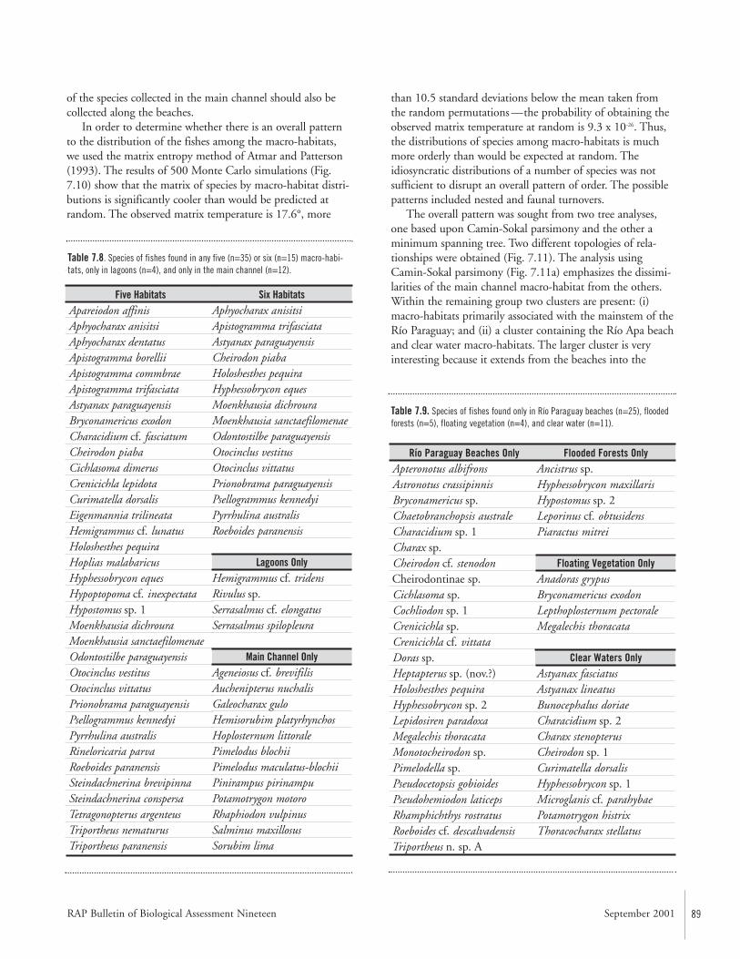
89
of the species collected in the main channel should also becollected along the beaches.
In order to determine whether there is an overall patternto the distribution of the fishes among the macro-habitats,we used the matrix entropy method of Atmar and Patterson(1993). The results of 500 Monte Carlo simulations (Fig.7.10) show that the matrix of species by macro-habitat distri-butions is significantly cooler than would be predicted atrandom. The observed matrix temperature is 17.6°, more
than 10.5 standard deviations below the mean taken fromthe random permutations —the probability of obtaining theobserved matrix temperature at random is 9.3 x 10⁻²⁶. Thus,the distributions of species among macro-habitats is muchmore orderly than would be expected at random. Theidiosyncratic distributions of a number of species was notsufficient to disrupt an overall pattern of order. The possiblepatterns included nested and faunal turnovers.
The overall pattern was sought from two tree analyses,one based upon Camin-Sokal parsimony and the other aminimum spanning tree. Two different topologies of rela-tionships were obtained (Fig. 7.11). The analysis usingCamin-Sokal parsimony (Fig. 7.11a) emphasizes the dissimi-larities of the main channel macro-habitat from the others.Within the remaining group two clusters are present: (i)macro-habitats primarily associated with the mainstem of theRío Paraguay; and (ii) a cluster containing the Río Apa beachand clear water macro-habitats. The larger cluster is veryinteresting because it extends from the beaches into the
Río Paraguay Beaches OnlyApteronotus albifronsAstronotus crassipinnisBryconamericus sp.Chaetobranchopsis australeCharacidium sp. 1Charax sp.Cheirodon cf. stenodonCheirodontinae sp.Cichlasoma sp.Cochliodon sp. 1Crenicichla sp.Crenicichla cf. vittataDoras sp.Heptapterus sp. (nov.?)Holoshesthes pequiraHyphessobrycon sp. 2Lepidosiren paradoxaMegalechis thoracataMonotocheirodon sp.Pimelodella sp.Pseudocetopsis gobioidesPseudohemiodon laticepsRhamphichthys rostratusRoeboides cf. descalvadensisTriportheus n. sp. A
Flooded Forests OnlyAncistrus sp.Hyphessobrycon maxillarisHypostomus sp. 2Leporinus cf. obtusidensPiaractus mitrei
Floating Vegetation OnlyAnadoras grypusBryconamericus exodonLepthoplosternum pectoraleMegalechis thoracata
Clear Waters OnlyAstyanax fasciatusAstyanax lineatusBunocephalus doriaeCharacidium sp. 2Charax stenopterusCheirodon sp. 1Curimatella dorsalisHyphessobrycon sp. 1Microglanis cf. parahybaePotamotrygon histrixThoracocharax stellatus
Table 7.9. Species of fishes found only in Río Paraguay beaches (n=25), floodedforests (n=5), floating vegetation (n=4), and clear water (n=11).
Five HabitatsApareiodon affinisAphyocharax anisitsiAphyocharax dentatusApistogramma borelliiApistogramma commbraeApistogramma trifasciataAstyanax paraguayensisBryconamericus exodonCharacidium cf. fasciatumCheirodon piabaCichlasoma dimerusCrenicichla lepidotaCurimatella dorsalisEigenmannia trilineataHemigrammus cf. lunatusHoloshesthes pequiraHoplias malabaricusHyphessobrycon equesHypoptopoma cf. inexpectataHypostomus sp. 1Moenkhausia dichrouraMoenkhausia sanctaefilomenaeOdontostilbe paraguayensisOtocinclus vestitusOtocinclus vittatusPrionobrama paraguayensisPsellogrammus kennedyiPyrrhulina australisRineloricaria parvaRoeboides paranensisSteindachnerina brevipinnaSteindachnerina conspersaTetragonopterus argenteusTriportheus nematurusTriportheus paranensis
Six HabitatsAphyocharax anisitsiApistogramma trifasciataAstyanax paraguayensisCheirodon piabaHoloshesthes pequiraHyphessobrycon equesMoenkhausia dichrouraMoenkhausia sanctaefilomenaeOdontostilbe paraguayensisOtocinclus vestitusOtocinclus vittatusPrionobrama paraguayensisPsellogrammus kennedyiPyrrhulina australisRoeboides paranensis
Lagoons OnlyHemigrammus cf. tridensRivulus sp.Serrasalmus cf. elongatusSerrasalmus spilopleura
Main Channel OnlyAgeneiosus cf. brevifilisAuchenipterus nuchalisGaleocharax guloHemisorubim platyrhynchosHoplosternum littoralePimelodus blochiiPimelodus maculatus-blochiiPinirampus pirinampuPotamotrygon motoroRhaphiodon vulpinusSalminus maxillosusSorubim lima
Table 7.8. Species of fishes found in any five (n=35) or six (n=15) macro-habi-tats, only in lagoons (n=4), and only in the main channel (n=12).
RAP Bulletin of Biological Assessment Nineteen September 2001
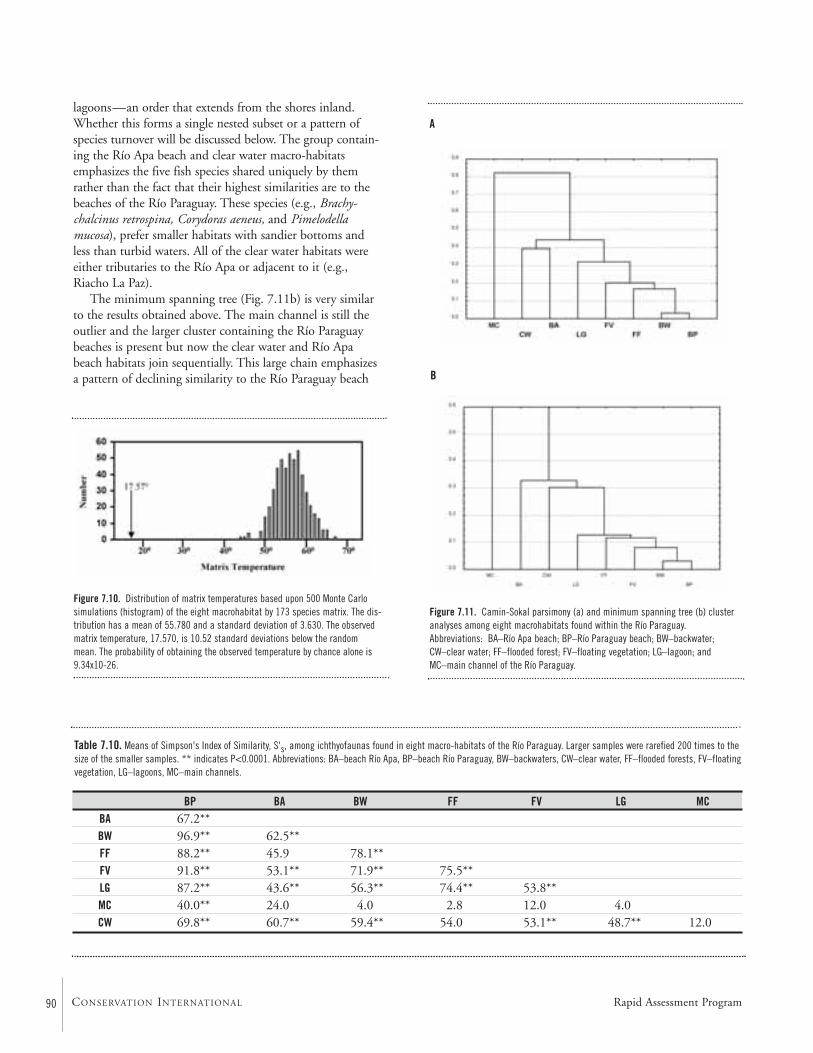
BP BA BW FF FV LG MCBA 67.2**BW 96.9** 62.5**FF 88.2** 45.9 78.1**FV 91.8** 53.1** 71.9** 75.5**LG 87.2** 43.6** 56.3** 74.4** 53.8**MC 40.0** 24.0 4.0 2.8 12.0 4.0CW 69.8** 60.7** 59.4** 54.0 53.1** 48.7** 12.0
Table 7.10. Means of Simpson's Index of Similarity, S's, among ichthyofaunas found in eight macro-habitats of the Río Paraguay. Larger samples were rarefied 200 times to thesize of the smaller samples. ** indicates P<0.0001. Abbreviations: BA–beach Río Apa, BP–beach Río Paraguay, BW–backwaters, CW–clear water, FF–flooded forests, FV–floatingvegetation, LG–lagoons, MC–main channels.
lagoons—an order that extends from the shores inland.Whether this forms a single nested subset or a pattern ofspecies turnover will be discussed below. The group contain-ing the Río Apa beach and clear water macro-habitatsemphasizes the five fish species shared uniquely by themrather than the fact that their highest similarities are to thebeaches of the Río Paraguay. These species (e.g., Brachy-chalcinus retrospina, Corydoras aeneus, and Pimelodellamucosa), prefer smaller habitats with sandier bottoms and less than turbid waters. All of the clear water habitats wereeither tributaries to the Río Apa or adjacent to it (e.g.,Riacho La Paz).
The minimum spanning tree (Fig. 7.11b) is very similarto the results obtained above. The main channel is still theoutlier and the larger cluster containing the Río Paraguaybeaches is present but now the clear water and Río Apabeach habitats join sequentially. This large chain emphasizesa pattern of declining similarity to the Río Paraguay beach
Figure 7.11. Camin-Sokal parsimony (a) and minimum spanning tree (b) clusteranalyses among eight macrohabitats found within the Río Paraguay.Abbreviations: BA–Río Apa beach; BP–Río Paraguay beach; BW–backwater;CW–clear water; FF–flooded forest; FV–floating vegetation; LG–lagoon; andMC–main channel of the Río Paraguay.
A
B
Figure 7.10. Distribution of matrix temperatures based upon 500 Monte Carlosimulations (histogram) of the eight macrohabitat by 173 species matrix. The dis-tribution has a mean of 55.780 and a standard deviation of 3.630. The observedmatrix temperature, 17.570, is 10.52 standard deviations below the random mean. The probability of obtaining the observed temperature by chance alone is9.34x10-26.
Rapid Assessment Program90 CONSERVATION INTERNATIONAL
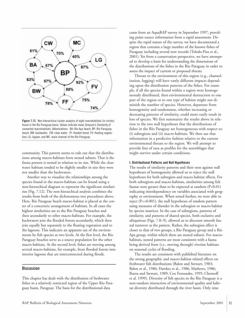
RAP Bulletin of Biological Assessment Nineteen September 2001 91
community. This pattern seems to rule out that the distribu-tions among macro-habitats form nested subsets. That is thefauna present is nested in relation to its size. While the clearwater habitats tended to be slightly smaller in size they werenot smaller than the backwaters.
Another way to visualize the relationships among thespecies found in the macro-habitats can be found using anon-hierarchical diagram to represent the significant similari-ties (Fig. 7.12). The non-hierarchical analysis combines theresults from both of the dichotomous tree procedures above.Here, Río Paraguay beach macro-habitat is placed at the cen-ter of a concentric arrangement of habitats. In all cases thehighest similarities are to the Río Paraguay beaches and then secondarily to other macro-habitats. For example, thebackwaters join the flooded forests secondarily, which thenjoin equally but separately to the floating vegetation and tothe lagoons. This indicates an apparent use of the environ-ments by fish species at two levels. At the first level, the RíoParaguay beaches serve as a source population for the othermacro-habitats. At the second level, fishes are moving amongseveral macro-habitats, for example, from flooded forests intointerior lagoons that are interconnected during floods.
Discussion
This chapter has dealt with the distribution of freshwaterfishes in a relatively restricted region of the Upper Río Para-guay basin, Paraguay. The basis for the distributional data
came from an AquaRAP survey in September 1997, provid-ing point source information from a rapid assessment. De-spite the rapid nature of the survey, we have documented aregion that contains a large number of the known fishes ofParaguay including several new records (Toledo-Piza et al.,2001). Yet from a conservation perspective, we have attempt-ed to develop a basis for understanding the dimensions ofthe distributions of the fishes in the Río Paraguay in order toassess the impact of current or proposed threats.
Threats to the environment of this region (e.g., channel-ization, logging) will have vastly different impacts depend-ing upon the distribution patterns of the fishes. For exam-ple, if all the species found within a region were homoge-neously distributed, then environmental destruction to onepart of the region or to one type of habitat might not di-minish the number of species. However, departure fromhomogeneity and randomness, whether increasing ordecreasing patterns of similarity, could more easily result inloss of species. We first summarize the results above in rela-tion to the two null hypotheses that the distributions offishes in the Río Paraguay are homogeneous with respect to:(i) subregions and (ii) macro-habitats. We then use thatinformation in a predictive fashion relative to the currentenvironmental threats to the region. We will attempt toprovide lists of taxa as profiles for the assemblages thatmight survive under certain conditions.
I. Distributional Patterns and Null HypothesesThe results of similarity patterns and their tests against nullhypotheses of homogeneity allowed us to reject the nullhypotheses for both subregion and macro-habitat effects. Forboth subregions and macro-habitats, similarities among fishfaunas were greater than to be expected at random (P<0.01)indicating interdependency on variables associated with geog-raphy or environment. When tested further, we were able toreject (P<<0.001), the null hypotheses of random patternusing measures of disorder in the subregion or macro-habitatby species matrices. In the case of subregions, patterns ofsimilarity, and patterns of shared species, both exclusive andubiquitous (Figs. 7.8–9), allowed us to discount smooth fau-nal turnover as the pattern. Rather, the subregion effect iscloser to that of two groups, a Río Paraguay group and a RíoApa group, within which there are nested subsets. For macro-habitats, nested patterns are most consistent with a faunabeing derived from (i.e., moving through) riverine habitatson seasonal cycles of flooding.
The results are consistent with published literature on the strong geographic and macro-habitat related effects onfreshwater fish distributions (Balon and Stewart, 1983; Balon et al., 1986; Hawkes et al., 1986; Mathews, 1986;Ibarra and Stewart, 1989; Cox Fernandes, 1995; Chernoff et al. 1999). Diversity of fish species in the Río Paraguay is anon-random interaction of environmental quality and habi-tat diversity distributed through the river basin. Only nine
Figure 7.12. Non-hierarchical cluster analysis of eight macrohabitats (in circles)found in the Rio Paraguay basin. Values indicate mean Simpson’s Similarity ofconnected macrohabitats. Abbreviations: BA–Río Apa beach; BP–Río Paraguay beach; BW–backwater; CW–clear water; FF–flooded forest; FV–floating vegeta-tion; LG–lagoon; and MC–main channel of the Río Paraguay.
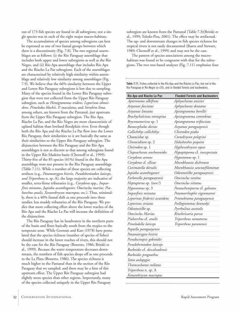
92 CONSERVATION INTERNATIONAL
out of 173 fish species are found in all subregions; not a sin-gle species was in each of the eight major macro-habitats.
The accumulation of species among subregions can bestbe expressed as one of two faunal groups between whichthere is a discontinuity (Fig. 7.8). The two regional assem-blages are as follows: (i) the Río Paraguay assemblage thatincludes both upper and lower subregions as well as the RíoNegro, and (ii) Río Apa assemblage that includes Río Apaand the Riacho La Paz subregions. Each of the assemblagesare characterized by relatively high similarity within assem-blage and relatively low similarity among assemblages (Fig.7.9). We believe that the 66% similarity between the Upperand Lower Río Paraguay subregions is low due to sampling.Many of the species found in the Lower Río Paraguay subre-gion that were not collected from the Upper Río Paraguaysubregion, such as Hemigrammus tridens, Leporinus obtusi-dens, Pimelodus blochii, P. maculatus, and Sorubim lima,among others, are known from the Pantanal, just upstreamfrom the Upper Río Paraguay subregion. The Río Apa,Riacho La Paz, and the Río Negro are more characteristic ofupland habitat than lowland floodplain river. Even thoughboth the Río Apa and the Riacho La Paz flow into the LowerRío Paraguay, their similarities to it are basically the same astheir similarities to the Upper Río Paraguay subregion. Thedisjunction between the Río Paraguay and the Río Apaassemblages is not as discrete as that among subregions foundin the Upper Río Madeira basin (Chernoff et al., 1999).Thirty-five of the 85 species (41%) found in the Río Apaassemblage were not present in the Río Paraguay assemblage(Table 7.11). While a number of these species are collectingartifacts (e.g., Potamotrygon histrix, Pseudohemiodon laticeps,and Triportheus n. sp. A), the large majority are indicative ofsmaller, terra-firme tributaries (e.g., Corydoras spp., Impar-finis minutus, Jupiaba acanthogaster, Otocinclus maríae, Pia-barchus analis, Xenurobrycon macropus, etc.). Thus, minimal-ly, there is a 40% faunal shift as one proceeds into thesesandier, less muddy tributaries of the Río Paraguay. We pre-dict that more collecting effort above the lower reaches of theRío Apa and the Riacho La Paz will increase the definition ofthe disjunction.
The Río Paraguay has its headwaters in the northern partsof the basin and flows basically south from the tropics to thetemperate zone. While Gorman and Karr (1978) have postu-lated that the species richness (number of species of fishes)should increase in the lower reaches of rivers, this should notbe the case for the Río Paraguay (Bonetto, 1986; Britski etal., 1999). Because the water temperature decreases down-stream, the numbers of fish species drops off as one proceedsto the La Plata (Bonetto, 1986). The species richness is much higher in the Pantanal than in the section of the RíoParaguay that we sampled, and there may be a hint of thisupstream effect. The Upper Río Paraguay subregion hadslightly more species than other regions. Importantly, manyof the species collected uniquely in the Upper Río Paraguay
subregion are known from the Pantanal (Table 7.3)(Britski etal., 1999; Toledo-Piza, 2001). The effect may be artifactual.The up- and downstream changes in fish species richness fortropical rivers is not easily documented (Ibarra and Stewart,1989; Chernoff et al., 1999) and may not be the case.
The pattern of species associations among the macro-habitats was found to be congruent with that for the subre-gions. The two tree-based analyses (Fig. 7.11) emphasize four
Río Apa and Riacho La Paz Apteronotus albifronsAstyanax fasciatusAstyanax lineatusBrachychalcinus retrospinaBryconamericus sp. 1Bunocephalus doriaeCallichthys callichthysCharacidae sp.Characidium sp. 2Cheirodon sp. 1Clupeacharax anchoveoidesCorydoras aeneusCorydoras cf. ellisaeCurimatella dorsalisJupiaba acanthogasterFarlowella paraguayensisHeptapterus sp. (nov.?)Hypostomus sp. 3Imparfinis minutusLeporinus friderici acutidensLeporinus striatusOdontostilbe sp.Otocinclus MaríaePiabarchus cf. analisPimelodella laticepsPoptella paraguayensisPotamotrygon histrixPseudocetopsis gobioidesPseudohemiodon laticepsRoeboides cf. descalvadensisRoeboides prognathusTatia aulopygiaThoracocharax stellatusTriportheus n. sp. AXenurobrycon macropus
Flooded Forests and BackwatersAphyocharax anisitsiAphyocharax dentatusApistogramma borelliiApistogramma commbraeApistogramma trifasciataAstyanax paraguayensisCheirodon piabaCtenobrycon pelegriniHoloshesthes pequiraHyphessobrycon equesHypoptopoma cf. inexspectataHypostomus sp. 1Moenkhausia dichrouraMoenkhausia sanctaefilomenaeOdontostilbe paraguayensisOtocinclus vestitusOtocinclus vittatusParauchenipterus cf. galeatusPotamorrhaphis eigenmanniPrionobrama paraguayensisPsellogrammus kennedyiPyrrhulina australisRineloricaria parvaTriportheus nematurusTriportheus paranensis
Table 7.11. Fishes collected in the Río Apa and the Riacho La Paz, but not in theRío Paraguay or Río Negro (n=35), and in flooded forests and backwaters.
Rapid Assessment Program
RAP Bulletin of Biological Assessment Nineteen September 2001 93
important features that are more easily determined from thenon-hierarchical cluster analysis (Fig. 7.12).
(I) The most critical feature is that the Río Paraguaybeaches are the primary population source for all of the othermacro-habitats. The Río Paraguay beaches share the highestnumber of species with each of the other macro-habitats(Table 7.7). This does not mean that there are not importantdifferences, but rather that the Río Paraguay beaches are themost diverse habitat, with the largest number of speciesfound in all other macro-habitats. All of the similarities tothe Río Paraguay beaches are significantly different and high-er than the mean of the distribution of random similarity.Hence, there is a dependence of all macro-habitats to the RíoParaguay beach populations as a source. This will be dis-cussed below in the context of recolonization in relation topotential threats.
(II) The patterns of similarities and shared taxa demon-strate the role of floods in structuring faunal assemblages.Waters flood from the main river channel over beaches intothe forests and into local depressions forming lagoons, whichare then stranded in the dry season. This is reflected in thecollected species such that 29 of the 39 species found in la-goons were also found in the flooded forests (Table 7.7);none were found exclusively in these two macro-habitats.Similarly, backwater habitats are formed as water rises orrecedes and sits in arms or depressions behind beaches or in bays, until communicating with the main river again.Thus, it is not surprising that the second largest pattern ofsimilarity is between the backwater and flooded forest macro-habitats (Table 7.11). These places accumulate species thatprefer quieter habitats and vegetation (e.g., Apistogrammaspp., Cheirodon piaba, Hyphessobrycon eques, Odontostilbeparaguayensis, Otocinclus vestitus, Pyrrhulina australis). Thesespecies not only have important roles within the ecosystem(e.g., see Lowe-McConnell, 1987), but also have high valuein the ornamental fish trade. The role of flooding andmacro-habitats for economically important species will bediscussed below.
(III) The fish species that inhabit the deeper environ-ments of the main channel (Tables 7.6, 7.8) often come outof the deeper waters to inhabit the beach habitats during theevenings or early mornings. The fish species collected in thetrawls and in the gill nets are only a small portion of what ismost certainly a much larger fauna (Chernoff et al., 1999).The only significant similarity found between the mainchannel and any other macro-habitat was with the Río Para-guay beaches at approximately 40%. Had there been morenight collections, the similarity might actually have beenhigher. The point to be made here is that that the deeperwater communities differ significantly from shallower habi-tats (Lowe-McConnell, 1987; Cox-Fernandez, 1995; Cher-noff et al., 1999). The linkage for some, but not all, deeperwater taxa is to the beach habitats.
(IV) The relationship between the species of fishes foundalong Río Apa beaches and clearwater macro-habitats is alsosignificant and represents another grouping of the macro-habitats. The Río Apa beaches and clearwater habitats shared37 species of which five were unique. Both Río Apa beachesand the clear waters were found to share more species withthe beaches in the Río Paraguay, and the five uniquely shared
Ancistrus cf. piriformisApareiodon affinisAphyocharax anisitsiAphyocharax dentatusApistogramma trifasciataAstyanax paraguayensisBrachychalcinus retrospinaBryconamericus sp. 1Bryconamericus sp. 2Bujurquina vittataCharacidium cf. fasciatumCheirodon piabaCorydoras aeneusCrenicichla lepidotaHemigrammus cf. lunatusHoloshesthes pequiraHoplias malabaricusHyphessobrycon equesLoricariichthys cf. platymetoponMoenkhausia dichrouraMoenkhausia intermediaMoenkhausia sanctaefilomenaeOdontostilbe paraguayensisOtocinclus vestitusOtocinclus vittatusPiabarchus cf. analisPimelodella mucosaPoptella paraguayensisPrionobrama paraguayensisPsellogrammus kennedyiRineloricaria lanceolataRoeboides paranensisSteindachnerina brevipinnaSteindachnerina conspersaSteindachnerina insculptaTetragonopterus argenteusXenurobrycon macropus
Table 7.12. Fishes species found in both Río Apa beaches and in clear watermacro-habitats (n=37).
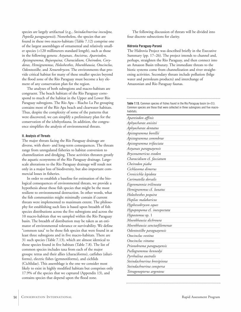
94 CONSERVATION INTERNATIONAL
species are largely artifactual (e.g., Steindachnerina insculpta,Poptella paraguayensis). Nonetheless, the species that arefound in these two macro-habitats (Table 7.12) comprise oneof the largest assemblages of ornamental and relatively small-er species (<120 millimeters standard length), such as thosein the following genera: Astyanax, Ancistrus, Apareiodon,Apistogramma, Bujurquina, Characidium, Cheirodon, Cory-doras, Hemigrammus, Holoshesthes, Moenkhausia, Otocinclus,Odontostilbe, and Xenurobrycon. The environments that pro-vide critical habitat for many of these smaller species beyondthe flood zone of the Río Paraguay must become a key ele-ment of any conservation plan for the region.
The analyses of both subregions and macro-habitats arecongruent. The beach habitats of the Río Paraguay corre-spond to much of the habitat in the Upper and Lower RíoParaguay subregions. The Río Apa – Riacho La Paz groupingcontains most of the Río Apa beach and clearwater habitats.Thus, despite the complexity of some of the patterns thatwere discovered, we can simplify a preliminary plan for theconservation of the ichthyofauna. In addition, the congru-ence simplifies the analysis of environmental threats.
II. Analysis of ThreatsThe major threats facing the Río Paraguay drainage arediverse, with short- and long-term consequences. The threatsrange from unregulated fisheries to habitat conversion tochannelization and dredging. These activities threaten greatlythe aquatic ecosystems of the Río Paraguay drainage. Large-scale alterations to the Río Paraguay drainage will result notonly in a major loss of biodiversity, but also important com-mercial losses in fisheries.
In order to establish a baseline for estimation of the bio-logical consequences of environmental threats, we provide ahypothesis about those fish species that might be the mostresilient to environmental destruction. In other words, whatthe fish communities might minimally contain if currentthreats were implemented to maximum extent. The philoso-phy for establishing such lists is based upon breadth of fishspecies distributions across the five subregions and across the10 macro-habitats that we sampled within the Río Paraguaybasin. The breadth of distribution may be taken as an esti-mator of environmental tolerance or survivability. We define“common taxa” to be those fish species that were found in atleast three subregions and in five macro-habitats. There are31 such species (Table 7.13), which are almost identical tothose species found in five habitats (Table 7.8). The list ofcommon species includes taxa from each of the majorgroups: tetras and their allies (characiforms), catfishes (siluri-forms), electric fishes (gymnotiforms), and cichlids(Cichlidae). This assemblage is the one we consider mostlikely to exist in highly modified habitats but comprises only17.9% of the species that we captured (Appendix 13), andcontains species that depend upon the flood zone.
The following discussion of threats will be divided intofour discrete subsections for clarity.
Hidrovia Paraguay-ParanáThe Hidrovia Project was described briefly in the ExecutiveSummary (pp. 17–26). The project intends to channel and,perhaps, straighten the Río Paraguay, and then connect intoan Amazon Basin tributary. The immediate threats to thebiotic systems come from channelization and river straight-ening activities. Secondary threats include pollution (bilgewater and petroleum products) and interchange ofAmazonian and Río Paraguay faunas.
Apareiodon affinisAphyocharax anisitsiAphyocharax dentatusApistogramma borelliiApistogramma commbraeApistogramma trifasciataAstyanax paraguayensisBryconamericus exodonCharacidium cf. fasciatumCheirodon piabaCichlasoma dimerusCrenicichla lepidotaCurimatella dorsalisEigenmannia trilineataHemigrammus cf. lunatusHoloshesthes pequiraHoplias malabaricusHyphessobrycon equesHypoptopoma cf. inexspectataHypostomus sp. 1Moenkhausia dichrouraMoenkhausia sanctaefilomenaeOdontostilbe paraguayensisOtocinclus vestitusOtocinclus vittatusPrionobrama paraguayensisPsellogrammus kennedyiPyrrhulina australisSteindachnerina brevipinnaSteindachnerina conspersaTetragonopterus argenteus
Table 7.13. Common species of fishes found in the Río Paraguay basin (n=31).Common species are those that were collected in three subregions and five macro-habitats.
Rapid Assessment Program
RAP Bulletin of Biological Assessment Nineteen September 2001 95
The Río Paraguay is a relatively shallow river above Asun-ción and meanders greatly. The depth of the river will needto be increased substantially in order to accommodate oceangoing container ships. The installation and maintenance of acommercial shipping channel will require constant dredging(as is done in the Río Orinoco of Venezuela). Rock outcrop-pings, such as near Cerritos Pão de Açúcar, will have to beeliminated. The overall effect of placing a large channel andstraightening of the river will be to change the patterns ofhydrography and sedimentation in the river. The deeperchannel will actively pull water out of the tributaries, theChaco, and the Pantanal—the effect is much like expandingthe width of a drainpipe in a bathtub. More water can exitthe system in shorter time. This will significantly decrease thedegree to which the broad flood plains of the Chaco and thePantanal are inundated during the rainy seasons, and willalso decrease the time that flood waters remain out of themain channel. The degree of flooding and the period ofinundation will be further decreased as dyking or riverstraightening is implemented.
Reduction or prevention of flooding in tropical rivers is perhaps the greatest threat not only to biodiversity but also to productivity (Goulding, 1981; Petts, 1985; Lowe-McConnell, 1987; Goulding et al., 1988; Machado-Allison,1994; McCulley, 1996). Much of the dependence of the fishspecies in the Río Paraguay on annual flooding is evident inour data. As stated above, one of the major patterns of distri-butional dependence was that, due to the flooding cycle (Fig.7.12), more inland habitats shared the majority of theirspecies with both the beach habitats and other inland habi-tats. Reduction of the inland macro-habitats would remove a critical resource for fishes both for food gathering and fornursery areas. Although beach habitats had the largest num-ber of species (Table 7.7), the number of species found inhabitats that result from inundations—backwaters, floatingvegetation, flooded forests and lagoons—are almost as great.Ninety species or 52% of the captured species were found inthese four macro-habitats. The 90 species comprise bothornamental and commercially valuable food fishes. For exam-ple, all of the pacus and pacu-relatives are important compo-nents of those habitats including, Metynnis mola, Myleustiete, Piaractus mitrei, and Mylossoma duriventre. Other foodor potential food fishes included: Psectrogaster curviventris,Pygocentrus nattereri, Liposarcus anisitsi, Cochliodon sp. 2,and Triportheus nematurus. There were numerous ornamen-tals that are common in the aquarium trade including, Gym-notus carapo, Eigenmannia trilineatus, Pyrrhulina australis,Otocinclus spp., Hyphessobrycon eques, Gymnocorymbus ter-netzi, Bujurquina vittata, and Apistogramma spp.
Seventy-four of the 90 fish species were also found broad-ly distributed on beaches, again indicating the flood-cyclerelationship among the use of macro-habitats by the fishes.Although some of the 16 species not captured on beaches areartifactual (e.g., Piaractus), the majority are quiet-water
forms, such as Hyphessobrycon maxillaris, Hemigrammus tri-dens, Microcharacidium sp., and Rivulus sp.
Although the “common species” are all found in the listof 90, it is potentially dangerous that these fishes are primar-ily dependent upon maintenance of the flooding cycle toundergo their life cycles. Many if not most of the species inthe list of 90, begin to yolk their eggs and spawn either onthe rising floods or directly in the flooded zone (Goulding,1981; Lowe-McConnell, 1987). During the period of inun-dation the fishes grow or add fats and leave the inundatedareas when the waters recede back into the main channel.Thus, reduction or elimination of the areas of inundationcould result in almost 50% loss of the total ichthyofauna.More than half of the 90 species were not discovered in theRío Apa or clear water habitats.
Another consequence of the reduction of waters lateral tothe Río Paraguay would be a vast reduction of the Río Apaand Riacho La Paz during the dry season. The Río Apa –Riacho La Paz region contains almost 30 fish species (Table7.11) that are associated with the terra-firme, headwater-likehabitats and were not found elsewhere which are also poten-tially imperiled by the Hidrovia Project.
For both the Río Paraguay macro-habitats and the RíoApa – Riacho La Paz zone, the Pantanal of Mato Grosso doSul would be a likely source from which recolonization ofthe fish fauna might be possible. However, we predict thatthe Pantanal will shrink in size as well and will suffer heavycasualties. Using the fish sample from this AquaRAP, andthe heterogeneous patterns of distribution and the depen-dency upon the flooding cycle, we calculate that more than60% of the fish species could be eliminated from the basin ifthe Hidrovia Project is implemented. The economic costs ofthis extinction must be explored.
Land Conversion in the Upper Río Paraguay and Río NegroCurrently, the human population along the western side ofthe Río Paraguay, especially in the upper section and alongthe Río Negro is low. However, populations are growing,bringing increasing pressures from agriculture and cattle-ranching. The effect is increased deforestation and land-clearing for agriculture with some indications of plans fordyking to control seasonal flood waters. The consequencesfor land conversion and flood control in the upper section ofthe Río Paraguay could be a large loss of aquatic biodiversitydue to loss of critical nursery and recruitment areas for fishesas well as important macro-habitats for adult fishes.
The upper section of the Río Paraguay and the RíoNegro contain no less than the 111 fish species captured inthose subregions, a value that represents 64.2% of the totalcaptured fauna. The potential loss of these species is arguedin a fashion similar to that presented above for the HidroviaProject. However, in such a limited case, source populationsfor recolonization exist in the Pantanal and in the Lower RíoParaguay.
96 CONSERVATION INTERNATIONAL
Land Conversion in the Río Apa and the Riacho La PazMuch of the Río Apa sub-basin is used for agriculture andranching. The area however, is not stable and continuedhabitat conversion is underway. Because this section is morearid, the drier soils make it necessary to use river water forirrigation. Additionally, because the waters are clear and notturbid, sedimentation and erosion damage the ecosystem.Much of the Río Apa basin is similar to terra firme andheadwater habitats. The system is very delicate.
Along with the Riacho La Paz, there are approximately 30 fish species that are not found in the more lowland habi-tats. This represents approximately 17.3% of the fauna thatis not easily replaced. The closest sources for recolonizationare in the headwaters of the Pantanal or in the Río Paraná.These are long distances and we doubt that these fishes areactive long-distance colonizers (e.g., Microcharacidium).Thus, continued habitat conversion could eliminate thesespecies that are found nowhere else in this portion of the RíoParaguay basin.
The dorado sports-fisheryThe Río Paraguay provides fisherman in Brasil and inParaguay with wonderful sportsfishing for dorado, Salminusmaxillosus (Bonetto, 1986). Currently, the fish seem abun-dant, but there are little or no limitations on this fishery. Thedorado is a top piscivore and exceeds 30 kilograms in size(Bonetto, 1986). The life history parameters, especially thenumber of years before individuals reach maturity, are notknown for this species. This species is of immediate concernand must be studied to protect this magnificent resource.
Conclusions and Recommendations
The role of rapid assessment programs is to provide a briefbut critical snapshot of the composition and structure ofecosystems. Because of the imminent threats to ecosystemsand their organisms across the globe (Myers, 1988, 1990;Sisk et al., 1994), a strategy of rapid assessments across land-scapes can target the best and most valuable habitats forimmediate conservation and detailed study. To maximize thevalue of the process, the rapid assessments should providenot only surveys of the organisms and vital environmentalcorrelates, but also hypotheses about the community struc-ture within the region, as well as resilience to environmentalthreats.
This task is particularly daunting in application to aquaticecosystems within tropical South America because thedynamics and complexity within these ecosystems are oftenunappreciated (e.g., Goulding 1980, 1981; Goulding et al.,1988; Machado-Allison, 1994; Barthem and Goulding,1997). The perspectives presented on the importance of andchallenges facing conservation of aquatic ecosystems(Naiman et al., 1995; Pringle, 1997), are often based exclu-
sively upon relatively simple temperate systems. Humandevelopment strategies (e.g., Almeida and Campari, 1995)within the basins of the principal rivers of South Americaoften completely ignore the impacts to aquatic ecosystems.
The purpose of this paper has been to evaluate the patterns of similarities for the distributions of fish speciesamong subregions and macro-habitats within the section ofthe Río Paraguay basin between Concepción and the Brazi-lian border, near the Río Negro. This area was discovered tobe fairly rich in fish species with 173 species captured(Toledo-Piza et al., 2001). This is an underestimate of thespecies richness because the number of additional speciesbeing captured on a daily basis had not diminished (Toledo-Piza et al., 2001: Fig. 6.1). A preliminary examination of thestructure of the fishes found within the region is critical as aprimary basis for designing a conservation strategy in relationto current and impending environmental threats.
The methods we used are designed to test the nullhypotheses of homogeneity of distribution of the fishes (orany organisms) in relation to geographic or environmentalvariables. Non-homogeneous, patterned distributions requiredifferent conservation strategies than does the situationwhere organisms are homogeneously distributed (e.g., Atmarand Patterson, 1993; Christensen, 1997). Our methods areappropriately conservative and robust, and have the advan-tage in that we can determine whether the similarity isgreater than or less than those expected at random.
The use of these methods follows from the use byChernoff et al. (1999) in order to estimate patterning withinan assemblage of species. This in itself is not a conservativeapproach to community ecology, but we believe that rapidassessment programs must provide beginning insights intoconservation plans to protect ecosystems and biodiversity tothe maximum extent possible. We are persuaded by the ele-gant argumentation of Shrader-Frechette and McCoy(1993). The ethics of conservation require that we risk atype-I error (rejection of a true null hypothesis) rather than atype-II error (failure to reject a false null hypothesis). In thecase presented here, it is better to err on the side of recogniz-ing structure within a biological assemblage. The conserva-tion plan is more stringent than that required to conserve ahomogeneously distributed community (Barrett and Barrett,1997; Christensen, 1997). We, therefore, conclude and rec-ommend the following:
1. The freshwater fishes are non-randomly distributed withrespect to subregions. There is a relatively sharp boundarybetween the Río Apa – Riacho La Paz and the Río Para-guay with more than a 50% turnover in species of fishes.Therefore, it is critical to designate two areas within theRío Paraguay basin as core conservation areas: 1) theUpper Río Paraguay – Río Negro and 2) the Río Apa –Riacho La Paz. Together they represent more than 80% of the diversity within the region.
Rapid Assessment Program
RAP Bulletin of Biological Assessment Nineteen September 2001 97
2. The Río Apa – Riacho La Paz zone is highly threatenedbecause land conversion is actively changing the charac-teristic of the ecosystem. Extinction or reduction of thefauna in these streams will have serious consequences forthe overall biodiversity because potential sources of organ-isms for recolonization are very far away (Pantanal head-waters and Río Paraná).
3. The freshwater fishes are non-randomly distributed withrespect to macro-habitats within the Río Paraguay basin.Beach habitats serve as source populations for other habi-tats that extend into the forest. These habitats are inter-connected during periods of inundation. Therefore, it iscritical that the natural flood cycle be maintained andthat broad areas for inundation be modified as little aspossible. Interference or serious reduction of the floodcycle and inundated habitats could result in as much as a 60% loss of the species in the basin.
4. In its proposed state, the Hidrovia Project poses a majorthreat to the aquatic biodiversity of the Río Paraguaybasin. The reduction of fishes in the region will haveimportant socio-economic consequences (e.g., loss orreduction of fisheries) in addition to the intrinsic value ofbiodiversity. If the Hidrovia Project is implemented, thenplans should be made ahead of time to attempt to findadequate refugia within which the majority of the biodi-versity can be self-supporting.
5. Studies of the biology and fisheries of the dorado,Salminus maxillosus, should be undertaken immediately.This should be done jointly between Paraguay and Brasilin a study of the entire Río Paraguay basin, including thePantanal. Fishing limits on size and season should beestablished to allow this top predator to be fished in a sus-tainable manner.
Literature Cited
Almeida, A.L.O. de and J.S. Campari. 1995. Sustainabledevelopment of the Brazilian Amazon. New York: OxfordUniversity Press. 189pp.
Atmar, W. and B.D. Patterson. 1993. The measure of orderand disorder in the distribution of species found in frag-mented habitat. Oecologia, 96:373–382.
Balon, E.K., S.S. Crawford, and A. Lelek. 1986. Fish com-munities of the upper Danube River (Germany, Austria)prior to the new Rhein-Main-Donau connection.Environmental Biology of Fishes, 15:243–271.
Balon, E.K. and D.J. Stewart. 1983. Fish assemblages in ariver with unusual gradient (Luongo, Africa—Zaire sys-tem), reflections on river zonation and description ofanother new species. Environmental Biology of Fishes,9:225–252.
Barrett, N.E. and J.P. Barrett. 1997. Reserve design and thenew conservation theory. In Pickett, S.T.A., R.S. Ostfield,M. Schachak, and G.E. Likens (eds.). The ecological basisof conservation: heterogeneity, ecosystems, and biodiversi-ty. Chapman and Hall, New York. Pp. 236–251.
Barthem, R. and M. Goulding. 1997. The catfish connec-tion: ecology, migration, and conservation of Amazonpredators. New York: Columbia University Press. 144pp.
Bonetto, A.A. 1986. Fish of the Paraná system. In Davies,B.R. and K.F. Walker (eds.). The ecology of river systems.Dordrecht, Netherlands: Dr. W. Junk Publishers. Pp.573–588.
Britski, H. A., K. Z. S. de Silimon, and B. S. Lopes. 1999.Peixes do Pantanal: manual de identificação. Brasília,Brasil: Embrapa. 184pp.
Chernoff, B., P.W. Willink, J. Sarmiento, A. Machado-Allison, N. Menezes and H. Ortega. 1999. Geographicand macro-habitat partitioning of fishes in Tahuamanu-Manuripi region, Upper Rio Orthon basin, Bolivia: con-servation recommendations. In Chernoff, B. and P.W.Willink (eds.). A biological assessment of aquatic ecosys-tems of the Upper Rio Orthon basin, Pando, Bolivia.Bulletin of Biological Assessment 15, ConservationInternational, Washington D.C. Pp. 51–68.
Christensen, N.L., Jr. 1997. Managing for heterogeneity and complexity on dynamic landscapes. In Pickett,S.T.A., R.S. Ostfield, M. Schachak, and G.E. Likens(eds.). The ecological basis of conservation: heterogeneity,ecosystems, and biodiversity. New York: Chapman andHall. Pp. 167–186.
Cox Fernandes, C. 1995. Diversity, distribution and commu-nity structure of electric fishes (Gymnotiformes) in thechannels of the Amazon River system, Brasil. Unpub-lished Ph.D. Dissertation. Durham: Duke University.394pp.
Goulding, M. 1980. The fishes and the forests: explorationsin Amazonian natural history. Los Angeles: University ofCalifornia Press. 280pp.
98 CONSERVATION INTERNATIONAL
Goulding, M. 1981. Man and fisheries on an Amazon fron-tier. Boston: Dr. W. Junk Publishers. 137pp.
Goulding, M., M.L. Carvalho, and E.G. Ferreira. 1988. RioNegro: rich life in poor water: Amazonian diversity andfoodchain ecology as seen through fish communities. TheHague, Netherlands: SPB Academic Publishing. 200pp.
Gorman, O.T. and J.R. Karr. 1978. Habitat structure andstream fish communities. Ecology, 59:507–515.
Hawkes, C.L., D.L. Miller, and W.G. Layher. 1986. Fishecoregions of Kansas: stream fish assemblage patterns andassociated environmental correlates. EnvironmentalBiology of Fishes, 17:267–279.
Ibarra, M. and D.J. Stewart. 1989. Longitudinal zonation ofsandy beach fishes in the Napo River basin, easternEcuador. Copeia, 1989:364–381.
Lowe-McConnell, R.H. 1987. Ecological studies in tropicalfish communities. New York: Cambridge University Press.382pp.
Machado-Allison, A. 1994. Factors affecting fish communi-ties in the flooded plains of Venezuela. Acta BiologicaVenezuelica, 15(2):59–74.
Matthews, W. J. 1986. Fish faunal ‘breaks’ and stream orderin the eastern and central United States. EnvironmentalBiology of Fishes, 17:81–92.
McCulley, P. 1996. Silenced rivers. New Jersey: Zed Books.320pp.
Myers, N. 1988. Threatened biotas: “hotspots” in tropicalforests. The Environmentalist, 8:1–20.
Myers, N. 1990. The biodiversity challenge: expanded hot-spots analysis. The Environmentalist, 10:243–256.
Naiman, R.J., J.J. Magnusin, D.M. McKnight and J.A.Stanford. 1995. The Freshwater imperative. Washington,D.C.: Island Press. 165pp.
Petts, G.E. 1985. Impounded rivers. New York: J.S. Wileyand Sons. 344pp.
Pringle, C. M. 1997. Expanding scientific research programsto address conservation challenges in freshwater ecosys-tems. In Pickett, S.T.A., R.S. Ostfield, M. Schachak, andG.E. Likens (eds.). The ecological basis of conservation:heterogeneity, ecosystems, and biodiversity. New York:Chapman and Hall. Pp. 305–319.
Rice, W.R. 1989. Analyzing tables of statistical tests.Evolution, 43:223–225.
Rohlf, F.J. and R.R. Sokal. 1995. Statistical tables. 3rdEdition. New York: W.H. Freeman and Co. 199pp.
Shrader-Frechette, K.S. and E.D. McCoy. 1993. Method inecology. New York: Cambridge University Press. 328pp.
Sisk, T.D., A.E. Launer, K.R. Switky, and P.R. Ehrlich. 1994.Identifying extinction threats. BioScience, 44:592–604.
Sokal, R.R. and N.L. Oden. 1976. Spatial correlation inbiology: I. methodology. Biological Journal of theLinnean Society, 10:199–228.
Sokal, R.R. and F.J. Rohlf. 1997. Biometry. 3rd Edition.New York: W.H. Freeman and Co. 887pp.
Toledo-Piza, M., B. Chernoff, D. Mandelburger, M. Medina,J. Sarmiento, and P.W. Willink. 2001. Diversity andabundance of fishes in the Upper and Lower RíoParaguay basin and the Río Apa sub-basin. In Chernoff,B., P.W. Willink, and J.R. Montambault (eds.). A biologi-cal assessment of the aquatic ecosystems of the RíoParaguay basin, Departamento Alto Paraguay, Paraguay.Pp. 73–79. RAP Bulletin of Biological Assessment 19.Washington, DC: Conservation International.
Rapid Assessment Program
RAP Bulletin of Biological Assessment Nineteen September 2001 99
Abstract
Null hypotheses concerning random distributions of specieswith respect to subregions and macro-habitats within theRío Paraguay are tested with data from 131 species ofmacro-crustaceans and benthic invertebrates and 186 speciesof aquatic plants. The patterns are compared to the resultsfor the distributions of fishes presented by Chernoff et al.(2001). The invertebrate data demonstrate the identical pat-tern among subregions as evident in the fish distributions.The results support the recognition of two zones: (i) the RíoParaguay zone containing the Upper and Lower Río Para-guay and the Río Negro; and (ii) the Río Apa zone contain-ing the Río Apa and the Riacho La Paz. For all data sets, theRío Paraguay zone has higher species richness than the RíoApa zone. The boundary between the two zones is abrupt,which is also supported by the plant data. Only 11 of 186species of plants were found in both zones. There is no con-gruence of pattern among macro-habitats. Both invertebrateand plant data sets contain many values that are not differ-ent from mean random similarities. The fish data set pro-vides an unambiguous pattern of habitats within the RíoParaguay zone tied together in relation to inundation ofhabitats during the flood cycle. The invertebrate set providesone cluster that is consistent with the general principal. Theplant data set demonstrates a relationship among shore andsand habitats, which experience greater currents than othermacro-habitats. The plants found in backwater habitats hadlittle similarity to other macro-habitats. Based on theseobservations, it is concluded that significant habitat withineach of zone needs to be preserved to maintain a large por-tion of the biodiversity.
Introduction
In previous chapters, Mereles (2001), Barbosa et al. (2001),Magalhães (2001) and Toledo-Piza et al. (2001) have dis-cussed general patterns of the distribution of aquatic andriparian plants, plankton and benthos, macro-crustaceans,and fishes in relation to subregions and macro-habitats with-in the Río Paraguay basin. Chernoff et al. (2001) tested nullhypotheses about the homogeneity of fish distributions withrespect to subregions and macro-habitats. They rejected bothnull hypotheses that the fish distributional data were ob-tained at random. The distributions of fishes indicate thatthere are two broad subregional associations: (i) the Upperand Lower Río Paraguay and the Río Negro and (ii) the RíoApa and the Riacho La Paz. The patterns of distributionassociated with macro-habitats is congruent with the subre-gional analysis. Within the Río Paraguay proper, the similari-ty among macro-habitats is a function of the flooding cycle.In the Río Apa and the Riacho La Paz, the associationamong macro-habitats is associated with terra firme, headwa-ter conditions. These results were then used to construct aconservation plan relative to fishes and to evaluate the poten-tial effects of threats.
In this chapter, we examine the generality of the patternsdiscovered by Chernoff et al. (2001) by co-examining pat-terns found in benthos, plankton, macro-crustaceans and“aquatic” plants. We will then use the commonality or dis-tinctiveness of the patterns to develop a conservation planthat would protect the majority of the aquatic biodiversitywithin the region that we surveyed.
Methods
The data sets used for these analyses are found in Appendices5,6, 8–11. Two sets of analyses were performed, including
CHAPTER 8
Congruence of Diversity Patternsamong Fishes, Invertebrates, andAquatic Plants within the Río ParaguayBasin, Paraguay
Barry Chernoff, Philip W. Willink, AntonioMachado-Allison, María Fátima Mereles, Célio Magalhães, Francisco Antonio R. Barbosa,Marcos Callisto Faria Pereira, and Mônica Toledo-Piza
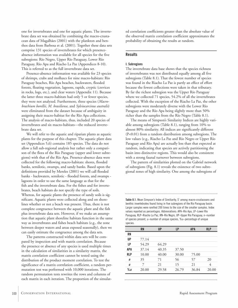
100 CONSERVATION INTERNATIONAL
one for invertebrates and one for aquatic plants. The inverte-brate data set was obtained by combining the macro-crusta-cean data of Magalhães (2001) with the plankton and ben-thos data from Barbosa et al. (2001). Together these data setscomprise 131 species of invertebrates for which presence-absence information was available for all species for the fivesubregions: Río Negro, Upper Río Paraguay, Lower RíoParaguay, Río Apa and Riacho La Paz (Appendices 8-10).This is referred to as the full invertebrate data set.
Presence-absence information was available for 23 speciesof shrimps, crabs and molluscs for nine macro-habitats: RíoParaguay beaches, Río Apa beaches, backwaters, floodedforests, floating vegetation, lagoons, rapids, cryptic (crevicesin rocks, logs, etc.), and clear waters (Appendix 11). Becausethe latter three macro-habitats had only 5 or fewer species,they were not analyzed. Furthermore, three species (Macro-brachium borellii, M. brasiliense, and Sylviocarcinus australis)were eliminated from the dataset because of ambiguity inassigning their macro-habitat for the Río Apa collections.The analysis of macro-habitats, thus, included 20 species ofinvertebrates and six macro-habitats—the reduced inverte-brate data set.
We will refer to the aquatic and riparian plants as aquaticplants for the purpose of this chapter. The aquatic plant dataset (Appendices 5,6) contains 185 species. The data do notallow a full sub-regional analysis but rather only a compari-son of the flora of the Río Paraguay (upper and lower subre-gions) with that of the Río Apa. Presence-absence data werecollected for the following macro-habitats: shores, floodedbanks, semilotic, swamps, and sandy banks. Based upon thedefinitions provided by Mereles (2001) we will call floodedbanks - backwaters, semilotic - flooded forests, and swamps -lagoons in order to use the same language as that for the fish and the invertebrate data. For the fishes and for inverte-brates, beach habitats do not specify the type of soils.Whereas, for aquatic plants the presence of sandy soils is sig-nificant. Aquatic plants were collected along and on shore-lines whether or not a beach was present. Thus, there is notcomplete congruence between the aquatic plant and the fishplus invertebrate data sets. However, if we make an assump-tion that aquatic plant shoreline habitats function in the sameway as invertebrates and fishes beach habitats (e.g., the zonebetween deeper waters and areas exposed seasonally), then wecan easily estimate the congruence among the data sets.
The patterns constructed within data sets will be com-pared by inspection and with matrix correlation. Because the presence or absence of any species is used multiple timesin the calculation of similarities in a similarity matrix, thematrix correlation coefficient cannot be tested using the distribution of the product moment correlation. To test thesignificance of a matrix correlation coefficient, a random per-mutation test was performed with 10,000 iterations. Therandom permutation tests rewrites the rows and columns ofeach matrix in each iteration. The proportion of the simulat-
ed correlation coefficients greater than the absolute value ofthe observed matrix correlation coefficient approximates theprobability of obtaining the results at random.
Results
I. SubregionsThe invertebrate data base shows that the species richness of invertebrates was not distributed equally among all fivesubregions (Table 8.1). That the fewest number of specieswas found in the Riacho La Paz is partly an effect of effortbecause the fewest collections were taken in that tributary. By far the richest subregion was the Upper Río Paraguaywhere we collected 71 species, 54.2% of all the invertebratescollected. With the exception of the Riacho La Paz, the othersubregions were moderately diverse with the Lower RíoParaguay and the Río Apa being slightly more than 50%richer than the samples from the Río Negro (Table 8.1).
The means of Simpson’s Similarity Indices are highly vari-able among subregions (Table 8.1), ranging from 10% toalmost 80% similarity. All indices are significantly different(P<0.01) from a random distribution among subregions. Thelow values (e.g., Riacho La Paz and Río Negro or Upper RíoParaguay and Río Apa) are actually less than that expected atrandom, indicating that species are actively partitioning thebasin into distinctive regions. This would also be consistentwith a strong faunal turnover between subregions.
The pattern of similarities plotted on the Gabriel networkof subregions (Fig. 8.1) reveals the existence of two subre-gional zones of high similarity. One among the subregions of
RN UP LP APA RLPRNUP 77.14LP 54.29 64.29
APA 37.14 40.35 37.50RLP 10.00 40.00 30.00 75.00
n 35 71 56 57 20u 7 21 15 21 4
%u 20.00 29.58 26.79 36.84 20.00
Table 8.1. Mean Simpson’s Index of Similiarity, S’ among macro-crustaceans andbenthic invertebrates found living in five subregions of the Río Paraguay basin.Larger samples were rarefied 200 times to the size of the smaller samples. Indexvalues reported as percentages. Abbreviations: APA–Río Apa, LP–Lower RíoParaguay, RLP–Riacho La Paz, RN–Río Negro, UP–Upper Río Paraguay, n–numberof species present, u–number of unique species, %u–percentage of uniquespecies.
Rapid Assessment Program
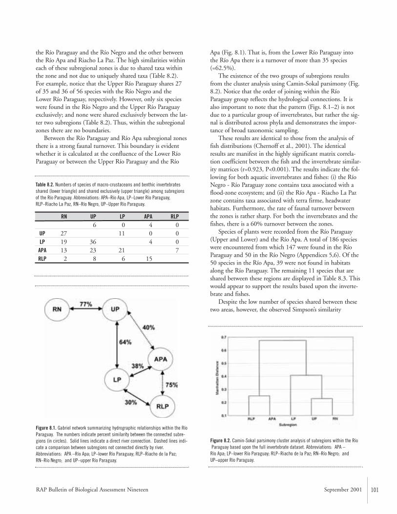
RAP Bulletin of Biological Assessment Nineteen September 2001 101
the Río Paraguay and the Río Negro and the other betweenthe Río Apa and Riacho La Paz. The high similarities withineach of these subregional zones is due to shared taxa withinthe zone and not due to uniquely shared taxa (Table 8.2).For example, notice that the Upper Río Paraguay shares 27of 35 and 36 of 56 species with the Río Negro and theLower Río Paraguay, respectively. However, only six specieswere found in the Río Negro and the Upper Río Paraguayexclusively; and none were shared exclusively between the lat-ter two subregions (Table 8.2). Thus, within the subregionalzones there are no boundaries.
Between the Río Paraguay and Río Apa subregional zonesthere is a strong faunal turnover. This boundary is evidentwhether it is calculated at the confluence of the Lower RíoParaguay or between the Upper Río Paraguay and the Río
Apa (Fig. 8.1). That is, from the Lower Río Paraguay intothe Río Apa there is a turnover of more than 35 species(=62.5%).
The existence of the two groups of subregions resultsfrom the cluster analysis using Camin-Sokal parsimony (Fig.8.2). Notice that the order of joining within the RíoParaguay group reflects the hydrological connections. It isalso important to note that the pattern (Figs. 8.1–2) is notdue to a particular group of invertebrates, but rather the sig-nal is distributed across phyla and demonstrates the impor-tance of broad taxonomic sampling.
These results are identical to those from the analysis offish distributions (Chernoff et al., 2001). The identicalresults are manifest in the highly significant matrix correla-tion coefficient between the fish and the invertebrate similar-ity matrices (r=0.923, P<0.001). The results indicate the fol-lowing for both aquatic invertebrates and fishes: (i) the RíoNegro - Río Paraguay zone contains taxa associated with aflood-zone ecosystem; and (ii) the Río Apa - Riacho La Pazzone contains taxa associated with terra firme, headwaterhabitats. Furthermore, the rate of faunal turnover betweenthe zones is rather sharp. For both the invertebrates and thefishes, there is a 60% turnover between the zones.
Species of plants were recorded from the Río Paraguay(Upper and Lower) and the Río Apa. A total of 186 specieswere encountered from which 147 were found in the RíoParaguay and 50 in the Río Negro (Appendices 5,6). Of the50 species in the Río Apa, 39 were not found in habitatsalong the Río Paraguay. The remaining 11 species that areshared between these regions are displayed in Table 8.3. Thiswould appear to support the results based upon the inverte-brate and fishes.
Despite the low number of species shared between thesetwo areas, however, the observed Simpson’s similarity
RN UP LP APA RLP6 0 4 0
UP 27 11 0 0LP 19 36 4 0
APA 13 23 21 7RLP 2 8 6 15
Table 8.2. Numbers of species of macro-crustaceans and benthic invertebratesshared (lower triangle) and shared exclusively (upper triangle) among subregionsof the Río Paraguay. Abbreviations: APA–Río Apa, LP–Lower Río Paraguay,RLP–Riacho La Paz, RN–Río Negro, UP–Upper Río Paraguay.
Figure 8.2. Camin-Sokal parsimony cluster analysis of subregions within the RíoParaguay based upon the full invertebrate dataset. Abbreviations: APA –
Río Apa; LP–lower Río Paraguay; RLP–Riacho de la Paz; RN–Río Negro; andUP–upper Río Paraguay.
Figure 8.1. Gabriel network summarizing hydrographic relationships within the RíoParaguay. The numbers indicate percent similarity between the connected subre-gions (in circles). Solid lines indicate a direct river connection. Dashed lines indi-cate a comparison between subregions not connected directly by river.Abbreviations: APA –Río Apa; LP–lower Río Paraguay; RLP–Riacho de la Paz;RN–Río Negro; and UP–upper Río Paraguay.
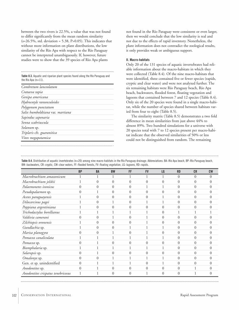
102 CONSERVATION INTERNATIONAL
BP BA BW FF FV LG RD CR CWMacrobrachium amazonicum 1 1 1 1 1 1 0 0 0Macrobrachium jelskii 1 0 0 0 0 0 0 0 0Palaemonetes ivonicus 0 0 0 0 1 1 0 0 0Pseudopalaemon sp. 0 1 0 0 0 0 0 0 0Acetes paraguayensis 1 0 0 0 0 1 0 0 0Dilocarcinus pagei 1 0 1 0 1 1 0 0 0Poppiana argentiniana 1 0 0 0 0 0 0 0 0Trichodactylus borellianus 1 1 1 1 1 0 1 1 1Valdivia camerani 0 0 1 0 1 0 0 0 0Zilchiopsis oronensis 1 0 0 0 1 0 0 0 0Gundlachia sp. 1 0 0 1 1 1 0 0 0Marisa planogyra 0 0 1 0 1 0 0 0 0Pomacea canaliculata 1 1 1 1 1 1 0 0 0Pomacea sp. 0 1 0 0 0 0 0 0 0Biomphalaria sp. 1 1 1 1 1 1 0 0 0Solaropsis sp. 0 1 0 0 0 0 0 0 0Omalonyx sp. 0 0 1 1 1 1 0 0 0Gen. et sp. unindentified 0 1 1 1 0 1 0 0 0Anodontites sp. 0 1 0 0 0 0 0 1 0Anodontites crispatus tenebricosus 1 1 0 0 1 0 0 1 0
between the two rivers is 22.5%, a value that was not foundto differ significantly from the mean random similarity(s=26.5%, std. deviation = 5.38, P>0.05). This indicates thatwithout more information on plant distributions, the lowsimilarity of the Río Apa with respect to the Río Paraguaycannot be interpreted unambiguously. If, however, futurestudies were to show that the 39 species of Río Apa plants
not found in the Río Paraguay were consistent or even larger,then we would conclude that the low similarity is real andnot due to the effects of rapid inventory. Nonetheless, theplant information does not contradict the zoological results,it only provides weak or ambiguous support.
II. Macro-habitatsOnly 20 of the 131 species of aquatic invertebrates had reli-able information about the macro-habitats in which theywere collected (Table 8.4). Of the nine macro-habitats thatwere identified, three contained five or fewer species (rapids,cryptic and clear water) and were not analyzed further. Thesix remaining habitats were Río Paraguay beach, Río Apabeach, backwaters, flooded forest, floating vegetation andlagoons that contained between 7 and 12 species (Table 8.4).Only six of the 20 species were found in a single macro-habi-tat, while the number of species shared between habitats var-ied from four to eight (Table 8.5).
The similarity matrix (Table 8.5) demonstrates a two folddifference in mean similarities from just above 44% toalmost 89%. Two hundred simulations for a universe with20 species total with 7 to 12 species present per macro-habi-tat indicate that the observed similarities of 50% or lesscould not be distinguished from random. The remaining
Combretum lanceolatumCrataeva tapiaGenipa americanaHydrocotyle ranunculoidesPolygonum punctatum Salix humboldtiana var. martianaSapindus saponariaSenna scabriusculaSolanum sp.Triplaris cfr. guaraniticaVitex megapotamica
Table 8.3. Aquatic and riparian plant species found along the Río Paraguay andthe Río Apa (n=11).
Table 8.4. Distribution of aquatic invertebrates (n=20) among nine macro-habitats in the Río Paraguay drainage. Abbreviations: BA–Río Apa beach, BP–Río Paraguay beach, BW–backwaters, CR–cryptic, CW–clear waters, FF–flooded forests, FV–floating vegetation, LG–lagoons, RD–rapids.
Rapid Assessment Program
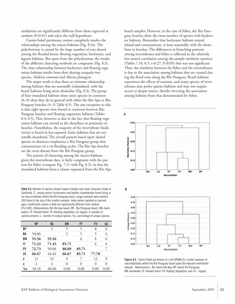
RAP Bulletin of Biological Assessment Nineteen September 2001 103
similarities are significantly different from those expected atrandom (P<0.01) and reject the null hypotheses.
Camin-Sokal parsimony cannot completely resolve therelationships among the macro-habitats (Fig. 8.3a). Thepolychotomy is caused by the large number of taxa sharedamong the flooded forest, floating vegetation, backwater, andlagoon habitats. But apart from the polychotomy, the resultsof the different clustering methods are congruent (Fig. 8.3).The close relationship between backwater and floating vege-tation habitats results from their sharing uniquely twospecies, Valdivia camerani and Marisa planogyra.
The major result is that there an intimate relationshipamong habitats that are seasonally indundated, with thebeach habitats being more dissimilar (Fig. 8.3). The group of four inundated habitats share more species in common (6–8) than they do in general with either the Río Apa or RíoParaguay beaches (4 –5; Table 8.5). The one exception to thisis that eight species were found in common between RíoParaguay beaches and floating vegetation habitats (Tables8.4, 8.5). This, however, is due to the fact that floating vege-tation habitats can extend to the shorelines in proximity tobeaches. Nonetheless, the majority of the invertebrate biodi-versity is found in less exposed, lentic habitats that are sea-sonally inundated. The overall pattern based upon sharedspecies or distances emphasizes a Río Paraguay group thatcommunicate vis a vis flooding cycles. The Río Apa beachesare the most distant from the Río Paraguay group.
The pattern of clustering among the macro-habitats,given the invertebrate data, is fairly congruent with the pat-tern for fishes (compare Fig. 7.11 with Fig. 8.3), in that theinundated habitats form a cluster separated from the Río Apa
beach samples. However, in the case of fishes, the Río Para-guay beaches share the most number of species with backwa-ter habitats. Remember that backwater habitats extendinland and communicate, at least seasonally, with the shore-lines or beaches. The differences in branching patternsamong invertebrates and fishes is reflected in the relativelylow matrix correlation among the sample similarity matrices(Tables 7.10, 8.5; r=0.27, P>0.05) that was not significant.Thus, the similarity between the fishes and the invertebratesis due to the association among habitats that are created dur-ing the flood zone along the Río Paraguay. Beach habitatsexperience the effects of currents, and many species of inver-tebrates may prefer quieter habitats and may not requireaccess to deeper waters, thereby inverting the associationamong habitats from that demonstrated for fishes.
BP BA BW FF FV LGBP 5 5 5 8 6BA 50.00 5 5 5 4BW 55.56 55.56 6 8 6FF 71.43 71.43 85.71 6 6FV 72.73 50.00 88.89 85.71 7LG 66.67 44.44 66.67 85.71 77.78n 11 10 9 7 12 9u 2 4 0 0 0 0%u 18.18 40.00 0.00 0.00 0.00 0.00
Table 8.5. Number of species shared (upper triangle) and mean Simpson’s Index ofSimiliarity, S’, among macro-crustaceans and benthic invertebrates found living insix macro-habitats within the Río Paraguay basin. Larger samples were rarefied200 times to the size of the smaller samples. Index values reported as percent-ages. Coefficients shown in bold are significantly different from random(P<0.001). Abbreviations: BA–Río Apa beach, BP– Río Paraguay beach, BW–back-waters, FF–flooded forest, FV–floating vegetation, LG–lagoon, n–number ofspecies present, u– number of unique species, %u–percentage of unique species.
Figure 8.3. Camin-Sokal parsimony (a.) and UPGMA (b.) cluster analyses ofmacrohabiotats within the Río Paraguay based upon the reduced invertebratedataset. Abbreviations: BA–beach Río Apa; BP–beach Río Paraguay; BW–backwater; FF–flooded forest; FV–floating Vegetation; and LG – lagoon.
A
B
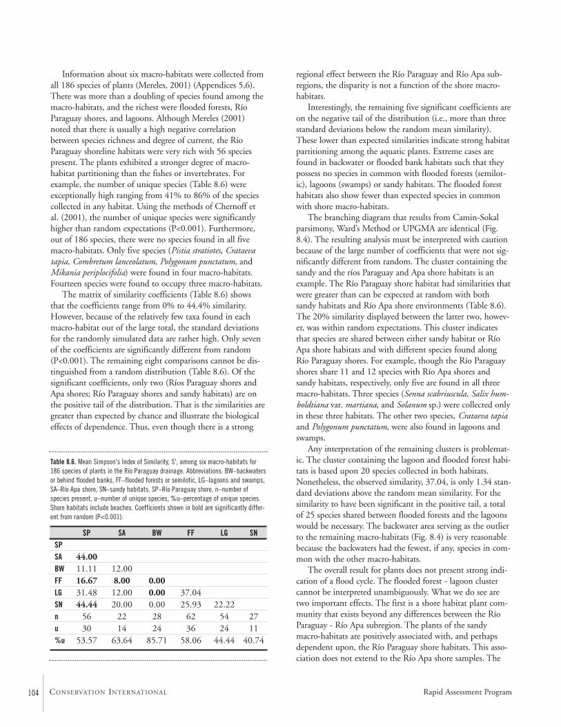
104 CONSERVATION INTERNATIONAL
SP SA BW FF LG SNSPSA 44.00BW 11.11 12.00FF 16.67 8.00 0.00LG 31.48 12.00 0.00 37.04SN 44.44 20.00 0.00 25.93 22.22n 56 22 28 62 54 27u 30 14 24 36 24 11%u 53.57 63.64 85.71 58.06 44.44 40.74
Information about six macro-habitats were collected fromall 186 species of plants (Mereles, 2001) (Appendices 5,6).There was more than a doubling of species found among themacro-habitats, and the richest were flooded forests, RíoParaguay shores, and lagoons. Although Mereles (2001)noted that there is usually a high negative correlationbetween species richness and degree of current, the RíoParaguay shoreline habitats were very rich with 56 speciespresent. The plants exhibited a stronger degree of macro-habitat partitioning than the fishes or invertebrates. Forexample, the number of unique species (Table 8.6) wereexceptionally high ranging from 41% to 86% of the speciescollected in any habitat. Using the methods of Chernoff etal. (2001), the number of unique species were significantlyhigher than random expectations (P<0.001). Furthermore,out of 186 species, there were no species found in all fivemacro-habitats. Only five species (Pistia stratiotes, Crataevatapia, Combretum lanceolatum, Polygonum punctatum, andMikania periplocifolia) were found in four macro-habitats.Fourteen species were found to occupy three macro-habitats.
The matrix of similarity coefficients (Table 8.6) showsthat the coefficients range from 0% to 44.4% similarity.However, because of the relatively few taxa found in eachmacro-habitat out of the large total, the standard deviationsfor the randomly simulated data are rather high. Only sevenof the coefficients are significantly different from random(P<0.001). The remaining eight comparisons cannot be dis-tinguished from a random distribution (Table 8.6). Of thesignificant coefficients, only two (Ríos Paraguay shores andApa shores; Río Paraguay shores and sandy habitats) are onthe positive tail of the distribution. That is the similarities aregreater than expected by chance and illustrate the biologicaleffects of dependence. Thus, even though there is a strong
regional effect between the Río Paraguay and Río Apa sub-regions, the disparity is not a function of the shore macro-habitats.
Interestingly, the remaining five significant coefficients areon the negative tail of the distribution (i.e., more than threestandard deviations below the random mean similarity).These lower than expected similarities indicate strong habitatpartitioning among the aquatic plants. Extreme cases arefound in backwater or flooded bank habitats such that theypossess no species in common with flooded forests (semilot-ic), lagoons (swamps) or sandy habitats. The flooded foresthabitats also show fewer than expected species in commonwith shore macro-habitats.
The branching diagram that results from Camin-Sokalparsimony, Ward’s Method or UPGMA are identical (Fig.8.4). The resulting analysis must be interpreted with cautionbecause of the large number of coefficients that were not sig-nificantly different from random. The cluster containing thesandy and the ríos Paraguay and Apa shore habitats is anexample. The Río Paraguay shore habitat had similarities thatwere greater than can be expected at random with bothsandy habitats and Río Apa shore environments (Table 8.6).The 20% similarity displayed between the latter two, howev-er, was within random expectations. This cluster indicatesthat species are shared between either sandy habitat or RíoApa shore habitats and with different species found alongRío Paraguay shores. For example, though the Río Paraguayshores share 11 and 12 species with Río Apa shores andsandy habitats, respectively, only five are found in all threemacro-habitats. Three species (Senna scabriuscula, Salix hum-boldtiana var. martiana, and Solanum sp.) were collected onlyin these three habitats. The other two species, Crataeva tapiaand Polygonum punctatum, were also found in lagoons andswamps.
Any interpretation of the remaining clusters is problemat-ic. The cluster containing the lagoon and flooded forest habi-tats is based upon 20 species collected in both habitats.Nonetheless, the observed similarity, 37.04, is only 1.34 stan-dard deviations above the random mean similarity. For thesimilarity to have been significant in the positive tail, a totalof 25 species shared between flooded forests and the lagoonswould be necessary. The backwater area serving as the outlierto the remaining macro-habitats (Fig. 8.4) is very reasonablebecause the backwaters had the fewest, if any, species in com-mon with the other macro-habitats.
The overall result for plants does not present strong indi-cation of a flood cycle. The flooded forest - lagoon clustercannot be interpreted unambiguously. What we do see aretwo important effects. The first is a shore habitat plant com-munity that exists beyond any differences between the RíoParaguay - Río Apa subregion. The plants of the sandymacro-habitats are positively associated with, and perhapsdependent upon, the Río Paraguay shore habitats. This asso-ciation does not extend to the Río Apa shore samples. The
Table 8.6. Mean Simpson's Index of Similarity, S', among six macro-habitats for186 species of plants in the Río Paraguay drainage. Abbreviations: BW–backwatersor behind flooded banks, FF–flooded forests or semilotic, LG–lagoons and swamps,SA–Río Apa shore, SN–sandy habitats, SP–Río Paraguay shore, n–number ofspecies present, u–number of unique species, %u–percentage of unique species.Shore habitats include beaches. Coefficients shown in bold are significantly differ-ent from random (P<0.001).
Rapid Assessment Program

RAP Bulletin of Biological Assessment Nineteen September 2001 105
Discussion
The purpose of this chapter has been to compare patterns ofdistributions of invertebrates, plants and fishes with respectto the subregions of the Río Paraguay basin and with respectto macro-habitats. Integration of patterns among the compo-nents of biodiversity will enable us to derive the most effec-tive conservation plan for the Río Paraguay basin betweenConcepción and the Brazilian border.
In an earlier chapter, Chernoff et al. (2001) were able toreject null hypotheses that the distributions of fishes wererandom with respect to subregions and with respect tomacro-habitats. The subregional analysis demonstrated thatthere were two main zones: (i) a Río Paraguay zone that con-tained the Upper and Lower Río Paraguay subregions plusthe Río Negro, and (ii) a Río Apa zone that contained theRío Apa and Riacho La Paz subregions. Within each zonespecies were shared broadly, between zones there was a strongfaunal turnover. The macro-habitat analysis demonstratedthat within the Río Paraguay zone there was a non-randomassociation of macro-habitats due to seasonal cycles of inun-dation. The Río Paraguay beach habitats were central, fromwhich most of the other interior habitats (e.g., floodedforests, backwaters, floating vegetation, and lagoons) werebasically nested subsets. The deeper waters of the main chan-
second effect is that the backwater macro-habitats comprise aunique assemblage of aquatic plant species. No species werefound in common between the backwaters and floodedforests, or lagoons and sandy macro-habitats.
nel bore the closest faunal similarity to the Río Paraguaybeaches but were distant from inland habitats. Anothermajor finding of the macro-habitat analysis was that a differ-ent faunal assemblage was present in the habitats that charac-terize the Río Apa zone: beaches, rapids, and clear water.This zone contains habitats more associated with terra firmeand headwater areas than lowland floodplains.
The subregional analyses of macro-crustaceans and benth-ic invertebrates displayed almost identical results to those for fishes. The correlation of the similarity matrices was 0.92 (P<0.001). The results highlighted that there was strongfaunal resemblance within the Río Paraguay zone, and thatthere was a rather sharp boundary to the Río Apa zone (Figs.8.1–2). Importantly, the invertebrate result was not due toany single taxon, rather the evidence was scattered across anumber of families, orders and phyla. The plant data werenot presented in a way to support a full subregional analysis.We were able to test for difference between the Río Paraguayand the Río Apa zones. The aquatic plants demonstrated astrong floral boundary between the zones—only 11 out of186 species were collected in both. Thus, our conservationrecommendations, presented below, emphasize that the RíoParaguay and the Río Apa zones are highly distinctive andrequire separate conservation efforts.
Unlike the subregional analyses, there was less congruenceamong the results based upon the macro-habitats. For inver-tebrates, the majority of the observed similarities were signifi-cantly different from random. The pattern of similaritiesamong macro-habitats for invertebrates was not significantlycorrelated with those for fishes (matrix r<0.27, P>0.05), butthis lack of correlation is due to the close association in fishesbetween the Río Paraguay beaches and backwater habitats.Nevertheless, the clustering order of the nested sequencelagoons, flooded forests, floating vegetation, and backwatersis identical in both fishes and invertebrates (Figs. 7.11, 8.3).Furthermore, the Río Apa beaches are most different withrespect to the other macro-habitats for both the invertebratesand the fishes. These results must be viewed only as a prelim-inary result, however, because only 23 species of invertebrateswere scored for a subset of the macro-habitats for which thefishes were collected.
The plant data are difficult to interpret. Less than half ofthe similarity coefficients were not significantly differentfrom random and the entropy analysis also conveyed that thematrix of species presences by macro-habitats were not signif-icantly more ordered than a random distribution. Giventhese limitations, there were two aspects of the plant datathat were not ambiguous. The first is that both sandy beach-es and Río Apa shores share a relatively large (>10) numberof species with Río Paraguay beaches. These habitats are sub-ject to relatively stronger currents than are other habitats andmay accumulate similar species. The second is that backwatersamples were very different from other samples such that no
Figure 8.4. Camin-Sokal parsimony cluster analysis of macrohabiotats within the Río Paraguay based upon the planet dataset. Abbreviations: BW—backwater;FF—flooded forest; LG—lagoon; SA—shoreline Río Apa; and SP—shoreline RíoParaguay.

106 CONSERVATION INTERNATIONAL
species were found in common with flooded forests, lagoons,and sandy habitats.
The discovery that the invertebrate and plant data are notsignificantly more ordered than random expectations is dueto the large number of idiosyncratic species distributionsacross subregions and macro-habitats. This is reflected in therelatively high number of similarity coefficients that were notsignificantly different from random mean similarity. The fishdistributions are highly patterned and pass both tests of sig-nificance (Chernoff et al., 2001). This means that the inver-tebrates add weak support for the subregional analysis andfor the flood-cycle relationship among macro-habitats exhib-ited by the fishes. This result is congruent with the results formacro-habitats exhibited by fishes and zoobenthos in thePantanal (Chernoff and Willink, 2000). The lack of similari-ty between the fish and plant data is somewhat surprisinggiven the strong association between “quiet-water” species offishes and plants (Goulding, 1980; Lowe-McConnell, 1987;Goulding et al., 1988). The fish samples contain manyspecies such as Apistogramma commbrae and Hyphessobryconeques which are usually collected in association with rootedaquatic vegetation. This result may change if collections weremade in closer proximity to one another.
Conclusions and Recommendations
Conservation plans must reflect departures from random dis-tributions of the flora and fauna with respect to geographyand macro-habitats. To the extent that pattern can be inter-preted from the invertebrate data set, it is congruent with thenon-random pattern exhibited by the fishes. The plant dataprovided a test that the Río Paraguay zone is different fromthe Río Apa zone—a finding congruent with both inverte-brates and fishes. There is no confirmation by invertebratesor plants of the flood-cycle relationship among macro-habi-tats that was displayed by the fishes. These conclusions leadto the following recommendations:
1. The flora and the fauna comprise two major zones withinthe Río Paraguay basin above Concepción to the BrazilianBorder: (i) the Río Paraguay zone containing the Upperand Lower Río Paraguay and the Río Negro; and (ii) theRío Apa zone containing the Río Apa and the Riacho LaPaz.
2. Based upon fishes, invertebrates and plants the RíoParaguay zone contains more species than does the RíoApa zone.
3. Significant habitat within each of these zones needs to bepreserved to maintain a large portion of the biodiversity.
4. There is some congruence among the fishes and inverte-brates with respect to their distributions among macro-habitats but not with aquatic plants. As a result samplesof all macro-habitats must be preserved to maintain themajority of species.
5. Elimination of habitats that require seasonal flooding,such as flooded forests, lagoons, and backwaters, wouldeliminate almost 50% of the plant species.
Literature Cited
Barbosa, F.A.R., M. Callisto, and J.A. Vianna. 2001. Waterquality, phytoplankton, and benthic invertebrates of theUpper and Lower Río Paraguay basin, Paraguay. InChernoff, B., P.W. Willink, and J.R. Montambault (eds.).A biological assessment of the aquatic ecosystems of theRío Paraguay basin, Departamento Alto Paraguay,Paraguay. Pp. 61–67. RAP Bulletin of Biological Assess-ment 19. Washington, DC: Conservation International.
Chernoff, B and P. W. Willink. 2000. Biodiversity patternswithin the Pantanal, Mato Grosso do Sul, Brasil. InA biological assessment of the aquatic ecosystems of the Pantanal, Mato Grosso do Sul, Brasil. P. Willink, B. Chernoff, L. E. Alonso, J. R. Montambault and R. Lourival (eds.) Pp. 103–106. RAP Bulletin ofBiological Assessment 18, Conservation International,Washington, DC.
Chernoff, B., P. W. Willink, M. Toledo-Piza, J. Sarmiento,M. Medina, and D. Mandelberger. 2001. Testinghypotheses of geographic and habitat partitioning of fish-es in the Río Paraguay. In Chernoff, B., P.W. Willink, andJ.R. Montambault (eds.). A biological assessment of theaquatic ecosystems of the Río Paraguay basin, Departa-mento Alto Paraguay, Paraguay. Pp. 80–98. RAP Bulletinof Biological Assessment 19. Washington, DC:Conservation International.
Gabriel, K. R. and R. R. Sokal. 1969. A new statisticalapproach to geographic variation analysis. SystematicZoology, 18:259–270.
Goulding, M. 1980. The fishes and the forests: explorationsin Amazonian natural history. Los Angeles: University ofCalifornia Press. 280pp.
Goulding, M., M. L. Carvalho, and E. G. Ferreira. 1988.Rio Negro: rich life in poor water: Amazonian diversityand foodchain ecology as seen through fish communities.The Hague, Netherlands: SPB Academic Publishing.200pp.
Rapid Assessment Program
RAP Bulletin of Biological Assessment Nineteen September 2001 107
Lowe-McConnell, R. H. 1987. Ecological studies in tropicalfish communities. Cambridge New York: University Press.382pp.
Magalhães, C. 2001. Macro-invertebrates of the Upper andLower Río Paraguay basin and the Río Apa sub-basin,Paraguay. In Chernoff, B., P.W. Willink, and J.R. Mon-tambault (eds.). A biological assessment of the aquaticecosystems of the Río Paraguay basin, Departamento AltoParaguay, Paraguay. Pp. 687–71. RAP Bulletin of Bio-logical Assessment 19. Washington, DC: ConservationInternational.
Mereles, M. F. 2001. Evaluation of the aquatic floral diversityin the Upper and Lower Río Paraguay basin, Paraguay. InChernoff, B., P.W. Willink, and J.R. Montambault (eds.).A biological assessment of the aquatic ecosystems of theRío Paraguay basin, Departamento Alto Paraguay, Para-guay. Pp. 56–60. RAP Bulletin of Biological Assessment19. Washington, DC: Conservation International.
Toledo-Piza, M., B. Chernoff, D. Mandelburger, M. Medina,J. Sarmiento, and P.W. Willink. 2001. Diversity andabundance of fishes in the Upper and Lower RíoParaguay basin and the Río Apa sub-basin, Paraguay. InChernoff, B., P.W. Willink, and J.R. Montambault (eds.).A biological assessment of the aquatic ecosystems of theRío Paraguay basin, Departamento Alto Paraguay, Para-guay. Pp. 73–79. RAP Bulletin of Biological Assessment19. Washington, DC: Conservation International.
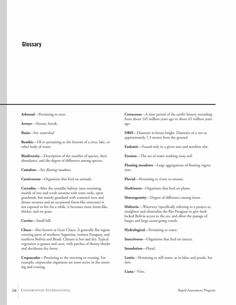
108 CONSERVATION INTERNATIONAL
Arboreal—Pertaining to trees.
Arroyo—Stream, brook.
Basin—See watershed.
Benthic—Of or pertaining to the bottom of a river, lake, orother body of water.
Biodiversity—Description of the number of species, theirabundance, and the degree of difference among species.
Camalote—See floating meadows.
Carnivorous—Organisms that feed on animals.
Cerradão—After the cerradão habitat (area consisting mainly of tree and scrub savanna with some wide, opengrasslands, but mainly grassland with scattered trees anddenser savanna and an occasional forest-like structure) is not exposed to fire for a while, it becomes more forest-like,thicker, and no grass.
Cerrito—Small hill.
Chaco—Also known as Gran Chaco. A generally flat regioncovering parts of northern Argentina, western Paraguay, andsouthern Bolivia and Brasil. Climate is hot and dry. Typicalvegetation is grasses and cacti, with patches of thorny shrubsand deciduous dry forest.
Crepuscular—Pertaining to the morning or evening. Forexample, crepuscular organisms are most active in the morn-ing and evening.
Cretaceous—A time period of the earth’s history extendingfrom about 145 million years ago to about 65 million yearsago.
DBH—Diameter at breast height. Diameter of a tree atapproximately 1.3 meters from the ground.
Endemic—Found only in a given area and nowhere else.
Erosion—The act of water washing away soil.
Floating meadows—Large aggregations of floating vegeta-tion.
Fluvial—Pertaining to rivers or streams.
Herbivores—Organisms that feed on plants.
Heterogeneity—Degree of difference among items.
Hidrovia—Waterway (specifically referring to a project tostraighten and channalize the Río Paraguay to give land-locked Bolivia access to the sea, and allow the passage ofbarges and large ocean-going vessels.
Hydrological—Pertaining to water.
Insectivores—Organisms that feed on insects.
Inundation—Flood.
Lentic—Pertaining to still water; as in lakes and ponds. Seelotic.
Liana—Vine.
Glossary
Rapid Assessment Program
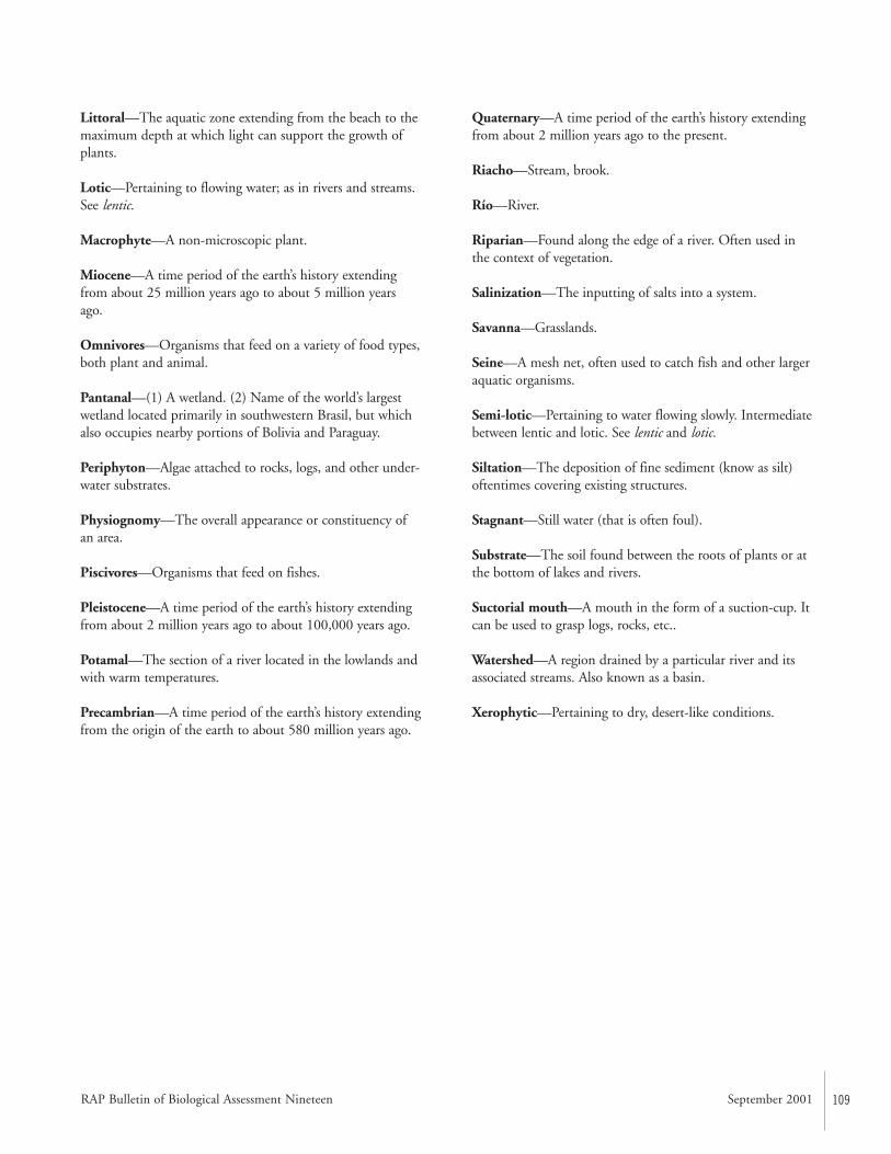
RAP Bulletin of Biological Assessment Nineteen September 2001 109
Littoral—The aquatic zone extending from the beach to themaximum depth at which light can support the growth ofplants.
Lotic—Pertaining to flowing water; as in rivers and streams.See lentic.
Macrophyte—A non-microscopic plant.
Miocene—A time period of the earth’s history extendingfrom about 25 million years ago to about 5 million yearsago.
Omnivores—Organisms that feed on a variety of food types,both plant and animal.
Pantanal—(1) A wetland. (2) Name of the world’s largestwetland located primarily in southwestern Brasil, but whichalso occupies nearby portions of Bolivia and Paraguay.
Periphyton—Algae attached to rocks, logs, and other under-water substrates.
Physiognomy—The overall appearance or constituency ofan area.
Piscivores—Organisms that feed on fishes.
Pleistocene—A time period of the earth’s history extendingfrom about 2 million years ago to about 100,000 years ago.
Potamal—The section of a river located in the lowlands andwith warm temperatures.
Precambrian—A time period of the earth’s history extendingfrom the origin of the earth to about 580 million years ago.
Quaternary—A time period of the earth’s history extendingfrom about 2 million years ago to the present.
Riacho—Stream, brook.
Río—River.
Riparian—Found along the edge of a river. Often used inthe context of vegetation.
Salinization—The inputting of salts into a system.
Savanna—Grasslands.
Seine—A mesh net, often used to catch fish and other largeraquatic organisms.
Semi-lotic—Pertaining to water flowing slowly. Intermediatebetween lentic and lotic. See lentic and lotic.
Siltation—The deposition of fine sediment (know as silt)oftentimes covering existing structures.
Stagnant—Still water (that is often foul).
Substrate—The soil found between the roots of plants or atthe bottom of lakes and rivers.
Suctorial mouth—A mouth in the form of a suction-cup. Itcan be used to grasp logs, rocks, etc..
Watershed—A region drained by a particular river and itsassociated streams. Also known as a basin.
Xerophytic—Pertaining to dry, desert-like conditions.
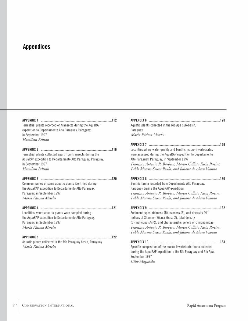
110 CONSERVATION INTERNATIONAL
APPENDIX 1 ....................................................................................112Terrestrial plants recorded on transects during the AquaRAP expedition to Departamento Alto Paraguay, Paraguay, in September 1997 Hamilton Beltrán
APPENDIX 2 ....................................................................................116Terrestrial plants collected apart from transects during the AquaRAP expedition to Departamento Alto Paraguay, Paraguay, in September 1997 Hamilton Beltrán
APPENDIX 3 ....................................................................................120Common names of some aquatic plants identified during the AquaRAP expedition to Departamento Alto Paraguay, Paraguay, in September 1997 María Fátima Mereles
APPENDIX 4 ....................................................................................121Localities where aquatic plants were sampled during the AquaRAP expedition to Departamento Alto Paraguay, Paraguay, in September 1997 María Fátima Mereles
APPENDIX 5 ....................................................................................122Aquatic plants collected in the Río Paraguay basin, Paraguay María Fátima Mereles
Appendices
APPENDIX 6 ....................................................................................128Aquatic plants collected in the Río Apa sub-basin, Paraguay María Fátima Mereles
APPENDIX 7 ....................................................................................129Localities where water quality and benthic macro-invertebrates were assessed during the AquaRAP expedition to Departamento Alto Paraguay, Paraguay, in September 1997 Francisco Antonio R. Barbosa, Marcos Callisto Faria Pereira,Pablo Moreno Souza Paula, and Juliana de Abreu Vianna
APPENDIX 8 ....................................................................................130Benthic fauna recorded from Departmento Alto Paraguay, Paraguay during the AquaRAP expedition Francisco Antonio R. Barbosa, Marcos Callisto Faria Pereira,Pablo Moreno Souza Paula, and Juliana de Abreu Vianna
APPENDIX 9 ....................................................................................132Sediment types, richness (R), eveness (E), and diversity (H') indices of Shannon-Wiener (base 2), total density (D (individuals/m2)), and characteristic genera of ChironomidaeFrancisco Antonio R. Barbosa, Marcos Callisto Faria Pereira,Pablo Moreno Souza Paula, and Juliana de Abreu Vianna
APPENDIX 10 ....................................................................................133Specific composition of the macro-invertebrate fauna collected during the AquaRAP expedition to the Río Paraguay and Río Apa,September 1997 Célio Magalhães
Rapid Assessment Program
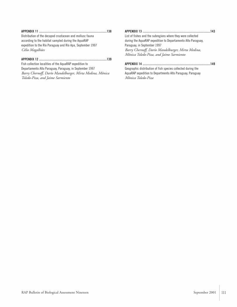
RAP Bulletin of Biological Assessment Nineteen September 2001 111
APPENDIX 11 ....................................................................................138Distribution of the decapod crustacean and mollusc fauna according to the habitat sampled during the AquaRAP expedition to the Río Paraguay and Río Apa, September 1997 Célio Magalhães
APPENDIX 12 ....................................................................................139Fish collection localities of the AquaRAP expedition to Departamento Alto Paraguay, Paraguay, in September 1997 Barry Chernoff, Darío Mandelburger, Mirta Medina, MônicaToledo-Piza, and Jaime Sarmiento
APPENDIX 13 ....................................................................................143List of fishes and the subregions where they were collected during the AquaRAP expedition to Departamento Alto Paraguay,Paraguay, in September 1997 Barry Chernoff, Darío Mandelburger, Mirta Medina, Mônica Toledo-Piza, and Jaime Sarmiento
APPENDIX 14 ....................................................................................149Geographic distribution of fish species collected during the AquaRAP expedition to Departmento Alto Paraguay, Paraguay Mônica Toledo-Piza
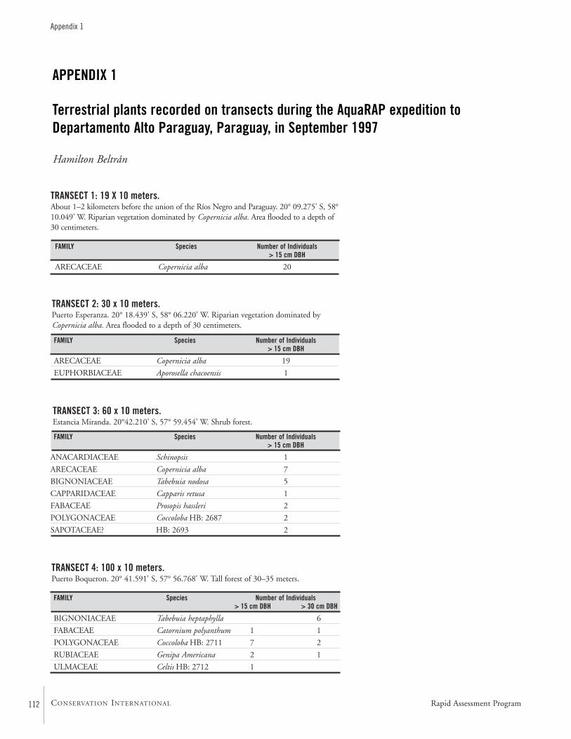
Rapid Assessment Program112
Appendix 1
CONSERVATION INTERNATIONAL
APPENDIX 1
Terrestrial plants recorded on transects during the AquaRAP expedition toDepartamento Alto Paraguay, Paraguay, in September 1997
Hamilton Beltrán
TRANSECT 1: 19 X 10 meters.About 1–2 kilometers before the union of the Ríos Negro and Paraguay. 20° 09.275' S, 58°10.049' W. Riparian vegetation dominated by Copernicia alba. Area flooded to a depth of30 centimeters.
TRANSECT 2: 30 x 10 meters.Puerto Esperanza. 20° 18.439' S, 58° 06.220' W. Riparian vegetation dominated byCopernicia alba. Area flooded to a depth of 30 centimeters.
TRANSECT 3: 60 x 10 meters.Estancia Miranda. 20°42.210’ S, 57° 59.454’ W. Shrub forest.
TRANSECT 4: 100 x 10 meters. Puerto Boqueron. 20° 41.591' S, 57° 56.768' W. Tall forest of 30–35 meters.
FAMILY Species Number of Individuals> 15 cm DBH > 30 cm DBH
BIGNONIACEAE Tabebuia heptaphylla 6
FABACEAE Catornium polyanthum 1 1
POLYGONACEAE Coccoloba HB: 2711 7 2
RUBIACEAE Genipa Americana 2 1
ULMACEAE Celtis HB: 2712 1
FAMILY Species Number of Individuals> 15 cm DBH
ARECACEAE Copernicia alba 20
FAMILY Species Number of Individuals> 15 cm DBH
ARECACEAE Copernicia alba 19
EUPHORBIACEAE Aporosella chacoensis 1
FAMILY Species Number of Individuals > 15 cm DBH
ANACARDIACEAE Schinopsis 1
ARECACEAE Copernicia alba 7
BIGNONIACEAE Tabebuia nodosa 5
CAPPARIDACEAE Capparis retusa 1
FABACEAE Prosopis hassleri 2
POLYGONACEAE Coccoloba HB: 2687 2
SAPOTACEAE? HB: 2693 2
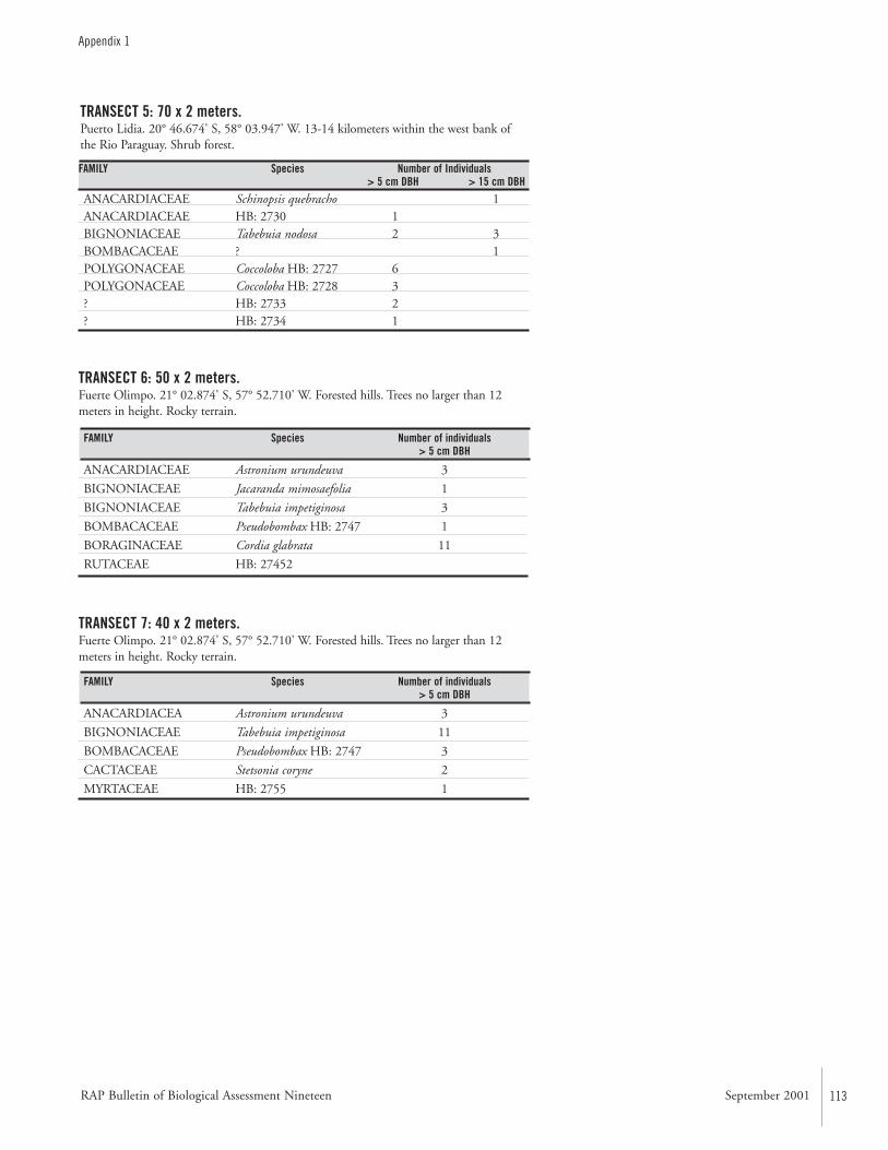
RAP Bulletin of Biological Assessment Nineteen September 2001 113
TRANSECT 6: 50 x 2 meters.Fuerte Olimpo. 21° 02.874' S, 57° 52.710' W. Forested hills. Trees no larger than 12meters in height. Rocky terrain.
Appendix 1
TRANSECT 5: 70 x 2 meters. Puerto Lidia. 20° 46.674' S, 58° 03.947' W. 13-14 kilometers within the west bank ofthe Rio Paraguay. Shrub forest.
FAMILY Species Number of Individuals> 5 cm DBH > 15 cm DBH
ANACARDIACEAE Schinopsis quebracho 1ANACARDIACEAE HB: 2730 1BIGNONIACEAE Tabebuia nodosa 2 3BOMBACACEAE ? 1POLYGONACEAE Coccoloba HB: 2727 6POLYGONACEAE Coccoloba HB: 2728 3? HB: 2733 2? HB: 2734 1
FAMILY Species Number of individuals> 5 cm DBH
ANACARDIACEAE Astronium urundeuva 3
BIGNONIACEAE Jacaranda mimosaefolia 1
BIGNONIACEAE Tabebuia impetiginosa 3
BOMBACACEAE Pseudobombax HB: 2747 1
BORAGINACEAE Cordia glabrata 11
RUTACEAE HB: 27452
TRANSECT 7: 40 x 2 meters.Fuerte Olimpo. 21° 02.874' S, 57° 52.710' W. Forested hills. Trees no larger than 12meters in height. Rocky terrain.
FAMILY Species Number of individuals > 5 cm DBH
ANACARDIACEA Astronium urundeuva 3
BIGNONIACEAE Tabebuia impetiginosa 11
BOMBACACEAE Pseudobombax HB: 2747 3
CACTACEAE Stetsonia coryne 2
MYRTACEAE HB: 2755 1
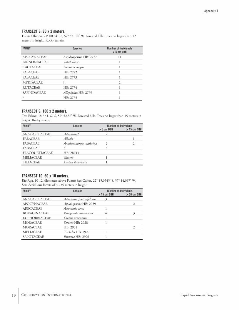
114 CONSERVATION INTERNATIONAL
Appendix 1
TRANSECT 8: 80 x 2 meters.Fuerte Olimpo. 21° 00.841' S, 57° 52.100' W. Forested hills. Trees no larger than 12meters in height. Rocky terrain.
FAMILY Species Number of individuals > 5 cm DBH
APOCYNACEAE Aspidosperma HB: 2777 11
BIGNONIACEAE Tabebuia sp. 1
CACTACEAE Stetsonia coryne 1
FABACEAE HB: 2772 1
FABACEAE HB: 2773 1
MYRTACEAE ? 2
RUTACEAE HB: 2774 1
SAPINDACEAE Allophyllus HB: 2769 1
? HB: 2775 1
TRANSECT 9: 100 x 2 meters. Tres Palmas. 21° 41.32' S, 57° 52.87' W. Forested hills. Trees no larger than 15 meters inheight. Rocky terrain.
FAMILY Species Number of Individuals> 5 cm DBH > 15 cm DBH
ANACARDIACEAE Astronium2 2FABACEAE Albizia 1FABACEAE Anadenanthera colubrina 2 2FABACEAE ? 6FLACOURTIACEAE HB: 28043MELIACEAE Guarea 1TILIACEAE Luehea divaricata 1
TRANSECT 10: 60 x 10 meters.Río Apa. 10-12 kilometers above Puerto San Carlos. 22° 15.0545' S, 57° 14.097' W.Semideciduous forests of 30-35 meters in height.
FAMILY Species Number of Individuals> 15 cm DBH > 30 cm DBH
ANACARDIACEAE Astronium fraxinifolium 3APOCYNACEAE Aspidosperma HB: 2939 2ARECACEAE Acrocomia totai 1BORAGINACEAE Patagonula americana 4 3EUPHORBIACEAE Croton urucurana 1MORACEAE Sorocea HB: 2928 1MORACEAE HB: 2931 2MELIACEAE Trichilia HB: 2929 1SAPOTACEAE Pouteria HB: 2926 1
Rapid Assessment Program
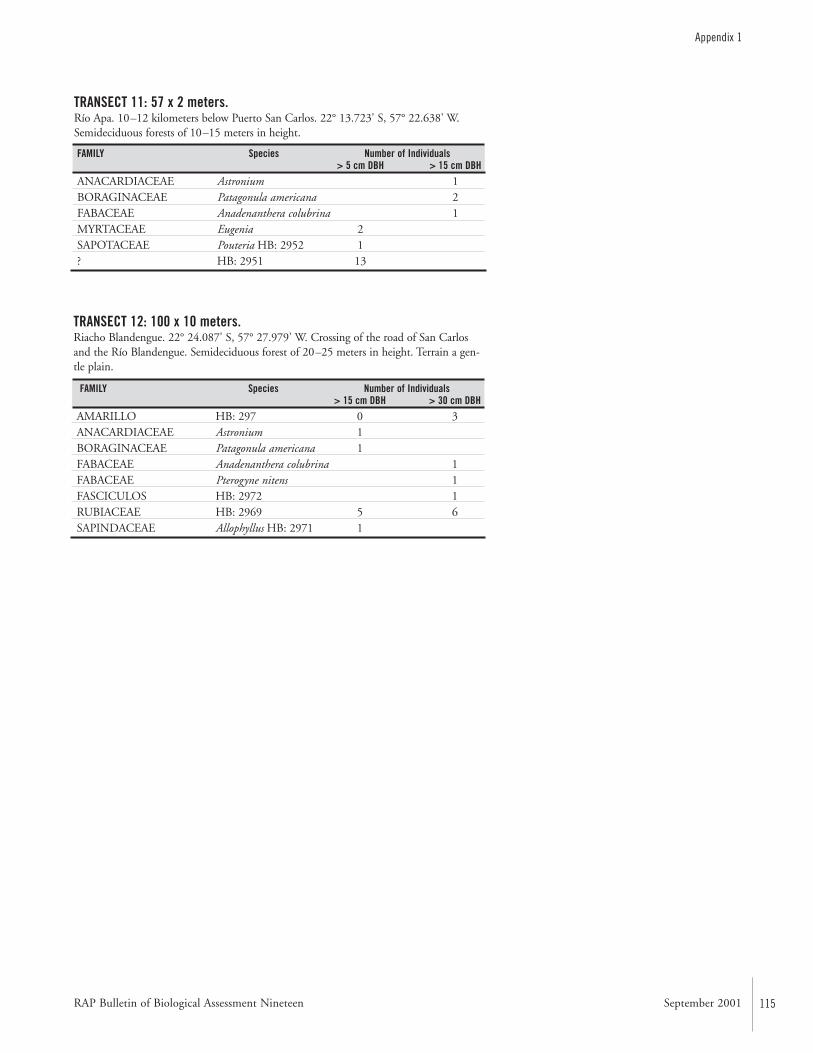
RAP Bulletin of Biological Assessment Nineteen September 2001 115
Appendix 1
TRANSECT 11: 57 x 2 meters.Río Apa. 10–12 kilometers below Puerto San Carlos. 22° 13.723' S, 57° 22.638' W.Semideciduous forests of 10–15 meters in height.
FAMILY Species Number of Individuals> 5 cm DBH > 15 cm DBH
ANACARDIACEAE Astronium 1BORAGINACEAE Patagonula americana 2FABACEAE Anadenanthera colubrina 1MYRTACEAE Eugenia 2SAPOTACEAE Pouteria HB: 2952 1? HB: 2951 13
TRANSECT 12: 100 x 10 meters.Riacho Blandengue. 22° 24.087' S, 57° 27.979' W. Crossing of the road of San Carlosand the Río Blandengue. Semideciduous forest of 20–25 meters in height. Terrain a gen-tle plain.
FAMILY Species Number of Individuals> 15 cm DBH > 30 cm DBH
AMARILLO HB: 297 0 3ANACARDIACEAE Astronium 1BORAGINACEAE Patagonula americana 1FABACEAE Anadenanthera colubrina 1FABACEAE Pterogyne nitens 1FASCICULOS HB: 2972 1RUBIACEAE HB: 2969 5 6SAPINDACEAE Allophyllus HB: 2971 1
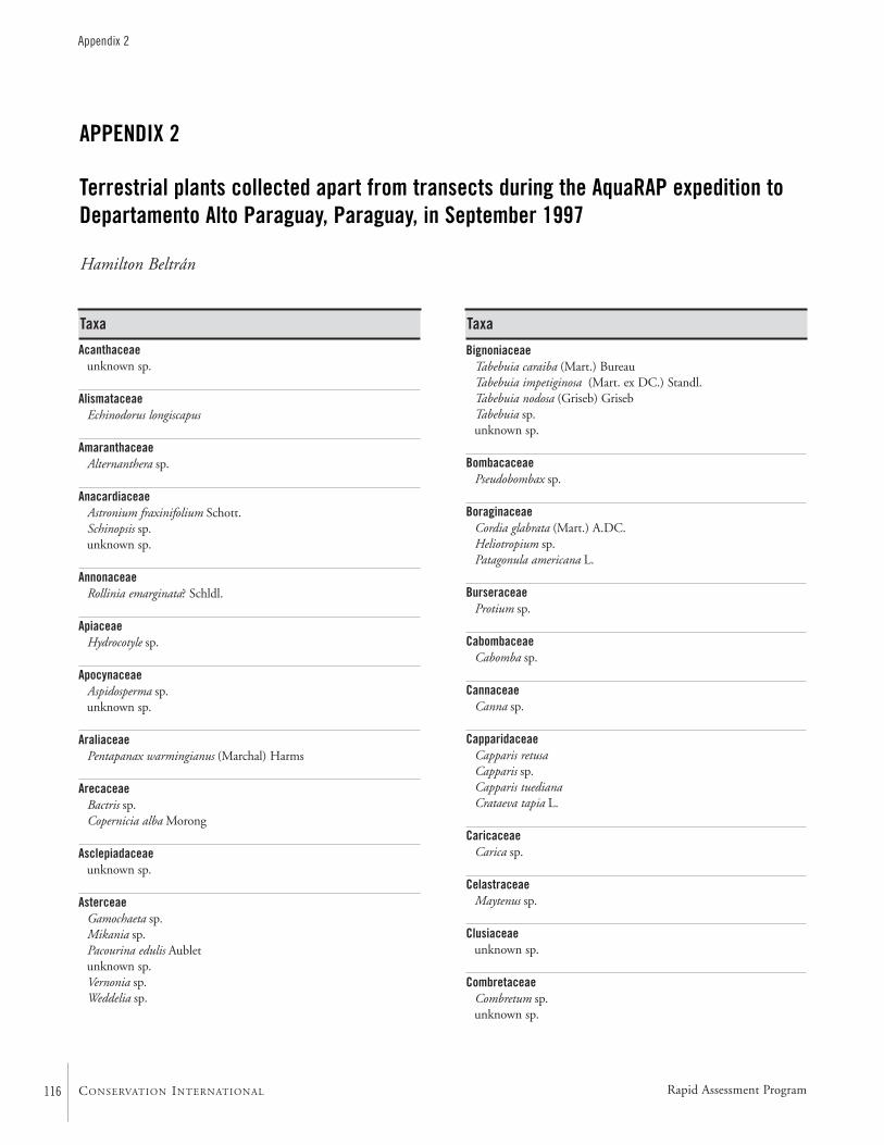
116
Appendix 2
CONSERVATION INTERNATIONAL
Acanthaceaeunknown sp.
AlismataceaeEchinodorus longiscapus
AmaranthaceaeAlternanthera sp.
AnacardiaceaeAstronium fraxinifolium Schott.Schinopsis sp.unknown sp.
AnnonaceaeRollinia emarginata? Schldl.
ApiaceaeHydrocotyle sp.
ApocynaceaeAspidosperma sp.unknown sp.
AraliaceaePentapanax warmingianus (Marchal) Harms
ArecaceaeBactris sp.Copernicia alba Morong
Asclepiadaceaeunknown sp.
AsterceaeGamochaeta sp.Mikania sp.Pacourina edulis Aubletunknown sp.Vernonia sp.Weddelia sp.
BignoniaceaeTabebuia caraiba (Mart.) BureauTabebuia impetiginosa (Mart. ex DC.) Standl.Tabebuia nodosa (Griseb) GrisebTabebuia sp.unknown sp.
BombacaceaePseudobombax sp.
BoraginaceaeCordia glabrata (Mart.) A.DC.Heliotropium sp.Patagonula americana L.
BurseraceaeProtium sp.
CabombaceaeCabomba sp.
CannaceaeCanna sp.
CapparidaceaeCapparis retusaCapparis sp.Capparis tuedianaCrataeva tapia L.
CaricaceaeCarica sp.
CelastraceaeMaytenus sp.
Clusiaceaeunknown sp.
CombretaceaeCombretum sp.unknown sp.
APPENDIX 2
Terrestrial plants collected apart from transects during the AquaRAP expedition toDepartamento Alto Paraguay, Paraguay, in September 1997
Hamilton Beltrán
Taxa Taxa
Rapid Assessment Program
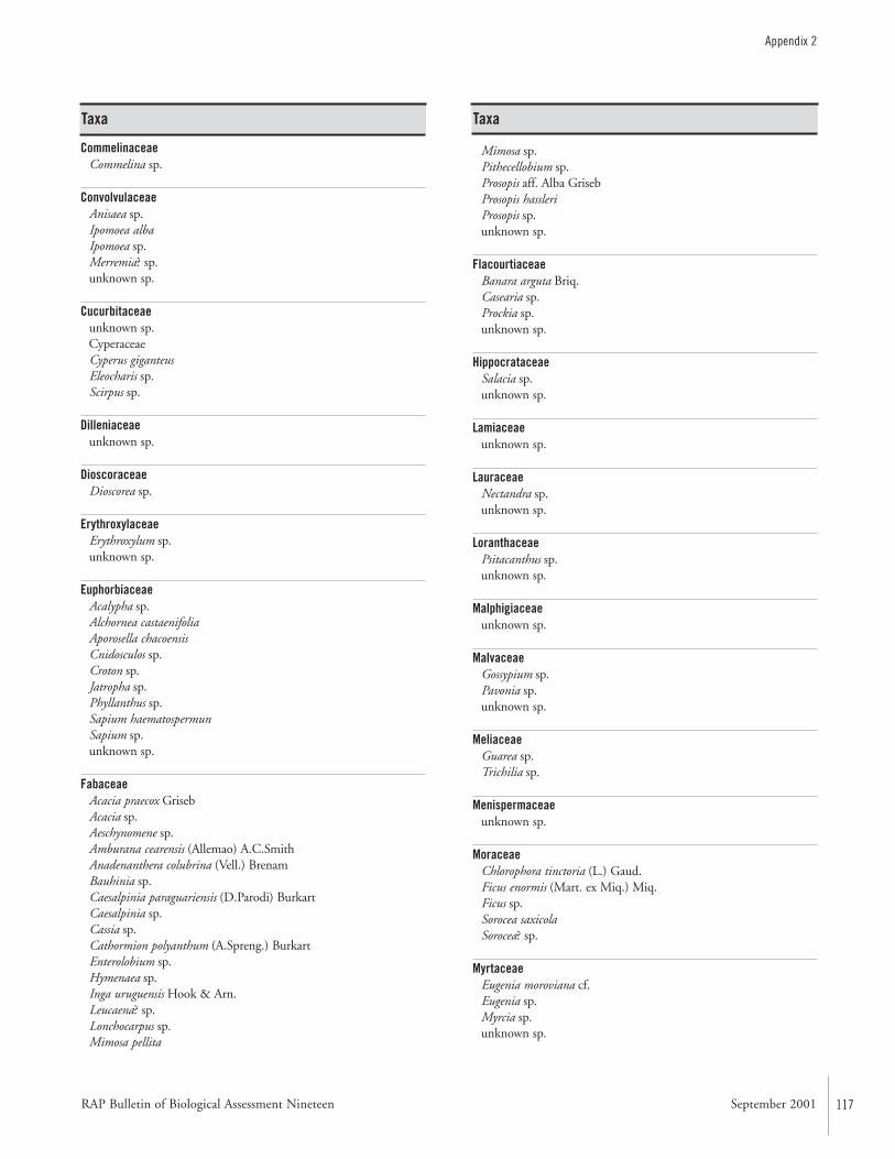
RAP Bulletin of Biological Assessment Nineteen September 2001 117
Appendix 2
CommelinaceaeCommelina sp.
ConvolvulaceaeAnisaea sp.Ipomoea albaIpomoea sp.Merremia? sp.unknown sp.
Cucurbitaceaeunknown sp.CyperaceaeCyperus giganteusEleocharis sp.Scirpus sp.
Dilleniaceaeunknown sp.
DioscoraceaeDioscorea sp.
ErythroxylaceaeErythroxylum sp.unknown sp.
EuphorbiaceaeAcalypha sp.Alchornea castaenifoliaAporosella chacoensisCnidosculos sp.Croton sp.Jatropha sp.Phyllanthus sp.Sapium haematospermunSapium sp.unknown sp.
FabaceaeAcacia praecox GrisebAcacia sp.Aeschynomene sp.Amburana cearensis (Allemao) A.C.SmithAnadenanthera colubrina (Vell.) BrenamBauhinia sp.Caesalpinia paraguariensis (D.Parodi) BurkartCaesalpinia sp.Cassia sp.Cathormion polyanthum (A.Spreng.) BurkartEnterolobium sp.Hymenaea sp.Inga uruguensis Hook & Arn.Leucaena? sp.Lonchocarpus sp.Mimosa pellita
Mimosa sp.Pithecellobium sp.Prosopis aff. Alba GrisebProsopis hassleriProsopis sp.unknown sp.
FlacourtiaceaeBanara arguta Briq.Casearia sp.Prockia sp.unknown sp.
HippocrataceaeSalacia sp.unknown sp.
Lamiaceaeunknown sp.
LauraceaeNectandra sp.unknown sp.
LoranthaceaePsitacanthus sp.unknown sp.
Malphigiaceaeunknown sp.
MalvaceaeGossypium sp.Pavonia sp.unknown sp.
MeliaceaeGuarea sp.Trichilia sp.
Menispermaceaeunknown sp.
MoraceaeChlorophora tinctoria (L.) Gaud.Ficus enormis (Mart. ex Miq.) Miq.Ficus sp.Sorocea saxicolaSorocea? sp.
MyrtaceaeEugenia moroviana cf.Eugenia sp.Myrcia sp.unknown sp.
Taxa Taxa
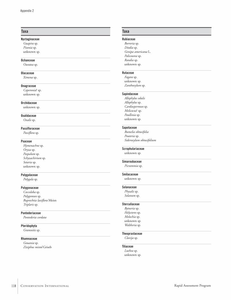
118
Appendix 2
CONSERVATION INTERNATIONAL
NyctaginaceaeGuapira sp.Pisonia sp.unknown sp.
OchanceaeOuratea sp.
OlacaceaeXimena sp.
OnagraceaeCaperonia? sp.unknown sp.
Orchidaceaeunknown sp.
OxalidaceaeOxalis sp.
PassifloraceaePassiflora sp.
PoaceaeHymenachne sp.Oryza sp.Paspalum sp.Schyzachirium sp.Setaria sp.unknown sp.
PolygalaceaePolygala sp.
PolygonaceaeCoccoloba sp.Polygomun sp.Ruprechtia laxiflora MeisnTriplaris sp.
PontederiaceaePontederia cordata
PteridophytaGramnitis sp.
RhamnaceaeGouania sp.Ziziphus mistol Griseb
RubiaceaeBorreria sp.Diodia sp.Genipa americana L.Palicourea sp.Randia sp.unknown sp.
RutaceaeFagara sp.unknown sp.Zanthoxylum sp.
SapindaceaeAllophylus edulisAllophylus sp.Cardiospermun sp.Melicocus? sp.Paullinia sp.unknown sp.
SapotaceaeBumelia obtusifoliaPouteria sp.Sideroxylum obtusifolium
Scrophulariaceaeunknown sp.
SimaroubaceaePicrammia sp.
Smilacaceaeunknown sp.
SolanaceaePhysalis sp.Solanum sp.
SterculiaceaeBytneria sp.Helycteres sp.Melochia sp.unknown sp.Waltheria sp.
TheoprastaceaeClavija sp.
TiliaceaeLuehea sp.unknown sp.
Taxa Taxa
Rapid Assessment Program
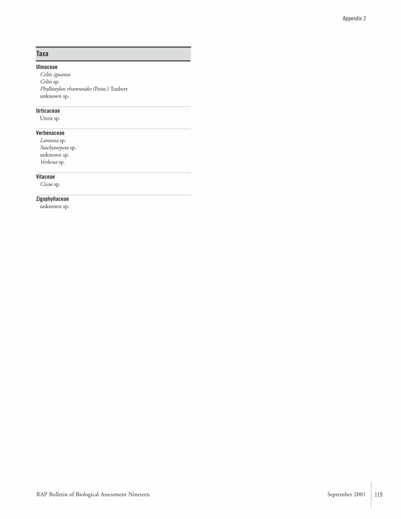
RAP Bulletin of Biological Assessment Nineteen September 2001 119
Appendix 2
UlmaceaeCeltis iguaneaCeltis sp.Phyllostylon rhamnoides (Poiss.) Taubertunknown sp.
UrticaceaeUrera sp.
VerbenaceaeLantana sp.Stachytarpeta sp.unknown sp.Verbena sp.
VitaceaeCissus sp.
Zigophyllaceaeunknown sp.
Taxa
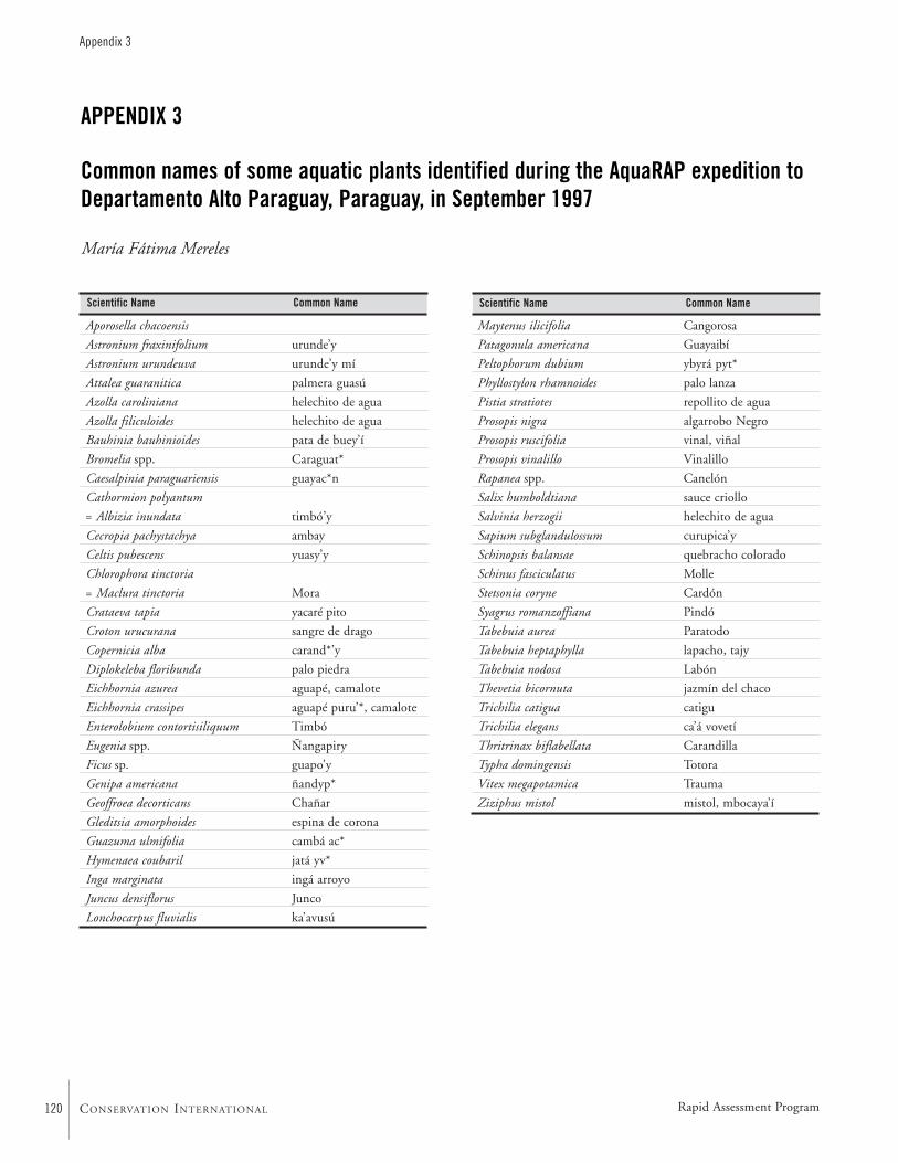
120
Appendix 3
CONSERVATION INTERNATIONAL
Aporosella chacoensis
Astronium fraxinifolium urunde’y
Astronium urundeuva urunde’y mí
Attalea guaranitica palmera guasú
Azolla caroliniana helechito de agua
Azolla filiculoides helechito de agua
Bauhinia bauhinioides pata de buey’í
Bromelia spp. Caraguat*
Caesalpinia paraguariensis guayac*n
Cathormion polyantum
= Albizia inundata timbó’y
Cecropia pachystachya ambay
Celtis pubescens yuasy’y
Chlorophora tinctoria
= Maclura tinctoria Mora
Crataeva tapia yacaré pito
Croton urucurana sangre de drago
Copernicia alba carand*’y
Diplokeleba floribunda palo piedra
Eichhornia azurea aguapé, camalote
Eichhornia crassipes aguapé puru’*, camalote
Enterolobium contortisiliquum Timbó
Eugenia spp. Ñangapiry
Ficus sp. guapo’y
Genipa americana ñandyp*
Geoffroea decorticans Chañar
Gleditsia amorphoides espina de corona
Guazuma ulmifolia cambá ac*
Hymenaea coubaril jatá yv*
Inga marginata ingá arroyo
Juncus densiflorus Junco
Lonchocarpus fluvialis ka’avusú
APPENDIX 3
Common names of some aquatic plants identified during the AquaRAP expedition toDepartamento Alto Paraguay, Paraguay, in September 1997
María Fátima Mereles
Maytenus ilicifolia Cangorosa
Patagonula americana Guayaibí
Peltophorum dubium ybyrá pyt*
Phyllostylon rhamnoides palo lanza
Pistia stratiotes repollito de agua
Prosopis nigra algarrobo Negro
Prosopis ruscifolia vinal, viñal
Prosopis vinalillo Vinalillo
Rapanea spp. Canelón
Salix humboldtiana sauce criollo
Salvinia herzogii helechito de agua
Sapium subglandulossum curupica’y
Schinopsis balansae quebracho colorado
Schinus fasciculatus Molle
Stetsonia coryne Cardón
Syagrus romanzoffiana Pindó
Tabebuia aurea Paratodo
Tabebuia heptaphylla lapacho, tajy
Tabebuia nodosa Labón
Thevetia bicornuta jazmín del chaco
Trichilia catigua catigu
Trichilia elegans ca’á vovetí
Thritrinax biflabellata Carandilla
Typha domingensis Totora
Vitex megapotamica Trauma
Ziziphus mistol mistol, mbocaya’í
Scientific Name Common Name Scientific Name Common Name
Rapid Assessment Program

RAP Bulletin of Biological Assessment Nineteen September 2001 121
Appendix 4
APPENDIX 4
Localities where aquatic plants were sampled during the AquaRAP expedition toDepartamento Alto Paraguay, Paraguay, in September 1997
María Fátima Mereles
Río Paraguay Locality Latitude LongitudeSemi-lotic Habitats:1. Outlet of the Río Negro into the Río Paraguay and confluence with the Río Nabileque. 20° 09’ 15.6” S 58° 10’ 12.4” W2. Puerto 14 de Mayo. 20° 18’ 5.1” S 58° 06’ 6.5” W3. Puerto 14 de Mayo. 20° 17’ 30.5” S 58° 06’ 2.8” W4. Puerto Boquerón. 20° 45’ 51.2” S 57° 57’ 29.5” W5. Puerto Voluntad. 20° 41’ 43.9” S 57° 59’ 30.6” W6. Riacho Paso Lidia. 20° 58’ 34.4” S 57° 50’ 19.1” W7. Fuerte Olimpo, Riacho Vaquero. 21° 01’ 03” S 57° 52’ 4.0” W8. Puerto Estancia Cerrito. 21° 26’ 27.2” S 57° 54’ 10.8” W9. Estancia Cerrito, Riacho “Coe’yù”. 21° 25’ 12.7” S 57° 55’ 21.6” W10. Puerto 3 Palmas. 21° 52’ 51.6” S 57° 57’ 06” W11. Riacho Celina. 21° 46’ 34.8” S 57° 56’ 56” W12. Río Verde, in the proximity of the outlet into the Río Paraguay. 23° 06’ 17.1” S 57° 42’ 45.6” WShoreline Habitats:1. Outlet of the Río Negro into the Río Paraguay. 20° 09’ 15.6” S 58° 10’ 12.4” W2. Estancia Miranda. 20° 40’ 2.3” S 57° 59’ 41.5” W3. Estancia Cerrito, Riacho Coe’yù. 21° 25’ 12.7” S 57° 55’ 21.6” W4. Estancia Cerrito. 21° 26’ 27.2” S 57° 54’ 10.8” W5. Riacho Celina. 21° 46’ 34” S 57° 56’ 56” W6. Puerto 3 Palmas, branch of the Río Paraguay. 21° 42’ 54” S 57° 57’ 24” W7. Puerto 3 Palmas, Riacho to the south of Isla Margarita. 21° 39’ 54.4” S 57° 52’ 11.2” W8. Río Napegue, vicinity of the outlet into the Río Paraguay. 22° 58’ 32” S 57° 43’ 38” W9. Río Aquidabán. 23° 06’ 2.8” S 57° 34’ 1.8” WSwamps:1. Puerto 14 de Mayo. 20° 18’ 5.1” S 58° 06’ 6.5” W2. Estancia Miranda. 20° 40’ 2.3” S 57° 59’ 41.5” W3. Puerto Lidia and nearby. 20° 47’ 8.1” S 58° 57’ 38.9” W4. Riacho Vaquero. 20° 58’ 34.4” S 57° 50’ 19.1” W5. Riacho Coè’yù. 21° 27’ 46.3” S 57° 55’ 40.3” W6. Puerto 3 Palmas, Riacho Celina. 21° 46’ 34.8” S 57° 56’ 56.9” W7. Puerto 3 Palmas, Riacho Celina. 21° 42’ 54” S 57° 57’ 24” WSand Banks:1. Banco San Alberto, outlet of Riacho San Alberto. 21° 52’ 33.4” S 57° 55’ 19.2” W2. Riacho Celina. 21° 46’ 34” S 57° 56’ 56” W3. Front of Estancia Cerrito. 21° 26’ 27” S 57° 54’ 10.8” WFlooded Banks:1. Río Apa, Puerto San Carlos del Apa, 15 kilometers to the east. 22° 13’ 13.9” S 57° 17’ 27.2” W2. Río Apa. 22° 13’ 25.7” S 57° 14’ 10.5” W3. Río Apa. 22° 14’ 0.8” S 57° 16’ 17.1” W4. Puerto San Carlos del Apa. 22° 11’ 56.1” S 57° 24’ 35.4” W5. Río Apa, outlet of the Arroyo Tebicuary. 22° 12’ 04” S 57° 25’ 53.4” W6. Arroyo Blandengue. 22° 24’ 4.5” S 57° 27’ 56” W7. Riacho La Paz. 22° 22’ 30.2” S 57° 28’ 57.5” W
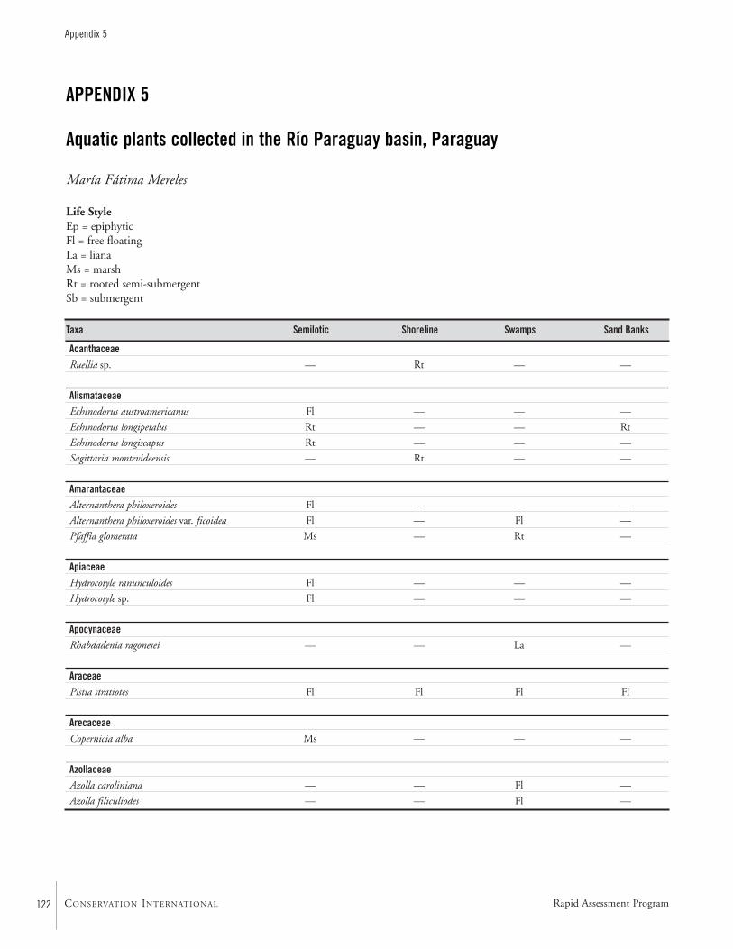
122
Appendix 5
CONSERVATION INTERNATIONAL
APPENDIX 5
Aquatic plants collected in the Río Paraguay basin, Paraguay
María Fátima Mereles
Life StyleEp = epiphyticFl = free floatingLa = lianaMs = marshRt = rooted semi-submergentSb = submergent
AcanthaceaeRuellia sp. — Rt — —
AlismataceaeEchinodorus austroamericanus Fl — — —
Echinodorus longipetalus Rt — — Rt
Echinodorus longiscapus Rt — — —
Sagittaria montevideensis — Rt — —
AmarantaceaeAlternanthera philoxeroides Fl — — —
Alternanthera philoxeroides var. ficoidea Fl — Fl —
Pfaffia glomerata Ms — Rt —
Apiaceae Hydrocotyle ranunculoides Fl — — —
Hydrocotyle sp. Fl — — —
ApocynaceaeRhabdadenia ragonesei — — La —
AraceaePistia stratiotes Fl Fl Fl Fl
ArecaceaeCopernicia alba Ms — — —
AzollaceaeAzolla caroliniana — — Fl —
Azolla filiculiodes — — Fl —
Taxa Semilotic Shoreline Swamps Sand Banks
Rapid Assessment Program
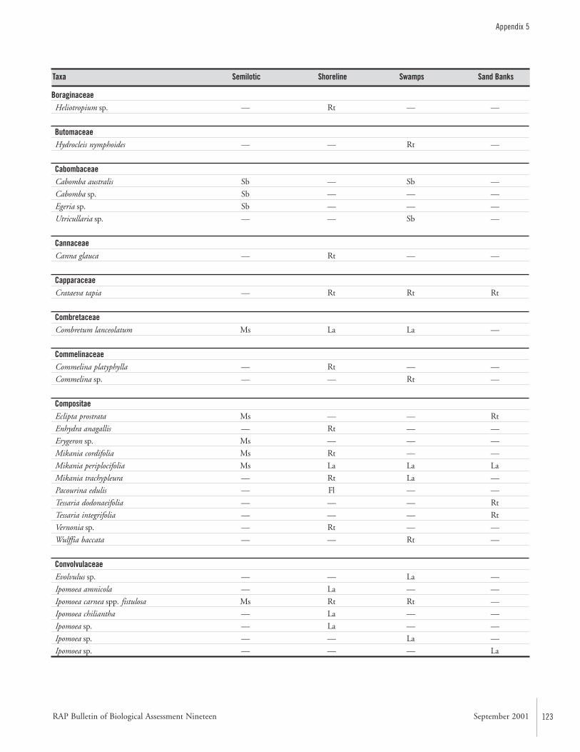
RAP Bulletin of Biological Assessment Nineteen September 2001 123
Appendix 5
BoraginaceaeHeliotropium sp. — Rt — —
ButomaceaeHydrocleis nymphoides — — Rt —
CabombaceaeCabomba australis Sb — Sb —
Cabomba sp. Sb — — —
Egeria sp. Sb — — —
Utricullaria sp. — — Sb —
CannaceaeCanna glauca — Rt — —
CapparaceaeCrataeva tapia — Rt Rt Rt
CombretaceaeCombretum lanceolatum Ms La La —
CommelinaceaeCommelina platyphylla — Rt — —
Commelina sp. — — Rt —
CompositaeEclipta prostrata Ms — — Rt
Enhydra anagallis — Rt — —
Erygeron sp. Ms — — —
Mikania cordifolia Ms Rt — —
Mikania periplocifolia Ms La La La
Mikania trachypleura — Rt La —
Pacourina edulis — Fl — —
Tessaria dodonaeifolia — — — Rt
Tessaria integrifolia — — — Rt
Vernonia sp. — Rt — —
Wulffia baccata — — Rt —
ConvolvulaceaeEvolvulus sp. — — La —
Ipomoea amnicola — La — —
Ipomoea carnea spp. fistulosa Ms Rt Rt —
Ipomoea chiliantha — La — —
Ipomoea sp. — La — —
Ipomoea sp. — — La —
Ipomoea sp. — — — La
Taxa Semilotic Shoreline Swamps Sand Banks
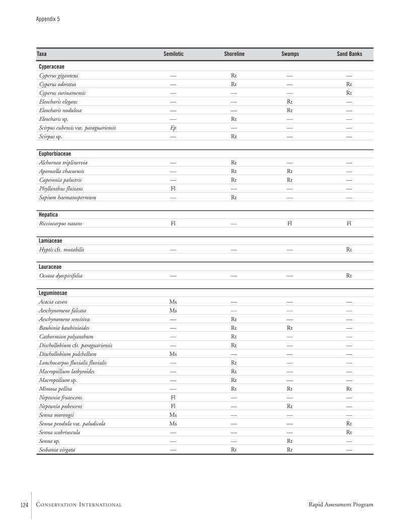
124
Appendix 5
CONSERVATION INTERNATIONAL
CyperaceaeCyperus giganteus — Rt — —
Cyperus odoratus — Rt — Rt
Cyperus surinamensis — — — Rt
Eleocharis elegans — — Rt —
Eleocharis nodulosa — — Rt —
Eleocharis sp. — Rt — —
Scirpus cubensis var. paraguariensis Ep — — —
Scirpus sp. — Rt — —
EuphorbiaceaeAlchornea triplinervia — Rt — —
Aporosella chacoensis — Rt Rt —
Caperonia palustris — Rt Rt —
Phyllanthus fluitans Fl — — —
Sapium haematospermum — Rt — —
HepaticaRicciocarpus natans Fl — Fl Fl
LamiaceaeHyptis cfr. mutabilis — — — Rt
LauraceaeOcotea dyospirifolia — — — Rt
LeguminosaeAcacia caven Ms — — —
Aeschynomene falcata Ms — — —
Aeschynomene sensitiva — Rt — —
Bauhinia bauhinioides — Rt Rt —
Cathormion polyanthum — Rt — —
Dischollobium cfr. paraguariensis — Rt — —
Dischollobium pulchellum Ms — — —
Lonchocarpus fluvialis fluvialis — Rt — —
Macroptilium lathyroides — Rt — —
Macroptilium sp. — Rt — —
Mimosa pellita — Rt Rt Rt
Neptunia frutescens Fl — — —
Neptunia pubescens Fl — Rt —
Senna morongii Ms — — —
Senna pendula var. paludicola Ms — — Rt
Senna scabriuscula — — — Rt
Senna sp. — — Rt —
Sesbania virgata — Rt Rt —
Taxa Semilotic Shoreline Swamps Sand Banks
Rapid Assessment Program
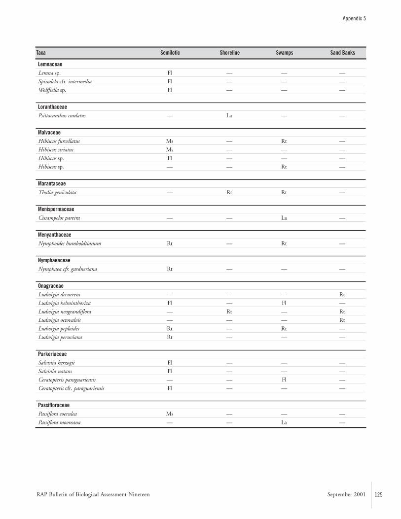
RAP Bulletin of Biological Assessment Nineteen September 2001 125
Appendix 5
LemnaceaeLemna sp. Fl — — —
Spirodela cfr. intermedia Fl — — —
Wolffiella sp. Fl — — —
LoranthaceaePsittacanthus cordatus — La — —
MalvaceaeHibiscus furcellatus Ms — Rt —
Hibiscus striatus Ms — — —
Hibiscus sp. Fl — — —
Hibiscus sp. — — Rt —
MarantaceaeThalia geniculata — Rt Rt —
MenispermaceaeCissampelos pareira — — La —
MenyanthaceaeNymphoides humboldtianum Rt — Rt —
NymphaeaceaeNymphaea cfr. gardneriana Rt — — —
OnagraceaeLudwigia decurrens — — — Rt
Ludwigia helminthoriza Fl — Fl —
Ludwigia neograndiflora — Rt — Rt
Ludwigia octovalvis — — — Rt
Ludwigia peploides Rt — Rt —
Ludwigia peruviana Rt — — —
ParkeriaceaeSalvinia herzogii Fl — — —
Salvinia natans Fl — — —
Ceratopteris paraguariensis — — Fl —
Ceratopteris cfr. paraguariensis Fl — — —
PassifloraceaePassiflora coerulea Ms — — —
Passiflora mooreana — — La —
Taxa Semilotic Shoreline Swamps Sand Banks
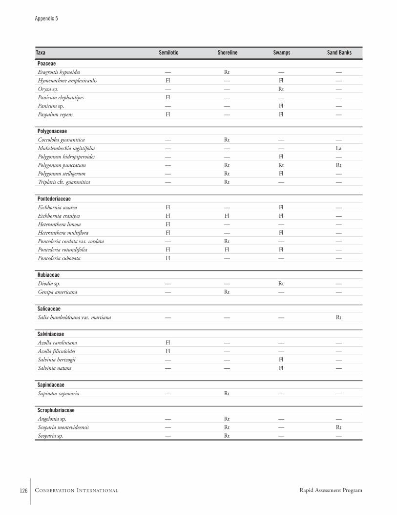
126
Appendix 5
CONSERVATION INTERNATIONAL
PoaceaeEragrostis hypnoides — Rt — —
Hymenachme amplexicaulis Fl — Fl —
Oryza sp. — — Rt —
Panicum elephantipes Fl — — —
Panicum sp. — — Fl —
Paspalum repens Fl — Fl —
PolygonaceaeCoccoloba guaranitica — Rt — —
Muhelembeckia sagittifolia — — — La
Polygonum hidropiperoides — — Fl —
Polygonum punctatum — Rt Rt Rt
Polygonum stelligerum — Rt Fl —
Triplaris cfr. guaranitica — Rt — —
PontederiaceaeEichhornia azurea Fl — Fl —
Eichhornia crassipes Fl Fl Fl —
Heteranthera limosa Fl — — —
Heteranthera multiflora Fl — Fl —
Pontederia cordata var. cordata — Rt — —
Pontederia rotundifolia Fl Fl Fl —
Pontederia subovata Fl — — —
RubiaceaeDiodia sp. — — Rt —
Genipa americana — Rt — —
SalicaceaeSalix humboldtiana var. martiana — — — Rt
SalviniaceaeAzolla caroliniana Fl — — —
Azolla filiculoides Fl — — —
Salvinia hertzogii — — Fl —
Salvinia natans — — Fl —
SapindaceaeSapindus saponaria — Rt — —
ScrophulariaceaeAngelonia sp. — Rt — —
Scoparia montevideensis — Rt — Rt
Scoparia sp. — Rt — —
Taxa Semilotic Shoreline Swamps Sand Banks
Rapid Assessment Program
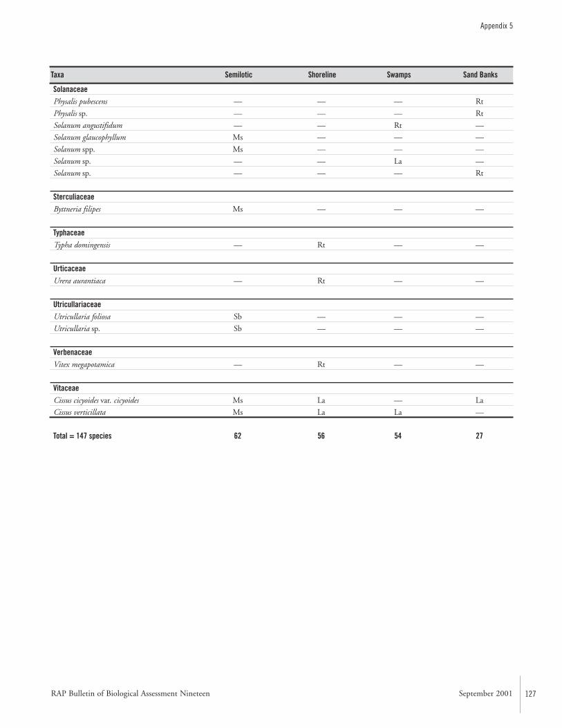
RAP Bulletin of Biological Assessment Nineteen September 2001 127
Appendix 5
Taxa Semilotic Shoreline Swamps Sand Banks
SolanaceaePhysalis pubescens — — — Rt
Physalis sp. — — — Rt
Solanum angustifidum — — Rt —
Solanum glaucophyllum Ms — — —
Solanum spp. Ms — — —
Solanum sp. — — La —
Solanum sp. — — — Rt
SterculiaceaeByttneria filipes Ms — — —
TyphaceaeTypha domingensis — Rt — —
UrticaceaeUrera aurantiaca — Rt — —
UtricullariaceaeUtricullaria foliosa Sb — — —
Utricullaria sp. Sb — — —
VerbenaceaeVitex megapotamica — Rt — —
Vitaceae Cissus cicyoides var. cicyoides Ms La — La
Cissus verticillata Ms La La —
Total = 147 species 62 56 54 27
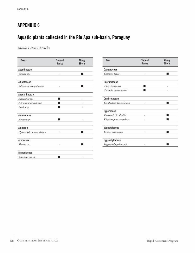
128
Appendix 6
CONSERVATION INTERNATIONAL
APPENDIX 6
Aquatic plants collected in the Río Apa sub-basin, Paraguay
María Fátima Mereles
Taxa Flooded Along Banks Shore
AcanthaceaeJusticia sp. - ■
AdiantaceaeAdiantum orbignianum - ■
AnacardiaceaeAcrocomia sp. ■ -
Astronium urundeuva ■ -
Attalea sp. ■ -
AnnonaceaeAnnona sp. ■ -
ApiaceaeHydrocotyle ranunculoides - ■
ArecaceaeSheelea sp. - ■
BignoniaceaeTabebuia aurea ■ -
Taxa Flooded Along Banks Shore
CapparaceaeCrataeva tapia - ■
CecropiaceaeAlbizzia hassleri ■ -
Cecropia pachystachya ■ -
CombretaceaeCombretum lanceolatum - ■
CyperaceaeEleocharis cfr. debilis - ■
Rhynchospora corymbosa - ■
EuphorbiaceaeCroton urucurana - ■
HygrophyllaceaeHygrophyla guianensis - ■
Rapid Assessment Program
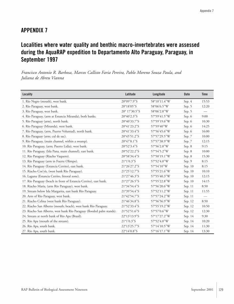
RAP Bulletin of Biological Assessment Nineteen September 2001 129
Appendix 7
APPENDIX 7
Localities where water quality and benthic macro-invertebrates were assessed during the AquaRAP expedition to Departamento Alto Paraguay, Paraguay, inSeptember 1997
Francisco Antonio R. Barbosa, Marcos Callisto Faria Pereira, Pablo Moreno Souza Paula, and Juliana de Abreu Vianna
Locality Latitude Longitude Date Time
1. Río Negro (mouth), west bank. 20°09’7.9’’S 58°10’11.4’’W Sep. 4 15:53
2. Río Paraguay, west bank. 20°18’05’’S 58°06’6.5’’W Sep. 5 12:20
3. Río Paraguay, west bank. 20° 17’30.5’’S 58°06’2.8’’W Sep. 5 —
4. Río Paraguay, (arm at Estancia Miranda), both banks. 20°40’2.3’’S 57°59’41.5’’W Sep. 6 9:00
5. Río Paraguay (arm), north bank. 20°40’33.7”S 57°59’19.6”W Sep. 6 10:30
6. Río Paraguay (Miranda), west bank. 20°41’23.2”S 57°59’40”W Sep. 6 14:25
7. Río Paraguay, (arm, Puerto Voluntad), north bank. 20°41’33.4”S 57°56’45.6”W Sep. 6 16:00
8. Río Paraguay (arm; cul de sac). 20°45’51.2”S 57°57’29.5”W Sep. 7 10:00
9. Río Paraguay, (main channel, within a swamp). 20°47’8.1”S 57°57’38.9”W Sep. 7 12:15
10. Río Paraguay, (arm; Puerto Lidia), west bank. 20°52’3.4”S 57°56’2.8”W Sep. 8 9:15
11. Río Paraguay, (Isla Pana, main channel), east bank. 20°52’22.2”S 57°54’5.2”W Sep. 8 10:00
12. Río Paraguay (Riacho Vaquero). 20°58’34.4”S 57°50’19.1”W Sep. 8 15:30
13. Río Paraguay (arm in Fuerte Olimpo). 21°1’0.3”S 57°52’4.0”W Sep. 9 8:15
14. Río Paraguay (Estancia Cerrito), east bank. 21°26’27.2”S 57°54’10”W Sep. 10 8:15
15. Riacho Coe’yù, (west bank Río Paraguay). 21°25’12.7”S 57°55’21.6”W Sep. 10 10:10
16. Laguna (Estancia Cerrito, littoral zone). 21°27’46.3”S 57°55’40.3”W Sep. 10 12:15
17. Río Paraguay (beach in front of Estancia Cerrito), east bank. 21°27’26.5”S 57°55’22.8”W Sep. 10 14:15
18. Riacho María, (arm Río Paraguay), west bank. 21°34’54.4”S 57°56’20.6”W Sep. 11 8:50
19. Stream below Isla Margarita, east bank Río Paraguay. 21°39’54.4”S 57°52’11.2”W Sep. 11 11:55
20. Arm of Río Paraguay, west bank. 21°42’54.7”S 57°57’24.2”W Sep. 11 —
21. Riacho Celina (west bank Río Paraguay). 21°46’34.8”S 57°56’56.9”W Sep. 12 8:50
22. Riacho San Alberto (mouth; beach), west bank Río Paraguay. 21°52’33.4”S 57°55’19.2”W Sep. 12 10:50
23. Riacho San Alberto, west bank Río Paraguay (flooded palm stands). 21°52’51.6”S 57°57’0.6”W Sep. 12 12:30
24. Stream at north bank of Río Apa (Brasil). 22°13’13.9”S 57°17’27.2”W Sep. 14 9:30
25. Río Apa (mouth of the stream). 21°1’0.3”S 57°52’4.0”W Sep. 14 10:20
26. Río Apa, south bank. 22°13’25.7”S 57°14’10.5”W Sep. 14 11:30
27. Río Apa, south bank. 22°14’0.8”S 57°16’17.1”W Sep. 14 13:30
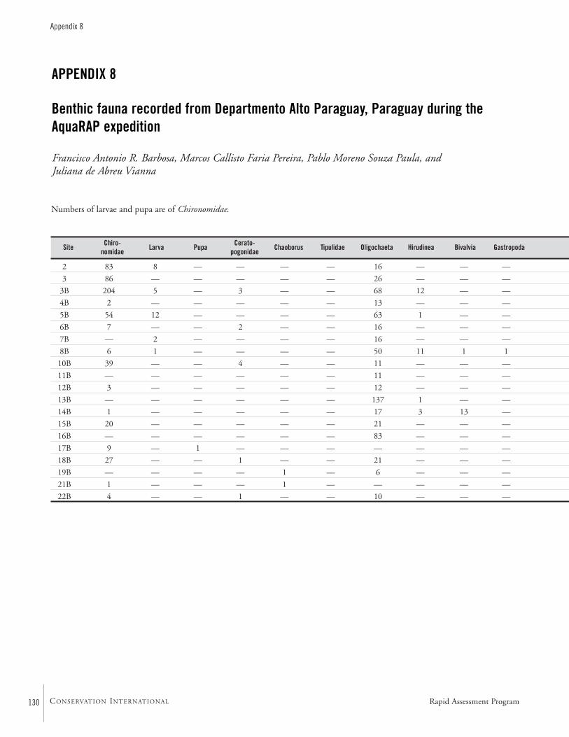
130
Appendix 8
CONSERVATION INTERNATIONAL
APPENDIX 8
Benthic fauna recorded from Departmento Alto Paraguay, Paraguay during theAquaRAP expedition
Francisco Antonio R. Barbosa, Marcos Callisto Faria Pereira, Pablo Moreno Souza Paula, and Juliana de Abreu Vianna
2 83 8 — — — — 16 — — —
3 86 — — — — — 26 — — —
3B 204 5 — 3 — — 68 12 — —
4B 2 — — — — — 13 — — —
5B 54 12 — — — — 63 1 — —
6B 7 — — 2 — — 16 — — —
7B — 2 — — — — 16 — — —
8B 6 1 — — — — 50 11 1 1
10B 39 — — 4 — — 11 — — —
11B — — — — — — 11 — — —
12B 3 — — — — — 12 — — —
13B — — — — — — 137 1 — —
14B 1 — — — — — 17 3 13 —
15B 20 — — — — — 21 — — —
16B — — — — — — 83 — — —
17B 9 — 1 — — — — — — —
18B 27 — — 1 — — 21 — — —
19B — — — — 1 — 6 — — —
21B 1 — — — 1 — — — — —
22B 4 — — 1 — — 10 — — —
Site Chiro-nomidae Larva Pupa Cerato-
pogonidae Chaoborus Tipulidae Oligochaeta Hirudinea Bivalvia Gastropoda
Numbers of larvae and pupa are of Chironomidae.
Rapid Assessment Program
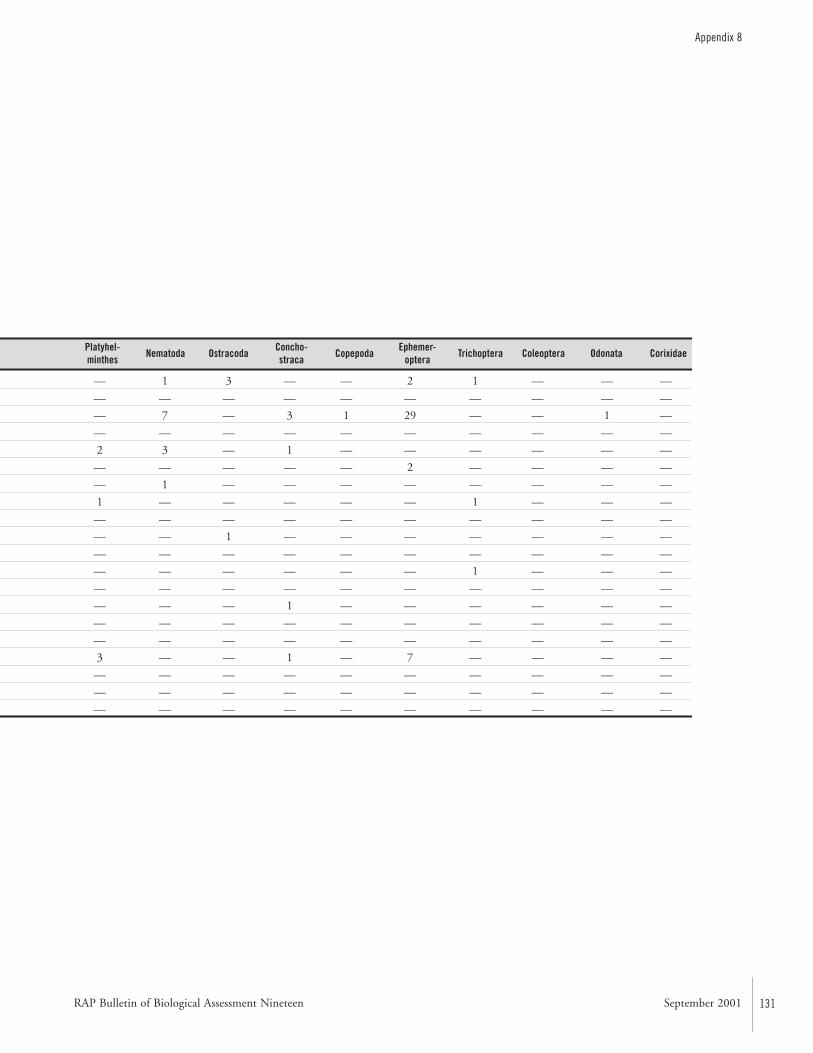
RAP Bulletin of Biological Assessment Nineteen September 2001 131
Appendix 8
— 1 3 — — 2 1 — — —
— — — — — — — — — —
— 7 — 3 1 29 — — 1 —
— — — — — — — — — —
2 3 — 1 — — — — — —
— — — — — 2 — — — —
— 1 — — — — — — — —
1 — — — — — 1 — — —
— — — — — — — — — —
— — 1 — — — — — — —
— — — — — — — — — —
— — — — — — 1 — — —
— — — — — — — — — —
— — — 1 — — — — — —
— — — — — — — — — —
— — — — — — — — — —
3 — — 1 — 7 — — — —
— — — — — — — — — —
— — — — — — — — — —
— — — — — — — — — —
Platyhel-minthes Nematoda Ostracoda Concho-
straca Copepoda Ephemer-optera Trichoptera Coleoptera Odonata Corixidae
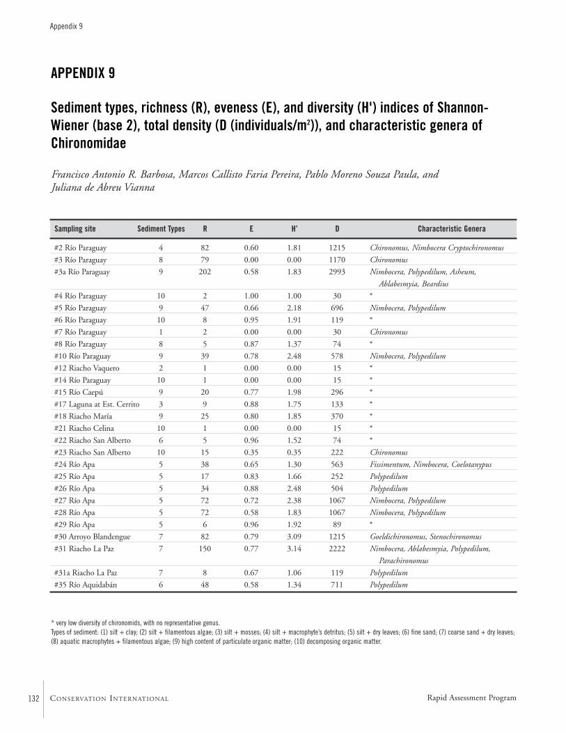
132
Appendix 9
CONSERVATION INTERNATIONAL
APPENDIX 9
Sediment types, richness (R), eveness (E), and diversity (H') indices of Shannon-Wiener (base 2), total density (D (individuals/m2)), and characteristic genera ofChironomidae
Francisco Antonio R. Barbosa, Marcos Callisto Faria Pereira, Pablo Moreno Souza Paula, and Juliana de Abreu Vianna
#2 Río Paraguay 4 82 0.60 1.81 1215 Chironomus, Nimbocera Cryptochironomus
#3 Río Paraguay 8 79 0.00 0.00 1170 Chironomus
#3a Río Paraguay 9 202 0.58 1.83 2993 Nimbocera, Polypedilum, Asheum,
Ablabesmyia, Beardius
#4 Río Paraguay 10 2 1.00 1.00 30 *
#5 Río Paraguay 9 47 0.66 2.18 696 Nimbocera, Polypedilum
#6 Río Paraguay 10 8 0.95 1.91 119 *
#7 Río Paraguay 1 2 0.00 0.00 30 Chironomus
#8 Río Paraguay 8 5 0.87 1.37 74 *
#10 Río Paraguay 9 39 0.78 2.48 578 Nimbocera, Polypedilum
#12 Riacho Vaquero 2 1 0.00 0.00 15 *
#14 Río Paraguay 10 1 0.00 0.00 15 *
#15 Río Caepú 9 20 0.77 1.98 296 *
#17 Laguna at Est. Cerrito 3 9 0.88 1.75 133 *
#18 Riacho María 9 25 0.80 1.85 370 *
#21 Riacho Celina 10 1 0.00 0.00 15 *
#22 Riacho San Alberto 6 5 0.96 1.52 74 *
#23 Riacho San Alberto 10 15 0.35 0.35 222 Chironomus
#24 Río Apa 5 38 0.65 1.30 563 Fissimentum, Nimbocera, Coelotanypus
#25 Río Apa 5 17 0.83 1.66 252 Polypedilum
#26 Río Apa 5 34 0.88 2.48 504 Polypedilum
#27 Río Apa 5 72 0.72 2.38 1067 Nimbocera, Polypedilum
#28 Río Apa 5 72 0.58 1.83 1067 Nimbocera, Polypedilum
#29 Río Apa 5 6 0.96 1.92 89 *
#30 Arroyo Blandengue 7 82 0.79 3.09 1215 Goeldichironomus, Stenochironomus
#31 Riacho La Paz 7 150 0.77 3.14 2222 Nimbocera, Ablabesmyia, Polypedilum,
Parachironomus
#31a Riacho La Paz 7 8 0.67 1.06 119 Polypedilum
#35 Río Aquidabán 6 48 0.58 1.34 711 Polypedilum
* very low diversity of chironomids, with no representative genus.Types of sediment: (1) silt + clay; (2) silt + filamentous algae; (3) silt + mosses; (4) silt + macrophyte’s detritus; (5) silt + dry leaves; (6) fine sand; (7) coarse sand + dry leaves;(8) aquatic macrophytes + filamentous algae; (9) high content of particulate organic matter; (10) decomposing organic matter.
Sampling site Sediment Types R E H’ D Characteristic Genera
Rapid Assessment Program
RAP Bulletin of Biological Assessment Nineteen September 2001 133
Appendix 10
APPENDIX 10
Specific composition of the macro-invertebrate fauna collected during the AquaRAPexpedition to the Río Paraguay and Río Apa, September 1997
Célio Magalhães
Annelida: Hirudinea
Crustacea: DecapodaPalaemonidae
Macrobrachium amazonicum ■ ■ ■ —
Macrobrachium borellii — ■ ■ —
Macrobrachium brasiliense — — ■ ■
Macrobrachium jelskii — ■ — —
Palaemonetes ivonicus — ■ — —
Pseudopalaemon sp. — ■ — —
Sergestidae
Acetes paraguayensis — ■ — —
Trichodactylidae
Dilocarcinus pagei ■ ■ — —
Poppiana argentiniana ■ — — —
Sylviocarcinus australis ■ ■ ■ —
Trichodactylus borellianus ■ ■ ■ ■
Valdivia camerani ■ — — —
Zilchiopsis oronensis ■ ■ — —
Crustacea: ConchostracaCyclestheriidae
Cysclestheria hislopi ■ ■ — —
Crustacea: Ostracoda ■ ■ — —Crustacea: AmphipodaHyallelidae
Hyallela curvispina — ■ — —
Crustacea: IsopodaCymothoidae
Gen. et sp. unindentified — ■ — —
Crustacea: BranchiuraArgulidae
Dolops carvalhoi ■ ■ — —
Dolops longicauda — ■ — —
SPECIES SUB-BASINS COLLECTEDUpper Río Lower Río Río Riacho La PazParaguay Paraguay Apa
134
Appendix 10
CONSERVATION INTERNATIONAL
Mollusca: GastropodaAncylidae
Gundlachia sp. ■ ■ — —
Ampullariidae
Marisa planogyra ■ — — —
Pomacea canaliculata ■ ■ — —
Pomacea sp. — — ■ —
Planorbidae
Biomphalaria sp. ■ ■ ■ —
Solaropsidae
Solaropsis sp. — — ■ —
Succineidae
Omalonyx sp. ■ ■ — —
Mollusca: BivalviaHyriidae
Gen. et sp. unindentified ■ ■ ■ —
Anodontites sp. — — ■ ■
Anodontites crispatus tenebricosus — ■ ■ —
Platyhelminthes: TrematodaTemnocephalidae ■ ■ ■ —
Insecta: ColeopteraCarabidae
Gen. et sp. unindentified — ■ ■ —
Chrysomelidae
Gen. et sp. unindentified ■ — — —
Curculionidae
Gen. et sp. unindentified ■ ■ — —
Dryopidae
Dryops sp. — — ■ —
Dytiscidae
Gen. et sp. unindentified ■ — — —
Celina sp. ■ ■ — —
Copelatus sp. ■ — — —
Laccophilus sp. 1 ■ ■ ■ —
Laccophilus sp. 2 — ■ — —
Laccophilus sp. 3 — ■ — —
Megadytes sp. 1 ■ ■ — —
Megadytes sp. 2 ■ — — —
Pachydrus sp. ■ — — —
Thermonectus sp. ■ ■ ■ —
Lampyridae
Gen. et sp. unindentified ■ — — —
Noteridae
SPECIES SUB-BASINS COLLECTEDUpper Río Lower Río Río Riacho La PazParaguay Paraguay Apa
Rapid Assessment Program
RAP Bulletin of Biological Assessment Nineteen September 2001 135
Appendix 10
Canthydrus sp. 1 ■ — — —
Canthydrus sp. 2 ■ — — —
Canthydrus sp. 3 ■ — — —
Hydrocanthus sp. 1 ■ — ■ —
Hydrocanthus sp. 2 ■ — — —
Mesonoterus sp. ■ — — —
Suphis sp. 1 ■ — — —
Suphis sp. 2 ■ — — —
Gyrinidae
Gen. et sp. unindentified — ■ — —
Gyrinus sp. — — ■ —
Hydrophilidae
Gen. et sp. unindentified ■ — ■ —
Hydrobiinae ■ ■ ■ —
Berosus sp. ■ — — —
Derallus sp. ■ ■ — —
Hydrochus sp. — ■ — —
Tropisternus sp. 1 ■ ■ ■ n
Tropisternus sp. 2 ■ ■ ■ —
Tropisternus sp. 3 — — ■ —
Scarabaeidae
Dynastinae ■ — — —
Scirtidae
Gen. et sp. unindentified ■ ■ — —
Insecta: DermapteraGen. et sp. unindentified ■ — — —
Insecta: DipteraCeratopogonidae
Gen. et sp. unindentified — ■ — —
Chironomidae
Gen. et sp. unindentified ■ — — —
Chironominae ■ — — —
Orthocladinae ■ — — —
Tanypodinae ■ ■ — —
Culicidae
Gen. et sp. unindentified ■ — ■ —
Insecta: EphemeropteraBaetidae
Gen. et sp. unindentified — — ■ —
Baetis sp. — — ■ ■
Caenidae
Caenis sp. ■ — ■ —
Leptophlebiidae
SPECIES SUB-BASINS COLLECTEDUpper Río Lower Río Río Riacho La PazParaguay Paraguay Apa
136
Appendix 10
CONSERVATION INTERNATIONAL
Farrodes sp. — — ■ —
Tricorythidae
Tricorythodes sp. — — ■ —
Insecta: HemipteraBelostomatidae
Belostoma bergi ■ — ■ —
Belostoma dentatum — — — ■
Belostoma denticolle ■ — — —
Belostoma pygmeum ■ ■ ■ —
Belostoma triangulum ■ ■ — —
Belostoma cf. venezuelae — — — ■
Corixidae
Tenagobia sp. ■ — ■ —
Gelastocoridae
Gen. et sp. unindentified — — ■ —
Naucoridae
? Pelocoris sp. — ■ ■ —
Nepidae
Ranatra sp. — — ■ —
Ranatra parvula ■ — — —
Ranatra cf. parvula — — ■ —
Insecta: LepidopteraFamily unidentified — ■ — —
Pyralidae
Gen. et sp. unindentified ■ — — —
Insecta: MegalopteraCorydalidae
Corydalus sp. — — ■ ■
Insecta: OdonataAeshnidae
Coryphaeschna adnexa ■ ■ — —
Calopterigidae
Hetaerina sp. — — ■ ■
Coenagrionidae
Gen. et sp. unindentified ■ ■ — —
? Acanthagrion sp. — — ■ —
Argia sp. ■ — — —
Ishnura sp. ■ — — —
? Telebasis sp. — ■ — —
Gomphidae
Cyanogomphus sp. — — ■ —
Phyllocycla sp. — ■ ■ ■
SPECIES SUB-BASINS COLLECTEDUpper Río Lower Río Río Riacho La PazParaguay Paraguay Apa
Rapid Assessment Program
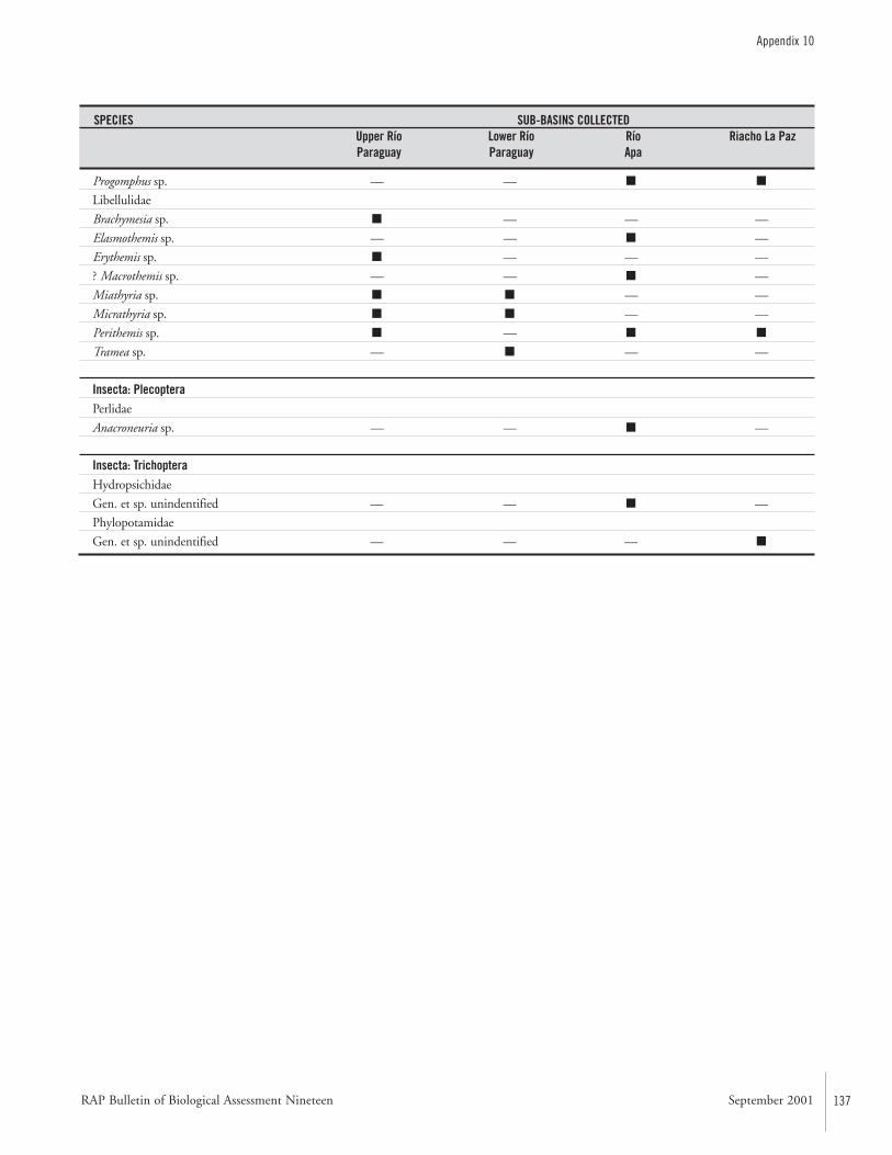
RAP Bulletin of Biological Assessment Nineteen September 2001 137
Appendix 10
Progomphus sp. — — ■ ■
Libellulidae
Brachymesia sp. ■ — — —
Elasmothemis sp. — — ■ —
Erythemis sp. ■ — — —
? Macrothemis sp. — — ■ —
Miathyria sp. ■ ■ — —
Micrathyria sp. ■ ■ — —
Perithemis sp. ■ — ■ ■
Tramea sp. — ■ — —
Insecta: PlecopteraPerlidae
Anacroneuria sp. — — ■ —
Insecta: TrichopteraHydropsichidae
Gen. et sp. unindentified — — ■ —
Phylopotamidae
Gen. et sp. unindentified — — — ■
SPECIES SUB-BASINS COLLECTEDUpper Río Lower Río Río Riacho La PazParaguay Paraguay Apa
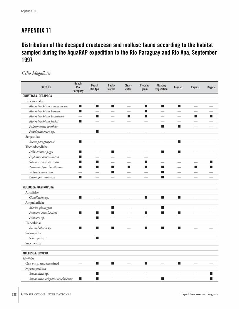
138
Appendix 11
CONSERVATION INTERNATIONAL
APPENDIX 11
Distribution of the decapod crustacean and mollusc fauna according to the habitatsampled during the AquaRAP expedition to the Río Paraguay and Río Apa, September1997
Célio Magalhães
CRUSTACEA: DECAPODAPalaemonidae
Macrobrachium amazonicum ■ ■ ■ — ■ ■ ■ — —
Macrobrachium borellii ■ — — — ■ — — — —
Macrobrachium brasiliense — ■ — ■ ■ — — ■ ■
Macrobrachium jelskii ■ — — — — — — — —
Palaemonetes ivonicus ■ ■ — —
Pseudopalaemon sp. — ■ — — — —
Sergestidae
Acetes paraguayensis ■ — — — — — ■ — —
Trichodactylidae
Dilocarcinus pagei ■ — ■ — — ■ ■ — —
Poppiana argentiniana ■ — — — —
Sylviocarcinus australis ■ ■ — — ■ — — — ■
Trichodactylus borellianus ■ ■ ■ ■ ■ ■ — ■ ■
Valdivia camerani — — ■ — — ■ — — —
Zilchiopsis oronensis ■ — — — — ■ — — —
MOLLUSCA: GASTROPODAAncylidae
Gundlachia sp. ■ — — — ■ ■ ■ — —
Ampullariidae
Marisa planogyra — — ■ — — ■ — — —
Pomacea canaliculata ■ ■ ■ — ■ ■ ■ — —
Pomacea sp. — ■ — — —
Planorbidae
Biomphalaria sp. ■ ■ ■ — ■ ■ ■ — —
Solaropsidae
Solaropsis sp. ■
Succineidae
MOLLUSCA: BIVALVIAHyriidae
Gen et sp. undetermined — ■ ■ — ■ — ■ — —
Mycetopodidae
Anodontites sp. — ■ — — — — — — ■
Anodontites crispatus tenebricosus ■ ■ — — — ■ — — ■
BeachRío
Paraguay
BeachRío Apa
Back-waters
Clear-water
Floodedplain
Floatingvegetation Lagoon Rapids CrypticSPECIES
Rapid Assessment Program
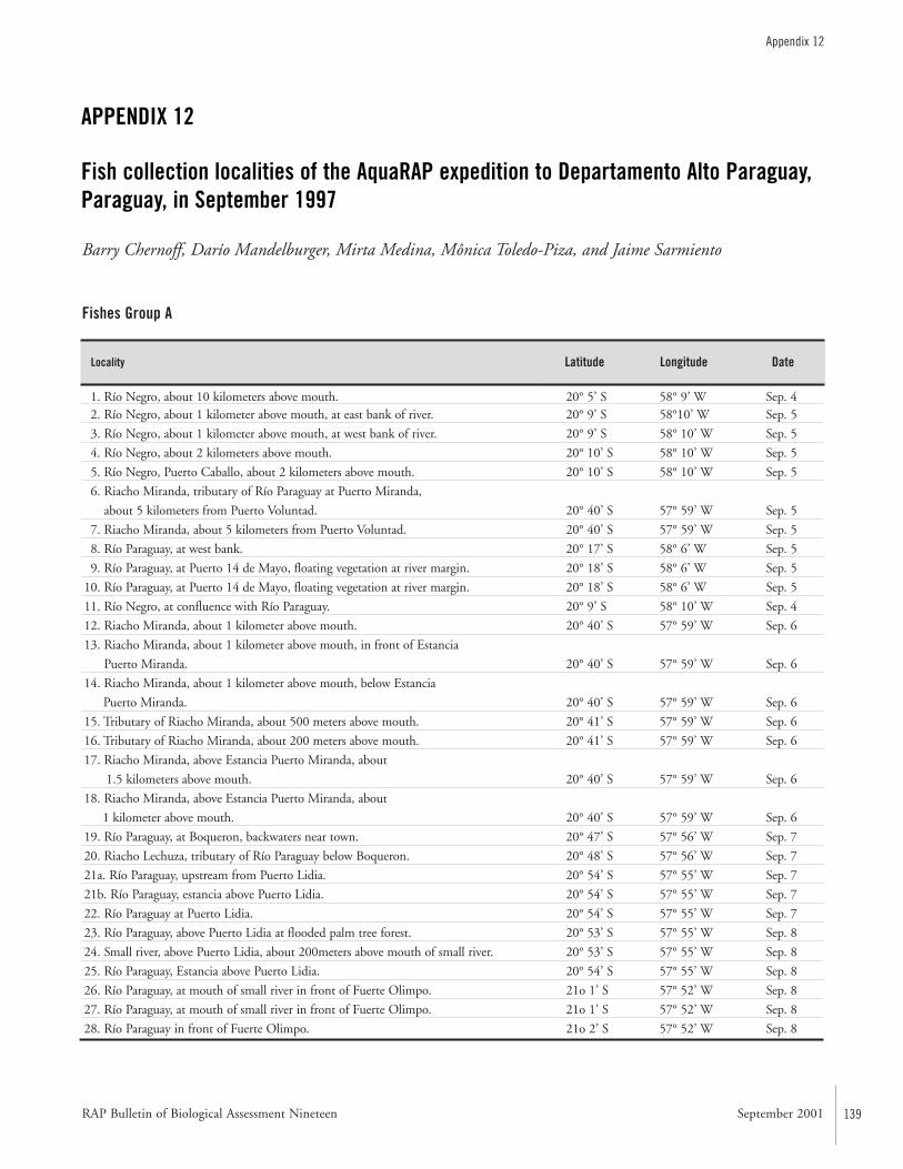
RAP Bulletin of Biological Assessment Nineteen September 2001 139
Appendix 12
1. Río Negro, about 10 kilometers above mouth. 20° 5’ S 58° 9’ W Sep. 42. Río Negro, about 1 kilometer above mouth, at east bank of river. 20° 9’ S 58°10’ W Sep. 5
3. Río Negro, about 1 kilometer above mouth, at west bank of river. 20° 9’ S 58° 10’ W Sep. 5
4. Río Negro, about 2 kilometers above mouth. 20° 10’ S 58° 10’ W Sep. 5
5. Río Negro, Puerto Caballo, about 2 kilometers above mouth. 20° 10’ S 58° 10’ W Sep. 5
6. Riacho Miranda, tributary of Río Paraguay at Puerto Miranda,
about 5 kilometers from Puerto Voluntad. 20° 40’ S 57° 59’ W Sep. 5
7. Riacho Miranda, about 5 kilometers from Puerto Voluntad. 20° 40’ S 57° 59’ W Sep. 5
8. Río Paraguay, at west bank. 20° 17’ S 58° 6’ W Sep. 5
9. Río Paraguay, at Puerto 14 de Mayo, floating vegetation at river margin. 20° 18’ S 58° 6’ W Sep. 5
10. Río Paraguay, at Puerto 14 de Mayo, floating vegetation at river margin. 20° 18’ S 58° 6’ W Sep. 5
11. Río Negro, at confluence with Río Paraguay. 20° 9’ S 58° 10’ W Sep. 4
12. Riacho Miranda, about 1 kilometer above mouth. 20° 40’ S 57° 59’ W Sep. 6
13. Riacho Miranda, about 1 kilometer above mouth, in front of Estancia
Puerto Miranda. 20° 40’ S 57° 59’ W Sep. 6
14. Riacho Miranda, about 1 kilometer above mouth, below Estancia
Puerto Miranda. 20° 40’ S 57° 59’ W Sep. 6
15. Tributary of Riacho Miranda, about 500 meters above mouth. 20° 41’ S 57° 59’ W Sep. 6
16. Tributary of Riacho Miranda, about 200 meters above mouth. 20° 41’ S 57° 59’ W Sep. 6
17. Riacho Miranda, above Estancia Puerto Miranda, about
1.5 kilometers above mouth. 20° 40’ S 57° 59’ W Sep. 6
18. Riacho Miranda, above Estancia Puerto Miranda, about
1 kilometer above mouth. 20° 40’ S 57° 59’ W Sep. 6
19. Río Paraguay, at Boqueron, backwaters near town. 20° 47’ S 57° 56’ W Sep. 7
20. Riacho Lechuza, tributary of Río Paraguay below Boqueron. 20° 48’ S 57° 56’ W Sep. 7
21a. Río Paraguay, upstream from Puerto Lidia. 20° 54’ S 57° 55’ W Sep. 7
21b. Río Paraguay, estancia above Puerto Lidia. 20° 54’ S 57° 55’ W Sep. 7
22. Río Paraguay at Puerto Lidia. 20° 54’ S 57° 55’ W Sep. 7
23. Río Paraguay, above Puerto Lidia at flooded palm tree forest. 20° 53’ S 57° 55’ W Sep. 8
24. Small river, above Puerto Lidia, about 200meters above mouth of small river. 20° 53’ S 57° 55’ W Sep. 8
25. Río Paraguay, Estancia above Puerto Lidia. 20° 54’ S 57° 55’ W Sep. 8
26. Río Paraguay, at mouth of small river in front of Fuerte Olimpo. 21o 1’ S 57° 52’ W Sep. 8
27. Río Paraguay, at mouth of small river in front of Fuerte Olimpo. 21o 1’ S 57° 52’ W Sep. 8
28. Río Paraguay in front of Fuerte Olimpo. 21o 2’ S 57° 52’ W Sep. 8
APPENDIX 12
Fish collection localities of the AquaRAP expedition to Departamento Alto Paraguay,Paraguay, in September 1997
Barry Chernoff, Darío Mandelburger, Mirta Medina, Mônica Toledo-Piza, and Jaime Sarmiento
Latitude Longitude Date
Fishes Group A
Locality
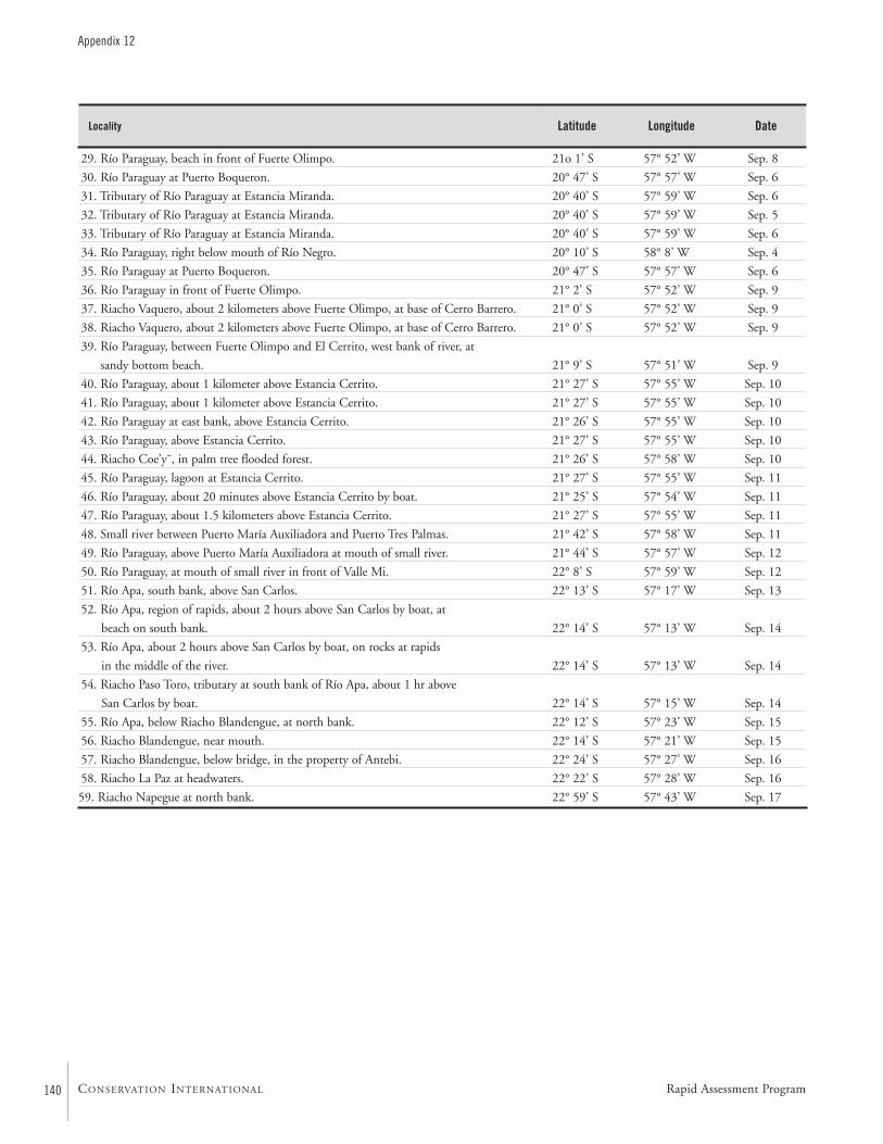
140
Appendix 12
CONSERVATION INTERNATIONAL
Latitude Longitude DateLocality
29. Río Paraguay, beach in front of Fuerte Olimpo. 21o 1’ S 57° 52’ W Sep. 8
30. Río Paraguay at Puerto Boqueron. 20° 47’ S 57° 57’ W Sep. 6
31. Tributary of Río Paraguay at Estancia Miranda. 20° 40’ S 57° 59’ W Sep. 6
32. Tributary of Río Paraguay at Estancia Miranda. 20° 40’ S 57° 59’ W Sep. 5
33. Tributary of Río Paraguay at Estancia Miranda. 20° 40’ S 57° 59’ W Sep. 6
34. Río Paraguay, right below mouth of Río Negro. 20° 10’ S 58° 8’ W Sep. 4
35. Río Paraguay at Puerto Boqueron. 20° 47’ S 57° 57’ W Sep. 6
36. Río Paraguay in front of Fuerte Olimpo. 21° 2’ S 57° 52’ W Sep. 9
37. Riacho Vaquero, about 2 kilometers above Fuerte Olimpo, at base of Cerro Barrero. 21° 0’ S 57° 52’ W Sep. 9
38. Riacho Vaquero, about 2 kilometers above Fuerte Olimpo, at base of Cerro Barrero. 21° 0’ S 57° 52’ W Sep. 9
39. Río Paraguay, between Fuerte Olimpo and El Cerrito, west bank of river, at
sandy bottom beach. 21° 9’ S 57° 51’ W Sep. 9
40. Río Paraguay, about 1 kilometer above Estancia Cerrito. 21° 27’ S 57° 55’ W Sep. 10
41. Río Paraguay, about 1 kilometer above Estancia Cerrito. 21° 27’ S 57° 55’ W Sep. 10
42. Río Paraguay at east bank, above Estancia Cerrito. 21° 26’ S 57° 55’ W Sep. 10
43. Río Paraguay, above Estancia Cerrito. 21° 27’ S 57° 55’ W Sep. 10
44. Riacho Coe’y˘, in palm tree flooded forest. 21° 26’ S 57° 58’ W Sep. 10
45. Río Paraguay, lagoon at Estancia Cerrito. 21° 27’ S 57° 55’ W Sep. 11
46. Río Paraguay, about 20 minutes above Estancia Cerrito by boat. 21° 25’ S 57° 54’ W Sep. 11
47. Río Paraguay, about 1.5 kilometers above Estancia Cerrito. 21° 27’ S 57° 55’ W Sep. 11
48. Small river between Puerto María Auxiliadora and Puerto Tres Palmas. 21° 42’ S 57° 58’ W Sep. 11
49. Río Paraguay, above Puerto María Auxiliadora at mouth of small river. 21° 44’ S 57° 57’ W Sep. 12
50. Río Paraguay, at mouth of small river in front of Valle Mi. 22° 8’ S 57° 59’ W Sep. 12
51. Río Apa, south bank, above San Carlos. 22° 13’ S 57° 17’ W Sep. 13
52. Río Apa, region of rapids, about 2 hours above San Carlos by boat, at
beach on south bank. 22° 14’ S 57° 13’ W Sep. 14
53. Río Apa, about 2 hours above San Carlos by boat, on rocks at rapids
in the middle of the river. 22° 14’ S 57° 13’ W Sep. 14
54. Riacho Paso Toro, tributary at south bank of Río Apa, about 1 hr above
San Carlos by boat. 22° 14’ S 57° 15’ W Sep. 14
55. Río Apa, below Riacho Blandengue, at north bank. 22° 12’ S 57° 23’ W Sep. 15
56. Riacho Blandengue, near mouth. 22° 14’ S 57° 21’ W Sep. 15
57. Riacho Blandengue, below bridge, in the property of Antebi. 22° 24’ S 57° 27’ W Sep. 16
58. Riacho La Paz at headwaters. 22° 22’ S 57° 28’ W Sep. 16
59. Riacho Napegue at north bank. 22° 59’ S 57° 43’ W Sep. 17
Rapid Assessment Program
RAP Bulletin of Biological Assessment Nineteen September 2001 141
Appendix 12
Latitude Longitude DateLocality
1. Río Negro, about 3 kilometers above mouth. 20° 8’ S 58° 9’ W Sep. 5
2. Río Negro, about 2.5 kilometers above mouth. 20° 9’ S 58° 10’ W Sep. 5
3. Riacho Miranda, about 200 meters from Estancia Miranda. 20° 40’ S 57o 59’ W Sep. 6
4. Riacho Miranda, about 4 kilometers from Estancia Miranda. 20° 38’ S 58° 0’ W Sep. 6
5. Río Paraguay, near Riacho Miranda. 20° 41’ S 57o 59’ W Sep. 6
6. Río Paraguay, Estancia Voluntad at Puerto Voluntad. 20° 42’ S 57o 57’ W Sep. 6
7. Río Paraguay, about 700 meters from Puerto Boqueron. 20° 47’ S 57o 57’ W Sep. 6
8. Río Paraguay, about 2 kilometers below Puerto Boqueron. 20° 46’ S 57o 57’ W Sep. 6
9. Tributary of Río Paraguay, about 2 kilometers below Puerto Boqueron. 20° 48’ S 57o 56’ W Sep. 7
10. Tributary of Río Paraguay, about 2 kilometers below Puerto Boqueron. 20° 48’ S 57o 56’ W Sep. 7
11. Riacho Lechuza, below Puerto Boqueron. 20°48’ S 57o 56’ W Sep. 7
12. Río Paraguay, in front of Estancia Puerto Lidia at Puerto Lidia. 20° 54’ S 57o 55’ W Sep. 7
13. Río Paraguay, at Puerto Lidia. 20° 54’ S 57o 55’ W Sep. 7
14. Río Paraguay, about 4 kilometers above Puerto Lidia. 20° 58’ S 57o 52’ W Sep. 8
15. Río Paraguay at Puerto Fuerte Olimpo. 21° 2’ S 57o 52’ W Sep. 9
16. Tributary of Río Paraguay, about 10 kilometers below Puerto Fuerto Olimpo. 21° 9’ S 57o 52’ W Sep. 9
17. Riacho Santa Eulalia, below Fuerte Olimpo. 21° 8’ S 57o 52’ W Sep. 9
18. Río Paraguay. 21° 6’ S 57o 56’ W Sep. 9
19. Río Paraguay, at lagoon at Estancia Cerrito. 21° 27’ S 57o 55’ W Sep. 10
20. Río Paraguay, in front of Estancia Cerrito. 21° 27’ S 57o 55’ W Sep. 10
21. Río Paraguay, at lagoon at Estancia Cerrito. 21° 27’ S 57o 55’ W Sep. 10
22. Río Paraguay, at lagoon about 200 meters from large lagoon at Estancia Cerrito. 21° 27’ S 57o 55’ W Sep. 10
23. Río Paraguay, above Estancia Cerrito. 21° 26’ S 57o 55’ W Sep. 10
24. Río Paraguay, above Estancia Cerrito. 21° 26’ S 57° 55’ W Sep. 11
25. Río Paraguay, about 1 kilometer below Estancia Cerrito. 21° 29’ S 57° 56’ W Sep. 10
26. Río Paraguay, at backwaters connecting with river. 21° 35’ S 57° 55’ W Sep. 11
27. Río Paraguay, at backwaters connecting with river, about 30 meters from beach at river. 21° 48’ S 57° 55’ W Sep. 12
28. Riacho Celina. 21° 49’ S 57° 57’ W Sep. 12
29. Tributary of Río Paraguay, about 200 meters above confluence with Río Paraguay. 21° 52’ S 57° 55’ W Sep. 12
30. Río Apa, at beach about 5 kilometers above its mouth. 22° 6’ S 57° 55’ W Sep. 13
31. Río Apa, at small embayment near its mouth. 22° 7’ S 57° 55’ W Sep. 13
32. Río Apa, at small embayment. 22° 7’ S 57° 53’ W Sep. 13
33. Riacho Mosquito, at lagoon about 1 kilometer from Estancia Ybytupora. 22° 7’ S 58° 0’ W Sep. 14
34. Riacho Puerto Esperanza at swampy area. 22° 4’ S 57° 59’ W Sep. 14
35. Tributary of Río Paraguay at swampy backwater area. 22° 14’ S 57° 58’ W Sep. 14
36. Tributary of Río Paraguay at swampy area. 22° 14’ S 57° 58’ W Sep. 14
37. Riacho Cande, in front of Puerto Casado, at backwaters. 22° 16’ S 57° 58’ W Sep. 14
38. Tributary of Río Paraguay, about 500 meters below Puerto Casado. 22° 16’ S 57° 55’ W Sep. 14
39. Río Apa, at sandbanks in front area of rapids. 22° 7’ S 57° 51’ W Sep. 15
40. Río Apa, at swampy area in backwaters, about 500 meters from river. 22° 7’ S 57° 51’ W Sep. 15
41. Río Apa, at small embayment. 22° 7’ S 57° 49’ W Sep. 15
42. Río Apa, embayment surrounded by sand banks. 22° 8’ S 57° 51’ W Sep. 15
43. Riacho La Paz, near mouth. 22° 24’ S 57° 48’ W Sep. 16
44. Riacho La Paz, at embayment connecting with river about 80 meters from margin. 22° 24’ S 57° 48’ W Sep. 16
45. Riacho La Paz, at embayment on south side. 22° 24’ S 57° 46’ W Sep. 16
Fishes Group B
142
Appendix 12
CONSERVATION INTERNATIONAL
Latitude Longitude DateLocality
46. Riacho La Paz above mouth of Riacho Primavera. 22° 24’ S 57° 43’ W Sep. 16
47. Río Paraguay at Laguna Tayara, above Puerto Itacua. 22° 27’ S 57° 51’ W Sep. 16
48. Río Paraguay at Puerto Itacua. 22° 29’ S 57° 50’ W Sep. 16
49. Riacho Napegue at margin. 22° 58’ S 57° 43’ W Sep. 17
50. Río Paraguay at ganadera Tango, kilometer 353, at west bank. 23° 7’ S 57° 38’ W Sep. 17
51. Río Aquidabán, near mouth. 23° 4’ S 57° 32’ W Sep. 18
Rapid Assessment Program
RAP Bulletin of Biological Assessment Nineteen September 2001 143
Appendix 13
APPENDIX 13
List of fishes and the subregions where they were collected during the AquaRAPexpedition to Departamento Alto Paraguay, Paraguay, in September 1997
Barry Chernoff, Darío Mandelburger, Mirta Medina, Mônica Toledo-Piza, and Jaime Sarmiento
RajiformesPotamotrygonidae
Potamotrygon histrix — — — — ■
Potamotrygon motoro — — ■ — —
LepidosireniformesLepidosirenidae
Lepidosiren paradoxa — ■ — — —
CharaciformesAnostomidae
Leporinus friderici — ■ — — —
Leporinus friderici acutidens — — — ■ —
Leporinus lacustris — ■ — — —
Leporinus cf. obtusidens — — ■ — —
Leporinus striatus — — — ■ —
Schizodon cf. dissimile — ■ ■ — —
Characidae
Acestrorhynchus pantaneiro — ■ ■ — —
Aphyocharax anisitsi ■ ■ ■ ■ ■
Aphyocharax dentatus — ■ ■ ■ ■
Aphyocharax paraguayensis — — ■ ■ ■
Astyanax fasciatus — — — ■ ■
Astyanax lineatus — — — ■ ■
Astyanax marionae — — — ■ —
Astyanax paraguayensis — ■ ■ ■ ■
Brachychalcinus retrospina — — — ■ ■
Brycon sp. ■ ■ — — —
Bryconamericus exodon — ■ ■ ■ ■
Bryconamericus cf. exodon — — ■ — —
Bryconamericus sp. 1 — — — ■ ■
Bryconamericus sp. 2 — ■ ■ ■ ■
Bryconamericus sp. 3 — ■ — ■ —
Characidae sp. — — — ■ —
Characidium cf. fasciatum ■ ■ ■ ■ ■
Río NegroUpper RíoParaguay
Lower RíoParaguay
Río Apa Riacho La Paz
144
Appendix 13
CONSERVATION INTERNATIONAL
Characidium sp. 1 — ■ — — —
Characidium sp. 2 — — — — ■
Charax leticiae — — ■ ■ —
Charax sp. — ■ — — —
Charax stenopterus — — ■ — —
Cheirodon piaba — ■ ■ ■ ■
Cheirodon cf. piaba — ■ ■ ■ —
Cheirodon sp. 1 — — — ■ —
Cheirodon sp. 2 — ■ ■ — —
Cheirodon sp. 3 — ■ — — —
Cheirodon cf. stenodon ■ — — — —
Cheirodontinae sp. — ■ — — —
Clupeacharax anchoveoides — — — ■ —
Ctenobrycon pelegrini — ■ ■ — —
Galeocharax gulo — — ■ — —
Gymnocorymbus ternetzi — ■ ■ — —
Hemigrammus cf. lunatus — ■ ■ ■ ■
Hemigrammus cf. tridens — — ■ — —
Holoshesthes pequira ■ ■ ■ ■ ■
Holoshesthes cf. pequira — ■ — — —
Hyphessobrycon eques — ■ ■ ■ —
Hyphessobrycon maxillaris — ■ — — —
Hyphessobrycon sp. 1 — — ■ — —
Hyphessobrycon sp. 2 — — ■ — —
Jupiaba acanthogaster — — — ■ —
Metynnis mola ■ ■ ■ — —
Microcharacidium sp. — ■ ■ — —
Moenkhausia dichroura ■ ■ ■ ■ ■
Moenkhausia intermedia — — ■ ■ ■
Moenkhausia sanctaefilomenae — ■ ■ ■ —
Monotocheirodon cf. sp. ■ — — — —
Myleus tiete — ■ ■ — —
Mylossoma duriventre — ■ — — —
Odontostilbe paraguayensis ■ ■ ■ ■ ■
Odontostilbe sp. — — — ■ —
Piabarchus cf. analis — — — ■ ■
Piabucus melanostomus — ■ — ■ —
Piaractus mitrei ■ ■ — — —
Poptella paraguayensis — — — ■ —
Prionobrama paraguayensis — ■ ■ ■ —
Pristobrycon sp. ■ ■ ■ — ■
Psellogrammus kennedyi ■ ■ ■ ■ ■
Pygocentrus nattereri ■ ■ ■ — —
Roeboides cf. descalvadensis — — — — ■
Roeboides paranensis — ■ ■ ■ —
Roeboides prognathus — — — ■ —
Roeboides sp. — ■ ■ — —
Río NegroUpper RíoParaguay
Lower RíoParaguay
Río Apa Riacho La Paz
Rapid Assessment Program
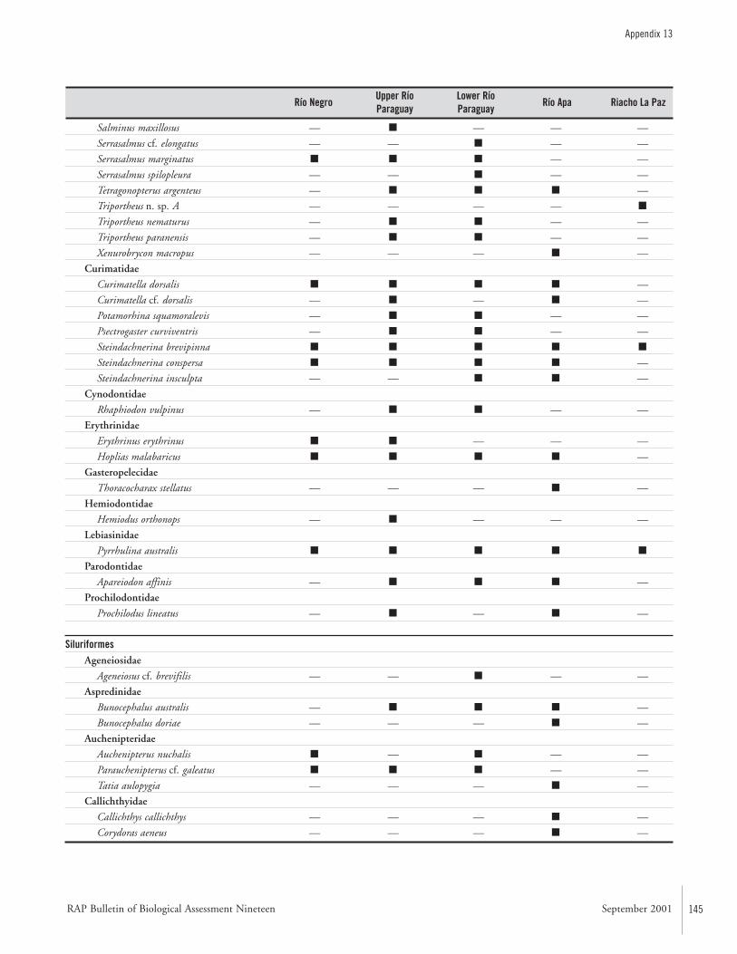
RAP Bulletin of Biological Assessment Nineteen September 2001 145
Appendix 13
Salminus maxillosus — ■ — — —
Serrasalmus cf. elongatus — — ■ — —
Serrasalmus marginatus ■ ■ ■ — —
Serrasalmus spilopleura — — ■ — —
Tetragonopterus argenteus — ■ ■ ■ —
Triportheus n. sp. A — — — — ■
Triportheus nematurus — ■ ■ — —
Triportheus paranensis — ■ ■ — —
Xenurobrycon macropus — — — ■ —
Curimatidae
Curimatella dorsalis ■ ■ ■ ■ —
Curimatella cf. dorsalis — ■ — ■ —
Potamorhina squamoralevis — ■ ■ — —
Psectrogaster curviventris — ■ ■ — —
Steindachnerina brevipinna ■ ■ ■ ■ ■
Steindachnerina conspersa ■ ■ ■ ■ —
Steindachnerina insculpta — — ■ ■ —
Cynodontidae
Rhaphiodon vulpinus — ■ ■ — —
Erythrinidae
Erythrinus erythrinus ■ ■ — — —
Hoplias malabaricus ■ ■ ■ ■ —
Gasteropelecidae
Thoracocharax stellatus — — — ■ —
Hemiodontidae
Hemiodus orthonops — ■ — — —
Lebiasinidae
Pyrrhulina australis ■ ■ ■ ■ ■
Parodontidae
Apareiodon affinis — ■ ■ ■ —
Prochilodontidae
Prochilodus lineatus — ■ — ■ —
SiluriformesAgeneiosidae
Ageneiosus cf. brevifilis — — ■ — —
Aspredinidae
Bunocephalus australis — ■ ■ ■ —
Bunocephalus doriae — — — ■ —
Auchenipteridae
Auchenipterus nuchalis ■ — ■ — —
Parauchenipterus cf. galeatus ■ ■ ■ — —
Tatia aulopygia — — — ■ —
Callichthyidae
Callichthys callichthys — — — ■ —
Corydoras aeneus — — — ■ —
Río NegroUpper RíoParaguay
Lower RíoParaguay
Río Apa Riacho La Paz
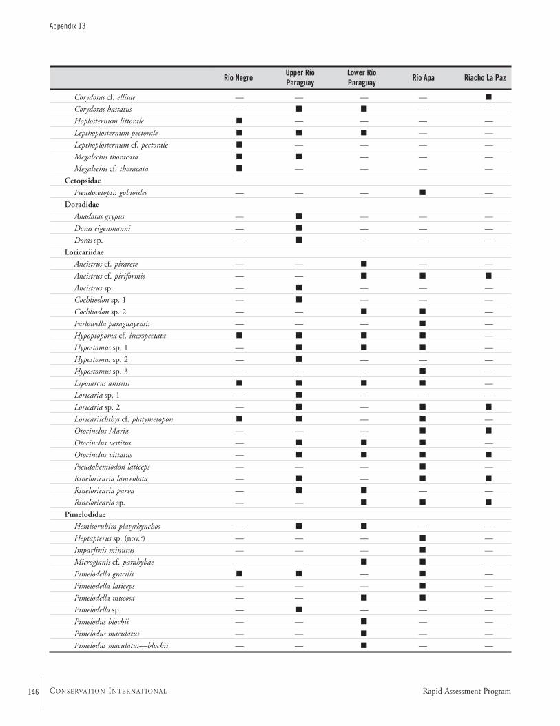
146
Appendix 13
CONSERVATION INTERNATIONAL
Corydoras cf. ellisae — — — — ■
Corydoras hastatus — ■ ■ — —
Hoplosternum littorale ■ — — — —
Lepthoplosternum pectorale ■ ■ ■ — —
Lepthoplosternum cf. pectorale ■ — — — —
Megalechis thoracata ■ ■ — — —
Megalechis cf. thoracata ■ — — — —
Cetopsidae
Pseudocetopsis gobioides — — — ■ —
Doradidae
Anadoras grypus — ■ — — —
Doras eigenmanni — ■ — — —
Doras sp. — ■ — — —
Loricariidae
Ancistrus cf. pirarete — — ■ — —
Ancistrus cf. piriformis — — ■ ■ ■
Ancistrus sp. — ■ — — —
Cochliodon sp. 1 — ■ — — —
Cochliodon sp. 2 — — ■ ■ —
Farlowella paraguayensis — — — ■ —
Hypoptopoma cf. inexspectata ■ ■ ■ ■ —
Hypostomus sp. 1 — ■ ■ ■ —
Hypostomus sp. 2 — ■ — — —
Hypostomus sp. 3 — — — ■ —
Liposarcus anisitsi ■ ■ ■ ■ —
Loricaria sp. 1 — ■ — — —
Loricaria sp. 2 — ■ — ■ ■
Loricariichthys cf. platymetopon ■ ■ — ■ —
Otocinclus Maria — — — ■ ■
Otocinclus vestitus — ■ ■ ■ —
Otocinclus vittatus — ■ ■ ■ ■
Pseudohemiodon laticeps — — — ■ —
Rineloricaria lanceolata — ■ — ■ ■
Rineloricaria parva — ■ ■ — —
Rineloricaria sp. — — ■ ■ ■
Pimelodidae
Hemisorubim platyrhynchos — ■ ■ — —
Heptapterus sp. (nov.?) — — — ■ —
Imparfinis minutus — — — ■ —
Microglanis cf. parahybae — — ■ ■ —
Pimelodella gracilis ■ ■ — ■ —
Pimelodella laticeps — — — ■ —
Pimelodella mucosa — — ■ ■ —
Pimelodella sp. — ■ — — —
Pimelodus blochii — — ■ — —
Pimelodus maculatus — — ■ — —
Pimelodus maculatus—blochii — — ■ — —
Río NegroUpper RíoParaguay
Lower RíoParaguay
Río Apa Riacho La Paz
Rapid Assessment Program
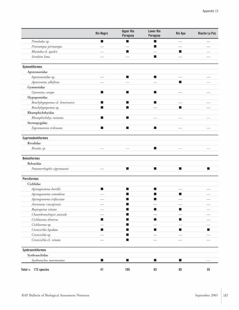
RAP Bulletin of Biological Assessment Nineteen September 2001 147
Appendix 13
Pimelodus sp. ■ ■ ■ — —
Pinirampus pirinampu — — ■ — —
Rhamdia cf. quelen — ■ — ■ —
Sorubim lima — — ■ — —
GymnotiformesApteronotidae
Apteronotidae sp. — ■ ■ — —
Apteronotus albifrons — — — ■ —
Gymnotidae
Gymnotus carapo ■ ■ ■ — —
Hypopomidae
Brachyhypopomus cf. brevirostris ■ ■ ■ — —
Brachyhypopomus sp. ■ ■ — ■ —
Rhamphichthyidae
Rhamphichthys rostratus ■ ■ — — —
Sternopygidae
Eigenmannia trilineata ■ ■ ■ — —
CyprinodontiformesRivulidae
Rivulus sp. — — ■ — —
BeloniformesBelonidae
Potamorrhaphis eigenmanni — ■ ■ ■ ■
PerciformesCichlidae
Apistogramma borellii ■ ■ ■ — —
Apistogramma commbrae — ■ ■ ■ —
Apistogramma trifasciata — ■ ■ — —
Astronotus crassipinnis — ■ — — —
Bujurquina vittata — ■ ■ ■ —
Chaetobranchopsis australe — ■ — — —
Cichlasoma dimerus ■ ■ ■ ■ —
Cichlasoma sp. — ■ — — —
Crenicichla lepidota ■ ■ ■ ■ ■
Crenicichla sp. — ■ — — —
Crenicichla cf. vittata — ■ — — —
SynbranchiformesSynbranchidae
Synbranchus marmoratus ■ ■ ■ ■ —
Total = 173 species 41 105 93 85 35
Río NegroUpper RíoParaguay
Lower RíoParaguay
Río Apa Riacho La Paz
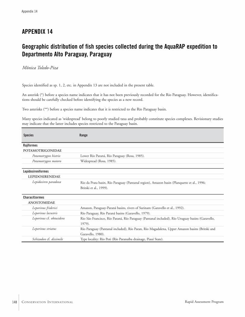
148
Appendix 14
CONSERVATION INTERNATIONAL
APPENDIX 14
Geographic distribution of fish species collected during the AquaRAP expedition toDepartmento Alto Paraguay, Paraguay
Mônica Toledo-Piza
RajiformesPOTAMOTRIGONIDAE
Potamotrygon histrix
Potamotrygon motoro
LepidosireniformesLEPIDOSIRENIDAE
Lepidosiren paradoxa
CharacifzormesANOSTOMIDAE
Leporinus friderici
Leporinus lacustris
Leporinus cf. obtusidens
Leporinus striatus
Schizodon cf. dissimile
Species identified as sp. 1, 2, etc. in Appendix 13 are not included in the present table.
An asterisk (*) before a species name indicates that it has not been previously recorded for the Río Paraguay. However, identifica-tions should be carefully checked before identifying the species as a new record.
Two asterisks (**) before a species name indicates that it is restricted to the Río Paraguay basin.
Many species indicated as ‘widespread’ belong to poorly studied taxa and probably constitute species complexes. Revisionary studiesmay indicate that the latter includes species restricted to the Paraguay basin.
Lower Río Paraná, Río Paraguay (Rosa, 1985).
Widespread (Rosa, 1985).
Rio da Prata basin, Río Paraguay (Pantanal region), Amazon basin (Planquette et al., 1996;
Britski et al., 1999).
Amazon, Paraguay-Paraná basins, rivers of Surinam (Garavello et al., 1992).
Río Paraguay, Río Paraná basins (Garavello, 1979).
Rio São Francisco, Río Paraná, Río Paraguay (Pantanal included), Río Uruguay basins (Garavello,
1979).
Río Paraguay (Pantanal included), Río Paran, Río Magadalena, Upper Amazon basins (Britski and
Garavello, 1980).Type locality: Río Poti (Río Paranaíba drainage, Piauí State).
Species Range
Rapid Assessment Program
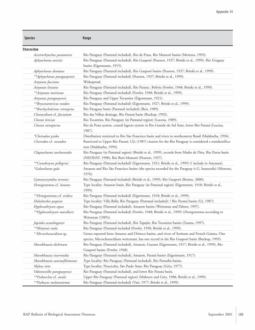
RAP Bulletin of Biological Assessment Nineteen September 2001 149
Appendix 14
CharacidaeAcestrorhynchus pantaneiro
Aphyocharax anisitsi
Aphyocharax dentatus
**Aphyocharax paraguayensis
Astyanax fasciatus
Astyanax lineatus
**Astyanax marionae
Astyanax paraguayensis
**Bryconamericus exodon
**Brachychalcinus retrospina
Characidium cf. fasciatum
Charax leticiae
Charax stenopterus
*Cheirodon piaba
Cheirodon cf. stenodon
Clupeacharax anchoveoides
**Ctenobrycon pellegrini
*Galeocharax gulo
Gymnocorymbus ternetzi
Hemigrammus cf. lunatus
**Hemigrammus cf. tridens
Holoshesthes pequira
Hyphessobrycon eques
**Hyphessobrycon maxillaris
Jupiaba acanthogaster
**Metynnis mola
* Microcharacidium sp.
Moenkhausia dichroura
Moenkhausia intermedia
Moenkhausia sanctaefilomenae
Myleus tiete
Odontostilbe paraguayensis
**Piabarchus cf. analis
**Piabucus melanostomus
Río Paraguay (Pantanal included), Rio da Prata, Río Mamoré basins (Menezes, 1992).
Río Paraguay (Pantanal included), Río Guaporé (Pearson, 1937; Britski et al., 1999), Río Uruguay
basins (Eigenmann, 1915).
Río Paraguay (Pantanal included), Río Guaporé basins (Pearson, 1937; Britski et al., 1999).
Río Paraguay (Pantanal included) (Pearson, 1937; Britski et al., 1999).
Widespread.
Río Paraguay (Pantanal included), Río Parana·, Bolivia (Fowler, 1948; Britski et al., 1999).
Río Paraguay (Pantanal included) (Fowler, 1948; Britski et al., 1999).
Río Paraguay and Upper Tocantins (Eigenmann, 1921).
Río Paraguay (Pantanal included) (Eigenmann, 1927; Britski et al., 1999).
Río Paraguay basin (Pantanal included) (Reis, 1989).
Rio das Velhas drainage, Río Paraná basin (Buckup, 1992).
Rio Tocantins, Río Paraguay (in Pantanal region) (Lucena, 1989).
Rio da Prata system, coastal lagoon system in Rio Grande do Sul State, lower Río Paraná (Lucena,
1987).
Distribution restricted to Rio São Francisco basin and rivers in northeastern Brasil (Malabarba, 1994).
Restricted to Upper Río Paraná. Uj’s (1987) citation for the Río Paraguay is considered a misidentifica-
tion (Malabarba, 1994).
Río Paraguay (in Pantanal region) (Britski et al., 1999), records from Madre de Dios, Rio Purus basin
(NEODAT, 1998), Río Beni-Mamoré (Pearson, 1937).
Río Paraguay (Pantanal included) (Eigenmann, 1921; Britski et al., 1999) (? include in Astyanax).
Amazon and Rio São Francisco basins (the species recorded for the Paraguay is G. humeralis) (Menezes,
1976).
Río Paraguay (Pantanal included) (Britski et al., 1999), Río Guaporé (Benine, 2000).
Type locality: Amazon basin, Río Paraguay (in Pantanal region) (Eigenmann, 1918; Britski et al.,
1999).
Río Paraguay (Pantanal included) (Eigenmann, 1918; Britski et al., 1999).
Type locality: Villa Bella; Río Paraguay (Pantanal included); ? Río Paraná basins (Uj, 1987).
Río Paraguay (Pantanal included), Amazon basins (Weitzman and Palmer, 1997).
Río Paraguay (Pantanal included) (Fowler, 1948; Britski et al., 1999) (Hemigrammus according to
Weitzman (1985)).
Río Paraguay (Pantanal included), Rio Tapajûs, Rio Tocantins basins (Zanata, 1997).
Río Paraguay (Pantanal included (Fowler, 1950; Britski et al., 1999).
Genus reported from Amazon and Orinoco basins, and rivers of Surinam and French Guiana. One
species, Microcharacidium weitzmani, has one record in the Río Guaporé basin (Buckup, 1993).
Río Paraguay (Pantanal included), Amazon, Guyana (Eigenmann, 1917; Britski et al., 1999), Río
Guaporé basins (Fowler, 1948).
Río Paraguay (Pantanal included), Amazon, Paraná basins (Eigenmann, 1917).
Type locality: Río Paraguay (Pantanal included), Rio Parnaíba basins.
Type locality: Piracicaba, São Paulo State; Río Paraguay (Géry, 1977).
Río Paraguay (Pantanal included), and lower Río Parana basin.
Upper Río Paraguay (Pantanal region) (Mahnert and Géry, 1988; Britski et al., 1999).
Río Paraguay (Pantanal included) (Vari, 1977; Britski et al., 1999).
Species Range
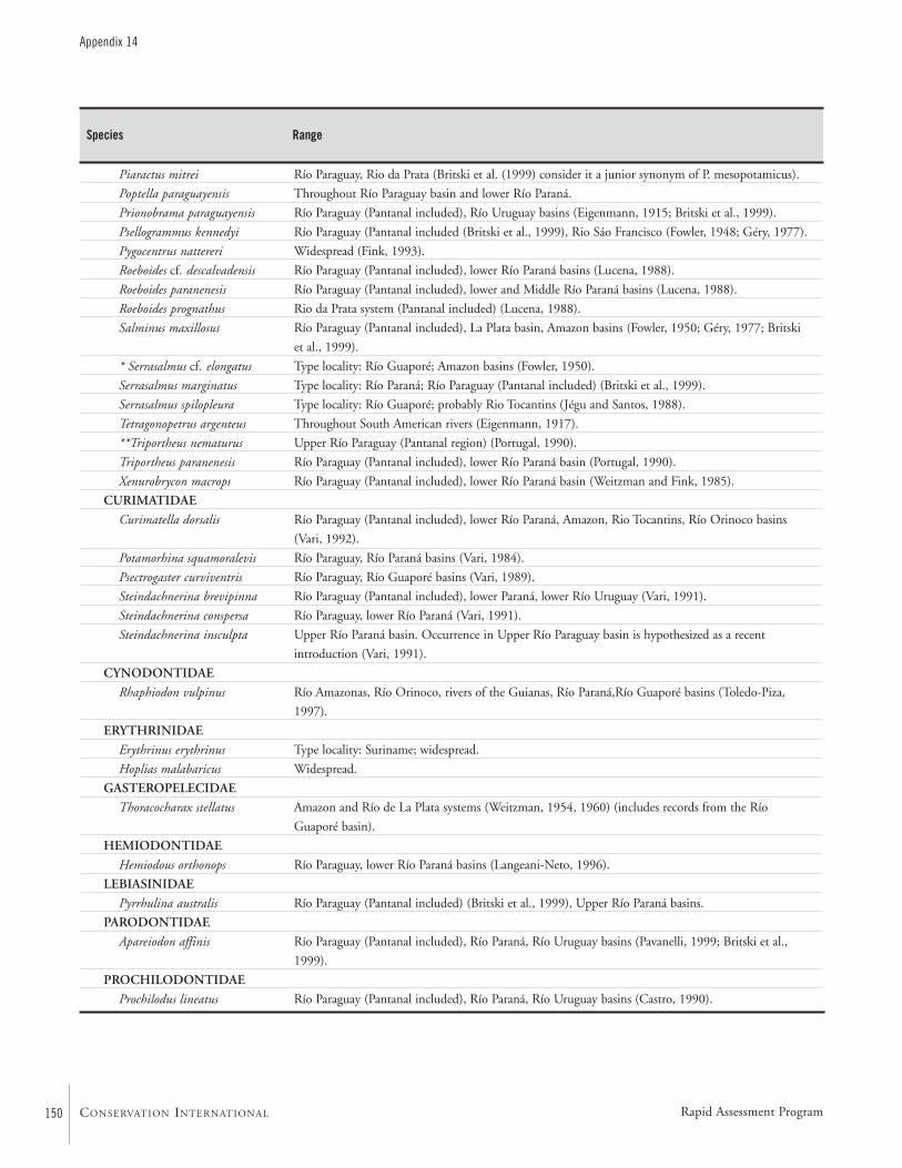
150
Appendix 14
CONSERVATION INTERNATIONAL
Species Range
Piaractus mitrei
Poptella paraguayensis
Prionobrama paraguayensis
Psellogrammus kennedyi
Pygocentrus nattereri
Roeboides cf. descalvadensis
Roeboides paranenesis
Roeboides prognathus
Salminus maxillosus
* Serrasalmus cf. elongatus
Serrasalmus marginatus
Serrasalmus spilopleura
Tetragonopetrus argenteus
**Triportheus nematurus
Triportheus paranenesis
Xenurobrycon macrops
CURIMATIDAE
Curimatella dorsalis
Potamorhina squamoralevis
Psectrogaster curviventris
Steindachnerina brevipinna
Steindachnerina conspersa
Steindachnerina insculpta
CYNODONTIDAE
Rhaphiodon vulpinus
ERYTHRINIDAE
Erythrinus erythrinus
Hoplias malabaricus
GASTEROPELECIDAE
Thoracocharax stellatus
HEMIODONTIDAE
Hemiodous orthonops
LEBIASINIDAE
Pyrrhulina australis
PARODONTIDAE
Apareiodon affinis
PROCHILODONTIDAE
Prochilodus lineatus
Río Paraguay, Rio da Prata (Britski et al. (1999) consider it a junior synonym of P. mesopotamicus).
Throughout Río Paraguay basin and lower Río Paraná.
Río Paraguay (Pantanal included), Río Uruguay basins (Eigenmann, 1915; Britski et al., 1999).
Río Paraguay (Pantanal included (Britski et al., 1999), Rio Sáo Francisco (Fowler, 1948; Géry, 1977).
Widespread (Fink, 1993).
Río Paraguay (Pantanal included), lower Río Paraná basins (Lucena, 1988).
Río Paraguay (Pantanal included), lower and Middle Río Paraná basins (Lucena, 1988).
Rio da Prata system (Pantanal included) (Lucena, 1988).
Río Paraguay (Pantanal included), La Plata basin, Amazon basins (Fowler, 1950; Géry, 1977; Britski
et al., 1999).
Type locality: Río Guaporé; Amazon basins (Fowler, 1950).
Type locality: Río Paraná; Río Paraguay (Pantanal included) (Britski et al., 1999).
Type locality: Río Guaporé; probably Rio Tocantins (Jégu and Santos, 1988).
Throughout South American rivers (Eigenmann, 1917).
Upper Río Paraguay (Pantanal region) (Portugal, 1990).
Río Paraguay (Pantanal included), lower Río Paraná basin (Portugal, 1990).
Río Paraguay (Pantanal included), lower Río Paraná basin (Weitzman and Fink, 1985).
Río Paraguay (Pantanal included), lower Río Paraná, Amazon, Rio Tocantins, Río Orinoco basins
(Vari, 1992).
Río Paraguay, Río Paraná basins (Vari, 1984).
Río Paraguay, Río Guaporé basins (Vari, 1989).
Río Paraguay (Pantanal included), lower Paraná, lower Río Uruguay (Vari, 1991).
Río Paraguay, lower Río Paraná (Vari, 1991).
Upper Río Paraná basin. Occurrence in Upper Río Paraguay basin is hypothesized as a recent
introduction (Vari, 1991).
Río Amazonas, Río Orinoco, rivers of the Guianas, Río Paraná,Río Guaporé basins (Toledo-Piza,
1997).
Type locality: Suriname; widespread.
Widespread.
Amazon and Río de La Plata systems (Weitzman, 1954, 1960) (includes records from the Río
Guaporé basin).
Río Paraguay, lower Río Paraná basins (Langeani-Neto, 1996).
Río Paraguay (Pantanal included) (Britski et al., 1999), Upper Río Paraná basins.
Río Paraguay (Pantanal included), Río Paraná, Río Uruguay basins (Pavanelli, 1999; Britski et al.,
1999).
Río Paraguay (Pantanal included), Río Paraná, Río Uruguay basins (Castro, 1990).
Rapid Assessment Program
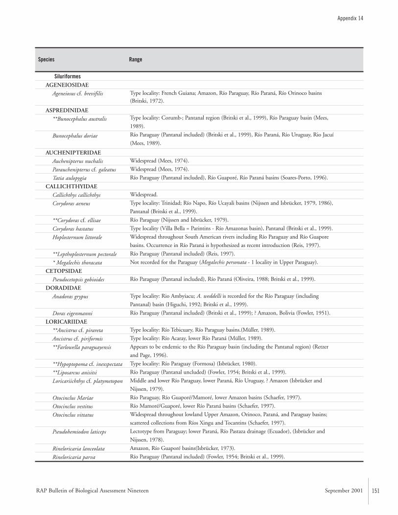
RAP Bulletin of Biological Assessment Nineteen September 2001 151
Appendix 14
Species Range
SiluriformesAGENEIOSIDAE
Ageneiosus cf. brevifilis
ASPREDINIDAE
**Bunocephalus australis
Bunocephalus doriae
AUCHENIPTERIDAE
Auchenipterus nuchalis
Parauchenipterus cf. galeatus
Tatia aulopygia
CALLICHTHYIDAE
Callichthys callichthys
Corydoras aeneus
**Corydoras cf. ellisae
Corydoras hastatus
Hoplosternum littorale
**Lepthoplosternum pectorale
* Megalechis thoracata
CETOPSIDAE
Pseudocetopsis gobioides
DORADIDAE
Anadoras grypus
Doras eigenmanni
LORICARIIDAE
**Ancistrus cf. pirareta
Ancistrus cf. piriformis
**Farlowella paraguayensis
**Hypoptopoma cf. inexspectata
**Liposarcus anisitsi
Loricariichthys cf. platymetopon
Otocinclus Maríae
Otocinclus vestitus
Otocinclus vittatus
Pseudohemiodon laticeps
Rineloricaria lanceolata
Rineloricaria parva
Type locality: French Guiana; Amazon, Río Paraguay, Río Paraná, Río Orinoco basins(Britski, 1972).
Type locality: Corumb·; Pantanal region (Britski et al., 1999), Río Paraguay basin (Mees,
1989).
Río Paraguay (Pantanal included) (Britski et al., 1999), Río Paraná, Río Uruguay, Rio Jacuí
(Mees, 1989).
Widespread (Mees, 1974).
Widespread (Mees, 1974).
Río Paraguay (Pantanal included), Río Guaporé, Río Paraná basins (Soares-Porto, 1996).
Widespread.
Type locality: Trinidad; Río Napo, Río Ucayali basins (Nijssen and Isbrücker, 1979, 1986),
Pantanal (Britski et al., 1999).
Río Paraguay (Nijssen and Isbrücker, 1979).
Type locality (Villa Bella = Parintins - Río Amazonas basin), Pantanal (Britski et al., 1999).
Widespread throughout South American rivers including Río Paraguay and Río Guapore
basins. Occurrence in Río Paraná is hypothesized as recent introduction (Reis, 1997).
Río Paraguay (Pantanal included) (Reis, 1997).
Not recorded for the Paraguay (Megalechis personata - 1 locality in Upper Paraguay).
Río Paraguay (Pantanal included), Río Paraná (Oliveira, 1988; Britski et al., 1999).
Type locality: Rio Ambyiacu; A. weddelli is recorded for the Río Paraguay (including
Pantanal) basin (Higuchi, 1992; Britski et al., 1999).
Río Paraguay (Pantanal included) (Britski et al., 1999); ? Amazon, Bolivia (Fowler, 1951).
Type locality: Río Tebicuary, Río Paraguay basins.(Müller, 1989).
Type locality: Río Acaray, lower Río Paraná (Müller, 1989).
Appears to be endemic to the Río Paraguay basin (including the Pantanal region) (Retzer
and Page, 1996).
Type locality: Río Paraguay (Formosa) (Isbrücker, 1980).
Río Paraguay (Pantanal uncluded) (Fowler, 1954; Britski et al., 1999).
Middle and lower Río Paraguay, lower Paraná, Río Uruguay, ? Amazon (Isbrücker and
Nijssen, 1979).
Río Paraguay, Río Guaporé/Mamoré, lower Amazon basins (Schaefer, 1997).
Río Mamoré/Guaporé, lower Río Paraná basins (Schaefer, 1997).
Widespread throughout lowland Upper Amazon, Orinoco, Paraná, and Paraguay basins;
scattered collections from Ríos Xingu and Tocantins (Schaefer, 1997).
Lectotype from Paraguay; lower Paraná, Río Pastaza drainage (Ecuador), (Isbrücker and
Nijssen, 1978).
Amazon, Río Guaporé basins(Isbrücker, 1973).
Río Paraguay (Pantanal included) (Fowler, 1954; Britski et al., 1999).
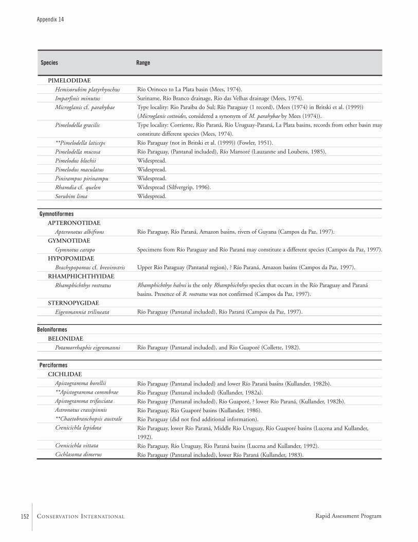
152
Appendix 14
CONSERVATION INTERNATIONAL
Species Range
PIMELODIDAE
Hemisorubim platyrhynchus
Imparfinis minutus
Microglanis cf. parahybae
Pimelodella gracilis
**Pimelodella laticeps
Pimelodella mucosa
Pimelodus blochii
Pimelodus maculatus
Pinirampus pirinampu
Rhamdia cf. quelen
Sorubim lima
GymnotiformesAPTERONOTIDAE
Apteronotus albifrons
GYMNOTIDAE
Gymnotus carapo
HYPOPOMIDAE
Brachypopomus cf. brevirostris
RHAMPHICHTHYIDAE
Rhamphichthys rostratus
STERNOPYGIDAE
Eigenmannia trilineata
BeloniformesBELONIDAE
Potamorrhaphis eigenmanni
PerciformesCICHLIDAE
Apistogramma borellii
**Apistogramma commbrae
Apistogramma trifasciata
Astronotus crassipinnis
**Chaetobranchopsis australe
Crenicichla lepidota
Crenicichla vittata
Cichlasoma dimerus
Río Orinoco to La Plata basin (Mees, 1974).
Suriname, Río Branco drainage, Rio das Velhas drainage (Mees, 1974).
Type locality: Rio Paraiba do Sul; Río Paraguay (1 record), (Mees (1974) in Britski et al. (1999))
(Microglanis cottoides, considered a synonym of M. parahybae by Mees (1974)).
Type locality: Corriente, Río Paraná, Río Uruguay-Paraná, La Plata basins, records from other basin may
constitute different species (Mees, 1974).
Río Paraguay (not in Britski et al. (1999)) (Fowler, 1951).
Río Paraguay, (Pantanal included), Río Mamoré (Lauzanne and Loubens, 1985).
Widespread.
Widespread.
Widespread.
Widespread (Silfvergrip, 1996).
Widespread.
Río Paraguay, Río Paraná, Amazon basins, rivers of Guyana (Campos da Paz, 1997).
Specimens from Río Paraguay and Río Paraná may constitute a different species (Campos da Paz, 1997).
Upper Río Paraguay (Pantanal region), ? Río Paraná, Amazon basins (Campos da Paz, 1997).
Rhamphichthys hahni is the only Rhamphichthys species that occurs in the Río Paraguay and Paraná
basins. Presence of R. rostratus was not confirmed (Campos da Paz, 1997).
Río Paraguay (Pantanal included), Río Paraná (Campos da Paz, 1997).
Río Paraguay (Pantanal included), and Río Guaporé (Collette, 1982).
Río Paraguay (Pantanal included) and lower Río Paraná basins (Kullander, 1982b).
Río Paraguay (Pantanal included) (Kullander, 1982a).
Río Paraguay (Pantanal included), Río Guaporé, ? lower Río Paraná, (Kullander, 1982b).
Río Paraguay, Río Guaporé basins (Kullander, 1986).
Río Paraguay (did not find additional information).
Río Paraguay, lower Río Paraná, Middle Río Uruguay, Río Guaporé basins (Lucena and Kullander,
1992).
Río Paraguay, Río Uruguay, Río Paraná basins (Lucena and Kullander, 1992).
Río Paraguay (Pantanal included), lower Río Paraná (Kullander, 1983).
Rapid Assessment Program
RAP Bulletin of Biological Assessment Nineteen September 2001 153
Appendix 14
Species Range
SynbranchiformesSYNBRANCHIDAE
Synbranchus marmoratus Widespread.
Literature Cited
Benine, R. 2000. Taxonomia e relaçõıes filogenéticas deGymnocorymbus Eigenmann, 1908 (Characiformes,Characidae). Unpublished Masters dissertation. Botucatu,Brasil: Instituto de Biociências—Universidade Estadual deSão Paulo (UNESP). 55pp.
Britski, H.A. 1972. Sistematica e evolucao dosAuchenipteridae e Ageneiosidae (Teleostei, Siluriformes).Unpublished Masters thesis. São Paulo: InstitutoBiociências da Universidade de São Paulo. 142pp.
Britski, H.A. and J.C. Garavello. 1980. Sobre uma nova espé-cie de Leporinus da bacia amazônica (Pisces, Anostomidae)com considerações sobre L. striatus Kner, 1850 e espéciesafins. Papéis Avulsos de Zoologia, São Paulo, 35:253–262.
Britski, H. A., K. Z. S. de Silimon, and B. S. Lopes. 1999.Peixes do Pantanal: manual de identificação. Brasília,Brasil: Embrapa. 184pp.
Buckup, P.A. 1992. Redescription of Characidium fasciatum,type species of the Characidiinae (Teleostei, Characi-formes) Copeia, 1992:1066–1073.
Buckup, P.A. 1993. Review of the characidiin fishes(Teleostei: Characiformes), with desriptions of four newgenera and ten new species. Ichthyological Exploration ofFreshwaters, 4:97–154.
Campos da Paz, R. 1997. Sistemática e taxonomia dos peixeselétricos das bacias dos rios Paraguai, Paraná e SãoFrancisco, comáotas sobre espécies presentes em rioscosteiros do leste do Brasil (Teleostei: Ostariophysi:Gymnotiformes). Unpublished Ph.D. dissertation. SãoPaulo: Universidade de São Paulo.
Castro, R.M.C. 1990. Revisão taxonômica da famíliaProchilodontidae (Ostariophysi: Characiformes).Unpublished Ph.D. dissertation. São Paulo: Universidadede São Paulo. 293pp.
Collette, B.B. 1982. South American freshwater needlefishesof the genus Potamorrhaphis (Beloniformes: Belonidae).Proceedings of the Biological Society of Washington,95:714–747.
Eigenmann, C.H. 1915. The Cheirodontinae, a subfamily ofminute characid fishes of South America. Memoirs of theCarnegie Museum 7:1–99.
Eigenmann, C.H. 1917. The American Characidae. part 1.Memoirs of the Museum of Comparative Zoology,43:1–102.
Eigenmann, C.H. 1918. The American Characidae. part 2.Memoirs of the Museum of Comparative Zoology,43:103–208.
Eigenmann, C.H. 1921. The American Characidae. part 3.Memoirs of the Museum of Comparative Zoology,43:209–310.
Eigenmann, C.H. 1927. The American Characidae. part 4.Memoirs of the Museum of Comparative Zoology,43:311–428.
Fink, W.L. 1993. Revision of the piranha genus Pygocentrus(Teleostei, Characiformes) Copeia, 1993:665–687.
Fowler, H.W. 1948. Os peixes de ·gua doce do Brasil (1aentrega). Arquivos de Zoologia do Estado de São Paulo,6:1–204.
154
Appendix 14
CONSERVATION INTERNATIONAL
Fowler, H.W. 1950. Os peixes de gua doce do Brasil (2aentrega). Arquivos de Zoologia do Estado de São Paulo,6:205–404.
Fowler, H.W. 1951. Os peixes de gua doce do Brasil (3aentrega). Arquivos de Zoologia do Estado de São Paulo,6:405–625.
Fowler, H.W. 1954. Os peixes de gua doce do Brasil (4aentrega). Arquivos de Zoologia do Estado de São Paulo,9:1–400.
Garavello, J.C. 1979. Revisão taxonômica do generoLeporinus Spix, 1829 (Ostariophysi, Anostomidae).Unpublished Ph.D. dissertation. São Paulo: Instituto deBiociências da Universidade de São Paulo. 451pp.
Garavello, J.C., S.F. dos Reis, and R.E. Strauss. 1992.Geographical variation in Leporinus friderici (Bloch)(Pisces: Ostariophysi: Anostomidae) from the Paraná-Paraguay and Amazon River basins. Zoologica Scripta,21:197–200.
Géry, J. 1977. Characoids of the world. Neptune City, NewJersey: T.F.H. Publications, Inc. Ltd. 672pp.
Higuchi, H. 1992. A phylogeny of the South Americanthorny catfishes (Osteichthyes: Siluriformes, Doradidae).Unpublished Ph.D. dissertation. Cambridge,Massachusetts: Harvard University. 372pp.
Isbrücker, I.J.H. 1973. Status of the primary homonymousSouth American catfish Loricaria cirrhosa Perugia, 1897,with remarks on some other loricariids (Pisces, Siluri-formes, Loricariidae). Annali Museo Civico di StoriaNaturale di Genova, 79:172–191.
Isbrücker, I.J.H. 1980. Classification and catalogue of themailed Loricariidae (Pisces, Siluriformes). Verslagen enTechnische Gegevens, 22:1–181.
Isbrücker, I.J.H. and H. Nijssen. 1978. Two new species anda new genus of neotropical mailed catfishes of the sub-family Loricariinae Swainson, 1838 (Pisces, Silurifromes,Loricariidae) Beaufortia, 27:177–206.
Isbrücker, I.J.H. and H. Nijssen. 1979. Three new SouthAmerican mailed catfishes of the genera Rineloricaria andLoricariichthys (Pisces, Siluriformes, Loricariidae).Bijdragen tot de Dierkunde, 48:191–211.
Jégu, M. and G.M. Santos. 1988. Le genre Serrasalmus(Pisces, Serrasalmidae) dans le bas Tocantins (Brésil, Par·),avec la description d’une espêce nouvelle, S. geryi, dubassin Araguaia-Tocantins. Revista HydrobiologiaTropical, 21:239–274.
Kullander, S.O. 1982a. Cichlid fishes from the La Platabasin. part II. Apistogramma commbrae (Regan, 1906).Revue Suisse de Zoologie, 89:33–48.
Kullander, S.O. 1982b. Cichlid fishes from the La Platabasin. part IV. review of the Apistogramma species, withdescription of a new species (Teleostei, Cichlidae).Zoologica Scripta, 11:307–313.
Kullander, S.O. 1983. A revision of the South Americancichlid genus Cichlasoma (Teleostei: Cichlidae).Stockholm: Naturhistoriska Riksmuseet. 296pp.
Kullander, S.O. 1986. Cichlid fishes of the Amazon Riverdrainage of Peru. Stockholm: Swedish Museum ofNatural History. 431pp.
Langeani-Neto, F. 1996. Estudo filogenético e revisão tax-onômica da família Hemiodontidae Boulenger, 1904(sensu Roberts, 1974) (Ostariophysi, Characiformes).Ph.D. dissertation. São Paulo: Universidade de São Paulo.171pp.
Lauzanne, L. and G. Loubens. 1985. Peces del río Mamoré.Paris: ORSTOM. 116pp.
Lucena, C.A.S. de. 1987. Revisão e redefinição do gêneroneotropical Charax Scopoli, 1777 com a descrição de qua-tro espécies novas (Pisces; Characiformes; Characidae).Comunicações do Museu de Ciências da PUCRS,40:5–124.
Lucena, C.A.S. de. 1988. Lista comentada das espéces dogênero Roeboides Günther, 1864 descritas para as baciasdos rios Amazonas, São Francisco e de Prata (Characi-formes, Characidae, Characinae). Comunicações doMuseu de Ciências da PUCRS, Série Zoologia, PortoAlegre 1:29–47.
Lucena, C.A.S. de. 1989. Trois nouvelles espéces du genreCharax Scopoli, 1777 pour la région Nord du Brésil(Characiformes, Characidae, Characinae). RevueFrancaise d’Aquariologie, 15:97–104.
Rapid Assessment Program
RAP Bulletin of Biological Assessment Nineteen September 2001 155
Appendix 14
Lucena, C.A.S. de and S.O. Kullander. 1992. TheCrenicichla (Teleostei: Cichlidae) species of the UruguaiRiver drainage in Brazil. Ichthyological Exploration ofFreshwaters, 3:97–160.
Mahnert, V. and J. Géry. 1988. Les genres Piabarchus Myerset Creagrutus Günther du Paraguay, avex la description dedeux nouvelles espéces (Pisces, Ostariophysi, Characidae).Revue Francaise d’Aquariologie, 15:1–8.
Malabarba, L.R. 1994. Sistem”tica e filogenia de Cheiro-dontinae (Ostariophysi: Characiformes: Characidae).Unpublished Ph.D. dissertation. São Paulo: Universidadede São Paulo. 287pp.
Mees, G.F. 1974. The Auchenipteridae and Pimelodidae ofSuriname (Pisces, Nematognathi). ZoologischeVerhandelingen, 132:1–256.
Mees, G.F. 1989. Notes on the genus Dysichthys, subfamilyBunocephalinae, family Aspredinidae (Pisces, Nema-tognathi). Proceedings of the Koninklijke NederlandseAkademie van Wetenschappen (Series C), 92:189–250.
Menezes, N.A. 1976. On the Cynopotaminae, a new sub-family of Charcidae (Osteichthyes, Ostariophysi,Characoidei). Arquivos de Zoologia, São Paulo, 28:1–91.
Menezes, N.A. 1992. Redefinição taxonômica das espécies deAcestrorhynchus do grupo lacustris com a descrição de umanova espécie (Osteichthyes, Characiformes, Characidae).Comunicações do Museu de Ciências da PUCRS, SérieZoologia, Porto Alegre, 5:39–54.
Müller, S. 1989. Description de deuz nouvelles espêcesparaguayennes du genre Ancistrus Kner, 1854 (Pisces,Siluriformes, Loricariidae). Revue Suisse de Zoologie,96:885–904.
NEODAT. 1998. Inter-Institutional Database of FishBiodiversity in the Neotropics. http://biodiversity.bio.uno.edu/~neodat/.
Nijssen, H. and I.J.H. Isbrücker. 1979. Chronological enu-merations of nominal species and subspecies of Corydoras(Pisces, Siluriformes, Callichthyidae). Bulletin ZoologischMuseum, Universiteit van Amsterdam, 6:129–135.
Nijssen, H. and I.J.H. Isbrücker. 1986. Review of the genusCorydoras from Peru and Ecuador (Pisces, Siluriformes,Callichthyidae). Studies on Neotropical Fauna andEnvironment, 21:1–68.
Oliveira, J.C. de. 1988. Osteologia e revisão sistemática deCetopsidae (Teleostei, Siluriformes). Unpublishedd Ph.D.dissertation. São Paulo: Universidade de São Paulo.242pp.
Pavanelli, C. S. 1999. Revisão taxonômica da famíliaParodontidae (Ostariophysi: Characiformes). Ph.D. dis-sertation, Universidade Federal de São Carlos, São Carlos,Brasil. 334pp.
Pearson, N.E. 1937. The fishes of the Beni-Mamoré andParaguay basins, and a discussion of the origin of theParaguayan fauna. Proceedings of the California Academyof Science, 23:99–114.
Planquette, P., P. Keith, and P.-Y. Le Bail. 1996. Atlas despoissons d’eau douce de Guyane (Tome 1). MuséumNational d’Historie Naturelle, Ministére del’Environnement. 1–431.
Portugal, L.P.S. 1990. Revisão sistematica do gêneroTriportheus Cope (Teleostei, Characiformes, Characidae).Unpublished Ph.D. dissertation, Instituto Biociências daSão Paulo: Universidade de São Paulo. 192pp.
Reis, R.E. 1989. Systematic revision of the neotropicalcharacid subfamily Stethaprioninae (Pisces, Characi-formes). Comunicações do Museu de Ciências daPUCRS, Série Zoologia, Porto Alegre, 2:3–86.
Reis, R.E. 1997. Revision of the neotropical catfish genusHoplosternum (Ostariophysi: Siluriformes:Callichthyidae), with the description of two new generaand three new species. Ichthyological Exploration ofFreshwaters, 7:299–326.
Retzer, M.E. and L.M. Page. 1996. Systematics of the stickcatfishes, Farlowella Eigenmann & Eigenmann (Pisces,Loricariidae). Proceedings of the Academy of NaturalSciences of Philadelphia, 147:33–88.
Rosa, R.S. 1985. A systematic revision of the SouthAmerican freshwater stingrays (Chondrichthyes:Potamotrygonidae). Unpublished Ph.D. dissertation,Virginia: College of William and Mary. 523pp.
Schaefer, S.A. 1997. The neotropical cascudinhos: systemat-ics and biogeography of the Otocinclus catfishes (Siluri-formes: Loricariidae). Proceedings of the Academy ofNatural Sciences of Philadelphia, 148:1–120.
156
Appendix 14
CONSERVATION INTERNATIONAL
Silfvergrip, A.M.C. 1996. A systematic revision of theneotropical catfish genus Rhamdia (Teleostei, Pime-lodidae). Stockholm: Swedish Museum of NaturalHistory. 156pp.
Soares-Porto, L.M. 1996. Análise filogenética dosCentromochlidae. redefinição e revisão taxonômica deTatia A. de Miranda Ribeiro, 1911 (Osteichthyes,Siluriformes, Doradoidea). Unpublished Ph.D. disserta-tion. São Paulo: Universidade de São Paulo. 278pp.
Toledo-Piza, M. 1997. Systematic revision of theCynodontinae (Teleostei: Ostariophysi: Characiformes).Unpublished Ph.D. dissertation. New York: The CityUniversity of New York. 394pp.
Uj, A. 1987. Les Cheirodontinae (Characidae, Ostariophysi)du Paraguay. Revue Suisse de Zoologie, 94:129–175.
Vari, R.P. 1977. Notes on the characoid subfamilyIguanodectinae, with a description of a new species.American Museum Novitates, 2612:1–6.
Vari, R.P. 1984. Systematics of the neotropical characiformgenus Potamorhina (Pisces: Characiformes). SmithsonianContributions to Zoology, 400:1–36.
Vari, R.P. 1989. Systematics of the neotropical characiformgenus Psectrogaster Eigenmann and Eigenmann (Pisces:Characiformes). Smithsonian Contributions to Zoology,481:1–43.
Vari, R.P. 1991. Systematics of the neotropical characiformgenus Steindachnerina Fowler (Pisces: Ostariophysi).Smithsonian Contributions to Zoology, 507:1–118.
Vari, R.P. 1992. Systematics of the neotropical characiformgenus Curimatella Eigenmann and Eigenmann (Pisces:Ostariophysi), with summary comments on theCurimatidae. Smithsonian Contributions to Zoology,533:1–48.
Weitzman, M. 1985. Hyphessobrycon elachys, a new minaturecharacid from eastern Paraguay (Pisces: Characiformes).Proceedings of the Biological Society of Washington,98:799–808.
Weitzman, S.H. 1954. The osteology and relationships of theSouth American characid fishes of the subfamily Gastero-pelecinae. Stanford Ichthyological Bulletin, 4:213–263.
Weitzman, S.H. 1960. Further notes on the relationshipsand classification of the South American characid fishes ofthe subfamily Gasteropelecinae. Stanford IchthyologicalBulletin, 7:217–239.
Wietzman, S.H. and S.V. Fink. 1985. Xenurobryconin phy-logeny and putative pheromone pumps in glandulocau-dine fishes (Teleostei: Characidae). SmithsonianContributions to Zoology, 421:1–121.
Wietzman, S.H. and L. Palmer. 1997. A new species ofHyphessobrycon (Teleostei: Characidae) from the Neblinaregion of Venezuela and Brazil, with comments on theputative ‘rosy tetra clade’. Ichthyological Exploration ofFreshwaters, 7:209–242.
Zanata, A.M. 1997. Jupiaba, um novo género deTetragonopterinae com osso pélvico em forma de espinho(Characidae, Characiformes). Iheringia, Série Zoologia,Porto Alegre, 83:99–136.
Rapid Assessment Program
Conservation International1919 M Street, NWSuite 600Washington, DC 20036 USA
TELEPHONE: 202-912-1000FAX: 202-912-0772
WEB: www.conservation.orgwww.biodiversityscience.org
With generous support from:
The Giuliani Family Foundation
A Biological Assessment of theAquatic Ecosystems of the RíoParaguay Basin, Alto Paraguay,Paraguay
6 Participants and Contributors
9 Organizational Profiles
11 Acknowledgements
12 Report at a Glance
14 Informe a un vistazo (Español)
16 Resumo do Relatório (Português)
18 Mombe’u (Guaraní)
20 Executive Summary
28 Resumen Ejecutivo (Español)
37 Sumário Executivo (Português)
45 Maps
47 Images
49 Chapters
108 Glossary
110 Appendices
The Field Museum1400 South Lake Shore DriveChicago, IL 60605-2496
TELEPHONE: 312-922-9410FAX: 312-665-7932
WEB: www.fieldmuseum.org
The FieldMuseum