Water-soluble stimuli responsive star-shaped segmented macromolecules

ARTICLE IN PRESS
0277-3791/$ - se
doi:10.1016/j.qu
�Correspond
sellschaft AG,
Tel.: +43-1-501
E-mail addr
Quaternary Science Reviews 24 (2005) 321–336
3-D mapping of segmented active faults in the southern Vienna Basin
Ralph Hinsch�, Kurt Decker, Michael Wagreich
Institute of Geology, University of Vienna, Althanstr. 14, A-1090 Vienna, Austria
Received 6 December 2002; accepted 27 April 2004
Abstract
In this paper we present novel data on the location and kinematics of seismically active fault segments of the Vienna Basin
Transfer Fault System in the southern Vienna Basin. Spatial mapping of active faults and kinematical analyses are based on
commercial 3-D reflection seismic data, geomorphological features such as tilted Quaternary river terraces and fault scarps, the
geometry of subsided Quaternary basins, and published geodetic data. Accordingly, active faulting in the southern Vienna Basin
occurs partly by reactivation of the Miocene fault system related to the formation of the Vienna pull-apart basin between c. 17 and
8Ma. Two domains of Quaternary and active faults can be distinguished with, (1) predominantly strike-slip and (2) mainly normal
faulting. (1) A seismically active NE-striking sinistral strike-slip fault zone with large negative flower structures is mapped at the
south-eastern margin of the basin. Subsidence within the reflection seismically imaged flower structure is documented by up to
1000 m of throw since Pannonian times and the accumulation of up to 150m thick Quaternary gravels. At the surface the fault zone
is characterized by en-echelon faults with some prominent scarps. (2) Major E-dipping normal faults branch off from the transfer
strike-slip fault system. The normal faults extend into the central and western part of the basin as well as into the urban area of
Vienna. Close to Vienna, the normal offset along such a normal fault is at minimum 300m since Pannonian times. Surface
expressions of active normal faulting are tilted Quaternary terraces of the Danube river and tilted ancient land surfaces in the
hanging wall of the normal faults. The mapped active normal faults are kinematically linked by a common detachment horizon,
which is in contact with the seismically active strike-slip zone along the south-eastern border of the basin. Northeast of the Vienna
Basin the seismically active zone continues as a straight line indicating a rather linear transfer fault zone than a pull-apart step over
geometry.
r 2004 Elsevier Ltd. All rights reserved.
1. Introduction
The southern Vienna Basin is a prominent site ofmoderate seismicity with medium sized earthquakes(M0 �5.0–5.5) returning at periods of several decades(ZAMG, 2001; e.g., Schwadorf 1927 with M=5.2;Fig. 1). The distribution of earthquake epicentres,active fault kinematics resolved from focal solutions,and the few available dynamic data suggest thatearthquakes occur on reactivated faults of the ViennaBasin Transfer Fault System, which are inherited from
e front matter r 2004 Elsevier Ltd. All rights reserved.
ascirev.2004.04.011
ing author. Current address: Rohoel-Aufsuchungsge-
Schwarzen bergerplatz 16, A-1015 Vienna, Austria
16-301; fax: +43-1-50116-223.
ess: [email protected] (R. Hinsch).
Miocene strike-slip faulting and pull-apart formation(Decker et al., 2005). Miocene deformation in theVienna Basin was distributed over a dense networkof kinematically linked faults covering the entire areaof the basin and the adjacent basin margins. Thesefaults are generally very well known due to extensivehydrocarbon exploration in the basin providing severalthousand kilometres of 2-D seismic, c. 500 km2 of3-D seismic data, and several thousand drill holes(Sauer et al., 1992; Kroll and Wessely, 1993). Majorfaults typically are spaced at distances of only fewkilometres showing splays and branches, and convergeto depth (Fig 1). The past kinematics of the faults andtheir interaction has been analysed by several studies(Fodor, 1995; Decker, 1996; see Decker et al., 2005,for a review).

ARTICLE IN PRESS
Fig. 1. Structural setting and seismicity of the Vienna Basin. Inset: Main structural units in the Eastern Alpine–Carpathian region (modified after
Decker, 1996), VB: Vienna basin, VBTF: Vienna Basin Transfer Fault. The main map shows the faulted pre-Neogene basement surface (modified
from Kroll and Wessely, 1993) and earthquake epicentres since 1201 BC (ZAMG, 2001). The rectangle marks the position of the 3-D seismic survey.
Labelled points: (1) Leopoldsdorf Fault, (2) Steinberg Fault, (3) transition to Mur-Murz Fault. A: Austria, CZ: Czech Republic, H: Hungaria; SK:
Slovakia.
R. Hinsch et al. / Quaternary Science Reviews 24 (2005) 321–336322
Geological evidences of active faulting in the Viennabasin is usually limited to sparse single outcrops (e.g.,Kummel, 1935; Fink et al., 1958; Kupper, 1971) orhave been inferred from lineament analysis of remotesensing data (Hausler et al., 2002). Therefore, the
knowledge of the location of active faults and theirkinematics is very low in contrast to the accurate dataon Miocene faults. This is mainly due to the limitedaccuracy of available earthquake hypocenter determi-nations with errors of several kilometres both in

ARTICLE IN PRESSR. Hinsch et al. / Quaternary Science Reviews 24 (2005) 321–336 323
horizontal and vertical directions. Earthquake loca-tion errors are typically larger than the spacing ofmapped Miocene faults and do not allow to discrimi-nate active and inactive faults. As a result, it is notknown, where exactly the active faults are located, howthey are segmented and how these segments interactkinematically. However, such data are among the mostimportant input parameters for realistic seismic hazardestimates in a densely populated and highly vulnerableregion such as the Vienna Basin, e.g., for estimatingthe maximum magnitude of a future earthquake(Schwarz and Coppersmith, 1984; Wells and Copper-smith, 1994). In general, geological data might con-tribute to determine seismogenic fault segmentationas major geometric bends at faults often coincidewith segment boundaries (Cowie and Scholz, 1992;Stewart and Taylor, 1996). The need for updatedtectonic datasets is stressed by the recent finding ofa considerable seismic slip deficit along the ViennaBasin Transfer Fault System (Hinsch and Decker,2003). It is shown that seismic deformation computedfrom the seismic moment release of historical earth-quakes accounts only for 10–20% of the geologicallydetermined slip rates of c. 2 mm/yr across the faultsystem (Grenerczy et al., 2000; Grenerczy, 2002a,2002b; Decker et al., 2005). At present it is not clearwhether this slip deficit indicates an underestimatedseismic potential of the fault system, or it is relatedto distinct mechanical conditions along differentfault segments.
Available seismic hazard estimates for easternAustria are based on probabilistic analyses of histor-ical earthquakes and refrain from the use of anyfault-related data (Lenhardt, 1995, 1996; Grunthalet al., 1998). It is the major purpose of this paper toseed a fault-related database pinpointing locations ofactive faults, to show up possible fault segmentation,and to assess active kinematics in order to betterconstrain possible locations of future earthquakes,their probable depths and maximum expected magni-tudes. Mapping of active faults in the southern ViennaBasin and the assessment of present fault kinematics isbased on the interpretation of a 3-D reflection seismicsurvey covering one of the seismically most activeparts of the Vienna Basin Transfer Fault (3-D seismicsurvey Moosbrunn, OMV AG, Austria). Seismicinterpretation is combined with geomorphologicaldata (high resolution Digital Elevation Models),and the distribution and thickness of Quaternarysediments to distinguish active faults from inactiveMiocene ones. The results backup a regional map ofactive faults (i.e. Pleistocene to recent) and provide thebasis for the discussion of a novel model of faultsegmentation and active kinematics, which is inagreement with seismological, geodetical and geologi-cal data.
2. Geological background
2.1. Tectonic setting, seismicity and recent kinematics
The Vienna Basin is a regional depression between theEastern Alps and the Western Carpathians locatedalong the Vienna Basin Transfer Fault (Vienna BasinTransfer Fault; Fig. 1 inset). This fault developed duringMiocene eastward lateral extrusion of crustal blocksfrom the Eastern Alps to the Carpathian-Pannonianregion (Ratschbacher et al., 1991; Linzer et al., 1997,2002). The Vienna Basin represents a thin-skinnedMiocene pull-apart basin with a left stepping geometryat the sinistral Vienna Basin Transfer Fault, which isconsidered to root on the basal detachment of theAlpine–Carpathian orogenic wedge at depths between 8and 12 km (Royden et al., 1983; Royden, 1988). Thebasin is a classical pull-apart structure with a rhomboi-dal shape and two depocentres (Fig. 1). The structuralmap of the pre-Miocene basement (Kroll and Wessely,1993) shows that the faults with the largest dip-slipoffset are located at the western border of the basinresulting in a large-scale asymmetry of the basin (e.g.,Leopoldsdorf and Steinberg Fault, Fig. 1). These, partlylistric faults accumulate up to 5 km normal offset andbranch off from the sinistral strike-slip faults at theborder, though opening the pull-apart basin. The majorbranch point of the Leopoldsdorf Normal Fault in thesouthern Vienna basin is located within the 3-D seismicdataset investigated in this study (Fig. 1).
Observed seismicity (Fig. 1) as well as offsetQuaternary sediments prove continued fault activityalong the Vienna Basin Transfer Fault (Aric andGutdeutsch, 1981; Gutdeutsch and Aric, 1988; Deckerand Peresson, 1998; Hinsch and Decker, 2003; Decker etal., 2005). The seismicity pattern along the Vienna BasinTransfer Fault highlights a 400 km long and c. 30 kmwide zone paralleling the Miocene fault system (Gut-deutsch and Aric, 1988). Recorded seismicity within theVienna Basin area predominantly lines up at the south-eastern border of the basin in prolongation with theseismically active zones in the Eastern Alps and theWestern Carpathians (Gutdeutsch and Aric, 1988;Fig. 1). Recent stresses and focal mechanisms fromearthquakes along the Vienna Basin Transfer Faultmostly indicate sinistral strike-slip faulting along north-east striking subvertical faults (Gangl, 1975; Marsch etal., 1990; Reinecker and Lenhardt, 1999; Reinecker,2000). These data are consistent with GPS observationsindicating approximately 2 mm/yr sinistral movement ofthe Vienna Basin Transfer Fault (Grenerczy et al., 2000;for a regional kinematical overview compare Fig. 1 ofDecker et al. 2005). For the present kinematics it is notclear whether the fault system still represents a pull-apart system or rather a linear strike-slip fault at thesouthern border of the basin.
ARTICLE IN PRESSR. Hinsch et al. / Quaternary Science Reviews 24 (2005) 321–336324
2.2. Sedimentary evolution and stratigraphy of the
Vienna Basin
The structural interpretation of 3-D seismic datautilizes a very well constrained stratigraphic framework(Sauer et al., 1992; Seifert, 1996), which is correlated tothe Paratethys chronostratigraphy (Rogl, 1996). Thesedimentary evolution of the Vienna Basin startedduring the Early Miocene (Eggenburgian–Ottnangian–-Karpatian; c. 20–17 Ma) with the development of apartly non-marine piggyback basin on top of N-to NW-moving Alpine thrust units (Decker, 1996). Around theEarly/Middle Miocene boundary (c. 17 Ma) kinematicschanged to sinistral transtension (Fodor 1995; Decker,1996), initiating pull-apart subsidence and marinetransgression in the central part of the basin. Marinesedimentation in the southern part of the basincommenced during the Early Badenian. During theBadenian and Sarmatian, the rapidly subsiding marinebasin was filled with up to 3000 m thick successions ofmarls and sandstones (central parts of the basin), as wellas delta sands and carbonates (basin margins; Sauer etal., 1992; Weissenback, 1995; Seifert, 1996). Decreasingsalinity during the Sarmatian and Pannonian leads tolimnic-fluvial deposition (Seifert, 1996). Within thecentral part of the basin, unconformities and erosionare very minor. Maximum water depths probably neverexceeded 250 m as subsidence was approximatelymatched by sedimentation. Miocene syntectonic sedi-mentation is expressed in a stack of depositionalsequences with distinct seismic facies and partlygrowth-strata.
Seismic facies and stratal geometries are depicted inthe 3-D seismic survey and stratigraphic units arereadily correlated across faults and linked to thechronostratigraphic framework by borehole control inorder to assess both fault offsets and the timing offaulting.
3. Mapping of faults in 3-D seismic data
For mapping of subsurface faults we interpret the 3-Dseismic survey Moosbrunn (OMV Austria, Figs. 1and 2). Statigraphic information is obtained by threewells within the survey (Fig. 2). The wells are tied to theseismic by velocity information provided by OMV (forthe Neogene sediments 1 s TWT correspond to c. 1100 mdepth, 2 s TWT to c. 2600 m and 2.5 s TWT to c.3500 m).
The area of the 3-D seismic survey covers the zone ofhighest seismicity along the south-eastern margin of theVienna Basin southeast of Vienna (Figs. 1 and 2). Thesurface topography of this area is characterized by aprominent elevated plateau within the otherwise veryflat southern Vienna Basin (Rauchenwarth Plateau;
Figs. 2 and 3a). A prominent linear morphological scarpdelimits this plateau to the southeast. The scarpcorresponds to the northeast-trending boundary be-tween Late Miocene (Pontian) strata outcropping on theelevated plateau and up to 150 m thick Quaternarysediments of the Mitterndorf Basin below the scarp(Figs. 3b and 4).
3-D seismic data show that the scarp is underlain byan array of faults, which is illustrated using two sectionsperpendicular to the fault zone (Sections A and B), onesection paralleling the scarp of the RauchenwarthPlateau (Section C), and an attribute map covering theentire area of the survey including the scarp (Figs. 5–8).In the following description alphabetical labels andnumbers are used to identify main fault blocks and mainfaults, respectively (inset in Figs. 5–8).
3.1. Section A
The arbitrary seismic line crosses the area south of theRauchenwarth Plateau (Fig. 2) displaying a negativeflower structure (Fig. 5). Miocene sediments (Karpatianto Pannonian) are faulted in a tulip structure with thetwo main faults 1 and 2 (Fig. 5). The western fault (mainfault 1) splays into several branch faults in the upperpart of the section between 0.25–1.5 s TWT imbricatingthe margin of fault block A (Fig. 5, 1.5–3.2 km). Themain faults of the tulip structure converge into acommon major strike-slip fault at about 2.7 s TWT (c.4000 m depth). Growth strata within the tulip structureand stratigraphic thicknesses outside the fault zoneconstrain the timing of fault activity. Within the tulip allstratigraphic units show increased thickness comparedto the bordering fault blocks A and C (Fig. 5). The Top-Lower Pannonian horizon is offset by up to 0.75 s TWT(c. 1000 m, using velocity information from wells fordepth conversion) in the tulip structure, indicatingmajor fault activity approximately between 10 and7 Myrs (fault block B, Fig. 5). Growth strata geometryand the easterly tilt of strata suggest that dip-slipdisplacement along the south-eastern main fault 2 washigher than on main fault 1 in post Lower Pannoniantimes. In general, strata in fault block A and B dip to theeast while block C displays sub-horizontal stratification.
3.2. Section B
The section is located approx. 7.5 km northeast ofSection A and also depicts a negative flower structure(Fig. 6). It differs significantly from Section A withrespect to the age of growth strata and the direction oftilting within the flower structure (fault block E). InSection B, the main sedimentary thickness variationoccurs across the fault system of fault 3 bordering theflower structure to the east. Maximum throw on thisfault system for the Top Karpatian horizon is 0.8 s TWT

ARTICLE IN PRESS
Fig. 2. Overview map of the Vienna Basin south of Vienna and the Danube River with locations of transects shown in Figs. 4–7 and Fig. 9.
R. Hinsch et al. / Quaternary Science Reviews 24 (2005) 321–336 325
(c. 1250 m). Badenian and Sarmatian growth strataaccommodate a large portion of normal fault offset.While Badenian and Sarmatian thicknesses do notchange significantly across the fault system borderingthe flower structure to the west (main fault 1),Pannonian and younger sediments display their max-imum thickness here. The changing polarity of growthstrata indicates a shift of main dip-slip fault activityfrom the eastern (main fault 3) to the western fault(main fault 1) in the Pannonian. Unlike in Section A, allMiocene reflectors dip to the west.
3.3. Section C
This northeast-striking inline of the 3-D blockparallels the scarp of the Rauchenwarth Plateau(Fig. 7, for location refer to Fig. 2). The south-westernpart of the section displays relatively thin Miocenesediments (1.25 s TWT, c. 1400 m) overlying a basementhigh, which is delimited by a major normal fault (mainfault 4, Leopoldsdorf Fault; Fig. 1). The fault shows athrow of approx. 1 s TWT (1600 m) at the base of the
Badenian and is characterized by large-scale rollover(Fig. 7). Growth strata in the hangingwall indicate thatmost of the normal fault activity occurred in theBadenian and decreased through the Sarmatian toPannonian. Since Pannonian times at least 0.3 s TWT(c. 300 m) of throw along the fault is documented. Thisfault is one of the major normal faults forming the step-over geometry of the pull-apart basin (Fig. 1). The faultterminates against and branches off from the strike-slipfault (main fault 1), thus being delimited by the negativeflower structure of Section A (Figs. 5 and 8b). Faultgeometries depicted in 3-D seismic and the pre-Miocenebasement topography indicate a kinematical linkage ofboth faults rather than a cross-cutting relation.
The northern part of the section comprises a faultsystem (main fault 5) forming the western limit of anegative flower structure (Fig. 7). Minor stratigraphicseparations and thickness variations across the flowerstructure as well as the small reverse offsets of theKarpatian across main fault 5 indicate predominantlypost-depositional activity and/or a high strike-slipcomponent.

ARTICLE IN PRESS
Fig. 3. (a) Shaded digital elevation model of the Vienna Basin south of Vienna and the Danube River. Illumination from 315/45. The white rectangle
indicates position of 3-D seismic survey by OMV Austria. (b) Geological map (modified from Fuchs and Grill, 1984) draped over digital elevation
model. Additional information: Isopach contours: thickness of Pleistocene fluvial gravels infilling the Mitterndorf Basin (below terrace base). For
topographic information refer to Fig. 2, which shows the same area as Fig. 3a,b.
R. Hinsch et al. / Quaternary Science Reviews 24 (2005) 321–336326

ARTICLE IN PRESSR. Hinsch et al. / Quaternary Science Reviews 24 (2005) 321–336 327
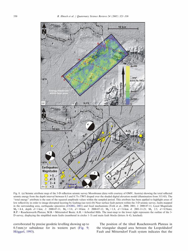
3.4. Map of reflected energy
Seismic attributes are used as additional technique tomap faults in the 3-D survey and to spatially link thefaults interpreted in sections. The attribute map shown
Fig. 4. Topographic sections across the Rauchenwarth Plateau, and
the north-eastern depocenter of the Quaternary Mitterndorf Basin.
The plateau shows a general westward tilt (schematically indicated)
and is covered by slightly west-tilted Pleistocene terraces (T3, indicated
by arrow). In contrast the younger terrace T2 to the east is not tilted.
Vertical exaggeration is 100 (see Fig. 2 for location of transects).
Fig. 5. Section A. Seismic data and interpreted section from the 3-D reflect
showing a negative flower structure dissecting both the pre-Miocene basemen
is approx. 2.5 at 2 s TWT. The inset-map to the lower right represents the ou
the simplified main faults (numbered in circles 1–5) and main fault blocks (l
in Fig. 8a provides an overview of the map distributionof fault zones based on the total energy reflected from aninterval between 0.5 and 0.75 s TWT (c. 500–800mdepth). This interval has been chosen because it isrelatively close to the surface and is relatively complete,with only few gaps in the seismic data caused by missingsource or receiver points (cf. Sections A, B and C). Lowamounts of reflected energy displayed in narrow linearzones of the attribute map are interpreted as fault zoneswith partly destroyed sub-horizontal layering. Thedestruction or small scale tilting of layering by faultingresults in the loss of impedance changes within seismicresolution and/or reflection of energy away fromreceivers. The coincidence of faults mapped in thecross-sections with zones of low reflectance proves thatthis interpretation is correct for most of the survey apartfrom the north-eastern region, where low reflectedenergy is related to seismic acquisition and processing(i.e., only partial correction of static problems and/ ormissing overlap). Other geological reasons potentiallycausing zones of low reflectivity such as homogenousmaterial without contrasting impedances or regionallytilted strata causing energy loss due to reflection andrefraction away from receivers are ruled out for thisdataset.
The seismic attribute map displays a fault patternwith a major NE-striking fault (segments of main fault
ion seismic survey Moosbrunn (data with courtesy of OMV, Austria)
t and Miocene sediments (see Fig. 2 for location). Vertical exaggeration
tline of the 3-D survey, displaying the position of the section (red line),
etters A–G, hatched), also indicated at top of the interpreted section.

ARTICLE IN PRESS
Fig. 6. Section B. Seismic data and interpreted section from the 3-D reflection seismic survey Moosbrunn (data with courtesy of OMV, Austria)
showing a negative flower structure dissecting both the pre-Miocene basement and Miocene sediments (see Fig. 2 for location). Faults at the western
side of the section are part of the normal faults in the hangingwall of the listric Leopoldsdorf Fault imaged in Section C (Fig. 7). Vertical exaggeration
is approx. 2.5 at 2 s TWT. The inset-map to the lower right represents the outline of the 3-D survey, displaying the position of the section (red line),
the simplified main faults (numbered in circles 1–5) and main fault blocks (letters A–G, hatched).
R. Hinsch et al. / Quaternary Science Reviews 24 (2005) 321–336328
1, labelled 1a to 1d; Fig. 8) paralleling and underlyingthe morphological scarp of the Rauchenwarth Plateau.The fault forms the NW boundary of the negative flowerstructure mapped in Sections A and B. The faults 2and 3 at the SE boundary of the flower structure aswell as fault 5 are shown to splay off from the mainfault 1 depicting a fault geometry indicative fordivergent sinistral wrenching. The southernmost exten-sion of the Leopoldsdorf normal fault (main fault 4)terminates at fault 1a of the main NE-striking strike-slipfault system.
4. Active tectonics inferred from Quaternary geology and
geomorphology
The following section evaluates and summarizes dataindicative for Quaternary and recent deformation in thearea of the 3-D seismic survey and its vicinity.Morphological data, the thickness of Quaternary sedi-ments, tilting of fluvial terraces, geodetic levellingindicating recent surface subsidence, and earthquakedata are used to prove Quaternary to recent activity ofindividual faults.
4.1. Active faults around the Rauchenwarth Plateau
The Rauchenwarth Plateau south of the Danube(Fig. 2) is a triangular shaped elevated plateau withPannonian strata rising up to 65 m over the LateQuaternary to recent fluvial deposits of the surroundingextremely flat part of the Vienna Basin (Fig. 3b).The plateau is characterized by a smooth and gentlyWNW-dipping surface, which is transitional to the flatpart of the basin west of the plateau, and an erosiveboundary facing the Danube in the north-east (Fig. 4).The south-eastern limit of the elevation is a pronouncedlinear scarp coinciding with the fault MF 1 mapped in3-D seismic (Figs. 3a and 8b). The area below thescarp is covered by up to 150 m thick Quaternaryfluvial deposits of the Mitterndorf Basin topped byhistorical swamps (cf. Decker and Peresson, 1998;Decker et al., 2005). The position of this Quaternarybasin exactly on top of the centres of subsidence of thenegative flower structure mapped from 3-D seismic, therecoded seismicity and available seismic fault planesolutions give evidence for the continued activity of thefault zone as a sinistral strike-slip system (Fig. 8b). Alldata therefore strongly suggest a tectonic origin of thesouth-eastern scarp of the Rauchenwarth Plateau. The

ARTICLE IN PRESS
Fig. 7. Section C. Seismic data and interpreted section from the 3-D reflection seismic survey Moosbrunn (data with courtesy of OMV, Austria)
depicting the Leopoldsdorf Normal Fault System as well as a negative flower structure in northern part of the section affecting pre-Miocene
basement and Miocene sediments (for location see Fig. 2). Vertical exaggeration is approx. 2.5 at 2 s TWT. The inset-map to the lower left represents
the outline of the 3-D survey, displaying the position of the section (red line), the simplified main faults (numbered in circles 1–5) and main fault
blocks (letters A–G, hatched).
R. Hinsch et al. / Quaternary Science Reviews 24 (2005) 321–336 329
combination of 3-D seismic data with the digitalelevation model shows that the fault scarp starts to riseat the branch point of the Leopoldsdorf Fault (mainfault 4) splaying off from fault 1, which underlies thescarp further north (Figs. 1 and 8b). At this branchpoint the main apparent dip-slip displacement in theflower structure of the Mitterndorf Fault System transitsfrom the south-eastern boundary fault (fault 2) to thenorth-western branch with fault 1b and1c below thescarp (Figs. 5 and 6).
Additional information on Quaternary deformationof the Rauchenwarth Plateau comes from tilted fluvialterraces of the Danube overlying the northern slope ofthe plateau (Figs. 3b, 9 and 10). In topographic sectionsparalleling the Danube, the terrace T3 displays a slopegently dipping against the flow direction of the river(Figs. 9 and 10). Fossil vertebrates and molluscsconstrain the age of the gravels as late Middle to LatePleistocene (Kupper, 1954; Frank and Rabeder, 1997c).Recent westward tilting of the plateau is further
ARTICLE IN PRESS
Fig. 8. (a) Seismic attribute map of the 3-D reflection seismic survey Moosbrunn (data with courtesy of OMV, Austria) showing the total reflected
seismic energy from the depth interval between 0.5 and 0.75 s TWT draped over the shaded digital elevation model (illumination from 315/45). The
‘‘total energy’’ attribute is the sum of the squared amplitude values within the sampled period. This attribute has been applied to highlight areas of
low reflectivity in order to image disrupted layering by faulting (see text) (b) Near surface fault pattern within the 3-D seismic survey, faults mapped
in the surrounding area, earthquake epicentres (ZAMG, 2001) and focal mechanisms (Toth et al., 2000, 2001; 1: 2000-07-11, Local Magnitude
ML=4.4, depth d=1km; 2: 2000-07-11, ML=3.8, d=10km; 3: 2000-07-12, ML=1.8, d=5.6km 4: 2001-11-21; ML 2.5, d=8.9 km).
R.P.=Rauchenwarth Plateau; M.B.=Mitterndorf Basin; A.H.=Arbesthal Hills. The inset-map to the lower right represents the outline of the 3-
D survey, displaying the simplified main faults (numbered in circles 1–5) and main fault blocks (letters A–G, hatched).
R. Hinsch et al. / Quaternary Science Reviews 24 (2005) 321–336330
corroborated by precise geodetic levelling showing up to0.5 mm/yr subsidence for its western part (Fig. 9;Hoggerl, 1993).
The position of the tilted Rauchenwarth Plateau inthe triangular shaped area between the LeopoldsdorfFault and Mitterndorf Fault system indicates that the

ARTICLE IN PRESS
Fig. 9. Combined plot of geodetically derived subsidence rates (see
Fig. 2 for location of the levelling line), morphological section, slope of
Danube river and seismic section (see Fig. 2 for location).
F.C.=Fischa Creek. Subsidence rates are calculated from precise
levelling campaigns in 1954 and 1988 (Hoggerl, 1993). Quaternary
fluvial terraces are labelled T1 (youngest) to T4 (oldest; cf. Fig. 3b).
The age of terrace T3 is constrained by late Middle Pleistocene to early
Late Pleistocene mammal fossils from location (a) (Frank and
Rabeder, 1997c).
R. Hinsch et al. / Quaternary Science Reviews 24 (2005) 321–336 331
morphology of the plateau is related to continued slipalong both faults. The comparison of the surface slopeof the plateau and the tilted terrace T3 of the Danube(Figs. 4 and 9), as well as the rollover of theLeopoldsdorf Fault in Section C (Fig. 7), stronglysuggest active normal faulting and Quaternary to recentrollover of the hanging wall.
A morphological depression between the southern tipof the Rauchenwarth Plateau and the city limits ofVienna probably marks the surface expression of thenorthern continuation of the Leopoldsdorf Fault (Fig.8b, stippled line). Within the city limits of Vienna,several Quaternary terraces show roughly N-S-trendingboundaries, which are likely to be tectonically controlled(Figs. 3b, 8b and 10). Direct evidence for Quaternarynormal faulting within Vienna comes from east-directedstriated normal faults recorded in loess sediments(Kummel, 1935, location 3 in Fig. 10) of late MiddlePleistocene age (Frank and Rabeder, 1997a; location 3in Fig. 10), east-directed normal faults documented inPleistocene gravels in the northern part of the city ofVienna (Fink et al., 1958; location 1 in Fig. 10), and afault of unknown orientation displacing the base of theHolocene gravels of the Danube (Plachy, 1981; location2 in Fig. 10). It is suggested that these Quaternary faultsbelong to an active fault zone forming the northerncontinuation of the Leopoldsdorf Fault (Fig. 10).
4.2. Active faults north and south of the Rauchenwarth
Plateau
In this paragraph, we consider the continuationof the active faults interpreted in the previous sectionin adjacent areas of the Vienna Basin. In order to dothis, interpretations by Decker et al. (2005) and re-interpreted published data are taken into account.Results are summarized in a tectonic map of thesouthern Vienna Basin highlighting inferred activefaults (Fig. 10).
The 3-D seismic data allow the mapping of the north-eastern continuation of the strike-slip fault systemforming the fault scarp of the Rauchenwarth Plateau(main fault 1) into the area of the Arbesthal Hillsbeyond the north-eastern termination of the MitterndorfBasin (fault 1d, Fig. 8b, line drawing of seismic SectionD, Fig. 9, cf. Fig. 2 for location names). The fault strikeat surface is marked by a north-east trending dry valleytransecting the hilly upland (Figs. 3a and 8). Severalnorth-striking branch faults dissect the northern part ofthe Rauchenwarth Plateau (Fig. 8b). The passage of theFischa Creek between the Rauchenwarth Plateau andthe Arbesthal Hills coincides with two minor branchfaults seen in the seismic (parts of fault 5, Fig. 7, 8b and9). Apart from the morphological expression, activefaulting is indicated by marked relative subsidence of upto 1mm/yr (Hoggerl, 1993; Fig. 9) measured for thewesternmost Arbesthal Hills, which correspond tofault block G between fault 5 and 1d (Fig. 8).Interestingly, the location of subsidence pattern isdirectly situated in along strike continuation of theMitterndorf Basin depocenter, hence making a compar-able flower structure kinematics likely. Both faults, 5and 1d, are linked to active faults, which offsetPleistocene terraces and delimit thick Quaternary basinsnorth of the Danube (Decker et al., 2005). Main fault 1links to a north-east striking fault system, which istraced across the Lassee Basin into the Slovak part ofthe Vienna Basin. The north-striking branch faults (fault5 and parallel faults) strike towards a group of curvedfaults offsetting Quaternary terraces and delimitingtwo other Quaternary basins (Fig. 10; see also Deckeret al., 2005).
The south-western continuation of the strike-slipfaults 1 and 2, which delimit the subsided MitterndorfBasin, is traced for about 30 km to the south-western tipof the Vienna Basin. The boundary faults of theMitterndorf Basin depicted in Fig. 10 have beeninterpreted from Quaternary thickness maps (Prohaska,1983; Berger, 1987; Fig. 10, location point 4). A negativeflower structure geometry similar to the 3-D seismic areais assumed for the southern part of the MitterndorfBasin. To the southwest, the surface traces of the basinboundary faults converge into a narrow principledisplacement zone, which has been shown to offset
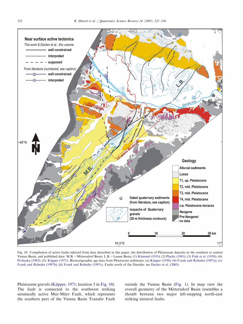
ARTICLE IN PRESS
Fig. 10. Compilation of active faults inferred from data described in this paper, the distribution of Pleistocene deposits in the southern to central
Vienna Basin, and published data. M.B.=Mitterndorf Basin; L.B.=Lassee Basin; (1) Kummel (1935); (2) Plachy (1981); (3) Fink et al. (1958); (4):
Prohaska (1983); (5): Kupper (1971). Biostratigraphic age data from Pleistocene sediments: (a) Kupper (1950); (b) Frank and Rabeder (1997a); (c):
Frank and Rabeder (1997b); (d) Frank and Rabeder (1997c). Faults north of the Danube: see Decker et al. (2005).
R. Hinsch et al. / Quaternary Science Reviews 24 (2005) 321–336332
Pleistocene gravels (Kupper, 1971; location 5 in Fig. 10).The fault is connected to the southwest strikingseismically active Mur-Murz Fault, which representsthe southern part of the Vienna Basin Transfer Fault
outside the Vienna Basin (Fig. 1). In map view theoverall geometry of the Mitterndorf Basin resembles arhomb between two major left-stepping north-eaststriking sinistral faults.

ARTICLE IN PRESS
Fig. 11. Schematic sketch map of southern to central Vienna Basin and cross-sections illustrating active kinematics and partitioning of deformation
along the Vienna Basin Transfer Fault entering the basin from the south. The sketch-map covers approximately the same area as Fig. 10.
R. Hinsch et al. / Quaternary Science Reviews 24 (2005) 321–336 333
5. Active kinematics in the Vienna Basin
The mapping of active structures as demonstrated inthe previous chapter shows a variety of faults, whichshow strong indications of recent activity.
As highlighted by Decker et al. (2005) the presentkinematics of the Vienna Basin Transfer Fault mimicsthe Miocene kinematics: the sinistral fault system linksdivergent structures in the Eastern Alps with thin-skinned thrust systems in the Eastern Carpathians. Aspart of this fault system, the Vienna Basin represents apull-apart structure within the former alpine thrustwedge (cf. Decker et al., 2005, their Figs. 2 and 5).
In order to enhance the understanding of the faultsystem in the Vienna Basin we will use the results gainedso far to constrain a schematic kinematical model(Fig. 11). The model is subdivided into three domains(I–III; Fig. 11), which are also illustrated in sections.
I) The Vienna Basin Transfer Fault enters the ViennaBasin at its south-western tip as a narrow displacementzone (Mur-Murz Fault) separating the extruding StyrianWedge from the Alpine Thrust Units (Fig. 11, SectionI). Seismicity along this sector is relatively high(Reinecker and Lenhardt, 1999; Hinsch and Decker,2003).
II) Entering the southern Vienna Basin the strike-slipfault builds up a negative flower structure within theMiocene sedimentary basin fill, which increases inthickness towards the centre of the basin (Fig. 1). Thefaults delimit a rhomboidal pull-apart structure betweena minor left-step of the strike-slip fault, which in cross-section appears as a negative flower structure developedin the uppermost sediments (Fig. 11, Section II). This
rhomboidal negative flower structure is overlain by theQuaternary Mitterndorf Basin (Fig. 10). The branch lineat which the basin boundary faults converge into aprincipal displacement is located close to the base of theMiocene sedimentary rocks (Figs. 5 and 6). Suchupward branching of basement strike-slip faults enteringinto sedimentary layers is a common observationat interfaces of heterogeneous materials as shown byanalogue modelling (Naylor et al., 1986; Richard et al.,1995).
III) A major kinematical boundary of the segmentedfault system is represented by the branch line of thesouthernmost large normal fault spanning the pull-apartbasin. The Leopoldsdorf Fault splaying from the strike-slip fault below the Mitterndorf Basin characterizes thebeginning of this domain. Westward tilting of terracesand Pleistocene strata clearly demonstrate that arollover associated with fault activity on the western-most normal faults of the Vienna Basin is active (i.e.Leopoldsdorf fault and Steinberg fault; Fig. 1 Points 1and 2; see also Decker et al., 2005, their Figs. 5 and 9).Additional normal faults branch from the SW–NEtrending strike-slip fault zone to its northern side(displayed Fig. 11, Section III). These additional faultscause only minor stratigraphic separation within theMiocene strata as displayed in the 3-D seismic data(Fig. 7) but dissect and tilt Quaternary terraces close toand north of the Danube (Figs. 9, 10 and Decker et al.,2004, their Fig. 9). Splay faults are connected to theprincipal displacement zone either directly or via theMiocene pull-apart detachment, which is commonlyinterpreted to coincide with the decollement of theAlpine–Carpathian thrust system (Royden et al., 1983;

ARTICLE IN PRESSR. Hinsch et al. / Quaternary Science Reviews 24 (2005) 321–336334
Royden, 1988). Westward tilting of surfaces andPleistocene strata clearly demonstrate that faults areactive throughout most of the Neogene to Pleistocenesedimentary basin fill.
Within the sedimentary cover and the upper parts ofthe crust the active fault system in the Vienna Basin thussuccessively splits up into an increasing number ofbranch faults in the basin centre. Active movements onthe fault system thus need to be partitioned on thesefaults. This is schematically shown in Fig. 11 by thethickness of the fault traces. Detailed quantification ofthis strain partitioning, however, is extremely difficultand Fig. 11 shows a crude estimate based on observa-tions like quaternary gravel thickness and tilting ofterraces. We assume that movement on the fault systemconcentrates along the trend of the deep Quaternarybasins (Mitterndorf and Lassee Basin, Fig. 10). Thesebasins line up with earthquake epicentres along theVienna Basin Transfer Fault (Fig. 1) favouring theinterpretation that the fault system now does not have apull-apart step-over geometry but a more or less straightnorth-eastern continuation into the Western Car-pathians. Thus, the active normal faults within thebasin do not seem to act as faults of a large-scale pull-apart basin, as they did in the Miocene. Theirreactivation rather is kinematically linked to the moreor less straight sinistral strike-slip fault zone at thesouth-eastern border of the Vienna Basin. Accordingly,recent pull-apart formation affecting the whole ViennaBasin is unlikely. This change from pull-apart to a lineartransfer geometry likely corresponds to the observedregional change of tectonics in Pliocene times in thewhole Pannonian domain from extensional basin for-mation to compressional inversion (Horvath andCloetingh, 1996). However, more neotectonic data fromthe northern Vienna Basin is necessary to clarify this.
The presented model is in good agreement withregional kinematic constraints. One of the latest feltearthquakes occurred on a principal fault zone belowthe Mitterndorf Basin (ZAMG, 2001; Ebreichsdorf,three events recorded on 12 July 2000 with magnitudesbetween 3.0 and 4.0, for location compare Fig. 2). Thesuspected main fault zone is part of the large-scalestrike-slip transfer fault at the south-eastern border ofthe Vienna Basin. The focal solution of the strongestevent is interpreted as sinistral strike-slip on a north-eaststriking plane (Fig. 8b; Toth et al., 2000). A smallerearthquake from November 2001 can be attributed tothe splaying normal faults. The focal solution of thisevent is interpreted as a slightly oblique normal fault(Fig. 8b; Toth et al., 2001).
On a more regional scale the model of the transferfault system is in good agreement with GPS observa-tions revealing c. 2mm/yr NE-directed movement of theStyrian Wedge with respect to the European foreland(Grenerczy et al., 2000). It also agrees with most of the
maximum horizontal stress directions presented inReinecker and Lenhardt (1999, their Fig. 8). However,one of their stress indicators within the Vienna Basindepicts E–W oriented maximum horizontal stress, whichis in contrast to the sinistral kinematics proposed here.On the other side, this stress data contradicts breakoutmeasurements indicating NNE–SSE directed maximumhorizontal stress by Marsch et al. (1990), which supportsour interpretation.
6. Conclusions
Mapping of active faults in the Vienna Basin reveals ahighly segmented system of strike-slip and normalfaults. The major strike-slip fault zone is traced alongthe south-eastern border of the Vienna Basin bymapping subsided Quaternary basins and surfacial faultscarps, which overly negative flower structures. Activefaults form a zone of en-echelon faults, which is up to10 km wide at surface. According to reflection seismicdata, these faults merge into a principal fault zone below4–5 km depth.
Active strike-slip faulting is kinematically linked tothe reactivation of major Miocene normal faultsbranching off from the wrench fault in the centralVienna Basin. Their recent activity is proven by tiltedfluvial terraces and offset Quaternary sediments. Withinthe Vienna Basin, both the normal faults and the strike-slip system are thought to root on the former floorthrust of the Alpine wedge. This decollement surface issituated in depth between c. 4 and 15 km, thus in depthof seismic activity.
Fault segmentation is one of the important inputparameters of seismic hazard evaluations (e.g., Schwarzand Coppersmith, 1984) and information on theseismogenic fault segmentation might be assessed fromnear surface geological data (Cowie and Scholz, 1992;Stewart and Taylor, 1996). Assessments of the seismo-genic segmentation of the Vienna Basin Transfer FaultZone would provide important constraints for max-imum credible earthquake (MCE) calculations. From akinematical point of view, the branch line of theLeopoldsdorf Fault represent a fault segment borderwhich is likely to subdivide the fault also at seismogenicdepth. At this branch line at least some of the movementof the fault system must be transferred to the dippingbasal detachment, distributing strain throughout theVienna Basin. Apart from that, we think that it is highlyproblematic to map seismogenic segments for the strike-slip fault system at the south-eastern border of theVienna Basin from fault segments mapped in the upper4 km. Too many reactivated faults from the Miocene areacting as branch or splay faults to define valid segmentboundaries for the main fault system. High resolutionseismological investigations are needed to further

ARTICLE IN PRESSR. Hinsch et al. / Quaternary Science Reviews 24 (2005) 321–336 335
constrain fault segmentation in depth below 4–5 km.Additional mechanical modelling of the fault systemmight allow a more quantitative assessment of thedeformation partitioning occurring on the branch faultsand hence helps to understand the relationship betweenfar the field kinematics, seismic and aseismic deforma-tion in the Vienna Basin.
Acknowledgements
Active tectonics research in the Vienna Basin isfunded by the Trainings and Research Network ENTEC(Environmental Tectonics) of the European Commis-sion (Contract No. HPRN-CT-2000-00053), and theAustrian Bundesministerium fur Bildung, Wissenschaftund Kultur. We appreciate the support by OMV Austria(especially W. Hamilton and B. Krainer) supplying thereflection seismic dataset 3-D Moosbrunn and Land-mark Graphics Corporation providing GeoGraphixDiscovery software for 3-D seismic interpretation inthe frame of a Landmark Strategic University AllianceGrant. We substantially benefited from discussions withour ENTEC colleagues during the Spring WorkshopVienna 2002. Especially, we like to thank T. Winter, B.Niviere, U. Fracassi and T. Dewez for inspiringdiscussions about geomorphology, G. Lopes Cardozoand K. Ustaszewski for supporting us in the field, G.Wessely and K. Wagner for sharing their outstandingexpertise on the subcrop of the Vienna Basin, and W.Lenhardt and G. Gangl for supplying and explainingseismological data. P. Strauss and A. Zamoli helped bydigitising subsurface maps. The manuscript benefitedsubstantially from the reviews of F. Neubauer, J.Reinecker and T. Winter.
References
Aric, K., Gutdeutsch, R., 1981. Seismotectonic and refraction seismic
investigation in the border region between the Eastern Alps and the
Pannonian Basin. Pure and Applied Geophysics 119, 1125–1133.
Berger, E., 1987. Analyse der Funktionsfaktoren des Grundwasser-
speichers Mitterndorfer Senke. Unpublished Report to the
Government of Lower Austria 47 pp.
Cowie, P.A., Scholz, C.H., 1992. Physical explanation for the
displacement–length relationship of faults using a post-yield
fracture mechanics model. Journal of Structural Geology 14 (10),
1133–1148.
Decker, K., 1996. Miocene tectonics at the Alpine–Carpathian
junction and the evolution of the Vienna Basin. Mitteilungen der
Gesellschaft der Geologie und Bergbaustudenten in Osterreich 41,
33–44.
Decker, K., Peresson, H., 1998. Miocene to present-day tectonics of
the Vienna Basin transform fault Links between the Alps and the
Carparthians Abstracts XVI Congress of the Carpathian–Balkan
Geological Association. Geologische Bundesanstalt, Vienna, pp.
33-36.
Decker, K., Peresson, H., Hinsch, R., 2005. Active tectonics and
Quaternary basin formation along the Vienna Basin Transfer fault.
Quaternary Science Reviews, this issue (doi:10.1016/j.quascir-
ev.2004.04.012).
Fink, J., Grill, R., Kollmann, K., Kupper, H., 1958. Beitrage zur
Kenntnis des Wiener Beckens zwischen Grinzing und NuXdorf
(Wien XIX). Jahrbuch der Geologischen Bundesanstalt, Wien 101,
117–138.
Fuchs, W., Grill, R., 1984. Map: geologische Karte von Wien und
Umgebung (1:200:000). Geologische Bundesanstalt (GBA), Vien-
na.
Fodor, L., 1995. From transpression to transtension: Oligocene–
Miocene structural evolution of the Vienna Basin and the
East Alpine-Western Carpathian junction. Tectonophysics 242,
151–182.
Frank, C., Rabeder, G., 1997a. Laaerberg. In: Doppes, D., Rabeder,
G. (Eds.), Pliozane und pleistozane Faunen Osterreichs. Mitteilun-
gen der Kommission fur Quartarforschung der osterreichischen
Akademie der Wissenschaften, Wien, Osterr. Akad. Wiss.,
pp. 88–92.
Frank, C., Rabeder, G., 1997b. Mannsworth. In: Doppes, D.,
Rabeder, G. (Eds.), Pliozane und pleistozane Faunen Osterreichs.
Mitteilungen der Kommission fur Quartarforschung der osterrei-
chischen Akademie der Wissenschaften, Wien, Osterr. Akad. Wiss.,
pp. 102–105.
Frank, C., Rabeder, G., 1997c. Fischamend an der Donau. In:
Doppes, D., Rabeder, G. (Eds.), Pliozane und pleistozane Faunen
Osterreichs. Mitteilungen der Kommission fur Quartarforschung
der osterreichischen Akademie der Wissenschaften, Wien, Osterr.
Akad. Wiss., pp. 79–80.
Gangl, G., 1975. Seismotektonische Untersuchungen am Alpen-
ostrand. Mitteilungen der Geologischen Gesellschaft in Wien,
1973–1974(66-67) pp. 33-48.
Grenerczy, G., 2002a. Tectonic processes in the Eurasian—African
plate boundary zone revealed by space geodesy. In: Stein, S.,
Freymueller, J.T. (Ed.), Plate Boundary Zones. Geodynamic
Series, vol. 30. American Geophysical Union, pp. 67-86.
Grenerczy, G., 2002b. Towards a dense intraplate velocity map for
Central Europe. Reports on Geodesy 1(61).
Grenerczy, G., Kenyeres, A., Fejes, I., 2000. Present crustal movement
and strain distribution in Central Europe inferred from GPS
measurements. Journal of Geophysical Research 105 (B9),
21835–21846.
Grunthal, G., Mayer-Rosa, D., Lenhardt, W.A., 1998. Abschatzung
der Erdbebengefahrdung fur die D-A-CH-Staaten - Deutschland,
Osterreich, Schweiz. Bautechnik 10, 19–33.
Gutdeutsch, R., Aric, K., 1988. Seismicity and neotectonics of the East
Alpine-Carpathian and Pannonian Area. In: Royden, L.H.,
Horvath, F. (Eds.), The Pannonian Basin: a study in basin
evolution. AAPG Memoir 45. American Association of Petroleum
Geologists and Hungarian Geological Society, Tulsa, Oklahoma,
Budapest, pp. 183–194.
Hausler, H., Leber, D., Peresson, H., Hamilton, W., 2002. A New
Exploration Approach in a Mature Basin: Integration of 3-D
Seismic, Remote-sensing, and Microtectonic Data, Southern
Vienna Basin, Austria (Chapter 18). In: Schumacher, D.,
LeSchack, L.A. (Ed.), Surface Exploration Case Histories. AAPG
Studies in Geology. American Association of Petroleum Geolo-
gists, Tusla, Oklahoma.
Hinsch, R., Decker, K., 2003. Do seismic slip deficits indicate
underestimated seismic potential along the Vienna Basin Transfer
Fault System? Terra Nova 15, 343–349.
Hoggerl, N., 1993. Hohenanderungen im nordlichen Wiener Becken.
In: Steinhauser, G, Walach, P. (Eds.), Osterr. Beitrage zu
Meteorologie und Geophysik, vol. 8, Vienna, pp. 161-175.
Horvath, F., Clotingh, S., 1996. Stress-induced late-stage subsi-
dence anomalies in the Pannonian Basin. Tectonophysics 266,
287–300.

ARTICLE IN PRESSR. Hinsch et al. / Quaternary Science Reviews 24 (2005) 321–336336
Kroll, A., Wessely, G., 1993. Map: Wiener Becken und angrenzende
Gebiete: Strukturkarte-Basis der tertiaaren Beckenfullung
(1:200000). Geologische Bundesanstalt, Vienna.
Kummel, F., 1935. Der LoX des Laaerberges bei Wien. Verhandlungen
Geologische Bundesanstalt, Vienna, pp. 132-135.
Kupper, H., 1950. Eiszeitspuren im Gebiet von Wien. Sitzberichte der
osterreichischen Akademie der Wissenschaften,. Math. Natwiss.
Kl. 159, 199–206.
Kupper, H., 1954. Geologie und Grundwasservorkommen im sudli-
chen Wiener Becken. Jahrbuch Geologische Bundesanstalt, Vienna
97, 161–210.
Kupper, H., 1971. Quartare Tektonik im Untergrund des Schwarza-
tales bei Ternitz, N.O. Verhandlungen der Geologischen Bunde-
sanstalt, Vienna 3, 522–527.
Lenhardt, W., 1996. Erdbebenkennwerte zur Berechnung der Talsper-
ren Osterreichs, unpublished. report, Zentralanstalt fur Meteor-
ologie und Geodynamik (ZAMG), Vienna, pp. 86.
Lenhardt, W.A., 1995. Regional earthquake hazard in Austria. In:
Duma, G. (Ed.). 10th European Conference on Earthquake
Engineering, Vienna, Austria. Balkema, Rotterdam.
Linzer, H.G., Decker, K., Peresson, H., Dell’Mour, R., Frisch, W.,
2002. Balancing lateral orogenic float of the Eastern Alps.
Tectonophysics 354, 211–237.
Linzer, H.-G., Moser, F., Nemes, F., Ratschbacher, L., Sperner, B.,
1997. Build-up and dismembering of the eastern Northern
Calcereous Alps. Tectonophysics 272, 97–124.
Marsch, F., Wessely, G., Sackmaier, W., 1990. Borehole-breakouts as
geological indications of crustal tension in the Vienna Basin. In:
Rossmanith, P. (Ed.), Mechanics of Joined and Faulted Rock.
A.A. Balkema, Rotterdam, pp. 113–120.
Naylor, M.A., Mandl, G., Sijpesteijn, C.H.K., 1986. Fault geometries
in basement-induced wrench faulting under different initial stress
states. Journal of Structural Geology 8 (7), 737–752.
Plachy, H., 1981. Neue Erkenntnisse zur Tektonik im Wiener Raum.
Mitteilungen der osterreichischen Geologischen Gesellschaft 74/75,
231–243.
Prohaska, W., 1983. Die geologischen und hydrogeologischen Ver-
haltnisse am Westrand des sudlichen Wiener Beckens. Doctoral
Thesis, University of Vienna, Vienna 161 pp.
Ratschbacher, L., Frisch, W., Linzer, H.-G., Merle, O., 1991. Lateral
extrusion in the Eastern Alps. Tectonics 10, 257–271.
Reinecker, J., Lenhardt, W., 1999. Present-day stress field and
deformation in eastern Austria. International Journal of Earth
Science 88, 532–550.
Reinecker, J., 2000. Stress and Deformation: Miocene to Present-Day
Tectonics in the Eastern Alps, Tubinger Geowissenschaftliche
Arbeiten; Reihe A: Geologie, Palaontologie, Stratigraphie. Institut
und Museum fur Geologie und Palaontologie der Universitat
Tubingen, Tubingen, pp. 128.
Richard, P.D., Naylor, M.A., Koopman, A., 1995. Experimental
models of strike-slip tectonics. Petroleum Geoscience 1, 71–88.
Rogl, F., 1996. Stratigraphic correlation of the Paratethys Oligocene
and Miocene. Mitteilungen der Gesellschaft der Geologie und
Bergbaustudenten in Osterreich 41, 65–74.
Royden, L.H., 1988. Late Cenozoic tectonics of the Pannonian Basin
system. In: Royden, L.H., Horvath, F. (Eds.), The Pannonian
Basin: a study in basin evolution. AAPG Memoir 45. American
Association of Petroleum Geologists and Hungarian Geological
Society, Tulsa, Oklahoma, Budapest, pp. 27–48.
Royden, L.H., Horvath, F., Rumpler, J., 1983. Evolution of the
Pannonian Basin System, 1. Tectonics. Tectonics 2, 63–90.
Sauer, R., Seifert, P., Wessely, G., 1992. Guidbook to excursions in
the Vienna Basin and the adjacent Alpine–Carpathian thrustbelt
in Austria. Mitteilungen Geologische Gesellschaft, Vienna 85,
1–264.
Schwarz, P.D., Coppersmith, K.J., 1984. Fault behaviour and
characteristic earthquakes: examples from the Wasatch and San
Andreas fault zones. Journal of Geophysical Research 89,
5681–5698.
Seifert, P., 1996. Sedimentary-tectonic development and Austrian
hydrocarbon potential of the Vienna Basin. In: Wessely, G., Liebl,
W. (Eds.), Oil and gas in Alpide Thrusbelts and Basins of Central
and Eastern Europe. EAGE Special Publications No. 5., EAGE,
pp. 331–341.
Stewart, M.E., Taylor, W.J., 1996. Structural analysis and fault
segment boundary identification along the Hurricane Fault in
south-western Utah. Journal of Structural Geology 18 (8),
1017–1029.
Toth, L.P., Monus, P., Zsıros, T., 2000. Hungarian Earthquake
Bulletin, 1999, GeoRisk, Budapest.
Toth, L.P., Monus, P., Zsıros, T., Kiszely, M., Kosztyu, Z., 2001.
Hungarian Earthquake Bulletin, 2001, GeoRisk, Budapest.
Weissenback, M., 1995. Ein Sedimentationsmodell fur das Unter- bis
Mittelmiozan (Karpatien—Badenien) des zentralen Wiener Beck-
ens. Doctoral Thesis, University of Vienna, Vienna.
Wells, D.L., Coppersmith, K.J., 1994. New empirical relationships
among magnitude, rupture width, rupture area, and surface
displacement. Bulletin of the Seismological Society of America 84
(4), 974–1002.
ZAMG, 2001. Earthquake catalogue of felt earthquakes (Austria).
Computer File. Central Institute of Meteorology and Geodynamics
(ZAMG), Vienna.
Copyright © 2022 FDOKUMEN