264061.pdf - University of Bristol Research Portal
261
This electronic thesis or dissertation has been downloaded from Explore Bristol Research, http://research-information.bristol.ac.uk Author: Clark, Jacob Daniel Title: Insular monument building : a cause of social stress? The case of prehistoric Malta. General rights Access to the thesis is subject to the Creative Commons Attribution - NonCommercial-No Derivatives 4.0 International Public License. A copy of this may be found at https://creativecommons.org/licenses/by-nc-nd/4.0/legalcode This license sets out your rights and the restrictions that apply to your access to the thesis so it is important you read this before proceeding. Take down policy Some pages of this thesis may have been removed for copyright restrictions prior to having it been deposited in Explore Bristol Research. However, if you have discovered material within the thesis that you consider to be unlawful e.g. breaches of copyright (either yours or that of a third party) or any other law, including but not limited to those relating to patent, trademark, confidentiality, data protection, obscenity, defamation, libel, then please contact [email protected] and include the following information in your message: • Your contact details • Bibliographic details for the item, including a URL • An outline nature of the complaint Your claim will be investigated and, where appropriate, the item in question will be removed from public view as soon as possible.
-
Upload
khangminh22 -
Category
Documents
-
view
0 -
download
0
Transcript of 264061.pdf - University of Bristol Research Portal

This electronic thesis or dissertation has beendownloaded from Explore Bristol Research,http://research-information.bristol.ac.uk
Author:Clark, Jacob Daniel
Title:Insular monument building : a cause of social stress? The case of prehistoric Malta.
General rightsAccess to the thesis is subject to the Creative Commons Attribution - NonCommercial-No Derivatives 4.0 International Public License. Acopy of this may be found at https://creativecommons.org/licenses/by-nc-nd/4.0/legalcode This license sets out your rights and therestrictions that apply to your access to the thesis so it is important you read this before proceeding.
Take down policySome pages of this thesis may have been removed for copyright restrictions prior to having it been deposited in Explore Bristol Research.However, if you have discovered material within the thesis that you consider to be unlawful e.g. breaches of copyright (either yours or that ofa third party) or any other law, including but not limited to those relating to patent, trademark, confidentiality, data protection, obscenity,defamation, libel, then please contact [email protected] and include the following information in your message:
•Your contact details•Bibliographic details for the item, including a URL•An outline nature of the complaint
Your claim will be investigated and, where appropriate, the item in question will be removed from public view as soon as possible.

ý,
INSULAR MONUMENT BUILDING: A CAUSE OF SOCIAL STRESS?
THE CASE OF PREHISTORIC MALTA
JACOB DANIEL CLARK
A dissertation submitted to the University of Bristol in accordance with the requirements of the degree of Ph. D. in the Faculty of Arts, Department of Archaeology.
September 1998
Word Count 46,000

ABSTRACT
Prehistoric monument building, particularly that on islands, is reviewed. The insularity and nature of island societies and the question of possible social stress arising from these activities is posed. The degree of stress must be quantified and the technique of energetics analysis is the best available.
Prehistoric Malta is chosen for detailed examination of these questions. The island is first described, including its location, geography, geology, climate and extant remains, together with the cultural phases and possible structure of its society. The rationale of an energetics analysis is covered with several examples of its application and a justification of its utility for Malta.
The Ggantija temple is chosen for particular study and detailed drawings of its remains are given. The architecture of the original temple is hypothesised and the materials involved
quantified. For each material the unit labour costs of procurement (including the location
of sources), transport, preparation and construction are estimated. By combining the quantities of materials used with the unit labour costs, the total labour requirements are computed. A sensitivity analysis, allowing for significant variation of all the important figures, is given. Previous work on labour requirements is reviewed and found to be a grave over-estimate.
The prehistoric population numbers, and the availability of temple building workers, is
estimated. Combinations of the figures for labour required and labour available allows estimates of the percentage demand on worker's time to be made, including a sensitivity analysis. These percentages give a quantified view of the stress which temple building placed on society.
Contrary to previous suggestions embedded in the literature, no excessive stress is indicated. Further, there is no evidence of any concentration of building effort at the end of the period and it is unlikely that temple construction per se contributed to that culture's downfall.
These are major conclusions and justify the use of energetics analysis and the work involved.
2

ACKNOWLEDGEMENTS
Having completed a M. Sc. in environmental archaeology at U. C. L., I consulted Prof. Peter Warren, Bristol University, about the idea of taking an M. A. in Mediterranean archaeology. He advised me to undertake a doctoral course. The research reported here is the result.
I have had three advisors : Simon Stoddart, then lecturer in archaeology, University of Bristol, knowledgeable about, and an excavator on, Malta. He was both inspiring and helpful. Following his transfer to Cambridge his wife, Caroline Malone, also a lecturer at the University of Bristol, became my advisor, until she too moved to Cambridge. I am grateful for her help. Lastly, Peter Warren stepped into the breach, for the last year. He has been most assiduous in checking my drafts, giving useful advice and guiding me towards the proper presentation of a Ph. D. thesis, to say nothing of keeping me up to an appropriate timetable. He has been an invaluable mentor.
Others who have helped me at Bristol are Alan Chalmers and Rowland Morgan, both in the Faculty of Engineering. Mr. Morgan's help is acknowledged in more detail, in the body of the thesis.
John McDermott and Simon Stoddart translated from the Italian.
In Malta, I was helped in many ways by the following : Tancred Gouder, Anthony Pace, Dennis de Lucca, Anthony Bonanno and Patrick Schembri and the sculptor Joe Xuereb. Mrs. Anne Bradley at the British High Commission facilitated many contacts and arranged financial help from the British Council, which is gratefully acknowledged.
Miss Stephanie Downer and Mrs. Wendy Cavill have coped patiently and competently with typing multiple drafts of this thesis.
My wife, Pauline, has given great support and encouragement and was my valuable assistant on field trips to Malta.
3

AUTHOR'S DECLARATION
I declare that the work in this dissertation was carried out in accordance with the Regulations of the University of Bristol. The work is original except where indicated by special reference in the text and no part of the dissertation has been submitted for any other degree.
Any views expressed in the dissertation are those of the author and in no way represent those of the University of Bristol.
The dissertation has not been presented to any other University for examination either in the United Kingdom or overseas.
e ýeý Signed: ........................................ Date:
...............................
4

TABLE OF CONTENTS Page
Title Page 1 Abstract 2 Acknowledgements 3 Author's Declaration 4
Chapter 1. The Unique Nature of Island Cultures. 11
1.1 Introduction. 11 1.2 What constitutes an island and defines insularity? 12 1.3 What constitutes a monument? Where are they found? Are 15
they unique to the societies that built them? 1.4 What were the structures of the societies that built monuments 17
and did these change over time? 1.5 Did building monuments cause social stress, and was such stress 20
particularly acute for small island societies? How is stress to be measured?
1.6 A brief review of some island societies which built monuments. 21 1.7 Conclusion. 26
Chapter 2. Brief description of the Maltese Islands and their prehistoric 27 cultures.
2.1 The Islands. 27 2.2 Geology and Topography. 28 2.3 Climate. 34 2.4 Outline of Prehistoric Maltese Cultures. 36 2.5 Boundedness : the question of Contact 37 2.6 The Pre-Temple Building Period. 40 2.7 The Temple Building Period. 42
2.7: 1 The Temples. 42 2.7: 2 Cultural development during the Maltese Temple 47
Building Period. 2.7: 3 Location of Sites. 51 2.7: 4 Social Structure. 53
2.8 The Post-Temple Building Period. 60
Chapter 3. The Rationale of an Energetics Approach. 61
3.1 Introduction. 61 3.2 Definition of Energetics in an Archaeological Context 61 3.3 History of the Use of Energetics in Archaeological Contexts. 64 3.4 Review of Examples of Energetics Analysis: 69
3.4: 1 Mesoamerica. 69 3.4: 2 Energetics analysis in Hawaii. 74 3.4: 3 Energetics work on Neolithic and Bronze Age Wessex. 75 3.4: 4 Energetics work on Sardinia. 76 3.4: 5 Easter Island. 77
3.5 The Utility of an Energetics approach to the Maltese Temple 78 Period.

Page Chapter 4. The Ggantija Temples: Original Appearance and Materials. 82
4.1 The temples on Gozo. 82 4.2 The Ggantija temples: brief description. 82 4.3 The Temples in detail: Perimeter Wall: Phasing. 89 4.4 Rubble and Earth infill. 95 4.5 Apses: Stone Sizes, Quantities etc. 96 4.6 The Question of Roofing. 100 4.7 How were the Temples Roofed? 120 4.8 Plastering the Apse Walls. 126 4.9 Painting the Apse Walls. 129 4.10 Flooring the Temples. 130 4.11 The Temple Portals. 131 4.12 The Temple Furnishings. 135 4.13 The Platforms Outside the Temples. 138 4.14 Conclusion. 142
Chapter 5. Materials: Procurement, Transportation, Preparation 143 and Construction.
5.1 Stones: 143 5.1: 1 Location of Quarries, General. 143 5.1: 2 Location of Quarries on Malta. 144 5.1: 3 Source of stones for Ggantija. 148 5.1: 4 Methods of Quarrying. 157 5.1: 5 Methods of Stone Transport: General Description. 167 5.1: 6 Methods of Stone Transport: Quantified Examples. 172 5.1: 7 Tabulation of Results for Stone Transport. 179 5.1: 8 Preparation of Stones. 181 5.1: 9 Erection of Stones. 182
5.2 Rubble: 183 5.2: 1 Rubble Procurement. 183 5.2: 2 Rubble Transport. 184 5.2: 3 Rubble Erection. 184
5.3 Torba: 184 5.3: 1 Procurement. 184 5.3: 2 Transport. 185 5.3: 3 Preparation. 185 5.3: 4 Application. 185
5.4 Timber: 185 5.4: 1 Availability. 185 5.4: 2 Procurement. 189 5.4: 3 Transport. 189 5.4: 4 Preparation. 189 5.4: 5 Erection. 189
5.5 Conclusion. 189
Chapter 6. Energetics: the Labour Requirements. 190
6

Chapter 6 (cont. ) Page 6.1 Summary of Results. 190 6.2 Tabulated Details. 190 6.3 Sensitivity Analysis: 194
6.3: 1 Original Heights. 194 6.3: 2 Procurement. 195 6.3: 3 Transport. 195 6.3: 4 Preparation. 196 6.3: 5 Erection. 196 6.3: 6 Length of Work Periods. 196 6.3: 7 Sensitivity Analysis : Summary Figures. 197
6.4 Previous Energetics Analyses. 199
Chapter 7. Population. 208
7.1 Introduction. 208 7.2 Carrying Capacity. 209 7.3 Historical Population Data. 211 7.4 Temple Building Labour. 212
Chapter 8. Labour Required and Labour Available. 215
8.1 Introduction. 215 8.2 Labour Required and Labour Available: "Central" Figures. 217 8.3 Observations on the "Central" Figures. 218 8.4 Observations on the Sensitivity Analysis Figures. 220 8.5 Comments on Pollini's Figures. 222 8.6 In Conclusion. 224
Chapter 9 Conclusions. 225
9.1 Has an Energetics Analysis Thrown New Light on the Temple. 225 Building Period in Malta?
9.2 Did Temple Building Cause a Strain on Maltese Society? 225 9.3 Does the Energetics Analysis Provide Clues to the Nature of 229
Maltese Temple Period Society? 9.4 Development over time. 233 9.5 Conclusion. 236
Appendix 1: Figure source references when not the author's figures. 239
Appendix 2: Literature review pertinent to Chapter 9.241
Appendix 3: Literature review pertinent to Chapter 2.242
Bibliography 243
7

LIST OF TABLES
Page
6.1 Total Labour Input to Ggantija South Temple. 191
6.2 Total Labour Input to Ggantija North Temple. 192
6.3 Labour Input to the Construction of the Ggantija Tarxien Period 193 Additional Terrace.
6.4 Sensitivity Analysis. 198
6.5 Comparison of Pollini's Figures with those of the author. 201
7.1 Availability of Building Labour. 213
8.1 Labour Required & Labour Available: "Central" Figures. 217
8.2 Labour Sensitivity Analysis. 219
8

LIST OF FIGURES Page
2.1 Location of the Maltese Islands. 27
2.2 The Maltese Islands. 28 2.3 The geology of the Hagar Qim/Mnajdra area. 31 2.4 A north/south geological section through west Malta. 32 2.5 Mean monthly rainfall 1854-1986. 34
2.6 Total yearly rainfall 1854-1986. 35 2.7 Average maximum and minimum temperatures. 35 2.8 The evolution of the Maltese temples. 42 2.9 Tombs 5 (left) and 1 and 2 (right) at Xemxija. 43 2.10 Plan of trefoil temple at Mnajdra. 43
2.11 Aerial view of Ggantija temple, Gozo, from the north east. 44 2.12 Plan of Ggantija temples. 45 2.13 The distribution of the Maltese temples. 52 2.14 Access diagrams for some Maltese temples and Hal Saflieni. 55 3.1 Relation of annual household and community corvee labour. 70
costs at different population densities. 4.1 Ggantija Temples. After Trump 1990 with platform added 83
by author. 4.2 Ggantija Temple plan. 85 4.3 Ggantija Temple sections. 86 4.4 Entrance to Ggantija South Temple. 87 4.5 Rear of Ggantija South Temple Perimeter Wall. 87 4.6 View from rear of Ggantija South Temple. 88
4.7 ? Altars in left rear apse Ggantija South Temple. 88 4.8 Ggantija Temple orientation plan. 89
4.9 Exterior elevation Ggantija. "Lapping" clockwise. 90 & 91 4.10 Apse 3 from north north-west. 97
4.11 Interior Apse 3. "Lapping" clockwise. 97 4.12 Ggantija South Temple apse 3. 98
4.13 Detail of Ggantija South Temple apse 3. 98 4.14 Kordin Temples. 102 4.15 Drawing of a model temple from Mgarr. 104 4.16 Schematic plan and elevation of inner and outer walls and infill. 105 4.17 Reconstruction of Temple III Tarxien. 106 4.18 Reconstruction of the roofing of Cellas 2 and 3 of Temple III 107
at Tarxien. 4.19 Reconstruction of an almost fully preserved room at the Hal 108
Saflieni hypogeum. 4.20 View of the entrance to and part of the inside of the outer left 109
apse of the South Temple Ggantija. 4.21 Reconstruction of the entrance to the first pair of apses at Ggantija. 110 4.22 Reconstruction section and plan Temple 1, Tarxien. 112 4.23 Reconstruction Celia 1, Temple 1, Tarxien. 112 4.24 Reconstruction of the roofing of two apses at Tarxien by Ceschi. 114 4.25 Piovanelli's reconstruction of the same apses as Ceschi's. 114 4.26 Model temple from Mgarr. 116 4.27 Wall relief of a temple at Mnajdra. 117 4.28 Exterior of a gima at L-Ahrax to Gewwa. 122 4.29 Interior of the above girna. 122 4.30 Section through temple roof. 124
9

LIST OF FIGURES (cont. ) Page
4.31 Plan of roof guttering and drainage. 124 4.32 Apse wall daub at Ggantija. 127 4.33 Painting of Ggantija by Brocktorff. 128 4.34 Hagar Qim Facade. 132 4.35 Measured dressed stones at Ggantija. 133 4.36 Ggantija : Right hand spiral slab of Apse 2: end. 136 4.37 Ggantija : Threshold slab of entrance to Room 4. 136 4.38 Ggantija : The Platform Sequences. 139 4.39 Section of Ggantija Platform. 140 4.40 Ggantija Facade (Brocktorff). 141 4.41 Ggantija : Retaining wall of Platform (Brocktorff). 141 5.1 Contour map : territory around Hagar Qim and Mnajdra. 146 5.2 Sections through Hagar Qim and Mnajdra territory. 147 5.3 Stone availability : Hagar Qim and Mnajdra. 149 5.4 Coralline limestone quarries. 150 5.5 Geological map : Ggantija region. 151 5.6 Globigerina outcrop on faultline. 152 5.7 View from outcrop to Ggantija looking north east. 152 5.8 Routes for Globigerina transport to Ggantija. 155 5.9 Contour map for Globigerina transport. 156 5.10 Quarrying wedge slots - Aswan, Egypt. 159 5.11 Azzopardi demonstrating slot cutting. 163 5.12 Driving in splitting wedges. 164 5.13 A relatively modem block split by wedging, Hagar Qim. 165 5.14 Zen-i Carmeno showing an unused splitting slot at Ggantija North Temple. 165 5.15 Quarrying time : hardness v. labour. 166 5.16 A Mayan Indian putting down a load, carried by trumpline. 168 5.17 Litter transport in the Himalayas. 169 5.18 Carrying a 1.5 ton stone column in LaVenta, Mexico. 169 5.19 Assyrian transport. 170 5.20 Tarxien Temples: 'Canon Balls' for transport? 171 5.21 Tarxien Temples: Balls and cylinders for transport? 171 5.22 Naga tribesmen using a v-shaped sledge. 172 5.23 Relation of load to distance for human carriers. 175 5.24 Two Chinese carrying a stone. 178 5.25 Simple sculpture. 181 9.1 The six pairs or clusters of temples in relation to modern, arable 232
land (stippled) with hypothetical chiefdom territories, marked by the straight lines.
9.2 Sculptor Joe Xuereb with his obese figure. 237
10

CHAPTER I
UNIQUE ISLAND DEVELOPMENTS
1.1 INTRODUCTION
The title of this thesis is "Insular Monument Building: a cause of social stress? The case of
prehistoric Malta". The broad elements that need to be reviewed are:
1. What constitutes an island and defines insularity?
2. What constitutes a monument? Are island monuments unique to the islands on which
they stand?
3. What was the structure of the societies that built monuments and did this change
over time?
4. Did building monuments cause social stress, and was such stress particularly acute
for small island societies? How is stress to be measured?
In this chapter each of these elements is considered in turn, followed by a review of a
number of prehistoric island societies which built monuments and which may be
instructive in considering the case of prehistoric Malta, consideration of which starts in
Chapter 2.
Finally, there is a brief introduction to the methodological approach adopted: that of
energetics analysis.
11

1.2 WHAT CONSTITUTES AN ISLAND AND DEFINES INSULARITY?
Chambers Twentieth Century Dictionary defines an island as "a mass of land surrounded
with water --- anything isolated, detached, or surrounded by something of a different
nature, eg. a wood among prairies -- -". Making a social point John Donne (c. 1571-1631)
wrote: "No man is an island, entire of itself'. (Devotions). The sentiment is equally
relevant to our purposes.
Some islands are so large that from the perspective of an examination of specialised island
cultures, they should in fact be regarded as continents, where heterogeneous societies can
develop. Australia is an obvious example. Veth (1993) considered one such development
in "Islands in the Interior" which reports on an isolated society surrounded by the desert of
northwest Australia.
In the case of islands bounded by the sea, their populations depended for contact beyond
their shores on purposeful journeys by sea, to or from their island. At the same time there
are what might be called degrees of insularity or boundedness. To what extent, after initial
colonisation, did populations maintain previous living systems and beliefs, and to what
extent did adaptations to new insular conditions produce new modes? To what extent were
such adaptations influenced by contact with populations beyond the sea, populations who
were themselves developing? There are two elements to be considered. The first and
easier is geographic location. The further a particular island is from the nearest land, the
greater its boundedness is likely to have been, and conversely the closer to the nearest land
the less the boundedness dictated by geography. Easter Island is an obvious example of
the former, lying 2250km from the next nearest island, and so small that it is remarkable it
was ever found and colonised at all in prehistoric terms. At the other extreme, Purcell
(1995) in reviewing the detailed publication of an Aegean island survey by Cherry, Davis
12

and Mantzourani (1991) criticised those authors for not sufficiently recognising the
unboundedness of the island of Keos, situated less than 15km from mainland Greece. He
avers that their analysis took insufficient account of the island's many links with the
mainland: indeed that seaborne traffic enhanced these links compared to overland links
over similar distances. Not only will the location of a particular island affect the
continuing contact its population has with its neighbours, it will also affect the likelihood
of further waves of immigration after initial colonisation. Once again, this was unlikely in
the case of Easter Island, but the location of all the islands in the Mediterranean (including
Malta) meant that there was no physical bar to such further waves.
Linking the first element of boundedness, that of geography, with the second, that of the
island population's attitude to boundedness, is whether the island's location placed it in
such a position as to be a desirable staging post in trade between other, off shore,
communities. The Balearics, for example, were not on a trading route. Malta on the other
hand, certainly from Phoenician times but perhaps not before, was on such a route between
the eastern and western Mediterranean basins (a point discussed further in Chapter 9).
The second element of boundedness to be considered is each island population's attitude to
it, and how such attitudes may have changed over time. These attitudes were partly
determined by necessity - for example for essential commodities not available on the
island in question - and with "will", did the society in question want to maintain contact
with the world beyond them or not? In the case of the Aegean islands in general, which
had no obsidian, contact with Melos was essential in order to obtain this prerequisite for
tool manufacture. The same applies to the Maltese islands, which obtained their obsidian
from the Lipari islands or from Pantellaria. But beyond the obtaining of such necessities,
how bounded were islands? The answer must be that boundedness varied from island to
island, and also over time.
13

That the means of transport was not an element in the degree of an island's boundedness is
clear. Seaborne transport in antiquity is well attested, although in the Mediterranean, as
elsewhere, it might have been limited to certain times of the year. Obsidian from the
Aegean island of Melos, dating to about 10,000 BC, was found on the mainland of Greece
at Franchthi cave. The colonisation of the Maltese islands took place about 5000 BC. This
post dated, for example, Crete in the late eighth or early seventh millennium, but much
preceded, in the western Mediterranean, that of the Balearics in the third millennium BC.
Other examples might be cited, but it is clear that sea crossings took place in the
Mesolithic and were well within the competence of Neolithic cultures.
To what extent the first colonisation was followed by further contact is an important
question in relation to cultural development. Further contact might take any of three
forms: further wave/s of colonisation, procurement of essential commodities, and trade.
The first form needs no further comment except to say that further wave/s of colonisation,
whether from the same area as the preceding, or elsewhere, could bring new cultural
elements. The second, although sometimes confused with the third, stands on its own:
those in need of Melian obsidian, for example, could sail to get it without anything being
given in return to the occupants of Melos (when there were any). Indeed, for 6000 years,
from the tenth to the fourth millennium BC, there were no permanent settlements on Melos
(Bahn: 1992). Trade implies a mutual interest in one community providing something
wanted by a second, in return for the second providing something wanted by the first. "No
man is an Island" and all three of these forms of further contact, after initial colonisation,
could spread cultural influences in either direction.
It is sometimes difficult to distinguish between the second and third forms, particularly
because the material moving in one direction may be archaeologically durable, whereas
that moving in the other has perished. For example, eastern Mediterranean spondylus
14

shells, or the ornamental beads made from them, are found as far west as Holland, in
Neolithic contexts (Phillips 1980: 170). What was the trade mechanism? Did the Dutch'
go and fetch them? Did eastern Mediterraneans bring them, and if so, with what return?
Or were they passed from hand to hand, increasing in value as they went? And if so, again
with what return? A further instance occurs in Maltese prehistory: the Maltese needed
obsidian and obtained it from Lipari and from Pantelleria (Cann and Renfrew 1964: 120);
what had they to offer in exchange? Or was there no need because an expedition could be
sent to obtain obsidian from one of the islands above, as was certainly the case in the
earlier Melian period? Discussion of the Maltese use of obsidian brings us to a further
point concerning boundedness, namely whether fluctuations in imports or trade over time
may have taken place and if so, why. In Malta there are signs of a diminution of imports at
the start of the temple building period and a resumption in the Tarxien Cemetery phase.
(Malone and colleagues 1993: 83; Stoddart and colleagues 1993: 7 and 17). This
situation will be discussed further in the next chapter. On the Balearics, a similar
phenomenon is noted by Patton (1996: 96) with a decline in "the significance of trade" in
the Talayotic monument building period followed by a resumption in the post-Talayotic
period. All these authors suggest the decline is associated with a change from an
exchange-oriented society to a monument-oriented society, followed by a reversal of this
position. Clearly, such a proposition is important in relation to the motivation for
monument building, and the degree of isolation, or insular boundedness involved; and also
to the question of stress.
1.3 WHAT CONSTITUTES A MONUMENT? WHERE ARE THEY FOUND? ARE THEY UNIQUE TO THE SOCIETIES THAT BUILT THEM?
The word "monument" has a wide variety of meanings. The sense in which it is used in
this thesis is the narrow one of "a notable building or site" (one of several meanings given
15

in Collins English Dictionary). They are found in both island and mainland settings. To
cite a few, there are Ahu and statues on Easter Island; navetas, talyots and taulas on the
Balearic islands; nuraghi on Sardinia; temples and hypogea on the Maltese islands; and
'palaces' on Crete. Mainland sites include temples in Mesopotamia; pyramids in Egypt and
megalithic constructions in western Europe. Conversely there are islands with no such
monuments - Cyprus and Sicily for example - and mainland areas also with none,
southern Italy for example. Whatever the social motivation for monument building, it is
clear that such motivation did not apply to all societies, nor indeed to any given society for
all time.
Where monuments are found, they are usually unique to the society that built them. In all
the examples noted above, there are no analogues elsewhere. In relation to island
monuments Evans (1973 : 519) has this to say: "Island communities often display a
tendency towards the exaggerated development of some aspect of their culture, which is
often connected with ceremonial. The isolation and relative security (and perhaps
boredom) of island life can allow the continuance of trends which in a mainland
environment are likely to be inhibited by various extraneous factors long before they can
reach their logical conclusion. Particular biases then show up which may continue to
become progressively more developed over a long period of uninterrupted community life.
It is, for instance, a striking fact that a large number of island communities in many parts
of the world have spent much time and energy in erecting extensive ceremonial and
religious complexes, which they have gone on progressively elaborating and embellishing
over a great many centuries". This quotation usefully leads to the next section.
16

1.4 WHAT WERE THE STRUCTURES OF THE SOCIETIES THAT BUILT MONUMENTS AND DID THESE CHANGE OVER TIME?
One of the themes that used to run through earlier literature concerning large monument
construction was that they were built by state societies or by societies approaching
statehood. It was thought that the monuments in question were so large that they would
have required vast numbers of workmen to build them. The recruitment and organisation
of such a workforce, together with planning the monuments, could only be achieved by a
complex hierarchical society with coercive power at its command. Of the examples cited
in section 1.3 above, it is clear that some monuments were built by fully developed state
societies (Egypt, Mesopotamia, Crete). States are based on cities. Clark (1946: 89)
suggests that cities are: "the most palpable index of civilization". Cities were the centres of
hierarchical societies, with concomitant inequality, drawing supplies from the surrounding
countryside, involved in supporting non-farming specialists, and in general redistributing
food and other requisites. The state elite would have, at its command, some form of militia
which could be used not only in conflicts with neighbours, but also to secure its home
power base. On the other hand some monument building societies did not have a state
structure. Both Malta and Easter Island, because of their size, could not support a large
enough population to reach statehood of the form outlined above. There is, however, no
clear dividing line between pre-state and state societies. Much use has been made in the
anthropological literature, and subsequently archaeological literature, of the pre-contact
societies in the Pacific. In one of the most developed of the Polynesian cultures, that on
the Hawaiian islands, the distinction between a complex chiefdom structure and a state
structure, is not clear. This problem also exists in considering the structure of society in
the Mayan lowlands of the Yucatan, Mexico, and is the subject of discussion in Chapter 3.
What can be said unequivocally is that a state structure has it in its power to conceive and
17

execute monumental edifices. The motivation and organisation of pre-state societies to
erect such monuments is less easily discerned.
In the 1970s archaeologists, in considering the organisation of pre-state societies, put much
weight on anthropological work in the Pacific. The sequence was perceived as a
progression: Bands-+Tribes-*Chiefdoms-*States and sometimes portrayed as a ladder of
progress up this sequence. But this portrayal has subsequently been recognised as too
simplistic. In particular the structure of society in Tribes and Chiefdoms has been seen as
capable of many different manifestations. Tribes were typically led by "Big Men", those
who rose to leadership through personal competence or charisma. Chiefdoms
institutionalised this process by emphasising the importance of genealogy or the
relationship of the chiefs family to the proposed or asserted closeness to the ancestral
founder of the group.
At this point there should be some consideration of the roles of secular and religious
authority. A secular authority is necessary in any society to adjudicate in inter-personal
disputes over land or animals, or other matters that cause friction in society. At the same
time people tend to look for a meaning to their lives beyond their immediate, everyday
existence. What they find has an infinite variety. Places may be given a sacred ascription,
ancestors may be sacred, gods with human or animal or hybrid forms may be sacred, living
people may be sacred and so on, and there may be any combination of these. Envisioning
and interpreting the wishes of the divine needs mediation and this tends to become
institutionalised in some form of human mediator, who because of his/her office, exercises
authority. Thus we have a role for both secular and religious authority. In all forms of
society, examples may be found where one or other authority is predominant or where the
two roles are combined. Where they are separate, there will tend to be tension between the
two and the predominance of one or the other over time, may change.
18

In state societies, monuments may be built to reinforce religious or secular power or as
individual self aggrandising personal monuments - mausolea of one kind or another - harnessing the power the state has to mobilise and organise the necessary expertise and
labour. In pre-state societies, there may not be the necessary imperative to construct large
monuments. Individual power of chiefs or their equivalent may be demonstrated by larger
burial edifices and grander burial goods, but their power will not be adequate to muster the
labour to build large, purely secular monuments to an individual. Religious authority may
be in a position to muster sufficient communal enthusiasm to erect large monuments as a
means of contacting the divinities with a view to placating them and or seeking their
intercession on humanity's behalf.
But it is difficult to find an example of this happening without there being some additional
impetus. Human populations tend to grow to the point where some constraint hinders or
prevents further growth. This gives rise to rivalries between adjacent human groups.
Territory becomes important and the groups find it desirable to stake a claim to their
particular territory and ideology and to declare their equality with, if not superiority to,
neighbouring groups. This situation can give rise to the necessary additional impetus. It is
to this situation that most archaeologists and anthropologists would attribute most pre-state
monumental building.
In pursuing the study of cultural change, therefore, it is necessary to ascertain whether such
rivalries might have existed and been causal in the erection of large monuments: Do the
form and location of monuments indicate such rivalries?
Following this line of enquiry brings us to the final questions:
19

1.5 DID BUILDING MONUMENTS CAUSE SOCIAL STRESS, AND WAS SUCH STRESS PARTICULARLY ACUTE FOR SMALL ISLAND SOCIETIES? HOW IS STRESS TO BE MEASURED?
The answer to these questions appears to be that in some, but not all cases, stress was
caused, and further that such stress could be particularly acute for small island societies.
The increasing elaboration and size of monuments built by the Mayans in Mesoamerica is
said by some scholars to have been stressful, and possibly to have led to that society's
collapse. The case for and against this proposition is covered in greater detail in Chapter 3.
On Easter Island the size and proliferation of the monuments built by its society certainly
caused acute stress and contributed to its downfall (Chapter 3 covers this situation in more
detail).
The stress of the direct effort in constructing monuments may not be an isolated
phenomenon, in the sense that too much labour is demanded of a population otherwise
involved in a subsistence existence. Labour demands sustenance and an excessive
demand, that is one over and above what might be categorised as "free time", calls for
further productive effort to assure food supplies. This, in turn, may lead to further
demands on the environment leading to ecological degradation and a resultant downward
spiral. It should be remarked, perhaps, that such an ecological downward spiral is not
necessarily the result of the demand for labour for monument building, but can have its
own dynamic arising from population growth, or other factors. For instance, as we shall
see, one of the contributory factors in the decline of society on Easter Island was the
import, by the colonisers, of rats which ate the nuts of the indigenous palm tree, thus
inhibiting the palm's regrowth, and causing increasing treelessness.
It is essential when considering whether stress arose, and if so its degree of acuteness, to
have some means of measuring it. The first, and less satisfactory, method of measuring
20

stress is by observation of its apparent consequences. Such was the case on Easter Island:
the society collapsed; why?; because the Easter Islanders exhausted themselves and their
island by building too many monuments. The argument seems plausible but unproved.
The second method of measuring stress is much more direct, through the use of the
technique of energetics analysis. This technique is covered in detail in Chapter 3, but it is
appropriate to give a brief resume here.
An energetics analysis seeks to reconstruct a monument in its original form, hypothetically,
for each successive phase if more than one. The quantities of each constituent material are
calculated and multiplied by the person-days involved in the procurement, transport,
preparation and erection of each appropriate unit of each material; there is thus produced
the total person-days of labour involved in each phase of the monument's construction. By
relating these figures to the time over which the monument was built and the amount of
labour available, the percentage of each available worker's time spent on the monument's
construction each year may be computed. Such a calculation will be directly relevant to
the question of possible social stress.
1.6 A BRIEF REVIEW OF SOME ISLAND SOCIETIES WHICH BUILT MONUMENTS
The purpose of this review is to give some examples of island societies which built
monuments in order to illustrate the questions asked in the sections above, particularly
those concerning boundedness, uniqueness of monuments, society structure and stress. It
is hoped that by so complementing the preceding sections, these questions may be more
particularly asked in relation to prehistoric Malta.
Easter Island lies 2250km from the nearest Polynesian islands, the Pitcairn, to the west
21

and 3750km from the Chilean mainland to the east, and is only 160sq km in area. Most
scholars consider that it was colonised by Polynesians from the west in c. 300-500 AD. (eg.
Bahn & Flenley 1992, Esen-Baur 1993, Van Tilburg 1994, Irwin 1992). Whether there
was a second wave of colonisation is disputed: Esen Baur (op. cit. 151) postulates one in
the fourteenth century, also from eastern Polynesia, and that the fusion of these people with
the existing population produced the cultural flowering seen c. 1350-1650 AD. Irwin (1992
181), based largely on the unlikelihood of a further strike of such a small island over such
a distance, considers that there was only one colonisation. Heyerdahl (1958,1961,1989)
was led by the likeness of Easter Island stonework to that of the South American Incas to
think that there must have been an influence from that continent, but this view is not held
by other scholars.
From an original boatload of people (and their domesticates: chickens, rats, sweet potatoes
etc. ) the population increased to several thousand by c. 1600 AD. Bahn (1993 : 54)
suggests a figure of 6-8000, Renfrew (1972: 161) suggests a figure of 3-4000 as more
appropriate to the island's carrying capacity. By the time of the first European contact in
the eighteenth century, the figure had declined to about 2000 (Bahn op. cit. 54).
From an early stage "The establishment of the Rapa Nui on their new island home required
an adaptive transformation, technology and resource utilisation. A series of cultural
selections took place in which aspects of their definition as a people were abandoned,
while others were preserved --- or emphasised in new ways. Choices were made by
individuals on every level of the society which were prompted by the actual environment
but also by their perception of the environment. " (Van Tilburg 1994: 51).
The outcome was what Sahlins (1955) called the "Esoteric Efflorescence in Easter Island".
The earliest manifestation c. 600-800 AD was the construction of Ahu, dressed stone
22

platforms with associated burial vaults. As time went on, these became larger - one was
45m in length and 10m from front to rear. There are some 250 remaining Ahu on the
island. About 1000 AD, the Ahu started to be embellished with giant stone statues, the
stone for which was all quarried from one volcanic crater. Later still, many of the statues
were furnished with "top hats" fashioned from red stone from another quarry. Both the
Ahu and the statues are unique to Easter Island; but "it is not hard to derive [features of the
statues] from other widespread Polynesian forms in stone and wood". (Bellwood 1987: 26).
The Ahu and their statues are found throughout the island, mainly along the coasts. The
labour involved in their construction was enormous (see Chapter 3). It is thought that the
driving force was a combination of ancestor worship and territorial marking by rival
Polynesian style chiefdoms (eg. Metraux 1957, Renfrew 1973 a, Bahn & Flenley 1992).
Ahu and statue building ceased about 1600 AD. Many half-finished statues are found on
the slopes of the volcano where their stone was quarried, and there are examples of statues
abandoned part way to their destined Ahu. Overlapping for 150 years with the later period
of Ahu-statue construction, there appears a new religious manifestation: the Birdman cult.
There are relief carvings of creatures with human torsos and limbs, surmounted by birds'
heads, featuring the curved beaks and gular pouches typical of frigate birds. There appears
to have been some centralisation of, at the least, religious influence because these Birdmen
are particularly associated with the south west corner of the island and possibly an annual
ritual associated with an island off this part of the coast.
As reported by Renfrew (1973 a) and Routledge (1919), amongst others, Easter Island was
peopled by ten tribes of Polynesian origin. Each of these tribes traced their descent back to
a common ancestor, usually one of the first settlers or their sons or grandsons. One of
these tribes traced their ancestry back to the senior original settler and thus provided the
sacred paramount chief for the whole island. This principle of lineage seniority was
23

similar to other Polynesian chiefdom societies. Inter-tribal rivalry was intense and may
have been exacerbated by population growth and scarcity of land. It seems very possible
that, by channelling the disputes this rivalry gave rise to into monument building, even
more destructive warfare may have been avoided.
The first European contact was by the Dutchman Roggerveen in 1722, who found the
statues still standing on their Ahu. Between this time and the visit of Cook in 1774, many
of the statues had been toppled, it is assumed as a rejection of the Ahu culture by the
ecologically stressed island society. This possible stress is further considered in Chapter 3.
The Balearic islands. Waldren (1982) and others have divided the later prehistory of the
Balearics as follows:
Pre-Talayotic (Copper/EBA)
Talayotic I (MBAJL. BA)
Talayotic II (LBA/EIA)
Post-Talayotic (IA)
3400-1700 BC
1700-1150 BC
1150- 800 BC
800- 300 BC
In the Talayotic period, Balearic societies developed a suite of unique stone structures,
having no relation to the mainland nor to neighbouring islands, which took three forms:
Burial structures known as navetas because of their resemblance to upturned boats.
The more elaborate navetas had two storeys. It is thought that the upper one was for
the storage of bodies while decomposing, and the lower one for the keeping of the
resulting, disarticulated, bones.
Talayots, which are stone built towers, often called "watch towers", though their
24

purpose is uncertain. Usually an integral part of settlements, they might be round,
oval or square and 10m across.
Taulas, which consist of a flat monolith placed on top of an upright one, and usually
surrounded by a horseshoe shaped stone enclosure. The supporting monolith might
be as much as 5m high and the surmounting slab 5m long. Taulas, like talayots, are
associated with settlements and are thought (eg. Waldren 1982) to have served as
sanctuaries.
Labour expenditure on all these edifices was considerable, and it is clear that some form of
religious activity was closely integrated with secular society. Several sites produced
considerable quantities of animal remains, which might be the result of sacrifice or feasting
or both. Navetas have only been certainly found on Menorca, talayots on both Menorca
and Mallorca, as are taulas. It is not clear whether the absence of navetas on Mallorca is a
product of differential preservation or original distribution. There are at least 36 (Waldren
1982) on Menorca, so it might be supposed that the probable total absence of navetas on
the larger island of Mallorca, does indeed reflect original distribution. The two islands are
separated by about 40kms and it is possible that, while sharing styles of monument for the
living, they did not for the dead.
The building of all three types of monument ceased about 800 BC when Punic and then
Roman activity influenced the area. As far as the author is aware, no quantified
assessment of stress has been made.
On Sardinia, there was another unique development, with echoes, perhaps, in Corsica, but
not elsewhere, which appears to have been entirely secular. This was the construction of
"nuraghi" in the Bronze Age - Iron Age period, c. 1800-500 BC. Nuraghi are thought to
25

have been fortified residences at the centre of small settlements. Earlier ones are simple,
round stone towers with space inside for people and perhaps animals, and are about 7m in
diameter. Later nuraghi became much more elaborate with multiple, sometimes
interlocking buildings. It is thought that nuraghi were the residences of petty-chiefs that
would also become the refuge of the local society if under attack (Webster 1991,1996;
Trump 1991,1992). They are numerous, over 7000 having being identified, and apart
from the somewhat similar Tom on Corsica to the north, to which they are perhaps related,
they are a special adaptation of the Sardinians to their society and environment. Webster
(1991) has made an energetics analysis of Sardinian nuraghi and come to the conclusion
that building them did not cause stress to their builders, contrary to proposals previously
advanced by others. This analysis is covered in more detail in Chapter 3.
1.7 CONCLUSION
Both the general discussion at the beginning of this chapter and the brief review of some
islands with unique monuments have been designed as a lead into considering the case of
prehistoric Malta. By bearing in mind the questions asked and the pointers given by
example, we intend that the question asked in the title, "Insular Monument Building :a
cause of social stress? The case of prehistoric Malta", be given as comprehensive an
answer as possible.
26

CHAPTER 2
A DESCRIPTION OF THE MALTESE ISLANDS AND THEIR PREHISTORIC CULTURES
2.1 THE ISLANDS
The Maltese islands stand in isolation in the central Mediterranean. The nearest land is
Sicily 80kms to the north. Westwards, North Africa is nearly 300kms distant. See Fig. 2.1.
ýr
_. "výý% äý Via, ' ý' 1 o At loos kx i Matts ý'y ,L 6'
THE MEDITERRANEAN
Fig. 2.1 Location of the Maltese Islands. See footnote.
There are three main islands. Malta itself has an area of 243sq km. To the north-west lies
Gozo, separated from Malta by a 5km wide channel and with an area of 69sq km. Between
the two lies Comino, 2sq kms. In addition, there are a number of insignificant islets. See
Fig. 2.2.
Footnote: Source references for figures which are not the author's are given in Appendix 1.
27

Fig. 2.2 The Maltese Islands. Temple sites underlined.
In considering the colonisation and prehistory of the islands it is necessary to set out the
environment that faced the settlers and this is done in the sections that follow.
2.2 GEOLOGY AND TOPOGRAPHY
The following description of the geology and topography of the islands has drawn on
Evans (1959), Trump (1990 b), Bonanno (1990 b) and especially Zammit-Maempel (1977)
as well as the author's own observations, helped by the excellent geological maps of the
islands.
28

Given the amount of vulcanism in the area, it might have been expected that the islands
were the result of such activity. This is not, however, the case; the islands consist of
sedimentary limestone laid down undersea in the Miocene era (c. 25-5 mya) and
subsequently pushed up by tectonic action. This happened in the Pliocene (c. 5-2 mya) as a
result of the African Plate colliding with the Eurasian Plate.
In the succeeding Pleistocene, the period of ice ages with intermittent, warm interglacials,
starting about 2 million years ago, there were major changes in sea level resulting from the
variation in the amount of water trapped in Polar and other ice caps. At times, Malta was
joined to Sicily by a land bridge, but probably not to North Africa. Following the
maximum of the last glaciation, c. 18,000 BP, sea levels rose and by about 10,000 BP. the
boundaries of the Maltese islands would have been much as they are at present, except for
relatively minor coastline changes due to erosion or deposition, or as the result of tectonic
faulting, discussed later. Neither tectonic nor eustatic factors appear to have altered the
size or shape of the islands since before the arrival of the first colonisers in about 5000 BC.
The basic geological stratigraphy of the islands is as follows, working upwards from the
lowest stratum:
Lower Coralline limestone: a hard semi-crystalline limestone rich in marine fossils
and hard in nature.
Globigerina limestone: a golden soft stone named after the shells of Globigerina,
which, with other Foraminifera, form the bulk of this material.
Blue Clay, laid down by down-wash from the hills surrounding the Mediterranean as
it then was.
29

Sporadic areas of green sand.
Upper Coralline limestone: similar in composition to Lower Coralline limestone.
All these strata appear in thicknesses varying from a few metres to hundreds in the case of
the three limestones.
The simple stratigraphy described above, has been disturbed by major tectonic move-
ments, tilting, bending and faulting the original structure, which has occurred during and
since the Pleistocene. There is some evidence that these tectonic disturbances, including
faulting, may have continued since Neolithic times (Zammit-Maempel 1977: 18). A
major fault line is visible on Malta itself (the Victoria lines, a site of British fortifications),
where the down-throw is in parts as much as 180m. Throughout the islands, there are
many other fault lines, which are important because of the way they exposed useable
outcrops of stone.
As an illustration of these tectonic effects Fig. 2.3 shows the geology around the temples of
Hagar Qim and Mnajdra on Malta (further discussed in Chapter 5. ) A north-south section
through west Malta is shown in Fig. 2.4 and clearly demonstrates the degree of movement
that may occur.
30

o; e
let
Ar.
r
-71
)1 Z8 in -0
4)
CIA cm to
ýI 1r
6,
31

c', E
o a, L c
ca 0)
a
E
I 5 I-- C/, W
Ll. O
O
C., W
ui J
LA.
OC CL t/,
0
tt
V r"
E
'ýR1"+ cý N
NÜ
3 ýn
tt ÖV
UN v) NU
"m, as a
an
o
NeC Cq (O)
Ö
.. O
C7 --ý II II II
o c% U
cýý x
b O U
O O
U
32

Coralline and to some extent Globigerina limestone have the convenient property, in
exposed areas, of fissuring both horizontally and vertically and thus providing building
blocks, sometimes of megalithic size, which can be easily extracted.
Some 60% of the modem Maltese islands (including areas now built over) are classified as
possible arable land. See Fig. 9.1 in Chapter 9, also Renfrew (1973 a), Said-Zammit
(1997). Malta itself has some superb natural harbours, notably those at Valetta and
Marsaxlokk. Gozo is not so blessed but does have bays perfectly suitable for beaching
prehistoric boats, for example at Ramla, some 2kms from the Ggantija temples. Finally, in
relation to physical environment, it should be noted that being small islands, the produce of
the sea, as well as of the land, was readily available.
Topographically, Malta itself is typically rolling country, punctuated by fault lines and
occasional hills, and mainly consisting of Globigerina limestone in the east and Coralline
limestone in the west. The south-west coast has dramatic cliffs falling into the sea. The
topography of Gozo is dominated by a series of hills, capped by plateau-like Upper
Coralline limestone with a karstic surface and separated by Globigerina limestone areas
and valleys of fertile blue clay. A geological map of part of Gozo may be found in Fig. 5.5
Chapter 5.
Water percolates through limestone and the areas of exposed limestone, whether Coralline
or Globigerina, tend to be dry with shallow soils, very subject to erosion. Blue clay arrests
water percolation and when underlying limestone facilitates the formation of aquifers,
which may exit through springs in the overlying limestone. Blue clay also provided the
raw material for domestic house construction in the temple building period of the fourth
and third millennia. Malone, Stoddart and Trump (1988) report on the excavation of wattle
and daub and mudbrick residences of this period at Ghajnsielem Road, Gozo.
33

2.3 CLIMATE
The data for this section come, in the main, from Chetcuti, Buhagia, Schembri and Ventura
(1992), supplemented by the author's own experience, particularly of the extremes of
temperature and rainfall of which the Maltese islands are capable. The islands have a
typical Mediterranean climate with hot, dry summers and cool, wet winters. See Fig. 2.5.
0 JAN FEB MAR APR MAY JUN JUL AUG SEP OCT NOV DEC
Fig. 2.5 Mean monthly rainfall 1854-1986
These averages hide high inter-annual variations. For example, over the period covered in
Fig. 2.5, the lowest October rainfall was nil and the highest 586mm. Similarly, the total
annual rainfall varies significantly: see Fig. 2.6. Variations occur over the islands'
landmasses but are probably less significant than the two variations noted above,
34

TOTAL RAINFALL (mm) 1100
1000-
900-
800-
700--l
600
500
40C
30C
200
100
0 1854 1864 1874 1884 1894 1904 1914 1924 1934 1944 1y! 4 19 4 1i /4 1984
YEAR
Fig. 2.6 Total yearly rainfall 1854-1986
(Mean/rainfall X and one standard deviation above and below the mean. )
Temperatures are typically Mediterranean, hot in summer and cool in winter. See Fig. 2.7.
TEMPERATURE (C) 35
30
25
20
15
10
5
o' JAN FEB MAR APR MAY JUN JUL AUG SEP OCT NOV DEC
-$- maximum temperature 1 minimum temperature
Fig. 2.7 Average maximum and minimum temperatures.
Mean daily maximum and minimum air temperatures, which are the averages of the
maximum and minimum air temperatures recorded daily for each month 1951-1986.
Within these averages, there are much greater individual extremes: 43°C was recorded in
July 1988 and 1°C in January 1981. Slight ground frosts can occur in January and
35

February.
The Maltese islands are windy. Less than 10% of days are classified as calm with most
other days having winds of 2-39km/hr, the prevailing direction being north-westerly. All
months can suffer gale force winds (defined as being those over 63km/hr), concentrated in
the winter months.
Having reported on the Maltese environment, we turn now to a description of the islands'
prehistoric culture.
2.4 OUTLINE OF PREHISTORIC MALTESE CULTURES
The generally recognised sequence of prehistoric Maltese cultures is set out below. It is
based on Renfrew's (1972) synthesis of calibrated C14 dates and has not altered
significantly since that time. (See also Bonanno 1990 a: 16-17 and Evans 1984. ) The
cultures are considered in more detail later, but at this juncture, three points are worth
making. Although the Temple Building period is sometimes called Chalcolithic, ie.
Copper Age, no metal tools have been found and the culture would be better described as
Neolithic right through to 2500 BC. (The term Chalcolithic was applied because nearby
Italy/Sicily did have Chalcolithic cultures at this time. ) Secondly, the phases in brackets
do not really describe significantly different cultures, and lastly whether there was a hiatus
between Tarxien and Tarxien Cemetery is a matter of dispute - discussed later - hence the
question mark.
36

Period Phase Dates
Ghar Dalam 5000-4500 BC Neolithic ) Grey Skorba 4500-4400 BC
Red Skorba 4400-4100 BC
Zebbug 4100-3600 BC (Mgarr 3800-3600 BC)
Temple ) Ggantija 3600-3000 BC Building ) (Saflieni 3300-3000 BC) Period ) Tarxien 3000-2500 BC
Bronze ) Tarxien Cemetery ? 2500-1500 BC Age ) Borg-in-Nadur 1500-700 BC
2.5 BOUNDEDNESS : THE QUESTION OF CONTACT
Prior to the radiocarbon revolution explanations of the origins of the Maltese islands'
cultures were full of influences from overseas, many from the eastern Mediterranean, but
some also from Italy. Pottery styles were traced to Crete, temple architecture to Mycenean
tholos tombs, "fat lady" statues to middle eastern mother goddesses and so on. The advent
of radiocarbon dating proved that all these - except perhaps the last - significantly pre-
dated the proposed prototypes.
Nevertheless, there were contacts. There are the obvious ones of initial colonisation and
the Bronze Age immigration, with perhaps an intervening one at the start of the Zebbug
period. Malta is short of at least one essential requirement for neolithic existence: flint or
obsidian for use as cutting tools. Some low grade chert is available, but is not very
satisfactory for this purpose. Thus throughout the Neolithic/temple building periods,
people were dependent on offshore resources. The ability to provenance obsidian (Cann
and Renfrew 1964) has shown that the Maltese drew supplies from both the Lipari islands
north of Sicily and from Pantelleria island to the west. Whether either or both of these
were obtained through Sicily as an intermediary, is unclear, as is the question of whether
37

trade was involved. In addition to obsidian, brown flint was imported from Sicily. Trump
(1966 : 50) gives some interesting figures for the source of obsidian artefacts he found at
Skorba: (adapted by author).
Lipari Pantellaria
Ghar Dalam 99 21 Grey Skorba 29 11 Red Skorba 70 1 Zebbug 25 3 Ggantija 33 4 Tarxien 15 1
Obsidian and perhaps flint were the only essential materials required for Neolithic
subsistence which were not available to the occupants of the Maltese islands.
In addition, there were other needs which could not be satisfied in Malta, perhaps the most
important of which was red ochre, used both in burials and on the walls of some temples
and in the Hal Saflieni hypogeum. This was available in Sicily. Stoddart and his
colleagues (1993 : 7) report that: "Caches of ochre, collected for transport perhaps to
Malta, have been found at Serra del Palco near Milena in Sicily (Maniscalo 1989). " It
would seem that this would certainly have been a matter of trade, requiring something in
return. From the Late Bronze Age "Maltese textiles had a high reputation, which may have
begun unrecorded much earlier". (Trump 1966: 50).
Apart from these essentials and needs, there is evidence of other imports to the Maltese
islands: some may have been purposeful and some fortuitous. Among the latter are some
Aegean sherds, but they probably arrived after the temple building period. Amongst the
former are lava for querns, from Etna, alabaster for figurines from either Agrigento or
Calabria and green stone axes from Calabria. (Trump 1966, Stoddart and colleagues
1993). Where pottery of similar style is found in both Malta and Sicily, it is often very
difficult to determine whether this was indigenous or imported.
38

This then is the archaeological evidence for contact. Interpretation of it varies enormously.
On the minimalist side, Trump (1966 : 51) states: "No large numbers of visitors, pilgrims,
or traders, could have passed through Malta leaving so little trace. Until the mid-sea routes
were opened up by the Phoenicians, there was in any case nowhere to pass through to;
Malta's sole route was to or from south east Sicily. The non-local raw materials were
almost certainly imported thence in Maltese craft". Malone and colleagues (1993: 83) say
in relation to the Tarxien period: "fewer materials were imported into the islands during
this time of crisis than in the more fruitful era" (ie. in the Ggantija period). Stoddart and
colleagues echo this assessment (1993 : 7) "the import and deposition of green stones and
obsidian and other foreign materials become increasingly rare --- in the Tarxien period".
And again the same authors (op. cit. 17) "exotic products, which were common in the pre-
temple building Zebbug period, were increasingly scarce in the precise period during
which most active temple construction and elaboration occurred. "
On the other side are ranged, for example, Brea (1960: 133-4) who, in reviewing Evans
(1959) says: "One thing seems to me quite certain, namely that such a splendid culture,
[the Maltese temple period] artistically so much alive, cannot be simply the result of local
evolution --- the flowering of Maltese culture can only be explained --- as the result of
an intensive maritime and commercial activity which presupposes exchanges --- the
natural consequence of Malta's obligatory port of call on all the routes which link the east
and west Mediterranean. Indeed -- - the cultural superiority of Malta over Sicily is due
precisely to the fact that Sicily, agriculturally so much richer was able to lead a closed life
--- while Malta --- had to seek new sources --- across the seas".
Evans (1959: 160-1) states: "we can be fairly sure that the Maltese islands were connected
by a web of trade relations that were more than sporadic with most of the neighbouring
lands of the western Mediterranean".
39

Cassar (1997: 139) states: "Bearing in mind that the [Maltese] archipelago lies in the
narrow channel which joins the eastern and western basins of the Mediterranean, it should
not be unreasonable to assume that architectural practices were both imported and exported
by the primitive inhabitants, particularly with the arrival of new cultures".
The author is more persuaded by Trump's deduction from the evidence, as set out above,
than by those scholars arguing for a greater degree of contact.
2.6 THE PRE-TEMPLE BUILDING PERIOD
Although, as described in the previous chapter, a land bridge to Malta from Sicily would
have been available in the last ice age, there is no evidence of Palaeolithic occupation of
what is now Malta, (despite excitement about the discovery in 1917 of what appeared to be
Neanderthal teeth at Ghar Dalam cave, subsequently found to be unproven (Evans 1959 :
36). ) First settlement came in around 5000 BC by neolithic farmers from Sicily. The
evidence that they came from Sicily is firstly that it is the nearest land, 80kms to the north,
and more tellingly that the tools and the pottery they used can be identified with those in
contemporary Sicily, particularly Stentinello ware and perhaps also Monte Kronio. This
pottery has impressed decoration. (Evans 1959,1984, Trump 1990 b, Bonanno 1990 b).
Trump (1966) excavated the site of Skorba, whose earliest occupation was in the Ghar
Dalam phase c. 4800 BC, which yielded information on the farming practice at that time:
remains of sheep, goats and cattle were found, together with barley, emmer and club
wheat, and lentils. The name of this phase, Ghar Dalam, is after the type site of the cave of
that name in Malta where remains of this first culture were found, overlying successive
animal remains stretching back into the Pleistocene.
40

The succeeding Grey Skorba and Red Skorba phases were thus named by Trump (1966)
following the pottery styles found by him in strata at Skorba. These styles were simpler
than Ghar Dalam pottery, often plain of grey then red ware, and when decorated, incised
rather than impressed. Trump (Evans 1984) considers that the first three phases were
successive, indigenous developments, and although perhaps influenced by continuing
contacts with Italy or Sicily, did not represent a fresh colonisation.
The Zebbug phase, starting in about 4100 BC, does represent a striking change compared
with the preceding Red Skorba phase. The pottery has affinities with the San Cono/Piano
Notaro and Conzo styles of southern Sicily. New shapes are evident -a pear shaped jar
being typical - and new decorations of painted or incised lines, the latter often filled with
white or red paste. Continuing contact with Sicily is thus clear. The Zebbug phase sees
the first evidence of rock cut tombs for collective burials. Whether these are connected
with the appearance, at about the same time, of single or double rock cut tombs in Sicily, is
not clear. Trump (1981 : 64-5) thinks not. Evans (1984: 493) is more cautious in making
a judgement. It is not clear whether the Zebbug phase was started by a new immigration of
people from Sicily, or was merely a response to contact. Trump (1981 : 64) is
unequivocal: "The immigrants who initiated the second cycle of cultural development ---
the Zebbug phase --". By 1990 (b, 20) he is more cautious and uses the word "perhaps":
Bonanno (1990 a: 20) says: "a new wave of immigration from Sicily" is indicated: Evans
(1984: 493) urges "caution in assuming that the changes indicate any major change in the
population". That the Maltese were capable of developing something entirely new and
their own is abundantly evident from their subsequent unique temples and the temple
furniture. But in the case of the Red Skorba/Zebbug break what was new to Malta was
already in existence on Sicily. The author feels that this change came about as a result of a
new wave of immigration and not merely as a consequence of continuing trading contact.
This conclusion cannot be proved but seems the more plausible.
41

2.7 THE TEMPLE BUILDING PERIOD
2.7: 1 The Temples
In about 3600 BC, the Maltese people started building their "Temples", stone structures
unique to the Maltese islands. There had been signs of religious practice in the later Red
Skorba phase at Skorba, where a building of two oval chambers, containing figurines,
suggested possible use as shrines (Trump 1966,1981). No evidence for above ground
religious activity in the Zebbug phase has been found. However, it is plausibly argued that
the multi-chambered rock cut tombs of the Zebbug period may have been the inspiration
for above ground temples, similar in plan. See Figs. 2.8,2.9 and 2.10.
._u.
D
ý%%1 ok ! 1I . Iýi Is £
, ýO. MU`
%/` "
r
i%
%, "-. r
. 11 %
.0 go,. - ßv0 0ý1
all
i
i '
14 1 ,ý
.. _. 1i1 1I. _..
e.
Fig. 2.8 The Evolution of the Maltese temples.
a. rock cut tomb at Xemxija; b. lobed temple, Mgarr East; c. trefoil temple, Skorba West;
d. 5 apse temple, Ggantija South; e. 4 apse temple, Mnajdra Central; f. 6 apse temple,
Tarxien Central. Each scale is 3m.
42
! ý1 E

Fig. 2.9 Tombs 5 (left) and 1 and 2 (right) at Xemxija
one ere.
Fig. 2.10 Plan of trefoil temple at Mnajdra
tý'i , ý.. tý. ý
43

Fig. 2.11 Aerial view of Ggantija temple, Gozo, from the north east.
All the temples, built throughout the period 3600-2500 BC, have features in common. A
perimeter wall, often of megalithic construction, surrounds an inner structure of "apses"
with an entrance portal and interconnecting passages. The gaps between the outer
perimeter wall and the apse walls, are filled with stone and earth rubble. The entrance side
of the perimeter wall was typically concave with a terrace platform in front of it. The
temples are scattered over the Maltese islands and all the major ones have the feature of
being in adjoining pairs, or in some cases, as at Tarxien, more than two conjoined. They
were built of the stone local to their sites, although when this was Coralline limestone,
Globigerina limestone, more easily dressable, might be brought in from a distance. Fig.
2.11 shows an aerial view of Ggantija temple, which is built of Coralline limestone and
exhibits the features outlined above. A much more detailed description of this temple is
given in Chapter 4.
44
IL

There was a pattern to the development of temple plans over the temple building period. It
is illustrated in Fig. 2.8. The earliest temple plan was a simple lobed one, such as that in
Fig. 2.8b, built in the Ggantija phase. This was followed by trefoil (Fig. 2.8c), and five
apse versions (Fig. 2.8 d). Succeeding these were four apse temples (Fig. 2.8e) and the
only six apse one (Fig. 2.8f) in the Tarxien phase. The sequence was not in fact quite as
simple as this: for example, a lobed temple at Mgarr East is dated to the GgantijalTarxien
crossover (Saflieni); and the four apse temple at Ggantija is dated to the Ggantija phase;
unlike the others, which are Tarxien. A plan illustrating the four and five apse temples at
Ggantija is given below: Fig. 2.12.
Fig. 2.12 Plan of Ggantija Temples
The distinction between the Ggantija and Tarxien phases of the Temple Building period is
not well defined, or at least it is not abrupt. As noted above, the plans of the temples are
not definitive. Tarxien period pottery, although better fired and finished, and more diverse
in shape with incised decoration of evolving pattern in this period, is nevertheless no more
than a development.
The temples themselves, in addition to those of their plans, show other developments over
time. The majority of the earlier ones were built in the main of Coralline limestone,
45

relatively easily extracted in fissured blocks. The apse walls constructed of these blocks
might be smoothed with daub infill, plastered and painted (as at Ggantija and Skorba) but
only the portals and internal furniture were of dressed Globigerina limestone. Most later
temples were built on or near to Globigerina limestone outcrops. This stone was dressed to
smooth ashlar blocks and the architectural and building skill involved in their construction
was very considerable. The outside of the temple at Hagar Qim, illustrated in Fig. 4.34,
demonstrates this. Also at Hagar Qim is an indication of the builders' understanding of the
use of horizontal arches, covered in the discussion in Chapter 4.
There are some superb carvings in Globigerina limestone, some three dimensional and
some surface carvings of blocks. The majority of these come from Tarxien, which is
probably the result of differential survival (only Tarxien and Skorba have been excavated
using modern archaeological techniques). These stone carvings are complemented by fine
pottery. The question of the use of the temples is covered in a later section of this chapter.
What should be stated at this stage, is that they were temples. Collin's English Dictionary
defines temples as "a building or place dedicated to the worship of a deity or deities ---a
building regarded as the focus of an activity, interest, or practice". The size and design of
the buildings appear to rule out domestic use and there are no signs of burials. Inside the
buildings furnishings which can most easily be identified as altars abound, indeed at
Tarxien one such altar was found to hold animal bones and a long flint knife, indicating
sacrifice. In the Tarxien period (as discussed later in this chapter) there appear the
trappings of a contrived engineering of "mystery". So it seems safe to assume that these
buildings were temples, as defined above.
In parallel with the building of the temples was the construction of the two known
hypogea: that of Hal Saflieni near Tarxien and of the Xaghra Stone Circle near Ggantija.
These are each a series of underground chambers used for the burial of the dead and for
46

ritual purposes associated with the dead. The Xaghra Stone Circle utilised existing
underground caves in the Coralline limestone of the Xaghra plateau. The Hal Saflieni
hypogeum is a human construct, being a series of chambers on several levels carved out
from the soft Globigerina limestone in which it is situated. The earliest of these is
reminiscent of the pattern of the tombs at Xemxija mentioned earlier. The later ones are
much more elaborate and echo the fine Globigerina limestone temples of the later Tarxien
period at Hagar Qim and Tarxien itself. As discussed in Chapter 4, these chambers have
often been cited as evidence for the form of temple roofing. There are illustrations of Hal
Saflieni in Chapter 4. Hundreds, or in the case of Hal Saflieni, thousands of articulated
and disarticulated human skeletons were found in the hypogea.
2.7: 2 CULTURAL DEVELOPMENT DURING THE MALTESE TEMPLE BUILDING PERIOD
Any consideration of cultural development must have as the starting point the remains of
the culture that are available for study, and its chronology. In what follows by way of
factual description, use has been made of Evans (1959,1971,1996), Trump (1966,1981,
1990 b), Malone, Bonanno, Gouder, Stoddart & Trump (1993), Stoddart, Bonanno,
Gouder, Malone & Trump (1993), Malone and Stoddart (1996).
The temples have already been briefly described in their physical form, and it has been
argued that they fulfilled some religious function. The temples were frequently in pairs,
with the younger of the two on the right, facing their entrances, this second temple tending
to be of a less accomplished construction. Tarxien and Hagar Qim were more complicated
in having more than two temples. The temples were entered via a platform which could
have accommodated considerable numbers of people. Entry was through a portal in a very
imposing, concave facade. As has been noted, this gave onto a varying number of apses.
47

The apses and the through passages might be furnished with carved blocks, altars, human
and animal figures and pottery bowls. Tarxien, being the best excavated of the larger
temples, provides the most information. At the further side of the first right hand apse of
Tarxien's western temple, there was an altar with a spirally decorated base, having an
opening behind which were found animal bones including a goat horn, presumably the
result of sacrifice with the long flint knife blade also found in the altar. Animal bones were
also found in the stone "cupboards" in the more rearward apses. Libation holes in the
floors were presumably for liquid offerings, a supposition perhaps confirmed by the
presence of many varying sized pottery bowls, some either so large or so small that they
could hardly have been useful as domestic utensils. In some temples, for instance at
Tarxien Hagar Qim and Mnajdra, are so called oracle holes in the apse wall slabs. These
give onto small rooms formed in the space between the apse wall and the perimeter wall,
with access usually from the outside. The oracle openings were small and were
presumably the communication link between someone inside the small room and those in
the apse. It should be noted that these all occur in Tarxien period temples, ones whose
apse walls were of Globigerina limestone.
In the uprights of the portals forming the junction between pairs of apses (other than the
three lobed forms) may be found holes, made it is presumed to hold doors or curtains
across the openings. (The less likely but possible use was to tether sacrificial animals. ) As
the temples were roofed (see Chapter 4) and if doors or curtains were placed across
openings, the areas enclosed would have been completely dark, apart from any artificial
light from torches. In this respect, they would have been the same as rooms in the
hypogea. The more permanent temple furnishings, that of carved stone blocks, show a
progression from sparse pitting to more dense pitting to spiral, sometimes elaborate spiral,
designs and finally animal representations. These may be found on blocks across, or either
side of, portals, or as a form of screen across apses, or on altars. The animal
48

representations are of sheep, goats, pigs and cattle (a pig at Tarxien complete with her
litter) being the animals sacrificed. At Ggantija there was a representation of a snake.
Elsewhere, there were birds and fish, and at Hagar Qim what appears to be a potted plant
decorating the four sides of an altar.
There are a very large number of human-form figures and figurines in both stone and
terracotta from Tarxien and elsewhere. These were found throughout the temple interiors.
There are all sizes, ranging from the huge seated one found at Tarxien, which must
originally have been 2.5m in height, down to representations only centimetres high. They
may be standing, squatting, or seated. Some are naked, some clothed in long pleated skirts
reaching to the calves or feet. They are obese, with very exaggerated buttocks, thighs, legs
and arms, and small hands and feet. A notable feature is that there is no clear indication of
sex, despite the fact that they are popularly called "fat ladies", presumably because human
females have more pronounced hips than males. Many, though not all, have separate
heads. This is not a product of carving technique, but in order that the heads could be
moved by strings placed through holes in the rear of the heads. Judging from the examples
of secure provenance, this feature of "puppet" heads seems to be restricted to the Tarxien
period. (Author's observation. ) There are examples of larger, seated, pleated skirt figures
with diminutive nude, obese figures on either side of the feet (eg. Evans : 1971 p. 143 and
Plate 4 8)
These "sexless" obese figures contrast with earlier and contemporary unequivocally female
figures in terracotta, also found in various positions in the temples. An early one dating to
the Red Skorba period was found by Trump at Skorba and has unmistakable exaggerated
breasts and genitalia. A later one, the famous "Venus of Malta", with clearly defined
breasts, is from Tarxien period Hagar Qim. These figures are much more naturalistic than
the obese stone figures described above. There are no overtly male figures. There are,
49

however, carvings of unmistakable phalli, sometimes multiple and framed in a niche (eg.
Evans : 1971 p. 145 and Plates 10 and 11) from Tarxien.
Constructed in chronological parallel with the temples were the two known hypogea, Hal
Saflieni associated with Tarxien and the Xaghra Stone Circle near Ggantija. These are
both burial complexes containing, certainly in the case of the Xaghra Stone Circle, both
articulated and disarticulated human burials. Hal Saflieni, on several levels, was excavated
and the Xaghra Stone Circle was a series of adapted natural caves. Both started to be
occupied in the Zebbug period, immediately preceding the temple building period. They
continued to be occupied until the end of the Tarxien period. Hal Saflieni was excavated,
perhaps one should say emptied, in the early part of this century, with no adequate record
except when Zammit took over the work. The Xaghra Stone Circle was cleared, but not
completely, in the early part of the last century, but fortunately enough remained for some
very useful data to be obtained in the new excavations of the 1980s and '90s.
Associated with the burials at the Xaghra Stone Circle were personal ornaments of beads,
stone tools, pendants and pots filled with red ochre. The only grave goods associated with
the Tarxien burials at the same site, were small terracotta, obese figurines of the type
already described.
Both hypogea had ritual or cult areas associated with the burial areas. These were
provided with altars, and it is in these areas, certainly at the Xaghra Stone Circle, that the
bulk of the stone and ceramic figures and the pottery bowls were found. One Tarxien
period bowl contained red ochre, a material that had been used to daub both figures and
bones throughout the site's period of use. Most of the figures found were of the same form
as those coming from temples, already described. At the Xaghra Stone Circle, two
different types were found. One is a small limestone carving of a pair of pleated skirt
50

obese figures, seated next to each other, one holding a bowl and the other what might be a
child. The other different carvings found are a collection of nine stone figures, disposed
when excavated in a way that suggested they may originally have been in an organic
container, perhaps a sack or box, since perished. Six of the figures were flat, human
figures about 15cros tall in various stages of completion, some adorned with pleated skirts.
The other three were variously, a human head on a long neck, another on aV shaped
support and the last an animal head on a long neck.
The whole of the Xaghra Stone Circle was originally surrounded by a stone wall - hence
its name - with the entrance orientated towards the Ggantija temples, confirming a perhaps
obvious connection.
2.7: 3 LOCATION OF SITES
Fig. 2.13 shows the distribution of temple sites on the Maltese islands. The only feature
that may be remarked on at this stage is the absence of any remains in the centre of Malta.
The terrain is similar to that where temples are found, and whether the absence is a
function of differential preservation or of original absence, is not known. The only
domestic structures known are at Skorba, and at Ghajnsielem Road (near 9 on the map).
51

3n 2X A
4 10 km
6 "9 GOZO 7p 8
29o i1 Rock-cut tomb
Lobed temple 10 Q 30
28 ýý
Trefoil temple 11 31
5-apse temple 12/l 19 13 27n
X 4-apse temple 21 20
6-apse temple 13
"14 ® p Temple, anomalous
17 16 /
" Temple?, ruin Q X118 15
ell i "
MALTA lo, 13 26
_-1 ýý 35
ý 34aQ
'24 22
Xýt S
33 36
32. 23
Fig. 2.13 The Distribution of Temple Sites on the Maltese Islands
27-31 are the cluster around Tarxien (31) and 27 is Hal Saflieni. 22 and 23 are Mnajdra
and Hagar Qim, respectively. 17 is Skorba. 1-4 are on the Xaghra plateau, 1 being
Ggantija. The Xaghra Stone Circle lies between I and 4 and it is not marked because its
rediscovery post-dated the production of this map (Trump 1981). The dashed lines
demarcate the territories proposed by Renfrew (1973 a).
52

2.7: 4 SOCIAL STRUCTURE
Descriptions and explanations of prehistoric Maltese social structure are nearly as
numerous as the scholars who have considered it. The literature consulted is listed in
Appendix 3. Several things are clear from the foregoing description:
The society was religious.
Religion must have been well organised to produce the temples, the hypogea and their
contents.
Religion manifested itself regionally, without one dominant centre, but with a
common ideology.
Although religious manifestation changed over time, there were recurrent themes.
The question of population size is considered in detail in Chapter 7. Suffice it to say here
that a reasonable estimate of its maximum size is about 10,000. Evans (1977: 24) suggests
that agricultural communities can double in size with each generation until the limits of
land and other resources are reached. In the case of the Maltese islands, even with a small
starting population, such a limit could be reached in a few hundred years; in fact in the
first, Ghar Dalam, period. Many writers have speculated on whether the Maltese
population grew to a point where relief was sought from the stress this caused, by engaging
in temple building, and to what extent the effort required in such religious expression,
exacerbated the stress, possibly leading to the ultimate downfall, and indeed extinction, of
the Maltese temple building culture.
53

Before considering this matter further, it is worth reviewing the development of various
aspects of Maltese temple building over time.
From their earliest manifestation through to their end in c2500 BC, the temples all had
many similar characteristics. A differing number of inter-linking apses were surrounded
by a peripheral wall, the intervening gaps being filled with rubble and earth, and the whole
was fronted by a large platform. Access became increasingly circumscribed, this change
taking place particularly in the Tarxien period. Either existing temples had screens of
some kind erected to close off inner areas, such as happened at Skorba, or newly built
temples had this feature incorporated. Bonanno, Gouder, Malone and Stoddart (1990)
devised a series of access diagrams to show this development. Fig. 2.14 demonstrates the
increasing complexity of access over time.
Concurrently with this change in access to temples, there came a change in the figures they
contained. In all periods, obesity featured, but only grotesquely in the Tarxien period. Up
to then, the sex of the figures could be clearly ascertained as female. While clearly female
figures continued to be made in the Tarxien period, the very obese figures have no overtly
sexual characteristics (unless it be said that large hips equals female). Biaggi (1986: 137)
suggests that: "The lack of sexual characteristics might represent the result of a process of
evolution from figures whose power as sacred images lay in well defined sexual
characteristics, to figures whose power lay in their opulence. The sex of the figures may
have been deliberately left out to concentrate on the most important thing - the fatness and
therefore the opulence and sanctity of the figures". She goes on to suggest that, like
Medieval angels the similarities, rather than the dissimilarities between the sexes, were
being emphasised. What of the continuance of clearly female terracotta figures, such as
the "Venus of Malta"? Perhaps they represented the ministering priestesses.
54

t"*I ?f
sk. ra ma s. n. -
ýGpnýgn T. M, ior ýSanýenq
TI...
Srst
Fig. 2.14 Access diagrams for some Maltese temples and Hal Saflieni
The figures are often taken to represent some form of fertility cult. But at the same time,
some cult of the dead, or of ancestors, must have existed because of the time and effort
spent on constructing and furnishing the hypogea, with similar figures. Perhaps it was all
one linked religious cosmos involving the perennial cycle of birth, life and death controlled
by the gods (however envisaged), where propitiation was essential if that cycle was to
continue. Perhaps the group of figures found at the Xaghra Stone Circle was the "tool kit"
of some functionary involved in the ritual of such propitiation.
55

In noting the change in the form of the figures in the Tarxien period, the new feature of
"puppet" heads on the obese figures, and of oracle openings, should be remembered.
These too seem to add to the increasing aura of mystery and exclusiveness associated with
more restricted access. There must have been a division between the initiated and the
uninitiated: if o the initiated had access to the inner sanctum the rituals would have
served little purpose.
The geographic distribution of the temples and the hypogea needs consideration. Fig 2.13
maps this distribution. Several facts may be noted.
Temples are scattered all over the islands.
There are at least three major complexes. The earliest, three lobed, temple types are
found at each.
Only on Gozo are there no Tarxien period temples. (Trump 1990 b, 26,156; however
the evidence is circumstantial, Trump 1998 personal communication). Nevertheless,
internal furnishings of Ggantija and use of the Xaghra Stone Circle both indicate
Tarxien period use.
No one site is dominant, to any major degree, in terms of size.
Only two hypogea are known.
This territorial distribution led Renfrew (1973 a) to suggest that Maltese society was
divided up into a series of rival chiefdoms, Polynesian style, each with their own territory
needing demarcation and aggrandisement, but sharing a common ideology. The six such
territories Renfrew proposed are shown on Fig. 2.13. Polynesian chiefdoms are based on a
56

lineage based status structure and Renfrew (op. cit. ) develops the notion of such a structure
as a model for Maltese society, and goes on to consider the similarities between Maltese
and Easter Island societies and their development. In another paper, Renfrew and Level
(1979) further explored Maltese territoriality using the Xtent modelling technique. This
technique weights Thiessen polygons (the ones Renfrew used in Fig. 2.13) so that
territorial area is dependent on the size of centre. The more weight given to the importance
of size of centre, the fewer such centres will appear until in the end a picture of dominance
will arise. Applying the technique to Malta by measuring the size of the various temple
clusters, Renfrew and Level found that with a low centre size weighting, they arrived at the
same six territory division as Renfrew had originally proposed. With the highest centre
size weighting, they arrived at just two centres, based on Tarxien and Ggantija
respectively.
Bonanno, Gouder, Malone and Stoddart (1990: 192-5) criticise "the underlying
assumption behind previous interpretation of the Maltese monuments --- of an
increasingly centralised hierarchy that could not be sustained and led to collapse, " on two
grounds. It is not clear to what "previous interpretation" they refer unless it be to Renfrew
and Level's two centre Xtent model. They do however make two useful points. The first is
to question the appropriateness of the (Polynesian) chiefdom model to [all] "middle range
societies", "that is those societies on the gradient between simple agriculturalists and
states". The second is to draw attention to the fact that Maltese temples typically appear in
pairs, or larger groups. This, they say, would indicate fluctuating cycles of intra-group
competition as well as inter-group rivalry, promoted by prominent individuals operating in
the dense social networks of a relatively small population, recruiting and using their
personal factions within a similar ideological context. The author's view of these two
points is firstly to agree that too blind a use of Polynesian ethnography would be wrong.
On the second there seems no justification for postulating intra-group competition as the
57

explanation for the clustering of temples. Indeed where there are pairs of temples abutting
the later of the two is inferior in execution to the earlier one. At Ggantija the re-use of
some of the stones from the first temple's perimeter wall to construct the new perimeter
wall around the pair of temples, would seem to indicate co-operation not competition. This
problem is further discussed in Chapter 9.
It is however, worth noting that only two hypogea are known, and these are at Renfrew and
Level's maximum dominance centres. Many have supposed that there must have been a
further hypogeum at the Hagar Qim/Mnajdra site, but none has yet been found. Perhaps
the two centres postulated by Renfrew and Level were accepted by Maltese society as far
as the functions of hypogea were concerned.
There is a further problem about the chiefdom model. Chiefdoms tend to defend their
territories and to expand them by means of warfare. No Maltese temple period weapons
have been found other than a very limited number of worked flints and sling-stones, more
probably used for hunting than for warfare. It could of course be that weapons were
fashioned from now perished organic materials, but this seems unlikely for techniques of
warfare are always advanced by technological developments of weapons. It seems
therefore that the rivalries inherent in any society were worked out by other means by the
Maltese.
Were there environmental or ecological changes during the temple period? Although
suggested by several authors, there is no hard evidence that temple building society, or its
predecessors, caused major environmental damage such as deforestation and soil erosion.
There is evidence that such damage had occurred by the late Bronze Age c1000 BC, (see
Chapter 5, section 5.4: 1), but there is no evidence that it occurred before or during the
temple period. Indeed, the skeletal evidence from the Xaghra Stone Circle indicated very
58

healthy individuals. (Malone, Bonanno, Gouder, Stoddart and Trump 1993 : 81).
Many authors refer to stress caused by over-population or environmental degradation or a
combination of these, and by the effort being put into temple building. For example:
Trump (1990 b: 21): "Excessive temple building might imply neglect of the precious soil
of the fields". Malone and colleagues (1993 : 83): "[by 3000 BC] Malta seems to have
become an island world under powerful economic and environmental stress, where the
communities were struggling to maintain their former standards of living and to feed the
population. "
Stoddart and colleagues (1993: 8): "- -- late Tarxien society can be envisaged as stressed
and isolated, preoccupied with its own predicament -- -".
Evans (1977: 23): "Eventually the time and effort demanded [to build the temples] must
have come near to straining the capabilities of the population to the utmost limit, and the
resulting strains may even have assisted in bringing about the eventual breakdown of the
system".
Renfrew (1970: 208-9) asked: "Should we regard the temples of Malta - -- as fantastic
material achievements --- absorbing much of the time of the population and perhaps
seriously hampering development in other directions --- ? Or did they represent a
relatively small annual effort --- a small tax upon the population -- -7".
It is this question that the balance of this research addresses. The next chapter describes
the rationale of an energetics approach. That is a methodical assessment of the labour
input, over time, into a monumental construction and what conclusions about societies'
structure and development may be drawn from such an analysis.
59

2.8 THE POST-TEMPLE BUILDING PERIOD
The temple building period ended in about 2500 BC. It was succeeded by the Bronze Age
Tarxien Cemetery period. It is so called, rather confusingly, because the type site was a
cemetery used for the interment of the cremated remains of these Bronze Age people in a
sterile soil overlay, above the Tarxien temples. This might be taken as indicating a hiatus
between the end of the Tarxien period and the beginning of the Tarxien cemetery period.
On the other hand, the Tarxien Cemetery Bronze Age people may have colonised the
Maltese islands in about 2500 BC and either annihilated or assimilated to their culture any
pre-Bronze Age people they found. What is clear is that there was a new immigration,
whence is not entirely clear, bringing with them new pottery, metal weapons and a total
disinterest in the temples which were abandoned. (It is worth noting the absence of any
weapons before the advent of the Tarxien Cemetery period, there are no spearheads and
only one arrow head from Tarxien and two from Ggantija. The latter may have been for
hunting as may some objects found in the Hal Saflieni hypogeum possibly identified as
slingstones. ) (Evans : 1959, Trump 1990 b. )
60

CHAPTER 3
THE RATIONALE OF AN ENERGETICS APPROACH
3.1 INTRODUCTION
This chapter sets out to: -
1. Define energetics: that is, what is meant by the word in an archaeological context.
2. Suggest what we may hope to gain from its use in an archaeological context.
3. Comment on the history of the use of energetics analyses in archaeological contexts.
4. Consider some examples of the application of energetics in archaeological contexts,
the problems involved and the uncertainties resulting,
5. Consider the utility of an energetics approach to the Maltese temple period.
3.2 DEFINITION OF ENERGETICS IN AN ARCHAEOLOGICAL CONTEXT
Energetics is the study and evaluation of the energy expended in producing something. In
terms of prehistoric architecture, it is to assess the amount of energy involved in
constructing an edifice. Such energy expenditure may usefully be measured in person-
hours or person-days.
61

What makes such a study worthwhile? Abrams (1989 : 53) says: "The explicit goals of
the energetic analysis of architecture are to explain ... the cultural context that led to the
particular pattern of energy expenditure and distribution, and to describe and explain the
process of changing energy expenditure in architecture through time".
The energetics analysis itself comprises estimating the energy in terms of labour, which
went into the construction of a monument or suite of monuments. It is necessary to
consider whether the monument was built in one stage, or several, and if the latter, to
consider the energetics of each. The monument, or each of its stages, will need to be
theoretically reconstructed to its original form. Both the phasing and the reconstruction
may present significant problems in an archaeological context.
The components of an energetics analysis are theoretically straightforward and consist of
two elements. The first is to evaluate each stage of the monument in question (in its
theoretically reconstructed form) in terms of the quantity and size and degree of
preparation of its various constituents. For example, the stones of its walls, the plaster of
its surfacing, the painting of the latter. The second component of the analysis is concerned
with estimating the energetics involved in the procurement, transportation, preparation and
erection/use of each of these constituents.
A sub-sector of any such analysis is the consideration of any specialist skills involved in
such an endeavour, that, for example, involving sculptors, ceramicists, wall painters. The
use of such specialists may throw light on the cultural organisation of the society involved.
In addition to the points discussed above, there are other inputs, which will add to any light
thrown on the cultural context. The first is to estimate the duration of each construction
stage. As will be seen in the examples discussed below, useful data on construction data
62

are sometimes available, eg. for Egyptian and Mesoamerican Mayan constructions. In the
absence of such historical data, such estimation is likely to be impossible. The second is
estimation of the size of the population geographically available for the work involved, if
any reasonable estimate of the demands on that population is to be made. Various methods
may be employed to this end. If archaeological evidence for residential sites and their size
is available, this is clearly useful. Carrying capacity of the land, using prehistorically
available technology, and historical records will provide further evidence. Thirdly, in
addition to the total energetics involved, particularly in transportation and erection, the
maximum size of single monoliths may predicate a minimum work force.
Estimation of these elements, combined with the complexity of the monument concerned,
will give an indication of the social organisation required, and perhaps of the strain which
building the monument, placed on society. In addition, as the quotation from Abrams
above suggests, if there are distinct building phases with changing energy expenditure or
architecture, or building contents, changes in social organisation may be indicated.
There is a general recognition that there is some correlation between the scale of
monumental building and social complexity. It is equally recognised that one example of
monumental building of a certain scale with a particular social complexity associated with
it, does not mean that another culture, with a similar scale of building, has a like social
complexity (and of course vice versa). This does not however mean that an energetics
analysis cannot contribute to an assessment of the degree and form of social complexity,
and its development overtime. In relation to the form of complexity, McGuire (1983, see
also Rathje 1975, Abrams 1989), makes an important point in distinguishing between
inequality and heterogeneity. Inequality is the variable of wealth differences, whereas
heterogeneity is concerned with the degree of functional differentiation such as power or
the existence of a priesthood. "These two variables specify the vertical and horizontal axes
63

of social structure, and their interaction defines the form of any given society. Considering
how these interrelationships change, produces an evolutionary model of social structure"
(McGuire op. cit. 93). The two variables of inequality and heterogeneity may not increase
in step in a situation of developing complexity. Frequently, heterogeneity may increase -
say with some form of social power structure becoming able to organise the building of
public monuments in a relatively egalitarian society; which power structure, once in place,
then turns to increasing its relative wealth, thus increasing inequality, which may evidence
itself in varying opulence of residences or of burials. As we shall see, for the Maltese
temple building period, that society appears to have continued for a thousand years in the
first phase; temples continued to be built but there are no residential or significant burial
signs of increasing inequality.
3.3 HISTORY OF THE USE OF ENERGETICS IN ARCHAEOLOGICAL CONTEXTS
This section gives a brief history of the use of energetics in an archaeological context. It is
of comparatively recent origin. During the first half of this century, and indeed before that,
architectural studies were concerned with detailed description, and archaeological
excavations were directed to that end. At the end of this period, such studies also
embraced the attempt to identify the unilineal stages of cultural development, exemplified
by successive monument construction. This position changed in the mid 1960's.
Kaplan (1963) and Cowgill (1964) were concerned to argue against the widely held view
that when large amounts of labour and specialist craftsmen were needed, this could only
result from the threat or use of coercive force. Kaplan (op. cit. 397) for instance states:
"One of the prominent themes running through recent comparative work on ancient state -
or state-like - societies, has been the relationship between the construction and
maintenance of large-scale public works and the emergence of centralised bureaucratic
64

political systems". And again, (op cit. 399) he quotes A. Palerm as saying in 1955:
"Actually a strong socio-political organisation seems to be the only way open to a people
with a poorly developed technology to have and use large-scale public works. Human
labor is the only substitute for advanced technology; the less technology the more human
effort is required, which means greater coercive organisation --- How can one mobilise
such crowds, make them work in organised fashion and maintain them without a powerful
and efficient social structure? " Kaplan goes on to say himself: "the author's argument
often tends to shift from a functional to a causal level and becomes deceptively circular: a
powerful centralised bureaucratic state is required to build large scale public works, and
the construction of such works leads to the emergence of a coercive centralised state. "
However, the arguments of both Kaplan and Cowgill were couched in rather general terms
and were concerned to point out that traditional agricultural efficiency was such as to have
considerable surplus labour available. As Erasmus (1965 : 280) says, it is not justifiable to
lead from this to a "picture of bored aboriginals wandering aimlessly through the brush
[sic] in search of a power structure to put them to work".
Kaplan and Cowgill and Erasmus were all concerned to point to examples around the
world, where large monuments are the result of uncoerced community effort and typically
are religious monuments, built out of a desire for community prestige and cohesiveness,
often over long periods of time.
Kaplan argued that even some of the largest Mesoamerican monuments could have been
made over protracted periods of time, by part time workmen operating under a developed
chiefdom-type society, rather than under a coercive state system. Erasmus, (1965)
undertook a pioneering energetics study at the Mayan ceremonial centre at Uxmal,
Yucatan, Mexico. By experiment, he derived data to cover the labour per unit involved in
65

the extraction, transport, preparation and erection of the materials involved in the
construction of the centre. Based on measurement of the centre and the quantified use of
the various components of its construction, he calculated the amount of labour building it
had required, including that of any specialist craftsmen such as sculptors. He then assessed
how much labour would have been available. He went on to make the critical assumption
that the labour to construct the centre was expended uniformly over the historically attested
250 years of occupation. The consequences, in terms of the strain on the community
building the centre, are discussed in more detail in section 3.4: 1 below, but in summary,
his conclusions were that the degree of strain was by no means so great as to imply that
coercive force was employed.
Sanders and Price (1968) did not like the conclusions of Kaplan (1963) and Erasmus
(1965) (nor for that matter, by inference, Cowgill (1964), though they do not cite him).
They say: "A major problem is attempting to infer reliably, the distinction between
chiefdoms and civilisations from the archaeological evidence.... The difficulties lie in
seeing the distinction between unusually large chiefdoms and non-urban civilizations in the
archaeological picture. " (op. cit. 53).
Sanders and Price argue that if there are no preceding, or succeeding, analogues for a
population of 1,200 households building a centre the size of Uxmal, then it is unlikely that
Uxmal was so built, and they find no such analogues. Indeed, post contact Mesoamerica,
with all its religious fervour, and with corvee labour available, could manage no
equivalent. "The question is not what can be done, but what is normally done by organised
groups of humans in the way of co-operative building projects". (op. cit. 55) They further
say that most major Mesoamerican sites are at the centre of an area of several thousand
square miles with peripheral smaller centres, though without adducing the same situation
for Uxmal. But it is of interest that later in their book, (op. cit. 131 et. seq. ) they observe
66

that: "the historic distributions of chiefdoms coincided with regions composed of small,
circumscribed, microgeographical zones". That is, islands or circumscribed mainland
areas. Where there was an agriculturally fertile area, surrounded by less fertile territory,
the surplus produced by the fertile area allowed a lineage of chiefs to develop increasing
hegemony over an increasingly large area.
Undeterred by such criticism, Abrams (1984 a, 1984 b, 1987,1989), undertook energetics
analysis at the major Mayan site at Copan Honduras. He was concerned with the
energetics involved in residences rather than public monuments, and with what light such
an analysis could throw on the structure of society and the means by which it mobilised the
necessary labour. To make the analysis, he both used the data Erasmus had derived and
supplemented it with his own experimentation. He came to a number of conclusions:
there was marked inequality in Late Classic Mayan society with a palace residence
requiring several thousand-fold the labour input involved in a humble residence,
even such a large residence did not put a major strain on the society that built it,
which fact did not of itself preclude the use of some form of corvee labour or slaves -
say war captives. ("Corvee" in the sense of "the practice or an instance of forced
labour": Collins English Dictionary).
The second of these conclusions is very similar to that of Erasmus outlined above.
Abrams' work is covered in more detail, later in this section. The studies of Erasmus and
Abrams were not concerned with development over time. Such work was done by Cheek
(1986) also at Copan and by Kolb (1994) in Hawaii (see sections 3.4: 1 and 3.4: 2). By
evaluating the variation in size and in the case of Kolb, in function, these both traced the
67

variation in labour input to monument construction over time, and from such data,
speculated on the changing nature of the societies involved.
It is of interest that Earle (1994) commenting on Kolb's work, says (535): "During the 1960
and'70s, studies of labor contributions to monumental construction gained an unsavory
reputation because of problems with measurement and interpretation. But with innovative
reconsideration a new generation of archaeologists represented here by Kolb is returning to
labor as a critical dimension for measurement. Fundamental to meaning is an
understanding of value, and a labor theory of value, ... offers an obvious opportunity for
archaeological research. ... Kolb is able to measure the changing human investment of
labor in monumental construction as articulated with concomitant changes in social and
political organization. Labor has the virtue of offering a common currency for
investigation of the nature of social action and meaning from the individual object to the
monumental pyramid"
Kolb's work is commented on in more detail below. It may be noted that Kolb's work and
also that of Webster (1991), considering Sardinian nuraghi discussed later in this chapter,
drew heavily on the pioneering experimental work of Erasmus and Abrams, as indeed does
the author's.
It is interesting how little use of the technique of energetics analysis has been made in
recent years. From the foregoing, and from the more detailed review that follows, it would
appear that energetics analyses can make a significant contribution to understanding past
societies and their development. And yet, to the best of the author's knowledge, only
Webster (1991) and Kolb (1996) have made use of it. It cannot be that there are not
subjects fit for such study - for example in South America.
68

The remainder of this chapter considers those examples where energetics analyses have
been applied.
3.4 REVIEW OF EXAMPLES OF ENERGETICS ANALYSIS
Brief mention has been made of several energetics analyses in the section above. This
section considers them in greater detail.
3.4: 1 Mesoamerica
Erasmus (1965) worked at Uxmal (see above). By experiment, he derived data for the
procurement, transport, preparation and construction of the materials involved in Uxmal.
This came to a total of 7.5 million man-days. Erasmus says Uxmal was occupied for 250
years and assumes it was built uniformly over this period, giving a figure of 30,000 man-
days per annum.
Erasmus goes on to consider relevant population densities. He concludes that 75 persons,
or 15 households, per square mile, is a reasonable figure. Taking a five mile radius around
Uxmal (two hours walking) gives a total of 6,000 persons or 1,200 families.
Assuming each household provides the occasional labour of one man, if Uxmal was built
uniformly over 250 years, this would require 27 man-days per annum per household. As a
figure double this would not be unreasonable for uncoerced labour (roughly one day per
week, per household), there is considerable scope for variation in building activity over the
years. And as Erasmus says (op. cit. 297) "with a little enthusiasm" spurts in building
activity could have achieved the "Nunnery Quadrangle", the largest building complex built
to one pre-conceived plan, in six years or so.
69

Erasmus (op. cit. Fig. 1) produces a graph showing the relation of annual household and
community corvee labour costs at different population densities (Fig. 3.1 below).
20
ö 18 0
16
14
12
10
"ý 8 a
E6 0 pa a C
ý4 Z
0
ivý ee s
-As
°a 1 ee eis°ýs bp-
s
-mý a aý " eý"s a - ecsons 3 p
Man- Da s der ear a eeded . in b uild Uxm al in 250 ear s
O 2 0.40 60 80 100 120 14 0 160 Annual Man-Days of Labor Per Head of Average family of five
Fig. 3.1 Relation of annual household and community corvee labour costs at different
population densities.
On various evidence, he suggests that in agriculturally productive areas, it is no hardship
for a man to discharge his duties to his chief or community, by "giving" 40-50 man-days
per annum. Corvee labour demanded variously by feudal English lords or the owners of
Bolivian haciendas earlier in this century, could amount to "a third, to a half of a man's
year". (op. cit 281). Demands of this size in both cases could give rise to revolutionary
flare-ups and to suppression by military force, ie. a state reaction.
In both these examples, it was the man of the household who provided the labour. The
extreme case quoted by Erasmus, is that of post World War II Ukrainian collective farms,
where 500 person-days per annum, per household, were demanded by the state. This was
extreme coercion by one of the most coercive of modem states.
This 40-150-500 series, gives some measure of the degree of the centralisation of power,
70

and it is to this measurement that energetics can contribute.
Erasmus goes on to consider the problems of planning and co-ordination. He suggests that
"Maya society [was] an unusual member of the chiefdom class", (op. cit. 297) involving a
priesthood sub-culture, capable of such planning and co-ordination. In support of this
argument, he suggests firstly that Mayan murals do not support the idea of a repressive
authority: while there is evidence of rank, all ranks seem to have easy inter-relationships.
Secondly, he suggests that one must remember that chiefdom societies that might have
been more elaborate socially and culturally, would be just those most likely to be eclipsed
by stronger colonising states, because their very elaboration posed the most threat to the
colonisers.
Another piece of major energetics work in Mesoamerica was that done by Abrams (1984 a,
1984 b, 1987,1989) at Copan, Honduras, a major Mayan site. Like Erasmus, discussed
above, Abrams was concerned to use energetics as a means to suggest the social
organisation of its builders. He did extensive experimental work to determine the labour
content involved in procurement, transportation, processing and erection of the materials
involved, in a selection of edifices. Further, he divided these inputs into those of
specialists (preparation of plaster, sculpturing and construction, including planning and
supervision) and unskilled labour (all other activities).
His conclusions were that the following person-days were required for (1989 : 72):
Rural wattle and daub house
Masonry urban residences
Royal palace
50 P. Ds. to 100 P. Ds.
1,000 P. Ds. to 5,000 P. Ds.
30,000 P. Ds.
71

All the urban compounds, with the exception of the royal palace, were similar in having
several residences that had required 1,000 P. Ds., and one, or a very few, that had required
5,000 P. Ds.
Abrams tackles the problem of time by suggesting that a standardised time of 60 days be
allowed for each structure. Thus allowing them to be built in the slack farming season, a
practice having much ethnographical support (1989: 66-7). He calculates that the larger
residences would require 17 persons, the largest non-royal residence 137, and the palace 40
specialists and 371 non-specialists (1989 : 73).
Abrams estimates the population of the Copan "pocket" to be 12,000. That is a labour pool
of 4,000. To build the palace in 60 days, required 371 non-specialists, ie. 9% of the pool.
If built over one year, this becomes 1.5%. And such requirements would be occasional.
As far as specialists are concerned, Abrams suggests that master-specialists might have
been members of the rulers' lineage, who could be supplemented when necessary by using
the specialists of the lesser lineage chiefs. Specialists who might themselves, be part time.
Such use could depend either on the ruler having political power, or through his having
established obligations through gifts and feasts.
The same way of organising the necessary unskilled labour would apply. The intermediate
elite would operate a similar system of recruitment within their sub-division of the social
group. The commoner would draw on his own familial network.
The conclusion Abrams drew in 1987 (496) was: "that elite construction was not a drain on
the labour pool, and that elite construction demands created little, if any, stress on the
infrastructure of Late Classic Copan society. " But in 1989 (73), based on the same
72

energetics analysis, he says: "These figures suggest a model of hierarchical labor
recruitment, the ruler able to recruit from the entire polity, possibly within the context of a
form of corvee system". The two statements are not incompatible of course, but the second
throws rather a different light on the Mayan society than the first taken in isolation - an
instance perhaps of one of the uncertainties an energetics analysis cannot solve.
In passing, it may be noted that the Chiefdom/State argument about Mayan society
continues: See, for example, Fox, Cook, Chase & Chase 1996, Chase & Chase 1996, Fox
& Cook 1996 and Demarest 1996. While taking differing views, these all agree that there
was considerable diversity of Mayan social organisation, and further that it should be
recognised that there were intermediate stages between the two, which they call
segmentary. This would seem to fit quite nicely with Erasmus' and Abrams' conclusions.
The unifying force within such a system might be a theocratic, not a political one.
All the work we have reviewed so far, has been concerned with taking a snapshot at a
particular moment in time. In Mesoamerica, energetics has also been used to illuminate
societal changes over time and I briefly review the work that was done by Cheek (1986).
Without attempting to quantify the energetics involved, he analyses the number and
volume of the structures built in the Main Plaza at Copan, Honduras. Using electrical
resistivity over the whole area, he mapped the structures and did trial excavations of those
areas not previously excavated. Using existing structures as analogues for those structures
only partially remaining or overbuilt, he estimated the volume of each structure. Then by
allocating both the numbers of structures and their volumes to their respective time
periods, (corresponding to the classic sub-divisions of Mayan culture) he plotted the
changes in constructional activity in each period.
This showed significant variations, and one of the conclusions he arrives at is that despite
73

the increasing population in the Late Classic: "the rulers at Copan seem to have increased
the tax burden on their peasant populations. Whether this was sufficient to cause them
excessive stress, will not be known until actual labour expenditure and final population
figures are known". (op. cit. 67)
Although inconclusive, this work does have useful pointers to the use of energetics to
demonstrate the changes in the demand for labour over time
3.4: 2 Energetics Analysis in Hawaii
Following on the discussion of Cheek's work above, it is appropriate to consider work done
by Kolb (1994) on Hawaii, which follows a somewhat similar methodology.
Eight temples on the island of Maui were excavated and the forms of their construction
were allocated to each of the recognised periods of Hawaiian societal development
(Formation, Consolidation, Unification and Annexation), when a temple of the relevant
period was present. The number of person-days involved in the construction of each stage,
in each temple, was computed by using the experimental data of Abrams (1984 a, 1989),
Erasmus (1965), Renfrew (1973 c) among others. (Details of such data are given in
Chapter 4. )
The other significant data extracted during excavation, were the numbers of identifiable
specimens of faunal remains. These were taken as "indicators of conspicuous
consumption". (op. cit. 526).
Finally, the design of the various stages of temple construction were assessed, with the
resultant conclusion that design moved from open (ie. accessible to all) to closed (ie.
74

restricted access) over time; that open access small temples, theocratically built for all,
grew in size (and labour input) as chiefs took to themselves, religious as well as political
power; that access became more exclusive and finally that constructional activity declined,
as sacrificial activity increased (a labour tax changing to one of in kind). As Kolb puts it:
"[This] documents the increasing role of the chief as intermediary with the supernatural.
Intensification of the religious role of elites, is a common pattern in complex societies.
Early in the course of political development ...
large public monuments were constructed
to bind elite and commoners together in a common ideology. ...
[later] elites began
stressing their role as mediators with the supernatural ... enhancing their status through
displays of material wealth. " (op. cit. 533)
This quotation of some length has been given because it may be relevant to the Maltese
situation.
3.4: 3 Energetics Work on Neolithic and Bronze Age Wessex
This is of particular interest in relation to Malta because, unlike the situation in
Mesoamerica, procurement, transport and erection of megaliths is involved.
Work on the Neolithic has been done by Renfrew (1973 b, 1973 c), Atkinson (1961),
Wainwright (1969), Startin & Bradley (1981), Richards & Whitby (1997), and Scourse
(1997), among others. Most of the interest from our point of view, arises from the
experimental work with megaliths, but in addition, one may note particularly the work of
Renfrew (depending on the earlier work of Atkinson (1961)), and of Startin & Bradley
(1981), both of whom calculate the labour input into earthworks. Renfrew (1973 c), sees a
progression from 10,000 man hours for a long barrow, to 10,000,000 man hours for eg.
Silbury Hill. He deduces increasing development of chiefdoms with a core/periphery
75

structure. He discusses population density but does not attempt the concomitant
calculation of what sort of strain construction activity put on society.
Startin & Bradley (1981), recalculate earth work labour requirements at a much lower
figure than Renfrew, and conclude "monument building in Wessex need not have made an
enormous demand on the energy budget". (op. cit. 294). They base this conclusion on
the construction of Bronze Age Avebury or Stonehenge, requiring the labour of 1% to 5%
of the population, depending on whether one assumes those involved came from Wessex as
a whole, 50,000 persons, or the Marlborough Downs, 10,000. Startip & Bradley are
ambivalent about whether their data points to Renfrew's "continuous evolution"; they
prefer, on the whole, to see a jump change between Neolithic and Bronze Age. (op. cit.
294).
3.4: 4 Energetics Work on Sardinia
Webster (1991), considers the energetics and concomitant social implications of Bronze
Age, Sardinian nuraghi. Webster suggests that in village settlements of about forty, the
nuraghe served as the fortified refuge for all and the residence of the local petty-elite.
Architecturally, the classic nuraghe is a stone constructed, truncated cone with internal
rooms. This form became larger and more complex over time. Over 7,000 nuraghi are
scattered throughout Sardinia.
Webster used energetics data from Erasmus (1965) and Abrams (1984 a) to calculate the
labour input into various sizes of nuraghe. Along with the increasing size of nuraghi, the
population and settlement size was also increasing. Thus, over the whole nuraghe building
phase of 1,200 years, at no time would adult males be called onto contribute more than 40
days per year, if plausible construction time estimates are used. (A classic nuraghe needed
76

3,600 person-days, the largest 18,000. )
Webster was concerned to throw light on the argument between those who held that
nuraghi were built by a complex society, employing both specialists (architects, etc. ) and
slaves (eg. Balmuth 1981,1984, Gallin 1987, Lillin 1959) and those who held that
uncoerced, communal labour from petty-chiefdoms, was used, (eg. Trump 1980,1990 b,
Santillo-Frizell 1989). Webster concludes by confirming his initial assumptions: the data
pointed to the use of uncoerced labour from a petty-chiefdom type society.
3.4: 5 Easter Island
There is no overall application of energetics analysis to Easter Island. Much work,
including experimental work, has been done on the labour requirements involved in
quarrying, carving, transporting and erecting Easter Island platforms and statues (Bahn &
Fenley 1992, Heyerdahl 1958,1961,1989, Heyerdahl & Ferdon 1961, Lee 1986,1992,
Sahlins 1955, Fischer 1993, Flenley 1993 amongst others). But all these estimates and
experiments were concerned with the labour content involved with particular statues, and
do not go on to estimate the percentage demand on the available labour force. Van Tilburg
1994, goes further in estimating the labour and time involved in moving an average statue,
(upwards of 70 men from a total of 400 persons), and estimates the amount of surplus
resources required to support this effort, and concludes that something like double the
normal agricultural subsistence resources, was required. However, as Van Tilburg
estimates a period of five days for this work, it is too short in duration to provide any
pointers to social or economic impact.
Of more interest is the assessment of environmental degradation on Easter Island.
Evidence derives from palynologic, palaeozoologic, native tradition and historic records.
77

A picture of ecological degradation emerges from a variety of causes such as deforestation
(trees being used for various purposes and their regeneration being inhibited by imported
Polynesian rats eating their nuts), soil erosion, shortage of protein, (no timber to build
boats to catch fish, etc. ). Population estimates are for a drop in the total, from c. 10,000 to
c. 2,000 before the calamitous Peruvian slave raids in the 1860's (Van Tilburg 1994, Bahn
& Flenley 1992, Lee 1986,1992, Flenley 1993).
This evidence of ecological degradation is of particular interest, because of its possible
relevance to the situation in the Maltese temple Period: are there parallels of over-
exploitation of resources on a similar sized island, with a similar sized population?
3.5 THE UTILITY OF AN ENERGETICS APPROACH TO THE MALTESE TEMPLE PERIOD
The remains of the Maltese temple Period have been briefly described in Chapter 2.
There is a number of "temples" on Malta and Gozo, often in pairs, distributed in such a
way as to suggest to Renfrew (1973 a), that they were built as chiefdom markers of
particular territories. The temple period lasted for some 1,100 years (3,600-2,500 BC),
with temples being built in both the first half (the Ggantija phase) and the second half (the
Tarxien phase). These dates are calibrated c. 14 based, see for example, Renfrew 1972:
144. The temples appear to have been for ritual use for the living - there are no signs of
burials. Additionally, two subterranean hypogea are known, associated in each case with a
temple complex, which combined the functions of burial places with, apparently, ritual
facilities for the dead or their veneration. Apart from one, or at most two, sites of housing
complexes, there are no known residential structures associated with the temples.
78

In terms of existing monumental remains, there are four sites where temple remains allow
reasonably plausible reconstruction of their original form: Mnajdra, Hagar Qim and
Tarxien on Malta and Ggantija on Gozo. Only at Tarxien is there any reasonably scientific
excavation evidence: the other three sites have larger remaining edifices but they were
"cleared" in the earlier nineteenth century before systematic archaeology was developed.
The evidence from Tarxien will be useful when considering the original form of the
temples, especially the vexed question of roofing.
Three sites have considerable upstanding remains of, in each case, a pair of adjoining
temples. There are the twin sites, less than a kilometre apart, of Mnajdra and Hagar Qim.
The former lies on Coralline limestone and is built partly of that material and partly of
Globigerina limestone, which is available near by. At least one of the Mnajdra pair of
temples appears to have been built earlier than those at Hagar Qim, which are constructed
of the Globigerina limestone on which they lie. (In passing, it may be noted that the South
Temple at Hagar Qim, as it now stands, is a complex structure, not easily falling into the
single entrance, multi-apse form of most other Maltese temples. ) The most complete
structure, with some walls still standing to a height of seven metres, is Ggantija on Gozo,
built in the main, of the local Coralline limestone on which it stands. It is near Ggantija
that the hypogeum, known as the Xaghra Stone Circle, is sited.
The use of energetics analysis to throw light on socio-economic complexity requires, for its
fullest utility, an ability to assess the following:
A meaningful reconstruction of the monument being studied.
2. An assessment of the time over which it was constructed, and if in phases, how long
each lasted.
79

3. The labour input to its construction (phased if that were the case).
4. The input of specialists if they were involved.
5. The labour available for construction.
How susceptible is the Maltese temple period to such an analysis?
Taking one temple complex, that of Ggantija on Gozo, it can be said:
A meaningful reconstruction is possible.
2. The construction can be phased into three parts. The time of construction of each
can only be guessed at, but may be relatively irrelevant if labour input is low, in
relation to labour available.
3. Labour input can be calculated with fair accuracy.
4. Specialist input can also be calculated with fair accuracy.
5. Labour available can only be estimated by reference to prehistoric carrying capacity
and likely land utilization, and to historic data.
Although there are two considerable uncertainties in the list above (that of construction
time and population available), the conclusion is that an energetics analysis may well
illuminate aspects of the Maltese temple building period society. Ggantija has the most
complete, extant remains and stands alone, as the major temple complex on Gozo, and for
80

these reasons, has been chosen as the site for a detailed energetics analysis.
It may be asked: has this been done already? Pollini (1988) made an estimate in some
detail, of the labour input into the temples of Tarxien, Hagar Qim and Ggantija. Neither he
nor his colleagues (Anati & Anati 1988), extend the analysis to consider the other variables
listed above. The validity of Pollini's work will be considered after the author's analysis.
The next chapter is concerned with the attempt to reconstruct the original form of Ggantija
and its phasing.
81

CHAPTER 4
THE GGANTIJA TEMPLES : ORIGINAL APPEARANCE AND MATERIALS
This chapter, after a brief introduction to the temples on the island of Gozo, assesses the
original appearance of the Ggantija temples and the phasing of their construction. The
amount of materials used, is calculated for use in the energetics analysis in Chapter 6.
4.1 THE TEMPLES ON GOZO
On Gozo there are three known temple sites. Ta Cenc is on a plateau, on the south centre
of the island and is otherwise known as Borg li Mramma (Trump 1990 b) or 11 Borg to
1'Mramma (Evans 1971). It is of uncertain date, very small and ruinous. The other two are
in the north centre of the island on the Xaghra plateau. The first is Santa Vema, a small
temple site, and as far as the few remains allow determination, a site in use throughout the
prehistoric period (Evans 1971: 189). Santa Verna is just less than a kilometre away from
Ggantija, the major temple site on Gozo.
4.2 THE GGANTIJA TEMPLES : Brief Description
Ggantija, or the "Giant's Tower", is on a quite different scale from the other two temples
and comparable to the large ones on Malta.
It is a double temple site, both temples being built in the Ggantija phase (c. 3600-3000 BC).
The first and older one on the south west of the site, hereinafter the'South Temple', is a
82

five apse temple and the later one, a four apse temple on the north east, hereinafter the
'North Temple', both with entrances facing south east, as is often the case on the Maltese
islands. Surrounding the temples is a retaining wall, built mainly of very large megaliths.
The space between the temple apses and the retaining wall is filled with rubble. Parts of
the remaining walls reach a height of several metres: the highest, about 7m. In front of the
temples is a more or less semi-circular platform, later in date than either temple, in fact,
built in the Tarxien phase (c. 3000-2500 BC).
A plan of the temples is given below (Fig. 4.1). An aerial view is shown in Fig. 2.11.
op
Fig. 4.1 Ggantija Temples, After Trump 1990 with Platform added by the author.
83

Both temples are built primarily of the hard Coralline limestone of the plateau on which
they sit, as is the retaining wall of the platform. Some architectural features, such as door
jambs and lintels, are of Globigerina limestone, which must have been brought from some
distance.
Geomorphologically, the Xaghra plateau, on which Ggantija sits, is an irregular shape,
sloping down on all sides, sometimes steeply, to lower levels of blue clay, which in turn, is
surrounded by upper Globigerina limestone, the nearest to Ggantija being about 800m
away. Further details of the geology and topography follow, when the sources of stone are
being considered..
The above serves as a brief description of the Ggantija temples and their surroundings.
What now follows, is a detailed assessment of the existing remains and their conjectural,
original form. This assessment is preceded by copies of Evans (1971) plan and sections for
reference. (Figs. 4.2 and 4.3)
84

I- a
A cd
a aý a
aý H :ý an C7 N
L=r
85

11
N
C
N
E
an t7 M
`Ct
86

Fig. 4.4 Entrance to Ggantija South Temple.
Fig. 4.5 Rear of Ggantija South Temple Perimeter Wall.
87

'..
L a
''µ-
,' ,ý ,, -.
`, ý ýý
ý:
Fig. 4.6 View from rear of Ggantija South Temple.
Fig. 4.7 ? Altars in left rear apse Ggantija South Temple.
88

4.3 THE TEMPLES IN DETAIL : PERIMETER WALL : PHASING
Below is an orientation plan for this and subsequent sections:
/7
c
8
p to CA
0000 Conjectural line of original South Temple perimeter.
Fig. 4.8 Ggantija Temple orientation plan.
The drawings that follow are of the whole circuit of the outer walls, starting in the south
corner of the South Temple, marked A on the orientation plan, and proceeding in a
clockwise direction. The drawings derive from a series of photographs taken by the author
and scaled: therefore the scale given is approximate. All walls, as indicated on Evans'
plan, are of single stone thickness. The original drawings were three times the scale of
those presented here.
89
IxNt

4.3 THE TEMPLES IN DETAIL : PERIMETER WALL : PHASING
Below is an orientation plan for this and subsequent sections:
i
G
B
p tom
0000 Conjectural line of original South Temple perimeter.
Fig. 4.8 Ggantija Temple orientation plan.
The drawings that follow are of the whole circuit of the outer walls, starting in the south
corner of the South Temple, marked A on the orientation plan, and proceeding in a
clockwise direction. The drawings derive from a series of photographs taken by the author
and scaled: therefore the scale given is approximate. All walls, as indicated on Evans'
plan, are of single stone thickness. The original drawings were three times the scale of
those presented here.
89
lk 6

I- fi"ffft i_
Fig. 4.9 Exterior elevation Ggantija
"Lapping" clockwise. E-
A
90
$A
FG

n ýý
G-
_-- w
Pý
Fig. 4.9 Continued
K : 1-
91

The first observation one makes from these drawings, is that a plan of the base of the
perimeter wall, such as Evans' (1971) gives an undue impression of unbroken
monumentality. In fact, there are three sections where this is not the case, that is sections
B to C, F to G, and H to J.
It is worth considering at this point, the question of phasing, as set out by Evans (1971 :
179-82). There are good grounds for concluding that the North Temple was built after the
south one. Apart from the rubbly nature of section B to C, the whole wall from A to E
shows fine megalithic construction, with the base stones laid on end, alternately, radially
and tangentially, as Evans' plan and the author's elevations, show.
At E, there is a concave angle and the wall, so to speak, starts again. First, there are some
good sized megaliths, culminating in a fine one at F. Thereafter, all the way from F to G,
the wall is of generally smaller stones, low and ruinous. A good explanation is that the
South Temple, when built, had a perimeter wall continuing from E to I. When the North
Temple was built, this was dismantled and some of the megaliths were incorporated in E to
F. The conjectural, original wall of the South Temple is shown E to I. This may be
confirmed by the otherwise anomalous existence in the wall of the left hand first apse,
North Temple, of the edge of a vertical block, one of the outer wall slabs of the original
South Temple allowed to remain when the North Temple was built (Trump 1990 b: 159).
This conclusion on phasing is given further credence by the fact that the masonry of the
apses of the North Temple is of a less high standard than that of the South Temple's apses.
Thus it may be assumed that the north and South Temples were built in two distinct
phases.
A further aspect of phasing concerns the South Temple. It will be observed from the plan
92

that the three inner apses of this, are larger than the outer two. Evans (1971 : 180) is worth
quoting in full on this point: "It would therefore be reasonable to suggest, though it is
impossible to prove, that the South Temple was originally built as a huge trefoil, [a
primitive trait in the development of temple plans] to which an extra pair of apses was
subsequently added, probably because a new development of cult demanded it. "
Evans' suggestion is perhaps advanced by the discontinuity in the perimeter wall section B
to C, already mentioned. On the other hand, it may be that it was rebuilt at the time of the
North Temple construction because of previous collapse. It does not seem modern as it
shows on the earliest drawings, for instance, those of Brocktorff early in the nineteenth
century. However, in other respects, the homogeneity of both internal construction and
most of the external, suggests to the author that the building of the front two apses and the
retaining wall for all five, were part of the same building programme. That is, that the idea
of a five apse temple, rather than a three apse temple, if not at first planned, occurred
during the building of the first three apses. It has been assumed in what follows, that the
South Temple was built in one continuous phase.
A number of stones was accurately measured. Based on these and scaling off the stones
from the drawings, the following data are derived from the section of wall from K to D, on
the plan. This comprises the southern half of the South Temple. (The rubble section B to
C has been measured as it now is. ) The weights given were obtained by multiplying the
relevant volumes in cubic metres by 2.2 (the specific gravity of Coralline limestone) to
arrive at weights: (see below)
93

Number of Maximum Average Total Stones Weight Weight Weight
tonnes tonnes tonnes
Stones over 2 tonnes 30 20.9 8.5 255.4
Stones 1-2 tonnes 37 2.0 1.4 51.0
Stones 0.5-1 tonne 52 1.0 0.5 25.9
Stones under 0.5 - 0.5 - 21.2 tonnes incl. Rubble
For the original South Temple, figures may be doubled.
The North Temple outer walls are in such a state of disrepair, that an accurate estimate is
difficult. The total original length of the South Temple wall was 98m. (A-B-C-D-E-I-J-K-
A on the plan). 20m of this were reused in the North Temple (E to I). The North Temple
wall was 48m (E-F-G-H-I) of which 20m may be assumed to come from the South
Temple, leaving 28m of new stone procurement.
Although the North Temple is of a lower standard than the South Temple, I have assumed
the same masonry, per meter run, was required, certainly in overall dimensions, even if not
in block size.
This gives the following figures:
94

Newly procured stone North Temple:
Number of Maximum Average Total Stones Weight Weight Weight
tonnes tonnes tonnes
Stones over 2 tonnes 17 20.9 8.5 143.0
Stones 1-2 tonnes 21 2.0 1.4 28.6
Stones 0.5-1 tonne 29 1.0 0.5 14.5
Stones under 0.5 - 0.5 - 11.9 tonnes incl. rubble
Reused South Temple masonry in North Temple:
Stones over 2 tonnes 12 20.9 8.5 102.2
Stones 1-2 tonnes 15 2.0 1.4 20.4
Stones 0.5-1 tonne 21 1.0 0.5 10.4
Stones under 0.5 - 0.5 - 8.5 tonnes incl. Rubble
All these figures are based on the existing height of the South Temple wall K to D and
need to be multiplied by a factor, depending on an assessment of the heights of the original
walls, a matter considered later.
4.4 RUBBLE AND EARTH INFILL
A calculation has been made of the amount of rubble and earth infill involved in filling the
gaps between the outer perimeter wall and the inner apse walls of the southern half of the
South Temple, using Evans' (1971) plan and sections (i. e. bounded by K-A-B-C-D-K on
the orientation plan). The figures are:
95

Plan area 146sq m
Average height* 5m
Volume 730cu m, say 1460 tonnes
* see discussion on height of the original temple, later in this chapter.
These figures should be doubled, to give the infill for the whole South Temple, assumed to
be bounded by the line E to I, on the plan.
Some of this would have been reused when the North Temple was built. The figures for
the balance of the North Temple are:
Total area
Reused are
Newly procured area thus
Average height*
* see above
Volume
16. lsqm
6.9sq m
9.2sq m
5m
46cu m, say 92 tonnes
4.5 APSES : Stone Sizes, Quantities etc.
Apse 3 is marked on the orientation plan Fig. 4.8.
Fig. 4.10 is a photograph of this apse.
Fig. 4.11 is a drawing of the apse wall, taken from a series of photographs and is therefore
only approximately to scale. Stones number 1-6 were measured accurately and their
dimensions are given below. These were then used to provide data on the whole apse,
as also detailed below:
96

Fig. 4.11 Interior apse 3. "Lapping" clockwise -+
97
Fig. 4.10 Ggantija apse 3 from north north west
i a. eýu ý. ý. gee .i WrOPOCti ER TtkEk
1i O11S4. s' Mr`TRES

Fig. 4.12 Ggantija South Temple apse 3.
Fig. 4.13 Detail of Ggantija South Temple apse 3.
.... _: ý'
.ý
ýý 7j
.. , ýr.
S: '
-�ft
98

Measured stones:
Stone No. Width Height Depth Square Cubic Weight at Cms Metres* Metres* 2.1 sg
1 180 50 50 0.72 0.36 756kg 2 110 60 50 0.53 0.26 546kg 3 130 60 50 0.62 0.31 651 kg 4 60 60 80 0.29 0.23 483kg 5 110 45 50 0.40 0.20 420kg 6 80 60 50 0.38 0.20 420kg
Average 55 0.49 0.23 483kg
* Reduced by 20% to allow for lack of rectilinearity.
The total number of large stones is 91.
The total area of the large stones is 91 x 0.49 = 44.6sq m.
The total apse area inner surface = 52.5sq m.
The area of small stones is (52.5-44.6) x 0.5 = 4. Osq m with a depth of say 20cms.
The large stones range in weight from 756kg down to 420kg, with an average of 483kg.
Total weight of the large stones = 91 x 483kg = 44 tonnes.
The small stones (liftable by one man), weight, in total, 4x0.2 x 2.1 = 1.68 tonnes.
The South Temple has five apses. Three of the size measured and of the other two, one is
40% bigger and the other 20% smaller. So for the whole temple, we need to multiply the
above figures by 1+1+1+1.4 + 0.8 = 5.2.
The North Temple has four apses and a nearly flat back "sanctuary". In relation to the
South Temple apse 3, which was measured, these represent 100%, 90%, 70%, 50% and
30% of that apse, respectively. So the total lineage is 1+0.9 + 0.7 + 0.5 + 0.3 = 3.6 x
measured apse. (The North Temple apses are more crudely built, but the assessment
remains reasonable. )
99

Thus, in summary:
Stones Small stones Large stones
South Temple 1.68 x 5.2 = 8.7 44x5.2=228.8
North Temple 1.6 8x3.6 = 6.0 44x3.6=158.4
All these figures are based on apse 3 of the South Temple, which has an average remaining
height of 3.0m. For reconstruction purposes, they need to be multiplied by a factor
depending on an assessment of their original height.
4.6 THE QUESTION OF ROOFING
When considering the problem of the original height of the walls, the question of whether
the temples were roofed and if so how, is a crucial one, as well as being of intrinsic
interest.
This problem has been reviewed at some length, because there is a major difference of
opinion between what might be described as the Italian school and the British. The dispute
is between whether the temples were roofed by stone beams laid over inward battering
walls of the apses, or by timber beams overlaid with brush and perhaps turves.
Unfortunately, the issue became a nationalistic one, encapsulated by the following
quotation from Tampone et al (1987: 11), in paraphrased translation:
"The English School is unaware of the fundamental contribution in architectural and
structural interpretation made by Carlo Ceschi, the only complete, documented and reliable
study of its kind, mentioned only in the most extensive bibliographies. This school is still
dependent upon simplistic versions, such as wooden beams and branches held together
with earth (eg. Trump), which take as evidence, traces of fire found inside some rooms,
especially in the temple of Tarxien. "
100
This echoes an earlier comment by Paribeni in his preface to Ceschi's publication in 1939
(p. 11) when he said: "We must be happy that after so many researches, undertaken by
scholars of every country, this result [that of monumental stone roofing] has been seen and
achieved by an Italian scholar. "
The author's review covers the literature, and considers the possibilities of
no roofs
roofs of wood and other material
roofs of stone slabs
The author's conclusions are that:
the temples were roofed
that the later, Tarxien phase temples, may have been roofed with stone slabs, though
this is unlikely
that Ggantija period temples, and Ggantija in particular, were roofed with timber and
other plants/other material.
There follows a review of scholarly opinion.
Ashby and his colleagues (1913: 6), say of Ggantija and Mnajdra: "The apses were
certainly roofed, and it is indeed possible that the whole of the oval area was covered. "
But they give no evidence for this assertion.
Of the south building at Kordin, they say, of one of the apses (G): "The roof was probably
a beehive roof, like those of the nuraghi of Sardinia. " (p. 41); and of another (p. 47): "The
wall between M and L is only a single block thick, and whether, and, if so, how M was
roofed, is not altogether clear. " (See plan : Fig. 4.14)
101

VcrtZal 52inei ® fforcxvNtaJ
Paý». ýý. t ® . F7ooralaZa
[J Uncertain Coscriny"ir ®2
-IIc .1a
ý. "
. i, r. -
:`r". �t .
"- ~O""" 'fi'r-ýý
"ý ýi"" ."
"',. �
.- ,
". ,.
i y. 4
ý' ; "ý
. C
"ý
".
. . ý7
: " ý. ,'
"'. " ' , ,.
,ý .. ýý
�.. C. "1 .t _______I-1_ -. -p--- . ___� 4__
Fig. 4.14 Kordin temples : from Ashby and colleagues 1913 Plate V.
102

Zammit (1930) excavated Tarxien from 1915-1917, shortly after its accidental discovery in
1914 and reported on it in detail. He says (p. 31):
"Another extremely interesting feature was discovered in this apse. At the corner, where
the beautiful niche is standing, a stone was found in place on the top of the first wall-slab,
one of the first row of the ashlar masonry that in the shape of a dome, covered the apse.
This stone is distinctly wedge-shaped with the upper surface inclined in the direction of the
radius of the curve required to form an arch. This stone then, was evidently one of the
springers of the arch. The architectural importance of this material, proof that the builders
of the Stone Age temple knew how to lay the foundation of an arch, is obvious to all, and,
although no complete cupolas built on this scientific principle have survived, the evidence
of this unmistakable springer in situ, deserves the earnest attention of both archaeologists
and architects. Hitherto, it had been observed only that the doming of the apses in the
Maltese, megalithic buildings, was designed on the corbel system, in which each row of
roofing stones, projects beyond the one next below it. Thus at Hagar Kim and Mnajdra,
this certainly was the system adopted. "
As we will see later, this suggestion of arches, as opposed to corbels, as a method of
roofing, has been rejected by all subsequent scholars.
The other reference to roof made by Zammit, is as follows (op. cit. : 80)
"The domed apses and the covered passages were undoubtedly the first to collapse.
Covering the floors with debris consisting of the broken slabs as well as of all the objects
that were crushed under the stones. In many cases, however, it appeared that many of the
objects were broken intentionally before the collapse of the building, for fragments of
important vases were found in distant parts of the ruins. "
103

The first serious work on the question of temple roofing, was done by Ceshi (1939), who
was an Italian architect, asked by Ugolini, an Italian archaeologist, to consider the
question. Ceschi compared Maltese temples with the nuraghi of Sardinia, the sesi of
Pantelleria and the talayots of the Balearics, in relation to their (corbel) roofing, without of
course realising in 1939, that the Maltese examples antedated the others by up to 2000
years. Ceschi draws attention to the little limestone model of a temple found at Mgarr
(Fig. 4.15) In plan, this is elliptical with vertically placed block walls, a trilithon entrance
and horizontal slab roofing at right angles to the long axis.
Fig. 4.15 Drawing of a model temple from Mgarr
Ceschi (op. cit. : 24) notes one important aspect of temple construction, namely the
connection between the outer surrounding wall and the inner apse walls. The outer
perimeter walls have, at their base, large orthostats laid alternately in line with the plane of
the wall and at right angles to it. The apse walls are in effect "horizontal arches". Between
the two is an infill of rubble and stone. This infill is retained by the robust construction of
the outer wall and puts pressure on the horizontal arches of the apse walls, thus
consolidating the whole. Whatever the roof, this construction created a very strong edifice
and no doubt explains their remarkable preservation for 5000 years. See Fig. 4.16.
104

We I1 9 1-
t=L\1PcTlO N
Fig. 4.16 Schematic plan and elevation of inner and outer walls and infill.
Ceschi considered the block that Zammit had taken to be an arch springer (see above) and
concluded that it had been repositioned at a date subsequent to its initial placement. (A
view also held by Evans (eg. 1959: 119)
Ceschi says (op. cit.: 52) "With these data, it is possible to establish an approximate line of
the governing curve of the false vault that reaches higher or lower heights, according to the
greater or lesser size of the apses. "
105

Fig. 4.17 shows Ceschi's plan reconstruction of temple III at Tarxien and Fig. 4.18 his
reconstruction of (his) cellas 2 and 3, there.
0
wt; ,
4ý; "\ý'c;: tea,
ýr '
.: iý
-
ý'ý ýt%ýj, Cam" .t i
ft 1
ýýýýýý
1 :.
'0'
10" Walls of existing vertical slabs Walls of hypothetical vertical slabs Existing horizontal Slabs
D Hypothetical horizontal slabs
Fig. 4.17 Reconstruction of Temple III Tarxien.
106
Iticut

Raw 1 Ä
0rss4 M. 00
Fig. 4.18 Reconstruction of the roofing of Cellas 2 and 3 of temple III at Tarxien.
U
LVM
BELLA 2
107

He goes on to say that the conceptualisation of the original temple roofing is aided by
consideration of the underground hypogeum of Hal Saflieni. (p. 58-59, paraphrased
translation): "Not that it is possible to create a constructive parallel between a series of
spaces carved in the tuff [sic - actually Globigerina limestone] rock at considerable depth,
and an organic temple from above ground, but who descends into the hypogeum after some
days of contact with the remains of the temples, cannot but remain struck by a sense of
familiarity that he discovers in the architectural masses of the walls of the dark caverns...
a building in a cave, probably destined for the same use as the temples, would have
resounded with the same artistic style. One should not, therefore, wonder too much at the
finding underground, of forms common to the temples above ground".
Fig. 4.19 shows Ceschi's reconstruction of a room in the hypogeum.
Fig. 4.19 Reconstruction of an almost fully preserved room at the Hal Saflieni hypogeum.
108

Then follows an interesting reconstruction of an apse at Ggantija. Ceschi's photograph is
rather obscure, so the Author's has been substituted. Fig. 4.20, see also Fig. 4.10.
..
Fig. 4.20 View of the entrance to and part of the inside of the outer left apse of the South
Temple, Ggantija.
Fig. 4.21 shows Ceschi's reconstruction of the entrance and part of the apse. The trilithon
reconstruction is entirely plausible, but note the translation from the rough blocks of the
apse walls in the photograph, to the dressed ashlar walls in the reconstruction. Ceschi's
reconstruction is implausible: Coralline limestone is very hard to dress and, unlike
Globigerina limestone, is very durable. This will later form a crucial part of the discussion
of possible roofing methods.
109

Fig. 4.21 Reconstruction of the entrance to the first pair of apses at Ggantija.
110

Ceschi concludes his work by giving reconstruction plans and elevations and interior
reconstructed views of temples at Tarxien. An example is given in Figs. 4.22 and 4.23.
Finally, in answer to the criticism that as he envisages the originals, there would have been
no light, he says that would certainly have been so in the hypogeum at Hal Saflieni and this
would have required artificial light; and further that if the temples had not been roofed,
their furnishings, made of soft Globigerina limestone, would soon have eroded away. This
seems to be a valid argument.
The next serious piece of work on temple roofing, was that done by Tampone, Vanucci and
Cassar (1987), in relation to the Ggantija temple. They also refer to the Mgarr "model"
(Fig. 4.15). They assert that the irregularity of Ggantija's apse walls is the result of the
"depredations which these buildings have undergone in the course of several thousand
years". (op. cit.: 8).
This would seem to be inaccurate for the following reasons:
The Coralline limestone, of which the apse walls are built, is hard, durable (unlike
Globigerina limestone) and not easily worked: hence the roughness of these surfaces.
In the rear apse of the South Temple, the colour of the stones gives a clear indication
of the height of the debris cleared in the 1820's "excavation", and at the same time,
there is no difference between the surfaces of the blocks above and below this line.
Tampone, Vanucci, and Caspar (op. cit. 11) state, in paraphrased translation: "The theory
of a stone roof... is plausible from a strictly technical and constructional viewpoint.
Structurally, the slabs we hypothesise can be thought of as rectangular beams on simple
supports. Allowing that the beams were 5m long, [this is reasonable from the point of
111

Fig. 4.22 Reconstruction section and plan Temple 1, Tarxien.
Fig. 4.23 Reconstruction Celia 1, Temple 1, Tarxien.
112

view of the gap to be bridged], 60cros broad and 80cros high, the tensile strength of the
stone is adequate and the pressure on the walls, about l kg/sq cm. The complete loss of the
[roof] slabs can be explained by the decay in the mechanical properties of the material, and
by [earthquake] shocks to the structure".
The third and last detailed assessment of roofing, is also Italian, by Piovanelli (1988).
Piovanelli starts by saying that roofing should be considered in the context of the temples'
function: doors could be locked for security or defence and so there must have been a roof.
The author's view is that defence was unnecessary - no weapons of this period have been
found - and a religious society hardly needed security, any more than Christian churches in
a believing society did. Access may have been limited, but this was not a coercive
limitation
Piovanelli argues against Evans' idea of a wood-supported roof, on the grounds that it was
not durable and that wood is more appropriate to rectangular, not "kidney" shaped
buildings. This argument does not seem valid: wood can be perfectly durable if adequately
protected from the elements by some form of covering and the "kidney" point seems
irrelevant.
Piovanelli has doubts about the massiveness of Ceshci's reconstructions. He considers
that, architecturally, there would have been more signs of the stones from the collapsed
roofs. He suggests that it would be worthwhile to look again at the Hal Saflieni hypogeum
(see Fig. 4.19). He further suggests that on top of the inwardly battered walls of an apse,
were placed concentric rings of stone, which progressively reduced the space to be
covered, and that this, more convincingly, corresponds to the form of the hypogeum.
Thus, he suggests the scheme shown in Fig. 4.25 compared with Ceschi's, repeated for
convenience in Fig. 4.24.
113

1014 om
CELLA 3
CELLA 2
0123 4m
Fig. 4.24 Reconstruction of the roofing of two apses at Tarxien by Ceschi.
From Piovanelli (1988: Fig 1) from Ceschi (1939: Fig 33)
s .T
p1t3 4m
Fig. 4.25 Piovanelli's reconstruction of the same apses as Ceschi's above.
114

"The large saving in material is obvious, and so too is the structural interdependence of the
whole system ... the modest size of these horizontal slabs ... may have led the first
excavators to ignore their remains. " (op cit : 130).
It is important to consider whether the physical properties of Globigerina limestone would
allow construction of an edifice such as that postulated by Pollini. The author must here
acknowledge the invaluable expert assistance of Mr. Rowland Morgan, Senior Lecturer in
the Department of Civil Engineering, University of Bristol. On a visit to Malta and Gozo,
in October 1996, Morgan and the author collected samples of Globigerina limestone.
From these, Morgan cut four small beams 256 x 35 x 35mm and subjected them to a tensile
test, to ascertain their flexural strength, also known as the Modulus of Rupture (d). Three
beams cut from one sample produced an average d=N/mm2 of 4.5, while the fourth beam,
cut from another sample, produced the much lower figure of 1.9. The density of the
material was 1.7 tonnes/cu m.
Morgan assumed that the length of beam necessary to span a temple apse was 6m (derived
from measuring apses at Hagar Qim) and that in section, the beam measured 0.5m x 0.5m.
By applying the appropriate formula, Morgan calculated that such beams could support
their own weight. Further, that a beam with the higher Modulus of Rupture could support
an additional load of 5 tonnes at its centre, and the one with the lower Modulus, a weight
of 1.5 tonnes at the centre. Clearly, a greater load could be carried if it were distributed
more equally over the length of the beam.
The result of this work is to demonstrate that the material strength of Globigerina
limestone does not place a constraint on the possibility of roofing the temple apses with
stone. It does not, of course, demonstrate that such a method was employed. This question
is reviewed in the next section.
115

Evans (1959 : 126) represents the "British School's" standpoint when he states: "One very
vexed question is whether, and if so, how the temples were roofed ... The grandiose, but
rather specious, reconstructions published by the Italian architect Carlo Ceschi, just before
the last war, have tended rather to discredit the idea that they were roofed, but I am rather
of the opinion that they must have been, though in a more modest manner than that
imagined by Ceschi, no doubt. "
In favour of some form of roofing, Evans (op. cit. : 128) points to the excellent condition of
the Globigerina limestone furnishings when Tarxien was first excavated and contrasts this
with the degradation of the modem copies and cites this as evidence for roofing -
including the central spaces as well as the apses.
Despite the inward overhang of the apse walls, Evans rejects a corbelled dome on the
grounds that it was impossible for a semi-circular structure. He cites, like others, the
Mgarr model (Fig. 4.26) repeated for convenience, showing horizontal slab roofing,
II) I III IIII II, fit,
p =ý:. '^I iI ufS
Fig. 4.26 Model temple from Mgarr
116

and also the "graffito" relief on a wall at Mnajdra, Fig. 4.27.
Fig. 4.27 Wall relief of a temple at Mnajdra.
After referring to the hypogeum at Hal Saflieni, Evans says "An exactly similar form of
roofing is used today in some of the Maltese farmhouses, but it is only feasible for rooms
of strictly limited breadth. About 8ft is the maximum span which can be covered by a slab
of Maltese limestone, without introducing central supports. " (op. cit.: 127). (But see
preceding section. ) Despite corbelling, says Evans, the apse spans are far greater than
this. "Personally, I am inclined to think that it [the roofing] was done with wood. Suitable
wood is now scarce in the Maltese islands ... Yet in prehistoric Malta, there may well have
been a sufficient supply on hand. " (op. cit.: 128).
"One feature of the Tarxien temples could be interpreted as positive evidence in favour of
wooden roofs. This is the sign of intense burning, visible on the walls of the middle
temple at Tarxien. The conflagration that caused them evidently happened while the
temple was still in use, since they go below the present floor level. What was there in the
temples to burn so furiously - unless they were roofed with wood?. " (op. cit.: 127-8).
117
Evans argues that "A completely domed structure seems unlikely, for a number of reasons.
It seems highly improbable that such a structure could have been made using the
techniques employed in building the earlier temples [eg. Ggantija]. ... The true corbelled
vault is circular in plan and is given solidity by the mutual pressure of its component parts
on each other ... the semi-circular course of corbelled blocks in the temple, has to be held
at each end by a tall pillar-like slab, which, however, was only high enough to serve four or
five courses of blocks. Above this level, the roof, if it existed, must have been flat. " (op
cit. : 127).
In confirmation, he looks at the model from Mgarr (Fig. 4.26) and the relief carving from
Mnajdra (Fig. 4.27)
Evans' major (1971) work is descriptive, rather than speculative and he does not consider
roofing. Trump (1966) has various comments on this matter. Trump's work is primarily
about his excavations at Skorba on Malta. Of the earlier (Ggantija) phase he says (p. 5):
"no direct evidence was found on how the building was roofed at this time". Of the
Tarxien phase, he says: "Evidence for roofing was slight but important in view of its
extreme scarcity on other sites. It is clear that masonry as rough as that in the apse walls
here [ie. Skorba] could never have supported the weight of a corbelled vault in stone. Its
roughness excludes equally, the horizontal arch ... a device certainly employed in later
temples. Any roofing must have been in some lighter construction. In part of the west
apse, the stratigraphy in the 15 or 20cros above the floor, was illuminating. Immediately
overlying the torba was about 8cms of hard, compacted grey clay, an accumulation of
trampled dirt on the floor, as everywhere else in the building. Between this and the stone
and dust filling of the temple ruins, was a sterile level of crumbled orange clay. This is
presumably the decayed remains of a roof of clay-on-brush. " (op. cit. : 6-7).
118

In a footnote, Trump notes:
"A good example of later date was excavated in 1960. A defence tower of the third
century AD ... had been roofed with beams, brush, clay and plaster. The fire which
destroyed it, had preserved the first three as charcoal, ash and poor terracotta in the lowest
debris inside the building. " (op. cit. : 7). It may be presumed that by this footnote, Trump
wished to imply that the orange remains referred to in the previous paragraph, were the
result of fire, though he does not say so.
At the end of Trump's volume, an appendix (v. ) by C. R. Metcalfe, identifies charcoal
samples as being of wild or domesticated olive, and Metcalfe comments "the samples came
from the destruction level of the temple (Tarxien phase) and must represent the timberwork
of its roof. The implication is that they were from well grown olive trees, not from the
wild scrub olive. " In the pre-temple Ghar Dalam phase, samples of Cercis siliquastrum
and possibly of Crataegus sp. and Fraxinus sp. were found.
The question of the availability of timber is reviewed in Chapter 5: the author's conclusion
therein, is that there is no reason to suppose lack of availability.
The literature on roofing has been reviewed at some length because this is a very vexed
problem. What conclusions may be drawn?
Bonnano (1988: 110) briefly reviews the position and concludes:
That the temples were roofed.
How were they roofed? He states that the archaeologists say by beams covered with
branches and clay and the architects say with stone slabs, thus putting the two in
"different camps. As an archaeologist, I will be convinced of the version confirmed
119

by experiment. This is an ideal opportunity for a little experimental archaeology. "
It will be noted that Ceschi, Tampone and his colleagues and Piovanelli all thought that
Globigerina limestone beams could be used to span a 5m gap. This view was confirmed
by Morgan. Evans incorrectly thought 8ft (2.5m) was about a maximum.
All the authors quoted believe temples were roofed, for the reasons given. This view
should be accepted. As an additional pointer, it may be noted that when considering the
apse walls at Ggantija, later in this chapter, it will be found that they were plastered and
probably painted, a treatment that would not have lasted if exposed to Malta's sometimes
torrential storms.
4.7 HOW WERE THE TEMPLES ROOFED?
From the outset, we should not assume that they were all roofed in one way. It is perfectly
possible that as architectural and constructional skills became more sophisticated, roofing
methods changed. The later temples (Tarxien, Hagar Qim) built of Globigerina, could
have been roofed with stone slabs as suggested by Piovanelli. Although the author is
inclined to think that this was not done, for the reasons advanced by Evans, ie. at Tarxien,
signs of strong conflagration and lack of damage to furnishings. Even in these temples, a
timber based roof, seems more likely.
Turning to Ggantija, the main centre of our interest, even cursory examination of the apse
walls shows that they could not have withstood the pressures that would have been
involved with a stone roof. (A view held by Trump, as has been seen, in respect of the
similarly constructed Skorba. ) Ceschi and Tampone and his colleagues, both show
reconstructions of the apse wall of Ggantija as if they had been constructed of dressed
120

ashlar blocks : they were not. The crude Coralline limestone blocks used in the apses'
construction are much the same as they were when originally built. Had Ceschi and
Tampone and colleagues allowed for this, it seems doubtful whether they would have
advanced their propositions that Ggantija had a stone roof.
In rejecting the idea of stone roofing, it should be said that we are ignoring the apparent
evidence of the model temple from Mgarr (Fig. 4.26). Is this reasonable? It is very likely
that smaller shrines, as well as the larger temples, were constructed by local village
communities. If so, roofing them with stone blocks in the way shown in the model, would
have been a logical building technique. It was somewhat similar to the method employed,
until recently, in the construction of Maltese giren, which are huts for sheltering livestock
or shepherds, with corbelled walls surmounted by stone slabs (covered by smaller stones)
(Fsadni 1992). Shown in Figs. 4.28 and 4.29 is a large gima at L-Ahrax to Gewwa on
Malta. It has an external diameter at the base, of about 5.5m and an internal diameter of
3.5, ie. the walls are about lm thick at this point, and the overall height is 2.7m. Fig. 4.29
shows the corbel construction and it will be noted that this narrows rapidly to the apex,
requiring only relatively small, flat slabs for its completion, and thus somewhat different
from the Temple Period models.
The fact that small buildings were so constructed, does not mean such a technique could,
or would have been extended to the larger temple structure.
So, the conclusion is that probably all the larger temples, certainly Ggantija, had timber
supported roofs. These may have been covered with brush and some rainproof top layer.
That leaves a major question. Malta can suffer torrential storms. What happened to the
water?
121

Fig. 4.28 Exterior of a girna at L-Ahrax to Gewwa
Fig. 4.29 Interior of the above girna
The areas to be covered are large. At Ggantija, the largest apse is some 10m across at its
widest point. One possibility is that only the apses were roofed. This presents two
problems:
122

Where did the rainwater go? If it was directed to the central aisles, they would, at
times have been awash with water and their morphology gives no indication of being
designed to deal with such a situation.
2. If the rainwater was directed towards the inter-wall rubble infill, and this was not
covered, then hydraulic action would have tended to wash down the smaller
components and put pressure on the torba surfacing of the apses, pushing it off.
The other possibility is that the whole temple complex was roofed over, and that the
rainwater was directed, in some way, over the perimeter wall. The South Temple at
Ggantija, is nearly 30m from front to back and more from side to side. A pitched roof,
with an eaves height equal to part of the surviving wall, would need a much higher central
ridge, this height depending on the nature of the weather proof outer layer.
There was a durable weather proof material available to the temple builders, one that could
be used at low angles, namely torba. Torba is ground up Globigerina limestone, which
when mixed with water, can be applied as a plaster. Applied in several layers and allowed
to dry between applications, it forms a very durable surface. It was used on the apse walls
and on parts of the floor at Ggantija (and is also in other Maltese temples). Its durability is
demonstrated by the continued presence of such floors, open to the elements, certainly
since clearance early in the last century.
The author's hypothesis is that torba was employed in the roofing of Ggantija. Its
properties would also allow the construction of guttering, by being used to waterproof the
inside surfaces of Globigerina slabs, forming the gutter. See Fig. 4.30 for a schematic
representation. If such guttering were employed between the apses, the roofing over the
apses could be pitched, at a fairly low angle, to drain into such guttering, which, in turn,
123

could slope gently down to drain over the perimeter wall. Over the apses, the roof could
be of fairly large timbers. In turn, covered successively by smaller timbers, then daub
(earth and small stones) and torba. Fig. 4.30 demonstrates the scheme. Over the rubble
infilling it would only be necessary to make a surface of daub, covered with torba.
Fig. 4.31 shows a plan of the way such guttering might be employed. Other configurations
are possible, but if some such method were employed, it would give a fairly flat, external
appearance to the top of the temple, which would correspond to the character of the model
temple and graffito already referred to (Figs. 4.26 and 4.27), and thus not detract from the
imposing temple facade.
oýoý' i e°on o &o Z 00 000
(Lv $0 ý. ý seo00 000 osu6
eeo G+-Oßý6etýlk ýo"G
66ö öýeetý ö0. eeýo iýhýS
'T o it. hx to Ac v ý? S vti@cw -t ýýý
Look (GG 7 V-CkS$
() q %: ý-Ql N I? co
ScACL I "- W. tCIA
Fig. 4.30 Section through temple roof
01'r
o 1CP
K eas
ooo$, Mwo*l
ý . ý- ýý, - Fig. 4.31 Plan of roof guttering and drainage direction.
124

Given this conjectural roofing, the material requirements for the South Temple would be as
follows:
large timbers to roof 5 apses and the central aisle: 384sq m
up to 17cros in diameter and 6m long equal to 384 trees
small branches to cover the above: up to 5 cms in 384sq m
in diameter and 2.5m long equal to 3072 branches
daub to cover all the roof at 5cms thick over 650sq m 75 tonnes
torba to cover roof and line the guttering slabs at 2.5cms 38 tonnes
thick and 700sq m.
Guttering: Globigerina limestone slabs 5cms thick with 210m run
a wall height of 20cros and a base 40cros wide equal to 15 tonnes
Equivalent figures for the North Temple involve covering 234sq m of apses and aisle,
400sq m of total roof area and 76m run of guttering. All these figures are carried forward
to Chapter 6.
As far as wall height is concerned, we start from the point that the highest remaining wall,
that of the inner apse of the South Temple, stands at 7.0m, as does the highest portion of
the South Temple facade. Assuming these heights to be at their original level, and
assuming that the maximum height of some internal walls was some 2m higher, to allow
for the necessary pitching of roofs, we arrive at an average height of apse walls, of 8m and
for the perimeter wall, a height of 7m.
125

We can assume that these dimensions apply to both south and North Temples, although the
latter may have been somewhat lower.
In the sensitivity analysis in chapter 6, allowance is made for the possibility that all the
heights given above, may have been greater.
Finally it may be noted that the roof postulated would not have left much debris when
destroyed by fire or otherwise, nor damaged the temple's furnishings significantly.
4.8 PLASTERING THE APSE WALLS
Were the interior apses of the temples plastered? This question really divides into two:
Were the dressed Globigerina limestone walls of the later temples - Hagar Qim and
Tarxien plastered?
Were the undressed Coralline limestone walls of earlier temples - Skorba and
Ggantija plastered?
At Tarxien, Zammit (1917: 272) found the use of white mortar to fill the interstices
between building blocks, that led him to suggest that the walls were plastered all over and
perhaps painted with red ochre, of which he found traces. However, he found no traces of
surviving plaster. Evans (1971 : 130) finds it hard to believe that the accurately cut and
beautifully finished slabs "... were intended to be completely covered up. "
At Ggantija, the position is very different. The apse walls are built of undressed Coralline
limestone blocks, of varying size. Evans states (1959: 107): "there is some evidence that
the rugged chamber walls were concealed by a thick layer of daub, faced with a thinner
126

layer of limestone plaster" [torba].
Specimens of the daub and plaster are in Valetta museum. The plaster on top of the daub
is 0.5cros thick and covered with a red ochre pigment (Evans 1971 : 175), although later
(p. 185) he says the plaster is 5cms thick - surely a typographical error - no-one plasters
that thick on a reasonable base).
Fig. 4.32 shows a photograph of some remaining daub in the first apse on the left of
Ggantija South Temple.
Fig. 4.32 Apse wall daub at Ggantija.
Fig. 4.33 is a painting by Brocktorff (whose name is spelt variously) made in the 1820s,
shortly after the original clearance. This shows imperfectly smoothed walls, which
perhaps allows some confirmation of Evans' analysis:
127

Fig. 4.33 Painting of Ggantija by Brocktorfff.
Trump (1966 : 5,8) reported on his excavation of the temples at Skorba, and found similar
traces of plastering. Walls built of undressed medium sized "cyclopean" Coralline
limestone, had their interstices packed with similar rubble, which was then plastered and
painted with red ochre. Tampone and his colleagues (1987: 18-19), report on their
investigations of "so-called plaster" of the apse at Ggantija. A portion was extracted for
inspection which "was in the process of falling off'. This sample was of the daub, above-
mentioned and was analysed in detail and found to consist of clay, silt, sand and gravel in
varying proportions. (This corresponds to a visual inspection of those parts remaining,
which have not "fallen off', see Fig. 4.32). Tampone and colleagues, go on to speculate
that this daub was then covered with a white plaster, (but not lime in the sense of burnt
limestone) as Evans and Trump would also have it. Alternatively, it acted as a base for
thin slabs of Globigerina limestone: an idea they find attractive. Such tiling was certainly
possible, but as no signs of it have been found, and Evans found signs of plastering, his
128

proposition is preferred.
We may now turn to the quantities involved.
The blocks used in the apses of Ggantija are extremely rough. If one assumes that the
blocks are hemispherical in outer prospect, then approximately 0.009cu m of daub is
required per sq m. If, in addition, one supposes that the daub extended a further 2cm, then
0.029cu m per sq m, is required, equal to 0.06 tonnes per sq m.
Let us assume that Evans' figure of O. 5cros of plaster is correct, then 0.005cu m per sq m is
required.
The horizontal linear length of the five apses of the South Temple (omitting door jambs
etc. ) is 96m and that of the North Temple is 75m. Multiplying these figures by the
presumed height, will give us the material requirements (see later in this chapter).
4.9 PAINTING THE APSE WALLS
Evans (1971 : 175) says that on the torba plastering of the Ggantija apses: "there were
abundant trances of red paint". This echoes the use of red ochre in the Hal Saflieni
hypogeum. It may well have been the case that the torba floors were similarly painted:
certainly, this was so in parts of the Ggantija period at Skorba (Evans 1971 : 37). Zammit
(1912), found traces of red ochre at Tarxien, though whether on walls or floor, is not clear.
No reference to the provenance of red ochre has been found, but it is not available on the
Maltese islands, and must have been imported from Italy or Sicily. Labour requirements
would, therefore, have involved procuring it, shipping it, grinding it up and applying it. I
do not have any means of estimating the energetics involved and have, therefore, suggested
129

a very arbitrary figure of 0.4 litres per sq m of a mixture, of 1 part red ochre solids to 10
parts water. The areas to be covered are as for plaster, given above (walls and floors).
4.10 FLOORING THE TEMPLES
It is clear from the existing remains, that the interior of the temples were floored, in part,
by stone paving and in part by rubble and earth, surfaced with torba. Stone slabs were
used for the temple entrances and for part of the internal aisles in the temples, as is
apparent from Evans' plan (Fig. 4.2). They were typically about 20cros thick, laid on a
rubble foundation, and in Ggantija, were of Coralline limestone.
Evans (1971: 180) reports on four trenches dug at Ggantija in 1954. Trench A was cut in
apse 6 of the South Temple (see Evans' plan Fig. 4.2). A layer of torba 6 cms thick lay over
a thin layer of earth, in turn over a packed layer of stones. As the earth contained both
Ggantija and Tarxien period potsherds it may be that the original floor was the layer of
stones subsequently re-floored with torba in the Tarxien period. Trench B in apse 3, had a
layer of torba over stones containing Ggantija sherds. The other two trenches were taken
out in the North Temple. Trench C in room 14, had a remarkably thick torba section,
2Scros, containing Ggantija period sherds. Finally, trench D in apse 9, had a thin earth
layer containing Tarxien type pottery, below which was a thin torba layer over a
compacted layer containing Zebbug and Ggantija period sherds.
There are considerable variations in the thickness of both rubble infill and of the torba
surfacing. Rubble infill varies from a few centimetres to 60cros, (eg. at Tarxien) and the
torba surface from as little as 2cms (in parts of Ggantija), to as much as 25cms (also at
Ggantija). The floors of both the south and North Temples at Ggantija, slope downwards
towards their entrances, following the natural slope of the land. So extensive infilling was
130

unnecessary. As a reasonable estimate, an average rubble infill thickness of 30cros and
torba thickness of 5cms, has been taken.
Areas and volumes involved are:
South Temple
Rubble infill Apses 220sq m Aisles 15sq m
235 x 0.3m thick = 70 Under paving slabs 45 x 0.1 = 4.5
75. Ocu m Torba
Apses and aisles 235 x 0.05 = 12cu m Paving
Aisles 45 x 0.2 = 9cu m
North Temple
Rubble infill Apses 99sq m Aisles 33sq m
132 x 0.3m thick = 40 under paving slabs 16 x 0.1 =2
42cu m Torba
Apses and aisles 132 x 0.05 = 7cu m Paving
Aisles 16 x 0.2 = 3cu m
4.11 THE TEMPLE PORTALS
The entrance to the temples and the passageways, through from the outer pair of apses to
the inner two or three, had impressive monolithic jambs and lintels. No lintels remain at
Ggantija, but those at Hagar Qim (modem re-erections but plausible see Fig. 4.34) and at
Tarxien, and also the model and graffito, previously referred to, all give an idea of their
magnificence.
131

Fig. 4.34 Hagar Qim Facade
Evans' (1971) plans and sections give an idea of the layout and size of the jambs at
Ggantija.
The South Temple Portals
Several of the existing jambs were measured by the author, as marked on Evans' plan. See
Fig. 4.35.
The dimensions are given below. It will be noticed that all but two are of dressed
Globigerina limestone, and the two Coralline limestone monoliths are, in fact, upright
stones not serving as portal jambs. This is true throughout the two temples: (see below)
132

I- Q
as
odo C7
aý 0
b
M
bA
133

Monolith Height Width Depth Volume Material Area to be cros ems cms cu m dressed
sq m A 290 150 60 2.6 Dressed Globigerina 14 B 250 70 40 0.7 6 C 190? 70 35 0.5 5 D 240 160 40 1.5 11 E 430 230 50 4.9 26 F 260? 140 50 1.8 11 G 280 120 65 2.2 If of 12 H 240 100 40 1.0 of it 8 I 240 120 90 2.3 Irregular Coralline Total 93 J 290 160 90 4.2 if
The total volume (A to E) for one half of the outer portal jambs is, 10.2 or 20.4cu m, for
the whole portal. And for the inner portal (G to H), it is 3.2, which times 2, gives 6.4cu m
for the whole portal.
The lintel span distances are:
C to its opposite number 0.2m
B to its opposite number 2.8m
G to its opposite number 3-Om
The thickness of the lintel at Hagar Qim is 0.5m. Assuming the outer portal was spanned
across B and assuming 0.5m thickness, the lintel would have been 2.8 x 4.0 x 0.5 =
5.6cu m. The inner portal lintel 3.0 x 2.5 x 0.5 = 3.8cu m. Thus in total, the portals of the
South Temple require 20.4 + 6.4 + 5.6 + 3.8 = 36.2cu m. If we use the example of Hagar
Qim with its two-tier lintel, the requirement becomes 45.6cu m of Globigerina limestone.
Other standing stones total c. 4cu m of Globigerina and l3cu m of Coralline limestone.
There is a problem of what masonry there was above the portals. If the theory of how the
temples were roofed, be accepted, then the walls above the portals had to extend to the
height of the apse walls, taken earlier as 8m. The height of the top of the lintels averages
134

nearly 4m, so an additional 4m is required. The additional masonry and rubble required,
assuming outer walls with rubble infill, would have been 4x2.8 x4+4x3.0 x 2.5 =
75cu m, of which 23cu m is stone walling and 52cu m is rubble infill.
In addition, we can assume that the visible inside walls of the portals above the lintels were
filled in and surfaced with daub and then plastered, as were the apse walls. This required
0.029cu m of daub per sq m and 0.005cu m of plaster. The total area to be so covered is
4 x2.8+2 x4 x3.0=36sgm.
The North Temple Portals
The dimensions of the North Temple portals are very similar to those of the South Temple
and it is reasonable to use the same calculations for the North Temple as for the south.
4.12 THE TEMPLE FURNISHINGS
The South Temple is furnished with some carved, decorated stones. These are not built
into the structure, but stand upon the floors, with the one exception of a threshold slab
between the outer and inner pairs of apses. All these stones are still visible but their
decoration has deteriorated badly.
There are two blocks, 45cms in each dimension, at the rear of the portal entrance to the
first pair of apses. In each case, two sides are decorated with shallow drilled holes 0.7cm
in diameter, separated by 3 cms, and they have a raised border on the decorated surfaces
(Evans 1971, and author's observation). The blocks are identified as x on Fig. 4.35.
135

I
n
I
II
`y
Fig. 4.36 Ggantija : Right-hand spiral slab of Apse 2; end.
Fig. 4.37 Ggantija : Threshold slab of entrance to Room 4.
136

In the first apse to the right, are two blocks forming a kind of screen. Each are about 1.3m
long and 0.7m wide and 0.5m high, on which is carved a running spiral decoration on one
side and one end (Y on Fig. 4.35) Fig. 4.36 illustrates this.
The threshold slab (Z on Fig. 4.35) is 2. Om long, 0.3m thick and 1.2m wide and has a
drilled surface on its visible eastern side, similar to the blocks described above Fig. 4.37
illustrates this. Finally, in the rear right hand apse, was a slab 135cros long, 60cros wide
and 30cros thick, on the edge of which, was carved a snake in low relief (now in Gozo
museum).
That these were not the only furnishings is indicated by Brocktorff s paintings, which show
some further drilled and spirally decorated blocks. See, for example, Evans 1971: plate 29.
No relief carvings, nor three-dimensional sculptures remain, other than the snake
mentioned above except possibly two unprovenanced Globigerina limestone heads.
(Evans 1971: 184 and Plate 62). Temples of the Tarxien period, especially at Tarxien
itself, and also for example, at Hagar Qim, have numbers of both. A number of carved
stone figurines were found in the recent excavations at the Xaghra Stone Circle, the
hypogeum on the same plateau as Ggantija (Pace : 1996). One "statue menhir" is dated to
the Zebbug phase (c. 4100-3800 BC). The others, in reports made so far, have not been
dated. But in the absence of any archaeological evidence, it is assumed that there were no
further three-dimensional sculptures at Ggantija.
For the purposes of the energetics analysis, the figure used for decorated blocks is that for
those surviving plus 50%, to take account of the additional ones shown by Brocktorff.
This may be an underestimate. Tarxien temple shows much richer and more abundant
furnishings of blocks with drilled holes, spirals and animal reliefs. Whether this is the
137

result of the systematic excavation by Zammit in the early years of this century, compared
with the unrecorded "clearance" of Ggantija in the early years of the last, or a genuine
reflection of the relative paucity of furnishings at Ggantija, we shall never know. It is
noteworthy that there are no remaining carved furnishings in the Ggantija North Temple.
Whether this is because there were none, or the result of clearance, is not clear. It is, of
course, possible that the carved furnishings in the South Temple were placed there in the
Tarxien period, well after Ggantija was built. For the purposes of the energetics analysis it
has been assumed that they were placed there at the time Ggantija was built.
Thus we have:
Smoothed blocks surface area 15.7sq m
Relief carvings surface area 2.8sq m
4.13 THE PLATFORMS OUTSIDE THE TEMPLES
It was customary outside each temple, to have a more or less semi-circular level terrace,
presumably for the people to assemble at times of cult practice. Remains of such terraces
may be seen at Tarxien, Hagar Qim, Mnajdra and Skorba, as well as Ggantija. The
remaining terrace at Ggantija is huge and is roughly delineated by the line A-A-A on
Fig. 4.38.
Evans excavated a sample trench in the retaining wall in 1954 and reports on it in Evans
1971: 179-81. His sectional drawing is shown in Fig. 4.39. He remarks on the "surprising
feature" that the retaining wall rested on a bed of soil deposit about lm thick. The wall
contains a considerable quantity of Tarxien sherds and Evans (1971 : 181) concludes:
"thus it was established beyond doubt that the platform had been completed some time
after the completion of the temple complex, presumably at an advanced stage of the
Tarxien phase, when the considerable deposit ...
had accumulated".
138

.Z
If
U U
N
C3" U
W
a ,ý °'
aS
C7 00 M IRT bA
.. r i=r
0
139

CM
Fig. 4.39 Section of Ggantija Platform.
Probably the most likely sequence was that the builders of the South Temple allowed for
an appropriate terrace in front of their temple (bounded by B-B-B Fig. 4.38) on ground
sloping slightly downwards, and that the subsequent builders of the North Temple, had a
similar more-or-less level area in front of their temple (B-B-C on the plan). The builders
of the earlier South Temple would not have been likely, given the need for a frontal
terrace, to have constructed their temple in such a position as to require massive revetment.
At some much later date in the Tarxien period, a bigger terrace was required. This is when
it was extended to the extent of A-A-A on the plan, requiring megalithic walling shown in
Evans' section and illustrated in Brocktorifs painting (Figs. 4.40 and 4.41):
140
Sci. ýu .4s. U. ' D. rº a4. ® E1.4 gat.

1;
Fig. 4.40 Ggantija Facade (Brocktorff)
ýý' s
: ý. ":
Fig. 4.41 Ggantija : Retaining wall of Platform (Brocktorff)
The plateau at Xaghra in the area of the temples, has an abrupt edge and we can reasonably
assume that the retaining wall A-A-A on the plan was built relatively close to where the
abruptness took place: say 7m. It is on these assumptions that I have calculated the
following material requirements:
141

Original terrace for South Temple:
Infill : area 180sq mx0.6m depth = 108cu m
Additional terrace area for North Temple:
Infill : area 120sq mx0.6m depth = 72cu m
Tarxien period addition:
Megalith wall say 150sq m= 1059 tonnes*
Infill 18 x 75 +7x 75 x 0.6 = 1665cu m or 3330 tonnes
* Derived from data on the peripheral wall of the South Temple, see earlier.
4.14 CONCLUSION
The quantities given in this chapter have been carried forward to Chapter 6.
142

CHAPTER 5
MATERIALS: PROCUREMENT, TRANSPORTATION, PREPARATION & CONSTRUCTION
This chapter sets out to discuss the general principles underlying procurement and the
particular sources relevant to Maltese temples. It then goes on to discuss methods of
transport, and the transport routes used in relation to the Ggantija temple. Finally, methods
of preparation and erection are covered. For each of these activities, the energetics
involved are tabulated, in order that they may be applied to the quantities given in the
previous chapter.
5.1 STONES
5.1: 1 Location of Quarries, General
On the whole, prehistoric stone structures were built using the nearest source of
conveniently useable stone, having due regard to the problems of transportation. One may
cite Abrams (1987,1989), Erasmus (1965), Sidrys (1978 a) for Mesoamerica, Schliemann
(1875,1880) for Greece and Turkey, Daniel (195 8) for Wales, Hutton (1922) for Fiji,
Renfrew (1979) for Scotland and Webster (1991) for Sardinia. Indeed, Trump (1990 b)
suggests that in Sardinia, the siting of nuraghi was dictated by availability of suitable
stones.
Sometimes, however, the structures were sited at places where large stones had to be
transported considerable distances, e. g. on Easter Island where the huge statues mostly
came from one volcanic crater (Heyerdahl 1958,1961; Skjolsvold 1961). The most
famous example is the bluestones at Stonehenge, Wilts. thought to come from the Preseli
143

hills, in south west Wales, although whether they were entirely transported by man, or part
transported as glacial erratics to the N. Marlborough downs, is still a matter of dispute.
(Atkinson 1956,1959; Thorpe & Williams-Thorpe 1991, Thorpe et. al 1991, Green 1997
and Scourse 1997). In any event very large stones were transported for considerable
distances.
If water transport was available, distances from quarry to site might be increased, for this
was an altogether easier way of transporting stone than overland. If Stonehenge bluestones
were transported by man from Wales, waterborne transport would have been used
extensively (Atkinson 1956,1959). The Egyptians used the Nile extensively (Kemp 1989,
Lehner 1985). The Minoans used waterborne transport from the Pelekita quarry to Zakros
in Crete, where land transport was impossible (Shaw 1973).
At the same time, we should not forget that ritual requirements for location or prestige
enhancement could be very powerful motivators, as indicated by the evidence of Easter
Island.
How does Malta fit into this picture?
5.1: 2 Location of quarries on Malta
In Malta the only reference to temple quarry sites appears to be in Ellul 1988 (4,5). Ellul
comes from a long family line which has farmed around Hagar Qim, helped in the 1839
excavations and has acted as guardians at the site for generations, so he speaks from
tradition and knowledge.
"Man ... started building himself... a ... kind of house. This he did from the loose, flat
144

slabs of rock found in the surface layer on the crest of hills. Now transport was his greatest
difficulty. So, whenever possible, he would try to do without it. Most often, he would
start to erect his building on the very same spot where he found his building slabs, which
required only to be raised upright. But naturally he would require to dig up a
comparatively larger area to build a temple that requires a large number of blocks.
"At Hagar Qim, the face of the rock where they had arrived unearthing the blocks of stone,
is about a hundred metres to the S. E. of the ruins, in a field to the south of the gate. (Now
it is levelled by modem bulldozers. ) Another rock face could be seen about 200 metres to
the South West on the way to Mnajdra. If one goes to the spot, one may see very clearly
for oneself. "
Joseph Ellul has some distinctly odd ideas, (for instance, that Hagar Qim was destroyed by
the flood into the Mediterranean when the Gibraltar land bridge was breached 5000 years
ago, the title of his book is "Malta's Prediluvian Culture"), that would not be accepted by
many. Nevertheless, his description of stone procurement seems to be sound.
The area discussed by Ellul was chosen for a close examination, despite the main area of
investigation being Ggantija on Gozo, because it is a much more open area and not built
over, and hence more revealing from the point of view of quarry location and stone
transportation.
The author walked the territory around Hagar Qim and Mnajdra, which is shown on the
contour map (Fig 5.1) and in sections on the section map (Fig 5.2). Marked on the contour
map are the locations of Figs 5.3 to 5.4.
145

\11/II -'r
I ö I
Nýo
! =o
Z)-l ---------. --
1ý
7ý
ool 0 Iý y
1V
I =y C h
8I P
t
p
CD 0 0
a) v
b
b
E a
b
a)
0
0 U
vi an
146
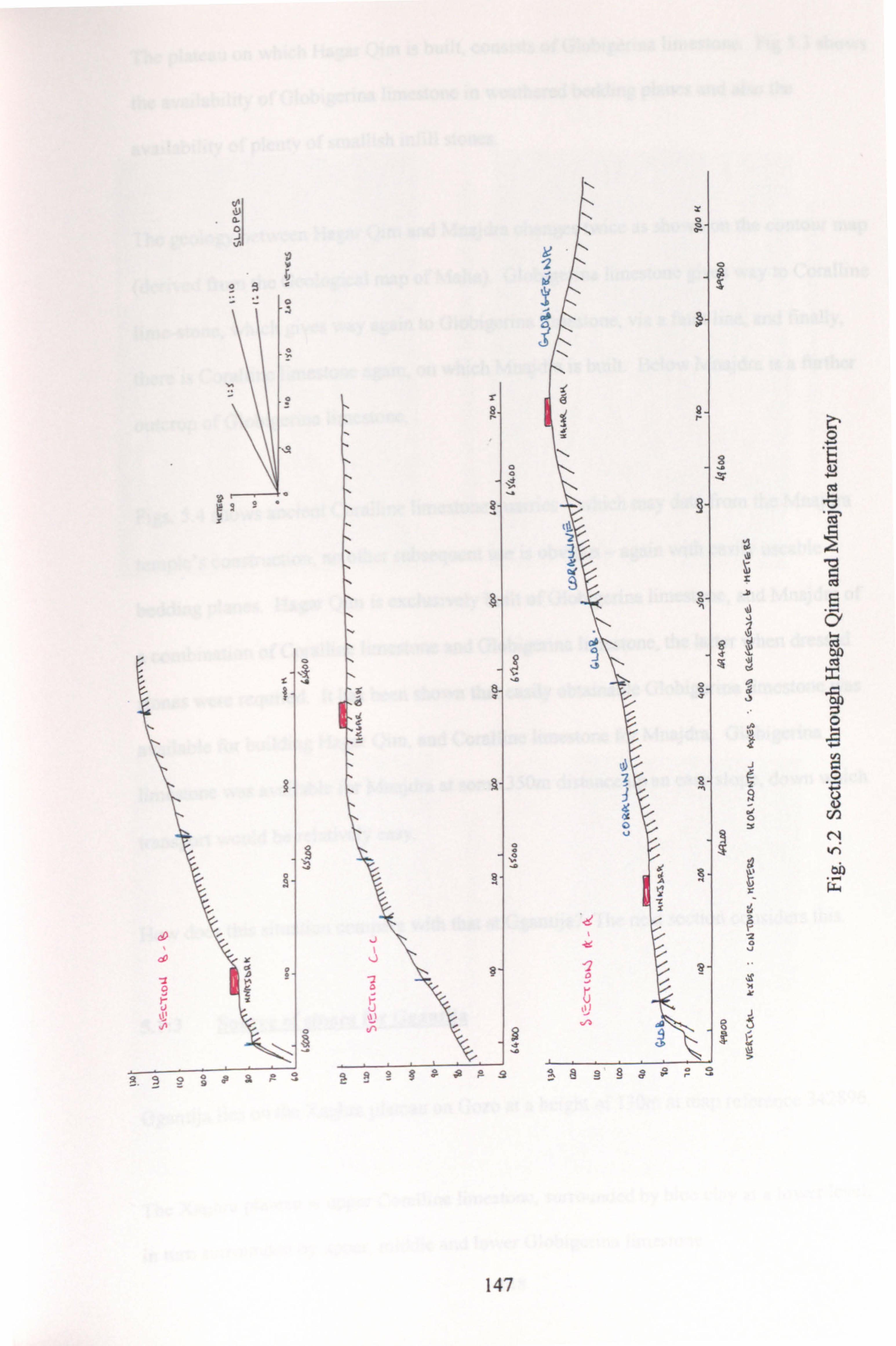
u 0 .1
y
C _a
°
r
T
O O
ý ýý
o w
9
J
J
O J
aý
9
Y
? äs
0 g
of 8 Y
t s r 9
1 s
8 J V
air
9 C
0
CIO s SF
ä .
ry
Z g
K a O ýc
f g `1
Y Y Z S J
U
Y
9. 9 9 §ý eR r° ý
0 E
ä Cd
bJý
147

The plateau on which Hagar Qim is built, consists of Globigerina limestone. Fig 5.3 shows
the availability of Globigerina limestone in weathered bedding planes and also the
availability of plenty of smallish infill stones.
The geology between Hagar Qim and Mnajdra changes twice as shown on the contour map
(derived from the Geological map of Malta). Globigerina limestone gives way to Coralline
lime-stone, which gives way again to Globigerina limestone, via a fault line, and finally,
there'is Coralline limestone again, on which Mnajdra is built. Below Mnajdra is a further
outcrop of Globigerina limestone.
Figs. 5.4 shows ancient Coralline limestone quarries - which may date from the Mnajdra
temple's construction, no other subsequent use is obvious - again with easily useable
bedding planes. Hagar Qim is exclusively built of Globigerina limestone, and Mnajdra of
a combination of Coralline limestone and Globigerina limestone, the latter when dressed
stones were required. It has been shown that easily obtainable Globigerina limestone was
available for building Hagar Qim, and Coralline limestone for Mnajdra. Globigerina
limestone was available for Mnajdra at some 350m distance up an easy slope, down which
transport would be relatively easy.
How does this situation compare with that at Ggantija? The next section considers this.
5.1: 3 Source of stones for Ggantiia
Ggantija lies on the Xaghra plateau on Gozo at a height of 130m at map reference 342896.
The Xaghra plateau is upper Coralline limestone, surrounded by blue clay at a lower level,
in turn surrounded by upper, middle and lower Globigerina limestone.
148

MAW w-j
b b aý aý
aý c 0 a) E
c a) an
0 C7
s
C) 0 0
0 a)
a) bA
C7
149
an
0 t5 E
o "ý C7ý
b a
a 2 Co 2
cn M KA
bD
T

. JZ
0 cr
aý
aý
0 U .r 0 0
I
a"
0 `r a) E
U
I 0 U
U O
Cfj ^O. + cd 05
Q U)
Q"
O O
G) E G) A
cd O
U
U V1
G) O O
G)
cd 0
U
a)
150

1%*
m
i
_-ý
N
U
vi
at w
_ý. ýý ice}- , f. " . tý--_ Iý
.1., a_ý "ý" .ý
21
ýY_ ,ºI. ac, I,
,Y
'ý ti
v'-p% ago
C
111 b! g
G
lop
Q CL V
41
lam,. J3 co
__ý ,. ýA"SiýJý: l�d \- ýý
. "ý ý aal 1_ý,.
151

Fig. 5.6 Globigerina limestone outcrop on faultline
Fig. 5.7 View from outcrop to Ggantija looking north east
152

The geological map (Fig. 5.5) shows the configuration. Most of Ggantija is built of
undressed blocks of Coralline limestone with occasional apparently dressed blocks. It is
now difficult to see where this stone came from because of agriculture and urban
development, but reference to the section on Hagar Qim and Mnajdra above, which lie in
open country, would suggest that accessible and appropriate bedding planes of Coralline
limestone would have been available at no great distance. The example of Mnajdra would
suggest that suitable stone would have been available at 100-200m. Conservatively, we
may assume 200m. To the north and west of Ggantija, the ground slopes gently upwards
and there would have been no serious terrain problems presented to transportation.
Some parts of Ggantija are composed of Globigerina limestone, such as the entrance and
interior jambs, presumably lintels, and carved temple architecture, such as the presumed
"altars". Some of these blocks are over 2cu m (or around 4.5 tonnes).
Examination of the geological map (see Fig. 5.5) and walking the territory, reveals the
nearest Globigerina limestone to be 600m distant in an east south east direction and 700m
distant in a south south west direction. However, neither of these potential sources are
outcrops and would have been difficult to utilise. In a roughly north east direction across
the Ramla valley, is a Globigerina limestone outcrop at a height of 20m above sea level
and 1.8km in a straight line from Ggantija, a distance that would be significantly increased
by the need to traverse the sometimes steep slopes.
The most likely source is an outcrop on a fault line, with convenient bedding planes about
1.2km in a straight line in a south west direction on the outskirts of the modem village of
Xewkija. See Fig. 5.5 and Figs. 5.6 and 5.7 for photographs. Map reference 335887.
153

A 1: 2500 contour map, with contours at 2.5m intervals, allowed possible transport routes
between this outcrop and Ggantija, to be plotted. Immediately to the south of Ggantija is a
steep scarp sloping downwards, which would be the most difficult part of the route to
negotiate.
Marked on an enlargement of the geological map (Fig 5.8) are the three routes which have
been plotted on the contour map, (Fig 5.9).
Route 1 involves a maximum gradient of 10°. The total distance is 1200m, with 60m at
1011,50m at 5° and the balance less than 2.5°.
Route 2 has a maximum gradient of 5°, a total distance of 1250m, of which 120m is at 5°.
Route 3 has a maximum gradient of 2.5°, a total distance of 1400m, of which 200m is at
2.5°.
Route 1 is little shorter than route 2 and seems unlikely. Route 2 would require
significantly more manpower than route 3, over 120m of its length and for the purposes of
the energetics analysis, route 3 has been assumed.
This assessment is of course predicated on the assumption that Temple Period land forms
were the same as modem ones. This may be incorrect for two reasons:
1. Erosion and/or deposition may have taken place. It seems unlikely that these would
have had a major effect on the routes, or the slopes postulated.
2. There may have been tectonic disturbances since Ggantija was constructed. The 154

"Fw
low
"ok
1
""wý-, ý:
of
Cd cn C7 0 4- t
a
0 N E
on
0
40.
00
155

A
W
A
Q g
bo
Q .ý
0
d 7 4 N
ed
C7 0
0 N
b 0
N ". r
cs
oý
ab
156
00poo "o oo000 o aý öe N cr .. oa bs
r
S/10. a

Maltese islands have been subject to such disturbances for millions of years : indeed
they are the cause of Malta's complex geology, and of the many fault lines visible
today. Zammit-Maempel (1977: 18) suggests that some faulting may possibly have
occurred since Neolithic times. Whether this applies to the Globigerina outcrop
identified as the source for Ggantija, must be uncertain. It does not have the features
cited by Zammit-Maempel as evidence for the recent origin of the Maghlaq fault on
Malta. The possibility of post temple construction faulting proximate to Ggantija has
therefore been ignored.
5.1: 4 Methods of Quarrying
The literature has been reviewed for methods of quarrying and the energetics involved, that
seem relevant to Malta. Additionally, two old time Gozitan quarrymen have been inter-
viewed. This section presents the findings laid out by geographical location and concludes
with a table proposing labour estimates for use in the energetics analysis. By way of
preface to all the labour estimates, it is worth stressing the great variability of work rates -
a point made by Ritchie (1976: 51) in reference to Cornwall's (1974: 199) experimental
work at Wareham, Dorset.
The most useful experimental work has been done in Mesoamerica:
ABRAMS 1984 a (149-54 and 190), and 1989 (70), gives experimental data for quarrying
tuff in lowland Maya country in Yucatan, Mexico. This tuff is consolidated small particle
volcanic ejecta, and although of different origin, is similar in hardness and density to
Maltese Foraminifera-based Globigerina limestone.
The quarrying technique he gives is to:
157

Clear the outcrop of dirt and locate fissuring.
Hammer spikes into the fissures (or specially cut "indentations"), lever about and
break off the block.
Cut the block into "suitably-sized" pieces. He does not say what these are, but one
may assume 25-40kg.
Abrams cites various experiments and concludes that a reasonable average procurement
rate is 750kg per person-day of 5 hours, using wooden and stone tools. This includes
cutting into "suitably-sized" pieces, but not dressing.
ERASMUS 1965: 285-6, writes about experiments he conducted in Yucatan, Mexico:
"Had I not personally observed these experiments (on the excavation of building stones), I
would not have believed that so much rock could be so rapidly pried from the surface of
such a small area. A heavy hardwood post... was used by a Mayan Indian ... skilled at
excavating surface rock". He excavated 1700kg in five hours, a working day in the heat
prevailing. This was one third the amount excavated by a man using an iron crow bar.
The material was tuff and the block sizes ranged from 25-35kg.
SIDRYS 1978 b: 170, discusses the quarrying of limestone blocks for use as stelae in
Mesoamerican Mayan sites. The method used was the common one of channelling sides
and back "probably using imported greenstone celts and/or local large chert bifaces as
chisels in conjunction with hammerstone or wooden mallets". The bottom was undercut at
various points and levers placed in these, to snap the remaining "pegs". No labour
estimates are given.
For Egypt, HODGES 1970: 86-7, describes how "each block of stone appears to have
been cut clear at either side and at the back by making a narrow draught, using either
158
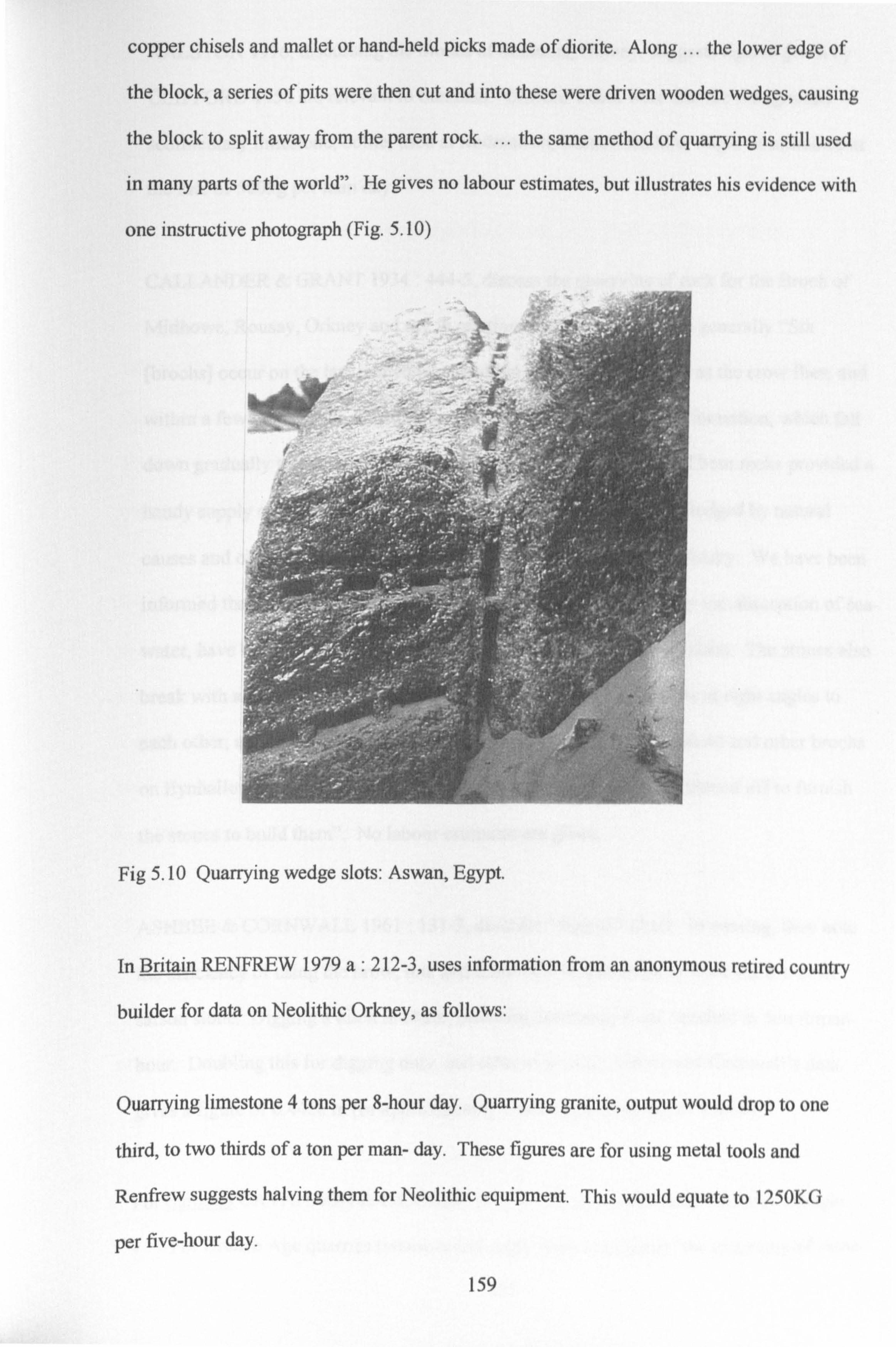
copper chisels and mallet or hand-held picks made of diorite. Along ... the lower edge of
the block, a series of pits were then cut and into these were driven wooden wedges, causing
the block to split away from the parent rock. ... the same method of quarrying is still used
in many parts of the world". He gives no labour estimates, but illustrates his evidence with
one instructive photograph (Fig. 5.10)
r r r
,; s
-
1'
Fig 5.10 Quarrying wedge slots: Aswan, Egypt.
In Britain RENFREW 1979 a: 212-3, uses information from an anonymous retired country
builder for data on Neolithic Orkney, as follows:
Quarrying limestone 4 tons per 8-hour day. Quarrying granite, output would drop to one
third, to two thirds of a ton per man- day. These figures are for using metal tools and
Renfrew suggests halving them for Neolithic equipment. This would equate to 1250KG
per five-hour day.
_ý, r
159

RALSTON 1976, discussing the Stones of Stenness, Orkney, suggests figures given by
CLIFFORD 1950 are relevant to Stenness. Clifford's data were that the fine grained
sedimentary limestone, oolite, used at Rodmarton, Gloucestershire, might be extracted at
the rate of 500kg per man day.
CALLANDER & GRANT 1934: 444-5, discuss the quarrying of rock for the Broch of
Midhowe, Rousay, Orkney and say in relation to broch construction generally "Six
[brochs] occur on the last-named island within a distance of 4 miles as the crow flies, and
within a few yards of the flagstone rocks of the Old Red Sandstone formation, which fall
down gradually to the water's edge in a series of ledges and steps. These rocks provided a
handy supply of good building material, as many slabs had been dislodged by natural
causes and others could be levered or wedged off without much difficulty. We have been
informed that wedges of wood, driven in dry and allowed to swell by the absorption of sea-
water, have been used within living memory in Orkney, to prise off slabs. The stones also
break with a natural fracture, often leaving three straight edges, some at right angles to
each other, and to the bedding plane. In the neighbourhood of Midhowe and other brochs
on Eynhallow Sound, it is quite plainly seen where slabs had been skinned off to furnish
the stones to build them". No labour estimates are given.
ASHBEE & CORNWALL 1961: 131-2, describe "digging" chalk. In passing, they note
the efficiency of using the brow, tine and beam of a Wapiti antler to lever out a 1-2cwt
sarson stone. Digging a ditch in chalk, including bucketing it out, resulted in 5cu t/man
hour. Doubling this for digging only, and otherwise using Ashbee and Cornwall's data
gives a figure of 0.44cu m (or approximately 1 tonne) per man day of 8 hours.
For Sardinia CAVANAGH & LAXTON, 1987 b: 41, say concerning Sardinian nuraghi
For Bronze Age quarries (where metal might have been used) "the quarrying of stone
160

may have been so informal as to leave no clear trace".
"rubble would probably have been fragmented ...
by ... undercutting and fire-setting. "
"for large, more regular blocks ... it is possible that more sophisticated methods using
channels, drilled holes, cuts and wedges were used. "
It seems - "probable that natural bedding planes were exploited to give stones of
approximately equal size. "
WEBSTER, 1991, in relation to nuraghi construction, makes some detailed calculations of
the labour input to their construction. On page 845, he says large stones at the base may be
Icu m weighing 2250kg, smaller higher ones 50 x 50 x 25cms, weighing 140kg, with an
average of 75 x 50 x 50cros, ie. 0.2cu m weighing 450kg.
On page 848, he suggests that "building stone was procured from shallow bedrock deposits
at no great distance. The weathering of shallow surface bedrock [basalt in this case] is, in
many elevated locations, visibly advanced. Today [fields are] densely strewn with
nuraghi-sized boulders". Further "one might guess that simple wood and stone tools would
have served - wooden prey-bars and splitting wedges, hard stone hammers". Evidence "...
suggests distances of less than 200m. " (with 2km a maximum).
On quarrying, transporting, rough dressing and wall construction, he uses data from
Erasmus 1965 and Abrams 1984. These are noted above. But it is worth pointing out that
Erasmus was reporting on the quarrying and transport of blocks, averaging 30kgs in
weight, well below any reported by Webster.
On Easter Island, HEYERDAHL, 1958 and SKJOLSVOLD, 1961: 365-374, describe how
the mayor and five of his men, picked up abandoned stone picks at the quarry site of Rano
Raraku. Clenched like daggers in their hands, they used them to cut side and back grooves
161

for a potential statue, using copious water. The stone is hard volcanic and this was
essentially a bashing, not a cutting technique, accompanied the while by rhythmic
chanting. Time estimates were that two teams of six, working shifts, would require 12
months to cut a block about 5x1.5 x lm. This estimate is very much larger than any given
above. The stone is harder, the work was not taken to a conclusion and it may be that there
was a certain predisposition by the modem Easter Islanders (and perhaps the Norwegians)
to exaggerate the achievements of their ancestors. Nevertheless, if correct, the demand for
surplus labour on Easter Island would have been huge and would have placed a real strain
on society.
For Malta, POLLINI, 1988: 136, gives the following figures for the three sizes of block he
considers:
2.5 tonne blocks, 7-11 hours = 0.7 tonnes/day
3.5 tonne blocks, 11-16 hours = 0.8 tonnes/day
11 tonne blocks, 14-25 hours = 0.4 tonnes/day
The smaller blocks are predominant, so Pollini's average is say 0.7 tonnes/day, which
equals 1.4 P. Ds. /tonne (for a five hour day).
Gozo. Personal field work by the author : In September 1995, Comino Azzopardi was
interviewed. He runs, together with his son, grandson and great grandson, a family
Globigerina limestone quarry on the west of Gozo. Aged c. 73, he lives in Xaghra. The
huge quarry, now mechanised, used to be worked by him and his colleagues by hand, a
process he described to me. Blocks 15' wide by 10' high by 4' deep (4.5m x 3. Om x 1.2m)
were extracted by cutting channels at the sides and back, using a pickaxe. (See Fig. 5.10,
Azzopardi was wearing sandals, had a sore foot, and it was very, very wet, so he didn't
want to go into the quarry to demonstrate! ) Slots were then cut in the base. Into these,
metal wedges were driven (see Fig. 5.11) which then, or overnight, split off the block.
162
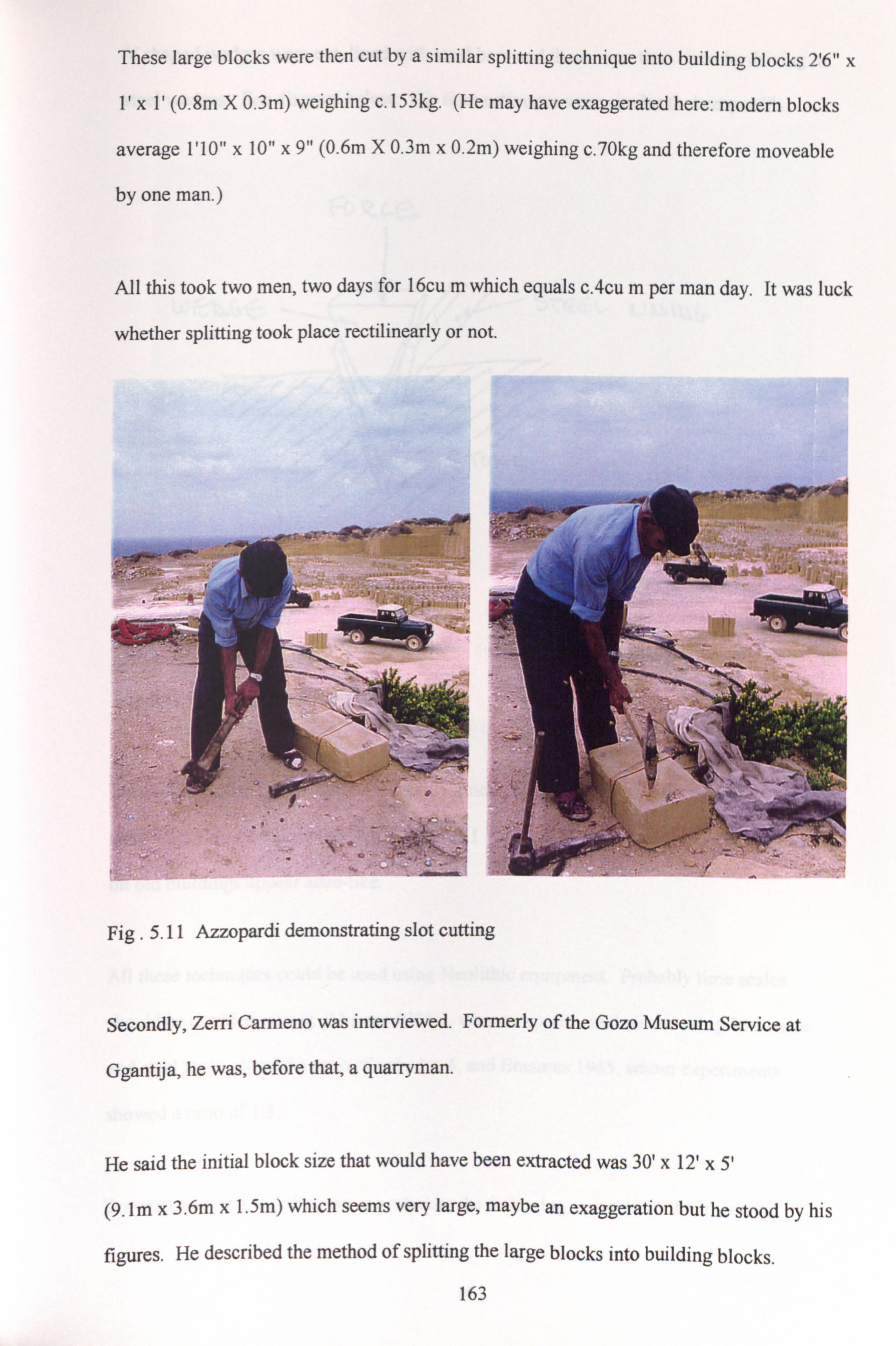
These large blocks were then cut by a similar splitting technique into building blocks 2'6" x
1' x 1'(0.8m X 0.3m) weighing c. 153kg. (He may have exaggerated here: modern blocks
average 1'10" x 10" x 9" (0.6m X 0.3m x 0.2m) weighing c. 70kg and therefore moveable
by one man. )
All this took two men, two days for l6cu m which equals c. 4cu m per man day. It was luck
whether splitting took place rectilinearly or not.
}
_ ETIT. __ _
f
I. äf'; ß r
-
rý ý.
Fig. 5.11 Azzopardi demonstrating slot cutting
aX'- -"
_ý_ ý+
It'
ý+ C
ol
Secondly, Zerri Carmeno was interviewed. Formerly of the Gozo Museum Service at
Ggantija, he was, before that, a quarryman.
He said the initial block size that would have been extracted was 30' x 12' x 5'
(9. Im x 3.6m x 1.5m) which seems very large, maybe an exaggeration but he stood by his
figures. He described the method of splitting the large blocks into building blocks.
163
' '! .
-. ' . ý,

V shaped wedges were cut, lined with steel bars and these were then riven by driving in
steel wedges. See diagram below: His time estimates were similar to Azzopardi's.
ý. ýý
ýýýTýý S 71S6 L- 0_l I. i 111(r
ýj ýýýý
ý/ý
Fig. 5.12 Driving in splitting wedges
sl
Dressing of these stones, and Globigerina limestone is very soft when first cut, was done
with what Carmeno described as an axe, but I think was an adze: certainly dressing marks
on old buildings appear adze-like.
All these techniques could be used using Neolithic equipment. Probably time scales
should be doubled, see eg. Abrams 1984 a, whose experimental results using both stone
and steel tools, showed a ratio of only 1: 1.5, and Erasmus 1965, whose experiments
showed a ratio of 1: 3.
Drawing this data together, we can tabulate the following, using Neolithic methods:
164

h `i w
Fig. 5.13 A relatively modern block split by wedging. Hagar Qim.
r }'ý �,
r _, 4
Vr
Fig. 5.14 Zerri Carmeno showing an unused splitting slot at Ggantija North Temple.
165

Type of Rock Size of Block Weight of Block Person Days/cu m
Tuff Limestone Various for building 2.93 (Yucatan, Mexico, Abrams 1989)
Tuff Limestone 0.01-0.02cu in 23-34kg 1.25 (Yucatan, Mexico, Erasmus 1965)
Hard Volcanic 7.5cu in 19 tonnes 480 (Easter Island, Skjolsvold 1961)
Soft Limestone Various for building 1.25 (Scotland, Renfrew, 1979 a)
Granite Various for building 10.0 (Scotland, Renfrew, 1979 a)
Oolite Various for building 10.0 (England, Clifford 1950)
Chalk Digging a ditch in chalk 0.44 (England, Ashbee & Cornwall 1961)
Limestone (unspecified) c. 1.4cu in 3 tonnes 1.4 (Malta, Pollini, 1988)
Globigerina limestone c. 0.05cu m c. l20kg 0.5 (Gozo, Author, 1995)
On this showing the quarrying time for Globigerina limestone seems low: on the other
hand, it is a very amenable material, so perhaps the figure might be accepted. (See end of
this section for figure used in subsequent analysis. )
The data may be represented graphically:
GA%R9lrT(E -º
Wk% N r-SS
'TV AF --º-
GLO Mt GEl iitjk , Gtr t*A_A -+
i
Fig. 5.15 Quarrying time : hardness v. labour
166
F-tt- /CAA. M 10

From the foregoing on the location of quarries and the method of quarrying, the following
points may be summarised:
Soft Globigerina limestone may be levered out of fissured courses.
Available Neolithic techniques would allow the extraction and dressing of
rectilinear blocks, using the side and back channelling method and freeing the block
by baseline hole or partial channelling and breaking the block free by driving in
wooden wedges, possibly including wetting them to cause swelling.
Hard Coralline limestone blocks could be levered out from layered courses.
Coralline limestone blocks could also be extracted as blocks, using the same quarrying
technique as for Globigerina limestone, but this would be very laborious.
A reasonable time estimate for sizeable stones, based on the above data, would be a
minimum of 0.5 man days per cubic metre and a maximum of perhaps 2.9 man days
per cu m, say an average of 1.0 man days per cu m, whether for Globigerina
limestone (involving some quarrying) or for Coralline limestone (assuming only
levering out layered blocks), which at 2.2 tonnes/cu m=0.45 P. Ds. /tonne - and for
rubble and earth, double this amount ie. 0.23 P. Ds. /tonne.
These figures of 0.45 P. Ds. /tonne and 0.23 P. Ds. /tonne, are the "central" ones, ie. the
author's best estimates that are used in the energetics analysis in Chapter 6. The
possible variations used in the Sensitivity Analysis, also in Chapter 6, are discussed.
there.
5.1: 5 Methods of Stone Transport : General Description
Wheels had not been invented when the Maltese were building their temples. Given this
fact, the following transportation methods were open to them (always assuming that timber
167
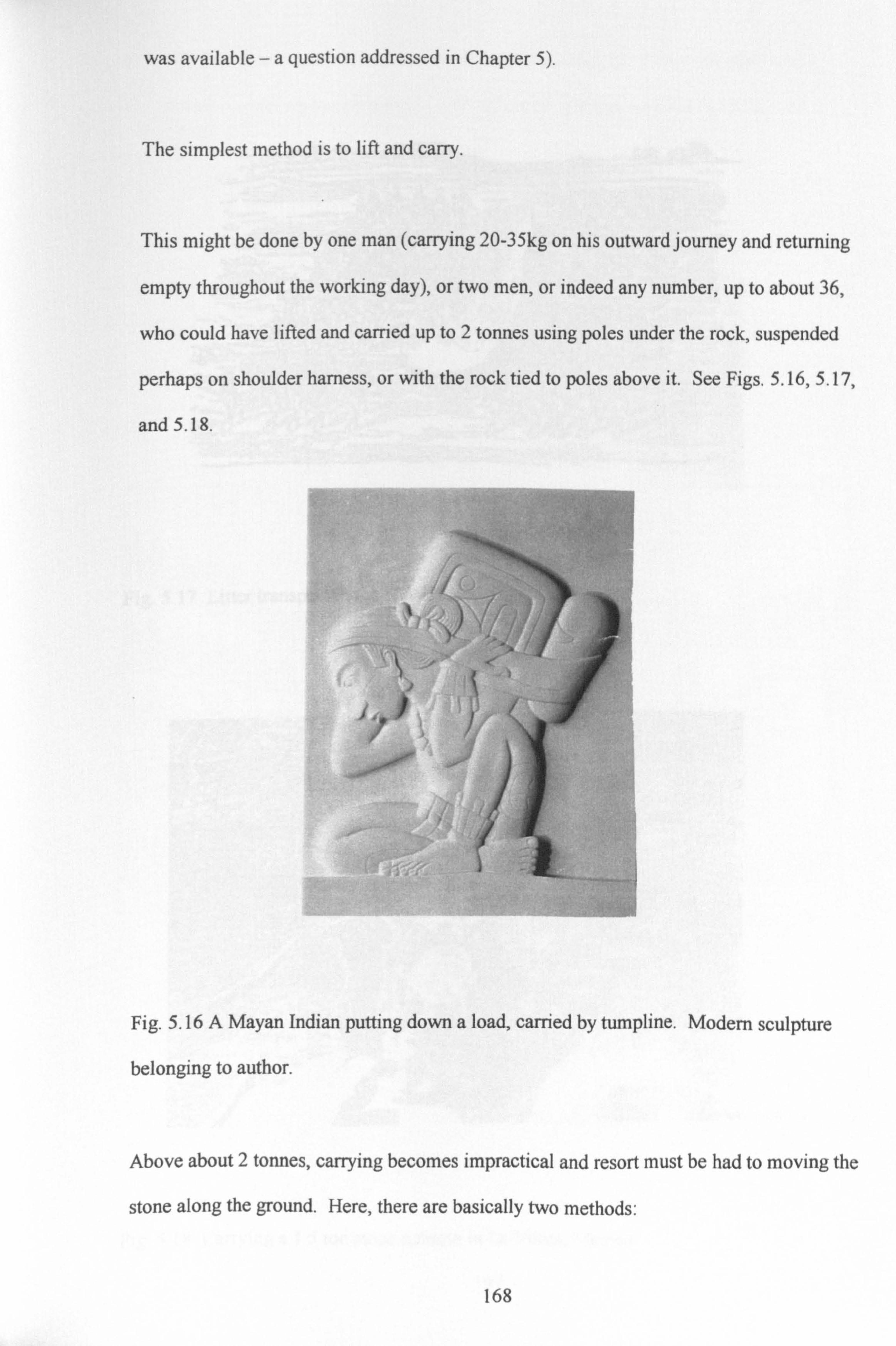
was available -a question addressed in Chapter 5).
The simplest method is to lift and carry.
This might be done by one man (carrying 20-35kg on his outward journey and returning
empty throughout the working day), or two men, or indeed any number, up to about 36,
who could have lifted and carried up to 2 tonnes using poles under the rock, suspended
perhaps on shoulder harness, or with the rock tied to poles above it. See Figs. 5.16,5.17,
and 5.18.
i t L. i
Fig. 5.16 A Mayan Indian putting down a load, carried by tumpline. Modern sculpture
belonging to author.
Above about 2 tonnes, carrying becomes impractical and resort must be had to moving the
stone along the ground. Here, there are basically two methods:
168

Fig. 5.17 Litter transport in the Himalayas
Fig. 5.18 Carrying a 1.5 ton stone column in La Venta, Mexico
169

1. The first is to employ levers, either on their own - they are a very efficient lifting
device - or levers in combination with rollers or (perhaps relevant to Malta - see
later) stone "canon balls".
2. Second is to drag the stone on a sledge. This may run over a specially made track,
have its way lubricated with water or grease, or run on rollers. In any case, its passage
may be assisted with levers. There is a fine Assyrian relief employing most of these
techniques: Fig. 5.19 below.
Fig. 5.19 Assyrian transport: eighth century BC.
Medium sized stones could be dragged along the ground on aV or Y shaped sledge, cut
from a suitably shaped tree. Heyerdahl, 1961, reports an experiment using this method.
Hutton, 1922, describes witnessing Naga tribesmen in Assam using such a method. See
Fig. 5.22
170

Fig. 5.20 Tarxien Temples: 'Canon Balls' for transport?
Fig. 5.21 Tarxien Temples: Balls and cylinders for transport?
171

Fig. 5.22 Naga tribesmen using aV shaped sledge
5.1: 6 Methods Of Stone Transport : Quantified Examples
There follows a review of the literature, especially where some indication of energetics is
given. At the end of the section, the data have been tabulated.
ABRAMS 1984 a: 160 and 1989: 70, gives the following formula for moving earth
(derived from United Nations 1961, Economic Commission for Asia and the Far East
1957. ) It is equally applicable to any load that can be carried:
P. Ds. /cum =LX [I + 11
v
Where P. Ds. = person days
L= quarry to site distance in kms
Q= quantity carried per journey in cu m
H= hours per day (taken as 5)
V= velocity loaded kms/hour (taken as 3)
V' = velocity unloaded kms/hour (taken as 5)
172

This works for any load one person can carry. If, for example, two persons are carrying
one load between them, then the P. Ds. must be doubled.
ATKINSON, 1956: 109, discusses the methods and energetics of moving the bluestones
and sarsens of Stonehenge, Wiltshire. He suggests that wooden sledges were used, and
describes an experiment where schoolboys, 32 in number, pulled such a sledge, weighing
3500 lbs (1500kg) up a 4° slope.
When rollers were placed under the sledge, the pulling numbers needed, reduced to 14, but
of course the rollers needed moving too. In addition, steering ropes and people would be
needed.
He goes on to suggest that 22 men per ton weight would progress at half a mile per day.
"The heaviest stones, which weigh about 50 tons, would therefore need some 1100 men to
move them. "
ATKINSON, 1959: 60-3, says that a 50 ton stone would require 100 men "to pull it along
on rollers on flat ground, and at least another 100 to lay the rollers in front of the sledge
and keep it from wandering sideways. To pull the stone up ... a gradient of 9° would need
at least another 350 men".
If we take further figures from Atkinson, (1959 : 60) he says that with good rollers, 10
men could pull a 1.5 ton stone on a sledge up to a 4° slope: thus 7 men per ton. 50 tons
would take 350 men. So his 450 men up a 9° slope, tallies better than his 1956 figure of
1100 men. All these figures need multiplying by 2.2 to convert from cu m to tonnes and we
arrive at: - 350 x 2.. 2 = 18.8 P. Ds. per tonne per km 50 x1.2x0. x161
173
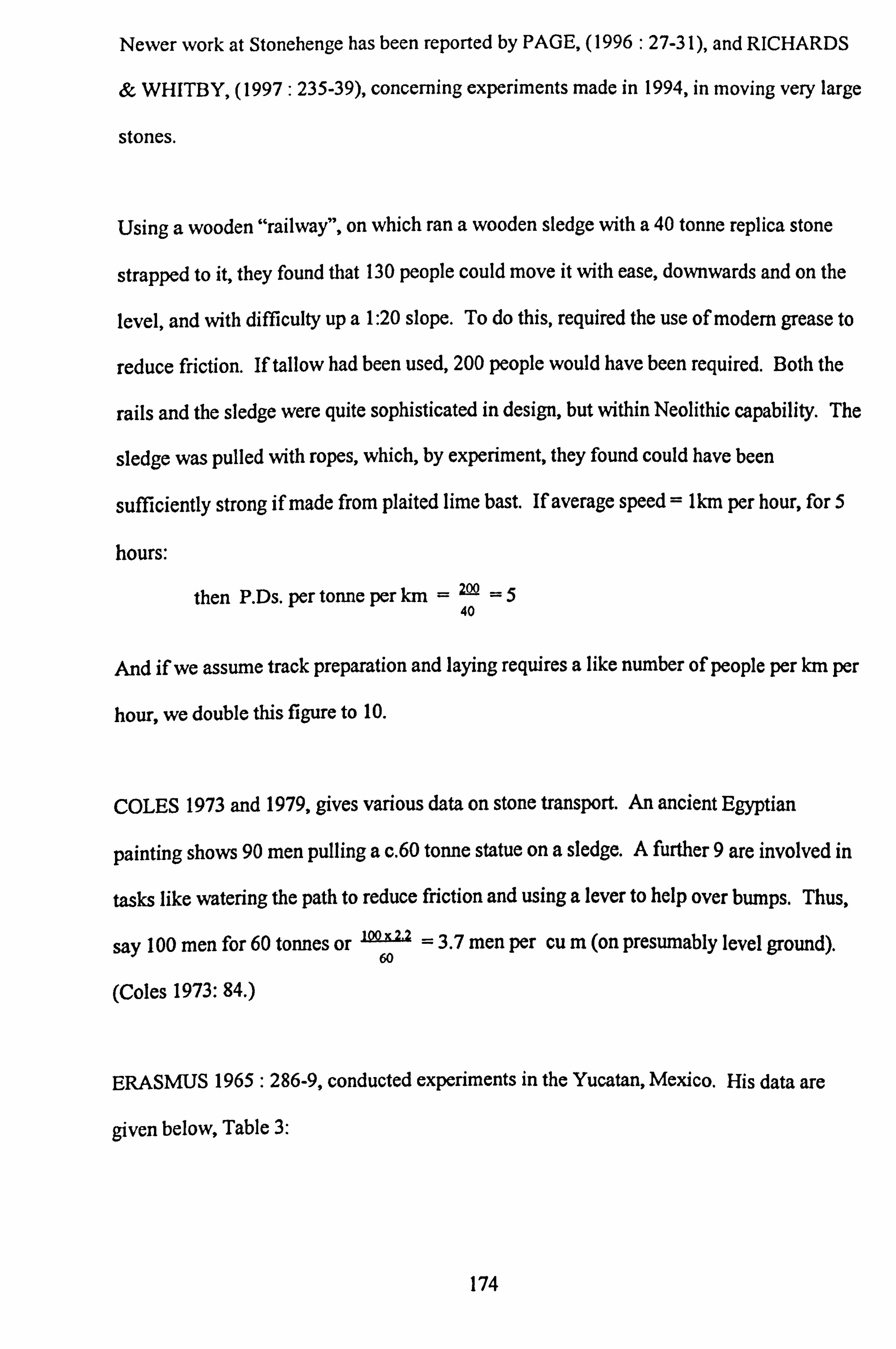
Newer work at Stonehenge has been reported by PAGE, (1996: 27-31), and RICHARDS
& WHITBY, (1997: 235-39), concerning experiments made in 1994, in moving very large
stones.
Using a wooden "railway", on which ran a wooden sledge with a 40 tonne replica stone
strapped to it, they found that 130 people could move it with ease, downwards and on the
level, and with difficulty up a 1: 20 slope. To do this, required the use of modern grease to
reduce friction. If tallow had been used, 200 people would have been required. Both the
rails and the sledge were quite sophisticated in design, but within Neolithic capability. The
sledge was pulled with ropes, which, by experiment, they found could have been
sufficiently strong if made from plaited lime bast. If average speed = tkm per hour, for 5
hours:
then P. Ds. per tonne per km = 200 =5 40
And if we assume track preparation and laying requires a like number of people per km per
hour, we double this figure to 10.
COLES 1973 and 1979, gives various data on stone transport. An ancient Egyptian
painting shows 90 men pulling a c. 60 tonne statue on a sledge. A further 9 are involved in
tasks like watering the path to reduce friction and using a lever to help over bumps. Thus,
say 100 men for 60 tonnes or ý2 = 3.7 men per cu m (on presumably level ground).
(Coles 1973: 84. )
ERASMUS 1965: 286-9, conducted experiments in the Yucatan, Mexico. His data are
given below, Table 3:
174

Carriers Total Total Total Weight Per Trips Distance Weight Trip
(Kilometres) (Kilograms) (Kilograms)
A 34 17 950 28 250 metres
B 20 20 500 25 500 metres
C 15 22.5 517 34 750 metres
D 11 22 250 23 1000 metres
Table 3: Rock Carrying Experiment.
Carriers B, C and D used tumplines, A carried on his head. The average is 27kg over a
total distance of carrying there, and coming back empty, of 2 1km per man day.
Although his narrative is a bit confused, he also gives a graph: -
6 J1 III I
Idcll rig ns ös , s . 1claal Pertormaacs
O
Distance is meters from Escaratioa to fill
Fig. 5.23 Relation of load to distance for human carriers
As a cross-check, the author compared data from this graph with Abrams' formula (see
above). From the graph for a distance of 0.5km, one person would carry 0.5 tonnes in a
day. This may be converted to 4.4 P. Ds. per cu m. Using Abrams' formula, we get 4.8
175

P. Ds. per cu m, so there is remarkable correspondence.
HEIZER, (1966: 825), describes an experiment in La Venta, Mexico, which showed that a
stone column, weighing 2 tonnes, was the maximum that could be lifted, by 35 men, using
rope slings and shoulder poles. If they progressed, on average, at Ikm/hour for 5 hours,
this equals 3.5 P. Ds. /tonne/km.
HEYERDAHL, (1958 and 1961), and SKJOLSVOLD (1961: 365-74), on Easter island,
organised a gang of 180 "previously feasted" men to pull a 4m. statue weighing 10 tonnes
"some distance" on aY shaped wooden sledge, without rollers, on level ground. This
equates to 18 men per ton or 40 men per cu m. Speed was not given, nor were the
consequences of feasting assessed!
HUTTON 1922 : (244-7), describes the transportation in 1921, of stone statues in Fiji, by
Naga tribesmen. The sledge on which the statues were transported, was aV shaped main
timber from a forked tree, with cross slats to carry the statues. The larger of two statues
weighed perhaps 1.5 tonnes. The sledges were pulled by an unspecified number of men,
but up to 200 were available, when necessary, using natural creeper ropes. The transport
was accompanied by much ceremonial. It is fairly clear that the number of men available,
was not the minimum required to pull the sledge, "the pullers for the [smaller] stone were
few in number". See Fig. 5.22.
Reports of similar sledges have been made in other Asian and Pacific ethnographic
investigations.
RENFREW, 1979 a: (213), gives some transport times given to him by an old time
Orcadian builder: -
176

1000 cu yds of stone materials being carried over 50yds, would take 1000 man hours,
which converted to metric units, equals 2.2 P. Ds. /cu m/km. This is close to the result of
2.3 P. Ds. /cu m/km, produced by Abrams' formula.
SIDRYS, 1978 b: (172), says that "in Sumba, for example, an 11 ton block was dragged
on a sledge for 3km by 525 men in two days.
This means that 25 x= 32 P. Ds. per ton, per km were required equivalent to 69 P. Ds. 11x3
per cu m, per km.
POLLINI, (1988: 134-51), for Malta, divides transport labour into two: that required for
moving quarried blocks from immediate quarry site, to a pre-constructed transport sledge
track, and the labour required for moving the blocks along the track. He divides his blocks
into: small (average 2.5 tonnes), medium (3.5 tonnes), and large (11.0 tonnes). For a five
hour day, labour required ranges from 54 to 152 P. Ds. /tonne/km and averages 70
P. Ds. /tonne/km. It should be noted that Pollini assumes there are no blocks or rubble small
enough to carry : all his material is moved by large block transport methods.
THE AUTHOR at Chongqing, China in 1997, at a drainage construction site, observed two
men carrying a large stone slung from a pole over their shoulders. Based on the
photograph, Fig. 5.24, the radius of the roughly spherical stone, was 23 cms, its volume
0.05cu m, and weight at 2.2sg, 0.11 tonnes. This is a heavy load and so if we assume they
can carry it for 3.0 hours per day at 2km per hour, then P. Ds. per tonne per km = 4.5.
177

ýýýt
S.
Fig. 5.24 Two Chinese canying a stone
ZAMMIT, 1930, on Maltese temples says: -
P. 10 "... the stone blocks of which [some temple structures] are made, rested on rows of
spherical stones, varying in diameter from about one to two feet ... These stone balls are
met with in all the Maltese megalithic ruins, and must have served the purpose of rollers".
P. 85 "Probably [the larger stone balls] served the purpose of rollers to help shifting of the
large stone blocks. Being of soft Globigerina limestone, they were easily shaped, both
intentionally and by dint of being rolled under the pressure of a heavy weight. They broke
easily, and many fragments of them have been found. ...
One cannot fail to conjecture,
however, that they might have had a religious significance". Of these remarks Heizer,
(1966: 829), comments "The limestone balls of Malta are, however, clearly too soft to
have been used in this fashion" without elaborating further. Heizer's scepticism would
appear to be justified.
178

5.1: 7 Tabulation of Results for Stone Transport
A. Liftable weights, small
Abrams' formula is:
P. Ds. /cum =LX [I +I v
We can apply values to this formula:
L= distance to materials = say Ikm
Q= capacity of container = say 0.014 (30kg at 220kg/cu m)
H= hours per day, taken as 5
V= speed in km/hour loaded, taken as 3
VI - speed in km/hour unloaded, taken as 5
Thus P. Ds. per cu m per km= x (3 +s ) 0.014 x=7.6
or P. Ds. per tonne, per km = 3.5
Abrams' formula has been used for the "central" energetics analysis.
B. Liftable weights, large
Heizer's experiment produced a figure of 3.5 P. Ds. /tonne/lan.
Pollini gives an average of 70 P. Ds. /tonne/km.
The author in China, P. Ds. per tonnne, per km = 4.5.
Conclusion : Mexico was a controlled experiment and Heizer's figure of 3.5
P. Ds. /tonne/km, has been used as the "central" figure. (Equal, it may be noticed, to
the figure for smaller weights given above. )
179

C. Unliftable (dragable weights)
Summarising the above:
Atkinson: 17 men per cu m gives:
18.9 P. Ds. per cu m, per km, up a 4°. Multiply by 3
for a 9° slope. Using sledge and
rollers. English experiment.
Coles: 3.7 men per cu m on level ground. 60 tonne load on sledge, no rollers, level
ground, derived from Egyptian painting.
Heyerdahl & Skjolsvold: 40 men per cu m: modem experiment, Easter Island.
Sidrys: gives 115 men/cu m and 69 P. Ds. per cu m, per km: modern Sumba.
Page & Richards & Whitby: give data allowing us to assume about 10 P. Ds. per tonne
per km.
Pollini: gives data that equate to 70 P. Ds. /tonne/km.
Conclusion: use Atkinson: say 20 P. Ds. per cu m, per km with a
1.5 x uplift for slopes of 5°. That is:
P. Ds. per tonne, per km downhill or level = 9.1
P. Ds. per tonne, per km up a 5° slope = 13.6
If, as suggested earlier in this chapter, Globigerina limestone blocks over 2 tonnes
were resourced where indicated and carried on route 3, then 1 tonne takes 9.1 x 1.2 +
13.6 x 0.3 = 13.6 P. Ds., and smaller blocks less than 2 tonnes take 3.5 x 1.4 = 4.9
P. Ds. per tonne.
180

In Summary
Small loads _5
30 kg P. Ds. per tonne, per km = 3.5
Medium loads 30kg -2 tonnes P. Ds. per tonne, per km. = 3.5
Large loads over 2 tonnes P. Ds. per tonne, per km
- downhill or level = 9.1
- up a 5°slope = 13.6
In applying these data to the quantities involved, it has been assumed that the blocks used
were dressed where procured, that is that the finished blocks were transported and that the
dressing chippings were transported separately, to be converted into torba on the temple
site.
5.1: 8 Preparation of Stones
ABRAMS, (1984 a: 163-5), and also Abrams (1984 b), reports on the experimental
dressing of 14 masonry blocks by four masons, using Neolithic tools. The experiments
took place in the Yucatan, Mexico and were on the local tuff, which has similar
characteristics to Maltese Globigerina limestone. He found that it took 11.6 P. Ds. per cu m
or 5 P. Ds. per tonne. These figures have been used for Globigerina limestone blocks. He
also describes (1984 a: 168-71), experimental sculpturing of both simple and complex
motifs. Appropriate to the Ggantija sculptured stone surfaces are his simple motifs. See
Fig. 5.25 below:
Fig. 5.25 Simple sculpture. Scale 1: 6
181

The labour requirements based on 7 "simple" carvings, were 6.2 P. Ds. per sq m. These
figures have been used.
Concerning Coralline limestone blocks, which constitute the vast majority of masonry in
the Ggantija temples, it is presumed, based on their appearance, that no preparation was
involved.
5.1: 9 Erection of Stones
ABRAMS, (1984 b: 70), (see also Abrams, (1984 a: 175-6), gives a figure of 0.6 P. Ds.
per tonne for dressed masonry walls, in Yucatan, Mexico.
ERASMUS, (1965: 291-2), gives a figure of 2.9 P. Ds. per tonne for cemented, dressed
block construction, also in Mexico.
RENFREW, (1979 a: 212-4), quotes figures that work out at 0.2 P. Ds. per tonne for
undressed blocks in Orkney.
A figure of 0.6 P. Ds. per tonne, has been used for masonry comprising blocks below 2
tonnes, that is those that can be carried by men.
For construction, using stones over 2 tonnes, other data are needed. These are scant
because although many experiments have been carried out to erect large blocks, they have
been concerned with how and by how many, and not with how long. Pollini (1988) has a
complicated series of calculations to arrive at labour requirements for erection. He
assumes all blocks are over 2 tonnes in weight and his data works out at an average of 5.1
P. Ds. per tonne.
182

RICHARDS & WHITBY, (1997: 235-52), give figures from which one may deduce that
18,000 P. Ds. were required to raise seventy 40 tonne uprights at Stonehenge. This works
out at 6 P. Ds. /tonne. As they give no evidence for their numbers and this figure must
therefore be somewhat conjectural.
It has been noted above, that the transport of large blocks over 2 tonnes, require 9.1
P. Ds. /tonne/km over level ground, which compares with 3.5 P. Ds for stones under 2
tonnes, which may be lifted.
In the absence of any reliable person-day calculations for the erection of large blocks, the
very arbitrary calculation has been used of applying the transport ratio for small blocks to
large blocks (ie. 3.5 : 9.1) to their erection.
9A x 0.6 = 1.5 P. Ds. /tonne for blocks over 2 tonnes. 3.5
5.2. RUBBLE
Very large quantities of rubble were used. The rubble comprised small stones, gravel and
earth. The major quantity was used to infill the spaces between the outer perimeter wall
and the apse walls. It was also used on the roof, the floor and on the terraces.
5.2: 1 Rubble Procurement
It is assumed that the source was very local to the temples, averaging 0.2km and that
procurement involved little more than digging it up. Abrams', (1989: 70), formula gives a
figure of 0.19 P. Ds. /tonne and this figure has been increased by 20% to allow for the
increased labour in prising out stones as well as earth, resulting in a figure of 0.23
P. Ds. /tonne. (This may be compared with the figure of 0.55 P. Ds. /tonne prising out chalk
183

derived from the data in Ashbee & Cornwall, (1961: 131-2), which involved significant
quarrying from hard beds. )
5.2: 2 Rubble Transport
Application of the standard formula (given for instance in Abrams, 1989 : 70), results in a
figure of 0.7 P. Ds. /tonne.
5.2: 3 Rubble Erection
This is a very minor operation, basically tipping out the load, at times after carrying it up
when infilling between walls, and some levelling. Abrams allows 0.1 P. Ds. /tonne (1989:
70) and this figure has been used.
5.3. TORBA
Torba is the plaster of prehistoric - and indeed later - Malta. It is made by grinding
Globigerina limestone to a powder, mixing it with water and applying it in layers as one
would the fired limestone plaster of today. As it dries, it becomes very durable, as
witnessed by the remaining temple floors, which have been subjected to the elements over
many centuries. It was used on temple floors, walls and, it is suggested, on temple roofs.
5.1: 1 Procurement
Quarrying would have taken the same labour as Globigerina limestone blocks, ie. 0.45
p. Ds. /tonne - see the preceding discussion.
184

5.3: 2 Transport
Again, as Globigerina limestone blocks of less than 2 tonnes, i. e 4.9 P. Ds. /tonne.
5.3: 3 Preparation
This involved grinding pieces of Globigerina limestone to a powder. In the absence of
more relevant data, a figure equal to Abrams' (1989: 70) figure of 20 P. Ds. /tonne for burnt
lime plaster, has been allowed. This may be an over-estimate, but the labour involved was
certainly considerable. (An experiment by the author involving bashing a small quantity of
Globigerina limestone with a stone maul produced figures similar to those of Abrams. )
5.3: 4 Application
Abrams, (1989: 70), allows a figure of approximately 0.1 P. Ds. /tonne for plastering. This
figure has been used, except for roof plastering, where the figure has been doubled to allow
for the problems of lifting to the roof and aligning the levels : in any event, the figure
involved is small in relation to others.
5.4 TIMBER
5.4: 1 Availability
In the previous chapter, it has been postulated that timber was used in the roofing of the
Ggantija temples. In this chapter, the use of timber for stone procurement, transportation
and erection, has also been assumed. It is now necessary to validate the availability of
timber for such purposes. At the present time, there is very little standing timber on either
185

Malta or Gozo. There are stands of timber on lower-lying, fertile soils where agriculture
has not encroached; typically, these are of Aleppo pine: Pinus halapensis. In addition,
there are olive groves.
The amount of timber presently available would have been inadequate, certainly in the
vicinity of the Ggantija temples. Present day evidence indicates that trees will grow, so the
question is: to what extent did they, in the temple building period?
The evidence is conflicting.
STODDART and his co-authors, (1993 : 5), say "Available evidence from molluscs and
pollen suggest a largely treeless landscape at a very early stage: timber was not as widely
available as in other Neolithic societies. " They do not quote the sources of their evidence.
The author surmises that the mollusc evidence is from finds during the excavation of the
Xaghra Stone Circle on the Xaghra plateau, close to Ggantija. This is a rocky, largely
soiless area and the molluscs found there do indeed indicate treelessness and a
preponderance of xeroresistant, open habitat, species. (Prof. Patrick Schembri, personal
communication). This evidence does not of course preclude trees growing in more
favourable conditions nearby. There is such an area immediately below and to the south of
Ggantija, now given over to arable fanning. There is no pollen evidence available from
the Temple Building period, Malta, with its well draining, limey soils, is not conducive to
its preservation.
TRUMP, (1966: 51), footnote 5 reports the following: "A clay sample from a [Late
Bronze Age] water Cistern near Luqa in 1960 was analysed for pollen by Professor H.
Godwin of the Cambridge Botany School. Pollen was scanty, largely of Compositae,
Plantago, and other arable weeds. Pinus was present but very scarce, Olea wild or
186

cultivated also occurred. " Thus by this date, c. 1000 BC, it appears that vegetation on the
island was much as today, largely treeless.
METCALFE, (1966: Appendix V), reported on the botanical determination of charcoal
samples found when Trump excavated the temple complex at Skorba, Malta. Earlier in
date than the Ggantija Temple from the Ghar Dalam period, were Judas (Cercis
Siliquastrum) and possible Hawthorn (Crataegus sp. ) and Ash (Fraxinus sp. ) and later in
date Tarxien period, was Olive (Olea europea). This last came from the destruction level
of the temple, and was presumed to come from the timberwork of the roof, with the
implication that it came from well grown, domesticated olive trees.
The Skorba temple, like Ggantija, is built of Coralline limestone and the roofing is likely to
have been similar. Thus, olive might well have been used (perhaps parsimoniously the
prunings) for the lighter top layer to support a daub and torba overlay, but not for the
longer span supports over the aisles. What was used for these, is not clear from Trump's
report. TRUMP, (1966: 51), "We know that timber, in large size and considerable,
quantity, was employed in temple construction, and it is most unlikely all to have been
imported for the purpose, from Sicily".
Although seaborne timber transport is well attested in the Bronze Age, there is negligible
evidence for such transport in the preceding Neolithic/Copper ages, and it is unlikely to
have been part of the Maltese Temple Period economy. Although timber could have been
imported, if timber was available on Malta, there would have been no need to import, and
this possibility has been ignored.
PATRICK SCHEMBRI informs the writer (personal communication), that he has charcoal
evidence for Malta as follows: -
187

Ghar Dalam phase (5250-4550 BC)
Judas Tree
Hawthorn
Ash
Ggantija phase (3600-3000 BC)
Phillyrea (a member of the Oleaceae family and often mistaken for evergreen
oak (Mabberley 1989))
Tarxien phase (3000-2500 BC)
Aleppo Pine
Olive
It seems that the conclusion should be that timber was available in the temple building
period. This timber would have included both constructional timber - eg. Pine, Ash - and
smaller species - eg. Olive, Judas tree and Phillyrea. It was probably available quite
locally to Ggantija, in the fertile soils just to the south. One may assume that it could be
obtained at an average of not more than Ilan distance. The people of this time would have
depended on timber, not only for temple construction purposes but also for fuel and for the
construction of domestic residences. The latter may be assumed from the absence of any
more than a very few archaeological remains of the use of stone for domestic purposes (eg.
Malone and colleagues 1988).
One can imagine that the Neolithic/Copper Age pressure on timber resources, both from
the need for timber and from clearance for agriculture, was quite intense, leading to the
present eroded soil conditions and treelessness. Nevertheless, the conclusion above, that
timber was available to the temple builders, stands.
188

5.4: 2 Procurement
Using Neolithic equipment, Abrams, (1989: 70), quotes the results of tree felling
experiments in the Yucatan, Mexico: 13 minutes for a small tree and 88 minutes for a
larger tree. These figures convert to 0.04 P. Ds. for a small tree and 0.29 for a larger one.
5.4: 3 Transport
Larger trees 5m long, would weigh approximately 50kg (5 xn r2 x 0.5 sg =5x it x 0.08 x
0.08 x 0.5 = 50). Two men could carry one of these at 2km/hour, which over l km (the
assumed distance) equates to 0.2 P. Ds. per tree, over 5 hours. Smaller trees, by a similar
calculation, would weigh 2.5kg and would require 0.02 P. Ds. per tree.
5.4: 4 Preparation
It is assumed that preparation ie. trimming, would require the same labour as felling.
5.4: 5 Erection
It has been assumed that the same labour as for transport, is required, which may be over-
generous, but the total figures are relatively small.
5.5 CONCLUSION
The figures given above are carried forward into the next chapter where labour require-
ments for the construction of the temples are calculated.
189

CHAPTER 6
ENERGETICS : THE LABOUR REQUIREMENTS
6.1 SUMMARY OF RESULTS
The results from Chapters 4 and 5, are presented below in tabular form. Separately for the
South Temple, the North Temple (both of the Ggantija period, but built sequentially, it has
been argued) and of the later Tarxien period extended terrace.
The total requirements, expressed in person-years, are given below. It is assumed that each
person would work for ninety days per year, a figure discussed below. By way of
explanation, 10 person-years, for example, might be provided by 10 persons working for 1
year, or 1 person for ten years.
For the South Temple For the North Temple For the "Tarxien" Terrace
173 person-years 74 person-years 91 person-years
Total 338 person-years
The chapter continues with a sensitivity analysis and concludes with a review of previous
energetics analysis at Ggantija.
6.2 TABULATED DETAILS
These are given on the next three pages.
190

Total Labour Input To Gcgantiia South Temple
Procurement Transport Preparation Erection P. Ds. / P. Ds. / P. Ds. / P. Ds. / Total
Tonnes Tonne P. Ds. Tonne P. Ds. Tonne P. Ds. Tonne P, Ds. P. Ds.
Masonry Walls (Coralline) Perimeter >2 tonnes 691 0.45 311 3.6 2488
of <2 tonnes 269 0.45 121 0.7 188 Apses 637 0.45 287 0.7 446 Over Portals 51 0.45 23 0.7 36
Sub Total 742 3158 Rubble Between in/outer walls 4380 0.23 1007 0.7 3066 Over portals 114 0.23 26 0.7 80 Flooring 150 0.23 35 0.7 105 Terrace 216 0.23 50 0.7 151
Sub Total 1118 3402 Pre Plastering Daub Apses 46 0.23 11 0.7 35 Over portals 2 0.23 1 0.7 1 Roof 75 0.23 17 0.7 53
Sub Total 29 89 Torba Globigerina)
- 1.5 1037 - 0.6 161 - 0.6 382 - 0.6 31
1611 5511
- 0.1 438 - 0.1 11 - 0.1 15 - 0.1 22
486 5006
- 0.6 28 - 0.6 1 - 0.6 45
74 192
Apses 8 0.45 4 4.9 39 20 160 0.1 1 Over portals Flooring 24 0.45 11 4.9 118 20 Roof 38 0.45 17 4.9 186 20
Sub Total 42 343 Globigerina Limestone Paving slabs 18 0.45 8 4.9 88 Guttering 15 0.45 7 4.9 74 Portal jambs >2 tonnes 54 0.45 24 13.6 734
It it <2 tonnes 5 0.45 2 4.9 25 Lintels >2 tonnes 41 0.45 18 13.6 558 Furnishings 16 sq m
@ 0.78 2 0.45 1 13.6 27 of which carved [email protected]
Sub Total 60 1506 Timber Per Tree
480 0.1 2 760 0.2 8
1400 111796
5 90 0.6 11 5 75 0.6 9 5 270 1.5 81 5 25 1.5 8 5 205 1.5 62
12 1.5 19
696
3
174 2436
Large 384 Trees 0.29 111 0.2 77 0.29 111 0.2 77 Small 3072 Trees 0.04 123 0.02 61 0.04 123 0.02 61
Sub Total 234 138 234 138 744
Grand Total : P. Ds. 2225 8636 2330 2338 15529 Person Years Assum- 25 96 26 26 173
ing 90 day year
Table 6.1
191

Total Labour Input To Ggantiia North Temple
Procurement Transport Preparation Erection P. Ds. / P. Ds. / P. Ds. / P. Ds. / Total
Tonnes Tonne P. Ds. Tonne P. Ds. Tonne P. Ds. Tonne P. Ds. P. Ds.
Masonry Walls (Coralline) Perimeter >2 tonnes 199 0.45 90
<2 tonnes 78 0.45 35 " (reused)> 2 tonnes 143 - -
is <2 tonnes 56 - - Apses 387 0.45 174 Over Portals 51 0.45 23
Sub Total 322 Rubble
Inter walls new 138 0.23 32 Inter walls reused 103 - - Over portals 114 0.23 26 Flooring 84 0.23 19 Terrace 144 0.23 33
Sub Total 110 Pre Plastering Daub Apses 27 0.23 6 Over portals 2 0.23 1 Roof 46 0.23 11
Sub Total 18 Torba Globigerina) Apses 5 0.45 2 Over portals Flooring 14 0.45 6 Roof 23 0.45 10
Sub Total 18 Globigerina Limestone Paving slabs 6 0.45 3 Guttering 9 0.45 4 Portal jambs >2 tonnes 54 0.45 24
of of <2 tonnes 5 0.45 2 Lintcls >2 tonncs 41 0.45 18
Sub Total 51 Timber Number P. Ds/
Tree Large 234 0.29 68 Small 1872 0.04 75
Sub Total 143
3.6 716 - 1.5 299 0.7 55 - 0.6 47 - -- 2.0 286 - -- 0.8 45 0,7 271 - 0.6 232 0.7 36 - 0.6 31
1078 940 2340
0.7 97 0.1 14
- - 0.1 10 0.7 80 0.1 11 0.7 59 0.1 8 0.7 101 0.1 14
337 57 504
0.7 19 0.6 16 0.7 2 0.6 1 0.7 32 0.6 28
53 45 116
4.9 25 20 100 0.1 1
4.9 69 20 280 0.1 1 4.9 113 20 460 0.2 5
207 840 7 1072
4.9 29 5 30 0.6 4 4.9 44 5 45 0.6 5 13.6 734 5 270 1.5 81 4.9 25 5 25 1.5 8
13.6 558 5 205 1.5 62 1390 575 160 2176
P. Ds/ P. Ds/ P. Ds/ Tree Tree Tree 0.2 47 0.29 68 0.2 47 0.02 38 0.04 75 0.02 38
85 143 85 456
Grand Total : P. Ds. 662
Person Years Assum- 7 ing 90 day year
3150 1558 1294 6664
35 17 74
Table 6.2
192

Labour Input To The Construction Of The Ggantiia Tarxien Period Additional Terrace
Procurement Transport Erection Total P. Ds. / P. Ds. / P. Ds. /
Tonnes Tonne P. Ds. Tonne P. Ds. Tonne P. Ds. P. Ds.
Masonry Walls
>2 Tonnes 762
<2 Tonnes 297
Rubble Infill 3,330
Total P. Ds.
Total Person Years Assuming 90 Day Year
Table 6.3
0.45 343 3.6 2,743 1.5 1,143 ) 4,749
0.45 134 0.7 208 0.6 178 )
0.23 766 0.7 2,331 0.1 333 3,430
1,243 5,282 1,654 8,179
91
193

6.3 SENSITIVITY ANALYSIS
There is a large number of assumptions in the energetics analyses, incorporated in the
tables above. It is important to conduct a sensitivity check to assess reasonable upper and
lower limits for this analysis. It is only fruitful to look at the major figures involved and an
attempt has been made to do this in the following table.
The following aspects have been considered:
6.3: 1 Original Heights
6.3: la. The original height of the walls: the maximum height of the remaining perimeter
wall is 7m. It has been assumed that it would not have been less and might have
been lm higher ie. 8m.
The remaining apse walls are much lower. That of apse 3, as marked on the plan, is
3m. However, if the theory advanced on roofing - ie. that there was a roof, and of
what form - is correct, then the original apse walls must have been a minimum of
8m and, for sensitivity analysis purposes, perhaps lm higher, ie. 9m.
6.3: lb. The same conclusions hold for the rubble infill, ie. assumed height 8m,
maximum 9m.
6.3: lc. It has been assumed that the original heights of the North Temple were the same
as those of the South Temple. The evidence for this is at the conjunction of the
remaining North and South Temple walls, and the height of a portion of the north west
section of the North Temple perimeter wall.
194

6.3: ld. There is no reason to vary the quantities given for the Tarxien period terrace,
as this may reasonably be assumed to be the same size as originally built.
6.3: 2 Procurement
The section on procurement in Chapter 5, shows enormous differences in the various
estimates of labour costs involved. In the main energetics analysis, a figure of 0.45
P. Ds. /tonne for stones of any size, has been used. It has been assumed that stone
quarrying, whether of Coralline or Globigerina limestone, was from fissured, bedding-
planed outcrops (the evidence for which has been covered in a previous chapter). If this
assumption be allowed to stand, (ie. in particular, the cutting, splitting and levering out
techniques discussed in Chapter 5 were not employed), a minimum figure of 0.23 and a
maximum figure of 1.3 P. Ds. /tonne seems reasonable, see Chapter 5. For rubble, ie. a
mixture of stone and earth, a central figure of 0.2 P. Ds. /tonne has been used, and there
seems to be no reason significantly to alter this figure for sensitivity purposes. It derives
from the detailed experiments described in Abrams (1984 a: 155).
6.3: 3 Transport
There are two elements here: first the distance carried and second, the labour per kilometre
involved. As far as the first element is concerned, the author is reasonably satisfied that
the distances postulated (for Globigerina limestone, large Coralline limestone stones and
smaller stones and rubble) are sufficiently accurate not to warrant a sensitivity variation.
On the second, that of labour per kilometre, the problem resolves into two parts. For
weights that could be carried, the formula given by Abrams (1989: 70), stands without
need for sensitivity variation. For larger stones, there is a very large variation. The figures
used in the main energetics analysis, are for 9.1 P. Ds. /tonne/km on the level or downhill
195

and 13.6 P. Ds. /tonne/km up a5° slope. The lowest estimate is about 2 P. Ds. /tonne/km
(Coles) and the reasonable highest (Pollini), about 30 P. Ds. /tonne/km. These two figures
have been used in the sensitivity analysis.
6.3: 4 Preparation
For Ggantija, very little preparation of materials was involved. The only large labour input
postulated was for the preparation of torba. This involved grinding torba Globigerina
limestone to a powder for use as a plaster. Abrams (1989 : 70) gives a figure of 20
P. Ds. /tonne for the preparation of fired lime plaster, ie. quarrying limestone, obtaining
timber and firing. This is a very different process from powdering limestone by pounding
it. Nevertheless, Abrams' figure has been used. It may be wrong, and anywhere between
10 P. Ds. /tonne and 30 P. Ds. /tonne, correct. These figures have been used in the sensitivity
analysis.
6.3: 5 Erection
The sensitivity question here is in respect of the labour involved in the erection of large, ie.
unliftable, stones. The existing data are very scant, as has been noted. The author has a
figure of 1.5 P. Ds. /tonne. In the sensitivity analysis, a lower assumed figure of 1.5
P. Ds. /tonne has been used and a maximum figure of 7.0 P. Ds. /tonne.
6.3: 6 Length of Work Periods
A five hour working day has been assumed in all the author's calculations. This is based
on Erasmus' (1965: 285-6) work in the Yucatan, Mexico, where the high summer
temperatures (reaching over 100°F at times) meant that the work rate dropped off after five
196

hours. Abrams (1984 a: 153) for like reasons, uses a five and a half hour working day.
Malta is very hot and humid in the summer months (with temperatures in the nineties
Fahrenheit), when it has been assumed temple building took place in the slack period of the
farming year. A five-hour working day therefore seem appropriate.
This may be too low: Renfrew (1979 a: 212-3) gives a figure of eight hours for Orkney.
Pollini (1987: 144) uses a figure of ten hours. For the purposes of the sensitivity analysis,
a minimum figure of 5 hours/day and a maximum of 10 hours/day, are used.
The other work period, which must be questioned, is the conversion of person-days to
person-years. The figures presented assume a ninety-day working year, utilising the
agricultural off-season. Abrams (1989 : 66) suggests a figure between 60 and 100 days.
But of course, a "professional" workforce could be postulated working say 300 days per
year. No account has been taken of this consideration in the sensitivity analysis. Dividing
the given years by three, would give an approximation of the number of "professional"
years.
Table 6.4 tabulates the results of the above assessment. In each set of figures, for example
the South Temple, the central column carries forward figures from Table 6.1 and on either
side the amount by which these figures should be decreased or increased.
6.3: 7 Sensitivity Analysis : Summary Figures
The figures given in table 6.4, may be surmised as follows, where sensitivity variations
occur: -
197

(Sý Q N 00 N ý" Z 8p
ýC ö to
g S. a
p( G
00 C> Wl
N ..
o M M
r
N
Ö
00 C) en
c en
00 ` r Z -- o Z o0 3 I, äaß o `O
; = o ý ýö
vi öa ~
z ON
ei to
lq h Net
o ON ~ - º7 N
P! W t- en m ON ON
4; M ° z , 2 a 0;
N N
N rn n N N co
M (D N ' - 0
'D ö
h
h ä r~,
ß'1 cn
o ßý '7 Yi .. r N Oý ~ 0 h
Q Q' A
yý et N 0
00 O co P ä
(ý 04Ly m
O N "
U
> 'may Cn fý 'ý ýO
N
lq*
M v~ý y~j
cn ýý C4
~ Z W N
toi q
u O CA P
h O ~ M
00 co
h 00
ýO Oý
r-a
z M
~
yý ~ OÖ N 'ýf n.
i ºý. M
F1 0
O p O
"" N N
Oý N
" 0 y .ý
00 "r
4n 9
h N
ßý F N h h
, ~ý
"~i M
y rý 3ya
ew ý3 ý^ A 00000 oD v ý.
fö 2- 0 9 ý' 2 g3 m Z: 3 y OA bA 01) QM bA 0 CA 7y OO
y .ý Cý Ca N "" Q ýf O
aý 9
ýO j vom. 1101
rW (L) 4ý. b. (dý K ý`" 2aß 0ß
ua. Qo 'g
$c - .5 -E 2ö ý ýý ý, jt " -ta 2 a) 4i %, e9Ab. 9
14 $yöFVV oQ Vý 1i oQ ?ýN .d
öý" Ä.
e Aä Äý
Ä° Äý Aä F° E°ý Vý Ur F" zAý
.: cjM a7 v1 ýp h 00 O
198

Expressed as % Min/Central/Max Min/Central/Max
Quantities arising from 8.5/8.5/9.5 100/100/113 wall height variation: metres (wall and infill)
Procurement: stones: 0.23/0.45/1.3 51/100/289 P. Ds. /tonne
Transport: large stones: 2/9.2/30 22/100/326 P. Ds. /tonne
Preparation: torba: 10/20/30 50/100/150 P. Ds. /tonne
Erection: large stones: 1.5/1.5/7.0 100/100/467 P. Ds. /tonne
Working day: 5/5/10 50/100/100 hours
Bringing together all this data, we arrive at the following figures :
Lowest Estimate
Person-Years
For the South Temple 41 For the North Temple 13 For the "Tarxien" Terrace 19
Total 73
Central Estimate
Person-Years
173 74 91
338
Highest Estimate
Person-Years
392 193 232
817
In terms of considering the labour demand on the relevant population, the central and
lower and upper limits are considered in the next chapter.
6.4 PREVIOUS ENERGETICS ANALYSES
The only previous energetics work done for the Maltese temples, is that of Pollini (1987),
He worked from photographs and drawings and calculated the labour input involved in the
199

remaining buildings at Hagar Qim, Ggantija and the best preserved one at Tarxien. He
says "[The] results [are] expected to have a possibility of error of less than 10% on
average". [Sic] (op. cit. 133).
He worked on the basis of counting the number of stones involved, which he divided as
follows:
Small < lcu m and approx. 2.5 tonnes
Medium 1-2cu m and 2-5 tonnes
Large 3.5cu m and 7-15 tonnes
He assumed that transport was along pre-prepared stone trackways, using wooden rollers
or the stone spheres found at temple sites, aided with levers, and that the average distance
travelled was lkm. The trackway stones were reused in building construction.
Considerable effort was put into dressing stones, even at Ggantija. Erection involved
levering stones into position, including levering them upwards when above the first course.
The results of his analysis are given in table 6.5. Pollini's original data are expressed in
person-hours, but he reckoned on a ten hour working day, so his figures have been
converted to person-days (P. Ds. ). Apart from this, his quantities and the work involved per
unit, are as expressed by him. Alongside his figures are the author's work rates, applied to
the existing Ggantija remains (ie. not increased by the dimensions assumed for the original
buildings, as Pollini made no such assumptions).
There are clearly major differences. Pollini's total is for 409,600 P. Ds. Whereas the
author's, for a like building, is 3,664 P. Ds., and for the total remaining edifice, is
9,028 P. Ds.
200

yh �'
9 l4 %D N lIcý
t0
äM 't MM4MM lý
. --i O efiý1 V-N vNi 'z OM op N ý,, st n
fý EO Qi rf N. MM4 y1 MNM ri
HÄM ýn '^
p -ý 00 4i Cj M4O
OO vl %0
v0N
L 0y
*. 0 N O> O 9
Q ný MýM vi 4n M
O0 Ir CI0 '/1 0 1( 0 ý. aNQ N_ NN' . Nr NON v-- M
n 00 't t- 4- F, 0 r- .n er OýH
< CO)
9 äý
(ý Nom. -, o0O^; MOhatfý äA aE0 - -eri o N9%0 M10 (4 `0 %0 t'ý
ýi O"ý7 hyý0 v1'ý? QýOv1NON
ci NM MN M"yM
yA 0p
L vi öp GO O
NCO cAONCO
MN `07
ö Cl)
O
OOOO OO<ööäööööö , 0oo CD N OOOONvý0 N1ýM00
A . -,
ÖMOÖNet NN
M- Oý h . -ý 00
N 00 00 0 Co
E2 cý
CL 00p Co Banman 10 4- r"7 uiMnM h "-+- N%0NtN %D VI Ovº OCaOO
vº 2
pO N
[ý+ ÖNSMO?
0 fý ONN O' U)
WZOMMCMNO
ý` MMMM
12 ýg ý
to e ZC: 9 ;9m iý to -2
2 Ei UO
91 1"UO 0 JD
4 a du
F2 (5 Ici ce l -2 2 H -; 0: $ 1>0
O +O+ Qmm'' V 4ý-ý 4ý"ý (ý Öy Vf OO
Z QI a ýyc,
1+1 W
W Fon
on h- ex x> > t) 15 y
ä ÄAnH äää ää¢ F'
201

This difference of a hundredfold, like for like, needs serious consideration. In what
follows, the author's central figures have been used: the maximum figures, in the
sensitivity analysis, would change the comparison but not to a major degree.
The quantities involved: Pollini based his work on the number of stones involved in
construction. It seems likely that this methodology was based on the dressed stone
Globigerina limestone construction of Hagar Qim and Tarxien, which was then extended,
inappropriately, to Ggantija. Using Pollini's total stone numbers and his average weight
figures, given above, a total of 9,445 tonnes is arrived at. This compares with the author's
figure of 918 tonnes and a ratio between the two of 10.3: 1.
A cross check was made on the author's figure. The existing perimeter wall is 122m long
and an estimated 0.7m thick and 5.0m high. This gives a total equal to :
122 x 0.7 x 5.0 = 427cu m or at 1.25 tonnes/cu m, allowing for interstices = 534 tonnes.
And the apse walls are 173m long and an estimated 0.4m thick and 5m high, giving:
173 x 0.4 x5= 346cu m or at 1.25 "sg" = 433 tonnes.
Taken together, these total 967 tonnes. This compares with the 918 tonnes calculated by
the author from detailed measurements. Thus one can have confidence in the author's
figure of 918 tonnes, rather than Pollini's extrapolated figure of 9,445 tonnes ie. a ratio
greater than 10: 1.
It may be noted in parenthesis, on the other side of the quantity equation is the fact that
Pollini made no allowance for the very large quantity of rubble infilling between the outer
and inner walls, and to a lesser degree, forming the two temples' original terraces. In total,
amounting to some 3,110 tonnes.
202
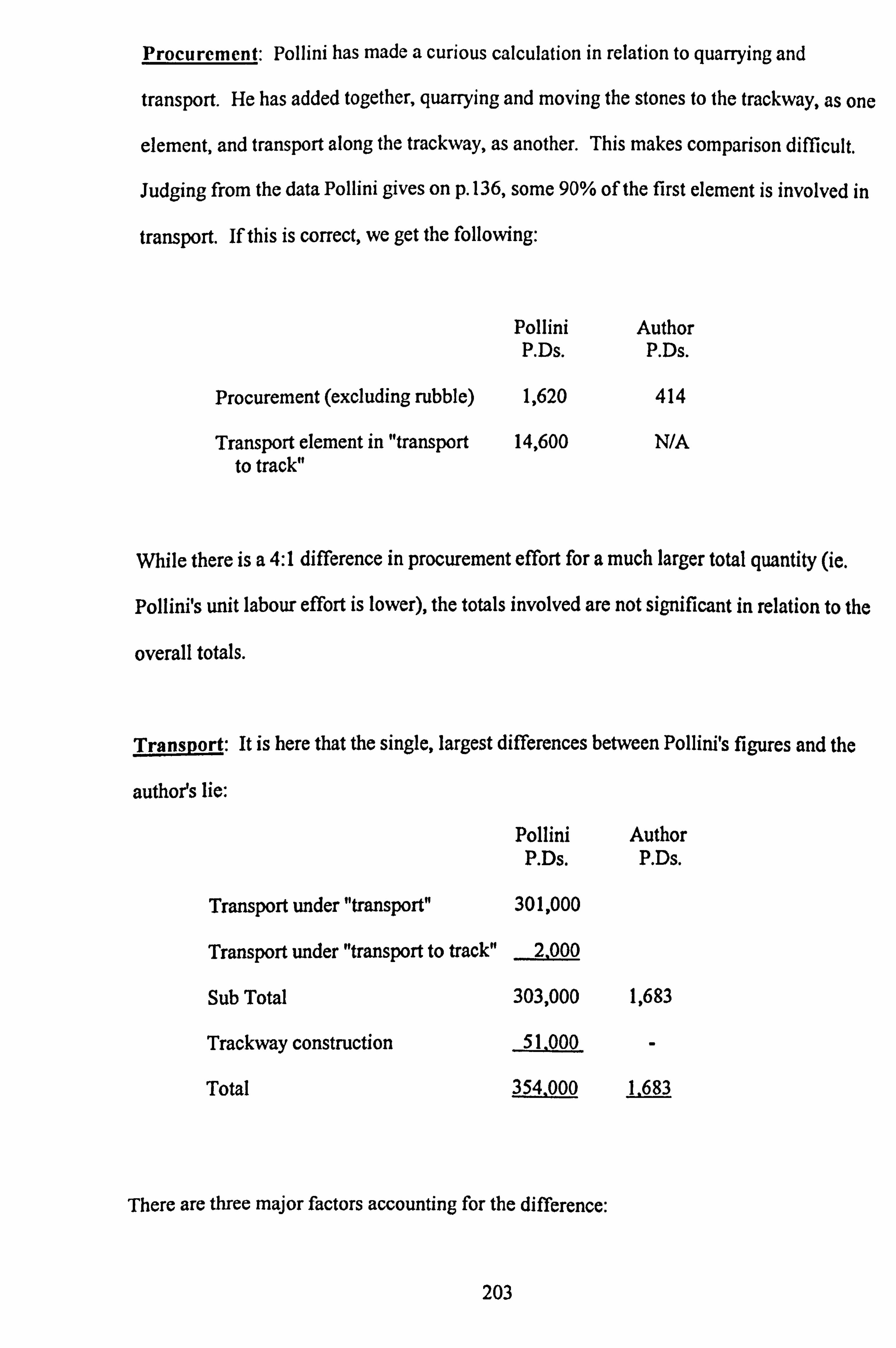
Procurement: Pollini has made a curious calculation in relation to quarrying and
transport. He has added together, quarrying and moving the stones to the trackway, as one
element, and transport along the trackway, as another. This makes comparison difficult.
Judging from the data Pollini gives on p. 136, some 90% of the first element is involved in
transport. If this is correct, we get the following:
Pollini Author P. Ds. P. Ds.
Procurement (excluding rubble) 1,620 414
Transport element in "transport 14,600 N/A to track"
While there is a 4: 1 difference in procurement effort for a much larger total quantity (ie.
Pollini's unit labour effort is lower), the totals involved are not significant in relation to the
overall totals.
Transport: It is here that the single, largest differences between Pollini's figures and the
author's lie:
Pollini P. Ds.
Transport under "transport" 301,000
Transport under "transport to track" 2,000
Sub Total
Trackway construction
Total
Author P. Ds.
303,000 1,683
51.000 -
354.000 1.683
There are three major factors accounting for the difference:
203

1. Quantities involved (see above)
Pollini Author Tonnes Tonnes
Excluding rubble infill 9,445 918 Rubble infill 3,110
Totals 9,445 4,028
2. Distances Travelled: Pollini assumes 1km for all materials. The author assumes
different distances:
0.2km for rubble and small stones (Coralline limestone)
0.4km for larger stones (Coralline limestone)
1.2km for Globigerina limestone material
The bulk of the material used is Coralline limestone.
3. Methods used: as mentioned above, Pollini assumes transport by levering along a
prepared trackway, using rollers and levers, and that all stones have to be transported
thus.
The author assumes that rubble and small stones (<2 tonnes) are carried and that larger
stones are dragged on sleds.
The figures are:
Pollini P. Ds. /km/tonne
Small stones, rubble Small stones Medium stones Large stones
28 71 45
Author P. Ds. /km/tonne
3.5
10.0
As the author assumes the major quantity of the material used at Ggantija, was carried
204

(3,903 tonnes, including rubble), and only 359 tonnes were dragged, the methods
involved average 4.0 P. Ds. lkm/tonne, compared with Pollini's weighted average of 35
P. Ds. /km/tonne.
Dressing: Here Pollini gives a total of 8,200 P. Ds. based, it appears, on a discounted value
of dressing costs at Hagar Qim and Tarxien, because the Ggantija blocks are less dressed.
The author believes the majority of stones at Ggantija (Coralline limestone) were not
dressed and the minority of blocks of Globigerina limestone (for instance, for portal
jambs) were.
The resulting figures are:
Pollini Author P. Ds. P. Ds.
Dressing stones 8,200 300
Preparation of building site: Pollini gives a total of 5,000 P. Ds., based on 5 P. Ds. per
square metre, to cover earth moving and levelling. The author has allowed 358 P. Ds. for
only minor excavation and levelling up with rubble. This may be too low, but it is difficult
to see why 5 P. Ds. would be required per sq m. In the summary that follows, 1 P. Ds. has
been allowed, giving a total of 1,000 P. Ds.
Erection
Pollini Author Tonnes P. Ds. /Tonne P. Ds. Tonnes P. Ds. /Tonne P. Ds.
Stones 9,445 Rubble -
Total
3 28,200 918 1 909 3,110 0.6 1,866
28,200 2,775
205

The differences here are again very large, partly accounted for by the 10: 1 weight
discrepancy already mentioned, and partly by Pollini's per tonne erection estimates being
three times the author's.
Overall: The differences between Pollini and the author, are huge, amounting, as has been
noted, to 409,600 P. Ds. for Pollini, and 3,664 P. Ds. for the author, when comparing the
construction of the edifice Pollini assumes.
In conclusion, and in justification of the author's figures compared with Pollini's, the
following summary is presented:
Procurement: There is a negligible difference in relation to the total.
Transport: Here, there are three elements involved in the difference between Pollini's
figures of 354,000 P. Ds. and the author's of 1,683 P. Ds.
1. uantities: Applying the ratio of 10.3: 1 given above, would reduce Pollini's figure
to 34,359 P. Ds.
2. Methods used: Applying the author's figure of 4.0 P. Ds. /tonne, rather than Pollini's
of 35 P. Ds/tonne, further reduces the 34,359 P. Ds. above to 3,927 P. Ds.
3. The balance of the difference between the above 3,927 P. Ds. and the author's 1,683
P. Ds., is accounted for by the difference in the postulated transport distances.
Dressin : Pollini's figure is 8,200 P. Ds. and the author's 300 P. Ds. Pollini's figure is not
justified by the amount of dressed stone at Ggantija and the author's is to be preferred.
206

Preparing building site: An adjusted figure of 1,000 P. Ds. was suggested above.
Erection: Pollini gives a figure of 28,200 P. Ds. and the author a comparable figure of
909 P. Ds.
1. Quantities involved: Applying the 10.3: 1 ratio reduces the 28,200 to 2,738 P. Ds.
2. The difference in the labour per tonne ratio, is 3: 1. Applying this to 2,738 further
reduces the figure to 913 P. Ds.
Adding together Pollini's adjusted totals, as above, gives the following:
Adjusted Pollini Totals
Procurement Transport Dressing Preparation of Site Erection
Total
1,620 (no adjustment made) 1,683
300 1,000
913
5.516
It should be remembered that Pollini postulated a 10 hour day and the author's, a5 hour
one. For final comparison with Pollini, the author's figure of 3,664 P. Ds. should be halved
to 1,832 P. Ds. Both figures are well within the sensitivity parameters considered earlier.
Earlier, the author has assumed a ninety day working year, allowing for work to take place
in the slack part of the farming year. Applying these figure to the person days, Pollini's
figures equate to 4,551 person-years, whereas the author's equal 41 person-years, or
allowing for the rubble used (which Pollini did not), 100 person-years.
207

CHAPTER 7
POPULATION
7.1 INTRODUCTION
There are three elements in an energetics analysis which together lead to an assessment of
a society's contribution to its monuments:
The labour involved in the construction of monuments.
The size of the pool (or population) from which this labour was drawn.
The length of time over which the monuments were constructed.
The first of these was discussed in Chapter 6. The last is the subject, inter al/a, of Chapter
8. The middle element is the subject of the present chapter.
Estimating prehistoric populations is notoriously difficult. There are various approaches
which may be taken:
1. An assessment based on the size and number of known habitation sites, with estimates
of original numbers
2. An assessment based on burial numbers.
3. An assessment based on the carrying capacity of the territory concerned and its
utilization.
4. An assessment based on known and relevant historical data.
In the context of the Temple Building period on the Maltese islands, the first two are not
open avenues: there are virtually no known habitation sites. Two burial sites are known,
that at Hal Saflieni near Tarxien, which contained perhaps 6,000 minimum number of
individuals and at the Xaghra Stone Circle which contained "hundreds, perhaps thousands"
of individuals (Malone and colleagues 1993 : 81). As these were in use from c4000-2500
208

BC, they provide no useful insight into population numbers. (Though it might be remarked
that Cassar (1997: 138) suggests that the Hal Saflieni figure could indicate a population of
over 8000: "indicating a larger population than the land could safely support". This
appears to the author to be an unjustified deduction. ) The last two avenues are the ones
explored here.
7.2 CARRYING CAPACITY
The land areas involved are:
Sq kms Hectares
Malta 246 24,600 Comino 3 300 Gozo 67 6,700
Total 316 31,600
It is not the total land area that is important, but rather that suitable for arable agriculture.
For both major islands, the modern figure (which includes land now covered by urban
development) is 60% (eg. Ransley 1974: 22, Renfrew 1973 a: 153). Considerable soil
erosion has taken place since the temple building period and this gives rise to Renfrew's
estimate (1973 a: 153) of a higher figure of 70% of arable land available.
Against Renfrew's uplift, it has been argued in Chapter 5, that there were many more trees
in Temple Building period Malta, than is the case today. Thus, although 70% of land may
theoretically have been available, allowance for stands of trees suggests that the figure of
60% is the best estimate. Use of this figure produces the following:
209

Total Ha. Agriculturally useable amble Ha. @ 60%
Gozo 6,700 4,020 Maltese Islands 31,600 18,960
The other variables to consider are the degree of useable arable land utilisation and the
density of occupation of that land. For the temple building period, we have no idea of the
population pressure on land use. For the purposes of this analysis, figures of 30%, 70%
and 100 % of land use have been taken. (It is worth noting that Renfrew (1973 a: 153-155)
has taken the maximum figure. ) A central figure of 70% of land use has been employed in
this analysis.
It could, however, be argued that the advent of temple building was triggered by the
stresses of population pressures brought about by 100% land use and the consequent social
pressures for territory marking. This argument might have more relevance to Malta where
there are several major temple complexes, but nevertheless could apply to Gozo. It has
certainly been suggested (eg. by Renfrew 1973 a: 144) that the genesis of north west
European megalithic monuments, found in the main in coastal regions, lay in population
pressure deriving from westward migrations of people being baulked by the Atlantic of the
possibility of further movement. Allowance has therefore been made in the sensitivity
analysis which follows that there may indeed have been 100% land utilisation.
In the absence of firm data, the density of occupation estimates may vary widely. Renfrew
(1973 a: 155) quotes and rejects a figure of 43.5 Ha. per person appropriate to semi-arid
south Iran in the early farming period. Startin and Bradley (1981 : 294) quote Green
(1974) as suggesting 10 Ha. per person, as relevant to Bronze Age Wessex, England. Said-
Zammit (1997: 36), in relation to iron Age Mediterranean farm holdings, quotes 5.4 Ha.
210

per family and from Bronze Age Greece, an average family of 5.0 (both figures from
Bintliff, personal communication and 1977: 83), which gives a figure of 1.1 Ha. per
person.
Renfrew (1973 a: 155) uses a figure of 2.0 Ha. per person.
For the purposes of this analysis a central figure of 2 Ha. per person, +/_ 50% for
sensitivity purposes, has been taken. In the next section, the reasonableness of this
assessment is checked against available historical data.
7.3 HISTORICAL POPULATION DATA
Luttrell (1975 : 37-40) notes a population census record dating from 1241 AD, as follows:
Number of Families
Malta 753 Gozo 366 TOTAL 1119
This record is subdivided into Christians, Muslims and Jews. The extant record survives as
a result of successive copying and recopying, and Luttrell plausibly argues, in detail, that
the 47 Christian families recorded for Malta (compared with 203 for Gozo) should in fact
read 1047. This gives a revised table:
Numbers of Families
Malta 1753 Gozo 366 TOTAL 2119
This, Luttrell states, produces a reasonable total population of 10,000. Blouet (1993 : 40)
thinks this is too high given the likely technology of this thirteenth century agriculture and
suggests a: "total population nearer to 5000 than 10,000", though he gives no details of the
211

agriculture in question.
Using the two sets of figures, given above, for the area of agriculturally useable arable land
and the Medieval population, the following numbers can be derived for the Maltese
Islands:
Total Ha. Total Ha. / Person Population
Luttrell 18,960 10,000 1.9 Blouet 18,960 5,000 3.8
If one assumes that both Neolithic and Medieval agriculture involved farmsteads
employing mixed farming methods, that is crops and animals, there is no reason to suppose
that the carrying capacity of the land differed between the two periods. Labour input may
have differed but that does not invalidate the figures suggested in 7.3.
7.4 TEMPLE BUILDING LABOUR
The figures given above embrace the total population. Consideration must be given to
what proportion of the total would be competent to assist in temple building. Most authors
assume that such work was done by adult men, though perhaps on not always good
grounds (Patton 1993 : 9). On skeletal burial evidence at the Neolithic tomb at Isbister,
Orkney, Hedges (1983,1984) derived the figure of 20-25 adult males percent of the total
population, ie. 1 in 5 -1 in 4. Renfrew (1973 c: 549) though without discussing the gender
question, suggested that "one fifth of the population could be mobilised for public works
for three months of the year". (The months were not given, but presumably were during
the agricultural "off" season). In the matter of which sex did what, it may be observed that
the heavier work, ie. stone quarrying, transport and erection, was probably carried out by
men. On the other hand, rubble procurement, transportation and application, could well
212

have been carried out by women, as could the preparation and application of torba. It may
be reasonable to assume that both adult males and females were not simultaneously
occupied on temple construction from a given homestead.
Given this assumption, the figures below are based on one fifth of the population being
available for temple construction during the annual building period, that is for three months
where agricultural demands were low:
Total Ha. Agricultural Ha.
Calculation 1: (varying land, utlisation, constant 2 Ha. /person available) Ha. /person available Land utilization % Persons available Total population = above x5
Calculation 2: (Varying Ha. /person constant land utilisation at 70%) Land utilisation at 70% Ha. /person available Persons available Total population = above x5
Calculation 3: (Varying land utilisation and Ha. /person available) Land utilisation % Ha. /person available Persons available Total population = above x5
Gozo Total Maltese Islands
6700 31600 4020 18960
2 2 2 2 2 2 30 70 100 30 70 100
121 282 402 569 1327 1896 605 1410 2010 2845 6635 9480
70 70 70 70 70 70 3 2 1 3 2 1
188 282 563 885 1327 2654 940 1410 2815 4425 6635 13270
30 70 100 30 70 100 3 2 1 3 2 1
80 282 804 379 1327 3792 400 1410 4020 1895 6635 18960
Table 7.1 Availability of Building Labour
It will be noted from the above figures, that the total population of the Maltese Islands,
assuming 100% use of 60% (agriculturally available arable) land and 2 Ha. per family, is
9,480. Renfrew (1973 a: 153-55) assumes 100% and 70%, giving a figure of c. 11,000.
213

Luttrell quoted above gives a figure of 10,000 for medieval Malta. These figures would
correspond to approximately the 2,010 total or 402 persons available for temple building
for Gozo in the table above (60% arable land, 100% land use, 2 Ha. per person).
The author's preference, but one based only on the supposition that human exploitation is
rarely pushed to its limits, is for 70% land use at 2 Ha. per person. For Gozo, this gives a
total population of 1,410 and 282 persons available for temple building: the "central"
figures. With these figures may be compared Luttrell's figure for medieval Gozo of 366
families which could provide a like figure of available labour.
The next chapter considers these figures and the more extreme population postulates in
relation to the various estimates of temple building labour requirements.
214

CHAPTER 8
LABOUR REQUIRED AND LABOUR AVAILABLE
8.1 INTRODUCTION
Chapter 6 set out figures for the labour requirement to build Ggantija and Chapter 7 figures
for labour availability. This chapter brings these two sets of figures together and
comments on the sort of strain demands for temple building labour may have put upon the
community.
As has been said earlier (Chapter 4, section 3), Ggantija was built in three distinct phases:
first the South Temple
then the North Temple, both being built during the Ggantija Period, followed by
- the Temple platform, built in the Tarxien Period.
These three edifices are considered separately. There is a very large number of figures to
consider and for the sake of simplicity, the "central" figures, ie. the author's preferred ones,
are taken first, followed by consideration of the implications of the sensitivity analyses.
Comment is also made on the implications of Pollini's analysis.
Taking the South Temple by way of example, it will be seen from the table that follows
that 15,529 person-days were required and that 282 persons were available. Theoretically
this implies that if all 282 worked at once, the temple could be built in 55 days. It is
however, unrealistic to assume that all 282 could be organised to work at once. For one
thing, the building sequence dictates that stones have to be quarried before they are
transported, and transported before they are erected. If dressing is involved, this has to be
incorporated in the sequence. Rubble infill cannot be put in place until the walls are at
215

least partway built and the roof cannot be constructed until the temple is, in other respects,
complete. It is unlikely but possible that the sequences might be followed and completed
in the postulated ninety day-year. It is more likely that a longer period was taken. If, say,
three years were taken then instead of each available worker needing to provide 55 days,
this figure would be divided by 3, giving a total per available person, per year of about 18.
If each worker had 90 days maximum availability, then only 20% of this time would be
required each year (or expressed another way, 5% of the worker's 365 day year). This
reasoning is developed further in section 8.4.
An alternative possibility is to postulate that a "professional" workforce was employed:
that is the community supported a permanent workforce engaged in building the temple.
If the task was to be completed in three years, it would require: 11129- = 14 persons working 365x3
every day. This in fact is not feasible because the transport and erection of the largest
stones would, at times, require say 200 persons. It would of course have been possible to
combine a "professional" force with occasional input from a much larger band of
volunteers (pleased perhaps, at contributing to the temple's construction). It is suggested
later that the structure of the temple building society was unlikely to have been one where
a "professional" force could have been organised and, alternatively, arranging for the use,
on a part-time basis, of the available workforce would have been the system adopted.
Whether this was a low labour time requirement throughout the year (5% as calculated
above) or a larger requirement (20%) during the agricultural off season, must be a matter
of conjecture. Ethnographic examples (eg. Abrams 1989: 66, Erasmus 1965: 280-1)
suggest that at any rate for domestic buildings, the agricultural off-season was used for
construction.
The table (8.1) that follows presents figures that follow this line of reasoning, based on the
author's central figures. It must of course be pointed out that the three year period chosen
216

is entirely arbitrary. It could be any period up to what might be regarded as a maximum
(10 years? or 25 years? ) during which community interest might be sustained and the
leaders of the project driving force maintained. As the total labour requirements, in person
or percentage terms, are so low for even three years, it does not seem fruitful to produce
figures for a longer period than the three years suggested.
8.2 LABOUR REQUIRED & LABOUR AVAILABLE: "CENTRAL" FIGURES
South North Platform Temple Temple
Total labour required P. Ds. 15,529 6,664 8,179
No. of person-years required 173 74 91 assuming a 90 day working year (ie. P. Ds. divided by 90)
Total population of Gozo 1,410 1,410 1,410
Workforce available assuming 282 282 282 one fifth of total
No. of days required from each 55 24 29 of the available workers
No. of days required from each 18 8 10 worker year assuming a three year building period
% that that figure represents of the 20% 9% 11 % worker's 90 day slack fanning period
% that that workload represents 5% 2% 2% of the worker's 365 day year
Table 8.1 Labour Required & Labour Available: "Central" Figures. (From Tables 6.1 and 7.1)
Before discussing the implications of these figures, it is appropriate to conduct a sensitivity
analysis. Such an analysis has been carried out in respect of labour requirements in
Chapter 6 and for population figures in Chapter 7.
217

For each of the South Temple, the North Temple and the Tarxien platform the sensitivities
have been presented in three ways:
1. Extremes of labour required, "central" labour availability.
2. "Central" labour required, extremes of labour availability.
3. Extremes of both labour required and labour availability.
In the tables that follow, these three possibilities have been identified by the numbers
above. (Table 8.2)
83 OBSERVATIONS ON THE "CENTRAL" FIGURES
Casual observation of the Ggantija temples and their later platform give the impression of a
massive contribution of labour by the relatively low density "copper age" agricultural
community. If the casual observer then tries to envisage the original form of the temples,
this already large contribution becomes even greater. Similar observations have been
made for example, about Stonehenge, England and Mayan ceremonial complexes in
Mesoamerica.
But examination of the figures in Table 8.2 presents a different view. First it must be
reiterated that the Ggantija complex was built in three distinct phases, possibly widely
separated, and thus spacing out demands for labour.
Section 8.2 above, postulated that if a three year building period, for the largest con-
struction, the South Temple, were assumed, the demands on the available work force of
282 represented 20% of each worker's time available if this was 90 days per year, or 5% of
the worker's time, assuming availability for 365 days per year.
218

Labour Required & Labour Available : Sensitivity Analysis
Total Population 4,020 1,410 400 Workforce Available Assuming One Fifth 804 282 80
Labour Required : Minimum "Central" Maximum SOUTH TEMPLE
Labour Required : P. Ds. 1. Number of days from each individual : variable
requirement, "Central" availability. 1. % this represents of individual's 90 days assuming
three year building period. 2. Number of days from each individual : "Central"
requirement, variable availability. 2. % this represents of individual's 90 days assuming
three year building period. 3. Number of Days from each individual : variable
requirement and availability 3. % this represents of individual's 90 days assuming
three year building period.
NORTH TEMPLE Labour Required
1. Number of days from each individual : variable requirement, "Central" availability
1. % this represents of individual's 90 days assuming three year building period
2. Number of days from each individual : "Central" requirement, variable availability.
2. % this represents of individual's 90 days assuming three year building period.
3. Number of days from each individual : variable requirement and availability.
3. % this represents of individual's 90 days assuming three year building period.
"TARXIEN" PLATFORM Labour required
1. Number of days from each individual : variable requirement, "Central" availability.
1. % this represents of individual's 90 days assuming three year building period.
2. Number of days from each individual : "Central" requirement, variable availability.
2. % this represents of individual's 90 days assuming three year building period.
3. Number of days from each individual : variable requirement and availability.
3. % this represents of individuals 90 days assuming three year building period.
Table 8.2 Labour Sensitivity Analysis
3,702 15,529 35,294
13 55 125
5% 20% 46%
19 55 194
7% 20% 72%
5 55 441
2% 20% 163%
1,146 6,664 17,371
4 24 83
1% 9% 31%
8 24 83
3% 9% 31%
1 24 217
1% 9% 80%
1,715 8,179 20,943
6 29 74
2% 11% 27%
10 29 102
4% 11% 38%
2 29 262
1% 11% 97%
219

This represents no great strain on the community. It may be compared to the figure
(Webster 1991 : 853) derives for the construction of single tower nuraghi on Iron Age
Sardinia of 10 P. Ds. per year, also imposing structures. For the even more impressive
"Nunnery Quadrangle" at Uxmal, Mexico, Erasmus (1965: 296-7) calculates that with a
contribution of 40 man-days per year, the Nunnery could have been built in 14 years. So
even this much more massive construction (650,000 man-days required) involved a low
level strain on the relevant community. For Stonehenge IIIa, England (the standing
stones), Startin and Bradley (1981: 294) suggest an involvement of 1% of the population
constantly working.
A word should be said here about the one aspect of temple construction that involved
specialised craftsmanship: that of surface carving. The labour involved here was limited,
estimated at 12 days (see Table 6.1). Kaplan (1963 : 403) says: "... the artistry of a
product is frequently no clue as to whether its maker was a full-time or part-time artisan".
Lacking evidence to the contrary, it seems safe to assume that this work, as all others
involved in temple building, was done by part-time workers.
8.4 OBSERVATIONS ON THE SENSITIVITY ANALYSIS FIGURES
These observations are again based on looking at the largest of the Ggantija edifices; the
South Temple.
At the low extreme the temple required 3,702 P. Ds. and the labour force available
numbered 804. This would require five days' work from each person, or 2% of their
available time, assuming a 90 day work-year and three year building period. Although
each component of the minimum number of total P. Ds. required in the temple construction
might individually be justified, it seems most unlikely that each and every one is. Apart
from observing that the labour requirements place minimal strain on the building
220

community, it does not seem fruitful to comment further. Even looking at the figures
deriving from using "central" labour availability and variable building requirements, or
"central" building requirements and variable labour availability, we can still make the same
observation: ie. strain on the community is negligible.
At the high extreme, the P. Ds. required for the South Temple number 35,294, compared
with the "central" figure of 15,529 (127% higher) and the labour availability is 80
compared with 282 (28%). Using both these extreme figures, the number of days of work
required from each worker is 441 and the requirement from each worker, assuming a 90
day work-year and a three year building period is 163%. That is, to build the temple in
three years would require a building period of 90 x 1.63 = 147 days.
Other permutations are instructive, based on the figures of a labour requirement of 35,294
P. Ds. and a labour availability of 80 persons, and are set out below:
Building Period Days per person per year
Percent this represents of a 90 day year
Percent this represents of a 365 day year
As above :3 years 147 5 years 88 10 years 44 25 years 18
163% 98% 49% 20%
41% 25% 12% 5%
From the above it may be noted that a five year building period would require all of the
available workers' time if they worked on temple building for 90 days per year. Half the
available time per year would be required if the building period were 10 years, but would
only represent 12% of their total time. A 25 year building period, by no means an
implausibility, would require only 5% of each available worker's total full year time.
221

The total population postulated here is 400, based on 30% utilisation of available arable
land and 3 Ha. per person: the population seems low after over 1,500 years of Neolithic
occupation, and indeed possibly low in relation to the "critical mass" which might engage
in such a construction as Ggantija. A further problem is that some of the largest stones
would require more than 80 persons to transport them, though this is a problem that might
have been overcome either by drafting in every available able bodied person on Gozo,
(perhaps still falling short of 200) or soliciting help from nearby Malta. Alternatively, it
might be suggested that had the local labour force, fully mobilised, been unable to move
and erect the largest stones, society would have been willing to compromise and use
smaller stones, despite the diminution of the monument's impressiveness. But. such a
compromise would have been unnecessary if the population was larger.
The other variation is that of the number of P. Ds. required for the South Temple's
construction- This is something over double the number set out in the "central" estimate
and produces a figure of 125 days per person, assuming that 282 are available (line 1 in
Table 8.2). Over a three year building period, each individual would have to work 46% of
his/her available 90 day work-year. This seems an entirely feasible proposition and if
asked to hazard what are the probable figures, they seem likely to lie between the
postulated "central" figures, with perhaps a chance of being up to 20% lower and 100%
higher. Wherever the truth lies, the comments made about the absence of strain on society
in the section on the "central" figures above, still apply.
8.5 COMMENTS ON POLLINI'S FIGURES
The inconsistencies and inaccuracies incorporated in Pollini's (1987) labour requirement
figures have already been pointed out in Chapter 6. It is desirable at this point to consider
the implications which acceptance of his figures would have for the time taken to construct
222

the temples, by relating them to the available labour.
Pollini estimated the number of P. Ds. involved in the construction of the Ggantija complex
as it may be seen today, without distinguishing any separate building phases. He
considered only the walls and floor, and did not include either the rubble infill nor the
"Tarxien" platform. For the construction he considered, he arrived at 409,000 P. Ds. The
author's equivalent figure is a "central" one of 3,664. (See Table 6.5).
Using the author's "central" population figures, the comparison is as follows; using the
author's "central" population and labour availability figures in both cases:
Pollini Author
Total population
Available Workers
Total P. Ds. required
Days required per available worker
Number of years involved at 90 days/year
1,410 1,410
282 282
409,600 3,664
1,452 13
16 0.14
The comparison becomes even more stark if one multiplies Pollini's figure of 409,600 for
the existing walls by the author's estimate of the total labour required for both the South
and North Temples, as originally built, of 22,193 P. Ds. (see Tables 6.1,6.2 and 6.5)
divided by the 3,664 P. Ds. above. That is correcting for Pollini's incomplete assessment of
the existing structures and for his not assessing the work content of the original. The
comparison then becomes: Pollini Author
Pollini's figure x 22.193: number of years 97 3,664
Author's total figures: number of years 0.85
223

Pollini's figure of 16 years already seems a fairly long period to sustain effort, but when
extrapolated to 97 years, it becomes unbelievable. It should perhaps be remarked that if
one allows for the building of the South and North Temples in distinct phases, the South
Temple required 70% of the total. Applying this to the 97 years above, produces 68 years:
still an enormous figure and one which implies a 25% labour "tax" on available adults for
68 years. At the least, this must imply an autocratic society akin to the most coercive state
systems, in a society of 1,410 persons. Had Pollini extended his investigation to include
consideration of the time taken to build the temples, he might have been led to reconsider
the validity of his labour requirement figures!
8.6 IN CONCLUSION
The central proposition put forward in this chapter is that the labour requirements to
construct the Ggantija complex, did not pose a significant strain on the temple building
period population of Gozo.
The next chapter explores whether such a finding throws any light on the structure of
Gozo's society and attempts a comparison with other prehistoric societies.
224

CHAPTER 9
CONCLUSIONS
9.1 HAS AN ENERGETICS ANALYSIS THROWN NEW LIGHT ON THE TEMPLE BUILDING PERIOD IN MALTA?
Questions that an energetics analysis might hope to answer are:
Did the building of temples place a strain on Maltese society?
2. Does the analysis provide clues to the nature of Maltese temple period society?
3. Are there signs of societal development over time?
4. Was the utility of the energetics analysis, in relation to Malta, envisaged in
Chapter 3, confirmed?
9.2 DID TEMPLE BUILDING CAUSE A STRAIN ON MALTESE SOCIETY?
It has been demonstrated in Chapter 4 that the Ggantija temple complex was built in three
distinct phases. The first of these, the South Temple, was the one that had the highest
labour requirements for its construction, and it is therefore this temple which has been
concentrated on in Chapter 8, in relation to the effect which its construction might have
had on the society which built it.
Using the author's "central", or preferred figures, construction required 15,529 person days
(P. Ds. ) of labour. If the temple was built only in the ninety days of each year that has been
suggested as the "off season" for an agricultural community, and if a workforce of 282
persons was available, and if construction was spread over three years; then only 20% of 225

each person's available time needed to be devoted to the temple's building. If, however,
building was spread over the whole year, then only 5% of each available person's total time
would be required.
In the sensitivity analysis, the lowest labour requirement figure for the South Temple
suggested that, on the same basis as above, only 5% of a ninety day "year" or less than 2%
for a full year, would be required of each person. But a concatenation of all the lowest
labour requirement figures with the highest population density seemed unlikely.
The highest labour requirements combined with the lowest population figure would mean
that over a three year building period, the available labour of 80 persons would each have
to spend 147 days on temple building, or 40% of their total time. However, if the total
building time was extended to five years, the temple construction would require 88 days
from each person, just within the 90 days postulated as being available. By extension, the
annual requirement would be halved to 44 days or half each person's available time for a
ten year building period. A twenty five year period, by no means implausibly long, would
require 18 days per person, per year, representing 20% of a ninety day year or 5% of a total
year.
Most attention has been paid to the South Temple at Ggantija because it had the largest
requirement for labour, and therefore was the most likely to cause stress on its builders. It
is, however, worth reviewing briefly the results of the energetics analyses on the other two
edifices at Ggantija. The North Temple, using the author's "central", or preferred, figures
required 6664 person-days for its construction, and if 282 persons were the available
workforce, and construction was spread over 3 years then if it was built during the 90 day
agricultural off season, each person would have to devote 9% of their time. If building
were spread over the whole year this figure falls to just over 2%. From the sensitivity
226

analysis (Table 8.2), if the population is the minimum postulated, providing 80 persons
available for temple building, and the labour required is the maximum, ie. 17,371 person-
days, then for a three year building period each person must spend 80% of their 90 day
availability each year or 20% of their total time. A longer building period would lessen
these percentages in proportion and might be the more likely social response to the
demands for labour.
Similar conclusions arise from consideration of the building of the Tarxien period terrace.
Here the "central" figures indicate a demand for 11% of the time of available labour for a
90 day year for each of three years of 3% of each person's total year. For the maximum
figures on the sensitivity analysis these two percentages become 97% and 25%
respectively. As for the North Temple if these lower population figures and higher labour
requirement figures are correct, it is likely that the building of the terrace would have been
extended for a longer period than three years.
On this basis, even the highest figures do not indicate that temple building, per se, placed
any undue strain on society. The lowest population figures set out were for 80 persons
available, being one out of five of the total population. It may be asked whether a total
population of 400 represents what might be termed a "critical mass" for envisaging,
planning and constructing a major monument such as the Ggantija South Temple? It is
instructive to look at the building of some of England's major parish churches. Hutton and
Cook (1976: 118) have an illuminating paragraph:
"It is the more astonishing that so many of the finest Perpendicular churches of England
are in what were always small villages (at most seventy householders or taxpayers). [That
is three to four hundred total population. ] It is hard to realise how great was the
compulsion, or impulsion, on our forefathers to lay out so much of their modest where-
227

withal upon their parish church and its contents. [Contents] which all still bear witness ---
to the high priority accorded --- to the after-life and the powerful mediation of the Holy
Church, especially in the local community". One should not push the analogy too far, but
the parallels with Maltese temple building society are striking.
In considering the question of stress, two other developments on the Xaghra plateau, on
which Ggantija stands, should be mentioned. Santa Verna is a small Ggantija period
temple site of which little now remains. It is certainly much smaller than anything at
Ggantija and as there is no evidence that it was built concurrently with either of the
Ggantija temples, it does not appear necessary to include it in any assessment of strain.
The other development is the hypogeum; the Xaghra Stone Circle. It has been described in
Chapter 2. It was occupied and developed from the Zebbug period through to the Tarxien
period. How much labour was expended in developing the series of natural caves, and at
what dates, is not known, but as for Santa Verna this need not have been at the same time
as the construction of Ggantija South Temple, and it can also be ignored from the aspect of
additional stress.
Acceptance of Pollini's labour requirements for the construction of Ggantija would produce
a totally different assessment of strain on society. But his figures were shown in Chapter 6
to be totally inaccurate and are only mentioned here for the sake of completeness.
The examples reviewed in Chapter 3 showed that even quite large monumental structures,
built in prehistory, did not place an undue strain on society that built them. Possible
exceptions were: Mayan ceremonial centres - these had a large population available and
may have been made by a society approaching, or arrived at, statehood; On Easter Island,
there has not been an energetics analysis, so whether the documented ecological disaster is
the result of excessive monument construction and its labour demands, or other causes, or a
228

combination, remains uncertain.
9.3 DOES THE ENERGETICS ANALYSIS PROVIDE CLUES TO THE NATURE OF MALTESE TEMPLE PERIOD SOCIETY?
An extensive review of the literature pertaining to pre-state society has been undertaken.
Appendix 2 identifies the relevant entries within the bibliography of the whole dissertation.
Earlier theories were based on research in the Pacific and were envisaged as an
evolutionary progression, indeed sometimes even the steps of a ladder up which society
climbed, the lowest rung being Bands, followed by Tribes, Chiefdoms and finally States.
As further fieldwork and even further theorising progressed, it became clear that if such a
framework was to be of use, an infinite number of variations of each rung must be
admitted, and further that there was no inevitability in progression up the ladder.
Although states are, in general, categorised as involving tens of thousands of people with a
centralised authority and able to employ coercive force, which was used to reinforce that
authority and inherent inequalities, yet the distinction between complex chiefdoms and
states was often blurred. Chapter 3 reviewed two such situations, in Hawaii and Mayan
Mesoamerica. Smaller societies, such as those on Malta and Gozo, tend to have some form
of tribe or chiefdom societal organisation. Any society produces, and indeed needs,
leaders and leaders enjoy and cultivate power. An established subsistence society, based
on Neolithic agriculture, and hence with a relatively low population density, does not need
much organisation for its economic and social well being. There does need to be some
means of resolving conflicts over land use, animal ownership and so on. The leaders who
fulfil this function may be singular, chosen or accepted because of their ability, or plural
such as a group of elders chosen perhaps by seniority. No hereditary principle needs to be
involved.
229

But such a low level of organisation is not likely to have produced the temples or hypogea
of the Maltese islands. For this, some form of "charismatic office" (Webster 1976 : 820) is
needed. That is, there must have been some transformation from the simpler form of
organisation described above into a more permanent "office".
Chapter 2 described the situation in the Maltese islands. Some 500 years before the start of
the Ggantija temple building period, there appears in the Zebbug phase a new form of
pottery, perhaps brought by new colonisers, with incised little men sometimes decorating
it, and also a carved stone, stylised, anthropomorphic "menhir". By 3600 BC temple
building started, and temples they were: they are clearly for worship and cult practice and
sacrifice. They were not used for burial. The hypogea served this latter function, also
incorporating ritual areas. Associated with both temples and hypogea are small and large
carved figures, ranging from stick men to grotesquely obese figures. These are
supplemented by relief carvings of animals and elaborately executed geometric patterns.
This was a religious society. What function the gods fulfilled is not known. It has been
plausibly suggested that some form of fertility cult was involved, but the elaboration of the
hypogea also suggests that ancestors were, at the least, venerated. "But the gods, being
fictions, must have had real representatives, nominally their specialised servants, who must
have done much to give concrete form to the imaginary beings, and by interpreting, must
have invented their desires. Temples presuppose priesthoods. ... The construction of a
temple was a co-operative task... The whole must be planned in advance". (Childe 1973:
100-1) and then the work must be directed and co-ordinated.
So one may conclude that Malta, at the least, had a theocratic "charismatic office". Some
minimum secular functions also had to be performed. Were the religious and secular
office separated? There is no evidence for this: there are no extant secular monuments, 230

nor aggrandising burial remains. (The hypogeum at Hal Saflieni is thought to have
contained the remains of over 6000 individuals - certainly not the remains of all deaths in
the area over 1000 years, but neither does it represent the remains of an elite few: the same
pattern is apparent from the recent excavations at the Xaghra Stone Circle. ) The necessary
secular, societal functions could have been performed by the religious "office". What was
the nature of that office? That it was in some way self-perpetuating is clear. But there is
no sign of a single superior religious centre. Although the temple complex at Tarxien is
larger and more complex than those at Hagar Qim, Mnajdra and Ggantija, it is not
significantly so. And by analogy, there is no reason to suppose that such a single superior
centre must have existed: Hellenistic Greek society had no such central religious authority.
Renfrew (1973 a: 152-5) suggested that the Maltese islands were occupied by perhaps six
chiefdoms. He produced a map to demonstrate this possibility (Fig. 9.1)
231

"""ý" "
"" "_"Q.
iýýTil1
"
MIIIIIý: IifilllM ;r
Fig. 9.1 The six pairs or clusters of temples in relation to modern, arable land (stippled)
with hypothetical chiefdom territories, marked by the straight lines.
Later Renfrew and Level (1979: 152-8), using the technique of Xtent analysis, suggested
that it might be possible to postulate two centres of dominance on the Maltese islands; one
based on Tarxien on Malta and the other on Ggantija on Malta. As has been noted in
Chapter 2, some credence might be lent to this theory by the fact that the only two known
hypogea, at Hal Saflieni and the Xaghra Stone Circle, share the same locations.
The two possible outlines of the structure of Maltese society noted above are possible, but
suffer from two defects. One is that noted in Chapter 2; they do not take account of the
pairing and clustering of the temples which might be taken to indicate intra as well as inter
territorially divided society rivalries. The other is that they view what remains of the
232

temple building society as a single manifestation and not as a situation developing over at
least 800 years. Whatever the rivalries within or between regional societies, these were not
settled by resort to weapons. There are none of significance found in the remains of the
temple period -a remarkable and unusual feature. The energetics analysis does not throw
much light on this quandary, except that the labour requirements for temple construction,
spread over this period would certainly not militate against a fluctuating or changing
territoriality or societal structure during the temple period.
9.4 DEVELOPMENT OVER TIME
Various strands of development over time may be discerned and are discussed below.
1. Temple types: As noted in Chapter 2, the earlier temples of the Ggantija period were
built of undressed limestone blocks, whether of Coralline limestone or of Globigerina
limestone. Later, Tarxien period, temples were built where Globigerina limestone was
readily available. Some were built exclusively of Globigerina limestone (Tarxien, Hagar
Qim), others of a combination (Mnajdra, built on Coralline limestone but with Globigerina
limestone available close by). The Tarxien period Globigerina limestone was carefully
dressed into fine ashlar blocks, which was easily done, even using Neolithic tools, when
the stone was first quarried. Use of such blocks gave an altogether more sophisticated
appearance to both the exteriors and interiors of the temples. It is noteworthy that no
Tarxien period temples were built on sites without access to Globigerina limestone other
than Skorba east, and furthermore that no new temples were built in the Tarxien period on
Gozo. The large, additional platform at Ggantija was built in the Tarxien period, and may
reflect a change in cult practices, or an increase in population, or both.
233

2. Contents: There is a problem here, namely that differential preservation may give a
distorted view of the elaboration of temple contents in the Tarxien period. It can be stated
that the elaboration and skill involved in the furnishings of the Tarxien temples themselves,
were of a high order. We cannot know whether, for example, sacrifice was practised in
pre-Tarxien periods but it seems likely. The evolution of anthropomorphic figures is
however clear, as has been discussed in Chapter 2. The very obese, sexless (ie. with no
discernible sexual attributes) figures make their appearance in the Tarxien period, and
probably indicate a developing religion or cult practice.
3. Exclusivity: Over the temple building period there is a distinct increase in the degree
of exclusion from inner temple areas, coupled with the apparatus of contrived mystery -
the oracle holes and the manipulable "puppet" heads of the obese figures. It would seem
that the priesthood was becoming increasingly elite and exclusive, and manipulating the
general public; one might surmise as a means of enhancing their own power rather than as
a means of improved communication with the divine to enhance the general weal.
4. Trade and Contact: There is very little evidence for trade throughout the temple
period. Obsidian and flint and hard igneous rock for axes were necessary materials for the
Neolithic society, but whether they were obtained by trade or foraging is not known. The
same applies to red ochre, which though perhaps not a necessi in a subsistence sense was
certainly needed by the temple period society. Some more exotic materials were imported:
greenstone from Italy and perhaps pumice. There are some signs of diminution in these
imports: stones were progressively reworked to the point where they became ornaments
not tools. Culturally, after the probable influx of a new wave of immigrants at the start of
the Zebbug period, there appears to have been very little cultural contact in either direction
(always allowing that the Lipari islands, one of the sources of obsidian, were inhabited as
was Sicily, the probable source of red ochre). Some authors cannot believe that there was
234

not significant contact, despite the lack of archaeological evidence: their argument is based
on Malta's subsequent status as an entrepot, a status not achieved until the Phoenician
opening of the sea lanes.
5. The End: of the temple period came abruptly in about 2500 BC. Trump (1976)
gives a comprehensive assessment of possible causes. One possibility is war. The
successors to the Tarxien culture, that of the Bronze Age Tarxien Cemetery, were clearly
invaders bringing with them the trappings of an alien culture including metal weapons. It
is not clear, however, whether there was a gap between the end of the Tarxien period and
the beginning of the Tarxien Cemetery. There certainly was a gap in the use of the Tarxien
site, evidenced by the accretion of a metre of sterile soil before the Tarxien Cemetery
people started using it as a burial site. No such gap was evident at Skorba, though damage
to the temple blocks preceded Bronze Age additions (Trump op. cit. 605). Social
instability, involving revolt against an increasingly restrictive and dominant priesthood is
another possible cause, but although possible would hardly have resulted in a complete
disappearance of a culture. Disease, such as a plague, falls in a similar category: although
a plague might have been calamitous, it would not have been totally destructive.
Economic factors are a further possible cause of the end of the Tarxien period culture.
Deforestation, both to provide timber for building purposes and extra agricultural land,
could have led to serious soil erosion, especially of some of Malta's lighter soil covered
land. But again, this would hardly have led to the total disappearance of Tarxien culture.
Another cause for the collapse, even if only a contributory one, is often advanced, that is
the strain on society involved in temple building. "The number and size of the temples in
their latest, Tarxien, phase necessitated a large labour force and so a substantial
population" (Trump op. cit. 607). "Eventually the time and effort demanded [to construct
235

"structures like the Ggantija or Hagar Qim temples"] --- may even have assisted in
bringing about the eventual breakdown of the system" (Evans 1977: 23). It seems clear
from the evidence set out in this thesis, that building the temples placed no great strain on
the society that built them. Dating their construction is, as yet, imprecise, but there is no
evidence of a sudden increase in building activity immediately before the collapse of
Tarxien society.
Trump (op. cit. 607) points to the extreme variability in Malta's climate and the occurrence
of drought years (see Chapter 2). If there was a succession of such droughts over five
years, the effect would be disastrous. Bonanno (1990 a: 44) picks up this theme: "over-
exploitation and eventual exhaustion of the natural resources, compounded by successive
years of drought which forced the entire population to desert the island, seems so far the
most plausible solution to the enigma". Trump (op. cit. 608) points out that as yet, no
evidence of such an exodus has been found elsewhere, although this does not, of course,
disprove the theory. The idea of a "Moses" leading his people to a chosen land is certainly
romantic as well as being plausible.
9.5 HAS THE UTILITY OF THE ENERGETICS ANALYSIS, IN RELATION TO MALTA, ENVISAGED IN CHAPTER 3, BEEN CONFIRMED?
It may fairly be asserted that the energetics analysis has demonstrated that the labour
required to construct Ggantija, in relation to Gozo's population, placed no great strain on
the prehistoric Gozitan society. A strong motivating force (such as envisaged by Hutton
and Cook, section 9.2 above) and organisation were required but the necessary labour was
there to be mobilised. It may be argued that selecting one temple complex (Ggantija) is to
ignore the possibility that other structures may have been more demanding. This may be
the case, for instance at the Globigerina complex of Hagar Qim with its dressed stone
236

construction. Hagar Qim may have required more labour in the dressing, but the difference
would be one of degree not kind: the major labour requirement component is transport in
both cases. Tarxien demonstrably demanded skilled labour for its carved furnishings, not
present at Ggantija. As a cross check on this, the author commissioned an obese figure
sculpture in Globigerina, measuring some 30 x 20 x 20cms, from a local Gozitan sculptor.
This took him ten hours using metal tools. Doubling this to 20 hours to allow for Neolithic
tools (Abrams 1984a: 168) gives an indication that the time taken to sculpt Tarxien figures
would not have been excessive, and could, as suggested for Ggantija reliefs, been provided
by part-time craftsmen.
Fig. 9.2 Sculptor Joe Xuereb with his obese figure.
It may also be said that the energetics analysis demonstrates that temple building, either in
a direct way for labour or indirectly in its resultant effect on natural resources, did not
contribute to any significant degree to the demise of the temple building society.
Finally, as a negative contribution by the energetics analysis reported herein, it has been
demonstrated that an unthinking use of Pollini's (inaccurate) analysis would lead to very
237

different conclusions regarding the strain temple building would have placed on temple
period society.
238

APPENDIX 1
Figure Source References When Not The Author's Figures
2.1 Trump 1990 Fig. 3 2.2 Ridley 1976 p. 10 2.3 Geological Map of the Maltese
Islands : Oil Exploration Directorate : Malta 1993
2.4 Geological Map of the Maltese Islands : Oil Exploration Directorate : Malta 1993
2.5 Chetcuti, Buhagiar, Schembri and Ventura 1992 p. 18 2.6 Chetcuti, Buhagiar, Schembri and Ventura 1992 p. 16 2.7 Chetcuti, Buhagiar, Schembri and Ventura 1992 p. 29 2.8 Trump 1981 Fig. 2 2.9 Bonanno 1990 (no page number) 2.10 Bonanno 1990 (no page number) 2.11 Bonanno 1990 (no page number) 2.12 Trump 1990 Fig. 32 2.13 Trump 1981 Fig. 11 2.14 Bonanno, Gouder, Malone and Stoddart 1990 Fig. 5 3.1 Erasmus 1965 p. 282 4.3 Evans 1971 Plan 38 A 4.4 Evans 1971 Plan 38 B 4.6 Bonanno 1990 p. 16 4.8 Ashby, Bradley, Peet & Tagliaferro 1913 Plate V 4.9 Zammit 1994 p. 20 4.11 Ceschi 1939 p. 47 4.12 Ceschi 1939 p. 55 4.13 Ceschi 1939 Fig. 37 4.15 Ceschi 1939 Fig. 40 4.16 Ceschi 1939 Fig. 42 4.17 Ceschi 1939 Fig. 50 4.18 Piovanelli 1988 Fig. 1 4.19 Piovanelli 1988 Fig. 3 4.20 Zammit 1994 p. 20 4.21 Evans 1959 Plate 76 4.22 Fsadric 1992 p. 45 4.23 Fsadric 1992 p. 45 4.27 National Library, Malta : reproduced in Pace 1996 p. 24 4.28 Bonanno 1990 Front cover 4.30 Evans 1971 Plate 26 4.31 Evans 1971 Plate 26 4.33 Evans 1971 Fig. 65 4.34 Pace 1996 p. 30 4.35 Evans 1971 Plate 28 5.1 Mapping Unit : Malta 1988
Geological map : Oil Exploration Directorate : Malta 1993
239

APPENDIX 1 (cont. )
5.5 Geological map : Oil Exploration Directorate : Malta 1993
5.8 Geological map : Oil Exploration Directorate : Malta 1993
5.9 Hodges 1970 p. 86 5.15 Heizer 1966 p. 823 5.16 Heizer 1966 p. 825 5.17 Heizer 1966 p. 826 5.18 Hutton 1922 Plate XVI 5.19 Erasmus 1965 Fig. 2 5.21 Abrams 1984 a p. 169 9.1 Renfrew 1973 a Fig. 33
240
APPENDIX 2
Author's review of literature pertaining to the organisation of pre-state societies as the
comparative basis for Chapter 9, and fully listed in the bibliography:
Adams 1975 Johnson & Earle 1987
Arnold 1996 Kirch 1989,1990
Barth 1967 Knapp 1990
Bellwood 1987 Leach 1983
Braun & Plog 1982 Level 1979
Carneiro 1981 McCall 1979
Chapman 1985,1990 McGuire 1983
Chase & Chase 1996 Malinowski 1932
Cherry 1978,1983 Orme 1981
Clark & Piggott 1965 Phillips 1973
Cohen & Service 1978 Renfrew 1973 c, 1979 b
Creamer & Haas 1985 Renfrew & Cooke 1979
Drennan 1983 Sahlins 1963
Earle 1985,1987,1991,1997 Sanders & Price 1968
Feinman & Neitzel 1984 Terrell 1986
Flannery 1972 Webster D. 1976
Fox, Cook, Chase & Chase 1996 Webster G. S. 1996
Fried 1978 Willey 1974
Friedman 1982 Yoffee 1993
Goldenweiser 1936
241

APPENDIX 3
Author's review of literature pertaining to prehistoric Maltese Society's structure, Chapter 2, and fully listed in the bibliography.
Biaggi
Bonanno
Bonanno, Gouder, Malone & Stoddart
Brea
Evans
Malone, Bonanno, Gouder, Stoddart & Trump
Malone, Stoddart, Bonanno, Gouder & Trump
Malone & Stoddart
Renfrew
Renfrew & Level
Ridley
Sorlini
Stoddart, Bonanno, Gouder, Malone & Trump
Trump
Webster D.
Webster G. S.
Zammit
1986
1986,1990 b, 1995,1996
1990
1960
1959,1971,1973,1977,1984,1996
1993
1995
1996
1973 a, 1973 b, 1974,1979 b, 1986
1979
1976
1986
1993
1962,1966,1976,1981,1990,1995
1976
1996
1930 a
242

Bibliography
Abrams E. M. 1984 a. Systems ofLabour Organisation in Late Classic Copan, Honduras : The Energetics of Construction. Unpublished Ph. D. dissertation, Department of Anthropology, The Pennsylvania State University, University Park.
Abrams E. M. 1984 b. Replicative Experimentation at Copan Honduras : Implications For Ancient Economic Specialization. Journal of New World Archaeology. 6(2)39-48.
Abrams E. 1987. Economic Specialisation and Construction Personnel in Classic Period Copan, Honduras. American Antiquity. 52 (3) 485-99.
Abrams E. M. 1989. Architecture and Energy : An Evolutionary Perspective. In M. B. Schiffer (ed. ) Archaeological Method & Theory. Vol. I (47-87). Tucson : University of Arizona Press.
Adams R McC. 1975. The emerging place of trade in civilisational studies. In J. A. Sabloff & C. C. Lamberg-Karlovsby (eds. ) Ancient Civilisation and Trade. (451-65). Albuquerque : New Mexico University Press.
Adams RN. 1975. Energy & Structure :. 4 Theory of Social Power. Austin : University of Texas Press.
Altschuler M. 1958. On the Environmental Limitations of Mayan Cultural Development. Southwestern Journal of Anthropology. 14 189-98.
Anati E. 1995. Archaeological Exploration in Malta. Bollettino dei Centro Camuno di StudiPreistorici. 28 103-6.
Anati A. F. & Anati E. (eds. ) 1988. Missione a Malta. Milano : Jaca Book.
Arnold J. (ed. ) 1996. Emergent Complexity: The Evolution oflntermediate Societies. Ann Arbor, Michegan, USA : International Monographs in Prehistory
Ashbee P. & Cornwall I. W. 1961. An experiment in field archaeology. Antiquity. 35 129-34.
Ashby T., Bradley RN., Peet T. E. & Tagliaferro N. 1913. Excavations in 1908-11 in various megalithic buildings in Malta & Gozo. Papers of the British School at Rome. VI (1) 1-126.
Atkinson R. J. C. 1956. Stonehenge. London : Hamish Hamilton.
Atkinson R. J. C. 1959. Stonghenge & Avebury and Neighbouring Monuments. London H. M. S. O.
Atkinson R. J. C. 1961. Neolithic engineering. Antiquity. 35 292-9.
Bafico S. & Rossi G. 1987. New light on the architecture of the Nuraghe S. Antine Torvalba in the province of Sassari. Papers of the British School at Rome. 55 69-74.
243

Bahn P. (ed. ) 1992. Collins Dictionary ofArchaeology. Glasgow : Harper Collins.
Bahn P. G. 1993. The History of Human Settlement in Rapanui. In S. R. Fischer (ed. ) Easter Island Studies. (53-5). Oxford : Oxbow Books.
Bahn P. & Flenley J. 1992. Easter Island Earth Island. London : Thames & Hudson.
Baillie M. G. A. 1991. Marking in Marker Dates : towards an archaeology with historical precision. World Archaeology. 23 (2) 233-43.
Baillie M. G. C. 1995. A Slice through time : dendro-chronology & precision dating. London : Batsford..
Balmuth M. 1981. The nuraghi towers of Sardinia. Archaeology. 34 (2) 35-43.
Balmuth M. 1984. The Nuraghi of Sardinia, an introduction. In M. Balmuth & R Rowland Jr. (eds. ) Studies in Sardinian Archaeology. (23-52). Ann Arbor : Michigan University Press.
Balmuth M. S. (ed. )1987. Studies in Sardinian Archaeology III : Nuragic Sardinia and the Mycenaean World Oxford : British Archaeological Reports S. 387.
Balmuth M. S. & Rowland R. J. (Jnr. ) (eds. ) 1984. Studies in Sardinian Archaeology. Ann Arbor : University of Michigan Press.
Balmuth M. S., Gilman A. & Prados-Torreira L. 1997. Encounters and Transformations. The Archaeology oflberia in Transition. Sheffield : Sheffield Academic Press.
Barnes M., Brightwell R., Von Hagen A., Lehner M. & Page C. 1996. Secrets of Lost Empires Reconstructing the Glories ofAges Past. London : BBC Books.
Barrett J. C. 1988. The Living, the Dead and the Ancestors : Neolithic and Early Bronze Age Mortuary Practices. In J. C. Barrett and T. Kinnes (eds. ) The Archaeology of context in the Neolithic and Bronze Age : recent trends. (30-41). Sheffield : Dept of Archaeology and Prehistory.
Barth F. 1967. On the study of social change. American Anthropologist. 69 661-9.
Parton A. H. 1969. Communities in Disaster :a Sociological Analysis of Collective Stress Situations. New York : Doubleday.
Bar-Yosef 0. & Kra R. S. (eds. ) 1994. Late quaternary chronology and Palaeoclimates of The eastern Mediterranean. Radio Carbon : Tucson : University of Arizona Press.
Bellwood P. 1987. The Polynesians : Prehistory of an Island People. London : Thames & Hudson.
Biaggi C. 1986. The significance of the nudity, obesity and sexuality of the Maltese goddess figures. In A. Bonanno (ed. ) Archaeology and fertility cult in the Ancient Mediterranean. (131-40). Malta : Malta University Press.
Bintliff J. L. 1977. An Archaeological Survey of the Lower Catchment of the Ayio Farango Valley. The Annual of the British School ofArchaeology at Athens. 72,82-4.
244

Blouet B. 1993 (1967). The Story of Malta. Malta : Progress Press.
Bodley J. H. 1981. Inequality: an energetics approach. In G. Berreman & K. Zarestsky (eds. ) Social Inequality: Comparative and Developmental Approaches. (183-200). London : Academic Press.
Bonanno A. (ed) 1986. Archaeology and fertility cult in the ancient Mediterranean. Malta : Malta University Press
Bonanno A. 1990 a. Matta : an Archaeological Paradise. Malta : M. P. Publications Ltd.
Bonanno A. 1990 b. The Archaeology of Gozo : from Prehistoric to Arab times. In C. Cirri (ed. ) Go--o : the Roots of an Island (11-45). Malta : Said International.
Bonanno A. 1995. Contextual significance of ritual evidence in Malta. In W. H. Waldren, J. A. Ensenyat and R. C. Kennard. Ritual Rites and Religion in Prehistory 1. (136-45). Oxford : British Archaeological Reports S. 611.
Bonanno A., Gouder T., Malone C. & Stoddart S. 1990. Monuments in an island society : the Maltese context. World Archaeology. 22 (2) 190-205.
Bradley R 1993. Altering the Earth Edinburgh : Society of Antiquaries of Scotland Monograph 8.
Braun D. & Plog S. 1982. Evolution of "Tribal" Social Networks : Theory and Pre- historic North American Evidence. American Antiquity. 47 504-25.
Brea B. L. 1957. Sicily before the Greeks. New York : Praeger.
Brea B. L. 1960. Malta and the Mediterranean. Antiquity. 34 132-7.
Browne B. S. & Atkinson R. J. C. 1963. Neolithic Engineering. Antiquity. 37 140-4.
Brydone P. 1809 (1770). A Tour through Sicily and Malta in a series of letters to William Beckford Esq. London : Vernon, Hood & Sharpe.
Callander J. G. & Grant W. G. 1934. The Broch of Midhowe, Rousay, Orkney. Proceedings Society ofAntiquaries, Scotland . 68 (1933-4) 444-514.
Cameron C. M. & Tomka S. A. 1993. The Abandonment of Settlements and Regions. Cambridge : Cambridge University Press.
Cann J. R. & Renfrew C. 1964. The Characterization of Obsidian and its application to the Mediterranean Region. Proceedings of the Prehistoric Society. XXX 111-333.
Cameiro R. L. 1981. The Chiefdom : Precursor of the State. In G. D. James & R. R. Kautz (eds. ) The Transition to Statehood in the New World. (37-39). Cambridge : Cambridge University Press.
Cassar L. F. 1997. Settlement patterns in the Maltese Islands : from early colonization to pre-Independence. Geojournal. 41 (2) 137-44.
Cavanagh W. G. & Laxton R. R. 1981. The Structural Mechanics of the Mycenean Tholos Tomb. Annual of the British School at Athens. 76 109-40.
245

Cavanagh W. G. & Laxton R. R. 1982. Corbelling in the Late Minoan Tholos Tombs. Annual of the British School at Athens. 77 65-77.
Cavanagh W. & Laxton R. 1985. Vaulting in Myceneau Tholos Tombs and Sardinian Nuraghi. In C. Malone & S. Stoddart (eds. ) Papers in Italian Archaeology IV. (413- 33). Oxford : British Archaeological Reports S 245.
Cavanagh W. & Laxton R. 1987 a. An investigation into the construction of Sardinian Nuraghi. Papers of the British School at Rome. 55 1-68.
Cavanagh W. G. & Laxton R. R. 1987 b. Notes on building techniques in Mycenaen Greece and Nuragic Sardinia. In M. Balmuth (ed. ) Studies in Sardinian Archaeology 111. (39-53). Oxford : British Archaeological Reports S 387.
Cesari J. 1992. New contributions to the study of the Megalithic in Corsica. In R. H. Tyot & T. K. Andrews (eds. ) Sardinia in the Mediterranean: A Footprint in the Sea. (105- 17). Sheffield : Sheffield Academic Press.
Ceschi C. 1939. Architeltura dei templi megalitici di Malta. R. Istituto d'Archaeologia & storia dell'Arte, Vol XVII, Roma (Fratelli Palombi).
Chapman P LW. 1985. The later prehistory of Western Mediterranean Europe : recent Advances. In F. Wendorf and A. Cloze (eds. ) Advances in World Archaeology 4. (115-87). London : Academic Press.
Chapman R 1990. Emerging Complexity: The later prehistory of south east Spain, Iberia and the west Mediterranean. Cambridge : Cambridge University Press.
Chapman R. W. Lewthwaite J. G. & Waldren In The Deya Conference ofPrehistory. Reports S 229 (ii).
W. H. (eds. ) 1984. Sardinia & Corsica. (499-509). Oxford : British Archaeological
Chase A. F. & Chase D. Z. 1996. More than Kin and King. Centralised Political Organisation among the Late Classic Maya. Current Anthropology. 37(5)803-10.
Cheek C. 1986. Construction Activity as a Measurement of Change at Copan. Honduras. In P. S. Urban & E. M. Schostman (eds. ) The Southeast Maya Periphery. (50-71). Austin : University of Texas Press.
Cherry J. F. 1978. Generalisation and the archaeology of the state. In D. Green, C. Hazelgrove & M. Spriggs (eds. ) Social Organisation and Settlement. (411-37). Oxford : British Archaeological Reports S 47.
Cherry J. F. 1981. Pattern and process in the earliest colonisation of the Mediterranean Islands. Proceedings of the Prehistoric Society. 47 41-68.
Cherry J. F. 1983. Evolution, Revolution and the origins of complex society in Minoan Crete. In A. Kryzszkowska & L. Nixon (eds. ) Minoan Society: Proceedings Of the Cambridge Colloquium 1981. (33-45). Bristol : Bristol Classical Press.
Cherry J. F. 1984. The initial colonisation of the West Mediterranean Islands in the light of island bio-geography and palaeo-geography. In W. H. Waldren, R, Chapman, J. Lewthwaite & R. C. Kennard (eds. ) The Deya Conference of Prehistory. (7-23). Oxford : British Archaeological Reports S 229.
246

Cherry J. F. 1985. Islands out of the Stream : Isolation and interaction in the early East Mediterranean Insular Prehistory. In A. B. Knapp & T. Stech (eds. ) Prehistoric Production and exchange : the Aegean and Eastern Mediterranean. (12-29). Los Angeles : University of California.
Cherry J. F. 1990. The first colonisation of the Mediterranean islands: a review of recent research. Journal ofMediterranean Archaeology. 3 145-221.
Cherry J. F. 1992. Palaeolithic Sardinians? Some questions of evidence and method. In R. H. Tybrot & T. K. Andrews (eds. ) Sardinia in the Mediterranean :A Footprint in the Sea. (28-39). Sheffield : Sheffield Academic Press.
Cherry J. F., Davis J. L. & Mantzourani E. 1991. Landscape archaeology as long-term history: northern Keos in the Cycladic islands from earliest settlement until modern times. Los Angeles : University of California Institute of Archaeology.
Chetcuti D., Buhagiar A., Schembri P. J., & Ventura F. 1992. The Climate ofthe Maltese Islands. Malta : University of Malta.
Childe V. G. 1950. The Urban Revolution. Town Planning Review XXI (I) 3-17.
Childe V. G. 1973. What Happened in History. Book Club London : Associates.
Cirri C. (ed. ) 1990. Gozo: The Roots of an Island. Malta : Said International Ltd.
Clark G. & Piggott S. 1965. Prehistoric Societies. London : Hutchinson.
Clark J. G. D. 1946. From Savagery to Civilization. London : Cobbett Press
Clifford E. M. 1950. The Cotswold Megalithic Culture : the grave goods and their background. In C. F. Fox & B. Dickens (eds. ) The Early Cultures ofNorth West Europe. 21-40. Cambridge : Cambridge University Press.
Cohen R& Service E. (eds. ) 1978. Origins of the State: the Anthropology of Political Evolution. Philadelphia : Institute for the Study of Human Issues.
Coles J. 1973. Archaeology by Experiment. London : Hutchinson University Library.
Coles J. 1979. Experimental Archaeology. London : Academic Press.
Cordell L. S. 1984. Prehistory of the Southwest. London : Academic Press.
Cornwall I. W. 1974. Addenda. In J. G. Evans & S. Limbrey : Experimental Earthwork at Wareham. (199). Proceedings of the Prehistoric Society. 40 170-202.
Cowgill G. L. 1964. The End of Classic Maya Culture: a Review of Recent Evidence. Southwestern Journal of Anthropology. 20 145-59.
Cowgill G. L. 1975. On causes and consequences of ancient and modem population Changes. American Anthropologist. 77 505-25.
Creamer W. & Haas J. 1985. Tribe versus chiefdom in Lower Central America. American Antiquity. 50 (4) 738-54.
247

Culbert T. B. 1977. Maya development and collapse: an economic perspective. In N. Hammond (ed. ) Social Processes in Maya Prehistory. (509-30). London : Academic Press.
Daniel G. 1958. The Megalith builders of Western Europe. London : Hutchinson.
Daniel G. 1972. Megaliths in History. London : Thames & Hudson.
Daniel G. 1978. Review of de Laet J. Acculturation in continuity in Atlantic Europe Mainly during the Neolithic period and the Bronze Age: IV Atlantic Colloquium. Helinium XVIII 1978.268-9.
De Boisgelen L. 1805. Ancient and Modern Malta: containing a full and accurate account of the present state of the islands of Malta and Gozo. London : Richard Phillips.
De CoppettD. (e(i) 1992. Understanding Rituals. London : Routledge.
De Lanfranchi F. 1992. The megalithic monuments of Corsica and Sardinia: a com- parative study. In R. H. Tykot & T. K. Andrews (eds. ) Sardinia in the Mediterranean: a Footprint in the Sea. (118-27). Sheffield : Sheffield Academic Press.
Demarest A. A. 1996. Closing Comment Current Anthropology. 37 (5) 821-30.
Drennan R. D. 1983. Ritual and ceremonial development at the early village level. In K. Flannery and J. Marcus (eds. ) The Cloud People: Divergent Evolution of the Zapotec and Mrxtec civilization. (46-50). London : Academic Press.
Drennan R 1984 a. Long distance Movement of Goods in the Mesoamerican Formative and Classic American Antiquity. 49 27-43.
Drennan R. 1984 b. Long distance transport costs in Pre-Hispanic Mesoamerica. American Anthropologist. 86 105-12.
Dunham D. 1956. Building an Egyptian pyramid. Archaeology. 9 (3)156.65.
Eadie P. M. 1990. Malta & Gozo. Blue Guide: London : Black Norton.
Earle T. 1985. Prehistoric economies and the evolution of social complexity: a com- mentary. In A. B. Knapp and T. Steck (eds. ) Prehistoric production and Exchange: the Aegean and Eastern Mediterranean. (106-11). Los Angeles : University of California
Earle T. 1987. Chiefdoms in Archaeological and Ethnohistorical historical Perspective. Annual Review ofAnthropology. 16 279-308.
Earle T. K. (ed. ) 1991. Chiefdoms: Power, economy and ideology. Cambridge : Cambridge University Press.
Earle T. 1994. Comment on Kolb 1994. Current Anthropology. 35 (5) 534-5.
Earle T. 1997. How Chiefs Come to Power. The Political Economy in Prehistory. Stanford Ca : Stanford University Press.
Ellul J. S. 1988. Malta's Prediluvian Culture. Malta. 248

Erasmus C. 1956. Cultural structure and process: the occurrence and disappearance of reciprocal farm labor. Southwestern Journal ofAnthropology. 12 : 444-71.
Erasmus C. 1965. Monument building: some field experiments. Southwestern Journal of Anthropology. 21 277-301.
Esen-Baur H-H. 1993. The Tangata Manu of Rapanui. In S. R. Fischer (ed. ) Easter Island Studies. (146-52). Oxford : Oxbow monograph 32.
Evans J. D. 1953. The Prehistoric Culture - Sequence in the Maltese Archipelago. Proceedings of the Prehistoric Society. 19 41-94.
Evans J. D. 1956. The `Dolmens' of Malta and the origins of the Tarxien cemetery Culture. Proceedings of the Prehistoric Society. 22 85-101.
Evans J. D. 1959. Malta. New York : Praeger.
Evans J. D. 1971. The Prehistoric antiquities of the Maltese Islands :A survey. London : Althlone Press.
Evans J. D. 1973. Islands as laboratories for the study of culture process. In C. Renfrew (ed. ) The Explanation of Culture Change : Models in Prehistory. (517-20). London : Duckworth.
Evans J. D. 1977. Island archaeology in the Mediterranean : problems and opportunities. World Archaeology. 9 12-26.
Evans J. D. 1984. Maltese Prehistory -A reappraisal. In R. W. Chapman, J. G. D. Lewthwaite, W. H. Waldren (eds. ) The Deya Conference ofprehistory. (489- 97). Oxford : British Archaeological Reports S 229 (ii).
Evans J. D. 1996. What went on in a Maltese Megalithic'Temple'? In A. Pace (ed. ) Maltese Prehistoric Art 5000-2500 BC. (39-44). Malta : Patrimonju Publishing.
Evans J. G. D. Limbrey S. 1974. The Experimental Earthwork on Morden Bog, Wareham, Dorset. England : 1963-1972. Proceedings of the Prehistoric Society. 40: 170-202.
Fagan B. M. 1995. Ancient North America The Archaeology of a Continent. London : Thames & Hudson.
Feinman G. D. & Neitzel J. 1984. Too Many Types : An Overview of Sedentary Prestate Societies in the Americas. In M. H. Schiffer (ed. ) Advances in Archaeological Method and Theory. Vol 7. (39-103). London : Academic Press
Ferguson I. 1991. The Prehistoric Parish Temples of Malta. Journal of Mediterranean Studies. 1 (2) 286-94.
Fiedel S. J. 1987. Prehistory of the Americas. Cambridge : Cambridge University Press.
Finley M. J. 1979. Ancient Sicily. London : Book Club Associates.
Flannery K. 1972. The Cultural Evolution of Civilisations. Annual Review of Ecology and Systematics. 3 399-426.
249

Flannery K. V. (ed. ) 1976. The Early Mesoamerican Village. London : Academic Press.
Flannery K. 1982. The Golden Marshalltown :A Parable for the Archaeology of the 1980's. American Anthropologist. 84 265-78.
Flannery K. & Marcus J. 1976. Evolution of the public building. In C. E. Cleland (ed. ) Culture Change and Continuity. (205-21). London : Academic Press.
Flenley J. R. 1993. The Palaeoecology of Easter Island and its Ecological Disaster. In S. R. Fischer (ed. ) Easter Island Studies. (27-45). Oxford : Oxbow monograph 32.
Ford R 1974. Northeastern archaeology : past and future directions. Annual Review of Anthropology. 3: 385413.
Fox J. W. & Cook. G. W. 1996. Constructing Maya Communities. Ethnography for Archaeology. Current Anthropology. 37 (5) 811-21.
Fox J. W., Cook G. W., Chase A. F. & Chase D. Z. 1996. Questions of Political and Economic Integration : Segmentary versus Centralised States among the Ancient Maya. Current Anthropology. 37(5)795-801.
Fried M. H. 1978. The State, the Chicken, and the Egg; or, What Came First? In R. Cohen & E. Service (eds. ) Origins of the State : the Anthropology of Political Evolution. (35-48). Philadelphia : Institute for the Study of Human Issues.
Friedman J. 1982. Catastrophe & Continuity in Social Evolution. In C. Renfrew, M. Rowlands & B. Segraves (eds. ) Theory and explanation in Archaeology. (175-96). London : Academic Press.
Fsadni M. 1992. The Girna. The Maltese corbelled stone hut. Malta : Dominican Publication.
Gallin L. 1987. The Prehistoric towers of Sardinia. Archaeology. 40 (5) 27-33.
Geyh M. A. 1994. The paleohydrology of the eastern Mediterranean. In O. Bar-Yosef, & R. S. Kra (eds. ) Late quaternary chronology and palaeoclimates of the Eastern Mediterranean. (131-45). Tucson : University of Arizona.
Goldenweiser A. A. 1936. Loose Ends of a Theory on the Individual, Pattern, and Involution in Primitive Society. In R. H. Lowie (ed. ) Essays in Anthropology Presented to A. L. Kroeber. (99-104). Berkeley : University of California Press.
Graves IH. W. 1994. Comment on Kolb 1994. Current Anthropology. 35 (5) 536-7.
Green C. P. 1997. The Provenance of Rocks used in the Construction of Stonehenge. In B. Cunliffe & C. Renfrew (eds) : Science and Stonehenge. (257-70). Oxford : Oxford University Press.
Green H. S. 1974. Early Bronze Age Territory and Population in Milton Keynes, Buckinghamshire and the Great Ouse Valley. Archaeological Journal. 131 75-139.
Hammond N. 1977. Ex Oriente Lux :A View from Belize. In R. E. W. Adams (ed. ) The Origins of Maya Civilisation. (45-76). Albuquerque : University of New Mexico Press.
250

Harris D. R. (ed. ) 1980. Human Ecology in Savanna Environments. London : Academic Press.
Hassan F. A. 1981. Demographic Archaeology. London : Academic Press.
Hedges J. W. 1983. Isbister :a Chambered Tomb in Orkney. Oxford : British Archaeological Reports 115.
Hedges J. W. 1984. Tomb of the Eagles. London : John Murray.
Heizer R. F. 1966. Ancient Heavy Transport, Methods and Achievements. Science. 153 (3738) 821-30.
Heizer R. F. & Cook S. F. (eds. ) 1960. The Application of Quantitative Methods in Archaeology. New York : Current Anthropology.
Heyerdahl T. 1958. Aku Aku The Secret of Easter Island London : Allen & Unwin
Heyerdahl T. 1961. An Introduction to Easter Island. In T. Heyerdahl & E. N. Ferdon Jnr. (eds. ) Reports of the Norwegian Archaeological Expedition to Easter Island and The east Pacific : Vol 1, Archaeology of Easter Island. (21-92). London: Allen & Unwin.
Heyerdahl T. 1989. Easter Island. The Mystery solved. London : Souvenir Press.
Hodges H. 1970. Technology in the Ancient World. London : Allen Lane/Penguin.
Hodges P. 1993. How the Pyramids were built. Warminster, Wilts : Aries & Phillips.
Holloway R. R. 1991. The Archaeology of Ancient Sicily. London : Routledge.
Howells W. W. 1960. Estimating Population Numbers through Archaeological and Skeletal Remains. In R. F. Heizer & S. F. Cook (eds. ) The Application of Quantitative Methods in Archaeology. (158-76). New York : Current Anthropology.
Hutton G. & Cook 0.1976. English Parish Churches. London Thames & Hudson.
Hutton J. H. 1922. The meaning and method of the erection of monoliths by the Naga Tribes. Journal of the Royal Anthropological Institute. 52 242-9.
Irwin G. 1992. The Prehistoric Exploration and Colonisation of the Pacific. Cambridge : Cambridge University Press.
Johnson A. & Earle T. 1987. The Evolution of Human Societies. Stanford : Stanford University Press.
Kaplan D. 1963. Men, monuments and political systems. Southwestern Journal of Anthropology. 19 397-410.
Kardulias P. N. 1995. Architecture, Energy and Social Evolution at Isthmia, Greece : Some Thoughts about Late Antiquity in the Korinthia. Journal of Mediterranean Archaeology. 8 (2) 33-59.
Kirch P. V. 1989. The evolution of the Polynesian Chiefdoms. Cambridge : Cambridge University Press.
251

Kirch P. 1990. Monumental architecture and power in Polynesian Chiefdoms :a compari- son of Tonga and Hawaii. World Archaeology. 22 (2) 206-22.
King R. 1975. Sardinia. London : David & Charles
Knapp A. B. 1990. Paradise gained and Paradise lost : Intensification, Specialization, Complexity, Collapse. Asian Perspectives. 28 (2) 179-214.
Kolb J. M. 1994. Monumentality and the Rise of Religious Authority in Precontact Hawaii. Current Anthropology. 35(5)52147.
Laferla A. V. 1972. The Story of Man in Malta. Malta : Aquilina.
Leach E. 1983. The Gatekeepers of Heaven : Anthropological Aspects of Grandiose Architecture. Journal ofAnthropological Research. 39 243-64.
Lee G. 1986. The Birdman Motif of Easter Island. Journal of New World Archaeology VII (I) 39-49.
Lehner M. 1996. The Pyramid. In M. Barnes, R. Brightwell, A. Von Hagen, M. Lehner, and C. Page. Secrets of lost Empires : Reconstructing the Glories of Ages Past. (46-93). London : BBC Books.
Lillui G. 1959. The Nuraghi of Sardinia. Antiquity. 33 32-8.
Lo Schiavo F. 1985. Nuragic Sardinia in its Mediterranean Setting : some recent advances. Edinburgh : Edinburgh University Press.
Lucas A. & Harris J. R. 1962. Ancient Egyptian Materials and Industries. London : Histories and Mysteries of Man Ltd.
Luttrell A. T. (ed. ) 1975. Medieval Malta, Studies on Malta before the Knights. London : The British School at Rome.
Macarthur RH. & Wilson O. E. 1967. The Theory of Island Biogeography. Princeton : Princeton University Press.
McCall G. M. 1979. Kinship and Environment on Easter Island : Some Observations & Speculations. Mankind. 12 119-37.
McGuire R. H. 1983. Breaking Down Cultural Complexity, Inequality and Heterogeneity. In M. B. Schiffer (ed. ) Advances in Archaeological Method and Theory Vol. 6. (91- 143). London : Academic Press.
Mabberley A. J. 1989. The Plant Book. Cambridge : Cambridge University Press.
Mackie E. 1977. The Megalith Builders. London : Phaidon.
Mahoney L. 1996.5000 Years ofArchitecture in Malta. Malta : Valletta Publishing.
Malinowski B. 1932. Argonauts of the Western Pacific. London : Routledge.
252

Malone C. 1985. Pots, prestige and ritual in Neolithic southern Italy. In C. Malone & S. Stoddart (eds. ) Papers in Italian Archaeology IV (ii). (118-51). Oxford : British Archaeological Reports S 244.
Malone C. & Stoddart S. (eds. ) 1985. Papers in Italian Archaeology 1V Part iii Patterns in Protohistory. Oxford : British Archaeological Reports S 245.
Malone C. & Stoddart S. 1996. Representations of Death-Discoveries at the Xaghra Stone Circle, Gozo. In A. Pace (ed. ) Maltese Prehistoric Art 5000-2500 BC. (45- 51). Malta : Patrimonju Publishing.
Malone C., Stoddart S., & Trump D. 1988. A house for the temple builders: recent investi. gations on Gozo, Malta. Antiquity. 62 297-301.
Malone C., Bonanno A., Gouder T., Stoddart S., & Trump D. 1993. The Death Cults of Prehistoric Malta. Scientific American Dec. 1993.76-83.
Malone C., Stoddart S., Bonanno A., Gouder T. & Trump D. 1995. Mortuary Ritual of 40' Millennium BC Malta : the Zebbug Period Chambered Tomb from the Brochtorf Circle at Xaghra (Gozo). Proceedings of the Prehistoric Society. 61 303-45.
Metraux A. 1957. Easter Island, a Stone Age Civilisation in the Pacific. London : Deutsch.
Moseley M. E. 1975. Prehistoric principles of labour organisation in the Moche Valley, Peru. American Antiquity. 40 (2) 191-6.
Nelson B. A. 1995. Complexity, hierarchy, and scale :a controlled comparison between Chaco Canyon, New Mexico and la Quemada Zacatecas. American Antiquity. 60 (4) 597-618.
Orme B. 1981. Anthropology for Archaeologists. London : Duckworth.
Pace A. (ed. ) 1996. Maltese Prehistoric Art 5000-2500 BC. Malta : Patrimonju Publishing.
Page C. 1996. Stonehenge. In M. Barnes, R. Brightwell, A. Von Hagen, M. Lehner, & C. Page. Secrets ofLost Empires 9-45. London : BBC Books.
Patton M. 1993. Statements in Stone. Monuments and Society in Neolithic Brittany. London : Routledge.
Patton M. 1996. Islands in time. Island sociogeography and Mediterranean Prehistory. London : Routledge.
Phillips A. P. 1973. The evolutionary model of human society and its application to certain early farming populations of western Europe. In C. Renfrew (ed. ) The Explanation of Culture Change. (529-37). London : Duckworth.
Phillips P. 1980. The Prehistory of Europe. London : Allen Lane.
Piovanelli G. 1988. Alcure considerazioni sulla possibile copertura dei Templi Maltesi. In A. F. Anati & E. Anati (eds. ) Missione a Malta. (125-30). Milan, Italy : Jaca Book.
253

Pollini E. 1988. Stima di massima del lavoro richiesto per la costruzione di alcuni templi megalitici di Malta. In A. F. Anati & E. Anati (eds. ) Missione a Malta. Milan, Italy : Jaca Book.
Purcell N. 1995. Field Survey of an Asteroid. Antiquity. 69: 186-9.
Rackham 0.1972. The vegetation of the Myrtos region and charcoal and plaster impress- ions. In P. Warren Myrtos : An Early Bronze Age Settlement in Crete. (283-304). London : British School at Athens/Thames and Hudson.
Rackham O. 1982. Land-use and the Native Vegetation of Greece. In M. Bell & S. Limbrey (eds. ) Archaeological Aspects of Woodland Ecology. (177-98). Oxford : British Archaeological Reports S 146.
Ralston I. B. M. 1976. Estimate of the effort involved in the construction of the Stones of Stenness, Orkney. In J. N. G. Ritchie. The Stones of Stenness. (Appendix 10) Proceedings Society Antiquaries, Scotland 107 (1975-6) : 50-52.
Ransley N. 1974. A Geography of The Maltese Islands. Malta : St. Aloysins College.
Rathje W. 1975. The Last Tango in Mayapan. In J. Sabloff & Lamberg-Karlovsky (eds. ) Ancient Civilization & Trade. (409-48). Albuquerque : New Mexico University Press.
Renfrew C. 1970. New Configurations in Old World archaeology. World Archaeology 2 199-211.
Renfrew A. C. 1972. Malta and the calibrated radio carbon chronology. Antiquity 46. 141-4.
Renfrew C. 1973 a. Before Civilization : The radio carbon revolution and prehistoric Europe. London : Cape (Penguin).
Renfrew C. (ed. ) 1973 b. The Explanation of Culture Change : Models in Prehistory. London : Duckworth.
Renfrew C. 1973 c. Monuments, mobilization and social organisation in Neolithic Wessex. In C. Renfrew (ed. ) The explanation of Culture Change : Models in Pre- history. (539-58). London : Duckworth.
Renfrew C. 1974. Beyond a Subsistence Economy : The Evolution of Social Organisation In Prehistoric Europe. In C. B. Moore (ed. ) Reconstructing Complex Societies. (69- 95). Bulletin of the American Schools of Oriental Research. No. 20.
Renfrew C. 1976. "Megaliths territories and populations". In S. J. De Laet (ed. ) Acculturation and Continuity in Atlantic Europe, Papers presented at the IV Atlantic Colloquium. (198-220). Brugge : De Tempel.
Renfrew C. 1979 a. Investigations in Orkney. London : Society of Antiquaries/Thames & Hudson.
254

Renfrew C. 1979 b. Systems Collapse as Social Transformation, Catastrophe and Anastrophe in Early State Societies. In C. Renfrew & K. L. Cooke (eds. ) Transformations : Mathematical approaches to cultural changes. (481-506). London : Academic Press.
Renfrew C. (ed. ) 1981 The Megalithic Monuments of Western Europe. London : Thames & Hudson.
Renfrew C. 1983. The Social Archaeology of Megalithic Monuments. Scientific American. 249 (Nov) 128-136.
Renfrew C. 1986. The prehistoric Maltese achievement and its interpretation. In A. Bonanno (ed. ) Archaeology and fertility cult in the ancient Mediterranean. (118- 130). Malta : Malta University Press.
Renfrew C. & Cooke K. L. (eds. ) 1979. Transformations : Mathematical approaches to cultural change. London : Academic Press.
Renfrew C. & Level EV. 1979. Exploring Dominance : Predicting Politics from Centers. In C. Renfrew and K. L. Cooke (eds. ) Transformations, Mathematical Approaches to Culture Change. (145-67). London : Academic Press.
Renfrew J. M. 1972. Cultivated plants from the Tarxien Cemetery, Malta. Antiquity 46. 144-5.
Richards J. & Whitby M. 1997. The Engineering of Stonehenge. In B. Cunliffe & C. Renfrew (eds. ). Science and Stonehenge. 231-52. Oxford : Oxford University Press.
Richerson J. 1996. Megaliths on the Move: Reinstallation of Malta's prehistoric megaliths Minerva
_7 (5) 45-9.
Ridley M. 1976. The Megalithic Art of the Maltese Islands. Poole, Dorset : Dolphin Press.
Ritchie J. N. G. 1976. The Stone of Stennes, Orkney. Proceedings Society ofAntiquaries Scotland 1071-60.
Routledge S. 1919. The Mystery of Easter Island : the Story of an Expedition. London : Sifton Praed & Co.
Runnels C. N. 1995. Environmental Degradation in Ancient Greece. Scientific American. March 1995 72-5.
Sahlins M. 1955. Esoteric Efflorescence in Easter Island. American Anthropologist. 57 1045-52.
Sahlins M. 1963. Poor man, Rich man, Big-man, Chief : Political types in Melanesia and Polynesia. Comparative studies in Society and History. 5 285-303.
Sahlins M. D. 1974 (1972). Stone Age Economics. London : Tavistock.
Sahlins M. 1981. Historical Metaphors and Mythical Realities : Structure in the early History of the Sandwich Islands Kingdom. Michigan : University of Michigan Press.
255

Sahlins M. 1985. Islands of History. Chicago : Chicago University Press.
Said-Zammit 1997. Population : Land Use and Settlement on Punic Malta. Oxford : British Archaeological Reports S 682.
Sanders W. T. & Price D. J. 1968. Mesoamerica. The Evolution ofa Civilization. New York : Random House.
Sanders W. T. & Santley R. S. 1983. A Tale of Three Cities : Energetics and Urbanisation in Pre-Hispanic Central Mexico. In E. Vogt & R. Levanthal (eds. ) Prehistoric Settlement Patterns. (243-91). Tucson : University of New Mexico Press.
Santillo-Frizell B. 1989. The autonomous development of dry masonry domes in the Mediterranean area - some considerations. Opuscula Romana. 17 (11) 143-61.
Santillo-Frizell B. & Santillo R 1984. The Construction and Structural Behaviour of the Mycenean Tholos Tomb. OpusculaAtheniensia. 15 (4) 45-52.
Schembri P. J. 1997. The Maltese Islands : Climate, vegetation, and landscape. Geo- Journal. 41 (2) 115-25.
Schliemann H. 1875. Troy and its remains. New York : Arno reprint 1976.
Schliemann H. 1880. Mycenae :a narrative of researches and discoveries at Mycenae & Tiryns. New York : Reprint Arno.
Scourse J. D. 1997. Transport of the Stonehenge Bluestones : Testing the Glacial Hypothesis. In B. Cunliffe & C. Renfrew (eds. ) Science and Stonehenge. 271-314. Oxford : Oxford University Press.
Service A. & Bradbery J. 1979. Megaliths and their Mysteries. London : Weidenfeld & Nicholson.
Service A. & Bradbery 11993. The Standing Stones of Europe :A Guide to the Great Megalithic Monuments. London : Dent.
Shaw J. 1973. Minoan Architecture : Materials and Techniques. Annuario della Scuola Archeologica di Atene. 49 N. S. 31 (1971) 4-250.
Sidrys R 1978 a. Archaeological Measurement of the Matter-energy flow in Meso- american Civilisation. In R. Sidrys (ed. ) Papers on the Economy and Archi- tecture of the Ancient Maya. (1-39). Los Angeles : University of California.
Sidrys R. 1978 b. Megalithic architecture and sculpture of the ancient Maya. In R. Sidrys (ed. ) Papers on the Economy and Architecture of the Ancient Maya. (155-73). Los Angeles : University of California.
Skjolsvold A. 1961. The Stone Statues and Quarries of Rano Raraku. In T. Heyerdahl, E. N. Ferdon Jnr. (eds. ) Archaeology of Easter Island. (365-74). London : Allen & Unwin
Sorlini G. B. 1986. The megalithic temples of Malta, an anthropological perspective. In A. Bonanno (ed. ) Archaeology and Fertility Cult in the Ancient Mediterranean. (141-150). Malta : Malta University Press.
256

Stanley Price N. P. 1977. Colonisation and continuity in the early prehistory of Cyprus. World Archaeology. 9 27-41.
Startin B. & Bradley R 1981. Some notes on work organisation and society in prehistoric Wessex. In C. L. N. Ruggles & A. W. R. Whittle (eds. ) Astronomy and Society in Britain during the period 4000-1500 B. C. (289-96). Oxford : British Archaeological Reports 88.
Stiros S. & Jones R. E. (eds. ) 1996. Archaeoseismology. Athens : The British School at Athens.
Stoddart S., Bonanno A., Gouder T., Malone C., & Trump D. 1993. Cult in an Island Society: Prehistoric Malta in the Tarxien Period. Cambridge Archaeological Journal. 3(1)3-19.
Tampone G., Vannucci S. & Cassar J. A. 1987. Nuovo ipotesi sull'architettura del tempio megalitco di Ggantija a Gozo. Bollittino Inegheri. 3 3-20.
Terrell J. 1986. Prehistory in the Pacific Islands. Cambridge : Cambridge University Press.
Thirgood J. V. 1987. Cyprus :A Chronicle of its forests, land and people. Vancouver : University of British Columbia Press.
Thorpe RS. & Williams-Thorpe 0.1991. The myth of long distance megalith transport. Antiquity. 65 64-73.
Thorpe RS., Williams-Thorpe 0., Jenkins D. G. & Watson J. S. 1991. The Geological Sources and Transport of the Bluestones of Stonehenge, Wiltshire, UK. Proceedings Prehistoric Society. 57 (2) 103-57.
Topp C. N. D. Prehistoric Malta and Gozo. Valetta : Progress Press.
Trigger B. 1990. Monumental architecture :A thermodynamic explanation of symbolic behaviour. World Archaeology. 22 (2) 119-32.
Trump D. 1961. Skorba Malta and the Mediterranean. Antiquity. 35 300-3.
Trump D. H. 1962. Origin of the Maltese Temples. Antiquity XXXVI. 59-60.
Trump D. H. 1966. Skorba. London : The Society of Antiquaries.
Trump D. H. 1976. The Collapse of the Maltese Temples. In G. de G. Sieveking, I. H. Longworth & K. E. Wilson (eds. ) Problems in Economic and Social Archaeology. London : Duckworth
Trump D. H. 1980. The prehistory of the Mediterranean. London : Allen Lane.
Trump D. H. 1981. Megalithic Architecture in Malta. In J. D. Evans, B. Cunliffe, & C. Renfrew (eds. ) Antiquity and Man : Essays in Honour of Glyn Daniel. (128-40), London : Thames and Hudson.
Trump D. 1990 a. Nuraghe Noeddos and the Bonu Ighinu Valley : Excavation and Survey in Sardinia. Oxford : Oxbow.
257

Trump D. H. 1990 b. Malta : An Archaeological Guide. Malta : Progress Press Ltd..
Trump D. 1991. The Nuraghi of Sardinia, territory and power : the evidence from the commune of Mara, Sassari. In E. Herring, R. Whitehouse & J. Williams (eds. ) Papers of the Fourth Conference of Italian Archaeology (1990). (43-8). London : Accordia University College London.
Trump D. H. 1992. Militarism in Nuragic Sardinia. In R. H. Tykot & T. K. Andrews (eds. ) Sardinia in the Mediterranean :A Footprint in the Sea. (198-203). Sheffield : Sheffield Academic Press.
Trump D. H. 1995. R. I. P. in Gozo. In W. H. Waldren, J. A. Ensenyat & RC. Kennard (eds. ) Ritual, Rites and Religion in Prehistory Vol I. (104-13). Oxford : British Archaeological Reports S 611.
Trump D. 1996. Art in Pottery. In A. Pace (ed. ) Maltese Prehistoric Art 5000-2500 BC. (31-7). Malta : Patrimonju Publishing.
Tykot RR 1996. Obsidian Procurement and Distribution in the Central and Western Mediterranean. Journal ofMediterraneanArchaeology. 9 (1) 39-82.
Van Tilburg J. A 1994. Easter Island. Archaeology, Ecology and Culture. London : British Museum Press.
Van Tilburg J. A & Lee G. 1987. Symbolic Stratigraphy : Rock art and the monolithic statues of Easter Island. WorldArchaeology. 19 (2)133-49.
Veth P. M. 1993. Islands in the Interior. Ann Arbor, Michigan, USA. : International Monographs in Prehistory.
Wainwright G. J. 1989. The Henge Monuments. London : Thames & Hudson.
Waldren W. H. 1982. Balearic Prehistoric Ecology and Culture. Oxford : British Archaeological Reports S 149.
Ward-Perkins J. B. 1971. Quarrying in Antiquity : technology, tradition and social change. Proceedings of the British Academy. 57 137-58.
Webster D. 1976. On Theocracies. American Anthropologist. 78 (4) 812-18.
Webster D. 1985. Surplus Labour and Stress in late Classic Maya Society. Journal of Anthropological Research. 41(4)375-399.
Webster G. 1988. Duos Nuraghes : preliminary results of the first three seasons of Excavation. Journal of Field Archaeology. 15 465-72.
Webster G. 1990. Labour control and emergent stratification in prehistoric Europe. Current Anthropology. 31 (4) 337-66.
Webster G. S. 1991. Monuments, mobilization and Nuragic organization. Antiquity. 65 840-56.
Webster G. S. 1996 a. A Prehistory ofSardinia 2300-500 B. C. Sheffield : Sheffield Academic Press.
258

Webster G. S. 1996 b. Social Archaeology and the irrational. Current Anthropology. 37 (4) 609-27.
Webster G. S. & Michels J. W. 1986. Palaeoeconomy in west-central Sardinia Antiquity. 60 226-9.
Whitehouse R. 1992. Underground Religion : Cult and Culture in Prehistoric Italy. London : Accordia Research Centre.
Willey G. R. 1974. A summary of the Complex Societies Colloquium. In C. B. Moore (ed) Reconstructing Complex Societies. Bulletin of the American Schools of Oriental Research. No. 20 145-53.
Wolin' W. 1948. Island of Death. London : Reissued by Hacher Art Books 1973.
Yoffee N. 1993. Too Many Chiefs? or Safe Texts for the 90s. In N. Yoffee & A. Sherralt (eds. ) Archaeological Theory : Who Sets the Agenda? (60-74). Cambridge : Cambridge University Press.
Yoffee N. & Cowgill G. L. (eds. ) 1988. The Collapse ofAncient States and Civilisations. Tucson : University of Arizona Press.
Zammit T. 1916. The Hal-Tarxien Neolithic Temple, Malta. Archaeologia LXVII. 127-44 + plates.
Zammit T. 1917. Second Report on the Hal-Tarxien Excavations, Malta. Archaeologia LXVIII 263-84 + plates.
Zammit T. 1920. Third Report on the Hal-Tarxien Excavations, Malta. Archaeologia LXX 179-200 + plates.
Zammit T. 1929. The Neolithic Temples of Hal Tarxien Malta. Malta : Empire Press, Valetta, Malta.
Zammit T. 1930 a. Prehistoric Malta. Oxford : Oxford University Press.
Zammit T. 1930 b. The Prehistoric Remains of the Maltese Islands. Antiquity IV 55-9 + plates.
Zammit T. 1994. Tarxien Temples and Saflieni Hypogeum. Malta : Interprint Ltd.
Zammit-Maempel G. 1977. An outline ofMaltese Geology. Malta.
Zammit Maempel G. 1989. Ghar Dalam cave and deposits. Malta.
259