Welfare and Distributional Implications of Shale Gas - Brookings
Upload
independentCategory
view
3download
0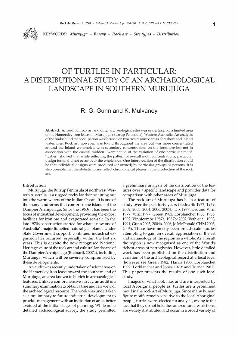
1Rock Art Research 2008 - Volume 25, Number 2, pp. 000-000. R. G. GUNN and K. MULVANEY
KEYWORDS: Murujuga – Burrup – Rock art – Site types – Distribution
OF TURTLES IN PARTICULAR:A DISTRIBUTIONAL STUDY OF AN ARCHAEOLOGICAL
LANDSCAPE IN SOUTHERN MURUJUGA
R. G. Gunn and K. Mulvaney
Abstract. An audit of rock art and other archaeological sites was undertaken of a limited area of the Hamersley Iron lease, on Murujuga (Burrup Peninsula), Western Australia. An analysis of the fi nds found that occupation was focused on two rich resource areas, foreshore and inland waterholes. Rock art, however, was found throughout the area but was more concentrated around the inland waterholes, with secondary concentrations on the foreshore but not in association with the coastal midden. Examination of the variation of one particular motif, ‘turtles’, showed that while refl ecting the patt ern of overall motif concentrations, particular design forms did not occur over the whole area. One interpretation of the distribution could be that individual designs were produced (or owned) by particular groups or persons. It is also possible that the stylistic forms refl ect chronological phases in the production of the rock art.
IntroductionMurujuga, the Burrup Peninsula of northwest Wes-
tern Australia, is a rugged rocky landscape jutt ing out into the warm waters of the Indian Ocean. It is one of the many landforms that comprise the islands of the Dampier Archipelago. Since the 1960s it has been the focus of industrial development, providing the export facilities for iron ore and evaporated sea-salt. In the late 1970s construction started for what is now one of Australia’s major liquefi ed natural gas plants. Under State Government support, continued industrial ex-pansion has occurred, especially within the last six years. This is despite the now recognised National Heritage value of the rock art and cultural landscape of the Dampier Archipelago (Bednarik 2007a), including Murujuga, which will be severely compromised by these developments.
An audit was recently undertaken of select areas on the Hamersley Iron lease toward the southern end of Murujuga, an area known to be rich in archaeological features. Unlike a comprehensive survey, an audit is a summary examination to obtain a true and fair view of the archaeological resource. The work was undertaken as a preliminary to future industrial development to provide management with an indication of areas bett er avoided at the initial stages of planning. While not a detailed archaeological survey, the study permitt ed
a preliminary analysis of the distribution of the fea-tures over a specifi c landscape and provides data for comparison with other areas of Murujuga.
The rock art of Murujuga has been a feature of study over the past forty years (Bednarik 1977, 1979, 2002, 2003, 2004, 2006, 2007b; Dix 1977; Dix and Virili 1977; Virili 1977; Green 1982; Lorblanchet 1983, 1985, 1992; Vinnicombe 1987a, 1987b; 2002; Veth et al. 1993, 1994; Gunn 2003, 2004a, 2006; Jo McDonald CHM 2005, 2006). These have mostly been broad-scale studies att empting to gain an overall appreciation of the art and archaeology of the region as a whole. As a result the region is now recognised as one of the World’s richest areas of petroglyphs. However, litt le detailed work has been published on the distribution and variation of the archaeological record at a local level (however see Green 1982; Harris 1988; Lorblanchet 1992; Lorblanchet and Jones 1979; and Turner 1981). This paper presents the results of one such local study.
Images of what look like, and are interpreted by local Aboriginal people as, turtles are a prominent motif in the rock art of Murujuga. Since many human fi gure motifs remain sensitive to the local Aboriginal people, turtles were selected for analysis, owing to the fact that they do not hold the same cultural restrictions, are widely distributed and occur in a broad variety of

Rock Art Research 2008 - Volume 25, Number 2, pp. 000-000. R. G. GUNN and K. MULVANEY2
forms, from simple outline to complex infi ll patt erns (Green 1982; Vinnicombe 2002; Jo McDonald CHM 2006).
The study areaThe study area, designated as the ‘King Bay
South Block’, is located towards the southern end of Murujuga (Fig. 1). The block is approximately 2.1 × 0.9
km in extent and covers around 1.4 km2 (144 ha) of land (Fig. 2). The block is bounded on the north by the sea, the east by a large tidal inlet, and to the south and west by existing vehicle tracks. The area includes a coastal strip, an elevated rocky plateau-like rise, two feeder creeks, two ephemeral waterholes (Muddy Pool and Turtle Pool), and a series of inland rocky knolls (Fig. 3). While both waterholes are fed by freshwater, these can be inundated by saltwater at unusually high tides.
Figure 1. Murujuga and the location of the study area.
Figure 2. The study area in relation to King Bay and the Pistol Range (note the dark areas of exposed rock).
Figure 3. Muddy Pool from the AM knoll.
3Rock Art Research 2008 - Volume 25, Number 2, pp. 000-000. R. G. GUNN and K. MULVANEY
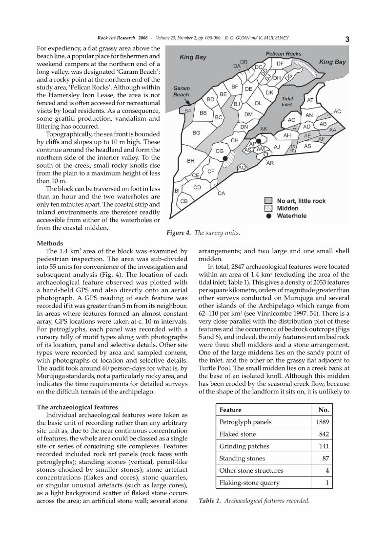
For expediency, a fl at grassy area above the beach line, a popular place for fi shermen and weekend campers at the northern end of a long valley, was designated ‘Garam Beach’; and a rocky point at the northern end of the study area, ‘Pelican Rocks’. Although within the Hamersley Iron Lease, the area is not fenced and is oft en accessed for recreational visits by local residents. As a consequence, some graffi ti production, vandalism and litt ering has occurred.
Topographically, the sea front is bounded by cliff s and slopes up to 10 m high. These continue around the headland and form the northern side of the interior valley. To the south of the creek, small rocky knolls rise from the plain to a maximum height of less than 10 m.
The block can be traversed on foot in less than an hour and the two waterholes are only ten minutes apart. The coastal strip and inland environments are therefore readily accessible from either of the waterholes or from the coastal midden.
MethodsThe 1.4 km2 area of the block was examined by
pedestrian inspection. The area was sub-divided into 55 units for convenience of the investigation and subsequent analysis (Fig. 4). The location of each archaeological feature observed was plotted with a hand-held GPS and also directly onto an aerial photograph. A GPS reading of each feature was recorded if it was greater than 5 m from its neighbour. In areas where features formed an almost constant array, GPS locations were taken at c. 10 m intervals. For petroglyphs, each panel was recorded with a cursory tally of motif types along with photographs of its location, panel and selective details. Other site types were recorded by area and sampled content, with photographs of location and selective details. The audit took around 60 person-days for what is, by Murujuga standards, not a particularly rocky area, and indicates the time requirements for detailed surveys on the diffi cult terrain of the archipelago.
The archaeological featuresIndividual archaeological features were taken as
the basic unit of recording rather than any arbitrary site unit as, due to the near continuous concentration of features, the whole area could be classed as a single site or series of conjoining site complexes. Features recorded included rock art panels (rock faces with petroglyphs); standing stones (vertical, pencil-like stones chocked by smaller stones); stone artefact concentrations (flakes and cores), stone quarries, or singular unusual artefacts (such as large cores), as a light background scatt er of fl aked stone occurs across the area; an artifi cial stone wall; several stone
arrangements; and two large and one small shell midden.
In total, 2847 archaeological features were located within an area of 1.4 km2 (excluding the area of the tidal inlet; Table 1). This gives a density of 2033 features per square kilometre, orders of magnitude greater than other surveys conducted on Murujuga and several other islands of the Archipelago which range from 62–110 per km2 (see Vinnicombe 1997: 54). There is a very close parallel with the distribution plot of these features and the occurrence of bedrock outcrops (Figs 5 and 6), and indeed, the only features not on bedrock were three shell middens and a stone arrangement. One of the large middens lies on the sandy point of the inlet, and the other on the grassy fl at adjacent to Turtle Pool. The small midden lies on a creek bank at the base of an isolated knoll. Although this midden has been eroded by the seasonal creek fl ow, because of the shape of the landform it sits on, it is unlikely to
Figure 4. The survey units.
Table 1. Archaeological features recorded.
Feature No.
Petroglyph panels 1889
Flaked stone 842
Grinding patches 141
Standing stones 87
Other stone structures 4
Flaking-stone quarry 1

Rock Art Research 2008 - Volume 25, Number 2, pp. 000-000. R. G. GUNN and K. MULVANEY4
have ever been the size of the larger two. The location of the stone arrangement is not shown for security reasons but it is not closely associated with any other archaeological or outstanding natural feature.
The features included 1889 art panels, bearing 4015 individual petroglyphs or an overall density of 1349 panels and 2868 petroglyphs per square kilometre. As the rock outcrops occupy an area of 30 ha, this gives an overall density of 0.006/m2 of the available surfaces, or around one petroglyph per 10 m². However, the actual density varied from small outcrops with over
a hundred motifs, to large outcrops with no motifs. Motif density on individual panels also varied, with large panels completely fi lled with a single detailed motif, small panels with a single small motif, and medium-sized panels with a dozen small motifs and others of similar size with only single small motifs.
The fl aked-stone features were either small scatt ers of fl aked stone or isolated cores. All were of grey-black granophyre and while most were irregular fl akes, a few had collections of blade fl akes and the single quarry site (Fig. 6) appears to have been a location specialising in blade reduction (see also Veth 1982).
Grinding patches occurred on 141 horizontal bedrock panels. These have concentrations at both waterholes and along the creek-lines, with another large concentration adjacent to the foreshore in the BB area (Fig. 7). The number per panel ranged from one to four, with a total number of 159 patches. These ranged from 13 mm to 90 mm in length, with widths being around half the length. The median length was 30
cm, median width 16 cm and the width to length ratio ranged between 1 and 4.5, with a median value of 1.8. On morphological character, these grinding patches are the likely result of plant-food processing (see also Turner 1981).
Standing stones were located across most of the area (Fig. 6) but were more concentrated on the outcrop overlooking the creek-line and Turtle Pool. As there are many naturally standing stones within the larger outcrops, only stones that had been chocked were recorded here, although it is highly
Figure 5. Distribution of all archaeological features recorded.
Figure 6. Locations of major non-art features. Figure 7. Distribution of grinding patches.

5Rock Art Research 2008 - Volume 25, Number 2, pp. 000-000. R. G. GUNN and K. MULVANEY
likely that a good number of those not chocked were also artificially placed. Immediately outside the study area, on the eastern side of the tidal inlet, is a signifi cant concentration of over 96 standing stones on a single knoll, known as Echidna Hill. Within the study block, 97 individual standing stones were recorded from 87 locations. The maximum number per location was eight, but only seven locations had more than a single stone. The stones were generally small, ranging from 0.18 m to 1.3 m in height (median 0.55 m, with only three over 1 m tall; n=80). While the majority were placed on or near the crest of their respective outcrops, most were inconspicuous in their placement, being small rocks among larger rocks. For them to have been clearly visible from any distance greater than a few metres, they would need to have been painted or otherwise decorated, although there is now no evidence for such a practice. Also, no patt ern of alignment with other cultural or natural features was detected.
Other stone features recorded were a stone-walled shelter, two singular stone cairns, and one stone arrangement. Due to the diffi culty of distinguishing between made, used and natural pits on the rock slopes, clear evidence of use or modifi cation was required for a ‘pit’ site to be recorded as an archaeological feature. On this basis, no ‘pit’ sites were recorded within the study area.
The petroglyphsPetroglyphs occur throughout the study
area (Fig. 5), although they tend to be con-centrated in four areas: around the two water-holes, behind ‘Garam Beach’, and to a lesser extent around ‘Pelican Rocks’ (Fig. 8). Just
over two-thirds of both the art panels and the motifs occur around the two waterholes, indicating that the waterholes provided the principal foci for rock art production (Table 2). Overall, the area has an average density of 29 motifs per hectare across the study area and 134 petroglyphs per hectare within the boulder formations.
Of the 4015 motifs recorded, 3465 (86%) could be arbitrarily classifi ed by type; with the other 550 being only fragmented remnants (Table 3). For the purposes of this study, the motifs were grouped into eighteen broad types with additional categories for ‘other’ (particularly amorphous areas) and fragments.
Figure 8. Petroglyph densities.
Concentration Panels MotifsTurtle Pool (CG, CH, CF) 766 40% 1626 40%Muddy Pool (AK, AM, AP) 451 24% 1099 27%‘Garam Beach’ (BB) 123 6% 210 5%‘Pelican Rocks’ (DF) 28 1% 62 2%
Table 2. Motif concentrations.
Table 3. Overall motif frequencies.
MOTIF TYPENo. of motifs
% of motifs
No. ofpanels
% of panels
Max motifs/panel
‘Human fi gure’/ anthropomorph 932 27 577 32 13Geometric element 740 21 540 30 7Simple design 334 10 277 15 9‘Bird track’ 278 8 161 9 13Other 228 7 178 9 6‘Turtle’ 175 5 166 9 3Oval 169 5 145 8 4Other animal 124 4 111 6 3Other marine 120 3 96 5 8‘Macropod track’ 61 2 47 2 5‘Human foot’ 59 2 50 3 3‘Egg-set’ 56 2 51 3 3‘Bird’ 46 1 38 2 3‘Marine liver’ 41 1 37 2 3Complex design 39 1 36 2 3‘Macropod’ 26 <1 23 1 3‘Marine tail’ 20 <1 19 1 2‘Archaic face’ 9 <1 9 <1 1‘Turtle run’ 8 <1 6 <1 3
3465 100 1828
Classifi ed motifs 3465 86 1828 24Fragments 550 14 261 9Total 4015 100 1889

Rock Art Research 2008 - Volume 25, Number 2, pp. 000-000. R. G. GUNN and K. MULVANEY6
There were 1032 panels (55%) that had only a single motif, 412 panels (22%) with two motifs, and 184 (10%) with three motifs. Twenty-eight panels had from 10 to 24 motifs (1.5%), although only three had 20 or more motifs. For the 577 panels with ‘human fi gures’, 67% had a single fi gure, 20% two fi gures, 7% had three fi gures and less than 1% had 10 or more. For turtles, 95% of the engraved panels had a single motif, 4% had two ‘turtles’, and <1% (a single example) had three ‘turtles’. That is, there are no occurrences with more than three ‘turtles’ per panel.
Production and placementTechnique of production was not quantifi ed as
part of this investigation. It was clear, however, that the petroglyphs were mostly produced by direct percussion ‘pecking’ with pointed implements. In this sense, and contra Maynard (1977), ‘pecking’ and ‘pounding’ are both direct percussion techniques, with pecking producing distinct pits while pounding, made with a rounded mur-e, produces an image by shallow bruising of the rock surface (cf. Bednarik 1998). A small number of other motifs were produced by scratching or abrading (cf. Vinnicombe 2002: 15–16). In a few instances, motifs have combined two techniques and, in several examples, a motif in one technique has been later refreshed or modifi ed in another. In the small number of superimpositions that could be readily interpreted, scratching and abrading both overlie pecking.
The quality of motif production varies greatly, from what appear to have been rapidly executed, unrefi ned shapes, to apparently carefully considered designs done with precise pecking that required a high degree of technical profi ciency (Fig. 9). Although subjective,
an assessment between excellence and inferiority of particular motifs (from either a Western or Indigenous perspective), mapping the quantity and distribution of motif quality is an aspect that deserves further att ention.
The primary inclination of the art panels (horizontal <45° or vertical ≥45°) was recorded to examine the aspect of publicity (viewing exposure/display coverage). Vertical panels can be viewed by a greater number of people at one time and from a greater distance and therefore have the potential to have been used diff erently. Hence, vertical panels should be bett er suited for the placement of display art, ‘markers’
Figure 9. Well designed and carefully executed motifs.
Figure 10. Percentage of fragments for areas with >20 motifs.

7Rock Art Research 2008 - Volume 25, Number 2, pp. 000-000. R. G. GUNN and K. MULVANEY
or instructional (rather than personal) art. Overall, 29% of the 1889 panels were vertical and these occur throughout the study area but with a concentration around Muddy Pool (38%, n=208). Probably not coincidentally, this is where the greatest number of ‘cliff faces’ occurs. Visually, however, only three motifs stand out for their placement. All are large (>1 m) and on prominent vertical surfaces. At Muddy Pool, a complex zoomorph (180 cm; Fig. 36) has been positioned near the crest of the outcrop. Although now difficult to see due to its weathering, at the time aft er its production it would have been a stunning sight from the fl at plain below. At Pelican Rocks, a large and exquisitely designed ‘pelican’ motif (110 cm; Fig. 9a) has been placed conspicuously on a cliff face overlooking the open beach. Within the centre of the plateau, between the tidal arm and the sea, two large, horizontal eel-like motifs (170 cm and 110 cm) have been placed low down on a cliff face within a narrow gully. Consequently, they can only be viewed from directly in front of the panel and, unlike the former two, they are not in an area of dense petroglyphs. The lack of similarly outstanding motifs in the Turtle Pool and ‘Garam Beach’ areas suggests that these four fi gures would have had an extraordinary function.
Motif types and distributionsIn the following, the labels given
refl ect those of common parlance among researchers on Murujuga and that used by contemporary Aboriginal custodians. These do not necessarily refl ect the interpretations of the creators of the rock art or its past custodians and hence are off ered purely as a convenient descriptive tool (cf. Clegg 1991; Bednarik 2007b: 241–243).
Fragments: This amalgam of markings comprises, as the name implies, segments of petroglyphs that preclude their being classifi ed into recognisable subjects. The 550 fragments accounted for 14% of all petroglyphs. They occurred on 261 panels, with a maximum number of nine. Sixty-one panels had only fragments. They are not distributed evenly over the study area. Overall they are more numerous in areas with higher motif numbers, however, on a percentage basis, their distribution is variable, ranging from 0% to 30% regardless of overall motif numbers. The percentage of fragments is higher in the inland areas compared to those along the coast (Fig. 10), and particularly the areas around Turtle Pool. Whether this is due to earlier art production around the inland waterholes,
as appears to be the case elsewhere at Murujuga, or is a factor of greater coastal erosion of the rock art (n.b. Bednarik 1994) remains unclear at this stage.
Human fi gures: ‘Human fi gure/anthropomorphs’ are the most numerous and widely distributed motif type, of which 932 were identifi ed on 577 panels (Fig. 11). These occurred in a wide variety of schemata,
Figure 11. Distribution of ‘human fi gure’ motifs.
Figure 12. Distribution of ‘geometric element’ motifs.

Rock Art Research 2008 - Volume 25, Number 2, pp. 000-000. R. G. GUNN and K. MULVANEY8
including profi le and ‘climbing-man’ types. The most common form, however, was the frontal stick-fi gure. As the human fi gure depictions are particularly sensitive to custodians today, they will not be illustrated or further discussed.
Geometric elements and simple designs: Geometric elements (740 cases) consisted of a wide variety of
types (e.g. semblance to L, T, V, K, C and U-shapes), each of which was rarely repeated more than a few times. As a group, the 540 panels (30%) on which they occur are relatively evenly distributed across the study area (Fig. 12). Simple designs (334 cases), such as two combined geometric elements (linear and dot; oval and bars), occurred on 15% of panels, and their distribution closely parallels that of the ‘geometric elements’.
Bird and macropod tracks: ‘Bird track’ motifs (both three-toed and four-toed types) account for 8% of the total and occur on 9% of panels. They are distributed throughout the study area, although they are more common in the Turtle Pool location (Fig. 13). Panels with ‘macropod track’ motifs, which are fewer in number and generally less varied in their schemata than the ‘bird tracks’, occur throughout the area but, numerically, are concentrated on panels around Muddy Pool.
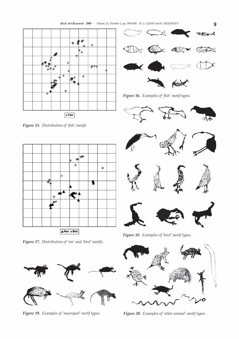
Turtles and ‘other marine creatures’: ‘Turtles’, which form one of the most visually apparent groups, account for only 175 motifs (5%), and occur on 166 panels (9%). These are focused on sites around the two inland middens, and particularly Turtle Pool (Fig. 14). This motif will be discussed further below. In contrast to turtles, other marine subjects account for 3% of motifs and are widely distributed throughout the area (Fig. 15). The class incorporates a broad variety of naturalistic representations including ‘shark’, ‘dugong’, ‘stingray’, ‘porpoises’ and a range of ‘fi sh’. The most common fi sh-like form was a simplifi ed and stylised design consisting of an ovate body with fi sh tail (Fig. 16).
Birds, macropods and ‘other animals’: Forty-six examples of ‘bird’ motifs occur throughout the area, and while varying in apparent species, tend to focus on coastal species such as ‘cormorant’ (Figs 17 and 18). All of the birds are represented as standing in profi le; none are shown in fl ight. ‘Macropods’ are uncommon (<1% of the total art corpus), yet, unlike the bird motifs, they are concentrated on sites inland from the coast (Fig. 17). They are generally small in size (less than 20 cm). The larger versions tend to be more carefully produced and
have greater detail in their infi ll (Fig. 19). However, no large outline types, diagnostic of the earlier art periods (Mulvaney in press), were recorded. A wide range of ‘other animals’ (including ‘reptiles’ and a possible eel) was recorded (Fig. 20). Most were well produced with a clear profi le and showing idiosyncratic features, such that many may be amenable to etic speciation
Figure 13. Distribution of ‘bird track’ and ‘roo track’ motifs.
Figure 14. Distribution of ‘turtle’ motifs.
9Rock Art Research 2008 - Volume 25, Number 2, pp. 000-000. R. G. GUNN and K. MULVANEY
Figure 15. Distribution of ‘fi sh’ motifs.
Figure 16. Examples of ‘fi sh’ motif types.
Figure 17. Distribution of ‘roo’ and ‘bird’ motifs.Figure 18. Examples of ‘bird’ motif types.
Figure 19. Examples of ‘macropod’ motif types. Figure 20. Examples of ‘other animal’ motif types.
Rock Art Research 2008 - Volume 25, Number 2, pp. 000-000. R. G. GUNN and K. MULVANEY10
att empts. Individual ‘animals’ are rarely represented more than once. As a group they occur throughout the study area but with a concentration in the vicinity of the two waterholes (Fig. 21).
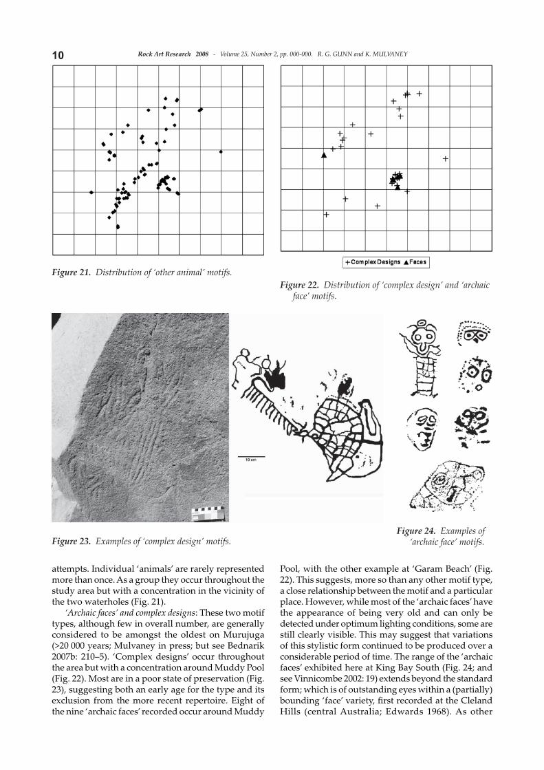
‘Archaic faces’ and complex designs: These two motif types, although few in overall number, are generally considered to be amongst the oldest on Murujuga (>20 000 years; Mulvaney in press; but see Bednarik 2007b: 210–5). ‘Complex designs’ occur throughout the area but with a concentration around Muddy Pool (Fig. 22). Most are in a poor state of preservation (Fig. 23), suggesting both an early age for the type and its exclusion from the more recent repertoire. Eight of the nine ‘archaic faces’ recorded occur around Muddy
Pool, with the other example at ‘Garam Beach’ (Fig. 22). This suggests, more so than any other motif type, a close relationship between the motif and a particular place. However, while most of the ‘archaic faces’ have the appearance of being very old and can only be detected under optimum lighting conditions, some are still clearly visible. This may suggest that variations of this stylistic form continued to be produced over a considerable period of time. The range of the ‘archaic faces’ exhibited here at King Bay South (Fig. 24; and see Vinnicombe 2002: 19) extends beyond the standard form; which is of outstanding eyes within a (partially) bounding ‘face’ variety, fi rst recorded at the Cleland Hills (central Australia; Edwards 1968). As other
Figure 21. Distribution of ‘other animal’ motifs.Figure 22. Distribution of ‘complex design’ and ‘archaic
face’ motifs.
Figure 23. Examples of ‘complex design’ motifs.Figure 24. Examples of
‘archaic face’ motifs.

11Rock Art Research 2008 - Volume 25, Number 2, pp. 000-000. R. G. GUNN and K. MULVANEY
examples have now been located in several places, within or on the margins of the arid region of Australia, that involve a large de-gree of variation (the prominent circular ‘eyes’ remaining the primary feature), it is evident that a more rigorous analysis and defi nition of ‘archaic faces’ is now required (cf. Dix 1977; Lewis and McCausland 1987; David et al. 1992; Franklin 2004; McDonald 2005; see Bednarik 2007b: 232).
Marine tail and liver: Two other motif categories need mention, although their distribution has not been analysed as the sample size does not provide meaningful data. The ‘tail’ motif resembles that portion of either a whale or dugong. In the case of the liver, this is a bi-lobed form usually with a short tang at the apex. This image was identifi ed as a stingray liver by Aboriginal informants consulted by McCarthy (1961: 132–3) when he was recording rock art on nearby Depuch Island. These bi-lobed images fall into two forms; those that are relatively fat, open and short, and those that are narrow, closed and elongated. The latt er are taken to be shark rather than stingray livers. Indeed, in north-eastern Arnhem Land the totemic shark clan design painted on the chest of ritual participants has a marked semblance to the Pilbara petroglyphs.
Other patt ernsCompositions: For the greater number of panels,
motifs appear to consist of singular representations. Even when in association with other motifs of the same or diff erent types on the one panel, they invariably have diff erences in production technique, which is indicative of a discontinuous association. No elaborate panels such as the so-called ‘climbing men panel’ (Walsh 1988: 71; cf. Bednarik 2007b: 243) were recorded, although motifs within this distinctive style, with disjoined head and body, do occur. The very few examples of composition that do occur are either aggregates of similar motifs (Fig. 25) or human fi gures att ached by a line to either a fi sh or macropod (suggesting fi shing or hunting associations).
Placement: Almost one in three (29%) of the art panels have a vertical inclination. All motif classes are represented on these panels but none have more than 50% of their class represented. Hence there is no absolute preference for any motif type on vertical or
horizontal surface. On the vertical faces, most classes are represented by 20–40%. Those types that are more common on vertical faces (>40%) are ‘macropods’ (54%), ‘archaic faces’ (5 of 9), other ‘animals’ (47%), and ‘human figures’ (45%). Those types that are uncommon on vertical faces (>20%), and hence more common on horizontal faces, are ‘marine liver’ (12%) and ‘human feet’ (8%). Hence motif types that are normally regarded (cognitively perceived) in profi le in nature are more likely to be placed on vertical panels than geometric motifs or ‘naturalistic’ motifs represented in plan (‘lizards’, ‘turtle’). This suggests
Figure 26. Motif proportions for the three major art concentrations.
Figure 25. Examples of compositions and arrangements.

Rock Art Research 2008 - Volume 25, Number 2, pp. 000-000. R. G. GUNN and K. MULVANEY12
that, where possible, the artists have refl ected the natural appearance of these motifs. While motif class placement was not decisive, as mentioned above, this is not necessarily the case for particular motif types such as particular bird or animal species where there is an intention of placement in the vertical.
Variation: The three areas of motif concentration (Muddy Pool, Turtle Pool and ‘Garam Beach’; Fig. 8) have overall similarities in their motif repertoires (Fig. 26). The diff erences are one of degree rather than kind, with more human fi gures and geometric designs (both simple and complex) at Muddy Pool; more
geometric elements, ‘turtles’ and ‘turtle eggs’ at Turtle Pool; and more ‘fi sh’, ‘birds’ and ‘other animals’ at ‘Garam Beach’. While these may be meaningful in themselves, the patt ern is repeated when the units within a single cluster are examined. However, in a study of site and subject distributions in the Withnell Bay area (5 km north) a similar patt ern of location, adjacent resources and dominance of subject depiction was noted (Turner 1981). Within the Turtle Pool group, a few motif types stand out for their concentration in
particular survey units of the group: turtle motifs in unit CG; geometric elements in unit CF; and ‘human fi gures’ and ‘feet’ in unit CH (Fig. 27).
More on turtlesThe basic schema used to depict what we term
turtle motifs is of an oval body with protruding, downward-turned fi ns, short head and tail. In plan, this is very similar to many of the fat-bodied human-fi gure motifs, and it is only the curve of the turtle fore-fi ns that distinguishes them from the ‘human fi gures’ (that have straight or jointed arms). Despite
a common schema, through the use of a wide range of decorative infi ll designs of the shell carapace (the turtle’s body), the artists have produced a number of distinctive patt erns that can be distinguished as motif sub-types (classes). Overall, the motifs tend to be outline forms, over half of these with infi ll patt ern comprising dots, linear, grid, simple (non-grid) or complex (two or more components) designs. Far less frequent were turtle images composed of a speckled, dot or solid area pecking.
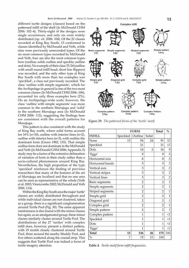
The 175 turtle motifs recorded here were catalogued into 23 classes on the basis of their carapace pattern (Figs 28 and 29). Of these, only eleven classes (48%) had more than two representatives (Table 4), and the most common fi ve classes accounted for almost three-quarters of the total (72%). Three classes had more than 10% of the motifs (outline only; solid; outline and speckle), but just one patt ern type had more than 20% (outline only, 31%). This indicates that despite the wide variety of patt erns available, preference was given to particular confi gurations. This high proportion of outline-only forms was also observed on the north side of King Bay, where in an area of 2.8 ha, 41 out of 62 ‘turtle’ motifs (66%) had outline-only forms (Green 1982: 135).
In their overview of the Dampier Archipelago rock art, McDonald and Veth identified 68
Figure 27. Motif proportions within the Turtle Pool concentration.
Figure 28. The basic forms of the ‘turtle’ motif.
13Rock Art Research 2008 - Volume 25, Number 2, pp. 000-000. R. G. GUNN and K. MULVANEY
diff erent turtle designs (classes) based on the patt erned infi ll of the shell (Jo McDonald CHM 2006: 102–4). Thirty-eight of the designs were single occurrences, and only six were widely distributed (op. cit. 2006: 104). Of the 22 classes recorded at King Bay South, 13 conformed to classes identifi ed by McDonald and Veth, while nine were previously unrecorded types. Of the six most common types recorded by McDonald and Veth, four are also the most common types here (outline; solid; outline and speckle; outline and dots). No example of their class TU24 (outline with small round infi ll head, short line fl ippers) was recorded, and the only other type at King Bay South with more than ten examples was ‘speckled’, a class not previously recorded. The class ‘outline with simple segments’, which for the Archipelago in general is one of the two most common classes (Jo McDonald CHM 2006: 106), accounted for only three examples here (2%). On an Archipelago-wide scale, however, the class ‘outline with simple segments’ was more common in the northern Murujuga and ‘solid’ in the southern Murujuga area (Jo McDonald CHM 2006: 112), suggesting the fi ndings here are consistent with the overall patterns for Murujuga.
This patt ern is also consistent with the study of King Bay north, where solid forms account for 16% (n=10), outline with interior lines (n=2), outline with interior bars (n=3), with outline the dominant form (Green 1982: 135). That simple outline form does not dominate in the McDonald and Veth (Jo McDonald CHM 2006: Appendix 5) study may be a factor of the extensive delineation of variation of form in their study rather than a socio-cultural phenomenon around King Bay. Nevertheless, the high proportion of the type ‘speckled’ reinforces the finding of previous researchers that many of the features of the art of Murujuga are localised and that no one area can be seen as representative of the whole (Veth et al. 2003; Vinnicombe 2002; McDonald and Veth 2006: 114).
Within the King Bay South area the major ‘turtle’ classes are widely distributed throughout and while individual classes are not clustered, taken as a group, there is a signifi cant conglomeration around Turtle Pool (Fig. 30). The same apparent randomness is also found with the minor classes but again, as an amalgamated group, these minor classes similarly cluster around Turtle Pool. The distributions of the 27 ‘turtles’ with complex infi ll does, however, present a distinct patt ern, with 19 motifs closely clustered around Turtle Pool, three around the nearby Muddy Pool, and fi ve others scatt ered along the coastal strip. This suggests that Turtle Pool was indeed a focus of turtle imagery att ention.
Figure 29. The patt erned forms of the ‘turtle’ motif.
Table 4. Turtle motif form-infi ll frequencies.
FORM Total %INFILL Speckled Outline SolidNone 13 54 24 91 52Speckled 21 21 12Dots 14 2 16 9‘Eggs’ 9 9 5Horizontal axis 8 8 5Horizontal bands 5 5 3Vertical axis 3 3 2Vertical stripes 3 3 2Vertical lines 3 3 2Basic segments 2 2 1Simple segments 2 2 1Striped segments 2 2 1Simple grid 2 2 1Diagonal grid 2 2 1Complex grid 2 2 1Simple patt ern 2 2 1Complex patt ern 1 1 <1Speckled 1 1 <1Dots 1 1 <1‘Eggs’ 1 1 <1Total 13 136 26 175 100% 7 78 15 100

Rock Art Research 2008 - Volume 25, Number 2, pp. 000-000. R. G. GUNN and K. MULVANEY14
One interpretation of the distribution of the more complex patt erned forms could be that individual designs were produced (or owned) by particular groups or persons. Hence, a greater range would be found in the more commonly used centres, with outlying examples refl ecting the area visited by an individual during his/her/their stay within the study area. Green (1982: 135) postulated the relationship of turtle image clusters with prominent landform that aff orded ‘lookouts’ for spott ing turtles.
Of the eight panels containing more than one turtle motif, four panels contain distinct individual designs (usually suggestive of some time diff erence in their production), three have apparently contemporary pairs but with diff erent forms (Fig. 31), and only one has a contemporary pair that utilises the same form (relative age based on degree of patination). Hence, given the high proportion of singular representations, the association of turtle motifs on any particular panel is more likely to be coincidental than planned. Six of the eight panels with more than one turtle motif occur adjacent to Turtle Pool, while the other two are widely separated along the coastal strip.
Horizontal rock faces have 79% of the 175 turtle motifs, while 21% occur on vertical faces (≥45°). This is consistent with the overall trend for a preference for horizontal panels throughout the area (c. 66%). Slightly more patt erned motifs occur on vertical panels (29%), however, this is not seen as signifi cant as, within panel clusters, both patt erned and basic types can occur on both surface inclinations, and none of those on vertical panels are particularly larger or more visually outstanding.
The physical size of images within the diff erent classes is similar (Table 5), with most being 10 cm and 40 cm in length. The largest turtle motif, a 218 cm outlined ‘turtle’, is an exceptional individual
as the next largest is only 45 cm. Excluding this exceptional fi gure, the size range is similar for both basic and patt erned infi ll types. McDonald and Veth (Jo McDonald CHM 2006) found that overall, most examples ranged between 21 and 30 cm. The majority
Figure 30. Distribution of the more common ‘turtle’ classes.
Figure 31. Contemporary pair of turtles on the same panel but with diff erent infi ll patt erns.
Table 5. ‘Turtle’ class numbers and sizes.
Motif class
Size
No % min. max. medianT 54 31 9 128 17S 24 14 9 34 17T.A 21 12 14 38 23T.B1 14 8 12 35 19K 13 7 11 40 21T.V2 9 5 9 25 15T.G1 8 5 19 25 21T.V1 5 3 16 22 20T.S2 3 2 15 30 -T.S3 3 2 17 33 -T.C2 3 2 15 26 -T.S1 2 1 - 16 -T.B2 2 1 20 23 -T.G2 2 1 15 24 -T.P2b 2 1 22 32 -T.P1a 2 1 9 27 -S.B1 2 1 17 28 -T.P2a 2 1 - 23 -T.P2c 1 <1 - 14 -T.G3 1 <1 - 38 -T.V3 1 1 - 36 -T.P1b 1 <1 - 29 -

15Rock Art Research 2008 - Volume 25, Number 2, pp. 000-000. R. G. GUNN and K. MULVANEY
of motifs here are in the 11–20 cm size class (Table 6), and with a median of 20 cm. As with the turtle patt erns, the size range of the turtle motifs was found to vary across the Archipelago (Jo McDonald CHM 2006: 112–3), with the smaller size frequencies in the present study area conforming to that of their southern and central Murujuga regions.
A variation on the turtle motif has twin front fi ns, occasionally also twin rear fi ns and in one instance, twin heads (Fig. 32). These are interpreted as representing mating turtles (Turner 1981: Appendix 1; Green 1982: 135; Vinnicombe 2002: 20). In another singular example, the outline of a ‘turtle’ has been retouched at a much later date, but with the head on the ‘shoulder’ of the former, suggesting rejuvenation with a change in the visual meaning of the motif.
Eight motifs referred to as ‘turtle-runs’ were recorded. These are interpreted as the trails left by turtles in the sand aft er crawling up the beach to lay their eggs (cf. Vinnicombe 2002: 20). One panel contained three representations and the others only one each. The panel with the three ‘runs’ also contained a ‘turtle’ motif (Fig. 33). None of the other ‘runs’ were directly associated with turtle motifs, however, the six panels containing the run motifs all occur around Turtle Pool (CF and CG areas). In support of this interpretation of the motif is a case one kilometre to the south-east of King Bay South, where a ‘whale-tail’ motif is surrounded by the ‘turtle-run’ motif. It is of note that the appearance of whales in the Archipelago waters coincides with the nesting months of turtle (Geoff Kruger, pers. com. 2007).
Aggregates of small disc-shaped motifs, ‘egg-sets’, are assumed to represent turtle eggs rather than emu eggs, which are commonly depicted in a similar manner at inland sites (although the latt er are usually larger in size and fewer in clutch number). Considering that turtle eggs were a favoured summer food, this assumption is not unreasonable (Vinnicombe 2002: 21). ‘Egg-set’ motifs occur on 51 panels (e.g. Fig. 34), yet only two occur on panels with turtle motifs, therefore leaving the interpretation of this generalised motif open to other possibilities, such as sea-bird eggs, which are also laid in the area and were similarly sought aft er. However, of the 51 panels, 42 occur around Turtle Pool, where the majority of turtle motifs occur, a coincidence that is not seen as random.
On three panels containing ‘egg-sets’, the design contains an unusually high number of ‘eggs’. The motifs are placed to cover most of their respective panel surfaces, and with very litt le space between the individual ‘eggs’. With all three panels, the motifs are very weathered and occur on small and vertical faces. This arrangement gives them the character of cupule surfaces, a motif type commonly associated with early artistic production in the Kimberley (Morwood 2002), Victoria River District (Taçon et al. 1999), Arnhem Land (Edwards 1979) and central Australia (Gunn 2004b; note also Bednarik 1993). By their weathering, it is likely that these three panels predate the Holocene sea-rise and, therefore, they are unlikely to represent ‘turtle eggs’ despite their classifi cation as such here. In addition, the large zoomorph (Fig. 35) was created on a surface that may well have been a cupule surface, but these are now so weathered that it is not possible to determine whether they predate the fi gure or were part of the motif’s original infi ll.
Table 6. ‘Turtle’ motif size frequencies.
Size class 1–10 11–20 21–30 31–40 41–50 >50 TotalNo. (all) 11 76 47 15 1 1 151No. (patt erned) 1 8 11 3 23
Figure 32. ‘Mating turtle’ motif.
Figure 33. ‘Turtle run’ motif with ‘turtle’.
Figure 34. ‘Turtle egg’ motif.

Rock Art Research 2008 - Volume 25, Number 2, pp. 000-000. R. G. GUNN and K. MULVANEY16
DiscussionDix and Virili (1977: 95), writing about the petro-
glyphs of the Dampier Archipelago, observed that ‘turtles have patt erns which suggest diff erentiation between species on the part of the artists’. It was anticipated that, with the high number of turtle motifs, a patt ern would emerge to enable identifi cation to species. There are fi ve species of turtle that inhabit the waters of the Dampier Archipelago, the Green (Chelonia mydas), Loggerhead (Carett a carett a), Flatback (Natator depressus), Leatherback (Dermochelys coriacea) and Hawksbill (Eretmochelys imbricata). Identifi cation to species within the rock art of the area is apparently possible with bird and fi sh images, so it would seem not unreasonable that this would extend to turtles as it does to other marine mammals (see Green 1982: 143). Turtle species display some variability in the general shape of their body, relative size of head, size and angle of fl ippers, and most obviously, in the plan view of the carapace. In particular, the Flatback is rounded whereas the Leatherback is elongated with distinct longitudinal ridges; the other three are similar with a tapering to the posterior end. However, within our King Bay South sample, no species-diagnostic features
are apparent. As King Bay is not a turtle-nesting beach, there remains the possibility that species defi nition may well be highlighted in motifs produced in close proximity to those onshore locations utilised by particular turtle populations.
Within the study area, the superfi cial investigation of the distribution of a range of motif types, and the more detailed study of the turtle motif shows that there is considerable variation across the landscape. However, there is litt le in the way of discernible spatial patt erning across all the petroglyph subjects. Clearly, the concentration of artwork at Turtle Pool, Muddy Pool and ‘Garam Beach’ and the location of large middens at Turtle Pool and beyond ‘Pelican Point’, the smaller midden immediately upstream from Muddy Pool, and the stone quarry/workshop at ‘Pelican Point’, indicate that utilisation of the area focused on particular resource areas (waterholes, mangroves and foreshore). There is litt le diff erence within the total corpus of artwork at each of these locations, suggesting that the four areas were used both concurrently and for similar purposes. The nature of the speciality of the three motifs (zoomorph; ‘pelican’; ‘eels’) singled out for their artistic att ributes of size and placement is, however, not elaborated by other archaeological aspects. Further, the distribution of standing stones, while related to the areas of occupation, is otherwise unrelated to that of the artwork patt erns. Interestingly, this lack of patt erning contrasts to the patt ern identifi ed in the Withnell Bay South area, where diff erences in the art repertoire were seen as refl ecting site use and local resource exploitation (Turner 1981).
Chronologically, the higher proportion of petro-glyph fragments around Turtle and Muddy Pools suggests that these areas might contain older art than along the coastline. This is supported by the distribution of motifs from the Pleistocene period (Mulvaney in press a, in press b): ‘complex designs’ and ‘archaic faces’, with eight of the nine faces recorded occurring at Muddy Pool, and possible ‘cupule surfaces’ around both waterholes. While this would be consistent with the newer coastal art deriving from the Holocene era, it might also be explained by natural deterioration experienced by the coastal panels (although this is considered unlikely). Weathering of petroglyphs across the archipelago is a further subject requiring att ention.
The four thousand petroglyphs recorded from the King Bay South study area is high for an Australian petroglyph site (Jo McDonald CHM 2005: 152) and is comparable to the largest site in central Australia (cf. Edwards 1966; Forbes 1983; Gunn 2000) and Yunta region (Edwards 1966), although considerably smaller than the larger petroglyph sites in western New South Wales (Sturts Meadows, >16 000 motifs; Clegg 1987). It is not, however, a large number in terms of locations within the Dampier Archipelago, where up to 10 000 petroglyphs occur within valley systems; for example it is estimated that in Skew Valley the density is 40
Figure 35. Large zoomorph (?) motif on a prominent vertical panel at Muddy Pool (1.80 m high).

17Rock Art Research 2008 - Volume 25, Number 2, pp. 000-000. R. G. GUNN and K. MULVANEY
motifs/ha (Lorblanchet 1992: 20). This compares with around 28 motifs per hectare at King Bay South. Yet it is far denser than some other areas (1.2 motifs/ha within King Bay-Hearsons Cove; Vinnicombe 1997). As there are also large areas of spinifex fl ats that are almost devoid of petroglyphs, it is clear that the petroglyphs occur in varying concentrations across the landscape. If, then, the petroglyph density for the study area were taken as representative or at least ‘average’ for Murujuga, this would imply that Murujuga contains around 370 000 petroglyphs (excluding those of the surrounding islands and mainland ranges to the south). This prediction coincides precisely with Bednarik’s original census of Murujuga petroglyphs in the 1960s, of between 350 000 and 390 000 motifs (Bednarik 2007b: 235–6). Consequently, the prediction of one million petroglyphs for the entire Archipelago (Bednarik 2002, 2007b; Jo McDonald CHM 2005: 152) is probably not unreasonable.
The concentration of rock art and other site types occurring around the inland waterholes shows that these were the primary local foci, with the estuary midden (where there is less outcropping rock) used almost solely for shellfish exploitation. The bay foreshore appears to have been used for only infrequent occupation, most probably by people camping at the inland freshwater reserves. A similar patt ern was reported at Skew Valley (Lorblanchet 1992), although the preponderance of shell noted by Lorblanchet was not as evident here.
ConclusionThis small study has shown that while there is
considerable variation across the study area, there is litt le in the way of patt erning of the art, subject, style and form. This is interpreted as indicating, at least during the late Holocene, that a similar patt ern of occupation and utilisation was practised across this small area of Murujuga. A detailed comparative study of other areas across Murujuga is now needed to further elaborate the various foci and any art patt erns elsewhere across the Archipelago. Also, using a larger study area, some common patt erns may be detected amongst the less frequent, older (early Holocene or Pleistocene?) artwork.
AcknowledgementsThe audit was undertaken for Pilbara Iron-Rio Tinto
(Aust.) Pty Ltd. Ron Vanderwal and Geoff Kruger off ered constructive suggestions on the content and Leigh Douglas commented on the draft . Thanks also to the three anonymous RAR reviewers. Responsibility for the presentation and conclusions, however, remains with the authors.
R. G. (ben) Gunn(La Trobe University)329 Mt Dryden RoadLake Lonsdale, VIC 3380AustraliaE-mail: [email protected]
Kenneth Mulvaney(University of New England)340 Elliott CrescentDampier, W.A. 6713AustraliaE-mail: [email protected]
Final MS received 13 March 2008.
REFERENCES
Bednarik, R. G. 1977. A survey of prehistoric sites in the Tom Price region, northwestern Australia. Archaeology and Physical Anthropology in Oceania 12: 51–76.
Bednarik, R. G. 1979. The potential of rock patination analysis in Australian Archaeology – part 1. The Artefact 4: 14–38.
Bednarik, R. G. 1993. About cupules. Rock Art Research 10: 138–139.
Bednarik, R. G. 1994. A taphonomy of palaeoart. Antiquity 68: 68–74.
Bednarik, R. G. 1998. The technology of petroglyphs. Rock Art Research 15: 23–35.
Bednarik, R. G. 2002. The survival of the Murujuga (Burrup) petroglyphs. Rock Art Research 19: 29–40.
Bednarik, R. G. 2003. Dampier report April 2003. AURA Newslett er 20(1): 5–8.
Bednarik, R. G. 2004. Dampier report May 2004. AURA Newslett er 21(1): 2–5.
Bednarik, R. G. 2006. Australian apocalypse: the story of Australia’s greatest cultural monument. Occasional AURA Publication 14, Australian Rock Art Research Association Inc., Melbourne.
Bednarik, R. G. 2007a. Good progress at Dampier. Rock Art Research 24: 267–271.
Bednarik, R. G. 2007b. The science of Dampier rock art – part 1. Rock Art Research 24: 209–246.
Clegg, J. 1987. Style and tradition at Sturt’s Meadows. World Archaeology 19: 236–255.
Clegg, J. 1991. !Pictures and pictures of … In P. Bahn and A. Rosenfeld (eds), Rock art and prehistory, pp. 109–111. Oxbow Monograph 10, Oxbow Books, Oxford.
David, B., D. Chant and J. Flood 1992. Jalibang 2 and the distribution of pecked faces in Australia. Memoirs of the Queensland Museum 32(1): 61–77.
Dix, W. 1977. Facial representations in Pilbara rock engra-vings. In P. J. Ucko (ed.), Form in indigenous art, pp. 277–285. Australian Institute for Aboriginal Studies, Canberra.
Dix, W. C. and F. L. Virili 1977. Prehistoric petroglyphs of the Dampier Archipelago, north western Australia. Bollett ino del Centro Camuno di Studi Preistorici 16: 87–110.
Edwards, R. 1966. Comparative study of rock engravings in South and central Australia. Transcripts of the Royal Society of South Australia 90: 33–38.
Edwards, R. 1968. Prehistoric rock engravings at Thomas Reservoir, Cleland Hills, western central Australia. Records of the South Australian Museum 15: 647–670.
Edwards, R. 1979. Australian Aboriginal art: the art of the Alligators Rivers region, Northern Territory. Australian Institute of Aboriginal Studies, Canberra.
Forbes, S. 1983. Aboriginal rock engravings at N’Dhala Gorge, Northern Territory. In M. Smith (ed.), Archaeology at Anzaas 1983, pp. 199–213. Western Australian Muse-um, Perth.

Rock Art Research 2008 - Volume 25, Number 2, pp. 000-000. R. G. GUNN and K. MULVANEY18Franklin, N. R. 2004. Explorations of variability in Australian
prehistoric engravings. BAR International Series 1318, British Archaeological Reports, Oxford.
Green, N. 1982. They draw rude fi gures on stone: engravings at King Bay. Unpubl. MA thesis, Australian National University, Canberra.
Gunn, R. G. 2000. Central Australian rock art: a second report. Rock Art Research 17: 111–126.
Gunn, R. G. 2003. Parker Point upgrade project, Dampier, Western Australia: archaeological survey. Unpubl. report to Hamersley Iron Pty Ltd, Dampier.
Gunn, R. G. 2004a. Detailed recording of petroglyphs at Parker Point, Dampier, W. A. Unpubl. report to Hamersley Iron Pty Ltd, Dampier.
Gunn, R. G. 2004b. Angerle: an Anmatyerre rock art and Dreaming site. Unpubl. report to the Traditional Owners, AIATSIS, Canberra, and AAPA, Alice Springs.
Gunn, R. G. 2006. Sketching the surface: scratched petro-glyphs at Parker Point, Dampier, Western Australia. In P. Chenna Reddy (ed.), Exploring the mind of ancient man, pp. 35–51. Research India Press, New Delhi.
Harris, J. 1988. An excavation report of Georges Valley shell midden, Burrup Peninsula. Unpubl. thesis, University of Western Australia.
Jo McDonald Cultural Heritage Management Pty Ltd 2005. Desktop assessment of scientifi c values for indigenous cultural heritage on the Dampier Archipelago, Western Australia. Unpubl. report by Jo McDonald and Peter Veth to the Department of Environment and Heritage, Canberra.
Jo McDonald Cultural Heritage Management Pty Ltd 2006. A study of the distribution of rock art and stone structures on the Dampier Archipelago. Umpubl. report by Jo McDonald and Peter Veth to the Department of Environment and Heritage, Canberra.
Lewis, D. and B. McCausland 1987. Engraved human fi gures and faces from Wardaman country, eastern Victoria River district, Northern Territory. Australian Aboriginal Studies 1: 67–79.
Lorblanchet, M. 1983. The chronology of the rock engravings at Gum Tree Valley and Skew Valley, near Dampier, WA. In M. Smith (ed.), Archaeology at Anzaas 1983, pp, 180–184. Western Australian Museum, Perth.
Lorblanchet, M. 1985. The rock engravings of the top of Gum Tree Valley, Dampier (WA). Unpubl. report on fi le at DIA, Perth.
Lorblanchet, M. 1992. The rock engravings of Gum Tree Valley and Skew Valley, Dampier, Western Australia: chronology and functions of sites. In J. McDonald and I. P. Haskovec (eds), State of the art, pp. 39–59. Occasional AURA Publication 6, Australian Rock Art Research Association, Melbourne.
Lorblanchet, M. and R. Jones 1979. Les premieres fouilles a Dampier (Australie Occidentale), et leur place dans l’ensemble Australien. Bulletin de la Société Préhistorique Fançaise 76(10–12): 463–487.
McCarthy, F. D. 1961. The rock engravings of Depuch Island, north-west Australia. Records of the Australian Museum
25(8): 1–73.McDonald, J. 2005. Archaic faces to headdresses: the
changing role of rock art across the arid zone. In P. Veth, M. Smith and P. Hiscock (eds), Desert peoples: archaeo-logical perspectives, pp. 116–141. Blackwell, Carlton.
Maynard, L. 1977. Classification and terminology in Australian rock art. In P. J. Ucko (ed.), Form in indigenous art, pp. 387–402. Australian Institute of Aboriginal Stu-dies, Canberra.
Morwood, M. J. 2002. Visions from the past: the archaeology of Australian Aboriginal art. Allen & Unwin, Crows Nest.
Mulvaney, K. in press a. About time: towards a chronology of the Dampier Archipelago petroglyphs of the Pilbara region, Western Australia. University of Western Austra-lia Press, Perth.
Mulvaney, K. in press b. Dating the Dreaming: extinct fauna in the petroglyphs of the Pilbara region, Western Australia. Archaeology in Oceania.
Taçon, P. S. C., R. Fullagar, S. Ouzman and K. Mulvaney 1999. Cupule engravings from Jinmium-Granilpi (north-ern Australia) and beyond: exploration of a widespread and enigmatic class of rock markings. Antiquity 71: 942–965
Turner, J. 1981. Murujuga: a spatial analysis of the engraved rock art of Withnell Bay. Unpubl. BA thesis, University of Western Australia, Perth.
Veth, P. 1982. Testing the behavioural model – the use of open site data. Unpubl. BA thesis, University of Western Australia, Perth
Veth, P., E. Bradshaw, T. Gara, N. Hall, P. Haydock and P. Kendrick 1993. Burrup Peninsula Aboriginal Heritage Project. Unpubl. report to the Department of Conservation and Land Management, Perth.
Veth, P., T. Gara and P. Kendrick 1994. The Aboriginal face of rock art on the Burrup Peninsula. In M. Sullivan, S. Brockwell and A. Webb (eds), Archaeology in the north, pp. 213–226. North Australia Research Unit (ANU), Darwin.
Vinnicombe, P. 1987a. Dampier archaeological project: resource document, survey and salvage of Aboriginal sites, Burrup Peninsula, Western Australia. Western Australian Museum, Perth.
Vinnicombe, P. 1987b. Salvage archaeology of the Burrup Peninsula. Australian Archaeology 25: 53–79.
Vinnicombe, P. 1997. King Bay/Hearson Cove Aboriginal Heritage Survey. Unpubl. report to the Department of Resources Development, Perth, by the West Pilbara Land Council.
Vinnicombe, P. 2002. Petroglyphs of the Dampier Archipelago: background to the development and descriptive analysis. Rock Art Research 19: 3–27.
Virili, F. I. 1977. Aboriginal sites and rock art of the Dampier archipelago, Western Australia: a preliminary report. In P. J. Ucko (ed.), Form in indigenous art, pp. 439–451. Australian Institute for Aboriginal Studies, Canberra.
Walsh, G. L. 1988. Australia’s greatest rock art. Brille-Brown, Bathurst.
RAR 25-000
Copyright © 2022 FDOKUMEN