118113_v2.pdf - IDRC Digital Library
44
iDRC - l.ib. I lzll BluePricingofUnderseaTreasures NeedsandOpportunitiesforEnvironmentalEconomicsResearch onCoralReefManagementinSouthEastAsia Annexes JackRuitenbeek RR#2-Site52-C21 Gabriolalsland,BC CanadaVOR1XO Email:[email protected] CoralReefWebSite:http://www.island.net/-hjr Background paper prepared for a presentation to the 12th Biannual Workshop of EEPSEA: EnvironmentalEconomicsProgramforSouthEastAsia,Singapore, l I- 14May 1999. Copyrightnoticeandacknowledgments ThetextofthisarticleisundercopyrightofthelntemationalDevelopmentResearch Centre[Copyright©19991DRC].Mapandgraphicsmaterialintheannexeshasbeen extractedandmodifiedforEEPSEApresentationalpurposeswiththekindpennissionof ReefCheck(HongKongUniversityofScienceandTechnology)andtheWorld ConservationMonitoringCentre(UK),withcopyrightsforthatmaterialbeingretained bythoseagencies. April1999 Citation: RuitenbeekHJ(1999)Bluepricingofunderseatreasures-needsandopportunitiesfor environmentaleconomicsresearchoncoralreefinanagementinSouthEastAsia.Paper presentedtothe 12thBiannualWorkshopoftheEnvironmentalEconomicsProgramfor SouthEastAsia,Singapore, l I- I 4May.IDRC,Singapore. 7VCNiJ s51.351.5(5) r ;a
-
Upload
khangminh22 -
Category
Documents
-
view
6 -
download
0
Transcript of 118113_v2.pdf - IDRC Digital Library
iDRC - l.ib. I lzll
BluePricingofUnderseaTreasures
NeedsandOpportunitiesforEnvironmentalEconomicsResearch onCoralReefManagementinSouthEastAsia
Annexes
JackRuitenbeek
RR#2-Site52-C21 Gabriolalsland,BC CanadaVOR1XO Email:[email protected] CoralReefWebSite:http://www.island.net/-hjr
Background paper prepared for a presentation to the 12th Biannual Workshop of EEPSEA:
EnvironmentalEconomicsProgramforSouthEastAsia,Singapore, l I- 14May 1999.
Copyrightnoticeandacknowledgments
ThetextofthisarticleisundercopyrightofthelntemationalDevelopmentResearch Centre[Copyright©19991DRC].Mapandgraphicsmaterialintheannexeshasbeen extractedandmodifiedforEEPSEApresentationalpurposeswiththekindpennissionof ReefCheck(HongKongUniversityofScienceandTechnology)andtheWorld ConservationMonitoringCentre(UK),withcopyrightsforthatmaterialbeingretained bythoseagencies.
April1999
Citation:
RuitenbeekHJ(1999)Bluepricingofunderseatreasures-needsandopportunitiesfor environmentaleconomicsresearchoncoralreefinanagementinSouthEastAsia.Paper presentedtothe 12thBiannualWorkshopoftheEnvironmentalEconomicsProgramfor SouthEastAsia,Singapore, l I- I 4May.IDRC,Singapore.
7VCNiJ
s51.351.5(5)
r ;a
Annexes
This annex volume contains resource material that is intended for the -use of current and prospective EEPSEA researchers in designing or implementing a research project relating to the marine protected areas in EEPSEA countries.
Annex A - ICRI Framework for Action Preamble Framework Purpose Principles Action
Annex B - Marine Protected Areas in EEPSEA Countries Marine Protected Area List Protected Area Categories
Annex C - Map Atlas General Map Descriptions WCMC Global Map and Regional Map for EEPSEA (Map C7) WCMC Map of Cambodia and Southern Vietnam (Map C8) WCMC Maps of South East China and North Vietnam (Map C9, C20) WCMC Maps of Indonesia (Maps C 10 to C14) WCMC Map of Sumatra and Peninsular Malaysia (Map C15) WCMC Map of Papua New Guinea (Map C 16) WCMC Map of Philippines (Map C17) WCMC Map of Sri Lanka (Map C18) WCMC Map of Thailand (Map C 19) References
Annex A - ICRI Framework for Action
This annex reproduces the ICRI Framework for Action adopted in 1995 to improve management of coral reefs.
International Coral Reef Initiative Framework for Action June 2, 1995
Preamble
Maintaining the biological diversity, condition, resources, and values of coral reefs and related ecosystems is a matter of global urgency. While the majority of countries which have coral reefs are developing countries, there are many reefs in the waters of developed countries. This unites the developed and developing countries and should command the attention of the international community. Coral reef survival depends upon the world community acquiring and maintaining the knowledge and capacity to conserve and sustainably use coral reefs and related ecosystems. This requires that all uses and impacts be brought within and maintained at levels which do not exceed these systems' natural capacity for production and regeneration.
The International Coral Reef Initiative (ICRI) Workshop was held at Silliman University in Dumaguete City, Philippines in May, 1995 to enable countries, donors, development and funding agencies to work with coral reef managers, private sector representatives, non-governmental organisations and scientists to develop this Framework as a basis for achieving sustainable management of coral reefs and related ecosystems.
The ICRI Framework for Action builds upon and reflects the principles and processes established by Agenda 21, the UN Commission on Sustainable Development, the Convention on Biological Diversity, the UN Framework Convention on Climate Change, the Global Conference on Sustainable Development of Small Island Developing States, the UN Convention on the Law of the Sea, Convention on International Trade in Endangered Species of Wild Flora and Fauna, Global Program of Action to Protect the Marine Environment from Land-Based Activities and other relevant international programs. It has been developed as a succinct statement which should be read and interpreted in light of these documents.
This Framework addresses the four elements of the ICRI Call to Action, which are:
management;
capacity building; research and monitoring; and
review.
Framework Purpose
The purpose of this Framework for Action is to mobilise governments and the wide range of other stakeholders whose
Page A-1
coordinated, vigorous and effective actions are required to implement the Call to Action.
Principles
The ICRI recognises the following principles:
Achieving the ICRI's purpose requires the full participation and commitment of governments, local communities, donors, NGOs, the private sector, resource users and scientists; therefore true partnerships, cooperation and collaboration exemplify the ICRI activities.
The over-riding priority is to support actions that will have tangible, positive and measurable effects on coral reefs and related ecosystems and on the well-being of the communities which depend upon them.
Human activities are the major cause of coral reef degradation; therefore managing coral reefs means managing those human activities. Individuals whose decisions and actions affect coral reefs--from board rooms to beaches--need to become aware of and committed to the conservation and sustainable use of coral reefs and related ecosystems.
The diversity of cultures, traditions and governance within nations and regions should be recognised and built upon in all the ICRI activities.
Integrated coastal management, with special emphasis on community participation and benefit, provides a framework for effective coral reef and related ecosystem management.
Developing national capacity to conserve and sustainably use coral reefs and related ecosystems requires a long term (decadal) commitment. Improvement of coral reef management requires a permanent commitment and an adaptive approach.
Strategic research and monitoring programs should be an integral part of the ICRI because management of coral reefs and
related ecosystems should be based on the most relevant scientific information.
Actions promoted under this framework should take account of, and fully use, the extensive body of international agreements and organisations that address issues related to coral reefs and related ecosystems. The ICRI will facilitate the leveraging and channeling of existing resources among all sectors for the benefit of coral reefs and related ecosystems.
Action
All those committed to supporting the ICRI and this Framework for Action are called upon to take account of and to act on the following at the international, regional and national levels.
Support national and regional efforts to establish and coordinate strategies, priorities and programs to implement the ICRI Framework for Action, starting with regional workshops to be held by early 1996.
Ensure that sustainable management of coral reefs and related ecosystems is considered at future relevant international meetings.
Develop and/or strengthen national, regional and international mechanisms for gathering and sharing information and expertise on the sustainable management of coral reefs and related ecosystems.
Promote improved access to financial and technological resources to enable institutions, regional centres and networks to assist and inform governments, industries and communities.
Addressing conservation and sustainable use of coral reefs and related ecosystems requires activities in the following areas:
integrated coastal management; public awareness, education and training;
Page A-2

ratification of or accession to relevant international instruments; stakeholder participation at all levels; i. training policy makers and private
sector decision makers in the development and implementation of coral reef management;
ii. marine science and technology; iii. environmental law, particularly
environmental impact assessment regulations; and
iv. assessing the potential for micro- enterprise development and facilitating access to financing on a small to medium scale.
Management
Encourage governments to develop and adopt integrated coastal management measures, including:
protection of the marine environment from land based sources of marine pollution; environmentally sound land use practices, including zoning where appropriate; measures to protect the marine environment from the adverse effect of maritime activities; national and regional disaster strategies; measures to prevent illegal fishing practices, achieve sustainable fischeries and protect the ecological systems that support them; tourism management and planning; cultural aspects of resource use; and enforcement of regulations. Encourage governments and funding
agencies to consider the ICRI Framework in project and program design and implementation.
Encourage, where appropriate, an intersectoral systems approach to planning and management.
Encourage improved coordination among international organisations, donors and NGOs to provide more effective programs at the regional and national level.
Encourage prompt implementation of the outcomes of FAO Code of Conduct for Responsible Fisheries and the Global Program of Action to Protect the Marine Environment from Land-Based Activities.
Promote awareness and action by the global tourist community to minimise individual and collective impacts of tourism on coral reefs and related ecosystems.
Promote the establishment and effective management of coastal and marine protected areas for coral reefs and related ecosystems, within the framework of customary international law as exemplified by the UN Convention on the Law of the Sea. This will contribute to the development of the Global Representative System of Marine Protected Areas as proposed by the World Bank, IUCN and Great Barrier Reef Marine Park Authority.
Promote the regulation of international trade in endangered and threatened reef- associated species through the Convention on International Trade in Endangered Species of Wild Flora and Fauna (CITES), and improve its implementation where required.
Encourage governments to develop and promote mechanisms for regulating international trade in species that are illegally harvested.
Encourage governments to develop legislation, policy and institutional capacity to apply environmental assessment to development activities.
Promote appropriate technologies, including voluntary programs and economic incentives and best management practices, for control of land-based causes of marine pollution.
Page A-3

Promote and replicate successes in integrated coastal management, including community based management, as appropriate.
Support management measures to improve the socio-economic condition of local communities through such means as retraining and sustainable alternative livelihood development.
Capacity Building
Capacity building includes establishing and strengthening human resource and institutional capabilities for coastal management, science, training and education.
Encourage regional organisations to assist countries and communities implementing ICRI, for example through measures including:
preparation of project proposals implementation of small grant programs. Establish, strengthen and sustain
mutually supportive networks of centres of expertise in management of coral reefs and related ecosystems.
Base human resource development strategies on needs assessments and ensure that they address:
the diversity of cultures traditions and governance structures; increased community awareness and involvement; improving the capacity of today's managers; providing for the education of tomorrow's managers; coverage of coral reef management issues in the training of all professionals whose work involves decisions which affect coral reefs and coastal resource management; technical training needs for people at the field level;
training and supporting trainers to work at the community and field level; evaluation of the effectiveness of training; and the need to target children in awareness raising. Improve coordination and targeting of
the education and human resource development programs provided by development partners.
Support formal and informal environmental education programs for all levels of the community on the subject of coral reefs and related ecosystems, with curricula and materials tailored to the interests and needs of the regions and end- users.
Encourage maximum use of national and regional expertise in management, research and capacity building activities.
Support the development, identification and dissemination of materials which address the interests and needs of the regions, including:
the value of coral reefs and related ecosystems; practical monitoring and management techniques; inventories of formal and on-the-job training opportunities; case studies of management, including success stories as well as examples which have not been successful; and case studies of human impact and natural variation in coral reefs and related ecosystems.
Increase the relevance to ICRI of existing donor scholarship programs by: devoting a proportion of scholarship awards to environmental studies; and encouraging thesis and dissertation studies carried out in home countries.
Page A-4
Encourage the private sector's role in management of coral reefs and related ecosystems through:
use of appropriate technologies; development of a trained and educated workforce; and innovative approaches to better environmental operating standards.
Research & Monitoring
Research and monitoring are needed to assess the status of coral reefs, evaluate the success of management and conservation actions and develop more effective management practices. As tropical ecosystems, coral reefs and related ecosystems are subject to dynamics which are generally less well understood than temperate systems. Therefore, without evidence it should not be assumed that they will react to natural and human disturbances in the same way as temperate systems.
Research and monitoring programs should address biological, physical, social, cultural and economic studies and should be carried out over time periods appropriate to their objectives. They should be supported by information management, interpretation and dissemination. In the collection of data for both research and monitoring, resource users should be involved to the maximum extent practicable.
Promote the involvement of managers in the development, conduct, interpretation and application of research and monitoring programs.
Promote and assist the development and application of resource assessment methods that:
allow for rapid assessment to establish baselines and initiate management can be used in Geographic Information and Decision Support Systems Promote the development of a Global
Coral Reef Monitoring Network under the
Coastal Zone Module of the Global Ocean Observing System by incorporating and, as necessary, establishing or strengthening regional nodes.
Encourage studies of coral reefs and related ecosystems which:
address priority management issues in individual countries or regions; address the synergies between human effects and natural variations as causes of stress and degradation in coral reefs and related ecosystems; involve interdisciplinary research into human impacts with initial priority of fisheries and tourism; integrate traditional knowledge; quantify the socio-economic impacts of conservation and habitat destruction; address the scales and linkages of the biological communities; and develop methods for impact mitigation and reef restoration. Develop programs to involve
communities, resource users, the private sector and others in monitoring the condition of coral reefs and related ecosystems.
Encourage regional and international forums which bring together managers and scientists to identify priority information requirements for management of coral reefs and related ecosystems.
Review
Review of the state of coral reefs and related ecosystems and of action taken to implement the ICRI Framework for Action should be conducted at national, regional and international levels on a regular basis.
The four yearly cycle of the international coral reef symposia provides an excellent opportunity to discuss the ecological condition of coral reefs. This should be matched by an equivalent program to review the effectiveness of implementation of
Page A-5

actions in accordance with the ICRI Framework For Action.
At the international level, the UN Commission on Sustainable Development provides an appropriate forum for review of international actions taken at all levels by governments, international organisations and agencies. The 1996 session of the Commission on Sustainable Development, with its focus on Chapter 17 (Protection of Oceans) of Agenda 21 will deal, inter alia, with coral reefs and related ecosystems.
UNEP should be encouraged to review the implementation and success of the ICRI Framework For Action through relevant programs including the Regional Seas Programmes.
Similarly the IOC through the Global Coral Reef Monitoring Network, should be encouraged to produce reports on the ecological condition of coral reefs and related ecosystems for discussion at the quadrennial International Coral Reef Symposia and other relevant international forums.

Annex B - Marine Protected Areas in EEPSEA Countries
Marine Protected Area List Table B 1 includes a list of all marine protected areas relating to EEPSEA countries within the World Conservation Monitoring Centre database. The database specifies areas according to current IUCN Category (I-VI), or lists sites according to those being proposed or under development (UP, DEV, DE). In some cases, "old designations" are still maintained in the database (e.g., REC=recreation; VIII = Protected Area under 1970s definitions). Where the site does not meet the internationally recognized definition of a protected area, application of a management category is not appropriate. This is indicated as category unassigned (UA) in WCMC protected area lists. The list is maintained by WCMC and that reproduced in Table B 1
was taken for EEPSEA countries from the WCMC web site:
http:// www.wcmc.org.uk /
More up to date information may be obtained from:
Information Officer, World Conservation Monitoring Centre, 219 Huntingdon Road, Cambridge CB3 ODL, United Kingdom. Tel: +44 1223 277314; Fax: +44 1223 277136. Email: [email protected]
It should be noted that there are no database entries for the following EEPSEA countries having coastal areas:
Cambodia China other than Taiwan
Protected Area Categories
The following definitions are taken from IUCN (1994). Guidelines for Protected Areas Management Categories. IUCN, Cambridge, UK and Gland, Switzerland. 261pp.
The definition of a protected area adopted by IUCN is: An area of land and/or sea especially dedicated to the protection and maintenance of biological diversity, and of natural and associated cultural resources, and managed through legal or other effective means.
IUCN has defined a series of protected area management categories based on management objective. Definitions of these categories, and examples of each, are provided in Guidelines for Protected Area Management Categories (IUCN, 1994). The six categories are:
CATEGORY la: Strict Nature Reserve: protected area managed mainly for science. Definition: Area of land and/or sea possessing some outstanding or representative
Page B-I
ecosystems, geological or physiological features and/or species, available primarily for scientific research and/or environmental monitoring. CATEGORY Ib: Wilderness Area: protected area managed mainly for wilderness protection. Definition: Large area of unmodified or slightly modified land, and/or sea, retaining its natural character and influence, without permanent or significant habitation, which is protected and managed so as to preserve its natural condition. CATEGORY II: National Park: protected area managed mainly for ecosystem protection and recreation. Definition: Natural area of land and/or sea, designated to (a) protect the ecological integrity of one or more ecosystems for present and future generations, (b) exclude exploitation or occupation inimical to the purposes of designation of the area and (c) provide a foundation for spiritual, scientific, educational, recreational and visitor opportunities, all of which must be environmentally and culturally compatible. CATEGORY III: Natural Monument: protected area managed mainly for conservation of specific natural features. Definition: Area containing one, or more, specific natural or natural/cultural feature which is of outstanding or unique value because of its inherent rarity, representative or aesthetic qualities or cultural significance. CATEGORY IV: Habitat/Species Management Area: protected area managed mainly for conservation through management intervention. Definition: Area of land and/or sea subject to active intervention for management purposes so as to ensure the maintenance of habitats and/or to meet the requirements of specific species.
CATEGORY V: Protected Landscape/Seascape: protected area managed mainly for landscape/seascape conservation and recreation. Definition: Area of land, with coast and sea as appropriate, where the interaction of people and nature over time has produced an area of distinct character with significant aesthetic, ecological and/or cultural value, and often with high biological diversity. Safeguarding the integrity of this traditional interaction is vital to the protection, maintenance and evolution of such an area.
CATEGORY VI: Managed Resource Protected Area: protected area managed mainly for the sustainable use of natural ecosystems. Definition: Area containing predominantly unmodified natural systems, managed to ensure long term protection and maintenance of biological diversity, while providing at the same time a sustainable flow of natural products and services to meet community needs.

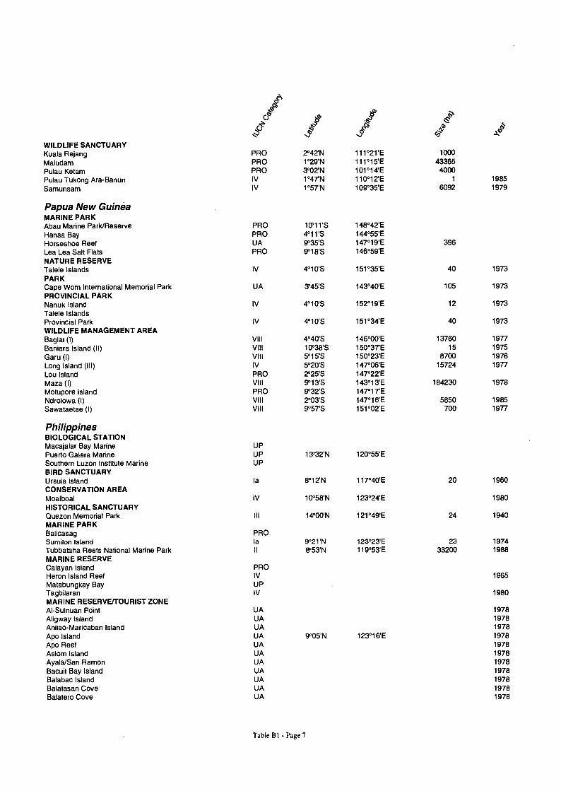
Table B1. Marine Protected Areas in EEPSEA Countries. The following list of marine protected areas has been derived from the WCMC Protected Areas Database. It should be noted that sites have been selected based on the IUCN definition of marine protected areas which describes them as any area of intertidal or subtidal terrain, together with its overlying water and associated flora, fauna, historical and cultural features, which has been reserved by law or other eff active means to protect part or all of the enclosed environment" (resolubn GAII 7.38, 17th General Assembly, IUCN). This definition includes sites with only a very small subtidal or intertidal territory which might otherwise be regarded as wholly terrestrial. Also included within this list are sites described as recommended and proposed. Such sites are thought to have no current legal protection status.
Va
V J A r
m AF
Indonesia GAME RESERVE Bakau Muara Kampar PRO O'35'N 102°57'E 70000 Bakau Selat Dumai PRO 1°57'N 101°15'E 60000 Bangkiriang PRO 1°18'S 122°19'E 1000 Banyuwangi IV 8°41'S 114°28'E 62000 1919 Batugendang Forest PRO 8°50'S 116°00'E 10000 Bawean IV 5147'S 112°39'E 3832 1979 Cikepuh IV 7°15'S 106°25'E 8128 1973 Dolongan IV 1122'N 120153'E 463 1981 Gill Air (Pulau Pemanang) GR PRO 2000 Gunung Wanggameti DE 10°06'S 120°13'E 6000 Jogo Tamu/Ponco Moyo PRO 1860 Kakinawe PRO 5000 Karang Gading IV 3°52'N 98136'E 15765 1980 Kelompok Hutan Kahayan PRO 3°21'S 113°48'E 150000 Kepulauan Asia and Ayu PRO 0°26'N 131°05'E 76406 Kepulauan Tukang Besi PRO 5°43'S 123°39'E 200000 Lampoko Mampie IV 3°26'S 119°15'E 2000 1978 Landu Mangrove Swamp PRO 1000 Manipo DE 10°08'S 124°13'E 2450 Marisa Complex PRO 94000 Meru Betiri DE 8°29'S 113°48'E 58000 1972 Muara Bobos PRO 5°59'S 107°18'E 5000 Pahatu Mangrove Swamp PRO 1000 Pantai Lunjuk GR (Sumbawa Is.) PRO 1000 Pati-Pati IV 0°35'S 123°06'E 198 1936 Perairan Kangean PRO 6°51'S 115°44'E 3000 Pleihari Tanah Laut IV 4°04'S 114°47'E 35000 1975 Pulau Anggrameos IV 2°42'S 134°50'E 2500 1981 Pulau Baun IV 6°30'S 134°41'E 13000 1974 Pulau Bulan PRO 0°58'N 103°53'E 12000 Pulau Dana PRO 10°49'S 122°39'E 1000 Pulau Dolok IV 8°09'S 138°13'E 600000 1978 Pulau Kambing PRO 8°16'S 125°34'E 4000 Pulau Kassa IV 3°18'S 128°07'E 900 1978 Pulau Kobroor PRO 6°14'S 134°29'E 170000 Pulau Manuk IV 5°33'S 130°18'E 100 1981 Pulau Mapia PRO 0°56'N 134°20'E 4015 Pulau Menipo GR (West Timor Is.) DE 10110'S 124°21'E 2000 1977 Pulau Panjang PRO 8°25'S 116°57'E 10000 Pulau Pasoso PRO 150 Pulau Pemananang PRO 2000 Pulau Rakit PRO 50 Pulau Rusa PRO 8°23'S 123°49'E 1406 Pulau Samama IV 2°09'N 118°20'E 220 1982 Pulau Sangiang PRO 8°11'S 119°03'E 16000 Pulau Sayang PRO 0°16'N 130°05'E 10468 Pulau Simeulue PRO 2°38'N 95°58'E 26750 Sabuda Tataruga IV 2°38'S 131°36'E 5000 1993 Sancang Cipatujah PRO 3000 Selat Muna PRO 5°13'S 122°15E Tanjung Amelango IV 4°24'S 122°49'E 850 1975 Tanjung Batikolo IV 4°18'S 121°34'E 5500 1980 Tanjung Kerita Mesa PRO 8'43'S 119°55'E 15000 Tanjung Oisina Mangrove Swamp PRO 500
Table BI - Page I

R a V am `tea
r31 klb
Tanjung Peropa IV 4°12'S 122048'E 38000 1986 Tanjung Pukuwatu PRO 10°31'S 123°18'E 6000 Tanjung Watupayung PRO 8°10'S 122°47'E 5 Teluk Lasolo-Teluk Dalam PRO 3'36'S 122°22'E 80000 Teluk Lelintah PRO 2°08'S 130°19'E 2500 Way Kambas HUNTING PARK
DE 4°52'S 105°36'E 130000 1937
Dataran Bena VI 10°06'S 124°17'E 11000 1978 Pulau Moyo VI 8°16'S 117°33'E 22250 1986 Pulau Moyo HP (Sumbawa) MARINE MULTIPLE USE RESERVE
PRO 22250
Teluk Ambon MARINE NATURE RESERVE
PRO 3°43S 128°10'E 50000
Arakan Wowontulap I 1°21'N 124°29'E 13800 1986 Kepulauan Togian I 0°20'S 122°05'E 100000 1989 Marine Kepuluan Take Bone Rate I 6°30'S 121 °08'E 530765 1992 Pulau Bunaken MARINE PARK
I 1°42'N 124°46'E 75265 1986
Kep. Aru Tenggara I 6°48'S 134°33'E 114000 1991 Laut Banda I 4°33S 129°54'E 2500 1977 P.Pombo
I 3°31'S 128°22'E 1000 1973 Pulau Sangiang I 750 1991 Pulau Weh IV 05051'N 095°17'E 2600 1978 Sangalaki IV 2°08'N 118°19'E 280 1982 Teluk Maumere NATIONAL PARK
I 8°27'S 122°23'E 59450 1986
Bali Barat (Bali) II 8°14'S 114°40'E 77727 1982 Baluran II 7°50'S 114°22'E 25000 1980 Berbak II 1°25'S 104°18'E 162700 1935 Bukit Barisan Selatan II 5°09'S 104°08'E 365000 1982 Gunung Gede Pangrango II 6°47'S 106°58'E 15000 1980 Gunung Leuser II 3°49'N 97°38'E 792675 1980 Gunung Lorentz PRO 1483200 Gunung Palung II 1°09'S 110°13E 90000 1990 Gunung Rinjani II 8°24'S 116°24'E 40000 1990 Komodo II 8°38'S 119°34'E 173500 1980 Kutai II 0°23N 117°16'E 198629 1982 Laut Cendrawasih
11 2°23'S 134°47'E 1453000 1990 Mamberamo-Pegunungan Foja PRO 3°02'S 139°02'E 1442500 Manusela II 3°06'S 129°29'E 189000 1982 Marine Bunaken Menado Tua II 1°41'N 124°42'E 89065 1989 Marine Kepulauan Karimun Jawa II 5°49'S 110°24'E 111625 1986 Marine Kepulauan Seribu II 5°33'S 106°33'E 110000 1982 Meru Betiri II 8025'S 113049'E 58000 1982 Pangandaran PRO 07°45'S 108°30'E 530 Rawa Aopa Watumohai II 4°27'S 122°01'E 96804 1989 Siberut PRO 56000 Tanjung Puting II 2°54'S 111°59'E 355000 1982 Ujung Kulon II 6046'S 105023'E 122936 1992 Wasur II 8°41'S 140°44'E 308000 1990 Way Kambas NATURE RESERVE
II 4°54'S 105°43'E 130000 1989
Apar Besar PRO 1°57'S 116°15'E 90000 Batanta Barat
I 0°51'S 130°37'E 10000 1981 Biak Utara I 0045'S 135°51'E 11000 1982 Cibanteng I 7°10'S 106°28'E 447 1925 Dua Saudara I 1°31'N 125°10'E 4299 1978 Gunung Api DE 6°38'S 126°39'E 80 1937
Gunung Lorentz I 4°20'S 137°39'E 2150000 1978 Gunung Palung DE 30000 1937 Hutan Angrrek dan Tanah Merah PRO 3000 Hutan Sambas PRO 1°43N 109°29'E 120000 Inggresau PRO 1°43S 136°32'E 280 Jamdena PRO 7134'S 131°23'E 60000 Jamursba-Mandi PRO 0'21'S 132°32'E 900
Table B 1 - Page 2

K\
Ja r l
J ` v e Karang Bolong I 1 1937
Karang Kamulyan PRO 25 Karimata PRO 150000 Kelompok Hutan Bakau Pantai Timur I 1°00'S 103°55'E 6500 1981
Kuala Jambu Aye PRO 5°10'N 97°31'E 3000 Kuala Langsa PRO 4°27'N 98°03'E 7000 Leuwang Sancang I 7°43'S 107°52'E 2157 1978 Mas Popaya Raja 1°00'N 122138'E 160 1939 Maubesi I 9°39'S 124°54'E 1830 1981 Misool Selatan I 1°55'S 130°03'E 84000 1982 Morowali I 1°35'S 121°30'E 225000 1986 Muara Cimanuk PRO 6°16'S 108°15'E 7100 Muara Gembong PRO 5°58'S 107°01'E 800 Muara Kayan PRO 2°58'N 117°30'E 80000 Muara Kendawangan PRO 2°41'S 110°20'E 150000 Muara Sebuku PRO 4°10'N 117°23'E 110000 Muara Siberut PRO 1°30'S 99°14'E 12000 Muara Sungai Guntung PRO 0°25'N 103°33'E 26000 Mubrani-Kaironi PRO 0144'S 133°30'E 1000 Napabalano I 4°39'S 122°42'E 9 1919 Nusa Barung I 8°28'S 113°20'E 6100 1920 Nusa Gede Pandjalu I 7°07'S 108°17'E 16 1919 Nusa Kambangan (Perluasan) PRO 7035'S 108°45'E 22077 P.Sempu I 8°26'S 112°42'E 877 1928 Pamukan PRO 2°30'S 116°19'E 10000 Pangandaran DE 7°43'S 108°40'E 419 1934 Pangumbahan Pantai Samarinda
PRO PRO 0°25'S 117°21'E 95000
Panua I 0°34'N 121053'E 45000 1984 Peg. Cycloop 2°30'S 140°31'E 22500 1978 Pegunungan Fakfak PRO 2059'S 132°32'E 51000 Pegunungan Kumawa PRO 3°50'S 132°58'E 118000 Peleng-Pulau Pulau Banggai PRO 1°46'S 123°07'E Perairan Pulau Weh & P. Beras PRO 5°42'N 95°04'E PulauAngwarmase I 8°02'S 131°05'E 800 1978 Pulau Bengkaru PRO 2°03'N 97°06'E 400 Pulau Berkeh I 2°06'N 100°44'E 500 1968 Pulau Bokor I 15 1921 Pulau Burung I 0°26'N 103°25'E 200 1968 Pulau Dua I 6°01'S 106°12'E 30 1984 Pulau Kaget I 85 1976 Pulau Kakabia (Kawi-Kawi) Pulau Kalambau dan Pulau Birah
PRO
PRO 1000 Pulau Laut I 400 1968 Pulau Maratua-Karang Muaras PRO 2105'N 118°45'E 110000 Pulau Mas Popaya Raja DE 160 1919 Pulau Noko dan Pulau Nusa I 15 1926 Pulau Nuswotar I 7°20'S 131°15'E 7500 1978 Pulau Panaitan/Pulau Peucang DE 6°36'S 105°09'E 17500 1937 Pulau Penyu PRO 5°40'S 127°50'E 2000 Pulau Pombo 7°52'S 138°57'E 100 1973 Pulau Rambut I 5°58'S 106°42'E 18 1939 Pulau Samalona PRO 5000 Pulau Saobi (Kangean Islands) DE 6°52'S 115°22'E 430 1919 Pulau Seho I 1°59'S 124°19'E 1250 1972 Pulau Supriori I 0°44'S 135°34'E 42000 1982 Pulau Taliabu PRO 1°44'S 124°40'E 70000 Pulau Waigeo I 0°13'S 130°32'E 153000 1982 Raja Ampat PRO 0°25'S 130°23'E 2976 Rantau Pala Gajah PRO 3°51'N 96°23'E 1600 Rawa Biru DE 8°42'S 140052'E 4000 1978 Salawati Ware I 1°00'S 130°48'E 57000 1982
Table BI - Page 3
JO J v°A do .3!b" Sausapor PRO 0°32'S 132°02'E Segara Anakan PRO 7°41'S 108053'E 15352 Simandulang PRO 2°39'N 100°09'E 2900 Sidei-Wibain PRO 0°44'S 133°40'E 900 Singkil Barat PRO 65000 Sukawayang 31 1919 Tanah Pedauh 544 1975 Tangkoko Batuangus I 1°29'N 125°11'E 3196 1981 Tangkoko-Dua Saudara DE 1°29'N 125111'E 8745 1978 Tanjung Api I 0°49'S 121°37'E 4246 1977 Tanjung Datuk PRO 0°04'N 103°44'E 28800 Tanjung Panjang PRO 3000 Tanjung Sedari PRO 6°15'S 107°43'E 8200 Teluk Adang dan Teluk Apar PRO 1°55'S 116°23'E 130000 Teluk Baron I 2 1937 Teluk Bintuni PRO 2°14'S 133°52'E 450000 Teluk Kelumpang Selat Laut / Sebuku PRO 3°00'S 116°07'E 66650 Teluk Kelumpang Selat Laut / Sebuku PRO 3°30'S 116°23'E 66650 Teluk Kelumpang Selat Laut / Sebuku PRO 3°22'S 116°06'E 66650 Teluk Kelumpang Selat Laut / Sebuku PRO 3°11'S 116°05'E 66650 Teluk Kelumpang/Selat Laut/Selat Sebuku 1 66650 1981 Teluk Lenggasana PRO 8°21'S 112°52'E 16000 Teluk Pelikan PRO 10113'S 123°23'E 10 Tujuh Belas Pulau I 08°16'S 109°37'E 11900 1987 Wae Bula PRO 3°07'S 130°14'E 60000 Waeapo PRO 3°22'S 127°03'E 3000 Wewe-Koor PRO 0124'S 132°15'E Wijayakusuma I 1 1937 Wondiwoi PRO 2°43'S 134°35'E 79500 Yapen Tengah I 1°45'S 136°15'E 59000 1982 OTHER AREA Tanjung Penghujan NR/RP PRO 2°57'S 111°34'E 40000 RECREATION PARK Gunung Selok V 7°40'S 109°12'E 126 1975 Nabire V 100 1980 Pananjung Pangandaran DE 7°43'S 108°40'E 38 1978 Pantai Palolowaru PRO 8°54'S 116°11'E 100 Pasir Putih/Besuki PRO 96 Pulau Kembang v 3°16'S 114°33'E 60 1976 Pulau Kera PRO 8 Pulau Merah PRO 196 Pulau Pasir Panjang PRO 0°54'N 103°20'E 10 Pulau Penyengat PRO 0°52'N 104°27'E 10 Pulau Rakit PRO 8°39'S 117°58'E 2000 Pulau Satonda PRO 1000 Pulau Tikus dan perairannya PRO 300 Pulau Weh v 1300 1982 Tanjung Keluang v 2000 1984 Tanjung Pasir PRO 6°03'S 106°41'E 500 Teluk Yotefa v 2°37'S 140°44'E 1650 1981 STRICT NATURE RESERVE Kepulauan Krakatau I 6°06'S 105025'E 2500 1919
Malaysia BIRD SANCTUARY Kota Belud UA 6°20'N 116°30'E 12200 1960 Pulau Bohay Dulang DE 4°37'N 118°46'E 300 1937 Pulau Burong, Pulau Babi, Pulau Perjudi UA 1 1926 Pulau Lima,Besar Pulau,Lima Kechil,Tokong Raket BS UA 2 1954
Table B I - Page 4
Va m Jam
Pulau Mantanani UA 300 1962 Pulau Sipadan UA 4°12'N 118°33'E 15 1937 COMMUNAL FOREST Tanjong Kelepu UA 2°28'N 111°51'E 73 1959 FOREST RESERVE Balok Mangrove UA 4°07'N 103°20'E Banjar North FOR UA 3124'N 101°11'E 268 Banjar South UA 3°18'N 101°16'E 111 Bebar Mangrove UA 3°05'N 103°26'E Beserah UA 3°51'N 103°21'E Cape Rachado UA 2°24'N 101°51'E 64 Cherating Mangrove UA 4°07'N 103°23'E Kampar UA 4°20'N 101°05'E Kapar UA 3°05'N 101°21'E 3836 Kayangeran UA 4°55'N 115°26'E 4798 1925 Kuala Sedili UA 1°55'N 104°09'E 433 1982 Maludam UA 1°36'N 111°09'E 16593 1962 Niah UA 3°40'N 113°41'E 6111 1936 Pontian Mangrove UA 2°47'N 103131'E 193 Pulau Che Mat Zin UA 2°5TN 101°18'E 1338 Pulau Kechil UA 4°50'N 100°37'E Pulau Kiang UA 3°01'N 101°17'E 8785 Pulau Kukup UA 1°19'N 103°25'E Pulau Langgun Pulau Lumut
UA UA 2°56'N 101°20'E 4559
Pulau Pintu Gedong UA 2°56'N 101°15'E 1115 Pulau Redang Pulau Selat Kering
UA UA 2°57'N 101°15'E 1220
Pulau Singa UA 6°13'N 99°44'E 628 Pulau Tanjong Barat UA 5488 Pulau Tanjong Timur UA 2928 Pulau Tengah UA 2°58'N 101°14'E 597 Pulau Tiga UA 4°15'N 100°56'E Pulau Timun UA 6°19'N 99°54'E 821 Pulau Tongkok UA 2°59'N 101°23'E Pulau Tuba UA 6°14'N 99°50'E 498 Rajang Mangrove UA 2106'N 111°16'E 6475 1929 Rompin Mangrove UA 2149'N 103°29'E 157 Sampadi UA 1135'N 109157'E 23920 1920 Sarawak Mangrove UA 1°38'N 110°18'E 8728 1920 Selat Panchor UA 6°20'N 99°54'E 1335 Sibuti Mangrove UA 3°59'N 113°44'E 245 1930 Sungai Miang Mangrove UA 3°26'N 103°26'E Sungei Buloh UA 3°10'N 101°34'E 3114 Tanjung Dagu UA 6°24'N 99°54'E 728 Tanjung Gelang UA 3°58'N 103°26'E Tanjung Hantu UA 4°19'N 100°34'E Tanjung Tuallang UA 4°17N 101°01'E HUNTING RESERVE Matang UA 4°48'N 100°37'E 40929 1904 MANGROVE FOREST RESERVE Abai UA 6123'N 116°21'E 1396 1984 Benkoka Penninsular UA 6°50'N 117°15'E 13283 1984 Elopura UA 5°50'N 118°07'E 24674 1984 Gum Gum UA 6°02'N 118°00'E 3086 1984 Kuala Bonggaya and Kuala Labuk UA 6°04'N 117°36'E 56912 1984 Kuala Segama and Kuala Maruap UA 5°30'N 118°50'E 23993 1984 Kuala Tingkaya UA 4°49'N 118°10'E 4745 1984 Kudat and Marudu UA 6°33'N 116°47'E 13636 1984 Lahad Datu UA 4°59'N 118°29'E 11066 1984 Menumbok UA 5018'N 115°25'E 5710 1984 Pulau Banggi UA 7°15'N 117°15'E 11504 1984 Semporna UA 4°27'N 118°30'E 23400 1984 Sulaman Lake UA 6°15'N 116°15'E 2635 1984 Sungai Sugut,Paitan,Pulau Jambongan UA 6°32'N 117°28'E 38564 1984
Table B I - Page 5
I , , ti0 a Tawau UA 4°19'N 117°34'E 39018 1984 Trusan Kinabatangan UA 5°45'N 118°23'E 40471 1984 MARINE PARK Pulau Babi Besar Pulau Banting Pulau Kapas Pulau Lang Tengah Pulau Lembu, Kacha, Paya, Segatang
PRO PRO PRO PRO IV °04'N 9°59'E 30 988
Pulau Perak REC 5°43'N 98°56'E Pulau Perhentian Besar Pulau Redang
PRO PRO 5°47'N 103°00'E 25000
Pulau Sembilang Pulau Sibu Pulau Tenggol Pulau Tenggol Pulau Tinggi
PRO PRO PRO PRO PRO °15'N 04°10'E
Pulau Tioman PRO 2°46'N 104°10'E Semporna PRO 4°38'N 118°46'E 8823 1977 MARINE RESERVE Pulau Sipadan PRO 4°05'N 118°40'E 710 NATIONAL PARK Bako II 1°43'N 110131'E 2728 1957 Limbang Mangroves DE 4°51'N 115°00'E 4500 Similajau II 3°26'N 113°15'E 7067 1979 Tanjung Datu PRO 2°13'N 109°39'E 1379 NATURE MONUMENT Kuala Selangor PRO 3°20'N 101°15'E 567 NATURE PARK Kuala Selangor UA 3°20'N 101°15'E 240 1989 OTHER AREA Klang Islands REC 2°59'N 101°27'E PARK Pulau Penyu (Turtle Islands) II 6°10'N 118°05'E 1740 1977 Pulau Tiga II 5044'N 115°40'E 15864 1978 Tunku Abdul Rahman II 6°00'N 116°02'E 4929 1974 PROTECTED FOREST Loba Pulau UA 2115'N 111°22'E 9272 1951 Pulau Bruit UA 25149 1951 PROTECTION FOREST RESERVE Banggi Island UA 7°17'N 117°09'E 11206 1992 Klias UA 5°18'N 115°37'E 3630 1992 Selangan Island UA 4°34'N 118°30'E 120 1984 Tanjong Nagas UA 4°20'N 118°24'E 1084 1984 TURTLE SANCTUARY Pulau Pangkor PRO 4°15'N 100°30'E Rantau Abang/Dungun (Extension) PRO 295 VIRGIN JUNGLE RESERVE Batumapun Mangrove la 4°24'N 117°39'E 164 1984 Mengalong la 5°00'N 115°29'E 1008 1984 Pangkor (North) la 4115'N 100°32'E 78 1960 Pulau Batik la 4°43'N 118°27'E 353 1984 Pulau Berhala la 5°51'N 118°09'E 173 1984 Pulau Sakar la 4°58'N 118°20'E 760 1984 Segari Melintang la 4°23'N 100°35'E 407 1957 Sepilok (Mangrove) la 5°48'N 117°57'E 1235 1931 Tabawan,Bohayan,Maganting,Silumpat Islands la 4°48'N 118°23'E 1009 1984 Tanjung Tuan UA 2°25'N 101°51'E 121 1953 WILDLIFE RESERVE Kuala Gula PRO 5°50'N 101°30'E 890 Kuala Selangor UA 3°21'N 101°14'E 44 1922 Kulamba P
VI 5°32'N 118°40'E 20682 1984 ulau Tioman S
UA 2°46'N 104°10'E 7160 1972 ungei Dusun IV 3°39'N 101°22'E 4330 1964 Tabin IV 5°15'N 118°45'E 111971 1984
Table B 1 - Page 6
JV v v . -,mO
WILDLIFE SANCTUARY Kuala Rejang PRO 2°42'N 111°21'E 1000
Maludam PRO 1°29'N 111°15'E 43365 Pulau Ketam PRO 3°02'N 101°14'E 4000 Pulau Tukong Ara-Banun IV 1°47'N 110°12'E 1 1985
Samunsam IV 1157'N 109°35'E 6092 1979
Papua New Guinea MARINE PARK Abau Marine Park/Reserve PRO 10'11'S 148°42'E Hansa Bay PRO 4°11'S 144°55'E Horseshoe Reef UA 9°35'S 147°19'E 396 Lea Lea Salt Flats PRO 9°18'S 146°59'E NATURE RESERVE Talele Islands IV 4°10'S 151°35'E 40 1973
PARK Cape Wom International Memorial Park UA 3'45'S 143°40'E 105 1973 PROVINCIAL PARK Nanuk Island IV 4°10'S 152°19'E 12 1973
Talele Islands Provincial Park IV 4°10'S 151°34'E 40 1973
WILDLIFE MANAGEMENT AREA Bagiai (I) VIII 4°40'S 146°00'E 13760 1977
Baniara Island (II) VIII 10°38'S 150°37'E 15 1975
Garu (I) VIII 5°15'S 150°23'E 8700 1976
Long Island (I11) IV 5°20'S 147°06'E 15724 1977
Lou Island PRO 2°25'S 147°22'E Maza (1) VIII 9113'S 143°13'E 184230 1978 Motupore Island PRO 9132'S 147°17'E Ndrolowa (I) VIII 2°03'S 147°16'E 5850 1985 Sawataetae (I) VIII 9°57'S 151°02'E 700 1977
Philippines BIOLOGICAL STATION Macajalar Bay Marine Puerto Galera Marine
UP UP 3°32'N 20°55'E
Southern Luzon Institute Marine BIRD SANCTUARY Ursula Island
UP
la 8°12'N 117°40'E 20 1960
CONSERVATION AREA Moalboal IV 10°58'N 123°24'E 1980 HISTORICAL SANCTUARY Quezon Memorial Park III 14°00'N 121°49'E 24 1940 MARINE PARK Balicasag Sumilon Island
PRO la 9'21'N 123°23'E 23 1974
Tubbataha Reefs National Marine Park II 8'53'N 119°53'E 33200 1988 MARINE RESERVE Calayan Island Heron Island Reef
PRO IV 1965
Matabungkay Bay Tagbilaran
UP IV 1980
MARINE RESERVE/TOURIST ZONE Al-Sulnuan Point UA 1978 Aligway Island UA 1978 Anilao-Maricaban Island UA 1978 Apo Island UA 9°05'N 123°16'E 1978 Apo Reef UA 1978 Aslom Island UA 1978 Ayala/San Ramon UA 1978 Bacuit Bay Island UA 1978 Balabac Island UA 1978 Balatasan Cove UA 1978 Balatero Cove UA 1978
Table B I - Page 7

I , , Balicasag Island UA 1978 Batangas Coastline UA 1978 Bating Peninsula UA 1978 Boracay Island UA 1978 Busuanga Island Buyallao Peninsula
UA UA 1978
1978 Buyayao Island UA 1978 Buyong Beach UA 978 1
Cabilao Island UA 1978
Camiguin Island UA 09°09'N 124°40'E 1978 Canaron Island UA 1978 Coron Island UA 5000 1978 Fort Burton UA 1978 Fortune Island UA 14°04'N 120°34'E 1978 Fugo Island UA 18°50'N 121°13'E 1978 Gaban Island UA 1978 Gaubian Island and vicinity UA 1978 Gigantangan Island UA 1978 Libago Island UA 1978 Ligig Island UA 1978 Ligpo Island UA 1978 Maasim Island UA 1978 Malahibang Island UA 1978 Malampaya Sound UA 25000 Malanina Island UA 1978 Maliputo Island-Talicud Island UA 1978 Medio Island UA 1978 Olango Island Complex UA 10116'N 124°03'E 1978 Opao Island UA 1978 Pambaron Island UA 1978 Panglao Island-Balicasag Area UA 9°35'N 123°45'E 1978 Pocanel Island UA 1978 Puerto Princesa UA 1978 Sacol Island UA 1978 Samal Island (eastern side) MR UA 1978 Sangali Cove UA 1978 Santa Cruz Island (Big & Small) NP/MR/TZ UA 13'30'N 122°10'E 1975 Selinog Island UA 1978 Sibalat Island Siguijor Island
UA UA 1978
1978 Sogod UA 1978 Solitario Island UA 1978 Sombrero Island ? 13°42'N 120°49'E 1977 Suguicay Island UA 1978 Verde Island UA 13°40'N 120°40'E 1978 MARINE SANCTUARY El Nido Marine Turtle Sanctuary IV 11°13'N 119°25'E 96 1984 Guiuan UA 10°58'N 125143'E 1970 Nasugbu UP 14°04'N 120°36'E 1970 Panguil Bay UP 8°00'N 123°41'E 1970 Pollilio Island UP 14°45'N 121°55'E 1970 MUNICIPAL PARK Carbin Reef (Sagay) ? 10°59'N 123°30'E NATIONAL INTEGRATED PROTECTED AREA Bantayan Islands PRO 1000 Honda Bay PRO 9°55'N 118°52'E 5000 Manila Bay PRO 1000 NATIONAL PARK Agoo-Damortis National Seashore Park VI 16°21'N 120°20'E 10947 1965 Hundred Islands NP/TZ/MR UP 1614'N 120°03'E 1676 1940 MacArthur Landing UA 11°11'N 125°00'E 7 1977 Manila Bay Beach Resort UP 14°45'N 120°45'E 465 1954 St Paul Subterranean River II 10110'N 118°55'E 3901 1971
Table B I - Page 8
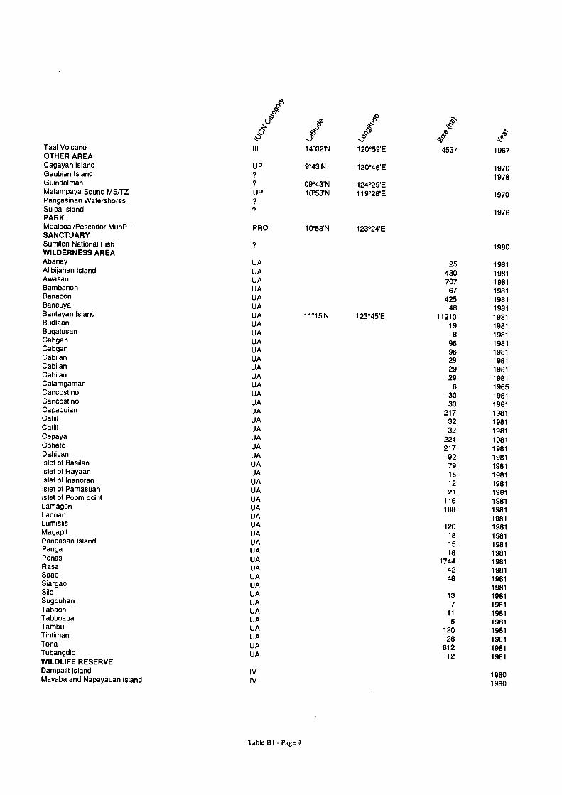
c v e0
Taal Volcano III 14°02'N 120059'E 4537 1967 OTHER AREA Cagayan Island UP 9°43'N 120°46'E 1970 Gaubian Island
? 1978 Guindolman ? 09°43'N 124°29'E Malampaya Sound MSITZ UP 10'53'N 119°28'E 1970 Pangasinan Watershores ?
Sulpa Island ? 1978 PARK Moalboal/Pescador MunP PRO 10'58'N 123°24'E SANCTUARY Sumilon National Fish ? 1980 WILDERNESS AREA Abanay UA 25 1981 Alibijahan Island UA 430 1981 Awasan UA 707 1981 Bambanon UA 67 1981 Banacon UA 425 1981 Bancuya UA 48 1981 Bantayan Island UA 11°15'N 123°45'E 11210 1981 Budlaan UA 19 1981 Bugatusan UA 8 1981 Cabgan UA 96 1981 Cabgan UA 96 1981 Cabilan UA 29 1981 Cabilan UA 29 1981 Cabilan UA 29 1981 Calamgaman UA 6 1965 Cancostino UA 30 1981 Cancostino UA 30 1981 Capaquian UA 217 1981 Catiil UA 32 1981 Catill UA 32 1981 Cepaya UA 224 1981 Cobeto UA 217 1981 Dahican UA 92 1981 Islet of Basilan UA 79 1981 Islet of Hayaan UA 15 1981 Islet of Inanoran UA 12 1981 Islet of Pamasuan UA 21 1981 Islet of Poom point UA 116 1981 Lamagon UA 188 1981 Laonan UA 1981 Lumislis UA 120 1981 Magapit UA 18 1981 Pandasan Island UA 15 1981 Panga UA 18 1981 Ponas UA 1744 1981 Rasa UA 42 1981 Saae UA 48 1981 Siargao UA 1981 Silo UA 13 1981 Sugbuhan UA 7 1981 Tabaon UA 11 1981 Tabboaba UA 5 1981 Tambu UA 120 1981 Tintiman UA 28 1981 Tona UA 612 1981 Tubangdio UA 12 1981 WILDLIFE RESERVE Dampalit Island IV 1980 Mayaba and Napayauan Island IV 1980
Table B I - Page 9
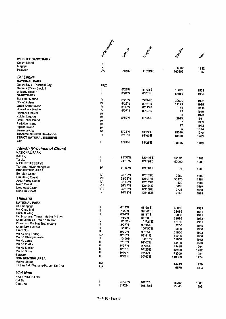
? ao Jao r` WILDLIFE SANCTUARY Culion Island Magapit
IV IV
elb
6002 932 Palawan UA 9°58'N 118°43'E 763399 1967
Sri Lanka NATIONAL PARK Dutch Bay (+ Portugal Bay) Ruhuna (Yala) Block 1
Wil
PRO II °29'N 1°28'E 3679 938 pattu Block 1 II 8°34'N 80°01'E 54953 1938 SANCTUARY
Bar Reef Marine IV 8°22'N 79°44'E 30670 1992 Chundikulam G
IV 9°29'N 80°31'E 11149 1938 reat Sober Island H
IV 8°32'N 81°13'E 65 1963 ikkaduwa Marine H
IV 6°07'N 80°07'E 45 1979 onduwa Island K
IV 8 1973 okilai Lagoon IV 8°59'N 80°55'E 2995 1951 Little Sober Island IV 7 1963 Parititivu Island IV 97 1973 Pigeon Island IV 5 1974 Seruwila-Allai IV 8°23'N 81°22'E 15540 1970 Trincomalee Naval Headworks IV 8'31'N 81°03'E 18130 1963 STRICT NATURAL RESERVE Yala
I 6°29'N 81128'E 28905 1938
Taiwan (Province of China) NATIONAL PARK Kenting T
II 21°57'N 120°46'E 32631 1982 aroko II 24°13'N 121028'E 92000 1986 NATURE RESERVE Tan-Shui River Mangrove IV 25'09'N 121°26'E 76 1986 PROTECTED AREA Bei-Men Coast H T
IV 23°19'N 120°03'E 2980 1987 ua- ung Coast J
VIII 23°23'N 121°27'E 53470 1984 eou-Perng Coast N
IV 22°09'N 120°53'E 530 1987 orth Coast N
VIII 25°17'N 121°34'E 5695 1987 ortheast Coast S
VIII 25°02'N 121056'E 13725 1984 ue-Hua Coast IV 24°18'N 121°45'E 7145 1984
Thailand NATIONAL PARK Ao Phangnga H C
II 8°17'N 98°36'E 40000 1989 at hao Mai H N
11 7°22'N 99020'E 23086 1981 at ai Yang H t N h T
II 8°07'N 98°17'E 9000 1981 a op arat hara - Mu Ko Phi Phi Kh
II 7'52'N 98°50'E 38996 1983 ao Laem Ya - Mu Ko Samet Kh
V 12°32'N 101°27'E 13100 1981 ao Lam Pi - Hat Thai Muang Kh S
II 8°27'N 98°15'E 7200 1986 ao am Roi Yot L S
II 12°12'N 100°00'E 9808 1966 aem on M K A Th
II 9°30'N 98°25'E 31500 1983 u ng o ong Mu K Ch I l
UA 9°33'N 99°41'E 10200 1980 o ang s ands M K L
II 12°00'N 102°15'E 65000 1982 u o anta M K Ph
II 7°32'N 99°07'E 13400 1990 u o etra M K Si il
II 6°57'N 99°35'E 49438 1984 u o m an M K S i
II 8°32'N 97°25'E 12800 1982 u o ur n T t
II 9°10'N 97°47'E 13500 1981 aru ao NON HUNTING AREA Mu Ko Libong Pa L P k Ph
II
UA
6°42'N 99042'E 149000
44749
1974
1979 en a anang-Pa Len Ko Chai UA 5670 1984
Viet Nam NATIONAL PARK Cat Ba C D
II 20°48'N 107°02'E 15200 1986 on ao II 8042'N 106038'E 15043 1982
Table BI - Page 10
Annex C - Map Atlas
General Map Descriptions
This annex contains a series of maps specifically selected to assist EEPSEA researchers in defining and undertaking researching projects related to marine system management. Maps Cl to C5 are based on Jameson et al. (1995) and provide global background information on key stresses on the coral reef environment. Map C6 relating to coral bleaching is based on research conducted through ReefCheck (Hong Kong University of Science and Technology 1998).
Maps C7 to C20 provide region-specific maps for EEPSEA countries, and are modified and/or reproduced with the permission of the World Conservation Monitoring Centre (WCMC). The reader is cautioned that more up to date information may be obtained directly from WCMC, and that other maps are available on the comprehensive map database accessible via the WCMC web site. The WCMC contacts are:
Information Officer, World Conservation Monitoring Centre, 219 Huntingdon Road, Cambridge CB3 ODL, United Kingdom. Tel: +44 1223 277314; Fax: +44 1223 277136. Email: [email protected]
http:// www.wcmc.org.uk /
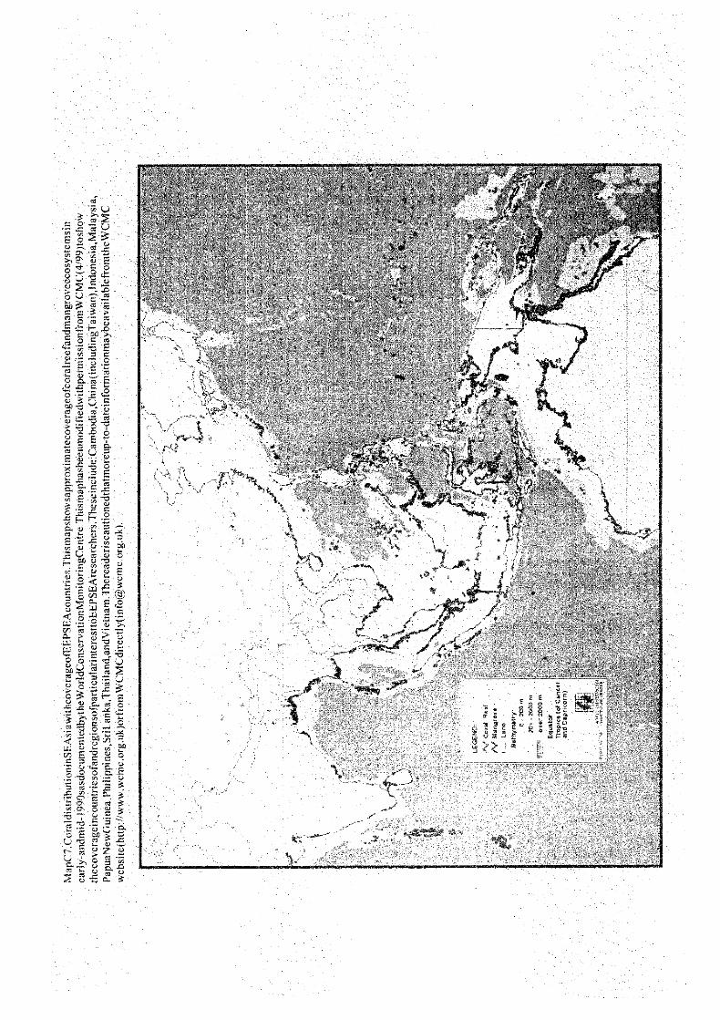
WCMC Global Map and Regional Map for EEPSEA (Map C7)
Global maps have been generated from a large number of different sources. Key among these are Petroconsultants SA (1990), UNEP/IUCN (1988a, 1988b) for coral reefs. Mangrove data are individually referenced by country, but all data have been taken from Spalding et al., (in press). For full details and references for individual countries, reference should be made to the individual national and sub-national maps. Map C7 has been modified from the global map, specifically for EEPSEA use to permit viewing of regional coral and mangrove areas.
WCMC Map of Cambodia and Southern Vietnam (Map C8)
Coastline and coral reefs have been taken from Petroconsultants SA (1990), a 1:1,000,000 digital map which plots reefs as arcs which approximately conform to emergent reef crest. Mangrove data for Cambodia were digitised from Mekong Secretariat (1991) which is based on 1988/9 LANDSAT TM images interpreted without ground-truthing. More recent maps Mekong Secretariat (1994) showing mangroves (c.1:400,000 to 1:1,000,000) are now available - differences in the mangrove coverages between these two sources are not significant at the scales used here. For Vietnam, data showing mangrove in the Mekong Delta only are taken from Anon (1987), believed to be the result of a forest inventory in 1987. Further approximate areas were added from edits provided by Francois Blasco.
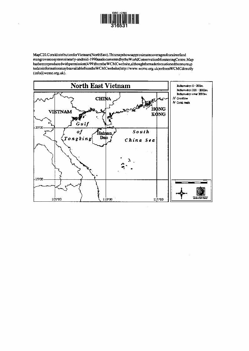
WCMC Maps of South East China and North Vietnam (Map C9, C20)
Coral reefs and coastline taken from Petroconsultants SA (1990), a 1:1,000,000 digital map which plots reefs as arcs which approximately conform to emergent reef crest. Mangrove
Page C-1
coverage gathered from sketch maps drawn over 1:500,000-1:1,000,000 base maps, prepared for this work by Professor Lin Peng, Xiamen University (mainland China) and Dr Jane Lewis, National Taiwan Ocean University (Taiwan).
WCMC Maps of Indonesia (Maps C10 to C14)
Reefs and coastline have been taken from Petroconsultants SA (1990), a 1:1,000,000 digital world map which plots reefs as arcs which approximately conform to emergent reef crest.
Mangrove data are based on the Regional Physical Planning Programme for Transmigration (RePPProT) work begun in 1984 in association with the National Centre for Coordination of Surveys and Mapping (BAKOSURTANAL). Surveys were based on existing reports, air photographs and satellite or radar imagery with selective field checking. Data were generously provided to WCMC by the RePPProT team in the form of hand-coloured draft maps at 1:2.5 million scale, dating from 1985 and 1987 for Kalimantan, from 1986 for Irian Jaya, from 1989 for Nusa Tenggara and from 1988 for Sulawesi. The maps for Irian Jaya, Nusa Tenggara, and Sulawesi have been further updated from maps provided by Wim Giesen of the Asian Wetlands Bureau showing key mangrove areas. A small number of additional edits were provided by Dr Jim Davie, University of Queensland, Australia, and by Francois Blasco.
WCMC Map of Sumatra and Peninsular Malaysia (Map C15) Reefs and coastline have been taken from Petroconsultants SA (1990), a 1:1,000,000 digital world map which plots reefs as arcs which approximately conform to emergent reef crest.
For Sumatra, mangrove data are based on the Regional Physical Planning Programme for Transmigration (RePPProT) work begun in 1984 in association with the National Centre for Coordination of Surveys and Mapping (BAKOSURTANAL). Surveys were based on existing reports, air photographs and satellite or radar imagery with selective field checking. Data were generously provided to WCMC by the RePPProT team in the form of hand-coloured draft maps at 1:2.5 million scale, dating from 1986 for Irian Jaya. These maps have been further updated from a series of maps provided by Wim Giesen of the Asian Wetlands Bureau showing key mangrove areas. A small number of additional edits were provided by Dr Jim Davie, University of Queensland, Australia, and by Francois Blasco.
Mangrove data for Peninsula Malaysia are taken from Forest Department (n.d.). Although undated, this unpublished map is an updated version of a map published in 1986.
WCMC Map of Papua New Guinea (Map C16)
Reefs and coastline have been taken from Petroconsultants SA (1990), a 1:1,000,000 digital world map which plots reefs as arcs which approximately conform to emergent reef crest. Digital mapped data for mangroves have kindly been provided by the Australian National University, with generous permission from the Department of Agriculture and Livestock, Papua New Guinea. These data are taken from the Papua New Guinea Resource Information System.
The source data have been generated from air photo interpretation of 1:50,000 and 1:80,000 images taken in the 1960s and 1970s, and mapped at a scale of 1:500,000. Although data are old it is thought that rates of change may not be large in this country, while these data are thought to be the most accurate available for this country.
WCMC Map of Philippines (Map C17)
Reefs and coastline have been taken from Petroconsultants SA (1990), a 1:1,000,000 digital world map which plots reefs as arcs which approximately conform to emergent reef crest. Additional reefs have been taken from UNEP/IUCN (1988), digitised at a scale of 1:4,800,000; and from NAMRIA (1988).
Mangrove data were also kindly provided by the NAMRIA (1988). These data represent processed satellite imagery, prepared from SPOT images taken in 1987, at a scale of 1:250,000. Some of the smallest islands in the southwest, central and northern parts of the country are not included in the coverage, but are not likely to make a significant difference to the total area.
WCMC Map of Sri Lanka (Map C18)
Coastline is taken from Petroconsultants SA (1990). Coral reefs have been digitised at a scale of 1:1,200,000 from UNEP/IUCN (1988). Mangrove data were kindly provided by the ODA Forest Mapping and Planting Project of the Forest Department in Sri Lanka. These were prepared from Landsat TM imagery, incorporated onto a 1:50,000 base-map. Most source images were from 1992, with analysis and ground-truthing completed by 1994. Details of the dataset provided in Legg and Jewell (199?).
WCMC Map of Thailand (Map C19)
The coastline is taken from Petroconsultants SA (1990). Coral reefs have been digitised at 1:2,800,000 (and at 1:835,000 for Phuket and 1:500,000 for Samet, Kut and Thalu) from UNEP/IUCN (1988). Mangrove polygons were prepared from the four-map series (IDRC/NRCT/RFD, 1991) produced as a part of the Remote Sensing and Mangroves Project (Thailand) at a scale of 1:500,000. Sources for these maps were Landsat-MSS data recorded in 1986-1987.
References
Anon (1987). Cac Loai Thuc Vat bi de Doa Dien Hinh va Mot Vung Tap Trung Erftemeijer, P., Allen, G.R. and Zuwendra (1989). Preliminary resource inventory of Bintuni
Bay, Irian Jaya, and recommendations for conservation and management. AWB-PHPA. Bogor, November 1989.
Forest Department (n.d). Peninsular Malaysia: The Forest Area. 1:1,000,000. Hand-coloured map obtained from the Forest Department, Kuala Lumpur in May 1989.
Giesen, W. (1991). Bakung Island, Riau (Pulau Bakung, Pulau Basu) Survey Report. PHPA/AWB Sumatra Wetland Project Report No. 11. December, 1991.
Giesen, W. (1991). Hutan Bakau Pantai Timor Nature Reserve, Jambi Survey Report. PHPA/AWB Sumatra Wetland Project Report No. 17. December, 1991.
Giesen, W., Baltzer, M. and Baruadi, R. (1991). Integrating Conservation with Land-use Development in Wetlands of South Sulawesi. PHPA/AWB, Bogor, October, 1991.
IDRC/NRCT/RFD (1991) Remote Sensing and Mangroves Project (Thailand). Series of four maps prepared at 1:500,000 by the Remote Sensing Division of the National Research Council. International Development Research Centre, National Research Council of Thailand and the Royal Forestry Department.
Page C-3
Legg, C. and Jewell, N. (199?). A 1:50,000 scale forest map of Sri Lanka: the basis for a national forest GIS. Unpublished report of the ODA Forest Mapping and Planting Project, Forest Department, Colombo, Sri Lanka.
Mekong Secretariat. (1991). Reconnaissance Landuse Map of Cambodia. 1:500,000. Mekong Secretariat, Bangkok, Thailand.
Mekong Secretariat. (1994). Cambodia Land Cover Atlas 1985/87 - 1992/93 (including national and provincial statistics). Remote Sensing and Mapping Unit, Mekong Secretariat; United Nations Development Programme; Food and Agriculture Organisation, Cambodia. 124pp.
NAMRIA (1988) Land Cover Maps, 1:250,000. National Mapping and Resources Information Authority, Manila, Republic of the Philippines.
PETA (1992). Profil Lingkungan Hidup Daerah Lahan Basah Propinsi Jambi Sumatera, Indonesia. PHPA/AWB Proyek Lahan Basah Sumatera, Laporan No. 20b. February, 1992.
Petroconsultants SA (1990). MUNDOCART/CD. Version 2.0. 1:1,000,000 world map prepared from the Operational Navigational Charts of the United States Defense Mapping Agency. Petroconsultants (CES) Ltd, London, UK.
Silvius, M.J. and Taufik, A.T. (1990). Conservation and land use of Pulau Kimaam, Irian Jaya. PHPA - AWB/INTERWADER, January, 1990. Unpublished Report.
Spalding, M.D., Blasco, F. and Field, C.D. (in press, publication in 1996). World Mangrove Atlas. International Society for Mangrove Ecosystems, Okinawa, Japan.
UNEP/IUCN (1988). Coral reefs of the world. Volume 2: Indian Ocean, Red Sea and Gulf. UNEP Regional Seas Directories and Bibliographies. IUCN, Gland, Switzerland and Cambridge, UK. 389pp.
UNEP/IUCN (1988a). Coral reefs of the world. Volume 1: Atlantic and Eastern Pacific. UNEP Regional Seas Directories and Bibliographies. IUCN, Gland, Switzerland and Cambridge, UK. 373pp.
UNEP/IUCN (1988b). Coral reefs of the world. Volume 2: Indian Ocean, Red Sea and Gulf. UNEP Regional Seas Directories and Bibliographies. IUCN, Gland, Switzerland and Cambridge, UK. 389pp.
Zieren, M., Yus Rusila Noor, Baltzer, M. and Najamuddin Saleh (1990). Wetlands of Sumba, East Nusa Tengarra: an assessment of the importance to man, Wildlife and conservation. PHPA/AWB-Indonesia, Bogor, August, 1990.
Jameson SC, McManus JW, Spalding MD. 1995. State of the reefs: regional and global perspectives. Background paper for International Coral Reef Initiative. May.
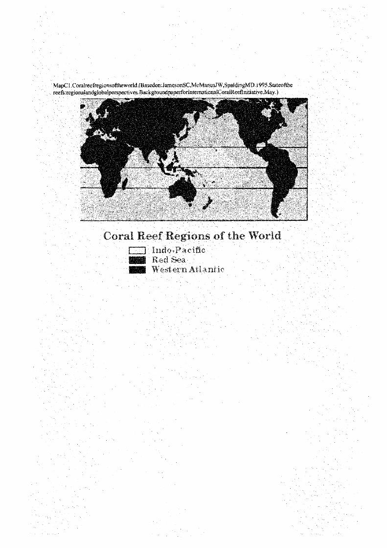
apCI.Coralreefregionsoftheworld (Basedon:J esonSC,McManusJW,SpaldingMD I995.Stateofthe reefs:regionalandglobalperspectives.BackgroundpaperforlnternationaiCoralReeflnitiative.May )

MapC2.DistributionofMarineProtecte as.Countriesorislandstateswithsigrnficantcoralree nagement
responsibilitiesareshowrnndarkgreeri;lightgreenshadingdepictscountrieswithics sdc ve Iopedcoral communities.(Basedc,: m 1,sonSC McManusJW,SpaidingMD.1995.Stateol4here ; s.regionalandglobal
perspectives.Backgr )v tr.:yerfoPtnt nri;onal :oraIReeiln3riarive.May.}
0
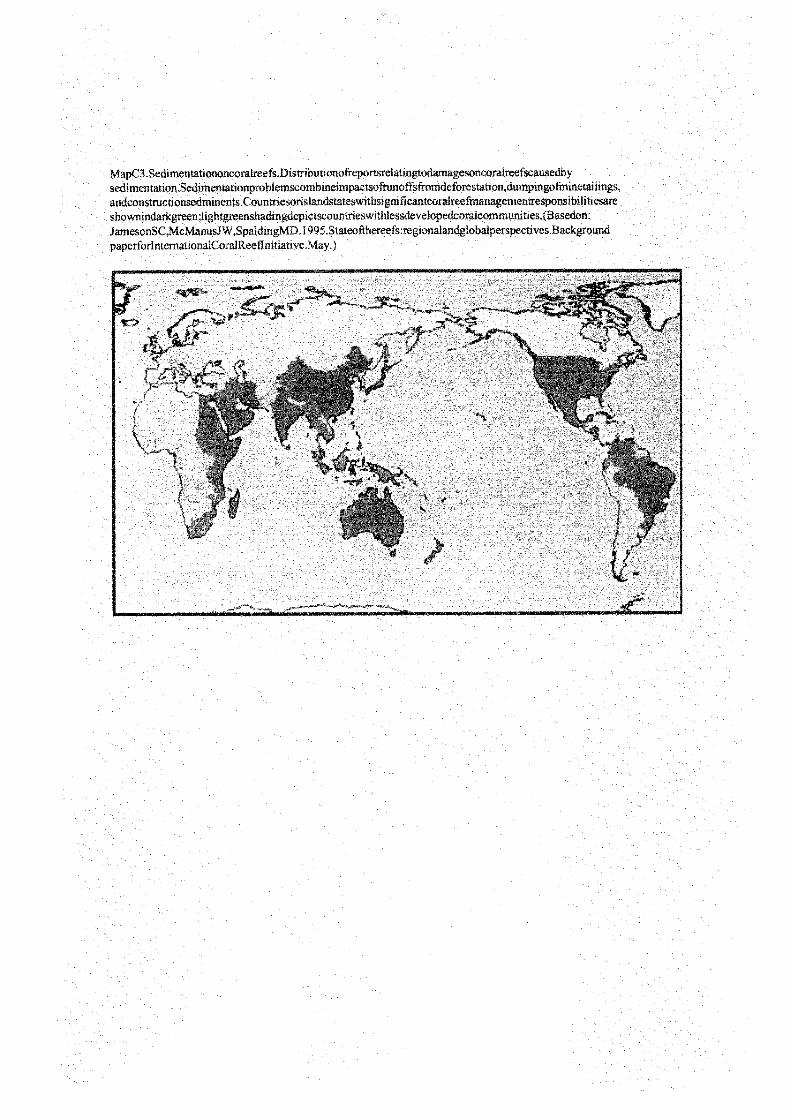
apC3 Sedimentationoncoralreefs.Dtstrtbutionofreportsrelatingt gesoncoralreefscausedby
I
iL
esonSC,McManusJ W,SpaldtngMD.1995.Stateofthereefs xegionalandglobalperspectives.Background showntndarkgreen;lightgreenshadingdeptctscountrieswtthles velopedcoralcommunittes.(Basedon. andconstructtonsedminents.Countriesonslandstateswithsi gni ficantcoralreefmanagementresponsibilitiesare sedimentation.Sedimentationproblemscombinesmpactsofrunoffsfromdeforestation,dumptngofmmetathngs,
paperforlnternationalCoraIReeflnittative.May. )

MapC4.Blastishingoncoralreefs.Distr iibutionofreportsrelatingtodamagearisingfromblastfishingoncoral reefs.Countriesorislandstateswithsignificantcoralreefmanagementresponsibi hn esareshowni ndarkgreen; lightgreenshadingdepictscountrieswithlessdevelopedcoralcommunities.(Basedon:JamesonSC,McManus JW,SpaI dingMD.1995.Stateofthereefsregionalandglobaiperspectives.Backgroundpaperforlntemational Coral Reeflnitiative.May. )
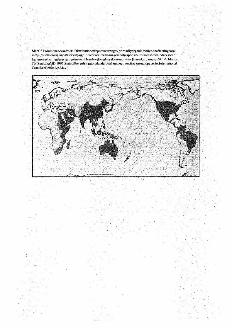
Pollutiononcoralreefs Distributionofreportsrelatingto(pri rilyorganic ollutionaffectingcoral 's. Countriesorislandstateswithsignificantcoralreefmanagemen sponsibilitiesareshownindarkgreen,
lightgreenshadingdepictscountrieswithlessdevelopedcoralco unities.(Basedon:JamesonSC,McManus W,SpaldingMD. l 995. Stateofthereefs:regionalandglobalperspectives. Backgroundpaperforl nternational
CoralReefinitiative.May. )
Mh

Map
C6.
Di s
tri b
utio
nofc
oral
blea
chin
gfro
mR
eefC
heck
199
8sur
vey.
Rep
rodu
cedw
ithpe
rmis
sion
(031
94)o
fRee
fChe
ckat
Hon
gKon
gUni
vers
ityof
Scie
nce
andT
echn
olog
y;ad
ditio
naI i
nfor
mat
iona
vai la
blea
t:http
://w
ww
.ust
.hk/
-web
rc/R
eefC
heek
/ree
f.ht
ml.
Ree
f C
heck
199
8 -W
orld
wid
e B
leac
hing
Eve
nts
RxI
fIc O
cean
tPdi
Pae
i paR
(eet
Ct t &
.kai
9kaA
. (p
mke
sW
M1.
Faa
eaer
an E
sie
taw
etM
Oaw
Opw
wu
a N
eeun
® ta
rp u
ww
ka4l
cm p
4ep
w4y
p
6o-n
t.st..
w w
r»r.
w..»
p :x
saew
ai
ap tp
r« ae
aw
E1C
;'.4
'c
of:t,
ArF
T,d
s=ia
rg r
, ce<
:o"y
'.1:_
Ca.
tl:a;
cdrn
7 t yi
),si
r-Ile
'V ot
fd4-
,nse
rcai
.,z
itaka
itl2p
eam
i ho
mV
'( \1
(.I4
IN
ttu,:o
4CIa
Eci
rctin
tric
uol_
:rni
rtia
,tlar
rula
tintc
c5!l,
l I fti
l::rr
ttr
hcl,,
Ihes
citi
rid_w
'an)
hodi
aChm
ia(iI
JudI
III=
Im'k
tni.[
ndon
e"iI,
AIII
a,itt
, C
'ahu
t"cC
=tir
ct '
hi?i
h(nn
r-.S
rrl:j
nha,
IIt Li
ntl.a
td`it
tnt3
m.lh
crct
d. i
cn(ic
,rte
tllltt
tttrt
reut
(o-
datin
Im a
tit?;
ulia
hta
a!ia
ble!
loll i
th(,
bk(M
( w
ebsi
te(h
ttp I
rwuw
.ucm
c or
g uk
)ort
(om
WC
MC
dire
ctly
(info
tt)w
cmc.
org
uk).
LEG
EN
D
Co.
al
Ree
f
r M
angr
ove
Land
Sat
hym
etry
0
- 20
0.
201_
2000
. ov
er 2
000
in
'rop.
ca (o
f C
ance
r an
d C
apric
orn)
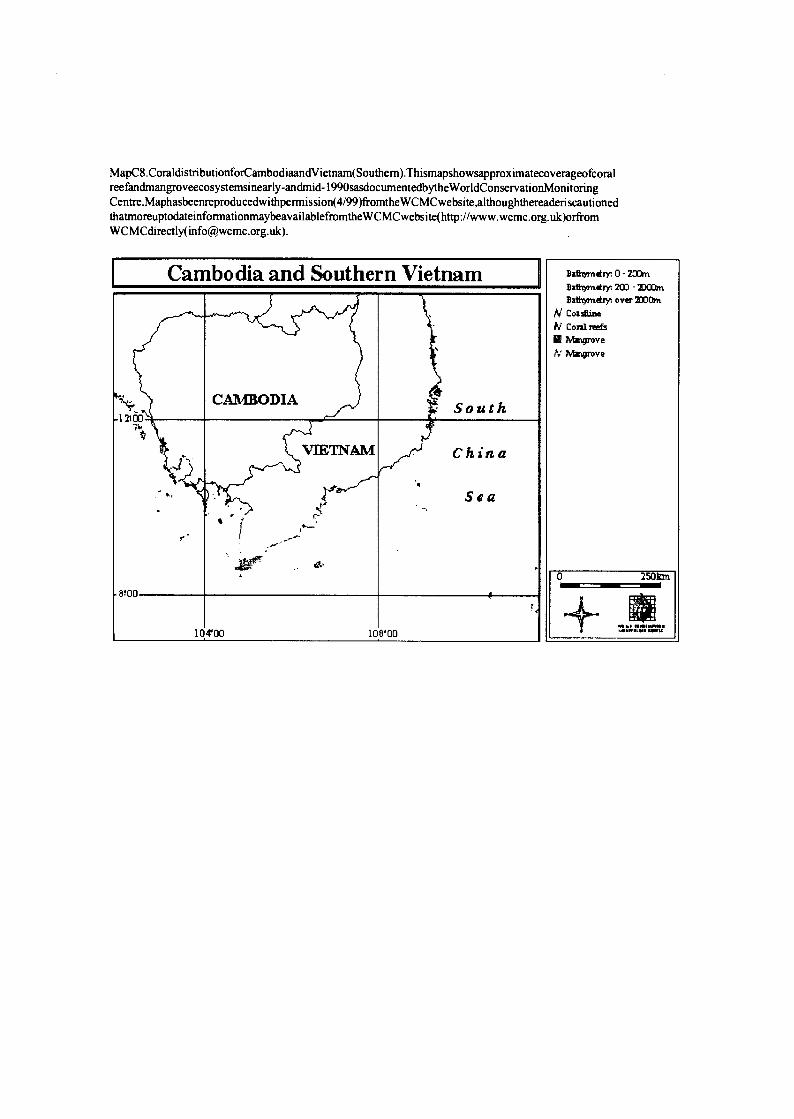
MapC8.CoraldistributionforCambodiaandV ietnam(Southern).Thismapshowsapproximatecoverageofcoral reefandmangroveecosystemsinearly-andmid- 1990sasdocumentedbytheWorldConservationMonitoring Centre.Maphasbeenreproducedwithpennission(4/99)fromthe WCMCwebsite,althoughthereaderi scautioned thatmoreuptodateinformatiomnaybeavailablefromtheW CMCwebsite(http://www.wcmc.org. uk)orfrom WCMCdirectly([email protected]).
Cam bodia and Southe rn Vietnam Batlr/mdry,0-20Qn Bath7mdrr,, 200 - MOOm
Bathymdr)n over 7OQon
commm IV coral reefs
0 MaVrove Mangrove
CAllO4DIA South 12100
t VEE TNAM China
Sea
8! 00
0 2501an
10 4'00 10 8'00 '4""`
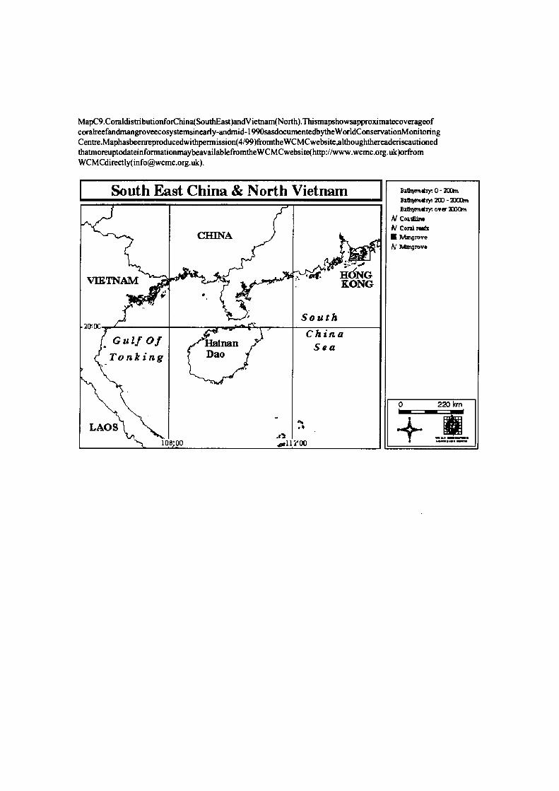
MapC9.CoraldistributionforChina(SouthEast)andV ietnam(North).Thismapshowsapproximatecoverageof coralreefandmangroveecosystemsinearly-andmid- 1990sasdocumentedbytheW orldConservationMonitoring Centre.Maphasbeenreproducedwithpermission(4/99)fromtheWCMCwebsite,althoughthereaderiscautioned thatmoreuptodateinformationmaybeavailablefromtheW CMCwebsite(http://www.wcmc.org. uk)orfrom WCMCdirectIy([email protected]).
South Ea st China & North Vietnam Ba*omtry:0-2(D Bzthymdry. 200 -T100dn
Bathymtry, over 30o[rn
Coatline IV corAl Toes
CHINA i Mmg:ove
N Mmgrove
<af 1 HONG VMTNAM .,
BONG !' O
South 20' o0 China Gulf Of f'Hainan Sea
Tonking Dao
LAOS 4 =
0 220 km
a3 10 8'00 .011 2'00

MapC I O.Coraldistributionforlndonesia(IrianJaya).Thismapshowsapproximatecoverageofcoraheefand mangroveecosystemsinearly-andmid- 1990sasdocumentedbytheW orldConservationMonitoringCentre.Map hasbeenreproducedwithpermission(4/99)fromtheW CMCwebsite,althoughthereaderiscautionedthatmoreup todateinformationmaybeavailablefromtheW CMCwebsite(http://www.wcmc.org.uk)orfrom WCMCdirectly ([email protected]).
Irian Jaya - Indonesia Ba&tmdry.O-40Drrt Batbymdry: 200 - 40ODm
. Bathymdryn over 3MOm } - Blak Philip pine N coadliru
Sea N coral rw[s Mrtpmve
ape fV Matgrove
Irian Jaya 4'00
Banda- PAP UA
Sea NB Al
' K GIUD RA
ep auan Yamdena
Arafura 0 300 km 8'00
Sea 13 700 13 6 00 14 0'00 ""'
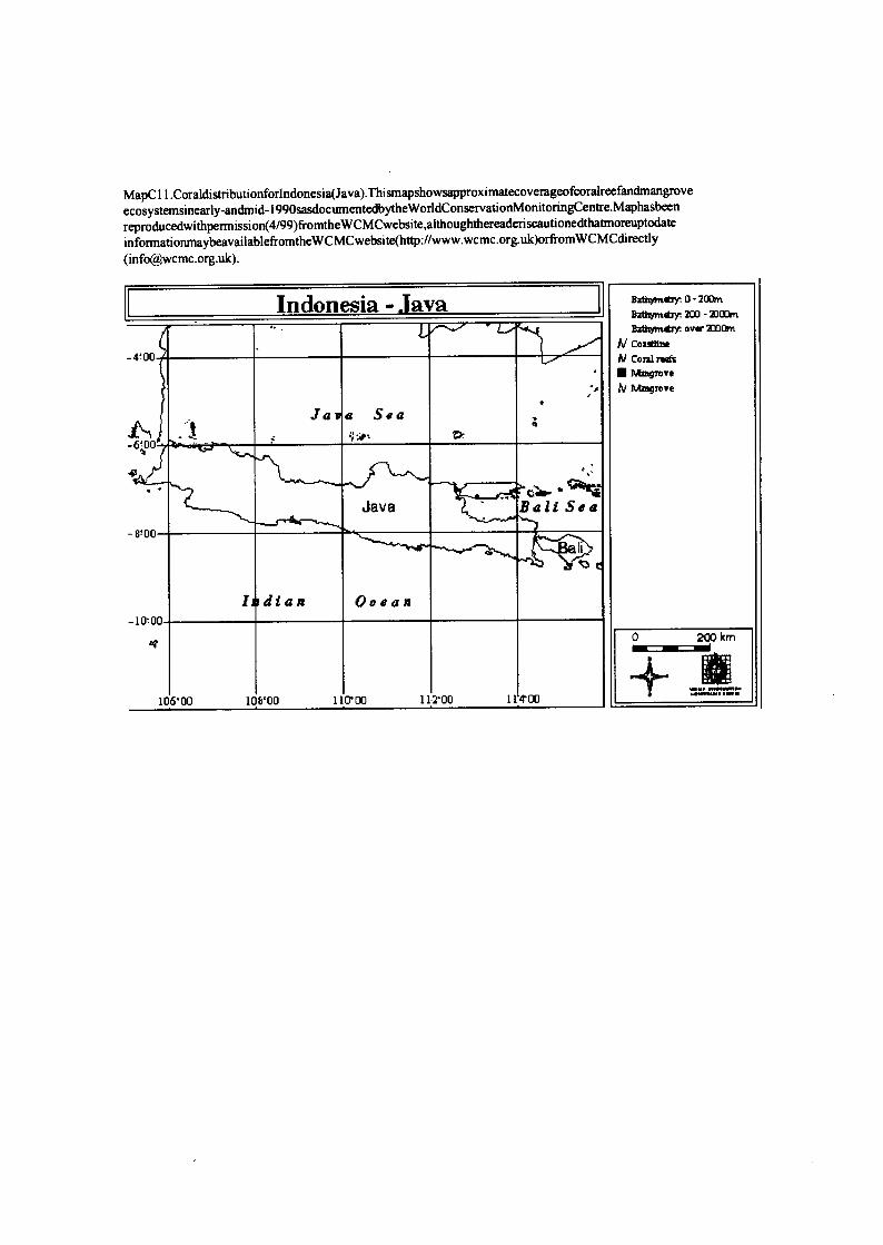
MapC 11.Coraldistributionforlndonesia(Java).Thismapshowsapproximatecoverageofcoralreefandmangrove ecosystemsinearly-andmid-1990sasdocumentedbytheWorldConservationMonitoringCentre.Maphasbeen
reproducedwithpermission(4/99)fromtheWCMCwebsite,althoughthereaderiscautionedthatmoreuptodate informationmaybeavailablefromtheW CMCwebsite(http://www.wcmc.org.uk)orfromW CMCdirectly
-4'00
Jasa Sea t
- WOO
Java Bali Sea
ad
1 dian I Ocean
Baawmtry. 0 - 700m
Baihymti 700 - 310mn
BzdWmtry: over 3MOm
N [oatline N coral rwfs
Mangrove
N Mangrove
0 200 km -d 110`00 11.2100 11'4'00 106'00 108`00
Indonesia -.lava

MapC 12.Coraldistributionforlndonesia(Kalimantan).Thismapshowsapproximatecoverageofcoralreefand mangroveecosystemsinearly-andm id- 1990sasdocumentedbythe W orldConservationMonitoringCentre.Map hasbeenreproducedwithpermi ssion(4/99)fromtheW CMCwebsite,althoughthereaderiscautionedthatmoreup todateinfon:nationmaybeavai lablefromthe WCMCwebsite(http://www. wcmc.org.uk)orfrom WCMCdirectly ([email protected]).
Indon esia - Kalim antan Bathyrndry. 0 - 20Dm
Bath m ,y 200 - Ban over 7000m
W Coaslirw
44OC A! Cora rofs
CIeb Mangrove Sarawak Sea
oaoo
Kalimantan Alakassar Stmu
> yy
4+00
0 350 km
,Jav Sea
10 8'00 11 100 11 6.00 "' 12 0 0 0

MapC 13.Coraldistributionforlndonesia(NusaTenggara).Thismapshowsapproximatecoverageofcoralreef andmangroveecosystemsinearly-andmid-1990sasdocumentedbytheWorldConservationMonitoringCentre. Maphasbeenreproducedwithpermission(4/99)fromtheWCMCwebsite,althoughthereaderiscautionedthat moreuptodateinformationmaybeavailablefromtheW CMCwebsite(http://www.wcmc.org.uk)orfromW CMC directIy([email protected]).
Indonesia - Nusa Tenagara Bzttgmdrr. 0 - 200m
Ba indry, 200 - 2DOOrn
B311ryixdry over 27DOhn
N Coidbne At Coral reds
grove
h' r1bngrove
4 350 km 3MMW
116'00 118100 120'00 122'00 124'00 126'00 128'00
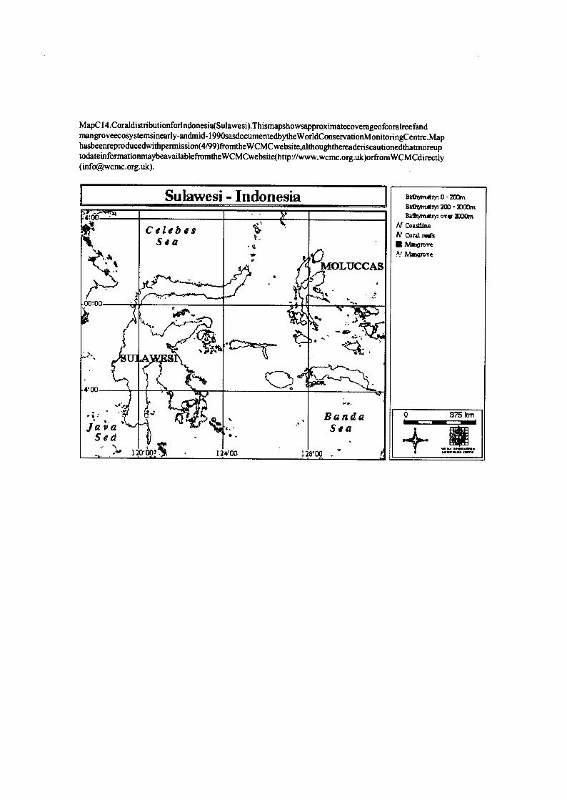
MapC 14.CoraldistributionforIndonesia(Sulawesi).Thismapshowsapproximatecoverageofcoralreefand mangroveecosystemsinearly-andmid-1990sasdocumentedbythe W orldConservationMonitoringCentre.Map hasbeenreproducedwithpermission(4/99)fromtheW CMCwebsite,althoughthereaderiscautionedthatmoreup todateinformationmaybeavailablefromthe WCMCwebsite(http://www.wcmc.org.uk)orfrom WCMCdirectly ([email protected]).
Sulawesi - Indonesia BathymetM0-200m Bathymdry. 200 - 3000m
4.00 Bathy,Yleir. , over 2000m
Celebes N coa3lme
Sea IV coral reefs
Mgrove ,V Magrove
MOLUCCAS a.
00.00 '- I lk
` w a. op
" - U S i "
4 100
- Banda 0 375 km
Java . Sea Sed N
1s 01oo! 12 4w ls voo o
.
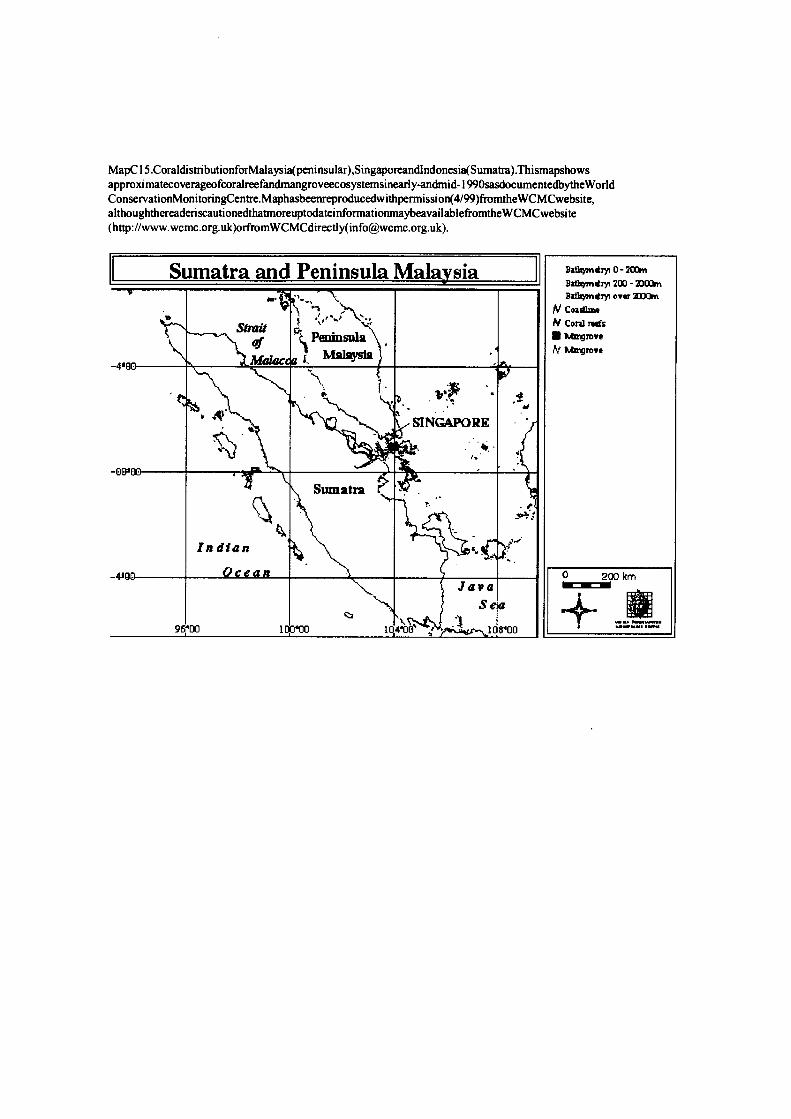
MapC 15.CoraldisttibutionforMalaysia(peninsular),Singaporeandlndonesia(Sumatra).Thismapshows approximatecoverageofcoralreefandmangroveecosystemsinearly-android-1990sasdocumentedbytheWorld ConservationMonitoringCentre.Maphasbeenreproducedwithpermission(4/99)fromtheWCMCwebsite, althoughthereaderiscautionedthatmoreuptodateinformationmaybeavailablefromthe W CMCwebsite (http://www.wcmc.org.uk)orfromWCMCdirectly([email protected]).
S umatra and Peninsula Mala sia Ba irn0-401` Batlrymtry+ 200 - 40001n
Bithymirr ovr 3IDOI t `j f N Coalume
Strait d ''~ N coral refs Peninsula )urmgrove
) i W htmgrove
-4e0 S a
fit . INGAPORE 4 , -oooo , N
Sumatra
Indian j,
-410 Ocean 1 0 200 km Java dd
Se a hem
' ' U 4 96 00 10 0 00 10 4 0 ; 10 8 00

MapC 16.CoraldistributionforPapuaNewGuinea.Thismapshowsapproximatecoverageofcoralreefand mangroveecosystemsinearly-andmid-1990sasdocumentedbytheW orldConservationMonitoringCentre.Map hasbeenreproducedwithpermission(4/99)fromtheWCMCwebsite,althoughthereaderiscautiopedthatmoreup todateinformationmaybeavailablefromtheWCMCwebsite(http://www.wcmc.org.uk)orfrom WCMCdirectly ([email protected]).
P apua New Guin ea Bathymdry:0-4` Bathymdry; 400 - 4000m BatYrymdry. over 4000m
Admiralty Nassau N coalree At c :5
IRIAN Islands New Islands mavrove
JAYA %T; Ireland tv Mmgrove
Bismark Sea
5=00
eW PAPUA NEW Britain
GUINEA Solomon OeN Sea
10'00 ' t 0 350 km
IISTR; -.. ,
''..,r- ALIA
Coral Sea . .n. ;,. ,
14 5.00 15 0.00 15 5 0 0
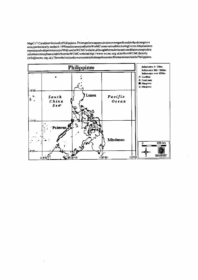
MapC 17.CoraldistributionforPhilippines.Thismapshowsapproximatecoverageofcoralreefandmangrove ecosystemsinearly-andmid- 1990sasdocumentedbytheWorldConservationMonitoringCentre.Maphasbeen
reproducedwithpermission(4/99)fromtheWCMCwebsite,althoughthereaderiscautionedthatmoreuptodate informationmaybeavailablefromtheW CMCwebsite(http://www.wcmc.org.uk)orfromWCMCdirectly
([email protected]).ThewebsitealsoshowsmoredetailedmapsfocsomeofthemainislandsinthePhilippines.
P hilippines BatYrymdiy. o-sooM Batkrymdry. zoo - MOOM
Bathymdrr over 2mom
N Coastline
N Conlreds a ' Mmgmve
E. r N Agwgrove
18.00
South Luzon Pacific China Ocean
Se
13,00
Palawan
IOJ Mindanao 0 525 km
t .
6.00
11 4'00 of 13 0'00 13 6'001 73 2 '0 0
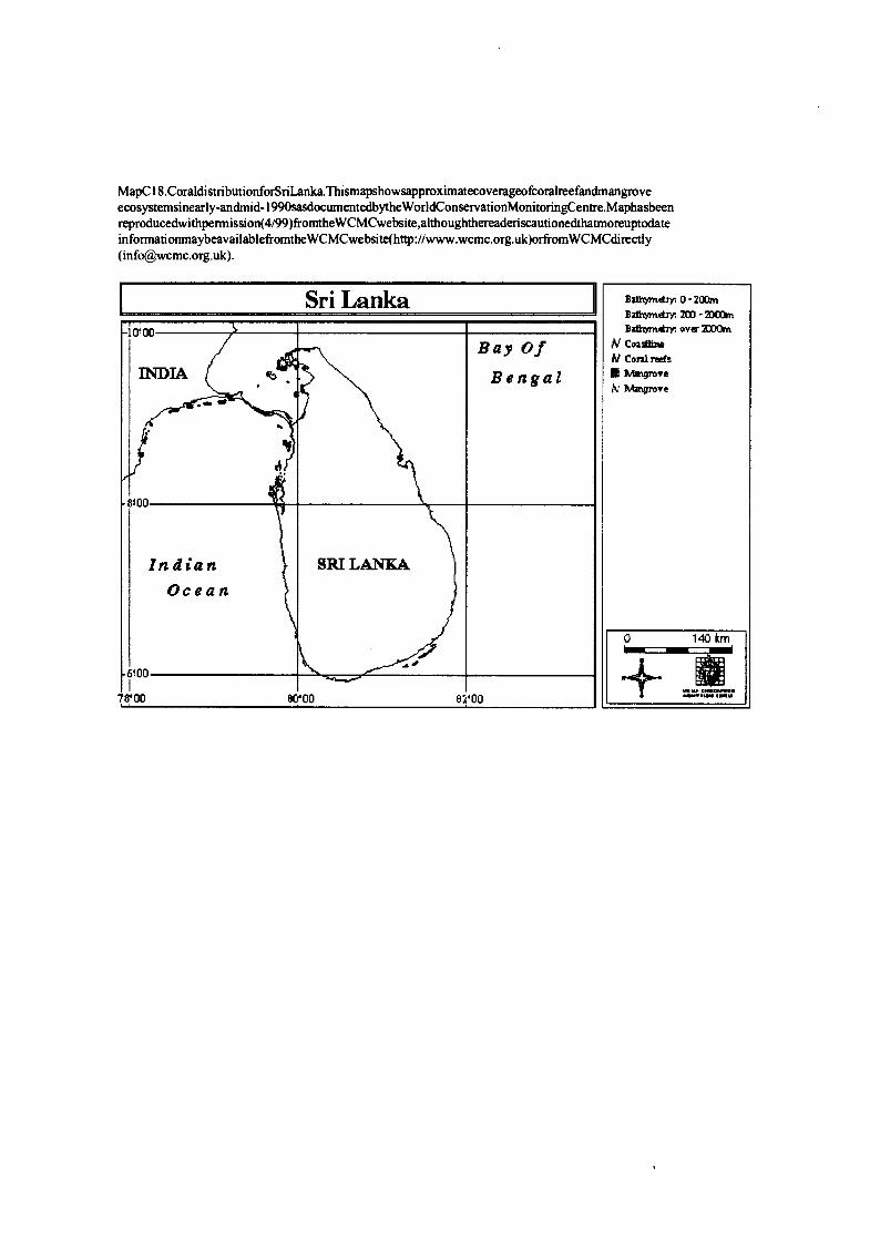
MapC18.CoraldistributionforSriLanka.Thismapshowsapproximatecoverageofcoralreefandmang ove ecosystemsinearly-andmid-1990sasdocumentedbytheWorldConservationMonitoringCentre.Maphasbeen reproducedwithpermission(4/99)fromtheWCMCwebsite,althoughthereaderiscautionedthatmoreuptodate informatiomnaybeavailablefromtheW CMCwebsite(http://www.wcmc.org.uk)orfromWCMCdirectly ([email protected]).
Sri Lanka Bathymdryr. 0 - 20@n
Bathyrndry; 200 - Moan
0100 Bathymdry. over 2000m
Bay Of N CoadhMe
A/ Coral reefs 777 MIA ! a Bengal E Mmgrove
W M ngnove
8!00
in d i a n SRI LANKA
Ocean
6 .00
0 140 km
hem
78'00 80 '00 82 '00
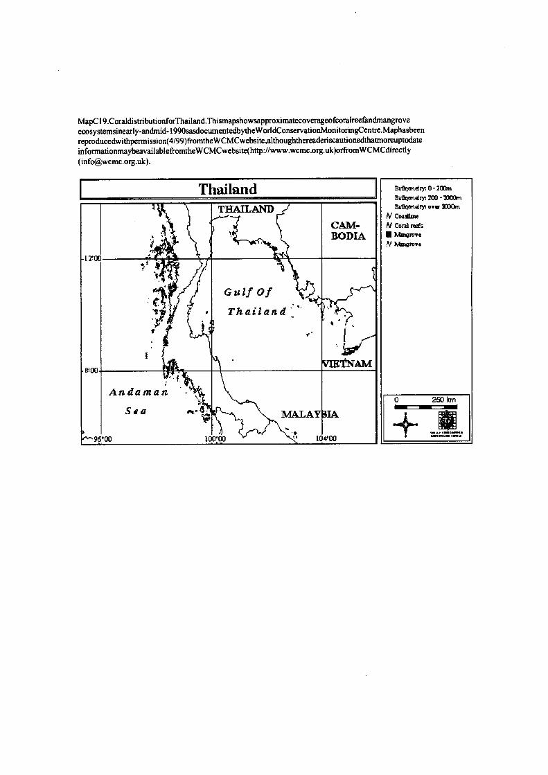
MapC 19.CoraldistributionforThailand.Thismapshowsapproximatecoverageofcoralreefandmangrove ecosystemsinearly-andmid-199osasdocumentedbythe WorldConservationMonitoringCentre.Maphasbeen reproducedwithpermission(4/99)fromtheWCMCwebsite,althoughthereaderiscautionedthatmoreuptodate informationmaybeavailablefromtheW CMCwebsite(http://www.wcmc.org.uk)orfromWCMCdirectly ([email protected]).
T hailand 1 1
Bz&Mdry: 0-400m Bath,nd : 400 - ao00m ry
THAILAND Baftmdrr o.Q 4000rn
N Coast= CAM- At Coral reds
BODIA -e A/ Mangrove
1700 of
.
Il 4.
Gulf Of Thailand
TNAM B!00
Andaman S e a *E MALAY IA
0 250 km
hom
96 '00 10 ' 0'00 ° 10 4000
II
DR
11
RDI
113111
MapC20.Coraldi stributionforVietnam(NorthEast).Thismapshowsapproximatecoverageofcoralreefand mangroveecosystemsinearly-andmid-1990sasdocumentedbythe W orldConservationMonitoringCentre.Map hasbeenreproducedwithpermission(4/99)fromtheW CMCwebsite,althoughthereaderiscautionedthatmoreup todateinformationmaybeavailablefromtheWCMCwebsite(http://www.wcmc.org.uk)orfrom WCMCdirectly ([email protected]).
North East Vietnam Batkgmekryr0-20Grn
Baftmckry. 200 - 20OQn
CM iA N Cmsthn. : IV coral reds
H NG I VE I TNAM
KO NG
Gulf 2000
of South n Tongking China Sea
15.00
0 ,
6WAM + 10 5 00 11 V OO 11 5 00