1-s2 0-S1877042812039067-main
10
Procedia - Social and Behavioral Sciences 52 (2012) 150 – 159 1877-0428 © 2012 The Authors. Published by Elsevier B.V. Selection and/or peer-review under responsibility of Institut Teknologi Bandung doi:10.1016/j.sbspro.2012.09.451 The 10 th Triple Helix International Conference Triple Helix in Disaster Management: Case Study of Strategic Environmental Assessment (SEA) for Government Office Relocation Planning of Padang City, Indonesia Eko Agus Prasetio a , Yukni Arifianti b , Bayuningrat Hardjakaprabon a , and Fitriani Agustin b a School of Business and Management – Institute of Technology, Bandung (SBM-ITB), Jl. Ganesha 10, Bandung, 40132, Indonesia b Geological Agency of Indonesia, Jl. Diponegoro No. 57, Bandung, 40122, Indonesia Abstract Disaster management is the dynamic form of series of integrated and sustainable activities that is carried out before, during and post disaster in order to realize the optimum protection to the community, social assets, economy and environment (Rachmat, 2004). National and local governments play a key role in it, especially in the disaster risk reduction by establishing the policies, plans and programs. Universities and research institutions supports the effort by providing expertise in the tools and methodology as well as providing education and training for the government’s personals. Businesses, in form of private consultancies, get involved in the project level by processing and analyzing the data using the appropriate methods. Strategic and environmental assessment is the keywords in Strategic Environmental Assessment (SEA). Strategic means that it happens in an early enough stage in the decision making process that it can have a significant influence on key decisions. Environmental is considered in the broadest sense which means that besides natural or bio-physical impacts, it may also include related social and economic aspects (Looien, 2009). This paper would like to present how SEA is utilized in the spatial planning decision for relocating Padang City Government office to a free hazard area while considering the socio-economic environment. The methodology used in this work is a case study of site selection for relocation of Padang City Government office and look at the interaction of government, academics and business in the process. It is followed by the discussion on the triple helix model that applies, including the cooperation and mutual relationship with international bodies in terms of exchange of hardware and software equipment with relevant data. The paper will result in the conceptual triple helix model that applies in disaster management. As a case study, the result of the work has its limitation but provide insight about the innovation in building infrastructure in hazard prone areas. Keywords: triple helix; disaster management; strategic environmental assessment Available online at www.sciencedirect.com © 2012 The Authors. Published by Elsevier B.V. Selection and/or peer-review under responsibility of Institut Teknologi Bandung
-
Upload
independent -
Category
Documents
-
view
1 -
download
0
Transcript of 1-s2 0-S1877042812039067-main

Procedia - Social and Behavioral Sciences 52 ( 2012 ) 150 – 159
1877-0428 © 2012 The Authors. Published by Elsevier B.V. Selection and/or peer-review under responsibility of Institut Teknologi Bandungdoi: 10.1016/j.sbspro.2012.09.451
The 10th Triple Helix International Conference
Triple Helix in Disaster Management: Case Study of Strategic Environmental Assessment (SEA) for Government Office
Relocation Planning of Padang City, Indonesia
Eko Agus Prasetioa, Yukni Arifiantib, Bayuningrat Hardjakaprabona, and Fitriani Agustinb
a School of Business and Management – Institute of Technology, Bandung (SBM-ITB), Jl. Ganesha 10, Bandung, 40132, Indonesia b Geological Agency of Indonesia, Jl. Diponegoro No. 57, Bandung, 40122, Indonesia
Abstract
Disaster management is the dynamic form of series of integrated and sustainable activities that is carried out before, during andpost disaster in order to realize the optimum protection to the community, social assets, economy and environment (Rachmat, 2004). National and local governments play a key role in it, especially in the disaster risk reduction by establishing the policies, plans and programs. Universities and research institutions supports the effort by providing expertise in the tools and methodology as well as providing education and training for the government’s personals. Businesses, in form of private consultancies, get involved in the project level by processing and analyzing the data using the appropriate methods.
Strategic and environmental assessment is the keywords in Strategic Environmental Assessment (SEA). Strategic means that it happens in an early enough stage in the decision making process that it can have a significant influence on key decisions. Environmental is considered in the broadest sense which means that besides natural or bio-physical impacts, it may also includerelated social and economic aspects (Looien, 2009).
This paper would like to present how SEA is utilized in the spatial planning decision for relocating Padang City Government office to a free hazard area while considering the socio-economic environment. The methodology used in this work is a case study of site selection for relocation of Padang City Government office and look at the interaction of government, academics andbusiness in the process. It is followed by the discussion on the triple helix model that applies, including the cooperation andmutual relationship with international bodies in terms of exchange of hardware and software equipment with relevant data. The paper will result in the conceptual triple helix model that applies in disaster management. As a case study, the result of the workhas its limitation but provide insight about the innovation in building infrastructure in hazard prone areas.
© 2012 Published by Elsevier Ltd.
Keywords: triple helix; disaster management; strategic environmental assessment
Available online at www.sciencedirect.com
© 2012 The Authors. Published by Elsevier B.V. Selection and/or peer-review under responsibility of Institut Teknologi Bandung

151 Eko Agus Prasetio et al. / Procedia - Social and Behavioral Sciences 52 ( 2012 ) 150 – 159
1. Introduction
Researchers from Center for Volcanology and Geological Hazard Mitigation – Geological Agency of Indonesia, worked with ITC, Faculty of Geo-Information Science and Earth Observation, University of Twente, Netherlands in a project of relocating government office from disaster area in Padang city, Indonesia. This project is used as a case study to look at the dynamic of interaction among academics, government and business in disaster management.
One aspect in disaster management is relocation of vital facilities from hazard-prone area. Government office relocation planning of Padang city, Indonesia is taken as a case study. This city suffered from an earthquake recently and in 2009. Padang as one of the main cities in the west coast of Sumatera Island and the capital of West Sumatera province has total area of 694,95 km2 (1.65% of West Sumatera area). The western part of the city is coastal area and the eastern and southern parts are mostly hilly areas. Padang is consisting of 11 sub-districts with Kota Tengah sub-district is the largest one and having 19 islands with Sikuai Island, Toran Island and Pisang Gadang Island as three main islands. It has five main rivers with Batang Kandis as the longest one.
Padang city lies in hazard prone areas such as earthquake, landslide, volcanic eruption, flood and tsunami, derived from subduction zone in the sea and major faults in the onshore Sumatra. A recent disaster is an earthquake on 30th
of September, 2009 with the magnitude of 7.6 Richter scale. Padang city suffered severe damage due to this earthquake that is followed by landslide. 253,490 houses and buildings are destroyed and 1,195 people died (Local Board for Disaster Management/Badan Penanggulangan Bencana Daerah/BPBD of West Sumatera Province, 2009).
Figure.1. Padang City Area

152 Eko Agus Prasetio et al. / Procedia - Social and Behavioral Sciences 52 ( 2012 ) 150 – 159
2. Disaster Management and Strategic Environmental Assessment (SEA)
Disaster management is a systematic process to reduce the negative impact or consequences of adverse events. The process includes planning and preparedness, prevention, mitigation and response and relief, and recovery to cope with the disasters. Disaster is an unexpected event, whether natural or man-made, which causes negative impact on people and its living conditions, and also the environment. These environmental conditions may aggravate the impact of a disaster and vice-versa. Healthy ecosystem and urban environment can reduce human vulnerability to natural hazards, whereas degraded environment and inadequate environmental infrastructure commonly amplify the negative impacts. Thus, emphasizing and reinforcing environmental assessment, along with planning and sustainable development in a disaster management is needed (Sadler and Verheem, 1996).
Strategic Environmental Assessment (SEA) is an important tool for mainstreaming disaster management in improving environmental performances, increasing environmental awareness across development sectors, in public, governmental or private decision making. It helps decision makers reach a better understanding of how environmental, social and economic considerations fit together, and in doing so provide a basis for planning and policy decisions (Sadler and Verheem, 1996).
3. Case of Utilization of SEA for Spatial Planning Decision in Relocating Padang Government Office
Padang city suffered severe damage due to this earthquake, 183,075 houses and buildings destroyed, and 1,195 people died. The contributing factor is the proximity to the center of the earthquakes, geological factors and the building construction. The worst damage is especially in the lowlands.
In hazard-prone areas, disaster and related risks can be a critical factor determining progress economic development. Strategic Environmental Assessment (SEA) should include the prioritization of environmental issues in terms of their effect on economic development. In this case, SEA can become an important tool in ensuring that adequate attention is paid to risk of disaster in the design of policies. The spatial planning decision to make is to relocate the Padang City Government office to a new place in free hazard areas with an attention to the environment.
No Decision Making Strategic Questions Strategic Action & Alternatives
1 Policy Is it necessary
Alternative 0 : not to relocate the governmental office of Padang City into another area. Alternative 1 : to relocate the governmental office of Padang City into another area
2 Plan What to do to Build/relocate new governmental office of Padang City with environmental consideration
3 Program Where to build/relocateGovernmental office must be close to community area, city centre and activity centre, outside protected areas, no hazard
4 Project How to relocate Build/relocate new governmental office of Padang City with the required accessibility
Table 1. Relocating Plan of Padang City Government Office
4. Triple Helix Model
The Triple Helix Model is an innovation of relationships between 3 elements: Government, Academics, and Business. The Triple Helix was brought up by two professors: Henry Etzkowitz from Stanford University, and

153 Eko Agus Prasetio et al. / Procedia - Social and Behavioral Sciences 52 ( 2012 ) 150 – 159
Loet Leydesdorff from the University of Amsterdam. Both professors provide different perspective on the theory, thus Triple Helix Models can be differentiated by two approaches.
Etzkowitz explains the triple helix as an institutional model of network relations. This approach explains about Triple Helix model arrangements among universities, government, and industries as institutional partners. With this approach, Etzkowitz has come up with three kinds of dimensions. These triple helix configurations differ from the network between each element. The first configuration explains that the government encompasses academia and industry (Etzkowitz; Leydesdorff, 2000). This configuration can be seen in the former Soviet countries and in Eastern European countries. This model is considered as a failed developmental model, because has minimum room for “bottom up” type initiatives, and innovation tends to be discouraged rather than encouraged (Etzkowitz; Leydesdorff, 2000).
State
Industry Academia
Figure 2. (Etzkowitz; Leydesdorff, 2000)
The second configuration provides a more separated network. The elements in this configuration are explained to be independent with strong borders dividing them, thus network relation becomes very low. Sweden and the US are examples for this configuration of the triple helix model. This model is manifested to reduce the role of the government from the previous configuration (Etzkowitz; Leydesdorff, 2000).

154 Eko Agus Prasetio et al. / Procedia - Social and Behavioral Sciences 52 ( 2012 ) 150 – 159
Industry
State
Academia
Figure 3. (Etzkowitz; Leydesdorff, 2000)
The third triple helix configuration is an overlapping institutional sphere. Each of the elements takes the role of the others, creating hybrid roles in each institution. (Etzkowitz; Leydesdorff, 2000).
State
Industry Academia
Figure 4 (Etzkowitz; Leydesdorff, 2000)
The other approach is known as the Triple Helix Dynamics. The approach from Leydesdorff’s perspective generates neo-evolutionary model of functional fluxes of communications through networks. There are three media of communication that support this approach, i.e., 1. Scientific communication, 2. Economic exchange relations and 3. Political interventions (Leydesdorff, 2012).

155 Eko Agus Prasetio et al. / Procedia - Social and Behavioral Sciences 52 ( 2012 ) 150 – 159
Figure 5 (Leydesdorff, 2013 (working paper))
From his perspective, the third triple helix configuration can become a dynamic overlay. The dynamic overlay is the generation of a tetrahedron that emerges from the bottom with four different types of communication. Furthermore, Leydesdorff explained that the three media of communication can be invented and developed further in this overlay (Leydesdorff, 2013 (working paper)).
5. The Case Study of SEA Implementation for Relocating Padang Government Office and Triple Helix Model
Recent triple helix studies tend to concentrate on the innovation system in a particular environment. The scope varies from an organization, region, country, to a large scale such as multilateral unions. This paper will approach a different perspective in the triple helix model application. This paper will explain how the triple helix model can be implemented in innovation on a certain case. The study case is disaster management using Strategic Environmental Assessment in the relocation planning of the government office in Padang city, West Sumatera, Indonesia. After hit by a huge earthquake, Padang as the capital of West Sumatera province was devastated. Several of the city’s main infrastructures have to be rebuilt. Among those infrastructure is government offices.
The main objective of this case study is to apply the triple helix model and describe the dynamic of triple helix actors in disaster management. Before implementation stage, it is essential to classify of each element’s role in this particular case. Table 2 explains how each element had involved.
Table 2. Role of the triple helix elements in relocation planning
Institutions Role
Planning Implementation
Government Data provider Monitoring
Strategy Policy
University Geospatial knowledge
Expertise Knowledge (Training)
Industry Geospatial Software Consulting
Project Management

156 Eko Agus Prasetio et al. / Procedia - Social and Behavioral Sciences 52 ( 2012 ) 150 – 159
The research has been done by researchers from Indonesian Geological Agency who got trained in ITC Netherlands. The data processing has been done by the researchers of Indonesian Geological Agency in July 2010. SEA as a framework is used and one method named Spatial Multi Criteria Evaluation (SMCE) is deployed to yield various maps that are useful in the decision making of Padang Government Office relocation. Spatial Multi-Criteria Evaluation (SMCE) is a spatial decision support tools. SMCE can help to identify and structure the problem(s), to find possible solutions, to evaluate the proposed solutions, and to monitor and evaluate the development of the project. The flowchart of SMCE is described below:
Figure 6. SMCE flowchart
We would like to mention the elements in the research as follows:
1. Institutions a. Geological Agency of Indonesia (part of Indonesian government), defined the goal of the project
of having a relocation planning of Padang Government Office from a hazard-prone area. b. ITC or Faculty of Geo-Information Science and Earth Observation, University of Twente,
Netherlands that built and provided an open source software for developing spatial maps used in the SEA/SMCE, provided expertise and training for research in disaster management.
c. Local university in Padang and Local Statistics Bureau that provided data (physical, economic, human and ecological data) used in the research.
2. Software Software that was used in the research is ILWIS, open-source geospatial software developed by ITC (www.itc.nl). On the other case, Indonesian Geological Agency might use licensed software such as AcGIS from ESRI (www.esri.com), a geospatial software company in US. Indonesian company involved in the process as a representative and consulting counterpart since no Indonesian company can develop geospatial software so far. This fact might give an insight that there is an opportunity for Indonesian software companies to develop local geospatial software including its services and maintenance.

157 Eko Agus Prasetio et al. / Procedia - Social and Behavioral Sciences 52 ( 2012 ) 150 – 159
3. DataData was collected by local university in Padang in coordination with local Statistical Bureau. The data was supplied to ITC in Netherlands.
4. Process and Result The criteria that have been put in the ILWIS software are as follows:
Aim: To relocate the new integrated governmental offices in Padang City, Indonesia. The size of the area should be 20 ha.
Objective 1: To avoid new government office areas will be affected by disasters. Criteria:
- Area should not be on flood plain area - Area should not be located at landslide prone areas. - The slope of the area should be less than 8% - Area should not be located in liquefaction areas - The area should be 500m from fault lines - The area should be 100m from the coastline
Objective 2:To facilitate economic growth by developing a new growth pole. Criteria:
- Area should not be in built-up area of the city - Area should not be close on mineral deposits - Area should not be close to existing mines - Area should be maximum 1 kilo meter from existing people settlement - The distance of the area from the existing growth pole should be 25km - Area should be 3 meters from existing roads.
Objective 3:To preserve the protected areas Criteria:
- Area should not be on wetlands - Area should not be on protected forest - Area should be minimum 500 meters from protected forest - River should not be considered - Area should be minimum 100 meters from river banks
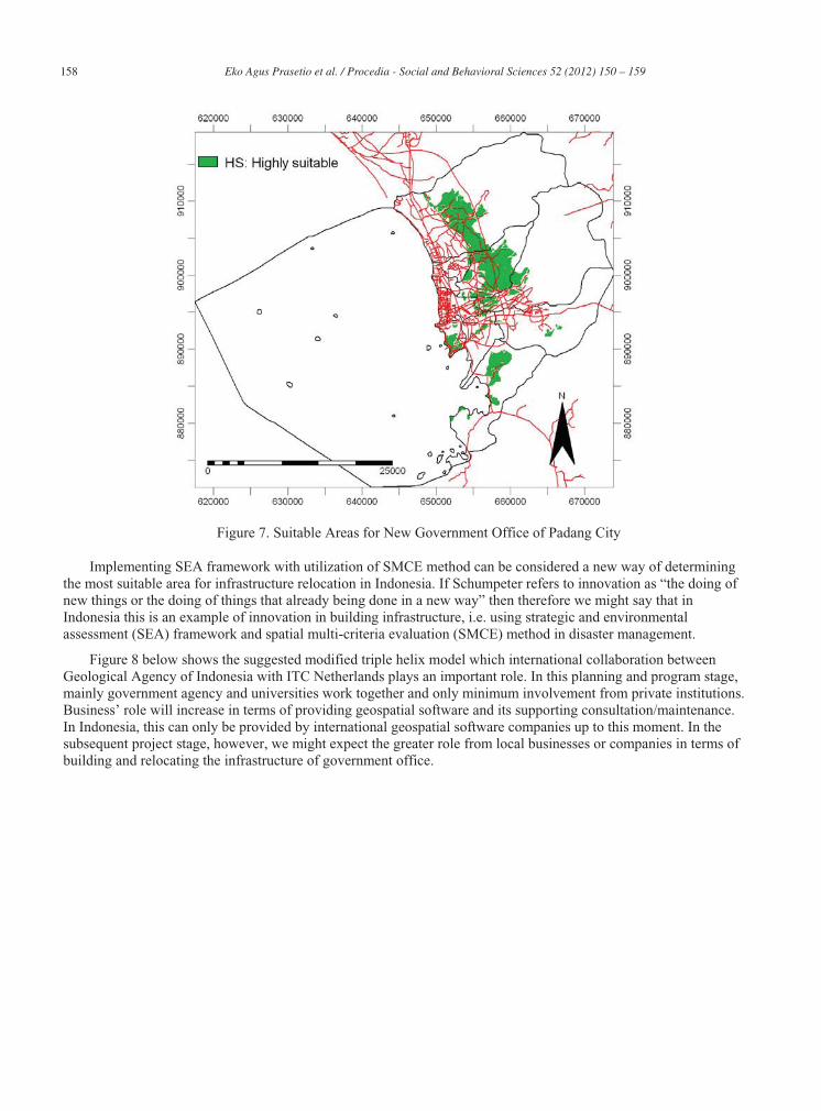
The result of the research is geospatial maps, such as economic vision and suitability maps, protected areas vision and suitability maps, terrain vision and suitability maps, equal vision and suitability maps, and resulted in the final map to locate the suitable areas for new government office of Padang City. Due to space limitation consideration, we showed the final map only (below). From that map, it is identified that the highly suitable area for new government office of Padang City has a total area of 8003 ha in the northeast.
158 Eko Agus Prasetio et al. / Procedia - Social and Behavioral Sciences 52 ( 2012 ) 150 – 159
Figure 7. Suitable Areas for New Government Office of Padang City
Implementing SEA framework with utilization of SMCE method can be considered a new way of determining the most suitable area for infrastructure relocation in Indonesia. If Schumpeter refers to innovation as “the doing of new things or the doing of things that already being done in a new way” then therefore we might say that in Indonesia this is an example of innovation in building infrastructure, i.e. using strategic and environmental assessment (SEA) framework and spatial multi-criteria evaluation (SMCE) method in disaster management.
Figure 8 below shows the suggested modified triple helix model which international collaboration between Geological Agency of Indonesia with ITC Netherlands plays an important role. In this planning and program stage, mainly government agency and universities work together and only minimum involvement from private institutions. Business’ role will increase in terms of providing geospatial software and its supporting consultation/maintenance. In Indonesia, this can only be provided by international geospatial software companies up to this moment. In the subsequent project stage, however, we might expect the greater role from local businesses or companies in terms of building and relocating the infrastructure of government office.

159 Eko Agus Prasetio et al. / Procedia - Social and Behavioral Sciences 52 ( 2012 ) 150 – 159
Figure 8. Modified Triple Helix Model
6. Limitation and Further Research As a case study, the result of this research might lack of generalization as the case covers only the policy,
planning and program stage and did not include the project stage. Nevertheless, this research points out the innovation in the planning process of building infrastructure in hazard-prone areas as part of disaster management in developing country such as Indonesia. Also, this research provides an insight about the minimum involvement of business actors that can be increased if local businesses can see and seize the opportunity in developing geospatial software as well as providing the corresponding consultation and maintenance.
Further research might be conducted to see different aspects of disaster management in a project level with EIA (Environmental Impact Assessment) which private sector could play an important role as one of the stakeholders.
7. Acknowledgement The authors would like to thank Jianping Guo and Diana A. Odongo for their work and support in the case study data processing of government office relocation planning of Padang City, Indonesia.
8. References 1. Looien, J. Training Module of Strategic Environmental Assessment, ITC, 2009 2. Leydesdorrf, L. (2013 (working paper)). “The Triple Helix of University-Industry-Government Relations” in
E. Carayanis and D. Campbell, Encyclopedia of Creativity, Innovation and Entrepreneurship. New York, Springer.
3. Local Board for Disaster Management (Badan Penanggulangan Bencana Daerah/BPBD) of West Sumatera Province, Buletin Laporan Harian Pusdalops BPNB, 2009, Jakarta.
4. Rachmat, H., 2004.”Potensi dan Mitigasi Bencana Geologi di Nusa Tenggara Barat”, Mataram, Publikasi Khusus Ikatan Ahli Geologi Indonesia.
5. Etzkowitz, H., Leydesdorff, L., (2000) “The Dynamic of Innovation: from National Systems and “Mode 2” to a Triple Helix of University – Industry – Government Relations”. Research Policy.
6. Sadler, B., Verheem R., (1996). “Strategic Environmental Assessment: Status, Challenges and Future Directions.” Ministry of Housing, Spatial Planning and Environment, The Netherlands and The International Study of Effectiveness of Environmental Assessment.