1 CITY PLAN COMMISSION Thursday, September 20, 2018 ...
306
Sustainable Development and Construction 214-670-4209 1 CITY PLAN COMMISSION Thursday, September 20, 2018 AGENDA BRIEFINGS: 5ES 11:00 a.m. PUBLIC HEARING: Council Chambers 1:30 p.m. *The City Plan Commission may be briefed on any item on the agenda if it becomes necessary. David Cossum, Director Neva Dean, Assistant Director of Current Planning BRIEFINGS: DCA 156-008 Consideration of amending the Dallas Development Code to create regulations for incentive zoning. Pam Thompson, Senior Planner Subdivision Docket Zoning Docket ACTION ITEMS: Subdivision Docket Planner: Mohammad Bordbar Consent Items: CONSENT ITEMS: (1) S178-297 (CC District 14) An application to create two lots from a 0.280-acre tract of land containing all of City Blocks 255, 260, 260 ½, and part of abandoned streets on property between Live Oak Street and Pacific Street, east of Olive Street. Owner: City of Dallas Surveyor: City of Dallas Application Filed: August 22, 2018 Zoning: CA-1(A) Staff Recommendation: Approval, subject to compliance with the conditions listed in the docket.
-
Upload
khangminh22 -
Category
Documents
-
view
3 -
download
0
Transcript of 1 CITY PLAN COMMISSION Thursday, September 20, 2018 ...

Sustainable Development and Construction 214-670-4209 1
CITY PLAN COMMISSION Thursday, September 20, 2018
AGENDA
BRIEFINGS: 5ES 11:00 a.m. PUBLIC HEARING: Council Chambers 1:30 p.m.
*The City Plan Commission may be briefed on any item on the agenda if it becomes necessary.
David Cossum, Director Neva Dean, Assistant Director of Current Planning
BRIEFINGS: DCA 156-008 Consideration of amending the Dallas Development Code to create regulations for incentive zoning. Pam Thompson, Senior Planner Subdivision Docket Zoning Docket ACTION ITEMS: Subdivision Docket Planner: Mohammad Bordbar Consent Items:
CONSENT ITEMS: (1) S178-297 (CC District 14)
An application to create two lots from a 0.280-acre tract of land containing all of City Blocks 255, 260, 260 ½, and part of abandoned streets on property between Live Oak Street and Pacific Street, east of Olive Street.
Owner: City of Dallas Surveyor: City of Dallas Application Filed: August 22, 2018 Zoning: CA-1(A) Staff Recommendation: Approval, subject to compliance with the
conditions listed in the docket.

City Plan Commission September 20, 2018
2
(2) S178-299 (CC District 2)
An application to replat a 0.376-acre tract of land containing all of Lots 7 and 8 in City Block 6/1597 to create one lot on property located at 4527 Cabell Drive, south of Annex Avenue.
Owners: B &G Properties, World Dallas Properties, Inc. Surveyor: A & W Surveyors, Inc. Application Filed: August 22, 2018 Zoning: MF-2(A) Staff Recommendation: Approval, subject to compliance with the
conditions listed in the docket.
(3) S178-300 (CC District 7)
An application to create one 0.32-acre lot from a tract of land in City Block 5800 on property located at Forney Road, west of Lawnview Avenue.
Owner: Jose Mendoza Surveyor: CBG Surveying Texas, LLC Application Filed: August 22, 2018 Zoning: LI Staff Recommendation: Approval, subject to compliance with the
conditions listed in the docket.
(4) S178-301 (CC District 4)
An application to create one 2.431-acre lot from a tract of land in City Blocks 5878 and 5879 on property located on Kiest Boulevard at Marvin D. Love Freeway, northeast corner.
Owner: Prosperity Bank Surveyor: Votex Surveying Company Application Filed: August 23, 2018 Zoning: RR Staff Recommendation: Approval, subject to compliance with the
conditions listed in the docket.
(5) S178-304 (CC District 14)
An application to create an 8-lot shared access development from a 0.317-acre tract of land containing all of lots 1 and 2 in City Block N/1480 on property located on Ross Avenue at Mary Street, west of Hubert Street.
Owner: Albi, LLC Surveyor: Texas Heritage Surveying, LLC Application Filed: August 24, 2018 Zoning: MF-2(A) Staff Recommendation: Approval, subject to compliance with
the conditions listed in the docket.

City Plan Commission September 20, 2018
3
(6) S178-305 (CC District 11)
An application to replat a 22.514-acre tract of land containing all of Lot 2 in City Block A/7409 and part of City Block 7409 to create four lots ranging in size from 2.652-acre to 6.821-acre on property located on Interstate Highway 635 (Lyndon B. Johnson Freeway), west of Preston Road.
Owner: Seritage SRC Finance, LLC Surveyor: Kimley-Horn and Associates, Inc. Application Filed: August 28, 2018 Zoning: PD 887 (Subdistrict 1A, Tract 2),(Subdistrict 1, Tract 3),
(Subdistrict 2) Staff Recommendation: Approval, subject to compliance with
the conditions listed in the docket.
Residential Replats and Building Line Reduction: (7) S178-296 (CC District 11)
An application to replat a 0.192-acre lot containing all of Lot 7 in City Block 44A/7460 to reduce a portion of the existing 10-foot building line and jog around a proposed swimming pool on property located at 15 Wooded Gate Drive, south of Greenwich Lane.
Owner: William Dearman Surveyor: Texas Heritage Surveying, LLC Application Filed: August 22, 2018 Zoning: PD 384 Staff Recommendation: Approval, subject to compliance with
the conditions listed in the docket.
(8) S178-298 (CC District 13)
An application to replat a 0.856-acre tract of land containing all of Lot 12 and part of Lot 11 in City Block E/5517 to create one lot and to reduce a portion of the existing 50-foot building line to 43.5 feet along the north line of Gaywood Road on property located at 10211 Gaywood Road, east of Hollow Way Road.
Owners: Paul H. Devereux and Sharon Devereux Surveyor: A & W Surveyors, Inc. Application Filed: August 22, 2018 Zoning: R-1ac (A) Staff Recommendation: Approval, subject to compliance with
the conditions listed in the docket. Miscellaneous Items: D178-016 Carlos Talison (CC District 13)
An application for a development plan and landscape plan for a medical laboratory use on property zoned Subarea C within Planned Development District No. 745, on the southwest corner of Midtown Boulevard and Manderville Lane.
Staff Recommendation: Approval Applicant: Cushman & Wakefield Representative: Maxwell J. Fisher, AICP - MASTERPLAN

City Plan Commission September 20, 2018
4
D178-018 Carlos Talison (CC District 10)
An application for a development plan and landscape plan for an office and restaurant use on property zoned Subarea C within Planned Development District No. 758, on the southeast corner of Walnut Hill Lane and Wildcat Way.
Staff Recommendation: Approval Applicant: PC LH Land Partner LP Representative: Kirk Hermansen – Hermansen Land Development
D178-019 Abraham Martinez (CC District 3)
An application for a development plan and landscape plan for a private recreation center, club, or area on property zoned Subdistrict S-8 within the South Zone of Planned Development District No. 521, on the northwest corner of Saddleridge Drive and Isom Lane.
Staff Recommendation: Approval Applicant: Mountain Creek Community Church Representative: Robert Summers
M178-042 Abraham Martinez (CC District 8)
An application for a minor amendment to the existing development plan for a public school other than an open-enrollment charter school [Seagoville High School] on property zoned Planned Development District No. 512, in an area generally bound by North Woody Road, Seagoville Road, and East Stark Road.
Staff Recommendation: Approval Applicant: Dallas Independent School District Representative: Karl A. Crawley, Masterplan
M178-044 Carlos Talison (CC District 6)
An application for a minor amendment to the existing development plan on property zoned as Subdistrict 2 within Planned Development District No. 732, on the east line of Wickmere Mews at Malone Cliff View.
Staff Recommendation: Approval Applicant: Don Nedler Representative: Audra Buckley – Permitted Development
M178-045 Abraham Martinez (CC District 5)
An application for a minor amendment to the existing development plan for a public school other than an open-enrollment charter school [John Ireland Elementary School] on property zoned Planned Development District No. 661, in an area generally bound by Gillette Street, Seco Boulevard, and North Jim Miller Road.
Staff Recommendation: Approval Applicant: Dallas Independent School District Representative: Karl A. Crawley, Masterplan

City Plan Commission September 20, 2018
5
Miscellaneous Items – Under Advisement: D178-004 Carlos Talison (CC District 2)
An application for a development plan for an office and retail/personal service use with parking garage on property zoned the North Subdistrict within Planned Development District No. 582, Victory Planned Development District, on the east line of Victory Avenue at All Star Way.
Staff Recommendation: Approval Applicant: Anland North Commercial, L.P. Representative: Hillwood Urban Services, L.P. U/A From: April 5, 2018, June 7, 2018, July 19, 2018, August 2, 2018 and August 16, 2018
Zoning Cases – Consent: 1. Z178-221(MB) Mohammad Bordbar
(CC District 13)
An application for an amendment to Planned Development District No. 734 for a public school other than an open-enrollment charter school on property zoned Planned Development District No. 734, on the southeast corner of Nuestra Drive and Wozencraft Drive.
Staff Recommendation: Approval, subject to a revised development plan and conditions. Applicant: Dallas Independent School District Representative: Rob Baldwin, Baldwin and Associates
2. Z178-304(PD) Pamela Daniel (CC District 14)
An application for the renewal of Specific Use Permit No. 2272 for a late-hours establishment limited to a restaurant without drive-in or drive-through service on property zoned Planned Development District No. 842, with a MD-1 Modified Delta Overlay for CR Community Retail District uses, on the east line of Greenville Avenue, between Prospect Avenue and Oram Street.
Staff Recommendation: Approval for a two-year period, subject to conditions. Applicant: Lavo Properties, LLC Representative: Rob Baldwin, Baldwin and Associates
3. Z178-312(PD) Pamela Daniel (CC District 6)
An application for the renewal of Specific Use Permit No. 1853 for the sale of alcoholic beverages in conjunction with a general merchandise or food store 3,500 square feet or less on property zoned an RR-D-1 Regional Retail District, with a D-1 Liquor Control Overlay, on the northeast corner of Royal Lane and North Stemmons Freeway.
Staff Recommendation: Approval for a five-year period with eligibility for automatic renewals for additional five-year periods, subject to conditions. Applicant: Anwer Ali

City Plan Commission September 20, 2018
6
4. Z178-305(SM) Sarah May (CC District 5)
An application for the renewal of Specific Use Permit No. 2219 for the sale of alcoholic beverages in conjunction with a restaurant without drive-in service on property zoned Subarea 6 within Planned Development District No. 366-D-1, the Buckner Boulevard Special Purpose District, with a D-1 Liquor Control Overlay, on the east side of South Buckner Boulevard, between Scyene Road and Bearden Lane.
Staff Recommendation: Approval for a two-year period with eligibility for automatic renewals for additional five-year periods, subject to a site plan and conditions. Applicant: Mariana Roman
5. Z178-267(SM) Sarah May (CC District 13)
An application for a CR Community Retail District with deed restrictions volunteered by the applicant on property zoned an R-7.5(A) Single Family District, on the east line of Abrams Road and the northwest line of Skillman Street. Staff Recommendation: Approval, subject to deed restrictions volunteered by the applicant
Applicant: RPI Creekside II, Ltd. Representative: Roger Albright
6. Z178-288(JM) Jennifer Muñoz (CC District 8)
An application for an LI Light Industrial District on property zoned an A(A) Agricultural District, at the northwest corner of Telephone Road and Bonnie View Road.
Staff Recommendation: Approval Applicant: RPG Acquisitions, LLC Representative: Rob Baldwin, Baldwin and Associates
Zoning Cases – Under Advisement: 7. Z178-235(JM) Jennifer Muñoz (CC District 1)
An application for a Planned Development District for Multifamily District uses on property zoned an R-7.5(A) Single Family District, on the southwest corner of North Tennant Street and West Davis Street.
Staff Recommendation: Approval, subject to a development plan and conditions. Applicant: 517 Tennant, LLC Representative: Rob Baldwin, Baldwin and Associates U/A From: August 16, 2018

City Plan Commission September 20, 2018
7
8. Z156-305(SM) Sarah May (CC District 5)
An application for the renewal of Specific Use Permit No. 2160 for the sale of alcoholic beverages in conjunction with a general merchandise or food store 3,500 square feet or less, on property zoned Subarea 7 within Planned Development District No. 366–D-1, the Buckner Boulevard Special Purpose District, with a D-1 Liquor Control Overlay, on the northwest corner of South Buckner Boulevard and Scyene Road.
Staff Recommendation: Approval for a three-year period, subject to staff’s recommended conditions. Applicant: East Bengal Corporation U/A From: August 2, 2018 and September 6, 2018
9. Z178-190(SM) Sarah May (CC District 1)
An application to amend Planned Development District No. 282 for mixed uses on property zoned Planned Development District No. 282, on the northwest corner of West Colorado Boulevard and North Beckley Avenue. Staff Recommendation: Approval, subject to a revised development plan and staff’s recommended conditions.
Applicant: Methodist Hospitals of Dallas Representative: Angela Hunt U/A From: April 19, 2018, May 17, 2018 June 7, 2018, June 21, 2018, July 19, 2018 and August 16, 2018.
__________________________________________________________________________ Other Matters: Minutes: September 6, 2018 Adjournment

City Plan Commission September 20, 2018
8
CITY PLAN COMMISSION PUBLIC COMMITTEE MEETINGS Thursday, September 20, 2018 ZONING ORDINANCE ADVISORY COMMITTEE (ZOAC) MEETING - Thursday, September 20, 2018, City Hall, 1500 Marilla Street, in Room 5ES, at 9:00 a.m., to consider (1) DCA 156-008 - Consideration of amending the Dallas Development Code to create regulations for incentive zoning and (2) DCA 178-012 - Consideration of amending the Dallas Development Code to create regulations for a new overlay called a Neighborhood Forest Overlay. CPC THOROUGHFARE COMMITTEE MEETING - Thursday, September 20, 2018, City Hall, 1500 Marilla Street, in Council Chambers, at 9:45 a.m., to consider (1) Wood Street Central Business District Streets and Vehicular Circulation Plan Amendment - An amendment to the City of Dallas Central Business District Streets and Vehicular Circulation Plan to delete Wood Street from Harwood Street to Pearl Expressway and (2) Jackson Street Central Business District Streets and Vehicular Circulation Plan Amendment - An amendment to the City of Dallas Central Business District Streets and Vehicular Circulation Plan to change the operational characteristics of Jackson Street between Pearl Expressway and Cesar Chavez Boulevard from a three-lane eastbound roadway in 36 feet of pavement and 70 feet of right-of-way to a one-lane westbound roadway with on-street parking and bicycle facilities in 46 feet of pavement and 70 feet of right-of-way. Note: The official Committee Agendas will be posted in the City Secretary’s Office and City Website at www.ci.dallas.tx.us/cso/boardcal.shtml. Please review the official agenda for items for consideration.

City Plan Commission September 20, 2018
9
EXECUTIVE SESSION NOTICE The Commission may hold a closed executive session regarding any item on this agenda when: 1. seeking the advice of its attorney about pending or contemplated litigation,
settlement offers, or any matter in which the duty of the attorney to the Commission/Board under the Texas Disciplinary Rules of Professional Conduct of the State Bar of Texas clearly conflicts with the Texas Open Meetings Act. [Tex. Govt. Code §551.071]
2. deliberating the purchase, exchange, lease, or value of real property if deliberation
in an open meeting would have a detrimental effect on the position of the city in negotiations with a third person. [Tex. Govt. Code §551.072]
3. deliberating a negotiated contract for a prospective gift or donation to the city if
deliberation in an open meeting would have a detrimental effect on the position of the city in negotiations with a third person. [Tex. Govt. Code §551.073]
4. deliberating the appointment, employment, evaluation, reassignment, duties,
discipline, or dismissal of a public officer or employee; or to hear a complaint or charge against an officer or employee unless the officer or employee who is the subject of the deliberation or hearing requests a public hearing. [Tex. Govt. Code §551.074]
5. deliberating the deployment, or specific occasions for implementation, of security
personnel or devices. [Tex. Govt. Code §551.076] 6. discussing or deliberating commercial or financial information that the city has
received from a business prospect that the city seeks to have locate, stay or expand in or near the city and with which the city is conducting economic development negotiations; or deliberating the offer of a financial or other incentive to a business prospect. [Tex. Govt. Code §551.086]
7. deliberating security assessments or deployments relating to information resources
technology, network security information, or the deployment or specific occasions for implementations of security personnel, critical infrastructure, or security devices. [Tex. Govt. Code §551.089]

City Plan Commission Date: 9/20/18 1(a) S178-297
CITY PLAN COMMISSION THURSDAY, SEPTEMBER 20, 2018
FILE NUMBER: S178-297 SENIOR PLANNER: Sharmila Shrestha
LOCATION: Live Oak Street and Pacific Street, east of Olive Street
DATE FILED: August 22, 2018 ZONING: CA-1(A)
CITY COUNCIL DISTRICT: 14 SIZE OF REQUEST: 0.280 acre MAPSCO: 45L
APPLICANT/OWNER: City of Dallas
REQUEST: An application to create two lots from a 0.280-acre tract of land containing all of City Blocks 255, 260, 260 ½, and part of abandoned streets on property between Live Oak Street and Pacific Street, east of Olive Street.
SUBDIVISION HISTORY:
1. S167-188 was a request west of the present request to replat a 3.181-acre tract of land containing Part of Lots 4 through 6 in City Block A/478, part of City Block A/478, all of City Block 250, and a closed and vacated portion of Live Oak Street to create one lot on property located on Pacific Avenue between St. Paul Street and Harwood Street. The request was approved June 8, 2017 and has not been recorded.
2. S167-003 was a request east of the present request to create one 1.244-acre lot, and one 3.485-acre lot from a 4.729-acre tract of land containing part of abandoned portions of Hawkins Street, and a variable width alley in City Blocks 270½, 280 and G3/280 on property located at 2505 Elm Street and fronting on Pacific Avenue, Good-Latimer Expressway, Elm Street, and Hawkins Street. The request was approved November 10, 2016 and has not been recorded.
3. S156-300 was a request east of the present request to replat a 0.538-acre tract of land containing part of Lot 11, and all of Lots 7, 8, 9, and 10 in City Block 279 1/2 to create one lot on property located on Good-Latimer Expressway between Swiss Avenue and Miranda Street. The request was approved October 20, 2016 and has not been recorded.
4. S145-159 was a request southeast of the present request to replat a 2.361-acre tract of land containing part of Lots 4, 5, 6, 7, and 8 in City Block 8/152; part of Lots 1, 2, 3, and 4, in City Block 9/151; and part of City Blocks 151 and 152 and abandoned Hawkins Street, and an abandoned portion of Young Street into one lot on property located on Canton Street at Farmers Market Way. The request was approved May 7, 2015 and has not been recorded.
5. S145-144 was a request northeast of the present request to create a 3.904-acre lot from a tract of land containing all of City Block M/720 of the “Subdivision of Block G & M of the Good Homestead”; and part of City Block M/271 excluding a portion of Lots 1 and 2, all in “Good’s Homestead Addition, an unrecorded plat” and a portion of Florence Street to be abandoned to create three lots on property bounded by Good-Latimer Expressway, Live Oak Street, Cantegral Street, and

City Plan Commission Date: 9/20/18 1(b) S178-297
Lodge Street. The request was approved May 7, 2015 and was recorded November 23, 2016.
6. S145-006 was a request north of the present request to replat a 7.062-acre tract of land containing all of Lots 9B and 9C in City Block 2/262 into six lots, and to replat a 3.632-acre tract of land containing all of Lot 2A in City Block A/261 into three lots on property bounded by Ross Avenue, Routh Street, Bryan Street, and Leonard Street and bisected by San Jacinto Street. The request was approved November 6, 2014 and was recorded October 30, 2016.
7. S123-201 was a request northeast of the present request to create a 0.376-acre tract of land containing part of City Block 317, Florence Street, and Hawkins Street. The request was approved July 25, 2013 but has not been recorded.
8. S123-111 was a request north of the present request to create a 5.4519-acre lot from a tract of land containing part of City Blocks 259, 264, and A/312 on property located at 2218 Bryan Street. The request was approved April 4, 2013 and has not been recorded.
9. S123-054A was a request northeast of the present request to create one 2.103-acre lot from a tract of land in City Block 283 and one-3.898-acre lot from all of City Block A/276 on property located on the east side of North Central Expressway at Bryan Street, north and south corners. The request was approved on January 10, 2013 and was recorded August 9, 2016.
STAFF RECOMMENDATION: The request complies with the requirements of CA-1(A) Central Area District; therefore, staff recommends approval of the request subject to compliance with the following conditions:
1. The final plat must conform to all requirements of the Dallas Development Code, Texas Local Government Code, Texas Land Surveying Practices Act and the General Rules and Regulations of the Texas Board of Land Surveying.
2. Department of Sustainable Development and Construction, Engineering Division must verify that the plat conforms with the water, wastewater, and easement requirements under the provisions of Chapter 49 of the Dallas City Code.
3. Compliance with all plans, contracts, ordinances, and requirements of the City of Dallas. Section 51A-8.102(a), (b), (c), and (d)
4. The number and location of fire hydrants, must comply with the Dallas Fire Code.
5. Any structure new or existing structure may not extend across new property lines. Section 51A-8.503(e)
6. On the final plat, all easement abandonments, and ROW abandonments must be by separate instrument with the recording information shown on the face of the plat. A release from the Real Estate Division is required prior to the plat being submitted to the Chairman for signature.

City Plan Commission Date: 9/20/18 1(c) S178-297
7. On the final plat, include two boundary corners tagged with these coordinates: “Texas State Plane Coordinate System, North Central Zone, North American Datum of 1983 on Grid Coordinate values, No Scale and no Projection.”
8. On the final plat, monument all set corners per the Monumentation Ordinance. Prior to submittal of the final plat for the Chairman’s signature the monuments must be verified by the Chief City Surveyors Office in the Public Works Department. Section 51A-8.617
9. Provide ALL supporting documentation (i.e. deeds, plats, ordinances, easements…etc.) with a completed Final Plat Checklist to the Survey Plat Review Group (SPRG) with the Final Plat Submittal after City Plan Commission Approval.
10. The number of lots permitted by this plat is two.
11. Submit a full set of Civil Engineering plans prepared per City Standards by a licensed (TX) Professional Engineer to Sustainable Development and Construction, Engineering Division, Room 200, Oak Cliff Municipal Center (i.e. 311T). Additions and alterations to the public infrastructure require approval and may require private development contracts with bonds. Sections 51A-8.102(c) and Section 51A-8.601(b) (4), (5), (6), (7), (8), and (9).
12. Detention may be required if the capacity of available outfall is not adequate to carry the developed runoff. Section 51A-8.611(e).
13. Place a note on the final plat stating “Lot-to-lot drainage will not be allowed without proper City of Dallas Engineering Department approval.” (note must be on plat). Section 51A-8.611(e).
14. On the final plat, add the note: “TxDOT approval may be required for any driveway modification or new access point(s).” No citation.
15. On the final plat, dedicate required right-of-way (via fee simple) from the established center line of all streets according to Central Business District (CBD)/Thoroughfare standards. Section 51A 8.602(c).
16. On the final plat, dedicate a 20-foot by 20-foot corner clip (via fee simple or street easement) at all street intersections. Section 51A 8.602(d) (1).
17. Comply with Mill Creek drainage requirement. Finish floor elevation must be 3 feet above nearest inlet, top of curb. Section 51A-8.611(d), C.9 of Mill Creek, Master Drainage Plan Study.
18. On the final plat, show vicinity map, topography/planimetric.
19. Engineer must furnish plans for water and sanitary sewer. Developer must furnish a contract for water and sanitary sewer. Sections 49-60(g) (1) and (2) and 49-62(b), (c), and (f).

City Plan Commission Date: 9/20/18 1(d) S178-297
20. Additional design information is required for assessment. Site plan must be submitted showing proposed development, building finished floor elevation, development, existing mains – including downstream manhole, and proposed water and wastewater service locations. Submit water/wastewater engineering plans to 320 E. Jefferson Blvd., Room 200, Attention: Water and Wastewater Engineering.
21. Water and wastewater main improvements are required by private development contract. Submit water/wastewater engineering plans to 320 E. Jefferson Blvd., Room 200, Attention: Water and Wastewater Engineering.
22. Capacity of existing wastewater system is questionable. Submit proposed wastewater discharge (gpm) of development for further assessment.
23. Per the City of Dallas Central Business District Streets and Vehicular Circulation Plan, Pearl Street requires 85 feet of right-of-way, Olive Street requires 64 feet of right-of-way, Pacific Avenue requires 80 feet of right-of-way, and Live Oak Street requires 70 feet of right-of-way.
24. On the final plat, provide the ordinances and recorded instruments for the Pearl Street abandonment, Cora Street abandonment, and two (2) Crockett Street closures noted on plat and label on the plat as “Abandonment authorized by Ordinance No. _______ and recorded as Instrument No.______.”
25. On the final plat, include fee simple dedication language in Owner’s Dedication.
26. Prior to final plat recordation, real estate release is required.
27. On the final plat, change “Pearl St.” south of Pacific Avenue, to “Pearl Expressway”, per Ordinance 5285. Section 51A-8.403(a)(1)(A)(xii)
28. On the final plat, change “Pearl St.”, between Pacific Avenue and Live Oak Street, to “Pearl Expressway”, per Ordinance 5285 and 30308, and make it clear that all the new and existing right-of-way for that street, between Pacific Avenue and Live Oak Street, is named “Pearl Expressway”. Section 51A-8.403(a)(1)(A)(xii)
29. On the final plat, change “Pacific St.” to “Pacific Avenue”, per City of Dallas Ordinance book 1A, Page 131 (book page 133). Section 51A-8.403(a)(1)(A)(xii)
30. On the final plat, change “Cesar Chavez Blvd.”, north of Pacific Avenue, to “Central Expressway”, per Ordinance 5285. Section 51A-8.403(a)(1)(A)(xii)
31. On the final plat, label “Cesar Chavez Boulevard”, south of Pacific Avenue (use a label with arrow if necessary), per Ordinance 27811. Section 51A-8.403(a)(1)(A)(xii)
32. On the final plat, change “US Interstate 345” to “Interstate Highway No. 345”, per TxDOT Highway Designation Files. Section 51A-8.403(a)(1)(A)(xii)

City Plan Commission Date: 9/20/18 1(e) S178-297
33. On the final plat, delete the label “Olive-Harwood Connection”. Section 51A-8.403(a)(1)(A)(xii)
34. On the final plat, change all street types from abbreviated to spelled out. Section 51A-8.403(a)(1)(A)(xii)
35. On the final plat, identify the property as Lots 1 and 2 in City Block A/255. Ordinance 1A, pages 131-148, section 2 (passed August 13, 1872).

City Plan Commission Date: 9/20/18 1(f) S178-297

City Plan Commission Date: 9/20/18 1(g) S178-297

City Plan Commission Date: 9/20/18 1(h) S178-297

City Plan Commission Date: 9/20/18 2(a) S178-299
CITY PLAN COMMISSION THURSDAY, SEPTEMBER 20, 2018
FILE NUMBER: S178-299 SENIOR PLANNER: Sharmila Shrestha
LOCATION: 4527 Cabell Drive, south of Annex Avenue
DATE FILED: August 22, 2018 ZONING: MF-2(A)
CITY COUNCIL DISTRICT: 2 SIZE OF REQUEST: 0.376 acre MAPSCO: 35Z
OWNERS: B &G Properties, World Dallas Properties, Inc.
REQUEST: An application to replat a 0.376-acre tract of land containing all of Lots 7 and 8 in City Block 6/1597 to create one lot on property located at 4527 Cabell Drive, south of Annex Avenue.
SUBDIVISION HISTORY:
1. S178-147 was a request north of the present request to replat a 0.197-acre tract of land containing part of Lot 3 and Lot 4 in City Block E/2011 to create one lot on property located at 2319 Kirby Avenue (A.K.A. “Kirby Street”), west of Deere Street. The request was approved April 5, 2018 and has not been recorded.
2. S178-079 was a request north of the present request to replat part of Lot 6 in City Block C/7488 to create one 9.194-acre lot on property located at 2307 Kirby Street. The request was approved February 15, 2018, 2016 but has not been recorded.
3. S178-033 was a request south of the present request to replat a 1.923-acre tract of land containing Lots 1 through 4, and Lots 7 through 12 and part of two alleys in City Block I/660 to create one lot on property bounded by Cabell Drive, Carroll Avenue, Lafayette Street, and Ashby Street. The request was approved November 30, 2017 but has not been recorded.
4. S167-057 was a request south of the present request to replat a 0.516-acre tract of land containing all of Lots 10, 11, and 12 in City Block I/660 to create one lot on property located on Ashby Street at Cabell Drive, east corner. The request was approved January 5, 2017 and was withdrawn November 2, 2017.
5. S167-055 was a request south of the present request to replat a 0.516-acre tract of land containing all of Lots 7, 8, and 9 in City Block I/660 into one lot on property located on Lafayette Street at Ashby Street, north corner. The request was approved January 5, 2017 and was withdrawn November 2, 2017.
6. S167-053 was a request southwest of the present request to replat a 0.344-acre tract of land containing all of Lots 7 and 8 in City Block J/660 into one lot on property located on Cabell Drive, northeast of Ashby Street. The request was approved January 5, 2017 and has not been recorded.
7. S167-052 was a request south of the present request to replat a 0.730-acre tract of land containing all of Lots 1 through 4 in City Block 1/660 into one lot on property located on Cabell Drive at Carroll Avenue, south corner. The request

City Plan Commission Date: 9/20/18 2(b) S178-299
has been approved administratively on December 27, 2016 and was withdrawn November 2, 2017.
8. S156-204 was a request northwest of the present request to replat 0.172-acre tract of land containing all of Lot 1, City Block 1/1539 to create five, 1,300-square foot lots, and one 753-square foot common area on property located on 2318 Carroll Avenue at Rusk Avenue. The request was approved on January 5, 2016 and was recorded March 23, 2018.
9. S156-021 was a request south of the present request to replat a 0.266-acre tract of land containing all of Lots 7 and 8 in City Block 10/1598 into four lots ranging between 2,818 and 3,033 square feet on property located on Lafayette Street and California Avenue, west corner. The request was approved November 19, 2015 and has not been recorded.
10. S156-016 was a request north of the present request to replat a 0.254-acre tract of land containing all of Lot 7 in City Block E/2011 into one 0.165-acre lot and one 0.089-acre lot on property located on Kirby Street at Deere Street, west corner. The request was approved November 19, 2015 and was recorded August 11, 2016.
11. S134-048 was a request north of the present request to replat a 0.28-acre tract of land containing all of Lots 1 and 2A in City Block F/2012 into five lots ranging in size from 0.05-acre to 0.07-acre located at 2223 and 2225 Kirby Street. The request was approved on January 9, 2013 and was recorded September 22, 2014.
12. S123-196 was request southwest of the present request to create a 4.610-acre lot from a tract of land containing all of Lots 1 through 7 in City Block D/660, Lots 1 through 14 in City Block E/660, part of Lots 8 through 14 in City Block 10/658, all of Lafayette Street to be abandoned between Peak Street and Ashby Street, and all of 15-foot wide alley in City Block E/660 located between Peak Street and Ashby Street. The request was approved on July 25, 2013 and was recorded April 12, 2016.
STAFF RECOMMENDATION: The request complies with the requirements of MF-2(A) Multifamily District; therefore, staff recommends approval of the request subject to compliance with the following conditions:
1. The final plat must conform to all requirements of the Dallas Development Code, Texas Local Government Code, Texas Land Surveying Practices Act and the General Rules and Regulations of the Texas Board of Land Surveying.
2. Department of Sustainable Development and Construction, Engineering Division must verify that the plat conforms with the water, wastewater, and easement requirements under the provisions of Chapter 49 of the Dallas City Code.
3. Compliance with all plans, contracts, ordinances, and requirements of the City of Dallas. Section 51A-8.102(a), (b), (c), and (d)

City Plan Commission Date: 9/20/18 2(c) S178-299
4. The number and location of fire hydrants, must comply with the Dallas Fire Code.
5. Any structure new or existing structure may not extend across new property lines. Section 51A-8.503(e)
6. On the final plat, all easement abandonments, and ROW abandonments must be by separate instrument with the recording information shown on the face of the plat. A release from the Real Estate Division is required prior to the plat being submitted to the Chairman for signature.
7. On the final plat, include two boundary corners tagged with these coordinates: “Texas State Plane Coordinate System, North Central Zone, North American Datum of 1983 on Grid Coordinate values, No Scale and no Projection.”
8. On the final plat, monument all set corners per the Monumentation Ordinance. Prior to submittal of the final plat for the Chairman’s signature the monuments must be verified by the Chief City Surveyors Office in the Public Works Department. Section 51A-8.617
9. Provide ALL supporting documentation (i.e. deeds, plats, ordinances, easements…etc.) with a completed Final Plat Checklist to the Survey Plat Review Group (SPRG) with the Final Plat Submittal after City Plan Commission Approval.
10. The number of lots permitted by this plat is one.
11. Submit a full set of Civil Engineering plans prepared per City Standards by a licensed (TX) Professional Engineer to Sustainable Development and Construction, Engineering Division, Room 200, Oak Cliff Municipal Center (i.e. 311T). Additions and alterations to the public infrastructure require approval and may require private development contracts with bonds. Sections 51A-8.102(c) and Section 51A-8.601(b) (4), (5), (6), (7), (8), and (9).
12. Place a note on the final plat stating “Lot-to-lot drainage will not be allowed without proper City of Dallas Engineering Department approval.” (note must be on plat). Section 51A-8.611(e).
13. On the final plat, dedicate 28 feet of right-of-way (via fee simple or street easement) from the established centerline of Cabell Drive. Sections 51A-8.602(c), 51A-8.604(c) and 51A-8.611(e).
14. On the final plat, dedicate a 15-foot by 15-foot alley sight easement at the intersection of Cabell Drive & the alley. Section 51A-8.602(e)
15. Comply with Mill Creek drainage requirement. Finish floor elevation must be 3 feet above nearest inlet, top of curb. Section 51A-8.611(d), C.9 of Mill Creek, Master Drainage Plan Study.

City Plan Commission Date: 9/20/18 2(d) S178-299
16. On the final plat, show the correct recording information for the subject property. Platting Guidelines.
17. On the final plat, show distances/width across all adjoining right-of-way. Platting Guidelines.
18. On the final plat, show recording information on all existing easements within 150 feet of the property.
19. On the final plat, show all additions or tracts of land within 150 feet of the property with recording information. Platting Guidelines.
20. Additional design information is required for assessment. Site plan must be submitted showing proposed development, building finished floor elevation, development, existing mains – including downstream manhole, and proposed water and wastewater service locations. Submit water/wastewater engineering plans to 320 E. Jefferson Blvd., Room 200, Attention: Water and Wastewater Engineering.
21. Wastewater main improvement may be required by private development contract. Submit water/wastewater engineering plans to 320 E. Jefferson Blvd., Room 200, Attention: Water and Wastewater Engineering.
22. On the final plat, remove step encroachment in Cabell Drive and provide documentation to Real Estate Department or contact Real Estate Department to discuss license.
23. Prior to recordation of final plat, Real Estate release is required.
24. On the final plat, identify the property as Lot 7A in City Block 6/1597. Ordinance 1A, pages 131-148, section 2 (passed August 13, 1872).

City Plan Commission Date: 9/20/18 2(e) S178-299

City Plan Commission Date: 9/20/18 2(f) S178-299

City Plan Commission Date: 9/20/18 2(g) S178-299

City Plan Commission Date: 9/20/18 3(a) S178-300
CITY PLAN COMMISSION THURSDAY, SEPTEMBER 20, 2018
FILE NUMBER: S178-300 SENIOR PLANNER: Sharmila Shrestha
LOCATION: Forney Road, west of Lawnview Avenue
DATE FILED: August 22, 2018 ZONING: LI
CITY COUNCIL DISTRICT: 7 SIZE OF REQUEST: 0.32 acre MAPSCO: 47K
APPLICANT/OWNER: Jose Mendoza
REQUEST: An application to create one 0.32-acre lot from a tract of land in City Block 5800 on property located at Forney Road, west of Lawnview Avenue.
SUBDIVISION HISTORY:
1. S145-238 was a request southwest of the present request to create one 2.911-acre lot from a tract of land in City Block 5800 on property located at 5212 Military Parkway and Parkdale Drive, southwest corner. The request was approved August 20, 2015 and has not been recorded.
2. S145-107 was a request southwest of the present request to replat 4 existing lots to create 2 new lots on property located west of the present request at 5415 Parkdale Drive. The request was approved on March 9, 2015 and was recorded June 27, 2017.
STAFF RECOMMENDATION: The request complies with the requirements of LI Light Industrial District; therefore, staff recommends approval of the request subject to compliance with the following conditions:
1. The final plat must conform to all requirements of the Dallas Development Code, Texas Local Government Code, Texas Land Surveying Practices Act and the General Rules and Regulations of the Texas Board of Land Surveying.
2. Department of Sustainable Development and Construction, Engineering Division must verify that the plat conforms with the water, wastewater, and easement requirements under the provisions of Chapter 49 of the Dallas City Code.
3. Compliance with all plans, contracts, ordinances, and requirements of the City of Dallas. Section 51A-8.102(a), (b), (c), and (d)
4. The number and location of fire hydrants, must comply with the Dallas Fire Code.
5. Any structure new or existing structure may not extend across new property lines. Section 51A-8.503(e)
6. On the final plat, all easement abandonments, and ROW abandonments must be by separate instrument with the recording information shown on the face of the plat. A release from the Real Estate Division is required prior to the plat being submitted to the Chairman for signature.

City Plan Commission Date: 9/20/18 3(b) S178-300
7. On the final plat, include two boundary corners tagged with these coordinates: “Texas State Plane Coordinate System, North Central Zone, North American Datum of 1983 on Grid Coordinate values, No Scale and no Projection.”
8. On the final plat, monument all set corners per the Monumentation Ordinance. Prior to submittal of the final plat for the Chairman’s signature the monuments must be verified by the Chief City Surveyors Office in the Public Works Department. Section 51A-8.617
9. Provide ALL supporting documentation (i.e. deeds, plats, ordinances, easements…etc.) with a completed Final Plat Checklist to the Survey Plat Review Group (SPRG) with the Final Plat Submittal after City Plan Commission Approval.
10. The number of lots permitted by this plat is one.
11. Submit a full set of Civil Engineering plans prepared per City Standards by a licensed (TX) Professional Engineer to Sustainable Development and Construction, Engineering Division, Room 200, Oak Cliff Municipal Center (i.e. 311T). Additions and alterations to the public infrastructure require approval and may require private development contracts with bonds. Sections 51A-8.102(c) and Section 51A-8.601(b) (4), (5), (6), (7), (8), and (9).
12. Place a note on the final plat stating “Lot-to-lot drainage will not be allowed without proper City of Dallas Engineering Department approval.” (note must be on plat). Section 51A-8.611(e).
13. On the final plat, determine the 100-year water surface elevation across the plat. Section 51A-8.611(d) and Trinity Watershed Management.
14. On the final plat, dedicate floodway easement, floodway management area, or floodway easement (within common area) with the appropriate easement statement included on the face of the plat. Section 51A-8.611(d) and Trinity Watershed Management, Drainage Design Manual Addendum V.
15. On the final plat, include additional paragraph in owner’s certificate (pertaining to floodplain). Section 51A-8.611(d), Trinity Watershed Management; Drainage Manual, Article V.
16. On the final plat, specify minimum fill and minimum finished floor elevations. Section 51A-8.611(d), Trinity Watershed Management.
17. On the final plat, show the natural channel set back from the crest of the natural channel. Section 51A-8.611(d), Trinity Watershed Management.
18. Prior to submission of the final plat, set floodway monument markers and provide documentation that the monuments have been set. Section 51A-8.617(d) (1), (2), (3), and (4).

City Plan Commission Date: 9/20/18 3(c) S178-300
19. Provide information regarding Fill Permit or Floodplain Alteration Permit if such permit is applied for to Sustainable Development and Construction, Engineering Division, Room 200, Oak Cliff Municipal Center. 51A-5.105(g).
20. On the final plat, show how all adjoining right-of-way was created. Section 51A-8.403(a) (1) (A) (xxii).
21. On the final plat, show recording information on all existing easements within 150 feet of the property.
22. Additional design information is required for assessment. Site plan must be submitted showing proposed development, building finished floor elevation, development, existing mains – including downstream manhole, and proposed water and wastewater service locations. Submit water/wastewater engineering plans to 320 E. Jefferson Blvd., Room 200, Attention: Water and Wastewater Engineering.
23. Wastewater main improvement may be required by private development contract. Submit water/wastewater engineering plans to 320 E. Jefferson Blvd., Room 200, Attention: Water and Wastewater Engineering.
24. On the final plat, change “Peachtree” to “Peach Tree Street”. Section 51A-8.403(a) (1) (A) (xii).
25. On the final plat, identify the property as Lot 4 in City Block B/5800. Ordinance 1A, pages 131-148, section 2 (passed August 13, 1872).

City Plan Commission Date: 9/20/18 3(d) S178-300

City Plan Commission Date: 9/20/18 3(e) S178-300

City Plan Commission Date: 9/20/18 3(f) S178-300

City Plan Commission Date: 9/20/18 4(a) S178-301
CITY PLAN COMMISSION THURSDAY, SEPTEMBER 20, 2018
FILE NUMBER: S178-301 SENIOR PLANNER: Sharmila Shrestha
LOCATION: Kiest Boulevard at Marvin D. Love Freeway, northeast corner
DATE FILED: August 23, 2018 ZONING: RR
CITY COUNCIL DISTRICT: 4 SIZE OF REQUEST: 2.431 acre MAPSCO: 54Y
OWNER: Prosperity Bank
REQUEST: An application to create one 2.431-acre lot from a tract of land in City Blocks 5878 and 5879 on property located on Kiest Boulevard at Marvin D. Love Freeway, northeast corner.
SUBDIVISION HISTORY: There has been no recent platting activity within close
proximity to this request.
STAFF RECOMMENDATION: The request complies with the requirements of RR Regional Retail District; therefore, staff recommends approval of the request subject to compliance with the following conditions:
1. The final plat must conform to all requirements of the Dallas Development Code, Texas Local Government Code, Texas Land Surveying Practices Act and the General Rules and Regulations of the Texas Board of Land Surveying.
2. Department of Sustainable Development and Construction, Engineering Division must verify that the plat conforms with the water, wastewater, and easement requirements under the provisions of Chapter 49 of the Dallas City Code.
3. Compliance with all plans, contracts, ordinances, and requirements of the City of Dallas. Section 51A-8.102(a), (b), (c), and (d)
4. The number and location of fire hydrants, must comply with the Dallas Fire Code.
5. Any structure new or existing structure may not extend across new property lines. Section 51A-8.503(e)
6. On the final plat, all easement abandonments, and ROW abandonments must be by separate instrument with the recording information shown on the face of the plat. A release from the Real Estate Division is required prior to the plat being submitted to the Chairman for signature.
7. On the final plat, include two boundary corners tagged with these coordinates: “Texas State Plane Coordinate System, North Central Zone, North American Datum of 1983 on Grid Coordinate values, No Scale and no Projection.”
8. On the final plat, monument all set corners per the Monumentation Ordinance. Prior to submittal of the final plat for the Chairman’s signature the monuments must be verified by the Chief City Surveyors Office in the Public Works Department. Section 51A-8.617

City Plan Commission Date: 9/20/18 4(b) S178-301
9. Provide ALL supporting documentation (i.e. deeds, plats, ordinances, easements…etc.) with a completed Final Plat Checklist to the Survey Plat Review Group (SPRG) with the Final Plat Submittal after City Plan Commission Approval.
10. The number of lots permitted by this plat is one.
11. Submit a full set of Civil Engineering plans prepared per City Standards by a licensed (TX) Professional Engineer to Sustainable Development and Construction, Engineering Division, Room 200, Oak Cliff Municipal Center (i.e. 311T). Additions and alterations to the public infrastructure require approval and may require private development contracts with bonds. Sections 51A-8.102(c) and Section 51A-8.601(b) (4), (5), (6), (7), (8), and (9).
12. Detention may be required if the capacity of available outfall is not adequate to carry the developed runoff. Section 51A-8.611(e).
13. Place a note on the final plat stating “Lot-to-lot drainage will not be allowed without proper City of Dallas Engineering Department approval.” (note must be on plat). Section 51A-8.611(e).
14. On the final plat, dedicate 50 feet of right-of-way from the established centerline of Kiest Boulevard. Sections 51A-8.602(c), 51A-8.604(c) and 51A-8.611(e).
15. On the final plat, add the note: “TxDOT approval may be required for any driveway modification or new access point(s).” No citation.
16. On the final plat, show how all adjoining right-of-way was created. Section 51A-8.403(a) (1) (A) (xxii).
17. On the final plat, show distances/width across all adjoining right-of-way. Platting Guidelines.
18. On the final plat, show recording information on all existing easements within 150 feet of the property.
19. Additional design information is required for assessment. Site plan must be submitted showing proposed development, building finished floor elevation, development, existing mains – including downstream manhole, and proposed water and wastewater service locations. Submit water/wastewater engineering plans to 320 E. Jefferson Blvd., Room 200, Attention: Water and Wastewater Engineering.
20. Water and wastewater main improvements may be required by private development contract. Submit water/wastewater engineering plans to 320 E. Jefferson Blvd., Room 200, Attention: Water and Wastewater Engineering.
21. On the final plat, change “West Kiest Blvd.” to “Kiest Boulevard”. Section 51A-8.403(a) (1) (A) (xii).

City Plan Commission Date: 9/20/18 4(c) S178-301
22. On the final plat, change “(State Highway No.67)” to “(US Highway No. 67)”. Section 51A-8.403(a) (1) (A) (xii).
23. On the final plat, identify the property as Lot 2 in City Block A/5979. Ordinance 1A, pages 131-148, section 2 (passed August 13, 1872).

City Plan Commission Date: 9/20/18 4(d) S178-301

City Plan Commission Date: 9/20/18 4(e) S178-301

City Plan Commission Date: 9/20/18 4(f) S178-301

City Plan Commission Date: 9/20/18 5(a) S178-304
CITY PLAN COMMISSION THURSDAY, SEPTEMBER 20, 2018
FILE NUMBER: S178-304 SENIOR PLANNER: Sharmila Shrestha
LOCATION: Ross Avenue at Mary Street, west of Hubert Street
DATE FILED: August 24, 2018 ZONING: MF-2(A)
CITY COUNCIL DISTRICT: 14 SIZE OF REQUEST: 0.317 acre MAPSCO: 36X
APPLICANT/OWNER: Albi, LLC
REQUEST: An application to create an 8-lot shared access development from a 0.317-acre tract of land containing all of lots 1 and 2 in City Block N/1480 on property located on Ross Avenue at Mary Street, west of Hubert Street.
SUBDIVISION HISTORY:
1. S178-242 was a request southwest of the present request to replat a 0.330-acre tract of land containing all of Lots 1 and 2 in City Block B/665 to create one lot on property located on Matilda Street at Lindell Boulevard, northeast corner. The request was approved July 19, 2014 and has not been recorded.
2. S178-117 was a request northeast of the present request to replat a 0.286-acre tract of land containing all of Lots 7, 8, and 9 to create one lot on property located on Hubert Street, between La Vista Court and La Vista Drive. The request was approved March 22, 2018 and has not been recorded.
3. S178-084 was a request east of the present request to replat a 0.209-acre tract of land containing part of Lot 8 in City Block 20/1874 to create one 0.209-acre lot on property located at 5930 Ross Avenue. The request was approved February 15, 2018 and has not been recorded.
4. S167-302 was a request north of the present request to replat a 0.138-acre tract of land containing part of Lot 3 in City Block 1/1476 to create one lot, on property located on at 5810 Lewis Street, east of Mary Street. The request was approved October 19, 2017 and has not been recorded.
5. S167-039 was a request north of the present request to replat a 0.14-acre tract of land containing part of Lot 1 in City Block I/1476 to create four lots ranging in size from 1291-Square Feet to 2082-Square feet on property located on 5800 Lewis Street at Mary Street, southwest corner. The request was approved January 5, 2017 and was recorded April 16, 2018.
6. S156-298 was a request south of the present request to replat a 0.165-acre tract of land containing all of Lot 10 in City Block E/666 to create four lots ranging in size from 1,542-square feet to 2,308-sqquare feet on property located at 1415 Hubert Street at Bryan Parkway, northwest corner. The request was approved October 20, 2016 and has not been recorded.
7. S156-115 was a request northeast of the present request to replat a 0.192-acre tract of land containing part of Lots 8, and 9 and an abandoned portion of La

City Plan Commission Date: 9/20/18 5(b) S178-304
Vista Drive (formerly Elliott Street) in City Block 1909 to create four lots 2,075 square feet in size (0.048-acre) on property located between La Vista Court and La Vista Drive (Elliott Street) east of Hubert Street. The request was approved March 3, 2016 and has not been recorded.
8. S156-077 was a request west of the present request to replat a 1.529-acre tract of land containing all of City Block L/1478 to create one lot on property located on Ross Avenue, Matilda Street, Hudson Street, and Hope Street. The request was approved February 4, 2016 and has not been recorded.
9. S145-252 was a request east of the present request to S145-252 was a request north of the present request to create one 0.3139-acre lot from a tract of land in City Block 1877 on property located at 5943 and 5947 Ross Avenue east of Hubert Street. The request was approved September 3, 2015 and was recorded February 21, 2017.
10. S145-245 was a request east of the present request to replat a 0.658-acre tract of land containing all of Lot 2 and part of Lot 8 in City Block 20/1877 into one 0.209-acre lot, one 0.214-acre lot; and to create a Shared Access Development with 5 single family lots ranging in size from 0.036 acres to 0.069 acres, on property located at 5930 Ross Avenue between Ross Avenue and Hudson Street, east of Hubert Street. The request was approved August 20, 2015 but has not been recorded. Phase I of this request was recorded October 20, 2016.
11. S145-111 was a request northwest of the present request to replat a 0.666-acre tract of land containing all of Lots 1-4 in City Block A/1473 into one lot on property located at 1800 Greenville Avenue. The request was approved March 19, 2015 and has not been recorded.
12. S145-110 was a request south of the present request to replat a 0.224-acre tract of land containing all of Lot 5 in City Block N/1480 into three lots on property located at 1612 Mary Street. The request was approved March 19, 2015 and was recorded September 28, 2016.
13. S123-217 was a request east of the present request to replat a 0.317-acre lot containing all of Lots 3 and 4 into one lot located at 5908 and 5914 Ross Avenue. The request was approved August 8, 2013 and was recorded August 24, 2015.
14. S123-142 was a request northwest of the present request to replat a 1.047-acre tract of land containing part of Lots 4, 5, 6, and 7 in City Block 1908 and a tract of land containing part of Lot 21 and all of Lots 20 and 22 in City Block 1907 into one lot at Matilda Street between La Vista Drive and Oram Avenue. The request was approved May 16, 2013 and recorded February 6, 2015.
STAFF RECOMMENDATION: The request complies with the requirements of MF-2(A) Multifamily District; therefore, staff recommends approval of the request subject to compliance with the following conditions:

City Plan Commission Date: 9/20/18 5(c) S178-304
1. The final plat must conform to all requirements of the Dallas Development Code, Texas Local Government Code, Texas Land Surveying Practices Act and the General Rules and Regulations of the Texas Board of Land Surveying.
2. Department of Sustainable Development and Construction, Engineering Division must verify that the plat conforms with the water, wastewater, and easement requirements under the provisions of Chapter 49 of the Dallas City Code.
3. Compliance with all plans, contracts, ordinances, and requirements of the City of Dallas. Section 51A-8.102(a), (b), (c), and (d)
4. The number and location of fire hydrants, must comply with the Dallas Fire Code.
5. Any structure new or existing structure may not extend across new property lines. Section 51A-8.503(e)
6. On the final plat, all easement abandonments, and ROW abandonments must be by separate instrument with the recording information shown on the face of the plat. A release from the Real Estate Division is required prior to the plat being submitted to the Chairman for signature.
7. On the final plat, include two boundary corners tagged with these coordinates: “Texas State Plane Coordinate System, North Central Zone, North American Datum of 1983 on Grid Coordinate values, No Scale and no Projection.”
8. On the final plat, monument all set corners per the Monumentation Ordinance. Prior to submittal of the final plat for the Chairman’s signature the monuments must be verified by the Chief City Surveyors Office in the Public Works Department. Section 51A-8.617
9. Provide ALL supporting documentation (i.e. deeds, plats, ordinances, easements…etc.) with a completed Final Plat Checklist to the Survey Plat Review Group (SPRG) with the Final Plat Submittal after City Plan Commission Approval.
10. The number of lots permitted by this plat is eight.
11. Submit a full set of Civil Engineering plans prepared per City Standards by a licensed (TX) Professional Engineer to Sustainable Development and Construction, Engineering Division, Room 200, Oak Cliff Municipal Center (i.e. 311T). Additions and alterations to the public infrastructure require approval and may require private development contracts with bonds. Sections 51A-8.102(c) and Section 51A-8.601(b) (4), (5), (6), (7), (8), and (9).
12. Detention may be required if the capacity of available outfall is not adequate to carry the developed runoff. Section 51A-8.611(e).

City Plan Commission Date: 9/20/18 5(d) S178-304
13. Place a note on the final plat stating “Lot-to-lot drainage will not be allowed without proper City of Dallas Engineering Department approval.” (note must be on plat). Section 51A-8.611(e).
14. On the final plat, dedicate 30 feet right-of-way (via fee simple or street easement) from the established center line of Ross Avenue. Section 51A 8.602(c).
15. On the final plat, dedicate 28 feet of right-of-way (via fee simple or street easement) from the established centerline of Mary Street. Sections 51A-8.602(c), 51A-8.604(c) and 51A-8.611(e).
16. On the final plat, dedicate a 10-foot by 10-foot corner clip (via fee simple or street easement) at the intersection of Ross Avenue & Mary Street. Section 51A 8.602(d) (1).
17. Comply with Peaks Branch drainage requirement. Finish floor elevation must be 3 feet above nearest inlet, top of curb. Trinity Watershed Management.
18. On the final plat, provide a minimum 22 feet for shared access area easement.
19. The Shared Access Development must provide 0.25 guest parking spaces per lot. Section 51A-4.411(g).
20. There must be no more than two access area points, each limited to serve no more than 18 dwelling units. Section 51A-4.411(d) (10)
21. The Shared Access Area Easement must be a minimum of 20 feet wide and contain a minimum paving width of 16 feet. Section 51A-411(d) (7).
22. A water and wastewater easement at least 12 feet wide to be used exclusively for public water and wastewater below grade must be provided within the Shared Access Area easement & labeled on the plat. Section 51A-4.411(d) (2) and Sections 49-60(d), 49-61(c) (5) (B), and Development Design Procedure and Policy Manual Section 6.2.
23. No building permit may be issued to authorize work in the shared access area development until the final plat and the Shared Access Area Agreement have been recorded in the real property records of Dallas County, and the recording information has been placed on the face of the plat, and all other requirements of the shared access area have been met. Section 51A-4.411(c) (3).
24. Prior to submittal of the final plat, the Shared Access Development must meet all of the requirements of Section 51A-4.411. Section 51A-4.411(c).
25. The recording information of the “Shared Access Area Agreement” must be placed on the final plat prior to being submitted to the City Plan Commission Chairman for signature. The Shared Access Area Agreement shall include a metes and bounds description of the shared access area as part of an attachment to the document. Section 51A-4.411(e).

City Plan Commission Date: 9/20/18 5(e) S178-304
26. For frontage purposes and determining building setback lines only, all of the property in this shared access development is considered to be one lot. Section 51A-4.411(f) (2).
27. Regardless of the minimum front yard setback of the applicable zoning district, the minimum front yard setback must be at least 20 feet from the right-of-way line of a street or alley if the parking space for the lot(s) is located in an enclosed structure and if the space faces upon or can be entered directly from the street or alley. Section 51A-4.411(f) (2).
28. Include the words “Shared Access Development” in the title block of the final plat. Platting Guidelines.
29. Place a note on the final plat stating: “No vehicular access is permitted to adjacent property outside the platted property from the shared access area except to a public or City Council approved private street.” Section 51A-4.411(d) (3), and 51A-4.411(d) (10).
30. If a guard house is provided, it must be at least 30 feet from the shared access point. Section 51A-4.411(d) (8).
31. The Shared Access Area Easement must be terminated a minimum of three feet from the adjacent property or right-of-way. Section 51A-8.618(b).
32. Shared Access Area Developments must comply with DWU standards for water and wastewater construction and design and be accepted by the City of Dallas prior to submittal of the final plat for the Chairperson’s signature. Section 49-61(c) (5) (B) and the Development Design Procedures and Policy Manual, Section 2.
33. On the final plat, show recording information on all existing easements within 150 feet of the property.
34. Prior to final plat, verify if there is need of easements for overhead electrical line and sanitary sewer running along south line of preliminary plat boundary.
35. Engineer must furnish plans for water and sanitary sewer. Developer must furnish a contract for water and sanitary sewer. Sections 49-60(g) (1) and (2) and 49-62(b), (c), and (f).
36. Additional design information is required for assessment. Site plan must be submitted showing proposed development, building finished floor elevation, development, existing mains – including downstream manhole, and proposed water and wastewater service locations. Submit water/wastewater engineering plans to 320 E. Jefferson Blvd., Room 200, Attention: Water and Wastewater Engineering.

City Plan Commission Date: 9/20/18 5(f) S178-304
37. Water and wastewater main improvements are required by private development contract. Submit water/wastewater engineering plans to 320 E. Jefferson Blvd., Room 200, Attention: Water and Wastewater Engineering.
38. Existing and any proposed water and wastewater easements must be shown and/or increased to conform to current design standards. Notice: Minimum DWU easement size 20 feet for one utility and 25 feet for both water and sewer. Larger diameter or deeper mains may require additional width.
39. On the final plat, provide a City of Dallas approved street name for the Shared Access Area Easement. Contact the Street Name Coordinator to obtain an approved street name. Sections 51A-8.403(a) (1) (A) (xiv) and 51A-8.506(e).
40. On the final plat, identify the property as Lots 1A, 1B, 1C, 1D, 2A, 2B, 2C, and 2D in City Block N/1480. Ordinance 1A, pages 131-148, section 2 (passed August 13, 1872).

City Plan Commission Date: 9/20/18 5(g) S178-304

City Plan Commission Date: 9/20/18 5(h) S178-304

City Plan Commission Date: 9/20/18 5(i) S178-304

City Plan Commission Date: 9/20/18 6(a) S178-305
CITY PLAN COMMISSION THURSDAY, SEPTEMBER 20, 2018
FILE NUMBER: S178-305 SENIOR PLANNER: Sharmila Shrestha
LOCATION: Interstate Highway 635 (Lyndon B. Johnson Freeway), west of Preston
Road/State Highway No. 289
DATE FILED: August 28, 2018 ZONING: PD 887 (Subdistrict 1A, Tract 2),
(Subdistrict 1, Tract 3), (Subdistrict 2)
PD LINK: http://www.dallascityattorney.com/51P/Articles%20Supp%2050/ARTICLE%20887.pdf
CITY COUNCIL DISTRICT: 11 SIZE OF REQUEST: 22.514 acres MAPSCO: 15P
APPLICANT/OWNER: Seritage SRC Finance, LLC
REQUEST: An application to replat a 22.514-acre tract of land containing all of Lot 2 in City Block A/7409 and part of City Block 7409 to create four lots ranging in size from 2.652-acre to 6.821-acre on property located on Interstate Highway 635 (Lyndon B. Johnson Freeway), west of Preston Road/State Highway No. 289.
SUBDIVISION HISTORY:
1. S178-040 was a request on the present request to replat a 22.514-acre tract of land containing part of Lot 2 in City Block A/7409 to create four lots ranging in size from 2.707-acre to 6.821-acre on property located on Interstate Highway 635 (Lyndon B. Johnson Freeway), west of Preston Road. The request was withdrawn December 4, 2017.
2. S167-271 was a request southeast of the present request to create one 0.593-acre lot from a tract of land in City Block 7408 on property located on Lyndon B. Johnson Freeway/Interstate Highway 635 and Preston Road, southwest corner. The request was approved September 28, 2017 but has not been recorded.
3. S156-256 was a request west of the present request to replat a 6.120-acre tract of land containing part of Lot 3 in City Block A/7409 in to 3 lots ranging in size from 0.178-acre to 2.998-acre on property located on Lyndon B. Johnson Freeway/Interstate Highway 635, between Preston Road and Montfort Drive. The request was approved August 18, 2016 but has not been recorded.
4. S156-251 was a request replat a 2.930-acre tract of land containing part of Lot 3 in City Block A/7409 to create one lot on property located on Preston Road, south of Alpha Road. The request was approved August 13, 2016 but has not been recorded.
5. S145-236 was an application to replat a 53.176-acre tract of land containing part of an unplatted tract of land in City Block 7014; part of City Block 7409; part of Lot 3 and all of Lots 1A, 7A and 8 in City Block A/7409, to create a multi-phase, mixed-use development on property generally bounded by Alpha Road on the north, Preston Road on the east, Montfort Drive on the west and Interstate

City Plan Commission Date: 9/20/18 6(b) S178-305
Highway 635 on the south. The request was approved on July 23, 2015 and has not been recorded.
6. S134-041 was an application to create one 0.457-acre lot, and one 4.008-acre lot from a 4.465-acre tract of land in City Block 7438 on property located at 13302 Preston Road at Dilbeck Lane, southwest corner. The request was approved on December 19, 2013, and the final plat was recorded on October 24, 2014.
STAFF RECOMMENDATION: The request complies with the requirements of PD 887 (Subdistrict 1A, Tract 2), (Subdistrict 1, Tract 3), (Subdistrict 2); therefore, staff recommends approval of the request subject to compliance with the following conditions:
1. The final plat must conform to all requirements of the Dallas Development Code, Texas Local Government Code, Texas Land Surveying Practices Act and the General Rules and Regulations of the Texas Board of Land Surveying.
2. Department of Sustainable Development and Construction, Engineering Division must verify that the plat conforms with the water, wastewater, and easement requirements under the provisions of Chapter 49 of the Dallas City Code.
3. Compliance with all plans, contracts, ordinances, and requirements of the City of Dallas. Section 51A-8.102(a), (b), (c), and (d)
4. The number and location of fire hydrants, must comply with the Dallas Fire Code.
5. Any structure new or existing structure may not extend across new property lines. Section 51A-8.503(e)
6. On the final plat, all easement abandonments, and ROW abandonments must be by separate instrument with the recording information shown on the face of the plat. A release from the Real Estate Division is required prior to the plat being submitted to the Chairman for signature.
7. On the final plat, include two boundary corners tagged with these coordinates: “Texas State Plane Coordinate System, North Central Zone, North American Datum of 1983 on Grid Coordinate values, No Scale and no Projection.”
8. On the final plat, monument all set corners per the Monumentation Ordinance. Prior to submittal of the final plat for the Chairman’s signature the monuments must be verified by the Chief City Surveyors Office in the Public Works Department. Section 51A-8.617
9. Provide ALL supporting documentation (i.e. deeds, plats, ordinances, easements…etc.) with a completed Final Plat Checklist to the Survey Plat Review Group (SPRG) with the Final Plat Submittal after City Plan Commission Approval.
10. The number of lots permitted by this plat is four.

City Plan Commission Date: 9/20/18 6(c) S178-305
11. Submit a full set of Civil Engineering plans prepared per City Standards by a licensed (TX) Professional Engineer to Sustainable Development and Construction, Engineering Division, Room 200, Oak Cliff Municipal Center (i.e. 311T). Additions and alterations to the public infrastructure require approval and may require private development contracts with bonds. Sections 51A-8.102(c) and Section 51A-8.601(b) (4), (5), (6), (7), (8), and (9).
12. Detention may be required if the capacity of available outfall is not adequate to carry the developed runoff. Section 51A-8.611(e).
13. Place a note on the final plat stating “Lot-to-lot drainage will not be allowed without proper City of Dallas Engineering Department approval.” (note must be on plat). Section 51A-8.611(e).
14. On the final plat, dedicate 65 feet right-of-way from the established center line of Preston Road, north of FN-8. Section 51A 8.602(c).
15. On the final plat, dedicate 87 feet of right-of-way from the established centerline of Preston Road, south of FN-8. Sections 51A-8.602(c), 51A-8.604(c) and 51A-8.611(e).
16. On the final plat, dedicate a 20-foot by 20-foot corner clip (right-of-way or street easement) at the intersection of Preston Road and FN-8, FN-8 and FN-6, FN-6 and FN-8, Interstate Highway 635 (Lyndon B. Johnson Freeway) and & FN-6. Section 51A 8.602(d) (1).
17. On the final plat, dedicate a 15-foot by 15-foot corner clip at the intersection of Preston Road and James Temple Drive, Interstate Highway 635 (Lyndon B. Johnson Freeway) and proposed road FN-8, and James Temple Drive & proposed road FN-6. Section 51A-8.602(e),
18. On the final plat, add the note: “TxDOT approval may be required for any driveway modification or new access point(s).”
19. If the location is within PD 468, PD 595, PD 887, then it must comply with Article XIII set forth by City Code 51A-13.
20. Prior to final plat, all thoroughfare right-of-way and corner clips need to be coordinated and approved by Transportation Department. Contact Kimberly Smith.
21. On the final plat, show recording information on all existing easements within 150 feet of the property.
22. On the final plat, show all additions or tracts of land within 150 feet of the property with recording information. Platting Guidelines.
23. On the final plat, change pedestrian easement to sidewalk easement.

City Plan Commission Date: 9/20/18 6(d) S178-305
24. On the final plat, per the City of Dallas Thoroughfare Plan, Section 51A-9, unnamed FN-6 and unnamed FN-8 require 69 feet of right-of-way.
25. Engineer must furnish plans for water and sanitary sewer. Developer must furnish a contract for water and sanitary sewer. Sections 49-60(g) (1) and (2) and 49-62(b), (c), and (f).
26. Additional design information is required for assessment. Site plan must be submitted showing proposed development, building finished floor elevation, development, existing mains – including downstream manhole, and proposed water and wastewater service locations. Submit water/wastewater engineering plans to 320 E. Jefferson Blvd., Room 200, Attention: Water and Wastewater Engineering.
27. Wastewater main improvement is required by private development contract. Submit water/wastewater engineering plans to 320 E. Jefferson Blvd., Room 200, Attention: Water and Wastewater Engineering.
28. On the final plat, change “Interstate Highway 635 (Lyndon B. Johnson Freeway)” to “Lyndon B. Johnson Freeway/Interstate Highway 635”. Section 51A-8.403(a) (1) (A) (xii).
29. On the final plat, change “Preston Road” to “Preston Road/State Highway No. 289”. Section 51A-8.403(a) (1) (A) (xii).
30. On the final plat, change “Proposed James Temple Drive” to “James Temple Drive” and make it clear that the name applies to both future right-of-way and that dedicated by this plat. Section 51A-8.403(a) (1) (A) (xii).
31. Prior to final plat, contact the Street Name Coordinator for help selecting appropriate names for the proposed public streets. Section 51A-8.403(a)(1)(A)(xiv), Section 51A-8.506(e)
32. On the final plat, identify the property as Lot 1 in City Block A1/7409, Lot 1 in City Block A2/7409, Lot 1 in City Block A3/7409, and Lot 1 in City Block A4/7409. Ordinance 1A, pages 131-148, section 2 (passed August 13, 1872).

City Plan Commission Date: 9/20/18 6(e) S178-305

City Plan Commission Date: 9/20/18 6(f) S178-305
City Plan Commission Date: 9/20/18 6(g) S178-305

City Plan Commission Date: 9/20/18 7(a) S178-296
CITY PLAN COMMISSION THURSDAY, SEPTEMBER 20, 2018
FILE NUMBER: S178-296 SENIOR PLANNER: Sharmila Shrestha
LOCATION: 15 Wooded Gate Drive, south of Greenwich Lane
DATE FILED: August 22, 2018 ZONING: PD 384
PD LINK: http://www.dallascityattorney.com/51P/Articles%20Supp%206/ARTICLE%20384.pdf
CITY COUNCIL DISTRICT: 11 SIZE OF REQUEST: 0.192 acre MAPSCO: 15Y
OWNER: William Dearman
REQUEST: An application to replat a 0.192-acre lot containing all of Lot 7 in City Block 44A/7460 to reduce a portion of the existing 10-foot building line and jog around a proposed swimming pool on property located at 15 Wooded Gate Drive, south of Greenwich Lane.
SUBDIVISION HISTORY:
1. S134-147 was a request southwest of the present request to replat a 1.976-acre tract of land containing all of Lot 1 in City Block 46/7460 into six lots ranging in size from 12,733 square feet to 15,608 square feet on property located at 6243 Forest lane. The request was approved May 22, 2014 and was recorded May 9, 2016.
2. S134-090 was a request southeast of the present request to replat a 7.015-acre tract of land containing all of Lots 6, 7, and 8 in City Block 43/7460 and all of Block 43-A/7460, and part of abandoned Crestway Drive right-of-way into one lot on property located on Forest Lane, west of Wooded Gate Drive. The request was approved March 6, 2014 and was recorded October 24, 2017.
3. S123-268 was a request northeast of the present request to replat a 0.737-acre tract of land containing all of Lot 1 and Lot 2 in City Block 33A/7460 into one lot and reduce the 40-foot platted building line along Longfellow Drive by one foot to bring the existing single family residence into compliance on property located at 6522 and 6532 Longfellow Drive. The request was approved October 24, 2013 and has not been recorded.
4. S123-181 was a request west of the present request to replat a 0.321 acre tract of land containing all of Lots 5 and 6 in City Block 50/7460 into one lot; and to remove the seven foot platted building line between Lots 5 and 6; and to remove the one foot platted building line from the west line of Lot 5 on property located at 11 Winding Lake Drive, north of Forest Lane. The request was approved July 11, 2011 and was recorded April 21, 2014.
5. S123-059 was a request west of the present request to replat a tract of land
containing all of Lots 7 and 8 in City Block 50/7460 into one 0.412-acre lot on
property located at 13 – 15 Winding Lake Drive, north of Forest Lane. The
request was approved on February 7, 2013 and was recorded August 9, 2013.

City Plan Commission Date: 9/20/18 7(b) S178-296
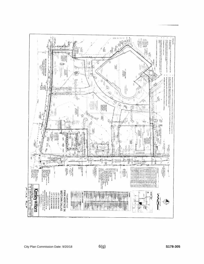
Property Owner Notification: On August 31, 2018, 33 notices were sent to property owners within 200 feet of the proposed plat.
BUILDING LINE REDUCTION: The Commission may approve a relocation or removal of the platted building line with a minimum front, side, or rear yard setback greater than required by zoning regulation only:
(1) Upon the affirmative vote of at least three-fourths of the commission members present; and
(2) If the Commission finds that relocation or removal of the platted building line will not:
(i) “require a minimum front, side, or rear yard setback less than required by
zoning regulation”
The platted building line along rear side of the proposed plat is 10 feet.
Per PD 384, rear yard setback is 10 feet; the request is to reduce the 10-
foot building line and wrap around the portion of the swimming pool
encroaching into a 10-foot platted building line setback. PD 384 refers to
Section 51A-4.400 for yard, lot, and space regulations which allow for
swimming pool development to occur in the rear yard setback.
(ii) “be contrary to the public interest;”
33 notices were sent August 31, 2018 to owners within 200 feet of the plat
boundaries.
(iii) “adversely affect neighboring properties; and”
The reduction of the portion of the existing building line to wrap around a
proposed swimming pool on property will be consistent to the other
properties.
(IV) “adversely affect the plan for the orderly development of the subdivision.”
The reduction of the portion of the existing building line to wrap around a
proposed swimming pool will allow the property to be developed in an
orderly matter with a uniform setback equal to other properties.
STAFF RECOMMENDATION OF BUILDING LINE REDUCTION: The request to
reduce the existing 10-foot platted building line along the rear yard setback of the
proposed plat will make the property conforming with the building line along the rest of
the block face. The zoning requires a 10-foot rear yard setback. Staff finds that the
request complies with PD 384, Section 51A-4.400, and Section 51A-8.505 of the Dallas
Development Code; therefore, staff recommends approval of reduction of the building
line.
STAFF RECOMMENDATION ON PLAT: Section 51A-8.503 states that “lots must
conform in width, depth, and area to the pattern already established in the adjacent

City Plan Commission Date: 9/20/18 7(c) S178-296
areas, having due regard to the character of the area, its particular suitability for
development, and taking into consideration the natural topography of the ground,
drainage, wastewater facilities, and the proposed layout of the streets.”.
The size of the existing lot will remain same. The staff has determined that the request
complies with the requirements of Section 51-8.503 and the requirements of PD 384;
therefore, staff recommends approval subject to compliance with the following
conditions:
1. The final plat must conform to all requirements of the Dallas Development Code,
Texas Local Government Code, Texas Land Surveying Practices Act and the
General Rules and Regulations of the Texas Board of Land Surveying.
2. Department of Sustainable Development and Construction, Engineering Division must verify that the plat conforms with the water, wastewater, and easement requirements under the provisions of Chapter 49 of the Dallas City Code.
3. Compliance with all plans, contracts, ordinances, and requirements of the City of Dallas. Section 51A-8.102(a), (b), (c), and (d)
4. The number and location of fire hydrants, must comply with the Dallas Fire Code.
5. Any structure new or existing structure may not extend across new property lines. Section 51A-8.503(e)
6. On the final plat, all easement abandonments, and ROW abandonments must be by separate instrument with the recording information shown on the face of the plat. A release from the Real Estate Division is required prior to the plat being submitted to the Chairman for signature.
7. On the final plat, include two boundary corners tagged with these coordinates: “Texas State Plane Coordinate System, North Central Zone, North American Datum of 1983 on Grid Coordinate values, No Scale and no Projection.”
8. On the final plat, monument all set corners per the Monumentation Ordinance. Prior to submittal of the final plat for the Chairman’s signature the monuments must be verified by the Chief City Surveyors Office in the Public Works Department. Section 51A-8.617
9. Provide ALL supporting documentation (i.e. deeds, plats, ordinances, easements…etc.) with a completed Final Plat Checklist to the Survey Plat Review Group (SPRG) with the Final Plat Submittal after City Plan Commission Approval.
10. The number of lots permitted by this plat is one.
11. Place a note on the final plat stating “Lot-to-lot drainage will not be allowed without proper City of Dallas Engineering Department approval.” (note must be on plat). Section 51A-8.611(e).

City Plan Commission Date: 9/20/18 7(d) S178-296
12. Submit drainage, paving, etc. plans prepared by a licensed (TX) Professional Engineer to Permit Center, Oak Cliff Municipal Center (i.e. non-311T). Section 51A-8.102 (c), Section 8.601(b)(4),(5),(6),(7),(8),(9)
13. On the final plat, show recording information on all existing easements within 150 feet of the property.
14. Prior to final plat, contact Real Estate to discuss abandonment process for retaining wall encroachment on the floodway easement common area (Volume 94153, page 3699) or provide documentation showing retaining wall encroachment has been removed.
15. Prior to final plat, provide a copy of recorded certified Ordinance No. 21994 to Real Estate.
16. On the final plat, the abandonment should be noted as “Abandonment authorized by Ordinance No. 21994 and recorded in Instrument No._______”.
17. Prior to recordation of final plat, Real Estate release is required.
18. On the final plat, identify the property as Lot 7 in City Block 44A/7460. Ordinance 1A, pages 131-148, section 2 (passed August 13, 1872).

City Plan Commission Date: 9/20/18 7(e) S178-296

City Plan Commission Date: 9/20/18 7(f) S178-296

City Plan Commission Date: 9/20/18 7(g) S178-296
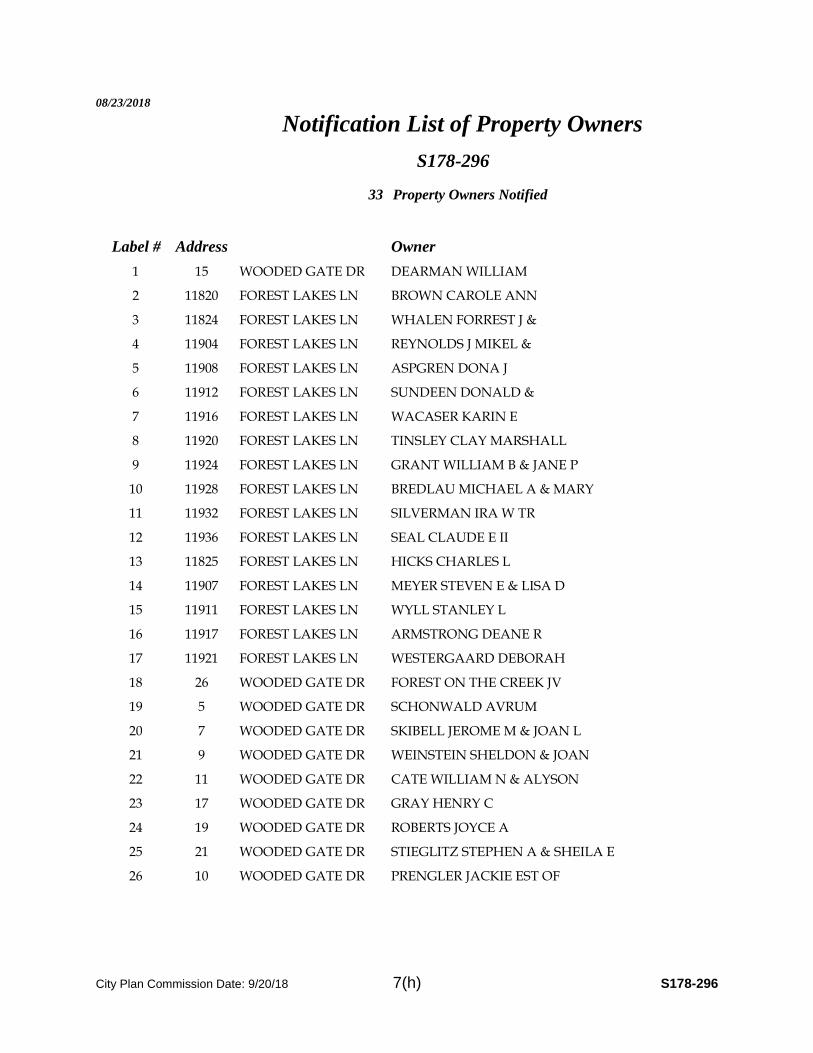
City Plan Commission Date: 9/20/18 7(h) S178-296
08/23/2018
Notification List of Property Owners
S178-296
33 Property Owners Notified
Label # Address Owner
1 15 WOODED GATE DR DEARMAN WILLIAM
2 11820 FOREST LAKES LN BROWN CAROLE ANN
3 11824 FOREST LAKES LN WHALEN FORREST J &
4 11904 FOREST LAKES LN REYNOLDS J MIKEL &
5 11908 FOREST LAKES LN ASPGREN DONA J
6 11912 FOREST LAKES LN SUNDEEN DONALD &
7 11916 FOREST LAKES LN WACASER KARIN E
8 11920 FOREST LAKES LN TINSLEY CLAY MARSHALL
9 11924 FOREST LAKES LN GRANT WILLIAM B & JANE P
10 11928 FOREST LAKES LN BREDLAU MICHAEL A & MARY
11 11932 FOREST LAKES LN SILVERMAN IRA W TR
12 11936 FOREST LAKES LN SEAL CLAUDE E II
13 11825 FOREST LAKES LN HICKS CHARLES L
14 11907 FOREST LAKES LN MEYER STEVEN E & LISA D
15 11911 FOREST LAKES LN WYLL STANLEY L
16 11917 FOREST LAKES LN ARMSTRONG DEANE R
17 11921 FOREST LAKES LN WESTERGAARD DEBORAH
18 26 WOODED GATE DR FOREST ON THE CREEK JV
19 5 WOODED GATE DR SCHONWALD AVRUM
20 7 WOODED GATE DR SKIBELL JEROME M & JOAN L
21 9 WOODED GATE DR WEINSTEIN SHELDON & JOAN
22 11 WOODED GATE DR CATE WILLIAM N & ALYSON
23 17 WOODED GATE DR GRAY HENRY C
24 19 WOODED GATE DR ROBERTS JOYCE A
25 21 WOODED GATE DR STIEGLITZ STEPHEN A & SHEILA E
26 10 WOODED GATE DR PRENGLER JACKIE EST OF

City Plan Commission Date: 9/20/18 7(i) S178-296
08/23/2018
Label # Address Owner
27 12 WOODED GATE DR TILLOTSON JOHN R &
28 14 WOODED GATE DR BOYD BARBARA K WHITE
29 16 WOODED GATE DR DEVENDORF MICHAEL A &
30 18 WOODED GATE DR THOMPSON OTIS R
31 20 WOODED GATE DR GOODMAN PHILIP & JUDITH
32 22 WOODED GATE DR HUFF WILLIAM H III & JUDITH E
33 24 WOODED GATE DR WIMMER LANCE P & MARILOU C

City Plan Commission Date: 9/20/18 7(j) S178-296

City Plan Commission Date: 9/20/18 8(a) S178-298
CITY PLAN COMMISSION THURSDAY, SEPTEMBER 20, 2018
FILE NUMBER: S178-298 SENIOR PLANNER: Sharmila Shrestha
LOCATION: 10211 Gaywood Road, east of Hollow Way Road
DATE FILED: August 22, 2018 ZONING: R-1ac(A)
CITY COUNCIL DISTRICT: 13 SIZE OF REQUEST: 0.856 acre MAPSCO: 25J
OWNERS: Paul H. Devereux and Sharon Devereux
REQUEST: An application to replat a 0.856-acre tract of land containing all of Lot 12 and part of Lot 11 in City Block E/5517 to create one lot and to reduce a portion of the existing 50-foot building line to 43.5 feet along the north line of Gaywood Road on property located at 10211 Gaywood Road, east of Hollow Way Road.
SUBDIVISION HISTORY:
1. S134-138 was a request east of the present request to replat a 0.8330-acre tract of land containing part of Lot 11 in City Block E/5517 into one lot on property located at 10227 Gaywood Road. The request was approved May 8, 2014 and was recorded September 24, 2014.
Property Owner Notification: On August 29, 2018, 11 notices were sent to property owners within 200 feet of the proposed plat.
BUILDING LINE REDUCTION: The Commission may approve a relocation or removal of the platted building line with a minimum front, side, or rear yard setback greater than required by zoning regulation only:
1) Upon the affirmative vote of at least three-fourths of the commission members present; and
2) If the Commission finds that relocation or removal of the platted building line will not:
(i) “require a minimum front, side, or rear yard setback less than required by zoning regulation”
The platted building line along north line of Gaywood Road is 50 feet. The front yard setback for the R-1ac(A) single family district is 40 feet; the request is to reduce the portion of 50-foot building line to 43.5 feet and have building line wrap around the portion of the structure encroaching into 50-foot platted building line setback.
(ii) “be contrary to the public interest;”
11 notices were sent August 29, 2018 to owners within 200 feet of the plat boundaries.
(iii) “adversely affect neighboring properties; and”

City Plan Commission Date: 9/20/18 8(b) S178-298
The reduction of the portion of the existing building line from 50 feet to 43.5 feet will be consistent to the other properties along the north line of Gaywood Road.
(IV) “adversely affect the plan for the orderly development of the subdivision.”
The reduction of 6.5 feet will allow the property to be developed in an orderly matter with a uniform setback equal to other properties along the north line of Gaywood Road.
STAFF RECOMMENDATION OF BUILDING LINE REDUCTION: The request to
reduce a portion of the existing 50-foot platted building line along north line of Gaywood
Road will make the property conforming with the building line along the rest of the block
face. The zoning requires a 40-foot front yard setback along the north line of Gaywood
Road. Staff finds that the request complies with Section 51A-8.505 of the Dallas
Development Code; therefore, staff recommends approval of reduction of the portion of
the existing 50-foot building line to 43.5 feet.
STAFF RECOMMENDATION ON PLAT: Section 51A-8.503 states that “lots must
conform in width, depth, and area to the pattern already established in the adjacent
areas, having due regard to the character of the area, its particular suitability for
development, and taking into consideration the natural topography of the ground,
drainage, wastewater facilities, and the proposed layout of the streets.”.
Lots to the north and east of the proposed lot are with similar lot width, depth, and pattern. Lots area range from 35,919.54 square feet to 43,279.66 square feet. The proposed lot area is 37,268 square feet (0.856 acre). The minimum lot area for R-1ac(A) is 43560 square feet (1.00 acre) but Section 51A-8.501(c) allows to process a replat with less lot area than required by zoning provided it includes all of a previous legal building site.
Staff concludes that the request is in compliance with Section 51A-8.503 and with the exception of Section 51A-8.501(c); therefore, staff recommends approval of the request subject to compliance with the following conditions:
1. The final plat must conform to all requirements of the Dallas Development Code, Texas Local Government Code, Texas Land Surveying Practices Act and the General Rules and Regulations of the Texas Board of Land Surveying.
2. Department of Sustainable Development and Construction, Engineering Division must verify that the plat conforms with the water, wastewater, and easement requirements under the provisions of Chapter 49 of the Dallas City Code.
3. Compliance with all plans, contracts, ordinances, and requirements of the City of Dallas. Section 51A-8.102(a), (b), (c), and (d)
4. The number and location of fire hydrants, must comply with the Dallas Fire Code.

City Plan Commission Date: 9/20/18 8(c) S178-298
5. Any structure new or existing structure may not extend across new property lines. Section 51A-8.503(e)
6. On the final plat, all easement abandonments, and ROW abandonments must be by separate instrument with the recording information shown on the face of the plat. A release from the Real Estate Division is required prior to the plat being submitted to the Chairman for signature.
7. On the final plat, include two boundary corners tagged with these coordinates: “Texas State Plane Coordinate System, North Central Zone, North American Datum of 1983 on Grid Coordinate values, No Scale and no Projection.”
8. On the final plat, monument all set corners per the Monumentation Ordinance. Prior to submittal of the final plat for the Chairman’s signature the monuments must be verified by the Chief City Surveyors Office in the Public Works Department. Section 51A-8.617
9. Provide ALL supporting documentation (i.e. deeds, plats, ordinances, easements…etc.) with a completed Final Plat Checklist to the Survey Plat Review Group (SPRG) with the Final Plat Submittal after City Plan Commission Approval.
10. The number of lots permitted by this plat is one.
11. Submit a full set of Civil Engineering plans prepared per City Standards by a licensed (TX) Professional Engineer to Sustainable Development and Construction, Engineering Division, Room 200, Oak Cliff Municipal Center (i.e. 311T). Additions and alterations to the public infrastructure require approval and may require private development contracts with bonds. Sections 51A-8.102(c) and Section 51A-8.601(b) (4), (5), (6), (7), (8), and (9).
12. Detention may be required if the capacity of available outfall is not adequate to carry the developed runoff. Section 51A-8.611(e).
13. Place a note on the final plat stating “Lot-to-lot drainage will not be allowed without proper City of Dallas Engineering Department approval.” (note must be on plat). Section 51A-8.611(e).
14. On the final plat, dedicate 28 feet of right-of-way (via fee simple) from the established centerline of Gaywood Road and Hollow Way Road. Sections 51A-8.602(c), 51A-8.604(c) and 51A-8.611(e).
15. On the final plat, dedicate a 10-foot by 10-foot corner clip (via fee simple or street easement) at the intersection of Hollow Way Road & Gaywood Road. Section 51A 8.602(d) (1).
16. On the final plat, show recording information on all existing easements within 150 feet of the property.

City Plan Commission Date: 9/20/18 8(d) S178-298
17. On the final plat, clarify is the 15-foot easement is an alley.
18. Additional design information is required for assessment. Site plan must be submitted showing proposed development, building finished floor elevation, development, existing mains – including downstream manhole, and proposed water and wastewater service locations. Submit water/wastewater engineering plans to 320 E. Jefferson Blvd., Room 200, Attention: Water and Wastewater Engineering.
19. Water main improvement may be required by private development contract. Submit water/wastewater engineering plans to 320 E. Jefferson Blvd., Room 200, Attention: Water and Wastewater Engineering.
20. Add a label on the final plat stating: “Building line reduction by this plat.”
21. On the final plat, identify the property as Lot 12A in City Block E/5517. Ordinance 1A, pages 131-148, section 2 (passed August 13, 1872).

City Plan Commission Date: 9/20/18 8(e) S178-298

City Plan Commission Date: 9/20/18 8(f) S178-298

City Plan Commission Date: 9/20/18 8(g) S178-298

City Plan Commission Date: 9/20/18 8(h) S178-298
08/23/2018
Notification List of Property Owners
S178-298
11 Property Owners Notified
Label # Address Owner
1 10211 GAYWOOD RD LANSBURGH ROBERT & ELAINE
2 10227 GAYWOOD RD HORN CHARLES L & LEAH T
3 5222 MEADERS LN WOODALL BLAKE EDWIN & KRISTI MCINTYRE
4 5310 MEADERS LN POLLARI KEVIN & JANET
5 5330 MEADERS LN HRUBETZ ALBERT
6 5338 MEADERS LN BRODER MICHAEL K &
7 10243 GAYWOOD RD HARTNETT JAY D & DEBORAH G
8 10210 GAYWOOD RD SMALL JUSTIN & NICOLE
9 10160 GAYWOOD RD HOLLISTER CHRISTOPHER W & HELEN C
10 10165 GAYWOOD RD DUNN H MARK &
11 10240 GAYWOOD RD STEWART WALTER & AUDREY

City Plan Commission Date: 9/20/18 8(i) S178-298

1
CITY PLAN COMMISSION THURSDAY, SEPTEMBER 20, 2018
Planner: Carlos A. Talison, MPA
FILE NUMBER: D178-016 DATE FILED: July 13, 2018 LOCATION: Southwest corner of Midtown Boulevard and Manderville Lane COUNCIL DISTRICT: 13 MAPSCO: 26 K SIZE OF REQUEST: ± 3.26 acres CENSUS TRACT: 78.23
MISCELLANEOUS DOCKET ITEM
OWNER: Southwest Transplant Alliance, Inc.
APPLICANT: Cushman & Wakefield
REPRESENTATIVE: Maxwell J. Fisher, AICP - MASTERPLAN REQUEST: An application for a development plan and landscape plan
for a medical laboratory use on property zoned Subarea C within Planned Development District No. 745.
SUMMARY: On June 14, 2016, the Dallas City Council established Planned Development District No. 745 by Ordinance No. 26372. The zoning was granted as a conceptual planned development district and requires City Plan Commission approval of a development plan prior to the issuance of a building permit for work other than repair of existing structures, demolition and grading, the installation of fencing or other structures for security purposes, work associated with permitted temporary uses, or work intended to provide for the irrigation or maintenance of landscaping. The proposed development plan provides for the construction of a 62,000-square-foot, two-story building within Planned Development District No. 745 to be used as a medical laboratory. In conjunction with the above requirement, the attached development plan is submitted for the City Planning Commission’s consideration. Staff has reviewed the proposed development plan and determined the plans comply with the requirements of the ordinance for PD No. 745. The most up to date PD ordinance may be viewed at the following link: http://www.dallascityattorney.com/51P/Articles%20Supp%2052/ARTICLE%20745.pdf STAFF RECOMMENDATION: Approval

2
List of Partners/Principals/Officers
Southwest Transplant Alliance
Chair Kris Gugliuzza, MD
Vice Chair Charles Gressle
Secretary Alejandro Meija, MD
Treasurer Ron Murff
President/CEO Patti Niles
EVP/CAO/GC Brad Adams
COO Sandi Lemons

3
SITE

4
SITE

5
Proposed Development Plan
6
Enlarged Development Plan

7
Proposed Landscape Plan

8
Proposed Tree Mitigation Plan

1
CITY PLAN COMMISSION THURSDAY, SEPTEMBER 20, 2018
Planner: Carlos A. Talison, MPA
FILE NUMBER: D178-018 DATE FILED: July 16, 2018 LOCATION: Southeast corner of Walnut Hill Lane and Wildcat Way COUNCIL DISTRICT: 10 MAPSCO: 27 P SIZE OF REQUEST: ± 0.50 acres CENSUS TRACT: 78.26
MISCELLANEOUS DOCKET ITEM
OWNER/APPLICANT: PC LH Land Partner LP
REPRESENTATIVE: Kirk Hermansen – Hermansen Land Development REQUEST: An application for a development plan and landscape plan
for an office and restaurant use on property zoned Subarea C within Planned Development District No. 758.
SUMMARY: On June 13, 2007, the Dallas City Council established Planned Development District No. 758 by Ordinance No. 26786. The zoning was granted as a conceptual planned development district and requires City Plan Commission approval of a development plan prior to the issuance of a building permit for work other than repair of existing structures, demolition and grading, the installation of fencing or other structures for security purposes, work associated with permitted temporary uses, or work intended to provide for the irrigation or maintenance of landscaping, a development plan and landscape plan must be approved by the city plan commission. The proposed development plan provides for the construction of a 4,699-square-foot building with an 850-square foot patio within Planned Development District No. 758 to include office and restaurant uses. In conjunction with the above requirement, the attached development plan is submitted for the City Planning Commission’s consideration. Staff has reviewed the proposed development plan and determined the plans comply with the requirements of the ordinance for PD No. 758. The most up to date PD ordinance may be viewed at the following link: http://www.dallascityattorney.com/51P/Articles%20Supp%2044/ARTICLE%20758.pdf STAFF RECOMMENDATION: Approval

2
List of Partners/Principals/Officers
LHTC RETAIL, LP
Chairman Stephen T. Clark
President M. Timothy Clark
Vice President, Treasurer, Secretary Alejandro Meija, MD

3
SITE
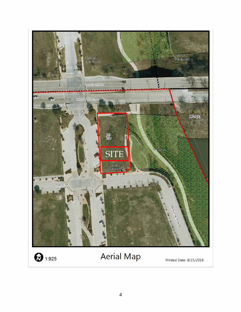
4
SITE

5
Proposed Development Plan

6
Enlarged Development Plan

7
Proposed Landscape Plan

8
Proposed Tree Removal Plan

1
CITY PLAN COMMISSION THURSDAY, SEPTEMBER 20, 2018
Planner: Abraham Martinez
FILE NUMBER: D178-019 DATE FILED: July 25, 2018
LOCATION: Northwest corner of Saddleridge Drive and Isom Lane
COUNCIL DISTRICT: 3 MAPSCO: 71B-A
SIZE OF REQUEST: ±16.4 acres CENSUS TRACT: 165.10
MISCELLANEOUS DOCKET ITEM
APPLICANT/OWNER: Mountain Creek Community Church
REPRESENTATIVE: Robert Summers
REQUEST: An application for a development plan and landscape plan
for a private recreation center, club, or area on property
zoned Subdistrict S-8 within the South Zone of Planned
Development District No. 521.
SUMMARY: On November 11, 1998, the Dallas City Council established Planned
Development District No. 521 by Ordinance No. 23711.
The zoning was granted subject to a conceptual site plan and requires a development
plan and landscape plan be approved by the City Plan Commission prior to the
issuance of any building permits. This request seeks the approval of a development and
landscape plan for a new 2,352-square-foot open air pavilion with attached restrooms
within a proposed outdoor recreation area. The proposed development plan will be
served by 14 parking stalls, as depicted on the attached plan.
The most up to date PD ordinance may be viewed at the following link:
http://www.dallascityattorney.com/51P/Articles%20Supp%2023/ARTICLE%20521.pdf
STAFF RECOMMENDATION: Approval
CD 13

2
Corporate Officers
Robert A. Summers President/Pastor
JoAn Summers Vice President
Ronald K. Syrcle Vice Chairman of the Board
Gilbert Ebarb Secretary
Josue Torrez Trustee
Dr. Sam Cooper Trustee
List of Owners

3
Proposed Development Plan

4
Proposed Development Plan – Enlarged

5
Proposed Landscape Plan

6
Proposed Landscape Plan - Enlarged
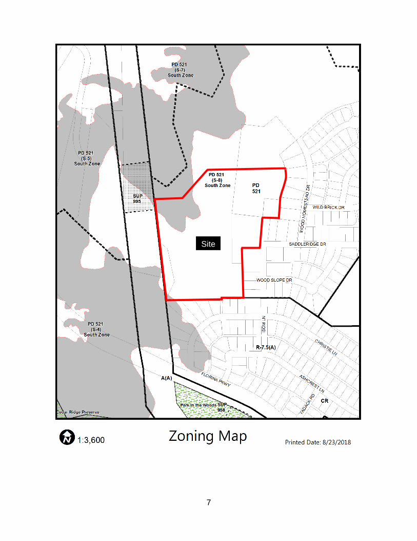
7
Site

8
Site
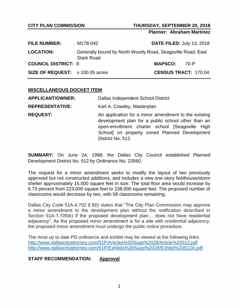
1
CITY PLAN COMMISSION THURSDAY, SEPTEMBER 20, 2018
Planner: Abraham Martinez
FILE NUMBER: M178-042 DATE FILED: July 13, 2018
LOCATION: Generally bound by North Woody Road, Seagoville Road, East
Stark Road
COUNCIL DISTRICT: 8 MAPSCO: 70-P
SIZE OF REQUEST: ± 100.05 acres CENSUS TRACT: 170.04
MISCELLANEOUS DOCKET ITEM
APPLICANT/OWNER: Dallas Independent School District
REPRESENTATIVE: Karl A. Crawley, Masterplan
REQUEST: An application for a minor amendment to the existing
development plan for a public school other than an
open-enrollment charter school [Seagoville High
School] on property zoned Planned Development
District No. 512.
SUMMARY: On June 24, 1998, the Dallas City Council established Planned
Development District No. 512 by Ordinance No. 23560.
The request for a minor amendment seeks to modify the layout of two previously approved but not constructed additions, and includes a new one-story fieldhouse/storm shelter approximately 15,000 square feet in size. The total floor area would increase by 6.73 percent from 223,000 square feet to 238,000 square feet. The proposed number of classrooms would decrease by two, with 58 classrooms remaining. Dallas City Code 51A-4.702 § B(i) states that “The City Plan Commission may approve a minor amendment to the development plan without the notification described in Section 51A-1.105(k) if the proposed development plan… does not have residential adjacency”. As the proposed minor amendment is for a site with residential adjacency, the proposed minor amendment must undergo the public notice procedure. The most up to date PD ordinance and exhibit may be viewed at the following links: http://www.dallascityattorney.com/51P/Articles%20Supp%2028/Article%20512.pdf http://www.dallascityattorney.com/51P/Exhibits%20Supp%2028/Exhibit%20512A.pdf STAFF RECOMMENDATION: Approval
CD 13

2
Dallas Independent School District
District 1 Edwin Flores, President
District 2 Dustin Marshall
District 3 Dan Micciche, 1st Vice President
District 4 Jaime Resendez
District 5 Lew Blackburn, Ph.D.
District 6 Joyce Foreman, 2nd Vice President
District 7 Audrey Pinkerton
District 8 Miguel Solis
District 9 Justin Henry, Board Secretary
List of Officers

3
Existing Development Plan

4
Existing Development Plan

5
Proposed Development Plan

6
Proposed Development Plan - Enlarged
Proposed new Field House / Storm Shelter
Prev. approved addition
Prev. approved addition

7
Site

8
Site
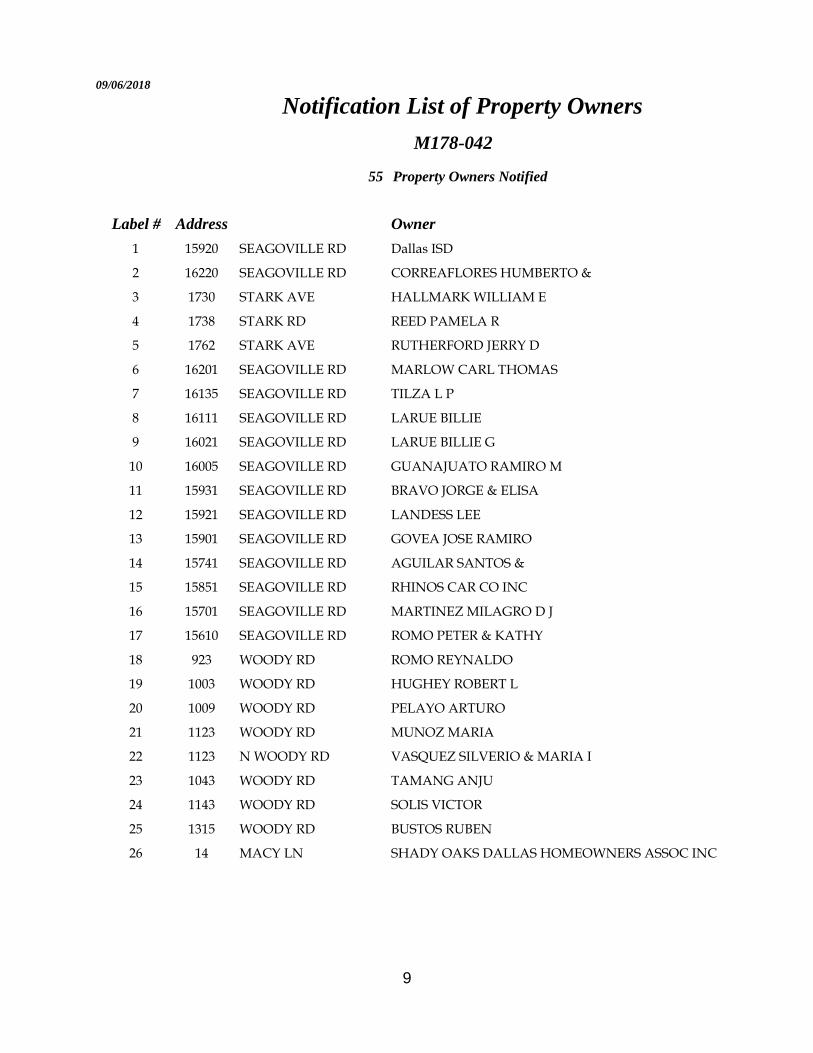
9
09/06/2018
Notification List of Property Owners
M178-042
55 Property Owners Notified
Label # Address Owner
1 15920 SEAGOVILLE RD Dallas ISD
2 16220 SEAGOVILLE RD CORREAFLORES HUMBERTO &
3 1730 STARK AVE HALLMARK WILLIAM E
4 1738 STARK RD REED PAMELA R
5 1762 STARK AVE RUTHERFORD JERRY D
6 16201 SEAGOVILLE RD MARLOW CARL THOMAS
7 16135 SEAGOVILLE RD TILZA L P
8 16111 SEAGOVILLE RD LARUE BILLIE
9 16021 SEAGOVILLE RD LARUE BILLIE G
10 16005 SEAGOVILLE RD GUANAJUATO RAMIRO M
11 15931 SEAGOVILLE RD BRAVO JORGE & ELISA
12 15921 SEAGOVILLE RD LANDESS LEE
13 15901 SEAGOVILLE RD GOVEA JOSE RAMIRO
14 15741 SEAGOVILLE RD AGUILAR SANTOS &
15 15851 SEAGOVILLE RD RHINOS CAR CO INC
16 15701 SEAGOVILLE RD MARTINEZ MILAGRO D J
17 15610 SEAGOVILLE RD ROMO PETER & KATHY
18 923 WOODY RD ROMO REYNALDO
19 1003 WOODY RD HUGHEY ROBERT L
20 1009 WOODY RD PELAYO ARTURO
21 1123 WOODY RD MUNOZ MARIA
22 1123 N WOODY RD VASQUEZ SILVERIO & MARIA I
23 1043 WOODY RD TAMANG ANJU
24 1143 WOODY RD SOLIS VICTOR
25 1315 WOODY RD BUSTOS RUBEN
26 14 MACY LN SHADY OAKS DALLAS HOMEOWNERS ASSOC INC

10
09/06/2018
Label # Address Owner
27 14102 GREENHAW LN LGI HOMES TEXAS LLC
28 14125 GREENHAW LN CAMDEN HOMES AT SHADY OAKS LLC
29 14265 BRIDGEVIEW LN THOMASON JULIA
30 14277 BRIDGEVIEW LN MENDIOLA HUMBERTO
31 14303 BRIDGEVIEW LN RUEZGA LAURA &
32 14307 BRIDGEVIEW LN SWIFT CRYSTAL & JOSHUA DANIEL
33 14311 BRIDGEVIEW LN ORTIZ JUAN
34 14315 BRIDGEVIEW LN HAGGERTY BILLY &
35 14327 BRIDGEVIEW LN VILLA SANDRA
36 14331 BRIDGEVIEW LN BANKS SHEDDRICK
37 14335 BRIDGEVIEW LN KIFLE ASBE
38 14339 BRIDGEVIEW LN LESLIE BRIAN
39 14343 BRIDGEVIEW LN OBRIEN FRANK JR & FRANCES
40 14347 BRIDGEVIEW LN ALVAREZ DANIEL
41 14351 BRIDGEVIEW LN BECERRA ARMANDO & WENDY
42 14355 BRIDGEVIEW LN GARCIA LUIS & DANIELLA
43 1302 LUCCHESE LN GARCIA RAUL &
44 1303 BARREL DR VASQUEZ FELIPE
45 1302 BARREL DR MUNOZ NOHEMI
46 1804 E STARK RD RUTHERFORD DWAINE R &
47 1700 E STARK RD CALVARY EAST BAPTIST CHURCH
48 972 HALEY DR LEGORRETA JOSE ISRAEL
49 15656 GATSBY LN MARTINEZ RAUL &
50 941 WOODY RD TEXAS CONFERENCE ASSOC SEVENTH DAY ADVENTISTS
51 1129 WOODY RD ARRIAGA JUAN F
52 1131 N WOODY RD GARCIA ANDRES A
53 408 STARK RD WAGLIARDO CARMEN ET AL
54 1804 E STARK RD RUTHERFORD DWAINE R & ANN
55 1810 E STARK RD HERNANDEZ MARIA &

1
CITY PLAN COMMISSION THURSDAY, SEPTEMBER 20, 2018
Planner: Carlos A. Talison
FILE NUMBER: M178-044 DATE FILED: July 20, 2018
LOCATION: East line of Wickmere Mews at Malone Cliff View
COUNCIL DISTRICT: 6 MAPSCO: 44 T
SIZE OF REQUEST: ± .4 acres CENSUS TRACT: 43.00
MISCELLANEOUS DOCKET ITEM
APPLICANT: Don Nedler
OWNER: Villas at Dilbeck CT HOA Inc.
REPRESENTATIVE: Audra Buckley – Permitted Development
REQUEST: An application for a minor amendment to the existing development plan for
Subdistrict 2 within Planned Development District No. 732.
SUMMARY: On September 14, 2005, the City Council passed Ordinance No. 26104
which established Planned Development District No. 732 for certain mixed uses on
property at the above referenced location.
At this time, the property owner has submitted an application for a minor amendment to allow for the addition of three parking spaces located within a portion of Common Area B on the current development plan. The applicant seeks to address guest parking issued within the development by providing the addition parking spaces. Dallas City Code 51A-4.702 § B(i) states that “The city plan commission may approve a minor amendment to the development plan without the notification described in Section 51A-1.105(k) if the proposed development plan… does not have residential adjacency”. As the proposed minor amendment is for a site with residential adjacency the proposed minor amendment must undergo the public notice procedure.
The most up to date PF ordinance and exhibits may be viewed at the following links:
http://www.dallascityattorney.com/51P/Articles%20Supp%2016/Article%20732.pdf
http://www.dallascityattorney.com/51P/Exhibits%20Supp%2016/732A.pdf
STAFF RECOMMENDATION: Approval

2
Villas at Dilbeck Court Homeowner’s Association, Inc.
Donald Nedler, President and Director
Myra Forbus, Director and Secretary
Robert Chase Little, Director and Tresurer
Phillip C. Umphres, Registered Agent for the HOA
Partners, Principals, & Officers

3
Existing Development Plan

4
Proposed Development Plan
Pa
rkin
g
Ad
ditio
n

5
SITE
SITE

6
SITE

7

8
08/15/2018
Notification List of Property Owners
M178-044
48 Property Owners Notified
Label # Address Owner
1 1926 MALONE CLIFF VIEW VILLAS AT DILBECK CT HOA INC
2 1902 MALONE CLIFF VIEW LITTLE ROBERT CHARLES
3 1904 MALONE CLIFF VIEW MULLEN ANA
4 1906 MALONE CLIFF VIEW YARBROUGH DAVID
5 1908 MALONE CLIFF VIEW BARTOLOMEI MARCO
6 1914 MALONE CLIFF VIEW CARPENTERSMITH CINDY
7 1916 MALONE CLIFF VIEW RAE STUART I & PATRICIA A
8 1918 MALONE CLIFF VIEW LUDWIG MARK T
9 1922 MALONE CLIFF VIEW JARAMILLO R & S INVES LLC
10 1930 MALONE CLIFF VIEW LOVE GARY & CANDACE
11 1937 MALONE CLIFF VIEW COOK MARY MCDERMOTT
12 1918 WICKMERE MEWS ROPE & CROCKER INVESTMENTS LLC
13 1916 WICKMERE MEWS M J CROCKER COMPANY LLC
14 1912 WICKMERE MEWS MJ CROCKER COMPANY LLC
15 1908 WICKMERE MEWS WILLIAMSON MICHAEL RAY
16 1906 WICKMERE MEWS BELMONT VILLAS DALLAS LTD
17 1911 MALONE CLIFF VIEW RYAN EDWARD J III &
18 1915 MALONE CLIFF VIEW WALLACE AUBREY J &
19 1923 MALONE CLIFF VIEW FORBUS GARY L & MYRA N
20 1927 MALONE CLIFF VIEW TYNAN FRANCES E
21 1910 MALONE CLIFF VIEW ODELL WILLIAM DEVIN
22 1912 MALONE CLIFF VIEW BEDFORD BEAU P
23 1934 MALONE CLIFF VIEW A 2 Z & T2 MANAGEMENT TRUST
24 1905 MALONE CLIFF VIEW NEDLER DONALD H
25 2120 N WILLOMET AVE CLAY ARTHUR DEVELOPMENT GROUP THE &
26 2111 OBENCHAIN ST CLAY ARTHUR DEVELOPMENT GROUP
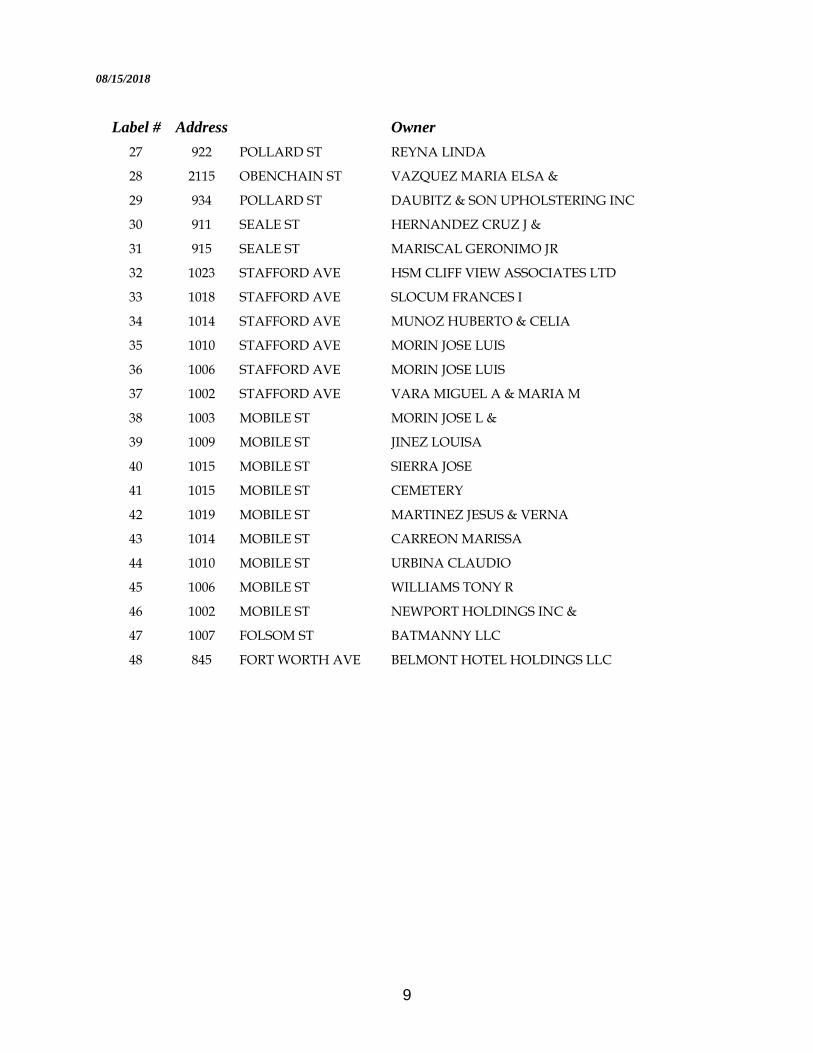
9
08/15/2018
Label # Address Owner
27 922 POLLARD ST REYNA LINDA
28 2115 OBENCHAIN ST VAZQUEZ MARIA ELSA &
29 934 POLLARD ST DAUBITZ & SON UPHOLSTERING INC
30 911 SEALE ST HERNANDEZ CRUZ J &
31 915 SEALE ST MARISCAL GERONIMO JR
32 1023 STAFFORD AVE HSM CLIFF VIEW ASSOCIATES LTD
33 1018 STAFFORD AVE SLOCUM FRANCES I
34 1014 STAFFORD AVE MUNOZ HUBERTO & CELIA
35 1010 STAFFORD AVE MORIN JOSE LUIS
36 1006 STAFFORD AVE MORIN JOSE LUIS
37 1002 STAFFORD AVE VARA MIGUEL A & MARIA M
38 1003 MOBILE ST MORIN JOSE L &
39 1009 MOBILE ST JINEZ LOUISA
40 1015 MOBILE ST SIERRA JOSE
41 1015 MOBILE ST CEMETERY
42 1019 MOBILE ST MARTINEZ JESUS & VERNA
43 1014 MOBILE ST CARREON MARISSA
44 1010 MOBILE ST URBINA CLAUDIO
45 1006 MOBILE ST WILLIAMS TONY R
46 1002 MOBILE ST NEWPORT HOLDINGS INC &
47 1007 FOLSOM ST BATMANNY LLC
48 845 FORT WORTH AVE BELMONT HOTEL HOLDINGS LLC

1
CITY PLAN COMMISSION THURSDAY, SEPTEMBER 20, 2018
Planner: Abraham Martinez FILE NUMBER: M178-045 DATE FILED: July 23, 2018 LOCATION: Generally bound by Gillette Street, Seco Boulevard, and North
Jim Miller Road COUNCIL DISTRICT: 5 MAPSCO: 58 E SIZE OF REQUEST: ± 12.28 acres CENSUS TRACT: 91.03
MISCELLANEOUS DOCKET ITEM APPLICANT/OWNER: Dallas Independent School District REPRESENTATIVE: Karl A. Crawley, Masterplan REQUEST: An application for a minor amendment to the existing development plan for a public school other than an open-enrollment charter school [John Ireland Elementary School] on property zoned Planned Development District No. 661. SUMMARY: On October 8, 2003, Planned Development District No. 661 was approved by the Dallas City Council. This request for a minor amendment seeks to allow for the expansion of an existing drive lane along North Jim Miller Road for student drop off; a reduction in available parking stalls from 75 to 70 stalls; inclusion of three additional portable buildings; and a new area for asphalt pavement for outdoor recreation. Dallas City Code 51A-4.702 § B(i) states that “The City Plan Commission may approve a minor amendment to the development plan without the notification described in Section 51A-1.105(k) if the proposed development plan… does not have residential adjacency”. As the proposed minor amendment is for a site with residential adjacency, the proposed minor amendment must undergo the public notice procedure. The most up to date PD ordinance and exhibit may be viewed at the following link: http://www.dallascityattorney.com/51P/Articles%20Supp%207/Article%20661.pdf http://www.dallascityattorney.com/51P/Exhibits%20Supp%204/pd661/661A.pdf STAFF RECOMMENDATION: Approval
CD 13

2
Dallas Independent School District
District 1 Edwin Flores, President
District 2 Dustin Marshall
District 3 Dan Micciche, 1st Vice President
District 4 Jaime Resendez
District 5 Lew Blackburn, Ph.D.
District 6 Joyce Foreman, 2nd Vice President
District 7 Audrey Pinkerton
District 8 Miguel Solis
District 9 Justin Henry, Board Secretary
List of Officers

3
Existing Development Plan

4
Existing Development Plan - Enlarged

5
Proposed Development Plan

6
Proposed Development Plan - Enlarged
New asphalt pavement
Modified drop off lane
3 new portables

7
Site

8
Site

9
09/06/2018
Notification List of Property Owners
M178-045
46 Property Owners Notified
Label # Address Owner
1 1515 N JIM MILLER RD Dallas ISD
2 1655 N JIM MILLER RD CARR RONALD J & JOYCE
3 6900 UMPHRESS RD GRACE FELLOLWSHIP INTR
4 1655 GILLETTE ST MEDINA EUGENIO & IRMA
5 1476 TEMPLECLIFF DR GUTIERREZ RICARDO &
6 1470 TEMPLECLIFF DR SANCHEZ RAFAEL &
7 1466 TEMPLECLIFF DR BYNUM RUBY J
8 1475 TEMPLECLIFF DR MULLINS JAMES R
9 1469 TEMPLECLIFF DR ZAMORA JESUS MARTINEZ & NANCY NALLELI
10 1465 TEMPLECLIFF DR GIRON GERARDO F & MARA L
11 1576 GILLETTE ST SMITH ALISSA D
12 1580 GILLETTE ST LOPEZ GABINO & TERESA L
13 1586 GILLETTE ST CALHOUN PAUL MARK &
14 1577 GILLETTE ST CAMARA ALICIA
15 1583 GILLETTE ST GARRETT JOHNNIE M
16 6824 SECO BLVD GARCIA JOSE FROYLAN CALVO &
17 6831 SECO BLVD TONCHE MARIA DE LOURDES & EFRAIN
18 1605 GILLETTE ST HERNANEZ HUMBERTO &
19 1609 GILLETTE ST DOMINGUEZ MARIANO
20 1615 GILLETTE ST DOMINGUEZ SERGIO C
21 1621 GILLETTE ST GREAGOR DELORES &
22 6868 HIGHSPIRE DR ALTAMIRANO PAFNUCIO &
23 6877 HIGHSPIRE DR VAZQUEZ ALBERT
24 6871 HIGHSPIRE DR MARTINEZ KARINA
25 6865 HIGHSPIRE DR NELSON BETTY R
26 1441 N JIM MILLER RD GROVE REDEVELOPMENT LLC

10
09/06/2018
Label # Address Owner
27 1614 N JIM MILLER RD CORPORATION OF EPISCOPAL
28 1606 N JIM MILLER RD AVINA JOSE L & OLGA
29 7106 AMY AVE SMITH ISAIAH E
30 7110 AMY AVE RODRIGUEZ JOSE LUIS &
31 7105 AMY AVE MIRELES RODRIGO
32 7111 AMY AVE PEREZ MARIA GUADALUPE
33 7115 AMY AVE AVINA JOSE & MARIA
34 1638 N JIM MILLER RD VELASQUEZ JOVITA
35 3 N JIM MILLER RD BRAZIL JIMMY O & JANICE
36 7103 SECO BLVD AMAYA FELIX J &
37 7109 SECO BLVD EUDABE ANTONIO V & NORMA PATRICIA
38 7115 SECO BLVD AYALA CONCEPCION &
39 1455 CELESTE DR MARTINEZ MARGARITA
40 1450 N JIM MILLER RD YARBOUGH EULANDA
41 1444 N JIM MILLER RD DANIELS ELLA LOUISE
42 1440 N JIM MILLER RD MOORE RICHARD & HELEN
43 1639 GILLETTE GAVELAN MARCIANA
44 1647 GILLETTE GUERRORO HUGO VARGAS
45 6807 UMPHRESS CT BASSDALE INVESTMENTS LLC
46 6811 UMPHRESS CT CLEMENTS RONALD DUANE

1
CITY PLAN COMMISSION THURSDAY, SEPTEMBER 20, 2018
Planner: Carlos A. Talison
FILE NUMBER: D178-004 DATE FILED: January 4, 2017
LOCATION: East line of Victory Avenue at All Star Way
COUNCIL DISTRICT: 2 MAPSCO: 45 E
SIZE OF REQUEST: ± 2.891 acres CENSUS TRACT: 19.00
MISCELLANEOUS DOCKET ITEM
OWNER/APPLICANT: Anland North Commercial, L.P.
REPRESENTATIVE: Hillwood Urban Services, L.P. REQUEST: An application for a development plan for an office and
retail/personal service use with parking garage on property zoned the North Subdistrict within Planned Development District No. 582, Victory Planned Development District.
SUMMARY: On August 23, 2000, the Dallas City Council established Planned Development District No. 582 by Ordinance No. 24346. Ordinance No. 24346 amended Ordinance Nos. 10962 and 19455, Chapters 51 and 51A of the Dallas City Code, as amended. The size of the PD is approximately 86.95 acres of land and is generally located east of Stemmons Freeway and north of Woodall Rodgers Freeway. The zoning was granted as a conceptual planned development district and requires City Plan Commission approval of a development plan prior to the issuance of a building permit for each phase of the development. The proposed development plan provides for a 347,000-square-foot, 12 story office building including 13,500 square-feet of retail and personal service uses, and a 445,000-square-foot, seven story parking garage that will cover an area of approximately 2.891 acres. In conjunction with the above requirement, the attached development plan is submitted for the City Planning Commission’s consideration. Staff has reviewed the proposed development plan and landscape plan and determined the plans comply with the requirements of the ordinance for PD No. 582. The most up to date PD ordinance may be viewed at the following link: http://www.dallascityattorney.com/51P/Articles%20Supp%2017/Article%20582.pdf
STAFF RECOMMENDATION: Approval.
PRIOR CPC ACTION: On April 5; June 7; July 25; August 2; and August 16, 2018, the City Plan Commission held this item under advisement to allow time for the applicant to revise the proposed development plan.

2
List of Partners/Principals/Officers
List of officers of Anland Holdings, Inc.:
Todd L. Platt President, Executive Vice President
M. Thomas Mason Executive Vice Prersident, Treasurer
Dewitt T. Hicks III Executive Vice Prersident
Ken Reese Executive Vice Prersident
Robert T. Vincente Executive Vice Prersident
Thomas D. Williams Executive Vice Prersident
Timothy E. Kinnear Executive Vice Prersident, Tax
Larry Blair Executive Vice Prersident
Michele M. Ringnald Secretary
Stephen D. Parker Assistant Secretary
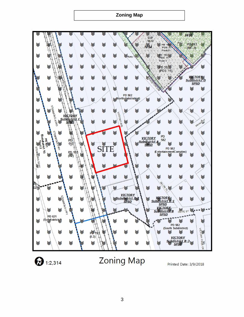
3
Zoning Map
SITE

4
Aerial Map
SITE

5
Proposed Development Plan
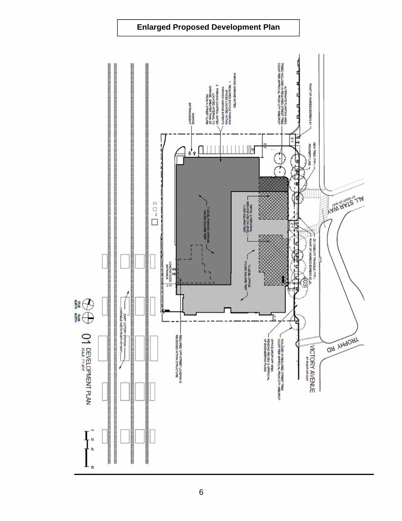
6
Enlarged Proposed Development Plan

7
Updated Victory Open Space Exhibit
SITE

Z178-221(MB)
1-1
CITY PLAN COMMISSION THURSDAY, SEPTEMBER 20, 2018
Planner: Mohammad Bordbar FILE NUMBER: Z178-221(MB) DATE FILED: March 28, 2018 LOCATION: Southeast corner of Nuestra Drive and Wozencraft Drive COUNCIL DISTRICT: 13 MAPSCO: 15 S SIZE OF REQUEST: Approx. 21.117 acres CENSUS TRACT: 96.04 OWNER\APPLICANT: Dallas Independent School District
REPRESENTATIVE: Rob Baldwin, Baldwin and Associates
REQUEST: An application to amend Planned Development District No. 734 for a public school other than an open-enrollment charter school on property zoned Planned Development District No. 734.
SUMMARY: The applicant proposes to amend Planned Development
District No. 734 to accommodate the expansion of E.D. Walker Middle School to a school serving students in Kindergarten through 8th grade.
STAFF RECOMMENDATION: Approval, subject to a revised development plan and revised landscape plan.
PLANNED DEVELOPMENT DISTRICT No. 734: http://dallascityattorney.com/51P/Articles%20Supp%208/Article%20734.pdf
Z178-221(MB)
1-2
BACKGROUND INFORMATION:
The site consists of a two-story building [E.D. Walker Middle School] with ancillary
football, baseball, and softball fields.
On October 26, 2005, the City Council approved Planned Development District No. 734
for a public school other than an open-enrollment charter school.
Zoning History: There have been no recent zoning cases requested in the area in the past five years. Thoroughfares/Streets:
Thoroughfare/Street Function ROW
Nuestra Drive Local 60 feet
Wozencraft Drive Local 60 feet
Traffic: The applicant has submitted a Traffic Management Plan indicating that the school will provide no queuing in the City right-of-way and will ensure the safety of the students at the drop-off and pick-up times. Access points are located on the north side of the site from Nuestra Drive, as depicted on Exhibit 1 of the TMP. With respect to traffic queue operations, the TMP stipulates that parents picking up students should enter the parking lot north of the school building via Nuestra Drive (see Exhibit 1). The Engineering Division of the Sustainable Development and Construction Department has reviewed the request and determined that, based on the technical support provided in the Traffic Management Plan and Transportation Assessment and Parking Analysis, it will not significantly impact the surrounding roadway system. STAFF ANALYSIS: Comprehensive Plan:
The fowardDallas! Comprehensive Plan was adopted by the City Council in June 2006.
The fowardDallas! Comprehensive Plan outlines several goals and policies which can
serve as a framework for assisting in evaluating the applicant’s request.

Z178-221(MB)
1-3
LAND USE ELEMENT GOAL 1.4 COORDINATE PLANNING ACTIVITIES TO BALANCE TRANSPORTATION, LAND USE, INFRASTRUCTURE AND THE ENVIRONMENT
Policy 1.4.1 Coordinate development and planning activities. ECONOMIC ELEMENT GOAL 2.5 FOSTER A CITY OF GREAT NEIGHBORHOODS Policy 2.5.1 Promote strong and distinctive neighborhoods to enhance Dallas’
quality of life. NEIGHBORHOOD PLUS
Policy 4.2 Support and leverage emerging school quality and school choice programs.
Surrounding Land Uses:
Zoning Land Use
Site PDD No.734 Public School
North R-16(A) Single Family Dwelling
East R-16(A) Public Park
South R-16(A) Single Family Dwelling
West PD No. 50, TH-2(A) Single Family Dwelling
Land Use Compatibility: Surrounding land uses consist of single family to the north, south, and west and a public park to the east. Built in the early 1970s, the E.D. Walker Middle School provides for Grades 6 through 8 and has a current enrollment of 758 students. The applicant proposes to amend Planned Development District No. 734 for the expansion of E.D. Walker Middle School to serve students in Kindergarten through eighth grade. The building additions include classrooms, gymnasium, and various site and infrastructure upgrades. After the site improvements, the applicant has indicated that enrollment will approach 1,100 students, with an overall classroom count of 50, comprised of 35 classrooms of K-6 and 15 classrooms of 7th and 8th grade. The school has operated within the community for a substantial period. The use is compatible with the adjacent single-family neighborhood and continues to serve as an amenity to the residents of the surrounding community. Since the site is subject to PD
Z178-221(MB)
1-4
conditions and a Traffic Management Plan requiring periodic update, staff believes that even with the school expansion, there are sufficient mechanisms in place to ensure the operation continues to run optimally over the years. Market Value Analysis
Market Value Analysis (MVA), is a tool to aid residents and policy-makers in understanding the elements of their local residential real estate markets. It is an objective, data-driven tool built on local administrative data and validated with local experts. The analysis was prepared for the City of Dallas by The Reinvestment Fund. Public officials and private actors can use the MVA to more precisely target intervention strategies in weak markets and support sustainable growth in stronger markets. The MVA identifies nine market types (A through I) on a spectrum of residential market strength or weakness. As illustrated in the attached MVA map, the colors range from purple representing the strongest markets to orange, representing the weakest markets. Off-Street Parking:
Parking will be provided per the Development Code. Pursuant to Section 51A-4.204(17), each kindergarten/elementary school classroom requires one and one-half parking spaces and each junior high/middle school classroom requires three and one-half parking spaces. Based upon the proposed composition of classrooms, a total of 98 parking spaces will be required. The applicant is proposing to exceed this requirement by providing 140 parking spaces, as depicted on the development plan. Landscaping: The applicant proposes to provide landscaping per the development plan, which outlines a
summary of the following design standards:

Z178-221(MB)
1-5
List of Officers
DALLAS INDEPENDENT SCHOOL DISTRICT.
BOARD OF TRUSTEES.
District 1 Edwin Flores, 1st Vice President
District 2 Dustin Marshall
District 3 Dan Micciche, President
District 4 Jamie Resendez
District 5 Lew Blackburn, Ph.D
District 6 Joyce Foreman, 2nd Vice President
District 7 Audrey Pinkerton, Board Secretary
District 8 Miguel Solis
District 9 Bernadette Nutall

Z178-221(MB)
1-6
Applicant’s Proposed Conditions
ARTICLE 734.
PD 734.
SEC. 51P-734.101. LEGISLATIVE HISTORY.
PD 734 was established by Ordinance No. 26146, passed by the Dallas City Council on October
26, 2005. (Ord. 26146)
SEC. 51P-734.102. PROPERTY LOCATION AND SIZE.
PD 734 is established on property located at the southeast corner of Wozencraft Drive and
Nuestra Drive. The size of PD 734 is approximately 20.93 acres. (Ord. 26146)
SEC. 51P-734.103. DEFINITIONS AND INTERPRETATIONS.
(a) Unless otherwise stated, the definitions and interpretations in Chapter 51A apply to this
article.
(b) Unless otherwise stated, all references to articles, divisions, or sections in this article are
to articles, divisions, or sections in Chapter 51A.
(c) This district is considered to be a residential zoning district. (Ord. 26146)
SEC. 51P-734.104. DEVELOPMENT PLAN.
(a) For a public school other than an open-enrollment charter school, development and use of
the Property must comply with the development plan (Exhibit 734A). In the event of a conflict between
the text of this article and the development plan, the text of this article controls.
(b) For all other uses, no development plan is required, and the provisions of Section 51A-
4.702 regarding submission of or amendments to a development plan, site analysis plan, conceptual plan,
development schedule, and landscape plan do not apply. (Ord. 26146)
SEC. 51P-734.105. MAIN USES PERMITTED.
(a) Except as otherwise provided in this section, the only main uses permitted in this district
are those main uses permitted in the R-16(A) Single Family District, subject to the same conditions
applicable in the R-16(A) Single Family District, as set out in Chapter 51A. For example, a use permitted
in the R-16(A) Single Family District only by specific use permit (SUP) is permitted in this district only
by SUP; a use subject to development impact review (DIR) in the R-16(A) Single Family District is
subject to DIR in this district; etc.
(b) A public school other than an open-enrollment charter school is permitted by right. (Ord.
26146)
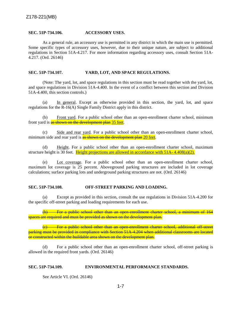
Z178-221(MB)
1-7
SEC. 51P-734.106. ACCESSORY USES.
As a general rule, an accessory use is permitted in any district in which the main use is permitted.
Some specific types of accessory uses, however, due to their unique nature, are subject to additional
regulations in Section 51A-4.217. For more information regarding accessory uses, consult Section 51A-
4.217. (Ord. 26146)
SEC. 51P-734.107. YARD, LOT, AND SPACE REGULATIONS.
(Note: The yard, lot, and space regulations in this section must be read together with the yard, lot,
and space regulations in Division 51A-4.400. In the event of a conflict between this section and Division
51A-4.400, this section controls.)
(a) In general. Except as otherwise provided in this section, the yard, lot, and space
regulations for the R-16(A) Single Family District apply in this district.
(b) Front yard. For a public school other than an open-enrollment charter school, minimum
front yard is as shown on the development plan 35 feet.
(c) Side and rear yard. For a public school other than an open-enrollment charter school,
minimum side and rear yard is as shown on the development plan 20 feet.
(d) Height. For a public school other than an open-enrollment charter school, maximum
structure height is 30 feet. Height projections are allowed in accordance with 51A- 4.408(a)(2).
(e) Lot coverage. For a public school other than an open-enrollment charter school,
maximum lot coverage is 25 percent. Aboveground parking structures are included in lot coverage
calculations; surface parking lots and underground parking structures are not. (Ord. 26146)
SEC. 51P-734.108. OFF-STREET PARKING AND LOADING.
(a) Except as provided in this section, consult the use regulations in Division 51A-4.200 for
the specific off-street parking and loading requirements for each use.
(b) For a public school other than an open-enrollment charter school, a minimum of 164
spaces are required and must be provided as shown on the development plan.
(c) For a public school other than an open-enrollment charter school, additional off-street
parking must be provided in compliance with Section 51A-4.204 when additional classrooms are located
or constructed within the buildable area shown on the development plan.
(d) For a public school other than an open-enrollment charter school, off-street parking is
allowed in the required front yards. (Ord. 26146)
SEC. 51P-734.109. ENVIRONMENTAL PERFORMANCE STANDARDS.
See Article VI. (Ord. 26146)

X-1
SEC. 51P-734.110. LANDSCAPING.
(a) Except as provided in this section, landscaping must be provided in accordance with
Article X.
(b) For a public school other than an open-enrollment charter school, landscaping must be
provided as shown on the development plan.
(c) Plant materials must be maintained in a healthy, growing condition. (Ord. 26146)
SEC. 51P-734.111. FENCES.
For a public school other than an open-enrollment charter school, fences are permitted at the
maximum height allowed in the R-16(A) Single Family District of five feet in the locations shown on
the development plan. (Ord. 26146)
SEC. 51P-734.112. SIGNS.
(a) Except as provided in this section, signs must comply with the provisions for non-
business zoning districts in Article VII.
(b) For a public school other than an open-enrollment charter school, signs are permitted
at the sizes and in the locations as shown in the development plan. (Ord. 26146)
SEC. 51P-734.113. ADDITIONAL PROVISIONS.
(a) The Property must be properly maintained in a state of good repair and neat appearance.
(b) Development and use of the Property must comply with all federal and state laws and
regulations, and with all ordinances, rules, and regulations of the city. (Ord. 26146)
SEC. 51P-734.114. COMPLIANCE WITH CONDITIONS.
(a) All paved areas, permanent drives, streets, and drainage structures, if any, must be
constructed in accordance with standard city specifications, and completed to the satisfaction of the
director of public works and transportation.
(b) The building official shall not issue a building permit to authorize work, or a certificate
of occupancy to authorize the operation of a use, in this district until there has been full compliance
with this article, the Dallas Development Code, the construction codes, and all other ordinances, rules,
and regulations of the city. (Ord. 26146)
SEC. 51P-734.115. ZONING MAP.
PD 734 is located on Zoning Map No. D-7. (Ord. 26146)

Z178-221(MB)
1-9

Z178-221(MB)
1-10
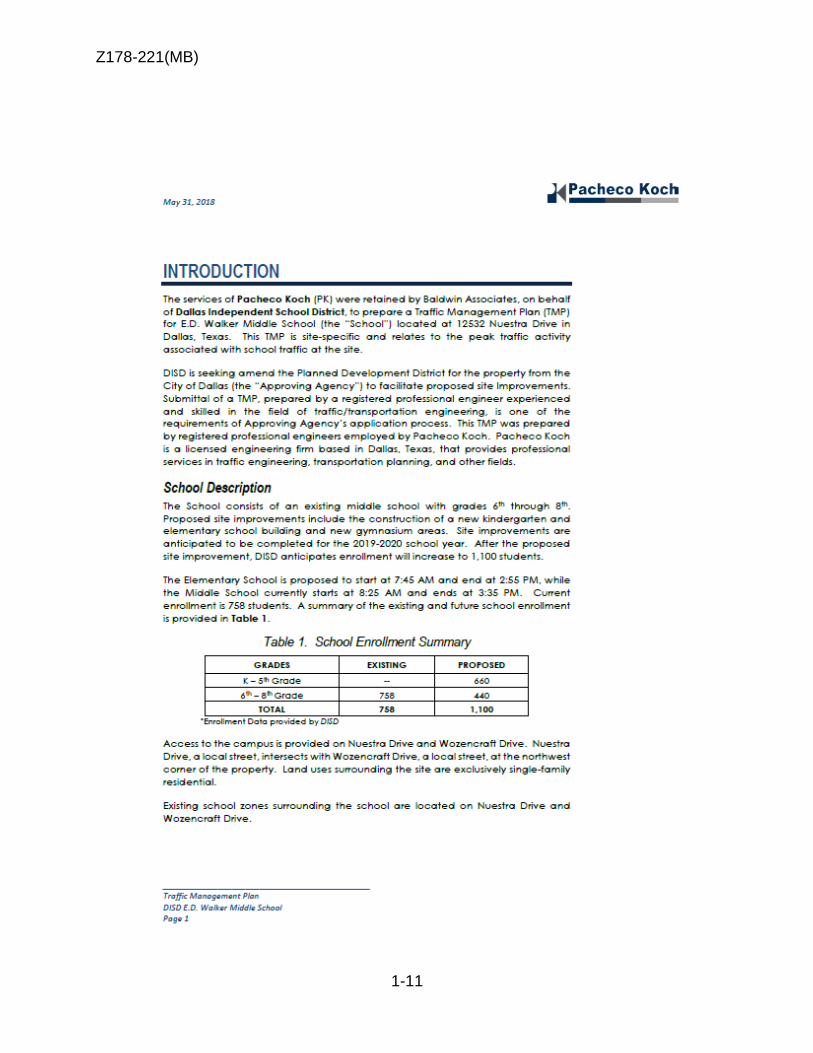
Z178-221(MB)
1-11

Z178-221(MB)
1-12

Z178-221(MB)
1-13

Z178-221(MB)
1-14

Z178-221(MB)
1-15

Z178-221(MB)
1-16

Z178-221(MB)
1-17

Z178-221(MB)
1-18

Z178-221(MB)
1-19

Z178-221(MB)
1-20
Single Family
Single Family
Single Family
Single Family
Single Family
Multi Family

Z178-221(MB)
1-21

Z178-221(MB)
1-22
09/05/2018
Notification List of Property Owners
Z178-221
214 Property Owners Notified
Label # Address Owner
1 12532 NUESTRA DR Dallas ISD
2 5707 MELETIO LN JONES KURT A & NIKKI DIAMOND
3 5715 MELETIO LN BOHART PHILIP G & LAUREN L
4 5723 MELETIO LN J TWO DEVELOPMENT INC
5 5731 MELETIO LN DEVLEER GARY & KATHLEEN
6 5739 MELETIO LN MCGLOTHLIN DARDEN A
7 5747 MELETIO LN ABOUZAGLO SHIMON &
8 5811 MELETIO LN TWOMEY MICHAEL E & HEATHER B
9 5821 MELETIO LN HIRSCH BERNARD SAMUEL
10 5841 MELETIO LN GOLDSTEIN JOSHUA & CYREL
11 5831 MELETIO LN MEYERCORD DAVID K
12 5907 CHARLESTOWN DR BAREA JOSE J
13 5708 CHARLESTOWN DR GLAUBEN MAX & FRIEDA
14 5716 CHARLESTOWN DR FEINSTEIN JACOB & ALLISON
15 5724 CHARLESTOWN DR JOHRI ANAPAM & HAIDY KARYNA
16 5732 CHARLESTOWN DR CANHAM RUSSELL & RAKSHA JAIN
17 5740 CHARLESTOWN DR SULLIVAN BRIAN J
18 5748 CHARLESTOWN DR SOLARI JACK T &
19 5808 CHARLESTOWN DR MCFADDEN MICHAEL & ERIKA
20 5816 CHARLESTOWN DR MEISENHEIMER FREDDIE EDWARD & SIDNEY J
21 5824 CHARLESTOWN DR ARLEN LISA CURTRIGHT
22 5832 CHARLESTOWN DR CLEMENTS GERARD H & PAMELA
23 5840 CHARLESTOWN DR LASHAK ISRAEL JOSE &
24 5848 CHARLESTOWN DR RENDLEMAN RYAN
25 5856 CHARLESTOWN DR MIRO FRANCIS G &
26 5707 CHARLESTOWN DR DELVECCHIO DAVID C &

Z178-221(MB)
1-23
09/05/2018
Label # Address Owner
27 5715 CHARLESTOWN DR MEYER HARRY ROBERT
28 5723 CHARLESTOWN DR ROWE WILLIAM CHRIS &
29 5731 CHARLESTOWN DR PRAGER SAMUEL J & ANNETTE H
30 5739 CHARLESTOWN DR COREY CARRIE MILLER &
31 5747 CHARLESTOWN DR PEDERNALES DEVELOPMENT COMPANY
32 5807 CHARLESTOWN DR MLH TRUST
33 5815 CHARLESTOWN DR 36 POWER EQUITY LLC
34 5823 CHARLESTOWN DR DAVIS JOSHUA RUBIN &
35 5831 CHARLESTOWN DR WEISS DAVID M & BARBARA L
36 5839 CHARLESTOWN DR GARDNER MICHAEL & JULIE
37 5847 CHARLESTOWN DR MOORE RICHARD M & TONYA L
38 5857 CHARLESTOWN DR EHLE RYAN M
39 5625 CHARLESTOWN DR WILLIAMS CANDACE KANE
40 5633 CHARLESTOWN DR LEWIS ARACELI
41 5649 CHARLESTOWN DR HURST MONTE K & BONNIE Y
42 5657 CHARLESTOWN DR FLEISHMANN ROBERT N &
43 5634 CHARLESTOWN DR SCHNEIDER STEVEN &
44 5642 CHARLESTOWN DR GONZALES CONSUELO
45 5650 CHARLESTOWN DR HENRY CRAIG JAMES
46 5658 CHARLESTOWN DR MURPHY FRANK H & LOUISE D
47 5911 BONNARD DR MATARRANZ SALLY SMITH &
48 5907 BONNARD DR HORTON DON G
49 5903 BONNARD DR CARROLL RUSSELL L & NANCY J
50 12541 MATISSE LN HUNDAHL PAMELA H
51 12539 MATISSE LN SMITH BIRL HOWARD
52 12535 MATISSE LN FOLSE MOLLY WOODWORTH
53 12531 MATISSE LN BURKS KEITH E & KELLEY G
54 12527 MATISSE LN DUGGER WYLIE BENJAMIN III &
55 12523 MATISSE LN ATWOOD NINA J &
56 12519 MATISSE LN BLACKBURN C RALPH II
57 12515 MATISSE LN ALVIS JAMES L &
Z178-221(MB)
1-24
09/05/2018
Label # Address Owner
58 12511 MATISSE LN SMITH JAMES M TRUSTEE
59 12507 MATISSE LN 12507 MATISSE LN LLC
60 12503 MATISSE LN MUIRHEAD LAWRENCE &
61 900001 NO NAME ST PRESTON SQUARE INC
62 12251 MONTEGO PLAZA WOODARD RICHARD M
63 12253 MONTEGO PLAZA LEWIS RICK A
64 12255 MONTEGO PLAZA CHAFETZ PAUL K
65 12257 MONTEGO PLAZA PERKINS FAMILY TRUST A
66 12259 MONTEGO PLAZA PAPPAS ANTIGONI
67 12261 MONTEGO PLAZA MOERSCHELL MARIE B
68 12263 MONTEGO PLAZA WHITEHURST MARY EVELYN
69 12265 MONTEGO PLAZA MCCOY DONNY G & MELISSA A
70 12267 MONTEGO PLAZA CAVITT CAROL H
71 12271 MONTEGO PLAZA PIZITZ SHERI L
72 12273 MONTEGO PLAZA PUMPELLY WILFRED C
73 12275 MONTEGO PLAZA TIGNOR REVOCABLE TRUST
74 12277 MONTEGO PLAZA THOMPSON EVELYN CORINNE B
75 12279 MONTEGO PLAZA FOGEL MELANIE GOLDSTEIN
76 12301 MONTEGO PLAZA MOORE VIRGINIA W
77 12305 MONTEGO PLAZA ARNETT SUSAN C
78 12309 MONTEGO PLAZA JAFFE RICHARD B &
79 12311 MONTEGO PLAZA COOPER SUZAN K
80 12315 MONTEGO PLAZA CLEAVELAND BARBARA
81 12317 MONTEGO PLAZA PRESCOTT MATTHEW CHARLES &
82 12319 MONTEGO PLAZA CRAFT JOAN M
83 12321 MONTEGO PLAZA TOBOLOWSKY PEGGY MARIE
84 12323 MONTEGO PLAZA DIBBERN MARY ELIZABETH WILSON
85 12327 MONTEGO PLAZA JOSEPHSON SCOTT R
86 12329 MONTEGO PLAZA THOMPSON CHARLENE
87 12331 MONTEGO PLAZA ROSENBAUM FRANKLIN &
88 12333 MONTEGO PLAZA RANEY BRIDGET G

Z178-221(MB)
1-25
09/05/2018
Label # Address Owner
89 12335 MONTEGO PLAZA MATLOCK BARBARA ANN F
90 12337 MONTEGO PLAZA CALDWELL BRUCE J JR & SUSAN J
91 12341 MONTEGO PLAZA MARSHALL FRANK W
92 12343 MONTEGO PLAZA BROWN GARY M & LINDA T
93 12345 MONTEGO PLAZA WALKER PAMELA MARGARET
94 12347 MONTEGO PLAZA ODOM ELIZABETH M
95 12349 MONTEGO PLAZA ROLATER CHOLLY J
96 12351 MONTEGO PLAZA AUERBACH DONALD & LINDA
97 12353 MONTEGO PLAZA PICKERING DOUG & JOAN
98 12355 MONTEGO PLAZA MATHEWS CLOVIS A
99 12357 MONTEGO PLAZA BOWES JUDITH E
100 12359 MONTEGO PLAZA SAMPSON ADELAIDE O
101 12361 MONTEGO PLAZA KISTLER PHILIP C
102 12363 MONTEGO PLAZA ARTMAN ELIZABETH KELLY
103 12365 MONTEGO PLAZA MULKEY LAUREN
104 12367 MONTEGO PLAZA MCELVANEY FRANCES O
105 12369 MONTEGO PLAZA DEAK ENID B
106 12371 MONTEGO PLAZA RUMSEY R LOUIS & ANNE O
107 12381 MONTEGO PLAZA LIEBMAN EDWARD C &
108 12383 MONTEGO PLAZA MULKEY VIRGINIA MARTIN
109 12385 MONTEGO PLAZA STRELITZ DARREL
110 12387 MONTEGO PLAZA TOMARELLI HENRY J &
111 12389 MONTEGO PLAZA KELLY CHARLOTTE S
112 12242 MONTEGO PLAZA WENDORF DENVER F JR EST OF
113 12244 MONTEGO PLAZA MILLOT JOAN M
114 12246 MONTEGO PLAZA CASABURRI CAROL
115 12248 MONTEGO PLAZA BELL LISA BERRES
116 12250 MONTEGO PLAZA CHRISTIAN PATRICIA & LARRY D
117 12252 MONTEGO PLAZA LUDWICK MARY K
118 12254 MONTEGO PLAZA GREGORY RONNIE L & HERLINDA URENA
119 12334 MONTEGO PLAZA RAMZY DAVID F &

Z178-221(MB)
1-26
09/05/2018
Label # Address Owner
120 12332 MONTEGO PLAZA SEEBERGER RUDOLGH G TR
121 12330 MONTEGO PLAZA JOHNSON MARK G
122 12328 MONTEGO PLAZA WHALEY ANDREW L
123 12326 MONTEGO PLAZA OLTROGGE EUGENE M &
124 12324 MONTEGO PLAZA GRUEN ALYSSA
125 12340 MONTEGO PLAZA FOLMNSBEE CATHY & GARY LIVING TR
126 12342 MONTEGO PLAZA SWAAB RUTH W
127 12344 MONTEGO PLAZA BUELL ROSEMARY B
128 12346 MONTEGO PLAZA THELMA WALDSTEIN SWANGO TRUST
129 12348 MONTEGO PLAZA KOORENNY KATHRYN L &
130 12362 MONTEGO PLAZA ROUTH SUSAN C TRUSTEE
131 12364 MONTEGO PLAZA MULLEN JAMES M & SANDRA A
132 12366 MONTEGO PLAZA VANCE EDDINS TRUST
133 12368 MONTEGO PLAZA MONTEGO 12368 LAND TRUST
134 12370 MONTEGO PLAZA NEVITT AUSTIN J
135 12372 MONTEGO PLAZA LENOX DOREEN A TR
136 12380 MONTEGO PLAZA BOWLES MARY J TRUSTEE
137 12382 MONTEGO PLAZA STRIEF MARY L
138 12384 MONTEGO PLAZA ROSSBACH JAN PHILIPP &
139 5617 MELETIO LN INVESTORS CAPITAL FUNDING LLC
140 5623 MELETIO LN MULLENIX LOUIS W
141 5834 MCSHANN RD ISRAEL ACHDUT
142 5828 MCSHANN RD DAVIS CHARLES
143 5740 MCSHANN RD BRODEN HELEN L
144 5732 MCSHANN RD WILLIAMS BERNARD JR TRUSTEE ET AL
145 5724 MCSHANN RD MCDONALD FRED G
146 5716 MCSHANN RD BAKER IRVING A
147 5708 MCSHANN RD PRINCE DR ROBERT
148 5640 MCSHANN RD CONGREGATION MIKVAH
149 5632 MCSHANN RD SNOW RUBYE D
150 5624 MCSHANN RD WATKINS MYRON H
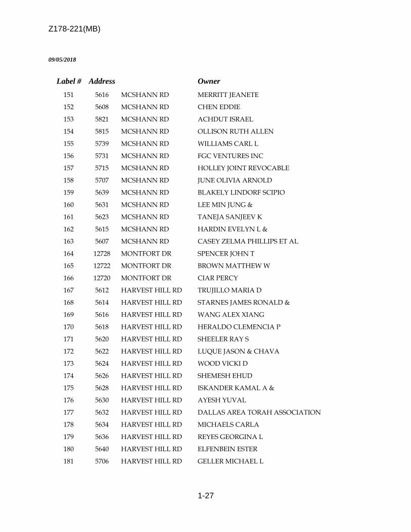
Z178-221(MB)
1-27
09/05/2018
Label # Address Owner
151 5616 MCSHANN RD MERRITT JEANETE
152 5608 MCSHANN RD CHEN EDDIE
153 5821 MCSHANN RD ACHDUT ISRAEL
154 5815 MCSHANN RD OLLISON RUTH ALLEN
155 5739 MCSHANN RD WILLIAMS CARL L
156 5731 MCSHANN RD FGC VENTURES INC
157 5715 MCSHANN RD HOLLEY JOINT REVOCABLE
158 5707 MCSHANN RD JUNE OLIVIA ARNOLD
159 5639 MCSHANN RD BLAKELY LINDORF SCIPIO
160 5631 MCSHANN RD LEE MIN JUNG &
161 5623 MCSHANN RD TANEJA SANJEEV K
162 5615 MCSHANN RD HARDIN EVELYN L &
163 5607 MCSHANN RD CASEY ZELMA PHILLIPS ET AL
164 12728 MONTFORT DR SPENCER JOHN T
165 12722 MONTFORT DR BROWN MATTHEW W
166 12720 MONTFORT DR CIAR PERCY
167 5612 HARVEST HILL RD TRUJILLO MARIA D
168 5614 HARVEST HILL RD STARNES JAMES RONALD &
169 5616 HARVEST HILL RD WANG ALEX XIANG
170 5618 HARVEST HILL RD HERALDO CLEMENCIA P
171 5620 HARVEST HILL RD SHEELER RAY S
172 5622 HARVEST HILL RD LUQUE JASON & CHAVA
173 5624 HARVEST HILL RD WOOD VICKI D
174 5626 HARVEST HILL RD SHEMESH EHUD
175 5628 HARVEST HILL RD ISKANDER KAMAL A &
176 5630 HARVEST HILL RD AYESH YUVAL
177 5632 HARVEST HILL RD DALLAS AREA TORAH ASSOCIATION
178 5634 HARVEST HILL RD MICHAELS CARLA
179 5636 HARVEST HILL RD REYES GEORGINA L
180 5640 HARVEST HILL RD ELFENBEIN ESTER
181 5706 HARVEST HILL RD GELLER MICHAEL L

Z178-221(MB)
1-28
09/05/2018
Label # Address Owner
182 5708 HARVEST HILL RD WORKMAN BENJAMIN & JAMIE
183 5710 HARVEST HILL RD FOREE ELIZABETH
184 5712 HARVEST HILL RD HANCOCK BEVERLY CHARLES
185 5714 HARVEST HILL RD CARTAGENA VICTORINO &
186 5716 HARVEST HILL RD MICHAELS CARLA
187 5718 HARVEST HILL RD GELDMAN DAVID & TAMAR
188 5722 HARVEST HILL RD CARLSON LAWRENCE OSCAR MANAGEMENT TRUST THE
189 5724 HARVEST HILL RD NATINSKY STEVEN A
190 5728 HARVEST HILL RD AUTRY MICHAEL L & SUZAN GAIL KEMP
191 5734 HARVEST HILL RD BENJAMIN DIANE & JEROME E
192 5736 HARVEST HILL RD GOH SWEE HUA
193 5804 HARVEST HILL RD 1397 EAST 7TH STREET TRUST THE
194 5808 HARVEST HILL RD NISSANOV OPHIR
195 5810 HARVEST HILL RD LEVI NATALIE
196 12607 MONTFORT DR ASHLEY DAVID &
197 5580 HARVEST HILL RD WESTDALE TWO CITIES PARTNERS LP
198 12709 MONTFORT DR ROZELL MARTHA J & GARLAND
199 12707 MONTFORT DR MORENO JUAN C
200 12705 MONTFORT DR TOLNAY SHAUN
201 12703 MONTFORT DR MARSHALL JUDITH A
202 12701 MONTFORT DR WARBURTON SARAH E &
203 12623 MONTFORT DR SINZINGER RICHARD A
204 12621 MONTFORT DR BERT ELLIS L & ALLYNE
205 12619 MONTFORT DR ROYAL BENJAMIN C JR &
206 12617 MONTFORT DR YOUNG JUDITH C
207 12615 MONTFORT DR SUAREZ AMADOR & WILMA
208 12613 MONTFORT DR GLIKMAN MARY
209 12611 MONTFORT DR MEDINA MARGARITA
210 12609 MONTFORT DR ASHLEY DAVID &
211 12415 MATISSE LN FOGELMAN MORTON J
212 12411 MATISSE LN COX DEBORAH ANN

Z178-221(MB)
1-29
09/05/2018
Label # Address Owner
213 5550 HARVEST HILL RD STERLING ACQUISITION CORP
214 5550 HARVEST HILL RD TREEMONT RETIREMENT LP

Z178-221(MB)
1-30

2-1
CITY PLAN COMMISSION THURSDAY, SEPTEMBER 20, 2018
Planner: Pamela Daniel FILE NUMBER: Z178-304(PD) DATE FILED: July 23, 2018 LOCATION: East Line of Greenville Avenue, between Prospect Avenue
and Oram Street COUNCIL DISTRICT: 14 MAPSCO: 36 X SIZE OF REQUEST: ± 22,204 sq.ft. CENSUS TRACT: 10.02 OWNER/APPLICANT: Lavo Properties, LLC REPRESENTATIVE: Rob Baldwin, Baldwin and Associates REQUEST: An application for the renewal of Specific Use Permit No.
2272 for a late-hours establishment limited to a restaurant without drive-in or drive-through service on property zoned Planned Development District No. 842, with a MD-1 Modified Delta Overlay for CR Community Retail District uses.
SUMMARY: The applicant is proposing to allow the existing restaurant
use [Gung Ho] to continue to operate as a late-hours establishment per PDD No. 842 and remain open past 12:00 a.m. (midnight).
STAFF RECOMMENDATION: Approval for a two-year period, subject to conditions.

Z178-304(PD)
2-2
BACKGROUND INFORMATION:
On January 26, 2011, the City Council approved Planned Development District No. 842 for Community Retail District uses, which requires a Specific Use Permit for any retail and personal service uses operating after 12:00 a.m. (midnight).
The site lies within the Tract 3 portion of Modified Delta Overlay No. 1.
A Certificate of Occupancy was approved and issued on January 30, 2018, for the existing restaurant use [Gung Ho] at the subject site.
On December 13, 2017, City Council granted Specific Use Permit No. 2272 for a late-hours establishment limited to a restaurant without drive-in or drive-through service for a late-hours establishment limited to a restaurant without drive-in or drive-through service, for a one-year time period.
The applicant is requesting renewal of the SUP for late hours to provide for continued daily operations between the hours of 12:00 a.m. (midnight) and 2:00 a.m., Monday through Sunday.
Zoning History: There have been eight zoning change requests in the area within the
last five years.
1. Z167-367: On December 13, 2017, the City Council approved Specific
Use Permit No. 2272 for a late-hours establishment limited
to a restaurant without drive-in or drive-through service for a
one-year time period, subject to a site plan and conditions.
(subject site)
2. Z156-300: On October 26, 2016, the City Council approved the renewal
of Specific Use Permit No. 1905 for a late-hours
establishment limited to a restaurant without drive-in or
drive-through for a four-year period subject to a site plan and
conditions.
3. Z156-294 On October 26, 2016 the City Council approved the renewal
of Specific Use Permit No. 1912 for a late-hours
establishment limited to a bar, lounge or tavern for a three-
year period subject to a site plan and conditions.
4. Z134-262 On October 8, 2014, the City Council approved a Specific
Use Permit for a late-hours establishment limited to a
restaurant without drive-in or drive through service for a
three-year period subject to a site plan and conditions.

Z178-304(PD)
2-3
5. Z134-177 On August 13, 2014, the City Council approved a Specific
Use Permit for a late-hours establishment limited to a
restaurant without drive-in or drive-through service for a one-
year period subject to a site plan and conditions.
6. Z123-304 On November 12, 2013, the City Council approved the
renewal of SUP No. 1904 for a late-hours establishment
limited to a restaurant without drive-in or drive-through
service.
7. Z134-204 On August 28, 2013 the City Council approved a Specific
Use Permit for a late-hours establishment limited to a
restaurant without drive-in service for a three-year period
with eligibility for automatic renewals for additional two year
periods, subject to conditions.
8. Z123-262 On August 28, 2013, the City Council approved a Specific
Use Permit for a late-hours establishment limited to a
restaurant without drive-in service for a one-year period
subject to a site plan and conditions.
Thoroughfare/Street
Thoroughfare/Street Type Existing/Proposed ROW
Greenville Avenue Collector 56 feet
Traffic: The Engineering Division of the Sustainable Development and Construction Department has reviewed the request and determined it will not negatively impact the surrounding street system. STAFF ANALYSIS: Comprehensive Plan: The forwardDallas! Comprehensive Plan was adopted by the City Council in June 2006. The forwardDallas! Comprehensive Plan outlines several goals and policies which can serve as a framework for assisting in evaluating the applicant’s request. URBAN DESIGN GOAL 5.1 PROMOTE A SENSE OF PLACE, SAFETY AND WALKABILITY Policy 5.1.1 Promote pedestrian-friendly streetscapes.

Z178-304(PD)
2-4
GOAL 5.3 ESTABLISHING WALK-TO CONVENIENCE
Policy 5.3.1 Encourage a balance of land uses within walking distance of each other.
Area Plans: Studies conducted in the area include the Lower Greenville Avenue Parking Study (1986) that recommended that “the City enforce premise code violations as it does in other parts of the City of Dallas”. Code Enforcement was also an issue highlighted in the Greenville Avenue Urban Design Study (1996-1997). It was recommended that “initiatives be taken to conduct a comprehensive sweep to clean-up the Greenville Avenue corridor and there after enforce codes with the assistance of property owners, residents, businesses and operations to maintain the property and report violations to the City for follow-up action.” Recommendations from both studies are still applicable today and consistent with authorized hearing SUP recommendations to address quality of life for adjacent residential neighborhoods and the Lowest Greenville Avenue corridor, respectively.
Modified Delta Overlay No. 1: In general terms, ‘delta theory’ means the number of nonconforming parking or loading spaces for a use that may be carried forward when the use is converted or expanded. The ‘modified delta’, in effect, prohibits the application of the delta theory due to a ceasing of a need to encourage redevelopment and adaptive reuse of existing structures or that the continued application of the delta theory will create traffic congestion and public safety issues. The site lies within Modified Delta Overlay No. 1 (MD-1), which consists of three ‘Areas’ in an area generally bounded by Ellsworth Avenue, west of Matilda Street, north of Ross Avenue, and east of Summit Avenue/Worcola Street. This site lies within the Area 3 portion of MD-1. MD-1 was adopted by the City Council on October 1, 1987. A June 14, 1995, City Council resolution provides for replacing parking in the right-of-way that is lost due to locating public dining space (subject to the granting of a private license) within this area, and requiring parking for the public dining area at a ratio of 1 space per 300 square feet of public dining space. Lastly, a June 28, 1995, amendment to the ordinance provides for the following: 1) a use that is discontinued or remains vacant for 12 months loses the right to carry forward nonconforming parking/loading under the delta theory; 2) the Board of Adjustment may not grant a special exception for required parking; 3) walking distance for remote parking is increased to 900 feet; and, 4) special parking may account for more than 50 percent of required parking for a use.

Z178-304(PD)
2-5
Land Use:
Zoning Land Use
Site PDD No. 842 Restaurant
North PDD No. 842 Restaurant
East PDD No. 167, CR SUP No. 285
Surface Parking Lot, Electric Substation
South PDD No. 842 Personal Service
West PDD No. 842 Retail
Land Use Compatibility: The 22,204-square-foot request site is developed with an approximately 5,313-square-foot structure with an 800-square-foot uncovered patio area. The application is for the renewal of SUP No. 2272, for a late-hours establishment limited to a restaurant without drive-in or drive-through service The applicant is requesting the renewal of the SUP for a late-hours establishment to permit the continued operation of the restaurant beyond 12:00 a.m. to 2:00 a.m., Monday through Sunday, consistent with other retail and personal service uses in the area. The site is surrounded by retail uses to the north, south and west surface parking lots and an electric substation to the east. The purpose of PDD No. 842 is to ‘ensure the compatibility of uses with adjacent residential neighborhoods and to reduce the incidence of crime by discouraging an over-proliferation of regional-serving, late-night venues.’ As defined in the PDD, a late-hours establishment is any retail or personal service use that operates between 12:00 a.m. and 6:00 a.m., and furthermore requires an SUP for this defined use. Additionally, the City Council adopted a compliance date of September 23, 2011, for any retail and personal service use operating beyond 12:00 a.m. to obtain the required SUP. PDD No. 842 establishes the following criteria for consideration of an SUP for a late-hours establishment:
(e) Factors to be considered for a specific use permit for a late-hours establishment. The city plan commission and city council shall consider the following factors when making the findings required by Section 51A-4.219(a)(3): (1) the number of citations issued by police to patrons of the establishment;

Z178-304(PD)
2-6
(2) the number of citations issued by police for noise ordinance violations by the establishment; (3) the number of arrests for public intoxication or disorderly conduct associated with the establishment; (4) the number of Texas Alcoholic Beverage Code violations of the establishment; and (5) the number of violent crimes associated with the establishment, with emphasis on violent crimes originating inside the establishment.
Market Value Analysis
Market Value Analysis (MVA), is a tool to aid residents and policy-makers in
understanding the elements of their local residential real estate markets. It is an
objective, data-driven tool built on local administrative data and validated with local
experts. The analysis was prepared for the City of Dallas by The Reinvestment Fund.
Public officials and private actors can use the MVA to more precisely target intervention
strategies in weak markets and support sustainable growth in stronger markets. The
MVA identifies nine market types (A through I) on a spectrum of residential market
strength or weakness. As illustrated in the attached MVA map, the colors range from
purple representing the strongest markets to orange, representing the weakest markets.
Reported incidents and calls requiring police activity within the year:
The crime statistics cover the period of October 23, 2016 through July 14, 2018. The
data shows that there have been 6 incidents and calls of crime at or near the area of
request with no arrests.
Incidents: IncidentNum Date1 Time1 UCR_Offense UCR_OffDescAddress ZipCode Premise
153470-2018 7/14/2018 1:15 2010 GREENVILLE AVE75206 Highway, Street, Alley ETC
067170-2018 3/31/2018 6:14 ALARM INCIDENT ALARM INCIDENT2010 GREENVILLE AVE75206 Other
026705-2018 2/5/2018 17:21 ALARM INCIDENT ALARM INCIDENT2010 GREENVILLE AVE75206 Other
021587-2018 1/29/2018 17:22 ALARM INCIDENT ALARM INCIDENT2010 GREENVILLE AVE75206 Restaurant/Food Service/TABC Location
282245-2017 12/12/2017 20:48 ALARM INCIDENT ALARM INCIDENT2010 GREENVILLE AVE75206 Bar/NightClub/DanceHall ETC.
254553-2016 10/23/2016 6:16 ALARM INCIDENT ALARM INCIDENT2010 GREENVILLE AVE75206 Restaurant/Food Service/TABC Location
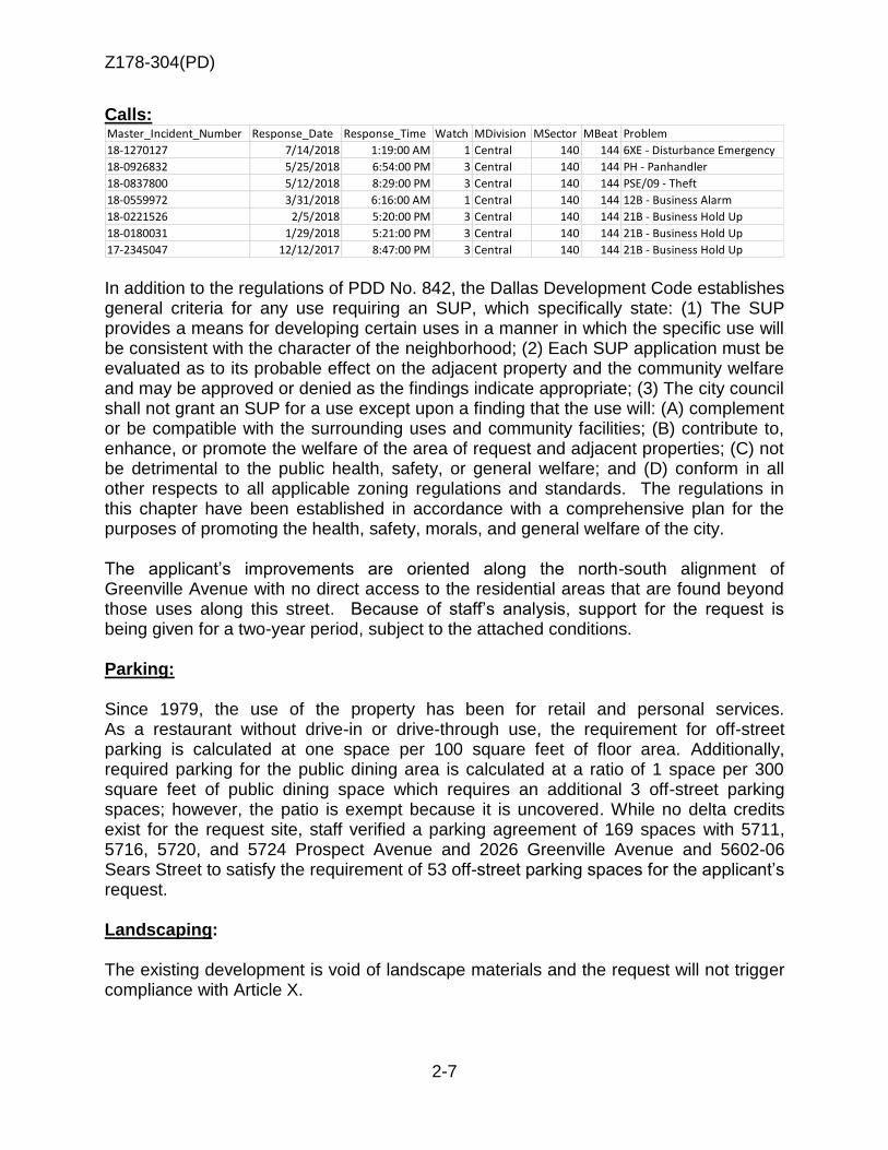
Z178-304(PD)
2-7
Calls: Master_Incident_Number Response_Date Response_Time Watch MDivision MSector MBeat Problem
18-1270127 7/14/2018 1:19:00 AM 1 Central 140 144 6XE - Disturbance Emergency
18-0926832 5/25/2018 6:54:00 PM 3 Central 140 144 PH - Panhandler
18-0837800 5/12/2018 8:29:00 PM 3 Central 140 144 PSE/09 - Theft
18-0559972 3/31/2018 6:16:00 AM 1 Central 140 144 12B - Business Alarm
18-0221526 2/5/2018 5:20:00 PM 3 Central 140 144 21B - Business Hold Up
18-0180031 1/29/2018 5:21:00 PM 3 Central 140 144 21B - Business Hold Up
17-2345047 12/12/2017 8:47:00 PM 3 Central 140 144 21B - Business Hold Up In addition to the regulations of PDD No. 842, the Dallas Development Code establishes general criteria for any use requiring an SUP, which specifically state: (1) The SUP provides a means for developing certain uses in a manner in which the specific use will be consistent with the character of the neighborhood; (2) Each SUP application must be evaluated as to its probable effect on the adjacent property and the community welfare and may be approved or denied as the findings indicate appropriate; (3) The city council shall not grant an SUP for a use except upon a finding that the use will: (A) complement or be compatible with the surrounding uses and community facilities; (B) contribute to, enhance, or promote the welfare of the area of request and adjacent properties; (C) not be detrimental to the public health, safety, or general welfare; and (D) conform in all other respects to all applicable zoning regulations and standards. The regulations in this chapter have been established in accordance with a comprehensive plan for the purposes of promoting the health, safety, morals, and general welfare of the city. The applicant’s improvements are oriented along the north-south alignment of Greenville Avenue with no direct access to the residential areas that are found beyond those uses along this street. Because of staff’s analysis, support for the request is being given for a two-year period, subject to the attached conditions. Parking: Since 1979, the use of the property has been for retail and personal services. As a restaurant without drive-in or drive-through use, the requirement for off-street parking is calculated at one space per 100 square feet of floor area. Additionally, required parking for the public dining area is calculated at a ratio of 1 space per 300 square feet of public dining space which requires an additional 3 off-street parking spaces; however, the patio is exempt because it is uncovered. While no delta credits exist for the request site, staff verified a parking agreement of 169 spaces with 5711, 5716, 5720, and 5724 Prospect Avenue and 2026 Greenville Avenue and 5602-06 Sears Street to satisfy the requirement of 53 off-street parking spaces for the applicant’s request. Landscaping: The existing development is void of landscape materials and the request will not trigger compliance with Article X.

Z178-304(PD)
2-8
Partners/Principals/Officers:
Lavo Properties, LLC Wonderful Seven GP Marc Andres, President Roger Andres, Director

Z178-304(PD)
2-9
SUP Conditions
1. USE: The only use authorized by this specific use permit is late hours establishment limited to a restaurant without drive through service.
2. SITE PLAN: Use and development of the Property must comply with the attached site plan.
3. TIME LIMIT: This specific use permit automatically terminates on December 13, 2017 (two-year period from passage of the ordinance).
4. FLOOR AREA: A. The maximum floor area is 7,300 square feet in the location shown on the attached site plan. B. The maximum floor area for the outdoor patio is 800 square feet in the location shown on the attached site plan. C. The patio must be uncovered. D. The owner or operator must obtain a private license for an outdoor patio, with a copy provided to the building official before the outdoor patio may be used by customers.
5. HOURS OF OPERATION: A. The restaurant must cease operation by 2:00 a.m., Monday through Sunday.
B. All customers must be removed from the Property by 2:15 a.m.
6. OUTDOOR SPEAKERS: Use of loudspeakers outdoors is prohibited between
the hours of 12:00 a.m. and 2:00 a.m.
7. MAINTENANCE: The Property must be properly maintained in a state of good repair and neat appearance.
8. GENERAL REQUIREMENTS: Use of the Property must comply with all federal and state laws and regulations, and with all ordinances, rules, and regulations of the City of Dallas.

Z178-304(PD)
2-10
Existing Site Plan

Z178-304(PD)
2-11

Z178-304(PD)
2-12

Z178-304(PD)
2-13

Z178-304(PD)
2-14
RReessttaauurraanntt
PPeerrssoonnaall SSeerrvviiccee
EElleeccttrriicc SSuubbssttaattiioonn
SSuurrffaaccee ppkkgg..
RReettaaiill

Z178-304(PD)
2-15
4
5
6
7
3
2
8
1

Z178-304(PD)
2-16

Z178-304(PD)
2-17
09/05/2018
Notification List of Property Owners
Z178-304
24 Property Owners Notified
Label # Address Owner
1 2008 GREENVILLE AVE LAVO PROPERTIES LLC
2 2000 GREENVILLE AVE LANDE PAUL &
3 5719 PROSPECT AVE MADISON PACIFIC DEV COM
4 5715 PROSPECT AVE REESE GRANDCHILDRENS
5 5711 PROSPECT AVE ANDRES FAMILY TRUST
6 2100 GREENVILLE AVE GREENVILLE 2100 LTD
7 2026 GREENVILLE AVE ANDRES FAMILY TRUSTS THE
8 5715 ORAM ST TEXAS UTILITIES ELEC CO
9 5724 PROSPECT AVE ANDRES FAMILY TRUST
10 5728 PROSPECT AVE WALL JOHN E JR
11 5726 ORAM ST TARL CABOT LLC &
12 5722 ORAM ST MCKINNEY FEARGAL &
13 5712 ORAM ST LOWGREEN PS
14 5710 ORAM ST SOURIS GEORGIA REVOCABLE TRUST
15 1931 GREENVILLE AVE GREENWAY SEARS LP
16 1919 GREENVILLE AVE 1919 27 GREENVILLE LTD
17 1917 GREENVILLE AVE SEB GROUP LLC
18 1911 GREENVILLE AVE INTERCITY INVESTMENT PROP
19 1909 GREENVILLE AVE WORLDWIDE FOOD INC
20 1903 GREENVILLE AVE LOWGREEN PS
21 2100 STONEBRIAR CT STONEBRIAR CT H O A
22 2 STONEBRIAR CT WHITE SHARI
23 1 STONEBRIAR CT HOOPER NICOLE E
24 2001 GREENVILLE AVE 2001 GREENVILLE VENTURE LTD
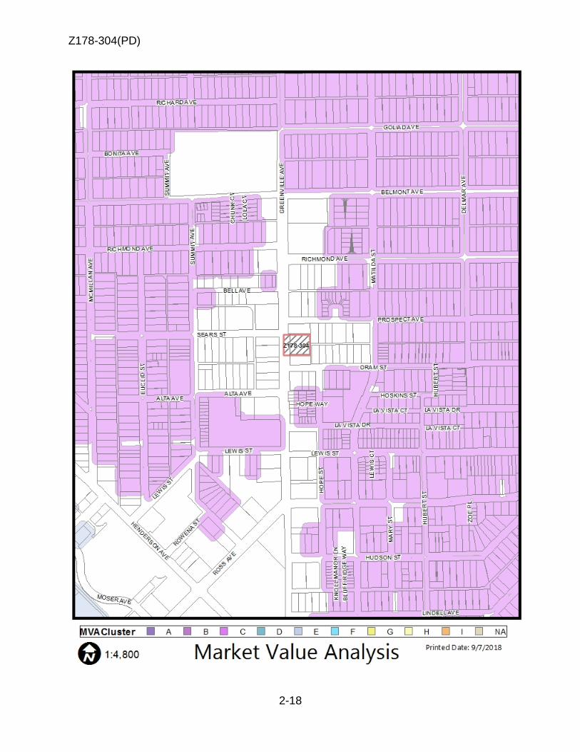
Z178-304(PD)
2-18

3-1
CITY PLAN COMMISSION THURSDAY, SEPTEMBER 20, 2018
Planner: Pamela Daniel
FILE NUMBER: Z178-312 (PD) DATE FILED: July 26, 2018 LOCATION: Northeast corner of Royal Lane and North Stemmons Freeway
COUNCIL DISTRICT: 6 MAPSCO: 22 H
SIZE OF REQUEST: Approx. 0.4695 acres CENSUS TRACT: 99.00
APPLICANT: Anwer Ali OWNER: Quickway Retail ARS REQUEST: An application for the renewal of Specific Use Permit No.
1853 for the sale of alcoholic beverages in conjunction with a general merchandise or food store 3,500 square feet or less on property zoned RR-D-1 Regional Retail District with a D-1 Liquor Control Overlay.
SUMMARY: The applicant proposes to continue the sale of alcoholic
beverages for off-premise consumption in conjunction with a general merchandise or food store 3,500 square feet or less use [Shell].
STAFF RECOMMENDATION: Approval for a five-year period with eligibility for
automatic renewals for additional five-year periods, subject to conditions.

Z178-312(PD)
3-2
BACKGROUND INFORMATION:
The request site is currently developed with an approximately 2,477-square-foot general merchandise store and a motor vehicle fueling station with a canopy and six fuel pumps.
A Certificate of Occupancy was approved and issued on November 10, 2003.
SUP No. 1853 was originally created on August 10, 2011 for a two-year period with eligibility for automatic renewals for additional five-year periods. The automatic renewal window was missed and the first renewal was approved on October 8, 2013 for five-year period with eligibility for automatic renewals for additional five-year periods.
The automatic renewal window was again missed so a second renewal request is sought.
The request is to continue to allow the sale of alcohol for off-premise consumption in conjunction with the general merchandise use on the property.
Zoning History: There has been one recent zoning request in the area within the past five years.
1. Z167-334: On August 22, 2018, the City Council approved the renewal of Specific Use Permit No. 1992 for a commercial amusement (inside) limited to a dance hall for a five-year period with eligibility for automatic renewals for additional five-year periods, subject to a revised site plan and conditions.
Thoroughfares/Streets:
Thoroughfares/Street Type Existing ROW
Royal Lane Principle Arterial 100 feet
North Stemmons Freeway Freeway Variable
Traffic:
The Engineering Division of the Sustainable Development and Construction
Department has reviewed the request and determined that it will not impact the
surrounding street system.

Z178-312(PD)
3-3
Surrounding Land Uses:
Zoning Land Use
Site RR-D-1 General Merchandise Store
North RR-D Vacant
East RR-D Vehicle service center
South
RR-D Vacant
West RR-D Freeway & Retail uses
STAFF ANALYSIS:
Comprehensive Plan: The forwardDallas! Comprehensive Plan was adopted by the City Council in June 2006. The forwardDallas! Comprehensive Plan outlines several goals and policies which can serve as a framework for assisting in evaluating the applicant’s request. The Plan identifies the request site as being in the Multi-modal Corridor Block. ECONOMIC ELEMENT
GOAL 2.4 CREATE AND MAINTAIN AN ENVIRONMENT FRIENDLY TO BUSINESSES AND ENTREPRENEURS
Policy 2.4.2 Restore Dallas as the premier city for conducting business within the region.
URBAN DESIGN ELEMENT
GOAL 5.3 ESTABLISHING WALK-TO CONVENIENCE
Policy 5.3.1. Encourage a balance of land uses within walking distance of each other.

Z178-312(PD)
3-4
Land Use Compatibility: The approximately 0.46-acre request site is currently developed with an approximately 2,477-square-foot general merchandise store and a motor vehicle fueling station with a canopy and six fuel pumps. The applicant is proposing to continue the sale of alcoholic beverages for off-premise consumption in conjunction with the general merchandise use on the property. The request site is adjacent to vacant uses to the north and south, a vehicle service center to the east, and the freeway and restaurant uses to the south. The general provisions for a Specific Use Permit in Section 51A-4.219 of the Dallas Development Code specifically state: (1) The SUP provides a means for developing certain uses in a manner in which the specific use will be consistent with the character of the neighborhood; (2) Each SUP application must be evaluated as to its probable effect on the adjacent property and the community welfare and may be approved or denied as the findings indicate appropriate; (3) The city council shall not grant an SUP for a use except upon a finding that the use will: (A) complement or be compatible with the surrounding uses and community facilities; (B) contribute to, enhance, or promote the welfare of the area of request and adjacent properties; (C) not be detrimental to the public health, safety, or general welfare; and (D) conform in all other respects to all applicable zoning regulations and standards. The regulations in this chapter have been established in accordance with a comprehensive plan for the purpose of promoting the health, safety, morals, and general welfare of the city. Because the request is to renew an existing Specific Use Permit for the sale of alcoholic
beverages in conjunction with the general merchandise store, the site is located
adjacent to a major thoroughfare, and the use having been in operation for 15 years,
staff recommends an approval period of five years with eligibility for five-year automatic
renewals. The seven subsequent years of operation under SUP No. 1853 has allowed
the applicant to establish a track record as being a good neighbor with the adjacent
retail businesses.
Market Value Analysis
Market Value Analysis (MVA), is a tool to aid residents and policy-makers in
understanding the elements of their local residential real estate markets. It is an
objective, data-driven tool built on local administrative data and validated with local
experts. The analysis was prepared for the City of Dallas by The Reinvestment Fund.
Public officials and private actors can use the MVA to more precisely target intervention
strategies in weak markets and support sustainable growth in stronger markets. The
MVA identifies nine market types (A through I) on a spectrum of residential market
strength or weakness. As illustrated in the attached MVA map, the colors range from
purple representing the strongest markets to orange, representing the weakest markets.

Z178-312(PD)
3-5
Parking: The Dallas Development Code requires off-street parking to be provided for a general merchandise use at one space for each 200 square feet of floor area, and two spaces for a motor vehicle fueling station. Therefore, the parking requirements for the proposed 2,400 square foot general merchandise use are 12 spaces; and two spaces for the motor vehicle fueling station. The total required parking spaces is 14. The attached site plan depicts a total of 14 parking spaces. Landscaping: Landscaping must be provided in accordance with Article X, as amended. Reported offense calls requiring police activity in the five years: The crime statistics cover the period of August 27, 2007 through August 26, 2018. The
data shows that there have been 166 calls, 37 incidents of crime and 15 arrests at or
near the area of request with no arrests.
Calls: Master_Incident_NumberResponse_Date Response_TimeWatch MDivision MSector MBeat Problem Priority_DescriptionLocation_NameAddress ApartmentCity State Postal_Code
18-1558659 8/26/2018 15:15 2 Northwest 550 551 46 - CIT 2 - Urgent SHELL | stemmons & royal11404 N Stemmons Serv NbDallas TX 75229
18-1394966 8/1/2018 23:10 3 Northwest 550 551 6X - Major Dist (Violence)2 - Urgent SHELL | stemmons & royal11404 N Stemmons Serv NbDallas TX 75229
18-1279128 7/15/2018 10:48 2 Northwest 550 551 20 - Robbery2 - Urgent SHELL | stemmons & royal11404 N Stemmons Serv NbDallas TX 75229
18-1254885 7/11/2018 20:29 3 Northwest 550 551 40 - Other 3 - General ServiceSHELL | stemmons & royal11404 N Stemmons Serv NbDallas TX 75229
18-1104920 6/20/2018 17:24 3 Northwest 550 551 6X - Major Dist (Violence)2 - Urgent 7-11/SHELL | stemmons & royal11404 N Stemmons Serv NbDallas TX 75229
18-1094391 6/19/2018 5:13 1 Northwest 550 551 **PD Requested by Fire2 - Urgent SHELL | stemmons & royal11404 N Stemmons Serv NbDallas TX 75229
18-0985212 6/3/2018 1:20 1 Northwest 550 551 40/01 - Other2 - Urgent SHELL | stemmons & royal11404 N Stemmons Serv NbDallas TX 75229
18-0907015 5/22/2018 21:51 3 Northwest 550 551 6X - Major Dist (Violence)2 - Urgent SHELL | stemmons & royal11404 N Stemmons Serv NbDallas TX 75229
18-0711196 4/23/2018 18:22 3 Northwest 550 551 11V - Burg Motor Veh4 - Non CriticalSHELL | stemmons & royal11404 N Stemmons Serv NbDallas TX 75229
18-0672122 4/17/2018 17:23 3 Northwest 550 551 6X - Major Dist (Violence)2 - Urgent SHELL | stemmons & royal11404 N Stemmons Serv NbDallas TX 75229
18-0603134 4/6/2018 23:02 3 Northwest 550 551 40 - Other 3 - General ServiceSHELL | stemmons & royal11404 N Stemmons Serv NbDallas TX 75229
18-0533079 3/27/2018 4:03 1 Northwest 550 551 58 - Routine Investigation7 - Unit InitiatedSHELL | stemmons & royal11404 N Stemmons Serv NbDallas TX 75229
17-2435786 12/27/2017 19:39 3 Northwest 550 551 40 - Other 3 - General ServiceSHELL | stemmons & royal11404 N Stemmons Serv NbDallas TX 75229
17-2299806 12/5/2017 18:06 3 Northwest 550 551 40 - Other 3 - General ServiceSHELL | stemmons & royal11404 N Stemmons Serv NbDallas TX 75229
17-2108420 11/5/2017 22:15 3 Northwest 550 551 20 - Robbery2 - Urgent SHELL | stemmons & royal11404 N Stemmons Serv NbDallas TX 75229
17-1994196 10/20/2017 0:37 1 Northwest 550 551 25 - Criminal Assault2 - Urgent SHELL | stemmons & royal11404 N Stemmons Serv NbDallas TX 75229
17-1939106 10/11/2017 22:36 3 Northwest 550 551 16 - Injured Person3 - General ServiceSHELL 11404 N Stemmons Serv NbDallas TX 75229
17-1706469 9/7/2017 9:55 2 Northwest 550 551 58 - Routine Investigation7 - Unit InitiatedSHELL GAS STATION11404 N STEMMONS SERV NBDallas TX 75229
17-1506752 8/8/2017 10:36 2 Northwest 550 551 6XA - Major Dist Ambulance2 - Urgent SHELL 11404 N Stemmons Serv NbDallas TX 75229
17-1265747 7/4/2017 1:41 1 Northwest 550 551 6X - Major Dist (Violence)2 - Urgent SHELL | stemmons & royal11404 N Stemmons Serv NbDallas TX 75229
17-1164793 6/19/2017 17:07 3 Northwest 550 551 6XE - Disturbance Emergency1 - EmergencySHELL | stemmons & royal11404 N Stemmons Serv NbDallas TX 75229
17-0991677 5/25/2017 22:34 3 Northwest 550 551 40 - Other 3 - General ServiceSHELL | stemmons & royal11404 N Stemmons Serv NbDallas TX 75229
17-0966963 5/22/2017 13:31 2 Northwest 550 551 7X - Major Accident2 - Urgent SHELL | stemmons & royal11404 N STEMMONS SERV NBDallas TX 75229
17-0921562 5/16/2017 1:57 1 Northwest 550 551 6X - Major Dist (Violence)2 - Urgent SHELL | stemmons & royal11404 N Stemmons Serv NbDallas TX 75229
17-0648847 4/6/2017 18:37 3 Northwest 550 551 6X - Major Dist (Violence)2 - Urgent SHELL | stemmons & royal11404 N Stemmons Serv NbDallas TX 75229
17-0483074 3/13/2017 10:27 2 Northwest 550 551 09V - UUMV4 - Non CriticalSHELL 11404 N STEMMONS SERV NBDallas TX 75229
17-0385012 2/27/2017 18:05 3 Northwest 550 551 6X - Major Dist (Violence)2 - Urgent SHELL | stemmons & royal11404 N Stemmons Serv NbDallas TX 75229
17-0363819 2/24/2017 10:53 2 Northwest 550 551 40/01 - Other2 - Urgent SHELL | stemmons & royal11404 N Stemmons Serv NbDallas TX 75229
17-0295285 2/14/2017 7:44 1 Northwest 550 551 40 - Other 3 - General ServiceSHELL | stemmons & royal11404 N Stemmons Serv NbDallas TX 75229
17-0175497 1/27/2017 23:53 3 Northwest 550 551 07 - Minor Accident3 - General ServiceSHELL | n stemmons @ROYAL11404 N STEMMONS SERV NBDallas TX 75229
17-0175497 1/27/2017 23:53 3 Northwest 550 551 07 - Minor Accident3 - General ServiceSHELL | n stemmons @ROYAL11404 N STEMMONS SERV NBDallas TX 75229
17-0111036 1/18/2017 4:30 1 Northwest 550 551 40/01 - Other2 - Urgent SHELL | stemmons & royal11404 N Stemmons Serv NbDallas TX 75229
17-0012430 1/2/2017 17:16 3 Northwest 550 551 6X - Major Dist (Violence)2 - Urgent SHELL | stemmons & royal11404 N Stemmons Serv NbDallas TX 75229
16-2511053 12/21/2016 18:28 3 Northwest 550 551 40 - Other 3 - General ServiceSHELL | stemmons & royal11404 N Stemmons Serv NbDallas TX 75229

Z178-312(PD)
3-6
16-2506074 12/21/2016 1:10 1 Northwest 550 551 20 - Robbery2 - Urgent SHELL | stemmons & royal11404 N Stemmons Serv NbDallas TX 75229
16-2506074 12/21/2016 1:10 1 Northwest 550 551 20 - Robbery2 - Urgent SHELL | stemmons & royal11404 N Stemmons Serv NbDallas TX 75229
16-2398648 12/4/2016 19:31 3 Northwest 550 551 6XA - Major Dist Ambulance2 - Urgent SHELL | stemmons & royal11404 N Stemmons Serv NbDallas TX 75229
16-2187203 11/2/2016 16:09 3 Northwest 550 551 40 - Other 3 - General ServiceSHELL | stemmons & royal11404 N Stemmons Serv NbDallas TX 75229
16-2143681 10/27/2016 15:31 2 Northwest 550 551 6X - Major Dist (Violence)2 - Urgent SHELL | stemmons & royal11404 N Stemmons Serv NbDallas TX 75229
16-1956270 10/1/2016 3:29 1 Northwest 550 551 40/01 - Other2 - Urgent SHELL | stemmons & royal11404 N Stemmons Serv NbDallas TX 75229
16-1806863 9/10/2016 7:09 1 Northwest 550 551 40/01 - Other2 - Urgent SHELL | stemmons & royal11404 N Stemmons Serv NbDallas TX 75229
16-1638036 8/17/2016 23:06 3 Northwest 550 551 40 - Other 3 - General ServiceSHELL | stemmons & royal11404 N Stemmons Serv NbDallas TX 75229
16-1560397 8/7/2016 3:41 1 Northwest 550 551 04 - 911 Hang Up2 - Urgent SHELL | stemmons & royal11404 N Stemmons Serv NbDallas TX 75229
16-1094014 6/5/2016 21:08 3 Northwest 550 551 6X - Major Dist (Violence)2 - Urgent A&A SHELL | stemmons & royal11404 N Stemmons Serv NbDallas TX 75229
16-0891385 5/10/2016 7:53 1 Northwest 550 551 40/01 - Other2 - Urgent SHELL | stemmons & royal11404 N Stemmons Serv NbDallas TX 75229
16-0883790 5/9/2016 6:28 1 Northwest 550 551 40/01 - Other2 - Urgent SHELL | stemmons & royal11404 N Stemmons Serv NbDallas TX 75229
16-0883314 5/9/2016 2:38 1 Northwest 550 551 20 - Robbery2 - Urgent SHELL | stemmons & royal11404 N Stemmons Serv NbDallas TX 75229
16-0772113 4/23/2016 16:59 3 Northwest 550 551 6X - Major Dist (Violence)2 - Urgent SHELL | stemmons & royal11404 N Stemmons Serv NbDallas TX 75229
16-0431398 3/5/2016 16:23 3 Northwest 550 551 6X - Major Dist (Violence)2 - Urgent SHELL | stemmons & royal11404 N Stemmons Serv NbDallas TX 75229
16-0409933 3/2/2016 15:41 2 Northwest 550 551 40/01 - Other2 - Urgent SHELL | stemmons & royal11404 N Stemmons Serv NbDallas TX 75229
16-0128907 1/21/2016 1:55 1 Northwest 550 551 20 - Robbery2 - Urgent SHELL | stemmons & royal11404 N Stemmons Serv NbDallas TX 75229
16-0058968 1/10/2016 0:53 1 Northwest 550 551 09V-01 UUMV Just Ocrd3 - General ServiceSHELL | stemmons & royal11404 N Stemmons Serv NbDallas TX 75229
15-2287529 11/12/2015 19:30 3 Northwest 550 551 40 - Other 3 - General ServiceSHELL 11404 N Stemmons Serv NbDallas TX 75229
15-2131354 10/20/2015 15:45 2 Northwest 550 551 40 - Other 3 - General ServiceSHELL GAS STATION11404 N Stemmons Serv NbDallas TX 75229
15-2034560 10/6/2015 18:44 3 Northwest 550 551 **PD Requested by Fire2 - Urgent SHELL | stemmons & royal11404 N Stemmons Serv NbDallas TX 75229
15-1859493 9/12/2015 16:09 3 Northwest 550 551 6X - Major Dist (Violence)2 - Urgent SHELL | stemmons & royal11404 N Stemmons Serv NbDallas TX 75229
15-1328287 7/4/2015 21:43 3 Northwest 550 551 6X - Major Dist (Violence)2 - Urgent SHELL | stemmons & royal11404 N Stemmons Serv NbDallas TX 75229
15-1160941 6/13/2015 10:42 2 Northwest 550 551 21B - Business Hold Up2 - Urgent SHELL | stemmons & royal11404 N Stemmons Serv NbDallas TX 75229
15-1156070 6/12/2015 19:32 3 Northwest 550 551 40/01 - Other2 - Urgent SHELL | stemmons & royal11404 N Stemmons Serv NbDallas TX 75229
15-1155249 6/12/2015 17:41 3 Northwest 550 551 40/01 - Other2 - Urgent SHELL | stemmons & royal11404 N Stemmons Serv NbDallas TX 75229
15-1066377 6/2/2015 2:46 1 Northwest 550 551 38 - Meet Complainant4 - Non CriticalSHELL | stemmons & royal11404 N Stemmons Serv NbDallas TX 75229
15-1012501 5/26/2015 14:52 2 Northwest 550 551 40/01 - Other2 - Urgent SHELL | stemmons & royal11404 N Stemmons Serv NbDallas TX 75229
15-0943296 5/17/2015 2:08 1 Northwest 550 551 40/01 - Other2 - Urgent SHELL | stemmons & royal11404 N Stemmons Serv NbDallas TX 75229
15-0364374 2/25/2015 3:14 1 Northwest 550 551 40 - Other 3 - General ServiceSHELL | stemmons & royal11404 N Stemmons Serv NbDallas TX 75229
15-0348393 2/22/2015 5:18 1 Northwest 550 551 32 - Suspicious Person2 - Urgent SHELL | stemmons & royal11404 N Stemmons Serv NbDallas TX 75229
15-0340527 2/21/2015 2:14 1 Northwest 550 551 40/01 - Other2 - Urgent SHELL | stemmons & royal11404 N Stemmons Serv NbDallas TX 75229
15-0175866 1/27/2015 16:59 3 Northwest 550 551 31/01 - Crim Mis/Prog/Non Felo3 - General ServiceSHELL | stemmons & royal11404 N Stemmons Serv NbDallas TX 75229
15-0059695 1/10/2015 3:51 1 Northwest 550 551 6X - Major Dist (Violence)2 - Urgent SHELL | stemmons & royal11404 N Stemmons Serv NbDallas TX 75229
14-2079329 10/24/2014 1:53 1 Northwest 550 551 40/01 - Other2 - Urgent SHELL | stemmons & royal11404 N Stemmons Serv NbDallas TX 75229
14-1957799 10/6/2014 18:59 3 Northwest 550 551 21B - Business Hold Up2 - Urgent SHELL | stemmons & royal11404 N Stemmons Serv NbDallas TX 75229
14-1827947 9/19/2014 10:10 2 Northwest 550 551 6X - Major Dist (Violence)2 - Urgent SHELL | stemmons & royal11404 N Stemmons Serv NbDallas TX 75229
14-1125375 6/12/2014 21:52 3 Northwest 550 551 58 - Routine Investigation7 - Unit InitiatedSHELL | (stemmons & royal)11404 N STEMMONS SERV EDallas TX 75229
14-1078257 6/6/2014 13:16 2 Northwest 550 551 6X - Major Dist (Violence)2 - Urgent SHELL | (stemmons & royal)11404 N Stemmons Serv EDallas TX 75229
14-0894212 5/11/2014 17:20 3 Northwest 550 551 **PD Requested by Fire2 - Urgent SHELL | (stemmons & royal)11404 N Stemmons Serv EDallas TX 75229
14-0782935 4/26/2014 14:28 2 Northwest 550 551 6X - Major Dist (Violence)2 - Urgent SHELL | (stemmons & royal)11404 N Stemmons Serv EDallas TX 75229
14-0640061 4/6/2014 6:08 1 Northwest 550 551 09V-01 UUMV Just Ocrd3 - General ServiceSHELL | (stemmons & royal)11404 N Stemmons Serv EDallas TX 75229
14-0297585 2/15/2014 6:21 1 Northwest 550 551 21B - Business Hold Up2 - Urgent SHELL | (stemmons & royal)11404 N Stemmons Serv EDallas TX 75229
14-0001893 1/1/2014 2:17 1 Northwest 550 551 40/01 - Other2 - Urgent SHELL | (stemmons & royal)11404 N Stemmons Serv EDallas TX 75229
13-2456448 12/20/2013 13:27 2 Northwest 550 551 6XE - Disturbance Emergency1 - EmergencySHELL | (stemmons & royal)11404 N Stemmons Serv EDallas TX 75229
13-2408205 12/13/2013 9:22 2 Northwest 550 551 6X - Major Dist (Violence)2 - Urgent SHELL | (stemmons & royal)11404 N Stemmons Serv EDallas TX 75229
13-2328850 12/1/2013 2:28 1 Northwest 550 551 6X - Major Dist (Violence)2 - Urgent SHELL | (stemmons & royal)11404 N Stemmons Serv EDallas TX 75229
13-2221285 11/14/2013 14:03 2 Northwest 550 551 09V - UUMV4 - Non CriticalSHELL | (stemmons & royal)11404 N Stemmons Serv EDallas TX 75229
13-2146950 11/2/2013 22:41 3 Northwest 550 551 6X - Major Dist (Violence)2 - Urgent SHELL | (stemmons & royal)11404 N Stemmons Serv EDallas TX 75229
13-2140696 11/2/2013 1:02 1 Northwest 550 551 40 - Other 3 - General ServiceSHELL | (stemmons & royal)11404 N Stemmons Serv EDallas TX 75229
13-1429937 7/23/2013 0:49 1 Northwest 550 551 40/01 - Other2 - Urgent SHELL | (stemmons & royal)11404 N Stemmons Serv EDallas TX 75229
13-1027442 5/30/2013 8:43 2 Northwest 550 551 6XA - Major Dist Ambulance2 - Urgent SHELL | (stemmons & royal)11404 N Stemmons Serv EDallas TX 75229
13-0964546 5/21/2013 11:46 2 Northwest 550 551 07 - Minor Accident3 - General ServiceSHELL | (stemmons & royal)11404 N Stemmons Serv EDallas TX 75229
13-0904202 5/13/2013 2:08 1 Northwest 550 551 6X - Major Dist (Violence)2 - Urgent SHELL | (stemmons & royal)11404 N Stemmons Serv EDallas TX 75229
13-0879645 5/9/2013 17:30 3 Northwest 550 551 40/01 - Other2 - Urgent SHELL | (35 AND ROYAL)11404 N Stemmons Serv EDallas TX 75229
13-0806898 4/29/2013 11:03 2 Northwest 550 551 40 - Other 3 - General ServiceSHELL | (stemmons & royal)11404 N Stemmons Serv EDallas TX 75229
13-0802505 4/28/2013 18:30 3 Northwest 550 551 6X - Major Dist (Violence)2 - Urgent SHELL | (stemmons & royal)11404 N Stemmons Serv EDallas TX 75229
13-0666161 4/9/2013 15:23 2 Northwest 550 551 11V/01 - Burg Motor Veh2 - Urgent SHELL | (stemmons & royal)11404 N Stemmons Serv EDallas TX 75229
13-0645633 4/6/2013 15:58 2 Northwest 550 551 6X - Major Dist (Violence)2 - Urgent SHELL | (stemmons & royal)11404 N Stemmons Serv EBUSN Dallas TX 75229
13-0553903 3/24/2013 6:24 1 Northwest 550 551 40 - Other 3 - General ServiceSHELL | (stemmons & royal)11404 N Stemmons Serv EDallas TX 75229
13-0338680 2/21/2013 5:22 1 Northwest 550 551 40 - Other 3 - General ServiceSHELL | (stemmons & royal)11404 N Stemmons Serv EDallas TX 75229
13-0259092 2/9/2013 6:31 1 Northwest 550 551 40 - Other 3 - General ServiceSHELL | (stemmons & royal)11404 N Stemmons Serv EDallas TX 75229
13-0186280 1/29/2013 14:47 2 Northwest 550 551 24 - Abandoned Property4 - Non CriticalSHELL | (stemmons & royal)11404 N Stemmons Serv EDallas TX 75229
13-0028485 1/5/2013 5:52 1 Northwest 550 551 40 - Other 3 - General ServiceSHELL | (stemmons & royal)11404 N Stemmons Serv EDallas TX 75229
12-2583150 12/27/2012 2:38 1 Northwest 550 551 6X - Major Dist (Violence)2 - Urgent SHELL | (stemmons & royal)11404 N Stemmons Serv EDallas TX 75229

Z178-312(PD)
3-7
16-2506074 12/21/2016 1:10 1 Northwest 550 551 20 - Robbery2 - Urgent SHELL | stemmons & royal11404 N Stemmons Serv NbDallas TX 75229
16-2506074 12/21/2016 1:10 1 Northwest 550 551 20 - Robbery2 - Urgent SHELL | stemmons & royal11404 N Stemmons Serv NbDallas TX 75229
16-2398648 12/4/2016 19:31 3 Northwest 550 551 6XA - Major Dist Ambulance2 - Urgent SHELL | stemmons & royal11404 N Stemmons Serv NbDallas TX 75229
16-2187203 11/2/2016 16:09 3 Northwest 550 551 40 - Other 3 - General ServiceSHELL | stemmons & royal11404 N Stemmons Serv NbDallas TX 75229
16-2143681 10/27/2016 15:31 2 Northwest 550 551 6X - Major Dist (Violence)2 - Urgent SHELL | stemmons & royal11404 N Stemmons Serv NbDallas TX 75229
16-1956270 10/1/2016 3:29 1 Northwest 550 551 40/01 - Other2 - Urgent SHELL | stemmons & royal11404 N Stemmons Serv NbDallas TX 75229
16-1806863 9/10/2016 7:09 1 Northwest 550 551 40/01 - Other2 - Urgent SHELL | stemmons & royal11404 N Stemmons Serv NbDallas TX 75229
16-1638036 8/17/2016 23:06 3 Northwest 550 551 40 - Other 3 - General ServiceSHELL | stemmons & royal11404 N Stemmons Serv NbDallas TX 75229
16-1560397 8/7/2016 3:41 1 Northwest 550 551 04 - 911 Hang Up2 - Urgent SHELL | stemmons & royal11404 N Stemmons Serv NbDallas TX 75229
16-1094014 6/5/2016 21:08 3 Northwest 550 551 6X - Major Dist (Violence)2 - Urgent A&A SHELL | stemmons & royal11404 N Stemmons Serv NbDallas TX 75229
16-0891385 5/10/2016 7:53 1 Northwest 550 551 40/01 - Other2 - Urgent SHELL | stemmons & royal11404 N Stemmons Serv NbDallas TX 75229
16-0883790 5/9/2016 6:28 1 Northwest 550 551 40/01 - Other2 - Urgent SHELL | stemmons & royal11404 N Stemmons Serv NbDallas TX 75229
16-0883314 5/9/2016 2:38 1 Northwest 550 551 20 - Robbery2 - Urgent SHELL | stemmons & royal11404 N Stemmons Serv NbDallas TX 75229
16-0772113 4/23/2016 16:59 3 Northwest 550 551 6X - Major Dist (Violence)2 - Urgent SHELL | stemmons & royal11404 N Stemmons Serv NbDallas TX 75229
16-0431398 3/5/2016 16:23 3 Northwest 550 551 6X - Major Dist (Violence)2 - Urgent SHELL | stemmons & royal11404 N Stemmons Serv NbDallas TX 75229
16-0409933 3/2/2016 15:41 2 Northwest 550 551 40/01 - Other2 - Urgent SHELL | stemmons & royal11404 N Stemmons Serv NbDallas TX 75229
16-0128907 1/21/2016 1:55 1 Northwest 550 551 20 - Robbery2 - Urgent SHELL | stemmons & royal11404 N Stemmons Serv NbDallas TX 75229
16-0058968 1/10/2016 0:53 1 Northwest 550 551 09V-01 UUMV Just Ocrd3 - General ServiceSHELL | stemmons & royal11404 N Stemmons Serv NbDallas TX 75229
15-2287529 11/12/2015 19:30 3 Northwest 550 551 40 - Other 3 - General ServiceSHELL 11404 N Stemmons Serv NbDallas TX 75229
15-2131354 10/20/2015 15:45 2 Northwest 550 551 40 - Other 3 - General ServiceSHELL GAS STATION11404 N Stemmons Serv NbDallas TX 75229
15-2034560 10/6/2015 18:44 3 Northwest 550 551 **PD Requested by Fire2 - Urgent SHELL | stemmons & royal11404 N Stemmons Serv NbDallas TX 75229
15-1859493 9/12/2015 16:09 3 Northwest 550 551 6X - Major Dist (Violence)2 - Urgent SHELL | stemmons & royal11404 N Stemmons Serv NbDallas TX 75229
15-1328287 7/4/2015 21:43 3 Northwest 550 551 6X - Major Dist (Violence)2 - Urgent SHELL | stemmons & royal11404 N Stemmons Serv NbDallas TX 75229
15-1160941 6/13/2015 10:42 2 Northwest 550 551 21B - Business Hold Up2 - Urgent SHELL | stemmons & royal11404 N Stemmons Serv NbDallas TX 75229
15-1156070 6/12/2015 19:32 3 Northwest 550 551 40/01 - Other2 - Urgent SHELL | stemmons & royal11404 N Stemmons Serv NbDallas TX 75229
15-1155249 6/12/2015 17:41 3 Northwest 550 551 40/01 - Other2 - Urgent SHELL | stemmons & royal11404 N Stemmons Serv NbDallas TX 75229
15-1066377 6/2/2015 2:46 1 Northwest 550 551 38 - Meet Complainant4 - Non CriticalSHELL | stemmons & royal11404 N Stemmons Serv NbDallas TX 75229
15-1012501 5/26/2015 14:52 2 Northwest 550 551 40/01 - Other2 - Urgent SHELL | stemmons & royal11404 N Stemmons Serv NbDallas TX 75229
15-0943296 5/17/2015 2:08 1 Northwest 550 551 40/01 - Other2 - Urgent SHELL | stemmons & royal11404 N Stemmons Serv NbDallas TX 75229
15-0364374 2/25/2015 3:14 1 Northwest 550 551 40 - Other 3 - General ServiceSHELL | stemmons & royal11404 N Stemmons Serv NbDallas TX 75229
15-0348393 2/22/2015 5:18 1 Northwest 550 551 32 - Suspicious Person2 - Urgent SHELL | stemmons & royal11404 N Stemmons Serv NbDallas TX 75229
15-0340527 2/21/2015 2:14 1 Northwest 550 551 40/01 - Other2 - Urgent SHELL | stemmons & royal11404 N Stemmons Serv NbDallas TX 75229
15-0175866 1/27/2015 16:59 3 Northwest 550 551 31/01 - Crim Mis/Prog/Non Felo3 - General ServiceSHELL | stemmons & royal11404 N Stemmons Serv NbDallas TX 75229
15-0059695 1/10/2015 3:51 1 Northwest 550 551 6X - Major Dist (Violence)2 - Urgent SHELL | stemmons & royal11404 N Stemmons Serv NbDallas TX 75229
14-2079329 10/24/2014 1:53 1 Northwest 550 551 40/01 - Other2 - Urgent SHELL | stemmons & royal11404 N Stemmons Serv NbDallas TX 75229
14-1957799 10/6/2014 18:59 3 Northwest 550 551 21B - Business Hold Up2 - Urgent SHELL | stemmons & royal11404 N Stemmons Serv NbDallas TX 75229
14-1827947 9/19/2014 10:10 2 Northwest 550 551 6X - Major Dist (Violence)2 - Urgent SHELL | stemmons & royal11404 N Stemmons Serv NbDallas TX 75229
14-1125375 6/12/2014 21:52 3 Northwest 550 551 58 - Routine Investigation7 - Unit InitiatedSHELL | (stemmons & royal)11404 N STEMMONS SERV EDallas TX 75229
14-1078257 6/6/2014 13:16 2 Northwest 550 551 6X - Major Dist (Violence)2 - Urgent SHELL | (stemmons & royal)11404 N Stemmons Serv EDallas TX 75229
14-0894212 5/11/2014 17:20 3 Northwest 550 551 **PD Requested by Fire2 - Urgent SHELL | (stemmons & royal)11404 N Stemmons Serv EDallas TX 75229
14-0782935 4/26/2014 14:28 2 Northwest 550 551 6X - Major Dist (Violence)2 - Urgent SHELL | (stemmons & royal)11404 N Stemmons Serv EDallas TX 75229
14-0640061 4/6/2014 6:08 1 Northwest 550 551 09V-01 UUMV Just Ocrd3 - General ServiceSHELL | (stemmons & royal)11404 N Stemmons Serv EDallas TX 75229
14-0297585 2/15/2014 6:21 1 Northwest 550 551 21B - Business Hold Up2 - Urgent SHELL | (stemmons & royal)11404 N Stemmons Serv EDallas TX 75229
14-0001893 1/1/2014 2:17 1 Northwest 550 551 40/01 - Other2 - Urgent SHELL | (stemmons & royal)11404 N Stemmons Serv EDallas TX 75229
13-2456448 12/20/2013 13:27 2 Northwest 550 551 6XE - Disturbance Emergency1 - EmergencySHELL | (stemmons & royal)11404 N Stemmons Serv EDallas TX 75229
13-2408205 12/13/2013 9:22 2 Northwest 550 551 6X - Major Dist (Violence)2 - Urgent SHELL | (stemmons & royal)11404 N Stemmons Serv EDallas TX 75229
13-2328850 12/1/2013 2:28 1 Northwest 550 551 6X - Major Dist (Violence)2 - Urgent SHELL | (stemmons & royal)11404 N Stemmons Serv EDallas TX 75229
13-2221285 11/14/2013 14:03 2 Northwest 550 551 09V - UUMV4 - Non CriticalSHELL | (stemmons & royal)11404 N Stemmons Serv EDallas TX 75229
13-2146950 11/2/2013 22:41 3 Northwest 550 551 6X - Major Dist (Violence)2 - Urgent SHELL | (stemmons & royal)11404 N Stemmons Serv EDallas TX 75229
13-2140696 11/2/2013 1:02 1 Northwest 550 551 40 - Other 3 - General ServiceSHELL | (stemmons & royal)11404 N Stemmons Serv EDallas TX 75229
13-1429937 7/23/2013 0:49 1 Northwest 550 551 40/01 - Other2 - Urgent SHELL | (stemmons & royal)11404 N Stemmons Serv EDallas TX 75229
13-1027442 5/30/2013 8:43 2 Northwest 550 551 6XA - Major Dist Ambulance2 - Urgent SHELL | (stemmons & royal)11404 N Stemmons Serv EDallas TX 75229
13-0964546 5/21/2013 11:46 2 Northwest 550 551 07 - Minor Accident3 - General ServiceSHELL | (stemmons & royal)11404 N Stemmons Serv EDallas TX 75229
13-0904202 5/13/2013 2:08 1 Northwest 550 551 6X - Major Dist (Violence)2 - Urgent SHELL | (stemmons & royal)11404 N Stemmons Serv EDallas TX 75229
13-0879645 5/9/2013 17:30 3 Northwest 550 551 40/01 - Other2 - Urgent SHELL | (35 AND ROYAL)11404 N Stemmons Serv EDallas TX 75229
13-0806898 4/29/2013 11:03 2 Northwest 550 551 40 - Other 3 - General ServiceSHELL | (stemmons & royal)11404 N Stemmons Serv EDallas TX 75229
13-0802505 4/28/2013 18:30 3 Northwest 550 551 6X - Major Dist (Violence)2 - Urgent SHELL | (stemmons & royal)11404 N Stemmons Serv EDallas TX 75229
13-0666161 4/9/2013 15:23 2 Northwest 550 551 11V/01 - Burg Motor Veh2 - Urgent SHELL | (stemmons & royal)11404 N Stemmons Serv EDallas TX 75229
13-0645633 4/6/2013 15:58 2 Northwest 550 551 6X - Major Dist (Violence)2 - Urgent SHELL | (stemmons & royal)11404 N Stemmons Serv EBUSN Dallas TX 75229
13-0553903 3/24/2013 6:24 1 Northwest 550 551 40 - Other 3 - General ServiceSHELL | (stemmons & royal)11404 N Stemmons Serv EDallas TX 75229
13-0338680 2/21/2013 5:22 1 Northwest 550 551 40 - Other 3 - General ServiceSHELL | (stemmons & royal)11404 N Stemmons Serv EDallas TX 75229
13-0259092 2/9/2013 6:31 1 Northwest 550 551 40 - Other 3 - General ServiceSHELL | (stemmons & royal)11404 N Stemmons Serv EDallas TX 75229
13-0186280 1/29/2013 14:47 2 Northwest 550 551 24 - Abandoned Property4 - Non CriticalSHELL | (stemmons & royal)11404 N Stemmons Serv EDallas TX 75229
13-0028485 1/5/2013 5:52 1 Northwest 550 551 40 - Other 3 - General ServiceSHELL | (stemmons & royal)11404 N Stemmons Serv EDallas TX 75229
12-2583150 12/27/2012 2:38 1 Northwest 550 551 6X - Major Dist (Violence)2 - Urgent SHELL | (stemmons & royal)11404 N Stemmons Serv EDallas TX 75229
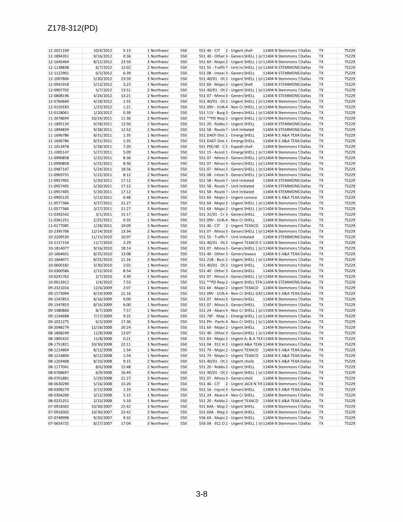
Z178-312(PD)
3-8
12-2021190 10/4/2012 5:13 1 Northwest 550 551 46 - CIT 2 - Urgent shell 11404 N Stemmons Serv EDallas TX 75229
12-1894351 9/16/2012 0:36 1 Northwest 550 551 40 - Other 3 - General ServiceSHELL | (stemmons & royal)11404 N Stemmons Serv EDallas TX 75229
12-1645464 8/12/2012 23:50 3 Northwest 550 551 6X - Major Dist (Violence)2 - Urgent SHELL | (stemmons & royal)11404 N Stemmons Serv EDallas TX 75229
12-1138838 6/7/2012 12:02 2 Northwest 550 551 55 - Traffic Stop7 - Unit InitiatedSHELL | (stemmons & royal)11404 N STEMMONS SERV EDallas TX 75229
12-1122901 6/5/2012 6:39 1 Northwest 550 551 08 - Intoxicated Person3 - General ServiceSHELL 11404 N STEMMONS SERV EDallas TX 75229
12-1007806 5/20/2012 23:59 3 Northwest 550 551 40/01 - Other2 - Urgent SHELL | (stemmons & royal)11404 N Stemmons Serv EDallas TX 75229
12-0941918 5/12/2012 3:23 1 Northwest 550 551 6X - Major Dist (Violence)2 - Urgent Shell 11404 N STEMMONS SERV EDallas TX 75229
12-0907702 5/7/2012 13:51 2 Northwest 550 551 40/01 - Other2 - Urgent SHELL | (stemmons & royal)11404 N Stemmons Serv EDallas TX 75229
12-0808196 4/24/2012 13:21 2 Northwest 550 551 07 - Minor Accident3 - General ServiceSHELL 11404 N STEMMONS FWY NBDallas TX 75229
12-0760660 4/18/2012 1:55 1 Northwest 550 551 40/01 - Other2 - Urgent SHELL | (stemmons & royal)11404 N Stemmons Serv EDallas TX 75229
12-0150183 1/23/2012 1:21 1 Northwest 550 551 09V - UUMV4 - Non CriticalSHELL | (stemmons & royal)11404 N Stemmons Serv EDallas TX 75229
12-0128061 1/20/2012 0:39 1 Northwest 550 551 11V - Burg Motor Veh3 - General ServiceSHELL | (stemmons & royal)11404 N Stemmons Serv EDallas TX 75229
11-2078694 10/24/2011 11:36 2 Northwest 550 551 **PD Requested by Fire2 - Urgent SHELL | (stemmons & royal)11404 N Stemmons Serv EDallas TX 75229
11-1895134 9/28/2011 13:50 2 Northwest 550 551 20 - Robbery2 - Urgent SHELL 11404 N STEMMONS SERV EDallas TX 75229
11-1894839 9/28/2011 12:52 2 Northwest 550 551 58 - Routine Investigation7 - Unit Initiated 11404 N STEMMONS FWY NBDallas TX 75229
11-1696786 8/31/2011 1:35 1 Northwest 550 551 DAEF-Dist Armed Encounter Foot1 - EmergencySHELL 11404 N Stemmons Serv EA&A TEXACODallas TX 75229
11-1696786 8/31/2011 1:35 1 Northwest 550 551 DAEF-Dist Armed Encounter Foot1 - EmergencySHELL 11404 N Stemmons Serv EA&A TEXACODallas TX 75229
11-1013478 5/28/2011 7:20 1 Northwest 550 551 PSE/40 - Other5 - Expeditershell 11404 N Stemmons Fwy NbDallas TX 75229
11-1005147 5/27/2011 5:09 1 Northwest 550 551 15 - Assist Officer1 - EmergencySHELL | (stemmons & royal)11404 N Stemmons Serv EDallas TX 75229
11-0990858 5/25/2011 8:36 2 Northwest 550 551 07 - Minor Accident3 - General ServiceSHELL | (sb stemmons svc rd & motor)11404 N Stemmons Serv EDallas TX 75229
11-0990858 5/25/2011 8:36 2 Northwest 550 551 07 - Minor Accident3 - General ServiceSHELL | (sb stemmons svc rd & motor)11404 N Stemmons Serv EDallas TX 75229
11-0987147 5/24/2011 18:56 3 Northwest 550 551 07 - Minor Accident3 - General ServiceSHELL | (stemmons & royal)11404 N Stemmons Serv EDallas TX 75229
11-0969731 5/22/2011 8:12 2 Northwest 550 551 08 - Intoxicated Person3 - General ServiceSHELL | (stemmons & royal)11404 N Stemmons Serv EDallas TX 75229
11-0957405 5/20/2011 17:12 3 Northwest 550 551 58 - Routine Investigation7 - Unit Initiated 11404 N STEMMONS SERV EDallas TX 75229
11-0957405 5/20/2011 17:12 3 Northwest 550 551 58 - Routine Investigation7 - Unit Initiated 11404 N STEMMONS SERV EDallas TX 75229
11-0957405 5/20/2011 17:12 3 Northwest 550 551 58 - Routine Investigation7 - Unit Initiated 11404 N STEMMONS SERV EDallas TX 75229
11-0905135 5/13/2011 6:48 1 Northwest 550 551 6X - Major Dist (Violence)2 - Urgent conoco 11404 N Stemmons Fwy SbA&A TEXACODallas TX 75229
11-0577366 3/27/2011 21:27 3 Northwest 550 551 6X - Major Dist (Violence)2 - Urgent SHELL | (stemmons & royal)11404 N Stemmons Serv EDallas TX 75229
11-0577366 3/27/2011 21:27 3 Northwest 550 551 6X - Major Dist (Violence)2 - Urgent SHELL | (stemmons & royal)11404 N Stemmons Serv EDallas TX 75229
11-0392542 3/1/2011 15:17 2 Northwest 550 551 31/01 - Crim Mis/Prog/Non Felo3 - General ServiceSHELL 11404 N Stemmons Serv EDallas TX 75229
11-0361251 2/25/2011 0:35 1 Northwest 550 551 09V - UUMV4 - Non CriticalSHELL 11404 N Stemmons Fwy NbDallas TX 75229
11-0177085 1/28/2011 19:09 3 Northwest 550 551 46 - CIT 2 - Urgent TEXACO 11404 N Stemmons Fwy NbDallas TX 75229
10-2395706 12/14/2010 13:34 2 Northwest 550 551 07 - Minor Accident3 - General ServiceSHELL | (stemmons & royal)11404 N Stemmons Serv EDallas TX 75229
10-2209530 11/15/2010 10:07 2 Northwest 550 551 55 - Traffic Stop7 - Unit Initiated 11404 N STEMMONS FWY NBDallas TX 75229
10-2157154 11/7/2010 2:29 1 Northwest 550 551 40/01 - Other2 - Urgent TEXACO STATION11404 N Stemmons Fwy NbDallas TX 75229
10-1814077 9/16/2010 18:14 3 Northwest 550 551 07 - Minor Accident3 - General ServiceSHELL | (stemmons & royal)11404 N Stemmons Serv EDallas TX 75229
10-1664601 8/25/2010 13:08 2 Northwest 550 551 40 - Other 3 - General Servicetexaco 11404 N Stemmons Fwy NbA&A TEXACODallas TX 75229
10-1664071 8/25/2010 11:16 2 Northwest 550 551 21B - Business Hold Up2 - Urgent SHELL | (stemmons & royal)11404 N Stemmons Serv EDallas TX 75229
10-0600182 3/30/2010 2:02 1 Northwest 550 551 40/01 - Other2 - Urgent SHELL 11404 N Stemmons Fwy NbDallas TX 75229
10-0300586 2/15/2010 8:54 2 Northwest 550 551 40 - Other 3 - General ServiceSHELL 11404 N Stemmons Fwy NbDallas TX 75229
10-0241762 2/7/2010 3:39 1 Northwest 550 551 07 - Minor Accident3 - General ServiceSHELL | (stemmons & royal)11404 N Stemmons Serv EDallas TX 75229
10-0013912 1/4/2010 7:53 1 Northwest 550 551 **PD Requested by Fire2 - Urgent SHELL STATION11404 N STEMMONS SERV EDallas TX 75229
09-2321016 12/6/2009 2:07 1 Northwest 550 551 6X - Major Dist (Violence)2 - Urgent TEXACO 11404 N Stemmons Serv EDallas TX 75229
09-1573094 8/19/2009 21:16 3 Northwest 550 551 09V - UUMV4 - Non CriticalSHELL GAS STATION11404 N Stemmons Serv EA&A TEXACODallas TX 75229
09-1547853 8/16/2009 6:00 1 Northwest 550 551 07 - Minor Accident3 - General ServiceSHELL 11404 N Stemmons Serv EDallas TX 75229
09-1547853 8/16/2009 6:00 1 Northwest 550 551 07 - Minor Accident3 - General ServiceSHELL 11404 N Stemmons Serv EDallas TX 75229
09-1480860 8/7/2009 7:57 1 Northwest 550 551 24 - Abandoned Property4 - Non CriticalSHELL | (stemmons & royal)11404 N Stemmons Serv EDallas TX 75229
09-1334688 7/17/2009 9:25 2 Northwest 550 551 7XF - Major Accident Freeway1 - EmergencySHELL | (stemmons & royal)11404 N Stemmons Serv EDallas TX 75229
09-1021275 6/3/2009 17:36 3 Northwest 550 551 PH - Panhandler4 - Non CriticalSHELL | (stemmons & royal)11404 N Stemmons Serv EDallas TX 75229
08-2048279 12/18/2008 20:24 3 Northwest 550 551 6X - Major Dist (Violence)2 - Urgent SHELL 11404 N Stemmons Serv EDallas TX 75229
08-1808249 11/8/2008 13:07 2 Northwest 550 551 40 - Other 3 - General ServiceSHELL | (stemmons & royal)11404 N Stemmons Serv EDallas TX 75229
08-1805432 11/8/2008 0:21 1 Northwest 550 551 6X - Major Dist (Violence)2 - Urgent A; & A TEXACO11404 N Stemmons Fwy NbDallas TX 75229
08-1751821 10/30/2008 22:11 3 Northwest 550 551 04 - 911 Hang Up2 - Urgent A&A TEXACO11404 N Stemmons Fwy NbDallas TX 75229
08-1214804 8/12/2008 1:54 1 Northwest 550 551 7X - Major Accident2 - Urgent TEXACO 11404 N Stemmons Fwy NbA&A TEXACODallas TX 75229
08-1214804 8/12/2008 1:54 1 Northwest 550 551 7X - Major Accident2 - Urgent TEXACO 11404 N Stemmons Fwy NbA&A TEXACODallas TX 75229
08-1203408 8/10/2008 9:15 2 Northwest 550 551 40/01 - Other2 - Urgent shells 11404 N Stemmons Fwy NbA&A TEXACODallas TX 75229
08-1177041 8/6/2008 15:48 2 Northwest 550 551 20 - Robbery2 - Urgent SHELL 11404 N Stemmons Fwy NbDallas TX 75229
08-0768697 6/9/2008 16:49 3 Northwest 550 551 40/01 - Other2 - Urgent SHELL | (stemmons & royal)11404 N Stemmons Serv EDallas TX 75229
08-0701881 5/29/2008 21:27 3 Northwest 550 551 07 - Minor Accident3 - General Serviceshell 11404 N Stemmons Fwy SbDallas TX 75229
08-0630290 5/16/2008 15:20 2 Northwest 550 551 46 - CIT 2 - Urgent JACK N THE BOX11404 N Stemmons Serv EDallas TX 75229
08-0308270 3/13/2008 1:19 1 Northwest 550 551 16 - Injured Person3 - General ServiceSHELL 11404 N Stemmons Fwy NbA&A TEXACODallas TX 75229
08-0304200 3/12/2008 5:15 1 Northwest 550 551 24 - Abandoned Property4 - Non CriticalSHELL 11404 N Stemmons Fwy NbDallas TX 75229
08-0225251 2/23/2008 5:10 1 Northwest 550 551 20 - Robbery2 - Urgent TEXACO 11404 N Stemmons Fwy SbA&A TEXACODallas TX 75229
07-0918302 10/30/2007 22:42 3 Northwest 550 551 6XA - Major Dist Ambulance2 - Urgent SHELL 11404 N Stemmons Fwy NbDallas TX 75229
07-0918302 10/30/2007 22:42 3 Northwest 550 551 6XA - Major Dist Ambulance2 - Urgent SHELL 11404 N Stemmons Fwy NbDallas TX 75229
07-0748998 9/20/2007 9:32 2 Northwest 550 556 6X - Major Dist (Violence)2 - Urgent SHELL 11404 N Stemmons Serv EDallas TX 75229
07-0654725 8/27/2007 17:04 3 Northwest 550 556 04 - 911 Open Line/Hang Up2 - Urgent SHELL | (stemmons & royal)11404 N Stemmons Serv EDallas TX 75229

Z178-312(PD)
3-9
IncidentNum Date1 Time1 UCR_Offense UCR_OffDesc Address ZipCode Premise
201504-2018 9/10/2018 21:00 11404 N STEMMONS FWY 75229 Gas or Service Station
261416-2017 11/16/2017 8:00 CRIMINAL TRESPASS MISCELLANEOUS 11404 N STEMMONS FWY 75229 Convenience Store
302654-2016 12/21/2016 1:10 DRUNK & DISORDERLY DRUNK & DISORDERLY 11404 N STEMMONS FWY 75229 Convenience Store
258063-2016 10/27/2016 15:40 NOT CODED NO UCR REPORTABLE OFFENSE 11404 N STEMMONS FWY 75229 Gas or Service Station
133718-2018 6/20/2018 17:20 ROBBERY-INDIVIDUAL ROBBERY 11404 N STEMMONS FWY 75229
064009-2018 3/26/2018 22:00 ROBBERY-INDIVIDUAL ROBBERY 11404 N STEMMONS FWY 75229 Gas or Service Station
253387-2017 11/5/2017 22:12 ROBBERY-INDIVIDUAL ROBBERY 11404 N STEMMONS FWY 75229 Parking Lot (All Others)
171775-2017 7/28/2017 22:00 UUMV AUTO THEFT - UUMV 11404 N STEMMONS FWY 75229 Parking Lot (All Others)
120182-2017 5/28/2017 16:35 OTHER THEFTS THEFT 11404 N STEMMONS FWY 75229 Gas or Service Station
044140-2017 2/24/2017 20:15 THEFT/BMV THEFT 11404 N STEMMONS FWY 75229 Parking Lot (All Others)
044140-2017 2/24/2017 20:15 FRAUD FRAUD 11404 N STEMMONS FWY 75229 Commercial Property Occupied/Vacant
0117937-2013 5/13/2013 2:00 Not Coded Not Coded MULTIPLE ROBBERY INCIDENT 11404 N STEMMONS FRWY 75229 PUBLIC PLACE
0134183-2013 5/30/2013 9:00 Not Coded Not Coded MULTIPLE ROBBERY INCIDENT 11404 N STEMMONS FRWY 75229 GAS STATION
0320410-2013 12/20/2013 13:28 ASSAULT ASSAULT | ADULT B/F | OFFENSE CONTACT | 0600-1800 11404 N STEMMONS FRWY 75229 SHELL 7529/STORE
0207045-2013 8/13/2013 10:30 Not Coded Not Coded MULTIPLE ROBBERY INCIDENT 11404 N STEMMONS FRWY 75229 108 - CONVENIENC
0080654-2013 4/1/2013 1:30 INVESTIGATION OF INVESTIGATION OF 11404 N STEMMONS FRWY 75229 GAS STATION
0215048-2013 8/21/2013 22:30 Not Coded Not Coded MULTIPLE ROBBERY INCIDENT 11404 N STEMMONS FRWY 75229 SHELL
142173-2014 6/12/2014 21:00 SEIZED PROPERTY SEIZED PROPERTY 11404 N STEMMONS FWY 75229 Convenience Store
145642-2014 6/16/2014 16:45 MISCELLANEOUS MISCELLANEOUS 11404 N STEMMONS FWY 75229 Gas or Service Station
299114-2014 12/17/2014 9:16 CRIMINAL TRESPASS MISCELANEOUS 11404 N STEMMONS FWY 75229 Convenience Store
20140099515 4/26/2014 15:00 Not Coded Not Coded MULTIPLE ROBBERY INCIDENT 11404 N STEMMONS FRWY 75229 GAS STATION
145400-2014 6/16/2014 16:37 CRIMINAL TRESPASS OTHER OFFENSES 11404 N STEMMONS FWY 75229 Gas or Service Station
216737-2014 9/8/2014 16:00 MISCELLANEOUS MISCELLANEOUS 11404 N STEMMONS FWY 75229 Gas or Service Station
153309-2015 7/4/2015 21:40 INJURED PUBLIC ACCIDENTAL INJURY 11404 N STEMMONS FWY 75229 Parking Lot (All Others)
118995-2015 5/26/2015 16:58 MISCELLANEOUS MISCELLANEOUS 11404 N STEMMONS FWY 75229 Parking Lot (All Others)
162798-2015 7/16/2015 2:28 MISCELLANEOUS MISCELLANEOUS 11404 N STEMMONS SERV E 75229 Convenience Store
111154-2016 5/10/2016 7:50 INJURED PUBLIC ACCIDENTAL INJURY 11404 N STEMMONS FWY 75229 Parking Lot (All Others)
135877-2016 6/5/2016 21:09 VANDALISM & CRIM MISCHIEF CRIMINAL MISCHIEF/VANDALISM 11404 N STEMMONS FWY 75229 Gas or Service Station
302654-2016 12/21/2016 1:10 NOT CODED NO UCR REPORTABLE OFFENSE 11404 N STEMMONS FWY 75229 Convenience Store
258063-2016 10/27/2016 15:40 NOT CODED NO UCR REPORTABLE OFFENSE 11404 N STEMMONS FWY 75229 Gas or Service Station
007458-2016 1/10/2016 0:52 MISCELLANEOUS MISCELLANEOUS 11404 N STEMMONS FWY 75229 Convenience Store
007458-2016 1/10/2016 0:52 THEFT/BMV THEFT 11404 N STEMMONS FWY 75229 Commercial Property Occupied/Vacant
110149-2016 5/9/2016 2:40 ROBBERY-INDIVIDUAL ROBBERY 11404 N STEMMONS FWY 75229 Parking Lot (All Others)
183823-2016 7/31/2016 18:00 THEFT/BMV THEFT 11404 N STEMMONS FWY 75229 Parking Lot (All Others)
229235-2015 10/3/2015 5:15 OTHER THEFTS THEFT 11404 N STEMMONS FWY 75229 Parking Lot (All Others)
20140081446 4/6/2014 5:40 UUMV UUMV | PASSINGER CARS | FORD | 1800-0600 11404 N STEMMONS FRWY 75229 124 - SERVICE STA
0086975-2013 4/9/2013 15:20 THEFT/BMV THEFT | OTHER THEFTS | BMV/UNATTACH PROP INSIDE VEH | $50 - $199.99 11404 N STEMMONS FRWY 75229 CONVENIENCE PARKING
IncidentNum ArrestNumber ArrestDate ChargeDesc UCRArrestChg PClass UCR UCRWord UCROffense
145400-2014 14-026104 6/16/2014 WARRANT-DALLAS PD (ALIAS) ALIAS/CAPIAS NA 0 NO UCR REPORTABLE OFFENSE NOT CODED
145400-2014 14-026104 6/16/2014 CRIMINAL TRESPASS OTHER /CRIMINAL TRESPASS MB 2600 OTHER OFFENSES CRIMINAL TRESPASS
040506-2015 15-007178 2/21/2015 PUBLIC INTOXICATION PUBLIC INTOXICATION MC 2300 DRUNK & DISORDERLY DRUNK & DISORDERLY
053989-2016 16-009622 3/5/2016 WARRANT HOLD (OUTSIDE AGENCY) HOLDS DSO NA 0 NO UCR REPORTABLE OFFENSE NOT CODED
235729-2016 16-042370 10/1/2016 PUBLIC INTOXICATION PUBLIC INTOXICATION MC 2300 DRUNK & DISORDERLY DRUNK & DISORDERLY
258063-2016 16-046027 10/27/2016 WARRANT HOLD (OUTSIDE AGENCY) HOLDS DSO NA 0 NO UCR REPORTABLE OFFENSE NOT CODED
302654-2016 16-053012 12/21/2016 PUBLIC INTOXICATION PUBLIC INTOXICATION MC 2300 DRUNK & DISORDERLY DRUNK & DISORDERLY
035093-2017 17-006080 2/13/2017 POSS MARIJUANA <2OZ NARCOTIC CHARGES MB 1800 NARCOTICS/DRUGS NARCOTICS & DRUGS
035093-2017 17-006080 2/13/2017 POSS CONT SUB PEN GRP 1 <1G NARCOTIC CHARGES FS 1800 NARCOTICS/DRUGS NARCOTICS & DRUGS
035093-2017 17-006080 2/13/2017 WARRANT-DALLAS PD (ALIAS) ALIAS/CAPIAS NA 0 NO UCR REPORTABLE OFFENSE NOT CODED
035093-2017 17-006080 2/13/2017 MAN DEL CONT SUB PEN GRP 1 > OR EQUAL 1G<4G NARCOTIC CHARGES F2 1800 NARCOTICS/DRUGS NARCOTICS & DRUGS
204902-2017 17-036785 9/7/2017 WARRANT HOLD (OUTSIDE AGENCY) HOLDS DSO NA 0 NO UCR REPORTABLE OFFENSE NOT CODED
204902-2017 17-036785 9/7/2017 WARRANT HOLD (OUTSIDE AGENCY) HOLDS DSO NA 0 NO UCR REPORTABLE OFFENSE NOT CODED
239709-2017 17-042769 10/20/2017 PUBLIC INTOXICATION PUBLIC INTOXICATION MC 2300 DRUNK & DISORDERLY DRUNK & DISORDERLY
Incidents:
Arrests:

Z178-312(PD)
3-10
List of Partners/Principals/Officers
Owner of Property AA Shell 1404 N. Stemmons Frwy
Entity: Quickway Retail Aswsociates 11 LTD Managers: 1. Alan Golman 2. Richard Golman 3. Kenneth Bruder 4. Howard Beckerman

Z178-312(PD)
3-11
SUP Conditions
1. USE: The only use authorized by this specific use permit is the sale of alcoholic beverages for off-premise consumption in conjunction with a general merchandise or food store 3,500 square feet or less.
2. SITE PLAN: Use and development of the Property must comply with the attached
site plan.
3. TIME LIMIT: This specific use permit expires on October 10, 2018, (five-year period from the passage of this ordinance) but is eligible for automatic renewal for additional five-year periods, pursuant to Section 51A-4.219 of Chapter 51A of the Dallas City Code, as amended. For automatic renewal to occur, the Property owner must file a complete application for automatic renewal with the director before the expiration of the current period. Failure to timely file a complete application will render this specific use permit ineligible for automatic renewal. (Note: The Code currently provides that applications for automatic renewal must be filed after the 180th but before the 120th day before the expiration of the current specific use permit period. The Property owner is responsible for checking the Code for possible revisions to this provision. The deadline for applications for automatic renewal is strictly enforced.)
4. MAINTENANCE: The Property must be properly maintained in a state of good repair and neat appearance.
5. GENERAL REQUIREMENTS: Use of the Property must comply with all federal and
state laws and regulations, and with all ordinances, rules, and regulations of the City of Dallas.

Z178-312(PD)
3-12
EXISTING SITE PLAN (no proposed changes)

Z178-312(PD)
3-13

Z178-312(PD)
3-14
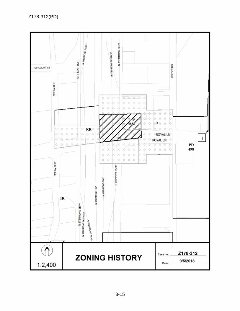
Z178-312(PD)
3-15
1

Z178-312(PD)
3-16
Vacant
Auto service center
Vacant
Freeway, Retail

Z178-312(PD)
3-17
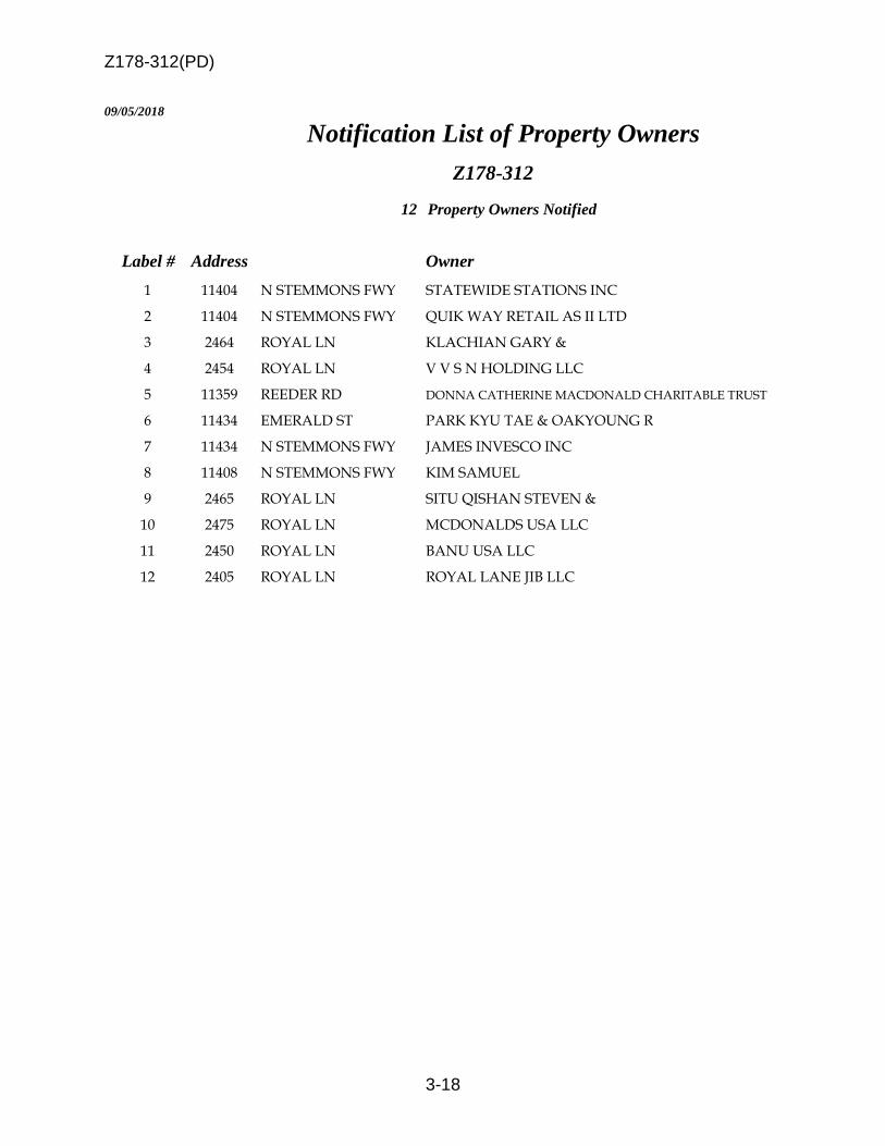
Z178-312(PD)
3-18
09/05/2018
Notification List of Property Owners
Z178-312
12 Property Owners Notified
Label # Address Owner
1 11404 N STEMMONS FWY STATEWIDE STATIONS INC
2 11404 N STEMMONS FWY QUIK WAY RETAIL AS II LTD
3 2464 ROYAL LN KLACHIAN GARY &
4 2454 ROYAL LN V V S N HOLDING LLC
5 11359 REEDER RD DONNA CATHERINE MACDONALD CHARITABLE TRUST
6 11434 EMERALD ST PARK KYU TAE & OAKYOUNG R
7 11434 N STEMMONS FWY JAMES INVESCO INC
8 11408 N STEMMONS FWY KIM SAMUEL
9 2465 ROYAL LN SITU QISHAN STEVEN &
10 2475 ROYAL LN MCDONALDS USA LLC
11 2450 ROYAL LN BANU USA LLC
12 2405 ROYAL LN ROYAL LANE JIB LLC

Z178-312(PD)
3-19
CD 13
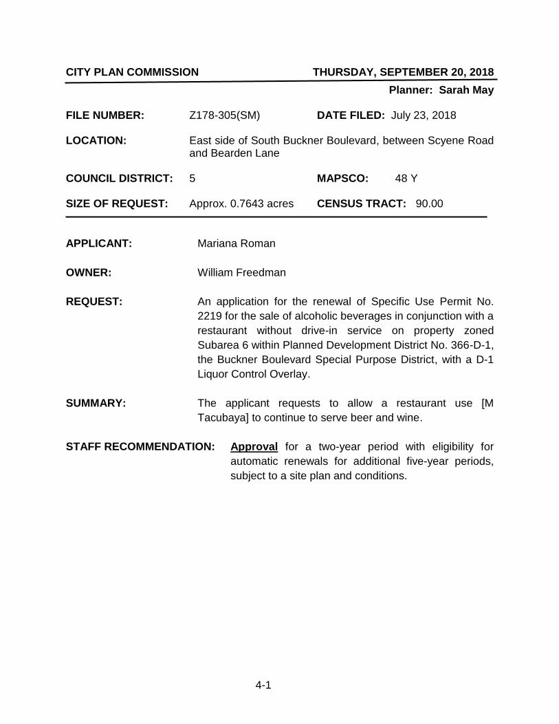
4-1
CITY PLAN COMMISSION THURSDAY, SEPTEMBER 20, 2018
Planner: Sarah May FILE NUMBER: Z178-305(SM) DATE FILED: July 23, 2018 LOCATION: East side of South Buckner Boulevard, between Scyene Road
and Bearden Lane COUNCIL DISTRICT: 5 MAPSCO: 48 Y SIZE OF REQUEST: Approx. 0.7643 acres CENSUS TRACT: 90.00
APPLICANT: Mariana Roman
OWNER: William Freedman
REQUEST: An application for the renewal of Specific Use Permit No.
2219 for the sale of alcoholic beverages in conjunction with a
restaurant without drive-in service on property zoned
Subarea 6 within Planned Development District No. 366-D-1,
the Buckner Boulevard Special Purpose District, with a D-1
Liquor Control Overlay.
SUMMARY: The applicant requests to allow a restaurant use [M
Tacubaya] to continue to serve beer and wine.
STAFF RECOMMENDATION: Approval for a two-year period with eligibility for
automatic renewals for additional five-year periods,
subject to a site plan and conditions.

Z178-305(SM)
4-2
BACKGROUND INFORMATION:
The request site that is developed within a multi-tenant, one-story, retail development and is located in a D-1 Liquor Control Overlay. The 1,200 square foot space is used for a restaurant without drive-in service. In addition, the proposed use uses a 433 square foot outdoor patio space.
The restaurant without drive-in service is permitted by right within Planned Development District No. 366. The D-1 Liquor Control Overlay requires a Specific Use Permit to serve alcoholic beverages within the use.
On November 9, 2016, City Council approved Specific Use Permit No. 2034 for the sale of alcoholic beverages in conjunction with a restaurant without drive-in service for a two-year period, subject to a site plan and conditions.
Zoning History: There has been one zoning change requested in the area during the past five years. 1. Z156-183: On August 9, 2017, City Council approved an amendment to Planned
Development District No. 366 on property located generally along both sides of South Buckner Boulevard from Heinan Drive and Hoyle Avenue on the north to the T. & N.O. Railroad on the south, and along Lake June Road between Carbona Drive on the west and Pleasant Drive on the east.
2. Z167-125: On February 22, 2017, City Council amended and renewed Specific Use Permit No. 2034 for the sale of alcoholic beverages in conjunction with a general merchandise or food store greater than 3,500 square feet for a five-year period with eligibility for additional five-year periods, subject to a site plan and conditions.
3. Z156-320: On November 9, 2016, City Council approved Specific Use Permit No.
2034 for the sale of alcoholic beverages in conjunction with a restaurant without drive-in service for a two-year period, subject to a site plan and conditions.
Thoroughfares/Streets:
Thoroughfare/Street Type Existing ROW
Proposed ROW
S. Buckner Boulevard Principal Arterial 80 ft. 80 ft.
COMPREHENSIVE PLAN: The forwardDallas! Comprehensive Plan was adopted by the City Council in June 2006. The forwardDallas! Comprehensive Plan outlines several goals and policies which can serve as a framework for assisting in evaluating the applicant’s request.

Z178-305(SM)
4-3
ECONOMIC ELEMENT GOAL 2.4 CREATE AND MAINTAIN AN ENVIRONMENT FRIENDLY TO
BUSINESSES AND ENTREPRENEURS
Policy 2.4.2 Restore Dallas as the premier city for conducting business within the region.
STAFF ANALYSIS: Surrounding Land Uses:
Zoning Land Use
Site Subarea 6, PDD No. 366 with a D-1 Retail and personal service
North Subarea 6, PDD No. 366 with a D-1 Restaurant, surface parking
South Subarea 6, PDD No. 366 with a D-1 Medical Clinic
East Subarea 6, PDD No. 366 with a D-1,
SUP No. 2034 General merchandise or food store
West Subarea 1, PDD No. 366 with a D-1 General merchandise or food store
Land Use Compatibility:
The site is developed with a one-story, multi-tenant retail development. The applicant
requests to continue to sell alcoholic beverages in an existing 1,200-square-foot
restaurant without drive-in service with a 423-square-foot outdoor patio. A Specific Use
Permit is required to serve alcoholic beverages in the D-1 Liquor Control Overlay. The
surrounding land uses consist of a variety of retail and personal service uses, and a
medical clinic.
The general provisions for a Specific Use Permit in Section 51A-4.219 of the Dallas
Development Code specifically state: (1) The SUP provides a means for developing
certain uses in a manner in which the specific use will be consistent with the character of
the neighborhood; (2) Each SUP application must be evaluated as to its probable effect
on the adjacent property and the community welfare and may be approved or denied as
the findings indicate appropriate; (3) The city council shall not grant an SUP for a use
except upon a finding that the use will: (A) complement or be compatible with the
surrounding uses and community facilities; (B) contribute to, enhance, or promote the
welfare of the area of request and adjacent properties; (C) not be detrimental to the
public health, safety, or general welfare; and (D) conform in all other respects to all
applicable zoning regulations and standards. The regulations in this chapter have been
established in accordance with a comprehensive plan for the purpose of promoting the
health, safety, morals, and general welfare of the city.

Z178-305(SM)
4-4
The continued sale of alcoholic beverages in conjunction with the existing restaurant
should not be a detriment to the adjacent properties because the Specific Use Permit
requires periodic review to ensure the site continues to comply with approved plans and
other regulations; therefore, staff supports the request.
Market Value Analysis
Market Value Analysis (MVA), is a tool to aid residents and policy-makers in
understanding the elements of their local residential real estate markets. It is an
objective, data-driven tool built on local administrative data and validated with local
experts. The analysis was prepared for the City of Dallas by The Reinvestment Fund.
Public officials and private actors can use the MVA to more precisely target intervention
strategies in weak markets and support sustainable growth in stronger markets. The
MVA identifies nine market types (A through I) on a spectrum of residential market
strength or weakness. As illustrated in the attached MVA map, the colors range from
purple representing the strongest markets to orange, representing the weakest markets.
Parking:
Pursuant to the Dallas Development Code, the off-street parking requirement for all
uses within the existing shopping center is 56 and 50 parking spaces are provided on
site. The applicant has provided staff with a parking agreement that shows the
additional six off-street parking spaces that are needed to meet the off-street parking
requirements. The additional off-street parking spaces are located on the south side of
Scyene Road, and north of the existing retail parking area. The distance between the
off-street parking where the request site is located and the additional six parking spaces
as identified on remote parking agreement is 225 feet.
Police Report:
Staff obtained the following list of offenses from the Dallas Police Department since
November 9, 2016.
Incident
No. Date Time Offense Description Premise MO
242893-
2017 10/22/2017
12:00:00
PM
Robbery-
individual Robbery
Parking Lot (All
Others)
Susp pointed a gun
at comp and took
comp's vehicle
111005-
2015 5/17/2015
9:20:00
AM
Alarm
incident
Alarm
incident
Restaurant/Food
Service/TABC False alarm

Z178-305(SM)
4-5
Location
1. USE: The only use authorized by this specific use permit is the sale of alcoholic beverages in conjunction with a restaurant without drive-in service.
2. SITE PLAN: Use and development of the Property must comply with the
attached site plan. 3. TIME LIMIT: This specific use permit expires on (two-year period from the
passage of this ordinance), but is eligible for automatic renewal for additional five-year periods, pursuant to Section 51A-4.219 of Chapter 51A of the Dallas City Code, as amended. For automatic renewal to occur, the Property owner must file a complete application for automatic renewal with the director before the expiration of the current period. Failure to timely file a complete application will render this specific use permit ineligible for automatic renewal. (Note: The Code currently provides that applications for automatic renewal must be filed after the 180th but before the 120th day before the expiration of the current specific use permit period. The Property owner is responsible for checking the Code for possible revisions to this provision. The deadline for applications for automatic renewal is strictly enforced) [November 9, 2018].
4. MAINTENANCE: The Property must be properly maintained in a state of good
repair and neat appearance. 5. GENERAL REQUIREMENTS: Use of the Property must comply with all federal
and state laws and regulations, and with all ordinances, rules, and regulations of the City of Dallas.
PROPOSED SUP No. 2219 AMENDMENT

Z178-305(SM)
4-6
EXISTING SITE PLAN
(no changes)
Request site that includes the outdoor patio space
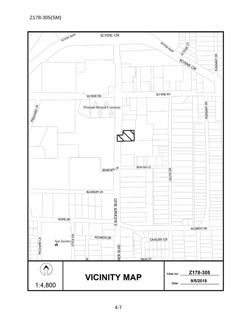
Z178-305(SM)
4-7

Z178-305(SM)
4-8
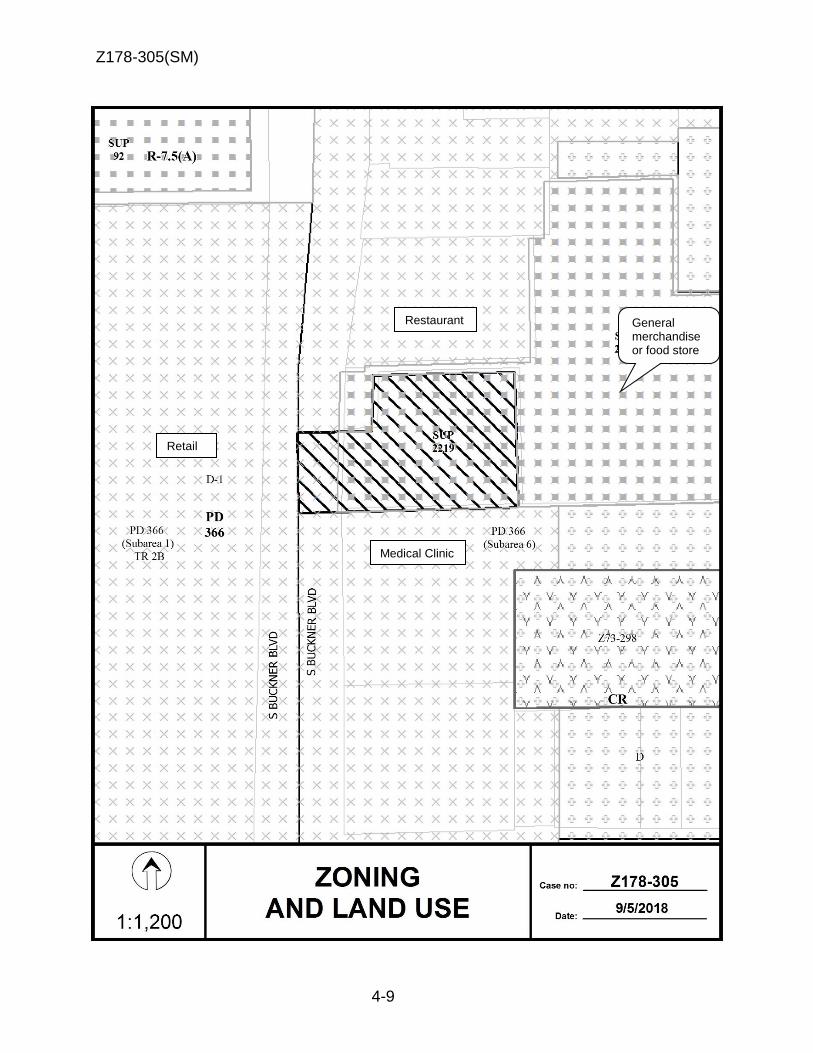
Z178-305(SM)
4-9
General merchandise or food store
Restaurant
Medical Clinic
Retail

Z178-305(SM)
4-10
3
1
2
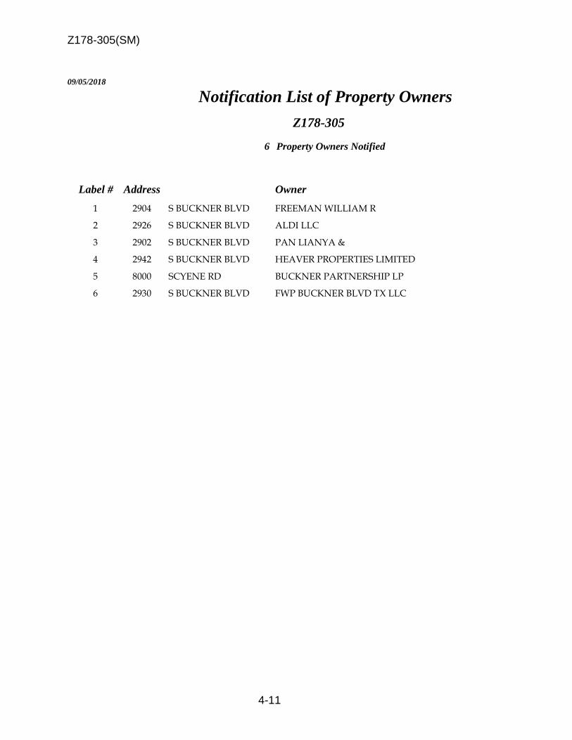
Z178-305(SM)
4-11
09/05/2018
Notification List of Property Owners
Z178-305
6 Property Owners Notified
Label # Address Owner
1 2904 S BUCKNER BLVD FREEMAN WILLIAM R
2 2926 S BUCKNER BLVD ALDI LLC
3 2902 S BUCKNER BLVD PAN LIANYA &
4 2942 S BUCKNER BLVD HEAVER PROPERTIES LIMITED
5 8000 SCYENE RD BUCKNER PARTNERSHIP LP
6 2930 S BUCKNER BLVD FWP BUCKNER BLVD TX LLC

Z178-305(SM)
4-12

5-1
CITY PLAN COMMISSION THURSDAY, SEPTEMBER 20, 2018
Planner: Sarah May FILE NUMBER: Z178-267(SM) DATE FILED: May 29, 2018 LOCATION: East line of Abrams Road and the northwest line of
Skillman Street COUNCIL DISTRICT: 13 MAPSCO: 27 S SIZE OF REQUEST: Approx. 6.586 acres CENSUS TRACT: 78.21 OWNER/APPLICANT: RPI Creekside II, Ltd.
REPRESENTATIVE: Roger Albright
REQUEST: An application for a CR Community Retail District with deed
restrictions volunteered by the applicant on property zoned
an R-7.5(A) Single Family District.
SUMMARY: The applicant proposes to construct a shopping center on
the currently undeveloped property. The proposed deed
restrictions prohibit certain uses and contain additional
restrictions to encourage development to be compatible with
White Rock Trail. In certain areas adjacent to Dallas Parks
and Recreation Department property, the proposed deed
restrictions also require building facades to contain 50
percent glass and prohibit loading and trash facilities.
STAFF RECOMMENDATION: Approval, subject to deed restrictions volunteered by
the applicant.

Z178-267(SM)
5-2
BACKGROUND INFORMATION:
The request site is currently undeveloped and is zoned an R-7.5(A) Single Family
District.
Zoning History: There has been no recent zoning changes requested in the area in
the last five years.
Thoroughfares/Streets:
Thoroughfare/Street Type Designation; ROW
Abrams Road Principal Arterial Standard 6 lanes, divided; 100 ft.
with bike lanes
Skillman Street Principal Arterial Standard 6 lanes, divided; 100 ft.
with bike lanes
Traffic:
The Engineering Division of the Sustainable Development and Construction Department
reviewed the proposed zoning and determined it will not have a negative impact on the
existing street system.
Comprehensive Plan:
The forwardDallas! Comprehensive Plan was adopted by the City Council in June 2006.
The forwardDallas! Comprehensive Plan outlines several goals and policies which can
serve as a framework for assisting in evaluating the applicant’s request.
ECONOMIC ELEMENT GOAL 2.1 PROMOTE BALANCED GROWTH Policy 2.1.1 Ensure that zoning is flexible enough to respond to changing
economic conditions.
URBAN DESIGN GOAL 5.3 ESTABLISHING WALK-TO CONVENIENCE
Policy 5.3.1 Encourage a balance of land uses within walking distance of each other.

Z178-267(SM)
5-3
STAFF ANALYSIS: Surrounding Land Uses:
Zoning Land Use
Site R-7.5(A) Floodplain
North R-7.5(A) Floodplain
East R-7.5(A) Floodplain and parkland
South CR Shopping center
West R-7.5(A) with SUP No. 70 and PDD No. 344 with D.
R. Z989-313
Commercial amusement (outside)
Land Use Compatibility:
The site is undeveloped, located in the floodplain, and contains extensive tree-canopy
cover. The applicant proposes to expand the shopping center, which abuts the site to
the south. Other surrounding uses include a commercial amusement (outside) use to
the west and Dallas Parks and Recreation Department (DPRD) property abuts the site
to the north and east. The DPRD property also contains a hike and bike trail (White
Rock Creek Trail) and floodplain.
Since the site contains many trees, is restricted with floodplain, and abuts two major
thoroughfares, the future development will require extensive tree mitigation, floodplain
review, civil engineering, and traffic analysis to obtain a permit. Therefore, staff was
primarily concerned with 1) the additional uses that would be allowed with the proposed
zoning change and 2) the compatibility of future buildings with the adjacent parkland.
The applicant proposes to prohibit certain uses that could be undesirable to surrounding
property owners and has offered to create a “Protection Zone” within the deed
restrictions in order to ensure future development develops in a manner in which it adds
interaction with the adjacent White Rock Creek Trail.
Staff supports the applicant’s request because 1) the applicant’s proposal to limit uses
would decrease the likelihood of nuisances to surrounding properties, 2) the “Protection
Zone” encourages development to orient patio dining and other public areas towards
the parkland, which would add “eyes” to the parkland, thereby making it safer for public
use.
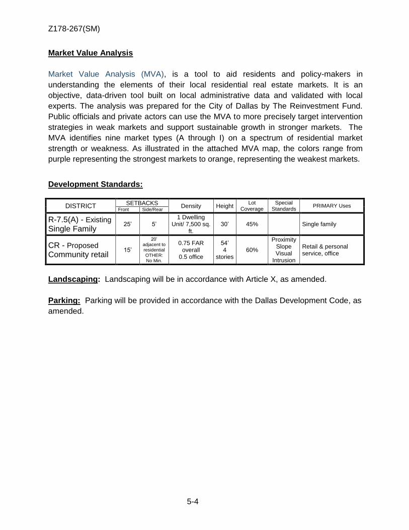
Z178-267(SM)
5-4
Market Value Analysis
Market Value Analysis (MVA), is a tool to aid residents and policy-makers in
understanding the elements of their local residential real estate markets. It is an
objective, data-driven tool built on local administrative data and validated with local
experts. The analysis was prepared for the City of Dallas by The Reinvestment Fund.
Public officials and private actors can use the MVA to more precisely target intervention
strategies in weak markets and support sustainable growth in stronger markets. The
MVA identifies nine market types (A through I) on a spectrum of residential market
strength or weakness. As illustrated in the attached MVA map, the colors range from
purple representing the strongest markets to orange, representing the weakest markets.
Development Standards:
DISTRICT SETBACKS
Density Height Lot
Coverage Special
Standards PRIMARY Uses
Front Side/Rear
R-7.5(A) - Existing Single Family
25’ 5’ 1 Dwelling
Unit/ 7,500 sq. ft.
30’ 45% Single family
CR - Proposed Community retail
15’
20’ adjacent to residential OTHER: No Min.
0.75 FAR overall
0.5 office
54’ 4
stories 60%
Proximity Slope Visual
Intrusion
Retail & personal service, office
Landscaping: Landscaping will be in accordance with Article X, as amended.
Parking: Parking will be provided in accordance with the Dallas Development Code, as
amended.
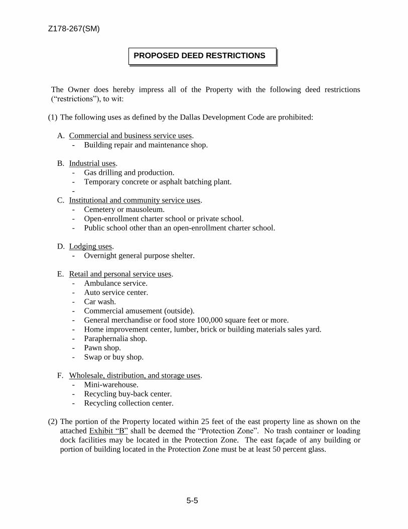
Z178-267(SM)
5-5
The Owner does hereby impress all of the Property with the following deed restrictions
(“restrictions”), to wit:
(1) The following uses as defined by the Dallas Development Code are prohibited:
A. Commercial and business service uses.
- Building repair and maintenance shop.
B. Industrial uses.
- Gas drilling and production.
- Temporary concrete or asphalt batching plant.
-
C. Institutional and community service uses.
- Cemetery or mausoleum.
- Open-enrollment charter school or private school.
- Public school other than an open-enrollment charter school.
D. Lodging uses.
- Overnight general purpose shelter.
E. Retail and personal service uses.
- Ambulance service.
- Auto service center.
- Car wash.
- Commercial amusement (outside).
- General merchandise or food store 100,000 square feet or more.
- Home improvement center, lumber, brick or building materials sales yard.
- Paraphernalia shop.
- Pawn shop.
- Swap or buy shop.
F. Wholesale, distribution, and storage uses.
- Mini-warehouse.
- Recycling buy-back center.
- Recycling collection center.
(2) The portion of the Property located within 25 feet of the east property line as shown on the
attached Exhibit “B” shall be deemed the “Protection Zone”. No trash container or loading
dock facilities may be located in the Protection Zone. The east façade of any building or
portion of building located in the Protection Zone must be at least 50 percent glass.
PROPOSED DEED RESTRICTIONS

Z178-267(SM)
5-6
PROPOSED EXHIBIT B TO
DEED RESTRICTIONS
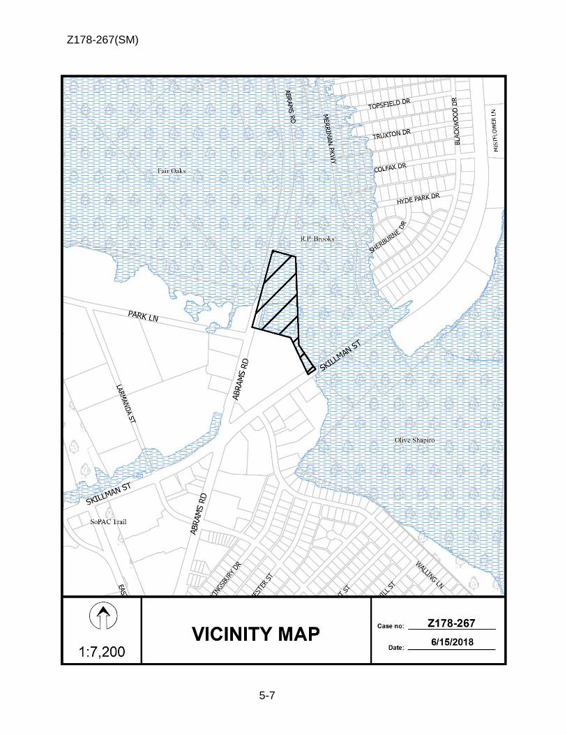
Z178-267(SM)
5-7

Z178-267(SM)
5-8

Z178-267(SM)
5-9
Shopping center
Undeveloped
Floodplain and Parkland
R-10(A)
R-10(A)
Commercial amusement
(outside)
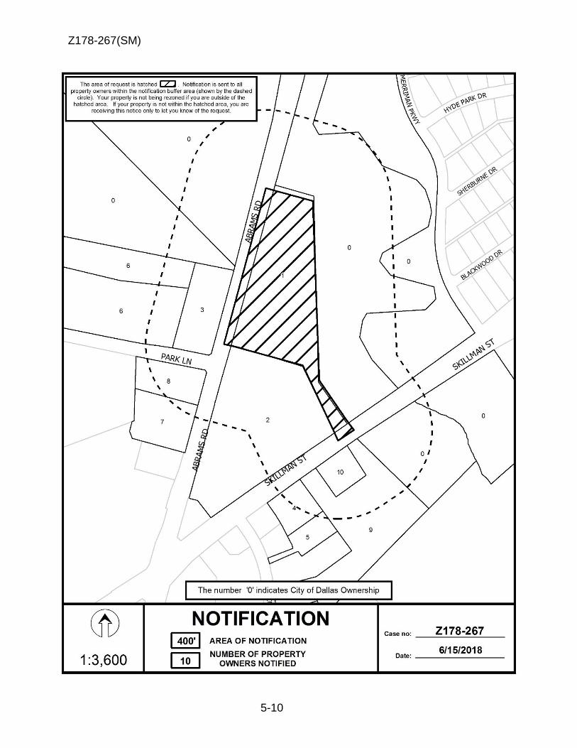
Z178-267(SM)
5-10

Z178-267(SM)
5-11
06/15/2018
Notification List of Property Owners
Z178-267
10 Property Owners Notified
Label # Address Owner
1 6800 ABRAMS RD RPI CREEKSIDE II LTD
2 6770 ABRAMS RD RPI SKILLMAN ABRAMS S C LTD
3 6801 ABRAMS RD CARUTH EARLE CLARK TRUST
4 6616 SKILLMAN ST NEWMAN ROSE CO
5 6824 WALLING LN PRESTRIDGE JEANNE JEANETTE
6 8787 PARK LN CARUTH EARLE CLARK TRUST
7 6751 ABRAMS RD J EVANS FAMILY PS KNOX LTD
8 6769 ABRAMS RD IM & AY LLC
9 6640 SKILLMAN ST SECURITY PORTFOLIO IV LP
10 6666 SKILLMAN ST DRKZ INC

Z178-267(SM)
5-12

6-1
CITY PLAN COMMISSION THURSDAY, SEPTEMBER 20, 2018
Planner: Jennifer Muñoz
FILE NUMBER: Z178-288(JM) DATE FILED: June 25, 2018 LOCATION: Northwest corner of Telephone Road and Bonnie View Road COUNCIL DISTRICT: 8 MAPSCO: 76 G SIZE OF REQUEST: ±70.1 acres CENSUS TRACT: 167.03 APPLICANT: RPG Acquisitions, LLC OWNER: Clemmie Skief; and, John H. Adams and Dolly D. Adams REPRESENTATIVE: Rob Baldwin, Baldwin and Associates
REQUEST: An application for an LI Light Industrial District on property zoned an A(A) Agricultural District.
SUMMARY: The purpose of this request is to allow for the development of
warehouse uses. Residential uses would no longer be allowed.
STAFF RECOMMENDATION: Approval

Z178-288(JM)
6-2
BACKGROUND INFORMATION:
The 70.0-acre request site is zoned an A(A) Agricultural District and is largely undeveloped with a few single family houses located at the northeast corner of the property, and along Telephone Road.
The warehouse land use is defined as a wholesale, distribution, and storage use in the Dallas Development code. This land use is allowed by right in the proposed LI Light Industrial District.
The proposed LI Light Industrial District would add a multitude of new uses, including commercial and business service; office; lodging; retail and personal service; and, wholesale, distribution, and storage uses.
Zoning History: There have been six zoning requests in the surrounding area in the past five years:
1. Z134-329: On April 22, 2015, the City Council approved an application for an LI Light Industrial District and Specific Use Permit No. 2145 for a commercial motor vehicle parking on property zoned an A(A) Agricultural District at the southwest corner of Telephone Road and Bonnie View Road.
2. Z156-354: On January 11, 2017, the City Council approved an application granting a CS Commercial Service District and Specific Use Permit No. 2221 for a tattoo studio on property within the Subdistrict 1A portion of Planned Development District No. 621, the Old Trinity and Design District Special Purpose, located on the south line of East Levee Street, between Manufacturing Street and Express Street.
3. Z167-243: On August 23, 2017, the City Council approved an application granting a CS Commercial Services District and deed restrictions volunteered by the applicant on property zoned an A(A) Agricultural District, south of Telephone Road, east of Travis Trail.
4. Z167-253: On June 28, 2017, the City Council approved an application granting a CS Commercial Service District and Specific Use Permit No. 2248 for a commercial motor vehicle parking on property zoned an A(A) Agricultural District, on the west line of Bonnie View Road, south of Telephone Road.
5. Z178-211: An application for the renewal of Specific Use Permit No. 2140 for a child care facility use on property zoned R-7.5(A) Single Family District, located on the northwest corner of Bonnie View Road and Cleveland Road. Pending resubmittal.
6. Z178-246: On August 8, 2018, the City Council approved an application for a CS Commercial Services District on property zoned an A(A) Agricultural District, located south of Telephone Road, east of Travis Trail.

Z178-288(JM)
6-3
Thoroughfares/Streets:
Traffic:
The Engineering Division of the Sustainable Development and Construction Department has reviewed the request and determined that it will not significantly impact the surrounding roadway system. STAFF ANALYSIS:
Comprehensive Plan:
The forwardDallas! Comprehensive Plan was adopted by the City Council in June 2006. The forwardDallas! Comprehensive Plan outlines several goals and policies which can serve as a framework for assisting in evaluating the applicant’s request. The request complies with the following land use goals and policies of the Comprehensive Plan: LAND USE ELEMENT GOAL 1.2 PROMOTE DESIRED DEVELOPMENT
Policy 1.2.1 Use Vision Building Blocks as a general guide for desired development patterns.
The Vision identifies the area as an Industrial Building Block. Industrial Areas, which offer important employment opportunities, occupy large areas of land and usually are near major roads and heavy rail lines. This request is characteristic of the building block in that it will provide a service to the mix of low- and medium-density industrial buildings and industrial yards supporting the Southport and the Agile Port, parts of West Dallas along I-30, and the Stemmons industrial area. ECONOMIC ELEMENT GOAL 2.1 PROMOTE BALANCED GROWTH
Policy 2.1.4 Support efforts to expand targeted business and industry development within the Southern Sector. Policy 2.2.4 Focus on logistics-related jobs for the expansion of employment opportunities, particularly in the Southern Sector.
Thoroughfare/Street Type Existing ROW Proposed ROW
Bonnie View Road Major Arterial 100 feet 100 feet
Telephone Road Minor Arterial 80 feet 80 feet

Z178-288(JM)
6-4
Dallas’ future development opportunities and much of the projected growth capacity lie in the Southern Sector, offering a great opportunity to guide development and direct economic activity. The vast majority of vacant land in the city is located in the Southern Sector. As such, developments similar to this are necessary in order to promote and encourage efforts for continued investment in these underutilized areas of the city.
Land Use Plan:
The site is located within the Agile Port Industrial Plan Area site as identified by the forwardDallas! Comprehensive Plan adopted by the City Council in June 2006. This area is considered to be a highly sophisticated information-based industry that seeks to minimize inventories and respond to the growing demand for next-day or even several-times a day delivery. Shifts in the warehousing and logistics industry have been accelerated by global trade, containerization and standardized packaging, just-in-time (JIT) inventory management, outsourcing delivery and increased technological capabilities. The result has been a heightened emphasis on economies of scale leading to the emergence of “superhub” distribution locations. This is what the Southern Sector’s Agile Port Industrial Area is striving to become—an intermodal freight facilities complex that can move goods from one transportation system to another (eg. rail to truck) on a huge scale. The proposed distribution warehouse use is an element of this development.
Surrounding Land Uses:
Zoning Land Use
Site A(A) Single Family and Undeveloped land
Northwest PD No. 980 and A(A) Crop Production, Single Family, and Undeveloped land
Northeast A(A) and R-7.5(A), SUP No. 2140
Crop Production, Single Family, Undeveloped land, and Child-care Facility
Southeast PD No. 761, LI and SUP No. 2145, CS and SUP No. 2248
Single Family, Undeveloped land, Truck Sales and Service, and Commercial Motor Vehicle Parking
Southwest A(A) and CS w/DRs
Commercial Motor Vehicle Parking, Undeveloped land, and Single Family
Land Use Compatibility:
The subject site is largely undeveloped, with a few single family houses located at the northeast corner of the property, and along Telephone Road. Surrounding land uses consist of crop production, single family, and undeveloped land to the northeast and northwest; a child-care facility to the northwest; single family, undeveloped land, truck

Z178-288(JM)
6-5
sales and service, and commercial motor vehicle parking to the southeast; and, commercial motor vehicle parking, undeveloped land, and single family to the southwest. The area of request is fully surrounded by PD No. 980 for commercial and business service and industrial uses to the northwest, A(A) Agricultural District to the west, north, east, and south, with LI Light Industrial District further west, and PD No. 761 (for LI uses), The Dallas Logistics Port Special Purpose District, to the southeast. The subject site is currently zoned an A(A) Agricultural District. The Dallas Development Code describes the purpose of this district as largely transformational. As the area develops with utilities and resources become available, the area changes based on development needs. The proposed LI Light Industrial District is described as being to provide for light industrial office, research and development, and commercial uses in an industrial park setting. This district is designed to be located in areas appropriate for industrial development which may be adjacent to residential communities. Upon visiting the site, it was evident that the area is shifting to an industrial nature; however, since the A(A) District allowed for development of single family residences, there are pockets of residential uses nearby. The proposed LI Light Industrial District is complementary to the surrounding trend in land uses shifting from A(A) District uses to industrial uses including PD No. 980 to the north and PD No. 761 (for LI uses), the Dallas Logistics Port Special Purpose District, to the southeast.
Market Value Analysis
Market Value Analysis (MVA), is a tool to aid residents and policy-makers in understanding the elements of their local residential real estate markets. It is an objective, data-driven tool built on local administrative data and validated with local experts. The analysis was prepared for the City of Dallas by The Reinvestment Fund. Public officials and private actors can use the MVA to more precisely target intervention strategies in weak markets and support sustainable growth in stronger markets. The MVA identifies nine market types (A through I) on a spectrum of residential market strength or weakness. As illustrated in the attached MVA map, the colors range from purple representing the strongest markets to orange, representing the weakest markets.
Development Standards:
District Setbacks Height Lot
Coverage Special
Standards Primary Uses
Front Side/Rear
Existing:
A(A) 50’
20’ side 50’ rear
24’ 10-25% 1 DU per 3
acres Agricultural & single family.
Proposed:
LI 15’
30’ adj. to res. (not including
A(A)) 0’ all others
70’ 80% RPS
Commercial & business service, industrial, institutional, retail & personal
service, wholesale, distribution, and storage, and office.

Z178-288(JM)
6-6
Land Use Comparison: Proposed Existing
Use LI A (A)
Animal production. X
Commercial stable. X
Building repair and maintenance shop. RAR
Bus or rail transit vehicle maintenance or storage facility. RAR
Catering service. X
Commercial bus station and terminal. X
Commercial cleaning or laundry plant. RAR
Custom business services. X
Custom woodworking, furniture construction, or repair. X
Electronics service center. X
Job or lithographic printing. RAR
Labor hall. SUP
Machine or welding shop. RAR
Machinery, heavy equipment, or truck sales and services. RAR
Medical or scientific laboratory. X
Technical school. X
Tool or equipment rental. X
Vehicle or engine repair or maintenance. X
Alcoholic beverage manufacturing. RAR
Industrial (inside) for light manufacturing. X
Inside industrial. RAR
Mining. SUP
Organic compost recycling facility. SUP
Adult day care facility. X SUP
Child-care facility. X SUP
Convalescent and nursing homes, hospice care, and related institutions.
SUP
Halfway house. SUP
Convent or monastery. X
Foster home. SUP
Library, art gallery, or museum. SUP
Extended stay hotel or motel. SUP
Hotel or motel. RAR or SUP

Z178-288(JM)
6-7
Land Use Comparison: Proposed Existing
Use LI A (A)
Lodging or boarding house. X
Overnight general purpose shelter. Check use.
Attached non-premise sign. SUP
Alternative financial establishment. SUP
Financial institution without drive-in window. X
Financial institution with drive-in window. RAR
Medical clinic or ambulatory surgical center. X
Office. X
Country club with private membership. X SUP
Private recreation center, club, or area. X SUP
College dormitory, fraternity, or sorority house. X
Handicapped group dwelling unit. Check use.
Single family. X
Alcoholic beverage establishments. Check use.
Animal shelter or clinic with outside run. Check use. SUP
Auto service center. RAR
Business school. X
Car wash. RAR
Commercial amusement (inside). Check use.
Commercial amusement (outside). X
Drive-in theater. SUP
Dry cleaning or laundry store. X
Furniture store. X
General merchandise or food store 3,500 square feet or less. X
General merchandise or food store 100,000 square feet or more. SUP
Home improvement center, lumber, brick or building materials sales yard.
RAR
Household equipment and appliance repair. X
Liquefied natural gas fueling station. Check use.
Nursery, garden shop, or plant sales. X
Motor vehicle fueling station. X
Paraphernalia shop. SUP
Personal service uses. X

Z178-288(JM)
6-8
Land Use Comparison: Proposed Existing
Use LI A (A)
Restaurant without drive-in or drive-thru service. RAR
Restaurant with drive-in or drive-through service. DIR
Taxidermist. X
Temporary retail use. X
Theater. X
Truck stop. SUP
Vehicle display, sales, and service. RAR
Commercial bus station and terminal. RAR
Heliport. SUP
Railroad passenger station. SUP
Transit passenger station or transfer center. Check use. SUP
Electrical substation. X SUP
Police or fire station. X SUP
Post office. X
Radio, television, or microwave tower. RAR SUP
Tower/antenna for cellular communication. Check use. Check use.
Water treatment plant. SUP
Freight terminal. RAR
Livestock auction pens or sheds. SUP
Manufactured building sales lot. RAR
Mini-warehouse. X
Office showroom/warehouse. X
Outside storage. RAR
Recycling buy-back center. Check use.
Recycling collection center. Check use.
Recycling drop-off container. Check use. Check use.
Recycling drop-off for special occasion collection. Check use. Check use.
Sand, gravel, or earth sales and storage. SUP
Trade center. X
Warehouse. RAR
X indicates permitted by right. SUP indicates permitted with a Specific Use Permit. RAR indicates permitted, but subject to Residential Adjacency Review. Check use indicates special provisions in Sec.51A-4.200.
Alternating color pattern indicates a new category of uses as separated in the Dallas Development Code.

Z178-288(JM)
6-9
Parking:
Pursuant to the Dallas Development Code, off-street parking must be provided in accordance with Division 51A-4.200. A warehouse use will require one space per 1,000 square feet of floor area up to 20,000 square feet, and one space per 4,000 square feet of floor area over 20,000 square feet. A general zone change application does not require the submittal of a site/development plan; therefore, this is an estimate of what could be required based upon the information provided by the applicant.
Landscaping:
Landscaping must be provided in accordance with the landscaping requirements in Article X, as amended.

Z178-288(JM)
6-10

Z178-288(JM)
6-11

Z178-288(JM)
6-12

Z178-288(JM)
6-13
Child-care
Facility
Undeveloped
Single Family Crop
Production
Commercial MV Parking
Truck Sales and Service
Single Family
Crop Production
Single Family
Commercial MV Parking
Single Family
Undeveloped
Undeveloped
Undeveloped
Single Family
Single Family

Z178-288(JM)
6-14
3
6
1
4
5
2

Z178-288(JM)
6-15
CD 13

Z178-288(JM)
6-16
08/20/2018
Notification List of Property Owners
Z178-288
30 Property Owners Notified
Label # Address Owner
1 4041 TELEPHONE RD ADAMS JOHN H
2 4243 CLEVELAND RD SKIEF CLEMMIE
3 4125 TELEPHONE RD SKIEF CLEMMIE
4 4200 CLEVELAND RD SKIEF CLEMMIE
5 8900 BONNIE VIEW RD LINICOMN VERNON
6 9100 TELEPHONE RD TEXAS UTILITIES ELEC CO
7 4200 CLEVELAND RD KAMY REAL PPTY TRUST
8 4188 CLEVELAND RD BANKS WILFRED JR
9 4101 CLEVELAND RD ARNOLD RODNEY B
10 8825 BONNIE VIEW RD COLEMAN JANICE
11 8821 BONNIE VIEW RD SALAZAR SAQUEO & PATRICIA
12 4241 CLEVELAND RD HARDMON ADDYS
13 8829 BONNIE VIEW RD GUEVARA FIDEL
14 8837 BONNIE VIEW RD MITCHELL ANDRE D &
15 3925 TELEPHONE RD SPRINGFUL PROPERTIES LLC
16 3845 TELEPHONE RD TEJAS INVESTORS
17 3935 TELEPHONE RD VILLEGAS MARCELINO
18 4200 CLEVELAND RD SKIEF CLEMMIE
19 3900 CEDARDALE RD CEDARDALE PHASE I LLC
20 9300 BONNIE VIEW RD DLH MASTER LAND HOLDING LLC
21 3918 TELEPHONE RD ROBERTS QUINCY
22 9600 TRAVIS TRL ROBERTS QUINCY
23 4100 TELEPHONE RD FENNER PAT &
24 9000 BONNIE VIEW RD STAFFORD KATHLEEN
25 3400 CEDARDALE RD MARTINEZ FERNANDO
26 4050 TELEPHONE RD FENNER PAT

Z178-288(JM)
6-17
08/20/2018
Label # Address Owner
27 4200 TELEPHONE RD SOTO JUAN CARLOS CRUZ
28 4200 TELEPHONE RD BENSON FREDDIE LEE &
29 4200 TELEPHONE RD GARCIA JAIME
30 9300 BONNIE VIEW RD NOSHAHI MOHAMMAD H

Z178-288(JM)
6-18

7-1
CITY PLAN COMMISSION THURSDAY, SEPTEMBER 20, 2018
Planner: Jennifer Muñoz
FILE NUMBER: Z178-235(JM) DATE FILED: April 16, 2018 LOCATION: Southwest corner of North Tennant Street and West Davis Street COUNCIL DISTRICT: 1 MAPSCO: 53 D SIZE OF REQUEST: ±0.60 acres CENSUS TRACT: 45.00 APPLICANT/OWNER: 517 Tennant, LLC REPRESENTATIVE: Rob Baldwin, Baldwin and Associates
REQUEST: An application for a Planned Development District for Multifamily District uses on property zoned an R-7.5(A) Single Family District.
SUMMARY: The purpose of the request is to allow for a 16-unit single
family, shared access development. A PD is requested to modify the following standards from the R-7.5(A) District requirements: (1) reduce the required front yard to 15 feet along West Davis Street and 25 feet along North Tennant Street, both with six-foot encroachments; (2) exempt balconies from side/rear setbacks; (3) increase maximum height to 42 feet and four stories; (4) increase lot coverage to 60 percent; (5) require no minimum lot size; and (6) add design standards.
STAFF RECOMMENDATION: Approval, subject to a development plan and
conditions.
PRIOR CPC ACTION: On August 16, 2018, the CPC held this item under
advisement to allow for additional review and
communication with the neighborhood.
CD 13
Z178-235(JM)
7-2
BACKGROUND INFORMATION:
The request is now solely for single family, shared access development. Conditions have been modified to allow R-7.5(A) Single Family District uses. A 25-foot front yard setback is now provided on North Tennant Street. Lot coverage has been reduced to 60 percent. For a shared access development, the shared access area may be used to determine lot coverage.
The 0.60-acre site is vacant. Aerial photography shows the site has been largely vacant since the 1950s (earliest available aerial).
The purpose of the request is to allow for a 16-unit single family, shared access development. A PD is requested to modify the following standards from the R-7.5(A) District requirements:
(1) Reduce the required front yard to 15 feet along West Davis Street and 25 feet along North Tennant Street, both with six-foot encroachments;
(2) Exempt balconies from side/rear setbacks;
(3) Increase max height to 42 feet and four stories;
(4) Increase lot coverage to 60 percent;
(5) Allow no minimum lot size; and
(6) Add design standards.
Zoning History: There have been no zoning cases in the area over the past five years.
Thoroughfares/Streets:
Traffic:
The Engineering Division of the Sustainable Development and Construction Department has reviewed the request and determined that it will not significantly impact the surrounding roadway system.
Thoroughfare/Street Type Existing ROW Proposed ROW
North Tennant Street Local 50 feet 50 feet
West Davis Street Local 100 feet 80 feet

Z178-235(JM)
7-3
STAFF ANALYSIS:
Comprehensive Plan:
The forwardDallas! Comprehensive Plan was adopted by the City Council in June 2006. The forwardDallas! Comprehensive Plan outlines several goals and policies which can serve as a framework for assisting in evaluating the applicant’s request. The applicant’s request generally complies with the following goals and policies of the Comprehensive Plan. URBAN DESIGN GOAL 5.1 PROMOTE A SENSE OF PLACE, SAFETY AND WALKABILITY
Policy 5.1.3 Encourage complementary building height, scale, design and character. Implementation Measure 5.1.3.2 Amend the Dallas zoning regulations to establish urban design standards that reflect quality design and good land use principles through regulations which address height, scale, bulk and massing of new development. Standards will also address the impact of parking lots and structures to minimize spillover to adjacent neighborhoods, mitigate any negative effects and eliminate visual intrusion or incompatibility with the adjacent residential neighborhoods, historic or conservation districts.
GOAL 5.2 STRENGTHEN COMMUNITY AND NEIGHBORHOOD IDENTITY
Policy 5.2.1 Maintain neighborhood scale and character. NEIGHBORHOOD PLUS
Policy 4.3 Enhance neighborhood desirability by improving infrastructure, housing stock, recreation and safety.
The proposed single family, shared access development use adds diversity in housing options. The modifications to the district standards requested are fitting for the site and maintain the overall scale and character of the neighborhood, while adding urban design features through architectural standards to enhance the facades of the proposed structures.
Z178-235(JM)
7-4
Surrounding Land Uses:
Zoning Land Use
Site R-7.5(A) Undeveloped
North R-7.5(A), PD No. 830,
Subdistrict 6, and PD No. 768
Single family, Restaurant w/drive-through, and
Undeveloped
East PD No. 830, Subdistrict 6 Multifamily
South
R-7.5(A) and PD No. 830,
Subdistrict 6 w/D-Liquor
Control Overlay
Single family
West PD No. 830, Subdistrict 6
w/D-Liquor Control Overlay Restaurant and Retail and personal service
Land Use Compatibility:
Initially, the purpose of the request was to allow for a 16-unit multifamily development or single family, shared access development. To promote flexibility in development, the proposed standards for the site would have allowed either a single family shared access development, or a multifamily development, subject to the proposed development plan. However, the case was held under advisement at CPC on August 16, 2018, to allow further communication with the neighborhood. The applicant has reduced the request to solely provide for a single family, shared access development. The request was noticed to the public as a PD for MF-2(A) uses; therefore, the request remains, and the conditions have been made more restrictive to only allow R-7.5(A) uses. Additional changes include a revised 25-foot front yard setback on North Tennant Street, reduced lot coverage from 70 to 60 percent, and for a shared access development, the shared access area may be used to determine lot coverage. This standard is typical in shared access developments for uses other than single family.
The 0.60-acre site is vacant. According to City records, no Certificates of Occupancy have been issued for the site. Aerial photography for the site indicate that the site has remained largely undeveloped since the 1950s.
Surrounding land uses include single family, restaurant with a drive through, and undeveloped to the north; multifamily to the east; single family to the south; and, restaurant without a drive through, and commercial development including retail and personal service uses to the west.
The purpose of the request is to allow for a 16-unit single family, shared access development. For a shared access development, the shared access area (easement) must have a minimum width of 22 feet, as noted on the development plan. Additionally, the shared access driveways can count in the lot coverage calculations per lot.

Z178-235(JM)
7-5
Development Standards:
DISTRICT SETBACKS
Density Height Lot
Coverage PRIMARY Uses
Front Side/Rear
Existing: R-7.5(A)
25’ w/up to 12”
projections
5’ SF OTHER:
10’ and 15’
One dwelling unit per lot. Minimum 7,500
sq. .6 acres/7,500 sq.ft. is
3 dwelling units
30’ No max stories
45% res. 25%
nonres.
RPS
Single family.
Proposed: PD for R-7.5(A) District Uses
15’ on W. Davis and 25’ on N. Tennant
Encroach-
ments up to 6’ for both
5’ and 5’ Balcony
encroach-ment.
16 dwelling units on 0.6 acres (27 dwelling
units per acre)
42’ 4 stories
60% res. 50%
nonres.
No RPS
Single family shared access.
The site is currently zoned an R-7.5(A) Single Family District. The current request is for a Planned Development District for R-7.5(A) District uses. The table above identifies the existing and proposed zoning district standards.
A PD is requested to modify the following standards from the R-7.5(A) District requirements:
(1) Reduce the required front yard to 15 feet on West Davis Street and 25 feet on North Tennant Street, both with six-foot encroachments:
The front yard setback in the existing single family zoning district is 25 feet. The subject site, with 164 feet of frontage along West Davis Street and 161 feet of frontage along North Tennant Street and ingress/egress planned on both streets, has two front yards. Block continuity would typically require development to conform to front yard setbacks established by the most restrictive zoning district within the block. The front yard setback would be 25 feet along North Tennant Street and between 0 and 10 feet along West Davis Street.
The property to the south has a 25-foot setback with up to five-foot encroachments for cantilevered roof eaves and balconies. The subject site is separated from this district by a 15-foot alley. The separation of the lots with the alley lends to the request to provide a 25-foot front yard with up to six-foot encroachments for cantilevered roof eaves, unenclosed porches, stairs, stoops, and awnings. The additional encroachment of one-foot is minimal and will be indistinguishable beside the 15-foot alley. This also supports the intent to have street facing entries for units with frontage along North Tennant Street, adding to the residential sense of the remainder of the block to the south.
The properties to the west and east are zoned Subdistrict 6 within PD No. 830 with a minimum front yard setback of 0 feet and a maximum of 10 feet on West Davis Street. Existing structures to the west were constructed before the adoption of PD No. 830 and do not comply with the required front yard setback requirements. As the area

Z178-235(JM)
7-6
redevelops, such as the subject site, consideration of the PD No. 830 standards is crucial for adequate site planning. The property across North Tennant Street to the east contains a multifamily use erected in 1949, predating the PD No. 830 ordinance as well, and seems to provide about 20 feet of front yard setback along West Davis Street and between 30 to 60 feet along North Tennant Street.
(2) Exempt balconies from side/rear setbacks:
The site has two side yards. One is facing the 15-foot alley separating the proposed development from existing single family structures. The other side yard is facing retail and personal service uses, westward toward Hampton Road. This request would allow up to a 0-foot separation from the property line onto the balcony structures. The properties to the south still have 15 feet of separation from the alley, with the R-7.5(A) District requiring a five-foot separation for single family uses and 10-feet for all other permitted structures. The property to the west requires no side or rear yard setback.
Staff believes that the intent of the surrounding zoning districts is met along with the request to allow balconies to encroach up to five feet (the required side yard setback).
(3) Increase max height to 42 feet and four stories:
The R-7.5(A) District allows a maximum height of 30 feet with no maximum stories and typically, RPS applies at a one-to-three ratio. The R-7.5(A) District allows a maximum height of 30 feet with no maximum stories and RPS applies at a one-to-three ratio. PDs are allowed to set height regulations, including whether or not RPS should apply. While the maximum request is for a height of up to 42 feet and four stories with no RPS, the conditions further restrict the units along the alley separation facing the single family neighborhood to the south to 26 feet and two stories, essentially requiring RPS for the block, but not across West Davis Street.
The properties to the west and east are restricted to a maximum height of 50 feet, which means RPS is not triggered by these sites. However, the RPS standard could be triggered from the R-7.5(A) District to the north across West Davis Street and adjacent to the south at a rate of one-to-three, according to the definition prescribed in Sec. 51(A)-4.412, except for that RPS is not generated from within a zoning district. The subject site is zoned similarly to the properties to the north across West Davis Street.
Overall, the redevelopment of the site with only 26 feet-in-height and two stories along the southern border lends to the intent of maintaining the RPS, while providing flexibility in design of the units. The site was really a leave-out along the West Davis Street frontage for PD No. 830. With the aforementioned district standards a maximum height of 50 feet to the east and west, the request for a maximum of 42 feet-in-height along the West Davis Street frontage seems appropriate.
(4) Increase lot coverage to 60 percent and for a shared access development, the shared access area may be used to determine lot coverage:
The request is to allow the lot coverage to increase from 45 percent [R-7.5(A)] to 60 percent. This coincides with higher density districts like the MF-2(A) standard of 60 percent. Additionally, 60 percent seems to be a middle ground between the PD No. 830
Z178-235(JM)
7-7
standard of 80 percent for the properties adjacent to the west and across North Tennant Street for the east.
Shared access developments for uses other than single family allow for the shared access area, or driveways, to count in the determination of lot coverage. The request is to keep this standard, despite restricting the use to solely single family uses. Staff finds this to be more appropriate than the original request of including this standard, plus 70 percent lot coverage as last requested.
(5) Allow no minimum lot size:
The purpose behind not requiring a minimum lot size is to allow flexibility in design. A shared access development would offer ownership of individual lots with existing regulations referring to the Dallas Development Code and requiring each lot to meet the requirements of the zoning district. For a shared access development in an R-7.5(A) District, the minimum lot size is 7,500 square feet. A maximum of five lots would be allowed.
The current request is for 16 dwelling units on 0.60-acres or 26,136 square feet of lot area or roughly three-times the typical density for R-7.5(A). That equates to approximately 27 dwelling units per acre. However, the location of the subject site, adjacent to commercial, multifamily, and with frontage along West Davis Street, lends to the request of providing a higher density, single family project.
(6) Added design standards include:
a. All dwelling units with street frontage along West Davis Street and North Tennant Street must have individual entries that face the street with direct access to the street from an improved path connecting to the sidewalk.
This standard will ensure the front yard remains intact. Additionally, the residential feel of the neighborhood will be preserved.
b. All main structures must have a gable, hip, or gambrel roof as part of the roof structure and style. Street-facing facades must have a minimum of four design elements.
The design standards ensure the traditional, residential feel of the neighborhood is maintained. The extra design features along street frontages add character.
c. All street-facing facades must provide a minimum transparency of 40 percent.
Transparency ensures that the neighborhood will not appear closed, adding to the urban nature of the area.
d. A minimum sidewalk of six feet must be provided along West Davis Street and a minimum five-foot sidewalk must be provided along North Tennant Street. The required sidewalk must be located behind a minimum five-foot landscape buffer between back-of-curb and sidewalk wherever possible. Also, a minimum of one bench and one trash can must be provided along West Davis Street.
Requiring wider sidewalks with a landscape buffer separating the sidewalk from the curb provides a safer, more enjoyable pedestrian experience. A bus stop exists at the

Z178-235(JM)
7-8
southwest corner of West Davis Street and North Tennant Street. No shelter or pedestrian amenities exist. Making the perimeter of the site easier to navigate for pedestrians is a positive change for the neighborhood.
e. Driveway terminations that do not provide egress to the site but are visible from the street must be screened with either landscaping or a wall architecturally compatible to the main structure. The required screening must provide pedestrian access from the site to the required sidewalk. Additionally, all street-facing private utilities must be screened from the right-of-way.
This continues the investment in the aesthetics of the neighborhood.
Staff found the provisions of the proposed PD text to offer adequate trade-offs to the benefit of the neighborhood overall.
Parking and Loading:
Parking will be provided per the Dallas Development Code, as amended. A single family shared access development is required to provide one parking space per dwelling unit according to Sec. 51A-4.209(6). In addition to any parking spaces required for each dwelling unit, Sec. 51A-4.411(g) states that shared access developments must provide 0.25 unassigned spaces available for use by visitors and residents for each dwelling unit. Guest parking spaces must be located where they will not impede access from any other guest parking space or dwelling unit to the shared access point. According to the proposed development plan, the site will contain 16 units and four guest parking spaces. All resident parking will be provided in garages at the floor level of the units.
Landscaping:
The new development on the property will require landscaping per Article X of the Dallas Development Code, as amended.

Z178-235(JM)
7-9
List of Officers

Z178-235(JM)
7-10
Proposed PD Conditions
ARTICLE .
PD .
SEC. 51P- .101. LEGISLATIVE HISTORY.
PD was established by Ordinance No. , passed by the Dallas City Council on
.
SEC. 51P- .102. PROPERTY LOCATION AND SIZE.
PD is established on property located at the southwest corner of Davis Street and
Tennant Street. The size of PD is approximately 0.60 acres.
SEC. 51P- .103. DEFINITIONS AND INTERPRETATIONS.
(a) Unless otherwise stated, the definitions and interpretations in Chapter 51A apply
to this article.
(b) Unless otherwise stated, all references to articles, divisions, or sections in this
article are to articles, divisions, or sections in Chapter 51A.
(c) This district is considered to be a residential zoning district.
SEC. 51P- .104. DEVELOPMENT PLAN.
(a) Except as provided, development and use of the Property must comply
with the development plan (Exhibit ___).
SEC. 51P- .105. MAIN USES PERMITTED.
The only main uses permitted are those main uses permitted in the R-7.5(A) Single
Family District, subject to the same conditions applicable in the R-7.5(A) Single Family District,
as set out in Chapter 51A. For example, a use permitted in the R-7.5(A) Single Family District
only by specific use permit (SUP) is permitted in this district only by SUP; a use subject to
development impact review (DIR) in the R-7.5(A) Single Family District is subject to DIR in this
district; etc.
HIGHLIGHTED SECTIONS
HAVE BEEN AMENDED
SINCE THE LAST CPC
HEARING ON AUGUST 16,
2018.

Z178-235(JM)
7-11
SEC. 51P- .106. ACCESSORY USES.
As a general rule, an accessory use is permitted in any district in which the main use is
permitted. Some specific accessory uses, however, due to their unique nature, are subject to
additional regulations in Section 51A-4.217. For more information regarding accessory uses,
consult Section 51A-4.217.
SEC. 51P- .107. YARD, LOT, AND SPACE REGULATIONS.
(Note: The yard, lot, and space regulations in this section must be read together with the
yard, lot, and space regulations in Division 51A-4.400. If there is a conflict between this section
and Division 51A-4.400, this section controls.)
(a) In general. Except as provided in this section, the yard, lot, and space regulations
for the R-7.5(A) Single Family District apply.
(b) Front yard.
(1) Minimum front yard is 15 feet along West Davis Street.
(2) Minimum front yard is 25 feet along North Tennant Street.
(3) Cantilevered roof eaves, unenclosed porches, stairs, stoops, and awnings
may project up to six feet into the front yard.
(c) Side and rear yard. Minimum side and rear yard is five feet. Balconies may
encroach into the side or rear yard.
(d) Density. Maximum number of dwelling units is 16.
(e) Floor area ratio. No maximum floor area ratio for residential structures.
(f) Height. Maximum structure height is 42 feet. The southern-most 35 feet of the
Property is limited to a maximum structure height of 26 feet.
(g) Lot coverage. Maximum lot coverage is 60 percent. Aboveground parking
structures are included in lot coverage calculations; surface parking lots and underground
parking structures are not. For a shared access development, the shared access area may be used
to determine lot coverage.
(h) Lot size. No minimum lot size.
(i) Stories. Except as provided, maximum number of stories is four. The southern-
most 35 feet of the Property is limited to a maximum of two stories.
Z178-235(JM)
7-12
SEC. 51P- .110. OFF-STREET PARKING AND LOADING.
Consult the use regulations in Division 51A-4.200 for the specific off-street parking and
loading requirements for each use.
SEC. 51P- .111. ENVIRONMENTAL PERFORMANCE STANDARDS.
See Article VI.
SEC. 51P- .112. LANDSCAPING.
(a) Landscaping must be provided in accordance with Article X. Design standards
for residential uses may be counted towards applicable design points for compliance with Article
X.
(b) Plant materials must be maintained in a healthy, growing condition.
SEC. 51P- .113. DESIGN STANDARDS FOR RESIDENTIAL USES.
(a) All dwelling units with street frontage along West Davis Street and Tennant Street
must have individual entries that face the street with direct access to the street from an improved
path connecting to the sidewalk.
(b) All main structures must have a gable, hip, or gambrel roof as part of the roof
structure and style. Street-facing facades must have a minimum of four of the below elements:
(1) Low pitched roof with wide, unenclosed eave overhang.
(2) Exposed roof rafters.
(3) Front porches, either full or partial width of the dwelling unit, with roof
supported by square columns.
(4) Decorative (false) beams or braces under gables.
(5) Columns or column bases that may continue to the ground level without a
break at the level of the porch floor.
(c) All street-facing facades must provide a minimum transparency of 40 percent.
(d) A minimum sidewalk of six feet must be provided along Davis Street and a
minimum five-foot sidewalk must be provided along Tennant Street. The required sidewalk

Z178-235(JM)
7-13
must be located behind a minimum five foot landscape buffer between back-of-curb and
sidewalk wherever possible.
(e) Driveway terminations that do not provide egress to the site but are visible from
the street must be screened with either landscaping or a wall architecturally compatible to the
main structure. The required screening must provide pedestrian access from the site to the
required sidewalk.
(f) All street-facing private utilities must be screened from the right-of-way.
(g) A minimum of one bench and one trash can must be provided along Davis Street.
SEC. 51P- .114. SIGNS.
Signs must comply with the provisions for non-business zoning districts in Article VII.
SEC. 51P- .115. ADDITIONAL PROVISIONS.
(a) The Property must be properly maintained in a state of good repair and neat
appearance.
(b) Development and use of the Property must comply with all federal and state laws
and regulations, and with all ordinances, rules, and regulations of the city.
(c) Ingress and egress on Davis Street is permitted by right turn only. The driveway
separation for controlling ingress and egress on Davis Street is a minimum of five feet in width.
(d) A shared access area must have a minimum width of 22 feet.
SEC. 51P- .116. COMPLIANCE WITH CONDITIONS.
(a) All paved areas, permanent drives, streets, and drainage structures, if any, must be
constructed in accordance with standard city specifications, and completed to the satisfaction of
the city.
(b) The building official shall not issue a building permit to authorize work, or a
certificate of occupancy to authorize the operation of a use, until there has been full compliance
with this article, the Dallas Development Code, the construction codes, and all other ordinances,
rules, and regulations of the city.

Z178-235(JM)
7-14
Proposed Development Plan

Z178-235(JM)
7-15

Z178-235(JM)
7-16

Z178-235(JM)
7-17
Single Family
Multifamily
Undeveloped Single Family
Single Family
Restaurant w/o Drive-through
Retail and Personal Service
Restaurant w/o Drive-through

Z178-235(JM)
7-18
CD 13
Z178-235(JM)
7-19
05/01/2018
Notification List of Property Owners
Z178-235
92 Property Owners Notified
Label # Address Owner
1 2316 W DAVIS ST ADAMS WAYNE E
2 517 N TENNANT ST FWLB LLC
3 2212 W DAVIS ST HADOH YUGENSEKININJIGYOUKUMIAI LLP
4 523 N MONTREAL AVE MUNIZ VICTOR
5 517 N MONTREAL AVE MUNIZ FELIPA TORRES
6 515 N MONTREAL AVE RODRIGUEZ ARACELI
7 509 N MONTREAL AVE GRELLE STEPHEN & EMILIE
8 507 N MONTREAL AVE MORENO MANUEL & MARIA V
9 501 N MONTREAL AVE DAVIS LARRY D
10 2215 CARNES ST RAMIREZ ARTHUR R
11 2219 CARNES ST BARCLAY JOHN EMMETT
12 2223 CARNES ST PILAND RICHARD A
13 2227 CARNES ST JENKINS BARRY L
14 2231 CARNES ST CASEY BRYAN A
15 2235 CARNES ST CAMACHO ANTONIO
16 2241 W JEFFERSON BLVD LUGO DELIA M
17 2233 W JEFFERSON BLVD COVARRUBIAS MARIA CARMEN
18 2227 W JEFFERSON BLVD BISHOP MARY RHEA
19 407 N MONTREAL AVE DERAMUS BILLY K
20 411 N MONTREAL AVE BOURLAND FAMILY TRUST
21 413 N MONTREAL AVE WATTS HAZEL JO
22 417 N MONTREAL AVE POLK DANIEL DALE
23 2214 CARNES ST ROACH DESSIE
24 2218 CARNES ST LOCKMAN BRETT C
25 2222 CARNES ST ROMERO MIRYAM & ENRIQUE
26 2226 CARNES ST MOJONNET STEPHANIE
Z178-235(JM)
7-20
05/01/2018
Label # Address Owner
27 2230 CARNES ST RAMIREZ ARTHUR R &
28 2234 CARNES ST EPKER JUSTIN C & ANGELA
29 520 N MONTREAL AVE PATTERSON DONNETT V
30 516 N MONTREAL AVE MACIAS ADRIAN
31 512 N MONTREAL AVE OJEDA RODOLFO
32 510 N MONTREAL AVE ORTEGA TRINIDAD R &
33 506 N MONTREAL AVE BANDA ANGEL R & PETRA
34 509 N TENNANT ST MACHADO PAULA J &
35 503 N TENNANT ST THOMPSON CASEY W
36 423 N TENNANT ST PUENTE GLORIA & ERNESTO
37 419 N TENNANT ST VILLANUEVA MAGDALENA
38 415 N TENNANT ST ONTIVEROS MIGUEL G &
39 411 N TENNANT ST CHANDLER CATHY
40 407 N TENNANT ST CASTILLO MARIA
41 403 N TENNANT ST TIMMONS ERNEST LEE
42 414 N HAMPTON RD HALLE PROPERTIES LLC
43 422 N HAMPTON RD LINCOLN LAWRENCE H
44 426 N HAMPTON RD FERNANDEZ HOMERO
45 502 N HAMPTON RD MITCHELL LEE L & YANKO L
46 2414 W DAVIS ST TEXAS UTILITIES ELEC CO
47 509 N HAMPTON RD QUIK WAY RETAIL AS II LTD
48 635 N OAK CLIFF BLVD GAINES STEFANIE L
49 631 N OAK CLIFF BLVD SHIELDS ROBERT W &
50 627 N OAK CLIFF BLVD PATTERSON JOHN D & LINDSEY L
51 623 N OAK CLIFF BLVD LEAL RUBEN R
52 619 N OAK CLIFF BLVD CERDA CARLOTA ESTATE OF
53 615 N OAK CLIFF BLVD FLORES MATIAS PEREZ &
54 609 N OAK CLIFF BLVD CHANDLER BLAKE I & LEAH M
55 605 N OAK CLIFF BLVD PANIAGUA BLANCA &
56 607 N OAK CLIFF BLVD PANIAGUA BLANCA &
57 606 TENNA LOMA CT PEREZ ADAM S

Z178-235(JM)
7-21
05/01/2018
Label # Address Owner
58 610 TENNA LOMA CT MCLEOD ANDREW C & MALLORY K
59 614 TENNA LOMA CT BECKHAM DARDEN C &
60 618 TENNA LOMA CT STRICKLAND AMY
61 622 TENNA LOMA CT BUCHANAN LINDA J
62 628 TENNA LOMA CT BRADDICK MICHAEL C
63 634 TENNA LOMA CT HEIM MCKAY ELIZABETH
64 638 TENNA LOMA CT BAGGETT TAMARA DENISE
65 611 TENNA LOMA CT SALAS IRENE RIVERA
66 620 N HAMPTON RD LOPEZ JOE
67 639 TENNA LOMA CT GONZALEZ DAVID
68 633 TENNA LOMA CT HALL SUE E
69 629 TENNA LOMA CT PERKINS SIMON & CARRIE
70 623 TENNA LOMA CT SALTSMAN KELLY OWEN
71 619 TENNA LOMA CT BINGHAM CHRISTOPHER & RACHAEL
72 615 TENNA LOMA CT PATEL PARTHIV Y
73 607 TENNA LOMA CT ROBLEDO MARIA
74 612 N HAMPTON RD HERNANDEZ BENJAMIN & COURTNEY MICHELLE
75 606 N HAMPTON RD SPERRY SHANNON
76 626 N HAMPTON RD HUNT RUBY VANESSA
77 630 N HAMPTON RD COLVIN DAVID E
78 638 N HAMPTON RD TIJERINA JUAN III
79 2211 W DAVIS ST VICTOR I THE LP LLC
80 626 N OAK CLIFF BLVD EDWARDS CHARLES G &
81 630 N OAK CLIFF BLVD ORLINO ANGELA
82 620 N OAK CLIFF BLVD SCHLEGEL AMANDA &
83 615 N HAMPTON RD HALL AZURE
84 619 N HAMPTON RD LOW SAVANNAH C
85 623 N HAMPTON RD PAREDES JOSE M &
86 627 N HAMPTON RD DUGAN JOE M LIFE ESTATE
87 2223 W JEFFERSON BLVD CEDAR CREST LLC
88 2332 W DAVIS ST COLE PLS PORTFOLIO LLC

Z178-235(JM)
7-22
05/01/2018
Label # Address Owner
89 408 N HAMPTON RD LV MANAGEMENT LLC
90 2427 W JEFFERSON BLVD DALLAS YANKEES LLC
91 2407 W DAVIS ST AMPEX HOLDINGS OF DALLAS LLC
92 2433 W DAVIS ST APOLLONIA MANAGEMENT GROUP PLLC

8-1
CITY PLAN COMMISSION THURSDAY, SEPTEMBER 20, 2018
Planner: Sarah May FILE NUMBER: Z156-305(SM) DATE FILED: July 12, 2016 LOCATION: Northwest corner of South Buckner Boulevard and Scyene
Road. COUNCIL DISTRICT: 5 MAPSCO: 48 Y SIZE OF REQUEST: Approx. 0.203 acres CENSUS TRACT: 85.00
APPLICANT/OWNER: East Bengal Corporation
REQUEST: An application for the renewal of Specific Use Permit No.
2160 for the sale of alcoholic beverages in conjunction with a
general merchandise or food store 3,500 square feet or less,
on property zoned Subarea 7 within Planned Development
District No. 366-D-1, the Buckner Boulevard Special
Purpose District, with a D-1 Liquor Control Overlay.
SUMMARY: The applicant proposes to continue the sale of alcoholic
beverages in the existing convenience store [Valero].
STAFF RECOMMENDATION: Approval for a three-year period, subject to staff’s
recommended conditions.
PRIOR CPC ACTION: On August 2 and September 6, 2018, the City Plan
Commission held this item under advisement to allow
the applicant additional time to obtain a Convenience
Store Certificate. As of the writing of this report, the
applicant has not passed inspections to be in
compliance with Chapter 12B of the Dallas City Code,
Convenience Stores.

Z156-305(SM)
8-2
BACKGROUND INFORMATION:
Aerial photography from 1957 shows the site developed with a gas station.
In February 1992, the request area was included in the establishment of the Buckner
Boulevard Special Purpose District.
In 1998, the existing gas station was demolished and a new gas station was
constructed.
A permit to construct an addition that was not in compliance with the zoning
regulations was issued in error in May 2005. Several inspections were conducted
until early 2006. However, final inspections were not requested and in 2011, when a
new permit was filed, the 2005 permit was revoked.
On April 19, 2011, a new permit was applied for to finish the work from the 2005
addition permit, but the application was not approved and therefore expired because
it did not comply with zoning regulations.
An application to the Board of Adjustments (BDA101-072) was made June 6, 2011,
for the setback and landscaping violations. The application was denied without
prejudice on November 14, 2011.
Specific Use Permit No. 2160 for the sale of alcoholic beverages in conjunction with
a general merchandise or food store 3,500 square feet or less was approved on
November 10, 2015, and expired on November 10, 2016.
On April 10, 2017, a permit for the addition was approved but was later cancelled on
July 17, 2017 by Building Inspection, who determined a permit was not required.
Certificate of Occupancy No. 1611171088 was issued on July 24, 2017, when the
site passed all inspections.
The site’s Convenience Store Certificate of Registration expired on August 15, 2017.
On October 30 and December 18, 2017, and on February 20, May 29, and July 26,
2018, the site failed inspections necessary for compliance with Chapter 12B of the
Dallas City Code, Convenience Stores. As of the writing of this report for September
6, 2018, the site has not passed inspections.
Zoning History: There has been no recent zoning changes in the vicinity within the last five years.

Z156-305(SM)
8-3
Thoroughfares/Streets:
Thoroughfare/Street Type Existing Dimension
South Buckner Boulevard
Principal Arterial Standard-6 lanes-Divided,
107 feet R.O.W.
Scyene Road Community Collector
Standard-4 lanes-Undivided, 60 feet R.O.W.
Traffic: The Engineering Division of the Sustainable Development and Construction Department has reviewed the request and determined that the proposed development will not have a negative impact on the surrounding street system. The analysis is based upon the traffic worksheet the applicant provided during the application submittal. Comprehensive Plan: The forwardDallas! Comprehensive Plan was adopted by the City Council in June 2006. The Plan outlines several goals and policies which can serve as a framework for assisting in evaluating the applicant’s request.
URBAN DESIGN ELEMENT GOAL 5.3 ESTABLISHING WALK-TO CONVENIENCE
Policy 5.3.1 Encourage a balance of land uses within walking distance of each other. STAFF ANALYSIS: Surrounding Land Uses:
Zoning Land Use
Site PD 366 Subarea 1 Retail with gas station
North, West & South R-7.5(A), SUP 92 Cemetery
East PD 366 Subarea 6 Restaurant with drive-through service
Land Use Compatibility:
The predominate land use that surrounds the request site to the north, west and south
is a cemetery. The uses to the east of the request site are primarily retail auto-oriented
buildings that line the eastern border of South Buckner Boulevard. A drive through
restaurant is located immediately east of the request site. To the northeast and
southeast are pawn shops and auto-related uses.
The general provisions for a Specific Use Permit in Section 51A-4.219 of the Dallas
Development Code specifically state: (1) The SUP provides a means for developing

Z156-305(SM)
8-4
certain uses in a manner in which the specific use will be consistent with the character of
the neighborhood; (2) Each SUP application must be evaluated as to its probable effect
on the adjacent property and the community welfare and may be approved or denied as
the findings indicate appropriate; (3) The city council shall not grant an SUP for a use
except upon a finding that the use will: (A) complement or be compatible with the
surrounding uses and community facilities; (B) contribute to, enhance, or promote the
welfare of the area of request and adjacent properties; (C) not be detrimental to the
public health, safety, or general welfare; and (D) conform in all other respects to all
applicable zoning regulations and standards. The regulations in this chapter have been
established in accordance with a comprehensive plan for the purpose of promoting the
health, safety, morals, and general welfare of the city.
The requested renewal of the continued sale of alcoholic beverages in conjunction with
the existing general merchandise or food store is compatible with the surrounding retail
and other non-residential uses because it accesses a major thoroughfare. Additionally,
the continued sale of alcoholic beverages in conjunction with the existing general
merchandise or food store should not be a detriment to the adjacent properties because
the Specific Use Permit requires periodic review. Because the applicant has struggled
to meet the minimum standards to obtain a Convenience Store registration as further
discussed below, staff does not support automatic-renewals at this time.
The general merchandise or food store 3,500 square feet or less use is also regulated
by Chapter 12B of the Dallas City Code, Convenience Stores. This chapter applies to
all convenience stores, which is defined as any business that is primarily engaged in the
retail sale of convenience goods, or both convenience goods and gasoline, and has less
than 10,000 square feet of retail floor space; the term does not include any business
that has no retail floor space accessible to the public. The purpose of Chapter 12B is to
protect the health, safety, and welfare of the citizens of the city of Dallas by reducing the
occurrence of crime, preventing the escalation of crime, and increasing the successful
prosecution of crime that occurs in convenience stores in the city. The applicant’s CS
registration expired August 15, 2017, approximately 11 months after the application for
renewal was submitted. Staff has been conferring with the Dallas Police Department
and has delayed scheduling the case for consideration to allow the applicant time to
pass inspection and meet all CS registration requirements for over a year. Although the
applicant is not compliant with the minimum regulations to renew its CS registration,
they will have up to six months after CPC makes a recommendation to complete the
necessary processes to obtain a CS registration, before the case is scheduled for a City
Council hearing.

Z156-305(SM)
8-5
Parking: Pursuant to the Dallas Development Code, the off-street parking requirement
for a general merchandise or food store use is one (1) space per 200 square feet of
floor area and a motor vehicle fueling station requires two spaces. Therefore, the
approximately 2,112-square-foot convenience store requires 11 parking spaces for a
total of 13 spaces for the site. 13 parking spaces are shown on the previously approved
site plan. Off-street and loading required parking must be provided in accordance with
Division 51A-4.200 for the specific off-street parking and loading requirements for each
use.
Police Report: Staff obtained the following lists of offenses, calls, and arrests from the
Dallas Police Department for the period between January 1, 2015 to August 1, 2018.
Incident No. Date Time UCR Offense MO
138082-2018 6/25/2018 18:03 Robbery-Individual
Unknown suspect took comps money by force
076624-2018 4/12/2018 14:15 Assault Unknown suspect hit comp
causing injury
049959-2018 3/9/2018 6:00 Assault AP kicked comp with her foot
causing pain
049959-2018 3/9/2018 6:00 Drunk &
Disorderly AP was under the influence in
a public place
011119-2018 1/15/2018 21:20 Not Coded A/P wants to commit suicide.
281880-2017 12/12/2017 10:00 Criminal Trespass
Criminal Trespass Affidavit
128261-2017 6/7/2017 1:20 Robbery-Business
Suspect entered held witness at gun point demanded prop
121116-2017 5/29/2017 18:45 Miscellaneous MIR
098173-2017 5/1/2017 15:00 Found Found property report
214250-2016 9/5/2016 17:07 Accident MV Unknown suspect was involved in a crash with victim and fled
196484-2016 8/15/2016 14:45 Criminal Trespass
Criminal Trespass Affidavit on file
142190-2016 6/12/2016 15:15 Assault Suspect choked and hit comp
causing pain and impeded breathing.
144000-2015 6/24/2015 1:50 UUMV
134227-2015 6/12/2015 20:30 Liquor Offense
093782-2015 4/27/2015 5:00 Robbery-Business
035839-2015 2/15/2015 3:00 Assault
Note: UUMV means unauthorized use of motor vehicle.

Z156-305(SM)
8-6
Incident No. Date Time Problem Priority Description
18-1352067 7/26/2018 10:50 58 - Routine Investigation 7 - Unit Initiated
18-1139282 6/25/2018 18:06 20 - Robbery 2 - Urgent
18-0951624 5/29/2018 13:06 58 - Routine Investigation 7 - Unit Initiated
18-0905832 5/22/2018 18:05 40 - Other 3 - General Service
18-0649664 4/14/2018 3:51 20 - Robbery 2 - Urgent
18-0493256 3/21/2018 6:57 21B - Business Hold Up 2 - Urgent
18-0414818 3/9/2018 6:13 40/01 - Other 2 - Urgent
18-0309907 2/20/2018 11:11 58 - Routine Investigation 7 - Unit Initiated
18-0141815 1/23/2018 17:09 32 - Suspicious Person 2 - Urgent
17-2179355 11/16/2017 19:19 6X - Major Dist (Violence) 2 - Urgent
17-2020003 10/23/2017 17:41 6X - Major Dist (Violence) 2 - Urgent
17-1912903 10/7/2017 23:34 6X - Major Dist (Violence) 2 - Urgent
17-1722108 9/9/2017 17:21 PSE/09 - Theft 5 - Expediter
17-1077752 6/7/2017 1:28 20 - Robbery 2 - Urgent
17-1017779 5/29/2017 18:59 07 - Minor Accident 3 - General Service
17-0828201 5/2/2017 19:01 40 - Other 3 - General Service
17-0727415 4/17/2017 17:14 PH - Panhandler 4 - Non Critical
17-0394461 2/28/2017 22:48 04 - 911 Hang Up 2 - Urgent
16-1621023 8/15/2016 15:02 6X - Major Dist (Violence) 2 - Urgent
16-1491430 7/28/2016 20:38 40 - Other 3 - General Service
16-1468157 7/25/2016 16:30 6X - Major Dist (Violence) 2 - Urgent
16-1303250 7/3/2016 7:22 6X - Major Dist (Violence) 2 - Urgent
16-1296821 7/2/2016 12:16 6X - Major Dist (Violence) 2 - Urgent
16-1241019 6/25/2016 3:16 46 - CIT 2 - Urgent
16-1230894 6/23/2016 21:05 6X - Major Dist (Violence) 2 - Urgent
16-1200877 6/19/2016 21:31 7X - Major Accident 2 - Urgent
16-1151966 6/13/2016 13:22 07 - Minor Accident 3 - General Service
16-0635342 4/4/2016 13:05 6X - Major Dist (Violence) 2 - Urgent
15-2573828 12/25/2015 1:40 6X - Major Dist (Violence) 2 - Urgent
15-2051835 10/9/2015 8:49 6X - Major Dist (Violence) 2 - Urgent
15-1985370 9/29/2015 20:11 6X - Major Dist (Violence) 2 - Urgent
15-1809782 9/5/2015 21:09 41/20 - Robbery - In
Progress 1 - Emergency
15-1809782 9/5/2015 21:09 41/20 - Robbery - In
Progress 1 - Emergency
15-0797585 4/27/2015 5:28 20 - Robbery 2 - Urgent
15-0690903 4/12/2015 16:05 6X - Major Dist (Violence) 2 - Urgent
15-0301296 2/15/2015 3:12 6X - Major Dist (Violence) 2 - Urgent

Z156-305(SM)
8-7
Charge Description Arrest No. Date Time Charge UCR Offense
Public Intoxication 18-007837 3/9/2018 30:00.0 Public
Intoxication Drunk &
Disorderly
Assault -Pub Serv (Peace
Officer/Judge) 18-007837 3/9/2018 30:00.0 Null Null
APOWW (Social Services Referral)
18-001758 1/15/2018 05:00.0 APOWW Not Coded

Z156-305(SM)
8-8

Z156-305(SM)
8-9
Proposed SUP No. 2160 Amendment 1. USE: The only use authorized by this specific use permit is the sale of alcoholic
beverages in conjunction with a general merchandise or food store 3,500 square feet or less.
2. SITE PLAN: Use and development of the Property must comply with the
attached site plan. Staff recommendation:
3. TIME LIMIT: This specific use permit expires on [three years from the passage of this ordinance] [November 10, 2016.]
Applicant’s request:
3. TIME LIMIT: This specific use permit expires on [three years from the passage of this ordinance], but is eligible for automatic renewal for additional five-year periods pursuant to Section 51A-4.219 of Chapter 51A of the Dallas City Code, as amended. For automatic renewal to occur, the Property owner must file a complete application for automatic renewal with the director before the expiration of the current period. Failure to timely file a complete application will render this specific use permit ineligible for automatic renewal. (Note: The Code currently provides that applications for automatic renewal must be filed after the 180th but before the 120th day before the expiration of the current specific use permit period. The Property owner is responsible for checking the Code for possible revisions to this provision. The deadline for applications for automatic renewal is strictly enforced.) [November 10, 2016.]
4. MAINTENANCE: The Property must be properly maintained in a state of good
repair and neat appearance. 5. GENERAL REQUIREMENTS: Use of the Property must comply with all federal
and state laws and regulations, and with all ordinances, rules, and regulations of the City of Dallas.

Z156-305(SM)
8-10
EExxiissttiinngg SSiittee PPllaann
((nnoo cchhaannggeess))

Z156-305(SM)
8-11

Z156-305(SM)
8-12

Z156-305(SM)
8-13
Cemetery
Restaurant w/Drive through
Cemetery

Z156-305(SM)
8-14
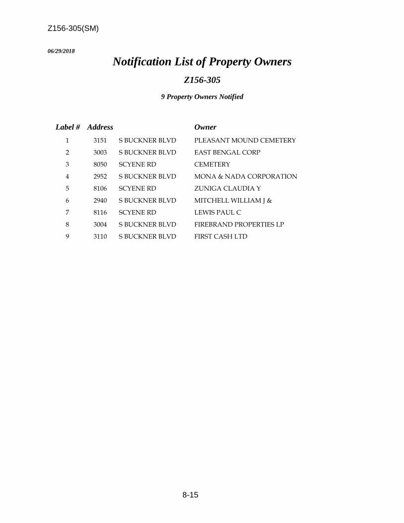
Z156-305(SM)
8-15
06/29/2018
Notification List of Property Owners
Z156-305
9 Property Owners Notified
Label # Address Owner
1 3151 S BUCKNER BLVD PLEASANT MOUND CEMETERY
2 3003 S BUCKNER BLVD EAST BENGAL CORP
3 8050 SCYENE RD CEMETERY
4 2952 S BUCKNER BLVD MONA & NADA CORPORATION
5 8106 SCYENE RD ZUNIGA CLAUDIA Y
6 2940 S BUCKNER BLVD MITCHELL WILLIAM J &
7 8116 SCYENE RD LEWIS PAUL C
8 3004 S BUCKNER BLVD FIREBRAND PROPERTIES LP
9 3110 S BUCKNER BLVD FIRST CASH LTD

9-1
CITY PLAN COMMISSION THURSDAY, SEPTEMBER 20, 2018
Planner: Sarah May
FILE NUMBER: Z178-190(SM) DATE FILED: February 22, 2017
LOCATION: Northwest corner of West Colorado Boulevard and North Beckley Avenue
COUNCIL DISTRICT: 1 MAPSCO: 44 Z
SIZE OF REQUEST: Approx. 35.86 acres CENSUS TRACT: 42.01
OWNER: Pavilion Properties APPLICANT: Methodist Hospitals of Dallas REPRESENTATIVE: Angela Hunt REQUEST: An application to amend Planned Development District No.
282 for mixed uses on property zoned Planned Development
District No. 282.
SUMMARY: The applicant [Methodist Hospitals of Dallas] proposes to
reconstruct an approximate two-story, 35,000-square-foot
wellness center on the north side of the hospital campus,
near Greenbriar Lane.
STAFF RECOMMENDATION: Approval, subject to a revised development plan and
staff’s recommended conditions.
PRIOR CPC ACTION: On April 19, May 17, June 7, June 21, July 19 and August
16, 2018, the City Plan Commission held this item under
advisement to allow the applicant to discuss the application
with the neighborhood. Revisions to the conditions and an
updated revised development plan are included this report.
PLANNED DEVELOPMENT DISTRICT No. 282:
http://www.dallascityattorney.com/51P/Articles%20Supp%206/ARTICLE%20282.pdf
PLANNED DEVELOPMENT DISTRICT No. 282 EXHIBITS:
http://www.dallascityattorney.com/51P/exhibits.html#a282

Z178-190(SM)
9-2
BACKGROUND INFORMATION:
According to the applicant’s website, Methodist Hospital of Dallas originally
opened in 1927 and has since had many expansions.
On December 2, 1987, the City Council approved PDD No. 282. The PDD has
subsequently been amended several times.
Zoning History: There have been two recent zoning cases in the vicinity in the last five
years.
1. Z178-185: On April 25, 2018, the City Council will consider a City Plan Commission authorized hearing for a historic building demolition delay.
2. Z145-341: On November 10, 2015, the City Council approved a City Plan Commission authorized hearing for a historic building demolition delay.
Thoroughfares/Streets:
Thoroughfare/Street Function Proposed Dimension and ROW
West Colorado Boulevard Collector Minimum-4 lanes-undivided, Varies
North Beckley Avenue Minor Arterial 6 lanes-divided, 100’ ROW,
72’ pavement with cycle track
Greenbriar Lane Local Street 120 feet
Haines Avenue Local Street 85 feet
Traffic:
The Engineering Division of the Sustainable Development and Construction Department
reviewed the proposed zoning and determined it will not have a negative impact on the
existing street system.
Comprehensive Plan:
The forwardDallas! Comprehensive Plan was adopted by the City Council in June 2006.
The forwardDallas! Comprehensive Plan outlines several goals and policies which can
serve as a framework for assisting in evaluating the applicant’s request.
The request complies with the following land use goals and policies of the
Comprehensive Plan:

Z178-190(SM)
9-3
LAND USE ELEMENT
GOAL 1.1 ALIGN LAND USE STRATEGIES WITH ECONOMIC DEVELOPMENT
PRIORITIES
Policy 1.1.5 Strengthen existing neighborhoods and promote neighborhoods’
unique characteristics.
Acknowledge the importance of neighborhoods to the city’s long-term health and
vitality. Dallas is a city of great neighborhoods. To attract new families and
maintain existing stable neighborhoods, residents must take pride in and feel
confident in investing in their neighborhoods over the long term. Existing
neighborhoods require public and private investment and attention to maintain
their desirability as places to live. New neighborhoods must be pedestrian-
friendly, have a sense of community, and exhibit long-term viability.
ECONOMIC ELEMENT
GOAL 2.1 PROMOTE BALANCED GROWTH
Policy 2.1.1 Ensure that zoning is flexible enough to respond to changing
economic conditions.
Planning for balanced growth in a dynamic economic environment calls for
flexible zoning regulations to enable the City to respond to changing markets and
to better facilitate development that aligns with economic priorities.
STAFF ANALYSIS
Surrounding Land Uses:
Zoning Land Use
Site PDD No. 282 Hospital and related uses
North R-7.5(A) Single Family
East
PDD No. 468 (Subdistrict D, WMU-5);
PDD No. 468 (Subdistrict G, WMU-20,
Medical Use Overlay);
Multifamily;
Medical Offices; Retail
South PDD No. 468 (Subdistrict D, WMU-5); Restaurants, Personal
service, and Retail uses
West R-7.5(A) Single Family
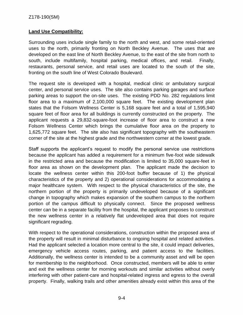
Z178-190(SM)
9-4
Land Use Compatibility:
Surrounding uses include single family to the north and west, and some retail-oriented
uses to the north, primarily fronting on North Beckley Avenue. The uses that are
developed on the east line of North Beckley Avenue, to the east of the site from north to
south, include multifamily, hospital parking, medical offices, and retail. Finally,
restaurants, personal service, and retail uses are located to the south of the site,
fronting on the south line of West Colorado Boulevard.
The request site is developed with a hospital, medical clinic or ambulatory surgical
center, and personal service uses. The site also contains parking garages and surface
parking areas to support the on-site uses. The existing PDD No. 282 regulations limit
floor area to a maximum of 2,100,000 square feet. The existing development plan
states that the Folsom Wellness Center is 5,168 square feet and a total of 1,595,940
square feet of floor area for all buildings is currently constructed on the property. The
applicant requests a 29,832-square-foot increase of floor area to construct a new
Folsom Wellness Center which brings the cumulative floor area on the property to
1,625,772 square feet. The site also has significant topography with the southeastern
corner of the site at the highest grade and the northwestern corner at the lowest grade.
Staff supports the applicant’s request to modify the personal service use restrictions
because the applicant has added a requirement for a minimum five-foot wide sidewalk
in the restricted area and because the modification is limited to 35,000 square-feet in
floor area as shown on the development plan. The applicant made the decision to
locate the wellness center within this 200-foot buffer because of 1) the physical
characteristics of the property and 2) operational considerations for accommodating a
major healthcare system. With respect to the physical characteristics of the site, the
northern portion of the property is primarily undeveloped because of a significant
change in topography which makes expansion of the southern campus to the northern
portion of the campus difficult to physically connect. Since the proposed wellness
center can be in a separate facility from the hospital, the applicant proposes to construct
the new wellness center in a relatively flat undeveloped area that does not require
significant regrading.
With respect to the operational considerations, construction within the proposed area of
the property will result in minimal disturbance to ongoing hospital and related activities.
Had the applicant selected a location more central to the site, it could impact deliveries,
emergency vehicle access routes, parking, and patient access to the facilities.
Additionally, the wellness center is intended to be a community asset and will be open
for membership to the neighborhood. Once constructed, members will be able to enter
and exit the wellness center for morning workouts and similar activities without overly
interfering with other patient-care and hospital-related ingress and egress to the overall
property. Finally, walking trails and other amenities already exist within this area of the

Z178-190(SM)
9-5
site, and by placing the wellness center in this location, its members will be able to
utilize these outdoor amenities as well.
Due to the physical characteristics of the property and the operational characteristics of
the hospital, staff supports the request to allow a personal service use within 200 feet of
Greenbriar Lane in the location shown on the proposed development plan.
The applicant has proposed some additional restrictions on the northernmost portion of
the site due to some concerns regarding the existing development rights in the future
development area at the corner of Greenbriar Lane and North Beckley Avenue. The
revised request now includes the creation of a new term called a restricted zone, which
means an area south of the south line of Greenbriar Lane, and a portion of Haines
Avenue and is identified on the revised development plan. The applicant has proposed
the restricted zone to be 100 feet in depth for the following uses that were previously not
restricted:
-- Medical or scientific laboratory.
-- Financial institution without drive-
in window.
-- Ambulance service.
-- Transit passenger shelter.
In exchange for prohibiting the above uses within 100 feet of Greenbriar Lane, the
applicant is requesting that the 200-foot restricted zone for the following uses be
reduced; therefore allowing these uses to now be considered as limited or prohibited
uses within the proposed 100-foot restricted zone:
-- General merchandise or food store 3,500 square feet or less. [Limited]
-- General merchandise or food store greater than 3,500 square feet. [Prohibited]
-- Restaurant without drive-in or drive-through service. [Limited]
Staff generally supports the applicant’s request because uses have been further
restricted that are more likely to occur on a hospital campus and restrictions have been
lessened for uses that are less likely to be independently operated main uses.
However, although staff does not support the full reduction in restriction area from 200
feet to 100 feet as the applicant requests, staff can support a relaxation of restriction for
retail-related uses from 200 to 150 feet because it is a slight reduction in exchange for
additional height restrictions the applicant has offered.

Z178-190(SM)
9-6
Maximum height:
The existing PDD regulations limit height, not on average grade1, but instead by
topographic elevations above mean sea level. Although this is an uncommon practice,
it is appropriate because of the varying topography of the site and surrounding
properties. The PDD is divided into two areas that are demarcated on the development
plan: business and non-business signage areas. The PDD allows a maximum structure
height within the business signage area of 680 feet above mean sea level and allows a
maximum structure height within the non-business signage area of 634 feet above
mean sea level. Since the area of the PDD that is closest to residential zoning is
primarily within the non-business signage area, the defined areas establish a “ceiling”
for each area regardless of grading operations.
Regarding the proposed depth of the restricted zone, the contour lines shown on the
development plan shows existing grades of approximately 427, 430, and 432 feet above
mean sea level for depths of 100, 150, and 200 feet from Greenbriar Lane. Therefore,
although maximum structure height is limited to 634 feet above mean sea level, the
resulting height limitation at each one of these depths, is 207, 204, and 202 feet, when
the existing grades at 100, 150, and 200 feet depths are subtracted.
It is also important to note that residential proximity slope (RPS) does not apply in the
existing zoning regulations of the site. However, if the regulations of RPS were applied,
a maximum structure height (from average grade) at 15 (the minimum front yard
setback), 100, 150, and 200-foot depths (including 100 feet for the Greenbriar Lane
right-of-way width), would result in an RPS height restriction at those points would be
38.33, 66, 83, and 100 feet, respectively.
The applicant requests a 100-foot deep restricted zone and has offered to limit height to
40 feet above grade in this zone. Although staff notes the applicant’s request limits this
area’s maximum height to a more restrictive height than RPS would have required,
since the restricted zone also serves as a land use restriction, staff supports a 150-foot
deep restricted zone as an average between the existing 200-foot restricted area for
certain uses from Greenbriar and the applicant’s proposed 100-foot restricted zone.
1 The term GRADE means the average of the finished ground surface elevations measured at the highest and lowest exterior corners of a structure. For purposes of this definition, FINISHED GROUND SURFACE ELEVATION means the ground surface elevation of the building site before any construction or the ground surface elevation as altered in accordance with grading plans approved by the building official. Finished ground surface elevation does not include: (1) fill material not necessary to make the site developable; (2) berms; or (3) landscape features.

Z178-190(SM)
9-7
Landscaping:
Except for the requested additional regulations proposed by the applicant to require a
wrought iron fence and evergreen plant materials in the restricted zone, landscaping will
be in accordance with Article X, as amended.
Parking:
Parking will be in accordance with the existing regulations of PDD No. 282. The
development plan shows 2,126 parking spaces are required by code for the multitude of
uses and floor area on the site and 3,684 spaces are provided.
Amendments to the Development Plan: Based on previous actions, it has been determined the following processes to amend the most recent Council-approved development plan in PDD No. 282 are required in the following circumstances: 1. A Council-approved development plan amendment is required when:
a. A building is proposed outside of an area designated as Future Development Area or
b. A building is proposed within an area designated as Future Development Area and it does not comply with the parameters of the Building Areas table on the Council-approved development plan.
2. A minor amendment is required when: a. an addition or new construction is proposed within an area designated as
Future Development Area and b. the proposed building meets the parameters that are listed in the Building
Areas table regarding the maximum floor area, maximum number of stories, and height.
Staff has previously processed several minor amendments to the most recent Council-approved development plan in the past for buildings or additions in areas designated as Future Development Area and would continue that practice.

Z178-190(SM)
9-8

Z178-190(SM)
9-9

Z178-190(SM)
9-10

Z178-190(SM)
9-11
PROPOSED AMENDMENTS TO
ARTICLE 282.
PD 282.
SEC. 51P-282.101. LEGISLATIVE
HISTORY.
PD 282 was established by Ordinance No. 19779, passed by the Dallas City Council on
December 2, 1987. Ordinance No. 19779 amended Ordinance Nos. 10962 and 19455, Chapters 51 and
51A of the Dallas City Code, as amended. Ordinance No. 19779 was amended by Ordinance No. 19943,
passed by the Dallas City Council on April 27, 1988, and Ordinance No. 22011, passed by the Dallas City
Council on April 13, 1994. (Ord. Nos. 10962; 19455; 19779; 19943; 22011; 25711; 25917) SEC. 51P-282.102. PROPERTY LOCATION AND
SIZE.
PD 282 is established on property generally located at the northeast corner of Colorado
Boulevard and Haines Avenue. The size of PD 282 is approximately 35.86 acres. (Ord. Nos. 19779;
22011; 25711; 25917) SEC. 51P-282.103. DEFINITIONS AND INTERPRETATIONS.
Staff recommended:
(a) Unless otherwise stated, the definitions and interpretations in Chapter 51A apply to this
article. In this district, RESTRICTED ZONE means a 150-foot area south of the south line of Greenbriar
Lane and a portion of Haines Avenue as shown on the development plan (Exhibit 282A).
Applicant requested:
(a) Unless otherwise stated, the definitions and interpretations in Chapter 51A apply to this
article. In this district, RESTRICTED ZONE means a 100-foot area south of the south line of Greenbriar
Lane and a portion of Haines Avenue as shown on the development plan (Exhibit 282A).
(b) Unless otherwise stated, all references to articles, divisions, or sections in this article are
to articles, divisions, or sections in Chapter 51A.
(c) This district is considered to be a residential zoning district. (Ord. Nos. 25711; 25917)
SEC. 51P-282.104. DEVELOPMENT PLAN.
(a) For a hospital, electronics service center, medical or scientific laboratory, medical
clinic or ambulatory surgical center, office, ambulance service, commercial parking lot or garage, dry
cleaning or laundry store, general merchandise or food store 3,500 square feet or less, general
merchandise or food store greater than 3,500 square feet, personal service use, restaurant without drive-
in or drive through, surface parking, theater, or helistop, development and use of the Property must

Z178-190(SM)
9-12
comply with the development plan (Exhibit 282A). In the event of a conflict between the text of this
article and the development plan, the text of this article controls.
(b) For any other use, a revised development plan must be approved by the city
plan commission before the issuance of any building permit to authorize work in this district.
(Ord. Nos.
22011; 25711; 25917)
SEC. 51P-282.105. MAIN USES PERMITTED.
The following uses are the only main uses permitted [in this district, and some are not
permitted within 200 feet of Greenbriar Lane as indicated in this section]:
(1) Agricultural uses.
-- None permitted.
(2) Commercial and business service uses.
-- Commercial cleaning or laundry plant. [Prohibited [Not permitted] within 200 feet
of Greenbriar Lane.]
-- Custom business services. -- Electronics service center. [Prohibited [Not permitted] within 200 feet of
Greenbriar Lane.]
-- Medical or scientific laboratory. [Prohibited within the restricted zone.]
(3) Industrial uses.
-- None permitted.
(4) Institutional and community service uses.
-- Child-care facility.
-- Church. -- College, university, or seminary.
-- Convalescent and nursing homes, hospice care and related institutions.
-- Hospital.
-- Public or private school.
(5) Lodging uses.
-- Hotel or motel.
(6) Miscellaneous uses.
-- Temporary construction or sales office.
(7) Office uses.

Z178-190(SM)
9-13
-- Financial institution without drive-in window. [Prohibited within the restricted zone.]
-- Medical clinic or ambulatory surgical center. -- Office.
(8) Recreation uses.
-- Private recreation center, club, or area.
(9) Residential uses.
-- Retirement housing.
(10) Retail and personal service uses.
-- Ambulance service. [Prohibited within the restricted zone.]
-- Commercial parking lot or garage.
-- General merchandise or food store 3,500 square feet or less. [Limited use
[Not permitted] within the restricted zone [200 feet of Greenbriar Lane].]
-- General merchandise or food store greater than 3,500 square feet. [Prohibited [Not
permitted] within the restricted zone [200 feet of Greenbriar Lane].]
-- Personal service uses. [Within the restricted zone, limited to 35,000 square feet in in the location shown on the development plan.[Not permitted within 200 feet of Greenbriar Lane].]
-- Restaurant without drive-in or drive-through service. [Limited use [Not
permitted] within the restricted zone [200 feet of Greenbriar Lane].]
-- Surface parking.
-- Theater. [Prohibited [Not permitted] within 200 feet of Greenbriar Lane.]
(11) Transportation uses.
-- Heliport.
-- Helistop.
-- Private street or alley.
-- Transit passenger shelter. [Prohibited within the restricted zone.]
(12) Utility and public service uses.
-- Local utilities.
-- Post office. -- Radio, television, or microwave tower. (Ord. Nos. 22011; 25917)
SEC. 51P-282.106. ACCESSORY USES.
As a general rule, an accessory use is permitted in any district in which the main use is
permitted. Some specific types of accessory uses, however, due to their unique nature, are subject to
additional regulations in Section 51A-4.217. For more information regarding accessory uses, consult
Section 51A-
4.217. (Ord. 25917)

Z178-190(SM)
9-14
SEC. 51P-282.106.1. LIMITED USES. (a) Except as provided in this section, consult the limited use regulations in Section 51A-
4.218 for the specific limited use requirements for each limited use.
(b) For each general merchandise or food store 3,500 square feet or less limited use, exterior
advertising signs are allowed on the same lot as the limited use with an effective area not to exceed 75
square feet with the following restrictions.
(c) For all general merchandise or food store 3,500 square feet or less limited uses, a
maximum of two limited uses may erect advertising signs that comply with this subparagraph for each
building facade with a maximum projection of six inches from the building facade and may be
illuminated as specified in the non-business sign district regulations.
SEC. 51P-282.107. YARD, LOT, AND SPACE REGULATIONS.
(Note: The yard, lot, and space regulations in this section must be read together with the yard,
lot, and space regulations in Division 51A-4.400. In the event of a conflict between this section and
Division
51A-4.400, this section controls.)
(a) Setbacks.
(1) Except as provided in this subsection, the minimum setback from all
street frontages is 15 feet.
(2) Minimum setback from Colorado Boulevard is 20 feet for all structures built
after
March 9, 2005. Signs must comply with the setbacks provided in Section 51P-282.113.
(b) Floor area. Maximum floor area is 2,100,000 square feet. The calculation of the
floor area does not include above-grade, below-grade, or surface parking areas.
(c) Height. Except as provided in this subsection, maximum [Maximum] structure
height in the area designated for business signage regulations as shown on the development
plan is 680 feet above mean sea level, and in the area designated for non-business signage
regulations is 634 feet above mean sea level. The elevation above mean sea level (MSL) is calculated
from the existing benchmark located at the southwest corner of Greenbriar Lane and Beckley Avenue.
The elevation of the benchmark is 420.35 feet above MSL. Maximum structure height within the
restricted zone, is 40 feet above grade. The following structures may project a maximum of 12 feet
above the height limitations specified in this subsection.
(1) Elevator penthouse or bulkhead.
(2) Mechanical equipment room.
(3) Visual screens which surround roof-mounted mechanical equipment and

Z178-190(SM)
9-15
roof mounted equipment if screened.
(4) Chimney and vent stacks.
(5) Navigation and landing aids.
(6) Communications equipment.
(d) Lot coverage. Maximum lot coverage is 80 percent. Aboveground parking structures
are included in lot coverage calculations; surface parking lots and underground parking structures are
not.
(e) Stories. Except as provided in this section, m[M]aximum number of
stories in the area designated for business signage regulations as shown on the development plan
is 11, and in the area designated for non-business signage regulations is nine. In the restricted zone,
maximum number of stories is two. (Ord. 25917)
SEC. 51P-282.108. OFF-STREET PARKING.
(a) Rehabilitation center. For the rehabilitation center shown on the development plan
as “existing fitness center,” parking must be provided at a ratio of one parking space for each 375 square
feet of floor area.
(b) All other uses. For all other uses, consult the use regulations in Division 51A-4.200
for the specific off-street parking and loading requirements for each use. (Ord. Nos. 22011; 25917)
SEC. 51P-282.109. TRANSPORTATION IMPROVEMENTS AND DEDICATIONS.
(a) Beckley Avenue median. The owner(s) must provide all improvements to the
Beckley Avenue median between Tilden Avenue and Colorado Boulevard required by the director of
the department of public works and transportation to facilitate safe access to and circulation around the
Property.
(b) Greenbriar Lane access. No ingress or egress to or from the Property is permitted
from
Greenbriar Lane. (Ord. Nos. 22011; 25917)
SEC. 51P-282.110. ENVIRONMENTAL PERFORMANCE STANDARDS.
See Article VI. (Ord. 25917)
SEC. 51P-282.111. LANDSCAPING.
(a) Except as provided in this section, landscaping [Landscaping] must be provided in
accordance with Article X.
Z178-190(SM)
9-16
(b) A minimum six-foot-tall wrought iron fence, or similar materials, is required
within the restricted zone, west of Handley Drive.
(c) Except as required by the Dallas Fire Code or other regulations, pedestrian and
vehicular openings in the wrought iron fence within the restricted zone are prohibited.
(d) Except where subsection (c) requires openings, evergreen plant materials
recommended for local area use by the building official are required south of and adjacent to the
wrought iron fence and must provide a visual barrier for a minimum height of six feet within
three years after their initial planting. The plant materials must be located in a bed that is at least
three feet wide with a minimum soil depth of 24 inches. Initial plantings must be capable of
obtaining a 70 percent solid appearance within three years. Plant materials must be placed a
maximum of five feet on center over the entire length of the bed unless the building official
approves an alternative planting density that a landscape authoritiy certifies as being capable of
providing a solid appearance within three years.
(e) All plant materials must be maintained in a healthy, growing condition. (Ord. 25917)
SEC. 51P-282.112. LIGHTING.
(a) Any lighting fixture located on the Property that exceeds 10 feet in height may
not penetrate a one-to-three slope projecting upward and outward from the property line of any R,
R(A), D, D(A), TH, or TH(A) district or any PD that allows single family, duplex, or townhouse uses;
or a one-to- one slope projecting upward and outward from the property line of any MF, MF(A), MH,
MH(A), or CH district or any PD that allows multifamily, manufactured home, or clustered housing
uses. In no event, however, may a light fixture located on the Property exceed 30 feet in height.
(b) Lighting on the Property must average, on a maintained basis, an intensity of not
less than 0.5 footcandle. Residual illumination of nearby residentially zoned property may not
exceed 0.1 footcandle measured at ground level five or more feet inside the residential property line.
(c) Only cut-off, indirect, or shielded light fixtures are permitted on the Property. (Ord.
Nos. 22011; 25917)
SEC. 51P-282.113. SIGNS.
(a) Except as provided in this section, signs must comply with the provisions for
business zoning districts in Article VII.
(b) Signs located adjacent to the northern and western boundaries of the Property in the
area shown on the development plan must comply with the provisions for non-business zoning
districts in Article VII.
(c) Detached premise signs must be set back a minimum is 10 feet from Colorado
Boulevard. (Ord. Nos. 22011; 25917)

Z178-190(SM)
9-17
SEC. 51P-282.114. HELICOPTER BASE.
(a) The helicopter base may have no more than two helipads. These pads are limited to
air ambulance transport of patients to and from the facility and other medical-related purposes,
including but not limited to the transport of medical supplies and organs. The helicopter base may also
have a refueling facility to be used only for refueling the helicopters providing contractual service
to the facility. The following additional conditions apply.
(b) The helicopter pilot should follow major thoroughfares when approaching and
departing the helicopter base.
(c) The helicopter pilot must maintain an elevation of 1,200 feet above mean sea level
except during landing and takeoffs.
(d) The helicopter pilot should avoid noise sensitive areas such as residences, schools, and
churches.
(e) The helicopter base must be located as shown on the helicopter base plan (Exhibit 282B).
(f) Takeoffs and landings must follow the paths shown on the helicopter flight path
plan
(Exhibit 282C). (Ord. Nos. 19779; 22011; 25917)
SEC. 51P-282.115. ADDITIONAL PROVISIONS.
(a) A minimum five-foot wide sidewalk is required between the projected street curb and
the required fence within the restricted zone.
(b) A limited access control gate is required to access the Haines Avenue employee parking
area as shown on the development plan (Exhibit 282A).
(c) The [entire] Property must be properly maintained in a state of good repair and neat
appearance.
(d[b]) Development of the Property must comply with the requirements of the Federal
Aviation Administration and with all federal and state laws and regulations, and with all ordinances,
rules, and regulations of the city. (Ord. Nos. 22011; 25917)
SEC. 51P-282.116. PAVING.
All parking spaces, aisles, maneuvering areas, and driveway connections to streets or alleys,
whether enclosed or unenclosed, must comply with the standards set forth in the Dallas
Development Code. (Ord. Nos. 22011; 25917)
SEC. 51P-282.117. COMPLIANCE WITH CONDITIONS.
(a) All paved areas, permanent drives, streets, and drainage structures, if any, must be

Z178-190(SM)
9-18
constructed in accordance with standard city specifications, and completed to the satisfaction of the
director of public works and transportation.
(b) The building official shall not issue a building permit to authorize work or certificate
of occupancy to authorize the operation of a use in this PD until there has been full compliance with
this article, the Dallas Development Code, the construction codes, and all other applicable ordinances,
rules, and regulations of the city. (Ord. Nos. 22011; 25917)
[SEC. 51P-282.118. ZONING MAP.
PD 282 is located on Zoning Map Nos. K-6 and K-7. (Ord. Nos. 19779; 25917)]

Z178-190(SM)
9-19
Existing Development Plan

Z178-190(SM)
9-20
Proposed Development Plan

Z178-190(SM)
9-21

Z178-190(SM)
9-22
CPC Responses
Single Family
Multifamily
Parking
Parking
Retail
Medical
Office
Restaurant,
Personal Service,
& Office

Z178-190(SM)
9-23
1 2
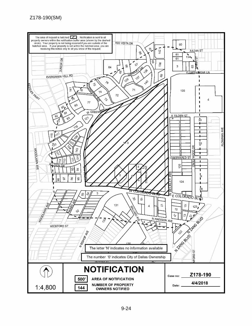
Z178-190(SM)
9-24

Z178-190(SM)
9-25
04/04/2018
Notification List of Property Owners
Z178-190
144 Property Owners Notified
Label # Address Owner
1 1441 N BECKLEY AVE PAVILION PROPERTIES
2 1401 STEMMONS AVE PAVILLION PROP
3 1424 N BECKLEY AVE METHODIST HOSPITALS OF DALLAS
4 1136 BALLARD AVE METHODIST HOSPITALS OF DALLAS
5 221 W COLORADO BLVD METHODIST HOSPITALS OF DALLAS
6 1134 BALLARD AVE HELLEN RYAN
7 1212 N MADISON AVE METHODIST HOSPITALS OF DALLAS
8 1129 N BECKLEY AVE GREENHOUSE CLYDE
9 1127 N BECKLEY AVE MTX NOOR REAL ESTATE LLC
10 1300 N MADISON AVE 122S HAMPTON LLC
11 1304 N MADISON AVE CASTILLO SIMON III
12 1215 N ZANG BLVD TRITON ZANG LLC
13 1317 N MADISON AVE TRITON ZANG, LLC
14 1202 N BECKLEY AVE TRITON ZANG LLC
15 1309 N MADISON AVE MARTINEZ BROS INV
16 1218 N BECKLEY AVE MARTINEZ BRO INV
17 1211 N BECKLEY AVE BECKLEY PLACE PARTNERS LP
18 1221 N BECKLEY AVE DEJONG VLADI &
19 200 W COLORADO BLVD METROPLEX PROPERTIES
20 1205 N MADISON AVE KECHEJIAN ENTERPRISES LP
21 1322 N BECKLEY AVE JONES VICKI D
22 116 OAKENWALD ST BARR JOHN H TRUSTEE
23 1339 ENGLEWOOD AVE KESSLER WOMERNS GROUP LLC
24 1333 ENGLEWOOD AVE BARR MARY CHRISTIAN TRUST
25 1329 ENGLEWOOD AVE BARR BURT JR
26 1325 ENGLEWOOD AVE BARR JOHN H TRUSTEE

Z178-190(SM)
9-26
04/04/2018
Label # Address Owner
27 1307 ENGLEWOOD AVE AMIRGHOLIZADEH KARIM
28 123 E COLORADO BLVD AMIR KARIM
29 203 E COLORADO BLVD MARY CHRISTIAN BARR TRUST
30 1336 ENGLEWOOD AVE BARR JOHN HOLMAN II TR
31 1338 ENGLEWOOD AVE BARR JOHN HOLMAN II TR
32 1402 ENGLEWOOD AVE DEAN PATRICK J
33 1406 ENGLEWOOD AVE METHODIST HOSPITALS OF DALLAS
34 1426 ENGLEWOOD AVE BUCKOVAN ROBERT SCOTT
35 1430 ENGLEWOOD AVE BUCKOVAN COPE CYNTHIA JEAN
36 1438 ENGLEWOOD AVE DIAZ MARY G
37 1400 N BECKLEY AVE METHODIST HOSPITALS OF DALLAS
38 1403 ENGLEWOOD AVE METHODIST HOSPITALS OF DALLAS
39 1224 WOODLAWN AVE WILLIAMS ELDA FAYE
40 1230 WOODLAWN AVE STAGGS SAM
41 1234 WOODLAWN AVE BURDINE T W &
42 1236 WOODLAWN AVE BURDINE T W
43 1242 WOODLAWN AVE LOGAN KIMBERLY DIANE
44 458 W COLORADO BLVD HARRIS W ERNEST
45 408 W COLORADO BLVD COLLIE RUTH
46 1241 HAINES AVE WAVERING TAMMY A
47 1235 HAINES AVE SPENGLER COREY & VERONICA
48 1231 HAINES AVE MURPHREE TRACIE
49 1227 HAINES AVE GARCIA DESSIE &
50 1223 HAINES AVE MCLAURY MICHAEL W
51 1219 HAINES AVE MCDONALD JAMES W &
52 1208 HAINES AVE HAINES SHARSHIV LLC
53 1234 HAINES AVE PROHASKA THOMAS M & JILL M
54 330 W COLORADO BLVD HUGHES WENDY L
55 328 W COLORADO BLVD ANDROSOV TATIANA
56 1218 N BISHOP AVE AXXIS ENTERPRISES
57 1167 N MADISON AVE DELEON SERGIO & OLGA A

Z178-190(SM)
9-27
04/04/2018
Label # Address Owner
58 1159 N MADISON AVE 1159 NORTH MADISON LLC
59 1155 N MADISON AVE LOMAS HOMAR C &
60 101 JULIAN ST DALLAS COUNTY SCHOOLS
61 1616 N BECKLEY AVE DP BECKLEY 1616 LLC
62 115 E GREENBRIAR LN MIMS JACK A &
63 123 E GREENBRIAR LN RICHARDSON DARYL GOURMET CATERING INC
64 1542 STEMMONS AVE PATTERSON ROBERT K & AMBER L
65 1528 STEMMONS AVE MALONE THOMAS DEAN &
66 1654 HANDLEY DR ROSEN MATTHEW
67 1640 HANDLEY DR MALLINSON LUKE W &
68 1605 N BECKLEY AVE AUSBROOKE LLC
69 1620 HANDLEY DR KAVANAGH PETER
70 115 W GREENBRIAR LN DSGN ASSOCIATES INC
71 141 W GREENBRIAR DR SCOTT KACEY & JAKE B
72 215 W GREENBRIAR LN MERLINO ANDREW &
73 233 W GREENBRIAR LN OCON JOE
74 1561 STEMMONS AVE EBERHART BLAKE ALLEN & ANGELA NEYLON
75 1551 STEMMONS AVE TINDLE DAVID WELDON
76 1535 STEMMONS AVE BARLOW CLINTEN & WHITNEY
77 305 W GREENBRIAR LN KAVANAGH PETER J & A LYNN
78 1580 STEMMONS AVE TERRELL LANE &
79 1524 JUNIOR DR OBRIEN THOMAS J & MELISSA
80 1514 JUNIOR DR CRUMP THOMAS B &
81 911 KESSLER PKWY ARRINGTON JOHN C &
82 921 KESSLER PKWY OBRIEN MELISSA ANN &
83 1505 JUNIOR DR BERRY MARTHA W D
84 1509 JUNIOR DR BIELAMOWICZ MATTHEW T &
85 1517 JUNIOR DR HOPPER KIRK
86 1611 RIO VISTA DR CHERNOCK CHRISTIAN S
87 1606 RIO VISTA DR ALEXANDER BRIAN & BICK SARAH
88 434 ALLISON DR SHIPP BRETT R
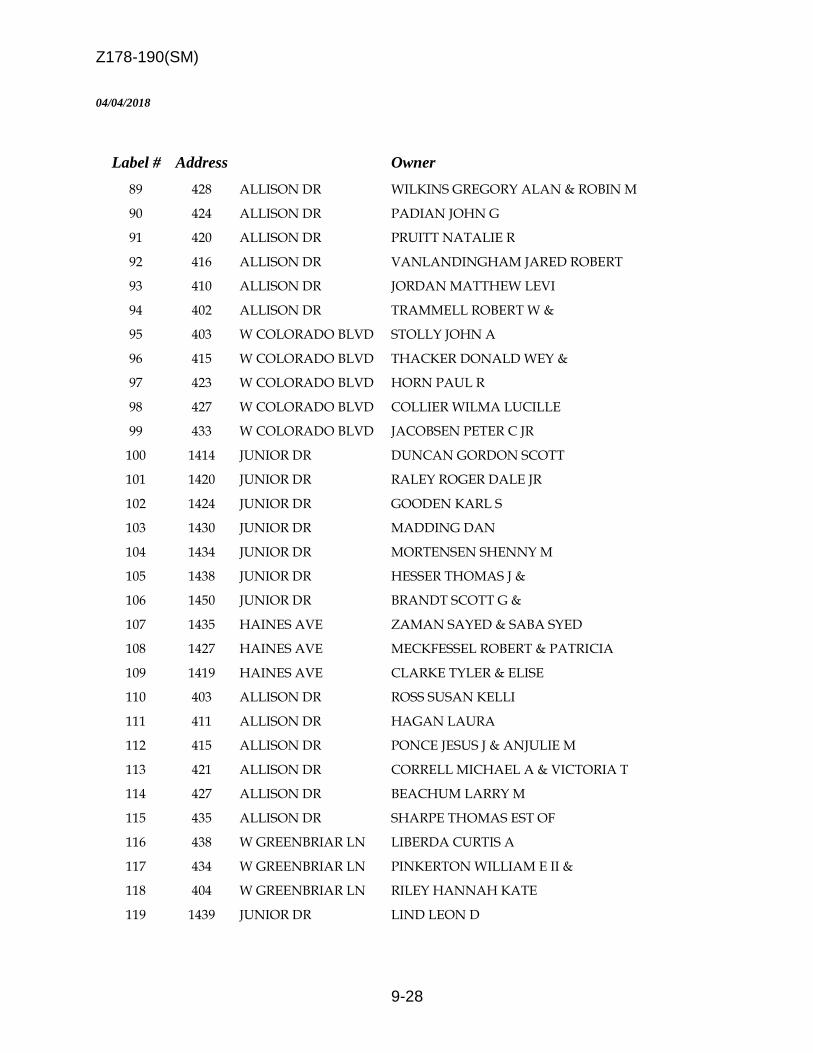
Z178-190(SM)
9-28
04/04/2018
Label # Address Owner
89 428 ALLISON DR WILKINS GREGORY ALAN & ROBIN M
90 424 ALLISON DR PADIAN JOHN G
91 420 ALLISON DR PRUITT NATALIE R
92 416 ALLISON DR VANLANDINGHAM JARED ROBERT
93 410 ALLISON DR JORDAN MATTHEW LEVI
94 402 ALLISON DR TRAMMELL ROBERT W &
95 403 W COLORADO BLVD STOLLY JOHN A
96 415 W COLORADO BLVD THACKER DONALD WEY &
97 423 W COLORADO BLVD HORN PAUL R
98 427 W COLORADO BLVD COLLIER WILMA LUCILLE
99 433 W COLORADO BLVD JACOBSEN PETER C JR
100 1414 JUNIOR DR DUNCAN GORDON SCOTT
101 1420 JUNIOR DR RALEY ROGER DALE JR
102 1424 JUNIOR DR GOODEN KARL S
103 1430 JUNIOR DR MADDING DAN
104 1434 JUNIOR DR MORTENSEN SHENNY M
105 1438 JUNIOR DR HESSER THOMAS J &
106 1450 JUNIOR DR BRANDT SCOTT G &
107 1435 HAINES AVE ZAMAN SAYED & SABA SYED
108 1427 HAINES AVE MECKFESSEL ROBERT & PATRICIA
109 1419 HAINES AVE CLARKE TYLER & ELISE
110 403 ALLISON DR ROSS SUSAN KELLI
111 411 ALLISON DR HAGAN LAURA
112 415 ALLISON DR PONCE JESUS J & ANJULIE M
113 421 ALLISON DR CORRELL MICHAEL A & VICTORIA T
114 427 ALLISON DR BEACHUM LARRY M
115 435 ALLISON DR SHARPE THOMAS EST OF
116 438 W GREENBRIAR LN LIBERDA CURTIS A
117 434 W GREENBRIAR LN PINKERTON WILLIAM E II &
118 404 W GREENBRIAR LN RILEY HANNAH KATE
119 1439 JUNIOR DR LIND LEON D

Z178-190(SM)
9-29
04/04/2018
Label # Address Owner
120 1427 JUNIOR DR GAMBER VIBEKE M LIFE ESTATE
121 304 W GREENBRIAR LN VANDERWOUDE LARRY A & PAULA BARBER
122 1133 N ZANG BLVD ZANG OC 2016 LLC
123 126 E COLORADO BLVD HEBREE REVOCABLE LIVING TRUST
124 1306 N BECKLEY AVE CTA ASSOCIATES LP
125 1330 N BECKLEY AVE KESSLER WOMENS GROUP LLC
126 1215 N BISHOP AVE COTE SEAN S &
127 1213 N BISHOP AVE NEELY CHRISTOPHER & FRANCESCA
128 1211 N BISHOP AVE PALCHIK DIANA
129 1209 N BISHOP AVE BERMAN DOUGLAS M & SUMMER M
130 1144 N MADISON AVE Dallas ISD
131 1222 N BISHOP AVE 1222 BISHOP LLC
132 1163 N MADISON AVE ARELLANO JULIO &
133 1150 N BISHOP AVE OAK CLIFF LAND DEV CO
134 114 JULIAN ST DARYL RICHARDSON GOURMET CATERING INC
135 1520 N BECKLEY AVE KESSLER PEAK LTD PS
136 1619 N BECKLEY AVE AUSBROOKE LLC
137 1639 HANDLEY DR TUCKER TOBY & REBECCA
138 1629 HANDLEY DR HOMAN KATHERINE LIFE ESTATE
139 1655 HANDLEY DR CANAVATI NATALIE
140 133 W GREENBRIAR LN JOHNSTON JOHN & PATRICIA
141 1534 JUNIOR DR REA JAMES G
142 1703 N BECKLEY AVE BG BROOKVIEW PARTNERS LTD
143 1411 HAINES AVE ISENBERG RALPH & YAN HONG
144 1445 JUNIOR DR JENKINS KITTY VALERIE &