1 . ', - Canada.ca
129
·. . .1 . ',. 1 I 1+1 Scientific Excellence • Resource Protection & Conservation • Benefits for Canadians Excellence scientifique • Protection et conservation des ressources • Benefices aux Canadiens . . (W FISH£ RIEe; ,\ Satellite-Derived Daily Sea Surface Te mperature OCEANS CANADA Maps for Areas "0" to " P" from 1984 to 1986 0: Overview Data; East Coast to Canada Satellite Pass to P: Western North Atlantic; Gulf of Ma in e to Hudson Strait B.J. Topliss, L. Payzant, C.S. Mason , H. Edel , K.L. March, I.G. Holden, M. Thiebaux, and F. Guptill Published by: Physical and Chemical Sciences Branch Scotia-Fundy Region Department of Fisheries and Oceans Bedford Institute of Oceanography P.O. Box 1006 Dartmouth, Nova Scotia Canada B2Y 4A2 August 1990 Canadian Data Report of Hydrography and Ocean Sciences No. 89 I Fisheri es and Oceans Peches et Oceans Canada
-
Upload
khangminh22 -
Category
Documents
-
view
3 -
download
0
Transcript of 1 . ', - Canada.ca
·. . .1 . ',. 1
I
1+1
Scientific Excellence • Resource Protection & Conservation • Benefits for Canadians Excellence scientifique • Protection et conservation des ressources • Benefices aux Canadiens . .
(W ~.L .~.
FISH£ RIEe; ,\
Satellite-Derived Daily Sea Surface Temperature OCEANS CANADA
Maps for Areas "0 " to " P" from 1984 to 1986 0: Overview Data; East Coast to Canada Satellite
Pass to P: Western North Atlantic; Gulf of Maine to Hudson Strait
B.J. Topliss , L. Payzant, C.S. Mason, H. Edel , K.L. March, I.G. Holden, M. Thiebaux, and F. Guptill
Published by: Physical and Chemical Sciences Branch Scotia-Fundy Region Department of Fisheries and Oceans
Bedford Institute of Oceanography P.O. Box 1006 Dartmouth, Nova Scotia Canada B2Y 4A2
August 1990
Canadian Data Report of Hydrography and Ocean Sciences No. 89
I
Fisheries and Oceans
Peches et Oceans Canada

Canadian Data Report Of Hydr~graph)' and Ocean Sciences
Data reports prOl ide a medium for the documentation and di ...... emll1allon oldata in a form directl~ u cable b~ the SCientific and engineering communllie . Generall~, the report~ contain raIl and or anal~ led data but \\ til not eontall1 interpretation, of the data. Such compilations commonl~ \\ ill hale been prepared in upport of\\ ork related to the program~ and intae. b of the Ocean SCience and Sun ey (OSS) ~ector of the Department of Fisheries and Ocean ... .
Data reports are not intended for general di\lribullon and the contents mu . t not be referred to in other publication~ \\ithout prior \\fitten authorllallon from the i\~ulllg eSlablr,hment. The correct citation appears abo\ e the ab,tract of each report. Data report~ are abstracted in Aquali( Science., (Jlld Fisflerio ~h.\lra(/\ and IIlde .\ed in the Department's annual inde.' to ,cienlific and technical publication ...
Data reports are produced regionall~ but arc numhered nationall~ ReLjue t for IIldi\ idual reports \\ ill be filled b~ the i,'>uing e\tablr . hment II. ted on the tront COl er and title page. Out of ,tocI.. reports 1\ 111 be ~uprlied for a fee b~ commercial agents .
RegIOnal and headquarter e\tahlr.,hmenh 01 Ocean SCience and Suney' cea\cd publication or Iheir \ arlou;., report .,erle,> a ... ot December 19 I. A complete Ii tlllg of the"e pu blicatlon, i pu bli'hed III I he Canadillll J IIur1l1l1 o f Fill/( /"/£', IIl1d ~ {/uall ( .\)(/(,II({,I, \ olume 39: Indn to Publication, 19 ~. The current ... enc\. \\ hich begin ... \\ith report number I. \\a, illlllaled in Januar~ 1%2
Rapport statistique canadien sur I'hydrographie et les sciences oceaniques
Le, rapport , tatislILjue, ,enent de IChlCUIe pour Ia compilation et la ditlu IOn de, donnee . ~om une forme directement ullh,dble par Ie, ,ncntitlljue, et Ie, tcdlnlcien~ , En generaL les rapport contiennent de donnee, brute,> ou anal\,ee, 111.11, nc fourlllssent pas d'interpretation de, donnee . Ce ... compilation ,onl preparee Ie pllh soU\ent a I'appui de tralau, he ... dU'\ programme, et inten~1 du en Ice de~ SCience et lele ... oceaniLjue~ (S LO) du mini,tcre de Peche el de., Ocean ... .
Le~ rapport!> ~tati.,tiLjue ... ne ,,>onl plh deQll1e, ,i une \ a ... te di,tribution el leur contenu ne doit pas etre menllonne dan, une publlGltlon ,an, une aU\(lrl,ation ecrite prealable de I'etablissemenl auteur. Le titrc e,act parait au-de"lh du re,ume de chaque rapport. Le~ rapport"> ,tathliljue,> ,ont rc'>ul11e, dan la reI ue R, '11/11';' £1('\ \cil'J7Cl'.1 /llIlieuliqul'1 £'I (IlIIW1icIUt'I. ct ib ,ont Lla,sc, dan, I'indc\ Jnnuel de' publications ,cientifique, ct technlLjue du \ ll11i,tcre .
Le rapporb ~tati~tiLjue, ,ont produih j I'cchelon regional. mal., numerote, a I'echelon national. Les dcmande, dc rappon, ,cront ,atl,taltc, par I'ctabli\ emcnt auteur dont Ie nom figurc,ur la COLli crturc et la pagc dUlilrc . Le, rapporhcplll,e, ont fourlll contre retribution par dc, agent... CO 111 I11C1"ClaU , .
Les etablissement: de SClcnce, et Ie\ c, occanlLjue dalh Ie regions et it I'admini,t ration cent rale ont ceo . e de pu bller leur, dl\ cr es 'ene, de rapport-. en decembre Il)· I. L' ne Ii te complete de ce, publlcatlo!h tigure dan, Ie \ olume Jl), Inde, de, publications 191\2, du Jourllal Cal/adll'lI £I" '( 1,.,1< 1 \ flllli t'II/HIII" <'I lllllllllHllIl'I. La ,erie actuelle a commence a\\:!c la publication du rapport nurnao I en Jam ia 19 2.
r
1
t
L

Canadian Data Report of
Hydrography and Ocean Sciences No. 89
August 1990
SATELLITE DERIVED DAILY SEA SURFACE TEMPERATURE
MAPS FOR AREAS "0" TO "P" FROM 1984to 1986
0: OVERVIEW DATA; EAST COAST OF CANADA SATELLITE PASS to
P: WESTERN NORTH ATLANTIC; GUI:.F OF MAINE TO HUDSON STRAIT
by
B.J. Topliss\ L Payzant, C.S. Mason', H. Edel 2
and
K. L. March 3, I.G. Holden 3
, M. Thiebaux\ and F. Guptil1 3
'Physical and Chemical Sciences Scoti a- Fu ndy Regi on
Department of Fisheries and Oceans
Bedford Institute of Oceanography P.O. Box 1006
Dartmouth, Nova Scotia Canada B2Y 4A2
2Department of Fisheries and Oceans 200 Kent Street Ottawa, Ontario K1AOE6
3Sea Kem Oceanography Limited P.O. Box 696 Dartmouth, Nova Scotia B2Y 3Y9

II
The category of "Canadian Data Report" cannot normally be referenced without the prior consent of the authors. For this report only, the authors give prior consent to reference the work using the correct citation:
©Minister of Supply and Services 1990 Cat. No. Fs97-16/89E ISSN 0711-6721
Correct citation for this publication:
Topliss B.J., L. Payzant, C.S. Mason, H. Edel, K.L. March, I.G. Holden, M. Thiebaux, and F. Guptill. 1990. Satellite Derived Daily Sea Surface Temperature Maps for Areas "0" and ."P" from 1984 to 1986. 0: Overview Data; East Coast of Canada Satellite Pass and P: Western North Atlantic; Gulf of Maine to Hudson Strait. Can. Data Rep. Hydrogr. Ocean Sci. No. 89: vi + 121 pp.

III
ABSTRACT
Topliss B.J., L. Payzant, C.S. Mason, H. Edel, K.L. March, I.G. Holden, M. Thiebaux, and F. Guptill. 1990. Satellite Derived Daily Sea Surface Temperature Maps for Areas "0" and "P" from 1984 to 1986. 0: Overview Data; East Coast of Canada Satellite Pass and P: Western North Atlantic; Gulf of Maine to Hudson Strait. Can. Data Rep. Hydrogr. Ocean Sci. No. 89: vi + 121 pp.
Satellite imagery from the NOAA series have been used to produce daily sea surface temperature (SST) maps for specific areas off the east coast of Canada Each temperature map is accompanied by a visible wavelength map which can be used for basic cloud discrimination. Details of the for turning a satellite infrared image into a SST map are given together with scientific and applications limitations resulting from the processing choices made at each step. Details on how to access and use the atlas are also given. Each regional atlas is intended to serve as both a quicklook of available data and as a prototype or pilot atlas to assess regional demands and specifications. The images or maps themselves can only be viewed with the aid of a computer. Catalogues for the images are presented here which cover such items as the quality of the navigation of each image/map, and the degree of cloud cover as well as the location of a specific map within the archiving system. The catalogues are also available on a VAX computer system for electronic access.
RESUME
Topliss B.J., L. Payzant, C.S. Mason, H. Edel, K.L. March, I.G. Holden, M. Thiebaux, and F. Guptill. 1990. Satellite Derived Daily Sea Surface Temperature Maps for Areas "0" and "P" from 1984 to 1986. 0: Overview Data; East Coast of Canada Satellite Pass and P: Western North Atlantic; Gulf of Maine to Hudson Strait. Can. Data Rep. Hydrogr. Ocean Sci. No. 89: vi + 121 pp.
Une imagerie satellitaire provenant de la serie de la NOAA a ete uti.isee pour produire quotidiennement des cartes de la temperature de la mer en surface (TMS) dans certaines zones situees au large des cotes est du Canada. Chacune des cartes de la temperature s' accompagne d'une carte des longueurs d'onde du visible pouvant servir a la differenciation des n.uages fondamentaux. Certains details sont donnes ici concernant les phases de traitement permettant de transformer une photo-satellite infrarouge en une carte de la TMS; sont aussi precisees les limites scientifiques et pratiques resultant des choix de traitement faits a chacune des etapes. On trouve de plus des details sur la fac;on d'acceder a I'atlas et la maniere de s'en servir. Chacun des atlas regionaux est destine a servir ala fois d'aperc;u rapide des donnees accessibles et d'atlas a I'etat de prototype ou experimental pour evaluer les specifications et les besoins regionaux. Les images ou les cartes comme telles ne peuvent etre examinees qu'a I/aide d'un ordinateur. Des catalogues montrant les images en question sont presentes ici et ils portent sur des parametres comme la qualite de la navigation avec chacune des images par rapport a la carte, ainsi que Ie degre de couverture nuageuse de meme que Ie lieu d'une carte donnee au sein du systeme d'archivage. Les catalogues sont aussi accessibles a I'aide d'un ordinateur VAX pour acces electronique.


v
TABLE OF CONTENTS
Abstract/Resume.
List of Tables.
List of Figures.
Introduction.
The Raw Data Archive ....... .
The Quicklook Archive ..
Atlas Creation
Atlas Processing
Ingest and Navigation .....
Batch Processing: Sectors and Visible Images.
Batch Processi ng: Tem peratu re AI gorithm .
Batch Processing: Map Projection .....
Graphics Overlays ..
Quality Control ................... .
Calibrations and Processing Errors.
Catalogues and Tape Inventories.
Access to Catalogues and Atlas ........ .
Summary
Acknowl edgements .....
References ............. .
Disclaimer and further contacts .............. .
Appendix 1: Catalogue of Daily SST and Visible Images in Area 0 for years 1984, 1985 and 1986 ..... .
Appendix 2: Catalogue of Daily SST and Visible images Area P
Page
.. III
. .. VI
· VI
· .1
· .2
.2
... 4
... 4
.5
. .. 6
7
.9
..10
. .......... 11
. .. 12
..13
.14
.15
.16
. .17
. .21
35
for years 1984, 1985and 1986 .................................................. 61
Appendix 3: Lising of file NAVERR: - navigation problems .................................... 87
Appendix 4: Listing of raw data files via INVREAD . ....... ..... . . ... .......... . . .. . . . . ... ..99

VI
LIST OF TABLES
Catalogue Names and Area Co-ordinates .. . .23
2 Navigation Error codes ... . .. 24
LIST OF FIGU RES
(NOTE: Figures are only applicable to the hardcopy version of this r-eport. ~~o figures appear in the reports available in digital (magnetic tape) media which appear as the first digital file on the first volume of each regional atlas tape.)
Conversion values for NOAA 7 data (10 to 8 bit) 25
2 Conversion values for NOAA 9 data (10 to 8 bit) 26
3 East Coast of Canada Satell ite pass: Coverage. .... 27
4 Geographic Atlas Areas ... ... 28
5 Atlas Processing Record (APR) example logsheet . .29
6 Coverages relative to East Coast Geography: Area 0 . 30
7 Graphics overlay; combined coastline, grid and bathymetry (as applicable): Area P ..... 31
INTRODUCTION'
Sea Surface Temperature (SST) has been used in both marine and fisheries research off the east coast of Canada for numerous decades (Hachey 1935, 1937) There are a variety of uses for SST information from high precision accuracy measurements air-sea interaction and heat flux calculations (Isemer and Hasse 1985), to the use of statistical means and annual anomalies for environmental and fisheries studies (Sutcliffe et al 1977, Drinkwater and Myers 1987), to the simple location and monitoring of thermal frontal regions in the ocean (Legeckis 1979). Historic SST information has generally come from various marine sources, such as research vessels, commercial ships of opportunity and military vessels. Regional and monthly composites of the available data are then performed and atlases such as those produced by ICES (1962) are the common end product. Such historic data are, however, largely confined to the world's shipping lanes with either sparse or no coverage for some parts of the world. With the advent of satellite measurements of SST, both real time and large scale global coverage (Woods 1983) becomes possible. The Nationa I Oceanographic and Atmospheric Agency (NOAA) have combined ship of opportunity measurements with satellite ocean enhanced photographs to produce weekly analysis charts for the Eastern Seaboard of the United States including some sections off Atlantic Canada These charts can be transmitted directly to vessels wishing to identify the characteristics of the Gulf Stream for either commercial or sporting activities. They can also be obtained by subscription by research and educational establishments and used in futher analysis of fisheries studies (Campana and Hurley 1989) Similar charts also exist for the west coast of the United States (Montgomery, 1981) and oceanographic interpretations of the NOAA Atlantic Canada charts are published routinely as a State of the Ocean's report in the "Sou'wester" magazine.
The prime source of satellite SST coverage are the NOAA (and TIROS) series of satellites (see Maul 1985 for details of individual launch sequences since 1960). The sensors used since I\JOAA5 are the AVHHRR (Advanced Very High Resolution Radiometer) and the AVHRRI2 (with an extra band in the infrared) operating in a polar, sun synchronous orbit at an approximate height of 850km with a nadir geometric resolution of approximately 1.1 km. The waveband details of both the AVHRR and the AVHRR/2 are given in Robinson (1985), although in many references the /2 notation IS dropped so that the term AVHRR now tends to refer to the currrent generation/model of the sensor.
Data from the NOAA series of satellites are received In Canada by the Atmospheric Environment Service (AES) and the Department of Energy Mines and Resources, Canada Centre for Remote Sensing. For coverage of the east coast of Canada, the satellite data are received at AES, Downsview outside Toronto, Ontario. This information is largely used by AES for real time weather prediction and by Ice Central, Ottawa, for supplementing ice conditions in northern latitudes. The information is generally not archived since analysis of historic marine data is not part of AES's mandate. Since early 1984, collaborative scientific research programmes have existed between AES Bedford, Nova Scotia and the Department of Fisheries and Oceans, Bedford Institute of Oceanography. This collaboration has now covered several joint Meteorological - Oceanography programmes such as the Shelf Break Programme (1976-78), the South-West Nova Scotia Programme (1978-83), Oceanographic Analysis of Sea Ice and Icebergs (1985-89), CASP (Canadian Atlantic Storms Programme 1985-86), Atlanti c Ocean Currents from Satell ite (1989-94), and planned Sea Ice FI ux onto Newfoundland Shelves (1990-94), and CASP -II (1990- 93). As part of this collaboration AES, Bedford have received daily NO,I\,.I\ satellite imagery of the east coast from the main Downsview facility These tapes are first catalogued at BIO and then stored at a local Federal Government tape repository in Burnside, Dartmouth. From the initiation of this collaborative programme in 1984 until approximately November 1988, the Downsview receiving station was only able to receive data in 8 bit format even though the satellite sensor transmitted down 10 bit information. Hence, although it is possible to note the published precision and accuracy of satellite derived temperatures (Robinson 1985), the errors associated with the satellite temperatures presented in these atlases will be larger. It
2
is expected however that the values will-still be within the values of accuracy of 1 deg C and precision of 0.5 deg C determined by Robinson and Ward (1989) for the north-east Atlantic.
Only one NOAA pass per day is dumped to magnetic tape in Downsview. Since some of the data was to be used for monitoring water currents and ice movement off the Labrador coast (atlas areas I and F) this would require the use of visible as well as thermal channels from the sensor, so the daytime pass was selected for preservation. Due to the relatively high latitudes of some of the areas covered by the Downsview receiving station, the quantity/quality of daylight coverage for these areas was improved by selecting the afternoon pass. Hence the vast majority of the existing archive consists of daily passes of the afternoon orbit (only 18 night passes were archived during 1984-1986) This means that the archived data are generally NOT suitable for studying consecutive diurnal or day -night changes in surface temperatures ( but see Ikeda 1989) or for short term (6 or 12 hour) velocity calculations from consecutive passes. No assessment of the data is made prior to recording by Downsview; the one pass per day coverage is maintained whether any given area is cloud free or whether the entire pass is cloudy. The eventual application and use of the archived data is left with the end user. All (one pass per day) data are preserved unless technical faults at the receiving station have prevented this. Conversely as far as Canadian east coast users are concerned if the data they need are not in this archive there is a very realistic probability that they do not exist in Canada and users should consult the U.S satellite data agencies such as EDIS (Environmental Data Inventory Service). For purely oceanographic research applications users might also contact the Oceanography Departments at the University of Rhode Island and at the University of Miami both of whom maintain infrared satellite archives of marine areas.
The main applications for the (AES/BIO) archived satellite data are research process orientated studies for time-series analysis. With a great deal of cloud cover occurring off the east coast of Canada, minimal use has been made of real time reception and transmission to ships of either raw satellite imagery or satellite derived SST Hence the data acquisition arrangement with AES is for historic, not real time data. This data stream therefore would NOT be useful for any real time applications. The data arrive at BIO in batches of 2 to 4 months of data generally between 3 to 6 months after satellite transmission. This delay also allows AES to access the stored tapes for short term and individual requests within the region. At BIO each tape is given an internal tape identification number of the form IAxxxx. This number alone is used for storing and retrieval of the tapes in the local tape repository. Since the pre-November 1988 data from Downsview are recorded in 8 bit format, but transmitted from the satell ite in 10 bit format, the data have been processed by AES through a look-up table for conversion These look-up tables are different for each satellite and for the individual channels on the satellite. When using software which expects the NOAA data to be in 10-bit form (e.g. as with the University of Miami software), it is necessary to reprocess the data through the inverse look-up tables. The AES look-up tables for each channel of NOAA 7 and NOAA 9 are displayed in Figures 1 and 2. [For display and enhancement with image processing routines working with an 8 bit data format such an inverse procedure would not be required.] For detailed information on the pre-November 1988 AES tape format see the relevant internal AES document available on request from the Satellite Data Acquisition Division at AES, Downsview (or contact lAS centre at BIO).
THE QUICKLOOK ARCHIVE
Each IAxxxx tape contains a section of a satellite orbit for the east coast of Canada (Figure 3). The quantity of north-south coverage on a particular tape has varied with time. Each pass is recorded on a single 1600 bpi magnetic tape; 6250 bpi tapes are used since 1988. The afternoon pass is an ascending orbit which means that reception by the Downsview station starts as far down as the southern states of the U.S.A. and reception finishes approximately below the Arctic circle in central Baffin Bay (atlas area K, see Figure 4). Hence these archived satellite data are NOT suitable for Arctic
3
studies and potential users for that area sh0uld contact CCRS {for data from their west coast receiving station} or the U.S.A. (for data from their Alaska receiving station). The raw archived tapes contain approximately 3,000 scan lines and hence cover approximately 3000 + kilometres. The data length on tapes has been arranged to give maximum Canadian coverage and to finish at the limit of Downsview's reception in the north. The start location of data on is adjusted to achieve maximum Canadian coverage on ONE 1600 bpi data tape and the start location is generally in the Boston to New York area (atlas area A). The length of data on a tape has increased with time and by the end of 1986 had increased to approximately 4,000 scan lines. Since the afternoon pass will progress eastward each day, the horizontal extent of the data coverage will change with time (Figure 3). Data coverage starts so as to cover the Canadian east coast ocean areas of interest such as the Gulf of Maine (atlas area A) and the Gulf of St. Lawrence (atlas area E). Occasionally the orbital path takes in parts of Hudson Bay (atlas area N for the northern section and atlas area M for the southern section) and James Bay (atlas area M) However these latter two areas are on the edge of the east coast target area and so the atlases only represent limited coverage; the Downsview receiving station can cover these areas more frequently Potential users for this location will need to search other data archives for fuller coverage. The eastern limits of this archive correspond to the eastern receiving limits of the Downsview station, which touches on parts of eastern Greenland (atlas areas Land J) and the North Atlantic Ocean immediately south of Greenland (atlas areas G and D). These areas are on the outer limit of the target area and coverage by this archive is by no means complete. The eastern limit of the Downsview receiving station just overlaps with the western limits of the satellite receiving facilities at the University of Dundee, Scotland, United Kingdom. Potential users of NOAA imagery for this central northern area of the North Atlantic should access the Scottish and main U.S.A. archives.
(NOTE: Data from any of these other receiving stations will probably be in 10 bit format and In
different tape formats)
Since the raw data cover different geographical areas on each day a quicklook is needed to help users identify their area of interest and also to identify the quantity of cloud cover (or lack of it, depending on the application). A compressed overview of each tape is produced on a 35mm photographic slide medium by a contractor using the false colour enhancement routines in the EASI/PACE software package of PCI Ltd. This software is used for the quicklook task since it possesses the capability of loading an image (for display, decimation, enhancement and annotation) directly from tape to display without first having to store the image on disc. Two quicklook slides are produced for every IA tape; first a false colour composite of one visible and two infrared channels and second a black and white shot of the 11 micron infrared channel. Preselected seasonally adjusted contrast stretching routines are used to produce the false colour composite image. The colour contrast selected helps visual identification of land, open water, ice and cloud cover. The single black and white slide is also produced with a seasonal contrast stretching routine which helps to identify potential thermal features in the water. These slides are stored in chronological order in slide carousels for viewing at the BIO Image Analysis facility. As yet no additional quicklooks are available for external distribution.
The alternative means of determining what data are in the IA tape archive is from a listing of holdings. Facilities operating the University of Miami software with the University of Rhode Island data cataloguing programmes will be able to call INVREAD (Inventory Read). This provides a list of the satellite tapes which have been "ingested" through University of Miami procedures. The information contained in this list gives: satellite identifier (e.g. NOAA7), data type (usually LAC for local area coverage). the year and julian day, the time in GMT of the first recorded scan line, the orbit number, the number of scan lines on tape, the number of missing lines (usually 0), a file number (usually 1), the internal (BIO) tape identifier number and finally the first date of ingest for that ta"pe together with a project or user identifier. This data holding list has been attached as an appendix to the atlas for areas o and P. The list shows that data coverage starts on January 25th 1984 and that the vast majority of data held is from the NOAA 7 and 9 satellites with just 5 passes from NOAA 8 and 33 from NOAA6 up to the end of 1986. The change over between NOAA 7 and 9 occurred in early January 1985 There is

4
no indication from these lists of the quality of the data for a specific application (degree of cloud cover etc) and the east-west coverage of an individual pass can only be inferred from the start scan time. (Since the satellite is sun synchronous it passes over the same location on the globe at approximately the same local time with a slight east-west progression in the start times).
The raw archived satellite data between 1984 and 1986 have been processed into 14 regional and 2 overview atlases of SST. Each one of these areas comprises a three year digital (magnetic tape) atlas. The rationale behind the creation of the atlases dictates many of the processing choices which have b'een made. The concept behind the atlas creation was to enable the satellite imagery to be distributed as a "quicklook" and to be evaluated as widely as possible by non imagery specialists. Since the processed satellite data still remain in digital format they still have to be analysed by means of an image processing system, but the level of sophistication of required systems can be minimised with adequately pre-processed imagery. The final imagery therefore will be calibrated SST maps which are independent of the specific satellite sensor and should be capable of being displayed on even a simple PC based image system (with appropriate data format reads). The first decision is that NO data will be discarded so that all of the raw data will be placed into one of the areas even though this will result in some of the "edge" areas having temperature non-linearities due to scan angle effects and such areas will not have very comprehensive coverage; the second is that all the areas will be covered at full spatial resolution, that is without decimation. Individual users may later chose to disregard data, to decimate areas, or average data for statistics, but that decision rests with the end user. The full spatial resolution decision dictates the maximum size of an individual area for the BIO processing system to be 1024 by 1024 pixels, which in turn resulted in mapping the east coast into 14 areas or atlases. The details for each area are given in Table 1. For the hardcopy version of this report (as opposed to the digital version on the magnetic tape header file of each atlas) the physical limits of these areas are shown in Figure 4. The atlases are arranged mainly in horizontal sequence. A very simple final mapping projection was chosen having straight parallel lines of latitude and longitude. Although this seems a very primitive form of projection, it is most suited to the simplest form of image processing which sees images as simple arrays. It also allows basic image processing decimation routines to be used to join adjacent atlases, all with a minimal knowledge of co-ordinate systems and projections. The images can easily be remapped into any (e.g. Mercator) co-ordinates by users, especially those already operating University of Miami systems. Some overlap between the atlases has also been allowed. This is more from logistics based on local knowledge of oceanographic studies and is aimed to minimise the number of atlases individual projects have to access. Inevitably there will be some studies which are forced to look at more than one atlas even for relatively small regions such as the Bay of Fundy. [Some of the outer areas have poor coverage so on the basis of probable infrequent access/users and to minimise report costs areas have been combined into five reports as indicated in Table 1.]
A TLAS PROCESSING
The processing of AVHRR satellite images into SST maps was completed with the University of Miami DSP software version August 1988 on VMS version 4.7. The main steps to process large quantities of images are:
1. Ingest and Navigation.
2. Batch processing for atmospheric correction.
3 Remapping into regional areas.
4. Quality assessment and catalogue production.

5
The University of Miami software has been developed by oceanographic research workers specifically for dealing with imagery collected over the oceans (Cornillon et al 1985) This results in several conceptual differences/approaches in the software as compared with systems developed for land based imagery. The input data for the NOAA/AVHRR are usually a large section of a satellite orbit not a pre-defined segment of data as for Landsat data. working with all or most of a pass from a receiving station, the probability of finding some cloud free, near nadir area is greatly improved. This area is then used to produce navigation corrections, which in turn are applied to the whole pass so that ocean areas, or coastal areas with cloud covered land can be accurately navigated. For this atlas an entire pass from the Downsview receiving station is loaded to disc. This raw image is navigated and then an atmospheric correction applied to the entire pass. This huge temperature map is then remapped into the 14 regional and 2 overview segments by creating 16 individual transformation matrices. [There is insufficient computer memory to allow the full pass to be transformed and then broken up into regions]. The same 16 transformation matrices are also applied to the accompanying "huge" visible image. Since each daily pass covers a different area, the transformation matrices have to be re-calculated for each pass.
Ingest and Navigation
The raw IA tapes have to be "ingested" into the system. This places the entire pass onto disc and also, for a first ingest of the tape, updates the raw data holding inventory (accessed by INVREAD see U. of Miami Manuals). The pass is automatically named by the software using Year, Julian Day, first scan time in GMT (ZT) and an extension indicating the satellite type. This automatic naming convention is maintained throughout all processing stages so that the information in the raw data holdings (given as an appendix in the report for areas 0 and P) can be used to trace or locate any of the intermediate files and can be cross-checked against the final catalogues and tape indexes/directories for the processed images.
EXAMPLE OF AUTOMATED FILE NAMING CONVENTION:
Inventory entry: Ingest entry: Sector entry:
Atmospheric entry: Remap & atlas entry:
NOA7 LAC 1984/070 17:54:01 84070175401 N07 M84070175401 x.smg (M -NOAA7, N -NOAA6, L -NOAA8, K -NOAA9); ( x -A to 0 atlas areas). M84070 17540 1 x. fmg 84070175401 RMx (M -SST map) 84070175401.RVx (V -visible map)
Satellite information needs to be registered to a co-ordinate system. For land based applications the registration of an image is undertaken against a land map showing features such as roads and rivers (Drury, 1987). The process of making the image fit the map is achieved with "ground control points". These locations are chosen because of their easy identification (intersection of major road systems etc.) and they need to be distributed evenly on all sides of the image. With ocean applications there is immediately a problem: there are few static identifiers to mark an ocean area and coastlines, by their definition, tend to occur on one side of an image only. This means that ocean images require different registration procedures than images for land based applications The University of Miami software uses a registration approach based on the correction of the satellite ephemeris data. "Navigation" is the term given by Miami for relating the satellite data to a latitude and longitude co-ordinate system. (For specific details of the navigation algorithms the reader should contact the University of Miami.) After navigation, however, the imagery will still look distorted and is not in any specific mapped co-ordinate system, the software simply "knows" where the satellite was for that particular orbit number and can hence relate the image to earth co-ordinates. "Ocean Navigation" is conducted in a similar manner to some land based navigation schemes The coastline is drawn (from the CIA World Database Coastline) on a graphics plane over the image; a section of the

6
satellite pass close to nadir (centre) is identified and redrawn; under magnification the chosen section of coastline is moved around (up/down, left/right) by the operator on the graphics plane until the best fit between the imagery coast and the database coastline is obtained. The software then works out ROll, PITCH and TIME corrections to apply to the satellite ephemeris data already stored in a database within the University of Miami software. The navigated image is then assessed as an entire pass by the operator to see if the edges/corners of the image are also correct or warrant a YAW correction. All the navigation "corrections" are stored in a further database DB MAN ( U. of Miami manuals for access and operation). This means that once a satellite pass has been navigated correctly there should be no further need to re-navigate that pass regardless of the users geographic sub-area of interest. All further analyses will access the navigation corrections for that orbit as stored in the DBMAN database. Conversely since the database only stores one set of corrections per orbit/satellite NO UNAUTHORISED NAVIGATIONS of the raw archived NOAA imagery should be conducted by any user on the BIO system; to do so would replace and hence destroy the established navigation corrections. This cautionary note does not apply to those users who intend to process the finished atlas data or to process the raw data on external sites. Since a database of navigation corrections has been established it is necessary to understand its limitations with regard to processing the atlas data. The raw data will still be distorted but after further processing of the data (still to be described) the images can be displayed on a single mapping projection. This means that all the images within a given regional atlas should, theoretically, overlay each other exactly In practice, this will not happen and deviations may result from a number of causes The imagery coastline and the World Database coastline may not match because of flaws in the database coastline itself (version used is July 1987, North American portion) or because areas of image coastline are tidal (e.g Ungava Bay or the Bay of Fundy) or have seasonal ice attached to them so masking the true coastline. Other mismatches between images will arise because of Inaccuracies in the chosen navigation. For a very small number of images the navigation corrections procedure will not be valid for the entire pass if the satellite orbital characteristics were changing such as during degassing. The quality of the navigation for a given atlas area will be partly dependent on the distance of that area from the navigation centre; the further the area is from the satellite nadir the more likely Inaccuracies will occur When each satellite pass was navigated any problems arising in the navigation were logged In an navigation error text file NAVERR, the codes indicating the range of problems are given In Table 2. The full error text is added as an appendix to the atlas for areas 0 and P During processing of the atlases from the raw data to the finished SST stage, a log sheet (Atlas Processing Record -APR see Figure 5) was maintained by the technical contract staff Quality control information was entered onto these sheets together with the area used for navigation and a navigation quality code. These values were later entered into the catalogues for each area. Hardcopy versions of the APR records are available for research users only at the BIO Image Analysis Facility site In the case of an image in a regional atlas having an offset with respect to a time series of other SST images then the land based methods of "rubber stretching" one image to match a "standard" image can be applied. In the case of images which have no land in the regional atlas there is no method of assessing the accuracy of individual i mages or ocean features. In that case it is wise to regard any large movement of ocean features as potentially incorporating some navigation error; the probability of a given image being in error could still be related to a combination of distance from nadir and the navigation quality code.
Batch Processing: Sectors and Visible Images
After the raw tapes have been navigated and the D8rv1A~~ database checked for an entry the images can be converted into radiometric units. Details of the processing commands are given In the University of Miami manuals. This stage of the processing is called "sectorising" because, for the individual research image (as opposed to the mass production of images for an atlas), this is the stage where a "sector" of the raw data is extracted for analysis. The raw data consist of digital counts which must be converted to radiometric units: albedo, in percent, for the visible channels; and radiance, in mw/m 2 for the infrared channels. The appropriate calibration equations are produced by NASA/NOAA (Lauritson et al 1979). It was found by Brown et al (1985) that it was necessary to consider the internal operating temperature of the sensor in order to produce radiometric

7
calibrations at the ± 0.2 deg C level. This atlas used the NASA/NOAA look-up tables for radior:netric calculation.
The AVHRR sensor has several channels operating at different wavelengths. Two of these channels are situated in the visible portion of the electromagnetic spectrum (from 580 to 680nm and 725 to 1,1 OOnm) and give wide band views of the land/ice/ocean interfaces. The remaining channels are situated in the infrared region of the electromagnetic spectrum and are slightly different between the odd and even numbered NOAA systems (see Maul 1985, Robinson 1985). The visible channel is useful in interpreting ocean imagery for at least two applications: clouds and ice. The SST algorithm described below will empirically convert the satellite signals into sea surface temperatures. The algorithm will do this for any pixel value regardless of whether that value is truly ocean water or not. Numerous schemes have been investigated for determing and classifying cloud cover (e.g Coakley and Bretherton 1982, Crosby and Glasser 1978, Hunt 1973, and Saunders et al 1982) which may then allow users to mask out data not to be converted to a SST. Most schemes utilise the visible band so that night imagery requires alternative schemes. With night imagery more than one SST algorithm is used and if the predicted SST's do not fall within certain limits then the data are assumed to be contaminated (McClain et al 1985). The U of M algorithm allocates an opaque cloud a value of SST; a standard of zero degrees is usually used since this value is not mistaken for anything other than a cloud in warm ocean areas. For Canadian waters, where the temperature of seawater can reach as low as -1.8 deg C, and in particular for the regional atlases, the cloud limit or first order cloud discriminator has been set at -3 deg C. However since not all clouds are completely opaque, but are thin enough to allow some transmission, these will give FALSE SST values. In general such false temperatures are seen as cool patches and sometimes may be easily identified in the thermal imagery. As a means of assisting the true interpretation of the imagery, each fully processed SST image is accompanied on the digital (magnetic) tape by the corresponding mapped region from a visible channel (2) of the AVHRR sensor. Displaying the visible image (often in a grey scale) in sequence with the temperature image provides a quick method of identifying thin cloud regions. Features such as thin clouds extendi ng off the coast over the ocean can hel p to identify" anomalous" ocean patches as contaminated SST data which will have to be discardeD. Use of simple and fairly standard density slicing routines (usually available as part of any simple Image Processing package) on the visible image can produce "masks" to blank out these contaminated data areas in the thermal imagery. The second application for the visible channel, in Canadian waters, is similarly to blank out ice contaminated data from the thermal imagery. Some ice related information may be retrieved from either the single visible band or from the visible/thermal pair of images, but in general this set of SST atlases are NOT directly applicable to the remote sensing of ice conditions and movement. Such applications tend to make more use of the individual spectral bands (Petersen 1987). The information on navigation, mapping, quality control and catalogue entry all apply equally well to the final visible map as to the thermal map.
Batch Processing: Temperature Algorithm
The application of a SST algorithm to the infrared channels is also referred to as an atmospheric correction. This is because present satellite sensors have infrared channels (3,4 and 5 on the AVHRR) situated in atmospheric windows which allow slightly differing quantities of radiation to pass through them and this feature can be used to eliminate, or at least minimise, atmospheric effects. The IR radiance received by the satellite depends on the atmospheric temperature profile as well as the distribution of water vapour, carbon dioxide and ozone in the atmosphere. Hence the NOAA satellites provide information to the meterologists which is undesirable noise to the oceanographers. Early SST algorithm work concentrated on parameterising atmospheric effects as a bulk correction t9 SST estimates. Anding and Kauth (1970,1972), Maul and Sidran (1972), Prabhakara et al (1974) and McMillan (1975) all used linear relationship between water vapour attenuation (Bignell 1970) and the apparent temperature in particular infrared bands. Atmospheric models (Deschamps and Phulphin 1980, McMillan and Crosby 1984, Barton 1983, 1985) helped provide a further theoretical basis behind multiple-window algorithms. Comparisons with sea surface

8
measurements were good (Tabata and Gower 1980, Bernstein 1982) but more detailed work soon found the need for a temperature-dependent bias correction (McClain 1981, McClain et al 1983, Strong and McClai n 1984).
The quantity of reflected solar radiation also varies among these different windows and varies with the time of the satellite overpass. There is no reflected solar radiation at night and so different temperature or atmospheric correction algorithms are used for day and night passes In general channel 3 (3.7 microns), which contains the largest contribution from reflected solar radiation, is not used in day time algorithms. For the odd numbered series of satellites (7,9 etc) this means that channels 4 and 5 are used in the SST calculations. Since the even numbered series (6,8 etc) have no channel 5, a 3,4 algorithm is applied, but has a low level of reliability Very few images in this archive are from NOAA 6 and 8 and their correct use is anticipated only in tracking ocean surface features etc., and not in combination or composition with images from the odd numbered sensors. For the NOAA-7 satellite the global 2-channel day (and night) algorithms from McClain et al 1983 were used and for NOAA-9 the algorithms from McClain et al 1985 were selected (but see Calibration section). A master computer file is normally made up for batch processing which guides the imagery through the appropriate processing routines. The satellite type is taken automatically from the satellite pass (IA tape) so that no human intervention is required to identify and direct each satellite type through the processing stages; for example automatic reading of the orbital time of day will dictate whether a night or day processing algorithm is performed.
Although numerous satellite algorithms have been determined and sucessfully tested against SST in-situ measurements (Strong and McClain 1984, Njoku 1985, Pearce et al 1989, Robinson and Ward 1989). not many of the algorithms have been validated at the cold end of the temperature scale (-2 deg C to + 5 deg C) Most satellite algorithms are verified by statistical methods with the best results obtained for large dynamic ranges in temperature, so that many algorithms have been more globally (or basin) than regionally orientated. In some cases regional atmospheric algorithms may be required to cope with specific atmospheric conditions (desert dust clouds, chinook winds, volcanic eruptions etc.) Given that the raw archived satellite data have already been clipped into 8 bit format, this data stream may not be optimal to distinguish between published SST algorithms.
The default algorithm used throughout the atlases was the GLOBAL two channel SST algorithms originally derived from NOAA buoy-satellite comparisons and given in McClain et al 1985. These algorithms are valid for a range of scan angles up to approximately 50 degrees. Several studies have noted large temperature deviations/predictions at large scan angles and some correction schemes have been devised (Maul 1983, LLewellyn-Jones et al 1984, Cornillon et al 1987). Robinson and Ward (1989) recommended that even after correction, data outside ± 900 pixels from nadir should not be used. The McClain et al (1985) algorithm would be valid for approximately upto ± 750 pixels from nadir. (Maximum data extent is 1024 pixels from nadir). The scan angle effect is still subject to further research and although several algorithms (corrections) have been devised for NOAA-7, few (at time of atlas production) were known for NOAA-9 imagery. In the future new satellite sensors (e.g. ATSR Along Tracking Scanning Radiometer) are being devised to sample the atmosphere through more than one look angle (Harries et al 1983) in order to eliminate/minimise atmospheric effects. For the current users this atlas has lost access to the scan angle/nadir information except by deduction or visually from Atlas O. This overview atlas (0) is presented on an 11: 1 decimation so that al! passes can be observed on the same 512 by 512 display and projection; this should allow users to overlay their atlas area co-ordinates and determine approximate pixel values. As with cloud contamination, the most likely scenario for an edge image is rejection from a numerical time-series analysis but inclusion for feature identification. If Atlas area 0 has not been acquired the user can deduce some scan angle information from each catalogue. If a 1024 by 1024 area has not been filled then it must contain the edge of the satellite pass (remember all data have been preserved and there are no remap clippings - see next section). The progression of an atlas area towards or away from nadir can also be approximated from the catalogue information. The lower temperature limit for all the atlases was set at -2.5 deg C with an upper limit of 27.5 deg C and a temperature

9
resolution of 0.125 deg C. Both the upper and lower limit may occassionally be exceeded: the upper limit simply by the presence of very warm (e.g. Gulf Stream) water; and the lower limit because of possible non-linearities in the temperature radiation relationship or increased inability to eliminate subpixel cloud/ice contamination at very low temperatures. In general both these occurrences and the geographical area affected should be minimal. The fixed temperature range and resolution for all atlas areas was chosen as part of the initial objective of producing the simplest data set to work with on all levels and types of image processing systems ( but see Calibration section).
There are many restrictions on the accurate interpretation of satellite derived temperatures. Most of these limitati.ons are connected with the physics of monitori ng infrared radiation. Oceanographers work within the 3-dimensional domain of the ocean (Robinson 1985) Surface measurements by oceanographers generally mean a temperature taken from anywhere from the 5 metres the ocean. These values have been obtained (1) by ships of opportunity either from traditional bucket samples or from engine intake pipes as the ship is underway or (2) from station measurements employing CTD (Conductivity /Temperature/Depth) profiling devices. The satellite however "sees" only the top few millimetres of the water column or the "skin" of the ocean (Paulson and Simpson 1981). Such a thin layer is often dramatically effected by changes in the air-sea interface (Robinson et al 1984). Strong solar heating in calm weather can produce a distinctive diurnal rise in the skin temperature which may result in apparent mismatches between satellite and ocean collected data. This diurnal heating can sometimes be detected by comparison between consecutive day-night passes (Robinson 1985). Conversely Stramma et al (1986) used in-situ and carefully extracted satellite derived SST data to examine diurnal warming events of more than 1 deg C, exceeding on occasion 300,000 km2, for depths up to 1 to 2m. They noted that estimates of long term SST fluctuations have to take into consideration the time of the satellite pass as part of the computation. For this (AES/BIO) data archive of afternoon passes such day-night comparative checks will not be possible and users should be wary of short, sudden or local increases in surface temperature, especially if linked to periods of calm sunny weather. Although this skin temperature problem appears to make the use of daytime imagery less desirable, the use of night time imagery also has its own problems. The channel specifically designed for optimum night work is channel 3 (approximately 3.7 microns) and this channel has had perSIStent design flaws (Warren 1989) which appear about 3 to 6 months after satellite launch. The data are sometimes useable but often have a herring bone pattern (Warren 1989) superimposed on the image. Conversely some areas off the east coast of Canada are noted for fog cover which can often be quickly detected with day time visible imagery. Hence although there may be additional or unwanted variability occurring in day time imagery there are limitations and restrictions on using any form of satellite derived SST maps. end users of the atlases must be familiar with the most likely sources of errors or anomalies for their own study areas.
Batch Processing: Map Projection
Although the projection of images into a given co-ordinate system has al ready been mentioned several times, it is in fact the last stage in the batch processing sequence. After application of the atmospheric correction/temperature algorithm the images are still in the distorted projection as seen by the individual satellite orbits. The University of Miami software has stored the navigation corrections for each orbit and so "knows" where that image is in terms of earth latitude and longitude (o-ordinates. Within the U of .IV1 framevvork it is possible to draw coastlines and grids, place bathymetry contours, extract ocean station data and in general work with the images within their individual distortions. Since in effect the image is already mapped, the next stage is referred to by Miami software as "remapping". Research users may chose to remap by performing transformations into a specific map projection if they wish to observe changes between images or wish to produce a polished product for publication or display. Once outside the framework of the U of M system however the images can only be compared if they have all been transformed onto a common projection. Most land projection-mapping routines clip off the edges of an image in the new projection because a fixed array of data will not have sufficient area coverage to provide data for all

10
elements in a new projection. Miami software avoids this "clipping" phenomenon since by working with the entire satellite pass it can process larger quantities of data from the start. For example, if a user chooses a 1024 by 1024 i mage as a desi red output map si ze, the sectori si ng routi ne can be set up to take a 2048 by 2048 section of data out of the satellite pass. This larger working size is passed down through all the processing stages (atmospheric correction etc.) until it reaches the remapping routine. At that stage the routine has enough data to fill all the data elements for most of the 28 available remapping procedures (see U. of Miami manuals for details)
The main exceptions to this rule are for border areas of an individual pass for which there is not enough data from that pass to fill the remapped area even with the larger data extraction. This means that under our initial objective of preserving all data, any blank areas in a processed image are due to an absence of available data in our archive and not from projection clipping. Two of the most common projections used by are Mercator and Lambert Conformal. Different projections have different benefits (Bernstein 1983) and it is arguable that some projections preserve satellite features more accurately than others for large scale processing (Lloyd and D'Souza 1987). Many oceanographers simply stick with the projections with which they are familiar or for which they have other data sets - generally Mercator. As part of our initial objective to produce the simplest possible atlas, a non-oceanographic projection was selected. These atlases have a basic square projection, that is with parallel lines of latitude and longitude, called "Old style" code number 1 in the U of M remapping routines. Users of a U of M system can simply remap the atlas images into any of the 27 alternative projections available on the system. However, since any further remapping on a Miami or other system will only have the fi nail 024 by 1024 images to work with, the resulting image will usually display clipped areas Other (non-Miami) users would have to create specific software to undo and replace the projection and so may prefer to stay with the given projections.
Graphics Overlay
There are some basic operations connected with these images which could be difficult to reproduce on some simple processing systems. An example is the reproduction of a graphic coastline for a landmask . Hence a standard or reference set of graphics (or bit planes) has been provided for each atlas (see Figures 6 onwards). These graphics consist of, where applicable:
i) coastline
i i) bathymetry contours
iii) latitude and longitude grid lines
and they are located on the first volume of each area of the atlas tapes. Plots of the graphics shown in this report have been slightly modified for clarity. In the digital atlas version the grid lines (latitude and longitude) are drawn in full at the 2° intervals indicated on the diagrams and the land masses have not been filled in (an easily available option on most image systems). The graphic overlays represent fairly elemental display/analysis tools for the scientist; for example combining two adjacent land areas should show continuity of the coastlines. The coastline overlays have all been carefully selected from the the best havigated images for that area. It is hoped that if the naviagation and rernapping errors are srnall enough/ then one carefully selected set of graphics can act as the "standard" for that area of the atlas. This means that large deviations from that standard can be considered an error and that image either discarded, reprocessed on a Miami based system or corrected with" rubber stretching" routi nes (Drury 1987) avai lable on basic i mage processing systems.
That is the principle; in practice some immediate problems arise. Graphic display formats and manipulations are more variable between both hardware and software systems. Even simple decimation for graphics is absent on most systems. (This feature is now apparently available on the PCI EASI/PACE software for version 4.1.) This means that if users have a work station rather than an

11
image processing terminal, they may have limited options of working with the graphics provided. In this context an image terminal is one which comes in exact multiples of 512 by 512; most work stations do not e.g. the BIO SUN/3 comes with a maximum window of 960 by 1130 but can only work with an image window of 840 by 840 This automatically means that the processed images cannot be displayed in full resolution except by one section at a time. It also means that a user can only work with the preprocessed graphics in a 512 by 512 window and hence with an image of only one quarter the resolution of the original. The options for true image terminals are to work with either the 512 by 512 image/graphics or 1024 by 1024 image/graphics. To maximise all the options the graphics in the atlases have been provided in both 512 and 1024 (in the form of four 512 sections) sizes. Of course users may write additional software· to achieve these additional graphics manipulations. Alternatively, if coastline and bathymetric databases are available, users may prefer to generate their own graphics once their systems recognise the given image projection co-ordinates.
Quality Control
With the completion of all the atlases for 1984 to 1986 approximately 30,000 images have been created and stored in 16 atlases with an average of 20 volumes (magnetic tapes) per atlas. This number of images will undoubtedly lead to human error and operational procedures were included in the hopes of minimising such errors. A series of manual checklists were installed at various stages in the "production line" of image creation. A very detailed list of these checks can be found in the contactors final report (Seakem 1989) available from the contractors report section of the DFO/BIO library The final series of checks are covered by the APR (Atlas Processing Record) sheets which cover the progress of work conducted on each IAxxxx tape from the time it left the government tape repository to its eventual return. The APR sheets (Figure 5) cover 7 main categories of processing during which different checks were made These categories are: Ingest, Navigation, Navigation Confirmation, Batch submission, Batch run, Batch checking and Backups. Many of the checks installed are relatively simple and consist of confirmation that a specific job has been successfully completed as intended (e.g. that specific image files have been created and checked off before the next stage of processi ng begi ns.)
In order to save disc space only those satellite channels specifically required for processing of a specific pass were ingested. BIO Ingest procedures require a check that the correct channels have been ingested according to the satellite type (even or odd) A check was also made that the full number of lines of data had been transferred from tape to disc (that is all the data were analysed). Most of the errors encountered at this stage and logged into the file READERR.txt were corrected on a second attempt unless a tap~ remained unreadable. The READERR files are available onsite.
The Navigation quality control however requires much more visual assessment and checking. After a navigation correction has been made it needs to be assessed. A fi rst visual assessment or confidence rating for the direct area being navigated is made using the levels; GD -good, OK- fine, PR- problem (only given after the second attempt), NN - not navigable, I -interpolated navigation. These last two categories have entries in the NAVERR.txt file appearing as an appendix in atlases 0 and P. The latitude and longitude used to perform the navigation are recorded, as are the atlas division into which this area falls and the distance of the location from the satellite nadir. An additional check on the navigation is made by looking at the level of accuracy for the pass ()s a '.!"hole This is done by comparing the \/\/DB!! coastline with the land around the edges of a scene. This could result in the need for a YAW correction, in which case an entry is made in the NAVERR.txt file. The degree 01 the YAW correction is qualified by levels of 3/2,1.5, or 1 (see Catalogue section for code). Indirectly the degree of cloud cover is one of the largest contributors to navigation error. If clouds cover a sufficient proportion of the image there may be inadequate coastlines available to perform an accurate navigation. Since the level of accuracy obtained in navigation tends to be subjective and will also propagate throughout the analysis, a Navigation Confirmation is performed.

12
Where possible this consists of another operator independently checking the image/coastline agreements and quality codes assigned.
Most of the Batch submission and run checks consist of keeping track of files submitted and created during processing. The average real time used by the batch jobs (all regions) running overnight (system at minimal use) was between 1.5 and 2.5 hours depending on use. This allowed about 4 satellite passes to be processed each night. In order to complete the atlas within the specified timeframe it was necessary to pass additional images to another VAX system via ethernet connections. This micro-VAX was only used to perform some of the required tasks so that further checking was required when images were returned to the main VAX-750. All the errors occuring during this section were recorded in BAERR.txt which is available onsite. As with many of the READERR entries, problems within this section of the processing could be corrected and the analysis
At the Batch checking stage there were again more quality assessments. The overview atlas (0) was used to confirm which divisions of the atlas did have data in them and to check off both via directories and the manual display of divisions that all these areas were correctly assigned. Checks were made that each IR and visible image were present and held valid data, were the appropriate area and that the IRiVIS pair matched. The overview area was also used to estimate the quality of the satellite data for SST (only) content. The levels of assessment used were VG, G, P, S, and 0 (see Catalogue section for code). The divisions were also examined for significant quantities of thin cloud which could appear as false SST values; an additional qualifier of C was added to the above If this category could be determined by purely visual means.
At the backup stage the quality control checks again consisted of keeping track of jobs, especially if consecutive backup was delayed by individual problem files. After completion of all three years of the atlas, the first year of the final tapes containing the preprocessed images were read to ensure that all data files could be retrieved. At this stage about 005% of the data was unreadable and because of the small number involved those files were reprocessed Years 2 and 3 (85, 86) were not checked (due to fiscal limitations) but the same low level of unreadable images is anticipated.
CALIBRATIONS AND PROCESSING ERRORS
One of the largest drawbacks to performing so many production like operations in a research environment is that any software/technical problems which arise tend to hold up the production line. With contract work the usual solution is to advance with all images through those stages of the production which can be completed. This has the drawback that some inaccuracies or inconsistencies in choice only show up in later stages of the processing by which time insufficient resources (either person-years or money) are left to produce a more consistent routine or assessment.
Errors or inconsistencies will exist at various stages in the atlas processing and end users are requested to please log all errors affecting their atlas and provide feedback to BIO. Some of the errors are relatively minor, although annoying, and become obvious as the user passes through each stage in the use of the atlas. The catalogue entries record 100% data only as 99%, some entries in the atlas indicate 0% data (then why an entry at al17), for others there is no navigation accuracy code given. VVhen retrieving images from the atlas tapes, a very sma!! fraction \/Vi!! probably be unreadable. \AJhen working with a series of images the navigation will not be at the same level of accuracy for all images in the series. As the images are used to produce temperature maps or composites several technical/scientific limitations apply (see previous sections). All the images were intended to have the same pixel-dump temperature scale, but due to a human processing error at an early stage this did not happen.

13
For NOAA 6 and 8 pixel-dump to temperature conversion:
Temp °C == 0.125 x pixel dump - 3.00 [NOAA 6 and 8]
For NOAA 7 and 9 the tem re conversions have an additional processing error of ± 2 counts at one standard deviation. For NOAA 7 the pixel dump to temperature conversion is:
Temp °C == 0.131 x pixel dump - 466 [NOAA 7J
For NOAA 9 the pixel dump to temperature conversion is:
Temp °C == 0.119 x pixel dump - 1.41 [NOAA 9)
The Atlas images were processed using standard NASA NOAA 9 radiometric conversions for each channel. If the user wishes to compare atlas temperatures to other NOAA-9 temperatures processed with the non-linear (n-1) radiometric conversions (Brown et al 1985) then the approximate conversion formula is:
Temp(n-1)°C =0.131pixeldump -3.76
The error associated with this conversion is ± 4 counts. Because of the processing error the temperature range of the different types of imagery is slightly different. Temperatures were output to the atlas images at integer levels between 4 and 245; integer levels outside this interval were allocated to masks all cloud areas in the images have a digital pixel dump of 4) Although a temperature conversion is provided for NOAA 6 and 8, accurate temperatures cannot generally be derived from these satellites (see previous sections). With consideration for the 2 count processing error, the typical temperature range retrievable from the NOAA 7 atlas images (after use of the above conversion equations) is - 4°C to 2re and for the linear NOAA 9 atlas images - o.re to 27.5°C. These changes in minimum temperatures will also mean minor inconsistencies in the recorded histograms of amount of non-cloud data given in the catalogues (see Appendices). Temperature data below approximately minus 1°C for NOAA 9 and minus 4°C for NOAA 7 will have been logged as cloud. This will have a minor effect on the majority of warm images but will mean that some (- 18°C to approx
0.8°e) true cold water temperatures have been irretrievably lost in the NOAA 9 atlas images. (These could still be retrieved from the original AVHRR archived tapes). The additional errors introduced in the processing stage are still relatively small compared to the typical ± 8 counts (± 1°C) accuracy associated with the comparison of satellite data with measured sea surface temperatures (Robinson and Ward 1989). The temperatures derived from the conversion equations are still satellite global estimations and actual temperatures for the east coast of Canada may have different absolute values, particularly if dependent on or biased towards any of the limitations previously discussed. Local algorithms have not been discussed in this report but interested users may contact BIO for any updated improvements on local algorithm performance.
CATALOGUE AND TAPE INVENTORIES
To access a digital atlas, which unlike a traditional atlas cannot be seen without the assistance of a computer, a catalogue (see Appendix 1) of available images is required. The catalogue has to relate sufficient information to users so that they can choose images appropriate to thei r applications. The basic information of YEAR, JULIAN DAY, file number, IR no. and VIS no., and volume number, VOL, for an atlas division will allow the user to locate images (maps) of both temperature and visible data. The term NO indicates that there is no raw tape in the AES/BIO archive for that julian day, NA indicates that there is no area for this division, the daily satellite pass falls outside the atlas area. A decimal addition after the julian date indicates the hour in GMT of the satellite pass when two daily passes have been recorded by AES. The amount of useful data to be retrieved can be judged from the information of % 0, percentage of stored area which has data, and % cl r, percentage of real

14
(as opposed to stored) data which does not include solid (ie. opaque) cloud cover. Due to inconsistencies between various histogram programmes full coverage is logged as 99% not 100%. The difference is considered sufficiently small not to affect the use of the catalogue. Depending on the application, users for SST can minimise data retrieval by uSing the following quality assessment codes:
VG very good; the data are consistent and appear to show SST patterns.
G good; the data are nearly coherent.
P patchy; large patches of data are i with cloud.
5 speckled; the data only exist as small « 50 pi areas.
o little or no SST data exist in the area.
These codes may also appear in combination; e.g. PS in which case the dominant qualifier appears first. The appendum IC indicates the visual presence of thin cloud cover likely to contaminate SST values (see Quality Control section). For many applications these catalogue entries will be sufficient to allow a user to select data. When a user's application involves the accurate location or accurate estimate of movement of a feature or the composition of numerous images then an assessment of navigation accuracy (NAV ACC) and confidence (NAV Cant) will be required. The categories for navigational confidence are simply GooD, OK, or PRoblem. The qualifier In is coded by:
3 if there are land areas visible in 3 opposite corners then the yaw correction should improve the navigation.
2 if two opposite corners can be seen at their extremes then the yaw correction should be fairly good.
1.5 if two opposite corners can be seen, but only one is at the extreme then the yaw correction is probably useful.
only one corner can be seen and no valid yaw correction can be made.
Yaw corrections are not used frequently by BIO researchers working with regional data and hence the local level of experience of both applying and evaluating yaw corrected images will be less than for the other types of navigation corrections. Users should bear this in mind when working with yaw corrected images and any feedback to BIO would be much appreciated. The parameters for the navigation accuracy are the distance in pixels of the navigation centre from satellite nadir and the atlas division in which navigation was conducted (e.g. 72/F indicates 72 pixels from nadir, atlas area F). The satellite (SAT) type NOAA 6.7,8,or 9 is included in the list and will be of use to avoid including 6 and 8 images in any composites or time series of station temperatures. These satellite images can, however, be used to follow features etc. (see earlier sections). The other item in the catalogues is the IA# containing the raw satellite pass. This only has direct application for use at BIO but can be linked to the data holding list to identify the pass specifically if a user is searching other databases for additional passes for that day, or the same pass at a full 10 bit accuracy.
ACCESS TO ATLAS AND CATALOGUES
The first access to information about the catalogue of processed SST/visible images is via the traditional means of a hardcopy data report in the Canadian Data Report Series available to libraries and individual users. Since many planned or future datalinformation systems will include direct computer access to data and data searching methods, an initial link between traditional

15
hardcopy and "electronic" catalogues has been achieved by storing the.report and catalogue information on the VAX at the BIO Image Analysis Facility. Users who have authorised access to networks into the DFO/BIOIVAX ethernet system may log into a "captured" (limited access, read only) user account called ATLAS. The current password for this account can be obtained on request. The structure of the account and the file naming procedures are displayed automatically after login. Operations within this account are via standard VAXIVMS commands such as directory/type/print etc. The type of VAX editor most useful to the user to scan and manipulate the catalogues will depend on the users own terminal/keyboard type.
The processed SST and visible images are only availabieon magnetic tape in ANSI-labelled format (American National Standard X3.27 - 1978). Potential users unable to handle this format should contact the systems manager at the BIO Image Analysis Facility for advice. The images and graphics on these tapes are direct copies of Miami files in Newstyle (post 1987) format. Individual users will need to write appropriate tape read/input routines to handle such foreign formats. Format details are given in the U of M manuals, DSP Image File Format (August 24 1988) available from the University of Miami or from the BIO systems manager. The digital atlas tapes are available to outside research users and educational establishments on the same basis and regulations as those governing the transfer of non-imagery DFO marine data. Requests for guidelines and clearance for commercial and non-DFO related use ofthe atlases should be directed to the Industrial Liaison Officer at BIO.
For external users who have acquired the atlas tapes for use on their own VAXIVMS system, files are retrieved from the atlas magnetic tapes with the VMS COpy command after mounting the tape with the VMS mount command, using a block size of 6144. The standard VMS wildcard facility can be used when naming the file(s) to be retrieved from the atlas It is not necessary to specifically "skip" unwanted files as only those named in the COpy command will be retrieved. The first volume (tape) of each atlas also contains some additional files as per the following example for atlas area x:
REPORT.TXT (the text of this report, diagrams excluded) CATx84.TXT CATx85.TXT
(catalogue for year 1984 for atlas area x) (catalogue for year 1985 for atlas area x)
CATx86.TXT (catalogue for year 1986 for atlas area x) READERR.TXT (Read error log - see quality control section) NAVERR.TXT (Navigation error log - see navigation section) BAERR.TXT SKx 1 LIS
to SKxn.LlS
(Batch error log - see quality control section) r (A directory listing of the file/image names
\. for each volume (tape) 1 to n for atlas region x).
These header files on the first volume are immediately followed by the processed images, SST and visible, starting from January 25th 1984. Any of these text files can be retrieved from the tape with the copy command and viewed or printed with the VMS LIST or PRINT command after retrieval.
SUMM.4RY
This report has outlined the production of a pilot atlas of satellite imagery. All the images have been converted to either a temperature or a visible (albedo) map with intended identical range and with the same map projection. The limitations of the data have been identified at the various processing stages. Much of the research work being conducted in this field aims at producing better imagery with the expectation that the next generation of satellite sensors (eeg. ATSR - Along Track Scanning Radiometer) will achieve these improvements. However, all the limitations on the correct and accurate interpretation of the satellite data should not hide the very successful studies and
"

16
applications to which these data have been put. This archive of data has been used in studies such as Petersen (1987), Petrie et al (1987), Gratton et al. (1988) and Ikeda (1989) and many similarly successful oceanographic studies have been conducted using other infrared satellite archives e.g. Simpson and Bowers (1979); Brown et al. (1983); Olson et al. (1983); Evans et al (1985); Brown et al. (1986); Corni lion et al. (1987).
ACKNOWLEDGEMENTS
Support for this work is acknowledged in part from the Department of Fisheries and Oceans; the Unsolicited Proposal Programme, the Department of Supply and Services and from the Radar Data Development Programme, Energy Mines and Resources.
The authors wish to thank the staff at AES Downsview, Operational Systems Division and the Aerospace Meteorology Division who have helped create the NOAA archive of East coast images for use by AES Bedford and the Bedford Institute of Oceanography. Particular thanks are given to John lewis at AES who has helped ensure a steady data stream.
This prototype atlas was created using the software created at the Rosenstiel School of Marine and Atmospheric Science, University of Miami. Considerable thanks are expressed to Drs. Otis Brown, Bob Evans and to Jim Brown and the Miami group in general who have helped BIO maintain a research capability in satellite image processing and provided scientific advice and support.

17
REFERENCES
Anding D. and Kauth R. (1970). Estimation of Sea Surface Temperature from Space. Remote Sensing of Environment 1, 217-220.
Anding D. and Kauth R (1972). Reply to the Comment by G.A. Maul and M. Sidran. Remote Sensing of Environment 2, 171-173. .
Barton IJ (1983). Dual channel satellite measurements of sea surface temperature. Quarterly Journal of Royal Meteorological Society 109,365-378
Barton U. (1985). Transmission Model and Ground-Truth Investigation of Satellite-Derived Sea Surface Temperatures. Journal of CI i mate and Appl ied Meteorology 24,508-516.
Bernstein R. L. (1982). Sea Surface Temperature Estimation Using the NOAA6 Satellite Advanced Very High Resolution Radiometer Journal of Geophysical Reserach 87,C12, 9455-9465
Bernstein R. (1983). In: Manual of Remote Sensing Volume 1. Chapter 21: Image Geometry and Rectification. American Society of Photogrammetry. 1232pp.
Bignell K.J. (1970). The water vapour continuum. Quarterly Journal of Royal Meteorological Society. 96,390-403.
Brown O.B., Brown J. W., Evans R.H. (1985). Calibration of Advanced Very High Resolution Radiometer Infrared Observations. Journal of Geophysical Research 90,C6, 11667-11677.
Brown O.B, Cornillon P.C, Emmerson S.R and Carle H.M. (1986). Gulf Stream Warm Rings: A Statistical Study ofTheir Behaviour. Deep Sea Research 33, 11/12, 1459-1473
Brown O.B., Olson D.B, Brown J.W Evans, R.H. (1983) Satellite Infrared Observation of the Kinematics of a Warm-core Ring. Australian Journal of Marine and Freshwater Research 34, 535-545
Campana S.E. and Hurley PCF. (1989) An age- and temperature-mediated growth model for cod (Gadus morhua) and Haddock (Melanogrammus aeglefinus) larvae in the Gulf of Mai ne. Canadian Journal of Fisheri es and Aq uatic Sci ences. 46, 4, 603-613.
Coakley Jr. J.A. and Bretherton F.P. (1982) Cloud Cover from High-Resolution Scanner Data: Detecting and allowing for Partiaily filled fields of view. Journal of Geophysical Research 87,C7 4917-4932.
Cornillon P., Gilman C, Stramma L., Brown 0., Evans R., Brown J. (1987). Processing and Analysis of Large Volumes of Satellite-Derived Thermal Infrared Data. Journal of Geophysical Research 92, C12 12993-13002.
Crosby OS. and Glasser KS (1978) Radiance Estimates from Truncated Observations. Journal of Applied Meteorology 17,1712-1715.
Deschamps P.Y. and Phulphin T. (1980). Atmospheric correction of Infrared Measurements of Sea Surface Temperature using channels at 3.7, 11 and 12um. Boundary-Layer Meteorology 18, 131-143.
"

18
Drinkwater K.F. and R. Myers. (1987). Testing predictions of marine fish and shellfish landings from environmental variables. Canadian Journal of Fisheries and Aquatic Science. 44. 1568-1573
Drury S.A. (1987). Image Interpretation in Geology Allen and Unwin, London. 243 pp.
Evans RH, Baker K.5., Brown O.B. and Smith R.C. (1985). Chronology of warm-core Ring 82B. Journal of Geophysical Research 90, C5, 8803-881'.
Gratton Y., Mertz G. and Gagne J.A. (1988) Satellite Observations of Tidal Upwelling and Mixing in the SLLawrence Estuary. Journal of Geophysical Research 93, C6, 6947-6954.
Hachey H.B, (1935). The effect of a storm on an inshore area with markedly stratified waters. Journal of Bioi Board of Canada 1,227-237.
Hachey H.B., (1937) Ekman's theory applied to water replacement on the Scotian Shelf. Proceedings of the Nova Scotia Institute of Science. 19,264-276.
Harries J.E., LLewellyn-Jones D.T., Minnett PJ., Saunders R.W. and Zavody A.M. (1983) Observations of sea-surface temperature for climate research. Philosophical Transactions of the Royal Society of London. A 309,381-395.
Hunt G.E. (1973). Radiative properties of terrestrial clouds at visible and infra-red thermal window wavelengths. Quarterly Journal of Royal Meteorological Society 99,346-369.
ICES (1962) Mean Monthly temperature and Salinity of the surface layer of the North Sea and Adjacent Waters from 1905 to 1954. Conseil Permanent International pour I'exploration de la mer service hydrographique. Charlottenlund Slot - Danemark.
Ikeda M. (1989) Snow Cover Detected by Diurnal Warming of Sea Ice/Snow Surface off Labrador in NOAA Imagery. IEEE Geophysical and Remote Sensing. 27, 5, 552-560.
Isemer H-J and Hasse L. (1985). the Bunker Climate Atlas of the North Atlantic Ocean. Vol 1: Observations pp 218 Vol 2: Air-Sea Interactions pp 252. Topics in Atmosphere and
Oceanographic Sciences. Springer-Verlag:Berlin.
Lauritson L., Nelson G.J. and F.W. Porto (1979) Data extraction and calibration of TIROS-N/NOAA radiometers. NOAA Technical Memorandum. TM.NESS 107, 81pp
Legeckis R. (1979). A survey of world wide SST fronts detected by environmental satellites. Journal of Geophysical Research 83 C 4501-4522.
LLewellyn-Jones D.T., Minnett PJ. Saunders R.W. and A. M. Zavody (1984). Satellite multichannel infrared measurements of sea surface temperature of the N.E. Atlantic Ocean using
AVHRR/2. Quarterly Journal of Royal Meteorological Society, 110,613-631.
Lloyd D. and G. D'Souza (1987) !'-/!apping NOAA-AVHRR imagery using equal-area radial projections. International journal of Remote Sensi ng: Letters 8, 12 1869-1878
Maul G.A. (1985) Introduction to Satellite Oceanography. Martinus Nijhoff Publishers. Dordrecht pp 606.
Maul G.A. and Sidran M. (1972). Comment on "Estimation of Sea Surface Temperature from Space" by D. Anding and R. Kauth. Remote Sensing of Environment 2.165-169.

19
Maul G.A (1983). Zenith Angle Effects in Multichannel Infrared Sea Surface Remote Sensing. Remote Sensing of Environment 13,439-451
McClain E. P. (1981). Multiple Atmospheric-Window Techniques for satellite derived sea surface temperatures. In Oceanography from Space edited by J.F. Gower. Plenum Press p 73-85.
McClain E.P, Pichel W.G., Walton CC, Ahmad Z. and Sutton J, (1983). Multi-channel improvements to satellite-derived Global Sea Surface Temperature. (1983). Advanced Space Research 2,6, 43-47.
McClain E.P, Pichel W.G. and Walton CC (1985). Comparative Performance of AVHRR-based Multichannel Sea Surface Temperatures. Journal of Geophysical Reserch. 90. C6 11587-11601.
McMillin L.M. (1975). Estimation of sea Surface Temperatures From Two Infrared Window Measurements with Different Absorption. Journal of Geophysical Research 80. 36. 5113-5117.
McMillin L.M. and D5.Crosby (1984). Theory and Validation of the Multiple Window Sea Surface Temperature Technique. Journal of Geophysical Research 80. O. 3655-3661.
Montgomery D.R. (1981) Commercial applications of satellite oceanography. Oceanus 24, 56-64, Woods Hole Oceanographic Institution, Woods Hole, Mass.
Njoku E.G. (1985) Sateflite-Derived Sea Surface Temperature Workshop Comparisons. Bulletin of the American Meteorological Society. 66,3,274-281.
Olson D.B., Brown O.B. and Emmerson S.R. (1983). Gulf Stream Frontal Statistics from Florida Straits to Cape Hatteras Derived from Satellite and Historical Data. Journal of Geophysical Research 88, C8, 4569-4577.
Paulson CA and Simpson J.J (1981). The Temperature Difference Across the Cool Skin of the Ocean. Journal of Geophysical Research 86. Cl1 11044-11054.
Pearce AF., Prata A.J. and Manning CR. (1989). Comparison of NOAA/AVHRR-2 sea surface temperatures with surface measurements in coastal waters. International Journal of Remote Sensing 10,1,37-52.
Petersen 1. (1987). A snapshot of the Labrador Current inferred from Ice-floe movement in NOAA satellite imagery. Atmosphere-Ocean 25,4, 402-415.
Petrie B., Topliss B.J. and Wright D.G. (1987). Coastal Upwelling and Eddy Development off Nova Scotia. Journal of Geophysical Research 29, C12, 12979-12991.
Prabhakara C, Dalu G., Kunde V.G. (1974). Estimation of Sea Surface Temperature From Remote Sensing in the 11 to 13 um Window Region. Journal of Geophysical Research 79, 33, 5039-5044.
Robinson 1.5. (1985). Satellite Oceanography: An Introduction for Oceanographers and Remote Sensing Scientists, Ellis Horwood Series in Marine Science. 455pp. Ellis Horwood:Chichester, England.
..

20
Robinson IS, N.C. Wells and H. Charnock (1984). Review Article: The sea surface thermal boundary layer and its relevance to the measurement of sea surface temperature by airborne and spaceborne radiometers. International Journal of Remote Sensing 5,1,19-45.
Robinson IS and Ward N. (1989). Comparison between satellite and ship measurements of sea surface tempearture in the north-east Atlantic Ocean. International Journal of Remote Sensing. 10,4 and 5,787-799
Saunders R.W, N.R. Ward, C.F. England and G E. Hunt (1982) Satellite Observations of Sea Surface Temperature around the British Isles. Bulletin of the American Meteorological Society. 63 3. 267-272.
Seakem (1989). A Computer Atl as of Satell ite Sea Surface Images of the Canadian East Coast: Creation and Instruction. 80pp. Bedford Institute of Oceanography Library Collection.
Simpson J.M. and Bowers D. (1979). Shelf Sea Fronts' Adjustments Revealed by Satellite IR Imagery. Nature 280, 648-651.
Stramma L., P. Cornillon, R.A Weller, J.F. Price and M.G. Briscoe (1986). Large Diurnal Sea Surface Temperature Variability: Satellite and in situ Measurements. Journal of Physical
Oceanography. 16,827-837.
Strong AE. and McClain EP. (1984) Improved Ocean Surface Temperatures from Space -Comparisons with Drifti ng Buoys. Bulletin of the American Meteorological Soci 65,2, 138 - 142.
Sutcliffe W.H. Jr., K. Drinkwater and B.S. Muir (1977). Correlations of fish catch and environmental factors in the Gulf of Maine. Journal of Fisheries Research Board of Canada.34: 19-30.
Woods J.D. (1983). Satellite monitoring of the ocean for global climate research. Philosophical Transactions of the Royal Society of London. A 309, 337-359.
Warren D. (1989) AVHRR channel-3 noise and methods for its removal International Journal of Remote Sensing. 10,4and 5. 645-651.

21
DISCLAIMER AND FURTHER CONTACTS
This atlas has been created primarily for research and development work. The limitations of interpreting sea surface temperatures derived from satellite imagery have been stated but other limitations may also exist and come to light as the data are used more. In no event shall the Department of Fisheries and Oceans, Government of Canada be held liable for any special, indirect or consequential damages or any damages whatsoever arising out of or in connection with the use and i nterpretati on of the processed atl ases.
For further relevant information from 810, please contact:
HEAD LIBRARIAN: INDUSTRIAL LlASON OFFICER:
Ms. A. Oxley Ms. C. Clute
IMAGE ANALYSIS FACILITY: COMMITTEE CHAIRPERSON: Dr. C. S. Mason IMAGE ANALYSIS FACILITY: RESEARCH SCIENTIST REMOTE SENSING: Dr. B J. Topliss IMAGE ANALYSIS FACILITY: SYSTEMS MANAGER: Scotia-Fundy Region Department of Fisheries and Oceans clo Bedford Institute of Oceanography PO Box 1006 Dartmouth, N.S. B2Y 4A2 Canada
FAX: 902 - 426-7827/2256 Tel: 902 - 426- 3675: Librarian
- 3698: Liason Officer -8232: Image Analysis Facility
CANADIAN SATELLITE IMAGERY:
User Assistance and Marketing Unit Canada Centre for Remote Semi ng 2464 Sheffield Road Ottawa Ontario K lA OY7 Canada
FAX: 613 - 952 -7353 Tel: 613-995-1210
Satellite Data Reception Facility Atmospheric and Environment Services 4905 Dufferi n Street Dovvnsview Ontario M3H 5T4 Canada
FAX: 416-739-4521 Tel: 416-739-4825
Mrs. L. Payzant

22
EUROPEAN/ATLANTIC SATELLITE IMAGERY: Dr. P Baylis Department of Electrical Engineering & Electronics University of Dundee Dundee DDl 4HN Scotland United Kingdom
FAX: I nternati anal 44 382 201604 Tel: International 4438223181 Ext: 229
UNITED STATES SATELLITE IMAGERY: NOAAlNESDIS National Environmental Satellite, Data and Information Service National Climatic Data Center Satellite Data Services Division Room 100 Pri ncton Executi ve Center Washington D.C 20233 U.S.A.
FAX: (U.S.A) 301 - 763 - 8443 Tel: (U.S.A) 301-763-8400
OCEANOGRAPHIC IMAGERY and PROCESSING (RESEARCH ONLY): Dr. P Cornillon Graduate School of Oceanography University of Rhode Island Narragansett RI02882 USA.
FAX: (U.S.A) 401-792-6160 7
Tel: (U.S.A) 401-792-6283/6170
Dr O. Brown & Dr. R. Evans Rosenstiel School of Marine and Atmospheric Physics University of Miami Rickenbacker Causeway Miami Florida 33149 U.S.A.
FAX: (USA) 305-361-4622 Tel: (U.S.A) 305-361-4018

23
Table 1. Catalogue Names and Area Co-ordinates
Area Names:
(Full resolution areas) A GULF OF MAINE AND MID ATLANTIC BIGHT B SCOTIAN SHELF, SLOPE AND GULF STREAM C NEWFOUNDLAND BASIN AND GULF STREAM D GULF STREAM EXTENSION/RECIRCU LATION E GULF OF ST. LAWRENCE F EAST NEWFOUNDLAND SHELF AND SLOPE G NORTHATLANTICCURRENT H HUDSON STRAIT AND UNGAVA BAY
LABRADOR SEA IRMINGER SEA
K SOUTHERN BAFFIN BAY AND DAVIS STRAIT L EAST GREENLAND CURRENT/DENMARK STRAIT M SOUTHERN HUDSON BAY AND JAMES BAY N NORTHERN HUDSON BAY AND FOXE BASIN
(NOT full resolution data) o OVERVIEW DATA: EAST COAST OF CANADA SATELLITE PASS P WESTERN NORTH ATLANTIC: GULF OF MAIN!: TO HUDSON STRAIT
@,#,$,%,* - COMBINED REPORTING IN CANADIAN DATA REPORT SERIES
Area Temp Vis Centre Resolution (Deg/Pixel) Suffix Long Lat Long Lat
A@ X X -70.28 40.50 0.01315 0.01 B@ X X -60.88 40.50 0.01315 0.01 C@ X X -47.48 40.50 0.01315 0.01 D@ X X -3.4.08 40.50 0.01315 001
E# X X -63.35 50.50 0.01572 0.01 F# X X -51.95 50.50 001572 0.01 G# X X -35.92 50.50 0.01572 0.01
H$ X X -67.62 60.50 0.02031 0.01 1$ X X -58.51 60.50 0.02031 0.01 J$ X X -38.20 60.50 0.02031 0.01
K% X X -60.10 67.12 0.02572 0.01 L% X X -33.74 67.12 0.02572 0.01 M% X X -8570 56.12 0.01793 0.01 N% X X -81.56 66.12 0.02470 001
0* X 0 -55.00 58.00 0.18 0.11 P* X X -55.00 50.50 0.0393 0.025

CODES
AD
*BAD
CST
LLU
LO
LRO
LRU
LSR
o PU
Q
RO
RSL
5
TBO
TD
TD(V)
UO
ULD
URD
URD(V)
URU
<>
16,8
><
24
TABLE 2: NAVIGATION ERROR CODES
NAVIGATION PROBLEMS
All but the nadir of the WDBII should be moved down
something is wrong with the image r~sulting in a bad navigation
WDBII coastline is wrong
Lower Left WDBII coastline should move up
the top and bottom on the left side should move in the opposite direction
Left and right sides should move in the opposite direction
Lower Right WBDII coastline should move up
left side should move to the right
opposite corners move opposite
opposite corners ofthe WDBII should both move up
clouds make navigation questionable
top and bottom on the right side should move in the opposite directions
right side should move to the left
strange
Top and bottom should move in the opposite direction
top WDBII coastline should move down
variation on top down
the Upper Left and Upper Right should move in opposite directions
the upper left WBDII coastline should move down
the upper right WDBII coastline should move down
variation on URD
the upper right must move up
horizontal yaw problem: top & bottom should move right & left opposite each
other
if not a NOA7 then the satellite is specified
left and right sides must move together towards the center line

25
250
200
w :::J .-l
~ 150 I-iii CO
100
50
%~----~10~----~2~0------3~0-------4~O------~5~O------~6~O------~7~O------~8~o------~-------~
10- BIT VALUE (X1 01)
Fig 1 Conversion values for NOAA 7 data (10 to 8 bit)

ill :::::> .....J
300
250
200
;;; 150 f-en co
100
50
B
/' /'
CHANNEL 1 ,2 ---CHANNEL3 CHANNEL4 - - - -CHANNELS
/' /'
/' /'
/' /'
/' /'
/' /'
/' /'
100 200 300
/' /'
/' /'
/'
400
26
,/ --'"
/',' /' '
/' " /' "
/' " /' ' /' "
/' " /' "
/' " /' ' /' "
/' " /' " /' '
/' " /' "
/' " /' " /' '
/' "
/' /'
/' /'
/'
500
,----
10· BIT VALUE
---
600 700 800 900 1000
Fig 2 Conversion values for NOAA 9 data (10 to 8 bit)

27
Fig 3 East coast of Canada satellite pass: coverage

28
J
F G
p
o
INDEX OF ATLAS AREAS
Fig 4 Geographic Atlas Areas

RTLRS PROCESSING RECORD SEAKEM OCEANOGRAPHY
29
IA __ _
TAPE CHECKED OUT OF B I 0 ARCH IUE:
Filinn Information Noles NO. IIme/OiHe I1t up.
NOA_ CH DR
iNGT BLOCKS LINES Problems:
Solution: NO. Ilme/oate tit
_______ NO_
Comments Done
READERR 00(_
SID
0
UP'I LON lAT D IIJ~ D I ST __ 1Y NAIJElUI 00(_
CONf YAW SAVE DBM_ NAU
Problems:
I Solution:
2nd image: bad line: D
~~~ \10. Time/date Rt. OpB. Nd: U_: l_: thanged_ Ji
bATCH No. Time/date Re. Op. INf_ SATN_ COMP Q# lOG# Pr#_ -SUB Problem:
0 ~~.
No. Time/date W';o;q;_"",", ..... 19Y'; ~ - - iI;;,v;y;'9I,~ _ \?R'N'~"" •• .. fl"Fh .... •
~t. Op. inBI A B C D [ r G H I J K l !'vi N 0 P
.flMG I ! I I ! I ! I T r I ! 0 BATCH
Problem: Ell ENDT. lOGOK_ ElICl BAERR DOC_ RUN
D NO. IImel Gale He up.
A B C 0 [ r G H I J K L M N (1 p
OVERVW
DIR IR BATCH
V I S I-r CHE(Ie: SYS
DISPLAY IR f 45_ VIS 1
=t::::=L~:;J NAUC SYS __ 1 .",,,,,,,<,, CL
Problems: 750toSUN_ SUN
0 N'o. IImel Gale l1e UP'I
I • Problems: au I .
fI B C D [ r G H I J K l M N
j~ I~ TBUT ___ I I I I I I I I I I I 1 I I 0 DEl .RMG IV R B C D LJ G H I.-J K L M N 0 p- O
fiN Date: Signature: 0 TAPE CHECKED SnCK INTO BIO RRCHIVE:
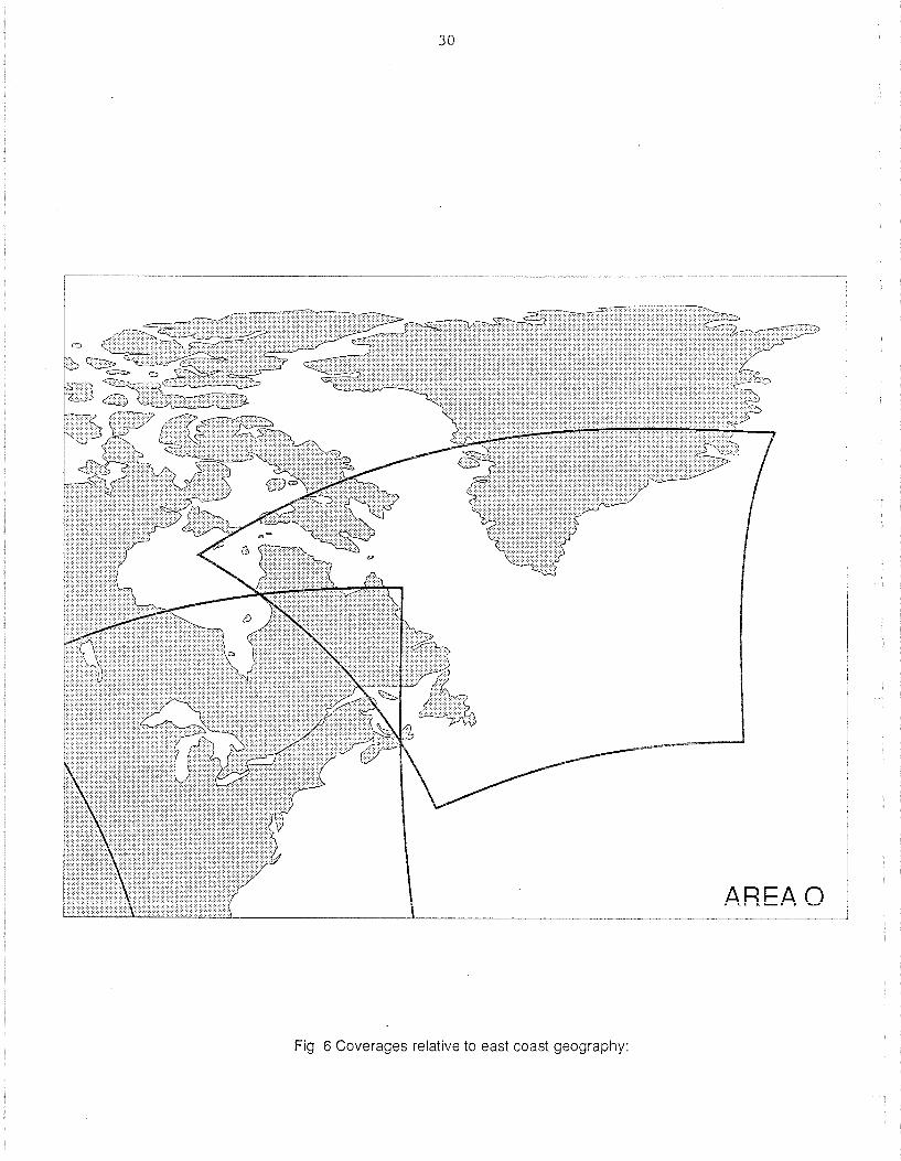
30
Fig 6 Coverages relative to east coast geography:

31
Fig 7 Graphics overlay; combined coastline, grid and bathymetry
\) =0 o
AREAP


35
Appendix 1: Catalogue of Daily SST and Visible Images in Area 0


37
Sea Surface Tem re Atlas Catalogue Area 0 1984
JUL YR IR VIS Vol IA# Sat Nav. Nav. %0 % Qual.
001 184 NO NO TAPE 002 184 NO NO TAPE 003 184 NO NO TAPE 004 184 NO NO TAPE 005 184 NO NO TAPE 006 184 NO NO TAPE 007 184 NO NO TAPE 008 184 NO NO TAPE 009 184 NO NO TAPE 010 184 NO NO TAPE 011 184 NO NO TAPE 012 184 NO NO TAPE 013 184 NO NO TAPE 014 184 NO NO TAPE 015 /84 NO NO TAPE 016 184 NO NO TAPE 017 /84 NO NO TAPE 018 /84 NO NO TAPE 019 /84 NO NO TAPE 020 /84 NO NO TAPE 021 184 NO NO TAPE 022 184 NO NO TAPE 023 /84 NO NO TAPE 024 184 NO NO TAPE 025 184 11 0001 7 GO/O 300/E 15 13 026 184 12 0002 7 GO/2 163/F 16 23 027 184 13 0003 7 OK/3 72/F 21 19 028 184 14 0004 7 GO/3 > 512/E 21 14 029 184 15 0005 7 OK/l.S 430/F 21 16 030.17 184 16 0006 7 OK/l > 512/E 22 19 030.19 184 17 0007 7 OK13 190/E 20 9 031 184 18 0008 7 GO/3 257/H 20 6
032 184 19 0009 7 GO/2 26/E 20 9 033 184 20 0010 7 GO/3 57/E 20 15 034 184 21 0011 7 PRJ1.S 17/E 27 13 035 184 22 0012 7 OK/l 46/F 27 15 036 184 23 0013 7 OK/1.5312/E 28 13 037 184 24 0014 7 GO/3 >512/1 28 15 038 184 25 0015 7 GO/O 271/1 29 12 039 184 26 0016 7 OK/3 200/E 19 9 040 /84 27 0017 7 OK/3 10/E 23 10 041 184 28 0018 7 OK/3 22/E 27 10 042 184 29 0019 7 OK/2 189/E 27 10 043 184 30 0020 7 OK/2 93/F 27 15 044 184 31 1 0021 7 OK/2 134/F 27 21 045 184 NO NO TAPE 046 184 32 1 0022 7 OK/3 200/1 28 19 047.17 184 33 0023 7 OK/2 54/1 27 15 047.19 184 34 0024 7 GO/3 49/E 26 33 048 184 35 0025 7 OK/3 SOlE 29 36 049 184 36 0027 7 PRJ3 OlE 27 17 050 184 37 0026 7 PR13 122/E 27 13 051 184 38 0028 7 OK/3 155/H 27 13

38
Sea Surface Tern re Atlas Area 0 1984
JUL YR IR VIS Vol IA# Sat Nav. Nav. %0 % Qual. day: no. no. Conf. Ace. cl r 052 184 39 0029 7 OK/3 122/F 27 10 053 184 40 0030 7 OK/1.5 79/K 28 12 054 184 41 0031 7 GO/3 243/1 28 15 055 184 42 0032 7 GO/3 257/J 27 15 056 184 43 0033 7 PRJl 209/B 26 18 057 184 44 0034 7 GO/3 35/H 26 15 058 184 45 0035 7 GO!3 65/H 27 14 059 184 46 0036 7 OK/1 134/E 27 6 060 184 47 0037 7 OK/15 > 512/NN 27 17 061 184 48 0038 7 PRI3 10/E 28 12 062 184 49 0039 7 PRJ15 244/1 28 20 063 /84 50 0040 7 GO/3 95/K 27 21 064 184 NO NO TAPE 065 184 51 1 0041 7 GO!3 OlE 26 10 066 184 52 0042 7 OK!1.5215/H 27 7 067 184 53 0043 7 PRJ3 90/F 27 11 068 184 54 0044 7 GO/1 164/F 27 11
069 184 55 0045 7 GO/l.5 342/F 28 16 070 184 56 0046 7 GO/2 296/E 28 21 071 184 57 0047 7 OK/l.5 >512/F 28 22
072 184 58 0048 7 OKI3 OlE 26 22 073 /84 59 0049 7 GO/2 OlE 27 13 074 /84 60 0050 7 OK/3 114/E 27 16 075 /84 61 0051 7 OK/3 198/F 27 16 076 /84 62 0052 7 OK/3 29/H 27 24 077 /84 63 0053 7 GO/l >512/F 28 21 078 /84 64 0054 7 GO/2 470/E 28 22
079.17 184 65 0056 7 OK/2 304/E 25 12 079.19 184 66 0055 7 OK/3 SOlE 21 20 080 /84 67 0057 7 OK/3 400/E 26 27
081 184 68 0058 7 GO/3 120/E 26 26 082 184 69 0059 7 GO/1 100/E 12 55 083 184 70 0060 7 OK/3 O/F 27 25 084 184 71 1 0061 7 PRI2 70/F 28 21 085 184 NO NO TAPE 086 184 72 0062 7 PRJ3 490/F 28 22 087 184 73 1 0063 7 GO/2 150/K 29 26 088 184 NO NO TAPE 089 184 74 1 0064 7 GO/3 OlE 26 24 090 184 75 0065 7 OKI1.5 360/E 27 18 091 /84 76 0066 7 GO/2 300/E 27 24 092 184 77 0067 7 OK/3 O/F 28 22
093 184 78 0068 7 GO/3 219/F 28 26 094 /84 79 0069 7 GO/3 461 IF 28 24 095 184 80 0070 7 OK/2 203/1 29 29 096 184 8.1 0071 7 GO/2 297/H 24 25 097 /84 NO NO TAPE 098 /84 NO NO TAPE 099 /84 NO NO TAPE 100 /84 NO NO TAPE 101 /84 82 0072 7 OK/1 240/E 28 40 102 /84 83 0073 7 GO/l >512/F 28 29 103 /84 NO NO TAPE 104 /84 NO NO TAPE

Sea Tem
JUL YR
105 184 106 184 107 184 108 184 109 184 110 184 111 184 112 184 113 184 114 184 115 184 116.18 184 116.20 184 117.18 184 117.19 184 118 184 119 184 120 184 121 184 122 184 123 184 124 184 125 184 126.18 184 126.19 184 127 184 128 184 129 184 130 184 131 184 132.11 184 132.18 184 133 184 134 184 135 184 136 184 137 184 138 184 139 184 140 184 141 184 142 184 143 184 144 184 145 184 146 184 147 184 148 184 149 184 150 184 151 184 152 184 153 184 154 184
39
re Atlas Catalogue Area 0
IR
NO NO 84 85 86 87 88 89 90 91 92 93 94 95 96 97 98 NO 99 100 101 102 103 104 105 106 107 108 109 110 111 112 113 114 115 116 117 118 119 120 121 122 123 124 125 126 NO 127 128 129 130 131 132 133
VIS Vol IA# Sat
NO TAPE NO TAPE
0074 7 0075 7 0076 7 0077 7 0078 7 0079 7 0080 7 0081 7 0082 7 0083 7 0084 7 0085 7 0086 7 0087 7
1 0088 7 NO TAPE
NO TAPE
0089 7 0090 7 0091 7 0092 7 0093 7 0094 7 0095 7 0096 7 0097 7 0098 7 0099 7 0100 7 0101 8 0102 7 0103 7 0104 7 0105 7 0106 7 0107 7 0108 7 0109 7 0110 7 0111 7 0112 7 0113 7 0114 7 0115 7 0116 7
0117 7 0118 7 0119 7 0120 7 0121 7 0122 7 0123 7
1984
Nav. Nav. % 0 % Qual
GD/1.5 O/F 27 35 GD/3 167/H 28 29 OK/3 54/F 28 31 GD/2 357/F 28 34 GD/3 214/K 29 35 GD/3 176/E 23 38 0/0 OlE 25 37 GD/3 76/E 27 36 G D/3 OlE 27 37 GD/1.5 OlE 28 38 GD/3 O/A 18 70 G D/2 172/F 28 39 GD/3 57/A 19 74 GD/l.5 341/F 28 43 GD/l.5 >512/F 17 62
G D/2 SOlE 24 30 G D/2 186/E 27 39 GD/l.5 36/E 27 35 GD/2 O/F 28 37 GD/l.5 102/F 28 35 GD/2 O/K 28 36 GD/1.5 51/A 20 58 G D/3 OlE 29 36 G D/2 OlE 21 46 GD/2 110/E 22 47 G D/3 O/H 27 37 G D/3 155/E 27 35 OK/l 76/F 20 84 GD/3 22/F 25 49 GD/3 39/F 28 47 G D/3 416/F 28 41 G D/3 248/K 27 50 PR/2 > 512/F 23 51 GD/3 OiB 25 43 GD/2 OlE 12 52 G D/3 122/E 21 53 GD/l OlE 15 62 GD/l O/F 18 57 G D/2 428/1 28 43 GD/3 417/1 29 47 GD/3 121/K 29 42 GD/2 10tE 21 56 OK/3 20/E 27 41
GD/2 47/F 13 76 GD/l.5 15/F 28 41 GD/2 247/F 28 46 GD/2 347/1 28 49 OK/2 162/1 29 48 OK/3 OlE 19 53 GD/3 OtH 21 44

40
Sea Surface re Atlas Area 0 1984
JUL YR IR VIS Vol IA# Sat Nav. Nav. %D % Qual
155 /84 134 0124 7 156 184 135 0125 7 81/H 26 50 157 184 136 0126 7 O/H 26 65 158 184 137 0127 7 > 512/E 26 63 159 184 138 0128 7 > 512/F 25 55 160.17 /84 139 0129 7 169/1 22 49 160.19 /84 140 0130 7 OlE 15 46 161 184 141 0131 7 GDi2 OlE 30 59 162.1 2/84 142 0132 8 PR/3 OlE 22 81 162.1 9/84 143 0133 7 PRJ3 26/E 20 47 162.2 2/84 144 0134 8 PRJ3 49/E 25 73 163 184 145 0135 7 OK/3 78/E 26 60 164.08 /84 146 0136 7 PRJ2 OlE 25 41 164.181 84 147 0137 7 GD/3 OlE 17 66 165 184 148 1 0138 7 OK/3 28/F 26 52 166 /84 149 .1 0139 7 OK/l.5 204/F 26 52 167 184 150 0140 7 OK/3 > 512/E 25 52 168.17 184 151 0141 7 PRJ2 135/K 23 50 168.19 184 152 0142 7 OK/3 OlE 28 65 169.1 7/84 153 0143 7 GD/3 OIK 21 51 169.19/84 154 0144 7 PRJ3 OlE 30 58 170 184 155 0145 7 PRJ3 O/H 21 49 171 184 156 0146 7 PRJ3 275/E 26 60 172 184 157 0147 7 OK/3 OIF 26 68 173 184 158 0148 7 OK/3 66/F 26 66 17418 184 159 0149 7 OK/3 224/E 26 70 17420 184 160 0150 7 PRJ3 OIA 24 67 175 184 161 0151 7 OK/3 IIF 25 65 176.17 184 162 0152 7 GD/l IIF 7 77 176.19 184 163 0153 7 GD/3 167/E 19 69 177.17 /84 164 0154 7 PRJ3 0/1 21 71 177.19 184 165 0155 7 PRJ3 In 27 73 177.22 184 166 0156 6 PRJ3 OIF 24 80 178.07 /84 167 0157 7 OKll 201/F 20 66 178.12 184 168 0158 6 OK/3 86/1 23 82 179.07 184 169 0159 7 PRJ2 IIF 18 67 179.18 184 170 0160 7 OK/3 29/E 26 63 180 184 171 0161 7 PRJ3 39/E 25 72 181 184 172 0162 7 OK/3 39/F 26 68 182 184 173 0163 7 PRJ3 370/F 25 56 183.18 184 174 0164 7 PRJ3 403/F 24 53 183.19 184 175 0165 7 OK/3 203/E 25 71 184 184 176 0166 7 OK/3 OlE 26 77 185 184 177 0167 7 OK/3 OIA 27 71 186 184 178 0168 6 OK/3 201/E 23 86 187 184 179 0169 7 OK/2 OlE 26 65 188 184 180 0170 7 OK/3 OlE 26 74 189 184 181 0171 7 OK/3 OIF 26 79 190 184 182 0172 7 PRJ3 130/F 26 75 191 /84 183 0173 7 OK/2 399/F 25 61 192 /84 184 0174 7 . OK/l.5 >512/E 24 68 193 /84 185 0175 7 OK/1.5 7211 18 77 194 184 186 0176 6 OK/3 93/F 25 76 195 /84 187 0177 6 GD/3 OlE 19 78

41
Sea Surface Tem Atlas ue Area 0 1984
JU L YR IR VIS Vol IA# Sat Nav Nav. %0 % Qual
196 /84 188 0178 7
197 /84 189 0179 7 OK/l.50/F 26 71
198 /84 190 0180 7 OK/2 198/F 26 64
199 /84 191 0181 7 OK/3 > 512/E 24 66
200 /84 192 0182 7 OK/3 > 512/E 24 69
201 /84 193 0183 7 OK/3 OlE 27 71
202.07 /84 194 0186 7 GO/3 385/F 19 78
202.19 /84 195 0185 7 OK/l.S OlE 26 77
202.22 /84 196 0184 7 OK/2 OlE 25 84
203.07 /84 197 0187 7 G0I1.5 350/F 19 87
203.19 /84 198 0188 7 GO/3 OlE 26 75
204.11 /84 199 0190 6 GO/3 OlE 21 87
204.18 /84 200 0189 7 OK/3 OlE 26 67
205 /84 201 0191 7 OK/l.5 7/F 26 63
206 /84 202 0192 7 GOI1 28/F 17 61
207.12 /84 203 0193 6 OKI2 O/A 22 84
207.18 /84 204 0194 7 OK/l.S 361/F 25 61
207.19 /84 205 0195 7 OK/l.S O/A 25 75
208 /84 206 0196 7 GO/l.S >S12/E 25 70
209 /84 207 0197 7 GO/l.S 74/1 22 74
210 /84 208 0198 7 OK/3 120/8 28 68
211.12 /84 209 0199 6 OK/3 200/E 22 84
211.19 /84 . 210 0200 7 OK/3 200/E 27 67
212 /84 211 0201 7 PRl2 400/E 26 63
213.11 /84 212 0202 6 OK/l.5113/F 20 76
213.18 /84 213 0203 7 OK/l.S OfF 26 62
214 /84 214 0204 7 G0I1.5 267/F 26 58
215.18 /84 215 0205 7 GO/2 326/F 26 59
215.19/ 84 216 0206 7 OK/2 400/E 25 73
216.18 /84 217 0207 7 GO/2 400/1 24 62
216.19 /84 218 0208 7 GO/3 120/A 26 74
217.17 /84 219 0209 7 OK/1 200/1 21 56
217.22 /84 220 0210 7 GO/2 O/A 23 74
218 /84 221 0211 7 GO/l.S OlE 28 64
219 /84 222 0212 7 GOI1.S 60/E 26 73
220 /84 223 0213 7 OK/1.S OlE 26 65
221 /84 224 0214 7 GO/l.S OfF 20 70
222 /84 225 0215 6 GO/l 222/F 17 82
223 /84 226 0216 7 GO/2 341/E 26 64
224.18 /84 227 0217 7 GO/2 > S12/E 24 70
224.21 /84 228 1 0218 6 GOI1.S 326/E 24 81
225 /84 NO NOTAPE
226 /84 NO NO TAPE
227 /84 229 1 0219 7 GO/1S OlE 27 66
228 /84 230 1 0220 7 GO/l.S OlE 26 66
229.11 /84 231 0221 a 6 GOI1 OlE 20 84
229.18/ 84 232 0221 b 7 GOI1 SOlE 8 81
230 /84 233 0222 7 GO/1.S 70/E 26 72
231 184 234 0223 7 PRll.S 3S0/E 26 72
232 /84 235 0224 6 OK/3 200/E 23 80
233 /84 236 0225 6 OK/2 14S/E 21 82
234 /84 237 0226 7 GO/l.S OlE 28 59
235 /84 NO NO TAPE
236 /84 238 1 0227 7 GO/l.S S4/E 14 76

Sea Surface Tem
JUL YR
237 /84 238 /84 239 /84 240 /84 241.17 /84 241.19 /84 242 /84 243 /84 244 /84 245 /84 246 /84 247 /84 248 /84 249.12 /84 24918 /84 250 184 251 /84 252 /84 253 /84 254 /84 255.18 /84 255.20 /84 256 /84 257 /84 258 /84 259.22 /84 259.19 184 260 184 261 184 262.11 184 262.18 184 263 /84 264.19 /84 264.22 /84 265 /84 266 /84 267 /84 268 /84 269 /84 270 /84 271 /84 272.11 /84 272.99 /84 273 /84 274.19/84 274.21/84 275 184 276 184 277 184 278 184 279 184 280 184 281 /84 282 /84
42
re Atlas Catalogue Area 0
IR
239 240 241 242 243 244 245 NO 246 247 248 249 250 251 252 253 254 255 256 257 258 259 260 261 262 264 263 265 266 267 268 269 270 271 272 NO NO 273 274 275 276 277 NO 278 279 280 281 282 283 284 285 286 287 288
VIS Vol IA# Sat
0228 6 0229 6 0230 7 0231 7 0232 7 0233 7 0234 7
NO TAPE 1 0235 7
0236 7 0237 7 0238 7 0239 7 0240 6 0241 7 0242 7 0243 7 0244 7 0245 7 0246 7 0247 7 0248 7 0249 7 0250 7 0251 7 0252 6 0253 7 0254 7 0255 7 0256 6 0257 7 0258 6 0259 7 0260 6 0261 7
NO TAPE NO TAPE 1 0262 7
0264 7 0265 7 0266 7 0267 6 0268 7 0269 7 0263 7 0270 6 0271 7 0272 7 0273 7 0274 7 0275 7 0276 7 0277 7 0278 7
1984
Nav. Nav. %0 % Qual.
OK/l 52/E 22 86 OK/1 320/H 20 83 GO/1.S 280/F 26 66 GOI1 OlE 22 67 G 0/2 100/1 24 66 GO/3 48/A 27 59 G 013 39/E 28 80
GO/2 121/E 26 70 GO/2 193/F 26 71 OK/3 100/E 26 69 GO/1.5 >512/F 26 72 OK/3 >512/F 22 55 G0I1.5 200/E 23 83 GO/1.5 98/K 23 69 GOI.1.5 Oil 21 58 G0I1.5 OlE 27 55 GO/2 OlE 25 58 G0I1.5180/E 26 59 GO/1.5 30/F 26 73 GO/l.5 230/F 26 60 GOi3 O/A 21 72 GO/3 23/A 22 61 GO/1.5 717 22 64 GO/2 OlE 23 61 G0I1.5189/E 21 66 OK/1 100/E 23 60 GO/3 300/E 26 57 OKI1 200/F 15 68 OKi3 350/E 22 71 GO/3 O/F 22 58 OK/2 52/F 19 67 GO/3 17/A 22 67 OK/1.5 19/EA 22 58 GO/2 O/A 22 64
OK/3 100/E 23 45 OK/1.5 150/E 26 54 OK/l.5 50/F 26 45 GOI1 277/F 26 44 PRl2 97/F 19 61 BAD TAPE OK/l.5 174/1 24 50 OK/1 70/E 22 60 OK/3 204/F 24 51 G 0/2 O/F 23 59 GO/3 196/E 26 47 GO/3 161/- 19 61 GO/2 238/A 20 58 GOI1 202/F 22 46 OK/3 12/A 21 62 GO/l.5 28l/A 22 48 GO/3 0/1 20 39

43
Sea Tem re Atlas Catalogue Area 0 1984
JUL YR IR VIS Vol IA# Sat Nav. Nav. %0 % Qual
283 184 289 0279 7 GO/3 OlE 23 284.19 184 290 0280 7 OK/3 261/E 26 58 284.77 184 NO 0281 BAO TAPE 285 184 291 0282 7 OK/3 336/B 26 57 286 184 292 0283 7 GO/3 391/E 26 53 287 184 NO NO TAPE 288 184 NO NO TAPE 289 184 293 0285 7 GD/3 22/E 22 72
290 17 184 294 0286 7 OK/2 >512f7 20 53 290.19 184 295 0287 7 PRl3 OlE 22 79 291 184 296 0288 7 OK/3 17/E 23 81 292.11 184 297 0289 7 PRl3 OlE 20 74 292.19 184 298 0290 7 PRl3 100/E 26 56 293 184 NO 0291 7 BAD TAPE 294 184 299 0292 7 GO/l OIF 14 64 295 184 300 0293 7 OK/3 228/F 26 41 296 184 301 0294 7 GO/l.5 > 512f7 21 50 297 184 302 0295 7 PRl2 250/1 24 32 298 184 303 0296 7 GO/3 OlE 22 45 299 184 304 0297 7 OK/3 260/E 23 48 300 184 305 0298 7 OKI2 OlE 21 27 301 184 306 0299 7 PRI2 OlE 25 35 302 184 307 0300 7 OK/3 55/A 20 54 303 184 308 0301 7 OK/l 229/F 26 40 304.08 184 309 0302 7 OK/2 23/F 24 30 304.11 184 310 0303 6 OK/2 OlE 23 47 304.20 184 311 0304 7 GD/2 84/A 21 61 305.08 184 312 0305 7 OK/3 OIF 23 42 305.11 184 313 0306 6 PRl2 O/F 19 64 305.18 184 314 0307 7 PRl3 240/F 23 41 305.19 184 315 0308 7 GO/3 OIA 22 52 306.99 184 NO 0309 BAO TAPE 306.17 184 316 0310 7 OK/2 35/K 22 32 306.19 184 317 0311 7 GO/1.5 OIA 17 77
307 184 NO NO TAPE 308 184 318 0312 7 PRl3 12/A 25 24 309 184 319 0313 7 PRl3 OlE 25 35 310 184 320 0314 7 PR/3 157/H 25 31 311 184 321 0315 7 PRl3 189/F 26 38 312 184 322 0316 7 OK/3 O/A? 21 40 313 184 323 0317 7 OK/3 OlE 22 38 314 184 324 0318 7 OK/3 OIA 22 41 315 184 325 0319 7 OK/2 170/B 23 39 316 /84 ND 0320 BAD TAPE 317 184 326 0321 7 PRl3 OIF 25 34 318 184 ND 0322 BAD TAPE 319 184 ND NO TAPE 320 184 327 1 0323 7 OK/l.5 O/M 21 40 321 184 328 0324 7 PRl3 316/A 21 38 322 184 329 0325 7 7/1 > 512/F 22 25 323 184 330 0326 7 OKI1.5 OIA 22 30 324 184 331 0327 7 OKI2 OIA 23 23 325 184 332 0328 7 PR!3 31/E 25 12 326 184 333 0329 7 PR!3 35/F 26 21

44
Sea Surface Tem Atlas Catalogue Area 0 1984
JUL YR IR VIS Vol IA# Sat Nav. Nav. %D % Qual.
327 184 334 0330 7 1 328 /84 335 0331 7 OfF 21 33
/84 336 0332 7 O/A 21 45 330 /84 337 0333 7 GD/2 O/A 22 39 331 /84 338 0334 7 OK/2 122/A 23 48 332 /84 339 0335 7 OK/3 463/F 23 44 333 /84 340 0336 7 PRJ3 238/E 26 37 334 /84 341 0337 7 OK/l.S 184J? 20 41 335 /84 342 1 0338 7 GD/15 63/A 21 43 336 /84 ND NOTAPE 337 /84 343 0339 7 PR/l.5 298/1 23 18
337 /84 344 0340 6 PRJ3 58/A 20 30 338 184 345 0341 7 OK/1.5 O/A 22 33 339 184 346 0342 7 GD/2 25/A 23 29 340 /84 ND NOTAPE 341 184 ND NO TAPE 342 /84 ND NO TAPE 343 /84 347 1 0343 7 GD/3 83/A 21 46 344.20 /84 348 0344 7 OK/3 60/A 21 42 344.22 184 349 0345 6 OK/3 OIF 25 24 345 184 350 0346 7 GD/3 >512J? 25 24 346 184 351 0347 7 GD/3 18/E 22 27
347 184 ND 0348 BAD TAPE 348 184 352 0349 7 GD/3 >512J? 23 29 349 /84 353 0350 7 OK!3 58/E 26 16 350 /84 ND 0351 BAD TAPE 351 /84 ND 0352 BAD TAPE 352 184 354 0353 7 GD/3 58/A 21 45 353.08 /84 355 0354 7 Oil OlE 23 22 353.18 184 356 0355 7 GD/3 >512J? 25 19 354 /84 357 0356 7 GD/3 > 512J? 22 32 355 184 ND 0357 BAD TAPE 356 /84 ND 0358 BAD TAPE 357 /84 358 0359 7 0/1.5 IJ? 24 16 358.18 /84 359 0360 7 GD/3 98/E 26 18 35821 /84 360 0361 7 PRJ2 > 512/E 23 16 359 /84 361 0362 7 GD/3 224/H 26 23 360 /84 ND 0363 BAD TAPE 361.18 /84 362 0364 7 GD/3 >512J? 24 11
361.19 /84 363 0365 7 GD/3 O/A 22 32 362.18 /84 364 0366 7 GD/3 92/K 23 11 362.19 /84 365 0367 7 GD/3 O/A 22 22 363.17 /84 366 0368 9 GD/3 76/B 27 6 36319 /84 367 0369 7 GD/2 90/E 23 21 364 184 368 0370 9 GD/2 198/AI 20 36 365.18 184 369 0371 9 GD/2 74J? 20 38 365.22 /84 370 0372 6 OK/3 20/F 25 16 366.12 /84 371 0373 6 OK/3 OlE 22 14 366.17 184 372 0374 9 GD/2 91/F 27 13

Sea Surface Tem
JUL
001 002 003 004 005 006 007 008 009 010 011 012 013
YR
185 185 185 185 185 185 185 185 185 185 185 185 185
014 185 015 185 016 185 017 185 018 185 019 185 020 185 021 185 022 185 023 185 024 185 025 185 026 185 027 185 028 185 029 185 030 185 031.16 185 031.18 185 032 185 033 185 034 185 035 185 036 185 037 185 038 185 039 185 040 185 041 185 042 185 043 185 044 185 045 185 046 185 047 185 048 185 049 185 050 185 051 185 052 185
45
re Atlas Catalogue Area 0
IR
373 374 375 376 377 378 379 ND 380 381 382 383 384 ND 385 386 387 388 389
3 4 5 ND 6 7 8 9 10 11 12 13 14 ND 15 16 17 18 19 20 21 22 23 24 25 26 27 28 29 30 31 32
VIS
2
Vol IA# Sat
NO TAPE
1 2 2 2 2 2 0398 2 2 2 2 2 2 2 2 2
2 2 2 2 2 2 2 2 2 2 2 2 2 2 2 2 2 2
0375 7 0376 7 0377 7 0378 7 0379 7 0380 7 0381 7
0382 9 0383 9 0384 9 0385 9 0386 9 0387 BAD 0388 9 0389 9 0390 9 0391 9 0392 9 0393 9 0394 9 0395 9 0396 9 0397 9 BAD TAPE 0399 9 0400 9 0401 9 0402 9 0403 9 0404 9 0405 9 0406 9 0407 9 0408 BAD 0409 9 0410 9 0411 9 0412 9 0413 0414 9 0415 9 0416 9 0417 9 0418 9 0419 9 0420 9 0421 9 0422 9 0423 9 0424 9 0425 9 0426 9
Nav. Nav. % D
OK/3 72/F OK/3 7j?
GD/3 7j?
GD/3 7j?
OK/3 30/E GD/3 518 GD/3 174/8
GD/3 OIF GD/3 225/F GD/3 717 GD/3 717 GD/3 OIA TAPE GD/2 717 GD/3 717 GD/3 1301E GD/3 54/F OK/3 145/F OK/1.5 717 GD/3 88/A GD/2 717 OK13 OIK GD/2 40/E
OK/2 OlE GD/3 O/F G D/2 329/F OK/3 265/F GD/3 14/A GD/3 717 GD/1.5 10lE GD/1.5 50lK GD/1 28/J TAPE OK/3 SOlE OK/3 O/F OK/3 O/F OK/2 163/F GD/3 717 OK/2 164/A OKI1.5 100lK GD/2 OlE OK/2 OlE OK/1.5 O/H OK/2 717 GD/2 717 GD/2 ?17 PRl3 370/H PRl3 717 OK/3 200/1 OK/3 OlE OK/3 OlE
26 26 25 23 23 23 26
26 26 26 24 22
23 26 26 26 26 21 22 23 21 23
26 26 26 26 14 23 22 22 17
26 26 26 26 26 22 23 22 23 26 26 26 26 26 25 23 23 23
%
19 23 16 16 21 24 15
15 17 17 23 22
82 9 11 16 15 19 7 17 16 18
8 8 15 14 32 12 16 13 14
7 9 5 12 13 18 13 29 21 8 16 14 17 23 23 19 13 15
1985
Qual.

Sea Surface Tem
JUL day 053 054 055 056 057 058 059 060 061 062 063 064 065 066 067 068 069
YR
185 185 185 185 185 185 185 185 185 185 185 185 185 185 l or:: UJ
185 185
070.16 185 070.18 185 071 072 073 074 075 076 077
185 185 185 185 185 185 185
078.16 185 078.18 185 079 185 080 185 081 185 082 185 083 185 084 185 085.17 185 085.18 185 086 185 087.16 185 087.18 185 088.06 185 088.18 185 089 185 090 185 091 092 093 094.17 094.18 095 096 097 098 099 100
lor:: UJ
185 185 185 185 185 185 185 185 185 185
, IR
no.
33 ND 34 35 ND 36 37 38 39 40 41 42 43 44 45 46 47 48 49 50 51 52 53 ND 54 55 56 57 58 59 60 61 62 63 64 65 66 67 68 69 70 71 72 73 74 75 76 77 78 79 80 81 82 83
46
re Atlas Catalogue Area 0
VIS no.
Vol
2
2 2
2 2 2 2 2 2 2 2 2
IA# Sat
0427 9 0428 BAD 0429 9 0430 9 0431 BAD 0432 9 0433 9 0434 9 0435 9 0436 9 0437 9 0438 9 0439 9 0440 9
2 0441 9 2 0442 9 2 0443 9 2 0444 9 2 0445 9 2. 0446 9 2 0447 9 2 0448 9 2 0449 9 NO TAPE 2 0450 9 2 0451 9 2 0452 9 2 0453 9 2 0454 9 2 0455 9 2 0456 9 2 0457 9 2 0458 9 2 0459 9 2 0461 9 2 0460 9 2 0462 9 2 0463 9 2 0464 9 2 0465 9 2 0466 9 2 0467 9 2 0468 9 2 2 2 2 2 2 2 2 2 2 2
0469 9 0470 9 0471 9 0472 9 0473 9 0474 9 0475 9 0476 9 0477 9 0478 9 0479 9
Nav. Nav. % D Conf. Ace.
OK/3 O/H 24 TAPE OKI1.5 77/E 26 OK!3 32/E 26 TAPE OKI1.5 717 25 OK/3 23/E 23 OK/3 117 22 GD/2 6711 20 OK/3 112/E 24 OK/3 125/E 26 OKJ1 >512/F 15 PRJ3 O/F 26 OK/3 222/F 26 OK!3 <512/F 26 OK/2 59/A 23 OK/2 117 23 OK/3 200/J 21 OK!3 73/A 23 OK/3 >512/F 24 GD/3 260/E 26 GD/l 180/F 26 o K/3 > 51 21 A 26
OK/3 380/F 26 PRJ3 7n 26 G D/3 > 512JF 23 GD/3 69/A 23 GD/3 44/K 22 OK/3 57/E 24 GD!3 117!A 24 OK/3 120!E 24 OK/3 150!F 26 OK/3 134!F 26 OK!3 235!F 26 GD/2 O/A 22 GD/3 23/A 23 GDI1 306/1 25 GD/1.5 187/A 23 GDI1.5 OlE 22 OK/2 32/A 23 GDI1 25/1 22 GD/3 58/E 24 GD/3 3S9/E OK/3 105/F GD!3 63/F OK!3 145/F GD!3 01< E GD!2 400/F GD/3 ?n GD!3 O/A OK/1.S 103/K GD!3 170!E GD!3 OIA
26 26 26 26 22 26 26 23 22 24 24
% elr 18
13 12
12 21 14 11 22 8 18 8 13 14 34 19 23 30 22 19 18 15
19 15 15 31 15 24 23 24 22 18 16 38 35 20 34 18 32 20 29 12 15 17 23 40 30 24 29 27 22 25
1985
Qual.

Sea Surface Tem
JUL YR
101 185 101 185 102 185 103 185 104 185 105 185 106 185 107 185 108 185 109 185 110 185 111 185 112 185 113 185 114 185 115 185 116 185 117 185 118 185 119 185 120 185 121 185 122 185 123 185 124 185 125 185 126 185 127 185 128 185 129 185 130 185 131 185 132 185 133 185 134 185 135.16 185 135.18 185 136 185 137 185 138 185 139 185 140 185 141 185 142 185 143 185 144 185 145 185 146 185 147 185 148 185 149 185 150 185 151 185 152 185
re Atlas Catalogue
IR
84 NA ND 85 86 87 88 89 90 ND 91 92 93 94 95 96 97 98 99 ND 100 101 102 103 104 105 106 107 108 109 110 111 112 113 114 115 116 117 118 119 120 121 122 123 124 125 126 127 128 129 130 131 132 133
VIS Vol
2
2 2 2 2 2 2
2 2 2 2 2 2 2 2 2
2 2 2 2 2 2 2 2 2 2 2 2 2 2 2 2 2 2 2 2 2 2 2 2 2 2 2 2 2 2 2 2 2 2
47
Area 0 1985
IA# Sat Nav. Nav. % D % Qual.
0480 9 GD/3 100lE 26 18 0481 SAME AS ABOVE 0482 9 BAD TAPE 0483 9 OK/3 73/F 26 21 0484 9 G D/3 280/F 26 19 0485 9 GD/l.5 In 26 24 0486 9 GD/2 In 25 24 0487 9 GD/3 85iK 24 31 0488 9 GD/3 19/E 24 39 0489 BAD TAPE 0490 9 G D/3 60/E 26 39 0491 9 GD/3 54/F 26 39 0492 9 GD/3 53/F 26 41 0493 9 GD/2 120/F 26 37 0494 9 GD/2 1/1 27 37 0495 9 GD/2 340/E 22 37 0496 9 G D/3 154/K 24 32 0497 9 GD/3 O/K 21 23 0498 9 G D/3 OlE 24 38 0499 BAD TAPE 0500 9 GD/3 OlE 26 35 0501 9 GD/3 68/E 32 15 0502 9 GD/3 OIF 26 30 0503 9 OK/l.5 282/F 27 38 0504 9 GD/3 OIA 14 58 0505 9 GD/3 184/K 25 35 0506 9 GD/3 OlE 24 47 0507 9 GD13 223/E 24 42 0508 9 GD/3 In 24 38 0509 9 GD/3 65/E 26 29 0510 9 GD/3 302/E 26 31 0511 9 GD/3 42/F 26 38 0512 9 GD/3 121/F 26 36 0513 9 GD/3 In 26 36 0514 9 GD/1.5250/K 25 40 0515 9 GD/2 125/K 23 30 0516 9 GD/3 OlE 24 51 0517 9 GD/3 511A 24 43 0518 9 GD12 104/E 24 34 05199 GDI1 OlE 8 50 0520 9 GD/3 OlE 26 49 0521 9 GD/2 91/F 26 56 05229 GD/1.540/F 2661 0523 9 GD/1.5 262/F 26 58 0524 9 GD/3 In 26 58 0525 9 GD/l 170/K 24 49 0526 9 GD/3 170/K 22 43 0527 9 GD/3 SOlE 24 43 0528 9 GD/3 90/E 24 49 05299 GD13 160/F 26 41 0530 9 OK13 O/F 26 41 0531 9 OK/3 OfF 26 39 0532 9 OK/3 165/F 26 48 0533 9 0 K/2 450/F 25 43

Sea Surface Tem
JUL YR
153.16/85 153.18/85 154 185 155 185 156 185 157 185 158 185 159 185 160 185 161 185 162 185 163 185 164 185 165 185 166 185 167 185 168 185 169 185 170 185 171 185 172 185 173 185 174 185 175 185 176 185 177 185 178 185 179 185 180 185 181 185 182 185 183 185 184 185 185 185 186 185 187 185 188 185 189 185 190 185 191 185 192 185 193 185 194 185 195 185 196 185 197 185 198 185 199 185 200 185 201 185 201 185 202.16 185 202.18 185 203 185
IR
134 135 136 137 138 139 140 141 142 143 144 145 146 147 148 149 150 151 152 153 154 155 156 157 158 159 160 161 162 163 164 165 166 167 168 169 170 171 172 173 174 175 176 177 178 179 180 181 182 183 NA 184 185 186
Atlas Cata
VIS Vol
2 2 2 2 2 2 2 2 2 2 2 2 2 2 2 2 2 2 2 2 2 2 2 2 2 2 2 2 2 2 2 2 2 2 2 2 2 2 2 2 2 2 2 2 2 2 2 2 2 2
2 2 2
e
48
Area 0
leA # Sat Nav. Nav. % D
0534 9 0535 9 0536 9 0537 9 0538 9 0539 9 0540 9 0541 9 0542 9 0543 9 0544 9 0545 9 0546 9 0547 9 0548 9 0549 9 0550 6 0551 9 0552 9 0553 9 0554 9 0555 9 0556 9 0557 9 0558 9 0559 9 0560 9 0561 9 0562 9 0563 9 0564 9 0565 9 0566 9 0567 9 0568 9 0569 9 0570 9 0571 9 0572 9 0573 9 0574 9 0575 9 0576 9 0577 9 0578 9 0579 9 0580 9 0581 9 0582 9 0583 9 0584 SAME 0585 9 0586 9 0587 9
GD/2 260/K GD/3 lOlA OK/3 1(1
GD/3 O/A OK/l.5 45/E OK/3 210/E OK/3 10/E OK!3 20/F PRJ3 120/F OK/3 >512J1 OK/3 313/K OK/3 1(1
OKJ3 1(1
GD/2 150/K OK/3 OlE OK/3 OlE PRJ3 170/F OK/2 65/F OKJ1.5 307/E PRJ3 1(1
PRJ3 1(1
OK/3 OIA OK/3 OIA OK/3 94/E PRJ3 34/E OK/3 OlE PR/15 22/F PRJ3 118/F PRJ1.5 364/F PRJ3 1(1
PR/2 150/1 OK/2 Oil PRJ3 OlE PRJ3 OIF PRJ3 31/E OKJ3 OIF PRJ1.5 14/F PRJ3 1(1
OKJ3 OIA PRJ3 In PRJ2 62/1 OK/3 53/E PRJ3 SOlE PRJ3 10/E PRJ3 162/F PRJ3 In OK/3 170/F OK/3 In OK/3 In OK/3 110/1 AS ABOVE OK/2 90/1 PRJ3 90/E OK/3 OlE
24 23 23 24 24 26 26 26 23 26 25 23 23 24 16 26 21 26 25 24 24 23 24 24 26 26 26 26 26 24 23 20 24 26 26 26 26 26 23 24 22 24 24 26 26 26 26 25 24 22
21 23 24
%
41 47 49 62 54 46 50 54 47 52 58 58 55 45 66 59 49 58 54 56 57 56 54 61 66 62 51 58 54 46 53 61 68 64 62 65 58 64 71 71 66 64 62 64 68 70 74 68 58 51
49 67 67
1985
Qual

Sea Surface Tem
JUL
204 205 206 207 208 209 210 211 212
YR
185 185 185 185 185 185 185 185 185
213 185 214 185 215 185 216.17 185 216.18 185 217 185 218 185 219 185 220.16 185 220.18 185 221 185 222 185 223 185 224 185 225.17 185 225.19 185 226 185 227 185 228 185 229 185 230 185 231 185 232 185 233 185 234 185 235 185 236 185 237 185 238 185 239 185 240 185 241 185 242 185 243 185 244 185 245 185 246' 185 247 185 248 185 249 185 250 185 251 185 252 185 253 185 254 185
IR
187 188 189 190 191 192 193 194 195 ND 196 197 198 199 200 201 202 203 204 205 206 207 208 209 210 211 212 213 214 215 216 217 218 219 220 221 222 223 224 225 226 227 228 229 230 231 232 233 234 235 236 237 ND ND
49
Atlas Catalogue Area 0
VIS Vol IA# Sat Nav. Nav. % D %
2 2 2 2 2 2 2 2 2 NO TAPE
0588 9 0589 9 0590 9 0591 9 0592 9 0593 9 0594 9 0595 9 0596 9
2 0597 9 2 0598 9 2 0599 9 2 0600 9 2 0601 9 2 0602 9 2 0603 9 2 0604 9 2 0605 9 2 0606 9 2 0607 9 2 0608 9 2 0609 9 2 0610 9 2 0611 9 2 0612 9 2 0613 9 2 0614 9 2 0615 9 2 0616 9 2 0617 9 2 0618 9 2 0619 9 2 0620 9 2 0621 9 2 0622 9 2 0623 9 2 0624 9 2 0625 9 2 0626 9 2 0627 9 2 0628 9 2 0629 9 2 0630 9 2 0631 9 2 0632 9 2 0633 9 2 0634 9 2 0635 9 2 0636 9 2 0637 9 2 0638 9 NOTAPE NO TAPE
OK/3 90/E PR/3 OlE PR/3 O/F OK/3 63/F OK/3 7J1 PR/3 7J1 GD/l.5 O/F OK/3 89/E OK/3 34/E
OK/3 42/E OK/3 O/F GD/3 70/F GD/3 OIA GD/3 209/F G D/3 7J1 GD/3 36/E GD/l.5 68/1 GD/3 7J1 GD/3 51E GD/l.5 OlE GD/3 135/E GD/3 156/F GD/3 79/F GD/3 l7/A GD/3 l42/F GD/3 37/A GD/3 174/E G D/3 OIA G D/3 Oil G 0/3 OlE G 0/3 7J1 OK/3 OlE G 013 OlE GD/3 59/E GD/3 7J1 GD/3 7n GD/3 7n GO/3 63/1 GD/3 70/A G D/3 130/E GD/3 45/E GD/3 28/E GD/3 OlE GD/3 182/F GD/3 7n GD/3 220/1 GDI2 60/A GD/3 0/1 GD/3 OlE GD/3 40/E GD/l >512/E
26 64 26 52 26 49 26 57 26 66 22 58 20 79 23 66 19 66
26 26 26 22 26 25 23 23 23 24 24 26 26 26 14 26 15 23 23 21 24 26 26 26 26 26 25 23 22 24 25 26 26 26 26 26 25 24 22 24 26 18
55 69 63 75 60 64 70 63 69 63 62 66 69 66 86 66 80 68 63 65 73 65 65 77 80 74 68 70 68 70 64 61 54 53 47 58 50 62 56 66 54 70
1985
Qual

50
Sea Surface re Atlas Area 0 1985
JUL YR IR VIS Vol IA# Sat Nav. Nav .. %0 % Qual.
day no. no. Conf. Ace. elr
255 185 NO NO TAPE 256 185 NO NOTAPE 257 185 238 2 0639 9 GO/3 17/E 22 66 258 185 239 2 0640 9 GO/3 OIA 24 73 259 185 NO NO TAPE 260 185 NO NO TAPE 261 185 240 2 0641 9 GO/3 OIF 26 64 262.11 185 241 2 0643 8 GOI1 > 512/F 15 80 262.17 185 242 2 0642 9 GO/2 75/F 26 61
263 185 243 2 0644 9 GO/1.5 OlE 22 63 264 185 244 2 0645 9 GO/1.5 193/E 20 70 265 185 245 2 0646 9 GO/3 7f? 26 53 266 185 246 2 0647 9 GO/2 260/1 24 53 267 185 247 2 0648 9 GO/3 9/A 24 70 268 185 248 2 0649 9 GO/3 220/E 24 65 269 185 249 2 0650 9 GO/3 OlE 24 58 270 185 250 2 0651 9 GO/3 38/E 26 43 271 185 251 2 0652 9 GO/2 326/E 26 55 272 185 252 2 0653 9 GO/2 O/F 26 46
273 185 253 2 0654 9 GO/3 69/A 22 55 274 185 254 2 0655 9 GO/3 7f? 24 43 275 185 255 2 0656 9 GO/3 717 25 49 276 185 256 2 0657 9 GO/3 OlE 23 51 277 185 257 2 0658 9 GO/3 Oil 21 39 278 185 258 2 0659 9 G0/1.5 32/E 24 48 279 185 259 2 0660 9 GO/O 7/F 18 57 280 185 260 2 0661 9 GO/1 43/E 26 39 281 185 261 2 0662 9 GO/2 O/F 26 41 282 185 262 2 0663 9 GOJ3 717 26 36 283 185 263 2 0664 9 GO/3 247/F 26 31 284 185 264 2 0665 9 GOJ3 717 25 26 285 185 265 2 0666 9 GO/2 226/1 24 29 286 185 266 2 0667 9 GO/3 54/1 21 30 287 185 267 2 0668 9 GO/3 274/A 24 46 288 185 NO 0669 BAD TAPE 289 185 268 2 0670 9 GO/2 24/E 26 29 290 185 269 2 0671 9 GO/2 16/F 26 39 291 185 270 2 0672 9 GO/3 22/F 26 42 292 185 271 2 0673 9 GO/3 ?f7 25 36 293 185 NO NO TAPE 294 185 272 2 0674 9 GO/3 28/E 23 53 295 185 273 2 0675 9 GO/3 l11/E 23 53 296.16 185 274 2 0676A9 GO/3 44/1 20 40 296.18 /85 275 2 067689 GO/2 2 OrA, 12 76 297 185 276 2 0677 9 GO/3 OlE 24 50 298 185 277 2 0678 9 GO/2 269/E 26 32 299 185 278 2 0679 9 GO/2 270/F 26 33 300 185 279 2 0680 9 GO/2 55/F 26 37 301 185 280 2 0681 9 GO/2 22/A 17 48 302 185 281 2 0682 9 GO/2 O/A 18 43 303 185 282 2 0683 9 GO/2 7f? 25 37 304 185 283 2 0684 9 GO/3 21 IE 23 51 305 185 284 2 0685 9 GO/2 108/M 27 22
306 185 285 2 0686 9 GO/3 35/E 24 59

51
Sea Tem re Atlas Area 0 1985
JUL YR IR VIS Vol IA# Sat Nav. Nav. %0 % Qual
da:-t no. no. Conf. Ace. cl r 307 185 286 2 0687 9 GO/l 40/E 24 57 308 185 287 2 0688 9 GO/2 OlE 26 42 309 185 288 2 0689 9 GO/l.S 50/F 26 30 310 185 289 2 0690 9 GO/l 74/F 26 29 311 185 290 2 0691 9 GO/3 28/A 22 42 312 185 291 2 0692 9 GO/3 OIA 23 40 313 185 292 2 0693 9 GO/3 95/E 23 36 314 185 293 2 0694 9 GO/3 )(7 23 30 315 185 294 2 0695 9 GO/3 36/E 23 30 316 185 295 2 0696 9 GO/3 20/E 24 28 317 185 296 2 0697 9 GO/l.S 77/E 26 14 318 185 297 2 0698 9 GO/3 20/E 26 24 319 185 298 2 0699 9 GO/3 18/F 26 20 320 185 299 2 0700 9 GO/2 160/F 26 23 321 185 300 2 0701 9 GO/3 iSOlA 22 31 322 185 301 2 0702 9 GO/3 O/A 23 35 323 185 302 2 0703 9 G0/1.5 7/M 17 6 324 185 303 2 0704 9 GO/3 O/J 20 21 325 185 304 2 0705 9 GO/2 89/E 15 24 326 185 305 2 0706 9 GO/3 8/E 26 12 327 185 306 2 0707 9 GO/2 20/E 26 17 328 185 307 2 0708 9 GO/15 27/F 26 20 329 185 308 2 0709 9 GO/3 40/F 26 23 330 185 309 2 0710 9 GOI2 308/F 26 24 331 185 310 2 0711 9 GO/2 ?/F 25 22 332 185 311 2 0712 9 GO/2 184/1 24 22 333 185 312 2 0713 9 GO/2 O/K 22 19 334 185 NO NO TAPE 335 185 313 2 0714 9 GO/3 OlE 24 28 336 185 314 2 0715 9 GO/3 100/H 26 14 337 185 315 2 0716 9 GO/1.5 126/F 26 11 338 185 316 2 0717 9 GO/1 233/E 26 16 339 185 317 2 0718 9 GO/l.S 188/F 26 25 340 185 318 2 0719A9 GO/l 403/F 14 30 341 185 319 2 0719B 9 GO/3 47/A 14 26 342 185 320 2 0720 9 GO/2 8/E 23 22 343 185 321 2 072iA9 GO!l O/K 20 17 344 185 322 2 0721 B 9 GO/2 260/A 12 43 345 185 323 2 0722A9 GO/2 74/E 12 26 346 185 324 2 0722B 9 GO/l 41/E 17 26 347 185 325 2 0723 9 GO/3 25/F 26 17 348 185 326 2 0724 9 GO/l.5 263/E 26 16 349 185 327 2 0725 9 GO/3 386/F 26 21 350 /85 328 2 0726 9 GO/2 717 25 25 351 185 329 2 0727 9 GO/2 140/K 18 35 352 185 330 2 0728 9 OK/l.5 20/K 22 18 353 185 331 2 0729 9 GO/3 55/E 24 10 354 185 332 2 0730 9 GO/3 10/E 26 11 355 185 333 2 0731 9 GO/l 300/F 15 12 356 /85 334 2 0732 9 GO/3 135/F 21 11 357 185 335 2 0733 9 OK/2 16/F 26 20 358 185 336 2 0734 9 GO/3 124/A 23 15 359 185 337 2 0735 9 GO/1S 717 26 22
360 185 338 2 0736 9 GO/2 717 24 17

52
Sea re Atlas Catalogue Area 0 1985
JUL YR IR VIS Vol IA# Sat Nav. Nav. %D % Qual.,
361 185 339 2 0737 9 GD/1.5 ?I? 23 15 362 185 340 2 0738 9 GD/2 54/E 24 23 363 185 341 2 0739 9 GD/3 77/E 25 14 364 185 342 2 0740 9 GD/3 20S/H 26 13 365 185 343 2 0747 9 OK/3 252/F 26 19

53
Sea Tem Atlas Area 0 1986
JUL YR IR VIS Vol IA# Sat Nav. Nav. %0 % Qual.
001 186 344 2 0748 9 GO/3 71' 26 21 002 186 345 2 0749 9 GO/1.5 210/F 26 15 003 186 346 2 0750 9 OK/l.5 71' 26 20 004 186 347 2 0751 9 GO/3 39/E 23 14 005 186 348 2 0752 9 GO/3 71' 24 11 006 186 349 2 0753 9 GOJ1 40/1 21 24 007 186 350 2 0754 9 GO!3 45/A 24 14 008 186 351 2 0755 9 GO/1.5 150/E 22 7 009 186 352 2 0756 9 GO/1.5 150/E 26 13 010 186 353 2 0757 9 GO/2 10/F 26 21 011 186 354 2 0758 9 G0!1.5 355/F 26 14 012 186 355 2 0759 9 GOJ3 296/F 26 16 013 186 356 2 0760 9 GO/3 717 26 19 014 186 357 2 0761 9 GOI1 135/K 25 19 015 186 358 2 0762 9 GOI1 ?n 22 10 016 186 359 2 0763 9 GO/2 137/A 24 19 017 186 360 2 0764 9 GOI2 27/E 25 24 018 186 361 2 0765 9 GOJ3 216/E 26 15 019 186 362 2 0766 9 OK/3 72/E 26 21 020 186 363 2 0767 9 G0I1.5 258/1 26 17 021 186 364 2 0768 9 GO/3 In 27 12 022 186 365 2 0769 9 GO/l.5 71' 26 18 023 186 366 2 0770 9 GOJ3 OlE 23 21 024 186 367 2 0771 9 G0I1.5 340/J 22 13 025 186 368 2 0772 9 GO/l.S S5/A 24 10 026 186 369 2 0773 9 GOI1 370/E 24 18 027 186 370 2 0774 9 OKll 71' 26 14 028 186 371 2 077S 9 GO/l In 26 17 029 186 372 2 0776 9 GO/l.S OIF 26 19 030 186 373 2 0777 9 GO/3 230/E 26 20 031 186 374 2 0778 9 GO/3 In 26 20 032 186 375 2 0779 9 GO/3 717 25 16
033 186 376 2 0780 9 GO/3 310/J 24 9
034 186 377 2 0781 9 GO/3 OlE 24 13 03S 186 378 2 0782 9 GO/3 OlE 24 12 036 186 379 2 0783 9 GOI1.S 245/E 72 58 037 186 380 2 0784 9 OKJ3 114/F 26 13 038 186 381 2 0785 9 GO/2 1011A 14 36 039.17 186 382 2 078689 GO/l 7/A 17 9 039.17 186 383 2 0786A9 GO/l 7/E 19 3 040 186 1 3 0787 9 GO/3 283/F 26 22 041 186 2 3 0788 9 GO/3 71' 26 21 042 186 3 3 0789 9 GO/l.S 221/J 24 15 043 186 4 3 0790 9 GO/1.5 39/J 22 21 044 186 5 3 0791 9 GO!3 117/A 23 12 045 186 6 3 0792 9 GO/2 45/E 16 20 046 186 7 3 0793 9 GO/1.5 240/E 26 9 047 186 8 3 0794 9 GO/1.5 48/E 26 10 048 186 9 3 0795 9 GO/3 O/A 21 25 049 186 10 3 0796 9 GO/3 211/F 26 18 050 186 11 3 0797 9 GO/3 ?n 25 23 051 186 12 3 0798 9 GO/3 206/1 24 26 052 186 13 3 0799 9 GO/2 100/1 22 21

54
Sea Tem Atlas Area 0 1986
JUL YR IR VIS Vol IA# Sat Nav. Nav. %0 % Qual.
053 186 14 3 0800 9 054 186 15 3 0801 9 87/E 23 19 055 186 NO 0802 BAO TAPE 056 186 16 3 0803 9 GO/3 171/E 26 11 057 186 17 3 0804 9 GO/3 274/E 26 12 058 186 18 3 0805 9 GO/l.S 196/F 26 19 059 186 19 3 0806 9 GO/3 In 26 27 060 186 ·20 3 0807 9 GOIi.S In 2S 12 061 186 21 3 0808 9 GO/15 320/1 23 13 062 186 22 3 0809 9 GO/1.S Oil 21 13 063 186 23 3 0810 9 GOJ3 OlE 23 25 064 186 24 3 0811 9 GO/3 12S/E 26 13 065 186 25 3 0812 9 GO/3 42/F 26 13 066 186 26 3 0813 9 GO/3 OlE 26 21 067 186 27 3 0814 9 GO/1.S 200/F 26 15 068 186 28 3 0815 9 GO/l.S 268/F 26 12 069 186 29 3 0816 9 GO/3 ?n 25 14 070 186 30 3 0817 9 GO/3 260/A 22 33 071 186 31 3 0818 9 GO/3 182/J 20 7 072.16 186 32 3 0819 9 GO/3 O/J 23 9 072.18 186 33 3 0820 9 GOJ3 37/E 23 29 073 186 34 3 0821 9 GO/3 65/H 23 21 074 186 35 3 0822 9 GO/3 72/E 26 17 075 186 36 3 0823 9 GO/3 O/F 26 13 076 186 37 3 0824 9 GO/3 133/F 26 18 077 186 38 3 0825 9 GO/3 262/F 26 22
078 186 39 3 0826 9 OKI1.S 407/F 25 23 079 186 40 3 0827 9 GO/3 243/1 24 14 080.16 186 41 3 0828 9 GO/3 83/1 22 9 080.18 186 42 3 0829 9 GO/3 90/A 22 29 081 186 43 3 0830 9 GO/2 O/A 22 31 082 186 44 3 0831 9 G012 2S/E 23 35 083 186 45 3 0832 9 GO/3 119/E 26 22
084 186 46 3 0833 9 GO/3 74/F 26 17 085 186 47 3 0834 9 GO/3 7n 26 22
086 186 48 3 0835 9 G0/1.5 270/E 26 23 087 186 49 3 0836 9 OK/3 ?n 25 22 088 186 50 3 0837 9 GOJ3 73/A 21 43 089.16 186 51 3 0838 9 OK/3 ?n 22 30 089.18 186 52 3 0839 9 GO/3 168/A 22 44 090.16 186 53 3 0840 9 GO/3 314/J 20 24 090.18 186 54 3 0841 9 GO/3 73/A 22 41 091 186 55 3 0842 9 GOJ3 OlE 23 38 092 186 NO NO TAPE 093 186 56 3 0843 9 GO/3 163/F 26 21 094 186 57 3 0844 9 GO/3 OlE 26 25 095 186 58 3 0845 9 GO/l.S 23/F 26 33 096 /86 59 3 0846 9 GO/2 380/E 24 34 097 186 60 3 0847 9 GO/2 ?n 25 31 098 186 61 3 0848 9 GO/l.S 168!K 23 30 099 186 62 3 0849 9 GO/l.S 22/K 22 31 100 186 63 3 0850 9 GO/l 40/A 23 34 101 186 64 3 0851 9 GO/3 145/E 23 34 102 186 65 3 0852 9 GO/3 21!E 26 47

Sea Surface Tem
JUL YR
103 /86 104 /86 105 /86 106 186 107 /86 108 /86 109 /86 110 186 111 /86 112 /86 113 /86 114 /86 115 /86 116 /86 117 /86 118 /86 119 /86 120 /86 121 /86 122 /86 123 /86 124 /86 125 /86 126.17 /86 126.18 /86 127.16/86 127.18/86 128 /86 129 /86 130 186 131 /86 132 /86 133 /86 134.17 /86 134.18 /86 135.07 /86 135.17 /86 135.18 /86 136.07 /86 136.16 /86 136.18 /86 137.06 /86 137.16/86 138 /86 139 /86 140 /86 141 /86 142 /86 143 /86 144 /86 145 /86 146.16 /86 146.18 /86 147.16 /86
55
re Atlas Catalogue Area 0
IR VIS Vol IA# Sat Nav. Nav. % D %
ND 66 67 68 69 70 71 72 73 74 75 76 77 78 79 80 81 82 83 84 85 86 87 88 89 90 91 92 93 94 95 96 97 98 99 100 101 102 103 104 105 106 107 108 109 110 111 112 113 114 115 116 117 118
NO TAPE 3 0853 9 3 0854 9 3 0855 9 3 0856 9 3 0857 9 3 0858 9 3 0859 9 3 0860 9 3 0861 9 3 0862 9 3 0863 9 3 0864 9 3 0865 9 3 0866 9 3 0867 9 3 0868 9 3 0869 9 3 0870 9 3 0871 9 3 0872 9 3 0873 9 3 0874 9 3 0875A9 3 0877 9 3 0875B 9 3 0876 9 3 0878 9 3 0879 9 3 0880 9 3 0881 9 3 0882 9 3 0883 9 3 0884 9 3 0885 9 3 0887 9 3 0886 9 3 0888 9 3 0889 9 3 0890 9 3 0891 9 3 0892 9 3 0893 9 3 0894 9 3 0895 9 3 0896 9 3 0897 9 3 0898 9 3 0899 9 3 0900 9 3 0901 9 3 0902 9 3 0903 9 3 0904 9
GD/3 41/F GDI1.5416/E GD/2 152/A GD/3 1f7
GD/1 86/K gd/1.5 Ole GD/2 65/E GD/2 143/E GD/3 286/F GD/1 44/F G D/3 103/F GD!1.5 351/F GD/3 7n GD/1.5 170/1 GD/1 Oil GD/3 240/E GD/l.5 73/E GD/l.5 62/E GD/3 48/F GD/2 86/F GD/2 255/F GD/3 7n GD/3 In GD/3 OlE GD/3 36/1 G D/3 42/E GD/3 51/E GD/3 37/E GD/2 14/E G D/2 OlE GD/2 OlE GD!3 289/F GD/3 382/F G D/3 O/A GD/1.5 43/F GD!3 In GD/3 OlE G DI1. 5 100/F GD/3 232/1 GD/3 38/E GD/l OfF GD/2 90/J GD/3 OlE GD/3 85/E GD/3 146/E GD!1.5 11/E GD/3 156/F GD/3 323/F GD/3 II? GD/3 176/1 GD/3 225/J GD/3 43/E GD/2 137/K
26 39 15 53 16 62 23 27 22 23 23 49 23 44 26 27 26 41 14 66 26 47 26 50 25 46 23 41 21 24 23 52 26 38 26 30 26 36 26 40 26 44 26 41 16 46 22 59 19 48 24 54 25 52 25 44 13 52 26 41 26 40 26 58 26 62 23 72 21 57 23 58 24 71 19 60 23 53 24 62 19 47 20 42 25 44 26 49 26 52 26 49 26 53 27 42 24 49 24 46 22 39 24 53 22 36
1986
Qual.

56
Sea Surface Tern re Atlas Catalogue Area 0 1986
JUL YR IR VIS Vol IA# Sat Nav. Nav. %D % Qual.
da~ no. no. Conf. Ace. cl r
147.18 186 119 3 0905 9 GD/3 16/E 25 54 148 186 120 3 0906 9 GD/3 OlE 26 48 149 186 121 3 0907 9 GD/3 152/E 26 46 150 186 122 3 0908 9 GD/2 01< E 22 60 151 186 123 3 0909 9 GD/2 108/F 26 38 152 186 124 3 0910 9 GD/3 289/F 26 46 153 186 125 3 0911 9 GD/3 'l/? 26 47 154 186 126 3 ·0912 9 GD/2 27/E 24 54 155 186 127 3 0913 9 GD/3 143/E 24 49 156 186 128 3 0914 9 GD/3 57/E 25 50 157 186 1 3 0915 9 GD/3 42JE 25 51 158 186 130 3 0916 9 GD/3 60/E 26 46 159 186 131 3 0917 9 OK/15 7711 26 43 160 186 132 3 0918 9 GD/3 O/F 26 42 161 /86 133 3 0919 9 GD/2 265/F 26 36 162 186 134 3 0920 9 GD/3 'lIE 26 34 163 186 135 3 0921 9 GD/3 55/E 24 61 164 186 136 3 0922 9 GD/3 122/1 23 50 165 186 137 3 0923 9 GD/1.5 OlE 20 59 166 186 138 3 0924 9 GD/3 57/E 24 61 167 186 139 3 0926 9 GD/3 61/E 26 50 168 186 140 3 0927 9 GD/3 'l/? 21 55 169 186 ND NO TAPE 170 186 141 3 0928 9 GD/1.5 97/F 26 52 171 186 142 3 0929 9 GD/2 329/F 25 52 172.17 186 143 3 0930 9 GD/3 'l/? 25 49 172.18 186 144 3 0931 9 GD/3 25/E 23 58 173 186 145 3 0932 9 GD/3 'l/? 23 42 174 186 146 3 0933 9 GD/3 OlE 24 64 175 186 147 3 0934 9 GD/2 30/E 24 65 176 186 148 3 0935 9 GD/3 OlE 26 61 177 186 149 3 0936 9 GD/1.5 16/E 26 60 178 186 150 3 0937 9 OKI1.5 OlE 26 58 179 186 151 3 0938 9 OK/3 32/F 26 48 180 186 152 3 0939 9 OK/3 551A 22 64 181 186 153 3 0940 9 GD/3 8/A 23 60 182 186 154 3 0941 9 GD/3 20/E 23 54 183 186 155 3 0942 9 GD/2 41/E 23 49 184 186 156 3 0943 9 GD/3 551E 24 61 185 186 157 3 0944 9 GD/3 96/E 24 67 186 186 158 3 0945 9 GD/3 226/E 26 65 187 186 159 3 0946 9 GD/3 24/E 26 57 188 186 160 3 0947 9 GD/2 OlE 26 51 1QQ 186 161 3 0948 'V"" 9 GD/3 O/A. 22 71
190 186 162 3 0949 9 GD/3 'l/? 25 57 191 186 163 3 0950 9 GD/3 OIA 23 62 192 186 164 3 0951 9 GD/3 107/A 23 68 193 186 165 3 0952 9 OK!3 OlE 24 72 194 186 166 3 0953 9 GD/3 OlE 23 76 195 186 167 3 0954 9 GD/2 104/E 26 78 196 186 168 3 0955 9 GD/2 19/E 26 70 197 186 169 3 0956 9 GD/3 OlE 26 72 198 186 170 3 0957 9 GD/3 208/F 26 68 199 /86 171 3 0958 9 GD/l 333/F 14 82

57
Sea Surface Tem re Atlas Catalogue Area 0 1986
JUL YR IR VIS Vol IA# Sat Nav. Nav. %0 % Qual. day no. no. Conf. Ace. cl r
200 186 172 3 0959 9 GO/3 20/E 20 69 201 186 NO NO TAPE 202 186 173 3 0960 9 GO/3 72/A 23 69 203 186 174 3 0961 9 GO/2 OlE 21 76 204 186 175 3 0962 9 GO/3 39/E 17 74 205 186 176 3 0963 9 GO/3 OlE 26 54 206 186 177 3 0964 9 OK/3 In 26 8 207 186 178 3 0965 9 GO/3 14/F 26 69 208 186 179 3 0966 9 GO/3 259/F 26 74 209 186 180 3 0967 9 GO/3 In 24 72
210 186 181 3 0968 9 GO/3 228/1 23 69 211 186 182 3 0969 9 GO/3 33/1 22 62 212 186 183 3 0970 9 GO/2 In 16 69 213 186 184 3 0971 9 GO/3 48/H 27 55 214 /86 185 3 0972 9 GD/3 20/E 26 62 215 186 186 3 0973 9 GO/15 97/F 26 66 216 186 187 3 0974 9 GO/3 117 26 68 217 186 188 3 0975 9 GO/3 188/F 26 65 218.17 186 189 3 0976 9 GO/3 117 25 64 218.18 186 190 3 0977 9 GO/2 62/A 14 69 219 186 191 3 0978 9 GO/3 117 24 69 220 186 192 3 0979 9 GO/1.5115/1 18 68 221 186 193 3 0980 9 GO/3 OlE 25 71 222 186 194 3 0981 9 GO/2 113/E 25 62 223 186 195 3 0982 9 GO/2 178/E 24 59 224 186 196 3 0983 9 GO/3 282/E 26 58 225 186 197 3 0984 9 GOI2 OfF 26 61 226 186 198 3 0985 9 GO/3 132/F 23 56 227 186 199 3 0986 9 OK/3 327/F 26 59 228 186 200 3 0987 9 OK/3 717 25 63 229 186 201 3 0988 9 GO/3 170/1 24 62 230 186 202 3 0989 9 GO/3 130/1 22 63 231 186 203 3 0990 9 GO/3 OlE 25 67 232 186 204 3 0991 9 GO/3 OlE 26 61 233 /86 205 3 0992 9 GO/2 43/E 26 58 234 186 206 3 0993 9 GO/3 OlE 26 58 235 186 207 3 0994 9 GO/3 '17 26 59 236 186 208 3 0995 9 OK/1.5 298/F 26 62 237 186 209 3 0996 9 GO/3 117 25 57 238 186 210 3 0997 9 GO/3 17/E 24 57 239 186 211 3 0998 9 GO/3 ?j7 22 52 240.16 186 212 3 0999 9 GO/3 60/J 25 42 240.18 186 213 3 1000 9 GO/3 OlE 25 44 241 186 214 3 1001 9 OKI3 551E 25 54 242 186 215 3 1002 9 OK/3 l11E 26 62 243 186 216 3 1003 9 GO/2 15/F 26 65 244 186 217 3 1004 9 GO/2 O/F 26 60 245 186 218 3 1005 9 GO/3 240/F 26 61 246 186 219 3 1006 9 GO/3 ?j7 27 63 247 186 NO NO TAPE 248 186 220 3 1007 9 GO/2 OIA 25 59 249 186 NO NO TAPE 250 186 221 3 1008 9 GO/3 250/A 25 55 251 186 222 3 1009 9 GO/3 70/E 26 56

58
Sea re Atlas Catalogue Area 0 1986
JUL YR IR VIS Vol IA# SaL Nav. Nav. %0 % Qual.
252 186 223 3 1010 9 GO/l ?/E 18 253 186 224 3 1011 9 GO/3 62/F 26 53 254 186 225 3 1012 9 PR/l.5 88/F 26 55 255 186 226 3 1013 9 GO/3 ?/F 27 59 256 186 227 3 1014 9 G0f1.5 OIA 24 59 257.17 186 228 3 1015 9 GO/2 97/K 24 62 257.18 186 229 3 1016 9 GD/3 73/A 25 50 258 186 230 3 1017 9 GDJ3 30/A 25 55 259 186 231 3 1018 9 GD/3 OlE 25 55 260 186 232 3 1019 9 GO/2 OlE 26 50 261 186 233 3 1020 9 OK/2 26/E 22 44 262 186 234 3 1021 9 GO/2 70/F 26 51 263 186 235 3 1022 9 GD/3 138/F 26 43 264 186 236 3 1023 9 GO/3 335/F 26 51 265 186 237 3 1024 9 GO/3 IIF 26 54 266 186 NO NO TAPE 267 186 238 3 1025 9 GO/l.5 O/K 21 42 268 186 239 3 1026 9 GO/2 259/A 25 49 269 186 240 3 1027 9 GO/3 155/E 26 60 270 186 241 3 1028 9 G 01 1. 5 110/1 24 48 271 186 242 3 1029 9 GO/3 'IA 26 51 272 186 243 3 1030 9 GO/3 148/F 23 57 273 186 244 3 1031 9 GO/l.5 190/F 27 51 274 186 245 3 1032 9 GO/3 246/E 24 48 275 186 246 3 1033 9 GO/3 Ifl 24 52 276 186 247 3 1034 9 GD/l.5 Ifl 23 39 277 186 248 3 1035 9 GD/2 202/E 25 36 278 186 249 3 1036 9 GO/2 115/E 25 33 279 186 250 3 1037 9 GO/3 260/F 26 33 280 186 251 3 1038 9 GD/2 95/A 22 51 281 186 252 3 1039 9 GO/l.50/F 26 44 282 186 253 3 1040 9 GO/2 136/F 26 39 283 186 254 3 1041 9 GO/3 248/E 22 39 284 186 255 3 1042 9 GO/2 OlE 24 40 285 186 256 3 1043 9 GOI2 108/A 24 43 286 186 257 3 1044 9 G0!1.5 114/1 21 34 287 186 258 3 1045 9 GO/2 67/E 25 31
288 186 259 3 1046 9 GD/2 35/E 26 25 289 186 260 3 1047 9 GO/3 136/E 26 32 290 186 261 3 1048 9 GO/l OlE 18 46 291 186 262 3 1049 9 GO/3 240/1 26 35 292 186 263 3 1050 9 GO/3 322/F 26 35 293.17 186 264 3 1051 9 GO/3 Ifl 25 37 293.19 186 265 3 1052 9 GO/3 O/A 24 57 294 186 266 3 1053 9 GO/3 176/1 24 32 295 186 267 3 1054 9 GD/2 OlE 25 40 296 186 268 3 105'5 9 GO/3 ?I? 25 34 297 186 269 3 1056 9 GD/2 170/E 25 34 298 186 270 3 1057 9 GD/3 217/E 26 28 299 186 271 3 1058 9 GD/1.5 73/F 26 28 300 186 272 3 1059 9 GD/1.5 O/F 26 25 301 186 273 3 1060 9 GD/l.5 292/E 26 20 302 186 274 3 1061 9 GD/3 18/A 24 34 303 186 275 3 1062 9 GO/3 195/A 24 37

Sea
JUL day 304 305 306 307 308 309 310 311 312 313 314 315 316 317 318 319 320 321 322 323 324 325 326 327 328 329 330 331 332 333 334 335 336 337 338 339 340 341 342 343 344 345 346 347 348 349 350 351 352 353 354 355 356 357
YR
/86 /86 /86 /86 /86 /86 186 186 186 /86 186 186 /86 186 186 186 /86 186 186 /86 186 186 186 /86 186 186 186 /86 186 /86 186 186 /86 /86 186 186 /86 /86 /86 /86 /86 /86 /86 /86 /86 /86 /86 /86 /86 /86 186 186 /86 /86
IR no. 276 277 278 279 280 281 282 283 284 285 286 287 288 289 290 291 292 293 294 295 296 297 298 299 300 301 302 303 304 305 306 ND 307 308 309 310 311 312 313 314 315 316 317 318 319 320 321 322 323 324 325 326 327 328
59
Atlas Catalogue Area 0
VIS no.
Vol IA# Sat
3 1063 9 3 1064 9 3 1065 9 3 1066 9 3 1067 9 3 1068 9 3 1069 9 3 1070 9 3 1071 9 3 1072 9 3 1073 9 3 1074 9 3 1075 9 3 1076 9 3 1077 9 3 1078 9 3 1079 9 3 1080 9 3 1081 9 3 1082 9 3 1083 9 3 1084 9 3 1085 9 3 1086 9 3 1087 9 3 1088 9 3 1089 9 3 1090 9 3 1091 9 3 1092 9 3 1093 9 NO TAPE 3 1094 9 3 1095 9 31096 9 3 1097 9 3 1098 9 3 1099 9 3 1100 9 3 1101 9 3 1102 9 3 1103 9 3 1104 9 3 1105 9 3 1106 9 3 1107 9 3 1108 9 3 1109 9 3 1110 9 3 1111 9 3 1112 9 3 1113 9 3 1114 9 3 1115 9
Nav. Nav. % D Conf. Ace.
GD/3 OlE 24 GD/3 34/A 25 GD/1.5 149/E 25 GD!3 96/E 26 GD/3 62/1 23 OK/3 18/F 26 GDI1.5 147/F 26 G D/2 284/E 23 GD/3 7j? 25 GD/1 145/1 23 GD/3 OlE 15 G D/2 203/E 16 GD/3 82/E 26 G D!1. 5 OlE 1 3 GD/3 28/E 26 G D/3 158/F 26 GD/3 7j? 26 GD/3 7j? 25 GD/3 31/E 24 GD/3 25/1 21 GO/3 OlE 24 GD/3 90/H 25 GD/3 74/1 26 GD/3 35/F 26 GD/3?j? 26 G D/3 310/F 26 GD/3 7j? 25 GD/3 40/E 15 GD/3 7j? 24 GD/3 717 25 GD/2 127/E 25
G D/2 OfF 26 GD/l.50/F 26 OK/3 440/F 27 GD/3 O/A 25 GD/3 139/A 25 GD/3 O/A 26 GD/3 OlE 30 GD/3 OlE 33 GD/3 17/H 34 GD/3 117/F 35 OK/3 76/F 35 G D/3 180/F 36 GD/3 328/F 35 GD/l.5 ?j? 31 GD/3 50/E 27 GD/3 OlE 33 GD/3?j? 21 GD/3 112/H 35 GD/l.S 14/1 3S OK/3 O/F 36 GD/3 131/F 36 PR!3 269/F 33
% cl r 32 30 27 27 27 23 21 31 29 26 46 33 16 22 13 24 21 19 16 23 10 12 17 23 19 13 21 38 19 15 19
20 19 20 15 27 20 15 14 13 12 13 11 13 13 17 16 19 16 18 15 13 9
1986
Qual.

60
Sea Su Tem re Atlas Catalogue Area 0 1986
JUL YR IR VIS Vol IA# Sat Nav. Nav. %D % Qual
358 186 329 3 1116 9 OK/3 174/E 34 11 359 186 330 3 1117 9 GD/3 337/1 31 10 360 186 331 3 1118 9 GD/3 717 29 21 361 186 332 3 1119 9 GD/3 74/E 32 10 362 186 . 333 3 1120 9 GD/3 OlE 21 19 363 186 334 3 1121 9 GD/3 207/E 35 15 364 186 335 3 1122 9 GD/2 16/F 36 9 365 186 336 3 1123 9 GD/3 57/F 37 12

61
Appendix 2: Catalogue of Daily SST and Visible Images in Area P


63
Sea Surface Temperature Atlas Catalogue Area P
JUL
001 002 003 004 005 006 007 008 009 010 all 012 013 014 015 016 017 018 019 020 021 022 023 024 025 026 027
YR
/84 /84 /84 /84 /84 /84 /84 /84 /84 /84 /84 /84 /84 /84 /84 /84 /84 /84 /84 /84 /84 /84 /84 /84 /84 /84 /84
028 /84 029 /84 030.17 /84 030.19 /84 031 /84 032 /84 033 /84 034 /84 035 /84 036 /84 037 /84 038 /84 039 /84 040 /84 041 /84 042 /84 043 /84 044 /84 045 /84 046 /84 047.17 /84 047.19 /84 048 /84 049 050 051
/84 /84 /84
IR
ND ND ND ND ND ND ND ND ND ND ND ND ND ND ND ND ND ND ND ND ND ND ND ND 11 13 17 19 21 23 25 27 29 31 33 35 37 39 41 43 45 47 49 51 53 ND 55 57 59 61 63 65 67
VIS
12 14 18 20 22 24 26 28 30 32 34 36 38 40 42 44 46 48 50 52 54
56 58 60 62 64 66 68
Vol IA# Sat
NO TAPE NO TAPE NO TAPE NO TAPE NO TAPE (\JO TAPE NO TAPE NO TAPE NO TAPE NOTAPE NO TAPE NO TAPE NO TAPE NO TAPE NO TAPE NO TAPE NO TAPE NO TAPE NO TAPE NO TAPE NO TAPE NO TAPE NOTAPE NO TAPE
NO TAPE
0001 7 0002 7 0003 7 0004 7 0005 7 0006 7 0007 7 0008 7 0009 7 0010 7 0011 7 0012 7 0013 7 0014 7 0015 7 0016 7 0017 7 0018 7 0019 7 0020 7 0021 7
1 0022 7 0023 7 0024 7 0025 7 0027 7 0026 7 0028 7
Nav. Nav. %D
GD/O 300/E GD/2 163/F OK/3 72/F
65 74 90
%
14 24 22
GD/3 >512/E 86 13 OK/1.5 430/F 82 15 o K/ 1 > 5 1 2/ E 76 1 0 OK/3 190/E 62 13 GD/3 257/H 69 6 GD/2 26/E 76 9 GD/3 S7/E 83 17 PR/l.S 17/E 90 20 OK/l 46/F 92 22 OK/l.S 312/E 88 17 G D/3 > 51 2/1 84 18 GD/O 271/1 78 10 OK/3 200/E 67 7 OK/3 10/E 75 11 OK/3 22/E 83 12 OK/2 189/E 89 12 OK/2 93/F 92 21 OK/2 134/F 88 29
OK/3 200/1 79 27 OK/2 54/1 69 16 G D/3 49/E 66 27 OK/3 50/E 62 21 PRJ3 OlE PRJ3 122/E OK/3 155/H
81 88 92
18 19 19
1984
Qual.

Sea
JUL YR
052 /84 053 /84 054 /84 055 /84 056 /84 057 /84 058 /84 059 /84 060 /84 061 /84 062 /84 063 /84 064 /84 065 /84 066 /84 067 /84 068 /84 069 /84 070 /84 071 /84 072 /84 073 /84 074 /84 075 /84 076 /84 077 /84 078 /84 079.17 /84 07919 /84 080 /84 081 /84 082 /84 083 /84 084 /84 085 /84 086 /84 087 /84 088 /84 089 /84 090 /84 091 /84 092 /84 093 /84 094 /84 095 /84 096 097 098 099 100 101 102 1()::> IV-J
104
/84 /84 /84 /84 /84 /84 /84 /84 /84
re Atlas Cata
IR
69 71 73 75 77 79 81 83 85 87 89 91 NO 93 95 97 99 101 103 105 107 109 111 1 3 5 7 9 11 13 15 17 19 21 NO 23 25 NO 27 29 31 33 35 37 39 41 NO NO NO NO 43 45 ND NO
VIS
70 72 74 76 78 80 82 84 86 88 90 92
94 96 98 100 102 104 106 108 110 112 2 4 6 8 10 12 14 16 18 20 22
24 26
28 30 32 34 36 38 40 42
44 46
64
,L\rea P
Vol IA# Sat Nav. Nav. % 0 %
NO TAPE
0029 7 0030 7 0031 7 0032 7 0033 7 0034 7 0035 7 0036 7 0037 7 0038 7 0039 7 0040 7
1 0041 7 0042 7 0043 7 0044 7 0045 7 0046 7 0047 7 0048 7 0049 7
1 0050 7 2 0051 7 2 0052 7 2 0053 7 2 0054 7 2 0056 7 2 0055 7 2 0057 7 2 0058 7 2 0059 7 2 0060 7 2 0061 7 NO TAPE 2 0062 7 2 0063 7 NO TAPE
2 2 2 2 2 2 2
0064 7 0065 7 0066 7 0067 7 0068 7 0069 7 0070 7
2 007 i 7 NO TAPE NO TAPE NO TAPE NO TAPE 2 0072 7 2 0073 7 NOTAPE NO TAPE
OKI1.5 79/K 84 G D/3 243/1 79 GO/3 257/J 69 PRJ1 209/8 73 GO/3 35/H 80 GO/3 65/H 87 OK/1 134/E .92 OK!1.5 >512/NN 89 PRJ3 10/E 85 PRJ1.5 244/1 80 GO/3 95/K 70
GO/3 OlE 79 OK/l.5 215/H 86 PRJ3 90/F 92 GO/l 164/F 90 G 0!1 .5 342/F 86 G 0/2 296/E 80 OK/l.5 >512/F 72 OK/3 OlE 71 GO/2 OlE 78 OK/3 114/E 85 OK/3 198/F 91 OK/3 29/H 90 GO/l >512/F 86 GO/2 470/E 82 OK/2 304/E 65 OK/3 50/E 62 OK/3 400/E 70 GD/3 120/E 78 GO/1 100/E 55 OK/3 O/F 91 PRJ2 70/F 91
PRJ3 490/F 83 G 0/2 1 50/K 77
GO/3 OlE 77 OK/l.5 360/E 84 G 0/2 300/E 91 OK/3 O/F 91 G 0/3 219/F 88 GO/3 461/F 84 OK/2 203/1 79
13 16 18 21 21 20 8 24 13 25 23
15 11 17 16 25 19 15 21 17 20 24 31 32 32 18 17 26 37 58 37 26
32 25
27 19 32 30 34 33 35
GD/2 297/H 69 29
OK/l 240/E 89 46 GO/l >512/F 84 36
1984
Qual.

Sea
JUL YR
105 184 106 184 107 184 108 184 109 184 110 184 111 184 112 184 113 184 114 184 115 /84 116.18 /84 116.20 /84 117.18 184 117.19 184 118 184 119 /84 120 184 121 184 122 184 123 /84 124 /84 125 /84 126.18 /84 126.19 /84 127 /84 128 /84 129 /84 130 /84 131 184 132.11 /84 132.18 /84 133 /84 134 184 135 /84 136 /84 137 /84 138 184 139 184 140 /84 141 184 142 184 143 184 144 145 146 147 148 149 150 151 152 153 154
/84 184 184 /84 184 /84 /84 184 184 1011 10'+
/84
IR
NO NO 47 49 51 53 55 57 59 61 63 65 67 69 71 73 75 NO 77 79 81 83 85 87 89 91 93 95 97 99 101 103 105 107 109 111 113 115 1 3 5 7 9 11 13 15 NO 17 19 21 23 25 27 29
Atlas
VIS
48 50 52 54 56 58 60 62 64 66 68 70 72 74 76
78 80 82 84 86 88 90 92 94 96 98 100 102 104 106 108 110 112 114 116 2 4 6 8 10 12 14 16
18 20 22 24 26 28 30
65
Area P
Vol IA# Sat Nav. Nav. % 0 %
NO TAPE NO TAPE 2 0074 7 2 0075 7 2 0076 7 2 0077 7 2 0078 7 2 0079 7 2 0080 7 2 0081 7 2 0082 7 2 0083 7 2 0084 7 2 0085 7 2 0086 7 2 0087 7 2 0088 7 NO TAPE 2 0089 7 2 0090 7 2 0091 7 2 0092 7 2 0093 7 2 0094 7 2 0095 7 2 0096 7 2 0097 7 2 0098 7 2 0099 7 2 0100 7 2 0101 8 2 0102 7 2 0103 7 2 0104 7 2 0105 7 2 0106 7 2 0107 7 2 0108 7 3 0109 7 3 0110 7 3 0111 7 3 0112 7 3 0113 7 3 3
0114 7 0115 7
3 0116 7 NO TAPE 3 0117 7 3 0118 7 3 0119 7 3 0120 7 3 0121 7 3 3
0122 7 0123 7
GO/1.5 OfF 90 40 GO/3 167/H 92 29 OK/3 54/F 89 31 GO/2 357/F 85 48 GO/3 214/K 80 43 GO/3 176/E 68 24 010 OlE 72 34 GO/3 76/E 83 39 G 013 OlE 90 43 GO/1.5 OlE 93 48 GO/3 ·O/A 28 51 G 0/2 172/F 90 54 GO/3 57/A 35 72 GOI1.5 341/F 86 60 GO/I.5 >512/F 65 65
GO/2 SOlE 75 38 GO/2 186/E 82 49 GO/l.5 36/E 90 46 GO/2 O/F 93 48 GO/l.5 102/F 90 40 G 0/2 O/K 86 38 GO/l.5 51/A 41 45 GO/3 OlE 81 39 G 012 OlE 66 48 GO/2 110lE 74 45 GO/3 OIH 81 40 GO/3 1551E 88 39 OK/l 76/F 77 82 GO/3 22/F 93 57 GO/3 39/F 90 58 GO/3 416/F 86 50 G 0/3 248/K 82 50 PR/2 >512/F 74 49 G 0/3 OIB 73 48 GO/2 OlE 54 52 G 013 122/E 86 52 GOll OlE 72 63 GO/1 O/F 82 57 G 0/2 428/1 87 50 GO/3 417/1 82 52 GO/3 121/K GOI2 10/E OKi3 20/E
GO/2 47/F GO/1.5 15/F GO/2 247/F GO/2 347/1 OKI2 162/1 OK!3 OlE GO/3 O/H
75 55 72 64 79 51
65 77 91 46 87 57 82 57 76 56 53 47 56 43
1984
Qual.

Sea Surface
JUL YR
155 /84 156 /84 157 /84 158 /84 159 184 160.17 184 160.19/84 161 184 162.12/84 162.19 184 162.22 184 163 /84 164.08 184 164.18 /84 165 /84 166 /84 167 /84 168.17/84 168.19 /84 169.17/84 169.19/84 170 /84 171 /84 172 /84 173 /84 174.18/84 174.20 184 175 184 176.17 184 176.19 184 177.17 /84 177.19 /84 177.22 /84 178.07 184 178.12 184 179.07 184 179.18 184 180 184 181 184 182 184 183.18 184 183.19 184 184 184 185 184 186 184 187 184 188 184 189 184 190 184 191 184 192 184 193 184 194, 195
184 J84
IR
31 33 35 37 39 41 43 45 47 49 51 52 54 56 58 60 62 64 66 68 70 72 74 76 78 80 82 84 86 88 90 92 94 96 98 100 102 104 106 108 110 112 114 1 3 5 7 9 11 13 15 17 19 21
Atlas Catalogue
VIS
32 34 36 38 40 42 44 46 48 50
53 55 57 59 61 63 65 67 69 71 73 75 77 79 81 83 85 87 89 91 93 95 97 99 101 103 105 107 109 111 113 115 2 4 6 8 10 12 14 16 18 20 22
Vol
3 3 3 3 3 3 3 3 3 3 3 3 3 3 3 3 3 3 3 3 3 3 3 3 3 3 3 3 3 3 3 3 3 3 3 3 3 3 3 3 3 3 3 4 4 4 4 4 4 4 4 4 4 4
66
Area P
IA# Sat Nav. Nav. % 0 %
0124 7 0125 7 0126 7 0127 7 0128 7 0129 7 0130 7 0131 7 0132 8 0133 7 0134 8 0135 7 0136 7 0137 7 0138 7 0139 7 0140 7 0141 7 0142 7 0143 7 0144 7 0145 7 0146 7 0147 7 0148 7 0149 7 0150 7 0151 7 0152 7 0153 7 0154 7 0155 7 0156 6 0157 7 0158 6 0159 7 0160 7 0161 7 0162 7 0163 7 0164 7 0165 7 0166 7 0167 7 0168 6 0169 7 0170 7 0171 7 0172 7 0173 7 0174 7 0175 7 0176 6 0177 6
8l/H O/H > 5l2JE > 5l2JF 169/1
G 0/2 OlE G 0/2 OlE PR/3 OlE PRJ3 26/E PRJ3 49/E OK/3 78/E PRJ2 OlE GO/3 OlE OK/3 28/F OK/l.5 204/F OKI3 > 512/E PRJ2 135/K OK/3 OlE GO/3 O/K PRJ3 OlE PRJ3 O/H PRJ3 275/E OK/3 OfF OKI3 66/F OK/3 224/E PRJ3 O/A OK/3 7/F GO/1 7/F GO/3 167/E PRJ3 Oil PRJ3 717 PRJ3 O/F OK/1 201/F OK/3 86/1 PRJ2 7/F OK/3 29/E PRJ3 39/E OK/3 39/F PRJ3 370/F PRJ3 403/F OKI3 203/E OK/3 OlE OK/3 O/A OKI3 201!E OK/2 OlE OK/3 OlE OK/3 O/F PRJ3 130/F OK/2 399/F OK/l.S >S12/E OK/l.S 7211 OKJ3 93/F GO/3 OlE
95 53 95 67 92 64 85 60 72 56 45 50 52· 52 72 88 56 55 94 76 88 68 74 49 78 66 95 56 92 53 86 51 76 56 48 53 62 51 52 51 55 43 87 58 94 69 95 62 92 69 46 75 86 67 26 72 58 76 63 77 64 73 93 84 83 69 80 84 69 64 86 67 93 73 96 72 92 56 85 52 52 61 58 76 64 69 75 81 85 64 92 76 96 77 93 74 87 72 79 73 61 75 95 74 79 77
1984
Qual.

67
Sea Surface Temperature Atlas Catalogue Area P
JUL YR
196 /84 197 /84 198 /84 199 /84 200 184 201 184 202.07 184 202.19 184 202.22 184 203.07 184 203.19 184 204.11 184 204.18 /84 205 184 206 /84 207.12 /84 207.18 /84 207.19 /84 208 /84 209 /84 210 /84 211.12 /84 211.19 /84 212 /84 213.11 /84 213.18 /84 214 184 215.18 184 215.19 /84 216.18 /84 216.19 /84 217.17 /84 217.22 184 218 /84 219 184 220 184 221 /84 222 /84 223 /84 224.18 184 224.21 /84 225 184 226 184 227 184 228 184 229.11 184 229.18 184 230 184 231 184 232 /84 233 184 234 /84 235 236
184 184
IR
23 25 27 29 31 33 35 37 39 41 43 45 47 49 51 53 55 57 59 61 63 65 67 69 71 73 75 77 79 81 83 85 87 89 91 93 115 95 97 99 101 ND ND 103 105 107 109 111 113 1 3 5 ND 7
VIS Vol IA# Sat
24 4 0178 7 26 4 0179 7 28 4 0180 7 30 4 0181 7 32 4 0182 7 34 4 0183 7 36 4 0186 7 38 4 0185 7 40 4 0184 7 42 4 0187 7 44 4 0188 7 46 4 0190 6 48 4 0189 7 50 4 0191 7 52 4 0192 7 54 4 0193 6 56 4 0194 7 58 4 0195 7 60 4 0196 7 62 4 0197 7 64 4 0198 7 66 4 0199 6 68 4 0200 7 70 4 0201 7 72 4 0202 6 74 4 0203 7 76 4 0204 7 78 4 0205 7 80 4 0206 7 82 4 0207 7 84 4 0208 7 86 4 0209 7 88 4 0210 7 90 4 0211 7 92 4 0212 7 94 4 0213 7 116 4 0214 7 96 4 0215 6 98 4 0216 7 100 4 0217 7 102 4 0218 6
NO TAPE NO TAPE
104 4 0219 7 106 4 0220 7 108 4 0221a 6 110 4 0221 b 7 112 4 0222 7 114 4 0223 7 2 5 0224 6 4 5 0225 6 6 5 0226 7
f'>lO TAPE 8 5 0227 7
1984
Nav. Nav. % D % Qual.
OK/3 OlE 92 78 OK/l.S OfF 96 74 OK/2 198/F 93 66 OK/3 >5l2/E 86 66 OK/3 >5l2/E 80 66 OK/3 OlE 63 64 GD/3 385/F 81 75 OK/1.5 OlE 74 83 OK/2 OlE 93 90 GD/l.5 350/F 74 86 GD/3 OlE 84 79 GD/3 OlE 88 86 OK/3 OlE 91 72 OK/l.5 7/F 96 63 GD/l 28/F 76 58 OK/2 OIA 75 79 OK/1.5 361/F 88 68 o K/l .5 01 A 5 1 68 GD/1.5 > S12/E 82 74 GD/l.5 74/1 69 81 OK/3 120/8 68 66 OK/3 200/E 72 88 OK/3 200/E 81 74 PRJ2 400/E 91 68 OK/l.5 113/F 91 75 OK/15 O/F 97 63 GO/l.5 267/F 94 62 G 0/2 326/F 90 64 OKI2 400/E 51 61 G D/2 400/1 81 68 GO/3 120/A 57 70 OK/l 200/1 65 59 GD/2 O/A 64 71 GD/l.S OlE 68 63 GD/1.5 60/E 81 67 OK/1.S OlE 91 64 GD/l.S OIF 92 70 GD/l 222/F 76 82 GD/2 341/E 91 65 GO/2 >512/E 80 84 GD/l.S 326/E 89 88
GO/1.5 OlE 81 74 GO/1.5 OlE 91 73 G 011 OlE 86 83 GO/l SOlE 37 85 GO/l.S 70/E 95 79 PRJ1.5 350/E 91 76 OK!3 200/E 74 82 OK/2 145/E 84 83 GD/l.5 OlE 68 56
GD/15 54/E 61 77

Sea Surface Tem
JUL YR
237 184 238 184 239 184 240 184 241.17 184 241.19 184 242 184 243 184 244 184 245 184 246 184 247 184 248 184 249.12 184 249.18 184 250 184 251 184 252 184 253 184 254 184 255.18 184 25520 184 256 184 257 184 258 184 259.22 184 259.19 184 260 184 261 184 262.11 184 262.18 184 263 184 26419 184 26422 184 265 184 266 184 267 184 268 184 269 184 270 184 271 184 272.11 184 27299 184 273 184 27419 184 274.21 275 276 277 278 279 280 281 282
/84 184 184 184 184 184 184 /Q/I IV'"
184
IR
9 11 13
15 17-19 21 NO 23 25 27 29 31 33
35 37 39 41 43 45 47 49 51 53 55 59 57 61 63 65 67 113
69 71 73 NO NO 75 77 81
83 85 NO 87 89 91 93 95 97 99 101
103 105 107
68
re Atlas Catalogue Area P
VIS Vol IA# Sat Nav. Nav. %D %
10 12
14 16 18
20 22
24 26 28 30 32 34 36 38 40 42 44 46 48 50 52 54 56 60 58 62 64 66 68 114
70 72 74
76 78 82 84 86
88 90 92 94 96 98 100 102 104
106 108
5 0228 6 5 0229 6 5 0230 7 5 0231 7
5 0232 7 5 0233 7. 5 0234 7 NO TAPE 5 0235 7 5 0236 7 5 0237 7 5 0238 7 5 0239 7
5 0240 6 5 0241 7 5 0242 7 5 0243 7 5 0244 7 5 0245 7 5 0246 7 5 0247 7 5 0248 7 5 0249 7 5 0250 7 5 0251 7 5 0252 6 5 0253 7 5 0254 7 5 0255 7 5 0256 6 5 0257 7 5 0258 6 5 0259 7 5 0260 6 5 0261 7 NO TAPE NO TAPE 5 0262 7 5 0264 7 5 0265 7 5 0266 7 5 0267 6
0268 7 5 0269 7 5 0263 7 5 5 5 5 5 5 5 5 5
0270 6 0271 7 0272 7 0273 7 0274 7 0275 7 0276 7 0277 7 0278 7
OKI1 52/E 83 87 OK!1 320/H 92 82 GDI15 280/F 92 76 GD/l OlE 89 71 GD/2 100/1 76 72 GD/3 48/A 62 78 GD/3 39/E 68 85
GO/2 121/E 90 78 GD/2 193/F 97 73 OK/3 100lE 95 67 GDI1.5 >S12/F 92 67 OK13 > 512/F 73 60 GD/l.5 200/E 78 84 GD/l.5 98/K 74 74 GD/1.5 Oil 62 55 GD/1.5 OlE 80 67 GD/2 OlE 90 65
GD/l.5 180/E 97 62 GD/l.5 30/F 96 70 GDI1.5 230/F 92 65
GD/3 O/A 4-3 59 GD/3 23/A 51 56 GD!1.5 IjI 59 64 G D/2 OlE 68 56
GD/l.5 189/E 66 53 OK/l 100/E 77 58 GD/3 300/E 89 62 OK/l 200/F 70 69 OK/3 350/E 83 75 G D/3 O/F 94 62 OK/2 52/F 89 66
GD/3 17/A 50 60 OK/l.519/EA 80 54 GD/2 O/A 58 57
OK/3 100/E 78 51 OKI1.5 150/E 96 63 OKI1.550/F 96 50 GD/l 277/F 93 48 PR12 97/F 84 60 BAD TAPE OK/1.5 174/1 77 ')4 OK/l 70/E 66 59 OKJ3 GD/2 GD/3 GDf3 GD/2 GDI1 OK/3 GD/1 5 GD/3
204/F O/F 196/E 161/-238/A 202/F 12/A 281//'-, Oil
90 76 88 26 34 89 4-8 57 60
57 S3 53 40 46 46 60 49 37
1984
Qual

69
Sea Surface Temperature Atlas Catalogue Area P
JUL YR
283 /84 284.19 /84 284.71 /84 285 /84 286 /84 287 288
/84 /84
289 /84 290.17 /84 290.19 /84 291 /84 292.11 /84 292.19 /84 293 /84 294 /84 295 /84 296 /84 297 /84 298 /84 299 184 300 /84 301 /84 302 /84 303 184 304.08 184 304.11 /84 304.20 184 305.08 /84 305.11 /84 305.18 /84 305.19 /84 306.99 /84 306.17 /84 306.19 /84 307 /84 308 /84 309 /84 310 /84 311 /84 312 184 313 /84 314 /84 315 /84 316 /84 317 /84 318 319 320 321 322 323 324 325 326
/84 /84 /84 /84 /84 /84 /84 /84 /84
IR
109 111 ND 1 3 ND ND 5 7 9 11 13 15 ND 17 19 21 23 25 27 29 35 31 33 37 39 41 85 43 45 47 ND 49 51 ND 53 55 57 59 61 63 65 67 ND 69 f'JD ND 71 73 75 77 79 81 83
VIS
110 112
2 4
6 8 10 12 14 16
18 20 22 24 26 28 30 36 32 34 38 40 42 86 44 46 48
50 52
54 56 58 60 62 64 66 68
70
72 74
76· 78 80 82 84
Vol IA# Sat Nav. Nav. % D
5 5
6 6 NO TAPE NOTAPE
0279 7 0280 7 0281 BAD 0282 7 0283 7
6 0285 7 6 0286 7 6 0287 7 6 0288 7 6 0289 7 6 0290 7
0291 7 6 0292 7 6 0293 7 6 0294 7 6 0295 7 6 0296 7 6 0297 7 6 0298 7 6 0299 7 6 0300 7 6 0301 7 6 0302 7 6 0303 6 6 0304 7 6 0305 7 6 0306 6 6 0307 7 6 0308 7
0309 BAD 6 0310 7 6 0311 7 NO TAPE 6 0312 7 6 0313 7 6 0314 7 6 0315 7 6 0316 7 6 0317 7 6 0318 7 6 0319 7
0320 BAD 6 0321 7
0322 BAD NO TAPE 6 0323 7 6 0324 7 6 0325 7 6 0326 7 6 0327 7 6 0328 7 6 0329 7
GD/3 OlE OK/3 261/E TAPE OK/3 336/B GD/3 391/E
GD/3 22/E OK/2 > 512(> PRJ3 OlE OK/3 17/E PRJ3 OlE PRJ3 100/E BAD TAPE GD/1 OfF OK/3 228/F GD/l.5 >512(> PR/2 250/1 GD/3 OlE OK/3 260/E OKI2 OlE PRJ2 OlE OK/3 55/A OK/l 229/F OK/2 23/F OK/2 OlE GD/2 84/A OK/3 O/F PRJ2 OfF PRJ3 240/F GD/3 O/A TAPE OKI2 35/K GD/l.5 O/A
PRJ3 i2/A PRJ3 OlE PRJ3 157/H PRJ3 189/F OK/3 O/A? OK/3 OlE OK/3 O/A OK/2 170/B TAPE PRJ3 OfF T.APE
75 87
94 96
S6 61 65 74 89 86
66 93 47 79 64 74 85 93 32 93 89 86 47 93 88 77 55
66 48
85 92 96 93 47 55 63 73
92
OK/l.5 OIM 46 PRJ3 316/A 54 ?/1 >512/F 67 OK/.l.5 OIA 71 OK/2 OIA 82 PRJ} 31/E 92 PRJ3 35/F 96
%
40 56
58 55
67 64 72 85 78 59
64 46 54 38 42 44 28 41 63 41 31 54 63 43 62 41 46
31 78
31 44 37 44 31 34 41 40
40
33 25 23 21 13 14 23
1984
Qual.

Sea Tem
JUL YR
327 /84 328 /84 329 /84 330 /84 331 /84 332 /84 333 /84 334 /84 335 /84 336 184 337 /84 337 /84 338 /84 339 /84 340 /84 341 /84 342 /84 343 /84 344.20 /84 344.22 /84 345 /84 346 /84 347 /84 348 /84 349 /84 350 /84 351 /84 352 /84 353.08 /84 353.18 /84 354 /84 355 /84 356 /84 357 /84 358.18 /84 358.21 /84 359 /84 360 /84 361.18 /84 361.19 /84 362.18 /84 362.19 /84 363.17 /84 363.19 /84 364 /84 365.18 /84 365.22 /84 366.12 /84 366.17 /84
IR
87 89 91 93 95 97 99 101 103 ND 105 107 109 111 NO ND ND 113 115 1 3 5 ND 7 9 ND ND 11 13 15 17 ND ND 19 21 23 25 ND 27 29 31 33 35 37 39 41 43 45 47
re Atlas
VIS
88 90 92 94 96 98 100 102 104
106 108 110 112
114 116 2 4 6
8 10
12 14 16 18
20 22 24 26
28 30 32 34 36 38 40 42 44 46 48
70
Area P
Vol IA# Sat Nav. Nav. % D %
6 0330 7 6 0331 7 6 0332 7 6 0333 7 6 0334 7 6 0335 7 6 0336 7 6 0337 7 6 0338 7 NO TAPE 6 0339 7 6 0340 6 6 0341 7 6 0342 7 NO TAPE NO TAPE NO TAPE 6 0343 7 6 0344 7 7 0345 6 7 0346 7 7 0347 7
0348 BAD 7 0349 7 7 0350 7
0351 BAD 0352 BAD
7 0353 7 7 0354 7 7 0355 7 7 0356 7
0357 BAO 0358 BAD
7 0359 7 7 0360 7 7 0361 7 7 0362 7
0363 BAD 7 0364 7 7 0365 7 7 0366 7 7 0367 7 7 0368 9 7 0369 7 7 0370 9 7 7 7 7
0371 9 0372 6 0373 6 0374 9
OK/3 192/F OK/3 OIF PRJ3 OIA GD/2 OIA OK/2 122/A OK/3 463/F PRJ3 238/E OK/1.S 184Jl GO/l.S 63/A
PRJ1.S 298/1 PRJ3 S8/A OK/l.S O/A GD/2 25/A
GO/3 83/A OK/3 60/A OK/3 O/F GD/3 >512J? GO/3 18/E TAPE GD/3 >512Jl OK/3 58/E TAPE TAPE GD/3 58/A Oil OlE GD/3 >512J? GO/3 >512J? TAPE TAPE 0/1.5 If? GD/3 98/E PRJ2 > 512/E GD/3 224/H TAPE GD/3 >512f? GD/3 O/A GD/3 92/K GD/3 O/A GD/3 76/B GD/2 90/E GD/2 198/A I GDi2 74i? OK/3 20/F OK/3 OlE GD/2 91/F
93 46 54 63 72 82. 92 31 38
79 43 62 72
38 46 92 83 63
81 92
45 91 82 62
92 97 85 95
81 53 72 62 88 71 28
29 21 26 26 45 43 47 25 45
17 18 27 21
19 34 27 28 27
24 18
43 26 17 25
18 22 19 27
15 19 7 9 7 10 23
33 23 93 18 76 20 94 15
1984
Qual.

Sea Surface Temperature Atlas
JUL
001 002 003 004 005 006
YR
185 185 185 185 185 185
007 185 008 185 009 185 010 185 011 185 012 185 013 185 014 185 015 185 016 185 017 185 018 185 019 185 020 185 021 185 022 185 023 185 024 185 025 185 026 185 027 185 028 185 029 185 030 185 031.16 185 031.18 185 032 185 033 185 034 185 035 185 036 185 037 185 038 185 039 185 040 185 041 185 042 185 043 185 044 045 046 047 048 049 050 051 052
185 185 185 185 185 185 185 185 185
IR
49 51 53 55 57 59 61 ND 63 65 67 69 71 ND 73 75 77 79 81 83 85 87 89 91 ND 93 95 97 99 101 103 105 107 109 ND 111 1 3 5 113 7 9 11 13 15 17 19 21 23 25 27 29 31
VIS
50 52 54 56 58 60 62
64 66 68 70 72
74 76 78 80 82 84 86 88 90 92
94 96 98 100 102 104 106 108 110
112 2 4 6 114 8 10 12 14 16 18 20 22 24 26 28 30 32
71
Area P
Vol IA# Sat Nav. Nav. % D %
7 7 7 7 7 7
0375 7 0376 7 0377 7 0378 7 0379 7 0380 7
7 0381 7 NO TAPE 7 0382 9 7 0383 9 7 0384 9 7 0385 9 7 0386 9
0387 BAD 7 0388 9 7 0389 9 7 0390 9 7 0391 9 7 0392 9 7 0393 9 7 0394 9 7 0395 9 7 0396 9 7 0397 9
0398 BAD 7 0399 9 7 0400 9 7 0401 9 7 0402 9 7 0403 9 7 0404 9 7 0405 9 7 0406 9 7 0407 9
0408 BAD 7 0409 9 8 0410 9 8 0411 9 8 0412 9 7 0413 8 0414 9 8 0415 9 8 0416 9 8 0417 9 8 8 8 8 8 8 8 8 8
0418 9 0419 9 0420 9 0421 9 0422 9 0423 9 0424 9 0425 9 0426 9
OK/3 72/F OK/3 717 GD/3 717 GD/3 717 OK/3 30/E GD/3 SIB GD/3 174/8
G D/3 OIF GD/3 225/F GD/3 717 GD/3 717 G D/3 OIA TAPE GD/2 717 GD/3 717 G D/3 130/E GD/3 54/F OK/3 145/F OK/1.5 7n GD/3 88/A GD/2 717 OK/3 O/K GD/2 40/E TAPE OK/2 OlE G D/3 O/F GD/2 329/F OK/3 265/F GDi3 14/A GD/3 717 G D/1.5 10/E GD/1.5 50/K GDJ1 28/J TAPE OK/3 SOlE OK/3 O/F OK/3 O/F OK/2 163/F GD/3 117 OKI2 164/A OK/1.S 100/K G D/2 OlE OK/2 OlE OK/15 O/H OK/2 117 GD/2 117 GD/2 ?f7
. PRJ3 370/H PRJ3 7j7
OKJ3 200/1 OK/3 OlE OK/3 OlE
95 91 83 71 70 80 92
95 92 88 78 64
80 91 96 96 94 46 53 74 61 76
94 97 9S 92 31 73 57 66 48
91 96 95 93 89 53 71 69 77
18 23 1 S 14 11 18 17
14 16 16 16 12
79 11 14 16 16 12 4 14 16 14
10 8 14 15 22 10 9 12 16
9 10 6 12 13 6 12 22 16
87 10 93 19 96 17 94 17 91 26 84 22 75 22 70 8 78 11
1985
Qual

Sea
JUL YR
053 185 054 185 055 185 056 185 057 185 058 185 059 185 060 185 061 185 062 185 063 185 064 185 065 185 066 185 067 185 068 185 069 185 070.16 185 070.18 185 071 185 072 185 073 185 074 185 075 185 076 185 077 185 078.16 185 078.18 185 079 185 080 185 081 185 082 185 083 185 084 185 085.17 185 085.18 185 086 185 087.16 185 087.18 185 088.06 185 088.18 185 089 185 090 185 091 185 092 185 093 185 094.17 185 094.18 185 095 185 096 185 097 185 098 185 099 100
IOC: /OJ
185
IR
33 ND 35 37 ND 39 41 43 45 47 49 51 53 55 57 59 61 63 65 67 69 71 73 ND 75 77 79 81 83 85 87 89 91 93 95 97 99 101 103 105 107 109 111 1 3 ·5 7 9 11 13 15 17 19 21
72
Atlas Catalogue Area P
VIS Vol IA# Sat Nav. Nav. % D %
34
36 38
'40
42 44 46 48 50 52 54 56 58 60 62 64 66 68 70 72 74
76 78 80 82 84 86 88 90 92 94 96 98 100 102 104 106 108 110 112 2 4
8 0427 9 0428 BAD
8 0429 9 8 0430 9
0431 BAD 8 0432 9 8 0433 9 8 0434 9 8 0435 9 8 0436 9 8 0437 9 8 0438 9 8 0439 9 8 0440 9 8 0441 9 8 0442 9 8 0443 9 8 0444 9 8 0445 9 8 0446 9 8 0447 9 8 0448 9 8 0449 9 NO TAPE 8 0450 9 8 0451 9 8 0452 9 8 0453 9 8 0454 9 8 0455 9 8 0456 9 8 0457 9 8 0458 9 8 0459 9 8 0461 9 8 0460 9 8 0462 9 8 0463 9 8 0464 9 8 0465 9 8 0466 9 8 0467 9 8 0468 9 9 0469 9 9 . 0470 9
6 9 0471 9 0472 9 0473 9 0474 9 0475 9 0476 9 0477 9
8 9 10 9 12 9 14· 9 16 9 18 9 20 9 0478 9 22 9 0479 9
OK/3 O/H 85 TAPE OK/l.5 77/E 96 OK/3 32/E 95 TAPE OK/l.5 7f? 87 OK/3 23/E 60 OK/3 7f? 66 GD/2 67/1 55 OK/3 112/E 82 OK/3 125/E 88 OKll >512/F 55 PRJ3 O/F 96 OK/3 222/F 93 OK/3 <512/F 90 OK/2 59/A 57 OKI2 7f? 73 OK/3 200/J 62 OK/3 73/A 72 OK/3 >512/F 79 GD/3 260/E 86 GD/l 180/F 92 OK/3 >512/A 97
OK/3 380/F 91 PRJ3?f? 87 GD/3 >512/F 74 GD/3 69/A 62 GD/3 44/K 66 OK/3 57/E 76 GD/3 117/A 84 OK/3 120/E 90 OK/3 150/F 96 OKJ3 134/F 96 OK/3 235/F 93 GD/2 OIA 44 GD/3 23/A 51 GD/l 30611 83 GD/l.S 187/A 59 GD/l.S OlE 94 OKI2 32/A 66 GD/1 25/1 63 GD/3 58/E 81 G D/3 359/E 88 OK/3 105/F 94
15
14 11
12 13 13 4 21 9 10 8 14 16 22 20 23 30 20 24 21 18
22 12 12 17 15 21 21 26 27 21 14
22 30 24 27 19 29 19 24 14 15
GO/3 63/F 97 20 OKJ3 145/F GO/3 0/< E GOI2 400/F GO/3 ?f?
GO/3 O/A OK/1.5 103/K GO/3 170/E GO/3 O/A
95 25 41 23 91 32 87 28 63 28 65 27 79 85
19 24
1985
Qual.

73
Sea Surface Tern re Atlas Area P 1985
JUL YR IR VIS Vol IA# Sat Nav. Nav. %0 % Qual. day no. no. Conf. Ace. cl r
101 185 23 24 9 0480 9 GO/3 100lE 92 23 101 185 NA 0481 SAME AS ABOVE 102 185 NO 0482 9 BAO TAPE 103 185 25 26 9 0483 9 OK/3 73/F 96 24 104 185 27 28 9 0484 9 GO/3 280/F 93 22 105 185 29 30 9 0485 9 G0I1.5 7j7 89 24 106 185 31 32 9 0486 9 GO/2 7j7 83 25 107 185 33 34 9 0487 9 GO/3 85/K 74 26 108 185 35 36 9 0488 9 GO/3 19/E 76 28 109 185 NO 0489 BAO TAPE 110 185 37 38 9 0490 9 GO/3 60/E 90 39 111 185 39 40 9 0491 9 GO/3 54/F 96 42 112 185 41 42 9 0492 9 GO/3 53/F 97 45 113 185 43 44 9 0493 9 GOI2 120/F 94 40 114 185 45 46 9 0494 9 GO/2 7j7 91 40 115 185 47 48 9 0495 9 GO/2 340/E 88 40 116 185 49 50 9 0496 9 GO/3 154/K 77 32 117 185 51 52 9 0497 9 GO/3 O/K 62 26 118 185 53 54 9 0498 9 GO/3 OlE 80 34 119 185 NO 0499 BAO TAPE 120 185 55 56 9 0500 9 GO/3 OlE 93 38 121 185 57 58 9 0501 9 GO/3 68/E 78 20 122 185 59 60 9 0502 9 GO/3 O/F 95 31 123 185 61 62 9 0503 9 OK/1.5 282/F 93 38 124 185 63 64 9 0504 9 GO/3 OIA 32 48 125 185 65 66 9 0505 9 GO/3 184/K 80 32 126 185 67 68 9 0506 9 GO/3 OlE 69 37 127 185 69 70 9 0507 9 GO/3 223/E 77 34 128 185 71 72 9 0508 9 GO/3 7j7 84 32 129 185 73 74 9 0509 9 GO/3 65/E 91 30 130 185 75 76 9 0510 9 GO/3 302/E 97 34 131 185 77 78 9 0511 9 GO/3 42/F 96 39 132 185 79 80 9 0512 9 GO/3 121 IF 94 35 133 185 81 82 9 0513 9 GO/3 ?j7 91 37 134 185 83 84 9 0514 9 GO/l.5 250/K 83 39 135.16 185 85 86 9 0515 9 GO/2 125/K 72 30 135.18 185 87 88 9 0516 9 GO/3 OlE 65 49 136 185 89 90 9 0517 9 GO/3 511A 74 37 137 185 91 92 9 0518 9 GO/2 104/E 81 33 138 185 93 94 9 0519 9 GO/l OlE 38 45 139 185 95 96 9 0520 9 GO/3 OlE 94 54 140 185 97 98 9 0521 9 GO/2 91/F 97 63 141 185 99 100 9 0522 9 GO/l.5 40/F 95 67 142 /85 101 102 9 0523 9 GO/l.5 262/F 92 60 143 185 103 104 9 0524 9 GO/3 7j7 87 60 144 /85 i05 106 9 0525 9 GO/l 170/K ,0 rf"l
10 :IV
145 185 107 108 9 0526 9 GO/3 170/K 66 40 146 185 109 110 9 0527 9 GO/3 SOlE 78 43 147 185 111 112 9 0528 9 GO/3 90/E 85 49 148 185 1 2 10 0529 9 GO/3 160/F 92 43 149 185 3 4 10 0530 9 OK/3 OfF 97 43 150 185 5 6 10 0531 9 OK/3 OfF 96 41 1 e:1 IOe: 7 8 1n 0532 9 OK!3 165/F 93 53 I .J I IV.J ' v
152 /85 9 10 10 0533 9 OK/2 450/F 87 45

Sea Surface Tem
JUL day 153.16 153.18 154 155 156 157 158 159 160 161 162 163 164 165 166 167 168 169 170 171 172 173 174 175 176 177 178 179 180 181 182 183 184 185 186 187 188 189 190 191 192 193 194 195 196 197 198 199 200 201 201 202.16
YR
/85 /85 /85 /85 /85 /85 /85 /85 /85 /85 /85 /85 /85 /85 /85 /85 185 /85 /85 /85 /85 185 185 /85 185 185 185 /85 185 185 185 /85 185 185 185 185 /85 /85 /85 /85 /85 /85 /85 /85 /85 /85 185 /85 /85 /85 185 185
202.18 /85 203 185
IR no. 11 13 15 17 19 21 23 25 27 29 31 33 35 37 39 41 43 45 47 49 51 53 55 57 59 61 63 65 67 69 71 73 75 77 79 81 83 85 87 89 91 93 95 97 99 101 103 105 107 109 NA 111 113
Atlas Catalogue
VIS no. 12 14 16 18 20 22 24 26 28 30 32 34 36 38 40 42 44 46 48 50 52 54 56 58 60 62 64 66 68 70 72 74 76 78 80 82 84 86 88 90 92 94 96 98 100 102 104 106 108 110
112 114 2
Vol
10 10 10 10 10 10 10 10 10 10 10 10 10 10 10 10 10 10 10 10 10 10 10 10 10 10 10 10 10 10 10 10 10 10 10 10 10 10 10 10 10 10 10 10 10 10 10 10 10 10
10 1 " IV
11
74
Area P
IA# Sat
0534 9 0535 9 0536 9 0537 9 0538 9 0539 9 0540 9 0541 9 0542 9 0543 9 0544 9 0545 9 0546 9 0547 9 0548 9 0549 9 0550 6 0551 9 0552 9 0553 9 0554 9 0555 9 0556 9 0557 9 0558 9 0559 9 0560 9 0561 9 0562 9 0563 9 0564 9 0565 9 0566 9 0567 9 0568 9 0569 9 0570 9 0571 9 0572 9 0573 9 0574 9 0575 9 0576 9 0577 9 0578 9
Nav. Nav. Conf. Ace.
GD/2 260/K GD/3 10JA OK/3 1f7
GD/3 OIA OK/1.5 45JE OK/3 210/E OK/3 10lE OK/3 20/F PRJ3 120/F OK/3 >512J7 OK/3 313/K OK/3 IJ7 OKJ3 7J7 GD/2 150/K OK/3 OlE OKJ3 OlE PRJ3 170/F OK/2 65/F OK/l.5 307/E PRJ3 7f7 PRJ3 7f7 OK/3 OIA OK/3 OIA OK/3 94JE PRJ3 34/E OK/3 OlE PR/1.5 22JF PRJ3 118/F PRJ1.5 364/F PRJ3 7f7 PRJ2 150/1 OKI2 011 PRJ3 OlE PRJ3 O/F PRJ3 31/E OKJ3 OfF PRll.514/F PRJ3 ?f7 OK/3 OIA PRJ3 7f7 PRJ2 62/1 OK/3 53/E PRJ3 SOlE PRJ3 10/E PR/3' 162/F
0579 9 PR/3 Ifl
0580 9 OK/3 170/F 0581 9 OK/3 7/? 0582 9 OK/3?!? 0583 9 ·OK/3 110/1 0584 SAME- AS ABOVE 0585 9 OK/2 90/1 0586 9 0587 9
no I"':> r IVJ 90/E OKJ3 OlE
%D
81 59 70 75 82 88 94 96 84 90 84 75 71 47 62 91 88 95 90 85 80 68 76 83 89 94 95 93 89 80 73 59 80 86 92 96 94 91 54 77 65 77 84 90 95 95 92 88 79 69
59 74 81
% cl r 44 44 52 54 50 48 61 60 54 54 50 54 51 36 66 55 49 58 54 57 63 68 57 62 70 73 61 64 61 52 64 72 63 71 70 68 59 67 71 80 64 66 63 61 66 70 79 71 56 50
50 69 61
1985
Qual.

Sea Surface
JUL YR
204 /85 205 /85 206 /85 207 /85 208 /85 209 /85 210 /85 21 1 /85 212 /85 213 /85 214 /85 215 /85 216.17 /85 216.18 /85 217 /85 218 . /85 219 /85 220.16 /85 220.18 /85 221 /85 222 /85 223 /85 224 /85 225.17 185 225.19 /85 226 /85 227 228 229 230 231 232 233 234 235 236 237 238 239 240 241 242 243 244 245 246 247 248 249 250 251 252 253 254
/85 /85 /85 /85 /85 /85 /85 /85 /85 185 185 /85 /85 /85 /85 185 /85 /85 /85 IQr:: IV-J
185 185 185 /85 185 /85 185 185
IR
3 5 7 9 11 13 15 17 19 ND 21 23 25 27 29 31 33 35 37 39 41 43 45 47 49 51 53 55 57 59 61 63. 65 67 69 71 73 75 77 79 81 83 85 87 89 91 93 95 97 99 101 103 ND ND
re Atlas
VIS
4 6 8 10 12 14 16 18 20
22 24 26 28 30 32 34 36 38 40 42 44 46 48 50 52 54 56 58 60 62 64 66 68 70 72 74 76 78 80 82 84 86 88 90 92 94 96 98 100 102 104
75
Area P
Vol IA# Sat Nav. Nav. % D %
11 0588 9 11 0589 9 11 0590 9 11 0591 9 11 0592 9 11 0593 9 11 0594 9 11 0595 9 11 0596 9 NOTAPE 11 0597 9 11 0598 9 11 0599 9 11 0600 9 11 0601 9 11 0602 9 11 0603 9 11 0604 9 11 0605 9 11 0606 9 11 0607 9 11 0608 9 11 0609 9 11 0610 9 11 0611 9 11 0612 9 11 0613 9 11 0614 9 11 0615 9 11 0616 9 11 0617 9 11 0618 9 11 0619 9 11 0620 9 11 0621 9 11 0622 9 11 0623 9 11 0624 9 11 0625 9 11 0626 9 11 0627 9 11 0628 9 11 0629 9 11 0630 9 11 0631 9 11 0632 9 11 0633 9 11 0634 9 11 0635 9 11 0636 9 11 0637 9 11 0638 9 NO TAPE NO TAPE
OK/3 90/E PRJ3 OlE PRJ3 O/F OK/3 63/F OK/3 7n PRJ3 7n GD/1.5 O/F OK/3 89/E OK!3 34/E
OK/3 42/E OK/3 OIF G D/3 70/F GD/3 O/A GD/3 209/F GD/3 7n GD/3 36/E GD/1.5 68/1 GD/3 7n GD/3 5iE GD/L5 OlE GD/3 135/E GD/3 156/F GD/3 79/F GD/3 17/A GD/3 142/F GD/3 37/A GD!3 174/E GD/3 OIA GD/3 0/1 GD/3 OlE GD/3 7n OK/3 O/E GD/3 OlE GD/3 59/E GD/3 7n GD/3 7n GD/3 7n GD/3 63/1 GD/3 70/A GD/3 130/E GD/3 45/E GD/3 28/E GD/3 OlE GD!3 182/F GD/3 ?n
88 62 94 54 96 53 94 61 91 61 75 59 91 79 71 60 59 . 58
92 56 97 75 95 66 39 83 92 67 87 72 61 72 70 65 69 60 76 71 83 72 90 73 96 74 96 65 21 82 94 64 30 81 58 53 66 57 60 66 81 72 88 59 94 62 97 78 95 79 92 77 84 70 76 78 65 70 78 64 85 63 92 60 97 60 96 57 93 47 89 60
G D/3 220/1 82 43 GD/2 60/A 67 53 G D/3 0/1 63 58 G D/3 OlE 82 63 G D/3 40/E 89 55 G DI 1 > 512/E 54 63
1985
Qual.

Sea
JUL
255 256 257 258 259
Tem
YR
185 /85 /85 /85 185
260 /85 261 185 262.11 185 262.17 /85 263 /85 264 /85 265 /85 266 /85 267 /85 268 /85 269 /85 270 /85 271 /85 272 185 273 185 274 185 275 /85 276 /85 277 /85 278 185 279 /85 280 185 281 185 282 185 283 185 284 /85 285 /85 286 185 287 /85 288 185 289 185 290 185 291 /85 292 185 293 185 294 185 295 185 296.16 185 296.18 /85 297 185 298 299 300 301 302 303 304 305 306
185 185 185 185 185 185 185 185 185
IR
NO NO 105 107 NO NO 109 111 113 1 3 5 7
9 11 13 15 17 19 21 23 25 27 29 31 33 35 37 39 41
43 45 47 49 ND 51 53 55 57 ND 59 61 63 65 67 69 71 73 75 77 79 81 83 85
76
Atlas Catalogue Area P
VIS Vol IA# Sat Nav. Nav. % D %
106 108
110 112 114 2 4 6 8 10 12 14 16 18 20 22 24 26 28 30 32 34 36 38 40 42 44 46 48 50
52 54 56 58
60 62 64 66 68 70 72 74 76 78 80 82 84 86
NO TAPE NO TAPE 11 0639 9 11 0640 9 NO TAPE NO TAPE 11 0641 9 11 0643 8 11 0642 9 12 0644 9 12 0645 9 12 0646 9 12 0647 9 12 0648 9 12 0649 9 12 0650 9 12 0651 9 12 0652 9 12 0653 9 12 0654 9 12 0655 9 12 0656 9 12 0657 9 12 0658 9 12 0659 9 12 0660 9 12 0661 9 12 0662 9 12 0663 9 12 0664 9 12 0665 9 12 0666 9 12 0667 9 12 0668 9
0669 BAD 12 0670 9 12 0671 9 12 0672 9 12 0673 9 NO TAPE 12 0674 9 12 0675 9 12 0676A9 12 0676B 9 12 0677 9 12 12 12 12 12 12 12 12 12
0678 9 0679 9 0680 9 0681 9 0682 9 0683 9 0684 9 0685 9 0686 9
GD/3 17/E 64 54 GD/3 OIA 72 71
GD/3 OIF 93 GD/l >512/F 60 GO/2 75/F 98 GD/l.5 OlE 39 GD/l.5193/E 41 GD/3 In 88 GO/2 260/1 78 GD/3 9/A 69 GD/3 220/E 76 GD/3 OlE 83 GD/3 38/E 90 GD/2 326/E 96 GD/2 OIF 96 GD/3 69/A 43 GD/3 1n 89 GD/3 In 85 GD/3 OlE 65 GD13 Oil 61 GD/1.5 32/E 80 GD/O IIF 71 GDI1 43/E 93 GD/2 OIF 97 GD/3 In 95 GD/3 247/F 92 GD/3 In 86 GD/2 226/1 77 G D/3 5411 62 GD/3 274/A 77 TAPE GD/2 24/E 91 GD/2 16/F 96 GD/3 22/F 96 GD/3 In 93
GD/3 28/E 59 GD/3 111/E 66 GD/3 44/1 57 GD/2 20/A 39 GD/3 OlE 81
67 86 67 58 74 62 59 74 71 62 46 62 51 51 45 52 45 51 55 51 50 49 40 28 28 26 30 40
35 46 49 37
40 46 43 78 48
GD/2 269/E 88 37 GD12 270/F 94 39 GD/2 55/F 96 44 GD/2 22/A 31 31 GD/2 OIA 37 4..3 GD/2 In 84 '34 GD/3 21/E 63 44 G D!2 108/!\!! 53 34 GD/3 35/E 78 66
1985
Qual.

77
Sea Surface Temperature Atlas Catalogue Area P
JUL day 307 308 309 310 311 312 313 314 315 316 317 318 319 320 321 322 323 324 325 326 327 328 329 330 331 332 333 334 335 336 337 338 339 340 341 342 343 344 345 346 347 348 349 350 351 352 353 354 355 356 357 358 359 360
YR
185 185 185 185 185 185 185 /85 185 185 185 185 185 185 185 185 185 185 185 185 185 185 185 185 185 185 185 185 185 185 185 185 185 185 185 185 185 185 185 185 185 185 185 185 185 185 185 185 185 185 185 185 185 185
IR no.
87 89 91 93 95 97 99 101 103 105 107 109 111 113 115 117 1 3 5 7 9 11 13 15 17 19 21 NO 23 25 27 29 31 33 35 37 39 41 43 45 47 49 51 53 55 57 59 61 63 65 67 69 71 73
VIS no.
88 90 92 94 96 98 100 102 104 106 108 110 112 114 116 11.8 2 4 6 8 10 12 14 16 18 20 22
24 26 28 30 32 34 36 38 40 42 44 46 48 50 52 54 56 58 60 62 64 66 68 70 72 74
Vol
12 12 12 12 12 12 12 12 12 12 12 12 12 12 12 12 13 13 13 13 13 13 13 13 13 13 13
IA# Sat
0687 9 0688 9 0689 9 0690 9 0691 9 0692 9 0693 9 0694 9 0695 9 0696 9 0697 9 0698 9 0699 9 0700 9 0701 9 0702 9 0703 9 0704 9 0705 9 0706 9 0707 9 0708 9 0709 9 0710 9 0711 9 0712 9 0713 9
NO TAPE 13 0714 9 13 0715 9 13 0716 9 13 07]7 9 13 0718 9 13 0719A9 13 071989 13 0720 9 13 0721A9 13 072189 13 0722A9 13 072289 13 0723 9 13 0724 9 13 0725 9 13 0726 9 13 0727 9 13 13 13 13 13 13 13 13 13
0728 9 0729 9 0730 9 0731 9 0732 9 0733 9. 0734 9 0735 9 0736 9
Nav. Nav. % 0 % cl r Conf. Ace.
GO/1 40/E 86 65 55 37 32 39 33 34
GO/2 OlE 91 GO/l.5 50/F 97 GO!1 74/F 95 GO/3 28/A 46 GO/3 OIA 33 GO/3 95/E 60 GD/3 GO/3
ill .1 :
36/E G 0/3 20/E GO/l.S 77/E GO/3 20/E GO/3 18/F GO/2 160/F GO!3 150lA GO/3 OIA GO/l.5 ?/M G 0/3 O/J GO/2 89/E GO/3 8/E GO/2 20/E GO!1.S 27/F GO/3 40/F GO/2 308/F GO/2 i/F GO/2 184/1 GO/2 O/K
GO/3 OlE GO/3 100/H G0!15 126/F GO/1 233/E GO/l.5 l88/F GO/l 403/F GO/3 47/A GO/2 8/E G 0/1 O/K GO/2 260/A GO/2 74/E GO/l 41/E GO/3 25/F G 0/1. 5 263/E GO/3 386/F GO/2 ?f7 GO/2 140/K OK/15 20/K GO/3 55/E GO/3 10lE GO/1 300/F G 0/3 l35/F OK/216/F GO/3 124/A GO/l.S 717 GO/2 717
68 25 76 24 83 25 89 15 95 28 96 22 93 25 50 16 58 32 53 4 57 23 63 28 87 14 93 21 96 22 94 25 91 22 86 19 77 19 64 18
85 31 91 18 96 12 95 19 92 27 54 21 35 21 68 16 57 15 43 35 54 24 79 27 96 21 94 17 90 12 85 21 68 25 64 17 80 9 87 16 70 11 94 10 95 23 48 16 87 23 79 9
1985
Qual.

78
Sea Surface Tern Atlas Catalogue Area P 1985
JUL YR IR VIS Vol IA# Sat Nav. Nav. %D % Qual.
361 185 75 76 13 0737 9 GD/l.5 717 68 15 362 185 77 78 13 0738 9 GD/2 54/E 78 20 363 185 79 80 13 0739 9 GD/3 77/E 85 16 364 185 81 82 13 074Q 9 GD/3 208/H 92 15 365 185 83 84 13 0747 9 OK/3 252/F 97 22

79
Sea Temperature Atlas Catalogue Area P 1986
JUL YR IR VIS Vol IA# Sat Nav. Nav. 0/0 D % Qual.
001 186 85 86 13 0748 9 GD/3 If? 96 23 002 186 87 88 13 0749 9 G D!1. 5 210/F 93 17 003 186 89 90 13 0750 9 OK/1.5 If? 89 23 004 186 91 92 13 0751 9 GD/3 39/E 60 13 005 186 93 94 13 0752 9 GD/3 If? 68 7 006 186 95 96 13 0753 9 GDI1 40/1 61 11 007 186 97 98 13 0754 9 GD/3 45/A 83 12
008 186 99 100 13 0755 9 GD/15 150/E 89 8 009 186 101 102 13 0756 9 GD/1.5 150/E 95 15 010 186 103 104 13 0757 9 GD/2 10lF 97 25 011 186 105 106 13 0758 9 GD!1.5 355/F 95 15 012 186 107 108 13 0759 9 GD/3 296/F 91 17 013 186 109 110 13 0760 9 GD/3 If? 86 24 014 186 111 112 13 0761 9 GDI1 135/K 78 18 015 186 1 2 14 0762 9 GDI1 ?f? 65 11 016 186 3 4 14 0763 9 GD/2 137/A 80 12 017 186 5 6 14 0764 9 GD/2 27/E 87 21 018 186 7 8 14 0765 9 GD/3 216/E 93 19 019 186 9 10 14 0766 9 OK/3 72/E 98 26 020 186 11 12 14 0767 9 GD/1.5 258/1 95 20 021 186 13 14 14 0768 9 GD/3 If? 92 13 022 186 15 16 14 0769 9 G0I1.5 If? 89 14 023 186 17 18 14 0770 9 GO/3 OlE 62 12 024 186 19 20 14 0771 9 GD!1.5 340/J 68 9 025 186 21 22 14 0772 9 GD/1.5 55/A 77 6 026 186 23 24 14 0773 9 GOI1 370/E 84 16 027 186 25 26 14 0774 9 OKl1 Ifl 91 17 028 186 27 28 14 0775 9 GDI1 If? 97 22
029 186 29 30 14 0776 9 GO/l.5 OIF 96 21 030 186 31 32 14 0777 9 GO/3 230/E 94 19 031 186 33 34 14 0778 9 GO/3 Ifl 90 14 032 186 35 36 14 0779 9 GO/3 If? 84 13 033 186 37 38 14 0780 9 GO/3 310/J 75 6 034 186 39 40 14 0781 9 GO/3 OlE 74 9 035 186 41 42 14 0782 9 GO/3 OlE 81 9 036 186 43 44 14 0783 9 GO/l.5 245/E 88 6 037 186 45 46 14 0784 9 OK/3 114/F 95 13 038 186 47 48 14 0785 9 GO/2 101/A 20 13 039.17 186 49 50 14 078689 GOI1 ?/A 76 10 039.17 186 51 52 14 0786A9 GOI1 ?/E 69 4 040 186 53 54 14 0787 9 GO/3 283/F 91 21 041 186 55 56 14 0788 9 GD/3 ?fI 86 19 042 186 57 58 14 0789 9 G0I1.5 221/J 78 16 043 186 59 60 14 0790 9 G0!1.5 39/J 64 17 OIlA .,...,. /86 61 62 14 0791 9 GO!3 117/A 74 9 045 186 63 64 14 0792 9 GO/2 45/E 56 10 046 186 65 66 14 0793 9 G0I1.5 240/E 92 13 047 186 67 68 14 0794 9 G0I1.5 48/E 97 11 048 186 69 70 14 0795 9 GO/3 O/A 36 14 049 186 71 72 14 0796 9 GO/3 211/F 92. 17 050 186 73 74 14 0797 9 GO/3 ?I? 87 24 051 186 75 76 14 0798 9 GO/3 206/1 80 25 052 186 77 78 14 0799 9 GO/2 100/1 66 22

80
Sea Surface Tem Atlas Catalogue Area P 1986
JUL YR IR VIS Vol IA# Sat Nav. Nav. %0 % Qual.
da~ no. no. Conf. Ace. cl r
053 186 79 80 14 0800 9 GO/3 107/E 71 15 054 186 81 82 14 0801 9 GO/2 87/E 79 13 055 186 NO 0802 BAO TAPE 056 186 83 84 14 0803 9 GO/3 171/E 95 13 057 186 85 86 14 0804 9 GO/3 274/E 96 12 058 186 87 88 14 0805 9 G0/1.5 196/F 93 21 059 186 89 90 14 0806 9 GO/3 ?/7 89 26 060 186 91 92 14 0807 9 GO/15 ?/7 83 12
061 186 93 94 14 0808 9 G0/15 320/1 72 12 062 186 95 96 14 0809 9 G0/1.5 Oil 62 16 063 186 97 98 14 0810 9 GO/3 OlE 76 24 064 186 99 100 14 0811 9 GO/3 125/E 87 19 065 186 101 102 14 0812 9 GO/3 42/F 93 16 066 186 103 104 14 0813 9 GO/3 OlE 97 25 067 186 105 106 14 0814 9 GOI1 5 200/F 94 16 068 186 107 108 14 0815 9 GO/15 268/F 91 12 069 186 109 110 14 0816 9 GO/3 ?j? 84 11 070 186 111 112 14 0817 9 GO/3 260/A 57 18 071 186 1 2 15 0818 9 GO/3 182/J 62 8 072.16 186 3 4 15 0819 9 GO/3 O/J 48 14 072.18 186 5 6 15 0820 9 GO/3 37/E 72 17 073 186 7 8 15 0821 9 GO/3 65/H 81 8 074 186 9 10 15 0822 9 GO/3 72/E 90 22 075 186 11 12 15 0823 9 G013 O/F 96 16 076 186 13 14 15 0824 9 G013 133/F 95 23 077 186 15 16 15 0825 9 GO/3 262/F 92 25 078 186 17 18 15 0826 9 OK/l.5 407/F 88 25 079 186 19 20 15 0827 9 GO/3 243/1 80 14 080.16 186 21 22 15 0828 9 GO/3 83/1 68 10 080.18 186 23 24 15 0829 9 G013 90/A 62 16 081 186 25 26 15 0830 9 GO/2 O/A 69 25 082 186 27 28 15 0831 9 GOI2 25/E 78 29 083 186 29 30 15 0832 9 G013 119/E 88 27
084 186 31 32 15 0833 9 GO/3 74/F 94 20 085 186 33 34 15 0834 9 GO/3 )j? 96 26 086 186 35 36 15 0835 9 GO/l.5 270/E 93 28 087 186 37 38 15 0836 9 OK/3 ?/7 89 23 088 186 39 40 15 0837 9 GO/3 73/A 52 33 089.16 186 41 42 15 0838 9 OK/3 )j? 70 29 089.18 186 43 44 15 0839 9 GO/3 168/A 59 40 090.16 186 45 46 15 0840 9 GO/3 314/J 57 17 090.18 186 47 48 15 0841 9 GO/3 73/A 68 36 091 186 49 50 15 0842 9 GO/3 OlE 76 41 092 186 NO I'JO TAPE 093 186 51 52 15 0843 9 GO/3 163/F 93 25 094 186 53 54 i5 0844 9 GO/3 OlE 97 29 095 186 55 56 15 0845 9 G0I1.5 23/F 94 38 096 186 57 58 15 0846 9 GO/2 380/E 87 41 097 186 59 60 15 0847 9 GO/2 )j? 86 37 098 186 61 62 15 0848 9 G0/1.5 168/K 75 36 099 186 63 64 15 0849 9 GO/l.S 22/K 66 35 100 186 65 66 15 0850 9 GO/l 40/A 73 28 1 f\ 1 186 C"7 co 1 c: nQC:1 a GD/3 145fE 82 38 IV I VI vu I J VV...J I J
102 186 69 70 15 0852 9 GO/3 21/E 91 59

Sea Tem
JUL YR
103 186 104 186 105 186 106 186 107 186 108 186 109 186 110 /86 111 186 112 186 113 186 114 186 115 186 116 186 117 186 118 186 119 186 120 /86 121 /86 122 186 123 /86 124 186 125 /86 126.17 186 126.18 /86 127.16 /86 127.18 /86 128 /86 129 /86 130 /86 131 186 132 /86 133 /86 134.17 /86 134.18 /86 135.07 /86 135.17 /86 135.18 /86 136.07 /86 136.16 /86 136.18 /86 137.06 /86 137.16 /86 138 /86 139 /86 140 /86 141 186 142 186 143 186 144 186 145 186 146.16 186 146.18 /86 147.16 186
IR
NO 71 73 75 77 79 81 83 85 87 89 91 93 95 97 99 101 103 105 107 109 111 1 3 5 7 9 11 13 15 17 19 21 23 25 27 29 31 33 35 37 39 41 43 45 47 49 51 53 55 57 59 61 63
81
Atlas Catalogue Area P
VIS Vol IA# Sat Nav. Nav. % D %
72 74 76 78 80 82 84 86 88 90 92 94 96 98 100 102 104 106 108 110 112 2 4 6 8 10 12 14 16 18 20 22 24 26 28 30 32 34 36 38 40 42 44 46 48 50 52 54 56 58 60 62 64
NO TAPE 15 0853 9 15 0854 9 15 0855 9 15 0856 9 15 0857 9 15 0858 9 15 0859 9 15 0860 9 15 0861 9 15 0862 9 15 0863 9 15 0864 9 15 0865 9 15 0866 9 15 0867 9 15 0868 9 15 0869 9 15 0870 9 15 0871 9 15 0872 9 15 0873 9 16 0874 9 16 0875A9 16 0877 9 16 0875B9 16 0876 9 16 0878 9 16 0879 9 16 0880 9 16 0881 9 16 0882 9 16 0883 9 16 0884 9 16 0885 9 16 0887 9 16 0886 9 16 0888 9 16 0889 9 16 0890 9 16 0891 9 16 0892 9 16 0893 9 16 0894 9 16 0895 9 16 16 16 16 16 16 16 16 16
0896 9 0897 9 0898 9 0899 9 0900 9 0901 9 0902 9 0903 9 0904 9
GD/3 41/F GO/l.5 416/E GO/2 152/A GD/3 7/?
GDI1 86/K GDI1.5 OlE GDi2 65/E GD/2 143/E GD/3 286/F GDI1 44/F GD/3 103/F GDI1.5 351/F GO/3 7/?
G0I1.5 170/1 GD/l Oil GD/3 240/E GD/l.5 73/E GDI1.5 62/E GD/3 48/F GD/2 86/F GD/2 255/F GO/3 7/?
GD/3 ?/? GD/3 OlE GD/3 36/1 GD/3 42/E GO/3 51/E GD/3 37/E GD/2 14/E G D/2 OlE GD/2 OlE GD/3 289/F GD/3 382/F GO/3 OIA GDI1.5 43/F GD/3 7/? GD/3 OlE G DI 1. 5 100/F GD/3 232/1 GD/3 38/E GD/l O/F G D/2 90/J GDJ3 OlE GD/3 85/E GD/3 146/E GD/l.5 l1/E GD/3 156/F GD/3 323/F GD/3 7/?
GD/3 176/1 GD/3 225/J GD/3 43/E GD/2 137/K
95 50 29 51 35 60 76 34 68 31 70 44 79 45 89 34 95 48 66 65 94 55 91 60 83 56 73 51 60 25 76 52 87 46 94 36 97 43 95 46 92 45 87 35 60 46 57 51 62 48 72 51 79 46 86 46 59 49 98 44 96 43 93 59 89 72 55 80 90 64 80 66 62 75 86 62 72 63 70 68 87 49 57 48 84 45 90 54 96 55 97 52 94 56 91 43 80 57 75 48 64 36 74 52 50 39
1986
Qual.

82
Sea Tem re Atlas Catalogue Area P 1986
JUL YR IR VIS Vol IA# Sat Navo Navo %0 % Qual
147018 186 65 66 16 0905 9 GO/3 16/E 81 51 148 186 67 68 16 0906 9 GO/3 OlE 87 49 149 186 69 70 16 0907 9 GO/3 152/E 94 50 150 186 71 72 16 0908 9 GO/2 OI<E 35 42 151 186 73 74 16 0909 9 GOI2 108/F 95 40 152 186 75 76 16 0910 9 GO/3 289/F 91 48 153 186 77 78 16 0911 9 GO/3 717 87 48 154 186 79 80 16 0912 9 GO/2 27/E 65 55 155 186 81 82 16 0913 9 GO/3 143/E 72 45 156 186 83 84 16 0914 9 GO/3 57/E 79 49 157 186 85 86 16 0915 9 GO/3 42/E 85 53 158 186 87 88 16 0916 9 GO/3 60/E 92 53 159 186 89 90 16 0917 9 OK/l05 7711 97 46 160 186 91 92 16 0918 9 GO/3 O/F 96 43 161 186 93 94 16 0919 9 GO/2 265/F 93 39 162 186 95 96 16 0920 9 GO/3 7/E 89 32 163 186 97 98 16 0921 9 GO/3 55/E 62 51 164 186 99 100 16 0922 9 GO/3 122/1 72 64 165 186 101 102 16 0923 9 GO/L5 OlE 66 54 166 186 103 104 16 0924 9 GO/3 57/E 83 67 167 186 105 106 16 0926 9 GO/3 61/E 89 59 168 186 107 108 16 0927 9 GO/3 7/? 92 54 169 186 NO NO TAPE 170 186 109 110 16 0928 9 GO/l05 97/F 94 56 171 186 111 112 16 0929 9 GO/2 329/F 90 53 172017 186 1 2 17 0930 9 GO/3 717 84 52 17L18 186 3 4 17 0931 9 GO/3 25/E 57 51 173 186 5 6 17 0932 9 GO/3 717 72 51 174 186 7 8 17 0933 9 GO/3 OlE 72 61 175 186 9 10 17 0934 9 GO/2 30/E 80 58 176 186 11 12 17 0935 9 GO/3 OlE 87 59 177 186 13 14 17 0936 9 GO/L5 16/E 93 65 178 186 15 16 17 0937 9 OK/L5 OlE 97 67 179 186 17 18 17 0938 9 OK/3 32/F 95 53 180 186 19 20 17 0939 9 OK/3 551A 47 41 181 186 21 22 17 0940 9 GO/3 8/A 54 49 182 186 23 24 17 0941 9 GO/3 20/E 62 55 183 186 25 26 17 0942 9 GO/2 41/E 70 39 184 186 27 28 17 0943 9 GO/3 55/E 77 57 185 186 29 30 17 0944 9 GO/3 96/E 84 71 186 186 31 32 17 0945 9 GO/3 226/E 90 64 187 186 33 34 17 0946 9 GO/3 24/E 96 63 188 186 35 36 17 0947 9 GOI2 OlE 95 53 189 /86 37 38 17 0948 9 GO/3 OIA 43 65 190 186 39 40 17 0949 9 GO/3 717 88 47 191 186 41 42 17 0950 9 GO/3 OIA 59 46 192 186 43 44 17 0951 9 GO/3 107/A 67 61 193 186 45 46 17 0952 9 OK/3 OlE 75 66 194 186 47 48 17 0953 9 GO/3 OlE 80 73 195 186 49 SO 17 0954 9 GO/2 104/E 88 79 196 186 51 52 17 0955 9 GO/2 19/E 94 73
197 186 53 54 17 0956 9 GO/3 OlE 96 80 '''0 1OC C::C:: C::C: 17 0957 9 GO!3 208!F 93 73 1::70 IOU JJ JV , ,
199 186 57 58 17 0958 9 GO/1 333/F 56 81

Sea Surface Tem
JUL YR,
200 /86 201 /86 202 /86 203 /86 204 /86 205 186 206 186 207 /86 208 186 209 /86 210 /86 211 /86 212 /86 213 /86 214 /86 215 /86 216 /86 217 /86 218.17 /86 218.18 /86 219 /86 220 /86 221 /86 222 /86 223 /86 224 /86 225 /86 226 /86 227 /86 228 /86 229 /86 230 /86 231 186 232 /86 233 /86 234 /86 235 186 236 /86 237 186 238 /86 239 /86 240.16 /86 240.18 /86 241 /86 242 /86 243 244 245 246 247 248 249 250 251
/86 /86 186 186 186 186 186 186 186
83
re Atlas Catalogue Area P
IR VIS Vol IA# Sat Nav. Nav. % D %
59 ND 61 63 65 67 69 71 73 75 77 79 81 83 85 87 89 91 93 95 97 99 101 103 105 107 109 111 1 3 5 7 9 11 13 15 17 19 21 23 25 27 29 31 33 35 37 39 41 ND 43 ND 45 47
60
62 64 66 68 70 72 74 76 78 80 82 84 86 88 90 92 94 96 98 100 102 104 106 108 110 112 2 4 6 8 10 12 14 16 18 20 22 24 26 28 30 32 34 36 38 40 42
44
46 48
17 0959 9 NO TAPE 17 0960 9 17 0961 9 17 0962 9 17 0963 9 17 0964 9 17 0965 9 17 0966 9 17 0967 9 17 0968 9 17 0969 9 17 0970 9 17 0971 9 17 0972 9 17 0973 9 17 0974 9 17 0975 9 17 0976 9 17 0977 9 17 0978 9 17 0979 9 17 0980 9 17 0981 9 17 0982 9 17 0983 9 17 0984 9 17 0985 9 18 0986 9 18 0987 9 18 0988 9 18 0989 9 18 0990 9 18 0991 9 18 0992 9 18 0993 9 18 0994 9 18 0995 9 18 0996 9 18 0997 9 18 0998 9 18 0999 9 18 1000 9 18 1001 9 18 1002 9 18 1003 9 18 1004 9 18 1005 9 18 1006 9 NO TAPE 18 1007 9 NO TAPE 18 1008 9 18 1009 9
GD/3 72/A GD/2 OlE GD/3 39/E GD/3 OlE OK/3 7jl
GD!3 14!F GD!3 259!F GO/3 7jl
GO/3 228!1 GD/3 33/1 GO/2 7jl
GD/3 48!H GD/3 20/E GD/1.5 97/F GD!3 7jl
GD/3 188!F GD/3 7jl
GD!2 62/A GD/3 7jl
GD/l.5115/1 GD/3 OlE GD/2 113!E GD/2 178/E GD!3 282/E GD!2 O/F GD!3 132/F OK!3 327/F OKi3 7jl
GD/3 170/1 GD/3 130/1 GD/3 OlE GO/3 OlE GO/2 43/E GD/3 OlE GD/3 ?jl
OK/l.S 298/F GD/3 7/7 GD/3 17/E GD/3 7jl
GD/3 60/J GD/3 OlE OK!3 55!E OK/3 l1/E GD/2 GD/2 GD/3 GD/3
GO/2
GD/3 GD/3
15/F O/F 240/F ?/7
O/A
250/A 70/E
72 66 72 76 74 76 . 92 57 97 9 94 72 91 73 83 71 74 69 64 69 49 60 81 58 90 70 96 74 95 69 92 64 87 73 31 72 62 67 64 69 76 75 83 72 89 65 94 68 96 63 83 63 90 64 84 63 74 68 63 70 81 68 87 72 93 63 97 63 94 59 91 56 86 60 65 66 65 53 51 43 79 39 86 59 92 66 97 96 93 88
70
84 90
74 70 65 72
76
63 70
1986
Qual.

Sea
JUL YR
252 186 253 186 254 186 255 186 256 186 257.17 186 257.18 186 258 186 259 186 260 /86 261 186 262 /86 263 186 264 /86 265 186 266 186 267 /86 268 /86 269 /86 270 186 271 186 272 186 273 186 274 186 275 /86 276 /86 277 /86 278 /86 279 /86 280 186 281 /86 282 /86 283 186 284 /86 285 /86 286 186 287 186 288 /86 289 /86 290 /86 291 /86 292 /86 293.17 186 293.19 186 294 186 295 186 296 /86 297 /86 298 /86 299 /86 300 186 301 186 302 303
186 186
IR
49 51 53 55 57 59 61 63 65 67 69 71 73 75 77 ND 79 81 83 85 87 89 91 93 95 97 99 101 103 105 107 109 111 1 3 5 7 9 11 13 15 17 19 21 23 25 27 29 31 33 35 37 39 41
Atlas Cata
VIS
50 52 54 56 58 60 62 64 66 68 70 72 74 76 78
80 82 84 86 88 90 92 94 96 98 100 102 104 106 108 110 112 2 4 6 8 10 12 14 16 18 20 22 24 26 28 30 32 34 36 38 40 42
84
Area P
\701 IA# Sat Nav. Nav. % D %
18 1010 9 18 1011 9 18 1012 9 18 1013 9 18 1014 9 18 1015 9 18 1016 9 18 1017 9 18 1018 9 18 1019 9 18 1020 9 18 1021 9 18 1022 9 18 1023 9 18 1024 9 NO TAPE 18 1025 9 18 1026 9 18 1027 9 18 1028 9 18 1029 9 18 1030 9 18 1031 9 18 1032 9 18 1033 9 18 1034 9 18 1035 9 18 1036 9 18 1037 9 18 1038 9 18 1039 9 18 1040 9 18 1041 9 19 1042 9 19 1043 9 19 1044 9 19 1045 9 19 1046 9 19 1047 9 19 1048 9 19 1049 9 19 1050 9 19 1051 9 19 1052 9 19 1053 9 19 1054 9 19 1055 9 19 1056 9 19 1057 9 19 1058 9 19 1059 9 19 1060 9 19 19
1061 9 1062 9
GD!1 i/E GD/3 62/F PR/l.5 88/F GD/3 i/F GD!1.5 OIA GD/2 97/K GD/3 73/A GD/3 30/A GD/3 OlE GD/2 OlE OK/2 26/E GD/2 70/F GD/3 138/F GD/3 335/F GD/3 i/F
GD!1.5 O/K GD/2 259/A GD/3 1551E GD/l.5 110/1 GD/3 i/A GD/3 148/F G DI1 .5 190/F GD/3 246/E GD/3 1j7
G0!1.5 ij7
GO/2 202/E GO/2 115/E GO/3 260/F GO/2 95/A GD/1.5 OfF GO/2 136/F GO/3 248/E GO/2 OlE GD/2 108/A GO/l.5114/1 GO/2 67/E GO/2 35/E GO/3 136/E GOI1 OlE GO/3 240/1 GO/3 322/F GO/3 ?j7
GO/3 O/A GO/3 176/1 GO/2 OlE GO/3 ij7
GO/2 170/E GO/3 217/E G0I1.5 73/F GO/15 OfF GO/l.5 292/E GD/3 i8/A GO/3 195/A
72 96 57 94 54 91 58 61 54 75 58 68 59 75 54 82 56 88 60 93 46 97 58 95 48 92 56 87 58
63 48 80 50 86 59 84 55 98 58 94 58 93 53 57 50 64 50 71 42 77 39 84 32 90 38 33 40 97 51 94 43 51 32 61 42 68 35 61 41 82 35 88 31 94 40 80 47 95 39 91 37 86 43 59 51 77 34 73 40 79 34 86 31 92 32 97 32 95 28 92 20 56 38 63 25
1986
Qual.

Sea
JUL day 304 305 306 307 308 309 310 311 312 313 314 315 316 317 318 319 320 321 322 323 324 325 326 327 328 329 330 331 332 333 334 335 336 337 338 339 340 341 342 343 344 345 346 347 348 349 350 351 352 353 354 355 356 357
85
Temperature Atlas Catalogue Area P
YR
186 186 186 186 186 186 186 186 186 186 186 186 186 186 186 186 186 186 186 186 186 186 186 186 186 186 186 186 186 186 186 186 186 186 186 186 186 186 186 186 186 186 186 186 186 186 186 186 186 186 186 186 186 186
IR no.
43 45 47 49 51 53 55 57 59 61 63 65 67 69 71 73 75 71 79 81 83 85 87 89 91 93 95 97 99 101 103 ND 105 107 109 111 1 3 5 7 9 11 13 15 17 19 21 23 25 27 29 31 33 35
VIS no. 44 46 48 50 52 54 56 58 60 62 64 66 68 70 72 74 76 78 80 82 84 86 88 90 92 94 96 98 100 102 104
106 108 110 112 2 4 6 8 10 12 14 16 18 20 22 24 26 28 30 32 34 36
Vol. IA# Sat
19 1063 9 19 1064 9 19 1065 9 19 1066 9 19 1067 9 19 1068 9 19 1069 9 19 1070 9 19 1071 9 19 1072 9 19 1073 9 19 1074 9 19 1075 9 19 1076 9 19 1071 9 19 1078 9 19 1079 9 19 1080 9 19 1081 9 19 1082 9 19 1083 9 19 1084 9 19 1085 9 19 1086 9 19 1087 9 19 1088 9 19 1089 9 19 1090 9 19 1091 9 19 1092 9 19 1093 9 [\JO TAPE 19 1094 9 19 1095 9 19 1096 9 19 1097 9 20 1098 9 20 1099 9 20 1100 9 20 1101 9 20 1102 9 20 1103 9 20 1104 9 20 1105 9 20 1106 9 20 20 20 20 20 20 20 20 20
1107 9 1108 9 1109 9 1110 9 1111 9 1112 9 1113 9 1114 9 1115 9
Nav. Nav. Conf. Ace.
GD/3 OlE GD/3 34/A GD/1.5149/E GD/3 96/E GD/3 62/1 OK/3 18/F GD/1.5 147/F GD/2 284/E GD/3 7n GD/l 145/1 GD/3 OlE GD/2 203/E GD/3 82/E GDI1.5 OlE GD/3 28/E GD/3 158/F GD/3 7n GD/3 7n GD/3 31/E GD/3 25/1 GD/3 OlE GD/3 90/H GD/3 74/1 G D/3 35/F GD/3 7n GD/3 310/F GD/3 717 GD/3 40/E GD/3 7n GD/3 7n GD/2 127!E
G D!2 O/F GD/l.5 O/F OK/3 440!F GD/3 O!A GD!3 139!A GD/3 OIA GD/3 OlE GD!3 OlE GD/3 17!H GD/3 117/F OK/3 76/F GD/3 180!F GD/3 328!F GD!1.5 'n GD/3 SOlE GD/3 OlE GD/3 In GD/3 112/H GD/1.5 14/1 OK/3 O/F GD/3 131!F PR/3 269!F
%D
70 71 84 90 95 96 93 54 83 72 52 63 88 63 96 94 91 84 65 61 79 86 92 97 95 91 86 44 70 71 84
95 95 89 55 61 68 75 82 89 95 96 94 90
% cl r 37 38 29 33 29 26 24 34 36 26 43 30 20 22 16 28 21 20 16 23 10 12 20 26 19 13 26 25 23 15 22
25 21 24 15 21 23 12 9 5 10 8 13 18
83 15 66 12 73 16 49 18 87 19 93 19 97 21 95 16 91 12
1986
Qual.

86
Sea Surface Tem Atlas Catalogue Area P 1986
JUL YR IR VIS Vol IA# Sat Nav.- Nav. %D % Qual.
358 186 37 38 20 1116 9 OK/3 174/E 58 20 359 186 39 40 20 1117 9 GD/3 337/1 77 16 360 186 41 42 20 1118 9 GD/3 717 72 18 361 186 43 44 20 1119 9 GD/3 74/E 79 13 362 186 45 46 20 1120 9 GD/3 OlE 76 19 363 186 47 48 20 1121 9 GD/3 207/E 92 17 364 186 49 50 20 1122 9 GD/2 16/F 97 10 365 186 51 52 20 1123 9 GD/3 57/F 96 16

87
Appendix 3: Listing of file NAVERR: - navigation problems


89
IANO. CODE DESCRIPTION
IAOOO3 TD(V) Nadir correct, Lower Left correct, but top WDBII should be down 3 pixels and to the left 1
IAOO04 URD Nadir good, Lower Left and Upper Right good but Upper Right WBDII should come down 4 pixels
IAOOO5 URD(V) Nadir correct, Left correct, but Right (Greenland) coastline should be moved down 2 pixels and moved to the right 2 pixels
IAOOO6 TD Nadir correct, Lower Left good, top down 4 pixels IAOOO7 LRU All good ,except the Lower Right should move up 3 pixels IAOOO8 LLU All good, except the lower left should move up 2 pixels IAOOO9 CST Baie Comeau coastline too far south IADOll C5T White Bay, Nfld coastline too east Nadir correct, Lower left
within 1-2 pixels, but: IADDll TD top (l and R) should move down 4-6 pixels IAOO12 TD top (L and R) should move down 2 pixels IAOO13 TD top (l and R) should move down 3 pixels IAOO14 URD All good except Upper Right WDBII should be down 2 pixels IAOO16 TD top (L and R) should move down 3-4 pixels IAOO17 TD top (L and R) should move down 3-4 pixels IAOO18 TD top (L and R) should move down 2-5 pixels IAOO19 TD top (l and R) should move down 2-5 pixels IAOO20 AD Nadir good but rest should move down 4 pixels IA002l TD top (L and R) should move down 4 pixels IAOO22 UO Nadir and Bottom good, Upper Left should move down 4,
while the Upper Right should move up 2 pixels IA0023 UO Nadir and Bottom good, U L should be down 3, U R up 2 IA0024 TD(V) UR should be down 3, UL should be down 1 IA0025 TD(V) UR should be down 3, UL should be down 5 IA0026 TD top should be down 4-6 pixels IAOO27 TD(V) UR should be down 2, UL should be down 6 IAOO28 5 Nadir good, Right should be up 2, UL down 4, and LL up 2 IAOO29 TD top should be down 4-6 pixels IAOO30 PU Ll should be up 2, and the UR up 4 pixels, rest good IA003l LO UL should be down 2, Ll should be up 2 IAOO32 ULD UL should be down 3 IAOO33 TD top should be down 6 pixels IAOO35 ULD Ul should be down 5 pixels IAOO36 ULD UL should be down 3 pixels IAOO37 TD top should be down 3 pixels IA0038 PU/UO the LL and U R should both move up 2, but the UL should be
down 4 pixels IAOO39 TD(V) top down 10, LL up 3 pixels IAOO40 PU/UO the LL and U R should both move up 1, but U L down 2 pixels IAOO4l TD top down 3-4 pixels IAOO42 URD the upper right should be down 6 pixels IAOO43 TD(V) top down 7, LL up 2 pixels IAOO44 LO LL should be up 1, and U L down 3 IAOO45 TD UL top down 3 pixels, UR down 7 pixels IAOO46 UO UL down 3, UR up 1 pixel IAOO47 TD UL down 2, UR down 5 pixels IA0048 TD(V) UL down 5, UR down 3, LR up 1 IAOO51 TD(V) UL down 3, UR down 3, LL down 1 IAOO52 UO(V) UL up 2, UR down 2, LL down 1 pixel

IANO. COOE IAOO54 TO IAOO55 TO(V) IAOO57 TO(V) IAOO58 TO IA0059 * BAO
IAOO60 TO IA0061 * BAO
IA0062 TO IAOO64 URO IA0065 Q IA0066 URO IA0067 TO IAD068 <>
IAD069 <>,TO
IA0070 TO IAOO72 TO IAOO73 TO +
IAOO74 TO IA0075 TO IA0076 *BAO,TO IA0078
IA0079 <> IA0080 *BAO IA0089 TO + IA0097 IA0101 LSR IA0106 TO IAOl16 TO IA0122 TO + IA0124 TO + IA0125 TO IA0127 TO IA0128 TO IA0129 TO IA0132 TO +/8
IA0133 TO IA0134 TO +/8
!A0135 TO IA0136 TO+
IA0138 TO IA0139 TO IA0140 ?? IA0141 TO IA0142 TO
90
OESCRIPTION Top should be down 3 pixels top down 3, LL left 3 top down 6, LL left 1 top down 3
read errors allow only the bottom 1600 lines to be processed; navigation is good for the bottom top down 5 pixels bad lines displace the image allowing good navigation at the bottom only - top should be up 10 pixels URdown 5 pixels UR down 4 pixels clouds over lower image make navigation questionable there UR should be down 3 pixels UL down 2, UR down 4 pixels Requires some form of horizontal yaw correction: UL should be 1 pixel to the right, LL should be 2 pixels to the left. U R should be 1 pi xel to right,LL should be 1 pi xel to left. top down 2 pixels. top down 3 pixels. top down 3 pixels. U L down 1 pi xel, U R down 3 pi xels. Probl em with ingest; top 1/4 of image is repeat of same line. U L down 3 pixels, U R down 2 pixels. UR should be down 2 pixels, but UL is good. Top should be down 15 (UL) to 20 (UR) pixels. Top left should be down 1 ,lower left should be 1 pixel to the left. LL should be 1 pixel to the left, but elsewhere outline is good. Scale badly compressed. U L should come down 5 pixels,LL should be up 1 ,UR obscured Top should be up 1 pixel. The left side should be 2 pixels to the right. U L should be down 7 pixels, URis obscured. Top should come down 2 pixels. U L should be down 1, U R should be down 2,LL to come up 1. Top should be down 1 pixel,LL should be up 1 pixel. UL should be down 3 pixels,UR could move 1 pixel left. Top should come down 4 pixels Top should come down 5 pixels Top should come down 3 pixels UR should come down 6 pixels ,center should come down 1 ,and both lower corners should go up a pixel. UL should come down 6 pixels, UR should come down 8 pixels. UL should come down 6 pixels, UR is obscured, LL should go up 1 pixel. Top should come down 5 pixels. UL should come down 9 pixels,UR is obscured, LL should go pixel. U L should come down 3 pixels, U R should come down 4 pixels.
.Top should come down 5 pixels. -- no entry --Top should come down 8 pixels. Top should come down 4 pixels.

IANO. COOE IA0144 TO+
IA0145 RO IA0146 TO +
IA0147 TO IA0148 TO IA0149 TO IA0150 TO +
IA0151 TO IA0154 TO IA0155 TO IA0156 TO +/6
IA0157 Q IA0158 < >/6
IA0160 TO IA0161 TO IA0163 TO
IA0164 TO IA0165 TO + IA0166 TO IA0167 TO IA0168 < >/6
IA0169 TO IA0170 TO(V) IA0171 TO IAOl72 TO IA0173 TO IA0174 TO(V) IA0175 TO IA0176 TO/LSRl6 IA0178 TO IA0179 TO IA0180 TO(V) IA0181 TO IA0182 TO la0183 TO IA0185 TO IA0184 LSR IA0188 TO IA0190 LSRlS/6
IA0189 TO lAO 191 TO IA0193 ></6
IA0194 TO IA0195 TO IA0196 TO
91
OESCRIPTION Top should come down 7 pixels,bottom corners should move 2 pixels vertically in opposite directions. UR should come down 5 pixels, LR should come up pixels. UL should come down 6 pixels, UR should come down 7 pixels. may be slight scale compression. U L should come down 6 pixels, U R should come down 5 pixels. Top should come down 6 pixels. Top should come down 4 pixels. U L should (oem down 6 pixels, U R should come down 8 pixels and all but nadir and LL should move 1 pixel to the right. UL should come down 5 pixels, UR should (orne down 6 pixels. Top should come down 10 pixels. Top should come down 10 pixels. UL should come down 10 pixels, UR is good, but left side should move 2 or 3 pixels to the right. Clouds everywhere except Nfld. Left side should move right up to 4 pixels, right side should move 1 or 2 pixels to the right. Top should come down 5 pixels. UL should come down 8 pixels, UR should come down 9 pixels. UL should come down 6 pixels, UR should come down 12 pixels. Top should (orne down 12 pixels. Top should come down 4 or 5 pixels, bottom should go up 1. Top should come down 5 pixels. Top should come down 6 pixels. Left side should go 4 pixels to right; right side 1 pixel to the left top down 5 pixels top down 5 pixels; and to the right 1 pixel top down 8 pixels top down 7 pixels top down 6 pixels top down 5 pixels;and to the left 1 pixel top down 5 pixels top down 5 pixels;and the left side 4 to the right top down 6 pixels top down 6 pixels top down 6 pixels;and LL up 2 pixels top down 7 pixels top down 6 pixels top down 4 pixels top down 5 pixels left side should move right 5 pixels top down 5 pixels left side should move right 2 pixels; the LR should move 2 pixels to the right; and the UR should move 3 pixels up top down 7 pixels top down 5 pixels left side should move 3 pixels to the right; right side should move 1 pixel to the left top down 5 pixels top down 8 pixels top down 6 pixels

IANO. CODE IA0197 TO IA0198 TO IA0199 RSU6 IA0200 TO IA0201 RSL IA0202 LSRJ6 IA0203 ULD IA0206 URD IA0207 ULD IA0211 ULD IA0213 TD IA0217 URU IA0218 URU/S/6
IA0219 URD IA0221 RSU6 IA0223 *BADTD IA0224 LSRJ6 IA0225 LSRJ6
IA0228 LSRJ6
IA0229 LSRJ6
IA0234 RSD IA0236 TO
IA0237 URD IA0239 TD(V)
IA0256 TO
IA0260 URD(V)/6
!A0264 URD IA0265 URD IA0267 LSRJ6
IA0269 LSU IA0270 LSRJ6
IA0271 RSD IA0276 S
IA0278 LO
IA0279 TO IA0282 TD+
IA0286 TO IA0287 TO
IA0288 TO
92
DESCRIPTION top down 4 pixels top down 6 pixels right side must move left 3 pixels
down 3 pixels right side moves left 1-4 pixels left side must move right 5 pixels upper left must move down 3 pixels upper right must move down 4 pixels upper left must move down 3 pixels upper left must move down 3 pixels top down 6 pixels upper right must move up 3 pixels upper right must move up 3 pixels; upper left should move 3 pixels to the left upper right should move down 3 pixels right side should move 3 pixels to the left top down 15-40 left side should move 4 pixels to the right. left side should move 3 or 4 pixels to the right, and top should come down 1 pixel. Left side should move 3 or 4 pixels to the right, and the left side should move down 3 pixels. Left top should move 4 pixels to the right, and the left side should move down 2 or 3 pixels. Right side should be 1 or 2 pixels down. Upper left should come down 3 pixels, upper right should come down 4. Upper right should come down 6 pixels. Upper left should come down 2 pixels, upper right should come down 5, and both should be 2 pixels to the right. Upper left should come down 3 pixels,upper right should LSRJ6 come down 6, and the left side should be 2 pixels to the right. Upper right should be down 3 pixels, and also 2 pixels to the left. Upper right should come down 3 pixels. Upper right should come down 5 pixels. Left side should be 3 pixels right, and the upper right RSD/6 should come down 6 pixels. Lower left should come up 5 pixels. Left side should be 2 or 3 pixels to the right, and the TO top should also come down 2 pixels. Right side should come down 1 or 2 pixels. Top should be down 4 or 5 pixels, top right and lower left should move 2 pixels to the left. . Top left should come down 2 pixels, while the lower left should move up 2 pixels. Top should come down 2 pixels. Top should be 4 pixels lower, and the top left should be also be 4 pixels to the left. Top should come down 2 or 3 pixels. Possible scale compression. Top should be down 10 pixels on each side, and the lower left should come up 3 pixels. Top should come down 3 pixels

IANO. CODE IA0289 TD +/6
IA0290 TD IA0293 TD IA0294 RSL IA0295 T80
IA0297 tD IA0298 TD IA0300 TD+
IA0303 LRO
IA0305 T80
IA0306 LSR
IA0307 TD IA0312 TD IA0313 TD+ IA0314 TBO
IA0315 TD IA0317 TD +
IA0318 TD IA0319 IA0321 T80
IA0323 TBO
IA0324 TD IA0326 TD + IA0327 TD IA0328 TD IA0329 TD+
IA0330 TD IA0331 TD IA0332 TD IA0334 TD IA0336 TD IA0339 *BAD IA0340 AD
IA0341 TD IA0344 IA0345 >< IA0350 TD IA0354 *BAD IA0359 *BAD
93
DESCRIPTION Top should come down 5 or 6 pixels, and the lower left should be 1 down and 3 to the right. Top should be 7 pixels down. Top should be down 5 pixels. Right side should move 2 pixels to the left. Top should be down 2 pixels while the lower left should move up 7 pixels Top should come down 4 pixels. Top right shouldbe 5 pixels down. Top left should come down 4 pixels, top right should move 5 pixels down and 2 to the right. Left side should move 2 or 3 pixels right, while the right side should be 2 pixels to the left. Top left should be down 2 pixels, the top right down 5, and both should be 2 pixels to the right, while the bottom should move up 1 pixel. Top left should be 6 pixels to the right, the lower left 4 pixels to the right. Top should come down 8 pixels. Top left should come down 8 pixels. Top should comedown 7 pixels and 1 pixel to the right. The top should be down 4 pixels, while the bottom should move up 5 pixels. Top should come 6 pixels down. Top right should be down 5 and left 1 pixel, while the bottom should be 1 pixel up. Top should come down 7 pixels. The top left should be 3 pixels down and 3 to the right. The top should be down 9 pixels, while the bottom should be up 5 pixels. Top right should be down 2 pixels while the lower right should be up 4 pixels. Top should come down 10 pixels. Top should be down 3 pixels and 1 to the right. Top left should be down 2, top right down 6 pixels. Top should be down 8 or 9 pixels. Top should come 8 or 9 pixels down and 1 pixel each towards the center line. Top should come down 5 or 6 pixels. Top should be 5 pixels down. Top right should be 6 pixels down. Top right should come down 4 pixels Top should be down 9 pixels. Scale seems to be compressed. Top should be down 12 pixels and the sides should be 2 pixels in towards the center line. The lower left also should be down 6 pixels, but the image center is good. The top right should be 3 pixels down. Lower right should go up 5 pixels. Left side should move 2 pixels to the right, right side 3 left. Top left should move down 4 pixels. Scale is badly compressed: corners out by 30 or 40 pixels! Extreme scale compression: top right should be down 50 pixels.

IANO. COOE IA0361 *BAO
IA0372 LSR +
IA0373 RSL
IA0375 RSU IA0376 TBO
IA0379 T80
IA0390 TBO IA0392 TO IA0399 TO IA0400 TO IA0402 TO><
IA0404 TO IA0409 TO,RSL
IA0410 TO IA0411 TO IA0412 TO IA0414 TO+
IA0415 LO
IA0417 TO IA0418 RSL IA0419 TO IA0422 TO IA0423 TO IA0424 TO+
IA0425 TO+
IA0426 TO+
IA0427 TO+
IA0429 TD IA0430 TD IA0432 TD,RSL
IA0433 TD+
IA0434 TD+
IA0436 TD,LSR
IA0437 TD IA0439 TD IA0440 TD IA0441 TD
94
DESCRIPTION Extreme scale compression: off 10 pixels either way on the same sub-image as the point of navigation The left side should move 2 or 3 pixels to the right, and the top right should be 3 pixels up and 3 to the left. The lower right should be 4 pixels to the I and the lower left should be up 2 pixels. Top right should be up 5 pixels. Top should move up 3 pixels while tfle lower left should be down 1 pixel.
left should move up 4 pixels while the lower I should be down 2 or 3 pixels. Top should down 2 pixels, while the lower left should be up 1. Top should come 3 pixels down. Upper right should come down 4 pixels. Top should come down 2 pixels. Top should be down 4 pixels. The top left should be 1 pixel to the right, and the top right should be 1 pixel to the left. Top left should be down 3 pixels. Top left should be 4 pixels down,the top right 6 down and the right side should be 1 pixel to the left. The top should be 5 pixels lower. The top should be 6 or 7 pixels lower. The top right should come down 7 pixels. The upper right should be 6 pixels lower, and the lower left should be 2 pixels to the left Top left should be down 2 pixels, while the lower left should be up 4 pixels. The top right should be 3 pixels lower. The lower right should be 3 pixels to the left. The top right should be 4 pixels lower and 1 to the left. The top should come down 9 or 10 pixels. The top should come down 9 or 10 pixels. The top left should come down 3 pixels, while the lower left should move up 3 pixels. The top should move down 4 pixels, while the lower left should be up 2 pixels and 1 to the left. The top right should be down 4 pixels and 1 to the right, and the lower areas should be up 1 or 2 pixels. The top should be down 2 or 3 pixels, and the lower right should be up 3 pixels and 2 to the left. The top should come down 5 pixels. The top should come down 5 pixels. The top should be 2 or 3 pixels lower, and the top right should be 3 pixels to the left. The top should come down 5 pixels, and the bottom should be up 2 pixels The top should come down 4 or 5 pixels, while the lower left should be up 2 pixels. The top should be down 6 pixels, and the left side should be 1 or 2 pixels to the right. The top should come down 6 pixels. The top should come down 7 pixels. The top should come down 5 or 6 pixels. The top should come down 6 pixels.

lANa. CODE IA0442 TD IA0443 TD+
IA0444 IA0445 TD IA0446 TD +
IA0447 TD+
IA0449 TD
IA0450 TD IA0451 TD IA0452 TD +
IA0453 La
IA0454 LLU IA0455 TD+
IA0456 TD IA0457 TD,LSR
IA0458 TD IA0459 TD IA0461 TD IA0466 TD IA0468 LL IA0470 AD
IA0472 TD IA0475 TBO
IA0482 S
IA0483 TD,RSL IA0492 ><T
IA0499 S lAO 505 LSR IAOS1l LSR IA0528 RSL IA0529
IA0530 TD IA0531 TD IAOS32 TD IA0533 TD + IAOS36 TD IA0538 TD IA0539 TD IA0540 ULD 1.£>..0541 ><,TD
95
DESCRIPTION The top should come down 5 pixels. The top should be 5 pixels lower, while the bottom should move up 3 pixels. The bottom should be up 4 pixels (nav. at Greenland). The top should come down 4 pixels. The top should be 6 pixels lower, while the lower left should be down 2 and the lower right up 1 pixel. The top should come down 3 pixels, and the lower left should moveupl. The top should come down·3 pixels, and the top I should be 1 pixel to the right. The top should be 2 pixels lower and 1 to the left. The should be 9 pixels lower. The top should be 2 pixels lower and the top left should be 3 pixels to the left. The top left should be 2 pixels down while the bottom left should be up 2 pixels. The lower left should be up 2 pixels and 2 pixels left. The top should come down 3 pixels, and the lower left should be up 1 pixel and 2 to the left. The top should come down 2 or 3 pixels. The top should be 5 or 6 pixels lower, and the left side should be 1 pixel to the right. The top should come down 5 pixels. The top should come down 4 pixels. The top should come down 4 or 5 pixels. The top right should be 4 pixels lower. The bottom should move 1 or 2 pixels left and up 1 or 2. The top should be 2 pixels lower and the lower left should be 3 pixels lower. The top should come down 3 pixels. The top should be 1 or 2 pixels to the right, while the bottom shou I d be 1 pi xel to the I eft. Coastal outline is incomplete and approximately 900-1000 lines south of image coastline. The top right should come down 3 pixels and 2 to the left. Left and right sides at the top should be 1 or 2 pixels towards the centerline. As in IA0482. Outline is 2000 lines south of true coast. The left side should be 1 or 2 pixels to the right. The top left should be 2 pixels to the right and 1 down. The right side should move 1 pixel to the left. The top right and bottom left should both be down 1 pixel and 2 pixels to the right. The top should be 4 pixels lower. The top should be 3 pixels lower. The top should come down 4 pixels. Thetop should be 3 pixels lower and 1 pixel towards center. The top should be 2 or 3 pixels lower. The top should come down 3 pixels. The top should be 3 pixels lower. The top left should be down 3 pixels and 2 pixels to the right. The top should move down 4 pixels and 1 pixel in towards the center.

IANO. CODE IA0542 TD,>< IA0543 TD IA0544 TD IA0545 TD IA0546 TD,LSR
IA0548 TD IA0549 TD,RSL
IA0550 ><
IA0551 TD,LSR
IA0552 TD,><
IA0553 TD IA0554 TD IA0555 TD IA0556 TD+
IA0557 TD+ IA0558 TO+
IA0559 TO IA0560 TO IA0561 TO +
IA0562 TO IA0563 TO IA0564 TO IA0565 TO IA0566 TO IA0567 TO IA0568 TO IA0569 TO,LSR
IA0570 TO IA0571 TO
IA0572 TO IA0573 TO IA0574 TO IA0575 TO IA0576 TO IA0577 TO 1,-<\0578 TD IA0579 TO
IA0580 TD +
IA0581 TO+
IA0582 TO+
96
DESCRIPTION The top should be 6 pixels lower and 1 pixel towards center. The top should be 5 pixels lower. The top should come down 3 pixels. The top should be 4 or 5 pixels lower. The should be 4 or 5 pixels lower, and the left side should move 1 pixel to the right. The top should come down 3 pixels. The top should be 6 or 7 pixels lower, and the top right should be 2 pixels to the left. The left side should be 4 to 6 pixels to the right, the right side 1 pixel left, and the top down 3 pixels. The top should be 6 pixels lower, and the left side should be 2 pixels to the right. The top should be down 4 pixels, and both top corners should be 1 pixel towards the centerline. The top should be 5 or 6 pixels lower. The top should be 6 or 7 pixels lower. The top right should come down 6 pixels. The top right should be 4 pixels lower, and the right side should be 1 or 2 pixels to the right. The top should be 5 or 6 pixels lower and 1 pixel to the right. The top should be 5 or 6 pixels lower and 1 or 2 pixels to the right,and the lower left should go up 3 pixels. The top should be 5 pixels lower. The top should be 6 pixels lower. The top should be down 6 or 7 pixels and 1 or 2 pixels to the right. The top should come down 8 pixels. The top should be 9 pixels lower The top should come down 6 pixels. The top should be 5 pixels lower The top left should be 8 pixels lower and 2 pixels to the right. The top left should be 7 pixels lower The top should come down 9 pixels. The top should be 5 or 6 pixels lower, and the left side should be 1 or 2 pixels to the right. The top should be 10 pixels lower. The top left should be 9 pixels lower and 2 to the right, and the top right should be down 6 pixels and 1 to the left. The top left should be 6 pixels lower and 2 to the right. The top should be 6 or 7 pixels lower. The top right should be 7 pixels lower. The top left should be 6 pixels lower.
. The top left should be 7 pixels lower. The top should be 8 or 9 pixels lower. The top should be 7 pixels lower. The top should move down 10 pixels and also 1 pixel towards the centerline. The top should be 6 pixels lower, and the top left should move 2 pixels to the right. The top should be 5 pixels lower, and the top left should move 2 pixels to the right. The top should be 4 or 5 pixels lower, and the top left should move 2 pixels to the right.
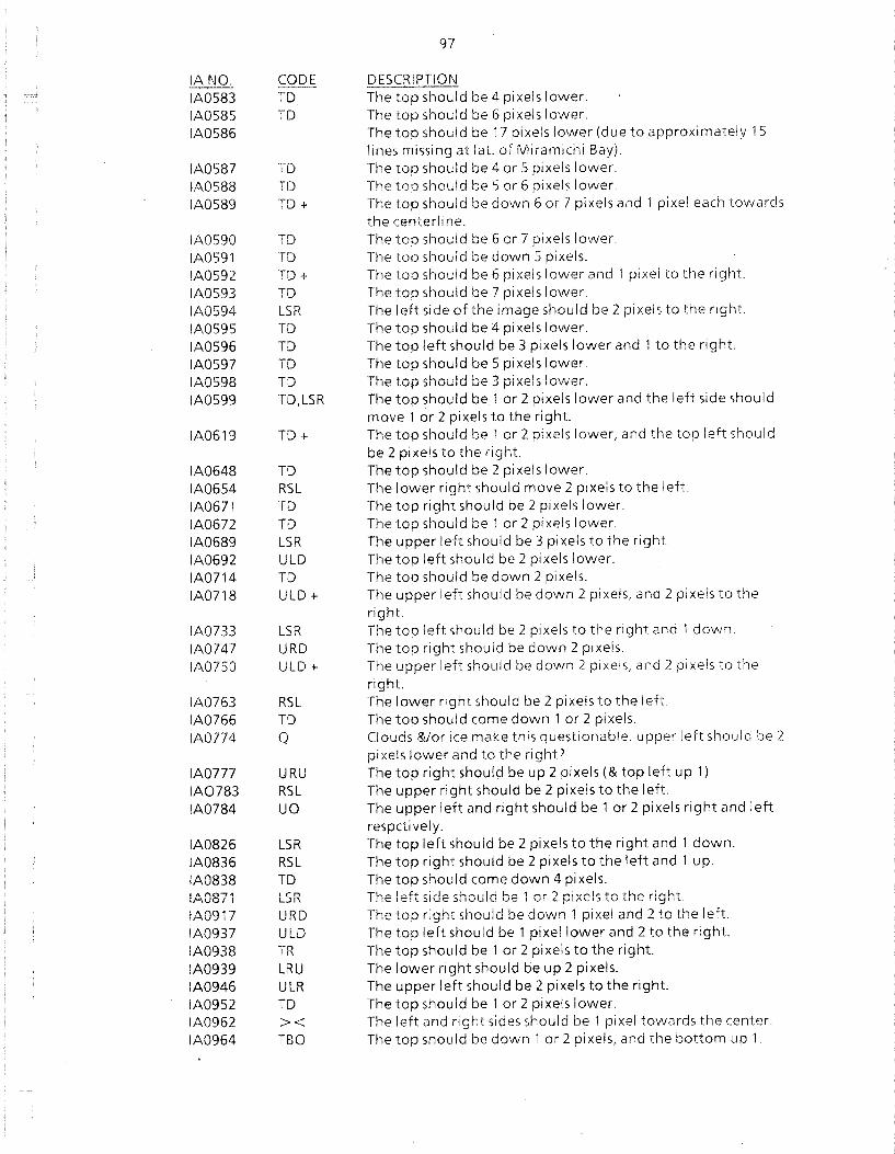
IANO. CODE IA0583 TD IA0585 TD IA0586
IA0587 TD IA0588 TD IA0589 TD +
IA0590 TD IA0591 TD IA0592 TD + IA0593 TD IA0594 LSR IA0595 TD IA0596 TD IA0597 TD IA0598 TD IA0599 TD,LSR
IA0619 TD +
IA0648 TD IA0654 RSL IA0671 TD IA0672 TD IA0689 LSR IA0692 ULD IA0714 TD IA0718 ULD +
IA0733 LSR IA0747 URD IA0750 ULD +
IA0763 RSL IA0766 TD IA0774 Q
IA0777 URU IA0783 RSL IA0784 UO
IA0826 LSR IA0836 RSL IA0838 TD IA0871 LSR IA0917 URD IA0937 ULD IA0938 TR IA0939 LRU IA0946 ULR IA0952 TD IA0962 >< IA0964 TBO
97
DESCRIPTION The top should be 4 pixels lower. The top should be 6 pixels lower. The top should be 17 pixels lower (due to approximately 15 lines missing at lat. of Miramichi Bay). The top should be 4 or 5 pixels lower. The top should be 5 or 6 pixels lower The top should be down 6 or 7 pixels and 1 pixel each towards the centerli ne. The top should be 6 or 7 pixels lower. The top should be down 5 pixels. The top should be 6 pixels lower and 1 pixel to the right. The top should be 7 pixels lower. The left side of the image should be 2 pixels to the right. The top should be 4 pixels lower. The top left should be 3 pixels lower and 1 to the right. The top should be 5 pixels lower. The top should be 3 pixelslo'vver. The top should be 1 or 2 pixels lower and the left side should move 1 or 2 pixels to the right. The top should be 1 or 2 pixels lower, and the top left should be 2 pixels to the right. The top should be 2 pixels lower. The lower right should move 2 pixels to the left. The top right should be 2 pixels lower. The top should be 1 or 2 pixels lower. The upper left should be 3 pixels to the right. The top left should be 2 pixels lower. The top should be down 2 pixels. The upper left should be down 2 pixels, and 2 pixels to the right. The top left should be 2 pixels to the right and 1 down. The top right should be down 2 pixels. The upper left should be down 2 pixels, and 2 pixels to the right. The lower right should be 2 pixels to the left The top should come down 1 or 2 pixels. Clouds &/or ice make this questionable. upper left should be 2 pixels lower and to the right? The top right should be up 2 pixels (& top left up 1) The upper right should be 2 pixels to the left. The upper left and right should be 1 or 2 pixels right and left respeti vel y. The top left should be 2 pixels to the right and 1 down. The top right should be 2 pixels to the left and 1 up. The top should come down 4 pixels. The left side should be 1 or 2 pixels to the right. The top right should be down 1 pixel and 2 to the left. The top left should be 1 pixel lower and 2 to the right. The top should be 1 or 2 pixels to the right. The lower right should be up 2 pixels. The upper left should be 2 pixels to the right. The top should be 1 or 2 pixels lower. The !eft and right sides should be 1 pixel towards the center. The top should be down 1 or 2 pixels, and the bottom up 1.
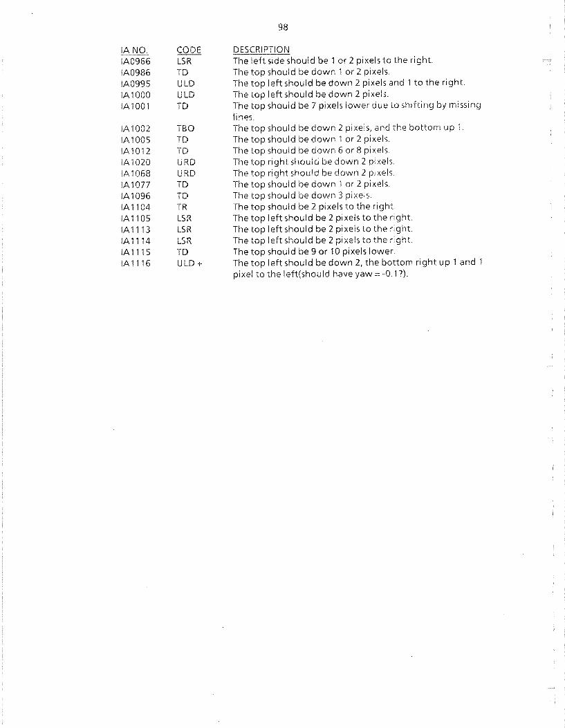
IANO. CODE IA0966 LSR IA0986 TO IA0995 ULO IA 1000 ULO IA100l TO
IA 1002 TBO IA 1005 TO IA1012 TO IA 1020 URO IA 1068 URO IA1077 TO IA 1096 TO IA 1104 TR IA 1105 LSR IA 1113 LSR IA 1114 LSR IA 1115 TO IA 1116 ULO +
98
DESCRIPTION The left side should be 1 or 2 pixels to the right. The top should be down 1 or 2 pixels. The top left should be down 2 pixels and 1 to the right. The top left should be down 2 pixels. The top should be 7 pixels lower due to shifting by missing lines. The top should be down 2 pixels{ and the bottom up 1. The top should be down 1 or 2 pixels. The top should be down 6 or 8 pixels. The top right should be down 2 pixels. The top right should be down 2 pi xels. The top should be down 1 or 2 pixels. The top should be down 3 pixels. The top should be 2 pixels to the right. The top left should be 2 pixels to the right. The top left should be 2 pixels to the right. The top left should be 2 pixels to the right. The top should be 9 or 10 pixels lower. The top left should be down 2{ the bottom right up 1 and 1 pixel to the left(should have yaw = -0. 1 7).

99
Appendix 4: Listing of raw data files via INVREAD


101
SAT ID YEARDAY HH:MM:SS ORBIT SCNS MIS F LABEL INV DATE PROJECT
NOA7 LAC 1984/025 18:42:33 13361 2048 0 IAOOOl 88/04/28 KLM NOA7 LAC 1984/026 18:30:47 13375 2048 0 IAOO02 88/05/16 KLM NOA7 LAC 1984/027 18: 18:29 13389 2548 0 IAOO03 88/05/16 KLM NOA7 LAC 1984/028 18:06: 14 13403 2546 0 IAOO04 88/05/16 KLM NOA7 LAC 1984/029 17:54:00 13417 2548 0 IAOO05 88/05/16 KLM NOA7 LAC 1984/030 17:41:45 13431 2544 0, IAOO06 88/05/16 KLM NOA7 LAC 1984/030 19:22:47 13432 2548 0 IAOO07 88/05/16 KLM NOA7 LAC 1984/031 19: 10:23 13446 2548 0 IAOO08 88/05/27 SST
NOA7 LAC 1984/032 18:57:59 13460 2546 0 IAOO09 88/05/16 KLM NOA7 LAC 1984/033 18:45:38 13474 2548 0 IA0010 88/05/16 KLM NOA7 LAC 1984/034 18:33:20 13488 3070 0 IA0011 88/05/18 KLM NOA7 LAC 1984/035 18:21 :01 13502 3072 0 IAOO12 88/05/18 KLM NOA7 LAC 1984/036 18:08:45 13516 3072 0 IAOO13 88/05/18 KLM NOA7 LAC 1984/037 17:56:31 13530 3072 0 IAOO14 88/05/27 SST
NOA7 LAC 1984/038 17:44: 16 13544 3072 0 IA0015 88/05/18 KLM ~JOA7 LAC 1984/039 19:12:55 13559 2474 0 !AOO16 88/05/18 KLM NOA7 LAC 1984/040 19:00:33 13573 2759 0 IAOO17 88/05/18 KLM NOA7 LAC 1984/041 18:48: 10 13587 3072 0 IAOO18 88/05/18 KLM NOA7 LAC 1984/042 18:35:51 13601 3072 0 IAOO19 88/05/18 KLM NOA7 LAC 1984/043 18:23:32 13615 3072 0 IA0020 88/04/29 KLM NOA7 LAC 1984/044 18:11:15 13629 3072 0 IA0021 88/05/18 KLM NOA7 LAC 1984/046 17:46:45 13657 3072 0 IAOO22 88/05/26 SST
NOA7 LAC 1984/047 17:35:04 13671 2841 0 IAOO23 88/04/26 LAP-testing
NOA7 LAC 1984/047 19:15:25 13672 3072 0 IA0024 88/04/26 LAP-testi ng
NOA7 LAC 1984/048 19:03:02 13686 3071 0 IA0025 88/05/26 IGH
NOA7 LAC 1984/049 18:50:40 13700 3071 0 IAOO27 88/05/27 SST
NOA7 LAC 1984/050 18:38: 18 13714 3070 0 IA0026 88/05/26 IGH
NOA7 LAC 1984/051 18:25:59 13728 3072 0 IA0028 88/05/03 LAP-Test
NOA7 LAC 1984/052 18:13:43 13742 3070 0 IA0029 88/05/27 IGH
NOA7 LAC 1984/053 18:01 :30 13756 3072 0 IA0030 88/05/04 LAP-Test
NOA7 LAC 1984/054 17:49: 11 13770 3066 0 IA0031 88/05/30 SST
NOA7 LAC 1984/055 17:37:33 13784 2830 0 IA0032 88/06/02 IGH
NOA7 LAC 1984/056 19:05:29 13799 3072 0 IA0033 88/06/02 IGH
NOA7 LAC 1984/057 18:53:06 13813 3072 0 IA0034 88/06/03 IGH
NOA7 LAC 1984/058 18:40:44 13827 3066 0 IA0035 88/06/03 IGH
NOA7 LAC 19841059 18:28:24 13841 3074 0 IA0036 88/05/04 LAP-Test
NOA7 LAC 1984/060 18: 16:06 13855 3072 0 IA0037 88/04/29 KLM NOA7 LAC 1984/061 18:03:49 13869 3072 0 IA0038 88/06/06 IGH
NOA7 LAC 1984/062 17:51 :34 13883 3067 0 IA0039 88/06/06 IGH
NOA7 LAC 1984/063 17:39:53 13897 2858 0 IA0040 88/06/07 IGH
NOA7 LAC 1984/065 18:55:28 13926 3071 0 IA0041 88/06/07 IGH
NOA7 LAC 1984/066 18:43:06 13940 3072 0 IA0042 88/05/09 LAP-Test
NOA7 LAC 1984/067 18:30:46 13954 3072 0 IA0043 88/06/07 IGH
NOA7 LAC 1984/068 18:18:28 13968 3072 0 IA0044 88/06/09 IGH
NOA7 LAC 1984/069 18:06: 11 13982 3072 0 IA0045 88/06109 IGH
NOA7 LAC 1984/070 17:54:01 13996 3028 0 IA0046 88/06/07 IGH
NOA7 LAC 1984/071 17:42:06 14010 2915 0 IA0047 88/06/08 IGH
NOA7 LAC 1984/072 19:10:13 14025 3072 0 IA0048 88/06/08 IGH
NOA7 LAC 1984/073 18:57:49 14039 3072 0 IA0049 88/06/16 SST
NOA7 LAC 1984/074 18:45:26 14053 3072 0 IA0050 88/06/16 IGH
NOA7 LAC 1981,1D75 18:33:05 14067 3072 0 1 IA0051 88/05/09 LAP-Test
"JOA7 LAC 1984/076 18:20:49 14081 3074 0 IA0052 88/06/09 IGH
NOA7 LAC 1984/077 18:08:29 14095 3072 0 IA0053 88/04/29 KLM

102
SAT ID YEARDAY HH:MM:SS ORBIT SCNS MIS F LABEL INV DATE PROJECT
NOA7 LAC 1984/078 17:56: 12 14109 3067 0 IA0054 88/06/16 IGH
NOA7 LAC 1984/079 17:45: 18 14123 2585 0 IA0056 88/06/16 IGH
NOA7 LAC 1984/079 19:24:58 14124 2634 0 IA0055 88/06/09 IGH
NOA7 LAC 1984/080 19: 12:31 14138 3073 0 IA0057 88/05/10 LAP-Test
NOA7 LAC 1984/081 19:00:06 14152 3045 0 IA0058 88/05/10 LAP-Test
NOA7 LAC 1984/082 18:47:44 14167 1632 0 IA0059 88/06/10 IGH
NOA7 LAC 1984/083 18:35:23 14180 3072 0 IA0060 88/06/10 IGH
NOA7 LAC 1984/084 18:23:03 14194 3074 0 IA0061 88/06/10 IGH
NOA7 LAC 1984/086 17:58:28 14222 3072 0 IA0062 88/06/1 0 IGH
NOA7 LAC 1984/087 17:46: 12 14236 3070 0 IA0063 88/0611 0 IGH
NOA7 LAC 1984/089 19:02:22 14265 3046 0 IA0064 88/06113 IGH
NOA7 LAC 1984/090 18:49:59 14279 3072 0 IA0065 88/06/13 IGH
NOA7 LAC 1984/091 18:37:36 14293 3072 0 IA0066 88/06/13 IGH
NOA7 LAC 1984/092 18:25: 16 14307 3070 0 IA0067 88/06/13 IGH
NOA7 LAC 1984/093 18:12:59 14321 3072 0 IA0068 88/06/16 IGH
NOA7 LAC 1984/094 18:00:40 14335 3070 0 IA0069 88/06/13 IGH
NOA7 LAC 1984/095 17:48:24 14349 3072 0 IA0070 88/06/13 IGH
NOA7 LAC 1984/096 19: 17:00 14364 2890 0 IA0071 88/06/20 SST
NOA7 LAC 19841101 18: 15:08 14434 3072 0 IAOO72 88/06/14 IGH
NOA7 LAC 1984/102 18:02: 50 14448 3073 0 IA0073 88/06/14 IGH
NOA7 LAC 1984/107 18:41:57 14519 3068 0 IA0074 88/06/17 IGH
NOA7 LAC 19841108 18:29:36 14533 3072 0 IA0075 88/06/17 IGH
NOA7 LAC 1984/109 18:17:16 14547 3045 0 IA0076 88/06/17 IGH
NOA7 LAC 1984/110 18:04:57 14561 3070 0 IAoon 88/06/14 IGH
NOA7 LAC 1984/111 17:52:41 14575 3070 0 IAOO78 88/06/19 IGH
NOA7 LAC 1984/112 19:21: 18 14590 2743 0 IA0079 88/06/19 IGH
NOA7 LAC 1984/113 19:08:51 14604 2821 0 IA0080 88/06/14 IGH
NOA7 LAC 1984/114 18:56:27 14618 3070 0 IA0081 88/06/14 IGH
NOA7 LAC 1984/115 18:44:04 14632 3072 0 IA0082 88/,306/14 IGH
NOA7 LAC 19841116 18:31 :43 14646 3069 0 IA0083 88/06/19 IGH
NOA7 LAC 1984/116 20:09:51 14647 3072 0 IA0084 88/06/21 IGH
NOA7 LAC 19841117 18:19:23 14660 3072 0 IA0085 88/06/21 IGH
NOA7 LAC 19841117 19:57:34 14661 3073 0 IA0086 88/06/21 IGH
NOA7 LAC 1984/118 18:07:04 14674 3071 0 IA0087 88/06/21 IGH
NOA7 LAC 19841119 17:54:47 14688 2048 0 IA0088 88/06/21 IGH
NOA7 LAC 19841121 19: 11 :00 14717 2869 0 IA0089 88/06/21 IGH
NOA7 LAC 1984/122 18:58:33 14731 3072 0 IA0090 88/06/21 IGH
NOA7 LAC 19841123 18:46:09 14745 3073 0 IA0091 88/06/21 IGH
NOA7 LAC 19841124 18:33:51 14759 3070 0 IA0092 88/06/21 IGH NOA7 LAC 19841125 18:21 :28 14773 3072 0 IA0093 88/06/21 IGH NOA7 LAC 19841126 18:09:08 14787 3070 0 IA0094 88/0511 0 LAP-Test
NOA7 LAC 1984/126 19:47:21 14788 3072 0 IA0095 88/06/23 IGH NOA7 LAC 1984/127 17:56:50 14801 3072 0 IA0096 88/06/23 IGH
NOA7 LAC 19841128 19:25:31 14816 2556 0 IA0097 88/04/29 KLM NOA7 LAC 1984/129 19: 13:04 14830 2669 0 IA0098 88/06/23 IGH
NO.A7 L.AC 19841130 19:00:38 14844 3072 0 IA0099 88/06/23 IGH
NOA7 LAC 19841131 18:48: 15 14858 3068 0 IA0100 88/06/23 IGH
NOA8 LAC 19841132 1 i :54:52 5826 3072 0 IA010l 88/06/23 IGH NOA7 LAC 1984/132 18:35:52 14872 2863 0 IA0102 88/06/23 IGH NOA7 LAC 19841133 18:23:31 14886 3072 0 IA0103 88/06/23 IGH NOA7 LAC 19841134 18:11:12 14900 3072 0 IA0104 88/06/23 IGH NOA7 LAC 19841135 17:58:53 14914 2926 0 IA0105 88/06/23 IGH NOA7 LAC 1984/136 17:46:45 14928 2562 0 IA0106 88/06/23 alloe
NOA7 LAC 1984/137 19: 15:06 14943 2945 0 IA0107 88/06/23 IGH
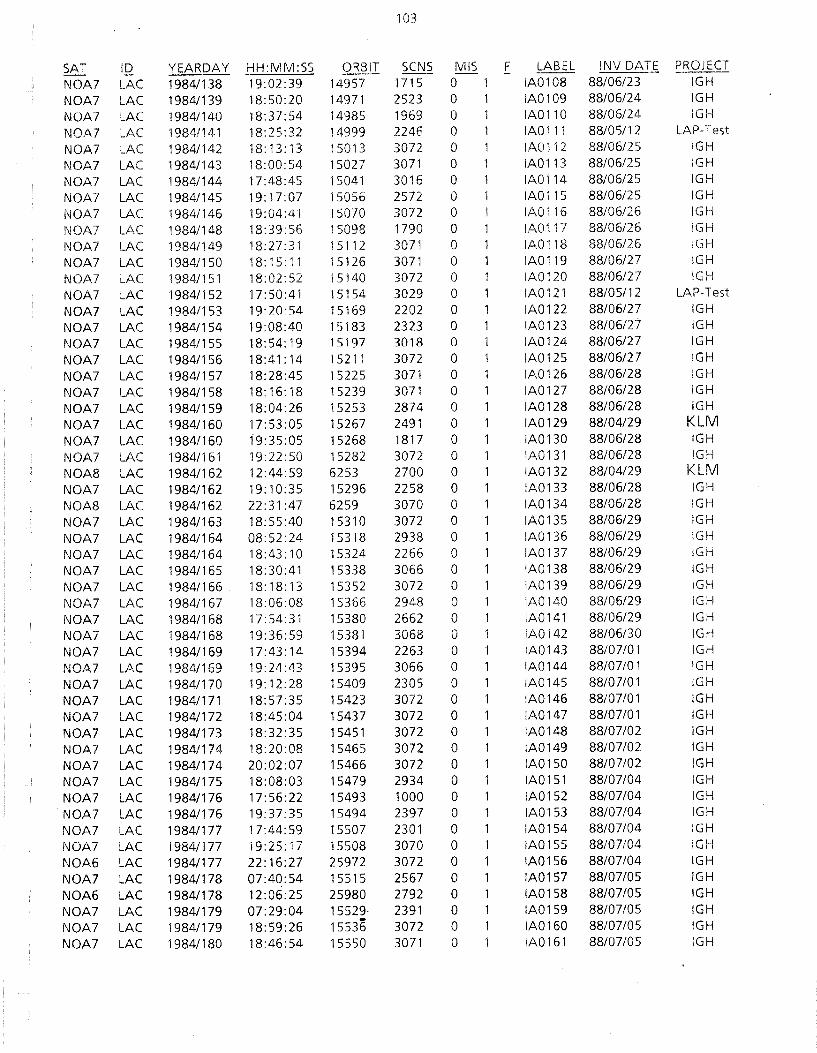
103
SAT ID YEARDAY HH:MM:SS ORBIT SCNS MIS F LABEL INV DATE PROJECT
NOA7 LAC 19841138 19:02:39 14957 1715 0 1 IA0108 88/06/23 IGH
NOA7 LAC 19841139 18:50:20 14971 2523 0 IA0109 88/06/24 IGH
NOA7 LAC 19841140 18:37:54 14985 1969 0 IA0110 88/06/24 lGH
NOA7 LAC 1984/141 18:25:32 14999 2246 0 IA0111 88/05/12 LAP-Test
NOA7 LAC 1984/142 18: 13: 13 15013 3072 0 IA0112 88/06/25 IGH
NOA7 LAC 1984/143 18:00:54 15027 3071 0 IA0113 88/06/25 IGH
NOA7 LAC 19841144 17:48:45 15041 3016 0 IA0114 88/06125 IGH
NOA7 LAC 19841145 19:17:07 15056 2572 0 IAOl15 88/06/25 IGH
NOA7 LAC 19841146 19:04:41 15070 3072 0 IA0116 88/06/26 IGH
NOA7 LAC 1984/148 18:39:56 15098 1790 0 IA0117 88/06/26 IGH
NOA7 LAC 1984/149 18:27:31 15112 3071 0 IA0118 88/06/26 IGH
NOA7 LAC 1984/150 18: 15: 11 15126 3071 0 IA0119 88/06/27 IGH
NOA7 LAC 19841151 18:02:52 15140 3072 0 IA0120 88/06/27 IGH
NOA7 LAC 1984/152 17:50:41 15154 3029 0 IA0121 88/05/12 LAP-Test
NOA7 LAC 1984/153 19:20:54 15169 2202 0 IA0122 88/06/27 IGH
NOA7 LAC 19841154 19:08:40 15183 2323 0 IA0123 88/06/27 IGH
NO,l\7 LAC 19841155 18:54:19 15197 3018 0 IA0124 88/06/27 IGH
NOA7 LAC 19841156 18:41: 14 15211 3072 0 IA0125 88/06/27 IGH
NOA7 LAC 19841157 18:28:45 15225 3071 0 IA0126 88/06/28 IGH
NOA7 LAC 19841158 18: 16: 18 15239 3071 0 IAOl27 88/06/28 IGH
NOA7 LAC 1984/159 18:04:26 15253 2874 0 IA0128 88/06/28 IGH
NOA7 LAC 19841160 17:53:05 15267 2491 0 IA0129 88/04/29 KLM NOA7 LAC 1984/160 19:35:05 15268 1817 0 IA0130 88/06/28 IGH
NOA7 LAC 19841161 19.22:50 15282 3072 0 IA0131 88/06/28 IGH
NOA8 LAC 1984/162 12:44:59 6253 2700 0 IA0132 88/04/29 KLM NOA7 LAC 19841162 19:10:35 15296 2258 0 IA0133 88/06/28 IGH
NOA8 LAC 19841162 22:31 :47 6259 3070 0 IA0134 88/06/28 IGH
NOA7 LAC 19841163 18:55:40 15310 3072 0 IA0135 88/06/29 IGH
NOA7 LAC 19841164 08:52:24 15318 2938 0 IA0136 88/06/29 IGH
NOA7 LAC 19841164 18:43: 10 15324 2266 0 IA0137 88/06/29 IGH
NOA7 LAC 19841165 18:30:41 15338 3066 0 IA0138 88/06/29 IGH
NOA7 LAC 19841166 18: 18: 13 15352 3072 0 IA0139 88/06/29 IGH
NOA7 LAC 19841167 18:06:08 15366 2948 0 IA0140 88/06/29 IGH
NOA7 LAC 19841168 17: 54:31 15380 2662 0 IA0141 88/06/29 IGH
NOA7 LAC 19841168 19:36:59 15381 3068 0 IA0142 88/06/30 IGH
NOA7 LAC 19841169 17:43: 14 15394 2263 0 IA0143 88/07/01 IGH
NOA7 LAC 19841169 19:24:43 15395 3066 0 IA0144 88/07/01 IGH
NOA7 LAC 19841170 19: 12:28 15409 2305 0 IA0145 88/07/01 IGH
NOA7 LAC 19841171 18:57:35 15423 3072 0 IA0146 88/07/01 IGH
NOA7 LAC 19841172 18:45:04 15437 3072 0 IA0147 88/07/01 IGH
NOA7 LAC 1984/173 18:32:35 15451 3072 0 IA0148 88/07/02 IGH
NOA7 LAC 19841174 18:20:08 15465 3072 0 IA0149 88/07/02 IGH
NOA7 LAC 1984/174 20:02:07 15466 3072 0 IA0150 88/07/02 IGH
NOA7 LAC 1984/175 18:08:03 15479 2934 0 IA0151 88/07/04 IGH
NOA7 LAC 19841176 17: 56:22 15493 1000 0 IA0152 88/07/04 IGH
I\JOA7 LAC 19841176 19:37:35 15494 2397 0 IA0153 88/07/04 IGH
NOA7 LAC 19841177 17:44:59 15507 2301 0 IA0154 88/07/04 IGH
NOA7 LAC 1984/177 19:25:17 15508 3070 0 IA0155 88/07/04 IGH
NOA6 LAC 19841177 22:16:27 25972 3072 0 IA0156 88/07/04 IGH
NOA7 LAC 1984/178 07:40:54 15515 2567 0 IA0157 88/07/05 IGH
NOA6 LAC 19841178 12:06:25 25980 2792 0 IA0158 88/07/05 IGH
NOA7 LAC 19841179 07:29:04 15529· 2391 0 IA0159 88/07/05 IGH
NOA7 LAC 19841179 18:59:26 15536 3072 0 IA0160 88/07/05 IGH
NOA7 LAC 19841180 18:46: 54 15550 3071 0 IA0161 88/07/05 IGH

104
SAT ID YEARDAY HH:MM:SS ORBIT SCNS MIS F LABEL INV DATE PROJECT
NOA7 LAC 1984/181 18:34:26 15564 3072 0 IA0162 88/07105 IGH
NOA7 LAC 1984/182 18:22:08 15578 3010 0 IA0163 88/07/05 IGH
NOA7 LAC 1984/183 18: 10: 12 15592 2809 0 IA0164 88/07/05 IGH
NOA7 LAC 19841183 19:51 :38 1.5593 3072 0 IA0165 88/07/05 IGH
NOA7 LAC 1984/184 19:39:22 15607 3072 0 IA0166 88/07/06 ihg
NOA7 LAC 19841185 19:27:07 15621 3072 0 IA0167 88/07/06 IGH
NOA6 LAC 1984/186 12:15:01 26094 2707 0 IA0168 88/07/06 IGH
NOA7 LAC 19841187 19:01: 17 15649 3070 0 IA0169 88/07/06 IGH
NOA7 LAC 19841188 18:48:45 15663 3071 0 IA0170 88/07/06 IGH
NOA7 LAC 19841189 18:36:18 15677 3072 0 IA0171 88/07/06 IGH
NOA7 LAC 19841190 18:23:47 15691 3072 0 IAOl72 88/07106 IGH
NOA7 LAC 1984/191 18: 11 :40 15705 2950 0 IA0173 88/07/07 IGH
NOA7 LAC 19841192 17:59:45 15719 2765 0 IA0174 88/07/07 IGH
NOA7 LAC 19841193 17:48:30 15733 2076 0 IA0175 88/07/07 IGH
NOA6 LAC 19841194 22:09:21 26214 3072 0 IA0176 88/07/07 IGH
NOA6 LAC 19841195 12:00:20 26222 2475 0 IA0177 88/07107 IGH
NOA7 LAC 1984/196 18:50:34 15776 3072 0 IA0178 88/07/07 IGH
NOA7 LAC 19841197 18:38:04 15790 3072 0 IA0179 88/07108 IGH
NOA7 LAC 1984/198 18:25:35 15804 3072 0 IA0180 88/07108 IGH
NOA7 LAC 1984/199 18:13:42 15818 2864 0 IA0181 88/07108 IGH
NOA7 LAC 1984/200 18:01 :30 15832 2793 0 IA0182 88/07108 IGH
NOA7 LAC 1984/201 19:30:41 15847 3072 0 IA0183 88/07/08 IGH
NOA7 LAC 19841202 07:46:45 15854 2428 0 IA0186 88/07108 IGH
NOA7 LAC 1984/202 19: 17:48 15861 3072 0 IA0185 88/07/08 IGH
NOA6 LAC 19841202 22: 17:52 26328 3072 0 IA0184 88/07108 IGH
NOA7 LAC 1984/203 07:34:22 15868 2436 0 IA0187 88/07/08 IGH
NOA7 LAC 19841203 19:04:53 15875 3072 0 IA0188 88/07/07 IGH
NOA6 LAC 19841204 11 :44:23 26350 2669 0 IA0190 88/07/09 IGH
NOA7 LAC 19841204 18:52:26 15889 3072 0 IA0189 88/07/08 IGH
NOA7 LAC 19841205 18:39:51 15903 3072 0 IA0191 88/07/09 SST
NOA7 LAC 19841206 18:27:22 15917 2296 0 IA0192 88/07109 SST
NOA6 LAC 1984/207 12: 12:23 26393 2623 0 IA0193 88/07109 SST
NOA7 LAC 19841207 18: 15: 11 15931 2968 0 IA0194 88/07/10 IGH
NOA7 LAC 19841207 19:57:00 15932 3072 0 IA0195 88/07/10 IGH
NOA7 LAC 19841208 18:03:06 15945 2838 0 IA0196 88/07/10 IGH
NOA7 LAC 19841209 17:51 :42 15959 2476 0 IA0197 88/07/10 IGH
NOA7 LAC 1984/210 19:20: 13 15974 3072 0 IA0198 88/07/11 SST
NOA6 LAC 1984/211 12:16:28 26450 2645 0 IA0199 88/07111 SST
NOA7 LAC 1984/211 19:07:05 15988 3070 0 IA0200 88/07111 SST
NOA7 LAC 1984/212 18:54:07 16002 3072 0 IA0201 88/07/11 SST
NOA6 LAC 19841213 11:29:12 26478 2570 0 IA0202 88/07/11 SST
NOA7 LAC 1984/213 18:41 :36 16016 3070 0 IA0203 88/07112 IGH
NOA7 LAC 1984/214 18:29:07 16030 3070 0 IA0204 88/07/12 IGH
NOA7 LAC 19841215 18:16:45 16044 3041 0 IA0205 88/07/12 IGH
NOA7 LAC 19841215 19:58:45 16045 3060 0 IA0206 88/07/13 SST
NOA7 LAC 1984/216 18:05:04 16058 2768 0 IA020? 88/07/13 SST NOA7 LAC 19841216 19:46:27 16059 3072 0 IA0208 88/07113 SST
NOA7 LAC 1984/217 17:54:02 16072 2266 0 iA0209 88/07/13 SST
NOA6 LAC 1984/217 22:59:48 26542 2779 0 IA0210 88/07114 SST
NOA7 LAC 1984/218 19:21:57 16087 3072 0 IA0211 88/07114 SST
NOA7 LAC 1984/219 19:08:51 16101 3029 0 IA0212 88/07114 SST
NOA7 LAC 1984/220 18:55:52 16115 3072 0 IA0213 88/07/14 SST
NO.47 L.4C 1984/221 18:43:22 16129 2567 0 IA0214 88/07115 IGH
NOA6 LAC 1984/222 11: 14:21 26606 2331 0 IA0215 88/07115 IGH

105
SAT 10 YEARDAY HH:MM:SS ORBIT SCNS MIS F LABEL INV DATE PROJECT
NOA7 LAC 1984/223 18: 18:30 16157 3031 0 IA0216 88/07/15 IGH
NOA7 LAC 19841224 18:07:02 16171 2674 0 IA0217 88/07/15 SST
NOA6 LAC 19841224 21 :50:59 26641 2967 0 IA0218 88/07/15 SST
NOA7 LAC 19841227 19: 10:35 16214 3072 0 IA0219 88/07/15 IA0219
NOA7 LAC 1984/228 18:57:36 16228 3072 0 IA0220 88/07/15 IA0220
NOA6 LAC 19841229 11 :45:43 26706 2605 0 IA0221 88/07/15 SST
NOA7 LAC 19841229 18:45:06 16242 1196 0 IA0221 88/07/18 SST
NOA7 LAC 19841230 18:32:36 16256 3072 0 IA0222 88/07/18 SST
NOA7 LAC 19841231 18:20:08 16270 3022 0 IA0223 88/07/18 SST
NOA6 LAC 19841232 12: 13: 11 26749 2743 0 IA0224 88/07/18 SST
NOA6 LAC 19841233 11 :49:51 26763 2609 0 IA0225 88/07/18 IGH
NOA7 LAC 19841234 19:25:21 16313 3072 0 IA0226 88/07/18 IGH
NOA7 LAC 19841236 18:59: 19 16341 1882 0 IA0227 88/07/18 IGH
NOA6 LAC 19841237 11 :53:44 26820 2695 0 IA0228 88/07/18 IGH
NOA6 LAC 19841238 11:30:10 26834 2621 0 IA0229 88/07/19 SST
NOA7 LAC 19841239 18:21 :50 16383 3072 0 IA0230 88/07/19 SST
NOA7 LAC 1984/240 08:19:23 16391 2643 0 IA0231 88/07/19 SST
NOA7 LAC 1984/241 17:58:05 16411 2668 0 IA0232 88/07/19 SST
NOA7 LAC 19841241 19:39:21 16412 3052 0 IA0233 88/07/19 IGH
NOA7 LAC 19841242 19:27:03 16426 3070 0 IA0234 88/07/19 IGH
NOA7 LAC 19841244 19:01 :02 16454 3072 0 IA0235 88/07/19 IGH
NOA7 LAC 19841245 18:48:31 16468 3073 0 IA0236 88/07/19 IGH
NOA7 LAC 1984/246 18:36:00 16482 3072 0 IA0237 88/07/20 SST
NOA7 LAC 19841247 18:23:32 16496 3070 0 IA0238 88/07/20 SST
NOA7 LAC 19841248 18: 13:01 16510 2371 0 IA0239 88/07/20 SST
NOA6 LAC 19841249 12:05:46 26991 2823 0 IA0240 88/04/29 KLM NOA7 LAC 19841249 18:00:03 16524 2559 0 IA0241 88/07/20 IGH
NOA7 LAC 19841250 17:48:26 16538 2276 0 IA0242 88/07/20 IGH
NOA7 LAC 19841251 19: 15:40 16553 3072 0 IA0243 88/07/20 IGH
NOA7 LAC 19841252 19:02: 19 16567 3072 0 IA0244 88/07/20 IGH
NOA7 LAC 19841253 18:50: 11 16581 3073 0 IA0245 88/07/21 SST
NOA7 LAC 19841254 18:37:41 16595 3072 0 IA0246 88/07/21 SST
NOA7 LAC 19841255 18:25: 12 16609 3072 0 IA0247 88/07/21 SST
NOA7 LAC 19841255 20:04:45 16610 3070 0 IA0248 88/07/21 SST
NOA7 LAC 19841256 19:52:24 16624 3072 0 IA0249 88/07/21 IGH
NOA7 LAC 19841257 19:40:02 16638 3068 0 IA0250 88/07/21 IGH
NOA7 LAC 19841258 19:27:44 16652 3066 0 IA0251 88/07/21 IGH
NOA7 LAC 19841259 19:15:25 16666 3073 0 IA0253 88/07/22 SST
NOA6 LAC 19841259 22:50:59 27140 3072 0 IA0252 88/07/21 IGH
NOA7 LAC 19841260 19:04:23 16680 3073 0 IA0254 88/07/22 SST
NOA7 LAC 19841261 18:51 :51 16694 2048 0 IA0255 88/07/22 SST
NOA6 LAC 19841262 11· 54: 35 27176 2738 0 IA0256 88/07/22 SST
NOA7 LAC 19841262 18:39:21 16708 2751 0 IA0257 88/07/24 IGH
NOA6 LAC 19841263 11 :31 :23 27190 2533 0 IA0258 89/04/28 LAP
NOA7 LAC 19841264 19:54:02 16737 3068 0 IA0259 88/07/24 IGH
NOA6 LAC 19841264 22:31:19 27211 3072 0 IA0260 88/07/24 IGH
NOA7 LAC 19841265 19:41 :·41 16751 3072 0 IA0261· 88/07/24 IGH
NOA7 LAC 19841268 19:07.21 16793 2597 0 IA0262 88/07/25 SST
NOA7 LAC 19841269 18:53:30 16807 3072 0 IA0264 88/07/25 SST
NOA7 LAC 19841270 18:40:59 16821 3068 0 IA0265 88/07/25 SST
NOA7 LAC 19841271 18:28:30 16835 3072 0 IA0266 88/07/25 IGH
NOA6 LAC 19841272 11: 15:40 27318 2568 0 IA0267 88/07/25 IGH
NOA7 LAC 19841273 18:04:39 16863 2689 0 rA0269 88/07/25 IGH
NOA7 LAC 19841274 19:30:59 16878 3070 0 IA0263 88/07/25 SST

106
ID YEARDAY HH:MM:SS ORBIT SCNS MIS F LABEL INV DATE PROJECT
NOA6 LAC 1984/274 21 :52:45 27353 3042 0 IA0270 88/07/26 SST
NOA7 LAC 19841275 19: 18:40 16892 3072 0 IA0271 88/07/26 SST
NOA7 LAC 19841276 19:07:40 16906 3070 0 IA0272 88/07/26 SST
NOA7 LAC 1984/277 20:34:27 16921 3072 0 IA0273 88/07/26 SST
NOA7 LAC 19841278 20:22:02 16935 3072 0 IA0274 88/07/27 IGH
NOA7 LAC 19841279 18:30:09 16948 2697 0 IA0275 88/07/27 IGH
NOA7 LAC 19841280 19:57:16 16963 3070 0 IA0276 88/07/27 IGH
NOA7 LAC 1984/281 19:44: 55 16977 3071 0 IA0277 88/07/27 IGH
NOA7 LAC 1984/282 17:55: 18 16990 2161 0 IA0278 88/07/28 IGH
NOA7 LAC 1984/283 19:20: 16 17005 3072 0 iA0279 88/07/28 IGH
NOA7 LAC 1984/284 19:09: 17 17019 3072 0 IA0280 88/07/28 IGH
NOA7 LAC 1984/285 18:56:44 17033 3069 0 IA0282 88/07/28 IGH
NOA7 LAC 1984/286 18:44: 13 17047 3072 0 IA0283 88/07/31 IGH
NOA7 LAC 1984/289 19:46:30 17090 3071 0 IA0285 88/07/31 IGH
NOA7 LAC 1984/290 17:56:46 17103 2205 0 IA0286 88/07/31 IGH
NOA7 LAC 1984/290 19:34:10 17104 3059 0 IA0287 88/07/31 IGH
NOA7 LAC 1984/291 19:21 :52 17118 3072 0 IA0288 88/08/02 IGH
NOA6 LAC 1984/292 11 :35:58 27603 2610 0 IA0289 88/08/02 IGH
NOA7 LAC 1984/292 19:10:53 17132 3072 0 IA0290 88/08/02 IGH
NOA7 LAC 1984/293 18:58: 19 17146 3072 0 IA0291 88/08/02 IGH
NOA7 LAC 19841294 18:45:49 17160 1964 0 IA0292 88/08/02 IGH
NOA7 LAC 19841295 18:33:18 17174 3070 0 IA0293 88/08/02 IGH
NOA7 LAC 1984/296 20:00:26 17189 3072 0 IA0294 88/08/03 IGH
NOA7 LAC 1984/297 18:09: 16 17202 2749 0 IA0295 88/08/03 IGH
NOA7 LAC 1984/298 19:35:44 17217 3072 0 IA0296 88/08/03 IGH
NOA7 LAC 1984/299 19:23:26 17231 3072 0 IA0297 88/08/03 IGH
NOA7 LAC 1984/300 19:12:28 17245 2693 0 IA0298 88/08/04 IGH
NOA7 LAC 19841301 18:59:54 17259 3070 0 IA0299 88/08/11 IGH
NOA7 LAC 1984/302 20:26:47 17274 3072 0 IA0300 88/08/04 IGH
NOA7 LAC 1984/303 18:34:53 17287 3067 0 IA0301 88/08/04 IGH
NOA7 LAC 1984/304 08:31 :50 17295 2814 0 IA0302 88/08/04 IGH
NOA6 LAC 1984/304 11 :47:36 27774 2803 0 IA0303 88/08/05 IGH
NOA7 LAC 1984/304 20:02:00 17302 3072 0 IA0304 88/08/05 IGH
NOA7 LAC 1984/305 08: 19:39 17309 2776 0 IA0305 88/08/16 LAP
NOA6 LAC 1984/305 11:24:37 27788 2505 0 IA0306 88/08/05 IGH
NOA7 LAC 1984/305 18:11:05 17315 2658 0 IA0307 88/08/05 IGH
NOA7 LAC 1984/305 19:49:39 17316 3072 0 IA0308 88/08/08 IGH
NOA7 LAC 1984/306 17:59:23 17329 2393 0 IA0310 88/08/08 IGH
NOA7 LAC 1984/306 19:37: 18 17330 2505 0 IA0311 88/08/08 IGH
NOA7 LAC 1984/308 19:14:02 17358 3070 0 IA0312 88/08/08 IGH
NOA7 LAC 1984/309 19:01 :28 17372 3072 0 IA0313 88/08/09 IGH NOA7 LAC 1984/310 18:48:56 17386 3068 0 IA0314 88/08/09 IGH NOA7 LAC 1984/311 18:36:26 17400 3072 0 IA0315 88/08/09 IGH NOA7 LAC 1984/312 20:03:33 17415 3073 0 IA0316 88/08/09 IGH
NOA7 LAC 1984/313 19: 51: 11 17429 3072 0 IA0317 88/08/09 IGH
NOA7 LAC 1984/314 19:38:50 17443 3072 0 IA0318 88/08/09 IGH
NOA7 LAC 19841315 19:26:31 17457 3072 0 IA0319 88/08/10 IGH
NOA7 LAC 19841317 19:03:01 17485 3069 () IA0321 88/08/10 IGH v
NOA7 LAC 19841320 20:05:05 17528 3072 0 IA0323 88/08/10 IGH
NOA7 LAC 1984/321 19:52:43 17542 3068 0 IA0324 88/0811 0 IGH
NOA7 LAC 1984/322 18:02:19 17555 2447 0 IA0235 88/08/10 IGH
NOA7 LAC 1984/323 19:28:03 17570 3036 0 IA0326 88/08/11 IGH NOA7 LAC 1984/324 19:15:46 17584 3072 0 IA0327 88/08/11 IGH NOA7 LAC 19841325 19:04:33 17598 3072 0 IA0328 88/08/11 IGH

107
SAT ID YEARDAY HH:MM:SS ORBIT SCNS MIS F LABEL INV DATE PROJECT
NOA7 LAC 1984/326 18:52:01 17612 3072 0 IA0329 88/08/11 IGH
NOA7 LAC 19841327 18:39:30 17626 2957 0 IA0330 88/08/15 IGH
NOA7 LAC 19841328 20:06:36 17641 3072 0 IA0331 88/08/15 IGH
NOA7 LAC 19841329 19: 54: 14 17655 3069 0 IA0332 88/08/15 IGH
NOA7 LAC 19841330 19:41 :53 17669 3072 0 IA0333 88/08115 IGH
NOA7 LAC 1984/331 19:29:34 17683 3072 0 IA0334 88/08/15 IGH
NOA7 LAC 19841332 19: 17: 16 17697 3072 0 IA0335 88/08/16 IGH
NOA7 LAC 19841333 19:06:04 17711 3070 0 IA0336 88/08/16 IGH
NOA7 LAC 19841334 20:32: 55 17726 3072 0 IA0337 88/08/16 IGH
NOA7 LAC 19841335 20:20:31 17740 3070 0 IA0338 88/08/16 IGH
NOA7 LAC 19841337 18:17:02 17767 2665 0 IA0339 88/08/16 IGH
NOA6 LAC 19841337 23:20:39 28251 3040 0 IA0340 88/08/18 IGH
NOA7 LAC 1984133.8 19:43:24 17782 3072 0 IA0341 88/08/18 IGH
NOA7 LAC 19841339 19:31 :05 17796 3072 0 IA0342 88/08/18 IGH
NOAl LAC 19841343 20:22:01 17853 3072 0 IA0343 88/08/18 IGH
NOA7 LAC 19841344 20:09:38 17867 3072 0 IA0344 88/08119 IGH
NOA6 LAC 1984/344 22:14:16 28350 3072 0 IA0345 88/08/19 IGH
NOA7 LAC 19841345 18:18:03 17880 2900 0 IA0346 88/08119 IGH
NOA7 LAC 1984/346 19:44:47 17895 3072 0 IA0347 88/08/19 IGH
NOA7 LAC 19841348 19:20:03 17923 3072 0 IA0349 88/08/19 IGH
NOA7 LAC 19841349 19:08:51 17937 3070 0 IA0350 88/08/22 IGH
NOA7 LAC 19841352 20: 10:47 17980 3072 0 IA0353 88/08/22 IGH
NOA7 LAC 19841353 08:28: 16 17987 2712 0 IA0354 88/08122 IGH
NOA7 LAC 1984/353 18:19:25 17993 2812 0 IA0355 88/08/22 IGH
NOA7 LAC 19841354 19:46:00 18008 3072 0 IA0356 88/08/22 IGH
NOA7 LAC 19841357 19: 10:06 18050 2934 0 IA0359 88/08/23 IGH
NOA7 LAC 1984/358 18:58: 16 18064 3071 0 IA0360 88/08/23 IGH
NOA6 LAC 1984/358 21:38:32 28549 2813 0 IA0361 88/08/23 IGH
NOA7 LAC 1984/359 18:44:59 18078 3072 0 IA0362 88/08/23 IGH NOA7 LAC 1984/361 18:20:52 18106 2741 0 IA0364 88/08/23 IGH NOA7 LAC 1984/361 19:59:37 18107 3072 0 IA0365 88/08/24 IGH
NOA7 LAC 1984/362 18:08:58 18120 2537 0 IA0366 88/08/24 IGH
NOA7 LAC 1984/362 19:47:15 18121 3072 0 IA0367 88/08/24 IGH
NOA9 LAC 1984/363 17:36:29 164 3072 0 IA0368 88/08/24 IGH
NOA7 LAC 1984/363 19:34:54 18135 3072 0 IA0369 88/08/24 IGH
NOA9 LAC 19841364 19:04:45 245 3072 0 IA0370 88/08/25 IGH NOA9 LAC 1984/365 18:54:00 259 3072 0 IA0371 88/08/25 IGH NOA6 LAC 1984/365 22: 10:27 28649 3072 0 IA0372 88/08/25 IGH NOA6 LAC 19841366 12:00:37 28657 2685 0 IA0373 88/08/25 IGH NOA9 LAC 19841366 17:03:48 272 3072 0 IA0374 88/08/25 IGH NOA7 LAC 19851001 18:46: 15 18191 3072 0 IA0375 88/08/29 IGH NOA7 LAC 19851002 18:33:43 18205 3072 0 IA0376 88/08/29 IGH
NOA7 LAC 19851003 18:21 :53 18219 2824 0 IA0377 88/08/29 IGH NOA7 LAC 19851004 18: 10: 18 18233 2502 0 IA0378 88/08/29 IGH NOA7 LAC 19851005 19:36:07 18248 3072 0 IA0379 88/08/29 IGH NOA7 LAC 19851006 19:23:46 18262 3072 0 IA0380 88/08/30 IGH
NOA7 LAC 19851007 19:12:36 18276 3072 0 IA0381 88/08/30 IGH j\JOA9 LAC 19851009 17:08:44 399 3072 0 IA0382 88/08/30 IGH
NOA9 LAC 1985/010 16: 57: 58 413 3072 0 IA0383 88/08/30 IGH
NOA9 LAC 1985/011 16:47:24 427 3009 0 IA0384 88/08/30 IGH NOA9 LAC 19851012 16:37:43 441 2642 0 IA0385 88/08/31 IGH NOA9 LAC 19851013 18:05:44 456 3072 0 IA0386 88/08/31 IGH NOA9 LAC 19851015 17:44: 34 484 3072 0 IA0388 88/08/31 iGH NOA9 LAC 19851016 17:35:14 498 3072 0 IA0389 88/08/31 IGH

108
SAT ID YEARDAY HH:MM:SS ORBIT SCNS MIS F LABEL INV DATE PROJECT
NOA9 LAC 1985/016 18:08:32 5647 3072 0 lA0763 89/01/04 IGH
NOA9 LAC 1985/017 17:24:27 512 3069 0 IA0390 88/08/31 IGH
NOA9 LAC 1985/018 17:13:41 526 3072 0 IA0391 88/09/01 IGH
NOA9 LAC 1985/019 17:02:55 540 3072 0 IA0392 88/09/01 IGH
NOA9 LAC 19851020 18:31 :53 555 3072 0 IA0393 88/09/01 IGH
NOA9 LAC 1985/021 18:21: 14 569 3072 0 IA0394 88/09/01 IGH
NOA9 LAC 1985/022 16:32:07 582 2583 0 IA0395 88/09/01 IGH
NOA9 LAC 1985/023 16:22:27 596 2213 0 IA0396 88/09/02 IGH
NOA9 LAC 19851024 17:49:26 611 3072 0 IA0397 88/09/02 IGH
NOA9 LAC 1985/026 17:29:24 639 3072 0 IA0399 88/09/06 IGH
NOA9 LAC 1985/027 17: 18:38 653 3072 0 IA0400 88/09/06 IGH
NOA9 LAC 1985/028 17:07:53 667 3072 0 IA0401 88/09/06 IGH
NOA9 LAC 1985/029 16:57:08 681 3072 0 IA0402 88/09/06 IGH
NOA9 LAC 1985/030 18:26:08 696 2207 0 IA0403 88/09/09 LAP
NOA9 LAC 1985/031 16:37: 15 709 . 2511 0 IA0404 88/09/06 IGH
NOA9 LAC 1985/031 18: 15:31 710 3071 0 IA0405 88/09/07 IGH
NOA9 LAC 1985/032 16:26:53 723 2387 0 IA0406 88/09/07 IGH
NOA9 LAC 1985/033 16: 17:48 737 1782 0 IA0407 88/09/07 IGH
NOA9 LAC 1985/035 17:34:22 766 3072 0 IA0409 88/09/07 IGH
NOA9 LAC 1985/036 17:23:35 780 3072 0 IA0410 88/09/07 IGH
NOA9 LAC 1985/037 17: 12:48 794 3072 0 IA0411 88/09/08 IGH
NOA9 LAC 1985/038 17:02:03 808 3071 0 IA0412 88/09/08 IGH
NOA9 LAC 1985/039 16:51 :22 822 3051 0 IA0413 89/05/12 lap
NOA9 LAC 1985/040 18:20:23 837 3063 0 IA0414 88/09/08 IGH
NOA9 LAC 19851041 16:31 :20 850 2556 0 IA0415 88/09/08 IGH
NOA9 LAC 1985/042 17:59:09 865 3071 0 IA0416 88/09/08 IGH
NOA9 LAC 1985/043 17:48:34 879 3072 0 IA0417 88/09/08 IGH
NOA9 LAC 1985/044 17:39: 19 893 3071 0 IA0418 88/09/09 IGH
NOA9 LAC 1985/045 17:28:30 907 3064 0 IA0419 88/09/12 LAP
NOA9 LAC 1985/046 17: 17:43 921 3071 0 IA0420 88/09/09 IGH
NOA9 LAC 1985/047 17:06:57 935 3070 0 IA0421 88/09/09 IGH
NOA9 LAC 1985/048 16:56:13 949 3071 0 IA0422 88/09/12 IGH
NOA9 LAC 1985/049 16:46:01 963 2878 0 IA0423 88/09/12 IGH
NOA9 LAC 1985/050 16:35:59 977 2636 0 IA0424 88/09/12 IGH
NOA9 LAC 1985/051 18:04:31 992 3071 0 IA0425 88/09/12 IGH
NOA9 LAC 1985/052 17:53:56 1006 3072 0 IA0426 88/09113 IGH
NOA9 LAC 1985/053 17:43:21 1020 3069 0 IA0427 88/09/13 IGH
NOA9 LAC 1985/055 17:22:38 1048 3070 0 IA0429 88/09/13 IGH
NOA9 LAC 1985/056 17: 11 :51 1062 3072 0 IA0430 88/09/13 IGH
NOA9 LAC 19851058 16:50:39 1090 2974 0 IA0432 88/09/13 IGH
NOA9 LAC 1985/059 18:19:59 1105 3072 0 IA0433 88/09/14 IGH
NOA9 LAC 19851060 16:30:52 1118 2380 0 IA0434 88/09/14 IGH
NOA9 LAC 1985/061 16:20:59 1132 2085 0 IA0435 88/09/14 IGH
NOA9 LAC 19851062 17:48:09 1147 3072 0 IA0436 88/09/14 IGH
NOA9 LAC 1985/063 17:38:20 1161 3071 0 IA0437 88/09/14 IGH
NOA9 LAC 19851064 05:57:12 1168 2141 0 IA0438 88/09/15 IGH
NOA9 LAC 1985/065 17: 16:46 1189 3071 0 IA0439 88/09/15 IGH
~~OA9 LAC 1985/066 17:05:59 1203 3071 0 IA0440 88/09/15 ~GH
NOA9 LAC 1985/067 16:55:20 1217 3035 0 IA0441 88109/15 IGH
NOA9 LAC 1985/068 18:24:48 1232 3072 0 IA0442 88/09/15 IGH NOA9 LAC 1985/069 16:35:04 1245 2610 0 IA0442 88/04/29 KLM NOA9 LAC 19851070 16:25:12 1259 2310 0 IA0444 88/09/16 IGH
NOA9 LAC 1985/070 18:03:33 1260 3072 0 IA0445 88/09/16 IGH
NOA9 LAC 1985/071 17:52:57 1274 3072 0 IA0446 88/09/16 IGH

109
SAT ID YEARDAY HH:MM:SS ORBIT SCNS MIS F LABEL INV DATE PROJECT
NOA9 LAC 1985/072 17:43: 13 1288 3072 0 IA0447 88/09/16 IGH
NOA9 LAC 19851073 17:32:25 1302 3072 0 IA0448 88/09/16 IGH
NOA9 LAC 1985/074 17:21 :37 1316 3072 0 IA0449 88/09/19 IGH
NOA9 LAC 1985/076 17:00:05 1344 3072 0 IA0450 88/09/19 IGH
NOA9 LAC 1985/077 16:49:34 1358 2993 0 IA0451 88/09/19 IGH
NOA9 LAC 1985/078 16:40:00 1372 2579 0 IA0452 88/09/19 IGH
NOA9 LAC 1985/078 18: 18:59 1373 3072 0 IA0453 88/09/19 IGH
NOA9 LAC 1985/079 16:29:50 1386 2381 0 IA0454 88/09/20 IGH
NOA9 LAC 1985/080 17:57:44 1401 3072 0 IA0455 88/09/20 IGH
NOA9 LAC 19851081 17:47:09 1415 3072 0 IA0456 88/09/20 IGFH
NOA9 LAC 1985/082 17:36:34 1429 3072 0 IA0457 88/09/20 IGH
NOA9 LAC 1985/083 17:26:29 1443 3072 0 IA0458 88/09/20 IGH
NOA9 LAC 1985/084 17: 15:42 1457 3072 0 IA0459 88/09/21 IGH
NOA9 LAC 1985/085 17:04:56 1471 3072 0 IA0461 88/09/21 IGH
NOA9 LAC 1985/085 18:45:05 1472 3072 0 IA0460 88/09/21 IGH
NOA9 LAC 1985/086 18:34:26 1486 3072 0 IA0462 88/09/21 IGH
NOA9 LAC 1985/087 16:43: 58 1499 2873 0 IA0463 88/09/23 IGH
NOA9 LAC 1985/087 18:23:47 1500 3072 0 IA0464 88/09/23 IGH
NOA9 LAC 1985/088 06:42:06 1507 2666 0 IA0465 88/09/23 IGH
NOA9 LAC 1985/088 18: 13:08 1514 3072 0 IA0466 88/09/23 IGH
NOA9 LAC 1985/089 16:24:06 1527 2329 0 IA0467 88/09/23 IGH
NOA9 LAC 1985/090 17:51:55 1542 3071 0 IA0468 88/09/26 IGH
NOA9 LAC 1985/091 17:42:09 1556 3072 0 IA0469 88/09/26 IGH
NOA9 LAC 1985/092 17:31:21 1570 3072 0 IA0470 88/09/26 IGH
NOA9 LAC 1985/093 17:20:33 1584 3072 0 IA0471 88/09/26 IGFH
NOA9 LAC 1985/094 17:09:47 1598 3072 0 IA0472 88/09/26 IGH
NOA9 LAC 1985/094 18:49:54 1599 3072 0 IA0473 88/09/27 IGH
NOA9 LAC 1985/095 16:59:02 1612 3072 0 IA0474 88/09/27 IGH
NOA9 LAC 1985/096 16:48:34 1626 2974 0 IA0475 88/09/27 IGH
NOA9 LAC 1985/097 18:17:56 1641 3072 0 IA0476 88/09/27 IGH
NOA9 LAC 1985/098 16:28:54 1654 2336 0 IA0477 88/09/27 IGH
NOA9 LAC 1985/099 17:56:42 1669 3072 0 IA0478 88/09/28 IGH
NOA9 LAC 1985/100 17:46:07 1683 3072 0 IA0479 88/09/28 IGH
NOA9 LAC 1985/101 17:36:12 1697 3072 0 IA0480 88/09/28 IGH
NOA9 LAC 1985/102 17:25:25 1711 3072 0 IA0482 88/10/03 IGH
NOA9 LAC 1985/103 17:14:38 1725 3070 0 IA0483 88/09/28 IGH
NOA9 LAC 1985/104 17:03:53 1739 3072 0 IA0484 88/09/28 IGH
NOA9 LAC 1985/105 16:53:21 1753 2993 0 IA0485 88/10/03 IGH
NOA9 LAC 1985/106 16:43:02 1767 2841 0 IA0486 88/10/03 IGH
NOA9 LAC 1985/107 16:32:55 1781 2633 0 IA0487 88110/03 IGH
NOA9 LAC 1985/108 18:01 :29 1796 3072 0 IA0488 88/10/03 IGH
NOA9 LAC 1985/110 17:41 :04 1824 3072 0 IA0490 88/10/03 IGH
NOA9 LAC 1985/111 17:30:16 1838 3072 0 IA0491 88/10103 IGH
NOA9 LAC 1985/112 17:19:29 1852 3072 0 IA0492 88/10/04 IGH
NOA9 LAC 1985/113 17:08:42 1866 3072 0 IA0493 88/10/04 IGH
NOA9 LAC 1985/114 16:57:57 1880 3072 0 IA0494 88/10/04 IGH
NOA9 LAC 1985/115 06:56:38 1888 2594 0 IA0495 88/1 0104 IGH
NOA9 LAC 1985/116 16:37:35 1908 2688 0 !A0496 88/10/04 IGH
NOA9 LAC 1985/117 16:28:14 1922 2197 0 IA0497 88/10/04 IGH
NOA9 LAC 19851118 17:55:39 1937 3072 0 IA0498 88/10/05 IGH
NOA9 LAC 1985/119 17:45:04 1951 3072 0 IA0499 88/1 0105 IGH
NOA9 LAC 1985/120 17:35:07 1965 3072 0 IA0500 88/10105 IGH
NOA9 LAC 1985/121 17:26:21 1979 3072 0 IA0501 88/10105 IGH
NOA9 LAC 1985/122 17: 13:33 1993 3072 0 IA0502 88/10/05 IGH

110
SAT ID YEARDAY HH:MM:SS ORBIT SCNS MIS F LABEL INV DATE
NOA9 LAC 1985/123 17:02:48 2007 3072 0 IA0503 88/10/05 lGH
NOA9 LAC 1985/124 18:32:20 2022 2087 0 IA0504 88/10/05 IGH
NOA9 LAC 19851125 16:42: 14 2035 2742 0 IAOSOS 88/10/06 IGH
NOA9 LAC 1985/126 18: 11 :02 2050 3072 0 IA0506 88/10/06 IGH
NOA9 LAC 1985/127 18:00:26 2064 3072 0 IA0507 88/10/06 IGH
NOA9 LAC 1985/128 17:49:51 2078 3072 0 IA0508 88/10/06 IGH
NOA9 LAC 1985/129 17:40:00 2092 3072 0 IA0509 88/10/06 IGH
NOA9 LAC 1985/130 17:29:12 2106 3072 0 IA0510 88/10/06 IGH
NOA9 LAC 1985/131 17:18:25 2120 3072 0 IA0511 8811 0/07 IGH
NOA9 LAC 1985/132 17:07:38 2134 3072 0 IA0512 88/1 0/07 IGH
NOA9 LAC 1985/133 16:56:55 2148 3061 0 IA0513 88/1 0/07 IGH
NOA9 LAC 1985/134 16:46:51 2162 2830 0 IA0514 88/10/07 IGH
NOA9 LAC 1985/135 16:37:03 2176 2489 0 IA0515 88/10/07 IGH
NOA9 LAC 1985/135 18: 15:49 2177 3072 0 IA0516 88/10107 IGH
NOA9 LAC 1985/136 18:05: 12 2191 3072 0 IA0517 88/10/11 IGH
NOA9 LAC 1985/137 17:54:36 2205 3072 0 IA0518 88/1 0/11 IGH
NOA9 LA,C 1985/138 17:44:51 2219 1251 0 IA0519 88/10/11 IGH
NOA9 LAC 1985/139 17:34:02 2233 3072 0 IA0520 88/10/11 IGH
NOA9 LAC 1985/140 17:23:15 2247 3072 0 IA0521 88/10/11 IGH
NOA9 LAC 1985/141 17:12:29 2261 3072 0 IA0522 88/10/11 IGH
NOA9 LAC 1985/142 17:01 :43 2275 3072 0 IA0523 88/10/11 IGH
NOA9 LAC 1985/143 16:51:18 2289 2956 0 IA0524 88/10/12 IGH
NOA9 LAC 1985/144 16:41: 17 2303 2699 0 IA0525 88/10112 IGH
NOA9 LAC 1985/145 16.31:33 2317 2346 0 IA0526 88/10112 IGH
NOA9 LAC 1985/146 17:59:23 2332 3072 0 IA0527 88/10112 IGH
NOA9 LAC 1985/147 17:48:47 2346 3072 0 IA0528 88/10/12 IGH
NOA9 LAC 1985/148 17:38:53 2360 3072 0 IA0529 88/10/14 IGH
NOA9 LAC 1985/149 17:28:06 2374 3072 0 IA0530 88/10/14 IGH
NOA9 LAC 1985/150 17: 17: 18 2388 3072 0 IA0531 88/10/14 IGH
NOA9 LAC 1985/151 17:06:32 2402 3072 0 IA0532 88/10/14 IGH
NOA9 LAC 1985/152 16:56: 17 2416 2892 0 IA0533 88/10/14 IGH
NOA9 LAC 1985/153 16:45: 57 2430 2750 0 IA0534 88/1 0/14 IGH
NOA9 LAC 1985/153 18:25:23 2431 3072 0 IA0535 88/1 0/14 IGH
NOA9 LAC 1985/154 16:35:56 2444 2499 0 IA0536 88/1 0/17 IGH
NOA9 LAC 1985/155 18:04:07 2459 3072 0 IA0537 88/1 0/17 IGH
NOA9 LAC 1985/156 17:53:36 2473 3072 0 IA0538 88/10/17 IGH
NOA9 LAC 1985/157 17:43:48 2487 3072 0 IA0539 88/10/17 IGH
NOA9 LAC 1985/158 17:32:54 2501 3072 0 IA0540 88/10/17 IGH
NOA9 LAC 1985/159 17:22:07 2515 3072 0 IA0541 88/10/18 IGH
NOA9 LAC 1985/160 17: 12:40 2529 2602 0 IA0542 88/10/18 IGH
NOA9 LAC 1985/161 17:00:40 2543 3046 0 IA0543 88/10/18 IGH
NOA9 LAC 1985/162 16:50:29 2557 2843 0 IA0544 88/1 0/18 IGH
NOA9 LAC 1985/163 16:40:22 2571 2626 0 IA0545 88/10/18 IGH
NOA9 LAC 1985/164 18:08:52 2586 3072 0 IA0546 88/10/20 IGH
NOA9 LAC 1985/165 16:21:21 2599 2208 0 IA0547 88/10/20 IGH
NOA9 LA,C 1985/166 17:47:4'1 2614 2289 0 IA0548 88/10/20 IGH
NOA9 LAC 1985/167 17:37:44 2628 3072 0 IA0549 88/10/20 IGH
NOA6 LAC 1985/168 11 :27: 17 31049 2716 0 IA0550 88/10/20 IGH
NOA9 LAC 1985/169 17: 16:08 2656 3072 0 IA0551 88/10/20 IGH
NOA9 LAC 1985/170 17:05:51 2670 2906 0 IA0552 88/1 0/21 IGH
NOA9 LAC 1985/171 16:55:19 2684 2823 0 IA0553 88/10/21 IGH
NOA9 LAC 1985/172 16:44:43 2698 2776 0 IA0554 88/10/21 IGH
NOA9 LAC 1985/173 18:13:38 2713 3072 0 IA0555 88/10/21 IGH
NOA9 LAC 1985/174 18:02:59 2727 3072 0 IA0556 88/10/21 IGH

1 11
SAT ID YEARDAY HH:MM:SS ORBIT SCNS MIS F LABEL INV DATE PROJECT
KlOA9 LAC 1985/175 17:52:23 2741 3072 0 IA0557 88/10/21 IGH
NOA9 LAC 1985/176 17:42:32 2755 3072 0 IA0558 88/10/24 IGH
NOA9 LAC 1985/177 17:31 :44 2769 3072 0 IA0559 88/10/24 IGH
NOA9 LAC 1985/178 17:20:59 2783 3072 0 IA0560 88/10/24 IGH
NOA9 LAC 1985/179 17:10:09 2797 3072 0 IA0561 88/10/24 IGH
NOA9 LAC 1985/180 16:59:30 2811 3033 0 IA0562 88/10/24 IGH
NOA9 LAC 1985/181 16:49:34 2825 2741 0 IA0563 88/10/24 IGH
NOA9 LAC 1985/182 16:39: 12 2839 2613 0 IA0564 88/10/26 IGH
NOA9 LAC 1985/183 16:29:38 2853 2197 0 IA0565 88/10/26 IGH
NOA9 LAC 1985/184 17:57:05 2868 3072 0 IA0566 88/1 0/26 IGH
NOA9 LAC 1985/185 17:47:19 2882 3072 0 IA0567 88/10/26 IGH
NOA9 LAC 1985/186 17:36:29 2896 3070 0 IA0568 88/06/30 YANKO
NOA9 LAC 1985/187 17:25:41 2910 3072 0 IA0569 88/10/26 IGH
NOA9 LAC 1985/188 17: 14: 54 2924 3072 0 IA0570 88/10/27 IGH
NOA9 LAC 1985/189 17:04:07 2938 3072 0 IA0571 88/1 0/27 IGH
NOA9 LAC 1985/190 18:33:39 2953 3072 0 IA0572 88/06/30 YANKO
NOA.9 LAC 1985/191 16:43:42 2966 2695 0 IA0573 88/10/27 IGH
NOA9 LAC 1985/192 16:33:56 2980 2353 0 IA0574 88/10/27 IGH
NOA9 LAC 1985/193 18:01 :45 2995 3072 0 IA0575 88/10/27 IGH
NOA9 LAC 19851194 17:51 :09 3009 3072 0 IA0576 88/06/30 YANKO
NOA9 LAC 1985/195 17:41: 15 3023 3072 0 IA0577 88/10/28 IGH
NOA9 LAC 19851196 17:30:27 3037 3072 0 IA0578 88/10/28 IGH
NOA9 LAC 1985/197 17: 19:39 3051 3067 0 IA0579 88/10/28 IGH
NOA9 LAC 1985/198 17:08:53 3065 3072 0 IA0580 88/10/28 IGH
NOA9 LAC 1985/199 16:58:27 3079 2950 0 IA0581 88/10/28 IGH
NOA9 LAC 1985/200 16:48: 19 3093 2729 0 IA0582 88/10/31 IGH
NOA9 LAC 1985/201 16:38:23 3107 2443 0 IA0583 88/10/31 IGH
NOA9 LAC 1985/202 16:28:22 3121 2190 0 IA0585 88/10/31 IGH
NOA9 LAC 1985/202 18:06:25 3122 3061 0 IA0586 88/06/30 YANKO
NOA9 LAC 1985/203 17:55:49 3136 3072 0 IA0587 88/10/31 IGH
NOA9 LAC 1985/204 17:46:00 3150 3072 0 IA0588 88/10/31 IGH
NOA9 LAC 1985/205 17:35: 11 3164 3072 0 IA0589 88/06/30 YANKO
NOA9 LAC 1985/206 17:24:23 3178 3072 0 IA0590 88/11/01 IGH
NOA9 LAC 19851207 17:13:36 3192 3072 0 IA0591 88/11/01 IGH
NOA9 LAC 1985/208 17:02: 50 3206 3072 0 IA0592 88/11/01 IGH
NOA9 LAC 1985/209 16:53:44 3220 2479 0 IA0593 88/11/01 IGH
NOA8 LAC 1985/210 11 :46:56 12138 2596 0 IA0594 88/06/30 YANKO
NOA9 LAC 19851211 18: 11 :05 3249 3072 0 IA0595 88/11/02 IGH
NOA9 LAC 1985/212 17:58:51 3263 3072 0 IA0596 88/06/30 YANKO
NOA9 LAC 1985/214 17:39: 55 3291 3072 0 IA0597 88/11/02 IGH
NOA9 LAC 1985/215 17:29:08 3305 3072 0 IA0598 88/06/29 YANKO
NOA9 LAC 1985/216 17: 18:20 3319 3067 0 IA0599 88/06/29 YANKO
NOA9 LAC 1985/216 18:58:26 3320 3072 0 IA0600 88/11/02 IGH
NOA9 LAC 1985/217 17:07:34 3333 3072 0 IA0601 88/06/29 YANKO
NOA9 LAC 1985/218 16:57: 14 3347 2918 0 IA0602 88/11/03 LAP
NOA9 LAC 1985/219 18:26:24 3362 3072 0 IA0603 88/06/29 YANKO
NOA9 LAC 1985/220 16:36:56 3375 2500 0 IA0604 88111/03 IGH
NOA9 LAC 1985/220 18: 15:46 3376 3072 0 IA060S 88/11/03 IGH
NOA9 LAC 1985/221 18:05:08 3390 3072 0 IA0606 88/11/03 IGH
NOA9 LAC 1985/222 17:54:32 3404 3072 0 IA0607 88/11/07 IGH
NOA9 LAC 19851223 17:44:41 3418 3072 0 IA0608 88/11/07 IGH
NOA9 LAC 1985/224 17:33:51 3432 3072 0 IA0609 88/11/07 IGH
NOA9 LAC 19851225 17:23:04 3446 3072 0 IA0610 88/11/07 IGH
NOA9 LAC 19851225 19:00:22 3447 3072 0 IA0611 88/06/29 YANKO

112
SAT ID YEARDAY HH:MM:SS ORBIT SCNS MIS F LABEL INV DATE PROJECT
NOA9 LAC 1985/226 17:12:17 3460 3072 0 IA0612 88/11/07 IGH
NOA9 LAC 19851227 18:39:01 3475 3072 0 IA0613 88/11/08 IGH
NOA9 LAC 19851228 18:31 :05 3489 3071 0 IA0614 88/11/08 IGH
NOA9 LAC 19851229 18:20:26 3503 3070 0 IA0615 88/06/29 YANKO
NOA9 LAC 19851230 16:31 :54 3516 2145 0 IA0616 88/11/08 IGH
NOA9 LAC 1985/231 17:59: 11 3531 3072 0 IA0617 88/11/08 IGH
NOA9 LAC 19851232 17:49:26 3545 3072 0 IA0618 88/11/08 IGH
NOA9 LAC 1985/233 17:38:36 3559 3072 0 IA0619 88/11/09 IGH
NOA9 LAC 19851234 17:27:48 3573 3072 0 IA0620 88/11/09 IGH
NOA9 LAC 19851235 17: 17:01 3587 3072 0 IA0621 88/11/09 iGH
NOA9 LAC 1985/236 17:06: 14 3601 3072 0 IA0622 88/11/09 IGH
NOA9 LAC 19851237 16:56:17 3615 2786 0 IA0623 88/11/09 IGH
NOA9 LAC 19851238 16:46:05 3629 2594 0 IA0624 88/11/09 IGH
NOA9 LAC 19851239 16: 36:09 3643 2308 0 IA0625 88/1111 0 IGH
NOA9 LAC 1985/240 18:03:51 3658 3072 0 IA0626 88/11/10 IGH
NOA9 LAC 1985/241 17:53:15 3672 3072 0 IA0627 88/06/29 YANKO
NOA9 LAC 19851242 17:43:21 3686 3072 0 IA0628 88/11/10 IGH
NOA9 LAC 1985/243 17:32:33 3700 3072 0 IA0629 88/11/10 IGH
NOA9 LAC 19851244 17:21:45 3714 3072 0 IA0630 88/11/14 IGH
NOA9 LAC 19851245 17: 10:58 3728 3072 0 IA0631 88/11/14 IGH
NOA9 LAC 1985/246 17:00:29 3742 2973 0 IA0632 88/11/14 IGH
NOA9 LAC 19851247 16:50:22 3756 2751 0 IA0633 88/11/14 IGH
NOA9 LAC 19851248 18: 19:09 3771 3072 0 IA0634 88/11/14 IGH
NOA9 LAC 19851249 16:30:07 3784 2325 0 IA0635 88/11/14 IGH
NOA9 LAC 19851250 17:57:55 3799 3072 0 IA0636 88/11/15 IGH
NOA9 LAC 19851251 17:48:06 3813 3072 0 IA0637 88/11/15 IGH
NOA9 LAC 19851252 06:07: 15 3820 2799 0 IA0638 88/11/15 IGH
NOA9 LAC 19851257 18:24:29 3898 2837 0 IA0639 88/11/15 IGH
NOA9 LAC 19851258 18: 13: 12 3912 3071 0 IA0640 88/11/15 IGH
NOA9 LAC 19851261 17:42:01 3954 3072 0 IA0641 88/11/15 IGH
NOA8 LAC 19851262 11 :21 :40 12877 2156 0 IA0643 88/11/16 IGH
NOA9 LAC 1985/262 17:31:14 3968 3072 0 IA0642 88/11/16 IGH
NOA9 LAC 19851263 19:00:32 3983 3072 0 IA0644 88/11/16 IGH
NOA9 LAC 1985/264 18:49:51 3997 2794 0 IA0645 88/11/16 IGH
NOA9 LAC 1985/265 16:59:17 4010 2934 0 IA0646 88/11/16 IGH
NOA9 LAC 1985/266 16:49:25 4024 2621 0 IA0647 88/11/16 IGH
NOA9 LAC 19851267 18:17:52 4039 3072 0 IA0648 88/11/21 IGH
NOA9 LAC 19851268 18:07: 15 4053 3072 0 IA0649 88/11/21 IGH
NOA9 LAC 19851269 17:56:38 4067 3072 0 IA0650 88/11/21 IGH
NOA9 LAC 1985/270 17:46:47 4081 3072 0 IA0651 88/11/21 IGH
NOA9 LAC 19851271 17:35:58 4095 3072 0 IA0652 88/11/21 IGH
NOA9 LAC 19851272 17:25:10 4109 3072 0 IA0653 88/11/21 IGH
NOA9 LAC 1985/273 18:54:32 4124 3072 0 IA0654 88/11/22 IGH
NOA9 LAC 19851274 17:03:51 4137 2821 0 IA0655 88/11/22 IGH
NOA9 LAC 1985/275 16:53:20 4151 2906 0 IA0656 88/11/22 IGH
NOA9 LAC 19851276 18:22:32 4166 3072 0 IA0657 88/11/22 IGH
NOA9 LAC 19851277 16:33:52 4179 2193 0 IA0658 88/11/22 IGH
NOA9 LAC 19851278 18:01: 17 4194 3072 0 IA0659 88/11/22 IGH
NOA9 LAC 19851279 06:20:17 4201 2397 0 IA0660 88/11/23 IGH
NOA9 LAC 1985/280 17:40:41 4222 3072 0 IA0661 88/11/23 IGH
NOA9 LAC 19851281 17:29:53 4236 3072 0 IA0662 88/11/2~ IGFH
NOA9 LAC 1985/282 17:19:06 4250 3071 0 IA0663 88/11/23 IGH
NOA9 LAC 1985/283 17:08:20 4264 3072 0 IA0664 88/11/23 IGH
NOA9 LAC 1985/284 16:57:57 4278 2929 0 IA0665 88/11/23 IGH

113
SAT ID YEARDAY HH:MM:SS ORBIT SCNS MIS F LABEL INV DATE PROJECT
NOA9 LAC 1985/285 - 16:47:55 4292 2680 0 IA0666 88/11/24 IGH
NOA9 LAC 1985/286 16:38:31 4306 2205 0 IA0667 88/11/24 IGH
NOA9 LAC 1985/287 18:05:54 4321 30n 0 IA0668 88/11/24 IGH
NOA9 LAC 1985/289 17:45:23 4349 30n 0 IA0670 88/11/24 IGH
NOA9 LAC 19851290 17:34:35 4363 30n 0 IA0671 88/11/24 IGH
NOA9 LAC 1985/291 17:23:47 4377 30n 0 IA06n 88/11/24 IGH
NOA9 LAC 1985/292 17: 13:00 4391 3013 0 IA0673 88/11/25 IHG
NOA9 LAC 1985/294 18:31 :49 4420 30n 0 IA0674 88/11/25 IGH
NOA9 LAC 1985/295 18:21 :09 4434 30n 0 IA0675 88/11/25 IGH
NOA9 LAC 1985/296 16:32:43 4447 2105 0 IA0676 88/11/25 IGH
NOA9 LAC 19851296 18: 10:32 4448 1862 0 IA0676 88/11/25 IGH
NOA9 LAC 1985/297 17:59:55 4462 30n 0 IA0677 88/11/25 IGH
NOA9 LAC 1985/298 17: 50:05 4476 30n 0 IA0678 88/11/29 IGH
NOA9 LAC 19851299 17:39:15 4490 30n 0 IA0679 88/11/25 IGH
NOA9 LAC 1985/300 17:28:27 4504 3056 0 IA0680 88/11/29 IGH
NOA9 LAC 1985/301 18:56:09 4519 3072 0 IA0681 88/11/29 IGH
NOA9 LAC 1985/302 18:45:28 4533 30n 0 IA0682 88/11129 IGH
NOA9 LAC 1985/303 16:56:39 4546 2883 0 IA0683 88111/29 IGH
NOA9 LAC 1985/304 18:25:45 4561 30n 0 IA0684 88/11/30 IGH
NOA9 LAC 1985/305 08:24:34 4569 30n 0 IA0685 88/11/30 IGH
NOA9 LAC 1985/306 18:04:29 4589 30n 0 IA0686 88/11/30 IGH
NOA9 LAC 1985/307 17:53:53 4603 30n 0 IA0687 88/11/30 IGH
NOA9 LAC 1985/308 17:43:54 4617 30n 0 IA0688 88/11/30 IGH
NOA9 LAC 1985/309 17.33:05 4631 30n 0 IA0689 88/11/30 IGH
NOA9 LAC 1985/310 17:22: 17 4645 30n 0 IA0690 88/12/01 IGH
NOA9 LAC 1985/311 18: 51:41 4661 30n 0 IA0691 88/12/01 IGH
NOA9 LAC 19851312 18:41:01 4674 30n 0 IA0692 88/12/01 IGH
NOA9 LAC 19851313 18:30:20 4688 30n 0 IA0693 88/12/01 IGH
NOA9 LAC 1985/314 18: 19:41 4702 30n 0 IA0694 88/12/01 IGH
NOA9 LAC 1985/315 18:09:02 4716 30n 0 IA0695 88/12/01 IGH
NOA9 LAC 1985/316 17:58:25 4730 30n 0 IA0696 88/12/02 IGH
NOA9 LAC 1985/317 17:48:33 4744 30n 0 IA0697 88112/02 IGH
NOA9 LAC 1985/318 17:37:43 4758 30n 0 IA0698 88/12/02 IGH
NOA9 LAC 1985/319 17:26:54 47n 30n 0 IA0699 88112/02 IGH
NOA9 LAC 1985/320 17:16:06 4786 30n 0 IA0700 88/12/02 IGH
NOA9 LAC 1985/321 18:45:33 4801 30n 0 IA0701 88/12/02 IGH
NOA9 LAC 1985/322 18:34:54 4815 3072 0 IA0702 88/12/06 IGH
NOA9 LAC 1985/323 18:27:04 4829 2048 0 IA0703 88/12/06 IGH
NOA9 LAC 1985/324 16:35:47 4842 2105 0 IA0704 88/12/06 IGH
NOA9 LAC 1985/325 18:04:23 4857 2048 0 IA0705 88/12/06 IGH
NOA9 LAC 1985/326 17:53:09 4871 30n 0 IA0706 88/12/06 IGH
NOA9 LAC 1985/327 17:42: 18 4885 30n 0 IA0707 88/12/06 IGH
NOA9 LAC 1985/328 17:31 :29 4899 30n 0 IA0708 88/12/07 IGH
NOA9 LAC 1985/329 17:20:41 4913 30n 0 IA0709 88112/07 IGH
NOA9 LAC 1985/330 17:09:54 4927 3070 0 IA0710 88/12/07 IGH NOA9 LAC 1985/331 16:59:28 4941 2948 0 IA0711 88/12/07 IGH NOA9 LAC 1985/332 16:49:22 4955 2718 0 IA0712 88112/07 IGH
~JOA9 LAC 1985/333 16:39:40 4969 2346 0 IA0713 88/12/08 IGH
NOA9 LAC 1985/335 17:56:50 4998 3072 0 IA0714 88/12/08 IGH
NOA9 LAC 1985/336 17:46:53 5012 3073 0 IA0715 88/12/08 IGH NOA9 LAC 1985/337 17:36:05 5026 3072 0 IA0716 88/12/08 IGH NOA9 LAC 1985/338 17:25:14 5040 3072 0 IA07l7 88/12/08 IGH
NOA9 LAC 1985/339 17:14:29 5054 30n 0 IA0718 88/12/08 IGH
NOA9 LAC 1985/340 17:03:51 5068 1847 0 IA0719 88/12/09 IGH
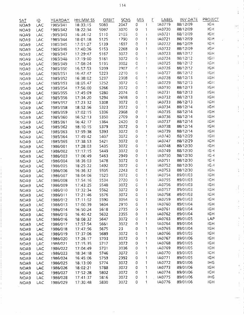
114
SAT ID YEARDAY HH:MM:SS ORBIT SCNS MIS F LABEL INV DATE PROJECT
NOA9 LAC 1985/341 18.:33: 15 5083 2047 0 IA0719 88/12/09 IGH
NOA9 LAC 1985/342 18:22:34 5097 3070 0 IA0720 88/12/09 IGH
NOA9 LAC 1985/343 16:34: 12 5110 2105 0 IA0721 88/12/09 IGH
NOA9 LAC 1985/344 18:01:18 5125 1790 0 IA0721 88/12/09 IGH
NOA9 LAC 1985/345 17:51 :27 5139 1697 0 IA0722 88/12/09 IGH
NOA9 LAC 1985/346 17:40:36 5153 2268 0 IA0722 88/12/09 IGH
NOA9 LAC 1985/347 17:29:47 5167 3072 0 IA0723 88/12/12 IGH
NOA9 LAC 1985/348 17: 19:00 5181 3072 0 IA0724 88/12112 IGH
NOA9 LAC 1985/349 17:08:24 5195 3002 0 IA0725 88/12112 IGH
NOA9 LAC 1985/350 16:57:53 5209 2907 0 IA0726 88/12/12 IGH
NOA9 LAC 1985/351 16:47:47 5223 2210 0 IA0727 88/12/12 IGH
NOA9 LAC 1985/352 16:38:02 5237 2308 0 IA0728 88/12/13 IGH
NOA9 LAC 1985/353 18:05:47 5252 3072 0 IA0729 88/12/13 IGH
NOA9 LAC 1985/354 17:56:00 5266 3072 0 IA0730 88/12/13 IGH
NOA9 LAC 1985/355 17:45:09 5280 2074 0 IA0731 88/12/13 IGH
NOA9 LAC 1985/356 17:34:20 5294 2658 0 IA0732 88/12/13 IGH
NOA9 LAC 1985/357 17:23:32 5308 3072 0 IA0733 88/12/13 IGH
NOA9 LAC 1985/358 18: 52: 56 5323 3072 0 IA0734 88/12/14 IGH
NOA9 LAC 1985/359 17:02:15 5336 2968 0 IA0735 88/12/14 IGH
NOA9 LAC 1985/360 16:52:13 5350 2709 0 IA0736 88/12/14 IGH
NOA9 LAC 1985/361 16:42:17 5364 2420 0 IA0737 88/12/14 IGH
NOA9 LAC 1985/362 18:10:15 5379 3072 0 IA0738 88/12/14 IGH
NOA9 LAC 1985/363 17:59:38 5393 3072 0 IA0739 88/12114 IGH
NOA9 LAC 1985/364 17:49:42 5407 3072 0 IA0740 88/12/29 IGH
NOA9 LAC 1985/365 17:38:53 5421 3072 0 IA0747 88/12/29 IGH
NOA9 LAC 1986/001 17:28:03 5435 3072 0 IA0748 88/12/30 IGH
NOA9 LAC 1986/002 17:17:15 5449 3072 0 IA0749 88/12/30 IG:-i
NOA9 LAC 1986/003 17:06:49 5463 2949 0 IA0750 88/12/30 IG:-i
NOA9 LAC 1986/004 18:36:03 5478 3072 0 IA0751 88/12/30 IG:-i
NOA9 LAC 1986/005 18:25:22 5492 3072 0 IA0752 88/12/30 IG,:-i
NOA9 LAC 1986/006 16:36:32 5505 2243 0 IA0753 88/12/30 IGh
NOA9 LAC 1986/007 18:04:06 5520 3072 0 IA0754 89/01/03 IGH
NOA9 LAC 1986/008 17: 54: 16 5534 2720 0 IA0755 89/01/03 IGH
NOA9 LAC 1986/009 17:43:25 5548 3072 0 IA0756 89/01/03 IGH
NOA9 LAC 1986/010 17:32:34 5562 3072 0 IA0757 89/01/03 IGH
NOA9 LAC 1986/011 17:21 :46 5576 3072 0 IA0758 89/01/03 IGH
NOA9 LAC 1986/012 17:11:02 5590 3054 0 IA0759 89/01/03 IGH
NOA9 LAC 1986/013 17:00:39 5604 2910 0 IA0760 89/01/04 IGH
NOA9 LAC 19861014 16:50:24 5618 2735 0 IA0761 89/01/04 IGH
NOA9 LAC 1986/015 16:40:42 5632 2355 0 IA0762 89/01/04 IGH
NOA9 LAC 1986/016 18:08:32 5647 3072 0 IA0763 89/01/05 LAP
NOA9 LAC 1986/017 17:57:54 5661 3072 0 IA0764 89/01/04 IGH
NOA9 LAC 1986/018 17:47:56 5675 23 0 IA0765 89/01/04 IGH
NOA9 LAC 1986/019 17:37:06 5689 3072 0 IA0766 89/01/05 IGH
NOA9 LAC 1986/020 17:26:17 5703 3072 0 IA0767 89/01/06 IGH
NOA9 LAC 1986/021 17:15:35 5717 3072 0 IA0768 89/01/05 IGH
NOA9 LAC 1986/022 17:04:49 5731 3036 0 IA0769 89/01/05 IGH
NOA9 LAC 1986/023 18:34:18 5746 3072 0 IA0770 89/01/05 IGH
NOA9 LAC 1986/024 16:45:06 5759 2392 0 IA0771 89/01/05 IGH
NOA9 LAC 1986/025 18: 13:00 5774 3072 0 IA0772 89/01/06 IHG
NOA9 LAC 1986/026 18:02:21 5788 3072 0 IA0773 89/01/06 IGH
NOA9 LAC 1986/027 17:52:28 5802 3072 0 IA0774 89/01/06 IGH
NOA9 LAC 1986/028 17:41:37 5816 3072 0 IA0775 89/01/06 IHG
NOA9 LAC 1986/029 17:30:48 5830 3072 0 IA0776 89/01/06 IGH

115
SAT ID YEARDAY HH:MM:SS ORBIT SCNS MIS F LABEL INV DATE PROJECT
NOA9 LAC 1986/030 17:19:59 5844 3072 0 IA0777 89/01/09 IGH
NOA9 LAC 1986/031 17:09:13 5858 3067 0 IA0778 89/01/09 IGH
NOA9 LAC 1986/032 16:58:58 5872 2878 0 IA0779 89/01/09 IGH
NOA9 LAC 1986/033 16:48:53 5886 2646 0 IA0780 89/01/09 IGH
NOA9 LAC 1986/034 18: 17:25 5901 3072 0 IA0781 89/01/09 IGH
NOA9 LAC 19861035 18:06:47 5915 3072 0 IA0782 89/01/09 IGH
NOA9 LAC 1986/036 17: 56: 58 5929 3072 0 IA0783 89/0111 0 IGH
NOA9 LAC 1986/037 17:46:07 5943 3072 0 IA0784 89/01/10 IGH
NOA9 LAC 1986/038 19: 12: 34 5958 3072 0 IA0785 89/0111 0 IGH
NOA9 LAC 1986/039 17:27:05 5971 2048 0 IA0786 89/01112 IGH
NOA9 LAC 1986/040 17:13:41 5985 3072 0 IA0787 89/01112 IGH
NOA9 LAC 1986/041 17:03: 15 5999 2948 0 IA0788 89/01/12 IGH
NOA9 LAC 1986/042 16:53:08 6013 2720 0 IA0789 89/01/12 IGH
NOA9 LAC 19861043 16:43:30 6027 2319 0 IA0790 89/01112 IGH
NOA9 LAC 1986/044 18: 10:40 6042 3072 0 IA0791 89/01113 IGH
NOA9 LAC 1986/045 18:00:03 6056 2286 0 IA0792 88/09/02 AWl
NOA9 LAC 19861046 17:50:36 6070 3072 0 IA0793 89/01/13 IGH
NOA9 LAC 1986/047 17:39:46 6084 3072 0 IA0794 89/01/13 IGH
NOA9 LAC 1986/048 19:08:37 6099 3072 0 IA0795 89/01/13 IGH
NOA9 LAC 1986/049 17: 18:08 6112 3072 0 IA0796 89/01113 IGH
NOA9 LAC 1986/050 17:07:48 6126 2909 0 IA0797 89/01/16 IGH
NOA9 LAC 1986/051 16:57:29 6140 2750 0 IA0798 89/01/16 IGH
NOA9 LAC 1986/052 16:47:49 6154 2359 0 IA0799 89/01/16 IGH
NOA9 LAC 1986/053 18:15:04 6169 3072 0 IA0800 89/01/16 IGH
NOA9 LAC 1986/054 18:04:26 6183 3072 0 IA0801 89/01/16 IGH
NOA9 LAC 1986/056 17:44: 13 6211 3072 0 IA0803 89/01/16 IGH
NOA9 LAC 1986/057 17:33:23 6225 3072 0 IA0804 89/01117 IGH
NOA9 LAC 1986/058 17:22:34 6239 3072 0 IA0805 89/01/17 IGH
NOA9 LAC 1986/059 17: 11 :55 6253 3016 0 IA0806 89/01/17 IGH
NOA9 LAC 1986/060 17:01 :36 6267 2854 0 IA0807 89/01/17 IGH
NOA9 LAC 1986/061 16:51:41 6281 2547 0 IA0808 89/01/17 IGH
NOA9 LAC 1986/062 16:41:39 6295 2294 0 IA0809 89/01/17 IGH
NOA9 LAC 1986/063 18:08:47 6310 3072 0 IA0810 88/09/02 AWl
NOA9 LAC 1986/064 17:59:30 6324 3072 0 IA0811 89/01/18 IGH
NOA9 LAC 1986/065 17:48:39 6338 3072 0 IA0812 89/01/18 IGH
NOA9 LAC 1986/066 17:37:48 6352 3072 0 IA0813 89/01/18 IGH
NOA9 LAC 1986/067 17:26:59 6366 3072 0 IA0814 89/01/18 IGH
NOA9 LAC 1986/068 17: 16: 11 6380 3072 0 IA0815 89/01/18 IGH
NOA9 LAC 1986/069 17:05:59 6394 2857 0 IA0816 89/01/19 IGH
NOA9 LAC 1986/070 18:34:26 6409 3072 0 IA0817 89/01/19 IGH
NOA9 LAC 1986/071 16:46:01 6422 2207 0 IA0818 89/01/19 IGH
NOA9 LAC 1986/072 16:36:43 6436 2207 0 IA0819 89/01/19 IGH
NOA9 LAC 1986/072 18: 13:06 6437 3072 0 IA0820 89/01/19 IGH
NOA9 LAC 1986/073 18:02:29 6451 3072 0 IA0821 89/01/19 IGH
NOA9 LAC 1986/074 17:53:02 6465 3072 0 IA0822 89/01/20 IGH
NOA9 LAC 1986/075 17:42: 12 6479 3072 0 IA0823 88/09/02 AWl
NOA9 LAC 1986/076 17:31 :23 6493 3067 0 IA0824 89/01/20 IGH
NOA9 LAC 1986/077 17:20:40 6507 3072 0 IA0825 89/01/20 !GH
NOA9 LAC 1986/078 17:09:57 6521 3003 0 IA0826 89/01/20 IGH
NOA9 LAC 1986/079 16:59:46 6535 2785 0 IA0827 89/01/20 IGH
NOA9 LAC 1986/080 16:49:57 6549 2442 0 IA0828 89/01/23 IGH
NOA9 LAC 1986/080 18:28:05 6550 3072 0 IA0829 89/01/23 IGH
NOA9 LAC 1986/081 18: 17:25 6564 3072 0 IA0830 89/01/23 IGH
NOA9 LAC 1986/082 18:06:47 6578 3070 0 IA0831 89/01/23 IGH
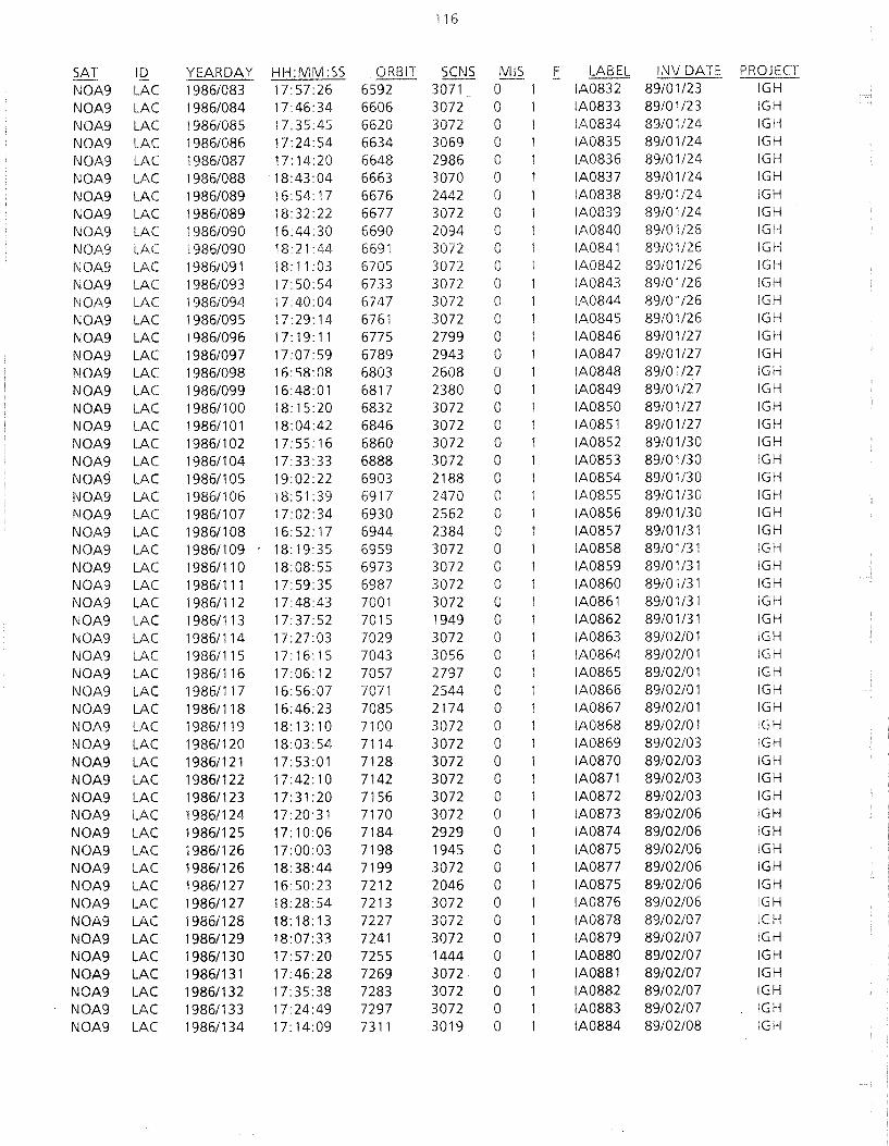
116
SAT 10 YEARDAY HH:MM:SS ORBIT SCNS MIS F LABEL INV DATE
NOA9 LAC 1986/083 17:57:26 6592 3071 0 IA0832 89/01/23 IGH
NOA9 LAC 1986/084 17:46:34 6606 30n 0 IA0833 89/01/23 IGH
NOA9 LAC 1986/085 17:35:45 6620 3072 0 IA0834 89/01/24 IGH
NOA9 LAC 19861086 17:24:54 6634 3069 0 IA0835 89/01/24 IGH
NOA9 LAC 1986/087 17: 14:20 6648 2986 0 IA0836 89/01/24 IGH
NOA9 LAC 1986/088 18:43:04 6663 3070 0 IA0837 89/01/24 IGH
NOA9 LAC 19861089 16:54: 17 6676 2442 0 IA0838 89/01/24 IGH
NOA9 LAC 19861089 18:32:22 6677 30n 0 IA0839 89/01/24 IGH
NOA9 LAC 19861090 16:44:30 6690 2094 0 IA0840 89/01/26 IGH
NOA9 LAC 1986/090 18:21 :44 6691 3072 0 iA0841 89/01/26 IGH
NOA9 LAC 19861091 18:11:03 6705 30n 0 IA0842 89/01/26 IGH
NOA9 LAC 19861093 17: 50:54 6733 3072 0 IA0843 89/01/26 IGH
NOA9 LAC 19861094 17:40:04 6747 3072 0 IA0844 89/01/26 IGH
NOA9 LAC 19861095 17:29:14 6761 3072 0 IA0845 89/01/26 IGH
NOA9 LAC 19861096 17:19:11 6775 2799 0 IA0846 89/01/27 IGH
NOA9 LAC 19861097 17:07:59 6789 2943 0 IA0847 89/01/27 IGH
NOA9 LAC 19861098 16: 58:08 6803 2608 0 IA0848 89/01/27 IGH
NOA9 LAC 19861099 16:48:01 6817 2380 0 IA0849 89/01/27 IGH
NOA9 LAC 1986/100 18:15:20 6832 3072 0 IA0850 89/01/27 IGH
NOA9 LAC 1986/101 18:04:42 6846 3072 0 IA0851 89/01/27 IGH
NOA9 LAC 19861102 17:55: 16 6860 3072 0 IA0852 89/01/30 IGH
NOA9 LAC 1986/104 17:33:33 6888 3072 0 IA0853 89/01/30 IGH
NOA9 LAC 1986/1 05 19:02:22 6903 2188 0 IA0854 89/01/30 IGH
NOA9 LAC 1986/106 18:51 :39 6917 2470 0 IA0855 89/01/30 IGH
NOA9 LAC 1986/1 07 17:02:34 6930 2562 0 IA0856 89/01/30 IGH
NOA9 LAC 1986/108 16:52: 17 6944 2384 0 IA0857 89/01/31 IGH
NOA9 LAC 1986/109 18: 19:35 6959 3072 0 IA0858 89/01/31 IGH
NOA9 LAC 1986/110 18:08:55 6973 3072 0 IA0859 89/01/31 IGH
NOA9 LAC 19861111 17:59:35 6987 3072 0 IA0860 89/01/31 IGH
NOA9 LAC 19861112 17:48:43 7001 3072 0 IA0861 89/01/31 IGH
NOA9 LAC 19861113 17:37:52 7015 1949 0 IA0862 89/01/31 IGH
NOA9 LAC 1986/114 17:27:03 7029 3072 0 IA0863 89/02/01 IGH
NOA9 LAC 19861115 17: 16: 15 7043 3056 0 IA0864 89102/01 IGH
NOA9 LAC 1986/116 17:06: 12 7057 2797 0 IA0865 89/02/01 IGH
NOA9 LAC 1986/117 16:56:07 7071 2544 0 IA0866 89/02/01 IGH
NOA9 LAC 19861118 16:46: 23 7085 2174 0 IA0867 89/02/01 IGH
NOA9 LAC 1986/119 18: 13: 10 7100 3072 0 IA0868 89/02/01 IGH
NOA9 LAC 19861120 18:03:54 7114 3072 0 IA0869 89/02/03 IGH
NOA9 LAC 19861121 17:53:01 7128 3072 0 IA0870 89/02/03 IGH
NOA9 LAC 1986/122 17:42: 10 7142 3072 0 IA0871 89/02/03 IGH
NOA9 LAC 19861123 17:31:20 7156 3072 0 IA0872 89/02/03 IGH NOA9 LAC 19861124 17:20:31 7170 3072 0 IA0873 89/02/06 IGH NOA9 LAC 19861125 17:10:06 7184 2929 0 IA0874 89/02/06 IGH NOA9 LAC 19861126 17:00:03 7198 1945 0 IA0875 89/02/06 IGH
NOA9 LAC 19861126 18:38:44 7199 3072 0 IA0877 89/02/06 IGH
NOA9 LAC 1986/127 16:50:23 7212 2046 0 IA0875 89/02/06 IGH
NOA9 LAC 1986/127 18:28:54 7213 3072 0 IA0876 89/02/06 IGH
NOA9 LAC 19861128 18:18:13 7227 30n 0 IA0878 89/02/07 IGH
NOA9 LAC 19861129 18:07:33 7241 3072 0 IA0879 89/02/07 IGH
NOA9 LAC 1986/130 17:57:20 7255 1444 0 IA0880 89/02/07 IGH NOA9 LAC 1986/131 17:46:28 7269 3072 0 IA0881 89/02/07 IGH NOA9 LAC 19861132 17:35:38 7283 3072 0 IA0882 89/02/07 IGH NOA9 LAC 19861133 17:24:49 7297 3072 0 IA0883 89/02/07 IGH NOA9 LAC 19861134 17: 14:09 7311 3019 0 IA0884 89/02/08 IGH

117
SAT 10 YEAR DAY HH:MM:SS ORBIT SCNS MIS F LABEL INV DATE PROJECT
NOA9 LAC 1986/134 18:54:31 7312 3072 0 1 IA088S- 89/02/08 IGH
NOA9 LAC 1986/135 07: 12:45 7319 2585 0 IA0887 89/02/08 IGH
NOA9 LAC 1986/135 17:04:06 7325 2600 0 IA0886 89/02/08 IGH
NOA9 LAC 1986/135 18:43:49 7326 3072 0 IA0888 89/02/08 IGH
NOA9 LAC 1986/136 07:02:38 7333 2384 0 IA0889 89/02/08 IGH
NOA9 LAC 1986/136 16:53:58 7339 2518 0 IA0890 89/02/09 IGH
NOA9 LAC 1986/136 18:33:07 7340 3072 0 IA0891 89/02/09 IGH
NOA9 LAC 1986/137 06:51 :43 7347 2457 0 IA0892 89/02/09 IGH
NOA9 LAC 19861137 16:44:32 7353 2052 0 IA0893 89/02/09 IGH
NOA9 LAC 19861138 18: 11 :48 7368 3072 0 IA0894 89/02/09 IGH
NOA9 LAC 19861139 18:01 :38 7382 3072 0 IA0895 89/02/09 IGH
NOA9 LAC 19861140 17:50:46 7396 3072 0 IA0896 89/02/10 IGH
NOA9 LAC 1986/141 17:39:55 7410 3072 0 IA0897 89/02/10 IGH
NOA9 LAC 1986/142 17:29:05 7424 3072 0 IA0898 89/02/13 IGH
NOA9 LAC 1986/143 17:18:16 7438 3072 0 IA0899 89/02/13 IGH
NOA9 LAC 1986/144 17:08:37 7452 2664 0 IA0900 89/02/13 IGH
NOA9 LAC 1986/145 16:57:59 7466 2609 0 IA0901 89/02/13 IGH
NOA9 LAC 1986/146 16:48:07 7480 2291 0 IA0902 89/02/13 IGH
NOA9 LAC 19861146 18:26:41 7481 3072 0 IA0903 89/02/13 IGH
NOA9 LAC 1986/147 16:38:40 7494 2082 0 IA0904 89/02/13 IGH
NOA9 LAC 19861147 18: 16:00 7495 3072 0 IA0905 89/02/13 IGH
NOA9 LAC 1986/148 18:05:56 7509 3072 0 IA0906 89/02/14 IGH
NOA9 LAC 1986/149 17:55:03 7523 3072 0 IA0907 89/02/14 IGH
NOA9 LAC 19861150 19:24:31 7538 3072 0 IA0908 89/02/14 IGH
NOA9 LAC 19861151 17:33:22 7551 3072 0 IA0909 89/02/14 IGH
NOA9 LAC 1986/152 17:22:53 7565 2948 0 IA0910 89/02/15 IGH
NOA9 LAC 1986/153 17:12:07 7579 2944 0 IA0911 89/021'5 IGH
NOA9 LAC 1986/154 18:41:35 7594 3072 0 IA0912 89/021'5 IGH
NOA9 LAC 1986/155 18:30:57 7608 3072 0 IA0913 89/02r 5 IGH
NOA9 LAC 1986/156 18:20:13 7622 3072 0 IA0914 89/02r 5 IGH
NOA9 LAC 1986/157 18:09:33 7636 3072 0 IA0915 89/02r 5 IGH
NOA9 LAC 19861158 17:59:20 7650 3072 0 IA0916 89/02/16 IGH
NOA9 LAC 1986/159 17:48:29 7664 3072 0 IA0917 89/02/16 IGH
NOA9 LAC 1986/160 17:37:38 7678 3072 0 IA0918 89/02/16 IGH
NOA9 LAC 1986/161 17:26:51 7692 3049 0 IA0919 89/02/16 IGH
NOA9 LAC 1986/162 17:16:17 7706 2961 0 IA0920 89/02/16 IGH
NOA9 LAC 1986/163 18:45:47 7721 3072 0 IA0921 89/02/16 IGH
NOA9 LAC 1986/164 16: 55:49 7734 2575 0 IA0922 89/02/17 IGH
NOA9 LAC 19861165 18:24:25 7749 2012 0 IA0923 89/02/17 IGH
NOA9 LAC 1986/166 18: 14: 16 7763 2892 0 IA0924 89/02117 IGH
NOA9 LAC 19861167 18:03:37 7777 3072 0 IA0926 89/02/17 IGH
NOA9 LAC 19861168 17:52:44 7791 2626 0 IA0927 89/02/20 IGH
NOA9 LAC 19861170 17:31 :03 7819 3072 0 IA0928 89/02/20 IGH
NOA9 LAC 1986/171 17:20:14 7833 2980 0 IA0929 89/02/20 IGH
NOA9 LAC 19861172 17:09:56 7847 2893 0 IA0930 89/02/20 IGH
NOA9 LAC 19861172 18:49:44 7848 3072 0 IA0931 89/02/20 IGH
NOA9 LAC 19861173 17:00:09 7861 2528 0 IA0932 89/02/20 IGH
NOA9 LAC 1986/174 18:28:20 7876 3072 0 IA0933 89/02/21 IGH
NOA9 LAC 1986/175 18: 17:40 7890 3072 0 IA0934 89/02/21 IGH
NQA9 LAC 1986/176 18:07:52 7904 3072 0 IA0935 89/02/21 IGH
NOA9 LAC 19861177 17:56:59 7918 3072 0 IA0936 89/02/21 IGH
NOA9 LAC 19861178 17:46:07 7932 3072 0 IA0937 89/02/21 IGH
NOA9 LAC 19861179 17:35:17 7946 3072 0 IA0938 89/02/21 IGH
NOA9 LAC 1986/180 19:04:39 7961 3072 0 IA0939 89/02/22 IGH

118
SAT ID YEAR DAY HH:MM:SS ORBIT SCNS MIS F LABEL !NV DATE
NOA9 LAC 1986/181 18:53:56 7975 3072 0 IA0940 89/02/22 IGH
NOA9 LAC 1986/182 18:43: 13 7989 3072 0 IA0941 '59/02/22 IGH
NOA9 LAC 19861183 18:32:30 8003 3072 0 IA0942 89/02/22 IGH
NOA9 LAC 19861184 18:21 :50 8017 3072 0 IA0943 89/02/22 IGH
NOA9 LAC 19861185 18: 11: 10 8031 3072 0 IA0944 89/02/22 IGH
NOA9 LAC 19861186 18:01:13 8045 3072 0 IA0945 89/02/24 IGH
NOA9 LAC 19861187 17: 50: 21 8059 3072 0 IA0946 89/02/24 IGH
NOA9 LAC 19861188 17:39:29 8073 3072 0 IA0947 89/02/24 IGH
NOA9 LAC 1986/189 19:08:50 8088 3016 0 IA0948 89/02/24 IGH
NOA9 LAC 19861190 17: 18:06 8101 2975 0 iA0949 89/02/24 IGH
NOA9 LAC 1986/191 18:47:22 8116 3072 0 IA0950 89/02/27 IGH
NOA9 LAC 1986/192 18:36:40 8130 3072 0 IA0951 89/02/27 IGH
NOA9 LAC 19861193 18:25:59 8144 3072 0 IA0952 89/02/27 IGH
NOA9 LAC 19861194 18:15:19 8158 3073 0 IA0953 89/02/27 IGH
NOA9 LAC 1986/195 18:05:26 8172 3072 0 IA0954 89/02/27 IGH
NOA9 LAC 1986/196 17:54:32 8186 3072 0 IA0955 89/02/27 IGH
NOA9 LAC 1986/197 17:43:41 8200 3072 0 IA0956 89/02/28 IGH
NOA9 LAC 1986/198 17:32: 50 8214 3072 0 IA0957 89/02/28 IGH
NOA9 LAC 1986/199 17:22:03 8228 1890 0 IA0958 89/02/28 IGH
NOA9 LAC 1986/200 18:51:30 8243 2790 0 IA0959 89/02/28 IGH
NOA9 LAC 1986/202 18:30:09 8271 3072 0 IA0960 89/02/28 IGH
NOA9 LAC 1986/203 18: 19:26 8285 2805 0 IA0961 88/06/24 YANKO
NOA9 LAC 1986/204 18:09:36 8299 2300 0 IA0962 88/06/24 YANKO
NOA9 LAC 1986/205 17:58:43 8313 3072 0 IA0963 89/03/01 IGH
NOA9 LAC 1986/206 17:47:51 8327 3072 0 IA0964 89/03/01 IGH
NOA9 LAC 1986/207 17:37:00 8341 1844 0 IA0965 89/03/01 IGH
NOA9 LAC 1986/208 17:26: 10 8355 3071 0 IA0966 89/03/01 IGH
NOA9 LAC 1986/209 17:16:05 8369 2812 0 IA0967 89/03/01 IGH
NOA9 LAC 1986/210 17:05: 53 8383 2618 0 IA0968 89/03/02 IGH
NOA9 LAC 1986/211 16:55: 50 8397 2374 0 IA0969 89'03/02 IGH
NOA9 LAC 1986/212 18:20:51 8412 3071 0 IA0970 8903/02 IGH
NOA9 LAC 1986/213 18:14:16 8426 3072 0 IA0971 89/03/02 IGH
NOA9 LAC 19861214 18:03:00 8440 3072 0 IA0972 89/03/02 IGH
NOA9 LAC 1986/215 17:52:01 8454 3072 0 IA0973 89/03/02 IGH
NOA9 LAC 1986/216 17:41 :09 8468 3072 0 IA0974 89/03/03 IGH
NOA9 LAC 1986/217 17:30:18 8482 3072 0 IA0975 89/03/03 IGH
NOA9 LAC 1986/218 17: 19:47 8496 2966 0 IA0976 89/03/03 IGH
NOA9 LAC 1986/218 18:57: 11 8497 3011 0 IA0977 89/03/03 IGH
NOA9 LAC 1986/219 18:49:33 8511 3072 0 IA0978 89/03/03 IGH
NOA9 LAC 1986/220 16:59:46 8524 2122 0 IA0979 89/03/03 IGH
NOA9 LAC 1986/221 18:28:08 8539 3072 0 IA0980 88/06/24 YANKO
NOA9 LAC 1986/222 18:17:28 8553 3072 0 IA0981 89/03/06 IGH
NOA9 LAC 1986/223 18:07:02 8567 2949 0 IA0982 89/03/06 IGH
NOA9 LAC 1986/224 17:56:08 8581 3072 0 IA0983 88/06/24 YANKO
NOA9 LAC 19861225 17:45: 16 8595 3072 0 IA0984 88112/07 INGRID
NOA9 LAC 1986/226 17:35:45 8609 2595 0 IA0985 88/06/23 YANKO
NOA9 LAC 1986/227 17:23:45 8623 3016 0 IA0986 89/03/07 IGH
NOA9 LAC 1986/228 17:13:13 8637 2916 0 LA0987 89/03/07 IGH
NOA9 LAC 1986/229 17:03:16 8651 2614 0 IA0988 89/03/07 IGH
NOA9 LAC 19861230 16:53:17 8665 2323 0 IA0989 89/03/07 IGH
NOA9 LAC 1986/231 18:21 :32 8680 3072 0 IA0990 89/03/07 IGH
NOA9 LAC 1986/232 18:11:10 8694 3072 0 IA0991 89/03/07 IGH
NOA9 LAC 1986/233 18:00: 16 8708 3072 0 IA0992 88/06/23 YANKO
NOA9 LAC 19861234 17:49:24 8722 2594 0 IA0993 89/03/08 IGH

119
SAT ID YEARDAY HH:MM:SS ORBIT SCNS MIS F LABEL INV DATE PROJECT
NOA9 LAC 1986/235 17:38:33 8736 3072 0 IA0994 89/03/08 IGH
NOA9 LAC 1986/236 17:27:43 8750 3072 0 IA0995 89/03/08 IGH
NOA9 LAC 19861237 17.17:21 8764 2907 0 IA0996 89/03/08 IGH
NOA9 LAC 1986/238 18:46:59 8779 3072 0 IA0997 88/06/23 YANKO
NOA9 LAC 19861239 16:57:17 8792 2358 0 IA0998 89/03/09 IGH
NOA9 LAC 1986/240 16:47:55 8806 2288 0 IA0999 89/03/09 IGH
NOA9 LAC 1986/240 18:25:35 8807 3072 0 IA1000 89/03/09 IGH
NOA9 LAC 19861241 18: 14: 54 8821 3072 0 IA100l 88/06/21 YANKO
NOA9 LAC 19861242 18:04:23 8835 3072 0 IA1002 88/06/23 YANKO
NOA9 LAC 19861243 17:53:31 8849 3072 0 IA1003 89/03/09 IGH
NOA9 LAC 1986/244 17:42:39 8863 3072 0 IA1004 89/03/1 0 IGH
NOA9 LAC 1986/245 17:31:49 8877 3072 0 IA1005 89/03/10 IGH
NOA9 LAC 19861246 17:21 :09 8891 3010 0 IA1006 89/03/1 0 IGH
NOA9 LAC 1986/248 18:40:20 8920 3071 0 IA1007 88/06/23 YANKO
NOA9 LAC 1986/250 18: 18:57 8948 3072 0 IA1008 89/03/13 IGH
NOA9 LAC 1986/251 18:08:31 8962 3072 0 IA1009 89/03/14 IGH
NOA9 LAC 1986/252 17:59:57 8976 2048 0 IA1010 88/06/23 YANKO
NOA9 LAC 1986/253 17:46:46 8990 3072 0 IA1011 89/03/14 IGH
NOA9 LAC 1986/254 17:35: 55 9004 3064 0 IA1012 89/03/14 IGH
NOA9 LAC 1986/255 17:25:05 9018 3072 0 IA1013 89/03/14 IGH
NOA9 LAC 1986/256 18:55:08 9033 3072 0 IA1014 88/06/21 YANKO
NOA9 LAC 1986/257 17:04:43 9046 2624 0 IA1015 89/03/15 IGH
NOA9 LAC 1986/257 18:44:24 9047 3072 0 IA1016 88/06/21 YANKO
NOA9 LAC 19861258 18:33:43 9061 3072 0 IA1017 89/03/15 IGH
NOA9 LAC 1986/259 18:23:00 9075 3072 0 IA1018 89/03/15 IGH
NOA9 LAC 1986/260 18: 12:38 9089 3073 0 IA1019 89/03/15 IGH
NOA9 LAC 1986/261 18:01 :43 9103 2691 0 IA1020 88/06/21 YANKO
NOA9 LAC 1986/262 17:50:51 9117 3072 0 IA1021 89/03/16 IGH
NOA9 LAC 1986/263 17:40:00 9131 3072 0 IA1022 89/03/16 IGH
NOA9 LAC 1986/264 17:29:12 9145 3052 0 IA1023 89/03/16 IGH
NOA9 LAC 19861265 17:18:43 9159 2941 0 IA1024 89/03/16 IGH
NOA9 LAC 1986/267 16:59:05 9187 2238 0 IA1025 89/03/16 IGH
NOA9 LAC 1986/268 18:27:02 9202 3071 0 IA1026 89/03/17 IGH
NOA9 LAC 1986/269 18:16:22 9216 3071 0 IA1027 89/03/17 IGH
NOA9 LAC 1986/270 18:06:53 9230 2698 0 IA1028 89/03/17 IGH
NOA9 LAC 1986/271 17:54:58 9244 3071 0 IA1029 88/06/24 YANKO
NOA9 LAC 1986/272 17:44:06 9258 2792 0 IA1030 89/03/17 IGH
NOA9 LAC 1986/273 17:33: 16 9272 3072 0 IA1031 89/03/17 IGH
NOA9 LAC 1986/274 19:03: 14 9287 3072 0 IA1032 89/03/20 IGH
NOA9 LAC 1986/275 18:52:30 9301 3072 0 IA1033 89/03/20 IGH
NOA9 LAC 1986/276 17:02:21 9314 2520 0 IA1034 89/03/20 IGH
NOA9 LAC 1986/277 18:31 :05 9329 3071 0 IA1035 89/03/20 IGH
NOA9 LAC 1986/278 18:20:23 9343 3067 0 IA1036 89/03/20 IGH
NOA9 LAC 1986/279 18:09:55 9357 3072 0 IA1037 89/03/21 IGH
NOA9 LAC 1986/280 19:39:35 9372 3072 0 IA1038 89/03/21 IGH
NOA9 LAC 1986/281 17:48: 09 9385 3072 0 IA1039 89/03/21 IGH
NOA9 LAC 1986/282 17:37:20 9399 3072 0 IA1040 89/03/21 IGH
NOA9 LAC 19861283 19:07:16 9414 2888 0 IA1041 89/03/21 IGH
NOA9 LAC 1986/284 18:56:32 9428 3072 0 IA1042 89/03/21 IGH
NOA9 LAC 1986/285 18:45:49 9442 3072 0 IA1043 89/03/22 IGH
NOA9 LAC 1986/286 16:56:28 9455 2214 0 IA1044 89/03/22 IGH
NOA9 LAC 19861287 18:24:24 9470 3072 0 IA1045 89/03/22 IGH
NOA9 LAC 1986/288 18:14:01 9484 3072 0 IA1046 89/03/22 IGH
NOA9 LAC 1986/289 18:03:07 9498 3072 0 IA1047 89/03/22 IGH

120
SAT ID YEARDAY HH:MM:SS ORBIT SCNS MIS F LABEL INV DATE PROJECT
NOA9 LAC 1986/290 17:52:14 9512 2294 0 IA 1048 89/03/22 IGH
NOA9 LAC 1986/291 17:41 :23 9526 3072 0 IA 1049 89/03/23 IGH
NOA9 LAC 19861292 17:30:33 9540 3072 0 IA 1050 89/03/23 IGH
NOA9 LAC 1986/293 17:20: 12 9554 2899 0 IA 1051 89/03/23 IGH
NOA9 LAC 1986/293 19:00:33 9555 3072 0 IA1052 89/03/23 IGH
NOA9 LAC 1986/294 17: 10:01 9568 2669 0 IA1053 89/03/23 IGH
NOA9 LAC 1986/295 18:39:06 9583 3045 0 IA1054 89/03/23 IGH
NOA9 LAC 1986/296 18:28:24 9597 3072 0 IA1055 89/03/28 IGH
NOA9 LAC 1986/297 18:17:45 9611 3072 0 IA1056 89/03/28 IGH
NOA9 LAC 19861298 18:07: 11 9625 3072 0 IA10S7 89/03/28 IGH
NOA9 LAC 1986/299 17:56: 18 9639 3072 0 IA1058 89/03/28 IGH
NOA9 LAC 1986/300 17:45:26 9653 3072 0 IA1059 89/03/28 IGH
NOA9 LAC 1986/301 17:34:37 9667 2743 0 IA1060 89/03/28 IGH
NOA9 LAC 1986/302 19:04:33 9682 3072 0 IA1061 89/03/29 IGH
NOA9 LAC 1986/303 18:53:49 9696 3070 0 IA 1062 89/03/29 IGH
NOA9 LAC 1986/304 18:43:07 9710 3072 0 IA 1063 89/03/29 IGH
NOA9 LAC 1986/305 18:32:23 9724 3072 0 IA1064 89/03/29 IGH
NOA9 LAC. 1986/306 18:21:42 9738 3071 0 IA 1065 89/03/29 IGH
NOA9 LAC 1986/307 18: 11: 13 9752 3073 0 IA 1066 89/03/29 IGH
NOA9 LAC 1986/308 18:00: 21 9766 2810 0 IA1067 89/03/30 IGH
NOA9 LAC 1986/309 17:49:30 9780 3072 0 IA 1068 89/03/30 IGH
NOA9 LAC 1986/310 17:38:36 9794 3072 0 IA 1069 89/03/30 IGH
NOA9 LAC 1986/311 19:08:34 9809 3072 0 IA 1070 89/03/31 IGH
NOA9 LAC 1986/312 17: 17:32 9822 2849 0 IA1071 89/03/31 IGH
NOA9 LAC 1986/313 17:07:33 9836 2569 0 IA 1072 89/03/31 IGH
NOA9 LAC 1986/314 18:36:21 9851 2120 0 IA1073 89/04/03 IGH
NOA9 LAC 1986/315 18:25:39 9865 2260 0 IA1074 89/04/03 IGH
NOA9 LAC 1986/316 18:15: 14 9879 3072 0 IA1075 89/04/03 IGH
NOA9 LAC 1986/317 18:04:20 9893 1890 0 IA 1076 89/04/03 IGH
NOA9 LAC 1986/318 17: 53:29 9907 3072 0 IA10n 89/04/03 IGH
NOA9 LAC 1986/319 17:42: 35 9921 3072 0 IA 10"78 89/04/03 IGH
NOA9 LAC 1986/320 17:31 :44 9935 3072 0 IA1079 89/04/04 IGH
NOA9 LAC 1986/321 17:21 :27 9949 2877 0 IA 1080 89/04/04 IGH
NOA9 LAC 1986/322 18:51 :04 9964 3072 0 IA1081 89/04/04 IGH
NOA9 LAC 1986/323 17:01 :36 9977 2241 0 IA 1082 89/04/04 IGH
NOA9 LAC 1986/324 18:29:34 9992 3071 0 IA1083 89/04/04 IGH
NOA9 LAC 1986/325 18: 18:53 10006 3072 0 IA1084 89/04/04 IGH
NOA9 LAC 1986/326 18:08:20 10020 3072 0 IA1085 89/04/05 IGH
NOA9 LAC 1986/327 17:57:25 10034 3072 0 IA 1086 89/04/05 IGH
NOA9 LAC 1986/328 17:46:32 10048 3072 0 IA 1087 89/04/05 IGH
NOA9 LAC 1986/329 17:35:43 10062 3072 0 IA 1088 89/04/05 IGH
NOA9 LAC 1986/330 17:25: 18 10076 2913 0 IA 1089 89/04/05 IGH
NOA9 LAC 1986/331 18: 54: 54 10091 2208 0 IA 1090 89/04/06 IGH
NOA9 LAC 1986/332 18:44: 13 10105 3070 0 IA1091 89/04/06 IGH
NOA9 LAC 1986/333 18:33:29 10119 3072 0 IA 1092 89/04/06 IGH
NOA9 LAC 1986/334 18:22:46 10133 3072 0 IA 1093 89/04/06 IGH
NOA9 LAC 1986/336 18:01 :23 10161 3072 0 IA 1094 89/04/06 IGH
NOA9 LAC 19861337 17:50:29 10175 3055 0 IA1095 89/04/06 IGH
NOA9 LAC 1986/338 17:40: 13 10189 3071 0 IA 1096 89/04/07 IGH
NOA9 LAC 1986/339 19:10:21 10204 3072 0 IA 1097 89/04/07 IGH
NOA9 LAC 1986/340 18:59:39 10218 3072 0 IA 1098 89/04/07 IGH
NOA9 LAC 1986/341 18:48:52 10232 3071 0 IA 1099 89/04/07 IGH
NOA9 LAC 1986/342 18:35:34 10246 3959 0 IA1100 89/04/10 IGH
NOA9 LAC 1986/343 18:25: 17 10260 3957 0 IAll01 89/04/10 IGH

121
SAT ID YEARDAY HH:MM:SS ORBIT SCNS MIS F LABEL INV DATE PROJECT
NOA9 LAC 1986/344 18:14:45 10274 3959 0 IA1102 89/04/10 IGH
NOA9 LAC 1986/345 18:04:24 10288 3959 0 IAll03 89/04/10 IGH
NOA9 LAC 1986/346 17:53: 15 10302 3958 0 IA1104 89/04/11 IGH
NOA9 LAC 1986/347 17:42:58 10316 3893 0 IAll05 89/04/11 IGH
NOA9 LAC 1986/348 17:32:42 10330 3661 0 ~A 1106 89/04/11 IGH
NOA9 LAC 1986/349 17:22:24 10344 3321 0 IA1107 89/04/11 IGH
NOA9 LAC 1986/350 18:49:36 10359 3959 0 IA1108 89/04/11 IGH
NOA9 LAC 1986/351 18:40:31 10373 3955 0 IAll09 89/04/11 IGH
NOA9 LAC 1986/352 16:52:50 10386 2056 0 IA1110 89/04/12 IGH
NOA9 LAC 19861353 18: 18: 54 10401 3957 0 IA1111 89/04112 IGH
NOA9 LAC 1986/354 18:08: 12 10415 3957 0 IA1112 89/04/12 IGH
NOA9 LAC 19861355 17:57:37 10429 3959 0 IAll13 89/04112 IGH
NOA9 LAC 1986/356 17:46:52 10443 3915 0 IA1114 89/04/13 IGH
NOA9 LAC 1986/357 17:36:28 10457 3589 0 IAl115 89/04/13 IGH
NOA9 LAC 1986/358 19:06:52 10472 3953 0 IA1116 89/04/13 IGH
NOA9 LAC 19861359 17:15:57 10485 3191 0 IA1117 89/04/13 IGH
NOA9 LAC 1986/360 18:43:09 10500 3959 0 IA1l18 89/04/13 IGH
NOA9 LAC 1986/361 18:32:49 10514 3959 0 IA 1119 89/04/13 IGH
NOA9 LAC 1986/362 18:22:29 10528 2911 0 IA1120 89/04/14 IGH
NOA9 LAC 1986/363 18: 11 :55 10542 3959 0 IA1121 89/04/17 LAP
NOA9 LAC 1986/364 18:01 :21 10556 3959 0 IA1l22 89/04/14 IGH
NOA9 LAC 19861365 17:50:46 10570 3959 0 IAl123 89/04/14 IGH