1 Authors' Response to the Reviewer Comments Manuscript ...
14
1 Authors’ Response to the Reviewer Comments Manuscript Ref.: hess-2017-533 Title: Assessment of the Weather Research and Forecasting (WRF) Model for Extreme Rainfall Event Simulations in the Upper Ganga Basin Authors: Ila Chawla, Krishna K. Osuri, Pradeep P. Mujumdar, and Dev Niyogi We sincerely thank the reviewers for their comments on the manuscript and offering their suggestions and critical input that has helped improve the manuscript. We provide here our replies to the reviewers’ comments and highlight the changes made in the revised manuscript based on the comments. Sections which are modified in the revised manuscript are mentioned in this document. Responses to the comments of Referee #1: General Comments: The authors have used Weather Research and Forecasting model for extreme events over upper Ganga basin and evaluated the simulations. The work is of importance; however, there are certain comments that need to be addressed. Comment 1: I have reservation in stating " However, setting up the WRF model, that simulates extremely heavy rainfall over the ISMR region is still considered as a challenging task..". In my opinion setting up WRF is no longer a challenging task, given multiple works have been reported on the same. However, finding the best physics parameterization option or understanding of the combinations of good parameterization options for different purposes is still an area of research and that needs to come out through the first paragraph of introduction. Response: We agree and have modified the statement. The statement was meant to highlight that it is a challenging task since it involves consideration of several aspects such as forcing data, model grid spacing/resolution, land surface parameterization and choice of an appropriate physics scheme. Action: Lines “However, setting up the WRF model, that simulates extremely heavy rainfall over the ISMR region is still considered as a challenging task, which involves consideration of several aspects such as forcing data, model grid spacing/resolution, land surface parameterization and
-
Upload
khangminh22 -
Category
Documents
-
view
6 -
download
0
Transcript of 1 Authors' Response to the Reviewer Comments Manuscript ...

1
Authors’ Response to the Reviewer Comments
Manuscript Ref.: hess-2017-533
Title: Assessment of the Weather Research and Forecasting (WRF) Model for Extreme Rainfall Event
Simulations in the Upper Ganga Basin
Authors: Ila Chawla, Krishna K. Osuri, Pradeep P. Mujumdar, and Dev Niyogi
We sincerely thank the reviewers for their comments on the manuscript and offering their
suggestions and critical input that has helped improve the manuscript. We provide here our replies
to the reviewers’ comments and highlight the changes made in the revised manuscript based on
the comments. Sections which are modified in the revised manuscript are mentioned in this
document.
Responses to the comments of Referee #1:
General Comments:
The authors have used Weather Research and Forecasting model for extreme events over upper
Ganga basin and evaluated the simulations. The work is of importance; however, there are certain
comments that need to be addressed.
Comment 1: I have reservation in stating " However, setting up the WRF model, that simulates
extremely heavy rainfall over the ISMR region is still considered as a challenging task..". In my
opinion setting up WRF is no longer a challenging task, given multiple works have been reported
on the same. However, finding the best physics parameterization option or understanding of the
combinations of good parameterization options for different purposes is still an area of research
and that needs to come out through the first paragraph of introduction.
Response: We agree and have modified the statement. The statement was meant to highlight that
it is a challenging task since it involves consideration of several aspects such as forcing data, model
grid spacing/resolution, land surface parameterization and choice of an appropriate physics
scheme.
Action: Lines “However, setting up the WRF model, that simulates extremely heavy rainfall over
the ISMR region is still considered as a challenging task, which involves consideration of several
aspects such as forcing data, model grid spacing/resolution, land surface parameterization and
2
choice of an appropriate physics scheme.” are modified in the revised manuscript and now read
as:
“However, finding the optimal set of physics parameterization schemes (along with the selection
of an appropriate model grid spacing/resolution) to simulate extreme/heavy rainfall events, and
understanding the effect of the combination of different parametrization schemes on rainfall
estimates over the Indian monsoon region are still an active area of research.”
Comment 2: I also have reservation in selecting an extreme event without understanding how
does the regional model work for seasonal monsoon rainfall over the region. Do they add value to
the simulations by global models? What about the existing literature on evaluation of CORDEX
in adding values? Which one is more sensitive, microphysics parameterization or cumulative
parametrization. How does WRF perform in different years, dry, wet or normal years? There are
multiple works that have been published recently. The authors need to perform a good review of
recent literature, identify the gap and define the problem. This is missing in the present version of
the manuscript.
Response:
‘How does the regional model work for seasonal monsoon rainfall over the region? Do they add
value to the simulations by global models?’
Global models have been employed in several studies to understand the large-scale circulation
pattern and for quantitative analysis of the monsoon rainfall, but due to their coarse resolution,
they are unable to represent the local to regional characteristics of monsoon rainfall. Regional
models, on the other hand, can explicitly simulate the interactions between the large-scale weather
phenomenon and regional topography, making the climate simulations reliable (Ratna et al., 2011;
Wang et al., 2005; Kang et al., 2002; Gadgil et al., 2005; Srinivas et al., 2013). Furthermore,
regional models have a better representation of convection thus offsetting one of the major sources
of errors and uncertainties in the global models. Therefore, mesoscale models, such as the Weather
Research and Forecasting (WRF) model, becomes a preferred choice to study seasonal monsoon
rainfall.
The WRF model has been used as a diagnostic tool to understand the Indian Summer Monsoon
Rainfall (ISMR) over the Himalayan region. For example, Kumar et al., (2012) used the WRF
model to simulate the cloudburst event of 2010 in the Leh area over the north-western Himalayan
3
belt. While, Kumar et al., (2014) and Thayyen et al., (2013) used the WRF model to gain insight
into the atmospheric processes and the mesoscale convective system (MCSs) that led to the 2010
Leh event. Similarly, Chevuturi et al., (2015) simulated the heavy precipitation event of September
2012 in the central Himalayas using the WRF model. Medina et al., (2010) used the WRF model
to understand how topography and land surface conditions affect the extreme convection in
western and eastern Himalayas. Particularly for the 2013 heavy rainfall episode in the Uttarakhand
region, the WRF model is used in several studies, including those by Kotal et al., (2014); Vellore
et al., (2016); and Hazra et al., (2017) to understand the physical processes leading to the event.
Shekhar et al., (2015); Dimri et al., (2016); and Chevuturi and Dimri, (2016) performed in-depth
synoptic and mesoscale analysis of the June 2013 heavy rainfall event using the WRF model.
Rajesh et al., (2016) presented the role of land surface conditions in simulating the heavy rainfall
event. Therefore, from the existing literature, it can be established that the regional model performs
considerably well over the region.
Although model analysis of the June heavy rainfall event in the Uttarakhand state has been studied,
ensemble analysis emphasizing the impact of the interaction between different model
configurations in simulating the heavy rainfall event, and the associated variability (uncertainty)
is still lacking. With this perspective, this paper seeks to assess the sensitivity of the WRF model
to predict extremely heavy rainfall events.
‘What about the existing literature on evaluation of CORDEX in adding values?’
In the earlier submitted version of the manuscript, we attempted to analyze the extreme rainfall
event from the CORDEX data and observed that the rainfall is significantly underestimated by the
CORDEX products (Section 2.2, old manuscript). Based on the comments received from both the
reviewers and the focus we wish to keep in this study ‒ which is the ability and the
sensitivity/variability within WRF runs for simulating the heavy rain event(s) ‒ we have now
eliminated the analysis related to the CORDEX data in the revised manuscript. Nonetheless, with
regards to the existing literature on this topic, Ali et al., (2014) studied the extreme rainfall
projected by the CORDEX RCMs over the urban areas in India. They observed CORDEX-RCMs
have a significant bias in the monsoon maximum rainfall, which could be attributed to model
parametrization (Gutowski Jr et al., 2010) and model resolution (Wehner et al., 2010; Tripathi and
Dominguez, 2013).
‘Which one is more sensitive, microphysics parameterization or cumulative parametrization?’
4
The experiment results indicate that the microphysics parameterization and cumulative
parametrization work in tandem in simulating the rainfall. The former appears to influence the
spatial pattern of the rainfall better, while the convective parameterization influences the quantity
of rainfall (Section 3.1.2). However, the results from this study alone, and the interdependency of
the two aspects limit the ability to ascertain whether the simulated rainfall is ‘more’ sensitive to
which of the two parameterization processes.
‘How does WRF perform in different years, dry, wet or normal years?’
Since the main aim of the paper is to assess the sensitivity of the WRF model to simulate heavy
rainfall events and understand the effect of the combination of different parametrization schemes,
the performance of the WRF model for dry, wet or normal years deemed not to be a major concern.
Action: The introduction section is significantly modified and additional literature is now added
in the revised manuscript.
Comment 3: The authors need to present the evaluation of the regional model at least for one
season of monsoon (for all 122 days). We have to make sure that the selected parameterization
does not overestimate for all the days and hence performing well for the extreme days. This
simulation needs to be performed.
Response: This comment was again more aligned with the CORDEX part of the study – which
has been taken off from the revision. In the study, we are using a mesoscale model configuration
to obtain the reliable forecasts for which typically 3- 5 days period is considered. Therefore, to run
the model for entire monsoon season (i.e. 122 days), the model needs to be reinitialized after every
few days, wherein boundary conditions are obtained from NCEP FNL reanalysis dataset while the
initial conditions are obtained from the forecasted data of the previous cycle. This process is
computationally expensive, and not central to the study goal (as revised now), nor is it feasible
under the current model set-up. Nonetheless, we appreciate the point the reviewer is making and
as an alternative approach to test the performance for more than one setting, we have identified
additional cases of heavy to extremely heavy rainfall events over different months of the monsoon
season and conducted model experiments for these additional events to access the model
performance. The configuration with MYJ PBL, BMJ CU, and Goddard MP is again found to
perform ‘best’ in simulating the spatial and temporal variability of the extremely heavy rainfall
over the upstream region of the UGB ‒ adding more credence and generality to the study findings.

5
Action: Results pertaining to the additional heavy to extremely heavy rainfall events are added to
the revised manuscript (Section 3.1.1). Please refer to the response to comment 7 (Referee #1) for
further details.
Comment 4: Figure 4 is wrongly interpreted. The CORDEX models have the boundary conditions
from CMIP5 models that do not have any observed initial condition. Hence, it is not correct to
pick up specific dates from the simulations and compare. I think it is better to delete this figure.
Response: The analysis related to the CORDEX data is deleted from the revised manuscript.
Action: Figure 4 (old manuscript) presenting the variability in daily and cumulative rainfall
obtained from the CORDEX downscaled data is removed from the revised manuscript.
Comment 5: Similarly Figure 12 also has the same problem if the bias is for those specific days.
Action: Figure 12 (b) (in the old manuscript) presenting the comparison of CORDEX data with
the WRF simulations is removed in the revised manuscript.
Comment 6: I would specifically suggest to delete the CORDEX part, as it may not be directly
related to the work (if authors want they may pick up the evaluation runs that are forced with
reanalysis data, but such simulations may not be available for 2013). They should focus on
identifying the added value by regional model in comparison with the reanalysis data that is being
used as boundary condition.
Response: We agree.
Action: CORDEX section (Section 2.2 (old manuscript) and part of Section 3.2) is removed from
the revised manuscript.
Comment 7: I am not very sure, if the use of single extreme is sufficient for any conclusion.
Response: We agree, and simulations for five different (additional) heavy to extremely heavy
rainfall events, each corresponding to the individual month of the monsoon season (June to
September), that occurred in the upstream region of the UGB are now included in the revised
manuscript.
Action: Following details are added in the revised manuscript:
Section 2.1:
6
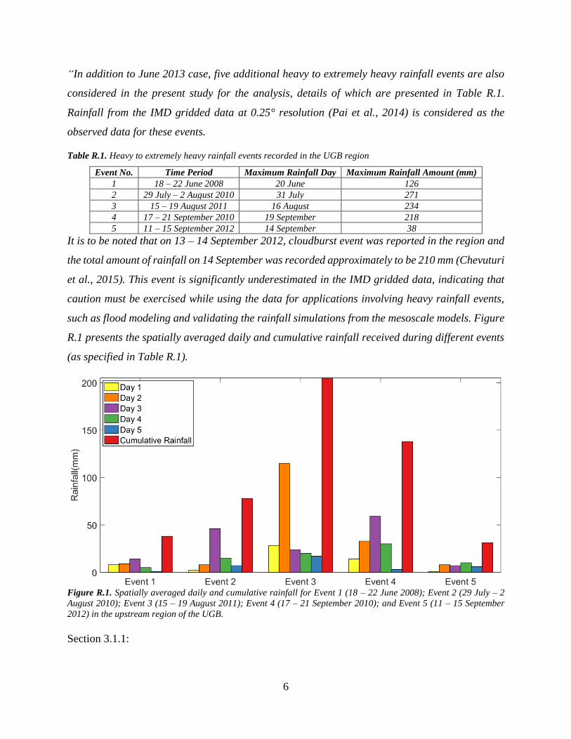
“In addition to June 2013 case, five additional heavy to extremely heavy rainfall events are also
considered in the present study for the analysis, details of which are presented in Table R.1.
Rainfall from the IMD gridded data at 0.25° resolution (Pai et al., 2014) is considered as the
observed data for these events.
Table R.1. Heavy to extremely heavy rainfall events recorded in the UGB region
Event No. Time Period Maximum Rainfall Day Maximum Rainfall Amount (mm)
1 18 – 22 June 2008 20 June 126
2 29 July – 2 August 2010 31 July 271
3 15 – 19 August 2011 16 August 234
4 17 – 21 September 2010 19 September 218
5 11 – 15 September 2012 14 September 38
It is to be noted that on 13 ‒ 14 September 2012, cloudburst event was reported in the region and
the total amount of rainfall on 14 September was recorded approximately to be 210 mm (Chevuturi
et al., 2015). This event is significantly underestimated in the IMD gridded data, indicating that
caution must be exercised while using the data for applications involving heavy rainfall events,
such as flood modeling and validating the rainfall simulations from the mesoscale models. Figure
R.1 presents the spatially averaged daily and cumulative rainfall received during different events
(as specified in Table R.1).
Figure R.1. Spatially averaged daily and cumulative rainfall for Event 1 (18 – 22 June 2008); Event 2 (29 July – 2
August 2010); Event 3 (15 – 19 August 2011); Event 4 (17 – 21 September 2010); and Event 5 (11 – 15 September
2012) in the upstream region of the UGB.
Section 3.1.1:
7
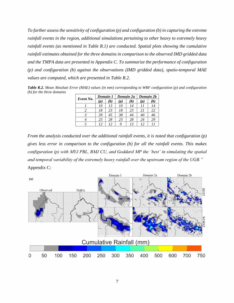
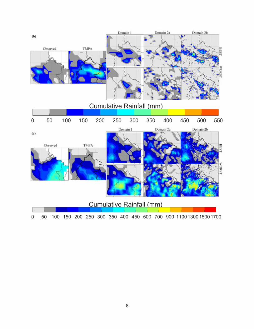
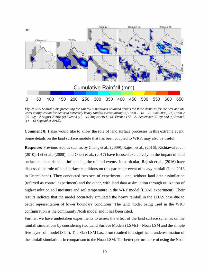
To further assess the sensitivity of configuration (p) and configuration (b) in capturing the extreme
rainfall events in the region, additional simulations pertaining to other heavy to extremely heavy
rainfall events (as mentioned in Table R.1) are conducted. Spatial plots showing the cumulative
rainfall estimates obtained for the three domains in comparison to the observed IMD gridded data
and the TMPA data are presented in Appendix C. To summarize the performance of configuration
(p) and configuration (b) against the observations (IMD gridded data), spatio-temporal MAE
values are computed, which are presented in Table R.2.
Table R.2. Mean Absolute Error (MAE) values (in mm) corresponding to WRF configuration (p) and configuration
(b) for the three domains
Event No. Domain 1 Domain 2a Domain 2b
(p) (b) (p) (b) (p) (b)
1 10 13 10 14 11 14
2 18 23 18 23 21 22
3 39 45 38 44 40 46
4 23 28 23 28 24 29
5 12 12 9 13 12 11
From the analysis conducted over the additional rainfall events, it is noted that configuration (p)
gives less error in comparison to the configuration (b) for all the rainfall events. This makes
configuration (p) with MYJ PBL, BMJ CU, and Goddard MP the ‘best’ in simulating the spatial
and temporal variability of the extremely heavy rainfall over the upstream region of the UGB.”
Appendix C:
8

9
10
Figure R.2. Spatial plots presenting the rainfall simulations obtained across the three domains for the best and the
worst configuration for heavy to extremely heavy rainfall events during (a) Event 1 (18 – 22 June 2008); (b) Event 2
(29 July – 2 August 2010); (c) Event 3 (15 – 19 August 2011); (d) Event 4 (17 – 21 September 2010); and (e) Event 5
(11 – 15 September 2012).
Comment 8: I also would like to know the role of land surface processes in this extreme event.
Some details on the land surface module that has been coupled to WRF, may also be useful.
Response: Previous studies such as by Chang et al., (2009); Rajesh et al., (2016); Kishtawal et al.,
(2010); Lei et al., (2008); and Osuri et al., (2017) have focused exclusively on the impact of land
surface characteristics in influencing the rainfall events. In particular, Rajesh et al., (2016) have
discussed the role of land surface conditions on this particular event of heavy rainfall (June 2013
in Uttarakhand). They conducted two sets of experiment – one, without land data assimilation
(referred as control experiment) and the other, with land data assimilation through utilization of
high-resolution soil moisture and soil temperature in the WRF model (LDAS experiment). Their
results indicate that the model accurately simulated the heavy rainfall in the LDAS case due to
better representation of lower boundary conditions. The land model being used in the WRF
configuration is the community Noah model and it has been cited.
Further, we have undertaken experiments to assess the effect of the land surface schemes on the
rainfall simulations by considering two Land Surface Models (LSMs) – Noah LSM and the simple
five-layer soil model (Slab). The Slab LSM based run resulted in a significant underestimation of
the rainfall simulations in comparison to the Noah LSM. The better performance of using the Noah
11
model could be attributed to the temporal evolution of soil moisture fields. Additional details
related to the land surface module used in the current study are added in the revised manuscript.
Action: Following paragraph is added in the revised manuscript (Section 2.2):
“The sensitivity of various WRF configurations to simulate heavy rainfall events is assessed using
the Noah LSM (Chen and Dudhia, 2001; Tewari et al., 2004; Ek et al., 2003). The Noah LSM is a
community model that is included in the WRF suite with the prime aim of providing reliable
boundary conditions to the atmospheric model. As a result, Noah LSM is moderately detailed
model, which includes single canopy layer with canopy resistance scheme of Noilhan and Planton,
(1989) and four soil layers (at 0.1, 0.3, 0.6 and 1.0 m) with a total soil depth of 2 m. The last soil
layer of 1 m acts as a reservoir for drainage of water under gravity and the above three layers
serve as root zone depths. There is a provision in the model to change default root zone depths
with the actual values from the field, subjected to data availability. In the Noah LSM, surface (skin)
temperature is obtained using a single linearized surface energy balance equation, which
effectively considers the ground and vegetation surface. Frozen soil parametrization based on
Koren et al., (1999) and surface runoff scheme of Schaake et al., (1996) are also included in this
model. Soil moisture, soil temperature, water intercepted by the canopy and snow stored on the
ground are also included as the prognostic variables in the model. More detailed information on
the Noah LSM can be obtained from Ek et al., (2003).
To assess the effect of the land surface scheme on simulations, the Noah LSM is replaced with the
simple five-layer Soil Model (Slab; (Dudhia, 1996)). In contrast to the relatively sophisticated
Noah LSM, Slab is based on simple thermal diffusion in the soil layers that has constant soil
moisture availability but a prognostic soil temperature term (Deardorff, 1978). Further
differences between the two LSMs are presented in Section 3.1.3.”
12
References
Ali, H., Mishra, V., and Pai, D.: Observed and projected urban extreme rainfall events in India,
Journal of Geophysical Research: Atmospheres, 119, 2014.
Chang, H.-I., Kumar, A., Niyogi, D., Mohanty, U., Chen, F., and Dudhia, J.: The role of land
surface processes on the mesoscale simulation of the July 26, 2005 heavy rain event over Mumbai,
India, Global Planet. Change, 67, 87-103, 2009.
Chen, F., and Dudhia, J.: Coupling an advanced land surface–hydrology model with the Penn
State–NCAR MM5 modeling system. Part I: Model implementation and sensitivity, Mon. Weather
Rev., 129, 569-585, 2001.
Chevuturi, A., Dimri, A., Das, S., Kumar, A., and Niyogi, D.: Numerical simulation of an intense
precipitation event over Rudraprayag in the central Himalayas during 13–14 September 2012, J.
Earth Syst. Sci., 124, 1545-1561, 2015.
Chevuturi, A., and Dimri, A.: Investigation of Uttarakhand (India) disaster-2013 using weather
research and forecasting model, Nat. Hazards, 82, 1703-1726, 2016.
Deardorff, J.: Efficient prediction of ground surface temperature and moisture, with inclusion of a
layer of vegetation, Journal of Geophysical Research: Oceans, 83, 1889-1903, 1978.
Dimri, A., Thayyen, R., Kibler, K., Stanton, A., Jain, S., Tullos, D., and Singh, V.: A review of
atmospheric and land surface processes with emphasis on flood generation in the Southern
Himalayan rivers, Sci. Tot. Environ., 556, 98-115, 2016.
Dudhia, J.: A multi-layer soil temperature model for MM5, Preprints, The Sixth PSU/NCAR
mesoscale model users’ workshop, 1996, 22-24,
Ek, M., Mitchell, K., Lin, Y., Rogers, E., Grunmann, P., Koren, V., Gayno, G., and Tarpley, J.:
Implementation of Noah land surface model advances in the National Centers for Environmental
Prediction operational mesoscale Eta model, Journal of Geophysical Research: Atmospheres, 108,
2003.
Gadgil, S., Rajeevan, M., and Nanjundiah, R.: Monsoon prediction—why yet another failure, Curr.
Sci, 88, 1389-1400, 2005.
Gutowski Jr, W. J., Arritt, R. W., Kawazoe, S., Flory, D. M., Takle, E. S., Biner, S., Caya, D.,
Jones, R. G., Laprise, R., and Leung, L. R.: Regional extreme monthly precipitation simulated by
NARCCAP RCMs, J. Hydrometeorol., 11, 1373-1379, 2010.
Hazra, A., Chaudhari, H. S., Ranalkar, M., and Chen, J. P.: Role of interactions between cloud
microphysics, dynamics and aerosol in the heavy rainfall event of June 2013 over Uttarakhand,
India, Q. J. Roy. Meteorol. Soc., 143, 986-998, 2017.
Kang, I.-S., Jin, K., Wang, B., Lau, K.-M., Shukla, J., Krishnamurthy, V., Schubert, S., Wailser,
D., Stern, W., and Kitoh, A.: Intercomparison of the climatological variations of Asian summer
monsoon precipitation simulated by 10 GCMs, Clim. Dyn., 19, 383-395, 2002.
Kishtawal, C. M., Niyogi, D., Tewari, M., Pielke, R. A., and Shepherd, J. M.: Urbanization
signature in the observed heavy rainfall climatology over India, Int. J. Climatol., 30, 1908-1916,
2010.
13
Koren, V., Schaake, J., Mitchell, K., Duan, Q. Y., Chen, F., and Baker, J.: A parameterization of
snowpack and frozen ground intended for NCEP weather and climate models, Journal of
Geophysical Research: Atmospheres, 104, 19569-19585, 1999.
Kotal, S., Roy, S. S., and Roy Bhowmik, S.: Catastrophic heavy rainfall episode over Uttarakhand
during 16–18 June 2013—observational aspects, Curr. Sci, 107, 234-245, 2014.
Kumar, A., Houze Jr, R. A., Rasmussen, K. L., and Peters-Lidard, C.: Simulation of a flash
flooding storm at the steep edge of the Himalayas, J. Hydrometeorol., 15, 212-228, 2014.
Kumar, M. S., Shekhar, M., Krishna, S. R., Bhutiyani, M., and Ganju, A.: Numerical simulation
of cloud burst event on August 05, 2010, over Leh using WRF mesoscale model, Nat. Hazards,
62, 1261-1271, 2012.
Lei, M., Niyogi, D., Kishtawal, C., Pielke Sr, R., BeltrĂĄn-Przekurat, A., Nobis, T., and Vaidya,
S.: Effect of explicit urban land surface representation on the simulation of the 26 July 2005 heavy
rain event over Mumbai, India, Atmos. Chem. Phys., 8, 5975-5995, 2008.
Medina, S., Houze, R. A., Kumar, A., and Niyogi, D.: Summer monsoon convection in the
Himalayan region: Terrain and land cover effects, Q. J. Roy. Meteorol. Soc., 136, 593-616, 2010.
Noilhan, J., and Planton, S.: A simple parameterization of land surface processes for
meteorological models, Mon. Weather Rev., 117, 536-549, 1989.
Osuri, K., Nadimpalli, R., Mohanty, U., Chen, F., Rajeevan, M., and Niyogi, D.: Improved
prediction of severe thunderstorms over the Indian Monsoon region using high-resolution soil
moisture and temperature initialization, Scientific Reports, 7, 2017.
Pai, D., Sridhar, L., Rajeevan, M., Sreejith, O., Satbhai, N., and Mukhopadhyay, B.: Development
of a new high spatial resolution (0.25× 0.25) long period (1901–2010) daily gridded rainfall data
set over India and its comparison with existing data sets over the region, Mausam, 65, 1-18, 2014.
Rajesh, P., Pattnaik, S., Rai, D., Osuri, K., Mohanty, U., and Tripathy, S.: Role of land state in a
high resolution mesoscale model for simulating the Uttarakhand heavy rainfall event over India,
J. Earth Syst. Sci., 125, 475-498, 2016.
Ratna, S. B., Sikka, D., Dalvi, M., and Venkata Ratnam, J.: Dynamical simulation of Indian
summer monsoon circulation, rainfall and its interannual variability using a high resolution
atmospheric general circulation model, Int. J. Climatol., 31, 1927-1942, 2011.
Schaake, J. C., Koren, V. I., Duan, Q. Y., Mitchell, K., and Chen, F.: Simple water balance model
for estimating runoff at different spatial and temporal scales, Journal of Geophysical Research:
Atmospheres, 101, 7461-7475, 1996.
Shekhar, M., Pattanayak, S., Mohanty, U., Paul, S., and Kumar, M. S.: A study on the heavy
rainfall event around Kedarnath area (Uttarakhand) on 16 June 2013, J. Earth Syst. Sci., 124, 1531-
1544, 2015.
Srinivas, C., Hariprasad, D., Bhaskar Rao, D., Anjaneyulu, Y., Baskaran, R., and Venkatraman,
B.: Simulation of the Indian summer monsoon regional climate using advanced research WRF
model, Int. J. Climatol., 33, 1195-1210, 2013.
Tewari, M., Chen, F., Wang, W., Dudhia, J., LeMone, M., Mitchell, K., Ek, M., Gayno, G., Wegiel,
J., and Cuenca, R.: Implementation and verification of the unified NOAH land surface model in
14
the WRF model, 20th conference on weather analysis and forecasting/16th conference on
numerical weather prediction, 2004,
Thayyen, R. J., Dimri, A., Kumar, P., and Agnihotri, G.: Study of cloudburst and flash floods
around Leh, India, during August 4–6, 2010, Nat. Hazards, 65, 2175-2204, 2013.
Tripathi, O. P., and Dominguez, F.: Effects of spatial resolution in the simulation of daily and
subdaily precipitation in the southwestern US, Journal of Geophysical Research: Atmospheres,
118, 7591-7605, 2013.
Vellore, R. K., Kaplan, M. L., Krishnan, R., Lewis, J. M., Sabade, S., Deshpande, N., Singh, B.
B., Madhura, R., and Rao, M. R.: Monsoon-extratropical circulation interactions in Himalayan
extreme rainfall, Clim. Dyn., 46, 3517-3546, 2016.
Wang, B., Ding, Q., Fu, X., Kang, I. S., Jin, K., Shukla, J., and Doblas‐Reyes, F.: Fundamental
challenge in simulation and prediction of summer monsoon rainfall, Geophys. Res. Lett., 32, 2005.
Wehner, M. F., Smith, R. L., Bala, G., and Duffy, P.: The effect of horizontal resolution on
simulation of very extreme US precipitation events in a global atmosphere model, Clim. Dyn., 34,
241-247, 2010.