0-12H VSR forecasting and nowcasting review and plan in CMA
41
Page 1 0-12H VSR forecasting and nowcasting review and plan in CMA Xiaoling Zhang, Bo Yang, Yongguang Zheng, Jie Sheng, Yinjing Lin, Wenyuan Tang, Kanghui Zhou National Meteorological Center, China Meteorological Administration
-
Upload
khangminh22 -
Category
Documents
-
view
4 -
download
0
Transcript of 0-12H VSR forecasting and nowcasting review and plan in CMA

Page 1
0-12H VSR forecasting and
nowcasting review and plan in CMA
Xiaoling Zhang, Bo Yang, Yongguang Zheng, Jie Sheng, Yinjing Lin, Wenyuan Tang, Kanghui Zhou
National Meteorological Center, China Meteorological Administration
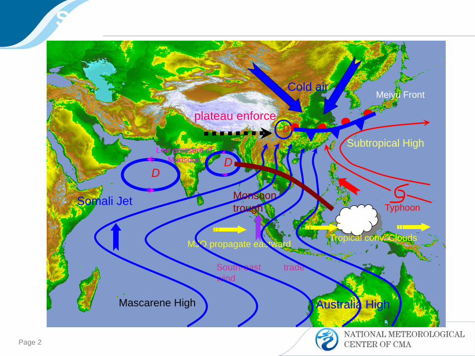
Page 2
Australia High
Subtropical High
South-east tradewind
Tropical conv. Clouds
Typhoon
Mascarene High
Somali Jet
Low pressure of Monsoon
plateau enforce
MJO propagate eastward
DD
D
Cold airMeiyu Front
Monsoontrough
Synoptic Systems over East Asia
Page 3
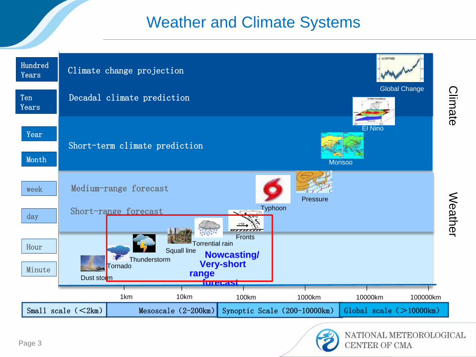
Weather and Climate Systems
Global Change
Minute
Hour
day
week
Month
Year
Ten Years
Hundred Years
1km 10km 100km 1000km 100000km10000km
Dust storm
TornadoThunderstorm
Typhoon
FrontsTorrential rain
Monsoon
EI Nino
Squall line
Pressure
Short-range forecast
Medium-range forecast
Short-term climate prediction
Decadal climate prediction
Climate change projection
Small scale(<2km) Mesoscale(2-200km) Synoptic Scale(200-10000km) Global scale(>10000km)
Clim
ateW
eather
Nowcasting/Very-short
range forecast

– Hail >5 mm– Thunderstorm gale> 17m/s– Tornado– Short-time rainstorm>20mm/h
Severe Convective Weather
Beijing Jul.21Haerbin Hail in Jun.12
Gauntry crane collapse in Guangdong Apr.13
Funing EF4 tornado in Jun.23
North China in Jul.19-20
138.5mm/h(2300BJT Jul.19)
Jun.1 in Northeast ChinaSquall-line Hail Tornado
Short-time Rainstorm

Severe convective weather characteristics and its operational forecasting in CMA
0-2h Nowcasting
2-12h Very-short-range forecast
Future Prospects
Contents

Severe convective weather characteristics and operational forecasting in CMA
0-2h Nowcasting
2-12h Very-short-range forecast
Future Prospects
Contents

1981-2010 annual frequency of severe convective weather
Thunderstorm ST heavy rainfall >20mm/h
Hail Thunderstorm gale
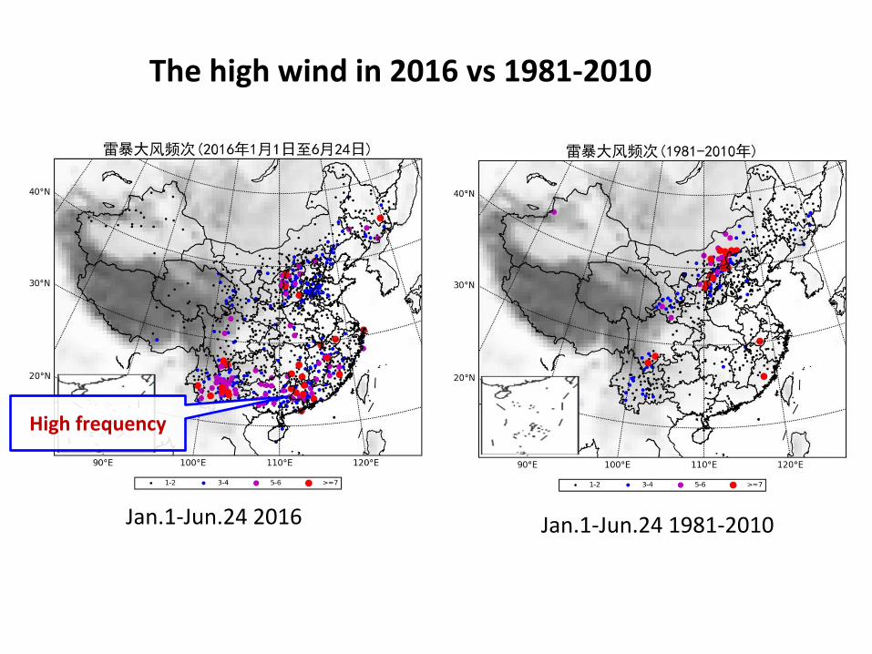
Jan.1-Jun.24 2016
The high wind in 2016 vs 1981-2010
Jan.1-Jun.24 1981-2010
High frequency

From Wenjie Fan and Xiaoding Yu ,2015)
Distribution and variation trend of EF2 tornados and above in 1961-2010
Distribution
Variation trend

0 h 2 h 12 h
SWPC/NMC
PROVINCE
CITY AND COUNTY
MONITOR
MONITOR
MONITOR
WARNING
WARNING
WATCH
WATCH
Operational responsibility in CMA
WATCH
WARNING
National level
Local level
Lightning Rainstorm Hail Gale
Warning signals

NMC 12h Forecast
NMC 0-6h Watch
Local Office 0-2h Warning
SCW location and intensity

Severe convective weather characteristics and its operational forecasting in CMA
0-2h Nowcasting
2-12h Very-short-range forecast
Future Prospects
Contents
• In SWPC/NMC, the monitoring and Extrapolation techniques mainly based on satellite and lightning data
• In local office mainly based on the radar data

Severe Convective Weather monitor in NMC
Lightning Hail
High Wind
Short-time heavy rainfall
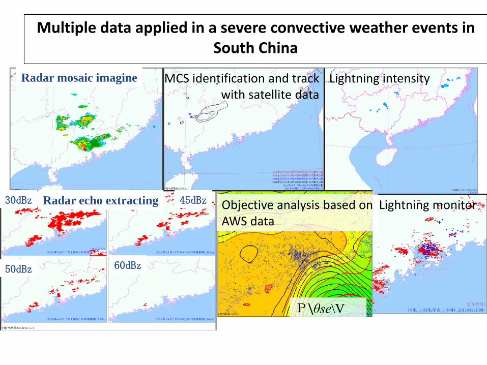
Radar mosaic imagine
Radar echo extracting30dBz 45dBz
50dBz 60dBz
MCS identification and track with satellite data
Lightning intensity
P\θse\V
Objective analysis based on AWS data
Lightning monitor
Multiple data applied in a severe convective weather events in South China
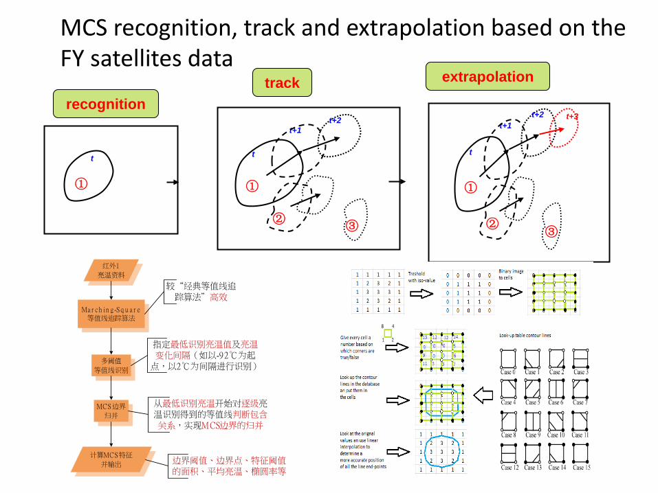
MCS recognition, track and extrapolation based on the FY satellites data
①
t
t+1
①
②③
t
t+2recognition
track extrapolation
t+1
①
②③
t
t+2 t+3
MCS
Ma r ch in g-Sq u a r e等值线追踪算法
多阈值
等值线识别
指定最低识别亮温值及亮温变化间隔(如以-92℃为起
点,以2℃为间隔进行识别)
红外1
亮温资料
较“经典等值线追踪算法”高效
MCS边界
归并
从最低识别亮温开始对逐级亮温识别得到的等值线判断包含关系,实现MCS边界的归并
计算MCS特征
并输出 边界阈值、边界点、特征阈值的面积、平均亮温、椭圆率等

Recognition, track and extrapolation of the MCS based on the FY satellites data
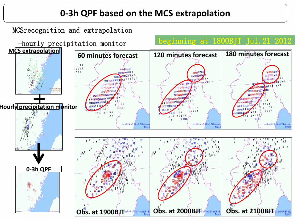
60 minutes forecast
Obs. at 1900BJT
beginning at 1800BJT Jul.21 2012
120 minutes forecast 180 minutes forecast
Obs. at 2000BJT Obs. at 2100BJT
MCSrecognition and extrapolation
+hourly precipitation monitor
0-3h QPF based on the MCS extrapolation
Hourly precipitation monitor
MCS extrapolation
0-3h QPF
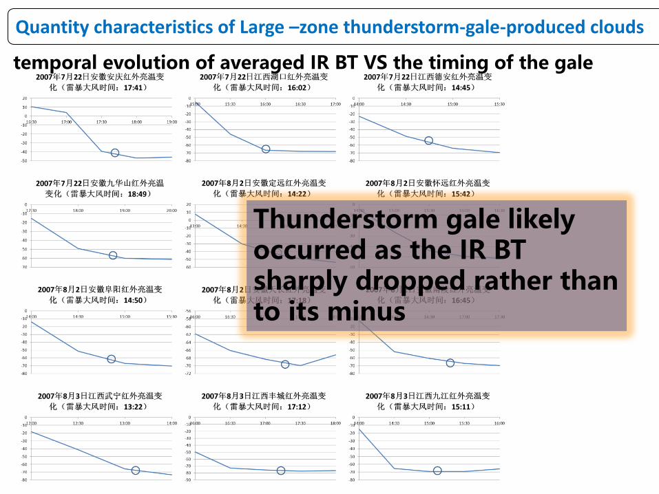
temporal evolution of averaged IR BT VS the timing of the gale
Thunderstorm gale likely occurred as the IR BT sharply dropped rather than to its minus
Quantity characteristics of Large –zone thunderstorm-gale-produced clouds

Cell recognition by cluster analysis
Track and extrapolation by Calman filter
The algorithm not only recognizes and tracks thunderstorm cell, but also distinguishes the split and merge of thunderstorm.
Thunderstorm cell recognition, track and Extrapolation based on the lightning data
Cell-1Cell-3
Cell-2
Cell-2
Cell-3
Cell-1Cluster analysis Split
Merge

Case in Mar.20 2013
Integrated in SWPC operation platform

Improved the Mesocyclone recognition algorithm Used
in WSR-98D radar
Decreased FAR by diagnosing the intensity, bottom
height and wind shear of a mesocyclone
Decreased FAR by pattern recognition
Tornado recognition and automatic warning in Jiangsu
TVS MCHIT 38% 61%
FAR 16 PUP 24 /
Total Num. by improved algorithm
40 71
Num. by PUP 47 168

Tornado recognition and automatic warning in Jiangsu
• Integrated in SWATCH which is the operation platform of Jiangsu province bureau
• Valid tornado-detected distance associated with typhoon and westerlies is 60km
and 100km
• A weak tornado was recognized from the mixed echo nearby Nantong at 1653BJT
Aug.7 2014
• Funing EF4 Tornado was recognized ahead of ~15 min. in Jun.23 2016
--- Yuanyuan Zheng 2016

Used only in the area within 100km from the radar station
Automatic warning used to value the risk of the electric
power system
High wind recognition by radar radial velocity at 0.5 elevation angles

SWAN2.0客户端
VILSCIT
Blue: 30min beforeRed: currentGreen: 1 hour later
Severe Weather Automatic System(SWAN) The main operation platform in CMA, used in many local offices Some updating in 2015• Version2.0 replaced Version 1.6• significant change in the aspects of algorithm, data resource and
function 3DVAR wind retrieval from Doppler radar rain cluster recognition by QPE enhanced very-short-range forecasting capability by integrated
the SCW probability forecast based on NWP output

Severe convective weather characteristics and its operational forecasting in CMA
0-2h Nowcasting
2-12h Very-short-range forecast
Future Prospects
Contents
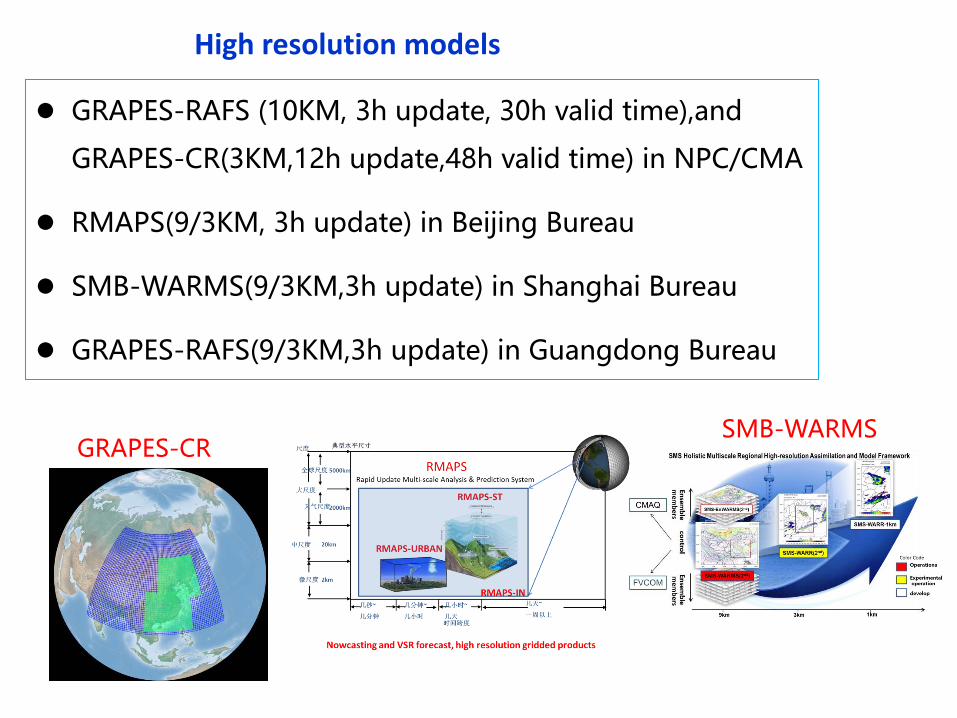
GRAPES-RAFS (10KM, 3h update, 30h valid time),and
GRAPES-CR(3KM,12h update,48h valid time) in NPC/CMA
RMAPS(9/3KM, 3h update) in Beijing Bureau
SMB-WARMS(9/3KM,3h update) in Shanghai Bureau
GRAPES-RAFS(9/3KM,3h update) in Guangdong Bureau
High resolution models
GRAPES-CRSMB-WARMS

Evaluated the high resolution model in warm season testbed
during 2013-2014
High resolution models would be useful in SCW forecast
SWPC began to develop 2-12h forecast techniques based on high
resolution models in 2015 and test the 2-6h operational watch in
warm season of 2015 and 2016
6h QPF TS in 18hours valid time beginning at 1200UTC during Jun.9-Jul.31 2014
HR Models

SWPC experimental watch in 2015-2016 warm season
SWPC watch and local office warning in Jul.14 2016
Thunderstorm gale and hail watch ST rainstorm watch
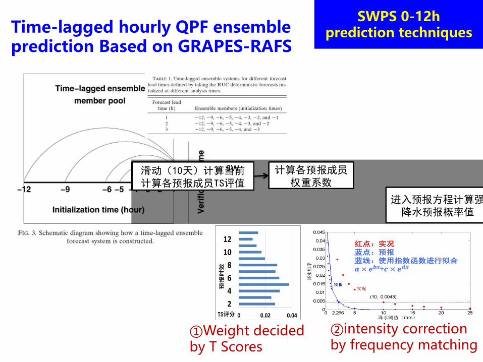
Time-lagged hourly QPF ensemble prediction Based on GRAPES-RAFS
②intensity correction by frequency matching
①Weight decided by T Scores
sw
SWPS 0-12h prediction techniques

GRAPES-RAFS prediction correction
QPF TS in June to August 2015(red: after, blue: before)
5-10mm
10-15
15-20
20-25
25-30
Obs.
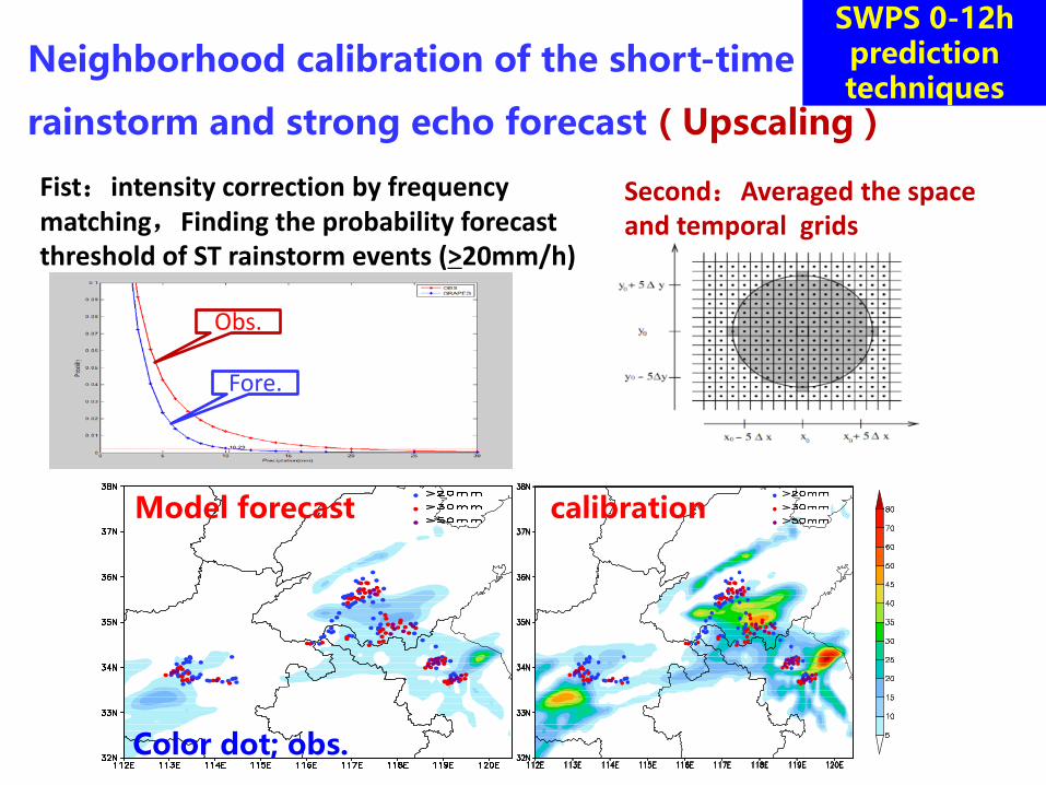
Neighborhood calibration of the short-time
rainstorm and strong echo forecast(Upscaling)
Fist:intensity correction by frequency matching,Finding the probability forecast threshold of ST rainstorm events (>20mm/h)
Second:Averaged the space and temporal grids
Obs.
Fore.
calibrationModel forecast
Color dot; obs.
SWPS 0-12h prediction techniques
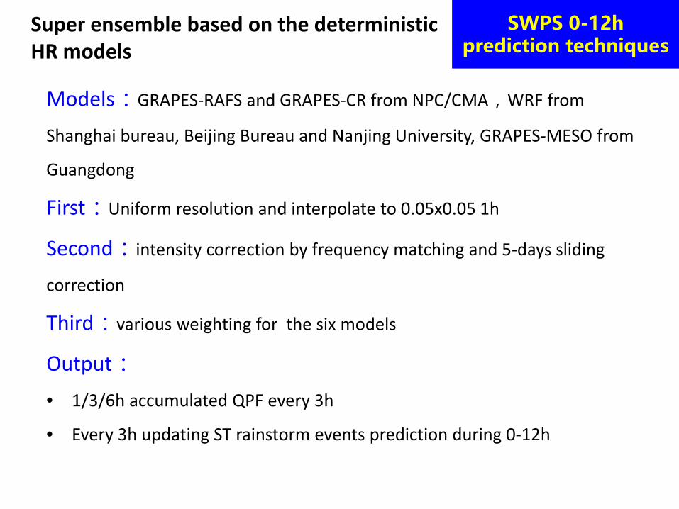
Super ensemble based on the deterministic HR models
Models:GRAPES-RAFS and GRAPES-CR from NPC/CMA,WRF from
Shanghai bureau, Beijing Bureau and Nanjing University, GRAPES-MESO from
Guangdong
First:Uniform resolution and interpolate to 0.05x0.05 1h
Second:intensity correction by frequency matching and 5-days sliding
correction
Third:various weighting for the six models
Output:• 1/3/6h accumulated QPF every 3h
• Every 3h updating ST rainstorm events prediction during 0-12h
SWPS 0-12h prediction techniques

Super ensemble ST rainstorm forecast has been integrated in SWPC operational platform
Criterion of the ST rainstorm warning

-2-12h SCW monitoring and VSR forecasting based on Obs. and high resolution and rapid updating models in SWPC/NMC
From past to future,Efforts to achieve seamless monitoring and forecasting

Severe convective weather characteristics and its operational forecasting in CMA
0-2h Nowcasting
2-12h Very-short-range forecast
Future Prospects
Contents

Challenges for nowcasting and VSR forecasting
How to comprehensively use the multiple data source (radar, satellite, lightning, AWS, NWP outputs and so on)to enhance the extrapolating capability and extend the valid time of forecast
How to resolve the convective initiation How to extend the valid warning time by optimizing the
operational process and cooperating between SWPC and the local offices

Roadmap of NWP development for 2015-2025
• CR EPS• Focus on convective initiation, location and
intensity of the high wind and heavy rainfall, large scale forcing and so on
NWP plays the key and irreplaceable role

• To issue the 0-12h objective SCW products with 1h resolution
• To issue the 2-6h subjective watch products to guide local office warning
• To effort the seamless forecasting in 3days by cooperation between SWPC
and local offices
SWPC operational targets to 2018
SWPC 2-6hLocal office 0-2h
SWPC2-6h watch
Local offices:0-2h warning
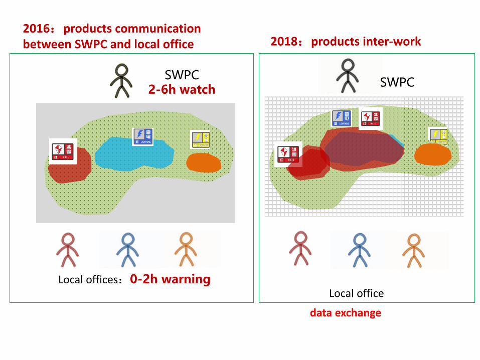
2016:products communication between SWPC and local office 2018:products inter-work
data exchange
SWPC
Local office

监测技术和多源资料融合分析技术
对流尺度天气分析技术
综合多源资料临近预报技术
基于高分辨率模式的短时预报技术
Techniques developing plan
Ensemble ,Upscaling
Blending, integrated extrapolation algorithms based on radar, satellite data and so on
Warn-on Forecast: to apply the convective recognition and track techniques into the HR models output
HR obs. Data applied into convective analysis
Comprehensive monitor
Assimilation of multiple data, especialy radar and satellite data
Cooperation between the operational branches and the research units
2016 2017 2018
Convection monitor and multiple data blending and analysis techniques
Convective-scale analysis techniques
Multiple data comprehensively nowcasting
VSR Forecast techniques based on HR models
New data and comprehensively monitor and analysis techniques
Comprehensively extrapolation techniques
HR models output Correction blending
Techniques enhanced further
Pre-warning techniques of convection initiation,deveopingand decay
To buid a SCW monitoring, nowcasting and VSR forecasting systems
Page 41
Thank you