! l I I ! I
108
I _ bo,_. / . lur_._fO "i-l_ ! l | OPERATIONSANDMAINTENANCE SCHEDULE BALDWIN LAKE ECOLOCICALRESERVE | (ANDADJACENTLANDS) I I FINAL REPORT AUGUST 1989 I 1 | P_ep_e,tFor: Prep_d By: I California Department of Fish and Game Katherine Barrows i. Endangered Plant Program 53277 Avenida Diaz 1416 Ninth Street La Ouinta, CA 92253 . Sacramento, California 95814 ! I: In Cooperation With: California Nature Conservancy I 785 Market Street San Francisco, CA 94103 I
-
Upload
khangminh22 -
Category
Documents
-
view
1 -
download
0
Transcript of ! l I I ! I
I _ bo,_. / . lur_._fO "i-l_
!l| OPERATIONSANDMAINTENANCESCHEDULEBALDWINLAKEECOLOCICALRESERVE
| (ANDADJACENTLANDS)
II FINAL REPORTAUGUST 1989
I
1| P_ep_e,tFor: Prep_d By:
ICalifornia Department of Fish and Game Katherine Barrows
i. Endangered Plant Program 53277 Avenida Diaz1416 Ninth Street La Ouinta, CA 92253. Sacramento, California 95814
!I: In Cooperation With:
California Nature Conservancy
I 785 Market StreetSan Francisco, CA 94103
I

i!!| OPERhTIONSANDMAINTENANCESCHEDULE
BALDWIN LAKE ECOLOCICAL RESERVE[A__ ADJACENTLANDS_
| SANBERNARDINOCOUNTY,CALIFORNIAII
Prepared forCalifornia Department of Fish and Game
i EndangeredPlantProgram1416 Ninth StreetSacramento, California 95814
!i August 1989
iby
I Katherine Barrows53277 Avenida Diaz
ii La Quinta, CA 92253
i Prepared under Cooperative Contractto
I California Nature Conservancy785 Market StreetSan Francisco, CA 94103
i, Funded by California Endangered Species Tax Check-off FundContract No, FG-7605
Ii
!I TABLE OF CONTEh_rs
I INTRODUCTION ............................................... 1
I PARTMETHODSI:ANDINVENTORYMATER-IAL_........._................_..._........-............................. 77RESULTS AND DISCUSSION ................................. 9
I Plant Communitipesebble Plains'....- .' " " i i ' '..'............--.' ' ' ' ' ' ' ' " " i............''.' ' ' ' ' ' ' ' " ' "Wet Meadows.................................... 9
I P_ams......V.erna_Clee..ks..._......_.............................._............-............ 1130Wet Meadow Rare Plants .......................... 13
i VernPalebbleCxeeP1kainRarRerePlantPlSarts''''"'''""'.. '...........,...,........-- ,'''''''''''' 2153Animals ............................................. 26
I BirdRseptileM sammal''s''''''''a'n'd"''''A'mphibialns"''''''''''''''''''''''''''''""'''''''''''''''''''''''''''.. ',......................... 227276
I Physica_nVasivFieSheature--s'''"''''Ex'oti..c....P1.antslan..d............._ .'''''''''''''''''''''''''''A"nimals i''''''''''''..'.........., 238228Soils .......................................... 32
i Ge___Hgyydr___gy..............................................................._............. 3323Cultural Features: Historical Land Use ...................... 35
I Culmra_tructureFSeamres:''''''''''''''''''''''''Cu'rrentLandUse --.'''''''''"' 3357Structures ...................................... 37
I R°adosff-HighwaayndTraivlSehicl'e''''''''"'U'se _' .''''''''''''''''' 3399Potential for Developmem .......................... 40
I PotentiaBlaldwin LakMieninLegvelCl:aimSR:ecreationSalUrr°undinugseLand.,s. . . . . . , . . . . ..'' .'.,,..,... 40
Baldwin Lake Level: Bald Eagle Habitat ............... 41
I PART II: SPECIES MANAGEMENT GOALS ......................... 43SPECIES ACCOUNTS ...................................... 43
I Bird-f__teS_ednder-peta_eCdheckerb___Thme_yp_dium................_..........................................4435Unarmored Three-spined Stickleback ........................ 46
B HABITAT/SPpECIESebblePlain ...........................A.CCOUNTS ,............_............ 4488Wet Meadow ......................................... 50
i SPEcIEVernalMANAGEMECNTreek ..... GO_ALS'''"''''''''""'''''"''''''''..",.,........................ 55_Bird-fomed Checkerbloom ................................ 52
i Slender-petaledThelypodium.............................. 52
i
!! TABLE OF CONTENTS (Cont.)
| Unarmored Three-spined stickleback ........................ 52HABITAT/SPECIES MANAGEMENT GOALS .................... 53
I PebblePlain .......................................... 53Wet Meadow ......................................... 54Vernal Creek ......................................... 54
.i PART HI: AREA MANAGEMENT OBJECTIVES ...................... 55ASSESSMENT OBJECTIVES .................................. 55PROTECTION OBJECTIVES ................................. 60
I MANIPULATIONOBJECTIVES ............................... 63
i PART IV: OPERATIONS AND MAINTENANCE PLAN .................. 66REFERENCES ................................................. 70
I APPENDIX I. List of Plant Species ................................... 73APPENDIX II. Biological Monitoring Plan ............................. 89APPENDIX III. "Horse House" Renovation Plan ......................... 96
I APPENDIX IV. Itemization of Management Costs ........................ 99APPENDIX V. List of agencies/individuals ............................. ]00
!Ii!II!IIII!
!'I LIST OF FIGURES
I Figures
1. LocationofStudyArea 3
I 2. Topographic Position and Management Units 4
3. Vegetation Map 114. RarePlantsinWetMeadows 14
I 5a. Rare Plants on Pebble Plains - BLER" 17Bear Valley Sandwort and Kennedy's Buckwheat
5b. Rare Plants on Pebble Plains Study Area 18Bear Valley Sandwort and Kennedy's Buckwheat
I 6a. RarePlantson PebblePlains- BLER* 19Parish's Rock Cress and Ashy-gray Paintbrush
I 6b. Rare Plantson PebblePlains- StudyArea 20Parish's Rock Cress and Ashy-gray Paintbrush
I 7a. Rare Plants on Pebble Plains - BLER 21Munz's Hedgehog and Killip's Linanthus
I 7b. Rare Plants on Pebble Plains - Study Area 22Munz's Hedgehog and Kitlip's Linanthus
i 8a. RarePlantsof VernalCreeks- BLER 24
8b. Rare Plants of Vernal Creeks - Study Area 25
9. Location of Exotic Plant Populations 29
I 10. ObservationsofWildBurros 30
11. HydrologicalFeatures 34
I 12. Historical Land Use 36
I 13. Current Land Use 3814. BaldEagleRoostTrees 42
i 15. Present and Proposed Trails 64
i 16. Locationof ProposedImplementationActions 65
!

LIST OF TABLES
Tables
1. Land Management Status within Study Area 2
2. RarePlantSpeciesof StudyArea 5
3. PlantCommunities 10
4. MammalSpecies 26
5. BirdSpecies 27
6. Population Counts of Sidalcea pedata 44
7. Species/Habitat Management Goals 57
8. Implementation Actions and Costs 68
9. Protection Actions and Costs 69
* BLER = Baldwin Lake Ecological Reserve
!m INTRODUCTION
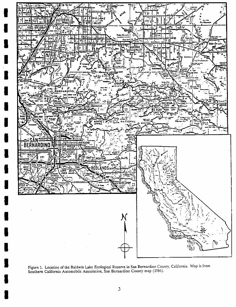
m The proposed Baldwin Lake Ecological Reserve includes 124 acres located in SanBernardino County on the northwest shore of Baldwin Lake (Figure 1). Baldwin Lake, at
I an elevation of 6720 feet (2050 m), lies at the east end of Big Bear Valley. From here thenorthern slope of the San Bernardino Mountains drops abruptly to the Mojave Desert.State Highway 18 runs along the north shore of Baldwin Lake and bisects the ecological
m reserve.The focus of this operations and maintenance schedule is the proposed Baldwin Lake
I Ecological Reserve, state-owned properties maiiaged by the California Department of Fishand Game (CDFG). Formal designation of the area as an Ecological Reserve was initiatedin April 1989 and should be completed by the end of the year (Gronholdt 1989).
I This management plan also addresses adjacent lands, managed by the U.S. ForestService (USFS) and The Nature Conservancy (TNC), because of the occurrence of
m contiguous rare plant populations on these lands. Therefore this schedule also includes aproposa[ to develop a cooperative management plan for the three agencies and theirrespective lands (Figure 2). The proposed management actions in this schedule will serve
i only as recommendations for the U.S. Forest Service and The Nature Conservancy. Therelevant USFS parcels (also referred to as the "Lamane" parcels to distinguish them fromother surrounding USFS lands) occur within the North Baldwin Lake and Holcomb Valley
m special Interest Area; management actions are specified by the USFS for this Area. Theentire area addressed in this report will be referred to as "the study area." The acreage,ownership and management status of these lands are given in Table 1.
m The study area is within the Big Bear Basin, a locality noted for a high degree of plantendemism. In fact, the San Bernardino Mountains have one of the richest endemic florasin the state, with 23 endemic taxa of plants. The study area hosts an ensemble of 14 rare
m or sensitive species. Included in this list are two federally-listed and state-listed endangeredspecies, the bird-footed checkerbloom, Sidalcea pedata and the slender-petaled mustard,Thelypodium stenopetalum. The endemic plant species occur in three principle habitats:
I 1) pebble plains (seven species); 2) wet meadow habitat (four species); 3) vernal creeks(three species). A list of the rare species and their current status is given in Table 2.
m Also present in Baldwin Lake when the water level is sufficiently high is the federally-listed endangered unarmored three-spine stickleback, Gasterosteus aculeatus ssp. williamsoni.This species was last seen along the north shore of Baldwin Lake, within the Ecological
i Reserve, in 1985 (Malcolm, pers. comm.). Sticklebacks could possibly re-invade the lakefrom outlying populations (e.g. Shay Creek) in subsequent years when the lake level is high.
m The present study was initiated under supervision of the California Department of Fishand Game, Endangered Plant Program through a cooperative program wifl_ the CaliforniaNature Conservancy. Prior to initiation of field studies, a scoping meeting involving
I representives of the California Department of Fish and Game, California NatureConservancy, U.S. Forest Service, and Friends of the Big Bear Valley Preserve was heldon the study site. The scoping session produced a list of the relevant management concerns
I and discussion of the potential for cooperative management efforts in the study area.
I
!!
The field studies conducted include: inventories of the vascular plant species, plant
i communities, vertebrate species; physical and hydrological features; distribution of specialhabitats, state- and federally-listed Threatened and Endangered species, and USFS Sensitivespecies; disturbance impacts within the study area; and determination of historical and
current land uses on the reserve and surrounding lands.This operation and maintenance schedule and management plan address the significant
management objectives for the Baldwin Lake Ecological Reserve and adjacent lands within
I the study area. For each the rare taxa, species management goalsof have been formulated.
As part of a long-term goal of monitoring the rare species, a preliminary monitoring planfor these unique species has been included. The property also has a structure, the "horse
I house" built in the 1940's,which requires action.management
I Table 1. size, and statusof landsincludedwithintheLocation, ownership, managementstudy area.
I Land Owner/ Size Location Management
i Manager (acres) Status
CaliforniaDepartment 124 T2N,R2E Ecological
I of Fish and Game NWl/4 Sec. 6 Reserve
Nature Conservancy 30.7 T3N,RIE Private-
I portionSec.35 Protected
U.S.Forest Service1 453 T3N,R2E Public-
I SW1/4 Sec. 31 ProtectedT3N,R1Eportion Sec. 36
I PrivateInholding 14 T2N,R2E Private-("Cemetar)," parcel) portion Sec. 6 Unprotected
I t Designated as part of North Baldwin Lake Special Interest Area.
!In summary, this plan proposes the development of a cooperative management program
I between the participating agencies with respect to the stud)' area. Species managementgoals can be accomplished through the shared action of California Department of Fish andGame, The Nature Conservancy and the U.S. Forest Service personnel. The most
I significant objectives include acquisition of a private inholding, redirecting wild burroactivity away from rare plant populations, developing an interprmive program, andimplementing a monitoring program.
I2
I
I Q
r
III
\
I
Lp_
-BER_ _'-'_' 'I
I LINOA_Aw*-I
I ?,peru
"i' ;_.,_:_ _"
I ' .;:i• - t ._- ; .'" ,.".N" _ .,_,., ..I /_L__-._I__-.-_,.,_. . ,,,\
"_-p_,_.... ._.. ./I ::_.')'_. -.. _V
I Figure i. Location of the Baldwin Lake Ecological Reserve in San Bern_dino Count3.,, California. Map is fromSouthern California Automobile Association, San Bernardlno County map (1986).
!
I Figure 2. Location and land management responsibilities for the properties within the study area at BaldwinLake. Private lands not within the study area are shown by a dotted fine. The remaining lands surrounding the
i study area are managed by the U.S. Forest Service.
_= California Department of Fish and Game
I ._-]'-] = U.S. Forest Service, Lamane parcels k'ff
_-_= The Nature Conservancy, Starland parcel _lX
I "Cemetarv" parcel, private inholdin_I i-- -
I 4

k_
t ._._= w =: _ < _ j _
I _° _
• ._
U m
I _. _
I 0 U -_
' iiI 5
r.q ¢q _ ;.JO
(1) oJ
"o _ = _-_ o .u's" _ _ ._ _ _ _ m ¢ >',
U :_ ;= :::: ,,r, ,.r- _ = = :::: '_" ¢
U * _3 _ O _-i 0 rO
R J-_ oJ OJ W _J O_ ¢J O2 "_ C I
_ U fq 002 OJ _J _J _- 0 ¢•_ _ _ _'_ _- 0 OJ
0 _ oJ '_ 0 ,j_
I I_ _ _ . .,.4
N _ _ U 0 _ m
oJ " "_ 0 .C:
_C9 _J _9
i1:m° °°U _ c4[--4 _q ;::::"
I 6

!I PART I: INVENTORY
I The following section details the results of inventories of the natural and culturalfeatures of the study area. Emphasis in the inventory phase was on distribution of the rare
I plant species. In depth inventories of vertebrate species were not made; however lists ofall vertebrate species observed are included in this section.
I METHODS AND MATERIALSField studies were initiated on the Baldwin Lake Ecological Reserve on 25 March 1988.
I The first visit was made to search for early blooming species. Subsequent visits in 1988were made on a weekly or biweekly basis. Additional field work was carried out from 1April to 31 July 1989.
I The primary focus of field work in April through June of each year was mapping of rareplant populations. All of the lands under California Department of Fish and Game
i management were thoroughly surveyed to determine rare plant distribution, type anddistribution of plant communities, and land use (historical and current). Comprehensivesurveys of the rare plant habitats and historical sites within the Lamane (U.S.F.S) and
i Starland (TNC) parcels were also completed at this time.In addition to field mapping, the distribution of rare plants was determined from
California Natural Diversity Data Base (CNDDB) records (dated 23 August 1985) and from
I local botanical expert Tim Krantz. season was very dr3, man 3,The 1988 and species were
absent or were present in very reduced numbers. Additional mapping of rare plantpopulations was completed in Spring 1989; unfortunately the 1989 season was at least as
I the 1988 Information locations for some species (e.g. Linanthusdry as season. on some
killipii, Mimulus exiguus) are based on records maintained by Mr. Krantz; some of thesepopulations (e.g. Mimulus exiguus) have not been observed for at least five years (Krantz,
I personal communication).
Vegetation mapping is based on ground surveys and aerial photo interpretation. Names
I given to vegetation types/plant communities are modified from Holland (1986) and Paysenet al. (1980). Aerial photographs, available from the USFS, Big Bear Ranger Districtcollection, were consulted for the following dates: 3 August 1938, 20 June 1949, 22
I February 1953, 15 June 1965, 19 August 1972, 29 August 1983, and August 1988. Thesephotographs were also used to determine changes in land use patterns, presence of roadsand trails, and changes in man-made features within the study area.
I A base map of the Baldwin Lake Ecological Reserve was prepared by Tom Lnpo,geographer for the CNDDB. This map was used to locate rare plant populations and other
I features of the reserve; it is the map used for many of the figures herein. Where additionalplant populations or land use features occurred outside the reserve, but within the studyarea a second map was prepared on U.S.G.S. 7.5 minute topographic maps of the area.
I To determine the effectiveness of potential monitoring methods and to familiarize theauthor with the plant species, some preliminary "test" monitoring was conducted on one of
I the pebble plains in April 1988. This preliminary monitoring transect was used to
I
!I determine species composition, and to evaluate the nested frequency plot method in
detecting trends in selected species within the pebble plain rare plant community.
I Additional data to evaluate potential monitoring techniques were obtained from amonitoring program established on other pebble plains within the Big Bear Ranger District(Barrows, 1988).
I No quantitative censuses of vertebrate populations were made in the study area. Birdand reptile species encountered during field work were recorded. Small mammals which
I occur on the Baldwin Lake Ecological Reserve were detected by live-trapping between 29August and 29 September 1988. Traps were placed in random clusters in three habitats:1) pebble plains; 2) wet meadow; 3) sagebrush scrub. In each habitat Sherman live-trapswere placed in a scattered pattern, clustered within a 50 ms area. In each area 50 to 100
I traps were placed per night. Traps were checked in the early morningand the small
mammals present were identified to species. Sherman live traps were operated on a total
i of six nights for a total of 450 trap-nights.The presence of wild burro populations was monitored in several ways. During the
spring months, burros were regularly seen in the North Baldwin Lake area during the earl),
I and late evening hours. When burros were present, their activity and feedingmorningpatterns were observed and recorded. During the summer and fall months, little burroactivity was observed. However, surveys of the study area indicated their presence by
I trails, tracks, and scat. The of other large mammals was detected from their signspresence(scats, tracks, diggings).
I The information on previously recorded populations of the unarmored three-spinedstickleback (Gasterosteus aculeatus ssp. wiUiamsonii) in Baldwin Lake was obtained from Dr.James Malcolm, University of Redlands, Redlands, California. Dr. Malcolm has been
I studying the sticklebacks in Baldwin Lake and adjacent Shay Meadow since 1981.
Information on the historical land use and settlement patterns in the stud 3' area were
I largely obtained from Tom Core, president of the Big Bear Valley Historical Society. Asite visit with Mr. Core was made on 2 November 1988. During this visit Mr. Core pointedout the location of historical buildings near the town of DoNe and discussed the various
I land use activities during the period from 1870 to the present. A telephone conversationwith Mr. Core on 29 September 1988 also provided information on the history of the area.The information he provided was useful in determining some of the potential effects of
I historical land use on the study area and the rare plant populations.
I!II
RESULTS AND DISCUSSION
Plant Communities
The Baldwin Lake Ecological Reserve and adjacent lands which comprise the studyarea include a diversity of vegetation types typical of the San Bernardino Mountains.Several topographic and climatic features interact to influence the vegetation; the proximityof the Mojave Desert results in a generally dry climate. The Baldwin Lake area receivesless than 38 cm (13 inches) of precipitation per year, mostly as snowfall. Another influenceon the vegetation is a nighttime temperature inversion which occurs in the Big Bear Basin(Mirmich 1971) resulting in a colder climate than is typical for this elevation.
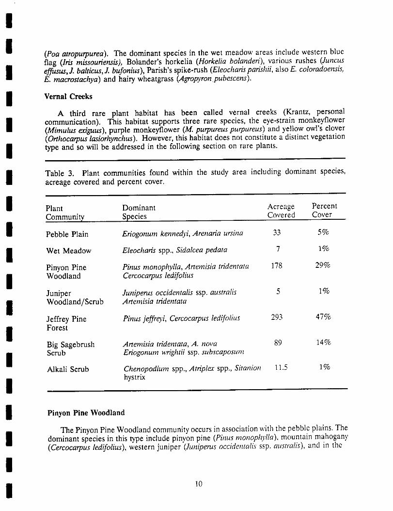
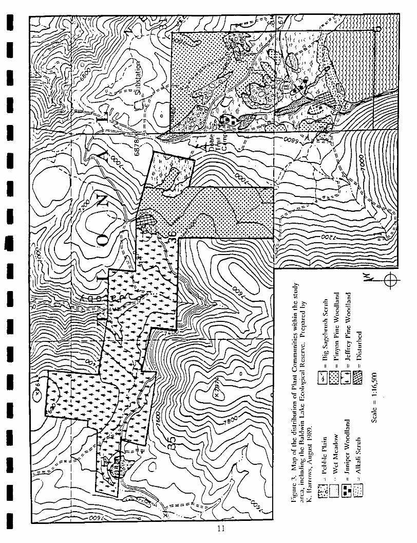
The map of the distribution of plant communities within the study area is presentedin Figure 3. The plant communities within the study area include pebble plain, wetmeadow, sagebrush scrub, pinyon pine woodland, juniper woodland and scrub, jeffrey pineforest, and alkaline scrub/wetland vegetation around the margins of Baldwin Lake. Theacreage and percent cover for each vegetation type within the stud), area is given in Table2.
Pebble Plains
The study area is notable for the presence of several vegetation types which supporta host of endemic plant species. Among these, the pavement or pebble plains are the mostevident as open, tree-less expanses amidst the surrounding forest. Pebble plains areidentified by the presence of two indicator species, the southern mountain buckwheat(Eriogonum kennedyi ssp. austromontanum) and the Bear Valley sandwort (Arenap_a ursina).The flora includes 33 species (Derby 1979); five are rare species including the _'omentioned above and the ashy-gray paintbrush (Castilleja cinerea), Parish's rock cress(Arabis parishii), and Munz's hedgehog cactus (Echinocereus engehnannii vat. munzii). Otherdominant species on the pebble plains include Bear Valley bluegrass (Poa hlcurva),Douglas' draba (Draba douglasii var. crocked), and low everlasting (Antennaria dimorpha).
Wet Meadows
At several locations within ihe study area, low-lying areas which collect precipitationin the form of snow or rain develop vernally wet conditions that support wet meadowvegetation. These wet meadow sites typically occur where a heavy clay layer in the soilintercepts a drainage or seep. The wet meadow vegetation is often associated with pebbleplains. On the Baldwin Lake study area, wet meadow habitat occurs on either side ofHighway 18 (see Figure 3). This vegetation supports two endangered species, the bird-footed checkerbloom (Sidalceapedata), and the slender-petaled thelypodium (Thel)podiumstenopetalum). At this location, the thelypodium occupies slightly higher ground along themargin of the drainages or wet spots; it is more closely associated with open sagebrush(Artemisia nova) stands. The cbeckerbloom is located within or on the edges of shallowdrainages. A third wet meadow-associated species which does not occur with thelypodiumand the checkerbloom at this site is the California dandelion (TarcL_'acum califonrictml); thedistribution of this species is discussed in the following section on plants. Another rarespecies associated with wet meadow areas but not observed in ]988 is Bear Vulley bluegrass
(Poa atropurpurea). The dominant species in the wet meadow areas include western blueflag (Iris missouriensis), Bolander's horkelia (Horkelia bolanderi), various rushes (Juncuseffusus, J. balticus, J. bufonius ), Parish's spike-rush (Eleocharis parishii, also E. coloradoensis,E. rnacrostachya) and hairy wheatgrass (Agropyron.pubescens).
Vernal Creeks
A third rare plant habitat has been called vernal creeks (Krantz, personalcommunication). This habitat supports three rare species, the eye-strain monkeyflower(Mimulus exiguus), purple monkeyflower (M. purpureuspurpureus) and yellow owl's clover(Orthocarpus lasiorhynchus). However, this habitat does not constitute a distinct vegetationtype and so will be addressed in the following section on rare plants.
Table 3. Plant communities found within the study area including dominant species,acreage covered and percent cover.
Plant Dominant Acreage PercentCommunity Species Covered Cover
Pebble Plain Eriogonum kennedyi, Arenaria ursina 33 5%
Wet Meadow Eleocharis spp., Sidalcea pedata 7 1%
Pinyon Pine Pinus monophylla, Artemisia tridentata 178 29%Woodland Cercocarpus ledifolius
Juniper Juniperus occidentalis ssp. australis 5 1%Woodland/Scrub Artemisia tridentata
Jeffrey Pine Pinus jeffreyi, Cercocarpus ledifolius 293 47%Forest
Big Sagebrush Artemisia tn'dentata, A. nova 89 14%Scrub Eriogonum wrightii ssp. subscaposum
Alkali Scrub Chenopodium spp., Atriplea" spp., Sitanion 11.5 1%hystrix
Pinyon Pine Woodland
The Pinyon Pine Woodland community occurs in association with the pebble plains. Thedominant species in this type include pinyon pine (Pinus monophylla), mountain mahogany(Cercocarpus ledifolius), western juniper (Juniperus occidenta]is ssp. al¢stl_Tlis),and in the
10
1]
understory, Eriogonum umbellatum ssp. munzii. This community is closely associated withbig sagebrush scrub dominated by Artemisia tridentata.
Juniper Woodland and Scrub
The occurrence of this community is very limited on the study area. Small stands oflarge stately western junipers occur associated with big sagebrush, rabbitbrush(Chrysothamnus nauseosus, C. viscidifolia) and a variety of herbs and grasses.
Jeffrey Pine Forest
The stands of Jeffrey pine forest intergrade with pinyon pine woodland but Jeffreypine is the clear dominant on the USFS (Lamane) and TNC (Starland) parcels alongHolcomb Valley Road. This mixed forest is dominated by Jeffrey pine (Pinus jeffreyi) withassociated pinyon pine, western juniper, mountain mahogany, and canyon live oak (Quercuschrysolepis). Common understory shrubs include big sagebrush and greenleaf manzanita(Arctostaphylos patula ssp. platyphylla). On the forest floor sulfur-flowered buckwheat andvarious .grasses (Sitanion hystrix, Elymus glaucus ssp. virescens, Bromus tectotum ) are commonin opemngs.
Big Sagebrush Scrub
The presence of big sagebrush scrub on the site, dominated by Artemisia tridentata, isan indicator of the Mojave Desert influence. This community varies considerably in boththe density of Artemisia and in species composition. A common associate in these standsis dwarf sagebrush (Artemisia nova). Around the "horse house" and on the east side ofHighway 18 on the CDFG parcel, nearly pure stands of dense sagebrush occur. Elsewherein the vicinity of the horse house and on the Lamane parcels (USFS) more open stands ofsagebrush occur. In these open stands associated species include desert mallow(Sphaeralcea ambigua), interior bush lupine (Lupinus excubitus ssp. austromontanum ), andMojave antelope bush (Purshia glandulosa). On abandoned roads and other disturbed sites,rabbit brush, snakeweed (Gutierrezia sarothrae), prickly poppy (Argemone munita), storksbill(Erodium cicutarium), and rattlesnake weed (Euphorbia alboma_ginata) are common.
Alkali Scrub/Grassland
Along the margins of the lakebed is a mixed association of alkaline and wetlandsspecies. Because the lake has been dry since 1985, many marsh or wetlands species whichmay occur there were absent during the survey. The margins of the lake were dominatedby a variety of grasses and alkaline indicators including squirrel-tail, salt grass (Distichlisspicata), hairgrass (Deschampsia danthonioides), and alkali heliotrope (Heliotropiumcurassavicum var. oculatum). On the dry lakebed were various chenopods including lamb'squarters (Chenopodium fremontii), four-wing saltbush (Atriplex canescens), red goosefoo_(Chenopodium rubrum), and dark green goosefoot (Chenopodium atrovirens).
12

!I Plants
I One significant feature of the proposed Baldwin Lake Ecological Reserve and adjacentlands in the study area is the abundance of rare plants. The inventor 3, of rare plants
I involved mapping and estimating abundance for the fourteen species which may occur onthe study area. These species are reported below by habitat. No effort was made toestimate abundance for all species; however, state/federally-listed species were counted
I individually.Both the 1988 and 1989 seasons were so dry that a number of the rare plant species
i were present in numbers far below average, and others, known previously from the area,were not found. Additional surveys in the spring of 1989 failed to detect some of the plantspecies not present in 1988 (Mimulus exiguus, Linanthus killipii).
I The list of rare plant species for the study area given completeis in Table 2. A list
of all plant species known to occur in the Baldwin Lake area (Krantz 1986) is given in
i Appendix I.Wet Meadow Rare Plants
I The meadow habitat two state- and federally-listed endangered species,wet supports
the bird-footed checkerbloom (Sidalcea pedata) and slender-petaled thelypodium(Thelypodium stenopetalum) in addition to a third Southern California endemic, Bear Valley
I bluegrass (Poa atropurpurea). Also present in wet areas but not associated with thecheckerbloom and thelypodium at this site is the California dandelion (Taraxacumcalifomicum ).
I 1. Bird-footed Checkerbloom (Sidalcea pedata) - This species is known to occur infour different locations within the study area (Figure 4). In the 1988 season checkerblooms
I were observed only in the small drainage which crosses Highway 18 (labeled "A" in Figure4). Approximately 130 plants were counted here on 9 May in 1988, on either side of theroad. The other mapped locations were mapped by Tim Krantz (personal communication)
I in previous years. In the 1989 season a more thorough map of this species' distribution anda much more accurate count of individuals was made. In the larger drainage ("A" in Figure4) 1724 individuals were counted. An additional 188 individuals were counted in a smaller
I drainage ("B" in Figure 4). In both of these subpopulations approximately 30 to 50% of allflowering plants counted had the flower stalks clipped near the base; it is possible that thisclipping was done by burros.
I 2. Slender-petaled thelypodium (Thelypodium stenopetalum) -This species is known tooccur at two locations within the study area (Figure 4). In 1988 the counted population
I of this species was extremely small; only 11 individuals were observed at the site labelled"C" in Figure 4. Not all of the potential habitat was surveyed thoroughly (this species canbe difficult to locate as it often grows under and up through sagebrush bushes). Plants were
I observed only on the east side of H_3' 18. In 1989 a more thorough survey of this specieswas completed. Again plants were only observed at the site labeled "C" but this year amore accurate count located 19 flowering plants and 10
II 13

Baldwin Lak:
'- Ol T D"s'-'r ""r-C OQ COl ix,,_ ,.. V_--/
!
I first year rosettes. A monitoring transect was established in one portion of the populationand the location of all individuals was mapped. This species' habitat received fairly heavy
I trampling by burros since the field surveys in 1988.
3. Bear Valley bluegrass (Poa atropurpurea) - This species occurs in wet meadows or
I seeps within the study area. Only one population of this species is known from the studyarea but no individuals of this species were observed in 1988 or 1989. However, perhapsdue to the dry year surveys for the species were not successful. The known occurrence is
I located on the private "inholding" (Figure 4) where it may be associated with Sidaleeapedata and Mimulus exiguus.
I 4. California dandelion (Tar,_,,,a_n califomicum) - There are two known populationsof this species within the study area (Figure 4). One of these is a fairly large population,with approximately 130 individuals observed in 1988, associated with a small spring on the
i Lamane (U.S.F.S.) property just south of the historical Doble town site. This populationis impacted by burro trampling around the spring and invasion of the weedy commondandelion, Taraxacum officinale. At least several hybrid individuals resulting from a cross
i between these two Taraxacum species have been observed at this site (Krantz, personalcommunication). A second location, near an abandoned well, has not supported this speciessince 1985, probably because the well has been dry (Krantz, pers. comm.); the well wasflowing during the spring/summer 1989 season but no California dandelions were observed.!
One of the primary concerns for Taraxacum cahfornicum is the potential forhybridization with the weedy introduced T. officinale. California dandelion is distinguished
I from the common dandelion the not reflexed, Also the leaves in T.by erect, phyllaries.califomicum are subentire to sinuate-dentate; those in T. officinale are pinnatifid to deeplyincised. Hybrid individuals have erect phyllaries but more deeply incised leaves.
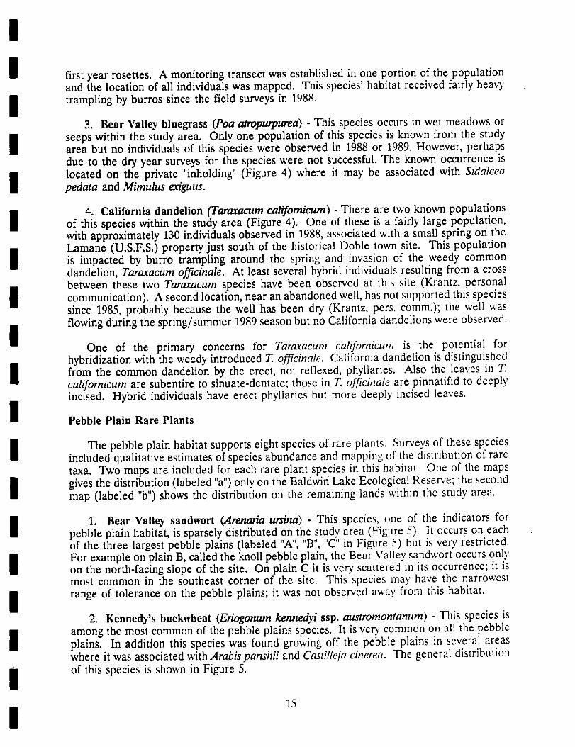
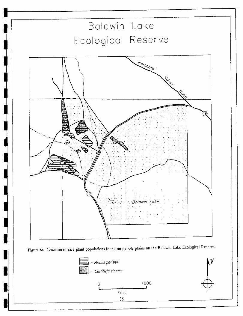
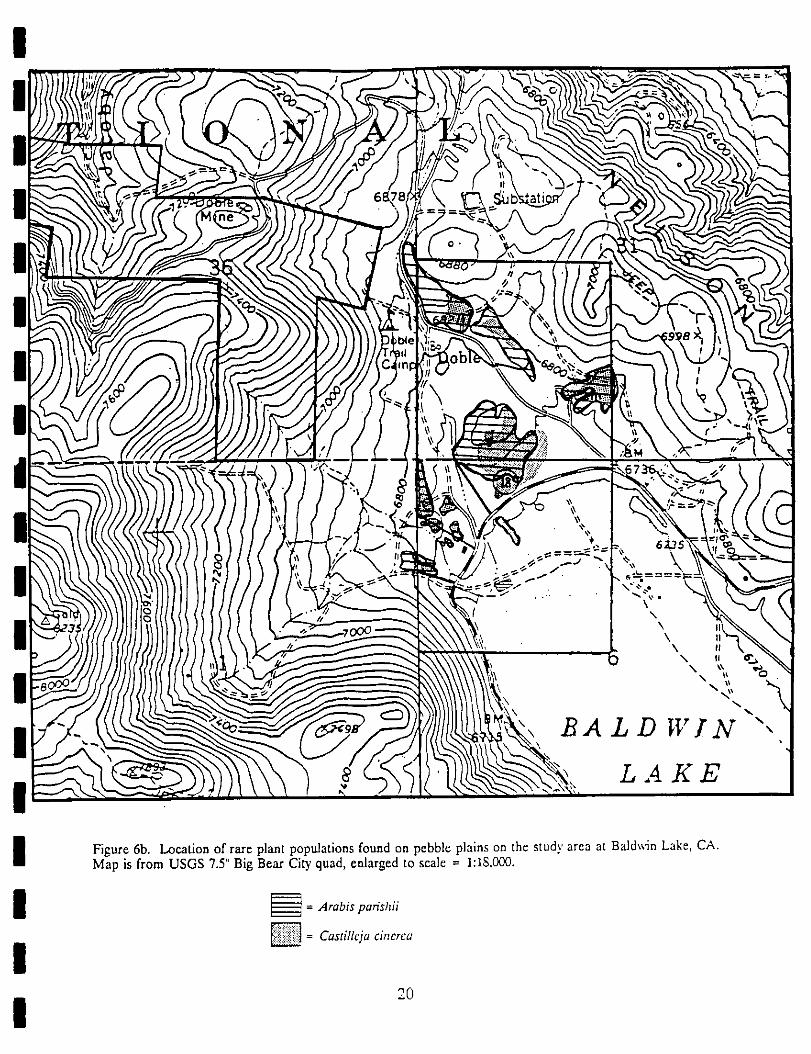
I Pebble Plain Rare Plants
I The pebble plain habitat supports eight species of rare plants. Surveys of these speciesincluded qualitative estimates of species abundance and mapping of the distribution of raretaxa. Two maps are included for each rare plant species in this habitat. One of the maps
I gives the distribution (labeled "a") only on the Baldwin Lake Ecological Reserve; the secondmap (labeled "b") shows the distribution on the remaining lands within the study area.
I 1. Bear Valley sandwort (Arenar/a un_u_) - This species, one of the indicators forpebble plain habitat, is sparsely distributed on the study area (Figure 5). It occurs on eachof the three largest pebble plains (labeled "A", "B", "C" in Figure 5) but is very restricted.
I For example on plain B, called the knoll pebble plain, the Bear Valley sandwort occurs onlyon the north-facing slope of the site. On plain C it is very scattered in its occurrence; it ismost common in the southeast corner of the site. This species may have the narrowesl
I range of tolerance on the pebble plains; it was not observed away from this habitat.2. Kennedy's buckwheat (Eriogonum kennedyi ssp. austromomanum) - This species is
I among the most common of the pebble plains species. It is ve_, common on all the pebbleplains. In addition this species was found growing off the pebble plains in several areaswhere it was associated with Arabispanshii and Castille]a cinerea. The general distribution
i of this species is shown in Figure 5.
| 15

There are two related Eriogonurn taxa which occur on the study area which are similarin aspect to E. kennedyi ssp. austromontanum. These are Eriogonum kennedyi ssp. kennedyiand Eriogonum wrightii ssp. subscaposum. The latter species is common as an understoryspecies in yellow pine forest, sagebrush scrub and in the pinyon pine woodland. It isdistinguished by characteristics of the flowering stems; in E. wrightfi the inflorescence stemsare branched, in E. kennedyi they are unbranched. E. kennedyi ssp. austromontanum andE. k. kennedyi are difficult to distinguish. Characters used by Reveal (1979) are as follows:
E. k. austromontanum E. la kennedyi
Lvs. 6-12 mm long Lvs. 2-4 mm longLvs. loosely matted Lvs. forming dense matsFlowering July - September Flowering April - JuneAehenes 3.5-4 mm long Achenes ca. 2 mm long
Krantz (1981) indicates that the Knoll pebble plain includes representatives of bothsubspecies of E. kennedyi. Eriogonum kennedyi ssp. kennedyi also occurs on the pebbleplains on the north side of Holcomb Valley Road (USFS, private) and on a small pebbleplain southwest of Doble Trail Camp.
3. Parish's rock cress (Arabisparishii) - This species is a Big Bear Basin endemic butis relatively widespread in appropriate habitat. This species was found to be common onthe pebble plains and also in open areas of sagebrush scrub. Its distribution on the studyarea is shown in Figure 6.
4. Ashy-gray paintbrush (Ca_leja cinerea) - This hemiparasitic species is associatedwith the roots of Eriogonum kennedyi ssp. austromontanum and with Ar_emisia nova. It ispresent on the pebble plains but is also common off the pebble plains in patches, usuallyassociated with Arabis parishi and/or Eriogonum kennedyi ssp. austromontanum, itsdistribution appears to be closely tied to the presence of clay soils (whether or not saragosaquartzite pebbles are present). The species is variable in flower color, ranging from sulfuryellow to orange-red. Its distribution is shown in Figure 6.
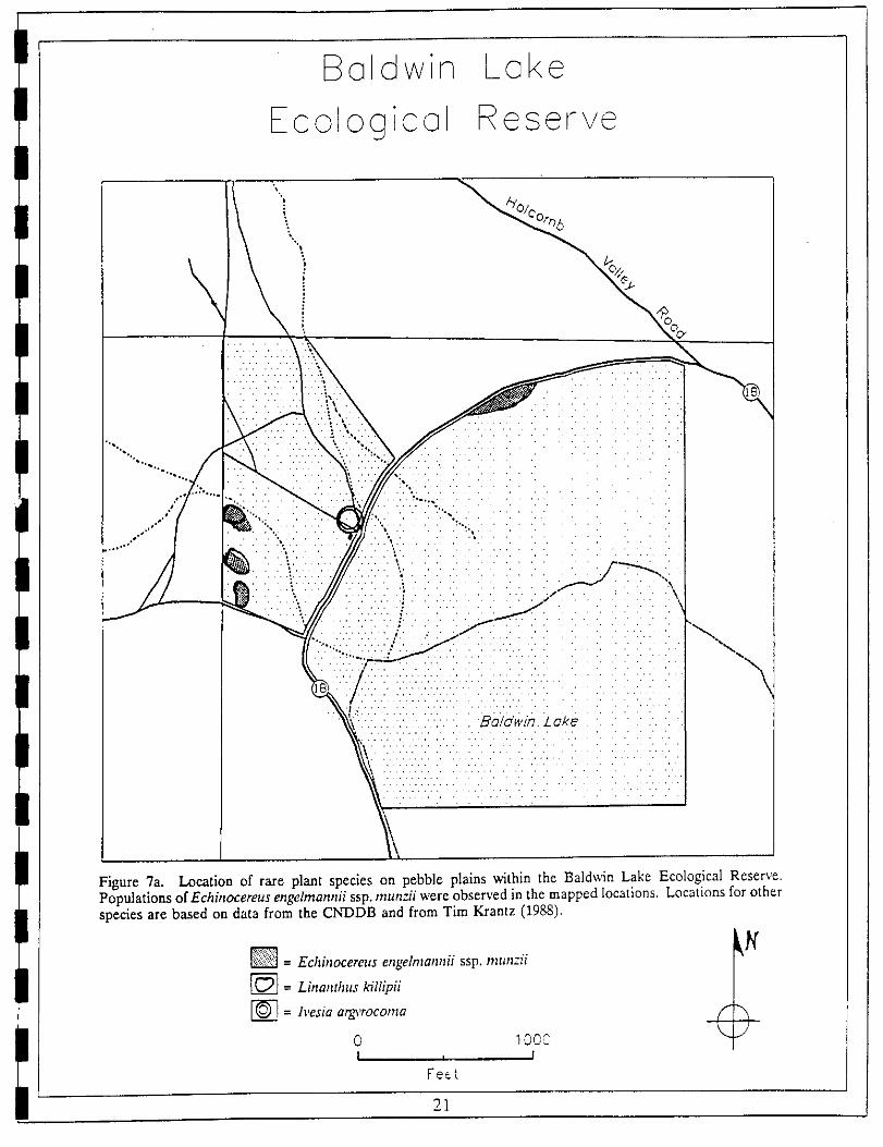
5. Rat tails (Ivesia at,gyrocoma) - This species is patchily distributed on the pebbleplains within the study area. It is often associated with disturbed areas, such as old roadsor vehicle tracks. The known locations on the study area are shown in Figure 7. It is nolonger on the U.S. Forest Service sensitive plant list.
6. Baldwin Lake iinanthus (Linanthus killipff) - This endemic species is variable in itsoccurrence, depending at least partially on the soil moisture in a given season. This specieswas not observed at the Baldwin Lake study area in either 1988 or 1989. It was
16

Baldwin Lake
Ecological Reserve
\"k
"'........_2:!_:::!:::!:}:!:! ! !:_:i :::]3i:!:: :!::1
Figure 5a. Location of rare plant populations found on pebble plains on the Baldw;m Lake Ecological Resen'e,San Bernardlno County, CA.
= Arenmqa ursina _
= Enogonum kennedyi ssp, austromontanum
o _oc: \J
Feet
17

..BA I, D WIN ",
LAKE
Figure 5b. Location of rare plant populations found on pebble plains on the study area at Baldwin Lake, CA.Map is from USGS 7.5' Big Bear City quad, enlarged to scale - 1:18,000.
= Arenaria ursina _X_--_q = Eriogonum kennedyi ssp. austromontanum
18
Baldwin Lake
Ecological Reserve
'_.\_ ",_%
"'"........ ",;3::, ..::!::i:i:!.:i:i,.:: ::}/i: i.}:i::i::!/ '.....:..:::.:. '.}:. :.. :. :..:.:... : :-.:.:."
•:...:\..... ",,.
Figure 6a. Location of rare plant populations found on pebble plains on the Baldwin Lake Ecological Reserve.
__ = ,4rabis parishii _(
_ = Castilleja cinerea
0 1000 -7"I i I _1Feet
19
!
I Figure 6b. Location of rare plant populations found on pebble plains on the stud)' area at Baldwin Lake, CA.Map is from USGS 7.5" Big Bear City quad, enlarged to scale = 1:18,000.
I __ =Arabisparishii
I _= Castillcja cinerea
20
I
Baldwin Lake
Ecolocjical Reserve
\.. /'/°/c°r_5
i'
iii:
Figure 7a, Location of rare plant species on pebble plains within the Baldwin Lake Ecological Reserve.Populations ofEchinocereus engelmannii ssp. rnunzii were observed in the mapped locations. Locations for otherspecies are based on data from the CNDDB and from Tim Krantz (1988),
g_ = Echb)ocereus engelmannii ssp. rtltlll2ii
= Linanthus ldllipii
[-_ = lvesia argvrocoma _._\
0 1000I _ I
Feet
21

!
Figure 7b. Location of rare plant species on pebble plains within the study area at N. Baldwin Lake. Map is
I from USGS 7.5' Big Bear Ci_' quad.
I _ = Echinocercus engelmamlii ssp mtm'.:ii= Lblanthus killipii
i Scale = 1:24,000
!
I observed in flower on several other pebble plains (e.g. Sawmill). In some years this speciescarpets the pebble plains for brief periods (Krantz 1983). Occurrences for this species from
I the CNDDB are included in Figure 7.
7. Munz's hedgehog cactus (Echinocereus engelmannii var. munzit) - This species is
I very patchy in its distribution on the pebble plains. Where it occurs it is in small clumpsof 3 to 15 individuals. It was flowering in late June in 1988; on 28 June 1988 approximately200 individuals were counted on the knoll pebble plain (Figure 7). On the pebble plains
I behind the "horse house" three clumps of the species were located with 11, 11, and 15individuals counted. More thorough mapping and monitoring of this species is needed. In1989 a series of transects was established to monitor this species on the knoll pebble plain
I (Neel 1989).Vernal Creek Rare Species
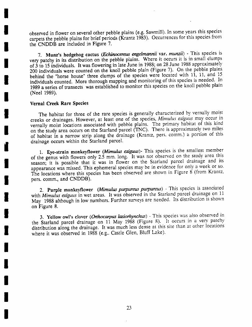
I The habitat for three of the rare species is generally characterized by vernally moistcreeks or drainages. However, at least one of the species, Mimulus exiguus may occur in
i vernally moist locations associated with pebble plains. The primary, habitat of this kindon the study area occurs on the Starland parcel (TNC). There is approximately two milesof habitat in a narrow strip along the drainage (Krantz, pers. comm.) a portion of this
i drainage occurs within the Starland parcel.1. Eye-strain monkeyflower (Mimulus exiguus)- This species is the smallest member
of the genus with flowers only 2.5 mm. long. It was not observed on the study area this
I it is that it in flower the Starland drainage and itsseason; possible was on parcelappearance was missed. This ephemeral species may be in evidence for only a week or so.The locations where this species has been observed are shown in Figure 8"(from Krantz,
I pers. comm.,and CNDDB).
2, Purple monkeyflower (Mimulus purpureus purpureus) - This species is associated
I with Mimulus exiguus in wet areas. It was observed in the Starland parcel drainage on 11May 1988 although in low numbers. Further surveys are needed. Its distribution is shownon Figure 8.
I 3, Yellow owl's clover (Orthocarpus lasiorhynchus) - This species was also observed inthe Starland parcel drainage on 11 May 1988 (Figure 8). It occurs in a yen, patchy
I distribution along the drainage. It was much less dense at this site than at other locationswhere it was observed in 1988 (e.g.. Castle Glen, Bluff Lake).
!IIIII
Boldwin Lol<e
Ecolog col Reserve
"Xko_
"'.. :i..:ii:iii! i{;_,.;;.. . ;.i;i:iii;i:i;.ii; i .;ii iii t
_;,.i;_;.:_i;i_ii/!3_i_iiiii_i,ii:! _ i:,i__:. \1i iiZ!:iii,i i, ili,i,i,i!ii : : 1
_:!ii:.i:i! iiii!:;!!ii.i i:i:i.:!!!ii!:i!i :!! t
Figure 8a. Location of rare plant populations found in Vernal Creek habitat, on the Baldwln Lake Ecological
Resets'e, San Bernardino County, CA. _k_
+= Mimulus exq_us
0 1080I , I
Feet
24

!!
!I Figure 8b. Location of rare plant populations found in Vernal Creek habitat on th_ Starland parcel. Map isfrom USGS 7.5' Big Bear City quad. Scale + 1:24,000.
I _ = VernalCreekhabitat
| 25
II Animals
I Mammals
i The mammal live-trapping was carried out in sagebrush scrub, open pinyon pinewoodland, and the perimeter of the pebble plain behind the horse house. The mammalsknown to occur on the study area, determined from live-trapping, observations (including
i scat, tracks, etc), or other written sources are given in Table 4.
Table 4. Mammalian species observed or detected on or near the Baldwin Lake study
I area, San Bernardino County, during May through October in 1988.
Method of
I Species Detection
Lepus californicus - Black-tailed Hare observed
I Eutamias merriami - Merriam Chipmunk observedSciurus griseus - Western Gray Squirrel observedThomomys bottae - Botta Pocket Gopher sign
I Dipodomys sp. - Kangaroo Rat 1 live-trapPerornyscus maniculatus - Deer Mouse live-trapMicrotus californicus - California Meadow Mouse live-trap
I Neotoma fuscipes - Dusky-footed Woodrat signUrocyon cineroargenteus - Gray Fox signFells concolor - Mountain Lion 2 literature
I Lynx rufus - Bobcat literatureOdocoileus hemionus californicus - Mule Deer literature
I 1 Species identification not confirmed. Probably D. panaminms or D. agihs2 Observations from Krantz (1983).
IIIIII
26
!
!I Birds
The list of bird species encountered on the study area during field work is given in
I includes the of water birds that would likely use the north shoreTable 5. The list speciesof Baldwin Lake during periods when it contains water; these species were not observed
i during 1988 or 1989.
Table 5. Bird species observed within the study area at Baldwin Lake, San Bernardino
I November of 1988 and 1989.County durin_ April through
Species
I Pied-billed Grebe Nuttall's WoodpeckerEared Grebe DownyWoodpecker
I American White Pelican Common Flicker (Red-shafted)Great Blue Heron WesternWoodPeweeGadwall DuskyFlycatcher
I Green-winged Teal Western FlycatcherMallard Tree SwallowCommonPintail Stellar'sJay
I CinnamonTeal ScrubJayNorthern Shoveler Pinyon JayRedhead CommonRaven
I Ring-necked Duck Mountain ChickadeeCommonMerganser BushtitSharp-shinned Hawk White-breasted Nuthatch
I Cooper's Hawk Red-breasted NuthatchRed-tailedHawk BrownCreeperAmericanKestrel WesternBluebird
I Mountain Quail White-crowned SparrowBand-tailedPigeon ChippingSparrowCommon Screech Owl Nevada Sage Sparrow
I Great Horned Owl Green-tailed TowheeSaw-whetOwl BrownTowheeCommon Nighthawk Brown-headed Cowbird
I White-throated Swift Lesser GoldfinchAnna's Hummingbird House FinchCalliope Hummingbird
II Reptiles and Amphibians
Very little reptile activity was observed within the study area. Subsequem observationsI from individuals familiar with the local herpetofauna should be compiled a complete
inlo
list of reptiles and amphibians.
I27
I
!!
Fish
I One significant fish species occurs in Baldwin Lake during the periods when it is fullof water. This is the federally-listed Endangered unarmored three-spined stickleback
i (Gasterosteus aculeatus ssp. williamsonii). This species was last collected in Baldwin Lakethe last time it was full of water, in August 1985 by Dr. James Malcolm of the Universityof Redlands. Late in 1985 Dr. Malcolm observed a die-off of the sticklebacks as the lake
level receded. He also observed eared grebes, mergansers, and great blue herons feeding
on the fish during this period. Additional natural history information and managementconcerns are addressed in the section on Species Management Goals for this species.
i Invasive Exotic Plants and Animals
The potential for negative impacts on the native flora, particularly the rare species,
I was evaluated during the field surveys. Three exotic species, two plants and one mammal,have the potential for seriously impacting the natural values within the study area. Thedistribution and abundance of these species is described.
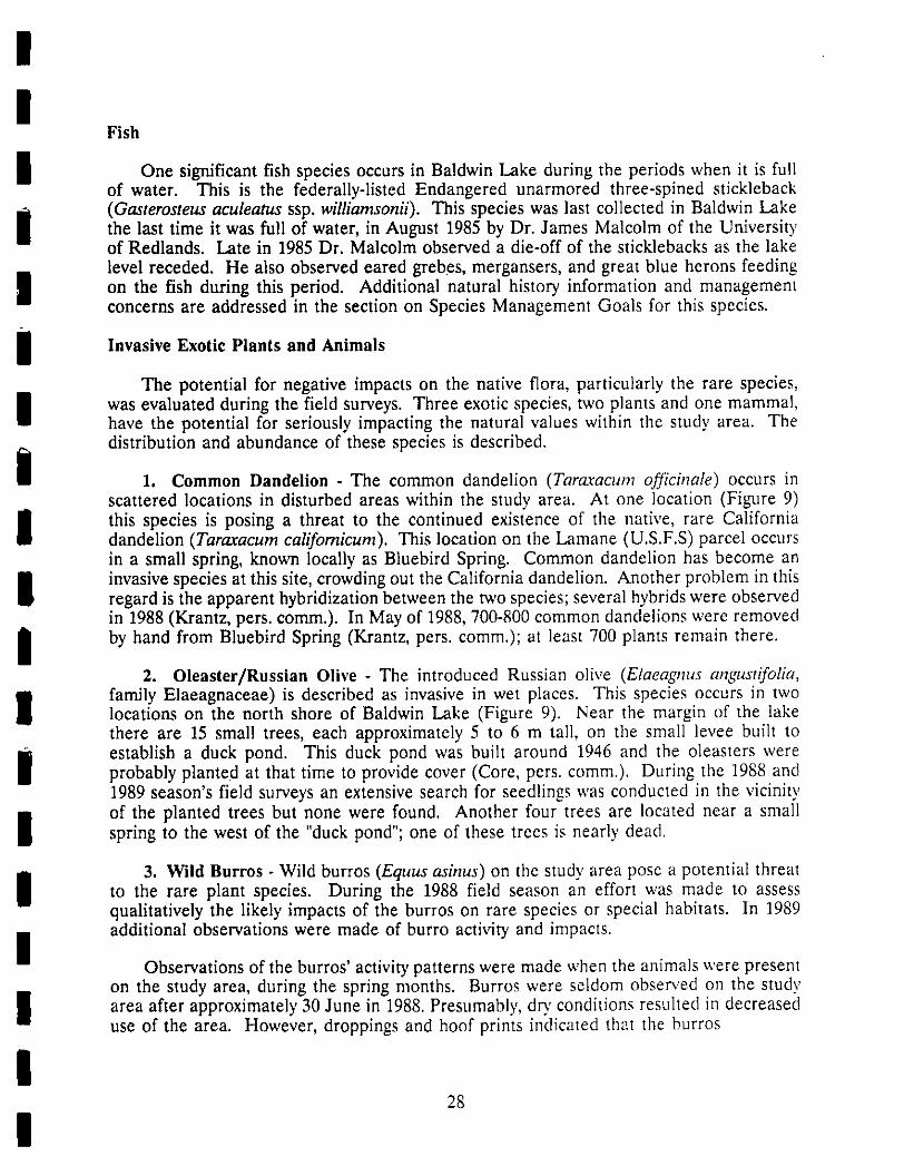
1. Common Dandelion - The common dandelion (Tara.racum ofJicinale) occurs inscattered locations in disturbed areas within the study area. At one location (Figure 9)
this species is posing a threat to the continued existence of the native, rare Californiadandelion (Taraxaeum californicum). This location on the Lamane (U.S.F.S) parcel occursin a small spring, known locally as Bluebird Spring. Common dandelion has become an
I invasive species at this site, crowding out the California dandelion. Another problem in thisregard is the apparent hybridization between the two species; several hybrids were observedin 1988 (Krantz, pers. comm.). In May of 1988, 700-800 common dandelions were removed
I by hand from Bluebird Spring (Krantz, pets. comm.); at least 700 plants remain there.2. Oleaster/Russian Olive - The introduced Russian olive (Elaeagnus angustifolia,
I family Elaeagnaceae) is described as invasive in wet places. This species occurs in twolocations on the north shore of Baldwin Lake (Figure 9). Near the margin of the lakethere are 15 small trees, each approximately 5 to 6 m tall, on the small levee built to
i establish a duck pond. This duck pond was built around 1946 and the oleasters wereprobably planted at that time to provide cover (Core, pets. comm.). During the 1988 and1989 season's field surveys an extensive search for seedlings was conducted in the vicinity
i of the planted trees but none were found. Another four trees are located near a smallspring to the west of the "duck pond"; one of these trees is nearly dead.
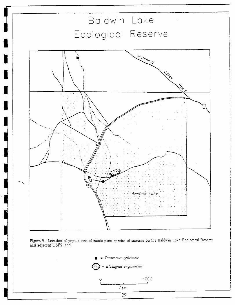
i 3. Wild Burros - Wild burros (Equus asinus) on the study area pose a potential threatto the rare plant species. During the 1988 field season an effort was made to assessqualitatively the likely impacts of the burros on rare species or special habitats. In 1989additional observations were made of burro activity and impacts.
IObservations of the burros' activity patterns were made when the animals were present
on the study area, during the spring months. Burros were seldom observed on the study
I area after approximately 30 June in 1988. Presumably, dr?' conditions resulted in decreaseduse of the area. However, droppings and hoof prints indicated that the burros
I28
I
Boldwin Loke
- ol gi olI- C 0 C I, ,.,,.,_
Figure 9. Location of populations of exotic plant spedes of concern on the Ba]d;vin Lake Ecolo¢cai Reserveand adjacent USF$ land.
• = Taraxacum o_Tcina/e
= Elaeagnus ang_tstifolia
0 _OC,OI _ T
flee"
29
Baldwin Loke
Ecological ReseFve
_o,bb
...... ,",'.' ..... _E'. .... ...... .' " ". " " \' I• .,.I, .... , ', ' .' , " . . " ... ' ,' '. - - .' I
•_ v.v... . v . :Ba{q'wL_Zoke ........
?,,.v.v..v.:,....v .:... :.: ........ . "
Figure 10. Areas where observations of wild burros were made during the period from 30 April to 1 July 198&no burros were observed in 1989.
_= Burros observed
_= Burro sign (lracks, lrails, droppings) observed
0 100_L., , l
Fee_
3O
!I were still present in the area through October 1988. No burros were actually observed by
the author in 1989 but there was considerable evidence of their activity within rare plant
i habitat.The primary areas where burros were observed was on the Knoll pebble plain (on
i Lamane/"Cemetary" parcel) and in the grass-covered margins of the dry lake bed (Figure10). Observations of the burros on the pebble plains were made in the evening hours whenas many as 12 animals were observed on the Knoll pebble plain. As many as 24 animalshave been observed in the area by others; in December 1989 23 animals were observed
I (Coelho, pers. comm.). Burro droppings can on pebble plainbe found the located behind
the "horse house" as well. Burros are predominantly grazing animals (Bleymeyer, pers.comm.) so they are probably foraging on grasses. The extent to which they may forage on
I or impact rare species on the pebble plains is not known
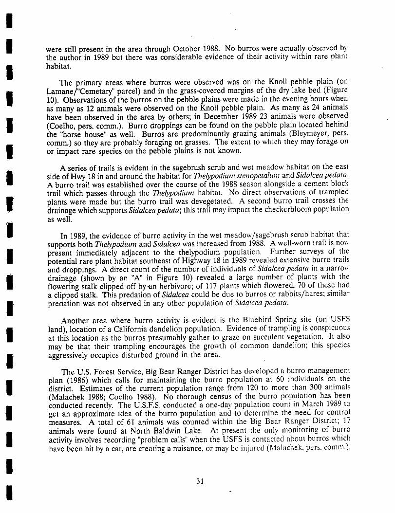
A series of trails is evident in the sagebrush scrub and wet meadow habitat on the east
I side of Hwy 18 in and around the habitat for Thelypodium stenopetalum and Sidalcea pedata.A burro trail was established over the course of the 1988 season alongside a cement blocktrail which passes through the Thelypodium habitat. No direct observations of trampled
I plants were made but the burro trail was devegetated. A second burro trail crosses thedrainage which supports Sidalceapedata; this trail may impact the checkerbloom populationas well.
I In 1989, the evidence of burro activity in the wet meadow/sagebrush scrub habitat thatsupports both Thelypodium and Sidalcea was increased from 1988. A well-worn trail is now
I present immediately adjacent to the thelypodium population. Further surveys of thepotential rare plant habitat southeast of Highway 18 in 1989 revealed extensive burro trailsand droppings. A direct count of the number of individuals of Sidalcea pedata in a narrow
I drainage (shown by an "A" in Figure 10) revealed a large number of plants with theflowering stalk clipped off by.an herbivore; of 117 plants which flowered, 70 of these hada clipped stalk. This predation of Sidalcea could be due to burros or rabbits/hares; similar
i predation was not observed in any other population of Sidalcea pedata.Another area where burro activity is evident is the Bluebird Spring site (on USFS
I land), location of a California dandelion population. Evidence of trampling is conspicuousat this location as the burros presumably gather to graze on succulent vegetation. It alsomay be that their trampling encourages the growth of common dandelion; this species
I aggressively occupies disturbed ground in the area.The U.S. Forest Service, Big Bear Ranger District has developed a burro management
i plan (1986) which calls for maintaining the burro population at 60 individuals on thedistrict. Estimates of the current population range from 120 to more than 300 animals(Malachek 1988; Coelho 1988). No thorough census of the burro population has been
conducted recently. The U.S.F.S. conducted a one-day population count in March 1989 to
I get an approximate idea of the burro population toand determine the need for control
measures. A total of 61 animals was counted within the Big Bear Ranger District; 17animals were found at North Baldwin Lake. At present the only monitoring of burro
I calls"whenthe USFSis contactedaboutburroswhichactivity involves recording "problemhave been hit by a car, are creating a nuisance, or may be injured (Malachek, pers. comm.).
!31
I
!I PhysicalFeatures
I Soil
The soils found within the study area are generally characterized by a high clay
I component related to the geological history of the area as a Pleistocenelake bed. The
pebble plain soils have been described as fine mixed mesic typic haploxeralfs of theHodgson family (Retelas 1978). An exploratory Soil pit excavated by Derby (1979) on the
I Van Dusen pebble plain greater clay particlesindicated than 60% in the B2 horizon.
Observations on road cuts in the Big Bear basin reveal the abrupt change in soil textureat the B2 horizon. The pebble plain soils are also transported easily as fine clay particles
I removed wind and water. The surface on the pebble plains is dominated by rockare bycobbles which average 3 to 10 cm across, although larger rocks (+ 20 cm) are notuncommon.
i The high clay component in the soil also contributes to the formation of wet meadowhabitat. This habitat occurs where clay lenses in the soil are intercepted by shallow
I drainages or springs. The clay forms a barrier to infiltration of water and createsappropriate conditions for the rare species. The soil profile at these sites differs primarilyin the absence of a surface layer of rock cobbles. Vernal creeks and drainages are the
result of similar conditions.
Geology
I The San Bernardino Mountains are part of the Transverse Ranges GeomorphicProvince of California. The uplift of the San Bernardino Mountain Range is estimated at
I a minimum age of 6.2 million years (Woodburne 1975). The continuous movement of thePacific lithospheric plate in a northwestern direction with respect to the North Americanplate creates active uplift which has occurred since the Plioccne; the San Andreas and San
I Jacinto faults are the principal zones of this activity (Crowell, 1975).The basins that form the present day Baldwin Lake and Big Bear Valley are both the
I result of deposition of lake-bottom and alluvial debris (Stout 1976). During the Ice Age,approximately 18,000 to 20,000 years ago, the entire basin was filled by a huge lake. Thereis some evidence to suggest that there may have been at least two earlier lakes in the Big
i Bear Valley. A thick section of blue-gray clay up to 60 meters thick is one indication ofa second lake which filled both Big Bear and Baldwin Lake basins (Stout 1976). Today,Baldwin Lake is a closed basin with internal drainage.
I The deep clay layers deposited by ancient lakes in theBaldwin Lake basin contribute
to the unusual plant association on the pebble plains. These clay deposits persist on thehillsides which surround Baldwin Lake as well. Rocks in the area are predominantly
I Saragosa Quartzite of Precambrian age (Stewart 1975).and Poole The distinctive surface
pebble evident on the pebble plains is composed of Saragosa Quartzite rocks. ThisSaragosa Quartzite Formation is lithologically correlated with eastern Mojave and Great
I Basin units and Poole(Stewart 1975).
I32
i

!I Hydrology
The hydrologic features in the Baldwin Lake Ecological Reserve lands consist of a
I series of small drainages which drain into precipitationBaldwin Lake. Annual in the
Baldwin Lake area is less than 38 cm (17.3 inches) with most occurring in the form ofsnowfall. Some of these drainages include the sources of water for rare plant habitats, the
I meadows and the annual creeks. Hydrologic features within the study area are shownwet
in Figure 11. The significant drainages, in terms of rare plant habitat, are designated witha letter; these letters are referred to in the following discussions of the hydrologic features.
I The primary populations of both Sidalcea pedata and Thelypodium stenopetalum occurin or near a small drainage indicated by an "A" in Figure 11. This drainage is fed by run-
I off from the slopes to the north and west and from the slopes of the Knoll pebble plainimmediately north of the drainage. The drainage crosses Hwy. 18 via a culvert under thehighway. The so-called "Cemetary parcel", privately owned property immediately adjacent
I to this drainage, is part of the watershed for run-off waters that contribute to the wetmeadow habitat. Potential for development of this parcel constitutes an off-site threat tohydrologic conditions which maintain the rare plant populations.
I There is evidence from aerial photographs of considerable variation in the extent ofthe wet meadow habitat surrounding drainage A. An August 1938 aerial photograph on
I file at the Big Bear Ranger Station indicates the extent of wet meadow habitat during awet period, when the Baldwin Lake level was high. Then the wet meadow plants extendedto the road west of this drainage. A second drainage which supports Sidalcea pedata is
labeled with a "B" in Figure 11. This drainage also receives run-off water from the"Cemetary parcel" via a culvert under Hwy. 18.
I Another historical influence on hydrologic conditions in the area is a man-made ditchwhich is evident on aerial photographs as a straight line running from the site of the Baird'smill to a well at the edge of Baldwin Lake (indicated at "C" in Figure 11). This ditch was
i built during the mining period (probably 1899-1900) to support a pipeline for water pumpedfrom the well to the mill site (Core 1988). The ditch remains very evident today; it isapproximately 8 inches deep and may divert water from the wet meadow area during wet
i periods.The Bluebird Spring area (indicated by a "D" on Figure 11) supports the Taraxacum
i californicum population and falls within drainage "A" described above. The impacts ofwild burros on hydrologic conditions at this site are described in the previous section (page25).
I There also several wells located the reserve which are remnants ofare on property
the gold-mining and "horse house" eras. These wells (indicated by "E" and "F" in Figure11) are located in the northwest corner of Baldwin Lake, near the duck pond. One of the
I wells is artesian well with a high flouride content; this well has a shut-off valve whichan
was turned on in spring 1989 (Coetho, pers. comm.). It flows at a rate of approximately 10
I gallons/minute and has resulted in a luxuriant growth of wetland plants below the well. Asecond well has water at the surface but presently has just a well-casing. II was apparentlyinstalled to maintain the water level in the duck pond.
I33
I

!
I Figure I1. Hydrological features on the study area at Baldwin Lake, San Bernardino Count)', CA. Map isadapted from USGS 7.5' Big Bear City quad.
I A = Rare Plant Habitat in Wet Meadow DrainageB = Sidalce pedata Habitat in Drainage
C = Ditch for Mill Water Supply (historical)
I D =BluebirdSpringE, F = Artesian Well, historical well
I G = Drainage on Starland Parcel
| 34

!I The level of water in Baldwin Lake influences the potential for waterfowl habitat
around the perimeter, for bald eagle foraging habitat, and for three-spined stickleback
I habitat within the lake. The water level in the lake normally fluctuates from completelydry to an elevation of 6698 feet when full. Information from a local historian (Core 1988)familiar with the lake level of Baldwin Lake since 1923 indicates the wet/dry cycle typical
i since that date. During the period from winter 1923-24 to winter 1935-36 the lake was dry.The winter of 1937-38 was very wet and the lake level remained high for 3-4 years, thendwindled until a wet year in 1944-45. Flooding of some of the houses on the southperimeter of the lake occurred in winters of 1973-74 and 1983-1985. The lake has been dR,
I since1985.
I HistoricalLandUseCultural Features:
Structures
I The predominant historical land use within the study area was mining for gold. Thehistoric site of the town of Doble and the remains of several old mine sites are still in
I evidence. The mining activity began in 1873 with the construction of the first stamp millby Lucky Baldwin (at "A" in Figure 12). This mill burned downa in 1875 and a second millwas not built until 1899-1900. This second mill was operated by Delamar and was located
I in the canyon, below Holcomb Valley Road ("B"), on the Lamane property (U.S.F.S.). Thismill used the cyanide process beginning in 1916; the waste materials were allowed to draininto Baldwin Lake or into the ground. The mill was shut down in 1923 and was
I disassembled for scrap in 1933 (Core 1988).
A third, 3-stamp mill was present near the DoNe town site. The ground disturbance
I is still evident from a white powdery soil that covers the small knoll where the mill waslocated (at "C" in Figure 12). This mill was operated by Sam Baird who gave Doble its firstname -- Bairdstown. This mill was powered by a steam plant which used water from
I Baldwin Lake transported in a ditch (Figure 11) from the lake's edge to the mill site (Core1988).
I The town of Doble was, during its heyday, home to approximately 180 people (Core1988). A 1900 photograph shows 24 to 28 buildings, including at least one on the northside of the present Holcomb Valley Road, on the pebble plain. A school was built
I somewhere on the north side of this road although no evidence of it remains; the remainsof the cemetary, where about 40 people were buried, are still evident. The last threebuildings from Doble were removed by the Forest Service in the 1970's due to vandalism
i problems.The effects of cutting trees for wood to feed the mill operations are still evident. A1
i the Baldwin mill site ("B" in Figure 12) the cleared area can still be seen, although manypinyon pines have become established since that time.
Another historical building is more recent in its origin, the so-called "horse house."
I This house (at D) on the CDFG property was built in about by a man1945 who hoped
to develop a duck hunting club. He also established the "duck pond" (E) at the lake
i margin and approximately 50 duck blinds were built. The pond area and some scrap wood
35
I

Figure 12. Historical land use features on the study area, including proposed Bal&_n Lake Eco/ogina/Reserve.Map is adapted from USGS 7.5' Big Bear City quad, enlarged to scale = 1:18,000.
'* -- Doble Schoolhouse _ = Debris Plies (from Gold era)
'_ = Gold Stamp MiLlSite • = Well Site
• = "Horse" house [] = Dump Area
= Duck Pond -- _ = Original Road
36

!I from the blinds are still present. Two different wells were used to pump water into the
pond; these are shown at "F" and "G" in Figure 12. The hunting operation was unsuccessful
I and the site was abandoned after about four years. The "horse house" designationapparently came much later; historian Tom Core (personal communication 1988) had neverheard the name, could not explain it's origin or recall another more appropriate name for
I the building.The "horse house" was occupied again in 1974 by a man who hoped to have a small
i grocery store there. The present roof, windows and the electricity were added in 1974. Theoccupants at that time hoped to eventually exchange fix-up activity on the house for apartial interest in the property but this never came to pass. The house was occupied only
i for a few years before it was again abandoned (Core 1988). The house has beenabandoned since the parcel was purchased by the Nature Conservancy in 1983.
The area behind and to the north of the "horse house" is dotted with many small trash
I had been used the site. Piles of tin cans, oldpiles. This area by public as a dump rusty
bottles, old beds and other large items are very common, particularly in the area denotedby "H".
I Cultural Features: Current Land Use
I Structures
The "horse house" in its current condition, as of November 1988, was not suitable for
I use. The building had no windows or doors, no utilities, and portions of the structure wereunsafe. The Friends of the Big Bear Valley Preserve, a non-profit support group for NatureConservancy and USFS protection activities, is interested in using the facility as a visitor
I center. They currently offer interpretive walks throughout the year. With some repairwork, the building could be used as a gathering place for visitors and a limited interpretivefacility.
I The Nature Conservancy and the Friends of the Big Bear Valley Preserve have receivedpermission from California Department of Fish and Game regional headquarters to restore
I the building on a limited scale. Current plans for the "horse house" call for upgrading thestructure so that it can be used as a meeting place/visitor center and storage location forsupplies and tools. In the long-term, a full-fledged visitor center might be developed here;
I however this option would require funding and staffing requirements well beyond currentcapabilities. At the present time, the facility can be used as a meeting place, for thelocation of an interpretive kiosk, and as the take-off point for interpretive trails.
I In spring 1989 the Friends group initiated restoration of the "horse house". The3'removed the southern "wing" of the building, which was considered unsafe. They are now
I in the process of replacing exterior siding, installing windows and doors, insulating andenclosing the interior walls, and installing electricity to the building. A proposal forrestoration of the building, written by preserve manager John Stephenson, is included in
i Appendix III.
I| 37
'_.\\..i . '.;..:,".',:-_'. :>::lg.,9) /,M/,(/ J"_ >i-L._/t',_---_7_½_-_-_,z_7_\.'r-_
l/,,_,._"-_ _.- ',Z,:',:4_ 'L._--">-$_;:):_ 'K+J/ ,'r-/-gJ).._-').J_. , '!) h" \, ,_ :..'_, .;'.... '-". f ,// ,_ "-%.,,
'-,,<.'_<-':,,_.l%;M'/<'d __... 4_, ,t:(_\\\,,%Xll/'-_//,_A))ll)ll-__j<<'j.I7"'f',!t,.""f,>'::IL_._,:....It., ..P,-7_,..J,
Figure 13. Current land use features, including roads, trails, and fences within the Baldwin Lake Ecological
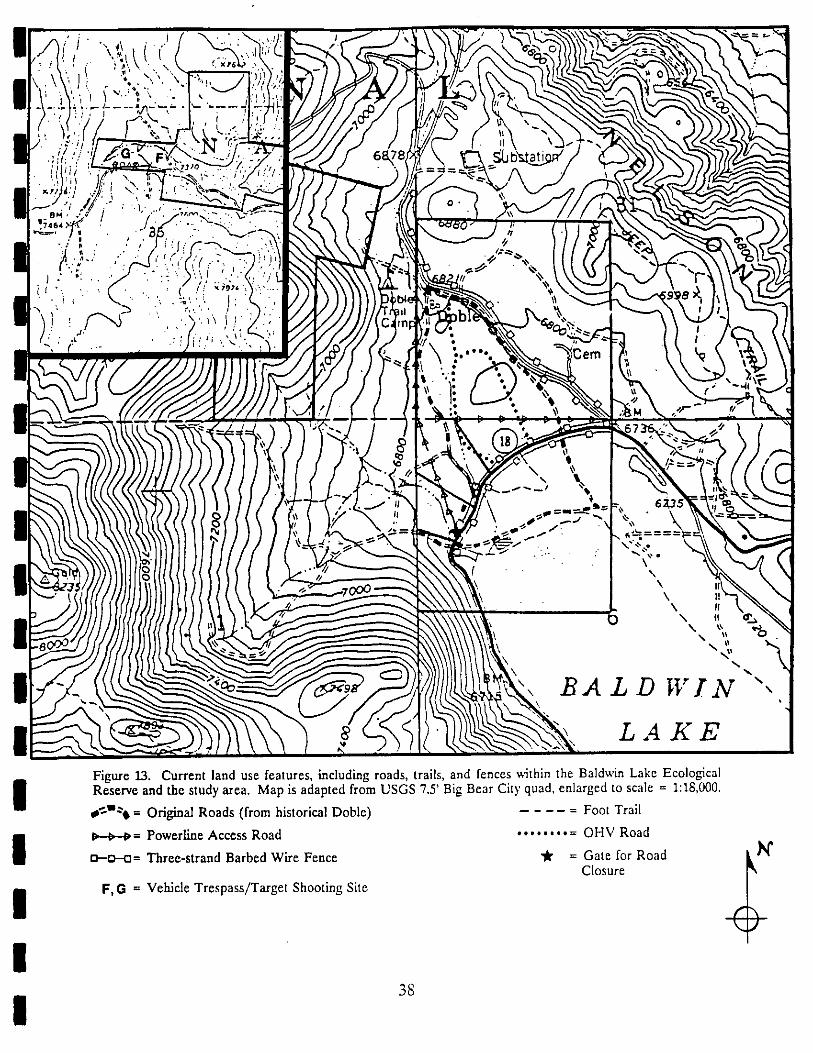
I Reserve and the study area. Map is adapted from USGS 7.5' Big Bear City quad, enlarged to scale = 1:18,000@¢llel = Original Roads (from historical Doble) ..... Foot Trail
_ _= Powerline Access Road ......... OHV Road
I t_--_= Three-strand Barbed Wire Fence _ = Gate for Road Ii I_l_Closure
i F,G = Vehicle Trespass/Target Shooting Site
I

!I Roads and Trails
i The California Department of Fish and Game lands within the study area were ownedby the Nature Conservancy until their purchase by the State in 1986. In 1986 and 1987, abarbed wire fence was erected along the Highway 18 boundaries of the property. The
i property on either side of Holcomb Valley Road was also fenced at this time; this fenceprotects pebble plains and associated habitat under U.S. Forest Service management. Thelocation of existing fences and other current land use features is shown in Figure 13; these
i features are referred to in the text by letters of the alphabet as indicated on the map.At present there is only one established trail within the CDFG lands; in most cases
old roads serve as trails. This trail (indicated with an "X" in Figure 13) is located on the
I east side of Hwy 18, through the area where Thelypodium stenopetalum and Sidalceapedatagrow. The trail has 10" round cement stepping stones to prevent trampling of the habitat;these stones extend for approximately 50 yards from the road. Burros also use this trail as
I it is the only place where there is a pass-through in the fence. Impact to the rare planthabitat could be minimized by relocating this trail.
I There are a series of roads that cross through the CDFG and Lamane-east parcels.These roads are shown in Figure 13. Some of these roads were established by early minersand residents of DoNe; these roads are indicated as "A" and "B", both are evident in 1938
I aerial photographs of the site. Road A was used by miners and residents of Doble as themain road to Hwy 18 before the existing Holcomb Valley Road was built (Core 1988). TheHolcomb Valley Road is first evident in 1949 photographs.
I One of the roads which cuts on a southeast-northwest diagonal across the CDFG landsis an access road to the Southern California Edison power line. This road continues north
I to Holcomb Valley road along the boundary between sections 31 and 36, and east along theboundary between sections 31 and 6, across the "Knoll" pebble plain. The latter section ofthe road, indicated by a "C" in Figure 13, is first evident in 1965 photographs of the site.
I The other sections of this road are not evident until 1983 aerial photographs.Off-Highway Vehicle Use
I The remainder of the roads on the property are apparently the result of vehicle activitysince 1965. Prior to the fencing of the perimeter along paved roads, there was a serious
I problem with OHV-trespass. Access to the CDFG parcels on the west side of H_3_ 18 hasbeen limited by the three-strand barbed wire fence and locked gates at all roads. Off-road vehicle trespass has not been a problem in the last several years (Coelho 1988).
I There is a problem with OHV access to the CDFG property on the Hw3'lake side of
18. During periods when Baldwin Lake is dry it is an attractive site for OHV enthusiasts.Access to this property is from the dry lake to the south. Occasional vehicle trespass might
I of little-used roads travel north to 18 (indicated byinvolve using one the existing to Hwya "D" on Figure 13). This activity could threaten rare plant habitat although to date therehas not been this kind of problem; however, during certain times of the year (particularly
I winter and summer) vehicle the lake is common (Coelho 1988).trespass on
I39
I
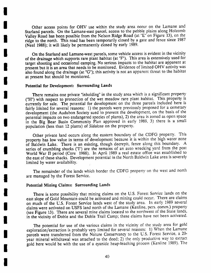
!I Other access points for OHV use within the study area occur on the Lamane and
Starland parcels. On the Lamane-east parcel, access to the pebble plains along Holcomb
I Valley Road has been possible from the Nelson Ridge Road (at "E" on Figure 13), on theridge to the north. This road has been temporarily closed by a gate and fence since 1987(Neel 1988); it will likely be permanently closed by early 1989.
I On the Starland and Lamane-west parcels, some vehicle access is evident in the vicinityof the drainage which supports rare plant habitat (at "F"). This area is extensively used for
i target shooting and occasional camping. No serious impacts to the habitat are apparent atpresent but it is an area that needs to be monitored. Evidence of limited OHV activity wasalso found along the drainage (at "G"); this activity is not an apparent threat to the habitat
i at present but should be monitored.Potential for Development: Surrounding Lands
I There remains in the studyarea whichis a significantpropertyone private "inholding"
("H") with respect to protection of the wet meadow rare plant habitat. This property iscurrently for sale. The potential for development on the three parcels included here is
I limited for several reasons: 1) the parcels were previously proposed for a cemetaryfairlydevelopment (the Audubon Society sued to prevent the development, on the basis of thepotential impacts on two endangered species of plants), 2) the area is zoned as open space
I in the Big Bear Basin Community Plan approved in early 1989, 3) there is a smallpopulation (less than 12 plants) of Sidalcea on the property.
I Other private land occurs along the eastern boundary of the CDFG property. Thisproperty has low value in terms of development because it is within the high water zoneof Baldwin Lake. There is an existing, though decrepit, fence along this boundary. A
I series of crumbling shacks ('T') are the remains of an auto wrecking yard from the postWorld War II period (Core 1988). In April 1989 a real estate office was established tothe east of these shacks. Development potential in the North Baldwin Lake area is severely
I limited by water availability.
The remainder of the lands which border the CDFG property on the west and north
I are managed by the Forest Service.Potential Mining Claims: Surrounding Lands
I There is some possibility that mining claims on the U.S. Forest Service lands on theeast slope of Gold Mountain could be activated and mining could occur. There are claims
I on much of the U.S. Forest Service lands west of the study area. In early 1989 severalclaims were activated on USFS land north of the Lamane (Kenline, pers. comm.) property(see Figure 13). There are several mine claims located to the northwest of the State lands,
I in the vicinity of Doble and the Doble Trail Camp; these claims have not been activated.The potential for use of the various claims in the vicinity of the study area for gold
i exploration/extraction is probably very limited for several reasons: 1) When the Lamaneparcels were transferred from the Nature Conservancy to the U.S. Forest Service, a 20-year mineral withdrawal was attached to the deed; 2) the only productive way to extract
i gold here would be with the use of a cyanide heap-leaching process (Kenline 1989). The
40
I
!I approval of a cyanide-leaching operation is very unlikely (Kenline 1989); 3) the economic
value of the gold residues in the N. Baldwin Lake area west to Jacoby Creek is probably
I low (Kenline 1989).Baldwin Lake Level: Recreational Use
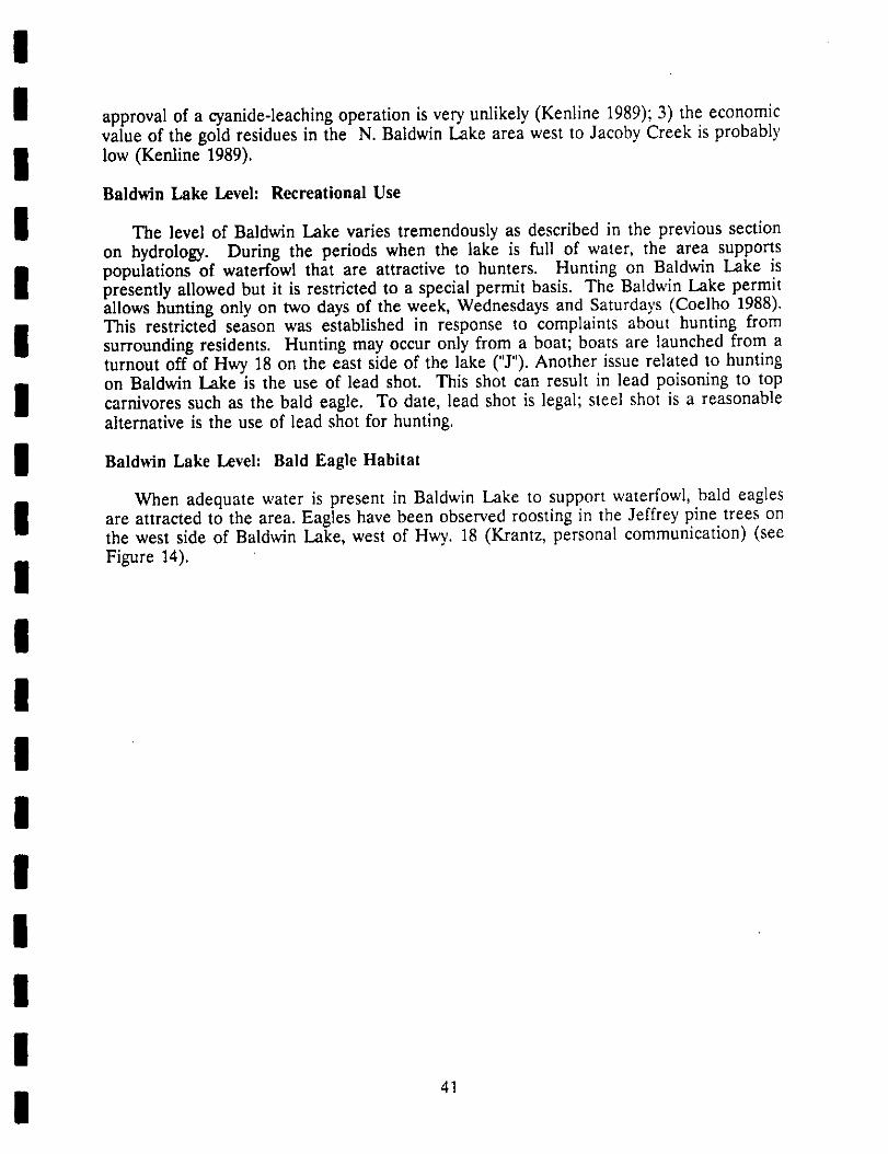
I The level of Baldwin Lake varies tremendously as described in the previous sectionon hydrology. During the periods when the lake is full of water, the area supports
I populations of waterfowl that are attractive to hunters. Hunting on Baldwin Lake ispresently allowed but it is restricted to a special permit basis. The Baldwin Lake permitallows hunting only on two days of the week, Wednesdays and Saturdays (Coelho 1988).
i This restricted season was established in response to complaints about hunting fromsurrounding residents. Hunting may occur only from a boat; boats are launched from aturnout off of Hwy 18 on the east side of the lake ("J"). Another issue related to huntingon Baldwin Lake is the use of lead shot. This shot can result in lead poisoning to top
I carnivores such as the bald eagle. To date, lead shot is legal; steel shot is a reasonablealternative is the use of lead shot for hunting.
I Baldwin Lake Level: Bald Eagle Habitat
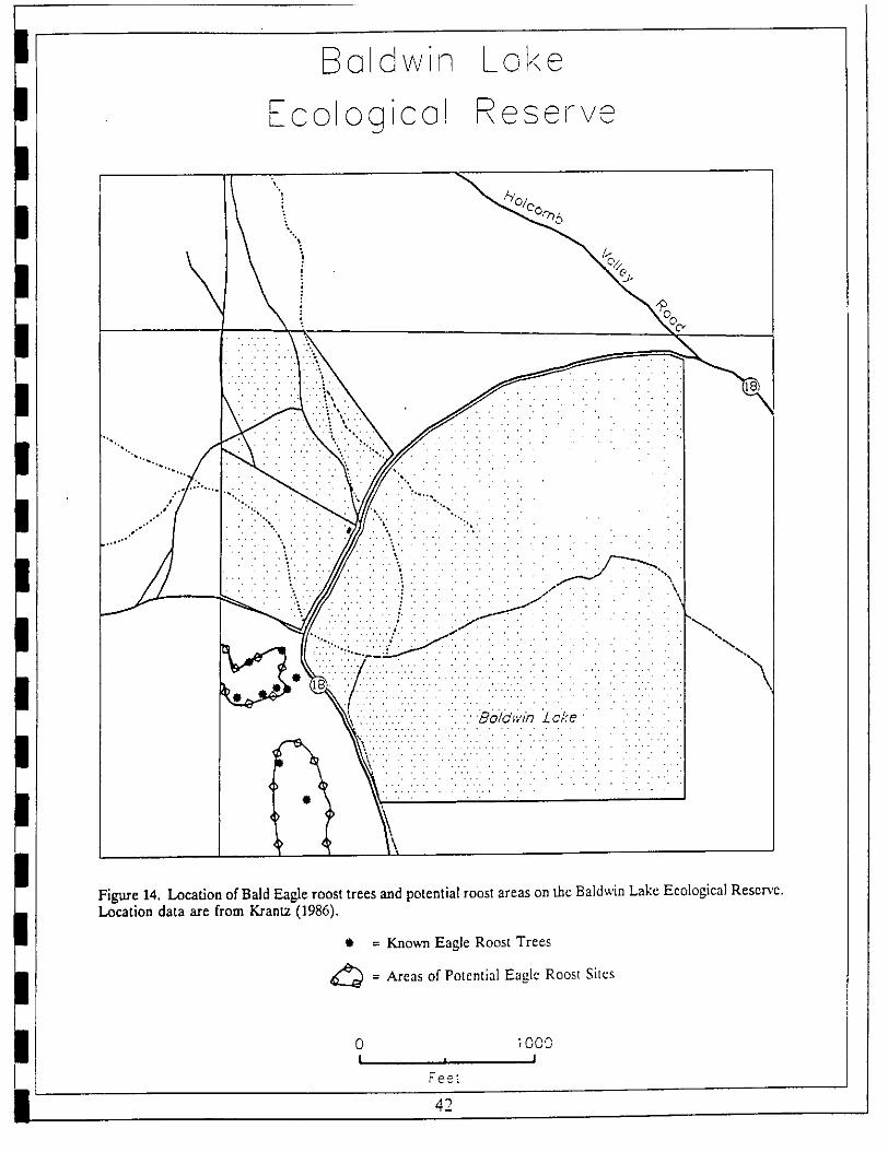
When adequate water is present in Baldwin Lake to support waterfowl, bald eagles
I are attracted to the area. Eagles have been observed roosting in the Jeffrey pine trees onthe west side of Baldwin Lake, west of Hwy. 18 (Krantz, personal communication) (see
i Figure 14).
!III!IIII 41
E_aldwin Loke
FcologicoJ Reset're
• _- - -'.i-_- " .: --" -. ---'.',
......." i iI :i i 'i"_i: iI i: i:_ ii :."..:ii ;i-i: //'ii :i ::• i " : i : i i .i ii iI i: '
_::S i!i!i:ii:/iiiiiii_ :ii__:::_:i!:!!!\"xl
1'4 _;::......... " '
Figure 14. Location of Bald Eagle roost trees and potential roost areas on the Baldwin Lake Ecological Reser,'e.Location data are from Krantz (1986).
• = Known Eagle Roost Trees
_= Areas Potential Eagle Roostof Sites
0 t000| i I
Fee_
42

!I PART lh SPECIES MANAGEMENT GOALS
I This section reviews background information on systematics, habitat, distribution,current status, historical distribution, and ecology of rare species of plants and animals or
I special habitats on the study area. The factors which may limit the populations of thesespecies are discussed. Management actions already taken to protect the species are listed.The threats to each of these species and the potential for recovery of degraded populations
i are also addressed. These data are used to develop a series of management goals tomaintain viable populations of species or areas of habitat. The possibility of increasing thepopulations/habitats are addressed by enhancement goals.
I this section include those with federal orThe individual species considered in only
state-listed status. Since the two listed plant species occur together at this site the speciesmanagement goals are essentially the same. These are stated following the background
I information these This is followed by a description for the one listedon two species.
animal species. Other rare plant species are covered in this section under the specialhabitat in which they occur. Species management goals for these habitats are listed
I following the background information for each one.
I SPECIES ACCOUNTS
Bird-footed Checkerbloom (Sidalcea pedata)
I Description. The bird-footed checkerbloom is a many-stemmed perennial, 2-4 dm. tallfrom a fleshy taproot (no rhizomes). The species is distinguished by the mostly basal leaves
I which are 3(-5)-lobed. The cauline leaves are divided into three primary segments, whichare further dissected into linear segments. The five-parted flowers, which occur in terminalracemes, may vary in color from pink to magenta with pale white stripes. The petioles are
I distinctively bright red. The carpels are smooth, another distinguishing feature.Habitat. This checkerbloom is restricted to vernally wet meadows and sparsely vegetated
I dry meadows in the Big Bear Valley, San Bernardino Mountains. The wet meadow habitatoccurs where heavy clay soils coincide with wet areas. Within the wet meadow habitat thecheckerbloom tends to occupy the upland sites where conditions are slightly drier;
I individuals generally are not found in the dense rush and/or sedge thickets typical in thelow spots of drainages. At Baldwin Lake this species is most common along the uppermargins of the small drainages.
I _. The historical distribution of the bird-footed checkerbloom is thought tohave been much more extensive prior to the development of Big Bear Dam in the 1890's.
i Early botanists, notably Samuel Parish (1838-1928), reported that the lower parts of BigBear Valley were a green subalpine meadow; Parish reported the checkerbloom as"frequent in the meadows of Bear Valley" (Parish 1917 (from Krantz 1983a)). Subsequentdevelopment or recreational activities in the Big Bear Basin have eliminated much of the
I wet meadow habitat essential to the bird-footed checkerbloom.
I43
I

!
I The present distribution of this species is restricted to twelve occurrences (Cox 1986) inBig Bear Valley. This species has not been known to occur naturally in the adjacent
I Holcomb Valley; approximately 20 checkerblooms were transplanted from a threatenedsite to Holcomb Valley in 1986; the status of these plants has not been determined. Theonly populations of Sidalcea pedata in a fully protected status are those at Baldwin Lake.
I Other populations at Metcalf Bay, Bluff Lake, Eagle Point, and Pan Hot Springs arepartially protected by landowner agreements in the case of the first three. The NatureConservancy is currently negotiating with the Big Bear City Community Services District,
i owners of the Pan Hot Springs property, for a conservation easement of the rare planthabitat. The distribution and population status of this species was documented by Krantz(1983b).
I St_tlas of Popol_tion on Reserve. The bird-footed checkerbloom occurs in four locationson the north shore of Baldwin Lake; three of these locations are within the CDFGboundaries and the fourth, a very small population of 2 to 6 individuals (Krantz 1988), is
I on private land. In the 1988 season, approximately 130 wereindividuals counted in
drainage "A" (Figure 11). The species was not surveyed at the other two sites on CDFGland and was not present at the site on private land.
I In 1989 a much more thorough count of this species was made. Wit'hin drainages "A" and"B" all individuals were counted as either plants with flowers or plants without flowers. The
I results of these counts are given in Table 6.
I Table 6. counts for Sidalcea pedata in three subpopulations at North BaldwinPopulationLake.
I No.ofPlants No.ofPlants
Subpopulation With Flowers Without Flowers Total
I DrainageA 689 1322 2011WestofHwy.18 (138) (298) (434)
I EastofHwy.18 (551) (1026) (1577)
DrainageB 117 71 188
!I Limiting Factors. The primary limiting factor for Sidalcea pedata appears to be theavailability of sufficient soil moisture. Though no quantitative research has been conducted
on habitat requirements for this species, the presence of clay soils is also a consistent
I habitat characteristic. The maintenance of hydrologic conditions within the wet meadowhabitat is of critical importance to this species' survival.
I Threats to Populations. The greatest threat to the continued existence of bird-footedcheckerblooms at Baldwin Lake is alteration of soil moisture conditions. Another threat
to the populations, OHV trespass, has been only partially controlled. The access to the
I wet meadow habitat from Hwy 18 has been fenced to prevent vehicle trespass; a limited
I 44

!I threat of vehicle trespass from the dry lake bed to the south is present. Vehicle activity
could impact the Sidalcea population in the northeast corner of the CDFG lands. To date,
I no significant trespass is evident at this location.Another potential threat to the checkerbloom is trampling by burros and/or humans. At
I present there is only one location where a burro trail crosses the checkerbloom habitat.This trail could be closed off to prevent burro access. Burro activity is on the increasewithin the Big Bear Ranger District (Malachek 1988). Relocation of a pass-through in
i the fence along Hwy 18 would probably reduce burro trampling in the wet meadowhabitat.In addition to trampling, there may be some evidence that burros are eatingcheckerblooms. In May 1989, approximately 60% of the individuals in one population had
i the flower stalks clipped off; this damage might also be caused by rabbits.Management Actions Completed. Actions already taken to protect this species includecompletion of fencing along both sides of Hwy 18 in 1986. Some interpretive programs
I the about the at Baldwin Lake have been presented by theto educate public rare plantsFriends of the Big Bear Valley Preserve, a local support group for the Nature Conservancy.
I Recovery Potential. The only evidence of degradation of the checkerbloom populationswithin ttie study area is the clipping of flower stalks. It is not known whether this predationis by burros or rabbits. Several steps can be taken to prevent degradation; these are
I described under the species management goals.
I Slender-petaled Thelypodium (The_ypodium stenopetalum)
Description. The slender-petaled mustard is a glabrous, glaucous biennial with simple
I stems 3 to 8 dm tall; there may be one to several branches per plant. The many-floweredinflorescence has small whitish petals, 10 to 14 mm long. The calyx has a purplish tingewhich gives the inflorescence a purple hue. This species can be distinguished by the
I oblanceolate leaves of the basal rosette, which whither soon after anthesis. The caulineleaves are sagittate or auriculate-clasping at the base. The plant is generally glaucous, oftenwith a purplish cast to the leaves.
I Habitat. This species tends to occupy the drier upland portions of wet meadows or sparselyvegetated dry meadows. The locations where it occurs at Baldwin Lake are dominated by
I open sagebrush scrub vegetation. The plants are often seen growing up through thesagebrush shrubs; these individuals can be nearly 1 m tall. These sagebrush scrub sites areclosely associated with wet areas along the margins of drainages or low areas where water
I collects in the spring. Associated species include Artemisia tridentata, Gutierrezia sarothrae,lris missouriensis, Castilleja cinema, Distichlis spicata, Oenothera caIifomica, and Linumlewisii.
I Distribution. Once more extensive around Big Bear Valley, the populations of this specieshave been restricted as a result of inundation of Big Bear Lake, and disturbance of itshabitat as a result of development. At the present time there are six known occurrences
I for this species; three of these populations are protected one populationand will be
protected. The population size was determined for each of these sites in 1989; the largest
I45
I
II population is at Eagle Point. Additional information on the annual variation in size and
density of these populations is needed.
Status of Ponulation on Reserve. There are two known populations of the slender-petaledthelypodium on the Baldwin Lake CDFG lands (see Figure 4). The only one in evidence
I in the dry 1988 season occurred on the east side of Hwy 18, adjacent to the small drainagethat supports Sidalcea pedata. Only 11 individuals were counted in 1988. In 1989 a morethorough survey was conducted but again plants were found only in the same area. In 1989
I there were 29 plants counted.Limiting Factors. The potential habitat for this species is limited on the site. However,
i the parameters of the habitat for this mustard have not been studied or defined. Thespecies occurs in association with wet meadow sites so soil moisture is apparently a criticalfeature. The clay content of the soil is also important, although no quantitative data are
i available regarding the specific soil characteristics this species prefers.Threats to Populations. The significant threat to the species is the trampling of individualplants by burros and, to a lesser degree, by humans. Burro and human trails both pass
I the habitat. The burro trail apparently established during the 1988directly through was
season by burros moving from the west side of Hwy 18 toward the lake. There is also alimited threat of OHV trespass in the second population of this species, in the northeast
I of the CDFG This is the same area described as potentially threatenedcorner property.in the section on Sidalcea pedata.
I Alterations in surface or subsurface hydrology could also impact the slender-petaledthelypodium populations. This might occur if development were to take place on the so-called "Cemetary" parcel, upslope of the mustard populations.
I Management Actions Completed. The protection of this species has been promoted bythe completion of a fence along H_3' 18 in 1986. However, a break in the fence directs
I foot travellers on a trail through the middle of the mustard habitat. Cement steppingstones (12" diameter) have been placed along the trail to prevent direct trampling of theplants.
I Recovery. Potential. The degradation of habitat for the slender-petaled mustard appearsto have increased from 1988 to 1989. Trampling by burros or humans should be terminated
I by removing the trails or old roads which pass through the population. The potential forenhancing the species' populations has not been addressed at this or any other site.Monitoring is needed to determine annual population size and trends.
IUnarmored Three-spined Stickleback
I (Gasterosteus acu/eatus ssp. williamsom')Description. The unarmored three-spined stickleback is a subspecies of the three-spined
i stickleback which is identified by the absence of armored plates on the back. The speciesis identified by sampling a portion of the population. From a sample of no less than 15fish, 50% of the adults will have 2 plates or less or 50% will be plateless (Malcolm 1988).
I The fish that occur in Baldwin Lake when water is present are genetically related to fish
I 46
present in perennial pools above and below Shay Meadow at the south end of BaldwinLake. The subspecies was first described from a population in the Santa Clara River.Though the taxonomy is not fully confirmed, there is some indication that the Big Bearpopulations may be genetically distinct from the Santa Clara River populations. Hence, atthe present time the Big Bear populations are allied with the ssp. williamsoni awaitingfurther clarification of their taxonomic status (Malcolm 1988).
Habitat. This species occupies shallow waters, 2 to 3 feet deep, in perennial pools orstreams in the Big Bear basin. The fish may occur in open or sheltered areas of the pool.They can tolerate high alkalinity/salinity levels in the water; quantitative data on the habitatcharacteristics of the species are currently being gathered (Malcolm 1988). Sticklebacksmake their nests in shallow protected waters along the margins of the pool or lake wherethey occur. Nests are probably associated with vegetation along the water margins.
Distribution. The known local populations of the unarmored three-spined stickleback arelimited to two occurrences near Shay Meadow. At both of these sites, perennial pools aremaintained to provide habitat for this species. Sticklebacks have been collected from thenorth shore of Baldwin Lake by Dr. James Malcolm, most recently in August 1985. Thus,during periods of high water in Baldwin Lake, a population of fishes colonizes the lakeportion of the CDFG lands. This population is derived from a "seed" population in theShay Creek pool.
Status of Population on Reserve. The occurrence of this species on the reserve is limitedby the presence of high water in Baldwin Lake. There is no quantitative data on thenumber of fish that might occur within the study area during these periods. Preliminarysampling of fish populations in the two perennial ponds was initiated in in 1988. At theShay Meadow pool, 240 fish were captured in a minnow trap during a four-hour period inSeptember (Stephenson 1988).
Limiting Factors. Not enough data is currently available to determine limiting factors forthis species.
Threats to Population. The occurrence of sticklebacks at North Baldwin Lake is contingenton the appropriate water level. Threats to the species are primarily from destruction ofhabitat as a result of alterations in hydrology. The apparently natural wet-dr3, cycle inBaldwin Lake indicates that a water level sufficient to maintain a permanent population ofsticklebacks in north Baldwin Lake will occur only during wet years. As long as thepopulations in Shay Creek are maintained, fish can reinvade Baldwin Lake during wetperiods.
The species apparently is not adversely affected by hunting activity on the lake or by thepredation by grebes, mergansers, and herons (Malcolm 1988).
Recovery P0_;en_ial. The recovery of this species within the reserve area would requirepermanent stabilization of the level of Baldwin Lake. Representatives of the Big BearCity Community Services District have indicated a long-term goal of stabilizing the lakelevel to enhance its recreational values. The sources for adequate water supplies toaccomplish this goal have not yet been determined. Historic data seem to indicate thalcycles of wet and dry years are normal for Baldwin Lake.
47

!!
HABITAT/SPECIES ACCOUNTS
IManagement concerns for the remaining rare species on the study area are addressed
i under the habitat in which they occur. Long-term maintenance of these species is assumedto depend on long-term viability of their habitats. Species Management goals follow eachhabitat description.
l Pebble Plain
I Pebble islands of low-growing vegetation within forests ofDescription. plains are sparse,Jeffrey pine or woodlands of pinyon pine. The plains typically occur on level or gentlysloping sites. They occur in areas where clay soils are intercepted by saragosa quartzite
I rock The treeless pavements show no evidence of ever having supported treespavements.
(Derby and Wilson 1978); they appear to represent a topographic-edaphic climax within thesurrounding Jeffrey Pine Forest or Pinyon Pine Woodland.
I The flora and physiognomy of the pebble plains share many characteristics with an alpinehabitat, dominated by caespitose perennials, cushion plants and dwarfed annuals (Derby and
I Wilson 1978). For the San Bernardino Mountains, pebble plains are identified based onthe presence of two endemic plants, Eriogonum kennedyi ssp. austromontanum and Arenariaursina. The distribution and abundance of these species varies from site to site and within
I a pebble plain due to local variation in topography. Some of the pebble plains are almostexclusively populated with caespitose perennials and annuals. At other sites the dwarfsagebrush, Artemisia nova may represent 50% or more of the cover. Pebble plains in
I Holcomb Valley are partially tree-covered.Distribution. The pebble plains occur in an area of approximately 155 km of the
I northeastern San Bernardino Mountain Range (Derby and Wilson 1978), centered aroundHolcomb and Big Bear Valleys. They are found within an elevation range of 1830 to 2288m. Other similar "pebble plains" occur at Table Mountain (Thorne 1976) and at Garner
I Valley, San Jacinto Mountains (Hamilton 1988). Species composition at these latter sitesis distinctively different.
I The pebble plains in the San Bernardino Mountains occur in clusters of "islands"surrounded by forest vegetation. There are 12 sites where the 3, occur; these sites haveexperienced varying degrees of disturbance although most are now in a protected status
i (Neel 1988).Status of Habitat on Reserve. Within the study area, including CDFG, USFS, and TNClands, there are at least four pebble plains; within the CDFG parcel there is one pebble
I plain which occurs half on Department land and half on USFS pebbleland. Each of the
plains has received at least some disturbance, primarily due to access roads or OHV travel.Another disturbance factor which affects CDFG lands in particular is the collecting of
I saragosa quartzite rocks from the pebble plains; these are gathereddistinctive rocks for
decorative purposes. Their removal is usually evident on the pebble plains by the large
I48
I
II holes that are left behind. Other potential sources of disturbance include changes in
hydrology, burro activity, and human trampling.
I Limiting Factors. The occurrence of pebble plains is limited by topographic and edaphicfactors. These include level or gentle slopes, high percentage (e.g.. 53% (Derby and Wilson
i 1978)) of clay in the soil, saragosa quartzite rock pebbles, elevations between 1830 and 2288m,
i Threats to Habitat. At present, the most significant threat to the pebble plains, OHVactivity, has been controlled by fencing of the perimeter access from Hwy 18. OHV activityresults in roads or tracks which disturb the surface soil structure and destroy plants.
i Disturbance of the soil profile and surface topography may result in changes in hydrology.that might impact rare species. Rock collecting has been controlled by the restricted access;the large holes left by collectors are still very evident on the pebble plain on CDFG lands,behind the "horse house". The impacts of human trampling and burro activity, are not
I conspicuous; increased interpretive use the area create a trampling problem.of could The
impact of burros is not clearly evident. The burros use the pebble plains at least some of
i the time for foraging; their droppings are scattered on all the pebble plains.Another potential threat to the long-term maintenance of pebble plain habitats isencroachment of tree species. Derby and Wilson (1979) found that densities of pebble
I endemic species was inversely correlated with litter buildup and light intensity underplaintree canopies. Potential encroachment begins with tree or shrub seedling establishmentunder existing tree canopies; they found that in no case was a tree seedling found outside
I an existing tree or shrub canopy. Examination of aerial photographs of the North BaldwinLake study area from 1938 and 1988 suggests that encroachment occurs very slowly, if atall, along the margins of the pebble plains. The presence of newly established trees in in
I 1988 photographs was not obvious on pebble plains within the study area. However, in non-pebble plain vegetation "new" trees are conspicuous on these photographs. Monitoring offorest encroachment is needed to assess the impacts of this long-term trend.
I M_nagement Actions Completed. The boundaries of both CDFG and USFS lands alongHwy 18 and Holcomb Valley Road were fenced in 1986. On one of the pebble plains on
I the Lamane-east (U.S.F.S.) parcel a truck track established during wet weather left deepruts in the surface. Water bars were installed in 1987 to reduce erosion and encourage
recontouring of the slope. Unauthorized OHV access from surrounding lands is being
I limited by U.S.F.S. road closures on Nelson Ridge (in 1988-1989).Recovery_ Potential. The effects of changes in hydrology as a result of established roads
I need to be determined. The desirability of recontouring the surface topography in theseareas needs to be assessed. Revegetation of the roads is occurring naturally and is probablyadequate to eventually satisfy recovery goals. Species composition of rcvegetated areas
I needs to be monitored. At one site on the Lamane-east parcel, a recovering road is heavilypopulated with matchweed, Gutierrezia sarothrae; this species is scarcely present onundisturbed portions of the pebble plain.
II
. 49
!Wet Meadow
The listed species associated with wet meadow habitats were addressed individually at_1 the beginning of the section. Other species associated with wet meadow habitats includeI
Taraxacum californicum (TACA) and Poa atropurpurea (POAT).
i Description. Low-lying or drainage areas by heavy clayswales underlain soils. These areas
collect precipitation and runoff from surrounding slopes and drainages. They are generallyvernally wet but may have persistent soil moisture into the summer in wet years.
I Dominants include various rushes (Juncus spp.), sedges (Carex spp.), spike-rush (Eleocha_sspp.) and Missouri iris.
I Distribution. Wet meadow habitats are present in the Big Bear and Holcomb valleys ofthe Big Bear area. Three of the four rare species are San Bernardino Mountains endemics(SIPE, THST, TACA) and one is a Southern California endemic (POAT). Wet meadow
I habitat which supports these species has been impacted by development and recreationaluse in the area. This habitat occurs at less than 15 sites within the Big Bear RangerDistrict.
I_ Status of Habitat within Reserve. The wet meadow habitat occurs at five sites within thestudy area. However not all the associated rare species occur at all sites. Poa atropurpurea
I. is known from only two of the sites; Taraxacum californicum is known at two sites.Limil/ing Factors. Wet meadow habitat and the associated rare species occur where heavy
I clay soils intercept high soil moisture. California dandelion appears to favor sites wherethe ground is saturated or inundated; it is not found in the drier portions of these wetmeadows.
I Threats to Habitat/Species. The most significant current threat to wet meadow habitat,specifically where Taraxacum californicum occurs, appears to be invasion of the exotic T.
II officinale. This common weed seems to colonize areas previously disturbed by burros, as
| well as other disturbed ground. Alteration of surface hydrology is a potential threat.
i Management Actions Completed. The reduction of general disturbance in the study areawas accomplished with the completion of perimeter fencing in 1986. Manual removal ofTaraxacum officinale from one wet meadow site was accomplished by Tim and Ariel Krantzin 1987.
I' Recovery_ Potential. The immediate need for recover 3, within this habitat is at theCalifornia dandelion population near Bluebird Spring (See Figure 8). The prevention of
I burro access and removal of common dandelion (and hybrids which may be present)any
must be accomplished prior to recovery efforts. Evaluation of the need for enhancementof wet meadow species should follow completion of these efforts.
IVernal Creek
De_cripfi0n. Vernal creeks/drainage areas are drainages that flow only intermittently thatare underlain by heavy clay soils. These annual creeks or drainages may be similar to wet
I50
I
!I meadows and some rare plant species occur in both habitats. Vernal creeks are
distinguished by the rare species they support, including Mimulus exiguus, Mimuluspurpureus, and Orthocarpus lasiorhynchus. Within the study area, the vernal creek habitat
I occurs in a drainage on the Starland (TNC) parcel. This drainage is deeper and moresparsely vegetated than the typical wet meadow drainages. These drainages appear to besubject to a much greater degree of scouring during flooding events than drainages which
I support wet meadow vegetation.
Distribution. Vernal creeks or drainages which support rare plant habitat are very limited
I in occurrence within the Big Bear Basin. They tend to be associated with pebble plains,so are subject to similar disturbance factors. Other good examples of this habitat occur atCastle Glen (TNC) on the south side of Big Bear Lake, Eagle Point (TNC), a remnant wet
I meadow on the south side of Big Bear Lake, and Upper Sugarloaf (U.S.F.S.), a series ofpebble plains on the north-facing slope of Sugarloaf Mountain.
I St_,'_psof Habitat on Reserve. The primary habitat for vernal creek species occurs in ashallow drainage on the Starland tract. Two other local occurrences of Mimulus exiguushave been documented: one on CDFG land near Hw3' 18 and another on the "Cemetary"
I, parcel (see Figure 8).Limiting Factors. This habitat is limited by the presence of adequate precipitation/runoff
I and heavy clay soils. The species are sensitive to annual variations in water availability;' most of the species were observed in very low numbers (Mimulus purpureus, Orthocarpuslasiorhynchus) or not at all (Mimulus exiguus) in 1988 and 1989.
Management Actions Completed. No specific management actions have been taken toprotect this habitat. Access to the drainage on the Starland parcel is unrestricted from
i U.S.F.S. road 3N02 and Holcomb Valley Road. One population of eye-strain monkey-flower occurs on private, unprotected land.
I!IIII!i
51
I
!I SPECIESMANAGEMENTGOALS
IBird.footed Checkerbloom (Sidalcea pedata)
i Slender-petaled Thelypodium (The_pod/um stenopetalum)
The ultimate goal of the management program for the Baldwin Lake CDFG property
l and adjacent lands is to insure the continued survival of the rare plant and animal speciespresent there.
I 1. Maintain Viable Populations of Rare Species. This goal is the ultimate purpose behindthe management of the study area. Because of the size and configuration of the landswithin this unit, the goal must also be applied to management of surrounding lands.
I 2. Maintain Current Hydrologic Conditions to Support Rare Plant Habitat. Alteration ofcurrent hydrologic conditions would seriously impact the survival of rare species.
I 3. Protect Populations of Rare Species From Negative Impacts. The potential for damagefrom human activities or exotic species must be considered in protection efforts.
I' 4. Gain More Thorough Understanding of Rare Species Biolo_/Ecological Requirements.Without baseline information on the population status and ecolo_, (vigor, demography,habitat requirements, survivorship) of these species there is no basis for evaluating the
i success of management practices.
i 5. Evaluate the Need for Enhancement of Populations of Rare Species. The potentialfor increasing the population densities of rare species must be consistent with othermanagement goals. Attainment of the previous three goals is necessal3' before
i enhancement efforts can be successful.6. Establish Protection Strate_ for the Reserve and Surrounding Lands. The cooperative
i nature of the management effort at this site requires the participation of all agencies informulating a protection strategy for the stud)' area.
IUnarmored Three-spined stickleback
I (Gasterosteus aculeatus williamsom)ssp.
I Until the potential for establishing a permanent high water level in Baldwin Lake hasbeen determined, the management goals for the unarmored three-spined stickleback arelimited to strategies during periods when this animal occupies the north end of Baldwin
i Lake, during wet periods resulting from natural precipitation.
I52
I
!I I. Maintain Viable Population of Species. This goal will apply to management actions
undertaken during high water periods to insure survival of this species.
I 2. Determine Baseline Data for Pooulation. Estimates of the population of this species' during periods of occupation of north Baldwin Lake are needed to monitor populationtrends for the long-term.
I 3. Maintain and/or Enhance the Nest Habitat for Species. A significant aspect ofprotection for this species is the success of nesting. Protection of nest habitat is an
,I important part of this goal.
I HABITAT/SPECIES MANAGEMENT GOALS
I Pebble Plain
I The management goals for the pebble plains are focused on the protection of the rarespecies associated with this habitat.
I 1. M_aintain Viable Populations of Featured Species. This goal is the ultimate managementconcern; it must also be applied to surrounding lands where rare species may occur. Other
i more specific goals listed below are required for attainment of this goal.2. Insure Protection of Rare Plant Habitats from Disturbance. The most significant impacts,from vehicle access have been controlled. Assessment and prevention of other impacts is
I needed. For example,the impact on pebble plainsof wild burros is not obvious but shou]d
be evaluated over the long-term.
I Data for of Featured Species.The need fora monitoring3. Develon Baseline Populationsplan focus{ng on endemic species is essential. The data gathered in the initial years will beuseful to describe typical species composition, density, and viability for rare species. The
I necessity of some management actions can be better determined once this baseline data isavailable.
I 4. Enhance Public Awareness and Appreciation of Habitat. The development ofinterpretive programs is essential to long-term protection of habitat. Interpretive usesmust be designed to minimize impacts to rare species; potential impact should be
monitored.
5. E_tabli_h Protection Strate_wyfor Habitat. The cooperative nature of the management
I effort at this site requires the participation of all agencies in formulating a protectionstrategy for the study area.
I 6. Evaluate Need for Enhancement of Populations of Featured Species. Restoration ofdisturbed areas should be addressed under this goal. Determination of minimum viablepopulation size should also be addressed.
I53
I

!i WetMeadow
I The management goals for wet meadow habitat are identical to those stated for' Sidalcea pedata and The_podium stenopetalum (page 41). The specific objectives used toaccomplish these goals vary depending on the species involved and local disturbance factors.
I These objectives are delineated in the following section "Area Management Objectives".
I Vernal Creek
I The management goals for the vernal creek habitat and associated rare species areessentially identical to those for wet meadow habitats.
1. Maintain Viable Populations of Featured Species. This is the ultimate goal formanagement of this habitat. Other more specific goals listed below are required forattainment of this goal.
I 2. Maintain Current Hydrologic Conditions to Support Rare Plant Habitat. Alteration ofcurrent hydrologic conditions would seriously impact the survival of rare plant species.
i 3. Protect Populations of Rare Species from Negative Impacts. This goal includes allprotection measures from acquisition of relevant properties to fencing to exclude vehicles.
I 4. Determine Baseline Data for Rare Species. The development of a monitoring programfor rare species will allow evaluation of the success of management practices.
I 5. Evaluate the Need for Enhancement of Populations of Rare Species. Development ofa monitoring program to assess potential impacts/population declines is an importantaspect of this goal.
I 6. E_tablish Prg(ecti0n S_rategy for the Reserve and Surrounding Lands. Though thishabitat does not occur on the CDFG lands, the cooperative nature of the management
I effort at this site requires the participation of all agencies in formulating a protectionstrategy for the study area.
Ii!!
| 54
i
!n PART III: AREA MANAGEMENT OBJECTIVES
N This section presents a discussion of the objectives and actions for accomplishing thespecies management goals put forth in Part II. The biological, physical, administrative, and
I financial implications of these objectives are also described. The attainment of goals andobjectives through the cooperative effort of the participating agencies is delineated. Theneed for staff participation and financial support of management programs is included in
N the context of a cooperative effort. Specific objectives are defined in the following areas:. Assessment and Monitoring objectives, including those necessary to evaluate managementneeds/techniques; Protection objectives, including acquisition, interpretive, and regulatory
needs; Manipulation objectives, including restoration and control of exotic species. Table6 lists the major species management goals for the featured species and habitats of thestudy area and the principal objectives needed to meet these goals.
IASSESSMENT OBJECTIVES
II1. Inventory listedsensitive plant and animal species to determine population
status and map distribution.
I The most basic assessment need with respect to management is the inventory anddocumentation of listed/rare species status and distribution within the study area. Most
I of the inventory and mapping of featured species and habitats was completed in thepreparation of this plan. The results of the inventory were presented in Part I. However,because the seasons in 1988 and 1989 were very dry, a number of species were absent and
i many species were under-represented. Additional inventory and mapping of plant speciesis called for in future wet years.
n 2. Develop long-term monitoring program for listed/sensitive species.Ill
The implementation of a monitoring program for the study area will involve several
N components which focus on three basic management objectives. The first objective is toestablish a baseline of data on annual variation in rare species populations to assess trends.These baseline data can also be used to evaluate the effectiveness of management actions
N and future impacts on populations of rare species.A second monitoring objective is to document the effects of disturbance and track the
• recovery of disturbed areas. Nearly all of the roads which cross pebble plains have been!1 closed or will be closed by the end of 1989. Monitoring of the natural revegetation of these
roads is needed to document the species composition and rate of recovery. Qualitative
i observations of pebble plains during the 1988 season suggest that, at least in areas wherethe soil profile and surface topography are relatively intact, natural revegetation is sufficientto bring about eventual recovery of the site. Exceptions to this pattern may occur where
i disturbance has resulted in total devegetation of the pebble plain and subsequemdisturbance of surface topography. In some cases, recontouring may be necessary, to restorenatural hydrologic conditions. This is likely for the largest pebble plain on the Lamane-
l| s5
!i east parcel (see Figure 3), where deep ruts have altered the concentration of seasonalrunoff. Water bars have been installed at this site.
i Another recommendation for the is to track the ofmonitoring on study area recoverywet meadow habitat impacted by human and burro trails. Following relocation of thesetrails, monitoring would provide data to evaluate the natural recovery of the vegetation and
i possible need for enhancement of rare plant populations.
A third objective, and one that is not a high priority at the present time, involves
I monitoring the invasion of trees and shrubs on the pebble plains. Preliminary evidencefrom aerial photographs suggests that this may not be a significant concern.
I An outline of a monitoring plan, including significant questions and suggestedmethodologies, is included in Appendix II.
I 3. Determine impacts of burros on rare plant populations/special habitats.
i The potential impacts of wild burros on rare species were evaluated in a qualitativemanner during the inventory phase of this plan. Some of the impacts are significant enoughthat they warrant action in terms of protection objectives; these objectives are delineated
I in the following section. For these cases, including impacts on habitat for two species,Thelypodium stenopetalum and Taraxacum californicum, assessment objectives includemonitoring the effectiveness of management actions.
I In the case of burro activity on pebble plains, the impacts are less clear. For thishabitat, determination of the impacts of burros would involve short-term research using
i exclosures. Barbed wire exclosures, designed to prohibit entry by burros but not by othergrazing animals (e.g. deer) can be erected on the pebble plains and sampled over time.With a proper experimental design, including control plots and replicate samples, the impact
i of burro activity can be determined. However, based on qualitative observations andcomparison with other pebble plains, the impacts of burros do not appear significant for thishabitat.
IIIIII
56
i

!
I Table 7. Summary of primary species management goals for the proposed Baldwin Lake Ecological Reserve
and adiacent lands within the study area and the principal obiectives needed to achieve each goal.
I Manaoemant Goal Obiectives and Actionsi¢,
i Maintain Hydrologic ConditionsSidalcea pedata * Determine strategy for protection/Thelypodium stenopetalum acquisition of the "cemetary" parcel
I * Determine impact of burros on wet meadowhabitat
Taraxacum califomicum . ._ * Cohtrol burro access to Bluebird Spring
I * Determine impact of burros on spring• Determine future status of artesian
well along edge of Baldwin Lake
i Wet Meadow Habitat * Determine strategy, for protection/acquisition of the "cemetary" parcel• Determine impact of burros on wet meadow
habitat
I Vernal Creek * Develop "cooperative management agreement"for U.S.F.S. and TNC lands which control
'1 drainageProtect Populations from Negative Impacts
I Sidalceapedata * Determine strategy for protection/acquisition of the "cemetary" parcel• Determine impacts/possible grazing by
burros
* Post and sign southern boundary of Reserve• Develop an interpretive program
I 77_elvpodium stenopetahml * Control burro access/trampling in" habitat
• Relocate visitor trail which is now
through habitat
I * Determine strate_, for protection/acquisitionof"cemetary"parcel• Post and sign southern boundary of
Reserve
I * Determine impacts of burros.• Develop an interpretive program
!!!!
57
!

!I Table 7 (continued)
I Management Goal Objectives and ActionsPebble Plain ' * Determine strategy for protection/
acquisition of "cemetary" parcel
I * Support closure of Nelson Ridge Rd.by U.S.F.S.• Establish cooperative patrolling program
I with CDFG, TNC, and USFS personnel• Determine impacts of burros• Develop interpretive program
I Wet Meadow * Determine strategy for protection/acquisition of "cemetary" parcel
i * Establish cooperative patrolling program' with CDFG, USFS, TNC
• Control Taraxacum officinale populationat Bluebird Spring and elsewhere
I * Develop an interpretive programVernal Creek * Fence accessto Starland Creek at UnionFlat road
I * Establish cooperative patrolling program• Develop an interpretive program.
i Determine Baseline DataAll Rare Species/Habitats * Inventory listed/sensltlve plant & animalspecies for population status/dlstributlon
t * Develop long-term monitoring program• Determine impacts of burros/exotic plants
Establish Protection Strategy
I Sidalcea pedata * Develop strategy for protection of "cemetary"parcel
• Develop "cooperative management agreement"
I betv.'een CDFG, TNC, and USFS
77telypodium stenopetahtm * Determine strate_, for protection of
i "cemetary" parcel• Develop "cooperative management agreement"
between CDFG, TNC, and USFS
I Taraxacum californicum * Develop "cooperative management agreement"between CDFG, TNC, and USFS
All Rare Habitats * Determine strategy for protection of
I "cemetary"parcel• Develop "cooperative management agreement"between CDFG, TNC, and USFS
II
58
I

4. Determine threats posed by exotic plant species to rare plants/special habitats.
Two exotic plant species were described as potential threats to the rare species. Thefirst of these, Taraxacum officinale, is a weedy species which colonizes wet areas which ishabitat for the native Taraxacum californicum. T. officinale is invasive and appears tocompete for space with the native dandelion. Because this species is so invasive, controlof its population is included as a management objective. Assessment and monitoring of theeffectiveness of removal of this species is needed as a follow-up.
Two other issues are relevant to determination of threats to the native dandelion fromits introduced relative. The first of these is the evidence of hybridization between the twoTaraxacum species; several potential hybrids were observed during the 1988 season; hybridsexhibit intermediate characteristics between the two species, although no formal descriptionof the hybrids has been published. The primary objective should be to remove Taraxacumofficinale (and all hybrids) from the area. However, to assess the hybridization problem,an annual count of the number of hybrid individuals in the population should be made. Apossible research question would involve the extent of this hybridization within the rangeof the species. For the purposes of monitoring, the number of hybrid individuals in theBluebird Spring population should be counted annually.
A second question with respect to the common dandelion is the extent to which burroactivity favors this species. Burros tend to trample and scrape in spring areas. Qualitativeobservations suggest that T. offtcinale colonizes the open ground created by burro activity.However, more information is required to address this question. A burro exclosuredesigned to exclude burros but not native grazing animals, such as deer (Blymyer 1988), isproposed. The recommended specifications are for a four-strand barbed wire fence withsmooth wires on the top and bottom. The lowermost wire is 20" from the ground, thesecond wire 35" from the ground, the third wire 39 inches from the ground (it is importantto have no more than 4" spacing on the upper wires to prevent strangulation) and the upperwire 43" from the ground (Helvie 1971). An exclosure of 5 to 10 square meters isappropriate; an adjacent area should be designated as a control. Within the exclosure fiveto six square meter plots can be sampled in a randomized block design (Zar 1984) fordensity of the two dandelion species; the same sample layout will be used in the controlarea.
The other weedy species of concern is the Russian olive, Elaeagnus angustifolia. Thisspecies does not appear to be spreading on the site; however, counts of the number ofindividuals and a survey for seedlings should be conducted annually.
59

PROTECTION OBJECTIVES
1. Determine strategy for protection of the "Cemetary" Parcel.
This property includes habitat for several rare species and influences the drainageinto wet meadow habitat for two endangered plants on CDFG lands. Protection of thisproperty is important to prevent development or other activity that would alter thehydrologic regime. The current owners of the property have demonstrated some hostilitytoward the cause of endangered species protection. Possible alternatives for protecting thisproperty include acquisition by the U.S.F.S, acquisition by TNC, a landowner agreement orconservation easement, and acquisition involving Proposition 70 (State Parks and WildlifeBond Act of 1988) funds. At the present time, the Nature Conservancy and the U.S. ForestService are making preliminary inquiries regarding acquisition (Stephenson 1988, Nee]1988). The precise boundaries of the CDFG lands should be also determined; there isuncertainty as to the location of the boundary between the "cemetary" parcel and CDFGlands along the primary drainage from Bluebird Spring.
2. Complete "Ecological Reserve" designation for CDFG property.
Official designation of the CDFG Baldwin Lake lands as an Ecological Reserve hasyet to be finalized. This designation is important for several reasons. The designationgives the land official protection status, subject to the rules and regulations of theDepartment. The designation also gives the local game warden law enforcementcapabilities with respect to issuing citations for violation of the State Fish and Game Code.The designation also gives the property official recognition within the public sector whichenhances the effectiveness of interpretive and enforcement programs.
Official designation of the Baldwin Lake CDFG lands as a reserve was initiated inApril 1989. The final designation should be completed by the end of 1989 (Gronholdt1989).
3. Develop cooperative patrolling plan.
The successful implementation of some of the protection measures described hereinwill depend on patrolling and management of incidents of trespass, vandalism etc. Atpresent the CDFG game warden is responsible for the Baldwin Lake Reserve lands.U.S.F.S. rangers patrol the federal lands. The TNC preserve manager has maintainedfences and informed trespassers of the significance of the area. Ideally, a cooperativepatrolling program could be developed. This program would give the TNC managerauthority to call the CDFG warden or USFS ranger when an incident occurs. An incidentreport form could be developed to track the kinds of incidems that occur, potential problemareas, and appropriate responses.
4. Develop "Cooperative Management Agreement" for stud)' area, to include CaliforniaDepartment of Fish and Game, U.S. Forest Service, and Nature Conservancy lands.
The contiguous nature of the lands within the study area and the distribution of rareplant species are conducive to a cooperative management program involving all three
60
!I agencies. A cooperative spirit has already developed with regard to accomplishing
management goals and a de facto cooperative relationship has existed at the site for the
i last five years.Still, an official management agreement is called for which would delineate
responsibilities of the participating agencies. This agreement could also be used to establish
I for costs of this plan.responsibilities implementation management
5. Determine appropriate policy for hunting on Baldwin Lake.
I Baldwin Lake has been used as a waterfowl hunting area during years when the waterlevel is adequate to support these wildlife. Consumptive uses such as hunting are permitted
I on ecological reserves; the policy with respect to hunting is dependent on the mostappropriate use and protection of primary resources at the individual reserve in question.Several aspects of the hunting issue have been the subject of concern. In the past, local
I residents complained about hunting on the Lake and asked the Department to disallow it;the Department responded by strictly limiting hunting on Baldwin Lake to two days a weekby permit only (Coelho 1988). Another concern with regard to hunting is the use of lead
I shot which poses a potential negative impact off bald eagles that roost around the lake andmight feed on contaminated waterfowl. Positive control measures have been taken to limitthe impacts of hunting including the two-day a week limit and a regulation that permits
i hunting only from boats. Disallowing hunting on the site might result in an increase inpoaching violations (Coelho 1988). A ban on the use of lead shot on Baldwin Lake wouldinsure protection of Bald Eagles and other predators and should be instituted.
I 6. Develop an interpretive program to inform visitors of resource values and minimizeimpacts on rare species.
I Education of the public regarding the natural resource values on the study area is aneffective way to reduce negative impacts such as trespassing and vandalism. The installation
I of a large interpretive sign or kiosk, one or more interpretive trails and the developmentof a trail brochure are all suitable components of an interpretive program. An existingfacility, the so-called "horse house" would function well as a meeting place and take-off
i point for trails. A plan to improve the house has been prepared by the NatureConservancy's Preserve Caretaker; a copy of the proposed restoration plan is included inAppendix III (Stephenson 1988). This improvement plan has been approved by regionalCDFG personnel. The repair and improvement process was begun in March 1989 and is
I proceeding well. The cost of the basic restorationhas been estimated at between $2,000
and $3,000; the Friends of the Big Bear Valley Preserve is prepared to provide some, if not
i all, of the necessary financial support.Development of an interpretive program must be based on the minimization of impacts
to rare species. The existing trail on the east side of H_ 18 (Figure 15) should be
I rerouted avoid the habitat. This trail can be moved to the southtO Sidalcea/Thelypodium
side of the drainage, allowing access to the rare plant habitat for viewing but reducing thetrampling of sensitive habitat. An existing trail is already present which could begin directly
I across the street from the horse house and pass through sagebrush scrub in a non-sensitivearea (Figure 16). Relocation of the pedestrian pass-through in the fence would also benecessary. The present pass-through should be removed to discourage burro use of this
I61
I

!I trail. An additional barrier could also be erected at the edge of the small drainage where
a burro trail currently exists through the wet meadow habitat (Figure 17).
I A suitable interpretive trail could follow existing roads behind the "horse house" toloop around the pebble plain (Figure 15); signs and plant labels could be installed alongthe route. A self-guiding trail brochure would guide the visitor through the wonders of
I the pebble plain world. The potential for cooperative development of a trail brochure isexcellent; all parties are enthusiastic about the idea. A preliminary trail route and potentialinterpretive stops were determined in a field meeting with U.S.F.S and TNC personnel in
I August 1988.
7. Post and sign the southern boundary of the Reserve lands to control trespass.
I The southern boundary of the CDFG lands is the only unrestricted access point forvehicles on the east side of Hwy 18. When it is dry, Baldwin Lake is an attractive site for
I OHV and four-wheel drive enthusiasts. Trespass onto CDFG lands is illegal but notcontrolled at present. No trespassing signs, with additional language about the sensitivenature of the habitat, need to be installed along the southern boundary; posting would also
I be a good idea along the eastern boundary. This posting would greatly facilitateenforcement of the restrictions as it would give the warden legal authority to cite trespassersfrom the State Penal Code (Section 602.m).
I 8. Contact utilities, military personnel to ask cooperation in reducing vehicle access onpebble plains.
I Powerline access roads are used routinely by utilities personnel for maintenancepurposes. Military personnel also have used the area as part of training exercises. These
i ndividuals need to be informed of the sensitive plant habitat in the area.A list of contacts is given in Appendix V.
!IIII!I
62
!

!i MANIPULATION OBJECTIVES
I 1. Implement control measures for exotic plant species.
The common dandelion, Taraxaeum officinale is such an invasive weed that efforts to
i control its spread should be implemented as soon as possible. An initial effort to reducethe population was carried out in 1988 when 700-800 plants were manually removed fromthe site (Krantz 1988). The remainder of the plants could be removed manually by a team
i of agency personnel and volunteers in 1989. Subsequent monitoring of the success of thismethod is a necessary component of this objective.
i 2. Implement measures to control wild burro access to rare plant habitat.
Burro trampling of rare plant habitat is a serious concern at two locations: 1) the
i Thelypodium stenopetalum habitat on CDFG land near Baldwin Lake; 2) the Taraxacumcalifornicum habitat at Bluebird Spring on the Lamane-east property. At the first locationan attempt to control burro access will involve relocation of the trail and fence pass-
I through as described in Protection Objective #5 above. If this is ineffective, fencing thesensitive habitat can be considered.
i At Bluebird Spring, an exclosure experiment to test the impacts of burro activity onthe relative dominance of the dandelion species is described in Assessment Objective #3;this experimental exclosure will also effectively protect at least part of the Taraxacum
I californicum population. Complete exclosure of the spring is another protection option.3. Develop strategy for control of burro population if necessa_.
I Assessment and protection objectives with respect to burro populations are aimed atdescribing and controlling burro impacts within the study area. The U.S. Forest Service,
i Big Bear Ranger District carried out a burro census (Malachek 1988) in early 1989. Theyare currently reevaluating the burro management program. Populations of this exotic speciesare not to exceed 60 animals on the district. Estimates of their present numbers range from
i 120 to 300 animals.The location of burro exclosures, trail barriers, signs, and other items described in the
i protection and manipulation objectives are shown in Figure 16.
IIII
63
!
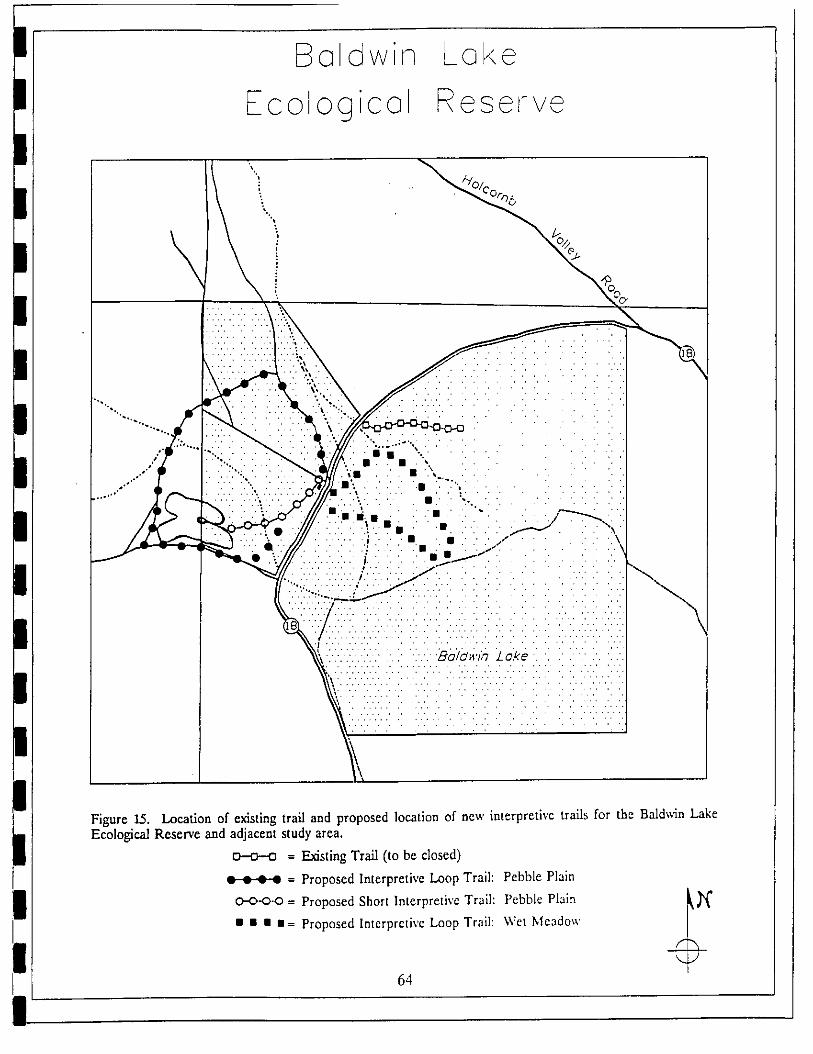
E_aldwi_s Lake
cologicol Reset-re
"_ /./
\\i ",¢Oo
• .'"'"" , ; [:i[:[i}:.iI/I:III} ,,,;.... • .., ...... .
' iS!Sl ili S\_:?] I
_',//.'.'.'"' ," '..'.. , ....................
},,Figure 15. Location of existing trail and proposed location of new interpretive trails for the Bald_'.Sn LakeEcological Reserve and adjacent study area.
= Existing Trail (to be closed)
= Proposed Interpretive Loop Trail: Pebble Plain
= Proposed Short Interpretive Trail: Pebble Plain _'_
/
• • • • = Proposed Interpretive Loop Trail: Wet Meadow -3t
64

Bmldwin Loke
Ecologicel Reserve
;!i!ii!i/ii!i!i!i:_;i!}.L .L-":} .}_..;;i ,,,i i}i;;;ii; i,} i/;i"iii}i;i
....... _"->,, -_ ":/"{i.. : :.. : i i ,_:. i
,. _:-_'-_-<'-. . .:.. ; . • "-..i
;.
"k ; ; , i ,; • , ; I
Figure 16. Location of recommended implementation actions for the proposed Baldwin Lake Ecological Reserveand adjacent lands. Map is from USGS 7.5' Big Bear City quad, enlarged to scale = 1:18,000.
It = Trail Barrier _I_ = Interpretive Sign
• = BurrowExclosure _ = Postand SignBoundary _l,
= Pedestrian Pass-through
0 100CI,,,,,_ , IFeet
65
!I OPERATIONS AND MAINTENANCE PLAN
PART IV:
This section details, in tabular format, the operations and maintenance jobs required
I fulfill the This plan includes those jobs required to attain speciesto objectives.areamanagement goals, as well as recommended jobs for maintenance of the area. Each jobis given a priority rank from 1 to 3 with 1 being the highest priority. Tables 8 and 9
I includes costs associated with protection actions for the study area.
I RESPONSIBLEACTION PRIORITY AGENCY
I I. Legal and Regulatory Requirements.
A. Department of Fish and Game Policies
I 1. Ecological Reserve designation 1 CDFGa. gives Warden enforcement authorityb. in progress by regional CDFG staff
2. Huntingpolicy 2 CDFG
I a. recommend prohibition of lead shotb. does not impact rare plant habitatc. precedent for waterfowl hunting
I B. Applicable city/county ordinances1. Hunting regulated by local ordinancea. permitted on Wednesdays, Saturdays
(by CDFG permit) to reduce conflict
I with residential areas.
C. Hazardous areas requiring restricted access
I 1. Doble Mine Posting 1 USFS 1.2,1%/a. requires posting to warn of hazard TNC
D. Attractive nuisances/potential liabilities
I 1. Doble Mine Hazard 1 USFS
E. Handicap access requirements
i 1. provide access to "horse house" 2 CDFG TNC/withinterpretivesignthere. VoL
F. CooperativeManagementAgreement 1 CDFG
I 1. Determine regulatory requirements for TNCeachagencyinvolved USFSa. Cooperative patrolling 2 ALLb. Cooperativeinterpretiveprogram 1 q'NC/
I c. Involve Friends of Big Bear Valley _/Preserves,volunteers. Vol.
i II. Non-biological Considerations.A. Stabilization of Baldwin Lake level 3
1. Lake level fluctuates naturally from wet to dry.2. No current source of water to stabilize.
I 3. Big Bear City Community Services Districtis lead agency.
!66
I
I
I RESPONSIBLE lABOR
ACTION PRIORITY AGENCY K1.R:E
I B. Removal of debris dumps from CDFG 3 CDFG Vol.property
i 1. Area used as dump site by publicIlL 0 & M Jobs required to fulfill Objectives
I A. Water allocation1. Secure control of "Cemetary" parcel 1 TNC/CDFGa. Acquisition at estimated $70,000 USFS?
(owner asking $275,000).
I b. Availability of Prop. 70 funds?c. Determinecorrectboundaryline 1 CDFG2. Determine status of artesian well 2 CDFG
I B. Exotic controlplant/animal
1. Implement control of Wild Burros I CDFG/USFS TNC/a. ReroutetrailinTHSThabitat Vol.
I b. Barriers in wet meadow habitatc. Establish/moaitor exclosure at Bluebird Spring USFS USP'3/2. Determine impacts on rare plant habitat 1 USFS/TNC TNC/
a. Establishexclosuresonpebbleplains 2 Vol.
I 3. Common Dandelion (Taraxacum officinale)a. Implement control by hand removal 1 USFS Vol.b. Monitor effectiveness on annual basis
4. Russian Olive (Elaeagmts angustifolia)
I a. No need for control at present 3 CDFGb. Monitor population status annually 1 Vol.
I C. Administration of Public Use1. Design and posting of signs to inform 1 CDFG TNC/publicofspecialhabitat USFS
a. Determine whether signs should reflect
I cooperative management of area.b. Develop incident reporting form 2 ALL2. Development of interpretive facility 2 CDFG Vol.
a. Plan to restore "horse house"
I submittedto CDFGb. Determine maintenance needs3. Trail construction/maintenance 2 CDFG/ Vol.
I a. Minimizeimpactsto rareplants USFS4. Develop cooperative plan for 2 ALL Vol.staffmg/volunt eer support
I D. Monitoring Program1. Develop monitoring plan 1 TNC Vol.a. long term trends in populations USFSb. recovery from disturbance
I c. cooperative plan for implementation
E. Habitat improvement
i 1. Evaluate need for revegetation 2 ALL Vol.on roads, trails (may also require recontouring)2. Managementof successionalstates 3 ALL
a. evidence of invasion of pebble plains by trees?
I67
!
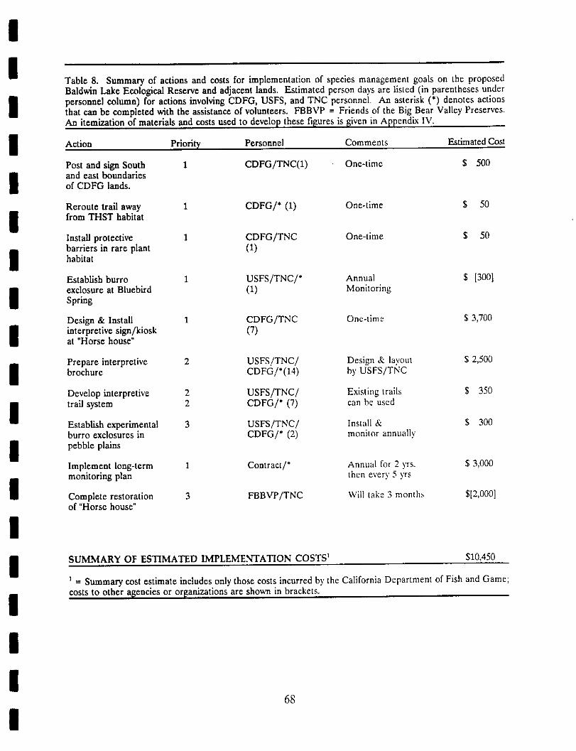
!
I Table 8. Summary of actions and costs for implementation of species management goals on the proposedBaldwin Lake Ecological Reserve and adjacent lands. Estimated person days are listed (in parentheses under
I personnel column) for actions involving CDFG, USFS, and TNC personnel. An asterisk (*) denotes actionsthat can be completed with the assistance of volunteers. FBBVP = Friends of the Big Bear Valley Preserves.An itemization of materials and costs used to develop these figures is _iven in Appendix IV.
I Action PrioriW Personnel Comments EstimatedCost
Post and sign South 1 CDFG/TNC(1) One-time $ 500
I and east boundariesof CDFG lands.
Reroute trail away 1 CDFG/* (1) One-time $ 50
I from THST habitatInstall protective 1 CDFG/TNC One-time $ 50barriersin rareplant (1)
I habitat
Establish burro 1 USFS/TNC/* Annual $ [300]exclosureat Bluebird (1) Monitoring
I Spring
Design & Install 1 CDFG/TNC Onc-time $ 3,700
I interpretive sign/kiosk (7)at "Horse house"
Prepare interpretive 2 USFS/TNC/ Design & layout $ 2,500
I brochure CDFG/'(14) by USFS/TNC
Develop interpretive 2 USFS/TNC/ Existing trails $ 350
I trail system 2 CDFG/* (7) can be usedEstablish experimental 3 USFS/TNC/ Install & $ 300burro exclosures in CDFG/* (2) monitor annually
I pebbleplainsImplement long-term 1 Contract/* Annual for 2 yrs. $ 3,000monitoringplan thenevery5yrs
Complete restoration 3 FBBVP/TNC Will take _ month. $[2,000]of "Horse house"
II SUMMARY OF ESTIMATED IMPLEMENTATION COSTS _ $10,450
i = Summary cost estimate includes only those costs incurred by the California Department of Fish and Game;
i costs to other a[gencies or organizations are shown in brackets.
!I
68
!

!
I Table 9. Summary of actions and costs for protection of the proposed Baldwin Lake Ecological Reserve andadjacent lands. Estimated person days are listed for actions involving CDFG, USFS, and TNC personnel.
I Annual One-timeAction Personnel Comments Cost Cost
I Secure watershed for TNC/CDFG 14 acres @ FMV $70,000SIPEfrHST habitat by USFS $5,000/acre
I protection of "Cemetary"parcel
Develop Cooperative CDFG/USFS/ Coordinate plans $ ??
I Management Agreement TNC with each agencyPatrol Baldwin Lake CDFG_USFS/ One person, 4 $2,400Ecologinal Reserve area TNC (12) hours, bimonthly
I to control illegal trespassMaintainfences TNC Oneperson,4 $1,200
i hours, monthlyMaintain horse house TNC/CDFG One person, 4 $1,200facilities hours,monthly
I Fence vernal annual TNC/USFS Proposed as part (USFS)creek habitat on of Arrastre/Union
i Starland parcel Flat road closure
ISUMMARY OF ESTIMATED PROTECTION COSTS $4,800 $70,000
IIIIIII
69
I
!I REFERENCES
!Barrows, IC 1988. Biological Monitoring Plan for rare plant species of the Big Bear Basin.
Unpublished report for the San Bemardino National Forest.
I Blymyer, M. 1988. Personal communication with Mr.Blymyer on several occasions, Augustto October, in 1988. Mr. Blymyer is wildlife biologist for the Bureau of Land
I Management, Palm Springs Resource Area.
Ciano, L. 1984. Pebble Plain Communities as Islands: Test of Island Biogeography
I Theory, Ecological Genetics of Island species. Unpublished PhD Dissertation, Universityof California, Riverside. 101 p.
I Coelho, R. 1988. Personal communication with Mr. Coelho. Mr. Coelho is the GameWarden, California Department of Fish and Game, San Bernardino Mountains.
I Core, Tom. 1988. Personal communication with Mr. Core on 29 September and 2November 1988. Mr. Core is president of the local Big Bear Valley Historical Society.
I Cox, Robin. 1986. Element Preservation Plan: Sidalceapedata. Unpublished documenton file with The Nature Conservancy, California Field Office.
I Crowell, J.C. 1975. The San Andreas Fault in Southern California. California Divisionof Mines and Geology, Special Report 118:7-27.
I Derby, Jeanine. 1979. Floristics and Phytosociology of the Pebble Plains in the SanBernardino Mountains, California. Unpublished Master's thesis, California StateUniversity, San Bernardino; available at the Big Bear Ranger Station and San Bernardino
i National Forest Supervisors Office.Derby, J. and R.C. Wilson. 1978. Floristics of Pebble plains of the San Bernardino
i Mountains. Aliso 9(2):374-378.Derby, J. and R.C. Wilson. 1979. Phytosociology of pebble plains in the San Bernardino
i Mountains. Aliso 9(3):463-474.Gronholdt, Christine. 1989. Personal communication, April 1989. Ms. Gronholdt is
Wildlife Biologist and State Lands Coordinator, California Department of Fish and
I Game.
Helvie, J.B. 1971. Bighorns and Fences. Desert Bighorn Council 1971 transactions.
I Holland, B. 1986. Preliminary descriptions of the Terrestrial Natural Communities ofCalifornia. State of California, Dept. of Fish and Game, Non-game Heritage program.
I 156pp.
I70
I

Kenl/ne, George. 1989. Personal Communication, July 1989. Mr. Kenline is Minerals andLands Officer for the Big Bear Ranger District, San Bernardino National Forest.
Krantz, T.P. 1978. A botanical investigation of Sidalcea pedata: a survey of the speciesthroughout its range. Unpublished report to San Bernardino National Forest. 21 p.
Krantz, T.P. 1980. Thelypodium stenopetalum, the slender-petaled mustard, a botanicalsurvey of the species throughout its range. Unpublished report for the San BernardinoNational Forest. 44 p.
Krantz, T.P. 1981. A survey of two pebble plains endemics: the Bear Valley sandwort,Arenaria ursina and Big Bear buckwheat, Eriogonum kennedyi ssp. austromontanum. Astudy of the taxa throughout their ranges. Prepared for the San Bernardino NationalForest. 79 p.
Krantz, T.P. 1981. The Bear Valley bluegrass, Poa atropurpurea a survey of the taxon inthe San Bernardino Mountains. Unpublished report for the San Bernardino NationalForest. 40 p.
Krantz, T.P. 1983a. The Pebble Plains of Baldwin Lake. Fremontia.
Krantz, T.P. 1983b. Site Stewardship summary for the Baldwin Lake Preserve System.Unpublished report for The Nature Conservancy. San Francisco, CA.
Krantz, T.P. 1987. Island biogeography and preserve design of an insular rare plantcommunity. In, Elias, T.S. 1987. Conservation and management of rare and endangeredplants. Proceedings of a conference of the California Native Plant Society. Sacramento.
Krantz, T.P. 1988. Personal communication. Mr. Krantz is an environmental consultantand botanist with considerable expertise on the local flora.
Malcolm, J. 1988. Personal commun/cation. Dr. James Malcolm is professor of zoologyat University of Redlands, Redlands, CA.
Minn/ch, R.A. 1971. Minimum temperatures in Big Bear Basin, California. Associationof the Pacific Coast Geographers Yearbook V(33):83-106.
Neel, M. 1987. Pebble Plain Status and Protection Alternatives Summary. Unpublisheddocument, San Bernardino National Forest. 27 p.
Neel, M. 1988, 1989. Personal Communication. Ms. Neel is a botanist for the Big BearRanger District, San Bernardino National Forest.
Neel, M. 1989. Draft Monitoring Report: Pebble Plains, Big Bear Ranger District.Unpublished report, San Bernardino National Forest.
Neel, M. 1989. Draft Monitoring Report: Echinocereus engelmannii ssp. munzii, Big BearRanger District. Unpublished report, San Bernardino National Forest.
71

!I O'Brien, M.H. 1980. The pollination biology of a Pebble Plain: Pollinator Visitation
Patterns. Oecologia 47:213-218.
I Paysen, T.E., J.A. Derby, H. Black, Jr., V. Bleich and J. Mincks. 1980. A Vegetationclassification system applied to Southern California. Pacific Southwest Forest and Range
i Experiment Station. General Technical Report PSW 45.Retelas, J. 1978. U.S. Forest Service Order Three Soil Survey, reports on file. San
Bernardino National Forest.
I San Bernardino National Forest. 1988. Environmental Assessment: Nelson Ridge sensitive
plant habitat protection project.
I Stephenson, John. 1988. Personal communication. Mr. Stephenson is Preserve Managerfor the Big Bear Valley Preserves of The Nature Conservancy.
I Stewart, J.H. and F.G. Poole. 1975. Extension of the Cordilleran miogeosynclinal belt tothe San Andreas fault, southern California. Geological Society of America Bulletin
I V(86):205-212.
Stout, M.L. 1976. Thrusting, landsliding, and man, eastern San Bernardino Mountains,
I Southern California. Geological Society of America Bulletin 13:319-411.
Woodburne, M.O. 1975. Cenezoic stratigraphy of the Transverse Ranges and adjacent
I areas, southern California. Geological Society of America Special paper 162. 87 p.U.S. Forest Service. 1988. Sect. 2670. Threatened, Endangered, and Sensitive Species
I Management. Forest Service Manual.USDA Forest Service and Soil Conservation Service. 2980. In cooperation with the regents
I of the Univerity of California Agricultural Experiment Station. Soil Survey of the SanBernardino National Forest area, California.
IIIIII
72
I
!I APPENDIX I. List of plant species for the Baldwin Lake study area. This list was
prepared by Tim Krantz (1986) for a volunteer docent training booklet published by Friendsof the Big Bear Valley Preserves. It represents the most complete plant list available for
I the studyarea.
IIIIIIIIIIIIIII
73
I
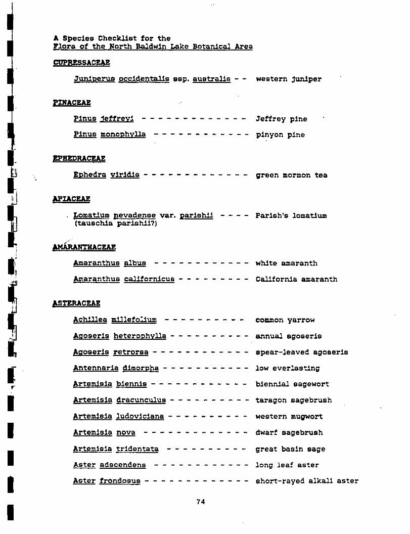
A Species Checklist for theFlora of the North Baldwin Lake Botan/cal Area
013PP_SACFJ_
Jun/perus occlden_1_s ssp. australls - - western Jun/per
I_INACEAEP_nus Jeffrevi ............. Jeffrey plne
Pinus monophylla ............ pinyon pine
EP_nRACEAE
. Ephedra vlr_d_e ............. preen mormon tea
AP 0zAz
Lomattum nevadense vat. parish// Parlsh's lomatlum(tauschla parish/i?)
: AUum'ncEAZAmaranthus albus ............ wh/te amaranth
Amaranthus californlcus ......... C_1_forn/a amaranth
ASTERACEAE
Aohil/es m_11efol/um .......... common yarrow
A,qoserls heterophylla .......... annua/ agoeerls
Af;oserls retrorsa ............ spear-leaved agoseris
Antennarla dlmorpha ........... low everlasting
Artem/sla blennls ............ blen_4_1 sagewort
Artemlsla dracuncu/us .......... _aragon sagebrush
Artemlela ludovlclana .......... western mu_wort
I Artemlsla nova ............. dwarf sagebrush
Artemls_a trldentata .......... great basln sage
I Aster edscendens ............ long _eaf aster
I Aster frondosus ............. short-rayed alkall aster
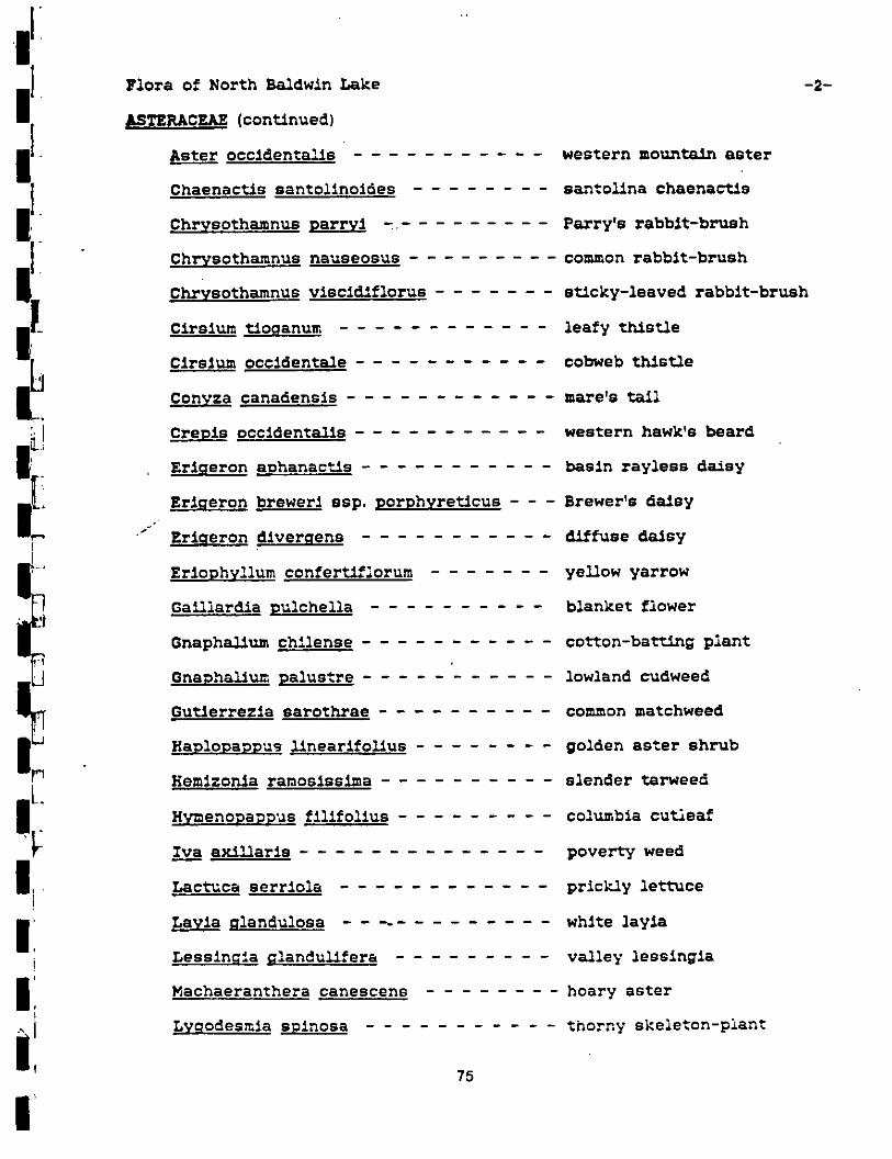
l{
{ Flora of North Ba,_dwtn %_ke -2-£STERJkCF.,AZ (cont:l.nued)
Aster occlden¢n_te ........... western mountain aster
Chaenactls santollnoldes ........ san'.ol/na chaenactls
Chrysothamnus parry_ .......... Party's rabb_t-bz_sh
Chryeothamnus nauseosus ......... common rabblt-brush
Chrysothamnus vlsc_d_florue ....... s1_cky-leaved rabblt-brush
Cirslum 1".1oganum ............ leafy 1_h/stle
Clrs_um 9cc_denta/e ........... cobweb th/stle
Conyza canadensls ............ mare's t.all
i_ Crepls 9cc_dentalls ........... western hawk's beard
!. Erlgeron aphanac_/e ........... basin rayless da/sy
i! Erlgeron brewer_ ssp. porphyre1_cus - - - Brewer's da/sy/ Erlgeron d_vergens ........... _÷fuse daisy
Erlophyllum confertlflorum ....... yellow yarrow
Gailiard/a pulchella .......... blanket flower
Gnaph-11um ch*.lense ........... ¢o%-ton-baVting plant
Gnaph_lu= palus_.re ........... lowland cudweed
Gutlerrezla saro_hrae .......... common matchweed
HaDIoDaDDus llnearlfol_us ........ golden as_er shrub
L Hemlzonla ramoslsslma .......... slender tarweed
!_ HYmeno_a_us fll:_fol_.us ......... co:umbta cu'r._eafIra axlllarls .............. poverty weed
I! Lac1:uca serr_ola ............ prlc_ly lettuce
II{ Layla glandulosa ............. white ]ay_a
Lessln.qla Rlandullfera ......... valley lesslngla
Machaeranthera canescens ........ hoary aster
Lygodes_la splnosa ........... thorny skele_on-pian_
i l 75
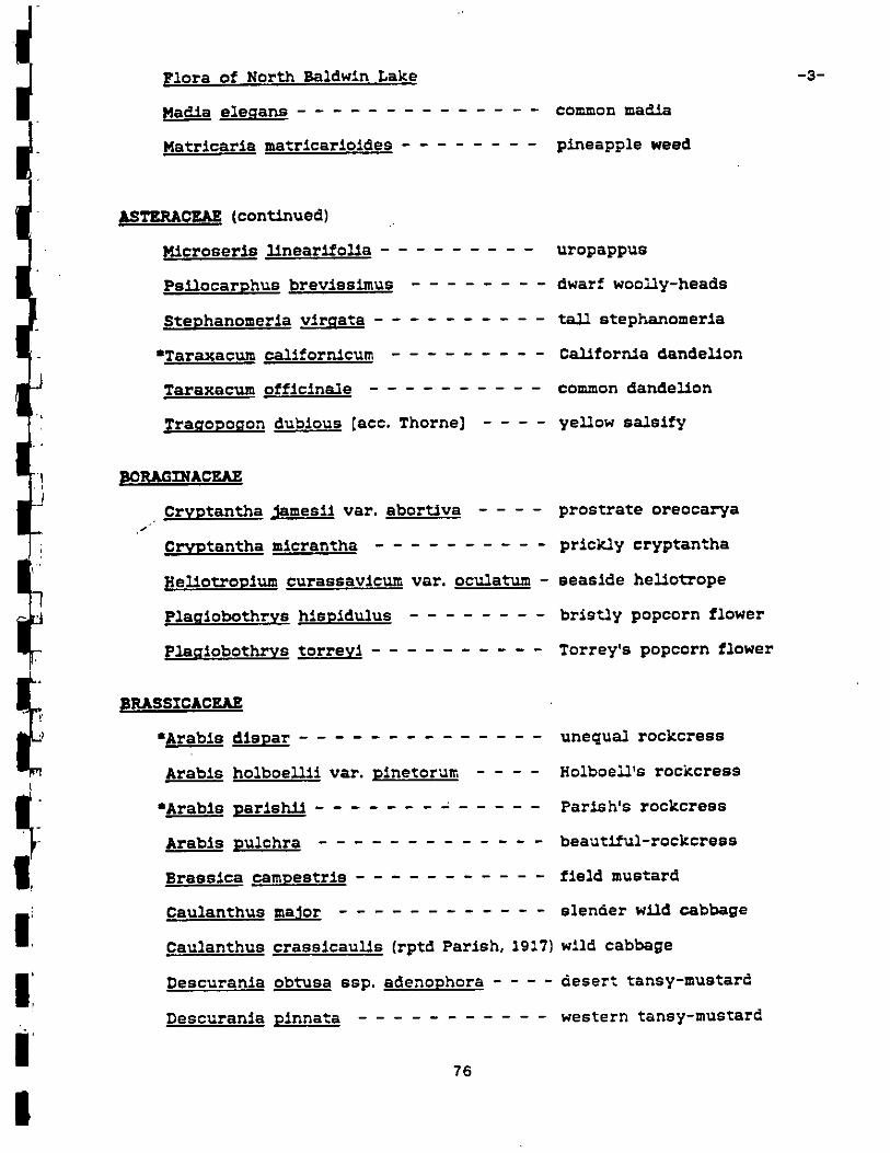
Flora of Nort_h Baldwin Lake -3-
Media eleRans .............. common mad/a
Matrlcarla matrlcarloldss ........ pineapple weed
ASTERACEAE (tongued)
M1croserls 11nearlfolla ......... uropappus
Peilocarphus brevlsslmus ........ dwarf woolly-heads
Stephanomerla vlrqata .......... ta_1 stephanomerla
•TaraxacumcalIforn_cum ......... Cal/forn/a dandellon
Taraxacumofflclna/e .......... common dands]/on
Tra_oDo_on dubious [acc. Thorne] .... ye_ow salslfy
ii BoRxs acrJ
• Cryptantha _ames_1 var. sbor1_Iva .... prostrate oreocarya
Cryptantha mlcrantha .......... prickly cryptantha
Hellolu'oplumcurassav_cumvar. ocu/atum - seaside hellotTope
P1a_Iobo1:hrys hlspldulus ........ brls_,/ypopcorn flower
F1a_1obothrye torrey_ .......... Torrey's popcorn flower
_RASSICACEAE
•Arab,s dlspar .............. unequa/rockcrsss
Arabls holboellll vat. plnetorum .... Holboe_'s rockcrese
•Arabls parleh/1 ....... - ..... Parlsh's rockcress
Arable pulchra ............. beautlful-rockcrsss
Braeslca campestrls ........... field mustard
CatLlanthus ma_or ............ slender wild cabbage
I Cau_anthus crass_cau_s (rptd Parish, 1917) w11d cabbage
I Descuran_a 9btusa ssp. adenophora .... desert tansy-mustardDascuranla plnnata ........... western tansy-mustard
' 76
!

Flora of North Baldwin Lake -4-
BRASSICACEAE (continued)
Descuran/a sophia ............ tansy-mustard
Drabs dou;llasi_ var. crockerl ...... Douglas' draba
E,-yslmum capltatum ........... western wA11flower
Hutch/nsla proeumbens .......... prostate hutchinsla
Lepld/um perfol/a_n_r, - ......... round-leaf pepper-grass
Lepld/um vlrRlrdcum ........... wiid pepper-grass
Rorlppe cuz-v_s_gua .......... western yel/ow-cress
Rorlppa nasrurt_um-aquatlcum ...... water-cress
S:Isymbrlum a/TAssimum .......... %'umble mustard
"Thelypod_um etsnopetalum ........ elendsr-ps_led 1:helypod/um
Thysanocarpus curv_pes vat. erad/atus - -ha/z-y fringe pod
CACTACEAE
•Echlnocereus engelman/_ var. munzi_ - - - hedgehog cactusT
Echlnocereus %T_gloch/d/atus var. mohsvensls - mound cactus
Opun1_a basilarls ............ beavez_a]_ cactus
Opun1_a //i-torallsvaz'.plercel ..... prlck/y peaz"
CAPR._'OT.,J.ACEAE
Sambucus .caerulea ............ blue elderberry
Symphor_oarpos parlsb/1 ......... Parlsh's snowberry
I CARYOPHYtr.a, CEAEArenarla urslna ............. bear va/ley eandwort
I Sagina occ_dentalls ........... western pearlwort
Sllene verecunda ssp. plsryota ..... ¢uyamsca campion
I Spergu/arla rubra ............ purple sand spurry
, 77
!
Flora of North Baldwin Lake -5-
•CRI_._OPODLtCEAE
ATrlplex arqentea exspansa ....... s',.Iversa/1:b_tsh
Atr:Lplex caneacens ........... hoary sail:bush
A1:rlplex rosea .... - ........ red aa/tbush
Acrlplsx ¢r,unca1:a ............ 1:runca1:eaa/1:bush
Chenopod:tum atrovi_ens ......... _=?k green sail:bush
Chenopod/u= fremontil .......... Fremon1:'s goosefoo1:J
l i Chenopod/um glaucum sap. salInum .... oak-_eaved goosefoo1:Che_opodlum le1=1:oDhyllum ........ narrow-leaved goosefoo1:
ii ChenopodL_u m rub_m ........... red goosefoo1:L '
Chenopod/um de_enerlanum ?[acc. Thorne]
E N:11:roph/laocclden_1- ? [poss. acc. Thorne] - wes1:ern n4_Tophila
,/ Monolepls spa1:hu/a1:a(rp1:dMunz) .... club-leaved monolep;[sI
Salsola Iberlca ............. Russlan ¢h/stAe
Salsola paulsenll (rp1:dMunz) ...... Russ:Lan ¢.h/stle
Suasda depressa var. depressa ...... Pursh's sea-bl1_e
PCOFVOLVULACF-J_
FCa/ys1:eR_a fu/cra1:a ........... Sonora morning glory
Cuscu1:a c=)_fornlca ........... C=1_ornla dodder
CRASSOLACEAI_
/ Dud/eya abrams_,/' ............ Abram's dudleya
,_LEAGNACEAE
Eles.qnus anqus_,-Ifolla.......... Russian ollve
ERICACEAE
Arctostaphylos pa1:u/a ssp, platvphylia - green/ear manzan11:a
78
Flora of North Baldwin Lake -6-
aozAc
Euphorbia albomarRlnata ......... rattlesnake weed
Euphorbla paimerl ............ wood sp_ge
Euphorbia serpylltfo_a - ........ thyme-_eaved spurge
F_Ac_
Amorpha c=_4_orn_ca ........... C=!_forn.ta false _ltgo
AstraRalus dou.qlas_t asp. parishl_ - - - Douglas' ra_..leweed
*As_'aQalus leucolobus .......... bear valley woolly-pod
As_'ag_lus pursh_ VE_. lectulus .... Ehzrsh_s woo_y-pod
As_'agalus lent:l.q_nosus sap,- ...... mot_..led ra_r.leweed
Lotus crasstfo_tus ........... _ck-leaved ln-efoll
Lotus ob:ZonQlfoltus ........... narrow-leaved lwefoll
Lotus purshlanus ............ Spanish clover
'1-_ LotUs nevadense ............. Sierra Nevada _efolli
Luplnus andsrson/1 ........... Anderson's lupine
Lupinus conclnnus ............ elegant ann-m1 luplne
Luplnus confertus ............ prairie luplne
Luplnus brewerl ............. Brewer's lupine
Lup_nus excub_Tus vat. austromontanum - -Interior bush lupine
Melllotus off_cinal/s .......... yellow sweet clover
_. Tr_fol/um var_e_atum .......... wh/te-tlpped clover
Tr_fol_um wormskloldi_ ......... cow clover
i FAGACEAE(_uercus ohrysolep_s ........... canyon live oak
I Quercus turb_nella? ........... turban oak
!

Flora of North Ba/dwln Lake -7-
G_/_FLANACEAE
Frasera parryl ............. Party's green gentlan
OERANIACEAE
Erodlum clcutar_um ........... red-stem filaree
Gerardum rlchardsonll .......... Itlchardson's geran/um
_YDROPHYLLACEAE
Erlod/c%-yon tr_choca/yx ......... ha/ry yerba santa
Nama demlssum .............. purple mat
Nemophila menzlesil ........... baby blue-eyes
Phaoella austromontana ......... Morays phaoella
Phacella blcolor ............ two-color phacelia
/ Phacella curvlpes ............ Washoe phacella
Phace1_= _nbrlcata ........... imbricate phacella
Phace_ia mohavensis ........... MoJave phacella
_AMIACEAE
.Sa/vla DachvD'nvT_a ........... rose sage
Salvla columbar_ae ........... ch/a
Scutellar_a austtnae .......... Austin's sku//cap
_. Stachys albens ............. white hedge net_cleTr_chostema mlcranthum ......... small-flowered blue-curls
I Llnum .lewlsll.............. western b_ue flax
i. oAsACMentzel_a congesta or aff. toMentzella affin_s ? ace Sanders ..... hydra stlck-:eaf
!80
!
Flora of North Ba.ldwln Lake -8-
LOSACEAE (continued)
Mentzella laevlca1_14_ .......... b:_.zlng star
MALVACZAE
A/cea roses ............... hollyhock
Malacothamnus fasclculs%-us ....... mesa malacothamnus
Malacothamnus orblcularls ........ round-leaf malacothamnus
_4alva nlcaeenele ............ bull mallow
'I S£da leprosa vat. hederacea ....... alka//-mallow
*S_4_Icea pedata ............. blrd*s foot checker
Sphaeralcea ambl.qus ........... desert m_]1ow
/M1rabil'.ablgelovll ........... wishbone bush
ONAGRACEAE
.Camlssonla pusiiia ........... dwarf sun cup
, Epiloblum adenocaulon .......... northern willow-herb
Ep_/ob_um pardculatum .......... panlcled w_ow-herb
OayoDh%rtum d/ffusum ........... ILtffuse gayophyCum
Oenothera callfornlca .......... CallforrLia even/n; prlmrose
Oenothera caesp_tosa .......... desert even/ng primrose
OROBANCHACEAE
!Orobanche callfornlca asp. feud.qel - - - Callforn/a broomrape
'I Orobanche unlflora asp. occlden_alls - - nakedbroomrape
i PAPAVERACEAEArqemone mun_ta ............. prlck/y poppy
I Eschscholtzla callforn/ca ........ Cal_forn_a poppy'
81
! ,

I Flora of North Ba/dw_n Lake -9-PLANTAGINACEAE
_ P_antago purshl/ var. oblon_a ...... Pursh's plantain
pOLZMONZACr_E
Allophyllum v_olaceum .......... v_olet allophyllum
Er_aetrum denslfollum .......... many-leaved erlastrum
Gil/a cana ............... broad-flowered gilia
Linanthue brevlculus .......... Mo_ave llnant/%us
IL4_anthus tr_114pil ........... F_114p's linanzhus
Mlcroster_e gracills .......... slender m/croster_s
Navarretla brewer_ ........... Brewer's navarretla
Navarretla penlnsularls ......... BaJa navarretAa
•Ph/ox aue1:romontana ........... western mountain phloxI
Phlox cov_11e_ ............. Covil/e's phlox
POLYGONACEAE
Chor_zanthe watson/_ .......... Watson's sp2ny herb
Erlo_onum dav_dson/i .......... Dav_dson's buckwheat
Er_o_onum fasc_cu/ainlm ......... cn11_orn/a buckwheat
tErlo;;onum kennedyl sep. aus_romontanum -Kennedy's buckwheat
Erlo_onum kennedy_ eep. kennedy_ .... Kennedy's buckwheat
Er_o.qonum par_ehil ........... Par_sh's buckwheat
Er_o.qonum m/crothecum ssp. corymboso_des -_reat basin buckwheat
Erlo_onum umbella_um esp. munzi_ - - - sulphur flowered buckwheat
I Erlo.qonum wrlf;h_Jd esp. subscapoeum - - - Wr_ght's
buckwheat
Poly.qonu_z avlculare ........... common knotweed
i Po_y;;onum ramos_sslmum knotweedyellow-flowered
I Rumex callfornlcus ........... willow dock
82
!
Flora of North Baldwin Lake -IO-_[_:)LYGONACEAE (continued)
Rumex con_lomeratus ? [ace. Thorne] - - - clustered dock
Rumex crispus .............. curtly dock
Rumex fueqlnus .... - ........ golden dock
pORTu_J_CACBAE
Ca_yp_n'ld_um parryl ........... Party's pussy-paws
Clay_or_a perfa_'tata .......... miner's lettuce
Clayton_a epathulata .......... common mon_.._a
Lewts_a nevadensls ........... Nevada lewista
Lew_e_a red.tva vat. m_nor .... .... b_rterroot
Mont_ta fontana asp. variabllis ..... water mont/a
i / Mont_astrum lineare ........... narrow montiaPortulaca o_eracea ........... common purslane
Androeace septentrlonalle sap. subumbellata - northernandroaace
i Dodecatheon [aff.hendersonll] ..... shootinR star
G1aux mar_tlma (rp_ in Munz) ...... sea milkwort
RANUNCULACEAE
Delphlrdum parlshi_ ........... Pariah's larkspur
Myoaurus ar_etatus ........... sedge mouse-tnll
Ranuncu]us aquatl/Is .......... water buttercup
Ranuncu/us cymba/arla var. saxL_ontanus - desert buttercup
I Ranuncu/us c_!_forn_cue var. austromontanus - C_1_forn/a buttercup
I A &CZAZCeanothue _ ............ desert ceanothus
!

Flora of North Baldwin Lake -11-•ROSACF_¢
i Amelnnchler utahenste .......... Utah service-berry
Cercocarpus ledLfol_ue ......... curl-leaf mount-4,_ mahogany" Horkelta bolander_ ........... Bolander'e horke_
*Iveeta argyroeoma ............ s_'.ver-haired lvsslapoten_lla aneerlna ........... common s_verweed
_ FotenC111a blennls ........... btennlai elnquefo_poten_411a Rrac_!4_ ssp. nut-e_11_ slender cinquefoil
_J po_entllla peettnlsecta ......... sierra ctnquefo_
li Purehte Rlanduloea ........... MoJave antelope bush
Rosa woodsil .............. interior rose
UBIAC
. ' G_14um par_sh11 ............. Parlsh's bedetraw
_%LICACEAE
Sallx scoulerlana ............ Scouler willowI
S_AGACEAE
L_thoDhra_ma tenellum .......... smooth wood/and starSCROP_IO_ARIACEAE
_ Cae_]e_a chromosa ........... Indian paintbrushdesert
" Csetille_a chromoea X Castil/eJa clnerea hybrid paintbrush_Css_'_e_a elnerea - - - "- ....... ashy-_rey Indlan paintbrush
i Colllnaia parvlfiora .......... small-flowered blue-eyed MaryCordylanthue nev_r_ .......... Nevln'e blrd's-beak
I L1mosella aoaul_s ............ southern mudwort
L_moeeila a_ua_/ca ........... northern mudwort
I84
I

Flora of Nort_ Baldwin Lake -12-
$CROPHULkR_a_ (oon_nued
_ulus androsaceus ........... androsace monkey-flower
I "V.tmu_us ex.t!;_us ............. mean monkey-flower
_tmulus gut-_a'cue ............ common monkey-flower
P'_nulus flortb_.due ........... flor£ferous monkey-flower
y4mulus p_oeu_ ............. downy monkey-flower
_tlmulus pr_uloldee va_. plloee_us - - - primrose monkey-flower
M1mu/us sukedorfil ........... Suksdorf monkey-flower
penstemon labrosus ..... .-..... San Gabriel penstemon
_ .Penstemon _ne_1_ ........... Grlnell's penstemonVeron/ca Dere_rlna ........... purslane speedwell
. N1co_ana attenuate ........... coyote tobaccoSolanum xantll ............. purple nightshade
STERuULIACEAE
! Fremontodendron callfornicum ...... Cnl_ornla flannelbush
URTICACEAEUrT/ca holoserlcoa ........... hoary nettle
VIOLACEAE
Vlol_ dou_las:Ll ............. Douglas' vlolet
Vlola purpurea ............. mountaln v_olet
VISCACEAE
Arceuthob_um sp. - ........... plne m/stletoe
i Phoradendron bol/eanum ......... Bolle's mls_/etoe
85
iI
ill V_orao_Nor__dwln _ke -IS-J
ii _c_vac_Yuccabrev_o_a k1111_111111 Joehuatree
II] Yucca sonid_era _oJaveyucca
Ii _U,UU_..,._.CEA',A1_4um campanulaCum ........... sierra on/on
i! _11um davAstae - - ........... Davis' on/onAlbum flmbrlarum vat. parryl ...... fringed onion
I[_ cYPERAc_
Carex athrostachya - _ ......... slender-beaked sedge
Carex nebrascensAs ........... Nebraska sedge
Carex Draearacil/s ........... cZustered field sedge
EieocharAs eoZoradoensls ........ Colorado splke-rush
E/eocharls macrostachya ......... pale splke-rush
Eleocharls parAshll ........... Parlsh's splke-rush
Eleocharls qulnqueflora ......... flve-flower spike-rush
Sctrpus .acurus ............. vAscAd ruleDou/rush
Sclrpus valtdus ............. American great bulrush
XRIDACEAE
li Irls m/ssourlensls ........... western blue-flagSisyrlnchlum bellum ........... blue-eyed grass
I 3UNCACEAE
I _uncus bal1:Icus ............. Ba11Licrush
Juncus bryoides ............. moss rush
I 3uncus bufonlus ............. _oad rush
_uncus eff_sus ............. com_o_ rush
| .
I
Flora of North Baldwin Park -14-
3UNCACEAE
I 3uncus kellogq_/ ............ Kei:ogg's lush
3uncus macrandrus ............ iong-anthered _sh
_. _-_*4NACEAE
Lemna m_or ............... _esser duckweed
_emna mlnlma .............. leas*,duckweed
ij CalochorTus Invenustue ......... plain marlposa
! Caloohortus kennedyl .......... Kennedy mar_posa.CalochorTus Invenuet-us X Calochortus kennedy_ hyhr_s
POACEAE
•A_roDvron deserto_,.m .......... desert wheatgrass
Acr_o_'cron pul_eseens ........... hacl.ry wheatgrass
-_ Bouteloua gracllls ........... blue grams
I Bromus .moll_s.............. so."tchessBromus orcuTT.lanus ........... OrcuTt hrome-Grass
Bromue tec_,orum ............. downy hromeDeschamps_a dan*_hollloldee........ halrgraes
Dist.lchlissp_cata ........... salt grass
Elymus _laucus ssp. vlreecene ...... western wild ryeHordeum hrschyantherun ......... meadow bariey
Hordeum callforn_cum .......... Callforn/a barley
I Hordeum Juba_,um ............. g_ant squirrel grass
Lo_ium perenne ............. perenn.ta_ ryegraesMuhlenbergla asperifo1_a ........ rough stem muh3y
I Muhlenberg_a callforn/ca ........ Cal/forn_a muhly

iiIi!i ,_o.o,,o__w_o_ke -=5-
_ACEA_ (continued)
I !I Oryzops:ls hymeno:Ldee .......... lnd/an r;lce grass
"[i pea annua ................ annual bluegrass|. =Pea atwopurpurea - - - ......... San Bernard/no bluegrass
iiiPea fendlerlana ............. mutt;on grass
Pea incurva ............... alpine bluegrass
_ Pea nevadens_.s ............. Nevada bluegrass
..1,.] Pea pratensle .............. Ken_cky bluegrassi L pea ocabrena .............. malpa_s bluegrass
Polvpo_on =onspe_4ensle ......... rabbit's food grass
puc¢:Lne_!_a nu*ct-!14ana ......... Nut_'e allE_ grass
_!i:_ S_tanion hysU'_x ............ bert:e-brush squirrel-_-41w
Stlpa comata .............. need/e and thread grass_. It_,#_: ;
_OTAHOGE'I_0NACEAE
Ruppla clrrhosa ? ............ d/tchgrass
RupDia marlt_a ............. d/tchgrass
_[_ _Za_rlC;mr.t.T_CFJ_.Zann_che_la paluetz':ls ......... horned pondweed
i|_ .,

!i APPENDIX II. Preliminary Biological Monitoring Plan for Rare Plant Species of the
Baldwin Lake Study Area. Following initial field work in Spring 1989, methods discussed
I herein may be adapted to suit monitoring demands for each species.
III
!I!I!!IIII
I

!I PRELIMINARY BIOLOGICAL MONITORING PLANNORTH BALDWIN LAKE ECOLOGICAL RESERVE
I PreparedBy:KateBarrowsNovember 1988
I INTRODUCTION
I Basic information on the occurrence and distribution of rare plant species and habitatswithin the Baldwin Lake study area is fairly complete. However, little quantitativeinformation on species composition and density of rare plant species is available for the
I three habitat types addressed by this plan. Derby and Wilson (1979) sampled frequency,density and cover on three pebble plains, not including Baldwin Lake. Quantitative dataon rare plant species distribution and abundance in other habitat types (wet meadows,
I vernal creeks) is unavailable. Approximate counts of the populations of two federally andstate-listed plant species have been made on an informal basis in the past. A systematicgrid map of one portion of a Sidalcea pedata population was completed (Krantz 1988).
I Since the time of these studies disturbance and protection efforts have influenced thestatus of rare plant species. Information on changes in species composition, rare plant
I densities, and recovery from disturbance is needed for all three habitats. Given theseinformation needs, this Monitoring Plan addresses two basic goals:
I 1) To establish a baseline monitoring program for rare species of the Baldwin LakeEcological Reserve and adjacent study area, to assess long term health of rare plantpopulations.
I 2) To assess the effects of disturbance on rare plant species and to monitor recover3'of disturbed areas.
I The monitoring plan will focus on lands managed by the California Departmentof
Fish and Game. Other lands adjacent to the Baldwin Lake Ecological Reserve, managedby The Nature Conservancy and U.S. Forest Service will also be included. The emphasis
I of the plan is a simple, repeatable monitoringscheme which follows trends in rare plant
populations; the program is designed to be carried out with participation of volunteers.
I PROGRAM OBJECTIVES
The goal of a rare plant monitoring program is to follow long-term trends in species'
I populations. There are several basic questions which the proposed monitoring programwill attempt to address. These include:
I 1. What are the natural fluctuations in density and distribution of rare plant specieswithin the study area?
I 2. Is natural revegetation adequate for recovery of vegetation cover in disturbedhabitats? Are there significant differences in species compositionbetween disturbed and undisturbed areas?
| 0o
I
I
I3. What are the significant impacts of burros on rare plant habitats? Of human
Ii visitors?To address these questions, the proposed rare plant monitoring program focuses on
i the following basic objectives:1. To obtain baseline data on rare plant species distribution and abundance in
undisturbed and disturbed areas.
I 2. To monitor the natural of disturbed areas.revegetation3. To obtain population counts of listed plant species.
i Another objective, which can be addressed in a separate research plan, is to assess theimpacts of burros/humans on rare plant species/habitats. An indirect result of the theproposed monitoring program is an evaluation of current protection efforts in terms of the
I species management goals described in the Operations and Maintenance Schedule.
I RARE PLANT SPECIES
The high degree of endemism in the Big Bear Basin results in a list of species that
I could make a monitoring program an overwhelming task. For this reason, the monitoringscheme will focus on indicator species for each habitat as follows:
I Wet Meadows - Sidalcea pedata, Thelypodium stenopetalumPebble Plains - Arabis parishii, Arenaria ursina, Castilleja cinerea, Eriogonum kennedyi
I ssp. austromontanum, Linanthus killipiiVernal Creeks Mimulus exiguus, Mimulus purpureus purpureus, Orthocarpttslasiorhynchus
I MONITORING PROCEDURESThe methods used for monitoring will vary depending on the habitat is question. A
i primary goal is to obtain a population census of the listed species which occur within thestudy area. For the pebble plains, quantitative methods to produce a sample estimatecan be applied. In the vernal annual habitat, monitoring in the implementation phase canbe qualitative in nature until the typical distribution and density of the target species can
i be assessed.
i WetMeadowsThe density and distribution of the two listed species, Sidalcea pedata (SIPE) and
Thelypodium stenopetalum (THST), is such that a complete count of individuals should be
I possible. For THST, individuals should be counted in several categories: non-floweringrosettes, second year plants in flower/not in flower. For SIPE, individuals can be countedas seedlings, flowering adults, non-flowering adults. In addition to a population census,
I

permanent plots, with mapped individuals could be established to determine density,number of flowers per individual, survivorship. Permanent plots can be established in astratified pattern according to plant density; plots should be at least one meter in area(round plots preferable). Alternately, several belt transects (long rectangular plots) couldbe used.
Data Collected:
1. Absolute count of individuals for SIPE, THST2. Possible sample plots for density, number of flowers.3. Areal extent of population for SIPE, THST
Season:
Sampling should be conducted between April 1 and June 30.
Pebble Plalns
The recommended method used to monitor trends on the pebbJe plains wil] beNested Frequency analysis (U.S.F.S. Range Analysis Manual FSH 2209.21 R-4, 1983) withmodifications. This frequency method was chosen because it is a simple, repeatable schemewhich is based on an objective measure of plant abundance. The primary concern withfrequency as a measure of abundance is that data collected is a function of plot size. Nestedplots allow selection of the most appropriate quadrat size so that frequency is notconsistently under-estimated or over-estimated. Frequency. has been shown by a numberof authors to be a sensitive measure of vegetation change (Grieg-Smith 1964, Smith et al.1986, 1987).
Within each of three pebble plains a random point will be selected. From this pointa baseline 50 meters long will be laid out along the long access of the plain. Rebar stakeswill be placed at each end of the baseline; these stakes will be covered with plastic caps toreduce the hazard to visitors. Because pebble plains are small and relocation of thebaseline is not likely to be.a problem, the stakes will be driven with only six inches aboveground. The position of each baseline will be mapped in reference to roads and otherprominent features and the compass directioon of the baseline will be recorded.
Transects will be laid out perpendicular to the baseline at points determined by randomnumbers between 0 and 50. At each point where a given random number intersects thebaseline the transect will be established perpendicular to that baseline. The compassdirection of each transect will be recorded. The nested frequency frame is laid along thetransect to take a sample. Frequency samples are taken ever3, two meters for a total of 15samples per transect.
A diagram of the nested frequency frame is shown in Figure 1A. The frequency frameshould be laid on the transect tape with the 5 cm plot in the lower left corner, on themeter mark (2 m, 4 m, 6 m etc.). For each frequency frame or sample, the smallest plot
size in which a given species occurs is recorded. Plot sizes used in this program are 5 cm 225 cm 2, 50 cm 2. For the rare species (ARPA, ARUR, CACI, ERKEA, LIKI), density will
92
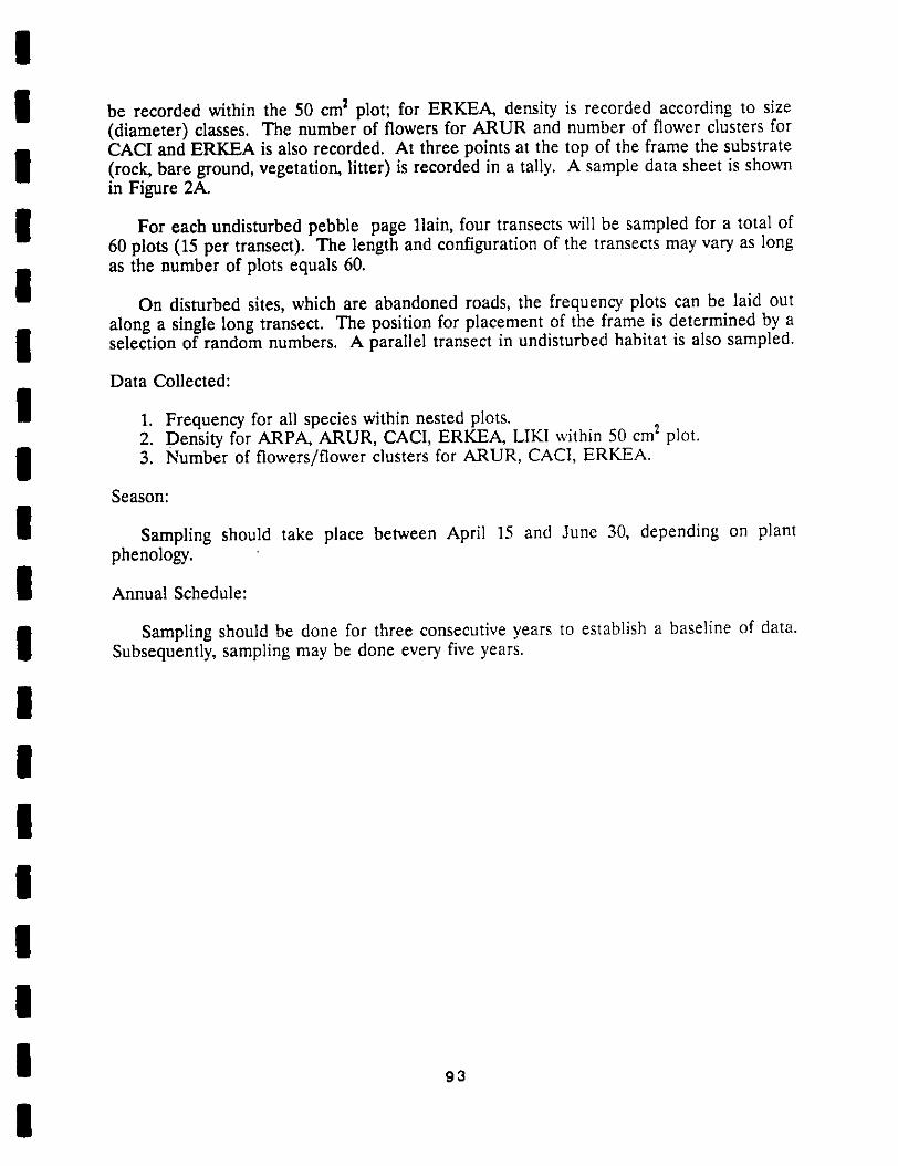
!I be recorded within the 50 cm _ plot; for ERKEA, density is recorded according to size
(diameter) classes. The number of flowers for ARUR and number of flower clusters forCACI and ERKEA is also recorded. At three points at the top of the frame the substrate
I (rock, bare ground, vegetation, litter) is recorded in a tally. A sample data sheet is shownin Figure 2A.
I For each undisturbed pebble page llain, four transects will be sampled for a total of60 plots (15 per transect). The length and configuration of the transects may vary as longas the number of plots equals 60.
I On disturbed sites, which are abandoned roads, the frequency plots can be laid outalong a single long transect. The position for placement of the frame is determined by a
I selection of random numbers. A parallel transect in undisturbed habitat is also sampled.
Data Collected:
I 1. Frequency for all species within nested plots.2. Density for ARPA, ARUR, CACI, ERKEA, LIKI within 50 cm 2 plot.
I 3. Number of flowers/flower clusters for ARUR, CACI, ERKEA.Season:
I Sampling should take place between April 15 and June 30, depending on plantphenology.
I Annual Schedule:
i Sampling should be done for three consecutive years to establish a baseline of data.Subsequently, sampling may be done every five years.
!!|
|I!
| 93
I

I
i
I
i
I 1
I_F
IFigure 2. Nested Frequency Sampling frame. Frequency is
i recorded as the smallest plot in which a given species occurs.Density is recorded in plot 3 (50 cm x 50 cm).
i
I
I
Ii

Olhlr Sp{{Ill.:
II
m REFERENCES CITED
IDerby, J. 1979. Floristics and phy_osociology of the pavement
m plains in the San Bernardino Mountains, California. A thesispresented to the faculty of California S_ate College, SanBernardino.
m Derby, J., and R. Wilson. 1979. Ph_osociology of pavementpavement plains in the San Bernardino Mountains. Aliso@(3):463-474.
I Greig-Smith, P. 1983. Quantitative Plant Ecology. ThirdEdition. University of California Press, Berkeley.
m Krantz, T. 1978. A botanical investigation of A_NI_ pm_i_N_iWars. A complete survey of A_hi_ p_hll, its distributionand habitat. Funded by Pleuss-Staufer Inc. in cooperation
m with the San Bernardino National Forest.Krantz, T. 1979. A botanical investigation of _I_
,,ni_l_,_R asp. _. San Bernardino National Forest.
m Krantz, T. 1981. The Bear Valley Bluegrass, Pna _.A survey of the taxon in the San Bernardino Mountains. San
i Bernardino National Forest.Krantz, T. 1981. A survey of two pavement plains endemics: the
Bear Valley sandwor_, A_n_.i_ ,_in_; Big Bear Buckwheat,
m _i_nmHm _moHyj Ssp. _H_m_n_mm1_m. A study of _hetaxa zhroughout their ranges. Prepared for _he SanBernardino National Forest.
I Krantz, T. 1983. Site Stewardship Summary for the Big BearValley Preserve. Prepared for The Nature Conservancy.
I Neel, M. 1987. Pebble Plain Status and Protection AlternativeSummary. San Bernardino National Forest.
m Smith, s., s. Bunting, and M. Hironaka. 1987. Evaluation of theimprovements in sensitivity of nested frequency plots _ovegetational change by summation. Great Basin Naturalist47(2):299-307.
I Travis, J. and R. Surfer. 1986. Experimental Designs andStatistical methods for demographic szudies of rare plants.Natural Areas Journal 6(3):3-12.
I U.S.D.A. 1983. U.S.F.S. Range Analysis Manual FSH 2209.21R-4.
lg4
I

!I APPENDIX III. Proposed plan for renovation of the "Horse house" on California
Department of Fish and Game property at Baldwin Lake. Plan was prepared by John
i Stephenson, preserve manager for The Nature Conservancy.
III!II!I!!IIII| 96
I
!PROPOSAL: RENOVATING THE "HORSEHOUSE" AT NORTH BALDWIN LAKE
!The Nature Conservancy would like to renovate the "Horsehouse" structure
I at North Baldwin Lake to serve as a storage facility and base ofoperations for the Big Bear Valley Preserve. We have an experienced
carpenter a_sisting us and he has assured us that most of the existing
I structure is sound and in good condition. He also informed us that thefar west end is not structurally sound and needs to be torn down. Much
of the lumber and siding needdd for making repairs on the sound
i structure can be obtained from the section to he torn down.Here is a list of what we propose to do in the order we plan to do it:
I i) Tear down the unstable west end.- We will work from the top on down to ensure that the structure
does not collapse. The roof sheeting will be removed first, then the
I rafters, then the supports. Since most of this section is already inthe form Of a roofed, open-air patio, taking it down should not take
very long. The useable lumber will be cleaned up and stacked for future
l use.2) Patch up the existinK sidin_ and install new sidin_ where needed.
- most of the structure already has siding on it. but elot of
I patching will be needed. We hope that the siding obtained fromdemolishing the west end will suffice to fill the gaps without siding.
However. it is quite possible that some siding will have to be bought.
I B) Freeing.- All of the exterior walls are well framed, however some
additional framing will be required. An existing sliding glass window
I on the north side of the building will be framed in for securityreasons. An interior wall will be added and two interior doorways will
be framed in so that storage rooms can be individually secured. We do
I not anticipate having to buy any lumber for the framing. The materialobtained from demolishing the west end should be more than enough tomeet our needs.
I 4) Install doors.- Four exterior (solid core) doors and three interior (hollow
core) doors need to be installed. One existing exterior door can be
i reused, however three new ones will have to be bought. All threeinterior doors will have to be bought.
I 5) Install windows.- Five windows need to be installed. The two southside windows
already have custom frames and need only to have cut glass placed in
them. The three northside windows will require regular sliding
l windows. All the windows have chain link fencing stretchedcurrently
over them. For security reasons, we intend to keep these in place,
however they will be trimmed and framed to look more attractive.
!!
97
!
II 6) Roofing.
- Most of the roof is in good shape, but some additional roll
roofing will need to be installed. Black mastic will be applied to the
I Joints to make them water proof.
7) Insulation and drywall.
I • t 3 x 15 inch roll insulation will be placed between the studsand drywall sheeting will be used to form the interior walls. We
estimate that approximately 84 4x8 ft. sheets of drywall will be neededto cover the walls.
I 8) Electrical wiring.- Electrical wiring is already in place, but this wiring will
I have to be checked and approved by an electrician.
9) Painting.
- The drywall will be painted. The doors and exposed beams will
I either be painted or varnished.
The renovation work will be done by the preserve caretaker and
I volunteers. Materials needed for the work will be paid for by theFriends of the Big Bear Valley Preserve and the Nature Conservancy. A
skilled carpenter with experience at doing this type of work is
I assisting us to ensure that the job is done safely and correctly.Everything will be done according to building code standards. A drawing
of the floor plan with the proposed renovations is included on the
i following page.
II
II
II
I
I
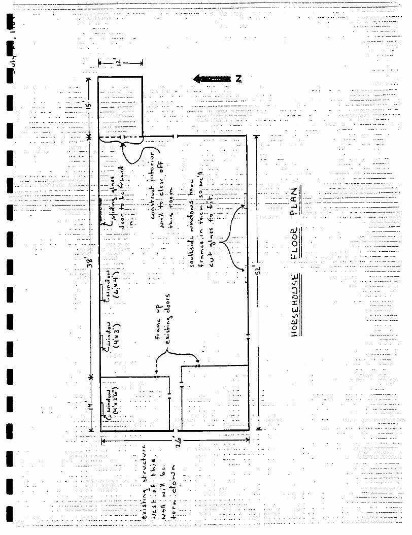
:: ::: -
,.:,:.-.::ii:-:l-.,.::--.:..,'ii l,•"!ll:::.........--.-.::.: ..i:" :! .... _ " ::-::.......
I " _ .........•-- _ _ :::.:-:::__.
I "__ o --:""_._ _. _ ................
I (_ ................ -,_ .. .::::
I| .......
I " ';i ' ......:-::3-'_ ....... ....... "....: :_'.:. .:'_::::":
I _: ""
'- . i-- ....... . . . ........ ., . ................
I _ ....-.-:::---_-...... _ ..........: .-..-:-:::-::..
............ _ . , .... , ........... .
............._:_ ....................: .- - ,. .:::: , ..... ...............
I .........................._,-__._--. ::: ................ : ................................._ _ _ -F................. : .:.::: :. "........:- ": _ ...L:-.-.-:.-_'_:-:_.-.-L.--'-:.:.-- :::: ................ ".....................
!I APPENDIX IV. Itemization of costs for materials and management actions described in text.
BASIS FOR ESTIMATE OF COSTS FOR MATERIALS AND MANAGEMENT ACTIONS DESCRIBED
I IN THE PLAN
NO. COST/ TOTAL
I ITEM NEEDED ITEM COST1. Post and Sign Boundaries
Steel T posts (heavyweight) 43 $ 4.62 $ 220.00
I Signs - Metal 8" x 10" 50 $ 6.00 300.00$ 520.00
I Note: Southern is 3694 feet eastern is 2639 feet (0.5 miles). Post signs at 150'boundary (0.7miles); boundary
intervals.
I 2. Experimental Burro ExclosuresRedwood4"x 4"x 8' cornerposts 4 $ 7.70 $ 30.80Barbed wire @ $0.06/ft. 264' 15.84 15.84
I Smooth wire @ $0.04/ft. 264' 10.56 10.56SteelT posts(heavyweight) 16 4.00 64.00Hardware 10.00
i Plus 5% cost overrun and 6% tax 15.00150.00
I Note: Cost estimate is for one 10 x 10 meter square exclosure.
3. Install Interpretive Kiosk and Sign (near Horse House)
I Sign - 4'x 5' or 5' x 6' $ 750 -1000.00
* Living Desert Reserve (Palm Desert, CA; (619) 346-5694)
I - use aluminum backing with painted wording, hand-paintedillustrations. Very attractive.- also manufacture clay tiles for trail markers, small signs.
I * California State Parks (Bob Garrison)- cost for signs may reach $5,000.* Ann Staley ((916) 325-4293 x 54293)
- making displays for TNC Cosumnes River Preserve
I - costs $500-1200 depending on wording.Kiosk $1500.00
I * Use redwood for weather resistance* Possible kiosk design is given on attached figure.* Can be constructed with volunteer/TNC/USFS labor.
I 4. Interpretive Brochure
Cost estimate given is for printing cost for 5,000 $ 2000.00
I * Writing/layout/design to be cooperative effortbetween TNC/CDFG/USFS16 December 1988
I
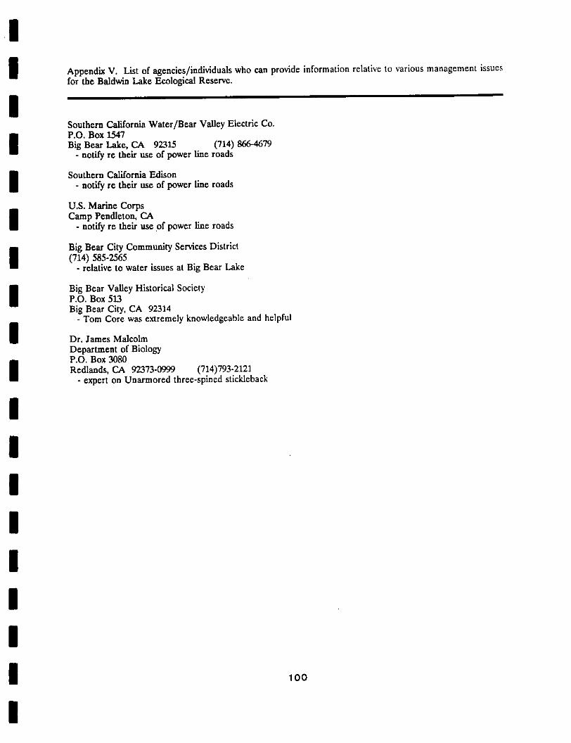
II Appendix V. List of agencies/individuals who can provide information relative to various management issues
for the Baldwin Lake Ecological Reserve.
ISouthern California Water/Bear Valley Electric Co.
i P.O. Box 1547Big Bear Lake, CA 92315 (714) 866-4679- notify re their use of power line roads
I Southern California Edison- notify re their use of power llne roads
U.S. Marine Corps
I Camp Pendleton, CA- notify re their use .of power line roads
Big Bear City Community Services District
i (714)585-2565- relative to water issues at Big Bear Lake
I Big Bear Valley Historical SocietyP.O. Box 513
Big Bear City, CA 92314- Tom Core was extremely knowledgeable and helpful
I Dr. James MalcolmDepartment of BiologyP.O. Box 3080
I Redlands, CA 92373.0999 (714)793-2121- expert on Unarmored three-splned stickleback
IIIIIIII 100
I