


Bahasa
Halaman
Hukum

19 April 2022
POLITECNICO DI TORINORepository ISTITUZIONALE
Renewing Local Planning to Face Climate Change in the Tropics / Tiepolo, Maurizio; Pezzoli, Alessandro; Vieri,Tarchiani. - STAMPA. - (2017), pp. 1-372.
Original
Renewing Local Planning to Face Climate Change in the Tropics
Publisher:
PublishedDOI:
Terms of use:openAccess
Publisher copyright
(Article begins on next page)
This article is made available under terms and conditions as specified in the corresponding bibliographic description inthe repository
Availability:This version is available at: 11583/2644902 since: 2019-07-23T20:24:03Z
Springer Open
Green Energy and Technology
Maurizio TiepoloAlessandro PezzoliVieri Tarchiani Editors
Renewing Local Planning to Face Climate Change in the Tropics

Green Energy and Technology

More information about this series at http://www.springer.com/series/8059
Maurizio Tiepolo • Alessandro PezzoliVieri TarchianiEditors
Renewing Local Planningto Face Climate Changein the Tropics
EditorsMaurizio TiepoloDIST, Politecnico and Universityof Turin
TurinItaly
Alessandro PezzoliDIST, Politecnico and Universityof Turin
TurinItaly
Vieri TarchianiIBIMET-CNRFlorenceItaly
ISSN 1865-3529 ISSN 1865-3537 (electronic)Green Energy and TechnologyISBN 978-3-319-59095-0 ISBN 978-3-319-59096-7 (eBook)DOI 10.1007/978-3-319-59096-7
Library of Congress Control Number: 2017940819
© The Editor(s) (if applicable) and The Author(s) 2017. This book is an open access publicationOpen Access This book is licensed under the terms of the Creative Commons Attribution 4.0International License (http://creativecommons.org/licenses/by/4.0/), which permits use, sharing, adap-tation, distribution and reproduction in any medium or format, as long as you give appropriate credit tothe original author(s) and the source, provide a link to the Creative Commons license and indicate ifchanges were made.The images or other third party material in this book are included in the book’s Creative Commonslicense, unless indicated otherwise in a credit line to the material. If material is not included in the book’sCreative Commons license and your intended use is not permitted by statutory regulation or exceeds thepermitted use, you will need to obtain permission directly from the copyright holder.The use of general descriptive names, registered names, trademarks, service marks, etc. in this publi-cation does not imply, even in the absence of a specific statement, that such names are exempt from therelevant protective laws and regulations and therefore free for general use.The publisher, the authors and the editors are safe to assume that the advice and information in thisbook are believed to be true and accurate at the date of publication. Neither the publisher nor theauthors or the editors give a warranty, express or implied, with respect to the material contained herein orfor any errors or omissions that may have been made. The publisher remains neutral with regard tojurisdictional claims in published maps and institutional affiliations.
Printed on acid-free paper
This Springer imprint is published by Springer NatureThe registered company is Springer International Publishing AGThe registered company address is: Gewerbestrasse 11, 6330 Cham, Switzerland
To Silvia Macchi,our esteemed colleague at SapienzaUniversity of Rome,involved in climate planning anddevelopment aid,who passed away during the finalpreparation of the book.We would like to dedicate this volumeto her memory.
Foreword
The adverse impacts on human-induced climate change are a global problem withdifferent impacts in different localities around the world.
Hence, adapting to those adverse impacts of climate change is both a local and aglobal problem. At the global level, we have agreed to include tackling climatechange as one of the Sustainable Development Goals (SDG13) and also agreed theParis agreement on climate change.
However, the success of meeting those global goals will depend on everyvillage, town, and city finding its own adaptation solutions and putting them inplace. Unfortunately, we are still lagging behind in being able to do this successfullyalthough many efforts are being tried around the world.
This publication tries to learn and share lessons from many of the local-levelefforts around the world. These lessons will be very useful for practitioners in townsand cities around the world who are also struggling to find adaptation solutions intheir own localities.
Saleemul HukIIED-International Institute for Environment
and Development, London, UKICCCAD-International Centre for Climate Change
and Development, Independent University, Dhaka, Bangladesh
vii
Preface
This book presents the most recent results of a research started at the end of 2011 inAfrica South of the Sahara and then extended to the whole tropics. The focus of ourwork is climate planning. With this term, we mean all those plans to limit climatechange (mitigation and sustainable action plans), to protect human settlementsagainst its impacts (emergency, risk reduction, adaptation plans, and resiliencestrategies) and to pursue both the medium-term (municipal development plans) andlong-term (comprehensive, general, and master plans) aims.
During these years, we have organized three UICCA—Urban Impact of ClimateChange in Africa—conferences (Turin 2011, 2013, 2016) to share and discuss thefirst results of our work with other similar experiences, involving over one hundredresearchers, various officials and local administrators, as well as numerous students.
A selection of the reports presented at the 3rd UICCA conference is providedhere. The book tackles a topic which is going to be critical in the years to come:How to implement the 11th Sustainable Development Goal—SDG (2015). We arereferring to the target which states “By 2020, substantially increase the number ofcities and human settlements adopting and implementing integrated policies andplans toward inclusion, resource efficiency, mitigation and adaptation to climatechange, resilience to disasters, and develop and implement, in line with the SendaiFramework for disaster risk reduction 2015–2030, holistic disaster risk manage-ment at all levels” (United Nations’ Sustainable Development Goal 11).
Today, the debate and literature on SDGs is focused on monitoring the achieve-ment of the goals. The aim of our work, on the other hand, is to draw attention on howto reach the above-mentioned target of SDGs at 2030. And the reason lies in the factthe tools used so far to center the target lack efficiency and the cities which will mostneed to use them have little or no knowledge of them.Our work raises thematter of thequality of climate planning. And this looks at the analyses prior to planning, decisionmaking for planning, and the innovation of climate measures. However, it also looksat transversal topics, such as IT systems and planningmethods. For example, we focuson the transition from participated planning built upon traditional knowledge only,which still prevails in the Least Developed Countries (LCDs), to that which integratesthis with technical-scientific knowledge, which is better suited to identifying the
ix
nature of the climate change, and the expected impacts of adaptation and riskreduction measures.
The attention of the book is aimed at the tropical LDCs in that they contain thecities less able to limit the emissions responsible for climate change and to copewith the impacts of the latter but which, at the same time, will be the context inwhich the biggest transformations in human settlements will take place within thenext 15 years.
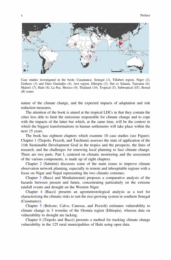
The book has eighteen chapters which examine 10 case studies (see Figure).Chapter 1 (Tiepolo, Pezzoli, and Tarchiani) assesses the state of application of the11th Sustainable Development Goal in the tropics and the prospects, the lines ofresearch, and the challenges for renewing local planning to face climate change.There are two parts. Part I, centered on climatic monitoring and the assessmentof the various components, is made up of eight chapters.
Chapter 2 (Sabatini) discusses some of the main issues to improve climateobservation network planning, especially in remote and inhospitable regions with afocus on Niger and Nepal representing the two climatic extremes.
Chapter 3 (Bacci and Mouhaimouni) proposes a comparative analysis of thehazards between present and future, concentrating particularly on the extremerainfall events and drought on the Western Niger.
Chapter 4 (Bacci) presents an agrometeorological analysis as a tool forcharacterizing the climatic risks to suit the rice-growing system in southern Senegal(Casamance).
Chapter 5 (Belcore, Calvo, Canessa, and Pezzoli) estimates vulnerability toclimate change in 3 woredas of the Oromia region (Ethiopia), whereas data onvulnerability to drought are lacking.
Chapter 6 (Tiepolo and Bacci) presents a method for tracking climate changevulnerability in the 125 rural municipalities of Haiti using open data.
Case studies investigated in the book: Casamance, Senegal (1), Tillaberi region, Niger (2),Gotheye (3) and Ouro Gueladjio (4), Arsi region, Ethiopia (5), Dar es Salaam, Tanzania (6),Malawi (7), Haiti (8), La Paz, Mexico (9), Thailand (10), Tropical (T), Subtropical (ST), Boreal(B) zones
x Preface
Chapter 7 (Demarchi, Cristofori, and Facello) presents an early warning systemfor urban Malawi integrating satellite-derived precipitation data and geospatialreference datasets.
Chapter 8 (Vignaroli) proposes a Web-based approach for early drought riskidentification using freely available rainfall estimations and forecasts to strengthenthe mechanism for the prevention and management of the food crisis in Sahel.
Chapter 9 (Franzetti, Bagliani, and Pezzoli) tackles the climatic characterizationof Thailand.
Part II of this book also collects eight chapters which look mainly atdecision-making tools for local climate planning and innovation in climaticmeasures.
Chapter 10 (Tiepolo) presents the state of climate planning in 338 large- andmedium-sized cities in the tropics using the QCPI—Quality of Climate PlanningIndex.
Chapter 11 (Tiepolo and Braccio) presents a case of multirisk analysis andevaluation in rural Niger integrating local and scientific knowledge.
Chapter 12 (Fiorillo and Tarchiani) presents a simplified method for assessingflood hazard and related risks using open-access tools and data in a rural munici-pality in south Western Niger.
Chapter 13 (Faldi and Macchi) presents an application for forecasting and par-ticipatory backcasting methods for assessing urban people’s vulnerability to wateraccess in Dar es Salaam, Tanzania.
Chapter 14 (Emperador, Orozco Noriega, Ponte, and Vargas Moreno) presents amethod for climate risk reduction mainstreaming at La Paz, Mexico.
Chapter 15 (Bechis) presents an innovative stove for limiting the use of wood asa fuel for cooking in Niger, using farming and forestry residues, estimating thepotential impacts on renewable natural resources.
Chapter 16 (Di Marcantonio and Kayitakire) presents a review of theindex-based insurance in Africa as a tool to reduce climatic risk at rural level.
Chapter 17 (Schultz and Adler) presents the climate vulnerability reductioncredit system applied to rural Niger to assess the outputs of climate adaptationmeasures to reduce vulnerability to climate change.
Chapter 18 (Tiepolo, Pezzoli, and Tarchiani) gathers conclusions, indicates areasfor future research, and supplies numerous recommendations for renewing localplanning in the tropics to the main stakeholders.
Turin, Italy Maurizio TiepoloTurin, Italy Alessandro PezzoliFlorence, Italy Vieri Tarchiani
Preface xi
Acknowledgements
Numerous people contributed to the realization of the 3rd UICCA conference andthe subsequent book. We would especially like to record Mauro Pedalino, StefaniaCametti, and Bruno Gentile of the Italian development cooperation that allowed theANADIA Niger project to extend its activities to the conference. We are in debtwith Elisabetta Franzé and Marcella Guy for financial management; Cinzia Paganoand Luisa Montobbio for the Internet management; Eleonora d’Elia and NoemiGiraudo for helping us during the conference organization; and Timotheos Vissilioufor photographs and press release. If the works have left a mark on all of us, it isthanks to Prof. Raffaele Paloscia (University of Florence), who led the finalroundtable and drew the conclusions of the event. Our sincere thanks go to all thosewho attended the conference and who asked question, enriched it with contributionsor simply listened. All these people gave us the impression that we were part ofsomething important.
We would like to thank Katiellou Gatpia Lawan and Aissa Sitta as respectivelythe ANADIA national project manager and national technical coordinator.A special thanks to Moussa Labo, director of National Directorate of Meteorologyof Niger, for his support in ANADIA activities. We acknowledge the WorldClimate Research Programme’s working group on coupled modeling, which isresponsible for CMIP, and we thank the climate modeling groups for producingtheir model output and making it available. For CMIP, the US Department ofEnergy’s Program for climate model diagnosis and intercomparison that providedcoordinating support and led development of software infrastructure in partnershipwith the Global Organization for Earth System Science portals (Chap. 3), all thecollegues of the PAPSEN project especially Andrea Di Vecchia (project coordi-nator), Institute of Biometeorology-Italian National Research Council. A specialthanks goes to the regional directorate for Rural Development of the SédhiouRegion (Senegal) and Marco Manzelli (IBIMET) for information on critical stagesfor rice crops in Mid-Upper Casamance (Chap. 4) and to University of Turin forInternational Cooperation project, which supported three young researchers in theSiraro, Shalla, and Shashame Woredas for three months to exchange data and
xiii
experience with LVIA NGO. Many thanks are also due to the LVIA staff in Italyand in Ethiopia for their precious leading work in field and their active preparationdesk work (Chap. 5). We remain indebted to Ottavio Novelli (AESA Group) forhaving enabled the activity which inspired the open data index for vulnerabilitytracking in rural Haiti (Chap. 6); Tiziana de Filippis, Leandro Rocchi, MaurizioBacci, Elena Rapisardi (IBIMET-CNR) for CRZ model implementation and 4 cropsystem Web application development (Chap. 8); Chayanis Krittasudthacheewaof the Stockholm Environment Institute, Asia Centre for hosting a student ininternship and for being a mentor to this student in the research (Chap. 9); AndreaMelillo and Simone Ghibaudo for map design; and Idrissa Mamoudou (CNEDDNiger) for providing valuable information on municipal development plans in Niger(Chap. 10), and Thierry Negre for helping the collection of information (Chap. 16).
The editors would like to thank the head of the DIST, Prof. Patrizia Lombardi,and the head of IBIMET-CNR, Antonio Raschi, for their constant support,encouragement, and unwavering trust.
xiv Acknowledgements
Contents
1 Renewing Climate Planning Locally to Attendthe 11th Sustainable Development Goal in the Tropics . . . . . . . . . . 1Maurizio Tiepolo, Alessandro Pezzoli and Vieri Tarchiani
Part I Analysis for Planning
2 Setting up and Managing Automatic Weather Stationsfor Remote Sites Monitoring: From Niger to Nepal . . . . . . . . . . . . . 21Francesco Sabatini
3 Hazard Events Characterization in Tillaberi Region, Niger:Present and Future Projections . . . . . . . . . . . . . . . . . . . . . . . . . . . . . 41Maurizio Bacci and Moussa Mouhaïmouni
4 Characterization of Climate Risks for Rice Cropin Casamance, Senegal . . . . . . . . . . . . . . . . . . . . . . . . . . . . . . . . . . . . 57Maurizio Bacci
5 A Methodology for the Vulnerability Analysisof the Climate Change in the Oromia Region, Ethiopia . . . . . . . . . . 73Elena Belcore, Angela Calvo, Carolin Canessaand Alessandro Pezzoli
6 Tracking Climate Change Vulnerability at MunicipalLevel in Rural Haiti Using Open Data . . . . . . . . . . . . . . . . . . . . . . . 103Maurizio Tiepolo and Maurizio Bacci
7 Visualize and Communicate Extreme Weather Riskto Improve Urban Resilience in Malawi . . . . . . . . . . . . . . . . . . . . . . 133Alessandro Demarchi, Elena Isotta Cristofori and Anna Facello
8 Building Resilience to Drought in the Sahelby Early Risk Identification and Advices . . . . . . . . . . . . . . . . . . . . . 151Patrizio Vignaroli
xv
9 Rethinking Water Resources Management Undera Climate Change Perspective: From National to Local Level.The Case of Thailand . . . . . . . . . . . . . . . . . . . . . . . . . . . . . . . . . . . . . 169Francesca Franzetti, Alessandro Pezzoli and Marco Bagliani
Part II Decision Making Tools for Climate Planning
10 Relevance and Quality of Climate Planningfor Large and Medium-Sized Cities of the Tropics . . . . . . . . . . . . . . 199Maurizio Tiepolo
11 Local and Scientific Knowledge Integrationfor Multi-risk Assessment in Rural Niger . . . . . . . . . . . . . . . . . . . . . 227Maurizio Tiepolo and Sarah Braccio
12 A Simplified Hydrological Method for Flood RiskAssessment at Sub-basin Level in Niger . . . . . . . . . . . . . . . . . . . . . . 247Edoardo Fiorillo and Vieri Tarchiani
13 Knowledge for Transformational Adaptation Planning:Comparing the Potential of Forecasting and BackcastingMethods for Assessing People’s Vulnerability . . . . . . . . . . . . . . . . . . 265Giuseppe Faldi and Silvia Macchi
14 An Effective Approach to Mainstreaming DRRand Resilience in La Paz, Mexico. . . . . . . . . . . . . . . . . . . . . . . . . . . . 285Juan Carlos Vargas Moreno, Enrico Ponte, Sophia Emperadorand Marcela Orozco Noriega
15 Possible Impact of Pelletised Crop Residues Useas a Fuel for Cooking in Niger . . . . . . . . . . . . . . . . . . . . . . . . . . . . . . 311Stefano Bechis
16 Review of Pilot Projects on Index-Based Insurancein Africa: Insights and Lessons Learned . . . . . . . . . . . . . . . . . . . . . . 323Federica Di Marcantonio and François Kayitakire
17 Addressing Climate Change Impacts in the SahelUsing Vulnerability Reduction Credits . . . . . . . . . . . . . . . . . . . . . . . 343Karl Schultz and Linus Adler
18 Renewing Climate Planning Locally in the Tropics:Conclusions . . . . . . . . . . . . . . . . . . . . . . . . . . . . . . . . . . . . . . . . . . . . . 365Maurizio Tiepolo, Alessandro Pezzoli and Vieri Tarchiani
xvi Contents
Chapter 1Renewing Climate Planning Locallyto Attend the 11th SustainableDevelopment Goal in the Tropics
Maurizio Tiepolo, Alessandro Pezzoli and Vieri Tarchiani
Abstract In the last seven years, tropical cities with a climate plan have tripledcompared to the previous seven years. According to the 11th United Nations’Sustainable Development Goal, climate planning should significantly increase by2030. The Sendai framework for disaster risk reduction (2015) and the New urbanagenda signed in Quito (2016) indicate how to achieve this goal through analysis,categories of plans and specific measures. This chapter identifies the main obstaclesto the significant increase in tropical human settlements with a climate plan and thepossible solutions. First of all, the distribution and trend at 2030 of tropical humansettlements are ascertained. Then local access to information on damage, hazard,exposure, vulnerability and risk, and the consideration of these aspects in the nationalguides to local climate planning are verified. Lastly, the categories of plans andclimate measures recommended by the United Nations are compared with those thatare most common today, using a database of 401 climate plans for 338 tropical citiesrelating to 41 countries. The chapter highlights the fact that the prescription fortreating tropical cities affected by climate change has been prepared without anaccurate diagnosis. Significantly increasing climate planning must consider thatsmall-medium human settlements in the Tropics will prevail at least until 2030. Andmost effort will be required from Developing and Least Developed Countries. Therecommendations of the United Nations concerning the preliminary analyses ignorethe fact that local authorities usually do not have access to the necessary information.
M. Tiepolo is the author of 1.3.3, 1.3.4 and 1.4 sections. A. Pezzoli is the author of 1.1 and 1.2sections. V. Tarchiani is the author of 1.3.1, 1.3.2 and 1.5 sections.
M. Tiepolo (&) A. PezzoliDIST, Politecnico and University of Turin, Viale Mattioli 39, 10125 Turin, Italye-mail: [email protected]
A. Pezzolie-mail: [email protected]
V. TarchianiNational Research Council—Institute of BioMeteorology (IBIMET),Via Giovanni Caproni 8, 50145 Florence, Italye-mail: [email protected]
© The Author(s) 2017M. Tiepolo et al. (eds.), Renewing Local Planning to Face ClimateChange in the Tropics, Green Energy and Technology,DOI 10.1007/978-3-319-59096-7_1
1
Climate plans and recommended measures are not those currently in use. We proposethree areas of action to facilitate the mainstreaming of the recommendations in thetropical context. They require a renewal of the local planning process if we intend toreach the 11th SDG by 2030.
Keywords Climate change Climate planning SDG Mainstreaming Opensource maps Open data Plan guidelines Vulnerability Tropics
1.1 Introduction
Today, in the Tropics, one large or medium-size city out of four has a plan to reducegreenhouse gas emissions (mitigation and sustainable plans), the impacts of globalwarming (emergency, adaptation, resilience plans) or both (general, comprehensiveplans). We don’t know how frequent these plans are in towns (under 0.1 millionpop.) and in rural areas. The resolutions of the United Nations, expressed in the2030 Agenda for sustainable development (2015), in the Sendai Framework (2015)and in the New urban agenda (2016) supply numerous recommendations to “sub-stantially increase the number of cities and human settlements adopting andimplementing integrated policies and plans towards inclusion, resource efficiency,mitigation and adaptation to climate change, resilience to disasters, and develop andimplement… holistic disaster risk management at all levels” (UNESC 2016: 28;UN General Assembly 2015).
Getting started with 11th SDG requires more than a simple review of thelong-term planning practices, developing need assessment, costing and monitoring(SDSN 2015), this last aspect being the current focus of much reflection on SDGs.
While knowledge of local climatic planning in the Tropics has increased in recentyears (Seto et al. 2014), only recently have systematic analyses been developed(Macchi and Tiepolo 2014; Tiepolo et al. 2016; Tiepolo 2017) and vulnerabilityassessment and risk evaluation have been tested in urban areas (Sakai et al. 2016) andrural locations (Pezzoli and Ponte 2016; Tarchiani and Tiepolo 2016).
The objective of this chapter is to identify the obstacles to the mainstreaming ofthe United Nations recommendations in the Tropics and how to overcome them.
In the Tropics, the urban population is expected to rise by 43% by 2030: doublethe increase in the rest of the world (UNDESA 2014). This rapid urbanisation takesplace in a context characterised by widespread underdevelopment (96% of LeastDeveloped Countries-LDCs are in the Tropics) and the presence of advancedeconomies (Brazil, China, France, Mexico, Singapore, South Africa, Taiwan,USA). In advanced economies, plans and policies to support adaptation and themitigation of climate change are consolidated, while in Developing Countries andespecially in LDCs, there is a prevalence of community-based adaptation under-taken by Non-Governmental Organizations-NGOs and partners in development.This said, it is in the Tropics that certain measures to face climate change practiced
2 M. Tiepolo et al.
in advanced economies can be adapted and reproposed to LDCs, because they areconceived to cope with the same hazards.
The following sections analyse the 11th SDG, the recommendations relating toclimate planning in the Sendai Framework and in the New urban agenda. Thenidentify today’s distribution of tropical human settlements by demographic classand that expected by 2030. The next step is the consideration of access to theinformation necessary to develop the analyses of exposure, vulnerability, and riskrecommended by the United Nations. Then the analyses recommended by thenational guidelines to local climate planning are identified. Lastly, the most popularplan categories and climate measures in the Tropics are analysed. This highlightswhat is missing from the mainstreaming of the recommendations of the UnitedNations.
1.2 Materials and Methods
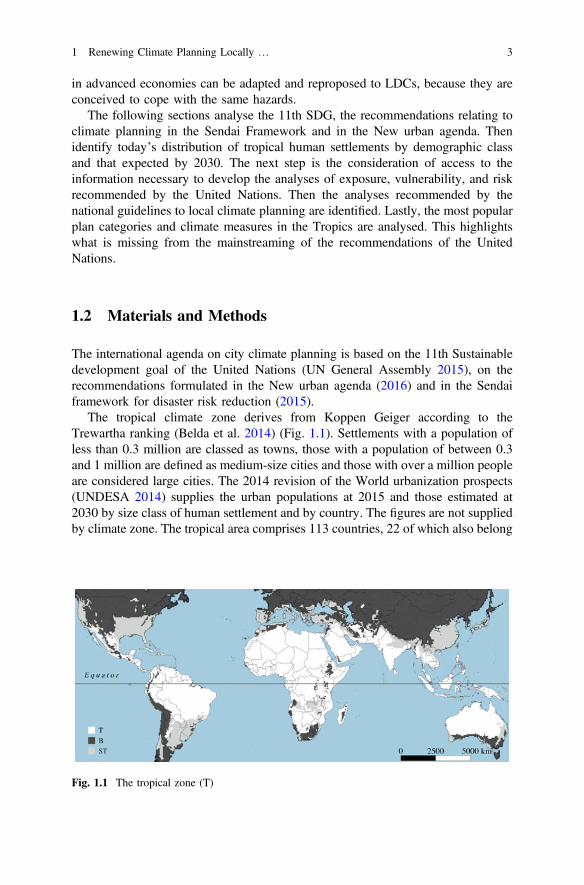
The international agenda on city climate planning is based on the 11th Sustainabledevelopment goal of the United Nations (UN General Assembly 2015), on therecommendations formulated in the New urban agenda (2016) and in the Sendaiframework for disaster risk reduction (2015).
The tropical climate zone derives from Koppen Geiger according to theTrewartha ranking (Belda et al. 2014) (Fig. 1.1). Settlements with a population ofless than 0.3 million are classed as towns, those with a population of between 0.3and 1 million are defined as medium-size cities and those with over a million peopleare considered large cities. The 2014 revision of the World urbanization prospects(UNDESA 2014) supplies the urban populations at 2015 and those estimated at2030 by size class of human settlement and by country. The figures are not suppliedby climate zone. The tropical area comprises 113 countries, 22 of which also belong
Fig. 1.1 The tropical zone (T)
1 Renewing Climate Planning Locally … 3
to other areas (subtropical and, sometimes, boreal) like the Andine countries, andvarious countries in Southern Asia and Southern Africa. The UNDESA informationallows us to identify the inhabitants of the tropics only for settlements 0.1–0.3million inhabitants. We don’t know how many people live in settlements with lessthan 0.3 million inhabitants in the tropical area. We have assumed that these set-tlements have the same share of cities (>0.3 million pop.) falling within the tropicalzone of the country in question. This gave us the population of the towns in thetropics. This information on the population by category of human settlementsallows us to highlight the characteristics of tropical human settlements and theirtrend at 2030.
This chapter, however, aims to appreciate the current relevance of climateplanning, so we need to compare the number of human settlements with the numberof climate plans. We have to pass from the population of the urban agglomerationsto the number of administrative jurisdictions, conserving the articulation by class ofdemographic size. The UNDESA database cannot help us in this analysis.
Consequently, we have prepared a specific database starting from the nationalcensuses of the tropical countries. It has enabled us not only to identify the numberof tropical human settlements with more than 0.1 million inhabitants, but also toidentify the transition that human settlements will make from one class to another inthe years to come, due to the urbanisation process, an aspect which is not con-sidered by the UNDESA statistics. The new entries have been identified byapplying the average growth rate 2010–15 of the cities of every tropical country(UNDESA 2014) to towns with less than 0.1 million inhabitants and considering allthe towns expected to pass the population threshold of 0.1 million by 2030. Therates vary from 0.2% (Australia, Venezuela) to 3.7% per annum (Rwanda) which,in this last case, would take all towns that have more than 60 thousand inhabitantsnowadays above 100 thousand by 2030.
The relevance of local climate planning and of the relative climate measures isobtained from two previous surveys (Tiepolo and Cristofori 2016; Tiepolo 2017) onclimate plans in the large and medium size cities of the Tropics. The database usedcontains 364 plans related to 322 tropical cities in 41 countries, updated toDecember 2016. With the term local we intend the minimum administrative levelwith safety and environmental tasks, which comprise climate mitigation andadaptation. In most cases, this level corresponds to municipalities.
The capacity of cities to develop hazard, damage, exposure, vulnerability andrisk analyses recommended by the United Nations depends on open access tohazard, vulnerability and risk maps on a local scale (municipal). The examination iscarried out on the web, in just the 41 countries that currently have climate plans.
The analyses recommended today are based upon 13 guidelines for the prepa-ration of local risk mitigation/adaptation/reduction plans. Some guidelines arenational while others regard single states (Chiapas in Mexico, California, andArizona in the USA) (Table 1.1). The information on climate plans and measurescontained comes from our database on 364 plans for 322 tropical cities.
4 M. Tiepolo et al.
1.3 Results
1.3.1 Future Climate Planning According to the UN Vision
The resolutions adopted by the United Nations General Assembly on the 2030agenda for sustainable development (2015), the Sendai framework for disaster riskreduction and the New urban agenda (NUA) trace the path for improving andextending climate planning (UN General Assembly 2015; UNISDR 2015, UNConference 2016).
The 11th SDG envisages a substantial increase in climate plans for cities andhuman settlements. The Framework and the NUA contain 25 recommendationsrelated to climate planning: type of analysis, plan categories, type of climateplanning. Emergency and risk reduction plans, zoning maps and development codesare recommended as well as seven climate measures: four for adaptation and threefor mitigation. Next steps are: first, to check whether planning tools recommendedby the United Nations are suited to the main type of settlement of the Tropics;second, to assess to what extent it is possible to increase the dissemination ofclimate planning given the planning capacity demonstrated over the past sevenyears; third, to learn if the analyses recommended can be implemented with theinformation available today; fourth, to learn if the types of plans and measuresrecommended have already been implemented or are brand new.
1.3.2 Importance of the Tropical Human Settlements
A third of the world’s urban population lives in the tropics and this share isexpected to rise by 2030. This will change the breakdown of human settlements bycategory of demographic size. Large cities (over one million inhabitants) areexpected to pass from 38 to 44% of the urban population.
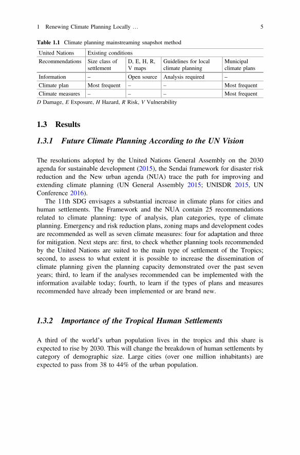
Table 1.1 Climate planning mainstreaming snapshot method
United Nations Existing conditions
Recommendations Size class ofsettlement
D, E, H, R,V maps
Guidelines for localclimate planning
Municipalclimate plans
Information – Open source Analysis required –
Climate plan Most frequent – – Most frequent
Climate measures – – – Most frequent
D Damage, E Exposure, H Hazard, R Risk, V Vulnerability
1 Renewing Climate Planning Locally … 5
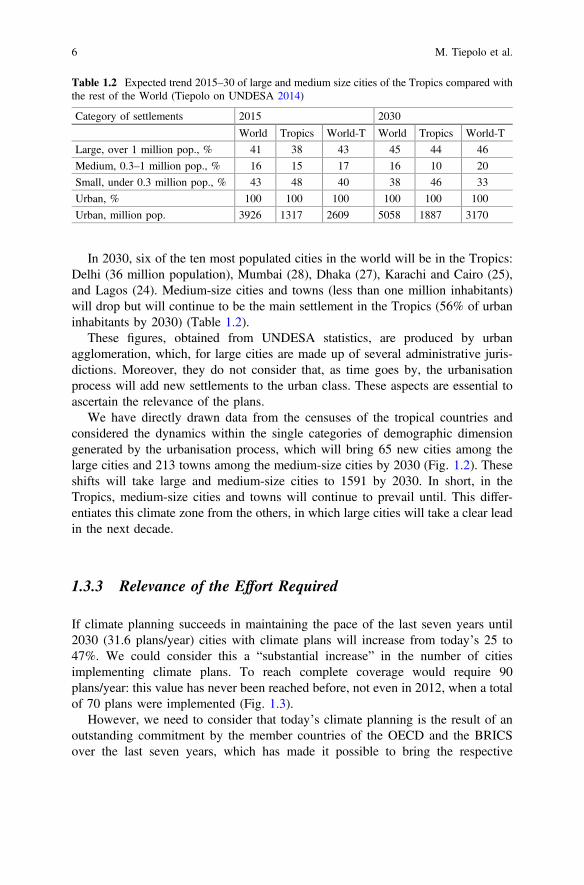
In 2030, six of the ten most populated cities in the world will be in the Tropics:Delhi (36 million population), Mumbai (28), Dhaka (27), Karachi and Cairo (25),and Lagos (24). Medium-size cities and towns (less than one million inhabitants)will drop but will continue to be the main settlement in the Tropics (56% of urbaninhabitants by 2030) (Table 1.2).
These figures, obtained from UNDESA statistics, are produced by urbanagglomeration, which, for large cities are made up of several administrative juris-dictions. Moreover, they do not consider that, as time goes by, the urbanisationprocess will add new settlements to the urban class. These aspects are essential toascertain the relevance of the plans.
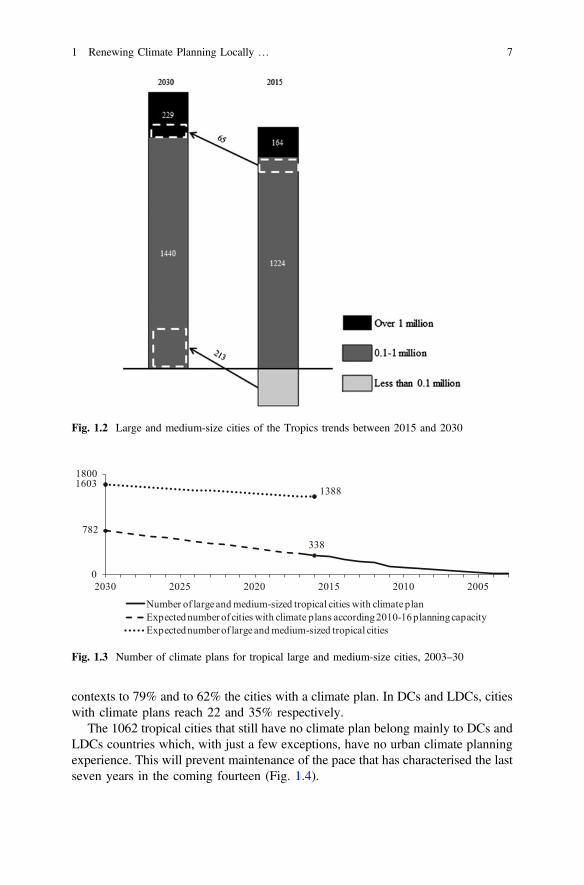
We have directly drawn data from the censuses of the tropical countries andconsidered the dynamics within the single categories of demographic dimensiongenerated by the urbanisation process, which will bring 65 new cities among thelarge cities and 213 towns among the medium-size cities by 2030 (Fig. 1.2). Theseshifts will take large and medium-size cities to 1591 by 2030. In short, in theTropics, medium-size cities and towns will continue to prevail until. This differ-entiates this climate zone from the others, in which large cities will take a clear leadin the next decade.
1.3.3 Relevance of the Effort Required
If climate planning succeeds in maintaining the pace of the last seven years until2030 (31.6 plans/year) cities with climate plans will increase from today’s 25 to47%. We could consider this a “substantial increase” in the number of citiesimplementing climate plans. To reach complete coverage would require 90plans/year: this value has never been reached before, not even in 2012, when a totalof 70 plans were implemented (Fig. 1.3).
However, we need to consider that today’s climate planning is the result of anoutstanding commitment by the member countries of the OECD and the BRICSover the last seven years, which has made it possible to bring the respective
Table 1.2 Expected trend 2015–30 of large and medium size cities of the Tropics compared withthe rest of the World (Tiepolo on UNDESA 2014)
Category of settlements 2015 2030
World Tropics World-T World Tropics World-T
Large, over 1 million pop., % 41 38 43 45 44 46
Medium, 0.3–1 million pop., % 16 15 17 16 10 20
Small, under 0.3 million pop., % 43 48 40 38 46 33
Urban, % 100 100 100 100 100 100
Urban, million pop. 3926 1317 2609 5058 1887 3170
6 M. Tiepolo et al.
contexts to 79% and to 62% the cities with a climate plan. In DCs and LDCs, citieswith climate plans reach 22 and 35% respectively.
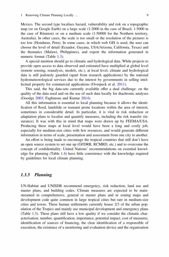
The 1062 tropical cities that still have no climate plan belong mainly to DCs andLDCs countries which, with just a few exceptions, have no urban climate planningexperience. This will prevent maintenance of the pace that has characterised the lastseven years in the coming fourteen (Fig. 1.4).
Fig. 1.2 Large and medium-size cities of the Tropics trends between 2015 and 2030
782338
16031388
0
1800
2030 2025 2020 2015 2010 2005
Number of large and medium-sized tropical cities with climate planExpected number of cities with climate plans according 2010-16 planning capacityExpected number of large and medium-sized tropical cities
Fig. 1.3 Number of climate plans for tropical large and medium-size cities, 2003–30
1 Renewing Climate Planning Locally … 7
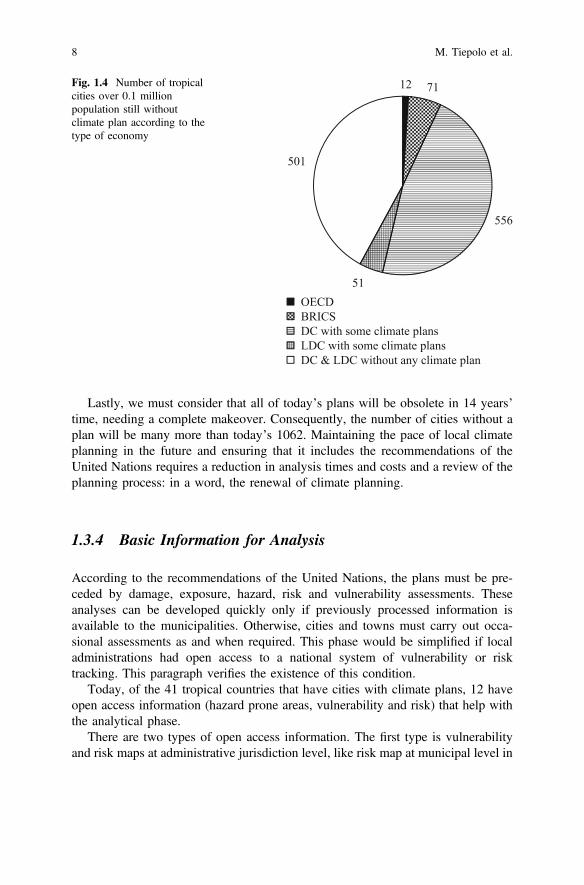
Lastly, we must consider that all of today’s plans will be obsolete in 14 years’time, needing a complete makeover. Consequently, the number of cities without aplan will be many more than today’s 1062. Maintaining the pace of local climateplanning in the future and ensuring that it includes the recommendations of theUnited Nations requires a reduction in analysis times and costs and a review of theplanning process: in a word, the renewal of climate planning.
1.3.4 Basic Information for Analysis
According to the recommendations of the United Nations, the plans must be pre-ceded by damage, exposure, hazard, risk and vulnerability assessments. Theseanalyses can be developed quickly only if previously processed information isavailable to the municipalities. Otherwise, cities and towns must carry out occa-sional assessments as and when required. This phase would be simplified if localadministrations had open access to a national system of vulnerability or risktracking. This paragraph verifies the existence of this condition.
Today, of the 41 tropical countries that have cities with climate plans, 12 haveopen access information (hazard prone areas, vulnerability and risk) that help withthe analytical phase.
There are two types of open access information. The first type is vulnerabilityand risk maps at administrative jurisdiction level, like risk map at municipal level in
12 71
556
51
501
OECDBRICSDC with some climate plansLDC with some climate plansDC & LDC without any climate plan
Fig. 1.4 Number of tropicalcities over 0.1 millionpopulation still withoutclimate plan according to thetype of economy
8 M. Tiepolo et al.
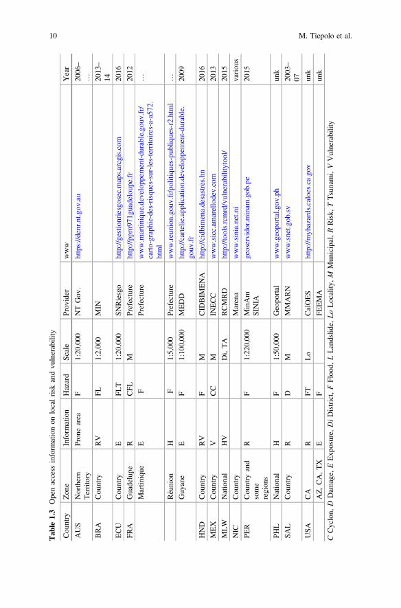
Mexico. The second type localises hazard, vulnerability and risk on a topographicmap (or on Google Earth) on a large scale (1:2000 in the case of Brazil, 1:5000 inthe case of Réunion) or on a medium scale (1:50000 for the Northern territory,Australia). In other cases, the scale is too small or the resolution of the pictures istoo low (Honduras, Peru). In some cases, in which web GIS is used, the user canchoose the level of detail (Ecuador, Guyana, USA/Arizona, California, Texas) andthe thematics (Malawi, Philippines), and export the information generated innumeric format (Table 1.3).
A special mention should go to climatic and hydrological data. While projects toprovide open access to data observed and estimated have multiplied at global level(remote sensing, reanalysis, models, etc.), at local level, climate and hydrologicaldata is still jealously guarded (apart from research applications) by the nationalhydrometeorological services due to the interest by governments in selling intel-lectual property for commercial applications (Overpeck et al. 2011).
This said, the big data-sets currently available offer a dual challenge: on thequality of the data used and on the use of such data locally for diachronic analyses(Goodge 2003; Faghmous and Kumar 2014).
All this information is essential to local planning because it allows the identi-fication of flood, landslide or tsunami prone locations within the area of interest,sometimes in considerable detail. In particular, it is vital in risk reduction oradaptation plans to localise and quantify measures, including the risk transfer (in-surance). It was with this in mind that maps were drawn up by FEEMA/USA.Producing these maps at local level would have been a long and costly job,especially for medium-size cities with few resources, and would generate differentinformation in terms of scale, presentation and assessment from one city to another.
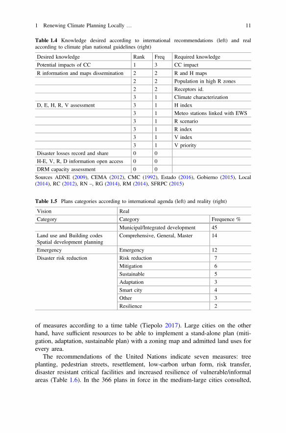
An effort is being made to encourage the tropical countries that still don’t havean open source system to set one up (GFDRR, RCMRD, etc.) and to overcome theconcept of confidentiality. United Nations’ recommendations on essential knowl-edge for planning (Table 1.4) have little consistence with the knowledge requiredby guidelines for local climate planning.
1.3.5 Planning
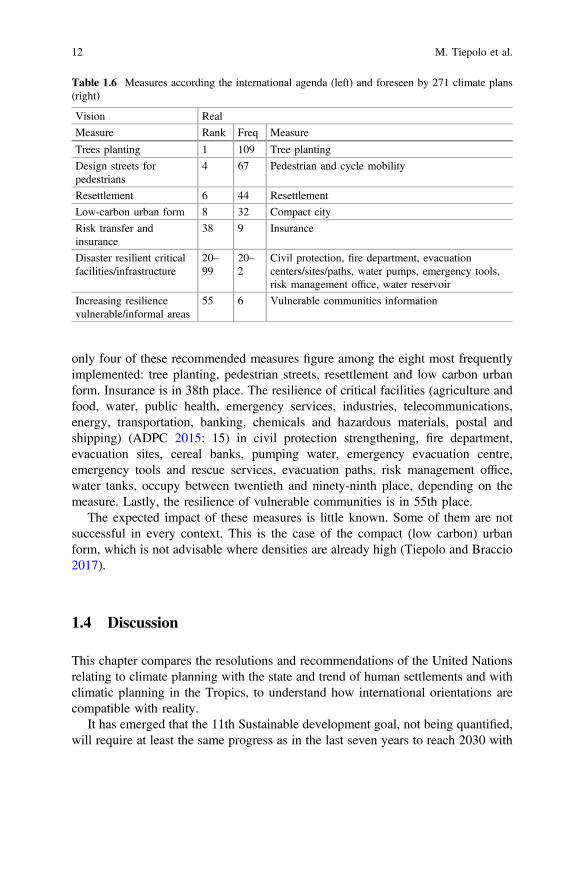
UN-Habitat and UNISDR recommend emergency, risk reduction, land use andmaster plans, and building codes. Climate measures are expected to be main-streamed in comprehensive, general or master plans and in zoning maps anddevelopment code quite common in large tropical cities but rare in medium-sizecities and towns. These human settlements currently house 2/3 of the urban pop-ulation of the Tropics and mainly use municipal development and emergency plans(Table 1.5). These plans still have a low quality if we consider the climatic char-acterisation, number, quantification, importance, potential impact, cost of measures,identification of sources of financing, the clear identification of a responsible ofexecution, the existence of a monitoring and evaluation device and the organisation
1 Renewing Climate Planning Locally … 9
Tab
le1.3
Openaccess
inform
ationon
localrisk
andvu
lnerability
Cou
ntry
Zon
eInform
ation
Hazard
Scale
Prov
ider
www
Year
AUS
Northern
Territory
Pron
earea
F1:20
,000
NTGov
.https://d
enr.n
t.gov
.au
2006
–
…
BRA
Cou
ntry
RV
FL1:2,00
0MIN
2013
–
14
ECU
Cou
ntry
EFL
T1:20
,000
SNRiesgo
http://gestionriesgosec.m
aps.arcgis.com
2016
FRA
Guadelupe
RCFL
MPrefecture
http://pp
rn97
1guadeloup
e.fr
2012
Martin
ique
EF
Prefecture
www.m
artin
ique.develop
pement-du
rable.go
uv.fr/
carto-graphie-des-risques-sur-les-territo
ires-a-a57
2.html
…
Réunion
HF
1:5,00
0Prefecture
www.re
union.go
uv.fr/politiqu
es-pub
liques-r2.htm
l…
Guy
ane
EF
1:10
0,00
0MEDD
http://cartelie.app
lication.developp
ement-du
rable.
gouv
.fr20
09
HND
Cou
ntry
RV
FM
CID
BIM
ENA
http://cidb
imena.desastres.hn
2016
MEX
Cou
ntry
VCC
MIN
ECC
www.sicc.am
arellodev.com
2013
MLW
National
HV
Di,TA
RCMRD
http://tools.rcmrd/vulnerabilitytoo
l/20
15
NIC
Cou
ntry
Marena
www.sinia.net.ni
variou
s
PER
Cou
ntry
and
some
region
s
RF
1:22
0,00
0MinAm
SINIA
geoservido
r.minam
.gob
.pe
2015
PHL
National
HF
1:50
,000
Geopo
rtal
www.geopo
rtal.gov
.ph
unk
SAL
Cou
ntry
RD
MMMARN
www.snet.g
ob.sv
2003
–
07
USA
CA
RFT
Lo
CalOES
http://myh
azards.caloes.ca.gov
unk
AZ,C
A,T
XE
FFE
EMA
unk
CCyclon,
DDam
age,
EExp
osure,
DiDistrict,FFloo
d,LLandslid
e,Lo
Locality
,M
Mun
icipal,RRisk,
TTsunami,VVulnerability
10 M. Tiepolo et al.
of measures according to a time table (Tiepolo 2017). Large cities on the otherhand, have sufficient resources to be able to implement a stand-alone plan (miti-gation, adaptation, sustainable plan) with a zoning map and admitted land uses forevery area.
The recommendations of the United Nations indicate seven measures: treeplanting, pedestrian streets, resettlement, low-carbon urban form, risk transfer,disaster resistant critical facilities and increased resilience of vulnerable/informalareas (Table 1.6). In the 366 plans in force in the medium-large cities consulted,
Table 1.4 Knowledge desired according to international recommendations (left) and realaccording to climate plan national guidelines (right)
Desired knowledge Rank Freq Required knowledge
Potential impacts of CC 1 3 CC impact
R information and maps dissemination 2 2 R and H maps
2 2 Population in high R zones
2 2 Receptors id.
3 1 Climate characterization
D, E, H, R, V assessment 3 1 H index
3 1 Meteo stations linked with EWS
3 1 R scenario
3 1 R index
3 1 V index
3 1 V priority
Disaster losses record and share 0 0
H-E, V, R, D information open access 0 0
DRM capacity assessment 0 0
Sources ADNE (2009), CEMA (2012), CMC (1992), Estado (2016), Gobierno (2015), Local(2014), RC (2012), RN –, RG (2014), RM (2014), SFRPC (2015)
Table 1.5 Plans categories according to international agenda (left) and reality (right)
Vision Real
Category Category Frequence %
Municipal/Integrated development 45
Land use and Building codesSpatial development planning
Comprehensive, General, Master 14
Emergency Emergency 12
Disaster risk reduction Risk reduction 7
Mitigation 6
Sustainable 5
Adaptation 3
Smart city 4
Other 3
Resilience 2
1 Renewing Climate Planning Locally … 11
only four of these recommended measures figure among the eight most frequentlyimplemented: tree planting, pedestrian streets, resettlement and low carbon urbanform. Insurance is in 38th place. The resilience of critical facilities (agriculture andfood, water, public health, emergency services, industries, telecommunications,energy, transportation, banking, chemicals and hazardous materials, postal andshipping) (ADPC 2015: 15) in civil protection strengthening, fire department,evacuation sites, cereal banks, pumping water, emergency evacuation centre,emergency tools and rescue services, evacuation paths, risk management office,water tanks, occupy between twentieth and ninety-ninth place, depending on themeasure. Lastly, the resilience of vulnerable communities is in 55th place.
The expected impact of these measures is little known. Some of them are notsuccessful in every context. This is the case of the compact (low carbon) urbanform, which is not advisable where densities are already high (Tiepolo and Braccio2017).
1.4 Discussion
This chapter compares the resolutions and recommendations of the United Nationsrelating to climate planning with the state and trend of human settlements and withclimatic planning in the Tropics, to understand how international orientations arecompatible with reality.
It has emerged that the 11th Sustainable development goal, not being quantified,will require at least the same progress as in the last seven years to reach 2030 with
Table 1.6 Measures according the international agenda (left) and foreseen by 271 climate plans(right)
Vision Real
Measure Rank Freq Measure
Trees planting 1 109 Tree planting
Design streets forpedestrians
4 67 Pedestrian and cycle mobility
Resettlement 6 44 Resettlement
Low-carbon urban form 8 32 Compact city
Risk transfer andinsurance
38 9 Insurance
Disaster resilient criticalfacilities/infrastructure
20–99
20–2
Civil protection, fire department, evacuationcenters/sites/paths, water pumps, emergency tools,risk management office, water reservoir
Increasing resiliencevulnerable/informal areas
55 6 Vulnerable communities information
12 M. Tiepolo et al.
47% of cities equipped with a climate plan. This goal won’t be easy to reachbecause countries with more experience and resources (OECD, BRICS) havealmost completed (62–79%) their local planning, while 67% of cities without a planare in DCs and LDCs.
The first obstacle lies in the lack of urban climate planning experience in half ofthe cities that lack a climate plan today. The second obstacle lies in the lack ofaccess to essential information to assess damage, hazard, exposure, vulnerabilityand risk, since open access systems that allow knowledge of hazards, risks andvulnerability are operational in few tropical countries only. The third obstacle isdual. Firstly, tropical medium-size cities and towns do not use planning tools withzoning maps and building codes to include the climatic measures according to therecommendations of the United Nations. Secondly, the seven climate measuresrecommended by the United Nations are, with just one exception, quite uncommon.
This general framework shadows the considerable effort made by certaincountries: Colombia, with its risk management municipal plans, Mexico with itsmunicipal climate action plans, the USA with its climate action plans, India with thesmart city program, South Africa with risk reduction plans and integrated devel-opment plans, to mention just a few examples. But best practices in a few dozencities are not yet able to generate a propulsive effect on the remaining 1388 tropicallarge and medium size cities.
We have found that the recommendations regarding the implementation of theSDGs do not raise the matter of climate planning quality. We find this to be animportant aspect. Significantly increasing the number of plans isn’t enough. Qualityof these plans matter. This aspect should be considered in 11th SDG monitoring.
We can see four possible solutions. First, hazard assessment. Hazard assessment isnot in particular demand from the national guides to local planning. Planning is rarelyconsequent to climate characterisation. The definition of climate measures does notconsider that drought-prone locations are increasingly being flooded and will be somore and more in the future (e.g. Niger) and that wet areas also suffer droughts whichhave catastrophic effects on farming and human needs (e.g. Paraguay, Haiti).
Second, inclusion of the concept of potential impact on the planning process.The process of prioritisation of the measures is based on potential impact only inmitigation plans. Adaptation plans do not base the prioritisation of measures onpotential impacts. A device that estimates potential impacts, consequently selectsclimate measures and priorities, and monitors the results achieved, communicatingthem to stakeholders to adjust the aim and make them accessible open source,would seem to be helpful. The analytical part, that aimed at ascertaining the risklevel for example, is made up of exclusively participative methods which originatein the participated rural appraisal introduced by Chambers (1992), the best qualitiesof which were the involvement/mobilisation of local communities and the identi-fication of measures compatible with weak local capacities. If, twentyfive years ago,remote rural areas offered few alternatives to indigenous knowledge skills, this havelong since changed: villages have become towns, administrative decentralisationhas now been consolidated almost everywhere, basic infrastructures (water, sewers)are often present, high resolution daily precipitation gridded datasets and Google
1 Renewing Climate Planning Locally … 13
earth images are now available open source throughout the Tropics and for a seriesof years sufficiently long as to allow the appreciation of broad scale climate trendsand their impacts. What is limiting, particularly in LDCs, is the capacity to accessand use this information outside the capital city.
Third, access to open source information for analysis. We should switch fromoccasional assessments to the open source tracking systems of vulnerability andrisk, local needs and action, to address national resources and those of officialdevelopment aid towards the communities most vulnerable to CC and coordinateoperations among the myriad of development partners, avoiding repetitions. Thisinformation cannot be produced locally with acceptable costs and standards. But itcan be produced by central or intermediate bodies and made open access.
Fourth, integrate scientific-technical and local knowledge. The effort required isdual. On one hand, simplifying and contextualising the former in order to make iteasier to be used locally. On the other, fostering learning for adaptation and miti-gation among rural people (Nyong et al. 2007). Reference is made to so-calledclimate services: meaning climate information targeted to assist decision-making.This type of information has to be based on scientifically credible climatic infor-mation and expertise but requires local knowledge of user needs and mutualengagement between users and providers in order to be effective (WMO 2011).
Among the limitations and weaknesses of this chapter, the first thing that shouldbe mentioned is the state of planning in towns (less than 0.1 million inhabitants)which, on a global scale, contain 43% of the urban population.
As regards the implications of our findings, we show that mainstreaming, asrecommended by the United Nations, cannot take place in medium size cities andtowns because this category of human settlements rarely uses physical planningtools. A revolution in the local diagnosis is necessary, switching to the use of openaccess information, collected using a tracking process, integrated with localknowledge and standardized. This will increase the relevance of the plans as well astheir quality.
The recommendations for further research are to extend the diagnosis to towns(rural world) and make it permanent. Another important area of research for thefuture will be the better understanding of the urban-rural relationship, its evolutionand management under climate change. The interconnections between rural andurban areas are complex on a series of interlinked plans: migration, pollution, foodsupply. Many strategic decisions which significantly affect rural communities couldnot be subject to the jurisdiction of local governments, and vice versa, the planningof neighbouring or peri-urban rural areas could influence both the risk and thequality of life of urban populations.
14 M. Tiepolo et al.
1.5 Conclusions
This chapter highlights a paradoxical situation related to climate planning in theTropics: we are in the presence of prescriptions (11th United Nations SDG andrecommendations) without diagnosis (state and trend of human settlements, of localclimate change and climate planning).
We have investigated the relevance of the challenge: much greater than it mightseem, due to the tropical urbanisation, which will add 213 new medium-size citiesin the next 14 years. And then the fact that mostly of the cities that will have tohave climate plans are in DCs and in LDCs, which often have no climate planningat all.
A gap still exists between the vision of the United Nations and the real state ofclimate planning today: cities and towns need to adopt climate plans at a pace of thepast seven years, but not the plans produced so far, and not using the measuresenvisaged up to now, leaving the job to LDCs because the member countries of theOECD and BRICS have already done the job.
Climate planning recommendations regard the analysis and the planning process(categories of plans, measures). The mainstreaming of these recommendationsencounters three obstacles today.
First, the local knowledge of hazards, exposures, damage, vulnerability, and riskis absent or occasional, and is not freely accessible in most (70%) of the 41 tropicalcountries observed. The tracking of these last elements and their free accessibility isessential to extend climate planning, to reduce costs, considering the range ofintervenants (multi-bilateral development aid, coalitions of local governments,central and intermediate governments, NGOs, etc.) and to produce informationwhich is really helpful to the local government. In some cases (Malawi), the albeitcommendable initiative is practiced without taking into account these two aspects:too many indicators to produce the vulnerability index, and an excessively roughgeographic definition to be useful at local level. Second, the physical plans onwhich the mainstreaming recommended by the United Nations focuses are rare intropical small-medium settlements, DCs and, particularly, in LDCs. Third, themeasures recommended aren’t successful in all tropical contexts.
Mainstreaming UN recommendations on local scale requires to fill differentcognitive and procedural gaps, despite the fact that, in recent years, knowledge ofclimate planning has been strengthened.
Analysis. Knowledge of relevant climate trends for urban and rural sectors(agriculture) in contexts which don’t have a network of weather stations on theground or a sufficiently long series of records, vulnerability to climate changeassessment in contests lacking information on a local scale and, transition to openaccess vulnerability tracking, early warning systems.
1 Renewing Climate Planning Locally … 15
Planning process. Assessment of the quality of climate plans, estimate of thepotential of the risk reduction measures, risk reduction methods, backcasting.
Measures. Risk transfer, fuel for cooking, adaptation and adaptation credits.The 18 chapters that follow tackle these matters.
References
ADME-Agence de l’Environnement et de la Maîtrise de l’Energie. 2009. Construire et mettre enoeuvre un Plan climat-energie territorial. Guide méthodologique.
ADPC-Asian Disaster Preparedness Centre. 2015. Disaster recovery toolkit. ADPC: Guidance oncritical facilities. Bangkok.
Belda, M., E. Haltanová, T. Holenke, and J. Kavlová. 2014. Climate classification revisited: FromKoëppen to Trewartha. Climate Research 59: 1–13. doi:10.3354/cr01204.
CEMA-California Emergency Management Agency. 2012. California adaptation planning guide.Chambers, R. 1992. Rural appraisal: Rapid, relaxed and participatory. IDS Discussion Paper 311.Estado plurinacional de Bolivia. Ministerio de planificación del desarrollo. 2016. Lineamentos
metodólogicos para la formulación de planes territoriales de desarrollo integral para vivirbien PTDI.
Faghmous, J.H., and V. Kumar. 2014. Spatio-temporal data mining for climate data: Advances,challenges and opportunities. In Data mining and knowledge discovery for big data—Methodologies, challenge and opportunity, studies in big data 1, ed. W.W. Chu, 83–116.Berlin: Springer. doi:10.1007/978-3-642-40837-3_3.
Gobierno del estado de Chiapas. Secretaría de gestión pública y programa de gobierno. 2015. Guíametodológica para la elaboración del plan municipal de desarrollo. Tuxtla Gutiérrez.
Goodge, G.W. 2003. Data validity in the National archive. In Handbook of weather, climate andwater, ed. T.D. Potter, and B.R. Colman. Hoboken, New Jersey: Wiley.
Local government academy. Department of interior and local government. 2014. LGU guidebookon the formulation of local climate change action plan (LCCAP) Book 2. Manila: LGA.
Macchi, S. and M. Tiepolo (eds.). 2014. Climate change vulnerability in southern African cities.Building knowledge for adaptation. Cham, Heidelberg, New York, Dorderecht, London:Springer. doi:10.1007/978-3-319-00672-7.
Nyong, A., F. Adesina, and B.O. Elasha. 2007. The value of indigenous knowledge in climatechange mitigation and adaptation strategies in the African Sahel. Mitigation and AdaptationStrategies for Global Change 12 (5): 787–797. doi:10.1007/s11027-007-9099-0.
Overpeck, J.T., G.A. Meehl, S. Bony, and D.R. Easterling. 2011. Climate data challenges in the21st Century. Science 331 (6018): 700–702. doi:10.1126/science.1197869.
Pezzoli, A., and E. Ponte. 2016. Vulnerability and resilience to drought in the Chaco, Paraguay. InPlanning to cope with tropical and subtropical climate change, ed. Tiepolo, M., E. Ponte, andE. Cristofori, 63–88. Berlin: De Gruyter Open. doi:10.1515/9783110480795-005.
RC-República de Colombia. Unidad Nacional para la Gestion del Riesgo de Desastres. 2012. Guíapara la formulación del plan municipal de gestión del riesgo de desastre. Bogotá.
RN-República de Nicaragua, Ministerio del ambiente y los recursos naturales, Dirección generalde cambio climático. - Guía fácil para la elaboración de los planes municipales de adaptaciónante el cambio climático.
RG-République de Guinée, Ministère de l’administration du territoire et de la decentralisation,Direction nationale diu Développement local. 2014. Guide méthodologique d’élaboration duplan de développement local.
16 M. Tiepolo et al.
RM-Royaume du Maroc, Ministère déléfué auprès du Ministre de l’énergie, des mines, de l’eau etde l’environnement charge de l’environnement, Ministère de l’interieur. Direction générale descollectivités locales. 2014. Guide pour l’intégration de l’environnement dans la planificationcommunale.
Sakai, de Oliveira R., D.L. Cartacho, E. Arasaki, P. Alfredini, M. Rosso, A. Pezzoli, and W.C. deSouza. 2016. Extreme events assessment methodology as a tool for engineering adaptationmeasures—Case study of North Coast of Sao Paulo State (SP), Brazil. In Planning to cope withtropical and subtropical climate change, ed. M. Tiepolo, E. Ponte, and E. Cristofori, 42–62.Berlin: De Gruyter Open. doi:10.1515/9783110480795-004.
Seto, K.C., S. Dhakal, A. Bigio, H. Blanco, G.C. Delgado, D. Dewar, L. Huang, A. Inaba, A.Kansal, S. Lwasa, J.E. McMahon, D.B. Müller, J. Murakami, H. Nagendra, and A.Ramaswami. 2014. Human settlements, infrastructure and spatial planning. In Climate change2014: Mitigation of climate change. Contribution of working group III to the fifth assessmentreport of the Intergovernmental Panel on Climate Change, ed. O. Edenhofer, R.Pichs-Madruga, Y. Sokona, E. Farahani, S. Kadner, K. Seyboth, A. Adler, I. Baum, S.Brunner, P. Eickemeier, B. Kriemann, J. Savolainen, S. Schlömer, C. von Stechow, T.Zwickel, and J.C. Minx. Cambridge, UK and New York, USA: Cambridge University Press.
SFRPC-South Florida Regional planning council. 2015. Adaptation action areas. A planningguidebook for Florida’s local governments.
SDSN-Sustainable Development Solutions Network. 2015. Getting started with the sustainabledevelopment goals. A guide for stakeholdes.
Tarchiani, V., and M. Tiepolo (eds.). 2016. Risque et adaptation climatique dans la regionTillabéri, Niger. Pour renforcer les capacités d’analyse et d’évaluation. Paris: L’Harmattan.
Tiepolo, M., and S. Braccio. In press. Urban form dynamics in three Sahelian cities: Consequencesfor climate change vulnerability and sustainable measures. In Adaptation planning in a mutableenvironment: From observed changes to desired futures, ed. L. Ricci, S. Macchi. Berlin:Springer.
Tiepolo, M. 2017. Relevance and quantity of climate planning in large and medium size cities ofthe Tropics. In Renewing climate planning to cope with climate change, ed. M. Tiepolo, A.Pezzoli, and V. Tarchiani. Cham, Heidelberg, New York, Dorderecht, London: Springer.
Tiepolo, M., E. Ponte, and E. Cristofori. (eds.). 2016. Planning to cope with tropical andsubtropical climate change. Berlin: De Gruyter Open Ltd. doi:10.1515/9783110480795.
Tiepolo, M., and E. Cristofori. 2016. Climate change characterization and planning in largetropical and subtropical cities. In Planning to cope with tropical and subtropical climatechange, 42–62. Berlin: De Gruyter Open. doi:10.1515/9783110480795-003.
UN Conference on Housing and Sustainable Urban Development. 2016. Habitat III. New urbanagenda. Draft outcome document for adoption in Quito, October 2016.
UNESC-United Nations Economic and Social Council. 2016. Report of the inter-agency andexpert group on sustainable development goal indicators at forty seventh session of theStatistical commission, 8–11-March 2016.
UN General Assembly. 2015. Resolution adopted by the general assembly on 25 September 2015transforming our world: The 2030 Agenda for sustainable development.
UNDESA-United Nations Department of Economic and Social Affairs, Population Division. 2014.World urbanization prospects. The 2014 revision.
UNISDR. 2015. Sendai framework for disaster risk reduction 2015–2030. Geneva: UNISDR.WMO-World Meteorological Organization. 2011. Climate knowledge for action: a global
framework for climate services. Geneva: WMO.
1 Renewing Climate Planning Locally … 17
Open Access This chapter is licensed under the terms of the Creative Commons Attribution 4.0International License (http://creativecommons.org/licenses/by/4.0/), which permits use, sharing,adaptation, distribution and reproduction in any medium or format, as long as you give appropriatecredit to the original author(s) and the source, provide a link to the Creative Commons license andindicate if changes were made.The images or other third party material in this chapter are included in the chapter's Creative
Commons license, unless indicated otherwise in a credit line to the material. If material is notincluded in the chapter's Creative Commons license and your intended use is not permitted bystatutory regulation or exceeds the permitted use, you will need to obtain permission directly fromthe copyright holder.
18 M. Tiepolo et al.

Part IAnalysis for Planning
Chapter 2Setting up and Managing AutomaticWeather Stations for Remote SitesMonitoring: From Niger to Nepal
Francesco Sabatini
Abstract Surface weather observations are widely expanding for multiple reasons:availability of new technologies, enhanced data transmission features, transitionfrom manual to automatic equipment, early warning for critical climate risks. Oneof the main objective is to rehabilitate/increase the density of existing network, byproviding data from new sites and from sites that are difficult to access andinhospitable. Despite the increasing number of AWS’s deployed, many remote sitesare still not covered by surface observations. The goal is to improve AWS networkplanning, especially in regions where the scarcity of local trained personnel andfunding availability to manage the instrumentation are relevant issues. Some con-sultancies performed in the past aimed to support, remotely and/or locally, Nationalweather services, Public agencies, Local authorities and International organizationsin defining and evaluating AWS’s siting and selection. The efficacy of the resultsmainly depends on the accurate choice of the sites of installation (network plan), onthe correct selection and description of instrumentation type to prepare the inter-national tenders, on the training process to improve the AWS’s management effi-ciency. The present chapter would discuss some of the main issues arisen from theexperience gained during the institutional activities and consultancies in interna-tional projects.
Keywords Remote Automatic weather station Sensor
2.1 Introduction
An automatic weather station (AWS) is defined as a “meteorological station atwhich observations are made and transmitted automatically” (WMO 1992a).Despite the increasing number of AWS’s deployed, many remote areas are not
F. Sabatini (&)National Research Council—Institute of BioMeteorology (IBIMET),Via Giovanni Caproni 8, 50145 Florence, Italye-mail: [email protected]
© The Author(s) 2017M. Tiepolo et al. (eds.), Renewing Local Planning to Face ClimateChange in the Tropics, Green Energy and Technology,DOI 10.1007/978-3-319-59096-7_2
21
covered yet by surface observations. The lack of local trained personnel andfunding availability to manage the instrumentation, together with the risks associ-ated with the safety of the equipment in remote and possibly insecure areas, rep-resent the most relevant constraints. All the National weather services, publicagencies, domestic organizations share these problems resulting more acute indeveloping countries (DC).
Furthermore to introduce and understand the role that AWS’s can play in DC,we cannot limit ourselves to evaluate the performances of a standard AWS, but weshould put them in the local specific context. As such the AWS “per se” do notchange the efficiency of a Meteorological/Hydrological/AgroMeteorologicalService if:
– They are not combined with others technologies such as computer science,remote sensing, GIS;
– the preparation of personnel is not very different from the past in terms of abilityto deal with computers, electronic instrumentation, data transmission, dataanalysis, data combining on a geographical basis, choice and adaptation ofmodels;
– there is not an international effort to prepare the tools such as manuals, softwareand learning procedures, to train personnel in an efficient and modern way(Maracchi et al. 2000).
FAO, GIZ, ICIMOD, AghryMet, World Bank, are international organizationsthat promote projects and cooperation, to sustain local Authorities in developingaffordable weather observing networks. The efficacy of the results mainly dependson the sensors/systems selection (technical specifications), the accurate choice ofthe sites of installation and the evaluation of the observation network sustainability(economic and technical).
2.2 Why RAWS?
In the international scenario of AWS’s, most of the developed countries have gonein for automation in their surface observational system since early 1970s. Countrieslike USA, Australia, Canada, China, India and many European countries are in theforefront. At the same time, it should be noted that no country has completelywithdrawn their existing set-up of conventional surface observatories (WMOET-AWS Final report 2008). AWS are being installed to enhance their meteoro-logical observational network and many countries have their AWS installed inAntarctica or other reference sites (i.e. Himalaya, Nepal—EVK2CNR, Pyramidlaboratory–Italy) for research purposes. Though AWS is unmanned by design, tocheck its security, exposure conditions and to do preventive maintenance, inspec-tions to the sites are required for the upkeep of the AWS.
Moreover the availability of though, low power electronic equipment, encour-aged the installation of RAWS’s. In the past years, consultancies that I provided for
22 F. Sabatini
FAO to draw technical specifications for AWS and AHyS to be installed inNorthern Iraq, Somalia and Afghanistan confirmed this trend.
Example of RAWS networks are HKH-HYCOS (Regional Flood InformationSystem Hindu Kush Himalayan Region (http://www.icimod.org/hycos), SHARE(Station at High Altitude for Research on the Environment), SNOTEL (SnowTelemetry, http://www.wcc.nrcs.usda.gov/snow/), THAMO (Trans-AfricanHydroMeteorological Observatory (www.thamo.org).
WMO Integrated Global Observing System (WIGOS) aims at an improvedcollaboration and coordination between NMHSs and relevant national and regionalorganizations. It embraces the Global Observing System (GOS), the observingcomponent of the Global Atmosphere Watch (GAW), the WMO HydrologicalObserving Systems (including the World Hydrological Cycle Observing System(WHYCOS)) and the observing component of the Global Cryosphere Watch(GCW)—(https://www.wmo.int/pages/prog/www/wigos/wir/index_en.html).
Snowfall/snow depth measurements, undisturbed air quality observations, cli-mate change studies, lead to select remote sites for ideal displacement of sensors(Nitu and Wong 2010). Even agrometeorology and hydrology applications are oftendealing with the remoteness of rivers, valleys, mountains.
2.3 Transition from Manual to AWS
The WMO ET-AWS-5 Geneva 2008 (WMO report 2008), agreed that humanobservers were able to integrate and classify a wide range of information needed forfull description of weather events. With the advent of AWS, particular areas such asvisual observations, cloud classification and weather type identification are handledpoorly or not at all, by an AWS unattended by observer. On the other hand, AWSprovide benefits in frequent, regular, objective and consistent measurements andcan be located in any environment, including extremely remote and harshconditions.
The transition to AWS is often instigated by a perception that these systems arecheaper to operate and easier to manage than human observers. This was not theexperience of a number of member countries. Therefore, it identified a number ofresponsibilities and costs that may not be immediately apparent to those that adoptautomatic systems. (Shanko 2015).
The change for automation is a reality in all networks (India, Nepal, Lebanon,Niger, Ethiopia, etc.) and the careful management of the transition process isneeded to protect data user needs. Canada created a Change Management Board(CMB), to provide a forum for network planners, operational managers and datastakeholders to discuss strategic issues regarding the transition process.
Before embarking on automation of their network, Members and/or localorganizations should consider (i) the resource requirements, (ii) potential gains andlosses, (iii) how to manage this transition, (iv) Training/professional improvement,(v) homogenization of different datasets.
2 Setting up and Managing Automatic Weather Stations… 23
M.J. Molineaux (Molineaux 2010) suggested a preliminary list of guidelineswhich would assist in the process of converting to automatic systems:
• Management of network change• Defining and assigning responsibilities• System costing• Parallel testing (Traditional vs. automatic)• Metadata• Data quality and reliability• User requirements• Access to data and metadata
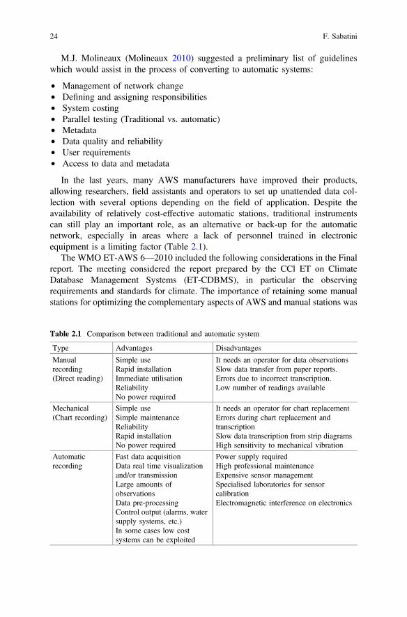
In the last years, many AWS manufacturers have improved their products,allowing researchers, field assistants and operators to set up unattended data col-lection with several options depending on the field of application. Despite theavailability of relatively cost-effective automatic stations, traditional instrumentscan still play an important role, as an alternative or back-up for the automaticnetwork, especially in areas where a lack of personnel trained in electronicequipment is a limiting factor (Table 2.1).
The WMO ET-AWS 6—2010 included the following considerations in the Finalreport. The meeting considered the report prepared by the CCl ET on ClimateDatabase Management Systems (ET-CDBMS), in particular the observingrequirements and standards for climate. The importance of retaining some manualstations for optimizing the complementary aspects of AWS and manual stations was
Table 2.1 Comparison between traditional and automatic system
Type Advantages Disadvantages
Manualrecording(Direct reading)
Simple useRapid installationImmediate utilisationReliabilityNo power required
It needs an operator for data observationsSlow data transfer from paper reports.Errors due to incorrect transcription.Low number of readings available
Mechanical(Chart recording)
Simple useSimple maintenanceReliabilityRapid installationNo power required
It needs an operator for chart replacementErrors during chart replacement andtranscriptionSlow data transcription from strip diagramsHigh sensitivity to mechanical vibration
Automaticrecording
Fast data acquisitionData real time visualizationand/or transmissionLarge amounts ofobservationsData pre-processingControl output (alarms, watersupply systems, etc.)In some cases low costsystems can be exploited
Power supply requiredHigh professional maintenanceExpensive sensor managementSpecialised laboratories for sensorcalibrationElectromagnetic interference on electronics
24 F. Sabatini
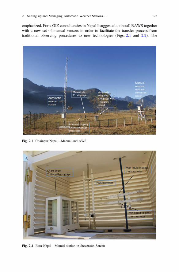
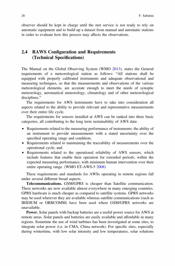
emphasized. For a GIZ consultancies in Nepal I suggested to install RAWS togetherwith a new set of manual sensors in order to facilitate the transfer process fromtraditional observing procedures to new technologies (Figs. 2.1 and 2.2). The
Fig. 2.1 Chainpur Nepal—Manual and AWS
Fig. 2.2 Rara Nepal—Manual station in Stevenson Screen
2 Setting up and Managing Automatic Weather Stations… 25
observer should be kept in charge until the met service is not ready to rely onautomatic equipment and to build up a dataset from manual and automatic stationsin order to evaluate how this process may affects the observations.
2.4 RAWS Configuration and Requirements(Technical Specifications)
The Manual on the Global Observing System (WMO 2013), states the Generalrequirements of a meteorological station as follows: “All stations shall beequipped with properly calibrated instruments and adequate observational andmeasuring techniques, so that the measurements and observations of the variousmeteorological elements, are accurate enough to meet the needs of synopticmeteorology, aeronautical meteorology, climatology and of other meteorologicaldisciplines.”
The requirements for AWS instruments have to take into consideration allaspects related to the ability to provide relevant and representative measurementsover their entire life cycle.
The requirements for sensors installed at AWS can be ranked into three basiccategories, all contributing to the long term sustainability of AWS data:
• Requirements related to the measuring performance of instruments: the ability ofan instrument to provide measurements with a stated uncertainty over thespecified operating range and condition;
• Requirements related to maintaining the traceability of measurements over theoperational cycle; and
• Requirements related to the operational reliability of AWS sensors, whichinclude features that enable their operation for extended periods, within theexpected measuring performance, with minimum human intervention over theirentire operating range. (WMO ET-AWS-5 2008)
These requirements and standards for AWSs operating in remote regions fallunder several different broad aspects.
Telecommunications. GSM/GPRS is cheaper than Satellite communication.These networks are now available almost everywhere in many emerging countries.GPRS hardware is much cheaper as compared to satellite systems. GPRS networksmay be used wherever they are available whereas satellite communications (such asIRIDIUM or ORBCOMM) have been used where GSM/GPRS networks areunavailable.
Power. Solar panels with backup batteries are a useful power source for AWS atremote areas. Solar panels and batteries are easily available and affordable in manyregions. Sometime the use of wind turbines has been investigated at some sites, tointegrate solar power (i.e. in CMA, China network). For specific sites, especiallyduring wintertime, with low solar intensity and low temperatures, solar solutions
26 F. Sabatini
alone do not supply reliable off-grid power, especially in critical weather and thedark seasons, so the use of fuel cell deserve mention. (i.e. New-Zealand remotesnowfall stations)
Sensors. Robust and high quality sensors are suggested for remote areas.Sensors and the platform employed should be suitable for remote diagnostics andtroubleshooting in order to avoid frequent inspection visits..
AWS equipment. The cost of the data loggers and communication devices hascome down drastically with recent advances in electronics technologies, BUTequipment, which can work over an extended temperature range, are still expensive.Robust data loggers and communication devices are required which can work inextreme environments e.g., temperature and prolonged time with high humidityvalues.
AWS enclosure. In extreme weather areas waterproof box should be rust proofand salt resistant. Normally we go for standard IP65-66 or NEMA 4 protectiongrade. These enclosures should be made of suitable material or properly shielded sothat inside temperature does not increase considerably, causing malfunction to theelectronic equipment or batteries. High rainfall rates can cause water infiltration, sothe connector and core hitches exposure to the environment mast be minimal.
Radiation shields. Radiation shields should be rugged and allow free airflowover the sensors, so wooden or plastic Stevenson screens should be employed.Normally fan-aspirated shield are not suggested unless strictly required.
Earthing. AWS equipment is often damaged by lightning strikes. Appropriateconventional or maintenance-free earthing, could be very effective in the long run.State-of-the-art lightning arrestors together with maintenance-free earthing at thesite could reduce AWS faults due to lightning.
Calibration of sensors and maintenance of stations. Tropical; mountain anddry regions have peculiar problems in maintenance of AWS sensors due to dustdeposition or frost/snow damages. Though AWS are generally unmanned bydesign, regular visits to a site are required to check its security, exposure conditionsand for performing preventive maintenance. The costs of maintenance, calibrationand running expenses for an operating AWS network far outweigh the initialpurchase expense, so these expenses should be kept in mind before planning thesiting and installation of an AWS network. Calibration of sensors should be per-formed at least once or twice per year. Availability of manpower and funds aremajor constraints in accomplishing these tasks.
Safety. In remote regions security of AWS equipment has become a majorconcern. It is quite common that there are many thefts of solar panels and batteriesfrom the AWS sites. I had experienced 2 solar panels stolen and 1 cup anemometerbroken for pure vandalism, The general public now understand that solar panels andbatteries can be used in domestic or mobile applications (i.e. Van, Campers). Publicparticipation of local people and awareness programs can help to reduce theseevents. The participation of Non-Governmental Organizations (NGO) can be alsoconsidered. The installation near military camps or police stations is often adoptedas a suitable compromise between safety vs RAWS representativeness. Adoption ofWMO siting classification guidelines, is important for exhaustive description of
2 Setting up and Managing Automatic Weather Stations… 27
sensors exposure. M. Leroy of Météo-France proposed a standardised method todescribe siting classification for the main variables measured at AWS, that are nowincorporated in the WMO-CIMO reference guide (WMO Technical Guide n.8 2012)
When deciding to buy an AWS the first step is to design the exact configuration(i.e. the type of sensors, amount of memory of the data-logger, power required,etc.). The main characteristics should be: Reliability; Robustness (toughness);Simple operation; Reduced level of maintenance; Installation of few sensors andestimation of other parameters.
Some examples:
• Instead of using a standard “A” Pan evaporimeter tank, which requires frequentinterventions, it is better to estimate the evaporation from the other meteoro-logical variables such as air temperature and humidity, wind speed, solar radi-ation, etc.
• For wind speed and direction, bi-dimensional sonic anemometers can be usedwhich can replace traditional cup anemometers and vane sensors. Sonicanemometers are now comparable in terms of costs and signal output features;as they have no moving parts the maintenance operations are greatly reduced.Virtually no recalibration procedures are required.
• The net radiation can be estimated from the global radiation.• If soil moisture sensors have to be installed, Time Domain Reflectometry sen-
sors (i.e. Delta_T Thetaprobe, Campbell CS610)1 offers low maintenanceoperations and long term stability. Alternatively, this parameter could be esti-mated from soil water balance methods.
Furthermore, if the AWS is not part of a reference climate network, the adoptionof a passive (natural ventilation) solar radiation shield for Air temperature andRelative humidity sensors is suggested (no power required for the fan and no fanfailures). Possible errors on air temperature observation during unfavorable con-ditions (wind speed 1 m/s and global solar radiation >800 W/m2) are expected.The accuracy of thermometer can be of ±0.3 °C instead of ±0.1 °C.
The data logger (Fig. 2.3) has to meet the following generic requirements:portability, prolonged field deployment, flexibility, rapid sampling over multiplechannels, small size and weight, low power drain, non-volatile data storage, andbattery-backed real time clock. ADC (Analog-to-Digital converter) should have atleast 14–16 bit resolution and a voltage range of 0–2.5 Vdc, 0–5Vdc, −5/+5 Vdc orautorange. SDI-12 port, RS-485 and RS-232 input, Digital inputs for tipping raingauge bucket, pulse anemometer and digital leaf wetness sensors. Normallyup-to-date systems have these features. One of the following arrangements can beconsidered:
1The names are necessary to report factually on available data; however, the author neitherguarantees nor warrants the standard of the product of specific manufacturer, and the use of thename by the author implies no approval of the product and manufacturer to the exclusion of othersthat may also be suitable.
28 F. Sabatini
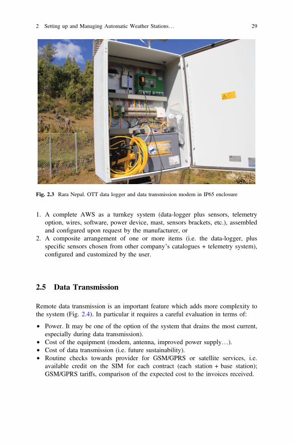
1. A complete AWS as a turnkey system (data-logger plus sensors, telemetryoption, wires, software, power device, mast, sensors brackets, etc.), assembledand configured upon request by the manufacturer, or
2. A composite arrangement of one or more items (i.e. the data-logger, plusspecific sensors chosen from other company’s catalogues + telemetry system),configured and customized by the user.
2.5 Data Transmission
Remote data transmission is an important feature which adds more complexity tothe system (Fig. 2.4). In particular it requires a careful evaluation in terms of:
• Power. It may be one of the option of the system that drains the most current,especially during data transmission).
• Cost of the equipment (modem, antenna, improved power supply…).• Cost of data transmission (i.e. future sustainability).• Routine checks towards provider for GSM/GPRS or satellite services, i.e.
available credit on the SIM for each contract (each station + base station);GSM/GPRS tariffs, comparison of the expected cost to the invoices received.
Fig. 2.3 Rara Nepal. OTT data logger and data transmission modem in IP65 enclosure
2 Setting up and Managing Automatic Weather Stations… 29
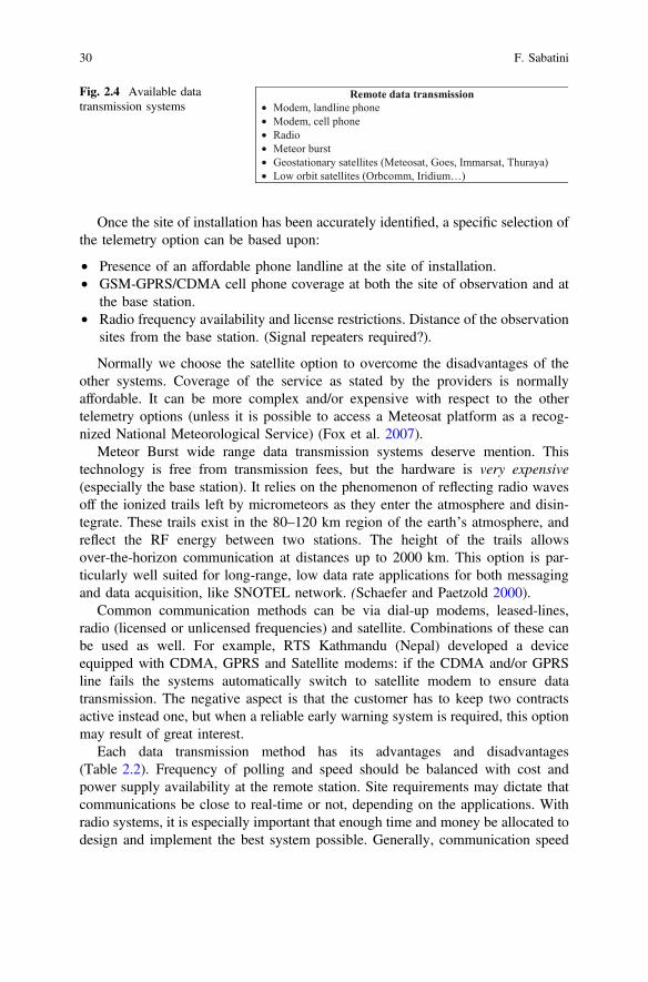
Once the site of installation has been accurately identified, a specific selection ofthe telemetry option can be based upon:
• Presence of an affordable phone landline at the site of installation.• GSM-GPRS/CDMA cell phone coverage at both the site of observation and at
the base station.• Radio frequency availability and license restrictions. Distance of the observation
sites from the base station. (Signal repeaters required?).
Normally we choose the satellite option to overcome the disadvantages of theother systems. Coverage of the service as stated by the providers is normallyaffordable. It can be more complex and/or expensive with respect to the othertelemetry options (unless it is possible to access a Meteosat platform as a recog-nized National Meteorological Service) (Fox et al. 2007).
Meteor Burst wide range data transmission systems deserve mention. Thistechnology is free from transmission fees, but the hardware is very expensive(especially the base station). It relies on the phenomenon of reflecting radio wavesoff the ionized trails left by micrometeors as they enter the atmosphere and disin-tegrate. These trails exist in the 80–120 km region of the earth’s atmosphere, andreflect the RF energy between two stations. The height of the trails allowsover-the-horizon communication at distances up to 2000 km. This option is par-ticularly well suited for long-range, low data rate applications for both messagingand data acquisition, like SNOTEL network. (Schaefer and Paetzold 2000).
Common communication methods can be via dial-up modems, leased-lines,radio (licensed or unlicensed frequencies) and satellite. Combinations of these canbe used as well. For example, RTS Kathmandu (Nepal) developed a deviceequipped with CDMA, GPRS and Satellite modems: if the CDMA and/or GPRSline fails the systems automatically switch to satellite modem to ensure datatransmission. The negative aspect is that the customer has to keep two contractsactive instead one, but when a reliable early warning system is required, this optionmay result of great interest.
Each data transmission method has its advantages and disadvantages(Table 2.2). Frequency of polling and speed should be balanced with cost andpower supply availability at the remote station. Site requirements may dictate thatcommunications be close to real-time or not, depending on the applications. Withradio systems, it is especially important that enough time and money be allocated todesign and implement the best system possible. Generally, communication speed
Remote data transmission• Modem, landline phone• Modem, cell phone• Radio • Meteor burst• Geostationary satellites (Meteosat, Goes, Immarsat, Thuraya)• Low orbit satellites (Orbcomm, Iridium…)
Fig. 2.4 Available datatransmission systems
30 F. Sabatini
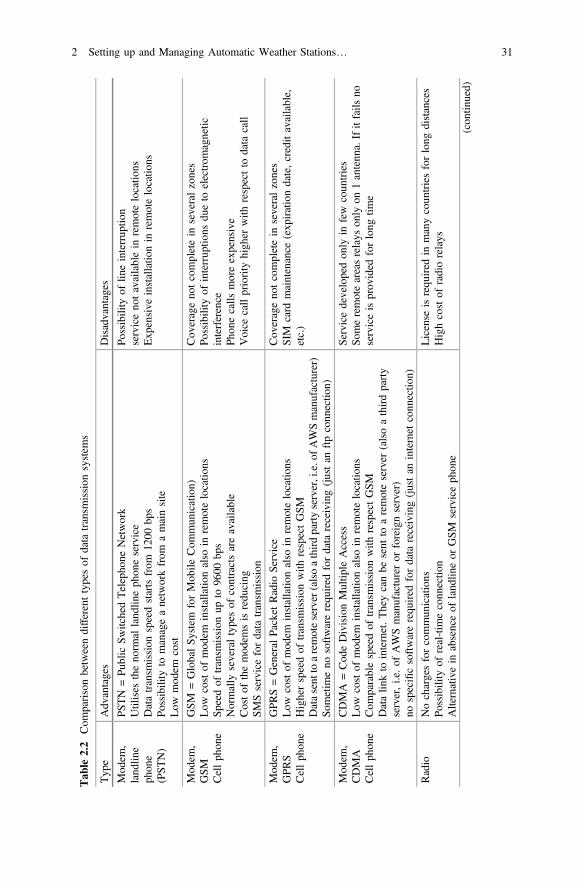
Tab
le2.2
Com
parisonbetweendifferenttypesof
data
transm
ission
system
s
Typ
eAdv
antages
Disadvantages
Mod
em,
land
line
phon
e(PST
N)
PSTN
=Pu
blic
SwitchedTelepho
neNetwork
Utilises
theno
rmal
land
lineph
oneservice
Datatransm
ission
speedstartsfrom
1200
bps
Possibility
tomanageanetworkfrom
amainsite
Low
mod
emcost
Possibility
oflin
einterrup
tion
serviceno
tavailablein
remotelocatio
nsExp
ensive
installatio
nin
remotelocatio
ns
Mod
em,
GSM
Cellph
one
GSM
=GlobalSy
stem
forMob
ileCom
mun
ication)
Low
costof
mod
eminstallatio
nalso
inremotelocatio
nsSp
eedof
transm
ission
upto
9600
bps
Normally
severaltypesof
contractsareavailable
Costof
themod
emsisredu
cing
SMSservicefordata
transm
ission
Cov
erageno
tcompletein
severalzones
Possibility
ofinterrup
tions
dueto
electrom
agnetic
interference
Phon
ecalls
moreexpensive
Voice
callpriority
high
erwith
respectto
data
call
Mod
em,
GPR
SCellph
one
GPR
S=General
Packet
Radio
Service
Low
costof
mod
eminstallatio
nalso
inremotelocatio
nsHigherspeedof
transm
ission
with
respectGSM
Datasent
toaremoteserver
(alsoathirdpartyserver,i.e.ofA
WSmanufacturer)
Sometim
eno
softwarerequ
ired
fordata
receiving(justan
ftpconn
ectio
n)
Cov
erageno
tcompletein
severalzones
SIM
card
maintenance
(exp
irationdate,creditavailable,
etc.)
Mod
em,
CDMA
Cellph
one
CDMA
=Cod
eDivisionMultip
leAccess
Low
costof
mod
eminstallatio
nalso
inremotelocatio
nsCom
parablespeedof
transm
ission
with
respectGSM
Datalin
kto
internet.Theycanbe
sent
toaremoteserver
(alsoathirdparty
server,i.e.of
AWSmanufactureror
foreignserver)
nospecificsoftwarerequ
ired
fordata
receiving(justan
internet
conn
ectio
n)
Servicedevelopedon
lyin
few
coun
tries
Someremoteareasrelays
only
on1antenn
a.Ifitfails
noserviceisprov
ided
forlong
time
Radio
Nochargesforcommun
ications
Possibility
ofreal-tim
econn
ectio
nAlternativein
absenceof
land
lineor
GSM
serviceph
one
License
isrequ
ired
inmanycoun
triesforlong
distances
Highcostof
radiorelays
(con
tinued)
2 Setting up and Managing Automatic Weather Stations… 31
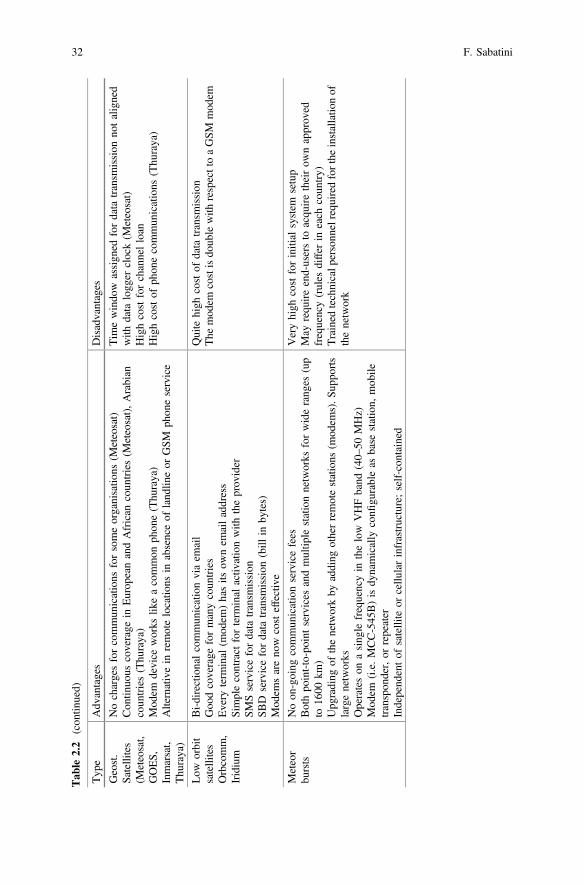
Tab
le2.2
(con
tinued)
Typ
eAdv
antages
Disadvantages
Geost.
Satellites
(Meteosat,
GOES,
Inmarsat,
Thu
raya)
Nochargesforcommun
ications
forsomeorganisatio
ns(M
eteosat)
Con
tinuo
uscoverage
inEurop
eanandAfrican
coun
tries(M
eteosat),Arabian
coun
tries(Thu
raya)
Mod
emdevice
works
likeacommon
phon
e(Thu
raya)
Alternativein
remotelocatio
nsin
absenceof
land
lineor
GSM
phon
eservice
Tim
ewindo
wassign
edfordata
transm
ission
notaligned
with
data
logg
erclock(M
eteosat)
Highcostforchannelloan
Highcostof
phon
ecommun
ications
(Thu
raya)
Low
orbit
satellites
Orbcomm,
Iridium
Bi-directionalcommun
icationviaem
ail
Goo
dcoverage
formanycoun
tries
Every
term
inal
(mod
em)hasits
ownem
ailaddress
Simplecontract
forterm
inal
activ
ationwith
theprov
ider
SMSservicefordata
transm
ission
SBD
servicefordata
transm
ission
(bill
inby
tes)
Mod
emsareno
wcosteffective
Quite
high
costof
data
transm
ission
The
mod
emcostisdo
ublewith
respecttoaGSM
mod
em
Meteor
bursts
Noon
-going
commun
icationservicefees
Bothpo
int-to-point
services
andmultip
lestationnetworks
forwiderang
es(up
to16
00km
)Upg
rading
ofthenetworkby
adding
otherremotestations
(mod
ems).S
uppo
rts
largenetworks
Operateson
asing
lefrequencyin
thelow
VHFband
(40–50
MHz)
Mod
em(i.e.MCC-545
B)isdy
namically
confi
gurableas
base
station,
mob
iletranspon
der,or
repeater
Independ
entof
satellite
orcellu
larinfrastructure;self-con
tained
Veryhigh
costforinitial
system
setup
May
requ
ireend-usersto
acqu
iretheirow
napprov
edfrequency(rules
differ
ineach
coun
try)
Trained
technicalp
ersonn
elrequ
ired
forthe
installatio
nof
thenetwork
32 F. Sabatini
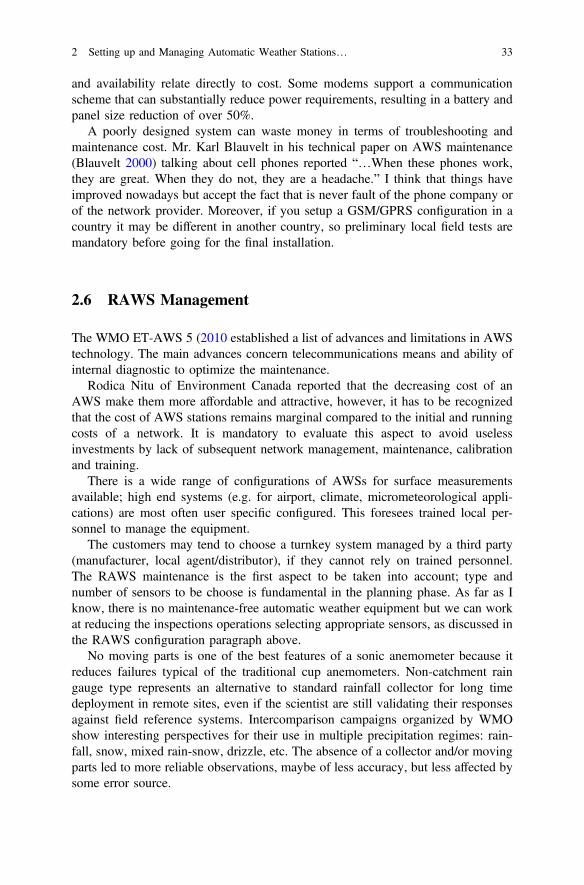
and availability relate directly to cost. Some modems support a communicationscheme that can substantially reduce power requirements, resulting in a battery andpanel size reduction of over 50%.
A poorly designed system can waste money in terms of troubleshooting andmaintenance cost. Mr. Karl Blauvelt in his technical paper on AWS maintenance(Blauvelt 2000) talking about cell phones reported “…When these phones work,they are great. When they do not, they are a headache.” I think that things haveimproved nowadays but accept the fact that is never fault of the phone company orof the network provider. Moreover, if you setup a GSM/GPRS configuration in acountry it may be different in another country, so preliminary local field tests aremandatory before going for the final installation.
2.6 RAWS Management
The WMO ET-AWS 5 (2010 established a list of advances and limitations in AWStechnology. The main advances concern telecommunications means and ability ofinternal diagnostic to optimize the maintenance.
Rodica Nitu of Environment Canada reported that the decreasing cost of anAWS make them more affordable and attractive, however, it has to be recognizedthat the cost of AWS stations remains marginal compared to the initial and runningcosts of a network. It is mandatory to evaluate this aspect to avoid uselessinvestments by lack of subsequent network management, maintenance, calibrationand training.
There is a wide range of configurations of AWSs for surface measurementsavailable; high end systems (e.g. for airport, climate, micrometeorological appli-cations) are most often user specific configured. This foresees trained local per-sonnel to manage the equipment.
The customers may tend to choose a turnkey system managed by a third party(manufacturer, local agent/distributor), if they cannot rely on trained personnel.The RAWS maintenance is the first aspect to be taken into account; type andnumber of sensors to be choose is fundamental in the planning phase. As far as Iknow, there is no maintenance-free automatic weather equipment but we can workat reducing the inspections operations selecting appropriate sensors, as discussed inthe RAWS configuration paragraph above.
No moving parts is one of the best features of a sonic anemometer because itreduces failures typical of the traditional cup anemometers. Non-catchment raingauge type represents an alternative to standard rainfall collector for long timedeployment in remote sites, even if the scientist are still validating their responsesagainst field reference systems. Intercomparison campaigns organized by WMOshow interesting perspectives for their use in multiple precipitation regimes: rain-fall, snow, mixed rain-snow, drizzle, etc. The absence of a collector and/or movingparts led to more reliable observations, maybe of less accuracy, but less affected bysome error source.
2 Setting up and Managing Automatic Weather Stations… 33
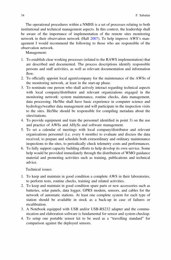
The operational procedures within a NMHS is a set of processes relating to bothinstitutional and technical management aspects. In this context, the leadership shallbe aware of the importance of implementation of the remote sites monitoringnetwork in their observation network (Hall 2007). To help improve AWS’s man-agement I would recommend the following to those who are responsible of theobservation network.
Management:
1. To establish clear working processes (related to the RAWS implementation) thatare described and documented. The process descriptions identify responsiblepersons and staff activities, as well as relevant documentation and informationflow.
2. To officially appoint local agent/company for the maintenance of the AWSs ofthe monitoring network, at least in the start-up phase.
3. To nominate one person who shall actively interact regarding technical aspectswith local company/distributor and relevant organizations engaged in themonitoring network: system maintenance, routine checks, data management,data processing. He/She shall have basic experience in computer science andhydrology/weather data management and will participate in the inspection visitsto the sites. He/She should be responsible for compiling metadata about thesites/stations.
4. To provide equipment and train the personnel identified in point 3) on the useand practice of AWSs and AHySs and software management.
5. To set a calendar of meetings with local company/distributor and relevantorganizations personnel (i.e. every 6 months) to evaluate and discuss the datareceived, to prepare and schedule both extraordinary and ordinary maintenanceinspections to the sites, to periodically check telemetry costs and performances.
6. To fully support capacity building efforts to help develop its own service. Somehelp would be provided immediately through the distribution of WMO guidancematerial and promoting activities such as training, publications and technicaladvice.
Technical issues:
1. To keep and maintain in good condition a complete AWS in their laboratories,to perform tests, routine checks, training and related activities.
2. To keep and maintain in good condition spare parts or new accessories such asbatteries, solar panels, data logger, GPRS modem, sensors, and cables for thenetwork of automatic stations. At least one complete system for each type ofstation should be available in stock as a back-up in case of failures orrecalibration.
3. A Notebook equipped with USB and/or USB-RS232 adapter and the commu-nication and elaboration software is fundamental for sensor and system checkup.
4. To setup one portable sensor kit to be used as a “travelling standard” forcomparison against the deployed sensors.
34 F. Sabatini
Field inspections/maintenance:
1. Give consistency to sensor sampling and data acquisition intervals to the AWSand RAWS configurations.
2. Double-check all the system configurations (i.e. sensor conversion factors,height of installation, sensor exposure).
3. Implement their “Field Form Report” with data comparison against portableand/or traditional sensors, where applicable.
4. Set into the configuration one or more “awakening intervals” for remote mod-ems (i.e. two or three intervals of 1 h each per day), in order to set communi-cations for routine checks or remote configuration modifications.
5. Interact with relevant organizations to strengthen practical training on AWSmanagement and data evaluation. This will be supportive for the person(s) incharge of network maintenance.
6. Develop a document that describes work processes typical for observationgeneration, making reference to the relevant WMO documents (Sabatini 2010).
2.7 Low-Cost RAWS: A Suitable Choice?
The WMO ET-AWS-6 2010 agreed that there is a need for continuous monitoringof advances of AWS technology for timely and comprehensive advice to WMOMembers. Research Institutes, Universities, and international organizations arefollowing the AWS technologies evolution as well, in order to suggest up to datesolutions for meteorological and micrometeorological monitoring. Advances intechnology and the decrease of costs of sensors and data loggers led to thedevelopment and integration by manufacturers of compact/low-cost weather sta-tions. This is significantly driven by the ability to integrate and display data frommultiple sources, in real time and near real time, primarily through the internet.(WMO ET_AWS-6-Final report 2010)
Computer science, real-time data and metadata transmission, Smartphones,Internet, electronic devices, led to the foundation of open access monitoringplatforms.
Data-sharing, participative approach, citizens science, data interoperability arethe keywords of this process. A common base is that these platforms are based onlow-cost (or very low-cost) equipment because it should serves as muchvolunteers/observers as possible.
The compact AWSs are increasingly used for agricultural, urban meteorology.They normally integrate inexpensive sensors of performance of measurement yet tobe assessed. Most of these AWS include pre-programmed data processing algo-rithms that are the property of the integrator.
Given the affordable cost, including installation, the small foot print required,and the increased availability, these platforms have a good chance to capture a largeshare of the market for producing meteorological data for various applications.
2 Setting up and Managing Automatic Weather Stations… 35
Advantages:
• compact, self-contained;• low-cost;• easily deployable;• integrating up to date forms of communication which allow networking and
spatial integration of data.• ability to establish a denser network;• real-time and on site storage of data;• potential to be used as a subset of a fully equipped AWS (e.g. temperature and
precipitation);
Disadvantages:
• Reduced interaction (Black box) between the system and the customer• Third-party sensors or transmission devices cannot be implemented• Metadata absent or poorly reported• Lack of standardized observations procedures
(WMO ET-AWS-6-2010)
Manufacturers like Davis (USA, CA), Pessl (Austria), Caipos (Austria),Decagon (USA), Onset (USA), Netsens (Italy), mainly propose low cost (orcost-effective) equipment for environmental monitoring and agrometeorologicalapplications. Some of them provide to customer an AWS with some optionalconfigurations, powered by a Solar Panel, plus an internal battery and transmitsweather data in quasi real time (i.e. 15 to 60 min) over GSM/GPRS.
The system can also send SMS Alarms upon specific events like frost, rain,temperature, etc.
Data are regularly uploaded to a web platform developed by the manufacturer—(password protected). The user besides checking the weather data, can accessadditional packages for Weather Forecast, Disease prediction models and IrrigationManagement The user pays a flat yearly fee that includes the Internet traffic and theweb domain management.
More advanced research institutes or public organizations tend to build-upAWS’s based on very low cost acquisition board (i.e. Arduino, Raspberry) that offera large number of options and devices (multiplexer, Wi-Fi boards, GPRS modem,applications notes developed by the community). These systems are normallylimited to specific projects for specific applications for a defined amount of time (i.e.1 to 3 years), because the overall toughness of the system is not normally com-parable to the traditional AWS’s even if examples of services based on thisapproach exist. The power consumption is also an issue since low-cost systemsnormally drain more power with respect advanced data loggers. This then has animpact on the size of the batteries and of solar panels.
Info4Dourou and Info4Dourou 2.0—sustainable management project (http://cooperation.epfl.ch/Info4Dourou) aims at increasing the availability of naturalresource information for local people of Burkina Faso and improve environmentaldata collection using low-cost local-made automatic stations. The EPFL—CODEVLausanne, Switzerland developed a low cost hydro-meteorological observation
36 F. Sabatini
network to reinforce and increase water and natural resource management capacityby engaging new technology for development and to increase the ability of the ruralcommunity to adapt to changing environmental pressures.
CNR-IBIMET developed its own infrastructure (www.sensorwebhub.org), toreceive data from multiple type of homemade sensors/stations, even mobile sys-tems, in order to provide an open common platform compliant to OGC approachtowards the world of IoT (De Filippis et al. 2015).
The adoption of the low-cost approach for remote sites meteorological moni-toring deserve attention, since it can integrate conventional networks providinguseful information otherwise not available.
2.8 Conclusions
Surface meteorological monitoring at remote sites requires a decision process thatresult in a cross-cutting activity among a given Organization. The applications, thesite accessibility, harsh environments, lack of data transmission platforms andpower supply options, may led to a very difficult selection procedure.
As already pointed out by the present chapter the most important constraints arerepresented by: (i) the limited technical capacity in the local organizations tooperate and maintain the systems and (ii) the risks associated with the safety of theequipment in remote and possibly insecure areas.
Upon my experience the best approach would be represented by a step by step,progressive installation, of AWS at the remote sites. Since the skill of personnelgrows normally up according to the complexity of the network, the multiple setupof AWS’s can pose problem of sustainability at the beginning.
Whatever the sites position an expensive part of the whole plan is also repre-sented by the software/hardware infrastructure and the processing center for datamanagement (normally installed at the organization headquarter), but the aspect ofmaintenance of several surface observation sites represents a very important aspect.
Unfortunately, this approach rarely matches those of the national/internationalimplementation projects: even well-conceived initiatives are normally focused on aspecified amount of years (3–5 years), without an extended follow-up process.Once the project expires, the network is no longer appropriately managed andmissing inspections lead to lack of data in the observations series and hardwarefailures. Sometime the result is a set of several AWS’s generations, not interop-erable, installed for different projects and from different manufacturer.
WMO-RTC’s should accompanying this transition process addressing specifictraining course on AWS management and IT integration, but again the synchro-nization among national and international bodies in not that efficient.
Anyway the RAWS’s are expanding despite their difficult management. Thisprocess will continue in the next years for multiple applications: water resourcemonitoring, solid precipitations, climate change studies, basic climatology, groundtruth for remote sensing analysis.
2 Setting up and Managing Automatic Weather Stations… 37
The selection and management of robust and well maintained RAWS is a realchallenge for whatever country is planning their implementation in the presentobserving system. WMO, FAO, AghryMet, ICIMOD and related internationalprojects could play an important role in this process, in order to adopt appropriateapproaches compliant to up-to-date techniques.
References
Blauvelt, K. 2000. Maintenance and calibration manual for the automated weather data network.Calibration facility, High plains climate center. University of Nebraska–Lincoln USA.
De Filippis, T., L. Rocchi, and E. Rapisardi. 2015. SensorWeb Hub infrastructure for open accessto scientific research data. Geophysical Research Abstracts 17. EGU2015-7847-2.
Fox, J., P. Geissler, and R. Worland. 2007. Versatile Iridium Campbell link,. (1) British AntarcticSurvey ([email protected]). Geophysical Research Abstracts 9. 01810. SRef-ID: 1607–7962/gra/EGU2007-A-01810. © European Geosciences Union.
Hall, B.L., and T.J. Brown. 2007. Comparison of weather data from the remote automated weatherstation network and the North American Regional Reanalysis. In 87th AMS Annual Meeting.
Maracchi, G., F. Sabatini, and M.V.K. Sivakumar. 2000. The role of automated weather stations inDeveloping Countries. In Proceedings of the International workshop on “Automated weatherstations for applications in agriculture and water resources management: Current use andfuture perspectives”. 6–10 March 2000. Lincoln, Nebraska, USA.
Molineaux, M.J. 2010. Automation of surface observations. Development of guidelines andprocedures for the transition from manual to automatic weather stations. WMO CBS—Opag onIntegrated observing systems. Expert team on requirements and implementation aws platforms(Et-Aws). Sixth session. Final report. Geneva, Switzerland, 20–23 April 2010.
Nitu, R., and K. Wong. 2010. Measurement of solid precipitation at automatic weather stations,challenges and opportunities. Meteorological Service of Canada, 4905 Dufferin St, Toronto,ON, M3H 5T4, Canada.
Sabatini F. 2010. Recommendations for the design of a system for acquisition, transmission andstorage of Hydro-Meteorological data on the Kailash sacred landscape in Nepal. Project title:Supporting climate change adaptation and biodiversity conservation in the Kailash landscape.Final report.
Schaefer, G.L., and R.F. Paetzold. 2000. SNOTEL (SNOpack TELemetry) and SCAN (SoilClimate Analysis Network). In Proceedings of the International workshop on “Automatedweather stations for applications in agriculture and water resources management: Current useand future perspectives”. 6–10 March 2000, Lincoln, Nebraska, USA.
Shanko, D. 2015. Use of automatic weather stations in Ethiopia. National Meteorological Agency(NMA) report, Addis Ababa, Ethiopia.
WMO. 2010. Guide to meteorological instruments and methods of observation, Technical Manualn° 8. 7th Edition 2008 updated 2010. Geneva, Switzerland: World MeteorologicalOrganization.
WMO. 2008. Final report. World Meteorological Organization—Commission For Basic Systems -Opag On Integrated Observing Systems. Expert Team On Requirements for Data FromAutomatic Weather Stations—Fifth Session—Geneva, Switzerland, 5–9 May 2008.
WMO. 2010. Final report. World Meteorological Organization—Commission For Basic Systems -Opag On Integrated Observing Systems. Expert team on requirements for data from automaticweather stations—Sixth session - Geneva, Switzerland, 22–25 June 2010.
WMO. 2013. Manual on the global observing system. Revised latest edition 2010.
38 F. Sabatini

Open Access This chapter is licensed under the terms of the Creative Commons Attribution 4.0International License (http://creativecommons.org/licenses/by/4.0/), which permits use, sharing,adaptation, distribution and reproduction in any medium or format, as long as you give appropriatecredit to the original author(s) and the source, provide a link to the Creative Commons license andindicate if changes were made.The images or other third party material in this chapter are included in the chapter's Creative
Commons license, unless indicated otherwise in a credit line to the material. If material is notincluded in the chapter's Creative Commons license and your intended use is not permitted bystatutory regulation or exceeds the permitted use, you will need to obtain permission directly fromthe copyright holder.
2 Setting up and Managing Automatic Weather Stations… 39
Chapter 3Hazard Events Characterizationin Tillaberi Region, Niger: Presentand Future Projections
Maurizio Bacci and Moussa Mouhaïmouni
Abstract Niger is one of the countries most vulnerable to climatic risks. An adap-tation tomeet these threats is urgent and supported by politicians and decisionmakers,as stressed in the Programme d’Action National pour l’Adaptation aux changementsclimatiques (PANA) of Niger. The main aim of this paper is to provide an assessmentof the current and future scenario of natural hazards in Tillaberi Region (Niger). Themapping of hazard changes in the study area is done comparing the probability ofrecurrence of severe meteorological conditions for droughts and floods betweenpresent and future climate using several projections from the Coupled ModelIntercomparison Project Phase 5 (CMIP5). The result is a hazard characterizationhighlighting the need for urgent interventions. The natural hazard information withexposure and vulnerability assessment indicators can help decision makers in prior-itizing interventions in the Tillabéri Region using an objective approach. Thismethodology has been proposed within the framework of the ANADIA Project thataims to support disaster prevention activities, from national to local scale, helpinginstitutions in the design and implementation of disaster risk management strategies.
Keywords Climate change Natural hazard Drought Extreme rainfall Niger
3.1 Introduction
Natural disasters, notably floods and drought, are becoming a major concern inWest African countries. These are caused mainly by natural hazards such asextremely intense rainfall events or extensive dry periods. With the current rapid
M. Bacci (&)National Research Council—Institute of BioMeteorology (IBIMET),Via Giovanni Caproni 8, 50145 Florence, Italye-mail: [email protected]
M. MouhaïmouniNational Meteorological Service of Niger, Niamey, Nigere-mail: [email protected]
© The Author(s) 2017M. Tiepolo et al. (eds.), Renewing Local Planning to Face ClimateChange in the Tropics, Green Energy and Technology,DOI 10.1007/978-3-319-59096-7_3
41
climate change conditions attention should be paid to natural disasters in alldevelopment planning at national, regional and local levels to minimize the risks.The Programme d’Action National pour l’Adaptation aux changements climatiques(PANA) of Niger sets adaptation policies as urgent and necessary to cope withfuture climate risk.
Tillaberi Region, the case study area, is located in the westernmost part of Niger.It consists of 45 municipalities with an estimated 2,722,482 inhabitants in 2012(INS 2012). Its economy is mainly based on subsistence agricultural and livestockfarming. 84.9% of its population live in rural area and 71.7% live below the povertythreshold (INS 2011).
Niger is extremely vulnerable to extreme climate events. The country facedheavy losses due to increased flooding and drought episodes in the last decade. In2013 alone, the number of victims from floods in the Tillaberi Region was esti-mated at 39,681 and 2902 hectares of fields were flooded (OCHA 2013).
Numerous factors contribute to increasing local exposure and vulnerability tonatural disasters: (i) the changes in river flows and discharges caused by humanactivities (Mahe et al. 2013), (ii) population growth and related environmentaldegradation (Leblanc et al. 2008) and (iii) changes in hydrography dynamics(Descroix et al. 2009, 2012). It is clear that some actions are needed to face climaterisks. We consider a bottom-up approach in the climate change adaptation processas a key of measures’ effectiveness. Adaptation capacity is linked with some localelements such as population food security, education and knowledge of climaticrisk. A decrease of vulnerability to climate risk can also be achieved knowing whatthe future could hold.
Tillaberi Region belongs largely to the Sahelian zone characterized by difficultclimatic conditions such as low rainfall and high temperatures that can reach 45 °C.It has a single rainy season from June till September averaging an annual precip-itation from 250 mm/year in Abalak, in the north, to 800 mm/year in Gaya, in thesouth.
The interannual variability is quite significant and it is possible to identify threedifferent phases in the last 30 years: (1) a dry period in the 1980s, (2) a transitiondecade in the 1990s with a high interannual variability and (3) a wet phase in thefirst decade of 2000 (Fig. 3.1).
Despite this increasing trend in total rainfall amount, changes in extreme eventsdistribution are slightly different and not immediately related to the seasonal sum.In this case we integrate different climate indexes, such as the StandardizedPrecipitation Index (SPI) by McKee et al. (1993) at monthly scale, to achieve amore complete climatic characterization.
We analyze changes in rainfall distribution with particular emphasis on extremeevents. As described in the Special Report from Intergovernmental Panel onClimate Change (IPCC) Managing the risks of extreme events and disasters toadvance climate change adaptation (IPCC 2012), the near future will likely see anincreasing number of extreme events.
The study analyzes historical climatic trends and future scenarios in TillaberiRegion, identifying hotspots and discusses how observed trends could impact
42 M. Bacci and M. Mouhaïmouni
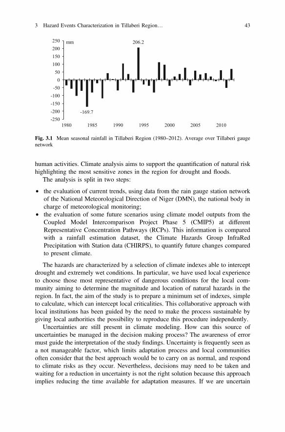
human activities. Climate analysis aims to support the quantification of natural riskhighlighting the most sensitive zones in the region for drought and floods.
The analysis is split in two steps:
• the evaluation of current trends, using data from the rain gauge station networkof the National Meteorological Direction of Niger (DMN), the national body incharge of meteorological monitoring;
• the evaluation of some future scenarios using climate model outputs from theCoupled Model Intercomparison Project Phase 5 (CMIP5) at differentRepresentative Concentration Pathways (RCPs). This information is comparedwith a rainfall estimation dataset, the Climate Hazards Group InfraRedPrecipitation with Station data (CHIRPS), to quantify future changes comparedto present climate.
The hazards are characterized by a selection of climate indexes able to interceptdrought and extremely wet conditions. In particular, we have used local experienceto choose those most representative of dangerous conditions for the local com-munity aiming to determine the magnitude and location of natural hazards in theregion. In fact, the aim of the study is to prepare a minimum set of indexes, simpleto calculate, which can intercept local criticalities. This collaborative approach withlocal institutions has been guided by the need to make the process sustainable bygiving local authorities the possibility to reproduce this procedure independently.
Uncertainties are still present in climate modeling. How can this source ofuncertainties be managed in the decision making process? The awareness of errormust guide the interpretation of the study findings. Uncertainty is frequently seen asa not manageable factor, which limits adaptation process and local communitiesoften consider that the best approach would be to carry on as normal, and respondto climate risks as they occur. Nevertheless, decisions may need to be taken andwaiting for a reduction in uncertainty is not the right solution because this approachimplies reducing the time available for adaptation measures. If we are uncertain
-169.7
206.2
-250-200-150-100-500
50100150200250
1980 1985 1990 1995 2000 2005 2010
mm
Fig. 3.1 Mean seasonal rainfall in Tillaberi Region (1980–2012). Average over Tillaberi gaugenetwork
3 Hazard Events Characterization in Tillaberi Region… 43
about what future we need to adapt to, it doesn’t mean that we are not confidentenough in our knowledge to make decisions to manage climate risks.
In this study we propose the approach of comparing different indicators andevaluating significant trends to achieve the most appropriate ways to tackle climatechange in Tillaberi. We are confident that convergence of the evidence could guidestrategic choices for the near future.
The study contains an analysis conducted within the framework of the ClimateChange Adaptation, Disaster Prevention and Agricultural Development for FoodSecurity (ANADIA) project with the collaboration of the Meteorological NationalDirection of Niger.
3.2 Materials and Methods
3.2.1 Current Conditions
Daily rainfall data, from the official DMN database, come from the rain gaugestation network in the Tillaberi Region. This information is used to assess currentclimatic conditions. In the analysis we retain stations with at least 30 years ofrecords, considering this period as the minimum requirement to produce a statisticalanalysis with a common climate reference (1981–2010). The stations fulfillrequirements are 29.
Using daily data for each station, we evaluate the total number of dry days (dayswithout rain or with less than 1 mm) and the maximum consecutive dry daysrecorded in the June–September period identifying drought conditions andassessing their magnitude and distribution. The number of wet days with rain equalto or more than 1 mm and the number of episodes that exceed the threshold of 10and 20 mm/day are selected identifying wet conditions. Finally, we choose thehighest 1-day precipitation, the yearly number of days with rain exceeding the 95thand 99th percentile to describe heavy rains distribution.
Therefore, each station is characterized by the following yearly index (basing on1981–2010 period):
– R95p, Very wet days (days), Number of days >95th percentile calculated for wetdays;
– R99p, Extremely wet days (days), Number of days >99th percentile;– RR, Precipitation sum (mm);– RR1, Wet days (days), Number of days 1 mm;– R20 mm, Very heavy precipitation days (days) Number of days 20 mm;– R10 mm, Heavy precipitation days (days), Number of days 10 mm;– RX1 day, Highest 1-day precipitation (mm) Maximum sum for 1 day.
Here, for concision needs, we present only the regional averaged value com-puted over these 29 stations for each index. This mean value allows the evaluation
44 M. Bacci and M. Mouhaïmouni
of linear regression over time series, intercepting climatic trends and their magni-tude at regional scale.
The Pearson product-moment correlation coefficient has been computed as ameasure of the linear correlation of the index variation over time and the non-parametric Kendall’s tau estimation for monotonic trends. Kendall’s tau measuresthe strength of the relationship between the two variables making no assumptionsabout the data distribution or linearity of any trends. Like other measures of cor-relation, Kendall’s tau assumes a value between −1 and +1. A positive correlationsignifies that the values of both variables are increasing. Instead, a negative cor-relation signifies that as one variable increases, the other one decreases. Confidenceintervals can be calculated and hypotheses tested with the help of Kendall’s tau.The main advantage of using this measurement is that the index distribution hasbetter statistical properties, and Kendall’s tau can be interpreted directly in terms ofthe probability of observing concordant and discordant pairs. On the contrary,outliers, unequal variances, non-normality and nonlinearity unduly influence thePearson correlation.
3.2.2 Standardized Precipitation Index (SPI)
The Standardized Precipitation Index (SPI) describes the magnitude of dry and wetconditions in a desired location. It allows an analyst to determine the rarity of anepisode at a given time scale (e.g. Monthly resolution).
The SPI index is recommended by the World Meteorological Organization(WMO) to be used by all National Meteorological and Hydrological Servicesaround the world to characterize meteorological droughts (WMO 2012). The SPI issimple to calculate because precipitation is the only required input parameter and itis just as effective in intercepting wet periods as dry periods.
The SPI formula is based on the long-term precipitation record. This record isfitted to a probability distribution, which is then transformed into a normal distri-bution. Positive SPI values indicate greater than median precipitation (wet condi-tions) and negative values indicate less than median precipitation (droughtconditions). Because the SPI is normalized, wetter and drier climates can be rep-resented in the same way.
The classification system shows SPI values to define drought and wet intensitiesresulting from the SPI as proposed by WMO (Table 3.1).
The SPI was designed to quantify the precipitation deficit for multiple time-scales. In fact these timescales reflect the impact of drought on the availability ofthe different water resources. For instance, soil moisture conditions respond toprecipitation anomalies on a relatively short timescale, groundwater, streamflowand reservoir storage reflect the longer-term precipitation anomalies. In this case weare looking for a meteorological characterization and use the 1-month SPI tocharacterize each single month in the rainy season (June, July, August and
3 Hazard Events Characterization in Tillaberi Region… 45
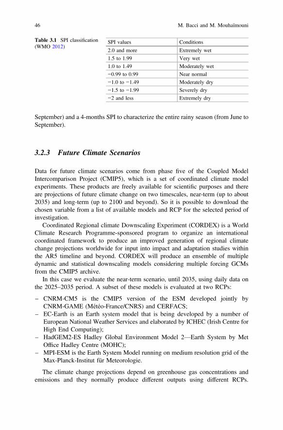
September) and a 4-months SPI to characterize the entire rainy season (from June toSeptember).
3.2.3 Future Climate Scenarios
Data for future climate scenarios come from phase five of the Coupled ModelIntercomparison Project (CMIP5), which is a set of coordinated climate modelexperiments. These products are freely available for scientific purposes and thereare projections of future climate change on two timescales, near-term (up to about2035) and long-term (up to 2100 and beyond). So it is possible to download thechosen variable from a list of available models and RCP for the selected period ofinvestigation.
Coordinated Regional climate Downscaling Experiment (CORDEX) is a WorldClimate Research Programme-sponsored program to organize an internationalcoordinated framework to produce an improved generation of regional climatechange projections worldwide for input into impact and adaptation studies withinthe AR5 timeline and beyond. CORDEX will produce an ensemble of multipledynamic and statistical downscaling models considering multiple forcing GCMsfrom the CMIP5 archive.
In this case we evaluate the near-term scenario, until 2035, using daily data onthe 2025–2035 period. A subset of these models is evaluated at two RCPs:
– CNRM-CM5 is the CMIP5 version of the ESM developed jointly byCNRM-GAME (Météo-France/CNRS) and CERFACS;
– EC-Earth is an Earth system model that is being developed by a number ofEuropean National Weather Services and elaborated by ICHEC (Irish Centre forHigh End Computing);
– HadGEM2-ES Hadley Global Environment Model 2—Earth System by MetOffice Hadley Centre (MOHC);
– MPI-ESM is the Earth System Model running on medium resolution grid of theMax-Planck-Institut für Meteorologie.
The climate change projections depend on greenhouse gas concentrations andemissions and they normally produce different outputs using different RCPs.
Table 3.1 SPI classification(WMO 2012)
SPI values Conditions
2.0 and more Extremely wet
1.5 to 1.99 Very wet
1.0 to 1.49 Moderately wet
−0.99 to 0.99 Near normal
−1.0 to −1.49 Moderately dry
−1.5 to −1.99 Severely dry
−2 and less Extremely dry
46 M. Bacci and M. Mouhaïmouni
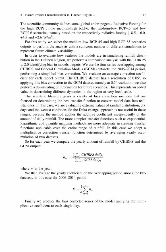
The scientific community defines some global anthropogenic Radiative Forcing forthe high RCP8.5, the medium-high RCP6, the medium-low RCP4.5 and lowRCP2.6 scenarios, namely based on the respectively radiative forcing (+8.5, +6.0,+4.5 and +2.6 W/m2).
For this study we select the medium-low RCP 45 and high RCP 85 scenariosoutputs to perform the analysis with a sufficient number of different simulations torepresent future climate variability.
In order to evaluate how realistic the models are in simulating rainfall distri-bution in the Tillaberi Region, we perform a comparison analysis with the CHIRPSv. 2.0 identifying bias in models outputs. We use the time series overlapping amongCHIRPS and General Circulation Models (GCMs) datasets, the 2006–2014 period,performing a simplified bias correction. We evaluate an average correction coeffi-cient for each model output. The CHIRPS dataset has a resolution of 0.05′, soapplying this bias correction to the GCM dataset, namely at 0.5′ resolution, we alsoperform a downscaling of information for future scenarios. This represents an addedvalue in determining different dynamics in the region at very local scale.
The scientific literature gives a variety of bias correction methods that arefocused on determining the best transfer function to convert model data into real-istic ones. In this case, we are evaluating extreme values of rainfall distribution, drydays and the wettest condition. So the Delta change approach is not useful in theseranges, because the method applies the additive coefficient independently of theamount of daily rainfall. The more complex transfer functions such as exponential,logarithmic and quantile mapping methods are more adequate in creating transferfunctions applicable over the entire range of rainfall. In this case we adopt amultiplicative correction transfer function determined by averaging yearly accu-mulation of two datasets.
So for each year we compare the yearly amount of rainfall by CHIRPS and theGCM output:
Km ¼Pn
i¼1 CHIRPS dailyiPni¼1 GCM dailyi
where m is the year.We then average the yearly coefficient on the overlapping period among the two
datasets, in this case the 2006–2014 period.
K ¼ 1n
Xn
m¼1
Km
Finally we produce the bias corrected series of the model applying the multi-plicative coefficient to each single day.
3 Hazard Events Characterization in Tillaberi Region… 47
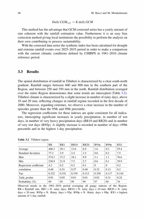
Daily CGMcorr ¼ K daily GCM
This method has the advantage that GCM corrected series has a yearly amount ofrain coherent with the rainfall estimation value. Furthermore it is an easy biascorrection method giving local institutions the possibility to perform the analysis ontheir own contributing to process sustainability.
With the corrected data series the synthetic index has been calculated for droughtand extreme rainfall events over 2025–2035 period in order to make a comparisonwith the current climatic conditions defined by CHIRPS in 1981–2010 climatereference period.
3.3 Results
The spatial distribution of rainfall in Tillaberi is characterized by a clear south-northgradient. Rainfall ranges between 600 and 800 mm in the southern part of theRegion, and between 250 and 350 mm in the north. Rainfall distribution averagedover the entire Region demonstrates that some trends are intercepted (Table 3.2).Tillaberi climate is characterized by a slight increase in number of rainy days, above10 and 20 mm, reflecting changes in rainfall regime recorded in the first decade of2000. Moreover, regarding extremes, we observe a clear increase in the number ofepisodes greater than the 95th and 99th percentile.
The regression coefficients for these indexes are quite consistent for all indica-tors, intercepting significant increases in yearly precipitation, in number of wetdays, in number of very heavy precipitation days (RR10 and RR20) and in numberof very wet days (R95p). A slightly increase is recorded in number of days >99thpercentile and in the highest 1-day precipitation.
Table 3.2 Tillaberi region
RR RR1 RR10 RR20 R95p R99p RX1
Average 400.3 29.1 13.6 6.9 1.6 0.3 55.4
Standard deviation 77.2 3.9 2.4 1.5 0.6 0.2 7.5
Max 574.3 37.2 18.1 9.9 3.1 1.1 76.6
Min 238.9 21.9 7.5 2.7 0.6 0.1 39.9
Regression coefficient 4.2 0.2 0.2 0.1 0 0 0.2
correlation 0.48 0.51 0.57 0.48 0.32 0.13 0.2
Tau 0.322 0.241 0.339 0.313 0.258 0.117 0.144
2side_pvalue 0.01 0.05 0.01 0.01 0.03 0.31 0.24
Probability (%) 99 95 99 99 97 69 76
Observed trends in the 1981–2010 period averaging all gauge stations of the Region.RR = Rainfall rate, RR1 = N. rainy days, RR10 = N. rainy days > 10 mm; RR20 = N. rainydays > 20 mm; R95p = N. Rainy days > 95p; R99p = N. Rainy days > 99p; RX1 = highestamount of 1-day rainfall
48 M. Bacci and M. Mouhaïmouni
3.3.1 Standardized Precipitation Index
Using daily rainfall data from the DMN gauge network we calculated the SPI indexfor each station. We then averaged the SPI values over the entire region giving anoverview of the climate in Tillaberi region in 33 years. SPI has been produced attwo time scales: (i) 4-months resolution, in order to intercept dry or wet conditionsover the entire rainy season, (ii) monthly resolution, describing monthly climaticconditions of the region at higher temporal resolution. Figure 3.2 presents theregional SPI graph. The comparison of these two time scales intercepts criticalitiesin different stages of the rainy season evolution (onset, central part, end) and givesan idea of the rainfall regime recorded in each year. The graph shows extremely dryconditions recorded in 1984 with a persistent negative SPI in June, July and August.Extremely wet conditions are recorded in 1994 with the highest value of SPI inAugust. We could associate June SPI to the interannual variability of the rainyseason’s onset strength. No extreme episodes are recorded in this month even ifconditions are moderately dry in 1987. In July, SPI shows a lack of significantfluctuations, especially after 2000 when a sequence of normal conditions isobserved. August records the maximum rainfall amount so it is the month mostinfluencing the SPI value of the rainy season. In August there are extreme valuesover the entire period of monthly SPI: 1984 with a significant episode of droughtand 1994 with the wettest conditions.
The 2000s are almost characterized by normal conditions. September marks theend of the rainy season and in the time series the SPI values for this month show aslight trend toward wet conditions. In summary SPI shows a quasi-normal situationin the last decade that means a globally favorable condition in rainfall distribution
-3
-2
-1
0
1
2
3
1980 1985 1990 1995 2000 2005 2010
SPI
June July August September June-Sept.
Fig. 3.2 June, July, August and September monthly SPI distribution and 4-months SPI in 1981–2012 period
3 Hazard Events Characterization in Tillaberi Region… 49
comparing the driest period of the 1980s and wettest period of the 1990s. SPI is notconceived to intercept changes in daily extremes distributions, in fact in the lastdecade several floods are recorded in the region, but it could intercept dry and wetperiods in rainfall distribution. SPI must be considered as complementary infor-mation of the daily extreme events distribution in classifying target period rainfalldistribution with respect to time series. The increase of extreme rainfall events in aSPI wet period is normal, but as in the case of Tillaberi, the increase of extremerainfall events in SPI normal period indicates an increase of extremes in rainfalldistribution.
3.3.2 Future Scenarios
The last IPCC AR5 affirms: The frequency and intensity of heavy precipitationevents over land will likely increase on average in the near term. (Kirtman et al.2013). This statement is valid at global scale, so this study focuses on the TillaberiRegion analyzing the near-future conditions and extreme events likelihood.
We computed a very large set of indicators and here we present the mostrepresentative ones. We found that rainfall distribution is predicted to very likelyincrease drought and flood risk in Tillaberi Region. In fact several climate trendsand climate model simulations from CORDEX-CMIP5 show: likely increase inmaximum consecutive dry days; likely increase in number of dry periods of morethan 5 days; likely increase in number of very heavy precipitation days; and likelyincrease in highest 1-day precipitation (mm)—Absolute value in the period.
The projections of future climate, describing drought conditions, have beenproduced and we show here the result of the comparison between the maximumnumber of consecutive dry days (RR < 1 mm) in June-September period betweenCHIRPS dataset and different GCMs (Fig. 3.3).
The 2025–2035 period presents an average increase of 1–3 days in the maxi-mum number of consecutive dry days in the rainy season with a slight east to westgradient. The increase in intense dry conditions must alert end users in the region,especially farmers and food security actors. Prolonged dry periods could causestress in rainfed crops and consequently reduce final yield. In a region with mainlysubsistence agriculture this means an urgent need for adaptation.
While the maximum number of consecutive dry days intercepts the most acutestress, a proxy indicator for chronic drought stress is the number of periods of morethan 5 consecutive dry days recorded in Tillaberi Region. We present here, simi-larly to the previous index, the average difference between each GCMs outputcompared to present climatic conditions defined by CHIRPS.
50 M. Bacci and M. Mouhaïmouni
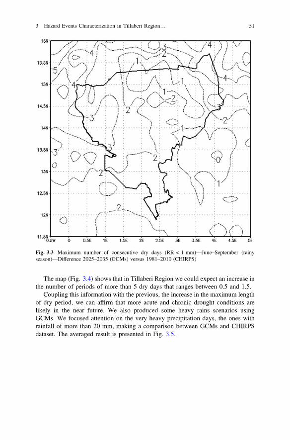
The map (Fig. 3.4) shows that in Tillaberi Region we could expect an increase inthe number of periods of more than 5 dry days that ranges between 0.5 and 1.5.
Coupling this information with the previous, the increase in the maximum lengthof dry period, we can affirm that more acute and chronic drought conditions arelikely in the near future. We also produced some heavy rains scenarios usingGCMs. We focused attention on the very heavy precipitation days, the ones withrainfall of more than 20 mm, making a comparison between GCMs and CHIRPSdataset. The averaged result is presented in Fig. 3.5.
Fig. 3.3 Maximum number of consecutive dry days (RR < 1 mm)—June–September (rainyseason)—Difference 2025–2035 (GCMs) versus 1981–2010 (CHIRPS)
3 Hazard Events Characterization in Tillaberi Region… 51
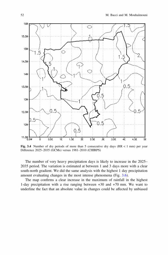
The number of very heavy precipitation days is likely to increase in the 2025–2035 period. The variation is estimated at between 1 and 3 days more with a clearsouth-north gradient. We did the same analysis with the highest 1 day precipitationamount evaluating changes in the most intense phenomena (Fig. 3.6).
The map confirms a clear increase in the maximum of rainfall in the highest1-day precipitation with a rise ranging between +30 and +70 mm. We want tounderline the fact that an absolute value in changes could be affected by unbiased
Fig. 3.4 Number of dry periods of more than 5 consecutive dry days (RR < 1 mm) per yearDifference 2025–2035 (GCMs) versus 1981–2010 (CHIRPS)
52 M. Bacci and M. Mouhaïmouni
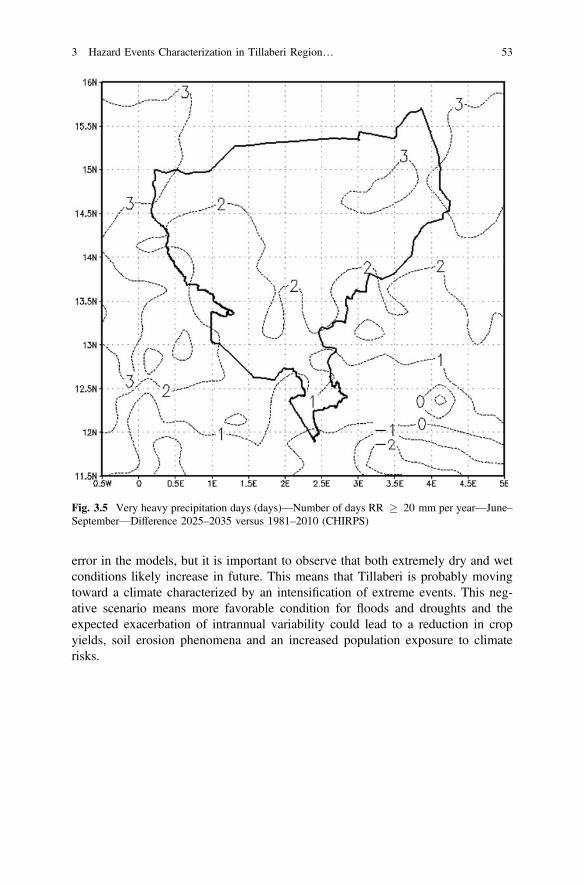
error in the models, but it is important to observe that both extremely dry and wetconditions likely increase in future. This means that Tillaberi is probably movingtoward a climate characterized by an intensification of extreme events. This neg-ative scenario means more favorable condition for floods and droughts and theexpected exacerbation of intrannual variability could lead to a reduction in cropyields, soil erosion phenomena and an increased population exposure to climaterisks.
Fig. 3.5 Very heavy precipitation days (days)—Number of days RR 20 mm per year—June–September—Difference 2025–2035 versus 1981–2010 (CHIRPS)
3 Hazard Events Characterization in Tillaberi Region… 53
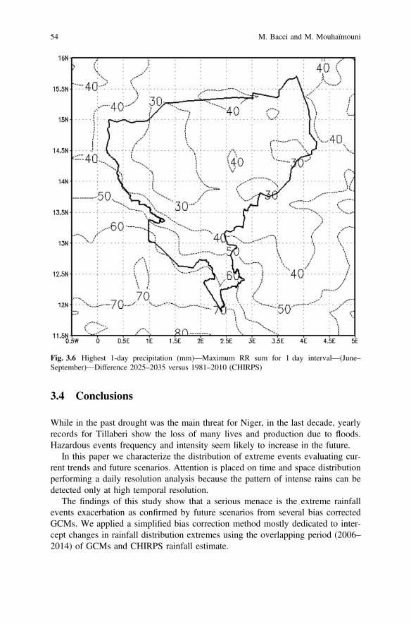
3.4 Conclusions
While in the past drought was the main threat for Niger, in the last decade, yearlyrecords for Tillaberi show the loss of many lives and production due to floods.Hazardous events frequency and intensity seem likely to increase in the future.
In this paper we characterize the distribution of extreme events evaluating cur-rent trends and future scenarios. Attention is placed on time and space distributionperforming a daily resolution analysis because the pattern of intense rains can bedetected only at high temporal resolution.
The findings of this study show that a serious menace is the extreme rainfallevents exacerbation as confirmed by future scenarios from several bias correctedGCMs. We applied a simplified bias correction method mostly dedicated to inter-cept changes in rainfall distribution extremes using the overlapping period (2006–2014) of GCMs and CHIRPS rainfall estimate.
Fig. 3.6 Highest 1-day precipitation (mm)—Maximum RR sum for 1 day interval—(June–September)—Difference 2025–2035 versus 1981–2010 (CHIRPS)
54 M. Bacci and M. Mouhaïmouni
The most significant current trend intercepted in Tillaberi Region is the increasein intense rainfall phenomena. SPI analysis shows an absence of significant dry andwet periods in the recent past. The combination of these two pieces of informationimplies an increase of extreme events in a normal rainfall regime. Near-futureprojections for rainfall distribution confirm the intensification of rainfall extremes.GCMs outputs show a consistent increase in very intense rainfall phenomena andan increase in the highest 1-day rainfall amount. At the same time for droughtcharacterization, GCMs outputs show an increase in dry spells intensity. Bothmaximum number of consecutive dry days and the number of periods of more than5 consecutive dry days are predicted to increase. The combination of this infor-mation gives a not favorable picture of what we could expect for near-future climateconditions in Tillaberi and it must alert decision makers to urgently take someaction.
The findings of the study demonstrate the importance of tailored climate analysiswhen we move toward local scale (from sub-national to municipalities). Criticalitiescould be intercepted only by the study of most intense phenomena at a dailyresolution because these changes in extremes distribution are not detectable bytypical seasonal climatic trends analysis, distributed within IPCC reports or otherstudies at national level.
Mapping climate changes highlights criticalities at very local scale and it couldcontribute to selecting priorities for the Tillaberi climatic risk adaptation process. Inaddition, maps support the risk assessment process giving the possibility ofsuperposing the quantification of natural hazard likelihood with other vulnerabilityand exposure indicators.
Considering Tillaberi’s current population growth and environmental degrada-tion combined with the higher probability of negative climatic extreme conditionsmust alert decision makers to apply opportune and urgent measures in order toreduce climate risk.
As a last statement, we suggest that whenever new GCMs and rainfall estimationdatasets are distributed, to perform an up-to-date analysis giving decision makersthe most accurate information on future climate conditions.
References
Descroix, L., G. Mahé, T. Lebel, G. Favreau, S. Galle, E. Gautier, J.C. Olivry, et al. 2009.Spatio-temporal variability of hydrological regimes around the boundaries between Sahelianand Sudanian areas of West Africa: A synthesis. Journal of Hydrology 375 (1–2): 90–102.doi:10.1016/j.jhydrol.2008.12.012.
Descroix, L., P. Genthon, O. Amogu, J.L. Rajot, D. Sighomnou, and M. Vauclin. 2012. Change inSahelian rivers hydrograph: The case of recent red floods of the Niger river in the Niameyregion. Global and Planetary Change 98–99: 18–30. doi:10.1016/j.gloplacha.2012.07.009.
INS-Institut National de la Statistique. 2011. Tillaberi en chiffres 2011. http://www.stat-niger.org/statistique/file/Regions/TillaberienChiffres2011.PDF. Accessed 13 June 2016.
3 Hazard Events Characterization in Tillaberi Region… 55
INS-Institut National de la Statistique de la Republique du Niger. 2012. Résultats définitifs duquatrième (4ème) Recensement général de la population et de l’habitat (RGP/H) 2012, parrégion et par department. Niamey, Niger.
IPCC. 2012. Managing the risks of extreme events and disasters to advance climate changeadaptation. A special report of working groups I and II of the Intergovernmental Panel onClimate Change, ed Field, C.B., V. Barros, T.F. Stocker, D. Qin, D.J. Dokken, K.L. Ebi, M.D.Mastrandrea, K.J. Mach, G.-K. Plattner, S.K. Allen, M. Tignor, and P.M. Midgley. Cambridge,UK, and New York: Cambridge University Press.
Kirtman, B., S.B. Power, J.A.Adedoyin,G.J. Boer, R.Bojariu, I. Camilloni, F.J. Doblas-Reyes,A.M.Fiore, M. Kimoto, G.A.Meehl, M. Prather, A. Sarr, C. Schär, R. Sutton, G.J. van Oldenborgh, G.Vecchi, and H.J. Wang. 2013. Near-term climate change: projections and predictability. InClimate change 2013: The physical science basis. Contribution of working group I to the Fifthassessment report of the Intergovernmental Panel on Climate Change, ed. T.F. Stocker, D. Qin,G.-K. Plattner, M. Tignor, S.K. Allen, J. Boschung, A. Nauels, Y. Xia, V. Bex and P.M.Midgley.Cambridge, United Kingdom and New York: Cambridge University Press.
Leblanc, M.J., G. Favreau, S. Massuel, S.O. Tweed, M. Loireau, and B. Cappelaere. 2008. Landclearance and hydrological change in the Sahel: SW Niger. Global and Planetary Change 61(3–4): 135–150. doi:10.1016/j.gloplacha.2007.08.011.
Mahe, G., G. Lienou, L. Descroix, F. Bamba, J.E. Paturel, A. Laraque, M. Meddi, H. Habaieb, O.Adeaga, C. Dieulin, F. Chahnez Kotti, and K. Khomsi. 2013. The rivers of Africa: Witness ofclimate change and human impact on the environment. Hydrological Processes 27: 2105–2114. doi:10.1002/hyp.9813.
McKee, T.B., N.J. Doesken, and J. Kleist. 1993. The relationship of drought frequency andduration to time scale. In Proceedings of the Eighth Conference on Applied Climatology,Anaheim, California, 17–22 January 1993. Boston: American Meteorological Society, 179–184.
OCHA-United Nations Office for the Coordination of Humanitarian Affairs. 2013. Niger andnatural disaster—Flooding, Niger: aperçu humanitaire provisoire sur les inondations (au 25Septembre 2013) - Cellule de Coordination Humanitaire/Cabinet du Premier Ministre avecl’appui technique de OCHA. http://reliefweb.int/report/niger/niger-aper%C3%A7u-humanitaire-provisoire-sur-les-inondations-au-25-septembre-2013.
WMO-World Meteorological Organization, M. Svoboda, M. Hayes, and D. Wood. 2012.Standardized precipitation index—User guide. Geneva: World Meteorological Organization.ISBN 978-92-63-11091-6.
Open Access This chapter is licensed under the terms of the Creative Commons Attribution 4.0International License (http://creativecommons.org/licenses/by/4.0/), which permits use, sharing,adaptation, distribution and reproduction in any medium or format, as long as you give appropriatecredit to the original author(s) and the source, provide a link to the Creative Commons license andindicate if changes were made.The images or other third party material in this chapter are included in the chapter's Creative
Commons license, unless indicated otherwise in a credit line to the material. If material is notincluded in the chapter's Creative Commons license and your intended use is not permitted bystatutory regulation or exceeds the permitted use, you will need to obtain permission directly fromthe copyright holder.
56 M. Bacci and M. Mouhaïmouni
Chapter 4Characterization of Climate Risks for RiceCrop in Casamance, Senegal
Maurizio Bacci
Abstract This chapter contributes to a global reflection on climate change and itsimplications for agricultural production. We present a case study aiming to quantifytrends of climate risks for rice crop in Casamance (Senegal). We evaluate therecurrence of drought and extreme rainfall conditions in the most sensitive phasesof plant life and identify trends in the rainy season distribution. To overcome thelow quality of climate records from gauge stations in the Region we use the rainfallestimation Climate Hazards group with InfraRed Precipitation Stations (CHIRPS), adaily gridded dataset with 0.05′ resolution over the period 1981–2013. The analysisis centered on the critical aspects that determine rice final yield such as: availabilityof water in the (i) plant germination and (ii) flowering phases, and (iii) the dynamicsof the rainy season. We use the return period method to identify extreme eventsprobability in rice crop’s sensitive phases. Lastly, we identify the dynamics of thethree parameters of the growing season: start, end and length by highlighting sig-nificant changes recorded in the study period (1981–2010). These outputs aim tosupport strategic agronomic choices in the Region.
Keywords Climate change Rural development Rice crop Casamance
4.1 Introduction
Casamance Region is an enclave territory in southern Senegal (Fig. 4.1). Thehistorical sociopolitical instability of the Region contributed to a regression of itsrural development process (Evans 2003). Nowadays, the changes in the social andeconomic context of the country and the more secure conditions in Casamance leadthe Region to a new rural development phase. According to the National Program
M. Bacci (&)National Research Council—Institute of BioMeteorology (IBIMET),Via Giovanni Caproni 8, 50145 Firenze, Italye-mail: [email protected]
© The Author(s) 2017M. Tiepolo et al. (eds.), Renewing Local Planning to Face ClimateChange in the Tropics, Green Energy and Technology,DOI 10.1007/978-3-319-59096-7_4
57
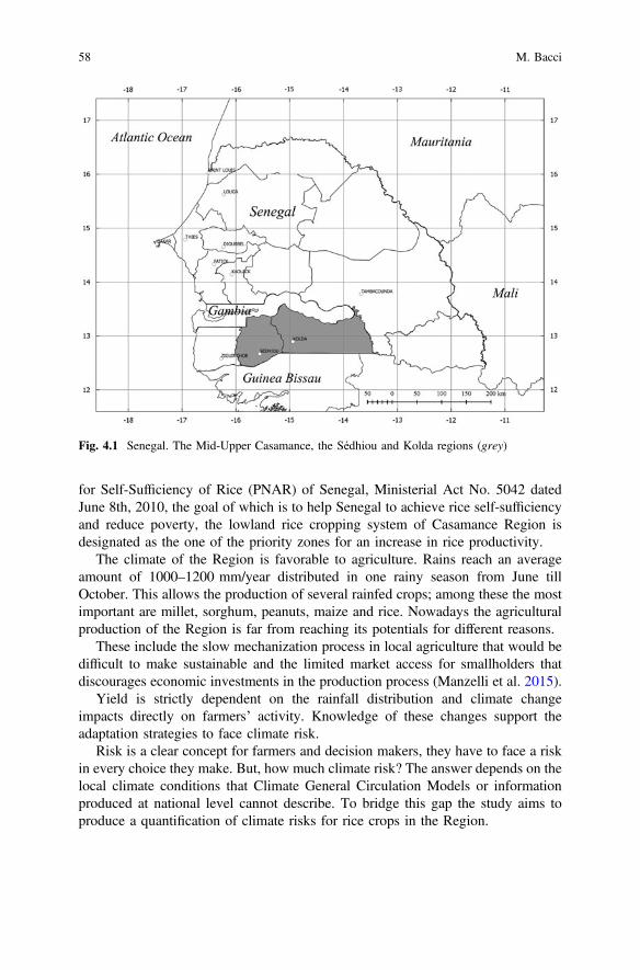
for Self-Sufficiency of Rice (PNAR) of Senegal, Ministerial Act No. 5042 datedJune 8th, 2010, the goal of which is to help Senegal to achieve rice self-sufficiencyand reduce poverty, the lowland rice cropping system of Casamance Region isdesignated as the one of the priority zones for an increase in rice productivity.
The climate of the Region is favorable to agriculture. Rains reach an averageamount of 1000–1200 mm/year distributed in one rainy season from June tillOctober. This allows the production of several rainfed crops; among these the mostimportant are millet, sorghum, peanuts, maize and rice. Nowadays the agriculturalproduction of the Region is far from reaching its potentials for different reasons.
These include the slow mechanization process in local agriculture that would bedifficult to make sustainable and the limited market access for smallholders thatdiscourages economic investments in the production process (Manzelli et al. 2015).
Yield is strictly dependent on the rainfall distribution and climate changeimpacts directly on farmers’ activity. Knowledge of these changes support theadaptation strategies to face climate risk.
Risk is a clear concept for farmers and decision makers, they have to face a riskin every choice they make. But, how much climate risk? The answer depends on thelocal climate conditions that Climate General Circulation Models or informationproduced at national level cannot describe. To bridge this gap the study aims toproduce a quantification of climate risks for rice crops in the Region.
Fig. 4.1 Senegal. The Mid-Upper Casamance, the Sédhiou and Kolda regions (grey)
58 M. Bacci
The results are mainly addressed to the entire agricultural community, fromdecision makers to smallholders, who must receive clear and pertinent informationfor their agronomic choices.
In this paper attention is placed on the analysis of the agrometeorological con-ditions that most influence the rice yield in the Region. In Mid-Upper Casamancethere are two different types of rice crop: (i) upland rainfed rice (plateau) and(ii) lowland rainfed rice (vallée).
The upland rice is a rainfed crop grown on dry soil without any water man-agement. This activity is carried out by men and mechanization is sometimes usedto aid their labor.
The lowland rainfed rice is grown in the natural depression near CasamanceRiver. This activity uses traditional practices by which farmers, mostly women,seek to support the family’s food balance. So this essentially remains a subsistencecrop where women try reduce economic risks rather than intensify productivity. Theeffects of climate on this farming system are linked to the poor management ofwater in the field. Heavy rains and dry spells in some specific periods of the plantgrowing cycle could cause stress to plants and reduce yield potentials.
The other important factor, determining a good or bad harvest, is the dynamicsof the West African Monsoon. In other words how an early or delayed start and endof the growing season impacts on yield. Each crop and variety is characterized byan optimal cycle length, so if there is no water available to complete the crop cyclethere is a risk of the loss of the entire harvest (Roudier et al. 2011; Sultan et al.2005). Indeed seasonality influences farmers’ decisions about when to sow andharvest, and ultimately the success or failure of their crops (Graef et al. 2001).
The labor organization in the field is dependent on rainfall distributions, in thecase of a late start to the season farming could be in competition with otheractivities and farmers risk not having enough time for field preparation and sowing,leaving some plots uncultivated (Manzelli et al. 2015b).
A longer growing season allows farmers to diversify crops or, as in this case, ricevarieties. Instead, a shorter growing season and delayed start to the season reduceavailable options. Traditional agriculture is characterized by local varieties thatwomen select in the years, mostly ecotypes naturally adapted to the local envi-ronment, but in the case of rapid climate change they aren’t able to independentlyadjust seeds selection to new conditions.
Based on the observed climate, we try to identify local climate trends aiming tosupport the evaluation process of risk in agricultural production and the climatechange adaptation process in the region. A set of synthetic indicators useful for thelocal community has been defined based on local knowledge, trying to highlight thefactors most influencing final yield. A collaborative approach with the local agri-cultural service allowed us to select the following risk indicators: the presence ofextreme events, both rainfall and drought, in (i) the germination and (ii) floweringperiod, and (iii) the dynamics of the growing season.
The probability of negative events is immediately comprehensible by decisionmakers and the results of the study can support strategic choices in the short- andmid-term.
4 Characterization of Climate Risks for Rice Crop … 59
Raw climatic data from the ground measurement network are poor and unevenlydistributed, so we chose for the analysis a daily rainfall estimation images dataset:the Climate Hazards Group InfraRed Precipitation with Station data (CHIRPS). Theselected dataset has a spatial resolution of 0.05°, sufficient to describe dynamics ofrainfall in the Region with more of 30 years of data available to define a climaticindex. This approach has the advantage of describing phenomena over the entiredomain and producing hazard maps capable of intercepting criticalities at a verylocal level (i.e. municipality level).
4.2 Materials and Methods
The rainfall estimation dataset used in this work is the Climate Hazards GroupInfraRed Precipitation with Station data (CHIRPS) v1p8 by the U.S. GeologicalSurvey and Earth Resources Observation and Science (Funk et al. 2015). CHIRPS isa quasi-global daily dataset spanning 50°S–50°N, starting in 1981 to near-present.CHIRPS incorporates 0.05° resolution satellite imagery with in situ station data tocreate gridded rainfall time series for trend analysis and seasonal drought monitoring.
CHIRPS rainfall estimation daily images are distributed in NetCDF (NetworkCommon Data Form) format, one of the most common climatic gridded data for-mats. We used the Climate Data Operators (CDO) to deal with this dataset. CDO isa large open source tool set for working on climate and model data. Using this toolwe selected the domain over Casamance Region from the original dataset andcomputed the different indexes starting from the CHIRPS daily data.
4.2.1 Climate Extremes
Climate extremes may be time averages or frequencies of events above a giventhreshold of a single meteorological variable. In this case study we focused ondetecting climatic stress in rice yield through the likelihood of recurrence ofextreme events in the most vulnerable crop stages. The proposed approach iden-tified criticalities supporting agronomic strategic choices that involve short- tomedium-term economic investment. In Casamance, according to rice plant physi-ology and local knowledge, the most critical periods for rice yield are duringemergence and flowering. We therefore chose the months of June-July and Octoberas the most critical stages. In both periods we evaluated a set of indexes describingdrought and extreme rainfall phenomena, these are:
• the maximum consecutive dry days, i.e. the greatest number of consecutive daysper time period with daily precipitation below 1 mm; and the number of dryperiods of more than 5 days to assess drought periods;
• the number of days when rainfall rate is at least 10 and 20 mm plus the highestone day precipitation amount per time period to assess heavy rainfall.
60 M. Bacci
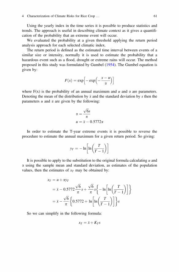
Using the yearly index in the time series it is possible to produce statistics andtrends. The approach is useful in describing climate context as it gives a quantifi-cation of the probability that an extreme event will occur.
We evaluated the probability at a given threshold applying the return periodanalysis approach for each selected climatic index.
The return period is defined as the estimated time interval between events of asimilar size or intensity, normally it is used to estimate the probability that ahazardous event such as a flood, drought or extreme rains will occur. The methodproposed in this study was formulated by Gumbel (1954). The Gumbel equation isgiven by:
FðxÞ ¼ exp exp x ua
h i
where F(x) is the probability of an annual maximum and u and a are parameters.Denoting the mean of the distribution by x and the standard deviation by s then theparameters u and a are given by the following:
a ¼ffiffiffi6
ps
pu ¼ x 0:5772a
In order to estimate the T-year extreme events it is possible to reverse theprocedure to estimate the annual maximum for a given return period. So giving:
yT ¼ ln lnT
T 1
It is possible to apply to the substitution to the original formula calculating u anda using the sample mean and standard deviation, as estimates of the populationvalues, then the estimates of xT may be obtained by:
xT ¼ uþ ayT
¼ x 0:5772
ffiffiffi6
p
psþ
ffiffiffi6
p
ps ln ln
TT 1
¼ xffiffiffi6
p
p0:5772þ ln ln
TT 1
s
So we can simplify in the following formula:
xT ¼ xþKTs
4 Characterization of Climate Risks for Rice Crop … 61
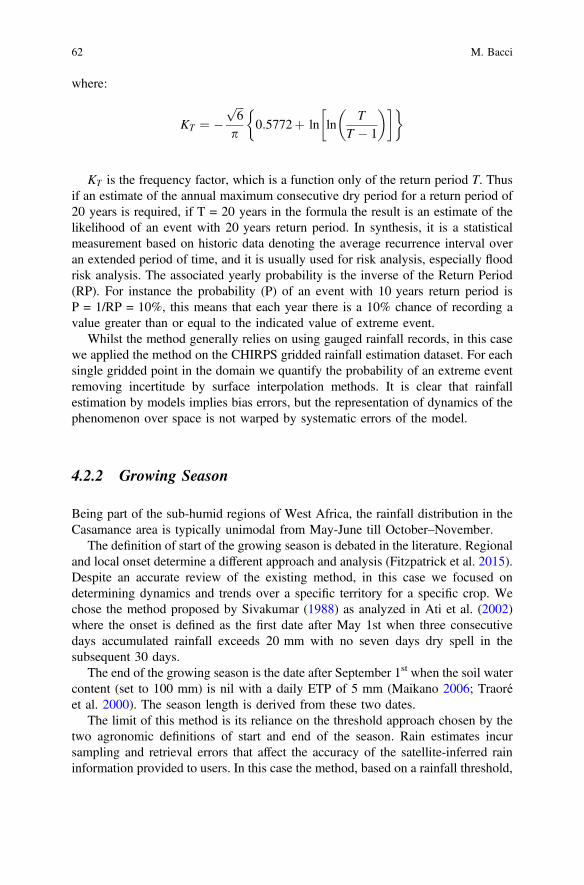
where:
KT ¼ ffiffiffi6
p
p0:5772þ ln ln
TT 1
KT is the frequency factor, which is a function only of the return period T. Thusif an estimate of the annual maximum consecutive dry period for a return period of20 years is required, if T = 20 years in the formula the result is an estimate of thelikelihood of an event with 20 years return period. In synthesis, it is a statisticalmeasurement based on historic data denoting the average recurrence interval overan extended period of time, and it is usually used for risk analysis, especially floodrisk analysis. The associated yearly probability is the inverse of the Return Period(RP). For instance the probability (P) of an event with 10 years return period isP = 1/RP = 10%, this means that each year there is a 10% chance of recording avalue greater than or equal to the indicated value of extreme event.
Whilst the method generally relies on using gauged rainfall records, in this casewe applied the method on the CHIRPS gridded rainfall estimation dataset. For eachsingle gridded point in the domain we quantify the probability of an extreme eventremoving incertitude by surface interpolation methods. It is clear that rainfallestimation by models implies bias errors, but the representation of dynamics of thephenomenon over space is not warped by systematic errors of the model.
4.2.2 Growing Season
Being part of the sub-humid regions of West Africa, the rainfall distribution in theCasamance area is typically unimodal from May-June till October–November.
The definition of start of the growing season is debated in the literature. Regionaland local onset determine a different approach and analysis (Fitzpatrick et al. 2015).Despite an accurate review of the existing method, in this case we focused ondetermining dynamics and trends over a specific territory for a specific crop. Wechose the method proposed by Sivakumar (1988) as analyzed in Ati et al. (2002)where the onset is defined as the first date after May 1st when three consecutivedays accumulated rainfall exceeds 20 mm with no seven days dry spell in thesubsequent 30 days.
The end of the growing season is the date after September 1st when the soil watercontent (set to 100 mm) is nil with a daily ETP of 5 mm (Maikano 2006; Traoréet al. 2000). The season length is derived from these two dates.
The limit of this method is its reliance on the threshold approach chosen by thetwo agronomic definitions of start and end of the season. Rain estimates incursampling and retrieval errors that affect the accuracy of the satellite-inferred raininformation provided to users. In this case the method, based on a rainfall threshold,
62 M. Bacci
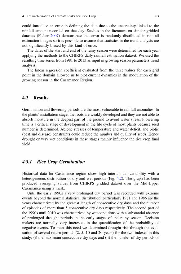
could introduce an error in defining the date due to the uncertainty linked to therainfall amount recorded on that day. Studies in the literature on similar griddeddatasets (Ficher 2007) demonstrate that error is randomly distributed in rainfallestimation images so it is possible to assume that statistics in the trend analysis arenot significantly biased by this kind of error.
The dates of the start and end of the rainy season were determined for each yearapplying the methods to the CHIRPS daily rainfall estimation dataset. We used theresulting time series from 1981 to 2013 as input in growing season parameters trendanalysis.
The linear regression coefficient evaluated from the three values for each gridpoint in the domain allowed us to plot current dynamics in the modulation of thegrowing season in the Casamance Region.
4.3 Results
Germination and flowering periods are the most vulnerable to rainfall anomalies. Inthe plants’ installation stage, the roots are weakly developed and they are not able toabsorb moisture in the deepest part of the ground to avoid water stress. Floweringtime is a critical stage of development in the life cycle of most plants because seednumber is determined. Abiotic stresses of temperature and water deficit, and biotic(pest and disease) constraints could reduce the number and quality of seeds. Hencedrought or very wet conditions in these stages mainly influence the rice crop finalyield.
4.3.1 Rice Crop Germination
Historical data for Casamance region show high inter-annual variability with aheterogeneous distribution of dry and wet periods (Fig. 4.2). The graph has beenproduced averaging values from CHIRPS gridded dataset over the Mid-UpperCasamance using a mask.
Until the early 1990s a very prolonged dry period was recorded with extremeevents beyond the normal statistical distribution, particularly 1981 and 1986 are theyears characterized by the greatest length of consecutive dry days and the numberof episodes of more than 5 consecutive dry days respectively. The second part ofthe 1990s until 2010 was characterized by wet conditions with a substantial absenceof prolonged drought periods in the early stages of the rainy season. Decisionmakers are normally very interested in the quantification of the probability ofnegative events. To meet this need we determined drought risk through the eval-uation of several return periods (2, 5, 10 and 20 years) for the two indexes in thisstudy: (i) the maximum consecutive dry days and (ii) the number of dry periods of
4 Characterization of Climate Risks for Rice Crop … 63
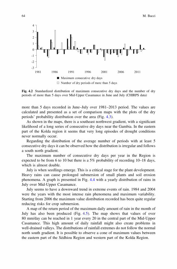
more than 5 days recorded in June–July over 1981–2013 period. The values arecalculated and presented as a set of comparison maps with the plots of the dryperiods’ probability distribution over the area (Fig. 4.3).
As shown in the maps, there is a southeast northwest gradient, with a significantlikelihood of a long series of consecutive dry days near the Gambia. In the easternpart of the Kolda region it seems that very long episodes of drought conditionsnever normally occur.
Regarding the distribution of the average number of periods with at least 5consecutive dry days it can be observed how the distribution is irregular and followsa south north gradient.
The maximum number of consecutive dry days per year in the Region isexpected to be from 6 to 10 but there is a 5% probability of recording 10–18 days,which is almost double.
July is when seedlings emerge. This is a critical stage for the plant development.Heavy rains can cause prolonged submersion of small plants and soil erosionphenomena. A graph is presented in Fig. 4.4 with a yearly distribution of rains inJuly over Mid-Upper Casamance.
July seems to have a downward trend in extreme events of rain. 1984 and 2004were the years with the most intense rain phenomena and maximum variability.Starting from 2006 the maximum value distribution recorded has been quite regularreducing risks for crop submersion.
A map of the return period of the maximum daily amount of rain in the month ofJuly has also been produced (Fig. 4.5). The map shows that values of over80 mm/day can be reached in 1 year every 20 in the central part of the Mid-UpperCasamance. This high amount of daily rainfall might also create problems inwell-drained valleys. The distributions of rainfall extremes do not follow the normalnorth south gradient. It is possible to observe a cone of maximum values betweenthe eastern part of the Sédhiou Region and western part of the Kolda Region.
-3
-2
-1
0
1
2
3
4
1981 1986 1991 1996 2001 2006 2011
Maximum consecutive dry daysNumber of dry periods of more than 5 days
Fig. 4.2 Standardized distribution of maximum consecutive dry days and the number of dryperiods of more than 5 days over Mid-Upper Casamance in June and July (CHIRPS data)
64 M. Bacci
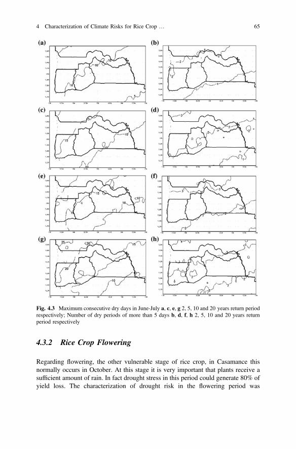
4.3.2 Rice Crop Flowering
Regarding flowering, the other vulnerable stage of rice crop, in Casamance thisnormally occurs in October. At this stage it is very important that plants receive asufficient amount of rain. In fact drought stress in this period could generate 80% ofyield loss. The characterization of drought risk in the flowering period was
Fig. 4.3 Maximum consecutive dry days in June-July a, c, e, g 2, 5, 10 and 20 years return periodrespectively; Number of dry periods of more than 5 days b, d, f, h 2, 5, 10 and 20 years returnperiod respectively
4 Characterization of Climate Risks for Rice Crop … 65
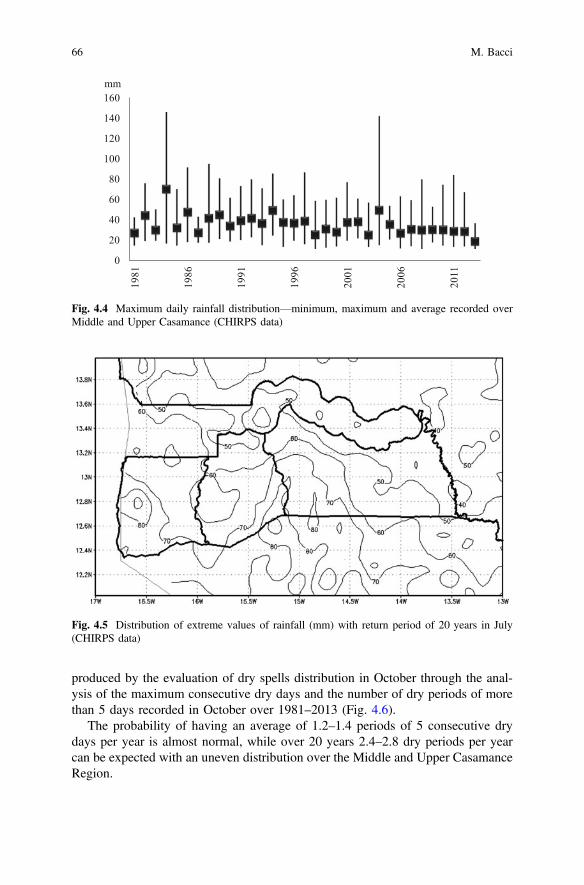
produced by the evaluation of dry spells distribution in October through the anal-ysis of the maximum consecutive dry days and the number of dry periods of morethan 5 days recorded in October over 1981–2013 (Fig. 4.6).
The probability of having an average of 1.2–1.4 periods of 5 consecutive drydays per year is almost normal, while over 20 years 2.4–2.8 dry periods per yearcan be expected with an uneven distribution over the Middle and Upper CasamanceRegion.
0
20
40
60
80
100
120
140
160
1981
1986
1991
1996
2001
2006
2011
mm
Fig. 4.4 Maximum daily rainfall distribution—minimum, maximum and average recorded overMiddle and Upper Casamance (CHIRPS data)
Fig. 4.5 Distribution of extreme values of rainfall (mm) with return period of 20 years in July(CHIRPS data)
66 M. Bacci
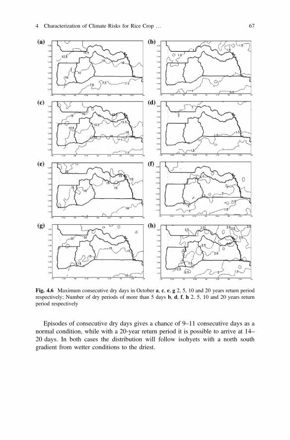
Episodes of consecutive dry days gives a chance of 9–11 consecutive days as anormal condition, while with a 20-year return period it is possible to arrive at 14–20 days. In both cases the distribution will follow isohyets with a north southgradient from wetter conditions to the driest.
Fig. 4.6 Maximum consecutive dry days in October a, c, e, g 2, 5, 10 and 20 years return periodrespectively; Number of dry periods of more than 5 days b, d, f, h 2, 5, 10 and 20 years returnperiod respectively
4 Characterization of Climate Risks for Rice Crop … 67
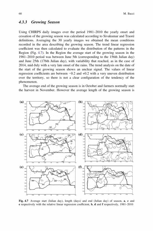
4.3.3 Growing Season
Using CHIRPS daily images over the period 1981–2010 the yearly onset andcessation of the growing season was calculated according to Sivakumar and Traorédefinitions. Averaging the 30 yearly images we obtained the mean conditionsrecorded in the area describing the growing season. The trend linear regressioncoefficient was then calculated to evaluate the distribution of the patterns in theRegion (Fig. 4.7). In the Region the average start of the growing season in the1981–2010 period was between June 5th (corresponding to the 156th Julian day)and June 25th (176th Julian day), with variability that reached, as in the case of2014, mid-July with a very late onset of the rains. The trend analysis on the date ofthe start of the growing season shows an unclear signal. The values of linearregression coefficients are between −0.2 and +0.2 with a very uneven distributionover the territory, so there is not a clear configuration of the tendency of thephenomenon.
The average end of the growing season is in October and farmers normally startthe harvest in November. However the average length of the growing season is
Fig. 4.7 Average start (Julian day), length (days) and end (Julian day) of season, a, c ande respectively with the relative linear regression coefficient, b, d and f respectively, 1981–2010
68 M. Bacci
120–140 days. The result is a consistent pattern to a shift towards November for theend of the cropping season. In general for Casamance there is a slight increasingtendency in the length of the growing season. Especially in Sédhiou Regionmaximum values are observed arriving at a ratio of increase in length of thegrowing season by 0.3 days a year.
4.4 Discussion
Rain distribution is one of the main factors that cause problems for rice crops inMid-Upper Casamance. Poor valleys water management, soil degradation anderosion phenomena, the lack of proper management of water in the plot andinappropriate agricultural practices are all factors creating a risk for crop yield.
To improve land and drainage management in the Region, the measure of cli-mate change risks is necessary to assist this development process. Indeed, where theagricultural system is very vulnerable to natural hazards, adaptation measures areurgently required, such as the reorganization of hydraulic management in the val-leys, with an evaluation of alternative cropping systems and/or introduction of newrice varieties and the risk to achieve all of this must be quantified.
The probability of dry spells or extreme events in the most critical stages of ricecrop supports alternative strategic choices and it is possible to evaluate the bestoptions in terms of crops and varieties combination for the Casamance Region. Infact, each crop, and consequentially each variety, has a particular sensitivity todrought spells. Using the probability maps of extreme events produced in this studyit is possible to select the most appropriate combination of crops and varietiesconsidering future climatic conditions.
We want to stress the fact that using a high resolution daily precipitation griddeddataset it is possible to describe phenomena at a very local scale, giving tailoredclimatic information also at municipality level.
The study characterized some crucial agro-climatic hazards impacting on theRegion rice crop production; this paper presents the most important findings. Firstof all we found that in the last decade the good rainfall distribution in the initialphase of the growing season determined a low probability of unfavorable conditionsfor crops. A downward trend in extreme rains in July also reassures us that in thecoming years we can expect better average conditions for the emergence of ricecrop. This doesn’t mean that hazardous events are not expected in future. In factusing the return period of extreme events in the June–July period a map wasproduced showing that amounts of 80 mm/day and more are expected 1 year every20, so a yearly probability of 5%. This information is also useful for drainagedesign and management in the Region.
The dynamics of the growing season show that in the Region there is generally aslight trend in the end of season shifting from early to end November. This aspect isvery interesting and reassures farmers and decision makers of the opportunity tocomplete the crop cycle in the case of late starts to the season. But this shift also has
4 Characterization of Climate Risks for Rice Crop … 69
negative effects on farming activities; indeed a continuation of favorable conditionsfor crop development, with delayed maturation and harvesting, can lead to prob-lems of losses due to straying animals and generate conflicts with livestock farmers.
Instead, the intercepted signal on the start of the growing season is weaker andshows an unclear trend in the Region. This could be linked to the current variabilityin the onset of the West African Monsoon.
Considering natural climate variability, caution will be maintained for agro-nomic planning in the Region, but a set of quantitative values is now available tosupport the decision-making process. This information must be constantly updatedin order to give end users the very latest available and accurate information of theclimate evolution.
4.5 Conclusions
The agro-meteorological characterization provided in this paper aims to support thedecision-making process in agriculture through tailored climatic information for theMiddle and Upper Casamance Region. The integration of local knowledge with themost recent gridded model outputs intercepts criticalities for rice crop yield.
A set of probability thresholds for the most important climatic threats is givenallowing end users to have a clear picture of possible risk scenarios. These valueshelp decision makers in their choices, indeed it is now possible to define theacceptable risk threshold; in other words they can set a level of potential losses thata farmer or politics considers acceptable, given probable climatic conditions. Theextreme events’ probability could also support new varietal and agronomic choices,guiding farmers in optimizing the production process. Furthermore, these valuescould support agronomists in the redesign and sizing of the hydraulic systemmanagement in the rice valleys of the Region.
The climate variability recorded in the Region suggests caution on the possiblerecurrence of flood and drought episodes, requiring an improvement in watermanagement systems to reduce the risk of yield losses.
The rainfall estimation gridded dataset describes phenomena through their nat-ural modulation over the territory; it therefore supports local communities in theiradaptation by showing a climate change distribution not measurable by the groundmeteorological network. This approach allows us to release information at verylocal level with detailed maps supporting the usability of the analysis results.
Feedback from end users, such as local associations and decentralized agricul-tural technical services, could guide future fine tuning of the climatic index anal-ysis. Indeed, dialogue between the scientific community and local users is the keyelement in the innovation process for the improvement of agronomic techniquesand strategies to face climate change. Moreover we recommend a synergy amongdifferent levels of end users to achieve a coordinated rural development process thatconsiders the most accurate information available on climate.
70 M. Bacci
This approach could be reproduced with General Circulation Models outputs inorder to evaluate some possible future scenario giving a picture of what climaticconditions will be like for rice crops in Casamance.
References
Ati, O.F., C.J. Stigter, and E.O. Oladipo. 2002. A comparison of methods to determine the onset ofthe growing season in northern Nigeria. International Journal of Climatology 22: 731–742.doi:10.1002/joc.712.
Evans, M. 2003. Ni paix ni guerre: The political economy of low-level conflict in the Casamance.Background Research for Humanitarian Policy Group Report, (13). London: OverseasDevelopment Institute.
Fitzpatrick, R.G.J., C.L. Bain, P. Knippertz, J.H. Marsham, and D.J. Parker. 2015. The WestAfrican monsoon onset: A concise comparison of definitions. Journal of Climate. doi:10.1175/JCLI-D-15-0265.1.
Ficher, B.L. 2007. Statistical error decomposition of regional-scale climatological precipitationestimates from the tropical rainfall measuring mission (TRMM). Journal of AppliedMeteorology and Climatology 46: 791–813. doi:10.1175/JAM2497.1.
Funk, C., P. Peterson, M. Landsfeld, D. Pedreros, J. Verdin, S. Shukla, G. Husak, J. Rowland, L.Harrison, A. Hoell, and J. Michaelsen. 2015. The climate hazards infrared precipitation withstations—a new environmental record for monitoring extremes. Scientific Data 2: 150066.doi:10.1038/sdata.2015.66.
Graef, F., and J. Haigis. 2001. Spatial and temporal rainfall variability in the Sahel and its effectson farmers’ management strategies. Journal of Arid Environments 48 (2): 221–231.
Gumbel, E.J. 1954. Statistical theory of extreme values and some practical applications. Appliedmathematics series 33. U.S. Department of Commerce, National Bureau of Standards.
Maikano, I. 2006. Generate prototype WCA recommendation maps for selected sorghum andmillet cultivars based on updated end-of-season dates (PRODEPAM, activity). Rapport destage. Institut International de Recherche sur les Cultures des Zones tropicales semi-arides(ICRISAT/Bamako).
Manzelli, M., E. Fiorillo, M. Bacci, and V. Tarchiani. 2015a. Lowland rice production in southernSenegal (Middle Casamance): Challenges and prospects for sustaining their restoration anddevelopment. Cahiers Agricultures 24 (5): 301–312. doi:10.1684/agr.2015.0772.
Manzelli, M., I. Seppoloni, E. Zucchini, M. Bacci, E. Fiorillo, and V. Tarchiani. 2015b. Lariziculture traditionnelle de bas-fond en Moyenne Casamance dans un contexte de change-ments globaux: enjeux et perspectives. In Eaux et sociétés face au changement climatique dansle bassin de la Casamance. Paris: L’Harmattan. ISBN 978-2-343-07690-4.
Roudier, P., B. Sultan, P. Quirion, and A. Berg. 2011. The impact of future climate change onWest African crop yields: What does the recent literature say? Symposium on Social theoryand the environment in the new world (dis)Order. Global Environmental Change 21 (3): 1073–1083. doi:10.1016/j.gloenvcha.2011.04.007.
Sivakumar, M.V.K. 1988. Predicting rainy season potential from the onset of rains in southernSahelian and Sudanian climatic zones of West Africa. Agricultural and Forest Meteorology 42:295–305.
Sultan, B., C. Baron, M. Dingkuhn, B. Sarr, and S. Janicot. 2005. Agricultural impacts oflarge-scale variability of the West African monsoon. Agricultural and Forest Meteorology 128(1): 93–110. doi:10.1016/j.agrformet.2004.08.005.
Traoré, S.B., F.-N. Reyniers, M. Vaksmann, B. Koné, A. Sidibé, A. Yorote, K. Yattara, and M.Kouressy. 2000. Adaptation à la sécheresse des ecotypes locaux de sorgho du Mali. Sécheresse11: 227–237.
4 Characterization of Climate Risks for Rice Crop … 71
Open Access This chapter is licensed under the terms of the Creative Commons Attribution 4.0International License (http://creativecommons.org/licenses/by/4.0/), which permits use, sharing,adaptation, distribution and reproduction in any medium or format, as long as you give appropriatecredit to the original author(s) and the source, provide a link to the Creative Commons license andindicate if changes were made.The images or other third party material in this chapter are included in the chapter's Creative
Commons license, unless indicated otherwise in a credit line to the material. If material is notincluded in the chapter's Creative Commons license and your intended use is not permitted bystatutory regulation or exceeds the permitted use, you will need to obtain permission directly fromthe copyright holder.
72 M. Bacci
Chapter 5A Methodology for the VulnerabilityAnalysis of the Climate Changein the Oromia Region, Ethiopia
Elena Belcore, Angela Calvo, Carolin Canessa and Alessandro Pezzoli
Abstract Goal of the vulnerability research of the last years is to evaluate whichcommunity, region, or nation is more vulnerable in terms of its sensitive to dam-aging effects of extreme meteorological events like floods or droughts. Ethiopia is acountry where it is possible to find the described conditions. Aim of this work wasto develop an integrated system of early warning and response, whereas neitherlandmark data nor vulnerability drought analysis existed in the country.Specifically, a vulnerability index and a capacity to react index of the population ofthree Woredas in the Oromia Region of Ethiopia were determined and analysed.Input data concerned rainfall, water availability, physical land characteristics,agricultural and livestock dimensions, as well as population and socio-economicindices. Data were collected during a specific NGO project and thanks to a fieldresearch funded by the University of Torino. Results were analysed and specificmaps were drawn. The mapping of the vulnerability indices revealed that the moreisolated Woreda with less communication roads and with less water sources pre-sented the worst data almost on all its territory. Despite not bad vulnerability indicesin the other two Woredas, however, population here still encountered difficulty toadapt to sudden climatic changes, as revealed by the other index of capacity toreaction. Beyond the interpretation of each parameter, a more complete reading keywas possible using the SPI (Standardized Precipitation Index) beside these
E. Belcore (&) A. Calvo C. CanessaDepartment of Agricultural, Forest and Food Sciences, University of Torino,Largo Paolo Braccini 4, Grugliasco (TO) 10095, Italye-mail: [email protected]
A. Calvoe-mail: [email protected]
C. Canessae-mail: [email protected]
A. PezzoliDIST-Politecnico and University of Turin, Viale Mattioli 39, 10125 Turin, Italye-mail: [email protected]
© The Author(s) 2017M. Tiepolo et al. (eds.), Renewing Local Planning to Face ClimateChange in the Tropics, Green Energy and Technology,DOI 10.1007/978-3-319-59096-7_5
73
indicators. In a normalized scale between 0 and 1, in this study the calculatedannual SPI index was 0.83: the area is therefore considerably exposed to thedrought risk, caused by an high intensity and frequency of rainfall lack.
Keywords Vulnerability analysis Climate change Ethiopia
5.1 Introduction
In 2007 the document of the Intergovernmental Panel on Climate Change (IPCC2007) confirmed with absolute certainty the man-made phenomenon of climatechange manifested by the increasing of the average global temperatures. One of themain consequences is the variation in rainfall patterns and the increasing probabilityof extreme meteorological events like floods or droughts. Various areas of the worldare therefore at natural disaster risk. Nevertheless, the latter is not just a function ofclimatic events, but also of the system characteristics. As underlined by UNISDR:“There is no such thing as a ‘natural’ disaster, only natural hazards” (UNISDR 2009).
The probability of calamitous events depends also on the vulnerability of thesystem, that is the collection of characteristics and conditions of human-environment systems that made it sensitive to damaging effects of extremeevents. Ethiopia is a country where it is possible to find the conditions abovedescribed. In the Ethiopian territory, in fact, environment, demographic and eco-nomic conditions exposed in many occasion the population to droughts andhumanitarian catastrophes due to the ENSO phenomenon and the heating of theIndian Ocean. Nowadays the necessity of limiting the increasing of global tem-peratures with politics of mitigation is clear, but it become fundamental the ex-anteevaluation of the systems vulnerability to extreme events. In order to adopt mea-sures to develop the capacity of adaptation of population and to improve theresilience, it is important to analyse the system vulnerability.
Vulnerability analysis can have a lead role in adaptation policies designed toreduce climate change impacts and extreme events on ecosystem services that are thefoundations of the human wellbeing (MEA 2009). Evaluating which individual,community, region, species or nation is more vulnerable is the goal of the vulner-ability research of last decades. However vulnerability studies are still a developingfield of research. Actually, the conceptual framework is still fragmented and basedon different paradigms, adversarial theories, heterogenic empirical studies and a verydiversified terminology (Vincent 2004). For example at now it doesn’t exist anuniversal accepted definition of vulnerability, the meanings attributed to the term areoften contested and the related concepts depends on finalities and on the studiedsystem (Cutter 2003). It is therefore necessary to find a common conceptualframework that guarantee coherence during research activities, to enhance policyactivities that can be applied to the stakeholders (Kasperson et al. 2001).
74 E. Belcore et al.
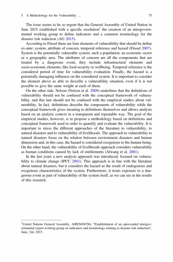
The issue seems to be so urgent that the General Assembly of United Nation inJune 2015 established with a specific resolution1 the creation of an intergovern-mental working group to define indicators and a common terminology for thedisaster risk reduction (AG 2015).
According to Füssel there are four elements of vulnerability that should be defineex-ante: system, attribute of concern, temporal reference and hazard (Füssel 2007).System is the potentially vulnerable system, such a population, an economic sectoror a geographic area. The attributes of concern are all the components that aretreated by a dangerous event, they include infrastructural elements andsocio-economic elements, like food security or wellbeing. Temporal reference is theconsidered period of time for vulnerability evaluation. Finally, the hazard is apotentially damaging influence on the considered system. It is important to considerthe element above as able to describe a vulnerability situation, even if it is notpossible to give the same weight at each of them.
On the other side, Nelson (Nelson et al. 2009) underlines that the definitions ofvulnerability should not be confused with the conceptual framework of vulnera-bility, and this last should not be confused with the empirical studies about vul-nerability. In fact, definitions describe the components of vulnerability while theconceptual framework gives meaning to definitions themselves and allows analysisbased on an analytic context in a transparent and repeatable way. The goal of theempirical studies, however, is to propose a methodology based on definitions andconceptual framework used in order to quantify and evaluate the vulnerability. It isimportant to stress the different approaches of the literature to vulnerability, tonatural disasters and to vulnerability of livelihoods. The approach to vulnerability tonatural disasters focus on the relation between environment disasters and humandimension and, in this case, the hazard is considered exogenous to the human being.On the other hand, the vulnerability of livelihoods approach considers vulnerabilityas human conditions caused by lack of entitlements (Alwang et al. 2001).
In the last years a new analysis approach was introduced, focused on vulnera-bility to climate change (IPCC 2001). This approach is in line with the literatureabout natural disasters, but it considers the hazard as the result of endogenous andexogenous characteristics of the system. Furthermore, it treats exposure to a dan-gerous event as part of vulnerability of the system itself, as we can see in the resultsof this research.
1United Nations General Assembly, A/RES/69/284, “Establishment of an open-ended intergov-ernmental expert working group on indicators and terminology relating to disaster risk reduction”,June, 3rd, 2015.
5 A Methodology for the Vulnerability … 75
5.1.1 Climate Change, Vulnerability and Resilience
It is well known that rural poverty increases when it increases elsewhere and theexpected situation is more difficult for the remote rural areas of the South of theworld (often already poor) where people lack resources to fall back on. When ruralregions impoverished, more people leave rural areas, reinforcing existing migrationtrends in a downward cycle.
Aim of this work is the analysis of population vulnerability and resilience in theRegion of Oromia (Ethiopia), using a data base of the NGO LVIA (created by aquestionnaire on food security) investigated by three students of the Universityof Turin (Department of Agricultural, Forest and Food Sciences, Department ofCulture, Politics and Society and Department of Territory of the University ofTurin) during a three month stage in Ethiopia in the summer 2015. An innovativemethodology is therefore explained, to evaluate the hazard and the effect of theClimate Change on the drought in Ethiopia using the vulnerability analysis, with adeeper study of the system and of the attribute of concern.
5.2 Area of Study
Ethiopia stretches over 1.12 million of km2 covering a huge part of Horn of Africa.It is a federal country, composed by nine ethnic administrative regions (Fig. 5.1).
The population in 2015 was around 99 million people, with a forecast of138 million in 2030 (United Nations 2015).
It is the second more populated country in Africa after Nigeria (CSA 2007). Theagricultural sector accounts the 45% of Ethiopian GDP. The 85% of populationworks in agriculture, but only 1% of farmland has an irrigation system. Agriculturetherefore depends on rainfalls. Pastoralism is an important source of livelihood andeconomy and accounts 15% of Ethiopian GDP. Ethiopia is composed by 9 Regions(or Zones): inside each Region there is a certain number of districts (called Woreda)and each Woreda is composed by municipalities (Kebele), the smallest adminis-trative unit of Ethiopia. In the last century Ethiopia unfortunately registered manyanomalies concerning precipitations distribution, that leads to frequent and intenseperiods of drought in many areas of the country. Several studies justify the pre-cipitation variability of Horn of Africa with the phenomenon of Niño and Niña(ENSO—El Niño Southern Oscillation18) (Hulme et al. 2001, Korecha 2006,Segele and Lamb 2005, Seleshi and Demarèe 1995). The main concern is theseasonal cycle of the rain (Segele and Lamb 2005, Viste et al. 2013), becauseanomalous rainy cycles may lead to huge damages to the agricultural production ofthe country, increasing the vulnerability of rural people which lives of subsistence(Sadoff 2008). The area of this study stretch over the territory in three Woredas of
76 E. Belcore et al.
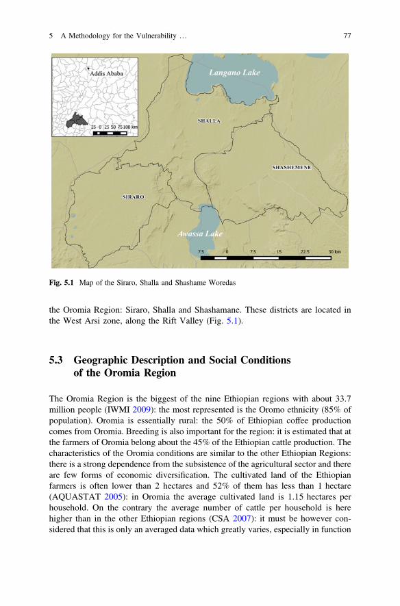
the Oromia Region: Siraro, Shalla and Shashamane. These districts are located inthe West Arsi zone, along the Rift Valley (Fig. 5.1).
5.3 Geographic Description and Social Conditionsof the Oromia Region
The Oromia Region is the biggest of the nine Ethiopian regions with about 33.7million people (IWMI 2009): the most represented is the Oromo ethnicity (85% ofpopulation). Oromia is essentially rural: the 50% of Ethiopian coffee productioncomes from Oromia. Breeding is also important for the region: it is estimated that atthe farmers of Oromia belong about the 45% of the Ethiopian cattle production. Thecharacteristics of the Oromia conditions are similar to the other Ethiopian Regions:there is a strong dependence from the subsistence of the agricultural sector and thereare few forms of economic diversification. The cultivated land of the Ethiopianfarmers is often lower than 2 hectares and 52% of them has less than 1 hectare(AQUASTAT 2005): in Oromia the average cultivated land is 1.15 hectares perhousehold. On the contrary the average number of cattle per household is herehigher than in the other Ethiopian regions (CSA 2007): it must be however con-sidered that this is only an averaged data which greatly varies, especially in function
Fig. 5.1 Map of the Siraro, Shalla and Shashame Woredas
5 A Methodology for the Vulnerability … 77
of the agro-ecologic environments (highlands, midlands, lowlands). The Region islocated in a drainage basin (the second of the country for dimension) and it disposesof a good quantity of water. Nevertheless the area is really vulnerable to thechanges of the precipitations distribution, because the current management systemcannot provide for a sustainable water access to the population (LVIA 2015).
5.4 The Analysed Woredas: Siraro, Shallaand Shashamene
The three Woredas are located along the down Rift valley: 80% of the Shashameneterritory is lowland, Siraro broadens on highlands, while Shalla is only on high-lands, until about 2000 m above sea level (Table 5.1). There are therefore differentclimatic conditions and different geographic environments, which affect soil fertilityand cultivations. Based on the agro-ecological zones, the main cultivations are:corn, teff, barley and beans.
During the last decade Ethiopian government (Disaster risk management andfood security sector) documented a great level of exposure to drought and floods(DRMFSS 2016). In addiction there is a socio-economic stress condition whichmakes the population more sensitive to climatic disturbs.
With an estimated population of about 662,000 inhabitants (Table 5.2), the threeWoredas have an high population density (about 310 inhabitants/km2) compared tothe national one (lower than 100) (DRMFSS 2016). Population (mainly of Islamicreligion) is very young with a low occupational level outside the agricultural sector:these economic conditions decrease the possibility of economic diversification inorder to reduce the population dependence from natural resources.
Table 5.1 Environmental and economic characteristics of the examined Woredas
Woreda Areakm2
Environment Economicactivities
Crops
Shashamene 779 Lowland (80%)Highland (20%)
AgricultureLivestockCommerce
Teff, barley, millet, sorghum,wheat, corn, beans
Siraro 607 Lowland (68%)Highland (32%)
AgricultureLivestock
Teff, wheat, corn, beans, potatoes
Shalla 749 Highland(1700–2000 m)
Agriculturelivestock
Corn
Table 5.2 Population (census 2007 and 2015 forecast)
Shashamene Siraro Shalla Total 2015 Forecast
347,228 145,649 149,804 642,681 661,961
78 E. Belcore et al.
5.5 Method and Materials
Questionnaires and InterviewsQuestionnaires and interviews were the instruments used for data collection. It waschiefly used a questionnaire created by LVIA NGO in its Food security project.Furthermore four interviews were submitted: one singular interview to the head ofthe village and three group of interviews to local water committees, to the womenof the villages and to the village community. 180 questionnaires were filled in thethree Woredas (15 Kebele per Woreda and 12 households per Kebele) in threemonths of work: the questionnaire was composed by 200 questions, with a total of36,000 collected data. More than 40 interviews were therefore submitted to heads ofvillages and communities.
Food Security QuestionnaireThe food security questionnaire was created by LVIA NGO in occasion of a projectrelated to the food security and water’s resource in the Woredas of Siraro, Shallaand Shashamane. The questionnaire was composed by 45 questions divided in 5sections: general information, livelihood, food security, and observation checklist(see Annex). The general information section was made up of 25 questions con-cerning family composition and water access of the interviewed household: theywere usually short and had multi-choice answers. Livelihood was the longestsection, containing 30 questions to investigate household economics activities,agricultural systems, yearly income, irrigation types and livestock characteristics.Food security section was composed by 11 questions about the number and thecomposition of daily meals and diseases related to under-nutrition conditions.The last section, observation checklist, was the shortest and was dedicated to theinterviewer, to obtain information on the family composition and characteristics.The questionnaire was created in order to be more understandable as possible andcontained short questions easily translatable from English to the local language. Italso included a series of control questions. Some questions (20, 21 and 41) wereopen and asked to the interviewee to discuss about different topics, but peoplenormally did not agree to answer. LVIA cultural mediators helped people to fulfillthe questionnaire: they read and translated in local language, explained questionsand wrote down the answer of the interviewee. Before conducting and summitingquestionnaires, each cultural mediator received the questionnaire and studied theguide line in order to have an homogeneous fulfill. In the questionnaire some keyquestions were individuated and therefore used to calculate vulnerability andresilience indexes. The identified sub-indicators which composed the vulnerabilityand resilience indices were 24 and concerned different topics: economy, water,environment, agriculture, livestock, demography, and others. The data elements ofeach sub-indicators were one or more.
5 A Methodology for the Vulnerability … 79
5.5.1 Interviews
The personal interview to the head of the village was useful to acquire generalinformation about the village where the households questionnaire was administered. Itwas composed by 28 short-answer questions about ethnic and religious composition,inhabitants distribution, quantity of cattle in the village and number and location of themain water sources. Another interview was dedicated to the Water committee (thelocal branch of the water management Ethiopian office). The interview was submittedto at least two of the seven members of the Committee. The 19 questions concernedcitizens’ water access, quality and quantity of water and the main problems aboutwater sources management. The group interview to members of the village wasstructured as a community map. All members of the community were invited to takepart at the interview. The consultation was lead outdoor. The first question was to drawon the ground the village boundaries and the main aggregation points (schools, church,mosque and health centers). The community maps are really useful to collect contestinformation and to create a first relation with the community before starting thesubmission of the household interviews. A short interview was submitted to a group ofwomen in each village. It was composed by four questions with the aim to generate adiscussion between the interviewees about their safeness, empowerment and duties.
The Interview Procedure The interviews and the questionnaires were submittedby one or two interviewers and a cultural mediator. In each village the sameprocedure was followed. At the beginning there was a short presentation of theproject and of the interviewer to the people of the village; therefore all memberswere invited to take part to the community map, in order to create a first relationshipwith the population and to find some volunteers for the questionnaires. Communitymaps were followed by the interviews to the head of the village, to the WaterCommittee and to a group of women. Therefore the questionnaires were submittedto four households in each village. In order to guarantee the same complete com-prehension about the main themes of the project, both questionnaires and interviewswere controlled and discuss with the local staff. Interviews and questionnaires tookplace outdoor, in shared spaces, with the presence of other members of the com-munity due to the necessity of transparency in the research and the spread curiosityof population. Two days in each village were necessary to collect all data.
5.6 Analysed Indicators
5.6.1 Vulnerability
The vulnerability is the capacity of a community to adapt itself when climatechanges cause modifications to the environment and condition the life (IPCC 2001).The vulnerability is an indicator, defined as a function of three sub-indicators:exposure (E), sensitivity (S) and adaptive capacity (Ac):
80 E. Belcore et al.
V ¼ E Sð Þ=Ca ð1Þ
Both E and S represent the negative effects of the changing conditions, while Cis the parameter which may counteract the negative effect of the impact.
5.6.2 Vulnerability and Resilience Macro-Indicators
The vulnerability index is composed by 18 macro-indicators, while the resilience iscalculated from 6 macro-indicators (Table 5.3).
Table 5.3 Vulnerability and resilience macro indicators
Indicator Description Data source Questions
E Population density Statistic agency of Ethiopia /
E Drought analysis Ethiopian National MeteorologicalServices Agency
/
S Cultivated land pro capita FSQ 4/16
S Number of members <5 and>65 years old
FSQ 5 + 6
S Yearly income pro capita FSQ (31–32)/4
S Presence of a second incomesource
FSQ 19
S Average litres of water fetchper day
FSQ (13a + 13b)/2
S Distance from the main watersource
FSQ 12a
S Average water price Community map 5
S Water quality FSQ, water committee interview 12d
S Type of soil and soil erosion Antierosion study /
S Average number of meals perday
FSQ (36a + 36b)/2
S Number of agriculture varieties FSQ 23
S Use of inputs FSQ 24
Ca Number of animals per cattle FSQ 17
Ca Type of water source in thevillage
FSQ 12a, 12b,12c, 12e
Ca Presence of a warehouse FSQ 30
Ca Beneficiary of governmentalprograms
FSQ 22
Re Higher educational level in thefamily
FSQ 9
(continued)
5 A Methodology for the Vulnerability … 81
ExposureExposure is defined as each meaningful climatic variation influencing the examinedsystem. Intensity, frequency, duration and physic extension of the hazard arespecifically considered. In the disaster risk management, the exposure is a set ofelements of the analysed system. There are two types of exposure: physical andsocial. Physical exposure refers to infrastructures, buildings, ecosystems and cul-tivations, while social exposure concerns human and animal populations. It isimportant to understand that an exposed population can be not vulnerable if itpresents low sensitivity and a good capacity of adaptation, but a vulnerable pop-ulation is always exposed. Furthermore, a geographic area can be exposed tohazards, but not vulnerable because uninhabited. In the definition of exposure isnecessary to find the social component, or the subject, and the physic component, orthe hazard of the system. The following paragraphs describes the procedure for thedetermination of the physical exposure (Ef) and of the social exposure (Ed) in thiswork.
Physical ExposurePhysical exposure describes the nature and the level of danger of the contextpotentially exposed. In Ethiopia the hazard is the drought. As suggested by WMO(2012), in order to analyze physical exposure, the SPI-Standardized PrecipitationIndex was used. The SPI is based on the cumulative probability of a given rainfallevent occurring at a station. The historic rainfall data of the station is fitted to agamma distribution, as the gamma distribution has been found to fit the precipi-tation distribution quite well. The process allows the rainfall distribution at thestation to be effectively represented by a mathematical cumulative probabilityfunction. Therefore, based on the historic rainfall data, it is possible to tell what isthe probability of the rainfall being less than or equal to a certain amount. Thus, theprobability of rainfall being less than or equal to the average rainfall for that areawill be about 0.5, while the probability of rainfall being less than or equal to an
Table 5.3 (continued)
Indicator Description Data source Questions
Re Participation in associations(cooperative)
FSQ 27
Re Internal aid (participation tolocal associations)
FSQ 34
Re Access to microcredit FSQ 33
Re Beneficiary of food securityLVIA project
FSQ 1
Re Presence of an health center inthe village
Community maps /
FSQ-Food security questionnaire
82 E. Belcore et al.
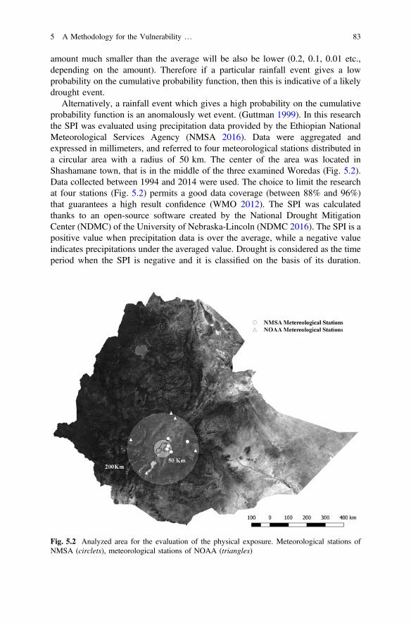
amount much smaller than the average will be also be lower (0.2, 0.1, 0.01 etc.,depending on the amount). Therefore if a particular rainfall event gives a lowprobability on the cumulative probability function, then this is indicative of a likelydrought event.
Alternatively, a rainfall event which gives a high probability on the cumulativeprobability function is an anomalously wet event. (Guttman 1999). In this researchthe SPI was evaluated using precipitation data provided by the Ethiopian NationalMeteorological Services Agency (NMSA 2016). Data were aggregated andexpressed in millimeters, and referred to four meteorological stations distributed ina circular area with a radius of 50 km. The center of the area was located inShashamane town, that is in the middle of the three examined Woredas (Fig. 5.2).Data collected between 1994 and 2014 were used. The choice to limit the researchat four stations (Fig. 5.2) permits a good data coverage (between 88% and 96%)that guarantees a high result confidence (WMO 2012). The SPI was calculatedthanks to an open-source software created by the National Drought MitigationCenter (NDMC) of the University of Nebraska-Lincoln (NDMC 2016). The SPI is apositive value when precipitation data is over the average, while a negative valueindicates precipitations under the averaged value. Drought is considered as the timeperiod when the SPI is negative and it is classified on the basis of its duration.
Fig. 5.2 Analyzed area for the evaluation of the physical exposure. Meteorological stations ofNMSA (circlets), meteorological stations of NOAA (triangles)
5 A Methodology for the Vulnerability … 83
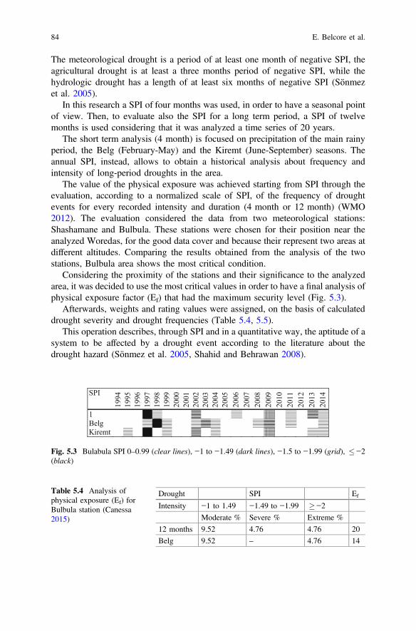
The meteorological drought is a period of at least one month of negative SPI, theagricultural drought is at least a three months period of negative SPI, while thehydrologic drought has a length of at least six months of negative SPI (Sönmezet al. 2005).
In this research a SPI of four months was used, in order to have a seasonal pointof view. Then, to evaluate also the SPI for a long term period, a SPI of twelvemonths is used considering that it was analyzed a time series of 20 years.
The short term analysis (4 month) is focused on precipitation of the main rainyperiod, the Belg (February-May) and the Kiremt (June-September) seasons. Theannual SPI, instead, allows to obtain a historical analysis about frequency andintensity of long-period droughts in the area.
The value of the physical exposure was achieved starting from SPI through theevaluation, according to a normalized scale of SPI, of the frequency of droughtevents for every recorded intensity and duration (4 month or 12 month) (WMO2012). The evaluation considered the data from two meteorological stations:Shashamane and Bulbula. These stations were chosen for their position near theanalyzed Woredas, for the good data cover and because their represent two areas atdifferent altitudes. Comparing the results obtained from the analysis of the twostations, Bulbula area shows the most critical condition.
Considering the proximity of the stations and their significance to the analyzedarea, it was decided to use the most critical values in order to have a final analysis ofphysical exposure factor (Ef) that had the maximum security level (Fig. 5.3).
Afterwards, weights and rating values were assigned, on the basis of calculateddrought severity and drought frequencies (Table 5.4, 5.5).
This operation describes, through SPI and in a quantitative way, the aptitude of asystem to be affected by a drought event according to the literature about thedrought hazard (Sönmez et al. 2005, Shahid and Behrawan 2008).
SPI
1994
1995
1996
1997
1998
1999
2000
2001
2002
2003
2004
2005
2006
2007
2008
2009
2010
2011
2012
2013
2014
1BelgKiremt
Fig. 5.3 Bulabula SPI 0–0.99 (clear lines), −1 to −1.49 (dark lines), −1.5 to −1.99 (grid), −2(black)
Table 5.4 Analysis ofphysical exposure (Ef) forBulbula station (Canessa2015)
Drought SPI Ef
Intensity −1 to 1.49 −1.49 to −1.99 −2
Moderate % Severe % Extreme %
12 months 9.52 4.76 4.76 20
Belg 9.52 – 4.76 14
84 E. Belcore et al.
Physical exposure (Ef) was obtained using the equation:
Ef ¼ SMv SMwð Þþ SSv SSwð Þþ SEv SEwð Þ ð2Þ
where: SMv: attributed rating of moderate drought frequency; SMw: weight of themoderate intensity drought; SSv: attributed rating of severe drought frequency; SSw:weight of the severe intensity drought; SEv: attributed rating of extreme droughtfrequency; SEw: weight of the extreme intensity drought.
Finally, averaging the three values (Table 5.4), it was obtained an Ef value equalto 17.66, on a maximum value of 24. The final normalization of the value, in a scaleof 0 1, reported a final value of 0.73.
5.6.3 Demographic Exposure
The demographic exposure indicates the amount of individuals exposed to hazards.In order to describe the demographical exposure, the population density of the
examined Kebeles was considered. In the Kebeles with high values of populationdensity, the availability of resources for inhabitants is low: for this reason the areasthat present higher values of population density are more vulnerable than the oneswith lower density. The population density was calculated using the data of theEthiopian population census of 2007 of the Central Statistical Agency of Ethiopia(CSA). All data was updated to the 2015 values considering a grow rate of 3%(World Bank 2016). Four classes corresponding to an increased population densitywere created, in order to normalize the demographic density values: at each class anEd (demographic exposure) value between 0.3 and 1 was associated (Table 5.6),corresponding the highest index (1) to the highest density (in this case >600inhabitants per squared kilometre).
Table 5.5 Weight,frequency and rating of Ef
Drought severity Weight Occurrence (%) Rating
Moderate 1 9.0 1
9.1−10.0 2
10.1−11.0 3
11.1 4
Severe 2 3.5 1
3.6−4.5 2
4.6−5.5 3
5.6 4
Very severe 3 1.5 1
1.6−2.0 2
2.1−2.5 3
2.6 4
5 A Methodology for the Vulnerability … 85
Sensitivity The sensitivity (S) represents the aptitude of populations and infras-tructures to be damaged by extreme events (see Eq. 3). Contest conditions andintrinsic characteristics of population itself are the main causes of sensitivity.
S ¼X
resources availability ð3Þ
When the hazard has a climatological nature, then an high sensitivity system isextremely sensitive to small variations of climatological conditions (Fellmann2012).
Analysing the data extrapolated from the Food security survey, twelve indicatorsthat describe the system sensitivity as resources availability were found. Thistwelve indicators were grouped in three categories: agro-environmental indicators,water indicators and socio-economic indicators (Table 5.7).
Agro-Environment IndicatorsAgro-environment indicators concern natural characteristics of the system. TheKebeles population life in based on subsistence agriculture, consequently theecosystem provides seasonal yield but it is also source of fuel, water and grazingland. Considering the strong relationship between population and its environment,for a correct vulnerability analysis it is essential to find agricultural and environ-mental indicators, as soil characteristics and agricultural quantity and quality.
Table 5.6 Demographicexposure (Ed) index
Population density Inhabitants/km2 Ed
0−199 0.3
200−399 0.5
400−599 0.7
>600 1
Table 5.7 Sensitivity indicator components
Agro-environment Soil type
Land degradation
Quality and quantity of agricultural inputs
Culture diversification
Water Availability
Price
Distance from the nearest water source
Quality
Socio-economic Cultivable land
Income per capita
Members of the family economically inactive
Presence of secondary income sources
Numbers of daily meals
86 E. Belcore et al.
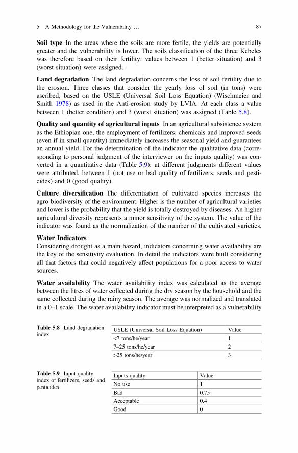
Soil type In the areas where the soils are more fertile, the yields are potentiallygreater and the vulnerability is lower. The soils classification of the three Kebeleswas therefore based on their fertility: values between 1 (better situation) and 3(worst situation) were assigned.
Land degradation The land degradation concerns the loss of soil fertility due tothe erosion. Three classes that consider the yearly loss of soil (in tons) wereascribed, based on the USLE (Universal Soil Loss Equation) (Wischmeier andSmith 1978) as used in the Anti-erosion study by LVIA. At each class a valuebetween 1 (better condition) and 3 (worst situation) was assigned (Table 5.8).
Quality and quantity of agricultural inputs In an agricultural subsistence systemas the Ethiopian one, the employment of fertilizers, chemicals and improved seeds(even if in small quantity) immediately increases the seasonal yield and guaranteesan annual yield. For the determination of the indicator the qualitative data (corre-sponding to personal judgment of the interviewer on the inputs quality) was con-verted in a quantitative data (Table 5.9): at different judgments different valueswere attributed, between 1 (not use or bad quality of fertilizers, seeds and pesti-cides) and 0 (good quality).
Culture diversification The differentiation of cultivated species increases theagro-biodiversity of the environment. Higher is the number of agricultural varietiesand lower is the probability that the yield is totally destroyed by diseases. An higheragricultural diversity represents a minor sensitivity of the system. The value of theindicator was found as the normalization of the number of the cultivated varieties.
Water IndicatorsConsidering drought as a main hazard, indicators concerning water availability arethe key of the sensitivity evaluation. In detail the indicators were built consideringall that factors that could negatively affect populations for a poor access to watersources.
Water availability The water availability index was calculated as the averagebetween the litres of water collected during the dry season by the household and thesame collected during the rainy season. The average was normalized and translatedin a 0–1 scale. The water availability indicator must be interpreted as a vulnerability
Table 5.8 Land degradationindex
USLE (Universal Soil Loss Equation) Value
<7 tons/he/year 1
7–25 tons/he/year 2
>25 tons/he/year 3
Table 5.9 Input qualityindex of fertilizers, seeds andpesticides
Inputs quality Value
No use 1
Bad 0.75
Acceptable 0.4
Good 0
5 A Methodology for the Vulnerability … 87
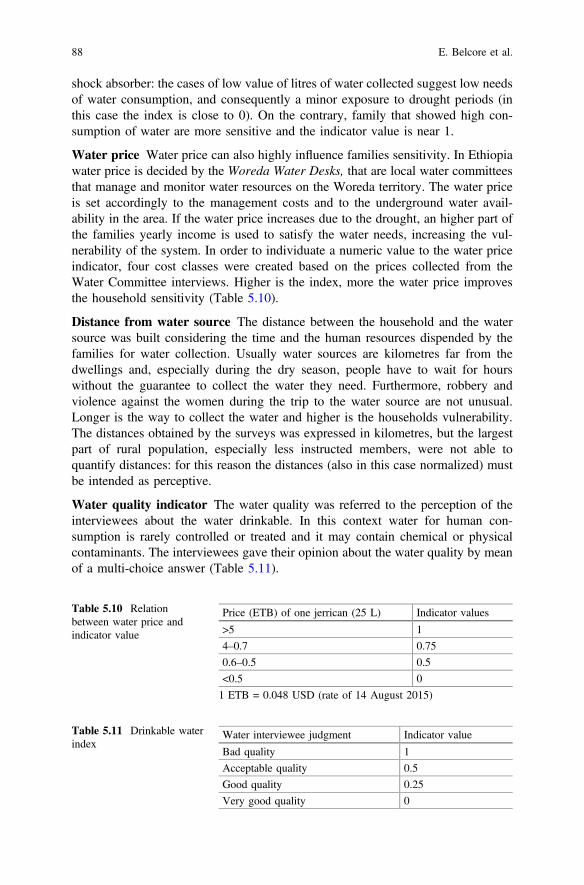
shock absorber: the cases of low value of litres of water collected suggest low needsof water consumption, and consequently a minor exposure to drought periods (inthis case the index is close to 0). On the contrary, family that showed high con-sumption of water are more sensitive and the indicator value is near 1.
Water price Water price can also highly influence families sensitivity. In Ethiopiawater price is decided by the Woreda Water Desks, that are local water committeesthat manage and monitor water resources on the Woreda territory. The water priceis set accordingly to the management costs and to the underground water avail-ability in the area. If the water price increases due to the drought, an higher part ofthe families yearly income is used to satisfy the water needs, increasing the vul-nerability of the system. In order to individuate a numeric value to the water priceindicator, four cost classes were created based on the prices collected from theWater Committee interviews. Higher is the index, more the water price improvesthe household sensitivity (Table 5.10).
Distance from water source The distance between the household and the watersource was built considering the time and the human resources dispended by thefamilies for water collection. Usually water sources are kilometres far from thedwellings and, especially during the dry season, people have to wait for hourswithout the guarantee to collect the water they need. Furthermore, robbery andviolence against the women during the trip to the water source are not unusual.Longer is the way to collect the water and higher is the households vulnerability.The distances obtained by the surveys was expressed in kilometres, but the largestpart of rural population, especially less instructed members, were not able toquantify distances: for this reason the distances (also in this case normalized) mustbe intended as perceptive.
Water quality indicator The water quality was referred to the perception of theinterviewees about the water drinkable. In this context water for human con-sumption is rarely controlled or treated and it may contain chemical or physicalcontaminants. The interviewees gave their opinion about the water quality by meanof a multi-choice answer (Table 5.11).
Table 5.10 Relationbetween water price andindicator value
Price (ETB) of one jerrican (25 L) Indicator values
>5 1
4–0.7 0.75
0.6–0.5 0.5
<0.5 0
1 ETB = 0.048 USD (rate of 14 August 2015)
Table 5.11 Drinkable waterindex
Water interviewee judgment Indicator value
Bad quality 1
Acceptable quality 0.5
Good quality 0.25
Very good quality 0
88 E. Belcore et al.
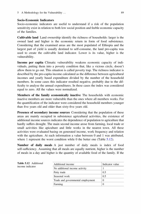
Socio-Economic IndicatorsSocio-economic indicators are useful to understand if a risk of the populationsensitivity exist in relation to both low social position and feeble economic capacityof the families.
Cultivable land Land ownership identify the richness of households: larger is theowned land and higher is the economic return in form of food subsistence.Considering that the examined areas are the most populated of Ethiopia and thelargest part of yield is usually destined to self-consume, the land pro-capita wasused to create the cultivable land indicator. Lower is its value, higher is thevulnerability.
Income per capita Climatic vulnerability weakens economic capacity of indi-viduals, putting them into a poverty condition that, like a vicious circle, doesn’tallow them to go out. This situation is called poverty trap. The richness indicator isdescribed by the pro-capita income calculated as the difference between agriculturalincomes and yearly based expenditure divided by the number of the householdmembers. In some cases this indicator resulted negative, probably due to the dif-ficulty to analyse the annual expenditures. In these cases the index was consideredequal to zero. All the values were normalized.
Members of the family economically inactive The households with economicinactive members are more vulnerable than the ones where all members works. Forthe quantification of the indicator were considered the household members youngerthan five years old and older than sixty-five years old.
Presence of secondary income sources Considering that the population of theseareas are mainly occupied in subsistence agricultural activities, the existence ofadditional income sources indicates the dependence of population to agriculture thathardly suffers drought. The main second income arose from farming, local trade orsmall activities like apiculture and little works in the nearest town. All theseactivities were evaluated basing on generated income, work frequency and relationwith the agriculture. At each information a value between 0 and 1 was attributed,where 1 represent the worst condition while 0 the better one (Table 5.12).
Number of daily meals A just number of daily meals is index of foodself-sufficiency. Assuming that all meals are equally nutrient, higher is the numberof meals in a day and higher is the quantity of available food of the family. If the
Table 5.12 Additionalincome indicator
Additional income Indicator value
No additional income activity 1
Petty trade 0.5
Seasonal work 0.5
Trade and governmental employment 0
Farming 0
5 A Methodology for the Vulnerability … 89
major part of food comes from their own cultivations, than it is possible to use theaverage number of daily meals as proxy for food self-sufficiency. All values werenormalized.
Capacity of AdaptationThe capacity of adaptation is the amount of inherent and context abilities of popu-lations that permits to people to quickly react to an extreme hazard and to adapt to newsituations. Therefore, the capacity of adaptation can contribute to mitigate the sen-sitivity effects and positively respond to physical exposure. The capacity of adapta-tion is defined by indicators that concern support degree between individuals of thecommunity, government disaster emergency plans and community aid infrastruc-tures. In this work the capacity of adaptation (Ca) indicator was calculated as:
Ca ¼X
food stock; livestock; governmental aid; water source ð4Þ
Food stock A warehouse permits to the households to store the seasonal yieldsuntil the following agricultural season, instead of selling it after the harvest. A foodstorage represent a tool for adaptation in drought situation. The value of 1 wasassigned to the families that used a private or common warehouse and 0 to the onesthat did not have it.
Livestock In Ethiopia livestock is an important economic and social element ofpeople’s life: livestock represents a food source, a work force, an income sourceand a social prestige. Thanks to the sale of part of the cattle, households can copewith natural shocks. The livestock represent the capacity to reply in short time toclimatic hazards, even if the economic value of livestock decrease in case ondrought because of the market saturation. The cattle number of each household wasnormalized.
Governmental aid Ethiopian government promotes many aid programs for ruralpopulation taking care of different aspects, from food security to education rights. Inthis case the indicator specifically refers to PSNP-Productive Safety Net Project, agovernmental project started in 2005. The project promotes food safety through fooddistribution, mainly milk powder and palm oil, to families in disadvantaged situa-tions. Households beneficiary can better cope with shocks thanks to external aid.
Water sources A good water resource management associated to collection,storage and pumping systems is the key strategy of adaptation to drought periods.The indicator was calculated using data from different questions of the survey(Table 5.13).
90 E. Belcore et al.
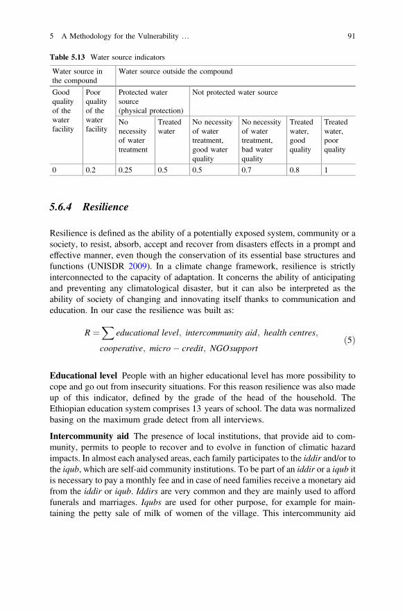
5.6.4 Resilience
Resilience is defined as the ability of a potentially exposed system, community or asociety, to resist, absorb, accept and recover from disasters effects in a prompt andeffective manner, even though the conservation of its essential base structures andfunctions (UNISDR 2009). In a climate change framework, resilience is strictlyinterconnected to the capacity of adaptation. It concerns the ability of anticipatingand preventing any climatological disaster, but it can also be interpreted as theability of society of changing and innovating itself thanks to communication andeducation. In our case the resilience was built as:
R ¼X
educational level; intercommunity aid; health centres;
cooperative; micro credit; NGOsupportð5Þ
Educational level People with an higher educational level has more possibility tocope and go out from insecurity situations. For this reason resilience was also madeup of this indicator, defined by the grade of the head of the household. TheEthiopian education system comprises 13 years of school. The data was normalizedbasing on the maximum grade detect from all interviews.
Intercommunity aid The presence of local institutions, that provide aid to com-munity, permits to people to recover and to evolve in function of climatic hazardimpacts. In almost each analysed areas, each family participates to the iddir and/or tothe iqub, which are self-aid community institutions. To be part of an iddir or a iqub itis necessary to pay a monthly fee and in case of need families receive a monetary aidfrom the iddir or iqub. Iddirs are very common and they are mainly used to affordfunerals and marriages. Iqubs are used for other purpose, for example for main-taining the petty sale of milk of women of the village. This intercommunity aid
Table 5.13 Water source indicators
Water source inthe compound
Water source outside the compound
Goodqualityof thewaterfacility
Poorqualityof thewaterfacility
Protected watersource(physical protection)
Not protected water source
Nonecessityof watertreatment
Treatedwater
No necessityof watertreatment,good waterquality
No necessityof watertreatment,bad waterquality
Treatedwater,goodquality
Treatedwater,poorquality
0 0.2 0.25 0.5 0.5 0.7 0.8 1
5 A Methodology for the Vulnerability … 91
indicator is based on the participation in iddir or iqub. If interviewee’s family tookpart at iddir or iqub the indicator value was set at one, otherwise it was set at zero.
Health centres In villages where there is a functional health centre or a health post(this is smaller than the health centre and medical staff is present three days perweek), the access to medicines and basic medical care guarantees a rapid recoverypost-hazard. Furthermore health posts offers courses about hygiene, children’sgrowth and birth control, that improve community education and preparedness. Invillages where there was a health post or centre was attributed the value of 1 to theindicator, if not the value was zero.
Cooperatives participation Cooperatives are able to decrease the social andeconomic marginality of rural areas thanks to members’ training, competivenessand access to market. Agricultural cooperatives give to farmers improved seed,fertilizers and chemicals by credit which can be paid back with the seasonal yield.Furthermore, cooperatives permit the organization between the members to helpeach other during the tillage and seeding periods providing agricultural knowledge.The agricultural cooperatives system potentially permits to farmers to easily resumethe agricultural cycle after a disturb. If people took part to cooperatives the indicatorhad the value of 1, if not, 0.
Micro-credit The access to credit indicates that the population has economicinstruments that permit the adoption of recovery strategy. Microcredit can poten-tially help vulnerable people to react and cope climatologic hazard, giving themeconomic resources necessary for adopting structural, physic, environmental andsocial strategies. The indicator value was 1 in case of access to microcredit and 0 incase of not access.
NGO support NGO projects play an important role in developing countries.Specifically in the analysed areas LVIA NGO is really active in food safety pro-grams that aim to defeat famine helping population to be food independent. In theKebele of Shashamane, Siraro and Shalla the NGO LVIA built warehouses in thevillages in order to permit to the farmers to stock the seasonal yield. Furthermorethey distributed seed, agricultural tools, plants and nitrogen-fixing species toimprove soil fertility. Communities that receives any NGO aid have more instru-ments to recovery after hazards. The indicator had the value of 1 in the communitywhich received NGO aid and 0 in the opposite case.
5.6.5 Capacity to React to Vulnerability
The capacity to react to vulnerability represents the relationship between vulnera-bility and resilience. It allows the detection of the areas that can potentially showmore damages and negative consequences due to climatic hazards. The capacity to
92 E. Belcore et al.
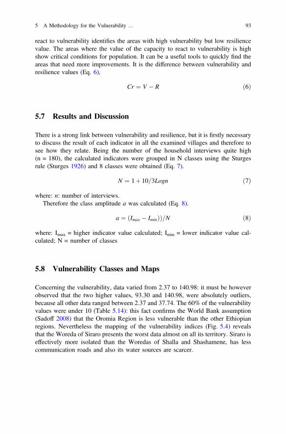
react to vulnerability identifies the areas with high vulnerability but low resiliencevalue. The areas where the value of the capacity to react to vulnerability is highshow critical conditions for population. It can be a useful tools to quickly find theareas that need more improvements. It is the difference between vulnerability andresilience values (Eq. 6),
Cr ¼ V R ð6Þ
5.7 Results and Discussion
There is a strong link between vulnerability and resilience, but it is firstly necessaryto discuss the result of each indicator in all the examined villages and therefore tosee how they relate. Being the number of the household interviews quite high(n = 180), the calculated indicators were grouped in N classes using the Sturgesrule (Sturges 1926) and 8 classes were obtained (Eq. 7).
N ¼ 1þ 10=3Logn ð7Þ
where: n: number of interviews.Therefore the class amplitude a was calculated (Eq. 8).
a ¼ Imax Iminð ÞÞ=N ð8Þ
where: Imax = higher indicator value calculated; Imin = lower indicator value cal-culated; N = number of classes
5.8 Vulnerability Classes and Maps
Concerning the vulnerability, data varied from 2.37 to 140.98: it must be howeverobserved that the two higher values, 93.30 and 140.98, were absolutely outliers,because all other data ranged between 2.37 and 37.74. The 60% of the vulnerabilityvalues were under 10 (Table 5.14): this fact confirms the World Bank assumption(Sadoff 2008) that the Oromia Region is less vulnerable than the other Ethiopianregions. Nevertheless the mapping of the vulnerability indices (Fig. 5.4) revealsthat the Woreda of Siraro presents the worst data almost on all its territory. Siraro iseffectively more isolated than the Woredas of Shalla and Shashamene, has lesscommunication roads and also its water sources are scarcer.
5 A Methodology for the Vulnerability … 93
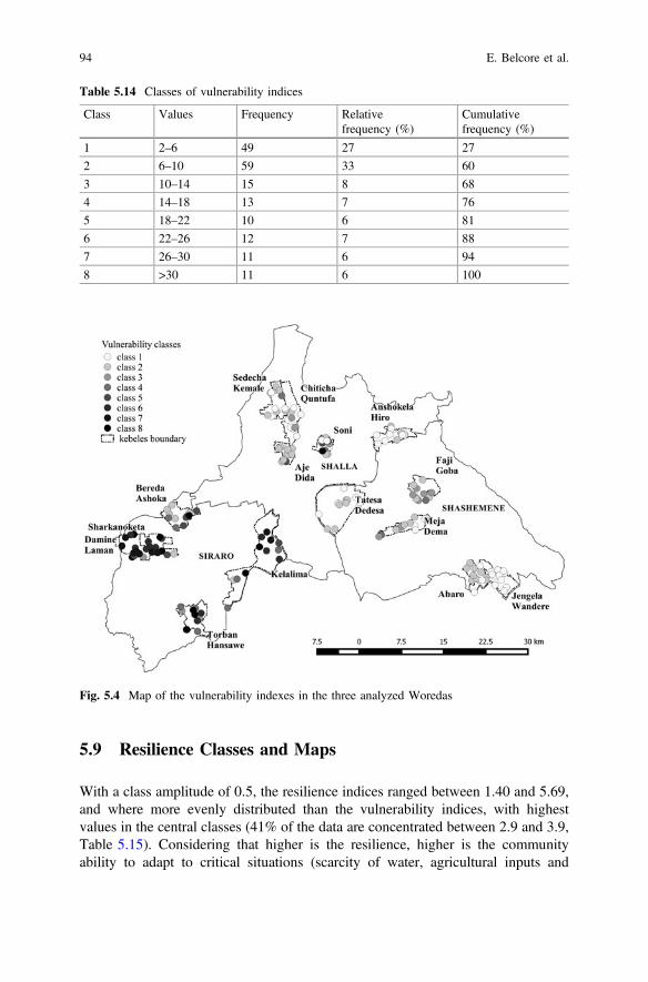
5.9 Resilience Classes and Maps
With a class amplitude of 0.5, the resilience indices ranged between 1.40 and 5.69,and where more evenly distributed than the vulnerability indices, with highestvalues in the central classes (41% of the data are concentrated between 2.9 and 3.9,Table 5.15). Considering that higher is the resilience, higher is the communityability to adapt to critical situations (scarcity of water, agricultural inputs and
Table 5.14 Classes of vulnerability indices
Class Values Frequency Relativefrequency (%)
Cumulativefrequency (%)
1 2–6 49 27 27
2 6–10 59 33 60
3 10–14 15 8 68
4 14–18 13 7 76
5 18–22 10 6 81
6 22–26 12 7 88
7 26–30 11 6 94
8 >30 11 6 100
Fig. 5.4 Map of the vulnerability indexes in the three analyzed Woredas
94 E. Belcore et al.
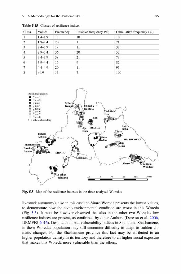
livestock autonomy), also in this case the Siraro Woreda presents the lowest values,to demonstrate how the socio-environmental condition are worst in this Woreda(Fig. 5.5). It must be however observed that also in the other two Woredas lowresilience indices are present, as confirmed by other Authors (Deressa et al. 2006,DRMFFS 2016). Despite a not bad vulnerability indices in Shalla and Shashamene,in these Woredas population may still encounter difficulty to adapt to sudden cli-matic changes. For the Shashamene province this fact may be attributed to anhigher population density in its territory and therefore to an higher social exposurethat makes this Woreda more vulnerable than the others.
Table 5.15 Classes of resilience indices
Class Values Frequency Relative frequency (%) Cumulative frequency (%)
1 1.4–1.9 18 10 10
2 1.9–2.4 20 11 21
3 2.4–2.9 19 11 32
4 2.9–3.4 36 20 52
5 3.4–3.9 38 21 73
6 3.9–4.4 16 9 82
7 4.4–4.9 20 11 93
8 >4.9 13 7 100
Fig. 5.5 Map of the resilience indexes in the three analysed Woredas
5 A Methodology for the Vulnerability … 95
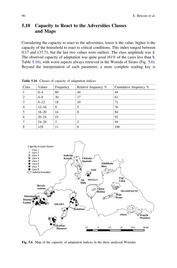
5.10 Capacity to React to the Adversities Classesand Maps
Considering the capacity to react to the adversities, lower it the value, higher is thecapacity of the household to react to critical conditions. This index ranged between0.17 and 137.71, but the last two values were outliers. The class amplitude was 4.The observed capacity of adaptation was quite good (61% of the cases less than 8,Table 5.16), with worst aspects always retrieved in the Woreda of Siraro (Fig. 5.6).Beyond the interpretation of each parameter, a more complete reading key is
Table 5.16 Classes of capacity of adaptation indices
Class Values Frequency Relative frequency % Cumulative frequency %
1 0–4 80 44 44
2 4–8 30 17 61
3 8–12 18 10 71
4 12–16 9 5 76
5 16–20 14 8 84
6 20–24 15 92
7 24–28 3 2 94
8 >28 11 6 100
Fig. 5.6 Map of the capacity of adaptation indices in the three analysed Woredas
96 E. Belcore et al.
possible if the SPI index is put beside them because the drought risk is a crucialparameters for all the types of vulnerability and resilience detection. In a normalizedscale between 0 and 1, in this study the calculated annual SPI index was 0.83: thearea is therefore considerably exposed to the drought risk, caused by an highintensity and frequency of rainfall lack.
5.11 Conclusions
Uncertain precipitations during the two Ethiopian rainy seasons (Belg and Kiremt)and increased temperatures registered in the last years impact the crop production,the livestock management and, as a consequence, the subsistence agriculturalproduction systems that in this country solely depends on rainfall.
Unfortunately at local level there are not specific quantitative studies to affordthe problem, also if the Ethiopian Government promoted the Disaster RiskManagement and Food Security Sector (DRMFSS) which in 2009 began to qual-itative monitor the drought risk bent of the Woredas. The aim of this project is todevelop an integrated system of Early Warning and Response, but actually neitherlandmark data nor vulnerability drought analysis exist in the country.
For this reason the methodology introduced in this study is important, both asenvironmental and social analysis.
The high risk of drought exposition caused by the increasing of drought’s fre-quency in the three examined Woredas is a useful information for the policy makerto create adaptation plans. At the same time policy makers may use the vulnerabilityindex both to isolate the variables that influence the system’s vulnerability and tocompare the different situations in the Woredas. Last, but not less important, withthe introduction of the index called “capacity to react to the vulnerability”, it ispossible to pointed out the areas at higher risk for the analysed impact factors.
Annex Food Security Questionnaire
Section 1—General Information
1. Date and time _______________ 2. Location (woreda, kebele, village):___________
3. Household HH ID ___ 4. HH size ___ 5. Members <5 age ___ 6. Members>65 age ___
7. Sex and age of respondent ______ 8. Relation interviewer with the HH__________
9. Educational level of HH head ___ 10. Nb of HH school-age children attendingclasses regularly ___
11. Do you have any type of water source in the compound? Y/N ___
5 A Methodology for the Vulnerability … 97
11A. If yes, specify source type: h tap h birkad h roof catchment h hand-dugwell h others ___
11B. Conditions: h very good h good h needs minor improvements h poor11C. Water quality: h very good h good h acceptable h poor11D. Water quantity: h more than enough h sufficient h insufficient11E. In case of more sources available, specify above the main water source and
indicate here the others (type, conditions, quality, quantity) ___12A. If no or limited water source in the compound, specify the distance (km) of
the main source used by the HH___12B. Source type: h protected h unprotected 11B2 Specify ___12C. Conditions: h very good h good h needs minor improvements h poor12D. Water quality: h very good h good h acceptable h poor12E. Water quantity: h enough h sufficient h insufficient13A. Average liters of water fetched by the HH per day during rainy season _
13B. During dry season ___14A. Is the drinking water used by the HH treated? Y/N ___14B. If yes specify the method ___15. Main source of fuel for domestic use _____
Section 2—Livelihood
16. HH land size (ha) ____ 17. Nb of livestock ____ 18. Mainoccupation/productive activity _____
19. Any other additional income generating activity: ____20. Main 3 factors affecting negatively the agricultural production ____21. Main 3 factors affecting negatively other productive activities ____22. Is the HH beneficiary of PSFP or other governmental support programs? Y/N
_____22A. If yes specify which one _____If the HH is mainly involved in agriculture, fill the following tables and infor-
mation (22 to 28):23. Production last year
Crop Farmingpractices
Cultivatedland (ha)
Average yield/ha(good season)
Average yield/ha (badseason)
%kept
% sold % lost Main buyer Time and reason forsale
24. Inputs: Specify per each type of input, the availability (both in terms ofquantity and timing), modalities access (for ex. borrowed, purchased, exchanged,etc.), and the average cost per season.
Input Availability and quality Access modalities Cost
25. Practices: Does the HH make use of compost or any improved organicagronomic practices? Y/N ___
98 E. Belcore et al.
25A. If not, specify why ____26. How would you rate the support received from agricultural extension ser-
vices? h Poor h Acceptable h Good26A. If rated poor, specify main areas for improvement ____27 Are you part of a cooperative? Y/N _____27A If yes specify services and benefits you receive from it ____27B If not, why are you not part? ____28. Nb of agricultural seasons ____29. Water source for agricultural activities: h Rain-fed h Irrigation29A If irrigation, specify access modalities/costs and management body _____30. Does the HH have a storage space? Y/N ____30A. If yes, specify capacity, main construction materials, general conditions,
what is stored, related average storage time, eventual treatments ________30B If yes, specify the main use: h later sale h own consumption h others2
_________31. Average income of the HH, per year, in ETB:
Main activity Average income mainactivity
2nd activity Average income 2nd activity
3rd activity Average income 3rd activity
Other incomes
32. Average expenses of the HH, per year, in ETB:
Food Water Clothes Education HH and hygiene items Other expenses
33. Did the HH have access to formal credit institutions in the last 3 years?Y/N___
33A. If yes, specify access modalities, value of loan, interest rate, purpose ___34. Is the HH part of iddir/iqub? Y/N ___34A. If yes, specify the main purpose of the iddir/iqub ____34B. If yes, specify average contribution per month ____
Section 3—Food Security
35. During the last 5 years, did any member suffer from malnutrition? Y/N_____
35A. If yes please specify which member(s), how many, measures undertaken____
36A. Average nb meals/day during hunger season: hh 1 h 2 h 3 h>336B. Post-Harvest Season: h 1 h 2 h 3 h > 337. Specify if any difference on nb of meals among HH members _____
2Specify.
5 A Methodology for the Vulnerability … 99
38A. Composition of main daily meal/hunger season ____38B. Composition of main daily meal/post-harvest season ___39. How is the quantity of food available in the HH perceived? h more than
enough h enough h insufficient40A. Main source of food: specify estimated % per each season and each
modality indicated by the respondent during hunger season: __%h own production__% h purchased __% h received __% h borrowed
40B. During post-harvest season: __% h own production __% h purchased __% h received __% h borrowed
41. Discuss any shock during the past 5 year faced by the HH, its impact andmain coping mechanisms __
Section 4—Observation Checklist
42. Is there a toilet (Y/N)? __ 42A. If yes, specify general conditions:h poor hacceptable h good
43. Electricity in the house (Y/N) __44. General conditions of compound and house____45. Any other relevant observation, comment, information
________________________Enumerator signature _______________________ Team Leader signature
________
References
AG-General Assembly of United Nation. 2015. Establishment of an open-ended intergovernmentalexpert working group on indicators and terminology related to disaster risk reduction. NewYork: A/RES/69/284.
Alwang, J., P. Siegel, S. Jorgensen. 2001. Vulnerability: a view from different disciplines. SocialProtection Discussion Paper 115.
AQUASTAT. 2005. Irrigation in Africa in figures. AQUASTAT Survey 2005. Rome: FAO.Canessa, C. 2015. Cambiamento climatico, siccità e sicurezza alimentare: una metodologia di
analisi della vulnerabilità. Il caso delle Woreda Etiopia. Turin: Thesis University of Turin.CSA-Central Statistical Agency. 2007. Population and housing census report. Addis Abeba:
Government of Ethiopia.CSA-Central Statistical Agency—Government of Ethiopia. 2007. National Statistical Data.
Official website: http://www.csa.gov.et/ Last access: 25th August 2016.Cutter, S.L. 2003. The vulnerability of science and the science of vulnerability. Annals of the
Association of American Geographers 93–1: 1–12.Deressa, T., R. Hassan, and C. Ringler. 2006. Measuring Ethiopian farmers vulnerability to
climate change across regional states. IFPRI Discussion Paper: Washington D.C. 00806.DRMFSS-Disaster Risk Management and Food Security Sector. 2016. Government of Ethiopia,
Official website: http://www.dppc.gov.et/ Last access: 25th August 2016.Fellmann, T. 2012. The assessment of climate change related vulnerability in the agricultural
sector: reviewing conceptual frameworks. FAO/OECD Workshop Building resilience foradaptation to climate change in agricultural sector. Rome: FAO.
100 E. Belcore et al.
Füssel, H.-M. 2007. Vulnerability: a generally applicable conceptual framework for climatechange research. Global Environmental Change 17(2): 155–167. doi:10.1016/j.gloenvcha.2006.05.002.
Guttman, N.B. 1999. Accepting the Standardized Precipitation Index: a calculation algorithm.Journal of the American Water Resources Association 35–2: 311–322.
Hulme, M., R. Doherty, T. Ngara, M. New, and D. Lister. 2001. African climate change: 1900–2100. Climate Research 12: 145–168.
IPCC-Intergovernmental Panel on Climate Change. 2001. Climate change 2001: Synthesis report.Contribution of working groups I, II, and III to the Third assessment report of theIntergovernmental Panel on Climate Change ed. R.T. Watson. Cambridge and New York:Cambridge University Press.
IPCC-Intergovernmental Panel on Climate Change. 2007. Climate Change 2007: SynthesisReport. Contribution of Working Groups I, II and III to the Fourth assessment report of theIPCC, ed. R.K. Pachauri and A. Reisinger. Geneva, Switzerland: IPCC.
IWMI-International Water Management Institute. 2009. Mapping drought patterns and impacts: Aglobal perspective. Colombo: IWMI Research Report.
Kasperson, J., and R. Kasperson. 2001. International workshop on vulnerability and globalenvironmental change, 01–2001. Stockholm: SEI Risk and Vulnerability Programme Report.
Korecha, D.B. 2006. Prredictability of June-September rainfall in Ethiopia. Monthly WeatherReview 135: 628–650. doi:10.1175/MWR3304.1.
LVIA. 2015. Groundwater potential study and mapping for Arsi Negele, Shashamene, Shala,Siraro. In Addis, ed. Oromia Region. Ababa: LVIA and Water Resources Consulting Service.
MEA-Millenium Ecosystem Assessment. 2009. Ecosystems and human well-being: current stateand trends. Findings of the condition and trends working group. Washington: Island Press.
NDMC-National Drought Mitigation Center. 2016. Program to calculate StandardizedPrecipitation Index. Web address National Drought Mitigation Centre: http://drought.unl.edu/monitoringtools/downloadablespiprogram.aspx Last access: 4th July 2016.
Nelson, R., P. Kokic, S. Crimp, P. Martin, H. Meinke, and S. Howden. 2009. The vulnerability ofAustralian rural communities to climate variability and change: Part II—Integrating impactswith adaptive capacity. Environmental Science & Policy 13: 18–27. doi:10.1016/j.envsci.2009.09.007.
NMSA-Ethiopian National Meteorological Services Agency. 2016. Official website: http://www.ethiomet.gov.et/ Last access: 25th August 2016.
Sadoff, C. 2008. Managing water resources to maximize sustainable growth: a World Bank waterresources assistance strategy for Ethiopia. The World Bank: Washington D.C.
Segele, Z., P. Lamb. 2005. Characterization and variability of Kiremt rainy season over Ethiopia.Meteorology and Atmospheric Physics 89(1): 153–180. doi:10.1007/s00703-005-0127-x.
Seleshi, Y., and G. Demarèe. 1995. Rainfall variability in the Ethiopian and Eritrean highlands andits links with the Southern Oscillation Index. Journal of Biogeography 22: 945–952.
Shahid, S., H. Behrawan. 2008. Drought risk assessment in the western part of Bangladesh.Natural Hazards 46(3): 391–413. doi:10.1007/s11069-007-9191-5.
Sönmez, F.K., A.Ü. Kömüscü, A. Erkan, and E. Turgu. 2005. An analysis of spatial and temporaldimension of drought vulnerability in Turkey using Standardized Precipitation Index. NaturalHazards 35(2): 243–264. doi:10.1007/s11069-004-5704-7.
Sturges, H.A. 1926. The choice of a class interval. Journal of the American Statistical Association21–153: 65–66.
United Nations. 2015. World population prospects, the 2015 Revision. Key findings and advancedtables. Working Paper ESA/P/WP.241.
UNISDR-United Nations International Strategy on Disaster Risk Reduction. 2009. www.unisdr.org Last access: 25th August 2016.
Vincent, K. 2004. Creating an index of social vulnerability to climate change for Africa. TyndallCentre Working Paper 56.
5 A Methodology for the Vulnerability … 101
Viste, E., D. Korecha, and A. Sorteberg. 2013. Recent drought and precipitation tendencies inEthiopia. Theoretical and Applied Climatology 112(3): 535–551. doi:10.1007/s00704-012-0746-3.
Wischmeier, W.H., and D.D. Smith. 1978. Predicting rainfall erosion losses—a guide toconservation planning. U.S. Department of Agriculture.
WMO-World Meteorological Organization. 2012. Standardized precipitation index – User guide,1090. Geneva: World Meteorological Organization, Publication No.
World Bank country data. 2016. http://databank.worldbank.org/ Last access: 1th September 2016.
Open Access This chapter is licensed under the terms of the Creative Commons Attribution 4.0International License (http://creativecommons.org/licenses/by/4.0/), which permits use, sharing,adaptation, distribution and reproduction in any medium or format, as long as you give appropriatecredit to the original author(s) and the source, provide a link to the Creative Commons license andindicate if changes were made.The images or other third party material in this chapter are included in the chapter's Creative
Commons license, unless indicated otherwise in a credit line to the material. If material is notincluded in the chapter's Creative Commons license and your intended use is not permitted bystatutory regulation or exceeds the permitted use, you will need to obtain permission directly fromthe copyright holder.
102 E. Belcore et al.
Chapter 6Tracking Climate Change Vulnerabilityat Municipal Level in Rural Haiti UsingOpen Data
Maurizio Tiepolo and Maurizio Bacci
Abstract In Least Developed tropical Countries, the vulnerability assessment toclimate change (CC) at local scale follows an indicator-based approach and usesinformation gathered mainly through household surveys or focus groups.Conceived in this way, the vulnerability assessment is rarely repeatable in time,cannot be compared with those carried out in other contexts and usually has lowspatial coverage. The growing availability of open data at municipal level, routinelycollected, now allows us to switch to vulnerability tracking (continuous, low cost,consistent with global monitoring systems). The aim of this chapter is to proposeand verify the applicability of a VICC-Vulnerability Index to Climate Change on amunicipal scale for Haiti. The chapter identifies open data on national, departmentaland municipal scale, selects the information on a municipal scale on the basis ofquality, identifies the indicators, evaluates the robustness of the index and measuresit. The index consists of 10 indicators created using information relating to monthlyprecipitations, population density, flood prone areas, crop deficit, farmers forself-consumption, rural accessibility, local plans for CC adaptation, irrigated agri-culture and cholera incidence. This information is gathered for the 125 mainly ruralmunicipalities of Haiti. The description and discussion of the results is followed bysuggestions to improve the index aimed at donors, local authorities and users.
Keywords Climate planning Local governments SPI Vulnerability index
M. Tiepolo authored all the sections with the only exception of section 6.2.4 Indicators 1 and 2,authored by M. Bacci.
M. Tiepolo (&)DIST, Politecnico and University of Turin, Viale Mattioli 39, Turin 10125, Italye-mail: [email protected]
M. BacciNational Research Council—Institute of BioMeteorology (IBIMET),Via Giovanni Caproni 8, 50145 Florence, Italye-mail: [email protected]
© The Author(s) 2017M. Tiepolo et al. (eds.), Renewing Local Planning to Face ClimateChange in the Tropics, Green Energy and Technology,DOI 10.1007/978-3-319-59096-7_6
103
6.1 Introduction
Vulnerability is “the propensity or predisposition to be adversely affected” (IPCC2014: 128) and is estimated in various sectors: food security (OCHA, WFP andFEWSNET), environment, agriculture, livelihood. Here we’re going to look atvulnerability to climate change (CC), in other words, “to a change in the state of theclimate that can be identified by changes in the mean and or the variability of itsproperties and that persists for an extended period, typically decades or longer”(IPCC 2014: 120). Vulnerability to CC is related to people. Ascertaining it isimportant for decision making related to adaptation measures and subsequentmonitoring and evaluation.
Vulnerability to CC at local scale is usually ascertained with a vulnerabilityindex with a variable number of indicators: from 10 to 33 (Hahn et al. 2009; RdH,MARNDR 2009; Gabetibuo et al. 2010; Sharma and Jangle 2012; Borja-Vega et al.2013; Etwire et al. 2013; PNUMA 2013; Ahsan and Warner 2014; Bollin et al.2014). The more indicators we have (namely those created especially to appreciatevulnerability), the harder it is to repeat the assessment in time and replicate it inother contexts (Table 6.1). In actual fact, decision making and monitoring need totrack vulnerability more than assess it occasionally.
To satisfy these requirements, we need open data on a small geographic area,routinely collected at low cost (World Bank 2014), of which we know the metadata.The ideal scale is that of municipalities, as these are the administrative jurisdictionsclosest to the impacts of CC and with specific tasks in the field.
Haiti is the 4th most vulnerable country to CC (Verisk Maplecroft 2016). Theprojections of the IPCC for the Caribbean region to which Haiti belongs suggestabout a 1.2–2.3 °C increase in surface temperature, a decrease in precipitations ofabout 5%, and a sea level rise of between 0.5 and 0.6 m by 2100 compared to thebaseline 1986–2005 (Nurse et al. 2014: 1627–8). If these changes should takeplace, the economic impacts on export crops (coffee and mango), on the availabilityof water resources and on health would be tremendous (Borde et al. 2015).Tracking vulnerability to CC on a municipal scale in Haiti is particularly helpful,because the aid that the country benefits to adapt to CC risk being repeatedlychannelled to the same areas, without reaching the most vulnerable municipalities.In Haiti today, the vulnerability assessment is practiced on a national and depart-mental scale. But the departments (from 1268 to 5000 km2) contain greatly diverseterritories. The South East department, for example, runs from the coast tomountain chains than exceed an altitude of 2200 metres in just 2000 km2. On thecontrary, the municipal scale is small enough (from 22 to 639 km2) for trackingwhich is also helpful to local projects.
The idea of measuring vulnerability at municipal scale isn’t new in Haiti. In 2009,the National council for food security-CNSA (Ministry of agriculture), in collabo-ration with FEWS NET, produced a vulnerability index on a municipal scale (RdH,CNSA-MARNDR 2009). However, the assessment was carried out only then andwe have no knowledge of the metadata of the indicators to be able to continue it.
104 M. Tiepolo and M. Bacci
The MPCE and ONPES Basic statistics program, funded by the EuropeanUnion, aimed mainly at the national poverty reduction strategy, is expected togenerate useful information, but at the moment there is no open data available.Different maps are now freely accessible at http://haitidata.org/ and routinely col-lected helpful information is available.
The aim of this chapter is to check the applicability of the vulnerability index toCC (VICC) on a municipal scale to Haiti, using routinely collected open data. Thechoice of the indicators that make up the index derives from the definition ofvulnerability (V) as a function of three components: exposure, sensitivity andadaptive capacity.
Exposure (E) refers to “The presence of people, livelihoods, species orecosystems, environmental functions, services, and resources, infrastructure, oreconomic, social, or cultural assets in places and settings that could be adverselyaffected.” (IPCC 2014: 1765). Examples are flood or drought prone areas andpopulation density.
Sensitivity (S) is “The degree to which a system or species is affected, eitheradversely or beneficially, by climate variability or change. The effect may be direct(e.g., a change in crop yield in response to a change in the mean, range, or vari-ability of temperature) or indirect (e.g., damages caused by an increase in thefrequency of coastal flooding due to sea level rise).” (IPCC 2014: 1772–73).Examples are anomalies in the prices of food, crop deficit, poverty, damage fol-lowing hydro-climatic disaster or the number of farmers who grow crops to satisfytheir own requirements only.
Adaptive capacity (AC) is “The ability of systems, institutions, humans, andother organisms to adjust to potential damage, to take advantage of opportunities, orto respond to consequences.” (IPCC 2014: 1758). Examples are official develop-ment aid in the environmental sector, the reduction of illiteracy, forest surfacedynamics, the existence of adaptation plans, rural infrastructures (irrigation, roads),safe housing, provided with drinking water, sanitation and hygiene facilities(WASH).
However, the irregularity of information, its availability at departmental levelonly and not freely accessible, means that most of these vulnerability dimensionsare now impossible to survey at municipal level.
The VICC requires recognition of open data which has led to the identification of10 vulnerability indicators on a municipal scale. The following paragraphs present,(ii) the methodology, which explains the meaning of the indicators selected, theircharacteristics and how the index is calculated, (iii) the results obtained with thevulnerability map at municipal level, and the advancements with respect to previousknowledge, (iv) the conclusions relating to perennial repetition, the expansion ofthe information needed to measure the index and the free availability ofinformation.
6 Tracking Climate Change Vulnerability at Municipal … 105
6.2 Metodology
Vulnerability is a function of Exposure (E), Sensitivity (S) and Adaptive capacity(AC) according to the Equation V = (E + S) + (1 − AC) already used by Heltberget al. (2010), PNUMA (2013), Tuhladhar et al. (2013), USAID (2014), andUNESCO (2016). Every determinant is described by indicators. The process ofindicator development is organised according to the steps suggested by Birkmann(2006), simplified here for operational use.
6.2.1 Identification of the Open Data
The open data useful to tracking vulnerability to CC in Haiti drops from 15 to 9 aswe move from country to municipal scale. At least one third of the information isnot collected with annual frequency, a quarter of the information is supplied bymulti-bilateral organisms (CHIRPS, CRED, OECD, FAO, UNDP) (Table 6.2), andtwo third is freely available (Table 6.3)
6.2.2 Indicator Performance
The open data at municipal scale on Haiti clearly grasps the vulnerability ofinfrastructures, the population and agriculture, but not of health and nutrition,education, natural resources and ecosystems highlighted by Adger et al. (2004), northe urban vulnerability.
As regards the temporal resolution of certain indicators (monthly precipitations,crop failure, adaptation planning) it is preferable to consider a period of time ratherthan just one year (for example, the five years following the earthquake of 2010).The drought magnitude and wet extremes have been observed over the past35 years. In other cases, the indicators refer to a specific year (population density,rural accessibility, irrigated agriculture, farmers for self-consumption, choleraincidence).
6.2.3 Selection Criteria for the Set of Potential Indicators
The selection of the indicators must be led by clear criteria which allow the pre-liminary assessment of each individual indicator (Schiavo-Campo 1999; Hilden andMarx 2013): the pertinence of the indicator with CC, its accurate description(metadata), data availability and regular updating, spatial coverage (to what extentthe municipalities are covered), the length of time series and temporal resolution,
106 M. Tiepolo and M. Bacci
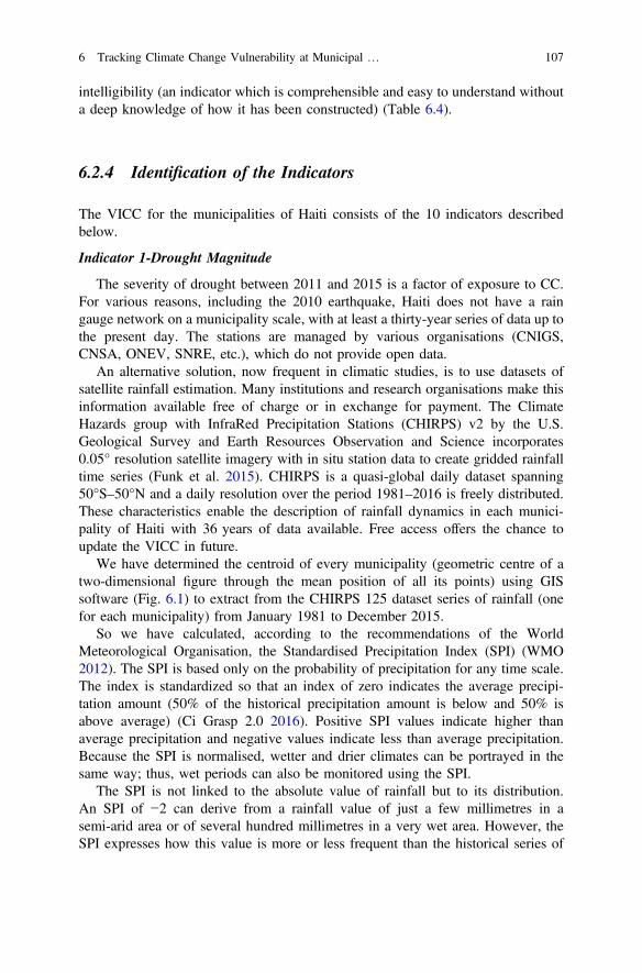
intelligibility (an indicator which is comprehensible and easy to understand withouta deep knowledge of how it has been constructed) (Table 6.4).
6.2.4 Identification of the Indicators
The VICC for the municipalities of Haiti consists of the 10 indicators describedbelow.
Indicator 1-Drought Magnitude
The severity of drought between 2011 and 2015 is a factor of exposure to CC.For various reasons, including the 2010 earthquake, Haiti does not have a raingauge network on a municipality scale, with at least a thirty-year series of data up tothe present day. The stations are managed by various organisations (CNIGS,CNSA, ONEV, SNRE, etc.), which do not provide open data.
An alternative solution, now frequent in climatic studies, is to use datasets ofsatellite rainfall estimation. Many institutions and research organisations make thisinformation available free of charge or in exchange for payment. The ClimateHazards group with InfraRed Precipitation Stations (CHIRPS) v2 by the U.S.Geological Survey and Earth Resources Observation and Science incorporates0.05° resolution satellite imagery with in situ station data to create gridded rainfalltime series (Funk et al. 2015). CHIRPS is a quasi-global daily dataset spanning50°S–50°N and a daily resolution over the period 1981–2016 is freely distributed.These characteristics enable the description of rainfall dynamics in each munici-pality of Haiti with 36 years of data available. Free access offers the chance toupdate the VICC in future.
We have determined the centroid of every municipality (geometric centre of atwo-dimensional figure through the mean position of all its points) using GISsoftware (Fig. 6.1) to extract from the CHIRPS 125 dataset series of rainfall (onefor each municipality) from January 1981 to December 2015.
So we have calculated, according to the recommendations of the WorldMeteorological Organisation, the Standardised Precipitation Index (SPI) (WMO2012). The SPI is based only on the probability of precipitation for any time scale.The index is standardized so that an index of zero indicates the average precipi-tation amount (50% of the historical precipitation amount is below and 50% isabove average) (Ci Grasp 2.0 2016). Positive SPI values indicate higher thanaverage precipitation and negative values indicate less than average precipitation.Because the SPI is normalised, wetter and drier climates can be portrayed in thesame way; thus, wet periods can also be monitored using the SPI.
The SPI is not linked to the absolute value of rainfall but to its distribution.An SPI of −2 can derive from a rainfall value of just a few millimetres in asemi-arid area or of several hundred millimetres in a very wet area. However, theSPI expresses how this value is more or less frequent than the historical series of
6 Tracking Climate Change Vulnerability at Municipal … 107
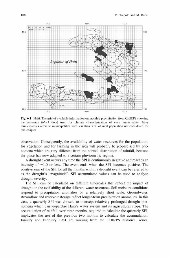
observation. Consequently, the availability of water resources for the population,for vegetation and for farming in the area will probably be jeopardised by phe-nomena which are very different from the normal distribution of rainfall, becausethe place has now adapted to a certain pluviometric regime.
A drought event occurs any time the SPI is continuously negative and reaches anintensity of −1.0 or less. The event ends when the SPI becomes positive. Thepositive sum of the SPI for all the months within a drought event can be referred toas the drought’s “magnitude”. SPI accumulated values can be used to analysedrought severity.
The SPI can be calculated on different timescales that reflect the impact ofdrought on the availability of the different water resources. Soil moisture conditionsrespond to precipitation anomalies on a relatively short scale. Groundwater,streamflow and reservoir storage reflect longer-term precipitation anomalies. In thiscase, a quarterly SPI was chosen, to intercept relatively prolonged drought phe-nomena which can jeopardise Haiti’s water system and its agricultural crops. Theaccumulation of rainfall over three months, required to calculate the quarterly SPI,implicates the use of the previous two months to calculate the accumulation.January and February 1981 are missing from the CHIRPS historical series.
Fig. 6.1 Haiti. The grid of available information on monthly precipitation from CHIRPS showingthe centroids (black dots) used for climate characterization of each municipality. Greymunicipalities refers to municipalities with less than 33% of rural population not considered forthis chapter
108 M. Tiepolo and M. Bacci
Consequently, 1981 has 10 monthly SPI values. Almost all of 1995 is missing, sothe SPI for that year was not calculated.
The report for the average value of the drought magnitude 2011–2015 (period ofanalysis) and its value for 1981–2010 (reference period), was calculated for everymunicipality. Subsequently, these values have been normalised on a scale of 0–1 onthe basis of the minimum and maximum value of the report recorded among all themunicipalities (Petite Rivière des Nippes 1.04 = 0, Belle Anse 3.42 = 1). Aftercalculating the drought magnitude, the map was produced (Fig. 6.2) using 4 clas-ses: 0–0.24, 0.25–0.49, 0.50–0.74, 0.75–1.
Indicator 2-Wet Extremes
Extreme precipitations between 2011 and 2015 are an exposure factor of amunicipality to CC, in that they can generate flooding. The characterisation of everymunicipality with respect to extreme precipitations uses, like for drought, theCHIRPS dataset correspondence with the centroid of every municipality. In thiscase, the options available were to characterise the wet conditions using classicindexes of intense rainfall or using the 1-month SPI:
• R20 mm, number of days’ rainfall in excess of 20 mm/year.• R95p, number of days’ rainfall higher than the 95th percentile/year (only during
rainy events).
Very wet 1-month SPI (number of months/year with SPI > 1.5) and extremelywet (number of months/year SPI > 2). In this case too, the ratio of the 2011–2015five-year average and the average for 1981–2010 was calculated for everymunicipality. Subsequently, these values are normalised on a scale of 0–1, on thebasis of the minimum and maximum. Every index presents positive and negativecharacteristics. R20 mm does not highlight significant changes in the variousmunicipalities so 20 mm is not enough to intercept the dynamics of extreme rains inHaiti.
R95p is more appropriate, in that it is based on the calculation of the distributionof rains in each individual municipality. However, it is a more sophisticated andharder to understand index. Moreover, its distribution in the municipalities of Haitidoes not present very significant changes. 1-month SPI extremely wet (SPI > 2)highlight more changes in the municipalities than the 1-month SPI very wet(SPI > 1.5). The 1-month SPI > 2 is relatively easy to explain and understand. Thisis why the decision was made to use it to characterise the wet extremes (Fig. 6.2)according to 4 classes: 0–0.24, 0.25–0.49, 0.50–0.74, 0.75–1.
Indicator 3-Flood Prone Areas
Haiti has few vast areas exposed to river or marine flooding (North–East,Artibonite, North–East of Port-au-Prince, Cayes). The rest of the territory presentslots of flood prone areas which are small in size. We referred to the freely availablemapping from the Centre National de l’Information Géo-Spatiale-CNGIS in 2010,which shows the extent of Haiti flood prone areas, according to field observations,
6 Tracking Climate Change Vulnerability at Municipal … 109
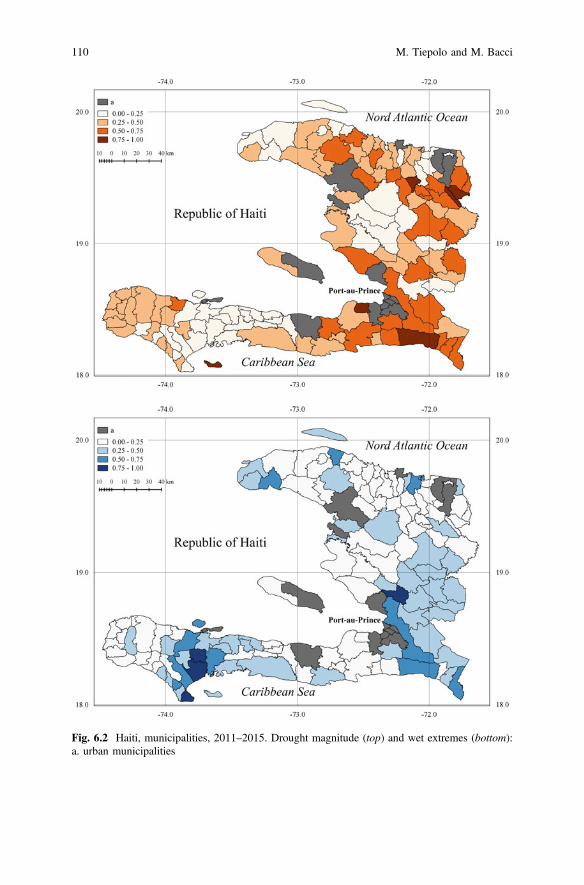
Fig. 6.2 Haiti, municipalities, 2011–2015. Drought magnitude (top) and wet extremes (bottom):a. urban municipalities
110 M. Tiepolo and M. Bacci
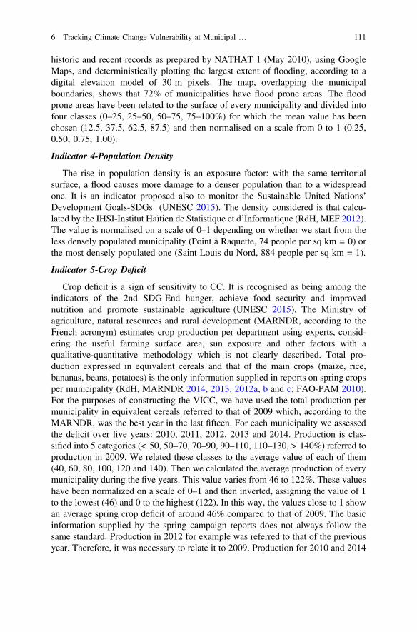
historic and recent records as prepared by NATHAT 1 (May 2010), using GoogleMaps, and deterministically plotting the largest extent of flooding, according to adigital elevation model of 30 m pixels. The map, overlapping the municipalboundaries, shows that 72% of municipalities have flood prone areas. The floodprone areas have been related to the surface of every municipality and divided intofour classes (0–25, 25–50, 50–75, 75–100%) for which the mean value has beenchosen (12.5, 37.5, 62.5, 87.5) and then normalised on a scale from 0 to 1 (0.25,0.50, 0.75, 1.00).
Indicator 4-Population Density
The rise in population density is an exposure factor: with the same territorialsurface, a flood causes more damage to a denser population than to a widespreadone. It is an indicator proposed also to monitor the Sustainable United Nations’Development Goals-SDGs (UNESC 2015). The density considered is that calcu-lated by the IHSI-Institut Haïtien de Statistique et d’Informatique (RdH, MEF 2012).The value is normalised on a scale of 0–1 depending on whether we start from theless densely populated municipality (Point à Raquette, 74 people per sq km = 0) orthe most densely populated one (Saint Louis du Nord, 884 people per sq km = 1).
Indicator 5-Crop Deficit
Crop deficit is a sign of sensitivity to CC. It is recognised as being among theindicators of the 2nd SDG-End hunger, achieve food security and improvednutrition and promote sustainable agriculture (UNESC 2015). The Ministry ofagriculture, natural resources and rural development (MARNDR, according to theFrench acronym) estimates crop production per department using experts, consid-ering the useful farming surface area, sun exposure and other factors with aqualitative-quantitative methodology which is not clearly described. Total pro-duction expressed in equivalent cereals and that of the main crops (maize, rice,bananas, beans, potatoes) is the only information supplied in reports on spring cropsper municipality (RdH, MARNDR 2014, 2013, 2012a, b and c; FAO-PAM 2010).For the purposes of constructing the VICC, we have used the total production permunicipality in equivalent cereals referred to that of 2009 which, according to theMARNDR, was the best year in the last fifteen. For each municipality we assessedthe deficit over five years: 2010, 2011, 2012, 2013 and 2014. Production is clas-sified into 5 categories (< 50, 50–70, 70–90, 90–110, 110–130, > 140%) referred toproduction in 2009. We related these classes to the average value of each of them(40, 60, 80, 100, 120 and 140). Then we calculated the average production of everymunicipality during the five years. This value varies from 46 to 122%. These valueshave been normalized on a scale of 0–1 and then inverted, assigning the value of 1to the lowest (46) and 0 to the highest (122). In this way, the values close to 1 showan average spring crop deficit of around 46% compared to that of 2009. The basicinformation supplied by the spring campaign reports does not always follow thesame standard. Production in 2012 for example was referred to that of the previousyear. Therefore, it was necessary to relate it to 2009. Production for 2010 and 2014
6 Tracking Climate Change Vulnerability at Municipal … 111
was referred to the registration sections (sub-category of the municipality). In thiscase, when the production values of the sections of a municipality were different,the mean value was calculated.
Indicator 6-Farmers for Self-consumption
Dependence exclusively on farming for subsistence is a sensitivity factor. Thisinformation is used by numerous scholars (Adger et al. 2004). The information issupplied by the MARNDR and is part of the Agricultural Atlas of Haiti (RdH,MARNDR 2012a, b and c). The information is provided for five classes which wetook to mean values of 80, 60, 40, 22.5 and 7.5 and then normalised on a scale from0 (7.5) to 1 (80).
Indicator 7-Local Development and Contingency Plans
Among the adaptive capacities the first thing to consider is the capacity of themunicipalities to plan the measures for adaptation to CC over a period time. Thiscapacity is among the indicators of the SDG 11-Make cities and human settlementsinclusive, safe, resilient and sustainable (indicator 11b1). Haiti’s municipalitieshave basically three types of tools: Local development plans, Contingency plansand, occasionally, Comprehensive plans. The implementation of these plansrequires the mobilisation of different players for financing. Freely available plans isimportant to encourage implementation. Recognition on internet has enabled theidentification of 19 plans. We have assigned a value of 0 to municipalities with aplan and a value of 1 to those without a plan.
Indicator 8-Irrigation Systems
The use of irrigation systems in agriculture is an adaptive capacity which isimportant in a country like Haiti which, in recent years, has been particularlyexposed to drought. The monitoring of the SDG 2-End hunger, achieve foodsecurity and improved nutrition and promote sustainable agriculture considersit (UNESC 2015). The Agricultural Atlas of Haiti supplies the amount of cultivableland that can be irrigated with respect to the cultivable area. The information issupplied according to five classes (<5, 5–15, 15–30, 30–60, >60%) which we haverelated to the mean values of every class (2.5, 12.5, 22.5, 45, 75) and normalised ona scale of 0 (75)–1 (2.5).
Indicator 9-Access to All-season Road
Municipalities that are served by all-season roads which allow constant access toservices that are not available in the place of residence is an adaptive capacityfactor. The Rural Access Index (RAI) proposed by the World Bank (Roberts et al.2006) and calculated by the MTPTC in May 2015 for every municipal section ofHaiti (RdH, MTPTS 2015) is among the indicators proposed by the United Nationsto monitor SDG 9-Build resilient infrastructure. The RAI expresses the percentageof population which, in every municipal subdivision (about 600 for the whole ofHaiti) lives within 2 km from an all-season road. The information is supplied
112 M. Tiepolo and M. Bacci
according to seven classes from 0–25% to 85–100%. We calculated the averagevalue for each class and, when a municipality is made up of sections with a differentRAI, the average between the values of every section. Then the values were nor-malised on a scale of 0 to 1 and rearranged to attribute the maximum value (1) tothe municipality with least accessibility (0.13) and the minimum (zero) to themunicipality with most accessibility (0.93).
Indicator 10-Cholera Incidence
Access to drinking water, sanitation and medical care expresses an adaptivecapacity and forms the 6th SDG-Ensure availability and sustainable management ofwater and sanitation for all (UNESC 2015). Since there is a lack of open data onaccess to drinking water and to sanitation at municipal level, we used the choleraincidence as proxy indicator as its persistence “almost 6 years after its appearance,is largely due to the lack of access to safe drinking water and sanitation” (OCHA2016: 3). This happens, for example, when sewage is dumped straight into the riverand the river is used for drinking, irrigation, bathing and washing clothes (Frerichs2016). Haiti, after the cholera peaks of 1.8 and 3.4‰ in 2010 and 2011 respectively,has still not succeeded in weakening the epidemic, which worsened in 2015(0.4‰). The Ministry of Human health regularly publishes statistics by munici-pality. We used those for April–June 2015 (RdH, MSPP 2015), which presents thelowest incidence during the year and considered only municipalities with a choleraincidence higher than 0.1‰. The figures were normalised on a scale of 0–1.Nineteen municipalities do not supply data because they do not have a local centrefor the diagnosis and treatment of cholera. We did not think it is fair to proceed inthese cases with the imputation of the missing data as the residents from thesemunicipalities simply go to the nearest cholera diagnosis and treatment centres.
6.2.5 Robustness and Applicability of the Index
To ensure that all the indicators are comparable, we normalised the values of eachindicator on a scale of 0 (minimum vulnerability) to 1 (maximum vulnerability)(Table 6.5). The indicators 5, 7 and 9 required the overturning of the value. Weassigned an equal weight to each indicator, instead of using expert opinions (hard totrace for 125 municipalities) or statistical models like the PCA-Principal componentanalysis (which require capacities which the users of the index rarely have, whetherthey are donors or local authorities). The vulnerability index to CC on a municipalscale adds together the values of the single indicators of exposure (E),sensitivity (S) and adaptive capacity (AC) according to the equationVICC¼ðEþSÞþ 1ACð Þ¼ ði1þ i2þ i3þ i4þ i5þ i6Þþ 1 i7þ i8þ i9þ i10ð Þð Þwhere i1 is drought magnitude, i2 is wet extremes, i3 is flood prone areas, i4 ispopulation density, i5 is crop deficit, i6 is farmers for self-consumption, i7 is local
6 Tracking Climate Change Vulnerability at Municipal … 113
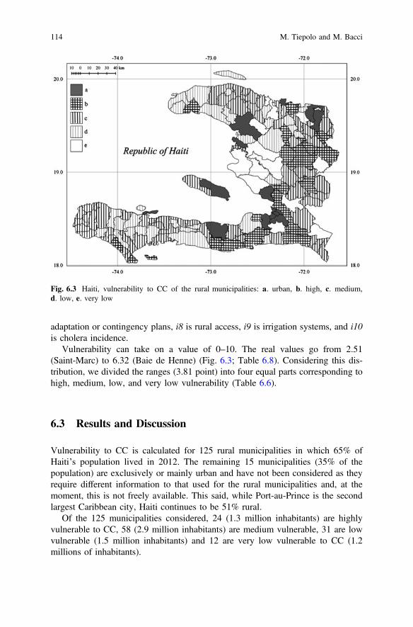
adaptation or contingency plans, i8 is rural access, i9 is irrigation systems, and i10is cholera incidence.
Vulnerability can take on a value of 0–10. The real values go from 2.51(Saint-Marc) to 6.32 (Baie de Henne) (Fig. 6.3; Table 6.8). Considering this dis-tribution, we divided the ranges (3.81 point) into four equal parts corresponding tohigh, medium, low, and very low vulnerability (Table 6.6).
6.3 Results and Discussion
Vulnerability to CC is calculated for 125 rural municipalities in which 65% ofHaiti’s population lived in 2012. The remaining 15 municipalities (35% of thepopulation) are exclusively or mainly urban and have not been considered as theyrequire different information to that used for the rural municipalities and, at themoment, this is not freely available. This said, while Port-au-Prince is the secondlargest Caribbean city, Haiti continues to be 51% rural.
Of the 125 municipalities considered, 24 (1.3 million inhabitants) are highlyvulnerable to CC, 58 (2.9 million inhabitants) are medium vulnerable, 31 are lowvulnerable (1.5 million inhabitants) and 12 are very low vulnerable to CC (1.2millions of inhabitants).
Fig. 6.3 Haiti, vulnerability to CC of the rural municipalities: a. urban, b. high, c. medium,d. low, e. very low
114 M. Tiepolo and M. Bacci
The municipalities highly vulnerable to CC are concentrated in the Centredepartment, and around Port-au-Prince. Most of these municipalities stretch acrossthe mountain territories of the central Cordillière, the Montaignes Noires and, aboveall, the Chaine de la Selle, behind the capital city (Fig. 6.3).
The concentration of highly vulnerable municipalities in the hinterland of thecapital city and a few kilometres from the main road linking Port-au-Prince to CapHaïtien should theoretically simplify the reduction of vulnerability, as the materialsneeded for the adaptation works do not require movement over long distances, whichwould be necessary to reach the southwest and northwest areas of the country.
The calculation of the VICC allows further considerations on its single com-ponents, starting with exposure. From 2013 to 2015, Haiti was struck by the worstdrought in the past 35 years, which peaked in 2014. The drought increased thenumber of dry months in a year which, in Belle Anse, went from three (1981–2010)to nine (2011–2015), in Bahon from three to eight, in Carice, Gressier and MontOrganisé from three to seven and in Ile à Vache from three to six (Fig. 6.3). Thisdrought affected all the municipalities. In the previous twenty years, there had onlybeen three isolated years of drought (1997, 2000, 2009).
The drought caught the Haitians off-guard, unprepared for an event of suchmagnitude. The 2013–2015 drought was preceded by two extremely wet years. Thishowever was not an effect of CC, because Haiti frequently has two extremely wetyears in a row, due to its position on the hurricane route.
As regards others factors of exposure, the flood prone area exceeds 75% of themunicipal surface area in Caracol, Cayes, Ferrier and Grande Saline, and between50 and 75% of the municipal surface area in Estère, Milot and Saint Raphaël. The
Table 6.1 The Haiti open data VICC compared with other conventional surveys to assessvulnerability to CC
Type ofinformation
Type of survey
Open data VICC2nd hand information
Traditional2nd handinformation
Household1st hand information
Municipalities# Hundreds Thousands Few to dozens
Information used Census, daily/weekly orannual surveys
Census Households survey,focus groups
Indicators number 10–13 38 17–31
Indicator weight No Yes Experts, PCA
Processing time Weeks Months Months
Staff One–two Unknown Dozens
Money use Freed for developmentactivities
Mapping Data collection andprocessing
Replicability Yes Yes Rare/No
Refresh rate Annual-biennial Decennial No
Example This chapter PNUMA(2013)
Ahsan and Warner(2014)
6 Tracking Climate Change Vulnerability at Municipal … 115
density of the population peaks in Saint Louis du Nord and is high in Limonade,Quartier Morin, Ferrier (Nord), Grande Saline (Artibonite), Croix des Bouquets(West), Belle Anse (South East) and Ile à Vache (South).
Rural sensitivity consists in two aspects. First, 65% of the municipalities hadcrop deficits between 2010 and 2014, with very severe deficits in six municipalities(crop yield of less than 46% compared to 2009): Cerca Carvajal, Gressier, LaVictoire, La Vallée, Maïssade and Saint Raphaël. Second, 16 municipalities haveover 70% of farmers cultivating for self-consumption only.
In relation to adaptive capacity, just nineteen municipalities have a localdevelopment or contingency plan. Thirty-eight municipalities have no irrigationsystems and only two have irrigated farming on over 60% of the useful farmland(La Victoire and Milot).
Eighty-four municipalities (67%) have very little accessibility to an all-seasonroad. Five municipalities have a very high cholera incidence (> 10/10,000): Baie deHenne, Anse d’Hainault, Croix de Bouquets, Hinche and Quartier Morin. These
Table 6.2 Haiti 2015. Open data relevant for vulnerability tracking according administrative level
Vulnerabilitydeterminants
Open data Administrative level
Country Department Municipality
Exposure Monthly precipitations Flood prone areas/unit area Population density
Sensitivity Anomalies in food prices Crop deficit Farmers cropping forself-consumption
Poverty Victims of hydro climatic disaster
Adaptive ODA in environmental sector capacity HDI-Human development index
Maternal mortality HIV Incidence Literacy rate School enrolment according gender Forest area Local plans for climate adaptation Rural accessibility Irrigated agriculture Water and sanitation Cholera incidence
116 M. Tiepolo and M. Bacci
four indicators highlight the municipalities with less adaptive capacity (Baie deHenne, Cerca la Source, Mirabelais and Thomonde, Ila à Vache, Anse d’Hainault)and those with more adaptive capacity (Bas Limbé, Saint-Marc, Petite Rivière del’Artibonite, Kenscoff and Léogane).
The comparison between exposure and adaptive capacity (Fig. 6.4) highlightsthat there is no relationship between the two determinants. Therefore, the adaptivecapacity does not respond to exposure to CC. This awareness alone justifies theneed for a VICC for Haiti at municipal level if we need to help decision makingwith regard to the adaptation of the most exposed municipalities. VICC on amunicipal level presents rather different results when compared with the previousmaps of the single determinants of vulnerability.
The map of drought magnitude 2011–2015, for example, is completely differentfrom that of drought susceptivity 2010 (RdH 2010: 18). The difference is due to thegreater precision of our study, the different methodology, and the fact that theperiod that we considered was influenced by very severe drought, something whichhad not occurred in the previous 20 years. Another example is crop deficit.
Table 6.3 Haiti 2016. Freely available data to build indicators for vulnerability to CC tracking
Vulnerabilitycomponents
Information Available at
Exposure Monthlyprecipitation
http://chg.geog.ucsb.edu/data/chirps/
Flood proneareas
http://haitidata.org/layers/cnigs.spatialdata:hti
Populationdensity
http://www.ihsi.ht/produit_demo_soc.htm
Sensitivity Crop deficit http://agriculture.gouv.ht/statistiques_agricoles/Atlas/thematiques_speciphiques.html
Farmer 4self-consumption
http://agriculture.gouv.ht/statistiques_agricoles/Atlas/thematiques_speciphiques.html
Adaptive Plans for CCA
capacity Ruralaccessibility
http://www.mtptc.gouv.ht/media/upload/doc/publications/ROUTE_INDICE-RAI-2015.pdf
Irrigationsystems
http://agriculture.gouv.ht/statistiques_agricoles/Atlas/thematiques_speciphiques.html
Choleraincidence
http://mspp.gouv.ht/site/downloads/Bulletin%20Trimestriel%20MSPP%20Juillet%202015%20version%20web%20compressed.pdf
6 Tracking Climate Change Vulnerability at Municipal … 117
The municipalities that presented the highest food scarcity in 2009 (RdH,MARNDR 2009: 18) are not the same ones that presented the worst crop deficitbetween 2010 and 2014. The difference depends on the methodology but also onthe fact that 2009 was one of the best agricultural years in the last fifteen.
The VICC is useful to all those projects which have such a dimension andduration as to justify a device for the assessment of their actions.
VICC can be also used to direct action. The municipalities with the highestscore for crop deficit, local plans, irrigated surface area, RAI and cholera incidenceare those that require most support to agriculture, to local development and con-tingency plans, road accessibility, irrigation systems and WASH.
The VICC can be improved by adding information on sensitivity (food prices,victims of disasters) and adaptive capacity (forested area, school enrolment, HIVincidence) which is currently available at national or departmental level only.
Table 6.4 Evaluation criteria for vulnerability indicators at municipal level
Indicator Evaluation criteria
Pertinence Metadata Availability& updating
Spatialcoverage
Length Intelligibility
Droughtmagnitude
5 5 5 5 5 4
Wet extremes 5 5 5 5 5 4
Flood proneareas
5 1 2 5 1 5
Populationdensity
5 5 5 5 3 5
Agriculturalproduction
5 5 5 5 4 5
Farmers forself-consumption
5 1 5 5 1 5
Plans for CCA 5 5 5 5 2 5
Ruralaccessibility
5 3 3 5 1 5
Irrigatedagriculture
5 1 5 5 2 5
Choleraincidence
5 1 5 4 2 5
Metadata: 1 weakly documented, 3 methodology documented but not freely available. Availability& updating: 2 routine collection does not exist, indicative information on accuracy, 3 datasupposed routinely collected and freely available, 5 data routinely collected and freely available.Spatial coverage: 4 data unavailable on 15% of municipalities. Length: 1 one year available only, 2two years available, 3 three years available, 4 four years available, 5 over 30 years availablewithout interruptions. Intelligibility: 4 easily understood without expert knowledge
118 M. Tiepolo and M. Bacci
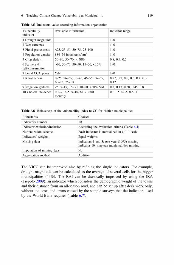
The VICC can be improved also by refining the single indicators. For example,drought magnitude can be calculated as the average of several cells for the biggermunicipalities (43%). The RAI can be drastically improved by using the IRA(Tiepolo 2009): an indicator which considers the demographic weight of the townsand their distance from an all-season road, and can be set up after desk work only,without the costs and errors caused by the sample surveys that the indicators usedby the World Bank requires (Table 6.7).
Table 6.5 Indicators value according information organization
Vulnerabilityindicator
Available information Indicator range
1 Drought magnitude 1–0
2 Wet extremes 1–0
3 Flood prone areas <25, 25–50, 50–75, 75–100 1–0
4 Population density 884–74 inhabitants/km2 1–0
5 Crop deficit 70–90, 50–70, < 50% 0.8, 0.4, 0.2
6 Farmers 4self-consumption
>70, 50–70, 30–50, 15–30, <15% 1–0
7 Local CCA plans Y/N 1–0
8 Rural access 0–25, 26–35, 36–45, 46–55, 56–65,66–75, 75–100
0.87, 0.7, 0.6, 0.5, 0.4, 0.3,0.12
9 Irrigation systems <5, 5–15, 15–30, 30–60, >60% SAU 0.3, 0.13, 0.28, 0.45, 0.8
10 Cholera incidence 0,1–2, 2–5, 5–10, >10/10,000monthly
0, 0.15, 0.35, 0.8, 1
Table 6.6 Robustness of the vulnerability index to CC for Haitian municipalities
Robustness Choices
Indicators number 10
Indicator exclusion/inclusion According the evaluation criteria (Table 6.4)
Normalization scheme Each indicator is normalized in a 0–1 scale
Indicators’ weights Equal weights
Missing data Indicators 1 and 3: one year (1995) missingIndicator 10: nineteen municipalities missing
Imputation of missing data No
Aggregation method Additive
6 Tracking Climate Change Vulnerability at Municipal … 119
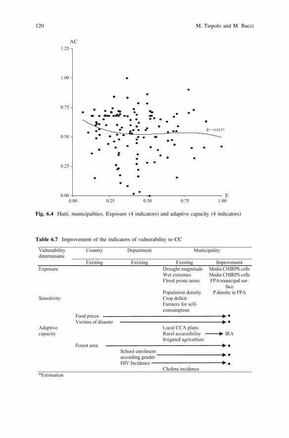
R² = 0.0157
0.00
0.25
0.50
0.75
1.00
1.25
0.00 0.25 0.50 0.75 1.00
AC
E
Fig. 6.4 Haiti, municipalities. Exposure (4 indicators) and adaptive capacity (4 indicators)
Table 6.7 Improvement of the indicators of vulnerability to CC
Vulnerabilitydeterminants
Country Department Municipality
Existing Existing Existing ImprovementExposure Drought magnitude Media CHIRPS cells
Wet extremes Media CHIRPS cellsFlood prone areas FPA/municipal sur-
facePopulation density P density in FPA
Sensitivity Crop deficit Farmers for self-consumption
Food pricesVictims of disaster
Adaptive Local CCA planscapacity Rural accessibility IRA
Irrigated agricultureForest area
School enrolment according genderHIV Incidence
Cholera incidence*Estimation
120 M. Tiepolo and M. Bacci
6.4 Conclusions
The VICC at municipal scale for Haiti aggregates 10 indicators consistent withthose proposed by the United Nations to monitor the SDGs (UNESC 2015): this isa reduced number compared to other vulnerability indices to CC on a local scale.Kept with just a few indicators, the VICC can easily be updated and allows centraland local governments and the Official development aid to orient the measures foradaptation to CC to the most vulnerable sectors, to appreciate the improvementsobtained years after year and to assess the impact and sustainability of localprojects.
The data needed to measure the 10 indicators to prove the applicability of theVICC were downloaded from the websites of the ministries and those of otherauthorities, only with regard to information on precipitations that is not freelyavailable in Haiti. This activity would be simplified if just one organisation were tobe responsible for open access to information on climate change vulnerability on amunicipal scale, such as CNIGS, CNSA, or ONEV-Observatoire National del’Environnement et de la Vulnerabilité du Ministère de l’Environnement. Thisorganization should update datasets on the vulnerability to CC of Haitian munici-palities (useful farming surface area, farmers for self-consumption/Min.Agriculture, monthly cholera incidence/Ministry for Health), supplied always in thesame format (maintaining 2009 as the year of reference for agricultural production)and completed (RAI data and not just the map/Ministry of Public works, trans-portation and communication).
In the future, the organisation in question could provide information on fiveadditional factors of vulnerability to CC available: average monthly prices of food(expanding the number of markets currently monitored by the CNSA), forested (orreforested) area, at five-years intervals at least (CNIGS), victims and damagescaused by hydro-meteorological disaster (Ministry of Interior and territorial com-munities), school enrolment according to gender (Ministry of National education),HIV incidence (Ministry of Health). Further expansions of the number of indicatorscould prevent the tracking of vulnerability and spatial coverage.
6 Tracking Climate Change Vulnerability at Municipal … 121
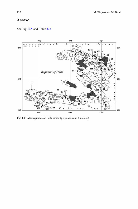
Annexe
See Fig. 6.5 and Table 6.8
Fig. 6.5 Municipalities of Haiti: urban (grey) and rural (numbers)
122 M. Tiepolo and M. Bacci
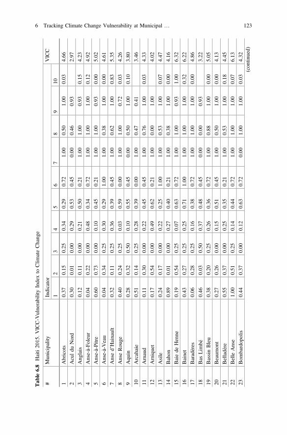
Tab
le6.8
Haiti20
15.VICC-V
ulnerabilityIndexto
Clim
ateChang
e
#Mun
icipality
Indicator
VICC
12
34
56
78
910
1Abricots
0.37
0.15
0.25
0.34
0.29
0.72
1.00
0.50
1.00
0.03
4.66
2Aculdu
Nord
0.30
0.01
0.00
0.29
0.53
0.45
0.00
0.46
0.93
2.97
3Ang
lais
0.12
0.11
0.00
0.21
0.50
0.21
1.00
1.00
0.93
0.15
4.23
4Anse-à-Fo
leur
0.04
0.22
0.00
0.48
0.34
0.72
1.00
1.00
1.00
0.12
4.92
5Anse-à-Pitre
0.60
0.73
0.00
0.10
0.45
0.21
1.00
1.00
0.93
0.00
5.02
6Anse-à-Veau
0.04
0.34
0.25
0.30
0.29
1.00
1.00
0.38
1.00
0.00
4.61
7Ansed’Hainault
0.32
0.11
0.25
0.36
0.39
0.45
1.00
0.62
1.00
0.83
5.35
8AnseRou
ge0.40
0.24
0.25
0.03
0.59
0.00
1.00
1.00
0.72
0.03
4.26
9Aqu
in0.28
0.32
0.50
0.10
0.55
0.45
0.00
0.50
1.00
0.10
3.80
10Arcahaie
0.51
0.14
0.25
0.28
0.39
0.00
1.00
0.47
0.41
3.46
11Arnaud
0.11
0.30
0.00
0.22
0.45
0.45
1.00
0.76
1.00
0.03
4.33
12Arniquet
0.17
0.54
0.00
0.49
0.62
0.21
1.00
0.00
1.00
4.02
13Asile
0.24
0.17
0.00
0.22
0.25
1.00
1.00
0.53
1.00
0.07
4.47
14Bahon
0.89
0.01
0.00
0.27
0.40
0.21
1.00
0.38
1.00
0.00
4.16
15Baiede
Henne
0.19
0.54
0.25
0.07
0.63
0.72
1.00
1.00
0.93
1.00
6.32
16Bainet
0.43
0.27
0.25
0.25
0.71
1.00
1.00
1.00
1.00
0.32
6.22
17Baradères
0.06
0.28
0.25
0.16
0.38
0.72
1.00
1.00
1.00
0.00
4.86
18Bas
Lim
bé0.46
0.03
0.50
0.37
0.48
0.45
0.00
0.00
0.93
3.22
19BassinBleu
0.38
0.20
0.25
0.26
0.36
0.72
1.00
0.88
1.00
0.00
5.05
20Beaum
ont
0.27
0.26
0.00
0.15
0.51
0.45
1.00
0.50
1.00
0.00
4.13
21Belladère
0.55
0.37
0.00
0.25
0.35
0.21
1.00
0.53
1.00
0.18
4.45
22Belle
Anse
1.00
0.51
0.25
0.14
0.44
0.72
1.00
1.00
1.00
0.07
6.13
23Bom
bardop
olis
0.44
0.37
0.00
0.12
0.63
0.72
0.00
1.00
1.00
0.03
4.32
(con
tinued)
6 Tracking Climate Change Vulnerability at Municipal … 123
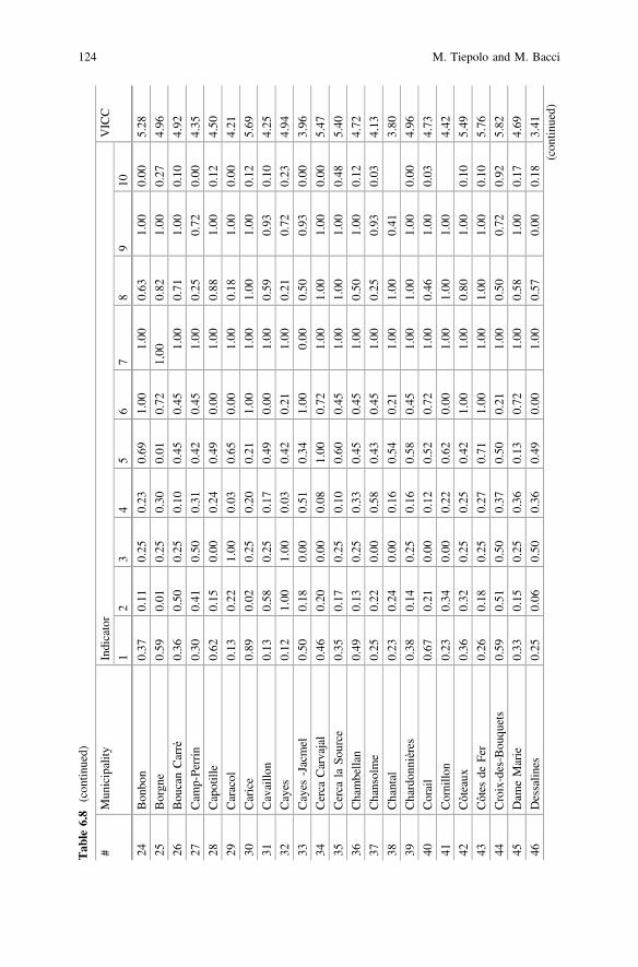
Tab
le6.8
(con
tinued)
#Mun
icipality
Indicator
VICC
12
34
56
78
910
24Bon
bon
0.37
0.11
0.25
0.23
0.69
1.00
1.00
0.63
1.00
0.00
5.28
25Borgn
e0.59
0.01
0.25
0.30
0.01
0.72
1,00
0.82
1.00
0.27
4.96
26Bou
canCarré
0.36
0.50
0.25
0.10
0.45
0.45
1.00
0.71
1.00
0.10
4.92
27Cam
p-Perrin
0.30
0.41
0.50
0.31
0.42
0.45
1.00
0.25
0.72
0.00
4.35
28Capotille
0.62
0.15
0.00
0.24
0.49
0.00
1.00
0.88
1.00
0.12
4.50
29Caracol
0.13
0.22
1.00
0.03
0.65
0.00
1.00
0.18
1.00
0.00
4.21
30Carice
0.89
0.02
0.25
0.20
0.21
1.00
1.00
1.00
1.00
0.12
5.69
31Cavaillo
n0.13
0.58
0.25
0.17
0.49
0.00
1.00
0.59
0.93
0.10
4.25
32Cayes
0.12
1.00
1.00
0.03
0.42
0.21
1.00
0.21
0.72
0.23
4.94
33Cayes
-Jacmel
0.50
0.18
0.00
0.51
0.34
1.00
0.00
0.50
0.93
0.00
3.96
34Cerca
Carvajal
0.46
0.20
0.00
0.08
1.00
0.72
1.00
1.00
1.00
0.00
5.47
35Cerca
laSo
urce
0.35
0.17
0.25
0.10
0.60
0.45
1.00
1.00
1.00
0.48
5.40
36Chambellan
0.49
0.13
0.25
0.33
0.45
0.45
1.00
0.50
1.00
0.12
4.72
37Chansolme
0.25
0.22
0.00
0.58
0.43
0.45
1.00
0.25
0.93
0.03
4.13
38Chantal
0.23
0.24
0.00
0.16
0.54
0.21
1.00
1.00
0.41
3.80
39Chardon
nières
0.38
0.14
0.25
0.16
0.58
0.45
1.00
1.00
1.00
0.00
4.96
40Corail
0.67
0.21
0.00
0.12
0.52
0.72
1.00
0.46
1.00
0.03
4.73
41Cornillo
n0.23
0.34
0.00
0.22
0.62
0.00
1.00
1.00
1.00
4.42
42Côteaux
0.36
0.32
0.25
0.25
0.42
1.00
1.00
0.80
1.00
0.10
5.49
43Côtes
deFer
0.26
0.18
0.25
0.27
0.71
1.00
1.00
1.00
1.00
0.10
5.76
44Croix-des-Bou
quets
0.59
0.51
0.50
0.37
0.50
0.21
1.00
0.50
0.72
0.92
5.82
45Dam
eMarie
0.33
0.15
0.25
0.36
0.13
0.72
1.00
0.58
1.00
0.17
4.69
46Dessalin
es0.25
0.06
0.50
0.36
0.49
0.00
1.00
0.57
0.00
0.18
3.41
(con
tinued)
124 M. Tiepolo and M. Bacci
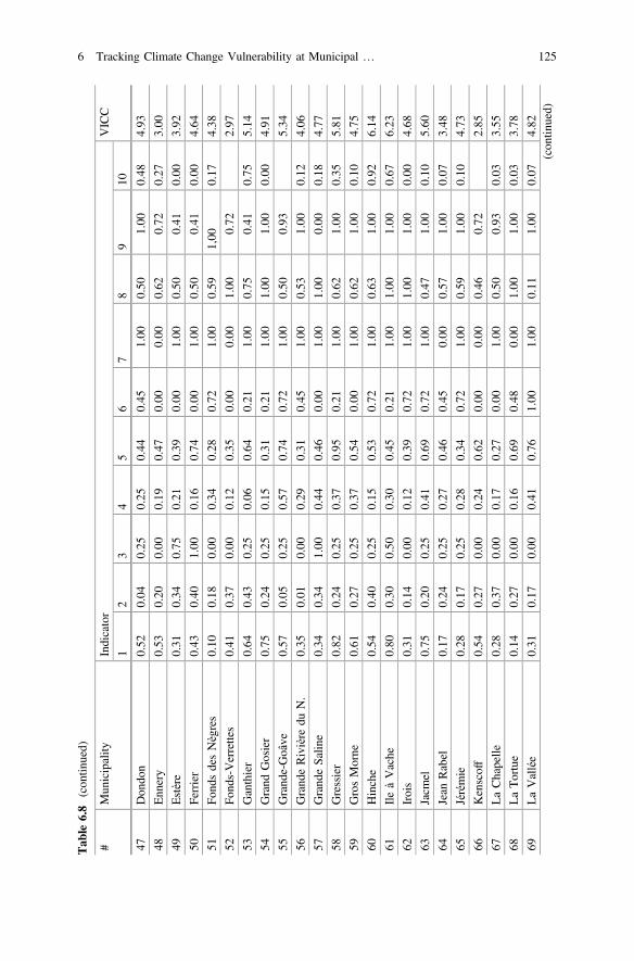
Tab
le6.8
(con
tinued)
#Mun
icipality
Indicator
VICC
12
34
56
78
910
47Don
don
0.52
0.04
0.25
0.25
0.44
0.45
1.00
0.50
1.00
0.48
4.93
48Enn
ery
0.53
0.20
0.00
0.19
0.47
0.00
0.00
0.62
0.72
0.27
3.00
49Estère
0.31
0.34
0.75
0.21
0.39
0.00
1.00
0.50
0.41
0.00
3.92
50Ferrier
0.43
0.40
1.00
0.16
0.74
0.00
1.00
0.50
0.41
0.00
4.64
51Fo
ndsdesNègres
0.10
0.18
0.00
0.34
0.28
0.72
1.00
0.59
1,00
0.17
4.38
52Fo
nds-Verrettes
0.41
0.37
0.00
0.12
0.35
0.00
0.00
1.00
0.72
2.97
53Ganthier
0.64
0.43
0.25
0.06
0.64
0.21
1.00
0.75
0.41
0.75
5.14
54Grand
Gosier
0.75
0.24
0.25
0.15
0.31
0.21
1.00
1.00
1.00
0.00
4.91
55Grand
e-Goâve
0.57
0.05
0.25
0.57
0.74
0.72
1.00
0.50
0.93
5.34
56Grand
eRivière
duN.
0.35
0.01
0.00
0.29
0.31
0.45
1.00
0.53
1.00
0.12
4.06
57Grand
eSalin
e0.34
0.34
1.00
0.44
0.46
0.00
1.00
1.00
0.00
0.18
4.77
58Gressier
0.82
0.24
0.25
0.37
0.95
0.21
1.00
0.62
1.00
0.35
5.81
59GrosMorne
0.61
0.27
0.25
0.37
0.54
0.00
1.00
0.62
1.00
0.10
4.75
60Hinche
0.54
0.40
0.25
0.15
0.53
0.72
1.00
0.63
1.00
0.92
6.14
61IleàVache
0.80
0.30
0.50
0.30
0.45
0.21
1.00
1.00
1.00
0.67
6.23
62Irois
0.31
0.14
0.00
0.12
0.39
0.72
1.00
1.00
1.00
0.00
4.68
63Jacm
el0.75
0.20
0.25
0.41
0.69
0.72
1.00
0.47
1.00
0.10
5.60
64Jean
Rabel
0.17
0.24
0.25
0.27
0.46
0.45
0.00
0.57
1.00
0.07
3.48
65Jérémie
0.28
0.17
0.25
0.28
0.34
0.72
1.00
0.59
1.00
0.10
4.73
66Kenscoff
0.54
0.27
0.00
0.24
0.62
0.00
0.00
0.46
0.72
2.85
67LaChapelle
0.28
0.37
0.00
0.17
0.27
0.00
1.00
0.50
0.93
0.03
3.55
68LaTortue
0.14
0.27
0.00
0.16
0.69
0.48
0.00
1.00
1.00
0.03
3.78
69LaVallée
0.31
0.17
0.00
0.41
0.76
1.00
1.00
0.11
1.00
0.07
4.82
(con
tinued)
6 Tracking Climate Change Vulnerability at Municipal … 125
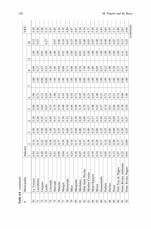
Tab
le6.8
(con
tinued)
#Mun
icipality
Indicator
VICC
12
34
56
78
910
70LaVictoire
0.54
0.14
0.50
0.30
0.86
1.00
1.00
0.00
1.00
0.12
5.45
71Lascaho
bas
0.47
0.37
0.50
0.26
0.39
0.72
1.00
0.27
1.00
0.57
5.56
72Léogane
0.49
0.22
0.50
0.52
0.62
0.21
0.00
0.47
0.93
3.96
73Lim
bé0.70
0.02
0.00
0.71
0.67
0.45
0.00
0.53
1.00
0.27
4.35
74Lim
onade
0.43
0.54
1.00
0.40
0.53
0.45
1.00
0.20
1.00
5.55
75Maïssade
0.21
0.22
0.25
0.15
0.79
1.00
1.00
1.00
1.00
0.07
5.69
76Maniche
0.05
0.77
0.25
0.13
0.39
0.21
1.00
0.50
0.93
0.00
4.24
77Marigot
0.64
0.24
0.25
0.38
0.48
0.45
1.00
0.88
0.93
0.10
5.35
78Marmelade
0.31
0.04
0.00
0.32
0.30
0.45
1.00
0.71
1.00
0.07
4.20
79Milo
t0.24
0.18
0.75
0.43
0.46
0.45
1.00
0.00
1.00
0.35
4.87
80Miragoâne
0.16
0.17
0.00
0.30
0.49
0.72
1.00
0.50
0.93
0.40
4.67
81Mirebalais
0.65
0.43
0.00
0.26
0.25
0.45
1.00
0.54
0.93
0.83
5.34
82MôleSaintNicolas
0.16
0.37
0.25
0.08
0.70
0.45
0.00
1.00
0.93
0.40
4.34
83Mom
binCrochu
0.53
0.30
0.00
0.12
0.57
0.21
1.00
1.00
1.00
0.03
4.77
84Mon
t-Organisé
0.78
0.18
0.25
0.17
0.48
0.45
1.00
1.00
1.00
0.07
5.38
85Moron
0.34
0.28
0.00
0.11
0.52
1.00
1.00
0.50
1.00
0.40
5.14
86Ouanaminthe
0.72
0.17
0.25
0.54
0.57
0.21
1.00
0.27
1.00
0.10
4.83
87Paillant
0.05
0.14
0.25
0.23
0.14
0.72
1.00
0.12
1.00
0.00
3.64
88Perches
0.31
0.02
0.00
0.25
0.63
0.72
1.00
1.00
1.00
0.00
4.93
89Pestel
0.12
0.58
0.00
0.09
0.44
0.21
1.00
0.20
1.00
0.07
3.71
90Petit
Troude
Nippes
0.07
0.37
0.25
0.14
0.26
0.72
1.00
0.75
1.00
0.33
4.90
91PetiteRivière
Artibon
ite0.25
0.17
0.50
0.31
0.38
0.00
0.00
0.47
0.41
0.15
2.63
92PetiteRivière
Nippes
0.01
0.00
0.25
0.27
0.58
1.00
1.00
0.38
0.93
0.25
4.66
(con
tinued)
126 M. Tiepolo and M. Bacci
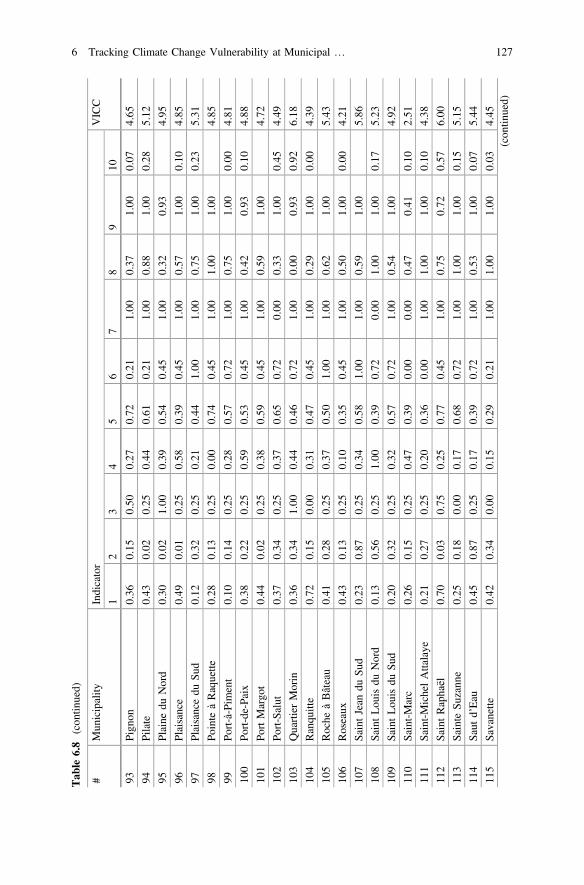
Tab
le6.8
(con
tinued)
#Mun
icipality
Indicator
VICC
12
34
56
78
910
93Pign
on0.36
0.15
0.50
0.27
0.72
0.21
1.00
0.37
1.00
0.07
4.65
94Pilate
0.43
0.02
0.25
0.44
0.61
0.21
1.00
0.88
1.00
0.28
5.12
95Plaine
duNord
0.30
0.02
1.00
0.39
0.54
0.45
1.00
0.32
0.93
4.95
96Plaisance
0.49
0.01
0.25
0.58
0.39
0.45
1.00
0.57
1.00
0.10
4.85
97Plaisancedu
Sud
0.12
0.32
0.25
0.21
0.44
1.00
1.00
0.75
1.00
0.23
5.31
98Po
inte
àRaquette
0.28
0.13
0.25
0.00
0.74
0.45
1.00
1.00
1.00
4.85
99Po
rt-à-Pim
ent
0.10
0.14
0.25
0.28
0.57
0.72
1.00
0.75
1.00
0.00
4.81
100
Port-de-Paix
0.38
0.22
0.25
0.59
0.53
0.45
1.00
0.42
0.93
0.10
4.88
101
PortMargo
t0.44
0.02
0.25
0.38
0.59
0.45
1.00
0.59
1.00
4.72
102
Port-Salut
0.37
0.34
0.25
0.37
0.65
0.72
0.00
0.33
1.00
0.45
4.49
103
QuartierMorin
0.36
0.34
1.00
0.44
0.46
0.72
1.00
0.00
0.93
0.92
6.18
104
Ranqu
itte
0.72
0.15
0.00
0.31
0.47
0.45
1.00
0.29
1.00
0.00
4.39
105
Roche
àBâteau
0.41
0.28
0.25
0.37
0.50
1.00
1.00
0.62
1.00
5.43
106
Roseaux
0.43
0.13
0.25
0.10
0.35
0.45
1.00
0.50
1.00
0.00
4.21
107
SaintJean
duSu
d0.23
0.87
0.25
0.34
0.58
1.00
1.00
0.59
1.00
5.86
108
SaintLou
isdu
Nord
0.13
0.56
0.25
1.00
0.39
0.72
0.00
1.00
1.00
0.17
5.23
109
SaintLou
isdu
Sud
0.20
0.32
0.25
0.32
0.57
0.72
1.00
0.54
1.00
4.92
110
Saint-Marc
0.26
0.15
0.25
0.47
0.39
0.00
0.00
0.47
0.41
0.10
2.51
111
Saint-MichelAttalaye
0.21
0.27
0.25
0.20
0.36
0.00
1.00
1.00
1.00
0.10
4.38
112
SaintRaphaël
0.70
0.03
0.75
0.25
0.77
0.45
1.00
0.75
0.72
0.57
6.00
113
Sainte
Suzann
e0.25
0.18
0.00
0.17
0.68
0.72
1.00
1.00
1.00
0.15
5.15
114
Saut
d’Eau
0.45
0.87
0.25
0.17
0.39
0.72
1.00
0.53
1.00
0.07
5.44
115
Savanette
0.42
0.34
0.00
0.15
0.29
0.21
1.00
1.00
1.00
0.03
4.45
(con
tinued)
6 Tracking Climate Change Vulnerability at Municipal … 127
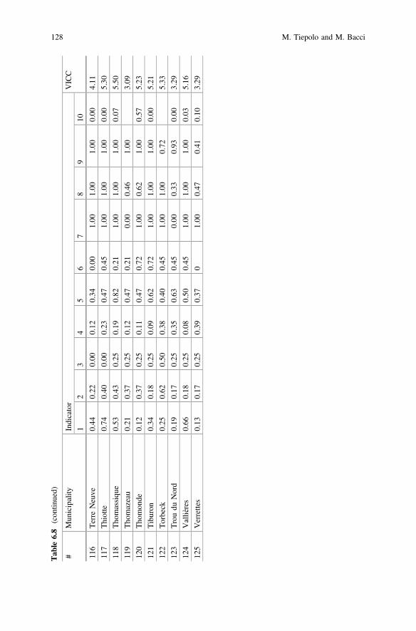
Tab
le6.8
(con
tinued)
#Mun
icipality
Indicator
VICC
12
34
56
78
910
116
Terre
Neuve
0.44
0.22
0.00
0.12
0.34
0.00
1.00
1.00
1.00
0.00
4.11
117
Thiotte
0.74
0.40
0.00
0.23
0.47
0.45
1.00
1.00
1.00
0.00
5.30
118
Tho
massiqu
e0.53
0.43
0.25
0.19
0.82
0.21
1.00
1.00
1.00
0.07
5.50
119
Tho
mazeau
0.21
0.37
0.25
0.12
0.47
0.21
0.00
0.46
1.00
3.09
120
Tho
mon
de0.12
0.37
0.25
0.11
0.47
0.72
1.00
0.62
1.00
0.57
5.23
121
Tiburon
0.34
0.18
0.25
0.09
0.62
0.72
1.00
1.00
1.00
0.00
5.21
122
Torbeck
0.25
0.62
0.50
0.38
0.40
0.45
1.00
1.00
0.72
5.33
123
Troudu
Nord
0.19
0.17
0.25
0.35
0.63
0.45
0.00
0.33
0.93
0.00
3.29
124
Vallières
0.66
0.18
0.25
0.08
0.50
0.45
1.00
1.00
1.00
0.03
5.16
125
Verrettes
0.13
0.17
0.25
0.39
0.37
01.00
0.47
0.41
0.10
3.29
128 M. Tiepolo and M. Bacci
References
Adger, W.N., N. Brooks, G. Bentham, M. Agnew, S. Eriksen. 2004. New indicators ofvulnerability and adaptive capacity. Tyndall Centre for Climate Change Research, technicalreport 7.
Ahsan, N., J. Warner. 2014. The socioeconomic vulnerability index: A pragmatic approach forassessing climate change led risks—A case study in the south-western coastal Bangladesh.International Journal of Disaster Risk Reduction 8: 32–49. doi:10.1016/j.ijdrr.2013.12.009.
Birkmann, J. 2006. Indicators and criteria dor measuring vulnerability: Theoretical bases andrequirements. In Measuring vulnerability to natural hazards. Onwards disaster resilientsocieties, ed. J. Birkmann, 55–77. Tokyo–New York–Paris: UNU Press.
Borde, A., M. Huber, A. Goburdhun, A. Guidoux, E. Revoyron, E. Nsimba, J.A. Louis, A. Donjia,and J.-L. Kesner. 2015. Estimation des couts des impacts du changement climatique en Haiti.New York: PNUD-Ministère de l’économie et des finances.
Bollin, C., K. Fritzsche, S. Ruzima, S. Schneiderbauer, D. Becker, L. Pedoth, and S. Liersch. 2014.Analyse intégrée de la vulnerabilité au Burundi, vol. II. GIZ: Analyse de vulnérabilité auniveau local. Bujumbura.
Borja-Vega, C., A. de la Fuente. 2013. Municipal vulnerability to climate change andclimate-related events in Mexico. Policy Research Working Paper 6417. Washington: TheWorld Bank.
Ci Grasp 2.0. 2016. Glossary. http://www.pik-potsdam.de/cigrasp-2/bg/glossary.html#S. Accessed15 July 2016.
Etwire, P.M., R.M. Al-Hassan, J.K.M. Kuwornu, and Y. Osei-Owusu. 2013. Application oflivelihood vulnerability index in assessing vulnerability to climate change and variability inNorthern Ghana. Journal of Environment and Earth Science 3 (2): 157–170.
FAO, PAM. 2010. Mission FAO/PAM d’évaluation de la récolte et de la sécurité alimentaire enHaiti. Rome: FAO.
Frerichs, R.R. 2016. Deadly river. cholera and cover-un post-earthquake Haiti. Ithaca, NY: ILRPress.
Funk, C., P. Peterson, M. Landsfeld, D. Pedreros, J. Verdin, S. Shukla, G. Husak, J. Rowland,L. Harrison, A. Hoell, and J. Michaelsen. 2015. The climate hazards infrared precipitation withstations—A new environmental record for monitoring extremes. Scientific Data 2: 150066.doi:10.1038/sdata.2015.66.
Gbetibouo, G.A., C. Ringler, R. Hassan. 2010. Vulnerability of the South African farming sectorto climate change and variability: An indicator approach. Natural Resources Forum 34:175–187. doi:10.1111/j.1477-8947.2010.01302.x.
Hahn, M.B., A.M. Riederer, S.O. Foster. 2009. The livelihood vulnerability index: A pragmaticapproach to assessing risks from climate varianbility and change—A case study inMozambique.Global Environmental Change 19: 74–88. http://dx.doi.org/10.1016/j.gloenvcha.2008.11.002.
Heltberg, R., and M. Bonch-Osmolovskiy. 2010. Mapping vulnerability to climate change.Washington: The World Bank.
Hilden, M., A. Marx. 2013. Evaluation of climate change state, impact and vulnerabilityindicators, ETC CCA Technical paper 02/2013.
IPCC-International Panel on Climate Change. 2014. Annex II: Glossary. In Climate change 2014:synthesis report. Contribution of Working Groups I, II and III to the Fifth Assessment Report ofthe IPCC, eds. R.K. Pachauri, and L.A. Meyers, 117–130. Geneva: IPCC.
Nurse, L.A., R.F. McLean, J. Agard, L.P. Briguglio, V. Duvat-Magnan, N. Pelesikoti,E. Tompkins, and A. Webb. 2014. Small islands. In Climate Change 2014: Impacts,Adaptation, and Vulnerability. Part B: Regional Aspects. Contribution of Working Group II tothe Fifth Assessment Report of the Intergovernmental Panel on Climate Change ed. V.R. Barros,C.B. Field, D.J. Dokken, M.D. Mastrandrea, K.J. Mach, T.E. Bilir, M. Chatterjee, K.L. Ebi,Y.O. Estrada, R.C. Genova, B.Girma, E.S. Kissel, A.N. Levy, S.MacCracken, P.R.Mastrandrea,
6 Tracking Climate Change Vulnerability at Municipal … 129
and L.L. White, 1613–1654. Cambridge, United Kingdom and New York, USA: CambridgeUniversity Press.
OCHA-United Nations Office for the Coordination of Humanitarian Affairs. 2016. Choleraremains an emergency and a priority fo the UN and its partners. Humanitarian Bulletin Haiti57: 3–4.
PNUMA-ORLAC-Programa de las Naciones Unidas para el Medio Ambiente, Oficina Regionalpara América Latina y el Caribe. 2013. Análisis de vulnerabilidad e identificación de opcionesde adaptación frente al cambio climático en el sector agropecuario y de recursos hídricos enMesoamérica. PNUMA-ORLAC.
RdH-République d’Haiti. 2010. Analysis of Multiple Hazard in Haiti. Port-au-Prince, March.RdH, MARNDR. 2012a. Atlas agricole d’Haïti. Enquête exploitation 2009. http://agriculture.
gouv.ht/statistiques_agricoles/Atlas/preface.html. Accessed 16 Jun 2016.RdH, MARNDR. 2012b. Politique d’irrigation du MARNDR 2012. Juin.RdH, MARNDR. 2012c. Evaluation de la campagne agricole de printemps 2012. Septembre.RdH, MARNDR. 2013. Evaluation previsionnelle de la performance des recoltes de la campagne
agricole de printemps 2013.RdH, MARNDR. 2014. Evaluation prévisionnelle de la performance des récoltes de la campagne
agricole de printemps 2014. Octobre.RdH, MARNDR CSA FEWS NET. 2009. Haiti: Cartographie de vulnerabilité multirisque
juillet/aout 2009.RdH, MEF, IHIS-Ministère de l’Economie et des Finances, Institut Haïtien de Statistique et
d’Informatique. 2012. Population totale, population de 18 ans et plus ménages et densitéséstimés en 2012. Port-au-Prince: DSDS.
RdH, MSPP-Ministère de la Santé Publique et de la Population. 2015. Infosanté. Bulletind’information 1, 9, juillet.
RdH, MTPTC-Ministère des Travaux Publics, Transports et Communicartion. 2015. RAI (RuralAccess Index) Haïti 2015. Accessibilité des sections communales au réseau routier, 6 maihttp://www.mtptc.gouv.ht/media/upload/doc/publications/ROUTE_INDICE-RAI-2015.pdf.Accessed 16 Jun 2016.
Roberts, P., K.C. Shyam, C. Rastogi. 2006. Rural access index: A key development indicator.Transport Papers 10, March. The World Bank.
Schiavo-Campo, S. 1999. Strengthening “performance” in public expenditure management. AsianReview of Public Administration 11 (2): 23–44.
Sharma, B., N. Jangle. 2012. Assessing vulnerability to climate risk in Ahmednagar (Maharashtra)and Vaishah (Bihar) using GIS technique. In 13th Esri India User Conference 2012.
Tiepolo, M. 2009. Lo sviluppo delle aree rurali remote. Petrolio, uranio e governance locale inNiger. Milan: Franco Angeli.
Tuladhar, F.M. 2013. Climate change vulnerability index mapping of Nepal using NASA EOSData. In 14th Esri India User Conference 2013.
UNESC-United Nations Economic and Social Council. 2015. Report of the inter agency andexpert group on sustainable development goals indicators. https://unstats.un.org/unsd/statcom/47th-session/documents/2016-2-IAEG-SDGs-E.pdf. Accessed 16 Jun 1916.
UNESCO-IHE-Institute for Water Education. 2016. Flood vulnerability indices. http://unescoihefvi.free.fr/vulnerability.php. Accessed 2 July 2016.
USAID. 2014. Design and use of composite indices in assessments of climate change vulnerabilityand resilience. Washington: USAID.
Verisk Maplecroft. 2016. Vulnerability Index. https://maplecroft.com/about/news/ccvi.html.Accessed 2 July 2016.
WMO-World Meteorological Organization, M. Svoboda, M. Hayes, and D. Wood. 2012.Standardized precipitation index user guide. Geneva: WMO.
World Bank. 2014. Open data for resilience initiative. World Bank: Field guide. Washington.
130 M. Tiepolo and M. Bacci
Open Access This chapter is licensed under the terms of the Creative Commons Attribution 4.0International License (http://creativecommons.org/licenses/by/4.0/), which permits use, sharing,adaptation, distribution and reproduction in any medium or format, as long as you give appropriatecredit to the original author(s) and the source, provide a link to the Creative Commons license andindicate if changes were made.The images or other third party material in this chapter are included in the chapter's Creative
Commons license, unless indicated otherwise in a credit line to the material. If material is notincluded in the chapter's Creative Commons license and your intended use is not permitted bystatutory regulation or exceeds the permitted use, you will need to obtain permission directly fromthe copyright holder.
6 Tracking Climate Change Vulnerability at Municipal … 131
Chapter 7Visualize and Communicate ExtremeWeather Risk to Improve UrbanResilience in Malawi
Alessandro Demarchi, Elena Isotta Cristofori and Anna Facello
Abstract Since the last century, an unprecedented settlement expansion, mainlygenerated by an extraordinary world population growth, has made urban commu-nities always more exposed to disasters. Casualties and economic impacts due tohydro-meteorological hazards are dramatically increasing, especially in developingcountries. Although the scientific community is currently able to provide innovativetechnologies to accurately forecast severe weather events, scientific products areoften not easily comprehensible for local stakeholders and more generally fordecision makers. On the other hand the integration of different layers, such ashazard, exposed assets or vulnerability through GIS, facilitates the risk assessmentand the comprehension of risk analysis. This work presents a methodology toenhance urban resilience through the integration into a GIS of satellite-derivedprecipitation data and geospatial reference datasets. Through timely and meaningfulhydro-meteorological risk information, this methodology enables local governmentpersonnel and decision makers to quickly respond and monitor natural phenomenathat could impact on the local community. This methodology is applied to theJanuary 2015 Malawi Flood case study and result will be discussed along withfurther recommended developments.
Keywords Flood Urban resilience Weather risk
A. Demarchi (&) E.I. Cristofori A. FacelloTriM—Translate into Meaning, Corso Sommeiller 24, 10128 Turin, Italye-mail: [email protected]
E.I. Cristoforie-mail: [email protected]
A. Facelloe-mail: [email protected]
© The Author(s) 2017M. Tiepolo et al. (eds.), Renewing Local Planning to Face ClimateChange in the Tropics, Green Energy and Technology,DOI 10.1007/978-3-319-59096-7_7
133
7.1 Introduction
The course of the XX century has been characterised by two unprecedenteddemographic phenomena. Firstly, an exceptional growth of world population whichis currently more than four times compared to the beginning of the last century(UNDESA 2011). Secondly, the rise of the urban population which in 2010 hasexceeded the rural population for the first time in the history (UNDESA 2011).
Combined together, these two demographic trends have determined a rapidexpansion of either planned or informal urban areas. All over the world, to meet thisinsatiable demand for land, communities were settled also in dangerous areas proneto natural disasters. Indeed, new settlements and infrastructures have been built onactive faults, under landslides or mudslides, in flooding areas, in areas of volcaniceruptions, etc. This unprecedented urban sprawling phenomenon has involved bothdeveloped and developing countries. On the other hand, increases in frequency andintensity of extreme weather events, mainly due to variation either in the mean stateof the climate or in its variability, are posing an always more serious risk toworldwide urban communities (Teegavarapu 2012; IPCC 2012). Indeed, even if thereis still some uncertainty about the rates of yearly change and it is difficult to distinguishbetween extreme events exacerbated by climate change from those that represent partof the current natural variability of climate, the Intergovernmental Panel on ClimateChange (IPCC) identifies climate impacts as one of the most relevant environmentalissues over the 21st century (Cardona et al. 2012; IPCC 2014).
As a consequence, the increased likelihood of urban communities to be affectedby natural events, along with climate change effects, is always more frequentlycausing large-scale disasters. Indeed, over the last century, the number of reportedcalamities due to natural phenomena has dramatically risen (CRED and UNISDR2016; Tiepolo and Cristofori 2016b).
Among all natural phenomena, the number of disasters related to hydro-meteorological events is predominant. According to CRED and UNISDR (2016),the overwhelming majority of natural disasters is indeed due to floods, storms andother weather-related events. These phenomena are clearly affecting the largestnumber of people and they are causing the largest amount of economic damageamong all the different typologies of phenomena. Only over the last twenty years,EM-DAT recorded 6457 weather-related disasters which claimed 606,000 lives and4.1 billion people injured (CRED and UNISDR 2016).
Considering the high level of exposure and the high level of vulnerability due tounprepared human communities, hydro-meteorological phenomena are particularitydangerous in developing countries where these events are causing always moremassive impacts in terms of causalities, economic and environment damages(Tiepolo and Cristofori 2016b). According to United Nations Office for DisasterRisk Reduction (UNISDR), Disaster Risk Reduction (DRR) aims to reduce thedamage caused by natural hazards like floods, droughts, cyclones, etc., through anethic of prevention. DRR framework includes on the one hand, long-term actions,such as a more adequate urban and territorial planning to guarantee a sustainable
134 A. Demarchi et al.
development and to make the local communities safer. On the other hand, DRRincludes also short and medium-term actions, such as undertaking prevention andpreparedness actions in order to reduce damage due to approaching hazardousphenomena (Eiser et al. 2012).
Nowadays, scientific community is able to provide innovative technologies toaccurately forecast hazard weather phenomena. However, results coming fromweather forecast must be translated into other languages, to be operationally usableby decision makers. As a matter of fact, within this translation a critical role ismainly played by two actors. The first actor is the scientific community, whoproduces numerical results, offers their interpretation and gives an assessment of theuncertainty. The second actor is represented by the users who have to understandthe scientifically based information and use them to make decisions. Therefore therepresentation of the final risk information in an understandable, meaningful andusable manner is a key issue in order to implement a proper DRR strategy. Thisissue is particularly related to the temporal and spatial scale at which the phe-nomena is studied and to the end-users needs or competencies.
With the aim of implementing effective actions to enhance adaptation andresilience, the increase of awareness about severe hydro-meteorological eventsthrough an improved access to technologies is considered essential (UNISDR2015). In this framework, Geospatial Information Technologies offer a broadassortment of innovative solutions in many different sectors and activities such as:Disaster Risk Management (DRM) and DRR (Altan et al. 2013; Miyazaki et al.2015; Cristofori et al. 2016a), assessment of environmental issues (Melesse et al.2007; Chigbu and Onukaogu 2013; Bonetto et al. 2016) and climate changeanalyses (Donoghue 2002; Sundaresan et al. 2014; Tiepolo and Cristofori 2016a).In particular, Geographic Information Systems (GIS) offer an essential environmentfor the effective collection, management, representation and multidisciplinaryanalysis of miscellaneous geographic data (Tomaszewski 2014). The integrationand visualization of various data derived from different sources into one system,permits to provide immediately understandable cartographic products that canaddress a variety of issues such as potential impacts due to hydro-meteorologicalphenomena on land use, health care facilities, transportation infrastructures orhouseholds (Ferrandino 2014; Duncan et al. 2014; Cristofori et al. 2016b). Inaddition, Remote Sensing (RS), providing timely and reliable information about theEarth’s surface and atmosphere, is a primary method for observing weather andclimate dynamics (Cristofori et al. 2015), while technical and non-technical usersmay accurately define the position of relevant environmental and geographic fea-tures through Global Positioning System (GPS) tools and applications. Finally,geospatial information technologies allow to effectively reduce costs, both in termof time and economic resources required for carrying out in situ spatial surveys(Cay et al. 2004). These technologies indeed permit to access a big amount ofinformation characterized by a large spatial and temporal coverage and, at the sametime, they provide the possibility to easily update the data for monitoring activities(Pandey and Pathak 2014).
7 Visualize and Communicate Extreme Weather … 135
The main objective of this paper is therefore to present a multidisciplinaryapproach to strengthen urban resilience by creating a GIS in which integrate,manage and visualize hazard information along with general reference data comingfrom different sources. Through an enhanced accuracy and usability of extremeprecipitation warnings, this methodology aims to enable local government per-sonnel and decision makers to quickly respond and monitor natural phenomena thatcould cause an impact for the local community.
In the following paragraphs will be presented, firstly the data used and themethodology, secondly the description of the case study (the 2015 Malawi floodevent), thirdly the obtained results, and finally the conclusions and some futuredevelopments.
7.2 Data and Method
The proposed methodology is an operative development of a previously publishedwork (Cristofori et al. 2015). One of the principal aims was to properly monitor andforecast extreme rainfall and the potential related physical impacts on populatedplaces. A methodology to easily process satellite-derived precipitation data for theassessment of extreme precipitation hazard was presented along with the applica-tion of the methodology to a past event (2013 Malawi Flood). Therefore data usedto perform the monitoring and forecasting of extreme precipitation within this paperare the same used in the work presented by Cristofori et al. (2015).
Since the possibility to immediately and easily identify lifelines, infrastructureand facilities affected may effectively supports decision-makers, emergency andrecovery teams, additional datasets concerning exposure information have beenconsidered in this work. In this framework, the development of a tailored GISrepresents an effective tool to easily and quickly visualize, analyse and integrateinto the same system, hazard information with general reference data. The flexi-bility of the GIS environment allows indeed to easily updating and adding manytypologies of data coming from different sources, such as raster satellite-derivedprecipitation and numerical weather prediction—Hazard data—and geospatial ref-erence vector datasets—Exposure data.
Thus, this methodology allows end-users to adapt the warning messages to theprofile and to the specific characteristics of the geographic features (e.g. populatedplaces, infrastructures, facilities, cultivated and grazing areas). In this way, bothbefore and in the aftermath of a hydro-meteorological event, the areas and theresources affected may be identified more precisely and more effective warningmessages may be generated. The possibility to issue different and tailored warningmessages represents one of the principal innovative development presented in thiswork.
Moreover, since this methodology aims to be economically sustainable, it hasbeen generated using only open-source data in an open-source environment (QGISsoftware, released version 2.8.3). Data used for the hazard assessment are indeed
136 A. Demarchi et al.
two open-source rainfall products derived from satellite precipitation estimates andfrom numerical weather prediction model: the near-real time version of the TropicalRainfall Measuring Mission (TRMM) 3B42RT and the Global Forecast System(GFS). TRMM (period of record 1997–2015), was a joint satellite mission ofNASA in cooperation with the Japan Aerospace Exploration Agency (JAXA)which covered the latitude band between 50° North and 50° South; it was designedto study tropical rainfall for weather and climate research. Data are available at0.25° 0.25° spatial resolution, with 3 h revisit time (Huffman et al. 2007, 2010).TRMM was mainly used to monitor the evolution and magnitude of extreme pre-cipitation events in real-time. Actually, a new joint mission, the GlobalPrecipitation Measurement (GPM), developed by the same agencies and based onthe notable successes of the TRMM, is operative.
GFS is a weather forecast model produced by the National Centers forEnvironmental Prediction (NCEP) of United States. The dataset covers the entireworld and it contains several atmospheric and land-soil variables such as temper-atures, winds, and precipitation to soil moisture. GFS may be used to operationallyforecast an event up to 16 days in advance. Data are available at 0.5° 0.5° spatialresolution, with 3 h revisit time.
TRMM is mainly used to monitor the evolution and magnitude of extremeprecipitation events in real-time while GFS supports the prediction of possiblehazardous weather phenomena. Therefore a complementary use of these twoproducts represents a fundamental tool for local governmental personnel anddecision makers because it allows to predict in advance and to monitor the temporaland spatial evolution of both short-term heavy rainfall and medium-term persistentrainfall events.
Data used for exposure assessment have been acquired from open-source webportals, such as OpenStreetMap (OSM), Geonode, Global Administrative AreasDatabase (GADM), FAO Geonetwork. Therefore, depending also on the specificend-user needs, several data have been downloaded, processed and integrated intothe system. Nonetheless, if the availability of geospatial datasets, needed to assessareas, proprieties or population most at risk are only partial, not-updated or evendenied, extraction techniques may be performed to acquire further information fromearth observation data (Ehrlich and Tenerelli 2012; Bonetto et al. 2016).
The main phases of the proposed methodology are hazard assessment, integra-tion of exposure information, and generation of risk warnings.
7.2.1 Hazard Assessment
The first step to assess the magnitude of hazardous hydro-meteorological events isthe calculation of accumulated precipitations over the area of interest. Several timeframes may be chosen to provide hazard information concerning the typology ofevent (i.e. 6–24 h for short-term heavy rainfall and 2–7 days for persistent rainfall).
7 Visualize and Communicate Extreme Weather … 137
This operation is performed in GIS environment using a specific in-house toolwhich allows to cumulate for each pixel the relative values of the 3-h TRMMprecipitation products covering the time span considered.
Once calculated the cumulated precipitation, the second step is the determinationof extreme precipitation thresholds, which may be defined as the amount of rainfallthat may trigger a “disaster” (such as flooding, landslides, etc.). Consequently, oncea given threshold is exceeded, a warning is issued by the alert system. The values ofthresholds have to be defined in advance in order to deliver a warning messagewhen a hazardous hydro-meteorological event is approaching and/or affecting aspecific geographic area. Different approaches exist to calculate adequate thresholdsand the scientific community is still conducting investigations on this topic. In thismethodology, a statistical meteorological approach has been followed in order toderive national and regional percentile values. Processing the after-real-timeTRMM historical dataset (from 1998 to 2015), the 95th, 97th and 99th percentilehave been calculated for different accumulated precipitation timeframes and havebeen chosen as low, medium and high alert levels.
7.2.2 Integration of Exposure Information
Hazard information derived from satellite precipitation estimates or from numericalweather prediction models are often represented using images that give only arough idea of the potential impact of a flood. Being expressed using raster orgridded format, the rainfall values are indeed returned on pixel scale and theunderstanding of such information can be particularly difficult for generic andnon-scientific users (Cristofori et al. 2015). Moreover, in order to shift from “pure”hazard information to a more “comprehensive” risk conception, the assessment ofexposed features has to be as well considered and integrated in the system.
In order to identify the potentially most affected features due to an approachingevent in the near-real-time after a disaster, the overlapping between the hazardinformation assessed and the exposure layers is performed in the created GIS. Inparticular, the following georeferenced layers are considered:
• administrative subdivision, to better contextualize the affected area;• census data expressed on administrative area, to assess the number of population
potentially affected;• built-up areas and villages, to identify which human settlements are affected;• infrastructures (i.e. road network, rail network, train stations, airports and har-
bours), to identify the best routes for emergency and recovery teams avoidingpossible network interruption;
• facilities (i.e. school, religious, government and health-care buildings), toaddress emergency and recovery teams, means, resources and eventually res-cued people avoiding facilities at-risk and/or already affected;
138 A. Demarchi et al.
• land-use/land-cover characterization, to know the typology of affected areas;• natural resources (i.e. lakes and rivers), to identify further hazardous sources
which may contribute to generate cascading effects related to hydro-meteorological events.
7.2.3 Generation of Risk Warnings
The third and last phase of the proposed methodology regards the generation of riskwarning messages. As previously described, once a given threshold is exceeded, awarning is issued by the alert system. Depending on the magnitude ofhydro-meteorological phenomenon, the warning message may be differentiated inthree levels of alert. A set of thresholds, composed by different crescent valuescorresponding to each level of resulting warning, has been defined. In this way,when the value of rainfall forecasted or monitored is exceeding the thresholds basedon TRMM time series, the corresponding alert level is issued as following:
• Low alert. Precipitation >95th percentile• Medium alert. Precipitation >97th percentile• High alert. Precipitation >99th percentile
Applying this 3-level alert system to administrative areas, human settlements,infrastructure and facilities, several typologies of information may be generated inthe form of easy to understand final risk maps. These cartographic products allow tomeaningful and immediate visualize the areas and the assets affected or at the riskaccording to the level of risk warning issued.
7.3 Case Study
As previously stated, this methodology has been conceived as a low-cost toolsustainable also for developing countries which are very often characterized by ashortage both in term of money and personnel. Therefore, in order to test andvalidate the methodology developed, the 2015 Malawi flood has been chosen ascase study. Since December 2014, exceptional heavy rains affected Malawi causingrivers to overflow and floods. More than 400 mm and more than 500 mm wererecorded respectively on one and three days of cumulative rainfall which representthe highest measurements since the establishment of meteorological stations in thehighlands area of the county (i.e. the Chichiri station in Blantyre) (Fig. 7.1).
Between the 10th and the 12th of January 2015, 15 Malawi districts (out of 28),and in particular the southern districts such as Nsanje, Chikwawa, and Phalombe,
7 Visualize and Communicate Extreme Weather … 139
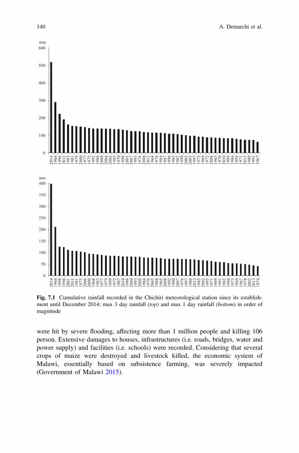
were hit by severe flooding, affecting more than 1 million people and killing 106person. Extensive damages to houses, infrastructures (i.e. roads, bridges, water andpower supply) and facilities (i.e. schools) were recorded. Considering that severalcrops of maize were destroyed and livestock killed, the economic system ofMalawi, essentially based on subsistence farming, was severely impacted(Government of Malawi 2015).
0
100
200
300
400
500
60020
1419
6619
9620
1119
8319
8119
7920
0019
7719
7519
9219
8820
0920
0420
0219
9519
7019
9820
0120
0719
9319
7420
0620
1219
6819
7619
8419
8719
9019
8519
8219
9920
0520
0319
9719
7319
6919
7220
0819
6519
7820
1019
8919
8619
9419
7120
1319
8019
9119
67
mm
0
50
100
150
200
250
300
350
400
2014
1966
1998
1996
2001
2011
1981
1975
2006
2000
1968
1983
1977
1979
1999
1972
1987
2010
1986
2004
1993
2009
1984
1970
2005
1988
1965
2008
1992
1990
2007
1976
1997
1980
2012
1985
2002
1995
1971
1989
1991
1982
1994
1973
1969
1967
1978
2003
2013
1974
mm
Fig. 7.1 Cumulative rainfall recorded in the Chichiri meteorological station since its establish-ment until December 2014; max 3 day rainfall (top) and max 1 day rainfall (bottom) in order ofmagnitude
140 A. Demarchi et al.
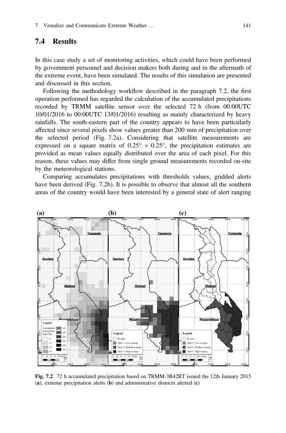
7.4 Results
In this case study a set of monitoring activities, which could have been performedby government personnel and decision makers both during and in the aftermath ofthe extreme event, have been simulated. The results of this simulation are presentedand discussed in this section.
Following the methodology workflow described in the paragraph 7.2, the firstoperation performed has regarded the calculation of the accumulated precipitationsrecorded by TRMM satellite sensor over the selected 72 h (from 00:00UTC10/01/2016 to 00:00UTC 13/01/2016) resulting as mainly characterized by heavyrainfalls. The south-eastern part of the country appears to have been particularlyaffected since several pixels show values greater than 200 mm of precipitation overthe selected period (Fig. 7.2a). Considering that satellite measurements areexpressed on a square matrix of 0.25° 0.25°, the precipitation estimates areprovided as mean values equally distributed over the area of each pixel. For thisreason, these values may differ from single ground measurements recorded on-siteby the meteorological stations.
Comparing accumulates precipitations with thresholds values‚ gridded alertshave been derived (Fig. 7.2b). It is possible to observe that almost all the southernareas of the country would have been interested by a general state of alert ranging
Fig. 7.2 72 h accumulated precipitation based on TRMM-3B42RT issued the 12th January 2015(a), extreme precipitation alerts (b) and administrative districts alerted (c)
7 Visualize and Communicate Extreme Weather … 141
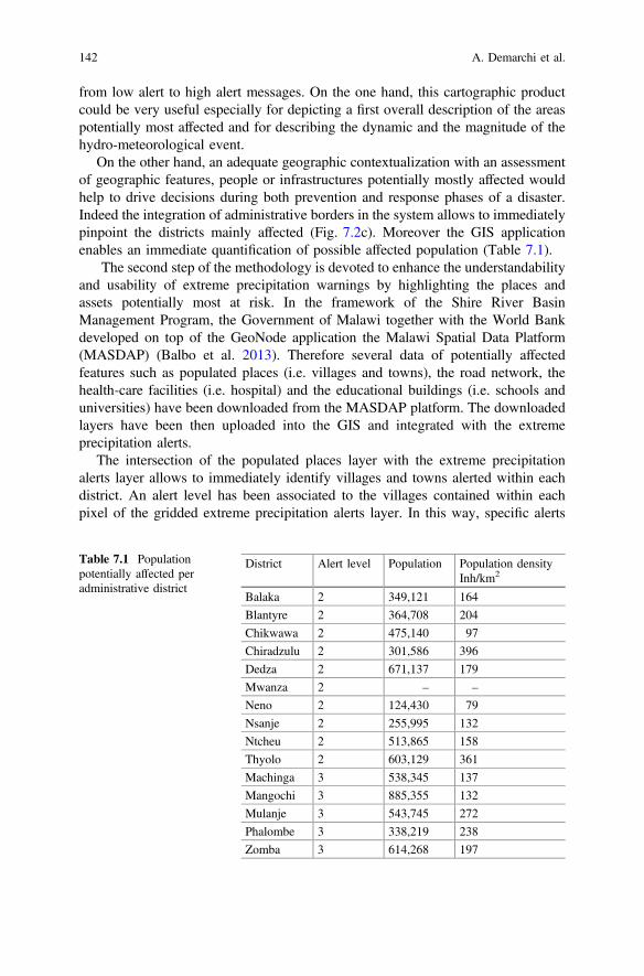
from low alert to high alert messages. On the one hand, this cartographic productcould be very useful especially for depicting a first overall description of the areaspotentially most affected and for describing the dynamic and the magnitude of thehydro-meteorological event.
On the other hand, an adequate geographic contextualization with an assessmentof geographic features, people or infrastructures potentially mostly affected wouldhelp to drive decisions during both prevention and response phases of a disaster.Indeed the integration of administrative borders in the system allows to immediatelypinpoint the districts mainly affected (Fig. 7.2c). Moreover the GIS applicationenables an immediate quantification of possible affected population (Table 7.1).
The second step of the methodology is devoted to enhance the understandabilityand usability of extreme precipitation warnings by highlighting the places andassets potentially most at risk. In the framework of the Shire River BasinManagement Program, the Government of Malawi together with the World Bankdeveloped on top of the GeoNode application the Malawi Spatial Data Platform(MASDAP) (Balbo et al. 2013). Therefore several data of potentially affectedfeatures such as populated places (i.e. villages and towns), the road network, thehealth-care facilities (i.e. hospital) and the educational buildings (i.e. schools anduniversities) have been downloaded from the MASDAP platform. The downloadedlayers have been then uploaded into the GIS and integrated with the extremeprecipitation alerts.
The intersection of the populated places layer with the extreme precipitationalerts layer allows to immediately identify villages and towns alerted within eachdistrict. An alert level has been associated to the villages contained within eachpixel of the gridded extreme precipitation alerts layer. In this way, specific alerts
Table 7.1 Populationpotentially affected peradministrative district
District Alert level Population Population densityInh/km2
Balaka 2 349,121 164
Blantyre 2 364,708 204
Chikwawa 2 475,140 97
Chiradzulu 2 301,586 396
Dedza 2 671,137 179
Mwanza 2 – –
Neno 2 124,430 79
Nsanje 2 255,995 132
Ntcheu 2 513,865 158
Thyolo 2 603,129 361
Machinga 3 538,345 137
Mangochi 3 885,355 132
Mulanje 3 543,745 272
Phalombe 3 338,219 238
Zomba 3 614,268 197
142 A. Demarchi et al.
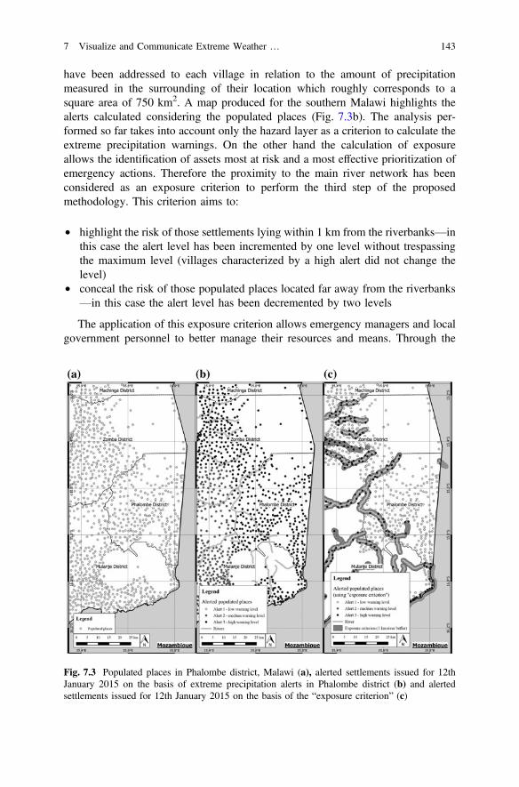
have been addressed to each village in relation to the amount of precipitationmeasured in the surrounding of their location which roughly corresponds to asquare area of 750 km2. A map produced for the southern Malawi highlights thealerts calculated considering the populated places (Fig. 7.3b). The analysis per-formed so far takes into account only the hazard layer as a criterion to calculate theextreme precipitation warnings. On the other hand the calculation of exposureallows the identification of assets most at risk and a most effective prioritization ofemergency actions. Therefore the proximity to the main river network has beenconsidered as an exposure criterion to perform the third step of the proposedmethodology. This criterion aims to:
• highlight the risk of those settlements lying within 1 km from the riverbanks—inthis case the alert level has been incremented by one level without trespassingthe maximum level (villages characterized by a high alert did not change thelevel)
• conceal the risk of those populated places located far away from the riverbanks—in this case the alert level has been decremented by two levels
The application of this exposure criterion allows emergency managers and localgovernment personnel to better manage their resources and means. Through the
Fig. 7.3 Populated places in Phalombe district, Malawi (a), alerted settlements issued for 12thJanuary 2015 on the basis of extreme precipitation alerts in Phalombe district (b) and alertedsettlements issued for 12th January 2015 on the basis of the “exposure criterion” (c)
7 Visualize and Communicate Extreme Weather … 143
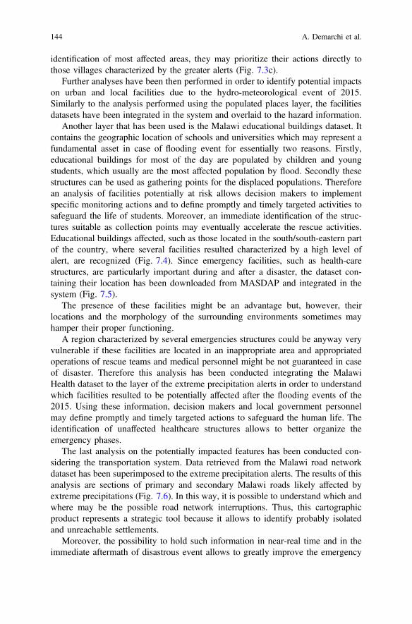
identification of most affected areas, they may prioritize their actions directly tothose villages characterized by the greater alerts (Fig. 7.3c).
Further analyses have been then performed in order to identify potential impactson urban and local facilities due to the hydro-meteorological event of 2015.Similarly to the analysis performed using the populated places layer, the facilitiesdatasets have been integrated in the system and overlaid to the hazard information.
Another layer that has been used is the Malawi educational buildings dataset. Itcontains the geographic location of schools and universities which may represent afundamental asset in case of flooding event for essentially two reasons. Firstly,educational buildings for most of the day are populated by children and youngstudents, which usually are the most affected population by flood. Secondly thesestructures can be used as gathering points for the displaced populations. Thereforean analysis of facilities potentially at risk allows decision makers to implementspecific monitoring actions and to define promptly and timely targeted activities tosafeguard the life of students. Moreover, an immediate identification of the struc-tures suitable as collection points may eventually accelerate the rescue activities.Educational buildings affected, such as those located in the south/south-eastern partof the country, where several facilities resulted characterized by a high level ofalert, are recognized (Fig. 7.4). Since emergency facilities, such as health-carestructures, are particularly important during and after a disaster, the dataset con-taining their location has been downloaded from MASDAP and integrated in thesystem (Fig. 7.5).
The presence of these facilities might be an advantage but, however, theirlocations and the morphology of the surrounding environments sometimes mayhamper their proper functioning.
A region characterized by several emergencies structures could be anyway veryvulnerable if these facilities are located in an inappropriate area and appropriatedoperations of rescue teams and medical personnel might be not guaranteed in caseof disaster. Therefore this analysis has been conducted integrating the MalawiHealth dataset to the layer of the extreme precipitation alerts in order to understandwhich facilities resulted to be potentially affected after the flooding events of the2015. Using these information, decision makers and local government personnelmay define promptly and timely targeted actions to safeguard the human life. Theidentification of unaffected healthcare structures allows to better organize theemergency phases.
The last analysis on the potentially impacted features has been conducted con-sidering the transportation system. Data retrieved from the Malawi road networkdataset has been superimposed to the extreme precipitation alerts. The results of thisanalysis are sections of primary and secondary Malawi roads likely affected byextreme precipitations (Fig. 7.6). In this way, it is possible to understand which andwhere may be the possible road network interruptions. Thus, this cartographicproduct represents a strategic tool because it allows to identify probably isolatedand unreachable settlements.
Moreover, the possibility to hold such information in near-real time and in theimmediate aftermath of disastrous event allows to greatly improve the emergency
144 A. Demarchi et al.
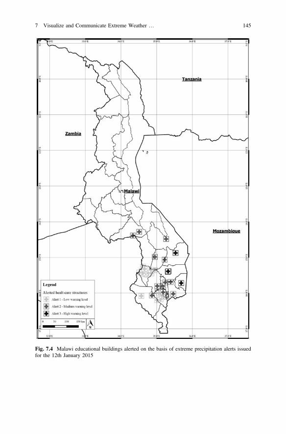
Fig. 7.4 Malawi educational buildings alerted on the basis of extreme precipitation alerts issuedfor the 12th January 2015
7 Visualize and Communicate Extreme Weather … 145

Fig. 7.5 Malawi health-care facilities alerted on the basis of extreme precipitation alerts issued for12th January 2015
146 A. Demarchi et al.
phases in terms of results and response time. Indeed, the possibility to plan inadvance the routes to be used by rescue teams or to locate and pinpoint back-upnetwork systems certainly allows to save great amount of resources, both in termsof time and money.
7.5 Conclusions
The methodology developed in this work is aimed at enhancing the adaptation andresilience to hydro-meteorological risks of local and urban communities. For thispurpose, this paper presents a multidisciplinary approach to produce immediatelyunderstandable and easy to use information about the potential impacts generatedby extreme rainfall events.
The methodology relies on the development of a tailored GIS that allows theintegration, management and visualization of different types of information com-monly used to perform the risk assessment (i.e. satellite derived precipitationestimates and geospatial datasets concerning the geographic features of the contextanalysed).
Simple hazard representations (i.e. near-real time accumulated precipitations) arevery useful tools for a first delineation of the event in term of magnitude and spatial
Fig. 7.6 Extreme precipitation alerts issued for the 12th January 2015 and the Malawi roadnetwork (on the left) and alerted section of the Malawi road network in relation to the amount ofprecipitation measured (on the right)
7 Visualize and Communicate Extreme Weather … 147
evolution. However, an accurate assessment of population, infrastructure andfacilities at risk is necessary to enhance the response of local communities facingextreme hydro-meteorological risks. The possibility to easily identify the places andthe assets potentially most at risk is thus a paramount functionality. Therefore,information concerning the geographic context (such as the populated places, theroad network, the health-care facilities and the educational buildings) have beenintegrated along with extreme precipitation alerts to produce a final risk informationimmediately understandable by technical and non-technical people.
The methodology developed has been validated for the case study of the Malawi2015 Flood event. Results clearly demonstrate that the methodology represents avaluable spatial decision support system tool for local decision makers during theemergency management and the DRR. Indeed, the created GIS has allowed firstlyto geographically contextualize and to quantify the magnitude of extreme weatherevents. Secondly, it has enabled to translate results of weather predictions andscientific analysis into meaningful information for decision makers. Thirdly, it hasallowed to identify and monitor possible impacts on communities. Fourthly, thedeveloped tool has permitted to quickly produce easy-to-understand cartographicproducts able to address the evolution of hydro-meteorological events and therelated potential impacts for the urban and local communities. Therefore, on thebasis of the information provided by this methodology, decision makers and localgovernment personnel may evaluate promptly and timely targeted actions, imple-menting all necessary measures to safeguard the life and property in areas at risk.
Moreover, the flexibility of the GIS environment enables the development of arepeatable and standardisable procedure that may be adapted to support a variety ofactors involved in resilience and adaptation projects also in other geographic areas.
It should be noticed that this methodology relies on the use of open-source data inan open-source environment. Open-source geospatial information technologies allowto effectively reduce costs, both in term of time and economic resources, required forcarrying out in situ spatial surveys. However, the accuracy of the alerts issued by thistool is strictly related on the resolution of the satellite imageries used. Usingopen-source data characterized by medium-low resolutions, this tool is suitable onlyfor analyses at national and regional scale. Therefore, further developments of theresearch should consider the implementation of analyses at a higher resolution to coverlocal scale events. Moreover, including topographic information (i.e. DTM-DigitalTerrain Model and DEM-Digital Elevation Model) and layers of historical floods, cansignificantly improve the reliability and accuracy of the methodology.
References
Altan, O., R. Backhaus, P. Boccardo, F. Giulio Tonolo, J. Trinder, N. Van Manen, and S.Zlatanova. 2013. The Value of Geoinformation for Disaster and Risk Management (VALID):Benefit Analysis and Stakeholder Assessment. Joint Board of Geospatial Information Societies(JBGIS): Copenhagen.
148 A. Demarchi et al.
Balbo, S., P. Boccardo, S. Dalmasso, and P. Pasquali. 2013. A public platform for geospatial datasharing for disaster risk management. In International Society for Photogrammetry and RemoteSensing (ISPRS) Archives, ed. F. Pirotti, A. Guarnieri, and A. Vettore: 189–195, Padua, Italy.XL-5/W3, W (The role of geomatics in hydrogeological risk, 27–28 February 2013.
Bonetto, S., A. Facello, E.I. Cristofori, W. Camaro, and A. Demarchi. 2016. An approach to useearth observation data as support to water management issues in the Ethiopian rift. In:Symposium on climate change adaptation in Africa 2016—Addis Ababa Ethiopia. 2016.
Cardona, O.D., M.K. van Aalst, J. Birkmann, M. Fordham, G. McGregor, R. Perez, R.S. Pulwarty,E.L.F. Schipper, and B.T. Sinh. 2012. Determinants of risk: exposure and vulnerability. InManaging the risks of extreme events and disasters to advance climate change adaptation.A special report of working groups I and II of the Intergovernmental Panel on Climate Change(IPCC), ed. C.B. Field, V. Barros, T.F. Stocker, D. Qin, D.J. Dokken, K.L. Ebi, M.D. Mastrandrea, K.J. Mach, G.K. Plattner, S.K. Allen, M. Tignor, and P.M. Midgley, 65–108.Cambridge, UK, and New York, USA: Cambridge University Press.
Cay, T., F. Iscan, and S.S. Durduran. 2004. The cost analysis of satellite images for using in GISby the pert. In XX ISPRS Congress, Com. IV, 12–23 July 2004, XXXV(B4). 2004, Istanbul,pp. 358–363.
CRED—Centre for Research on the Epidemiology of Disasters and UNISDR-United NationsOffice for Disaster Risk Reduction. 2016. The Human Cost of Weather-related Disasters 1995–2015. http://www.emdat.be/publications.
Chigbu, N. and D. Onukaogu. 2013. Role of geospatial technology in environmental sustainabilityin Nigeria-An overview. In FIG working week 2013 environment for sustainability. Abuja,Nigeria, 6–10 May, 2013.
Cristofori, E.I., A. Albanese, and P. Boccardo. 2016a. Early warning systems & geomatics:Value-added information in the absence of high resolution data. In Planning to cope withtropical and subtropical climate change. ed. M. Tiepolo, E. Ponte, E. Cristofori, 141–153.doi:0.1515/9783110480795-009.
Cristofori, E.I., S. Balbo, W. Camaro, P. Pasquali, P. Boccardo, and A. Demarchi. 2015. Flood riskweb-mapping for decision makers: A service proposal based on satellite-derived precipitationanalysis and geonode. In IEEE International Geoscience and Remote Sensing Symposium,IGARSS 2015 (2015): 1389–1392.
Cristofori, E.I., A. Facello, A. Demarchi, W. Camaro, M. Fascendini, and A. Villanucci. 2016b.A geographic information system as support to the healthcare services of nomadic community,the Filtu Woreda case study. In: Symposium on climate change adaptation in Africa 2016—Addis Ababa Ethiopia. 2016.
Donoghue, D.N.M. 2002. Remote sensing: Environmental change. Physical Geography 26 (1):144–151.
Duncan, M., K. Crowley, R. Cornforth, S. Edwards, R. Ewbank, P. Karbassi, C. McLaren, J.L.Penya, A. Obrecht, S. Sargeant, and E. Visman. 2014. Integrating science into humanitarianand development planning and practice to enhance community resilience. Full guidelines.
Ehrlich, D., and P. Tenerelli. 2012. Optical satellite imagery for quantifying spatio-temporaldimension of physical exposure in disaster risk assessments. Natural Hazards 68 (3):1271–1289. doi:10.1007/s11069-012-0372-5.
Eiser, J.R. and White et al. 2012. Risk interpretation and action: a conceptual framework forresponses to natural hazards. International Journal of Disaster Risk Reduction 1: 5–16.doi:10.1016/j.ijdrr.2012.05.002.
Ferrandino, J. 2014. Incorporating GIS as an interdisciplinary pedagogical tool throughout anMPA program. Journal of Public Affairs Education 20 (4): 529–544.
Government of Malawi. 2015. Malawi 2015 floods post disaster needs assessment report Malawi2015 floods.
Huffman, G.J., R.F. Adler, D.T. Bolvin, G. Gu, E.J. Nelkin, K.P. Bowman, Y. Hong, E.F. Stocker,and D.B. Wolff. 2007. The TRMM multisatellite precipitation analysis (TMPA): Quasi-global,multiyear, combined-sensor precipitation estimates at fine scales. Journal of Hydrometeorology8 (1): 38–55.
7 Visualize and Communicate Extreme Weather … 149
Huffman, G.J., R.F. Adler, D.T. Bolvin, and E.J. Nelkin. 2010. The TRMM multi-satelliteprecipitation analysis (TMPA). In Satellite rainfall applications for surface hydrology, ed.F. Hossain, and M. Gebremichael, 3–22. Springer.
IPCC-Intergovernmental Panel on Climate Change. 2014. Contribution of Working Group II to theFifth Assessment Report on Climate Change 2013: The Physical Science Basis. Cambridge:United Kingdom.
IPCC. 2012. Managing the risks of extreme events and disasters to advance climate changeadaptation. A special report of working groups I and II of the Intergovernmental Panel onClimate Change. Cambridge, United Kingdom.
Melesse, A.M., Q. Weng, P.S. Thenkabail, and G.B. Senay. 2007. Remote sensing sensors andapplications in environmental resources mapping and modelling. Sensors 7 (12): 3209–3241.doi:10.3390/s7123209.
Miyazaki, H., M. Nagai, and R. Shibasaki. 2015. Reviews of geospatial information technologyand collaborative data delivery for disaster risk management. ISPRS International Journal ofGeo-Information 4 (4): 1936–1964.
Pandey, J., and D. Pathak. 2014. Geographic Information System. New Delhi: The Energy andResources Institute, TERI.
Sundaresan, J., K.M. Santosh, A. Déri, R. Roggema, and R. Singh. 2014. Geospatial Technologiesand Climate Change. Springer International Publishing.
Teegavarapu, R.S.V. 2012. Floods in a changing climate. Extreme precipitation. New York:Cambridge University Press.
Tiepolo, M., and E.I. Cristofori. 2016a. Climate change characterisation and planning in largetropical and subtropical cities. In Planning to cope with tropical and subtropical climatechange, ed. M. Tiepolo, E. Ponte, and E. Cristofori, 6–41. Berlin: De Gruyter Open.
Tiepolo, M., and E. Cristofori. 2016b. Planning the adaptation to climate change in cities: anintroduction. In Planning to Cope with Tropical and Subtropical Climate Change, ed.M. Tiepolo, E. Ponte, and E. Cristofori, 1–5. Berlin: De Gruyter Open.
Tomaszewski, B. 2014. Geographic Information Systems (GIS) for Disaster Management. BocaRaton: CRC Press.
UNISDR. 2015. Making development sustainable: the future of disaster risk management. Globalassessment report on disaster risk reduction. Geneva, Switzerland: United Nations Office forDisaster Risk Reduction.
UNDESA-United Nations Department of Economic and Social Affairs, Population Division. 2011.World Population Prospects: The 2010 Revision, Highlights and Advance Tables.
Open Access This chapter is licensed under the terms of the Creative Commons Attribution 4.0International License (http://creativecommons.org/licenses/by/4.0/), which permits use, sharing,adaptation, distribution and reproduction in any medium or format, as long as you give appropriatecredit to the original author(s) and the source, provide a link to the Creative Commons license andindicate if changes were made.The images or other third party material in this chapter are included in the chapter's Creative
Commons license, unless indicated otherwise in a credit line to the material. If material is notincluded in the chapter's Creative Commons license and your intended use is not permitted bystatutory regulation or exceeds the permitted use, you will need to obtain permission directly fromthe copyright holder.
150 A. Demarchi et al.
Chapter 8Building Resilience to Drought in the Sahelby Early Risk Identification and Advices
Patrizio Vignaroli
Abstract Agriculture in the Sahel region is characterized by traditional techniquesand is strongly dependent on climatic conditions and rainfall. As a consequence ofrecurrent droughts in East and West Africa, integrated famine Early WarningSystems (EWS) have been established in order to produce and disseminate coherentand integrated information for prevention and management of food crises. Since theearly 1990s, analysis tools and simulation models based on satellite meteorologicaldata have been developed to support Multidisciplinary Working Groups (MWG) incropping season monitoring. However, many of these tools are now obsolete fromthe IT perspective or ineffective due to unavailability of regularly updated meteo-rological data. To ensure a long-term sustainability of operational systems fordrought risk zones identification CNR-IBIMET has developed 4Crop, a coherentOpen Source web-based Spatial Data Infrastructure to treat all input and output datain an interoperable, platform-independent and uniform way. The 4Crop system hasbeen conceived as a multipurpose tool in order to provide different categories ofstakeholder, from farmers to policy makers, with effective and useful informationfor climate risk reduction and drought resilience improvement. Advice to farmers isa fundamental component of prevention that can allow a better adaptation of tra-ditional cropping systems to climatic variability. Past experiences show thatagro-meteorological information and weather forecasts can play a key role for foodsecurity, reducing the vulnerability of farmers, strengthening rural productionsystems and increasing crop yields. A participatory and cross-disciplinary approachis essential to build farmers’ trust and to develop effective integration betweenscientific and local knowledge to increase the rate of dissemination and utilizationof advice.
Keywords Drought Early warning systems Risk management Adaptation
P. Vignaroli (&)National Research Council—Institute of Biometeorology (IBIMET),Via Giovanni Caproni 8, 50154 Florence, Italye-mail: [email protected]
© The Author(s) 2017M. Tiepolo et al. (eds.), Renewing Local Planning to Face ClimateChange in the Tropics, Green Energy and Technology,DOI 10.1007/978-3-319-59096-7_8
151
8.1 Introduction
Agriculture in the Sahel region is characterized by traditional techniques and isstrongly dependent on climatic conditions and rainfall. Moreover, the vulnerabilityof rainfed crop production systems to drought is worsened by soil degradation, lowresilience levels due to poverty and inability to implement effective risk mitigationstrategies (FAO 2011).
Food security of the rural population largely depends on environmental condi-tions and on spatial and temporal climate variability (Jouve 1991). In general, lowrainfall during the growing season can lead to lower crop yields and, sometimes, tofood crises (Sultan et al. 2005).
Crop yields may suffer significantly with either a late onset or early end of therainy season, as well as a high frequency of damaging dry spells (Mugalavai et al.2008). Early rains at the beginning of the season are often followed by dry spellsthat can last a week or longer. As the amount of water stored in the soil at this timeof year is negligible, crops planted early can suffer water shortage stresses during aprolonged dry spell (Marteau et al. 2011). The choice of sowing date is therefore ofparamount importance to farmers. Indeed, a successful early planting can producean earlier crop that may have a higher yield (Sivakumar 1988). Later plantingreduces the risk of early crop failures, but yields can decline because of the shortergrowing period remaining before the end of the rains (Jones 1976).
Concerning dry spells, there are two extremely critical periods when watershortage can cause wilting of the plants and yield reductions. The first occursimmediately after sowing when plants are germinating. A dry spell at this time canhalt germination and cause a sowing failure, requiring a second sowing withconsequent loss of seeds and growing days. The second critical period occursduring flowering when a water deficit can severely reduce crop yields (Benoit1977). The ability to effectively estimate the onset of the season and potentiallydangerous dry spells thus becomes vital for planning crop practices aiming tominimize risks and maximize yields. Increasing yearly variability due to climatechange has made farmers’ traditional knowledge on the planning of sowing andselection of crop type and variety rather ineffective (Waha et al. 2013).
This paper describes the activities of CNR-IBIMET to set up a web-based andopen access crop monitoring system for drought risk reduction and resilienceimprovement.
8.2 The Area of Interest
The geographical area coincides with the western part of the Sahel region. The areaextends between Senegal and Chad and is bounded to the north and south by theSaharan and Sudanese climatic zones (Fig. 8.1).
152 P. Vignaroli
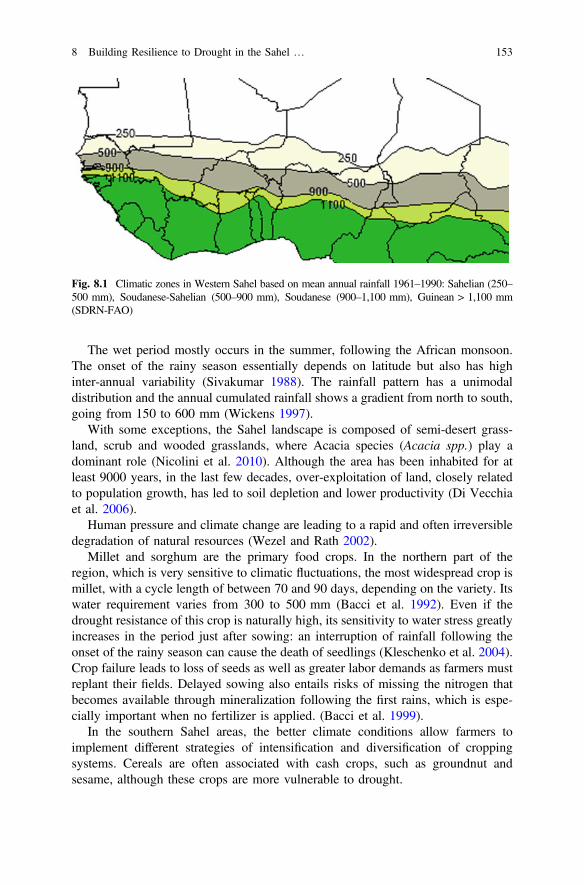
The wet period mostly occurs in the summer, following the African monsoon.The onset of the rainy season essentially depends on latitude but also has highinter-annual variability (Sivakumar 1988). The rainfall pattern has a unimodaldistribution and the annual cumulated rainfall shows a gradient from north to south,going from 150 to 600 mm (Wickens 1997).
With some exceptions, the Sahel landscape is composed of semi-desert grass-land, scrub and wooded grasslands, where Acacia species (Acacia spp.) play adominant role (Nicolini et al. 2010). Although the area has been inhabited for atleast 9000 years, in the last few decades, over-exploitation of land, closely relatedto population growth, has led to soil depletion and lower productivity (Di Vecchiaet al. 2006).
Human pressure and climate change are leading to a rapid and often irreversibledegradation of natural resources (Wezel and Rath 2002).
Millet and sorghum are the primary food crops. In the northern part of theregion, which is very sensitive to climatic fluctuations, the most widespread crop ismillet, with a cycle length of between 70 and 90 days, depending on the variety. Itswater requirement varies from 300 to 500 mm (Bacci et al. 1992). Even if thedrought resistance of this crop is naturally high, its sensitivity to water stress greatlyincreases in the period just after sowing: an interruption of rainfall following theonset of the rainy season can cause the death of seedlings (Kleschenko et al. 2004).Crop failure leads to loss of seeds as well as greater labor demands as farmers mustreplant their fields. Delayed sowing also entails risks of missing the nitrogen thatbecomes available through mineralization following the first rains, which is espe-cially important when no fertilizer is applied. (Bacci et al. 1999).
In the southern Sahel areas, the better climate conditions allow farmers toimplement different strategies of intensification and diversification of croppingsystems. Cereals are often associated with cash crops, such as groundnut andsesame, although these crops are more vulnerable to drought.
Fig. 8.1 Climatic zones in Western Sahel based on mean annual rainfall 1961–1990: Sahelian (250–500 mm), Soudanese-Sahelian (500–900 mm), Soudanese (900–1,100 mm), Guinean > 1,100 mm(SDRN-FAO)
8 Building Resilience to Drought in the Sahel … 153
8.3 Evolution of Early Warning Systems for FoodSecurity in the Sahel
In the late 1970s, as a consequence of recurrent droughts that occurred in East andWest Africa (Nicholson 2001), famine struck millions of people, creating a need fornational authorities and the international community to coordinate efforts to limitthe dramatic impact on the affected population. Since then, an integrated famineearly warning system (EWS) has been established in West Africa by the PermanentInter-State Committee for Drought Control in the Sahel (CILSS), which is still oneof the most effective and reliable mechanisms operating in sub-Saharan Africa inorder to prevent and manage food crises (Genesio et al. 2011).
The CILSS EWS is based on three complementary components:
• an information network operating at country level and involving nationaltechnical services and international organizations in order to produce and dis-seminate coherent and integrated information on population’s food securitystatus;
• a regional-national coordination, led by CILSS, to facilitate dialogue, consul-tation and coordination between partners;
• a relief body, to manage emergency activities at national level.
In the early 2000s, the EWS activities were still mainly focused on foodavailability by monitoring agricultural seasons and agro-climatic events. The maininformation product concerned the national cereal balance, often coupled with aqualitative assessment of food risk zones provided by agro-meteorological modelsor composite indicators (Tefft et al. 2006).
However, this approach has proven to be outdated and ineffective in identifyingcomplex multi-source crises such as that of Niger in 2005 (Cornia and Deotti 2008;Vallebona et al. 2008).
A conceptual model to integrate multi-disciplinary data and for the harmo-nization of information flow within the existing EWS has been provided by theFood Crises Forecasting Timetable (CPCA), developed by AGRHYMET regionalCentre of Niamey, Niger, in collaboration with the World MeteorologicalOrganization. The CPCA was designed to respond to decision makers’ need to bealerted at an appropriate time depending on the extent of the food crisis (local,national or regional), the coping capacity of the affected population and amount ofrequired food aid (Vignaroli et al. 2009).
This approach was then transferred and implemented in an operational way inthe Harmonized Framework (Cadre Harmonisé) for the analysis and identificationof areas at risk and vulnerable groups in the Sahel established by CILSS in col-laboration with national and international organizations involved in the Food CrisisPrevention Network in the Sahel (RPCA). The Cadre Harmonisé is a processaiming to achieve technical consensus and to enhance information generated byexisting information systems in order to evaluate food and nutrition insecurity on anobjective and consensual basis (CILSS 2014). Since 2013, Economic Community
154 P. Vignaroli
of West African States (ECOWAS) has selected the Cadre Harmonisé as the mainreference framework for food security analysis in 16 countries of West Africa andprovides tools for the classification, analysis and reporting of food insecurity, aswell as joint approaches for undertaking monitoring, assessments, data collection,and database management.
The Multidisciplinary Working Groups (MWGs) led by National MeteorologicalServices (NMSs) play a strategic role in the operation of national EWSs especiallyduring the rainy season. MWGs are in charge of providing timely and reliableinformation on rainfed crops status and agro-hydro-meteorological conditions insupport of decision-making processes, from farmers to national and internationalstakeholders.
8.4 An Open Source Geoprocessing Toolfor Drought Monitoring
Early warning systems operate on two levels: prevision and prevention. Prevision ismainly based on tools and models utilizing numeric forecasts and satellite data topredict and monitor the growing season. This approach is centered on the earlyidentification of risks and the production of information within the time prescribedfor decision-making (Vignaroli et al. 2009). Agrometeorological models have acentral role in this chain, as they can transform meteorological data into levels ofrisk for agriculture (Di Vecchia et al. 2002), identifying the geographical areasexposed to food insecurity risk due to cereal production shortage in relation to localdemand. Advice to farmers is thus a fundamental component of prevention,allowing a proactive response through a better adaptation of the traditional cropcalendar to climatic variability (Di Vecchia et al. 2006; Roudier et al. 2014).
Since the early 1990s, crop monitoring analysis tools and simulation modelsbased on meteorological satellite data have been developed within different inter-national cooperation programs to allow monitoring of the cropping season in CILSScountries (Samba 1998; Traore et al. 2011). Software was usually a stand-aloneapplication, transferred to NMSs but without continuous user support or updates.Furthermore, the scarcity of funds for hardware and software maintenance, besidesthe unavailability of regularly updated and timely meteorological data, led to thefailure or ineffectiveness of many of these tools.
In order to meet the needs of the CILSS meteorological services and to ensure along-term sustainability of operational systems for drought risk zones identificationCNR-IBIMET has developed 4Crop (Vignaroli et al. 2016), a coherent OpenSource web-based Spatial Data Infrastructure to treat all input and output data in aninteroperable, platform-independent and uniform way (Fig. 8.2). This activity issupported by the Global Facility for Disaster Reduction and Recovery (GFDRR)—The Challenge Fund.
8 Building Resilience to Drought in the Sahel … 155
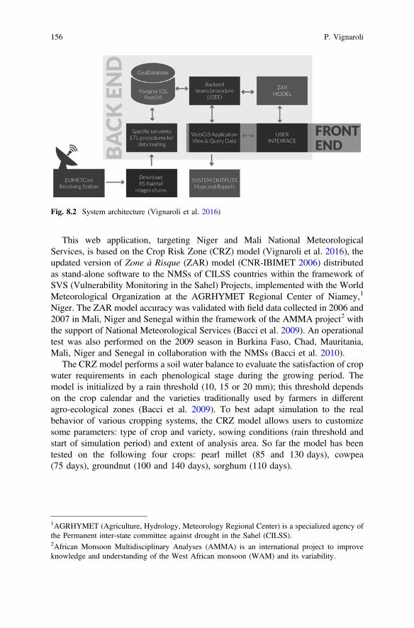
This web application, targeting Niger and Mali National MeteorologicalServices, is based on the Crop Risk Zone (CRZ) model (Vignaroli et al. 2016), theupdated version of Zone à Risque (ZAR) model (CNR-IBIMET 2006) distributedas stand-alone software to the NMSs of CILSS countries within the framework ofSVS (Vulnerability Monitoring in the Sahel) Projects, implemented with the WorldMeteorological Organization at the AGRHYMET Regional Center of Niamey,1
Niger. The ZAR model accuracy was validated with field data collected in 2006 and2007 in Mali, Niger and Senegal within the framework of the AMMA project2 withthe support of National Meteorological Services (Bacci et al. 2009). An operationaltest was also performed on the 2009 season in Burkina Faso, Chad, Mauritania,Mali, Niger and Senegal in collaboration with the NMSs (Bacci et al. 2010).
The CRZ model performs a soil water balance to evaluate the satisfaction of cropwater requirements in each phenological stage during the growing period. Themodel is initialized by a rain threshold (10, 15 or 20 mm); this threshold dependson the crop calendar and the varieties traditionally used by farmers in differentagro-ecological zones (Bacci et al. 2009). To best adapt simulation to the realbehavior of various cropping systems, the CRZ model allows users to customizesome parameters: type of crop and variety, sowing conditions (rain threshold andstart of simulation period) and extent of analysis area. So far the model has beentested on the following four crops: pearl millet (85 and 130 days), cowpea(75 days), groundnut (100 and 140 days), sorghum (110 days).
Fig. 8.2 System architecture (Vignaroli et al. 2016)
1AGRHYMET (Agriculture, Hydrology, Meteorology Regional Center) is a specialized agency ofthe Permanent inter-state committee against drought in the Sahel (CILSS).2African Monsoon Multidisciplinary Analyses (AMMA) is an international project to improveknowledge and understanding of the West African monsoon (WAM) and its variability.
156 P. Vignaroli
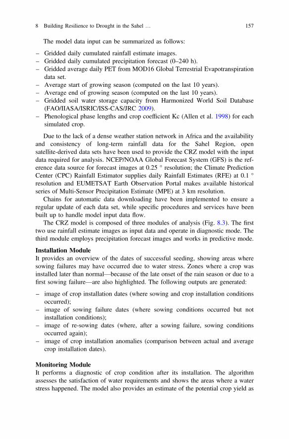
The model data input can be summarized as follows:
– Gridded daily cumulated rainfall estimate images.– Gridded daily cumulated precipitation forecast (0–240 h).– Gridded average daily PET from MOD16 Global Terrestrial Evapotranspiration
data set.– Average start of growing season (computed on the last 10 years).– Average end of growing season (computed on the last 10 years).– Gridded soil water storage capacity from Harmonized World Soil Database
(FAO/IIASA/ISRIC/ISS-CAS/JRC 2009).– Phenological phase lengths and crop coefficient Kc (Allen et al. 1998) for each
simulated crop.
Due to the lack of a dense weather station network in Africa and the availabilityand consistency of long-term rainfall data for the Sahel Region, opensatellite-derived data sets have been used to provide the CRZ model with the inputdata required for analysis. NCEP/NOAA Global Forecast System (GFS) is the ref-erence data source for forecast images at 0.25 ° resolution; the Climate PredictionCenter (CPC) Rainfall Estimator supplies daily Rainfall Estimates (RFE) at 0.1 °resolution and EUMETSAT Earth Observation Portal makes available historicalseries of Multi-Sensor Precipitation Estimate (MPE) at 3 km resolution.
Chains for automatic data downloading have been implemented to ensure aregular update of each data set, while specific procedures and services have beenbuilt up to handle model input data flow.
The CRZ model is composed of three modules of analysis (Fig. 8.3). The firsttwo use rainfall estimate images as input data and operate in diagnostic mode. Thethird module employs precipitation forecast images and works in predictive mode.
Installation ModuleIt provides an overview of the dates of successful seeding, showing areas wheresowing failures may have occurred due to water stress. Zones where a crop wasinstalled later than normal—because of the late onset of the rain season or due to afirst sowing failure—are also highlighted. The following outputs are generated:
– image of crop installation dates (where sowing and crop installation conditionsoccurred);
– image of sowing failure dates (where sowing conditions occurred but notinstallation conditions);
– image of re-sowing dates (where, after a sowing failure, sowing conditionsoccurred again);
– image of crop installation anomalies (comparison between actual and averagecrop installation dates).
Monitoring ModuleIt performs a diagnostic of crop condition after its installation. The algorithmassesses the satisfaction of water requirements and shows the areas where a waterstress happened. The model also provides an estimate of the potential crop yield as
8 Building Resilience to Drought in the Sahel … 157
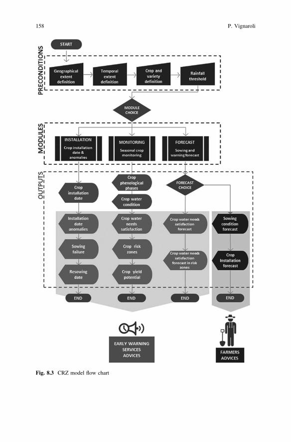
Fig. 8.3 CRZ model flow chart
158 P. Vignaroli
a consequence of the intensity of water stress and the phenological stage in which itoccurred. This module produces the following outputs:
– image of actual phenological phases image (where crop installation occurred);– crop water requirements satisfaction (water stress level in areas where crop
installation occurred);– available soil water (water actually available in the soil for areas where crop
installation occurred).
Forecast moduleIt is composed of two sub-routines. The first, Sowing Forecast, provides the fol-lowing outputs on the occurrence of favorable conditions for sowing and the sub-sequent crop installation:
– forecast date of sowing conditions (where forecasted rainfall satisfies sowingconditions);
– forecast date of crop installation (where the last ten-days estimated rainfallsatisfied sowing conditions and the forecasted rainfall allows crop installationconditions to be satisfied).
The second, called Warning Forecast, performs a prognosis on the possibleoccurrence of a water stress situation for crops already sown. This module producesthe following outputs:
– forecast of crop water requirements satisfaction (in areas where crop installationoccurred, forecasted satisfaction level of crop water requirements is shown);
– forecast of crop water requirements satisfaction in risk zones (in areas wherecrop stress conditions have already been identified, crop water requirements areforecasted).
Graphic Users’ Interfaces (GUI) and specific WEB GIS applications have beenimplemented to allow users initializing of analysis modules and to perform modeloutputs management and visualization.
8.5 Results and Discussion
The challenge of the 4Crop web application is to provide open access to CRZmodel output and results. The goal is to support CILSS early warning system andany other local users in decision-making to foster climatic risk management andresilience to drought. In order to avoid a language barrier that could prevent a wideruse of the web application, 4Crop is available in French, the official language of thetarget countries3 (Fig. 8.4).
3In the first phase of GFDRR project, activities have been focused on Mali and Niger. The secondphase will concern Burkina Faso, Mauritania and Senegal.
8 Building Resilience to Drought in the Sahel … 159
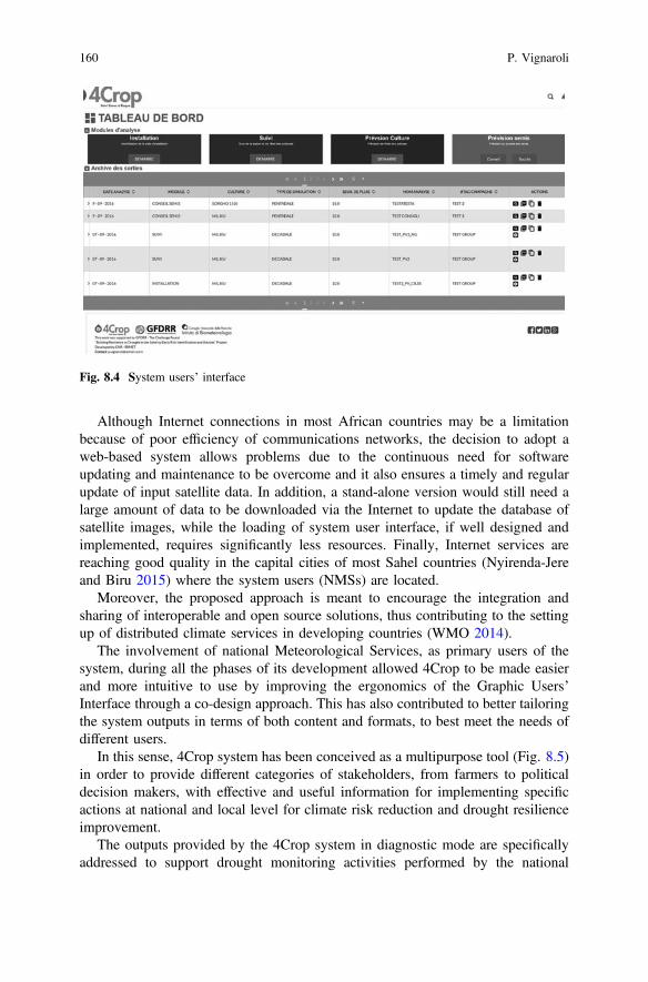
Although Internet connections in most African countries may be a limitationbecause of poor efficiency of communications networks, the decision to adopt aweb-based system allows problems due to the continuous need for softwareupdating and maintenance to be overcome and it also ensures a timely and regularupdate of input satellite data. In addition, a stand-alone version would still need alarge amount of data to be downloaded via the Internet to update the database ofsatellite images, while the loading of system user interface, if well designed andimplemented, requires significantly less resources. Finally, Internet services arereaching good quality in the capital cities of most Sahel countries (Nyirenda-Jereand Biru 2015) where the system users (NMSs) are located.
Moreover, the proposed approach is meant to encourage the integration andsharing of interoperable and open source solutions, thus contributing to the settingup of distributed climate services in developing countries (WMO 2014).
The involvement of national Meteorological Services, as primary users of thesystem, during all the phases of its development allowed 4Crop to be made easierand more intuitive to use by improving the ergonomics of the Graphic Users’Interface through a co-design approach. This has also contributed to better tailoringthe system outputs in terms of both content and formats, to best meet the needs ofdifferent users.
In this sense, 4Crop system has been conceived as a multipurpose tool (Fig. 8.5)in order to provide different categories of stakeholders, from farmers to politicaldecision makers, with effective and useful information for implementing specificactions at national and local level for climate risk reduction and drought resilienceimprovement.
The outputs provided by the 4Crop system in diagnostic mode are specificallyaddressed to support drought monitoring activities performed by the national
Fig. 8.4 System users’ interface
160 P. Vignaroli
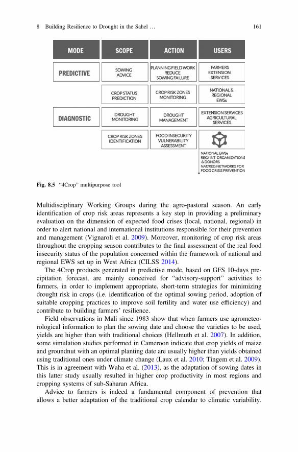
Multidisciplinary Working Groups during the agro-pastoral season. An earlyidentification of crop risk areas represents a key step in providing a preliminaryevaluation on the dimension of expected food crises (local, national, regional) inorder to alert national and international institutions responsible for their preventionand management (Vignaroli et al. 2009). Moreover, monitoring of crop risk areasthroughout the cropping season contributes to the final assessment of the real foodinsecurity status of the population concerned within the framework of national andregional EWS set up in West Africa (CILSS 2014).
The 4Crop products generated in predictive mode, based on GFS 10-days pre-cipitation forecast, are mainly conceived for “advisory-support” activities tofarmers, in order to implement appropriate, short-term strategies for minimizingdrought risk in crops (i.e. identification of the optimal sowing period, adoption ofsuitable cropping practices to improve soil fertility and water use efficiency) andcontribute to building farmers’ resilience.
Field observations in Mali since 1983 show that when farmers use agrometeo-rological information to plan the sowing date and choose the varieties to be used,yields are higher than with traditional choices (Hellmuth et al. 2007). In addition,some simulation studies performed in Cameroon indicate that crop yields of maizeand groundnut with an optimal planting date are usually higher than yields obtainedusing traditional ones under climate change (Laux et al. 2010; Tingem et al. 2009).This is in agreement with Waha et al. (2013), as the adaptation of sowing dates inthis latter study usually resulted in higher crop productivity in most regions andcropping systems of sub-Saharan Africa.
Advice to farmers is indeed a fundamental component of prevention thatallows a better adaptation of the traditional crop calendar to climatic variability.
Fig. 8.5 “4Crop” multipurpose tool
8 Building Resilience to Drought in the Sahel … 161
Past experiences show that agro-meteorological information can play a key rolefor food security, reducing the vulnerability of farmers, strengthening rural pro-duction systems and increasing crop yields (Kleschenko et al. 2004,; Pérarnaudet al. 2004). For example, from 1983 to 2004, the«Projet Pilote d’AssistanceAgro-météorologique aux Paysans» (AAMP 2005) in Mali proved an increase ofabout 30% in cereal production. In Senegal, starting from 1992 to 1994, the«Projetd’Assistance Météorologique à l’Agriculture au Sénégal»(AMAS) estimated a 20%increase in cereal yields by using agrometeorological advice. The METAGRIprogram, promoted by the World Meteorological Organization and operatingsince 2008 in several West African and Sub-Saharan countries currently representsa reference framework for the development and implementation ofagro-meteorological services for farmers. In 2016, a new stage of METAGRI isbeing launched, named METAGRI SERVICES, with the aim of reinforcing andextending the operational model of agrometeorological assistance to rural areas,which includes the development of decision-making support systems based onreliable remote sensing products and tested crop models (WMO 2016). This newapproach is supported by the availability of seasonal and 10-day rainfall forecasts(Njau 2010) and the possibility for farmers to access IC technologies (mobilephones) in order to disseminate information in rural areas (Aker and Fafchamps2015).
Empirical studies among African farmers have shown that climate forecasts canhelp reduce their vulnerability to drought and climate extremes, while also allowingthem to maximize opportunities when favorable rainfall conditions are predicted(Roudier et al. 2014; Martinez et al. 2012). However, it should be underlined thatweather forecasts in situations of climate uncertainty generally don’t modify thefarmer’s decision, but reinforces what has already been decided based on his/herown experience and observations (Roncoli et al. 2009). In fact, farmers combineinformation from different sources and multiple timeframes (Orlove et al. 2010). Sothey have some expectation about the coming season based on prior experience,empirical observations, and local knowledge, and then adjust their strategies whenshorter-term forecasts and real-time information become available (Orlove et al.2010).
In this regard, the analysis of the behavior of different groups of smallholderfarmers in two agro-ecological areas of Senegal provides examples of how farmerscould use predictive climate information at different timescales, as seasonal and10-day rainfall forecasts. (Roudier et al. 2014). In most cases, farmers identify atleast one strategy they could use in response to forecasts. Most adaptation strategiespertain to 10-day rather than seasonal forecasts, though the latter are used especiallywhere farmers have a wider range of options in planning preparatory activities, aswell as the choice of crops and/or varieties to sow, the amount of mineral or organicfertilizer to distribute before sowing, extent of the crop surfaces.
Adjusting sowing date is the most common change in traditional practicesadopted by farmers in response to 10-day rainfall forecasts; farmers decide to sowearlier or later than originally planned depending both on the configurationof rainfall in the forecasted 10 days (wet or dry) and in the preceding 10 days.
162 P. Vignaroli
This information is particularly important at this time, which is marked by highuncertainty and anxiety for farmers (Roudier et al. 2014). On the same bases,farmers could also decide to intensify weeding practices—to control weed prolif-eration and facilitate infiltration to limit runoff and soil erosion—as well as toanticipate harvest to prevent germination of grains or avoid damage by pests anddiseases that thrive in humid conditions (Roudier et al. 2014).
Overall, although farmers put their trust in local knowledge, they are open toreceiving and integrating scientific knowledge in their decisional process. Thisencourages extending the use of rainfall forecasts in producing and disseminatingadvice as a fundamental part of climate services to farmers in order to foster aproactive reaction to climate change and to cope with drought. In this sense, theadoption of a participatory, cross-disciplinary approach is essential to build farmers’trust and develop a fruitful collaboration between scientific and traditionalknowledge. Indeed, this interaction has been recognized as fundamental for theadoption of innovation in climate change adaptation because the enhancement oflocal knowledge facilitates effective communication and increases the rate of dis-semination and use of advice (Nyong et al. 2007).
8.6 Conclusions
4Crop is a multipurpose system implemented in collaboration with the NationalMeteorological Services of Niger and Mali to monitor the cropping season andprovide an early identification of crop risk zones in order to establish effectiveresponses for drought risk management at different levels. Within the perspective ofthe setting-up of distributed climate services, the overall 4Crop approach couldrepresent an enabling factor to allow a switch from generic information to advicetailored to specific user needs. Indeed, 4Crop outputs have been designed as ele-ments of information chains targeted on two main user categories under the prin-ciple of information-action.
The first group are decision makers at national/regional level who use infor-mation to implement actions and policies to prevent and manage food crises andstrengthen food security of the population. In this case, the critical elements arerepresented by the sustainability of early warning systems and the ability to gen-erate timely and appropriate information for decision makers. Strengthening of thecapacity of national institutions—particularly weather services—as well as thesetting up of distributed climate services that allow stakeholders at different levelsto access and share information products through web services protocols andstandards, can thus represent elements that facilitate decision-making and improveits effectiveness.
The second group of users are decision makers at local level, essentially farmers,who have to decide which crops and how to grow them. This requires not onlyfinding a suitable solution for translating information products into services thatare simple but effective for farmers, but also establishing a framework for
8 Building Resilience to Drought in the Sahel … 163
communication and collaboration between scientific institutions, national technicalservices and rural communities for an effective dissemination and adoption of theadvice.
To be effective and sustainable, climate services for farmers must be integratedinto a concerted and participatory strategy (including content and format of advice,communication channel, partnership with other local stakeholders and training),which enables final users to adopt scientific innovation in ways that are sociallyacceptable and environmentally sound.
In terms of beneficiaries, the approach will also pay special attention to gender:in many cases, women are the backbone of the farming community, however theyare at a disadvantage in their access to climate and weather information as well asaccess to training programs.
References
AAMP. 2005. Assistance Météorologique Opérationnelle au Monde Rural au Mali.Développement—Acquis—Perspectives. Coopération Suisse.
Aker, J.C., and M. Fafchamps. 2015. Mobile phone coverage and producer markets: evidence fromWest Africa. The World Bank Economic Review 29 (2): 262–292. Doi:doi.org/10.1093/wber/lhu006.
Allen, R.G., L.S. Pereira, D. Raes, and M. Smith. 1998. Crop evapotranspiration—Guidelines forcomputing crop water requirements—FAO irrigation and drainage paper 56. Rome: FAO.
Bacci, L., G. Maracchi, and B. Senni. 1992. Les stratégies agrométéorologiques pour les paysSahéliens. Florence: IATA-CeSIA.
Bacci, L., C. Cantini, F. Pierini, G. Maracchi, and F.N. Reyniers. 1999. Effects of sowing date andnitrogen fertilization on growth, development and yield of a short day cultivar of millet(Pennisetum glaucum L.) in Mali. European Journal of Agronomy 10 (1): 9–21. doi:10.1016/S1161-0301(98)00046-X.
Bacci, M., V. Tarchiani, P. Vignaroli, L. Genesio, and A. Di Vecchia. 2009a. Identification et suivides zones à risque agro-météorologique au Sahel. Rome: Aracne Editrice.
Bacci, M., A. Di Vecchia, L. Genesio, I. Hassan, M. Ndiaye, V. Tarchiani, and P. Vignaroli. 2009.D 5.2.e: AMMA information products tested within the CPCA for EW at national and farmer’sscale. African Monsoon Multidisciplinary Analysis (AMMA) project.
Bacci, M., A. Di Vecchia, L. Genesio, V. Tarchiani, and P. Vignaroli. 2010. Drought impactdetection on crops in the Sahel: a case study for the 2009 campaign. In proceeding of theGI4DM 2010 Conference Geomatics for crisis management, Feb 2–4, Turin, Italy.
Benoit, P. 1977. The start of the growing season in Northern Nigeria. Agricultural Meteorology18: 91–99.
CILSS-Comité Permanent Inter-Etats de Lutte contre la Sécheresse dans le Sahel. 2014.Identification et analyse des zones à risque et des populations en insécurité alimentaire etnutritionnelle au Sahel et en Afrique de l’Ouest. Manuel. Version 1.0 http://www.agrhymet.ne/PDF/Manuel%20CH_version%20finale.pdf. Accessed 8 July 2016.
CNR-IBIMET. 2006. SPM Suivi des pluies par Meteosat & ZAR Modèle Zone à Risque. Version2.0. Centre Regional AGRHYMET. ISBN 88-900502-1-7.
Cornia, G.A., and L. Deotti. 2008. Niger’s 2005 food crisis: extent, causes and nutritionalimpact. EUDN/WP, 15. https://www.researchgate.net/profile/Giovanni_Cornia/publication/237773711_NIGER’S’_2005_FOOD_CRISIS_EXTENT_CAUSES_AND_NUTRITIONAL_IMPACT/links/54aab7920cf2bce6aa1d58f5.pdf. Accessed 5 July 2016.
164 P. Vignaroli
Di Vecchia, A., P. Vignaroli, and B. Djaby. 2002. Les crises alimentaires et les systèmesde prévision au Sahel. https://www.researchgate.net/publication/267374263_Les_crises_alimentaires_et_les_systemes_de_prevision_au_Sahel. Accessed 12 July 2016.
Di Vecchia, A., M. Bacci, G. Pini, V. Tarchiani, and P. Vignaroli. 2006. Meteorological forecastsand agrometeorological models integration: a new approach concerning early warning for foodsecurity in the Sahel. In AARSE 2006: Proceeding of the 6th AARSE international conferenceon earth observation and geoinformation sciences in support of Africa’s development, 30 Oct–2 Nov 2006, Cairo, Egypt: The National Authority for Remote Sensing and Space Science(NARSS). ISBN 1-920-01710-0.
FAO/IIASA/ISRIC/ISS-CAS/JRC. 2009. Harmonized world soil database (version 1.1). FAO,Rome, Italy and IIASA, Laxenburg, Austria. http://www.fao.org/docrep/018/aq361e/aq361e.pdf. Accessed 13 July 2016.
FAO. 2011. The state of the world’s land and water resources for food and agriculture (SOLAW)—Managing systems at risk. Rome-London: Food and Agriculture Organization of the UnitedNations and Earthscan.
Genesio, L., M. Bacci, C. Baron, B. Diarra, A. Di Vecchia, A. Alhassane, I. Hassane, M. Ndiaye,N. Philippon, V. Tarchiani, and S. Traoré. 2011. Early warning systems for food security inWest Africa: evolution, achievements and challenges. Atmospheric Science Letters 12 (1):142–148. doi:10.1002/asl.332.
Hellmuth, M.E., A. Moorhead, M.C. Thomson, and J. Williams. 2007. Climate risk managementin Africa: learning from practice 01-261. Columbia University, International ResearchInstitute for Climate and Society.
Jones, M.J. 1976. Planting time studies on maize at Samaru, Nigeria, 1970–1973. SamaruMiscellaneous Paper (Nigeria) no. 57.
Jouve, P. 1991. Sécheresse au Sahel et stratégies paysannes. Science et changementsplanétaires/Sécheresse 2 (1): 61–69.
Kleschenko, A., L. Grom, M. Ndiaye, and R. Stefanski. 2004. The impact of agrometeorologicalapplications for sustainable management of farming, forestry and livestock systems. ReportCagM WMO/TD No. 1175. World Meteorological Organization.
Laux, P., G. Jäckel, R.M. Tingem, and H. Kunstmann. 2010. Impact of climate change onagricultural productivity under rainfed conditions in Cameroon-A method to improve attainablecrop yields by planting date adaptations. Agricultural and Forest Meteorology 150 (9): 1258–1271. doi:j.agrformet.2010.05.008.
Marteau, R., B. Sultan, V. Moron, A. Alhassane, C. Baron, and S.B. Traoré. 2011. The onset of therainy season and farmers’ sowing strategy for pearl millet cultivation in Southwest Niger.Agricultural and Forest Meteorology 151 (10): 1356–1369. doi:10.1016/j.agrformet.2011.05.018.
Martinez, R., D. Hemming, L. Malone, N. Bermudez, G. Cockfield, A. Diongue, J. Hansen, A.Hildebrand, K. Ingram, G. Jakeman, M. Kadi, G.R. McGregor, S. Mushtaq, P. Rao, R.Pulwarty, O. Ndiaye, G. Srinivasan, E. Seck, N. White, and R. Zougmore. 2012. Improvingclimate risk management at local level—Techniques, case studies, good practices andguidelines for World Meteorological Organization members. In Risk management—Currentissues and challenges, ed. N. Banaitiene. Europe: InTech. doi:10.5772/51554.
Mugalavai, E.M., E.C. Kipkorir, D. Raes, and M.S. Rao. 2008. Analysis of rainfall onset, cessationand length of growing season for western Kenya. Agricultural and Forest Meteorology 148(6–7): 1123–1135. doi:j.agrformet.2008.02.013.
Njau, L.N. 2010. Seasonal-to-interannual climate variability in the context of development anddelivery of science-based climate prediction and information services worldwide for the benefitof Society. Procedia Environmental Sciences 1: 411–420. doi:10.1016/j.proenv.2010.09.029.
Nicholson, S.E. 2001. Climatic and environmental change in Africa during the last two centuries.Climate Research 17: 123–144. doi:10.3354/cr017123.
Nicolini, G., V. Tarchiani, M. Saurer, and P. Cherubini. 2010. Wood-growth zones in Acacia seyalDelile in the Keita Valley, Niger: Is there any climatic signal? Journal of Arid Environments74: 355–359. doi:10.1016/j.jaridenv.2009.08.017.
8 Building Resilience to Drought in the Sahel … 165
Nyirenda-Jere, T., and T. Biru. 2015. Internet development and internet governance in Africa.ISOC Report. http://www.internetsociety.org/sites/default/files/Internet%20development%20and%20Internet%20governance%20in%20Africa.pdf. Accessed 22 July 2016.
Nyong, A., F. Adesina, and B.O. Elasha. 2007. The value of indigenous knowledge in climatechange mitigation and adaptation strategies in the African Sahel. Mitigation and AdaptationStrategies for Global Change 12 (5): 787–797. doi:10.1007/s11027-007-9099-0.
Orlove, B., C. Roncoli, M. Kabugo, and A. Majugu. 2010. Indigenous climate knowledge insouthern Uganda: the multiple components of a dynamic regional system. Climatic Change100 (2): 243–265. doi:10.1007/s10584-009-9586-2.
Pérarnaud, V., A. Bootsma, P. Isabirye, and B.L. Lee. 2004. Communication of agrometeoro-logical information. Report CagM WMO/TD No. 1254. Geneva: World MeteorologicalOrganisation.
Roncoli, C., C. Jost, P. Kirshen, M. Sanon, K.T. Ingram, M. Woodin, L. Somé, F. Ouatara, B.J. Sanfo, C. Sia, and P. Yaka. 2009. From accessing to assessing forecasts: an end-to-end studyof participatory climate forecast dissemination in Burkina Faso (West Africa). Climatic Change92 (3–4): 433–460. doi:10.1007/s10584-008-9445-6.
Roudier, P., B. Muller, P. D’Aquino, C. Roncoli, M.A. Soumaré, L. Batté, and B. Sultan. 2014.The role of climate forecasts in smallholder agriculture: lessons from participatory research intwo communities in Senegal. Climate Risk Management 2: 42–55. doi:10.1016/j.crm.2014.02.001.
Samba, A. 1998. Les logiciels DHC de diagnostic hydrique des cultures. Prévision des rendementsdu mil en zones soudano-sahéliennes de l’Afrique de l’Ouest. Sécheresse 9 (4): 281–288.
Sivakumar, M.V.K. 1988. Predicting rainy season potential from the onset of rains in SouthernSahelian and Sudanian climatic zones of West Africa. Agricultural and Forest Meteorology 42:295–305.
Sultan, B., C. Baron, M. Dingkuhn, B. Sarr, and S. Janicot. 2005. La variabilité climatique enAfrique de l’Ouest aux échelles saisonnière et intra-saisonnière. II: applications à la sensibilitédes rendements agricoles au Sahel. Sécheresse 16 (1): 23–33.
Tefft, J., M. McGuire and N. Maunder. 2006. Planning on the future. An assessment of foodsecurity early warning systems in sub-Saharan Africa. Synthesis Report. Rome: FAO.
Tingem, M., M. Rivington, and G, Bellocchi. 2009. Adaptation assessment for crop production inresponse to climate change in Cameroon. Agronomy for Sustainable Development 29 (2):247–256. doi:10.1051/agro:2008053.
Traoré, S.B., A. Alhassane, B. Muller, M. Kouressy, L. Somé, B. Sultan, P. Oettli, A.C. SiénéLaopé, S. Sangaré, M. Vaksmann, M. Diop, M. Dingkhun, and C. Baron. 2011. Caracterizingand modelling the diversity of cropping situations under climatic constraints in West Africa.Atmospheric Science Letters 12 (1): 89–95. doi:10.1002/asl.295.
Vallebona, C., L. Genesio, A. Crisci, M. Pasqui, A. Di Vecchia, and G. Maracchi. 2008. Largescale climatic patterns forcing desert locust upsurges in West Africa. Climate Research 37:35–41. ISSN: 1616–1572. doi:10.3354/cr00744.
Vignaroli, P., R. Rocchi, T. De Filippis, V. Tarchiani, M. Bacci, P. Toscano, M. Pasqui, and E.Rapisardi. 2016. The crop risk zones monitoring system for resilience to drought in the Sahel.In Geophysical Research Abstracts 18, EGU2016-16616-3, 2016. EGU General Assembly2016.
Vignaroli, P., V. Tarchiani, M. Bacci, and A. Di Vecchia. 2009. La prévention des crisesalimentaires au Sahel. In Changements globaux et développement durable en Afrique. Rome:Aracne Editrice.
Waha, K., C. Müller, A. Bondeau, J.P. Dietrich, P. Kurukulasuriya, J. Heinke, and H. Lotze-Campen. 2013. Adaptation to climate change through the choice of cropping system andsowing date in sub-Saharan Africa. Global Environmental Change 23 (1): 130–143. doi:10.1016/j.gloenvcha.2012.11.001.
Wezel, A., and T. Rath. 2002. Resource conservation strategies in agro-ecosystems of semi-aridWest Africa. Journal of Arid Environments 51 (3): 383–400. doi:10.1006/jare.2001.0968.
166 P. Vignaroli
Wickens, G.E. 1997. Has the Sahel a future? Journal of Arid Environments 37 (4): 649–663.doi:10.1006/jare.1997.0303.
WMO-World Meteorological Organization. 2014. Implementation Plan of the Global Frameworkfor Climate Services. WMO, GFCS http://www.wmo.int/gfcs/sites/default/files/implementation-plan//GFCS-IMPLEMENTATION-PLAN-FINAL-14211_en.pdf. Accessed 20 July 2016.
Open Access This chapter is licensed under the terms of the Creative Commons Attribution 4.0International License (http://creativecommons.org/licenses/by/4.0/), which permits use, sharing,adaptation, distribution and reproduction in any medium or format, as long as you give appropriatecredit to the original author(s) and the source, provide a link to the Creative Commons license andindicate if changes were made.The images or other third party material in this chapter are included in the chapter's Creative
Commons license, unless indicated otherwise in a credit line to the material. If material is notincluded in the chapter's Creative Commons license and your intended use is not permitted bystatutory regulation or exceeds the permitted use, you will need to obtain permission directly fromthe copyright holder.
8 Building Resilience to Drought in the Sahel … 167
Chapter 9Rethinking Water Resources ManagementUnder a Climate Change Perspective:From National to Local Level. The Caseof Thailand
Francesca Franzetti, Alessandro Pezzoli and Marco Bagliani
Abstract Likewise many other countries in Southeast Asia region, Thailand hashistorically enjoyed relatively abundant water resources. Nevertheless, recently, thisflood-prone country’s attention has shifted to drought, as evidence of a globallychanging climate. In order to gain better insights of Thai water resources anddisaster management, a review of institutions involved and policies promulgated atnational level has been conducted. What comes up from this review is that, onpaper, Thailand does present a very complex and sophisticated disaster manage-ment devise which, apparently, does not seem to be linked in any way to ordinarywater resources management, and what is more important is that a gap emergeswhen it comes to translate a national-level master plan into lower administrativelevels (namely at regional, provincial, district and local administrative organizationlevels). Poor communication, overlapping roles and responsibilities amongst con-cerned agencies, lack of budget availability and no long-term vision plans are onlyfew of the shortcomings hindering an effective implementation of disaster pre-vention and mitigation plans. Hence, this chapter seeks to rethink water-relateddisaster management in Thailand by (re-)shaping the institutional and policylandscapes, envisaging more holistic coordination mechanisms and informationflow which would engage all administrative levels (from national level to locallevel) and concerned stakeholders.
Keywords Disaster management Water resources ThailandF. Franzetti (&) A. PezzoliInteruniversity Department of Regional and Urban Studies and Planning,Politecnico and University of Turin, viale Mattioli 39, 10125 Turin, Italye-mail: [email protected]
A. Pezzolie-mail: [email protected]
M. BaglianiDepartment of Economy and Statistics Cognetti de Martiis, University of Turin,CLE-Lungo Dora Siena 100, 10100 Turin, Italye-mail: [email protected]
© The Author(s) 2017M. Tiepolo et al. (eds.), Renewing Local Planning to Face ClimateChange in the Tropics, Green Energy and Technology,DOI 10.1007/978-3-319-59096-7_9
169
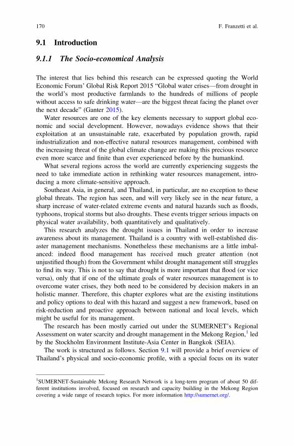
9.1 Introduction
9.1.1 The Socio-economical Analysis
The interest that lies behind this research can be expressed quoting the WorldEconomic Forum’ Global Risk Report 2015 “Global water crises—from drought inthe world’s most productive farmlands to the hundreds of millions of peoplewithout access to safe drinking water—are the biggest threat facing the planet overthe next decade” (Ganter 2015).
Water resources are one of the key elements necessary to support global eco-nomic and social development. However, nowadays evidence shows that theirexploitation at an unsustainable rate, exacerbated by population growth, rapidindustrialization and non-effective natural resources management, combined withthe increasing threat of the global climate change are making this precious resourceeven more scarce and finite than ever experienced before by the humankind.
What several regions across the world are currently experiencing suggests theneed to take immediate action in rethinking water resources management, intro-ducing a more climate-sensitive approach.
Southeast Asia, in general, and Thailand, in particular, are no exception to theseglobal threats. The region has seen, and will very likely see in the near future, asharp increase of water-related extreme events and natural hazards such as floods,typhoons, tropical storms but also droughts. These events trigger serious impacts onphysical water availability, both quantitatively and qualitatively.
This research analyzes the drought issues in Thailand in order to increaseawareness about its management. Thailand is a country with well-established dis-aster management mechanisms. Nonetheless these mechanisms are a little imbal-anced: indeed flood management has received much greater attention (notunjustified though) from the Government whilst drought management still strugglesto find its way. This is not to say that drought is more important that flood (or viceversa), only that if one of the ultimate goals of water resources management is toovercome water crises, they both need to be considered by decision makers in anholistic manner. Therefore, this chapter explores what are the existing institutionsand policy options to deal with this hazard and suggest a new framework, based onrisk-reduction and proactive approach between national and local levels, whichmight be useful for its management.
The research has been mostly carried out under the SUMERNET’s RegionalAssessment on water scarcity and drought management in the Mekong Region,1 ledby the Stockholm Environment Institute-Asia Center in Bangkok (SEIA).
The work is structured as follows. Section 9.1 will provide a brief overview ofThailand’s physical and socio-economic profile, with a special focus on its water
1SUMERNET-Sustainable Mekong Research Network is a long-term program of about 50 dif-ferent institutions involved, focused on research and capacity building in the Mekong Regioncovering a wide range of research topics. For more information http://sumernet.org/.
170 F. Franzetti et al.
resources status; regional climate change impacts and future projections for theregion will be presented, including El Niño-Southern Oscillation (ENSO) influenceof the regional climate. Section 9.2 describes briefly the methods and the materialsused in this research. Section 9.3 describes an overview of the institutionalframework that governs water resources and disaster management at the nationallevel. Section 9.4 introduces laws, policies, strategies and plans of drought’smanagement in Thailand. Section 9.5 analyzes a 4-step risk-based drought man-agement framework, modeled from international guidelines (in particular guidelinesfor Eastern Europe and the Near East countries), to be tailored to “fit” in the Thaicontext. Ideal institutional and policy adjustments will be suggested for each of thefour steps in particular analyzing in the first step the passage between the national tothe local level. Then the challenges and opportunity for Thailand of the frame-work’s application at national and local levels are analyzed in Sect. 9.6. Finally,Sect. 9.7 will look at potentialities and critical challenges of the proposed frame-work with critical lens, reflecting on the actual feasibility of its application andconsidering also a possibility for scaling the framework up to (but not only) theregional level.
9.1.2 Thailand and Increasing Threat of Drought
Thailand’s climate can be classified as tropical where seasonal monsoon winds,namely the southwest (SW) monsoon and the northeast (NE) monsoon, influencerainfall patterns, in addition to the passage of the Inter Tropical Convergence Zone(ITCZ) and tropical cyclones (TMD 2007).
Meteorologically, Thailand’s climate is divided into three main seasons:
• rainy season (or SW monsoon season): usually lasting from mid-May tomid-October. Abundant rain falls all over the country, with August-Septemberbeing the wettest period of the year (with the exception of southeast regionwhere the rainfall continues until December)
• winter season (or NE monsoon season): usually lasting from mid-October tomid-February. This is the mild period of the year, in the northern regions it canbecome quite cold
• summer season (or pre-monsoon season): this is considered that usually lastingfrom mid-February to mid-May. In this period it becomes very warm, with Aprilbeing the hottest month of the year (especially in the northern part).
Rainfall is a significant, if not the most important source of water for Thailand.Usual rainfall patterns vary considerably across the country as well as Thailand hasbeen historically considered a country with abundant water resources and reliesheavily on monsoon rainfall patterns.
Thailand’s fluvial system comprises 25 river basins, divided into 254 sub-basins.Of these river basins, 7 have been considered “hot spots” given the economic and
9 Rethinking Water Resources Management Under a Climate Change … 171

social pressure combined with limited freshwater resources: Chao Phraya andThajeen (central part), Chi and Moon rivers (northeast), Bang Pakong and easterseaboard (east) and Songkla lake (south) (The World Bank 2011).
Mainly used for domestic consumption, agriculture and industries, this watersource is getting rapidly overexploited. As of 2014, according to informationprovided by the latest DWR’s Water Resources Management Strategy of Thailand,water demand can be summarized as following:
• The agricultural sector remain the major water user with more that 80% of thecountry’s total water use, through a mix of large- medium- and small-scaleinfrastructure system. 65,000 million m3 are delivered to irrigated areas acrossthe nation. Where there is no irrigation system, agriculture is rain-fed, this areacorresponds to 19.2 million ha. In order to support the dry-season cultivation,groundwater extraction is some areas is deeply practiced.
• The 2014 water demand for the household consumption is estimated at 6490million m3 with projections for 2027 of an increase of 8260 million m3.
• Concentration of manufacturing and industrial estates is around Bangkok and inthe eastern part of the country. For the water sector is estimated around 4202million m3 (projected 7515 million m3 by 2027).
• The minimum water flow requirement for the dry season should not be less than27,090 million m3.
Although the rapid economic growth is not at same rates of 80s and early 90s,rapid urbanization and industrialization are still happening. These processes, whilebeneficial for poverty reduction and income increase, are putting serious pressureover natural resources, especially water resources.
Significant water quality issues arising from an uncontrolled exploitation of bothsurface and ground water resources as well as pollution of water bodies fromindustrial discharges affect both surface and groundwater resources (The WorldBank 2011). Some areas experience saline intrusion problems, not only in coastlineareas but also in the Northeast, where salinity encroachment combines with soilacidity issues. Salinity intrusion is a concern affecting not only water supply butalso crop cultivation fisheries and domestic uses (The World Bank 2011).
It is worth to bear in mind that there is a particular climatic phenomenon that hasstrong repercussions on the Thailand and South East Asia’s climate and weather.This phenomenon is called El Niño Southern Oscillation (ENSO). It is noticed how,during the El Niño period, the South and Southeast Asia suffer rainfall deficits aswell representend in Fig. 9.1. In the same time significant increases in intensity (butreduction in the number) of tropical cyclones will lead to more intense storms in theregion. Extreme rainfall events will increase the level of flood risk.
Narrowing the focus on the Mekong Region (Cambodia, Lao PDR, Myanmar,Thailand and Vietnam), studies conducted at regional level have shown how agreater inter-seasonal and inter-annual variability in rainfall patterns and hydrologyacross the region are expected, with large uncertainties on the monsoon pattern’sbehavior (Adamson and Bird 2010). This fact is witnessed by Thailand which is
172 F. Franzetti et al.
experiencing in recent years two extremes of water-related disasters, namely the2011 floods and the ongoing drought started in 2014 that is causing severe watershortages issues across the country.
Although floods and storms are ranked as major hazards (Office ofEnvironmental Policy and Planning 2000), water shortages arising from droughthave always been part of Thailand’s climatic conditions. Particularly, some parts ofthe country, such as the Northeastern region and the central plains, can be con-sidered hot spots as concerns drought issues.
Uneven water resources distribution, climate change effects, increased waterdemand are progressively exacerbating trade-off among different water users anduses are all contributing to the worsening situation. Despite rapid industrialization,Thailand remains an agricultural-based country, relying mostly on rain-fed riceproduction. Regions which suffer the most are indeed the ones where irrigationcanals and water distribution systems are still lacking.
According to the Department of Water Resources (DWR), villages lacking ofwater supply system are around 7000 (interview with DWR in 2015). Drought andwater shortages are threatening directly Thailand’s food and energy security. Thecountry’s rice production has been hit very hard; its vulnerability could affect globalprices on the rice markets. Furthermore, the ongoing severe drought could alsoresult in significant geopolitical consequences since the government is floating theidea to divert new water sources from near river basins (so a transboundary watercontext) such as the Salween and Yuam at the border with Myanmar or from theMekong river to pump water to major dams in the Northeastern part (Lovelle 2016).
9.2 Method and Materials
The methodology applied in this research consisted mainly in a qualitativeapproach. Four main phases can be identified along the information process andmost of it was gathered in Thailand, with the support of the StockholmEnvironment Institute-Asia Centre.
Fig. 9.1 Rainfall at end of June 2015: deficit (brown) and surplus (blue) (WFP 2015)
9 Rethinking Water Resources Management Under a Climate Change … 173
Firstly, information was collected through an extensive desk-based researchcharacterized by a substantial review of secondary data sources, including water-and disaster-related official policy documents, strategies, action plans, master plans,programs but also reports from NGOs and international development agenciesoperating in the area (e.g. the World Bank, Asian Development Bank, etc.…),policy briefs from SEI and other research institutes. Relevant sources of informationincluded also the English-based national newspapers such as The Bangkok Post andThe Nation and English version of governmental agencies websites. Most of therelated scholarly literature was also reviewed.
Secondly, Key Informant Interviews (KIIs) were identified as the most effectivetool to collect primary data. Eight KIIs took place in Bangkok from May 2015 toSeptember 2015 and most of the interviewee at the time were high-ranking gov-ernment officials from the Ministry of Natural Resources and Environment,Department of Water Resources, Department of Groundwater Resources,Department of Disaster Prevention and Mitigation but also researchers and aca-demics from the Hydro and Agro Informatics Institute, Chulalongkorn Universityand the Mekong River Committee Drought Management Programme. All of theseinterviews were audio-recorded and transcribed. Seven of these interviews wereconducted in English whilst one (with the Department of Disaster Prevention andMitigation) was conducted in Thai and translated into English.
Some of the information has been also collected with the participation tointernational conferences and workshops such as the ASEAN Drought workshopand the SUMERNET Regional assessment workshop on water scarcity and droughtmanagement in the Mekong region and through personal conversations with col-leagues and experts met in Bangkok.
Thirdly, a review of guidelines available, both at the international and regionallevel, to develop a potential drought management framework was performed.Particularly, three key documents were identified and utilized as a basis for thedevelopment of a tailored management framework for Thailand: the 2009 DroughtRisk Reduction Framework and Practices: contributing to the implementation of theHyogo Framework for Action produced by UNISDR; the 2014 Integrated NationalDrought Management Policy Guidelines: A Template for Action published by theIDMP, a joint program of the Global Water Partnership (GWP) and the UN’s WorldMeteorological Organization (WMO); and the 2015 Guidelines for the Preparationof Drought Management Plans. Development and Implementation in the context ofthe EU Water Framework Directive elaborated by the GWP for Central and EasternEurope. The last one was especially useful to see a precedent application of theframework adapted to a more localized context.
Lastly, as a result of this review, a 4-step process was elaborated (seeSects. 9.5.1, 9.5.2, 9.5.3, 9.5.4). For each one of these key steps, drawing on theindications of the conceptual framework, the current situation was highlighted andsuggestions for improvement along with organizational arrangements and policydirections were discussed.
Once the framework was developed, a critical reflection on potential possibilitiesand challenges was presented employing the SWOT-analysis model.
174 F. Franzetti et al.
9.3 Water Resources and Disaster ManagementInstitutions and Mechanisms in Thailand
At this stage, a brief overview of the institutional framework that governs waterresources and disaster management at the national level is provided. A quitecomplex institutional net emerges, thus without the pretention to be exhaustive, wewill attempt to identify key responsibilities related to water resources management(and consequently drought) for each of the main2 ministries and agencies involvedto provide the reader with a better sense of existing institutional dynamics. Ascommonly observed in other developing countries, water resources managementtasks in Thailand are widespread among several committees, ministries and spe-cialized agencies reflecting every administrative level namely the national, theprovincial (76 provinces) and the local (district, sub-district and village) level. Infacts, there are about thirty agencies and bureaus involved in water resourcesgovernance, reflecting a high fragmentation of roles and responsibilities(ADB 2013).
A first, national committee related to water resources was the National WaterResources Committee (NWRC). Firstly established in 1989 (then revised in 2002and 2007) and chaired by the Prime Minister, the NWRC was responsible forsupervision and monitoring of water resources management and policy formulation.This committee was not based on any legal act that can guarantee a permanentstatus, therefore NWRC has been often subjected to various changes, withouthaving a real power to implement policies (ADB 2013).
The catastrophic event which triggered a significant reform of high-level waterrelated institutions was the 2011 flood, pushing the Prime Minister, at that timeYingluck Shinawatra, to take action. Hence, with a Prime Minister’s Act on“Reconstruction and Future Development” she established two committees forflood prevention and control: a Strategic Committee for Reconstruction and FutureDevelopment (SCRFD) and a Strategic Committee for Water ResourcesManagement (SCWRM). The last one was specifically tasked to draft a water andflood management master plan (Funatsu 2014). According to this plan, with anotherPrime Minister Act on “Water Resources and Flood Control ManagementCommittee”, known also as the “Single Command Authority Act” (Funatsu 2014),three other bodies were established:
• A National Water Resources and Flood Policy Committee (NWRFPC) with themandate to formulate flood management policies and provide recommendationsto the Cabinet, chaired by the Prime Minister;
2Other ministries consulted and involved in decision-making during a disaster management are theMinistry of Defense (MOD), Ministry of Social Development and Human Security (MOSDHS),Ministry of Industry (MOI), Ministry of Labor (MOL), Ministry of Public Health (MOPH),Ministry of Commerce (MOC), Ministry of Finance (MOF) and the Royal Thai Army (NDPMC2009).
9 Rethinking Water Resources Management Under a Climate Change … 175
• A Water Resources and Flood Management Committee (CWRFM) chaired bythe Deputy Prime Minister responsible for the execution of adopted policy,measures and approval of water management investment projects action plans,approval of water management investment projects, and monitoring and eval-uation the implementation of investment projects. All relevant line agencies arerepresented in NWFPC and WFMC;
• An Office of National Water Resources and Flood Committee (ONWF) acting assecretariat body for the two committees and serves as single command authority(ADB 2013).
This landscape of committees had been in place until May 2014, when the RoyalThai Army overthrew the Prime Minister, taking control of the Government, and allthe long-term flood rehabilitations plans were halted by the National Council ofPeace and Order (Funatsu 2014).
A key success towards the introduction of Integrated Water ResourcesManagement process in Thailand has been the establishment of River BasinCommittees (RBCs). First steps were taken in mid-nineties when in 1998 theChao-Phraya River Basin Committee was formed (Anukularmphai, n.d.). In 2002,after the establishment of the Department of Water Resources (Fig. 9.2),twenty-five RBCs were created, each major river basin was further divided intosub-basins to better cope with the necessities and diversity of the hydrologicalfeatures (Anukularmphai, n.d.). Among the main roles, RBCs have mandate toformulate water resources management plans at basin level and coordinate thoseplans with relevant agencies, prioritize water allocation in equitable and efficientmeasures, monitoring and evaluation of other agencies’ performance in the basin.Members of RBCs are local authorities, water user groups and community stake-holders (NGOs/academics). Despite their establishment, it cannot be said that RiverBasin Committees in Thailand do have a proper legal status (Anukularmphai, n.d.).
A special river committee is the Thailand National Mekong Committee (TNMC)in charge of representing the country within the Mekong River Commission(MRC), main intergovernmental agency with mandate of transboundary coopera-tion of the Mekong River Basin. Other national committees relevant to our analysis,both chaired by the Prime Minister, are the National Committee on ClimateChange, established in 2006 as the highest policy-making body on climate issuesand the National Disaster Prevention and Mitigation Committee, established in2007, with the mandate to lay down policy for the formulation of the NationalDisaster Prevention and Mitigation Plan (NDPMP).
Each of these Ministries along with several departments, bureaus, offices andcenters are reflected into lower administrative levels. It goes that, for instance, theDWR has a branch at the provincial level, at district and sub-district level and sohas the DDMP etc. It is intuitive to understand the complexity of institutionalarrangements as well as the number of government officials involved in the hier-archical Thai bureaucracy.
When a disaster strikes and is officially announced, the mechanism in accor-dance with the 2007 National Disaster Prevention and Mitigation Plan (NDPMP)
176 F. Franzetti et al.
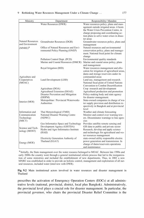
prescribes the activation of Emergency Operation Centers (EOCs) at all adminis-trative levels (national, provincial, district, local plus Bangkok). Administratively,the provincial level plays a crucial role for disaster management. In particular, theprovincial governor, who chairs the provincial Disaster Relief Committee is the
Ministry Department Responsibility/ Mandate
Natural Resources and Environment (MNRE)a
Water Resources (DWR) Water resources policy, plans and man-agement outside irrigated areas. it hosts the Water Crisis Prevention Centre, in charge proposing and coordinating ac-tion plans to solve water crises in disas-ter areas
Groundwater Resources (DGR) Groundwater resources policy, plans and management
Office of Natural Resources and Envi-ronmental Policy Planning (ONEP)
Natural resources and environmental conservation policy, plans and manage-ment. National focal point for climate change
Pollution Control Dept. (PCD) Environmental quality standards Marine and Coastal Resources (DMCR) Marine and coastal areas policy, plans
and management
Agriculture and Cooperatives (MOAC)
Royal Irrigation (RID) Water resources management and allo-cation for irrigation of agricultural areas, dams and storage reservoirs under its commanded areas
Land Development (LDD) Land use, management and research. National focal point of United Nations Convention to Combat Desertification
Agriculture (DOA) Crop research and development Agricultural Extension (DOAE) Agricultural production and promotion
Interior (MOI)
Disaster Prevention and Mitigation (DDPM)
Policy-making body and state agency for disaster management.
Metropolitan / Provincial Waterworks Authorities
State-owned companies in charge of wa-ter supply provision and distribution re-spectively in Bangkok and at provincial level
Information and Communication Technology (MICT)
Thai Meteorological (TMD) Weather and climate forecasting National Disaster Warning Centre (NDWC)
Monitor and control over warning tow-ers. Disseminates warnings to line agen-cies
Science and Tech-nology (MOST)
Geo Informatics Space and Technology Development Agency (GISTDA)
Provides satellite remote sensing and GIS data to public and private sector
Hydro and Agro Informatics Institute (HAII)
Research, develop and apply science and technologic for agricultural and wa-ter resources management
Energy (MOE)
Electricity Generation Authority of Thailand (EGAT)
state-owned utility responsible electric power generation and transmission. In charge of dams/reservoirs operations and maintenance
a Initially, the State management over the water resource belonged to MOAC. Between late 1990s and early 2000s the country went through a general institutional reform process that led to the reorganiza-tion of some ministries and included the establishment of new departments. Thus, in 2002 a new MNRE was established in order to provide an holistic control, management and exploitation of all nat-ural resources, included water (interview with DWR).
Fig. 9.2 Main institutional actors involved in water resources and disaster management inThailand
9 Rethinking Water Resources Management Under a Climate Change … 177
person with the right to announce an area stricken by a disaster and has the mandateto approve/reject budget requests for action plans and projects coming from lowerlevels (e.g. district, sub-district) (interview with DDPM).
The provincial Disaster Relief Committee is responsible for organizing effortsamong sectorial agencies (e.g. RID, DWR, LDD, DOAE etc.) coordinates lowerlevels (districts and sub-districts) while, on paper, the EOCs are in charge of com-mand, control, support and coordination of response and relief measures (NDPMC2009). However, this do not seem to always match the reality as “EOCs during adrought disaster mainly focus on monitoring” (interview with DDPM). Apart forthese institutional arrangements, a very important role, at local scale, during a dis-aster emergency is played by stakeholders of the civil society such as the Thai RedCross, non-governmental organizations, charitable organizations and volunteers andthe private sector who actively help and cooperate with the local authorities to carryout relief measures for people affected by the disaster (NDPMC 2009).
In times of disaster, important (and often unpopular) decisions need to be takenas the ones concerning water allocation practices.
During normal times, water allocation in Thailand mainly takes place annually atriver basin level. For the Chao Phraya river basin, this process usually beginsslightly before the end of each rainy season (around October) when an overallassessment of total water volume available in the major multi-purpose reservoirs,Bhumipol and Sirikit dams, is carried out by the central authorities. Once the totalamount of water available is known, a pre-seasonal allocation plan to match theirrigation area is carried out (Takeda et al. 2015; Divakar 2011). Consequently theresponsible authorities announce farmers on what crops are not recommended forthe next dry season (UNESCAP 2000).
Two key actors involved in this process are RID, under MOAC, and EGAT,under MOE which need to come up with a joint decision in order to release thewater, since RID regulates water within the irrigation systems whilst EGAT is incharge of dams and reservoirs operations and maintenance (UNESCAP 2000).
Usually the amount of water planned does not correspond to the actual amount ofwater released (Divakar et al. 2011, personal conversations). Since there is no lawdefining water rights, what happens is that some users, along the river basin can divertwater stealing in this way part of the resources destined to other downstream users(UNESCAP 2000). When a water crisis manifests itself, emergency inter-ministerialmeetings are held and normally the highestwater allocation priority is always assignedto domestic consumption (interviews with Chulalongkorn University and DWR).
9.4 Drought Management in Thailand: Laws, Policies,Strategies, Plans
Water resources in Thailand are governed by several water-related laws andnumerous amendments, regulations and decrees. Nonetheless, at the time of writ-ing, a proper Water Resources Law, which long and tormented approval process
178 F. Franzetti et al.
dates back to the early nineties, has never reached the consensus of all politicalparties, leading unavoidably the country to be characterized by an highly-fragmented legal framework. This is mainly due to an atmosphere of continuouspolitical instability and lack of political will characterizing various governments aswell as to the diversity of stakeholder interests in all water-related sectors, amongstother reasons. Hence, given the absence of a comprehensive legally-bindinginstrument for water resources, this sector is ruled by a number of sectoral lawsgoverning different aspects of this precious resource.
In order to be promulgated by the Royal Thai Government, any policy, plan,program and strategy must be consistent with a broad socio-economic developmentframework. This overarching development framework assumes the shape of a5-year National Economic and Social Development Plan, currently at its 11thedition (2012–2016). The plan promotes development strategies to be implementedaccording to the concept of “sufficiency economy”,3 the guiding principle ofThailand’s development since 1974, presented by H.M. King Bhumibol Adulyadej(NESDB 2012).
When dealing with water resources, the milestone documents of Thailand’swaterscape are represented by the National Water Vision and Policy both pro-mulgated in 2000. Before being approved, these two documents went through adrafting process based on an extensive participatory approach which involvedwater-related stakeholders (government official, researchers, NGOs and privatesector), in line with the Dublin Principles of Integrated Water ResourcesManagement (Anukularmphai, n.d.). The policy, articulated in 9 pillars, calls foractions to be undertaken such as a suitable and equitable water allocation for allwater use sectors, the need to meet water demand for agricultural and domesticuses, the approval and enforcement of the Water Law, insurance of sufficientbudget allocation for water-related issues and encouragement of effective stake-holder engagement (Anukularmphai, n.d.).
The only document issued specifically after last year’s drought is the IntegratedPlan for Drought Management for 2015 which comprises strategies on preventionand mitigation of drought impact by focusing on predictions of drought-prone areasand development of a quick, reliable alert warning system; preparation for disasterby supplying water in drought-prone areas with highest priority to water for con-sumption; emergency management by establishing operation centers andpost-disaster management by providing financial compensation, employment andlivelihood for victims (Royal Thai Government 2015).
Climate change is a cross-sectoral issue, well acknowledged in Thailand’s policyas demonstrated by the 2000 Initial Communication under the UNFCCC and by the
3The Sufficiency Economy is a fundamental concept for the Thai society, especially because it hasbeen developed and promulgated by the king in person. It fosters a sustainable developmentdominated by a “happy society with a equity, fairness and resilience” vision (NESDB 2012).
9 Rethinking Water Resources Management Under a Climate Change … 179
Second Communication under the UNFCCC (ONEP 2010). In order to provideguidelines to face challenges posed by climate change the National Strategic Planon Climate Change 2008–2012 first (Pipitsombat, n.d.; UNDP and OverseasDevelopment Institute 2012) and the National Climate Change Master Plan 2015–2050 then, were also promulgated.
In terms of disaster management Thailand’s Climate Change Master Plan 2015–2050 then, were also promulgated. Efforts seem to be based on a sound legal andpolicy framework, at least in principle. The 2007 Disaster Prevention andMitigation Act provides the overarching legal mechanisms for disaster managementin Thailand (ADPC 2013). According to this Act, a National Disaster Preventionand Mitigation Plan (2010–2014), promulgated in 2009, represents the nationalpolicy framework for disaster management within which all the other lower-levelplans have to be formulated. The plan envisages all phases of the disaster man-agement cycle, namely prevention and impact reduction, preparedness arrange-ments, disaster emergency management and post-disaster management (NDPMC2009). The document also calls for formulation of specific drought-related planssuch as Drought Prevention and Mitigation Integrated Action Plan or Dry SeasonCrops Cultivation Promotion Plan, in line with agricultural water management inthe dry season plans. As this plan has expired, a new National Disaster Preventionand Mitigation Plan was approved in 2015 but unfortunately, at the time of writingan English version of this policy document is not available. Beside the nationalplan, a Strategic National Action Plan (SNAP) on Disaster Risk Reduction 2010–2019 was formulated to fulfill the requirements of the Hyogo Framework for Action(HFA) 2005–2015, adopted right after the tsunami in the Indian Ocean in 2004(DDMP 2010).
9.5 An Institutional/Organizational Framework to IncludeWater-Related Disaster in Ordinary Water ResourcesManagement
This section seeks to rethink water-related disaster management in Thailand byproposing a possible re-shaping of institutional and policy landscapes, envisagingmore holistic coordination mechanisms and information flow which would engageall administrative levels (from national level to local level) and concerned stake-holders. In the following sections a 4-step risk-based drought managementframework, modeled from international guidelines (in particular guidelines forEastern Europe and the Near East countries) to be tailored to fit in the Thai context,is presented.
180 F. Franzetti et al.
9.5.1 Establish a Drought Committee and RelatedOrganizational Arrangements
International guidelines suggest that the first step towards an effective droughtmanagement system would be to identify or confirm an appropriate competentauthority (GWP CEE 2015). After identifying this authority has been chosen,a formal government resolution or legislation should introduce the legal andinstitutional framework for the entire drought planning process, establishing rolesand responsibilities at all administrative levels (GWP CEE 2015). Once the insti-tutional frameworks along with a suited legislation have been approved, a DroughtCommittee should be formed. This Drought Committee, regulated by the nationalauthority, should become a permanent body with a strong mandate, which tasksinclude establishing its organizational structure, setting up specific working groups,defining clear competencies and responsibilities of both the Committee and indi-vidual members, providing a communication strategy among all administrativelevels, coordinating specific measures among government and stakeholders,assigning tasks during all drought stages (normal, pre-alert, art, emergency) andsupervising the overall process evaluation procedures (GWP CEE 2015). Moreover,it is fundamental that the composition of the Drought Committee represents themulti-disciplinary nature of this issue: representatives ranging from national-leveldecision makers, local authorities, professional institutions providing technicalexpertise, key stakeholders such as farmers, local communities, NGOs but alsoenergy, tourism, industry sectors and water providers and suppliers should all beable to sit on this national body. Besides, a specific drought task force consisting inWorking groups/Committees addressing all the necessary technical assessments andprocedures should also be established (GWP CEE 2015).
With the 2007 National Disaster Mitigation and Prevention Act, Thailand hasalready officially adopted an institutional framework for disaster risk reduction(DRR), which includes drought. According to the 2007 Act, disaster management isunder the mandate of the Ministry of Interior, specifically, the Department ofDisaster Mitigation and Prevention (DDMP) has the responsibility to coordinate,support and enhance all disaster related activities and formulate national disasterplans. Even though, in principle, Chap. 15 of the 2009 National Disaster Preventionand Mitigation Plan (NDPMP) prescribes a procedure which fully takes intoaccount mitigation and preparedness, putting emphasis on all the disaster cyclemanagement (i.e. pre-disaster, during the disaster and post-disaster), one mightobserve that, in reality, governance mechanisms concerning drought measures areput in place only when drought strikes. This means that, in practice, full attention isgiven only to the central phase of disaster management cycle, during the disasteritself. Being drought primarily a water resources management issue, we argue thatdrought management mandate of the Ministry of Interior should be equally divided—at ministerial level—with the Ministry of Natural Resource and Environment(MNRE), in charge of state management of water resources.
9 Rethinking Water Resources Management Under a Climate Change … 181
Regarding the set up of a National Drought Committee, there may be no need toestablish a further new commission, given the high number of committees andsub-committees that proliferate within the Thai institutional landscape. Rather,it might be suggested a reform of the current4 National Water Resources and FloodPolicy Committee (NWRFPC), and the Committee for Water Resources and FloodManagement (CWRFM) established by the Water Resources Master Plan after the2011 devastating floods. This would lead to the creation of a National WaterResources Flood and Drought Policy Committee (NWRF&DPC), integrating in thisway mandates on flood and drought management policy and, accordingly, theCWRFM could be readjusted in a Committee for Water Resources, Flood andDrought Management (CWRF&DM). As concerns the organizational arrange-ments, in order to make sure that this renewed NWRF&DPC would appropriatelyinclude all stakeholder representatives of water-related sectors, reflecting themulti-disciplinary nature of the issues, the current inter-ministerial composition5
could be extended to representatives of local governments, research organizationsand academia, technical service providers (e.g. assessments, modelling, remotesensing etc.), non-governmental organizations and the private sector.
The NWRF&DPC, chaired by the Prime Minister, would have the authority toformulate polices related to flood and drought management, supervising the overallpreparedness and mitigation process for both hazards. Under its authority operatesthe CWRF&DM, in charge of formulating and implementing water managementaction plans following policy guidelines provided, approving water-relatedinvestment projects, endorsing fiscal budget and manpower mobilization and,lastly, preparing the National Drought Management Plan (DMP).
The CWRF&DM could be jointly co-chaired by Ministry of Natural Resourcesand Environment (MNRE) and Ministry of Science and Technology (MOST).6 Thejustification is that MNRE holds the State Management of water resources and, assuch, it should promote an overall sustainable integrated water resources man-agement whilst MOST controls two of the most relevant agencies in terms ofmonitoring and forecasting capacity.
Lastly, the drought task force should be supported by three different workinggroups or committees that provide services and implement different tasks of theplanning process:
4After the military junta took the leadership in 2014, the functions of the single-commandauthority established by the previous government after the 2011 floods have been halted and a newNational Water Resources Committee established. For simplicity, here it is preferred to maintainthe structure previously utilized, acknowledging that, on reality, the future of these bodies is highlyuncertain. It is very complex to deal with non-permanent commissions that keep changing withevery government, so in this framework it is assumed that NWRFPC and CWRFM have apermanent nature.5National Water-related Committees usually include representatives from water-resources relatedministries such as MNRE (DWR, DGWR), MOAC (RID, DOAE), MOI (DDPM, Public Work),MIST, MOPH etc.6In reality this Committee is chaired only by the Minister of Science and Technology (MOST).
182 F. Franzetti et al.
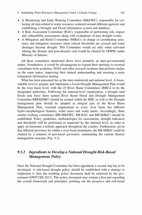
• A Monitoring and Early Warning Committee (M&EWC), responsible for col-lecting all data related to water resources scattered around different agencies andestablishing a Drought and Flood information system and database;
• A Risk Assessment Committee (RAC), responsible of performing risk, impactand vulnerability assessments along with evaluations of past drought events;
• A Mitigation and Relief Committee (MiReC), in charge of coordinating assis-tance and mitigation measures when critical thresholds are crossed and watershortages become drought. This Committee would act only when activated(during the disaster and post-disaster) and would be chaired by DDPM, underMinistry of Interior.
All these committees mentioned above have primarily an inter-governmentalnature. Nonetheless, it would be advantageous to expand their meetings to externalconsultants from academia, NGOs and other research institutes that perform studieson the same topics, improving their mutual understanding and ensuring a moretransparent information sharing.
What has been presented lies at the inter-ministerial and national level. A lower,suitable level to prepare and implement a Local Drought Management Plan wouldbe the river basin level, with the 25 River Basin Committees (RBCs) to be thedesignated authorities. Following the national-level organization, a drought (andflood) task force (here named River Basin Flood and Drought ManagementCommittee-RBF&DMC) should be created within the RBC as well as the Droughtmanagement plan should be adopted as integral part of the River BasinManagement Plan, essential requirement as every river basin has differenthydro-morphological features, water users and water needs. Accordingly, threesimilar working committees (RB-M&EWC, RB-RAC and RB-MiReC) should beestablished. Policy guidelines, methodologies for assessments, drought indicatorsand thresholds will be performed as requested by the national level, in order toapply an harmonic a holistic approach throughout the country. Furthermore, giventhat different provinces lie within a river basin boundaries, the RB-MiReC could bechaired by a rotation of provincial governors, maintaining the current disastermanagement structure (Fig. 9.3).
9.5.2 Ingredients to Develop a National Drought Risk-BasedManagement Policy
Once the National Drought Committee has been appointed, a second step has to bedeveloped. A risk-based drought policy should be established with a strategy toimplement it, then the resulting policy document shall be endorsed by the gov-ernment (GWP CEE 2015). This policy document may contain a first part regardingthe overall framework and principles, pointing out the proactive and risk-based
9 Rethinking Water Resources Management Under a Climate Change … 183
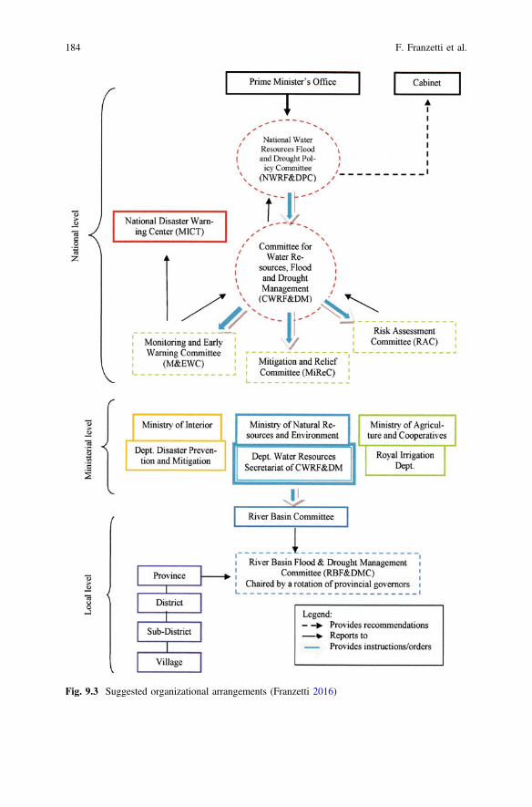
Fig. 9.3 Suggested organizational arrangements (Franzetti 2016)
184 F. Franzetti et al.
approach, together with a generic roadmap for its implementation in addition to keyphases to develop a Drought Management Plan (DMP) (e.g. administrative,financial, organizational, institutional, etc.) (GWP CEE 2015). Defining objectivesalong with specific and achievable goals of a drought-risk reduction policy is adecisive step as it represents the basis for the implementation of the DMP (WMOand GWP 2014). A critical passage is that the policy can only be effective if there isa prior identification that grasps the most vulnerable groups, activities anddrought-prone areas nationwide (GWP CEE 2015).
As emerged from the policy review conducted, policies that can be relateddirectly or indirectly to drought management have to be researched in sectoralpolicies and plans; in fact to date the country does not present any single, inter-graded and comprehensive drought management policy and strategy. Nevertheless,in the context of disaster management, Chap. 15 of the 2009 NDPMP containssome relevant policy objectives including “(i) to prevent and mitigate adverseimpact of drought on well-being and property of the people; (ii) to facilitate andensure effective and timely provision of assistance to affected people as well asrehabilitation to normalcy as soon as possible and (iii) to identify the clear andintegrative tasks and responsibilities to be taken by all government agencies as wellas non-government network organizations for dealing with drought” (NDPMC2009). Surely, the objectives presented already reflect a disaster-risk basedapproach and this gives us important indications about the direction which Thailandwould like to move towards.
A first recommendation is that it would be necessary to officially consider andrecognize drought as a normal and recurrent feature of Thailand’s climate, pro-viding in this way political acknowledgement of the water shortage issue perma-nently, and not just when and where the problem arises. Usually as soon as thedrought situation withdraws, drought relief measures are dismissed and water levelconditions become acceptable again, all media and political attention on thisproblem suddenly vanishes until another water shortage happens, leading to anotherwater crisis.
In terms of drought policy formulation, there are plenty of experiences, more orless successful, in drought-prone countries that could be mentioned.
A significant example worth to investigate may be represented by the AustralianDrought Policy, which has been constantly revised and improved over time.
A significant point to outline is that this National Drought Policy places greatemphasis of farmers responsibilities to manage climate risks (Stone 2014). Thailandcould take some inspiration from the way Australia has adopted, among its policygoals, the “self-reliance” concept to encourage farmers when it comes to climaterisk management. Besides, given the great importance of the agrarian basis of thecountry’s economy, surely a number of considerations on other sectors, especiallyagricultural productivity, must be included when drafting the policy.
9 Rethinking Water Resources Management Under a Climate Change … 185
9.5.3 Drought-Related Data Inventory and GapsIdentification
Regarding data inventory, a third step is necessary. For this reason the GWP CEEguidelines present the information to collect and analyze an effective DMP groupedinto six macro categories, namely meteorological, hydrological, agricultural,socio-economic, environmental impact and drinking water supply data. In order toestablish a drought information system, it would be necessary to collect and updateconstantly this information. Nevertheless, it is well known that gathering all thesedata together is not as easy as it might seem: this type of information is usuallyscattered around different departments and agencies that not very often share andintegrate data, especially when it comes to different ministries (GWP CEE 2015).For the abovementioned reasons, a careful analysis of the constraints (such asweaknesses and obstacles) in terms of data availability should be carried out in theearly stage of a drought management process, before developing a DMP. Lastly, itis worth to mention that relying on complete and integrated data also allows tocreate an appropriate national drought indicators system during the planning phases,which is a crucial condition to ensure the success of the plan.
Some indications on responsibilities to conduct drought risk assessments ana-lyzing risk factors and possible drought areas as well as to verify, update andprepare the drought database and hazard mapping are included in the Thai NationalDisaster Prevention and Mitigation Plan (Praneat 2014).
Availability and transparent sharing of this type of information determines theconditions for success of a Drought Management Plan. To date, Thailand does notpresent any comprehensive integrated7 national drought database: in fact,drought-related data are scattered around various agencies. Every governmentagency monitors and collects data according to its mandate of competence so, forinstance, the Thai Meteorological Dept. is in charge of monitoring weather stations;surface water resources status is be monitored by Dept. of Water Resources; RoyalIrrigation Dept. monitors only water status within irrigated areas while EGATmonitors water levels in reservoirs; groundwater resources are monitored by theDept. of Groundwater Resources; disaster information is monitored by Dept. ofDisaster Prevention and Mitigation; Land Development Dept. monitors soil con-ditions and the Royal Forest Dept. is in charge of forest monitoring and so forth. Itis evident, in order to be effective, a strong and harmonic data management capacityis needed and given the low level of communication among all the agencies con-cerned, current data flowing among agencies cannot be considered sufficient.
The National Disaster Prevention and Mitigation Plan (NDPMP) 2010–2014prescribed three important actions that fit into this point, namely to review andupdate existing data on drought-prone areas and create drought hazard maps alongwith a water resources database; to prepare a database on relevant personnel and
7By “integrated” here we are referring to the presence of a single database where all thedrought-related information converges.
186 F. Franzetti et al.
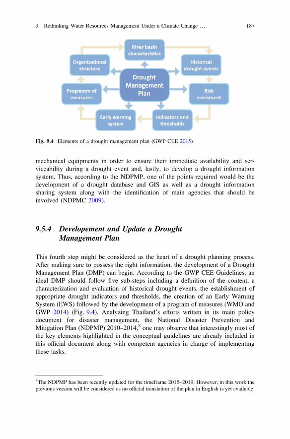
mechanical equipments in order to ensure their immediate availability and ser-viceability during a drought event and, lastly, to develop a drought informationsystem. Thus, according to the NDPMP, one of the points required would be thedevelopment of a drought database and GIS as well as a drought informationsharing system along with the identification of main agencies that should beinvolved (NDPMC 2009).
9.5.4 Developement and Update a DroughtManagement Plan
This fourth step might be considered as the heart of a drought planning process.After making sure to possess the right information, the development of a DroughtManagement Plan (DMP) can begin. According to the GWP CEE Guidelines, anideal DMP should follow five sub-steps including a definition of the content, acharacterization and evaluation of historical drought events, the establishment ofappropriate drought indicators and thresholds, the creation of an Early WarningSystem (EWS) followed by the development of a program of measures (WMO andGWP 2014) (Fig. 9.4). Analyzing Thailand’s efforts written in its main policydocument for disaster management, the National Disaster Prevention andMitigation Plan (NDPMP) 2010–2014,8 one may observe that interestingly most ofthe key elements highlighted in the conceptual guidelines are already included inthis official document along with competent agencies in charge of implementingthese tasks.
Fig. 9.4 Elements of a drought management plan (GWP CEE 2015)
8The NDPMP has been recently updated for the timeframe 2015–2019. However, in this work theprevious version will be considered as no official translation of the plan in English is yet available.
9 Rethinking Water Resources Management Under a Climate Change … 187
Although these tasks seem perfectly in line with a disaster preparedness andmitigation approach, no indications on methodologies or criteria to adopt forassessments or precise classification of droughts are provided in the plan. Therefore,it can be suggested to the National Water Resources Flood and Drought Policy andManagement Committee (NWRF&DPC and CWRF&DM) to fill this gap withappropriate methodologies to conduct risk, vulnerability and impacts assessments.
In terms of methodology, a first obstacle is represented by the definition ofdrought. The terminology adopted by the NDPMP says that “drought refers to theprolonged dry period of weather condition caused by the long period of deficit or norainfall spanning over large areas. Periods of prolonged drought can triggerwidespread and severe effects among people, animals, and vegetation, for instanceshortage of water for drinking and household use as well as for agricultural andindustrial purposes, substandard or highly limited crop or yield productions, deathof livestock etc.” (NDPMC 2009).
Now, it can be argued that this definition is quite vague in the sense that nospecific thresholds to identify drought stages are provided. This is confirmed by thepolicy review: most of the documents mention the problem of water shortages andmeasures that concerned agencies intend to apply, but no thresholds. It follows thatit is not clear how different types of drought are identified and treated. In ouropinion, this is a significant gap to acknowledge and address: drought affects groupsand activities in different ways, requiring ad hoc measures and definitions for everyarea. Common and shared definitions between government and stakeholders shouldbe discussed and adopted, making possible to begin working collectively onappropriate drought indicators and thresholds.
Looking at drought monitoring system, a recent study of NASA Goddar SpaceFlight Center highlighted how “the available drought monitoring system inThailand looks only at the agricultural drought (…) and this was insufficient foranalyzing accurate risk management and decision-making” (McCartney et al.2015). Once again, it is likely that several agencies’ technical divisions performtheir own analyses but results are not shared among other agencies. It is necessaryto come up with unified and acceptable indicators utilized throughout the country,maybe improving also the international cooperation channels through technical staffexchange with countries highly advanced in this field.
Being a country that often experiences extreme climate events, it can be said thatThailand has a good capacity with early warning systems (EWS). This is true forsome types of natural hazards including floods, storms, tsunami, tropical cyclonesand earthquakes, but it does not apply to drought. The 2004 tsunami that causedtremendous impacts on South and Southeast Asia is considered the trigger point forthe adoption and implementation of a disaster EWS, followed by the 2011 Greatflood. After the establishment of a National Disaster Warning Center in 2004, in2012 an agreement was reached in order to develop a Decision Support System foroperational flood risk management for the Chao Phraya river basin (centralThailand) (DHI 2012). Recent past drought events have strongly outlined thenecessity to establish an effective drought forecasting system and, consequently, anEWS for this hazard. To date, Thailand “does not have a drought forecasting system
188 F. Franzetti et al.
but this year (it) will start to implement a project to develop it” (interview withHAII 2015). Hopefully, learning from the dramatic drought experiences, Thailandwould invest more resources in the near future.
Regarding the program of measures, it has been already said that the NDMPembeds several measures covering, in principle, all phases of the disaster man-agement cycle. However, preparedness measures found in the plan, are suitable butcertainly not enough to cope with drought in a pro-active way. It would be nec-essary to identify and improve in all water-related policies specific strategies andmeasures to cope with drought, so every agency would better know in its field whatoptions are effective and which do not work. Every agency could report its beststrategies to the CWRF&DM which will incorporate them in a single program ofmeasures, to be reviewed and constantly updated.
Thailand has a fairly good experience in dealing with public hearing and con-sultations, even though it has not always been effectively implemented. Forinstance, the country went through a long process of stakeholders consultations tointroduce the Integrated Water Resources Management (IWMI) that led to theNational Water Policy and Vision not to mention the consultations for drafting theWater Resources Bill (Anukularmphai, n.d.). Consultations could take place atnational level, within the NWRF&DPC, where all stakeholders are represented andat the River Basin level, hosted by the River Basin Committees (RBCs), that willreport to the Dept. of Water Resources, secretariat of the Flood and Drought Policyand Management Committees. Comments and suggestions will then be analyzed bythe NWRF&DPC that will make sure they will be incorporated in the final draft.
As for educational awareness, the NDPMP already prescribes, amongst otheractivities, to organize “public education training and campaign to raise awarenessamong all members of community at risk and to provide important information tohelp them understand potential drought as well as an instruction of drought miti-gation strategies” that, for instance, include water restriction measures such as toregulate water use and planting less water—dependent crops in dry season(NDPMC 2009). Thailand is doing a relatively fair job in terms of awarenessincrease in some fields. For example, the Land Development Department hascreated programs like the “Volunteer Soil Doctors” with the purpose to train peopleon a voluntary basis to take care of and deal with soil problems. This idea could bereplicated also in specific training programs for drought.
To be fully effective, evaluation procedures should be accompanied by the gapanalysis presented in Sect. 9.5.3. Monitoring each of the steps is vital to identifystrengths and weaknesses of the whole process. A suggestion here might be toappoint an official responsible for this task within CWRF&DM (the ManagementCommittee) to keep track of the ongoing evaluation whilst it might be useful toproduce two separate post-drought evaluations: one conducted within the institu-tional environment and another one assigned to an external auditor (e.g. a non-profitresearch institute, or a private consultancy agency). In this way the two evaluationscan be crossed, allowing new elements to emerge. During the research period notrace of evaluation procedures on drought-related in English was found.
9 Rethinking Water Resources Management Under a Climate Change … 189
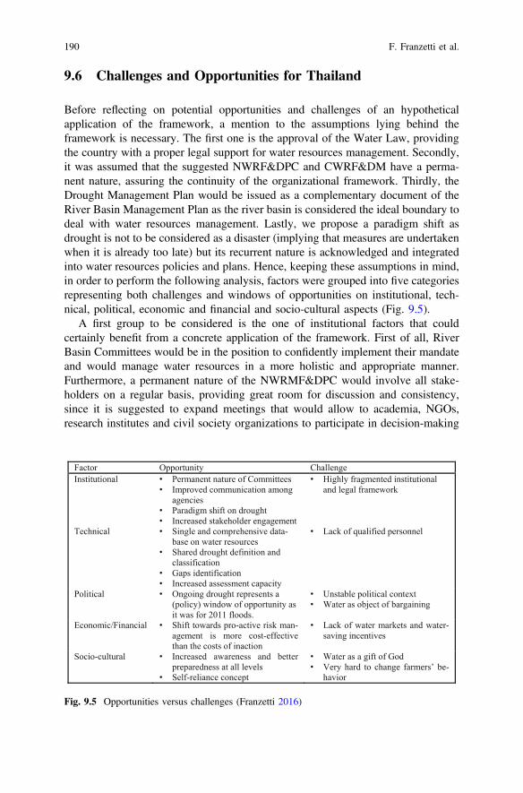
9.6 Challenges and Opportunities for Thailand
Before reflecting on potential opportunities and challenges of an hypotheticalapplication of the framework, a mention to the assumptions lying behind theframework is necessary. The first one is the approval of the Water Law, providingthe country with a proper legal support for water resources management. Secondly,it was assumed that the suggested NWRF&DPC and CWRF&DM have a perma-nent nature, assuring the continuity of the organizational framework. Thirdly, theDrought Management Plan would be issued as a complementary document of theRiver Basin Management Plan as the river basin is considered the ideal boundary todeal with water resources management. Lastly, we propose a paradigm shift asdrought is not to be considered as a disaster (implying that measures are undertakenwhen it is already too late) but its recurrent nature is acknowledged and integratedinto water resources policies and plans. Hence, keeping these assumptions in mind,in order to perform the following analysis, factors were grouped into five categoriesrepresenting both challenges and windows of opportunities on institutional, tech-nical, political, economic and financial and socio-cultural aspects (Fig. 9.5).
A first group to be considered is the one of institutional factors that couldcertainly benefit from a concrete application of the framework. First of all, RiverBasin Committees would be in the position to confidently implement their mandateand would manage water resources in a more holistic and appropriate manner.Furthermore, a permanent nature of the NWRMF&DPC would involve all stake-holders on a regular basis, providing great room for discussion and consistency,since it is suggested to expand meetings that would allow to academia, NGOs,research institutes and civil society organizations to participate in decision-making
Factor Opportunity ChallengeInstitutional • Permanent nature of Committees
• Improved communication among agencies
• Paradigm shift on drought • Increased stakeholder engagement
• Highly fragmented institutional and legal framework
Technical • Single and comprehensive data-base on water resources
• Shared drought definition and classification
• Gaps identification • Increased assessment capacity
• Lack of qualified personnel
Political • Ongoing drought represents a (policy) window of opportunity as it was for 2011 floods.
• Unstable political context• Water as object of bargaining
Economic/Financial • Shift towards pro-active risk man-agement is more cost-effective than the costs of inaction
• Lack of water markets and water-saving incentives
Socio-cultural • Increased awareness and better preparedness at all levels
• Self-reliance concept
• Water as a gift of God• Very hard to change farmers’ be-
havior
Fig. 9.5 Opportunities versus challenges (Franzetti 2016)
190 F. Franzetti et al.
processes while formalizing a knowledge exchange full of mutual benefits. Thiswould also lead to improved collaboration and coordination among concernedagencies, creating a constant and more transparent information flow.
To undermine these positive changes there is still a highly-fragmented institu-tional and legal framework.
A second group examines some technical factors such as, for instance, theconcentration of several agencies’ efforts under a single Monitoring and EarlyWarning Committee (M&EWC) in charge of establishing a single and compre-hensive database on water-related issues and disasters. More effective early warn-ings could be provided, not to mention the adoption of common drought definitions,classification and indicators to be implemented throughout the country. Enactingthe harmonization of data collection and analysis would be advantageous as it isalso linked with technical capacity to perform risk, impacts and vulnerabilityassessments. Engagement in process evaluation procedures would allow theauthorities to support the entire process and identify strengths and weaknesseswhere an intervention is needed.
And again, the ability to conduct assessments on current and past drought eventswould shed light on past experiences, serving as a basis for a more tailored programof measures to be implemented.
All these opportunities, however, could be hindered by the lack ofhighly-qualified and trained personnel, especially at local level. This point has beenhighlighted by several studies and sectoral capacity assessments (e.g. ADB 2013) asone of the main bottlenecks when it comes to maintaining and implementingmeasures on the ground.
Implications of political factors become evident if one observes the institutionalarrangements that were created after the 2011 floods. It can be hypothesized that theongoing water crisis in Thailand could potentially act as a trigger to take proactiveactions against drought, providing a window of opportunity for the country.A policy statement recognizing that drought is not to be considered only a disasterbut needs to be addressed under the ordinary water resources management wouldreflect an increased awareness among high-level government officials. Moreover, inorder to effectively perform a drought preparedness and mitigation process, politicalstability is an indispensable precondition. Unfortunately, this is definitely a critical,if not daunting, challenge in Thailand: history of several water-related committeesestablished under different governments has shown how the lifetime of these bodiesis short. Hence, it would be important that the nature of the suggested committeescan become permanent, in order to ensure continuity of the organizationalframework.
Naturally, in a very unstable political context, it is hard for government agenciesto plan and respond to these changes effectively. This is why expectations frompolicies, strategies and plans’ performance do not always turn out as desired.
Political will is another crucial factor as it influences the outcome of any type ofaction related (but not only) to water resources. Investments in water infrastructuredevelopment to solve water shortages and drought issues, not to mention theconstant objective to expand irrigated areas, have always dominated political
9 Rethinking Water Resources Management Under a Climate Change … 191
discourses but have never definitely solved the problem (Molle 2001). Probably,one of the many complex implications behind this, is that sometimes water,especially in agriculture, can become an object of political bargaining. For example,regarding slow expansion of irrigated areas that does not seem to match the con-tinuous claims from the authorities (RID) to increase irrigation, Achara Deboomnein an opinion on The Nation wrote that “the root of this long-standing problem liesin the fact that policymakers treat irrigation as a political tool, channeling budgets totemporary projects that only address short-term hurdles. No government has everembarked on a grand-scale project to tackle long-term problems” (Deboonme2015).
Economic and financial aspects related to this framework’s application includesome significant constraints that Thailand may face such as the lack of budgetavailability, even though a shift towards pro-active risk management can be morecost-effective if compared to the costs of inaction. The budgeting system inThailand is very centralized and it takes a long time before projects can beapproved, with the results that very few of them see the light (interview with Chula2015). For these reason, it is likely that funds for drought related projects wouldencounter several difficulties along their way. Another recurrent challenge, oftenmentioned in the literature, is the lack of a real water economics and market-basedmechanisms to incentivize water savings, in addition to water restriction measuresusually applied in times of crisis. In Thailand, water itself does not have a price as itis considered an “open access” resource (interviews with DWR and Chula 2015). Inthe agricultural sector, by far the most water-intensive sector, the only fees collectedare those for the water service and distribution system, not even enough to coveroperation and maintenance costs (Molle 2001).
If the framework were to be fully implemented could also have a significantimpact on civil society. Socio-cultural opportunities represented by committinginvestments in human and financial resources for educational programs, awarenesscampaigns and drought preparedness meetings at local level could help enormouslyin preparing people to cope with drought.
Public involvement in the approval process of a Drought Management Planwould give voice to affected local communities and would allow the government tobe more sensible to specific local needs, usually ignored at national level, whilst in along-term perspective it would perhaps increase people’s trust in governmentalmechanisms. Besides, programs targeting different groups can sensitize people tothe importance of water saving practices, where the government does not arrivewith market-based interventions. It would mean to cultivate that “self reliance”concept which would provoke a change in farmers’ perspectives and behavior, aswhat usually happens today is that “even if they are advised that there will not bewater to grow a second crop because there is no water (…) they will do it anywaybecause they rely on compensation and assistance schemes from the government”(interview with Chula 2015).
192 F. Franzetti et al.
9.7 Conclusion
Nowadays Thailand, and more generally Southeast Asia, is experiencing one of theworst water shortage crises of the past 15 years and drought is representing aserious threat for the country’s food and energy security. Main drivers includepopulation growth, rapid urbanization, industrialization and economic integration,unsustainable agricultural practices and depletion of natural resources (especiallywater) which, combined with increasing water demands, are exacerbating trade-offsamongst all water-related sectors (e.g. household consumption, agriculture, indus-try, hydropower production, tourism, fisheries, ecological flows maintenance). Tocomplicate the situation, global climate change and the growing threat of extremenatural events are presenting serious challenges for the whole humankind. As aconsequence, water resources are increasingly becoming more scarce and finite.Ensuring water availability (quantity and quality) for all sectors of an economy is akey concern of water resources management.
Since, until recently, most of the Thai government’s attention has been focusingon flood mitigation and control, this chapter had the objective to suggest a possiblemanagement framework as well as to increase general awareness on this insidious,slow-onset hazard.
Results from the reviews have highlighted how fragmented water-related dutiesand responsibilities are among ministries and line agencies, with overlappingresponsibilities, amplified by a low level of communication and information shar-ing. Furthermore, integrated flood and drought management is acknowledged inmost documents, but unfortunately it does not seem to reflect the practice: insti-tutional arrangements exist for flood management but not for drought. It has alsobeen stressed that, even though no single and comprehensive policy to addressdrought is explicitly presented, some indications can be found scattered aroundsectorial policies. We have seen that this phenomenon is considered as a disasterand, although in national documents measures to be adopted during all phases of adisaster cycle are prescribed, again this is not reflected on reality as only disasterrelief and emergency measures are effectively carried out, confirming the traditionalcrisis approach in disaster management.
To overcome this, a shift towards a more proactive, risk-based approach wouldbe advisable and in order to succeed, a tailored 4-step drought managementframework has been suggested, looking at international guidelines applied else-where as a basis. The final outcome of the proposed framework would be thepreparation of a Drought Management Plan based on important pillars such asforecasting, monitoring and evaluation system, comprehensive database, riskassessments and early warning system. Organizational arrangements along with are-shaped scope of existing national committees on water resources have also beendiscussed presenting a possible reorganization, especially at national level.Opportunities deriving from an actual application of this drought managementframework have been identified (e.g. increased awareness, better cooperationamong all stakeholders, improved public participation etc.). Nevertheless,
9 Rethinking Water Resources Management Under a Climate Change … 193
it is predictable that these opportunities could be hindered by structural constraintsand barriers such as highly fragmented institutional framework, political unrest andthe lack of an appropriate comprehensive water legislation.
References
Adamson, P., and J. Bird. 2010. The Mekong: A drought-prone tropical environment?International Journal of Water Resources Development 26 (4): 579–594. doi:10.1080/07900627.2010.519632.
ADB. 2013. Thailand sector assessment (Summary): Water resources. Country partnershipstrategy: Thailand, 2013–2016. Manila.
ADPC-Asian Disaster Preparedness Center. 2013. Assessment for disaster management planning,policies and responses in Thailand. ADPC website. http://www.adpc.net/igo/contents/adpcpage.asp?pid=2. Accessed Sept 2015.
Anukularmphai, A. n.a. Implementing integrated water resources management (IWRM): Based onThailand’s experience. IUCN.
DDMP-Department of Disaster Mitigation and Prevention. 2010. Strategic national action plan(SNAP) on disaster risk reduction 2010–2019.
Deboonme, A. 2015. Thailand’s rice basket shrivels amid drought of long-term policy. The Nation,3 Mar. http://www.nationmultimedia.com/opinion/Thailands-rice-basket-shrivels-amid-drought-of-lon-30255170.html. Accessed Aug 2015.
DHI. 2012. Protecting Thailand from floods. Using DSS to forecast floods in the Chao PhrayaRiver Basin. DHI case story. Danish Hydraulic Institute.
Divakar, L., M.S. Babel, S.R. Perret, and A.D. Gupta. 2011. Optimal allocation of bulk watersupplies to competing use sectors based on economic criterion—An application to the ChaoPhraya River Basin, Thailand. Journal of Hydrology 401 (1–2): 22–35. doi:10.1016/j.jhydrol.2011.02.003.
Franzetti, F. 2016. Towards the development of a drought management framework: Challengesand opportunities for Thailand. Master’s thesis, University of Turin.
Funatsu, T. 2014. Organizational reformation on water resources management after the 2011Thailand Great Floods. In Politics of the Environment - the formation of “late-comer” PublicPolicy, ed. Tadayoshi Terao. Chiba: Institute of Developing Economies.
Ganter, C. 2015. Water crises are a top global risk. World Economic Forum. http://www.weforum.org/agenda/2015/01/why-world-water-crises-are-a-top-global-risk. Accessed 11 Aug 2016.
GWP CEE. 2015. Guidelines for the preparation of drought management plans. Development andimplementation on the context of the EU Water framework directive. Global Water PartnershipCentral and Eastern Europe.
Lovelle, M. 2016. Thailand: Drought, water sources and the potential implications. FutureDirections International. http://www.futuredirections.org.au/publication/thailand-drought-water-sourcing-and-the-potential-implications/.
McCartney, S., et al. 2015. The Trifecta of drought: monitoring three types in Thailand. Earthzine,July 30. https://earthzine.org/2015/07/30/the-trifecta-of-drought-monitoring-three-types-in-Thailand. Accessed 24 Feb 2017.
Molle, F. 2001. Water pricing in Thailand: Theory and practice. DORAS DELTA, 7. Bangkok:Kasetsart University.
MNRE. http://webeng.mnre.go.th/ewt_news.php?nid=5. Accessed Mar 2016.NDPMC-National Disaster Prevention and Mitigation Committee. 2009. National disaster
prevention and mitigation plan 2010–2014.NESDB-National Economic and Social Development Board. 2012. The eleventh national
economic and social development plan 2012–2016.
194 F. Franzetti et al.
Office of Environmental Policy and Planning. 2000. Thailand’s initial communication under theUnited Nation Framework Convention on Climate Change. Bangkok: Ministry of Science,Technology and Environment.
ONEP-Office of Natural Resources and Environmental Policy and Planning. 2010. Thailand’sSecond Communication under the United Nations Framework Convention on Climate Change.Bangkok: Ministry of Natural Resources and Environment.
Pipitsombat, N. n.a. Policies related to climate change in Thailand. http://www.ostc.thaiembdc.org/atpac2011/Presentation_Ms_Nirawan.pdf.
Praneat, V. 2014. Drought conditions and management strategies in Thailand. http://www.droughtmanagement.info/literature/UNW-DPC_NDMP_Country_Report_Thailand_2014.pdf.Accessed May 2015.
Royal Thai Government. 2015. Integrated plan for 2015 drought management. http://www.thaigov.go.th/en/cabinet-synopsis-/item/90223-id90223.html.
Stone, R. 2014. Constructing a framework for National drought policy: The way forward—Theway Australia developed and implemented the national drought policy. Weather and ClimateExtremes 3: 117–125.
Takeda, M., A. Laphimsing, and A. Putthividhya. 2015. Dry season water allocation in the ChaoPhraya River basin, Thailand. International Journal of Water Resources Development. doi:10.1080/07900627.2015.1055856 .
TDM-Thai Meteorological Department. 2007. The climate of Thailand. http://www.tmd.go.th/en/archive/thailand_climate.pdf.
The World Bank. 2011 Thailand environment monitor. Integrated water resources management:A way forward. Washington D.C.: World Bank. http://documents.worldbank.org/curated/en/367151468303847751/Thailand-environment-monitor-integrated-water-resources-management-a-way-forward.
UNDP and Overseas Development Institute. 2012. Thailand climate public expenditure andinstitutional review. https://www.cbd.int/financial/climatechange/g-cpeirmethodology-undp.pdf.
UNESCAP. 2000. Principles and practices of water allocation among water-use sectors. WaterResource Series, 80.
WFP. 2015. El Nino: Implication and scenarios for 2015. http://documents.wfp.org/stellent/groups/public/documents/ena/wfp276236.pdf.
WMO and GWP. 2014. National drought management policy guidelines: A template for action(D.A. Wilhite). Integrated Drought Management Program-IDPM Tools and Guidelines Series 1.Geneva and Stockholm: WMO and GWP.
Open Access This chapter is licensed under the terms of the Creative Commons Attribution 4.0International License (http://creativecommons.org/licenses/by/4.0/), which permits use, sharing,adaptation, distribution and reproduction in any medium or format, as long as you give appropriatecredit to the original author(s) and the source, provide a link to the Creative Commons license andindicate if changes were made.The images or other third party material in this chapter are included in the chapter's Creative
Commons license, unless indicated otherwise in a credit line to the material. If material is notincluded in the chapter's Creative Commons license and your intended use is not permitted bystatutory regulation or exceeds the permitted use, you will need to obtain permission directly fromthe copyright holder.
9 Rethinking Water Resources Management Under a Climate Change … 195

Part IIDecision Making Tools for Climate
Planning
Chapter 10Relevance and Quality of ClimatePlanning for Large and Medium-SizedCities of the Tropics
Maurizio Tiepolo
Abstract In the last seven years, the number of plans with climate measures fortropical cities has increased 2.3 times compared to the previous seven years as aresult of the initiatives of central and local governments, multi-bilateral develop-ment aid and development banks. The plans matter in achieving the 11th UnitedNations’ Sustainable development goal. Therefore, the objective of this chapter is toascertain the relevance and quality of climate planning in large and medium-sizedcities in the Tropics. The chapter proposes and applies the QCPI-Quality of ClimatePlans Index, consisting of 10 indicators (characterization of climate, number,quantification, relevance, potential impact, cost, funding sources, timetable andresponsibility of measures, implementation monitoring and reporting). It is revealedthat 338 tropical cities currently have a local development, emergency, master,mitigation, adaptation, risk reduction plan or a resilience or smart city strategy.These tools were unquestionably more common in large cities, especially in OCDEand BRICS countries, while they were rare in Developing Countries. Localdevelopment plans (Municipal development, general, comprehensive) were themost common in medium-sized cities, along with those with the lowest quality,while stand-alone strategies and plans (resilience, mitigation, sustainable, adapta-tion), applied mostly in big cities, present much higher quality.
Keywords Climate change Municipal development plan Master plan Emergency plan Mitigation plan Adaptation plan Risk reduction plan Resilience strategy Smart city Plan quality Tropics
M. Tiepolo (&)DIST, Politecnico and University of Turin, Viale Mattioli 39, 10125 Turin, Italye-mail: [email protected]
© The Author(s) 2017M. Tiepolo et al. (eds.), Renewing Local Planning to Face ClimateChange in the Tropics, Green Energy and Technology,DOI 10.1007/978-3-319-59096-7_10
199
10.1 Introduction
Climate plans are used by a growing number of cities to reduce the emission ofGreen House Gases (GHG) into the atmosphere (mitigation, sustainable actionplans) and the impacts of climate change (emergency, adaptation, risk reduction,resilience plans). Municipal development and master plans should also be consid-ered among climate plans when they contain measures aimed at altering the urbanspatial configuration, density, land cover and physical building characteristics, allfactors that can modify the urban micro climate (Alcoforado and Matzarakis 2010).
In the Tropics, climate plans began to be developed in around 2003, based on theinitiatives of several multilateral bodies (development banks, United Nations),bilateral aid, associations and movements of local governments(ICLEI-International Council for Local Environmental Initiatives, C40), certainfoundations (Rockefeller, Bloomberg), and commitments made by individualcountries within the framework of international agreements (UN FrameworkConference for Climate Chance, Hyogo Framework for Action). These commit-ments are often converted into national laws that enforce local climate planning.
One of the recurring topics of the debate on climate planning is which tools touse to plan the reduction of GHG emissions and the impacts of CC on cities:stand-alone plans or mainstreaming of climate measures in existent plans(UN-Habitat 2009, 2011, 2015). According to Aylett (2014), climate planning isnot achieved with isolated plans. This said, the mainstreaming of climate measuresrequires the existence of plans which, according to Fraser and Lima (2012), areabsent in small towns.
A second topic is the quality of plans. Until a few years ago, according to theresults of the surveys carried out by Wheeler (2008), Tang et al. (2010) and Prestonet al. (2011), the quality was rather low. The first quality factor is the solidity of thepreliminary analysis that precedes planning. According to Hunt and Watkiss (2011),it was very imbalanced in relation to flood risk. Another quality factor concernsmeasures. According to Buckley (2010) and Anguelowski and Carmin (2011),those for mitigation of emissions prevail over those for adaptation to impacts.Among the measures envisaged, those effectively applied are only the short-mediumterm ones, those that can be accomplished within the space of a mandate (Lethoko2016). Wheeler (2008) then found that, in the United States, the measures envisagedby climate action plans were insufficient to significantly reduce GHG emissions.
The above information is taken from surveys with a rather varied reach: from afew case studies (Vergara 2005; UN Habitat 2015) to a few hundred cities (Carminet al. 2012; CAI 2012; CDP 2014) without distinguishing between towns and megacities, tropical, sub-tropical or boreal settlements, least-developed countries andwealthiest economies. Carried out in this way, these surveys do little to helpidentify the points on which to strengthen climate planning. To find a remedy forthis absence, in 2015 we investigated two climatic zones (Sub-tropics and Tropics),a specific class of city (large), concentrating attention only on stand-alone plans(Tiepolo and Cristofori 2016). It turned out that climate planning was still rather
200 M. Tiepolo
scarce (24% of cities) despite being on the increase (+1.5 times in the last fiveyears). Emergency, mitigation, adaptation and resilience plans were, in that order,the most widespread in big cities but quality was poor in 70% of cases. The resultsof that survey looked promising. This is why, in 2016, we extended the survey tomedium-sized cities and to all the existing plans, but narrowed observation to theTropics only, where there was a higher concentration of Developing Countries(DCs) and Least-Developed Countries (LDCs).
This chapter aims to ascertain (i) the relevance of climate planning and (ii) itsquality. The methodology followed starts with the identification of the cities that arepopulated by over 0.1 million inhabitants (1388) in tropical zone and then, amongthese, those that have enforced climate a planning tool (338). This is followed bythe download of the plans and the construction of the database. Lastly, the analysis:types of plans, their relevance (by class of city, by country and economy), andquality, through the specially conceived QCPI-Quality of Climate Plans Index. Thefollowing paragraphs are going to look at the methodology, the results (rise ofclimate planning in the Tropics, planning categories, quality), discussion, conclu-sions (focusing on possible improvements in climate planning and on recommen-dations to put them into practice).
10.2 Materials and Methods
This chapter is based on the results of a survey on climate plans in Chinese,English, French, Portuguese and Spanish, for cities with over 100,000 inhabitants,in 95 tropical countries. The survey covers 63% of tropical cities, while theremaining 37%, which belongs to countries from other linguistic areas (especiallyPhilippines, Indonesia, Malaysia, Bangladesh and Viet-Nam), is covered on alimited basis by plans accessible in English. The term big cities refers to jurisdic-tions with over one million inhabitants. Medium-sized cities are administrativejurisdictions with a population of between 0.1 and 1 million people. Some big citiesare split into municipalities. If these jurisdictions have over 100,000 inhabitants andhave a plan, like those of Lima, Miami, Niamey, Phoenix, Port-au-Prince, Rio deJaneiro, Santo Domingo and Yaoundé, then they were considered.
The plans were identified on the websites of the municipalities. Unavailableopen access plans were excluded from the survey.
The tropical zone was defined with Köeppen-Geiger’s classification based ontemperatures and rainfall observed over the period 1971–2000 (Rubel and Kottok2010) on a 0.5° latitude/longitude regular grid, as presented on the website http://koeppen-geiger.wu-wien.ac.at/shifts.htm. Categories and subcategories were usedaccording to Trewartha’s classification (Belda et al. 2014), which is adopted by theFAO, the Joint Research Centre of the European Commission and by IPCC (www.fao.org/docrep006/ad6528/ad652e07.htm). The tropical zone includes the cate-gories wet-tropical rain forest and tropical wet in dry called savanna. A city isconsidered tropical if at least part of it is included in the tropical climatic grid. For
10 Relevance and Quality of Climate Planning … 201
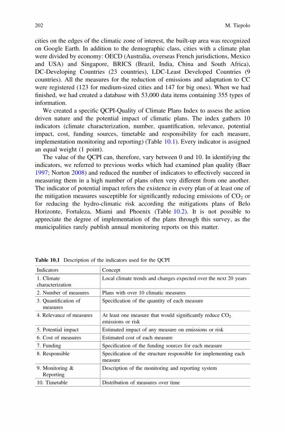
cities on the edges of the climatic zone of interest, the built-up area was recognizedon Google Earth. In addition to the demographic class, cities with a climate planwere divided by economy: OECD (Australia, overseas French jurisdictions, Mexicoand USA) and Singapore, BRICS (Brazil, India, China and South Africa),DC-Developing Countries (23 countries), LDC-Least Developed Countries (9countries). All the measures for the reduction of emissions and adaptation to CCwere registered (123 for medium-sized cities and 147 for big ones). When we hadfinished, we had created a database with 53,000 data items containing 355 types ofinformation.
We created a specific QCPI-Quality of Climate Plans Index to assess the actiondriven nature and the potential impact of climatic plans. The index gathers 10indicators (climate characterization, number, quantification, relevance, potentialimpact, cost, funding sources, timetable and responsibility for each measure,implementation monitoring and reporting) (Table 10.1). Every indicator is assignedan equal weight (1 point).
The value of the QCPI can, therefore, vary between 0 and 10. In identifying theindicators, we referred to previous works which had examined plan quality (Baer1997; Norton 2008) and reduced the number of indicators to effectively succeed inmeasuring them in a high number of plans often very different from one another.The indicator of potential impact refers the existence in every plan of at least one ofthe mitigation measures susceptible for significantly reducing emissions of CO2 orfor reducing the hydro-climatic risk according the mitigations plans of BeloHorizonte, Fortaleza, Miami and Phoenix (Table 10.2). It is not possible toappreciate the degree of implementation of the plans through this survey, as themunicipalities rarely publish annual monitoring reports on this matter.
Table 10.1 Description of the indicators used for the QCPI
Indicators Concept
1. Climatecharacterization
Local climate trends and changes expected over the next 20 years
2. Number of measures Plans with over 10 climatic measures
3. Quantification ofmeasures
Specification of the quantity of each measure
4. Relevance of measures At least one measure that would significantly reduce CO2
emissions or risk
5. Potential impact Estimated impact of any measure on emissions or risk
6. Cost of measures Estimated cost of each measure
7. Funding Specification of the funding sources for each measure
8. Responsible Specification of the structure responsible for implementing eachmeasure
9. Monitoring &Reporting
Description of the monitoring and reporting system
10. Timetable Distribution of measures over time
202 M. Tiepolo
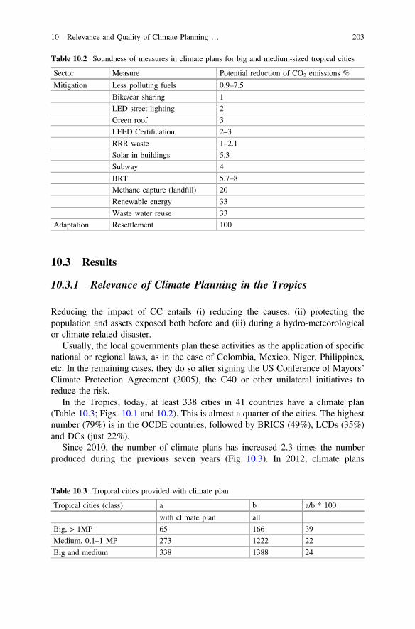
10.3 Results
10.3.1 Relevance of Climate Planning in the Tropics
Reducing the impact of CC entails (i) reducing the causes, (ii) protecting thepopulation and assets exposed both before and (iii) during a hydro-meteorologicalor climate-related disaster.
Usually, the local governments plan these activities as the application of specificnational or regional laws, as in the case of Colombia, Mexico, Niger, Philippines,etc. In the remaining cases, they do so after signing the US Conference of Mayors’Climate Protection Agreement (2005), the C40 or other unilateral initiatives toreduce the risk.
In the Tropics, today, at least 338 cities in 41 countries have a climate plan(Table 10.3; Figs. 10.1 and 10.2). This is almost a quarter of the cities. The highestnumber (79%) is in the OCDE countries, followed by BRICS (49%), LCDs (35%)and DCs (just 22%).
Since 2010, the number of climate plans has increased 2.3 times the numberproduced during the previous seven years (Fig. 10.3). In 2012, climate plans
Table 10.2 Soundness of measures in climate plans for big and medium-sized tropical cities
Sector Measure Potential reduction of CO2 emissions %
Mitigation Less polluting fuels 0.9–7.5
Bike/car sharing 1
LED street lighting 2
Green roof 3
LEED Certification 2–3
RRR waste 1–2.1
Solar in buildings 5.3
Subway 4
BRT 5.7–8
Methane capture (landfill) 20
Renewable energy 33
Waste water reuse 33
Adaptation Resettlement 100
Table 10.3 Tropical cities provided with climate plan
Tropical cities (class) a b a/b * 100
with climate plan all
Big, > 1MP 65 166 39
Medium, 0,1–1 MP 273 1222 22
Big and medium 338 1388 24
10 Relevance and Quality of Climate Planning … 203
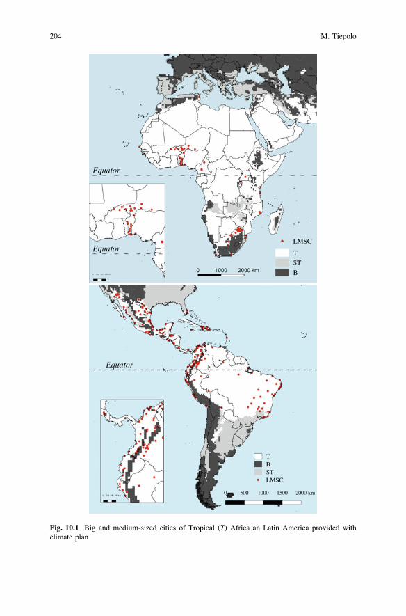
Fig. 10.1 Big and medium-sized cities of Tropical (T) Africa an Latin America provided withclimate plan
204 M. Tiepolo
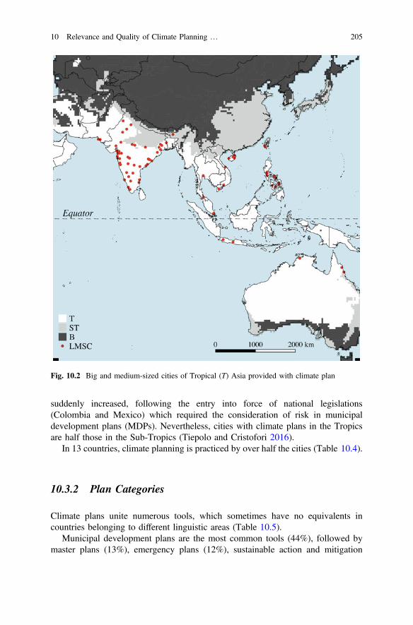
suddenly increased, following the entry into force of national legislations(Colombia and Mexico) which required the consideration of risk in municipaldevelopment plans (MDPs). Nevertheless, cities with climate plans in the Tropicsare half those in the Sub-Tropics (Tiepolo and Cristofori 2016).
In 13 countries, climate planning is practiced by over half the cities (Table 10.4).
10.3.2 Plan Categories
Climate plans unite numerous tools, which sometimes have no equivalents incountries belonging to different linguistic areas (Table 10.5).
Municipal development plans are the most common tools (44%), followed bymaster plans (13%), emergency plans (12%), sustainable action and mitigation
Fig. 10.2 Big and medium-sized cities of Tropical (T) Asia provided with climate plan
10 Relevance and Quality of Climate Planning … 205
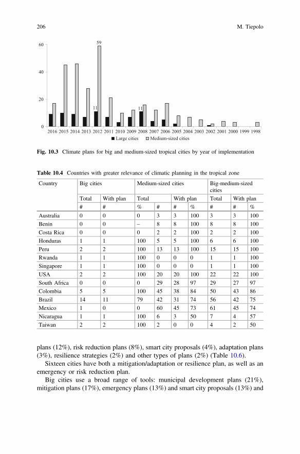
plans (12%), risk reduction plans (8%), smart city proposals (4%), adaptation plans(3%), resilience strategies (2%) and other types of plans (2%) (Table 10.6).
Sixteen cities have both a mitigation/adaptation or resilience plan, as well as anemergency or risk reduction plan.
Big cities use a broad range of tools: municipal development plans (21%),mitigation plans (17%), emergency plans (13%) and smart city proposals (13%) and
11 11
59
0
20
40
60
2016 2015 2014 2013 2012 2011 2010 2009 2008 2007 2006 2005 2004 2003 2002 2001 2000 1999 1998Large cities Medium-sized cities
Fig. 10.3 Climate plans for big and medium-sized tropical cities by year of implementation
Table 10.4 Countries with greater relevance of climatic planning in the tropical zone
Country Big cities Medium-sized cities Big-medium-sizedcities
Total With plan Total With plan Total With plan
# # % # # % # # %
Australia 0 0 0 3 3 100 3 3 100
Benin 0 0 – 8 8 100 8 8 100
Costa Rica 0 0 0 2 2 100 2 2 100
Honduras 1 1 100 5 5 100 6 6 100
Peru 2 2 100 13 13 100 15 15 100
Rwanda 1 1 100 0 0 0 1 1 100
Singapore 1 1 100 0 0 0 1 1 100
USA 2 2 100 20 20 100 22 22 100
South Africa 0 0 0 29 28 97 29 27 97
Colombia 5 5 100 45 38 84 50 43 86
Brazil 14 11 79 42 31 74 56 42 75
Mexico 1 0 0 60 45 73 61 45 74
Nicaragua 1 1 100 6 3 50 7 4 57
Taiwan 2 2 100 2 0 0 4 2 50
206 M. Tiepolo
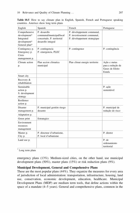
emergency plans (13%). Medium-sized cities, on the other hand, use municipaldevelopment plans (50%), master plans (15%) or risk reduction plans (9%).
Municipal Development, General and Compehensive PlansThese are the most popular plans (44%). They organize the measures for every areaof jurisdiction of local administration: transportation, infrastructure, housing, landuse, conservation, economic development, education, healthcare. MunicipalDevelopment Plans (MDP) are medium term tools, that define actions within thespace of a mandate (4–5 years). General and comprehensive plans, common in the
Table 10.5 How to say climate plan in English, Spanish, French and Portuguese speakingcountries. Asteriscs show long term plans
English Spanish French Portuguese
Comprehensivedevelopment*Integrateddevelopment*General plan*
P. desarollocommunal/municipal/localconcertado, P. territorialdesarollo integral
P. développement communal,P. investissement communal,P. développement strategique
Contingency p.Emergency p.Crisismanagement p.
P. contingenciaP. emergencia, PLEC
P. contingence P. contingência
Climate actionp.
Plan accion climaticamunicipal
Plan climat energie territoire Ação e metaspara a redução deGases de EfeitoEstufa
Smart city
Recovery &rehabilitation
Sustainableaction p.S. developmentstrategy
P. açãosustentável
Resilienceaction p.
Disastermanagement p.
P. municipal gestión riesgodesastre
P. municipal deredução do risco
Adaptation p.
Green print Estrategico
Environmentresourcesmanagement
Master p.City p.
P. directeur d’urbanisme,P. local d’urbanisme
P. diretor
Land use p. P. deordenamientoterritorial
* Long term plans
10 Relevance and Quality of Climate Planning … 207
USA, are long term tools that define policies for the next 20 years. A diagnosis(participated) of the shortcomings precedes planning of measures. The most accurateplans spread measures over time, defining the cost and the sources of funding, thebody responsible and the system of monitoring and evaluation. The MDP was bornto promote local development, not to respond to CC, so it does not characterize thelocal climate, unless obliged by law to do so (Niger). However, different measuresfall between those that are typical for mitigation (tree planting, pedestrian and cyclemobility, waste reducing/reusing/recycling) or adaptation (storm water drainage,resettlement from hazard prone areas). In the Tropics, MDPs are the first tools tocontain measures for adaptation to CC: Djougou and Malanville, Benin (2003 and2004), La Ceiba, Honduras (2005), Estelí, Nicaragua (2005), Thane (2005) andMysore (2006), India. MDPs with climate measures have been generalized inColombia, India, Mexico and other tropical countries since 2012. Odessa and Laredoare the first medium-sized cities to adopt a comprehensive plan (1988 and 1991).Glendele and Honolulu are the first to have a general plan (2002).
Master PlansMaster plans (13%) are the second most widespread tools. They first started to beimplement in big cities (Belo Horizonte 1996, Kigali 2004, São Luís 2005) and thenin medium-sized cities (Petrolina, São João Meriti, Uberlandia 2006). These plansare medium-long term and don’t just define land use, but also transportation, waterand sanitation, waste, economic and social development (education, health, accessto housing, tourism) and environment, without, however, specifying the costs of themeasures or their distribution over time, and without foreseeing the impacts or adevice for monitoring and reporting (M&R).
Emergency PlansThis group (12%) is especially common in South America but not in tropicalAfrica. 61% of plans traced have been drawn up over the past three years.
Table 10.6 Types of climate plan for big and medium-sized tropical cities
Type of plan Climate plans for cities
Big/medium-sized Big Medium-sized
n. % n. % n. %
Municipaldevelopment
164 44 13 21 151 50
Master plan 48 13 4 7 44 15
Emergency 45 12 10 13 35 12
Risk reduction 29 8 2 3 27 9
Sustainable 25 7 6 5 19 6
Mitigation 23 6 13 17 10 3
Adaptation 11 3 7 9 4 1
Smart city 15 4 10 13 5 2
Resilience 6 2 4 5 2 1
Other 10 3 5 7 5 2
Total 376 100 74 100 302 100
208 M. Tiepolo
There are two types of plan: those that specify the arrangements a local gov-ernment must make to become operative in the event of a disaster (La Esperanza,Sincelejo), and those that are operational (Santiago de Cali), describing thesequence of established operations that the various actors are called upon toimplement in order to respond to the emergency. These plans are, at times, limitedto one hazard only (heat in Ahmedabad, drought in Campinas, floods in Machala).Though they do not solely refer to CC-related disasters, they overlapmitigation/adaptation plans in relation to the definition of zones that are eitherexposed or at risk. In cities that have both an emergency plan and an adaptationplan, the two tools refer to different bodies, specifically civil defence or fire brigadein the first case, city council/environmental sector in the second.
The plan is implemented after an early warning. The warning should bestrategically communicated to areas that are exposed to the hazard, especially in theevent of floods. This only occurs in 30% of cases. However, only 18% of plansdefine the early warning threshold. Barely 20% define hazard prone areas and onlyin half the cases do they make use of maps. Emergency or contingency plans“analyse specific potential events or emerging situations that might threaten societyor the environment, and establish arrangements in advance to enable timely,effective and appropriate responses to such events and situations” (UNISDR 2009:7). Once again, a national law envisages the disaster prevention device (Colombia,India, Philippines, etc.) or civil defence (Brazil), and subsequently the creation ofmunicipal emergency committees to draw up dedicated plans. In other cases(Texas), the contingency plan is drawn up in compliance with rules defined by statecommissions. The first medium-sized cities to implement an emergency plan wereEl Progreso, Honduras (1998), Granada, Nicaragua (2005), San Andres de Tumaco,Colombia (2006) and Tacna, Peru (2007), followed by two big cities: Tegucigalpa,Honduras (2007) and Hyderabad, Pakistan (2008).
Risk Reduction PlansThese scarcely used plans (8%), contain structural and non-structural measuresdescribed in detail (costs and methods of financing), which respond to the hazardsto which the city is exposed. Sometimes these plans lack climate characterization.Risk reduction plans are in place in Brazil, Cameroun, Colombia, Nicaragua andPhilippines. One of the first medium-sized cities to adopt these plans is Granada,Nicaragua (2005), followed, among the big cities, by Maçeio and Vitoria, Brazil(2007).
Mitigation PlansThis group collects 6% of the planning tools traced. These plans focus on the need“to reduce the sources or enhance the sinks of greenhouse gases” (IPCC 2014: 19).Mitigation plans comprise the emission inventory, GHG reduction goals andmeasures. The most detailed plans estimate the expected reduction of emissions, therisks resulting from CC, the cost, funding sources and the timing of every measure.The capability assessment, which considers the technical and political ability toimplement the measures, is rarely carried out. The first mitigation plans for bigtropical cities were prepared for Bangkok, Thailand (2007) and Miami, USA
10 Relevance and Quality of Climate Planning … 209

(2008), and authentic climate plans, with numerous measures, for medium-sizedcities are those of Cairns and Darwin, Australia (2009 and 2010).
Sustainable Action PlansThese plans (6%) were introduced by the Inter-American Development Bankstarting in 2012. They contain mitigation measures (tree planting, pedestrian andcycle mobility) and adaptation measures (early warning and stormwater drainage)effective in the midterm. Their greatest limit is that they are stand-alone plans, notenvisaged by law, which the cities are not required to set up.
Smart City ProposalsSmart city proposals are the ultimate planning tool. Employed in India (in abouttwenty cities) and in Indonesia (Bogor 2015), these tools are still little used in theTropics (4%). They are based on broad consultation and, in general, concern one orjust a few parts of the city. The accent is on technological innovation (for example,sensors which tell you when trash bins are full, etc.) more than tackling big urbanproblems (slum upgrading and informal settlement regularization, poverty and riskreduction). However, they also contain measures for mitigation (reduction ofvehicle traffic) and adaptation (storm water drainage), which are not deriving fromclimate characterization or from risk assessment.
Adaptation PlansAdaptation planning focuses on “the adjustment in natural or human systems inresponse to actual or expected climatic stimuli or their effects, which moderatesharm or exploits beneficial opportunities” (UNISDR 2009). Plans includenon-structural measures (e.g. early warning, flood drills) and structural measures(flood barriers, stormwater drainage, and resettlement of inhabitants fromflood-prone areas). In the latter case, if local adaptation plans are not expresslyenvisaged by the general environment protection law or by a specific national law(Philippines 2007), they are implicit in the Local Government Act of variouscountries (Australia 1999) when council functions are specified and often extendedto “protect its area from natural hazards and to mitigate the effects of such hazards.”In other cases, the individual cities implement the specific national commitmentsmade at the United Nations Framework Convention for Climate Change(UNFCCC). Adaptation planning is funded by dedicated programmes, but is stillscarcely practised (3%) as it has not been able to be implemented on the sameglobal mobilisation levels as GHG mitigation. The first examples of adaptationplans are those of Darwin (2010) for medium-sized cities and of Semarang (2010)for big cities.
Resilience StrategiesResilience strategies (2%) are common in Asia only. The target of these strategies isto strengthen planning, organisational and management skills in view of a disaster,rather than implementing structural measures. Aside from structural measures, theydefine many actions based on the accumulation of information (databases on haz-ards, hazard prone area identification), management (establishing a CC coordinationoffice), training and awareness. The most accurate resilience strategies identify
210 M. Tiepolo
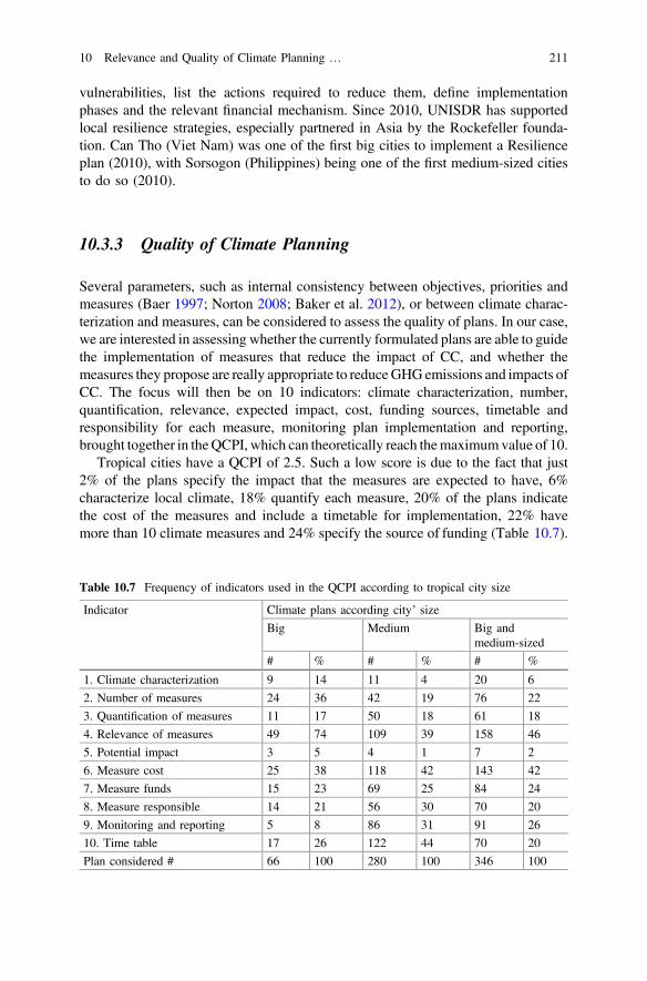
vulnerabilities, list the actions required to reduce them, define implementationphases and the relevant financial mechanism. Since 2010, UNISDR has supportedlocal resilience strategies, especially partnered in Asia by the Rockefeller founda-tion. Can Tho (Viet Nam) was one of the first big cities to implement a Resilienceplan (2010), with Sorsogon (Philippines) being one of the first medium-sized citiesto do so (2010).
10.3.3 Quality of Climate Planning
Several parameters, such as internal consistency between objectives, priorities andmeasures (Baer 1997; Norton 2008; Baker et al. 2012), or between climate charac-terization and measures, can be considered to assess the quality of plans. In our case,we are interested in assessing whether the currently formulated plans are able to guidethe implementation of measures that reduce the impact of CC, and whether themeasures they propose are really appropriate to reduceGHGemissions and impacts ofCC. The focus will then be on 10 indicators: climate characterization, number,quantification, relevance, expected impact, cost, funding sources, timetable andresponsibility for each measure, monitoring plan implementation and reporting,brought together in theQCPI, which can theoretically reach themaximumvalue of 10.
Tropical cities have a QCPI of 2.5. Such a low score is due to the fact that just2% of the plans specify the impact that the measures are expected to have, 6%characterize local climate, 18% quantify each measure, 20% of the plans indicatethe cost of the measures and include a timetable for implementation, 22% havemore than 10 climate measures and 24% specify the source of funding (Table 10.7).
Table 10.7 Frequency of indicators used in the QCPI according to tropical city size
Indicator Climate plans according city’ size
Big Medium Big andmedium-sized
# % # % # %
1. Climate characterization 9 14 11 4 20 6
2. Number of measures 24 36 42 19 76 22
3. Quantification of measures 11 17 50 18 61 18
4. Relevance of measures 49 74 109 39 158 46
5. Potential impact 3 5 4 1 7 2
6. Measure cost 25 38 118 42 143 42
7. Measure funds 15 23 69 25 84 24
8. Measure responsible 14 21 56 30 70 20
9. Monitoring and reporting 5 8 86 31 91 26
10. Time table 17 26 122 44 70 20
Plan considered # 66 100 280 100 346 100
10 Relevance and Quality of Climate Planning … 211
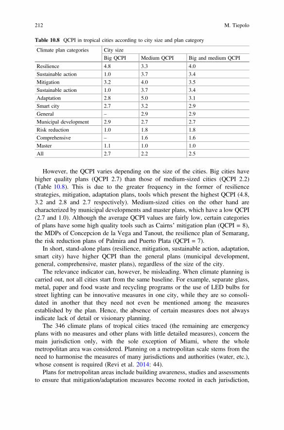
However, the QCPI varies depending on the size of the cities. Big cities havehigher quality plans (QCPI 2.7) than those of medium-sized cities (QCPI 2.2)(Table 10.8). This is due to the greater frequency in the former of resiliencestrategies, mitigation, adaptation plans, tools which present the highest QCPI (4.8,3.2 and 2.8 and 2.7 respectively). Medium-sized cities on the other hand arecharacterized by municipal developments and master plans, which have a low QCPI(2.7 and 1.0). Although the average QCPI values are fairly low, certain categoriesof plans have some high quality tools such as Cairns’ mitigation plan (QCPI = 8),the MDPs of Concepcion de la Vega and Tanout, the resilience plan of Semarang,the risk reduction plans of Palmira and Puerto Plata (QCPI = 7).
In short, stand-alone plans (resilience, mitigation, sustainable action, adaptation,smart city) have higher QCPI than the general plans (municipal development,general, comprehensive, master plans), regardless of the size of the city.
The relevance indicator can, however, be misleading. When climate planning iscarried out, not all cities start from the same baseline. For example, separate glass,metal, paper and food waste and recycling programs or the use of LED bulbs forstreet lighting can be innovative measures in one city, while they are so consoli-dated in another that they need not even be mentioned among the measuresestablished by the plan. Hence, the absence of certain measures does not alwaysindicate lack of detail or visionary planning.
The 346 climate plans of tropical cities traced (the remaining are emergencyplans with no measures and other plans with little detailed measures), concern themain jurisdiction only, with the sole exception of Miami, where the wholemetropolitan area was considered. Planning on a metropolitan scale stems from theneed to harmonise the measures of many jurisdictions and authorities (water, etc.),whose consent is required (Revi et al. 2014: 44).
Plans for metropolitan areas include building awareness, studies and assessmentsto ensure that mitigation/adaptation measures become rooted in each jurisdiction,
Table 10.8 QCPI in tropical cities according to city size and plan category
Climate plan categories City size
Big QCPI Medium QCPI Big and medium QCPI
Resilience 4.8 3.3 4.0
Sustainable action 1.0 3.7 3.4
Mitigation 3.2 4.0 3.5
Sustainable action 1.0 3.7 3.4
Adaptation 2.8 5.0 3.1
Smart city 2.7 3.2 2.9
General – 2.9 2.9
Municipal development 2.9 2.7 2.7
Risk reduction 1.0 1.8 1.8
Comprehensive – 1.6 1.6
Master 1.1 1.0 1.0
All 2.7 2.2 2.5
212 M. Tiepolo
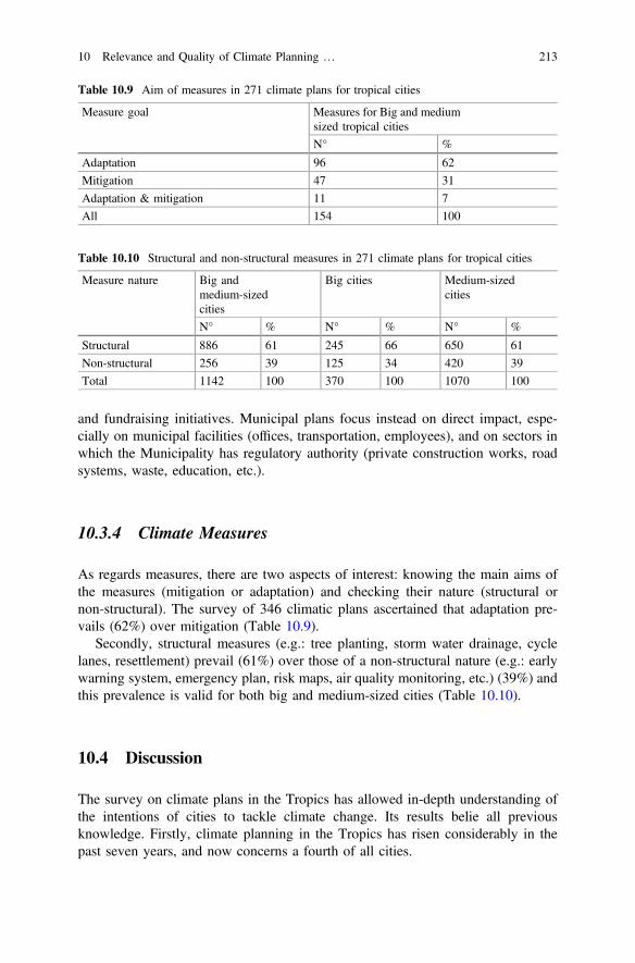
and fundraising initiatives. Municipal plans focus instead on direct impact, espe-cially on municipal facilities (offices, transportation, employees), and on sectors inwhich the Municipality has regulatory authority (private construction works, roadsystems, waste, education, etc.).
10.3.4 Climate Measures
As regards measures, there are two aspects of interest: knowing the main aims ofthe measures (mitigation or adaptation) and checking their nature (structural ornon-structural). The survey of 346 climatic plans ascertained that adaptation pre-vails (62%) over mitigation (Table 10.9).
Secondly, structural measures (e.g.: tree planting, storm water drainage, cyclelanes, resettlement) prevail (61%) over those of a non-structural nature (e.g.: earlywarning system, emergency plan, risk maps, air quality monitoring, etc.) (39%) andthis prevalence is valid for both big and medium-sized cities (Table 10.10).
10.4 Discussion
The survey on climate plans in the Tropics has allowed in-depth understanding ofthe intentions of cities to tackle climate change. Its results belie all previousknowledge. Firstly, climate planning in the Tropics has risen considerably in thepast seven years, and now concerns a fourth of all cities.
Table 10.9 Aim of measures in 271 climate plans for tropical cities
Measure goal Measures for Big and mediumsized tropical cities
N° %
Adaptation 96 62
Mitigation 47 31
Adaptation & mitigation 11 7
All 154 100
Table 10.10 Structural and non-structural measures in 271 climate plans for tropical cities
Measure nature Big andmedium-sizedcities
Big cities Medium-sizedcities
N° % N° % N° %
Structural 886 61 245 66 650 61
Non-structural 256 39 125 34 420 39
Total 1142 100 370 100 1070 100
10 Relevance and Quality of Climate Planning … 213
The option between stand-alone and existing plans (UN-Habitat 2015) is soonunravelled. Three quarters of climate-action is carried out using existing tools:MDPs and master plans, especially in medium-sized cities. Stand-alone plans areused only by big cities. The mainstreaming of climate measures in the existing toolshas several advantages in theory (UN-Habitat 2015; Revi et al. 2014; Basset andShandas 2010): decrease of hazard exposure (prohibition of building on hazardprone areas), increased chances of implementation (MDP), mitigation burdenshared with private sector (mitigation imposed upon developers), cost reduction(measures already funded in other sectors), reduced contribution to CC (regulationson building materials). In practice, we have found that mainstreaming presentsseveral limitations compared to stand-alone plans. Specifically, in the case ofmunicipal development plans, we notice very few climatic measures (an average of4). In the case of master plans other limitations include lack of characterisation ofthe hazard, prevalence of measures that only concern land use (setback to becomplied with during construction works, and land use allowed), lack of priorityand scheduling, no reference to the potential impact of works, rare monitoring andreporting of the plan implementation.
Secondly, previous knowledge of climate measures is belied. In the Tropics, thefocus isn’t on flood (Hunt and Watkiss 2011). It is on air quality (47 measures),drought, heat, fire, landslide and wind (28 measures), with flood coming last (16measures). The equivalent measures aren’t related to mitigation (Buckley 2010;Anguelowsky and Carmin 2011) but to adaptation. Lastly, contrary to the claimsmade by Wamsler et al. (2013), the measures are not always the same in thedifferent contexts with a prevalence of non-structural measures. They depend on theeconomy to which the city belongs (OECD, BRICS, DC, LDCs) and on the size ofthe city, and are mainly structural.
Thirdly, the QCPI confirms the observations of Wheeler (2008), Tang et al.(2010) and Preston et al. (2011) on smaller contexts: plan-quality is still low.Climate plans are not particularly action driven and their measures are inadequate tosignificantly reduce GHG emissions and the impacts of CC.
The existing plans, in which to carry out the mainstreaming of climate measures,present the lowest quality, regardless of the size of the city and the economy towhich it belongs. Mainstreaming requires a considerable amount of work to raisethe quality of MDPs, MPs and RMPs.
Our survey has two main limits. The first is that it considers no plans other thanthose accessible in Chinese, English, French, Spanish and Portuguese. Secondly,
214 M. Tiepolo
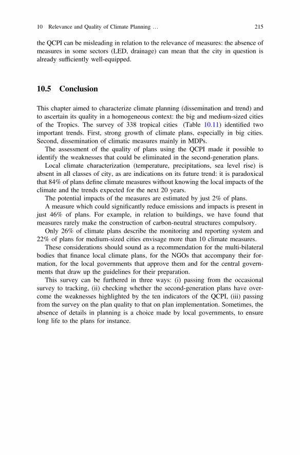
the QCPI can be misleading in relation to the relevance of measures: the absence ofmeasures in some sectors (LED, drainage) can mean that the city in question isalready sufficiently well-equipped.
10.5 Conclusion
This chapter aimed to characterize climate planning (dissemination and trend) andto ascertain its quality in a homogeneous context: the big and medium-sized citiesof the Tropics. The survey of 338 tropical cities (Table 10.11) identified twoimportant trends. First, strong growth of climate plans, especially in big cities.Second, dissemination of climatic measures mainly in MDPs.
The assessment of the quality of plans using the QCPI made it possible toidentify the weaknesses that could be eliminated in the second-generation plans.
Local climate characterization (temperature, precipitations, sea level rise) isabsent in all classes of city, as are indications on its future trend: it is paradoxicalthat 84% of plans define climate measures without knowing the local impacts of theclimate and the trends expected for the next 20 years.
The potential impacts of the measures are estimated by just 2% of plans.A measure which could significantly reduce emissions and impacts is present in
just 46% of plans. For example, in relation to buildings, we have found thatmeasures rarely make the construction of carbon-neutral structures compulsory.
Only 26% of climate plans describe the monitoring and reporting system and22% of plans for medium-sized cities envisage more than 10 climate measures.
These considerations should sound as a recommendation for the multi-bilateralbodies that finance local climate plans, for the NGOs that accompany their for-mation, for the local governments that approve them and for the central govern-ments that draw up the guidelines for their preparation.
This survey can be furthered in three ways: (i) passing from the occasionalsurvey to tracking, (ii) checking whether the second-generation plans have over-come the weaknesses highlighted by the ten indicators of the QCPI, (iii) passingfrom the survey on the plan quality to that on plan implementation. Sometimes, theabsence of details in planning is a choice made by local governments, to ensurelong life to the plans for instance.
10 Relevance and Quality of Climate Planning … 215
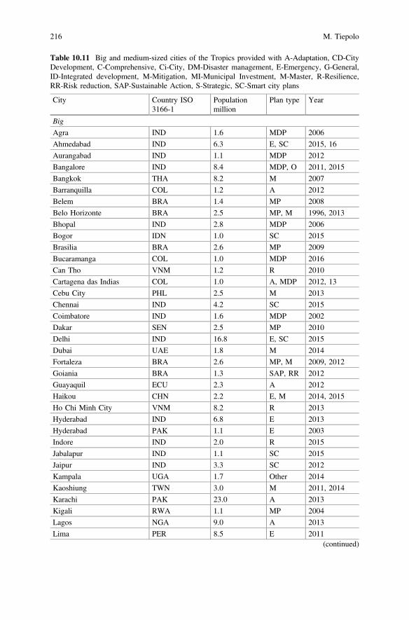
Table 10.11 Big and medium-sized cities of the Tropics provided with A-Adaptation, CD-CityDevelopment, C-Comprehensive, Ci-City, DM-Disaster management, E-Emergency, G-General,ID-Integrated development, M-Mitigation, MI-Municipal Investment, M-Master, R-Resilience,RR-Risk reduction, SAP-Sustainable Action, S-Strategic, SC-Smart city plans
City Country ISO3166-1
Populationmillion
Plan type Year
Big
Agra IND 1.6 MDP 2006
Ahmedabad IND 6.3 E, SC 2015, 16
Aurangabad IND 1.1 MDP 2012
Bangalore IND 8.4 MDP, O 2011, 2015
Bangkok THA 8.2 M 2007
Barranquilla COL 1.2 A 2012
Belem BRA 1.4 MP 2008
Belo Horizonte BRA 2.5 MP, M 1996, 2013
Bhopal IND 2.8 MDP 2006
Bogor IDN 1.0 SC 2015
Brasilia BRA 2.6 MP 2009
Bucaramanga COL 1.0 MDP 2016
Can Tho VNM 1.2 R 2010
Cartagena das Indias COL 1.0 A, MDP 2012, 13
Cebu City PHL 2.5 M 2013
Chennai IND 4.2 SC 2015
Coimbatore IND 1.6 MDP 2002
Dakar SEN 2.5 MP 2010
Delhi IND 16.8 E, SC 2015
Dubai UAE 1.8 M 2014
Fortaleza BRA 2.6 MP, M 2009, 2012
Goiania BRA 1.3 SAP, RR 2012
Guayaquil ECU 2.3 A 2012
Haikou CHN 2.2 E, M 2014, 2015
Ho Chi Minh City VNM 8.2 R 2013
Hyderabad IND 6.8 E 2013
Hyderabad PAK 1.1 E 2003
Indore IND 2.0 R 2015
Jabalapur IND 1.1 SC 2015
Jaipur IND 3.3 SC 2012
Kampala UGA 1.7 Other 2014
Kaoshiung TWN 3.0 M 2011, 2014
Karachi PAK 23.0 A 2013
Kigali RWA 1.1 MP 2004
Lagos NGA 9.0 A 2013
Lima PER 8.5 E 2011(continued)
216 M. Tiepolo
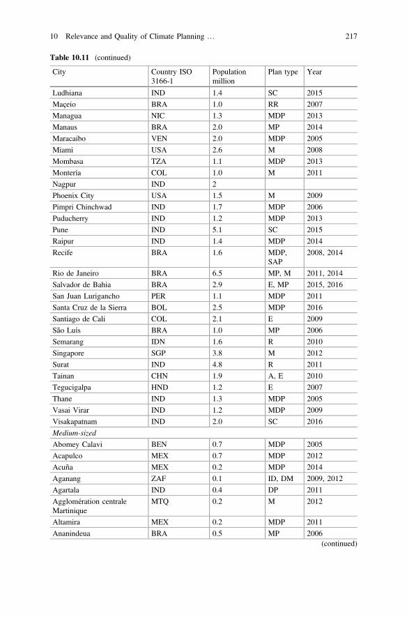
Table 10.11 (continued)
City Country ISO3166-1
Populationmillion
Plan type Year
Ludhiana IND 1.4 SC 2015
Maçeio BRA 1.0 RR 2007
Managua NIC 1.3 MDP 2013
Manaus BRA 2.0 MP 2014
Maracaibo VEN 2.0 MDP 2005
Miami USA 2.6 M 2008
Mombasa TZA 1.1 MDP 2013
Montería COL 1.0 M 2011
Nagpur IND 2
Phoenix City USA 1.5 M 2009
Pimpri Chinchwad IND 1.7 MDP 2006
Puducherry IND 1.2 MDP 2013
Pune IND 5.1 SC 2015
Raipur IND 1.4 MDP 2014
Recife BRA 1.6 MDP,SAP
2008, 2014
Rio de Janeiro BRA 6.5 MP, M 2011, 2014
Salvador de Bahia BRA 2.9 E, MP 2015, 2016
San Juan Lurigancho PER 1.1 MDP 2011
Santa Cruz de la Sierra BOL 2.5 MDP 2016
Santiago de Cali COL 2.1 E 2009
São Luís BRA 1.0 MP 2006
Semarang IDN 1.6 R 2010
Singapore SGP 3.8 M 2012
Surat IND 4.8 R 2011
Tainan CHN 1.9 A, E 2010
Tegucigalpa HND 1.2 E 2007
Thane IND 1.3 MDP 2005
Vasai Virar IND 1.2 MDP 2009
Visakapatnam IND 2.0 SC 2016
Medium-sized
Abomey Calavi BEN 0.7 MDP 2005
Acapulco MEX 0.7 MDP 2012
Acuña MEX 0.2 MDP 2014
Aganang ZAF 0.1 ID, DM 2009, 2012
Agartala IND 0.4 DP 2011
Agglomération centraleMartinique
MTQ 0.2 M 2012
Altamira MEX 0.2 MDP 2011
Ananindeua BRA 0.5 MP 2006(continued)
10 Relevance and Quality of Climate Planning … 217
Table 10.11 (continued)
City Country ISO3166-1
Populationmillion
Plan type Year
Anapolis BRA 0.4 MP 2016
Apartado COL 0.2 MDP 2012
Aracaju BRA 0.6 MP 2010
Armenia COL 0.3 MP 2009
Asansol IND 0.6 MDP 2006
Babahoyo ECU 0.1 E 2009
Bacolod PHL 0.5 A 2013
Ba-Phalaborwa ZAF 0.2 DM, IDP 2012, 2015
Barrancabermeja COL 0.3 MDP 2012
Belagavi IND 0.5 SC 2016
Bello COL 0.4 MDP 2012
Berhampur IND 0.4 CDP 2011
Betim BRA 0.4 MP 2007
Blouberg ZAF 0.2 MDP 2015
Boa Vista (Roirama) BRA 0.3 MP 2006
Bohicon BEN 0.1 MDP 2008
Buenaventura COL 0.4 MP 2001
Cairns AUS 0.2 M 2010
Campeche MEX 0.9 SAP 2015
Campina Grande BRA 0.4 MP 2006
Campo Goyatacazes BRA 0.5 MP 2007
Campos BRA 0.5 MP 2007
Cancun MEX 0.7 MDP 2014
Cariacica BRA 0.4 MP 2007
Carmen MEX 0.1 MDP 2012
Carrefour HTI 0.5 MIP 2011
Cartago COL 0.2 MP 2000
Chandler, AZ USA 0.3 E, GP 2006, 2008
Chetumal seeOthon P. Blanco
MEX 0.2 MDP 2013
Chiclayo PER 0.5 MDP 2015
Chilón MEX 0.1 MDP 2012
Choloma HND 0.2 MDP 2003
Cienaga COL 0,1 MDP 2012
Ciudad Madero MEX 0.2 MDP 2013
Ciudad Valles MEX 0.2 MDP 2004
Concepción de la Vega DOM 0.2 MDP 2016
Contagem BRA 0.6 RR 2007
Coral Springs USA 0.2 CP 2008(continued)
218 M. Tiepolo
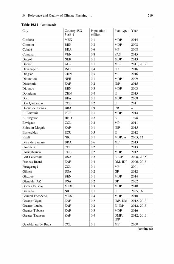
Table 10.11 (continued)
City Country ISO3166-1
Populationmillion
Plan type Year
Cordoba MEX 0.1 MDP 2014
Cotonou BEN 0.8 MDP 2008
Cuiabá BRA 0.6 MP 2008
Cumana VEN 0.8 PAS 2015
Dargol NER 0.1 MDP 2013
Darwin AUS 0.1 M, S 2011, 2012
Davanagere IND 0.4 SC 2016
Ding’an CHN 0.3 M 2016
Dioundiou NER 0.1 MDP 2009
Ditsobotla ZAF 0.2 IDP 2015
Djougou BEN 0.3 MDP 2003
Dongfang CHN 0.4 E 2015
Dori BFA 0.1 MDP 2008
Dos Quebradas COL 0.2 E 2011
Duque de Caxias BRA 0.9 RR –
El Porvenir PER 0.1 MDP 2014
El Progreso HND 0.2 E 1998
Envigado COL 0.2 MP 2011
Ephraim Mogale ZAF 0.1 IDP 2015
Esmeraldas ECU 0.5 E 2012
Estelí NIC 0.1 MDP, A 2005, 12
Feira de Santana BRA 0.6 MP 2013
Florencia COL 0.2 E 2013
Floridablanca COL 0.2 MDP 2012
Fort Lauerdale USA 0.2 E, CP 2008, 2015
Frances Baard ZAF 0.4 DM, IDP 2006, 2015
Fusagasugà COL 0.1 MP 2001
Gilbert USA 0.2 GP 2012
Glazoué BEN 0.1 MDP 2014
Glendale, AZ USA 0.2 GP 2002
Gomez Palacio MEX 0.3 MDP 2010
Granada NIC 0.1 E 2005, 09
General Escobedo MEX 0.4 MDP 2010
Greater Giyani ZAF 0.2 IDP, DM 2012, 2013
Greater Letaba ZAF 0.2 E, IDP 2012, 2015
Greater Tubatse ZAF 0.3 MDP 2016
Greater Tzaneen ZAF 0.4 DMP,IDP
2012, 2013
Guadalajara de Buga COL 0.1 MP 2000(continued)
10 Relevance and Quality of Climate Planning … 219
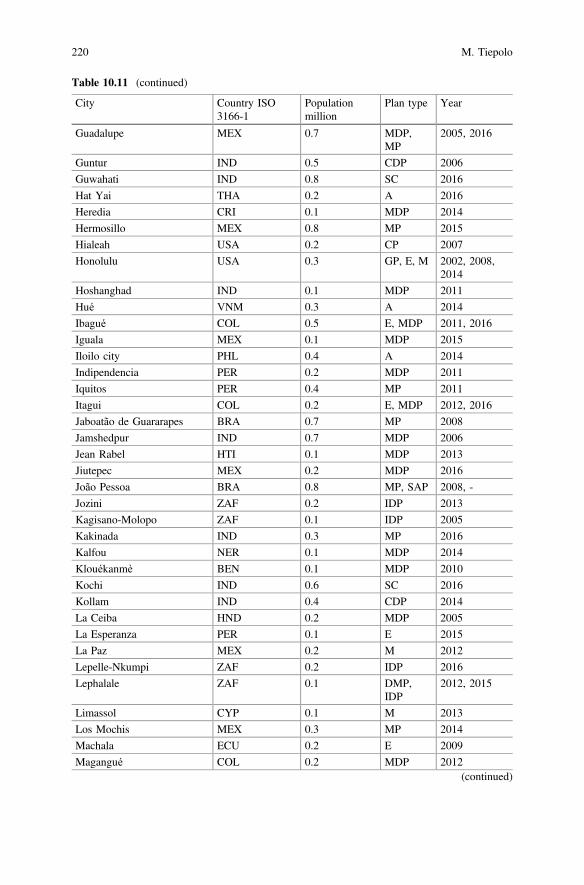
Table 10.11 (continued)
City Country ISO3166-1
Populationmillion
Plan type Year
Guadalupe MEX 0.7 MDP,MP
2005, 2016
Guntur IND 0.5 CDP 2006
Guwahati IND 0.8 SC 2016
Hat Yai THA 0.2 A 2016
Heredia CRI 0.1 MDP 2014
Hermosillo MEX 0.8 MP 2015
Hialeah USA 0.2 CP 2007
Honolulu USA 0.3 GP, E, M 2002, 2008,2014
Hoshanghad IND 0.1 MDP 2011
Hué VNM 0.3 A 2014
Ibagué COL 0.5 E, MDP 2011, 2016
Iguala MEX 0.1 MDP 2015
Iloilo city PHL 0.4 A 2014
Indipendencia PER 0.2 MDP 2011
Iquitos PER 0.4 MP 2011
Itagui COL 0.2 E, MDP 2012, 2016
Jaboatão de Guararapes BRA 0.7 MP 2008
Jamshedpur IND 0.7 MDP 2006
Jean Rabel HTI 0.1 MDP 2013
Jiutepec MEX 0.2 MDP 2016
João Pessoa BRA 0.8 MP, SAP 2008, -
Jozini ZAF 0.2 IDP 2013
Kagisano-Molopo ZAF 0.1 IDP 2005
Kakinada IND 0.3 MP 2016
Kalfou NER 0.1 MDP 2014
Klouékanmè BEN 0.1 MDP 2010
Kochi IND 0.6 SC 2016
Kollam IND 0.4 CDP 2014
La Ceiba HND 0.2 MDP 2005
La Esperanza PER 0.1 E 2015
La Paz MEX 0.2 M 2012
Lepelle-Nkumpi ZAF 0.2 IDP 2016
Lephalale ZAF 0.1 DMP,IDP
2012, 2015
Limassol CYP 0.1 M 2013
Los Mochis MEX 0.3 MP 2014
Machala ECU 0.2 E 2009
Magangué COL 0.2 MDP 2012(continued)
220 M. Tiepolo
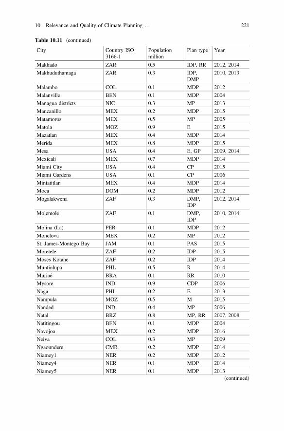
Table 10.11 (continued)
City Country ISO3166-1
Populationmillion
Plan type Year
Makhado ZAR 0.5 IDP, RR 2012, 2014
Makhuduthamaga ZAR 0.3 IDP,DMP
2010, 2013
Malambo COL 0.1 MDP 2012
Malanville BEN 0.1 MDP 2004
Managua districts NIC 0.3 MP 2013
Manzanillo MEX 0.2 MDP 2015
Matamoros MEX 0.5 MP 2005
Matola MOZ 0.9 E 2015
Mazatlan MEX 0.4 MDP 2014
Merida MEX 0.8 MDP 2015
Mesa USA 0.4 E, GP 2009, 2014
Mexicali MEX 0.7 MDP 2014
Miami City USA 0.4 CP 2015
Miami Gardens USA 0.1 CP 2006
Miniatitlan MEX 0.4 MDP 2014
Moca DOM 0.2 MDP 2012
Mogalakwena ZAF 0.3 DMP,IDP
2012, 2014
Molemole ZAF 0.1 DMP,IDP
2010, 2014
Molina (La) PER 0.1 MDP 2012
Monclova MEX 0.2 MP 2012
St. James-Montego Bay JAM 0.1 PAS 2015
Moretele ZAF 0.2 IDP 2015
Moses Kotane ZAF 0.2 IDP 2014
Muntinlupa PHL 0.5 R 2014
Muriaé BRA 0.1 RR 2010
Mysore IND 0.9 CDP 2006
Naga PHI 0.2 E 2013
Nampula MOZ 0.5 M 2015
Nanded IND 0.4 MP 2006
Natal BRZ 0.8 MP, RR 2007, 2008
Natitingou BEN 0.1 MDP 2004
Navojoa MEX 0.2 MDP 2016
Neiva COL 0.3 MP 2009
Ngaoundere CMR 0.2 MDP 2014
Niamey1 NER 0.2 MDP 2012
Niamey4 NER 0.1 MDP 2014
Niamey5 NER 0.1 MDP 2013(continued)
10 Relevance and Quality of Climate Planning … 221
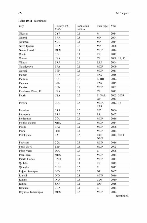
Table 10.11 (continued)
City Country ISO3166-1
Populationmillion
Plan type Year
Nicosia CYP 0.1 M 2014
Niteroi BRA 0.5 MP 2004
Noumea NCL 0.1 MP 2014
Nova Iguaçu BRA 0.8 MP 2008
Nueva Laredo MEX 0.4 MDP 2014
Ocaña COL 0.1 RR 2012
Odessa USA 0.1 CP 2008, 11, 15
Olinda BRA 0.4 RRP 2004
Ouahigouya BFA 0.1 MDP 2009
Ouessé BEN 0.1 MDP 2011
Palmas BRA 0.3 PAS 2015
Palmira COL 0.3 E, RR 2012
Panama PAN 0.9 PAS 2015
Parakou BEN 0.2 MDP 2007
Pembroke Pines, FL USA 0.2 CP 2013
Peoria USA 0.2 E, SAP,GP
2003, 2009,2013
Pereira COL 0.5 MDP,PAS
2012, 15
Petrolina BRA 0.3 MP 2006
Petropolis BRA 0.3 RR 2007
Piedecusta COL 0.1 MDP 2016
Piedras Negras MEX 0.2 MDP 2014
Pissila BFA 0.1 MDP 2008
Piura PER 0.4 MDP 2014
Polokwane ZAF 0.6 IDP,DMP
2012, 2013
Popayan COL 0.3 MDP 2016
Porto Novo BEN 0.3 MDP 2005
Porto Viejo ECU 0.3 E 2008
Poza Rica MEX 0.2 MDP 2014
Puerto Cortés HND 0.1 MDP 2013
Quibdó COL 0.1 RR 2012
Qiunghai CHN 0.5 E 2015
Rajpur Sonarpur IND 0.3 DP 2007
Ranchi IND 0.8 MDP 2016
Ratlam IND 0.3 CDP 2010
Ratlou ZAF 0.1 IDP 2016
Resende BRA 0.1 E 2014
Reynosa Tamaulipas MEX 0.6 MDP 2012(continued)
222 M. Tiepolo
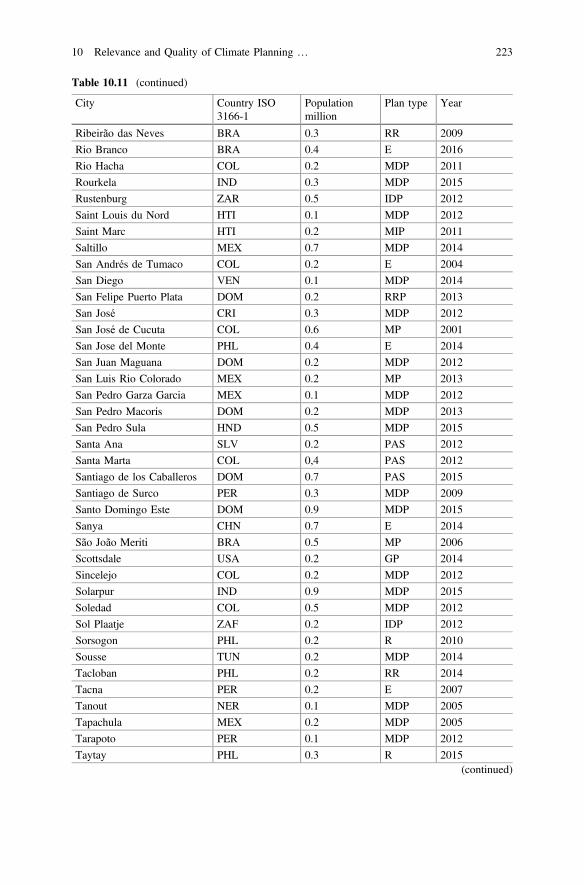
Table 10.11 (continued)
City Country ISO3166-1
Populationmillion
Plan type Year
Ribeirão das Neves BRA 0.3 RR 2009
Rio Branco BRA 0.4 E 2016
Rio Hacha COL 0.2 MDP 2011
Rourkela IND 0.3 MDP 2015
Rustenburg ZAR 0.5 IDP 2012
Saint Louis du Nord HTI 0.1 MDP 2012
Saint Marc HTI 0.2 MIP 2011
Saltillo MEX 0.7 MDP 2014
San Andrés de Tumaco COL 0.2 E 2004
San Diego VEN 0.1 MDP 2014
San Felipe Puerto Plata DOM 0.2 RRP 2013
San José CRI 0.3 MDP 2012
San José de Cucuta COL 0.6 MP 2001
San Jose del Monte PHL 0.4 E 2014
San Juan Maguana DOM 0.2 MDP 2012
San Luis Rio Colorado MEX 0.2 MP 2013
San Pedro Garza Garcia MEX 0.1 MDP 2012
San Pedro Macorís DOM 0.2 MDP 2013
San Pedro Sula HND 0.5 MDP 2015
Santa Ana SLV 0.2 PAS 2012
Santa Marta COL 0,4 PAS 2012
Santiago de los Caballeros DOM 0.7 PAS 2015
Santiago de Surco PER 0.3 MDP 2009
Santo Domingo Este DOM 0.9 MDP 2015
Sanya CHN 0.7 E 2014
São João Meriti BRA 0.5 MP 2006
Scottsdale USA 0.2 GP 2014
Sincelejo COL 0.2 MDP 2012
Solarpur IND 0.9 MDP 2015
Soledad COL 0.5 MDP 2012
Sol Plaatje ZAF 0.2 IDP 2012
Sorsogon PHL 0.2 R 2010
Sousse TUN 0.2 MDP 2014
Tacloban PHL 0.2 RR 2014
Tacna PER 0.2 E 2007
Tanout NER 0.1 MDP 2005
Tapachula MEX 0.2 MDP 2005
Tarapoto PER 0.1 MDP 2012
Taytay PHL 0.3 R 2015(continued)
10 Relevance and Quality of Climate Planning … 223
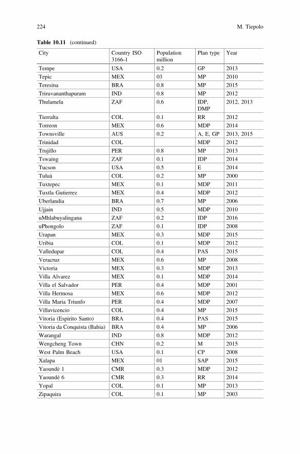
Table 10.11 (continued)
City Country ISO3166-1
Populationmillion
Plan type Year
Tempe USA 0.2 GP 2013
Tepic MEX 03 MP 2010
Teresina BRA 0.8 MP 2015
Triruvananthapuram IND 0.8 MP 2012
Thulamela ZAF 0.6 IDP,DMP
2012, 2013
Tierralta COL 0.1 RR 2012
Torreon MEX 0.6 MDP 2014
Townsville AUS 0.2 A, E, GP 2013, 2015
Trinidad COL MDP 2012
Trujillo PER 0.8 MP 2013
Tswaing ZAF 0.1 IDP 2014
Tucson USA 0.5 E 2014
Tuluá COL 0.2 MP 2000
Tuxtepec MEX 0.1 MDP 2011
Tuxtla Gutierrez MEX 0.4 MDP 2012
Uberlandia BRA 0.7 MP 2006
Ujjain IND 0.5 MDP 2010
uMhlabuyalingana ZAF 0.2 IDP 2016
uPhongolo ZAF 0.1 IDP 2008
Urapan MEX 0.3 MDP 2015
Uribia COL 0.1 MDP 2012
Valledupar COL 0.4 PAS 2015
Veracruz MEX 0.6 MP 2008
Victoria MEX 0.3 MDP 2013
Villa Alvarez MEX 0.1 MDP 2014
Villa el Salvador PER 0.4 MDP 2001
Villa Hermosa MEX 0.6 MDP 2012
Villa Maria Triunfo PER 0.4 MDP 2007
Villavicencio COL 0.4 MP 2015
Vitoria (Espirito Santo) BRA 0.4 PAS 2015
Vitoria da Conquista (Bahia) BRA 0.4 MP 2006
Warangal IND 0.8 MDP 2012
Wengcheng Town CHN 0.2 M 2015
West Palm Beach USA 0.1 CP 2008
Xalapa MEX 01 SAP 2015
Yaoundé 1 CMR 0.3 MDP 2012
Yaoundé 6 CMR 0.3 RR 2014
Yopal COL 0.1 MP 2013
Zipaquira COL 0.1 MP 2003
224 M. Tiepolo
References
Alcoforado, M.-J., and A. Matzarakis. 2010. Planning with urban climate in different climaticzones. Geographicalia 57: 5–39.
Anguelowsky, I., and J.A. Carmin. 2011. Something borrowed, everything new: Innovation andinstitutionalization in urban climate governance. Climate Opinions in EnvironmentalSustainability 3: 1–7. doi:10.1016/j.cosust.2010.12.017.
Aylett, A. 2014. Progress and challenges in the urban governance of climate change: Results of aglobal survey. Cambridge, MA: MIT.
Baer, W.C. 1997. General plan evaluation criteria: An approach to making better plans. JAPA 63(3): 329–344. doi:10.1080/01944369708975926.
Baker, I., A. Peterson, G. Brown, and C. McAlpine. 2012. Local government response to theimpacts of climate change: An evaluation of local climate adaptation plans. Landscape andUrban Planning 107: 127–136. doi:10.1016/j.landurbplan.2012.05.009.
Basset, E., and V. Shandas. 2010. Innovation and climate action planning. Perspectives frommunicipal plans. Journal of the American Planning Association 76 (4): 435–450. doi:10.1080/01944363.2010.509703.
Belda, M., E. Holtanová, T. Holenka, and J. Kalvová. 2014. Climate classification revisited: FromKöeppen to Trewartha. Climate Research 59 (1): 1–13. doi:10.3354/cr01204.
Buckley, H. 2010. Cities and the governing of climate change. Annual Review of Environment andResources 35: 229–259. doi:10.1146/annurev-environ-072809-101747.
CAI-Clean air initiative and Cities development initiative for Asia. 2012. Climate Change Plansand Infrastructure in Asian Citis. Pasig city: CAI and CDIA.
CDP-Carbon Disclosure Project. 2014. CDP Cities 2013. Summary Report on 110 Global Cities.London: CDP.
Carmin, J.A., N. Nadkami, and C. Rhie. 2012. Progress and Challenges in Urban ClimateAdaptation Planning. Results of a Global Survey. Cambridge, MA: MIT.
Fraser, A., and D.V. Lima. 2012. Regional technical assistance initiative on climate adaptationplanning in LAC cities. Survey results report.
Hunt, A., and P. Watkiss. 2011. Climate change impacts and adaptation in cities: A review of theliterature. Climatic Change 104 (1): 13–49. doi:10.1007/s10584-010-9975-6.
IPCC-International Panel on Climate Change. 2014. Annex II: Glossary. In Climate change 2014:Synthesis report. Contribution of working groups I, II and III to the fifth assessmeny report ofthe Intergovernmental panel on climate change, IPCC. Geneva: IPCC.
Lethoko. 2016. Inclusion of climate change strategies in municipal integrated development plans:A case from seven municipalities in Limpopo province, South Africa. Jàmbá-Journal odDisaster Risk Studies 8 (3). doi:10.4102/jamba.v8i3.245.
Norton, R.K. 2008. Using content analysis to evaluate local master plans and zonng codes. LandUse Policy 25: 432–454. doi:10.1016/j.landusepol.2007.10.006.
Preston, B.L., R.M. Westaway, and E.J. Yuen. 2011. Climate adaptation planning in practice: Anevaluation of adaptation plans for three developed nations. Mitig Adapt Strateg Glob Change16: 407–438. doi:10.1007/s11027-010-9270-x.
Revi, A. et al. 2014. Urban areas. In Assessment report 5, IPCC-WGII, 1–113.Rubel, F., and M. Kottok. 2010. Observed and projected climate shifts 1901–2100 depicted by
world maps of the Köppen-Geiger climate classification. Meteorol. Zeitschrift 19 (2): 135–141.doi:10.1127/0941-2948/2010/0430.
Tang, Z., S.D. Brody, C. Quinn, L. Chang, and T. Wei. 2010. Moving from agenda to action:evaluating local climate change actions plans. Journal of Environmental Planning andManagement 53 (1): 41–62. doi:10.1080/0964056090339977.
Tiepolo, M., and E. Cristofori. 2016. Climate change characterisation and planning in largetropical and subtropical cities. In Planning to cope with tropical and subtropical climatechange, ed. M. Tiepolo, E. Ponte, and E. Cristofori, 6–41. Berlin: De Gruyter Open. doi:10.1515/9783110480795-003.
10 Relevance and Quality of Climate Planning … 225
UN-Habitat. 2009. Climate change. The role of cities. Involvement, influence, implementation.UN-Habitat and UNEP-United Nations Environmental Program.
UN-Habitat. 2011. Cities and climate change. Global report on human settlements 2011.London-Washington, DC: Earthscan.
UN-Habitat. 2015. Integrating climate change into city development strategies. Climate changeand strategic planning. Nairobi: UN-Habitat.
UNISDR. 2009. 2009 UNISDR terminology on disaster risk reduction. Geneva: UNISDR- UnitedNations.
Vergara, W. 2005. Adapting to climate change. Lessons learned, work in progress, and proposednext steps for the World Bank in Latin America. The World Bank.
Wamsler, C., E. Brink, and C. Rivera. 2013. Planning for climate change in urban areas: Fromtheory to practice. Journal of Cleaner Production 50 (1): 68–81. doi: 10.1016/j.jclepro.2012.12.008 .
Wheeler, S.M. 2008. State and municipal climate change plans. Journal of the American PlanningAssociation 74 (4): 482–496. doi:10.1080/01944360802377973.
Open Access This chapter is licensed under the terms of the Creative Commons Attribution 4.0International License (http://creativecommons.org/licenses/by/4.0/), which permits use, sharing,adaptation, distribution and reproduction in any medium or format, as long as you give appropriatecredit to the original author(s) and the source, provide a link to the Creative Commons license andindicate if changes were made.The images or other third party material in this chapter are included in the chapter's Creative
Commons license, unless indicated otherwise in a credit line to the material. If material is notincluded in the chapter's Creative Commons license and your intended use is not permitted bystatutory regulation or exceeds the permitted use, you will need to obtain permission directly fromthe copyright holder.
226 M. Tiepolo
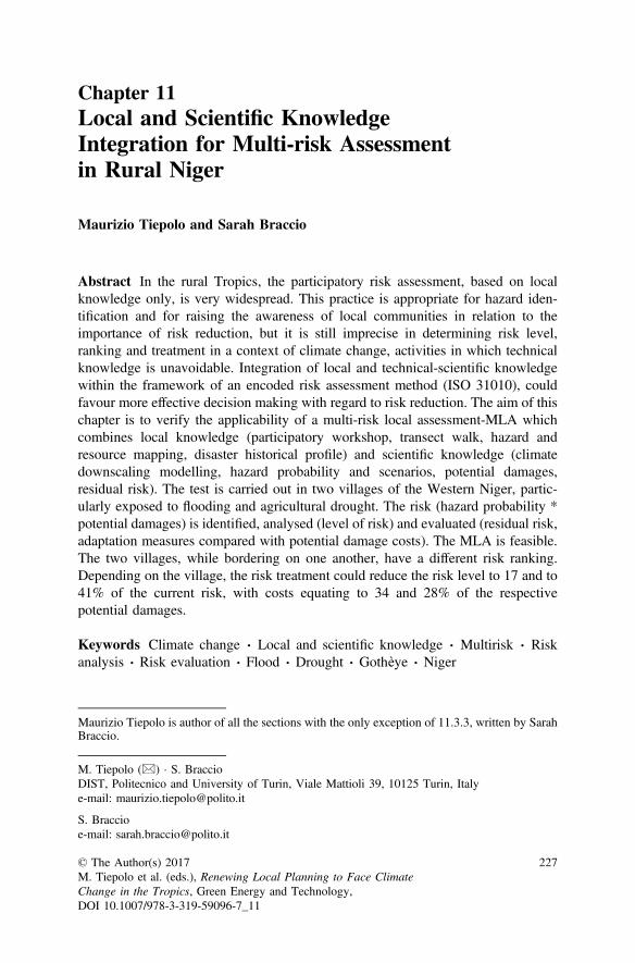
Chapter 11Local and Scientific KnowledgeIntegration for Multi-risk Assessmentin Rural Niger
Maurizio Tiepolo and Sarah Braccio
Abstract In the rural Tropics, the participatory risk assessment, based on localknowledge only, is very widespread. This practice is appropriate for hazard iden-tification and for raising the awareness of local communities in relation to theimportance of risk reduction, but it is still imprecise in determining risk level,ranking and treatment in a context of climate change, activities in which technicalknowledge is unavoidable. Integration of local and technical-scientific knowledgewithin the framework of an encoded risk assessment method (ISO 31010), couldfavour more effective decision making with regard to risk reduction. The aim of thischapter is to verify the applicability of a multi-risk local assessment-MLA whichcombines local knowledge (participatory workshop, transect walk, hazard andresource mapping, disaster historical profile) and scientific knowledge (climatedownscaling modelling, hazard probability and scenarios, potential damages,residual risk). The test is carried out in two villages of the Western Niger, partic-ularly exposed to flooding and agricultural drought. The risk (hazard probability *potential damages) is identified, analysed (level of risk) and evaluated (residual risk,adaptation measures compared with potential damage costs). The MLA is feasible.The two villages, while bordering on one another, have a different risk ranking.Depending on the village, the risk treatment could reduce the risk level to 17 and to41% of the current risk, with costs equating to 34 and 28% of the respectivepotential damages.
Keywords Climate change Local and scientific knowledge Multirisk Riskanalysis Risk evaluation Flood Drought Gothèye Niger
Maurizio Tiepolo is author of all the sections with the only exception of 11.3.3, written by SarahBraccio.
M. Tiepolo (&) S. BraccioDIST, Politecnico and University of Turin, Viale Mattioli 39, 10125 Turin, Italye-mail: [email protected]
S. Braccioe-mail: [email protected]
© The Author(s) 2017M. Tiepolo et al. (eds.), Renewing Local Planning to Face ClimateChange in the Tropics, Green Energy and Technology,DOI 10.1007/978-3-319-59096-7_11
227
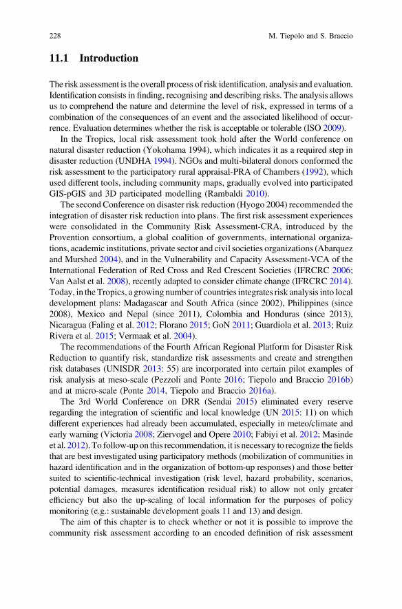
11.1 Introduction
The risk assessment is the overall process of risk identification, analysis and evaluation.Identification consists in finding, recognising and describing risks. The analysis allowsus to comprehend the nature and determine the level of risk, expressed in terms of acombination of the consequences of an event and the associated likelihood of occur-rence. Evaluation determines whether the risk is acceptable or tolerable (ISO 2009).
In the Tropics, local risk assessment took hold after the World conference onnatural disaster reduction (Yokohama 1994), which indicates it as a required step indisaster reduction (UNDHA 1994). NGOs and multi-bilateral donors conformed therisk assessment to the participatory rural appraisal-PRA of Chambers (1992), whichused different tools, including community maps, gradually evolved into participatedGIS-pGIS and 3D participated modelling (Rambaldi 2010).
The second Conference on disaster risk reduction (Hyogo 2004) recommended theintegration of disaster risk reduction into plans. The first risk assessment experienceswere consolidated in the Community Risk Assessment-CRA, introduced by theProvention consortium, a global coalition of governments, international organiza-tions, academic institutions, private sector and civil societies organizations (Abarquezand Murshed 2004), and in the Vulnerability and Capacity Assessment-VCA of theInternational Federation of Red Cross and Red Crescent Societies (IFRCRC 2006;Van Aalst et al. 2008), recently adapted to consider climate change (IFRCRC 2014).Today, in the Tropics, a growing number of countries integrates risk analysis into localdevelopment plans: Madagascar and South Africa (since 2002), Philippines (since2008), Mexico and Nepal (since 2011), Colombia and Honduras (since 2013),Nicaragua (Faling et al. 2012; Florano 2015; GoN 2011; Guardiola et al. 2013; RuizRivera et al. 2015; Vermaak et al. 2004).
The recommendations of the Fourth African Regional Platform for Disaster RiskReduction to quantify risk, standardize risk assessments and create and strengthenrisk databases (UNISDR 2013: 55) are incorporated into certain pilot examples ofrisk analysis at meso-scale (Pezzoli and Ponte 2016; Tiepolo and Braccio 2016b)and at micro-scale (Ponte 2014, Tiepolo and Braccio 2016a).
The 3rd World Conference on DRR (Sendai 2015) eliminated every reserveregarding the integration of scientific and local knowledge (UN 2015: 11) on whichdifferent experiences had already been accumulated, especially in meteo/climate andearly warning (Victoria 2008; Ziervogel and Opere 2010; Fabiyi et al. 2012; Masindeet al. 2012). To follow-up on this recommendation, it is necessary to recognize thefieldsthat are best investigated using participatory methods (mobilization of communities inhazard identification and in the organization of bottom-up responses) and those bettersuited to scientific-technical investigation (risk level, hazard probability, scenarios,potential damages, measures identification residual risk) to allow not only greaterefficiency but also the up-scaling of local information for the purposes of policymonitoring (e.g.: sustainable development goals 11 and 13) and design.
The aim of this chapter is to check whether or not it is possible to improve thecommunity risk assessment according to an encoded definition of risk assessment
228 M. Tiepolo and S. Braccio
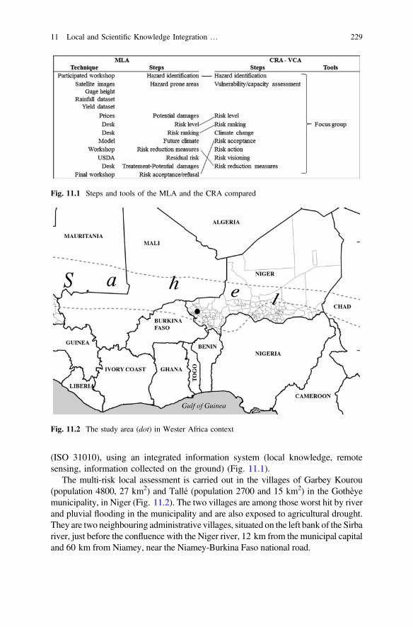
(ISO 31010), using an integrated information system (local knowledge, remotesensing, information collected on the ground) (Fig. 11.1).
The multi-risk local assessment is carried out in the villages of Garbey Kourou(population 4800, 27 km2) and Tallé (population 2700 and 15 km2) in the Gothèyemunicipality, in Niger (Fig. 11.2). The two villages are among those worst hit by riverand pluvial flooding in the municipality and are also exposed to agricultural drought.They are two neighbouring administrative villages, situated on the left bank of the Sirbariver, just before the confluence with the Niger river, 12 km from the municipal capitaland 60 km from Niamey, near the Niamey-Burkina Faso national road.
Fig. 11.1 Steps and tools of the MLA and the CRA compared
Fig. 11.2 The study area (dot) in Wester Africa context
11 Local and Scientific Knowledge Integration … 229
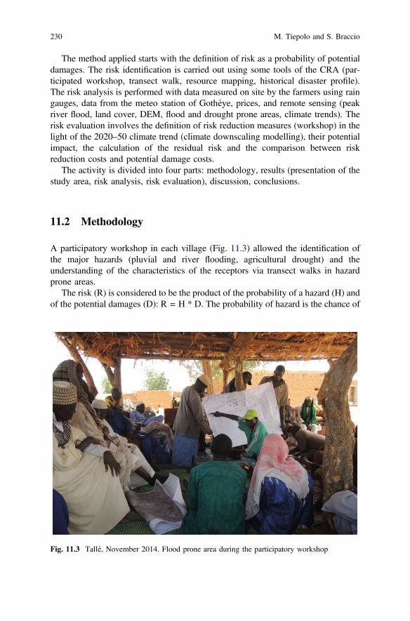
The method applied starts with the definition of risk as a probability of potentialdamages. The risk identification is carried out using some tools of the CRA (par-ticipated workshop, transect walk, resource mapping, historical disaster profile).The risk analysis is performed with data measured on site by the farmers using raingauges, data from the meteo station of Gothèye, prices, and remote sensing (peakriver flood, land cover, DEM, flood and drought prone areas, climate trends). Therisk evaluation involves the definition of risk reduction measures (workshop) in thelight of the 2020–50 climate trend (climate downscaling modelling), their potentialimpact, the calculation of the residual risk and the comparison between riskreduction costs and potential damage costs.
The activity is divided into four parts: methodology, results (presentation of thestudy area, risk analysis, risk evaluation), discussion, conclusions.
11.2 Methodology
A participatory workshop in each village (Fig. 11.3) allowed the identification ofthe major hazards (pluvial and river flooding, agricultural drought) and theunderstanding of the characteristics of the receptors via transect walks in hazardprone areas.
The risk (R) is considered to be the product of the probability of a hazard (H) andof the potential damages (D): R = H * D. The probability of hazard is the chance of
Fig. 11.3 Tallé, November 2014. Flood prone area during the participatory workshop
230 M. Tiepolo and S. Braccio
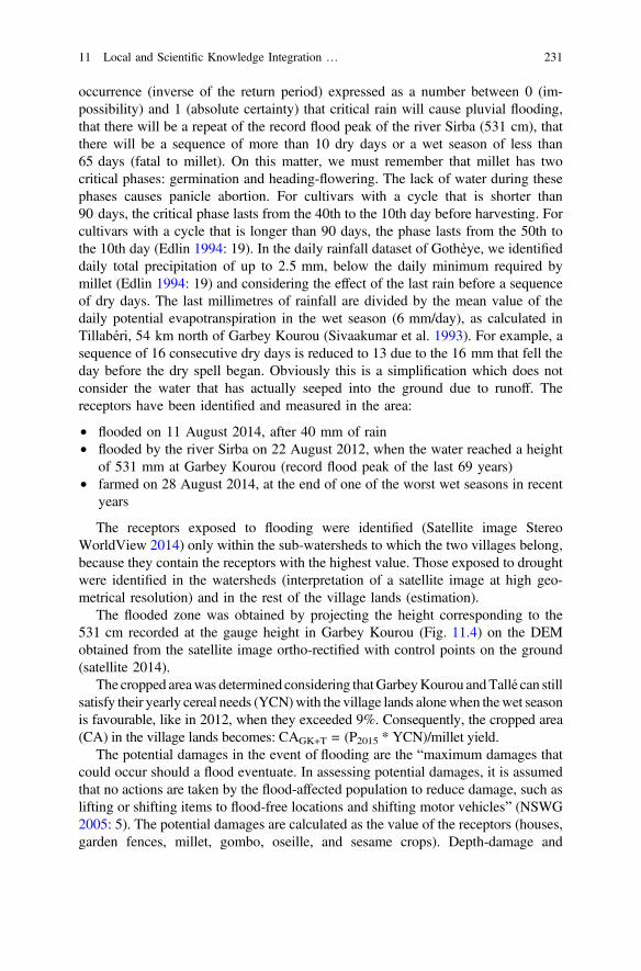
occurrence (inverse of the return period) expressed as a number between 0 (im-possibility) and 1 (absolute certainty) that critical rain will cause pluvial flooding,that there will be a repeat of the record flood peak of the river Sirba (531 cm), thatthere will be a sequence of more than 10 dry days or a wet season of less than65 days (fatal to millet). On this matter, we must remember that millet has twocritical phases: germination and heading-flowering. The lack of water during thesephases causes panicle abortion. For cultivars with a cycle that is shorter than90 days, the critical phase lasts from the 40th to the 10th day before harvesting. Forcultivars with a cycle that is longer than 90 days, the phase lasts from the 50th tothe 10th day (Edlin 1994: 19). In the daily rainfall dataset of Gothèye, we identifieddaily total precipitation of up to 2.5 mm, below the daily minimum required bymillet (Edlin 1994: 19) and considering the effect of the last rain before a sequenceof dry days. The last millimetres of rainfall are divided by the mean value of thedaily potential evapotranspiration in the wet season (6 mm/day), as calculated inTillabéri, 54 km north of Garbey Kourou (Sivaakumar et al. 1993). For example, asequence of 16 consecutive dry days is reduced to 13 due to the 16 mm that fell theday before the dry spell began. Obviously this is a simplification which does notconsider the water that has actually seeped into the ground due to runoff. Thereceptors have been identified and measured in the area:
• flooded on 11 August 2014, after 40 mm of rain• flooded by the river Sirba on 22 August 2012, when the water reached a height
of 531 mm at Garbey Kourou (record flood peak of the last 69 years)• farmed on 28 August 2014, at the end of one of the worst wet seasons in recent
years
The receptors exposed to flooding were identified (Satellite image StereoWorldView 2014) only within the sub-watersheds to which the two villages belong,because they contain the receptors with the highest value. Those exposed to droughtwere identified in the watersheds (interpretation of a satellite image at high geo-metrical resolution) and in the rest of the village lands (estimation).
The flooded zone was obtained by projecting the height corresponding to the531 cm recorded at the gauge height in Garbey Kourou (Fig. 11.4) on the DEMobtained from the satellite image ortho-rectified with control points on the ground(satellite 2014).
The cropped areawas determined considering thatGarbeyKourou andTallé can stillsatisfy their yearly cereal needs (YCN)with the village lands alonewhen thewet seasonis favourable, like in 2012, when they exceeded 9%. Consequently, the cropped area(CA) in the village lands becomes: CAGK+T = (P2015 * YCN)/millet yield.
The potential damages in the event of flooding are the “maximum damages thatcould occur should a flood eventuate. In assessing potential damages, it is assumedthat no actions are taken by the flood-affected population to reduce damage, such aslifting or shifting items to flood-free locations and shifting motor vehicles” (NSWG2005: 5). The potential damages are calculated as the value of the receptors (houses,garden fences, millet, gombo, oseille, and sesame crops). Depth-damage and
11 Local and Scientific Knowledge Integration … 231
duration-damage curves were not used as all the buildings have walls made of crudeearth which collapse as soon as the water crosses the threshold. The indirect effectsof flooding are not considered. The value of the receptors is obtained from the costof every construction element and labour recorded using the price schedule(Zaneidou 2013) and then checked locally.
Drought on the other hand does not cause the complete loss of the harvest. It hasbeen assumed that themaximum cereal deficit of theDepartment ofGothèye in the lastsix years (–53% in 2011) can be used as the value of unproductive fields in the twovillages, assuming that the farms only sow the area necessary to meet their cerealneeds. The value of the crop potentially damaged is obtained considering the price ofthe crop on the market of Gothèye in September 2014 (RN, MCPSP 2014a, b) mul-tiplied by the yield/ha (RN, MF, INS 2013a) and by the rate of unproductive fields.
The risk evaluation requires knowledge of the risk level after the risk treatment(residual risk) and comparison of the cost of the risk treatment with that of potentialdamages. The residual risk should allow acceptance or refusal of the risk. The risktreatment required the identification of the risk reduction measures in workshops, inthe presence of the mayor, the municipal technical services and experts of theministry of agriculture, CNEDD, DIST-Politecnico di Torino, Ibimet-CNR and theNational Directorate for Meteorology. The choice of the measures prioritises thereduction of the receptors, prevention of the installation in hazard prone areas,integration of risk reduction measures with development measures (irrigated
Fig. 11.4 The Sirba hydro station at Garbey Kourou in June 2014
232 M. Tiepolo and S. Braccio
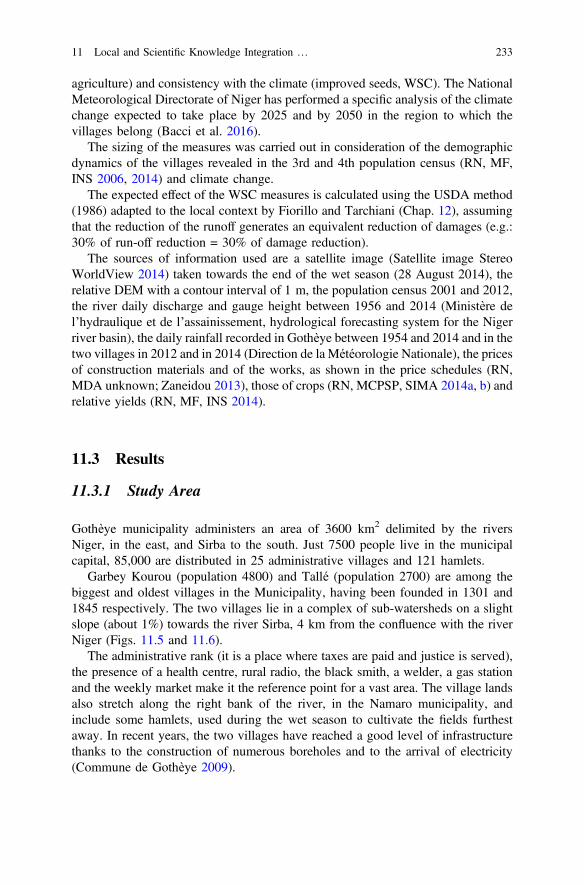
agriculture) and consistency with the climate (improved seeds, WSC). The NationalMeteorological Directorate of Niger has performed a specific analysis of the climatechange expected to take place by 2025 and by 2050 in the region to which thevillages belong (Bacci et al. 2016).
The sizing of the measures was carried out in consideration of the demographicdynamics of the villages revealed in the 3rd and 4th population census (RN, MF,INS 2006, 2014) and climate change.
The expected effect of the WSC measures is calculated using the USDA method(1986) adapted to the local context by Fiorillo and Tarchiani (Chap. 12), assumingthat the reduction of the runoff generates an equivalent reduction of damages (e.g.:30% of run-off reduction = 30% of damage reduction).
The sources of information used are a satellite image (Satellite image StereoWorldView 2014) taken towards the end of the wet season (28 August 2014), therelative DEM with a contour interval of 1 m, the population census 2001 and 2012,the river daily discharge and gauge height between 1956 and 2014 (Ministère del’hydraulique et de l’assainissement, hydrological forecasting system for the Nigerriver basin), the daily rainfall recorded in Gothèye between 1954 and 2014 and in thetwo villages in 2012 and in 2014 (Direction de la Météorologie Nationale), the pricesof construction materials and of the works, as shown in the price schedules (RN,MDA unknown; Zaneidou 2013), those of crops (RN, MCPSP, SIMA 2014a, b) andrelative yields (RN, MF, INS 2014).
11.3 Results
11.3.1 Study Area
Gothèye municipality administers an area of 3600 km2 delimited by the riversNiger, in the east, and Sirba to the south. Just 7500 people live in the municipalcapital, 85,000 are distributed in 25 administrative villages and 121 hamlets.
Garbey Kourou (population 4800) and Tallé (population 2700) are among thebiggest and oldest villages in the Municipality, having been founded in 1301 and1845 respectively. The two villages lie in a complex of sub-watersheds on a slightslope (about 1%) towards the river Sirba, 4 km from the confluence with the riverNiger (Figs. 11.5 and 11.6).
The administrative rank (it is a place where taxes are paid and justice is served),the presence of a health centre, rural radio, the black smith, a welder, a gas stationand the weekly market make it the reference point for a vast area. The village landsalso stretch along the right bank of the river, in the Namaro municipality, andinclude some hamlets, used during the wet season to cultivate the fields furthestaway. In recent years, the two villages have reached a good level of infrastructurethanks to the construction of numerous boreholes and to the arrival of electricity(Commune de Gothèye 2009).
11 Local and Scientific Knowledge Integration … 233
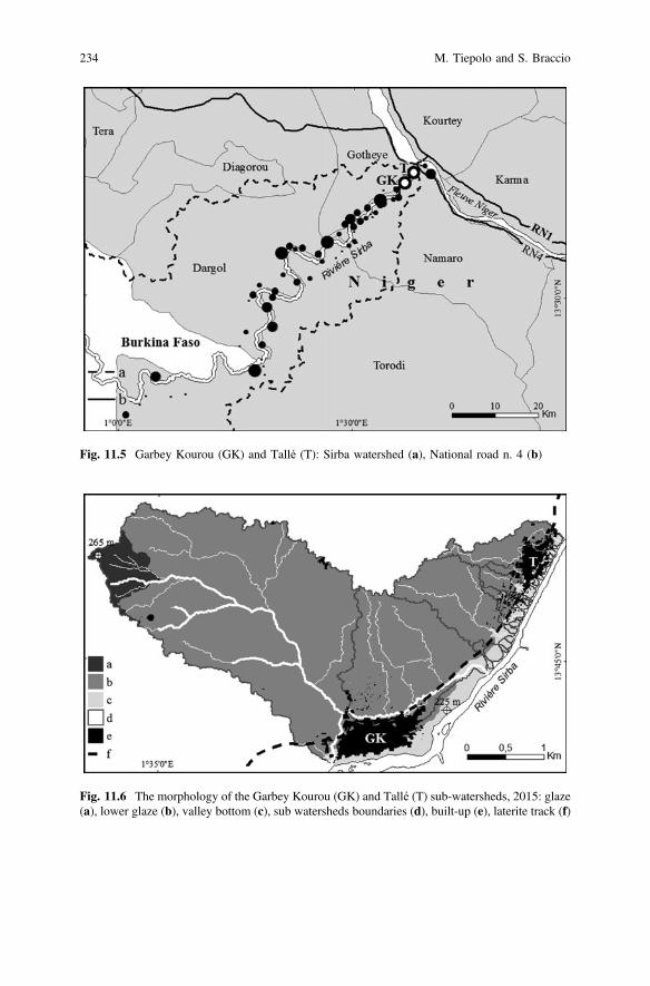
Fig. 11.5 Garbey Kourou (GK) and Tallé (T): Sirba watershed (a), National road n. 4 (b)
Fig. 11.6 The morphology of the Garbey Kourou (GK) and Tallé (T) sub-watersheds, 2015: glaze(a), lower glaze (b), valley bottom (c), sub watersheds boundaries (d), built-up (e), laterite track (f)
234 M. Tiepolo and S. Braccio
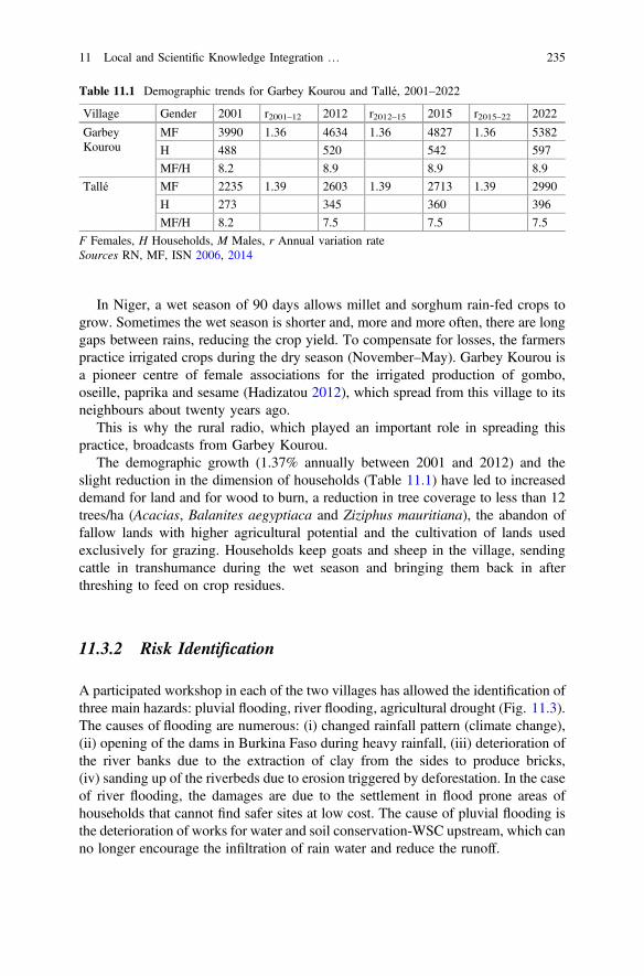
In Niger, a wet season of 90 days allows millet and sorghum rain-fed crops togrow. Sometimes the wet season is shorter and, more and more often, there are longgaps between rains, reducing the crop yield. To compensate for losses, the farmerspractice irrigated crops during the dry season (November–May). Garbey Kourou isa pioneer centre of female associations for the irrigated production of gombo,oseille, paprika and sesame (Hadizatou 2012), which spread from this village to itsneighbours about twenty years ago.
This is why the rural radio, which played an important role in spreading thispractice, broadcasts from Garbey Kourou.
The demographic growth (1.37% annually between 2001 and 2012) and theslight reduction in the dimension of households (Table 11.1) have led to increaseddemand for land and for wood to burn, a reduction in tree coverage to less than 12trees/ha (Acacias, Balanites aegyptiaca and Ziziphus mauritiana), the abandon offallow lands with higher agricultural potential and the cultivation of lands usedexclusively for grazing. Households keep goats and sheep in the village, sendingcattle in transhumance during the wet season and bringing them back in afterthreshing to feed on crop residues.
11.3.2 Risk Identification
A participated workshop in each of the two villages has allowed the identification ofthree main hazards: pluvial flooding, river flooding, agricultural drought (Fig. 11.3).The causes of flooding are numerous: (i) changed rainfall pattern (climate change),(ii) opening of the dams in Burkina Faso during heavy rainfall, (iii) deterioration ofthe river banks due to the extraction of clay from the sides to produce bricks,(iv) sanding up of the riverbeds due to erosion triggered by deforestation. In the caseof river flooding, the damages are due to the settlement in flood prone areas ofhouseholds that cannot find safer sites at low cost. The cause of pluvial flooding isthe deterioration of works for water and soil conservation-WSC upstream, which canno longer encourage the infiltration of rain water and reduce the runoff.
Table 11.1 Demographic trends for Garbey Kourou and Tallé, 2001–2022
Village Gender 2001 r2001–12 2012 r2012–15 2015 r2015–22 2022
GarbeyKourou
MF 3990 1.36 4634 1.36 4827 1.36 5382
H 488 520 542 597
MF/H 8.2 8.9 8.9 8.9
Tallé MF 2235 1.39 2603 1.39 2713 1.39 2990
H 273 345 360 396
MF/H 8.2 7.5 7.5 7.5
F Females, H Households, M Males, r Annual variation rateSources RN, MF, ISN 2006, 2014
11 Local and Scientific Knowledge Integration … 235
11.3.3 Risk Analysis
The drought prone areas are fields planted with crops at 28 August 2014: 353 ha(satellite image interpretation) in the sub-watersheds and 2500 ha (estimated) in thevillage lands of Garbey Kourou and Tallé. 40 mm of rain is 79% likely to fall in2015. A river flood of 531 cm has a 1.6% likelihood of occurrence in 2015.
An agricultural drought is 13% likely to last eleven consecutive days (as in2006) in 2015, and there is a 6% probability of having a wet season lasting less than65 days and a 1.6% probability of having 16 consecutive dry days in 2015.
In the sub-watersheds considered, there are houses made fully from crude earth,roofed with corrugated metal sheets, with fenced gardens, millet, sorghum, gombo,oseille, and sesame fields. Despite being small and made of crude earth, thebuildings make up the highest exposed value, considering the same surface area(Table 11.2; Fig. 11.7). In the event of drought, on the other hand, the crops have
Table 11.2 Potential damages at Garbey Kourou and at Tallé in 2015
Village hazard Hazard prone quantity Unit value Total
Receptor n. FCFA MFCFA
Garbey Kourou
River flood 79.3
Crude earth house 33 m2 79 953,375 75.3
Improved crude earth house 33 m2 2 1,365,175 2.7
Garden fence 2 640,000 1.3
Pluvial flood 29.8
Crude earth house 41 m2 22 1,201,890 26.4
Improved crude earth house 41 m2 2 1,696,126 3.4
Drought, watershed 26.2
Millet, ha (347 * 547) * 53/100 250,000 25.1
Gombo, oseille, sesame, ha (6*)53/100 349,000 1.1
Drought, all village lands 147.7
Millet, ha (4827 * 231) * 53/100 250,000 147.7
Gombo, oseille, sésame, ha (6) * 53/100 349,000 1.1
Total, sub-watershed 135.4
Total, all village lands 257.9
Tallé
River flood 59.7
Crude earth house 27 m2 38 * 56.4
Improved crude earth house 27 m2 2 * 3.5
Garden fence 164 * 0.3
Drought, sub-watershed 7.8(continued)
236 M. Tiepolo and S. Braccio
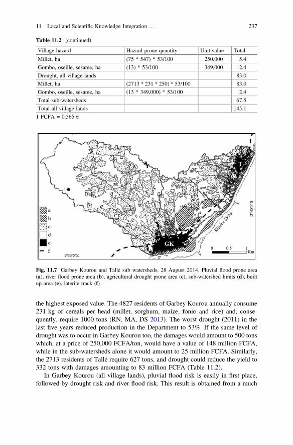
the highest exposed value. The 4827 residents of Garbey Kourou annually consume231 kg of cereals per head (millet, sorghum, maize, fonio and rice) and, conse-quently, require 1000 tons (RN, MA, DS 2013). The worst drought (2011) in thelast five years reduced production in the Department to 53%. If the same level ofdrought was to occur in Garbey Kourou too, the damages would amount to 500 tonswhich, at a price of 250,000 FCFA/ton, would have a value of 148 million FCFA,while in the sub-watersheds alone it would amount to 25 million FCFA. Similarly,the 2713 residents of Tallé require 627 tons, and drought could reduce the yield to332 tons with damages amounting to 83 million FCFA (Table 11.2).
In Garbey Kourou (all village lands), pluvial flood risk is easily in first place,followed by drought risk and river flood risk. This result is obtained from a much
Fig. 11.7 Garbey Kourou and Tallé sub watersheds, 28 August 2014. Pluvial flood prone area(a), river flood prone area (b), agricultural drought prone area (c), sub-watershed limits (d), builtup area (e), laterite track (f)
Table 11.2 (continued)
Village hazard Hazard prone quantity Unit value Total
Millet, ha (75 * 547) * 53/100 250,000 5.4
Gombo, oseille, sesame, ha (13) * 53/100 349,000 2.4
Drought, all village lands 83.0
Millet, ha (2713 * 231 * 250) * 53/100 83.0
Gombo, oseille, sesame, ha (13 * 349,000) * 53/100 2.4
Total sub-watersheds 67.5
Total all village lands 145.1
1 FCFA = 0.565 €
11 Local and Scientific Knowledge Integration … 237
higher probability of occurrence of 40 mm rain than 11 consecutive days or comparedto a flood of 531 cm (Table 11.3). In Tallé, on the other hand, drought risk is in firstplace, followed by river flood, if all the village lands are considered (Table 11.4).
11.3.4 Risk Evaluation
The evaluation requires knowledge of the cost and expected impact of the risktreatment on the current risk level, and comparison of the cost of potential damagesbefore risk treatment with those of the treatment itself.
Twenty measures have been identified for Garbey Kourou and 14 for Tallé. Themeasures for pluvial flooding are the management of gullies, new WSC, existingWSC maintenance, installation of a gauge in the pond, pond drainage, a ridge
Table 11.3 Risk level at Garbey Kourou and at Tallé in 2015
Village hazard Probability H (%) D (FCFA) R = H * D (M FCFA)
Garbey Kourou
River flood Medium 0.02 79.3 1.6
Pluvial flood High 0.79 29.8 23.5
Drought sub-watershed High 0.13–0.06 26.2 3.4
Drought all village lands High 0.13–0.06 147.7 19.2
Total all village lands 44.3
Tallé
Drought sub-watershed High 0.13 7.8 1.0
Drought all village lands High 0.13 83.0 10.8
Flood Medium 0.02 59.7 1.2
Total all village lands 0.89 12.0
Table 11.4 Risk ranking at Garbey Kourou and at Tallé in 2015
Village Probability
Risk High (M FCFA) Medium (M FCFA)
Garbey Kourou
Pluvial flood 33.5 –
Drought all village lands 3.4
Drought sub-watersheds 19.2 0.79
River flood – 1.6
Tallé
Drought all village lands 10.8
River flood – 1.2
Drought sub-watersheds 1.0 0.10
238 M. Tiepolo and S. Braccio
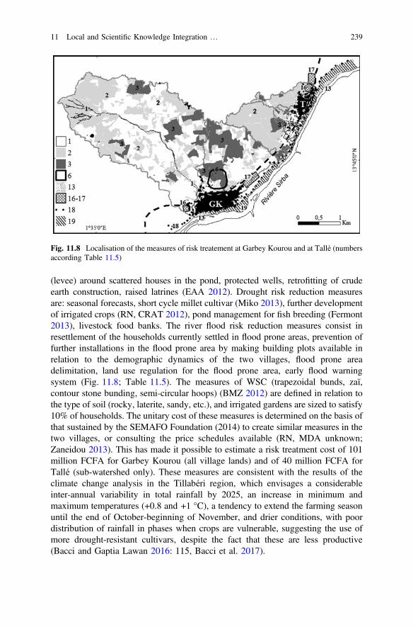
(levee) around scattered houses in the pond, protected wells, retrofitting of crudeearth construction, raised latrines (EAA 2012). Drought risk reduction measuresare: seasonal forecasts, short cycle millet cultivar (Miko 2013), further developmentof irrigated crops (RN, CRAT 2012), pond management for fish breeding (Fermont2013), livestock food banks. The river flood risk reduction measures consist inresettlement of the households currently settled in flood prone areas, prevention offurther installations in the flood prone area by making building plots available inrelation to the demographic dynamics of the two villages, flood prone areadelimitation, land use regulation for the flood prone area, early flood warningsystem (Fig. 11.8; Table 11.5). The measures of WSC (trapezoidal bunds, zaï,contour stone bunding, semi-circular hoops) (BMZ 2012) are defined in relation tothe type of soil (rocky, laterite, sandy, etc.), and irrigated gardens are sized to satisfy10% of households. The unitary cost of these measures is determined on the basis ofthat sustained by the SEMAFO Foundation (2014) to create similar measures in thetwo villages, or consulting the price schedules available (RN, MDA unknown;Zaneidou 2013). This has made it possible to estimate a risk treatment cost of 101million FCFA for Garbey Kourou (all village lands) and of 40 million FCFA forTallé (sub-watershed only). These measures are consistent with the results of theclimate change analysis in the Tillabéri region, which envisages a considerableinter-annual variability in total rainfall by 2025, an increase in minimum andmaximum temperatures (+0.8 and +1 °C), a tendency to extend the farming seasonuntil the end of October-beginning of November, and drier conditions, with poordistribution of rainfall in phases when crops are vulnerable, suggesting the use ofmore drought-resistant cultivars, despite the fact that these are less productive(Bacci and Gaptia Lawan 2016: 115, Bacci et al. 2017).
Fig. 11.8 Localisation of the measures of risk treatement at Garbey Kourou and at Tallé (numbersaccording Table 11.5)
11 Local and Scientific Knowledge Integration … 239
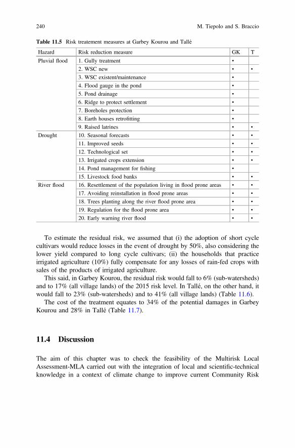
To estimate the residual risk, we assumed that (i) the adoption of short cyclecultivars would reduce losses in the event of drought by 50%, also considering thelower yield compared to long cycle cultivars; (ii) the households that practiceirrigated agriculture (10%) fully compensate for any losses of rain-fed crops withsales of the products of irrigated agriculture.
This said, in Garbey Kourou, the residual risk would fall to 6% (sub-watersheds)and to 17% (all village lands) of the 2015 risk level. In Tallé, on the other hand, itwould fall to 23% (sub-watersheds) and to 41% (all village lands) (Table 11.6).
The cost of the treatment equates to 34% of the potential damages in GarbeyKourou and 28% in Tallé (Table 11.7).
11.4 Discussion
The aim of this chapter was to check the feasibility of the Multirisk LocalAssessment-MLA carried out with the integration of local and scientific-technicalknowledge in a context of climate change to improve current Community Risk
Table 11.5 Risk treatement measures at Garbey Kourou and Tallé
Hazard Risk reduction measure GK T
Pluvial flood 1. Gully treatment •
2. WSC new • •
3. WSC existent/maintenance •
4. Flood gauge in the pond •
5. Pond drainage •
6. Ridge to protect settlement •
7. Boreholes protection •
8. Earth houses retrofitting •
9. Raised latrines • •
Drought 10. Seasonal forecasts • •
11. Improved seeds • •
12. Technological set • •
13. Irrigated crops extension • •
14. Pond management for fishing •
15. Livestock food banks • •
River flood 16. Resettlement of the population living in flood prone areas • •
17. Avoiding reinstallation in flood prone areas • •
18. Trees planting along the river flood prone area • •
19. Regulation for the flood prone area • •
20. Early warning river flood • •
240 M. Tiepolo and S. Braccio
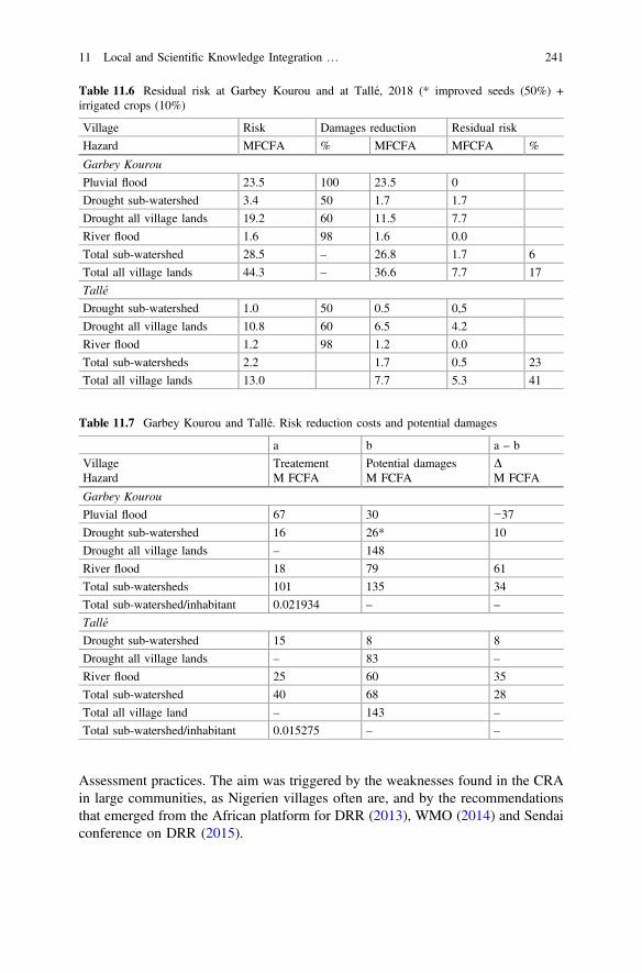
Assessment practices. The aim was triggered by the weaknesses found in the CRAin large communities, as Nigerien villages often are, and by the recommendationsthat emerged from the African platform for DRR (2013), WMO (2014) and Sendaiconference on DRR (2015).
Table 11.6 Residual risk at Garbey Kourou and at Tallé, 2018 (* improved seeds (50%) +irrigated crops (10%)
Village Risk Damages reduction Residual risk
Hazard MFCFA % MFCFA MFCFA %
Garbey Kourou
Pluvial flood 23.5 100 23.5 0
Drought sub-watershed 3.4 50 1.7 1.7
Drought all village lands 19.2 60 11.5 7.7
River flood 1.6 98 1.6 0.0
Total sub-watershed 28.5 – 26.8 1.7 6
Total all village lands 44.3 – 36.6 7.7 17
Tallé
Drought sub-watershed 1.0 50 0.5 0,5
Drought all village lands 10.8 60 6.5 4.2
River flood 1.2 98 1.2 0.0
Total sub-watersheds 2.2 1.7 0.5 23
Total all village lands 13.0 7.7 5.3 41
Table 11.7 Garbey Kourou and Tallé. Risk reduction costs and potential damages
a b a – b
VillageHazard
TreatementM FCFA
Potential damagesM FCFA
DM FCFA
Garbey Kourou
Pluvial flood 67 30 −37
Drought sub-watershed 16 26* 10
Drought all village lands – 148
River flood 18 79 61
Total sub-watersheds 101 135 34
Total sub-watershed/inhabitant 0.021934 – –
Tallé
Drought sub-watershed 15 8 8
Drought all village lands – 83 –
River flood 25 60 35
Total sub-watershed 40 68 28
Total all village land – 143 –
Total sub-watershed/inhabitant 0.015275 – –
11 Local and Scientific Knowledge Integration … 241
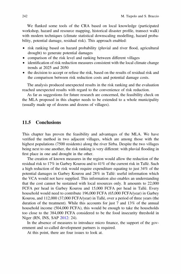
We flanked some tools of the CRA based on local knowledge (participatedworkshop, hazard and resource mapping, historical disaster profile, transect walk)with modern techniques (climate statistical downscaling modelling, hazard proba-bility, potential damage, residual risk). This approach enabled:
• risk ranking based on hazard probability (pluvial and river flood, agriculturaldrought) to generate potential damages
• comparison of the risk level and ranking between different villages• identification of risk reduction measures consistent with the local climate change
trends at 2025 and 2050• the decision to accept or refuse the risk, based on the results of residual risk and
the comparison between risk reduction costs and potential damage costs.
The analysis produced unexpected results in the risk ranking and the evaluationreached unexpected results with regard to the convenience of risk reduction.
As far as suggestions for future research are concerned, the feasibility check onthe MLA proposed in this chapter needs to be extended to a whole municipality(usually made up of dozens and dozens of villages).
11.5 Conclusions
This chapter has proven the feasibility and advantages of the MLA. We haveverified the method in two adjacent villages, which are among those with thehighest populations (7500 residents) along the river Sirba. Despite the two villagesbeing next to one another, the risk ranking is very different: with pluvial flooding infirst place in one and drought in the other.
The creation of known measures in the region would allow the reduction of theresidual risk to 17% in Garbey Kourou and to 41% of the current risk in Tallé. Sucha high reduction of the risk would require expenditure equating to just 34% of thepotential damages in Garbey Kourou and 28% in Tallé: useful information whichthe VCA would not have supplied. This information also enables an understandingthat the cost cannot be sustained with local resources only. It amounts to 22,000FCFA per head in Garbey Kourou and 15,000 FCFA per head in Tallé. Everyhousehold would need to contribute 196,000 FCFA (65,000 FCFA/year) in GarbeyKourou, and 112,000 (37,000 FCFA/year) in Tallé, over a period of three years (theduration of the treatment). While this accounts for just 7 and 13% of the annualhousehold income (504,000 FCFA), this would be enough to take the householdstoo close to the 384,000 FCFA considered to be the food insecurity threshold inNiger (RN, INS, SAP 2012: 24).
In the absence of measures to introduce micro finance, the support of the gov-ernment and so-called development partners is required.
At this point, there are four issues to look at.
242 M. Tiepolo and S. Braccio
• Perennial implementation of the risk treatment. The risk treatment is not per-manent. The works require annual maintenance and renovation every 10 or20 years. In the long term, the villages could do without outside help if theywere to continue investing in commercial crops.
• Reproducibility of the MLA. The methodology can be re-proposed in munici-palities at greatest risk (Tiepolo and Braccio 2016b) and, within these, in thebigger villages, as it is there that we find the receptors of higher value, whichjustify the costs of risk treatment. In the Tillabéri region, the second mostexposed in Niger, there are 24 such villages, and about 140 in the wholecountry.
• Convenience of the LMA. The assessment allows the formulation of detailedrisk treatment plans which would increase the impact of the measures.
• Who should develop the MLA. The NGOs which drew up the first generationlocal development plans ten years ago and are now busy drawing up the secondgeneration could benefit from specific training and be supported by regionalservices (determination of the village lands boundaries, hazard prone areas,calculation of the hazard probability).
References
Abarquez, I., and Z. Murshed. 2004. Community-based disaster risk management. Fieldpractitioners’ handbook. Bangkok: Asia disaster preparedness center.
Bacci, M., and M. Mouhaimouni. 2017. Hazard events characterization in Tillaberi region: presentand future projection. In Renewing climate planning to face climate changing in the Tropics,ed. M. Tiepolo, E. Pezzoli, and V. Tarchiani. Springer.
Bacci, M., K. Gaptia Lawan, and M. Moussa. 2016. Le climat de la région Tillabéri. In Risque etadaptation climatique dans la région Tillabéri, Niger, ed. V. Tarchiani, and M. Tiepolo,79–98. Paris: L’Harmattan.
Bacci, M., and K. Gaptia Lawan. 2016. Variabilités et changements climatiques et leurs impactssur les cultures pluviales dans la région Tillabéri, Niger. In Risque et adaptation climatiquedans la région Tillabéri, Niger, ed. V. Tarchiani, and M. Tiepolo, 99–116. Paris: L’Harmattan.
BMZ. 2012. Bonnes pratiques de CES/DRS. Contribution à l’adaptation au changement climatiqueet à la résilience des producteurs. Les expériences de quelques projets au Sahel. GIZ.
Chambers. R. 1992. Rural appraisal: rapid, relaxed and participatory. IDS Discussion Paper 311.Commune de Gothèye. 2009. Plan de développement communal 2009–2012.EAA. 2012. Étude sur l’assainissement productif Ecosan au Niger. Bilan et perspectives. Rapport
définitif, avril.Edlin, M. 1994. Analyse des risques de déficit hydrique au cours des différentes phases
phénologiques du mil précoce au Niger. Conséquences agronomiques. In Bilan hydriqueagricole et sécheresse en Afrique Tropicale, eds. F.-N. Reyniers, and L. Netoyo, 17–30. Paris:John Libbey Eurotexts.
Fabiyi, O.O. et al. 2012. Integrative approach of indigenous knowledge and scientific methods forflood risk anayses, responses and adaptation in rural coastal communities in Nigeria. Finalreport for 2011 start grants for global change research in Africa.
Faling, W., J.W.N. Tempelhoff, and D. van Niekerk. 2012. Retoric or action: are South Africanmunicipalities planning for climate change? Development Southern Africa 29 (2): 241–257.
11 Local and Scientific Knowledge Integration … 243
Fermont, Y. 2013. La pisciculture de subsistance en étangs en Afrique: Manuel technique.ACF-International Network.
Florano, E.R. 2015. Mainstreaming integrated climate change adaptation and disaster riskreduction in local development plans in the Philippines. In Handbook of climate changeadaptation, ed. W. Leal Filho, 433–456. Springer. doi:10.1007/978-3-642-38670-1_36.
Fondation SEMAFO. 2014. Rapport annuel 2013–2014.GoN-Government of Nepal. 2011. National framework on local adaptation plans for action.
Ministry of science technology and environment.Guardiola, L., J. Quiñónez, M. Domínguez, N. Jover, and R. Bernol. 2013. Guía metodológica
para incorporar la adaptacion al cambio climático en la planificación del dresarollo.Tegucigalpa.
Hadizatou Alhassoumi. 2012. Dynamiques associatives et processus d’affirmation des femmes deGarbey Kourou (Ouest du Niger) atour des activités agricoles. In Genre & agriculture familiale& paysanne. Regards Nord-Sud, colloque international Toulouse-Le Mirail, 22–24 Mai 2012.
IFRCRC-International Federation of Red Cross and Red Crescent Societies. 2014. Integratingclimate change and urban risks into the VCA. Geneva, IFRCRC: Ensure effective participatoryanalysis and enhanced community action.
IFRCRC-International Federation of Red Cross and Red Crescent Societies. 2006. What is VCA?An introduction to vulnerability and capacity assessment. Geneva: IFRCRC.
ISO-International Organization for Standardization. 2009. Guide 73:2009. Risk Management –Vocabulary.
Masinde, M., and A. Bagula. 2012. ITIKI: bridge between African indigenous knowledge andmodern science of drought prediction. Knowledge Management for Development Journal 7 (3):274–290. doi:10.1080/19474199.2012.683444.
Miko, I. 2013. Multiplication et diffusion de semences de qualité des variétés améliorées etadaptées au changement climatique. Fiche de bonne pratique. Niamey: FAO.
NSWG—New South Wales Government. 2005. Floodplain development manual. Appendix M –
Flood damage.Pezzoli, A., and E. Ponte. 2016. Vulnerability and resilience to drought in the Chaco, Paraguay. In
Planning to cope with tropical and subtropical climate change, eds. M. Tiepolo, E. Ponte, andE. Cristofori, 63–88. Berlin: De Gruyter Open. doi:10.1515/9783110480795-005.
Ponte, E. 2014. Flood risk due to heavy rains and rising sea levels in the municipality of Maputo.In Climate change vulnerability in Southern African Cities, eds. S. Macchi, and M. Tiepolo,187–204. Springer.
Rambaldi, G. 2010. Modélisation participative en 3D-Principes directrices et applications.Wageningen: Centre technique de coopération agricole et rurale ACP-UE.
RN, CRAT. 2012. La production du sésame dans la zone de Gothèye: de la culture deconsommation à celle commerciale.
RN, MA, DS. 2013–2015. Évaluation des récoltes de la campagne agricole d’hivernage 2012–2014 et résultats définitifs 2012–2014. Rapport national de synthèse.
RN, MCPSP-SIMA. 2014a. Bulletin Mensuel Volet Céréales, 9/14, septembre.RN, MCPSP-SIMA. 2014b. Bulletin Mensuel Volet Produits de Rente, 60, octobre.RN, MDA. unknown. Recueil des fiches techniques en gestion des ressources naturelles et de
production agro-sylvo-pastorales. PAC-Banque Mondiale.RN, MF, INS. 2014. Niger. Répertoire national des localités (ReNaLoc), juillet.RN, MF, INS. 2013. Annuaire statistique 2008–2012. Édition 2013.RN, MF, INS. 2006. ReNaCom- Répertoire national des communes.Ruiz Rivera, N., J.M. Casado Izquierdo, and M.T. Sánchez Salazar. 2015. Los atlas de riesgo
municipales en México como instrumento de ordenamiento territorial. InvestigacionesGéográficas. Boletín del Instituto de Geografía, UNAM 88: 146–162.
Sivaakumar, M.V.K., A. Maidoukia, and R.D. Stern. 1993. Agroclimatologie de l’Afrique del’Ouest. ICRISAT.
244 M. Tiepolo and S. Braccio
Tiepolo, M., and S. Braccio. 2016a. Flood risk preliminary mapping in Niamey, Niger. InPlanning to cope with tropical and subtropical climate change, eds. M. Tiepolo, E. Ponte, andE. Cristofori, 201–220. Berlin: De Gruyter Open. doi:10.1515/9783110480795-013.
Tiepolo, M., and S. Braccio. 2016b. Flood risk assessment at municipal level in Tillabéri region,Niger. In Planning to cope with tropical and subtropical climate change, eds. M. Tiepolo,E. Ponte, E. Cristofori, 221–242. Warsaw/Berlin: De Gruyter Open. doi:10.1515/9783110480795-014.
UN. 2015. Third World Conference on DRR. Sendai framework for disaster risk reduction 2015–2030.
UNDHA-United Nations Department of Humanitarian Affairs. 1994. Yokohama strategy and planof action for a safer world. Guidelines for natural disaster prevention, preparedness andmitigation. In World conference on natural disaster reduction. Yokohama, Japan 23–27 Mai1994.
UNISDR-The United Nations Office for Disaster Risk Reduction. 2013. Report of the 4th Africaregional platform on disaster risk reduction 13-15 February 2013. Tanzania: Arusha.
Van Aalst, M.K., T. Cannon, and J. Burton. 2008. Community level adaptation to climate change:The potential role of participatory community risk assessment. Global Environmental Change18: 165–179. doi:10.1016/j.gloenvcha.2007.06.002 .
Vermaak, J., and D. van Niekerk. 2004. Disaster risk reduction initiatives in South Africa.Development Southern Africa 21 (3): 555–574. doi:10.1080/0376835042000265487.
Victoria, L.P. 2008. Combining indigenous and scientific knowledge in the Dagupan city floodwarning system. In Indigenous knowledge for disaster risk reduction. Good practices andlessons learned from experiences in the Asia-Pacific Region, 52–54. UNISDR.
WMO-World Meteorological Organization, GFSC. 2014. Plan de mise en œuvre du cadre mondialpour les services climatiques. Geneve.
Zaneidou, D. 2013. Bordereaux des prix unitaires des principaux investissements réalisés par lesprojets FIDA au Niger – Capitalisation. Volume 1, FIDA.
Ziervogel, G., and A. Opere (eds.). 2010. Integrating meteorological and indigenousknowledge-based seasonal climate forecasts in the agricultural sector. Ottawa: IDRC.
Satellite image Stereo WorldView-2ID:14AUG28105608-M2AS-053799140010 28 August 2014.
Open Access This chapter is licensed under the terms of the Creative Commons Attribution 4.0International License (http://creativecommons.org/licenses/by/4.0/), which permits use, sharing,adaptation, distribution and reproduction in any medium or format, as long as you give appropriatecredit to the original author(s) and the source, provide a link to the Creative Commons license andindicate if changes were made.The images or other third party material in this chapter are included in the chapter's Creative
Commons license, unless indicated otherwise in a credit line to the material. If material is notincluded in the chapter's Creative Commons license and your intended use is not permitted bystatutory regulation or exceeds the permitted use, you will need to obtain permission directly fromthe copyright holder.
11 Local and Scientific Knowledge Integration … 245
Chapter 12A Simplified Hydrological Methodfor Flood Risk Assessment at Sub-basinLevel in Niger
Edoardo Fiorillo and Vieri Tarchiani
Abstract Flood events are increasing year by year in the Sahel, mainly caused byclimate and land use changes. New strategies and tools are necessary to optimizeflooding risk reduction plans. This paper presents a new hydrological method(FREM, Flooding Risk Evaluation Method), based on the curve number runoffestimation. The method can be adopted for small-medium basins and is based onthe integration of remote sensing techniques with field surveys and participatorymapping. It consists of preliminary identification of the areas and sub-basins thatmost contribute to the flood risk; scenarios can then be developed in order to:(i) optimize the placement of traditional water retention structures in the elementarysub-basins that contribute most to the overall risk, (ii) assess the contribution ofeach hydraulic structure to reduce the total risk, (iii) give a priority ranking to thesestructures identifying those most urgent. The main advantages of this method arethat it is easy to use and can be implemented using free available land cover, soiland morphology data and open-source GIS (Geographic Information System)software. A case study for the Ouro Gueladjo basin (Tillabery Region, Niger) ispresented.
Keywords Sahel Remote sensing Flood risk assessment Water retentionmeasures Adaptation
E. Fiorillo (&) V. TarchianiNational Research Council, Institute of Biometeorology (IBIMET),Via Caproni 8, 50145 Florence, Italye-mail: [email protected]
V. Tarchianie-mail: [email protected]
© The Author(s) 2017M. Tiepolo et al. (eds.), Renewing Local Planning to Face ClimateChange in the Tropics, Green Energy and Technology,DOI 10.1007/978-3-319-59096-7_12
247
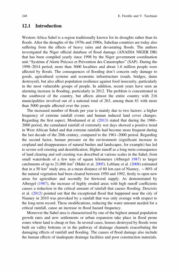
12.1 Introduction
Western Africa Sahel is a region traditionally known for its droughts rather than itsfloods. After the droughts of the 1970s and 1980s, Sahelian countries are today alsosuffering from the effects of heavy rains and devastating floods. The authorsinvestigated the Niger official database of flood damage (ANADIA NIGER DB)that has been compiled yearly since 1998 by the Niger government coordinationunit “Système d’Alerte Précoce et Prévention des Catastrophes” (SAP). During the1998–2014 period, more than 3600 localities and about 1.6 million people wereaffected by floods. The consequences of flooding don’t concern only damage togoods, agricultural systems and economic infrastructure (roads, bridges, damsdestroyed), but also affect population resilience against food insecurity, particularlyin the most vulnerable groups of people. In addition, recent years have seen analarming increase in flooding, particularly in 2012. The problem is concentrated inthe southwest of the country, but affects almost the entire country with 216municipalities involved out of a national total of 263, among them 81 with morethan 5000 people affected over the years.
The increased number of floods per year is mainly due to two factors: a higherfrequency of extreme rainfall events and human induced land cover changes.Regarding the first aspect, Mouhamed et al. (2013) stated that during the 1960–2000 period, the cumulated rainfall of extremely wet days showed a positive trendin West African Sahel and that extreme rainfalls had become more frequent duringthe last decade of the 20th century, compared to the 1961–2000 period. Regardingthe second factor, human pressure on the environment (significant increase incropland and disappearance of natural bushes and landscapes, for example) has ledto severe soil crusting and desertification. Higher runoff as a long-term consequenceof land clearing and soil crusting was described at various scales in the Sahel, fromsmall watersheds of a few tens of square kilometers (Albergel 1987) to largercatchments of up to 21,000 km2 (Mahé et al. 2005). Leblanc et al. (2008) estimatedthat in a 50 km2 study area, at a mean distance of 60 km east of Niamey, 80% ofthe natural vegetation had been cleared between 1950 and 1992, firstly to open newareas for agriculture and secondly for firewood supply. As demonstrated byAlbergel (1987), the increase of highly eroded areas with high runoff coefficientscauses a reduction in the critical amount of rainfall that causes flooding. Descroixet al. (2012) pointed out that the exceptional flood that happened near the city ofNiamey in 2010 was provoked by a rainfall that was only average with respect tothe long-term record. These modifications, reducing the water amount needed for acritical rainfall, cause an increase in flood hazard frequency.
Moreover the Sahel area is characterized by one of the highest annual populationgrowth rates and new settlements or urban expansion take place in flood pronezones where land is cheap or free. In several cases, houses destroyed by floods werebuilt on valley bottoms or in the pathway of drainage channels exacerbating thedamaging effects of rainfall and flooding. The causes of flood damage also includethe human effects of inadequate drainage facilities and poor construction materials.
248 E. Fiorillo and V. Tarchiani
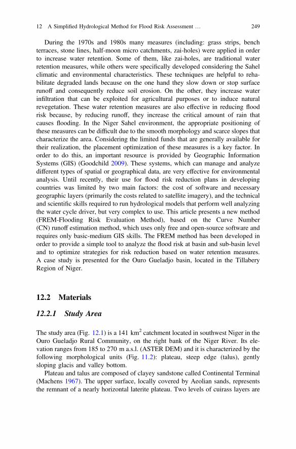
During the 1970s and 1980s many measures (including: grass strips, benchterraces, stone lines, half-moon micro catchments, zai-holes) were applied in orderto increase water retention. Some of them, like zai-holes, are traditional waterretention measures, while others were specifically developed considering the Sahelclimatic and environmental characteristics. These techniques are helpful to reha-bilitate degraded lands because on the one hand they slow down or stop surfacerunoff and consequently reduce soil erosion. On the other, they increase waterinfiltration that can be exploited for agricultural purposes or to induce naturalrevegetation. These water retention measures are also effective in reducing floodrisk because, by reducing runoff, they increase the critical amount of rain thatcauses flooding. In the Niger Sahel environment, the appropriate positioning ofthese measures can be difficult due to the smooth morphology and scarce slopes thatcharacterize the area. Considering the limited funds that are generally available fortheir realization, the placement optimization of these measures is a key factor. Inorder to do this, an important resource is provided by Geographic InformationSystems (GIS) (Goodchild 2009). These systems, which can manage and analyzedifferent types of spatial or geographical data, are very effective for environmentalanalysis. Until recently, their use for flood risk reduction plans in developingcountries was limited by two main factors: the cost of software and necessarygeographic layers (primarily the costs related to satellite imagery), and the technicaland scientific skills required to run hydrological models that perform well analyzingthe water cycle driver, but very complex to use. This article presents a new method(FREM-Flooding Risk Evaluation Method), based on the Curve Number(CN) runoff estimation method, which uses only free and open-source software andrequires only basic-medium GIS skills. The FREM method has been developed inorder to provide a simple tool to analyze the flood risk at basin and sub-basin leveland to optimize strategies for risk reduction based on water retention measures.A case study is presented for the Ouro Gueladjo basin, located in the TillaberyRegion of Niger.
12.2 Materials
12.2.1 Study Area
The study area (Fig. 12.1) is a 141 km2 catchment located in southwest Niger in theOuro Gueladjo Rural Community, on the right bank of the Niger River. Its ele-vation ranges from 185 to 270 m a.s.l. (ASTER DEM) and it is characterized by thefollowing morphological units (Fig. 11.2): plateau, steep edge (talus), gentlysloping glacis and valley bottom.
Plateau and talus are composed of clayey sandstone called Continental Terminal(Machens 1967). The upper surface, locally covered by Aeolian sands, representsthe remnant of a nearly horizontal laterite plateau. Two levels of cuirass layers are
12 A Simplified Hydrological Method for Flood Risk Assessment … 249
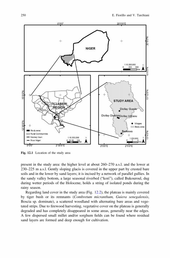
present in the study area: the higher level at about 260–270 a.s.l. and the lower at230–225 m a.s.l. Gently sloping glacis is covered in the upper part by crusted baresoils and in the lower by sand layers; it is incised by a network of parallel gullies. Inthe sandy valley bottom, a large seasonal riverbed (“kori”), called Bukouroul, dugduring wetter periods of the Holocene, holds a string of isolated ponds during therainy season.
Regarding land cover in the study area (Fig. 12.2), the plateau is mainly coveredby tiger bush or its remnants (Combretum micranthum, Guiera senegalensis,Boscia sp. dominate), a scattered woodland with alternating bare areas and vege-tated strips. Due to firewood harvesting, vegetative cover on the plateau is generallydegraded and has completely disappeared in some areas, generally near the edges.A few dispersed small millet and/or sorghum fields can be found where residualsand layers are formed and deep enough for cultivation.
Fig. 12.1 Location of the study area
250 E. Fiorillo and V. Tarchiani
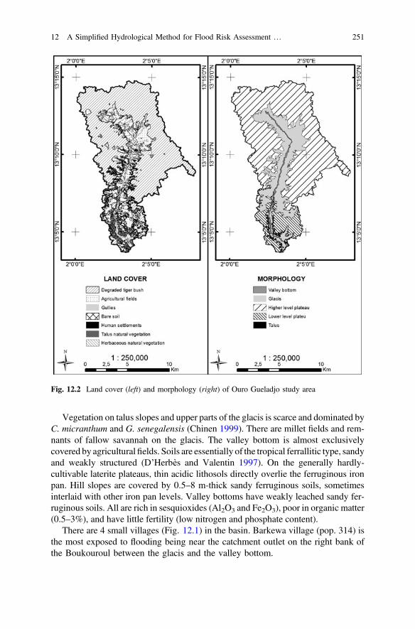
Vegetation on talus slopes and upper parts of the glacis is scarce and dominated byC. micranthum and G. senegalensis (Chinen 1999). There are millet fields and rem-nants of fallow savannah on the glacis. The valley bottom is almost exclusivelycovered by agriculturalfields. Soils are essentially of the tropical ferrallitic type, sandyand weakly structured (D’Herbès and Valentin 1997). On the generally hardly-cultivable laterite plateaus, thin acidic lithosols directly overlie the ferruginous ironpan. Hill slopes are covered by 0.5–8 m-thick sandy ferruginous soils, sometimesinterlaid with other iron pan levels. Valley bottoms have weakly leached sandy fer-ruginous soils. All are rich in sesquioxides (Al2O3 and Fe2O3), poor in organic matter(0.5–3%), and have little fertility (low nitrogen and phosphate content).
There are 4 small villages (Fig. 12.1) in the basin. Barkewa village (pop. 314) isthe most exposed to flooding being near the catchment outlet on the right bank ofthe Boukouroul between the glacis and the valley bottom.
Fig. 12.2 Land cover (left) and morphology (right) of Ouro Gueladjo study area
12 A Simplified Hydrological Method for Flood Risk Assessment … 251
The other three villages (Diollay Dialobè, pop. 714; Diollay Guedel, pop. 484;Diollay Idakaou, pop. 340) are not directly threatened by flooding, but their fieldslocated near the Boukouroul have been flooded repeatedly. This rural populationlives mainly on rain fed agriculture and grazing. The study area has a typicallysemiarid climate, with an average annual temperature of 29.8 °C and annual rainfallof 517 mm (1980–2015 Niamey airport meteorological station data). At seasonalscale, 90% of the annual rainfall, mostly of convective origin, occurs from June toSeptember.
12.2.2 Satellite Images
High-resolution satellite images provided by Google were used to detect land coverof the study area by photointerpretation that was subsequently used for FREMmethod implementation. Google imagery has already been used profitably in pre-vious studies (Chang et al. 2009; Mering et al. 2010; Ploton et al. 2012; Taylor andLovell 2012): it has the great advantage of providing free recent very high reso-lution true color images. For the study area, photointerpretation was performed onDigital Globe 50 cm resolution scenes acquired on November 9 2014. Moreover,30 m resolution LANDSAT false color images were acquired from the EarthExplorer data gateway (http://earthexplorer.usgs.gov/) and used to facilitate dis-crimination of bare soil from vegetated areas using the near infrared band.
12.2.3 Aster Dem Dataset
Morphology, slopes and drainage were derived from ASTER DEM dataset. 30 by30 m resolution grids were acquired free from ASTER GDEM data gateway (http://gdem.ersdac.jspacesystems.or.jp/). The ASTER Global Digital Elevation Model(ASTER GDEM) is a joint product developed and made available to the public bythe Ministry of Economy, Trade and Industry (METI) of Japan and the UnitedStates National Aeronautics and Space Administration (NASA). It is generatedfrom data collected from the Advanced Spaceborne Thermal Emission andReflection Radiometer (ASTER), a spaceborne earth observing optical instrument.Fujisada et al. (2005) stated that standard deviation is about 10 m, and so thevertical accuracy of DEM is about 20 m with 95% confidence. Hirano et al. (2003)assessed that ASTER DEM is suitable for a range of environmental mapping tasksin landform studies.
252 E. Fiorillo and V. Tarchiani
12.2.4 Soter Soil Niger DB
Soil data regarding the study area were derived from the SOTER (Soil and TerrainDigital Database) database that can be freely accessed on the internet (https://www.unihohenheim.de/atlas308/b_niger/projects/b2_1_2/html/english/ntext_en_b2_1_2.htm). The South West Niger SOTER database (Oldeman and Van Engelen 1993;Graef et al. 1998) has been specifically developed for land evaluation and man-agement purposes; it contains geomorphological and soil data in GIS or GIScompatible format and offers the possibility of relatively precise spatial estimationsof terrain related factors such as soil types and soil factors.
12.2.5 Rainfall Data and Critical Rain
Daily rainfall data of the Torodi meteorological station, the nearest to the study areaand located 23 km to the west, were acquired from the National MeteorologicalService (DMN) of Niger, in order to detect the critical amount of rain that causedfloods in the catchment.
Critical rain is considered as the minimum threshold of rain causing a flood, it issite specific and is identified by the study of rain/flood occurrences. Given thatDMN collects daily rain data, the model cannot take into account the rain intensityor basin concentration time. The simplified model is based on a simple relationshipbetween daily rainfall amount and probability of flooding, through the mediation ofthe structural features of the sub-basin. In the target area, the latest relevant floodwas on August 23 2013 due to an 80 mm critical rainfall.
12.3 Method
12.3.1 Theoretical Basis
The method is a simplified version of the Soil Water Assessment Tool (SWAT)(Gassman et al. 2007; Neitsch et al. 2011), the most widely used hydrologicalsimulator. This method provides a simple tool to analyze flood risk at basin andsub-basin level and to optimize strategies for risk reduction. More specifically, themethod allows: (i) the optimal placement of water retention structures in the ele-mentary sub-basins that contribute most to the overall risk, (ii) the assessment of thecontribution of each hydraulic structure to reduce the total risk, (iii) a priorityranking to be given to these structures identifying which are the most urgent.
The method is physically based, computationally efficient, and is based onRemote Sensing (RS) and GIS analysis integrated with field surveys. FREMmethodology is shown in Fig. 12.3; it requires a preliminary watershed and
12 A Simplified Hydrological Method for Flood Risk Assessment … 253
sub-basin delineation based on DEM data performed using QGIS software andTAUDEM plugin. Areas with the same slope, soil type and land cover form anElementary Territorial Unit (ETU), a basic computational unit assumed to behomogeneous in hydrologic response to rains.
This preliminary analysis allows the assessment of the Current Flood Risk(CFR) in the study area. The risk is expressed as the amount of water that con-centrates in the flooded areas after a critical rain, the minimum daily amount of rainthat previously caused flooding in the study area. Therefore, knowing the impact ofeach area of the catchment, in terms of water that flows away and doesn’t infiltrate,water retention measures can be planned. At this stage, two accessory types of mapscan be derived to facilitate risk reduction planning. Runoff maps show the areas thathave the highest runoff coefficients; priority maps, highlighting the units withhigher runoff coefficients and dimensions, indicate the areas where it is moreimportant to take action.
Finally, evaluating the runoff reduction coefficients of each water retentionmeasure, the Residual Risk (RR) is calculated as the amount of water due to acritical rain that would concentrate in the flooded areas after implementation of theplanned water retention measures. Areas with the same slope, soil type and landcover form an Elementary Territorial Unit (ETU), a basic computational unitassumed to be homogeneous in hydrologic response to rains.
Fig. 12.3 FREM methodology
254 E. Fiorillo and V. Tarchiani
12.3.2 CN Runoff Estimation
The curve number (CN) method (USDA 1986) allows surface runoff volumes ofindividual storm events to be estimated; it is widely used because of its simplicityand the limited number of parameters required for runoff prediction (e.g., Graf1988; Ponce and Hawkins 1996; Bhuyan et al. 2003). It is used in a wide range ofdesign situations and has been integrated into many hydrologic, erosion, andwater-quality models such as CREAMS (Knisel 1980), SWRRB (Williams et al.1985; Arnold et al. 1990), AGNPS (Young et al. 1989), EPIC (Sharpley andWilliams 1990), PERFECT (Littleboy et al. 1992), WEPP (Risse et al. 1994) andSWAT.
The CN method is an empirically-based set of relationships between rainfall,land-surface conditions and runoff depth. The basic equations used in the CNmethod are:
R ¼ P 0:25ð Þ2= Pþ 0:85ð Þ R ¼ O for P 0:2S ð1Þ
S ¼ 1000=CNð Þ 10 ð2Þ
where R = runoff depth (inches), P = precipitation depth (inches), S = potentialmaximum retention (inches), and CN is the Curve Number. The coefficients 0.2 and0.8 in Eq. (1) arise from an assumption that the initial abstraction value (Ia) S isequal to 0.2S.
CN is a function of soil type, land cover, slope and antecedent runoff condition.For each portion of the basin homogeneous in its hydrologic response to rains, a CNvalue, derived from specific tables, is conferred. CN has a range from 30 to 100;lower numbers indicate low runoff potential while higher numbers are forincreasing runoff potential. CN are referred to units with 5% slope and averagemoisture conditions; specific formulas are provided for slope and moistureadjustments.
12.3.3 Runoff Reduction Coefficients
In order to estimate the impact of water retention measures in the risk reductionplan, runoff reduction coefficients were derived from the available literature andconferred to packages of water retention measures that are specific for land covertypes (Table 12.1).
These runoff reduction coefficients, although indicative, are used to compara-tively assess the effect of water retention measures on the different hydrologicalunits. They can be used to develop scenarios that indicate the potential effects ofrisk reduction plans based on different runoff reduction techniques.
12 A Simplified Hydrological Method for Flood Risk Assessment … 255
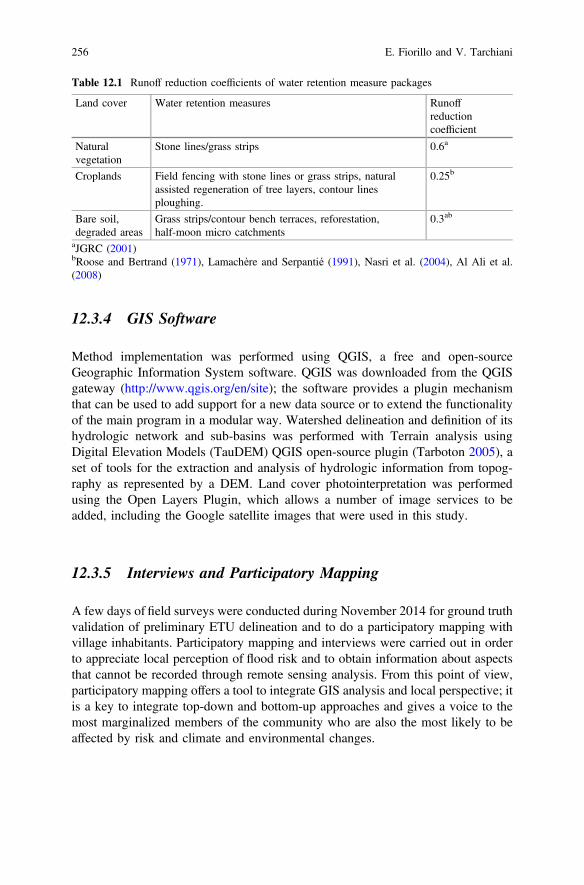
12.3.4 GIS Software
Method implementation was performed using QGIS, a free and open-sourceGeographic Information System software. QGIS was downloaded from the QGISgateway (http://www.qgis.org/en/site); the software provides a plugin mechanismthat can be used to add support for a new data source or to extend the functionalityof the main program in a modular way. Watershed delineation and definition of itshydrologic network and sub-basins was performed with Terrain analysis usingDigital Elevation Models (TauDEM) QGIS open-source plugin (Tarboton 2005), aset of tools for the extraction and analysis of hydrologic information from topog-raphy as represented by a DEM. Land cover photointerpretation was performedusing the Open Layers Plugin, which allows a number of image services to beadded, including the Google satellite images that were used in this study.
12.3.5 Interviews and Participatory Mapping
A few days of field surveys were conducted during November 2014 for ground truthvalidation of preliminary ETU delineation and to do a participatory mapping withvillage inhabitants. Participatory mapping and interviews were carried out in orderto appreciate local perception of flood risk and to obtain information about aspectsthat cannot be recorded through remote sensing analysis. From this point of view,participatory mapping offers a tool to integrate GIS analysis and local perspective; itis a key to integrate top-down and bottom-up approaches and gives a voice to themost marginalized members of the community who are also the most likely to beaffected by risk and climate and environmental changes.
Table 12.1 Runoff reduction coefficients of water retention measure packages
Land cover Water retention measures Runoffreductioncoefficient
Naturalvegetation
Stone lines/grass strips 0.6a
Croplands Field fencing with stone lines or grass strips, naturalassisted regeneration of tree layers, contour linesploughing.
0.25b
Bare soil,degraded areas
Grass strips/contour bench terraces, reforestation,half-moon micro catchments
0.3ab
aJGRC (2001)bRoose and Bertrand (1971), Lamachère and Serpantié (1991), Nasri et al. (2004), Al Ali et al.(2008)
256 E. Fiorillo and V. Tarchiani
12.4 Results
The FREM method allowed a flooding risk reduction plan to be conceived to acritical rain of 80 mm, equal to the amount that caused the last flood in thecatchment during 2013; this plan has already been thoroughly explained inTarchiani and Fiorillo (2016). The analysis indicated that the croplands of theGuellay villages, located on the glacis and in the bottom alluvial zones, arethreatened by 42 small sub-basins (Fig. 12.4), covering an area of 112.1 km2, thatdischarged 4,413,992 m3. Most of these sub-basins, corresponding to 96.1 km2, arecovered by degraded or highly degraded tiger bush formations on the plateau thatare responsible for 82% of the amount of water that flows on the flooded areas.Barkewa, the village most exposed to floods, is threatened by 6 small sub-basinsthat surround the village on the south-western and north-eastern sides (Fig. 12.4).
These sub-basins, covering an area of 9.9 km2, in 2013 discharged 303,596 m3
to the flooded Barkewa area. A classification of each sub-basin according to runoffcoefficient allowed the prioritizing of areas to be treated. Priority areas wereidentified as large surfaces with high runoff rates, mainly bare soil or degradedbushes. Regarding the Diollay area (Table 12.2), due to the fact that most of theincoming water arrives from the plateau, the proposed measures involve mainlyrestoration and protection of tiger bush (8501 ha).
The plateau has been heavily exploited in the last decades for firewood har-vesting and in the study area tiger bush is heavily degraded or has been totallycleared. On the glacis, proposed water retention measures involve mainly therestoration of marginal areas with natural vegetation by the implementation of
Fig. 12.4 Sub-basins affecting croplands of Diollay and Barkewa village (left) and Ouro Gueladjostudy area flood risk reduction plan (right)
12 A Simplified Hydrological Method for Flood Risk Assessment … 257
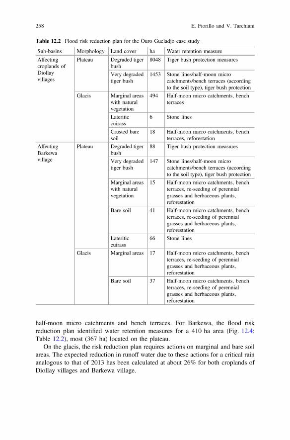
half-moon micro catchments and bench terraces. For Barkewa, the flood riskreduction plan identified water retention measures for a 410 ha area (Fig. 12.4;Table 12.2), most (367 ha) located on the plateau.
On the glacis, the risk reduction plan requires actions on marginal and bare soilareas. The expected reduction in runoff water due to these actions for a critical rainanalogous to that of 2013 has been calculated at about 26% for both croplands ofDiollay villages and Barkewa village.
Table 12.2 Flood risk reduction plan for the Ouro Gueladjo case study
Sub-basins Morphology Land cover ha Water retention measure
Affectingcroplands ofDiollayvillages
Plateau Degraded tigerbush
8048 Tiger bush protection measures
Very degradedtiger bush
1453 Stone lines/half-moon microcatchments/bench terraces (accordingto the soil type), tiger bush protection
Glacis Marginal areaswith naturalvegetation
494 Half-moon micro catchments, benchterraces
Lateriticcuirass
6 Stone lines
Crusted baresoil
18 Half-moon micro catchments, benchterraces, reforestation
AffectingBarkewavillage
Plateau Degraded tigerbush
88 Tiger bush protection measures
Very degradedtiger bush
147 Stone lines/half-moon microcatchments/bench terraces (accordingto the soil type), tiger bush protection
Marginal areaswith naturalvegetation
15 Half-moon micro catchments, benchterraces, re-seeding of perennialgrasses and herbaceous plants,reforestation
Bare soil 41 Half-moon micro catchments, benchterraces, re-seeding of perennialgrasses and herbaceous plants,reforestation
Lateriticcuirass
66 Stone lines
Glacis Marginal areas 17 Half-moon micro catchments, benchterraces, re-seeding of perennialgrasses and herbaceous plants,reforestation
Bare soil 37 Half-moon micro catchments, benchterraces, re-seeding of perennialgrasses and herbaceous plants,reforestation
258 E. Fiorillo and V. Tarchiani
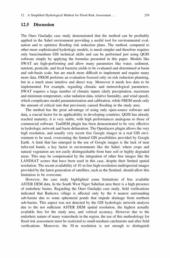
12.5 Discussion
The Ouro Gueladjo case study demonstrated that the method can be profitablyapplied in the Sahel environment providing a useful tool for environmental eval-uation and to optimize flooding risk reduction plans. The method, compared toother more sophisticated hydrologic models, is much simpler and therefore requiresonly basic/medium GIS technical skills and can be performed just using QGISsoftware simply by applying the formulas presented in this paper. Models likeSWAT are high-performing and allow many parameters like water, sediment,nutrient, pesticide, and fecal bacteria yields to be evaluated and determined at basinand sub-basin scale, but are much more difficult to implement and require manymore data. FREM performs an evaluation focused only on risk reduction planning,but in a much more intuitive and direct way. Moreover it needs less data to beimplemented. For example, regarding climatic and meteorological parameters,SWAT requires a large number of climatic inputs (daily precipitation, maximumand minimum temperature, solar radiation data, relative humidity, and wind speed),which complicates model parameterization and calibration, while FREM needs onlythe amount of critical rain that previously caused flooding in the study area.
The method has the great advantage of using only open-source software anddata, a crucial factor for its applicability in developing countries. QGIS has alreadyreached maturity; it is very stable, with high performances analogous to those ofcommercial software. TauDEM plugin has been demonstrated to be very effectivein hydrologic network and basin delineation. The Openlayers plugin allows the veryhigh resolution, and usually very recent free Google images in a real GIS envi-ronment to be used, overcoming the limited GIS possibilities provided by GoogleEarth. A limit that has emerged in the use of Google images is the lack of nearinfra-red bands, a key factor in environments like the Sahel, where crops andnatural vegetation are not easily distinguishable from bare soil or highly degradedareas. This may be compensated by the integration of other free images like theLANDSAT scenes that have been used in this case, despite their limited spatialresolution. The recent availability of 10 m free high-resolution multispectral imagesprovided by the latest generation of satellites, such as the Sentinel, should allow thislimitation to be overcome.
However, the case study highlighted some limitations of free availableASTER DEM data. In the South West Niger Sahelian area there is a high presenceof endorheic basins. Regarding the Ouro Gueladjo case study, field verificationsindicated that Barkewa village is affected only by the 6 nearest surroundingsub-basins due to some ephemeral ponds that impede drainage from northernsub-basins. This aspect was not detected by the GIS hydrologic network analysisdue to the not sufficient ASTER DEM spatial resolution, the highest actuallyavailable free for the study area, and vertical accuracy. However due to theendorheic nature of many watersheds in the region, the use of this methodology forflood risk assessment must be restricted to small-medium catchments and after fieldverifications. Moreover, the 30 m resolution is not enough to distinguish
12 A Simplified Hydrological Method for Flood Risk Assessment … 259
micromorphology and in some cases to precisely delineate sub-basins. Thereforeactual DEMs don’t allow the physical and morphological aspects involved in thewater cycle to be defined at a scale comparable to that provided by Google imagesfor land cover delineation. This can reduce accuracy in flood risk reduction plansand must be kept into account.
Soil information is often a critical aspect in environmental studies due to the factthat it can only be detected at a high scale resolution by field surveys and only a fewdata are usually available free. In the present case study, the availability of theNiger SOTER database helped to overcome this problem. Anyway the CN methodrequires only one type of soil information, the infiltration capacity that is classifiedin just four classes. This aspect facilitates implementation of the CN method in theFREM methodology because in the Sahel environment rough infiltration rates, likethose required, can easily be identified.
In the FREM model the impact of groundwater level was not considered becausesoil water balance in the Sahel is controlled more by surface than by deep soilconditions (Collinet and Valentin 1979, 1984; Hoogmoed and Stroosnijder 1984);therefore superficial hydrodynamics are mainly determined by surface conditionsthat are sufficient to explain significant infiltration (Casenave and Valentin 1992).
Finally, the Ouro Gueladjo case study highlighted that hydrologic modelling forrisk reduction planning cannot be performed adequately without considering theopinions and needs of local inhabitants. Remote sensing and GIS are extremelypowerful tools but some aspects that must be taken into account in risk reductionplanning cannot and will never be understood and considered through them. In thisstudy, a field campaign allowed remotely sensed data and local community per-ception, needs and knowledge of risk, to be integrated through the use of partici-patory mapping with the inhabitants of the villages located in the basin.
12.6 Conclusions
A real integration of hydrological risk reduction and adaptation to climate change doesnot exist, despite the many reports that pledge this integration. Climate change iscurrently affecting the water cycle and flood process by multiplying flash floods aswell as river floods in some areas, (Bates et al. 2008). Since 2009, the WorldMeteorological Organization has been promoting an integrated approach to floodmanagement: IFM (WMO 2009) that also aims at reducing the risks related to poormanagement of surface water and adaptation to climate change. At a local level,participatory methodologies for adaptation to climate change focus more on theirsuitability for the communities rather than appropriate planning of vast rural land-scapes. The municipalities have no information on climate change in their territory orany analytical and climate prediction capacity. They therefore cannot set adaptationand risk reduction policies based on the results of robust analysis of local conditions.
There is thus a strong need for new and effective tools for flood related riskreduction planning. Floods are becoming one of the most common disasters even in
260 E. Fiorillo and V. Tarchiani
the Sahel and, due to climate change and environmental degradation, they are goingto be increasingly frequent in the next decades. The method has been conceived forthe Sahel environment but could also be applied in other environments with onlyslight changes, mainly related to specific runoff reduction coefficients for differentwater retention measures.
The application of the methodology in the Municipality of Ouro Gueladjo wasactively used in the implementation of an action plan that was incorporated in theMunicipal Development Plan in accordance with the resources the MunicipalCouncil is planning to invest. The interest and participation of local stakeholdersand populations confirms the importance of continuing and improving approachesintegrating local and scientific knowledge to meet the real needs of communitiesand to ensure sustainable land management.
References
Al Ali, Y., J. Touma, P. Zante, S. Nasri, and J. Albergel. 2008. Water and sediment balances of acontour bench terracing system in a semi-arid cultivated zone. Hydrological Sciences Journal53 (4): 883–892. doi:10.1623/hysj.53.4.883.
Albergel, J. 1987. Sécheresse, désertification et ressources en eau de surface: application aux petitsbassins du Burkina Faso. The influence of climate change and climatic variability on thehydrologic regime and water resources (Proceedings of the Vancouver Symposium, August1987). AHS Publication, vol. 168, 355–365.
Arnold, J.G., J.R. Williams, A.D. Nicks, and N.B. Sammons. 1990. SWRRB; a basin scalesimulation model for soil and water resources management. Texas: A&M University Press.
Bates, B., Z.W. Kundzewicz, S. Wu, and J. Palutikof. 2008. Climate change and water. IPCCTechnical Paper VI. Geneva: IPCC Secretariat.
Bhuyan, S.J., K.R. Mankin, and J.K. Koelliker. 2003. Watershed–scale AMC selection forhydrologic modeling. Transactions of the ASAE 46 (2): 303. doi:10.13031/2013.12981.
Casenave, A., and C. Valentin. 1992. A runoff capability classification system based on surfacefeatures criteria in semi-arid areas of West Africa. Journal of Hydrology 130 (1): 231–249.
Chang, A.Y., M.E. Parrales, J. Jimenez, M.E. Sobieszczyk, S.M. Hammer, D.J. Copenhaver, andR.P. Kulkarni. 2009. Combining Google Earth and GIS mapping technologies in a denguesurveillance system for developing countries. International Journal of Health Geographics8: 49. doi:10.1186/1476-072X-8-49.
Chinen, T. 1999. Recent accelerated gully erosion and its effects in dry savanna, southwest ofNiger. In Human response to drastic change of environments in Africa, ed. N. Hori, 67–102.
Collinet, J., and C. Valentin. 1979. Analyse des différents facteurs intervenant sur l’hydrody-namique superficielle. Nouvelles perspectives. Applications agronomiques. Cahiers ORSTOMSérie pédologie 17: 283–328.
Collinet, J., and C. Valentin. 1984. Evaluation of factors influencing water erosion in West Africausing rainfall simulation. Challenges in African Hydrology and Water Resources. Symposium,Harare, 1984/06: 451–461.
D’Herbès, J.M., and C. Valentin. 1997. Land surface conditions of the Niamey region: ecologicaland hydrological implications. Journal of Hydrology 188–189: 18–42. doi:10.1016/S0022-1694(96)03153-8.
Descroix, L., P. Genthon, O. Amogu, J.L. Rajot, D. Sighomnou, and M. Vauclin. 2012. Change inSahelian rivers hydrograph: The case of recent red floods of the Niger river in the Niameyregion. Global and Planetary Change 98: 18–30. doi:10.1016/j.gloplacha.2012.07.009.
12 A Simplified Hydrological Method for Flood Risk Assessment … 261
Fujisada, H., G.B. Bailey, G.G. Kelly, S. Hara, and M.J. Abrams. 2005. Aster DEM performance.Geoscience and Remote Sensing, IEEE Transactions 43 (12): 2707–2714.
Gassman, P.W., M.R. Reyes, C.H. Green, and J.G. Arnold. 2007. The soil and water assessmenttool: Historical development, applications, and future research directions. Transactions of theASABE 50 (4): 1211–1250.
Goodchild, M.F. 2009. Geographic information system. In Encyclopedia of Database Systems.Springer US, 1231–1236. doi:10.1016/j.proeps.2009.09.160.
Graf, W.L. 1988. Fluvial processes in dryland rivers, 1–346. New York: Springer-Verlag.Graef, F., N. Van Duivenbooden, and K. Stahr. 1998. Remote sensing and transect-based retrieval
of spatial soil and terrain (SOTER) information in semi-arid Niger. Journal of AridEnvironments 39 (4): 631–644. doi:10.1006/jare.1998.0423.
Hirano, A., R. Welch, and H. Lang. 2003. Mapping from ASTER stereo image data: DEMvalidation and accuracy assessment. ISPRS Journal of Photogrammetry and Remote Sensing57 (5): 356–370. doi:10.1016/S0924-2716(02)00164-8.
Hoogmoed, W.B., and L. Stroosnijder. 1984. Crust formation on sandy soils in the Sahel.I. Rainfall and infiltration. Soil and Tillage Research 4: 5–23. doi:10.1016/0167-1987(84)90013-8.
JGRC. 2001. Guide technique de la conservation des terres agricoles. Documentation technique dela JGRC Vol. 5. Société Japonaise des Ressources Vertes. http://www.reca-niger.org/IMG/pdf/Guide_technique_conservation_terres_agricoles.pdf.
Knisel, W.G. 1980. CREAMS: A field scale model for Chemicals, Runoff, and Erosion fromAgricultural Management Systems [USA]. United States. Department of Agriculture.Conservation research report (USA).
Lamachère, J.M., and G. Serpantié. 1991. Valorisation agricole des eaux de ruissellement et luttecontre l’érosion sur champs cultives en mil en zone soudano-sahelienne. In Utilisationrationnelle de l’eau des petits bassins versants en zone aride, 165–178. AUPELF-UREF.
Leblanc, M.J., G. Favreau, S. Massuel, S.O. Tweed, M. Loireau, and B. Cappelaere. 2008. Landclearance and hydrological change in the Sahel: SW Niger. Global and Planetary Change61 (3): 135–150. doi:10.1016/j.gloplacha.2007.08.011.
Littleboy, M., D.M. Silburn, D.M. Freebairn, D.R. Woodruff, G.L. Hammer, and J.K. Leslie.1992. Impact of soil erosion on production in cropping systems. I. Development and validationof a simulation model. Soil Research 30 (5): 757–774.
Machens, E. 1967. Notice explicative sur la carte géologique du Niger occidental, a l’échelle du1/200 000. Editions du Bureau de recherches géologiques et minières.
Mahe, G., J.E. Paturel, E. Servat, D. Conway, and A. Dezetter. 2005. The impact of land usechange on soil water holding capacity and river flow modelling in the Nakambe River.Burkina-Faso. Journal of Hydrology 300 (1): 33–43. doi:10.1016/j.jhydrol.2004.04.028.
Mering, C., J. Baro, and E. Upegui. 2010. Retrieving urban areas on Google Earth images:Application to towns of West Africa. International Journal of Remote Sensing 31 (22):5867–5877. doi:10.1080/01431161.2010.512311.
Mouhamed, L., S.B. Traore, A. Alhassane, and B. Sarr. 2013. Evolution of some observed climateextremes in the West African Sahel. Weather and Climate Extremes 1: 19–25. doi:10.1016/j.wace.2013.07.005.
Nasri, S., J.M. Lamachere, and J. Albergel. 2004. The impact of contour ridges on runoff from asmall catchment. Revue des Sciences de l’Eau 17 (2): 265–289.
Neitsch, S.L., J.R. Williams, J.G. Arnold, and J.R. Kiniry. 2011. Soil and water assessment tooltheoretical documentation version 2009. Texas Water Resources Institute.
Oldeman, L.R., and V.W.P. Van Engelen. 1993. A world soils and terrain digital database(SOTER)-An improved assessment of land resources. Geoderma 60 (1): 309–325. doi:10.1016/0016-7061(93)90033-H.
Ponce, V.M., and R.H. Hawkins. 1996. Runoff curve number: Has it reached maturity? Journal ofHydrologic Engineering 1 (1): 11–19. doi:10.1061/(ASCE)1084-0699(1996)1:1(11).
262 E. Fiorillo and V. Tarchiani
Ploton, P., R. Pélissier, C. Proisy, T. Flavenot, N. Barbier, S.N. Rai, and P. Couteron. 2012.Assessing aboveground tropical forest biomass using Google Earth canopy images. EcologicalApplications 22 (3): 993–1003. doi:10.1890/11-1606.1.
Risse, L.M., M.A. Nearing, and M.R. Savabi. 1994. Determining the Green-Ampt effectivehydraulic conductivity from rainfall-runoff data for the WEPP model. Transactions of theASAE 37 (2): 411–418. doi:10.13031/2013.28092.
Roose, E.J., and R. Bertrand. 1971. Contribution à l’étude de la méthode des bandes d’arrêt pourlutter contre l’érosion hydrique en Afrique de l’Ouest. Résultats expérimentaux et observationssur le terrain. L’agronomie Tropicale 26 (11): 1270–1283.
Sharpley, A.N., and J.R. Williams. 1990. EPIC-erosion/productivity impact calculator: 1. Modeldocumentation. Technical Bulletin-United States Department of Agriculture 1–1768.
Taylor, J.R., and S.T. Lovell. 2012. Mapping public and private spaces of urban agriculture inChicago through the analysis of high-resolution aerial images in Google Earth. Landscape andUrban Planning 108 (1): 57–70. doi:10.1016/j.landurbplan.2012.08.001.
Tarboton, D.G. 2005. Terrain analysis using digital elevation models (TauDEM). Utah StateUniversity, Logan. http://hydrology.usu.edu/taudem/taudem3.1/. Accessed 26 June 2016.
Tarchiani, V., and E. Fiorillo. 2016. Plan villageois de réduction du risque d’inondation et desècheresse dans la commune d’Ouro Gueladjo au Niger. In Risque et adaptation climatiquedans la région Tillabéri, Niger, ed. V. Tarchiani, and M. Tiepolo, 177–203. Paris:L’Harmattan. ISBN 978-2-343-08493-0.
USDA. 1986. Urban hydrology for small watersheds. Technical Release 55: 2–6.Williams, J.R., A.D. Nicks, and J.G. Arnold. 1985. Simulator for water resources in rural basins.
Journal of Hydraulic Engineering 111 (6): 970–986.WMO. 2009. Integrated flood management. Report n. 1047. http://www.apfm.info/publications/
concept_paper_e.pdf. Accessed 26 June 2016.Young, R.A., C.A. Onstad, D.D. Bosch, and W.P. Anderson. 1989. AGNPS: A nonpoint-source
pollution model for evaluating agricultural watersheds. Journal of Soil and WaterConservation 44 (2): 168–173.
Open Access This chapter is licensed under the terms of the Creative Commons Attribution 4.0International License (http://creativecommons.org/licenses/by/4.0/), which permits use, sharing,adaptation, distribution and reproduction in any medium or format, as long as you give appropriatecredit to the original author(s) and the source, provide a link to the Creative Commons license andindicate if changes were made.The images or other third party material in this chapter are included in the chapter's Creative
Commons license, unless indicated otherwise in a credit line to the material. If material is notincluded in the chapter's Creative Commons license and your intended use is not permitted bystatutory regulation or exceeds the permitted use, you will need to obtain permission directly fromthe copyright holder.
12 A Simplified Hydrological Method for Flood Risk Assessment … 263
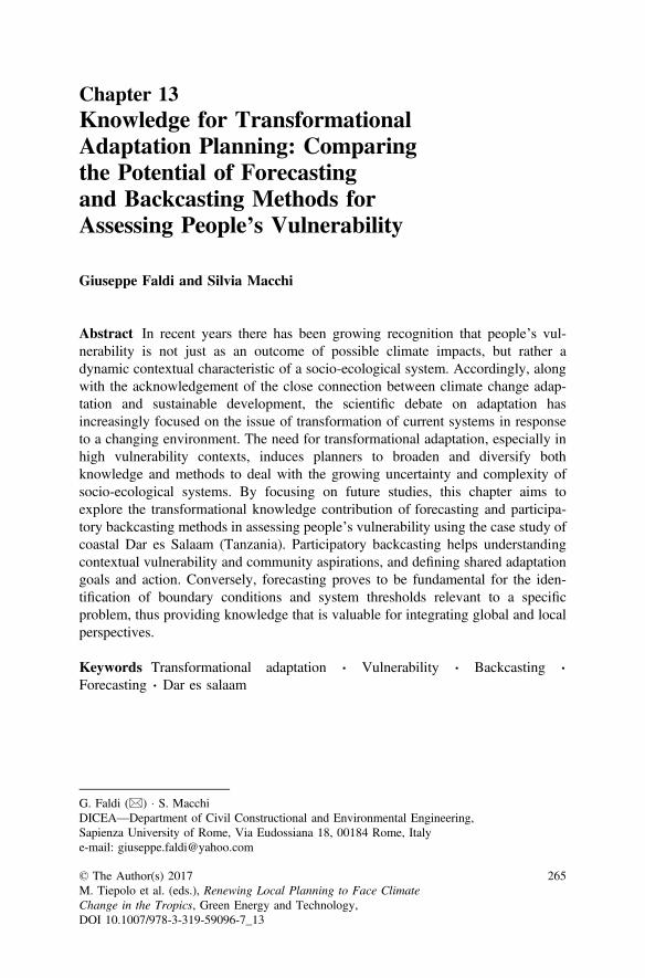
Chapter 13Knowledge for TransformationalAdaptation Planning: Comparingthe Potential of Forecastingand Backcasting Methods forAssessing People’s Vulnerability
Giuseppe Faldi and Silvia Macchi
Abstract In recent years there has been growing recognition that people’s vul-nerability is not just as an outcome of possible climate impacts, but rather adynamic contextual characteristic of a socio-ecological system. Accordingly, alongwith the acknowledgement of the close connection between climate change adap-tation and sustainable development, the scientific debate on adaptation hasincreasingly focused on the issue of transformation of current systems in responseto a changing environment. The need for transformational adaptation, especially inhigh vulnerability contexts, induces planners to broaden and diversify bothknowledge and methods to deal with the growing uncertainty and complexity ofsocio-ecological systems. By focusing on future studies, this chapter aims toexplore the transformational knowledge contribution of forecasting and participa-tory backcasting methods in assessing people’s vulnerability using the case study ofcoastal Dar es Salaam (Tanzania). Participatory backcasting helps understandingcontextual vulnerability and community aspirations, and defining shared adaptationgoals and action. Conversely, forecasting proves to be fundamental for the iden-tification of boundary conditions and system thresholds relevant to a specificproblem, thus providing knowledge that is valuable for integrating global and localperspectives.
Keywords Transformational adaptation Vulnerability Backcasting Forecasting Dar es salaam
G. Faldi (&) S. MacchiDICEA—Department of Civil Constructional and Environmental Engineering,Sapienza University of Rome, Via Eudossiana 18, 00184 Rome, Italye-mail: [email protected]
© The Author(s) 2017M. Tiepolo et al. (eds.), Renewing Local Planning to Face ClimateChange in the Tropics, Green Energy and Technology,DOI 10.1007/978-3-319-59096-7_13
265
13.1 Toward Transformational Adaptation: The Needto Innovate Vulnerability Assessment Methods
In recent years, there has been a recognition of the close connection betweenClimate Change (CC) adaptation and sustainable development, as well as theconsolidation of an interpretation of vulnerability as not only the result of possibleimpacts of CC but also as a contextual characteristic of a Socio-Ecological System(SES) (contextual vulnerability) (O’Brien et al. 2007). The debate on adaptation hasbecome increasingly focused on the transformation of current systems in responseto CC, and the multitude of economic, political, environmental, and social changesthat many communities, cities and regions must address.
Making reference mainly to Resilience and Transition theories (Martens andRotmans 2005; Folke 2006; Olsson et al. 2006; Van der Brugge and Rotmans2007), the literature on CC adaptation understands transformation as a structuralmodification of an SES deriving from a series of specific interacting changes thatoccur in different domains (economic, cultural, technological, ecological, andinstitutional), and which may occur as a response to a specific spontaneous ordeliberate event or action, or develop gradually over time (IPCC 2014).
According to this perspective, adaptation is no longer understood as simplysecuring a city with respect to a possible climate impact (incremental adaptation),but also as an opportunity to favour the deployment of transformative actionsoriented towards sustainability and equity goals (transformational adaptation andchange) (O’Brien 2012; Park et al. 2012; IPCC 2014). More specifically, incre-mental adaptation is considered the reproduction of actions and behaviours thathave already been tested in the past, or that are currently underway, and aimed atmaintaining the integrity and essence of a system with respect to the impacts of CC(Park et al. 2012). Vice versa, transformational adaptation includes the actions andbehaviours that modify the fundamental attributes of a system in response to adetermined impact of CC, and transformational change is understood as a modalityof reducing risk and the vulnerability, not only by adapting to CC, but also bychallenging those social and economic structures that have contributed to CC, andto social vulnerability more generally (IPCC 2014).
In particular, the need for transformational adaptation and change has beenemphasized (contemporaneously with incremental action) especially in contextslike Sub-Saharan urban environments characterized by high degrees of socialvulnerability and exposure to severe climatic stress (Kates et al. 2012).
This emerging theoretical perspective on adaptation led the scientific communityto identify a broad knowledge gap as regards how to plan in practice in a way thatfavours transformational adaptation and change in an SES, specifically for contextsof high social vulnerability (IPCC 2014).
In order to contribute to filling this gap, we first assume that promoting theconditions to facilitate a system transformation begins with changing the way werepresent and understand a given question upon which to intervene (“transformationof understandings” for “transformation of practices”) (Dente 2014). The type of
266 G. Faldi and S. Macchi
knowledge upon which the decision-making process is based as well as the way inwhich that knowledge is constructed, therefore, become fundamental elements infavouring a transformative process.
The transformational perspective on adaptation therefore induces planners tobroaden and diversify both knowledge and methods to deal with the growinguncertainty and complexity of socio-economic, environmental, and climatic systems.In particular, planners need to update the most widely-used climate proofing methodsfor vulnerability assessment (such as impact/risk analyses, developed predominantlyfor the management of natural disasters), as they are unable to fully grasp the futureuncertainty and the multidimensional vulnerability processes occurring in an SES,and, therefore, favour an incremental vision of adaptation. Planners also need toresearch alternative or complementary methods for supporting decision-making thatfocus the assessment process directly on the most vulnerable actors and their expe-riential knowledge, and that are able to embrace the uncertainty and complexity of themulti-stress context in which vulnerability dynamics are produced, and to proposelong-term future projects that consider people’s legitimate expectations of change(Eakin and Luers 2006; Pelling 2011; O’Brien 2012; IPCC 2014).
In pursuit of that goal, the present work focuses on the broad field of futurestudies in which scenario methods are increasingly used in planning for adaptationto CC (Börjeson et al. 2006), and seeks to explore the knowledge contributiontowards transformational adaptation on a local scale that arises from the use of thetwo main scenario building approaches for assessing people’s vulnerability: fore-casting and backcasting.
The argument is explored through the case study of Dar es Salaam (Tanzania),where a vulnerability assessment to access to water of the coastal peri-urbanpopulation was developed combining forecasting and participatory backcasting inthe framework of the Project “Adapting to Climate Change in Coastal Dar esSalaam” (ACC Dar) (www.planning4adaptation.eu).
After illustrating the use of the two scenario building approaches in the vul-nerability assessment process, the chapter presents the case study, the scenariomethodology, the research method, the results and emerging knowledge contribu-tion, ending with the potential use of forecasting and participatory backcastingmethods for transformational adaptation planning.
13.2 Scenario Analysis for Vulnerability Assessment
The growing interest in adaptation has been translated into progressively morecomplex methodologies to support the definition of adaptation strategies: from the“classic” environmental impact studies to the more detailed “first” and “secondgeneration” climate change vulnerability studies that encompass social parametersin the assessment process (Füssel and Klein 2006). Among the various method-ological instruments applied to adaptation planning and vulnerability assessment inparticular, scenario analysis methods are increasingly used because they are
13 Knowledge for Transformational Adaptation Planning … 267
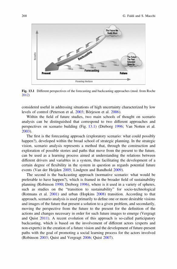
considered useful in addressing situations of high uncertainty characterized by lowlevels of control (Peterson et al. 2003; Börjeson et al. 2006).
Within the field of future studies, two main schools of thought on scenarioanalysis can be distinguished that correspond to two different approaches andperspectives on scenario building (Fig. 13.1) (Dreborg 1996; Van Notten et al.2003).
The first is the forecasting approach (exploratory scenario: what could possiblyhappen?), developed within the broad school of strategic planning. In the strategicvision, scenario analysis represents a method that, through the construction andexploration of possible stories and paths that move from the present to the future,can be used as a learning process aimed at understanding the relations betweendifferent drivers and variables in a system, thus facilitating the development of acertain degree of flexibility in the system in question as regards potential futureevents (Van der Heijden 2005; Lindgren and Bandhold 2009).
The second is the backcasting approach (normative scenario: what would bepreferable to have happen?), which is framed in the broader field of sustainabilityplanning (Robinson 1990; Dreborg 1996), where is it used in a variety of spheres,such as studies on the “transition to sustainability” for socio-technological(Rotmans et al. 2001) and urban (Hopkins 2008) transition. According to thatapproach, scenario analysis is used primarily to define one or more desirable visionsand images of the future that present a solution to a given problem, and secondarily,moving the perspective from the future to the present for the definition of theactions and changes necessary in order for such future images to emerge (Vergragtand Quist 2011). A recent evolution of this approach is so-called participatorybackcasting, which is based on the involvement of different actors (experts andnon-experts) in the creation of a future vision and the development of future-presentpaths with the goal of promoting a social learning process for the actors involved(Robinson 2003; Quist and Vergragt 2006; Quist 2007).
Fig. 13.1 Different perspectives of the forecasting and backcasting approaches (mod. from Roche2012)
268 G. Faldi and S. Macchi
As regards the use of scenario analysis in CC adaptation studies, the scenariomethods that draw from the forecasting approach, albeit with substantial differencesin their scenario building techniques (top-down vs. bottom-up, quantitative vs.qualitative, analytic vs. participatory), have played and continue to play a dominantrole in impact studies and CC vulnerability studies and are thus the most widelyused in adaptation planning, especially at the regional and supra-regional levels(e.g. SRES scenarios, socio-economic scenarios, down-scaled climatic scenarios)(IPCC 2000; Swart et al. 2004). In particular, forecasting scenario analysis isespecially used in CC studies to explore specific environmental and socio-economicquestions or phenomena that have a direct correlation to CC, and to understand,visualise, and analyse the relative main future trends, impacts, and climate risks, inorder to identify the vulnerability of the people exposed and to thus facilitate theidentification and prioritization of various adaptation policy responses (IPCC 2014).
In any case, despite their wide use in adaptation planning, various authors(Gydley et al. 2009, O’Brien 2012) have emphasized how the use of the “moreconsolidated” forecasting methods in the vulnerability assessment process cannothelp but support an incremental view of adaptation, especially on a local scale,because forecasting, which is based on the exploration of dominant trends and isincapable of taking contextual vulnerability dynamics and their future uncertaintyinto account, tends to consider the future as a restatement of the mechanisms of thepresent, thus favouring a conservative perspective on adaptation.
Contrariwise, backcasting is suggested in the literature (Giddens 2009; Van derVoorn et al. 2012; IPCC 2012) as theoretically able to favour the unfolding oftransformative processes in that, by moving from a utopian and desirable future, ittends to detach from present dynamics and, especially if applied in a participatoryway, can introduce certain elements into the adaptation planning process that canpromote transformation (shared vision and social learning). In any case, despite thehypothetical recognition of this potential, its use at the practical level for informinglocal adaptation planning has not yet been widely experimented.
13.3 Levels of Knowledge for Planning AdaptationLocally: Understanding the Access to Waterin Coastal Dar es Salaam
13.3.1 Study Area and Methods
The case study was carried out in Dar es Salaam (Fig. 13.2), the largest city inTanzania, and one of the most important metropolises of eastern Sub-SaharanAfrica. In the first phase of the developed vulnerability assessment process(Fig. 13.3a), a forecasting method was applied analytically to study a biophysicalphenomenon at the urban level that could be influenced by CC, namely seawaterintrusion into the coastal aquifer.
13 Knowledge for Transformational Adaptation Planning … 269
Fig. 13.2 Dar es Salaam Region and the areas of the Forecasting (F) and ParticipatoryBackcasting (PB) studies
270 G. Faldi and S. Macchi
Fig. 13.3 The different phases of the developed vulnerability assessment process (a), and theconceptual frameworks of the forecasting (b) and participatory backcasting (c) methodologies
13 Knowledge for Transformational Adaptation Planning … 271
In the second phase, the use of a participatory backcasting method was tested tostudy access to water in a specific peri-urban coastal community in Dar es Salaam.In general, access to water currently represents an emerging problem for the city’scoastal communities due to the increasing salinization of the aquifer, caused byanthropogenic pollution (Mato 2002; Mjemah 2007) and by growing seawaterintrusion (Mtoni et al. 2012; Faldi and Rossi 2014). In fact, as a result of theinefficiency of the municipal water system in meeting the increasing water demandsof a growing population—it currently serves 25–30% of the total water demand ofthe population (UN-Habitat 2009), which is estimated as 4.36 million inhabitantswith a growth annual rate of 5.6% (URT 2012)—groundwater has becomeincreasingly important for supporting human activities, especially in unplannedperi-urban areas (URT 2011).
Moreover, the recent changes in climatic characteristics in Dar es Salaam cancontribute to the impoverishment of local freshwater resources and additionaldemand for groundwater, particularly the significant decreasing trend in averagerainfall (from approximately 1200 mm/year in 1960 to approximately1000 mm/year in 2010), and the increasing trend in average mean temperature(Rugai and Kassenga 2014).
The purpose of the forecasting study was to analyse the temporal evolution ofseawater intrusion into the coastal aquifer in Dar es Salaam and the climatic andanthropogenic influences on the hydrogeological dynamics of the environmentalsystem, and to develop qualitative scenarios of future seawater intrusion trends withrespect to the possible evolution of the climatic and non-climatic factors considered(i.e. aquifer sensitivity to seawater intrusion). The methodology for assessing theaquifer’s sensitivity to seawater intrusion (Sappa et al. 2013) (Fig. 13.3b), appliedto a specific study area, consisted of two analytical steps (Table 13.1).
The backcasting study was developed through the use of the Theatre of theOppressed (TO) (Boal 1992) as a participatory tool, and sought to explore the hopesof the community as regards access to water, the challenges that could prevent themfrom realizing those hopes, and the collective development of possible strategies forovercoming obstacles and fulfilling their needs. The core idea of the developedbackcasting methodology (Faldi et al. 2014) (Fig. 13.3c) was to begin the process
Table 13.1 Analytical steps of the forecasting methodology
Steps of the F methodology Analysis methods
1. Understanding current aquiferexposure and sensitivity
• Seawater intrusion assessment through hydrochemical methods, namely physical and chemicaltesting of a monitored network of representativeboreholes from 2001 to 2012
• Analysis of climatic and anthropogenic influenceson hydrogeological dynamics through investigationof the temporal evolution of the piezometric surfaceand Active Groundwater Recharge (AGR)
2. Exploring future aquifer sensitivityscenario to seawater intrusion
Development of qualitative hypotheses for seawaterintrusion trends related to the possible futureevolution of climatic and non-climatic factors
272 G. Faldi and S. Macchi
by defining the community’s shared future vision regarding access to water, to thenlook backwards from that future to the present situation in order to identify thechallenges that might arise as they work towards achieving that vision, and finallyto identify strategies and actions for overcoming those challenges and achieving thedesired future. The methodology is organized in 4 consecutive steps, carried outduring a two-phase exercise (Table 13.2). By using a variety of creative TOtechniques, active community participation is fostered throughout the entire pro-cess. In fact, participants’ interaction represents the core of the process, which reliesheavily on a qualitative traditional knowledge system, made up of words, images,stories, and scenes. The developed methodology was tested though a backcastingexercise carried out in Kigamboni ward, a peri-urban coastal area located in thesouth of Dar es Salaam. The first phase of the exercise involved 24 young people,while in the second phase 11 public Forum Theatre events were performed invarious areas within the Kigamboni ward, involving in total more than 2000 people.
The results that emerged from the forecasting and backcasting studies were eval-uated with respect to the knowledge contribution provided, identified in terms of:
• understanding the problem of the access to water induced by the use of a givenmethod (way of addressing the future uncertainty and complexity of the context)
• objectives resulting from that understanding (consideration on people’s expec-tations of change)
• action resulting from that understanding.
13.4 Results of the Forecasting and ParticipatoryBackcasting Studies
In the first phase of the vulnerability assessment, the fundamental knowledgecontribution of the use of forecasting applied to the study of environmental systemsconsisted mainly in its ability to provide a better understanding of pressure factorsdetermining the seawater intrusion. This allowed for identification of the boundaryconditions of the disruption and the thresholds of the SES in relation to the evo-lution of the disruption and, consequently, the determination of general principlesidentifying the supra-local limits of local adaptation initiatives. In particular, theforecasting study shows an increase in the areas affected by seawater intrusion inthe period 2001–2012, and how this increase is correlated to the dropping
Table 13.2 Steps of the participatory backcasting methodology
Backcasting phases Steps of the PB-TO methodology
Community workshop 1. Development of a shared vision of future access to water2. Identification of the challenges in achieving that vision
Various public ForumTheatre sessions
3. Preparation of a theatrical representation staging the visionand related challenges that emerged during the workshop4. Collective exploration of alternative actions and strategies toovercome challenges
13 Knowledge for Transformational Adaptation Planning … 273
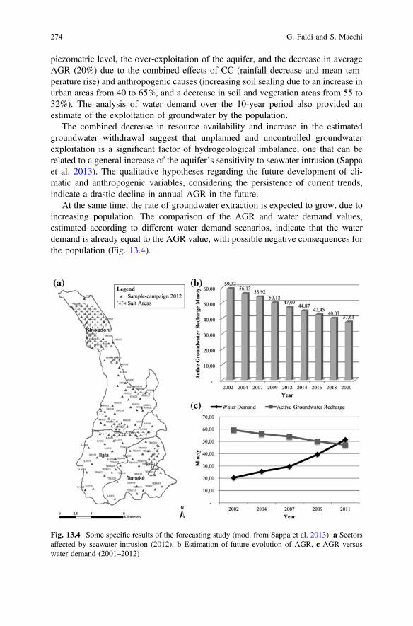
piezometric level, the over-exploitation of the aquifer, and the decrease in averageAGR (20%) due to the combined effects of CC (rainfall decrease and mean tem-perature rise) and anthropogenic causes (increasing soil sealing due to an increase inurban areas from 40 to 65%, and a decrease in soil and vegetation areas from 55 to32%). The analysis of water demand over the 10-year period also provided anestimate of the exploitation of groundwater by the population.
The combined decrease in resource availability and increase in the estimatedgroundwater withdrawal suggest that unplanned and uncontrolled groundwaterexploitation is a significant factor of hydrogeological imbalance, one that can berelated to a general increase of the aquifer’s sensitivity to seawater intrusion (Sappaet al. 2013). The qualitative hypotheses regarding the future development of cli-matic and anthropogenic variables, considering the persistence of current trends,indicate a drastic decline in annual AGR in the future.
At the same time, the rate of groundwater extraction is expected to grow, due toincreasing population. The comparison of the AGR and water demand values,estimated according to different water demand scenarios, indicate that the waterdemand is already equal to the AGR value, with possible negative consequences forthe population (Fig. 13.4).
Fig. 13.4 Some specific results of the forecasting study (mod. from Sappa et al. 2013): a Sectorsaffected by seawater intrusion (2012), b Estimation of future evolution of AGR, c AGR versuswater demand (2001–2012)
274 G. Faldi and S. Macchi
The forecasting study has therefore demonstrated that the problem has alreadyreached a limit state, providing in addition an order of relevance for the drivers ofthis disruption. In this specific case, CC represents a possible multiplier of theeffects of the disruption, but cannot be considered a primary stress factor in light ofthe weight of over-exploitation of the aquifer and soil sealing in recent years.
Thus, with respect to the identification of boundary conditions and systemthresholds, the forecasting study has proven able to identify those determinativefactors that are currently exceeded, or whose future development according to currenttrends would entail scenarios and tendencies to be avoided (business as usual sce-nario). This knowledge is fundamental to a vulnerability assessment aimed at adap-tation in transformational way, in that it offers the possibility of identifying whetherand where a change in the SES is necessary with respect to a specific disruption.Through the use of forecasting in studying specific disruptions to the environmentalsystem, it is therefore possible to define adaptation objectives beyond the local level,which adaptation initiatives should always follow in order to limit an alreadyexcessive disturbance or to recognize one that has reached critical levels.
In the case study, the conservation and sustainable use of groundwater resourcesis therefore framed as a priority general principle with fundamental significance forthe coastal communities of Dar es Salaam.
Despite the emergence of such strata, forecasting study was unable to understandthe contextual dynamics affected by the disturbance and the eventual existence ofcross-scalar influences, namely the internal factors and variables of the context thatcould constitute additional drivers of the disturbance. This contributes to anincrease in uncertainty when predicting what the future dynamics of an SES couldbe with regard to the evolution of the disturbance.
In the second part of the assessment process, analysis of the results of thepractical experimentation of participatory backcasting allowed for the definition ofa framework of knowledge elements that participatory backcasting, when applied atthe community level, can bring to a vulnerability assessment aimed at transfor-mational adaptation.
A first knowledge element that emerged from the use of participatory back-casting in the vulnerability assessment is strictly linked to the visioning process.The construction of a shared future vision highlighted in a clear and detailed waythe desires and hopes of the community as regards access to water: from thelegitimate expectation of stable access to good quality water at a reasonable price,which would be guaranteed by having access to multiple water sources, to thedesire to generate one or more socio-economic activities at both the individual andcommunity level. In particular, within the desired vision (Fig. 13.5a) every familyin the community has access to a sufficient amount of water for their domestic andproductive purposes (2000 L/day per household). Water supply should also beensured by one or more well-constructed, deep wells and various public standpipesconnected to the municipal water system. The desire for alternative water sourcesderives from need to guarantee a continuous and stable supply, so as to relievepeople from the need to spend a considerable part of their day obtaining water. Inaddition, adequate access to water would allow people to develop various
13 Knowledge for Transformational Adaptation Planning … 275
socio-economic activities on a broader scale, both at the household level (such asfamily agriculture) and the community level (such as larger-scale agriculture,livestock grazing, ice production for consumption, and fish farming in artificialponds). Understanding community aspirations therefore provides several kinds ofinformation that is valid at the community level, and the consideration of which inthe vulnerability assessment process could facilitate identification of possiblespecific adaptation objectives that are socially shared and more detailed, and viceversa, not extrapolated from an external vulnerability assessment that is neutral withrespect to the context.
Secondly, the use of participatory backcasting for vulnerability assessmentallowed for recognition of the multidimensionality of the problem being studied, i.e.by identifying the various vulnerability mechanisms existing in the context and theconnections that arise between them. In particular, during practical experimentationit became clear that the question of access to water is very complex and involves aseries of interrelated dynamics and multiple transversal aspects of community life.The question is correlated to a series of technical/environmental problems (quali-tative degradation of the resource, management and maintenance of water systemsto be installed in the area), however limited access to quality water resources alsodepends on other problematic and interrelated social, economic, and politicalconditions. In fact, the definition of challenges in achieving the vision facilitated theimmediate emergence of a multitude of critical situations linked to access to water:from establishing a common objective within the community as regards thedevelopment of possible shared projects to improve their access to water, toobtaining and eventually managing the funds needed to develop such communityprojects, to the risk that political authorities or individuals representing the com-munity might use their power to obtain personal economic benefits from the failureof community projects (Fig. 13.5a).
This capacity of backcasting allowed for a reduction in the level of uncertainty inunderstanding the possible evolution of an SES in response to a given environ-mental or socio-economic pressure factor that directly affects the context, or to aspecific already planned (or to be planned) adaptation action. In addition back-casting demonstrates the main causal processes and the level of entry points uponwhich it is important to focus in order to reduce/transform vulnerability conditions.
Lastly, in the collective exploration of possible actions for overcoming thechallenges and achieving the shared vision, the knowledge contribution provided byparticipatory backcasting demonstrates a more operational character. The publicevents carried out produced various practices directly proposed by the community.This included actions involving political authorities, proposed in a critical butcollaborative way, such as the creation of independent community groups forgathering funds (from various sources) or for gathering, sharing, and distributinginformation (plans, regulations, laws), as well as the creation of a community waterassociation with a clearly defined political strategy and an economic and technicalplan, and finally actions that assumed in some cases the occurrence of illegal acts(breaking of pipes to directly access water or forcing political leaders to step down)(Fig. 13.5b).
276 G. Faldi and S. Macchi
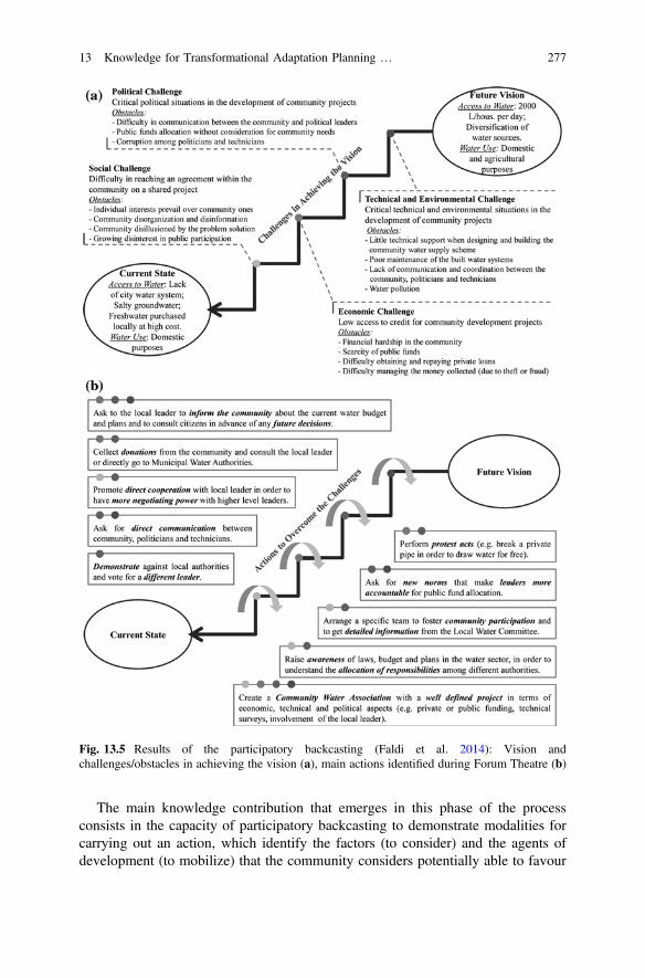
The main knowledge contribution that emerges in this phase of the processconsists in the capacity of participatory backcasting to demonstrate modalities forcarrying out an action, which identify the factors (to consider) and the agents ofdevelopment (to mobilize) that the community considers potentially able to favour
Fig. 13.5 Results of the participatory backcasting (Faldi et al. 2014): Vision andchallenges/obstacles in achieving the vision (a), main actions identified during Forum Theatre (b)
13 Knowledge for Transformational Adaptation Planning … 277
change. In particular, the community’s cooperation and desire to take on a centraland more “informed” role were the main factors in most of the proposed actions,while specific community information groups and local authorities were identifiedas possible agents of development, should they be involved in community projects.
In any case, the results analysis demonstrates how the use of the participatorybackcasting method revealed two principle limits.
The first is correlated to its inability to understand how the pressure factorsgenerated at a supra-local scale can influence contextual vulnerability dynamics.The second limit is the prevalent propensity towards the promotion of solutions andvisions that the community has already directly or indirectly experienced, andwhich often tend to be mostly conservative.
This was the case with the identification of a community well as the mainmethod of water supply that participants desired (although not the only one). Thatchoice, which was widespread in the context, certainly cannot represent a trans-formative solution as regards the conservation of groundwater resources. The lackof technical knowledge in the visioning process and in the collective exploration ofactions therefore proved in this case to be a factor that reduced the community’scapacity to define comprehensive courses of action that addressed all the challengesthat had been identified.
13.5 Conclusions
This chapter contributes to local-scale transformational adaptation using forecastingand participatory backcasting for assessing vulnerability to access to water of acoastal community of Dar es Salaam.
Forecasting and participatory backcasting emerge as potentially complementaryrather than alternative methods of supporting planning for transformational adap-tation. Participatory backcasting has proven able to overcome the limits of fore-casting methods in assessing vulnerability. In fact, forecasting fails to consider thecausal processes and contextual dynamics that can cause (or aggravate) people’svulnerability, and favours a conservative perspective when defining adaptationobjectives and actions.
As asserted in the literature, if vulnerability is framed exclusively as a staticcondition that quantifies the level of sensitivity and exposure of a given “exposedunit” to the possible impacts of a biophysical disturbance, it will lead mainly to theidentification of incremental adaptation measures. This is evident within the casestudy: the understanding of the potential evolution and relevance of the seawaterintrusion problem leads to the definition of primarily technical-infrastructural orregulatory actions aimed at managing or reducing the disturbance itself. Althoughthe conservation of water resources emerged as a general principle in the urbancontext of Dar es Salaam, that type of action cannot always be considered effective
278 G. Faldi and S. Macchi
or “no regret” in that the proposed representation is inevitably missing a part of theproblem, namely the understanding of how such initiatives can address contextualmechanisms of vulnerability.
The use of participatory backcasting in the vulnerability assessment can there-fore fill such gaps, because the alternative representation of the problem that itproposes allows the adaptation process to focus on the dynamics of contextualvulnerability. Participatory backcasting in this case study shows that groundwatersalinization represents only a part of the problem. People’s vulnerability is char-acterized as a dynamic condition that results from different and interconnectedsocio-economic, environmental, and political processes that reveal the reasons whypeople are unable to access quality water at a reasonable price.
In addition, participatory backcasting has proven potentially able to fill the gapsin forecasting in terms of defining the objectives and actions that come up againstthe future uncertainty of contextual vulnerability. The identification of sharedcommunity objectives, entry points and possible modalities of action providesgreater operability in the definition of medium-term adaptation options. This in turnallows for a reduction of uncertainty with respect to the efficacy of such options inthe specific context, and optimization of available financial resources, which can bescarce in general, and especially in Sub-Saharan contexts.
According to the representation of the problem proposed in the participatorybackcasting, new infrastructure are desired and preferred in the Kigamboni com-munity, but to be an effective and optimal option it would have to be preceded byactions that address various social, economic, and political problems.
From this point of view, participatory backcasting proposes a change in therepresentation of the problem, which can thus create the conditions for defininglocal adaptation strategies that are transformative, i.e. oriented not only to thedefinition of actions for counteracting the effects of CC, but also towards thedevelopment of future projects for sustainability and equity.
In any case, the complementarity of the two methods is also clear in the oppositedirection. Indeed, the fundamental knowledge contribution that emerged from theforecasting study can potentially compensate the limited technical knowledgewithin participatory backcasting. In fact, the ability of forecasting to identify, on asupra-local level, the boundary conditions and upper limits beyond which a systemchange becomes necessary allows for the definition of general objectives that alocal adaptation action should seek to meet. Such objectives therefore constituteexclusionary principles for the eventual range of actions defined at the local level.
From the perspective of transformational adaptation, forecasting can thereforebring to the vulnerability assessment process the type of technical knowledge that isnecessary to integrate the global into the local perspective. Such knowledge, ifintroduced into the participatory process, can also allow for an expansion of thehorizon of visions and possible courses of action that are available to the com-munity. In the present case study, this translated into the possibility of allowingpeople to recognize that a community well may not be the most desirable option,thus motivating them to search for alternative solutions that could be equallydesirable.
13 Knowledge for Transformational Adaptation Planning … 279
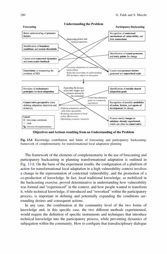
The framework of the elements of complementarity in the use of forecasting andparticipatory backcasting in planning transformational adaptation is outlined inFig. 13.6. On the basis of the experiment results, the configuration of a platform ofaction for transformational local adaptation in a high vulnerability context involvesa change in the representation of contextual vulnerability, and the promotion of aco-production of knowledge. In fact, local traditional knowledge, as mobilized inthe backcasting exercise, proved determinative in understanding how vulnerabilitywas formed and “experienced” in the context, and how people wanted to transformit, while technical knowledge, if introduced and “reworked” within the participatoryprocess, is important in defining and potentially expanding the conditions sur-rounding desires and consequent actions.
In any case, the combination at the community level of the two forms ofknowledge and, in this specific case, the two different methods experimented,would require the definition of specific instruments and techniques that introducetechnical knowledge into the participatory process, while preventing dynamics ofsubjugation within the community. How to configure that transdisciplinary dialogue
Fig. 13.6 Knowledge contribution and limits of forecasting and participatory backcasting:framework of complementarity for transformational local adaptation planning
280 G. Faldi and S. Macchi
of methods at the community level in a way that optimizes potential and limitsshortcomings for transformational local adaptation therefore requires furtherexperimentation and study.
References
Boal, A. 1992. Games for actors and non-actors. Oxford: Routledge.Börjeson, L., M. Höjer, K.-H. Dreborg, T. Ekvall, and G. Finnveden. 2006. Scenario types and
techniques: Towards a user’s guide. Futures 38 (7): 723–739. doi:10.1016/j.futures.2005.12.002.
Dente, B. 2014. Understanding policy decisions. Cham: Springer. doi:10.1007/978-3-319-02520-9.Dreborg, K.-H. 1996. Essence of backcasting. Futures 28 (9): 813–828. doi:10.1016/S0016-3287
(96)00044-4.Eakin, H., and A.L. Luers. 2006. Assessing the vulnerability of social-envoronmental systems.
Annuual Review of Environment and Resources 31: 365–394. doi:10.1146/annurev.energy.30.050504.144352.
Faldi, G., S. Macchi, O. Malcor, and M. Montemurro. 2014. Participatory backcasting for climatechange adaptation: supporting community reasoning on access towater inDar es Salaam. ACCDarProject. http://www.planning4adaptation.eu/Docs/newsInfoMaterial/07-2014/Backcasting%20Working%20Paper_Faldi_Macchi_Malcor_Montemurro.pdf. Accessed 28 November 2016.
Faldi, G., and M. Rossi. 2014. Climate change effects on seawater intrusion in coastal Dar esSalaam: Developing exposure scenarios for vulnerability assessment. In: Climate ChangeVulnerability in Southern African Cities, eds. S. Macchi and M. Tiepolo, 57–72. Cham:Springer. doi:10.1007/978-3-319-00672-7_4 .
Folke, C. 2006. Resilience: The emergence of a perspective for social-ecological systems analyses.Global Environmental Change 16: 253–267.
Füssel, H.-M., and R.J.T. Klein. 2006. Climate change vulnerability assessments: an evolution ofconceptual thinking. Climatic Change 75 (3): 301–329. doi:10.1007/s10584-006-0329-3.
Giddens, A. 2009. The politics of climate change. Cambridge: Polity Press.Gidley, J.M., J. Fien, J.-A. Smith, D.C. Thomsen, and T.F. Smith. 2009. Participatory futures
methods: Towards adaptability and resilience in climate-vulnerable communities.Environmental Policy and Governance 19 (6): 427–440. doi:10.1002/eet.524.
Hopkins, R. 2008. The transition handbook. From oil dependency to local resilience. White riverjunction: Chelsea Green Publishing.
IPCC. 2000. Special report on emissions scenarios. A special report of working group III of theIntergovernmental Panel of Climate Change. Cambridge: Cambridge University Press.
IPCC. 2012. Managing the risks of extreme events and disasters to advance climate changeadaptation. A special report of working groups I and II of the Intergovernmental Panel onClimate Change. Cambridge: Cambridge University Press.
IPCC. 2014. Climate change 2014: Impacts, adaptation, and vulnerability. Contribution ofworking group II to the fifth assessment report of the IPCC. Cambridge: Cambridge UniversityPress.
Kates, R.W., W.R. Travis, and T.J. Wilbanks. 2012. Transformational adaptation whenincremental adaptations to climate change are insufficient. PNAS-Proceedings of theNational Academy of Sciences of the United Stated of America 109 (19): 7156–7161.doi:10.1073/pnas.1115521109.
Lindgren, M., and H. Bandhold. 2009. Scenario planning: The link between future and strategy,2nd ed. Basingstoke: Palgrave Macmillan.
13 Knowledge for Transformational Adaptation Planning … 281
Mato, R.R.A.M. 2002. Groundwater pollution in urban Dar es Salaam, Tanzania: Assessingvulnerability and protection priorities. Eindhoven: University Press, Eindhoven University ofTechnology.
Martens, P., and J. Rotmans. 2005. Transitions in a globalizing world. Futures 37 (10):1133–1144. doi:10.1016/j.futures.2005.02.010.
Mjemah, I.C. 2007. Hydrogeological and hydrogeochemical investigation of a coastal aquifer inDar es Salaam, Tanzania. Gent: Ph.D. dissertation, Ghent University.
Mtoni, Y., I.C.Mjemah, K.Msindai, M. Van Camp, and K.Walraevens. 2012. Saltwater intrusion inthe Quaternary aquifers of Dar es Salaam region, Tanzania. Geologica Belgica 15 (1-2): 16–25.
O’Brien, K. 2012. Global environmental change II: From adaptation to deliberate transformation.Progress in Human Geography 36 (5): 667–676.
O’Brien, K., S. Eriksen, L.P. Nygaard, and A. Schjolden. 2007. Why different interpretations ofvulnerability matter in climate change discourses. Climate Policy 7 (1): 73–88.
Olsson, P., L.H. Gunderson, S.R. Carpenter, P. Ryan, L. Lebel, C. Folke, and.S. Holling. 2006.Shooting the rapids: navigating transitions to adaptive governance of social-ecological systems.Ecology and Society 11 (1): 18.
Park, S.E., N.A. Marshall, E. Jakku, A.M. Dowd, S.M. Howden, E. Mendham, and A. Fleming.2012. Informing adaptation responses to climate change through theories of transformation.Global Environmental Change 22: 115–126.
Pelling, M. 2011. Adaptation to climate change: From resilience to transformation. Abingdon:Routledge.
Peterson, G.D., G.S. Cumming, and S.R. Carpenter. 2003. Scenario planning: a tool forconservation in an uncertain world. Conservation Biology 17 (2): 358–366.
Quist, J. 2007. Backcasting for a sustainable future: the impact after ten years. Delft: Eburon.Quist, J., and P. Vergragt. 2006. Past and future of backcasting: The shift to stakeholder
participation and a proposal for a methodological framework. Futures 38: 1027–1045.Robinson, J. 1990. Futures under glass: A recipe for people who hate to predict. Futures 22 (8):
820–843. doi:10.1016/0016-3287(90)90018-D.Robinson, J. 2003. Future subjunctive: Backcasting as social learning. Futures 35: 839–856.Roche, P. 2012. A new possibility - An exciting future shaping our present. http://www.
executivecoachingwithlpr.com/2012_08_01_archive.html. Accessed 5 December 2016.Rotmans, J., R. Kemp, and M. van Asselt. 2001. More evolution than revolution: Transition
management in public policy. Foresight 3 (1): 15–31. doi:10.1108/14636680110803003.Rugai, D., and G.R. Kassenga. 2014. Climate change impacts and institutional response capacity
in Dar es Salaam, Tanzania. In: Climate Change Vulnerability in Southern African cities, eds.S. Macchi, and M. Tiepolo, 39–55. Cham: Springer. doi:10.1007/978-3-319-00672-7_3.
Sappa, G., M.T. Coviello, G. Faldi, M. Rossi, A. Trotta, and S. Vitale. 2013. Analysis of thesensitivity to seawater intrusion of Dar es Salaam’s coastal aquifer with regard to climatechange. ACCDar Project. http://www.planning4adaptation.eu/Docs/events/WorkShopII/WP_Activity_2.2_def.pdf. Accessed 25 November 2016.
Swart, R.J., P. Raskin, and J. Robinson. 2004. The problem of future: sustainability science andscenario analysis. Global Environmental Change 14 (2): 137–146. doi:10.1016/j.gloenvcha.2003.10.002.
UN-Habitat. 2009. Tanzania: Dar es Salaam City Profile. Nairobi: UNION, Publishing ServicesSection.
URT. 2011. Dar e Salaam City Environment Outlook 2011. Dar es Salaam: Vice-President’sOffice, Division of Environment, United Republic of Tanzania.
URT. 2012. Population and housing census: Population distribution by administrative areas. Dares Salaam: Ministry of Finance, National Bureau of Statistics, United Republic of Tanzania.
Van der Brugge, R., and J. Rotmans. 2007. Towards transition management of European waterresources. Water Resource Management 21 (1): 249–267. doi:10.1007/s11269-006-9052-0.
Van der Heijden, K. 2005. Scenarios: The art of strategic conversation, 2nd ed. Chichester: Wiley.
282 G. Faldi and S. Macchi
Van der Voorn, T., C. Pahl-Wostl, and J. Quist. 2012. Combining backcasting and adaptivemanagement for climate adaptation in coastal regions: A methodology and a South Africancase study. Futures 44: 346–364.
Van Notten, P.W.F., J. Rotmans, M.B.A. van Asselt, and D.S. Rothman. 2003. An updatedscenario typology. Futures 35 (5): 423–443. doi:10.1016/S0016-3287(02)00090-3 .
Vergragt, P.J., and J. Quist. 2011. Backcasting for sustainability: Introduction to the special issue.Technological Forecasting and Social Change 78 (5): 747–755. doi:10.1016/j.techfore.2011.03.010.
Open Access This chapter is licensed under the terms of the Creative Commons Attribution 4.0International License (http://creativecommons.org/licenses/by/4.0/), which permits use, sharing,adaptation, distribution and reproduction in any medium or format, as long as you give appropriatecredit to the original author(s) and the source, provide a link to the Creative Commons license andindicate if changes were made.The images or other third party material in this chapter are included in the chapter's Creative
Commons license, unless indicated otherwise in a credit line to the material. If material is notincluded in the chapter's Creative Commons license and your intended use is not permitted bystatutory regulation or exceeds the permitted use, you will need to obtain permission directly fromthe copyright holder.
13 Knowledge for Transformational Adaptation Planning … 283
Chapter 14An Effective Approach to MainstreamingDRR and Resilience in La Paz, Mexico
Juan Carlos Vargas Moreno, Enrico Ponte, Sophia Emperadorand Marcela Orozco Noriega
Abstract This chapter proposes a methodology to delineate strategic priorities andidentify specific locations for disaster risk management tactics that integrate ageospatial approach with qualitative and quantitative analysis. This methodologywas applied to a case study developed in the mid-sized city of La Paz, capital ofBaja California Sur, Mexico and serves as an example of an integrative main-streaming disaster risk management approach. The mainstreaming process wasdeveloped in four distinct phases (technical, institutional, social and financial) thatengage a diverse range of stakeholders, representing a broad range of professionalknowledge and experience. This study presents the first spatial resilience evaluationin Mexico and details how a mainstreaming approach can be integrated withtechnocratic methods to better dimension risk and provide decision makers with aversatile and effective multifaceted tool tailored to local needs.
Keywords Mainstreaming Geospatial analysis Resilience strategies Decisionmakers support Disaster risk reduction
14.1 Introduction
The economic, social and environmental impacts of disasters will increase in thecoming decades as the effects of climate change further exacerbate this trend.Global economic losses due to adverse natural events between 1980 and 2014 have
J.C. Vargas Moreno E. Ponte (&) S. Emperador M. Orozco NoriegaGeoAdaptive LLC, 250 Summer Street. First Floor, 02210 Boston, MA, USAe-mail: [email protected]
J.C. Vargas Morenoe-mail: [email protected]
S. Emperadore-mail: [email protected]
M. Orozco Noriegae-mail: [email protected]
© The Author(s) 2017M. Tiepolo et al. (eds.), Renewing Local Planning to Face ClimateChange in the Tropics, Green Energy and Technology,DOI 10.1007/978-3-319-59096-7_14
285
been estimated at US$4.2 trillion (Munich Re 2015). The occurrence of extremeweather patterns such El Niño of 2015/2016, one of the strongest recorded, and theWorld Bank’s estimate of 100 million people in extreme poverty by 2030 (WorldBank 2016) highlight the dangerous confluence of conditions that are predicted totake place in the near term.
These circumstances underscore why the integration of risk reduction, climatechange adaptation and resilience strategies must become an urgent priority as ameans to address a growing urban risk in a more effective and efficient manner.
In 2012, the World Bank (WB) presented the ‘Sendai Report: Managing DisasterRisks for a Resilient Future’ outlining 4 “Priorities for action” to mainstream orintegrate Disaster Risk Management (DRM) and disaster and climate risk acrossWB activities in developing countries. This report was produced using data from2012–2015 to assess the general progress in mainstreaming activities across WBefforts, such as: (i) in lending operations; (ii) in strategies; (iii) across globalpractices; and (iv) through investment in key dimensions of DRM; and (v) throughpartnerships.
The WB has made encouraging progress on the mainstreaming of DRM, both interms of the quantity and type of operations. For example, annual financial con-tributions to DRM increased from US$3.7 billion in 2012 to US$5.7 billion in2015. The mainstreaming approach has promoted a more favorable balancebetween ex ante risk management and post-disaster response financing.
Effective DRM requires attention at every step of the cycle: from disaster pre-paredness to resilient recovery. The WB has invested in developingmulti-disciplinary expertise in key dimensions of DRM, from risk modeling andassessment, early warning and weather and climate services, and risk financing andinsurance. Under the Global Practice for Social, Urban and Rural Development, andResilience’s (GSURR) leadership, the WB has advanced specialized expertise andoperational capacity to offer services in these areas to member countries. TheGlobal Facility for Disaster Reduction and Recovery (GFDRR) has supportedprogress through specialized thematic technical teams, as well as grant funding thathas informed the design of projects and provided support for investment operations.
New tools and methods are improving how disaster risks are identified andaddressed. For example, the Innovation Lab program, hosted by GFDRR, haspromoted open data platforms, citizen-led data collection with smart-phones, andother innovative approaches utilizing remote sensing and geospatial hazard data-sets. Such tools have increasingly been used to support policy decisions andinvestment allocation. The incorporation of hazard data, as well as the considerationof future climate change impacts, has increasingly informed investment projects thatmight otherwise fail to account for extreme events.
This chapter presents an innovative methodology that uses strong quantitativeand qualitative approaches, which were informed by a robust mainstreaming pro-cess and organized in four steps. As part of this process, a participatory phase wasdeveloped involving a variety of stakeholders representing a range of professionalexpertise, interests and local knowledge, comprised of representatives from: mul-tilevel government agencies, NGOs, members from the private sector, academia,
286 J.C. Vargas Moreno et al.
and civil society. The application of the methodology is presented as a case studydeveloped in the city of La Paz (Baja California Sur, Mexico).
14.1.1 Mainstreaming: A State of the Art Approach
With the increase of disaster related risk, particularly in urban areas, there isgrowing consensus among experts that the key to the lessening of risk lies in the‘mainstreaming’ of disaster risk reduction into development planning and policy.The Urban Agenda recently presented at the HABITAT III Conference in Quitounderlined the relevance and crucial nature of such approach, as a means “… tostrengthen the resilience of cities and human settlements, using mainstreamingholistic and data-informed disaster risk reduction and management at all levels,reducing vulnerabilities and risk, especially in risk-prone areas of formal andinformal settlements” (UN-Habitat 2016).
The term “mainstreaming” is derived from the concept of how small, isolatedtributaries flow into the larger main-stream of a river, a seamless integration ofdisparate flows into a larger whole (Pelling and Holloway 2006: 16). Hence“mainstreaming risk reduction” describes a process that fully incorporates andintegrates the efforts of disaster risk reduction (DRR) into larger relief efforts anddevelopment policy (La Trobe 2005). This approach aims to radically expand andenhance DRR so that it is incorporated into normal practice, and fully institution-alized within an agency’s relief and development agenda. Essentially, this processmerges the key principles of DRR with development goals, governance arrange-ments, institutional policies and practices.
When put into practice, mainstreaming requires an analysis of how potentialhazard events could affect the performance of policies, programs and projects, on theother hand, it should also consider the impact of these on the vulnerable landscapes.Results from these analyses can help inform risk sensitive development, which isnow widely recognized as a critical component to achieve sustainable development.
The mainstreaming process must also include or consider the effects of climatechange, and incorporate additional priority interventions as appropriate. This processrequires investing in climate changemonitoring and forecasting (both science and policyrelated) as part ofbroadernational efforts.Additional interventions suchas budgeting andfinancing for adaptation include the integration of adaptation into national systems andthe leveraging of special funding sources and modalities. Policy interventions canintervene at different levels including general measures that are reviewed with a climatelens, as well as adaptation-specific measures (UNDP-UNEP 2011).
Effective mainstreaming of DRM across multiple key sectors is vital for resilientdevelopment “because DRM is not a sector in itself, but a process to protectdevelopment progress, reduce losses and support growth” (Mackay and Bilton2003). This process is embedded in the day-to-day operations of national and localorganizations, across strategic sectors, and completed with specific resources (hu-man, financial, technical, material, knowledge) allocated to manage potential risks.
14 An Effective Approach to Mainstreaming DRR and Resilience … 287
The introduction of mainstreaming efforts can occur at all levels of governance,from its insertion into development plans, processes and initiatives at the local level(e.g. city master plans or individual infrastructure projects), to efforts at thesub-national and national levels. Risk management principals can also be main-streamed within decision-making processes, legislation, regulations, organizationalprotocols and subsidy regimes. Regardless of the level of governance or adminis-trative avenue, mainstreaming largely takes place within the core sectors related todevelopment activities used by most governments worldwide. These include agri-culture, transportation, utilities, housing, health and education, amongst others.
As a social justice-led approach to policy making, mainstreaming allows for theintegration of equal opportunity principles, strategies and practices into theeveryday workings of the government and other public bodies. It has three keycharacteristics: it is a deliberate process; there are multiple routes and/or outputsthat can be targeted (e.g. policies, plans and legislation); and it should take placeacross multiple levels of government.
According to this definition and characterization of mainstreaming, the followingthree purposes can be defined:
• To make certain that all the development programs and projects are designedwith evident consideration for potential disaster risks (La Trobe 2005).Currently, future risks are evaluated through separate processes, when it shouldbe done concurrently. Therefore, there is often a basic lack of technical capacityfor understanding, evaluating and acting on risk information (Oates et al. 2011).
• To make certain that all the development programs and projects do not inad-vertently increase vulnerability to disaster in all sectors (social, physical, eco-nomic and environment), influence the existing development agenda (Jahan1995) or modify existing laws and other legal provisions, as defined in theHyogo framework of action in 2005.
• To make certain that all disaster relief and rehabilitation programs and projectsare designed through a deliberate process that takes place across multiple levelsof government (Pervin et al. 2013; Bettencourt et al. 2006). Currently, DRM isseen as being ‘outside’ of sectoral development, having low priority in coresectors, and lacking the appropriate national legislation (Schipper and Pelling2006; Pelling and Wisner 2009).
The decentralization of DRM for local authorities is a critical element of goodgovernance. However this is often undermined by constraints due to local institu-tional capacity, financing difficulties, challenges with cross-government coordina-tion and low levels of citizen participation in risk-management activities (William2011). Experience has shown that in order for decentralization to be effective othersupporting aspects are needed, such as: “strong national leadership on DRM;mechanisms to enforce DRM policies; high levels of public awareness about risksand risk reduction; adequate technical capacity to undertake risk-reduction actions;and incentives that create strong political interest in risk-informed planning” (Scottand Tarazona 2011).
288 J.C. Vargas Moreno et al.
14.2 Methodology
Creating a clear ‘vision’ of mainstreaming approach has proved to be difficult forgovernments and other agencies around the World. Mainstreaming is a complexprocess that requires guidance by technical specialists and leaders. This can behampered by capacity of local sectoral staff, weak institutional mandates formainstreaming, and political pitfalls (Bahadur and Tanner 2013). In addition, theprocess can be obstructed by the grouping and compartmentalization of fundingstreams for DRM and climate change development, inadequate interest from theprivate sector, and the scarcity of estimates for the cost of mainstreaming. Theseconditions make it difficult to obtain financing for the application of mainstreaming(Becker-Birck et al. 2013). In the end, solutions and strategies are needed to ensurethat sectors no longer operate without a clear acknowledgement of risk and itsimpact on development. This requires strong political leadership and agreementbetween the different stakeholders (Harris and Bahadur 2014).
These challenges serve as the starting point from which GeoAdaptive hasdeveloped its methodology.
As a means to reduce risk and encourage the development of prosperous,equitable and sustainable societies, GeoAdaptive has applied a specific main-streaming methodology which refers to processes that include the results of riskassessments and climate change adaptation practices within current planning doc-uments at all levels of government (e.g. local: city master plans; regional: Statedevelopment plans; and national: five-year plans). Through this approach diverserisk profiles are developed, which indicate specific areas for investment and helpdefine strategic priorities.
GeoAdaptive incorporates a robust approach that divides mainstreaming intofour phases providing planners and decision makers a tool that allows them tounderstand climate risk and to run a cost-benefit analysis of the potential imple-mentation of specific measures and strategies. These four phases are described asfollows:
• Technical mainstreaming. The goal of this phase is to validate the resultsobtained during the previous risk analysis and to train local experts to best usethe information that has been collected. Through this phase different risk profilesare considered and merged with accessible and timely information on the eco-nomic returns of risk-informed decisions and risk-reducing investments. Withinthis phase GeoAdaptive works with the technical team from the local govern-ment and other key stakeholders to interpret the information collected and theanalytical results. As part of these efforts training is provided in disaster relatedtopics, as well as other skills related to the improvement of communicationswithin the local administration (ADPC 2010). In addition, officials are providedtraining in public participatory processes and multi-stakeholder dialogue thathelp resolve conflict over development priorities. Training programs provide therelevant risk information for local needs, encourage the respect and utilization ofindigenous knowledge and promote traditional practices of coping with disaster
14 An Effective Approach to Mainstreaming DRR and Resilience … 289
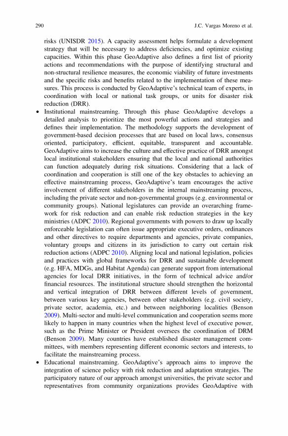
risks (UNISDR 2015). A capacity assessment helps formulate a developmentstrategy that will be necessary to address deficiencies, and optimize existingcapacities. Within this phase GeoAdaptive also defines a first list of priorityactions and recommendations with the purpose of identifying structural andnon-structural resilience measures, the economic viability of future investmentsand the specific risks and benefits related to the implementation of these mea-sures. This process is conducted by GeoAdaptive’s technical team of experts, incoordination with local or national task groups, or units for disaster riskreduction (DRR).
• Institutional mainstreaming. Through this phase GeoAdaptive develops adetailed analysis to prioritize the most powerful actions and strategies anddefines their implementation. The methodology supports the development ofgovernment-based decision processes that are based on local laws, consensusoriented, participatory, efficient, equitable, transparent and accountable.GeoAdaptive aims to increase the culture and effective practice of DRR amongstlocal institutional stakeholders ensuring that the local and national authoritiescan function adequately during risk situations. Considering that a lack ofcoordination and cooperation is still one of the key obstacles to achieving aneffective mainstreaming process, GeoAdaptive’s team encourages the activeinvolvement of different stakeholders in the internal mainstreaming process,including the private sector and non-governmental groups (e.g. environmental orcommunity groups). National legislatures can provide an overarching frame-work for risk reduction and can enable risk reduction strategies in the keyministries (ADPC 2010). Regional governments with powers to draw up locallyenforceable legislation can often issue appropriate executive orders, ordinancesand other directives to require departments and agencies, private companies,voluntary groups and citizens in its jurisdiction to carry out certain riskreduction actions (ADPC 2010). Aligning local and national legislation, policiesand practices with global frameworks for DRR and sustainable development(e.g. HFA, MDGs, and Habitat Agenda) can generate support from internationalagencies for local DRR initiatives, in the form of technical advice and/orfinancial resources. The institutional structure should strengthen the horizontaland vertical integration of DRR between different levels of government,between various key agencies, between other stakeholders (e.g. civil society,private sector, academia, etc.) and between neighboring localities (Benson2009). Multi-sector and multi-level communication and cooperation seems morelikely to happen in many countries when the highest level of executive power,such as the Prime Minister or President oversees the coordination of DRM(Benson 2009). Many countries have established disaster management com-mittees, with members representing different economic sectors and interests, tofacilitate the mainstreaming process.
• Educational mainstreaming. GeoAdaptive’s approach aims to improve theintegration of science policy with risk reduction and adaptation strategies. Theparticipatory nature of our approach amongst universities, the private sector andrepresentatives from community organizations provides GeoAdaptive with
290 J.C. Vargas Moreno et al.
expert knowledge on local conditions, the opportunity to validate analyticalresults, to identify site-based adaptation strategies and to raise local awareness.Overall this phase begins with stakeholder validation of the results from theorganizational and institutional mainstreaming phases (e.g. scenario results,forecasts from prior assessments, etc.). This mainstreaming phase is developedthrough different workshop, training activities and meetings, which are facili-tated across the all four phases of a project.
• Financial mainstreaming. Most local governments have yet to incorporate DRRand resilience strategies into their yearly budget, although some do have con-tingency or calamity fund for emergency response (ADPC 2010). Moreover, inmost cases, local governments are expected to dedicate budget line for DRR andresilience from existing budgets (ADPC 2010). Regardless, local governmentalso need to explore other sources of disaster-related funding. The SendaiFramework encourages countries to mainstreaming disaster risk into theirmacroeconomic strategies and public finances. Integrating the mainstreamingprocess is a central part of building resilience, as a means of protecting andguaranteeing the livelihood of individuals and businesses, as well as the oper-ation of the public sector institutions. To strengthen the country’s economic andfiscal resilience, governments should integrate disaster risk in public finance,including the development of risk-sensitive investments and risk financingmechanisms (UNISDR 2016). The capacity of countries to develop a soundeconomic analysis on the benefits of DRR is a central support for investmentand policy decisions conducting to resilience. GeoAdaptive’s process isdeveloped to help decision-makers better identify the best funding mechanismsfor the different actions and strategies prioritized in the institutional main-streaming phase.
Departing from the results obtained by the four different mainstreaming phases,GeoAdaptive’s team can evaluate the benefits of the strategies and measuresdeveloped in the prior phases. The resulting recommendations must be comple-mented with appropriate monitoring systems and should enable the development ofstrategies at the planning, execution and evaluation stages. However, monitoringmechanisms (particularly in developing countries) are often ad hoc, inconsistent,lacking transparency, or non-existent. This presents a challenge to policy-makersseeking to institutionalize risk-informed planning through national legislation.Therefore, GeoAdaptive’s final validation is obtained through the identification ofgoals from local authorities, an evaluation of the impacts and the development of amonitoring and evaluation process. These goals are organized in four groups:
• Implementing supportive policies: Within institutional mainstreamingGeoAdaptive recognizes the importance of strengthening political commit-ments, the implementation of policy and institutional frameworks that incor-porate disaster risk assessment, facilitate the investment of requisite resources,and strengthen the social capital of vulnerable communities.
14 An Effective Approach to Mainstreaming DRR and Resilience … 291
• Utilizing local experience and wisdom in risk assessment: GeoAdaptive rec-ognizes the importance of citizen’s experience of disasters and mitigationactions. Hence, the incorporation of citizen’s experience of disaster and miti-gation actions. Hence, the incorporation of traditional and local knowledgeduring our participative approach ensures that the process is responsive to thelocal conditions of the communities at risk, thereby enhancing its effectiveness.
• Basing risk assessment on information management: Starting with a riskassessment process that considers local information and data, we recognize thebasic governance responsibility of providing information on potential and actualrisks.
• Ensuring professional management of risk assessment systems: Ensuring pro-fessionalism in risk assessments requires investment in data, information andcommunication systems and in the development the requisite institutional andhuman capability to manage the process.
14.3 La Paz, Case Study
The following case study presents a pilot project that provided a rapid spatialanalysis of the impact (both damages and losses) of hurricane Odile (September 15,2014) on the Mexican municipality of La Paz. Hurricane Odile was the most intensetropical cyclone to affect the Baja California since 1976 (Fig. 14.1).
According to the National Center for Disaster Prevention (CENAPRED 2015)Odile caused six deaths, stranded 32,000 tourists and generated pecuniary damagesclose to MXN $12 billion pesos (state-wide).
The study area focused on the urban extent of the municipality of La Paz, thecapital of the state of Baja California Sur. Situated northwest of Mexico City, LaPaz is situated in a bay on the southeastern portion of the Baja California Peninsulawith an urban population of 215,178 residents (INEGI 2010). This coastal city islocated in an arid and semi-desert landscape and is the civic, educational andcommercial center of the region (Fig. 14.2). Although it’s the primary center ofgovernment for the state, the economic drivers of the region are focused on tourismand commerce.
The proximity, geographic isolation, and economic and infrastructural interde-pendencies amongst the municipalities of La Paz and Los Cabos generate anintrinsic relationship. This inter-reliant relationship was taken into considerationduring the analytical phase and these results were integrated into the study as ameans to identify resilience strategies at the regional level.
The analysis and final results summarized here form part of a larger effort:“Intervenciones estratégicas hacia un futuro resiliente en La Paz, Baja CaliforniaSur”, developed with the support of the International Community Foundation(ICF) and the Inter-American Development Bank (IDB).
292 J.C. Vargas Moreno et al.
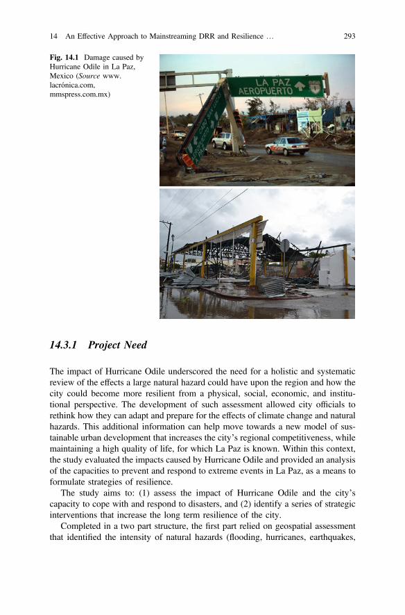
14.3.1 Project Need
The impact of Hurricane Odile underscored the need for a holistic and systematicreview of the effects a large natural hazard could have upon the region and how thecity could become more resilient from a physical, social, economic, and institu-tional perspective. The development of such assessment allowed city officials torethink how they can adapt and prepare for the effects of climate change and naturalhazards. This additional information can help move towards a new model of sus-tainable urban development that increases the city’s regional competitiveness, whilemaintaining a high quality of life, for which La Paz is known. Within this context,the study evaluated the impacts caused by Hurricane Odile and provided an analysisof the capacities to prevent and respond to extreme events in La Paz, as a means toformulate strategies of resilience.
The study aims to: (1) assess the impact of Hurricane Odile and the city’scapacity to cope with and respond to disasters, and (2) identify a series of strategicinterventions that increase the long term resilience of the city.
Completed in a two part structure, the first part relied on geospatial assessmentthat identified the intensity of natural hazards (flooding, hurricanes, earthquakes,
Fig. 14.1 Damage caused byHurricane Odile in La Paz,Mexico (Source www.lacrónica.com,mmspress.com.mx)
14 An Effective Approach to Mainstreaming DRR and Resilience … 293
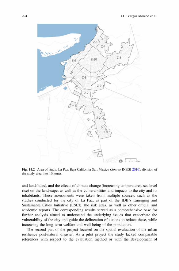
and landslides), and the effects of climate change (increasing temperatures, sea levelrise) on the landscape, as well as the vulnerabilities and impacts to the city and itsinhabitants. These assessments were taken from multiple sources, such as thestudies conducted for the city of La Paz, as part of the IDB’s Emerging andSustainable Cities Initiative (ESCI), the risk atlas, as well as other official andacademic reports. The corresponding results served as a comprehensive base forfurther analysis aimed to understand the underlying issues that exacerbate thevulnerability of the city and guide the delineation of actions to reduce these, whileincreasing the long-term welfare and well-being of the population.
The second part of the project focused on the spatial evaluation of the urbanresilience post-natural disaster. As a pilot project the study lacked comparablereferences with respect to the evaluation method or with the development of
Fig. 14.2 Area of study: La Paz, Baja California Sur, Mexico (Source INEGI 2010), division ofthe study area into 10 zones
294 J.C. Vargas Moreno et al.
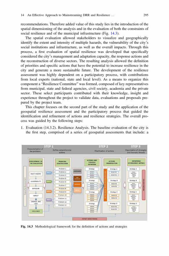
recommendations. Therefore added value of this study lies in the introduction of thespatial dimensioning of the analysis and in the evaluation of both the constraints ofsocial resilience and of the municipal infrastructure (Fig. 14.3).
The spatial evaluation allowed stakeholders to visualize and geographicallyidentify the extent and intensity of multiple hazards, the vulnerability of the city’ssocial institutions and infrastructure, as well as the overall impacts. Through thisprocess, a first evaluation of spatial resilience was developed that specificallyconsidered the city’s management and adaptation capacity, the response actions andthe reconstruction of diverse sectors. The resulting analysis allowed the definitionof priorities and specific actions that have the potential to increase resilience in thecity and generate a more sustainable future. The development of the resilienceassessment was highly dependent on a participatory process, with contributionsfrom local experts (national, state and local level). As a means to organize thiscomponent a “Resilience Committee” was formed, composed of key representativesfrom municipal, state and federal agencies, civil society, academia and the privatesector. These select participants contributed with their knowledge, insight andexperience throughout the project to validate data, evaluations and proposals pre-pared by the project team.
This chapter focuses on the second part of the study and the application of thegeospatial resilience assessment and the participatory process that guided theidentification and refinement of actions and resilience strategies. The overall pro-cess was guided by the following steps:
1. Evaluation (14.3.2). Resilience Analysis. The baseline evaluation of the city isthe first step, comprised of a series of geospatial assessments that include: a
Fig. 14.3 Methodological framework for the definition of actions and strategies
14 An Effective Approach to Mainstreaming DRR and Resilience … 295
multi-hazard assessment generated by different sources of information to iden-tify areas of greatest latent danger; a vulnerability assessment (physical andsocial); an exposure assessment (physical and social); the impact analysis ofHurricane Odile, including the identification of damages and economic losses;and a resilience evaluation, including disaster prevention and response capaci-ties in the city.
2. Identification and appraisal of challenges (14.3.3). Technical Mainstreaming.Having identified the baseline conditions the key challenges are identified basedon the predetermined geographic organization of the city (zones).
3. Definition and prioritization of actions (14.3.3). Institutional Mainstreaming.Specific actions are defined for each challenge and each is evaluated through aseries of filters and prioritization criteria. The objective is to identify the key,priority actions that will contribute the most to the development of integral,multi-sector resilient strategies.
4. Organization of actions by thematic grouping and definition of strategies (14.3.3).Institutional and Educational Mainstreaming. Once all the actions have been eval-uated by the prioritized they are organized into specific thematic groupings based onimplementation synergies, interdependencies and other interrelated benefits.
14.3.2 Resilience Analysis
Exposure and impact analysis allow the dimensioning of natural hazard effects.However, they do not indicate whether a city has the capacity to resist, adapt, cope andrecover from the negative effects of that hazard. For this reason, it is necessary toapproach the concept of resilience in an integralway, evaluating the dynamic conditionsof the behavior of the communities and the infrastructure that support them in order toimprove the skills and capacities needed to weather the impacts from a disaster.
In the case of La Paz, Odile’s presented a highly relevant opportunity to fullyassess the resilience of both the communities and the surrounding physicalinfrastructure.
The resilience analysis considered hurricane Odile as a trigger event andaddressed resilience in a cross-sectoral way, incorporating the following consid-erations: (1) how the hazard was addressed by city officials, (2) what type ofresponse actions were put into action to address the event, and (3) how the cityrecover from the event.
Resilience is traditionally measured through numerical indicators and metrics.However, one of the most significant challenges in defining strategies and actions toimprove resilience is the incorporation of a spatial component. The spatial elementpermits the identification of specific neighborhoods, communities and infrastructurethat will require direct intervention. For this reason, the resilience analysis devel-oped for La Paz has the distinctiveness of being designed to explore resilience notonly through quantitative methods but also through the incorporation of a
296 J.C. Vargas Moreno et al.
geographic component. Through this analysis, specific areas of high or low resi-lience can be identified and directly associated with specific conditions or triggers.This particular approach, was shaped on the resilience evaluation by Cutter et al.(2008), present resilience as a dynamic process dependent on antecedent conditions,the disaster’s severity, time between hazard events, and influences from exogenousfactors.
The analysis developed was based on a geographical database generated frominformation obtained from official sources (INEGI) and supplemented with dataobtained from secondary sources, prior evaluations and interviews with local offi-cials. The data collected was systematized in a Geographic Information System(GIS), creating a digital environment for the assessment. The geostatistical evalu-ation was elaborated through an analysis of geographical spatial statistics, whichrequired the segmentation of the city in a grid of 50 50 m cells. Each cell wasassigned a numerical value that represented the factor being evaluated. The use ofgeostatistical analysis permitted the identification of a resilience value and thereforepinpoint areas of lower resilience, as well as the factors or sectors that structurallycontributed to the inherent resilience of the city and its communities. Additionallythis approach allowed for the creation of a general spatial index of resiliencecapacities for each sector, allowing the visualization of the behavior and spatialdistribution of the resilience dynamics.
Each zone in the city was further explored based on the population’s access tohealth, emergency and support services (e.g. hospitals, shelters, etc.). The acces-sibility assessment was developed through the analysis and quantification of spatialnetworks, which analyzed the route and travel time from each housing area in thecity to the specific points identified for emergency and support services. The finalproduct identified the residential areas with greater difficulty to access support andemergency services during an emergency. For example, the results in La Paz showthat the southern communities have the greatest difficulty accessing or receivingemergency support.
When comparing the maximum and minimum values from the results of theresilience capacities spatial analysis, the emergency infrastructure and the healthservice sector resulted in the lowest values for the following reasons:
• Medical centers have a low capacity (number of beds and doctors per capita).• Shelters lack sufficient medical capabilities.• Access to health services and shelters are limited in flood scenarios.
Although the city provides ample coverage of basic services (77.91% of thepopulation has access to electricity, water and sewer service according to INEGI),accessibility and coverage in the southern communities of La Paz is a priority issue.The access to health and emergency services is dire especially in flood scenarios duein most part from the potential isolation of the zone due to its geographic locationsouth of the city center and the lack of services to support this part of the city.
A map for each of the services analyzed was created to visualize the results ofthe spatial-sectoral resilience capacity analysis: spatial patterns clearly show that the
14 An Effective Approach to Mainstreaming DRR and Resilience … 297
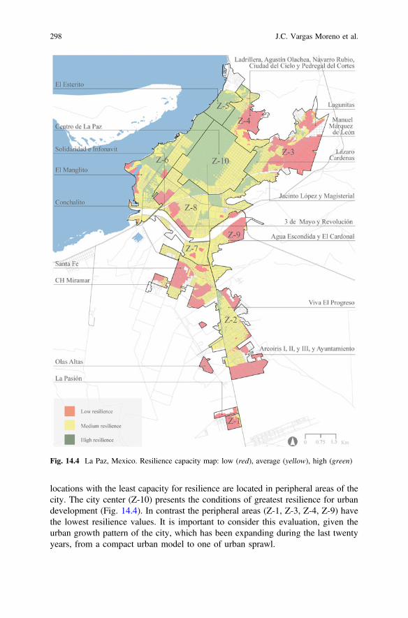
locations with the least capacity for resilience are located in peripheral areas of thecity. The city center (Z-10) presents the conditions of greatest resilience for urbandevelopment (Fig. 14.4). In contrast the peripheral areas (Z-1, Z-3, Z-4, Z-9) havethe lowest resilience values. It is important to consider this evaluation, given theurban growth pattern of the city, which has been expanding during the last twentyyears, from a compact urban model to one of urban sprawl.
Fig. 14.4 La Paz, Mexico. Resilience capacity map: low (red), average (yellow), high (green)
298 J.C. Vargas Moreno et al.
Authorities should consider these resilience patterns, in addition to other factors(e.g. provision of services, environmental impact, etc.) and the consequences thatarise if they continue to allow the city to grow in this manner. On the other hand,they must also comply and enforce adequate construction standards and environ-mental measures necessary to maintain and raise the level of resilience. For exampleZones 1, 3, 4 and 9 are shown to have the lowest capacity to prevent and respond toemergencies. During hurricane Odile zone 9 (Agua Escondida) experienced fewimpacts however, it received low resilience value for it mostly comprised ofinformal and marginalized communities. Zones 1, 3 and 4 registered the highestnumber of impacts to housing, as they are in multi-hazard areas and lack access toemergency services, which means these communities are in high impact areas andhave little capacity to cope.
The city center (Z-10) has a high capacity to cope with events caused by naturalhazards. Despite the damages to the road networkin this zone during Odile, itsaccess to basic and emergency services remained intact, for it is not in a highmulti-hazard area and all of its sectors have an integrated prevention and responseactions plan. On the other hand, zones 5 and 6, which include areas with themajority of the hotels and services of the city, proved to have a medium to highresponse capacity. It should be noted that the study is based on the impacts andresponse actions to hurricane Odile, and in this case, there was no significantdamage in these zones. However, this area is highly vulnerable to both storm surgeand coastal flooding.
14.3.3 Mainstreaming Analysis
The main challenges identified for the city were organized and evaluated consid-ering the results of the resilience analysis, which included: the multi-risk analysis,the resilience analysis, the previous works completed for the ESCI initiative and theimpact assessment for hurricane Odile. Additional analysis was done to evaluate thepriority areas identified as part of the resilience analysis and the priority areasidentified as part of the resilience analysis and the priority areas identified by thelocal government and civil society groups. Different layers of information wereanalyzed to observe the spatial overlaps that occur between the different perspec-tives and to identify the neighborhoods (colonias) that should be considered pri-orities, having incorporated broader perspectives from different local constituencies.Once identified, these prioritized areas were linked to the geo referenced damagescaused by hurricane Odile in order to verify the most prone areas. Of the 109specific impacts reported to road network, 2 occurred in vulnerable areas mappedby the city council, and 8 occurred in vulnerable areas reported by civil society.
The subsequent actions and strategies developed were identified through theprevious mentioned methodological framework.
14 An Effective Approach to Mainstreaming DRR and Resilience … 299
Identification and Appraisal of Challenges-Technical MainstreamingIn order to better understand and explore the role of resilience planning can haveupon the city the most important and critical challenges were identified. Thesechallenges were taken from the different components from the resilience analysis aswell as directly from city officials and key civil society groups. As a result 22challenges were identified in addition to the geographic reach of each issue. Thechallenges were categorized into two main groups: problems specific to a zone orarea of the city (e.g., zone 10, or neighborhood X), or problems that affect the entirecity (e.g. water shortage). Through the examination and analysis of these spatialpatterns, the relationships with each geostatistical zone of the city were explored.
Definition and Prioritization of Actions—Institutional MainstreamingFor each of the 22 challenges specific actions were developed to address the issuesat hand. In preparation for this exercise, an extensive review of projects and priorevaluations of the related issues was carried out to generate a list of actions orinterventions vetted by previous studies. A total of 81 strategies, actions or inter-ventions were noted, organized by sector and reviewed with the ResilienceCommittee for further verification.
Using the information gathered for the challenges, geographic and quantitative, aswell as the corresponding strategic interventions, a total of 29 actions were generatedin response to the 22 challenges. During this identification and evaluation process,the team used the information collected during multiple workshops with localstakeholders and meetings held with the Resilience Committee. The final actionswere identified based on the following set of considerations described below, whichwould facilitate the implementation and feasibility of the proposed actions.
• the level of vulnerability in the location where the action is being proposed andits relationship to other hazards
• the effects of climate change and other hazards on the action• clear identification of the stakeholders that should be involved or the relation-
ships they have with other implementing organizations• the monitoring and evaluation processes for the identified actions• direct relationship or link with other identified actions or current efforts• geographic scale of the action (some measures need to be applied at the city
scale, others at a site scale)• length and duration of the implementation phase of the action
The list (Table 14.1) represents an example of the challenges and correspondingactions, however the final list was further refined through a set of filters in order toidentify the most relevant actions to help improve the resilience of the city.
Once the actions were defined, characterized by sectors geographical located, aprioritization scheme based on a multi-criteria analysis was developed to identifythe most relevant actions to implement as part of the resilience strategy. A total of13 criteria were used for this adaptation prioritization phase. The first 10 key criteriafrom the criteria of the prioritization framework used by GIZ (2015) called“Methodology of prioritization of adaptation measures” the team selected 10 key
300 J.C. Vargas Moreno et al.
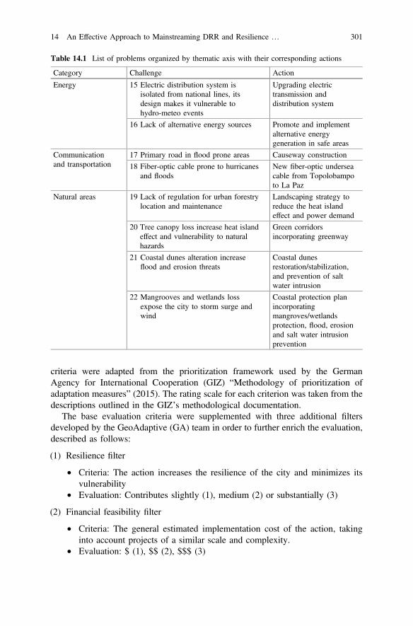
criteria were adapted from the prioritization framework used by the GermanAgency for International Cooperation (GIZ) “Methodology of prioritization ofadaptation measures” (2015). The rating scale for each criterion was taken from thedescriptions outlined in the GIZ’s methodological documentation.
The base evaluation criteria were supplemented with three additional filtersdeveloped by the GeoAdaptive (GA) team in order to further enrich the evaluation,described as follows:
(1) Resilience filter
• Criteria: The action increases the resilience of the city and minimizes itsvulnerability
• Evaluation: Contributes slightly (1), medium (2) or substantially (3)
(2) Financial feasibility filter
• Criteria: The general estimated implementation cost of the action, takinginto account projects of a similar scale and complexity.
• Evaluation: $ (1), $$ (2), $$$ (3)
Table 14.1 List of problems organized by thematic axis with their corresponding actions
Category Challenge Action
Energy 15 Electric distribution system isisolated from national lines, itsdesign makes it vulnerable tohydro-meteo events
Upgrading electrictransmission anddistribution system
16 Lack of alternative energy sources Promote and implementalternative energygeneration in safe areas
Communicationand transportation
17 Primary road in flood prone areas Causeway construction
18 Fiber-optic cable prone to hurricanesand floods
New fiber-optic underseacable from Topolobampoto La Paz
Natural areas 19 Lack of regulation for urban forestrylocation and maintenance
Landscaping strategy toreduce the heat islandeffect and power demand
20 Tree canopy loss increase heat islandeffect and vulnerability to naturalhazards
Green corridorsincorporating greenway
21 Coastal dunes alteration increaseflood and erosion threats
Coastal dunesrestoration/stabilization,and prevention of saltwater intrusion
22 Mangrooves and wetlands lossexpose the city to storm surge andwind
Coastal protection planincorporatingmangroves/wetlandsprotection, flood, erosionand salt water intrusionprevention
14 An Effective Approach to Mainstreaming DRR and Resilience … 301
(3) Technical and political viability filter
• Criteria: The action is viable taking into consideration the technicalknowledge available in the city and the support of politicians, based onsimilar projects in the city.
• Evaluation: not viable (1), moderately viable with additional support (2),viable with the technical knowledge available to the city (3)
This final list of 13 criteria was discussed and validated with the ResilienceCommittee to ensure that themost vital factors were taken into consideration in light ofthe committee’s perspective regarding the importance and applicability of the actions.
All filters, both GIZ and supplementary formulations, were evaluated with anequitable weight.
For the final evaluation, the values of the 13 filters were weighted using thefollowing equation:
A ¼ 1n
Xn
t¼1
xi
Where:
A is the average value of the performance evaluationR is the sum of all valuesn is the number of variablesXi is the value of each individual variable in the criteria listn is the number of terms or items evaluated
The evaluation ranks were as follows:
• Between 0 and 1 = Low priority• Between 1 and 2: Medium priority• Between 2 and 3: High priority
Several of the final actions are related to urban planning initiatives such as waterresource planning, coastal protection and disaster risk reduction strategies.Therefore, through this process, several actions were designed and prioritized toensure the distribution amongst key sectors, as well as the responsible entities ofimplementation. Due to this objective, the responsibility for implementing theproposed actions does not lie exclusively with government entities, but involvesother stakeholders, including civil society, the private sector and academia.
The application of the filters yielded a total of 20 prioritized actions from of theoriginal group of 29, with actions prioritized for each of the key sectors. The top 20actions scored evaluations ranging from 2 to 3, or high priority. These were furtheranalyzed to explore their potential distribution with respect to the sectorial cate-gories associated with each of the problems. It was encouraged that decision makersin La Paz evaluate the incorporation of these actions into existing efforts, given theirpreventative nature and high prioritization score (Table 14.2).
302 J.C. Vargas Moreno et al.
Organization of Actions by Thematic Grouping and Definition ofStrategies-Institutional and Educational Mainstreaming
The delineation of multi-sectoral strategies aimed to group or organize the prior-itized actions into larger thematic groups that allowed the identification of synergiesbetween the actions, sectors and stakeholders that can facilitate their implementationin a more efficient manner. Each strategy for La Paz was developed considering theinvolvement of various stakeholders and the linking of different institutions thatwould contribute to the achievement of the objectives set out by these thematic groups.Likewise, the strategies ensured that there were measures and activities at a variety ofscales that assured that therewere challenges identified at the local, urban and regionalscale. This aspect was particularly important in La Paz because of its location on apeninsula, making it vulnerable to large hydro-meteorological events since it relies onbasic infrastructure that is regionally operated (energy, water, transportation).
It was equally important that the multi-sectoral model explicitly indicate theresponsibilities of each stakeholder involved. In order to achieve this, each actionwas linked not only to the various municipal, state and federal government insti-tutions and private and academic stakeholders but also to the tools, actions andprojects already proposed or underway, such as those indicated by the PIMUS (PlanIntegral de Mobilidad Urbana Sustentable), the PACC-LAP (Plan de Acción deCambio Climático - La Paz) or proposed by the GIZ.
The prioritized actions were grouped around specific thematic groups byadhering to the following the principles:
• synergy among the actions within the same thematic group• collaboration between stakeholders and institutions• sectoral interdependence within the same thematic group• capture and distribution of shared benefits• extent or duration of implementation within the same thematic group (some
actions are short term, while others are long term)
As a result, 5 key thematic groups were defined, providing a comprehensive baseto organize the prioritized 20 actions. The 5 thematic groups are:
• 1: territorial management of natural hazards,• 2: provision of urban infrastructure and services• 3: strengthening social and business participation• 4: institutional risk management• 5: Integrated management of natural resources
14.3.4 Results
The Roadmap and the Resilience metrics were two tools developed as part of thestudy with the aim to guide and assist the implementation of the prioritized actions.
14 An Effective Approach to Mainstreaming DRR and Resilience … 303

Table 14.2 Example of the application of filters to the actions identified for the city of La Paz
Multi-criteria GIZ GA
Tra
nsve
rsal
ity
Coo
rdin
atio
n: s
take
hold
ers/
sect
ors
Feas
ibili
ty
Flex
. /"n
o re
gret
s"
Coo
rdin
atio
n: e
cosy
stem
s
Sust
aina
bilit
y
Att
enti
on to
vul
nera
ble
popu
lati
on
Act
ive
part
icip
atio
n
Stre
ngth
enin
g ad
aptiv
e ca
paci
ty
Eva
luat
ion
and
Feed
back
F. T
echn
ical
via
bilit
y
F. F
inan
cial
via
bili
ty
F. R
esili
ent
Tot
al
# Actions 1 2 3 4 5 6 7 8 9 10 A B C URBAN PLANNING AND RISK MANAGEMENT
1
Include technical standards that integrate hazard, vulnerability and risk maps into plans in order to restrict development in high risk areas and identify alternative programmatic or land uses.
3 3 2 2 3 3 3 1 3 3 3 3 3 3
2
Relocate housing that is located in unmitagable high risk areas to low risk zones, with access to basic services.
2 3 3 3 1 2 3 2 2 3 3 2 3 3
3
Channelize and install flood protection infrastructure to prevent the flooding of nearby housing and key infrastructure.
3 3 3 3 1 2 3 3 3 3 3 2 3 3
4
Build stabilization projects on the edges of the El Trinfo and El Cajoncito streams to reduce erosion and protect the streambeds.
1 3 3 2 1 1 3 3 2 2 2 1 1 2
5
Develop a public awareness and education campaigns to deal with prevention and preparation when faced with the threat of natural hazards.
3 3 2 3 3 3 3 2 3 3 3 2 3 3
304 J.C. Vargas Moreno et al.
They contributed to the implementation by defining the general scope of the pri-oritized actions within a strategy, the dimensioning of activities, approximate costs,and the potential impacts of each action.
The implementation success of these actions will depend on the coordination andcollaboration between stakeholders and the potential need to create temporaryalliances to facilitate the process.
Given that resilience depends on a continuous process between government,private sector and civil society, it will require the development and sustainment of acontinuous dialogue where adjustments and improvements in the prioritized actionsare discussed and explored given the current political, financial, and temporalcontext as well as environmental conditions.
The Road MapThe Road Map outlines the prioritized interventions or actions, which were
organized into five thematic strategies (Table 14.3). Specific resilience metrics wereidentified for each action that can be used to monitor the implementation of theaction, the period of implementation, the expected impact, and the approximateimplementation cost for each project.
As a complement to the Road map, a locator map was included that spatiallyidentified the prioritized actions. However, not all actions were identified geo-graphically because some are programmatic in nature or refere to training andshould be applied or available city-wide and were not specific to a particular area orgeographic location.
The approximate projected costs were provided for each action as a reference.These were determined through research of other similar projects in the region orMexico and by interviews with professionals or government representatives.However, looking at the distribution of the financial burdens and responsibilities ofthe programmed actions, it is noticeable that the urban management strategiesrepresent the most relevant and widespread of the projected investments.
The average execution period for the actions varies; however, most fall withinthe medium term (approximately 1 year), providing an opportunity for the identi-fication of financing mechanism, and could be initiated soon after the completion ofthe study in order to take advantage of the momentum generated from the project,maximizing its potential for implementation.
It should be noted that the distribution of the financial costs associated with theexecution of the actions was also carefully considered in this study.
32% of the final actions were identified as requiring Municipal level interven-tion. More than 50% of the 5 actions prioritized under the “Urban Planning andRisk Management” strategy also required financial support at the municipal level.This cost, although a large undertaking for the Municipal government, represents anopportunity for local authorities to demonstrate leadership in the public sector andimprove the internal capacities of the municipal staff.
Given the fact that the initial stages of the proposed projects will represent agreater use of resources, the municipal government may consider requestingassistance in terms of management of the respective federal authorities, or requesttechnical and economic assistance through international cooperation. The lowest
14 An Effective Approach to Mainstreaming DRR and Resilience … 305
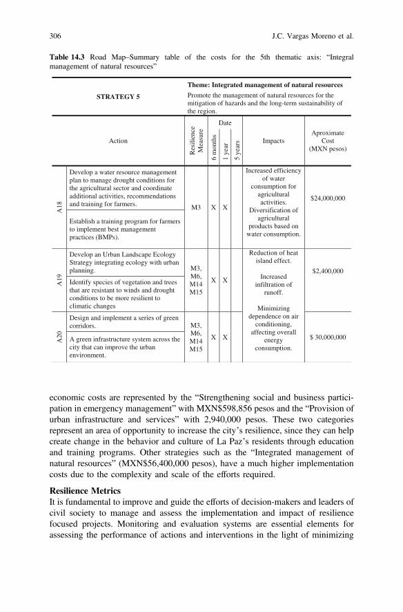
economic costs are represented by the “Strengthening social and business partici-pation in emergency management” with MXN$598,856 pesos and the “Provision ofurban infrastructure and services” with 2,940,000 pesos. These two categoriesrepresent an area of opportunity to increase the city’s resilience, since they can helpcreate change in the behavior and culture of La Paz’s residents through educationand training programs. Other strategies such as the “Integrated management ofnatural resources” (MXN$56,400,000 pesos), have a much higher implementationcosts due to the complexity and scale of the efforts required.
Resilience MetricsIt is fundamental to improve and guide the efforts of decision-makers and leaders ofcivil society to manage and assess the implementation and impact of resiliencefocused projects. Monitoring and evaluation systems are essential elements forassessing the performance of actions and interventions in the light of minimizing
Table 14.3 Road Map–Summary table of the costs for the 5th thematic axis: “Integralmanagement of natural resources”
STRATEGY 5
Theme: Integrated management of natural resources
Promote the management of natural resources for the mitigation of hazards and the long-term sustainability of the region.
Action
Res
ilien
ceM
easu
re Date
Impacts Aproximate
Cost(MXN pesos)
6 m
onth
s
1 ye
ar
5 ye
ars
A18
Develop a water resource management plan to manage drought conditions for the agricultural sector and coordinate additional activities, recommendations and training for farmers. M3 X X
Increased efficiency of water
consumption for agriculturalactivities.
Diversification of agricultural
products based on water consumption.
$24,000,000
Establish a training program for farmers to implement best management practices (BMPs).
A19
Develop an Urban Landscape Ecology Strategy integrating ecology with urban planning. M3,
M6, M14M15
X X
Reduction of heat island effect.
Increasedinfiltration of
runoff.
Minimizing dependence on air
conditioning, affecting overall
energyconsumption.
$2,400,000
Identify species of vegetation and trees that are resistant to winds and drought conditions to be more resilient to climatic changes
A20
Design and implement a series of green corridors. M3,
M6, M14M15
X X $ 30,000,000 A green infrastructure system across the city that can improve the urban environment.
306 J.C. Vargas Moreno et al.
risk and improving resilience. As a response, a series of resilience metrics weredesigned to evaluate of the state of the city in reference to resilience and measurethe effect of current and future interventions.
More than 300 existing indicators for resilience, vulnerability and risk wereexamined through a literature review (including global systems and tools availableto decision makers, for example indicators from UNISDR, IDB, World Bank andthe Rockefeller Foundation). Indicators were selected and developed with quan-tifiable and evaluable metrics from easily accessible and periodically generateddata. The final set of indicators were selected considering expert technicalknowledge and the following characteristics:
• Applicability to local conditions in La Paz and other similar cities in the region• Prevalence in the literature• Indicators that address multiple components of urban resilience (including risk)• Ability to be supervised by the Resilience committee• Relevance to infrastructure and social capacities to address threats• Availability of data needed to support indicators in La Paz.
A total of twenty-one resilience metrics were developed to form the resilienceassessment matrix. These indicators cover both the socio-organizational capacitiesand the functioning and performance of infrastructure and urban systems, in relationto the occurrence of natural hazards.
The metrics are divided by topics to facilitate its application:
• 1: Access and availability to basic services and infrastructure.• 2: Health and social welfare.• 3: Risk management and emergency management.• 4: Damage and impacts in emergencies.
In order to facilitate the indicator evaluation, a traffic light assessment wasdeveloped, using a benchmark scale generated from global (World Bank) and localstandards (reference indexes in Mexico and in Baja California Sur). The proposedmetrics allow the use of both statistical and geographical information periodicallyprovided by official institutions such as INEGI or the city government, whichgenerate the necessary information for evaluation in a reoccurring and financialsustainable way. The traffic light assessment facilitates the evaluation through aclear and simple system (light grey, grey, black) that can be easily interpreted andwould provide a baseline or reference for future evaluations (Tables 14.4 and 14.5).
Table 14.4 Classification of the traffic light assessment
Meets or exceeds resilience and sustainability standards
Has gaps in its resilience measure
Below the minimum standard
14 An Effective Approach to Mainstreaming DRR and Resilience … 307
14.4 Conclusions
The planning and development of a resilient society requires a complex and highlyintegrated approach. Establishing processes and analysis that identify timely andtangible strategies that respond to the challenges posed by climate change andnatural hazards continue to be an unknown issue for many cities.
Multiple discussion points emerge when carrying out a study of this nature. Themethods, approaches, and evaluation instruments used are rapidly evolving. On theother hand, studying resilience in the context of the recent impact of a hurricane such asOdile, poses evenmore significant challenges because of the availability of informationand data that is sensitive to social, environmental and economic constraints.
The participation of local stakeholders is fundamental to the success of thisprocess, particularly in the institutional and educational mainstreaming phases. Thedevelopment of a participatory and knowledge-generating process rather than anadvisory one is a critical distinction that must be highlighted.
A stakeholder analysis is a crucial first step to identify influential participants andkey stakeholders of the city, who can form part of a working consultative group(Resilience Committee). The formation of the group can help ensure the earlyinvolvement and support from key members of the city, as well as a better transitionbetween recommendations and the implementation of projects to ensure a “live” final
Table 14.5 Resilience metrics focused on the access and availability to basic services andinfrastructure
No. Resilience Measure
Description Thresholds A La Paz BCS
Light Grey
Grey Black
M1 Potable watercoverage
Percent of houses with access to potable water.
80–100% 60–80% <60% 97.9% ICES 2012
M2 Efficiency in water use
Water consumption per capita
55–90 37–55 y 90-110
<37 y >110 82.54 m3 / person / year ICES 2012
M3 Availability of water resources
Net water balance (internal and external resources)
>0 MMC/year
<0 MMC / year, with conservation plans
<0 MMC / year, without conservation plans
<0 million m3/year
M4 Electricity coverage
Percent of houses with electric service.
90–100% 70–90% <70% 98% ICES 2012
M5 Technology and
Communication
Coverage
Percentage of houses with cell phones.
90–100% 80–90% <80% 74% ICES 2010
Percent of houses with internet.
50–100% 40–50% <40% 36% ICES 2010
M6 Percent of managed runoff.
Percent of vegetation with respect to the urban footprint
>40% 30–40% <30% N/D
308 J.C. Vargas Moreno et al.
product. The members of the group should be key members representing the differentlevels of government, the institutional organizations from each sector involved, as wellas from civil society and the private sector. It is necessary to emphasize the level ofcommitment required by the Committee at the beginning, throughout and after thestudy to ensure the validity and follow-up of the implementation and evaluation pro-cesses. The formation of this group is essential to the development and improvement ofthe local capacity of local resilience experts in the city (technical mainstreaming).
In addition to local stakeholder knowledge it is fundamental to include and buildupon the knowledge and results from prior studies and efforts. The incorporation ofexisting technical information and data helped the alignment and contextualizationof the results and the formulation of actions that are verified with previously val-idated information (technical mainstreaming).
The compilation of georeferenced data (GIS, .kml, etc.) was essential for the spatialassessment, the visualization of challenges and proposals, and the analysis of resiliencecapabilities. It is recommended to coordinate and train collaborators from various localinstitutions in the collection of information through the use of free platforms such asOpen Street Maps and Quantum GIS. This will allow their involvement from thebeginning of the study, as well as the generation of local capacities.
The experiences gained in the area of resilience and risk management reveal thatno sector or entity is capable of addressing all aspects of response and adaptation.Resilience and risk management are multi-sectoral issues that require a systemicand holistic perspective. This requires the development of processes and analyzesthat recognize the interdependencies between sectors and formulate actions thatencompass and motivate a multi-sector, transdisciplinary and multi-institutionalcollaboration. Key to achieving this goal is to have representatives from differentsectors in discussions and analysis that recognize their interactions and synergies.
References
ADPC. 2010. Mainstreaming disaster risk reduction. Book 4, urban governance and communityresilience guides. Bangkok: ADPC.
Bahadur, A., and T. Tanner. 2013. Policy climates and climate policies: Analysing the politics ofbuilding urban climate change resilience. Urban Climate 7: 20–32.
Becker-Birck, C., J. Crowe, J. Lee, and S. Jackson. 2013. Resilience in action: Lessons frompublic-private collaborations around the world. Boston, US: Meister Consultants Group Inc.
Benson, C. 2009. Mainstreaming disaster risk reduction into development: Challenges andexperience in the Philippines. Geneva: ProVention.
Bettencourt, S. et al. 2006. Not if, but when: Adapting to natural hazard in the Pacific Islandsregion: A policy note. World Bank Policy Note. Washington, D.C.: World Bank.
CENAPRED. 2015. Ciclones tropicales (Huracanes). http://www.atlasnacionalderiesgos.gob.mx/index.php/riesgos-hidrometeorologicos/ciclones-tropicales-huracanes.
Cutter, S., L. Barnes, M. Berry, C. Burton, E. Evans, E. Tate, and J. Webb. 2008. A place-basedmodel for understanding community resilience to natural disasters. Global EnvironmentalChange 18 (4): 598–606. doi:10.1016/j.gloenvcha.2008.07.013.
GIZ. 2015. Propuestas de temas y proyectos GAU prioritarios. Anexo 6.Harris, K., and A. Bahadur. 2014. The case of Vanuatu: Integration of disaster risk management,
environment and climate change. In Vanuatu: Integration of disaster risk management,environment and climate change in Vanuatu. London: ODI.
14 An Effective Approach to Mainstreaming DRR and Resilience … 309
INEGI. 2010. Censo de población y vivienda 2010 del Instituto Nacional de Estadística yGeografia.
Jahan, R. 1995. The elusive agenda: Mainstreaming women in development. London: ZED Books.La Trobe, S. 2005. Mainstreaming disaster risk reduction: A tool for development organisations.
Australia: TEARFUND.Mackay, F., and Bilton, K. 2003. Learning from experience: Lessons in mainstreaming equal
opportunities. Scottish Executive Social Research.Munich Re. 2015. NatCat SERVICE Loss database for natural catastrophes worldwide.Oates, N., et al. 2011. The mainstreaming approach to climate change adaptation: Insights from
Ethiopia’s water sector. ODI Background Note. London: Overseas Development Institute.Pelling, M. and A. Holloway. 2006. Legislation for mainstreaming disaster risk reduction.
Middlesex: Tearfund archive www.preventionweb.net/english/professional/publications/v.php?id=1198. Accessed: September 27 2013.
Pelling, M., and B. Wisner. 2009. Reducing urban disaster risk in Africa. In Disaster riskreduction: Cases from urban Africa, ed. M. Pelling, and B. Wisner. London: Routledge.
Pervin, M., et al. 2013. A framework for mainstreaming climate resilience into developmentplanning. London: IIED.
Schipper, L., and M. Pelling. 2006. Disaster risk, climate change and international development:Scope for and challenges to integration. Disasters 30 (1): 19–38. doi:10.1111/j.1467-9523.2006.00304.x.
Scott, Z., and M. Tarazona. 2011. Study on disaster risk reduction, decentralization and politicaleconomy: Decentralization and disaster risk reduction. Global Assessment Report 2011.Geneva: UN Office for DRR.
UNDP-UNEP. 2011. Mainstreaming climate change adaptation into development planning: Aguide for practitioners.
UN-Habitat. 2016. Urbanization and development: Emerging futures. In World cities report 2016.Nairobi: UN-Habitat.
UNISDR. 2015. Sendai framework for disaster risk reduction 2015-2030. Geneva: UNISDR.UNISDR. 2016. Panel 3 Disaster risk reduction in public finance planning and investment,
Reunión ministerial y de autoridades de alto nivel sobre la implementación del marco deSendai para la reducción del riesgo de desastres 2015–2030 en las Américas. http://eird.org/ran-sendai-2016/eng/sessions/session-1/S1P3-Session-1-Panel-3.pdf.
Williams, G. 2011. Study on disaster risk reduction, decentralization and political economy: Thepolitical economy of disaster risk reduction. In Global assessment report 2011. Geneva: UNOffice for DRR.
World Bank. 2016. Shock waves, managing the impacts of climate change on poverty. WashingtonDC: The World Bank.
Open Access This chapter is licensed under the terms of the Creative Commons Attribution 4.0International License (http://creativecommons.org/licenses/by/4.0/), which permits use, sharing,adaptation, distribution and reproduction in any medium or format, as long as you give appropriatecredit to the original author(s) and the source, provide a link to the Creative Commons license andindicate if changes were made.The images or other third party material in this chapter are included in the chapter's Creative
Commons license, unless indicated otherwise in a credit line to the material. If material is notincluded in the chapter's Creative Commons license and your intended use is not permitted bystatutory regulation or exceeds the permitted use, you will need to obtain permission directly fromthe copyright holder.
310 J.C. Vargas Moreno et al.
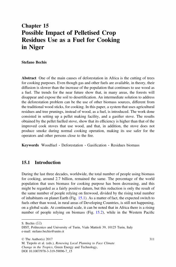
Chapter 15Possible Impact of Pelletised CropResidues Use as a Fuel for Cookingin Niger
Stefano Bechis
Abstract One of the main causes of deforestation in Africa is the cutting of treesfor cooking purposes. Even though gas and other fuels are available, in theory, theirdiffusion is slower than the increase of the population that continues to use wood asa fuel. The trends for the near future show that, in many areas, the forests willdisappear and expose the soil to desertification. An intermediate solution to addressthe deforestation problem can be the use of other biomass sources, different fromthe traditional wood sticks, for cooking. In this paper, a system that uses agriculturalresidues and tree prunings, instead of wood, as a fuel, is introduced. The work doneconsisted in setting up a pellet making facility, and a gasifier stove. The resultsobtained by the pellet fuelled stove, show that its efficiency is higher than that of theimproved cook stoves that use wood, and that, in addition, the stove does notproduce smoke during normal cooking operation, making its use safer for theoperators and other persons close to the fire.
Keywords Woodfuel Deforestation Gasification Residues biomass
15.1 Introduction
During the last three decades, worldwide, the total number of people using biomassfor cooking, around 2.7 billion, remained the same. The percentage of the worldpopulation that uses biomass for cooking purpose has been decreasing, and thismight be regarded as a fairly positive datum, but this reduction is only the result ofthe same number of people relying on firewood, divided by the rising total numberof inhabitants on planet Earth (Fig. 15.1). As a matter of fact, the expected switch tofuels other than wood, in rural areas of Developing Countries, is still not happening,on a global scale. At continental scale, it can be noted that in Africa there is a risingnumber of people relying on biomass (Fig. 15.2), while in the Western Pacific
S. Bechis (&)DIST, Politecnico and University of Turin, Viale Mattioli 39, 10125 Turin, Italye-mail: [email protected]
© The Author(s) 2017M. Tiepolo et al. (eds.), Renewing Local Planning to Face ClimateChange in the Tropics, Green Energy and Technology,DOI 10.1007/978-3-319-59096-7_15
311
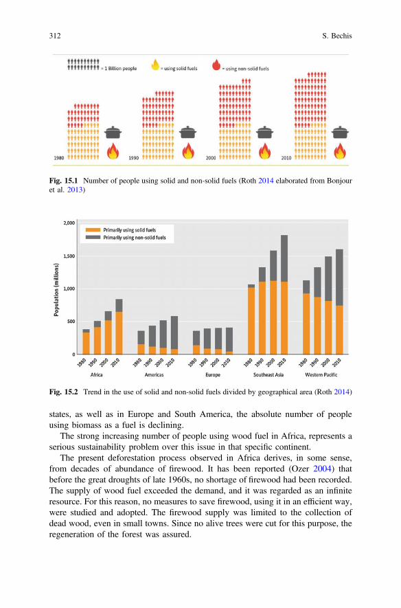
states, as well as in Europe and South America, the absolute number of peopleusing biomass as a fuel is declining.
The strong increasing number of people using wood fuel in Africa, represents aserious sustainability problem over this issue in that specific continent.
The present deforestation process observed in Africa derives, in some sense,from decades of abundance of firewood. It has been reported (Ozer 2004) thatbefore the great droughts of late 1960s, no shortage of firewood had been recorded.The supply of wood fuel exceeded the demand, and it was regarded as an infiniteresource. For this reason, no measures to save firewood, using it in an efficient way,were studied and adopted. The firewood supply was limited to the collection ofdead wood, even in small towns. Since no alive trees were cut for this purpose, theregeneration of the forest was assured.
Fig. 15.1 Number of people using solid and non-solid fuels (Roth 2014 elaborated from Bonjouret al. 2013)
Fig. 15.2 Trend in the use of solid and non-solid fuels divided by geographical area (Roth 2014)
312 S. Bechis
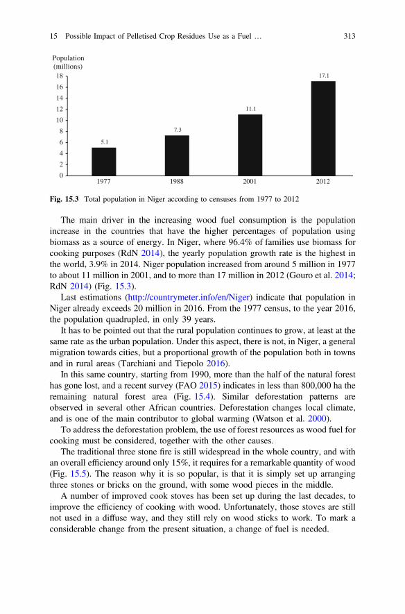
The main driver in the increasing wood fuel consumption is the populationincrease in the countries that have the higher percentages of population usingbiomass as a source of energy. In Niger, where 96.4% of families use biomass forcooking purposes (RdN 2014), the yearly population growth rate is the highest inthe world, 3.9% in 2014. Niger population increased from around 5 million in 1977to about 11 million in 2001, and to more than 17 million in 2012 (Gouro et al. 2014;RdN 2014) (Fig. 15.3).
Last estimations (http://countrymeter.info/en/Niger) indicate that population inNiger already exceeds 20 million in 2016. From the 1977 census, to the year 2016,the population quadrupled, in only 39 years.
It has to be pointed out that the rural population continues to grow, at least at thesame rate as the urban population. Under this aspect, there is not, in Niger, a generalmigration towards cities, but a proportional growth of the population both in townsand in rural areas (Tarchiani and Tiepolo 2016).
In this same country, starting from 1990, more than the half of the natural foresthas gone lost, and a recent survey (FAO 2015) indicates in less than 800,000 ha theremaining natural forest area (Fig. 15.4). Similar deforestation patterns areobserved in several other African countries. Deforestation changes local climate,and is one of the main contributor to global warming (Watson et al. 2000).
To address the deforestation problem, the use of forest resources as wood fuel forcooking must be considered, together with the other causes.
The traditional three stone fire is still widespread in the whole country, and withan overall efficiency around only 15%, it requires for a remarkable quantity of wood(Fig. 15.5). The reason why it is so popular, is that it is simply set up arrangingthree stones or bricks on the ground, with some wood pieces in the middle.
A number of improved cook stoves has been set up during the last decades, toimprove the efficiency of cooking with wood. Unfortunately, those stoves are stillnot used in a diffuse way, and they still rely on wood sticks to work. To mark aconsiderable change from the present situation, a change of fuel is needed.
5.1
7.3
11.1
17.1
0
2
4
6
8
10
12
14
16
18
2012200119881977
Population (millions)
Fig. 15.3 Total population in Niger according to censuses from 1977 to 2012
15 Possible Impact of Pelletised Crop Residues Use as a Fuel … 313
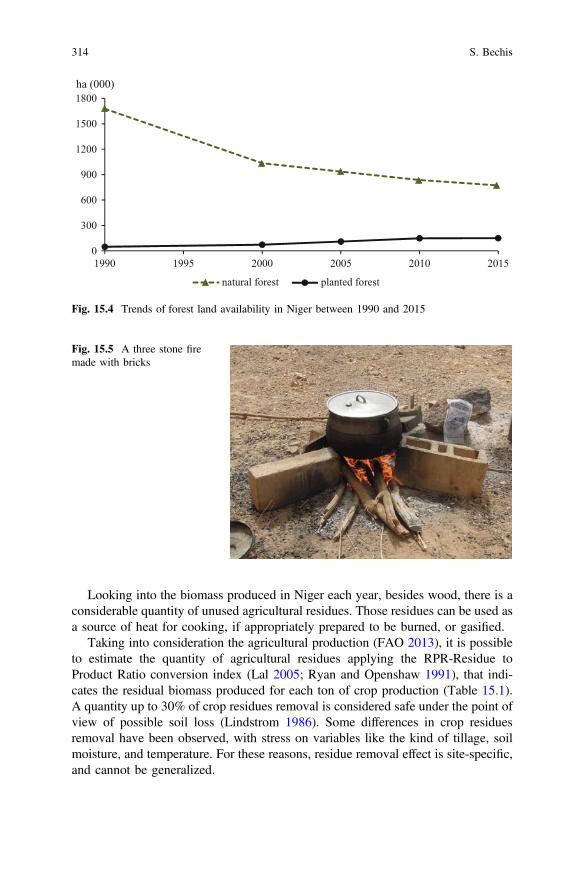
Looking into the biomass produced in Niger each year, besides wood, there is aconsiderable quantity of unused agricultural residues. Those residues can be used asa source of heat for cooking, if appropriately prepared to be burned, or gasified.
Taking into consideration the agricultural production (FAO 2013), it is possibleto estimate the quantity of agricultural residues applying the RPR-Residue toProduct Ratio conversion index (Lal 2005; Ryan and Openshaw 1991), that indi-cates the residual biomass produced for each ton of crop production (Table 15.1).A quantity up to 30% of crop residues removal is considered safe under the point ofview of possible soil loss (Lindstrom 1986). Some differences in crop residuesremoval have been observed, with stress on variables like the kind of tillage, soilmoisture, and temperature. For these reasons, residue removal effect is site-specific,and cannot be generalized.
0
300
600
900
1200
1500
1800
1990 1995 2000 2005 2010 2015
ha (000)
natural forest planted forest
Fig. 15.4 Trends of forest land availability in Niger between 1990 and 2015
Fig. 15.5 A three stone firemade with bricks
314 S. Bechis
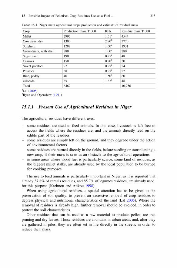
15.1.1 Present Use of Agricultural Residues in Niger
The agricultural residues have different uses.
– some residues are used to feed animals. In this case, livestock is left free toaccess the fields where the residues are, and the animals directly feed on theedible part of the residues.
– some residues are simply left on the ground, and they degrade under the actionof environmental factors.
– some residues are burned directly in the fields, before seeding or transplanting anew crop, if their mass is seen as an obstacle to the agricultural operations.
– in some areas where wood fuel is particularly scarce, some kind of residues, asthe biggest millet stalks, are already used by the local population to be burnedfor cooking purposes.
The use to feed animals is particularly important in Niger, as it is reported thatalready 37.8% of cereals residues, and 85.7% of legumes residues, are already used,for this purpose (Karimou and Atikou 1998).
When using agricultural residues, a special attention has to be given to thepreservation of soil quality, to prevent an excessive removal of crop residues todepress physical and nutritional characteristics of the land (Lal 2005). Where theremoval of residues is already high, further removal should be avoided, in order toprotect the soil characteristics.
Other residues that can be used as a raw material to produce pellets are treepruning and dry leaves. Those residues are abundant in urban areas, and, after theyare gathered in piles, they are often set in fire directly in the streets, in order toreduce their mass.
Table 15.1 Niger main agricultural crops production and estimate of residual mass
Crop Production mass T 000 RPR Residue mass T 000
Millet 2995 1.51a 4544
Cow peas, dry 1300 2.90b 3770
Sorghum 1287 1.50a 1931
Groundnuts, with shell 280 1.00a 280
Sugar cane 190 0.25a 48
Cassava 150 0.20b 30
Sweet potatoes 97 0.25a 24
Potatoes 88 0.25a 22
Rice, paddy 40 1.50a 60
Oilseeds 35 1.37a 48
Total 6462 10,756aLal (2005)bRyan and Openshaw (1991)
15 Possible Impact of Pelletised Crop Residues Use as a Fuel … 315
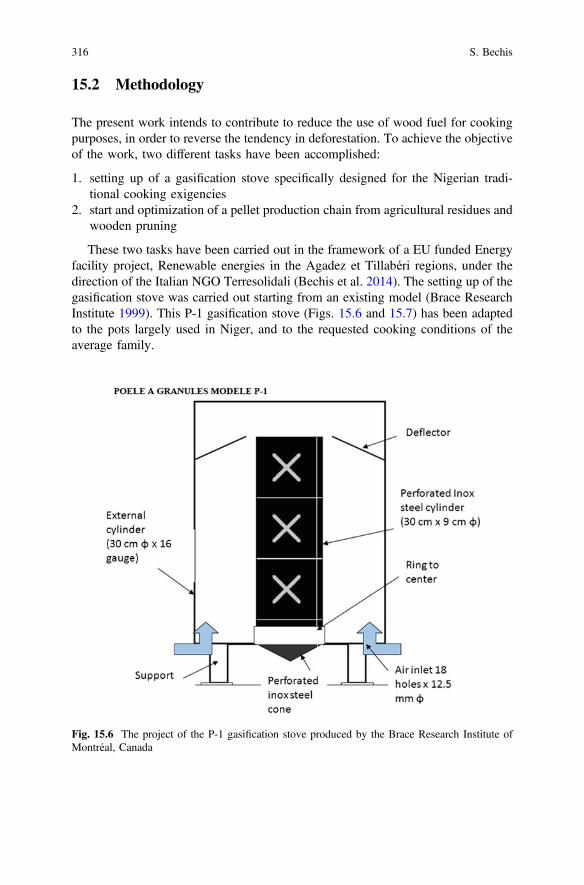
15.2 Methodology
The present work intends to contribute to reduce the use of wood fuel for cookingpurposes, in order to reverse the tendency in deforestation. To achieve the objectiveof the work, two different tasks have been accomplished:
1. setting up of a gasification stove specifically designed for the Nigerian tradi-tional cooking exigencies
2. start and optimization of a pellet production chain from agricultural residues andwooden pruning
These two tasks have been carried out in the framework of a EU funded Energyfacility project, Renewable energies in the Agadez et Tillabéri regions, under thedirection of the Italian NGO Terresolidali (Bechis et al. 2014). The setting up of thegasification stove was carried out starting from an existing model (Brace ResearchInstitute 1999). This P-1 gasification stove (Figs. 15.6 and 15.7) has been adaptedto the pots largely used in Niger, and to the requested cooking conditions of theaverage family.
Fig. 15.6 The project of the P-1 gasification stove produced by the Brace Research Institute ofMontréal, Canada
316 S. Bechis
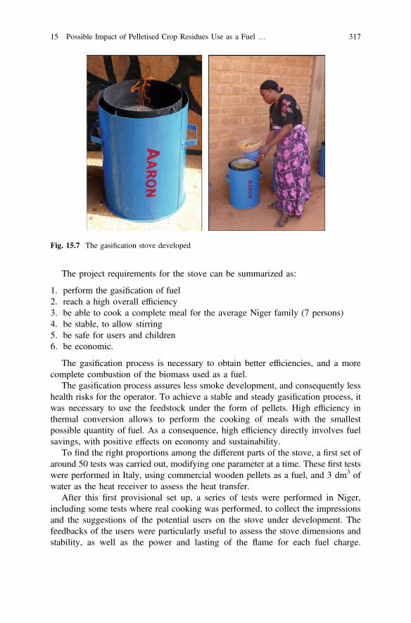
The project requirements for the stove can be summarized as:
1. perform the gasification of fuel2. reach a high overall efficiency3. be able to cook a complete meal for the average Niger family (7 persons)4. be stable, to allow stirring5. be safe for users and children6. be economic.
The gasification process is necessary to obtain better efficiencies, and a morecomplete combustion of the biomass used as a fuel.
The gasification process assures less smoke development, and consequently lesshealth risks for the operator. To achieve a stable and steady gasification process, itwas necessary to use the feedstock under the form of pellets. High efficiency inthermal conversion allows to perform the cooking of meals with the smallestpossible quantity of fuel. As a consequence, high efficiency directly involves fuelsavings, with positive effects on economy and sustainability.
To find the right proportions among the different parts of the stove, a first set ofaround 50 tests was carried out, modifying one parameter at a time. These first testswere performed in Italy, using commercial wooden pellets as a fuel, and 3 dm3 ofwater as the heat receiver to assess the heat transfer.
After this first provisional set up, a series of tests were performed in Niger,including some tests where real cooking was performed, to collect the impressionsand the suggestions of the potential users on the stove under development. Thefeedbacks of the users were particularly useful to assess the stove dimensions andstability, as well as the power and lasting of the flame for each fuel charge.
Fig. 15.7 The gasification stove developed
15 Possible Impact of Pelletised Crop Residues Use as a Fuel … 317
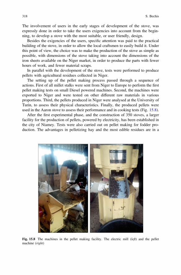
The involvement of users in the early stages of development of the stove, wasexpressly done in order to take the users exigencies into account from the begin-ning, to develop a stove with the most suitable, or user friendly, design.
Besides the exigencies of the users, specific attention was paid to the practicalbuilding of the stove, in order to allow the local craftsmen to easily build it. Underthis point of view, the choice was to make the production of the stove as simple aspossible, with dimensions of the stove taking into account the dimensions of theiron sheets available on the Niger market, in order to produce the parts with fewerhours of work, and fewer material scraps.
In parallel with the development of the stove, tests were performed to producepellets with agricultural residues collected in Niger.
The setting up of the pellet making process passed through a sequence ofactions. First of all millet stalks were sent from Niger to Europe to perform the firstpellet making tests on small Diesel powered machines. Second, the machines wereexported to Niger and were tested on other different raw materials in variousproportions. Third, the pellets produced in Niger were analysed at the University ofTurin, to assess their physical characteristics. Finally, the produced pellets wereused in the Aaron stove to assess their performance and in cooking tests (Fig. 15.8).
After the first experimental phase, and the construction of 350 stoves, a largerfacility for the production of pellets, powered by electricity, has been established inthe city of Niamey. Tests were also carried out on pellet making for fodder pro-duction. The advantages in pelletizing hay and the most edible residues are in a
Fig. 15.8 The machines in the pellet making facility. The electric mill (left) and the pelletmachine (right)
318 S. Bechis
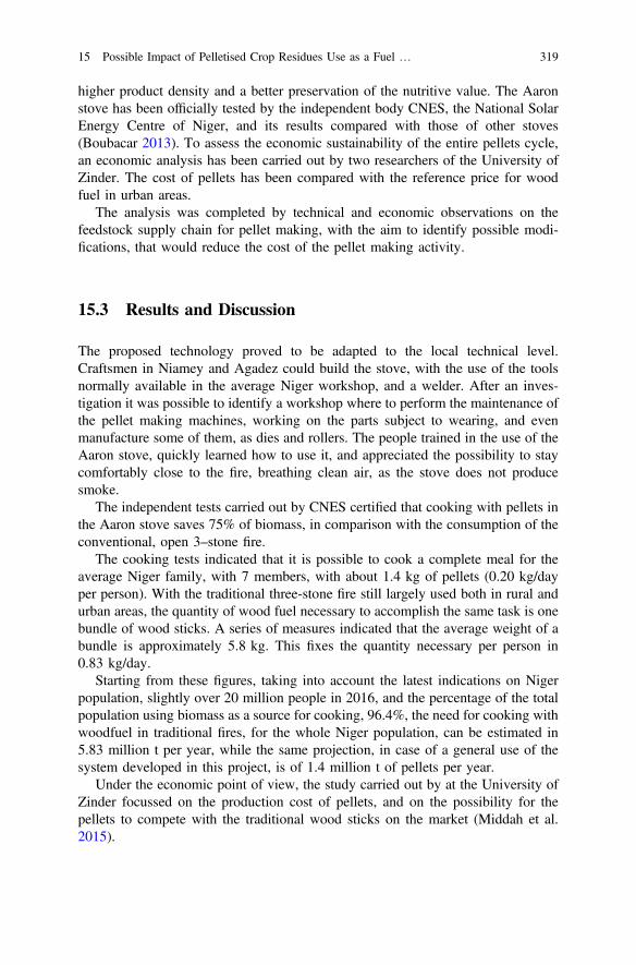
higher product density and a better preservation of the nutritive value. The Aaronstove has been officially tested by the independent body CNES, the National SolarEnergy Centre of Niger, and its results compared with those of other stoves(Boubacar 2013). To assess the economic sustainability of the entire pellets cycle,an economic analysis has been carried out by two researchers of the University ofZinder. The cost of pellets has been compared with the reference price for woodfuel in urban areas.
The analysis was completed by technical and economic observations on thefeedstock supply chain for pellet making, with the aim to identify possible modi-fications, that would reduce the cost of the pellet making activity.
15.3 Results and Discussion
The proposed technology proved to be adapted to the local technical level.Craftsmen in Niamey and Agadez could build the stove, with the use of the toolsnormally available in the average Niger workshop, and a welder. After an inves-tigation it was possible to identify a workshop where to perform the maintenance ofthe pellet making machines, working on the parts subject to wearing, and evenmanufacture some of them, as dies and rollers. The people trained in the use of theAaron stove, quickly learned how to use it, and appreciated the possibility to staycomfortably close to the fire, breathing clean air, as the stove does not producesmoke.
The independent tests carried out by CNES certified that cooking with pellets inthe Aaron stove saves 75% of biomass, in comparison with the consumption of theconventional, open 3–stone fire.
The cooking tests indicated that it is possible to cook a complete meal for theaverage Niger family, with 7 members, with about 1.4 kg of pellets (0.20 kg/dayper person). With the traditional three-stone fire still largely used both in rural andurban areas, the quantity of wood fuel necessary to accomplish the same task is onebundle of wood sticks. A series of measures indicated that the average weight of abundle is approximately 5.8 kg. This fixes the quantity necessary per person in0.83 kg/day.
Starting from these figures, taking into account the latest indications on Nigerpopulation, slightly over 20 million people in 2016, and the percentage of the totalpopulation using biomass as a source for cooking, 96.4%, the need for cooking withwoodfuel in traditional fires, for the whole Niger population, can be estimated in5.83 million t per year, while the same projection, in case of a general use of thesystem developed in this project, is of 1.4 million t of pellets per year.
Under the economic point of view, the study carried out by at the University ofZinder focussed on the production cost of pellets, and on the possibility for thepellets to compete with the traditional wood sticks on the market (Middah et al.2015).
15 Possible Impact of Pelletised Crop Residues Use as a Fuel … 319
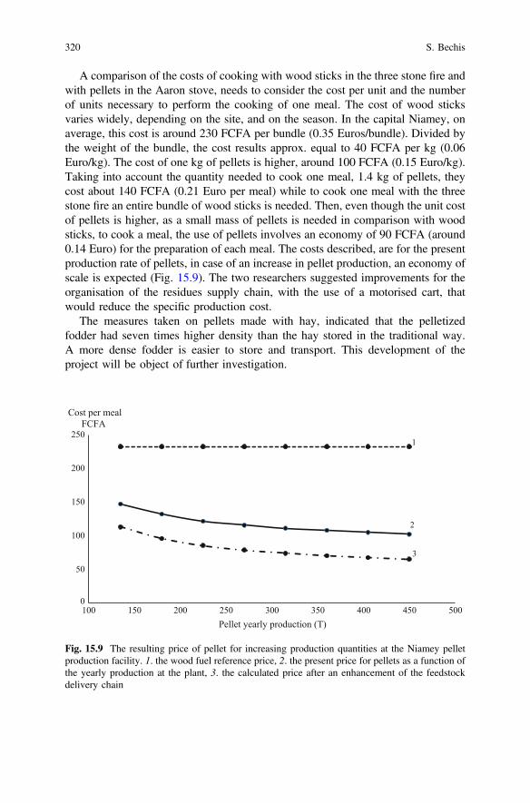
A comparison of the costs of cooking with wood sticks in the three stone fire andwith pellets in the Aaron stove, needs to consider the cost per unit and the numberof units necessary to perform the cooking of one meal. The cost of wood sticksvaries widely, depending on the site, and on the season. In the capital Niamey, onaverage, this cost is around 230 FCFA per bundle (0.35 Euros/bundle). Divided bythe weight of the bundle, the cost results approx. equal to 40 FCFA per kg (0.06Euro/kg). The cost of one kg of pellets is higher, around 100 FCFA (0.15 Euro/kg).Taking into account the quantity needed to cook one meal, 1.4 kg of pellets, theycost about 140 FCFA (0.21 Euro per meal) while to cook one meal with the threestone fire an entire bundle of wood sticks is needed. Then, even though the unit costof pellets is higher, as a small mass of pellets is needed in comparison with woodsticks, to cook a meal, the use of pellets involves an economy of 90 FCFA (around0.14 Euro) for the preparation of each meal. The costs described, are for the presentproduction rate of pellets, in case of an increase in pellet production, an economy ofscale is expected (Fig. 15.9). The two researchers suggested improvements for theorganisation of the residues supply chain, with the use of a motorised cart, thatwould reduce the specific production cost.
The measures taken on pellets made with hay, indicated that the pelletizedfodder had seven times higher density than the hay stored in the traditional way.A more dense fodder is easier to store and transport. This development of theproject will be object of further investigation.
0
50
100
150
200
250
100 150 200 250 300 350 400 450 500
Cost per meal FCFA
Pellet yearly production (T)
1
2
3
Fig. 15.9 The resulting price of pellet for increasing production quantities at the Niamey pelletproduction facility. 1. the wood fuel reference price, 2. the present price for pellets as a function ofthe yearly production at the plant, 3. the calculated price after an enhancement of the feedstockdelivery chain
320 S. Bechis
15.4 Conclusions
The achievements of the present work demonstrated that agricultural residues aresuitable as a cook fuel in Niger. Their adoption on a large scale mainly depends onthe organization of a supply chain of pelletized fuel to the consumers, and on publicpolicies, as the cost of the gasification stove is important when compared to therevenue of the average rural Niger family.
Under the technical point of view, the system developed with pellet making andthe gasification stove to use it, can potentially have a significant impact on forestsconservation, if it is implemented on a large scale.
A second important aspect of this system is linked to the gasification process,that produces much less harmful smoke than direct burning of biomass. The Aaronstove and its gasification system is likely to have a positive impact on health issueslinked to the use of firewood.
Attention has to be paid to the amount of crop residues removed from the fields.In areas where the removal of agricultural residues is already high, due to the use ofagricultural residues as fodder for animals, further removal should be avoided, inorder to protect the soil quality.
References
Bechis, S. et al. 2014. The Aaron stove, switching to agricultural residues to save firewood.ASABE and CSBE Annual International Meeting. Montréal.
Bonjour, S., et al. 2013. Solid fuel use for household cooking: country and regional estimates for1980–2010. Environmental Health Perspectives 121 (7): 784–790. doi:10.1289/ehp.1205987.
Boubacar, S. 2013. Résultats des tests sur le foyer Aaron. Niamey: CNES, Centre Nationald’Energie Solaire.
Brace Research Institute. 1999. Conception de poêles multifonction à biomasse densifiée engranules pour usages domestiques et communautaires. Montréal: Faculty of Engineering,McGill University, Report No. I-378-P-267.
FAO. 2015. FAO Global forest resources assessment. http://www.fao.org/3/a-i4793e.pdf.FAO. 2013. FAO statistical yearbook. http://www.fao.org/docrep/018/i3107e/i3107e00.htm.Gouro, A.S., C. Ly, H. Makkar. 2014. Résidus agricoles et sous-produits agro-industriels en
Afrique de l’ouest. État des lieux et perspectives pour l’élevage. Accra: Bureau régional pourl’Afrique de la FAO.
Karimou, M., and A. Atikou. 1998. Les systèmes agriculture-élevage au Niger. In The drysavannas of West and Central Africa, ed. G. Tarawali, and P. Hiernaux, 78–97. Ibadan: IITA.
Lal, R. 2005. World crop residues production and implications of its use as a biofuel. EnvironmentInternational 32 (4): 575–584. doi:10.1016/j.envint.2004.09.005.
Lindstrom, M.J. 1986. Effects of residue harvesting on water runoff, soil erosion and nutrient loss.Agriculture, Ecosystems & Environment 16 (2): 103–112. doi:10.1016/0167-8809(86)90097-6.
Middah, D., C. Harira. 2015. Production des pellets Ong Terre Solidali Niger. Institut Universitairede Technologie, University of Zinder and PREDAS Programme Régional de promotion desenergies domestiques et alternatives au Sahel, Burkina Faso.
Ozer, P. 2004. Bois de feu et déboisement au Sahel: mise au point. Sécheresse 15 (3): 243–251.
15 Possible Impact of Pelletised Crop Residues Use as a Fuel … 321
RdN-République du Niger, Institut National de Statistique du Niger. 2014. Le Niger en chiffres.http://www.stat-niger.org/statistique/file/Affiches_Depliants/Nigerenchiffres2014def.pdf.
Roth, C. 2014. Micro gasification 2.0 cooking with gas from dry biomass. Eschborn: GIZ.Ryan, P., K. Openshaw. 1991. Assessment of biomass energy resources: a discussion on it’s needs
and methodology. World Bank.Soil Quality National Technology Development Team. 2006. Crop residue removal for biomass
energy production: effects on soils and recommendations. Technical note No. 19. USDAUnited States Department of Agriculture—NRCS National Resources Conservation Servicesoils.usda.gov/sqi.
Tarchiani, V., and M. Tiepolo (eds.). 2016. Risque et adaptation climatique dans la RégionTillabéri, Niger. Pour renforcer les capacités d’analyse et d’évaluation. Paris: L’Harmattan.
Watson, R.T., et al. 2000. Land use, land-use change and forestry. Cambridge, UK: CambridgeUniversity Press and IPCC.
Open Access This chapter is licensed under the terms of the Creative Commons Attribution 4.0International License (http://creativecommons.org/licenses/by/4.0/), which permits use, sharing,adaptation, distribution and reproduction in any medium or format, as long as you give appropriatecredit to the original author(s) and the source, provide a link to the Creative Commons license andindicate if changes were made.The images or other third party material in this book are included in the book's Creative
Commons license, unless indicated otherwise in a credit line to the material. If material is notincluded in the book's Creative Commons license and your intended use is not permitted bystatutory regulation or exceeds the permitted use, you will need to obtain permission directly fromthe copyright holder.
322 S. Bechis
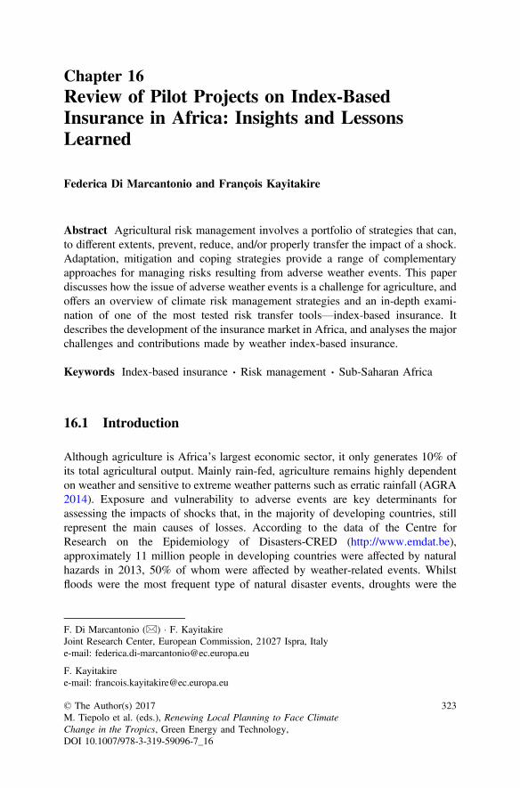
Chapter 16Review of Pilot Projects on Index-BasedInsurance in Africa: Insights and LessonsLearned
Federica Di Marcantonio and François Kayitakire
Abstract Agricultural risk management involves a portfolio of strategies that can,to different extents, prevent, reduce, and/or properly transfer the impact of a shock.Adaptation, mitigation and coping strategies provide a range of complementaryapproaches for managing risks resulting from adverse weather events. This paperdiscusses how the issue of adverse weather events is a challenge for agriculture, andoffers an overview of climate risk management strategies and an in-depth exami-nation of one of the most tested risk transfer tools—index-based insurance. Itdescribes the development of the insurance market in Africa, and analyses the majorchallenges and contributions made by weather index-based insurance.
Keywords Index-based insurance Risk management Sub-Saharan Africa
16.1 Introduction
Although agriculture is Africa’s largest economic sector, it only generates 10% ofits total agricultural output. Mainly rain-fed, agriculture remains highly dependenton weather and sensitive to extreme weather patterns such as erratic rainfall (AGRA2014). Exposure and vulnerability to adverse events are key determinants forassessing the impacts of shocks that, in the majority of developing countries, stillrepresent the main causes of losses. According to the data of the Centre forResearch on the Epidemiology of Disasters-CRED (http://www.emdat.be),approximately 11 million people in developing countries were affected by naturalhazards in 2013, 50% of whom were affected by weather-related events. Whilstfloods were the most frequent type of natural disaster events, droughts were the
F. Di Marcantonio (&) F. KayitakireJoint Research Center, European Commission, 21027 Ispra, Italye-mail: [email protected]
F. Kayitakiree-mail: [email protected]
© The Author(s) 2017M. Tiepolo et al. (eds.), Renewing Local Planning to Face ClimateChange in the Tropics, Green Energy and Technology,DOI 10.1007/978-3-319-59096-7_16
323
most important events in terms of people affected and large economic damagescaused (Carter et al. 2014).
The frequency of extreme climate events is generally increasing all over theworld (IPCC 2012), but the devastating effects are mainly recorded in those areaswhere there are high rates of poverty and limited resources and capacity for disasterresponse. This is true for half of Sub-Saharan countries that are hit by at least onedrought every 7.5 years, and by at least one flooding event every three years (Dilleyet al. 2005).
In this context, prevention, adaptation and mitigation strategies provide a rangeof complementary approaches for managing risks that arise from adverse weatherevents. Effective risk management responses should involve a portfolio of strategiesto reduce the impact of and properly transfer the residual part of the risks (the partnot covered by other mechanisms). As a part of these mechanisms, a particular formof risk transfer, known as index-based insurance, has received increased attentionfrom a number of academic researchers, international multilateral andnon-governmental organisations, and national governments (Miranda and Farrin2012). The interest shown in the use of this particular tool translated into a numberof agricultural insurance pilots that, with the exception of a few cases outsideAfrica, still suffer from substantial limitations. Besides the numerous advantages ofindex-based insurance over conventional insurance products, a number of technicaland socio-economic challenges have prevented its scalability at a commercial level.These unsatisfactory results are generated by both demand and supply. In thispaper, we provide some insights into the reasons behind the difficulties inscaling-up agricultural insurance and, in particular, index-based insurance schemes.
By reviewing pilot projects in Africa and the current literature, this paper alsoaims to introduce the key concepts and definitions behind risk management; pro-vide background information on the agricultural insurance market in Africa, dis-cussing both its development as well as the different types of insurance products,particularly index-based insurance; and highlight the challenging factors thatundermine product upscaling.
16.2 Agricultural Risk Management and Strategies
Agriculture is the largest economic sector of many African countries, employing65% of the African labour force and accounting for about a third of its grossdomestic product (World Bank 2008). Eighty percent of all farms in Sub-SaharanAfrica (SSA) are smallholder farmers, who contribute up to 90% of the productionin some SSA countries (AGRA 2014). However, production remains primarily atthe subsistence farming level (70%), with only a residual part generally commer-cialised (McIntyre et al. 2009).
Because of its intrinsic nature, the agricultural output remains sensitive to cli-mate variability (IPCC 2012). In addition, the increasing number of catastrophicevents and other extreme natural resource challenges and constraints weaken the
324 F. Di Marcantonio and F. Kayitakire
recovery process or worsen the long-term process of accumulating assets (Carteret al. 2007). These combined factors affect the livelihood of large parts of thepopulation that are vulnerable to weather shocks (Gautam 2006), and whose levelof preparedness and ability to properly respond to risks need to be improved.
Over time, individuals involved in the agricultural sector have developed a rangeof risk-management practices. Rural communities, financial institutions, traders,private insurers, relief agencies and governments all use a variety of both ex-anteand ex-post measures to reduce risk exposure and cope with losses. In some cases,and in the absence of formal mechanisms, rural households have developed indi-vidual or collective ex-ante actions for managing risks. In anticipating the negativeeffects of shocks, the most straightforward decision that a risk-averse farmer makesis to avoid profitable, but risky, activities (Elabed and Carter 2014; Hill 2011).
In the same vein, other informal arrangements, either in the form of ex-ante orex-post strategies, though effective means for offsetting the negative impact ofidiosyncratic shocks, have proven inadequate to protect people from destructiveevents that impact a large number of individuals simultaneously (Hazell 1992). Forinstance, Awel et al. (2014) highlight the ineffectiveness of informal risk sharinggroup arrangements, arguing that this mechanism cannot cope with spatial covariateshocks. Similarly, Dercon et al. (2014), showed that group risk-sharing mechanismsare very strong among households in Ethiopia, but tend to offer only a partial formof insurance, as they are characterised by limited commitment. This does notguarantee full insurance against covariate risks.
Another informal and ex-post strategy used by poor farmers and pastoralists isthe depletion of productive assets to offset income shocks and stabilise consumption(Carter et al. 2011). This strategy, frequently used by farmers to cope with shocks(Janzen and Carter 2013), has been found to have pernicious effects on householdwelfare (Hill 2011) and lower households’ ability to escape poverty (Lunde 2009).
Whilst moving from informal to formal sharing arrangements appears in theoryto be advantageous for rural community members, evidence from a rural village inthe Borana area of Ethiopia shows that, due to the complementarity of the twoforms of risk arrangement as well as the same selection and monitoring processes,“the formal credit service does not seem to outperform in terms of outreach theinformal risk sharing arrangements” (Castellani 2010).
Whilst most ex-ante and ex-post mechanisms implemented as formal or informalmitigation/coping strategies (Fig. 16.1) are in place in many developing countries(albeit to different extents and in different combinations), a comprehensiveframework that facilitates multidisciplinary risk evaluation and strategy imple-mentation is commonly lacking.1 The best way to efficiently combine a variety ofinstruments is also not yet completely clear. Jaffee et al. (2010) state that ‘all these
1The methodology for a Rapid agricultural supply chain risk assessment (RapAgRisk), developedby the Agricultural risk management team (ARMT) of the World Bank, provides a system-wideapproach for identifying risks, risk exposure, the severity of potential losses, and options for riskmanagement either by supply-chain participants (individually or collectively) or by third parties(e.g. the Government). It is designed to provide a first approximation of major risks,
16 Review of Pilot Projects on Index-Based Insurance in Africa … 325
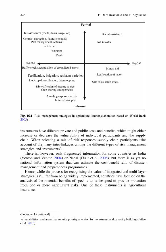
instruments have different private and public costs and benefits, which might eitherincrease or decrease the vulnerability of individual participants and the supplychain. When selecting a mix of risk responses, supply chain participants takeaccount of the many inter-linkages among the different types of risk managementstrategies and instruments’.
There is, however, only fragmented information for some countries as India(Venton and Venton 2004) or Nepal (Dixit et al. 2008), but there is as yet nonational information system that can estimate the cost-benefit ratio of disastermanagement and preparedness programmes.
Hence, while the process for recognising the value of integrated and multi-layerstrategies is still far from being widely implemented, countries have focused on theanalysis of the potential benefits of specific tools designed to provide protectionfrom one or more agricultural risks. One of these instruments is agriculturalinsurance.
Avoiding exposure to risk
Plot/crop diversification, intercropping
Informal risk pool
Fertilization, irrigation, resistant varieties
Buffer stock accumulation of crops/liquid assets
Diversification of income sourceCrop sharing arrangements
Mutual aid
Reallocation of labor
Sale of valuable assets
Cash transfer
Social assistance
Pest management systems
Infrastructures (roads, dams, irrigation)
Contract marketing, futures contracts
InsuranceCredit
Ex-postEx-ante
Informal
Formal
Safety net
Fig. 16.1 Risk management strategies in agriculture (author elaboration based on World Bank2005)
(Footnote 1 continued)
vulnerabilities, and areas that require priority attention for investment and capacity building (Jaffeeet al. 2010).
326 F. Di Marcantonio and F. Kayitakire
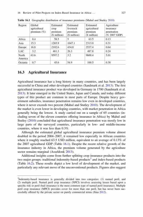
16.3 Agricultural Insurance
Agricultural insurance has a long history in many countries, and has been largelysuccessful in China and other developed countries (Sandmark et al. 2013). The firstagricultural insurance product was developed in Germany in 1700 (Sandmark et al.2013). It later emerged in the United States, Japan and Canada, and today differenttypes of this product are common in most parts of Europe. Despite heavy gov-ernment subsidies, insurance penetration remains low even in developed countries,where it never exceeds two percent (Mahul and Stutley 2010). The development ofthe market is even lower in developing countries, with market penetration in Africagenerally being the lowest. A study carried out on a sample of 65 countries (in-cluding seven of the eleven countries offering insurance in Africa) by Mahul andStutley (2010) concluded that agricultural insurance penetration was mostly low inlarge parts of the surveyed countries, particularly in low- and middle-incomecountries, where it was less than 0.3%.
Although the estimated global agricultural insurance premium volume almostdoubled in the period 2004–2007, it remained low especially in African countrieswhere it roughly reached 63.5 USD million, equivalent to an average of 0.13% ofthe 2007 agricultural GDP (Table 16.1). Despite the recent relative growth of theinsurance industry in Africa, the premium volume generated by the agriculturesector remains marginal (Asseldonk 2013).
Additional insights come from further splitting crop insurance products into thetwo major groups: traditional indemnity-based products2 and index-based products(Table 16.2). These results depict a low level of development of the market, andparticularly any relevant move of the unconventional products. Figures also suggest
Table 16.1 Geographic distribution of insurance premiums (Mahul and Stutley 2010)
Region Globalagriculturalpremium (%)
Estimatedcroppremium($ million)
Estimatedlivestockpremium($ million)
Estimatedagriculturalpremium($ million)
Agricultureinsurancepenetration(% 2007 GDP)
Africa 0.4 58.5 5 63.5 0.13
Asia 15.3 1265.9 1047.1 2313.0 0.31
Europe 16.8 2102.6 434.8 2537.4 0.64
LAC 3.2 461.3 26.3 487.8 0.24
NorthAmerica
63.6 9597.2 3.2 9600.4 5.01
Oceania 0.7 45.6 54.9 100.5 0.38
2Indemnity-based insurance is generally divided into two categories: (1) named peril, and(2) multiple peril. Named peril crop insurance (NPCI) involves assessing losses based upon aspecific risk or peril (hail insurance is the most common type of named peril insurance). Multipleperil crop insurance (MPCI) provides cover for more than one peril, but has never been suc-cessfully offered by the private sector on purely commercial terms (Sina 2012).
16 Review of Pilot Projects on Index-Based Insurance in Africa … 327
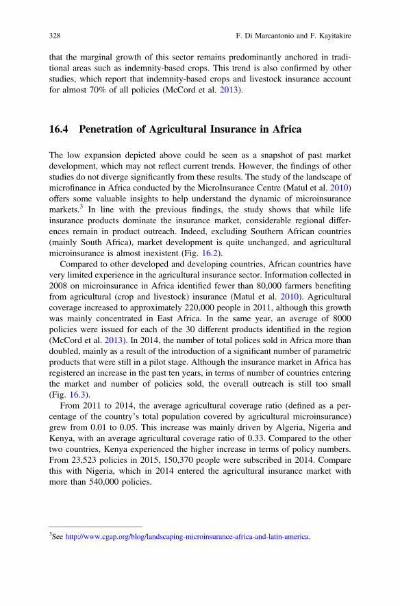
that the marginal growth of this sector remains predominantly anchored in tradi-tional areas such as indemnity-based crops. This trend is also confirmed by otherstudies, which report that indemnity-based crops and livestock insurance accountfor almost 70% of all policies (McCord et al. 2013).
16.4 Penetration of Agricultural Insurance in Africa
The low expansion depicted above could be seen as a snapshot of past marketdevelopment, which may not reflect current trends. However, the findings of otherstudies do not diverge significantly from these results. The study of the landscape ofmicrofinance in Africa conducted by the MicroInsurance Centre (Matul et al. 2010)offers some valuable insights to help understand the dynamic of microinsurancemarkets.3 In line with the previous findings, the study shows that while lifeinsurance products dominate the insurance market, considerable regional differ-ences remain in product outreach. Indeed, excluding Southern African countries(mainly South Africa), market development is quite unchanged, and agriculturalmicroinsurance is almost inexistent (Fig. 16.2).
Compared to other developed and developing countries, African countries havevery limited experience in the agricultural insurance sector. Information collected in2008 on microinsurance in Africa identified fewer than 80,000 farmers benefitingfrom agricultural (crop and livestock) insurance (Matul et al. 2010). Agriculturalcoverage increased to approximately 220,000 people in 2011, although this growthwas mainly concentrated in East Africa. In the same year, an average of 8000policies were issued for each of the 30 different products identified in the region(McCord et al. 2013). In 2014, the number of total polices sold in Africa more thandoubled, mainly as a result of the introduction of a significant number of parametricproducts that were still in a pilot stage. Although the insurance market in Africa hasregistered an increase in the past ten years, in terms of number of countries enteringthe market and number of policies sold, the overall outreach is still too small(Fig. 16.3).
From 2011 to 2014, the average agricultural coverage ratio (defined as a per-centage of the country’s total population covered by agricultural microinsurance)grew from 0.01 to 0.05. This increase was mainly driven by Algeria, Nigeria andKenya, with an average agricultural coverage ratio of 0.33. Compared to the othertwo countries, Kenya experienced the higher increase in terms of policy numbers.From 23,523 policies in 2015, 150,370 people were subscribed in 2014. Comparethis with Nigeria, which in 2014 entered the agricultural insurance market withmore than 540,000 policies.
3See http://www.cgap.org/blog/landscaping-microinsurance-africa-and-latin-america.
328 F. Di Marcantonio and F. Kayitakire
Tab
le16
.2Availabilityof
indemnity
andIndexbasedinsuranceby
region
asapercentage
ofagricultu
ralinsurance
prod
ucts(M
ahul
andStutley20
10based
onWorld
Banksurvey
2008
)
Region
Traditio
nalindemnity
based
Index-based
Cou
ntries
N.
Nam
edperil
MPC
ICrop
revenu
eGreenho
use
crop
sFo
restry
Area
yield
Weather
NDVI
Africa
850
500
1350
2538
0
Asia
1258
588
2525
1725
17
Europ
e21
9548
062
295
05
Latin
America
Caribbean
2050
900
2550
1530
5
North
America
210
010
050
5050
100
100
100
Oceania
210
00
010
010
00
00
Allcoun
tries
6569
633
3840
1522
9
16 Review of Pilot Projects on Index-Based Insurance in Africa … 329
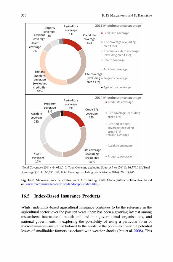
16.5 Index-Based Insurance Products
Whilst indemnity-based agricultural insurance continues to be the reference in theagricultural sector, over the past ten years, there has been a growing interest amongresearchers, international multilateral and non-governmental organisations, andnational governments in exploring the possibility of using a particular form ofmicroinsurance—insurance tailored to the needs of the poor—to cover the potentiallosses of smallholder farmers associated with weather shocks (Patt et al. 2008). This
Credit life coverage
19%
Life coverage (excluding credit life)
31%
Health coverage
17%
Accident coverage
23%
Property coverage
8%
Agriculture coverage
2%
2014 Microinsurance coverageCredit life coverage
Life coverage (excludingcredit life)
Life and accidentcoverage (excludingcredit life)Health coverage
Accident coverage
Property coverage
Credit life coverage
16%
Life coverage (excluding credit life)
Life and accident coverage
(excluding credit life)
36%
Health coverage
7%
Accident coverage
Property coverage
3%
Agriculture coverage
1%
2011 Microinsurance coverage
Credit life coverage
Life coverage (excludingcredit life)
Life and accident coverage(excluding credit life)
Health coverage
Accident coverage
Property coverage
Agriculture coverage
Total Coverage (2011): 44,012,010; Total Coverage excluding South Africa (2011): 16,779,368; Total Coverage (2014): 60,695,180; Total Coverage excluding South Africa (2014): 26,138,446
Fig. 16.2 Microinsurance penetration in SSA excluding South Africa (author’s elaboration basedon www.microinsurancecentre.org/landscape-studies.html)
330 F. Di Marcantonio and F. Kayitakire
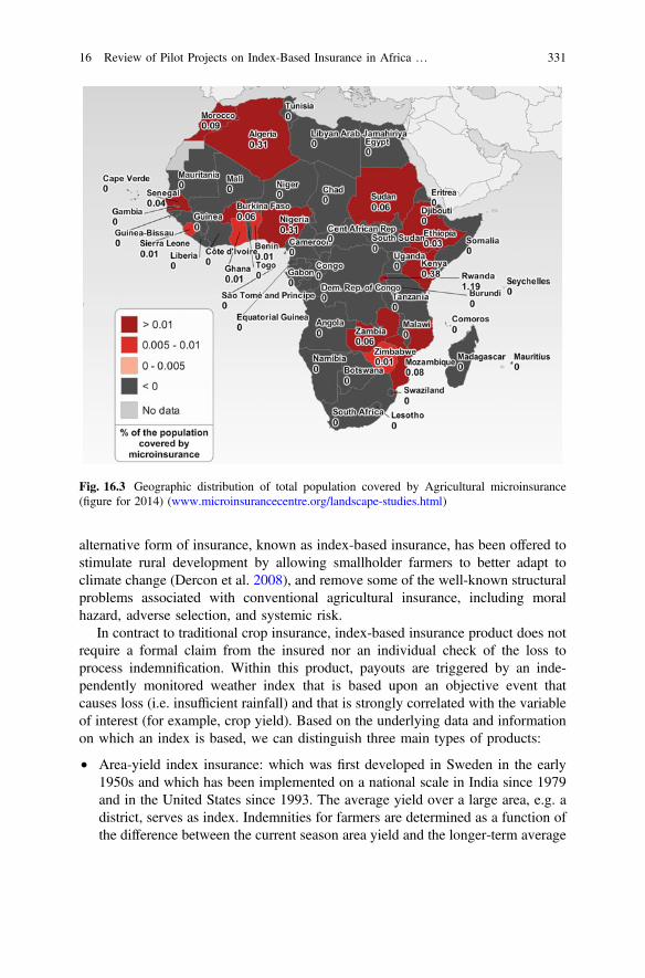
alternative form of insurance, known as index-based insurance, has been offered tostimulate rural development by allowing smallholder farmers to better adapt toclimate change (Dercon et al. 2008), and remove some of the well-known structuralproblems associated with conventional agricultural insurance, including moralhazard, adverse selection, and systemic risk.
In contract to traditional crop insurance, index-based insurance product does notrequire a formal claim from the insured nor an individual check of the loss toprocess indemnification. Within this product, payouts are triggered by an inde-pendently monitored weather index that is based upon an objective event thatcauses loss (i.e. insufficient rainfall) and that is strongly correlated with the variableof interest (for example, crop yield). Based on the underlying data and informationon which an index is based, we can distinguish three main types of products:
• Area-yield index insurance: which was first developed in Sweden in the early1950s and which has been implemented on a national scale in India since 1979and in the United States since 1993. The average yield over a large area, e.g. adistrict, serves as index. Indemnities for farmers are determined as a function ofthe difference between the current season area yield and the longer-term average
Fig. 16.3 Geographic distribution of total population covered by Agricultural microinsurance(figure for 2014) (www.microinsurancecentre.org/landscape-studies.html)
16 Review of Pilot Projects on Index-Based Insurance in Africa … 331
yield achieved in the same area. This requires that both, the current season yieldlevel and the historical area yields be known.
• Weather Index-based insurance: commercially underwritten since 2002, thistype of insurance utilises a proxy (or index)—such as amount of rainfall ortemperature—to trigger indemnity payouts to farmers. The operationalisation ofthis product requires intensive technical inputs and skills that are often notavailable in Africa. The concentration on rainfall indices and the need for highquality weather data and infrastructure, combined with the currently limitedoptions for insurance products, present additional challenges to the adoption ofthis product.
• Remotely-sensed index-based insurance: are insurance schemes based onindexes constructed using remote sensing data and are variants of eitherarea-yield or weather index-based insurance schemes. These products wereintroduced to try resolve the problems of scarcity of weather stations in remoterural areas. However, the low correlation of the indices constructed from remotesensing data and the actual losses is not yet resolved. The calibration of themodel linking the index to losses remains a challenge because of the lack ofreference data. The inadequacy of ground-based data has prompted doubts onthe use of these products (Rojas et al. 2011).
16.5.1 Pilot Projects in Africa
Index-based insurance has been sold as the most promising approach to minimisingex-post verification costs (IFAD 2011). Despite its multiple advantages (i.e.removal of asymmetric information, low administrative costs once the productstructures have been standardised, timeliness in payment), the penetration of thisproduct has not produced the expected results and, after more than a decade, is stilllargely in the pilot stage, with several projects operating around Africa. Differentalternatives in terms of product design, delivery mechanisms, pricing, and targetpopulation have been tried, but no long-term solution has yet been reached.
Difficulties in achieving positive results (World Bank 2005) have not discour-aged many from exploiting the market by promoting several pilot tests. While theseinitiatives have helped explore the possibility of creating a market for this product,they have not yet clarified the real set of benefits for consumers. Table 16.3summarises some characteristics of a selected number of weather index-insuranceprojects reviewed in other publications (Bruke et al. 2010; Carter et al. 2014;Asseldonk 2013; Hess and Hazel 2009; Skees et al. 2007; World Bank 2005).
Demand for index-based insurance is generally low. Supply and demand con-straints have not yet been completely removed and results continue to be belowexpectations. Uptake among different products has been shown to be in the range of20–30% (Giné 2009; Jensen et al. 2014a), with adopters usually hedging only avery small proportion of their agricultural income (McIntosh et al. 2013).
332 F. Di Marcantonio and F. Kayitakire
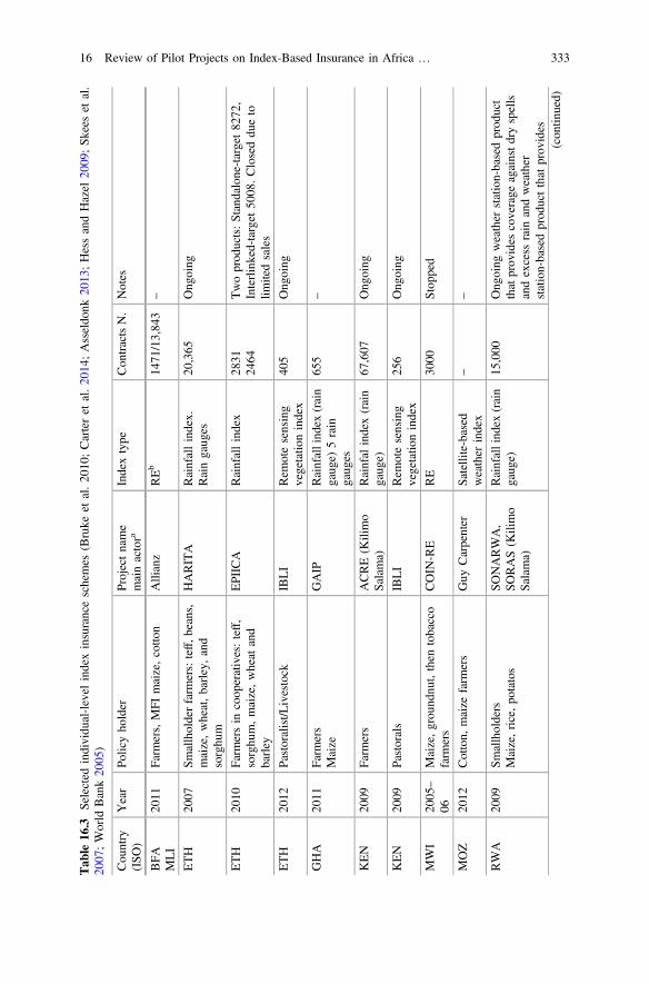
Tab
le16
.3Selected
individu
al-level
indexinsuranceschemes
(Bruke
etal.20
10;Carteret
al.20
14;Asseldo
nk20
13;HessandHazel
2009;Sk
eeset
al.
2007
;World
Bank20
05)
Cou
ntry
(ISO
)Year
Policyho
lder
Projectname
mainactora
Indextype
Con
tractsN.
Notes
BFA
MLI
2011
Farm
ers,MFI
maize,cotto
nAllianz
REb
1471
/13,84
3–
ETH
2007
Smallholderfarm
ers:teff,b
eans,
maize,wheat,barley,and
sorghu
m
HARITA
Rainfallindex.
Raingaug
es20
,365
Ong
oing
ETH
2010
Farm
ersin
coop
eratives:teff,
sorghu
m,maize,wheat
and
barley
EPIICA
Rainfallindex
2831
2464
Twoprod
ucts:Standalone-target82
72,
Interlinked-target
5008
.Closeddu
eto
limitedsales
ETH
2012
Pastoralist/L
ivestock
IBLI
Rem
otesensing
vegetatio
nindex
405
Ong
oing
GHA
2011
Farm
ers
Maize
GAIP
Rainfallind
ex(rain
gaug
e)5rain
gaug
es
655
–
KEN
2009
Farm
ers
ACRE(K
ilimo
Salama)
Rainfal
index(rain
gaug
e)67
,607
Ong
oing
KEN
2009
Pastorals
IBLI
Rem
otesensing
vegetatio
nindex
256
Ong
oing
MWI
2005
–
06Maize,grou
ndnu
t,then
tobacco
farm
ers
COIN
-RE
RE
3000
Stop
ped
MOZ
2012
Cotton,
maize
farm
ers
Guy
Carpenter
Satellite-based
weather
index
––
RWA
2009
Smallholders
Maize,rice,po
tatos
SONARWA,
SORAS(K
ilimo
Salama)
Rainfallind
ex(rain
gaug
e)15
,000
Ong
oing
weather
station-basedprod
uct
thatprov
ides
coverage
againstd
ryspells
andexcess
rain
andweather
station-basedprod
uctthat
prov
ides
(con
tinued)
16 Review of Pilot Projects on Index-Based Insurance in Africa … 333
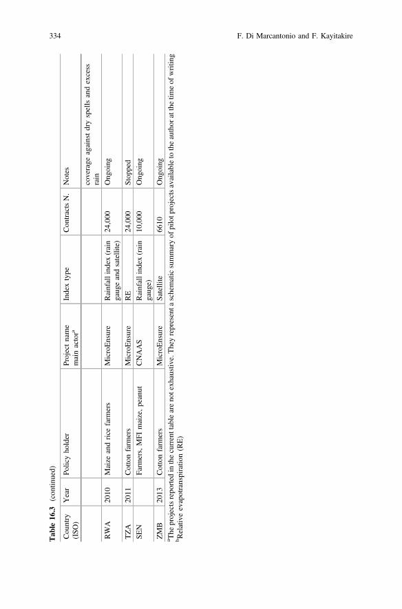
Tab
le16
.3(con
tinued)
Cou
ntry
(ISO
)Year
Policyho
lder
Projectname
mainactora
Indextype
Con
tractsN.
Notes
coverage
againstdryspellsandexcess
rain
RWA
2010
Maize
andrice
farm
ers
MicroEnsure
Rainfallind
ex(rain
gaug
eandsatellite)
24,000
Ong
oing
TZA
2011
Cottonfarm
ers
MicroEnsure
RE
24,000
Stop
ped
SEN
Farm
ers,MFI
maize,peanut
CNAAS
Rainfallind
ex(rain
gaug
e)10
,000
Ong
oing
ZMB
2013
Cottonfarm
ers
MicroEnsure
Satellite
6610
Ong
oing
a The
projectsrepo
rted
inthecurrenttableareno
texh
austive.Theyrepresenta
schematicsummaryof
pilotp
rojectsavailableto
theauthor
atthetim
eof
writin
gb R
elativeevapotranspiratio
n(RE)
334 F. Di Marcantonio and F. Kayitakire
Correspondingly, spontaneous uptake among the non-targeted population has neverexceeded 10% (Oxfam 2013).
Though some experiences outside Africa seem satisfactory (Carter et al. 2014),several physical, economic and institutional constraints make it difficult to replicatethese positive results in Africa. Bruke et al. (2010) identify several supply anddemand constraints common to almost all pilots. On the supply side, the mostcommon constraints are: lack of good quality data, start-up costs and related eco-nomic support by the government and difficulty in transferring covariate risk to theinternational reinsurance market. Other frequent supply constraints are related toinappropriate and/or costly delivery mechanisms (Sina 2012), lack of an enablingenvironment4 (Cole et al. 2009) and unfamiliarity with the insurance market Mahuland Stutley 2010).
Premium affordability (Carter 2012; Burke et al. 2010), farmers’ trust in insur-ance providers (Cole et al. 2009), financial illiteracy (Giné and Yang 2009), cog-nitive failure (Skees et al. 2008), and low willingness to pay (Chantarat et al. 2009)are usually pointed out as the major demand constraints that prevent productscalability. Similarly, empirical studies conducted in Malawi and Kenya stronglysupported the hypothesis that ambiguity-averse5 agents do not value any actuariallyfair insurance contracts and have a lower willingness to pay for any specific con-tract (Bryan 2010).
Data constraints remain the central problem for good index design. To workproperly, an index must be highly correlated with losses. Studying this correlation isof particular interest because it allows insurance providers to understand themagnitude of error associated with poor information. Indeed, the higher the cor-relation, the lower the error of an index in predicting losses. This error (known asbasis risk) is recognised as the main drawback of index insurance products (Carteret al. 2014). It basically consists in the mismatch between the payout triggered bythe index and the real loss faced by the policy holders. Basis risk not only affects theinsured but also the insurance company, which might be compelled to pay anindemnity even when no loss was incurred. To detect this correlation, long his-torical weather information and yield data are needed. It is generally assumed that atime series of at least 20 years’ data is enough to study this correlation.Additionally, for rainfall-based indices, it is also conventionally accepted that a20-km radius data point can depict the rainfall pattern of all those living within thisspatial area. This rule has, however, proved to be based on an overly optimistic
4Public-sector interventions are important to ensure that conditions exist for private insurers to gobeyond conducting pilot projects, and to start scaling up the business to reach larger numbers ofsmallholders (IFAD 2010).5Ambiguity aversion is best understood by considering the Ellsberg paradox. Ellsberg (1961)argued that, faced with two gambling options, one with known odds and one with unknown odds,many people prefer to choose the option with known odds, even if they can choose which side ofthe gamble to take. Basically, he showed that individuals react much more cautiously whenchoosing among ambiguous lotteries (with unknown probabilities) than when they choose amonglotteries with known probabilities.
16 Review of Pilot Projects on Index-Based Insurance in Africa … 335
assumption (Di Marcantonio et al. 2016), particularly in regions characterised byhigh levels of microclimatic variation (Gommes and Göbel 2013). This aspect, incombination with low density and uneven distribution of weather stations(Washington et al. 2006) and declining number of gauges (Maidment et al. 2014),lead us to rethink the suitability of current rainfall information as a good source forindex insurance construction in many African countries. In addition to historicalweather patterns, consistent and long-term weather time series are also essential fordetecting correlations and to retrospectively estimate the frequency of extremeevents, which influences the pricing of the product.6
Past experiences showed that, while in some cases lack of such informationdiscouraged suppliers from implementing further projects, in other cases it led toinnovative alternatives. For instance, in the case of Malawi, one of the pioneerAfrican countries experimenting with index insurance, the low density of automatedrainfall stations prevent an additional 200,000 farmers from being included in theprogramme. On the contrary, insufficient weather data, low quality of historicalweather data, and lack of dense weather stations did not prevent SyngentaFoundation (now operating through Agriculture and Climate Risk Enterprise Ltd.(ACRE)) from further expanding the project. The problem of low quality and scarceweather information was overcome by installing new automated weather stations.7
Whilst this allows the insurance company to keep basis risk under check, it will notsolve the problem of incomplete historical weather time series, at least in the shortrun. In addition, the installation and maintenance of additional weather stations isoften not affordable for Meteorological Services in Africa, and can be very prob-lematic in remote or conflict-affected areas.
For this reason, many pilots use alternative information, such as satellite-basedmeasurements Besides the numerous advantages of applying remote sensing to theinsurance market (de Leeuw et al. 2014), refining the set of missing information inan efficient and timing manner might be costly and even unfeasible (Vrieling et al.2014).8 However, the use of this information has brought new and as yet unresolvedchallenges. For instance in the case of IBLI, the performance of the first index wasfound to perform poorly in estimating drought-related mortality (Jensen et al.2014b). The low quality of livestock mortality data led to study a new algorithm for
6The accuracy of these information, used to estimate the parameters of the probability distributionfor the underlying weather risk, clearly determinates the pure risk of the insurance contract(Makaudze 2012).7See: http://www.syngentafoundation.com/db/1/1155.pdf and http://www.syngentafoundation.org/_temp/Kilimo_Salama_Fact_sheet_FINAL.pdf8Regarding the NDVI, for instance, retrieving long-term consistent time series from varioussources based on different sensor characteristics and algorithms could be time and resource con-suming (Miura et al. 2006). In addition to this and other technical constraints (i.e. corrections foreffects such as sensor degradation, orbital drift, and atmospheric variability), Turvey and McLaurin(2012) state that three relationships need to exist for an NDVI to work as an insurance index:(i) weather parameters of interest (e.g. extreme heat and/or drought) are strongly related to theNDVI; (ii) the NDVI can explain the variability of crop yields in detail; and (iii) the NDVImeasures must be correlated with losses.
336 F. Di Marcantonio and F. Kayitakire
the index (Woodard et al. 2016). The current index no longer explicitly predictslivestock mortality rates and product now “makes indemnity payments according toan index developed using only NDVI values” (Mills et al. 2015).
All these aspects highlight the reasons why index design is so complicated toimplement and no pilots is currently scaled up in Africa to a commercially viableproducts at a fair price attractive to poor consumers. Additionally, while the level ofuptake remains important for understanding the potential of scaling up the product,more emphasis should be given to other related aspects such as: (a) the marketdiscovery effect (new purchaser compared to renewed insurance), (b) proportion offull cash compared non-cash purchaser (either those who pay with work or thosewho mainly use coupons or other form of subsidy), (c) quantity insured versusquantity owned.
16.6 Conclusion
The challenge of risk management in agriculture is to find the proper balancebetween taking on risk and preparing for it with ex-ante actions, and managementof the consequences only after the event has occurred. Loss reduction and pro-tection of livelihoods are the main goals of risk management actions. As there is nounique recipe to deal with shocks in agriculture, risk management strategies shouldpursue this goal by combining the capacity to prepare for risk with the ability tocope with the effects. The development of a comprehensive framework would helpin this sense.
In the context of agricultural risk management, interest has moved recentlytowards risk transfer mechanisms in the form of crop and livestock insurance.A particular form of insurance, known as index-based insurance, has receivedgrowing attention, attracting substantial resources which have resulted in a largenumber of pilot programmes to test the effectiveness of this product to managecovariate risk in agriculture.
Although index-based insurance has been developed as an instrument to avoidconsumption smoothing or depletion of valuable assets among other social welfarebenefits, ambiguous results feed the debate on how much this product represents anopportunity for development, especially in a dynamic and changing environment.
The effectiveness of this instrument is still uncertain, but many lessons can belearned from past experience. Particularly, within the wide range of pilot experi-ences we revised, some key messages are clear and self-explanatory. In recent yearsthe level of uptake has increased but is still insufficient to make the productcommercially viable. On average, the uptake ranges from 30 to 40%, but in themajority of the cases this is mainly driven by the availability of subsidies to reducethe insurance premiums. Reasons behind the low uptake rates come from both thedemand and supply sides. From the demand side, price affordability, cognitivefailure and the economic behaviour of farmers have been found to be commonfactors that dampen the demand for the product. In many cases, these challenging
16 Review of Pilot Projects on Index-Based Insurance in Africa … 337
aspects have called for government intervention, a solution that in the long termwould not be sustainable. On the supply side, one of the major problems is the basisrisk. This problem, which is intrinsic to the nature of the product, mainly steamfrom the inadequacy of the data and it represents a critical limitation to theupscaling of this product.
Whilst few analyses of the impact of basis risk on a product demand exist,statistical assessment of its magnitude is lacking. Understanding the “tolerableerror” attached to this product would also clarify the effectiveness of the tool andconfirm or reject the current trends. Similarly, considering that insurance is just oneamong a number of complementary instruments, it is important to understand towhich extent and at what cost it is possible to design an affordable insurancescheme that responds to the real needs of the vulnerable farmers and pastoralists.
References
AGRA-Alliance for a Green Revolution in Africa. 2014. Africa agriculture status report 2014:Climate change and smallholder agriculture in Sub-Saharan Africa. Nairobi, Kenya. IssueNo. 2.
Asseldonk, M. Van. 2013. Market outlook for satellite-based RE index insurance in agribusiness.LEI memorandum 13-085.
Awel, Y.M., and T.T. Azomahou, T.T. 2014. Productivity and welfare effects of weather indexinsurance: Quasi-experimental evidence. Working Paper, UNU-MERIT and MaastrichtUniversity.
Bryan, G. 2010. Ambiguity and insurance. Yale working paper.Burke, M., de Janvry, A., J. Quintero. 2010. Providing index based agricultural insurance to
smallholders: Recentprogress and future promise.Available at: http://siteresources.worldbank.org/EXTABCDE/Resources/7455676-1292528456380/7626791-1303141641402/7878676-1306270833789/Parallel-Session-5-Alain_de_Janvry.pdf.
Carter, M.R., A. de Janvry, E. Sadoulet, A. Sarris. 2014. Index-based weather insurance fordeveloping countries: A review of evidence and a set of propositions for up-scaling. Workingpaper.
Carter, M.R., P.D. Little, T. Mogues, and W. Negatu. 2007. Poverty traps and natural disasters inEthiopia and Honduras.World Development 35 (5): 835–856. doi:10.1016/j.worlddev.2006.09.010.
Carter, M.R. 2012. Designed for development: Next generation approaches to index insurance forsmallholder farmers. ILO/MunichRe Microinsurance Compendium 2.
Carter, M.R., M. Ikegami, S.A. Janzen. 2011. Dynamic demand for index-based asset insurance inthe presence of poverty traps. Working paper.
Castellani, D. 2010. Microfinance and risk sharing arrangements: Complements or substitutes?Theory and evidence from Ethiopia. Ph.D. thesis Catholic University of Milan.
Chantarat, S., A. Mude, C. Barrett. 2009. Willingness to pay for index based livestock insurance:Results from a field experiment in northern Kenya. Working paper.
Cole, SA, X. Gine, J. Tobacma, P. Topalova, R. Townsend, I.J. Vickery. 2009. Barriers tohousehold risk management: Evidence from India. Working paper No. 09–116. HarvardBusiness School Finance; FRB of New York Staff Report No. 373.
de Leeuw, J.D., A. Vrieling, A. Shee, C. Atzberger, K.M. Hadgu, C. Biradar, H. Keah, and C.Turvey. 2014. The potential and uptake of remote sensing in support of insurance: A review.Remote Sensing 6 (11): 10888–10912. doi:10.3390/rs61110888.
338 F. Di Marcantonio and F. Kayitakire
Dercon, S., R.V. Hill, D. Clarke, I. Outes-Leon, and A.S. Taffesse. 2014. Offering rainfallinsurance to informal insurance groups: Evidence from a field experiment in Ethiopia. Journalof Development Economics 106: 132–143. doi:10.1016/j.jdeveco.2013.09.006.
Dercon, S., M. Kirchberger, J. Gunning, J. Platteau. 2008. Literature review on microinsurance.Geneva: International Labour Organization. http://www.ilo.org/public/english/employment/mifacility/download/litreview.pdf. Accessed 28 Jan 2017.
Dilley, M., R.S. Chen, and U. Deichmann. 2005. Natural disaster hotspots: A global risk analysis.World Bank Publications.
Di Marcantonio, F., A. Leblois, W. Göbel, and H. Kerdiles 2016. Effectiveness of weather indexinsurance for smallholders in Ethiopia. Submitted to Applied Economic Perspectives andPolicy.
Dixit, A., A. Pokhrel, and M. Moench. 2008. From risk to resilience: Costs and benefits of floodmitigation in the lower Bagmati basin: Case of Nepal Terai and North Bihar. Kathmandu,Nepal: ISET-Nepal and ProVention.
Elabed, G., and M. Carter. 2014. Ex-ante impacts of agricultural insurance: Evidence from a fieldexperiment in Mali. Working paper University of California Davis Agricultural and resourceeconomics. https://are.ucdavis.edu/people/faculty/michael-carter/working-papers.
Ellsberg, D. 1961. Risk, ambiguity and the savage axiorms. Quarterly Journal of Economics 75(4): 643–669.
Gautam, M. 2006. Managing drought in Sub-Saharan Africa: Policy perspectives. Invited paper foran invited panel session on drought: Economic consequences and policies for mitigation, at theIAAE conference, Gold Coast, Queensland, Australia, August 12–18, 2006.
Giné, X. 2009. Experience with weather insurance in India and Malawi. In Innovations in insuringthe poor. Washington DC: International Food Policy Research Institute.
Giné, X., and D. Yang. 2009. Insurance, credit, and technology adoption: Field experimentalevidence from Malawi. Journal of Development Economics 89 (1): 1–11. doi:10.1016/j.jdeveco.2008.09.007.
Gommes, R, and W. Göbel. 2013. Beyond simple, one-station rainfall indices. In The challengesof index-based insurance for food security in developing countries. Publications Office of theEuropean Union.
Hazell, P.B.R. 1992. The appropriate role of agricultural insurance in developing countries.Journal of International Development 4 (6): 567–581. doi:10.1002/jid.3380040602.
Hess, U., and P. Hazel. 2009. Innovations in insuring the poor. Focus 2020, Brief 14.Washington D.C.: International Food and Policy Research Institute (IFPRI).
Hill, R.V., J. Hoddinott, and N. Kumar. 2011. Adoption of weather index insurance: Learningfrom willingness to pay among a panel of households in rural Ethiopia. Discussion paper,01088, International Food Policy Research Institute.
IFAD-International Fund for Agricultural Development. 2010. The potential for scale andsustainability in weather index insurance. Rome: International Fund for AgriculturalDevelopment.
IFAD-International Fund for Agricultural Development. 2011. Weather index-based insurance inagricultural development: A technical guide. Rome: World food program and IFAD.
IPCC. 2012. Managing the risks of extreme events and disasters to advance climate changeadaptation. A special report of working groups I and II of the intergovernmental panel onclimate change. In ed. Field, C.B., V. Barros, T.F. Stocker, D. Qin, D.J. Dokken, K.L. Ebi, M.D. Mastrandrea, K.J. Mach, G.-K. Plattner, S.K. Allen, M. Tignor, and P.M. Midgley.Cambridge, UK and New York, USA: Cambridge University Press.
Jaffee, S., P. Siegel, C. Andrews. 2010. Rapid agricultural supply chain risk assessment, aconceptual framework. Agriculture and Rural Development Discussion Paper 47, The WorldBank.
Janzen, S.A., and M.R. Carter. 2013. The impact of microinsurance on consumption smoothingand asset protection: Evidence from a drought in Kenya. University of California at Davis.
16 Review of Pilot Projects on Index-Based Insurance in Africa … 339
Jensen, N., A. Mude, and C.B. Barrett. 2014a. How basis risk and spatiotemporal adverse selectioninfluence demand for index insurance: Evidence from Northern Kenya.Working paper, CornellUniversity.
Jensen, N.D., C.B. Barret, and A.G. Mude. 2014b. Basis risk and the welfare gains from indexinsurance: Evidence from Northern Kenya, MPRA Paper No. 59153.
Lunde, T. 2009. Escaping poverty: Perceptions from twelve indigenous communities in SouthernMexico. Thesis (Ph.D.) Johns Hopkins University.
Maidment, R.I., D. Grimes, R.P. Allan, E. Tarnavsky, M. Stringer, T. Hewison, R. Roebeling, andE. Black. 2014. The 30 year TAMSAT African rainfall climatology and time series (TARCAT)data set. Journal of Geophysical Research: Atmospheres 119 (18): 10619–10644. doi:10.1002/2014JD021927.
Mahul, O., and C. Stutley. 2010. Government support to agricultural insurance: Challenges andoptions for developing countries. Washington DC: World Bank.
Makaudze, E. 2012. Weather index insurance for smallholder farmers in Africa. Leassons learntand goals for the future. Stellenbosch: Sun Media.
Matul, M., M.J. McCord, C. Phily, and J. Harms. 2010. The landscape of microinsurance inAfrica. ILO.
McCord, M.J., R. Steinmann, C. Tatin-Jaleran, M. Ingram, and M. Mateo. 2013. The landscape ofmicroinsurnace in Africa 2012. GIZ-Program promoting financial sector dialogue in Africa andMicroinsurance Centre Munich Re Foundation.
McIntosh, C., A. Sarris, and F. Papadopoulos. 2013. Productivity, credit, risk, and the demand forweather index insurance in smallholder agriculture in Ethiopia. Agricultural Economics 44:399–417.
McIntyre, B.D., H.R. Herren, J. Wakhungu, and R.T. Watson. 2009. Agriculture at a crossroads.International assessment of agricultural knowledge, science and technology for development.Synthesis report. Whashington, DC: Island Press.
Mills, C., N. Jensen, C. Barrett, and A. Mude. 2015. Characterization for index based livestockinsurance. Working Paper, Cornell University.
Miranda, M.J., and K. Farrin. 2012. Index insurance for developing countries. Applied EconomicPerspectives and Policy 34 (3): 391–427. doi:10.1093/aepp/pps031.
Miura, T., A. Huete, and H. Yoshioka. 2006. An empirical investigation of cross-sensorrelationships of NDVI and red/near-infrared reflectance using EO-1 Hyperion data. RemoteSensing of Environment 100: 223–236. doi:10.1016/j.res.2005.10.010.
Oxfam America. 2013. R4 rural resilience initiative quarterly report April-June 2013.Patt, A., N. Peterson, M. Carter, M. Velez, U. Hess, A. Pfaff, and P. Suarez. 2008. Making index
insurance attractive to farmers. Paper presented at a workshop on ‘Technical issues in indexinsurance’, held October 7–8, 2008 at IRI, Columbia University, New York.
Rojas, O., F. Rembold, J. Delincé, and O. Léo. 2011. Using the NDVI as auxiliary data for rapidquality assessment of rainfall estimates in Africa. International Journal of Remote Sensing 32(12): 3249–3265. doi:10.1080/01431161003698260.
Sandmark, T., J-C. Debar, and C. Tatin-Jeleran. 2013. The emergence and development ofagricultural microinsurance. Microinsurance Network Discussion paper. Luxembourg
Sina, J. 2012. Index-based weather insurance—international & Kenyan experiences. Adaptation toclimate change and insurance (ACCI), Nairobi, Kenya.
Skees, J.R., A.G. Murphy, B. Collier, M.J. McCord, and J. Roth. 2007. Scaling up indexinsurance: What is needed for the next big leap forward? Weather insurance review preparedby the Microinsurance centre and global Agrisk for Kreditanstalt für Wiederaufbau (KfW).
Skees J.R., and B. Collier. 2008. The potential of weather index insurance for spurring a greenrevolution in Africa. Lexington, KY: The Watkins House, www.globalagrisk.com.
Turvey, C.G., M.K. Mclaurin. 2012. Applicability of the normalized difference vegetation index(NDVI) in index-based crop insurance design. Weather, Climate, and Society 4: 271–284.doi:10.1175/WCAS-D-11-00059.1.
Venton, C.C., and P. Venton. 2004. Disaster preparedness programmes in India: A cost benefitanalysis. HPN Network Paper No. 49. London, UK: Overseas Development Institute.
340 F. Di Marcantonio and F. Kayitakire
Vrieling, A., M. Meroni, A. Shee, A.G. Mude, J. Woodard, C.A.J.M. Kees de Bie, and F.Rembold. 2014. Historical extension of operational NDVI products for livestock insurance inKenya. International Journal of Applied Earth Observation and Geoinformation 28: 238–251.doi:10.1016/j.jag.2013.12.010.
Washington, R., G. Kay, M. Harrison, D. Conway, E. Black, A. Challinor, D. Grimes, R. Jones, A.Morse, and M. Todd. 2006. African climate change: Taking the shorter route. Bulletin of theAmerican Meteorological Society 87: 1355–1366. doi:10.1175/BAMS-87-10-1355.
Woodard, J.D., A. Shee, and A. Mude. 2016. A spatial econometric approach to designing andrating scalable index insurance in the presence of missing data. Geneva Papers on Risk andInsurance Issues and Practice 41 (2): 259–279. doi:10.1057/gpp.2015.31.
World Bank. 2005. Managing agricultural production risk innovations in developing countries.Washington DC: World Bank.
World Bank. 2008. World development report 2008: Agriculture for development. WashingtonDC: World Bank.
Open Access This chapter is licensed under the terms of the Creative Commons Attribution 4.0International License (http://creativecommons.org/licenses/by/4.0/), which permits use, sharing,adaptation, distribution and reproduction in any medium or format, as long as you give appropriatecredit to the original author(s) and the source, provide a link to the Creative Commons license andindicate if changes were made.The images or other third party material in this chapter are included in the chapter's Creative
Commons license, unless indicated otherwise in a credit line to the material. If material is notincluded in the chapter's Creative Commons license and your intended use is not permitted bystatutory regulation or exceeds the permitted use, you will need to obtain permission directly fromthe copyright holder.
16 Review of Pilot Projects on Index-Based Insurance in Africa … 341
Chapter 17Addressing Climate Change Impactsin the Sahel Using VulnerabilityReduction Credits
Karl Schultz and Linus Adler
Abstract Adaptation projects may be difficult to prioritize and finance, as theresults of projects are difficult to quantifiably measure and compare across projecttypes, and no singular “unit” for adaptation outcomes exists. The Higher GroundFoundation is developing the Vulnerability Reduction Credit (VRC™), whichincorporates cost/benefit analysis and per capita vulnerability equalization tools tomeasure the outputs of climate adaptation projects. The VRC quantifies in a sin-gular unit measures to reduce vulnerability to climate change. This chapter sum-marizes the structure and utility of VRCs and shows through a case study fromTalle, Niger, how VRCs are created and integrated into Sahelian communityadaptations to heterogeneous climate risks such as flooding and droughts. VRCanalysis and crediting may serve as a monitoring and evaluation tool and as aninstrument to help secure project finance while supporting sustained adaptation. Thechapter further considers the potential benefits to governments, donors andeconomies. VRC financing has advantages over standard development assistancemodels, particularly for project risk management, project preparation, enhancedtransparency of adaptation spend, and scaling of successful pilot projectsthroughout an economy.
Keywords Vulnerability reduction credit Adaptation finance Sahel Monitoring and evaluation climate adaptation Climate resilience
K. Schultz (&) L. AdlerThe Higher Ground Foundation, 18 Northchurch Terrace, London, UKe-mail: [email protected]
L. Adlere-mail: [email protected]
© The Author(s) 2017M. Tiepolo et al. (eds.), Renewing Local Planning to Face ClimateChange in the Tropics, Green Energy and Technology,DOI 10.1007/978-3-319-59096-7_17
343
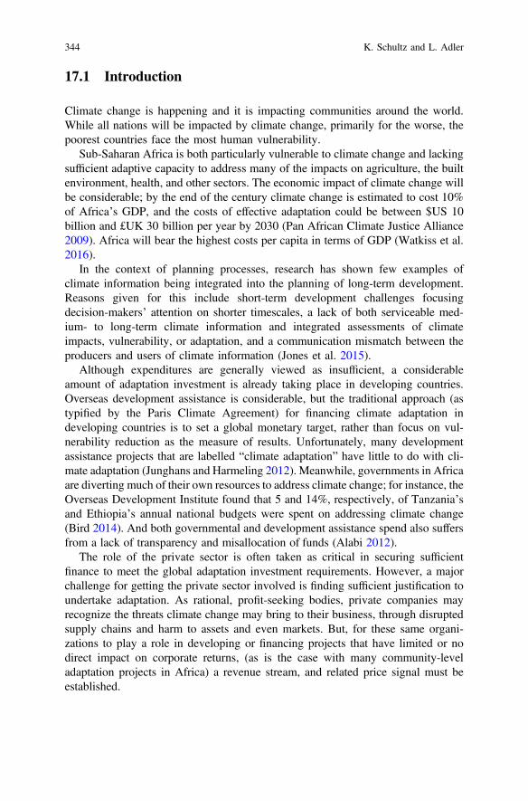
17.1 Introduction
Climate change is happening and it is impacting communities around the world.While all nations will be impacted by climate change, primarily for the worse, thepoorest countries face the most human vulnerability.
Sub-Saharan Africa is both particularly vulnerable to climate change and lackingsufficient adaptive capacity to address many of the impacts on agriculture, the builtenvironment, health, and other sectors. The economic impact of climate change willbe considerable; by the end of the century climate change is estimated to cost 10%of Africa’s GDP, and the costs of effective adaptation could be between $US 10billion and £UK 30 billion per year by 2030 (Pan African Climate Justice Alliance2009). Africa will bear the highest costs per capita in terms of GDP (Watkiss et al.2016).
In the context of planning processes, research has shown few examples ofclimate information being integrated into the planning of long-term development.Reasons given for this include short-term development challenges focusingdecision-makers’ attention on shorter timescales, a lack of both serviceable med-ium- to long-term climate information and integrated assessments of climateimpacts, vulnerability, or adaptation, and a communication mismatch between theproducers and users of climate information (Jones et al. 2015).
Although expenditures are generally viewed as insufficient, a considerableamount of adaptation investment is already taking place in developing countries.Overseas development assistance is considerable, but the traditional approach (astypified by the Paris Climate Agreement) for financing climate adaptation indeveloping countries is to set a global monetary target, rather than focus on vul-nerability reduction as the measure of results. Unfortunately, many developmentassistance projects that are labelled “climate adaptation” have little to do with cli-mate adaptation (Junghans and Harmeling 2012). Meanwhile, governments in Africaare diverting much of their own resources to address climate change; for instance, theOverseas Development Institute found that 5 and 14%, respectively, of Tanzania’sand Ethiopia’s annual national budgets were spent on addressing climate change(Bird 2014). And both governmental and development assistance spend also suffersfrom a lack of transparency and misallocation of funds (Alabi 2012).
The role of the private sector is often taken as critical in securing sufficientfinance to meet the global adaptation investment requirements. However, a majorchallenge for getting the private sector involved is finding sufficient justification toundertake adaptation. As rational, profit-seeking bodies, private companies mayrecognize the threats climate change may bring to their business, through disruptedsupply chains and harm to assets and even markets. But, for these same organi-zations to play a role in developing or financing projects that have limited or nodirect impact on corporate returns, (as is the case with many community-leveladaptation projects in Africa) a revenue stream, and related price signal must beestablished.
344 K. Schultz and L. Adler
While governments might subsidize some private involvement via tenders, andwhile there are a number of cases where adaptation may bring clear financial returnsto investors, the nature of much climate vulnerability is that, while economic returnsfrom adaptation measures (that may be represented variously through avoideddamage to buildings, etc.) are usually possible, financial returns (represented indirect project-level revenue streams) are much more difficult to achieve. This isparticularly the case for adaptation projects that address the vulnerabilities of poorercommunities. And so the challenge can be seen as identifying and deployingmechanisms that can convert economic need into financial investment.
When resources are allocated to adaptation, there is the risk that they may beineffective or inefficiently invested, owing to a lack of understanding of adapta-tion’s benefits. In part, this risk is created because of the lack of a recognized,general approach to evaluate and compare projects undertaken to reduce vulnera-bilities to climate change.
17.2 The Need for New Instruments to Address LocalVulnerabilities
Without a mechanism that can allow projects to be compared, and potentiallyincentivized, that is free from local or other political considerations, many of thegreat adaptation challenges facing Africa will persist. With such a mechanism, inparticular one that is fungible, has a single metric, and can be certified as a quantityof recognized “vulnerability reduction”, it is possible to:
• Better prioritize projects (thus bringing in efficiencies that increase the potentialfor effectively using limited resources),
• Serve as a means for leveraging finance from the revenue streams created, bysetting a price on a quantified level of vulnerability reduction,
• Allow for more transparent, “bottom-up” decision-making in adaptationinvestment, as communities, private and public adaptation technology andservice providers, and project developers have a fair chance at gaining credits,
• Serve as a positive feedback mechanism as the “market” for adaptation tech-nologies and effective project investment and operations improves through theincentive to optimize project vulnerability reduction.
• Create incentives for sustainable projects, as credits are issued only if projectscan prove that vulnerability reduction has been ensured for a (past) period oftime.
The challenges to creating such an instrument that may result in these benefits,include ensuring that it transparently, efficiently, and flexibly provides quantifiableand verifiable incentives, resulting in real and additional climate vulnerabilityreduction for poor communities. This entails ensuring that the instrument:
17 Addressing Climate Change Impacts in the Sahel … 345
• is robust: that baselines are clear, that projects establish that they are goingbeyond this baseline and that the monitoring and verification of the outputs isunambiguous,
• is quantifiable, in order to permit price setting around the units of vulnerabilityreduction, and to compare projects, and
• is sustained over time, which suggests a system design wherein projects are onlyawarded credits after the results are verified.
17.3 Vulnerability Reduction Credits (VRC™)
The proposed instrument, designed to meet the above requirements, is the climateVulnerability Reduction Credit (VRC™). A VRC represents avoided impact cost,normalized with an income equalization factor. Downscaled climate projections areused to estimate increased impact costs with climate change, and projects are thenassessed for how they decrease these costs. In addition, projects wishing to beawarded VRCs must meet certain social and other criteria. The VRC is a credit forwork done to avoid damages or losses owing to climate change (Schultz 2012).There are three fundamental assumptions in VRC analysis that, if accepted, validatetheir value in measuring vulnerability reduction:
1. Economic conditions are a valid measure of human wellbeing and can proxy foradaptive capacity,
2. Economic impacts can often be quantified, and,3. Impacts can be equalized for poorer communities.
The first assumption is that while there are many very important non-economicvalues, and that while economic wellbeing is not equivalent to human wellbeing,everyone needs to eat and be sheltered and economic conditions are a universal, andoften easily measurable, index related to human well-being, certainly as it relates tomost people living in developing countries.
The second assumption is that we can most easily assess vulnerability reductionusing economic cost-benefit analysis tools, which represent an established approach(Atkinson and Mourato 2008). There are a variety of methods for monetizingnon-financial values (e.g., hedonic pricing), and many of the climate vulnerabilitiescommunities face may be easily monetized (e.g. loss in agricultural production).
The third assumption, that we can equalize impacts by factoring in per capitaincome, is important if equity is a consideration, or more fundamentally, if humanvulnerability is the main concern rather than protection of economic assets orincomes. By considering a vulnerable community’s per capita income, the VRC cantake into account the reduced value, and thus economic impact, of poorer com-munities, focusing rather on the amount of human vulnerability per capita.
346 K. Schultz and L. Adler
The theory behind the analytical construction of VRCs is adapted from theIPCC’s Fourth Assessment Report (IPCC 2007), which states that vulnerability is afunction of exposure, sensitivity, and adaptive capacity. Adaptation measuresdecrease sensitivity and nurture adaptive capacity, and as a result vulnerability maybe reduced (Fig. 17.1).
17.3.1 How Do VRCs Work?
Essentially, a Vulnerability Reduction Credit represents €50 of avoided impact cost.It consists of:
• The Avoided Impact Cost (AIC), and;• An Income Equalization Factor (IEF).
Dividing the product of the AIC and the IEF by €50 gives the number of creditsa project earns (Fig. 17.2):
#VRCs ¼ AIC IEFð Þ €50 ð1Þ
As discussed previously, this formulation is analogous to the IPCC’s definitionof climate change vulnerability as a function of Exposure (of a system to climatechange), Sensitivity (of the exposed system to climate change) and the Adaptivecapacity of the system.
It might be useful to further unpack the terminology in the VRC formula. Thefirst term—the AIC—is analogous to exposure and sensitivity, which can be lookedat through the lens of expected damage or loss of income. Under anticipated climate
Fig. 17.1 Relationship between vulnerability, exposure, sensitivity, and adaptive capacity
17 Addressing Climate Change Impacts in the Sahel … 347
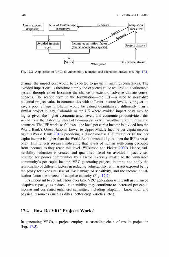
change, the impact cost would be expected to go up in many circumstances. Theavoided impact cost is therefore simply the expected value restored to a vulnerablesystem through either lessening the chance or extent of adverse climate conse-quences. The second term in the formulation—the IEF—is used to normalizepotential project value in communities with different income levels. A project in,say, a poor village in Bhutan would be valued quantitatively differently than asimilar project in, say, Colombia or the UK where avoided impact costs may behigher given the higher economic asset levels and economic productivities; thiswould have the distorting effect of favoring projects in wealthier communities andcountries. The IEF works as follows—the local per capita income is divided into theWorld Bank’s Gross National Lower to Upper Middle Income per capita incomefigure (World Bank 2016) producing a dimensionless IEF multiplier (if the percapita income is higher than the World Bank threshold figure, then the IEF is set asone). This reflects research indicating that levels of human well-being decouplefrom incomes as they reach this level (Wilkinson and Pickett 2009). Hence, vul-nerability reduction is created and quantified based on avoided impact costs,adjusted for poorer communities by a factor inversely related to the vulnerablecommunity’s per capita income. VRC generating projects interpret and apply therelationship of different factors in reducing vulnerability, with assets exposed beingthe proxy for exposure, risk of loss/damage of sensitivity, and the income equal-ization factor the inverse of adaptive capacity (Fig. 17.2).
It’s important to consider how over time VRC generation will result in enhancedadaptive capacity, as reduced vulnerability may contribute to increased per capitaincome and correlated enhanced capacities, including adaptation know-how, andphysical resources (such as dikes, better crop varieties, etc.).
17.4 How Do VRC Projects Work?
In generating VRCs, a project employs a cascading chain of results projection(Fig. 17.3).
Fig. 17.2 Application of VRCs to vulnerability reduction and adaptation process (see Fig. 17.1)
348 K. Schultz and L. Adler
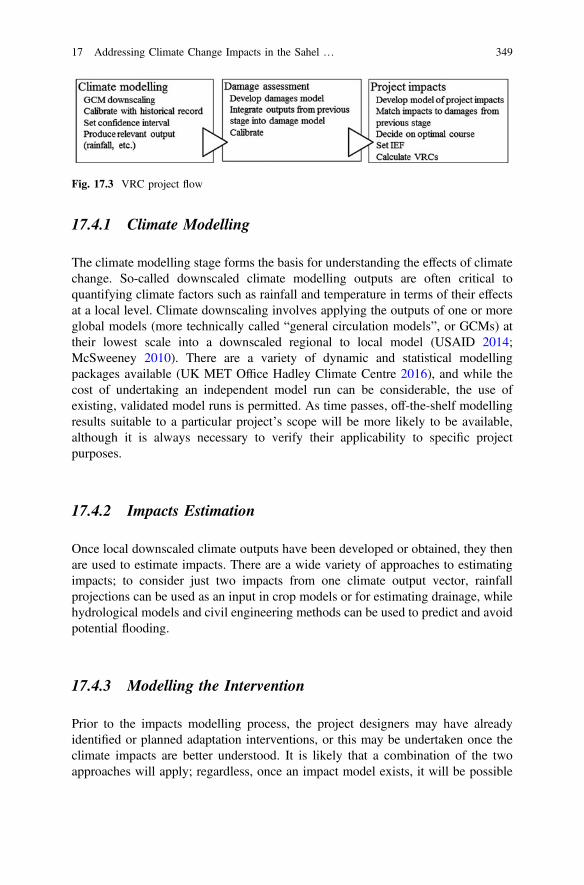
17.4.1 Climate Modelling
The climate modelling stage forms the basis for understanding the effects of climatechange. So-called downscaled climate modelling outputs are often critical toquantifying climate factors such as rainfall and temperature in terms of their effectsat a local level. Climate downscaling involves applying the outputs of one or moreglobal models (more technically called “general circulation models”, or GCMs) attheir lowest scale into a downscaled regional to local model (USAID 2014;McSweeney 2010). There are a variety of dynamic and statistical modellingpackages available (UK MET Office Hadley Climate Centre 2016), and while thecost of undertaking an independent model run can be considerable, the use ofexisting, validated model runs is permitted. As time passes, off-the-shelf modellingresults suitable to a particular project’s scope will be more likely to be available,although it is always necessary to verify their applicability to specific projectpurposes.
17.4.2 Impacts Estimation
Once local downscaled climate outputs have been developed or obtained, they thenare used to estimate impacts. There are a wide variety of approaches to estimatingimpacts; to consider just two impacts from one climate output vector, rainfallprojections can be used as an input in crop models or for estimating drainage, whilehydrological models and civil engineering methods can be used to predict and avoidpotential flooding.
17.4.3 Modelling the Intervention
Prior to the impacts modelling process, the project designers may have alreadyidentified or planned adaptation interventions, or this may be undertaken once theclimate impacts are better understood. It is likely that a combination of the twoapproaches will apply; regardless, once an impact model exists, it will be possible
Fig. 17.3 VRC project flow
17 Addressing Climate Change Impacts in the Sahel … 349
to test the application of specific impacts in order to predict the reduction invulnerability under alternative adaptation interventions. For instance, variousmethods for flood control or different crop substitutions or agronomical measurescan be assessed for suitability. By doing this, the project developers can determinean optimal course of action and, even more importantly, produce a quantifiableblueprint for reduction in vulnerability. The VRCs generated by the project cor-respond therefore to the difference in net impact value from the status quo (i.e., noproject, or a project that ignores expected climate change in its design).
17.4.4 Income Equalisation
The Income Equalisation Factor (IEF) (Sect. 17.3) is integral in the VRC issuancecalculation and is an indicator of the adaptive capacity of communities. Incomeequalization ensures that VRCs are not exaggerated in high income communities(owing to potential damages being valued higher per capita) and, likewise, notunderstated in poorer communities. As such, projects must establish with confi-dence the current or recent past per capita income of the people living within theproject boundary. To determine an appropriate project IEF, project developers candraw upon a number of sources, including approved government or third party percapita income data, or use sampling of the population within the project boundaryto estimate incomes following standard approaches to remove bias.
17.5 Applying VRCs to Local Climate Vulnerabilities
VRCs may be used to address a number of challenges that Sahelian communitiesmay face as they attempt to adapt to climate changes. These can be broadly dividedinto aiding the processes of:
• Adaptation planning and methodology development,• Project finance, and• Monitoring and evaluation.
These challenges cross different scales, from the very local to national and eveninternational, and also consider the potential for involving the broadest array ofpotential solution providers—cities, community groups, non-governmental orga-nizations, local private project developers, adaptation technology providers, toname some of the most important. Climate adaptation in Africa faces a number ofdifficulties, including that of prioritizing investments in a transparent, and ideally,effective way (Table 17.1). VRCs can be a way to plan and set targets for gov-ernments, in a diverse set of circumstances, from local allocations of public funds tosubmissions of nationally determined contributions that may trigger funding
350 K. Schultz and L. Adler
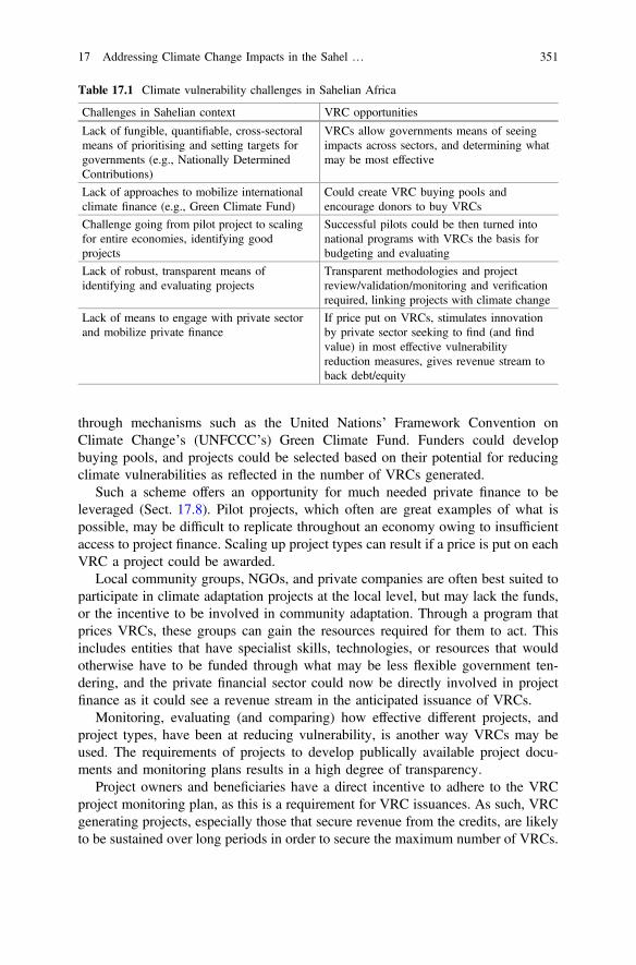
through mechanisms such as the United Nations’ Framework Convention onClimate Change’s (UNFCCC’s) Green Climate Fund. Funders could developbuying pools, and projects could be selected based on their potential for reducingclimate vulnerabilities as reflected in the number of VRCs generated.
Such a scheme offers an opportunity for much needed private finance to beleveraged (Sect. 17.8). Pilot projects, which often are great examples of what ispossible, may be difficult to replicate throughout an economy owing to insufficientaccess to project finance. Scaling up project types can result if a price is put on eachVRC a project could be awarded.
Local community groups, NGOs, and private companies are often best suited toparticipate in climate adaptation projects at the local level, but may lack the funds,or the incentive to be involved in community adaptation. Through a program thatprices VRCs, these groups can gain the resources required for them to act. Thisincludes entities that have specialist skills, technologies, or resources that wouldotherwise have to be funded through what may be less flexible government ten-dering, and the private financial sector could now be directly involved in projectfinance as it could see a revenue stream in the anticipated issuance of VRCs.
Monitoring, evaluating (and comparing) how effective different projects, andproject types, have been at reducing vulnerability, is another way VRCs may beused. The requirements of projects to develop publically available project docu-ments and monitoring plans results in a high degree of transparency.
Project owners and beneficiaries have a direct incentive to adhere to the VRCproject monitoring plan, as this is a requirement for VRC issuances. As such, VRCgenerating projects, especially those that secure revenue from the credits, are likelyto be sustained over long periods in order to secure the maximum number of VRCs.
Table 17.1 Climate vulnerability challenges in Sahelian Africa
Challenges in Sahelian context VRC opportunities
Lack of fungible, quantifiable, cross-sectoralmeans of prioritising and setting targets forgovernments (e.g., Nationally DeterminedContributions)
VRCs allow governments means of seeingimpacts across sectors, and determining whatmay be most effective
Lack of approaches to mobilize internationalclimate finance (e.g., Green Climate Fund)
Could create VRC buying pools andencourage donors to buy VRCs
Challenge going from pilot project to scalingfor entire economies, identifying goodprojects
Successful pilots could be then turned intonational programs with VRCs the basis forbudgeting and evaluating
Lack of robust, transparent means ofidentifying and evaluating projects
Transparent methodologies and projectreview/validation/monitoring and verificationrequired, linking projects with climate change
Lack of means to engage with private sectorand mobilize private finance
If price put on VRCs, stimulates innovationby private sector seeking to find (and findvalue) in most effective vulnerabilityreduction measures, gives revenue stream toback debt/equity
17 Addressing Climate Change Impacts in the Sahel … 351
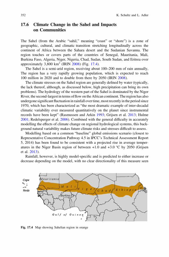
17.6 Climate Change in the Sahel and Impactson Communities
The Sahel (from the Arabic “sahil,” meaning “coast” or “shore”) is a zone ofgeographic, cultural, and climatic transition stretching longitudinally across thecontinent of Africa between the Sahara desert and the Sudanian Savanna. Theregion touches or covers parts of the countries of Senegal, Mauritania, Mali,Burkina Faso, Algeria, Niger, Nigeria, Chad, Sudan, South Sudan, and Eritrea overapproximately 3,800 km2 (IRIN 2008) (Fig. 17.4).
The Sahel is a semi-arid region, receiving about 100–200 mm of rain annually,The region has a very rapidly growing population, which is expected to reach100 million in 2020 and to double from there by 2050 (IRIN 2008).
The climate stresses on the Sahel region are generally defined by water (typically,the lack thereof, although, as discussed below, high precipitation can bring its ownproblems). The hydrology of the western part of the Sahel is dominated by the NigerRiver, the second-largest in terms offlow on theAfrican continent. The region has alsoundergone significantfluctuation in rainfall over time,most recently in the period since1970, which has been characterized as “the most dramatic example of inter-decadalclimatic variability ever measured quantitatively on the planet since instrumentalrecords have been kept” (Rasmussen and Arkin 1993; Grijsen et al. 2013; Hulme2001; Redelsperger et al. 2006). Combined with the general difficulty in accuratelymodelling the effects of climate change on regional hydrological systems, this back-ground natural variability makes future climate risks and stresses difficult to assess.
Modelling based on a common “baseline” global emissions scenario (closest toRepresentative Concentration Pathway 4.5 in IPCC’s Technical Assessment Report5, 2014) has been found to be consistent with a projected rise in average temper-atures in the Niger Basin region of between +1.0 and +3.0 °C by 2050 (Grijsenet al. 2013).
Rainfall, however, is highly model-specific and is predicted to either increase ordecrease depending on the model, with no clear directionality of this measure seen
Fig. 17.4 Map showing Sahelian region in orange
352 K. Schultz and L. Adler
until after 2050. This suggests that, in the future, communities will have to beprepared to withstand the region’s characteristically complex and fluctuating cli-mate modalities, perhaps with more variability in terms of intensity and timing, andwith a likely added temperature signal contributing to heat stress and increasedevapotranspiration. Even if annual rainfall decreases or remains stable, changes inrainfall pattern and timing can lead to increased incidence of flooding events, as isalready being reported in parts of the region (see next section).
Despite the potential for increased rainfall in the Sahel, many climate observerscaution against an assumption that climate change is, overall, “helping” WestAfrican agriculture, noting that, aside from the added heat stress dangers owing tothe anticipated temperature rise, an associated rise in evapotranspiration couldnegate any net hydrological gain from increased precipitation (Carbon Brief 2015).Despite their demonstrated resilience, rural populations in the region are still vul-nerable to increases in variability and in recent years have begun to observe agrowth in seasonable irregularity that is making it increasingly difficult to plan andcarry out plantings (Thomas 2013). Other impacts likely to follow from changes inrainfall frequency, timing, and intensity include shrinking of wetlands, decrease inspecies variety, water quality degradation, salinization, water table reduction, anderosion (German Federal Ministry for Economic Development and Cooperation andKFW Entwicklunbbank 2010).
17.7 A Case Study: Tillaberi
Recently, the ANADIA project (Tarchiani and Tiepolo 2016), a collaborationbetween the Italian Ministry of Foreign Affairs IBIMET-CNR, DIST-Politecnicoand University of Turin, and the National Meteorological Service of Niger, wasactive in Tillaberi Region, Niger in developing a climate risk assessment for twosubsistence farming villages located on the river Sirba at a distance of about 60 kmfrom the capital, Niamey (Table 17.2).
With a combined population of about 7,200, these neighboring villages havefaced varying stresses in the form of increased and increasingly erratic pluvialflooding, early onset of the growing season, and drought. Although as discussedabove it is particularly difficult in the Sahel region to attribute seasonal or evenmulti-seasonal variance in weather patterns to an overarching anthropogenic forcingsignal, the projected increase in temperatures in West Africa is likely to be asso-ciated with increased chaos in regional and local weather systems.
The communities, Talle and Garbery Kourou, grow a number crops both forsubsistence and market sales; the crops include millet, sorghum, rice, peanuts, andtomatoes. Per capita income is approximately $200 per year. The villagers alsomaintain some livestock for subsistence and market purposes. Extreme floodingevents, as have occurred in 2007, 2008, 2010, 2012, 2013, 2014, and 2015, havehad severe impacts on livelihoods in both villages. Flooding in 2014 affected60,000 people in Niger, with the worst effects occurring in Tillaberi. In that year, 38
17 Addressing Climate Change Impacts in the Sahel … 353
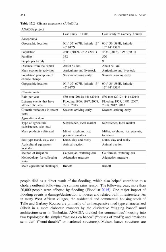
people died as a direct result of the flooding, which also helped contribute to acholera outbreak following the summer rainy season. The following year, more than20,000 people were affected by flooding (Floodlist 2015). One major impact offlooding events is damage/destruction to houses and related built infrastructure. Asin many West African villages, the residential and commercial housing stock ofTalle and Garbery Kourou are primarily of an inexpensive mud type characterized(albeit in a more elaborate manner) by the distinctive “digging banco” mudarchitecture seen in Timbuktu. ANADIA divided the communities’ housing intotwo typologies: the simpler “maisons en banco” (“houses of mud”); and “maisonssemi-dur” (“semi-durable” or hardened structures). Maison banco structures are
Table 17.2 Climate assessment (ANADIA)
ANADIA project
Case study 1: Talle Case study 2: Garbery Kourou
Background
Geographic location 001° 37′ 697E, latitude 13°45′ 647N
001° 36′ 589E, latitude13° 44′ 431N
Population 2603 (2012), 2235 (2001) 4634 (2012), 3990 (2001)
Families 372 520
People per family 7 9
Distance from the capital About 57 km About 59 km
Main economic activities Agriculture and livestock Agriculture and livestock
Population perception ofclimate change
Seasons arriving early Seasons arriving early
Geographic location 001° 37′ 697E, latitude 13°45′ 647N
001° 36′ 589E, latitude13° 44′ 431N
Climatic data
Rain per year 530 mm (2012); 441 (2014) 530 mm (2012); 441 (2014)
Extreme events that haveaffected the area
Flooding 1966, 1987, 2008,2012, 2013
Flooding 1959, 1987, 2007,2010, 2012, 2013
Climatic variations in recentyears
Seasons arriving early Seasons arriving early
Agricultural data
Type of agriculture(subsistence, sale, etc.)
Subsistence, local market Subsistence, local market
Main products cultivated Millet, sorghum, rice,peanuts, tomatoes
Millet, sorghum, rice, peanuts,tomatoes
Soil type (sand, clay, etc.) Dune, clay and rocky Dune, clay and rocky
Agricultural equipmentavailable
Animal traction Animal traction
Method of irrigation Californian, watering can Californian, watering can
Methodology for collectingwater
Adaptation measure Adaptation measure
Main agricultural challenges Runoff Runoff
354 K. Schultz and L. Adler
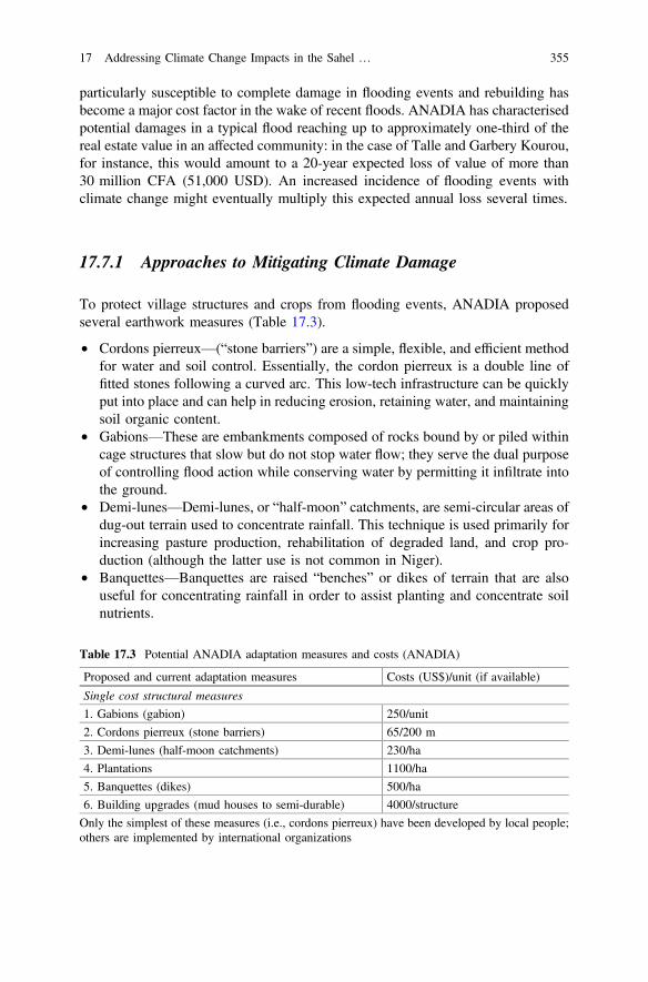
particularly susceptible to complete damage in flooding events and rebuilding hasbecome a major cost factor in the wake of recent floods. ANADIA has characterisedpotential damages in a typical flood reaching up to approximately one-third of thereal estate value in an affected community: in the case of Talle and Garbery Kourou,for instance, this would amount to a 20-year expected loss of value of more than30 million CFA (51,000 USD). An increased incidence of flooding events withclimate change might eventually multiply this expected annual loss several times.
17.7.1 Approaches to Mitigating Climate Damage
To protect village structures and crops from flooding events, ANADIA proposedseveral earthwork measures (Table 17.3).
• Cordons pierreux—(“stone barriers”) are a simple, flexible, and efficient methodfor water and soil control. Essentially, the cordon pierreux is a double line offitted stones following a curved arc. This low-tech infrastructure can be quicklyput into place and can help in reducing erosion, retaining water, and maintainingsoil organic content.
• Gabions—These are embankments composed of rocks bound by or piled withincage structures that slow but do not stop water flow; they serve the dual purposeof controlling flood action while conserving water by permitting it infiltrate intothe ground.
• Demi-lunes—Demi-lunes, or “half-moon” catchments, are semi-circular areas ofdug-out terrain used to concentrate rainfall. This technique is used primarily forincreasing pasture production, rehabilitation of degraded land, and crop pro-duction (although the latter use is not common in Niger).
• Banquettes—Banquettes are raised “benches” or dikes of terrain that are alsouseful for concentrating rainfall in order to assist planting and concentrate soilnutrients.
Table 17.3 Potential ANADIA adaptation measures and costs (ANADIA)
Proposed and current adaptation measures Costs (US$)/unit (if available)
Single cost structural measures
1. Gabions (gabion) 250/unit
2. Cordons pierreux (stone barriers) 65/200 m
3. Demi-lunes (half-moon catchments) 230/ha
4. Plantations 1100/ha
5. Banquettes (dikes) 500/ha
6. Building upgrades (mud houses to semi-durable) 4000/structure
Only the simplest of these measures (i.e., cordons pierreux) have been developed by local people;others are implemented by international organizations
17 Addressing Climate Change Impacts in the Sahel … 355
In addition, most village dwellings are currently of the less sturdy maisons enbanco type. To reduce potential catastrophic damage and cleaning costs duringflooding events, structures can be rebuilt in the more permanent semi-dur style at anapproximate cost of $4,000 for a typical family dwelling.
While some of these measures have already been adopted in the villages, thereexist capital and institutional barriers that have prevented them from autonomouslyadopting the optimal range of adaptation measures. Although demi-lunes, forexample, are a demonstrated technology for regenerating soil and containingrainfall, they have so far not been taken up autonomously at scale in Africa (UNEP2016). This might be a result of cost, as the UNEP reports that demi-lune instal-lation costs the equivalent of $150/ha to construct (ibid.); given how high this figureis relative to the typical per capita income of the region (ca. $100–200), thisrepresents a significant barrier to autonomous implementation.
Changes and augmentation to the current crop mixture may also be necessary inorder to maintain productivity as the growing season changes both in terms ofincreasing daily maximum and monthly average temperatures and increasinglyerratic hydrological conditions.
Other potential adaptations include institutional measures such as the develop-ment of early-warning weather systems, awareness training, and the delimitation offlood zones. While such interventions are much less physically capital intensive,they require investments in intangible, time-intensive factors such as humanexpertise, research, policy/planning formulation, and institutional development thathave to be maintained and augmented over the project lifetime and thus entail moresignificant recurring costs.
17.7.2 Converting Vulnerability into Adaptation:Producing VRCs in Tillaberi
The alternatives outlined above to mitigating climate-related damages in commu-nities such as Talle and Garbery Kourou are generally not difficult to implement,but they require capital investments that could prove prohibitive. In the case of theTillaberi ANADIA project, for instance, initial estimates based on the cost elementsamount to an initial capital investment of approximately €800,000 plus recurringannual operation and maintenance costs of more than €2,000 per year over a 20+year project lifetime. Given the low income level of the communities and thecurrent lack of access to capital markets, such cost levels are a barrier to imple-mentation. The ANADIA project study, for example, concluded that measures forreducing risk to the villages of Talle and Garbery Kourou by up to 23% would costfrom €23 to 34 per capita (out of a per capita income of c. €160), representing an“unsustainable” expenditure for rural families or the municipalities. (Tiepolo andBraccio 2017).
356 K. Schultz and L. Adler
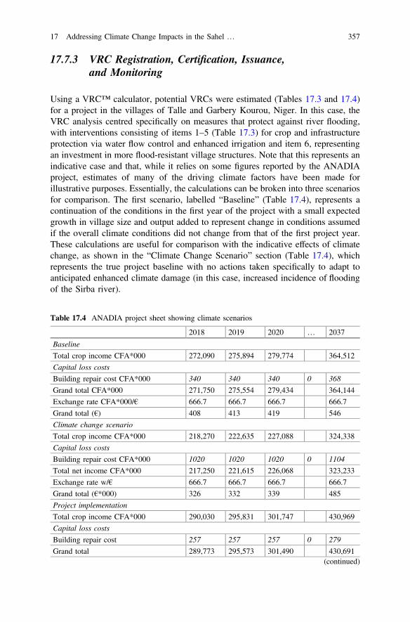
17.7.3 VRC Registration, Certification, Issuance,and Monitoring
Using a VRC™ calculator, potential VRCs were estimated (Tables 17.3 and 17.4)for a project in the villages of Talle and Garbery Kourou, Niger. In this case, theVRC analysis centred specifically on measures that protect against river flooding,with interventions consisting of items 1–5 (Table 17.3) for crop and infrastructureprotection via water flow control and enhanced irrigation and item 6, representingan investment in more flood-resistant village structures. Note that this represents anindicative case and that, while it relies on some figures reported by the ANADIAproject, estimates of many of the driving climate factors have been made forillustrative purposes. Essentially, the calculations can be broken into three scenariosfor comparison. The first scenario, labelled “Baseline” (Table 17.4), represents acontinuation of the conditions in the first year of the project with a small expectedgrowth in village size and output added to represent change in conditions assumedif the overall climate conditions did not change from that of the first project year.These calculations are useful for comparison with the indicative effects of climatechange, as shown in the “Climate Change Scenario” section (Table 17.4), whichrepresents the true project baseline with no actions taken specifically to adapt toanticipated enhanced climate damage (in this case, increased incidence of floodingof the Sirba river).
Table 17.4 ANADIA project sheet showing climate scenarios
2018 2019 2020 … 2037
Baseline
Total crop income CFA*000 272,090 275,894 279,774 364,512
Capital loss costs
Building repair cost CFA*000 340 340 340 0 368
Grand total CFA*000 271,750 275,554 279,434 364,144
Exchange rate CFA*000/€ 666.7 666.7 666.7 666.7
Grand total (€) 408 413 419 546
Climate change scenario
Total crop income CFA*000 218,270 222,635 227,088 324,338
Capital loss costs
Building repair cost CFA*000 1020 1020 1020 0 1104
Total net income CFA*000 217,250 221,615 226,068 323,233
Exchange rate w/€ 666.7 666.7 666.7 666.7
Grand total (€*000) 326 332 339 485
Project implementation
Total crop income CFA*000 290,030 295,831 301,747 430,969
Capital loss costs
Building repair cost 257 257 257 0 279
Grand total 289,773 295,573 301,490 430,691(continued)
17 Addressing Climate Change Impacts in the Sahel … 357
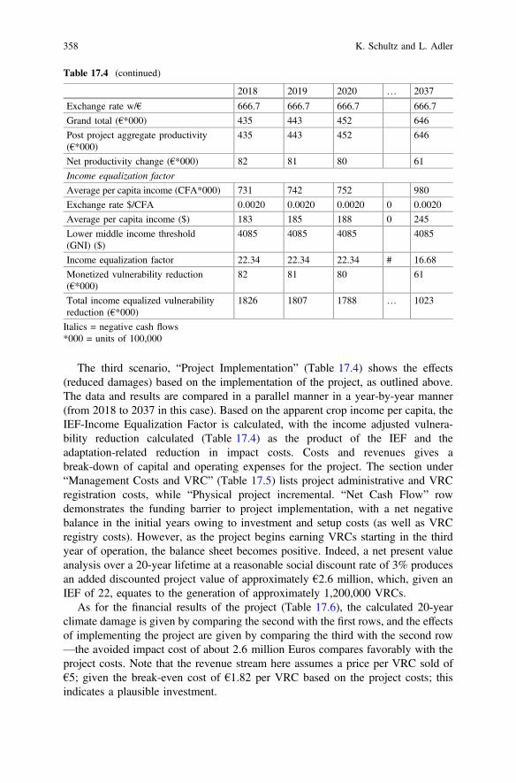
The third scenario, “Project Implementation” (Table 17.4) shows the effects(reduced damages) based on the implementation of the project, as outlined above.The data and results are compared in a parallel manner in a year-by-year manner(from 2018 to 2037 in this case). Based on the apparent crop income per capita, theIEF-Income Equalization Factor is calculated, with the income adjusted vulnera-bility reduction calculated (Table 17.4) as the product of the IEF and theadaptation-related reduction in impact costs. Costs and revenues gives abreak-down of capital and operating expenses for the project. The section under“Management Costs and VRC” (Table 17.5) lists project administrative and VRCregistration costs, while “Physical project incremental. “Net Cash Flow” rowdemonstrates the funding barrier to project implementation, with a net negativebalance in the initial years owing to investment and setup costs (as well as VRCregistry costs). However, as the project begins earning VRCs starting in the thirdyear of operation, the balance sheet becomes positive. Indeed, a net present valueanalysis over a 20-year lifetime at a reasonable social discount rate of 3% producesan added discounted project value of approximately €2.6 million, which, given anIEF of 22, equates to the generation of approximately 1,200,000 VRCs.
As for the financial results of the project (Table 17.6), the calculated 20-yearclimate damage is given by comparing the second with the first rows, and the effectsof implementing the project are given by comparing the third with the second row—the avoided impact cost of about 2.6 million Euros compares favorably with theproject costs. Note that the revenue stream here assumes a price per VRC sold of€5; given the break-even cost of €1.82 per VRC based on the project costs; thisindicates a plausible investment.
Table 17.4 (continued)
2018 2019 2020 … 2037
Exchange rate w/€ 666.7 666.7 666.7 666.7
Grand total (€*000) 435 443 452 646
Post project aggregate productivity(€*000)
435 443 452 646
Net productivity change (€*000) 82 81 80 61
Income equalization factor
Average per capita income (CFA*000) 731 742 752 980
Exchange rate $/CFA 0.0020 0.0020 0.0020 0 0.0020
Average per capita income ($) 183 185 188 0 245
Lower middle income threshold(GNI) ($)
4085 4085 4085 4085
Income equalization factor 22.34 22.34 22.34 # 16.68
Monetized vulnerability reduction(€*000)
82 81 80 61
Total income equalized vulnerabilityreduction (€*000)
1826 1807 1788 … 1023
Italics = negative cash flows*000 = units of 100,000
358 K. Schultz and L. Adler
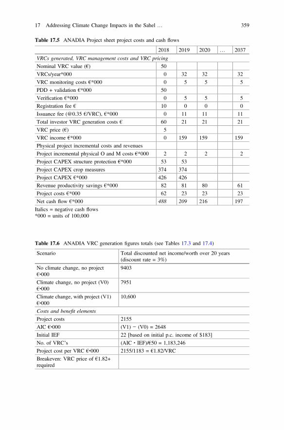
Table 17.5 ANADIA Project sheet project costs and cash flows
2018 2019 2020 … 2037
VRCs generated, VRC management costs and VRC pricing
Nominal VRC value (€) 50
VRCs/year*000 0 32 32 32
VRC monitoring costs €*000 0 5 5 5
PDD + validation €*000 50
Verification €*000 0 5 5 5
Registration fee € 10 0 0 0
Issuance fee (@0.35 €/VRC), €*000 0 11 11 11
Total investor VRC generation costs € 60 21 21 21
VRC price (€) 5
VRC income €*000 0 159 159 159
Physical project incremental costs and revenues
Project incremental physical O and M costs €*000 2 2 2 2
Project CAPEX structure protection €*000 53 53
Project CAPEX crop measures 374 374
Project CAPEX €*000 426 426
Revenue productivity savings €*000 82 81 80 61
Project costs €*000 62 23 23 23
Net cash flow €*000 488 209 216 197
Italics = negative cash flows*000 = units of 100,000
Table 17.6 ANADIA VRC generation figures totals (see Tables 17.3 and 17.4)
Scenario Total discounted net income/worth over 20 years(discount rate = 3%)
No climate change, no project€∙000
9403
Climate change, no project (V0)€∙000
7951
Climate change, with project (V1)€∙000
10,600
Costs and benefit elements
Project costs 2155
AIC €∙000 (V1) − (V0) = 2648
Initial IEF 22 [based on initial p.c. income of $183]
No. of VRC’s (AIC ∙ IEF)/€50 = 1,183,246
Project cost per VRC €∙000 2155/1183 = €1.82/VRC
Breakeven: VRC price of €1.82+required
17 Addressing Climate Change Impacts in the Sahel … 359
Such analysis helps assure that the generation of VRCs by a project equates totangible creation of climate adaptation value. The VRCs produced by the imple-mentation of verifiable, measurable adaptation measures in Tillaberi providepotential investors with an inducement to invest in these measures. The priced VRCstreams produced by the project help enable it by, for example, serving as collateralto help secure a loan to cover capital costs.
17.8 Direct Benefits to Vulnerable Communities
The benefits of undergoing the above process can be considerable, and possiblytransformational for the vulnerable community. By itself, of course, going throughthe rigor of establishing a clear and quantified vulnerability baseline, understandinghow a project may reduce these vulnerabilities, and setting in place a clear moni-toring framework will take time and possibly considerable expense. However, boththe knowledge gained and made transparent, and the potential for VRC generationmay provide a vulnerable community with:
• Enhanced Adaptive Capacity: A much better understanding of the community’sclimate adaptation needs, and improved community decisions on the tech-nologies, practices and timing for investment, and
• A way for the community to secure project finance that is aligned with itsinterests in sustained vulnerability reduction.
The vulnerable community (along with possible development partners) are ableto understand and then articulate their needs through developing a VRC baselineand being able to assess the expected results (in terms of VRCs, and by extension ofvulnerability reduction) of different project alternatives. In our case study, thisoccurs through the clear quantification of the expected economic impacts offlooding and agricultural loss through both flooding and increased droughts. Thecommunity can then identify where the most vulnerable assets are found, and focuson identifying measures (in the ANADIA project case, for example, this involvesthe implementation of water control infrastructure, such as demi-lunes, that wouldnot be constructed without outside funding, and the adoption of crop switching andplanning technologies) that will reduce these vulnerabilities. While the communityis free to prioritize however it wishes, it receives VRCs in proportion to the amountof avoided impacts resulting from adaptation.
As such, the community can use this clear and quantifiable understanding of itsvulnerabilities as both a decision-making tool and to articulate their needs andjustify donor funding. Once a community knows what particular levels of vulner-ability it has in different assets and production areas (in this case, crop productionand buildings/crop losses), it can seek adaptations that are most appropriate and willoffer the most effective results, and though the process of developing a projectdocument understand which will be most cost effective.
360 K. Schultz and L. Adler
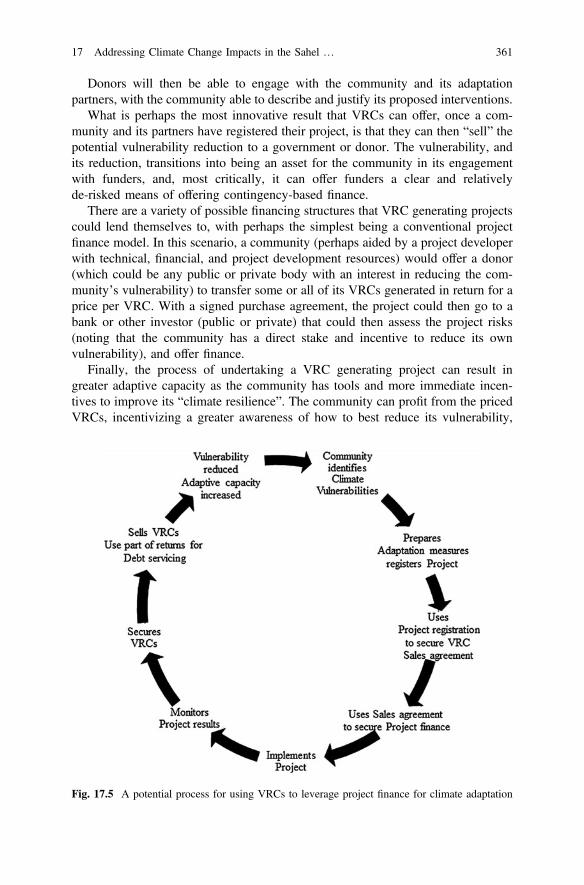
Donors will then be able to engage with the community and its adaptationpartners, with the community able to describe and justify its proposed interventions.
What is perhaps the most innovative result that VRCs can offer, once a com-munity and its partners have registered their project, is that they can then “sell” thepotential vulnerability reduction to a government or donor. The vulnerability, andits reduction, transitions into being an asset for the community in its engagementwith funders, and, most critically, it can offer funders a clear and relativelyde-risked means of offering contingency-based finance.
There are a variety of possible financing structures that VRC generating projectscould lend themselves to, with perhaps the simplest being a conventional projectfinance model. In this scenario, a community (perhaps aided by a project developerwith technical, financial, and project development resources) would offer a donor(which could be any public or private body with an interest in reducing the com-munity’s vulnerability) to transfer some or all of its VRCs generated in return for aprice per VRC. With a signed purchase agreement, the project could then go to abank or other investor (public or private) that could then assess the project risks(noting that the community has a direct stake and incentive to reduce its ownvulnerability), and offer finance.
Finally, the process of undertaking a VRC generating project can result ingreater adaptive capacity as the community has tools and more immediate incen-tives to improve its “climate resilience”. The community can profit from the pricedVRCs, incentivizing a greater awareness of how to best reduce its vulnerability,
Fig. 17.5 A potential process for using VRCs to leverage project finance for climate adaptation
17 Addressing Climate Change Impacts in the Sahel … 361
taking away the possibly long-off, uncertain, and thus maybe perceived to be lessreal threat of climate change, to be replaced with a knowledge that its adaptationactions can bring results in a growing season through VRC sales. In turn, incomesmay increase, and this, as noted above, is a proxy for and can correlate with animproved adaptive capacity (Fig. 17.5).
17.9 Conclusion
Climate Vulnerability Reduction Credits (VRCs™) offer communities, donors, andgovernments in the Sahel and around the world with a process that can helpovercome a number challenges related to effective climate adaptation. As the casestudy shows, VRCs offer to provide a needed source of funds and expertise to localcommunities, while helping donors and governments deliver scalable, transparentand capacity growing vulnerability reduction where it is needed most. There isconsiderable work required, however, to encourage adoption of the VRC.
References
Alabi, R.A. 2012. Sectoral analysis of impact of foreign aid in Nigeria: A dynamic specification.Downloaded on 3 June 2016 at http://www.iwim.uni-bremen.de/Siakeu/Alabi-SECTORAL%20ANALYSIS%20AID-AvH-3-2012.pdf.
Atkinson, G., and S. Mourato. 2008. Environmental cost-benefit analysis. Annual ReviewEnvironment and Resources 33 (1): 317–344. doi:10.1146/annurev.environ.33.020107.112927.
Bird, N. 2014. Fair share: Climate finance to vulnerable countries. London: OverseasDevelopment Institute.
Carbon Brief. (2015 July). Retrieved from carbon brief: http://www.carbonbrief.org/factcheck-is-climate-change-helping-africa.
Floodlist. 2015. Retrieved from http://floodlist.com/africa/niger-floods-4-dead-1000s-displaced.Grijsen, J.G., C. Brown, A. Tarhule, and Y.B. Ghile. 2013. Climate risk assessment for water
resources development in the Niger river basin part I: Context and climate projections.German Federal Ministry for Economic Development and Cooperation (BMZ) and KfW
Entwicklungsbank. 2010. Adaptation to climate change in the upper and middle Niger riverbasin. https://www.icafrica.org/en/knowledge-publications/article/adaptation-to-climate-change-in-the-upper-and-middle-niger-river-basin-172/
Hulme, M. 2001. Climatic perspectives on Sahelian desiccation: 1973–1998. GlobalEnvironmental Change 11 (1): 19–29. doi:10.1016/S0959-3780(00)00042-X.
IPCC. 2007. Contribution of working group II to the fourth assessment report of theintergovernmental panel on climate change. In eds. M.L. Parry, O.F. Canziani,J.P. Palutikof, P.J. van der Linden, and C.E. Hanson. Cambridge, UK and New York:Cambridge University Press.
IRIN. 2008. Backgrounder on the Sahel, West Africa’s poorest region. http://www.irinnews.org/feature/2008/06/02.
Jones, L., et al. 2015. Promoting the use of climate information to achieve long-term developmentobjectives in Sub-Saharan Africa: Results from the future climate for Africa scoping phase.London: CDKN and Future Climate for Africa.
362 K. Schultz and L. Adler
Junghans, L., and S. Harmeling. 2012. Different tales from different countries, a first assessment ofthe OECD adaptation marker. Germanwatch Briefing Paper, September.
KFW Entwicklungsbank. 2010. Adaptation to climate change in the upper and middle Niger riverbasin: River Basin Snapshot. Draft for discussion: http://ccsl.iccip.net/niger_river_basin.pdf.
McSweeney, R.J. 2010. Selecting members of the ‘QUMP’ perturbed-physics ensemble for use withprecis. UK Met Office: http://www.metoffice.gov.uk/media/pdf/e/3/SelectingCGMsToDownscale.pdf.
Pan African Climate Justice Alliance. 2009. The economic cost of climate change in Africa.Rasmussen, E.M., and P.A. Arkin. 1993. A global view of large-scale precipitation variability.
Journal of Climate 6: 1495–1522. doi:10.1175/1520-0442(1993)006<1495:AGVOLS>2.0.CO;2.
Redelsperger, J.L., Thorncroft, C., Diedhiou, A., Lebel, T., Parker, D. and Polcher, J. (2006). Africanmonsoon multidisciplinary analayis: An international project and field campaign. Bulletin of theAmerican Meteorological Society 87 (12): 1739–1746. doi: 10.1175/BAMS-87-12-1739
Schultz, K. 2012. Financing climate adaptation with a credit mechanism: Initial considerations.Climate Policy 12 (2): 187–197. doi:10.1080/14693062.2011.605563.
Tarchiani, V., and M. Tiepolo. 2016. Risque et adaptation climatique dans la région Tillabéri,Niger. Pour renforcer les capacités d’analyse et d’évaluation. Paris: L’Harmattan.
Thomas, A. 2013. Sahel villagers fleeing climate change must not be ignored. The Guardian,August 2.
Tiepolo, M., and S. Braccio. 2017. Local and scientific knowledge in multirisk assessment for ruralNiger. In Renewing local planning to face climate change in the tropics, eds. M. Tiepolo, A.Pezzoli, and V. Tarchiani. Springer.
UK Met Office Hadley Climate Centre. 2016. An introduction to the PRECIS system.UNEP-United Nations Environment Program. 2016. Sourcebook of alternative technologies for
freshwater augmentation in Africa: 1.1.2 Demi-lunes or semi-circular hoops. Newsletter andTechnical Publications: http://www.unep.or.jp/ietc/Publications/TechPublications/TechPub-8a/hoops.asp.
USAID. 2014. A review of downscaling methods for climate change projections. Washington, DC:USAID.
Watkiss, P. et al. 2016. The costs of adaptation. In The adaptation finance gap report 2016.Nairobi: United Nations Environment Programme. http://web.unep.org/adaptationgapreport/sites/unep.org.adaptationgapreport/files/documents/agr2016.pdf.
Wilkinson, R., and K. Pickett. 2009. The Spirit Level: Why equality is better for everyone. London:Penguin Press.
World Bank. 2016. World Bank country classifications. http://data.worldbank.org/about/countryclassifications.
Open Access This chapter is licensed under the terms of the Creative Commons Attribution 4.0International License (http://creativecommons.org/licenses/by/4.0/), which permits use, sharing,adaptation, distribution and reproduction in any medium or format, as long as you give appropriatecredit to the original author(s) and the source, provide a link to the Creative Commons license andindicate if changes were made.The images or other third party material in this chapter are included in the chapter's Creative
Commons license, unless indicated otherwise in a credit line to the material. If material is notincluded in the chapter's Creative Commons license and your intended use is not permitted bystatutory regulation or exceeds the permitted use, you will need to obtain permission directly fromthe copyright holder.
17 Addressing Climate Change Impacts in the Sahel … 363
Chapter 18Renewing Climate Planning Locallyin the Tropics: Conclusions
Maurizio Tiepolo, Alessandro Pezzoli and Vieri Tarchiani
Abstract In the Tropics, a significant increase in the number of cities providedwith climate plans by 2020, as announced in the 11th Sustainable development goalof the United Nations, requires an unprecedented effort. To achieve it, we have tosimplify the planning process and improve the quality of the plans. The aim of thisbook was to collect methods and experiences to inspire the simplification of theplanning process and increase the quality of climate planning. We focused attentionon the three critical phases of the planning process: analysis, decision making inplanning, climate measures. Sixteen case studies from Ethiopia, Haiti, Malawi,Mexico, Niger, Senegal, Tanzania and Thailand cover automatic weather stations inremote areas, rainfall estimation gridded datasets, open data for vulnerability indexto climate change, early warning systems, quality of climate plans index, multi-risklocal assessment, flooding risk evaluation method, backcasting, spatial dimension indisaster risk reduction and resilience, gasification stoves, index-based insurance andvulnerability risk credit. After indicating the possible analyses, 19 recommenda-tions were supplied to the United Nations SDGs monitoring system, the nationalweather services and those responsible for natural risks, to the Development banks,Official development aid and the research institutions.
Keywords Climate trends Climate measures Climate planning Decisionmaking SDG Vulnerability tracking TropicsM. Tiepolo is author of 18.1, 18.2.2 and 18.3 sections. A. Pezzoli is author of 18.2.1 and 18.2.3sections. V. Tarchiani is author of 18.2 and 18.4 sections.
M. Tiepolo (&) A. PezzoliDIST, Politecnico and University of Turin, Viale Mattioli 39, 10125 Turin, Italye-mail: [email protected]
A. Pezzolie-mail: [email protected]
V. TarchianiNational Research Council—Institute of BioMeteorology (IBIMET),Via Giovanni Caproni 8, 50145 Florence, Italye-mail: [email protected]
© The Author(s) 2017M. Tiepolo et al. (eds.), Renewing Local Planning to Face ClimateChange in the Tropics, Green Energy and Technology,DOI 10.1007/978-3-319-59096-7_18
365
18.1 From the State of Climate Planningto the Book Approach
This book contributes to “substantially increase the number of human settlementsadopting and implementing integrated policies and plans towards resource effi-ciency, mitigation and adaptation to climate change, resilience to disasters, anddisaster risk reduction”, in short, to what we have called “climate planning”. Thatannounced is one of the targets of the 11th Sustainable development goal of theUnited Nations, “Make cities inclusive, safe, resilient and sustainable” which thesignees undertake to achieve by 2020. We proceeded by 4 steps.
First of all, we decrypted the concept of climate planning expressed in the Newurban agenda (2016) and in the Sendai framework for disaster risk reduction (2015)of the United Nations.
Secondly, we identified the category of cities which are expected to prevail in theTropics in 2020 and 2030 (Chap. 1).
Third, we ascertained the state of climate planning in large and medium-sizedcities in the Tropics, identified local access to the key information necessary toclimate planning and the most common climate measures (Chaps. 1 and 10).
Four, we compared vision (UN SDGs) and reality (urbanization trends, state ofclimate planning, key-information access, most frequent climate measures). Thecomparison highlights three critical points of the process which the 11th SDG aimsto put in place.
18.1.1 New Tools and Measures
The climate plan proposed by the United Nations is that usually applied in the largecities of OECD and BRICS countries, where stand-alone plans or the acclimati-sation of long-term general, comprehensive and master plans prevail. But in 2030,the urban population in the Tropics will be concentrated mainly in cities under 0.3million pop. (46%), even if large cities will see the biggest increase (from today’s38–44%). Medium-size tropical cities mainly use medium-term municipal devel-opment plans because they do not have sufficient resources to prepare and runadditional tools or because no other plans are required by the national laws.Consequently, the plans that should be produced from now on and the measuresthat should be implemented to limit climate change and its impacts on humansettlements should be different from those that local administrations are currentlyimplementing in application of the single national legislations. This requires aregulatory adjustment that cannot be achieved in the short term. The alternative is tocontinue producing stand-alone plans that are detached from the local legal systemand which have little chance of being appropriated and implemented (becoming anexpenditure item in the municipal budget) once external financing ends.
366 M. Tiepolo et al.
18.1.2 Increasing the Production of Plans
The pace sustained by climatic planning in the last seven years has more thandoubled the number of climate plans in the Tropics compared to the previous sevenyears. Today, just 104 cities in the most advanced tropical countries (OECD andBRICS) still don’t have one. But no fewer than 950 cities in tropical DC and LDCsstill have no tools to reduce emissions or cope with the impacts of climate change,and half of these are in countries with no climate planning experience. If theproduction of plans could keep up this pace until 2020, not even half of the largeand medium-sized tropical cities would have a climate plan. And this can certainlynot be considered a substantial increase in climate planning.
18.1.3 Increasing the Quality of the Plans
Our survey of 338 tropical cities revealed an even lower quality of the plans, whichis inevitably translated into a poor impact of the measures envisaged. Two percentof climate plans estimate the potential impact of the planned measures, only 6% ofthe plans characterizes the local climate change and only one out of five climateplans specifying the quantity of measures to be taken. This uncertainty createsfurther inaccuracies: source of funding (indicated by one plan out of four) and thecost of measures (indicated by 42% of the plans only). The analysis and decisionmaking tools are therefore two weaknesses of the examined plans. Knowledge ofclimate change and its impacts is often lacking. And when knowledge exists it isacquired in a way that would radically renewed. For example, the preliminaryanalyses of planning (hazard, hazard-prone zones, vulnerability) are occasional,rarely become vulnerability tracking and are almost never locally accessible. Thisaspect is not considered by the SDGs monitoring system. We see this as a limit:what is not monitored cannot be accomplished.
We have reached the conclusion that, in order to achieve the above-mentionedtarget a radical renewal of local climate planning is necessary.
Producing new plans, more than in the past and of better quality, requires thesimplification and acceleration of certain steps of the current planning process. It iswith this intention that the book uses sixteen case studies to tackle three key-stepsof the planning process:
(1) Analysis for local climate planning(2) Decision making tools for local planning(3) Innovation in climate measures
18 Renewing Climate Planning Locally in the Tropics: Conclusions 367
18.2 Lessons Learned from the Book
18.2.1 Analysis for Local Planning
Analysis for local climate planning includes characterisation/probability of hazardin the contexts exposed to climate change, in the medium-long term, which is thehorizon of climate plans (from 5 to about 20 years). In these cases, the analysis iscalled up to characterise the climate, taking into account the needs for agriculturaland livestock production, protection of key infrastructures and, more generally, ofhuman settlements. In greater detail, we have seen (Chap. 2) that it is necessary toensure a technical capacity in maintaining and operating AWS-automatic weatherstations safety equipment. AWS are particularly important for flood monitoring,which is often carried out in remote watersheds compared to the built-up areas onthe plain, which are frequently large and medium-sized cities.
We then have to consider the new threats due to climate change: intense rainfalland dry spells also in drought treated countries (Chap. 3). Importance of tailoredclimate analysis (at local scale) with daily resolution (not seasonal trends like IPCC)superimposing natural hazard likelihood with other indicators.
For farming activities (e.g.: urban and peri-urban) it is useful to have highresolution daily precipitation gridded datasets: probability of unfavourable condi-tions for crops (according to critical periods in growing stages) and favourabletrends (late end of the rainy season) which can, however, trigger conflicts withherders (Chap. 4).
The analysis also implicates the ascertainment of vulnerability to climate change,which can be necessary on different scales: regional, using the municipality as aminimum unit of analysis, or restricted to parts of the smallest administrativejurisdiction. Depending on the contexts, these are occasional assessments, as in thecase of the Ethiopian districts (Chap. 5), or tracking, where open data exist, as inHaiti (Chap. 6). The open access of the single indicators (e.g.: that on floodexposure) guaranteed by a national service, would allow every local authority todirectly access information on exposure and vulnerability relating to its jurisdictionon a scale sufficient to its local planning needs, accelerating the local analysisprocess and cutting spending, which could be addressed towards measures foradaptation. The diagnosis for planning includes the Early Warning System. Thisdevice also belongs to the measures but is considered here to ascertain that thehazard prone areas are effectively covered by EWS. Also the device for extremeprecipitation alerts in Malawi uses open source information (Chap. 7).
When monitoring cropping season, it is necessary to plan things with caution,paying attention to translating information products into services that should besimple but effective for farmers, establishing a communication and collaborationbetween scientific institutions, national technical services and rural communities foran effective dissemination and adoption of the advice (Chap. 8). Climate servicesfor farmers should be integrated into a concerted and participatory strategy (in-cluding content and format of advice, communication channel, partnership with
368 M. Tiepolo et al.
other local stakeholders and training), which enables final users to adopt scientificinnovation in ways that are socially acceptable and environmentally sound. Theapproach needs to pay special attention to gender: in many cases, women are thebackbone of the farming community, however they are disadvantaged in accessingclimate and weather information as well as training programs.
18.2.2 Decision Making Tools for Climate Planning
The huge effort that has gone into climate planning in the last seven years has beencarried out largely by the large andmedium sized cities of the member countries of theOECD and BRICS, but much less than by those of the DC and LDCs (Chap. 10).The quality of planning measured with the QCP Index composed of 10 indicatorsremains low.
Climate planning is expected to spread, but it should also rise in quality,something which can be appreciated with the QCPI-Quality of Climate PlanningIndex (Chap. 10). This requires an improvement in methods, integrating the conceptof risk for example. The MLA-Multirisk Local Assessment (Chap. 11) presentsvarious advantages compared to the Community Risk Assessment. For example, itidentifies the potential impacts of climate change and those of the risk reductionmethods. The cost of potential damages compared with risk reduction costs allowsthe identification of the benefits of the single measures, also in the frequent cases ofcommunities exposed to multiple risks. Lastly, the method combines technicalknowledge and local knowledge. The FREM-Flooding Risk Reduction Methodintegrates in participated methods for flood risk management, a robust analysis oflocal condition in a context where local capacities on climate and prediction areabsent (Chap. 12).
The use of forecasting in the case of measures to increase access to water in Dares Salaam can be integrated with the identification of shared community objectives(backcasting). The first method is effective in establishing the technical limits of anintervention and can be helped by the definition of possible scenarios with thesecond method (Chap. 13).
These methods however require integration into local procedures. An example issupplied by disaster risk reduction and resilience in the case of La Paz, Mexico. Themethod proposed allows an assessment of urban resilience with a spatial dimension(Chap. 14).
18.2.3 Innovation in Climate Measures
As far as the measures are concerned, it is a matter of innovating the rangeavailable, focusing on those more capable of mitigating emissions and risk, and
18 Renewing Climate Planning Locally in the Tropics: Conclusions 369
then financing them. Two measures are almost completely absent from the 346plans for tropical cities considered by our survey.
The first regards the use of alternative fuels to wood and coke for cooking. The“three stone” is still the most frequently used stove in many large tropical cities.The effects of this device on emissions of CO2 and on deforestation (reduction ofcarbon sinks) around cities are clear. It alters the plant coverage, increasing run-offand soil erosion, which aggravate floods. The use of crop residues to producepellets and special gasification stoves is an answer to deforestation and to envi-ronmental alteration, which could impact on climate change mitigation (Chap. 15).Its use in an urban context would allow the limitation of the incessant process ofdeforestation which has exceeded a radius of 100 km around Niamey, the capitalcity of Niger, affecting most of the watersheds responsible for the disastrous floodsin 2010, 2012 and 2016.
The second measure is the index-based insurance to share risk in the case ofadverse weather events to which farming is exposed (Chap. 16), rarely provided forin local climate plans. This, however, is a measure that has experienced an impassebut which has potential if accompanied by measures for risk reduction.
Lastly, the question of financing the measures. The VRCs-VulnerabilityReduction Credits system (Chap. 17) presented and tested in the case of Nigercan allow the channelling of funds towards plans which are likely to have thebiggest impact.
18.3 Areas for Future Research
Climate plans are a way of mainstreaming climate change mitigation and riskreduction measures. However, they run the risk of remaining unimplemented and ofnot changing the conducts of people and key players. This is why it is necessary toact in other ways at the same time.
Key infrastructures (production and distribution of energy, roads, railways,ports, dams or important urban services, from education to health) could have aconsiderable impact on the reduction of emissions and the reduction of risk. Thepossible impact of infrastructures on climate change and, vice versa, of climatechange on the construction and exercise of such infrastructures, if considered rightfrom the concept of the project stage, can be substantially reduced. The criticalentrance point are the Development banks. The request for specific climaticrequirements in the proposals of financing submitted to the Development banks hasan impact of the entire growth machine: designers, surveyors, construction firmsand maintenance firms, suppliers of machinery, construction material, localadministration and sectorial administration of the Government.
A second sector is that of technical standards for the construction of acclimatizedinfrastructures.
Attention should be extended to these two sectors in the future.
370 M. Tiepolo et al.
18.4 Recommendations
Nineteen recommendations to different stakeholders are triggered by the book.United Nations SDGs monitoring system
1. Consider the percentage of large and medium-sized cities with climate plans asan indicator for the monitoring of the 11th SDG.
2. Consider the quality of the climate plans as an indicator for the monitoring ofthe 11th SDG (QCPI).
3. Use a database on cities and climate planning, similar to that created for thisbook, and update it.
National Hydro-meteo Services
4. Integrate the different sources of climate data. In LDCs and specially in remoteareas, the observation networks are few and far between. Climate analysis on alocal scale (municipal) can be practiced successful, integrating data observedthrough the network of automatic weather stations and rainfall estimationgridded datasets like TRMM, CHIRPS, etc.
5. Publish the data on floods so that local planning can be based on the analysis ofpast events also in semi-arid countries, where floods are becoming a high risk,both in urban and rural areas. Developing flood reporting systems based ongeo-referenced data and on the longest possible timescale.
National Services Responsible for Natural Risks
6. Switch from vulnerability assessment to vulnerability tracking, possibly throughopen data with a reduced number of indicators and make access to informationopen.
7. Make all the information useful to local climate planning freely available, fromclimate data to the areas exposed to flood, landslide, sea level rise and drought,to farmland, the prices of farm products on the markets, forestry coverage,victims and damage after disaster, through to school enrolment by gender.
8. Consider the capacity to react to vulnerability.
Federal/State Authorities Responsible for Local Development PlanningGuidelines
9. Increase the number of climate measures in the municipal development plans.10. Prepare lists of recommended measures, depending on the potential impact.11. Make climate plans more detailed, both in analysis and in the measures, which
should be structural and non-structural (e.g.: index-based insurance, climateservices, etc.).
12. Introduce into municipal development plans the assessment of the residual riskas a tool to make decisions regarding the measures that can have the biggestimpacts on the reduction of risk.
18 Renewing Climate Planning Locally in the Tropics: Conclusions 371
Research Institutions
13. Switch from monitoring the climate plans to tracking plan implementation.14. Ascertain the state of climate planning in towns (under 0.1 million pop.).15. Extend the survey on the other entry points of climate action: infrastructure
projects and construction standards.16. Ascertain the impact of the most important measures to reduce risk, in detail.
Official Development Aid
17. Assess adaptation measures in projects in terms of VRC-credits.
Insurance sector
18. Relaunch index-based insurance.
Development Banks
19. Finance projects for transition to the gasification stove fuelled by pellets, inurban and rural areas.
Open Access This chapter is licensed under the terms of the Creative Commons Attribution 4.0International License (http://creativecommons.org/licenses/by/4.0/), which permits use, sharing,adaptation, distribution and reproduction in any medium or format, as long as you give appropriatecredit to the original author(s) and the source, provide a link to the Creative Commons license andindicate if changes were made.The images or other third party material in this book are included in the book's Creative
Commons license, unless indicated otherwise in a credit line to the material. If material is notincluded in the book's Creative Commons license and your intended use is not permitted bystatutory regulation or exceeds the permitted use, you will need to obtain permission directly fromthe copyright holder.
372 M. Tiepolo et al.
Copyright © 2022 FDOKUMEN

