


Bahasa
Halaman
Hukum

Journal of Asian Earth Sciences 60 (2012) 235–245
Contents lists available at SciVerse ScienceDirect
Journal of Asian Earth Sciences
journal homepage: www.elsevier .com/locate / jseaes
Fluvial terrace formation in the eastern Fenwei Basin, China, during the past1.2 Ma as a combined archive of tectonics and climate change
Zhenbo Hu a,⇑, Baotian Pan a,⇑, Junping Wang b, Bo Cao a, Hongshan Gao a
a Key Laboratory of Western China’s Environmental Systems, Ministry of Education, Lanzhou University, Lanzhou 730000, People’s Republic of Chinab College of Resource Environment and Tourism, Capital Normal University, Beijing 100048, People’s Republic of China
a r t i c l e i n f o a b s t r a c t
Article history:Received 21 February 2012Received in revised form 27 August 2012Accepted 17 September 2012Available online 27 September 2012
Keywords:Yellow RiverFenwei BasinEmei PlatformFluvial terraceLoess
1367-9120/$ - see front matter � 2012 Elsevier Ltd. Ahttp://dx.doi.org/10.1016/j.jseaes.2012.09.016
⇑ Corresponding authors. Tel.: +86 931 8912315; faE-mail addresses: [email protected] (Z. Hu), panbt
The key to understanding the fluvial response to climate change and surface uplift is a thoroughdistinguishing between their roles in terrace formation. Previous studies have tended to attribute thefluvial behavior of deposit–incision alternation to climate cyclicity. A preliminary explanation is proposedhere for terrace formation in the eastern part of the Fenwei Basin, China. The observed fluvial terracesequence was developed by the Yellow River deeply downcutting into the Emei Platform, which wasuplifted within the eastern Fenwei Basin, and therefore it probably records the tectonic history of thisplatform. On the basis of the magnetostratigraphy and optically stimulated luminescence (OSL) dating,a ca. 1.2 Ma chronology was established for this terrace sequence. Pedostratigraphic analysis of the loessdeposits accumulated on each tread reveals that the terrace deposits are overlain immediately by a paleo-sol bed, suggesting that the abandonment of these terraces due to fluvial incision occurred at the transi-tions from glacial to interglacial climates. The glacial–interglacial climate cycle probably has a temporalcontrol on the fluvial behavior of deposit–incision alternation, even though the Yellow River develops inthe subsiding Fenwei Basin. The terrace generation may be sporadic and in the form of unusual stackedpattern before the Emei Platform was uplifted within the eastern Fenwei Basin. The terrace staircaseshowever, formed in synchrony with glacial–interglacial climate cycles since this platform began to upliftin the late Middle Pleistocene. This result indicates that uplift may be necessary in large terrace staircasegenesis. It can force the river system to downcut deeply enough during climatic transitions to separateterrace levels adequately, favoring the generation and subsequent preservation of the terrace treads.The terrace sequence of the Yellow River in the eastern Fenwei Basin therefore can be considered as acombined archive of climate change and local tectonic activity.
� 2012 Elsevier Ltd. All rights reserved.
1. Introduction
River terraces are generally regarded as an importantcomponent of the fluvial archive (Bull, 1990), providing importantevidence for landscape evolution and surface uplift (Maddy et al.,2000; Lavé and Avouac, 2001; Cohen et al., 2002; Stokes, 2008;Westaway et al., 2009). Furthermore, long-timescale climatic fluc-tuation can also be readily recorded by terrace sediments (Bull,1991; Bridgland, 2000; Veldkamp and Tebbens, 2001). River ter-races therefore are often used to evaluate the response of fluvialsystems to climate change and surface uplift induced by tectonicsor climate (e.g., Harvey and Wells, 1987; Hsieh and Knuepfer,2001; Westaway, 2002; Pan et al., 2003; Gao et al., 2008), and havelong been of great interest to researchers.
Terrace generation is often marked by an alternation betweensedimentation and vertical incision (Bull, 1990; Merritts et al.,
ll rights reserved.
x: +86 931 [email protected] (B. Pan).
1994), which is mainly related to allogenic (climate change, surfaceuplift, and base level change) and autogenic (intrinsic behavior andcomplex response) controls (Schumm, 1977; Antoine et al., 2000;Vandenberghe, 2003; Bridgland et al., 2004). Numerical simula-tions further reveal that the response of a river system to thesecontrols is likely to break the competing balance between sedi-ment flux and transportation power by discharge (e.g., Veldkampand van Dijke, 2000; Bogaart et al., 2003; van Balen et al., 2010),resulting in incision–deposition alternations (Bull, 1979, 1990).However, despite these advances in interpreting the occurrenceof fluvial terraces, the timing of fluvial terrace formation with re-spect to climatic fluctuation, and the function of these allogenicand autogenic controlling factors in river terrace developmentare still poorly understood (Vandenberghe, 1995; Bridgland andWestaway, 2008; Maddy et al., 2008; Erkens et al., 2009). Previouswork correlated terrace sequences with climatic records (e.g., Bull,1990; Sumbler, 1995), arguing that fluvial deposition and incisionprobably take place respectively in glacial and interglacial periodsor the converse (Penck and Brückner, 1909; Zeuner, 1945; Büdel,
236 Z. Hu et al. / Journal of Asian Earth Sciences 60 (2012) 235–245
1982; Molnar et al., 1994; Formento-Trigilio et al., 2003). Com-pared with these past works, recent studies suggest that riverdowncutting may occur during short warming or cooling transi-tions (e.g., Vandenberghe, 1995, 2008; Pan et al., 2003; Maddyet al., 2005; Antoine et al., 2007; Bridgland and Westaway,2008). In addition, although climate change seems to be responsi-ble for fluvial behavior of deposition–incision alternation(Bridgland and Westaway, 2008), it has no bearing on whether ter-race staircases are formed (Bull, 1990; Bridgland, 2000; Westawayet al., 2002). The degree of fluvial incision, which can probably beamplified by surface uplift (Maddy, 1997; Lavé and Avouac, 2001),has important influence on the generation and subsequent preser-vation of catchment-scale terrace flights (Maddy et al., 2000;Westaway et al., 2009). Abundant evidence from fluvial recordsin tectonically active mountains, therefore, has increasingly ledto interpretation of terrace genesis as a combined result of climatechange and surface uplift (e.g., Starkel, 2003; Hetzel et al., 2006;Maddy et al., 2008; Wang et al., 2009; Vandenberghe et al.,2011). However, distinction between fluvial responses to climatechange and surface uplift using terrace archive requires a thoroughevaluation of the specific roles of both factors in the developmentof fluvial sequences (Li et al., 1997; Gibbard and Lewin, 2009).
Of potential value in addressing these issues would be the pre-cise chronology of a complete fluvial terrace sequence. The YellowRiver (Huanghe), one of the largest rivers in the world, runs acrossnumerous tectonic zones and major active faults in China, offeringa favorable setting where the fluvial response to climate changeand surface uplift can be evaluated individually (Pan et al., 2009;Craddock et al., 2010). Moreover, most fluvial terraces occurringalong the Yellow River are mantled directly by thick aeolian loess,
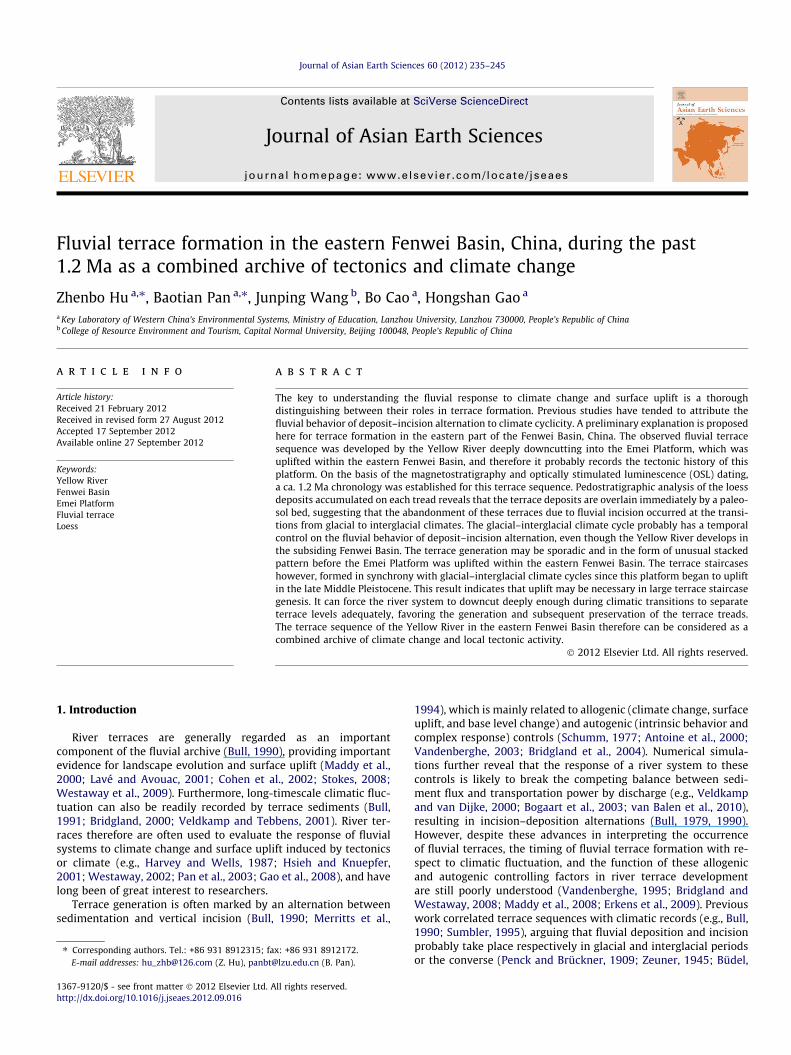
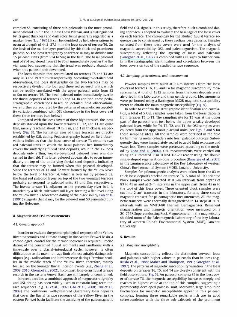
Fig. 1. Topographic map of the Fenwei Basin. (A) Major faults, rivers, and mountains aroflows eastward out of the basin along the southern front of the Zhongtiao Mountains. TFenwei Basin with the sampling site of the Nanzhao area and normal fault list. The Emetopography along a 5-kam-wide swath window (oriented perpendicular to swath transPlatform is displayed. (D) A lithostratigraphic section revised from Research Group AFSOline (A0–A) in Fig. 1B.
which can provide an excellent age constraint on underlying ter-race levels (Liu, 1985; Pan et al., 2010). In recent decades, thehistory of fluvial terraces by the Yellow River has served as a coretheme within geomorphology (e.g., Li et al., 1996; Cheng et al.,2002; Pan et al., 2005, 2007). Much attention has been paid tothe landscape evolution that is related to the dramatic uplift ofthe Tibetan Plateau during the Neogene and Quaternary (Li,1991; Li et al., 1997; Harkins et al., 2007; Perrineau et al., 2011).A geochronological framework for the fluvial terrace sequences ofthe Yellow River has also been reliably established using the multi-ple approaches of magnetostratigraphy, pedostratigraphy, electronspin resonance (ESR) dating, luminescence dating, and cosmogenicradionuclide dating (e.g., Cheng et al., 2002; Pan et al., 2009; Zhanget al., 2010; Perrineau et al., 2011). In contrast, the fluvial responseto climate and surface uplift in the middle reach of the YellowRiver is less well known.
The specific objective of this paper is to define the response ofthe fluvial landscape of the Yellow River to tectonic movement(uplift or subsidence) and climate change in the eastern FenweiBasin, China. A well-preserved fluvial terrace sequence was formedby the Yellow River in the Emei Platform that developed within theeast part of that Basin. It may have been shaped in a complete tec-tonic context of uplift and subsidence (Research Group AFSOM,1988). This fluvial sequence is covered by thick aeolian loess,enabling relative dating of the underlying terraces (Pan et al.,2003), thus providing new insight into the geomorphic responseof the Yellow River to tectonic and climatic changes.
In this study, a new geochronology for the terrace sequence ofthe Yellow River is constructed using a combined approach of mag-netostratigraphy and optically stimulated luminescence (OSL).
und the Fenwei Basin. The Yellow River cuts through the eastern Fenwei Basin andhe inset map displays the location within China. (B) The study area of the easterni Platform was uplifted within this study area. (C) Maximum, mean, and minimumect). On this swath plot, the extent of major topographic features across the EmeiM (1988) across the eastern Fenwei Basin. Its position is coincident with the dashed
Z. Hu et al. / Journal of Asian Earth Sciences 60 (2012) 235–245 237
Next, this geochronology is used to analyze the incision history ofthe Yellow River with respect to climate change, calculate thefluvial incision rate, and interpret the fluvial landscape responseof the Yellow River to tectonics and climate change.
2. Geological and geomorphic setting
The Fenwei Basin (known as the Fenwei Graben) is situated inthe eastern part of the Chinese Loess Plateau, bounded by theOrdos Plateau to the north and the W–E trending Qinling Orogento the south (Fig. 1A). It is expressed by a NE–SW trending,crescent-shaped subsided area constrained by numerous normaland strike-slip faults. The Fenwei Basin is ca. 400 km long and ca.15–60 km wide, covering an area of more than 20,000 km2
(Research Group AFSOM, 1988). It is invaded from west to eastby the Weihe River, Jinhe River, Luohe River, and Fenhe River allof which ultimately debouch into the Yellow River within thisbasin. The Yellow River first heads southward through the FenweiBasin, then turns eastward and finally leaves the basin along thesouthern front of the Zhongtiao Mountains (Fig. 1A).
This study mainly focuses upon the eastern part of the FenweiBasin (Fig. 1B), which is constrained by the Ordos Plateau to thenorthwest, the Taihang Mountains to the east, and the HuashangMountains to the south. This area is characterized by a large-scalelowland valley where the Emei Platform and Zhongtiao Mountainswere uplifted, forming a topography of alternating depressions androlling uplands. Its margin was transected by Hancheng Fault,Luoyunshan Fault, and the faults along the northern front of theHuashan Mountains. These faults are all in roughly NEE trendand normally downfaulted this area, leading to the subsiding base-ment of the eastern Fenwei Basin (Research Group AFSOM, 1988).This basement was then further intersected by several NEE trend-ing normal faults, i.e., North Marginal Fault of the Emei Platform,Shuangquan-Linyi Fault, and Zhongtiaoshan Fault, creating a seriesof faulted blocks (Fig. 1B). This topography of the study area is infact the spatial expression of these block-faulted structures (Wang,1987).
The Fenwei Basin is generally thought to have been formed andsubsided continuously during the Cenozoic as a response to the rel-ative uplift of the Qinling Mountains, and has simultaneously been
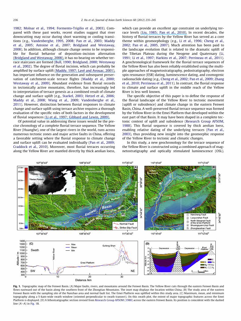
Fig. 2. Fluvial terrace sequence of the Yellow River at Nanzhao. (A) The stacked sequenceare presented by red words, indicating that the tread of terrace T4 is higher than the treadlower than the tread of terrace T5. (B) The terrace staircases T4, T3, T2, and T1 along th
filled by remarkably thick deposits (Research Group AFSOM, 1988).According to some authors, this epeirogenic uplift of the QinlingMountains would potentially be a response to climate change(Bridgland and Westaway, 2008; Westaway et al., 2009). TheCenozoic deposits in the eastern Fenwei Basin range in thicknessfrom ca. 5000 to 2000 m, pointing to the persistent subsidence ofthis area. Moreover, they exhibit a thinning trend towards thenorth (Fig. 1D), which probably results from the differential verti-cal motions within the basin (Sun, 2005). The fluviolacustrine andfluvial deposits overlain by aeolian loess accumulated in thesubsiding areas from the late Pliocene to the early Pleistocene(Research Group AFSOM, 1988). Their lithostratigraphy shows anundeformed, generally horizontal and parallel pattern, suggestingthat tectonics in the study area have, since the Pliocene, been dom-inated by vertical motions.
Tectonic movement in the study area has remained vigorous andactive during the Quaternary. Fault scarps and triangular facetswhich can be traced for hundreds of kilometers are readily observedalong the northern front of the Qinling and Huashan Mountains(Research Group AFSOM, 1988). A number of ground fissures result-ing from earthquakes are frequently exposed along normal faults(i.e., Hancheng Fault, Luoyunshan Fault, North Marginal Fault ofthe Emei Platform, Shuangquan-Linyi Fault, and ZhongtiaoshanFault) within this area (Wang, 1985, 1987). Furthermore, numerousmajor earthquakes registered in the historical record occurred inthe study area, indicating that fault movements never ceased(Wang, 1985).
The Yellow River cut through the eastern part of the FenweiBasin and thus provides a critical link between terrace formationand tectonic development within this basin. The intermittentdowncutting of the Yellow River in this region created a series ofstriking stepped landforms along the river valley. Based on fieldobservations, these terrace levels are distributed asymmetricallyalong the two sides of the Yellow River. In order to elucidate theincision history and terrace formation of the Yellow River withinthis basin, field investigations have focused upon the Emei Plat-form. Due to the transection by North Marginal Fault of the EmeiPlatform and Shuangquan-Linyi Fault, it has been uplifted withinthe eastern Fenwei Basin as a mesa covered by the thick Quater-nary loess (Fig. 1C). Deep downcutting by the Yellow River on thisplatform was interrupted by the formation of six fluvial terraces
of terraces T6, T5, and T4, looking north. Their heights above present-day river levels of terraces T6 and T5, while the tread of terrace T6 overlain by the thickest loess ise Yellow River, looking east.

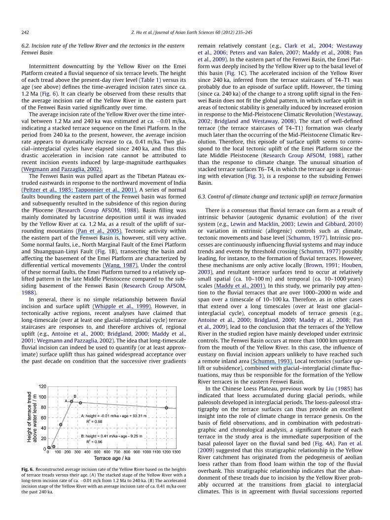
Fig. 3. Schematic cross section of the fluvial terraces and covering loess deposits in the Nanzhao region. The paleosol S14, S5, S3, S2, S1, and Sm are displayed in the loessdeposits for reference. The OSL ages obtained from the weakly-developed paleosol units (Sm) on terraces T3 and T2, and the black soil (S0) on terrace T1 are presented. SeeFig. 1B for the location of this terrace sequence.
Table 1Characteristics of the Yellow River terraces in the Nanzhao area.
Terrace sequence Height of terrace treadabove river level (m)
Thickness ofsand bed (m)
Thickness of loessdeposits on terrace (m)
Basal unit of loess stratigraphyon terrace tread
T6 78.8 >78.8 80–100 S14T5 88.4 >88.4 30–35 S3T4 91.2 >91.2 20–25 S2T3 46.6 >46.6 10–15 S1T2 4.5 >4.5 5–10 SmT1 2.5 >2.5 <2 S0
238 Z. Hu et al. / Journal of Asian Earth Sciences 60 (2012) 235–245
(Figs. 2 and 3). For each terrace, the characteristics of the fluvialdeposits and overlying aeolian loess, and the elevation of terracesurface above river level were determined, and the basal unit ofloess was investigated in detail in the field (Table 1). These resultsindicate that all the terraces (from T6 to T1) in this fluvial sequencewere formed by entrenchment of the Yellow River into valley fill,rather than further into underlying bedrock (Fig. 3). According toRitter et al. (2006), they are thus interpreted as aggradational ter-races characterized by unconsolidated sand deposits that are man-tled by Quaternary loess. In accordance with the timescale of loessand paleosol units in the Chinese Loess Plateau, the cover loess inthe study region was estimated by astronomical tuning (e.g., thebasal ages of S14, S3, S2, S1, and S0 are ca. 1.24 Ma, 336 ka,245 ka, 128 ka, and 11 ka old, respectively, according to Ding etal. (2002)). These cover deposits therefore can potentially providea geochronological framework for the studied fluvial terrace se-quence of the Yellow River, with reference to their pedostrati-graphic and magnetostratigraphic properties.
3. Fluvial terraces and overlying aeolian deposits
3.1. Fluvial terrace sequence and deposit
In order to establish a complete incision history for the YellowRiver in the eastern Fenwei Basin, field investigation focused upona natural outcrop near Nanzhao (Fig. 1B), where a well-preservedsequence of six aggradational terraces was present (Fig. 3). Thesefield measurements of terrace elevation and overlying loessthickness were performed using a differential GPS system with
an uncertainty of <5 cm. They show a pattern which is quite differ-ent from common terrace sequences in which older terraces occurat a higher elevation than young terraces. Terrace level T6 is over-lain by the thickest aeolian loess compared with other terraces andoccurs at lower elevation than terraces T5 and T4. Terrace T4 occu-pies the highest level in this sequence (Figs. 2A and 3). Moreover,according to field investigation, no faults were formed betweenterraces T6 and T4. The occurrence of this unconventional terracesequence of T6–T4, therefore, is consistent with the subsidingbasement of the study area. And the switch from the unusualstacked sequence (T6–T4) to the terrace staircase (T4–T1) may beattributed to the complex tectonic activity of the eastern FenweiBasin.
The terrace deposits of this fluvial sequence mainly consist ofsand and silt that occasionally contain some gravel lenses(Fig. 4B and C). Sand and silt beds are stratified and laterally con-tinuous for up to hundreds of meters, and are several centimetersthick. Some gravel lenses are typically interbedded with sand beds.Bedding is lenticular and laterally continuous over a few to tens ofcentimeters, while the individual beds are several centimetersthick. Most clasts are rounded or subangular, and grain size isabout 1–2 cm on average. Sedimentary structures are character-ized by trough cross-bedding or parallel bedding in sand beds, byparallel, horizontal lamination in silt beds, and by channel scourwithin gravel lenses. These beds are interpreted as fluvial depositsaccumulated in an aggrading channel. The presence of parallel bed-ding and trough cross-bedding indicated that they were depositedby a unidirectional flow. The lenticular geometry of gravel bedsand channel scours probably formed in a channelized flow. Theparallel lamination and fine grain size of the silt beds suggest that
Z. Hu et al. / Journal of Asian Earth Sciences 60 (2012) 235–245 239
the sediments settled out of suspension, pointing to a subsidinggeological background.
3.2. Aeolian deposits capping the fluvial terraces
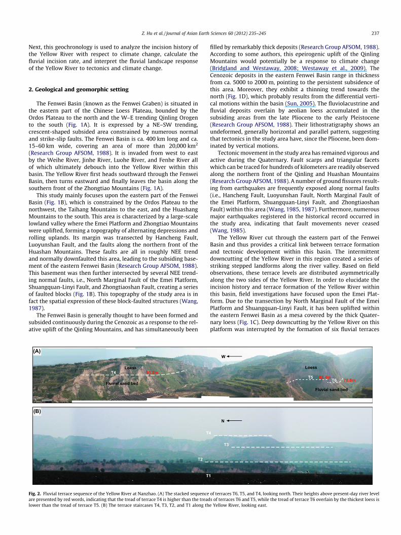
The Quaternary loess-paleosol sequences capping the treads offluvial terraces may provide age estimates for the underlyinglandforms and fluvial deposits. According to field investigation,
Fig. 4. Terrace filling and overlying loess deposits. (A) For each terrace in the study area,terrace were abandoned due to the Yellow River incision probably occurred during thedominated by the deposition of sand and silt. Sedimentary structures are characterizedlamination in silt beds. (C) The sand beds occasionally contain some gravel lenses. They
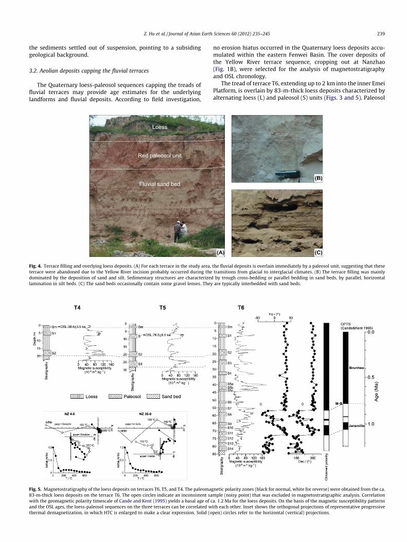
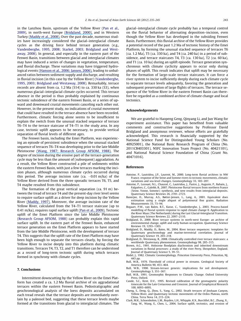
Fig. 5. Magnetostratigraphy of the loess deposits on terraces T6, T5, and T4. The paleomag83-m-thick loess deposits on the terrace T6. The open circles indicate an inconsistent sawith the geomagnetic polarity timescale of Cande and Kent (1995) yields a basal age of cand the OSL ages, the loess-paleosol sequences on the three terraces can be correlated wthermal demagnetization, in which HTC is enlarged to make a clear expression. Solid (o
no erosion hiatus occurred in the Quaternary loess deposits accu-mulated within the eastern Fenwei Basin. The cover deposits ofthe Yellow River terrace sequence, cropping out at Nanzhao(Fig. 1B), were selected for the analysis of magnetostratigraphyand OSL chronology.
The tread of terrace T6, extending up to 2 km into the inner EmeiPlatform, is overlain by 83-m-thick loess deposits characterized byalternating loess (L) and paleosol (S) units (Figs. 3 and 5). Paleosol
the fluvial deposits is overlain immediately by a paleosol unit, suggesting that thesetransitions from glacial to interglacial climates. (B) The terrace filling was mainlyby trough cross-bedding or parallel bedding in sand beds, by parallel, horizontalare typically interbedded with sand beds.
netic polarity zones (black for normal, white for reverse) were obtained from the ca.mple (noisy point) that was excluded in magnetostratigraphic analysis. Correlationa. 1.2 Ma for the loess deposits. On the basis of the magnetic susceptibility patternsith each other. Inset shows the orthogonal projections of representative progressivepen) circles refer to the horizontal (vertical) projections.
240 Z. Hu et al. / Journal of Asian Earth Sciences 60 (2012) 235–245
complex S5, consisting of three sub-paleosols, is the most promi-nent paleosol unit in the Chinese Loess Plateau, and is distinguishedby its great thickness and dark color, being generally regarded as amarker layer (Liu, 1985). It can be identified by field observations tooccur at a depth of 44.3–37.3 m in the loess cover of terrace T6. Onthe basis of the marker layer provided by this thick and prominentpaleosol S5, the loess stratigraphy on terrace T6 may be divided into15 paleosol units (from S14 to Sm) in the field. The basal paleosolunit of S14 registered from 83 to 80 m immediately overlies the flu-vial sand bed, suggesting that the tread was probably abandonedwhen this paleosol unit developed.
The loess deposits that accumulated on terraces T5 and T4 areonly 28.3 and 19.9 m thick respectively. According to detailed fieldobservations, the loess stratigraphy on the two terraces may berespectively divided into four and three red paleosol units, whichcan be readily correlated with the upper paleosol units from S3to Sm on terrace T6. The basal paleosol units immediately overliethe fluvial deposits of terraces T5 and T4. In addition, these pedo-stratigraphic correlations based on detailed field observations,were further corroborated by the patterns of magnetic susceptibil-ity variation combined with OSL chronology in the loess covers ofthese three terraces (see below).
Compared with the loess covers of these high terraces, the loessdeposits stacked upon the lower terraces T3, T2, and T1 are quitethin, merely reaching about 10 m, 5 m, and 1 m thickness, respec-tively (Fig. 3). The formation ages of these terraces are directlyestablished by OSL dating. Pedostratigraphy based on field obser-vations indicates that the loess cover of terrace T3 contains twored paleosol units in which the basal paleosol bed immediatelycovers the underlying fluvial sand deposits, while in the T2 loessdeposits only a thin, weakly-developed paleosol layer was dis-cerned in the field. This latter paleosol appears also to occur imme-diately on top of the underlying fluvial sand deposits, indicatingthat the terrace may be formed when this paleosol developed.Since the terraces of T3 and T2 were formed by the Yellow Riverbelow the level of terrace T4, which is overlain by paleosol S2,the basal red paleosol layers on top of the two youngest terracesprobably correspond to paleosol units S1 and Sm, respectively.The lowest terrace T1, adjacent to the present-day river bed, ismantled by a black, cultivated soil layer, forming a flat level alongthe Yellow River. Radiocarbon dating of the black soil by Pan et al.(1991) suggests that it may be the paleosol unit S0 generated dur-ing the Holocene.
4. Magnetic and OSL measurements
4.1. General approach
In order to evaluate the geomorphological response of the YellowRiver to tectonics and climate change in the eastern Fenwei Basin, achronological control for the terrace sequence is required. Precisedating of the concerned fluvial sediments and landforms with atime-scale over a glacial–interglacial cycle, however, is oftendifficult due to the maximum age limit of most suitable dating tech-niques (e.g., radiocarbon and luminescence dating). Previous stud-ies in the middle reach of the Yellow River, therefore, mainlyfocused on the younger fluvial incision events (e.g., Zhang et al.,2009, 2010; Cheng et al., 2002). In contrast, long-term fluvial terracerecords in the eastern Fenwei Basin are still largely unconstrained.
In recent decades, a combined approach of magnetostratigraphyand OSL dating has been widely used to constrain long-term ter-race sequences (e.g., Li et al., 1997; Gao et al., 2008; Pan et al.,2009). The continuous, well-preserved Quaternary loess depositsthat cover the fluvial terrace sequence of the Yellow River in theeastern Fenwei basin facilitate the archiving of the paleomagnetic
field and OSL signals. In this study, therefore, such a combined dat-ing approach is adopted to evaluate the basal age of the loess coveron each terrace. The chronology for the studied fluvial terrace se-quence can be constrained by these aeolian loess deposits. Samplescollected from these loess covers were used for the analysis ofmagnetic susceptibility, OSL, and paleomagnetism. The magneticsusceptibility reflecting the layering of loess and paleosols(Soreghan et al., 1997) is combined with OSL ages to further con-firm the stratigraphic identification and correlation between theloess covers on top of the studied terrace sequence.
4.2. Sampling, pretreatment, and measurement
Powder samples were taken at 0.1-m intervals from the loesscovers of terraces T6, T5, and T4 for magnetic susceptibility mea-surements. A total of 1312 samples from the loess deposits wereair-dried in the laboratory and then gently ground. Measurementswere performed using a Bartington MS2B magnetic susceptibilitymeter to obtain the mass magnetic susceptibility (Fig. 5).
In order to confirm the stratigraphic identification and correla-tion, a total of 5 OSL samples were taken from the loess depositsfrom terraces T5 to T1. The sampling site for T5 was at the upperpart of the paleosol unit just below the upper weakly-developedpaleosol layer, while for T4, T3, T2, and T1 the OSL samples werecollected from the uppermost plaeosol units (see Figs. 3 and 5 forthese sampling sites). All the samples were obtained in the fieldby hammering metal cylinders into fresh paleosol outcrops. Subse-quently they were immediately sealed to avoid light exposure andwater loss. These samples were pretreated according to the meth-od by Zhao and Li (2002). OSL measurements were carried outusing an automated Risø TL/OSL DA-20 reader using the doublesingle-aliquot regeneration-dose procedure (Banerjee et al., 2001)in the Luminescence Laboratory of the Key Laboratory of westernChina’s Environmental System (MOE), Lanzhou University.
Samples for paleomagnetic analysis were taken from the 83-mthick loess deposits stacked on terrace T6. A total of 100 orientedblock samples were collected at 0.5-m intervals from depths of83 to 45 m and at 2-m intervals in the upper part (from 45 m tothe top) of this loess cover. These oriented block samples werecut into 2 cm3 transects in the laboratory, forming three sets ofmagnetic transect for paleomagnetic measurements. All the mag-netic transects were thermally demagnetized in 14 steps at 50 �Cintervals with an MMTD-80 Thermal Demagnetizer. Remanentmagnetization and magnetic orientation were measured on a2G-755R Superconducting Rock Magnetometer in the magneticallyshielded room of the Paleomagnetic Laboratory of the Key Labora-tory of western China’s Environmental System (MOE), LanzhouUniversity.
5. Results
5.1. Magnetic susceptibility
Magnetic susceptibility reflects the distinction between loessand paleosols with higher values in paleosols than in loess (e.g.,Kukla et al., 1988; Maher and Thompson, 1991; Soreghan et al.,1997). The patterns of magnetic susceptibility variation in the loessdeposits on terraces T6, T5, and T4 are closely consistent with thefield observations (Fig. 5). For paleosol complex S5 in the loess cov-er of terrace T6, the magnetic susceptibility increases steeply andreaches its highest value at the top of this complex, suggesting aprominently developed paleosol unit. Moreover, large amplitudefluctuations for magnetic susceptibility appear in this paleosolcomplex, forming three remarkable peaks which are in goodcorrespondence with the three sub-paleosols of the prominent
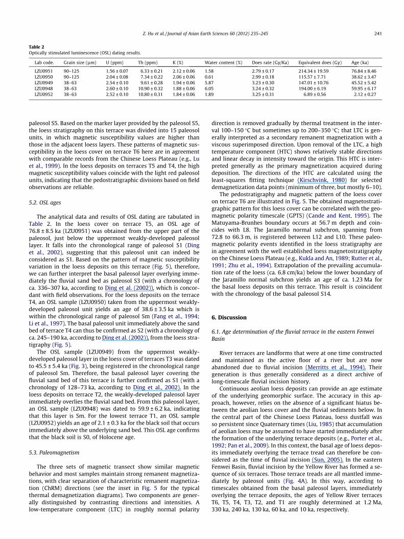
Table 2Optically stimulated luminescence (OSL) dating results.
Lab code. Grain size (lm) U (ppm) Th (ppm) K (%) Water content (%) Does rate (Gy/Ka) Equivalent does (Gy) Age (ka)
LZU0951 90–125 1.56 ± 0.07 6.33 ± 0.21 2.12 ± 0.06 1.58 2.79 ± 0.17 214.34 ± 19.59 76.84 ± 8.46LZU0950 90–125 2.04 ± 0.08 7.34 ± 0.22 2.06 ± 0.06 0.61 2.99 ± 0.18 115.57 ± 7.71 38.62 ± 3.47LZU0949 38–63 2.54 ± 0.10 9.61 ± 0.28 1.94 ± 0.06 5.87 3.23 ± 0.30 147.01 ± 10.76 45.52 ± 5.42LZU0948 38–63 2.60 ± 0.10 10.90 ± 0.32 1.88 ± 0.06 6.05 3.24 ± 0.32 194.00 ± 6.19 59.95 ± 6.17LZU0952 38–63 2.52 ± 0.10 10.80 ± 0.31 1.84 ± 0.06 1.89 3.25 ± 0.31 6.89 ± 0.56 2.12 ± 0.27
Z. Hu et al. / Journal of Asian Earth Sciences 60 (2012) 235–245 241
paleosol S5. Based on the marker layer provided by the paleosol S5,the loess stratigraphy on this terrace was divided into 15 paleosolunits, in which magnetic susceptibility values are higher thanthose in the adjacent loess layers. These patterns of magnetic sus-ceptibility in the loess cover on terrace T6 here are in agreementwith comparable records from the Chinese Loess Plateau (e.g., Luet al., 1999). In the loess deposits on terraces T5 and T4, the highmagnetic susceptibility values coincide with the light red paleosolunits, indicating that the pedostratigraphic divisions based on fieldobservations are reliable.
5.2. OSL ages
The analytical data and results of OSL dating are tabulated inTable 2. In the loess cover on terrace T5, an OSL age of76.8 ± 8.5 ka (LZU0951) was obtained from the upper part of thepaleosol, just below the uppermost weakly-developed paleosollayer. It falls into the chronological range of paleosol S1 (Dinget al., 2002), suggesting that this paleosol unit can indeed beconsidered as S1. Based on the pattern of magnetic susceptibilityvariation in the loess deposits on this terrace (Fig. 5), therefore,we can further interpret the basal paleosol layer overlying imme-diately the fluvial sand bed as paleosol S3 (with a chronology ofca. 336–307 ka, according to Ding et al. (2002)), which is concor-dant with field observations. For the loess deposits on the terraceT4, an OSL sample (LZU0950) taken from the uppermost weakly-developed paleosol unit yields an age of 38.6 ± 3.5 ka which iswithin the chronological range of paleosol Sm (Fang et al., 1994;Li et al., 1997). The basal paleosol unit immediately above the sandbed of terrace T4 can thus be confirmed as S2 (with a chronology ofca. 245–190 ka, according to Ding et al. (2002)), from the loess stra-tigraphy (Fig. 5).
The OSL sample (LZU0949) from the uppermost weakly-developed paleosol layer in the loess cover of terraces T3 was datedto 45.5 ± 5.4 ka (Fig. 3), being registered in the chronological rangeof paleosol Sm. Therefore, the basal paleosol layer covering thefluvial sand bed of this terrace is further confirmed as S1 (with achronology of 128–73 ka, according to Ding et al., 2002). In theloess deposits on terrace T2, the weakly-developed paleosol layerimmediately overlies the fluvial sand bed. From this paleosol layer,an OSL sample (LZU0948) was dated to 59.9 ± 6.2 ka, indicatingthat this layer is Sm. For the lowest terrace T1, an OSL sample(LZU0952) yields an age of 2.1 ± 0.3 ka for the black soil that occursimmediately above the underlying sand bed. This OSL age confirmsthat the black soil is S0, of Holocene age.
5.3. Paleomagnetism
The three sets of magnetic transect show similar magneticbehavior and most samples maintain strong remanent magnetiza-tions, with clear separation of characteristic remanent magnetiza-tion (ChRM) directions (see the inset in Fig. 5 for the typicalthermal demagnetization diagrams). Two components are gener-ally distinguished by contrasting directions and intensities. Alow-temperature component (LTC) in roughly normal polarity
direction is removed gradually by thermal treatment in the inter-val 100–150 �C but sometimes up to 200–350 �C; that LTC is gen-erally interpreted as a secondary remanent magnetization with aviscous superimposed direction. Upon removal of the LTC, a hightemperature component (HTC) shows relatively stable directionsand linear decay in intensity toward the origin. This HTC is inter-preted generally as the primary magnetization acquired duringdeposition. The directions of the HTC are calculated using theleast-squares fitting technique (Kirschvink, 1980) for selecteddemagnetization data points (minimum of three, but mostly 6–10).
The pedostratigraphy and magnetic pattern of the loess coveron terrace T6 are illustrated in Fig. 5. The obtained magnetostrati-graphic pattern for this loess cover can be correlated with the geo-magnetic polarity timescale (GPTS) (Cande and Kent, 1995). TheMatuyama-Brunhes boundary occurs at 56.7 m depth and coin-cides with L8. The Jaramillo normal subchron, spanning from72.8 to 66.3 m, is registered between L12 and L10. These paleo-magnetic polarity events identified in the loess stratigraphy arein agreement with the well established loess magnetostratigraphyon the Chinese Loess Plateau (e.g., Kukla and An, 1989; Rutter et al.,1991; Zhu et al., 1994). Extrapolation of the prevailing accumula-tion rate of the loess (ca. 6.8 cm/ka) below the lower boundary ofthe Jaramillo normal subchron yields an age of ca. 1.23 Ma forthe basal loess deposits on this terrace. This result is coincidentwith the chronology of the basal paleosol S14.
6. Discussion
6.1. Age determination of the fluvial terrace in the eastern FenweiBasin
River terraces are landforms that were at one time constructedand maintained as the active floor of a river but are nowabandoned due to fluvial incision (Merritts et al., 1994). Theirgeneration is thus generally considered as a direct archive oflong-timescale fluvial incision history.
Continuous aeolian loess deposits can provide an age estimateof the underlying geomorphic surface. The accuracy in this ap-proach, however, relies on the absence of a significant hiatus be-tween the aeolian loess cover and the fluvial sediments below. Inthe central part of the Chinese Loess Plateau, loess dustfall wasso persistent since Quaternary times (Liu, 1985) that accumulationof aeolian loess may be assumed to have started immediately afterthe formation of the underlying terrace deposits (e.g., Porter et al.,1992; Pan et al., 2009). In this context, the basal age of loess depos-its immediately overlying the terrace tread can therefore be con-sidered as the time of fluvial incision (Sun, 2005). In the easternFenwei Basin, fluvial incision by the Yellow River has formed a se-quence of six terraces. Those terrace treads are all mantled imme-diately by paleosol units (Fig. 4A). In this way, according totimescales obtained from the basal paleosol layers, immediatelyoverlying the terrace deposits, the ages of Yellow River terracesT6, T5, T4, T3, T2, and T1 are roughly determined at 1.2 Ma,330 ka, 240 ka, 130 ka, 60 ka, and 10 ka, respectively.
242 Z. Hu et al. / Journal of Asian Earth Sciences 60 (2012) 235–245
6.2. Incision rate of the Yellow River and the tectonics in the easternFenwei Basin
Intermittent downcutting by the Yellow River on the EmeiPlatform created a fluvial sequence of six terrace levels. The heightof each tread above the present-day river level (Table 1) versus itsage (see above) defines the time-averaged incision rates since ca.1.2 Ma (Fig. 6). It can clearly be observed from these results thatthe average incision rate of the Yellow River in the eastern partof the Fenwei Basin varied significantly over time.
The average incision rate of the Yellow River over the time inter-val between 1.2 Ma and 240 ka was estimated at ca. �0.01 m/ka,indicating a stacked terrace sequence on the Emei Platform. In theperiod from 240 ka to the present, however, the average incisionrate appears to dramatically increase to ca. 0.41 m/ka. Two gla-cial–interglacial cycles have elapsed since 240 ka, and thus thisdrastic acceleration in incision rate cannot be attributed torecent incision events induced by large-magnitude earthquakes(Wegmann and Pazzaglia, 2002).
The Fenwei Basin was pulled apart as the Tibetan Plateau ex-truded eastwards in response to the northward movement of India(Peltzer et al., 1985; Tapponnier et al., 2001). A series of normalfaults bounding the eastern part of the Fenwei basin was formedand subsequently resulted in the subsidence of this region duringthe Pliocene (Research Group AFSOM, 1988). Basin filling wasmainly dominated by lacustrine deposition until it was invadedby the Yellow River at ca. 1.2 Ma, as a result of the uplift of sur-rounding mountains (Pan et al., 2005). Tectonic activity withinthe eastern part of the Fenwei Basin is, however, still very active.Some normal faults, i.e., North Marginal Fault of the Emei Platformand Shuangquan-Linyi Fault (Fig. 1B), transecting the basin andaffecting the basement of the Emei Platform are characterized bydifferential vertical movements (Wang, 1987). Under the controlof these normal faults, the Emei Platform turned to a relatively up-lifted pattern in the late Middle Pleistocene compared to the sub-siding basement of the Fenwei Basin (Research Group AFSOM,1988).
In general, there is no simple relationship between fluvialincision and surface uplift (Whipple et al., 1999). However, intectonically active regions, recent analyses have claimed thatlong-timescale (over at least one glacial–interglacial cycle) terracestaircases are responses to, and therefore archives of, regionaluplift (e.g., Antoine et al., 2000; Bridgland, 2000; Maddy et al.,2001; Wegmann and Pazzaglia, 2002). The idea that long-timescalefluvial incision can indeed be used to quantify (or at least approx-imate) surface uplift thus has gained widespread acceptance overthe past decade on condition that the successive river gradients
Fig. 6. Reconstructed average incision rate of the Yellow River based on the heightsof terrace treads versus their age. (A) The stacked stage of the Yellow River with along-term incision rate of ca. �0.01 m/k from 1.2 Ma to 240 ka. (B) The acceleratedincision stage of the Yellow River with an average incision rate of ca. 0.41 m/ka overthe past 240 ka.
remain relatively constant (e.g., Clark et al., 2004; Westawayet al., 2006; Peters and van Balen, 2007; Maddy et al., 2008; Panet al., 2009). In the eastern part of the Fenwei Basin, the Emei Plat-form was deeply incised by the Yellow River up to the basal level ofthis basin (Fig. 1C). The accelerated incision of the Yellow Riversince 240 ka, inferred from the terrace staircases of T4–T1 wasprobably due to an episode of surface uplift. However, the timing(since ca. 240 ka) of the change to a strong uplift signal in the Fen-wei Basin does not fit the global pattern, in which surface uplift inareas of tectonic stability is generally induced by increased erosionin response to the Mid-Pleistocene Climatic Revolution (Westaway,2002; Bridgland and Westaway, 2008). The start of well-definedterrace (the terrace staircases of T4–T1) formation was clearlymuch later than the occurring of the Mid-Pleistocene Climatic Rev-olution. Therefore, this episode of surface uplift seems to corre-spond to the local tectonic uplift of the Emei Platform since thelate Middle Pleistocene (Research Group AFSOM, 1988), ratherthan the response to climate change. The unusual situation ofstacked terrace surfaces T6–T4, in which the terrace age is decreas-ing with elevation (Fig. 3), is a response to the subsiding FenweiBasin.
6.3. Control of climate change and tectonic uplift on terrace formation
There is a consensus that fluvial terrace can form as a result ofintrinsic behavior (autogenic dynamic evolution) of the riversystem (e.g., Lewin and Macklin, 2003; Lewin and Gibbard, 2010)or variation in extrinsic (allogenic) controls such as climate,tectonic movements and base level (Schumm, 1977). Intrinsic pro-cesses are continuously influencing fluvial systems and may inducetrends and events by threshold crossing (Schumm, 1977) possiblyleading, for instance, to the formation of fluvial terraces. However,these mechanisms are only active locally (Brown, 1991; Houben,2003), and resultant terrace surfaces tend to occur at relativelysmall spatial (ca. 10–100 m) and temporal (ca. 10–1000 years)scales (Maddy et al., 2001). In this study, we primarily pay atten-tion to the fluvial terraces that are over 1000–2000 m wide andspan over a timescale of 10–100 ka. Therefore, as in other casesthat extend over a long timescales (over at least one glacial–interglacial cycle), conceptual models of terrace genesis (e.g.,Antoine et al., 2000; Bridgland, 2000; Maddy et al., 2008; Panet al., 2009), lead to the conclusion that the terraces of the YellowRiver in the studied region have mainly developed under extrinsiccontrols. The Fenwei Basin occurs at more than 1000 km upstreamfrom the mouth of the Yellow River. In this case, the influence ofeustasy on fluvial incision appears unlikely to have reached sucha remote inland area (Schumm, 1993). Local tectonics (surface up-lift or subsidence), combined with glacial–interglacial climate fluc-tuations, may thus be responsible for the formation of the YellowRiver terraces in the eastern Fenwei Basin.
In the Chinese Loess Plateau, previous work by Liu (1985) hasindicated that loess accumulated during glacial periods, whilepaleosols developed in interglacial periods. The loess-paleosol stra-tigraphy on the terrace surfaces can thus provide an excellentinsight into the role of climate change in terrace genesis. On thebasis of field observations, and in combination with pedostrati-graphic and chronological analysis, a significant feature of eachterrace in the study area is the immediate superposition of thebasal paleosol layer on the fluvial sand bed (Fig. 4A). Pan et al.(2009) suggested that this stratigraphic relationship in the YellowRiver catchment has originated from the pedogenesis of aeolianloess rather than from flood loam within the top of the fluvialoverbank. This stratigraphic relationship indicates that the aban-donment of these treads due to incision by the Yellow River prob-ably occurred at the transitions from glacial to interglacialclimates. This is in agreement with fluvial successions reported
Z. Hu et al. / Journal of Asian Earth Sciences 60 (2012) 235–245 243
in the Lanzhou Basin, upstream of the Yellow River (Pan et al.,2009), in north-west Europe (Bridgland, 2000), and in WesternTurkey (Maddy et al., 2008). Over the past decade, numerous stud-ies have increasingly considered the glacial–interglacial climatecycles as the driving force behind terrace generation (e.g.,Vandenberghe, 1995, 2008; Starkel, 2003; Bridgland and West-away, 2008). In general, and especially in the eastern part of theFenwei Basin, transitions between glacial and interglacial climatesmay have induced a series of changes in vegetation, temperature,and fluvial discharge. These variations may have triggered hydro-logical events (Hanson et al., 2006; Jansen, 2006), leading to unbal-anced ratios between sediment supply and discharge, and resultingin fluvial incision (in this case by the Yellow River) (Vandenberghe,1995, 2003; Bridgland and Westaway, 2008). Remarkably, terracerecords are absent from ca. 1.2 Ma (S14) to ca. 330 ka (S3), whennumerous glacial–interglacial climate cycles occurred. This terraceabsence in the period is thus probably explained by continuoustectonic subsidence of the eastern Fenwei Basin, or a series of up-ward and downward crustal movements canceling each other out.However, in the present study, no indications of crustal movementthat could have resulted in the terrace absence have been recorded.Furthermore, climatic forcing alone seems to be insufficient toexplain the switch from the unusual stacked sequence of terraceT6–T4 to the terrace staircase of T4–T1 in the study area. In anycase, tectonic uplift appears to be necessary, to provide verticalseparation of fluvial levels of different ages.
The Fenwei basin, including the Emei Platform, was experienc-ing an episode of persistent subsidence when the unusual stackedsequence of terraces T6–T4 was developing prior to the late MiddlePleistocene (Wang, 1987; Research Group AFSOM, 1988). Thedegree of incision during the erosive part of the terrace-generationcycle may be less than the amount of (subsequent) aggradation. Asa result, the Yellow River constructed a pile of sediments withinthe eastern Fenwei Basin, with just a few terraces marking the inci-sion phases, although numerous climate cycles occurred duringthis period. The average incision rate (ca. �0.01 m/ka) of theYellow River derived from the three sporadic terraces T6, T5, andT4 maybe resulted from this subsidence.
The formation of the great vertical separation (ca. 91 m) be-tween the tread of terrace T4 and the present-day river level seemsto require surface uplift as a driver for deep incision by the YellowRiver (Maddy, 1997). Moreover, the average incision rate of theYellow River, calculated from the T4–T1 terrace staircase (up to0.41 m/ka), requires rapid surface uplift (Pan et al., 2009). Tectonicuplift of the Emei Platform since the late Middle Pleistocene(Research Group AFSOM, 1988) can probably explain this rapidsurface uplift. In the eastern part of the Fenwei Basin, enhancedterrace generation on the Emei Platform appears to have startedfrom the late Middle Pleistocene, with the development of terraceT4. This suggests that the uplift rate of the Emei Platform may havebeen high enough to separate the terraces clearly, by forcing theYellow River to incise deeply into this platform during climatictransitions. Terraces T4, T3, T2, and T1 therefore can be understoodas a record of long-term tectonic uplift during which terracesformed in synchrony with climate cycles.
7. Conclusions
Intermittent downcutting by the Yellow River on the Emei Plat-form has created a ca. 1.2 Ma fluvial archive of six aggradationalterraces within the eastern Fenwei Basin. Pedostratigraphic andgeochronological analysis of the loess deposits accumulated oneach tread reveals that the terrace deposits are immediately over-lain by a paleosol bed, suggesting that these terrace levels maybeformed at the transitions from glacial to interglacial climates. The
glacial–interglacial climate cycle probably has a temporal controlon the fluvial behavior of alternating deposition–incision, eventhough the Yellow River has developed in the subsiding FenweiBasin. Furthermore, this fluvial archive of the Yellow River providesa potential record of the past 1.2 Ma of tectonic history of the EmeiPlatform, by forming the unusual stacked sequence of terraces T6(ca. 1.2 Ma), T5 (ca. 330 ka), and T4 (ca. 240 ka) in a period of sub-sidence, and terrace staircases T4, T3 (ca. 130 ka), T2 (ca. 60 ka),and T1 (ca. 10 ka) during an uplift episode. Terrace generation syn-chronous with climate cyclicity appears to occur only duringphases of uplift. This result indicates that uplift may be necessaryfor the formation of large-scale terrace staircases. It can force ariver system to incise sufficiently deeply during each climate cycleto separate terrace levels adequately, favoring the generation andsubsequent preservation of large flights of terraces. The terrace se-quence of the Yellow River in the eastern Fenwei Basin can there-fore be regarded as a combined archive of climate change and localtectonics.
Acknowledgements
We are grateful to Haopeng Geng, Qinyang Li, and Jun Wang forexperiment assistance. This paper has benefited from valuablecomments and constructive suggestions by Professor DavidBridgland and anonymous reviewer, whose efforts are gratefullyacknowledged. This research is financially supported by theNational Science Fund for Distinguished Young Scholars (No.40925001), the National Basic Research Program of China (No.2011CB403301), NSFC Innovation Team Project (No. 40421101),and National Natural Science Foundation of China (Grant No.40471016).
References
Antoine, P., Lautridou, J.P., Laurent, M., 2000. Long-term fluvial archives in NWFrance. response of the Seine and Somme rivers to tectonic movements, climaticvariations and sea-level changes. Geomorphology 33, 183–207.
Antoine, P., Lozouet, N.L., Chaussé, C., Lautridou, J., Pastre, J., Auguste, P., Bahain, J.,Falguéres, C., Galehb, B., 2007. Pleistocene fluvial terraces from northern France(Seine, Yonne, Somme): synthesis, and new results from interglacial deposits.Quaternary Science Reviews 26, 2701–2723.
Banerjee, D., Murray, A.S., Bøtter-Jensen, L., Lang, A., 2001. Equivalent doesestimation using a single aliquot of polymineral fine grains. RadiationMeasurements 33, 73–94.
Bogaart, P.W., van Balen, R.T., Kasse, C., Vandenberghe, J., 2003. Process-basedmodelling of fluvial system response to rapid climate change II. Application tothe River Maas (The Netherlands) during the Last Glacial-Interglacial Transition.Quaternary Science Reviews 22, 2097–2110.
Bridgland, D., 2000. River terrace systems in north-west Europe: an archive ofenvironmental change, uplift and early human occupation. Quaternary ScienceReviews 19, 1293–1303.
Bridgland, D., Maddy, D., Bates, M., 2004. River terrace sequences: templates forQuaternary geochronology and marine-terrestrial correlation. Journal ofQuaternary Science 19, 203–218.
Bridgland, D., Westaway, R., 2008. Climatically controlled river terrace staircases: aworldwide Quaternary phenomenon. Geomorphology 98, 285–315.
Brown, A.G., 1991. Holocene floodplain diachronism and inherited downstreamvariations in fluvial processes: a study of the river Perry, Shropshire, England.Journal of Quaternary Science 5, 39–51.
Büdel, J., 1982. Climatic Geomorphology. Princeton University Press, Princeton, NJ,443 pp.
Bull, W.B., 1979. Threshold of critical power in streams. Geological Society ofAmerica Bulletin 90, 453–464.
Bull, W.B., 1990. Stream-terrace genesis: implications for soil development.Geomorphology 3, 351–367.
Bull, W.B., 1991. Geomorphic Responses to Climatic Change. Oxford UniversityPress, Oxford.
Cande, S.C., Kent, D.V., 1995. Revised calibration of the geomagnetic polaritytimescale for the Late Cretaceous and Cenozoic. Journal of Geophysical Research100, 6093–6095.
Cheng, S., Deng, Q., Zhou, S., Yang, G., 2002. Strath terraces of Jinshaan Canyon,Yellow River, and Quaternary tectonic movements of the Ordos Plateau, northChina. Terra Nova 14, 215–224.
Clark, M.K., Schoenbohm, L.M., Royden, L.H., Whipple, K.X., Burchfiel, B.C., Zhang, X.,Tang, W., Wang, E., Chen, L., 2004. Surface uplift, tectonics, and erosion of
244 Z. Hu et al. / Journal of Asian Earth Sciences 60 (2012) 235–245
eastern Tibet from large-scale drainage patterns. Tectonics 23, TC1006. http://dx.doi.org/10.1029/2002TC001402.
Cohen, K.M., Stouthamer, E., Berendsen, H.J.A., 2002. Fluvial deposits as a record forLate Quaternary neotectonic activity in the Rhine-Meuse delta, TheNetherlands. Netherlands Journal of Geosciences 81, 389–405.
Craddock, H.W., Kirby, E., Harkins, W.N., Zhang, H., Shi, X., Liu, J., 2010. Rapid fluvialincision along the Yellow River during headward basin integration. NatureGeoscience 3, 209–213.
Ding, Z., Derbyshire, E., Yang, S., Yu, Z., Xiong, S., Liu, T., 2002. Stacked 2.6-Ma grainsize record from the Chinese loess based on five sections and correlation withthe deep-sea d18O record. Paleoceanography 17, 1033–1053.
Erkens, G., Dambeck, R., Volleberg, K.P., Bouman, M.T.I.J., Bos, J.A.A., Cohen, K.M.,Wallinga, J., Hoek, W.Z., 2009. Fluvial terrace formation in the northern UpperRhine Graben during the last 20 000 years as a result of allogenic controls andautogenic evolution. Geomorphology 103, 476–495.
Fang, X., Li, J., Derbyshire, E., FitzPatrick, E.A., Kemp, R., 1994. Micromorphology ofthe Beiyuan Loess-Paleosol sequence in Gansu Province, China:geomorphological and paleoenvironmental significance. Palaeogeography,Palaeoclimatology, Palaeoecology 111, 289–303.
Formento-Trigilio, M.L., Burbank, D.W., Nicol, A., Shulmeister, J., Rieser, U., 2003.River response to an antive flold-and-thrust belt in a convergent margin setting,North Island, New Zealand. Geomorphology 49, 125–152.
Gao, H., Liu, X., Pan, B., Wang, Y., Yu, Y., Li, J., 2008. Stream response to Quaternarytectonic and climatic change: evidence from the upper Weihe River, centralChina. Quaternary International 186, 123–131.
Gibbard, P.L., Lewin, J., 2009. River incision and terrace formation in the LateCenozoic of Europe. Tectonophysics 474, 41–55.
Hanson, P.R., Mason, J.A., Goble, R.J., 2006. Fluvial terrace formation alongWyoming’s Laramie Range as a response to increased late Pleistocene floodMagnitudes. Geomorphology 76, 12–25.
Harkins, N., Kirby, E., Heimsath, A., Robinson, R., Reiser, U., 2007. Transient fluvialincision in the headwaters of the Yellow River, northeastern Tibet, China.Journal of Geophysical Research 112, F03S04. http://dx.doi.org/10.1029/2006JF000570.
Harvey, A.M., Wells, S.G., 1987. Response of Quaternary fluvial systems todifferential epeirogenic uplift: Aguas and Feos river systems, southeast spain.Geology 15, 689–693.
Hetzel, R., Niedermann, S., Tao, M., Kubik, P.W., Strecker, M.R., 2006. Climatic versustectonic control on river incision at the margin of NE Tibet: 10Be exposuredating of river terraces at the mountain front of the Qilian Shan. Journal ofGeophysical Research 111, F03012. http://dx.doi.org/10.1029/2005JF000352.
Houben, P., 2003. Spatio-temporally variable response of fluvial systems to LatePleistocene climate change: a case study from central Germany. QuaternaryScience Reviews 22, 2125–2140.
Hsieh, M., Knuepfer, P.L.K., 2001. Middle-late Holocene river terraces in the ErhjenRiver Basin, southwestern Taiwan — implications of river response to climatechange and active tectonic uplift. Geomorphology 38, 337–372.
Jansen, J.D., 2006. Flood magnitude–frequency and lithologic control on bedrockriver incision in post-orogenic terrain. Geomorphology 82, 39–57.
Kirschvink, J.L., 1980. The least-squares line and plane and the analysis ofpalaeomagnetic data. Geophysical Journal International 62, 699–718.
Kukla, G., Heller, F., Liu, M., Xu, C., Liu, S., An, S., 1988. Pleistocene climates in Chinadated by magnetic susceptibility. Geology 16, 811–814.
Kukla, G., An, Z., 1989. Loess stratigraphy in central China. Palaeogeography,Palaeoclimatology, Palaeoecology 72, 203–225.
Lavé, J., Avouac, J.P., 2001. Fluvial incision and tectonic uplift across the Himalayasof central Nepal. Journal of Geophysical Research 106, 26561–26591.
Lewin, J., Macklin, M.G., 2003. Preservation potential for Late Quaternary riveralluvium. Journal Quaternary Science 18, 107–120.
Lewin, J., Gibbard, L.P., 2010. Quaternary river terraces in England: forms, sedimentsand processes. Geomorphology 120, 293–311.
Li, J., 1991. The environmental offects of the uplift of the Qinghai-Xizang Plateau.Quaternary Science Reviews 10, 479–483.
Li, J., Fang, X., Ma, H., Zhu, J., Pan, B., Chen, H., 1996. Geomorphological andenvironmental evolution in the upper reaches of the Yellow River during thelate Cenozoic. Science in China 39, 380–390.
Li, J., Fang, X., der Voo, R.V., Zhu, J., Niocaill, C.M., Ono, Y., Pan, B., Zhong, W., Wang, J.,Sasaki, T., Zhang, Y., Cao, J., Kang, S., Wang, J., 1997. Magnetostratigraphic datingof river terraces: Rapid and intermittent incision by the Yellow River of thenortheastern margin of the Tibetan Plateau during the Quaternary. Journal ofGeophysical Research 102, 10121–10132.
Liu, T., 1985. Loess and the Environment. China Ocean Press, Beijing, pp. 31–147.Lu, H., Liu, X., Zhang, F., An, Z., Dodson, J., 1999. Astronomical calibration of loess-
paleosol deposits at Luochuan, central Chinese Loess Plateau. Palaeogeography,Palaeoclimatology, Palaeoecology 154, 237–246.
Maddy, D., 1997. Uplift-driven valley incision and river terrace formation insouthern England. Journal of Quaternary Science 12, 539–545.
Maddy, D., Bridgland, D.R., Green, C.P., 2000. Crustal uplift in southern England:evidence from the river terrace records. Geomorphology 33, 167–181.
Maddy, D., Bridgland, D., Westaway, R., 2001. Uplift-driven valley incision andclimate-controlled river terrace development in the Thames Valley, UK.Quaternary International 79, 23–36.
Maddy, D., Demir, T., Bridgland, D.R., Veldkamp, A., Stemerdink, C., van der Schriek,T., Westaway, R., 2005. An obliquity-controlled Early Pleistocene river terracerecord from Western Turkey. Quaternary Research 63, 339–346.
Maddy, D., Demir, T., Bridgland, D.R., Veldkamp, A., Stemerdink, C., van der Schriek,T., Westaway, R., 2008. The Early Pleistocene development of the Gediz River,Western Turkey: an uplift-driven, climate-controlled system? QuaternaryInternational 189, 115–128.
Maher, B.A., Thompson, R., 1991. Mineral magnetic record of the Chinese loess andpaleosols. Geology 19, 3–6.
Merritts, D.J., Vincent, K.R., Wohl, E.E., 1994. Long river profiles, tectonism, andeustasy: A guide to interpreting fluvial terraces. Journal of Geophysical Research99, 14031–14050.
Molnar, P., Brown, E.T., Burchfiel, B.C., Deng, Q., Feng, X., Li, J., Raisbeck, G.M., Shi, J.,Wu, Z., Yiou, F., You, H., 1994. Quaternary climate change and the formation ofriver terraces across growing anticlines on the north flank of the Tien Shan,China. The Journal of Geology 102, 583–602.
Pan, B., Li, J., Zhu, J., Chen, F., Cao, J., Zhang, Y., Cheng, H., 1991. Terrace developmentof the Yellow River and geomorphic evolution in Lanzhou area. In: QuaternaryGlacier and Environment Research in Western China. Science Press, Beijing, pp.271–277 (in Chinese with English abstract).
Pan, B., Burbank, D., Wang, Y., Wu, G., Li, J., Guan, Q., 2003. A 900 k.y. record of strathterrace formation during glacial-interglacial transitions in northwest China.Geology 31, 957–960.
Pan, B., Wang, J., Gao, H., Guan, Q., Wang, Y., Su, H., Li, B., Li, J., 2005. Paleomagneticdating of the topmost terrace in Kouma, Henan and its indication to theYellow River’s running through Sanmen Gorge. Chinese Science Bulletin 50,657–664.
Pan, B., Su, H., Hu, C., Hu, X., Zhou, T., Li, J., 2007. Discovery of a 1.0 Ma Yellow Riverterrace and redating of the fourth Yellow River terrace in Lanzhou area. Progressin Nature Science 17, 197–205.
Pan, B., Su, H., Hu, Z., Hu, X., Gao, H., Li, J., Kirby, E., 2009. Evaluating the role ofclimate and tectonics during non-steady incision of the Yellow River: evidencefrom a 1.24 Ma terrace record near Lanzhou, China. Quaternary Science Reviews28, 3281–3290.
Pan, B., Hu, Z., Wang, J., Vandenberghe, J., Hu, X., Wen, Y., Li, Q., Cao, B., 2010. Theapproximate age of the planation surface and the incision of the Yellow River.Palaeogeography, Palaeoclimatology, Palaeoecology doi. http://dx.doi.org/10.1016/j.palaeo.2010.04. 011.
Peltzer, G., Tapponnier, P., Zhang, Z., Xu, Z., 1985. Neogene and Quaternary faultingin and along the Qinling Shan. Nature 317, 500–505.
Penck, A., Brückner, E., 1909. Die Alpen im Eiszeitalter. Tauchnitz Leipzig, 3 vols,1199pp.
Perrineau, A., van der Woerd, J., Gaudemer, Y., Jing, Z., Pik, R., Papponnier, P.,Thuizat, R., Zheng, R., 2011. Incision rate of the Yellow River in NortheasternTibet constrained by 10Be and 26Al cosmogenic isotope dating of fluvial terraces:implications for catchment evolution and plateau building. The GeologicalSociety of London 353, 189–219.
Peters, G., van Balen, R.T., 2007. Pleistocene tectonics inferred from fluvialterraces of the northern Upper Rhine Graben, Germany. Tectonophysics 430,41–65.
Porter, S.C., An, Z., Zheng, H., 1992. Cyclic Quaternary alleviation and terracing in anonglaciated drainage basin on the north flank of the Qinling Shan, centralChina. Quaternary Research 38, 157–169.
Research Group on Active Fault System around Ordos Massif (Research GroupAFSOM), 1988. Active Fault System around Ordos Massif. Seismological Press,Beijing, pp. 77–142 (in Chinese).
Ritter, F.D., Kochel, C.R., Miller, R.J., 2006. Process Geomorphology. Waveland Press,Inc.,, pp. 243–244.
Rutter, N.W., Ding, Z., Evans, M.E., Liu, T., 1991. Baoji-type pedostratigraphic section,Loess Plateau, north-central China. Quaternary Science Reviews 10, 1–22.
Schumm, S.A., 1977. The Fluvial System. John Wiley, New York.Schumm, S.A., 1993. River response to baselevel change: implications for sequence
stratigraphy. Journal of Geology 101, 279–294.Soreghan, G.S., Elmore, R.D., Katz, B., Cogoini, M., Banerjee, S., 1997. Pedogenically
enhanced magnetic susceptibility variations preserved in Paleozoic loessite.Geology 25, 1003–1006.
Starkel, L., 2003. Climatically controlled terraces in uplifting mountain areas.Quaternary Science Reviews 22, 2189–2198.
Stokes, M., 2008. Plio-Pleistocene drainage development in an inverted sedimentarybasin: Vera basin, Betic Cordillera, SE Spain. Geomorphology 100, 193–211.
Sumbler, M.G., 1995. The terraces of the rivers Thame and Thames and their bearingon the chronology of glaciation in central and eastern England. Proceedings ofthe Geologists’ Association 106, 93–106.
Sun, J., 2005. Long-term fluvial archives in the Fen Wei Graben, central China, andtheir bearing on the tectonic history of the India-Asia collision system.Quaternary Science Reviews 24, 1279–1286.
Tapponnier, P., Xu, Z., Roger, F., Meyer, B., Arnaud, N., Wittlinger, G., Yang, J., 2001.Oblique stepwise rese and growth of the Tibetan Plateau. Science 294, 1671–1677.
Van Balen, R.T., Busschers, F.S., Tucker, G.E., 2010. Modeling the response of theRhine-Meuse fluvial system to Late Pleistocene climate change. Geomorphology114, 440–452.
Vandenberghe, J., 1995. Timescales, climate and river development. QuaternaryScience Reviews 14, 631–638.
Vandenberghe, J., 2003. Climate forcing of fluvial system development: an evolutionof ideas. Quaternary Science Reviews 22, 2053–2060.
Vandenberghe, J., 2008. The fluvial cycle at cold-warm-cold transitions in lowlandregion: a refinement of theory. Geomorphology 98, 275–284.
Z. Hu et al. / Journal of Asian Earth Sciences 60 (2012) 235–245 245
Vandenberghe, J., Wang, X., Lu, H., 2011. Differential impact of small-scaled tectonicmovements on fluvial morphology and sedimentology (the Huang Shuicatchment, NE Tibet Plateau). Geomorphology 134, 171–185.
Veldkamp, A., van Dijke, J.J., 2000. Simulating internal and external controls onfluvial terrace stratigraphy: a qualitative comparison with the Maas record.Geomorphology 33, 225–236.
Veldkamp, A., Tebbens, A.L., 2001. Registration of abrupt climate changes withinfluvial systems: insights from numerical modelling experiments. Global andPlanetary Change 28, 129–144.
Wang, A., Smith, J.A., Wang, G., Zhang, K., Xiang, S., Liu, D., 2009. Late Quaternaryriver terrace sequences in the eastern Kunlun Range, northern Tibet: Acombined record of climatic change and surface uplift. Journal of Asian EarthSciences 34, 532–543.
Wang, J., 1985. Periodicity of ground fissures and earthquakes in the earthquakebelt of the Weihe River. Acta Seismological Sinica 7, 190–201 (in Chinese withEnglish abstract).
Wang, J., 1987. The Fenwei rift and its recent periodic activity. Tectonophysics 133,257–275.
Wegmann, K.W., Pazzaglia, F.J., 2002. Holocene strath terraces, climate change, andactive tectonics: The Clearwater River basin, Olympic Peninsula, WashingtonState. Geological Society of America Bulletin 114, 731–744.
Westaway, R., 2002. Long-term river terrace sequences: evidence for globalincreases in surface uplift rates in the Late Pliocene and early MiddlePleistocene caused by flow in the lower continental crust induced by surfaceprocesses. Netherlands Journal of Geosciences 81, 305–328.
Westaway, R., Maddy, D., Bridgland, D., 2002. Flow in the lower continental crust asa mechanism for the Quaternary uplift of south-east England: constraints fromthe Thames terrace record. Quaternary Sciences Reviews 21, 559–603.
Westaway, R., Bridgland, D., White, M., 2006. The Quaternary uplift history ofcentral southern England: evidence from the terraces of the Solent River systemand nearby raised beaches. Quaternary Science Reviews 25, 2212–2250.
Westaway, R., Bridgland, D.R., Sinha, R., Demir, T., 2009. Fluvial sequences asevidence for landscape and climatic evolution in the Late Cenozoic: a synthesisof data from IGCP 518. Global and Planetary Change 68, 237–253.
Whipple, K.X., Kirby, E., Brocklehurst, S.H., 1999. Geomorphic limits to climate-induced increases in topographic relief. Nature 401, 39–43.
Zeuner, F.E., 1945. The Pleistocene Period: its Climate, Chronology and FaunalSuccessions. Ray Society, Publication No.130, London, 322pp.
Zhang, J., Qiu, W., Li, R., Zhou, L., 2009. The evolution of a terrace sequence along theYellow River (Huanghe) in Hequ, Shanxi, China, as inferred from optical dating.Geomorphology 109, 54–65.
Zhang, J., Qiu, W., Wang, X., Hu, G., Li, R., Zhou, L., 2010. Optical dating of ahyperconcentrated flow deposit on a Yellow River terrace in Hukou, Shaanxi,China. Quaternary Geochronology 5, 194–199.
Zhao, H., Li, S.H., 2002. Luminescence isochron dating: a new approach usingdifferent grain sizes. Radiation Protection Dosimetry 101, 333–338.
Zhu, R., Laj, C., Mazaud, A., 1994. The Matuyama-Brunhes and the upper Jaramillotransitions recorded in a loess section at Weinan, north-central China. Earth andPlanetary Science Letters 125, 143–158.
Top Related
Copyright © 2022 FDOKUMEN

