


Bahasa
Halaman
Hukum

165
Cornish Archaeology 51, 2012, 165–189
Early Neolithic activity and an Iron Age settlement at Penmayne, Rock, St Minver
JAMES GOSSIP, ANDY M JONES and HENRIETTA QUINNELL
with contributions from dana challinor, julie jones, and roger taylor
A geophysical survey in advance of development at Penmayne, Rock, identified a series of curvilinear anomalies thought to represent late prehistoric settlement. Targeted evaluation trenching revealed three ring-gullies associated with roundhouses of probable Middle Iron Age date. Three smaller structures, superimposed upon the ring-gullies indicated a later phase of Iron Age settlement.
The work also discovered an Early Neolithic pit, associated with sherds of carinated bowl pottery and providing two radiocarbon dates in the mid-fourth millennium cal BC. The investigation has added further information about the character of Early Neolithic occupation in north Cornwall and is particularly important for providing close dating for carinated bowl pottery in the south west.
A third determination of 380–190 cal BC came from a hearth associated with a small assemblage of broadly Middle Iron Age pottery. The archaeological recording has provided another late prehistoric unenclosed settlement site for comparison with others in lowland Cornwall and increases the number of open settlements dating to the Iron Age.
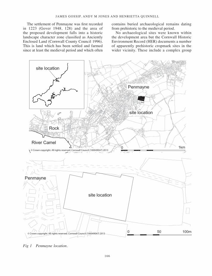
Location and backgroundThe site (centred on SW 94780 76182) is located at a height of 50m OD on a west-facing slope on former agricultural land between the historic settlements of Penmayne and Higher Penmayne, now absorbed into the village of Rock in the parish of St Minver (Fig 1). Recent housing development borders the site to the west and farmland to the north, south and east.
Bedrock geology comprises slaty mudstones of the Harbour Cove Slate Formation (British Geological Survey Sheet EW 335–336, 2004). Soil cover consists of shallow well-drained loams of the Powys Series over weathered shale (locally known as ‘shillet’) (National Soil Resources Institute, Soil Systems Group, 2004). Bare weathered rock was exposed in places after the topsoil was removed.
Historic Environment Projects, Cornwall Council, was commissioned by Cornwall Rural Housing Association Ltd to undertake a programme of evaluation trenching at Penmayne, Rock, in advance of a proposed housing development.
Geophysical survey of the development area by GSB Prospection in October 2009 revealed several circular anomalies, suggesting a possible settlement of late prehistoric date (GSB 2009). In December 2009 the Historic Environment Projects team undertook a programme of archaeological evaluation which confirmed that the geophysical survey anomalies represented at least three prehistoric roundhouses and other cut features. As a result, an additional programme of mitigation trenching was agreed to further characterise the nature of these archaeological deposits and recover material suitable for radiocarbon dating.
165-190_Gossip.indd 165 17/12/2013 10:16
JAMES GOSSIP, ANDY M JONES AND HENRIETTA QUINNELL
166
The settlement of Penmayne was first recorded in 1223 (Gover 1948, 128) and the area of the proposed development falls into a historic landscape character zone classified as Anciently Enclosed Land (Cornwall County Council 1996). This is land which has been settled and farmed since at least the medieval period and which often
contains buried archaeological remains dating from prehistoric to the medieval period.
No archaeological sites were known within the development area but the Cornwall Historic Environment Record (HER) documents a number of apparently prehistoric cropmark sites in the wider vicinity. These include a complex group
© Crown copyright. All rights reserved. Cornwall Council (100049047) 2013
© Crown copyright. All rights reserved. Cornwall Council (100049047) 2013
Fig 1 Penmayne location.
165-190_Gossip.indd 166 17/12/2013 10:16
Neolithic activity aNd aN iroN age settlemeNt at PeNmayNe, rock, st miNver
167
of features about 1km to the south of Penmayne, including enclosures and field systems probably of Iron Age or Romano-British date (MCOs 3356–3357, 8392, 21313, 21767–21768), together with a group of circular features which may represent Bronze Age barrows or, perhaps more probably, an unenclosed later prehistoric roundhouse settlement (MCOs 3352–3358, 29956). The presence of an enclosed settlement of late prehistoric date has recently been verified at Porthilly, approximately 1.5km to the south west (MCO 8391) (Gossip 2012: this volume). A possible late prehistoric enclosure is suggested by the fieldname ‘Round Meadow’ at Splatt, 300m to the north west of the Penmayne site (MCO 8490). The broader hinterland of the Camel estuary in which Penmayne lies is known for the high density of cropmarks representing late prehistoric settlement (Young 2012: this volume).
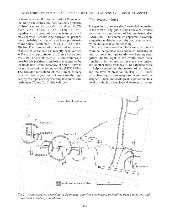
The excavationsThe geophysical survey (Fig 2) revealed anomalies in the form of ring-gullies and associated features consistent with settlement of late prehistoric date (GSB 2009). The anomalies appeared to overlap, suggesting multi-phase activity, and were targeted by the initial evaluation trenching.
Initially three trenches (1–3) were set out to examine the geophysical anomalies, focusing on both discrete and apparently overlapping ring-gullies. In the light of the results from these trenches a further mitigation stage was agreed and another three trenches (4–6) extended these to help characterise the nature of settlement and the level of preservation (Fig 2). All areas of archaeological investigation were machine stripped under archaeological supervision to a level at which archaeological features or layers
Fig 2 Archaeological recording at Penmayne, showing geophysical anomalies, trench locations and conjectural extents of roundhouses.
165-190_Gossip.indd 167 17/12/2013 10:16
JAMES GOSSIP, ANDY M JONES AND HENRIETTA QUINNELL
168
were revealed at the top of the ‘natural’ subsoil. Identified archaeological deposits were cleaned by hand and sample excavated.
The Early Neolithic pits
Trench 4
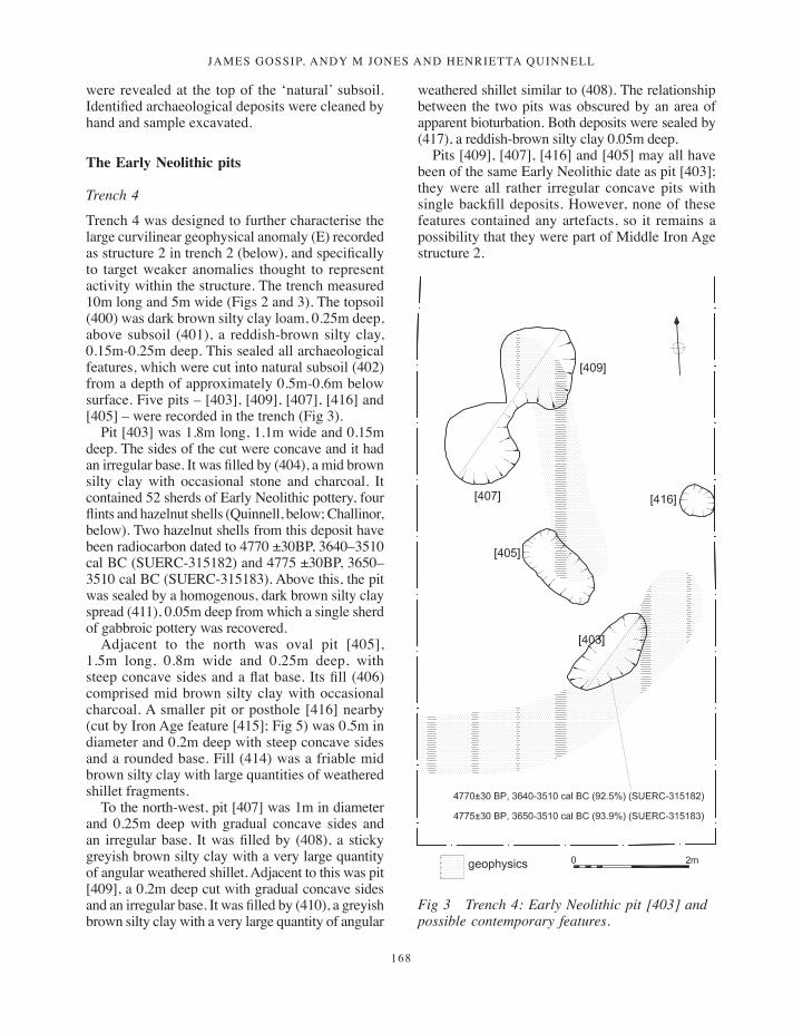
Trench 4 was designed to further characterise the large curvilinear geophysical anomaly (E) recorded as structure 2 in trench 2 (below), and specifically to target weaker anomalies thought to represent activity within the structure. The trench measured 10m long and 5m wide (Figs 2 and 3). The topsoil (400) was dark brown silty clay loam, 0.25m deep, above subsoil (401), a reddish-brown silty clay, 0.15m-0.25m deep. This sealed all archaeological features, which were cut into natural subsoil (402) from a depth of approximately 0.5m-0.6m below surface. Five pits – [403], [409], [407], [416] and [405] – were recorded in the trench (Fig 3).
Pit [403] was 1.8m long, 1.1m wide and 0.15m deep. The sides of the cut were concave and it had an irregular base. It was filled by (404), a mid brown silty clay with occasional stone and charcoal. It contained 52 sherds of Early Neolithic pottery, four flints and hazelnut shells (Quinnell, below; Challinor, below). Two hazelnut shells from this deposit have been radiocarbon dated to 4770 ±30BP, 3640–3510 cal BC (SUERC-315182) and 4775 ±30BP, 3650–3510 cal BC (SUERC-315183). Above this, the pit was sealed by a homogenous, dark brown silty clay spread (411), 0.05m deep from which a single sherd of gabbroic pottery was recovered.
Adjacent to the north was oval pit [405], 1.5m long, 0.8m wide and 0.25m deep, with steep concave sides and a flat base. Its fill (406) comprised mid brown silty clay with occasional charcoal. A smaller pit or posthole [416] nearby (cut by Iron Age feature [415]; Fig 5) was 0.5m in diameter and 0.2m deep with steep concave sides and a rounded base. Fill (414) was a friable mid brown silty clay with large quantities of weathered shillet fragments.
To the north-west, pit [407] was 1m in diameter and 0.25m deep with gradual concave sides and an irregular base. It was filled by (408), a sticky greyish brown silty clay with a very large quantity of angular weathered shillet. Adjacent to this was pit [409], a 0.2m deep cut with gradual concave sides and an irregular base. It was filled by (410), a greyish brown silty clay with a very large quantity of angular
Fig 3 Trench 4: Early Neolithic pit [403] and possible contemporary features.
weathered shillet similar to (408). The relationship between the two pits was obscured by an area of apparent bioturbation. Both deposits were sealed by (417), a reddish-brown silty clay 0.05m deep.
Pits [409], [407], [416] and [405] may all have been of the same Early Neolithic date as pit [403]; they were all rather irregular concave pits with single backfill deposits. However, none of these features contained any artefacts, so it remains a possibility that they were part of Middle Iron Age structure 2.
165-190_Gossip.indd 168 17/12/2013 10:16
Neolithic activity aNd aN iroN age settlemeNt at PeNmayNe, rock, st miNver
169
The Iron Age settlement
A linear alignment of three large circular structures (1, 2 and 3) was suggested by the geophysical survey and verified by the evaluation trenching (Figs 2, 4–6). An additional three structures, possibly relating to another phase of settlement, were suggested both by geophysical anomalies and excavated features (structures 4, 5 and 6). A
radiocarbon determination from a feature within structure 2 provided a Middle Iron Age date for the settlement and this is supported by a small number of pottery sherds.
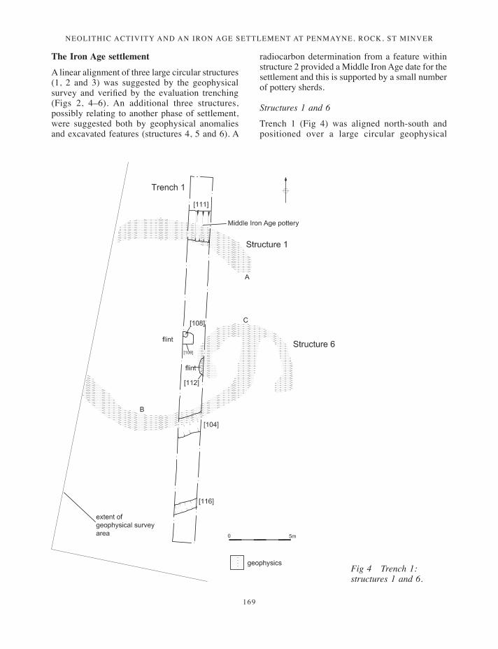
Structures 1 and 6
Trench 1 (Fig 4) was aligned north-south and positioned over a large circular geophysical
Fig 4 Trench 1: structures 1 and 6.
165-190_Gossip.indd 169 17/12/2013 10:16
JAMES GOSSIP, ANDY M JONES AND HENRIETTA QUINNELL
170
survey anomaly close to the western extent of the development area (structure 1). A second anomaly (C), possibly representing a smaller structure (structure 6), overlapped the eastern side of structure 1.
The topsoil layer (100) was a mid brown silty clay loam 0.05m deep, mostly scoured away by more recent development. This sealed (105), a light reddish-brown friable silty clay up to 0.35m deep, probably representing an earlier ploughsoil. (This was recorded in trench 2 as (235), in trench 3 as (301), in trench 4 as (401) and trench 6 as (601), and sealed all archaeological features.) All features were cut into natural subsoil (114) from a depth of approximately 0.3m to 0.4m below surface.
Results from the trenching revealed that structure 1 was represented by two lengths of curvilinear ditch or ring-gully, [111] and [104]. At the northern end of the trench curvilinear ditch [111] was 1.5m wide and 0.45m deep and had steep concave sides and a rounded base. The cut was filled by basal layer (110) and secondary fill (101). Deposit (110) was a mid reddish-brown silty clay with grey lenses; it was 0.2m deep and contained occasional small fragments of angular shillet. Fill (101), was a mid reddish-brown silty clay containing very frequent angular stone and was 0.25m deep. Six sherds of Middle Iron Age pottery were recovered from this deposit. This represented the northern arc of the curvilinear ditch forming structure 1.
The southern arc of structure 1 was represented by [104], a curvilinear ditch 1.6m wide and 0.3m deep with a steep-sided northern edge and a stepped southern edge and rounded base, filled by deposit (106), a light reddish-brown friable silty clay with occasional shillet fragments 0.3m deep below (105).
Within structure 1 and against the western baulk of the trench was cut [109], a square pit measuring 0.85m long and 0.75m wide cut into the natural clay subsoil. This had steep, almost vertical sides 0.2m deep and a flat base filled by (102), a light reddish-brown silty clay with a moderate amount of shillet with occasional inclusions of an unidentified non-slate rock type. This deposit incorporated a core preparation flake (Quinnell, below). It was cut by posthole [108], which was filled by (107), a reddish-brown silty clay. The posthole was circular, 0.27m in diameter and 0.15m deep, with vertical sides and a flat base.
The trench revealed features corresponding to the geophysical anomaly, suggesting that
structure 1 measured approximately 14m in diameter, although its western side lay beyond the geophysical survey area. The geophysical survey also suggested an entrance measuring roughly 2.6m wide on the eastern side of the structure, although it is also possible that it lay to the west.
The evidence for structure 6 was less conclusive. Just to the south of pit [109] was a bowl-shaped feature [112] protruding from the east side of the trench; this was 1.45m wide and 0.4m deep with steep concave sides cut into the natural subsoil. This feature appeared to coincide with the western end of a smaller geophysical anomaly C and may possibly have been the ditch or ring-gully terminal of structure 6 identified by the geophysical survey, or alternatively a feature associated with the entrance to structure 1. The cut contained basal fill (113), a grey silty clay 0.15m deep, sealed by secondary fill (103), a light reddish-brown silty clay 0.3m deep. This contained frequent shillet fragments, occasional rock, charcoal and a flint core. The curvilinear anomaly revealed by the geophysical survey suggested a possible structure measuring approximately 6m in diameter.
Outside structure 1, at the southern end of the trench was gully [116], a shallow, steep, concave-sided cut in natural bedrock. This was 0.1m deep and 0.4m wide and ran parallel to (or concentric with) [104]. It was filled by (115), a reddish-brown silty clay. The gully was not revealed by the geophysical survey but could represent either an additional structure or part of a field system (below).
Structures 2 and 5
Trench 2 (Fig 5) was located over two curvilinear geophysical anomalies (D and E) which appeared to represent intersecting structures (structures 2 and 5). Trench 4 was subsequently extended to the south to explore anomalies inside structure 2 (above).
The topsoil (200) / (236) was a mid brown silty clay loam 0.1m deep above subsoil (235), a light reddish-brown friable silty clay 0.3–0.45m deep which sealed all archaeological deposits. All features were cut into natural subsoil (201) from a depth of approximately 0.4–0.55m below surface.
Structure 2 was comprised of ditches or ring-gullies [202], [226] and [421]. The easternmost feature recorded was [202], a curvilinear cut 0.3m wide with a flat base 0.1m wide and stepped on its
165-190_Gossip.indd 170 17/12/2013 10:16
Neolithic activity aNd aN iroN age settlemeNt at PeNmayNe, rock, st miNver
171
eastern edge, with a break of slope into a deeper slot in the base of the cut up to 0.4m deep and a near-vertical western edge (Fig 5). This feature formed the eastern side of structure 2. The gully was filled by basal deposit (204), a reddish-brown friable silty clay, which was sealed by (205), a mid brown friable silty clay containing frequent shillet fragments.
Cut [226] was a curvilinear ditch or gully aligned north-north-east – south-south-west. It formed the western side of structure 2 and, as with [202], corresponded with the large geophysical survey anomaly E. It measured 0.9m wide by 0.14m deep and had steep concave sides and a flat base. It was filled by (227), a friable dark brown silty clay. Cut [421] was a curvilinear ditch revealed at the southern end of trench 4, extended to the south of trench 2. The ditch measured 1.5m wide and 0.2m deep, with a rounded, concave profile. Fill (420) comprised mid brown silty clay with frequent angular stone, occasional charcoal and a
pottery sherd of Neolithic date (Quinnell, below). A break in the geophysical anomaly suggested an entrance to the structure on the south-east side, and this may have been located just outside the trench to the east.
Within the eastern part of structure 2 was a group of three irregular cuts, [206], [208] and [210], which extended into trench 2 from the south. They were cut into natural subsoil (201) and filled by homogenous deposits (207), (209) and (211) respectively, comprising mid brown silty clays with few inclusions. These possible pits or hollows each measured 0.1m in depth and were 0.4–0.8m in length with widths of 0.45m (although they were not exposed in their entirety).
Between the centre and the western edge of structure 2 was a series of features connected by short lengths of a shallow gully. Cut [212] was a circular posthole with vertical sides and a flat base, measuring 0.4m diameter and 0.24m deep. It was filled by (213), a friable mid brown silty clay
Fig 5 Trenches 2 and 4: structures 2 and 5.
165-190_Gossip.indd 171 17/12/2013 10:16
JAMES GOSSIP, ANDY M JONES AND HENRIETTA QUINNELL
172
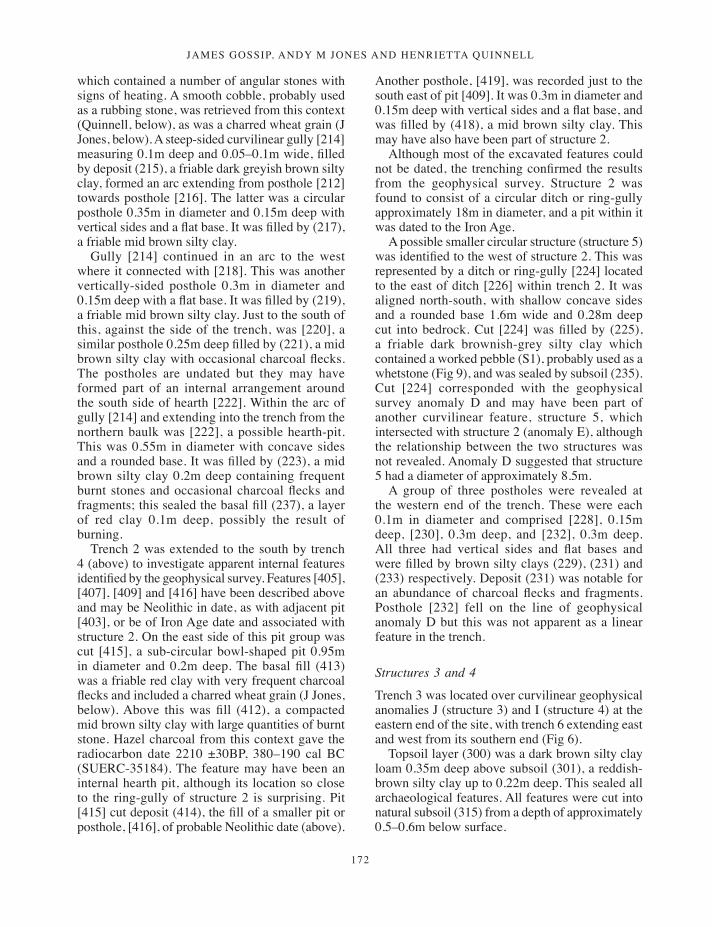
which contained a number of angular stones with signs of heating. A smooth cobble, probably used as a rubbing stone, was retrieved from this context (Quinnell, below), as was a charred wheat grain (J Jones, below). A steep-sided curvilinear gully [214] measuring 0.1m deep and 0.05–0.1m wide, filled by deposit (215), a friable dark greyish brown silty clay, formed an arc extending from posthole [212] towards posthole [216]. The latter was a circular posthole 0.35m in diameter and 0.15m deep with vertical sides and a flat base. It was filled by (217), a friable mid brown silty clay.
Gully [214] continued in an arc to the west where it connected with [218]. This was another vertically-sided posthole 0.3m in diameter and 0.15m deep with a flat base. It was filled by (219), a friable mid brown silty clay. Just to the south of this, against the side of the trench, was [220], a similar posthole 0.25m deep filled by (221), a mid brown silty clay with occasional charcoal flecks. The postholes are undated but they may have formed part of an internal arrangement around the south side of hearth [222]. Within the arc of gully [214] and extending into the trench from the northern baulk was [222], a possible hearth-pit. This was 0.55m in diameter with concave sides and a rounded base. It was filled by (223), a mid brown silty clay 0.2m deep containing frequent burnt stones and occasional charcoal flecks and fragments; this sealed the basal fill (237), a layer of red clay 0.1m deep, possibly the result of burning.
Trench 2 was extended to the south by trench 4 (above) to investigate apparent internal features identified by the geophysical survey. Features [405], [407], [409] and [416] have been described above and may be Neolithic in date, as with adjacent pit [403], or be of Iron Age date and associated with structure 2. On the east side of this pit group was cut [415], a sub-circular bowl-shaped pit 0.95m in diameter and 0.2m deep. The basal fill (413) was a friable red clay with very frequent charcoal flecks and included a charred wheat grain (J Jones, below). Above this was fill (412), a compacted mid brown silty clay with large quantities of burnt stone. Hazel charcoal from this context gave the radiocarbon date 2210 ±30BP, 380–190 cal BC (SUERC-35184). The feature may have been an internal hearth pit, although its location so close to the ring-gully of structure 2 is surprising. Pit [415] cut deposit (414), the fill of a smaller pit or posthole, [416], of probable Neolithic date (above).
Another posthole, [419], was recorded just to the south east of pit [409]. It was 0.3m in diameter and 0.15m deep with vertical sides and a flat base, and was filled by (418), a mid brown silty clay. This may have also have been part of structure 2.
Although most of the excavated features could not be dated, the trenching confirmed the results from the geophysical survey. Structure 2 was found to consist of a circular ditch or ring-gully approximately 18m in diameter, and a pit within it was dated to the Iron Age.
A possible smaller circular structure (structure 5) was identified to the west of structure 2. This was represented by a ditch or ring-gully [224] located to the east of ditch [226] within trench 2. It was aligned north-south, with shallow concave sides and a rounded base 1.6m wide and 0.28m deep cut into bedrock. Cut [224] was filled by (225), a friable dark brownish-grey silty clay which contained a worked pebble (S1), probably used as a whetstone (Fig 9), and was sealed by subsoil (235). Cut [224] corresponded with the geophysical survey anomaly D and may have been part of another curvilinear feature, structure 5, which intersected with structure 2 (anomaly E), although the relationship between the two structures was not revealed. Anomaly D suggested that structure 5 had a diameter of approximately 8.5m.
A group of three postholes were revealed at the western end of the trench. These were each 0.1m in diameter and comprised [228], 0.15m deep, [230], 0.3m deep, and [232], 0.3m deep. All three had vertical sides and flat bases and were filled by brown silty clays (229), (231) and (233) respectively. Deposit (231) was notable for an abundance of charcoal flecks and fragments. Posthole [232] fell on the line of geophysical anomaly D but this was not apparent as a linear feature in the trench.
Structures 3 and 4
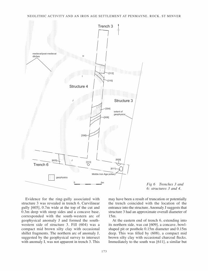
Trench 3 was located over curvilinear geophysical anomalies J (structure 3) and I (structure 4) at the eastern end of the site, with trench 6 extending east and west from its southern end (Fig 6).
Topsoil layer (300) was a dark brown silty clay loam 0.35m deep above subsoil (301), a reddish-brown silty clay up to 0.22m deep. This sealed all archaeological features. All features were cut into natural subsoil (315) from a depth of approximately 0.5–0.6m below surface.
165-190_Gossip.indd 172 17/12/2013 10:16
Neolithic activity aNd aN iroN age settlemeNt at PeNmayNe, rock, st miNver
173
Evidence for the ring-gully associated with structure 3 was revealed in trench 6. Curvilinear gully [605], 0.7m wide at the top of the cut and 0.3m deep with steep sides and a concave base, corresponded with the south-western arc of geophysical anomaly J and formed the south-western side of structure 3. Fill (604) was a compact mid brown silty clay with occasional shillet fragments. The northern arc of anomaly J, suggested by the geophysical survey to intersect with anomaly I, was not apparent in trench 3. This
may have been a result of truncation or potentially the trench coincided with the location of the entrance into the structure. Anomaly J suggests that structure 3 had an approximate overall diameter of 15m.
At the eastern end of trench 6, extending into its northern side, was cut [609], a concave, bowl-shaped pit or posthole 0.15m diameter and 0.15m deep. This was filled by (608), a compact mid brown silty clay with occasional charcoal flecks. Immediately to the south was [611], a similar but
Fig 6 Trenches 3 and 6: structures 3 and 4.
165-190_Gossip.indd 173 17/12/2013 10:16
JAMES GOSSIP, ANDY M JONES AND HENRIETTA QUINNELL
174
oval bowl-shaped pit or posthole measuring 0.7m by 0.5m and 0.2m deep cut into natural shillet subsoil. The feature was filled by (610), a mid brown, compact silty clay containing occasional charcoal flecks and shillet fragments. Three sherds of prehistoric pottery were recovered from this fill. At the southern end of trench 3 was posthole [313]. This was 0.15m in diameter and 0.25m deep with vertical sides and a flat base. It was filled by (314), a mid brown silty clay. Features [609], [611] and [313] fall within the conjectured arc of the structure 3 ring-gully and may have been structural postholes.
Structure 4 comprised ditches [304] and [310], both of which were located in trench 3. Curvilinear ditch [304] corresponded with the southern arc of geophysical anomaly I and formed the southern side of structure 4. It measured 1.3m wide and 0.4m deep and was filled by friable dark reddish-brown silty clay (302), 0.3m deep, which overlay (303), a mid brown sticky silty clay 0.1m deep containing large amounts of fragmented stone. The northern side of structure 4 was defined by cut [310], a curvilinear gully measuring 0.5m wide and 0.1m deep with steep concave sides and a rounded base filled by light reddish brown silty clay (309). This was aligned with the north-east side of anomaly I. Gully [310] was cut by medieval or post-medieval ditch [312]. The results from the geophysical survey and the trenching indicate that structure 4 measured approximately 7m in diameter.
Parallel to ditch [304] was gully [308], 0.4m wide and 0.1m deep with concave sides and a rounded base. This was filled by (307), a mid reddish-brown silty clay. A second curvilinear gully, [306] was located to the south of [304]. It was 0.5m wide and 0.1m deep with gradual concave sides (steeper on the northern edge) and a flat base. It was filled by (305), a mid brown compact silty clay with few inclusions. Neither of these gullies corresponded with anomalies identified by geophysical survey. It is therefore uncertain whether they were associated with further Iron Age structures, or are of an entirely different date.
Field systems
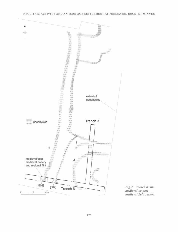
Further features were recorded in trenches 3 and 6 which represented parts of a field system with
medieval or post-medieval origins (Figs 2, 6 and 7). At the northern end of trench 3 was linear ditch [312], with steep sides 0.3m deep and 1.2m wide and a flat base, filled by (311), a friable, dark reddish brown silty clay. This feature corresponded with geophysical anomaly H and cut curvilinear gully [310], part of Middle Iron Age structure 4. The north-south portion of anomaly H appears to coincide with a boundary shown on the St Minver tithe map of c 1840 and the Ordnance Survey 1st edition 25in: 1 mile map of c 1880. Neither show features which might coincide with the excavated portion of [312], however. (A footpath shown on the Ordnance Survey map may indicate the origin of the north east – south west linear anomaly shown on Fig 2.)
Other linear features were identified in trench 6 sealed below topsoil (600) and subsoil (601) at a depth of 0.55m below the surface of the field. At the western end of the trench was [602], the cut of a north-south linear ditch cut into shillet, with stepped (but irregular) edges and a flat base, 0.3m deep and 2.5m wide. This was filled by (603), a mid brown silty clay containing occasional shillet fragments. Two sherds of medieval coarseware (thirteenth to fourteenth century), a sherd of post-medieval earthenware (seventeenth or eighteenth century) and a residual prehistoric flint flake were recovered from this deposit.
Parallel and adjacent to this was [607], part of a linear ditch 1.8m wide and 0.25m deep with gradual concave edges and a rounded base cut into the weathered bedrock natural. The ditch was filled by deposit (606), a mid brown compact silty clay. Both [602] and [607] correspond with geophysical anomalies and appear to represent a removed Cornish hedge, the below-ground evidence of which is often two parallel shallow ditches. Ditch [312] is likely to be part of the same field system.
Weak geophysical anomalies
Trench 5 was located in order to target weak geophysical anomalies (F) to the east of those investigated in trenches 2 and 4, thought to represent further settlement evidence. However, no archaeological features were identified within the trench.
165-190_Gossip.indd 174 17/12/2013 10:16
Neolithic activity aNd aN iroN age settlemeNt at PeNmayNe, rock, st miNver
175
Fig 7 Trench 6: the medieval or post-medieval field system.
165-190_Gossip.indd 175 17/12/2013 10:16
JAMES GOSSIP, ANDY M JONES AND HENRIETTA QUINNELL
176
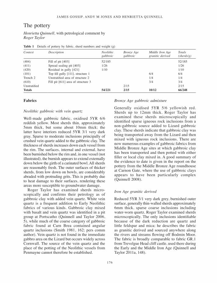
The pottery Henrietta Quinnell, with petrological comment by Roger Taylor
Table 1 Details of pottery by fabric, sherd numbers and weight (g)
Context Description Neolithic gabbroic
Bronze Age gabbroic
Middle Iron Age granitic derived
Totals (sherds/g)
(404) Fill of pit [403] 52/185 52/185(411) Spread sealing pit [403] 1/26 1/26(420) Residual in gully [421] 1/10 1/10(101) Top fill gully [111], structure 1 6/4 6/4Trench 2 Unstratified area of structure 2 1/4 1/4 (610) Fill pit [611] area of structure 3 3/4 3/4 Unstratified 2/15 2/15Totals 54/221 2/15 10/12 66/248
Fabrics
Neolithic gabbroic with vein quartz
Well-made gabbroic fabric, oxidised 5YR 6/6 reddish yellow. Most sherds thin, approximately 5mm thick, but some about 10mm thick; the latter have interiors reduced 5YR 3/1 very dark gray. Sparse to moderate inclusions principally of crushed vein quartz added to the gabbroic clay. The thickness of sherds increases down each vessel from the rim. The surfaces, internal and external, have been burnished below the rim and, in one vessel (not illustrated), the burnish appears to extend externally down below the girth of a carinated bowl. All sherds are reasonably fresh. The outer surfaces of thicker sherds, from low down on bowls, are considerably abraded with protruding grits. This is probably due to heat damage to their surfaces, rendering these areas more susceptible to groundwater damage.
Roger Taylor has examined sherds micro-scopically and confirms their petrology as of gabbroic clay with added vein quartz. White vein quartz is a frequent addition to Early Neolithic fabrics of various kinds. Gabbroic clay mixed with basalt and vein quartz was identified in a pit group at Portscatho (Quinnell and Taylor 2006, 5), while much of the coarse category of gabbroic fabric found at Carn Brea contained angular quartz inclusions (Smith 1981, 162; pers comm author). Vein quartz is not found in the immediate gabbro area on the Lizard but occurs widely across Cornwall. The source of the vein quartz and the place of the potting of the Neolithic vessels from Penmayne cannot therefore be established.
Bronze Age gabbroic admixture
Generally oxidised 5YR 5/6 yellowish red. Sherds up to 12mm thick. Roger Taylor has examined these sherds microscopically and identified sparse igneous rock inclusions from a non-gabbroic source added to Lizard gabbroic clay. These sherds indicate that gabbroic clay was being transported away from the Lizard and then mixed with igneous rock inclusions. There are now numerous examples of gabbroic fabrics from Middle Bronze Age sites at which gabbroic clay has been transported and then potted with either filler or local clay mixed in. A good summary of the evidence to date is given in the report on the pottery from the Middle Bronze Age roundhouse at Carnon Gate, where the use of gabbroic clays appears to have been particularly complex (Quinnell 2008).
Iron Age granitic derived
Reduced 5YR 3/1 very dark grey, burnished outer surface, generally thin-walled sherds approximately 6mm thick, sparse coarse inclusions including water-worn quartz. Roger Taylor examined sherds microscopically. The only inclusions identifiable because of the dark reduction are quartz and little feldspar and mica; he describes the fabric as granitic derived and sourced anywhere along the rivers and streams flowing off Bodmin Moor. The fabric is broadly comparable to fabric GR.1 from Trevelgue Head cliff castle, used there during the Early and the Middle Iron Age (Quinnell and Taylor 2011a, 148).
165-190_Gossip.indd 176 17/12/2013 10:16
Neolithic activity aNd aN iroN age settlemeNt at PeNmayNe, rock, st miNver
177
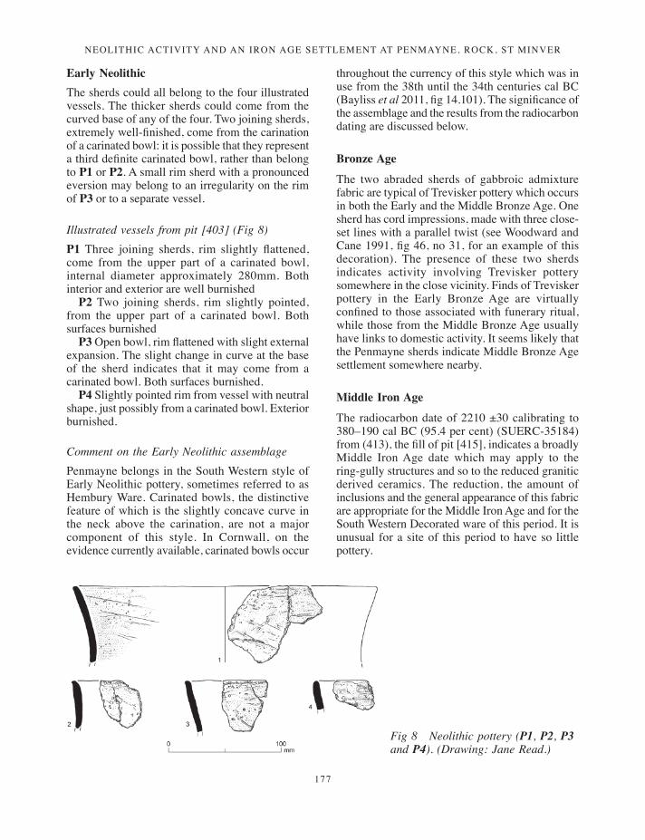
Early Neolithic The sherds could all belong to the four illustrated vessels. The thicker sherds could come from the curved base of any of the four. Two joining sherds, extremely well-finished, come from the carination of a carinated bowl: it is possible that they represent a third definite carinated bowl, rather than belong to P1 or P2. A small rim sherd with a pronounced eversion may belong to an irregularity on the rim of P3 or to a separate vessel.
Illustrated vessels from pit [403] (Fig 8)P1 Three joining sherds, rim slightly flattened, come from the upper part of a carinated bowl, internal diameter approximately 280mm. Both interior and exterior are well burnished
P2 Two joining sherds, rim slightly pointed, from the upper part of a carinated bowl. Both surfaces burnished
P3 Open bowl, rim flattened with slight external expansion. The slight change in curve at the base of the sherd indicates that it may come from a carinated bowl. Both surfaces burnished.
P4 Slightly pointed rim from vessel with neutral shape, just possibly from a carinated bowl. Exterior burnished.
Comment on the Early Neolithic assemblagePenmayne belongs in the South Western style of Early Neolithic pottery, sometimes referred to as Hembury Ware. Carinated bowls, the distinctive feature of which is the slightly concave curve in the neck above the carination, are not a major component of this style. In Cornwall, on the evidence currently available, carinated bowls occur
throughout the currency of this style which was in use from the 38th until the 34th centuries cal BC (Bayliss et al 2011, fig 14.101). The significance of the assemblage and the results from the radiocarbon dating are discussed below.
Bronze Age
The two abraded sherds of gabbroic admixture fabric are typical of Trevisker pottery which occurs in both the Early and the Middle Bronze Age. One sherd has cord impressions, made with three close-set lines with a parallel twist (see Woodward and Cane 1991, fig 46, no 31, for an example of this decoration). The presence of these two sherds indicates activity involving Trevisker pottery somewhere in the close vicinity. Finds of Trevisker pottery in the Early Bronze Age are virtually confined to those associated with funerary ritual, while those from the Middle Bronze Age usually have links to domestic activity. It seems likely that the Penmayne sherds indicate Middle Bronze Age settlement somewhere nearby.
Middle Iron Age
The radiocarbon date of 2210 ±30 calibrating to 380–190 cal BC (95.4 per cent) (SUERC-35184) from (413), the fill of pit [415], indicates a broadly Middle Iron Age date which may apply to the ring-gully structures and so to the reduced granitic derived ceramics. The reduction, the amount of inclusions and the general appearance of this fabric are appropriate for the Middle Iron Age and for the South Western Decorated ware of this period. It is unusual for a site of this period to have so little pottery.
Fig 8 Neolithic pottery (P1, P2, P3 and P4). (Drawing: Jane Read.)
165-190_Gossip.indd 177 17/12/2013 10:16
JAMES GOSSIP, ANDY M JONES AND HENRIETTA QUINNELL
178
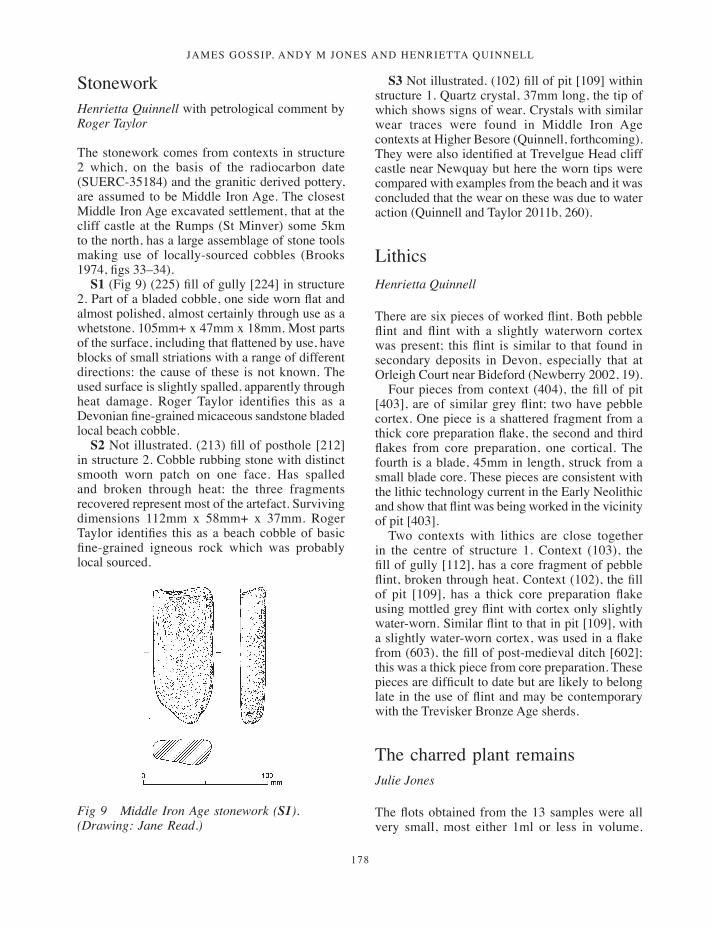
StoneworkHenrietta Quinnell with petrological comment by Roger Taylor
The stonework comes from contexts in structure 2 which, on the basis of the radiocarbon date (SUERC-35184) and the granitic derived pottery, are assumed to be Middle Iron Age. The closest Middle Iron Age excavated settlement, that at the cliff castle at the Rumps (St Minver) some 5km to the north, has a large assemblage of stone tools making use of locally-sourced cobbles (Brooks 1974, figs 33–34).
S1 (Fig 9) (225) fill of gully [224] in structure 2. Part of a bladed cobble, one side worn flat and almost polished, almost certainly through use as a whetstone. 105mm+ x 47mm x 18mm. Most parts of the surface, including that flattened by use, have blocks of small striations with a range of different directions: the cause of these is not known. The used surface is slightly spalled, apparently through heat damage. Roger Taylor identifies this as a Devonian fine-grained micaceous sandstone bladed local beach cobble.
S2 Not illustrated. (213) fill of posthole [212] in structure 2. Cobble rubbing stone with distinct smooth worn patch on one face. Has spalled and broken through heat: the three fragments recovered represent most of the artefact. Surviving dimensions 112mm x 58mm+ x 37mm. Roger Taylor identifies this as a beach cobble of basic fine-grained igneous rock which was probably local sourced.
S3 Not illustrated. (102) fill of pit [109] within structure 1. Quartz crystal, 37mm long, the tip of which shows signs of wear. Crystals with similar wear traces were found in Middle Iron Age contexts at Higher Besore (Quinnell, forthcoming). They were also identified at Trevelgue Head cliff castle near Newquay but here the worn tips were compared with examples from the beach and it was concluded that the wear on these was due to water action (Quinnell and Taylor 2011b, 260).
LithicsHenrietta Quinnell
There are six pieces of worked flint. Both pebble flint and flint with a slightly waterworn cortex was present; this flint is similar to that found in secondary deposits in Devon, especially that at Orleigh Court near Bideford (Newberry 2002, 19).
Four pieces from context (404), the fill of pit [403], are of similar grey flint; two have pebble cortex. One piece is a shattered fragment from a thick core preparation flake, the second and third flakes from core preparation, one cortical. The fourth is a blade, 45mm in length, struck from a small blade core. These pieces are consistent with the lithic technology current in the Early Neolithic and show that flint was being worked in the vicinity of pit [403].
Two contexts with lithics are close together in the centre of structure 1. Context (103), the fill of gully [112], has a core fragment of pebble flint, broken through heat. Context (102), the fill of pit [109], has a thick core preparation flake using mottled grey flint with cortex only slightly water-worn. Similar flint to that in pit [109], with a slightly water-worn cortex, was used in a flake from (603), the fill of post-medieval ditch [602]; this was a thick piece from core preparation. These pieces are difficult to date but are likely to belong late in the use of flint and may be contemporary with the Trevisker Bronze Age sherds.
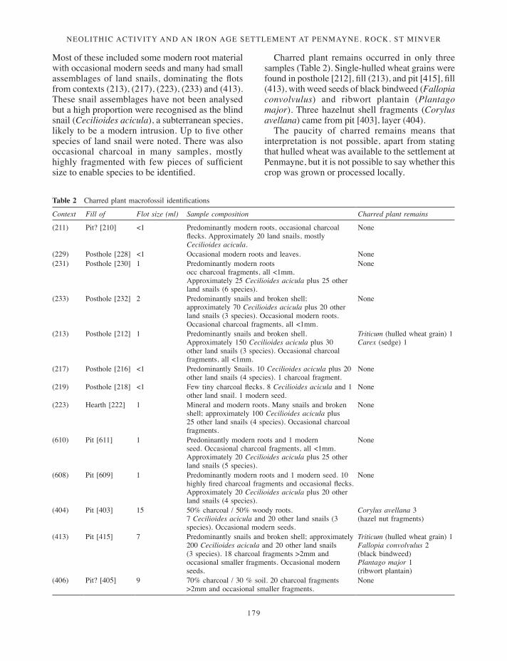
The charred plant remainsJulie Jones
The flots obtained from the 13 samples were all very small, most either 1ml or less in volume.
Fig 9 Middle Iron Age stonework (S1). (Drawing: Jane Read.)
165-190_Gossip.indd 178 17/12/2013 10:16
Neolithic activity aNd aN iroN age settlemeNt at PeNmayNe, rock, st miNver
179
Most of these included some modern root material with occasional modern seeds and many had small assemblages of land snails, dominating the flots from contexts (213), (217), (223), (233) and (413). These snail assemblages have not been analysed but a high proportion were recognised as the blind snail (Cecilioides acicula), a subterranean species, likely to be a modern intrusion. Up to five other species of land snail were noted. There was also occasional charcoal in many samples, mostly highly fragmented with few pieces of sufficient size to enable species to be identified.
Charred plant remains occurred in only three samples (Table 2). Single-hulled wheat grains were found in posthole [212], fill (213), and pit [415], fill (413), with weed seeds of black bindweed (Fallopia convolvulus) and ribwort plantain (Plantago major). Three hazelnut shell fragments (Corylus avellana) came from pit [403], layer (404).
The paucity of charred remains means that interpretation is not possible, apart from stating that hulled wheat was available to the settlement at Penmayne, but it is not possible to say whether this crop was grown or processed locally.
Table 2 Charred plant macrofossil identifications
Context Fill of Flot size (ml) Sample composition Charred plant remains
(211) Pit? [210] <1 Predominantly modern roots, occasional charcoal flecks. Approximately 20 land snails, mostly Cecilioides acicula.
None
(229) Posthole [228] <1 Occasional modern roots and leaves. None(231) Posthole [230] 1 Predominantly modern roots
occ charcoal fragments, all <1mm. Approximately 25 Cecilioides acicula plus 25 other land snails (6 species).
None
(233) Posthole [232] 2 Predominantly snails and broken shell;approximately 70 Cecilioides acicula plus 20 other land snails (3 species). Occasional modern roots. Occasional charcoal fragments, all <1mm.
None
(213) Posthole [212] 1 Predominantly snails and broken shell. Approximately 150 Cecilioides acicula plus 30 other land snails (3 species). Occasional charcoal fragments, all <1mm.
Triticum (hulled wheat grain) 1Carex (sedge) 1
(217) Posthole [216] <1 Predominantly Snails. 10 Cecilioides acicula plus 20 other land snails (4 species). 1 charcoal fragment.
None
(219) Posthole [218] <1 Few tiny charcoal flecks. 8 Cecilioides acicula and 1 other land snail. 1 modern seed.
None
(223) Hearth [222] 1 Mineral and modern roots. Many snails and broken shell; approximately 100 Cecilioides acicula plus 25 other land snails (4 species). Occasional charcoal fragments.
None
(610) Pit [611] 1 Predoninantly modern roots and 1 modern seed. Occasional charcoal fragments, all <1mm. Approximately 20 Cecilioides acicula plus 25 other land snails (5 species).
None
(608) Pit [609] 1 Predominantly modern roots and 1 modern seed. 10 highly fired charcoal fragments and occasional flecks. Approximately 20 Cecilioides acicula plus 20 other land snails (4 species).
None
(404) Pit [403] 15 50% charcoal / 50% woody roots.7 Cecilioides acicula and 20 other land snails (3 species). Occasional modern seeds.
Corylus avellana 3(hazel nut fragments)
(413) Pit [415] 7 Predominantly snails and broken shell; approximately 200 Cecilioides acicula and 20 other land snails (3 species). 18 charcoal fragments >2mm and occasional smaller fragments. Occasional modern seeds.
Triticum (hulled wheat grain) 1Fallopia convolvulus 2(black bindweed)Plantago major 1(ribwort plantain)
(406) Pit? [405] 9 70% charcoal / 30 % soil. 20 charcoal fragments >2mm and occasional smaller fragments.
None
165-190_Gossip.indd 179 17/12/2013 10:16
JAMES GOSSIP, ANDY M JONES AND HENRIETTA QUINNELL
180
The wood charcoalDana Challinor
The flots were notably poor in archaeological material (J Jones, above). One sample from context (608) produced some unidentified charred vesicular material, possibly parenchyma. While most flots contained small fragments of charcoal, identifiable material was only recorded from four contexts (Table 3). Two taxa were identified; Quercus sp. (oak) and Corylus avellana (hazel). Some of the Quercus charcoal exhibited tyloses, indicating the presence of heartwood, and some immature roundwood fragments were also noted. Suitable dating material was selected from three samples, including context (403) which contained Corylus avellana (hazel) nutshell fragments. No other non-charcoal charred plant material was noted, although the finer fractions were only examined cursorily.
Given the disappointing levels of preservation in the samples, little interpretation can be made. Charcoal was only present in low quantities, indicating that the assemblages are more likely to have derived from dispersed fuel rather than deliberate single-event dumps of domestic or other waste. The taxonomic list is too limited to provide much environmental reconstruction, but the results are consistent with the predominance of oak-hazel woodland in south-west England throughout early prehistory (Wilkinson and Straker 2008).
Radiocarbon datingThree samples from charred macrofossils (two hazelnut shells and a fragment of hazel wood) were submitted for accelerator mass spectrometry dating (AMS) at the Scottish Universities’ Environmental Research Centre (SUERC) (Table 4). The hazelnuts were both derived from deposit (404), the basal fill of pit [403], and provided the determinations
4770 ±30BP, 3640–3510 cal BC (92.5 per cent) (SUERC-315182) and 4775 ±30BP, 3650–3510 cal BC (93.9 per cent) (SUERC-315183), confirming this feature as Early Neolithic in date,.
Charred hazel wood from pit [415] produced the determination 2210 ±30BP, 380–190 cal BC (95.4 per cent) (SUERC-35184), indicating a Middle Iron Age phase of settlement. The results from the radiocarbon dating are discussed below.
The probability distributions (Tables 4 and 5) were calculated using OxCal (v3.10). Unless stated otherwise, the 95 per cent level of probability has been used throughout this report; calibrated determinations in the text may therefore differ from other published sources.
DiscussionAlthough finds were scarce and the excavation limited in extent, the investigations at Penmayne revealed two distinct episodes of activity, with hints of a third. The earliest activity was associated with an Early Neolithic pit, possibly part of a larger grouping.
Two abraded sherds of Trevisker pottery of Bronze Age date were recovered from unstratified contexts. It is likely that these were associated with Middle Bronze Age settlement activity in the vicinity. However, no features of this period were recorded within the trenches and none of the geophysical anomalies could obviously be assigned to this period, which means that the character of the Bronze Age activity is uncertain.
The main period of settlement activity occurred during the Iron Age, with a group of three large roundhouses defined by ring-gullies and three smaller ring-gullied structures. The geophysical survey and the excavated features suggest that the smaller ring-gullies may represent a different period of occupation from the larger structures, but it was not possible to establish which of these were the earliest.
Table 3 Charcoal identifications and radiocarbon dating (C14) selections
Context Cut Feature type
Quantity Identifications C14
(231) [230] Posthole + Quercus n/a(404) [403] Hollow ++ Quercus (hw) Corylus avellana nutshell x 3(413) [415] Pit ++ Quercus, Corylus avellana (rw) Corylus avellana rw x 1(406) [405] Pit? + Quercus (rw) Quercus sp. rw x1+=up to 5 frags; ++=up to 25 fragments; rw=roundwood; hw=heartwood
165-190_Gossip.indd 180 17/12/2013 10:16
Neolithic activity aNd aN iroN age settlemeNt at PeNmayNe, rock, st miNver
181
The following discussion focuses on the Neolithic and Iron Age settlement-related activity.
Neolithic pits and carinated pottery
The Early Neolithic pits
Pit [403], in trench 4, produced 52 sherds of pottery and two radiocarbon determinations: 4770 ±30BP, 3640–3510 cal BC (92.5 per cent) (SUERC-315182) and 4775 ±30BP, 3650–3510 cal BC (93.9 per cent) (SUERC-315183). These determinations place the pit towards the middle of the fourth millennium cal BC, during the latter part of the Early Neolithic period. The radiocarbon dates are the first to be obtained from Early Neolithic pits on the north Cornish coast and are significant because they provide close dating for carinated bowl pottery.
It is not absolutely certain whether pit [403] was situated within a group or was a single feature. Neolithic pits are usually found in groups in Cornwall and beyond (Cole and Jones 2002–3; Jones and Reed 2006; Leverett and Quinnell 2010; Garrow et al 2005), and it is possible that the four pits adjacent to [403], [405], [407], [409] and [416], which were devoid of artefacts, also date to the Early Neolithic period. Pits without artefacts have been radiocarbon dated to the Early Neolithic period in Cornwall, as for example at Tremough (Penryn) (Gossip and Jones 2007, 6). However,
it is possible that, given their location within roundhouses, some or all of the undated pits at Penmayne may have belonged to the Middle Iron Age settlement phase (below).
The phenomenon of pit digging has been recognised at a number of sites in Cornwall and found to span the entire Neolithic period (c 3900–2500 cal BC). Small pits containing structured deposits of pottery, flint and food remains have been revealed at Portscatho (Gerrans) (Jones and Reed 2006), Metha (St Newlyn East) (Jones and Taylor 2004, 43), Poldowrian (St Keverne) (Smith and Harris 1982), Trenowah (St Austell) (Johns 2008) and Helston (Helston) (Hood 2009). A larger pit group with a similar time-span was recorded at Tregarrick (Roche) (Cole and Jones 2002–3). There, six radiocarbon dates from a group of ten pits fell within a period of four centuries, from 3790 cal BC to 3370 cal BC (ibid, 134).
Late Neolithic pits have also been recorded across the county, as, for example, at Tremough (Gossip and Jones 2007 6–8), and these show a similar pattern of selection of material for burial. Radiocarbon determinations for Early Neolithic pits in Cornwall are presented in Table 4. As noted above, pits without artefacts have also been recorded: pit [21] at Tremough, for example, was devoid of artefacts but included charred plant macrofossils and burnt stones and produced an Early Neolithic determination of 4850 ±55 BP, 3770–3510 cal BC (AA-44601) (Gossip and Jones 2007, 112).
Table 4 Cornish Early Neolithic pit radiocarbon determinations
Site Context Lab. no Material Age BP years Calendrical years 95%
Penmayne Pit [403] (404) SUERC-315182 Hazelnut shell 4770 ±30 3640–3510 BCPenmayne Pit [403] (404) SUERC-315183 Hazelnut shell 4775 ±30 3650–3510 BCPoldowrian Pit [106] HAR-4323 Bulked charcoal 5180 ±150 4350–3650 BCPoldowrian Hearth pit [150] HAR-4052 Charcoal, Oak 4870 ±130 4000–3350 BCPoldowrian Layer [2] HAR-4568 Hazelnut shells from mixed
Mesolithic/Neolithic deposits6450 ±110 5620–5210 BC
Portscatho Pit [512] Wk-13259 Charcoal, Hazel 4713 ±45 3640–3370 BCPortscatho Pit [504] Wk-13257 Charcoal, Hazel 4805 ±51 3700–3380 BCPortscatho Pit [502] Wk-13256 Charcoal, Hazel 4818 ±48 3710–3380 BCPortscatho Pit [505] Wk-13258 Charcoal, Hazel 4952 ±45 3920–3640 BCTregarrick Pit [40] Wk-14916 Charcoal, Hazel 4914 ±40 3780–3640 BCTregarrick Pit [48] Wk-14918 Charcoal, Hawthorn 4908 ±47 3790–3630 BCTregarrick Pit [19] Wk-14913 Hazelnut shell 4839 ±42 3710–3520 BCTregarrick Pit [45] Wk-14917 Hazelnut shell 4768 ±43 3650–3370 BCTregarrick Pit [21] Wk-14914 Hazelnut shell 4775 ±44 3650–3380 BCTregarrick Pit [27] Wk-14915 Hazelnut shell 4776 ±44 3650–3380 BCTremough PAC Pit [102] (100) SUERC-29387 Charcoal, Hazel 4750 ±40 3640–3490 BCTremough PAC Pit [105] (103) SUERC-29383 Charcoal, Hazel 4750 ±40 3640–3490 BCTremough Pit [21] AA-44601 Charcoal, Hazel 4850 +55 3770–3510 BC
165-190_Gossip.indd 181 17/12/2013 10:16
JAMES GOSSIP, ANDY M JONES AND HENRIETTA QUINNELL
182
The form of the Penmayne pits (assuming all are Neolithic) differs somewhat from the comparanda listed above. In general, most recorded Neolithic pits in the south west are shallow and bowl-shaped (Cole and Jones 2002–3), although tree-throws were also sometimes used to hold deposits (Leverett and Quinnell 2010). By contrast, the pits at Penmayne were elongated with concave profiles. However, the character of their fills is similar to that of Early Neolithic pits identified elsewhere and suggests that they were backfilled rapidly in a single episode, perhaps soon after they had been dug. The pits were discrete, and although [407] and [409] lie immediately adjacent to each other, none were intercutting, suggesting either a single episode of digging or the respecting of each backfilled pit as each new one was dug. This absence of intercutting can also be seen at Poldowrian, Tregarrick Farm and Tremough (Smith and Harris 1982; Cole and Jones 2002–3; Gossip and Jones 2007, 7).
Pit [403] contained pottery and flint, objects frequently selected for deliberate inclusion in Neolithic pits, and paralleled by features at Portscatho, Tregarrick Farm, and the Tremough Performing Arts Centre (PAC) site (Jones and Reed 2006; Cole and Jones 2002–3; Jones and Taylor 2004; Gossip, forthcoming a), all of which show careful selection of artefacts for deposition. The incorporation of 52 sherds from a small number of carinated bowls within pit [403] implies that there was process of deliberate selection, with sherds from a particular form of vessel being chosen for inclusion. The reasonably fresh condition of the sherds also suggests that these had not been in circulation as sherds for any length of time before their deposition, and it is possible that the vessels were associated with activities on the site occurring shortly before their burial. The hazelnut fragments from within the pit also demonstrate collection and consumption of a wild food resource; significantly no charred grain was recovered although it survived within Iron Age features (J Jones, above). Again, these are commonly included within pits of this period. Taken together, these artefacts could suggest a visit to the site which included the working of flint and the sharing of food, which was then followed by the digging of pit [403] and deposition of items within it.
The impetus for Neolithic pit digging is not fully understood, but in the south-west peninsula it appears to be part of a wider set of ritualised
practices which were prevalent in the British Neolithic (Thomas 1999, 64–74; Allen et al 2004, Noble 2006, 66–8). Interpretations have been explored around the idea that the practice was a new Neolithic ritualised expression utilised for the discard of objects otherwise associated with settlement (Jones and Reed 2006). It is possible that communities saw the ritualised deposition of treasured or specially selected items in a certain place as a way of acquiring symbolic ownership, fixing a community to the land on which the pits were dug (Pollard 2001; Thomas 1999, 72, 87; Jones, forthcoming), or that deposition was a symbolic reciprocal return of artefactual and subsistence items to a location which had been exploited by the group making the deposit to provide shelter, subsistence and other resources. Alternatively, pits may have been associated with a wider ceremonial landscape destroyed by subsequent agriculture (Cole and Jones 2002–3, 134). Elsewhere in the south west, tree throws may have fulfilled a similar role to dug pits (Leverett and Quinnell 2010). At the Tremough PAC site, pits were associated with tree throws which also contained similar artefact groups, and perhaps were linked to the acquisition of new land for agriculture and settlement following woodland clearance (Gossip, forthcoming a) or with the marking of clearances in the woodland (Leverett and Quinnell 2010).
Carinated pottery in the south-west peninsula
The selection of a pottery form which is generally uncommon within Early Neolithic ceramic assemblages in the south west, and the association with a comparatively late date within the early phase of the Neolithic, makes the assemblage from Penmayne – the fifth published site in Cornwall with carinated bowls – worthy of further discussion.
P1 and P2 and a possible third example are carinated bowls; P3 and P4 may belong to bowls of this type. Pit [403], from which these came, produced two nearly identical radiocarbon dates on charred hazelnut shells, 4770 ±30BP, 3640–3510 cal BC (92.5 per cent) (SUERC-315182), and 4775 ±30BP, 3650–3510 cal BC (93.9 per cent) (SUERC-315183). These firmly situate the pit and its contents in the later 37th or 36th centuries cal BC, well into the currency of the South Western style of Early Neolithic pottery (Quinnell, above).
165-190_Gossip.indd 182 17/12/2013 10:16
Neolithic activity aNd aN iroN age settlemeNt at PeNmayNe, rock, st miNver
183
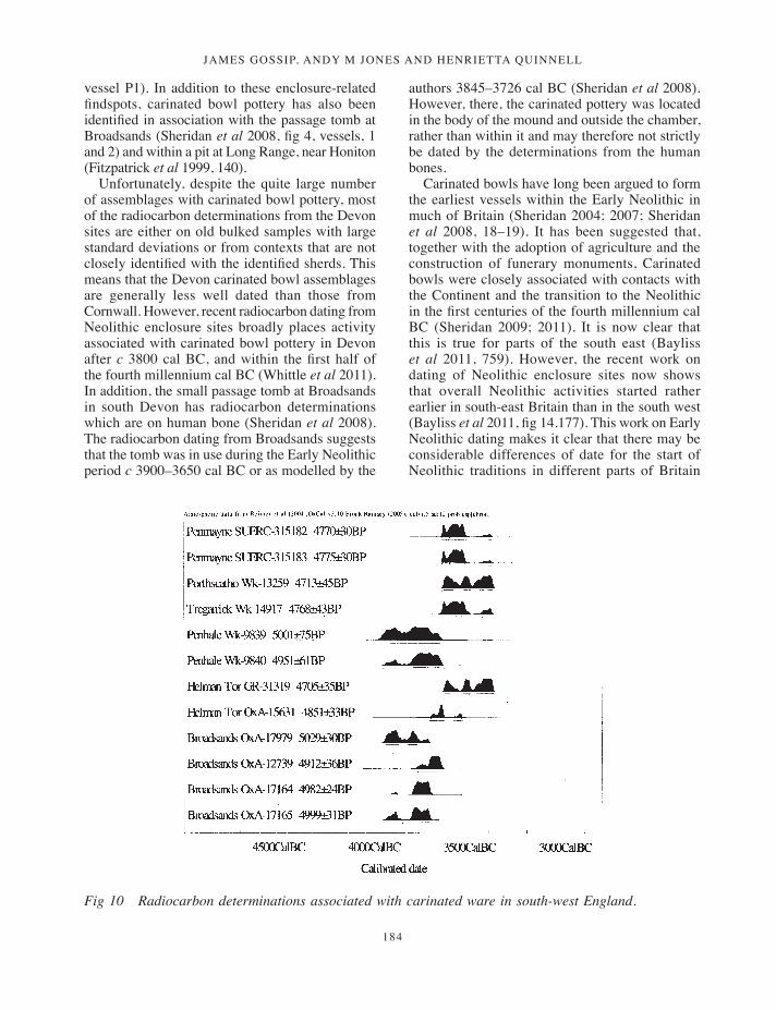
The other Cornish assemblages that include carinated bowls are those from pits at Portscatho and at Tregarrick Farm, Roche, the tor enclosures of Carn Brea (Carn Brea) and Helman Tor (Lanlivery), and structure 3229 at Penhale (St Enoder). The pit sites both have radiocarbon determinations which are closely associated with carinated bowls (Table 5). Pit [512] at Portscatho produced carinated bowl P1 with a date calibrating to 3640–3370 cal BC (Wk-13259) (Jones and Reed 2006, 17) and pit [45] (Wk-14917) at Tregarrick Farm produced carinated bowl P6 calibrating to 3790–3630 cal BC (Cole and Jones 2002–3, 133).
Recent work on the dating of Neolithic sites suggests that the tor enclosures at Helman Tor and at Carn Brea, both of which have carinated bowls in their assemblages, started around 3700 cal BC, with Carn Brea a little later than Helman Tor, and that both may have been in use for a century or two (Whittle et al 2011, 509). There are considerable complexities in the detailed dating for these sites and it is not possible to be more precise. However, two of the new determinations from Helman Tor were on residue from a carinated bowl (Mercer 1997, vessel P1; Whittle et al 2011,
500). These calibrate to 3640–3370 cal BC (Gr-31319) and 3710–3530 cal BC (OxA-15631). The determinations are broadly similar to those from pit sites such as Penmayne and reflect contemporaneity between tor enclosures, pit digging and the use of carinated bowl pottery.
A sixth site, currently awaiting full publication, is structure 3229 at Penhale (Whittle et al 2011, 514). This also produced carinated bowls and is associated with radiocarbon determinations of 3960–3700 cal BC (Wk-9839) and 3950–3630 cal BC (Wk-9840), making them the earliest dates to be associated with carinated bowl pottery in the south west.
Carinated bowls have also been recorded from several sites in Devon. By contrast with Cornwall, most of these find-spots are associated with Neolithic enclosures, including Haldon (Willock 1936, vessel, pl LXVII, vessel P41(a); Gent and Quinnell 1999a), Hembury (Liddell 1932, pl XXXVIII, vessel P328 ; Liddell 1935, pl XVIII, vessels P232 and P255), High Peak (Pollard 1966, fig 9, vessels 3 and 4) and Raddon (Gent and Quinnell 1999b, vessel P15), or, as in the case of Hazard Hill, with possibly unenclosed distinctive hills (Houlder 1963, fig 7,
Table 5 Early Neolithic carinated bowl pottery with closely associated radiocarbon determinations
Site Context/association Lab. no Age BP years Calendrical years 95%
CornwallPenmayne Pit [403], hazelnut shell found in pit with
carinated bowl sherds (this paper).SUERC-315182 4770 ±30 3640–3510 BC
Penmayne Pit [403], hazelnut shell found in pit with carinated bowl sherds (this paper).
SUERC-315183 4775 ±30 3650–3510 BC
Portscatho Pit [512], hazel charcoal found in pit with carinated bowl P1 (Jones and Read 2006).
Wk-13259 4713 ±45 3640–3370 BC
Tregarrick Pit [40], hazel charcoal found with carinated bowl P6 (Cole and Jones 2002–3).
Wk-14917 4768 ±43 3650–3370 BC
Penhale Pit 254 within structure 3299, charred cereal grains (Whittle et al 2011, 514)
Wk-9839 5001 ±75 3960–3700 BC
Penhale Posthole 3221 within structure 3299, hazel charcoal (Whittle et al 2011, 514).
Wk-9840 4951 ±61 3950–3630 BC
Helman Tor Residue from carinated vessel P14 (Mercer 1997; Whittle et al 2011, 514).
Gr-31319 4705 ±35 3640–3370 BC
Helman Tor Residue from carinated vessel P14 (Mercer 1997; Whittle et al 2011, 514).
OxA-15631 4851 ±33 3710–3530 BC
DevonBroadsands Human bone, single individual from chamber,
above the paving slab (Sheridan et al 2008).OxA-17979 5029 ±30 3950–3710 BC
Broadsands Human bone, single individual from chamber, above the paving slab (Sheridan et al 2008).
OxA-12739 4912 ±36 3770–3640 BC
Broadsands Human bone, single individual from chamber, below paving slab, (Sheridan et al 2008).
OxA-17164 4982 ±24 3910–3620 BC
Broadsands Human bone, single individual from chamber, below paving slab, (Sheridan et al 2008).
OxA-17165 4999 ±31 3940–3700 BC
165-190_Gossip.indd 183 17/12/2013 10:16
JAMES GOSSIP, ANDY M JONES AND HENRIETTA QUINNELL
184
vessel P1). In addition to these enclosure-related findspots, carinated bowl pottery has also been identified in association with the passage tomb at Broadsands (Sheridan et al 2008, fig 4, vessels, 1 and 2) and within a pit at Long Range, near Honiton (Fitzpatrick et al 1999, 140).
Unfortunately, despite the quite large number of assemblages with carinated bowl pottery, most of the radiocarbon determinations from the Devon sites are either on old bulked samples with large standard deviations or from contexts that are not closely identified with the identified sherds. This means that the Devon carinated bowl assemblages are generally less well dated than those from Cornwall. However, recent radiocarbon dating from Neolithic enclosure sites broadly places activity associated with carinated bowl pottery in Devon after c 3800 cal BC, and within the first half of the fourth millennium cal BC (Whittle et al 2011). In addition, the small passage tomb at Broadsands in south Devon has radiocarbon determinations which are on human bone (Sheridan et al 2008). The radiocarbon dating from Broadsands suggests that the tomb was in use during the Early Neolithic period c 3900–3650 cal BC or as modelled by the
authors 3845–3726 cal BC (Sheridan et al 2008). However, there, the carinated pottery was located in the body of the mound and outside the chamber, rather than within it and may therefore not strictly be dated by the determinations from the human bones.
Carinated bowls have long been argued to form the earliest vessels within the Early Neolithic in much of Britain (Sheridan 2004; 2007; Sheridan et al 2008, 18–19). It has been suggested that, together with the adoption of agriculture and the construction of funerary monuments, Carinated bowls were closely associated with contacts with the Continent and the transition to the Neolithic in the first centuries of the fourth millennium cal BC (Sheridan 2009; 2011). It is now clear that this is true for parts of the south east (Bayliss et al 2011, 759). However, the recent work on dating of Neolithic enclosure sites now shows that overall Neolithic activities started rather earlier in south-east Britain than in the south west (Bayliss et al 2011, fig 14.177). This work on Early Neolithic dating makes it clear that there may be considerable differences of date for the start of Neolithic traditions in different parts of Britain
Fig 10 Radiocarbon determinations associated with carinated ware in south-west England.
165-190_Gossip.indd 184 17/12/2013 10:16
Neolithic activity aNd aN iroN age settlemeNt at PeNmayNe, rock, st miNver
185
and in their character, and that what constituted the ‘Early Neolithic’ is likely to have varied regionally (Cummings 2009). For example, in Cornwall, the earliest part of the Neolithic seems to have been associated with the digging of pits and South Western style pottery, followed by tor enclosures and perhaps simple chambered tombs and portal dolmens. All of these site types may include carinated bowls (Jones and Quinnell 2011a). These contrasts between regions may have arisen through differential contacts with the Continent (Sheridan 2011), although given the scarcity of imported artefacts in Cornwall, the precise nature of any such links with communities in mainland Europe is uncertain (Jones and Quinnell 2011a).
In the wider south-west region it appears that although some vessels belonging to the carinated bowl tradition, such as those from Broadsands or Penhale, may belong in the first centuries of the fourth millennium cal BC, radiocarbon determinations from sites such as Penmayne indicates that the tradition persisted for several centuries and that vessels of this type were being manufactured at a much later date, towards the middle of the fourth millennium cal BC (Table 5; Fig 10). In other words, there are indications that the carinated bowl form in the south-west peninsula is likely to have been a long-lived tradition and form a part of the South Western Early Neolithic ceramic style. An early date, even for assemblages which solely comprise carinated bowls, cannot be assumed in the south west without supporting radiocarbon dating.
The Iron Age settlement
The Iron Age is currently thought to have started around 800 cal BC (Needham 2007) and continued until the start of the Romano-British period in AD 43. Iron Age society in Cornwall was shaped by local and long-standing traditions which were reflected in house construction, farming and defence.
At Penmayne the remains of at least three large ring-gullied structures (structures 1, 2 and 3) and three smaller ones (4, 5 and 6) associated with a roundhouse settlement were identified. Dating evidence is limited to a hearth associated with structure 2 which provided a radiocarbon determination of 2210 ±30 BP, 380–190 cal BC (SUERC-35184), and a few sherds of pottery which are likely to be of a similar date. This is
interesting in itself, since sites of this date usually produce more artefactual material. However, it should be remembered that only a limited sample of the structures were investigated and artefact-rich deposits may have been located beyond the area of the trenches. It is also possible that shallower features and artefacts may have disappeared through truncation of the site by later agricultural activity. The limited evidence suggests that the settlement was occupied during the Middle Iron Age, probably in the second or third centuries cal BC, although the origins and length of occupation on the site remain unknown.
Environmental reconstruction is also difficult due to the paucity of charred plant macrofossils or charcoal from the structures. Analysis of the charcoal assemblage suggests that it is wood-fuel waste (Challinor, above). There was occasional charcoal in many samples, but mostly highly fragmented, with few pieces of sufficient size to allow the species to be determined. Charred plant macrofossils were recovered from structure 2. Features [212], fill (213), and [415], fill (413), included hulled wheat within them, but it is uncertain whether the crop was grown or processed locally (J Jones, above).
All six structures took the form of penannular, circular gullies with some internal features. The three largest, structures 1, 2 and 3, were all substantial, between 14m and 18m in diameter. The suggestion of other phases of occupation is indicated by structures 4, 5 and 6, which ranged from 6m to 8.5m in diameter, which intersected with the larger structures. Unfortunately relationships between the structures were not revealed by the trenching and much of the discussion of the possible form of the structures relies upon the accuracy of the results from the geophysical survey.
The roundhouse settlement seems to have been aligned east-west, although there is no obvious reason for this. The smaller structures also share this alignment, overlapping with the larger roundhouses. Entrances into the roundhouses suggested by the geophysical survey (GSB 2009) seem to be to the east or south east; however, none were verified through excavation.
The investigated ring-gullies were shallow, possibly truncated by subsequent agricultural activity, with fill deposits that suggested fairly rapid infilling derived from the surrounding soils combined with organic material from the settlement. Traditionally it was thought that the
165-190_Gossip.indd 185 17/12/2013 10:16
JAMES GOSSIP, ANDY M JONES AND HENRIETTA QUINNELL
186
purpose of ring-gullies was to provide drainage of rainwater away from the walls of structures. However, work on reconstructed roundhouses has revealed that drip-gullies are not needed to perform this function (Reynolds 1982, 197). More recent interpretation has suggested that ring-gullies may in fact have been structural features – ring grooves – dug to hold the bases of vertically-set timbers forming the walls of roundhouses (Manning and Quinnell 2009). Such ring-groove roundhouses are widespread in southern Britain (Cunliffe 2005, 273). Examples have been identified at Blackhorse in east Devon, where stakeholes were identified in the base of the encircling gullies (Fitzpatrick et al 1999, 163–6). Large Middle Iron Age roundhouses with ring-gullies of similar diameters to those at Penmayne were also identified at Long Range in east Devon (ibid, 138–24). Although not identified as such by the excavators, a recent discussion of ring-grooved roundhouses in Devon has suggested them as possible structures of this type (Manning and Quinnell 2009). If the larger Penmayne roundhouses were also ring-grooved buildings they would have been substantial and imposing structures.
Aside from the ring-gullies which marked the perimeter of the structures, structural features were hard to identify. One hearth pit with charcoal-rich fill and scorched edges was identified in structure 2, and a square pit [109] of unknown function cut by a later posthole was recorded close to the centre of structure 1. Other cut features – potential postholes and shallow pits and hollows – were also recorded; however, preservation was fairly poor and internal features hard to define, although a series of structural postholes cut into the weathered bedrock and associated with a shallow gully were revealed within structure 2. The appearance of the roundhouses remains difficult to establish due to the limited nature of the excavation; the lack of datable material and diagnostic artefacts means that it is difficult to date features to a particular structural phase.
However, despite being both poorly preserved and only partially investigated, the form of the Penmayne structures, which include ring-gullies, postholes, pits and hearths, does conform with the range of features that have been recorded within Iron Age roundhouses elsewhere in Cornwall at sites such as Higher Besore and Threemilestone (Kenwyn) (Gossip, forthcoming c; Schwieso 1976) and is a form recognised – with local variations
– throughout the British Iron Age (Guilbert 1982, 67–88; Reynolds 1982, 173–98).
Penmayne adds to the number of excavated Iron Age settlements in Cornwall. Initially these were only known within enclosed sites, including hillforts, cliff castles and rounds (Quinnell 1986). These date from the later centuries of the first millennium cal BC and, in the case of rounds, the first few centuries AD (Johnson and Rose 1982; Young 2012: this volume). Excavated examples include Threemilestone round, occupied during the Late Iron Age, where a complex of intercutting ring-gullies suggested a multi-phase settlement (Schwieso 1976, 51–67). The nearest known Middle Iron Age site to Penmayne is the Rumps cliff castle, where an excavated structure bore some similarities with the Penmayne roundhouses. Seven hut circles were identified within the interior of the cliff castle, one of which comprised two concentric rock-cut gullies, the inner of which was 6.4m in diameter. A probable entrance was identified on the north-eastern side and within the area enclosed by the ring-gully were more than 50 postholes. There was no clear pattern to most of these but a possible internal posthole ring was arranged around a central hearth pit (Brooks 1974, 28).
Until recently, known unenclosed settlements in Cornwall were limited to a handful of sites, including Carn Euny (Sancreed), where roundhouses of Iron Age date pre-dated the courtyard house settlement (Christie 1978, 333), and Bodrifty (Madron) (Dudley 1956); at the latter, however, most of these structures may actually have been Bronze Age roundhouses re-used in the Iron Age (Jones and Quinnell 2011b). In recent years several other unenclosed occupation sites have been identified and excavated across lowland Cornwall, including examples at Penryn College (Penryn) (Gossip, forthcoming b) and Sir James Smith’s School, Camelford (Lanteglos-by-Camelford), where a large ring-gullied structure was uncovered (Jones and Taylor, forthcoming). The most extensive of these unenclosed settlements was at Higher Besore, Threemilestone (Gossip, forthcoming c), where 12 structures were identified defined by both circular and oval gullies, most of which contained postholes for supporting thatched roofs. The principal domestic structures measured 8–10m in diameter and, although smaller than structures 1, 2 and 3 at Penmayne, share some broad similarities. Radiocarbon determinations from the
165-190_Gossip.indd 186 17/12/2013 10:16
Neolithic activity aNd aN iroN age settlemeNt at PeNmayNe, rock, st miNver
187
structures at Higher Besore are a little later than those at Penmayne, suggesting occupation during the last two centuries cal BC.
Recent plotting of archaeological features from aerial photographs carried out by the National Mapping Programme identified a number of other unenclosed roundhouse settlements of probable Iron Age date, especially in the hinterland of the Camel estuary, with ring-ditches or gullies identified from crop-marks at Lelizzick (Padstow) and at Trewithen (St Merryn) (Young 2012: this volume). A further cluster of circular features, some of them intercutting, is known at Pentireglaze (St Minver) and may represent another unenclosed later prehistoric settlement. Excavations at Lelizzick revealed traces of roundhouses with surrounding ring-gullies (Wessex Archaeology 2008). The discovery of the Middle Iron Age settlement at Penmayne bolsters this evidence and it is now clear that unenclosed settlement in Cornwall during the late prehistoric period may have been considerably more prevalent than once thought.
Acknowledgements
The authors would like to thank Cornwall Rural Housing Association Ltd for funding the project and the landowner Mr Wills for allowing access to the site. Thanks are also due to Francis Shepherd who assisted with the field recording. The authors are grateful to Graeme Kirkham for commenting on the draft report. The Historic Environment project number is 2009108. The archive has been deposited at the RIC in Truro with the accession number TRURI: 2009.88.
ReferencesAllen, T, Barclay, A, and Lamdin-Whymark, H, 2004.
Opening the wood, making the land: the study of a Neolithic landscape in the Dorney area of the Middle Thames Valley, in J Cotton and D Field, eds, Towards a new stone age: aspects of the Neolithic in south-east England, York, 82–98
Bayliss, A, Healy, F, Whittle, A, and Cooney, G, 2011. Neolithic narratives: British and Irish enclosures in their timescapes, in A Whittle et al, 682–847
Brooks, R, 1974. The excavation of The Rumps cliff castle, St Minver, Cornwall, Cornish Archaeol, 13, 5–50
Christie, P M, 1978. The excavation of an Iron Age souterrain and settlement at Carn Euny, Sancreed, Cornwall, Proc Prehist Soc, 44, 309–434
Cole, D, and Jones, A M, 2002–3. Journeys to the Rock: archaeological investigations at Tregarrick Farm, Roche, Cornish Archaeol, 41–2, 107–143
Cummings, V, 2009. An Irish Sea change: some implications for the Mesolithic-Neolithic transition, in K Brophy and G J Barclay, eds, Defining a regional Neolithic: the evidence from Britain and Ireland, Oxford, 53–65
Cunliffe, B, 2005. Iron Age communities in Britain. An account of England, Scotland and Wales from the seventh century BC until the Roman Conquest, London (4th edition)
Dudley, D, 1956. An excavation at Bodrifty, Mulfra, near Penzance, Arch Jnl, 113, 1–32
Fitzpatrick, A, Butterworth, C A, and Grove, J, 1999. Prehistoric and Roman sites in east Devon: the A30 Honiton to Exeter Improvement DBFO Scheme, 1996–9, Salisbury
Garrow, D, Beadsmoore, E, and Knight, S, 2005. Pit clusters and the temporality of occupation at an Earlier Neolithic site at Kilverstone, Thetford, Norfolk, Proc Prehist Soc, 71, 139–57
Gent, T H, and Quinnell, H, 1999a. Salvage recording on the Neolithic site at Haldon Belvedere, Proc Devon Archaeol Soc, 57, 77–104
Gent, T H, and Quinnell, H, 1999b. Excavations of a causewayed enclosure and hillfort on Raddon Hill, Stockleigh Pomeroy, Proc Devon Archaeol Soc, 57, 1–76
British Geological Survey. 2004. Digital geological map of Great Britain, 1:50,000 scale (DiGMapGB-50) data. Version 2.10. Keyworth, Nottingham: British Geological Survey. Tile EW 335–336 Trevose Head and Camelford. Release date 30-06-2004
Gossip, J, 2012 [this volume]. Archaeological recording along the route of the Porthilly pipeline, Cornish Archaeol, 51, 209–11
Gossip, J, forthcoming a. Neolithic pits and tree throws at Tremough PAC, Cornwall, Cornish Archaeol
Gossip, J, forthcoming b. Prehistoric activity and Romano-British settlement at Penryn College, Penryn, Cornwall, Cornish Archaeol
Gossip, J, forthcoming c. Life outside the round: Bronze Age and Iron Age settlement at Higher Besore and Truro College, Threemilestone, Truro, Cornish Archaeol
Gossip, J, and Jones, A M, 2007. Archaeological investigations of a later prehistoric and a Romano- British landscape at Tremough, Penryn, Cornwall, Brit Arch Repts, Brit Ser, 443, Oxford
Gossip, J, and Jones, A M, 2008. A Bronze Age roundhouse at Carnon Gate, Feock, Cornish Archaeol, 47, 131–45
Gover, J E, 1948. The place-names of Cornwall, unpublished typescript held in Courtney Library, Royal Institution of Cornwall
165-190_Gossip.indd 187 17/12/2013 10:16
JAMES GOSSIP, ANDY M JONES AND HENRIETTA QUINNELL
188
GSB Prospection, 2009. Land at Penmayne, Rock. Geophysical survey report, Bradford
Guilbert, G, 1982. Post-ring symmetry in roundhouses at Moel y Gaer and some other sites in prehistoric Britain, in P J Drury, ed, Structural reconstruction: approaches to the interpretation of the excavated remains of buildings, Brit Arch Repts, Brit Ser, 110, Oxford, 67–88
Hather, J G, 2000. The identification of northern European woods: a guide for archaeologists and conservators, London
Hood, A, 2009. Land adjacent to Tresprison, Helston, Cornwall: post excavation assessment, Swindon (Foundations Archaeology, report no 629)
Houlder, C, 1963. A Neolithic settlement on Hazard Hill, Totnes, Proc Devon Archaeol Explor Soc, 21, 2–31
Johnson, N, and Rose, P, 1982. Defended settlement in Cornwall – an illustrated discussion, in D Miles, ed, The Romano-British countryside: studies in rural settlement and economy, Brit Arch Repts, Brit Ser, 103 (i), Oxford, 151–207
Johns, C, 2008. The excavation of a multi-period archaeological landscape at Trenowah, St Austell, Cornwall, 1997, Cornish Archaeol, 47, 1–48
Jones, A M, forthcoming a. Memory, myth, place and landscape inhabitation: a perspective from the south west peninsula, in A Chadwick and C Gibson, eds, Memory, myth, place and long-term landscape inhabitation
Jones, A M, and Quinnell, H, 2011a. The Neolithic and Bronze Age periods in Cornwall, c 4000 cal BC to c 1000 cal BC: an overview of recent developments, Cornish Archaeol, 50, 197–230
Jones, A M, and Quinnell, H, 2011b. Bosiliack: a later prehistoric settlement in Penwith, Cornwall, and its context, Arch Jnl, 168, 96–132
Jones, A M, and Reed, S J, 2006. By land, sea and air: an Early Neolithic pit group at Portscatho, Cornwall, and consideration of coastal activity during the Neolithic, Cornish Archaeol, 45, 1–30
Jones, A M, and Taylor, S R, 2004. What lies beneath … St Newlyn East and Mitchell: archaeological investigations 2001, Truro (Cornwall County Council)
Jones, A M, and Taylor, S R, forthcoming. Archaeological investigations of a Late Iron Age complex at Sir James Smith’s School, Camelford, Cornwall, Cornish Archaeol
Leverett, M, and Quinnell, H, 2010. An Early Neolithic assemblage from Waylands, Tiverton, Proc Devon Archaeol Soc, 61, 1–20
Liddell, D, 1932. Report of the excavations at Hembury fort Devon, third season, Proc Devon Arch Expl Soc, 1, 162–90
Liddell, D, 1935. Report of the excavations at Hembury fort Devon (1934 and 1935), Proc Devon Arch Expl Soc, 2, 135–75
Manning, P, and Quinnell, H, 2009. Excavation and field survey at the Iron Age hillfort of Berry Ball, Crediton Hamlets, Proc Devon Archaeol Soc, 67, 99–132
Mercer, R J, 1981. Excavations at Carn Brea, Illogan, Cornwall 1970–73 – a Neolithic fortified complex of the third millennium bc, Cornish Archaeol, 20, 1–204
Mercer, R, 1997. The excavation of a Neolithic enclosure complex at Helman Tor, Lostwithiel, Cornwall, Cornish Archaeol, 36, 5–63
National Soil Resources Institute, Soil Systems Group, 2004. Digital data copyright © Cranfield University, 2004.
Needham, S, 2007. The great divide, in C Haselgrove and R Pope, eds, The Earlier Iron Age in Britain and the near Continent, Oxford, 39–63
Needham, S, and Spence, T, 1996. Refuse and disposal at Area 16 East, Runnymede, Volume II, London
Newberry, J, 2002. Inland flint in prehistoric Devon: sources, tool-making quality and use, Proc Devon Archaeol Soc, 60, 1–38
Noble, G, 2007. Neolithic Scotland; timber, stone, earth and fire, Edinburgh
Nowakowski, J A, and Quinnell, H, 2011. Trevelgue Head, Cornwall: the importance of C K Croft Andrew’s excavations for prehistoric and Roman Cornwall, Truro (Cornwall Council)
Padel, O J, 1985. Cornish place-name elements, Nottingham
Pollard, S, 1966. Neolithic and Dark Age settlements on High Peak, Sidmouth, Devon, Proc Devon Arch Expl Soc, 23, 35–59
Quinnell, H, 1986. The Iron Age and the Roman period in Cornwall, Cornish Archaeol, 25, 111–34
Quinnell, H, 2004. Trethurgy. Excavations at Trethurgy round, St Austell: community and status in Roman and post-Roman Cornwall, Truro (Cornwall County Council)
Quinnell, H, 2008. The pottery, in Gossip and Jones 2008, 104–7
Quinnell, H, forthcoming. Stonework, in Gossip, J, forthcoming c
Quinnell, H, and Taylor, R, 2006. Neolithic pottery, in Jones and Reed 2006, 5–11
Quinnell, H, and Taylor, R, 2011a. Fabrics, in Nowakowski and Quinnell 2011, 146–51
Quinnell, H, and Taylor, R, 2011b. Distinctive but unmodified pieces, in Nowakowski and Quinnell 2011, 260–1
Reynolds, P, 1982. Substructure to superstructure, in P J Drury, ed, Structural reconstruction: approaches to the interpretation of the excavated remains of buildings, Brit Arch Repts, Brit Ser, 110, 173–98, Oxford
Schweingruber, F H, 1990. Microscopic wood anatomy, Birmensdorf (3rd edition)
Schwieso, J, 1976. Excavations at Threemilestone Round, Kenwyn, Truro, Cornish Archaeol, 15, 51–67
Sheridan, A, 2004. Neolithic connections along and across the Irish Sea, in V Cummings and C Fowler, eds, The Neolithic of the Irish Sea, materiality and traditions of practice, Oxford, 9–21
165-190_Gossip.indd 188 17/12/2013 10:16
Neolithic activity aNd aN iroN age settlemeNt at PeNmayNe, rock, st miNver
189
Sheridan, A, 2009. The Neolithization of Britain and Ireland: the ‘big picture’, in B Finlayson and G Warren, eds, Landscapes in transition, Oxford, 208–18
Sheridan, A, 2011. The Early Neolithic of south-west England: new insights and new questions, in Recent archaeological work in South Western Britain: papers in honour of Henrietta Quinnell, S Pearce, ed, Brit Arch Repts, Brit Ser, 548, Oxford, 21–40
Sheridan, A, Schulting, R, Quinnell, H and Taylor, R, 2008. Revisiting a small passage tomb at Broadsands, Devon, Proc Devon Archaeol Soc, 66, 1–26
Smith, I F, 1981 The Neolithic pottery, in Mercer 1981, 161–85
Thomas, J, 1999. Understanding the Neolithic, LondonWessex Archaeology, 2008. Lellizzick, near Padstow,
Cornwall. Archaeological evaluation and assessment of results, Salisbury (report no 65312.01)
Whittle, A, Bayliss, A, Healey, F, Mercer, R, Jones, A M, and Todd, M, 2011. The south-west peninsula, in Whittle et al 2011, 476–520
Whittle, A, Healy, F, and Bayliss, A, 2011. Gathering time: dating the Early Neolithic enclosures of southern Britain and Ireland, Oxford
Wilkinson, K, and Straker, V, 2008. Neolithic and Early Bronze Age: environmental background, in C J Webster, ed, The archaeology of south west England: south-west archaeological research framework, resource assessment and research agenda, Taunton
Willock, E H, 1936. A Neolithic site on Haldon (1934 and 1935), Proc Devon Arch Expl Soc, 2, 244–63
Woodward, A, and Cane, C, 1991. The Bronze Age pottery, 101–31, in J A Nowakowski, Trethellan Farm, Newquay: the excavation of a lowland Bronze Age settlement and Iron Age cemetery, Cornish Archaeol, 30, 5–242
Young, A, 2012 [this volume]. Prehistoric and Romano-British enclosures around the Camel estuary, Cornwall, Cornish Archaeol, 51, 69–124
165-190_Gossip.indd 189 17/12/2013 10:16
Top Related
Copyright © 2022 FDOKUMEN

