


Bahasa
Halaman
Hukum


280Catalogue of Rainfall Events with ShallowLandslides and New Rainfall Thresholdsin Italy
Maria Teresa Brunetti, Silvia Peruccacci, Loredana Antronico,Devis Bartolini, Andrea Maria Deganutti, Stefano Luigi Gariano,Giulio Iovine, Silvia Luciani, Fabio Luino, Massimo Melillo,Michela Rosa Palladino, Mario Parise, Mauro Rossi, Laura Turconi,Carmela Vennari, Giovanna Vessia, Alessia Viero, and Fausto Guzzetti
AbstractIn Italy, rainfall-induced shallow landslides are frequent and harmful phenomena. Theprediction of their occurrence is of social significance for civil protection purposes. For theoperational prediction of rainfall-induced shallow landslides empirical rainfall thresholdsbased on the statistical analysis of past rainfall conditions that triggered slope failures arecommonly used. The paper describes a catalogue of 1981 rainfall events, which caused 2408shallow landslides in Italy in the period 1996–2012. Information on rainfall-induced landslideswas collected searching chiefly online newspaper archives, blogs, and fire brigade reports. Foreach documented failure, we reconstructed the triggering rainfall conditions (rainfall durationD and cumulated rainfall E) using national and regional rain gauge networks. We analysed therainfall conditions to determine new ED rainfall thresholds for Italy. The calculated thresholdscan be implemented in a landslide forecasting system to mitigate landslide hazard and risk.
KeywordsShallow landslides ! Rainfall thresholds ! Italy
280.1 Introduction
In Italy, landslides cause every year severe economicdamages and casualties, frequently with loss of life (Salvatiet al. 2010). Prolonged rainfall and high intensity precipi-tation are the main triggering factors of shallow landslides.The prediction of rainfall-induced slope failures is of pri-mary importance for decision makers and for civil protec-tion authorities. At this aim, our Institute (CNR IRPI) iscollaborating with the Italian National Department for CivilProtection (DPC) to study the rainfall conditions respon-sible for the occurrence of shallow landslides in Italy. Ourresearch activity focuses on the definition of empiricalrainfall thresholds to be used in a nationwide landslidewarning system (Rossi et al. 2012). In the system, thethresholds are compared to rainfall measurements andquantitative rainfall forecasts to estimate the landslideoccurrence probability.
M.T. Brunetti (&) ! S. Peruccacci ! S. Luciani ! M. Melillo !M. Rossi ! F. GuzzettiCNR IRPI, via Madonna Alta 126, 06128 Perugia, Italye-mail: [email protected]
M.T. Brunetti ! S. Luciani ! M. RossiDipartimento di Scienze della Terra, Università degli Studi diPerugia, piazza dell’Università, 06123 Perugia, Italy
L. Antronico ! S.L. Gariano ! G. IovineCNR IRPI, via Cavour 6, 87036 Rende, Italy
D. BartoliniFormerly CNR IRPI, via Madonna del Piano 10,50019 Sesto Fiorentino, Italy
A.M. DeganuttiCNR IRPI, corso Stati Uniti 4, 35127 Padova, Italy
F. Luino ! M.R. Palladino ! L. Turconi ! A. VieroCNR IRPI, strada delle Cacce 73, 10135 Torino, Italy
M. Parise ! C. Vennari ! G. VessiaCNR IRPI, via Amendola 122 I, 70126 Bari, Italy
G. VessiaDipartimento di Ingegneria e Geologia, Università“G. d’Annunzio” di Chieti-Pescara, via dei Vestini 31,66031 Chieti Scalo, Italy
G. Lollino et al. (eds.), Engineering Geology for Society and Territory – Volume 2,DOI: 10.1007/978-3-319-09057-3_280, © Springer International Publishing Switzerland 2015
1575
280.2 Catalogue of Rainfall Events
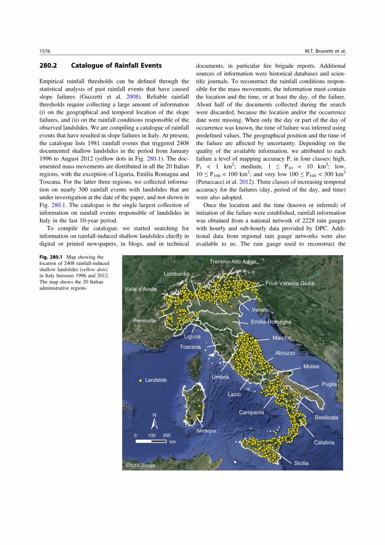
Empirical rainfall thresholds can be defined through thestatistical analysis of past rainfall events that have causedslope failures (Guzzetti et al. 2008). Reliable rainfallthresholds require collecting a large amount of information(i) on the geographical and temporal location of the slopefailures, and (ii) on the rainfall conditions responsible of theobserved landslides. We are compiling a catalogue of rainfallevents that have resulted in slope failures in Italy. At present,the catalogue lists 1981 rainfall events that triggered 2408documented shallow landslides in the period from January1996 to August 2012 (yellow dots in Fig. 280.1). The doc-umented mass movements are distributed in all the 20 Italianregions, with the exception of Liguria, Emilia Romagna andToscana. For the latter three regions, we collected informa-tion on nearly 300 rainfall events with landslides that areunder investigation at the date of the paper, and not shown inFig. 280.1. The catalogue is the single largest collection ofinformation on rainfall events responsible of landslides inItaly in the last 10-year period.
To compile the catalogue, we started searching forinformation on rainfall-induced shallow landslides chiefly indigital or printed newspapers, in blogs, and in technical
documents, in particular fire brigade reports. Additionalsources of information were historical databases and scien-tific journals. To reconstruct the rainfall conditions respon-sible for the mass movements, the information must containthe location and the time, or at least the day, of the failure.About half of the documents collected during the searchwere discarded, because the location and/or the occurrencedate were missing. When only the day or part of the day ofoccurrence was known, the time of failure was inferred usingpredefined values. The geographical position and the time ofthe failure are affected by uncertainty. Depending on thequality of the available information, we attributed to eachfailure a level of mapping accuracy P, in four classes: high,P1 < 1 km2; medium, 1 ≤ P10 < 10 km2; low,10 ≤ P100 < 100 km2; and very low 100 ≤ P100 < 300 km2
(Peruccacci et al. 2012). Three classes of increasing temporalaccuracy for the failures (day, period of the day, and time)were also adopted.
Once the location and the time (known or inferred) ofinitiation of the failure were established, rainfall informationwas obtained from a national network of 2228 rain gaugeswith hourly and sub-hourly data provided by DPC. Addi-tional data from regional rain gauge networks were alsoavailable to us. The rain gauge used to reconstruct the
Friuli-Venezia Giulia
Veneto
Emilia-Romagna
Marche
Abruzzo
Puglia
Calabria
Sicilia
Sardegna
Campania
Lazio
Toscana
Liguria
Piemonte
Valle d’Aosta
Lombardia
Molise
Trentino-Alto Adige
Basilicata
Umbria
0 100 200km
©2013 Google
Landslide
Fig. 280.1 Map showing thelocation of 2408 rainfall-inducedshallow landslides (yellow dots)in Italy between 1996 and 2012.The map shows the 20 Italianadministrative regions
1576 M.T. Brunetti et al.

rainfall event that caused the failure (i.e., rainfall duration,D, and cumulated event rainfall, E) was selected consideringthe distance from the landslide, and the relative elevation. Inplaces (e.g., in the complex Alpine orography), the localmorphological setting was also considered.
We define a rainfall event as a period or a sequence ofperiods of continuous precipitation separated from previousevents by dry periods. The length of the dry periods canvary, depending e.g., on seasonal, meteorological, and cli-matic conditions. The rainfall duration D was determined as
the time between the rainfall event starting time and the time(known or inferred) of the landslide initiation. Once therainfall duration D was determined, the cumulated eventrainfall E was obtained from the selected rain gauge record.
In the catalogue, for each rainfall event that triggered oneor more landslides the information includes: (i) rainfall eventidentification (code number, reference source), (ii) landslidelocation (place, municipality, province, region, geographicalprecision), (iii) landslide classification (if available from thesource of information), (iv) temporal information (day,
050
100150200250
300January
February
March
April
May
June
July
August
September
October
November
December
Rainfall events with landslidesLandslides
(a)
(b)
0 50 100 150 200 250 300 350 400 450
SardegnaSicilia
CalabriaBasilicata
PugliaCampania
MoliseAbruzzo
LazioMarcheUmbria
Friuli-Venezia-GiuliaVeneto
Trentino-Alto-AdigeLombardia
Valle d'AostaPiemonte
Count
Fig. 280.2 a Number of rainfallevents (green bars) and landslides(yellow bars) in the 17 Italianregions for which information isavailable in the catalogue. bNumber of rainfall events (ingreen) and landslides (in yellow)subdivided by month
280 Catalogue of Rainfall Events with Shallow Landslides 1577

month, year, time, date, temporal precision) and (v) rainfallinformation (representative rain gauge, rainfall duration, D,cumulated event rainfall, E and rainfall mean intensity, I).Figure 280.2a summarizes the total number of rainfall events(green bars) and the total number of landslides (yellow bars)in the 17 Italian regions for which information is available inthe catalogue. Variability in the number of events in eachregion is due to the incompleteness of the catalogue.Figure 280.2b portrays the monthly distributions of rainfall
events (in green), and of landslides (in yellow), and revealsthat rainfall induced failures in Italy occur mostly betweenNovember and January, but are also frequent in March.
Figure 280.3a shows the number and percentage of eachlandslide type listed in the catalogue. Most of the slopefailures (1662, 69.0%) are classified as generic shallowlandslides, due to a lack of a detailed description of the massmovement type in the source of information. The time of thefailure is available for a large portion (845, 42.7%) of therainfall-induced landslides in the catalogue (Fig. 280.3b).The majority of the landslides (1273, 52.9%) are locatedwithin an accuracy of 1 km2 (Fig. 280.3c).
280.3 National Rainfall Thresholds
We exploited the catalogue to define the new cumulatedevent rainfall-rainfall duration (ED) thresholds for the pos-sible initiation of shallow landslides in Italy. For the pur-pose, we analysed the distribution of the rainfall EDconditions responsible for the failures using a statisticalfrequentist method (Brunetti et al. 2010; Peruccacci et al.2012). The method allows defining objective probabilisticrainfall thresholds, and the associated uncertainties.Figure 280.4 shows, as an example, the new ED nationalrainfall threshold (black solid curve) at 5% of exceedancelevel (T5,I). The equation and the statistical uncertaintiesassociated with the threshold parameters are also shown. Asa comparison, in the same Fig. 280.4 we show the previousnational rainfall threshold (black dashed curve) at 5% ðT#
5;IÞderived from Brunetti et al. (2010). The new threshold is
(a) (b) (c)
P3008, 0.3%
P100212, 8.8%
P10915, 38.0%
P11273, 52.9%
Time845, 42.7%
Day period662, 33.4%
Day474, 23.9%
Shallow landslide1662, 69.0%
Rock fall390, 16.2%
Soil slip11, 0.5%
Debris flow116, 4.8%
Earth flow, mud flow229, 9.5%
Fig. 280.3 a Number andpercentage of landslides ofdifferent types in the catalogue. bNumber and percentage oflandslides with different level oftemporal accuracy. c Number andpercentage of landslides withdifferent level of mappingaccuracy
1h 1d 2d 4d 1w 2w 3w 1m 6w
T5,I : E = (7.1 ± 0.3) · D (0.40 ± 0.01)
T*5,I : E = 12.17 · D 0.36
100 101 102 103
103
100
101
102
Duration, D (h)
Cum
ulat
ed r
ainf
all,
E (m
m)
T5,I
1981 rainfall events
T*5,I
Fig. 280.4 Distribution of the cumulated rainfall (E) as a function ofthe rainfall duration (D) for 1981 rainfall events (green dots) thattriggered 2408 landslides in Italy. The black solid curve is the nationalrainfall threshold at 5% (T5,I) of exceedance level. The black dashedcurve is the previous national rainfall threshold at 5%
1578 M.T. Brunetti et al.

lower than the previous and this is mostly ascribed to thedifferent sources of information used to collect the two datasets. The main sources of landslide and rainfall informationused for this work were news and fire brigade reports.Brunetti et al. (2010) used chiefly information collected fromthe scientific literature, which usually reports large (i.e., rare,catastrophic) rainfall events that have triggered abundant andwidespread landslides. Using the frequentist method largerainfall events in the data set result in higher rainfallthresholds.
The new rainfall thresholds can be implemented in anationwide landslide warning system.
Acknowledgments Research conducted with funding provided by theItalian National Department for Civil Protection (DPC).
References
Brunetti MT, Peruccacci S, Rossi M, Luciani S, Valigi D, Guzzetti F(2010) Rainfall thresholds for the possible occurrence of landslidesin Italy. Nat Hazards Earth Syst Sci 10:447–458
Guzzetti F, Peruccacci S, Rossi M, Stark CP (2008) The rainfallintensity-duration control of shallow landslides and debris flows: anupdate. Landslides 5(1):3–17
Peruccacci S, Brunetti MT, Luciani S, Vennari C, Guzzetti F (2012)Lithological and seasonal control of rainfall thresholds for thepossible initiation of landslides in central Italy. Geomorphology139–140:79–90
Rossi M et al (2012) In: Eberhardt E et al (eds) Landslides andengineered slopes: protecting society through improved understand-ing, ISL NASL 2012, Banff, Alberta, Canada, June 2012, vol 2.Taylor & Francis Group, London, pp 1895–1899
Salvati P, Bianchi C, Rossi M, Guzzetti F (2010) Societal landslide andflood risk in Italy. Nat Hazards Earth Syst Sci 10:465–483
280 Catalogue of Rainfall Events with Shallow Landslides 1579

Engineering Geology for Society and Territory – Volume 2Landslide Processes
Giorgio LollinoDaniele GiordanGiovanni Battista CrostaJordi CorominasRafig AzzamJanusz WasowskiNicola Sciarra Editors
Top Related
Copyright © 2022 FDOKUMEN

