zoom instruction guide - City of Altoona WI
177
To Summary + Materials >> To Summary + Materials>> To Summary + Materials>> To ZOOM User Guide>> To Summary + Materials>>
-
Upload
khangminh22 -
Category
Documents
-
view
4 -
download
0
Transcript of zoom instruction guide - City of Altoona WI

To Summary + Materials >>
To Summary + Materials>>
To Summary + Materials>>
To ZOOM User Guide>>
To Summary + Materials>>

To Summary>>

IMPORTANT INFORMATION
ZOOM can be accessed by telephone or computer. You must have a computer or mobile phone app to see the PowerPoint slides.
For those participating by computer only, you must have a microphone enabled computer to communicate verbally. Otherwise you will have to call in via the telephone as well.
ZOOM INSTRUCTION GUIDE
WEBSITE and TELEPHONE
DUE TO CORONAVIRUS COVID-19 RESIDENTS ARE ENCOURAGED TO ATTEND THE PLAN COMMISSION MEETING VIA THE APPLICATION, ZOOM UNTIL FURTHER
NOTICE.
ZOOM MEETING INFORMATION: WEBSITE: https://zoom.us/join
MEETING ID: 823 0091 7655
Webinar Password: 609876
CALL IN PHONE NUMBER: 1-312-626-6799
To Agenda>>

TO ACCESS VIA TELEPHONE:
1. Call phone number: 1-312-626-6799
2. Enter Meeting ID: 823 0091 7655
3. Enter webinar password: 609876# to confirm you area participant and enter the meeting
4. To state a public comment, “raise hand”: *9(You will be called on in order received)

TO ACCESS VIA WEBSITE: 1. Access website at: https://zoom.us/join
2. A set of dialogue boxes will appear (as seen below)
Enter Meeting ID: 823 0091 7655
CLICK HERE
1
2

Enter meeting ID: 823 0091 7655
CLICK HERE
Enter Your Name to be displayed in Zoom meeting for public viewing
3
4 823 0091 7655
5. Enter webinar password on the next screen: 609876

CLICK HERE
5a
5b
Computer Audio
Phone Call
Call 1-312-626-6799 1-312-626-6799Meeting ID: 823 0091 7655
Meeting Password: 609876

3. Use icon RAISE HAND to provide Public Comments. You will be unmuted andcalled upon on in the order received.
SEE WEBSITE LINKS BELOW FOR MORE TUTORIALS
https://support.zoom.us/hc/en-us/articles/201362193
https://support.zoom.us/hc/en-us
https://www.youtube.com/embed/vFhAEoCF7jg?rel=0&autoplay=1&cc_load_policy=1
Click here to PUBLIC COMMENT
6

City of Altoona WI Special Plan Commission Summary, 2021 March 23 Page 1 of 3
MEMORANDUM
TO: Altoona Plan Commission
FROM: Joshua Clements, City Planner
DATE: March 18, 2021
SUBJECT: Summary of March 23, 2021 Plan Commission
Provided below for your consideration is a summary of the Plan Commission agenda items.
(IV) UNFINISHED BUSINESS
(V) NEW BUSINESS
ITEM 1 - Public Hearing at 6:00 p.m. or as soon thereafter as possible regarding a Preliminary Plat for River Prairie Townhomes.
See Enclosed: ● Preliminary Plat, River Prairie Townhomes● Declaration of Restrictive Covenants, HOA Incorporation & Bylaws (Draft)● Preliminary Plat Application● Community Impact Statement● Title 18 Environmental Checklist● 2020-1021 Memo to the City of Altoona RE Plat Review and Approval (Behling)
As you recall, the Specific Implementation Plan (SIP) for the River Prairie Townhome Condominiums was approved on August 27th.
The platting action is a completely separate and distinct process than the evaluation of the land use or characteristics of the use of the property. Those elements were approved and entitled with the Specific Implementation Plan. Final storm water permit will be reviewed and approved by the City of Altoona and Wisconsin Department of Natural Resources.
The Preliminary Plat was previously approved by the Plan Commission on February 23rd and by the City Council on February 25th. The platting process was re-started as the February action did not meet the 30 day waiting period in Altoona Municipal Code. Restarting the platting process does not affect the approved use or related permits.
To Agenda>>

City of Altoona WI Special Plan Commission Summary, 2021 March 23 Page 2 of 3
As described in the October 21, 2020 Memo by Attorney Behling, the standards of approval for a Plat are the technical drafting requirements of plats. Staff has determined that the Preliminary Plat as presented meets the technical requirements and is consistent with the amended SIP.
Suggested Motion: I move to close the public hearing.
ITEM 2 - Discuss/Consider recommendation to Council regarding Preliminary Plat for River Prairie Townhome Condominium. (Will be discussed at the March 25, 2021 Council Meeting).
Staff recommends approval of the Preliminary Plat.
Suggested Motion: I move to recommend / not recommend approval of the Preliminary Plat.
ITEM 3 - Discuss/consider Plan Commission Resolution 3A-21 Bicycle and Pedestrian Plan Preparation
See Enclosed: ● Proposed PC Resolution 3A-21
The West Central Wisconsin Regional Planning Commission (RPC) has offered to partner with the City to create a Bicycle and Pedestrian Plan. Commission-related costs for the project are covered by the Metropolitan Planning Organization, a constituent component of the RPC.
The Resolution formalizes the direction of the Plan Commission to staff to undertake the planning process, including creation of a temporary Ad-hoc Advisory Committee as a public engagement and contribution method.
As you may recall, the RPC completed the Safe Routes to School Plan for the City in 2017 as well as the Bicycle and Pedestrian Plan for the Metropolitan Region, 2017-2027.
Staff envisions the Bicycle and Pedestrian Plan to build upon and potentially become integrated into the Place Plan. Planning activities will be arranged for maximum coordination and co-benefit with the soon-to-launch Comprehensive Plan process.
The Bike-Ped Plan process is anticipated to take approximately 6 to 8 months.
Suggested Motion: I move to approve / not approve Plan Commission Resolution 3A-21.
ITEM 4 - Discussion and possible action regarding the Altoona Place Plan.
See Enclosed: ● Place Plan Chapter 2: Introduction (Draft)● Place Plan Chapter 3: Vision and Goals (Draft)● Place Plan Chapter 5: Open Space Inventory (Draft)● Parks Survey Results (2016-1219)● Bicycle Route Segment Map (2021-0319)

City of Altoona WI Special Plan Commission Summary, 2021 March 23 Page 3 of 3
As you know, city staff has been working on the Place Plan since fall 2016 as an ambitious vision for public space in the city. Due to the scope and ambition of this effort, and overall responsibility of staff to carry out all community development activities of the city, the study and preparation of plan is carried on. Draft versions of the Place Plan have been utilized in annual capital improvement planning and other implementation activities since 2017.
Enclosed are 90% drafts of Chapters 2, 3, and 5. These remain under edit and review by various city departments. Certain sections are less well edited and polished than others. The Bicycle Route Segment Map is also enclosed. The Open Space System Map, which will serve as a “cleaner” version is substantially similar and is being polished. Various versions of these items have been previously presented before the Parks Board and Plan Commission over the past four years.
Chapter 4: System Needs Assessment, Chapter 6: Bicycle and Pedestrian Element, and Chapter 7: Implementation are less complete. They will be provided as soon as coherent drafts are prepared. The cover and many of the appendices remain in less prepared draft condition.
Preparation of a WI DNR grant requires that the city have an adopted plan that meets the DNR standards for a comprehensive outdoor recreation plan (CORP). The Place Plan is intended to incorporate those elements. Due to the grant application being May 1, this places a time-certain direction for adoption for the Plan or sufficient components thereof.
The Place Plan is expected to be revised in Q4 2021 or Q1 2022 to integrate the Bicycle and Pedestrian Plan, and to integrate content from and be consistent with the new Comprehensive Plan. This may be thought of as “Phase II”. As a partial consequence, the bicycle and pedestrian element of the Place Plan is less well developed than other components due to time constraints of the grant deadline, and opportunity to be more effectively and deeply studied with expert assistance.
Much of the focused public engagement, including the survey, was conducted in 2016 and 2017. There have been intermittent activities since that period, focused primarily on more specific projects such as capital improvement projects (playgrounds, trails), River Prairie, Windsor Forest Neighborhood, and future development areas east and south of the city. The results for those engagement activities remain valuable and valid. However, engagement activities of the bicycle & pedestrian plan and comprehensive plan will be utilized in the planned revision.
Staff plans to publish the materials online and solicit public comment and feedback. Approval of the Plan is desired in April to meet the grant deadline.
Suggested Motion: I move to advance the components of the Place Plan presented to the Commission for Public Comment and to schedule a public hearing for adoptive consideration.
(VI) - MISCELLANEOUS BUSINESS
ITEM 1 - Additional Reading and Resources The Brookings Institution published an article in December examining the changing demographics of U.S. households. The article briefly examines these trends and connects changing household composition to the housing market, which is less flexible and slow to change.
www.brookings.edu/essay/trend-2-americas-demographics-are-transforming-but-our-housing-supply-is-not/

City of Altoona WI Special Plan Commission Summary, 2021 March 23 Page 1 of 2
MEMORANDUM
TO: Altoona Plan Commission
FROM: Joshua Clements, City Planner
DATE: March 18, 2021
SUBJECT: Summary of March 23, 2021 Plan Commission
Provided below for your consideration is a summary of the Plan Commission agenda items.
(V) NEW BUSINESS
ITEM 1 - Public Hearing at 6:00 p.m. or as soon thereafter as possible regarding a Preliminary Plat for River Prairie Townhomes.
See Enclosed: ● Preliminary Plat, River Prairie Townhomes● Declaration of Restrictive Covenants, HOA Incorporation & Bylaws (Draft)● Preliminary Plat Application● Community Impact Statement● Title 18 Environmental Checklist● 2020-1021 Memo to the City of Altoona RE Plat Review and Approval (Behling)
As you recall, the Specific Implementation Plan (SIP) for the River Prairie Townhome Condominiums was approved on August 27th.
The platting action is a completely separate and distinct process than the evaluation of the land use or characteristics of the use of the property. Those elements were approved and entitled with the Specific Implementation Plan. Final storm water permit will be reviewed and approved by the City of Altoona and Wisconsin Department of Natural Resources.
The Preliminary Plat was previously approved by the Plan Commission on February 23rd and by the City Council on February 25th. The platting process was re-started as the February action did not meet the 30 day waiting period in Altoona Municipal Code. Restarting the platting process does not affect the approved use or related permits.
As described in the October 21, 2020 Memo by Attorney Behling, the standards of approval for a Plat are the technical drafting requirements of plats. Staff has determined that the Preliminary Plat as presented meets the technical requirements and is consistent with the amended SIP.
Suggested Motion: I move to close the public hearing.
Plan Commission | March 23, 2021 New Business | Item 1 and 2 | Page 1 of 63
To Agenda>>

City of Altoona WI Special Plan Commission Summary, 2021 March 23 Page 2 of 2
ITEM 2 - Discuss/Consider recommendation to Council regarding Preliminary Plat for River Prairie Townhome Condominium. (Will be discussed at the March 25, 2021 Council Meeting).
Staff recommends approval of the Preliminary Plat.
Suggested Motion: I move to recommend / not recommend approval of the Preliminary Plat.
Plan Commission | March 23, 2021 New Business | Item 1 and 2 | Page 2 of 63

CURVE DATA (C1)RADIUS = 884.60'CHORD BEARING = S65°55'56"ECHORD = 33.60'ARC = 33.60'DELTA = 2°10'35"TANGENT IN = S64°50'39"ETANGENT OUT = S67°01'14"E
C1
CITY UTILITYEASEMENT
XCELEASEMENT46.71'
FOUND ALUMINUM MONUMENT
FOUND 3/4" IRON BAR
FOUND 1" OUTSIDE DIAMETER IRON PIPE
FOUND SQUARE LIMESTONE MONUMENT
SET 1" OUTSIDE DIAMETER BY 18" IRON PIPE,
1.13 POUNDS / LINEAR F00T
FOUND 2" OUTSIDE DIAMETER IRON PIPE
RECORD INFORMATION( )
LEGEND
UTILITY EASMENT
PH: (715) 831-0654 EMAIL: [email protected]
1818 BRACKETT AVENUE
EAU CLAIRE, WI 54701
NORTHWEST QUARTER OF THE NORTHWEST QUARTERSECTION 23, TOWNSHIP 27 NORTH, RANGE 9 WEST
NOT TO SCALE
RIVER PRAIRIE TOWNHOMESPart of the Northwest Quarter of the Northwest Quarter, Section 23, Township27 North, Range 9 West, City of Altoona, Eau Claire County, Wisconsin,including all of Lot 1 Certified Survey Map Number 2584 recorded in Volume14 of Certified Survey Maps on Pages 187-188 as Document Number 993666,and part of Outlot C of Moonlight Bay Subdivision.
SHEET 1 OF 2
Developer:Grip Development, LLC2601 Morningside DriveEau Claire, WI 54703
Surveyor:Jeffrey C. Stockburger, PLS #27081818 Brackett Ave.Eau Claire, WI 54701
RIVER PRAIRIE
PRELIMINARY PLATOF
EVERYDAY SURVEYING & ENGINEERING
TOWNHOMES
NW-NW
BEARINGS ARE REFERENCED TO THE WEST
LINE OF THE NORTHWEST 1/4 OF SECTION 23,
WHICH IS ASSUMED TO BEAR N0°27'24"E.
1"=50'
Plan Commission | March 23, 2021 New Business | Item 1 and 2 | Page 3 of 63
AutoCAD SHX Text
LAKE ROAD
AutoCAD SHX Text
MOONLIGHT BAY ROAD
AutoCAD SHX Text
LAKE ROAD
AutoCAD SHX Text
MOONLIGHT BAY ROAD
AutoCAD SHX Text
WIDTH VARIES
AutoCAD SHX Text
MOONLIGHT BAY SUBDIVISION VOLUME 7 PAGE 31
AutoCAD SHX Text
RIVER PRAIRIE TWINHOMES VOLUME 13 PAGE 20A
AutoCAD SHX Text
66'
AutoCAD SHX Text
66'
AutoCAD SHX Text
OUTLOT "C"
AutoCAD SHX Text
UNION PACIFIC RAILROAD COMPANY
AutoCAD SHX Text
EASEMENT DOCUMENT #1100071 TO UNION PACIFIC RAILROAD COMPANY
AutoCAD SHX Text
WIDTH VARIES
AutoCAD SHX Text
30' EXISTING CITY OF ALTOONA UTILITY EASEMENT
AutoCAD SHX Text
1
AutoCAD SHX Text
3
AutoCAD SHX Text
LOT 1 CERTIFIED SURVEY MAP #2584 VOLUME 14 PAGE 187-188
AutoCAD SHX Text
150'
AutoCAD SHX Text
5
AutoCAD SHX Text
UTILITY & ACCESS EASEMENT
AutoCAD SHX Text
1
AutoCAD SHX Text
2
AutoCAD SHX Text
3
AutoCAD SHX Text
4
AutoCAD SHX Text
5
AutoCAD SHX Text
6
AutoCAD SHX Text
7
AutoCAD SHX Text
8
AutoCAD SHX Text
9
AutoCAD SHX Text
10
AutoCAD SHX Text
11
AutoCAD SHX Text
12
AutoCAD SHX Text
13
AutoCAD SHX Text
14
AutoCAD SHX Text
15
AutoCAD SHX Text
16
AutoCAD SHX Text
17
AutoCAD SHX Text
18
AutoCAD SHX Text
19
AutoCAD SHX Text
20
AutoCAD SHX Text
21
AutoCAD SHX Text
22
AutoCAD SHX Text
23
AutoCAD SHX Text
24
AutoCAD SHX Text
25
AutoCAD SHX Text
26
AutoCAD SHX Text
27
AutoCAD SHX Text
28
AutoCAD SHX Text
30
AutoCAD SHX Text
29
AutoCAD SHX Text
31
AutoCAD SHX Text
32
AutoCAD SHX Text
33
AutoCAD SHX Text
34
AutoCAD SHX Text
35
AutoCAD SHX Text
36
AutoCAD SHX Text
OUTLOT 1
AutoCAD SHX Text
OUTLOT 1
AutoCAD SHX Text
LAKE ROAD
AutoCAD SHX Text
MOONLIGHT BAY ROAD
AutoCAD SHX Text
LAKE ROAD
AutoCAD SHX Text
MOONLIGHT BAY ROAD
AutoCAD SHX Text
UNION PACIFIC RAILROAD COMPANY
AutoCAD SHX Text
50
AutoCAD SHX Text
0
AutoCAD SHX Text
25
AutoCAD SHX Text
NORTHWEST CORNER 23-27-09 (TIES VERIFIED)
AutoCAD SHX Text
WEST 1/4 CORNER 23-27-09 (TIES VERIFIED)
AutoCAD SHX Text
Easement information: 1. Northern States Power Easement document #314601 affects Northern States Power Easement document #314601 affects west 25 feet Outlot "C" of Moonlight Bay Subdivision. 2. Property is subject to flowage rights over the NW 1/4-NW Property is subject to flowage rights over the NW 1/4-NW 1/4 Section 23 per Document #172534. 3. Property is subject to Northern States Power Easement Property is subject to Northern States Power Easement Document #501102 covering a strip of land 12 feet in width, 6 feet on either side of the electric facilities as installed. 4. Property is subject to Notice of Supplemental Final Order Property is subject to Notice of Supplemental Final Order and Judgement to AT&T in Document #967085. 5. AT&T Easement Document Number 996800.AT&T Easement Document Number 996800.
AutoCAD SHX Text
X

PH: (715) 831-0654 EMAIL: [email protected]
1818 BRACKETT AVENUE
EAU CLAIRE, WI 54701
SHEET 2 OF 2
EVERYDAY SURVEYING & ENGINEERING
CORPORATE OWNER'S CERTIFICATE OF DEDICATION
Grip Development, LLC, a corporation organized and existing under and by virtue of the laws of the State ofWisconsin, as owners do hereby certify that said company caused the land described on this plat to be surveyed,divided, mapped and dedicated as represented on the plat. Grip Development, LLC, does further certify that thisplat is required by S.236.10 or 236.12 to be submitted to the following for approval or objection.
------- City of Altoona------- Department of Administration
In witness hereof, the said Grip Development, LLC, has caused this document to be signed by JasonGriepentrog it's member.
On this day of , 2021.
.Jason Griepentrog, MemberGrip Development, LLC,
State of Wisconsin
County of SS
Personally came before me, this day of , 2021. The above named Jason Griepentrog.To me known to be the persons who executed the foregoing instrument and acknowledged the same.
.Notary Public
My commission expires .
SURVEYOR'S CERTIFICATE
I, Jeffrey C. Stockburger, Professional Land Surveyor in the State of Wisconsin, do hereby certify that by the orderof Jason Griepentrog, I have surveyed part of the Northwest Quarter of the Northwest Quarter, Section 23,Township 27 North, Range 9 West, City of Altoona, Eau Claire County, Wisconsin, including all of Lot 1 CertifiedSurvey Map Number 2584 recorded in Volume 14 of Certified Survey Maps on Pages 187-188 as DocumentNumber 993666, and part of Outlot C of Moonlight Bay Subdivision. The parcel is more particularly described asfollows:
Commencing at the West Quarter Corner of said Section 23;Thence N00°27'24"E, 1,456.64 feet along the West line of the Northwest Quarter to the point of beginning;Thence N00°30'48"E, 265.10 feet along the west line of Certified Survey Map Number 2584 and a southerlyextension thereof to the northwest corner of said Certified Survey Map;Thence S69°06'40"E, 517.92 feet along the northeasterly line of said Certified Survey Map;Thence along said northeasterly line and the arc of a curve 33.60 feet, concave southwesterly, with a chord bearingof S65°55'56"E, a chord length of 33.60 feet, and a radius of 884.60 feet;Thence S64°55'37"E, 458.28 feet along said northeasterly line to the southeast corner of said Certified Survey MapNumber 2584;Thence S89°14'16"W, 543.47 feet along the southerly line of said Certified Survey Map and a westerly extensionthereof to the northerly right-of-way line of the Union Pacific Railroad Company;Thence N70°52'46"W, 411.29 feet along said right-of-way line to the point of beginning.
Said parcel contains 170,974 square feet or 3.93 total acres, more or less.
I also certify that I have complied with the provisions of Chapter 236.34 of the Wisconsin Statutes, WisconsinAdministrative Code Chapter AE-7, and the City of Altoona Subdivision Ordinance. I further certify to the best ofmy knowledge and belief that the accompanying map is a true and correct representation of the exterior boundariesof the land surveyed and the division thereof made.
On this day of , 2021.
Jeffrey C. Stockburger S-2708
COUNTY TREASURERS CERTIFICATE
State of Wisconsin
County of SS
I, Glenda Lyons, being the duly elected, qualified, and acting treasurer of the County of Eau Claire, do herebycertify that the records in my office show no unredeemed tax sales and no unpaid taxes or special assessments onany of the land included in this plat of River Prairie Townhomes.
Dated this day of , 2021.
.Glenda Lyons, County Treasurer
CITY TREASURERS CERTIFICATE
State of Wisconsin
County of SS
I, Tina Nelson, City Treasurer, being the duly qualified and acting city treasurer of the City of Altoona, dohereby certify that the records in my office show no unredeemed tax sales and no unpaid taxes or specialassessments on any of the land included in this plat of River Prairie Townhomes.
Dated this day of , 2021.
.Tina Nelson, City Treasurer
COMMON COUNCIL RESOLUTION
Resolved that the plat of River Prairie Townhomes, located in the City of Altoona is hereby approved by theCity of Altoona.
Approved this day of , 2021.
.Brendan Pratt, Mayor
I hereby certify that the foregoing is a copy of a resolution adopted by the City of Altoona.
.Cindy Bauer, City Clerk
, a corporation duly organized and existing under and by virtue of the laws of the State of ,mortgagee of the above described land, does hereby consent to the surveying, dividing, mapping and dedication of the landdescribed on this plat, and does hereby consent to the above certificate of Jason Griepentrog, owner.
IN WITNESS WHEREOF, the said , has caused these presents to be signed by
, its ,
and countersigned by , its
, at , and its corporate seal to be
hereunto affixed this day of , 2021.
State of Wisconsin
County of SS
Personally came before me, this day of , 2021. The above named corporation to me known to be the
persons who executed the foregoing instrument and acknowledged the same.
.Notary Public
My commission expires .
CONSENT OF MORTGAGEE
RIVER PRAIRIE TOWNHOMESPart of the Northwest Quarter of the Northwest Quarter, Section 23, Township27 North, Range 9 West, City of Altoona, Eau Claire County, Wisconsin,including all of Lot 1 Certified Survey Map Number 2584 recorded in Volume14 of Certified Survey Maps on Pages 187-188 as Document Number 993666,and part of Outlot C of Moonlight Bay Subdivision.
PRELIMINARY PLATOF
Plan Commission | March 23, 2021 New Business | Item 1 and 2 | Page 4 of 63

CURVE DATA (C1)RADIUS = 884.60'CHORD BEARING = S65°55'56"ECHORD = 33.60'ARC = 33.60'DELTA = 2°10'35"TANGENT IN = S64°50'39"ETANGENT OUT = S67°01'14"E
C1
CITY UTILITYEASEMENT
XCELEASEMENT46.71'
FOUND ALUMINUM MONUMENT
FOUND 3/4" IRON BAR
FOUND 1" OUTSIDE DIAMETER IRON PIPE
FOUND SQUARE LIMESTONE MONUMENT
SET 1" OUTSIDE DIAMETER BY 18" IRON PIPE,
1.13 POUNDS / LINEAR F00T
FOUND 2" OUTSIDE DIAMETER IRON PIPE
RECORD INFORMATION( )
LEGEND
UTILITY EASMENT
PH: (715) 831-0654 EMAIL: [email protected]
1818 BRACKETT AVENUE
EAU CLAIRE, WI 54701
NORTHWEST QUARTER OF THE NORTHWEST QUARTERSECTION 23, TOWNSHIP 27 NORTH, RANGE 9 WEST
NOT TO SCALE
RIVER PRAIRIE TOWNHOMESPart of the Northwest Quarter of the Northwest Quarter, Section 23, Township27 North, Range 9 West, City of Altoona, Eau Claire County, Wisconsin,including all of Lot 1 Certified Survey Map Number 2584 recorded in Volume14 of Certified Survey Maps on Pages 187-188 as Document Number 993666,and part of Outlot C of Moonlight Bay Subdivision.
SHEET 1 OF 2
Developer:Grip Development, LLC2601 Morningside DriveEau Claire, WI 54703
Surveyor:Jeffrey C. Stockburger, PLS #27081818 Brackett Ave.Eau Claire, WI 54701
RIVER PRAIRIE
PRELIMINARY PLATOF
EVERYDAY SURVEYING & ENGINEERING
TOWNHOMES
NW-NW
BEARINGS ARE REFERENCED TO THE WEST
LINE OF THE NORTHWEST 1/4 OF SECTION 23,
WHICH IS ASSUMED TO BEAR N0°27'24"E.
1"=50'
Plan Commission | March 23, 2021 New Business | Item 1 and 2 | Page 5 of 63
AutoCAD SHX Text
LAKE ROAD
AutoCAD SHX Text
MOONLIGHT BAY ROAD
AutoCAD SHX Text
LAKE ROAD
AutoCAD SHX Text
MOONLIGHT BAY ROAD
AutoCAD SHX Text
WIDTH VARIES
AutoCAD SHX Text
MOONLIGHT BAY SUBDIVISION VOLUME 7 PAGE 31
AutoCAD SHX Text
RIVER PRAIRIE TWINHOMES VOLUME 13 PAGE 20A
AutoCAD SHX Text
66'
AutoCAD SHX Text
66'
AutoCAD SHX Text
OUTLOT "C"
AutoCAD SHX Text
UNION PACIFIC RAILROAD COMPANY
AutoCAD SHX Text
EASEMENT DOCUMENT #1100071 TO UNION PACIFIC RAILROAD COMPANY
AutoCAD SHX Text
WIDTH VARIES
AutoCAD SHX Text
30' EXISTING CITY OF ALTOONA UTILITY EASEMENT
AutoCAD SHX Text
1
AutoCAD SHX Text
3
AutoCAD SHX Text
LOT 1 CERTIFIED SURVEY MAP #2584 VOLUME 14 PAGE 187-188
AutoCAD SHX Text
150'
AutoCAD SHX Text
5
AutoCAD SHX Text
UTILITY & ACCESS EASEMENT
AutoCAD SHX Text
1
AutoCAD SHX Text
2
AutoCAD SHX Text
3
AutoCAD SHX Text
4
AutoCAD SHX Text
5
AutoCAD SHX Text
6
AutoCAD SHX Text
7
AutoCAD SHX Text
8
AutoCAD SHX Text
9
AutoCAD SHX Text
10
AutoCAD SHX Text
11
AutoCAD SHX Text
12
AutoCAD SHX Text
13
AutoCAD SHX Text
14
AutoCAD SHX Text
15
AutoCAD SHX Text
16
AutoCAD SHX Text
17
AutoCAD SHX Text
18
AutoCAD SHX Text
19
AutoCAD SHX Text
20
AutoCAD SHX Text
21
AutoCAD SHX Text
22
AutoCAD SHX Text
23
AutoCAD SHX Text
24
AutoCAD SHX Text
25
AutoCAD SHX Text
26
AutoCAD SHX Text
27
AutoCAD SHX Text
28
AutoCAD SHX Text
30
AutoCAD SHX Text
29
AutoCAD SHX Text
31
AutoCAD SHX Text
32
AutoCAD SHX Text
33
AutoCAD SHX Text
34
AutoCAD SHX Text
35
AutoCAD SHX Text
36
AutoCAD SHX Text
OUTLOT 1
AutoCAD SHX Text
OUTLOT 1
AutoCAD SHX Text
LAKE ROAD
AutoCAD SHX Text
MOONLIGHT BAY ROAD
AutoCAD SHX Text
LAKE ROAD
AutoCAD SHX Text
MOONLIGHT BAY ROAD
AutoCAD SHX Text
UNION PACIFIC RAILROAD COMPANY
AutoCAD SHX Text
50
AutoCAD SHX Text
0
AutoCAD SHX Text
25
AutoCAD SHX Text
NORTHWEST CORNER 23-27-09 (TIES VERIFIED)
AutoCAD SHX Text
WEST 1/4 CORNER 23-27-09 (TIES VERIFIED)
AutoCAD SHX Text
Easement information: 1. Northern States Power Easement document #314601 affects Northern States Power Easement document #314601 affects west 25 feet Outlot "C" of Moonlight Bay Subdivision. 2. Property is subject to flowage rights over the NW 1/4-NW Property is subject to flowage rights over the NW 1/4-NW 1/4 Section 23 per Document #172534. 3. Property is subject to Northern States Power Easement Property is subject to Northern States Power Easement Document #501102 covering a strip of land 12 feet in width, 6 feet on either side of the electric facilities as installed. 4. Property is subject to Notice of Supplemental Final Order Property is subject to Notice of Supplemental Final Order and Judgement to AT&T in Document #967085. 5. AT&T Easement Document Number 996800.AT&T Easement Document Number 996800.
AutoCAD SHX Text
X

CITY UTILITYEASEMENT
XCELEASEMENT46.71'
5.50'
15.0
0'
CURVE TABLECURVE
C12
LOT 25
OUTLOT 2
RADIUS
884.60'
884.60'
884.60'
CHORD BEARING
S65°55'56"E
S66°14'49"E
S65°09'31"E
CHORD
33.60'
23.89'
9.72'
ARC
33.60'
23.89'
9.72'
DELTA
002°10'35"
001°32'50"
000°37'45"
TANGENT IN
S67°01'14"E
S67°01'14"E
S65°28'24"E
TANGENT OUT
S64°50'38"E
S65°28'24"E
S64°50'38"E
FOUND ALUMINUM MONUMENT
FOUND 3/4" IRON BARFOUND 1" OUTSIDE DIAMETER IRON PIPE
FOUND SQUARE LIMESTONE MONUMENT
SET 1" OUTSIDE DIAMETER BY 18" IRON PIPE, 1.13 POUNDS /LINEAR F00T AT ALL OTHER LOT AND OUTLOT CORNERS
FOUND 2" OUTSIDE DIAMETER IRON PIPE
RECORD INFORMATION( )
LEGEND
UTILITY EASMENT
SET 1 1/4" IRON BAR WEIGHING 4.30 POUNDS / LINEAR FOOT
PH: (715) 831-0654 EMAIL: [email protected]
1818 BRACKETT AVENUEEAU CLAIRE, WI 54701
NORTHWEST QUARTER OF THE NORTHWEST QUARTERSECTION 23, TOWNSHIP 27 NORTH, RANGE 9 WEST
NOT TO SCALE
RIVER PRAIRIE TOWNHOMESPart of the Northwest Quarter of the Northwest Quarter, Section 23, Township27 North, Range 9 West, City of Altoona, Eau Claire County, Wisconsin,including all of Lot 1 Certified Survey Map Number 2584 recorded in Volume14 of Certified Survey Maps on Pages 187-188 as Document Number 993666,and part of Outlot C of Moonlight Bay Subdivision.
SHEET 1 OF 4
Developer:Grip Development, LLC2601 Morningside DriveEau Claire, WI 54703
RIVER PRAIRIE
EVERYDAY SURVEYING & ENGINEERING
TOWNHOMES
NW-NW
BEARINGS ARE REFERENCED TO THE WESTLINE OF THE NORTHWEST 1/4 OF SECTION 23,
WHICH IS ASSUMED TO BEAR N0°27'24"E.
1"=50'
Plan Commission | March 23, 2021 New Business | Item 1 and 2 | Page 6 of 63
AutoCAD SHX Text
LOT 1 CERTIFIED SURVEY MAP #2584 VOLUME 14 PAGE 187-188
AutoCAD SHX Text
LAKE ROAD
AutoCAD SHX Text
MOONLIGHT BAY ROAD
AutoCAD SHX Text
LAKE ROAD
AutoCAD SHX Text
MOONLIGHT BAY ROAD
AutoCAD SHX Text
WIDTH VARIES
AutoCAD SHX Text
MOONLIGHT BAY SUBDIVISION VOLUME 7 PAGE 31
AutoCAD SHX Text
RIVER PRAIRIE TWINHOMES VOLUME 13 PAGE 20A
AutoCAD SHX Text
66'
AutoCAD SHX Text
66'
AutoCAD SHX Text
OUTLOT "C"
AutoCAD SHX Text
UNION PACIFIC RAILROAD COMPANY
AutoCAD SHX Text
C1
AutoCAD SHX Text
EASEMENT DOCUMENT #1100071 TO UNION PACIFIC RAILROAD COMPANY
AutoCAD SHX Text
WIDTH VARIES
AutoCAD SHX Text
30' EXISTING CITY OF ALTOONA UTILITY EASEMENT
AutoCAD SHX Text
1
AutoCAD SHX Text
3
AutoCAD SHX Text
150'
AutoCAD SHX Text
5
AutoCAD SHX Text
ACCESS EASEMENT SEE SHEET 2
AutoCAD SHX Text
1
AutoCAD SHX Text
2
AutoCAD SHX Text
3
AutoCAD SHX Text
4
AutoCAD SHX Text
5
AutoCAD SHX Text
6
AutoCAD SHX Text
7
AutoCAD SHX Text
8
AutoCAD SHX Text
9
AutoCAD SHX Text
10
AutoCAD SHX Text
11
AutoCAD SHX Text
12
AutoCAD SHX Text
13
AutoCAD SHX Text
14
AutoCAD SHX Text
15
AutoCAD SHX Text
16
AutoCAD SHX Text
17
AutoCAD SHX Text
18
AutoCAD SHX Text
19
AutoCAD SHX Text
20
AutoCAD SHX Text
21
AutoCAD SHX Text
22
AutoCAD SHX Text
23
AutoCAD SHX Text
24
AutoCAD SHX Text
25
AutoCAD SHX Text
26
AutoCAD SHX Text
27
AutoCAD SHX Text
28
AutoCAD SHX Text
30
AutoCAD SHX Text
29
AutoCAD SHX Text
31
AutoCAD SHX Text
32
AutoCAD SHX Text
33
AutoCAD SHX Text
34
AutoCAD SHX Text
35
AutoCAD SHX Text
36
AutoCAD SHX Text
OUTLOT 3
AutoCAD SHX Text
OUTLOT 3
AutoCAD SHX Text
OUTLOT 2
AutoCAD SHX Text
OUTLOT 2
AutoCAD SHX Text
OUTLOT 2
AutoCAD SHX Text
OUTLOT 1
AutoCAD SHX Text
OUTLOT 1
AutoCAD SHX Text
OUTLOT 1
AutoCAD SHX Text
OUTLOT 2
AutoCAD SHX Text
OUTLOT 3
AutoCAD SHX Text
OUTLOT 3
AutoCAD SHX Text
A
AutoCAD SHX Text
COURSE TABLE A N44°42'40"W 0.71'B N45°17'20"E 0.71'C N24°06'31"W 0.71'D N65°53'29"W 0.71'E N23°00'20"W 0.71'F N66°59'40"W 0.71'G N19°55'28"W 0.71'H N70°04'32"E 0.71'I N25°52'37"W 0.71'J N64°07'23"E 0.71'K N25°52'37W 0.71'L N64°07'23"E 0.71'
AutoCAD SHX Text
B
AutoCAD SHX Text
"
AutoCAD SHX Text
"
AutoCAD SHX Text
"
AutoCAD SHX Text
"
AutoCAD SHX Text
"
AutoCAD SHX Text
"
AutoCAD SHX Text
"
AutoCAD SHX Text
"
AutoCAD SHX Text
"
AutoCAD SHX Text
"
AutoCAD SHX Text
"
AutoCAD SHX Text
"
AutoCAD SHX Text
"
AutoCAD SHX Text
"
AutoCAD SHX Text
"
AutoCAD SHX Text
C
AutoCAD SHX Text
D
AutoCAD SHX Text
F
AutoCAD SHX Text
E
AutoCAD SHX Text
G
AutoCAD SHX Text
H
AutoCAD SHX Text
I
AutoCAD SHX Text
J
AutoCAD SHX Text
K
AutoCAD SHX Text
L
AutoCAD SHX Text
UTILITY EASEMENT SEE SHEET 3
AutoCAD SHX Text
33'
AutoCAD SHX Text
LAKE ROAD
AutoCAD SHX Text
MOONLIGHT BAY ROAD
AutoCAD SHX Text
LAKE ROAD
AutoCAD SHX Text
MOONLIGHT BAY ROAD
AutoCAD SHX Text
UNION PACIFIC RAILROAD COMPANY
AutoCAD SHX Text
50
AutoCAD SHX Text
0
AutoCAD SHX Text
25
AutoCAD SHX Text
NORTHWEST CORNER 23-27-09 (TIES VERIFIED)
AutoCAD SHX Text
WEST 1/4 CORNER 23-27-09 (TIES VERIFIED)
AutoCAD SHX Text
Easement information: 1. Northern States Power Easement document #314601 affects Northern States Power Easement document #314601 affects west 25 feet Outlot "C" of Moonlight Bay Subdivision. 2. Property is subject to flowage rights over the NW 1/4-NW Property is subject to flowage rights over the NW 1/4-NW 1/4 Section 23 per Document #172534. 3. Property is subject to Northern States Power Easement Property is subject to Northern States Power Easement Document #501102 covering a strip of land 12 feet in width, 6 feet on either side of the electric facilities as installed. 4. Property is subject to Notice of Supplemental Final Order Property is subject to Notice of Supplemental Final Order and Judgement to AT&T in Document #967085. 5. AT&T Easement Document Number 996800.AT&T Easement Document Number 996800.
AutoCAD SHX Text
X
AutoCAD SHX Text
NOTES: 1. SEE SHEET 2 FOR ACCESS EASEMENT DETAIL. SEE SHEET 2 FOR ACCESS EASEMENT DETAIL. 2. SEE SHEET 3 FOR UTILITY EASEMENT DETAIL.SEE SHEET 3 FOR UTILITY EASEMENT DETAIL.

CITY UTILITYEASEMENT
XCELEASEMENT46.71'
S20°
53'29
"W51
.39'
S20°
53'29
"W51
.39'
S70°52'37"E 148.30'
S70°52'37"E 140.75'
L2
L3L4
L6
L7
L8
S63°36'42"E 146.46'
N25°
04'32
"E 5
8.99
'
N25°
04'32
"E 5
8.99
'
L9
L10
S0°1
7'30
"W 9
5.65
'
L14
L13
L1C1
C2
C4
C5
C6
S63°36'42"E 150.10'
L11
C7
C3 L5
S70°52'37"E 294.35'
L12
C8
ACCESS EASEMENTLINE TABLE
LINE
L1
L2
L3
L4
L5
L6
L7
L8
L9
L10
L11
L12
L13
L14
BEARING
S00°17'30"W
N19°07'23"E
S70°52'37"E
S19°07'23"W
S63°36'42"E
N26°23'18"E
S63°36'42"E
S26°23'18"W
S46°55'13"E
S26°23'18"W
S63°36'42"E
N67°17'16"E
N00°17'30"E
S89°42'30"E
DISTANCE
14.33
18.00
20.00
18.00
9.04
18.00
20.00
18.00
11.00
9.00
25.39
31.64
14.99
20.00
ACCESS EASEMENT CURVE TABLECURVE
C1
C2
C3
C4
C5
C6
C7
C8
RADIUS
28.00'
28.00'
112.00'
28.00'
72.00'
61.00'
88.00'
52.00'
CHORD BEARING
S10°35'30"W
S35°17'33"E
S67°14'39"E
N70°43'55"E
N34°04'40"E
N79°44'03"E
S67°14'39"E
S10°35'30"W
CHORD
10.01'
32.59'
14.19'
40.05'
22.53'
72.83'
11.15'
18.60'
ARC
10.07'
34.78'
14.20'
44.62'
22.62'
78.05'
11.16'
18.70'
DELTA
020°35'59"
071°10'06"
007°15'55"
091°18'46"
018°00'15"
073°18'31"
007°15'55"
020°35'59"
TANGENT IN
S20°53'29"W
S00°17'30"W
S70°52'37"E
S63°36'42"E
N43°04'47"E
S63°36'42"E
S70°52'37"E
S20°53'29"W
TANGENT OUT
S00°17'30"W
S70°52'37"E
S63°36'42"E
N25°04'32"E
N25°04'32"E
N43°04'47"E
S63°36'42"E
S00°17'30"W
24' ACCESSEASEMENT
S20°54'08"W15.00'
S69°05'52"E15.00'
N20°54'08"E14.80'
0.92'
N72°19'23"W26.13'
N0°27'27"E12.56'
S72°19'23"E26.14'
S0°1
7'20
"W 2
63.9
4'
PH: (715) 831-0654 EMAIL: [email protected]
1818 BRACKETT AVENUEEAU CLAIRE, WI 54701
NORTHWEST QUARTER OF THE NORTHWEST QUARTERSECTION 23, TOWNSHIP 27 NORTH, RANGE 9 WEST
NOT TO SCALE
RIVER PRAIRIE TOWNHOMESPart of the Northwest Quarter of the Northwest Quarter, Section 23, Township27 North, Range 9 West, City of Altoona, Eau Claire County, Wisconsin,including all of Lot 1 Certified Survey Map Number 2584 recorded in Volume14 of Certified Survey Maps on Pages 187-188 as Document Number 993666,and part of Outlot C of Moonlight Bay Subdivision.
SHEET 2 OF 4
RIVER PRAIRIE
EVERYDAY SURVEYING & ENGINEERING
TOWNHOMES
NW-NW
BEARINGS ARE REFERENCED TO THE WESTLINE OF THE NORTHWEST 1/4 OF SECTION 23,
WHICH IS ASSUMED TO BEAR N0°27'24"E.
1"=50'
ACCESS EASEMENT DETAIL
Plan Commission | March 23, 2021 New Business | Item 1 and 2 | Page 7 of 63
AutoCAD SHX Text
LAKE ROAD
AutoCAD SHX Text
MOONLIGHT BAY ROAD
AutoCAD SHX Text
LAKE ROAD
AutoCAD SHX Text
MOONLIGHT BAY ROAD
AutoCAD SHX Text
WIDTH VARIES
AutoCAD SHX Text
MOONLIGHT BAY SUBDIVISION VOLUME 7 PAGE 31
AutoCAD SHX Text
RIVER PRAIRIE TWINHOMES VOLUME 13 PAGE 20A
AutoCAD SHX Text
66'
AutoCAD SHX Text
66'
AutoCAD SHX Text
OUTLOT "C"
AutoCAD SHX Text
UNION PACIFIC RAILROAD COMPANY
AutoCAD SHX Text
EASEMENT DOCUMENT #1100071 TO UNION PACIFIC RAILROAD COMPANY
AutoCAD SHX Text
WIDTH VARIES
AutoCAD SHX Text
1
AutoCAD SHX Text
150'
AutoCAD SHX Text
1
AutoCAD SHX Text
2
AutoCAD SHX Text
3
AutoCAD SHX Text
4
AutoCAD SHX Text
5
AutoCAD SHX Text
6
AutoCAD SHX Text
7
AutoCAD SHX Text
8
AutoCAD SHX Text
9
AutoCAD SHX Text
10
AutoCAD SHX Text
11
AutoCAD SHX Text
12
AutoCAD SHX Text
13
AutoCAD SHX Text
14
AutoCAD SHX Text
15
AutoCAD SHX Text
16
AutoCAD SHX Text
17
AutoCAD SHX Text
18
AutoCAD SHX Text
19
AutoCAD SHX Text
20
AutoCAD SHX Text
21
AutoCAD SHX Text
22
AutoCAD SHX Text
23
AutoCAD SHX Text
24
AutoCAD SHX Text
25
AutoCAD SHX Text
27
AutoCAD SHX Text
28
AutoCAD SHX Text
30
AutoCAD SHX Text
29
AutoCAD SHX Text
31
AutoCAD SHX Text
32
AutoCAD SHX Text
33
AutoCAD SHX Text
34
AutoCAD SHX Text
35
AutoCAD SHX Text
36
AutoCAD SHX Text
OUTLOT 3
AutoCAD SHX Text
OUTLOT 3
AutoCAD SHX Text
OUTLOT 2
AutoCAD SHX Text
OUTLOT 2
AutoCAD SHX Text
OUTLOT 2
AutoCAD SHX Text
OUTLOT 1
AutoCAD SHX Text
OUTLOT 1
AutoCAD SHX Text
OUTLOT 1
AutoCAD SHX Text
OUTLOT 2
AutoCAD SHX Text
OUTLOT 3
AutoCAD SHX Text
OUTLOT 3
AutoCAD SHX Text
F
AutoCAD SHX Text
33'
AutoCAD SHX Text
50'
AutoCAD SHX Text
50'
AutoCAD SHX Text
24'
AutoCAD SHX Text
26
AutoCAD SHX Text
LAKE ROAD
AutoCAD SHX Text
MOONLIGHT BAY ROAD
AutoCAD SHX Text
LAKE ROAD
AutoCAD SHX Text
MOONLIGHT BAY ROAD
AutoCAD SHX Text
UNION PACIFIC RAILROAD COMPANY
AutoCAD SHX Text
50
AutoCAD SHX Text
0
AutoCAD SHX Text
25
AutoCAD SHX Text
NORTHWEST CORNER 23-27-09 (TIES VERIFIED)
AutoCAD SHX Text
WEST 1/4 CORNER 23-27-09 (TIES VERIFIED)

CITY UTILITYEASEMENT
XCELEASEMENT46.71'
5.50'
15.0
0'
N0°
27'3
3"E
152
.09'
N69°19'40"W 124.88'
N45°17'30"E10.73'
N45°17
'30"E
40.68
'
S89°42'30"E24.44'
S89°42'30"E 118.19'
S0°2
7'33
"W 1
07.7
6'
S80°38'11"E 99.05'
S67°16'01"E 420.77'
N70°04'32"E26.57'
N25°
04'32
"E 6
2.07
'N2
5°04
'32"E
70.
36'
S67°16'00"E 399.73'
N70°04'32"E 61.85'
S78°29'15"E 76.51'
S89°42'30"E 109.83'
PH: (715) 831-0654 EMAIL: [email protected]
1818 BRACKETT AVENUEEAU CLAIRE, WI 54701
NORTHWEST QUARTER OF THE NORTHWEST QUARTERSECTION 23, TOWNSHIP 27 NORTH, RANGE 9 WEST
NOT TO SCALE
RIVER PRAIRIE TOWNHOMESPart of the Northwest Quarter of the Northwest Quarter, Section 23, Township27 North, Range 9 West, City of Altoona, Eau Claire County, Wisconsin,including all of Lot 1 Certified Survey Map Number 2584 recorded in Volume14 of Certified Survey Maps on Pages 187-188 as Document Number 993666,and part of Outlot C of Moonlight Bay Subdivision.
SHEET 3 OF 4
RIVER PRAIRIE
EVERYDAY SURVEYING & ENGINEERING
TOWNHOMES
NW-NW
BEARINGS ARE REFERENCED TO THE WESTLINE OF THE NORTHWEST 1/4 OF SECTION 23,
WHICH IS ASSUMED TO BEAR N0°27'24"E.
1"=50'
UTILITY EASEMENT DETAIL
Plan Commission | March 23, 2021 New Business | Item 1 and 2 | Page 8 of 63
AutoCAD SHX Text
LAKE ROAD
AutoCAD SHX Text
MOONLIGHT BAY ROAD
AutoCAD SHX Text
LAKE ROAD
AutoCAD SHX Text
MOONLIGHT BAY ROAD
AutoCAD SHX Text
WIDTH VARIES
AutoCAD SHX Text
MOONLIGHT BAY SUBDIVISION VOLUME 7 PAGE 31
AutoCAD SHX Text
RIVER PRAIRIE TWINHOMES VOLUME 13 PAGE 20A
AutoCAD SHX Text
66'
AutoCAD SHX Text
66'
AutoCAD SHX Text
OUTLOT "C"
AutoCAD SHX Text
UNION PACIFIC RAILROAD COMPANY
AutoCAD SHX Text
C1
AutoCAD SHX Text
EASEMENT DOCUMENT #1100071 TO UNION PACIFIC RAILROAD COMPANY
AutoCAD SHX Text
WIDTH VARIES
AutoCAD SHX Text
1
AutoCAD SHX Text
150'
AutoCAD SHX Text
5
AutoCAD SHX Text
1
AutoCAD SHX Text
2
AutoCAD SHX Text
3
AutoCAD SHX Text
4
AutoCAD SHX Text
5
AutoCAD SHX Text
6
AutoCAD SHX Text
7
AutoCAD SHX Text
8
AutoCAD SHX Text
9
AutoCAD SHX Text
10
AutoCAD SHX Text
11
AutoCAD SHX Text
12
AutoCAD SHX Text
13
AutoCAD SHX Text
14
AutoCAD SHX Text
15
AutoCAD SHX Text
16
AutoCAD SHX Text
17
AutoCAD SHX Text
18
AutoCAD SHX Text
19
AutoCAD SHX Text
20
AutoCAD SHX Text
21
AutoCAD SHX Text
22
AutoCAD SHX Text
23
AutoCAD SHX Text
24
AutoCAD SHX Text
25
AutoCAD SHX Text
26
AutoCAD SHX Text
27
AutoCAD SHX Text
28
AutoCAD SHX Text
30
AutoCAD SHX Text
29
AutoCAD SHX Text
31
AutoCAD SHX Text
32
AutoCAD SHX Text
33
AutoCAD SHX Text
34
AutoCAD SHX Text
35
AutoCAD SHX Text
36
AutoCAD SHX Text
OUTLOT 3
AutoCAD SHX Text
OUTLOT 3
AutoCAD SHX Text
OUTLOT 2
AutoCAD SHX Text
OUTLOT 2
AutoCAD SHX Text
OUTLOT 2
AutoCAD SHX Text
OUTLOT 1
AutoCAD SHX Text
OUTLOT 1
AutoCAD SHX Text
OUTLOT 1
AutoCAD SHX Text
OUTLOT 2
AutoCAD SHX Text
OUTLOT 3
AutoCAD SHX Text
OUTLOT 3
AutoCAD SHX Text
30'
AutoCAD SHX Text
33'
AutoCAD SHX Text
50'
AutoCAD SHX Text
50'
AutoCAD SHX Text
LAKE ROAD
AutoCAD SHX Text
MOONLIGHT BAY ROAD
AutoCAD SHX Text
LAKE ROAD
AutoCAD SHX Text
MOONLIGHT BAY ROAD
AutoCAD SHX Text
UNION PACIFIC RAILROAD COMPANY
AutoCAD SHX Text
50
AutoCAD SHX Text
0
AutoCAD SHX Text
25
AutoCAD SHX Text
NORTHWEST CORNER 23-27-09 (TIES VERIFIED)
AutoCAD SHX Text
WEST 1/4 CORNER 23-27-09 (TIES VERIFIED)
AutoCAD SHX Text
NOTES: 1. SEE SHEET 2 FOR EASEMENT DETAILS.SEE SHEET 2 FOR EASEMENT DETAILS.

PH: (715) 831-0654 EMAIL: [email protected]
1818 BRACKETT AVENUEEAU CLAIRE, WI 54701
SHEET 4 OF 4
EVERYDAY SURVEYING & ENGINEERING
CORPORATE OWNER'S CERTIFICATE OF DEDICATION
Grip Development, LLC, a corporation organized and existing under and by virtue of the laws of the State ofWisconsin, as owners do hereby certify that said company caused the land described on this plat to be surveyed,divided, mapped and dedicated as represented on the plat. Grip Development, LLC, does further certify that thisplat is required by S.236.10 or 236.12 to be submitted to the following for approval or objection.
------- City of Altoona------- Department of Administration
In witness hereof, the said Grip Development, LLC, has caused this document to be signed by JasonGriepentrog it's member.
On this day of , 2021.
.Jason Griepentrog, MemberGrip Development, LLC,
State of Wisconsin
County of SS
Personally came before me, this day of , 2021. The above named Jason Griepentrog.To me known to be the persons who executed the foregoing instrument and acknowledged the same.
.Notary Public
My commission expires .
SURVEYOR'S CERTIFICATE
I, Jeffrey C. Stockburger, Professional Land Surveyor in the State of Wisconsin, do hereby certify that by the orderof Jason Griepentrog, I have surveyed part of the Northwest Quarter of the Northwest Quarter, Section 23,Township 27 North, Range 9 West, City of Altoona, Eau Claire County, Wisconsin, including all of Lot 1 CertifiedSurvey Map Number 2584 recorded in Volume 14 of Certified Survey Maps on Pages 187-188 as DocumentNumber 993666, and part of Outlot C of Moonlight Bay Subdivision. The parcel is more particularly described asfollows:
Commencing at the West Quarter Corner of said Section 23;Thence N00°27'24"E, 1,456.64 feet along the West line of the Northwest Quarter to the point of beginning;Thence N00°30'48"E, 265.10 feet along the west line of Certified Survey Map Number 2584 and a southerlyextension thereof to the northwest corner of said Certified Survey Map;Thence S69°06'40"E, 517.92 feet along the northeasterly line of said Certified Survey Map;Thence along said northeasterly line and the arc of a curve 33.60 feet, concave southwesterly, with a chord bearingof S65°55'56"E, a chord length of 33.60 feet, and a radius of 884.60 feet;Thence S64°55'37"E, 458.28 feet along said northeasterly line to the southeast corner of said Certified Survey MapNumber 2584;Thence S89°14'16"W, 543.47 feet along the southerly line of said Certified Survey Map and a westerly extensionthereof to the northerly right-of-way line of the Union Pacific Railroad Company;Thence N70°52'46"W, 411.29 feet along said right-of-way line to the point of beginning.
Said parcel contains 170,974 square feet or 3.93 total acres, more or less.
I also certify that I have complied with the provisions of Chapter 236.34 of the Wisconsin Statutes, WisconsinAdministrative Code Chapter AE-7, and the City of Altoona Subdivision Ordinance. I further certify to the best ofmy knowledge and belief that the accompanying map is a true and correct representation of the exterior boundariesof the land surveyed and the division thereof made.
On this day of , 2021.
Jeffrey C. Stockburger S-2708
COUNTY TREASURERS CERTIFICATE
State of Wisconsin
County of SS
I, Glenda Lyons, being the duly elected, qualified, and acting treasurer of the County of Eau Claire, do herebycertify that the records in my office show no unredeemed tax sales and no unpaid taxes or special assessments onany of the land included in this plat of River Prairie Townhomes.
Dated this day of , 2021.
.Glenda Lyons, County Treasurer
CITY TREASURERS CERTIFICATE
State of Wisconsin
County of SS
I, Tina Nelson, City Treasurer, being the duly qualified and acting city treasurer of the City of Altoona, dohereby certify that the records in my office show no unredeemed tax sales and no unpaid taxes or specialassessments on any of the land included in this plat of River Prairie Townhomes.
Dated this day of , 2021.
.Tina Nelson, City Treasurer
COMMON COUNCIL RESOLUTION
Resolved that the plat of River Prairie Townhomes, located in the City of Altoona is hereby approved by theCity of Altoona.
Approved this day of , 2021.
.Brendan Pratt, Mayor
I hereby certify that the foregoing is a copy of a resolution adopted by the City of Altoona.
.Cindy Bauer, City Clerk
, a corporation duly organized and existing under and by virtue of the laws of the State of ,mortgagee of the above described land, does hereby consent to the surveying, dividing, mapping and dedication of the landdescribed on this plat, and does hereby consent to the above certificate of Jason Griepentrog, owner.
IN WITNESS WHEREOF, the said , has caused these presents to be signed by
, its ,
and countersigned by , its
, at , and its corporate seal to be
hereunto affixed this day of , 2021.
State of Wisconsin
County of SS
Personally came before me, this day of , 2021. The above named corporation to me known to be the
persons who executed the foregoing instrument and acknowledged the same.
.Notary Public
My commission expires .
CONSENT OF MORTGAGEE
RIVER PRAIRIE TOWNHOMESPart of the Northwest Quarter of the Northwest Quarter, Section 23, Township27 North, Range 9 West, City of Altoona, Eau Claire County, Wisconsin,including all of Lot 1 Certified Survey Map Number 2584 recorded in Volume14 of Certified Survey Maps on Pages 187-188 as Document Number 993666,and part of Outlot C of Moonlight Bay Subdivision.
Plan Commission | March 23, 2021 New Business | Item 1 and 2 | Page 9 of 63

1
ARTICLES OF INCORPORATION OF
THE RIVER PRAIRIE TOWNHOMES OWNERS’ ASSOCIATION, INC.
The River Prairie Townhomes Owners’ Association, Inc., a nonstock, nonprofit corporation organized under Wis. Stat. ch. 181, hereby adopts the following Articles of Incorporation:
ARTICLE I NAME
The name of the corporation is The River Prairie Townhomes Owners’ Association, Inc. (hereinafter referred to as the “Association”).
ARTICLE II PERIOD OF EXISTENCE
The period of existence of the Association is perpetual.
ARTICLE III PURPOSE
The Association is organized to serve as an association of lot owners for a planned unit development subdivision known as The River Prairie Townhomes, located in the City of Altoona, Eau Claire County, Wisconsin. The purpose of the Association is to provide for the acquisition, construction, management, maintenance, and care of the common property and improvements and other property for which the Association is responsible, and to exercise the powers, carry out the responsibilities, and otherwise engage in any lawful activity authorized and permitted by Wis. Stat. ch. 181.
ARTICLE IV MEMBERS
The Association shall have members. Membership provisions shall be set forth in the Bylaws of the Association (the “Bylaws”). The respective voting rights of the members of the Association shall be as set forth in the Bylaws and that certain Declaration of Covenants, Restrictions and Conditions recorded in the office of the Eau Claire County Register of Deeds (the “Declaration”).
ARTICLE V PRINCIPAL OFFICE
Plan Commission | March 23, 2021 New Business | Item 1 and 2 | Page 10 of 63

2
The address of the principal office of the Association is 2601 Morningside Drive Eau Claire, WI 54703. The principal office is located in Eau Claire County, Wisconsin.
ARTICLE VI REGISTERED AGENT
The name and address of the initial registered agent of the Association are:
GRIP Development LLC c/o Jason Griepentrog
2601 Morningside Drive Eau Claire, WI 54703
ARTICLE VII ACTION BY BOARD OF DIRECTORS WITHOUT A MEETING
Any action required or permitted by these Articles or the Bylaws to be taken by the board of directors of the Association may be taken without a meeting if a written consent, setting forth the action so taken, is signed by sixty-seven percent (67%) of the directors then in office.
ARTICLE VIII INCORPORATOR
The name and address of the incorporator are:
GRIP Development LLC 2601 Morningside Drive
Eau Claire, WI 54703
Dated: March , 2021 /S/ Jason GriepentrogGRIP Development LLCJason Griepentrog, Member
This document was drafted by:
MICHAEL J. O’BRIEN - WI BAR NO. 1079124 O’BRIEN LAW OFFICE, LLC 13 E SPRUCE STREET, SUITE 108 CHIPPEWA FALLS, WI 54729 (715) [email protected]
Plan Commission | March 23, 2021 New Business | Item 1 and 2 | Page 11 of 63

1
Document No.
BYLAWS OF THE RIVER PRAIRIE TOWNHOMES OWNERS’ ASSOCIATION, INC.
Return to:
GRIP DEVELOPMENT LLC 2601 Morningside Drive Eau Claire, WI 54703
Plan Commission | March 23, 2021 New Business | Item 1 and 2 | Page 12 of 63

2
BYLAWS OF THE RIVER PRAIRIE TOWNHOMES
OWNERS’ ASSOCIATION, INC.
ARTICLE I GENERAL
1.1 Name and Purpose. The name of the corporation shall be The River Prairie Townhomes Owners’ Association (the “Association”). The Association is incorporated as a nonstock, nonprofit corporation under the provisions of the Wisconsin Nonstock Corporation Law, Wis. Stat. ch. 181. The Association has been organized to manage a planned unit development subdivision known as The River Prairie Townhomes, City of Altoona, Eau Claire County, Wisconsin, as regulated by the Declaration of Covenants, Restrictions and Conditions recorded in the Office of the Eau Claire County Register of Deeds (the “Declaration”).
1.2 Address. The principal office of the Association shall be located at 2601 Morningside Drive Eau Claire, WI 54703, or at such location as may be designed by the Association’s Board of Directors. All books and records of the Association shall be kept at its principal office. This address shall also be the mailing address of the Association.
1.3 Binding Effect. These Bylaws (the “Bylaws”) shall be binding upon the Lot Owners, their heirs, successors, and assigns and shall govern the use, occupancy, operation, and administration of The Subdivision Plat of The Townhomes at River Prairie.
1.4 Capitalized Terms. Capitalized terms not defined in these Bylaws shall have the definitions given to such terms in the Declaration. The Declaration is hereby incorporated by reference in and to the Bylaws.
1.5 Nonprofit Status. No part of the net earnings of the Association may inure (other than by acquiring, constructing, or providing management, maintenance, and care of Association property, and other than by a rebate of excess membership dues, fees, or assessments) to the benefit of any member or individual. Following the Association’s winding up of its affairs and upon its liquidation, no member of the Association shall receive any distribution of assets of the Association greater than the amount originally paid to the Association with respect to such member’s membership interest. Furthermore, following the wind-up of the Association’s affairs, any excess assets of the Association (other than a rebate of excess membership dues, fees, or assessments) following the wind-up of its affairs shall, at the time of the Association’s liquidation, be distributed to a religious, scientific, educational, benevolent, or other corporation or association that is organized and conducted not for pecuniary profit.
ARTICLE II MEMBERSHIP
Plan Commission | March 23, 2021 New Business | Item 1 and 2 | Page 13 of 63

3
2.1 Membership. The membership of the Association shall at all times consist exclusively of all Lot Owners. Land contract vendees but not land contract vendors shall be members of the Association. Persons who hold an interest in a Lot merely as security for the performance of an obligation (including Mortgagees) are not members of the Association.
2.2 Commencement and Termination. Membership shall immediately commence upon acquisition of an ownership interest in a Lot and shall immediately terminate upon conveyance of such ownership interest. If a Lot Owner’s ownership interest passes to its personal representative or to a trustee upon the Lot Owner’s death, such personal representative or trustee shall be a member of the Association.
2.3 Withdrawal or Expulsion. No Lot Owner may voluntarily withdraw from membership in the Association nor may any Lot Owner be expelled from such membership.
2.4 Membership Certificates. Membership certificates shall not be issued.
2.5 Membership List. The Association shall maintain a current membership list listing all Lot Owners of each Lot, the current mailing address, phone number, and email address for each Lot Owner for the purpose of providing notice of meetings of the Association, all Mortgagees of the Lot, if any, and, in the case of multiple owners of a Lot, the Lot Owner, if any, designated to cast any or all votes pertaining to such Lot in accordance with the Declaration. Each Lot Owner shall promptly provide written notice to the Association of any transfer of its Lot as provided in Section 2.6 and of any change in such Lot Owner’s name or current mailing address, phone number, and email address. No Lot Owner may vote at meetings of the Association until the name and current mailing address, phone number, and email address of such Lot Owner has been provided to and received by the secretary of the Association. Any Lot Owner that mortgages its Lot or any interest therein or enters into a land contract with respect to its Lot shall notify the secretary of the name and mailing address, phone number, and email address of its Mortgagee and shall also notify the secretary when such mortgage has been released or such land contract has been fulfilled, and the secretary shall make appropriate changes to the membership list effective as of the date of the mortgage, release, land contract, or fulfillment, as the case may be.
2.6 Transfer of Membership. Each membership shall be appurtenant to the Lot upon which it is based and shall be transferred automatically upon conveyance with the transfer of a Lot. As soon as possible following the transfer of a Lot, the new Lot Owners shall give written notice to the secretary of the Association of such transfer identifying the Lot and setting forth the names and mailing addresses of the new Lot Owners, the date of the transfer, the names and addresses of each Mortgagee, if any, and in the case of a Lot owned by multiple Lot Owners, the name of the person designated to vote, if any. The Association shall make appropriate changes to the membership list described in Section 2.5 effective as of the date of transfer.
2.7 Effect of Lien. No Lot Owner may vote on any matter submitted to a vote of the Lot Owners if the Association has recorded a statement of lien on the Lot owned by such Lot Owner and the amount necessary to release the lien has not been paid at the time of the voting.
Plan Commission | March 23, 2021 New Business | Item 1 and 2 | Page 14 of 63

4
2.8 Quorum. Lot Owners holding twenty-five percent (25%) of the total votes of the Association, present in person or represented by proxy, shall constitute a quorum at all meetings of the Lot Owners for the transaction of business.
2.9 Vote Required to Transact Business. When a quorum is present in person or represented by proxy at any meeting, a majority of votes cast shall decide any question brought before the meeting unless the question requires a different vote by express provision in the Declaration, Articles of Incorporation of the Association (the “Articles”), Wisconsin Nonstock Corporation Law, or these Bylaws, in which case such express provision shall apply.
2.10 Proxies. All proxies shall be in writing, signed by the Lot Owner giving such proxy, and filed with the secretary of the Association before or at the time of the meeting. No proxy shall be valid after one hundred eighty (180) days from its date of issuance, unless granted to a Mortgagee or tenant of a Lot.
2.11 Voting Designations of Multiple Lot Owners. If there are multiple Lot Owners of any single Lot, then each vote appurtenant to such Lot may be cast proportionately among the multiple Lot Owners in accordance with their respective percentages of ownership of the Lot, unless (a) the multiple Lot Owners have designated a single Lot Owner to exercise any or all votesappertaining to their Lot and have filed written notice of such designation signed by all such multipleLot Owners with the secretary of the Association, in which case such votes cast by a Lot Owner sodesignated shall be deemed to be the unanimous act of the multiple Lot Owners, or (b) only one ofmultiple Lot Owners of a Lot is present in person or by proxy at a meeting of the Association, inwhich event the Lot Owner present (whether or not such Lot Owner or any other Lot Owner hasbeen designated to cast votes pursuant to item (a) of this Section 2.11) is entitled to cast all votesallocated to the Lot and the same shall be deemed to be the unanimous act of the multiple LotOwners. No designation of a single Lot Owner to cast any vote appertaining to any Lot owned bymultiple Lot Owners shall be effective until written notice of such designation signed by all LotOwners of such Lot has been received by the secretary of the Association before casting such vote. Ifany Lot Owner is so designated, then except as provided in the Declaration or in these Bylaws, onlythat Lot Owner shall be entitled to cast such vote in person or by proxy. A voting designation may belimited in time or may be changed by notice in writing to the secretary of the Association signed byall Lot Owners.
ARTICLE III MEETINGS OF MEMBERS
3.1 Place. All meetings of the Lot Owners shall be held at a place in Eau Claire County, Wisconsin, that shall be stated in the notice of the meeting.
Plan Commission | March 23, 2021 New Business | Item 1 and 2 | Page 15 of 63

5
3.2 Annual Meetings. The first annual meeting of the Lot Owners shall be held during the month of June of each year, at the place, and on the date and at the hour, which are to be determined by the Board of Directors.
3.3 Special Meetings. Special meetings of the Lot Owners may be called at any time by the president of the Association and shall be called upon the written request of Lot Owners holding at least twenty-five percent (25%) of the votes. Business transacted at special meetings shall be limited to the objects stated in the notice of such meeting.
3.4 Notice of Meetings. No annual or special meeting of the Lot Owners may be held except upon at least ten (10) days’ (but not more than 60 days’) written notice delivered or mailed or emailed to each Lot Owner at the address shown on the Association’s current membership list. Such notice shall specify the place, day, and hour of the meetings and, in the case of a special meeting, the purpose of the meeting. Prior notice of a meeting is not required to any Lot Owner that signs a waiver of notice of such meeting.
3.5 Adjourned Meetings. If a quorum shall not be present in person or represented by proxy at any meeting, the Lot Owners present shall have the power to adjourn the meeting from time to time, without notice other than announcement at the meeting, until a quorum shall be present or represented by proxy. At such adjourned meeting at which a quorum shall be present or represented by proxy, any business may be transacted that might have been transacted at the meeting originally called.
3.6 Duties of Officers at Meetings. The president of the Association shall preside at all meetings of the Lot Owners, and in his or her absence, the vice president shall preside. The secretary shall take the minutes of the meeting and keep such minutes in the Association’s minute book. Votes at all meetings shall be counted by the secretary.
3.7 Order of Business. The order of business at all meetings of the Lot Owners shall be as follows:
(a) Calling the meeting to order;(b) Calling the roll of Lot Owners and certifying the proxies;(c) Proof of notice of meeting or waiver of notice;(d) Reading and disposal of any unapproved minutes;(e) Reports of officers;(f) Reports of committees (if appropriate);(g) Election of directors (if appropriate);(h) Unfinished business;(i) New business; and(j) Adjournment.
3.8 Action Without a Meeting by Written Consent. Any action required or permittedby the Wisconsin Nonstock Corporation Law, the Declaration, the Articles, or these Bylaws to be
Plan Commission | March 23, 2021 New Business | Item 1 and 2 | Page 16 of 63

6
taken by the vote of the Lot Owners may be taken without a meeting if a written consent, setting forth the action so taken, is signed and dated by all Lot Owners that would have been entitled to vote on the action at such meeting and that hold a number of votes equal to twenty-five percent (25%) of the total number of votes in the Association.
3.9 Action Without a Meeting by Written Ballot. Any action required or permitted by any provision the Wisconsin Nonstock Corporation Law, the Declaration, the Articles, or these Bylaws to be taken by the vote of the Lot Owners may be taken without a meeting if the Association delivers a written ballot to every Lot Owner entitled to vote on the matter. The written ballot shall set forth each proposed action, shall provide an opportunity to vote for or against each proposed action, and shall be accompanied by a notice stating the number of responses needed to meet the quorum requirements, the percentage of approvals necessary to approve each matter other than election of directors, and the time by which the ballot must be received by the secretary of the Association in order to be counted. Approval of any action by written ballot shall be valid only when the number of votes cast by ballot equals or exceeds the quorum required at a meeting authorizing the action and the number of approvals equals or exceeds the number of votes that would be required to approve the matter at a meeting at which the total number of votes cast was the same as the number of votes cast by ballot. Once received by the secretary of the Association, a written ballot may not be revoked.
ARTICLE IV BOARD OF DIRECTORS
4.1 Initial Directors. The Board of Directors shall be formed when all 36 units developed have been sold. Until such time, the Developer, shall oversee and act on behalf of the Association including hiring Riverbend Rentals and Property Management to carry out all daily business and operations of the Association.
4.2 Number and Term of Office. The Board of Directors shall be Members of the Association. The number of directors which shall constitute the whole Board of Directors shall be not less than three (3) no more than five (5). The initial Board shall be composed of three (3) Directors. Each director shall be elected to serve for a term of one (1) year.
4.3 Election of Directors. One (1) month before each annual meeting of the Lot Owners, the secretary of the Association shall mail to all Lot Owners a notice setting a deadline for nomination of persons to serve as directors on the Board of Directors. All nominations shall be mailed to the secretary. Lot Owners must obtain the prior consent of any person they nominate and may nominate themselves. Only Lot Owners entitled to vote on the election of any director may nominate a person to serve as a director. If the number of nominees equals the number of directors to be elected, the nominees shall automatically become the new directors to take office at the annual meeting. If the number of nominees is fewer than the number of directors to be elected, the secretary shall solicit further nominees by mail. If the number of nominees exceeds the number of directors to be elected, the secretary shall conduct an election by written ballot in accordance with Section 3.9 with all written ballots due before the deadline set by the secretary. Each Lot shall have the number
Plan Commission | March 23, 2021 New Business | Item 1 and 2 | Page 17 of 63

7
of votes provided in the Declaration. The persons receiving the largest number of votes shall be elected as directors and shall take office at the annual meeting.
4.4 Vacancy and Replacement. If the office of any director becomes vacant because of death, resignation, disqualification, or removal from office, such vacancy shall be filled by vote of a majority of the remaining directors at a special meeting of the Board of Directors held for that purpose promptly after the occurrence of such vacancy, even though the directors present may constitute less than a quorum, and each person so elected shall be a member of the Board of Directors for the remainder of the term of the director who left office or until a successor is elected in accordance with these Bylaws.
4.5 Removal. Any director may be removed for cause from the Board of Directors by a majority vote of the Lot Owners.
4.6 Compensation. No director shall receive any compensation for his or her services as a director of the Association other than reimbursement for reasonable out-of-pocket expenses incurred in the performance of directors’ duties.
ARTICLE V MEETINGS OF THE BOARD OF DIRECTORS
5.1 Regular Meetings. The regular meeting of the Board of Directors shall be held annually during the month of June at the time and place designated in the notice of such meeting. Thereafter, regular meetings of the Board of Directors shall be held annually without notice following the annual meeting of the Lot Owners at the same place as the Lot Owners’ meeting or at such place as the Board of Directors may vote to hold the meeting.
5.2 Special Meetings. Special meetings of the Board of Directors may be called at any time by the president and shall be called by the president or secretary at the request of any director on the Board of Directors. Business transacted at all special meetings shall be limited to the objects stated in the notice of such meeting.
5.3 Notice of Special Meetings. No special meeting of the Board of Directors may be held except upon at least three (3) days’ prior written notice delivered or mailed by the secretary to each member of the Board of Directors. Such notice shall specify the place, day, and hour of the meeting of the Board of Directors and the purpose of the meeting. Attendance by any director at any meeting of the Board of Directors shall be deemed a waiver of such notice.
5.4 Quorum. A majority of the Board shall constitute a quorum for the transaction of business. Except as otherwise expressly provided in the Wisconsin Nonstock Corporation Law, the Declaration, the Articles, or these Bylaws, every act of a majority of directors present at any meeting at which there is a quorum shall be the act of the Board of Directors. If a quorum is not present at the meeting, the directors then present may adjourn the meeting until such time as a quorum is present,
Plan Commission | March 23, 2021 New Business | Item 1 and 2 | Page 18 of 63

8
and at such later meeting at which a quorum is present, may transact any business that might have been transacted at the meeting originally called.
5.5 Order of Business. The order of business at all meetings of the Board of Directors shall be as follows:
(a) Calling the meeting to order;(b) Proof of notice of meeting or waiver of notice;(c) Reading and disposal of any unapproved minutes;(d) Reports of officers;(e) Reports of committees (if appropriate);(f) Election of officers (if appropriate);(g) Unfinished business;(h) New business; and(i) Adjournment.
5.6 Action Without a Meeting by Written Consent. Any action required or permittedby the Articles or these Bylaws to be taken by the Board of Directors may be taken without ameeting if a written consent, setting forth the action so taken, is signed by two-thirds (2/3) of thedirectors then in office.
ARTICLE VI POWERS AND DUTIES OF BOARD OF DIRECTORS
6.1 Powers and Duties. All powers and duties of the Association under the Declaration, the Articles, these Bylaws, and the Wisconsin Nonstock Corporation Law shall be exercised by the Board of Directors except those powers and duties specifically given to or required of any committees of the Association or the Lot Owners. The powers and duties of the Board of Directors include, without limitation, the power or duty to:
(a) Adopt budgets for revenues, expenditures, and reserves;
(b) Levy and collect General Assessments and Special Assessments and disburse funds inpayment of the Association’s expenses;
(c) Manage, maintain, repair, replace, improve, operate, and regulate the Common Elements,Limited Common Elements, and any property owned or leased by the Association;
(d) Grant easements, licenses, and rights-of-way through or over the Common Elements;
(e) Hire and supervise any property manager or agent, security manager or agent, othermanager or agent, employee, attorney, accountant, or any other independent contractor whose services the Board of Directors determines are necessary or appropriate;
Plan Commission | March 23, 2021 New Business | Item 1 and 2 | Page 19 of 63

9
(f) Sue on behalf of all Lot Owners;
(g) Make contracts and incur liabilities;
(h) Purchase, take, receive, rent, or otherwise acquire and hold any interest in real or personalproperty, including any Lot of The River Prairie Townhomes;
(i) Sell, convey, mortgage, encumber, lease, exchange, transfer, or otherwise dispose of anyinterest in real or personal property, including any Lot of the of The River Prairie Townhomes;
(j) Receive any income derived from payments, fees or charges for the use, rental, oroperation of the Common Elements and any property owned or leased by the Association;
(k) Adopt, amend, and repeal rules and regulations governing the operation, maintenance,and use of any portion of The River Prairie Townhomes and the personal conduct of any person on or with regard to of The River Prairie Townhomes property, including the imposition of charges for the use of Common Elements and penalties for infractions of the rules and regulations of the Association. Such rules and regulations may also be adopted, amended, and repealed by the Lot Owners having sixty-seven percent (67%) or more of the votes of the Association. Notwithstanding anything in these Bylaws to the contrary, (i) rules and regulations that are adopted, amended or repealed by the Lot Owners may not thereafter be amended, repealed, or readopted by the Board of Directors; and (ii) the Declarant and its successors and assigns shall not be subject to or bound by any rule, regulation, or amendment to a rule or regulation that is adopted without the written consent of the Declarant and its successors and assigns to the specific rule, regulation, or amendment;
(l) Procure insurance for The River Prairie Townhomes property and property owned orleased by the Association against loss by fire and other casualty and the Association and Lot Owners against public liability as provided in the Declaration and purchase such other insurance as the Board of Directors may deem advisable;
(m) Keep all books and records and prepare accurate reports of all transactions of theAssociation;
(n) Appoint committees to carry out any tasks that the Board of Directors deems necessary orappropriate;
(o) Designate depositories and establish accounts for the funds of the Association anddetermine which officers or agents shall be authorized to withdraw and transfer funds deposited in such accounts;
(p) Maintain such reserve funds for the operation, maintenance, repair, and replacement ofCommon Elements, Limited Common Elements, and any property owned or leased by the
Plan Commission | March 23, 2021 New Business | Item 1 and 2 | Page 20 of 63

10
Association, for contingencies and for making up any deficit in the Common Expenses for any prior year as the Board of Directors may deem proper or as may be required by law; and
(q) Delegate any or part of the powers and duties of the Board of Directors or Associationofficers to committees of the Association or to a manager or managing agent.
6.2 Manager. The Board of Directors may hire a manager or managing agent at a compensation rate established by the board to perform such duties and services as the Board of Directors shall authorize, including, without limitation, the duties enumerated in Sections 6.1 and 7.7.
ARTICLE VII OFFICERS AND THEIR DUTIES
7.1 Officers. The principal officers of the Association shall be the president, secretary, and treasurer. All officers shall be Lot Owners. The same individual may simultaneously hold more than one office in the Association, except that the President shall not also be the Secretary.
7.2 Election of Officers. The first election of officers shall take place at the first meeting of the Board of Directors. Thereafter, the officers shall be elected annually by the Board of Directors at its regular meeting.
7.3 Term. Each officer of the Association shall hold office for a term of one (1) year or until his or her successor shall be elected.
7.4 Special Appointments. The Board of Directors may elect such other officers as the affairs of the Association may require, each of whom shall hold office for a period specified by the Board of Directors which shall not exceed three (3) years, and have such authority and perform such duties as the Board of Directors may from time to time determine.
7.5 Resignation and Removal. Any officer may be removed from office by the Board of Directors whenever in its judgment the best interests of the Association will be served thereby. Any officer may at any time resign by giving written notice to the president or the secretary. Such resignation shall take effect on the date of receipt of such notice by the president or the secretary or at any later time specified in the notice. Unless otherwise specified in the notice, the acceptance of the resignation described in the notice shall not be necessary for its effectiveness.
7.6 Vacancies. A vacancy in any office may be filled by appointment by the Board of Directors. The officer appointed to fill such vacancy shall serve for the remainder of the term of the officer replaced.
7.7 Duties. Unless otherwise indicated by the Board of Directors or delegated to a manager or managing agent pursuant to Article VI, the duties of the officers are as follows:
Plan Commission | March 23, 2021 New Business | Item 1 and 2 | Page 21 of 63

11
(a) President. The president shall preside at all meetings of the members of the Associationand of the Board of Directors; oversee the implementation of the Board of Directors’ orders and resolutions; sign all leases, mortgages, deeds, contracts, checks, promissory notes, and other written instruments on behalf of the Association; generally manage the business of the Association; supervise and direct all other officers of the Association; and perform such other duties incident to the office of president as may be required under the Wisconsin Nonstock Corporation Law, the Declaration, the Articles, or these Bylaws, or by the Board of Directors.
(b) Secretary. The secretary shall record the votes and keep the minutes of all meetings andproceedings of the Board of Directors and of the Lot Owners; serve notices of the meetings of the Board of Directors and of the Lot Owners; keep all books and records of the Association other than books of account, including the membership list described in Section 2.5; and perform such other duties incident to the office of secretary as may be required under the Wisconsin Nonstock Corporation Law, the Declaration, the Articles, or these Bylaws, or by the Board of Directors.
(c) Treasurer. The treasurer shall receive and deposit in appropriate bank accounts all fundsof the Association and disburse such funds as directed by the president or by the Board of Directors; keep complete and accurate books of account; prepare the annual report of the business transacted by the Association each year; and prepare a proposed annual operating budget each year for consideration of the Board of Directors or Lot Owners.
7.8 Compensation. No officer shall receive any compensation for his or her services as an officer of the Association, other than reimbursement for reasonable out-of-pocket expenses incurred in the performance of officers’ duties.
7.9 Fidelity Bonds. The Board of Directors may require any officers, agents, or employees of the Association handling or responsible for Association funds to furnish adequate fidelity bonds. The premiums of such bonds shall be paid by the Association.
ARTICLE VIII BOOKS AND RECORDS
8.1 Inspection. The books, records, minutes, papers, and membership list of the Association shall at all times, during reasonable business hours, be subject to inspection by any Lot Owner. The Declaration, the Articles, and the Bylaws shall be available for inspection by any Lot Owner, Mortgagee, or prospective purchaser of a Lot at the principal office of the Association, where copies may be purchased at reasonable cost.
8.2 Audits. The accounts and records of the Association shall be audited at least once every other year by an audit committee selected by the Board of Directors. The committee shall retain such professional auditors and other independent examiners as it deems appropriate. The cost of such audit shall be a Common Expense.
Plan Commission | March 23, 2021 New Business | Item 1 and 2 | Page 22 of 63

12
ARTICLE IX BUDGET, ASSESSMENT, AND ANNUAL REPORT
9.1 Fiscal Year. The fiscal year of the Association shall begin on the first day of January and end on the last day of December.
9.2 Budget. The Board of Directors shall adopt an annual operating budget for the Association at the annual meeting of the Board of Directors. the Lot Owners holding at least twenty-five percent (25%) of the votes present in person or represented by proxy at their annual meeting shall adopt the annual operating budget for the Association at such annual meeting. The budget shall be effective for the period January 1 through December 31 of the succeeding year. For any year in which the Association is maintaining a reserve account, the Board shall include within the budget the amount of reserve funds to be collected for the ensuing year after considering:
1. The reserve funds then in the reserve account;
2. The estimated cost of repairing or replacing Common Elements, other than routinemaintenance;
3. The estimated remaining useful life of the Common Elements; and
4. The approximate proportion of the estimated cost of repairing or replacing CommonElements that will be covered by the reserve account and the approximate proportion that will be funded by other means.
9.3 Levying and Payment of Mandatory General Assessments. Based on the duly adopted annual operating budget, the Board of Directors shall levy mandatory General Assessments against the Lot Owners in proportion to their respective Percentage Interest. On or before the last day of December of each year, the secretary shall mail or deliver a copy of the annual operating budget and a statement of assessment for the next twelve (12) months to each Lot Owner. General Assessments shall be payable to the Association in twelve (12) equal installments that shall be due monthly in advance on the first day of each month. Such installments shall be mailed or delivered to the principal office of the Association and shall be deemed paid on the date of mailing or on the date of delivery, as the case may be.
9.4 Special Assessments. Special Assessments may from time to time be levied against Lot Owners by the Board of Directors for any of the purposes enumerated in the Declaration and shall be due and payable in the manner and on the date or dates designated by the Board of Directors.
9.5 Association Remedies upon Nonpayment of Assessments. Any General Assessment or Special Assessment not paid within ten (10) days after the date on which it is due
Plan Commission | March 23, 2021 New Business | Item 1 and 2 | Page 23 of 63

13
shall bear interest from the day following such due date at the rate of eighteen percent (18%) per year or the highest rate permitted by law, whichever is less. The Association may seek to collect any assessments not paid when due by filing statements of lien against the Lots on which they are assessed, by enforcing and foreclosing such liens, or by bringing an action for money damages against the Lot Owners personally obligated to pay the delinquent assessments. A suit to recover a money judgment for unpaid assessments shall be maintainable without foreclosing or waiving any lien securing the same. No Lot Owner may waive or otherwise escape liability for the assessments provided herein by nonuse of the Common Elements or abandonment of its Lot.
9.6 Annual Report. Each January, the Board of Directors shall, by formal action, approve a full and clear annual report of all business transacted by the Association during the previous fiscal year, including a report of the Common Expenses, surpluses, and assessments collected from each Lot Owner during the year. Copies of the annual report for the previous year shall be mailed or delivered to each Lot Owner at the address in the Association’s membership list before the third Thursday in February.
9.7 Reserve Account. All funds collected to fund a reserve account as described in section 9.02, above, shall be held in a separate, segregated account maintained in the name of the Association. Funds may be withdrawn from said account only for the purpose of repair or replacement.
ARTICLE X USE
Each Lot shall be used only for purposes permitted under the Declaration, the Articles, these Bylaws, and any rules and regulations of the Association.
ARTICLE XI ENFORCEMENT
It shall be the responsibility of each Lot Owner to see that the occupants and tenants of the Lot owned by such Lot Owner, and the employees, agents, representatives, invitees, and guests of such Lot Owner, occupants, and tenants, abide by the provisions of the Declaration, Bylaws, all rules and regulations of the Association, and any decisions made by the Association, the Board of Directors, or any committees of the Association that are authorized by any of the foregoing. Lot Owners should report infractions to the Board of Directors in writing, and the Board of Directors shall reply to the reporting Lot Owner within thirty (30) days concerning the action taken. In case of a violation of any provision of the Declaration, the Bylaws, any rule or regulation of the Association, or any authorized decision of the Association, the Board of Directors, or any committee of the Association, the Board of Directors shall notify the alleged offender. If the violation is not corrected within a reasonable time, the Association may take such action as it deems appropriate, including legal action against the offending Lot Owner or the Lot Owners of the Lot in which such offender is a tenant, occupant, employee, agent, representative, invitee, or guest, to correct the violation. In any
Plan Commission | March 23, 2021 New Business | Item 1 and 2 | Page 24 of 63

14
such action brought against any Lot Owner in which the Association is the prevailing party, the Lot Owner defendant in such action shall pay the Association’s costs and actual attorney fees.
ARTICLE XII LIABILITY AND INDEMNITY
12.1 General Scope and Definitions.
(a) The rights of directors and officers of the Association provided in this Article shall extendto the fullest extent permitted by the Wisconsin Nonstock Corporation Law and other applicable laws as in effect from time to time.
(b) For purposes of this Article, “director or officer” means a natural person (i) who is or wasa director or officer of the Association; (ii) who, while a director or officer of the Association, is or was serving at the Association’s request as a director, officer, partner, trustee, member of any governing or decision-making committee, employee, or agent of another corporation or foreign corporation, partnership, limited liability company, joint venture, trust, or other enterprise; (iii) who, while a director or officer of the Association, is or was serving an employee benefit plan because his or her duties to the Association also imposed duties on, or otherwise involved services by, the person to the plan or to participants in or beneficiaries of the plan; or (iv) who is or was a member of the Architectural Review Committee. Unless the context requires otherwise, “director or officer” shall also mean the estate and personal representative of a director or officer.
(c) For purposes of this Article, “proceeding” means any threatened, pending or completedcivil, criminal, administrative, or investigative action, suit, arbitration, or other proceeding, whether formal or informal, which involves foreign, federal, state, or local law (including federal or state securities laws) and that is brought by or in the right of the Association or by any other person.
(d) For purposes of this Article, “expenses” means fees, costs, charges, disbursements,attorney fees, and any other expenses incurred in connection with a proceeding, including a proceeding in which a director or officer asserts his or her rights under this Article, and, if the context requires, liabilities, including the obligation to pay a judgment, settlement, penalty, assessment, forfeiture, or fine, including any excise tax assessed with respect to an employee benefit plan.
Plan Commission | March 23, 2021 New Business | Item 1 and 2 | Page 25 of 63

15
12.2 Mandatory Indemnification.
(a) To the extent that a director or officer has been successful on the merits or otherwise inthe defense of any proceeding (including, without limitation, the settlement, dismissal, abandonment, or withdrawal of any action by which he or she does not pay or assume any material liability), or in connection with any claim, issue, or matter therein, he or she shall be indemnified by the Association against expenses actually and reasonably incurred by him or her in connection therewith to the extent that he or she was a party to the proceeding because he or she is or was a director or officer of the Association.
(b) In cases not included under Section 12.2(a), the Association shall indemnify any directoror officer against expenses actually and reasonably incurred by the director or officer in a proceeding to which the director or officer was a party because he or she is or was a director or officer, unless liability was incurred because the director or officer breached or failed to perform a duty he or she owed to the Association and the breach or failure to perform constituted any of the following: (i) a willful failure to deal fairly with the Association or its members in connection with a matter in which the director or officer had a material conflict of interest; (ii) a violation of criminal law, unless the director or officer had reasonable cause to believe his or her conduct was lawful or no reasonable cause to believe his or her conduct was unlawful; (iii) a transaction from which the director or officer derived an improper personal profit or benefit; or (iv) willful misconduct. The termination of a proceeding by judgment, order, settlement, or conviction, or upon a plea of no contest or an equivalent plea, does not, by itself, create a presumption that indemnification of the director or officer is not required under this subsection.
(c) Indemnification under this Section is not required to the extent that the director or officerhas previously received indemnification or allowance of expenses from any person, including the Association, in connection with the same proceeding.
(d) To the extent indemnification is required under this Article XII, the Association haspurchased or is required under Section 12.10 to purchase insurance on behalf of the indemnified person and the insurance policy includes a provision obligating the insurer to defend such person, the Association shall be obligated to extend such defense. To the extent possible under such insurance policy, the defense shall be extended with counsel reasonably acceptable to the indemnified person. The Association shall keep the indemnified person advised of the status of the claim and the defense thereof and shall consider in good faith the recommendations made by the indemnified person with respect thereto.
12.3 Determination of Right to Indemnification. Unless otherwise provided by written agreement between the director or officer and the Association, the director or officer seeking indemnification under Section 12.2 shall make a written request for indemnification that shall designate one of the following means for determining his or her right to indemnification: (a) by a majority vote of a quorum of the Board of Directors or a committee of directors consisting of directors not at the time parties to the same or related proceedings; (b) by independent legal counsel selected by a quorum of the Board of Directors or its committee in the manner prescribed in Section
Plan Commission | March 23, 2021 New Business | Item 1 and 2 | Page 26 of 63

16
12.3(a) or, if unable to obtain such a quorum or committee, by a majority vote of the full Board of Directors, including directors who are parties to the same or related proceedings; (c) by arbitration; or (d) by an affirmative vote of a majority of the Lot Owners entitled to vote; provided, however, that Lot Owners who are at the time parties to the same or related proceedings, whether as plaintiffs or defendants or in any other capacity, may not vote in making the determination. Any determination under this Section shall be made pursuant to procedures consistent with the Wisconsin Nonstock Corporation Law unless otherwise agreed by the Association and the person seeking indemnification. Such determination shall be completed, and eligible expenses, if any, shall be paid to the person requesting indemnification hereunder within sixty (60) days after the Association’s receipt of the written request required hereunder.
12.4 Allowance of Expenses as Incurred. Within thirty (30) days after a written request by a director or officer who is a party to a proceeding because he or she is or was a director or officer, the Association shall pay or reimburse his or her reasonable expenses as incurred if the director or officer provides the Association with all the following: (a) a written affirmation of his or her good-faith belief that he or she has not breached or failed to perform his or her duties to the Association; and (b) a written undertaking, executed personally or on his or her behalf, to repay the allowance and, if required by the Association, to pay reasonable interest on the allowance to the extent that it is ultimately determined under Section 12.3 that indemnification under Section 12.2 is not required and indemnification is otherwise not ordered by a court. The undertaking under this Section shall be an unlimited general obligation of the director or officer and may be accepted without reference to his or her ability to repay the allowance. The undertaking may be secured or unsecured.
12.5 Partial Indemnification.
(a) If it is determined pursuant to Section 12.3 that a director or officer is entitled toindemnification as to some claims, issues, or matters in connection with any proceeding, but not as to other claims, issues, or matters, the person or persons making such determination shall reasonably determine and indemnify the director or officer for those expenses that are the result of claims, issues, or matters that are a proper subject for indemnification hereunder in light of all circumstances.
(b) If it is determined pursuant to Section 12.3 that certain expenses (other than liabilities)incurred by a director or officer are for any reason unreasonable in amount in light of all the circumstances, the person or persons making such determination shall authorize the indemnification of the director or officer for only such amounts as he or she or they shall deem reasonable.
12.6 Indemnification of Employees and Agents. The Board of Directors, may, in its sole discretion, provide indemnification and/or defense and/or allowance of expenses in advance of a final determination of any proceeding to an employee or agent of the Association who is not a director or officer in connection with any proceeding in which the employee or agent was a defendant because of his or her actions as an employee or agent of the Association; provided, however, that prior to such indemnification, defense, or allowance of expenses, the Board of
Plan Commission | March 23, 2021 New Business | Item 1 and 2 | Page 27 of 63

17
Directors shall first determine that the employee or agent acted in good faith and in a manner he or she reasonably believed to be in, and not opposed to, the best interests of the Association.
12.7 Limited Liability of Directors and Officers.
(a) Except as provided in Subsections 12.07(b) and (c), a director or officer is not liable to theAssociation, its members or creditors, or any person for damages, settlements, fees, fines, penalties, or other monetary liabilities arising from a breach of, or failure to perform, any duty resulting solely from his or her status as a director or officer, unless the person asserting liability proves that the breach or failure to perform constitutes any of the acts of misconduct listed in Section 12.2(b).
(b) Except as provided in Section 12.7(c), this Section 12.7 does not apply to any of thefollowing: (i) a civil or criminal proceeding brought by or on behalf of any governmental unit, authority, or agency; (ii) a proceeding brought by any person for a violation of state or federal law when the proceeding is brought pursuant to an express private right of action created by state or federal statute; or (iii) the liability of a director under Wis. Stat. §§ 181.0832 and 181.0833.
(c) The provisions of Wis. Stat. § 12.07(b)(i) and (ii) do not apply to a proceeding brought bya governmental unit, authority, or agency in its capacity as a private party or contractor.
12.8 Severability of Provisions. The provisions of this Article and the several rights to indemnification, advancement of expenses, and limitation of liability created hereby are independent and severable and, if any such provision or right shall be held by a court of competent jurisdiction in which a proceeding relating to such provisions or rights is brought to be against public policy or otherwise to be unenforceable, the other provisions of this Article shall remain enforceable and in full effect.
12.9 Nonexclusivity of Rights. The rights to indemnification, defense, and advancement of expenses provided for in this Article shall not be deemed exclusive of any other rights to which those seeking indemnification, defense, or advancement of expenses may be entitled under any agreement authorized by the Board of Directors, any of the Bylaws, any vote of the members or disinterested directors or otherwise, both as to action in his or her official capacity and as to action in another capacity while holding such office. Notwithstanding the foregoing, the Association may not indemnify a director or officer, or permit a director or officer to retain any allowance of expenses, pursuant to any such additional rights unless it is determined by or on behalf of the Association that the director or officer did not breach or fail to perform a duty he or she owes to the Association that constitutes conduct under Section 12.2(b). A director or officer who is a party to the same or related proceeding for which indemnification, defense, or an allowance of expenses is sought may not participate in a determination under this Section.
12.10 Purchase of Insurance. The Association shall use its reasonable best efforts to purchase and maintain insurance on behalf of any person who is or was a director or officer of the Association, to the extent that such director or officer is insurable and such insurance coverage can be secured by the Association at rates and in amounts and subject to such terms and conditions as
Plan Commission | March 23, 2021 New Business | Item 1 and 2 | Page 28 of 63

18
shall be determined in good faith to be reasonable and appropriate by the Board of Directors of the Association, and whose determination shall be conclusive (provided, however, that such insurance shall contain a provision obligating the insurer to defend the director or officer, if such provision is available at reasonable rates), against liability asserted against or incurred by him or her in any such capacity or arising out of his or her status as such, whether or not the Association would have the power to indemnify or defend him or her against such liability under the provisions of this Article.
12.11 Benefit. The rights to indemnification, defense, and advancement of expenses provided by, or granted pursuant to, this Article shall continue as to a person who has ceased to be a director or officer and shall inure to the benefit of the heirs, executors, and administrators of such a person.
12.12 Amendment. No amendment or repeal of this Article shall be effective to reduce the obligations of the Association under this Article with respect to any proceeding based on occurrences that take place before such amendment or repeal.
ARTICLE XIII GENERAL PROVISIONS
13.1 Seal. The Association shall not have a corporate seal.
13.2 Interpretation. These Bylaws are subject to all provisions of the Declaration, the Articles, and the Wisconsin Nonstock Corporation Law. If any provision of these Bylaws shall be held invalid, such invalidity shall not render invalid any other provision hereof that can be given effect. Any invalid provision or portion thereof shall be interpreted as having been amended to comply with the provisions of the Wisconsin Nonstock Corporation Law in effect on the date of the adoption of these Bylaws. Nothing in these Bylaws shall be deemed or construed to authorize the Association to conduct or engage in any active business for profit on behalf of any or all Lot Owners.
13.3 Notices. Except as otherwise may be provided in the Wisconsin Nonstock Corporation Law, notices to any Lot Owner that are to be delivered or mailed pursuant to these Bylaws shall be deemed to have been given (a) in the case of delivered notices, on the date when the notice is delivered to the address on file with the secretary of the Association; or (b) in the case of mailed notices, on the date when the notice, addressed to the address on file with the secretary of the Association, is deposited in the United States mail with sufficient postage to effect delivery.
ARTICLE XIV AMENDMENT
These Bylaws may be amended only with the assent of at least fifty-one percent (51%) of the votes of the Lot Owners.
Plan Commission | March 23, 2021 New Business | Item 1 and 2 | Page 29 of 63

19
This document was drafted by:
MICHAEL J. O’BRIEN - WI BAR NO. 1079124 O’BRIEN LAW OFFICE, LLC 13 E SPRUCE STREET, SUITE 108 CHIPPEWA FALLS, WI 54729 (715) [email protected]
Plan Commission | March 23, 2021 New Business | Item 1 and 2 | Page 30 of 63

1
Document No.
DECLARATION OF COVENANTS, RESTRICTIONS AND CONDITIONS OF THE RIVER PRAIRIE TOWNHOMES
Return to:
GRIP DEVELOPMENT LLC 2601 Morningside Drive Eau Claire, WI 54703
SEE ATTTACHED EXHIBIT A Parcel Numbers
Plan Commission | March 23, 2021 New Business | Item 1 and 2 | Page 31 of 63

2
DECLARATION OF COVENANTS,
RESTRICTIONS AND CONDITIONS OF
THE RIVER PRAIRIE TOWNHOMES
CITY OF ALTOONA, EAU CLAIRE COUNTY, WISCONSIN
WHEREAS, GRIP DEVELOPMENT LLC, is the owner and developer (the “Declarant”) of all of the real estate described herein with said development to be known as The River Prairie Townhomes (collectively, the “Property”); and
WHEREAS, the Property has been subdivided and platted with said development to be known as The River Prairie Townhomes (the “Subdivision”), having thirty-six (36) Lots (individually a “Lot” and collectively the “Lots”) and three (3) Outlots (the “Outlots”) and described below; and
WHEREAS, the Subdivision is a Townhome Planned Unit Development (“PUD”) project that consists of common property and improvements to be owned and maintained by The River Prairie Townhomes Owners’ Association, Inc. whereby membership is automatic and nonseverable and the payment of assessments are mandatory for all Lot Owners; and
WHEREAS, the Declarant, has established a general plan for the improvement and development of the Property, and does hereby establish the covenants, conditions, reservations, and restrictions upon which and subject to which all lots and portions of such lots shall be improved or sold and conveyed by Declarant as owners thereof. Each and every one of these covenants and conditions, reservations and restrictions is and all are for the benefit of each present and future owner of land in the Subdivision, and shall bind the respective successors in interest of the present owner thereof. These covenants, conditions reservations, and restrictions are and each thereof is imposed upon such lots, all of which are to be construed as restrictive covenants running with the title to such lots and with each and every parcel thereof, for the Property, described as follows:
Lots 1, 2, 3, 4, 5, 6, 7, 8, 9, 10, 11, 12, 13, 14, 15, 16, 17, 18, 19, 20, 21, 22, 23, 24, 25, 26, 27, 28, 29, 30, 31, 32, 33, 34, 35, 36 and Outlots 1,2,3 The River Prairie Townhomes, City of Altoona, Eau Claire County, Wisconsin.
***SEE ATTACHED EXHIBIT A FOR LEGAL DESCRIPTION***
NOW THEREFORE, the Declarant herby subjects the Subdivision and each lot to the following covenants, conditions, reservations, and restrictions:
ARTICLE I STATEMENT OF PURPOSE
Plan Commission | March 23, 2021 New Business | Item 1 and 2 | Page 32 of 63

3
The general purpose of this Declaration is to help assure that the Subdivision will become and remain an attractive community; to preserve and maintain the natural beauty of the Property; to ensure the most appropriate development and improvement of each Lot; to guard against the erection thereon of poorly designed or proportioned structures; to obtain harmonious improvements and use of material and color schemes; to ensure the highest and best residential development of the Subdivision; and to encourage and secure the construction of attractive residential structures thereon.
ARTICLE II NO ADDITIONAL LOTS
No Lots shall be subdivided so as to create additional building parcels. This Covenant shall not be construed to prevent the use of one Lot and part of another Lot as a building parcel, so long as no additional Lot or building parcel is created thereby. If more than one Lot is used as building site, then the owner must file the necessary documents to revise the plat to reflect only one Lot prior to the issuance of a building permit.
ARTICLE III APPROVAL OF PLAN
All plans for the construction of private roads and driveways and all building plans for any building, fence, wall or structure to be erected upon any lot, and the proposed location thereof (site plans) upon any lot, any changes after approval thereof, any exterior remodeling, reconstruction, alternation, or addition to any buildings, road, driveway, or other structure upon any lot on such premises shall require the approval in writing by Declarant. The person or persons desiring to erect, construct or modify the same shall submit to Declarant a complete set of plans showing the building plans and specifications for the building, fence, driveway or other structure, as applicable, as well as site plans. No construction work shall commence prior to Declarant granting approval. Declarant or their assigns must approve all exterior materials, colors, and rooflines. The Declarant shall approve all lot line setbacks. All site plans shall be site surveyed to all lot corners by the Buyer. Approval of such plans and specifications shall be by written endorsement by the Declarant on such plans and specifications, or a separate written and signed document. A copy of plans shall be delivered to the Declarant (for their use) of the lot upon which the prospective building, road driveway or other structure is contemplated, prior to the beginning of such construction. Declarant shall not be responsible for any structure defects in such plans or specification or in any building or structure erected according to such plans and specifications. If Declarant fails to serve notice of disapproval of such plans within 30 days after Declarant’s receipt of the plans, such plans shall be deemed approved. Service shall be by United States Mail at the address furnished by the person seeking approval.
ARTICLE IV BUILDING
4.1 One Townhome Unit. Townhome unit for the purpose of this Declaration shall mean one single-family residential unit which is joined with other single-family residential units
Plan Commission | March 23, 2021 New Business | Item 1 and 2 | Page 33 of 63

4
existing in the Subdivision with a common wall, roof and foundation. Construction on each of the 36 Lots in the Subdivision shall be limited to one townhome unit. Each townhome unit shall be a single-family dwelling. All dwellings must have an attached garage, to be constructed contemporaneously with the dwelling. No exterior solar panels, antennae, or large satellite dishes may be used without Declarant approval.
4.2 Outbuildings Prohibited. Outbuildings are not allowed unless approved by Declarant.
4.3 Foundation Requirement. Any dwelling erected on any lot must have a full foundation or slab. Deck and porch support and similar exposed structural members must conform in design and appearance to the main structure and be approved by Declarant, or its assigns. Lots are required to utilize utilities and water supplied by the municipality.
ARTICLE V THE RIVER PRAIRIE TOWNHOMES OWNERS’ ASSOCIATION, INC.
5.1 General. All Lot Owners shall be entitled and required to be a member of an association of Lot Owners known as “The River Prairie Townhomes Lot Owners’ Association “ (the “Association”), which shall be responsible for carrying out the purposes of this Declaration, including exclusive management and control of the Common Elements and facilities of the Subdivision, which may include the appointment and delegation of duties and responsibilities hereunder to a committee or subcommittee commissioned by the Association for that purpose. The Association shall be incorporated as a nonprofit corporation under the laws of the State of Wisconsin and shall not issue capital stock.
The powers and duties of the Association shall include those set forth in the Association’s articles of incorporation (the “Articles”) and bylaws (the “Bylaws”), this Declaration, and Wis. Stat. ch. 181 (the “Wisconsin Nonstock Corporation Law”). All Lot Owners, tenants of Lots, and all other persons and entities that in any manner use the Property or any part thereof shall abide by and be subject to all provisions of all rules and regulations of the Association (collectively, the “Rules and Regulations”), this Declaration, the Articles, and the Bylaws. The Association shall have the exclusive right to promulgate, and to delegate the right to promulgate, the Rules and Regulations from time to time and shall distribute to each Lot Owner the updated version of such Rules and Regulations upon any amendment or modification to the Rules and Regulations. Any new Rule or Regulation or any revision to an existing Rule and Regulation shall become effective immediately upon distribution to the Lot Owners.
5.2 Voting of Lot Owners. Subject to the terms, conditions and limitations in the Articles and Bylaws of the Association, the Lot Owner(s) of each Lot shall be entitled to one vote as members of the Association for each such Lot owned. Where more than one person is a Lot Owner of one Lot, all such persons shall be members of the Association, but they shall be cumulatively entitled to only one vote per such Lot, and they may cast their total one vote in proportion to their ownership of such Lot.
Plan Commission | March 23, 2021 New Business | Item 1 and 2 | Page 34 of 63

5
5.3 Transfer of Control. The Lot Owners within the Subdivision shall assume control of the Association when one hundred percent (100%) of the Lots have been sold by Declarant.
5.4 Articles of Incorporation and Bylaws. The purpose and powers of the Association and the rights and obligations with respect to the members thereof shall be governed by the Articles and Bylaws of the Association; provided that, however, such Articles of Incorporation and Bylaws shall be subject to, and shall not contravene, the terms, conditions, benefits and burdens set forth in this Declaration.
5.5 Management of Outlots. The Association shall have the authority to manage the Outlots, which shall be conveyed to the Association by Declarant.
5.6 Amendment of Articles of Incorporation and Bylaws. Any amendment of the Articles or Bylaws of the Association must be affirmed by Lot Owners having sixty-seven percent (67%) or more of the votes of the Association and the Common Council of the City of Altoona, Wisconsin.
ARTICLE VI ASSOCIATION POWERS
6.1 Association Powers. All Subdivision business shall be managed by the Association, through its Board. The Association's actions are binding on all Lot Owners, except as otherwise set forth in this Declaration, Articles of Incorporation, Bylaws or rules and regulations. The Association is hereby granted all powers necessary to govern, manage, maintain, repair, administer and regulate the Subdivision and to perform all of the duties required of it.
6.2 Lot Owner Compliance. Each Lot Owner and occupant shall strictly comply with this Declaration, Articles of Incorporation, Bylaws and all Association decisions, resolutions, rules and regulations adopted in accordance with this Declaration and the Association’s Articles of Incorporation and Bylaws as any of same may be amended or supplemented from time to time. Acceptance of a deed or Lot occupancy shall be deemed the acceptance of such obligation and shall bind any such person as though such provisions were recited, stipulated and incorporated into any deed, conveyance or lease. Failure to comply with any of the same shall be grounds for an action to recover any amounts due, for damages or injunctive relief or both, together with interest, attorney's fees, costs and expenses incurred in connection therewith, brought by the Association on behalf of the Lot Owners, or in a proper case by an aggrieved Lot Owner. Additionally, Lot Owner's voting rights, or an occupant's right to use and enjoy the General Common Elements (except that any such occupant shall not be denied access to his Lot through the Common Elements) may be suspended during such noncompliance period by a written notice from the Association.
6.3 Association Maintenance. The Association shall be responsible for the management and control of the common areas (except patios) and shall maintain the same in good,
Plan Commission | March 23, 2021 New Business | Item 1 and 2 | Page 35 of 63

6
clean, and attractive order and repair, and shall have an easement over the entire Subdivision for the purpose of carrying out these responsibilities. In addition, the Association shall be responsible for providing and maintaining all common areas; for snow plowing all sidewalks, driveways, private streets, and parking areas; and the maintenance, repair, and replacement of all outdoor amenities, including lawns, landscaping, sidewalks, bicycle paths, driveways, and parking areas. The Association shall be responsible for repairing and replacing when necessary any common areas in the Subdivision.
6.4 Association Warranties and Covenants. Association further agrees and covenants as follows:
(a) To be responsible for the watering and weeding of all lawn and grass areas on thecommon areas in the subdivision. The Association shall be responsible for mowing,hedging the lawn applications on the common areas in the subdivision(fertilizing/maintenance).
(b) To care for, spray, trim, protect, plant and replant dead or damaged trees andshrubbery on the common areas in the subdivision; Additional plantings shall notcause damage to neighboring property. If so, plants shall be removed.
(c) To keep in good repair the sidewalks, not under the jurisdiction of the City ofAltoona, Wisconsin, and to keep in good repair the driveway area on said premises;Association shall be responsible for all snow removal from sidewalks and driveways.
(d) To pay for the collection and disposal of rubbish and trash from a common garbageservice contracted by Association.
(e) To provide common mailboxes for the entire development.
(f) To provide and maintain such exterior lighting as the Declarant or Lot Owners mayunanimously agree to be deemed advisable.
(g) To make all major exterior repairs to all buildings in the Subdivision, repaint or repairor otherwise refurbish the exterior of the structure and to keep the roof area in goodrepair, upon receipt of written consent of the adjoining Lot Owners. Contingencyfunds shall be maintained for anticipated expenses.
6.5 Damage Caused by Lot Owners. To the extent (i) any cleaning, maintenance, repair, or replacement of all or any part of the Subdivision is required as a result of the negligent, reckless, or intentional act or omission of any Lot Owner, tenant, or occupant of a Lot, or (ii) any cleaning, maintenance, repair, replacement, or restoration of all or any part of the Subdivision is required as a result of an alteration to a Lot by any Lot Owner, tenant, or occupant of a Lot, or the
Plan Commission | March 23, 2021 New Business | Item 1 and 2 | Page 36 of 63

7
removal of any such alteration (regardless of whether the alteration was approved by the Association or any committee thereof), or (iii) the Association must restore the Subdivision following any alteration required by this Declaration, or the removal of any such alteration, the Lot Owner that committed the act or omission or that caused the alteration, or the Lot Owners of the Lot occupied by such tenant or occupant or responsible for such guest, contractor, agent, or invitee, shall pay the cost of such cleaning, maintenance, repair, replacement, and restoration.
6.6 Common Expenses. Any and all expenses incurred by the Association in connection with the management, maintenance, repair, and replacement of the Subdivision, areas described in Section 6.3 and Section 6.4, and administration of the Association shall be deemed to be common expenses (the “Common Expenses”), including, without limitation, expenses incurred for landscaping and lawn care; snow shoveling and plowing; improvements to the Subdivision; common grounds security lighting; municipal utility services provided to the Subdivision; trash collection; and maintenance and management salaries, wages, costs and expenses.
6.7 General Assessments. The Association shall levy monthly general assessments (the “General Assessments”) against the Lot Owners for the purpose of maintaining a fund from which Common Expenses may be paid. The General Assessments against the Lot Owners shall be assessed in proportion to their Percentage Interests. General Assessments shall be due in advance on the first day of each month, or in such other manner as the Association may set forth in the Bylaws. Any General Assessment not paid when due shall bear interest until paid, as set forth in the Bylaws and, together with interest, collection costs, and reasonable attorney fees, shall constitute a lien on the Lot on which it is assessed if a statement of lien is filed within two (2) years after the assessment becomes due. Declarant shall not be required to pay General Assessments each month however will be responsible for any portion of Lots that are not sold and any such related expenses.
6.8 Special Assessments. The Association may, whenever necessary or appropriate, levy special assessments (the “Special Assessments”) against the Lot Owners, or any of them, for deficiencies in the case of destruction or condemnation; for defraying the cost of improvements to the Subdivision; for the collection of monies owed to the Association under any provision of this Declaration, or for any other purpose for which the Association may determine a Special Assessment is necessary or appropriate for the improvement or benefit of the Subdivision. Special Assessments shall be paid at such time and in such manner as the Association may determine. Any Special Assessment or installment not paid when due shall bear interest until paid, as set forth in the Bylaws and, together with the interest, collection costs, and reasonable attorney fees, shall constitute a lien on the Lot on which it is assessed if a statement of lien is filed within two (2) years after the Special Assessment becomes due.
6.9 Common Surpluses. If the surpluses of the Association (the “Common Surpluses”) should be accumulated, such Common Surpluses may be credited against the Lot Owners’ General Assessments in proportion to their respective Percentage Interests or may be used for any other purpose as the Association may determine.
Plan Commission | March 23, 2021 New Business | Item 1 and 2 | Page 37 of 63

8
6.10 Certificate of Status. The Association shall, upon the written request of an owner, purchaser, or Mortgagee of a Lot issue a certificate of status of lien. Any such party may conclusively rely on the information set forth in such certificate.
ARTICLE VII LOT OWNER MAINTENANCE, WARRANTIES AND COVENANTS
7.1 Lot Owner Maintenance. Each Lot Owner shall be responsible for the maintenance, repair, and replacement of all other improvements constructed within the Lot (including the electrical, heating, and air conditioning systems serving such Lot, and including any ducts, vents, wires, cables, or conduits designed or used in connection with such electrical, heating, or air conditioning systems), and for the maintenance of exterior patio areas appurtenant to the Lot, except to the extent any repair cost is paid by the Association.
7.2 Good Condition and Repair. Each Lot shall at all times be kept in good condition and repair. If any Lot or portion of a Lot for which a Lot Owner is responsible falls into disrepair so as to create a dangerous, unsafe, unsightly, or unattractive condition, or a condition that results in damage to the Common Elements, the Association, upon fifteen (15) days’ prior written notice to the Lot Owners of such Lot, shall have the right to correct such condition or to restore the Lot to its condition existing before the disrepair, or the damage or destruction if such was the cause of the disrepair, and to enter into such Lot for the purpose of doing so, and the Lot Owners of such Lot shall promptly reimburse the Association for the cost thereof. All amounts due for such work shall be paid within ten (10) days after receipt of written demand therefor, or the amounts may, at the option of the Association, be levied against the Lot as a Special Assessment.
7.3 Common Area Appurtenant to Lot Owner. Notwithstanding the foregoing, a Lot Owner shall be obligated at all times to maintain the common areas appurtenant to its Lot in a state of cleanliness in keeping with the manner in which the Subdivision will be kept, as determined by the Board from time to time and at all times in compliance with this Declaration, the Bylaws and the Rules and Regulations as promulgated or amended from time to time by the Board. Further and notwithstanding the foregoing, a Lot Owner shall be obligated at all times to maintain the common areas appurtenant to Lot Owner in a status of cleanliness in keeping with the manner in which the Subdivision will be kept, as determined by the Board from time to time, and at all times Lot Owner shall maintain such common areas in compliance with this Declaration and the Bylaws and rules and regulations as promulgated and amended by the Board from time to time.
7.4 Lawns. The Association shall coordinate all lawncare maintenance, including mowing, fertilizing, irrigating, shrub/tree replacement. This expense shall be a part of the Association’s annual budget and assessed to each Lot Owner.
7.5 Maintenance of Landscaping. The Association shall coordinate all landscape maintenance.
Plan Commission | March 23, 2021 New Business | Item 1 and 2 | Page 38 of 63

9
7.6 Lot Owner Warranties and Covenants. Each Lot Owner further agrees and covenants as follows:
(a) To commit no act which could reasonably be pre-determined to be hazardous to orweakening to the structure to which his Townhome Unit is contained.
(b) To refrain from engaging in any hazardous activity nor maintain any hazardoussubstance on the premises which could have the effect of mollifying the insurance ineffect thereon.
(c) To maintain a standard homeowner's policy of insurance for fire and extended coverageagainst loss or damage by fire or other casualty to the full replacement value of theowner's Townhome Unit and naming all owners, mortgages, or sellers under contract,or said Townhome Unit and naming all owners, mortgages, or sellers under contract,or said Townhome Unit as the named insurers under the policy as their respectiveinterests may appear. The liability coverage for said property shall be in an amount ofat least $100,000.00 for injury or death to one person and $300,000.00 for injury ordeath to more than one person in any one accident or occurrence and $100,000.00 forproperty damage. Nothing contained herein shall preclude any Townhome Owner fromcarrying additional insurance on his or her or its respective unit.
(d) To utilize the insurance proceeds received by the owner due to loss or damage to theTownhome Unit for purposes of reconstruction and/or repair so as to restore saidTownhome Unit to substantially its same condition as before such loss or damage.
(e) To refrain from installation or temporary placement of fencing. However, undergroundfences, such as pet fences, may be installed.
(f) Radio and television antennae and/all satellite dishes are prohibited.
(g) To maintain and repair his or her own sanitary sewer line and water service line to thepoint where the lines become the responsibility of the City of Altoona according toAltoona Municipal Codes.
(h) To maintain and repair his or her electrical service lines to the point where the sameconnect with the meter set and junction box. Each individual townhome Owner or hisor her agent is hereby granted the right of egress over and across all portions of anadjoining Lot for the purpose of carrying out the foregoing powers and duties.
7.7 Limitation on Liability. Further and notwithstanding the foregoing, the Declarant and/or the Association shall not be liable for any injuries or damage caused by the elements or by any person, or as a result of any utility, rain, snow or ice which may leak or flow from the common areas or from any pipe, drain, conduit, appliance or other equipment, facility or system which the
Plan Commission | March 23, 2021 New Business | Item 1 and 2 | Page 39 of 63

10
Association is obligated to maintain, including without liability any mold or mildew growth from any of the foregoing. The Association shall not be liable for loss or damage, by theft or otherwise, for property left in the Common Elements.
ARTICLE VIII LIMITATIONS ON USAGE BY LOT OWNERS
8.1 Landscaping in Drainage Ways. The natural surface drainage of any lot shall not be changed by grading, damming, filling or installing of conduits, except with the permission of Declarant, or its assigns.
8.2 Trash. No part of any lot shall be used for dumping garbage, trash, or refuse of any kind. Debris may be temporarily present in connection with construction work but must be secured to prevent such debris from being blown throughout the subdivision. Refuse may not be burned.
8.3 Pets. No animal shall be kept or maintained on any lot except for the usual household pets, and in such cases, the pets shall be so kept and maintained as not to become an unreasonable annoyance or nuisance to other residents in the subdivision by reason of movement, noise, odor or otherwise. Please refer to the Altoona City Ordinance Chapter 10.06 and 10.067 and any amendments thereto for legal provisions of household pets. Kennels are Prohibited.
8.4 Parking. Parking of service vehicles, tractors, lawn tractors, trailers, boats, travel trailers, mobile homes, campers and other recreational vehicles is prohibited unless kept in garages. Semi-tractors and truck of over one ton capacity shall not be temporarily or permanently kept on any Lot except in conjunction with providing services of a temporary nature to Lot Owner. This shall not prohibit temporary parking such vehicles for loading and unloading.
8.5 Activities. No noxious or offensive trade, hobby or any activity may be carried out on Property which will become a nuisance to the Subdivision. The Property shall be used for only residential purposes and not for agricultural, commercial, or business purposes. No loud or unreasonable noise shall be permitted. The operation of any motorbike, go-cart, or other motorized device with the Subdivision shall be deemed a nuisance if the sound generated there from is an annoyance to neighbors. The operation of snowmobiles in the Outlots is prohibited.
8.6 Yards. No clotheslines or other clothes-drying apparatus shall be permanently installed upon any Lot. No wind-powered electric generators, exterior television or radio transmitting antennae or satellite dish shall be placed without Declarant or Association approval. Seasonal decorations are permitted; however, other yard decorations and sculptures, including wildlife productions, are prohibited without Declarant or Association approval.
8.7 Exterior Building Fixtures. No exterior building fixtures, to include but not limited to windows, doors, siding, stone, roof, gutters, fascia and soffit shall be altered or changed to ensure the Subdivision’s uniform aesthetic. Any changes to exterior building fixtures shall be approved in writing be Declarant.
Plan Commission | March 23, 2021 New Business | Item 1 and 2 | Page 40 of 63

11
8.8 Firearms and Hunting. No firearms shall be discharged within the Property. Not hunting will be allowed within the Property.
ARTICLE IX SIGNAGE, FENCING, DRIVEWAYS AND RESIDENTIAL USE
9.1 Signage. No signs other than a sign identifying the property owner and a “For Sale” sign shall be displayed on any lot. Declarant may construct an area identification sign, identifying the subdivision, on one or more lots located near the roadway entrances to the subdivision.
9.2 Fencing. No fencing, or equivalent barriers, shall be installed on Lots. However, underground fences, such as pet fences, may be installed.
9.3 Driveways. Driveways shall be concrete or blacktop.
9.4 Residential Activities Only. No commercial or business activities shall be permitted upon the properties except as authorized as a home occupation by applicable zoning.
ARTICLE X PARTY WALL AGREEMENT
10.1 Party Wall Maintenance. “Party Wall” for the purpose of this Declaration shall mean and refer to the dividing wall between the townhome units, including without limitation that portion of the wall dividing each townhome unit’s respective garage and any other exterior portions of the building. Any matters concerning the Party Wall which are not covered by the terms of this Declaration shall be governed by the general rules of law regarding party walls. The cost of maintaining the Party Wall shall be borne equally by the Parties, who are the Lot Owners of the townhome units.
10.2 Costs of Repair. In the event of damage or destruction to the Party Wall (or “Common Structure” including the shared roof and/or overhang), from any cause, other than the negligence of either Lot Owner, the Lot Owners of the townhome units shall repair or rebuild said Common Structure. The cost of such repair or rebuilding shall be borne equally by the Lot Owners of the townhome units Each such Lot Owner shall have the right to the full use of said Common Structure so repaired and rebuilt. If any Lot Owner’s negligence shall cause damage to or restored and shall be entitled to have a mechanic’s lien on the Lot and dwelling unit of the party so failing to pay, for the amount of such defaulting party’s share of the repair or replacement costs together with interest at the maximum rate allowable. The party having such Common Structure repaired shall, in addition to the mechanic’s lien, be entitled to recover attorney’s fees and shall be entitled to all other remedies provided herein or by law. The mechanic’s lien granted herein is effective only if filed and recorded in Eau Claire County.
10.3 No Alteration or Change. Neither Lot Owner shall alter or change a Common
Plan Commission | March 23, 2021 New Business | Item 1 and 2 | Page 41 of 63

12
Structure in any manner, non-structural interior decoration expected, and such Common Structures shall remain in the same location as when originally erected. Each adjoining Lot Owner to said Common Structure shall have a perpetual easement in that part of the premises of the other on which said Common Structure is located, for the purposes of such Common Structure an any other additional area necessary to repair, replace, and maintain the same.
10.4 Condition and Repair of Exterior Walls. Each Lot Owner shall keep all exterior walls of the dwelling unit is in good condition and repair at his or her sole cost and expense. No Lot Owner shall do or permit to be done any act of thing that would tend to depreciate the value of the building (i.e., variance in design, colors, roofing, etc.)
10.5 Condition and Repair of Roof. Each Lot Owner shall maintain the roof over his or her dwelling unit is good condition and, in such manner, so as not to damage any other portion of the building. Each Lot Owner shall share equally in the costs to repair or maintain the roof over the Party Wall due to normal wear or physical damage. If a roofline is joined and both roofs must be replaced, replacement will be coordinated between the Lot Owners.
10.6 Negligence. A Lot Owner who, by his or her negligence, disinterest or willful act causes a Party Wall or roof to be exposed to the elements, shall bear the whole cost of furnishing the necessary protection against such elements and shall pay all damages resulting from such exposure. The cost of normal and timely weatherproofing and maintenance of the roof shall be in accordance with Section 10.5
10.7 Litigation. In the event it shall be necessary for any Lot Owner to place this Declaration in the hands of an attorney for the enforcement of any such Lot Owner’s rights hereunder or for the recovery of any monies due to such owner hereunder, and if it is necessary to bring suit for the enforcement of such rights or such recovery, the prevailing party in such suit shall recover from the losing party all costs of court and reasonable attorney’s fees, as determined by the court, in addition to any other relief or recovery awarded by the Court.
ARTICLE XI EASEMENTS AND ENCROACHMENT
11.1 Encroachment. In the event that, by reason of construction, settlement or shifting of the building, any part of the previously designated party walls or roof encroaches or shall hereafter encroach upon any part of the adjoining unit, or any part of any unit encroaches or shall hereafter encroach upon any party of the party wall or roof, of if by reason of the design or construction of any unit, it shall be necessary or advantageous to a Lot Owner to use or occupy, for normal uses and purposes, any portion of said party walls, roof, electrical or plumbing, consisting of unoccupied space withing the building and adjoining his or her unit, valid easements for the maintenance of such encroachment and for the use of such adjoining, space are hereby established and shall exist for the benefit of such unit and the common elements, as the case may be, so long as all or any part of the building containing such Townhome Units shall remain standing; provided, however, that in no event shall a valid easement for any encroachment be
Plan Commission | March 23, 2021 New Business | Item 1 and 2 | Page 42 of 63

13
created in favor of the Lot Owner of any townhome unit if such encroachment occurred due to the willful conduct of said Lot Owner.
11.2 Shared Driveway. Each Lot Owner grants to an adjoining Lot Owner with whom they share a driveway, an easement for the right to drive over their half of the driveway, backup and turn around to permit access to and from the public street. The Association shall be responsible for maintenance, repair and snow removal of their half of the driveway. The Association’s responsibilities shall include snow removal, seal coating, cracking filling, repair and replacement. The Lot Owner shall be responsible for sanding and salting the driveway.
11.3 Perpetual Easements. All easements and rights described herein are easements appurtenant, running with the land, perpetually in full force and effect, and at all times shall inure to the benefit of and be binding on the undersigned, its successors and assigns, and any Lot Owner, purchaser, mortgagee and other person having interest in said land, or any part or portion thereof.
11.4 Easement Deed. Attached hereto, as Exhibit B, is a true and accurate copy of a perpetual easement whereby the City of Altoona, as Grantor, conveyed an easement to Union Pacific Railroad Company, as Grantee, for the purpose of draining water from the Grantee’s property and the right of ingress and egress to and from for the specific purpose of grading and the construction, use, operation, maintenance, repair, renewal and reconstruction of slopes to achieve the purpose of the easement. This easement is located along the south end of the Property.
ARTICLE XII COMMON AREAS OF LOT OWNERS
Each Lot Owner will have an undivided interest in the common areas which include the following: all central and appurtenant installations for services such as power, light, telephone, gas hot and cold water, heating, refrigeration, air conditioning and incinerating (including all pipes, ducts, wires, cable and conduits used in connection therewith) and all other mechanical equipment spaces necessary to the maintenance of said townhome units. However, the aforementioned shall be considered common elements only in the event said apparatus and installations existing are for the common use or necessary or convenient to the existence, maintenance or safety of the Lot Owner of said townhome unit.
ARTICLE XIII MISCELLANEOUS
13.1 Successors and Assigns. The covenant and agreements set forth in this Declaration, and the easements granted hereunder, shall be perpetuals, shall bind Declarant and the Association and their successors and assigns, and shall run with the land.
13.2 Governing Law and Partial Invalidity. This Declaration shall be construed and enforced in accordance with the terms of the laws of the State of Wisconsin. If any term of this
Plan Commission | March 23, 2021 New Business | Item 1 and 2 | Page 43 of 63

14
Declaration shall to any extent be held invalid or unenforceable, the remaining term and provision shall be valid and enforced to the fullest extent permitted by law.
13.3 Notices. Notices to the City of Altoona shall be delivered by certified or registered mail, return receipt requested, to the City Clerk at 1303 Lunn Avenue, Altoona, WI 54720. Notices to the Declarant shall be delivered by certified or registered mail, return receipt requested, to GRIP DEVELOPMENT LLC c/o Jason Griepentrog 2601 Morningside Drive Eau Claire, WI 54703. Notices to a Lot Owner within the Subdivision shall be delivered by certified or registered mail, return receipt requested to the street address of the Lot Owner’s Lot. Any party may change its address by written notice given to the other parties. Either party, their successors and assigns, may change said addresses by notice properly given hereunder.
13. 4 Amendment. All provisions of this Declaration are subject to amendment bywritten instrument approved by the Common Council of the City of Altoona and executed by an authorized representative of the City of Altoona and by Declarant or its successors.
13.5 Enforcement. In the event any party seeks to enforce its rights, hereunder such action shall be venued in the Circuit Court of Eau Claire County. In the event of alleged material breach of this Declaration, the breaching party shall be entitled to thirty (30) days advance written notice of the alleged breach. Any alleged breach not cured within such thirty (30) day period, may be subject to an action in the Eau Claire County Circuit Court, or if all parties agree, to binding arbitration under the applicable rule of the American Arbitration Association. In any action, either in the Courts or by arbitration, the prevailing party shall be entitled to an award of its actual costs and reasonable attorney’s fees.
13.6 Private Right of Legal Action. Any Lot Owner, including the Declarant, shall have the right to bring legal action to enjoin any noncompliance or violation as set forth in Section 13.5.
13.7 Terms and Covenants. This Declaration shall run with the land and shall be binding upon all Lot Owners covered by this document for a period of twenty-five (25) years from the date this Declaration is recorded, after which time it shall automatically stand renewed for successive ten (10) year periods unless an instrument terminating or changing such covenants in whole or in part is signed by at least sixty-seven percent (67%) of Lot Owners, approved by the Common Council of the City of Altoona, and recorded in the office of the Eau Claire County Register of Deeds.
13.8 Validity. Invalidation of any of these covenants or restrictions or any severable part of any covenant or restriction by judgment or court order, shall in no way affect any of the other provisions, which shall remain in full force and effect.
13.9 Zoning. All Lots are further subject to all applicable zoning laws, ordinances and building codes.
Plan Commission | March 23, 2021 New Business | Item 1 and 2 | Page 44 of 63

15
13.10 City Enforcement. It is expressly understood that the City of Altoona has complete enforcement authority regarding these Covenants and Restrictions.
IN WITNESS WHEREOF, Declarant has caused this instrument to be signed this day of , 2021.
GRIP DEVELOPMENT LLC Jason Griepentrog, Member
STATE OF WISCONSIN ) ) ss.
COUNTY OF EAU CLAIRE )
On this day of , 2021, Jason Griepentrog, to me personally known and being first sworn, acknowledged that he or she signed the above document for the purposes recited therein.
Name: Notary Public, State of Wisconsin My Commission: ☐ This notarial act involved the use of communication technology
Plan Commission | March 23, 2021 New Business | Item 1 and 2 | Page 45 of 63

16
CONSENT OF CITY
The City of Altoona hereby consents to the terms and conditions of this Declaration.
CITY OF ALTOONA, a Wisconsin municipal corporation
By: Name: Its:
By: Name: Its:
STATE OF WISCONSIN ) ) ss.
COUNTY OF EAU CLAIRE )
On this day of , 2021, _____________________ & __________________, to me personally known and being first sworn, acknowledged that he or she signed the above document for the purposes recited therein.
Name: Notary Public, State of Wisconsin My Commission: ☐ This notarial act involved the use of communication technology
Plan Commission | March 23, 2021 New Business | Item 1 and 2 | Page 46 of 63

17
This document was drafted by:
MICHAEL J. O’BRIEN - WI BAR NO. 1079124 O’BRIEN LAW OFFICE, LLC 13 E SPRUCE STREET, SUITE 108 CHIPPEWA FALLS, WI 54729 (715) [email protected]
Plan Commission | March 23, 2021 New Business | Item 1 and 2 | Page 47 of 63

Plan Commission | March 23, 2021 New Business | Item 1 and 2 | Page 48 of 63

Plan Commission | March 23, 2021 New Business | Item 1 and 2 | Page 49 of 63

Plan Commission | March 23, 2021 New Business | Item 1 and 2 | Page 50 of 63

Plan Commission | March 23, 2021 New Business | Item 1 and 2 | Page 51 of 63

Plan Commission | March 23, 2021 New Business | Item 1 and 2 | Page 52 of 63

Plan Commission | March 23, 2021 New Business | Item 1 and 2 | Page 53 of 63

MEMORANDUM
TO: City of Altoona, c/o Mayor Pratt
FROM: John Robert Behling
DATE: October 21, 2020
RE: Plat Review and Approval
INTRODUCTION
You asked for guidance on the City Council’s authority when it comes to plat review and
approval/rejection. Below is information on the authority of a city to approve/reject a proposed
plat. It covers both language in Chapter 18 of the Altoona Ordinances and Chapter 236, Wis. Stats.
DISCUSSION
A. Ordinance
a. Preliminary Plat Review and Approval Procedure – Ord. § 18.11.020
The Plan Commission (the “Commission”) must approve or reject the preliminary plat within
ninety (90) days of filing, failure to do so constitutes an approval.
The Common Council must then review and act upon the Commission’s recommendation. Ord. §
18.11.020. There is no mandatory language as to how the Commission or Common Council must
vote, however, there are standards that must be met if a plat meets technical requirements and is
still rejected.
b. Final Plat Review and Approval Procedure – Ord. § 18.11.030
Approval, or conditional approval, of a preliminary plat entitles the final plat to approval, provided
the final plat conforms substantially to the preliminary plat, including any conditions of that
approval, conforms to applicable local plans and ordinances, and is submitted within six (6)
months of the last required approval of the preliminary plat.1 Ord. § 18.11.020(b).
If the final plat is not submitted within six (6) months of the last preliminary plat approval, the
Commission may refuse to approve the final plat. Ord. § 18.11.030(b)(3).
B. State/Common Law
Chapter 236, Wis. Stats., covers platting lands in the State of Wisconsin. This Chapter gives
municipalities the authority to approve or reject plats and provides requirements for approval. Wis.
Stat. § 236.10.
1 A local plan used as a basis for rejection must be adopted as authorized by law. Wis. Stat. 236.11(1)(b).
Plan Commission | March 23, 2021 New Business | Item 1 and 2 | Page 54 of 63

Approval of the preliminary or final plat must be conditioned on compliance with the following:
“(a) The provisions of Wis. Stat. § 236.
(b) Any municipal, town, or county ordinance that is in effect when the preliminary
plat is submitted. . . .” Wis. Stat. § 236.13(1).”
Wisconsin courts have found a local unit of government has no discretion to reject a proposed plat
where the plats did not conflict with existing statutory requirements or with existing written
ordinance . . . or rules as provided by such statutes.2 State ex rel. Columbia Corp. v. Town Bd. Of
Town of Pacific, 92 Wis. 2d 767, 779, 286 N.W.2d 130 (Ct. App. 1979).
If the Common Council rejects a plat, the aggrieved person may appeal to the circuit court. If
appealed, the standard of review is whether the rejection is arbitrary, unreasonable, or
discriminatory. Wis. Stat. § 236.13(5). In this situation, the court would likely look at existing
ordinances and statutes and at prior plat approvals/rejections to determine if there is a valid basis
for the rejection.
CONCLUSION
To determine if a rejection is permissible, the Common Council will need to review the plat
proposal and determine if it complies with all ordinances and state statutes. If the requirements in
both the ordinances and statute are met, a rejection would likely result in an adverse court ruling,
finding the decision arbitrary, unreasonable, or discriminatory.
\\wrprlacy\PMDocs\12544.0238\Memo to City of Altoona Re Plat Review and Approval_20201021.docx
2 Wis. Stat. § 236.13 was amended in 2011 to remove subsection (c), which had a comprehensive plan/master plan
as a basis for approval.
Plan Commission | March 23, 2021 New Business | Item 1 and 2 | Page 55 of 63

Plan Commission | March 23, 2021 New Business | Item 1 and 2 | Page 56 of 63

Plan Commission | March 23, 2021 New Business | Item 1 and 2 | Page 57 of 63

Plan Commission | March 23, 2021 New Business | Item 1 and 2 | Page 58 of 63

Plan Commission | March 23, 2021 New Business | Item 1 and 2 | Page 59 of 63

Plan Commission | March 23, 2021 New Business | Item 1 and 2 | Page 60 of 63

Plan Commission | March 23, 2021 New Business | Item 1 and 2 | Page 61 of 63

Plan Commission | March 23, 2021 New Business | Item 1 and 2 | Page 62 of 63

Plan Commission | March 23, 2021 New Business | Item 1 and 2 | Page 63 of 63

City of Altoona WI Special Plan Commission Summary, 2021 March 23 Page 1 of 1
MEMORANDUM
TO: Altoona Plan Commission
FROM: Joshua Clements, City Planner
DATE: March 18, 2021
SUBJECT: Summary of March 23, 2021 Plan Commission
Provided below for your consideration is a summary of the Plan Commission agenda items.
(IV) UNFINISHED BUSINESS
(V) NEW BUSINESS
ITEM 3 - Discuss/consider Plan Commission Resolution 3A-21 Bicycle and Pedestrian Plan Preparation
See Enclosed: ● Proposed PC Resolution 3A-21
The West Central Wisconsin Regional Planning Commission (RPC) has offered to partner with the City to create a Bicycle and Pedestrian Plan. Commission-related costs for the project are covered by the Metropolitan Planning Organization, a constituent component of the RPC.
The Resolution formalizes the direction of the Plan Commission to staff to undertake the planning process, including creation of a temporary Ad-hoc Advisory Committee as a public engagement and contribution method.
As you may recall, the RPC completed the Safe Routes to School Plan for the City in 2017 as well as the Bicycle and Pedestrian Plan for the Metropolitan Region, 2017-2027.
Staff envisions the Bicycle and Pedestrian Plan to build upon and potentially become integrated into the Place Plan. Planning activities will be arranged for maximum coordination and co-benefit with the soon-to-launch Comprehensive Plan process.
The Bike-Ped Plan process is anticipated to take approximately 6 to 8 months.
Suggested Motion: I move to approve / not approve Plan Commission Resolution 3A-21.
Plan Commission | March 23, 2021 New Business | Item 3 | Page 1 of 3
To Agenda>>

CITY OF ALTOONA PLAN COMMISSION RES. 3A-21 Page 1 of 2
Plan Commission Resolution 3A-21
Bicycle & Pedestrian Plan Preparation
WHEREAS, the City of Altoona is committed to advancing public health, safety, welfare, and enjoyment of life for all
through dedication to excellence in public space; and
WHEREAS, the City of Altoona is committed to creating a complete and comprehensive pedestrian and bikeway
system that makes walking and cycling safe, easy and enjoyable mobility and recreation choices by creating street
corridors that enable and encourage all users of all abilities; and
WHEREAS, significant accomplishments have already been achieved in Altoona by policy and budget prioritization,
dedicated attention to pedestrian and bicyclist considerations on all projects, and the proactive creation of bicycle
and pedestrian infrastructure; and
WHEREAS, streets are a critical and ubiquitous component of public space and play a major role in establishing the
image and identity of a city, enable or discourage certain activities, and represent a key framework for current and
future development; and
WHEREAS, integrating sidewalks, bicycle facilities, safe crossings, and related elements into the initial design of
street projects avoids the expense of retrofits later; and
WHEREAS, pedestrian and bicycle infrastructure are core features that enable and encourage the integration of
physical activity into daily routines and support active living for individuals of all ages and abilities; and
WHEREAS, active living improves health by supporting behaviors that lower health risks from conditions such as
obesity, diabetes, and heart disease, improves physical fitness and mental health, and facilitates community and
social connection; and
WHEREAS, communities that support active living strive to create amenities that will enhance the quality of life of
all of their residents, improve the physical and social environment in ways that attract businesses and workers, and
contribute to economic prosperity; and
WHEREAS, walking and bicycle commuting are effective means to improve air quality, reduce traffic congestion,
reduce travel costs, reduce noise, conserve energy, and reduce climate impacts; and
WHEREAS, an estimated forty percent of all trips in the U.S. are less than two miles, making bicycling a viable,
efficient, and safe transportation method; and
WHEREAS, walking, running, and bicycling are among the most popular recreational and exercise activities for
people of all ages and well-designed infrastructure and amenities enable and encourage the enjoyment of these
activities; and
Plan Commission | March 23, 2021New Business | Item 3 | Page 2 of 3

CITY OF ALTOONA PLAN COMMISSION RES. 3A-21 Page 2 of 2
WHEREAS, Wisconsin Statutes § 62.23 authorizes cities to create a Plan Commission to cause the creation and
implementation of plans for the physical development of the community to advance public health, safety, and
general welfare; and
WHEREAS, the City of Altoona adopted the Altoona Safe Routes to School Plan, 2017, and adopted the Bicycle and
Pedestrian Plan for the Metropolitan Planning Area, 2017 – 2027, each prepared by the West Central Wisconsin
Regional Planning Commission, as advisory policies; and
NOW THEREFORE, BE IT RESOLVED that the Plan Commission of the City of Altoona does hereby authorize
city staff to:
(1) Accept the invitation to partner with the Chippewa–Eau Claire Metropolitan Planning Organization,
staffed by the West Central Wisconsin Regional Planning Commission, to prepare an ambitious Bicycle
and Pedestrian Plan capturing the analogous vision and values of the community, describing strategies
and actions to pursue this vision, development of safe routes to parks, and related considerations. The
Plan Commission shall be engaged in the process, the creation of the Plan, and the Plan shall be
presented for a recommendation to the City Council.
(2) Create an ad-hoc Advisory Committee for the duration of the planning process to contribute members’
expertise to enrich the activities and preparation of the plan, guide public engagement, and advise city
staff and the Plan Commission. This committee shall be inclusive, reflect the diversity of the
community, and be comprised of Commissioners and individuals of the city and region who have an
interest, background, valuable insight, or particular expertise on these matters. City staff shall be
empowered to determine the work plan and parameters for the planning process under general
direction from the Plan Commission and Advisory Committee.
(3) Coordinate and integrate the pedestrian and bicycle planning process with other community
development activities.
Adopted this 23th day of March, 2021 CITY OF ALTOONA
___________________________________
Mayor Brendan Pratt
Chair of the Plan Commission
Attest: ___________________________________
Cindy Bauer, City Clerk
Drafted By: Joshua Clements, City Planner
Plan Commission | March 23, 2021New Business | Item 3 | Page 3 of 3

City of Altoona WI Special Plan Commission Summary, 2021 March 23 Page 1 of 2
MEMORANDUM
TO: Altoona Plan Commission
FROM: Joshua Clements, City Planner
DATE: March 18, 2021
SUBJECT: Summary of March 23, 2021 Plan Commission
Provided below for your consideration is a summary of the Plan Commission agenda items.
(IV) UNFINISHED BUSINESS
(V) NEW BUSINESS
ITEM 4 - Discussion and possible action regarding the Altoona Place Plan.
See Enclosed: ● Place Plan Chapter 2: Introduction (Draft)● Place Plan Chapter 3: Vision and Goals (Draft)● Place Plan Chapter 5: Open Space Inventory (Draft)● Parks Survey Results (2016-1219)● Bicycle Route Segment Map (2021-0319)
As you know, city staff has been working on the Place Plan since fall 2016 as an ambitious vision for public space in the city. Due to the scope and ambition of this effort, and overall responsibility of staff to carry out all community development activities of the city, the study and preparation of plan is carried on. Draft versions of the Place Plan have been utilized in annual capital improvement planning and other implementation activities since 2017.
Enclosed are 90% drafts of Chapters 2, 3, and 5. These remain under edit and review by various city departments. Certain sections are less well edited and polished than others. The Bicycle Route Segment Map is also enclosed. The Open Space System Map, which will serve as a “cleaner” version is substantially similar and is being polished. Various versions of these items have been previously presented before the Parks Board and Plan Commission over the past four years.
Chapter 4: System Needs Assessment, Chapter 6: Bicycle and Pedestrian Element, and Chapter 7: Implementation are less complete. They will be provided as soon as coherent drafts are prepared. The cover and many of the appendices remain in less prepared draft condition.
Plan Commission | March 23, 2021 New Business | Item 4 | Page 1 of 99
To Agenda>>

City of Altoona WI Special Plan Commission Summary, 2021 March 23 Page 2 of 2
Preparation of a WI DNR grant requires that the city have an adopted plan that meets the DNR standards for a comprehensive outdoor recreation plan (CORP). The Place Plan is intended to incorporate those elements. Due to the grant application being May 1, this places a time-certain direction for adoption for the Plan or sufficient components thereof.
The Place Plan is expected to be revised in Q4 2021 or Q1 2022 to integrate the Bicycle and Pedestrian Plan, and to integrate content from and be consistent with the new Comprehensive Plan. This may be thought of as “Phase II”. As a partial consequence, the bicycle and pedestrian element of the Place Plan is less well developed than other components due to time constraints of the grant deadline, and opportunity to be more effectively and deeply studied with expert assistance.
Much of the focused public engagement, including the survey, was conducted in 2016 and 2017. There have been intermittent activities since that period, focused primarily on more specific projects such as capital improvement projects (playgrounds, trails), River Prairie, Windsor Forest Neighborhood, and future development areas east and south of the city. The results for those engagement activities remain valuable and valid. However, engagement activities of the bicycle & pedestrian plan and comprehensive plan will be utilized in the planned revision.
Staff plans to publish the materials online and solicit public comment and feedback. Approval of the Plan is desired in April to meet the grant deadline.
Suggested Motion: I move to advance the components of the Place Plan presented to the Commission for Public Comment and to schedule a public hearing for adoptive consideration.
Plan Commission | March 23, 2021 New Business | Item 4 | Page 2 of 99

ALTOONA PLACE PLAN
City of Altoona Chapter 2: Introduction Place Plan DRAFT Page 2-1 DRAFT v9.1 2021 March 18
CHAPTER 2: INTRODUCTION
A thriving public realm, high-quality open spaces, lively and safe streets, and a thoughtful built environment are hallmarks of a healthy, livable, equitable, and holistic world-class city of any size, culture or climate.
Communities take multiple approaches to plan, design and manage public space, including parks, facilities, recreational programs and events, trails, gardens, forestry, natural areas, streetscapes, and more. The most prevalent approach is to conduct planning for specific facility types or functional areas of departmental responsibility. In general, this methodology often results in relatively narrow plans that focus predominately on parks as recreational features largely removed from other systems and functions, and bicycle and pedestrian plans that are not well integrated into either recreation or transportation. Other related essential functions, such as stormwater management and climate resiliency, are frequently either not addressed or well-integrated.
Two subsystems account for the majority of the public realm: transportation, and parks & open space. This plan does not account for the whole of the transportation system in terms of mobility, but examines bicycle and pedestrian facilities, streetscapes, as well as characteristics of streets and the use of land that impact the safety, convenience and enjoyment of the transportation system by people. This plan also examines the aesthetic and non-automobile functions of the transportation system, such as green infrastructure, boulevards, and interactions between transportation and land use. Other recognized subsystems include public buildings, undeveloped natural areas, and stormwater infrastructure. Public space also includes “quasi-public” space on private property readily accessible by the public, or experienced by the public through viewsheds.
Altoona is utilizing this opportunity to create a more expansive, visionary, and thoughtful approach to the design and governance of all public space with the objective to institute a culture of multifunctional, high performing public spaces. This design and management approach strives to unify the public realm by breaking down the siloed method of viewing each system, place, and use relatively exclusive of others. This approach places important new focus on marrying how planning, funding, design and space management opportunities can be better integrated. This framework is further intended as a transformational paradigm for relentlessly pursuing continuous improvement in community livability through the design and management of public space.
This strategy is summarized as pursuing excellence in place, bringing together disciplinary and specialized perspectives and best practices in parks and recreation, active transportation, and urban design, combined with principles of planning for equity, public health, placemaking, climate resiliency, place-based economic development, and others. This pursuit is recognized as a continual process, not a fixed condition to be achieved. For example, this approach treats the ubiquitous streetscape as fundamental and multi-purpose public space, rather than one predominately designed as a utilitarian corridor for automobiles. Parks and open spaces are planned and programmed as nodes in a comprehensive network, rather than as islands. Quality public spaces are recognized as integral to neighborhood identity, social cohesion and quality of life.
“For generations, parks were viewed simply as an amenity, a way to beautify a city. Whether they were planned for gardens, sports, or picnicking, parks were rarely seen as central to public safety and health. But that is beginning to change.
As cities around the world continue their growth, the role of parks is shifting. Parks are no longer seen as something nice to have, but rather as a vital system within the city’s overall network of infrastructure. These hard-working public spaces are probably the biggest untapped resource for cities in this century. Why? Livable, sustainable cities must balance density with open space for the health of their residents, their environments, and their economies.”
– Mitchell Silver, NYC ParksCommissioner & Former President,American Planning Association
Plan Commission | March 23, 2021 New Business | Item 4 | Page 3 of 99

ALTOONA PLACE PLAN
City of Altoona Chapter 2: Introduction Place Plan DRAFT Page 2-2 DRAFT v9.1 2021 March 18
This integrated, unifying planning approach seeks to encompass the entire constellation of public spaces, the systems and components that comprise them, holistically, while also functioning as a parks, recreation and open space plan and as a bicycle and pedestrian strategy in the conventional sense that a vision, goals, and functional recommendations are readily recognized, effective and implemented. This entails utilizing well-established methodologies as well as experimenting with emerging best practices and innovations in design, use, governance and management.
Excellence in people-focused place is the core building block of a healthy & prosperous city. Municipal policies and requirements should be intentionally aligned, and coordinated with other organizations and actors, to enable and further the creation of positive experiences for all users. Buildings and spaces of all scales and uses should be approachable and engaging to pedestrians. The role of government in this framework is to facilitate high quality of life, beyond merely efficient provision of basic infrastructure and services. Public spaces are what bind our communities and its peoples together.
Winter conditions typically impact the use, enjoyment and management of public space for about half of the year in Altoona. However, most spaces are not designed for multi-season use, and the specific considerations and strategies to encourage, invite and enable winter activity are specific to the conditions. Altoona is part of a regional “Wintermission” consortium to learn how to better design and program spaces for the winter.
The quality of public spaces of all types play a critical role as Altoona and the Chippewa Valley pursue strategies to become more compact, sustainable and socially equitable, and leverage our collective abundance of outdoor amenities to improve public health, quality of life, and economic vitality.
To avoid confusion with multiple other adopted planning documents, hereafter, this planning document will be referred and abbreviated as the “Altoona Place Plan”.
Altoona Context The City of Altoona has experienced tremendous growth in the preceding ten years. The City begin the decade with a population of 6,706 in the 2010 Census and has grown to an estimated 8,099 by 2020. This increase of 20.8% in ten years places Altoona month the second highest rate of population growth by a city in the State of Wisconsin during that period. Nearly one-third of the dwellings in the City have been permitted since 2001. Increase in the Eau Claire County population by 5.3% during this same period reflects this growth across the Chippewa Valley. Altoona is expanding and reinvesting in its public spaces to accommodate this growth with multiple park, facility, and trail projects recently completed, and others planned.
The investment in public spaces over the past five years is unprecedented in the history of Altoona. Over that period, the City has expanded its public space footprint to include Centennial Park, a long-envisioned park and natural area encompassing nearly 34 acres along Otter Creek. This is one treasured place in a new grand vision of a greenway following the Otter Creek Corridor. In September 2017, Altoona unveiled River Prairie Park, a 17-acre high-amenity public space along the Eau Claire River and centerpiece of the River Prairie development, including performance areas, multi-use trails, pavilions, splash pad, public art, gardens, and more. The park and overall development have already received awards by many State-wide associations. The Prairie Event Center in River Prairie Park opened in August 2017 and serves as the new home for the City recreation staff and features premier space for public and private events. Nearly five miles of new off-street trails were completed, including nearly three miles in River Prairie and a new one-mile route connecting the Altoona Elementary School.
Physical and Cultural Characteristics Altoona is predominately bounded by the Eau Claire River and Lake Altoona to the north and Otter Creek corridor to the south and west. Altoona adjoins the City of Eau Claire and generally features gateway-like entrances in
Plan Commission | March 23, 2021 New Business | Item 4 | Page 4 of 99

ALTOONA PLACE PLAN
City of Altoona Chapter 2: Introduction Place Plan DRAFT Page 2-3 DRAFT v9.1 2021 March 18
crossing the river or creek corridor. Regionally located on the edge of the driftless region and northern forests, the Eau Claire area is punctuated by wooded hills, watercourses, and farmland. Western Wisconsin is a rural region with Eau Claire at its center.
Industry in the Chippewa Valley historically was built upon timber, paper, manufacturing and automobile tires. However, the City of Eau Claire and region has experienced a cultural renaissance and reinvention as “The Music City of the North”. The result of a collision of organic forces: civic-minded entrepreneurs, successful artists and festivals, together with careful planning, strategic positioning, and ambitious partnerships, Eau Claire and the Chippewa Valley region of Northwest Wisconsin is on the map for performing arts, whimsical music festivals, and outdoor recreation.
This cultural renaissance has created a vibrant new community image, attracting young transplants, as well as retaining and attracting alumni of the University of Wisconsin - Eau Claire. This dynamic has fueled the establishment and growth of creative new industries, from tech to advanced manufacturing. The result is reinforcing recognition including by Thrillist as “the mini-Portland of your dreams” as well as Time Magazine, Forbes, Outside Magazine, CitiLab, and more.
The Chippewa Valley has long been regarded as regional with excellent outdoor amenities that support many recreational activities from fishing to cross-county skiing, and support a vibrant tourism industry. Over the past ten years (and likely longer), regional economic development leaders and entrepreneurs have successfully leveraged these recreational assets to attract new residents and business activity to the region. A multitude of factors support this trend, some intentionally aligned and others organic. Communities including Eau Claire, Altoona and Chippewa Falls invested or reinvested in designation public amenities and large parks, including Phoenix Park in Eau Claire, Riverfront Park in Chippewa Falls, the aforementioned River Prairie in Altoona, and many more trails and smaller parks.
Arts and cultural activities have become ascendant with artist entrepreneurs from a variety of backgrounds spanning fiber arts, sculpture, writing, performance, music, and more have achieved sustainable success. The area has long been home to successful artists, and the music and arts programs at local schools and UW-Eau Claire are storied. The past several years has seen broader and deeper success, resulting in a vibrant arts scene, recognition of the role of the arts in the economy and quality of life, and efforts large and small to highlight and promote the arts ecosystem as an economic and cultural destination. Notable among these efforts is the public-private partnership resulting in The Pablo Center at the Confluence performing arts center. These efforts are supported by several new or reinvigorated arts organizations, including Artisan Forge Studios maker hub and artist community, Forage culinary incubator, Eau Claire Writers Guild, and many public and private music venues. Each year, installations of sculpture, murals, and other public art expands in spaces public and private.
The Chippewa Valley has also experienced a larger trend of “festivalization”, described as events becoming immersive and often multi-day engagements, intermingling different art forms, and cross-pollination of business and tech into creative industries. The area now hosts several music and arts festivals including Jazz Fest, Eaux Claires, Blue Ox, Country Jam, Rock Jam, and many smaller events. Free music events are hosted in outdoor municipal venues on Mondays, Tuesdays, Wednesdays and Thursdays throughout the summer just between Eau Claire and Altoona, plus the weekly Farmer’s Market at Phoenix Park that grows each year and incorporates live performance.
The role of public spaces in supporting this reinvention, and the impact of attention on these spaces is layered and complex, creating some positive feedback cycles. Many new public spaces include performance areas with associated amenities for free public shows as well as ticketed events. These programmed events elevate interest and use of public spaces that is thought to result in greater passive use of the amenities, as well as revenue to construct and support their ongoing maintenance. These venues provide opportunities for artists to perform and
Plan Commission | March 23, 2021 New Business | Item 4 | Page 5 of 99

ALTOONA PLACE PLAN
City of Altoona Chapter 2: Introduction Place Plan DRAFT Page 2-4 DRAFT v9.1 2021 March 18
become known, elevating careers. Events draw people to artist stands and vendors, mobile food establishments, performance artists, and other entrepreneurs. These regular gatherings create opportunities to walking and biking, build social capital, and improve public self-image.
The successful regional collaboration and public-private partnerships related to the arts and public spaces has built and reinforced relationships and capacity to work together on collective efforts, from public spaces, arts and outdoor recreation efforts, to essential government and public services.
As the City continues to grow, new challenges are created by increased use and expectations of parks and open spaces, as well as cultural change yielding new and different uses and activities of public space. With new significant public spaces recently and soon to be completed, this Place Plan is a timely opportunity to comprehensively examine public space planning and management in Altoona.
Altoona Snapshot
Area: 4.73 square miles, approx. 3,027 acres Population: 8,099 Jan 1, 2020 WI DOA est. MSA Population: 214,068 +4.43% since 2010Labor Force (MSA):
Income Summary: Altoona Eau Claire County Median Household Income $ 55,571 $ 59,476 Per Capita Income $ 31,960 $ 30,983
Income figures are 2015-2019 U.S. Census ACS Estimates, in 2019 dollars.
Public Lands: 194.7 acres of parks and conservancy areas 2 community parks 8 City Parks and Playgrounds 4.8 miles of paved multi-use paths (confirm w/2020 projects) River Prairie Center Hobbs-Altoona Sports Center Fish House at Altoona City Park
Housing: 4,159 dwelling units 1,842 single-family detached 386 duplex / twin home 1,097 multiple family dwellings (3+) 473 senior living 354 manufactured homes * Completed and under construction, as of October 8, 2020
Racial and Ethnic Composition
Identification Altoona(a) Eau Claire County(b)
White alone, not Hispanic or Latino
90.6 % 89.6 %
Asian 3.5 % 4.3 %
Hispanic or Latino 3.5 % 2.7 %
Plan Commission | March 23, 2021 New Business | Item 4 | Page 6 of 99

ALTOONA PLACE PLAN
City of Altoona Chapter 2: Introduction Place Plan DRAFT Page 2-5 DRAFT v9.1 2021 March 18
Black of African American
0.8 % 1.2 %
American Indian and Alaska Native
0.0 % 0.6 %
Pacific Islander 0.0 % 0.2 %
Two or More Races 1.6 % 2.0 % (a) U.S. Census American Community Survey,2015-2019 Estimate
(b) U.S. Census, 2019 Estimate
Age Characteristics
Median Age 35.7 (US Census 2015-19 ACS Estimate)
Population Forecast
The State of Wisconsin Department of Administration (DOA) population projections were most recently released in 2013. The DOA January 1, 2020 population estimate of 8,099 exceeds the 2040 population projection of 7,945. Altoona’s population is estimated to have increased by 20.77% between the 2010 U.S. Census and the 2020 DOA annual estimate. This translates to an annual growth rate of approximately 1.9%.
The following forecast is staff-derived from a simple projection of a reasonable 1.5% annual growth estimate through 2040. For historical context, the annual growth rate of the City was 4.45% in the 1970s and 2.97% in the 1980s.
2020 Est. 2025 2030 2035 2040 Annual Rate
City of Altoona 8,099 8,725 9,399 10,126 10,908 1.5%
Plan Commission | March 23, 2021 New Business | Item 4 | Page 7 of 99

ALTOONA PLACE PLAN
City of Altoona Chapter 2: Introduction Place Plan DRAFT Page 2-6 DRAFT v9.1 2021 March 18
Purpose of this Plan
The City of Altoona emphasizes a holistic approach to community wellbeing and quality of life by thoughtfully integrating quality, functional, and enjoyable public lands and facilities throughout the City. In order to do this effectively, this Place Plan is intended to provide strategic direction in the development of parks and open spaces, recreational facilities and programs, bicycle and pedestrian infrastructure, and all public space generally. Recommendations include direct identification of projects and policy impacting public space as well as standards and guidelines applicable to private development.
Parks and open space planning, and bicycle and pedestrian planning, narrowly or traditionally defined, does not describe the purpose of this planning effort. Each are well-established methodologies responding to contemporary needs and opportunities. This approach is more accurately identified as how the public realm can be conceptualized, planned for, and managed in a holistic way to support community vitality. This plan must weave together the necessary elements to successfully function and be recognized as a “parks & recreation plan” and a “bicycle & pedestrian plan” while pursuing a unifying approach to public space.
Many publications describe the tremendous value that parks and open spaces provide in the lives of individuals, communities, and the environment. This recognition is increasingly expanding to other public spaces such as streetscapes and trails. To sample one such recent report, “The Benefits of Parks: Why America Needs More City Parks and Open Space” by the Trust for Public Land, makes the following observations about the health, economic, environmental and social benefits of parks and open space:
• Physical activity makes people healthier and increases with access to parks.
• Contact with the natural world improves physical and physiological health.
• Positive impacts on residential and commercial property values increase.
• Value is added to community through economic development and tourism.
• Trees and natural landscapes improve air quality, provide habitat for a diversity of wildlife, and assist withstorm water and erosion control.
• Crime and juvenile delinquency are reduced.
• Public spaces are at the center of stable neighborhoods and strong communities.
This Place Plan provides a technical inventory and assessment of Altoona parks, recreational programs, natural areas, bicycle trails and routes, and pedestrian conditions. This Plan lays out comprehensive strategies for system-wide improvements and specifies a range of design, engineering, policy, management, and program strategies to achieve the City’s goals of improving quality of life for all people. Recommendations seek to align and integrate open space and active transportation strategies comprehensively throughout overall city development, budgeting, and governance. As Altoona continues to grow and change, this plan will provide a guide to ensure a cohesive and ambitious approach to developing and maintaining high quality, high performance public spaces.
“Great cities are known for their great parks [and public spaces], and one measure of any city’s greatness is its ability to provide recreation, natural beauty, and signature open spaces for its citizens (…) Successful parks pay dividends for cities – building civic pride, increasing tourism and economic investment, and contributing to health and quality of life.”
- Will Rodgers, President & CEO, TheTrust for Public Land (Harnik, 2006)[added]
Plan Commission | March 23, 2021 New Business | Item 4 | Page 8 of 99

ALTOONA PLACE PLAN
City of Altoona Chapter 2: Introduction Place Plan DRAFT Page 2-7 DRAFT v9.1 2021 March 18
The preparation of this plan has involved a comprehensive review of each of the City’s park and open space facilities, existing multi-use trails, and prioritized bicycle and pedestrian corridors. Based upon this review, specific needs, deficiencies, and opportunities have been identified. This analysis examined existing parks and City-owned properties, while envisioning where future parks and open space areas may be prioritized in the future.
Few improvements are likely to be implemented without a plan. Good planning can reduce the cost of improvements by allowing, for example, nonmotorized improvements to be incorporated into scheduled road projects, or creation of public amenities from a new development or redevelopment. Funding from Federal or State programs, corporate or philanthropic sources is often only available if the proposed improvement appears in an adopted community plan. Development proposals and funding opportunities often arise that enable implementation of a project or program that had been envisioned years earlier, sometimes in unexpected or unforeseen ways. It is therefore important to, in cooperation with other local governments, develop plans to facilitate, anticipate, and be ready for opportunities that may arise.
Throughout the planning process, community members repeatedly and strongly voiced their support for the tremendous value and benefits parks and open spaces provide in their lives and the community as a whole. This Place Plan will reinforce these values, and is intended to confer service to serve all users, citizen and visitor, including children, the elderly, persons with disabilities, and those seeking to utilize non-motorized travel for commuting and recreation.
The structure of this planning document is laid out to be as simple, cohesive, and unifying as possible. Sections of this document address parks and natural areas as managed spaces, bicycle and pedestrian elements, and as other system components. This arrangement may suggest that each area is separate, but this structure is utilized to illustrate content in a rational manner such as to enable maximum understanding, reference, and implementation. As such, there may be some overlap or duplication as various concepts apply in multiple contexts.
Role of this Plan
The Place Plan serves as a foundational philosophical framework and policy guide providing direction for the development and operation of all public spaces, including parks, recreation programs, open spaces, bicycle and pedestrian facilities, and streetscapes within Altoona and future development areas. Conditions for how private development impacts public space or furthers excellence in place objectives are likewise incorporated. This framework is intentionally designed as a catalytic instrument to nurture a community culture of excellence in public space and prioritize convenient, safe and enjoyable pedestrian and bicyclist mobility.
This Plan serves as the (1) municipal parks, recreation and open space plan1 as well as (2) bicycle and pedestrian strategy. Further, this plan provides a broader, deeper strategy guide to pursue overall excellence in place. Recognizing that uses and purposes of parks, open spaces, trails and streetscapes are diverse and overlap, these elements are examined cohesively, rather than independently, to guide public space policies and priorities in Altoona. This framework seeks to functionally and seamlessly integrate two commonly separate planning approaches into a single systems perspective.
The design and governance of public space is explicitly linked to and informed by many of the City of Altoona’s key planning documents and regulatory instruments. The Place Plan integrates and incorporates these aspirations that strongly influence public space to provide a cohesive direction. As illustrated in the accompanying figure x,
1 The content of the Place Plan is intended to meet the standards of “Local Comprehensive Outdoor Recreation Plans” as defined by the WI Department of Natural Resources for eligibility for Wisconsin Stewardship Fund and Federal Land and Water Conservation Fund Program opportunities.
Plan Commission | March 23, 2021 New Business | Item 4 | Page 9 of 99

ALTOONA PLACE PLAN
City of Altoona Chapter 2: Introduction Place Plan DRAFT Page 2-8 DRAFT v9.1 2021 March 18
the policies in the Place Plan are informed by and contribute to the City of Altoona Comprehensive Plan, and subsequently guide the development and utilization of the variety of regulatory and implementation tools. The City adopts advisory plans, such as Safe Routes to School, which serve as informative documents to supplement specific areas of policy. A Summary of Existing Plans is included later in this chapter.
The role of the Place Plan is intended to be transformative, rather than tinkering at the margins or perpetuating more of the same. Open space planning and active transportation should be closely integrated with other public works and planning efforts to ensure measures work in concert toward achieving shared objectives and the community’s vision.
Although focusing predominately on public space and infrastructure, this Plan is a guide for the Council, Plan Commission and other advisors when they review development proposals or policies impacting the character or use of the built and natural environment. Further, this planning process serves in preparation of the appropriate elements of the next update to the City of Altoona Comprehensive Plan.
The Place Plan illustrates goals and objectives for the public space system of the City and includes site-specific recommendations for each existing park and identified corridor. This plan is not intended to serve as a detailed facility plan for each site, but rather as a guide, and additional study is recommended prior to undertaking significant projects.
The Place Plan incorporates standards and best practices from respective professions, state and federal government agencies. Together with existing ordinances, these serve as the basis for technical recommendations.
The Place Plan serves as a philosophical and cultural guide to public places that is intended to be a living document that is periodically revisited and revisited for refinement. Practically, a five- to ten-year implementation period is intended for most recommended policies and actions.
Parks, Recreation, and Open Space Plan
Open space can take on many forms, shapes, and functions, as can the recreation programs and public uses of these spaces. Traditionally, plans focus on designated municipal parks and other recreational features, in terms of current use, deficiencies, and envisioned improvements. This Place Plan will also include other public spaces and uses, such as streetscapes, natural areas, and green infrastructure.
This plan is intended to serve as the core element to produce the prerequisite five-year plans for eligibility for funding from various grant programs offered by the Wisconsin Department of Natural Resources, Federal
“Over 87% of Wisconsinites enjoy some form of outdoor recreation. This staggeringly high number reflects a state that is passionate about outdoor recreation and the traditions that go with it. Outdoor recreation happens over a variety of landscapes… providing high quality outdoor recreation experiences for a diverse population.”
- Wisconsin Statewide Comprehensive Outdoor Recreation Plan (SCORP), 2011-2016
“Two public realm planning processes in particular that may benefit from closer collaboration include parks and recreation master plans and comprehensive transportation plans; together these two processes address the majority of public realm subsystems. For example, [parks plans] typically address most of the sites within the public realm, including parks, community centers, trails, civic spaces, cultural and historical facilities, public art, environmental preserves, and greenways and blueways. [Transportation] typically address most of the linkages or connectors within the public realm including streets, sidewalks, bikeways, and transit.” [Parks and transportation] planning process collaboration “could lead to the planning and design of the public realm as a plexus.”
– David Barth
Plan Commission | March 23, 2021 New Business | Item 4 | Page 10 of 99

ALTOONA PLACE PLAN
City of Altoona Chapter 2: Introduction Place Plan DRAFT Page 2-9 DRAFT v9.1 2021 March 18
agencies, philanthropic and corporate funders. Altoona completed a five-year plan for parks and recreational programs in 2015, focusing primarily on inventorying existing facilities and addressing immediate needs. This Place Plan goes beyond that exercise to examine public space as a whole system.
The public realm is our common property, the fundamental element around which everything grows. Therefore, in order to systematically improve and curate desirable, enjoyable, and functional public space throughout the City, streetscapes must receive equal attention in our common place making efforts. This goes equally for ensuring maximum enjoyment and functionality of our environments for bicycle and pedestrian activities. The quality, character and completeness of our streetscapes are not limited to sidewalks and turf boulevards, but also include trees, landscaping, intersections, signs, adjoining uses- they are linear places, rather than pipes for vehicles.
Parks & Open Space Plan Priorities:
A. Maintain and Improve Existing Parks (top priority from City Council &Parks Board)
B. Address needs (in terms of maintenance and replacement of existingpark elements; areas of City without proximity to quality parks or trails)
C. Improve active use of existing parks, especially underutilized parks
D. Identify an ambitious long-term vision for the public realm
Parks, recreation, and open spaces perform numerous functions and provide numerous public and private benefits. Briefly, they provide:
• Diverse array of active and passive recreational opportunities, from sports fields to walking trails.
• Direct health and safety benefits (such as flood control, protection for water supply and groundwaterrecharge areas, cleansing of air, separation from hazards).
• Protection for important critical areas and natural systems, such as wetlands, corridors, shorelines, steepslopes, and for protection for wildlife diversity and habitat.
• Economic development including enhanced real estate values, tourism, resident and business attraction.
• Natural features and spaces important to defining community image and distinctive character.
• Boundaries between incompatible uses and breaks from continuous development. They can shape landuse patterns to promote more compact, efficient-to-service development.
• Places for facilities, such as playing fields, pavilions, cultural and historical sites, and community centersthat contribute educational, social and cultural benefits.
• Opportunity to prevent youth crime through park and recreation programs that offer social support fromadult leaders; leadership opportunities for youth; intensive and individualized attention to participants; asense of group belonging; youth input into program decisions; and opportunities for community services.
• Healthy lifestyles enhancement by facilitating improvements in physical fitness through exercise, and alsoby facilitating positive emotional, intellectual, and social experiences.
• Spaces for celebration, entertainment, civic engagement, intentional and accidental meetings.
• Linear park or natural area corridors to define and protect natural features, and serve as high-qualityroutes for non-motorized transportation and active recreation.
• Historic preservation opportunities to remind people of what they once were, who they are, what theyare, and where they are.
The Altoona Parks & Recreation Department’s Mission is to provide the City of Altoona with quality of life enhancement through athletic, recreational and leisure activities for all age groups.
Plan Commission | March 23, 2021 New Business | Item 4 | Page 11 of 99

ALTOONA PLACE PLAN
City of Altoona Chapter 2: Introduction Place Plan DRAFT Page 2-10 DRAFT v9.1 2021 March 18
Bicycle and Pedestrian Strategy
The City of Altoona is committed to being a leader in shifting away from dependence on automobiles and toward more holistic, safe, affordable, just and sustainable system of mobility enabling greater range of options. Bicycle and pedestrian mobility are the enduring modes that maximize these values.
This Place Plan creates a framework seeking to adapt best practices and innovations in bicycle and pedestrian planning with intent to elevate bicycle and pedestrian travel modes as the top priority and consideration in the area of transportation policies and projects. This plan moves beyond providing limited locations for bicycle facilities for transportation, or regarding these facilities as primarily recreational use. The intended outcome is to nurture a systems change at the city scale such that bicycle and pedestrian travel are the most efficient, safe, comfortable, interesting and convenient choice. Riding a bicycle and getting around on foot shall be a comfortable and integral part of daily life for people of all ages and abilities.
This portion of the Place Plan builds upon previous technical studies completed in 2005 and 2016 by SEH examining multi-use trails, and 2008 and 2017 Safe Routes to School study completed by West Central Wisconsin Regional Planning Commission (WCWRPC).
The City is currently engaged with West Central Wisconsin Regional Planning to complete a Bicycle and Pedestrian Plan and Safe Routes to Parks Plan throughout 2021. That effort will provide greater focus on this aspect of space planning and management, and the Place Plan is intended to be amended to incorporate and reflect those efforts.
Since the time period when most area roadways where constructed, the generally accepted engineering best practices to build and retrofit roadways, especially to improve bicycling and pedestrian conditions, has expanded to include treatments such as travel lane markings, buffered bike lanes, green bike lanes, wayfinding signage, bump-outs and enhanced intersections, left turn bike boxes, bicycle boulevards, among others. This toolbox continues to expand as communities’ experiment with techniques and materials, evaluate and share their experiences. As such, during this planning process staff and citizens revisited the 2005 bicycle route study completed by SEH within the context of the existing and future transportation system. In order to improve safety and circulation for all people and to improve mode choice, these best practices should be thoughtfully deployed throughout the City with context-sensitive solutions to achieve both individual and community level objectives of improved safety, circulation and connectivity, and quality of life.
Over half of the City of Altoona, predominately those areas platted before 1970, features the traditional rectilinear street grid with small block sizes and high intersection density. This structure generally facilitates bicycle and pedestrian circulation due to modest lot sizes, density of intersections, existing sidewalk, and predictable wayfinding. Other portions of the City are laid out in a more auto-dependent method, such as limited-access developments, rural roadways subsequently incorporated into the City, or long curving streets and cul-de-sacs necessary to navigate topography. While additional growth and development is anticipated, gains in improving place quality, including walking and bicycling accommodations, must occur by retrofitting existing developed areas that exist in a variety of forms.
“If you plan cities for cars and traffic, you get cars and traffic. If you plan for people and places, you get people and places” – Fred Kent, Project for PublicSpaces
“Streets and their sidewalks- the main public places of a city- are its most vital organs. Think of a city and what comes to mind? Its streets. If a city’s streets look interesting, the city looks interesting; if they look dull, the city looks dull.” – Jane Jacobs
Plan Commission | March 23, 2021 New Business | Item 4 | Page 12 of 99

ALTOONA PLACE PLAN
City of Altoona Chapter 2: Introduction Place Plan DRAFT Page 2-11 DRAFT v9.1 2021 March 18
Excellent planning and design resources are now available from governmental and specialized associations for use to help plan, evaluate, design and maintain nonmotorized facilities. There is no need to reinvent the wheel, and no excuse for employing inadequate or outdated methods.
Bicycles are identified as vehicles and equal users of the roadway, per Wisconsin State Statues § 346.04(4)(a). Bicycles are particularly vulnerable due to exposure of the rider as compared to significantly larger and faster automobiles. Thus, infrastructure should meet this legal recognition and in recognition of ensuring safety.
The subsequent chapters and appendices of this plan include information utilized or referred to develop this document and its recommendations. Included is a listing of general assumptions and trends relating to current and future park demands and needs (Chapter 4) and a detailed facilities inventory of each park and open space site within the City (Chapter 5). Projects previously identified in the 2015 Parks & Rec Plan (2015-2020) are listed in Appendix C. and updated to reflect current implementation status.
Why Plan for Walking and Cycling
The ultimate goal of transportation is to provide access to goods, services and activities. In general, the more transportation options available, the better the access, and nonmotorized modes are increasingly important and desired choices for locomotion and recreation. Safe and convenient nonmotorized travel provides many benefits, including reduced traffic congestion, user savings, road and parking facility savings, economic development and a better environment.
Walking, cycling and skating are also enjoyable and healthy activities. They are among the most popular forms of recreation as reported by the 2016 Altoona Parks & Recreation Survey as well as the Wisconsin State Comprehensive Outdoor Recreation Plan (2011-2016). Public health officials increasingly recognize the importance of frequent aerobic exercise, and the critical role of urban design and public places play in public health outcomes.
A built environment that is unfriendly to non-motorized users reduces everybody’s travel choices, and does not create streetscapes that are inclusive or comfortable for positive activities. The result is the creation of what are effectively single-use roadways and systemic “automobile dependency”, reduced mobility and choices, increased traffic congestion, higher road and parking facility costs, increased consumer costs, and greater environmental degradation.
As a broader philosophy of positioning Altoona with engaging public spaces, this plan recommends specific projects and adopting best practice policies to balance pedestrian and cyclist transportation with the automobile. Chapter 6: Bicycle and Pedestrian Mobility expounds upon the City’s strategic direction and commitment to expanding safe, convenient and enjoyable bicycle and pedestrian mobility in all contexts.
Public Health
The relationship between public health and community design has regained paramount interest of researchers, practitioners, and policy makers. Parks have a long history backed by scientific evidence of having positive impacts on mental and physical health. Every major health organization recognizes the connection between the characteristics of the built environment and population health (environmental determinates of health), principally
“A complete, connected,
comfortable network of protected
bike-lanes is a:
- Social equity strategy
- Affordability strategy
- Healthy cities strategy
- Climate mitigation strategy
- Economic development strategy
- Smart mobility strategy”
- Brent Toderian, former Chief
Planner, Vancouver BC
Plan Commission | March 23, 2021 New Business | Item 4 | Page 13 of 99

ALTOONA PLACE PLAN
City of Altoona Chapter 2: Introduction Place Plan DRAFT Page 2-12 DRAFT v9.1 2021 March 18
how the environment greatly impacts daily habits and routines, from active living to diet, that are closely aligned with chronic disease. Evidence includes how the character of the built environment impacts quality social interaction, physical activity, mental health, and exposure to nature.
Decades of medical & public health research attest to the preventive and curative effects of increased fitness, particularly outdoor exercise and walking-oriented lifestyles, on people of all ages. Thus, the design and management of public spaces, including parks and streetscapes, play a central role in facilitating healthier lifestyles. In addition, inviting public places enable social interaction and relationships that are critical in maintaining community cohesion, pride, and social capital, which are also strongly associated with overall health and wellness. Public spaces function in a convening role in that they may increase social capital as well as mental health by providing safe and desirable places for intentional as well as accidental meetings where people can develop social ties. These places also provide a setting where healthy behavior, physical and social, are modeled.
Fortunately, the best practices advocated by public health experts for designing places and communities for public health overlap significantly with those recognized by the planning profession for creating high performing spaces that advance social, environmental and financial sustainability. The evidence for improving public health outcomes through consciously incorporating best practices into place and community design is compelling.
“The built environment is a term for
the human-made landscape that we
all live and work in. It includes parks,
sidewalks, and a lot more – from
buildings to boulevards, canopy
trees to parking lots. A healthy
community is one that enables
people to make healthy choices as
part of their day-to-day tasks.”
- Dee Merriam, Centers for Disease
Control and Prevention
Plan Commission | March 23, 2021 New Business | Item 4 | Page 14 of 99

ALTOONA PLACE PLAN
City of Altoona Chapter 2: Introduction Place Plan DRAFT Page 2-13 DRAFT v9.1 2021 March 18
Social Equity and Cohesion
Equity is a multi-dimensional concept, the complexity of which is undergoing increased recognition and study by practitioners to better understand how the built environment is deterministic of uneven racial and economic equity. As illustrated in elsewhere in this Introduction, quality public spaces positively contribute to public health and economic vitality, as well as safety, youth development, opportunity, mobility, and general quality of life. Therefore, in order to pursue this vision and operationalize values, communities must affirmatively orient public realm priorities to ensure all residents have equal access, and indeed focus additional resources into areas of the community where historically marginalized peoples reside to eliminate inequities, achieve social justice and equitable outcomes.
Scientifically Supported Policies Directly Related to Public Health, Parks, Recreation and the Public Realm
Activity programs for older adults: Offer group educational, social or physical activities that promote social interaction, regular attendance, and community involvement among older adults.
Community-based social support for physical activity: Build, strengthen, and maintain social networks that provide supportive relationships for behavior change through walking groups or other community-based interventions.
Complete streets and streetscape design initiatives: Enhance streetscapes with greater sidewalk coverage and walkway connectivity, street crossing safety features, traffic calming measure, and other design elements.
Exercise prescriptions: Provide patients with prescriptions for exercise plans, often accompanied by progress checks at office visits, counseling, activity logs, and exercise testing.
Extracurricular activities for social engagement: Support organized social, art, or physical activities for school-age youth outside of the school day.
Mixed-use development: Support combination of land uses (e.g. residential, commercial, recreational) in development initiatives often through zoning regulations or Smart Growth initiatives.
Outdoor experiential education and wilderness therapy: Support outdoor pursuits that emphasize inter-and intra-personal growth through overcoming obstacles (e.g., challenge courses, wilderness excursions, etc.)
Places for physical activity: Modify local environments (e.g., parks, trails, sidewalks) to support physical activity, increase access to new or existing facilities for physical activity, or build new facilities.
Public transportation systems: Introduce or expand transportation options that are available to the public and run on a scheduled timetable (e.g. buses, trains, etc.)
Rain gardens and other bioretention systems: Establish bioretention systems (e.g., rain gardens, bioretention cells, green roofs, planter boxes, bioswales, etc.) to make city landscapes more permeable).
Safe routes to schools: Promote walking and biking to school through education, incentives, and environmental changes.
Traffic calming: Modify the built environment to affect traffic speed and patterns via speed bumps, pedestrian center crossing islands, curb extensions, roundabouts, etc.
Source: Robert Wood Johnson Foundation and University of Wisconsin Population Health Institute, County Health Rankings & Roadmaps, “Policies and Programs That Can Improve Health”, 2018. As summarized in Parks and Recreation System Planning, Barth, 2020.
Plan Commission | March 23, 2021 New Business | Item 4 | Page 15 of 99

ALTOONA PLACE PLAN
City of Altoona Chapter 2: Introduction Place Plan DRAFT Page 2-14 DRAFT v9.1 2021 March 18
Great public spaces are where celebrations are held, social and economic exchanges take place, friends and neighbors run into each other, and cultures mix. When the spaces work well, they serve as a stage for our personal and common public lives. They are the “front porches” of our neighborhoods and public institutions, where we interact with each other and with government.
The process of placemaking and place governance, when implemented well, brings people together to create a sense of shared ownership in the community and its public spaces. By meaningfully engaging and incorporating diverse and representative members of the community, these places become “bridge building places” more active and useful for the people who help to create them as well as be more welcoming to people of all ages, abilities, and backgrounds. This facilitates and encourages exposure, familiarity, and connection between people of all ages and backgrounds who may otherwise not know one another. When neighbors come together to improve their shared spaces, they come to know one another and empower inclusion, equity, and cohesion. In order for public spaces and systems, including transportation, to be reflective of the community, planning processes must be affirmatively inclusive. Involvement of all residents is vital for creating great places and communities and reflect the values and desires of residents.
Shared places work toward creating a community narrative and inclusive identity. When public spaces become a part of daily life, they are forever linked with personal and collective milestones, for example: meeting new friends, experiencing cultural events, and celebrating accomplishment. By facilitating emotional links to places, sharing these links helps to strengthen common purpose and vision, dedication to community enterprise, and participation in civil democratic process. These places are incredibly meaningful in the social function and vibrancy of the community as well as in individual lives.
Elements that encourage and nurture social interaction include:
• Plentiful seating, ideally of a variety of types, including moveable
• Opportunities to linger in the shade or sun
• Sight lines to improve sense of safety and enable watching of people coming and going
• Arranged in corridors connecting places and destinations, interesting and enjoyable for walking andstrolling for pleasure and mobility
• Nodes for people to linger alone or in groups, intimate for conversation but open for watching
• Pedestrian-scale lighting and signage
• Integrated and interesting landscaping
By prioritizing bicycle and pedestrian considerations, spaces are not only by nature more accessible and welcoming to people, but also democratize access and increase chance meetings that, over time, build recognition, attachment, and cohesion.
Economic Benefits
The quality of public places is strongly associated with direct and indirect economic benefits for households, businesses, and communities broadly. This dynamic has been measured empirically for decades through study of the proximity and access to amenities such as lakefront property, viewsheds, trails, tree-lined streets and notable
“Everyone has the right to live in a great place. More importantly, everyone has the right to contribute to making the place where they live great.” - Fred Kent, Project for Public
Spaces
Plan Commission | March 23, 2021 New Business | Item 4 | Page 16 of 99

ALTOONA PLACE PLAN
City of Altoona Chapter 2: Introduction Place Plan DRAFT Page 2-15 DRAFT v9.1 2021 March 18
park spaces, as observed through impacts of property values, rents, and new investment. Research in recent years have connected economic benefit to many other aspects of public space, such as neighborhood walkability, bicycle access, and the quality and proximity to both public and private “third places” that invite people to gather.
One of the great shifts in economic development thinking and practice in recent years is that quality of life and quality of place now occupy a central position in attracting and retaining talent. Places are recognized as venues to nurture the mixing of ideas and entrepreneurial spirit. Economic development practice is shifting from attracting firms to create local employment to creating communities where people desire to locate.
To realize this place strategy begins with an asset-based approach to identify, accentuate, and build upon distinctive cultural or natural features. Second, to employ best practices and research in complementary mix of uses, activities and features to create an engaging district at the granular and neighborhood scale. Fortunately, many of these tenants further other desirable objectives and functions of high performance places.
Similar to public health, evidence is accumulating at the personal and community scale for the economic benefits of bicycle and pedestrian oriented transportation and development. Bicycle and pedestrian facilities are far less infrastructure intensive to build and maintain and require less space. A greater portion of the infrastructure cost is labor rather than material, keeping a greater portion of the expenditures circulating in the local economy.
In addition to nurturing improvements for today’s citizens, in order to compete for future investment Altoona has to make investments in health and quality of life that allow us to continue to be regarded as a place of choice. These investments are win-win opportunities.
Equity & Inclusion
All people, regardless of income, ethnicity, heritage, gender, ability, or age should have equal access to quality public space. It is a right, not a privilege, to have safe, healthful access. Public spaces should be welcoming, inclusive, and representative of the entire community. The design, programming, and investment decisions regarding public spaces such as parks must be part of a proactive equity mission to improve quality of life for all people. This mission may include an affirmative focus to improve access and quality of public spaces in areas of the community where access to resources is, or has been, disproportionately less, or in areas where residents are most likely to benefit from the investment. This mission requires diligence, intention and focus.
Equity is a multi-dimensional. Equity and inclusion are multi-scalar, society-wide dynamics. This Plan will not summarize all the various aspects of equity and inclusion and how they are shaped or impacted by the physical design of public space. The approach in the construction of this Plan is in recognition that practices to improve equity and inclusion through space design are not made in a vacuum, and are parts of a larger physical, social and cultural ecosystem. This Plan will briefly summarize and affirm the
“Creative placemaking, done well, can deliver high value to its stakeholders, including community, developers, and public and private partners.” - Urban Land Institute
“No longer is it sufficient to build places that are merely functional and safe. Our placemaking aspirations must be as high and as grand as our economic goals because they are bound together.” – Peter Kageyama
What is Equity?
Equity connects all people to opportunity-
across race, ethnicity, heritage, income,
age, and ability. Equity expands options
and choice for housing, employment,
transportation, recreation, and pursuing a
healthy, fulfilling life. For the city and its
residents to reach its full potential, all
residents need to be able to access
opportunity, and benefit from shared
prosperity.
Plan Commission | March 23, 2021 New Business | Item 4 | Page 17 of 99

ALTOONA PLACE PLAN
City of Altoona Chapter 2: Introduction Place Plan DRAFT Page 2-16 DRAFT v9.1 2021 March 18
city and community’s vision, values, and commitment to advance equity and inclusion through space design and management.
Planners and policymakers will utilize an equity lens and approach in the location, design, and programming of public space to ensure equitable access to and use of public spaces by all residents. Current best practice in planning for equity are intended to be incorporated throughout this process, document, and recommendations. The National Recreation and Parks Association includes social equity as one of its three pillars, and equity is advanced through the American Institute of Certified Planners code of ethics and policy guides.
Equity is widely understood as a core component of just city-building and governance practices. The case for community parks, trails, and walkability as drivers of economic growth and enabling accessibility has been repeatedly and effectively made from multiple disciplines. The essential role of parks and trails in creating conditions that advance health and well-being is similarly well documented. Unfortunately, throughout history city building practices have been intentionally used to advance agendas of racial and wealth segregation. Due to the permanence of these decisions, many of these impacts persist.
Public space policies and decision will be aware of both equity of opportunity as well as equity of outcome. There is general agreement that everybody deserves “equity of opportunity,” meaning that disadvantaged people have adequate access to public space, education, and employment opportunities. In public space, this may mean that all neighborhoods have parks, adequate parks, and access to other public spaces. However, similar to those other issues, “equity of outcome,” meaning that society ensures that disadvantaged people actually succeed in these activities, means something different and therefore requires specific recognition and focus. Public spaces must reflect the diversity in the communities they serve, be inclusive and welcoming, resulting in use and participation.
The character of public spaces, from the amenities and features to arts and events, will respect and highlight the historic peoples of the region, current populations and increasingly diverse community in the city and region. All areas of the City will have proximity and access to quality public spaces. Public spaces build community.
Plan Commission | March 23, 2021 New Business | Item 4 | Page 18 of 99

ALTOONA PLACE PLAN
City of Altoona Chapter 2: Introduction Place Plan DRAFT Page 2-17 DRAFT v9.1 2021 March 18
Placemaking Principles as a Holistic Approach for Public Space
Placemaking is a term popularized and advocated by the Project for Public Spaces (among many others), building from decades of design and social science research by pioneers such as Ian McHarg, William Whyte, Jan Gehl, Jane Jacobs, and many others. This term applies to any place design or governance activity, and insights from these principles inform the holistic approach to public space described in this plan. General placemaking concepts include the “Power of 102”, with the premise that at each scale, places thrive when people have a range of reasons (ten) to go and be there.
Still other practitioners refine this placemaking philosophy to include additional principles of good design and programming to enrich people’s everyday experiences in public space. This practice continues to evolve with new research and evaluation, innovation, and applications. These insights include the degree to which space design and design process reflect community equity and inclusion. Specific approaches reflect use of nature and relationship of space design to our human biophilic response to living things and natural systems. Reflecting the practice of public space design in general, there are many layers within placemaking that require attention.
2 Project for Public Spaces. www.pps.org/article/the-power-of-10
Plan Commission | March 23, 2021 New Business | Item 4 | Page 19 of 99

ALTOONA PLACE PLAN
City of Altoona Chapter 2: Introduction Place Plan DRAFT Page 2-18 DRAFT v9.1 2021 March 18
Placemaking concepts serve as guides and reminders that successful places must be much be more than afterthoughts. Each destination should be carefully and intentionally designed and managed for multiple uses. Maximum coordination and complete integration of all pertinent subsystems of public space should be considered whenever planning a project, public works, policy or private development review as a matter of both culture and procedure. Further, institutionalize the thorough implementation of the pursuit of an excellence in public space in letter and spirit.
Many parks are designed for limited recreation uses and do not attract seniors, teens, or people simply looking to socialize, or for a place to sit or walk. These are often single-use places, exemplified by a patch of lawn with a small playground. While reserving unprogrammed natural areas for quiet enjoyment, Altoona envisions parks of all sizes as multi-functional public destinations that are lively, secure, and distinct in character. Specialized use facilities should be integrated into larger spaces that make shared use of facility and space resources and encourage broader uses. The best parks are flexible multi-use destinations and catalysts for community development.
Altoona recognizes that public space and social activity does not begin and end at the boundaries of a park. In reality, distinct public spaces such as parks are nodes of amenities and platforms for activity that invite and facilitate positive interaction and enjoyment throughout their neighborhood. However, most of our community experience is dictated by the streets, sidewalks, bikeways, and trails that connect places. Streets and sidewalks are in fact quintessential public spaces – they are ubiquitous connectors of the public and private realm, the stage where life unfolds.
Placemaking is in central tenant of neighborhood and city design as well. Space designers recognize that neighborhoods are places to live in, not drive through. The incorporation of transportation and mobility into this holistic approach of public space is a crucial one- each scale of the community, and its intimately related systems, must be taken into account to in order to achieve the desired outcomes.
This goes too for the quasi-public realm of private property observed from the public street, or passed through to arrive at the destination, which greatly impacts the overall experience and identify of the community. Existing City ordinances include many elements intended to directly influence the use, arrangement, accessibility, aesthetics, and performance of property, from building setbacks and height to landscaping, stormwater, and minimum upkeep. In recognition of the dynamic, this plan also recommends policies and strategies for nurturing engaging and welcoming places in the public-facing private realm.
Winter City and Seasonality
The City of Altoona pursued a competitive Wintermission program in 2019 to gain technical assistance and participation in an international effort to improve public health and social wellbeing through a focus on encouraging people to maintain activity and use of public space throughout the winter. Winter weather in northern climates such as the Chippewa Valley create specific challenges and considerations in space design and
“[Successful place planning] addresses both the internal conditions of parks and the connections of parks to neighborhoods, based on the understanding that the realm of parks begins at each resident’s door and extends through the connective fabric of the city and its parks and open spaces.” (Lombard, 2016)
“The mark of a great city isn’t how it treats its special places – but how it treats its ordinary ones” – Aaron M. Renn
“Placemaking is about turning a neighborhood or city from place you can’t wait to get through into one you never want to leave” – Fred Kent
Plan Commission | March 23, 2021 New Business | Item 4 | Page 20 of 99

ALTOONA PLACE PLAN
City of Altoona Chapter 2: Introduction Place Plan DRAFT Page 2-19 DRAFT v9.1 2021 March 18
programing to be successful in this mission. Although the city was not selected to participate in the program, the City of Eau Claire was selected and has graciously included Altoona as a broader regional cooperative effort. Since 2019 Altoona has elevated focus on winter events and programming.
Above: Principles of Winter Design, City of Edmonton Winter City Design Guide, 2020.
Winter conditions may persist for up to six months in the Chippewa Valley, bringing cold, wind, ice, and snow that impacts how people use all outdoor spaces, especially for mobility. Many cold climate cities show success in maintaining and growing pedestrian activity for transportation and leisure. Many of these are more compact cities or parts of cities were trips are relatively short and pedestrian infrastructure is well developed. However, cities
Winter Design in a Nutshell
The Winter Design Guidelines are comprehensive. For the sake of simplicity, however, the five main principles of winter city design are:
1. Incorporate design strategies to block wind, particularly prevailing winds and downdrafts.
2. Maximize exposure to sunshine through orientation and design.
3. Use color to enliven the winterscape.
4. Create visual interest with light, while being mindful of intensity, spread, contrast and color.
5. Design and provide infrastructure that supports desired winter life and improves comfort andaccess in cold weather
Source: City of Edmonton, Winter City Design Guide
Plan Commission | March 23, 2021 New Business | Item 4 | Page 21 of 99

ALTOONA PLACE PLAN
City of Altoona Chapter 2: Introduction Place Plan DRAFT Page 2-20 DRAFT v9.1 2021 March 18
such as Minneapolis, Boston and Eau Claire, and regions such as northern Europe with similar winter conditions to Wisconsin, reflect examples for continuing to expand walking and bicycling throughout the winter through careful attention to infrastructure design, snow and ice management, supportive programs, and end-of-trip solutions.
Maintaining and enhancing community livability throughout the winter not only requires careful design, but also space programming and maintenance. In a region with abundant opportunities for outdoor recreation, many of our residents already enjoy getting outside in the winter. However, we can plan events, curate programs, and ensure our public spaces are functional for mobility and recreation through winter.
The City of Eau Claire designated a trail loop through the Randall Park Neighborhood and downtown where priority snow clearing activities take place. As part of their wintermission strategy, the increased attention facilitated increased physical activity and recreation throughout the winter, and this activity was matched with complementary signage and social media marketing.
Altoona city staff conduct snow clearing activities of many of the bicycle facilities through the City. The River Prairie Trail is currently designated as a priority loop and has resulted in a large increase in use through the winter.
Ice and snow clearing activities are typically focused on maintaining automobile mobility. This focus reinforces our existing arrangement to prioritize automobile mobility over other options, creating widespread impacts that is discussed throughout this Plan. In order to shift culture and behavior toward a more balanced, health and efficient transportation system, design thinking and space management must proactively account for winter conditions to ensure safe, functional and enjoyable walking and bicycling.
Specific resources, examples and references include:
8 80 Cities – Winter City Toolkit
www.wintercitiestoolkit.com/ Clearinghouse of winter strategies
City of Edmonton – Winter City Design Guide
www.edmonton.ca/city_government/initiatives_innovation/winter-design-guidelines.aspx
City of Edmonton – Winter City Edmonton
www.wintercityedmonton.ca/ Interactive public-facing portal for winter activities and lifestyle
Winter Cities Institute https://wintercities.com/
Tactical Urbanism
A summary of tactical urbanism will be inserted here.
Summary of Existing Plans
The City of Altoona has a variety of existing plans, policies, studies and ordinances in place which guide the development and management of public spaces and facilities. This section of the Plan briefly summarizes these existing documents. A more comprehensive summary is provided in Appendix A: Summary of Current Plans. These include:
• Comprehensive Plan (2009)
• Parks & Open Space Plan (2015)
Plan Commission | March 23, 2021 New Business | Item 4 | Page 22 of 99

ALTOONA PLACE PLAN
City of Altoona Chapter 2: Introduction Place Plan DRAFT Page 2-21 DRAFT v9.1 2021 March 18
• Bicycle and Pedestrian Feasibility Study (2005)
• Safe Routes to School Plan (2008)
• Safe Routes to School Plan (2017)
• Chippewa Valley Future Regions (2018)
• Chippewa Valley Housing Task Force: Findings & Recommendations (2019)
• City Ordinances, including but not limited to:
o Trees (Ch. 8.04)
o Streets and Sidewalks (Ch. 12)
o Subdivisions and Land Divisions (Ch. 18)
o Zoning (Ch. 19)
Additional plans and ordinances guide private development in ways that significantly impact the public realm are addressed elsewhere in this Plan.
Comprehensive Plan (2009) Completed between 2006 and 2009, the City of Altoona Comprehensive Plan is, by State Statue, the principal policy document directing land and development activities in the City. This Place Plan advances the policy statements and priorities included in the Comprehensive Plan by creating a specific vision for public spaces with greater focus and specificity in recommended policies and projects. Parks, open spaces, bicycle and pedestrian facilities and other public works touch on a diversity of general planning themes, from land use to transportation.
To summarize, these policy requirements and guides in the Comprehensive Plan include:
• Preserve sensitive natural resources within the area, with a particular emphasis on protection andenhancement of Lake Altoona.
• Provide a safe, efficient, multi-modal and well-maintained transportation network, includingincorporation of pedestrian and bicycle planning, complete sidewalk network, use of grid-like streetpatterns, use of transportation calming devices and alternative designs.
• Encourages the (re)development of neighborhoods that are oriented towards pedestrians and well-servedby sidewalks, bicycle routes, and other non-motorized transportation facilities.
• Reinforce traditional neighborhood design principles, including mixed-use, compact, efficient andappealing use of land, including design guidelines.
• Utilize Official Mapping tools to coordinate long-term facility planning, including in the extraterritorialarea.
• Ensure that public facilities are well maintained and meet the needs of the public.
• Encourages the connectivity of local park and recreational facilities with regional facilities, via bicycle trialsor marked routes on existing roads.
• Avoid detrimental impact of development on natural resources, environmental corridors, habitat areas,historic and cultural resources, including fragmentation of natural areas.
Parks, Recreation and Open Space Plan (2015) This plan was prepared for incorporation into the 2015-2020 Eau Claire County Parks & Open Space Plan and is required for eligibility for many State grant funding mechanisms. This document summarizes the existing park
Plan Commission | March 23, 2021 New Business | Item 4 | Page 23 of 99

ALTOONA PLACE PLAN
City of Altoona Chapter 2: Introduction Place Plan DRAFT Page 2-22 DRAFT v9.1 2021 March 18
facilities in Altoona and includes a prioritized action plan. Many of the highest and secondary priority projects have been completed.
Bicycle and Pedestrian Feasibility Study (2005) The City of Altoona contracted with the consulting firm SEH to complete a feasibility study for a network of bicycle and pedestrian trails. The plan includes 23 trail segments totaling 11.3 miles. This study has served as the de facto bicycle and pedestrian plan for the City, with several segments since completed. Many of the remaining segments are incorporated in this Plan.
Safe Routes to School Plan (2008) Conducted by the West Central Wisconsin Regional Planning Commission, this study examined student travel patterns around the Altoona School District campus and identified opportunities to improve the safety and convenience of students to walk and bike. This plan resulted in improvements along Bartlett Avenue adjacent to the schools, including improved crosswalks, bump-outs, and signage. The plan also recommended discontinuing curb-side bus drop-off, which was accomplished with the 2016/17 construction of the Administration building.
Safe Routes to School Plan (2017) Conducted by the West Central Wisconsin Regional Planning Commission with support by City and District staff, this study examined progress since the 2008 plan and updated for contemporary conditions including the addition of the Altoona Elementary School at its new peripheral location. Similar to municipal bicycle and pedestrian plans, Safe Routes to School utilizes the six E’s: Engineering, Education, Encouragement, Enforcement, Equity and Evaluation, applied to schools as the principal destinations by identifying key corridors and constraints for engineering and evaluation, and directing education and encouragement toward students and their parents. The City of Altoona is an active partner in contributing to this planning process with the Altoona School District, and will be proactive in implementing the recommendations. Since adoption, WCWRPC has convened quarterly regional coordination meetings to facilitate implementation.
Chippewa Valley Future Region (2018) The Local Government Institute of Wisconsin selected the Chippewa Valley collaboration of Eau Claire, Eau Claire County and Altoona for a strategic foresight community futuring process focused on the creative economy. This collective arrived at a vision of “A regional where creativity thrives and drives innovation in commerce, culture, education and government.” Over the course of six months and four workshops, over 150 people contributed to creating a vision for a future region built upon the creative economy. Perhaps more importantly, these face-to-face gatherings created new relationships, collaborations and projects, and reinforced regional capacity for aligned and collective action.
Chippewa Valley Housing Task Force (2019) Created in 2018 with increased awareness of rising affordability and supply challenges in the regional housing market, Altoona, area communities and stakeholders came together in this task force to study the situation and instigate a coordinated response. The work of the Task Force is ongoing. Results include a Summary of Recommendations generated by the over 100 contributors, Housing Action Plans adopted by Altoona and Eau Claire, and many others. Most relevant to the Place Plan effort is the increased recognition of affordability challenges in our neighborhoods and region, and the unequal and inequitable experience of many of our residents. Awareness of access and equity considerations in public space design and programming is raised, and the importance of compact communities with quality public amenities as integral to affordable housing strategies was emphasized.
Plan Commission | March 23, 2021 New Business | Item 4 | Page 24 of 99

ALTOONA PLACE PLAN
City of Altoona Chapter 2: Introduction Place Plan DRAFT Page 2-23 DRAFT v9.1 2021 March 18
Summary of Planning Process
City of Altoona Planning Department played the lead role in managing the development of this Place Plan, with indispensable collaboration with Public Works and Parks & Recreation Department, and contributions from all areas of municipal government. Recommendations are strongly dictated by significant input from City Council, Parks & Recreation Committee, Plan Commission, Place Plan Advisory Committee, and citizen participation. Invaluable insight and assistance were provided by several community partners and interest groups, including West Central Wisconsin Regional Planning Commission, Eau Claire County, City of Eau Claire, Chippewa Off Road Bike Association, and the Bicycle Federation of Wisconsin.
City staff spent hundreds of hours studying existing conditions, touring and observing use of existing facilities, facilitating cross-departmental discussions regarding infrastructure, management, needs and priorities, and engaging with the public. Contemporary best practices, third-party standards, case studies, expert interviews, and example places and plans were thoroughly studied and considered with respect to Altoona’s context.
Principal Planning Direction
The following priorities and directives where provided by City Council, Parks Board and Plan Commission to guide the planning process.
(1) Maintain and improve existing City Parks by addressing existing needs
(2) Improve safety and connectively for bicyclists and pedestrians
(3) Improve active use of existing parks, especially underutilized spaces and facilities
(4) Identify an ambitious, implementation-focused framework & long-term vision for public space
(5) Ensure future development exemplifies excellence in public realm
Public Engagement
Public input serves as the central component informing desired uses and priorities for open spaces in Altoona. Extensive input was received from the public in the form of an online survey, park meet-ups, focus groups, interviews, open houses, and committee meetings.
In addition to gaining support for open space programs, citizen participation is crucial if the open space facilities and programs are to match community needs. The best source of information about Altoona open space needs are the citizens, employees and visitors who will use and benefit from this system. Combined with technical analysis, best practices and standards, citizen input directly informs the recommendation in this plan.
A detailed accounting of the public participation process and results are illustrated in Chapter 4: Needs Assessment.
Implementation The final chapter of this plan is a recommended implementation strategy that summarizes tools, timelines, and considerations for completing projects and changes in policy. Recommendations include direct and functional projects, while others, especially those highly aspirational, visionary, or long-term and nature, will require significant additional study, preparation, and time to design and implement. This vision will be achieved through a series of strategic short, medium, and long-term actions that will guide the City toward achieving the type of community it wants to be.
Plan Commission | March 23, 2021 New Business | Item 4 | Page 25 of 99

ALTOONA PLACE PLAN
City of Altoona Chapter 2: Introduction Place Plan DRAFT Page 2-24 DRAFT v9.1 2021 March 18
Since the initiation of this planning process in 2016, many of the initial recommendations have been successfully implemented. This is a testament to the commitment by the City Council, and collaboration between city departments to utilize best information and recommendations to continue to improve quality of life through public spaces.
As the population grows, and contemporary trends and best practices in the design and management of public space, including recreation and transportation, continue to change and evolve, the City must regularly evaluate the adequacy of existing facilities and policies to meet the needs and wants of residents and develop an achievable plan.
A key implementation strategy of this plan, as summarized in this chapter and highlighted through the document, is to continually improve Altoona’s capacity to design and manage high-performing public spaces that meet contemporary community needs and desires. In order to successfully implement, and continue to improve, the place design and management concepts in this plan, staff conducted a literature review regarding which specific factors are most likely to influence the adoption of these principles. According to Barth (2015), Diffusion of Innovation Theory as applied to public space design and management provides the basis for understanding how to approach this challenge. The Implementation chapter summarizes current knowledge on this theory as applied to space planning.
Availability of public funds over the next five to ten years will be a determining factor as to which projects can be undertaken and when. This is largely due to five important factors:
(1) The opening of River Prairie Park and the River Prairie Center in 2017, which will result in a rebalancingperiod of staff and budgets;
(2) The large tax increment district that encompasses River Prairie and adjacent developments thatoccupies a large and dedicated portion of the City budget until that district successfully closes;
(3) Maintenance and replacement schedule of other public works, principally streets and sewer system;
(4) State revenue limits.
(5) Recent rate of development and population growth increasing use of existing facilities, with delay inreceipt of property tax revenue.
Regional Context The City of Altoona exists in a regional social ecosystem of facilities and programs within the Chippewa Valley, and recognizes that people enjoy parks and programs throughout the area. Further, Altoona is contiguous with the City of Eau Claire and hosts Altoona Lake County Park within City limits. As briefly illustrated earlier in this chapter, the City is active in collaborating to advance arts, culture, economic development and other efforts that relate to public space.
Generally, Altoona and Eau Claire have well developed trail connections along River Prairie Drive and Spooner Avenue. Enhanced sidewalk connects the Cities along Highway 12, although improvements are recommended for this route. Connections along the southern half of the mutual boundary is presently impeded by Otter Creek.
The City of Eau Claire has completed several planning activities in recent years that inform the City of Altoona context, including:
• 2018 – Park and Recreation System Master Plan (2018-2022)
• 2018 – Park, Open Space & Recreational Facilities Plan (2018-2022)
• 2018 – Bicycle and Pedestrian Plan Update
• 2015 – Comprehensive Plan: Parks, Greenways and Trails System Plan
Plan Commission | March 23, 2021 New Business | Item 4 | Page 26 of 99

ALTOONA PLACE PLAN
City of Altoona Chapter 2: Introduction Place Plan DRAFT Page 2-25 DRAFT v9.1 2021 March 18
• 2013 – Park & Open Space Plan (2013-2017)
• 2011 – Department of Parks, Recreation & Forestry Strategic Plan
• 2010 – Bicycle and Pedestrian Plan
Eau Claire County
• Eau Claire County 2016-2020 Outdoor Recreation Plan.
• Eau Claire County owns and manages Lake Altoona County Park, a 13-acre property which is within theCity of Altoona boundary and just east of the City’s Lake Altoona Park. The County completed a newmaster plan for the facility in 2017 envisioning future use and expansion of existing amenities.
• City of Altoona Parks & Recreation Department completed a five-year plan and facilities inventory in 2015which is included in the Eau Claire County plan.
• Four County Highways, A, KB, SS and AA travel through or are adjacent to Altoona3, requiring an additionallevel of cooperation, standards, and governance.
Bicycle and Pedestrian Plan for the Metropolitan Planning Area, 2017 – 2027 West Central Wisconsin Regional Planning Commission (WCWRPC) led a year-long process to produce a new Metropolitan Bicycle and Pedestrian Plan for the urbanized portion of the Chippewa Valley, as defined by the Metropolitan Planning Organization boundary. This area includes Altoona, Chippewa Halls, Eau Claire, Lake Hallie, and developed areas of adjacent townships. Altoona City staff actively engaged and contributed throughout the planning process utilizing this opportunity to advance common goals, priorities and standards, as well as examine regional corridors. This planning effort provided an excellent opportunity for multi-jurisdiction and multi-scale synergies.
Eau Claire County Bicycle and Pedestrian Plan (2019) WCWRPC completed coordinated bicycle and pedestrian plans for Eau Claire, Chippewa and Dunn Counties, supported by the Transportation Alternatives Program (TAP) in 2017-18. This process built upon the metropolitan planning area plan by incorporating practices and expanding regional routes through the rural areas of the three-county region. These routes include County Highways KB and SS through and beyond the City of Altoona, as well as Prill Road along Altoona’s current southern boundary.
Wisconsin State Comprehensive Outdoor Recreation Plan, 2019 – 2023 The SCORP identifies state-wide and regional recreational needs and establishes overall goals to develop an improved supply of recreation amenities within the State, while also protecting Wisconsin’s natural environment for the enjoyment of residents and visitors. This plan also includes useful survey information that provides insight into recreational preferences and trends that may be utilized in local planning efforts. http://dnr.wi.gov/topic/parks/planning/scorp/.
Additional Elements & Efforts
Throughout the planning process, additional elements, opportunities and areas for further refinement were identified to enrich and deepen Altoona’s public space strategies. However, given resource constraints and the need to achieve a finished document, these areas were not thoroughly explored but are noted herein for future study.
3 County Highway A: Spooner Road and 3rd Street East; County Highway KB: Bartlett Avenue from 3rd Street East to 9 Mile Creek Road,
and Beach Road. County Highway SS (9 Mile Creek Road) lies just to the East of present City boundary). County Highway AA (Meyer Road and Prill Road) form current southeast boundary.
Plan Commission | March 23, 2021 New Business | Item 4 | Page 27 of 99

ALTOONA PLACE PLAN
City of Altoona Chapter 2: Introduction Place Plan DRAFT Page 2-26 DRAFT v9.1 2021 March 18
The American Association of Retired Persons (AARP) launched its Livable Communities program in recent years to support efforts of communities to be great places for people of all ages and abilities through research and advocacy for community design and planning best practices. These elements include safe, walkable streets; age-friendly housing and transportation options; access to needed services; and opportunities for residents of all ages to participate in community life. A particular focus and lens is on accessibility and interconnectedness of public space, and how people interact with their environment. These practices and efforts are mutually supportive of those advanced by this Plan. A parallel AARP program is the Age-Friend Community designation, which the City may consider participating.
Public Art is recognized as strengthening cultural values and preserving heritage, build community character and sense of place, enhance community engagement and participation, and contribute to economic vitality. Public art has been a priority in the development of River Prairie, and while some specific opportunities are identified in a few existing parks, implementation of a thoughtful and thorough plan for public art may need to be completed separately. www.planning.org/research/publicart/
Forestry is a specialized discipline that is often integrated into parks, streetscapes, and natural areas, but not always integrated and incorporated as a priority. The value of a vibrant urban forest and health natural areas is well recognized by a diversity of research that reflects the ecosystem value as well as economic benefits of trees. Components of the Place Plan are intended to elevate forestry efforts, but are not a replacement for a focused effort. The City is currently pursuing opportunities to study current conditions and prepare for a focused plan and strategy for its urban forest.
Public spaces are often utilized for local food production through measures ranging from organized community gardens and orchards, to fruit tree plantings and landscaping in parks, to resident curation of street terraces. Food plays a central role in culture, and interest in growing more edibles in urban and suburban areas expanded along with the local food movements in the early 2000s, and community development programs that showed the potential positive community-building role gardening and related programing. The Place Plan is broadly supportive of incorporating local food production into public spaces and includes some specific recommendations. However, more detailed study may reveal additional opportunities.
Land Stewardship and Habitat Restoration practices are specific strategies to reduce human impact on natural ecological systems by restoring deteriorated natural communities, steps to eliminate or manage negative factors such as pollution and land fragmentation, protect existing sensitive landscapes and species, and utilize strategies that ensure native plant and animal communities may co-exist with human settlements and uses of the land. Practices include preserving habitat corridors, shoreline and wetland areas, utilize native landscaping and tree species, and setting aside sufficiently sized areas for native communities to function. Altoona’s location bounded by the Eau Claire River and Otter Creek Corridor are prime regional examples of landscapes requiring stewardship and restoration practices.
Birding is among the most popular outdoor hobbies and recreational activities. In particular, birding is an activity that is enhanced by land stewardship and restoration practices, landscaping on public and private lands, as well as other low-impact curation activities that can support native and migrating bird species. Birding is also an educational opportunity to spend time outdoors, engage a broad range of people, learn about the natural world, improve observation of our community and be active. Practices in land management and curation of public spaces can intentionally enhance birding through supporting species as well as create points or areas of interest for observation. Place Plan recommendations include board strategies to improve habitat as well as specific opportunities to utilize bird houses in areas to encourage outdoor activity. www.wisconsinbirds.org/iba/
Plan Commission | March 23, 2021 New Business | Item 4 | Page 28 of 99

ALTOONA PLACE PLAN
City of Altoona Chapter 2: Introduction Place Plan DRAFT Page 2-27 DRAFT v9.1 2021 March 18
Integration of school and library programs and activities to advance excellence in public realm. As core educational institutions in the community, each provide opportunities to engage people in the design and management of public space, as well educate our peoples regarding the multiple facets of the natural and built environment.
Planning Timeline
City staff began working on this Plan in early 2016. Planning activities proceeded in spurts as time and resources allowed, challenged given the pace of growth in the City and region. The process and document became a living, iterative policy guide, utilized to inform the Capital Improvement Plan in each budget cycle, as well as amend certain City ordinances.
Scope of Work Design February – March, 2016
Online & Paper Survey April – October, 2016
Needs Assessment May – July, 2016; May – August, 2017
Park Meet-ups & Open Houses August – September, 2016
Recommendations and Action Plans August 2016 – April, 2017
Plan Preparation (cyclical) October 2016 – November 2019
Needs Assessment Revised August - September 2019; March – April 2020;
December – January, 2021
Public Open Houses & Comment Period March – April, 2021
Plan Adoption April 2021*
Amending the Plan
Altoona Bicycle and Pedestrian Plan (2021) The City of Altoona has commenced the creation of a focused bicycle and pedestrian plan with assistance by the West Central Wisconsin Regional Planning Commission. That effort is expected to provide greater focus and technical application of the more general strategies included in this Place Plan. The bicycle and pedestrian planning effort is expected to result in refined action planning that may be incorporated into revisions to this Place Plan.
Altoona Comprehensive Plan (2022) The City is preparing to undertake the creation of a new Comprehensive Plan. The planning process is expected to begin in April 2021 and integrate the full range of planning and governance elements, including the incorporation of the content of the Place Plan as the community and elected officials determine. A robust and inclusive public engagement process may result in new insights and refinement to the Place Plan.
As described, the Place Plan serves as a philosophical and cultural guide to public space that is intended to be a living document that is periodically revisited and refined. Practically, a five- to ten-year implementation period is intended for most recommended policies and actions, although some of the more ambitious objectives and projects may require generations of concerted effort to achieve. As with the City, the public realm is never “done”.
Amendments to this plan must follow the same general process as the original document with regard to updating the social and physical context, needs assessment, public participation, review and consideration. Amendments
Plan Commission | March 23, 2021 New Business | Item 4 | Page 29 of 99

ALTOONA PLACE PLAN
City of Altoona Chapter 2: Introduction Place Plan DRAFT Page 2-28 DRAFT v9.1 2021 March 18
are intended to build upon the vision and philosophy of the original plan while also incorporating latest best practices and innovations.
Plan Commission | March 23, 2021 New Business | Item 4 | Page 30 of 99

City of Altoona Chapter 3: Vison & Goals Place Plan DRAFT Page 3-1 DRAFT v7.2 2021 March 18
CHAPTER 3: PLAN VISION AND GOALS
The premise of designing and managing all public spaces as an integrated, multi-functional system is that this strategy advances the creation and management of high-performance public spaces and broader community prosperity. This chapter illustrates the vision and guiding principles, as well as more specific goals, objectives and policies of public space design and governance, and is organized to implementation-focused statements.
The vision, value statements, and strategic priorities are the “big picture” guiding content relating to public space design and management. The goals, objectives and policies are framed as more discrete and granular direction for implementation.
Vision Statement
A vision statement describes an ideal future scenario that can be realized if the proper actions are effectively implemented. The following vision statement has been developed to provide focus to the City staff and officials, partnering organizations, organizations and individuals working to enhance the health, safety, welfare, and quality of life in Altoona and the Chippewa Valley over the next five to twenty-five years.
Quality of life for all is recognized as a central purpose of public governance. Altoona will be a memorable community regarded as a leader in quality of life resulting in part from its high performing public spaces and active transportation network. Public spaces in the City will be high-quality, multi-functional, actively used, well-maintained, accessible and welcoming to all people.
The City of Altoona will be a community in which each park, neighborhood and major destination are seamlessly connected via low-stress multi-use trails, bikeways, and sidewalks. The balanced and efficient transportation system will place people first and foster a culture of health, safety, and mutual respect, in which biking and walking are viable, desirable and enjoyable options for people of all ages, heritage, abilities, and financial capacity.
Foundational Public Realm Planning Objectives:
• Maintain and Improve Public Health and Quality of Life for all residents
• Improve Environmental Stewardship, Natural Systems, Aesthetics, Climate Mitigation and Resiliency
• Improve municipal Fiscal and Structural Performance
• Provide active and passive Recreational Opportunities in all seasons
• Facilitate Economic Development
Public Space Strategic Framework:
1. Integrate with Land Use – Strategically develop accessible, seamless, well-connected networks of
parks and open spaces, walking and cycling facilities, natural areas and green infrastructure
supporting the goal of complete communities.
2. Active, Accessible & Healthy – Ensure access to public space is part of regular active and passive
recreational activities that support healthy lifestyles and vibrant social connections. Make daily
Plan Commission | March 23, 2021 New Business | Item 4 | Page 31 of 99

City of Altoona Chapter 3: Vison & Goals Place Plan DRAFT Page 3-2 DRAFT v7.2 2021 March 18
walking and cycling convenient, accessible, comfortable, healthy travel choices for people of all
ages and abilities.
3. Safe, Equitable & Efficient – Altoona’s public space, pedestrian and cycling networks will be
designed, maintained and developed to ensure accessible, safe and efficient use for all users. The
design and investment in public space will affirmatively further racial, social, and economic equity
through strategic decisions in the location and character of public spaces.
4. Design Excellence – Provide a high-quality network of public spaces, including pedestrian and
bicycle facilities, to ensure appealing, high-performing, multi-functional spaces for actively
programmed as well as passive and natural uses. Design strategies will incorporate best practices
in placemaking, accessibility, seasonality, cultural inclusion, and utilize both timeless and
contemporary design principles.
5. Vibrant Social Life – Public spaces will enhance social vibrancy and civic engagement through
organized sports and active recreation, social and cultural programs, integration of music and the
arts, passive use and enjoyment, and the frequency and quality of daily social interaction.
6. Financially Sustainable – Plan and implement cost-effective, financially sustainable parks, walking
and cycling facilities and networks, with due consideration for economic, health, environmental
cost benefits, and long-term maintenance.
7. Environmentally Sustainable, Resilient & Restorative – Public spaces will be located and designed
with nature to preserve, enhance, and restore sensitive and natural systems. Investments in
walking and bicycling are resource efficient and environmentally friendly modes of transportation
that contribute to the City and its residents to meet and surpass environment and climate goals.
8. Inclusive & Transparent Process – Continuously engage with the community as part of an inclusive
and transparent process to develop policies, strategies, programs, and infrastructure. Pursue
place governance practices that engage and partner with citizens and user groups in
programming, evaluation, and stewardship of public areas.
9. Maintenance – Public spaces and facilities will be well maintained to ensure maximum use and
enjoyment year-around, sensitive of the techniques and manner of maintenance to minimize
disruption of plant and animal communities and other natural systems.
Guiding Values Statements and Planning Concepts
• Central role of parks and public spaces in quality of life, community identity, public health, economicvitality
• Recognize public spaces, recreation programs, and bicycle/walkability conditions as force multipliers thatfurther enhance and serve multiple purposes with value beyond a single use, with community-wideimpacts.
• Accentuate Altoona’s assets and attributes, including natural areas, multi-use trails, waterways, andvistas.
• “Placemaking for Parks” – multi-use destinations that catalyze community development & quality of life
• Ensure all existing and future neighborhoods are well served by public spaces
Plan Commission | March 23, 2021 New Business | Item 4 | Page 32 of 99

City of Altoona Chapter 3: Vison & Goals Place Plan DRAFT Page 3-3 DRAFT v7.2 2021 March 18
• Ensure appropriate placement, size and composition of existing and new public space system elements toderive maximum synergy and public benefit.
• Public spaces improve ecological health and climate resiliency of City and its residents
• Efficient, functional and flexible places that are cost-effective to maintain
• Integrate current and future best practices & standards in parks, natural areas, trails, bicycle & pedestrianplanning
• Remove and reasonably prevent physical barriers to accessing public facilities for all users
• Align City ordinances and policies that impact the character of private development to complement,enhance, and perpetuate public welfare, specifically well-designed public space and built environment.
• Preserve sensitive habitats, and improve threatened or impaired sites
• Ambitious in scope, bold in implementation
City of Altoona Strategic Priorities
The City of Altoona conducts a strategic planning exercise periodically to engage the City Council and staff together to discuss and reach some consensus on the most pressing opportunities and challenges in the City. The following priorities are the result of the June 2016 strategic planning exercise facilitated by Jerry Deschane, Executive Director of the Wisconsin League of Municipalities. Many of these priorities apply directly or indirectly to how public spaces are designed and managed.
1. Repairing or replacing aging infrastructure
2. Hiring additional personnel to keep pace with growth
3. Identifying the next opportunity for economic growth & implementing economic development plan
4. Updating the City’s incident management / emergency response plan & training
5. Investing in quality of life amenities and opportunities
6. Finishing River Prairie the “right way”
7. Assuring “financial house is in order” (long range financial plan, TIDs, bonding, staff plan)
8. Implementing an active Forestry program (Emerald Ash Borer, street trees, oak wilt, etc.)
9. Focusing on staff development and accountability to foster a high-performing work environment(evaluation system, pay-for-performance, etc.)
10. Maximize cooperation with other agencies and private entities
11. Evaluating technological needs and implementing solutions as identified
12. Focusing efforts on long range planning
13. Evaluating space and facility needs and identifying projects to assure growth capacity
14. Improving public outreach and city communications
Plan Commission | March 23, 2021 New Business | Item 4 | Page 33 of 99

City of Altoona Chapter 3: Vison & Goals Place Plan DRAFT Page 3-4 DRAFT v7.2 2021 March 18
Goals, Objectives and Policies
The following section contains goals, objectives, policies, and actions developed throughout this planning process. These are derived from contemporary best practices and recent innovations, assessment of current conditions, input from citizens, and refinement of existing plans. These goals, objectives and policies are not listed in any particular priority arrangement. This section is consistent with the structure of the Comprehensive Plan (2009) defining goals, objectives, policies, and actions as follows:
Goal: A goal is a long-term target that states what the community wants to accomplish. Written in general terms, the statement offers a desired condition.
Objective: An objective is a statement that identifies a course of action to achieve a goal. They are more specific than goals and are usually attainable through planning and implementation activities.
Policy: A policy is a general course of action or rule of conduct that should be followed in order to achieve the goals and objectives of the plan. Policies are written as actions that can be implemented, or as general rules to be followed by decision-makers. Polices that direct action using the words “shall” or “will” are mandatory aspects of the implementation of this plan. Those policies using the words “should,” “encourage,” “discourage,” or “may” are advisory and intended to serve as a guide.
Action: Actions are discrete activities, tactics, or actions that are intended to contribute toward pursuit of the identified goals, objectives and policies of this plan.
Goal 1: Excellence in public space is valued and pursued as a holistic responsibility of local government furthering social, economic, and environmental responsibilities and collective aspiration.
Objectives
1. Thoroughly and thoughtfully integrate and implement the vision, goals, objectives, and policies of thisplan in the City’s Comprehensive Plan, annual and long-range budgeting, capital improvement plan,and other future activities.
2. Proactively update municipal ordinances, especially those impacting the built environment, tointegrate and implement the vision, goals, and objectives of this plan.
3. Complete detailed studies and plans for existing and future parks and open spaces.
Policies
1. The City Council, Parks Board, and Plan Commission should be regularly updated and engagedregarding the condition, planning, and implementation status of this vision.
2. Regularly evaluate operational activities from space programming to maintenance to ensureconsistency and advancement of vision and goals.
3. Maintain highly active presence on social media and future communication platforms to disseminateand market positive image, information and activities in City parks and public features.
Plan Commission | March 23, 2021 New Business | Item 4 | Page 34 of 99

City of Altoona Chapter 3: Vison & Goals Place Plan DRAFT Page 3-5 DRAFT v7.2 2021 March 18
Goal 2: Provide quality park and open spaces facilities and varied recreational opportunities and experiences to meet the needs of all residents, both now and in the future.
Objectives
1. Parks are provided within a 10-minute walk, approximately ½ mile, of all homes.
2. Achieve or exceed the National Recreation and Parks Association benchmark of 12 acres of “active”parkland for every 1,000 people.
3. Ensure existing public infrastructure, including parks, trails, and facilities, are maintained in good stateof repair and function.
4. Improve existing parks and natural areas to meet the recreational needs of the entire community.
5. Maximize the capacity and use of each public facility by designing for multiple complementary uses,flexible spaces, appropriate support amenities, and minimization of other non-activity space.
6. Coordinate the development of public parks and natural areas with other land uses to ensuremaximum compatibility and synergy.
7. Identify and acquire parkland need to serve future residents and preserve natural areas prior todevelopment occurring in these areas.
8. Ensure maximum implementation of public space objectives through coordination and regular viewof City plans, policies, and ordinances; and ensure all future plans and policies consider and furtherthe content of this plan.
9. Seek and regularly evaluate the balance of active and passive uses of each City park to maximize useand enjoyment.
10. Proactively cooperate with the Town of Washington and Eau Claire County on planning in the City’sextraterritorial jurisdiction.
11. Incorporate linear corridors as integral parts of the public space system to connect parks and naturalareas, which may provide a variety of passive and active recreational uses and habitat protection.
12. Utilize winter city design and programming guides to enhance use and enjoyment of all public spacesthroughout the winter season.
13. Continue to support and refine a robust city events program to deliver city- and privately-organizedarts, culture and recreational events throughout the year.
Policies
1. Public space design will affirmatively welcome and serve all people regardless of age, income, orbackground, and be sensitive to people experiencing limited mobility through ADA compliance.
2. Exercise the City’s Official Mapping authority to strategically identify and plan for future public landsand trails in undeveloped areas of the urban fringe and extraterritorial jurisdiction.
3. Ensure future land use planning and development proposals implement City’s vision, goals andobjectives contained in this plan, as well as other supportive ordinances and Official Map regardingpublic facilities.
4. Regularly evaluate recreational program activities for improvement, including careful considerationof new trends in programming.
5. Coordinate efforts with neighboring jurisdictions, Eau Claire County, State and Federal governments.
Plan Commission | March 23, 2021 New Business | Item 4 | Page 35 of 99

City of Altoona Chapter 3: Vison & Goals Place Plan DRAFT Page 3-6 DRAFT v7.2 2021 March 18
6. Actively police public spaces, most notably parks and heavily used multi-use trails, to reduce instancesthat concern public safety.
7. Support adequate training and resources for City staff to maintain awareness and expertise regardingcontemporary trends and best practices in recreational programing, space design and management.
8. Continue to integrate pet-friendly amenities in public spaces.
Actions
1. Public properties intended for active use should be clearly marked.
Goal 3: Encourage and enable citizen involvement and contribution in public space planning, design, and programming to promote place governance, greater utilization of public spaces, and represent the diversity of peoples of the region.
Objectives
1. Advance inclusive place governance by considering providing support for citizen interest groups, suchas bicycle groups, friends of the parks groups, Master Gardeners, recreational activity clubs, and othersimilar groups as one method for citizen engagement, feedback, volunteerism and fundraising tofurther active use and maintenance of public spaces.
2. Intentionally include citizens and user groups in the design and programming of public spaces, with aneighborhood focus.
3. Ensure that public spaces include characteristics, amenities, and programming that celebrate culturaldiversity as well as the historic peoples of the region.
4. Incorporate educational signage and features that highlight natural animal and plant communities,environmental features, and regional history.
Policies
1. Continue to monitor attendance and use of parks, programs, and events to assist in determiningdesign of recreation activities.
Actions
1. Conduct periodic surveys and utilization studies in order to assess needs, deficiencies, and identifytrends in use and desires.
2. Conduct ongoing cohesive public space imaging, branding, and marketing efforts.
Goal 4: Preserve, protect, and restore natural and cultural resources within and nearby the City.
Objectives
1. Recognize local actions with respect to regional and global citizenship.
2. Enhance and protect the surface water features of the region for public recreational uses.
3. Combine natural resource protection and restoration with public space development wheneverfeasible.
4. Identify and preserve sites having ecological, aesthetic, educational, scientific, historical, orarchaeological significance.
Plan Commission | March 23, 2021 New Business | Item 4 | Page 36 of 99

City of Altoona Chapter 3: Vison & Goals Place Plan DRAFT Page 3-7 DRAFT v7.2 2021 March 18
Policies
1. The City will use all available mechanisms, including Official Mapping and subdivision regulations, toensure maximum continuity and preservation of natural areas and corridors for ecological processes,hydrological importance, aesthetic and recreational uses; and prevent development in resourcepreservation areas and fragmentation of agricultural areas.
2. Use all available approaches to resource protection, including but not limited to acquisition,easements, zoning, education, and policy.
3. Continue to work with the Wisconsin DNR and other entities in the acquisition, preservation,management, and restoration of sensitive areas such as Lake Altoona and Eau Claire River shoreline,and Otter Creek.
4. The City will ensure private development protects natural and cultural resources utilizing allapproaches available.
5. The City will prioritize site planning best practices regarding stormwater management, native and lowimpact landscaping practices.
6. The City shall reserve significant vegetated buffers along all water bodies and drainage ways to limitthe impact of human activity on surface and ground water quality.
7. The City should utilize and encourage vegetated swales, rain gardens, wetlands, and other aesthetic,ecological, and resilient green features to manage site and area stormwater whenever possible.
8. The City shall utilize planning tools and land use controls to identify and preserve the Otter CreekGreenway for native plant and animal communities, area hydrologic processes, and passiverecreation.
9. The City should pursue projects and strategies that improve water and habitat quality in Lake Altoona,Eau Claire River, and associated shoreline and natural areas.
10. The City will discourage fragmentation of rural areas by housing and non-agricultural commercialdevelopment.
11. The City should encourage and utilize all appropriate tools to ensure peripheral areas remain ruraland utilized for agriculture and open space until urban development occurs.
12. Develop and implement programs and strategies to prevent and address threats of invasive andnuisance species.
13. Identify opportunities to enhance parkland with features and conditions that support local andmigrating animal and plant communities, including butterfly gardens, bird-supportive forestrypractices, and other techniques.
Actions
1. Pursue Important Bird Area1 (IBA) designation from the Wisconsin Bird Conservation Initiative andidentify implementation strategies throughout public spaces.
2. Continue Bird City Wisconsin designation.
1 www.wisconsinbirds.org/iba/
Plan Commission | March 23, 2021 New Business | Item 4 | Page 37 of 99

City of Altoona Chapter 3: Vison & Goals Place Plan DRAFT Page 3-8 DRAFT v7.2 2021 March 18
Goal 5: Pedestrian and bicycle travel and recreation choices are convenient, safe, accessible, viable, and enjoyable for all people in all areas of the City.
Objectives
1. City transportation and land use planning, zoning ordinances, and site plan review will prioritizepedestrian and bicyclist access, convenience, and safety.
2. Provide convenient and safe non-motorized connections between destinations.
3. Utilize best practices in design of all facilities, including intersections and trails, prioritizing keycorridors and conflict points.
Policies
1. Regularly review plans, ordinances, design standards and policies to incorporate the mostcontemporary best practices.
2. Ensure crosswalks, lane and street markings are maintained in good condition.
3. Evaluate the condition of existing sidewalks and intersections to ensure adequate condition for safeuse for people of all ability levels.
4. Develop and support programs and events to cultivate and celebrate walkability, bikeability, andactive transportation.
5. Contribute to regional efforts to plan for and improve walking and biking, including coordination witharea jurisdictions to maximize regional connectivity of active transportation facilities.
6. Consider “green complete streets” or similar design approach contextually utilized to local policiesand projects.
Actions
1. Complete missing sidewalk and bicycle infrastructure connections in existing developed areas.
2. Prioritize implementation of intersection improvements and completion of “missing link” multi-usetrail connections to improve use of existing facilities.
3. Regularly meet and coordinate with the Altoona School District, West Central Wisconsin RegionalPlanning Commission, and other partners to implement and regularly update the Safe Routes toSchool Plan.
4. Add strategically placed wayfinding signage along City roadways and multi-use trails directing usersto public features, such as parks, schools, business districts, and other points of interest.
5. Consider pursuing “Bicycle Friendly Community” designation.
6. Consider joining the “Vision Zero” network.
GOAL 6: Manage Altoona’s public space system in an efficient manner that optimizes benefit, controls cost, provides for public safety and enjoyment, and enhances functions of natural systems.
Objectives
1. Utilize Community Policing Through Environmental Design principles and strategies to design andmanage public spaces to reduce unwanted or unsafe activities.
2. Public spaces will be designed and managed to be flexible, multi-use and resilient, to avoid costlyreprogramming in the future.
Plan Commission | March 23, 2021 New Business | Item 4 | Page 38 of 99

City of Altoona Chapter 3: Vison & Goals Place Plan DRAFT Page 3-9 DRAFT v7.2 2021 March 18
Policies
1. Consider adoption of land management guides to reduce environmental impact of managementactivities, encouragement of natural systems, and control cost.
2. The City will prioritize compact, mixed-use development in current and future neighborhoods toenable proximity, access, and financial resources to support public spaces.
3. Utilize the location and programming of public spaces to improve area land value and investment.
GOAL 7: Public spaces will be strategically located, designed, and managed to improve climate change mitigation and resilience of the City as a whole.
Objectives
1. Utilize public property and guide development patterns to reserve areas for natural hydrologicalprocess, native plant and animal communities.
2. Regularly review and adopt ordinances and policies that further the resilience and function of naturaland human systems.
3. Collaborate with adjacent and area jurisdictions to preserve natural corridors and waterways, as wellas collaborative efforts to collectively address climate change mitigation and resilience.
Policies
1. Utilize City ordinances, policies, and communication to encourage use of native plants and trees inlandscaping.
2. Reserve significant natural areas for native plant and animal communities, allowing passive humanenjoyment such as trails, hiking, observation areas and bird watching.
3. The City should thoughtfully integrate site and regional stormwater facilities as assets and features ofpublic property.
4. The City should design and encourage area stormwater features located on public and privateproperty as aesthetic features rather than undesirable, required afterthoughts.
Actions
1. Identify underutilized or remnant properties that may be utilized in stormwater management orhabitat enhancement.
GOAL 8: Integrate food production as a coordinated and meaningful use of public space.
Policies
1. Consider completing a study on effective integration of food production as features of public space,and policies regarding local food production and processing.
2. Encourage location of community gardens on specific public properties.
3. Evaluate existing and future policies and ordinances within the context of enabling local foodcultivation and preparation.
Plan Commission | March 23, 2021 New Business | Item 4 | Page 39 of 99

City of Altoona Chapter 3: Vison & Goals Place Plan DRAFT Page 3-10 DRAFT v7.2 2021 March 18
Goal 9: Strategically grow the City’s forestry programs to advance the central role trees play in quality of place, aesthetics, economic value, and ecological functioning.
Objectives
1. Consider completing a detailed forestry assessment and plan.
2. Strive to achieve a thriving and complete boulevard tree system lining the city’s streets.
Policies
1. Inventory and monitor boulevard trees and forests on public properties for trimming, pruning, andremoving selected individuals.
2. Continue to monitor and manage the Emerald Ash Borer program.
3. Continue to develop and refine fiscally prudent and ecologically sound management of the city forest.
Actions
1. Continue to achieve “Tree City” and similar designations.
2. Pursue Wisconsin DNR Urban Forestry Grants and other funding opportunities to further sustainableurban and community forestry activities.
3. Identify gaps in tree canopy in boulevards, right-of-ways, and other public properties and plan forincreasing planting and canopy cover.
4. “Remnant” right-of-way and other small or isolated public lands are inventoried and evaluated for useas green infrastructure, forestry, and/or habitat enhancement opportunities.
GOAL 10: Public spaces will feature and facilitate location of public art.
Objectives
1. Consider completing a detailed plan and strategy for public art.
2. Encourage and incorporate public art into public and private projects whenever possible.
Policies
1. Public art, broadly defined, will be proactively considered in the design and funding of public spacesand public facilities.
Actions
1. Expand the Sculpture Tour Eau Claire to spaces in Altoona.
GOAL 11: Proactive and Purposeful Implementation
Objectives
1. This Plan will be incorporated and improved throughout thenext update to the Comprehensive Plan.
2. Annually review conditions of all major facilities and sites,reflect on the recommendations of this Plan, and coordinateoperational and capital improvement budgets.
“The truth about a city's
aspirations isn't found in its
vision. It's found in its budget.”
- Brent Toderian, Urban Planner /
former Vancouver Chief Planner
Plan Commission | March 23, 2021 New Business | Item 4 | Page 40 of 99

City of Altoona Chapter 3: Vison & Goals Place Plan DRAFT Page 3-11 DRAFT v7.2 2021 March 18
3. The City shall complete a 5-year inventory and action plan updates to ensure regular study andimprovement of planning and policy directives and maintain eligibility for State and Federal fundingopportunities.
4. Maintain a 20-year capital improvement outlook to support regular progress toward the long-rangeambitions of public space, adequately prepare for equipment replacement, and amenityrefurbishment schedules. Long-term budgeting improves awareness beyond immediate need andimproves predictability and timing of investments.
5. Acquire land in fee, by dedication, or by easement for future open space needs.
6. Create detailed plans for each existing, planned and envisioned public space; including but not limitedto: Library Park, Tower Park, Windsor Park, South Neighborhood Park, and Otter Creek Greenway.
Policies
1. Continuously evaluate staffing levels and collaboration between departments to efficiently addressand improve public spaces and services.
2. Pursue funding opportunities that enable or accelerate implementation of projects or policiescontained in this plan.
3. Strengthen partnerships with other governmental entities that own or manage outdoor recreationland or facilities, or that provide services that potentially enhance or expand city capacity toeffectively program or manage public space.
4. Consider utilizing recognized third-party assessment, certification and evaluation tools for designingand maintaining public spaces.
5. Achieve cost recovery targets for park and recreation facilities and services and adjust as needed.
Actions
1. Complete a Parkland Dedication Study to inform revisions to the parkland dedication and impact feeordinance.
GOAL 12: Private development will enhance the overall vision of creating excellence in public space.
Objectives
1. Prioritize effective implementation of the Community Design Principles in the Comprehensive Planthrough consistency with zoning and other land use controls. Consider incorporating the latest bestpractices in neighborhood design, new urbanism, and placemaking that implements theComprehensive Plan and the Place Plan in letter and spirit.
2. Evaluate the City Zoning Ordinances and Building Code to maximumly implement City vision, goalsand objectives contained in this Plan.
Policies
1. Ensure developers and the public are maximally appraised of vision, goals and regulations toimplement excellence in public space. Developers should be viewed as partners is achieving this visionin pragmatic and effective ways.
2. Arrangement and character of private development will prioritize pedestrian and bicyclist access,convenience, and safety.
Plan Commission | March 23, 2021 New Business | Item 4 | Page 41 of 99

City of Altoona Chapter 5: Open Space Inventory Place Plan DRAFT Page 5-1 DRAFT v3.1 2021 March 18
CHAPTER 5 – OPEN SPACE INVENTORY
This Chapter briefly describes the existing public open space inventory organized by space classification, features, and function. Most open spaces traditionally identified as existing or future parks. Some parks are identified as multiple classifications or functions due to the variety of facilities, size, and location of the space. This inventory highlights parks and other defined public natural areas, but not include facilities directly associated with streetscapes, such as sidewalks, boulevards, or bicycle facilities. Those types of spaces are identified in other areas of the Plan.
A brief profile is provided of each major park and natural area, identifying short-, medium- and long-term recommended projects and programming for each space. Conceptual ideas regarding the location and features of future park areas are also described.
Existing Parks & Open Spaces
River Prairie Park 21.7 acres
Altoona City Park 6.0 acres
Cinder City Park 25.7 acres
Highland Park 1.7 acres
Devney Park 3.9 acres
Lake Front Park 3.9 acres
Centennial Park 13.4 acres
Fairway Park 55.4 acres
Tower Park 12.7 acres
Jellybean Hill 7.4 acres
River Prairie Conservancy 24.7 acres
Clubview Park 3.9 acres
Perseverance Park 1.02 acres
Total 181.4 acres
Future Parks & Open Spaces Windsor Park 14.3 acres
Woodington Garden 1.0 acres
Library Park 0.8 acres
South Neighborhood Park * 37 acres
Otter Creek Greenway
* Lands that are not currently controlled by the City
Altoona School District Central Campus 8.3 acres
Elementary Campus 2.7 acres
Eau Claire County Lake Altoona County Park 13 acres
Following this inventory of existing and envisioned parks with accompanying opportunities are a summary of additional opportunities for which a specific location has not yet been identified.
Total City Area
3,027 acres 4.73 mi2
Future South Neighborhood 243 acres
0.4 mi2
Plan Commission | March 23, 2021 New Business | Item 4 | Page 42 of 99

City of Altoona Chapter 5: Open Space Inventory Place Plan DRAFT Page 5-2 DRAFT v3.1 2021 March 18
River Prairie Park
Classification(s): Community Park 21.7 acres
River Prairie Park is a high amenity destination for Altoona residents and visitors from throughout the region. Located in the River Prairie development, phase one of the park, including the utility infrastructure, canoe and kayak launch, large open air pavilion (1,700 sf2), regional stormwater features, and paved multi-use trail along the Eau Claire River, were completed in 2017. The remaining portions of the park were completed in by spring 2018. The City completed a dedicated restroom and parks maintenance building as well as final segments of the multi-use trail system were completed in 2019. The Park contains the River Prairie Center, Prevea Amphitheater, connected by regional multi-use trails, and boarded by the River Prairie Conservancy areas along the Eau Claire River.
Designed by Ayres Associates under creative direction from City staff, River Prairie Park is both an anchor of the mixed-use development with high-use urban characteristics, as well as natural wooded areas along the hillside and Eau Claire River. This space design intentionally embodied the excellence in place integrative design and management approach, and the success of that design process and use experience has served as one of the inspirations for this plan.
The main event area is the Prevea Amphitheater, designed to accommodate up to 5,000 people for large events, as well as be an intimate setting for small events, weddings, and passive users. The open stage allows larger event productions to deploy a mobile stage, sound, and lighting structure overtop of the permanent stage with intentionally placed utilities, anchors, and access. The amphitheater hosts the weekly “Rock’n on the River” and “Kicking it County” music series throughout the summer.
The Four Seasons area of the park includes the Four Seasons Stage, which is arranged for smaller performances and passive use. Several intentionally-designed wedding or similar event spaces, including the Forever Gardens, are carefully incorporated throughout the park.
The Front Porch Plaza is an event space that is arranged to host vendors and food trucks during events such as concerts and farmers markets, as well as seating for daily use. This area is intended to a multi-purpose gathering area featuring festoon lighting, sixteen Rail Tree sculptures, and integrated landscaping. The City purchased a 1,800 sf2 canvass tent structure for use during the summer for events.
Winding through the park is Prairie Creek, a constructed 700-foot-long recirculating waterway that serves as a play feature and soothing feature for lingering throughout the warm months. The creek begins at the Headwaters feature, designed to embody natural springs and wetlands, and is boarded by natural gardens, rock seating areas,
River Prairie Park 21.7 acres
Central Area 4.4
Total Green Space 3.2
Parking 1.2
River Area 15.8
Total Green Space 13.5
Large Performance Area 1.2
Pond Area 1.5
Large Pavilion Area 0.4
Plaza (North Side) 0.5
Lower Falls Area 0.5
Veterans Tribute Plaza 0.1
Trail, Walkways & Woodland 9.3
Large Parking Area 1.8
Pavilion Parking Area 0.5
Canoe & Kayak Launch* 1.5
* Launch area is in WI DOT right-of-way. Area measurements are approximated and rounded
Plan Commission | March 23, 2021 New Business | Item 4 | Page 43 of 99

City of Altoona Chapter 5: Open Space Inventory Place Plan DRAFT Page 5-3 DRAFT v3.1 2021 March 18
play spaces, and spanned by walking bridges. While the creek was designed for play, it has proven to be the most popular area destination for small kids throughout the summer.
River Prairie is designed to feature multiple opportunities for public art. The Nexus Sculpture raises from the gardens near the Headwaters of Prairie Creek and spans a boardwalk and the waterway as a place of inspiration and contemplation. Utilizing materials reflective of our railroad past and mimicking the shape of wind-bent prairie grasses, the sculpture is the creative gateway to the Park. The Headwaters also features sculpture platforms and lighting for future installations.
The park landscaping utilizes native prairie planting areas intended to be aesthetically attractive, low maintenance, and resist colonization by weeds and invasive species. A hallmark of the park design is that many of the existing mature oak trees remain and are incorporated into each space. Additional oaks as well as other native species have been replanted in areas were trees were unable to be preserved. Fruit trees populate the hillside near the pond area. Utility amenities include electrical access in all gathering spaces, high-speed wireless internet access, and strategically located security cameras.
The primary stormwater pond for the development is utilized as a feature with a walking trail around the perimeter, proximity to large pavilion space, and attractive landscaping. There is a large, lighted aeration fountain to ensure the pond does not become stagnant, and make-up water system in place so that the pond does not dry out. A dock provides a place for people to linger, fish, or observe birds and other organisms on or in the water. In the winter, a portion of the pond may be prepared for ice skating.
Parking is available in five public lots, street spaces, and nearby business lots. The upper or central park area is straddled by two public parking lots totaling 157 spaces. The large lot north of Front Porch Place contains approximately 222 spaces. The lot near the Large Pavilion contains approximately 40 spaces and the lot under Highway 53 at the canoe/kayak launch can serve approximately 30 vehicles. The River Prairie area has a total of 544 off-street parking spaces in public lots, 234 on-street spaces, and approximately 440 spaces in private lots.
River Prairie Conservancy The portion of River Prairie Park located along the Eau Claire River is regarded as the River Prairie Conservancy – Central Segment. This area is approximately 15.8 acres and extends between the River Prairie Drive bridge and Highway 53, including approximately 2,900 lineal feet (0.55 miles) of Eau Claire River shoreline.
The Central Segment of the River Prairie Conservancy includes wooded hillsides, the pond area, interpretive displays, birdhouses, and the River Prairie Trail. Specific features include an osprey platform funded in part by Xcel Energy, Purple Martin houses, a wild turkey feeding platform, and butterfly gardens planted in disturbed areas supported by Pheasants Forever. This portion of the park is excellent for nature viewing, including many species of native and migrating birds, toads, butterflies, otter and muskrat, and many others. The oppose side of the river, the north shore, in the City of Eau Claire, is relatively undisturbed, and features sandstone ledges, and a nesting pair of Bald Eagles located in a mature white pine across from Cowboy Jack’s restaurant patio.
Above: Nexus Sculpture (2019, Ayres Associates)
Plan Commission | March 23, 2021 New Business | Item 4 | Page 44 of 99

City of Altoona Chapter 5: Open Space Inventory Place Plan DRAFT Page 5-4 DRAFT v3.1 2021 March 18
Veterans Tribute Memorial Planning and design are currently underway to incorporate the Veterans Tribute Memorial and Tribute Trail into River Prairie, honoring military veterans from Eau Claire County and their service. The Veterans Tribute Plaza features a hardscape memorial display at the precipice of the hill overlooking the Eau Claire River above the pond. The Plaza is planned to display flags from each branch of the military for ceremonies as well as memorial stones dedicated to veterans from Eau Claire County. The Plaza will be connected to the river trail by new paved and accessible walking trails. The Tribute Trail will add thirteen life size bronze statues reflecting each major military conflict at points along the existing River Prairie Trail along the river. The Tribute includes installation of a 120-foot-tall flagpole, flying a 1,200 ft2 U.S. flag, which was competed in fall 2020. The design for Phase I of the tribute was approved on August 27th 2020, and Phase II on February 25th, 2021.
River Prairie Park and the Ayres design team have won multiple awards in its first two years of completion, including:
• Economic Development Initiative of the Year (2019), Wisconsin Economic Development Association
• 2019 Engineering Excellent Best of State Award, American Council of Engineering Companies of Wisconsin
• 2019 Engineering Achievement Award, Wisconsin Section of the American Society of Civil Engineers
• 2018 Project/Development of the Year, Momentum West
Features and amenities:
• Prevea Amphitheater, with design capacity for 5,000 attendees at large events, and suitable comfort forsmaller events and passive use.
• Four Seasons event area and performance stage, with rail art backdrop, mature oak trees, and timberseating.
• Three outdoor wedding/event sites, in addition to the two stages.
• River feature, including constructed fen headwaters, wading and play area, and falls features as thefeature grades down toward the Eau Claire River and the recirculating vault.
• Public restrooms in two locations (River Prairie Center, and restroom building near the Four Seasons area).
• The Plaza is an approximately 30,000 ft2 event space located on opposing sides of Front Porch Place andadjacent to the Prairie Event Center, large performance area, and primary wedding/event site. Thishardscaped area includes “rail tree” art features, trees, festoon lighting, movable outdoor furniture, andpower access for food trucks and events.
• Eau Claire County Veterans Memorial and Tribute Trail
• Riverside Pavilion located between the pond and Eau Claire River, with approximately 1,700 ft2 under roofarea.
• Two small stone and steel pavilions, one 320 ft2 and the other 256 ft2.
• 700 ft2 splash pad.
• Natural playground area with wood structures.
• Grass playing field.
• Two outdoor natural gas fire features and seating area.
• Nexus public art feature.
• Four platforms for public art in the fen area.
• Bicycle maintenance station
Plan Commission | March 23, 2021 New Business | Item 4 | Page 45 of 99

City of Altoona Chapter 5: Open Space Inventory Place Plan DRAFT Page 5-5 DRAFT v3.1 2021 March 18
Above left: Prairie Creek & Natural Play Area (July 2018, JC); right: Riverside Pavilion (June 2018)
Left: Rock’n on the River (June 2018, Volume One); Right: Prairie Creek (June 2018)
Left: Frosty Tuna Fat Tire Bike Race, February 2020; Right: First U.S. Crokicurl Rink, February 2021.
Plan Commission | March 23, 2021 New Business | Item 4 | Page 46 of 99

City of Altoona Chapter 5: Open Space Inventory Place Plan DRAFT Page 5-6 DRAFT v3.1 2021 March 18
Above: Prairie Creek, playground (right), restroom facility (center background), Four Seasons State (left background). Below: Prairie Creek, perspective north toward Four Seasons area. June, 2020.
Plan Commission | March 23, 2021 New Business | Item 4 | Page 47 of 99
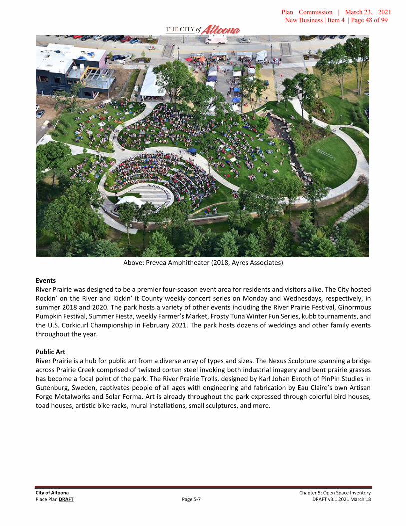
City of Altoona Chapter 5: Open Space Inventory Place Plan DRAFT Page 5-7 DRAFT v3.1 2021 March 18
Above: Prevea Amphitheater (2018, Ayres Associates)
Events River Prairie was designed to be a premier four-season event area for residents and visitors alike. The City hosted Rockin’ on the River and Kickin’ it County weekly concert series on Monday and Wednesdays, respectively, in summer 2018 and 2020. The park hosts a variety of other events including the River Prairie Festival, Ginormous Pumpkin Festival, Summer Fiesta, weekly Farmer’s Market, Frosty Tuna Winter Fun Series, kubb tournaments, and the U.S. Corkicurl Championship in February 2021. The park hosts dozens of weddings and other family events throughout the year.
Public Art River Prairie is a hub for public art from a diverse array of types and sizes. The Nexus Sculpture spanning a bridge across Prairie Creek comprised of twisted corten steel invoking both industrial imagery and bent prairie grasses has become a focal point of the park. The River Prairie Trolls, designed by Karl Johan Ekroth of PinPin Studies in Gutenburg, Sweden, captivates people of all ages with engineering and fabrication by Eau Claire’s own Artisan Forge Metalworks and Solar Forma. Art is already throughout the park expressed through colorful bird houses, toad houses, artistic bike racks, mural installations, small sculptures, and more.
Plan Commission | March 23, 2021 New Business | Item 4 | Page 48 of 99

City of Altoona Chapter 5: Open Space Inventory Place Plan DRAFT Page 5-8 DRAFT v3.1 2021 March 18
Issues and Opportunities Maintenance – River Prairie Park and surrounding boulevards are intentionally designed to feature native plants. This is a departure from other existing public areas in Altoona, creating a learning curve for staff and increased maintenance attention.
Disruption – River Prairie was designed and is intended as an active, mixed-use district. Several development sites adjacent to the park are not yet completed, and it may be a few years before all major construction activity is complete. These disruptions are anticipated to create management challenges to ensure park functions and programs continue with minimal impact.
Event Space – River Prairie Park was designed very intentionally to integrate several programmed event spaces. This is a new operational perspective for the City of Altoona, and will create new operational, maintenance, policy and facilities conditions that will require City Staff to adapt to. This is a significant opportunity to engage the community in collective events, including music and other performances, festivals, markets, and more.
Trail Hub – River Prairie Park is the center of nearly four miles of dedicated multi-use trails, many of which are along the Eau Claire River, and create connections in nearly every direction. This network creates opportunity for active walking, running, cycling, birding and other activities to pass around and converge upon the Park to create exciting daily and event-based uses.
Parking – With the Park designed for events and within a growing mixed-use district, parking is expected to be a constant balancing act. While each site and the district as a whole was designed carefully to not ‘over park’ through surplus of automobile infrastructure, active uses of the Park, businesses and events will stress this balance. For large events it is expected that nearby automobile parking will be at capacity, and that the City or event organizers may coordinate shuttles from off-site locations.
Short-Term (1-3 years)
• Evaluate ongoing maintenance requirements.
• Identify opportunities to add additional bicycle parking.
• Identify opportunities to add public art and other recreational, cultural, and aesthetic features.
• Continue to build relationships with area event planners to attract and coordinate opportunities in RiverPrairie Park.
• Continue to work with the Eau Claire County Veterans organizations regarding development of theVeterans Memorial and associated features.
• Continue to identify areas and opportunities for public art.
• Continue to develop events in River Prairie, especially those arts and culture opportunities open to thepublic.
Medium Term (3-5 years)
• Stay on top of maintenance and facility conditions at and beyond the normal replacement andrefurbishment cycle.
• Ensure all facilities are in excellent condition prior to closure of the Tax Increment District.
Plan Commission | March 23, 2021 New Business | Item 4 | Page 49 of 99

City of Altoona Chapter 5: Open Space Inventory Place Plan DRAFT Page 5-9 DRAFT v3.1 2021 March 18
Left: River Prairie Trail near the Pond (May 2018, JC)
Plan Commission | March 23, 2021 New Business | Item 4 | Page 50 of 99

City of Altoona Chapter 5: Open Space Inventory Place Plan DRAFT Page 5-10 DRAFT v3.1 2021 March 18
River Prairie Center
Classification(s) Event Center, Parks Offices
Designed by River Valley Architects in the Prairie School design approach, the River Prairie Center was completed in July 2017 and holds a strategic and highly visible location in River Prairie Park. The 9,100 sf2
public building serves as the main offices for the Parks & Recreation Department and contains restrooms for the facility as well as exterior access for the park. The Center is a premier event space for small and medium gatherings, including weddings, family gatherings, corporate and private events, Altoona Parks & Recreation and Library programs. The event space can accommodate 250 people in a round-table format or 400 for a meeting or lecture, and the space can be subdivided to host smaller groups. The Center is also intended to serve as the base of operations for larger events that take place in River Prairie Park, such as festivals, concerts, outdoor markets, and more. The Center also includes a catering kitchen and small meeting room.
Additional features include a bar that serves the indoor event space as well as outdoor plaza. The bar utilizes local wood harvested from a farm near Augusta and crafted by a local artisan. This same artisan utilized a selected piece that serves as the fireplace mantle. The Event Center includes restrooms that are accessible from the exterior to serve River Prairie Park, and a 1,200 sf2 outdoor plaza with grill and access to the bar, which can be access-controlled for certain events.
Parking is providing by an adjacent 85-space public lot to the south of the building, which includes a drop-off area, as well as area street parking.
The success of the venue has already resulted in displacing otherwise intended Parks & Rec programs and to turn away events. The City is exploring opportunities to add space elsewhere in the City to accommodate programs.
Above: River Prairie Center event space (2018, Kingpin Management)
Plan Commission | March 23, 2021 New Business | Item 4 | Page 51 of 99

City of Altoona Chapter 5: Open Space Inventory Place Plan DRAFT Page 5-11 DRAFT v3.1 2021 March 18
Issues and Opportunities Management – Operation of the River Prairie Center poses a challenge in a small city that does not have in-house capacity and scale for specialized staff for event planning and staffing. The City has partnered with a private vendor to manage events at the building and park spaces, a relationship that will require continual monitoring and evaluation. This relationship will need to be beneficial for the City, its partners, and area businesses for long term success and sustainability, as well as citizen enjoyment.
Operating Resources – The cost to construct the River Prairie Center was approximately $2.1 million. While the Event Center is not intended to directly generate revenue to the City for other uses, the operational model is one where most events will be at “market rate”, including weddings and other events, in order to provide dedicated resources to maintain the facility and adjacent park areas.
Balance – Designed to operate as a higher amenity and revenue-generating event venue, rather than a community center with relatively free access, there is a balancing act to be struck between scheduling revenue-producing events, Parks & Recreation programs, and community groups and family functions. This is an active management challenge that will be dynamically monitored and adjusted as needed.
Short-Term (1-3 years)
• Continue to develop signature events and balance public programming with revenue-generatingopportunities.
Medium Term (3-5 years)
• Ensure a sustainable operations and maintenance schedule, and associated revenue, to keep the EventCenter and its furnishings in excellent condition.
Altoona City Park (10th Street Park)
Classification(s) Area Park 6.0 acres
Also known as 10th Street Park, Altoona City Park is an active area park which accommodates a variety of activities that serve the adjacent neighborhoods as well as recreation sports (baseball and tennis), school sports, and group gatherings. Facilities include a youth grass infield baseball field, two separate playgrounds for youth and toddlers, community recreation building with restrooms, basketball half-court, six tennis courts (two of which are lighted), pavilion, gazebo, batting cages, picnic tables, grills and benches. The new community building was constructed in 2021 for flexible event space, and an older facility remains. Street parking is the only vehicle storage area near the park.
Altoona City Park is bounded by 10th Street to the west, 9th Street to the east, Hayden Avenue on the North and Bartlett Avenue to the South. Approximately 40 pull-in parking is available along Bartlett Avenue and parallel parking area along 9th Street. During events and other gatherings, street parking is utilized around the perimeter of the park. During peak use periods, this causes moderate congestion along 10th Street and Bartlett Avenue.
Altoona City Park 6.0 acres
General Parkland 3.4
Playground Areas 0.4
Pavilion 0.1
Baseball Field 1.0
Tennis Courts 1.1
Community Building 0.25
Parkland Fringe 0.25
Area measurements are approximated and rounded
Plan Commission | March 23, 2021 New Business | Item 4 | Page 52 of 99

City of Altoona Chapter 5: Open Space Inventory Place Plan DRAFT Page 5-12 DRAFT v3.1 2021 March 18
The six tournament-grade tennis courts are utilized by Altoona School District for practices and events under agreement with the City. Altoona City Park hosts Christmas holiday decorations and light display produced by the Altoona Lions Club, as well as a handful of moderate sized events through the summer.
In 2020, the City added a 4,000 ft2 Community Building to the east side of the park. The building includes spaces for parks and recreation programs as well as community events with built-in audio-visual, event kitchen, outdoor accessible restrooms, and public art opportunities. The old 1,600 ft2 building remains and is leased to the Altoona Historical Society for potential exhibit space. The new community building has inherited the name Fish House, from the original location.
The Altoona Historical Society donated the park gazebo in 2014 at the intersection of Garfield and 10th Street. The first Little Free Library on city property was donated and curated by the family of Arlene Flohr, a teacher at Altoona School District, which is very actively visited. The City added a drinking fountain, as well as lawn irrigation around the gazebo in 2014.
Altoona City Park first appears as a dedicated park in municipal maps and records in the 1940s as two properties straddling Garfield Avenue. Although the section of Garfield bisecting the park is long since abandoned for park space, underground utilities persist and the gazebo is the only park feature to occupy that corridor.
In 2017, the United Way of the Greater Chippewa Valley awarded a Born Learning Trail installation in the park, which was installed in Spring 2017 by volunteers.
In fall 2018, approximately 16 mature (40 – 60-year-old) green ash trees were removed from the park as part of the City’s ongoing emerald ash borer mitigation program. These trees comprised a substantial portion of the shade trees in the park, including those located near the tennis courts. The trees were replaced in 2019 with a variety of native species, but it will take a generation for new shade trees to mature.
Bartlett Avenue was reconstructed in 2019 along the southern edge of the park. This project included reconstructing the angled street parking and added curb extensions to improve pedestrian safety.
Above: 10th Street Park pavilion (August 2016, JC)
Plan Commission | March 23, 2021 New Business | Item 4 | Page 53 of 99

City of Altoona Chapter 5: Open Space Inventory Place Plan DRAFT Page 5-13 DRAFT v3.1 2021 March 18
Above: 10th Street Park ballfield. Below: 10th Street tennis courts (July 2016, JC)
Issues and Opportunities Placemaking – Altoona City Park has several facilities in place that are well used, and/or may improve use through additional enhancements. Many of the recommended projects entail improving or extending the usability of existing amenities, such as the community building, ball field, and lawn areas. Building on the Power of Ten principle, strategically adding and refining opportunities for passive and active activities may improve overall use of existing amenities and spaces.
Enliven Use – Altoona City Park is a “mature” space with significant space dedicated to active specialized uses, such as the baseball field, tennis courts and community building, as well as passive areas that include the pavilion, playground, and basketball court. The challenge is to determine context sensitive improvements in amenities and/or programming would yield improved or expanded use and enjoyment of a park that is perhaps the most actively used public outdoor space in Altoona at this time.
Community Building – The new 4,000 ft2 Fish House creates a new opportunity for year-round programming of the park, potentially becoming the primary site for many parks and recreation programs. The new restroom and water fountain may also extend use of the park by families and other functions.
Plan Commission | March 23, 2021 New Business | Item 4 | Page 54 of 99

City of Altoona Chapter 5: Open Space Inventory Place Plan DRAFT Page 5-14 DRAFT v3.1 2021 March 18
Old Building – The old community building is approximately 1,600 sf2 and has not been well used in recent years. With construction of the new building, this facility has been rented to the Altoona Historical Society for exhibit and storage space. Removal of the building had been contemplated to enable expansion of the tennis courts. Active use and upkeep of this building is likely to remain an issue of concern.
Playground - The existing playground equipment was installed in 2002 and is budgeted for replacement in 2021. The toddler playground was removed and replaced with expanded equipment in 2020 to a location closer to the primary play area. With re-envisioning and reinvestment in the Altoona’s parks, the central location provides an opportunity for a larger play area that provides a great opportunity for nearby neighborhoods as well as from across the city.
Winter Play – As Altoona’s traditional park, it is an active space from summer through fall. However, other than holiday lights, this park is little used for nearly half of the year. There is no topography in this park for sledding, but bringing in relatively clean snow from area streets, and perhaps the nearby church, would provide a play feature for children.
Short-Term (1-3 years)
• Begin programming the new Community Building.
• Replace playground equipment and related amenities (2021).
• Expand and resurface basketball court into full-court size.
• Repair electrical service at the pavilion.
• Consider adding a soccer goal on the lawn north of the tennis courts for seasonal community use.
• Explore opportunities to host activation events in the park, such as live music, art, or outdoor exercise.
• Extend public WiFi and security cameras to Altoona City Park by extending a fiber spur from the regionalbackbone line under Spooner Avenue.
• Consider adding a small vegetable garden curated by a Master Gardener or other volunteer group.
• Consider a “painted intersection” public art opportunity at Garfield and 9th Street.
• Paint/Repaint crosswalks at each corner, including mid-block crossing at Garfield and 10th Street.
Medium Term (3-5 years)
• Consider expansion of the tennis courts from 6 to 8, if the old community building is removed.Refresh/resurface existing courts.
• Identify locations for public art opportunities, such as murals on the new community building, pedestalsfor sculpture, etc.
• Consider replacing the existing restroom and concessions building at the ballfield.
Long Term (5+ years)
• Replace hardscape around ballfield area at the corner of Bartlett and 10th Street
• Add curb extensions, bump-outs, and/or raised crosswalks at each intersection and street crossing.
Plan Commission | March 23, 2021 New Business | Item 4 | Page 55 of 99

City of Altoona Chapter 5: Open Space Inventory Place Plan DRAFT Page 5-15 DRAFT v3.1 2021 March 18
Other Considerations
• Add pedestrian lighting along walking path. Cost estimates (2018) range from $6,000 - $7,500 dependingupon number and style of fixtures.
• Install field lights to the ball field. Cost estimates (2018) are approximately $60,000 for four poles.
• Develop mini-grandstand seating with integrated restrooms and concessions at the ballfield.
Cinder City Park
Classification(s) Community Park 25.7 acres 2300 Spooner Avenue
Cinder City Park is an active community park that utilized primarily by organized recreational sports and school sports programs. The park features three lighted softball fields, one lighted baseball field, the Hobbs-Altoona Sports Center, and significant parking area. Other amenities include restrooms, bleachers, concession stand with walk-in cooler, pavilions, scoreboards, and a small playground.
The Hobbs-Altoona Sports Center (“The Hobbs”) was constructed by the City of Altoona and is leased to the Altoona Youth Hockey Association. The Hobbs is approximately 32,000 square feet and is a special-use space which has limited availability to the general public. It is utilized occasionally by select events, including Cinder City Days festival.
The Parks Department maintenance garage and operations base is located in Cinder City Park, which serves as the center of the park and trail system maintenance staff and equipment. The Parks & Recreation Department offices were housed in a small meeting facility adjacent to the Hobbs until the River Prairie Center was completed in 2017. This building is now used for recreational equipment storage and restrooms for the park. Other facilities include the 120’ x 20’ concessions stand and recreational program storage building.
Cinder City Park was acquired in 1973 from the Chicago and North Western Transportation Company. The Park is bordered on west side by the 10th Street, to the north by the Union Pacific Railroad, which is depressed below the ground level of the park, to the east by the Eau Claire County Highway Department, and to the south by Spooner Avenue. The parking lot accommodates approximately 178 spaces, covering about 1.7 acres.
The City entered into an agreement with the Altoona Youth Softball League (AYSB) in November 2019 to allow the organization to develop an indoor batting facility near the parks maintenance garage. AYSB and allied organizations are currently examining the possibility of placing the playing surface at the ball fields to artificial field turf, which would allow greatly expanded use.
The primary parking lot and drive areas around Hobbs were reconstructed in 2020, including improvements to the stormwater and drainage systems.
The City installed a new Cinder City Park sign in 2016, including the City’s first municipal electronic message display.
Cinder City Park 25.7 acres
Softball & Baseball Fields 10.0 Pavilion Picnic Area 0.7
Playground Area 0.2
“Front Yard” 0.5
Parking 1.8
Hobbes-Altoona Sports Center 1.2
Parks System Maintenance 1.3
Carnival Area 6.5
Undeveloped / Pine Plantation 3.5
Plan Commission | March 23, 2021 New Business | Item 4 | Page 56 of 99

City of Altoona Chapter 5: Open Space Inventory Place Plan DRAFT Page 5-16 DRAFT v3.1 2021 March 18
Issues and Opportunities
Cinder City Days Festival – The Altoona Lions Club has held an annual carnival called Cinder City Days in Cinder City Park since the 1970s. In 2011, due to parking concerns and operations transforming turf areas to mud, the City prepared and relocated the festival to the “Carinal Area”.
Carnival Area – In 2011 the City logged a three-acre area in the undeveloped north portion of the park to relocate the Cinder City Days annual festival from the parking lot and “front yard” area. The area is otherwise not currently used for any other purpose. The City brought in top soil and seeded the cleared area in 2016, installed irrigation to support turf, and extended electric service to the area. The dimensions of the area may allow for a youth soccer field or small 200’ ballfield. Continued use of this space by the Carnival may pose a significant challenge for maintaining an adequate playing surface, and reasonably prevents any other recreational use of the area. City staff have discussed adding a fence and gate system to create a dog park, however more investigation is needed to determine feasibility.
Specialized Facility - Cinder City Park is an intensely used space during softball and baseball leagues and tournaments during the summer, and for hockey at the Hobbes. This occasionally yields overflow parking onto adjacent streets. Cinder City Park is sparsely used aside from these organized recreational programs and the annual Cinder City Days festival. Given the size of the park, central location on two major arterials (Spooner Avenue & 10th Street), and proximity to moderate density housing between 10th Street and North Willson Drive, there is ample opportunity and perhaps need to improve usability for other activities.
Trees – The trees in the undeveloped portions of Cinder City Park as well as lining the outfield fences of three ballfields are mature red pine. In 2016, three red pines were blown down in a wind storm during the Cinder City Days festival, landing on equipment but otherwise not causing injury. An evaluation by a Wisconsin DNR forester suggests one of three common red pine root fungus is the likely cause. The City removed mature red pines along the outfield of the west field, replacing with broad-leaf species, and will continue to monitor the balance of the stand. Since the plantation area is not otherwise maintained, the understory growth is thick brush, including poison ivy.
Destination Facility – Cinder City Park hosts several youth baseball and softball leagues and tournaments throughout the spring and summer. Investments in this area continue as AYSB plans to locate an indoor batting facility in the park, and potential installation of field turf playing surface at the ball fields which would allow a longer season, more frequent and intensive use. This may provide opportunities for further development of recreational facilities in the park, but also create increased use specialization.
Short-Term (1-3 years)
• Study placement of a dog park. One location may be to utilize the Carnival Area to create a two-sectiondog park utilizing placement of fencing to maximize off-leash dog run area while enabling annual carnivaluse. A two-area dog park includes one larger run for larger breed dogs, and a smaller area for small breeddogs. Depending upon ultimate design, between two and four acres may be available for this use, withprimary access from 10th Street. Specific design would utilize latest best practices and innovations in dogpark design.
• Investigate adding public art installations in the park, with ideas including murals on the south and westfaces of the Hobbs, and one or more platforms for permanent or temporary sculpture.
• Continue to monitor and manage the mature pine plantation, as the grove may require thinning and/orcutting over time. Add new trees as the existing individuals are removed to generally maintain a vibrantforest canopy.
Plan Commission | March 23, 2021 New Business | Item 4 | Page 57 of 99

City of Altoona Chapter 5: Open Space Inventory Place Plan DRAFT Page 5-17 DRAFT v3.1 2021 March 18
• Extend public WiFi and security cameras to Cinder City Park by extending a fiber spur from the regionalbackbone line in under Spooner Avenue.
• Identify opportunities to host events in the park and Hobbs to increase use as well as opportunities forrevenue to support park maintenance.
Medium Term (3-5 years)
• Consider adding a segment of multi-use trail along the north and east sides of the park, connecting to theexisting trail along 10th street near the bend in the road, and connecting to Spooner Avenue near the EauClaire County Highway Department.
• Consider adding a playground near the existing pavilion to provide a neighborhood playground area forchildren who reside in the moderate density neighborhood bounded by 10th Street, Spooner and NorthWillson. This area includes the Altoona Housing Corporation primary facilities across the street from thepavilion.
• Replace existing playground equipment located between the ballfields (2024).
• Eau Claire County plans to relocate their Highway Department operations from the 10.6-acre site to theeast of the park. This may provide opportunities to expand park uses such as adding ball fields andsecondary parking areas, in addition to use of existing county buildings for City public works and parksmaintenance operations.
Long Term (5+ years)
• Altoona-Hobbs Sports Center will require renovation and/or refurbishment.
Highland Park
Classification(s) Neighborhood Park 1.7 acres
Highland Park is a neighborhood park located in the Sherman-Highland neighborhood in the western area of the City. This neighborhood park is designed primarily for passive activities, with amenities including a basketball/tennis court, playground equipment, and small open-air pavilion. Most of the park area is lawn punctuated by mature trees. The playground equipment was installed in 2007.
The western boundary of the park adjoins a UPS distribution facility, boarded by chain link fence and partially screened by mature fir trees. The remaining sides of the park is bounded by Vernon, Gloede, and Hamilton Avenue. The neighborhood context is that this park is bordered by industrial property to the south and west, multi-family housing to the east, and predominately small-lot single-family homes to the north. There are no sidewalks in the area, although recent projects in the neighborhood have begun adding sidewalks to east-west roadways.
The adjacent Sherman-Highland neighborhood is composed of approximately 245 households. Surveys of the neighborhood conducted in 2016 classified associated with a Community Development Block Grant application identified over 50% of households as experiencing low- to-moderate income. Highland Park is the primary open space in the neighborhood, as pedestrian access to nearby Centennial Park is difficult due to topography and indirect road connections.
Plan Commission | March 23, 2021 New Business | Item 4 | Page 58 of 99

City of Altoona Chapter 5: Open Space Inventory Place Plan DRAFT Page 5-18 DRAFT v3.1 2021 March 18
Issues and Opportunities Activate Space – As the primary open space in a neighborhood comprised disproportionally of households experiencing low- to moderate-income, the importance of providing high-quality open spaces for people to gather is of elevated importance. The current form of the park is passive and can be described as a typical suburban park: a basketball court, a small playground, some picnic tables and a lot of grass. Access is impaired by lack of sidewalks. Despite the moderate population density of the neighborhood, observed use of the park is relatively low, and few programs or gatherings take place there.
Connectivity – Although the Sherman-Highland addition features small lots and block sizes in a traditional urban grid, the neighborhood lacks sidewalks. Most roads in the neighborhood are low traffic, yet pedestrian circulation conditions throughout most of the neighborhood are not safe. As the roads are rebuilt in the neighborhood, sidewalks are being added, beginning on the north side and proceeding south toward the park. This neighborhood is adjacent to significant commercial retail, employment, and services, and improved safe connectivity would greatly improve neighborhood conditions.
Short-Term (1-3 years)
• Add swings to the playground area.
• Resurface the playing courts and transition tennis area to basketball, add benches for improved use.
• Deploy soccer nets to create a small field (approximately 70 x 120) with flagged corners to providerecreation opportunity.
• Trim low branches on existing trees to free up clear sight lines throughout the park, especially toplayground area.
• Add recreation program programming at the park, with targeted outreach to improve activation of thespace.
• Paint crosswalks on intersections near and adjacent to the park as in interim solution until sidewalks areadded to area streets.
Medium Term (3-5 years)
• Ensure that sidewalks are added to adjacent and area streets through reconstruction, utilize “safe routesto parks” principles, including curb extensions wherever possible.
• Extend power and lighting to the pavilion.
• Consider adding a port-a-potty shell as an inexpensive option for an on-site restroom.
• The playground equipment will require replacement in approximately 2022/2023. This will be anopportunity to add increased investment and accessibility, like recent improvements to Devney Park in2018.
Long Term (5+ years)
• Monitor screening conditions along the west side of the park as the existing trees age to ensure visualseparation from adjacent logistics facilities.
• Refurbish/refresh pavilion structure.
Plan Commission | March 23, 2021 New Business | Item 4 | Page 59 of 99

City of Altoona Chapter 5: Open Space Inventory Place Plan DRAFT Page 5-19 DRAFT v3.1 2021 March 18
Devney Park
Classification(s) Neighborhood Park 3.9 acres
Devney Park is a neighborhood park located within the Knollwood Subdivision on Devney Drive. The park was developed in 1991. The Park includes one lighted youth baseball field, picnic tables, grill, bleachers, tennis court and a basketball court. The baseball field received covered dugouts from a local Eagle Scout project in 2016. The field also features an analog scoreboard.
A small pavilion and recreation facility with restrooms are also located in the park. This facility includes a small room which can host recreation programs or meetings. The pavilion portion is an open-air seating area to the rear of the building of approximately 450 square feet. The shingles of this facility was replaced in fall 2017.
Devney Park serves as the primary open space for three or four small neighborhoods. Nearby neighborhoods include a mix of housing types, including eight- and twelve-unit apartment buildings, developments of duplexes and twin homes, and median-sized single-family homes. Many of the approximately 400 dwellings within 0.25 miles of the park are generally thought to be home to families experiencing low-to-moderate income. The second ring, 0.25 to 0.5 miles to the west, north and east, are predominately homes in the middle to higher end in valuation, as compared to the City. Deveny Park is also the nearest existing park to the Hillcrest Estates Manufactured Home Park, located 0.75 miles to the east.
While there are sidewalks through the neighborhood to the west and north, most of the neighborhood east of 3rd Street lacks sidewalks. Streetscapes without sidewalks include areas of relatively high concentration of rental housing. Improving connectivity and safety through this subarea is a priority. The multi-use trail along 3rd Street is a short distance from the park and provides good access north and south.
The City installed new playground equipment in 2018, with a combination of rubber pour-in-place safety surface in high-traffic and access points, and engineered wood fiber making up the balance of the play surface. The total project cost was approximately $150,000. The previous playground equipment was located behind the pavilion and was removed in 2017. The new playground was relocated next to the pavilion due to larger footprint and improved sightlines for policing. Additional lighting and a security camera system was also added.
Above left: Devney Park Pavilion (2016).
Plan Commission | March 23, 2021 New Business | Item 4 | Page 60 of 99

City of Altoona Chapter 5: Open Space Inventory Place Plan DRAFT Page 5-20 DRAFT v3.1 2021 March 18
Above: Tennis Courts. Below: Youth baseball field (2016)
Issues and Opportunities
Rear Yard – To the south of the ball field is a 0.5-acre area that is maintained as grass and has a perceptible slope from east to west (approx. 6%). This area is bounded by private property on three sides, and mature pine trees to the south and west. The lot is not actively used, suffers from lack of visibility from the street or parking lot, and the slope renders use as a playing or practice field difficult. The existing mature trees render use as a community orchard or garden difficult due to persistent shade through most of the year.
Short-Term (1-3 years)
• Trim low branches from the trees that form the southern boundary of the park. There is a well-worn footpath through this depression and drainage, and garbage and other materials are frequently found there.Trimming low branches from the park-side of the screening area may reduce littering and other suspectedvagrancy in the park.
• Repair and resurface tennis and basketball court as part of regular maintenance.
Plan Commission | March 23, 2021 New Business | Item 4 | Page 61 of 99

City of Altoona Chapter 5: Open Space Inventory Place Plan DRAFT Page 5-21 DRAFT v3.1 2021 March 18
• Improve pedestrian connectivity and safety along Devney Drive. Recommended treatments include:adding fog lines along Devney Drive with 11-foot travel lanes; adding a mid-block crossing at Glades Driveand Devney Drive with bump-out and crosswalk; and adding or refreshing crosswalks at Thompson Driveand at 3rd Street East.
• Continue to add boulevard trees along Devney Drive. Mature trees exist in the single block between 3rd
Street East and Glades Avenue, and some trees were added in the vicinity of Thompson Drive in 2019. Agap of about 1,200 feet exists without boulevard trees.
• Identify public art opportunities in the park, such as adding mural space on the north face of the restroombuilding.
Medium Term (3-5 years)
• Examine opportunities to improve stormwater performance of the area through adding a rain garden orother feature. The vicinity is an area with known drainage issues.
Long Term (5+ years)
• Improve/refresh/replace bleachers and scoreboard at the ballfield.
Above: Devney Park Playground, March 2020
Lakefront Park
Classification(s) Area Park 3.9 acres
Lake Front Park is located on the south shore of Lake Altoona at the west end of Kewin Street. This park has the following amenities: handicapped accessible fishing dock, portable restroom, swing benches along the banks of Lake Altoona, picnic tables and parking lot.
Lakefront Park 3.9 acres Lawn Area 0.5
Shoreline Area 0.3
Woodland Area 3.1
Plan Commission | March 23, 2021 New Business | Item 4 | Page 62 of 99

City of Altoona Chapter 5: Open Space Inventory Place Plan DRAFT Page 5-22 DRAFT v3.1 2021 March 18
Lake Front Park has over 900 linear feet of shoreline on Lake Altoona, with some areas accessible to shore fishing. Lakefront Park is only one of two public properties on Lake Altoona, the other being Lake Altoona County Park approximately 1,000 feet to the east. The handicap accessible fishing dock was replaced in fall 2017. The dock is removed from the lake each fall and returned in the spring.
The park features approximately 0.5 acres maintained as a flat lawn boarded by mature oak trees. The remaining public space is a mature woodlot that slopes toward the lake, shoreline, and the parking lot. There are some fixed swing seats and picnic tables.
The park is relatively isolated from the rest of the City due to topography and the Union Pacific Railroad. A multi-use trail spur from the Lake Road Trail connects to the County Park. The trail requires design improvements due to steep grades to improve safety and visibility.
Issues and Opportunities Jewel Waiting to Happen – Waterfront parks are often the prized properties of park systems. The challenge with Lakefront Park is that it is relatively small, with just over 0.5 acres available for active use, limited parking and limited access, and proximity to the larger and more developed Lake Altoona County Park. The task is to determine how to effectively add programs and amenities to this space to encourage and improve use, taking advantage of the shoreline environment and the well-used neighboring County Park. This remains elusive.
Parking – Lake Front Park has a relatively small parking lot that, along with limited street parking, can accommodate approximately 25 vehicles. This makes simultaneous use by the general public and small groups difficult.
County Park – Lake Front Park is a little over 1,000 feet from Lake Altoona County Park, a popular 12-acre facility that includes a public boat launch, enclosed pavilion, sand swimming beach, restrooms, among other amenities. The County adopted a new master plan for the park in 2017 that proposes a new event space, pavilions, beaches stabilization, and other improvements.
Lake Access – The County Park includes a public boat launch, but the ADA accessible dock at Lakefront Park remains popular. To improve and expand use, recommendations include exploring installation of an ADA accessible canoe and kayak lift, and improving on-shore fishing opportunities.
Expansion. The existing property boarders a 1.5 acre parcel owned by Union Pacific Railroad. This parcel is wooded, mostly hillside, and boundaries are not marked.
Short-Term (1-3 years)
• Place one or more fire circles of nonflammable materials for small gatherings to enjoy the ambiance ofopen flame in a semi-controlled environment with seating.
• Place flat stones to create seating near water level to enable greater use of the shoreline for fishing andlounging.
• Explore feasibility of adding an ADA accessible canoe & kayak lift to the existing dock or as a separateamenity.
Medium Term (3-5 years)
• Improve multi-use trail along North Beach Road.
• Utilize stones, pavers, or other durable materials to create a walking labyrinth pattern or meditationgarden.
Plan Commission | March 23, 2021 New Business | Item 4 | Page 63 of 99

City of Altoona Chapter 5: Open Space Inventory Place Plan DRAFT Page 5-23 DRAFT v3.1 2021 March 18
• Design and construct a small adventure playground incorporating the existing tiered hillside. Ideasinclude:
o Installing multiple slides that utilize the hillside to safely create large slide runs without thechallenge of mitigating associated fall heights.
o Add multiple routes, methods and materials to climb the hill to access the slide entrance, such assteps, ramps, climbing rocks, and/or cargo nets.
o Hillside could be designed such to appear as the side of a ship, half buried in the hill, with variouslevels and methods to go up and down. Consider a “look out” structure at the top of the hill.
Long Term (5+ years)
• Improve stormwater runoff management from parking area through “green” landscape feature(s),intercepting the existing stormwater grate that conveys water from the parking lot directly into the lake.
Above: Lakefront Park, 2017
Plan Commission | March 23, 2021 New Business | Item 4 | Page 64 of 99

City of Altoona Chapter 5: Open Space Inventory Place Plan DRAFT Page 5-24 DRAFT v3.1 2021 March 18
Centennial Park
Classification(s) Area Park • Natural Area 13.4 acres
Centennial Park is an area park with primary access from Spooner Avenue. The Spooner Avenue Multi-Use Path parallels the roadway between Centennial Park and Spooner Avenue, providing good access by bicycle, walking, and running routes. In 2014 the City of Altoona worked with the design firm CBS2 to create an improvement plan for the Park. The park improvements, except the mountain bike / hiking trails, are the result of that plan.
Features of the park include a small playground, picnic area, playing field, walking trails, and sledding hill. A climbing hill with boulders highlights the playing field area. The Otter Creek Christian Academy and Altoona Lions Club donated a set of outdoor musical instruments, installed in 2017. The lawn areas are irrigated to support durable turf throughout the summer.
Chippewa Off Road Bike Association (CORBA) maintains 2.5 miles of single-track mountain bike trails through the park natural area. The City is working with CORBA to extend the existing trails through the adjoining DOT right-of-way, eventually under the Highway 53 bridge spanning Otter Creek and connecting to South Willson Drive. The trails are open to fat tire biking, snowshoeing, and walking throughout the winter. CORBA donated and maintains trailhead signage and park map directing users though the trail system.
The park natural area is approximately 12 acres of City property, with access to an additional 16 acres of wooded Department of Transportation right-of-way along Highway 53. This combined area features approximately 7,000 feet (1.3 miles) of the meandering Otter Creek.
Centennial Park is so named due to its dedication and initial planning during Altoona’s centennial in 1987. Historically, the property that became Centennial Park was a wastewater treatment facility. The existing stormwater pond and pump station are all the remains from this past use. There is driveway access to Woodside Terrace to the south, which is closed by gate to prohibit automobile through-traffic.
Issues and Opportunities
Short-Term (1-3 years)
• Add drinking water access from the pump station.
• Add shade trees near around the playground area and parking lot.
• Expand existing single-track mountain bike / hiking trails into the adjoining DOT right-of-way.
• Formalize and improve the easement-access to the park trail system from Valmont Avenue.
• Continue to strengthen and support the partnership with CORBA.
• Evaluate improvements to the park area adjoining Gloede Avenue, which functions as an access point forthe trail system.
Centennial Park 13.4 acres
Developed Area 2.1
Playground & Lawn 1.0
Parking & Drive 0.5
Pond & Roadway Buffer 0.6
Natural Area 11.3
DOT Right-of-Way Natural Area* 16.5 acres
Otter Creek ~ 7,000 ft
Single-Track Trails 2.5 miles
* Not included in City-wide Inventory Area measurements are approximated and rounded
Plan Commission | March 23, 2021 New Business | Item 4 | Page 65 of 99

City of Altoona Chapter 5: Open Space Inventory Place Plan DRAFT Page 5-25 DRAFT v3.1 2021 March 18
Medium Term (3-5 years)
• Work with the Department of Natural Resources to investigate opportunities to improve trout habitat inOtter Creek.
• Reconsider the 2014 plan elements regarding natural play structures and activities integrated into theforest fringe.
Long Term (5+ years)
• Extend the trail system southeast under Highway 53 to S. Willson Drive (medium-term) and south alongthe Otter Creek Greenway (long-term).
Fairway Park
Classification(s) Neighborhood Park • Natural Area 55.4 acres
Fairway Park occupies over 55 acres of beautiful natural areas along Otter Creek in the Hillcrest Greens neighborhood. In addition to wooded hillsides and river bottomland, the park includes three fairways from the former Hillcrest Country Club. While remnants of the golf course landscaping persist, most of these areas are naturally transitioning to into prairie and woodland fringe.
The developed park amenities occupy approximately 0.75 acres and are accessed from a relatively steep paved trail that intercepts Whistling Straits Drive. Park features include a parking area, small playground, pickleball/basketball courts, and a pavilion. In 2017 the City constructed a parking lot at the top of this hill at the road. The trail continues through the neighborhood, wrapping around the pond and proceeding west approximately 0.5 miles to Highway 12 at 10th Street West, and east approximately 0.6 miles to Third Street East. The Clubhouse, a three-building multi-family housing development, includes public walkways that also traverse down the hill to the park.
Along Otter Creek to the east of the playground is a 0.75-mile golf cart path that has become a multi-use trail, connecting up to St. Andrews Drive. This trail consists primarily of packed earth as it skirts the former fairways. The vision for this area is that the Otter Creek Corridor will become integrated into a regional Otter Creek Greenway, a natural corridor from the Eau Claire River to Prill Road and beyond. As part of this vision, the existing trail along Otter Creek will eventually be extended in both directions, to Centennial Park to the west and Prill Road to the southeast.
Fairway Park was dedicated to the City as part of the Hillcrest Greens neighborhood development process in 2013. The initial pavilion, playground, and access trail were provided by the Developer.
Fairway Park 55.4 acres
West Section
Woodland & Creek Bottom 21.6
Central Section
Woodland & Creek Bottom 13.4
Fairway / Prairie 1.5
Playground, Pavilion & Courts 0.8
Parking Lot 0.5
East Section
Woodland & Creek Bottom 11.3
Fairway / Prairie 5.5
Pond 0.8
Otter Creek ~ 8,275 ft
Maintained Trails 0.75 miles
Measurements are approximated and rounded
Plan Commission | March 23, 2021 New Business | Item 4 | Page 66 of 99

City of Altoona Chapter 5: Open Space Inventory Place Plan DRAFT Page 5-26 DRAFT v3.1 2021 March 18
The prairie, woodland fringe, watercourse, pond, and mature trees make Fairway Park an excellent area for bird watching, hiking, and wildlife viewing year-round. The Otter Creek Greenway serves as a corridor for wildlife including birds, deer, and black bear. The park includes over 8,275 lineal feet of Otter Creek.
Issues and Opportunities
Short-Term (1-3 years)
• Address and monitor erosion along steep slopes abutting existing trails.
• Stabilize Otter Creek shoreline and areas of former fairway that have eroded in recent flooding.
• Improve and repair the existing cart trail. The paved switch-back portion is beginning to deteriorate, andedges are slumping. The packed earth segment is in generally good condition but could be improved withminor investment.
Medium Term (3-5 years)
• Continue the existing trail to the west, from the playground to property owned by Cedar Creek CommunityChurch.
Long Term (5+ years)
• Continue the existing trail to the east beyond the existing boundaries of the park.
• Complete trail segment through lands owned by Cedar Creek Community Church, past Highway 12 toS.Willson Drive and Centennial Park.
• Playground equipment will require replacement in approximately 2025.
Plan Commission | March 23, 2021 New Business | Item 4 | Page 67 of 99

City of Altoona Chapter 5: Open Space Inventory Place Plan DRAFT Page 5-27 DRAFT v3.1 2021 March 18
Tower Park
Classification(s) Neighborhood Park / Conservation Park 12.7 acres
Tower Park is a predominately unimproved parkland located between the Estates at River Prairie and Rivers Edge Subdivision. Access is primarily provided by a parking lot at the intersection of Oakleaf Way, Rivers Edge Drive, and River Prairie Drive. The park includes a prominent City of Altoona water tower and associated improvements accessed from Moonlight Bay Drive. Pedestrian access is available at various points, and vehicles may also access the parkland from the water tower located within the park. The park is wooded, except for the abandoned right-of-way of East Willson Drive and the area immediately adjacent to the parking lot and Oakleaf Way.
Tower Park is intended to serve as a neighborhood park with passive uses, in addition to valuable plant and animal ecosystem benefits. The park is comprised of two parcels which were dedicated as part of development of the Estates at River Prairie (water tower), and the Rivers Edge Drive Subdivision. The adopted plan for Rivers Edge identifies the land as a “treed natural park with parking / picnic area”.
The concept for Tower Park is for walking trails and bird watching. The nearby Eau Claire River corridor is active with native and migrating birds throughout the year, and Tower Park provides an additional woodland destination. This design includes development of a walking trail through the park and adding clusters of bird amenities such as feeding stations, brightly colored bird houses of a variety of sizes, and other complementary people and bird features. The parking area should be finished, park sign added, and potentially a public art installation highlighting the designation as a birding park.
There is a sledding hill that occupies the southwest corner of the park and adjoining right-of-way. The hill has about 20-25 feet of drop and is convenient for nearby residents to use throughout the winter when conditions permit.
Above: Aerial view of Tower Park (Google Earth, 2015)
Plan Commission | March 23, 2021 New Business | Item 4 | Page 68 of 99

City of Altoona Chapter 5: Open Space Inventory Place Plan DRAFT Page 5-28 DRAFT v3.1 2021 March 18
Above: Context of public land near the Eau Claire River.
Issues and Opportunities Passive Use – Tower Park may serve as a neighborhood park for the Estates at River Prairie, Rivers Edge Drive, River Prairie Twinhomes, and other nearby residents. The park is linear, lined by the rear yards of homes, and understood to be intended as a passive use parkland. The mature trees, linear shape of the property, and connectivity to existing multi-use trails would lend this park to be used as a walking area for quiet contemplation or observation of birds.
Short-Term (1-3 years)
• Create a detailed master plan for the park with budget to implement while the River Prairie TIF District isavailable.
• Create walking path through the park beginning at parking lot and proceeding through property toMoonlight Bay Drive and the water tower, utilizing crushed stone and edging. This would formalize publicuse of the park for quiet activities.
• Clear brush and volunteer trees from former right-of-way area, remove any significant dead branches ortrees which may imperil enjoyment of the trails.
• Consider developing “birding park” with collections of brightly colored bird houses and supportiveamenities.
• Develop a trailhead facility with a park map, area map of multi-use trails, and picnic area with seating.
• Complete the existing parking lot to add capacity, extend life of the pavement, and improve stormwaterdrainage.
• Plan and complete property boundary marker arrangement to subtly but clearly demarcate theboundaries of the parkland.
Medium Term (3-5 years)
• Remain vigilant regarding possible intrusion of oak wilt.
Plan Commission | March 23, 2021 New Business | Item 4 | Page 69 of 99

City of Altoona Chapter 5: Open Space Inventory Place Plan DRAFT Page 5-29 DRAFT v3.1 2021 March 18
Jellybean Hill
Classification(s) Area Park 7.6 acres
Jellybean Hill is a south-facing hillside between High Point Estates and the Altoona Business Park that is utilized for sledding throughout the winter, as walking connection to the Altoona School campus, and as a vantage point for viewsheds to the south. The average drop is approximately 50 feet, with a run of approximately 525 feet. The space is classified as an Area Park due its principal use as an undeveloped open space with active use primarily for sledding. The property was officially dedicated as a City Park on April 9, 2020.
Jellybean Hill is comprised of two parcels, a 5.6-acre outlot dedicated with High Point Estates, and Lot 2 of the Altoona Business Park. The property is suitable for sledding without further improvements. When commercial development occurs on adjacent lots, the addition of berms may be necessary to ensure safety and routing of sledders.
Portions of Jellybean Hill are within tax increment district two. If improvements are pursued, there is a dedicated funding mechanism during while the district is open.
Above: Aerial of Jellybean Hill (Google Earth, 2015)
Issues and Opportunities Access – While Jellybean Hill serves as a pedestrian connection from Devney Drive to the Altoona School campus, the sidewalk system in the Altoona Business Park is incomplete. Sidewalks were added along the south side of Devney Drive and east side of McCann Drive in 2019, but the north and west sides remain without pedestrian accommodation.
Plan Commission | March 23, 2021 New Business | Item 4 | Page 70 of 99

City of Altoona Chapter 5: Open Space Inventory Place Plan DRAFT Page 5-30 DRAFT v3.1 2021 March 18
Wintermission – Storytelling suggests that Jellybean Hill has been utilized for sledding for several generations. It is also the only good location for “destination sledding” in the City. While the multi-use potential of the parkland is limited due to topography, highlighting the use of the park for sledding would advance City-wide efforts to improve activities during winter months.
Short-Term (1-3 years)
• Discuss shared parking agreements with future commercial development to provide off-street parking forsledders in the winter.
• Complete sidewalk network throughout the Business Park to improve pedestrian safety and access.
Median-Term (3-5 years)
• Consider adding a simple warming structure, or temporary enclosure, to enable greater sledding useduring the winter.
Windsor Park Future Park
Classification(s) Neighborhood / Area Park 14.3 acres
The property identified as Windsor Park encompasses the closed landfill managed jointly by the City of Altoona and Town of Washington and surrounded by the Windsor Forest subdivision. The entire property is approximately 14.3 acres, of which 7.5 acres is field and 6.8 acres is woodland. The area features landfill monitoring wells and vents and is reasonably prohibited from development. The City actively mows most of the field once or twice per year to ensure management access to the monitoring wells. The active vent and well circulation system was shut down in 2018 due to decreased concentration of offgas.
The property is used by citizens to walk dogs, snowshoe, and by children for unstructured play. Most of the property is prohibited from development without relocation of the underlying waste, lending itself to potential use as a dog park, as has been successfully accomplished in many communities. This might provide dogs and their owners up to 5 acres in a fence and gate system. Space would remain for complementary amenities, such as signage, walking trail, and potentially a playground. The woodland includes some older tree specimens and is otherwise a mix of intermediate growth estimated to be 40 to 60 years old.
The development of a dog park was rated as a medium interest and priority by respondents to the 2016 citizen survey. Additionally, interest in dog parks and pet related amenities is a frequent comment to the survey and has been identified in variety of national park and amenity surveys as a trending use. Pet owners are a dedicated user group, which may also lend to partnerships to fund and maintain the features.
A portion of the property may also serve to expand and improve trail connectivity through the neighborhood, by connecting Saxsonwood through the property to Nottingham Way, and potentially a walkway from Windsor Forest Drive to Saxsonwood. The City retains a right-of-way connection from Windsor Forest Drive southwest to Otter Creek, which may serve as a future recreational trail connection to a future trail through Otter Creek Greenway.
The size of the property as well as proximity to Otter Creek may also provide opportunities for bird supportive improvements. If the dog park concept does not materialize, the open area of the property, ringed with trees, may provide secondary opportunities for bird habitat improvement.
Plan Commission | March 23, 2021 New Business | Item 4 | Page 71 of 99

City of Altoona Chapter 5: Open Space Inventory Place Plan DRAFT Page 5-31 DRAFT v3.1 2021 March 18
The area identified as Windsor Park and approximately 6.5 acres of adjoining property to the north are included in a UW-Madison landscape architecture senior capstone project entitled “Windsor Forest Place”. The purpose of that exploration was to engage a design student to envision potential park improvements as well as future housing opportunities. The planning process included distribution of a survey to the approximately 175 households in the neighborhood, holding three virtual meetings, and three site tours during January 2021.
Issues and Opportunities Feasibility – Determine feasibility of utilizing the landfill surface for intentional recreational use. The City may need to bring in fill to level the surface and perform maintenance on the monitoring structures.
Complementary Development – Development of adjoining property has been discussed at multiple points in recent years. The student phase of the Windsor Forest Place exploration will be completed in May 2021. This design is anticipated to include complementary housing opportunities, creating new pedestrian connections, and envision park uses for the property.
Cooperation – The landfill is of joint custody and maintenance between the City of Altoona and Town of Washington. Cooperation from the Town will need to be continue for park development to occur.
Short-Term (1-3 years)
• Complete detailed study of landfill maintenance conditions for recreational use.
• Complete visioning, planning and design of adjacent development.
• Complete detailed conceptual plan for the park, trails, and cost estimates.
• Begin fundraising campaign for dog park.
Medium Term (3-5 years)
• Officially dedicate property as a City Park.
Plan Commission | March 23, 2021 New Business | Item 4 | Page 72 of 99

City of Altoona Chapter 5: Open Space Inventory Place Plan DRAFT Page 5-32 DRAFT v3.1 2021 March 18
• Begin implementing park plan.
• Develop maintenance plan for the park.
Medium Term (3-5 years)
• Evaluate implementation of park plan and examine potential of additional improvements or phases.
Above: Windsor Park (July 2016. Credit: Joshua Clements)
Woodington Garden Future Park Neighborhood Park 1.0 acre
Woodington Garden is the property on bounded by James Avenue, 7th Street West, and Bradwood Avenue across from the Altoona High School that features City Well Site #3. The property was dedicated to the City of Altoona in 1958 by Clyde and Grace Woodington for the citing of a city well. Mr. Woodington is a former Altoona teacher. The property is one acre, currently maintained as lawn, and screened from adjacent residences by mature trees.
The property is in relatively close proximity to Altoona City Park and the Altoona Intermediate School playground. This property provides an opportunity for a public use that complements the adjoining school facilities, given that the City already owns and maintains the property as lawn. In the past, a group of teachers inquired about locating a community garden at this location that might serve, in part, as an educational opportunity.
With the location and arrangement of the well, there would be water available for garden use, and with some improvement, off street parking and complementary amenities could be provided. The garden could include butterfly garden, garden equipment storage, limited scope garden compost, and outdoor classroom and seating with shade.
Plan Commission | March 23, 2021 New Business | Item 4 | Page 73 of 99

City of Altoona Chapter 5: Open Space Inventory Place Plan DRAFT Page 5-33 DRAFT v3.1 2021 March 18
Area examples of successful community gardens include Demmler Park, Lakeshore Park, and Forest Street Park in Eau Claire. Demmler and Lakeshore each have an 8’ wire fence with locking gate. Forest Street does not have significant fencing but features a garden pavilion and storage building. Each are managed by community groups and have water available.
Issues and Opportunities Clarify Uses – The indenture transferring property ownership to the City describes use restrictions as City well and related purposes and maintained attractively. To avoid future conflict, the City will need to determine what uses would be permissible.
Short-Term (1-3 years)
• Determine interest for a community garden or other public use of the property.
• Determine organizational structure for maintaining a garden or other educational amenity
• Develop garden property with phased plan to incorporate additional amenities and features as use andsupport grows.
Medium Term (3-5 years)
• Phase two of garden amenities.
Plan Commission | March 23, 2021 New Business | Item 4 | Page 74 of 99

City of Altoona Chapter 5: Open Space Inventory Place Plan DRAFT Page 5-34 DRAFT v3.1 2021 March 18
Above: Municipal Well #3 (June 2016. Credit: Joshua Clements)
Below: Demmler Gardens, Demmler Park, Eau Claire (July 2016. Credit: Joshua Clements)
Library Park Future Park
Classification(s) Neighborhood Park 0.8 acres
Altoona City Hall and Library occupies half of its City block. The City owns two parcels adjacent to City Hall totaling 0.4 acres. One half of this area is maintained as lawn and the Library recently installed a series of raised beds for flower gardens. Part of the property is also utilized for snow storage from the adjoining City Hall parking lot. The other half is a small house owned by the City which is actively rented. The City acquired adjacent properties for
Plan Commission | March 23, 2021 New Business | Item 4 | Page 75 of 99

City of Altoona Chapter 5: Open Space Inventory Place Plan DRAFT Page 5-35 DRAFT v3.1 2021 March 18
potential expansion of City Hall. The remaining balance of the block (0.4 acres) is occupied by three houses. Given recent growth in the City, expansion of City facilities at some point is a very real possibility.
Altoona does not maintain public open space in the eastern half of the “old” (pre-1970) City. Between 5th Street West and 5th Street East there is over 130 acres and over 400 dwelling units without a City Park. This area does adjoin the Altoona Intermediate School playground, which is approximately 1.4 acres, but is approximately 0.5 miles from the eastern end of the neighborhood. Creating a public open space adjacent to City Hall would provide a relatively central neighborhood park and opportunity for outdoor programming at City Hall and Library.
The presence of a public park near the old commercial district may provide contribute to overall reinvestment in the area. New successful business has been established in recent years, and there is general interest in creating a downtown plan to facilitate additional commercial and residential development. Being adjacent to City Hall and Library provide opportunities for specialized amenities and programming, such as outdoor reading area, community garden, public art, and others.
Issues and Opportunities Space Needs – The City conducted a space needs study for municipal departments to estimate facility demands over the next ten years. This analysis reflected that City Hall and the Library each face space constraints, and expansion is recommended. Among these expansion scenarios include utilizing this potential park area for parking. The current land use could be actively programmed as an interim use until the ultimate facility plan is completed.
Ownership – Three parcels would need to be acquired to obtain ownership of the entire block. This would improve opportunity for creating an outdoor space to serve the neighborhood as well as an opportunity for programming and events complementing City Hall and the Library.
Short-Term (1-3 years)
• Determine future City facility scenarios.
• Determine opportunities for interim recreational uses of the space.
Medium Term (3-5 years)
• Proceed with park design and use dependent upon future facility plans.
Plan Commission | March 23, 2021 New Business | Item 4 | Page 76 of 99
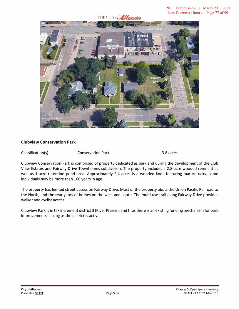
City of Altoona Chapter 5: Open Space Inventory Place Plan DRAFT Page 5-36 DRAFT v3.1 2021 March 18
Clubview Conservation Park
Classification(s) Conservation Park 3.8 acres
Clubview Conservation Park is comprised of property dedicated as parkland during the development of the Club View Estates and Fairway Drive Townhomes subdivision. The property includes a 2.8-acre wooded remnant as well as 1-acre retention pond area. Approximately 2.4 acres is a wooded knoll featuring mature oaks, some individuals may be more than 100 years in age.
The property has limited street access on Fairway Drive. Most of the property abuts the Union Pacific Railroad to the North, and the rear yards of homes on the west and south. The multi-use trail along Fairway Drive provides walker and cyclist access.
Clubview Park is in tax increment district 3 (River Prairie), and thus there is an existing funding mechanism for park improvements as long as the district is active.
Plan Commission | March 23, 2021 New Business | Item 4 | Page 77 of 99

City of Altoona Chapter 5: Open Space Inventory Place Plan DRAFT Page 5-37 DRAFT v3.1 2021 March 18
Above: Clubview Conservation Park, July 2016, viewing west over the stormwater pond toward the remnant woodland (credit: Joshua Clements)
Issues and Opportunities Conservation Recreation – Due to the limited accessibility, size and character of the existing property, the best use may be as a conservation area with a walking trail, bird houses, and other passive uses. There may be space for a small playground on the eastern end of the property, but this may not be desirable due to limited access and very close proximity to Highway 53. To preserve the existing mature oak trees as well as trees on area properties, evaluation for oak wilt is strongly recommended.
Short-Term (1-3 years)
• Evaluation for oak wilt. If Oak wilt is detected, the City will need to evaluate options.
• Place property boundary markers strategically along the perimeter to clearly identify relationship toadjoining homes.
• Tree planting and urban forestry operations
Medium Term (3-5 years)
• Determine walking trail design and curation opportunities. The property lends itself to an approximately0.25-mile trail loop, respecting distances from adjoining property. Site investigation suggests occasionaluse by exploring kids and/or walkers from adjoining neighborhoods.
Plan Commission | March 23, 2021 New Business | Item 4 | Page 78 of 99

City of Altoona Chapter 5: Open Space Inventory Place Plan DRAFT Page 5-38 DRAFT v3.1 2021 March 18
Above: Aerial of Clubview Conservation Park (Google Earth, 2015)
Perseverance Park
Classification(s) Neighborhood Park 1.02 acres
Perseverance Park was acquired in 2020 with the development of the Prairie View Ridge neighborhood. The park is comprised of an approximately 0.75-acre parkland for recreational amenities and a 0.27-acre area encircling the adjacent stormwater pond. The latter portion is committed to include a paved multi-use trail completed by the developer in conjunction with Prairie View Ridge. The parkland area is sufficient for a small playground, seating and complementary landscaping to create an attractive small neighborhood park for nearby residents to gather.
Perseverance Park was dedicated by Resolution 3A-21 of the City Council on March 11th, 2021 upon the one year anniversary of the World Health Organization’s declaration of the Covid-19 pandemic. In addition, the U.S. National Aeronautics and Space Administration (NASA) successfully landed the Perseverance Rover on the planet Mars on February 18th, 2021, a historic mission marking the next progression in human exploration of our solar system. The name Perseverance Park was selected by the Parks Board to as a testament and permanent reminder of the historic period. The resolution of dedication includes a provision that a marker be installed to simulate remembrance and reflection.
The Prairie View Ridge neighborhood is planned for 234 dwellings, with most of those (80%) being in buildings with four dwellings or greater. Thus, this park is likely to serve as the primary outdoor space for many nearby residents. The park will be accessible by the multi-use trail along Baumbach Way, and by the recreation trail along the pond from the south that connects to Hong Street.
Short-Term (1-3 years)
• Create a site plan for the park.
• Implement the site plan.
• Install a prominent and durable marker describing the purpose of the given name for Perseverance Parkconsistent with Resolution 3A-21.
Plan Commission | March 23, 2021 New Business | Item 4 | Page 79 of 99

City of Altoona Chapter 5: Open Space Inventory Place Plan DRAFT Page 5-39 DRAFT v3.1 2021 March 18
River Prairie Conservancy – West Segment
Classification(s) Natural Area 6.15 acres
In addition to River Prairie, the City of Altoona maintains ownership of approximately 24 acres along the Eau Claire River in two distinct areas. These areas are relatively undeveloped, hosting mature second-growth woodland, and connected by the River Prairie Trail Loop. In total, the City owns and manages approximately 7,000 lineal feet (1.31 miles) of Eau Claire River shoreline (inclusive of the portion within the Highway 53 right-of-way) from the Lake Altoona dam to the Eau Claire Country Club.
The River Prairie Conservancy, western segment, is the approximately 6.15 acre in the Southwest Quadrant of River Prairie. This area stretches west from the River Prairie Drive Bridge to the Union Pacific Railroad. This area includes the City of Eau Claire wastewater pump station.
The River Prairie Trail project of 2018-19 completed the segment that runs through the conservancy along the Eau Claire River. The Place Plan includes a vision of working with the Eau Claire County Club and City of Eau Claire to continue the trail along the Eau Claire River southwest, bridging the confluence of Otter Creek and the River, and connecting to Archery Park.
Rivers Edge Conservancy
Classification(s) Natural Area 16 acres
The Rivers Edge Conservancy is comprised of three parcels that comprise the southern bank of the Eau Claire River between the Lake Altoona Dam and Highway 53. The primary area is a linear 12-acre segment owned by the City of Altoona. The second portion is a 3-acre parcel owned by Eau Claire County on which the City maintains a parking area accessed from East Willson Drive.
The River Prairie Trail project of 2018-19 completed a 0.5-mile segment that connects the Canoe & Kayak launch in River Prairie, located under the Highway 53 bridge, through the Conservancy along the Eau Claire River to the dam parking lot, and meeting the trail that parallels Rivers Edge Drive near East Willson Drive.
The City may examine improvements to the parking area. In addition, there is a well-traveled foot path down a steep slope to a series of rocks below the Lake Altoona Dam that is popular with fisherman. The City may investigate options to improve safety and reduce erosion in this area.
Plan Commission | March 23, 2021 New Business | Item 4 | Page 80 of 99

City of Altoona Chapter 5: Open Space Inventory Place Plan DRAFT Page 5-40 DRAFT v3.1 2021 March 18
Above: Aerial view of Rivers Edge Conservancy (Google Earth, 2015)
Above: Eau Claire River along the Rivers Edge Conservancy (Sept. 2017. Credit: Joshua Clements)
Plan Commission | March 23, 2021 New Business | Item 4 | Page 81 of 99

City of Altoona Chapter 5: Open Space Inventory Place Plan DRAFT Page 5-41 DRAFT v3.1 2021 March 18
OTTER CREEK GREENWAY Natural Corridor of Regional Significance
Otter Creek Greenway is an envisioned corridor of preserved natural areas, highlighted by active parks and trails, following the existing course and topography of Otter Creek. The Greenway area begins at the confluence of Otter Creek and the Eau Claire River in the Eau Claire Country Club, and extends generally southeast past Prill Road, Highway 53 and beyond. Altoona’s Centennial Park and Fairway Park are within this corridor.
Otter Creek is a regionally significant watercourse with headwaters in Otter Creek Township (Eau Claire County) and Sumner Township (Trempealeau County), near the Village of Osseo. The land use in the watershed outside of city limits is predominately agricultural.
The vision for corridor includes maximizing public ownership of property to ensure natural systems are preserved and public access is available for passive activities, such as a future trail, fishing, and birdwatching. Property may be preserved and access for contiguous trails granted through easements as necessary. Two existing Altoona City Parks are within the corridor, Centennial Park and Fairway Park, and locations for future parkland and conservancy area should be prioritized to be contiguous with and complementary to the Greenway.
A recreational trail is envisioned to generally follow the Greenway, with the north terminus being Centennial Park and extending to Prill Road and beyond. Connections to this trail are expected at serval points to allow for access from existing and future neighborhoods. The approximate alignment of the envisioned trail system is included in the Open Space & Trails Map on Page XXXX.
The City of Eau Claire has worked to preserve the greenway by acquiring Otter Creek Community Park (60.7 acres) and Dog Park (9.4 acres), south of the City of Altoona along the west bank of Otter Creek, between Prill Road and US Highway 53. The Eau Claire Waterways Plan (2012) identifies a future trail system through the park. Further, the City of Eau Claire has identified the east bank and forested area as future park expansion.
The City of Altoona should proactively acquire land within and adjacent to the Otter Creek Corridor for parkland and other public uses. In areas south of the existing developed area, the City will focus on areas on the east bank of Otter Creek, envisioning the corridor as the natural boundary with the City of Eau Claire.
Issues and Opportunities Land Ownership – Significant stretches of the envisioned greenway are currently public property, including Centennial Park, Fairway Park, Highway 53 and Highway 12 right-of-way. Preservation of open space and natural features will require working with existing private landowners as well as proactive land planning of new developments. Strategic acquisition efforts of property or easements may fill the remaining gaps. Identifying the corridor in this plan, and subsequent planning efforts including Comprehensive Plan and official map, will ensure land dedication to occur in future development south of the Windsor Forest neighborhood.
Multi-jurisdictional Planning – Otter Creek generally serves as the boundary of the City of Altoona with the City of Eau Claire south of Highway 12. There are portions of the corridor north of Prill Road within the Town of Washington. The City of Eau Claire future land use map also reflects goals of preserving this corridor as a regionally significant natural area. Effective implementation of this vision will require proactive cooperation, especially future trail development.
Plan Commission | March 23, 2021 New Business | Item 4 | Page 82 of 99

City of Altoona Chapter 5: Open Space Inventory Place Plan DRAFT Page 5-42 DRAFT v3.1 2021 March 18
The accompanying illustration shows the portion of the Otter Creek Greenway from the Windsor Forest Subdivision to Highway 94. The City expects to focus on the eastern bank (outlined in blue) and collaborate with the City of Eau Claire, Eau Claire County, Town of Washington, landowners, and others to preserve the maximum extent of the Greenway.
Plan Commission | March 23, 2021 New Business | Item 4 | Page 83 of 99

City of Altoona Chapter 5: Open Space Inventory Place Plan DRAFT Page 5-43 DRAFT v3.1 2021 March 18
Short-Term (1-3 years)
• Memorialize Otter Creek Greenway vision in City Comprehensive Plan and Official Map.
• Complete a more detailed plan of the corridor.
• Ensure future development preserves the open space and natural conditions of the Greenway, withenvisioned trail connections and park spaces.
• Coordinate with the City of Eau Claire, Eau Claire County, Town of Washington, Department of NaturalResources and others on long-range planning of the corridor.
Medium Term (3-5 years)
• Ensure future development preserves the open space and natural conditions of the Greenway, withenvisioned trail connections and park spaces.
• Complete a more detailed study of potential recreational trail alignment and connections.
• Examine acquisition of properties within and adjacent to corridor through direct purchase, landdedication, or easement to preserve open space and trail connectivity.
Long Term (5+ years)
• Ensure future development preserves the open space and natural conditions of the Greenway, withenvisioned trail connections and park spaces.
South Neighborhood Park Future Park
Classification(s) Community Park 40 acres
The area bounded by Prill Road, Mayer Road, Highway 12 and Otter Creek is identified as the South Neighborhood in the 2009 Altoona Comprehensive Plan. This area is approximately 424 acres and is predominately agricultural land uses, Otter Creek Corridor, and eight existing homes. Approximately 36 acres are sensitive natural features, including Otter Creek floodplain, steep slopes, and existing drainageways.
The vision for the South Neighborhood Park is to serve as a community park with athletic fields, park pavilions, playground, parking, and other amenities to serve this subregion of the future City. The precise amenities will be determined through specific planning effort prior to park development. The Park location and uses are intended to be integrated into the larger vision for the City, for the Otter Creek Greenway, and serve as a “trailhead” opportunity for recreation trails throughout the neighborhood and region.
There are two potential locations examined for this park, each located along Otter Creek. The first area is located near the geographic center of the neighborhood along Otter Creek, and partially boarded on the north and south by existing drainageways. This location would allow the park to also function as a neighborhood park within 0.5 miles of the entire neighborhood. The envisioned area is approximately 40 acres, not including the primary creek corridor, steep slopes or drainageways, and inclusive of an existing wooded knob in the center of the neighborhood. Of this area, approximately 75% is currently wooded, and 25% agricultural. This existing land use mix permits complementary preservation of contiguous woodland within the Otter Creek Greenway with open land for playing fields and parking. Trails, pavilions, and other built amenities could be incorporated into the woodland areas. This parkland would also serve as the trailhead facility for recreational trails envisioned for Otter Creek Greenway and throughout the neighborhood.
Plan Commission | March 23, 2021 New Business | Item 4 | Page 84 of 99

City of Altoona Chapter 5: Open Space Inventory Place Plan DRAFT Page 5-44 DRAFT v3.1 2021 March 18
The second parkland area is approximately 16-20 acres of existing woodland just north of Prill Road. This location may be a good candidate for parkland due to complementary location to Otter Creek as well as proximity to Prill Road, which would allow relative ease of vehicle access. This property is predominately under single ownership and is currently outside of, but adjacent to, City corporate boundary. This area may be of interest to develop additional parkland should City resources permit, to expand the bounds of natural area within the Otter Creek Greenway, complement or incorporate into the primary site, and/or to create a greater destination open space.
The envisioned parkland should be identified in the Comprehensive Plan, and reserved through Official Mapping. As the neighborhood develops over time, parkland dedication and impact fees may be used to assemble parkland and greenway. The City’s subdivision ordinance currently requires five percent of development area to be reserved, not including floodplains and steep slopes. The City may need to purchase or seek other funding options to assemble the land envisioned for this park.
The South Neighborhood may be able contain between 1,275 and 2,500 homes upon initial build-out at similar character as recent developments in the region. This figure may be greater depending upon the character of development along the County roads. This broad projection provides an estimate of the number of households and people for the 0.5-mile service area. It is possible adjacent properties may be evaluated for complementary future public facilities such as a school. These design considerations should be incorporated into the comprehensive and neighborhood plan, and the future a more detailed plan for the park. Given the service area, providing shared parking and playing fields may be an efficient use of space and resources.
South Neighborhood Park is used as a placeholder name until a specific title can be identified. One suggestion is utilizing a naming convention to honor Native American tribes from region.
Plan Commission | March 23, 2021 New Business | Item 4 | Page 85 of 99

City of Altoona Chapter 5: Open Space Inventory Place Plan DRAFT Page 5-45 DRAFT v3.1 2021 March 18
Additional Amenities The following amenities have been identified through the planning process as needed or desired, but a location has not been determined due to lack of information or required focus.
Skate Park Skate parks are specialized facilities that permit skate boarders and in-line skaters a purpose-built environment for recreational activities and extreme sports. These facilities are typically comprised of durable materials and features such as ramps, rails, runs, and other objects. Although many of the features are common, there are no standard design templates or themes for skate parks. Given the often-active use of skate parks, and occasional noise, adjoining features and uses need to be harmonious and thoughtful in context. Ideally, these amenities will be integrated with other recreational uses and include (but not limited to) seating, restrooms, excellent visibility, shade, and nearby parking.
The City has been engaged with the skateboard community of the region to identify a potential location for a facility. This engagement initially stemmed from damage to seating and other features in River Prairie that were inappropriately utilized.
Plan Commission | March 23, 2021 New Business | Item 4 | Page 86 of 99

City of Altoona Chapter 5: Open Space Inventory Place Plan DRAFT Page 5-46 DRAFT v3.1 2021 March 18
Highway 12 Crossing Highway 12 is a substantial barrier that divides the City. As most development in Altoona in recent years outside of River Prairie has occurred along or south of Highway 12, a trend that is generally expected to continue, the safety and convenience of connections for pedestrians and cyclists crossing the highway has been of increasing concern and attention.
There are two at-grade crossings of the highway for non-automobiles, at 10th Street West and 3rd Street East. The 3rd Street connection is planned for completion in fall 2020. Each crossing will include multi-use trails with crosswalks and pedestrian-specific lighting controls.
This Plan includes a future trail along Otter Creek, including a facility that would traverse under the existing Highway 12 bridge of the creek. However, the topography is very challenging to implement that section, and the location would lend for recreational rather than transportation use.
A pedestrian bridge or tunnel has been discussed as a potential option for further investigation.
School District Open Space
The Altoona School District provides approximately 11 acres of recreational open space at two locations within the City of Altoona. These areas are comprised primarily of school playgrounds and athletic fields. In addition, the City and District have cooperative agreements for the use of City baseball and softball fields and tennis courts for school-sponsored sports team events and activities. Due to their location, District facilities complement City parks to serve as open space and play area for the neighborhoods in which they are located.
Altoona School District Central Campus The Altoona School District campus is located at the geographic center of the City and is bounded by Bartlett Avenue, 7th Street West, 3rd Street West, and hillside. The 34.4 acre campus hosts grades 4 – 12 and administrative offices. Due to its location, the playground functions as a neighborhood park for some uses.
In 2019 the District completed the OakLeaf Stadium project, reconstructing the District’s primary sports field with field turf playing surface, rubberized track and refurbished grandstand, along with entrance and gate system, restrooms, and concessions. The grandstands now seat 1,673.
Altoona Elementary School The Altoona Elementary School, grades 4K - 3, is located on the eastern edge of the City of Altoona at 157 Bartlett Avenue and opened in fall 2016. The campus includes a 0.7-acre playground, which is approximately 50% hardscape. The campus also includes a 2-acre playing field predominately utilized for physical education classes and intermural soccer.
Central Campus 8.3 acres
Playground Areas 1.2
Playing Fields 2.6
Stadium 4.5
Elementary Campus 2.7 acres Area measurements are approximated and rounded
Plan Commission | March 23, 2021 New Business | Item 4 | Page 87 of 99

City of Altoona Chapter 5: Open Space Inventory Place Plan DRAFT Page 5-47 DRAFT v3.1 2021 March 18
Eau Claire County Park and Open Space Facilities
Eau Claire County owns and operates Lake Altoona County Park within the City of Altoona. Located at 604 Beach Road, the park is approximately 13 acres and is very popular with boaters, beach-goers, and picnickers. It is one of seven major parks in the County Parks system and the only one within a City. The park hosts the Ski Sprite water ski shows weekly during the summer.
The County completed and adopted a Master Plan for the park in 2017 which calls for reconstruction of pavilions, bathrooms, parking areas, utilities, and refreshing landscaping over three phases.
Big Falls County Park is a 135-acre park located approximately 8 miles east of the City along the Eau Claire River. The park is predominately a natural amenity park that features waterfalls, hiking trails, and picnic areas.
Tower Ridge Recreational Area is the largest cross-country ski trail complex in west central Wisconsin with over 12 miles of maintained trails over its 700 acres. Tower Ridge is an increasingly popular area for mountain biking and hiking.
Beaver Creek Reserve offers over 400 acres of diverse forest and riverland along the Eau Claire River, located just east of Big Falls. Beaver Creek includes a citizen science center, Hobbs Observatory, Wildland’s Charter School, butterfly house, and many other amenities.
City of Eau Claire Park and Open Space Facilities
Altoona recognizes its location and context within the Chippewa Valley and the regional social ecosystem where many people travel between communities and enjoy parks, trails, and other public spaces in various places. The City of Eau Claire features nearly 1,600 acres of parkland, including facilities and amenities that are regional destinations. Eau Claire also features over 34.4 miles of multi-use and recreation trails, the second-highest figure among Wisconsin cities, including those that connect into Altoona. The Altoona public space planning effort is arranged to learn from and complement public spaces throughout the region, including those notable successes in the City of Eau Claire.
Plan Commission | March 23, 2021 New Business | Item 4 | Page 88 of 99

PLANNING DEPARTMENT DECEMBER 19, 2016
PARKS, RECREATION & TRAILS MASTER PLAN – SURVEY RESPONSES
City of Altoona | V 715-839-6092 | F 715-839-1800 Page 1 1303 Lynn Avenue | Altoona | WI | 54720 Parks, Rec & Trails Master Plan – Citizen Survey Results Summary www.ci.altoona.wi.us | [email protected] December 19, 2016
The City of Altoona Planning Department in collaboration with Parks & Recreation conducted a Citizen Survey as one key tool to lend insight into citizen use and priorities regarding use of Altoona parks, recreational programs, and open spaces. This similar version of this summary will appear as an appendix to the Parks, Recreation and Trails Master Plan, and serve a core role in informing staff recommendations.
The survey was launched in the Spring 2016 Parks & Recreation Guide and online via Google Forms on April 1. The survey was distributed in hard copy at City Hall, Parks & Recreation Office, and Library, as well as electronically via the City weekly email newsletter, Facebook, and Twitter. During the month of October, recognized locally as National Community Planning Month, the survey was “promoted” on Facebook, which yielded 204 of the 386 total responses (52.8%). The survey closed on November 1.
Q1
Q2
16%
17%
14%
51%
1% 1%
How frequently do members of your household visit Altoona parks per year?
1 - 5 Times 6 - 10 Times
11 - 19 Times 20+ Times
Do not visit the parks Other
0
50
100
150
200
250
300
AthleticFields
WalkingPaths
PavedBicycling
Trails
PicnicPavilions
RecreationCenter
Fishing Pier Toddler /Youth
Playgrounds
PicnicTables
TennisCourts
PickleballCourts
What amenities do you and your household use while at Altoona parks?
Frequently Sometimes Rarely
Plan Commission | March 23, 2021 New Business | Item 4 | Page 89 of 99

City of Altoona | V 715-839-6092 | F 715-839-1800 Page 2 1303 Lynn Avenue | Altoona | WI | 54720 Parks, Rec & Trails Master Plan – Citizen Survey Results Summary www.ci.altoona.wi.us | [email protected] December 19, 2016
What amenities do you and your household use while at Altoona parks?
Frequently Sometimes Rarely Weight
Athletic Fields 93 105 158 1.82 Walking Paths 226 118 42 2.48
Paved Bicycling Trails 219 91 76 2.37 Picnic Pavilions 60 166 160 1.74 Recreation Center 30 117 239 1.46
Fishing Pier 49 105 232 1.53 Toddler / Youth Playgrounds 157 81 148 2.02 Picnic Tables 111 171 104 2.02
Tennis Courts 52 91 230 1.52
Pickleball Courts 16 46 311 1.21
Q3
Total response for question three are listed in the table above, and illustrated in the following bar graph. Weighted average is calculated by giving numeric values to each category (very high = 5, high = 4, medium = 3, Low =2, Very low = 1).
What features should be considered as needs and priorities that the City of Altoona should considered in long range planning of parks and open spaces?
Very High High Medium Low Very Low No
Opinion Weighted Average
Toddler (2 - 5) Playgrounds 101 102 91 20 20 29 3.73
Youth (5 - 12) Playgrounds 124 122 66 14 14 23 3.96
Picnic Areas 74 110 111 41 11 13 3.56
Paved Bike Trails 220 86 38 12 15 8 4.30
Preserved Natural Areas 165 103 70 12 9 10 4.12
Mountain Biking / Running Trails 150 91 72 30 22 13 3.87
Disc Golf Course 48 52 121 68 43 32 2.98
Open Air Picnic Shelter 56 107 126 50 19 15 3.37
Dog Park 83 66 90 64 42 23 3.24
Bathroom Facilities 197 107 52 11 6 5 4.28
Interpretive Display and Signage 39 52 113 72 52 34 2.86
Community Gardens 69 75 104 60 41 21 3.20
Fruit Trees 48 70 89 71 62 25 2.91
Drinking Fountains 137 119 73 19 18 12 3.92
Fitness Stations 72 84 109 52 38 21 3.28
Large Destination Playground 111 96 90 25 18 22 3.76
Public Art 74 78 106 47 45 27 3.25
Sports Fields 94 92 94 37 26 22 3.56
Sledding Hill 121 101 84 36 17 13 3.76
Reserved space for Memorials / Monuments
38 64 110 62 52 38 2.92
Plan Commission | March 23, 2021 New Business | Item 4 | Page 90 of 99

City of Altoona | V 715-839-6092 | F 715-839-1800 Page 3 1303 Lynn Avenue | Altoona | WI | 54720 Parks, Rec & Trails Master Plan – Citizen Survey Results Summary www.ci.altoona.wi.us | [email protected] December 19, 2016
Q4 – What other park or open space features should be considered?
Responses Include: Pavilion for music & entertainment (8) Historical display exhibit
Dogs should be allowed in parks (6) Areas for seniors, handicap access (3)
Swimming pool (8) Air supply for tubing at the canoe/kayak launch
Ensure (future) fire features in River Prairie Park have cages/covers for safety
Emergency alarms or phone
Outdoor skating and hockey rinks (4) Connecting existing parks and destination in Altoona & Eau Claire with trails (3)
Snow shoe trails More pickleball courts
Benches in shade by each playground (3) Mountain bike course
Splash pad (10); fountains or misters Enough parking areas (free) (2)
Water play areas More fishing areas (3)
Kubb fields (2) Statues
Outdoor curling Archery course
Pavilions with electricity (2) Trail/Sidewalk to KB to the New School (5)
Keeping incoming traffic in a neighborhood to a minimum / Traffic impacts on neighborhoods (2)
Better crosswalks (3)
Safe crossings of Highway 12 (2) Dog park (4)
Community gardens (2) Compost center
Solar panels Bike rentals
0% 10% 20% 30% 40% 50% 60% 70% 80% 90% 100%
Interpretive Display and Signage
Fruit Trees
Reserved space for…
Disc Golf Course
Community Gardens
Dog Park
Public Art
Fitness Stations
Open Air Picnic Shelter
Sports Fields
Picnic Areas
Toddler (2 - 5) Playgrounds
Large Destination Playground
Sledding Hill
Mountain Biking / Running Trails
Drinking Fountains
Youth (5 - 12) Playgrounds
Preserved Natural Areas
Bathroom Facilities
Paved Bike Trails
Desireable parks & open space features, percent of respones ranked by weighted average.
Very High High Medium Low Very Low No Opinion
Plan Commission | March 23, 2021 New Business | Item 4 | Page 91 of 99

City of Altoona | V 715-839-6092 | F 715-839-1800 Page 4 1303 Lynn Avenue | Altoona | WI | 54720 Parks, Rec & Trails Master Plan – Citizen Survey Results Summary www.ci.altoona.wi.us | [email protected] December 19, 2016
Geocache system Hiking trails
Farmer’s market Amphitheatre (2)
Playground equipment that is multi-age and safe for toddlers
Nature areas, along Otter creek
Handicap accessible playground equipment (3) More biking trails
Places for parties More things to do at the Lake (2)
Better access for bikes on roads (2) Soccer / Football fields (2)
Baby changing station in restroom or larger family restroom
Signage to connect areas in Altoona & Eau Claire (2)
Better set up for Cinder City Days Piped in music like downtown Eau Claire
Replace Devney Playground Veterans-related spaces / Veterans Memorial (2)
Bathrooms (2) Skate Park
Access to dam area Secure bicycle racks (2)
Parks with views * Responses with multiple similar entries are combined and noted with the number of responses in parenthesis.* Responses above are illustrated in no particular order.* All responses will be included in appendix to park plan and are available from Planning Department.
Commentary: I have colored those items in the above list green for those that are currently planned for River Prairie Park. The Parks, Rec & Trails Plan may include recommends for additional features.
Q5
* Weighted average is calculated by giving numeric values to each category (very high = 5, high = 4, medium = 3,Low =2, Very low = 1).
Please provide your level of agreement with the following parks and open space planning concepts
Very High
High Moderate Low Very Low
No Opinion
Average
Connecting parks and schools with paved bike trails is a priority
219 64 60 16 21 6 4.17
Parks are designed to maximize preservation of natural areas
116 129 100 26 7 8 3.85
Parks are premier places to gather 132 144 85 12 7 6 4.01
Parks are the central point of our neighborhood and community
127 146 81 18 10 4 3.95
Parks are an indicator of civic vitality and pride
138 144 75 14 9 6 4.02
Parks and Trails are important to improve public and personal health
218 103 37 12 10 6 4.33
Parks and Trails are important to my quality of life
209 106 48 8 10 5 4.30
New developments should prominently feature parks, trails,
and natural areas
196 110 52 4 15 9 4.24
New and Existing parks will feature native plants and low-
maintenance landscaping
146 117 82 14 18 9 3.95
City parks and trails further economic development and
sustainability objectives
161 110 79 14 12 10 4.05
Plan Commission | March 23, 2021 New Business | Item 4 | Page 92 of 99

City of Altoona | V 715-839-6092 | F 715-839-1800 Page 5 1303 Lynn Avenue | Altoona | WI | 54720 Parks, Rec & Trails Master Plan – Citizen Survey Results Summary www.ci.altoona.wi.us | [email protected] December 19, 2016
Q6
* Weighted average is calculated by giving numeric values to each category (Daily = 5, Weekly = 4, Once or Twice a Month = 3, A Few Times per Year =2, Rarely = 1).
How often do you engage in the following activities?
Daily Weekly Once or Twice a Month
A Few Times
per Year Rarely Never
Weighted Average
Walk for Exercise 165 151 38 13 15 4 4.10
Walk for Pleasure 150 160 47 11 10 8 4.05
Bicycling for Transportation 25 65 65 46 96 89 1.99
Road Bicycling for Pleasure 30 107 90 56 57 46 2.63
View/Photograph Natural Scenery 39 79 106 79 41 42 2.66
Picnicking 6 30 108 155 65 22 2.20
Fishing 12 38 76 102 54 104 1.81
Swimming in Lakes/Rivers 20 66 91 114 55 40 2.38
Sledding 7 49 84 126 65 55 2.07
Baseball 15 50 51 52 79 139 1.58
Soccer 11 25 48 45 92 165 1.25
Geocashing 4 14 33 40 91 204 0.90
Bird Watching 25 31 40 65 89 136 1.52
Running or Jogging 48 76 55 46 52 109 2.21
Trail Running 31 60 57 59 51 128 1.90
Hiking 42 89 92 74 38 51 2.66
0 100 200 300 400
Connecting parks and schools with paved bike trails is a priority
Parks are designed to maximize preservation of natural areas
Parks are premier places to gather
Parks are the central point of our neighborhood and community
Parks are an indicator of civic vitality and pride
Parks and Trails are important to improve public and personalhealth
Parks and Trails are important to my quality of life
New developments should prominently feature parks, trails, andnatural areas
New and Existing parks will feature native plants and low-maintenance landscaping
City parks and trails further economic development andsustainability objectives
Please provide your level of agreement with the following parks and open space planning concepts
Very High High Moderate Low Very Low No Opinion
Plan Commission | March 23, 2021 New Business | Item 4 | Page 93 of 99

City of Altoona | V 715-839-6092 | F 715-839-1800 Page 6 1303 Lynn Avenue | Altoona | WI | 54720 Parks, Rec & Trails Master Plan – Citizen Survey Results Summary www.ci.altoona.wi.us | [email protected] December 19, 2016
Q7
0% 20% 40% 60% 80% 100%
Geocashing
Soccer
Bird Watching
Baseball
Fishing
Trail Running
Bicycling for Transportation
Sledding
Picnicking
Running or Jogging
Swimming in Lakes/Rivers
Road Bicycling for Pleasure
View/Photograph Natural Scenery
Hiking
Walk for Pleasure
Walk for Exercise
Reported Activity Participation, by Percentage
Daily Weekly Once or Twice a Month A Few Times per Year Rarely Never
0
50
100
150
200
Social Media(Facebook, Twitter, Etc)
Fliers City Website Seasonal Altoona Parks& Rec Guide (Printed)
Volume One
How do you prefer to receive information regarding city parks?
Top Preference Secondary Preference Occasionally Rarely Not Useful to Me
Plan Commission | March 23, 2021 New Business | Item 4 | Page 94 of 99

City of Altoona | V 715-839-6092 | F 715-839-1800 Page 7 1303 Lynn Avenue | Altoona | WI | 54720 Parks, Rec & Trails Master Plan – Citizen Survey Results Summary www.ci.altoona.wi.us | [email protected] December 19, 2016
Q8 What other types of programs or recreational activities would you like to see provided in the future?
Cooking for Families (2) Whole family activities (3)
More Facebook posts More Youth Softball
Music in the Park (6) Pickleball (2)
Zoo exhibit, such as Irvine Park Finish loop creational trail from 3rd to Lake Rd (6)
General aesthetic beautification Outdoor volleyball courts
Snow golf Winter/snow festival
Disc golf league (2) Adult tennis
More adult wellness groups (3) Shuffle Board
Bocce Ball (2) Horseshoes (2)
Swimming lessons (8) Food/beverage karts (2)
Plant Norway Spruces on berm on Lake Rd to minimize light pollution and deaden noise of railroad
Nature-oriented workshops such as garden classes, DYI, geocaching (2)
Snowshoeing trails (2) Groomed cross country skiing (4)
Soccer / Soccer fields (8) Hunter safety
Splash Pad (6) More Outdoor classes for adults (2)
Running club (5) Summer Ice Hockey
Rails Summer Program Guided interpretive hike on Otter Creek trails
More Trails – Love the trails we have, more would be great (3)
Group rides to educate people about destinations and routes – inside and outside of Altoona
Swimming Pool (4) Fishing Areas
Yoga (3) More activities age 12 – 17 (2)
Lifetime sports/games Mountain bike / running trails (2)
Broomball league Basketball league (2)
Flag football (12-and-up) (3) Archery
Expand City Bus service along HW12 and River Prairie Kayaking (2)
Fitness classes (3) Dog agility course
Programs during weekdays for preschool aged children Educational program about trees, benefits of trees
Runs & 5K races Ice fishing contest
Sledding area (2) Painting / Art classes (3)
Board & card game nights Volunteer service programs
Summer programs in Highland & Devney Park Basketball Courts (2)
Bike rentals Ice skating
Kubb (3) Kids movie nights
Young parents’ social group (for parents & for kids) Comprehensive “safe” walking and biking routes
Sailing or rowing on Lake Altoona Art festival (2)
Walking groups (some people need assistance, opportunity for socialization)
More hiking trails (2)
Football for younger kids (4-5 yr olds) Basketball and Volleyball for k - 3
More programs for kids 3 - 6 Farmer’s Market
Badminton or table tennis Rope course
Indoor walking track More adult weekend tournaments
Community gatherings Programs oriented towards senior citizens
* Responses with multiple similar entries are combined and noted with the number of responses in parenthesis.* Responses above are illustrated in no particular order.* All responses will be included in appendix to park plan and are available from Planning Department.
Q9 What is the ideal time for you or your child to participate in organized recreational programs?
Morning 17
Afternoon 21
Evening 108
Weekends 32
Anytime 6
Daytime 7
Plan Commission | March 23, 2021 New Business | Item 4 | Page 95 of 99

City of Altoona | V 715-839-6092 | F 715-839-1800 Page 8 1303 Lynn Avenue | Altoona | WI | 54720 Parks, Rec & Trails Master Plan – Citizen Survey Results Summary www.ci.altoona.wi.us | [email protected] December 19, 2016
Q10 When you think of the most attractive and useful parks, park features, or trails that you have visited in other communities, what comes to mind?
Fun and unique play structures (pirate ship, tree house, castle, etc) (3)
Play structures that incorporate activities for young and older children (14), new and modern
Trails through woods (8) Dogs friendly / allowed (8)
Scenic views (9) Playground (10)
Clean, attractive, well maintained (18) Wifi
Large Playground (2) Multi-purpose, filling many needs and things to do (8)
Water features (ponds, reflecting pools, water falls) (15) Multiple pavilions (4)
Splash Pad (8) Rentable items like kayaks/bikes/canoes
Sitting gardens (2), “zen” or calming Natural play structures, wood/rocks to jump on (5)
Paved Bike paths for biking/walking (20) Food access (2)
Natural areas (11) Trail connectivity (5)
Small outdoor event venues, stage or performance areas (2) Trails to shopping and desirable areas (5), “connect everything”
Natural landscaping and flowers (14) Informational markers / wayfinding signage, maps (7)
Mountain bike trails (3) Restrooms (17), clean, available all hours
Outdoor music (6) Hiking trails (well-marked) (10)
Child and Pet friendly (3) More drinking fountains, parks and along the trails (11)
Activities that draw people there Trail on KB to the New School
Nearby coffee shops and restaurants (2) Trail hub
Large Fishing pier and/or docks (2) Well maintained beach areas (2)
A gathering of communities all in one location Benches (10)
Pool (2) Security/Safety features (3)
Ease of access (9) Ice cream shoppe nearby trail
Shade trees beside trail (4) Designated pet areas
Fitness activity stops or stations (3) River front area (3)
Running trails Picnic Areas (7)
Beautiful trees, and variety of trees (6) Public art (3)
“Unique architectural designs. Cities that are willing to spend on customizing their parks and the features in them are evident. Those that don’t all look the same”
Trails that provide seamless connections as part of a useful network
Family gathering green space – no dogs Safe paths crossing roadways, well marked
Areas for Food Trucks (2) Easy-to-navigate website or app
Community gardens, fruit trees (2) Low or no cost
Year-round options Open areas to play catch (2)
Wide enough sidewalks for walking & bicycling on same route
Trails near residential areas, but through “natural” area with “wild” feel
Sports facilities (2) Bike lanes
Farmer’s Market Bicycle amenities (rest areas, air, maintenance stations) (2)
Educational signage (plants, animals, geology, etc) Multipurpose facility with winter use
Trails by UWEC Irvine Park (13)
Trails in the Twin Cities Devil’s Lake
Lowes Creek (2) Como Park’s Japanese Garden
Phoenix Park (19) Carson Park (10)
Picnic area at Altoona Beach Big slides at Carson Park
Central Park – Roseville MN Playgrounds at Beaver Creek
Bloomer athletic Sparta City parks – open and full of play area and trails
Eau Claire dog park Owen Park (4), Playground & Fitness Center
Venice Beach Possibility Playground in Port Washington
Otter Creek (2) Milwaukee Farmer’s Market
Lincoln Park Zoo Wausau, WI
Bay Beach (Green Bay) Minnehaha Park, MN
Sculpture Garden – Woodson Art Museum (Wausau)
* Responses with multiple similar entries are combined and noted with the number of responses in parenthesis.* Responses above are illustrated in no particular order.
Plan Commission | March 23, 2021 New Business | Item 4 | Page 96 of 99

City of Altoona | V 715-839-6092 | F 715-839-1800 Page 9 1303 Lynn Avenue | Altoona | WI | 54720 Parks, Rec & Trails Master Plan – Citizen Survey Results Summary www.ci.altoona.wi.us | [email protected] December 19, 2016
Q11
Demographics
8%3%
31%
23%
35%
What is the primary reason you or your children do not participate in programs through Altoona Parks & Recreation?
Cost
Lack of Transportation
Other Responsibilities
Desired Program(s) not offered
Other
32%
65%
1% 2%
A little about you (188 responses)
Male
Female
LGBT
Prefer not to answer
0
20
40
60
80
100
120
140
160
180
Age 0 - 5 Age 6 - 9 Age 10 - 13 Age 14 - 18
Nu
mb
er o
f H
ou
seh
old
s
Number of children in household
0 1 2 3+
Plan Commission | March 23, 2021 New Business | Item 4 | Page 97 of 99

City of Altoona | V 715-839-6092 | F 715-839-1800 Page 10 1303 Lynn Avenue | Altoona | WI | 54720 Parks, Rec & Trails Master Plan – Citizen Survey Results Summary www.ci.altoona.wi.us | [email protected] December 19, 2016
7%
14%
19%
34%
14%
10%
1% 1%
Age of Respondents, Percentage ( n=382 )
65+
55 - 64
45 - 54
35 - 44
30 - 34
25 - 29
19 - 24
12 - 18
13, 3.4%
45, 11.6%
32, 8.2%
48, 12.4%
250, 64.4%
0 50 100 150 200 250
Other
Town of Washington
City of Eau Claire
Altoona - Rent Residence
Altoona - Own Residence
Residence
Plan Commission | March 23, 2021 New Business | Item 4 | Page 98 of 99

Plan Commission | March 23, 2021 New Business | Item 4 | Page 99 of 99

City of Altoona WI Special Plan Commission Summary, 2021 March 23 Page 1 of 1
MEMORANDUM
TO: Altoona Plan Commission
FROM: Joshua Clements, City Planner
DATE: March 18, 2021
SUBJECT: Summary of March 23, 2021 Plan Commission
Provided below for your consideration is a summary of the Plan Commission agenda items.
(VI) - MISCELLANEOUS BUSINESS
ITEM 1 - Additional Reading and Resources The Brookings Institution published an article in December examining the changing demographics of U.S. households. The article briefly examines these trends and connects changing household composition to the housing market, which is less flexible and slow to change.
www.brookings.edu/essay/trend-2-americas-demographics-are-transforming-but-our-housing-supply-is-not/
Plan Commission | March 23, 2021 Misc Business | Item 1 | Page 1 of 1
To Agenda>>