Žinkovy – Obrovo hradiště (“Giant’s Hillfort”) within the context of the Late Bronze Age...
19
Student Archaeology in Europe 2014 104209 788026 9 ISBN 9788026104209 Student Archaeology in Europe | 2014 Petr Krištuf | David Novák | Peter Tóth | Dagmar Vokounová Franzeová | (eds.) Student Archaeology in Europe 2014 Petr Krištuf David Novák Peter Tóth Dagmar Vokounová Franzeová (eds.)
-
Upload
independent -
Category
Documents
-
view
0 -
download
0
Transcript of Žinkovy – Obrovo hradiště (“Giant’s Hillfort”) within the context of the Late Bronze Age...
Student Archaeology in Europe 2014
1042097880269
ISBN 9788026104209
Stu
den
t A
rch
aeol
ogy
in E
uro
pe
| 201
4P
etr
Kri
štu
f | D
avid
Nov
ák |
Pet
er T
óth
| D
agm
ar V
okou
nov
á F
ran
zeov
á | (
eds.
)
Student Archaeology in Europe 2014Petr KrištufDavid NovákPeter TóthDagmar Vokounová Franzeová(eds.)
Student Archaeology in Europe 2014
Student Archaeology in Europe 2014
Student Archaeology in Europe 2014
Conference Proccedings of the Student Session of the 19th Annual Meeting of the European Association of Archaeologist in Pilsen and 5th Student Conference „The Landscape in the Past, the Past in the Landscape“
Editors: Petr Krištuf | David Novák | Peter Tóth | Dagmar Vokounová Franzeová
Pilsen 2014
Department of Archaeology, Faculty of Philosophy and Arts, University of West Bohemia in Pilsen
This proceedings has been published as part of the grant project SVK1-2014-029, supported by the grant system of the University of West Bohemia in Pilsen.
© 2014 editors and authors
ISBN 978-80-261-0420-9
Publisher: University of West Bohemia in Pilsen
Student Conferences in the Process of EducationP. Krištuf - D. Novák - P. Tóth - D. Vokounová Franzeová
As well as other sciences, also archaeology edu-cates future scientists. On the quality of education, respectively on the quality of students themselves depend the future of whole discipline. Education is obviously complicated and never-ending process, but after finishing university, young archaeologists lose their student status, although they continue in further education. They become archaeologists-pro-fessionals. Nevertheless, already during the uni-versity studies, which are preparations for their scientific and research careers, these young archae-ologists are able to produce quality research; they are part of research teams at their own departments and often deal with their own research projects.
Important part of research is also well-done pres-entation – the project is worthless without presenta-tion of the results. The quality of presentation often determines the success or failure of whole project. It is therefore necessary to prepare students of archaeology to this fact already during their studies and improve their ability to present research, both the spoken and the written word. It is clear that the best way to get experience in this field of science is through experience and practice. Therefore, we believe that it is very important to provide to the students of archaeology a platform, on which they could present their projects in the form of reports and lectures, while allowing them to publish the results in the form of a scientific articles. We prepare them for their professional career where the inabil-ity to present their scientific results means “death”.
After graduation, the young archaeologists come into practice, they build their own career and become a part of the scientific community in which they have to find their place. It is a great advantage, if they can rely on a network of contacts involving other young researchers and experienced scientists, during this process. These contacts should therefore be made already during their studies. For most students, it is quite natural to create a bond with members of their own Alma Mater. However, building contacts with students from other institutions is much more
complicated, although particularly these people can provide them a valuable feedback regarding, for example, their own research. Establishing contacts with young archaeologists from home and foreign institutions is therefore crucial for the successive development of young researchers, and an essential part of the educational process should be the open-ing of channels of communication for students from different institutions.
Possible platforms that complement the educational process of the above attributes are regular student conferences. As it turns out, these platforms are becoming increasingly popular in Europe, suggest-ing their important role in the study of archaeology. The Department of Archaeology at the University of West Bohemia in Pilsen organize student con-ferences since 2010. Provisional highlight of the event was the organizing of the Student Session at the 19th Meeting of the European Association of Archaeologist, which was held in 2013 in Pilsen. This conference proceedings contains most of the contributions that were presented at this congress. In 2014, the conference continued with the 5th sea-son, which carried the subtitle “The landscape in the past, the past in the landscape”. The conference proceedings, which contains contributions from young archaeologists from all around the world, presents the scientific research results of the young-est generation in our field. We believe that the con-tributions are in a high quality, which often handle the comparison with the work of more experienced researchers. We believe that a Student Scientific Conference at the Department of Archaeology in Pilsen provided, and will continue to provide, the opportunity for young researchers to present their results and to prepare for their future career. Abun-dant participation at all of previous years showed us a great interest in these conferences from the students, and we are very thankful for that.
List of Contents
6 Preliminary results of the Early Neolithic pottery typology in South-East AlbaniaEdlira Andoni
12 Metallurgical landscape of the Bronze Age in BohemiaMarkéta Augustýnová
20 A methodology for studying shipwreck sites formation processesLuana Batista-Goulart
26 Interpretations of numismatics in the Illyrian Cities: Considerations on the Constructs in Albanian archaeologyArba Bekteshi
34 Biological characterization and identification of a necropolis dated to the Late Antiquity in Angers (north-western France)Lola Briceno-Boucey – Mark Guillon – Isabelle Souquet-Leroy
42 Rural settlement of the Moesia Inferior in the context of frontier area (Limes): An introduction to the problematicViktoria Čisťakova
50 Roman Provincial Boundaries. A Multidisciplinary approach to the specific case of BaeticaSergio España-Chamorro
58 Roman-provincial brooches from the Early Roman Period from the north part of the Middle Danube territoryJan Frýzl
66 Who was allowed to see and use gems with portraits of Roman emperors and empresses? Study based on some specimens from the Constantine Schmidt-Ciążyński collectionPaweł Gołyźniak
72 Necropolises of Rajhrad and Rajhradice – an evidence of the existence of central site in Rajhrad?Soňa Hendrychová
80 Ruins of the Church of the All Saints near Rabí (Klatovy district)Eliška Junková
4
88 Links and Traditions: Pottery of the 4th to 3rd millennium BC from Karelian Isthmus (North-West Russia)Margarita Kholkina
94 The trade routes and economic situation in the Western Desert during the Late Roman PeriodStanislava Kučová
100 Unknown deserted medieval village near Letiny (Blovice area; West Bohemia)Veronika Linková
110 Žinkovy – Obrovo hradiště (“Giant’s Hillfort”) within the context of the Late Bronze Age and the Early Middle Ages developmentMartin Loukota
118 Warrior in Archaic Greek Art: Symbolic meaning and cultural importanceWawrzyniec Miścicki
126 Imitation and identity in the pottery production of the Late Iron Age: The Lower Guadalquivir ValleyVioleta Moreno Megías
134 From single feature to settlement pattern, landscape and society: a methodological approach to castellological researchDavid Novák
144 The past carved into the rocks of the Mácha’s Region: Small monuments of the region Rovers’ Rocks (Roverské skály)Iva Pohunková
152 Solving the Puzzle of a Bronze Age Stone-Cist Grave at Jõelähtme, EstoniaLiivi Varul – Eve Rannamäe
160 Trephination of the skull among the population of the Khazar KaganateIrina Reshetova
166 Terra incognita revisited: Recent discoveries and the revision of the old excavations of Early Iron Age burial mounds from Zagorje (North-Western Croatia)Davor Špoljar
5

Abstract: The following paper is focused on understanding and evaluation of
the features from the site of Žinkovy – “Obrovo hradiště” (“Giant’s Hillfort”; West
Bohemia). The hillfort holds evidence about Nynice Culture settlement during
the Late Bronze Age. Another cultural activity comes from the Early Middle Ages.
The site was surveyed by a total station, and the data were processed in GIS. The
resulting 3D model refers to topography of the hillfort’s area, so new overall
extent of the hillfort was also set from the measured data. Surface survey and its
evaluation was also part of the research. Only a few finds fragments coming from
the Early Middle Ages were found, with decor and character corresponding to the
Middle Hillfort Period. There were several other sites and finds identified nearby
Žinkovy village, which could be associated with existence of the hillfort during
mentioned periods.
Keywords: hillfort – Late Bronze Age – Early Middle Ages – GIS – surface survey – pottery
Žinkovy – Obrovo hradiště (“Giant’s Hillfort”) within the context of the Late Bronze Age and the Early Middle Ages development
Martin Loukota
Stu
dent
Arc
haeo
logy
in E
urop
e | 2
014
Petr
Kri
štuf
| D
avid
Nov
ák |
Pete
r T
óth
| Dag
mar
Vok
ouno
vá F
ranz
eová
| (e
ds.)
110
1.0.0 Survey area definition
The site is situated near the village of Žinkovy, in the West Bohemia, Pilsen-South district. Žinkovy lies less than 30 km south to the Pilsen. The site itself is located approximately 1.5 km southeast of Žinkovy. There is a water surface spreading between the village and the hillfort, formed by Žinkovského and Labuť ponds, over which the horseshoe-form cliffs rise. They are commonly called “Pekla” (Hells), “Na Peklích”, “Žlabiny”, or directly – “Obrovo hradiště” (Giant’s Hillfort). The hillfort itself is located on the southern edge of this massif.
2.0.0 Environmental conditions
West Bohemia is part of the Czech Massif structure with the oldest pre-platform unit being so-called Moldanubicum of Šumava and Czech Forest (Mištera 1993, 17). Obrovo hradiště’s bedrock is formed mostly by granite with a rim of granodiorit, crossing it in northwest direction. This rim is fur-ther cut by diorite porfyr in northwest-southeast direction (http://mapy.geology.cz/geocr_50/). From a geomorphological point of view, the site is a part of Green-mountain Heights. It is a northwestern part of Nepomuk Highland in the Úslava catchment (Demek a kol. 1987, 570). There are two kinds of soil represented at the site, with the ranker meso-basic cambisol type spreading over most of the hill-fort’s area. The mesobasic cambisol type is located by the southeast slope (http://mapy.geology.cz/pudy/).
The main watercourse in the Žinkovy district is the upper course of the Úslava River, which extends in the north-south direction and then turns away towards the east above Žinkovy (Pomahač 1975, 1).
3.0.0 History of archaeological research
The first site survey was performed by Václav Čtrnáct in 1938–1939. He made four interventions of smaller proportions, which resulted in finds of coarse fragments from large vessels, fine sherds of smaller beaker vessels with sigmoid profiling, amphora vessel sherds, bowl and platter sherds and several whorl segments. Fragments have borne engraved decoration, and they were graphitized;
some of them were decorated with garland and oth-ers were channeled (Šaldová, 1981, 15–16).
Furthermore, another attention to the site was paid by Antonín Beneš, who, in a letter, stated that there are fresh interventions at the acropolis and its bailey. A. Beneš attributed them to Jiří Pomahač (Beneš 1970). In the same year, the site was visited by Karel Škrábek and his coworkers. During the survey, they were able to find a number of pottery sherds, from which it was possible to reconstruct the storage vessel dated back to the Hillfort Period (Škrábek, 1970, 20). Storage vessel was allegedly found during the cleanup of a profile from the previous amateur excavations at “U stély” location (Beneš, 1970, 20; Beneš–Škrábek 1973).
In 1995, the revision survey was performed here by Milan Metlička from the Museum of West Bohemia in Pilsen, which resulted in finding of 59 fragments belonging to the Nynice culture and the Middle and Late Hillfort Period (Metlička 1995). In 2003, the site was visited again by M. Metlička and Jiří Král. A hundred and ten artifacts were collected that day. The assemblage contained 14 pieces of the Nynice pottery, 90 pieces of the Hillfort Period pottery, frac-tion of a whorl, bone and slag. The Hillfort Period pottery has been dated back to the period of the early 9th up to the end of the 10th century (Král–Metlička 2003a; 2003b).
The latest archaeological activities were surface collections performed within this research. The result is 63 pieces of pottery fragments found. A cleanup of the damaged transverse rampart pro-file was also done (performed 25. 3. 2014). Rescue excavations were performed by the author together with Jiří Bouda from the Blovice Museum. During the cleanup, two pottery fragments were taken out directly from the section, one prehistoric and one of the Early Medieval origin. After finishing, the layers were clearly visible, while the lowest layer 3 was burned and mingled with charcoals. The section was documented by drawing (Fig. XII) and photo-graphically (Bouda 2014).
111
Žin
kovy
– O
brov
o hr
adiš
tě (“
Gia
nt’s
Hill
fort
”) w
ithi
n th
e co
ntex
t of t
he L
ate
Bro
nze
Age
and
the
Ear
ly M
iddl
e A
ges
deve
lopm
ent
Mar
tin
Louk
ota

4.0.0 Method
4.1.0 Software usedThe 3D modelling software, especially Surfer 9.0 was used during work, in which the measured data were processed. Thanks to 3D model creation, a length of fortification and the hillfort’s area were calculated. The model was made using to data obtained by total station Leica TCR-307. Resulting model, which will serve to a better assessment and description of the site (Fig. 2), was put together from a total of 2735 points.
4.2.0 Field surveySurface collections were made throughout the whole hillfort area. Found sherds are mainly datable to the Early Middle Ages (49 pieces), and to a lesser extent to the prehistoric times generally (14 pieces). There are also 20 sherds from the Early Middle Ages assemblage, typical and datable to the Middle Hiilfort Period. Nevertheless, the fragments of the prehistoric assemblage are atypical and their cul-tural classification is complicated.
The findings of pottery sherds come from eight locations in total (PRE – finds of prehistoric origin; EM – finds of the Early Medieval origin):
�Location No. 1: South, west and north slopes of the acropolis (Fig. 1:A-P1); 14 pottery fragments; dating: PRE 2 pcs; EM 12 pcs. �Location No. 2: Acropolis area (Fig. 1:A-P2); 11 pottery fragments; dating: PRE № 1pc; EM № 10 pcs. �Location No. 3: Southeast spur (Fig. 1:A-P3); 9 pot-tery fragments; dating: PRE № 2 pcs; EM № 7 pcs. �Location No. 4: Between the peaks (Fig. 1:A-P4); 15 pottery fragments; dating: PRE 6 № pcs; EM № 9 pcs. �Location No. 5: Elevated area (Fig. 1:A-P5); 7 of pottery fragments; dating: EM № 7 pcs. �Location No. 6: Eastern area (Fig. 1:A-P6); 3 pottery fragments. dating: PRE № 1 pc; EM № 2 pcs. �Location No. 7: Between the transversal rampart and the mound (Fig. 1:A-P7); 3 pottery fragments; dating: EM № 3 pcs. �Location No. 8: West to the hillfort (Fig. 1:A-P8); 1 pottery fragment; dating: PRE № 1 pc.
Fig. 2. 2D model of Obrovo hradiště created in the Surfer 9.0 software; B – Automatically generated contour model of Obrovo hradiště in the Surfer 9.0 software.
Fig. 1. A – Surface collection areas; individual areas: P1 – Location No. 1; P2 – Location No. 2; P3 – Location No. 3; P4 – Location No. 4; P5 – Location No. 5; P6 – Location No. 6; P7 – Location No. 7; P8 – Location No. 8. B – Distribution of settlement in four parts with marked gates. The parts: Č1 – Part 1; Č2 – Part 2; Č3 – Part 3 / acropolis; Č4 – Part 4; The gates: Br. A – the main gateway, expected entry into the fort; Br. B – gateway connecting Part 1 and Part 2.
112S
tude
nt A
rcha
eolo
gy in
Eur
ope
| 201
4Pe
tr K
rišt
uf |
Dav
id N
ovák
| Pe
ter
Tót
h | D
agm
ar V
okou
nová
Fra
nzeo
vá |
(eds
.)
5.0.0 Giant’s Hillfort site
5.1.0 OccupationEvidence of hillfort’s occupation in the late Bronze Age is the pottery assemblage, in which the char-acteristic fragments belonging to Nynice culture were recognized, and based on this assemblage collection, the site has been included in the group of the Late Bronze Age hillforts (Šaldová, 1977, 145). The phenomenon of building large and small hilltop sites on the tops of dominant hills and promontories often occurs in this period (Šaldová 1977). Žinkovy hillfort with its parameters falls into the group of promontory hillforts according to V. Šaldová classi-fication (Šaldová, 1983, 339–340).
The image of hillfort residential oikumene in the West Bohemia does not differ much compared to the time of the Late Bronze Age and the Hallstatt / La Tene Period, and is respected especially in the Early and Middle Hillfort Period (Bašta–Baštová, 1988, 23–26). The site’s occupation in the Early Medieval times is expected within the 8th to 10th century with the peak of the occupation being put into the Middle Hillfort Period. Obrovo hradiště’s dating is based on the findings of the Hillfort Period pottery (Maličký 1950, 33; Beneš–Škrábek 1973; Šaldová 1977, 142; 1981, 15–16; Hus 1985; Sláma 1986, 96; Bašta–Baštová 1988, 20; Metlička–Profantová 1997, 98; Čtverák 2003, 365–366).
5.2.0 Characteristics and description
The hillfort is situated at an altitude of 549 meters above sea level with an elevation of 90 meters above the Žinkovský pond water level. Surface area is 2.8 hectares, out of which 0.75 hectares forms the area of acropolis (Šaldová 1981, 15). Hillfort is surrounded by steep cliffs except for the northeast side, from where it is easily accessible. The site is defined by a perimeter rampart. The remains of the rampart are now visible on the terrain in a form of long terraced slope spurs (Metlička 2008, 208–209).
The transverse rampart in the northeastern part of the hillfort makes an exception, with its mass covering the hillfort from its most accessible side. The internal height of the rampart is 1 meter on the western side and rises up to 1.8 meter towards the east. The rampart is raised above the surrounding
terrain by 3.5 m in its outer side. The total length of the preserved rampart is 12 m (Metlička 2008, 209).
Main perimeter fortification was equipped by a fron-tal stone wall that is most visible beneath the east-ern part of the fortification, where the wall has been preserved up to the third row of imposed stones. The total length of the main fortification reaches 905 m, with the anticipated course of fortification on the southeastern spur. The “gallery”, which is cre-ated thanks to the terraced character of fortification, is ranging its width from 3 to 6 m (Metlička 2008, 209). The question of fortification dating remains; however, small insight into this problem could be solved with a help of aforementioned rescue excava-tion performed in 2014, where the remains of trans-verse rampart, previously damaged during the work of forestry workers, were captured. Nevertheless, even this research did not fully explain the dating of rampart, since only the damaged part has been cleaned. Rampart is not documented in the entire section and even the lowermost exposed layer does not appear to be a bedrock.
According to the plan, the hillfort could be divided into four parts. There is the main entrance to the complex leading through the gate A (sec-tion 1); (Fig. 1:B), located on the northeast side. The width of the entry path is 3.5 m. The peripheral rampart is also interrupted on the other side, but this interruption is recent. Section 1 has an area of 1.08 hectares with a plane surface sloping towards southeast. There is another gateway B in this sec-tion is connecting section 1 with section 2. The gateway B appears as a “ramp” of a width of 4 m. In the bottom part, there are stones located on both sides of approximately the same size of 60 x 70 x 60 cm, which might come from the former structure. Gateway B is almost perpendicular to the long ter-rain edge, which separates parts 1 and 2. So that part 1 is slightly lower than part 2.
Part 2 (Fig. 1:B) is separated from Part 1 by terrain edge at a height of 0.5 to 1.5 m with gateway B con-necting both parts. The total area of this part is 1.01 hectares. There is a terrain elevation in this part of the hillfort, where one of the most visible features lies. It is a rectangular stone platform. The platform itself is very distinguishable within the hillfort’s area, therefore it cannot be excluded that it could be arti-ficially created or at least, to some extent, modified. Terrain elevation has a rectangular shape of size 17 x 20 m. When viewed from the north side, there
113
Žin
kovy
– O
brov
o hr
adiš
tě (“
Gia
nt’s
Hill
fort
”) w
ithi
n th
e co
ntex
t of t
he L
ate
Bro
nze
Age
and
the
Ear
ly M
iddl
e A
ges
deve
lopm
ent
Mar
tin
Louk
ota
is a rising access path recognizable, leading to the top of the feature. Path width is 4 m. Feature No. 1 is located in the northeast corner of the ridge. It is a rectangular relict of 7 x 5 m size made of stacked blocks with a width of 0.7 x 0.6 meters. Some stones are not linked directly to each other and there are gaps between them, ranging from 10 to 20 cm. Feature 2 is located 4 meters north form the ridge. It is formed by a line of stones laid in an east-west line, slightly corrugated with total length of 17 m. Individual stones are not linked to each other, the gaps are between 1 and 1.5 m. The size of the stones ranges from 40 to 70 cm. Eight meters north behind the stone line, feature 3 is located in a form of another stone platform. The building is rectangu-lar with dimensions of probably 5 x 6 m. Northern and western sides are not preserved completely. As with previous features, blocks are not linked to each other; the gaps between them ranges from 20 to 30 cm.
Part 3 (Fig. 1:B) represents the acropolis with an area of 1.45 ha (the upper area of the acropolis - 0,75 ha, the area under the fortifications and pointed spurs - 0.7 ha). Acropolis is defined by its own fortification system with a total length of 305 m. Three sunken objects are located within the acropolis. Feature 4 is circular in shape with a diameter of 5 m and a depth of 0.6 m. The bottom of the object is slightly convex. Feature 5 is located 0.8 m from the previous one. The object is rectangular in size of 6 x 4.5 m. The feature 5 has two bottoms, the first has a depth of 0.8 m and the second one 1.1 m. The feature 6 is located in the middle of the southern slope of the acropolis. The Feature is rather oval with a strong convex bottom. The dimensions are 5 x 4 m with a depth of 0.5 m. There are conspicuous mounds of excavated material around these objects with a height ranging from 0.20 to 0.30 meters. In the case of these objects, the may either be remains of the excavation made by V. Čtrnáct or K. Škrábek (Škrábek, 1970, 19–20), or sampling mining pits, in which case they could be related to the existence of a medieval castle of Potštejn, located 600 meters north of the hillfort. Similar pits are also to be found in the surrounding woods around the castle.
There is another stone relic within the acropolis marked as feature 7. The object has a rectangular shape with east-west orientation and dimensions of 9 x 8 m. The size of the stones is 90 x 80 x 50 cm. The outer, north side of the feature is perpendicu-larly connected to another stone line, in a length of
2.5 m (north-south orientation). There is another line having 3 meters in length, perpendicularly connected to previously described line (east-west orientation), which is parallel to the northern side of the main shape. Furthermore, we can observe the feature 8 located under the southeast slope of the acropolis. It is a terrace, creating a flat platform within the slope. The platform is not cut into the hillside, but built on it. The front side is made of stones placed one at each other in size from 20 to 35 cm with up to five stone lines preserved above the ground. The height of the front line ranges from 0.7 to 1.3 m. Platform’s area is rectangular with dimensions of 7 x 7 m. A similar situation is found under the northern slope of the acropolis. Dimen-sions of the terrace are 5 x 4.5 m. The front side is not made of stones like feature 8; the front side here is preserved in the form of one row of large stones. This platform, unlike the previous one, is located on a flat terrain near terraced mound, which excess of 0.8 meters.
Part 4 (Fig. 1:B) is a spur on the southeast side of the hillfort, a flat surface with an area of 0.36 ha, which is not part of the main perimeter of the hillfort’s for-tification; yet there are stone lines visible on the edge of the rocky terrain with a width of 1–2 meters, indicating fortifications of this place. Stone fortifica-tion of Part 4 is best seen on the west side.
Obrovo hradiště is to be described as a double-part with an area of 2.8 hectares (Metlička–Profantová 1998). The accumulated value of all newly meas-ured areas is 3.7 hectares. Hillfort’s complete area thus rose by 0.9 hectares due to the inclusion of the southeast spur and western areas pointed spurs to the hillfort’s total extent. Without this areas, the overall size would be at 2.9 ha, which corresponds to the previous dimensions.
5.3.0 Artifacts
5.3.1 Pottery findsThe largest assemblage of artifacts coming from the Žinkovy hillfort is pottery from previous archae-ological research. Most records are stored in the Museum of West Bohemia in Pilsen (Metlička 2008, 210). Several other finds from Obrovo hradiště are exhibited in the local historical and geographical collection of Žinkovsko in Žinkovy. Smaller assem-blage is then to be found in the Museum of South Pilsen Region in Blovice.
114S
tude
nt A
rcha
eolo
gy in
Eur
ope
| 201
4Pe
tr K
rišt
uf |
Dav
id N
ovák
| Pe
ter
Tót
h | D
agm
ar V
okou
nová
Fra
nzeo
vá |
(eds
.)
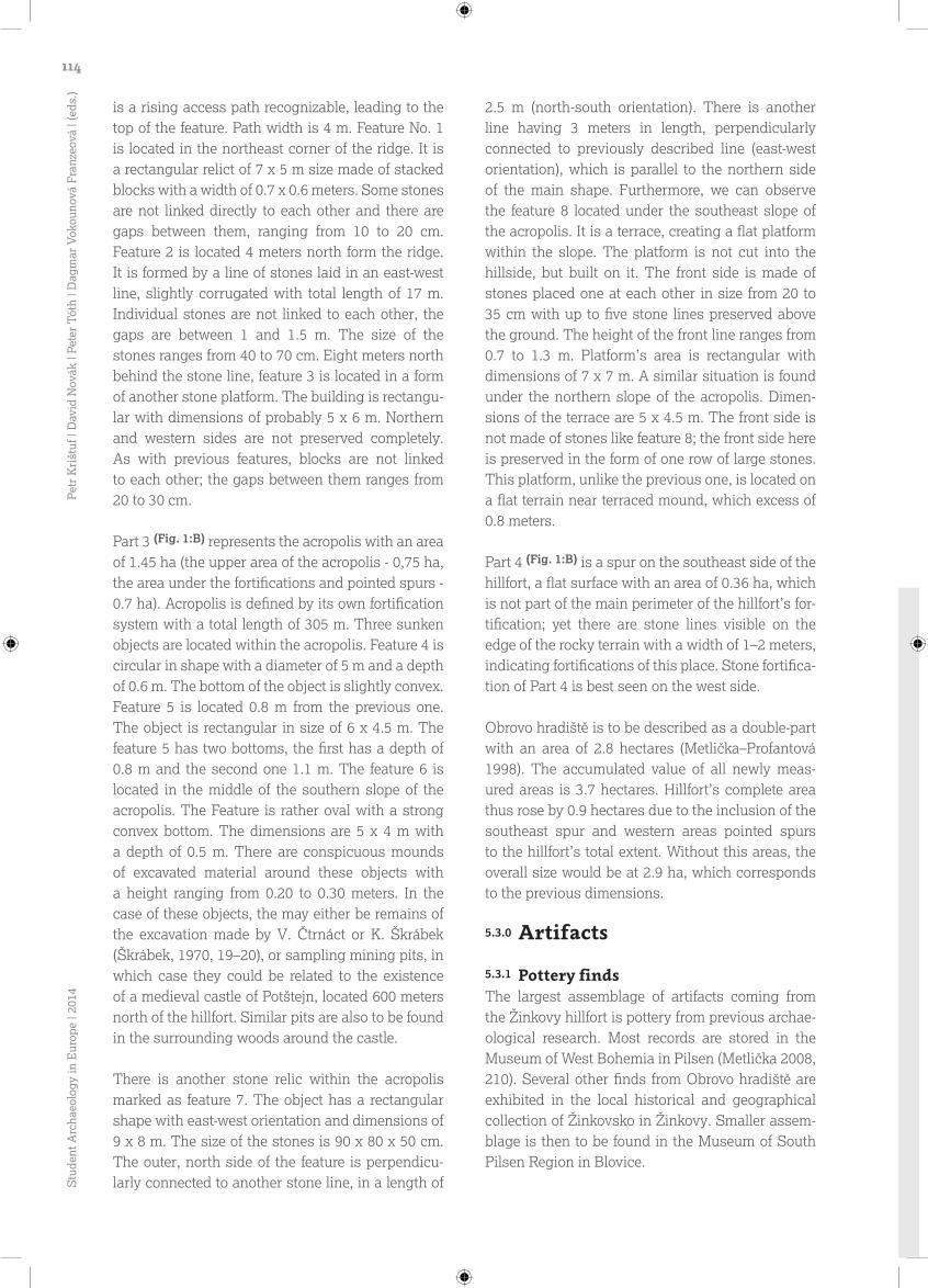
There is one item especially excelling in the col-lection of Blovice museum – reconstructed storage vessel from the Hillfort Period. The vessel has a low funnel closed spout, sweeping smoothly into the vessel’s body with the bulge at the top. Edge of the vessel is decorated and slightly undermined. The bulge is decorated with three strips of oblique oblong stamps (2x triangular and 1x quadrangular stamp). There are also two irregular wavy lines (top one being double, bottom one sometimes even triple) under the vessel’s bulge. There are even dou-ble to triple lines to be found at the bottom of the vessel. The vessel is hard-fired with an admixture of sand with inequality and roughness of the sur-face covered by a layer of fine clay. The vessel was produced manually by gluing separate bands of clay together, except for the neck and the edge, which were made on a potter’s wheel. The height of the vessel is 33.3 cm with a diameter on edge of 27 cm and bottom diameter having 14.5 cm. The vessel is dated back to the Middle Hillfort Period (Škrábek, 1970, 20).
5.3.2 Metal findsMaterial base of the hillfort’s metal artifacts is not very extensive. One metal artefact coming directly from the hillfort’s premises is rectangular iron strap-end with four rivets with a copper plate underlay. The strap-end is probably made according to the Carolingian draft; its production is rather placed in the context of the Great Moravian production. The strap-end is deposited in the Museum of West Bohe-mia in Pilsen (Metlička–Profantová 1998, 318–319).
In the valley above the Žinkovský Chateau, a hoard of two sets of bronze rings was discovered, dated back to the Late Bronze Age. Hoard contained two undecorated sets of five rings each, which slot together by their size. One set is incomplete, third and fifth rings are missing. The largest ring has a diameter of 13 cm and the smallest has 5 cm in diameter (Pomahač 1936, 33–34). Hoard is stored in the local historical and geographical collection of Žinkovsko at the Municipal Office building in Žinkovy.
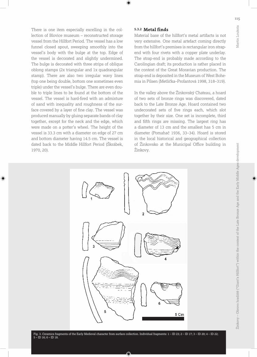
Fig. 3. Ceramics fragments of the Early Medieval character from surface collection. Individual fragments: 1 – ID 23; 2 – ID 17; 3 – ID 20; 4 – ID 22; 5 – ID 16; 6 – ID 18.
115
Žin
kovy
– O
brov
o hr
adiš
tě (“
Gia
nt’s
Hill
fort
”) w
ithi
n th
e co
ntex
t of t
he L
ate
Bro
nze
Age
and
the
Ear
ly M
iddl
e A
ges
deve
lopm
ent
Mar
tin
Louk
ota
6.0.0 Other observed sites
Archaeological monuments of Žinkovy region were engaged by an amateur archaeologist Jiří Pomahač, who describes several sites (Fig. XIII) in his publications Žinkovy in the past I–III and Topo-graphical-historical dictionary I–IV, which might be associated with studied hillfort. The oldest evidence of burials near the hillfort is known from Žinkov-ice; there was supposedly a burial ground with cremations from the Ha B period (Pomahač, 1975, 311) discovered in 1917. Another burial ground was found near Petrovice at the Štibřín Peak; four cremation burials were supposedly plowed with rough-surfaced, red-fired urns. There was a bronze sickle and a stone arrowhead inside one urn. The graves were allegedly placed in small barrows with stone cores underground (Pomahač, 1936, 37).
Another evidence of burials is located southwest of the Radkovice village. The local barrow-burial site was explored by A. Šlégl in 1903, finding two frus-tums with a hole at the tip (apparently loom weights), four sherds and bones (Pomahač, 1975, 238). There was another barrow-burial site detected near the Vojovice in 1913 (Pomahač, 1975, 295). Further-more, J. Pomahač with his colleagues found quan-tities of sherds near the village of Čepinec in 1968, which can be dated back to the period between the 10th and 12th centuries. More interesting discovery was made two years later, when a circular object with a width of about 1 m and a depth of about 30 cm was discovered by an excavator. The object was interpreted as a cremation based on a large amount of charcoals and molten clay pieces. Merely 140 pieces of pottery sherds came from the pit with 4 of them being thick-walled graphite pottery. Other graves were not discovered so far (Pomahač, 1975, 27–29). Radachovy village lying south of Čepince also attracts greater attention. Linear burial ground was discovered here during the road construction from Radachovy to Vojovic in 1912. There was part of a human skeleton and a pottery vessel found here, dated back to the 10th century (Pomahač, 1967, 74). This burial ground was interpreted as linear by J. Hůrková (1996). In her article, she mentions a discovery of eight skeletons at “U Křížků” location (Hůrková 1966; Schejbalová 2011, 78).
Burial evidence closest to the Obrovo hradiště is the Žinkovy burial ground. In the literature, its location is described by the name “Za kravínem”. It is a cre-mation burial ground, generally dated back to the
Early Middle Ages (Pomahač, 1967, 72). The closest evidence of further settlement near the hillfort was apparently placed on the site of the present castle ruins of Potštejn, on a rocky promontory north to the fortress. The theory that the castle was preceded by settlement from the Hillfort Period is supported by the evidence of the Early Hillfort Period pottery (Král – Metlička 2003), as well as the rampart character of castle’s fortification.
7.0.0 Conclusion
Framing the hillfort into the context of the Late Bronze Age is a far difficult task since nearby sites from this period are missing. The only exception is the burial site from the Ha B period, but because of lack of further information, we cannot come to a convincing conclusion. One possible conclusion may be, for the time being, the hypothesis stated by V. Šaldová, that the hillfort occupied by Nynická cul-ture held a function of a separate unit with minimal dependency at the other settlements (Šaldová1977).
Regarding the Early Middle Ages, the situation begins to be a little clearer. Observed sites are located within 5 km from the hillfort with the near-est sites being 1.7 km far, or even 600 m in the case of the Potštejn castle. The existence of burial sites suggests that there may be some permanent settlements in the form of hillfort during the Hill-fort Period located in these places. However, it is not clear, what were the relationships between the flatland settlement and the hillfort, and whether these sites were contemporary with each other. We cannot exclude the possibility that the Early Medie-val settlement was located in close proximity of the Žinkovy village or directly in its area, because of the Žinkovy-Záhatí site, from which comes a pottery assemblage from cultural pit dated to the Hillfort Period, stored in the Klatovy Museum. More Hillfort Period sherds were found at the “V jamkách” site. Both positions are roughly 500 m west from Žink-ovy. Smaller assemblage of the Early Hillfort Period comes from a site, where today lie the remains of the Potštejn castle (Král–Metlička 2003) with notice-able fortifications in the form of two circumferential ramparts with a moat. One possible hypothesis could be that the Obrovo hradiště had already lost administrative functions in the Early Hillfort Period, being replaced by a smaller administrative unit at the site of today’s castle ruins.
116S
tude
nt A
rcha
eolo
gy in
Eur
ope
| 201
4Pe
tr K
rišt
uf |
Dav
id N
ovák
| Pe
ter
Tót
h | D
agm
ar V
okou
nová
Fra
nzeo
vá |
(eds
.)

The rescue excavation could help to date back the hillfort’s earliest phase. Although only a damaged part of the rampart was cleaned-up (5 m in width to a height of 1 m), two pottery fragments caught in the section came from the research. Prehistoric sherd was detected in the layer 5, which is located above the layer 3. The sherd from the Hillfort Period lay in the layer 3. These findings suggests that the transverse rampart was modified and raised during the Hillfort Period, but whether there was a prehistoric phase of this rampart before the Hillfort Period was not con-firmed by the research. Layer 3 differed from the other layers mainly by being intermingled with plenty of small charcoals; the full course of this layer was there-
fore not completely captured. It is worth to mention the increased concentration of stones in the area of the inner rampart’s front. Rampart here was evidently equipped with a narrow inner stone wall (Fig. XII).
As a positive result of the research, we can regard an increasing of hillfort’s surface area up to 3.7 hectares due to the inclusion of its southeaster spur. At the previous plan (Metlička–Profantová 1998, 316), this area was not clear but in the field, however, it is a flat surface with evidence of fortifications in the form of thick stone lines in a width of 1–2 m. Different kind of fortification could indicate fortifying and connect-ing this place to the hillfort during its later phase.
8.0.0 References
�Bašta, J. – Baštová, D. 1988: K problematice počátků a vývoje slovanských hradišť v západních Čechách. Studia mediaevalia Pragensia 1, 9–31. �Beneš, A. 1970: Žinkovy / okr. Plzeň-jih – Obrovo hradiště, Zpráva o revizní kontrole amatérských výkopů na hradišti u Žinkov ze dne 30. 11. 1970, Archiv Západočeského muzea v Plzni oddělení prehistorie. �Beneš, A. – Škrábek, K. 1973: Žinkovy, okr. Plzeň-jih. Výzkumy v Čechách 1970, 176–178. �Bouda, J. 2014: Žinkovy / okr. okr. Plzeň-jih – Žinkovy „Obrovo hradiště“, Zpráva o archeologické akci muzeum Blovice, čj. 45/2014. �Čtverák, V. – Lutovský, M. – Slabina, M. – Smejtek, L. 2003: Encyklopedie hradišť v Čechách. Praha. �Demek, J. et al. 1987: Hory a nížiny. Zeměpisný lexikon ČSR. Praha. �Geological map 1:50 000: Czech Geological Service, <http://mapy.geology.cz/geocr_50/>, 10. 3. 2014. �Hůrková, J. 1996: Okresní muzeum v Klatovech. Zprávy ČAS, Supplement 27. Klatovy. �Král, J. – Metlička, M. 2003a: Žinkovy / okr. Plzeň-jih – Hrad „Potštejn“, Hlášení Západočeského muzea v Plzni oddělení prehistorie, čj. 102/2003. �2003b: Žinkovy / okr. Plzeň-jih – Žinkovy „Obrovo hradiště“, Hlášení Západočeského muzea v Plzni oddělení prehistorie, čj. 101/2003. �Metlička, M. 1995: Žinkovy / okr. Plzeň-jih – Žinkovy „Obrovo hradiště“, Hlášení Západačeského muzea v Plzni oddělení prehistorie, čj. 4/1995. �2008: Pravěká a raně středověká hradiště v západních Čechách. Unpublished master thesis, Faculty of Philosophy, ZČU, Pilsen. �Metlička, M. – Profantová, N. 1998: Zum Fund eines eisernen Riemenzeugbeschlages und zur Datierung des Burgwalls bei Žinkovy – Bez. Plzeň-jih. Saarbrücker Studien und Materialien zur Altertumskunde 6/7, 315–324. �Mištěra, L. 1993: Geografie západočeské oblasti. Plzeň. �Pomahač, J. 1967: Žinkovy v minulosti I. Žinkovy. �1975: Topograficko-historický slovník Žinkovska I – III. Žinkovy. �Pomahač, V. 1936: Nálezy předhistorických deposit bronzových na Žinkovsku. Plzeňsko – List pro vlastivědu západních Čech, 21–42. �Šaldová, V. 1977: Sociálně-ekonomické podmínky vzniku a funkce hradišť z pozdní doby bronzové v západních Čechách. Památky archeologické 68/1, 117–163. �1981: Westbohmen in der Bronzezeit. Befestigte Hohensiedlungen. Okrouhlé Hradiště. Praha. �1983: Sídlištní formy z pozdní doby bronzové v západních Čechách. Památky archeologické 74, 316–349. �Schejbalová, Z. 2011: Raně středověká řadová pohřebiště v Plzeňském kraji. Plzeň. �Škrábek, K 1970: Muzejní práce, 10 roků činnosti pracovníků okresního muzea v Blovicích 1960–1970. Blovice. �Soil map 1:50 000: Czech Geological Service, <http://mapy.geology.cz/pudy/>, 10. 3. 2014. �Tomášek, M. 2000: Půdy České republiky. Praha.
117
Žin
kovy
– O
brov
o hr
adiš
tě (“
Gia
nt’s
Hill
fort
”) w
ithi
n th
e co
ntex
t of t
he L
ate
Bro
nze
Age
and
the
Ear
ly M
iddl
e A
ges
deve
lopm
ent
Mar
tin
Louk
ota
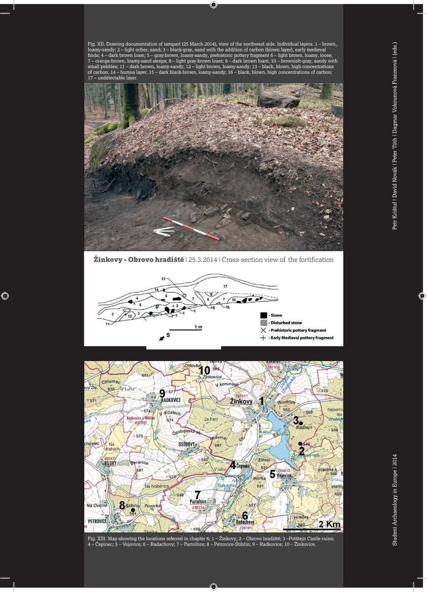
Fig. XIII. Map showing the locations referred in chapter 6; 1 – Žinkovy; 2 – Obrovo hradiště; 3 –Potštejn Castle ruins; 4 – Čepinec; 5 – Vojovice; 6 – Radachovy; 7 – Partoltice; 8 – Petrovice-Štibřín; 9 – Radkovice; 10 – Žinkovice.
Žinkovy - Obrovo hradiště | 25.3.2014 | Cross-section view of the fortification
Fig. XII. Drawing documentation of rampart (25 March 2014), view of the northwest side. Individual layers: 1 – brown, loamy-sandy; 2 – light ocher, sand; 3 – black-gray, sand with the addition of carbon (blown layer), early medieval finds; 4 – dark brown loam; 5 – gray-brown, loamy-sandy, prehistoric pottery fragment 6 – light brown, loamy, loose; 7 – orange-brown, loamy-sand sleeps; 8 – light gray-brown loam; 9 – dark brown loam; 10 – brownish-gray, sandy with small pebbles; 11 – dark brown, loamy-sandy; 12 – light brown, loamy-sandy; 13 – black, blown, high concentrations of carbon; 14 – humus layer; 15 – dark black-brown, loamy-sandy; 16 – black, blown, high concentrations of carbon; 17 – undetectable layer.
Stu
dent
Arc
haeo
logy
in E
urop
e | 2
014
Petr
Kri
štuf
| D
avid
Nov
ák |
Pete
r T
óth
| Dag
mar
Vok
ouno
vá F
ranz
eová
| (e
ds.)
Edlira Andoni, Center of Albanian Studies, Tirana, Albania, [email protected]
Markéta Augustýnová, University of West Bohemia, Pilsen, Czech Republic, [email protected]
Luana Batista-Goulart, Federal University of Sergipe, Brazil, [email protected]
Arba Bekteshi, University of Tirana, Albania, [email protected]
Lola Briceno-Boucey, University of Bordeaux, France, [email protected]
Viktoria Čisťakova, Charles University, Prague, Czech Republic, [email protected]
Sergio España-Chamorro, FPU Grant Holder (Spanish Ministry of Education). Universidad Complutense de Madrid, Spain, [email protected]
Jan Frýzl, University of West Bohemia, Pilsen, Czech Republic, [email protected]
Paweł Gołyźniak, Jagiellonian University, Krakow, Poland, [email protected]
Mark Guillon, INRAP/University of Bordeaux, France
Soňa Hendrychová, Charles University, Prague, Czech Republic, [email protected]
Eliška Junková, University of West Bohemia, Pilsen, Czech Republic, [email protected]
List of contributing authors174
Stu
dent
Arc
haeo
logy
in E
urop
e | 2
014
Petr
Kri
štuf
| D
avid
Nov
ák |
Pete
r T
óth
| Dag
mar
Vok
ouno
vá F
ranz
eová
| (e
ds.)

Margarita Kholkina, Saint Petersburg State University, Russia, [email protected]
Stanislava Kučová, Charles University, Prague, Czech Republic, [email protected]
Veronika Linková, University of West Bohemia, Pilsen, Czech Republic, [email protected]
Martin Loukota, University of West Bohemia, Pilsen, Czech Republic, [email protected]
Wawrzyniec Miścicki, Jagiellonian University, Krakow, Poland, [email protected]
Violeta Moreno Megías, University of Sevilla, Spain, [email protected]
David Novák, Institute of Archaeology, CAS, Prague, Czech Republic, [email protected]
Iva Pohunková, Masaryk Univesity, Brno, Czech Republic, [email protected]
Eve Rannamäe, University of Tartu, Estonia, [email protected]
Irina Reshetova, Institute of Archaeology, Moscow, RAS, Russia, [email protected]
Isabelle Souquet-Leroy, INRAP/University of Bordeaux, France
Davor Špoljarr, University of Ljubljana, Slovenia, [email protected]
Liivi Varul, University of Tartu, Estonia
175
Student Archaeology in Europe: Conference Proccedings of the Student Session of the 19th Annual Meeting of the European Association of Archaeologist in Pilsen and 5th Student Conference „The Landscape in the Past, the Past in the Landscape“
Edited by Petr Krištuf – David Novák – Peter Tóth – Dagmar Vokounová Franzeová Publisher: University of West Bohemia in Pilsen, Univerzitní 8, 306 14 Plzeň Graphic design and layout: Petr Kincl, www.petrkincl.info Language revision: Jan Kaňka Print: Polypress s.r.o, Truhlářská 486/15, 360 17 Karlovy Vary - Stará Role First edition Number of copies: 200
© 2014 P. Krištuf – D. Novák – P. Tóth – D. Vokounová Franzeová and individual authors
ISBN 978-80-261-0420-9