(With Michel Fortin) Shedding New Light on the Elusive Late Bronze and Ealry Iron Ages at Tell...
29
ANCIENT NEAR EASTERN STUDIES SUPPLEMENT 42 ACROSS THE BORDER: LATE BRONZE-IRON AGE RELATIONS BETWEEN SYRIA AND ANATOLIA Proceedings of a Symposium held at the Research Center of Anatolian Studies, Koç University, Istanbul May 31–June 1, 2010 Edited by K. Aslıhan YENER PEETERS LEUVEN – PARIS – WALPOLE, MA. 2013
Transcript of (With Michel Fortin) Shedding New Light on the Elusive Late Bronze and Ealry Iron Ages at Tell...
ANCIENT NEAR EASTERN STUDIES
SUPPLEMENT 42
ACROSS THE BORDER:LATE BRONZE-IRON AGE RELATIONS
BETWEEN SYRIA AND ANATOLIAProceedings of a Symposium held
at the Research Center of Anatolian Studies,Koç University, Istanbul
May 31–June 1, 2010
Edited by
K. Aslıhan YENER
PEETERSLEUVEN – PARIS – WALPOLE, MA.
2013
CONTENTS
Introduction: Imperial Demise and Forging Emergent Kingdoms . . . . . . 1K. A. YENER
SECTION A:EXCAVATIONS IN LEVANTINE TURKEY
AND LEVANTINE SYRIA
Chapter 1New Excavations at Alalakh: The 14th–12th Centuries BC . . . . . . . . . 11
K. A. YENER
Chapter 2The Late Bronze Age Fortresses at Alalakh: Architecture and Identity in Mediterranean Exchange Systems . . . . . . . . . . . . . . . . . . . . . . . 37
M. AKAR
Chapter 3Tayinat in the Early Iron Age . . . . . . . . . . . . . . . . . . . . . . . . 61
T. P. HARRISON
Chapter 4Chatal Höyük in the Amuq: Material Culture and Architecture during the Passage from the Late Bronze Age to the Early Iron Age . . . . . . . . . . . 89
M. PUCCI
Chapter 5The Crisis of Qatna at the Beginning of the Late Bronze Age II and the Iron Age II Settlement Revival. A Regional Trajectory towards the Collapse of the Late Bronze Age Palace System in the Northern Levant . . . . . . . . . . . 113
D. MORANDI BONACOSSI
Chapter 6Shedding New Light on the Elusive Late Bronze and Early Iron Ages at Tell ‘Acharneh (Syria) . . . . . . . . . . . . . . . . . . . . . . . . . . . . . . . 147
M. FORTIN and L. COOPER

vi CONTENTS
Chapter 7Sabuniye: A Late Bronze-Iron Age Port Settlement on the NortheasternMediterranean Coast . . . . . . . . . . . . . . . . . . . . . . . . . . . . 173
H. PAMIR
Chapter 8A Re-evaluation of the Late Bronze to Early Iron Age Transitional Period:Stratigraphic Sequence and Plain Ware of Tarsus-Gözlükule . . . . . . . . 195
S. YALÇIN
Chapter 9Exploring Sirkeli Höyük in the Late Bronze Age and its Interregional Con-nections . . . . . . . . . . . . . . . . . . . . . . . . . . . . . . . . . . . . 213
E. KOZAL
Chapter 10The Transition from the Late Bronze Age to the Early Iron Age at Tell Afis, Syria (phases VII-III) . . . . . . . . . . . . . . . . . . . . . . . . . . . . . 227
F. VENTURI
SECTION B:EXCAVATIONS IN EASTERN TURKEY
AND EASTERN SYRIA
Chapter 11Across Assyria’s Northern Frontier: Tell Fekheriye at the End of the LateBronze Age . . . . . . . . . . . . . . . . . . . . . . . . . . . . . . . . . . 263
P. V. BARTL and D. BONATZ
Chapter 12Between the Musku and the Aramaeans: The Early History of Guzana/Tell Halaf 293
M. NOVÁK
Chapter 13Some Implications of Revised C14 and Dendrochronological Dating for the “Late Bronze Levels” at Tille Höyük on the Euphrates . . . . . . . . . . . . 311
G. D. SUMMERS
Chapter 14The Late Bronze Age to Early Iron Age Transition: A Perspective from theUpper Tigris River . . . . . . . . . . . . . . . . . . . . . . . . . . . . . . 329
T. MATNEY
CONTENTS vii
Chapter 15Neo-Hittite Melid: Continuity or Discontinuity? . . . . . . . . . . . . . . 349
M. FRANGIPANE and M. LIVERANI
Chapter 16Pottery as an Indicator of Changing Interregional Relations in the Upper Euphrates Valley. The Case of the Late Bronze-Iron Age Assemblages fromArslantepe/Malatya . . . . . . . . . . . . . . . . . . . . . . . . . . . . . . 373
F. MANUELLI
Chapter 17New Excavations at the Late Bronze Age and Iron Age Site of Gre Amer onthe Garzan River, Batman Province . . . . . . . . . . . . . . . . . . . . . 393
G. PULHAN and S. R. BLAYLOCK
SECTION C:FUNERARY PRACTICES, TEXTS AND THE ARTS
Chapter 18Funerary Practices and Society at the Late Bronze-Iron Age Transition. A View from Tell Shiukh Fawqâni and Tell an-Nasriyah (Syria) . . . . . . . 423
A. TENU
Chapter 19Working Ivory in Syria and Anatolia during the Late Bronze-Iron Age . . . 449
A. CAUBET
Chapter 20Arts and Cross-Cultural Communication in the Early 1st Millennium: The Syro-Anatolian Contact . . . . . . . . . . . . . . . . . . . . . . . . . 465
S. MAZZONI
Chapter 21The Luwian Inscriptions from the Temple of the Storm-God of Aleppo . . 493
J. D. HAWKINS
Chapter 22Qadesh, Sea-Peoples, and Anatolian-Levantine Interactions . . . . . . . . . . 501
K. STROBEL
Chapter 23An Amulet with the Names of Ramesses II from the Roman Baths at Ankara 539
H. PEKER
CHAPTER 6
SHEDDING NEW LIGHTON THE ELUSIVE LATE BRONZE
AND EARLY IRON AGESAT TELL ‘ACHARNEH (SYRIA)
Michel FORTIN Université Laval, Québec, CanadaE-mail: [email protected]
and
Lisa COOPERUniversity of British Columbia, Vancouver, Canada
E-mail: [email protected]
ABSTRACT
Following a widely accepted interpretation of some second millennium literary docu-ments, Tell ‘Acharneh may represent the remains of the ancient city of Tunip. Several texts refer in particular to the existence of this important city, located in the Orontes valley, during the Late Bronze Age. Until now, however, no remains of this period had been revealed on this prominent archaeological site dug by a Canadian team, led by the two authors, since 1998. But, during the 2009 campaign and particularly the 2010 season, we came upon substantial remains of this period and the ones that followed: Early Iron Age I and II.
Tell ‘Acharneh, a substantial site in the middle Orontes valley (Syria), is one of the most conspicuous considering the following features:1
— its size: 1.2 km N-S by 500/600 m E-W, for a total surface of 72 hectares;— many of its components are still visible on the ground: a wide and circular pisé
city wall/rampart, a main citadel and a secondary one with a “postulated” city gate in between, leading to a lower town encircled by the rampart;
— its strategic setting in a right-angle bend of the course of the river Orontes, which itself served as a natural moat;
1 For a more detailed description of the site, see: Fortin 2006b.
95603_Anes_Supple_42_07_A_ch6_Fortin Cooper.indd 147 29/04/13 15:56
148 M. FORTIN AND L. COOPER
— its strategic location in the middle of a low plain forming an extension to the southern end of the middle Orontes valley: this situation had already been shown by Courtois during his pioneering survey in 19702 and then confirmed by us in 2004 and 2006.3 The site is visible from everywhere in the depressed plain (“cuvette”) at the southern end of the Middle Orontes valley.
THE HISTORICAL CONTEXT
Before the beginning of our excavations at Tell ‘Acharneh in 1998, we were well aware that this site must have corresponded to a major Aramaean city on the basis of information provided by a cuneiform inscription chiselled onto a piece of basalt which had been found just beside the main tell. This stela had been discovered by chance in 1924, when the bridge over the Orontes River, which was still being frequently used by local traffic, had been rebuilt.4 It was purposely left there by the Assyrian king Sargon II (or one of his high ranking officers who commanded his army and carried out his instructions while he was in his capital)5 only a short time after the conclusion of the 720 BC campaign against Hamath. From the text of this official proclamation, it seems likely that the Assyrian troops conquered the city that stood at the location of modern Tell ‘Acharneh — but whose ancient name is not mentioned — in the process of controlling the region which at that time was inhabited by Aramaean com-munities. We therefore surmise that ‘Acharneh probably corresponded to one of the major Aramaean cities during this period of time, and that because of its strategic location directly on the banks of the Orontes River, it must have been part of the core of the Aramaean Hamath kingdom.6
In spite of this information, however, it remains to be determined when exactly ‘Acharneh became an Aramaean city. It must have been somehow Aramaicized by the time of Shalmaneser III’s military expedition against Hamath in 853 BC, as it sided with the coalition of Aramaean cities defeated at Qarqar. Interestingly, an elevation view of its defensive city wall with gateways, towers, and battlements dated from some decades earlier may be featured on one of the sixteen famous embossed metallic gate bands belonging to a temple that was constructed by Shalmaneser III at the site of Balawat. It is often argued that the artists of the bronze bands “would have had some knowledge, probably eye witness knowledge, of the buildings” they depicted7 although this opinion is questioned by some scholars.8 Band number IX, which refers to the
2 Courtois 1972, p. 79, 1973, pp. 55, 59, 62–65. 3 Fortin 2007a, 2007b. 4 Thureau-Dangin 1933; Frame 2006. 5 Na’aman 2007, pp. 168–169. 6 Dion 1997, pp. 160–161. 7 Tucker 1994, p. 116. 8 Jacoby 1991.
95603_Anes_Supple_42_07_A_ch6_Fortin Cooper.indd 148 29/04/13 15:56
SHEDDING NEW LIGHT ON TELL ‘ACHARNEH 149
well-known capture of Qarqar by Shalmaneser III in 853 BC, shows, in addition to Warwar, two other Aramaean cities that were attacked, Parga/Barga and Ada/Adennu. These are described as “belonging to Urhilenu, the Hamatite” according to the epi-graphs on the band.9 Since they are represented by a river, it is logical to think that they correspond to major Aramaean towns of the Hamath kingdom, which were established on the banks of the Orontes River.10 This would seem particularly so since geography was an “organizing principle” strictly followed by artists from the time of Shalmaneser III11 and moreover, “both registers in each band [of the Balawat bronze bands] showed incidents from one campaign.”12 Thus, if the visual narrative is trust-worthy (the sequential organization of the bands on the door panels is still disputed by some scholars)13‘Acharneh is a good candidate for one of the depicted cities. In our reconstruction of the sequence of events, then, ‘Acharneh would have experienced a first attack by the Assyrian troops of Shalmaneser III in 853 BC. This attack was followed by a program of reconstruction before the city was taken one last time in 720 BC by Sargon II and his troops because of its resistance to the Assyrian invasion, as inferred by the ‘Acharneh inscription mentioned above. The reconstruction and reoccupation of ‘Acharneh following the destruction of 853 BC might bear the mark of Assyrian influence since the Hamath kingdom, which would have included the city of ‘Acharneh, accepted an Assyrian overlordship in 842 BC. This period of Assyrian hegemony lasted until the end of the 9th century, at which time the Aramaean king Zakkur seized power over Hamath.14
Before the Aramaean king Zakkur came into power, the kingdom of Hamath “had a mixed population.”15 This included Semitic tribes of Aramaeans who had settled here and there in the region16 as early as around 1100 BC, since Tiglath-pileser I had to contend with them in the course of a military expedition into North Syria.17 The name “Aramaeans” first appeared in inscriptions related to this campaign. The region also included Luwian populations, the presence of whom have been confirmed so far by twenty-one Hieroglyphic Luwian inscriptions discovered in the modern town of Hama or in its vicinity.18 The city of Hamath itself was under the leadership of a Hittite dynasty. Thus, although its citadel, excavated by the Danish team in levels F
9 Grayson 1996, pp. 74–76, A.O.102. 10 Sader 1987, p. 225 n. 98. 11 Marcus 1987. 12 Reade 1979, p. 70. 13 For instance: Hertel 2004; Schachner 2007; Curtis and Tallis 2008, pp. 11–15. 14 Hawkins 1982, p. 435; Dion 2006, p. 46 15 Dion 2006, p. 45. 16 Dion 2006, p. 44. 17 Bunnens 2009, p. 68. 18 Hawkins 2000, pp. 398–415.
95603_Anes_Supple_42_07_A_ch6_Fortin Cooper.indd 149 29/04/13 15:56
150 M. FORTIN AND L. COOPER
and E and dated to the 10th and early 9th centuries BC has been labelled “Aramaean,” it should probably be more appropriately defined as “Hittite.”19
Hieroglyphic Luwian inscriptions were found in three localities very close to Tell ‘Acharneh; Qalat al-Mudiq, Meharde and Sheizar. Since these sites are easily visible from the summit of the main tell at ‘Acharneh, it would be reasonable to think that some Luwian elements settled down at Acharneh in the Early Iron Age as well. Note-worthy is the fact that the stelae from Meharde and Sheizar20 refer to king Taita of the land of Padasatini or Wadasatini (a toponym now read Palistin), the very same indi-vidual mentioned on the reliefs from the Temple of the Strom God at Aleppo.21 Hawkins22 and Harrison23 have suggested recently that this king was the head of a kingdom located in the Amuq Plain, with its capital at Tell Ta’yinat. Between the 11th and 10th centuries BC, it extended to the environs of Hama. During this period, therefore, it is likely that Tell ‘Acharneh would have been somehow associated with, or even incorporated into, the “Land of Palistin,” a Neo-Hittite Early Iron Age “rump” state centered at Tell Ta’yinat.
Hawkins24 even sees a possible connection between the toponym “Palistin” and the Philistines, one of the “Sea Peoples” who appear at the end of the Bronze Age as sea-borne raiders on the Levantine coast: “we may perhaps envisage an intrusive group of Sea Peoples settlers in the north Levant and their territory being designated by a form of Palistin.” In this regard, it is relevant to mention two inscriptions from Medinet Habu, written in the years 5 and 8 of the reign of Ramses III (c.1180 BC), the phar-aoh who defeated the Sea Peoples at land and at sea. These texts refer to the conquest of the Amurru kingdom by the Sea Peoples and the submission of its population.25 Tell ‘Acharneh, which was known as Tunip at that time,26 had just been integrated into this kingdom!
An external wall of Medinet Habu shows a relief representation of Tunip as it would have looked during this period; a three-story high fortress surrounded on three of its sides by a moat. The fact that the city is shown attacked by soldiers of Ramses III27 implies that Tunip was no longer an ally of the Egyptians at the end of the Late Bronze Age. This situation contrasts with the beginning of the Late Bronze Age, when Tunip was on such good terms with Egypt that it was “personified” on a pylon erected
19 Hawkins 2000, p. 402. 20 Hawkins 1979, 1995, p. 97. 21 Hawkins 2000, pp. 415–419, 2009, p. 169. 22 Hawkins 2009, pp. 169–172. 23 Harrison 2009a, p. 181, 2009b. 24 Hawkins 2009, p. 171. 25 Klengel 1992, pp. 182–184.26 Klengel 1995. 27 Pritchard 1969, pl. 344.
95603_Anes_Supple_42_07_A_ch6_Fortin Cooper.indd 150 29/04/13 15:56
SHEDDING NEW LIGHT ON TELL ‘ACHARNEH 151
by Amenophis I (1525–1504 BC) at Karnak28 and that the king of Tunip was sending letters written on clay tablets to his “brother,” the Pharaoh Akhenaton (1351–1334 BC) at his capital Amarna.29 Those letters even allude to a “colonisation” of Tunip by Egyptians and to a remodelling of the city into an Egyptian town. Tunip seems to have been then under the tutelage of Egypt30 as its citizens clearly asked in a letter for its protection against the Hittites.31
This period of friendship came to an end after the battle of Qadesh (1275 BC). Ramses II led an attack against the city of Tunip because this city had endeavoured to maintain a good relationship with the Hittites, the foe against whom Egyptians had fought at Qadesh, 80 km to the south of Tell ‘Acharneh. The pharaoh had been right about Tunip’s divided loyalties; the name of Tunip appears in Hittite texts,32 namely in an itinerary, which describes it as a station used by the troops of Suppiluliuma I (1344–1322 BC) during their campaigns into Syria. One could easily cross the Orontes River there, as it is shallow and there is a ford. Many scholars agree that dur-ing the time after the Amarna period, the Hittites were able to take control of the northern region of Inner Syria, including the Ghab Valley, where Tell ‘Acharneh is located.33
Judging from the numerous written and iconographic documents briefly referred to here, if the identification of Tell ‘Acharneh with Tunip is correct,34 one should expect a major Late Bronze Age level of occupation at Tell ‘Acharneh. It should contain within it the remains of the material culture of the various people — Hittites and Egyptians — who tried to secure its alliance during this time, not to mention traces of the attacks led on the city by these groups and the phases of reconstruction that followed.
ARCHEOLOGICAL EVIDENCE: CAMPAIGNS 1998–2004
Archaeological evidence gathered by our team during field campaigns at Tell ‘ Acharneh between 1998 and 200435 confirmed the existence of occupation during the second phase of the Iron Age (900–720 BC; IA II). On the other hand, only a small amount of material for the Late Bronze Age and the early Iron Age (IA I) has been as-yet obtained,36 and it was clearly insufficient to demonstrate any kind of
28 Redford 1979. 29 Goren et al. 2002, 2003, 2004, pp. 116–121. 30 Klengel 1992, pp. 97, 104–105. 31 Freu 1992, p. 66, 2009, p. 21. 32 Klengel 1992, pp. 113, 163. 33 Still other scholars argue, however, that the Hittites’ role in Syria has been overestimated. See
Gromova 2007, p. 307. 34 Klengel 1995; Goren et al. 2002, 2003, 2004, p. 121. 35 Fortin and Cooper 2006; Fortin ed. 2006. 36 Cooper 2006, pp. 148–149.
95603_Anes_Supple_42_07_A_ch6_Fortin Cooper.indd 151 29/04/13 15:56
152 M. FORTIN AND L. COOPER
continuity between these periods. This situation contrasts with other contemporary sites in the region such as Tell Afis, where a clear continuity in the occupation from LBA to IA I is well documented.37 Moreover, at several sites in the Amuq valley fur-ther to the north, the transitional LB/IA period — long perceived as an interruptive period following the passage of the Sea Peoples in the Levant — is now established as of a period of continuity marked by the creation of rump Neo-Hittite states at the beginning of the Iron Age.38
In ‘Acharneh’s TE trench, we came upon a large cobbled floor surrounded by walls. Sherds dating to the Iron Age II period (900–720) were found embedded in the floor between the cobble stones.39 This installation is comparable to a cobble-floored build-ing at Tell Afis from which Iron Age II sherds were similarly uncovered.40 We were also able to observe a defensive glacis made of distinctive layers of earth containing EBA-MBA pottery and figurines, which was adjacent to and had been thrown up against the cobbled space.41 Although constructed some time during the Iron Age, this defensive structure was clearly constructed of earth mined from other parts of the set-tlement where extensive Bronze Age occupation had occurred many centuries before.
A similar multi-layered defensive glacis was encountered in the area of the postu-lated northern gate of the city, where there is a large opening in the massive earthen rampart that encircles the site.42 We are inclined to think that this glacis was con-structed as a precaution against the Assyrian troops of Shalmaneser III, whose cam-paigns against a coalition of Aramaean cities in the west culminated in the battle at Qarqar in 853. Alternatively, it may have been built in the aftermath of such a defeat — so vividly commemorated on the Balawat Gates’ bronze bands — and in anticipa-tion of further attacks. Whatever the precise motivation and date of these defensive constructions, they appear to have been in use when Sargon II took the city in 720 and erected the well-known stela, and reflect well the city’s part in the coalition of Aramaean cities that he defeated.
‘Acharneh’s circuit rampart, which upon first inspection seemed typical of a Levan-tine MBA fortification,43 appears also to date to the Iron Age since it appears to be associated with traces of a major building of Iron Age II date found in the CVB area of the Lower Town.44 In all, Tell ‘Acharneh’s occupation seems comparable to a sim-ilar situation at Qatna nearby, where urban life flourished during the Iron Age II, and
37 Mazzoni 1998b; Venturi 2000, 2007. 38 Harrison 2007, 2009a, 2009b; Hawkins 2009. 39 Fortin 2006d, pp. 114–116, 2006e, pp. 125–128. 40 Cecchini 2000; Soldi 2009, p. 103. 41 Fortin 2006d, pp. 117–118, 2006e, p. 125. 42 Fortin 2006e, pp. 125–133. 43 Burke 2008.44 Cooper and Fortin 2004; Fortin 2006c, p. 92, 2006e, pp. 136–138.
95603_Anes_Supple_42_07_A_ch6_Fortin Cooper.indd 152 29/04/13 15:56
SHEDDING NEW LIGHT ON TELL ‘ACHARNEH 153
the Aramaean settlement encompassed practically the entire site.45 But the question remains as to exactly when the Iron Age city was built at Tell ‘Acharneh. Can its founding be traced back to the Iron Age I? And what happened to the Late Bronze Age city of Tunip?
CAMPAIGN 2009: TEST TRENCH
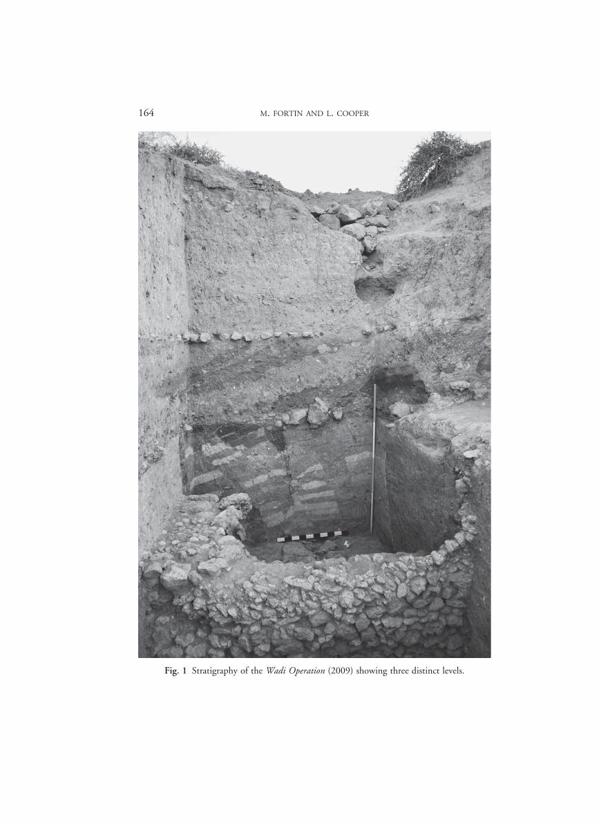
In order to find some answers to those questions, we returned to the field in 2009 and opened a small test trench measuring 5 ≈ 2,5 m at the top of a wadi formed by rain run-off on the southern flank of the main tell; Wadi Operation (WO) 1. It is precisely the transitional LB/IA period we tried to elucidate through this operation at Tell ‘Acharneh.
During this brief campaign (three weeks), we uncovered a 5 m deep stratigraphic sequence consisting of three clearly distinct levels (Fig. 1).
Level 1
The first level is characterized by a cobbled surface, clearly visible in section, with a fill above it, the thickness of which varies from 0.5 to 2 meters. Cobbles were cemented together with a white clayish material and the whole surface was originally covered with a fibre mat, the print of which could be easily observed in the white clay between the cobbles. This cobbled floor belonged to a major building we could trace into the section to the east of the trench.
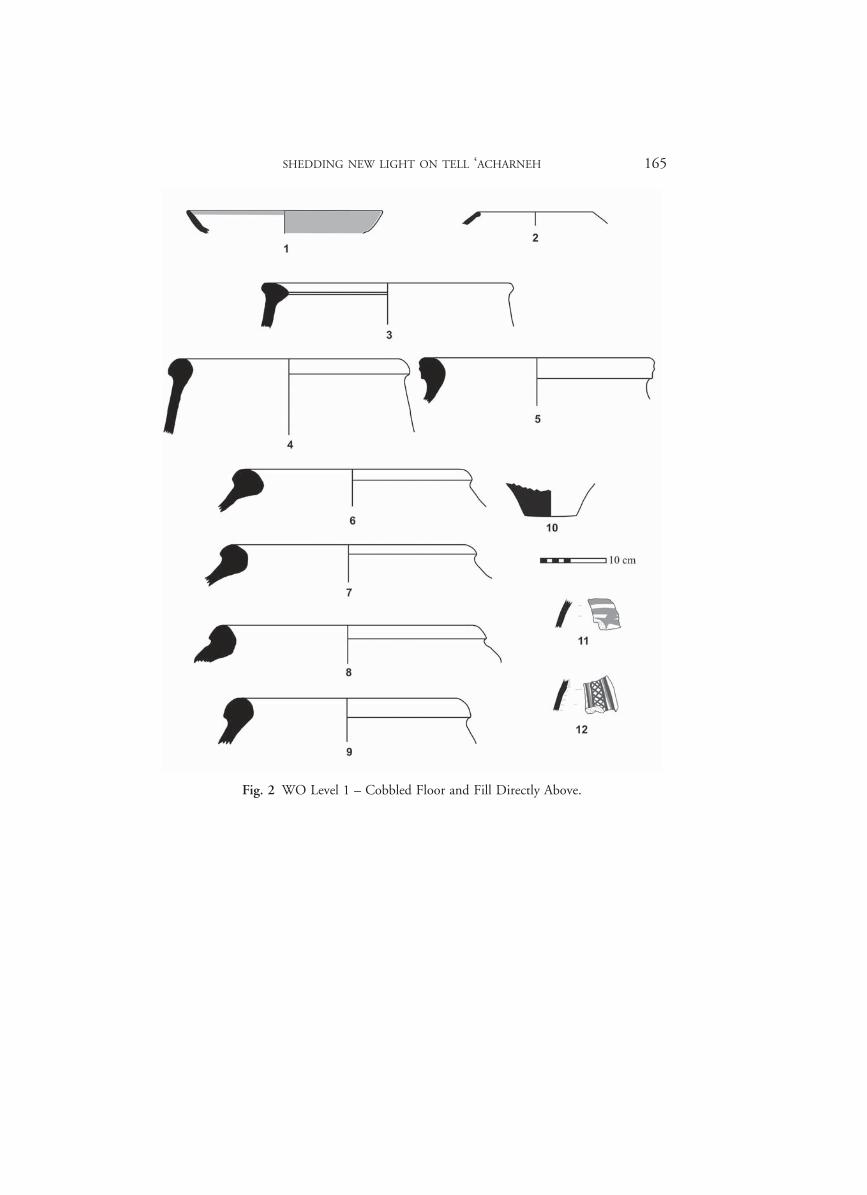
The cobbled surface had several fragments of pottery purposefully inserted among the cobbles. Ceramics relevant for the dating of this floor were also collected in the fill directly above it. These sherds belong to red slipped and burnished bowls (Fig. 2:1), the forms of which compare well to shapes found in Iron Age II contexts in sector CVB in the lower town of Tell ‘Acharneh,46 and large ovoid pithoi with thickened rims and heavy, solid-footed bases (Fig. 2:4–10), which are particularly numerous and offer the same range of fabric types and production technologies as those observed on Iron II specimens found in other sectors of the site.47 There were also sherds from deep bowls or kraters with expanded rims (Fig. 2:3)48 and globular, hole mouth cook-ing pots with thickened, internally rounded rims (Fig. 2:2).49
A few painted sherds (Fig. 2:11–12), some featuring bands of red paint similar to those already found elsewhere on the main mound at Acharneh, as well as a bodysherd
45 Morandi Bonacossi 2009, p. 120. 46 Cooper 2006, fig. 1:6–11. 47 Cooper 2006, figs. 4:12–17, 10–11, 16–17; Boileau 2006, pp. 197–199. 48 Cooper 2006, figs. 2:6–13; 3:1–9. 49 Cooper 2006, fig. 9:3–9.
95603_Anes_Supple_42_07_A_ch6_Fortin Cooper.indd 153 29/04/13 15:56
154 M. FORTIN AND L. COOPER
featuring bichrome decoration whose best parallels date back to the early part of the Iron Age, were found in the fill above the cobbled floor. We have already speculated that the principal mound at ‘Acharneh, unlike the Lower Town, was inhabited in the earlier Iron I period.50 These painted wares in sounding WO, which are probably residuals from an earlier occupation, also seem representative of that Iron I period.
The cobbled surface probably represents a construction that took place sometime in the Iron II period (900–720 BC), and approximately contemporary with the similar cobbled space found in TE1a–b–c on the main mound, some 40 meters to the north-east of WO1, although a few meters higher.51
Level 2
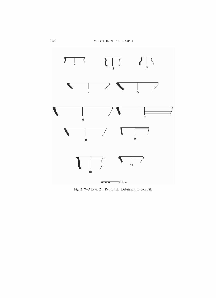
This Iron Age II cobbled floor lies right above a 1,20 m thick layer of reddish, bricky debris material coming from the destruction of wide walls that most probably belonged to a major building. To make the area even at the time of the area’s reoc-cupation, the occupants filled the depressions between the bricky debris with brown earth. This is our second level. The occupation period of the building made of red bricks, disaggregated by a major fire, is obviously earlier than the Iron II cobbled sur-face above, but by how many years?
Sherd fabrics and forms retrieved from this second level are different from those of Iron Age II sherds from the layer above. They include several small cups with flaring rims, which are the hallmark of the Middle Bronze Age (Fig. 3:1–3). Also present are bowls featuring internal swollen rims (Fig. 3:4–5), similar to those found at Qatna, Ebla, and along the Euphrates River, where they are believed to date to the final MBII and into the LBI.52 A few bowls with bevelled rims were recovered (Fig. 3:6), compa-rable to those found at Arqa Phase L, where they are dated to the Late Bronze Age; at Qatna, where they have been fit specifically within the Late Bronze II horizon at that site; and at Tell Afis in LBIIB.53 Another bowl with an out-turned rim (Fig. 3:7) has parallels to examples coming from Late Bronze Age strata at Tell Afis, and which seem to continue into the Iron I period.54 Rims of deep cups, which are corrugated or grooved below the rim (Fig. 3:9), are elsewhere regarded as dating to the end of the MBII and into the LBI period.55
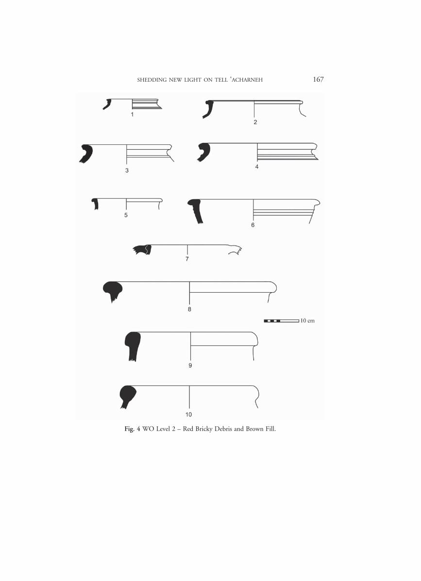
Among the pots, kraters and storage receptacles (Fig. 4), one continues to see forms that are typical of the Middle Bronze Age horizon of the Northern Levant (Fig. 4:1–4),
50 Cooper 2006, pp. 148–149, 155. 51 Fortin 2006b, pp. 114–116, 2006e, pp. 125–133. 52 Morandi Bonacossi et. al. 2009, p. 81, fig. 15:1–2. 53 Thalmann 2006, pl. 117: 13; Morandi Bonacossi et al. 2009, p. 101, fig. 32:4–6; Venturi 1998,
fig. 5:13; 2007, fig. 48:9 (phase Vb). 54 Venturi 1998, fig. 5:5; 2007, fig. 48:13–14; Mazzoni 1998, fig. 17:3. 55 Morandi Bonacossi et al. 2009, p. 81, fig. 15:10.
95603_Anes_Supple_42_07_A_ch6_Fortin Cooper.indd 154 29/04/13 15:56
SHEDDING NEW LIGHT ON TELL ‘ACHARNEH 155
although vessels with later dates are also attested. Particularly striking is the appear-ance of two-handled cooking pots with flanged rims (Fig. 4:7), which do not appear at Tell Afis until the very start of the Iron Age (Iron I) and which continue into the early Iron II period.56 Similar cooking pots have now also been documented in Iron I levels at Tell Tayinat.57 This second level is also characterized by the appearance of large pithos jars. One of these has an internally swollen rim (Fig. 4:8), which finds a good parallel at Tell Afis from the LBIIB,58 but the other pithos rims (Fig. 4:9–10) compare well with those which first appear in Iron I levels at Afis and which continue to propagate into the Iron II. Such pithoi are certainly well known from Iron II levels at Tell Acharneh.59
This second level made of red bricky debris and associated brown fill, found as a thick deposit right under the cobbled surface, contains a mix of ceramic material that includes not only an abundance of Middle Bronze Age forms, but also sherds dating to the Late Bronze and the early part of the Iron Age. Although this rubble contains within it debris from constructions that date back to the Middle Bronze Age, the final deposition of these layers must be attributed to no earlier than the Iron I period (1200/1150–900 BC).
Level 3
The building made of red-brick walls just mentioned had been erected on top of a purposely created fill — our third level — made up of earth and fragments of mud-brick walls from the occupational level below. The fill was retained by a 3 m high dry stone thin wall. At first sight, we inferred that elements of this fill, such as the wall remains, were originally erected during the period immediately prior to the second level, i.e. the Late Bronze Age. To be sure, none of the ceramics from this level 3 can be dated to the Iron Age. But, it turned out that none of the pottery can be assigned a date from the Late Bronze Age either! Indeed, almost all of the pottery from the contexts in level 3 dates to the Early and Middle Bronze Ages (Fig. 5). The Early Bronze Age specimens, which include, for example, fragments of painted caliciform cups, bowls with vertical ribbed rims, and vertical or slightly out-turned rim pots (Fig. 5:1–5), compare well with sherds found elsewhere at Hama, Ebla, Mishrifeh-Qatna, Al-Rawda and elsewhere at ‘Acharneh itself.60 All of the pieces belong within the EBIV horizon. The Middle Bronze Age forms, which include inturned-rim bowls,
56 Venturi 1998, fig. 8; 2007: fig. 62:4, 7–10; Mazzoni 1998, fig. 18:15–16. 57 Harrison 2010, fig. 7:4. 58 Venturi 1998, fig. 10:7. 59 Venturi 2007, fig. 63; Cooper 2006, figs 10–11, 16–17. 60 Fugmann 1958, fig. 93:3H352, 3H353; fig. 98:3G98, 3G773; fig. 103:3C89; Matthiae 1980,
fig. 21; Morandi Bonacossi et al. 2003, fig. 5:9; Boudier 2007, pl. I: 8–14; Cooper 2006, fig. 18:1–5.
95603_Anes_Supple_42_07_A_ch6_Fortin Cooper.indd 155 29/04/13 15:56
156 M. FORTIN AND L. COOPER
pots and cooking vessels with everted rims (Fig. 5:6–15), and decoration in the form of comb incising, are very comparable to MBIIA and B assemblages occurring else-where at Tell ‘Acharneh, and many other sites in Western Syria.61
On the basis of this finding, therefore, we cannot do otherwise than to assign a Middle Bronze date to the brick and stone constructions, and associated fill of Level 3. It is noteworthy that of the numerous sherds collected and classified from these earlier lots within WO, almost none of the material can be dated any later than the Middle Bronze Age.
At the end of our 2009 campaign, we had to admit that the well-known LBA town of Tunip was still very much elusive at Tell ‘Acharneh. Tell Afis, a site close and com-parable to Tell ‘Acharneh, offers a similar situation: the “Aramaean town of IA II seems to lie directly upon the ruins of the MB town, without any architectural evi-dence for LB or IAI periods.”62 Nevertheless, at Afis, this situation prevails only on the northern side of the tell. On the acropolis, the Late Bronze and Iron Age I periods are largely attested.63
CAMPAIGN 2010: THE LBA LEVEL AT LAST
With some issues still remaining to be resolved, in the spring of 2010, we extended our WO 1 trench further north into the tell, in a 10 ≈ 10 square, with the objective of exposing a larger area for each of the three levels described above. As these very recent results are still being analyzed and will be presented later on in a more detailed manner in a proper preliminary report, we will comment here only on the evidence gathered in relation to the transitional LB/IA period.
An IA II cobbled floor II
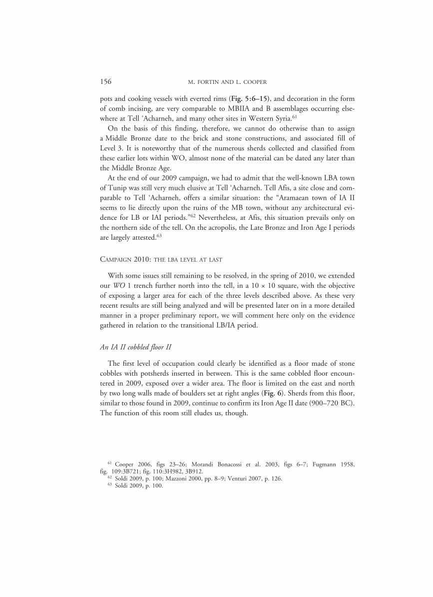
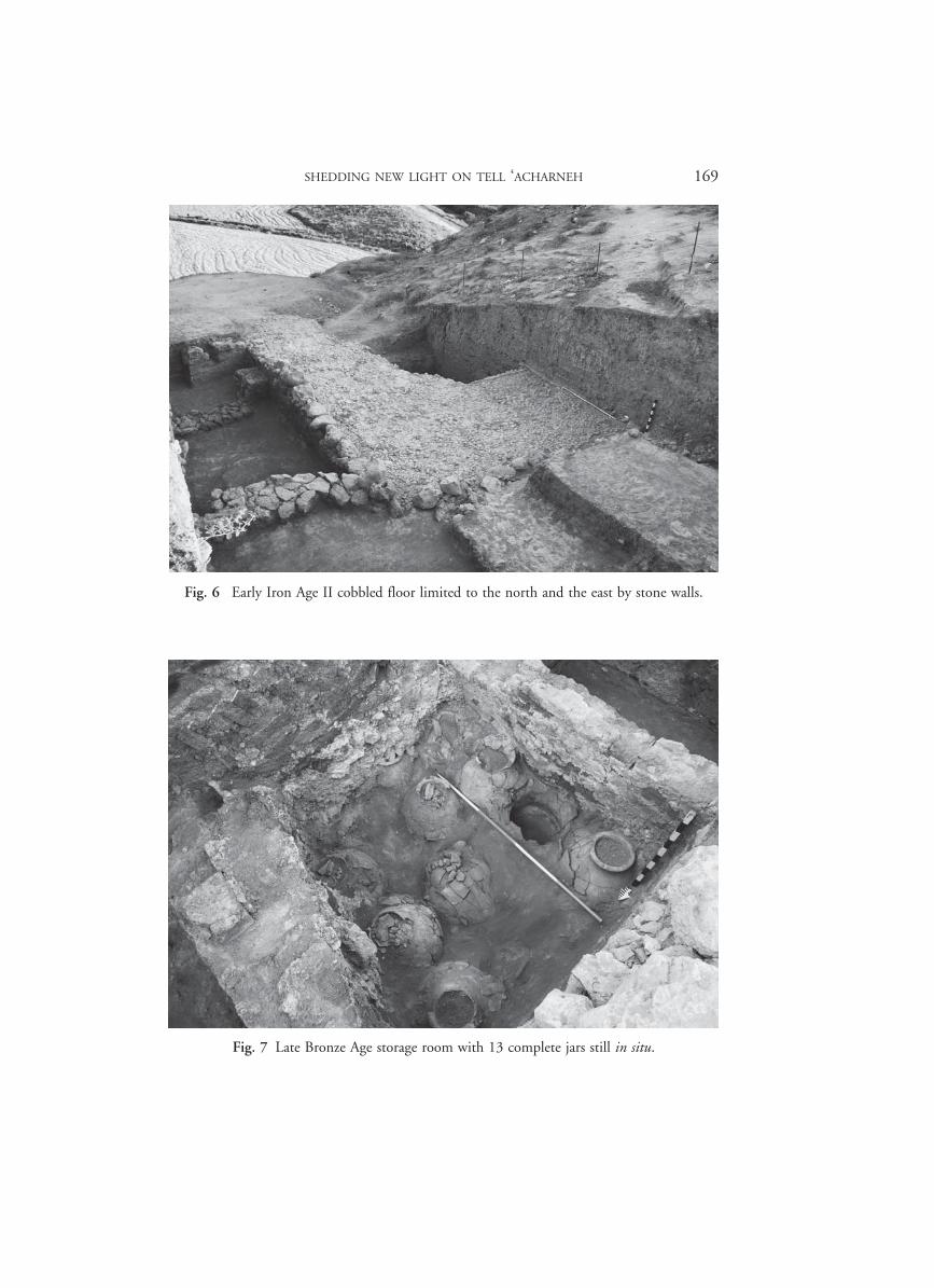
The first level of occupation could clearly be identified as a floor made of stone cobbles with potsherds inserted in between. This is the same cobbled floor encoun-tered in 2009, exposed over a wider area. The floor is limited on the east and north by two long walls made of boulders set at right angles (Fig. 6). Sherds from this floor, similar to those found in 2009, continue to confirm its Iron Age II date (900–720 BC). The function of this room still eludes us, though.
61 Cooper 2006, figs 23–26; Morandi Bonacossi et al. 2003, figs 6–7; Fugmann 1958, fig. 109:3B721; fig. 110:3H982, 3B912.
62 Soldi 2009, p. 100; Mazzoni 2000, pp. 8–9; Venturi 2007, p. 126. 63 Soldi 2009, p. 100.
95603_Anes_Supple_42_07_A_ch6_Fortin Cooper.indd 156 29/04/13 15:56
SHEDDING NEW LIGHT ON TELL ‘ACHARNEH 157
An IA I (?) fill and soil erosion layers
Our 2010 operation confirmed that this IA II structure, characterized by a cobbled floor, had cut and been set into layers of earlier debris which were found at a higher altitude in the areas around it. In all probability, these layers should be attributed to the Iron Age I period (1100–900 BC) although the ceramic material is not sufficient to confirm this date, at least for the moment. A larger portion of these layers will be excavated next season.
LBA storage rooms
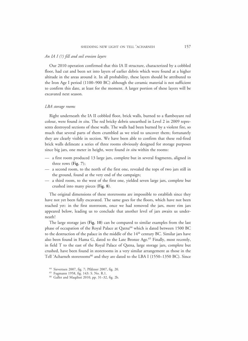
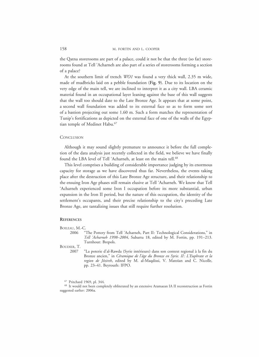
Right underneath the IA II cobbled floor, brick walls, burned to a flamboyant red colour, were found in situ. The red bricky debris unearthed in Level 2 in 2009 repre-sents destroyed sections of these walls. The walls had been burned by a violent fire, so much that several parts of them crumbled as we tried to uncover them; fortunately they are clearly visible in section. We have been able to confirm that these red-fired brick walls delineate a series of three rooms obviously designed for storage purposes since big jars, one meter in height, were found in situ within the rooms:
— a first room produced 13 large jars, complete but in several fragments, aligned in three rows (Fig. 7);
— a second room, to the north of the first one, revealed the tops of two jars still in the ground, found at the very end of the campaign;
— a third room, to the west of the first one, yielded seven large jars, complete but crushed into many pieces (Fig. 8).
The original dimensions of these storerooms are impossible to establish since they have not yet been fully excavated. The same goes for the floors, which have not been reached yet: in the first storeroom, once we had removed the jars, more rim jars appeared below, leading us to conclude that another level of jars awaits us under-neath!
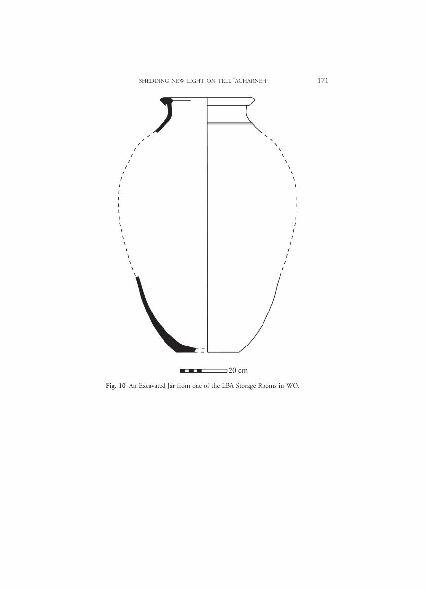
The large storage jars (Fig. 10) can be compared to similar examples from the last phase of occupation of the Royal Palace at Qatna64 which is dated between 1500 BC to the destruction of the palace in the middle of the 14th century BC. Similar jars have also been found in Hama G, dated to the Late Bronze Age.65 Finally, most recently, in field T to the east of the Royal Palace of Qatna, large storage jars, complete but crushed, have been found in storerooms in a very similar arrangement as those in the Tell ‘Acharneh storerooms66 and they are dated to the LBA I (1550–1350 BC). Since
64 Sievertsen 2007, fig. 7; Pfälzner 2007, fig. 20. 65 Fugmann 1958, fig. 143: S. No. R.1. 66 Gallet and Maqdissi 2010, pp. 31–32, fig. 2b.
95603_Anes_Supple_42_07_A_ch6_Fortin Cooper.indd 157 29/04/13 15:56
158 M. FORTIN AND L. COOPER
the Qatna storerooms are part of a palace, could it not be that the three (so far) store-rooms found at Tell ‘Acharneh are also part of a series of storerooms forming a section of a palace?
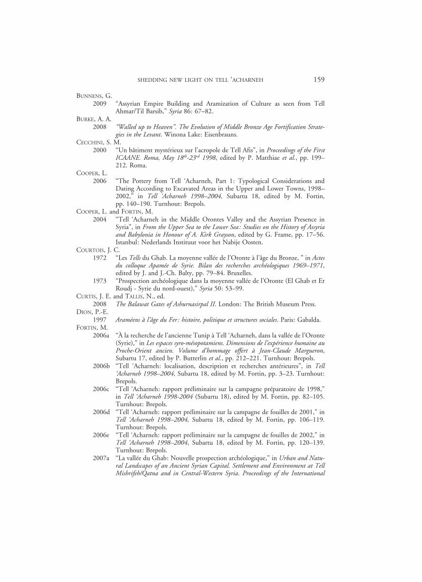
At the southern limit of trench WO1 was found a very thick wall, 2.35 m wide, made of mudbricks laid on a pebble foundation (Fig. 9). Due to its location on the very edge of the main tell, we are inclined to interpret it as a city wall. LBA ceramic material found in an occupational layer leaning against the base of this wall suggests that the wall too should date to the Late Bronze Age. It appears that at some point, a second wall foundation was added to its external face so as to form some sort of a bastion projecting out some 1.60 m. Such a form matches the representation of Tunip’s fortifications as depicted on the external face of one of the walls of the Egyp-tian temple of Medinet Habu.67
CONCLUSION
Although it may sound slightly premature to announce it before the full comple-tion of the data analysis just recently collected in the field, we believe we have finally found the LBA level of Tell ‘Acharneh, at least on the main tell.68
This level comprises a building of considerable importance judging by its enormous capacity for storage as we have discovered thus far. Nevertheless, the events taking place after the destruction of this Late Bronze Age structure, and their relationship to the ensuing Iron Age phases still remain elusive at Tell ‘Acharneh. We know that Tell ‘Acharneh experienced some Iron I occupation before its more substantial, urban expansion in the Iron II period, but the nature of this occupation, the identity of the settlement’s occupants, and their precise relationship to the city’s preceding Late Bronze Age, are tantalizing issues that still require further resolution.
REFERENCES
BOILEAU, M.-C.2006 “The Pottery from Tell ‘Acharneh, Part II: Technological Considerations,” in
Tell ‘Acharneh 1998–2004, Subartu 18, edited by M. Fortin, pp. 191–213. Turnhout: Brepols.
BOUDIER, T.2007 “La poterie d’al-Rawda (Syrie intérieure) dans son context regional à la fin du
Bronze ancien,” in Céramique de l’âge du Bronze en Syrie. II: L’Euphrate et la region de Jézireh, edited by M. al-Maqdissi, V. Matoïan and C. Nicolle, pp. 23–41. Beyrouth: IFPO.
67 Pritchard 1969, pl. 344. 68 It would not been completely obliterated by an extensive Aramaean IA II reconstruction as Fortin
suggested earlier: 2006a.
95603_Anes_Supple_42_07_A_ch6_Fortin Cooper.indd 158 29/04/13 15:56
SHEDDING NEW LIGHT ON TELL ‘ACHARNEH 159
BUNNENS, G.2009 “Assyrian Empire Building and Aramization of Culture as seen from Tell
Ahmar/Til Barsib,” Syria 86: 67–82.BURKE, A. A.
2008 “Walled up to Heaven”. The Evolution of Middle Bronze Age Fortification Strate-gies in the Levant. Winona Lake: Eisenbrauns.
CECCHINI, S. M.2000 “Un bâtiment mystérieux sur l’acropole de Tell Afis”, in Proceedings of the First
ICAANE. Roma, May 18th-23rd 1998, edited by P. Matthiae et al., pp. 199–212. Roma.
COOPER, L. 2006 “The Pottery from Tell ‘Acharneh, Part 1: Typological Considerations and
Dating According to Excavated Areas in the Upper and Lower Towns, 1998–2002,” in Tell ‘Acharneh 1998–2004, Subartu 18, edited by M. Fortin, pp. 140–190. Turnhout: Brepols.
COOPER, L. and FORTIN, M.2004 “Tell ‘Acharneh in the Middle Orontes Valley and the Assyrian Presence in
Syria”, in From the Upper Sea to the Lower Sea: Studies on the History of Assyria and Babylonia in Honour of A. Kirk Grayson, edited by G. Frame, pp. 17–56. Istanbul: Nederlands Instituut voor het Nabije Oosten.
COURTOIS, J. C. 1972 “Les Tells du Ghab. La moyenne vallée de l’Oronte à l’âge du Bronze, ” in Actes
du colloque Apamée de Syrie. Bilan des recherches archéologiques 1969–1971, edited by J. and J.-Ch. Balty, pp. 79–84. Bruxelles.
1973 “Prospection archéologique dans la moyenne vallée de l’Oronte (El Ghab et Er Roudj - Syrie du nord-ouest),” Syria 50: 53–99.
CURTIS, J. E. and TALLIS, N., ed.2008 The Balawat Gates of Ashurnasirpal II. London: The British Museum Press.
DION, P.-E. 1997 Araméens à l’âge du Fer: histoire, politique et structures sociales. Paris: Gabalda.
FORTIN, M.2006a “À la recherche de l’ancienne Tunip à Tell ‘Acharneh, dans la vallée de l’Oronte
(Syrie),” in Les espaces syro-mésopotamiens. Dimensions de l’expérience humaine au Proche-Orient ancien. Volume d’hommage offert à Jean-Claude Margueron, Subartu 17, edited by P. Butterlin et al., pp. 212–221. Turnhout: Brepols.
2006b “Tell ‘Acharneh: localisation, description et recherches antérieures”, in Tell ‘Acharneh 1998–2004, Subartu 18, edited by M. Fortin, pp. 3–23. Turnhout: Brepols.
2006c “Tell ‘Acharneh: rapport préliminaire sur la campagne préparatoire de 1998,” in Tell ‘Acharneh 1998-2004 (Subartu 18), edited by M. Fortin, pp. 82–105. Turnhout: Brepols.
2006d “Tell ‘Acharneh: rapport préliminaire sur la campagne de fouilles de 2001,” in Tell ‘Acharneh 1998–2004, Subartu 18, edited by M. Fortin, pp. 106–119. Turnhout: Brepols.
2006e “Tell ‘Acharneh: rapport préliminaire sur la campagne de fouilles de 2002,” in Tell ‘Acharneh 1998–2004, Subartu 18, edited by M. Fortin, pp. 120–139. Turnhout: Brepols.
2007a “La vallée du Ghab: Nouvelle prospection archéologique,” in Urban and Natu-ral Landscapes of an Ancient Syrian Capital. Settlement and Environment at Tell Mishrifeh/Qatna and in Central-Western Syria. Proceedings of the International
95603_Anes_Supple_42_07_A_ch6_Fortin Cooper.indd 159 29/04/13 15:56
160 M. FORTIN AND L. COOPER
Conference held in Udine, 9–11 December 2004, Studi Archeologici su Qatna 1, edited by D. Morandi Bonacossi, pp. 253–268. Udine: Forum Editrice.
2007b “Reprise de la prospection de la moyenne vallée de l’Oronte (Syrie) par une mission syro-canadienne: 2004–2006,” Journal of the Canadian Society for Mes-opotamian Studies 2, pp. 19–41.
FORTIN, M., ed.2006 Tell ‘Acharneh 1998–2004. Rapports préliminaires sur les campagnes de fouilles et
saisons d’études. Preliminary Reports on Excavation Campaigns and Study Season, Subartu 18, Turnhout: Brepols.
FORTIN, M. and COOPER, L.2006 “La mission canadienne à Tell ‘Acharneh (Syrie): à la recherche de l’ancienne
Tunip,” Mouseion. Journal of the Classical Association of Canada/Revue de la Société des études classiques 6: 163–201.
FRAME, G.2006 “The Tell ‘Acharneh Stela of Sargon II of Assyria,” in Tell ‘Acharneh 1998–
2004, Subartu 18, edited by M. Fortin, pp. 49–68. Turnhout: Brepols.FREU, J.
1992 “Les guerres syriennes de Suppiluliuma et la fin de l’ère amarnienne,” Hethitica 11: 39–101.
2009 “Qatna et les Hittites,” Studia Orontica 6: 9–23.FUGMANN, E.
1958 Hama: fouilles et recherches, 1931–1938, v. 2, pt. 1: L’architecture des périodes pré-Hellénistique. Copenhague: Nationalmuseet.
GALLET, Y. and AL-MAQDISSI, M.2010 “Archéomagnétisme à Mishirfeh/Qatna: nouvelles données sur l’évolution de
l’intensité du champ magnétique terrestre au Moyen-Orient durant les derniers millénaires”, Akkadica 131: 29–46.
GOREN, Y. et al. 2002 “Petrographic Investigations of the Amarna Tablets,” Near Eastern Archaeology
65/3: 196–205.2003 “The Expansion of the Kingdom of Amurru According to the Petrographic
Investigation of the Amarna Tablets,” Bulletin of the American Schools of Orien-tal Research 329: 1–11.
2004 Inscribed in Clay. Provenance Study of the Amarna Tablets and other Ancien Near Eastern Texts. Tel Aviv: Emery and Claire Yass publications in archaeology.
GRAYSON, A. K.1996 Assyrian Rulers of the Early First Millennium BC, II (858–745BC). Royal Inscrip-
tions of Mesopotamia, Assyrian Periods. Toronto: University of Toronto Press.GROMOVA, D.
2007 “Hittite Role in Political History of Syria in the Amarna Age Reconsidered,” Ugarit-Forschungen 39: 277–310.
HARRISON, T. P.2007 “Neo-Hittites in the North Orontes Valley: Recent Investigations at Tell
Ta’yinat,” Journal of the Canadian Society for Mesopotamian Studies 2: 59–68.2009a “Lifting the Veil on a “Dark Age”: Ta’yinat and the North Orontes Valley dur-
ing the Early Iron Age,” in Exploring the Longue Durée. Essays in Honor of Lawrence E. Stager, edited by J. D. Schloen, pp. 171–184. Winona Lake: Eisenbrauns.
2009b “Neo-Hittite in the “Land of Palistin”: Renewed Investigations at Tell Ta’yinat on the Plain of Antioch,” Near Eastern Archaeology 72/4: 174–189.
95603_Anes_Supple_42_07_A_ch6_Fortin Cooper.indd 160 29/04/13 15:56
SHEDDING NEW LIGHT ON TELL ‘ACHARNEH 161
2010 “The Late Bronze/Early Iron Age Transition in the North Orontes Valley,” in Societies in Transition. Evolutionary Processes in the Northern Levant between Late Bronze Age II and Early Iron Age, edited by F. Venturi, pp. 83–102. Bologna: CLUEB.
HAWKINS, J. D. 1979 “The Hieroglyphic Luwian Stelae of Meharde-Sheizar,” in Florilegium Anatoli-
cum. Mélanges offerts à Emmanuel Laroche, pp. 145–156. Paris: De Boccard.1982 “The Neo-Hittite States in Syria and Anatolia,” in The Cambridge Ancient His-
tory, Vol. III, pt. 1. The Prehistory of the Balkans; the Middle East and the Aegean World, tenth to eighth centuries B.C., edited by J. Boardman et al., pp. 372–441. Cambridge: Cambridge University Press.
1995 “The Political Geography of North Syria and South-East Anatolia in the Neo-Assyrian Period,” in Neo-Assyrian Geography, edited by M. Liverani, pp. 87–101. Roma: Università di Roma “La Sapienza”.
2000 Corpus of Hieroglyphic Luwian Inscriptions. Vol. I: Inscriptions of the Iron Age. Berlin-New York: Walter de Gruyter.
2009 “Cilicia, The Amuq, and Aleppo. New Light in a Dark Age,” Near Eastern Archaeology 72/4: 164–173.
HERTEL, T.2004 “The Balawat Gate Narratives of Shalmaneser III,” in Assyria and Beyond. Stud-
ies Presented to Mogens Trolle Larsen, edited by J. G. Dercksen, pp. 299–315. Leiden: Nederlands Instituut voor het Nabije Oosten.
JACOBY, R. 1991 “The Representation and Identification of Cities on Assyrian Reliefs,” Israel
Exploration Journal 41: 112–131.KLENGEL, H.
1992 Syria 3000 to 300 BC A Handbook of Political History. Berlin: Akademie Ver-lag.
1995 “Tunip und Andere Probleme der historischen Geographie Mittelsyriens,” in Immigration and Emigration within the Ancient Near East. Festschrift E. Lipinski, edited by K. Van Lerberghe and A. Schoors, pp. 125–134. Louvain: Uitgeverij Peeters en Departement Oriëntalistiek.
MARCUS, M. I. 1987 “Geography as an Organizing Principle in the Imperial Art of Shalmaneser III,”
Iraq 49: 77–90.MATTHIAE, P.
1980 Ebla. An Empire Rediscovered. Garden City, New York: Doubleday & Com-pany.
MAZZONI, S.1998a The Italian Excavations of Tell Afis (Syria): from Chiefdom to an Aramaean State.
Pisa: Edizioni ETS.1998b “The Late Iron I and Early Iron II Levels,” in Tell Afis (Siria). Scavi
sull’acropoli 1988–1992. The 1988–1992 Excavations on the Acropolis, edited by S. M. Cecchini and S. Mazzoni, pp. 163–171. Pisa: Edizioni ETS.
2000 “Syria and the Periodization of the Iron Age. A Cross-cultural Perspective,” in Essays on Syria in the Iron Age, Ancient Near Eastern Studies Supplement 7, edited by G. Bunnens, pp. 31–59. Louvain: Peeters.
MORANDI BONACOSSI, D.2009 “Continuity and Change in the Town Planning and Material Culture of Iron
Age II and III Mishrifeh, Central Syria,” Syria 86: 119–132.
95603_Anes_Supple_42_07_A_ch6_Fortin Cooper.indd 161 29/04/13 15:56
162 M. FORTIN AND L. COOPER
MORANDI BONACOSSI, D. et al.2003 “The Mishrifeh/Qatna 1999–2002. A Preliminary Report of the Italian Com-
ponent of the Joint Syrian-Italian-German Project. Part 2,” Akkadica 124: 144–204.
2009 “The “Eastern Palace” and the Residential Architecture of Area T at Mishrifeh/Qatna. Preliminary Report on the 2006–2008 Excavation Campaigns of the Italian Cimponent of the Syro-Italian Archaeological Project,” Mesopotamia 44: 61–112.
NA’AMAN, N.2007 “Sargon II’s Second Palû according to the Khorsabad Annals,” Tel Aviv 34:
165–170.PFÄLZNER, P.
2007 “Archaeological Investigtions in the Royal Palace of Qatna”, in Urban and Natural Landscapes of an Ancient Syrian Capital: Settlement and Environment at Tell Mishrifeh/Qatna and in CentralWestern Syria, edited by D. Morandi Bona-cossi, pp. 29–64. Udine: Forum.
PRITCHARD, J. B. 1969 The Ancient Near East in Pictures Related to the Old Testament. Princeton:
Princeton University Press.READE, J.
1979 “Narrative Composition in Assyrian Sculpture,” Baghdader Mitteilungen 10: 52–110.
REDFORD, D. B.1979 “A Gate Inscription from Karnak and Egyptian Involvement in Western Asia
during the Early 18th Dynasty,” Journal of the American Oriental Society 99/2: 270–287.
SADER, H. S. 1987 Les états araméens de Syrie depuis leur fondation jusqu’à leur transformation en
provinces assyriennes. Beirut.SCHACHNER, A.
2007 Bilder eines Weltreichs. Kunst- und kulturgeschichtliche Untersuchungen zu den Verzierungen eines Tores aus Balawat (Imgur-Enlil) aus der Zeit von Salmanassar III, König von Assyrien, Subartu 20. Turnhout: Brepols.
SIEVERSTEN, U.2007 “New Research on Middle Bronze Age Chronology of Western Syria”, in The
Synchronisation of Civlisations in the Eastern Mediterranean in the Second Millen-nium B.C. II, edited by M. Bietak and E. Czerny, pp. 423–430. Vienna: Verlag der Österreichischen Akademie der Wissenschaften.
SOLDI, S.2009 “Aramaeans and Assyrians in North-Western Syria: Material Evidence from
Tell Afis,” Syria 86: 97–118.THALMANN, J.-P.
2006 Tell Arqa — I. Les niveaux de l’âge du Bronze. Beyrouth: Institut français du Proche-Orient.
THUREAU-DANGIN, F. 1933 “La stèle d’Asharné,” Revue d’assyriologie et d’archéologie orientale 30: 53–56.
TUCKER, D. J.1994 “Representations of Imgur-Enlil on the Balawat Gates,” Iraq 56: 107–116.
95603_Anes_Supple_42_07_A_ch6_Fortin Cooper.indd 162 29/04/13 15:56
SHEDDING NEW LIGHT ON TELL ‘ACHARNEH 163
VENTURI, F.1998 “The Late Bronze Age II and Early Iron I Levels,” in Tell Afis (Siria). Scavi
sull’acropoli 1988–1992. The 1988–1992 Excavations on the Acropolis, edited by S. M. Cecchini and S. Mazzoni, pp. 123–162. Pisa: Edizioni ETS.
2000 “Le premier Age du Fer à Tell Afis et en Syrie septentrionale,” in Essays on Syria in the Iron Age, Ancient Near Eastern Studies Supplement 7, edited by G. Bun-nens, pp. 505–536. Louvain: Peeters.
2007 La Siria nell’età delle trasformazioni (XIII-X sec. A.C.). Nuovi contributi dallo scavo di Tell Afis, Studi e Testi Orientali 8, Serie Archeologica 1. Bologna: CLUEB.
95603_Anes_Supple_42_07_A_ch6_Fortin Cooper.indd 163 29/04/13 15:56
164 M. FORTIN AND L. COOPER
Fig. 1 Stratigraphy of the Wadi Operation (2009) showing three distinct levels.
95603_Anes_Supple_42_07_A_ch6_Fortin Cooper.indd 164 29/04/13 15:56
SHEDDING NEW LIGHT ON TELL ‘ACHARNEH 165
Fig. 2 WO Level 1 – Cobbled Floor and Fill Directly Above.
95603_Anes_Supple_42_07_A_ch6_Fortin Cooper.indd 165 29/04/13 15:56
166 M. FORTIN AND L. COOPER
Fig. 3 WO Level 2 – Red Bricky Debris and Brown Fill.
95603_Anes_Supple_42_07_A_ch6_Fortin Cooper.indd 166 29/04/13 15:56
SHEDDING NEW LIGHT ON TELL ‘ACHARNEH 167
Fig. 4 WO Level 2 – Red Bricky Debris and Brown Fill.
95603_Anes_Supple_42_07_A_ch6_Fortin Cooper.indd 167 29/04/13 15:56

168 M. FORTIN AND L. COOPER
Fig. 5 WO Level 3.
95603_Anes_Supple_42_07_A_ch6_Fortin Cooper.indd 168 29/04/13 15:56
SHEDDING NEW LIGHT ON TELL ‘ACHARNEH 169
Fig. 6 Early Iron Age II cobbled floor limited to the north and the east by stone walls.
Fig. 7 Late Bronze Age storage room with 13 complete jars still in situ.
95603_Anes_Supple_42_07_A_ch6_Fortin Cooper.indd 169 29/04/13 15:56
170 M. FORTIN AND L. COOPER
Fig. 8 Late Bronze Age storage room with seven crushed jars.
Fig. 9 Stone foundations of the mud-brick Late Bronze Age city wall?
95603_Anes_Supple_42_07_A_ch6_Fortin Cooper.indd 170 29/04/13 15:56
SHEDDING NEW LIGHT ON TELL ‘ACHARNEH 171
Fig. 10 An Excavated Jar from one of the LBA Storage Rooms in WO.
95603_Anes_Supple_42_07_A_ch6_Fortin Cooper.indd 171 29/04/13 15:56