YEAR 7 ENHANCED MASTERY BOOKLET Unit 2 - Ark ...
52
YEAR 7 ENHANCED MASTERY BOOKLET Unit 2 – Terrifying Tectonics
-
Upload
khangminh22 -
Category
Documents
-
view
0 -
download
0
Transcript of YEAR 7 ENHANCED MASTERY BOOKLET Unit 2 - Ark ...

YEAR 7 ENHANCED MASTERY BOOKLET
Unit 2 – Terrifying Tectonics

Blank Page

Unit 2: Terrifying Tectonics What will I be learning in this unit? By the end of this unit you will know all about earthquakes and volcanoes – what causes them and their impacts. You will investigate two case studies and will make an important decision about reducing future risks. Lesson 1: What is happening beneath our feet? In this lesson we learn to describe the structure of the earth and to compare its layers. Lesson 2: Why are the plates moving? In this lesson we learn how convection currents are formed and how this causes tectonic plate movement. We will use global maps to identify the main tectonic plates. Lesson 3: What are tectonic hazards and where do they occur? In this lesson we will learn to describe the global distribution of earthquakes and volcanoes, using continents and compass directions. We will also begin to understand the connection between plate boundaries and tectonic hazard distribution. Lesson 4: What causes an earthquake? In this lesson we will solve the mystery of why an earthquake happened in Sichuan in 2008 using a series of clues related to physical features and tectonic processes. Lesson 5: What were the impacts of the 2008 earthquake at Sichuan? In this lesson we are learning to describe and categorise the impacts of the 2008 Sichuan earthquake. We will start to explain why the effects were very severe. Lesson 6: What causes a volcano? In this lesson we are learning why volcanoes form at destructive plate boundaries using the case study of Volcán de Fuego in Guatemala. Lesson 7: What were the impacts of Volcán de Fuego’s 2018 eruption? In this lesson we describe some hazards resulting from volcanic eruptions, using the case study of Volcán de Fuego. Some students might analyse how volcanic impacts vary depending on factors such as population density, preparedness and emission type. Lesson 8: How can hazards be managed? In this lesson we are learning to describe how earthquakes and volcanoes can be prepared for and managed afterwards. Using either Sichuan or Volcán de Fuego, students will make a justified decision about tectonic hazard management. Optional lessons Lesson 9: What causes a tsunami? In this lesson we will explore the physical processes that led to the formation of a tsunami, using the case study of Japan in 2011. You will use cross-sectional diagrams to help explain how the tsunami formed. Lesson 10: What were the impacts of and responses to the Japanese Tsunami in 2011? In this lesson we will describe the impacts of the Japanese tsunami including the damage to the nuclear powerplant and trade.
1

Glossary – Terrifying Tectonics
Lesson 01 – What is happening beneath our feet?
Core – Extremely hot metal compounds at the centre of the Earth.
Oceanic crust – sections of the crust beneath the oceans.
Mantle – Earth’s thick ‘middle’ layer, made up of very hot magma.
Magma – melted or semi-melted rock.
Crust – Earth’s thin outer layer, made up of solid rock 7 – 100km thick.
Composition – what something is made up of, e.g. rock or magma.
Continental crust – sections of crust higher than ocean level.
Density – how dense (heavy) something is.
Lesson 02 – Why are the plates moving?
Tectonic plate – a large ‘slab’ of the crust.
Pangea – A ‘supercontinent’ existing 250 million years ago, which slowly broke apart into seven continents.
Plate boundary – the edge of a tectonic plate. It’s where most earthquakes and volcanoes occur.
Continent – huge chunks of land. There are seven continents.
Convection currents – the constant rising and sinking of magma in the mantle as it heats and cools.
Tectonic plate theory – the idea that over 250m years convection currents caused Pangea to break apart.
Lesson 03 – What are tectonic hazards and where do they occur?
Tectonic hazard – a dangerous event caused by tectonic plate movement (e.g. earthquake or volcanic eruption).
Distribution – the way something is spread out or arranged over a geographic area.
Earthquake – sudden violent shaking of the ground as a result of movements within the crust.
Cluster – a group, e.g. of earthquake events.
Volcanic eruption – when lava and other materials erupt through a hole in the crust.
Pacific Ring of Fire –boundary of the Pacific plate, so-named because many tectonic hazards occur here.
Conservative boundary – where two plates slide against each other.
Constructive boundary – where plates move apart, allowing magma to emerge and form (construct) new land.
2

Destructive boundary – where continental and oceanic crust collide.
Hotspot – volcanic areas formed by exceptionally hot areas within the mantle. They form volcanoes far away from plate boundaries.
Lesson 04 – What causes an earthquake?
Focus – the location in the crust where the earthquake occurs.
Richter Scale – a scale measuring an earthquake’s magnitude.
Epicentre – the point on Earth’s surface where shaking feels strongest (directly above the focus).
Sichuan – a region in southern China that is prone to earthquakes.
Seismic waves – waves of energy that move outwards from the focus through the crust.
Fault – a weakness in the crust caused by pressure at the plate boundary.
Collision boundary – where two or more sections of continental crust push towards each other.
Longmenshan fault – a weakness in the crust in Sichuan, caused by pressure at the Indian/Eurasian boundary.
Lesson 05 – What were the impacts of the 2008 earthquake at Sichuan?
Impact – another word for effect or consequence.
Environmental impact – damage to the surroundings, e.g. bridges or forests.
Social impact – something that affects people, e.g. loss of life.
Population density – how crowded a place is, measured by the number of people per square kilometre.
Economic impact – something that is costly, generally for a government.
Building collapse – the main cause of death in the Sichuan quake; sometimes known as pancaking.
Lesson 06 – What causes a volcano?
Volcano – an opening in the Earth’s crust.
Crater – bowl-shaped basin in the top of the volcano.
Volcanic eruption – when lava, gases and ash erupt through a volcano due to tectonic plate movement.
Subduction – when one section of crust pushes beneath another. The most dense plate subducts.
Magma chamber – large underground pool of magma.
Composite volcano – steep, explosive volcanoes made of ash and lava layers. They form at destructive boundaries.
3

Vent – central tunnel through the volcano that magma travels through.
Volcán de Fuego – a very active composite volcano in Guatemala, near the Cocos/Caribbean boundary.
Lesson 07 – What were the impacts of Volcán de Fuego’s 2018 eruption?
Ash column – a large pillar of ash rising from the volcano, forming an ash cloud above.
Evacuation – removing people from an unsafe area.
Pyroclastic flows – extremely dangerous, fast-moving flows of hot volcanic rock, gas and ash.
Warning signs – volcanoes usually give off signs such as steam, gas, ash clouds or bulging before they erupt.
Lahars – volcanic mudflows. Slow-moving but powerful mixtures of lava, ash, pyroclastic flows and rain/ice.
Agricultural land – land used for farming, e.g. tobacco farming land around Volcán de Fuego.
Lesson 08 – How can hazards be managed?
Management – something that is done to reduce risks.
Earthquake-proofing – making buildings stronger to withstand an earthquake.
Predict – use evidence to suggest that an event will happen.
Monitoring – observing something to detect any signs that it will happen again.
Prepare – get ready for something, e.g. signposting evacuation routes.
Respond – action taken after an event, e.g. first aid for survivors.
Lesson 09– What causes a tsunami?
Tsunami – a wave caused by tectonic movement under the sea floor.
Displace – to move from its original position. An earthquake under the sea floor displaces water which becomes the tsunami wave.
Ocean – enormous body of water. There are five major oceans, e.g. Pacific.
Pacific plate – a huge oceanic plate which subducted under the plate that Japan sits on, causing a major tsunami in 2011.
Lesson 10 – What were the impacts of and responses to the Japanese Tsunami in 2011?
Flooding – when land is land covered by water.
Fukushima – a city in Japan. A major nuclear power plant there was damaged by the 2011 tsunami.
Nuclear power plant – a site that uses dangerous nuclear technology to generate energy.
Debris – scattered pieces of rubbish or remains, e.g. chunks of houses and broken trees left in the tsunami’s wake.
4

Lesson 1: What is happening beneath our feet?
Read sections A-B. Then answer the questions.
A. Layers of the Earth:
The diagram below shows the layers of the earth.
New Learning Questions
4. How many layers of the Earth are there?
5. How much hotter is the core than the crust?
6. Which layer of the Earth is thinnest?
7. Which layer of the Earth is made of solid
rock?
8. What is the difference between oceanic
and continental crust?
The Earth has three main layers, the core, the mantle
and the crust. The diagram shows that the crust is a
solid thin rock layer, which covers all of earth’s
surface. The mantle is a thick layer of semi-liquid hot
rock and the core is made of extremely hot metal
compounds.
Answers:
1.b – the core
2.a – it does not move
3.b – hurricanes
4.3
5.5500oC
6.The crust
7.The crust
8.Oceanic crust is found under the ocean,
whereas continental crust is land above
the ocean. Continental crust is thicker and
lighter than oceanic crust.
5
Answer the following questions in your exercise book.
1. The diagram below shows the structure of the
Earth.
What is the arrow pointing to?
a. a volcano
b. the core
c. the crust
d. the mantle
2. Select the one false statement about the earth’s
crust:
a. It does not move
b. It is the Earth’s outer layer
c. It sits on top of hot magma
d. We live on it
3. Which one of these are not tectonic hazards?
a. earthquakes
b. hurricanes
c. tsunamis
d. volcanoes
B. Crust types:
The two types of crust are continental crust and
oceanic crust. Land above the ocean is called
continental crust. Land below the ocean is called
oceanic crust. The diagram below shows these two
types of crust.

Task 2/Develop Learning: The crust
Answer the following questions about continental and
oceanic crust.
1. What type of crust exists at X? ______________ I know this because…
2. Is there more oceanic or continental crust? _____________ Give percentages!
Section A – More on the structure of the earth!
After the earth formed, it was so hot inside the
planet that everything melted. The densest (heaviest)
materials sank to the core and the lighter substances
rose. This process helped to form the earth’s layers.
There are three major layers: core, mantle and crust.
The characteristics of the layers vary (composition,
thickness and temperature).
The core is the hottest layer, with temperatures
above 6000°C. The core is comprised mainly of iron
and nickel compounds. It generates intense heat
which keeps the mantle very hot.
The mantle is the largest layer. It sits between the
core and the crust and is 2900 km thick. It is made up
of molten (melted and semi-melted) rock, called
magma. When this rock erupts through the crust it is
called lava.
The crust is where we live. It is the thinnest layer and
is made up of solid rock. It is brittle (cracks easily).
Task 3/Independent Task: Learning more about Earth’s layers
Read Sections A and B before completing the tasks on the following page.
6

Layer Composition Thickness Temperature
Approximately 3500km
radius
Mantle 2900km thick 500-3000°C
<500°C
Section B – Oceanic and continental crust
There are two types of crust: oceanic and continental.
A chunk of crust under the ocean is called oceanic crust.
Approximately 70% of the crust is oceanic. Oceanic crust is
about 7km thick and it is mainly basalt rock which is dense,
dark and heavy. Oceanic crust is less than 200 million years old
– young in tectonic terms!
A chunk of crust that forms the land is called continental crust.
Continental crust is usually between 30-50km thick (can be as
thin as 7km and as thick as 100km). It is mainly granite rock
and is lighter than oceanic crust in weight and colour.
Continental crust is between 1-4 billion years old.
Study the map and the cross-section. They correspond (they match). Oceanic crust is located at A (Pacific Ocean);
continental crust is located at B (South America). Memory challenge: can you remember the composition
(materials), density (weight), thickness (crust depth) and age for A and B?
Stretch: Earth’s layers are distinct (different) but interrelated (they affect each other).
Suggest how the intense heat of the core might affect the mantle and the crust!
Tasks: 1. Using Sections A and B, create a table to show the key characteristics of each layer. Some
boxes have been completed for you – see below!
Tasks: 2. Draw your own cross-section to show
oceanic and continental crust.
3. Now label your diagram with as many of the
following key terms as possible: continental
crust, oceanic crust, denser, lighter, basalt,
granite, 7-100km thick, 7km thick, ocean, 200
million years old, 1-4 billion years old, 70% of
crust, 30% of crust 4.
7

Lesson 2: Why are the plates moving?
Read sections A-B. Then answer the questions.
A. Convection currents: Heat from the Earth's
core causes magma to circulate in the
mantle, setting up convection currents which
cause movement of the crust (we can see
these in the image below):
• Heat from the core causes molten
(melted, liquid) rock in the mantle to rise.
We call this melted rock magma.
• Near the crust it cools, causing it to sink.
• This sets up convection currents, which
move the plates in different directions.
Convection in the mantle has led to the
formation of tectonic plates. A tectonic plate
is a large ‘slab’ of the crust (continent and
sea floor).
New Learning Questions
5. Define a tectonic plate.
6. How quickly do tectonic plates move?
7. When did the supercontinent Pangea exist?
8. Define convection currents.
9. Are the following statements true or false?
a. Convection currents happen because
of heat from the Earth’s crust.
b. Tectonic plates all move in the same
direction.
c. A tectonic plate that moves 10 cm per
year is moving relatively quickly.
d. Pangea existed 250 years ago.
e. Hot magma rises, cool magma sinks.
In your book, write down the three correct
statements and fix the ‘fib’.
1. The outer layer of the Earth is called the
crust.
2. The crust is a thin layer of brittle rock.
3. The hottest layer of the Earth is the
mantle.
4. The mantle is made up of molten rock.
Answers:
1.The outer layer of the Earth is called the crust
(fact).
2.The crust is a thin layer of brittle rock (fact).
3.The hottest layer of the Earth is the mantle (fib)
-> corrected to: the hottest layer of Earth is the
core.
4.The mantle is made up of molten rock (fact).
5.A large ‘slab’ of the crust
6.A few centimetres each year
7.250 million years ago
8.Circulating magma in the mantle, which
causes plate movement
9.a. False, because the heat comes from the
core.
b. False, they move in different directions.
c. True
d. False, as Pangea existed 250 million years
ago!
e. True
B. Pangea: The picture below shows what the
world looked like 250 million years ago. All the
continents were joined together in a
supercontinent that we call Pangea!
Very slowly since then (a few centimetres each
year), tectonic plate movement has broken this
apart, leading to the position of continents that
we see today.

Task 3/Independent Task: Convection and tectonic plates
Read the information on the following page then complete the tasks below in your
geography workbook.
TASK A - Create a cross-sectional diagram to show convection currents in the mantle. (Use the
information from Section 2 on the next page to help you.)
TASK B – Write the sentences in full!
(Use Section 3 and the map to help you.)
a. A tectonic plate is… b. The UK is part of the ____________ plate. c. An example of a plate that is mainly oceanic is… d. The North American plate is moving in a ____________ direction. e. The North American plate is moving 2.3cm per year so in 50 years it will move… f. Plate boundary means… g. A plate boundary where plates are moving towards one another is…
TASK C – In your book, write down the terms from 1-8 in the correct order.
1. sinks 2. hottest 3. convection 4. million
5. temperatures 6. rises 7. theory 8. move
Extremely high _____ in the earth’s core melt the rock in the mantle. The mantle is at its _____ near the
core (approximately 3000°C). From here the molten rock _____ As it moves closer to the crust it ‘cools’
to 500-1000°C, so it _____ This creates a cycle known as _____ Convection currents in the mantle cause
the crust to _____ Tectonic plate _____ states that convection currents caused Pangea to begin to move
apart approximately 250 _____ years ago, moving the continents to their current locations.
Push yourself further!
• Annotate your diagram with
brief explanations.
• Show convection currents
moving tectonic plates apart!
Task 2/Develop Learning: Tectonic plates move… slowly!
Turn to the Lesson 2 worksheet on the last page of this booklet. Use the
tectonic plates map and information to label the following:
• At least two tectonic plate examples (e.g. Nazca plate)
• Show their direction of movement (using arrows)
• Identify a plate boundary (e.g. ‘The North American/Eurasian plate
boundary’)
9

Tectonic plate theory says that 250 million years ago the
continents were merged as one supercontinent called
Pangea. Since then, convection in the mantle has caused
Pangea to break apart - extremely slowly! Take a look at
the diagram to the right and pay close attention to how
long these changes have taken!
(250 million = 250,000,000 years!)
From Pangea to today’s continents Section 1 – Tectonic plate theory
Section 2 – Convection
Convection currents in the mantle are thought to move
chunks of the earth’s crust. The diagram below shows how
convection currents move the crust, forming tectonic
plates. In some cases, plates move apart; in others they
collide.
Section 3 – Tectonic plates
You already know that two types of crust exist – oceanic
and continental. Chunks of crust are called tectonic plates.
The map below shows the major tectonic plates and their
directions of movement. The edges of the plates are called
plate boundaries. X marks a plate boundary below. Think:
what are the plates doing at X (colliding, pulling apart or
sliding against one another)? Try to imagine the convection
currents in the mantle beneath these two chunks of crust! You can see that most
plates have continental and
oceanic crust. For example,
most of the Eurasian plate
is continental, but the
western section of the plate
is oceanic.
Stretch:
The map key refers to
‘subduction zones and’
‘divergent boundaries’.
What do you think these
terms mean? Use the
arrows as clues!
10
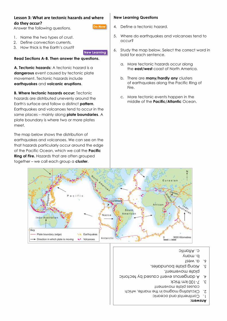
Lesson 3: What are tectonic hazards and where do they occur? Answer the following questions.
1. Name the two types of crust.
2. Define convection currents.
3. How thick is the Earth’s crust?
Answers:
1.Continental and oceanic 2.Circulating magma in the mantle, which
causes plate movement
3.7-100 km thick
4.A dangerous event caused by tectonic
plate movement.
5.Along plate boundaries.
6.a. west
b. many
c. Atlantic
Read Sections A-B. Then answer the questions.
A. Tectonic hazards: A tectonic hazard is a
dangerous event caused by tectonic plate
movement. Tectonic hazards include
earthquakes and volcanic eruptions.
B. Where tectonic hazards occur: Tectonic
hazards are distributed unevenly around the
Earth's surface and follow a distinct pattern.
Earthquakes and volcanoes tend to occur in the
same places – mainly along plate boundaries. A
plate boundary is where two or more plates
meet.
The map below shows the distribution of
earthquakes and volcanoes. We can see on the
that hazards particularly occur around the edge
of the Pacific Ocean, which we call the Pacific
Ring of Fire. Hazards that are often grouped
together – we call each group a cluster.
New Learning Questions
4. Define a tectonic hazard.
5. Where do earthquakes and volcanoes tend to
occur?
6. Study the map below. Select the correct word in
bold for each sentence.
a. More tectonic hazards occur along
the east/west coast of North America.
b. There are many/hardly any clusters
of earthquakes along the Pacific Ring of
Fire.
c. More tectonic events happen in the
middle of the Pacific/Atlantic Ocean.

Task 2/Develop Learning: Three plate boundary types
Study the information on three major plate boundary types below, then draw three simple diagrams in your
geography workbook to show these three boundary types (slide, apart, together).
Boundary 1: Plates slide alongside one another
Which hazard? earthquakes
What happens? Tectonic plates slide alongside each other. They may slide in the same or opposite directions. As they slide, they grind and push against each other. Over time (decades or even thousands of years), pressure builds up. When a plate finally ‘slips’, the ground shakes. Earthquakes at these boundaries can be extremely powerful. The formal name for this type of boundary is ‘conservative’.
Example? Pacific/North American boundary.
Boundary 2: Plates move apart
Which hazard? earthquakes and volcanoes
What happens? Convection currents move the plates apart which allows magma from the mantle to rise through the gap. This results in volcanic eruptions although they are fairly small (as far as volcanic eruptions go). As the plates move apart the ground can shake so earthquakes occur here as well. These quakes are also ‘gentle’. The formal name for this type of boundary is ‘constructive’.
Example? North American / Eurasian boundary (in the middle of the Atlantic Ocean!).
12

Boundary 3: Plates move together
Which hazard? earthquakes and volcanoes
What happens? Convection currents drag the plates towards one another. This collision releases huge amounts of energy causing violent earthquakes. If the heavier oceanic crust is forced down into the mantle it will melts and may erupt violently through holes in the crust. The formal name for this type of boundary is ‘destructive’.
Example? Nazca / South American boundary.
Task 3/Independent Learning:
Mapping tectonic hazards
Task: On the tectonic plates map
worksheet that you used last lesson,
find the following:
• Nazca/South American boundary
• Pacific/North American boundary
• North American/Eurasian boundary
For each boundary:
1. Label the plates involved 2. Draw arrows to show the direction
that each plate is moving in 3. Note whether the plates are
sliding/moving together/moving apart
4. Briefly describe the tectonic events that occur here (earthquakes, volcanoes or both?)
Use the map below to help you!
Stretch:
Find examples of tectonic hazards that are not near plate
boundaries. Why might they occur here? (Hint: hotspots
info box below!)
Hotspots: Not all volcanoes occur at plate boundaries. Some occur in
the middle of plates, in areas called hotspots. Hotspots are fuelled by
plumes, which are huge pockets of abnormally hot magma beneath the
crust. Plumes can rise up in weak areas far from plate boundaries. For
example, the Hawaiian Islands (circled on the previous page’s map)
formed over millions of years by eruptions through weaknesses in the
middle of the Pacific plate. They are located thousands of miles away
from the plate boundary. Island formation is still happening on Hawaii
every time the volcanoes Kilauea and Mauna Loa erupt – when the
lava erupts it cools and becomes solid, forming new land. The plate
moves extremely slowly over time, so chains of volcanoes form.
Each island in this chain was formed over the hotspot shown. Which is older: Kauai or Hawaii?
13

Terrifying Tectonics Mastery Quiz 1 - Revision and Reteach Resources
Option 1: What is happening beneath our feet?
Layer Composition Thickness Temperature
Core Metal compounds,
mainly iron and nickel
Approximately
3500km radius
Temperatures
reach 6000+°C
Mantle Molten (melted and
semi-melted) rock 2900km thick 500-3000°C
Crust Solid rock, e.g. granite
and basalt <100km thick <500°C
Section A – More on the structure of the earth!
After the earth formed, it was so hot inside the planet that everything melted. The densest (heaviest) materials
sank to the core and the lighter substances rose. This process helped to form the earth’s layers.
There are three major layers: core, mantle and crust. The characteristics of the layers vary (composition, thickness
and temperature).
The core has temperatures above 6000°C and is comprised mainly of iron and nickel compounds. It generates
intense heat which keeps the mantle very hot.
The mantle is the largest layer. It sits between the core and the crust and is 2900 km thick. It is made up of molten
(melted and semi-melted) rock, called magma. When this rock erupts through the crust it is called lava.
The crust is where we live. It is the thinnest layer and is made up of solid rock. It is brittle (cracks easily).
a) Look at the table. Which is the hottest layer of the Earth? Give its temperature!
b) Look at the table. Which is the coolest and most solid layer of the Earth?
c) Using information from the table and Section A explain why rock in the mantle is
molten.
14
4
If you are completing before the quiz, then complete all the questions. If you are completing
after the quiz, then use the key below to decide which questions you need to answer.
• Question 1 = Quiz questions 1, 2 or 3 incorrect
• Question 2 = Quiz questions 4, 5, 6 or 7 incorrect
• Question 3 = Quiz questions 8, 9 or 10 incorrect

Option 2: Why are the plates moving?
Option 3: What are tectonic hazards and where do they occur?
Convection currents in the mantle
Extremely high temperatures in the earth’s core melt the rock in the mantle. The mantle is at its hottest near the core (approximately 3000°C). From here the molten rock rises. As it moves closer to the crust it ‘cools’ to 500-1000°C, so it sinks. This creates a cycle known as convection.
Convection currents in the mantle cause the crust to move. Tectonic plate theory states that convection currents caused Pangea to begin to move apart approximately 250 million years ago, moving the continents to their current locations.
By breaking apart the crust and moving it very slowly over time, convection has caused the tectonic plates to form. In some cases, plates move apart; in other cases they collide.
Read the box on the previous page to help you answer the questions.
a) Finish the sentence: Near the core molten rock heats up which causes it to _______.
b) How has convection has caused tectonic plates to form?
c) Do tectonic plates move quickly or slowly? Give evidence from the box.

Stretch OPTIONS
Complete the stretch if you have all the questions correct
or if you have finished the tasks above.
• Using an atlas, find a tectonic plates map. Can you find
any smaller plates that are not shown on the map above?
• Google ‘volcanic hotspot Kilauea’ and create a fact-file
about this Hawaiian island (location, size, appearance,
eruption frequency etc.)
a) Study the map above. Give two specific locations where both earthquakes and volcanoes occur.
b) Another word for boundary is _____.
c) Why do most earthquakes and volcanoes occur near to plate boundaries?
What happens at plate boundaries?
A plate boundary is the edge of a tectonic plate. This is where two or more plates meet.
As we know, tectonic plates move. In some case plates slide against each other, in other cases they pull apart and in others they collide. When plates slide against each other the ground can shake intensely (earthquakes). When plates pull apart lava can gently flow out (volcanoes) and the ground can also shake. Where plates collide, one plate can push beneath another causing intense shaking (earthquakes) and violent volcanic eruptions.
In a few cases volcanoes form far from plate boundaries where there are holes in the plate. These are known as volcanic hotspots.
16

Lesson 4: What causes an earthquake?
Answer the following questions.
1. Define a plate boundary.
2. Define a tectonic hazard.
3. Name the 3 types of plate boundary.
Answers:
1.The edge of a tectonic plate, where two
or more plates meet.
2.A dangerous event caused by tectonic
plate movement.
3.Conservative, constructive, destructive
4.A sudden, violent shaking of the ground
as a result of movements within the crust.
5.The focus is the location in the crust
where the earthquake occurs, whereas
the epicentre is directly above the focus
on the earth’s surface.
6.B, because the seismic waves have not
travelled as far.
7.The magnitude (strength) of
earthquakes.
8.10 times stronger
Read sections A-C. Then answer the questions.
A. Earthquake features:
An earthquake is a sudden violent shaking of the
ground as a result of movements within the crust.
The focus is the location in the crust where the
earthquake occurs. Seismic waves move
outwards from the focus, through the crust.
The epicentre is directly above the focus on the
Earth's surface.
The diagram below shows the focus below the
ground and the location of the epicentre
above.
B. Earthquake formation:
At collision boundaries, two or more sections of
continental crust plates push towards each
other. This means that pressure builds up, which
can cause major earthquake events.
C. The Richter Scale:
The Richter Scale measures the magnitude
(strength) of earthquakes. An earthquake of
magnitude 5.0 is 10 times stronger than an
earthquake with a magnitude of 4.0!
A B
New Learning Questions
4. Define an earthquake.
5. What is the difference between the focus
and epicentre of an earthquake?
6. The diagram on the left of the page shows
letters A and B. Would shaking be stronger at
position A or B? Suggest why.
7. What does the Richter Scale measure?
8. How many times stronger is a 9.0 magnitude
earthquake than an 8.0 magnitude
earthquake?

Key term Meaning
focus
The location in the crust where the earthquake occurs.
(If the focus is shallow (e.g. 5km) the shaking may feel
stronger on the surface.)
epicentre The point directly above the focus on the Earth's surface.
Shaking feels strongest here.
seismic
waves
Waves of energy that move outwards from the focus
through the crust. (Shockwaves)
fault
A weakness or crack in the crust. (The best-known faults
are plate boundaries but there are hundreds of other
faults in Earth’s crust too!)
Task 2/Talk Task: Earthquake features
In your Geography workbook, number 1-5. With a partner, read the definitions below to
figure out which key term matches each number.
Task 3/Develop Learning: Earthquake in Sichuan: why?
Study the maps and the clues in the boxes below to help you solve why Sichuan suffered a
violent earthquake on 12th May 2008!
Figure 1:
• The light colour shows continental crust. • The black line is China’s outline. • The other lines are plate boundaries. • The X shows Sichuan’s location.
18

Figure 2: Seismic waves after the 2008
quake
Figure 3: Direction of plate
movement. X = Sichuan
Figure 4: Longmenshan fault
FACT A
Sichuan is a province (like a state or
a county) in southern China. It
contains large cities including
Chengdu. Sichuan is close to the
Indian/Eurasian boundary.
FACT B
Where plates push together energy
builds over time. The more time
passes, the greater the pressure at
the boundary.
FACT C
A fault is a weakness in the crust.
Faults form close to plate boundaries
because as plates move against one
another they weaken the land on
either side of the boundary.
FACT D
The focus was 19km deep. That is
quite shallow! Shallow earthquakes
cause more damage on the surface.
FACT E
A fault runs through Sichuan. It is
called the Longmenshan fault.
FACT F
The Indian plate is moving north east.
The Eurasian plate is moving south
east.
FACT G
The Indian plate and the Eurasian
plate are continental plates.
FACT H
When land at the fault ‘slipped’, the
ground shook violently. The
earthquake registered 7.9 on the
Richter Scale.
FACT I
When land on one side of the
boundary/fault gives way, seismic
waves move rapidly through the crust.
This makes the ground shake – an
earthquake!
FACT J
Intense pressure from collision
caused one side of the fault to slip
downwards – by 12m in some
places!
FACT K
Southern China is an earthquake-
prone region, but the last
earthquake before the 2008 event
was in 1976. That’s 28 years!
FACT L
Where two sections of continental
crust move towards one another it is
called a collision boundary.
Earthquakes but no volcanoes occur
at these boundaries.
1. Read facts A, B, F and I
again. Write these letters
down in the order you think
is most logical.
2. Read facts B, H, I and K again. Give at least one reason why the Sichuan
earthquake was so powerful. Try to include the words pressure and years.
3. Main task: Turn to the last page of this booklet. Use the Lesson 4 Worksheet (a
newspaper template) to write a newspaper report explaining why an earthquake happened in
Sichuan in May 2008! Include key terms and at least one labelled diagram.
Task 4/Independent Task: Piecing together the clues!
Complete the below tasks in your Geography exercise book.
19
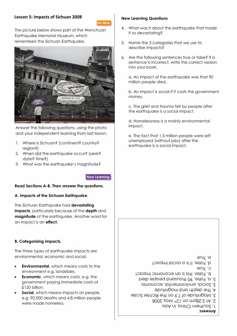
Lesson 5: Impacts of Sichuan 2008 The picture below shows part of the Wenchuan
Earthquake Memorial Museum, which
remembers the Sichuan Earthquake.
Read Sections A-B. Then answer the questions.
A. Impacts of the Sichuan Earthquake.
The Sichuan Earthquake had devastating
impacts, particularly because of the depth and
magnitude of the earthquake. Another word for
an impact is an effect.
B. Categorising impacts.
The three types of earthquake impacts are
environmental, economic and social.
• Environmental, which means costs to the
environment e.g. landslides.
• Economic, which means costs, e.g. the
government paying immediate costs of
£120 billion.
• Social, which means impacts on people,
e.g. 90,000 deaths and 4.8 million people
were made homeless.
Answer the following questions, using the photo
and your independent learning from last lesson.
1. Where is Sichuan? (continent? country?
region?)
2. When did the earthquake occur? (year?
date? time?)
3. What was the earthquake’s magnitude?
Answers:
1. Southern China, in Asia
2. At 2:28pm on 12th May 2008
3. Magnitude of 7.9 on the Richter Scale
4. The depth and magnitude
5. Social, environmental, economic
5. a. False, 90 thousand people died
b. False, this is an economic impact
c. True
d. False, it is a social impact
e. True
New Learning Questions
4. What was it about the earthquake that made
it so devastating?
5. Name the 3 categories that we use to
describe impacts?
6. Are the following sentences true or false? If a
sentence is incorrect, write the correct version
into your book.
a. An impact of the earthquake was that 90
million people died.
b. An impact is social if it costs the government
money.
c. The grief and trauma felt by people after
the earthquake is a social impact.
d. Homelessness is a mainly environmental
impact.
e. The fact that 1.5 million people were left
unemployed (without jobs) after the
earthquake is a social impact.

• 90,000 killed
• 400,000 injured
• Communication lines were ruined. Some people couldn’t contact family for days.
• Infrastructure ruined (e.g. roads, factories)
• £140 billion was spent between 2008-2011 to rebuild and repair.
• Millions of livestock and large crop areas (e.g. rice paddies) were destroyed. Approximately 12.5 million farm animals were killed.
A mother grieves her only
daughter at a collapsed
school in Beichuan
• 21+ million buildings collapsed. This caused most deaths.
• 20,000 students died because over 7,000 school buildings collapsed.
• There is a still a lot of anger over the poor building quality that led to such widespread building collapse.
• Those who have demanded answers from the Chinese government have been intimidated and pressured to remain silent.
• The earthquake triggered landslides. These caused around 1 in 5 deaths.
• Landslides blocked rivers and formed 34 quake lakes. This created a flood risk so villages were evacuated.
Section A: other impacts
Read Section B on the following page then answer the questions in your
geography exercise book.
3. What does the earthquake specialist think? Why would she disagree
with the Chinese government?
4. Why is there controversy (disagreement) about the earthquake?
Task 3/Develop Learning: Learning more about the impacts
Read all about the earthquake’s impacts in Sections A – C below.
Read Section A below then answer the questions in your geography
exercise book.
1. What caused more deaths: landslides or collapsed buildings?
2. Why was it difficult for families to find each other after the
earthquake? Give two factors.
21

DETAIL SICHUAN EARTHQUAKE
MON 12TH MAY 2008
CHRISTCHURCH EARTHQUAKE
TUES 22ND SEPTEMBER 2011
magnitude 7.9 6.3
depth 19km 5km
time of day 2:28pm 12:51pm
buildings Few building rules; many buildings made of
concrete and crumbly materials
Strict building rules; many buildings are
‘earthquake-proofed’ (strong and flexible
materials to bend not break)
how cramped? Cities in Sichuan are very cramped (e.g. in
Chengdu 6500 people per square km)
Not cramped (1440 people per square
kilometre)
deaths 90,000 185
I firmly believe that the
reason for the collapse [of
my daughter’s school]
was due to the quality of
the buildings.
I was jailed from 2010-2015 for investigating
why so many buildings collapsed. There is
strong evidence of corruption – money for
building stronger schools was taken by
officials. (Tan Zuoren, activist)
The earthquake was
devastating because it was
so strong. There was little
that could be done.
(Chinese government)
Earthquakes don’t kill
people. Buildings do!
(Elizabeth Hauser,
earthquake specialist)
Section B: anger in Sichuan
Section C: earthquake comparison
Not all strong earthquakes have extreme impacts. Compare Sichuan to a strong earthquake in
Christchurch, New Zealand. Why do you think effects were worse in Sichuan?
Task 4/Independent Task: Why were the impacts so severe?
Read Section C then complete questions 1 – 4 in your geography exercise book.
Short-answer questions:
1. Which earthquake caused more deaths: Sichuan 2008 or Christchurch 2011? 2. Which place had a more cramped population? 3. The building quality is more significant than the earthquake depth: true or false?
Main question:
4. Why were the impacts of the Sichuan 2008 earthquake so severe? Write 1-2 paragraphs using evidence from the Mastery booklet to support your response.
22

Lesson 05: Stretch reading sheet – Responses to the Sichuan 2008 earthquake
Key responses to the earthquake:
• 14 minutes after the earthquake, the Chinese government sent army troops to affected areas
• Within days 113,000 troops were assisting those affected. Army troops, government employees and armed police were on the ground working. They helped to clear collapsed buildings in order to find trapped people.
• Some places were difficult to get to because Sichuan is a mountainous region. Some people needing help did not receive it.
• Medical supplies were provided very quickly
• Disease outbreaks were avoided
• Medical services were restored quickly
• 45,000 medical workers contributed to care following the earthquake
• Populations in danger from landslides or flooding from quake lakes were safely relocated
• Beichuan Town residents were relocated and a new Beichuan Town was built 14 miles from the original city
• By 2012, 99% of the destroyed buildings had been rebuilt. Many new buildings were made more ‘earthquake-proof’.
• Building regulations (rules) were tightened up. However the problem of corruption is still widespread so some buildings may not follow the new rules.
• Little psychological support was provided. The effects of trauma are ongoing, especially for those who have lost children. Some people who have demanded answers have been beaten and put in jail.
Effective response check list:
✓ Was assistance sent out quickly?
✓ Were survivors kept physically safe?
✓ Were psychological traumas dealt with?
✓ Were people given sufficient accommodation?
✓ Were houses and other buildings rebuilt quickly?
Were buildings reconstructed using earthquake-proofing?
Stretch: Read about the earthquake responses then complete the tasks below.
Stretch
1. Were the responses sufficient? Use evidence from the checklist to
help you make your judgement.
2. If you were in charge of disaster response in Sichuan in 2008...
a) which problems would you deal with first?
b) how would you deal with them?
c) what recommendations would you make to the government
about avoiding this type of tragedy in the future?
23

Lesson 6: What causes a volcano? Study the map below, which shows some
tectonic plates and plate boundaries.
Use the map and your own knowledge to
answer the following questions.
1. Name the type of crust that 1 and 4 are
examples of?
2. Name the type of crust that 2 and 3 are
examples of?
3. Is it true or false that the South American and
Nazca plates are moving towards each
other?
4. What is the name of the layer beneath the
crust?
Answers:
1. Continental crust
2. Oceanic crust
3. True
4. Mantle
5. When lava, gases and ash are expelled
through a volcano due to tectonic plate
movement.
6. Destructive
7. Vent
8. Cocos and Caribbean plates
Read Sections A-B. Then answer the questions.
A. Volcano features:
Key features of a volcano are the magma
chamber, vent and crater, which are labelled in
the diagram below.
The diagram below shows the formation of a
volcano at a destructive plate boundary.
Once the denser oceanic plate subducts, it melts in
the mantle. You can see in the picture that the
melted rock is rising, because it is hot and light. Where
there is a vent (hole) in the crust, lava rises rapidly to
cause a volcanic eruption.
New Learning Questions
5. Define a volcanic eruption.
6. At what type of plate boundary do an oceanic
and continental plate meet?
7. What is the geographical word for a hole in the
crust?
8. Which two plates meet to form Volcán de
Fuego?
Subduction of denser
oceanic plate
Lighter
continental
plate
B. Volcano formation:
A volcanic eruption is when lava, gases and ash are
expelled through a volcano due to tectonic plate
movement. Volcanoes can form at destructive plate
boundaries, where an oceanic and continental plate
meet. After this collision, the denser oceanic plate
subducts (goes underneath) the lighter continental plate.
For example, today you will learn about Volcán de
Fuego, where the Cocos plate subducts under the
Caribbean plate.
Magma chamber
crater
vent

Section A – what is a volcano?
A volcano is a mountain that lava (hot melted rock) erupts from. Volcanoes form when there is a hole or
crack in the crust. Lava rises through the gap then becomes solid. Over time each eruption adds lava to
the volcano’s sides, increasing its size. Volcanoes emit (let out) other substances too, e.g. ash, gas and
steam. Extinct volcanoes no longer erupt; dormant volcanoes have not erupted for a long time but may
still do so; active volcanoes erupt fairly regularly. Guatemala’s Volcán de Fuego is an active volcano.
Definitions
• Magma – hot melted rock
• Magma chamber - large underground pool of magma
• Lava - magma, once it reaches the surface
• Crater - bowl-shaped basin in the top of the volcano
• Vent - central tube which magma travels through
• Ash, steam and gas – fine material thrown out by the volcano
• Volcanic bombs - larger material thrown out by the force of eruption, e.g. hot rocks
Section B – Volcán de Fuego
Volcán de Fuego means Volcano of Fire. It is one in a chain
of volcanoes near Guatemala’s coastline. It is close to the
Cocos and Caribbean boundary. Fuego is an example of a
volcano formed at a destructive boundary.
The volcano is 3,763m high and is 10 miles from the city of
Antigua.
It is very active, with several gas and ash emissions every
hour. Large eruptions happen every month or so and a
very dangerous eruption occurred in 2018.
Prep task: Write one sentence describing Volcán de Fuego ‘s
location. 25

Section C – Composite volcanoes
There are different types of volcanoes.
Composite volcanoes are very explosive. They form near
destructive boundaries. They are steep-sided and cone-
shaped. They are made up of layers of ash and lava.
Volcán de Fuego is a composite volcano.
Very sticky lava usually comes out of composite
volcanoes. Sticky lava does not ‘run’ very far. It solidifies
on the sides of the volcano which is what gives it a
steep shape (thin runny lava would run down the sides
and create a flatter volcano).
Preparation task:
List three features of composite volcanoes.
Task 4/Independent Task: Volcán de Fuego: formation and features
Success Criteria. My diagram has:
Using Section A:
• volcano features (minimum: crater, magma chamber, vent)
• volcano emissions (what comes out of a volcano)
• brief explanation: how volcanoes form
Using Section B & cloze activity:
• plate names and arrows to show their directions
• plate types (continental and oceanic)
• volcano name and location
• key terms: subduct, erupt etc.
• brief explanation: why eruptions occur (use answer to cloze activity)
Using Section C:
• brief description: what is a composite volcano?
Create your own diagram to show how the destructive plate boundary caused Volcán de Fuego to form! Use two pages in your book.
Copy this outline to start or draw
your own.
26

Lesson 06: What causes a volcano? Stretch reading sheet
Stretch:
Read the information about composite volcanoes then answer the question:
Why do composite volcanoes have such explosive eruptions?
Composite volcanoes – a deeper understanding
Composite volcanoes form at destructive plate boundaries. At these locations the magma
that develops beneath the volcano has a high acid content which makes it very viscous
(sticky).
Imagine a huge pool of very thick hot lava filling a magma chamber beneath an enormous
composite volcano like Volcán de Fuego. When the oceanic Cocos plate subducts and
melts, more magma rises into the chamber, forcing more sticky lava upward.
Composite volcanoes have complex layers and lots of additional vents inside them. This
means that lava can become clogged and stuck in the complex system of vents and when
it finally does explode, enormous amounts of lava push upwards, resulting in huge and
powerful eruptions.
To add to this, when oceanic crust subducts underneath continental crust, it can drag
large amounts of seawater with it which speeds the process of magma rising.
For most composite volcanoes major eruptions do not happen very often. This means
that enormous pools of magma build up beneath the volcano in the years between
eruptions. When they do erupt, a lot of lava comes out!
Composite volcanoes do not only emit lava. The deadliest emission is pyroclastic flows.
These are deadly flows of toxic gases and hot rocks which plummet down the steep sides
of the volcano at hundreds of miles per hour. Pyroclastic flows are faster and kill more
people than lava.
Pyroclastic flows race downwards Explosive eruption of lava
27

Lesson 7: What were the impacts of Volcán de Fuego’s 2018 eruption?
Answer the following questions in your books.
1. Composite volcanoes are made up of layers
of…
2. At destructive boundaries, what happens first:
subduction, collision or eruption?
3. What is another word for an impact?
Answers:
1. Layers of ash and lava
2. Collision
3. Effect/outcome/result/consequence
4. Pyroclastic flows, ash cloud, lahars, lava
5. Pyroclastic flows
6. Limited warning signs and the speed and
volume of pyroclastic flows
Read Sections A-B. Then answer the questions.
A. Volcán de Fuego impacts.
The 2008 eruption caused a variety of natural
hazards.
This image shows pyroclastic flows.
New Learning Questions
4. Name 4 impacts of the eruption.
5. Which of these impacts was the most devastating?
6. Why was evacuation unsuccessful?
Large pyroclastic flows are a deadly, fast-
moving mixture of hot gas and volcanic rock.
These caused the greatest impacts.
This image shows an ash cloud.
This image shows dangerous lahars.
An ash cloud is a cloud of fine, burnt materials
that rises above the volcano.
Lahars are mudslides created when hot emissions
(material released from the volcano) mix with
rainwater, snow or ice.
This image shows lava.
Lava is extremely hot melted rock which erupts from
volcanoes
Entire villages and areas of agricultural land were
layered in volcanic material! There were dangerous
lahars due to rainfall during the eruption and 165
deaths.
There had been few warning signs that the volcano
was going to erupt and the pyroclastic flows were
particularly large and fast, so evacuation had not
been successful. Evacuation means removing people
from an unsafe area.

Section A –
what came out?
Task 2/Independent Task: What were the impacts of the 2018 Volcán de Fuego eruption?
Study Sections A – C below.
Pyroclastic flows – why so dangerous? Composite
volcanoes are partly made of rock layers which can
come blasting out as pyroclastic flows. A pyroclastic
flow looks like a falling cloud of ash. But if you could
see into the cloud you would find a really hot and
fast-moving storm of solid rock. The flow moves at
speeds of up to 90 miles per hour so it is almost
impossible to escape if in its path. It can include
volcanic bombs the size of boulders! To make
matters worse, they are up to 1000 degrees Celsius.
Consequently, pyroclastic flows incinerate (burn) or
crush almost everything in their path. Volcán de
Fuego emitted huge amounts with little warning,
burying villages and crops.
Ash fall and pyroclastic flow
from Fuego covered towns,
villages and agricultural land
(farmland).
29

Section B – See the impacts
left to right: emergency services rescue
survivors; homes, cars and farmland buried by
ash and pyroclastic flows.
below: before and after – destroyed housing and
farmland in the village of Los Lotes
Section C – Facts and figures
The 15km high ash
column collapsed under
its own weight, adding
to the pyroclastic flows.
Ash and mudflows covered
roads and destroyed bridges
Rainfall during the eruption combined
with the ash and pyroclastic flows, create
lahars (slow but powerful mudflows, like
a wall of hot moving concrete).
Lahars blocked off some
areas, preventing rescue. 165 died, mainly
from pyroclastic
flows and lahars.
200+ never found
Within one day 13 new evacuation
centres were filled with survivors
affected 1.7 million people
Volcanic ash spread over
a 12-mile radius
3200+ people
evacuated
Anger at the authorities
for not evacuating earlier
Grief and trauma
Guatemala City’s
airport closed, affecting
trade and travel
Recovery workers
struggled in hot
conditions. Shoes
were ruined by hot
materials and
breathing was difficult
due to volcanic
particles in the air.
Timeline of events on 3rd June 2018:
6am: Ash and gas emissions visible
12pm: First major pyroclastic eruptions
4pm: Lava eruptions. People advised to
leave.
Few warning signs made it difficult to evacuate in time
30

Stretch:
Read the information below to find out why people were not evacuated earlier!
Monitoring volcanoes
Unlike earthquakes which occur with little
warning, volcanoes usually give off signs before
they erupt. Some signs are visible to the naked
eye, e.g. gas and steam. Other signs are picked
up via satellite and other monitoring, e.g.
infrared technology can detect rising heat levels,
seismometers can detect plate movement, gas
meters detect raised gas emissions, and satellites
may detect bulging as magma rises.
This technology and the skills needed to
constantly monitor volcanoes can be expensive,
especially for a country with so many volcanoes
like Guatemala.
Why weren’t people warned?
In Fuego’s case, eruption was
difficult to predict for a few reasons.
Firstly, the volcano is extremely
active and has regular emissions of
ash, gas and steam. People are used
to seeing this activity and it rarely
means that a major eruption will
occur.
Secondly, even though it is only 10
miles from major cities, Fuego is
very difficult to access so monitoring
was below standard. Only one
seismometer was being used and it
didn’t pick up signs to indicate that
evacuation was needed. Most
volcanoes are monitored with
several seismometers, gas meters,
pressure sensors and satellites.
Volcán de Fuego is very large, very
steep and very active. Fantastic to
investigate on Google Earth!
Essay: Why was the eruption of Volcán de Fuego eruption so devastating?
Then answer the question above. Turn to the last page in this booklet. Use the Lesson 7
Worksheet to help you structure your response.
There are many tools to predict eruption!
31

Terrifying Tectonics Mastery Quiz 2 – Reteach and Revision Resources
Option 1: What causes an earthquake?
Key term Meaning
focus The location in the crust where the earthquake occurs. (If the focus is shallow (e.g. 5km) the shaking may feel stronger on the surface.)
epicentre The point directly above the focus on the Earth's surface. Shaking feels strongest here.
seismic waves
Waves of energy that move outwards from the focus through the crust. (Shockwaves)
fault A weakness or crack in the crust. (The best-known faults are plate boundaries but there are hundreds of other faults in Earth’s crust too!)
a) Look at the table. What is the difference between the focus and the
epicentre?
b) Then look at the fact boxes. On the map, draw two arrows to show the
direction that the Indian and Eurasian plates are moving.
c) Why did an earthquake occur in Sichuan in 2008?
32
If you are completing before the quiz, then complete all the questions. If you are completing
after the quiz, then use the key below to decide which questions you need to answer.
• Question 1 = Quiz questions 1, 2 or 3 incorrect
• Question 2 = Quiz questions 4 or 5 incorrect
• Question 3 = Quiz questions 6 or 7 incorrect
• Question 4 = Quiz questions 9 or 10 incorrect

• 90,000 killed
• Communication lines were ruined in some areas; in some cases, people couldn’t contact family for days afterwards
• Infrastructure ruined (e.g. roads, factories)
• The earthquake triggered landslides
• 34 quake lakes formed as soil and rocks broke away from hills and blocked rivers
• £140 billion was spent between 2008-2011 to rebuild and repair
• 20,000 students died
Option 2: What were the impacts of the 2008 earthquake at Sichuan?
a) Look at the Venn diagram. Then code the seven impacts in the box below as either SOC, EC or EN.
b) Put these events into the correct order: landslide, earthquake, rivers blocked, quake lakes formed
c) Look at Elizabeth Hauser’s quote. Why did so many students die in the earthquake?

Option 3: What causes a volcano?
Option 4: What were the impacts of Volcán de Fuego’s 2018 eruption?
Stretch
Complete the stretch if you have all the questions correct or if you have finished the tasks above.
In contrast to composite volcanoes, ‘shield volcanoes’ (wide, gently sloping volcanoes) form where plates
move apart and lava easily flows out. Look back to the map from lesson 03 to help you figure out where in
the world we would find a) composite volcanoes and b) shield volcanoes. Make a list!
Study the fact boxes.
a) How far did the
volcanic ash spread?
b) Give two reasons
why it was so difficult
for recovery workers
to save people.
c) Explain why
pyroclastic flows are
so dangerous.
Study the diagram to
answer the questions:
a) Complete the sentence:
A v______ is a hole in the
crust through which lava
erupts.
b) ‘Composite’ means
made up of several parts.
Why do composite
volcanoes have this
name?
c) What happens to the
oceanic plate after it
subducts?
34

Lesson 8: How can hazards be managed?
Read Sections A-B. Then answer the questions.
A. Tectonic hazard management:
Tectonic hazards are very risky, so we manage
them to prevent risks. This includes:
• Prediction. This means using evidence to
suggest that an event will happen e.g.
monitoring changes in volcanic activity
• Preparation. This means getting ready for
something e.g. education, earthquake
proofing
• Response. This means taking action after an
event e.g. first aid for survivors
B. Management decisions:
The choices made about how to manage
hazards depend on economic and
geographical factors, including level of
development, economic priorities, the physical
landscape, population density and the type of
hazard.
The photos below show some of the impacts of
tectonic hazards.
Land covered in ash in Guatemala
Fallen buildings in Sichuan
Use the photos to answer the following
questions.
1. Suggest one thing that could be done to
reduce risks for people near Volcán de Fuego.?
2. Suggest one thing that could be done to
reduce risks for people near the Sichuan
earthquake?
Answers:
1. People must be removed from these unsafe
areas (evacuated)
2. Strengthen buildings
3. Prediction, preparation, response
4. Response
5. Prediction
6. Level of development, economic priorities,
the physical landscape, population density and
the type of hazard.
New Learning Questions
3. Name the three types of hazard management.
4. Name the type of management that takes
place after the event?
5. Name the type of management that takes
place before the event?
6. What are five factors that choices about
management can depend on?

Location 1: Sichuan, China
Sichuan fact file
Population of Sichuan province: approximately 90 million
Average income: about £8,000 (compared to average UK income £42,500)
Recent major tectonic event: 7.9 earthquake, 12th May 2008 (approx. 90,000 died)
Chengdu, capital city of Sichuan
Option 1 – Invest in earthquake prediction
It is extremely difficult to predict exactly where or when earthquakes will occur. However, some general techniques exist.
• Seismologists (earthquake experts) can study records of past earthquakes to calculate how soon another earthquake is likely to happen.
• Seismologists research where the most pressure is building to make general predictions about where earthquakes might strike.
Advantage: Can encourage preparation in possible EQ zones
Disadvantage: Costly and imprecise
Option 2 – Earthquake-proofing (PREPARATION)
The main way to protect against earthquakes is by earthquake-proofing buildings. This reduces building collapse, which is the greatest cause of death. Earthquake-proofing involves improving existing buildings or building all new ones to meet strict standards. Techniques include:
• Cross-bracing and shear walls to prevent collapse.
• Base isolators let the building move during an earthquake to reduce risk of breaking.
• Flexible building materials = ‘bend not break’. Advantage: Reduces building collapse Disadvantage: Extremely expensive and takes a long time
Option 3 – Invest in emergency services (RESPONSE)
Investing in the emergency services increases the number of people trained in search and rescue. After an earthquake one of the most important steps is to search for people who are trapped under buildings as this can save many lives. In Sichuan in 2008 there were many cases where people were pulled out from underneath collapsed buildings, including babies and children. One of the challenges faced by the emergency services is getting to people in remote and hilly regions, of which Sichuan has many. Advantage: Saves lives, relatively inexpensive Disadvantage: Does not prevent main cause of death
36
Task: The next two pages have text about management options for Sichuan and Volcán de Fuego. Read
the information below and choose one of the options for how the event should be managed. This essay is
an important piece of writing in this unit. Be sure to hand into your teacher.
Turn to the last page of this booklet. Use the Lesson 8 Worksheet to structure your answer.

Location 2: Volcán de Fuego, Guatemala
Regional fact file
Population of Volcán de Fuego region: approximately 1.5 million
Average income: about £3,700 (compared to average UK income £42,500)
Recent major tectonic event: major ash and pyroclastic eruption, 3rd June 2018
(approx. 165 died)
Los Lotes village,
covered by volcanic
materials in 2018
Option 1 – Build a high-tech monitoring system (PREDICTION)
Volcanologists (volcano experts) use many different techniques to predict volcanic eruption. Some include:
• Tiltmeters measure changes in the crust when magma rises
• GPS (global positioning systems) detect changes in the volcano’s surface, e.g. crater shape/size
• Observing ash, gas and steam emissions If volcanologists think that a volcano is going to erupt, they can advise evacuation which saves lives. Advantage: Relatively inexpensive; enables timely evacuation Disadvantage: Knowing when to advise evacuation is difficult when a volcano has regular (and generally safe) emissions like Fuego; difficult to get monitoring equipment onto inaccessible volcanoes like Fuego
Option 2 – Build lahar channels (PREPARATION)
A ‘lahar’ is a volcanic mudslide. They can include boulders, ice, volcanic materials such as lava and pyroclastic flows, and debris (e.g. broken trees). They are extremely dangerous as they can cover buildings and drown people. Lahar channels are large concrete structures (like enormous waterslides) that direct lahars away from populated areas. They require lots of upkeep because lahar materials damage the base of the channel. Advantage: Reduces risk of death by lahar. Disadvantage: Extremely expensive; does not reduce risk from other hazards such as pyroclastic flow.
Above: A lahar
channel in Japan
Left: lahar
channel diagram
Option 3 – Invest in emergency services (RESPONSE)
Investing in the emergency services increases the number of people trained in search and rescue. After an eruption one of the most important steps is to search for people who are trapped inside buildings and under volcanic materials as this can save many lives. In Guatemala in 2018 many people were rescued. One of the challenges faced by the emergency services is getting to people in areas blocked off by ash, lahars and pyroclastic materials – immense amounts of which were emitted by Fuego in 2018. Advantage: Saves lives, relatively inexpensive Disadvantage: Very difficult conditions for recovery workers; cannot always access trapped people
Emergency services workers dig
through hot ash to find survivors
37

Lesson 9: What causes a tsunami?
Study the map below, which shows the Eurasian
and Pacific Plates.
Use the map to decide if the statements below
are true or false.
1. At this plate boundary, the plates are moving
together.
2. The Pacific plate is oceanic.
3. The Eurasian plate might subduct under the
Pacific plate.
4. Earthquakes can happen under the sea floor.
Stretch: Explain your choice for each statement.
Answers:
1. True 2. False – the Eurasian plate is mainly continental,
so will not subduct under the oceanic Pacific
plate
3. True
4. True
5. A tsunami is a huge wave of water that has
been moved by an earthquake under the sea
floor
6. Normally, waves are caused by the wind, but
tsunami waves are caused by tectonic
movement. Tsunami waves are also much
larger.
7. Pacific, years, magnitude, displaced,
coastline
Read Sections A-B. Then answer the questions.
A. What is a tsunami?
A tsunami is a huge wave of water that has
been moved by an earthquake under the sea
floor. The photo below shows when a tsunami
wave hits the coast. This is only a small section
of the tsunami wave.
It is normal for the sea to have waves. Normal sea
waves are caused by the wind. A tsunami wave is
different because it is caused by an earthquake
under the sea instead. It is also far larger than an
ordinary wave.
B. What caused the 2011 tsunami in Japan?
This diagram shows how a tsunami waves occurs.
Notice the cars in the wave!
The Pacific plate was subducted when a 9.0
magnitude earthquake occurred near to the east
coast of Japan. This moved the water up as a
huge wave onto the shore.
New Learning Questions
5. What is a tsunami?
6. Give two differences between a normal wave
and a tsunami wave?
7. Complete the gaps below, using the following
words: coastline, years, Pacific, magnitude,
displaced.
At the Eurasian/Pacific boundary, the oceanic
__________ plate subducts. Over 200 __________
immense pressure built up from this subduction. On
11th March 2011 the Eurasian plate could take it
no more and a 9.0 ___________ earthquake
occurred. The earthquake shifted (__________)
enormous amounts of seawater, which then raced
towards Japan’s __________.

A 200 years of pressure build-
up from subduction caused the
Eurasian plate to jolt violently,
causing a 9.0 earthquake.
B A tsunami is a huge and
fast-moving wave of water
caused by an earthquake
under the sea floor.
C The Pacific plate is oceanic
crust. It is denser (heavier)
than continental crust.
D The Eurasian plate is
(mainly) continental crust.
E The Pacific and Eurasian
plates collide. Where they
meet it is a destructive plate
boundary.
F Water rushed away from
the epicentre at up to 700km
per hour. Some areas had only
8 minutes’ warning between
earthquake and tsunami.
G The earthquake shifted
massive volumes of water
outwards from the epicentre.
This was the tsunami wave.
H The Pacific plate subducts
under the Eurasian plate by
approximately 8cm per year.
I Japan’s east coast is close to
the plate boundary. The 2011
under-sea earthquake was
only 70km from the coastal
city of Sendai.
Task 1/Independent Task: What caused the 2011 tsunami in Japan?
Section A has information about the causes of the 2011 tsunami. Read each
box then answer the questions in your geography exercise book.
1. Sequence letters A/E/G/H to show the correct order of events.
2. Study Section B which shows three images. Match each image to either box
E, F or G (e.g. Image 1 = Box G).
Section A: jumbled events
Section B: maps and images 1
2
3
39

Section C: unfinished cross-section
3. Create your own diagram/s to show how the
2011 Japanese tsunami formed.
You could create one major diagram or a series
of smaller diagrams (a storyboard).
• Use labels (e.g. the key terms) and annotations (descriptions/explanations).
• The unfinished cross-section below might help as a starting point.
• Mini-stretch: add arrows to show convection currents moving the plates!
STRETCH:
Finished? Well done!
Complete one or more of the
optional tasks!
Option 3:
Calculate how much seawater was displaced by the
earthquake using the following approximate data
about the ‘size’ of water that was moved:
depth: 6km, width: 2km, length: 100km
Option 1:
Suggest how debris from Japan made it to North America! (Tip: think back to the clips we watched earlier…)
Option 2:
Imagine that you are standing on
top of a building in Miyako City
as the tsunami rushes in.
Describe what you see!
40

Lesson 10: What were the impacts of the 2011 Japanese tsunami?
Read Sections A-B. Then answer the questions:
A. The devastating impacts.
The 2011 tsunami in Japan was one of the worst
natural disasters in human history. The tsunami
had enormous economic, environmental and
social impacts.
• Economic: It was also the costliest natural
disaster ever, costing $210 billion.
• Environmental: There was widespread
damage as the wave was so large, reaching
up to 10 kilometres inland, and with the
highest wave reaching 40 metres.
• Social: 22,000 people died. It was so
damaging because it was a 9.0 magnitude
earthquake next to a very large settlement.
The tsunami damaged or destroyed 1.2 million
buildings, including damaged factories, ports
and farmlands. Look at the photo below.
Complete the sentences below.
1. Japan is located…
2. A tsunami is…
3. The 2011 tsunami that hit Japan was caused by…
Answers:
1. In east Asia, near the boundary of the
Eurasian/Pacific plates. 2. A huge wave of seawater caused by an
earthquake under the seafloor.
3. A 9.0 earthquake that occurred due to
subduction of the Pacific plate.
4. The wave was very large, reaching 10
kilometres inland and with the highest wave
reaching 40 metres
5. It was a 9.0 magnitude earthquake next to a
very large settlement
6. 22,000 people
7. $210 billion
8. 1.2 million buildings
New Learning Questions
4. Why did the tsunami cause so much
environmental damage?
5. Why did the tsunami cause so much social
damage?
6. How many deaths did the tsunami cause?
7. How much did the disaster cost?
8. How many buildings did the tsunami destroy?
Notice the widespread damage and debris
surrounding the boat.

Sections A and B explain more about the tsunami’s impacts. Read each
section then answer the questions in your geography exercise book.
Section A: So much debris!
Debris (da-bree) means
scattered rubbish or
remains.
Debris is a major cause of
death and destruction when
tsunamis rush onto land.
Imagine a 40-metre-high wall
of water carrying houses,
cars, and broken bridges
towards you at hundreds of
kilometres per hour!
The tsunami swept five
million tonnes of debris out
to sea. This map shows
where some of the debris
ended up.
1. Debris means s_ _ _ _ _ _ _ _ r_ _ _ _ _
_.
2. State two items of debris that ended up
in Canada.
Burning houses and
other debris was
swept out to sea.
A reporter, Toya Chiba, was
lucky enough to survive after
clinging to debris. Thousands
of others caught in the wave
were not so lucky.
42

Section B: Why was the
tsunami so devastating? Q: Most places along the
coastline had sea walls.
Why didn’t this stop the
wave?
A: Most sea walls were
between 3m and 18m in
height. In some places the
wave was 40m high!
Q: Tsunamis have
happened before in
Japan. Why didn’t
everyone go to
higher ground?
A: Many people
expected the tsunami
to be small like
previous tsunamis so
they stayed put
thinking they’d be
safe.
Q: What made this
tsunami so powerful?
A: The quake was extremely
strong (9.0) and extremely long
(6 minutes). Also, the Pacific
plate slid a long way (50m)
which shifted enormous
amounts of water very quickly.
3. Six minutes is very long for an earthquake.
4. Japan expected a tsunami of this size.
5. The sea walls were too small.
Section C: Tragedy at Okawa Elementary School
Okawa Elementary is a primary school in northern Japan. On 11th March 2011, 78 pupils were at school. The earthquake hit at 2:46pm. At 2:49pm there was an official warning that a 6m tsunami was coming; by 3:14pm the prediction was 10m.
As the children waited, some teachers insisted they should take students up a nearby hill. Two 11-year-old boys started to run towards the hill but were ordered back and returned obediently. Senior teachers decided that they should follow the general evacuation plan and head down towards the village. As they entered the village teachers and students saw a wall of black water rushing towards them. Some froze; others turned and fled the way they had come; the smallest children were confused. Four of the 78 students at school that day survived by running uphill and clinging to trees and debris. The rest died in the tsunami. Ten out of eleven teachers died too.
Over the coming months parents realised that bad decisions had been made which cost their children their lives. They have recently been awarded $11 million in compensation; their loss will remain.
6. Main Task: Describe the impacts of the 2011 tsunami. Include
social, economic and environmental impacts.
Stretch: Read Section C below before you complete Task 6.
Include information from Section C in your answer!
43

Worksheets for you to print out and stick into your books:
Lesson 2 Worksheet

Blank Page

THE
TODAY:
YOUR TITLE HERE
Lesson 4 Worksheet

Blank Page

Lesson 07: Why was Volcán de Fuego’s June 2018 eruption so devastating?
Introduction – What were the key impacts of Volcán de Fuego’s 2018 eruption?
Guatemala’s Volcán de Fuego experienced a major eruption in J_______ 20____
due to pressure at the destructive Cocos/Caribbean plate ____________________.
The eruption had major impacts including _______ deaths, _________ people
evacuated, and villages and towns completely covered in a_____________.
Main idea one – What are pyroclastic flows and why were they so destructive?
(Key vocabulary – pyroclastic flow, ash, toxic materials, incinerate, suffocate,
warning, monitor)
Pyroclastic flows are __________________________________________________________
______________________________________________________________________________.
Pyroclastic flows can reach up to ____ miles per hour. Hidden within the flows are
huge volcanic rocks that ______________________________________________________
______________________________________________________________________________.
In June 2018, Fuego’s pyroclastic flows reached temperatures of _______________
which ________________________________________________________________________
Pyroclastic flows are very difficult to escape as _________________________________
______________________________________________________________________________
______________________________________________________________________________.
To make matters worse, Volcán de Fuego was not monitored very well. For
example _____________________________________________________________________
______________________________________________________________________________.
Also, Fuego is a very active volcano, so people are used to ____________________.
Consequently, _______________________________________________________________
______________________________________________________________________________
______________________________________________________________________________.
Main idea two - Why was it difficult to save people?
(key vocabulary – conditions, recovery workers, evacuation, lahars)
Saving people was extremely difficult because of the conditions. For example,
burning ash __________________________________________________________________
_____________________________________________________________________________.
Volcanic materials mixed with rain to form lahars. Lahars blocked roads which
______________________________________________________________________________
______________________________________________________________________________
_______________________________________________________________________.
Conclusion – Why was the eruption so devastating?
In conclusion, it was the p________________ f__________ that made Volcán de
Fuego’s June 2018 eruption so devastating. They erupted with little w___________,
and the pyroclastic flows together with the ash meant that entire v____________
and farming regions were covered. Some people lost _________________________,
leaving them struggling with grief and economic hardship.
Lesson 7 Worksheet

Blank Page

Lesson 08: How can hazards be managed? DECISION-MAKING TASK
Circle chosen location: Sichuan (China) or Volcán de Fuego (Guatemala)
Of the three available management options, I recommend Option 1 / 2 / 3
This option involves…
________________________________________________________________________________
________________________________________________________________________________
It is the most suitable option for managing risks from future earthquakes / volcanic eruptions
because…
________________________________________________________________________________
________________________________________________________________________________
________________________________________________________________________________
________________________________________________________________________________
________________________________________________________________________________
________________________________________________________________________________
________________________________________________________________________________
Although it is the most suitable option it also faces some challenges, for example…
________________________________________________________________________________
________________________________________________________________________________
________________________________________________________________________________
I have rejected the other options because…
________________________________________________________________________________
________________________________________________________________________________
________________________________________________________________________________
Lesson 8 Worksheet