Noah's Ark on Mt. Damavand, Iran - damavandnoah
57
Noah’s Ark on Mt. Damavand, Iran by Rob Simms All satellite imagery used is ©/ copyrighted by DigitalGlobe (imagery used from QB02, GE01, and WV02), CNES / Astrium, EarthSat, Landsat, and Google. Note some website links may no longer be valid, due to the links being several years old!
-
Upload
khangminh22 -
Category
Documents
-
view
2 -
download
0
Transcript of Noah's Ark on Mt. Damavand, Iran - damavandnoah

Noah’s Ark on Mt. Damavand, Iran
by Rob Simms
All satellite imagery used is ©/ copyrighted by DigitalGlobe (imagery used from QB02, GE01, and WV02), CNES / Astrium, EarthSat, Landsat, and Google. Note
some website links may no longer be valid, due to the links being several years old!

This research should not be immediately ruled out for not fitting the (traditional) Urartu borders. Many mountains have been searched for the Ark of Noah, but the true location of the ark has remained elusive until now. The mountains of Agri Dagh (currently known as Ararat), Cudi,
Durupinar, Sabalan, and Suleiman have been searched for the ark.
Remember Matthew 19:26! I will present two accounts for Mt. Damavand, Iran.
(Calmet’s Dictionary Map and Ed Davis)
(Information on mountains searched from www.noahsarksearch.com)

The Ed Davis Story
from Don Shockey’s “The Painful Mountain”; Bob Cornuke’s “Lost Mountains of Noah; B.J. Corbin’s “ The Explorers of
Ararat,” and www.noahsarksearch.com (8/2/2014)

1. Something happened to me (Ed Davis) in 1943, that has haunted me all of my life! I was a member of the 364th Army Corps of Engineers working out of a base in Hamadan, Iran during WWII.
2. We're building a Way Station into Russia from Turkey. A supply route, whose mission involved assisting the British and Soviet armies in building a supply corridor from the Persian Gulf to Russia. Badi a young Iranian truck driver assigned to taxi military supplies and personnel about the countryside was hailed from a remote village to the north, where water resources were scarce.
3. One afternoon, as they loaded trucks at a rock quarry near, Hamadan. Davis asked Badi as their friendship deepened, where he lived. Badi pointed nonchalantly toward a great range of snowcapped mountains towering in the northern horizon. That is where I grew up, Badi said. On clear days, the towering peak of the mountain can be seen from the Iranian side on the horizon with its year-round snowcap. He grew up in a small village near the base of Mt. Ararat. (Below is a picture brought back by Ed Davis from his trip on page 52 of Don Shockey’s book. Why has this mountain not been searched?)
4. Davis helped Badi’s village build a permanent water system-an act of generosity, it cemented his friendship with Badi and granted Davis an honorable status with the village. Badi told Davis the mountains held a sacred, but closely guarded secret. Located near the summit of the most imposing peak and locked below a year-round glacier. He said sat the frozen remains of Noah’s Ark. Mt. Ararat that is where the ark landed? I said and he nods. Davis raised an eyebrow, but Badi remained admant.
5. Working together on various projects gave us the opportunity to talk a lot. Badi told me of the many times he and his family had visited the ark. “My grandfather has taken me up to see it.” The ark was a very sacred and holy relic to them, and it was their family’s responsibility to guard and protect it from outsiders. I became very interested in, what he was telling me. Badi informed me, that his father was the authority in his village and whatever he spoke, everyone must obey. He was the patriarch. All of Badi’s family are devout Moslems. Badi tells me if, I want to see the ark, they will take me there. I had done a favor for their village, which put me in good stead with the Abas family. In fact, they now have water, where before they had to walk two miles to get it.
6. An intriguing claim of Noah’s Ark, Davis thought and of this expressed to Badi mild interest in seeing it one day. He gave the matter no more thought until weeks later. Until one day in July, Badi’s father Abas returned to Hamadan and said the ark was visible. His sons had just returned from the mountains and it was exposed. Abas had ventured down from the mountains with urgent news from home. The chiseled-faced, brawny Abas found Badi in the company of Davis.
www.iles.umn.edu/faculty/bashiri/Courses/Damavand.gif

7. On one occasion Badi’s father had come to Hamadan. I gave the old man many pounds of English coffee that he appreciated. The old man and I both had an interest in horses and spent a lot of time, even with the language barrier. Discussing the various attributes of the American horseflesh versus the Persian varieties. The old man and his grandfather had been a soldier in the Iranian-Persian cavalry. Even though we were from two different cultures, two different backgrounds and religions, we liked each other and became friends. I was surprised when the old man gave me a leather canteen, which I still have, that he had used until 1917 when metal canteens were manufactured and first made available.
8. Abas confirmed his son’s comments about the ark and described in detail artifacts he had found scattered about the ancient relic, some of which he said he had in his possession at home. While these discussions continued to pique Davis’s imagination, he remained skeptical. Until one day shortly thereafter Abas arrived in camp again, this time to say, “The ice on the big mountain has melted considerably part of the ark is showing.” Then Abas said, “we can go see it now, if you like, I can take you there.”
9. So, I go to my commanding officer for permission to make the climb and ask for leave. He said, “its dangerous, you’ll get killed.” I tell him how much, I want to go. My commanding officer said, that he’d give me some leave time and would figure out something to cover my absence. He said, “I can give you R&R in Tehran and you could take the long way. I stock up on extra gasoline, oil, and tires.
10. There was another boy in the chaplain’s office. We first thought would go with us, but the next morning, when I went by to pick him up. He had decided to go to Tel Aviv for R&R. I loaded up my army truck with three extra barrels of gasoline and an extra case of motor oil and left Hamadan with the old man to drive to his village. Badi and I drove all day and into the evening, without a map, Davis noted a number of Russian encampments on the route north and paid casual attention to an otherwise indistinct town Badi pointed out called Casbeen (Qazvin). They drove along the border as far as Casbeen until we get to his little village (the settlement Davis helped get water.) We spend the night there.
11. In the middle of the night or sometime around midnight, Davis woke to loud shouts and banging outside his door: “Wake up! Wake up! We go! We go!” Davis rose tired and stiff to see Abas, Badi, and seven of his brothers packing supplies in a British Morley. Within minutes the band of adventures loaded the truck and drove off, traveling through the night. At dawn the next day, they reached the foothills of Ararat and arrive at another primitive village, steeped in the shadows of the great mountain Badi had described. They arrived at the Abas home near the base of Ararat. It looked like a walled dirt compound. It was for protection of the animals; they brought them inside the walls every night and locked the gate. It was a mud and rock affair that resembled the tan adobe pueblos Davis knew back home in Albuquerque, in early evening. Not withstanding the magnificent peak, Davis immediately noticed a peculiar vineyard built up around the remote village, like no other vineyard he’d ever seen or heard of. It had an ancient, almost arthritic appearance, the vines and trunks were so thick and tangled a grown man would have trouble reaching around them. They looked as old as time itself, Davis recalled thinking. Badi told him the villagers believed the prophet Noah had planted the vines himself. In fact, he said, the village’s Iranian name meant, Where Noah Planted the Vine.”
12. The majority of the cooking and eating was done downstairs and their sleeping upstairs. It was at this time, that the old man gave me a cup, a blue cup, a bowl and a spoon. Abas Abas told me to keep them, since they would be needed for the mountain trip. I carried my own Army knife. I tied these eating utensils on a cord and threw them over my pack and neck. Each person has his own gear for eating. Inside his home I saw a big pot containing some type of stew hanging over a firehearth on a swinging arm. It had everything in it including meat and lots of vegetables. I was served some bread with the meal and was offered some dried fruit in another bowl. On a wooden ledge were dried onions, herbs, and more dried fruit from which you could help yourself at anytime. The old man gave me such a big serving, that I had to pour part of it back into the main pot. Abas family welcomed Davis as a member of the family, and after a dinner of stew, the patriarch eyed Davis and said, “I’ve got some items out back, that might interest you. Please come and take a look.”
13. Davis felt his pulse quicken as Abas led him to a nearby shed and opened the door. Hidden in its shadows and propped against a wall, Abas pulled out an unwieldy object. These are the things the old man told me about, when I first met him. One thing led to another and he began telling me of the artifacts he and his family had found scattered on the mountain after a section of the ark had broken off. Now, I see and can hold some of the artifacts Abas was describing before my climb up Ararat. As Davis’s eyes adjusted to the dark, he judged that the object appeared to be a door, about three feet tall and fashioned in the manner of a cage. On closer inspection, Davis recognized it as an incredibly old cage door maybe 30-40 inches, with vertical bars woven of twisted branches, hard as a rock. Examining its tightly wound wood grain and hand-carved lock hanging to a side, Davis thought the piece to be petrified. I could even see the wood grain. It felt as cold and dense as tempered steel.

14. Abas then showed Davis other hand-carved latches used to lock pens, cages, and other types of holding compartments, and an array of ancient-looking oil lamps, old clay vats, bowls, jars, and crude tools to go along with a stash of what appeared to be prehistoric farm implements. Abas explained villagers collected the artifacts of the ark for generations in the high canyon, where the ark lay entombed. They find them strewn in a canyon below the ark. Abas says they have a cave filled with artifacts that cam from the Ark. The old man told me, that at certain times of the year, but not necessarily every year, portions of the ark would be visible and could be seen protruding from the ice, snow, rocks, and dirt. Abas then told me, that a piece of the back section had broken off, but when he was a youngster, it was more or less a complete boat, in one piece. Both Abas-Abas and his family have recovered pottery vessels at the site and some were found to still contain honey. In other containers they found dried beans and some items, which looked similar to lentils. Other edible food the Kurds recovered were some dried beans with the stems still attached.
15. It surprised Davis to learn, that no other westerner had ever seen the articles; it startled him even more to hear that, as an honored guest, he must keep all things to himself. “The ark and its contents have always been considered sacred by Abas and his family. Outsiders would only steal or profane them. For that reason it has been kept hidden from the outside world. Many come to the mountain but few, very few ever see. We always know who is on the mountain. God hides the structure from those who are not worthy to look upon it. A veil, a shroud of clouds God makes to cover it, Abas said.
16. The statement confused Davis. Why should he be trusted with such a secret? Without answering his unspoken question, they all retired to the village for the night. Everybody lived with him in this house, Abas-Abas’s wives, daughters, his mother, his grandmother and all the girls and their babies up to seven years old. Boys at seven go to where the men live. Inside his home was an upper loft, very long, like an inside porch and one would have to climb some steps to get to the upper level. We then went to bed and everybody slept together.
17. Davis slept restlessly, wondering what other surprises this strange countryside held in store. We sleep and at first light, after a hearty breakfast of stew and putting on mountain clothes, we drove as far as we could drive. The roads were bad, and I think about nine that morning we arrived at the first camp, that would serve as our base of operations. There we were joined by about eight of his family, all men. It was at this camp that horses were provided. We packed horses and rode for what seemed like forever.
18. A series of hidden caves, spaced strategically to provide shelter and support, marked the arduous route up the peak. By late afternoon they reached the first cave, cloistered in a maze of low ravines deep in the foothills of Ararat. They say it’s where T.E. Lawrence of Arabia hid, when he was doing reconnaissance. There was a huge pot of food waiting for us. After a quick meal, they mounted again and rode higher still up a narrow mountain trail, a route named the Back Door for bandits and black marketers who frequented it. They told me we weren’t taking the route, which most of the explorers would take. It was harder, but much shorter. They told me, that the easiest trail up Ararat was more toward Russia, but it is dangerous to let the Russians see you. They showed me two Russian out-posts in the far distance and were very, very careful not to get too close to any of them and be spotted. Rounding a steep, blind bend, they pointed out and Davis eyed a pair of decomposing human leg, frozen and half-buried in a snow bank. The brothers barely acknowledged it. They said, “He shouldn’t have been up here.” I believed them. For the first time Davis felt vulnerable and out of his element.
19. The route soon turned treacherous. Still they climbed on, as the rain began to fall, traversing one hair-raising ridge after another. In some places you can tell we were riding along a high cliff, but most of the time it’s hard to see because of the rain and fog. Endless hairpin switchbacks up and increasingly sharp grade made for slippery footing. I don’t know how, the horses are able to follow the route. The awkward gait of the spindly Iranian horses, teetering on the razor edge of sheer cliffs, set Davis’s teeth on edge. We ride in silence the rest of the day. Late in the day the trail ended, wiped out by a huge rockslide. I was so stiff, I could hardly move when we dismounted before the second cave. Are we there? Davis wondered. His heart sank to see one of Badi’s brothers lead the horses away, confirming they would be proceeding on foot. They roped themselves together and strained ever higher into the foggy haze. Just before nightfall they arrived at a larger, second cave. I can’t tell where we are. We spent the night and it continued raining through the night.

20. Before setting off the next morning, the party had to wait for a dense mantle of clouds and rain to dissipate. Forcing us to remain in camp for a long time. I don’t know how long it delayed us. A strong at times overwhelming smell of sulfur hung in the air. Davis agonized at how slowly time passed on in these heights and felt tremendously relieved, when the clouds parted and they continued their journey. Up on the mountain in this area you are walking in the clouds and fog all the time. The Kurd’s knew where they were going but I certainly didn’t. The trail here wasn’t too bad. It looked like it had been pretty well traveled. We hiked all day, starting that morning from the cave where we had left the horses. Each had a canteen of water, jerky, dried fruit, and bread the Kurds had brought with them. Everything was cold, miserable, and wet. By this time the terrain had turned even more severe, and they roped themselves together again to scale an increasingly chaotic tangle of narrow ledges, steep ridges, and high cliffs. You would take two footsteps and slide back one. At one point the brothers clapped their hands over their mouths and ordered Davis to be still.
21. “Russian sentries stationed below,” Abas whispered, pointing. “They would not be pleased by our presence.” From then on no one said a word. The brothers began communicating by a series of hand gestures, clipped snorts, and whistles. They eventually reached a third cave it was a relief, where another steaming pot of goulash awaited prepared for my visit by the Abas family. Davis wondered who prepared these hearty meals and felt deeply indebted to the phantom chef. Settling in for the night, Davis believed they might have climbed higher but for the Soviet soldiers scattered abroad the mountain.
22. Climbing became harder still, and more perilous, on the third day to reach the final cave. The group made most of its final dizzying turns tethered together by lengthy ropes, pulling one another up and over sharp ledges. Part of the trail had small rocks and gravel, smaller stones and we didn’t slide off as often and made a little better time. Passing into another dense canopy of clouds as the group reached a precariously perched cave, discreetly hidden in the snowy slope, Davis wanted only to collapse. Unless you knew how to get there, you’d pass the cave and never realize it was there not far from the trail. Yet he couldn’t help but gaze at the cave walls, beautifully adorned with strange writings and etchings of oddly pigmented lions and other animals. It looked beautiful and old on the rock walls a kind of natural rock bed or outcropping near the back of the cavern. Another pot of food is waiting for us. Davis marveled at their look of antiquity. What was this place, he wondered, lying back and he fell asleep.
23. The next morning we found the skies to be gray and rainy. Storms and lightning kept us cave bound until early afternoon until the rain let up and a short break finally appeared in the clouds. The last cave was located near, where we first looked upon the ark. Abas told me we should have made from his village in two days, but because of the bad weather it had taken us three instead. Abas said that many times soldiers are in the trail, and if any soldiers were seen we would have to remain hidden in the cave. Some of the Kurds with our group served as observers and scouts to warn us if anyone was seen. Quickly they mustered their gear and made a frantic scramble up the perilous last pitch, up and over a jagged moraine called Doomsday Rock-a great bulbous outcropping, dropping off on one side into a mile-deep chasm. I guess it’s called, that because it’s a place you could easily die and many have. Abas said it had taken the lives of many a weary climber. Some not of their own doing.
24. We doubled back around behind the imposing rock formation and come to a ledge after edging heel to toe past the terrible drop off. Davis found himself perched on a ledge enveloped by fog, overlooking a deep horseshoe-shaped gorge, its belly socked in by a dense cloudbank. Davis said, that he was not on the icecap and it was above them for most of the trip. They could see almost nothing, which meant more interminable waiting, wondering what lay below. The Abas clan whiled away the hours chattering aimlessly, flapping arms to stay warm. Davis lost in his thoughts, stood off to the side.
25. Just before dusk, as the group prepared to abandon the day’s mission, the fog lifts and the sun breaks a hole through the clouds, and Davis caught his first glimpse of the shadowy canyon. It is a mystical sight as the light shimmers on the wet canyon. The Abas brothers quietly began to pray, whispering petitions to Allah. Davis stood to the side, unsure what to do, when Abas walked him over to the ledge and pointed down into a horseshoe-shaped crevasse and says, “That’s Noah’s Ark.” But, I can’t see anything. Everything’s the same color and texture.

26. For several minutes they looked into the horseshoe-shaped crevasse. “Do you see it?” Abas asked and it took Davis’s eyes minutes to adjust. He stared hard into the yawning chasm, once, then twice. He saw nothing but heavy formless shadows-rocks, ice, and mountainside melding as one in the deep gorge, rendering everything inky black. Davis turned in frustration to Abas. After more tense moments staring into the darkness, the murky shadow at last yielded to form and depth. An angular object, strangely out of place among ice-polished boulders, emerged like a sleepy leviathan floating up from the abyss. It first appeared as a huge rock formation covered by fog. Suddenly there it was! A huge, rectangular, man-made structure partly covered by a talas of ice and rock lying on its side, like a battleship struck on a sandbar. At least a hundred feet are clearly visible. Oh, my God! Thought Davis. It’s enormous!
27. A few more seconds and he could see its full form and detail. Its bow, partially covered by a talus of snow and ice, appeared blunt and battered, yet suggested a rugged, majestic symmetry. There could be no doubt about it; this had to be a wooden ship, somehow marooned high on an ice-capped mountain. Davis blinked his eyes and realized he was looking into the craft, its dark, yawning maw easily stretching one hundred feet into the cleft of ice. Twisted, gnarled timbers, splintered up and out where the hull had split apart, framed the hole and water was cascading out from under it. Atop the upper deck sat a sort of raised roof, an elongated ridge running the better part of the ships length. The superstructure or catwalk was knee-high, about 20 feet wide and the keel was about 18-20 inches wide. Inside the broken end of the piece, I can see at least three floors and Abas says there’s a living space near the top with forty-eight rooms. He says there are cages inside as small as my hand, others big enough to hold a family of elephants. I can see what looks like remains of partitions and walkways inside the biggest piece. I really want to touch it- it’s hard to explain the feeling. The main part was off to the northeast, to my right, and it was lying tipped over on its side from the first point we could see it.
28. Abas points further down the gorge and I can make out another portion of it. Davis turned to see, about a half-mile from the main section, another massive structure settled in among the boulders, its timbers ripped and protruding at one end, exactly as the first. At the first sighting of the piece it was to my left and further down a slope. Both pieces had the same freezer-burned look of antiquity. They had clearly once been connected. The torn timbers kind of match.
29. They told me the ark is broken into three of four big pieces. Further down the gorge lay still more pieces of the ship, some sections wedged between rocks, some bathed in a torrent of glacial snowmelt. The rare July heat wave had shaved the ice back just enough to expose what had lain entombed for the better part of the century. “For ten, twenty years at a time,” Abas said, “the ark lies invisible under the ice. Then it suddenly appears.”
30. Davis rubbed his eyes, gazing deeper still into the cross-section cutaway of the main hull. He wondered at the crafts intricate interior design, comprising three distinct floors, stacked one on top of another. Between floors lay a dense grid-work of frail-looking partitions and narrow walkways, some of which seemed to have collapsed. Years earlier, during another unseasonably warm summer, Abas said he and his family had explored the ark and probed its bowels, discovering a mesmerizing array of primitive wooden stalls and cages. Interestingly, he recalled, the wood both within and without exhibited scant decay. In most places it felt hard as rock.
31. Abas said we could go down on ropes in the morning. It begins to rain and we go back to the cave. The next morning when we get up, it’s snowing. It had snowed all night and it’s at least belt deep on me. I can’t see anything down in the canyon. The ark is no longer visible. Abas says, “We have to leave, it’s too dangerous.” It took five days to get off the mountain and back to my base. I smell so bad when I get back, they burn my clothes. And no one seems interested in what I saw, so I quit talking about it. But I dream about it every night for twenty years.
32. Davis Bible Inscription (written following Davis’s return to Tehran in 1943, page 51 Don Shockey’s book) Went to Ararat with Abas. We saw a big ship on ledge in two pieces. I stayed with him at the big house. It rained and snowed for ten days. I stopped in Tehran and got some supplies and got warm and rested up. Also some new clothes. Lt. Burt was glad I got back. He was scared for me. He was afraid I would get killed. I think. I am glad I went. I think it is the ark. Abas has lots of things from there. My legs are almost healed from the horseback ride.

How is Damavand viewable from Hamadan? (Davis story from paragraphs 3 and 4) One afternoon, as they loaded trucks at a rock quarry near, Hamadan. Davis asked Badi as their friendship deepened, where he lived. Badi pointed nonchalantly toward a great range of snowcapped mountains towering in the northern horizon. (The Alborz/Elburz would have been snowcapped in the northern horizon north of Hamadan.) Badi stated, that located near the summit of the most imposing peak and locked beneath a year–round glacier, he said, sat the frozen remains of Noah’s Ark. That is where I grew up, Badi said. On clear days, the towering peak of the mountain can be seen from the Iranian side with its year-round snowcap. (Damavand is the most imposing peak in the range and could have been seen near the Hamadan area on multiple clear days. He grew up in a small village near the base of Mt. Ararat If someone asked, “Mt. Damavand, could it be viewable from the Hamadan area?” The answer would be, “yes,” and the best example would be viewing Mt. McKinley(Denali)/Mt. Foraker from Anchorage, Alaska at 102 ft. in elevation. The Turkish mountain is 400 miles northwest from the Hamadan, Iran area. Mt. Damavand is at a distance of 216 miles from Hamadan, Iran. Damavand is 18,406 ft. and Hamadan, Iran is 6,070 ft., if you were to calculate the horizon distance from the elevation of Hamadan to an object at 18,406 ft., it is 261.6 miles. The mountains south of Hamadan are 7,000-11,712 ft. in elevation. The picture below is an example of a 250 mile radius from the city of Hamadan, Iran.

This part is unclear, but I feel that when they went to pick up the boy from the chaplain’s office. It was on the same day that they left for Ararat. Badi and Davis drove all day and into the night, without a map. Davis noted a number of Russian encampments on the route north and paid casual attention to an otherwise indistinct town Badi pointed out called Casbeen. They drove along the border as far as Casbeen (driving along a Russian Occupational Border Zone) until we get to his little village (the settlement Davis helped to get water). Midnight to dawn from somewhere around Kazvin/Qazvin to the foothills of Ararat at the village of Noah, steeped in the shadows of the great mountain (west of the mountain.) Bob Cornuke’s book page 145; Williams pronounced Caz-Been and Ali replied: Oh, you must mean Qazvin. Casbeen has been confirmed to be Qazvin. The Persian Corridor and Aid to Russia CHAPTER XVI Truck Transport reported Hamadan to Qazvin would have been at least 8-10 hours in 1943. Especially during the rest of 1943, when the whole length of the route from Khorramshahr to Kazvin/Qazvin was still under construction and repair, congestion continued. It was reduced to 8 hours on March 28, 1944. The Motor Transport Service (MTS) cargo would have to be dumped at Kazvin on the border of the Soviet Zone of occupied Azerbaijan. Cargo was carried from Kazvin by the Soviets. Chief of the Soviet Transportation Department in Iran, all movement orders to American troops beyond the zonal border had been revoked on 16 January 1943. Davis went to see the ark in the summer of 1943. The American terminus remained at Kazvin until a brief period between Sept and Nov 1944, when special convoys went into Tabriz. Tabriz was the farthest point of the MTS to the Soviets well within the Soviet zone. The native Iranian drivers took the cargo into Tehran during the MTS. This would make more sense for Mt. Damavand being viewed from the Iranian side of a Russian Occupational Zone and driving along a Russian Occupational Zone border.
community.webshots.com/album/1989603adrFoHOtzI/1 www.history.army.mil
(THE PERSIAN CORRIDOR AND AID TO RUSSIA)
Invasion of Iran WWII

RUSSIAN-AID ROUTES Tabriz (blue circle) was well within the Soviet occupied zone of Iran in WWII. Then they would have crossed into the
Soviet zone to get to Tabriz in northwestern Iran.
Soviet (red arrows) stabilized frontline (dashed line) and Anglo (British/American green arrows) showing occupation from map.
www.history.army.mil
http://www.iranreview.org/content/Documents/The-Invasion-of-Iran-August-1941.htm

Drive to Qazvin and at Midnight drive to the reach the foothills of Ararat at dawn. They stayed all day in the village and in the evening time after they ate. Abas showed Davis the items in the shed. The next morning, they ate breakfast, then drove to meet
Abas family and start up a west canyon. The Turkish mountain has a northeast canyon!

Don Shockey’s book page 13 interview with Ed. You started up from the Iranian side to where the gorge comes out on the side of the mountain? You came around the bottom and then up the west ridge? Ed said, Yes, pretty far to the west. We came to this area under the highest point. Do you know where that is? We came west of there and past that down to Doomsday Point. Don’t ask me directions because we couldn’t see far off due to the heavy cloud cover on the mountain. The image below will give an idea, but there are many routes up Damavand and the peak was west from viewing the ark. Don Shockey’s book, “The Painful Mountain,” page 43 Synopsis 19. Ed Davis passed Jacob’s Well and a Moslem shrine located near Ahora Village. Ahora Village was this another misplacement of Davis on the Turkish mountain?

Iran is a land covered with high mountains, hills and vast deserts, whose climate varies from region to region. Thus it offers a very propitious environment for nomadic life. Tribe and mountain cannot be separated from each other. Wherever there is a
mountain, a tribe could also be found. A glance at the map of the Iranian plateau shows the mountains of Ararat, the mountain ranges of Zagros, the Alborz mountain range, and wherever you wander in these mountains, you will come across black tents, livestock, other animals and hard- working people. The black tents of the nomads are light and portable and can be easily pitched and dismantled. Decamping in Iran, Harmony Between Man and Nature; summer 1994(www.netiran.com)
Alborz Mountains

On what mountain would the ark have rested upon in Iran?
I. Hanaway in 1744, speaks of it as the "great mountain Demoan on which the Persians say that the Ark rested. The first to accomplish the
ascend -- the Persians having always believed and declared, like the Armenians in the case of Ararat. (www.google.com search images, damavand suspended animation)`
II. On Other Legend Associated Damavand with the arc, claiming that it rested here, and not ararat. http://asrehoda.com/damavand.htm
III. These aspirations indicate a peak singled surely out for the poet’s art and the peak soon appears in Demavand in the Elburz mountains, claimed resting-place of Noah’s Ark, and Kotal-i-Pir-i-Zan, where Lord Curzon (who supplies two epigraphs) went before. http://www.50connect.co.uk/turner/criticism/criticism08.html
IV. Page 351 of The Explorers of Ararat, Adam Olearius writes about the Armenians and Persians being of opinion.
V. Damavand meaning in Pahlavi language (one of ancient persian languages) means the place with low thermometer. I don't know the No.s but being raing in that region, if I'm right, I believe this is the second highest mountain after Himalayan mount. It's said from hikers climbing to tat top, that there are frozen ships on top which no body knows how many years (100's) they have been there. (Posted by guest: Behnaz) http://www.redtailcanyon.com/places/2414648.aspx
VI. President Khatami, the gentle intellectual elected by Iranians in 1997 to rein in the power of the clergy. "The people of my house are like the ark of Noah," goes one saying of the Prophet. "He who climbs aboard is saved." The lorry-drivers, whose 18-tonne vehicles mourn deaths that occurred over 1,300 years ago, are declaring that they hold onto the ark. They're on board. They're safe. http://www.geocities.com/samithecat1/articles2.html
VII. On Other Legend Associated Damavand with the arc, claiming that it rested here, and not ararat. http://www.summitpost.org/show/mountain_link.pl/mountain_id/248
VIII. Mount Damāvand, Damāvand also spelled Demavend, Persian Qolleh-ye Damāvand, extinct volcanic peak of the Elburz Mountains, about 42 miles (68 km) northeast of Tehrān, in northern Iran. Estimates of its height vary from about 18,400 feet (5,600 metres) to more than 19,000 feet (5,800 metres), and it dominates the surrounding ranges by 3,000 to 8,000 feet (900 to 2,450 metres). Its steep, snowcapped cone is formed of lava flows and ash and is crowned by a small crater with sulfuric deposits. Below the crater are two small glaciers; there are also fumaroles (holes for escaping fumes and gases), hot springs, and mineral deposits of travertine. Mount Damāvand is mentioned in several Persian legends, one of which gives it as the resting place of Noah’s ark.. http://www.britannica.com/EBchecked/topic/156939/Mount-Damavand

Calmet Dictionary drawing by Pierre Daniel Huet (1722) from www.noahsarksearch.com under Iran

A look at Damavand compared to the mountain drawn by Pierre Daniel Huet south of the Caspian Sea. (It is Damavand being called Ararat! Not Kuh-e Alvand)

Drawings from the Ed Davis account. (next 4 pages)

www.noahsarksearch.com

Ed Davis painting
www.noahsarksearch.com

www.noahsarksearch.com

www. noahsarksearch.com

The next page will start a comparison of the Davis drawings with Mt. Damavand, Iran. The Davis drawings were not exact, but rough drawings of the areas.

(Blue box for north direction on top right of picture)
www.noahsarksearch.com
© 2014 DigitalGlobe
www.noahsarksearch.com
© 2014 DigitalGlobe
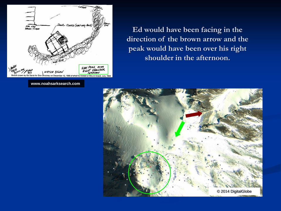
Ed would have been facing in the direction of the brown arrow and the peak would have been over his right
shoulder in the afternoon.

Abas walked him over to the ledge and pointed down into a horseshoe-shaped crevasse and says, “That’s Noah’s Ark.”
© 8/10/2009 DigitalGlobe © 2014 DigitalGlobe

Doomsday Rock (Paragraph 24) We doubled back around behind the imposing rock formation and come to a ledge after
edging heel to toe past the terrible drop off.

Researcher Kevin Kluetz notes, Ed told me that from his viewpoint of the Ark, the mountain summit was to his back, the morning sun would have risen from his right-front, and the evening sun would have set to his left-rear. If he turned around to face the summit, the evening sun would have set to the right of the summit.
If he turned back around and faced the Ark at night, he could see the glow of the lights of Teheran reflecting off of the clouds to his front, approximately 10 degrees to the left of the ark. Most Ark researchers assume that Ed had been on Mount Ararat, so I asked Ed if perhaps the glow he saw was from the lights of
Erivan, Armenia, to the northeast of Mount Ararat, Turkey. Ed said, “No, it was Teheran.” Kevin made sketches on 10/02/94 when he spent some time with Ed in his home. If North is 360 degrees, and South is 180 degrees, then the glow of the lights of Teheran was at about 30 degrees from North, the ark object was at
about 60 degrees, the mountain top was at about 240 degrees, and the sunset was at about 260 degrees. Kevin has a website at http://www.geocities.com/athens/parthenon/3021/
(The above degrees are off looking at some of the info. given by Ed Davis with the peak to his west and the position of the sun at sunset)


Kevin’s drawing and comparing it with the area on Damavand.
The red box states, “Three large rock formations or rocks were to Ed’s left.” I am going to show
you the area that his first sighting (1) would have been
and the 3 rocks were to his left.

Lights of Tehran Kevin’s notes: Ed saw the lights of the city glowing in a reddish color in a reflection off the clouds in the distance.

GoogleEarth sunset example from 7/13/2014 (Paragraph 6) Until one day in July, Badi’s father Abas returned to Hamadan and said the ark was visible. His sons had just
returned from the mountains and it was exposed. Abas had ventured down from the mountains with urgent news from home.

Ground view picture from www.summitpost.org

Area matches Ed Davis drawing by Elfred Lee on
Mt. Damavand!
© 8/10/2009 DigitalGlobe

A closer look at the canyon area (all areas match) and the green area is an exact match!

August 10, 2009 GeoEye-1 larger and smaller sections
© 8/10/2009 DigitalGlobe
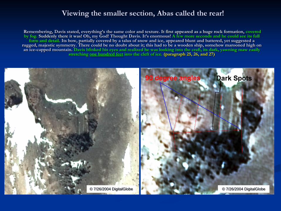
Remembering, Davis stated, everything’s the same color and texture. It first appeared as a huge rock formation, covered by fog. Suddenly there it was! Oh, my God! Thought Davis. It’s enormous! A few more seconds and he could see its full
form and detail. Its bow, partially covered by a talus of snow and ice, appeared blunt and battered, yet suggested a rugged, majestic symmetry. There could be no doubt about it; this had to be a wooden ship, somehow marooned high on an ice-capped mountain. Davis blinked his eyes and realized he was looking into the craft, its dark, yawning maw easily
stretching one hundred feet into the cleft of ice. (paragraph 25, 26, and 27)
© 7/26/2004 DigitalGlobe © 7/26/2004 DigitalGlobe
Viewing the smaller section, Abas called the rear!

The windowed area dark spots in imagery using multiple Google Earth Images.
© 2014 DigitalGlobe
© 2014 DigitalGlobe
© 2014 DigitalGlobe

The smaller section called the rear, by Abas.
© 7/26/2004 DigitalGlobe

© 9/9//2011 DigitalGlobe GEO1 © 2/22/2014 DigitalGlobe WV02
© 5/14/2011 DigitalGlobe GEO1 © 5/14/2011 DigitalGlobe GEO1 (smoothed)
The smaller section is not natural part of the mountain

© 9/9//2011 DigitalGlobe GEO1
The evidence of an Ark with broken Beams

Viewing the larger section
© 7/26/2004 DigitalGlobe

Kevin Kluetz notes; a North and South orientation of the larger section!

Surface runoff and example of moving it into another runoff area. It has a vertical shadow! Kevin’s notes: water flowed around the ark and out through a hole or small canyon.

© 2014 DigitalGlobe/GoogleEarth
© 7/26/2004 DigitalGlobe © 2014 DigitalGlobe/GoogleEarth
You can see the open end (top of image) has 90 degree
angles and the back (lower left) has a vertical shadow.

The larger section open end visible to Ed Davis. The 3rd deck left side and all right decks are filled in with dirt.
© 8/10/2009 DigitalGlobe © 8/10/2009 DigitalGlobe

Viewing of both sections visible to Ed. There are angles visible here not natural to the environment.
© 7/26/2004 DigitalGlobe
© 8/10/2009 DigitalGlobe

Another view of both sections
© 8/10/2009 DigitalGlobe © 7/26/2004 DigitalGlobe

Histogram of both areas
© 2014 DigitalGlobe

Third section in Davis drawing (picture lower right rotated)

They told me the ark is broken into three of four big pieces. Further down the gorge lay still more pieces of the ship, some sections wedged between rocks, some bathed in a torrent of glacial snowmelt. (paragraph 29)
The below image shows multiple areas of broken sections and the minimum size of 100ft. My estimated size is 110-125 ft.
The next image will show another area.

This image shows another area and the exact location from the other areas.
© 2014 DigitalGlobe & CNES / Astrium


www.summitpost.org

More information about the Davis account
1. I can give you R&R in Tehran and you could take the long way. It would make more sense to take leave closer to Tabriz for a trip to Agri Dagh. Davis wrote in his Bible, “stopped in Tehran and got some supplies and got warm and rested up.” Why would, they drive almost 500 miles from the Turkish mountain to warm up in July?
2. Davis also stated to Kevin Kluetz in 1994, that he was taken to the mountain by Lourds and not Kurds. 3. Explorers of Ararat page 142, “Strangely, Ed Davis did not recognize the high altitude photos(of the Turkish Mountain) as resembling what he
saw.” 4. Ed Davis did pass a lie detector test. 5. Abas said the ice on big mountain has melted considerably part of the ark is showing. Davis stated that he was not on the ice cap and it was
above them for most of the trip. Abas said, “The ark layed entombed for twenty years at a time.” It would have been in the ice cap. It should have been the snow has melted enough, that he could see it. Shockeys’ book page 15, They laughed about all of the fuss people have had trying to get to it. Certain times, in certain years all of the Ark is visible and visit it often. Well giving a logical look into it, Damavand is the tallest mountain in the middle east region.
6. Davis mentioned a strong at times overwhelming, smell of sulfur hung in the air. The last part of the climb up Damavand can be very dangerous due to the sulfur gas. Climbers are warned to climb with only with certain wind conditions. Davis mentioned burning his clothes. When he returned due to the smell of the sulfur.
7. Photo (lower left) below from page 55 of Don Shockey’s Book, “Photo given Ed Davis by Abas-Abas showing how difficult the trail up Mount Ararat can be when covered with snow and frozen ice. What year the photo-graph was taken is unknown.” The exact area was unknown, but it appears to have been taken between March and September in this canyon (lower right) on the Northeast/North side of Damavand at 35.967950, 52.120997. The field of view is not exact.

www.mpi-sb.mpg.de/~mbabak/Damavand1.jpg

www.camp4.com