XII - Halifax MA |
29
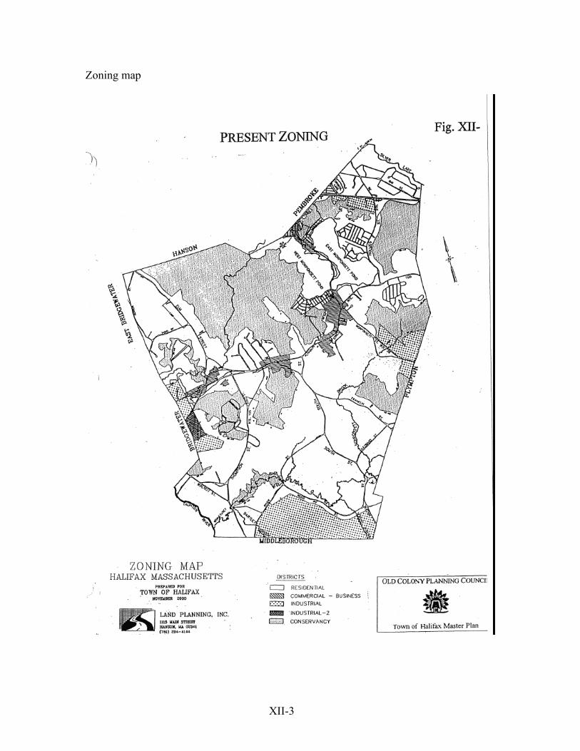
XII-1 XII Implementation / Development Controls A. Overall Observations The town's main development controls are the Zoning Bylaw, the Rules and Regulations for Subdivision Control, the Board of Health Regulations and local non-zoning Wetlands Protection Bylaw. These powers are all essentially restrictive in that they limit what may be done and set dimensional standards for the allowed activities. The Zoning Bylaw limits the location of activities to defined and mapped districts. However this essentially negative power is limited by the state Zoning Act's exemption (MGL C.40a, S. 3) of religious uses and of educational uses on land controlled by public, non-profit or religious bodies. Only the dimensional aspects of such activities may be regulated and this must be through "reasonable regulations". In any case zoning can not cause anything to happen. It just allows development if the market is there. And if a use is allowed in a given area as-of-right, it cannot be refused unless other regulations are violated. Such AOR uses can be only modified through the Planning Board's Site Plan Review. However uses requiring Special Permits can be modified in the review process since a special permit is a discretionary privilege, not an entitlement. Since as-of-right uses cannot be refused it is important to map well-selected minimum areas for commercial uses. This would help to preclude past Board objections to the extent and appearance of recent development along Plymouth St. The other provisions set standards for any development in allowed areas. They can indirectly prevent development in a given area if the standards can not be met ( e.g., the 1000’-foot maximum dead-end road in the Subdivision Rules and Regulations.), if excess wetlands alteration is required, or if soils are unsuitable for septic systems. B. Zoning The town's zoning consists of the Agricultural-Residential District (AR), the Commercial- Business District (CB)., the Industrial District (I), the Industrial -2 District (I-2) and the Conservancy District (C) along with two overlay districts, the Flood Plain District (FP) and the Aquifer and Well Protection District (AWP) adopted at the 1997 Town Meeting. The provisions, their apparent effectiveness and recommended revisions and additions are discussed below. The Halifax Zoning Bylaw regulates both allowed uses and densities. Thus it can be used to determine the structure of a community, i.e., the location of various residential,
-
Upload
khangminh22 -
Category
Documents
-
view
1 -
download
0
Transcript of XII - Halifax MA |
XII-1
XII
Implementation / Development Controls
A. Overall Observations The town's main development controls are the Zoning Bylaw, the Rules and Regulations for Subdivision Control, the Board of Health Regulations and local non-zoning Wetlands Protection Bylaw. These powers are all essentially restrictive in that they limit what may be done and set dimensional standards for the allowed activities. The Zoning Bylaw limits the location of activities to defined and mapped districts. However this essentially negative power is limited by the state Zoning Act's exemption (MGL C.40a, S. 3) of religious uses and of educational uses on land controlled by public, non-profit or religious bodies. Only the dimensional aspects of such activities may be regulated and this must be through "reasonable regulations". In any case zoning can not cause anything to happen. It just allows development if the market is there. And if a use is allowed in a given area as-of-right, it cannot be refused unless other regulations are violated. Such AOR uses can be only modified through the Planning Board's Site Plan Review. However uses requiring Special Permits can be modified in the review process since a special permit is a discretionary privilege, not an entitlement. Since as-of-right uses cannot be refused it is important to map well-selected minimum areas for commercial uses. This would help to preclude past Board objections to the extent and appearance of recent development along Plymouth St. The other provisions set standards for any development in allowed areas. They can indirectly prevent development in a given area if the standards can not be met ( e.g., the 1000’-foot maximum dead-end road in the Subdivision Rules and Regulations.), if excess wetlands alteration is required, or if soils are unsuitable for septic systems. B. Zoning The town's zoning consists of the Agricultural-Residential District (AR), the Commercial-Business District (CB)., the Industrial District (I), the Industrial -2 District (I-2) and the Conservancy District (C) along with two overlay districts, the Flood Plain District (FP) and the Aquifer and Well Protection District (AWP) adopted at the 1997 Town Meeting. The provisions, their apparent effectiveness and recommended revisions and additions are discussed below.
The Halifax Zoning Bylaw regulates both allowed uses and densities. Thus it can be used to determine the structure of a community, i.e., the location of various residential,
XII-2
commercial, industrial and institutional uses town-wide, their relation to each other, and the overall density pattern. The density patterns usually reflect the convenience, accessibility, amenities and utilities of given areas. Communities are usually more dense around the traditional center or along major roads with lower density development in outlying areas. Recent patterns in Halifax are more diffuse with businesses along major roads as well as in the center and with pockets of higher density housing such as the Twin Lakes Condominia in special outlying locations. Halifax's Zoning Bylaw is unusual in requiring the same 40,000 sq. ft. to 43,560 sq. ft lots (or the equivalent one acre per multi-family unit) town-wide. Therefore there is no overall prescribed density pattern related to the centrality, accessibility, amenities or environmental constraints of different parts of the town. The Bylaw also requires 150' frontage, 50’ foot front yards, 30’ side yards and 40’ foot rear yards for all uses (except multi-family housing and accessory buildings) in all districts, and has a town-wide 2 1/2 story or 40-foot height limit for all uses in all districts. The Bylaw is contradictory but appears to require 40,000 sq. ft. for most uses, and an acre (43,560 sq. ft.) for each multi-family dwelling unit. The Dimensional Table shows a 40,000 sq. ft. lot minimum for all uses including multi-family housing, but the text in the Density (Section 167-12) requires an acre (43,560 sq. ft.) for any multi-family dwelling unit. The Enumeration of Districts section (S.167-4) adds confusion by requiring one acre for any housing unit in the AR District, but 40,0000 sq. ft. for any uses, including housing, allowed in the CB District. Since it is unusual to require lower densities for multi-unit housing than for single-family detached houses, the intent may be to require a whole acre for any housing unit. According to the Building Inspector, Town practice is to require the stated acre for each multi-family unit and to accept 40,000 sq. ft. lots for detached housing. The potential 10% difference in the number of units allowed for a given uses in a given district is significant and potentially troublesome. It should be resolved. The Site Plan Review process under Section 167-28 enables the town to significantly modify projects which are otherwise allowed. The bylaw states that "No permit shall be granted for (any of a wide range of projects - other than single-family detached houses) except in conformity with a site plan (endorsed by the Planning Board).” A very comprehensive plan must be submitted and distributed for other boards' comments. The Board then seeks to assure reasonable use of the site in terms of impacts on adjacent uses, circulation and parking, drainage, functional and aesthetic compatibility with existing and potential adjacent uses, residential privacy, and potential expansion. It goes well beyond checking for compliance with specific requirements. The process allows considerable
XII-3
Zoning map
XII-4
cooperative fine-tuning of proposals. With such cooperation the stated enforcing power to deny permits is rarely exercised or challenged. 1. AR Agricultural-Residential District. Mapping and Present Uses
This is the town’s basic district. The 1994 Buildout Analysis found that it was mapped on over 3500 vacant acres Allowed Uses The District allows single-family housing and a variety of agricultural and institutional/public uses as of right. It also allows multi-family housing, major institutions such as hospitals, and selected commercial uses such as funeral homes, veterinary hospitals and campgrounds by special permit. The multi-family provisions in this district and in the Commercial and Business District require that the number of multi-family units not exceed the number of acres in the parcel, that the parcel have at least 10 acres, and that 80% of the parcel on a 200-foot square grid be found "percable" by the Board of Health. No unit may exceed 2 1/2 floors of living space and the front and rear setbacks are increased from the single-family standards of 50' and 40', to 75' and 100' respectively. The 30' side yard at the edge of the parcel remains, but 100’ is required between buildings within the development - essentially a 50-foot internal side yard requirement. If the required land area/unit were the same for all housing, multi-family projects could have about 10% more units/acre. This is because land used for internal circulation would help to meet area requirements. That is, the internal roadways would remain part of the lot for dimensional purposes. However the one acre (43,560 sq. ft.) per unit standard is nearly l0 % higher than the 40,000 sq. feet accepted for detached houses (except in S.167-4) and would remove any density advantage. A greater design advantage is that the multi-family provisions allow for leaving much of the land in open space or agriculture. For example a 12-acre parcel could accommodate its allowed 12 units in 3 groups of 4 townhouses on less than 3 acres total. This would leave 9 acres for gardening, recreation, or informal open space. This potential can be seen in the extensive open space preserved between the Twin Lakes development and the commuter rail station. The agricultural provisions allow plant growing ("orchard, nursery, greenhouse or cranberry or viniculture [grapes]") and livestock and poultry as-of right, along with farm stands so long as a major portion of the product is produced on the premises. However it prohibits piggeries “and /or swine” and requires special permits for breeding, boarding or
XII-5
selling dogs, cats or other for-bearing animals. These limitations presumably apply only to sites of less than 5 acres since the Zoning Act exempts farms of over five acres from use regulations. Effects and Implications The basically uniform requirement of 40,000 to 43,560 sq. ft./unit means that Halifax has no intended density pattern. Rather than the usual pattern of higher densities near the center, the rail station or major amenities and lower densities in outlying areas, the bylaw requires large lots for all new subdivisions and new lots on existing roads. This ignores differences between various parts of the Town and can lead to a relatively monotonous character. It suggests revising the area requirements to reflect different contexts and locational advantages. Recommendations 1. To reflect the varying character and attributes of different parts of the town consider r
graduating density standards to reflect differing amenities, accessibility, existing uses, and development constraints. This would put the moderate densities (well under one unit / acre) in area A which has lakeside amenities, shopping, compact neighborhoods, major roads and the MBTA rail station, and potential sewering; use low densities (about one unit /acre in area B, especially just south of Rte. 106; and the lowest overall densities (< one unit / acre) in area C, the southern tier with its remaining agriculture, extensive flood plain and wetlands, limited roads and rural development patterns.
The AR-25 25,000 sq. ft. District would be mapped in the northeast corner of the including the eastern end of Rte.106, the town's commercial center, and the land around the Monponsett Ponds and the Railroad station. The AR-35 35,000 sq. ft. district would be mapped across the center of town north and south of Rte.106. The AR-45 45,000-sq. ft. District would be mapped in the little-developed southern and southwestern portion of the town starting about one half mile south of Rte.106.
2. To give a slight incentive to more efficient multi-family housing, allow at least as many units/acre as with detached housing and continue to allow internal circulation space to count toward overall lot area requirements.
3. To further benefit from the efficiency of multi-family housing reduce the multi-family
housing area requirements to a point between from the actual 7.4 units/acre at Halifax Meadows and the present required 1 unit / acre to perhaps 4 units / acre, still giving each unit 1/4 acre while saving land.
4. Explore ways to increase overall design flexibility and provide permanent adjacent
usable open space in new neighborhoods. 2. CB Commercial-Business.
XII-6
Mapping and Present Uses The Commercial-Business District is mapped along sections of Rtes.105 and 58. It includes land just east of the landfill and a strip roughly bracketed by Thompson St. and South St. along Rte.106, much land around the Rtes.106/58 intersection and a portion at the north end of Rte. 58 at the Hanson line. There is also a free-standing approximately 14-acre parcel housing an used automobile parts operation Rte.106 and west of Pine St. The District contains both commercial and residential uses and covered 141 vacant acres during the build out analysis. This has been reduced by the use of approximately 28 acres for the Wal-Mart store and scattered recent commercial development along Rte. 106. It was recently expanded by about 12 for the supermarket proposed next to the Wal*Mart.. Allowed Uses This District allows most retail, service and office uses as-of-right while requiring special permits for wholesaling, automotive uses, drive-by businesses, veterinary hospitals, light industrial uses, and transportation and public utility uses. What is unusual is that it also allows "the same residential uses as the AR District" according to S.167-4, the Enumeration of Districts. Thus it allows single-family detached houses and accessory buildings as-of right and two-family or multi-unit dwellings by special permit. Its residential provisions are slightly more permissive in allowing small scale rooming or boarding activities and customary home occupations as-of-right while the AR District requires special permits for these. Section 167-4 states that the CB District requires 40,000 sq. ft. lots and allows up to 25% coverage. This is assumed to refer to business, commercial and residential uses. Section 167-14 requires a parking space for every one hundred square feet of retail, wholesale, or service businesses or office and professional buildings. Since theses uses can vary greatly in needs (as between intensive retail uses and extensive warehousing ) such uniform requirements are apt to be a poor fit in many cases. More basically, the requirements far exceed those in nearby communities. Hanson and Easton require one space per 150 sq. ft., Plympton and Bridgewater require one space per 200 sq. ft., and Whitman, Stoughton and Avon require one space per every 300 sq. ft. Halifax’s very high parking requirements are reflected in the extensive unused reserve area behind the Wal*Mart Store. They consume more land, force businesses to be farther apart thereby discouraging walking between stores, and increase storm runoff. This suggests reviewing the requirements empirically and reducing them as appropriate.
XII-7
Effects and Implications The total appears to well exceed probable near-future demand for commercial space. and its extensive mapping over much of Rte. 106 encourages continued strip development and lessens chances of getting one strong commercial center. The District would be more effective in concentrating business development if it limited most business to one major area and contained just slightly more land than short-term requirements. Since the bylaw allows both housing and commercial development, such mixtures could increase. In much more densely-developed centers mixed uses can work well, particularly where residential uses are in upper floors above contiguous commercial uses. At the present suburban scale of Halifax the mixed business and residential uses at ground level lead to a weaker pattern. Commercial development often leapfrogs existing housing. The new businesses then abut residences rather than existing commercial uses. This preserves the intervening housing but the overall unpredictably can weaken an area as a residential neighborhood. At the same time the intervening housing can constrain business activities and fragment business districts. Extensive strip commercial zoning does gives businesses many viable locations along major roads. However it does this at the cost of lessening the chances of getting a more concentrated, pedestrian-friendly commercial center and of destabilizing existing neighborhoods. Recommendations 1. Focus the allowed uses on commercial and business activities and remove the
specially- permitted residential uses. 2. Reduce the CB mapping along Rte. 106 and focus it on intended key commercial
areas, particularly at the intersection of Rtes. 58 and 106. This would involve: • Rezoning the predominantly residential area east of Indian Path Road and west of the
new Tedeschi's to A-R except for the existing commercial uses immediately east of Indian Path Rd. and across from the shopping center.
• Rezoning all but the central portion of the C-B zoned area around Plymouth and
Carver Sts. to A-R • Rezoning all of the CB land along Old Plymouth St. and Plymouth Sts. at the western end of the town (except for that southwest of Plymouth St. and west of Laurel St.) to AR • Reducing the depth of CB zoning at the shopping center to 400' • Aligning the CB zoning south of Rte.106 with proposed edge of that on the north side
XII-8
• Ending the CB zoning along east side of Monponsett. St., south of the Rtes 58/106 at the edge of the existing cranberry bog. • Extending CB zoning on the south side of Rte.106 east to the depth of the present
strip mall on the north side of the street. 3. Identify areas suitable for small, walkable neighborhood-serving retail areas and map
them CB on areas of 1-2 acres (or retain small amounts of existing CB zoning) at sites such as the intersections of Thompson and Summit Sts. , South and Hayward Sts., Plymouth and Carver Sts., and Plymouth St. and Redwood Rd. along with the present store site on Holmes St. near Annawon Drive, and a spot on Rte. 105 near Highland Drive
4. Study actual parking utilization in developed commercial and industrial areas along
with effective provisions in nearby communities, and draft revised provisions meeting needs without wasting land.
5. Consider provisions allowing joint use of spaces by nearby activities with
complementary times of need. C. I Industrial District. Mapping and Existing Uses. The Industrial District is mapped in several areas at the edge of town. These include: • Approximately 40 acres north of Rt.106 at the Bridgewater town line. This contains a
40.67 acre industrial park with 2 developed parcels. • Approximately 227.5 acres of vacant wood swamp, wooded upland and open land on the Bridgewater line south of the BFI landfill and behind property fronting on Thompson St. • Approximately 503 acres south of Wood St. on the Middleboro line. This is largely
wetlands used for limited agriculture and is expected to go into on-profit ownership for open space use..
• Approximately 56.5 acres off of Rte. 36 now accommodating the Old Colony RR station. • Approximately 176.3 acres of predominately agricultural land east of Monponsett St.
and 58.8 acres of agricultural land west of Monponsett St.
XII-9
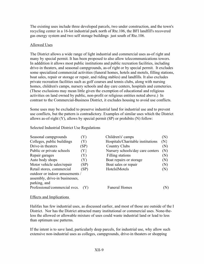
The existing uses include three developed parcels, two under construction, and the town's recycling center in a 16-lot industrial park north of Rte.106, the BFI landfill's recovered gas energy system and two self storage buildings just south of Rte.106. Allowed Uses The District allows a wide range of light industrial and commercial uses as-of right and many by special permit. It has been proposed to also allow telecommunications towers. In adddition it allows most public institutions and public recreation facilities, including drive-in theaters, and seasonal campgrounds, as-of right or by special permit. It excludes some specialized commercial activities (funeral homes, hotels and motels, filling stations, boat sales, repair or storage or repair, and riding stables) and landfills. It also excludes private recreation facilities such as golf courses and tennis clubs, along with nursing homes, children's camps, nursery schools and day care centers, hospitals and cemeteries. (These exclusions may mean little given the exemption of educational and religious activities on land owned by public, non-profit or religious entities noted above.) In contrast to the Commercial-Business District, it excludes housing to avoid use conflicts. Some uses may be excluded to preserve industrial land for industrial use and to prevent use conflicts, but the pattern is contradictory. Examples of similar uses which the District allows as-of-right (Y), allows by special permit (SP) or prohibits (N) follow: Selected Industrial District Use Regulations Seasonal campgrounds (Y) Children's' camps (N) Colleges, public buildings (Y) Hospitals/Charitable institutions (N} Drive-in theaters (SP) Country Clubs (N) Public or private schools (Y} Nursery schools/day care centers (N) Repair garages (Y) Filling stations (N) Auto body shops (Y) Boat repairs or storage (N) Motor vehicle sales/repair (SP) Boat sales or repair (N) Retail stores, commercial (SP) HotelsIMotels (N) outdoor or indoor amusements / assembly, drive-in businesses, parking, and Professional/commercial svcs. (Y) Funeral Homes (N) Effects and Implications Halifax has few industrial uses, as discussed earlier, and most of those are outside of the I District. Nor has the District attracted many institutional or commercial uses. None-the-less the allowed or allowable mixture of uses could waste industrial land or lead to less than optimum use patterns. If the intent is to save land, particularly deep parcels, for industrial use, why allow such extensive non-industrial uses as colleges, campgrounds, drive-in theaters or shopping
XII-10
centers? And if those uses are potentially acceptable, why exclude country clubs or hospitals? If heavy commercial uses like repair garages, car dealers and body shops are acceptable, why exclude marine sales and repair uses with similar impacts? Similarly, if schools are acceptable, why not include day care centers which could complement employment concentrations by providing work-site child care? And if the more centrally-located Commercial Business-zoned land along Rtes.106 and 58 would benefit from a greater concentration of activity, why allow/encourage retail and service uses in the peripheral Industrially-zoned lands? The implications are that the allowed uses should be more consistant and better focused, and that the mapping should be reduced to the most feasible areas. Recommendations l. Reconsider use regulations noted above and revise them uses as follows:
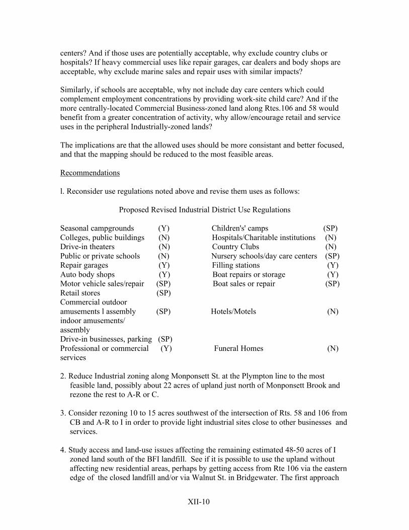
Proposed Revised Industrial District Use Regulations Seasonal campgrounds (Y) Children's' camps (SP) Colleges, public buildings (N) Hospitals/Charitable institutions (N) Drive-in theaters (N) Country Clubs (N) Public or private schools (N) Nursery schools/day care centers (SP) Repair garages (Y) Filling stations (Y) Auto body shops (Y) Boat repairs or storage (Y) Motor vehicle sales/repair (SP) Boat sales or repair (SP) Retail stores (SP) Commercial outdoor amusements l assembly (SP) Hotels/Motels (N) indoor amusements/ assembly Drive-in businesses, parking (SP) Professional or commercial (Y) Funeral Homes (N) services 2. Reduce Industrial zoning along Monponsett St. at the Plympton line to the most
feasible land, possibly about 22 acres of upland just north of Monponsett Brook and rezone the rest to A-R or C.
3. Consider rezoning 10 to 15 acres southwest of the intersection of Rts. 58 and 106 from
CB and A-R to I in order to provide light industrial sites close to other businesses and services.
4. Study access and land-use issues affecting the remaining estimated 48-50 acres of I
zoned land south of the BFI landfill. See if it is possible to use the upland without affecting new residential areas, perhaps by getting access from Rte 106 via the eastern edge of the closed landfill and/or via Walnut St. in Bridgewater. The first approach
XII-11
could serve both the Industrial land north of the landfill and theThompson St. backland. If such compatible access is not possible, rezone the rest of the upland to
A-R and the wooded swamp to C.
5. Consider rezoning the extensive (503.1 acres) of Industrially-zoned land between Wood, River, and Fuller Sts and the Middleboro line to the AR or C District. It includes 386 acres of mapped flood plain and 96 acres with severe septic limitations
and scattered, seemingly understated, wetlands. In the past extensive wooded cedar swamp was illegally cleared for agriculture and the perimeter of the site was most recently used for cornfields. The nature and basic use of the land make the Conservancy District more appropriate.
D. I-2 Industrial-2 District. Mapping and Existing Uses The I-2 District is mapped only on the 44.5-acre BFI landfill site south of Rte.106 on the Bridgewater line. Allowed Uses The I-2 District was established to accommodate sanitary landfills. It allows these as-of right along with churches and schools and excludes most other uses. By special permit it can allow farm stands; open air businesses; breeding or boarding of dogs, cats or fur-bearing animals; varied educational, cultural, governmental and public utility structures; and public recreation, but no children's camps, tenting, riding stables or private clubs. The District has been proposed for telecommunication towers where the landfill's sheer height could require minimal intrusion above the skyline. However the only tower has been built on level Ind. land just south of Plymouth St.. Effects and Implications The District long accommodated the present BFI landfill, but Town Meeting's reluctance to extend the District to the south precluded expansion of the landfill. It has since been closed and capped. Of the presently allowable uses, the most suitable is public recreation since the site is high and open. Safe sliding, skiing, hiking, biking etc. would probable require modifications such as reconfiguring the side slopes to avoid any dangerously abrupt changes, covering any hazardous drainage channels and enhancing the cap to avoid erosion or cracking. Fortunately the methane collection system pulls the gas downward and thus has relatively few components protruding through the surface. Recommendations

XII-12
1. Develop provisions explicitly allowing and regulating tele-communication towers by special permit.
2. Ease restrictions on recreational use of the site
E. C. Conservancy District Mapping and Present Uses This extensive district is intended "to protect the town's wetlands, floodplains and bogs while allowing appropriate development" according to section 167-4 E. of the bylaw. It is mapped extensively over wetlands in the northwestern portion of the town and over three major tracts along the Plympton town line. The land is mostly in wooded swamp, other wetlands and floodplains, cranberry bogs and some agricultural upland area. The boundaries reflect either topographic features such as contour lines and streams or property lines - commonly around cranberry bogs - along with some measured distances from roads. A major exclusion is the extensive upland agricultural property on Hemlock Island as well as some newer or expanded cranberry bogs such as those west of Elm St., at South and Hayward Sts.,and west of Palmer Mill Road. Very little of the District is developed except for bog support facilities and the Indian Path Road subdivision. As of 1994 the District included 1,707.2 acres of nominally undeveloped land. However a large portion of this was in agricultural use, with a very conservatively-estimated 297 acres in highly productive cranberry bogs and a comparable amount in related support facilities and buffer areas. Allowed Uses The District allows most public/institutional uses (colleges, schools, public/govt. buildings, libraries, musea, civic and recreation clubs and children's camps) as-of-right while requiring special permits for seemingly similar uses (nursery schools/day care centers, hospitals, nursing homes and charitable/non-correctional institutions), for cemeteries, commercial recreation, campgrounds, and riding stables; and for any housing. It explicitly excludes industrial uses and most businesses. As discussed earlier, these provisions are limited by the state Zoning Act's exemption in MGL, C.40a, S.3 of religious uses and of educational uses on land controlled by public, non-profit or religious bodies. Only the dimensional aspects of such activities may be limited and this must be through "reasonable regulations". Effects and Implications To date the district has few users other than extensive cranberry bogs. The only apparent recent housing is the Indian Path Road Subdivision north of Rte.106. Nor do any major public or institutional uses appear to have been built in the District.
XII-13
The District's provisions are contradictory in allowing some extensive institutional uses as-of-rightwhile requiring special permits for similar uses and for smaller-scale uses such as housing. The allowable uses would also need to conform to the Wetlands Protection Act, the Aquifer and Well Protection Zoning Bylaw and the non-zoning Wetlands Protection bylaw. The results of these special permit provisions need examination. Regardless of the exemption of religious and educational uses and of the lack of such development, these major uses should not be listed as allowed as-of right unless the town definitely wants them in the District. The zoning should mean what it says and should say what the town means. Recommendations l. Examine the boundaries of the District to identify which should be expanded to meet its stated purposes. Such expansions could include the addition of: • Omitted flood plains such as those along Monponsett Brook. • Missing wetlands such as the Industrial-zoned wooded swamp south of the BFI
landfill • The extensive Industrial-zoned agricultural wetlands south of Wood and River Sts. • New or expanded cranberry bogs. 2. Identify the implications of any possibly arbitrary boundaries such as the 400' setback between Holmes St. and Peterson's swamp and enact any needed revisions. 3. Revise the bylaw to remove any inappropriate as-of-right large-scale institutional uses. F. AWP The Aquifer and Well Protection District Mapping and Present Uses This overlay district is mapped over the Zone I (400'-protected circle) and DEP-approved Zone II recharge areas of the town's Richmond Park and YMCA wells, and over any Interim Wellhead Protection Areas. It covers much undeveloped land, agricultural land and commercial development around the intersection of Rtes.106 and 58, and considerable housing in the Richmond Park area. Allowed Uses The bylaw limits uses otherwise allowed in the underlying districts. It excludes potentially harmful uses such as solid waste facilities, landfills, hazardous waste generators, junkyards, auto repair facilities, printers, sludge storage, large scale earth removal, and some medical facilities. It also requires special permits for a range of other potentially hazardous activities and limits impervious surfaces.
XII-14
Effects and Implications The bylaw was passed in 1997 after many years’ study and several attempts to enact earlier versions. It drew on various earlier proposals and examples, and reflected concerns expressed at public hearings. The resulting bylaw accomplishes most of the key protections long urged by the Halifax Water Department, the Old Colony Planning Council and other agencies, and should go a long way to protect the town's water resources. However the Town Meeting deleted provisions covering "Zone IIIA" areas from which groundwater flows to the Zone II of existing/potential wells, along with provisions protecting the "Zone IIIB" areas from which surface water flows to Zone II or to existing/potential surface water supplies such as the Monponsett Ponds and Silver Lake. The last is particularly needed because the Lake is the heart of Brockton's supply and because the Monponsett Ponds are seasonally diverted to the Lake. Pembroke and Plympton have enacted bylaws covering surface water and/or ground water flowing to the Lake, and Brockton has discussed joint efforts to enact and enforce such provisions with the Kingston Water Board. The bylaw fills a major gap since Halifax was the last town without a general water supply protection zoning bylaw. However it should be made as complete and effective as possible. Recommendation Revise the Aquifer and Well Protection Bylaw by adding provisions regulating omitted hazards and protecting the Zone IIIB areas from which ground and surface water flow to the Monponsett Ponds and t Silver Lake. The needed changes are:
(a.) Revising the Section 167-17.2 Findings to read : A. The Richmond Park and YMCA Camp well sites and their watersheds along with the groundwater underlying Halifax are the primary sources of Halifax's existing and future water supply. The closely-linked surface water supplies of the Monponset Ponds and of Silver Lake to which the Ponds are diverted seasonally, are major local and regional resources. They are use by other communities and are potentially available to Halifax if needed. Accordingly the Town intends to protect all of these resources from local hazards. (b.) Adding to Section 167-3 Definitions: Zone IIIB That land beyond the area of Zone II from which surface water or groundwater flows to Silver Lake and to the East and West Monponsett
Ponds. This is defined as the land within 200' of the centerline of such tributaries and within 400' of the shores of the Ponds and the Lake.

XII-15
(c.) Adding to Section 167-4, Establishment of Districts: There are hereby established within the Town certain Aquifer and Well Protection Overlay Districts, which are delineated on maps entitled “DEP Zone II Map Richmond Park Wellfield ” dated January 1997 (Revised April 1997) and “Zoning Map - Town of Halifax - Proposed Water Supply Protection Zoning District - Delineation of Surface Water Supply Protection Sub-District Zone III B.” dated June 1998. The maps are hereby made a part of this Zoning By-Law and are on file in the office of the Town Clerk. (d.) Modifying and expanding the Section 167-17.6 Aquifer and Well Protection District Use Regulations as follows: [The proposed new provisions, and the application of the suggested Zone IIIB provisions to the present Schedule of Uses are shown below. Existing uses are numbered as at present but are not spelled out for simplicity. Proposed new items are in [ ]. Zone II/ Zone IIIB IWPA 1. N SP 2. N N 3. N N 4. N N 5. N SP 6. N SP 7. N SP 8. N SP 9. - - 10. N SP 11. SP SP 12. [SP] SP 13. Rendering impervious more than 20% of total lot area, [SP] SP regardless of lot size, only with a system to recharge precipitation without degrading water quality. 14. N SP 15. N SP 16. SP SP 17. N N a. SP SP b. SP SP c. SP SP d. SP SP e. SP SP 18. N N a. SP SP
XII-16
b. SP SP c. SP SP d. SP SP 19 . N N 20. N N 21. N N Zone II/ Zone IIIB IWPA 22. SP SP 23. N N 24. N N 25. SP SP 26. SP SP 27. [SP] SP 28. N N 29. [Animal husbandry within 100 feet of the - N seasonal high waterline] 30 [Cemeteries] N N 31 [Any floor drain in industrial or commercial process areas or hazardous N N materials storage areas which discharge to the ground without DEP authorization. 33. [Discharge of fill or dredged material in SP SP accord with 314 CMR 4.06(1)d.1 or through a waiver in accord with 314 CMR 9.06(4).] 34. [Discharging stormwater to a Class A surface SP SP water supply only if setback and treated by the highest and best practical method as per 314 CMR 9.06.) 35 [Any uses which use, process, or store toxic SP SP or hazardous materials in amounts exceeding normal household use, provided that all activity is in structures designed to prevent the generation or escape of contaminated runoff or leachate, and that all storage is either in free-standing containers within buildings or in free-standing containers above ground level and designed to hold either 10% the total capacity of all containers or 110% of the capacity of the largest container. Such activities or uses include but are not limited to metal plating, chemical manu- facturing, wood preserving, furniture stripping, dry cleaning, hairdressing, heavy vehicle repair or terminals, medical facilities and funeral

XII-17
homes]. 36 [Enlargement or alteration of existing uses SP SP which would require Special Permits under this bylaw if proposed as new uses.] (e.) Adding to Section 167-17.8: B. [Following the present text add "The decision shall be made through the Special Permit Process. The analysis shall use appropriate Department of Environmental Protection approved methodology (e.g., as per 310 CMR 22.00 for delineation of Zone II areas) and the results shall be taken into consideration by the Special Permit Granting Authority, in consultation with the Department. ] The map may be amended to include DEP-defined Interim Wellhead Protection Areas for identified but otherwise unprotected potential sources. In any case the AWP boundaries on these should be on the basic Halifax Zoning Map so that only one map is needed. G. FP The Flood Plain District Mapping and Present Uses The Flood Plain District (S.167-150 is an overlay district mapped to include the 100-year flood plain shown on the Federal Emergency Management Agency’s July 5,1982 FIRM maps and Flood Boundary and Floodway maps which are included by reference. According to the Bylaw, the District is to be shown as an overlay district on the Halifax Zoning Map but it does not appear on the available November, 2000 version. Its coverage is approximated by the FEMA Flood Plain shown on Figure II-1 It overlaps with the Conservancy District but includes much streamside flood plain omitted from that district while appropriately excluding agricultural and bog support upland which is in it. Most of the land in the District remains undeveloped except for cranberry bogs and related support facilities. Allowed uses As an overlay district it regulates uses allowed in the underlying districts. “ All encroachments, including fill, new construction, substantial improvements to existing structures and other development, are prohibited...” unless certified not to increase 100-year flood levels and to comply with State Building Code flood plain requirements.” Effects and Implications The District helps to prevent new development from aggravating flooding and to protect such development from present hazards by proper construction methods. Since the land involved is the most difficult to develop due to septic limitations and wetlands, the Flood

XII-18
Plain bylaw does not constrain development so much as modify that which is otherwise allowable. Recommendations (a.) Compare the FP District’s mapping with that of the Conservancy District to identify areas which should be in both districts. Recommendation Compare the FP District’s mapping with that of the Conservancy District to identify area that should be in both districts. C. Subdivision Rules and Regulations The town’s Subdivision Rules and Regulations govern land subdivision under the state’s Subdivision Control Law (MGL 41, K-Q). The Planning Board adopts its own regulations (i.e. without Town Meeting action) and may waive specific requirements when appropriate to a given project. The basic purpose of subdivision regulation is to ensure adequate access to all parcels created and the appropriate provision of municipal services (drainage, sewer and water) needed to serve such parcels. Thus the regulations cover the required right-of-way width, pavement width, grades, turning radii and construction details of subdivision roads and sidewalks. Since the focus is access, rules and regulations may also require pedestrian/bicycle ways where useful. In addition, the rules and regulations cover the provision of private services and hence may require underground electric and telephone wiring. The rules and regulations may not cover the land use or lot dimension issues regulated by zoning or be inconsistent with the requirements of other municipal boards. However, they may require planning board consent for a second residential structure on a parcel in order to ensure adequate access to such a building. In addition the rules and regulations may call for provision of land for parks, schools or other needed public facilities, but only with compensation. The Board may require that the land in question be withheld from sale or development for three years while the town seeks to require it. Among the variables which can affect the cost, feasibility and overall character of a subdivision are roadway width, sidewalk requirements, planting strip requirements, maximum cul de sac lengths, underground utilities, material to be used for curbs, drainage standards and requirements for pedestrian/bicycle easements to public lands, to

XII-19
major destinations or to other roadways and neighborhoods. The table below compares the major provisions in Halifax and other OCPC communities. Right-of-way width Major Roads/Arterials Halifax 100’, Abington, Avon 80’; Easton 76’ Kingston, Whitman 70’ Collector Roads Halifax 50’; Abington 62’; Avon, Stoughton, W. Bridgewater Easton, Hanson, Kingston, Pembroke, Plymouth, Plympton Whitman 50’ Minor Roads Halifax 50’; Abington 52’; Avon, Brockton, Plymouth 50’ Bridgewater, E. Bridgewater, Hanson, Kingston, Pembroke, Plympton, W. Bridgewater, Whitman 40’ Pavement Width Major Roads/Arterials Halifax 36’; Plympton 24’; Pembroke 30’; Easton, Hanson 32’ Kingston 40’; Abington, Avon, W. Bridgewater, Whitman 44’ Collectors Halifax 36’; E. Bridgewater 20’; Plympton 24’; Pembroke 26’; Kingston 30’; Easton, Hanson, Plymouth, Whitman 32’; Brockton 34’; Abington, Avon 36’; W. Bridgewater 38’ Minor Roads Halifax 30’; E. Bridgewater, Hanson 32’; Easton, Kingston, Pembroke, Plympton, W. Bridgewater and Whitman 24’; Abington, Plymouth 26’; Bridgewater 28’; Avon 30’ As can be seen, Halifax requires greater rights-of-way for major and minor roads than many communities. It requires a moderate 36’ pavement for major roads but the same width for collectors which are relatively high, and require the greatest width, 30’. For the most common minor roads. Overall the right-of-way and pavement provisions do not appear to obstruct development. However the 30’ minor roads may cost more, and lead to more run off and to less attractive streetscapes than necessary. The actual effect will depend on local policies and practices towards waiver requests. It would be appropriate to compare the effects of the 30’ requirement those of the most common, 24’ requirements in nearby towns.
XII-20
Sidewalks Halifax requires 2 sidewalks for all streets as do nearly all local communities except Hanson, Kingston, East Bridgewater and Stoughton which require only one in some or all cases. Halifax requires only a 4’ wide sidewalk as do East Bridgewater, Kingston, Plymouth, Plympton and Whitman while the others require 5 or 6 feet. Like most local communities Halifax requires a planting strip in residential areas. Curbs Halifax requires granite curbing at catch basins and corners but allows less expensive pre-cast concrete or bituminous concrete edging elsewhere. Cul de Sac Length Cul de Sac lengths vary greatly; Halifax allows 1,000’. Others are: Pembroke 2,000’, Easton 1,200’ except 600’ in minor cul de sacs, Bridgewater 1,000’, E. Bridgewater 900’, Plympton, Whitman 800’. Kingston 650’, Abington, Avon 600’, Hanson, Plymouth, Stoughton 500’, and Brockton 400’. Halifax allows relatively long (1,000) dead-end streets though Easton and Pembroke go further, allowing 1,200 and 2,000’ respectively. The range of these limits suggests that they are often arbitrary with shorter limits giving towns more bargaining power through waiver requests. If the intent is to minimize the number of potentially isolated dwellings (as in W. Bridgewater, below) the allowed length should be inverse to lot size, but except for Brockton’s 400’ limit this is not the case. Recommendation Reduce the allowed cul de sac length to 600’. Pedestrian/Bicycle Easements “Where necessary” Halifax requires 20’ side easements for utilities, drainage systems or pedestrian or bicycle paths, preferably along rear or side lot lines. This requirement could lead to useful routes connecting subdivisions (especially from dead end streets) with nearby neighborhoods, schools, stores and other destinations without having to take long round-about routes on busy streets. However, “necessary” is not defined and few if any new subdivisions are served by such pedestrian or bicycle paths. Avon, Bridgewater, Easton and Whitman also require 20’ to 25’ pedestrian or bicycle easements and Kingston allows them to be required by the Planning Board. In contrast, West Bridgewater makes them optional with the incentive that a path which is passable by emergency vehicles entitles a cul de sac to be longer and hold more houses.

XII-21
The lack of such paths reflects the fact that they are not absolutely required and the difficulty of relating a given path to unknown future development. Recommendations
1. Making such paths a basic requirement unless waived 2. Designing and adopting a skeletal town-wide pedestrian/bicycle path system to
which individual developments would be connected. Drainage Halifax requires developers to consider the performance of the entire watershed {upstream and downstream} when designing a system and requires them to provide any off-site improvements needed as result of the project. The only performance standard is that the design handle a 10-year storm. It does not require limiting increases in runoff through devices such a detention or retention ponds. Recommendation Require a zero increase in runoff. Open Space/Park Land Reservation The rules and regulations permit the Planning Board to require subdivision plans to show parks for recreation purposes in “reasonable proportion” to the size of the subdivision, and to prohibit building on that land for the three years allowed for public acquisition. This will be more effective if the required open space is part of a clear town-wide system, rather than an after-the-fact effort to hold expensive lots. Still, the power to delay sale of selected lots for three years should give the town some leverage in persuading the developer to spare key parts of the site or to consider using more flexible cluster development. Recommendation Work closely with preparation of the final Open Space and Recreation Plan, encouraging relatively location-specific proposals, have these included in any Official Map (discussed below), review relevant proposals with developers and be prepared to hold key sites to allow acquisition over the allowed three years. Overall Subdivision Control Recommendations
1. Develop design standards and policies relating proposed subdivision improvements to their context and to proposed nearby development, even
XII-22
something as simple as using a slightly curved road and varying setbacks (under the zoning) to fit the setting.
2. Use the Board’s discretion to work with developers to improve designs, reduce impacts, make developments more compatible with their surroundings and increase amenities such as pedestrian/bicycle paths and small unique common areas.
D. Non-Zoning Wetlands Protection Bylaw The town’s non-zoning Wetlands Protection Bylaw builds on the standards and procedures of the state Wetlands Protection Act, but extends its protective restrictions on development. It does so by prohibiting alterations or building in wetlands and floodplains or in a 100’ area around them unless permitted by the Conservation Commission. In contrast, the Act requires a filing for any work in that buffer area but only can regulate work acturlly within the wetlands resource area, or work which clearly harms that area. Thus under the Act an outfall a few feet from a wetland could not be regulated until the effluent was shown to be polluting the resource area. The Bylaw also foes further than the Act is extending the protected values to include habitat, recreation, air and noise pollution and aesthetics, and in requiring an explicit permit rather than an order of conditions for alterations potentially harming thee values. The Bylaw is more protective in that it allows the Commission to prevent activities which would have “unacceptable adverse or cumulatively adverse effects upon the wetland values protected by this bylaw; and where no conditions are adequate to protect those values”. By prohibiting work within 100 feet of a wetland or floodplain the Bylaw could, in effect, require 100’ rear yard though the Zoning Bylaw requires only 40’. The Bylaw appears to overlap with and extend the effect of the Zoning Bylaw provision (167-10-M) that all of the required minimum lot area be land which is neither wetlands nor subject to flooding. The Bylaw is administered according to accompanying Rules and Regulations. As written, these limit its applicability. The Bylaw requires Commission “permits” for activity within 100’ of wetlands or flood plain. In contrast the Regulations confirm jurisdiction over land within 100’ of wetlands or banks, but omit land within 100’ of floodplain, referring instead only to land within the flood plain itself. Further, while the Bylaw requires such Commission “permits” for work within 100’ of wetlands or flood plain, the Regulations require “variances” and only for work within 50’ of a bank (Sec. 2.01 (3) or a vegetated wetland (Sec. 2.02(3) or on land sactually subject to flooding. Variances for work in flood plains must be consistent with performance standards prohibiting: • Flood damage due to water being displaced by lost flood storage • Adverse effects on water supplies or groundwater where the floodplain is underlain
by pervious soils
XII-23
• Adverse effects on pollution where pervious soils are covered by tight peat and muck As a result of the conflicting provisions between the Bylaw and the Regulations, conservation staff reportedly focus on the more sensitive areas protected by the more narrowly focused Regulations. Recommendations
1. Study the effects of the conflicting provisions by examining the treatment under the Regulations of land within the 100’ swath for which Notices of Intent are filed under the Wetlands Protections Act and for which the Bylaw requires permits. Determine if any needed protection was lost because the Bylaw was not applied to the land between 50’ and 100’ of a wetlands, bank, or floodplain.
2. Depending on the results above, amend the Bylaw and/or the Regulations to be consistent with each other and with the Wetlands Protection Act’s 100’ standard.
E. Board of Health Regulations The Board of Health has adopted several local regulations intended to increase protection beyond that provided under the State Sanitary Code (Title V). In 1974 the Board amended its density regulations to deny building permits to any construction that would result in more than 4 families per acre in unsewered areas, except for “construction of single-family dwellings on lots of less than 10,000 sq. ft.” predating 1954. Since the basic lot requirement is now 40,000 sq. ft. and multi-family dwellings are limited to one unit per acre, it is only on such older lots (or through a comprehensive permit) that such development could be proposed. In any case the Board is unlikely to be able to approve new septic systems on lots of under 15,000 to 20,000 sq. ft. In 1979 the Board adopted maximum discharge rates for multi-unit housing and other uses. These limited discharges from multi-unit housing or other uses to 1,000 gallons/acre/day; the equivalent of two four-five bedroom units. Given the zoning requirement of one acre per unit, this standard will not further limit development. Then in 1981 the Board adopted two regulations:
• Rejecting the filling of seasonally submerged lands to create building sites, and excluding them as “unsuitable from a sanitary point of view for human habitation”. Such filling would be severely restricted under the Wetlands Protection Act and the town’s non-zoning Wetands Protection by law even without this provision.

XII-24
• Determining that filling land to create the minimum 4’ distance between the water
table and leaching field is not “an acceptable practice and such lands are not suitable from a sanitary point of view for human habitation”. The Board may allow greater g\flows given acceptable waste types, soils, depth to groundwater and bedrock.
Filling wetlands for this purpose would still be prohibited, but simply adding approved fill to gain the needed height over permeable soils is permissible under Title V as is evidenced by the mounding systems now appearing in the region. The Board basically follows and enforces the current Title V and has adopted no more restrictive provisions. Using its powers under Title V the Board requires greater tank capacities in problem areas in order to increase settling time and lessen flows of solids to leaching fields. Thus it requires replacing 1,000 gallon tanks with 1,500 gallon tanks when systems need repairs. Similarly, to protect leaching fields it recently required doubling tank capacities and holding times by adding a second tank in a series to the “large shared systems” at the Twin Lakes development. The Board has no specific policies regarding Privately Owned Treatment Plants (“package plants”) since these are generally over the 10,000 galon/day capacity requiring direct approval by DEP. Such package plants can greatly reduce the significance of poor soils as a development constraint. Thus the zoning must reflect the town’s desired density patterns. Given clear policies, package plants can allow appropriate higher densities in areas with high degrees of amenity or accessibility despite soil limitations. However, safe disposal is still required, so the plants cannot allow development in areas which have no feasible disposal area. In any case these potentials require a land use plan and other development regulations to guide development to more desirable/convenient areas, and to lessen growth pressures in outlying areas. In al, the Board’s locally-adopted regulations do not add significant protection beyond that contained in Title V or in existing state and local wetlands protection regulations. Nor do they appear to obstruct responsible development.
F. Official Maps A further little-used development control is the adoption of an “Official Map” as per MGL 40a S.81-E. These show public ways and parks “as theretofor laid out and established by law, privateways then existing and used in common by more than two owners”, and approved subdivisions. They require inclusion of a way on an approved subdivision plan or on the Official Map before a building permit may be granted or public water and sewers may be approved. More important, the map lays out the
XII-25
community’s intended eventual overall roadway system and is binding on future development. Once a community adopts an Official Map “no public way may be paid out, altered, relocated or discontinued if such (action) is not in accordance with the official map” unless the Planning Board has an opportunity to report on it. Effectively used, such a map could gradually accomplish the intended circulation system as portions of subsequent adjacent subdivisions were built along the mapped alignment and to the required standards. Recommendations Examine the effectiveness of Official Maps where adopted. Consider drafting and adopting an Offiicial Map and laying out the proposed ways from this plan and subsequent more detailed studies, including proposed bicycle, pedestrian and emergency vehicle accessways connecting destinations throughout the town. G. Growth Management Strategies/Building Permit Limitation Bylaw This bylaw is intended to slow growth by limiting the number of permits issued in a 12 month period to 40. Within that limit it allows no more than 6 permits to a given applicant in a 12 month period, and allows no more than 10 permits in a 24 month period for a given project. It exempted developments which were approved at the time of passage, thereby having the greatest immediate impact on builders seeking permits for new lots. The bylaw is administered on a rolling year basis, that is applications are compared with the number of units permitted in the previous 12 months; not during the previous calendar year. Thus new applications may be accepted and permits be issued every month. An alternative approach used in the town of East Bridgewater, restricts rate of development of individual projects to 30% in the first year and 15% in following years. Thus it spreads out the impact of a given development but does not limit the total growth possible each year. Neither of these approaches relates rates of growth to specific infrastructure availability or capacity nor to the relation of the project to town wide land use goals. Thus these approaches will slow or possibly divert development and raise cost without direct regard to the capacity of the most affected infrastructure or public services. Nor do they direct development to the most appropriate areas or to overall development goals and objectives. Looked at more broadly, growth management deals with controlling the rate, location and type and timing of development and its relation to existing and proposed infrastructure and services. In addition to zoning and the related spatial regulations discussed above, approaches used can include water and sewer connection mortioria, and rescheduled development or phased growth provisions.

XII-26
The choice of a method should reflect the problem definition. That is, is the town concerned with:
• The sheer volume of town-wide growth in terms of the number of dwelling units or square feet of commercial or industrial space regardless of specific impacts
• The timing and location of growth affecting its probable impacts on public facilities or services
• The type of growth including variables such as lot size, unit size and mix, traffic and other impacts, cost, layout, density and overall appearance
Though these may all be important it may be ultimately more important to influence the type and location of development if Halifax is to make the best use of its vacant land to meet housing , Commercial and industrial needs while preserving community character. Still there are times when immediate threats such as the potential overcrowding of the elementary school come to the fore.
Recommendation
Review the effectiveness of the bylaw and consider a revision giving more weight to the type and location of proposed development in comparison to the town’s land use, housing and development policies, and to the availability of needed local infrastructure and services.

XII-27
Zoning Rec.map

XII-28

XII-29
Minor Roads Halifax 30’ E. Bridgewater, Hanson, 32’
Easton, Kingston, Pembroke Yje bylaw goefurhter tanthe Plympton, W. Bridgewater and Whitman, 24’ ; Abington, Plymouth 26’; Bridgewater 28’; Avon 30’