
Human Resource Management Strategic Human Resource Management
Upload
khangminh22Category
view
2download
0
Cariboo-Chilcotin Land-Use Plan
Williams Lake Sustainable Resource
Management Plan
October 2005

Williams Lake Sustainable Resource Management Plan
2

Williams Lake Sustainable Resource Management Plan
3
TABLE OF CONTENTS 1 EXECUTIVE SUMMARY........................................................................................................ 7
2 INTRODUCTION .................................................................................................................... 8
3 ECONOMIC SECURITY....................................................................................................... 10 3.1 FOREST INDUSTRY ......................................................................................................... 10 3.2 MINING .......................................................................................................................... 11 3.3 TOURISM AND RECREATION ............................................................................................ 11
3.3.1 Recreation Corridors and Trails............................................................................... 12 3.3.2 Fishing ..................................................................................................................... 12
3.4 AGRICULTURE ................................................................................................................ 12 4 FIRST NATIONS .................................................................................................................. 13
5 GOAL 2 PROTECTED AREAS............................................................................................ 16
6 RESOURCE MANAGEMENT .............................................................................................. 18 6.1 TIMBER RESOURCE ........................................................................................................ 18
6.1.1 Timber Access ......................................................................................................... 18 6.1.2 Short Term Timber Impacts ..................................................................................... 18 6.1.3 Woodlot Licences and Community Forests ............................................................. 18 6.1.4 Silviculture................................................................................................................ 19
6.2 FOREST HEALTH............................................................................................................. 20 6.3 NO-HARVEST AREAS ...................................................................................................... 21 6.4 LANDSCAPE LEVEL BIODIVERSITY.................................................................................... 22
6.4.1 Landscape Unit Boundaries..................................................................................... 22 6.4.2 Seral Stage Distribution ........................................................................................... 23 6.4.3 Old Growth Management Areas .............................................................................. 29 6.4.4 Distribution of Cut and Leave Areas ........................................................................ 30 6.4.5 Landscape Connectivity........................................................................................... 32
6.5 STAND LEVEL BIODIVERSITY ........................................................................................... 33 6.5.1 Rare Ecosystems..................................................................................................... 33 6.5.2 Wildlife and Habitat Features................................................................................... 34 6.5.3 Grasslands............................................................................................................... 34 6.5.4 Wildlife Tree Retention............................................................................................. 35 6.5.5 Species Composition ............................................................................................... 39 6.5.6 Riparian Habitats ..................................................................................................... 39 6.5.7 Coarse Woody Debris.............................................................................................. 41
6.6 WILDLIFE ....................................................................................................................... 42 6.6.1 Mule Deer ................................................................................................................ 42 6.6.2 Mountain Goat ......................................................................................................... 43 6.6.3 California Bighorn Sheep......................................................................................... 44 6.6.4 Moose ...................................................................................................................... 45 6.6.5 Grizzly Bear ............................................................................................................. 45 6.6.6 Fur-bearers .............................................................................................................. 46
6.7 SPECIES AND HABITATS AT RISK ..................................................................................... 47 6.8 AQUATIC RESOURCES .................................................................................................... 47
6.8.1 Watershed Hydrology .............................................................................................. 48 6.8.2 Fish .......................................................................................................................... 48
6.8.2.1 Salmon .........................................................................................................................49 6.8.2.2 Bull Trout ......................................................................................................................49
6.8.3 Water Resources ..................................................................................................... 50 6.9 LAKES............................................................................................................................ 50 6.10 TOURISM AND RECREATION ............................................................................................ 53

Williams Lake Sustainable Resource Management Plan
4
6.10.1 Recreation Corridors and Trails .......................................................................... 53 6.10.2 Backcountry......................................................................................................... 55 6.10.3 High Elevation Visuals......................................................................................... 58 6.10.4 Scenic Areas ....................................................................................................... 58
6.11 MINERAL AND AGGREGATE RESOURCES.......................................................................... 60 6.12 ENERGY RESOURCES ..................................................................................................... 60 6.13 RANGE........................................................................................................................... 61 6.14 AGRICULTURE ................................................................................................................ 62 6.15 LAND ALLOCATION.......................................................................................................... 62 6.16 WILDCRAFT (BOTANICAL FOREST PRODUCTS) ................................................................. 63 6.17 TRAPPING ...................................................................................................................... 63 6.18 ACCESS ......................................................................................................................... 63
7 ANALYSIS METHODS AND RESULTS.............................................................................. 66 7.1 TIMBER AND NON-TIMBER OBJECTIVES ANALYSIS ............................................................ 66 7.2 BIODIVERSITY OBJECTIVES ANALYSIS.............................................................................. 67
7.2.1 Old Growth Management Areas .............................................................................. 67 7.2.2 Wildlife Tree Retention............................................................................................. 67
7.3 ANALYSIS RESULTS ........................................................................................................ 68 7.3.1 Timber/Non-Timber Targets .................................................................................... 68 7.3.2 Biodiversity............................................................................................................... 68
8 IMPLEMENTATION AND MONITORING ............................................................................ 69 8.1 IMPLEMENTATION............................................................................................................ 69 8.2 MONITORING .................................................................................................................. 69 8.3 FUTURE INVENTORY ....................................................................................................... 69 8.4 FUTURE PLANNING ......................................................................................................... 69 8.5 MECHANISMS FOR LAND USE CHANGES .......................................................................... 70
9 GLOSSARY OF SELECTED TERMS.................................................................................. 71
10 APPENDICES....................................................................................................................... 73 APPENDIX A: MAPS............................................................................................................... 73 APPENDIX B: FIRST NATIONS LIST ......................................................................................... 75 APPENDIX C: FIRST NATIONS INTERESTS ............................................................................... 76 APPENDIX D: 2005 CARIBOO RED & BLUE LISTED SPECIES INFORMATION............................... 83 APPENDIX E: WATERSHED SENSITIVITY ................................................................................. 85 APPENDIX F: LAKE MANAGEMENT.......................................................................................... 87 APPENDIX G: VIEWPOINTS, VIEWLINES, VIEWSCAPES, AND VISUAL QUALITY OBJECTIVES....... 105 APPENDIX H: ANALYSIS ASSUMPTIONS FOR NON TIMBER RESOURCES AND EEA DESCRIPTION .......................................................................................... 108

Williams Lake Sustainable Resource Management Plan
5
LIST OF TABLES TABLE 1 SOME EXAMPLES OF FIRST NATIONS CULTURAL AND HERITAGE FEATURES.................. 15 TABLE 2 WILLIAMS LAKE CANDIDATE GOAL 2 PROTECTED AREAS............................................. 16 TABLE 3 WILDLIFE TREE CHARACTERISTICS ............................................................................. 20 TABLE 4 SERAL STAGE DEFINITIONS USED FOR SERAL CONDITION ANALYSIS IN THE CARIBOO-CHILCOTIN REGION .............................................................................. 24 TABLE 5 MATURE+OLD, OLD, INTERIOR OLD FOREST REPRESENTATION TARGETS AND EARLY SERAL FOREST STRATEGIES ........................................................................... 24 TABLE 6 HIERARCHY OF STAND TYPES CONTRIBUTING TO RECRUITMENT OF MATURE FOREST IN LU-BEC SUBUNITS WHERE DRAWDOWNS HAVE OCCURRED ........ 28 TABLE 7 AMALGAMATION OF SMALL NDT-BEC SUBUNITS USED FOR ASSESSMENT OF SERAL OBJECTIVES IN THE WILLIAMS LAKE SRMP...................................................... 28 TABLE 8 INTERIOR FOREST SPECIFICATIONS ............................................................................ 30 TABLE 9 MATURE+OLD RETENTION PATCH SIZE TARGETS FOR THE WILLIAMS LAKE SRMP....... 31 TABLE 10 PRINCIPLES FOR LANDSCAPE CONNECTIVITY............................................................... 32 TABLE 11 WILDLIFE TREE RETENTION TARGETS ......................................................................... 36 TABLE 12 RIPARIAN RESERVE ZONE AND RIPARIAN MANAGEMENT ZONE SPECIFICATIONS............ 39 TABLE 13 WILDERNESS FISHERIES LAKES .................................................................................. 50 TABLE 14 VALUES FOR BACKCOUNTRY UNITS............................................................................. 56 TABLE 15 CCLUP AND WILLIAMS LAKE SRMP TARGET ANIMAL UNIT MONTHS IN 1994 BY CCLUP RESOURCE DEVELOPMENT ZONE ..................................................... 61 TABLE 16 LAKE MANAGEMENT ................................................................................................... 87 TABLE 17 LAKE MANAGEMENT STRATEGIES.............................................................................. 104 TABLE 18 SUMMARY OF VIEWPOINTS, VIEWLINES, VIEWSCAPES, AND VISUAL QUALITY OBJECTIVES ................................................................................... 105 TABLE 19 NON-TIMBER RESOURCE ASSUMPTIONS ................................................................... 108


Williams Lake Sustainable Resource Management Plan
7
1 EXECUTIVE SUMMARY The Williams Lake Sustainable Resource Management Plan is one of seven plans covering the Cariboo-Chilcotin Region, including the previously endorsed South Chilcotin and Anahim Round Table plans. SRMPs are a spatial application of the Cariboo Chilcotin Land Use Plan direction at the sub regional planning level. The Williams Lake SRMP covers a gross area of 1,079,982 hectares, with 689,335 hectares being productive forest landbase. The plan boundary was formerly recognized as the Williams Lake Forest District with the exception of the South Chilcotin plan area and now exists as the western portion of the Central Cariboo Forest District. Most of the regional timber facilities are concentrated in the City of Williams Lake. The Williams Lake plan area is divided by the Fraser River with the western portion dominated by the Chilcotin plateau and some mountainous areas to the south. There are 45 objectives in the plan to guide operational planners. Supporting strategies provide more detail regarding proposed practices for meeting objectives. Recommendations are also provided within the plan where planning advice was considered appropriate but not necessarily associated with a specific CCLUP requirement. First Nation, stakeholder, public, and multi-agency involvement was solicited to develop the objectives and to map specific values. The twelve maps included within this document represent most of the strategic level spatial information used in analysis of values with the CCLUP targets. Analysis of the mapped products reveals that the SRMP objectives can be met within the regional timber targets.

Williams Lake Sustainable Resource Management Plan
8
2 INTRODUCTION The Williams Lake Sustainable Resource Management Plan (SRMP) is one of seven SRMPs in the region. These plans are important elements of the Cariboo-Chilcotin Land Use Plan (CCLUP) 1 implementation. They provide the spatial reference and detailed objectives needed to implement the land use plan over the long term. The plan area, with the exception of the South Chilcotin plan area, covers the former Williams Lake Forest District which has now been combined with the former Horsefly District. Together they are currently referred to as the Central Cariboo Forest District. The SRMP is based on the 90-Day Implementation Process Final Report, released in 1995, which provided detailed area-based resource targets and strategies for timber, range, mining, fish, wildlife, biodiversity conservation, water management, tourism, recreation, agriculture and wildcraft/agro-forestry. The CCLUP, including the 90-Day Implementation Report, was declared a higher level plan in 1996 under the Forest Practices Code of British Columbia Act (FPC)2. It was later amended in 19993. As a higher level plan, the CCLUP guides application of the Forest Practices Code (FPC) and other resource management activities. In 1998 the Integration Report4 was released. This policy report provided a strategic scenario which showed how all the targets could be achieved and served to further guide planning at the sub-regional level. Sub-regional planning began in 1996, to provide more detailed spatial representation of CCLUP values at the district level. The Williams Lake sub regional planning process began in 1999, and to facilitate the public input process, workshops and public open houses were held. Public submissions were used in the development of a number of products for the SRP including revised visually sensitive areas, selection of Goal 2 Protected Areas, and areas to be maintained in a backcountry condition. Legal objectives will be established based on the SRMPs. These objectives will complement other regulations declared under the Forest and Range Practices Act (FRPA). It should be noted that, in the interests of brevity, objectives provided by the CCLUP are not necessarily repeated in the Williams Lake SRMP. Nevertheless, the CCLUP objectives still represent legal requirements that must be met as compliance with a higher level plan.
1 Cariboo-Chilcotin Land-Use Plan 90-Day Implementation Process Final Report, February 15, 1995 (207
pages). Cariboo-Chilcotin Land-Use Plan Addendum to the Ninety-Day Implementation Process: Final Report, April 20, 1995 (6 pages).
2 Order Declaring the Cariboo-Chilcotin Land-Use Plan to be a Higher Level Plan Pursuant to Section 1(1) of the Forest Practices Code of British Columbia Act, January 23, 1996 (2 pages).
3 Order Varying the Cariboo-Chilcotin Land-Use Plan 90-Day Implementation Process Final Report, February 1995 Resource Management Zone Objectives Pursuant to Section 3(2) of the Forest Practices Code of British Columbia Act, June 22, 1999 (2 pages).
4 Cariboo-Chilcotin Land-Use Plan Integration Report, April 6, 1998 (59 pages).

Williams Lake Sustainable Resource Management Plan
9
Within each section the text provides context for the objectives and strategies. References to the CCLUP are documented, and footnotes provide additional information. References to other documents are often paraphrased and brief. Readers should consult original documents where more comprehensive understanding is required. The SRMP does not apply to private land or protected areas and the Williams Lake SRMP conforms with the Province’s two-zone approach to mineral resource management. Consistent with Section 14 of the Mineral Tenure Act, the objectives and strategies in this plan do not restrict or prohibit responsible mining exploration or development activities. The maps in the printed plan are for general information purposes only. Planners should contact the Integrated Land Management Bureau (ILMB) for appropriate scale maps and digital files for the purpose of operational planning.

Williams Lake Sustainable Resource Management Plan
10
3 Economic Security SRMPs are a key mechanism for increasing certainty with regard to land and resource use, which in turn is the foundation for economic investment. The objectives and strategies contained in Section 6 provide specific, area based commitments to the resource based industries that drive the economy of the Cariboo Region, and clear strategic management direction to statutory decision makers. Establishment of objectives for non-market resources such as biodiversity also allow the forest industry to more easily address forest certification needs and will greatly facilitate implementation of the FRPA in the region. 3.1 Forest Industry The timber access targets achieved in the Williams Lake SRMP provide assurance that the forest industry will continue as a major economic driver in the Cariboo Region. The Williams Lake SRMP is one of five SRMP’s that contribute to the Williams Lake Timber Supply Area (TSA). Approximately 90 percent of the timber harvested in the SRMP area is processed in the Williams Lake TSA. The allowable cut in the Williams Lake TSA, is forecasted to generate up to 58.6 million5 dollars in provincial government revenues yearly. The Cariboo forest industry’s manufacturing facilities are concentrated within the communities of 100 mile House, Clinton, Williams Lake, Anahim Lake, and Quesnel and these facilities rely upon a fibre supply accessed across the entire Cariboo area. The forest industry within the Cariboo is diverse. Regional facilities include:
• 12 sawmills • 4 plywood/veneer plants • 1 oriented strand board plant • 1 medium density fibreboard plant • 2 pulp mills • numerous value-added manufacturing facilities • associated logging operations
Based on the Williams Lake Timber Supply Analysis Report (2001), the capital employed in these regional facilities totals 946 million dollars. A total of 78 million dollars in capital expenditures was made in maintaining and improving these facilities. In 2001, regional facilities produced 1,820 million foot board measure of structural lumber, 1.1 billion square feet of panel products and 500,000 tonnes of pulp. The production of these products required the consumption of 8, 815,000 m3 of logs. The accumulated sales value of lumber, panel, pulp, and value-added products amounted to
5Williams Lake TSA Timber Supply Review – (TSA Analysis Report) – September 2001

Williams Lake Sustainable Resource Management Plan
11
1.53 billion dollars. The total value of the logs used to create these products totalled 505 million dollars. For the region as a whole, the forest industry provided 8,470 full time jobs in 2001. While the area covered within the Williams Lake SRMP represents only a portion of the area included within the Cariboo-Chilcotin Land Use Plan, it nonetheless has made a significant contribution to the fibre supply and manufacturing required to maintain the industry here in the Cariboo. Over the last number of years, the average volume of timber removed annually from the Williams Lake SRMP area has been 850,000 cubic meters or approximately 10 percent of the total volume of timber utilized by the regional industry in 2001. Seven lumber mills, two chip mills, one veneer and plywood mill and two log home mills are located within the Williams Lake SRMP area and the forestry sector represents 31 percent of the labour force in the TSA. The continued viability of communities like Williams Lake is closely linked to maintenance of the regional forest industry. Map 1 provides a spatial representation of the areas that contribute to meeting the regional timber access targets. The map includes conventional harvesting areas where the primary focus is timber management, modified harvesting areas, that support a range of values and uses, including harvesting, and no harvest areas. The completed SRMPs are expected to accommodate the short term needs of the timber industry while ensuring appropriate levels of management for other values. 3.2 Mining The Williams Lake SRMP ensures access to 100 percent of the plan area for mineral and aggregate exploration and potential development, excluding protected areas and Goal 2 areas. This is consistent with government’s two–zone approach to mineral exploration and development. The comprehensive nature of the Williams Lake SRMP objectives will assist the mineral sector in making informed choices. Mine development is addressed under the Environmental Assessment Process. In general developed mines are a very small part of any strategic planning area; they are however an important economic driver for the province. All mining projects must pass through several stages of exploration and development, assessment and permitting, and coincide with favourable economic conditions for their successful exploitation to occur. 3.3 Tourism and Recreation Tourism, which includes portions of several service sectors including accommodation, retail trade, and transportation, has demonstrated significant growth and investment in recent years. Within the Williams Lake area, nearly 2,000 persons are employed in the tourism sector, catering to both tourist and business travellers. More than 500 businesses in the SRMP area service visitors’ needs, including outdoor recreation

Williams Lake Sustainable Resource Management Plan
12
facilities, tours and attractions, retail and service businesses, food and beverage facilities, and accommodations.6 Within the entire Williams Lake TSA, tourism represents about 13 percent of the employment sector. Access to crown land for the development of new tourism, commercial recreation, and backcountry opportunities and to provide for the expansion of existing operations is essential for the encouragement of economic development of the area. 3.3.1 Recreation Corridors and Trails The Tourism Opportunity Study for the Williams Lake area identified multi-use trails as an all season tourism opportunity. The Williams Lake SRMP addresses this potential by providing a recreation corridor management objective to maintain the viability of key trail corridors and by managing visuals from identified viewpoints. 3.3.2 Fishing The recreational fishery is a key tourism development opportunity. The Williams Lake SRMP supports both existing tourism operators and development opportunities through:
• Protection of habitat adjacent to identified critical fish habitat • Establishment of Lake Management Objectives • Identification of scenic areas in viewsheds surrounding existing operations • Assessment of lakes to determine the potential for both recreational sales and
commercial development. 3.4 Agriculture The beef industry represents 50 percent of the agriculture sector within the Cariboo Region, and accounts for 20 percent of the provincial beef cattle population. The value of the cattle marketed through the Williams Lake Stockyards is in excess of 23.5 million dollars annually. The agriculture sector is an important part of the Williams Lake area local economy and employs about eight percent of the local labour force. The SRMP recognizes the industry’s need to enhance access to Crown land and water in support of agricultural economic development opportunities.
6Williams Lake TSA Timber Supply Review – (TSA Analysis Report) – September 2001

Williams Lake Sustainable Resource Management Plan
13
4 FIRST NATIONS The province is committed to working with First Nations on a government-to-government basis without limiting aboriginal rights or treaty negotiations. This plan is not intended to nor is it to be interpreted to create, recognize, acknowledge, affirm, limit, or deny any aboriginal right, title, or interest. The province has a policy of sharing information and of offering First Nations opportunities to be involved in the planning process. The CCLUP (p. 41) encourages First Nations to play a direct role in the implementation of the plan. The following eleven Secwepemc (Shuswap), Tsilhqot’in (Chilcotin) and Carrier bands have claimed traditional territory within the Williams Lake SRMP: (i) T’exelc (Williams Lake Indian Band), (ii) Xats’ull (Soda Creek Band), (iii) Tsq’escen (Canim Lake Band), (iv) Xatl’tem/Stwecem’c (Canoe Creek Indian Band), (v) Lhtako First Nation (Red Bluff), (vi) Toosey Indian Band, (vii) North Thompson Band, (viii) Tl’etinqox (Anaham Indian Band), (ix) ‘Esdilagh (Alexandria Indian Band), (x) Esketemc First Nation (Alkali Lake), and (xi) Nazko Indian Band. Williams Lake Band, Soda Creek Band, Canoe Creek Band, and Canim Lake Band are affiliated with the Northern Secwepemc te Qelmuc (NStQ) (Cariboo Tribal Council). Lhtako First Nation and the Toosey Indian Band are affiliated with the Carrier-Chilcotin Tribal Council. North Thompson Band is affiliated with the Shuswap Nation Tribal Council. The Alexandria Indian Band and Anaham Indian Band are affiliated with the Tsilhqot’in National Government (TNG). The Esketemc First Nation and Nazko Indian Band have no tribal council affiliation. The Williams Lake SRMP reviewed the Esketemc First Nation, Soda Creek, Canoe Creek, and Williams Lake Indian Bands’ Traditional Use Studies, as well as an Archaeological Overview Assessment and a Cultural Heritage Overview. Since the Traditional Use Studies have information sharing agreements and statements indicating the need for formal consultation, the content of the studies could not be reported. Additionally, the Cultural Heritage Overview of the Cariboo Forest Region (completed by Diana Alexander in 1997), and the Archaeological Overview Assessment (AOA) (completed for the Williams Lake Forest District in 1998) were reviewed. The Cultural Heritage Overview extensively covers, among other things, the historical patterns of band membership, subsistence, and settlement patterns and cultural practices of native groups in the area. This overview is a literature review and was not based on interviews with First Nations. The AOA defines areas of archaeological potential and lists recorded archaeological sites. Local First Nations were invited to contribute to the SRMP. The intention was to encourage government-to-government discussions, and to enable a mechanism to better include First Nations’ knowledge and objectives in the Williams Lake SRMP. The First Nations objectives listed below in combination with other objectives in this SRMP

Williams Lake Sustainable Resource Management Plan
14
address some of the interests expressed by First Nations in the Williams Lake SRMP area. Through discussion between NStQ and ILMB, NStQ recommended that further investigation and communication be considered for the following initial list of items when any kind of planning is done:
• Tenure review system: The need for protecting First Nations trapping areas and other First Nations interests when tenures are renewed. The suggestion was made for contacting the appropriate First Nations for an understanding of any workable protective measures. Also investigate how the tenure renewal system should address impacts on First Nations access to cultural heritage features and natural resources overall.
• Traditional Use Study (TUS) Information: Encourage transparent communication and development of TUS information to facilitate easy incorporation of existing as well as new TUS information with SRMPs so important First Nation values and interests are appropriately protected and addressed when possible.
• First Nations Traditional Knowledge, (TK): To better understand and be able to incorporate First Nations Traditional Knowledge (TK) in the management of natural values. An example of First Nations Traditional Knowledge is the use of fire as a management tool.
• Inventories: Allow for better First Nation review, input, and involvement in inventories completed or used by government.
• First Nations Land Use Plans: Make sure government is informed of existing First Nation Land Use Plans and Special Designated Areas such as the NStQ Wilderness Areas and that these areas are considered when Land Use planning. Note: There are six Wilderness Areas in the NStQ land use plan.
• Access Management: First Nations to be involved in access management planning.
Currently and historically First Nations used the Williams Lake SRMP area for spiritual purposes, recreational uses, hunting, fishing, food gathering, and berry-picking, as well as the collection of medicinal plants, chert for tool-making, and spruce, cedar, balsam fir, and birch for basket-making (baskets used for food storage, retrieval, and cooking); these trees are also used for firewood. The majority of activities occurred in close proximity to rivers and waterbodies. Pithouse villages and burial sites are located within the plan area. First Nations have expressed an interest in maintaining trout and salmon populations and have indicated that they prefer all cultural and heritage resources be pesticide-free.
Objective 1 Manage industrial and commercial land development to prevent or mitigate physical damage to cultural and heritage features as identified by First Nations, consistent with the Heritage Conservation Act.

Williams Lake Sustainable Resource Management Plan
15
Table 1 Some Examples of First Nations Cultural and Heritage Features* Trails Burial sites Archaeological sites (artifacts, lithic scatter) Battle sites Occupation sites (campsites, pithouses) Village sites Quarries Culturally modified trees (where some or all of the CMTs were modified before 1846) Pictographs Petroglyphs Recreation sites Cache pits, roasting pits
*These are some cultural and heritage features. See Appendix C for additional examples.
Definition Maintain (where applied to ecological values): To prevent decline
from current condition, excluding naturally caused perturbations such as wildfire, insect infestations and extreme weather events.
Objective 2 Maintain First Nations’ trails identified by government or First
Nations, free of debris from industrial and commercial development.
NStQ request that they be contacted for further information on the location of their cultural heritage trails and the preferred means of protection when development is proposed. To continue to promote First Nations’ access to their traditional cultural and heritage sites, it is expected they will be involved in any future access management planning. Recommendation Identify and attempt to address the concerns of First Nations in
relation to access to identified cultural heritage sites when awarding Crown land tenures.

Williams Lake Sustainable Resource Management Plan
16
5 GOAL 2 PROTECTED AREAS Under CCLUP, 17 large new “Goal 1” parks and other protected areas were established. In the Williams Lake SRMP area this includes the Churn Creek protected area and the Junction Sheep Range Provincial Park. The new protected areas, combined with existing parks, totalled 11.75 percent of the Cariboo Region. As part of the government’s commitment to include 12 percent of the land base of the Cariboo Region in protected areas, the remaining 0.25 percent of the region (22,000 ha) was allocated for future designation as smaller “Goal 2” areas during sustainable resource management planning. The CCLUP (p. 23-24) specifies that sub-regional plans should identify which Goal 2 protected areas should be established. The CCLUP (p. 154) also states that small benchmark ecological reserves should be established as part of the 0.25 percent land target for Goal 2 protected areas, within those ecosections that are not well represented in the Protected Areas, for the purpose of future research, preserving biodiversity, and preserving portions of rare ecosystems. The overall objectives of Goal 2 protected areas are protection of special natural, cultural heritage, and recreational features, including rare and endangered species and critical habitats, outstanding or unique botanical, zoological, geological, and paleontological features, outstanding or fragile cultural heritage features, and outstanding recreational features. Once established as parks or other protected areas, approved Goal 2 protected areas will be managed by the Ministry of Environment (MOE) under the Park Act and other relevant Acts, through park management plans. The CCLUP, (p.35 to 39) protected areas management policies state that, except for placer tenures in Churn Creek, mining tenures fully within protected areas will be extinguished. However activities such as recreation, cattle grazing, hunting, trapping, and backcountry tourism will continue to be allowed. The Regional Goal 2 allocation of the Williams Lake SRMP is 2,236 ha. The planning team evaluated and refined 11 candidate areas that were suggested by members of the public, the Regional Protected Areas Team, and other government agencies. The SRMP has identified five areas totalling 1679 ha, as summarized in Table 2 and shown on Map 2. Candidate areas have been forwarded to the Cariboo Managers’ Committee (CMC) and Regional Resource Committee (RRC) for consideration. The CMC and the RRC will forward to Cabinet those Goal 2 proposals with which they agree. Cabinet will then decide whether to approve each proposal with the recommended status. Once the objective of 12 percent protected area has been achieved, the remaining proposed Goal 2 areas will be released for resource development. Table 2 Williams Lake Candidate Goal 2 Protected Areas
Area Designation Approximate Size (ha)
Dante’s Inferno Class “A” Provincial Park 304 Fraser River Breaks Class “A” Provincial Park 885 Beecher’s Prairie Class “C” Provincial Park 119

Williams Lake Sustainable Resource Management Plan
17
Area Designation Approximate Size (ha)
Rye Lake (split with Horsefly SRMP) Class “A” Provincial Park 371 (see Horsefly
SRMP) Hanceville Canyon (now extends slightly into the Williams Lake SRMP area)
Class “A” Provincial Park (see Chilcotin SRMP)
Total 1679

Williams Lake Sustainable Resource Management Plan
18
6 RESOURCE MANAGEMENT 6.1 Timber Resource 6.1.1 Timber Access The CCLUP, including the amendment of June 22, 1999, provides long-term timber targets within the Special Resource Development Zone (SRDZ), the Enhanced Resource Development Zone (ERDZ), and the Integrated Resource Management Zone (IRMZ). The targets were expressed (p. 148-149) (a) as a percentage of the productive forest land base falling into conventional, modified and no harvest categories, and (b) as access to specified percentages of the forest land base. The Integration Report (p. 77) expressed these timber targets as equivalent excluded area (EEA) targets. The IAMC, responsible for implementing the CCLUP, further refined the timber targets in 2000 in a regional analysis7 at both the CCLUP sub-unit level and the SRMP level. The timber access targets (equivalent excluded area) result from identifying (for each Resource Development or Management Zone) where timber harvesting will not be conducted or will be constrained due to other values. When calculating the equivalent excluded area of modified harvest areas the principle of an extended rotation is used to meet specific non-timber management objectives. See Section 7, Analysis Methods and Results, for additional information on calculating equivalent excluded area. 6.1.2 Short Term Timber Impacts The CCLUP (p. 149) directed that, to create certainty, a Timber Availability Plan be developed to ensure short-term timber availability during the full implementation of the CCLUP. The 1996 20-Year Short Term Timber Availability analysis determined that with the implementation of the CCLUP, the 1996 harvest levels could be maintained for at least the next 20 years within the regional context. Regional short term availability has recently risen due to the extreme mortality caused by mountain pine beetle. Effective January 2003, the Williams Lake TSA rationale for the AAC was announced by the Chief Forester. It determined the AAC for the Williams Lake TSA to be 3,768,400 m3 per year with 450,000 m3 per year partitioned to the three western supply blocks. 6.1.3 Woodlot Licences and Community Forests There are presently 31 Woodlot Licenses in the Williams Lake SRMP area covering 18,600 ha of productive forest. The woodlots are located in the Alkali, Bambrick, Big Creek, Big Lake, Chimney, Hawks Creek, Mackin, Meldrum, Riske, and Williams Lake Landscape Units. Woodlots contribute to meeting all CCLUP objectives. However, in recognition that woodlots are small area-based tenures, management for some non-timber resource values is focused outside woodlot boundaries. Permanent Old Growth Management Areas (OGMA) are not placed within woodlots, although areas 7 Letter from the Cariboo Mid-Coast Inter-Agency Management Committee, dated July 18, 2000 (3
pages).

Williams Lake Sustainable Resource Management Plan
19
constrained for other reasons can contribute to meeting the old seral objectives. Management for mule deer winter range (MDWR) within woodlots is to be consistent with the CCLUP Management Strategy for Mule Deer Winter Ranges in the Cariboo-Chilcotin. Part 1a: Management Plan for Shallow and Moderate Snowpack Zones (2002) and Part 1b: Management Plan for Transition and Deep Snowpack Zones (2005). Cariboo Forest Region Extension Note #25A8 (applicable outside Horsefly in IDFdk3, IDdk4, and IDFxm), and individual management plans for each winter range. Permanent OGMAs and MDWRs can be located in Community Forest Agreement areas. A Community Forest Agreement area was recently established near Alkali Lake (see Map 1). 6.1.4 Silviculture The CCLUP does not specifically address post-harvest silviculture in most areas, although management for riparian areas, biodiversity, coarse woody debris, and specific wildlife species require consideration when developing site preparation, planting, vegetation management, and stand tending prescriptions. Generally silvicultural treatments would not be applied in no-harvest areas such as wildlife tree patches (WTPs) and OGMAs. Nevertheless, special attention is required to maintain the representative ecological characteristics if any silvicultural work is deemed necessary in any of the following areas: OGMAs, riparian management areas, WTPs, wildlife habitat areas, ungulate winter ranges, wildlife features, critical fish habitat, rare ecosystems, and habitat for species at risk. Unless required for ecosystem restoration or protection of the area from serious pest damage, broadcast burning and broadcast application of pesticides should not occur within these areas. All harvested areas treated for vegetation management should retain a component of non-crop trees and shrubs on the site for nesting and wildlife forage. Addressing First Nations ethnobotany concerns should also be considered. Objective 3 During vegetation management activities, ensure high and
medium value wildlife trees contributing to wildlife tree retention requirements are retained.
Strategy 3.1 Use the criteria in Table 3, or a qualified wildlife/danger tree assessor to determine which trees are medium or high value. To ensure worker safety, use either no-work zones or assess each tree of concern, using a qualified wildlife tree assessor.
Recommendation Where wildlife trees are identified for retention, free-to-grow
requirements around the tree or within the no-work zone should be waived to avoid human activity within the fall zone of potential danger trees.
8 Structural Definitions for Management of Mule Deer Winter Range Habitat in the Interior Douglas-Fir
Zone. Cariboo Forest Region Research Section Extension Note #25A. August 2000 (7 pp.).

Williams Lake Sustainable Resource Management Plan
20
Table 3 Wildlife Tree Characteristics9 Wildlife Tree Value Characteristics HIGH A high-value wildlife tree has at least two of the characteristics listed in the adjacent column.
• Internal decay (heart rot or natural/excavated cavities present).
• Crevices present (loose bark or cracks suitable for bats).
• Large brooms present. • Active or recent wildlife use. • Current insect infestation. • Tree structure suitable for wildlife use (e.g., large
nest, hunting perch, bear den, etc.). • Largest trees on site (height and/or diameter)
and/or veterans. • Locally important wildlife tree species.
MEDIUM • Large, stable trees that will likely develop two or more of the above attributes for High.
LOW • Trees not covered by High or Medium categories. Objective 4 In areas of high and moderate grizzly bear habitat capability as
shown on Map 3, manage silvicultural activities on cutblocks so as to retain as much existing natural berry production as possible.
Strategy 4.1 Where broadcast application of herbicides is used, ensure 40 percent or more of the naturally occurring, berry-producing shrubs are retained within areas of high and moderate grizzly bear habitat capability.
6.2 Forest Health Natural forest disturbance agents such as insect pests, tree diseases, windthrow, and fire have a critical role in forest health and long-term forest productivity; however, they can also contribute to significant economic losses of timber. Forest disturbance agents contribute to diversity in forest structure, tree ages, and species composition. The disturbances create a landscape level mosaic of forest patches of various ages, densities, species composition, and succession stages; at the stand level they create a complex mixture of living, dead, and damaged trees of various species. Ecosystem complexity is in large part created by such disturbances, and a wide range of natural forest resources depends on that complexity for their existence. The planning goal is therefore not the elimination of pests and diseases, but rather their management to prevent major losses of timber.
9 Provincial Wildlife Tree Policy and Management Recommendations, February, 2000 (14 pp.).

Williams Lake Sustainable Resource Management Plan
21
Objective 5 Manage infectious outbreaks of forest diseases and pests in accord with objectives for other resource values identified in the SRMP.
Strategy 5.1 Management should be consistent with approved strategies at regional and provincial levels. For bark beetles, follow the strategies outlined in approved BCC updates.
6.3 No-Harvest Areas A number of values have been designated through CCLUP as no-harvest areas. In the Williams Lake area, these include: OGMAs, caribou no-harvest areas, riparian reserves, critical fish habitat, and lake management zones for class A lakes. In these areas, natural successional processes are left to occur without intervention unless large-scale threats from agents such as mountain pine beetle threaten to destroy the no-harvest area or the surrounding forest landscape. Industrial activities such as forest harvesting, including small-scale salvage are therefore precluded from such areas except under very specific circumstances. Definition No-harvest area: No-harvest areas are parcels of land other than parks
and protected areas, designated to conserve special ecological and cultural values. Protection of those values is paramount and encompasses the maintenance of natural processes such as endemic levels of natural disturbance. Therefore, with the exception of mining, industrial development, including timber harvesting is permitted only under special circumstances as described in Objective 6. No-harvest areas include:
1. Old Growth Management Areas, 2. Caribou No-harvest Areas, 3. Riparian Reserves, 4. Critical Fisheries Habitat, 5. Lake Management Zone, Class A lakes, and 6. “Community Areas of Special Concern” within the Anahim Round Table Interest Area.
Objective 6 Maintain No-harvest areas (see definition) by excluding industrial activities within their boundaries, with the following exceptions: 1. Insect control essential to curtail severe damage to the no-harvest area or to other forest values at the landscape level, 2. Salvage of dead timber (non-infectious) resulting from severe natural disturbance that has destroyed the ecological, wildlife, or cultural values for the area, 3. Control of wildfire, 4. Seed cone collection, provided trees are not felled, 5. Road construction where there is no other practicable location available,

Williams Lake Sustainable Resource Management Plan
22
6. In riparian reserve zones, creating a corridor for full suspension yarding or guyline tiebacks, where there is no other practicable location available, 7. Thinning to enhance old forest attributes within OGMAs inside Mule Deer Winter Range located within the shallow and moderate snowpack zones in accordance with the direction in “Management Strategy for Mule Deer Winter Ranges in the Cariboo-Chilcotin: Part 1a: Management Plan for Shallow and Moderate Snowpack Zones.”, 8. Ecological restoration activities approved by the ILMB or MOE statutory authorities consistent with the governing legislation, and 9. Exploration and development of minerals10 and coal; exploration and development of placer mines in designated placer areas.
Strategy 6.1 Harvesting in no-harvest areas should be in accord with accepted procedures as approved by the CMC. These procedures include but are not limited to: BCC Updates 5, 6, 7, 8, 9, 10, and 11.
Strategy 6.2 Harvesting proposals within the Community Areas of Special Concern should be discussed with the Anahim Round Table prior to approval.
6.4 Landscape Level Biodiversity Biodiversity is the diversity of plants, animals and other living organisms in all their forms and levels of organisation and includes the diversity of genes, species, and ecosystems as well as the evolutionary and functional processes that link them. The CCLUP Biodiversity Conservation Strategy11 of 1996, including its updates, provides the direction for biodiversity conservation in the Cariboo-Chilcotin Land Use Plan area. Additional updates are anticipated in the future to address specific issues. The Biodiversity Conservation Strategy is based on the principles of the Biodiversity Guidebook12. 6.4.1 Landscape Unit Boundaries Landscape Units were prepared as part of the Regional Biodiversity Conservation Strategy for the Cariboo Region. These Landscape Units were further refined through the Regional Landscape Unit Planning Strategy13 and through subsequent District initiatives.
Objective 7 Manage for biodiversity in accord with the landscape unit boundaries and biodiversity emphasis as shown on Map 4.
10 Mineral as defined in the Mineral Tenure Act, RSBC, 1996, Chapter 292, Part 1(1). 11 Biodiversity Conservation Strategy for the Cariboo-Chilcotin Land-Use Plan, July 1996 (183 pages). 12 Forest Practices Code of British Columbia Biodiversity Guidebook, September 1995 (99 pages). 13 Regional Landscape Unit Planning Strategy June 30th 1999.

Williams Lake Sustainable Resource Management Plan
23
6.4.2 Seral Stage Distribution The CCLUP (p. 153) requires that landscape level biodiversity be maintained by meeting or exceeding mature+old (M+O) and old forest objectives by NDT-BEC sub-units within landscape units. The seral objectives are derived from the Biodiversity Guidebook as modified by the Biodiversity Conservation Strategy14. Old forest is being managed as spatially delineated OGMAs but the mature portion of the M+O forest target is not spatially fixed over time. M+O stands are subject to attrition from natural disturbance over time so continual recruitment from mid-seral is necessary. To assure M+O seral targets are maintained through time, recruitment stands must therefore be available in mid-seral. Limiting the amount of early seral forest in a landscape is a useful tool in maintaining that mid-seral stand component. Seral classes are currently defined by age consistent with the Biodiversity Guidebook and the Biodiversity Conservation Strategy. In some landscapes, very little old forest is currently present. As a result, mature forest is deemed to meet the old forest target, where that is all that is available. The hierarchy of contributing types is explained in the definition provided for old forest. The old forest requirement is deemed to have been met, consistent with this definition, where OGMA planning has been completed (see following section regarding OGMAs). There has also been some work done regionally to develop an attribute-based definition for Douglas-fir in the Interior Douglas-fir (IDF) zone. The age-based definition may be replaced by an attribute-based definition of Fir in the IDF at such time as government deems it to be acceptable.
Definition: Old Forest: For the purpose of meeting Objective 8, the following stands are deemed to contribute to meeting the old forest target in the order listed:
1. Old forest as described in Table 4, within permanent and transition old growth managements areas, and no harvest areas, 2. Mature forest as described in Table 4, within permanent old growth management areas, and no harvest areas, 3. Mature forest as described in Table 4, within transition old growth management areas, and 4. Stands meeting attribute-based criteria for old forest once those criteria are approved by the ILMB statutory authority for the Cariboo.
14 Biodiversity Guidebook p.9, 25, 35; Biodiversity Conservation Strategy p.40, Update #2.

Williams Lake Sustainable Resource Management Plan
24
Table 4 Seral Stage Definitions Used for Seral Condition Analysis in the Cariboo-Chilcotin Region15 Seral stage
NDT Biogeoclimatic Zone
Early Mature Old
1 MH <40 >120 >250 2 CWH <40 >80 >250 2 SBS <40 >100 >250
1 & 2 ICH <40 >100 >250 3 ICH <40 >100 >140
1 & 2 ESSF <40 >120 >250 3 ESSF <40 >120 >140 3 MS <40 >100 >140 3 SBS <40 >100 >140 3 SBPS <40 >100 >140 4 BG (pine group) <40 >100 >140 4 BG (fir group) <40 >100 >250 4 IDF (pine group) <40 >100 >140 4 IDF (fir group) <40 >100 >250 5 ESSFxcp <40 >120 >140
Objective 8 Meet or exceed the targets for old and M+O forest, by
biogeoclimatic subunit, as specified in Table 5 including: 1. Old growth management areas,
2. Replacement areas for severely damaged lodgepole pine stands that are salvage logged, as specified in Objective 9.
Table 5 Mature+Old, Old, Interior Old Forest Representation Targets and Early
Seral Forest Strategies (% Biodiversity Forest Landbase)* Alkali Landscape Unit – Intermediate Biodiversity Emphasis
Natural Disturbance Type – Biogeoclimatic Variant
Area (ha) Mature+Old Forest
Old Forest Interior Old Forest**
Early Seral Forest
4-BGxh3 (fir group) 40 >43 >21 ≥10.5 <12 4-BGxw2 (fir group) 220 >43 >21 ≥10.5 <12 4-IDFdk3 (fir group) 27408 >43 >21 ≥10.5 <12 4-IDFdk3 (pine group) 10807 >23 >11 ≥2.75 <54 4-IDFxm (fir group) 2695 >43 >21 ≥10.5 <12 4-IDFxm (pine group) 298 >23 >11 ≥2.75 <54 Bambrick Landscape Unit – Low Biodiversity Emphasis
Natural Disturbance Type – Biogeoclimatic Variant
Area (ha) Mature+Old Forest
Old Forest Interior Old Forest**
Early Seral Forest
2-ESSFxv2 3814 >14 >9 ≥.90 n/a
15 Biodiversity Conservation Strategy for the Cariboo-Chilcotin Land-Use Plan, July 1996 (183 pages).
p. 40

Williams Lake Sustainable Resource Management Plan
25
3-MSxv 24329 >14 >14 ≥1.4 n/a 3-SBPSxc 31729 >8 >7 ≥0.7 n/a 4-IDFdk4 (fir group) 76 >22 >21 ≥5.25 n/a 4-IDFdk4 (pine group) 390 >11 >11 ≥1.1 n/a Big Creek Landscape Unit – Low Biodiversity Emphasis
Natural Disturbance Type – Biogeoclimatic Variant
Area (ha) Mature+Old Forest
Old Forest Interior Old Forest**
Early Seral Forest
2-ESSFxv2 3217 14 9 ≥.90 n/a 3-MSxv 8155 14 14 ≥1.4 n/a 3-SBPSxc 26615 >8 >7 ≥0.7 n/a 4-BGxw2 (fir group) 129 >22 >21 ≥5.25 n/a 4-IDFdk4 (fir group) 6230 >22 >21 ≥5.25 n/a 4-IDFdk4 (pine group) 15836 >11 >11 ≥1.1 n/a 4-IDFxm (fir group) 1428 >22 >21 ≥5.25 n/a 4-IDFxm (pine group) 419 >11 >11 ≥1.1 n/a Big Lake Landscape Unit – Low Biodiversity Emphasis
Natural Disturbance Type – Biogeoclimatic Variant
Area (ha) Mature+Old Forest
Old Forest Interior Old Forest**
Early Seral Forest
3-SBSdw1 40639 >11 >11 ≥1.1 n/a 3-SBSdw2 26462 >11 >11 ≥1.1 n/a 3-SBSmc1 1448 >11 >11 ≥1.1 n/a 3-SBSmh 2269 >11 >11 ≥1.1 n/a Chimney Landscape Unit – High Biodiversity Emphasis
Natural Disturbance Type – Biogeoclimatic Variant
Area (ha) Mature+Old Forest
Old Forest Interior Old Forest**
Early Seral Forest
4-BGxw2 (fir group) 1114 >65 >32 ≥16 <9 4-BGxw2 (pine group) 3 >34 >16 ≥4 <40 4-IDFdk3 (fir group) 33169 >65 >32 ≥16 <9 4-IDFdk3 (pine group) 3925 >34 >16 ≥4 <40 4-IDFxm (fir group) 4724 >65 >32 ≥16 <9 4-IDFxm (pine group) 220 >34 >16 ≥4 <40 Dog Creek Landscape Unit – Intermediate Biodiversity Emphasis
Natural Disturbance Type – Biogeoclimatic Variant
Area (ha) Mature+Old Forest
Old Forest Interior Old Forest**
Early Seral Forest
3-SBPSmk (1) 922 >17 >7 ≥1.75 <66 4-BGxh3 (fir group) 48 >43 >21 ≥10.5 <12 4-BGxw2 (fir group) 360 >43 >21 ≥10.5 <12 4-BGxw2 (pine group) 19 >23 >11 ≥2.75 <54 4-IDFdk3 (fir group) 30888 >43 >21 ≥10.5 <12 4-IDFdk3 (pine group) 343300 >23 >11 ≥2.75 <54 4-IDFxm (fir group) 4806 >43 >21 ≥10.5 <12 4-IDFxm (pine group) 1046 >23 >11 ≥2.75 <54 Farwell Landscape Unit – Intermediate Biodiversity Emphasis
Natural Disturbance Type – Biogeoclimatic Variant
Area (ha) Mature+Old Forest
Old Forest Interior Old Forest**
Early Seral Forest
3-SBPSmk 945 >17 >7 ≥1.75 <66 4-BGxh3 (fir group) 267 >43 >21 ≥10.5 <12 4-BGxh3 (pine group) 4 >23 >11 ≥2.75 <54 4-BGxw2 (fir group) 2178 >43 >21 ≥10.5 <12 4-BGxw2 ( pine group) 2 >23 >11 ≥2.75 <54 4-IDFdk4 (fir group) 7868 >43 >21 ≥10.5 <12 4-IDFdk4 (pine group) 7315 >23 >11 ≥2.75 <54 4-IDFxm (fir group) 8312 >43 >21 ≥10.5 <12

Williams Lake Sustainable Resource Management Plan
26
4-IDFxm (pine group) 1154 >23 >11 ≥2.75 <54 Gaspard Landscape Unit – Intermediate Biodiversity Emphasis
Natural Disturbance Type – Biogeoclimatic Variant
Area (ha) Mature+Old Forest
Old Forest Interior Old Forest**
Early Seral Forest
2-ESSFxv2 4062 28 9 ≥2.25 <36 3-MSxv 21216 26 14 ≥3.5 <46 3-SBPSxc 20190 >17 >7 ≥1.75 <66 4-BGxh3 (fir group) 1 >43 >21 ≥10.5 <12 4-BGxw2 (fir group) 33 >43 >21 ≥10.5 <12 4-BGxw2 (pine group) 3 >23 >11 ≥2.75 <54 4-IDFdk4 (fir group) 12860 >43 >21 ≥10.5 <12 4-IDFdk4 (pine group) 12510 >23 >11 ≥2.75 <54 4-IDFxm (fir group) 2797 >43 >21 ≥10.5 <12 4-IDFxm (pine group) 309 >23 >11 ≥2.75 <54 Hawks Creek Landscape Unit – Intermediate Biodiversity Emphasis
Natural Disturbance Type – Biogeoclimatic Variant
Area (ha) Mature+Old Forest
Old Forest Interior Old Forest**
Early Seral Forest
3-SBPSmk 2152 >17 >7 ≥1.75 <66 3-SBSdw2 22342 >23 >11 ≥2.75 <54 3-SBSmc1 330 >23 >11 ≥2.75 <54 4-IDFdk3 (fir group) 22541 >43 >21 ≥10.5 <12 4-IDFdk3 (pine group) 5257 >23 >11 ≥2.75 <54 4-IDFxm (fir group) 1816 >43 >21 ≥10.5 <12 4-IDFxm (pine group) 171 >23 >11 ≥2.75 <54 Mackin Landscape Unit – Low Biodiversity Emphasis
Natural Disturbance Type – Biogeoclimatic Variant
Area (ha) Mature+Old Forest
Old Forest Interior Old Forest**
Early Seral Forest
3-SBPSxc 21821 >8 >7 ≥0.7 n/a 3-SBPSdc 1368 >8 >7 ≥0.7 n/a 4-IDFdk3 (fir group) 11068 >22 >21 ≥5.25 n/a 4-IDFdk3 (pine group) 25249 >11 >11 ≥1.1 n/a 4-IDFdk4 (fir group) 66 >22 >21 ≥5.25 n/a 4-IDFdk4 (pine group) 1264 >11 >11 ≥1.1 n/a 4-IDFxm (fir group) 1240 >22 >21 ≥5.25 n/a 4-IDFxm (pine group) 321 >11 >11 ≥1.1 n/a Meldrum Landscape Unit – Intermediate Biodiversity Emphasis
Natural Disturbance Type – Biogeoclimatic Variant
Area (ha) Mature+Old Forest
Old Forest Interior Old Forest**
Early Seral Forest
4-IDFdk3 (fir group) 17820 >43 >21 ≥10.5 <12 4-IDFdk3 (pine group) 6942 >23 >11 ≥2.75 <54 4-IDFxm (fir group) 2200 >43 >21 ≥10.5 <12 4-IDFxm (pine group) 76 >23 >11 ≥2.75 <54 Nadila Landscape Unit – Low Biodiversity Emphasis
Natural Disturbance Type – Biogeoclimatic Variant
Area (ha) Mature+Old Forest
Old Forest Interior Old Forest**
Early Seral Forest
2-ESSFxv2 13769 >14 >9 ≥.90 n/a 3-MSxv 11516 >14 >14 ≥1.4 n/a 3-SBPSxc 5368 >8 >7 ≥0.7 n/a Riske Landscape Unit – Intermediate Biodiversity Emphasis
Natural Disturbance Type – Biogeoclimatic Variant
Area (ha) Mature+Old Forest
Old Forest Interior Old Forest**
Early Seral Forest
3-SBPSxc 965 >17 >7 ≥1.75 <66 4-BGxh3 (fir group) 26 >43 >21 ≥10.5 <12

Williams Lake Sustainable Resource Management Plan
27
4-BGxw2 (fir group) 489 >43 >21 ≥10.5 <12 4-BGxw2 (pine group) 30 >23 >11 ≥2.75 <54 4-IDFdk3 (fir group) 1850 >43 >21 ≥10.5 <12 4-IDFdk3(pine group) 7388 >23 >11 ≥2.75 <54 4-IDFdk4 (fir group) 6710 >43 >21 ≥10.5 <12 4-IDFdk4 (pine group) 6252 >23 >11 ≥2.75 <54 4-IDFxm (fir group) 11191 >43 >21 ≥10.5 <12 4-IDFxm (pine group) 1543 >23 >11 ≥2.75 <54 Tautri Landscape Unit – Low Biodiversity Emphasis
Natural Disturbance Type – Biogeoclimatic Variant
Area (ha) Mature+Old Forest
Old Forest Interior Old Forest**
Early Seral Forest
3-MSxv 1043 >14 >14 ≥1.4 n/a 3-SBPSdc 41588 >8 >7 ≥0.7 n/a 3-SBPSmk 6478 >8 >7 ≥0.7 n/a 3-SBPSxc 14240 >8 >7 ≥0.7 n/a Twan Landscape Unit – High Biodiversity Emphasis
Natural Disturbance Type – Biogeoclimatic Variant
Area (ha) Mature+Old Forest
Old Forest Interior Old Forest**
Early Seral Forest
3-SBPSdc 11000 >25 >10 ≥2.5 <50 3-SBPSmk 887 >25 >10 ≥2.5 <50 3-SBPSxc 1451 >25 >10 ≥2.5 <50 3-SBSdw2 7907 >34 >16 ≥4 <40 4-IDFdk3 (fir group) 1169 >65 >32 ≥16 <9 4-IDFdk3(pine group) 5813 >34 >16 ≥4 <40 4-IDFxm (fir group) 253 >65 >32 ≥16 <9 4-IDFxm (pine group) 66 >34 >16 ≥4 <40 Williams Lake Landscape Unit – Intermediate Biodiversity Emphasis
Natural Disturbance Type – Biogeoclimatic Variant
Area (ha) Mature+Old Forest
Old Forest Interior Old Forest**
Early Seral Forest
3-SBPSmk 18699 >17 >7 ≥1.75 <66 3-SBSdw2 619 >23 >11 ≥2.75 <54 4-IDFdk3 (fir group) 30204 >43 >21 ≥10.5 <12 4-IDFdk3 (pine group) 5756 >23 >11 ≥2.75 <54 4-IDFxm (fir group) 5021 >43 >21 ≥10.5 <12 4-IDFxm (pine group) 308 >23 >11 ≥2.75 <54 *The biodiversity land base represents the productive forest land area with the addition of parks and proposed Goal 2 areas. **Interior old expressed as % of biodiversity land base, calculated as the percentage of the Old Forest specified in the Biodiversity Guidebook, September 1995. Objective 9 Consistent with Objective 8 (2), in areas of catastrophic mountain
pine beetle damage, during the period of salvage harvesting, manage any draw down of the M+O seral target by managing harvest and replacement of damaged stands outside OGMAs as follows: 1. Harvest in stands which meet the following criteria: - Located in natural disturbance types 2, 3 or 4, - Located within a mountain pine beetle salvage zone, - If within TFLs, harvested stands have ≥ 50 percent pine by basal area, - If outside TFLs harvested stands have ≥ 70 percent pine by

Williams Lake Sustainable Resource Management Plan
28
basal area, - Areas having high mortality caused by mountain pine beetle. 2. Replace harvested stands with the oldest available, least risk stands in the same landscape unit - biogeoclimatic subunit.
Definition: Catastrophic mountain pine beetle damage: regionally significant,
severe mortality covering multiple landscape units as the result of mountain pine beetle attack of lodgepole pine.
Definition: Least risk stands refers to the priorities as listed in Table 6. Table 6 Hierarchy of Stand Types Contributing to Recruitment of Mature
Forest in LU-BEC Subunits Where Drawdowns Have Occurred Priority Stand Types Age of stand (years)1
ESSF CWH Other BEC zones 1 (mature seral)
>30% non-pine; >120 >80 >100
101-120 81-100
81-100 2 (mid seral) 3 4
>30% non-pine;
61-80
61-80
61-80 41-60 41-60 41-60 21-40 21-40 21-40
5 (young seral) 6 7
Any stand type
0–20 0–20 0–20 1Within age classes recruitment stands near the upper age limit of the class area preferred.
Where forest conditions do not meet the minimum requirements for M+O, the required areas of the oldest available forest within that biogeoclimatic variant, or group of variants will be deemed to be recruitment area. When assessing the condition of seral representation with targets in Table 5, amalgamate non-valley bottom BEC sub-units <5000 ha with adjacent sub-units consistent with Table 7 and procedures outlined in the Biodiversity Conservation Committee Update #2. Definitions of the fir and pine groups are from the BCC Update #3. Table 7 Amalgamation of Small NDT-BEC Subunits Used for Assessment of
Seral Objectives in the Williams Lake SRMP Landscape Unit Natural Disturbance Type – Biogeoclimatic Variant
Amalgamations Alkali BGxh3 + BGxw2 + IDFxm + IDFdk3 Bambrick a. MSxv + ESSFxv2
b. IDFdk4 + SBPSxc Big Creek a. BGxw2 + IDFxm + IDFdk4
b. MSxv + ESSFxv2 Big Lake SBSmc1 + SBSmh + SBSdw1 Chimney BGxw2 + IDFxm

Williams Lake Sustainable Resource Management Plan
29
Landscape Unit Natural Disturbance Type – Biogeoclimatic Variant Amalgamations
Dog Creek a. BGxh3 + BGxw2 + IDFxm b. SBPSmk + IDFdk3
Farwell a. BGxh3 + BGxw2 + IDFxm b. SBPSmk + IDFdk4
Gaspard a. BGxh3 + BGxw2 + IDFxm + IDFdk4 b. MSxv + ESSFxv2
Hawks Creek a. IDFxm + IDFdk3 b. SBSmc1 + SBPSmk + SBSdw2
Mackin a. IDFdk3 + IDFdk4 + IDFxm b. SBPSdc + SBPSxc
Meldrum IDFdk3 + IDFxm Riske a. BGxh3 + BGxw2 + IDFxm
b. SBPSxc + IDFdk4 Tautri MSxv + SBPSmk Twan a. IDFxm (Quesnel only) + IDFdk3
b. SBPSmk (Quesnel only) + SBPSdc + SBPSxc Williams Lake SBSdw2 + SBPSmk
6.4.3 Old Growth Management Areas Old forest objectives are achieved in the short and long term through a combination of permanent OGMAs, transition OGMAs, and no-harvest areas. There is an expected contribution to old forest from extended rotation areas such as retention and preservation visual areas managed over an extended rotation. The proportion of the visual area deemed to contribute to old was delineated as OGMAs inside the polygon to ensure management activities maintain the old growth characteristics. The no-harvest areas that contribute to meeting the old forest objectives, but are not designated as OGMAs, include protected areas, caribou no-harvest areas, riparian reserve zones, critical fish areas, habitat areas, Class A lake buffers, and a portion of wildlife tree patches. Permanent OGMAs were first designated in already constrained areas, and then placed in areas unconstrained for timber access using stand age, location, and patch size as primary criteria. In biogeoclimatic subunits where there is insufficient old forest in the no-harvest areas, including the permanent OGMAs, to meet the short-term old forest objectives, transition OGMAs were designated. Transition OGMAs contain the oldest available forest to immediately meet the objectives. Where old forest is simply unavailable mature forest was used according to the principles contained in the definition of old forest. Grouping of biogeoclimatic variants was done according to the principles outlined in Update #216. Where possible, OGMAs were placed in each biogeoclimatic variant to meet the old forest objectives for that variant even if that variant comprised a BEC subunit less than 5000 ha. Objective 10 Maintain the permanent OGMAs as shown on Map 5, subject to
the provisions set out in Objective 6 for no-harvest areas.
16 CCLUP Biodiversity Conservation Strategy Update #2.

Williams Lake Sustainable Resource Management Plan
30
Objective 11 Maintain permanent OGMAs by replacing any areas that are
removed or harvested with suitable areas of equivalent size in the same landscape unit-biogeoclimatic subunit.
Strategy 11.1 Replacement areas for portions of OGMAs removed or salvage harvested must be approved by the ILMB statutory decision maker.
Objective 12 Maintain the transition OGMAs as shown on Map 5, subject to the
provisions set out in Objective 6 for no-harvest areas, until recruitment areas in the permanent old growth management areas meet old forest condition, or at the end of the first rotation, whichever comes first.
Definition Rotation (age): The base rotation ages are 80 years for pine and
deciduous stands and 120 years for all other species. The rotation age represents the number of years required to harvest 100 percent of the productive forest in a given CCLUP zone (adapted from: CCLUP Integration Report, 1998).
OGMAs are established to conserve ecological values. Consequently, the permitted activities within an OGMA are very limited, consistent with the activities specified under the no-harvest objective in Section 6.3. Some sanitation treatments to address forest health are permitted where there are compelling needs to mitigate spread of that pest to the rest of the landscape. Old forest target requirements are deemed to be met in OGMAs according to the definition provided for old forest. Seral targets for M+O must still be met for that LU-NDT/BEC subunit according to the occurrence of mature and old forest within and outside the OGMAs.
Recommendation: Retain mature forest adjacent to old forest patches to increase the contribution of those patches to interior old forest targets especially where interior forest condition is well below the targets listed in Table 5.
Table 8 Interior Forest Specifications The minimum distance (meters) from the edge of a patch at which Interior Forest conditions occur. Forest Age or Type of Adjacent Patch Seral Stage of Forest Patch
Mature (> 120 years)
101-120 years
41-100 years
0-40 years
Non-Productive and Non-forested
Lakes and large (“double-line”) rivers and roads
Old 50 50 100 200 100 100 Mature 50 100 200 100 100
6.4.4 Distribution of Cut and Leave Areas The CCLUP (p. 153) identifies the need to plan for temporal distribution of cutblocks and a range of cutblock sizes (p. 180). The CCLUP specifies these topics will be

Williams Lake Sustainable Resource Management Plan
31
addressed in the Biodiversity Conservation Strategy. To address this need, the strategy states that some blocks should be larger than the default 60 ha maximum cutblock size prescribed under the Operational Planning Regulation of the FPC and the Planning and Practices Regulation in FRPA. Furthermore, included in the principles for the establishment of large cutblocks is the retention of leave areas that will result, by the end of a rotation, in the appropriate range of patch sizes in all seral ages. Temporal distribution of cutblocks is also addressed through seral stage objectives. Early seral objectives are not required to be met under CCLUP, but setting limitations on the amount of early forest in a landscape is important to ensure continuous recruitment of mid-seral forest and mature forest. If early seral forest is not limited at the LU/NDT-BEC subunit level, future deficits in mid-seral and in turn mature forest classes may be created, thereby compromising the temporal distribution objective and the long term integration assumptions of an equilibrium forest condition. It is critically important that larger patches of older forest be retained through time in each ecosystem. The CCLUP does not specify the number or size of retention patches. Table 9 provides some guidance with respect to size of retention patches. Small retention patches are expected to be plentiful due to harvest history and natural disturbance and are therefore not included as part of the management focus (see also Section 6.4.5).
Recommendation: Spatially locate available M+O forest, excluding OGMAs, to meet biodiversity distribution according to the following needs in order of priority: 1. Rare plant communities as identified by the Conservation Data centre, 2. M+O forest patches ≥ the sizes listed in Table 9, 3. Ecosystem connectivity according to the principles listed in Table 10.
Table 9 Mature+Old Retention Patch Size Targets for the Williams Lake
SRMP Low Emphasis Moderate
Emphasis High Emphasis NDT BEC
M+O% >250 ha. target
(% of M+O target)
M+O% >250 ha. target
(% of M+O target)
M+O% >250 ha. target
(% of M+O target)1 ESSF 25 50 50 1 ICH 25 50 50 1 MH 25 50 50
2 CWH 10 25 25 2 ESSF 10 25 25 2 ICH 10 25 25 2 SBS 10 25 25

Williams Lake Sustainable Resource Management Plan
32
Low Emphasis Moderate Emphasis
High Emphasis NDT BEC
M+O% >250 ha. target
(% of M+O target)
M+O% >250 ha. target
(% of M+O target)
M+O% >250 ha. target
(% of M+O target)3 ESSF 10 25 25 3 MS 10 25 25 3 SBPS 10 25 25 3 SBS 10 25 25 3 ICH 10 25 25
4 IDF-Fir 25 50 50 4 IDF-Pl 10 25 25
6.4.5 Landscape Connectivity The CCLUP (p. 153, 180) also highlights the need to plan for landscape connectivity. “Connectivity” is a qualitative term describing the degree to which late-succession ecosystems are linked to one another to form an interconnected network17. Management to reduce fragmentation and maintain connectivity should be guided by the type and degree of connectivity found in each natural disturbance type. Some connectivity concerns have been addressed through location of OGMAs, riparian zones, and other constrained areas. In addition, careful placement of available mature forest can also contribute to connectivity. Where mature and old forest are unavailable for maintaining connectivity, older immature forest will provide some (but not all) of the connectivity characteristics of mature forest. Management consistent with Table 10 will assure some landscape level connectivity is maintained. Where specific wildlife corridors are identified, they should also be managed for according to their identified management principles.
Table 10 shows the relative frequency with which connectivity characteristics of natural mature / old forest ecosystems occur for all biogeoclimatic sub-zones of each NDT. Table 10 Principles for Landscape Connectivity
NDT Connectivity Characteristics Frequency of Occurrence
1
Upland to upland Upland to stream Upland to wetland Cross-elevational Wetland complex Stream riparian Island remnants
High High High High Low to moderate High Low
17 Biodiversity Guidebook, p. 4, 19-20, 26-27, 35-36, 46-48, 52, 53-59, 74.

Williams Lake Sustainable Resource Management Plan
33
NDT Connectivity Characteristics Frequency of Occurrence
2
Upland to upland Upland to stream Upland to wetland Cross-elevational Wetland complex Stream riparian Island remnants
High Moderate Moderate High Low High Low
3 SBPS, SBSdk / mk / mc3 / wk1 / dw MSxv All other sub-
zones
Upland to upland Upland to stream Upland to wetland Cross-elevational Wetland complex Stream riparian Island remnants
Low Low Low Low High Low High
Mod to high Mod to high Mod to high Low High Low Moderate
Low to mod. Low to mod. High Moderate Moderate High Moderate
4 IDFdk All other sub-zones
Upland to upland Upland to stream Upland to wetland Cross-elevational Wetland complex Stream riparian Island remnants
Mod to High Mod to High Mod to High Low High Low Moderate
High High High High Low to Mod High Low
5 All Contiguous tracts of late seral to climax vegetation, with a few small early seral patches.
6.5 Stand Level Biodiversity 6.5.1 Rare Ecosystems The CCLUP identifies the need for protection of rare ecosystems in the SRDZ (p. 180), and the need to maintain ecosystem function (p. 153). An ecosystem is a functional unit consisting of all living organisms in a given area and all the non-living physical and chemical factors of their environment, linked together through energy flow. An ecosystem can vary in size (e.g., a pond, a field, a forest, or the earth’s biosphere). A rare ecosystem is defined as an ecosystem (site series or surrogate) that occupies less than two percent of a biogeoclimatic subzone within a Landscape Unit, is not common in an adjacent Landscape Unit, and is rare within the Cariboo-Chilcotin Land Use Plan area18. Provincially rare ecosystems (provincially red and blue-listed plant communities) also require protection and maintenance. The Conservation Data Centre has identified a number of provincially rare ecosystems and site series, but some may yet be un-identified.
18 Biodiversity Guidebook, p. 76; CCLUP Biodiversity Conservation Strategy p. 47-48.

Williams Lake Sustainable Resource Management Plan
34
Some rare ecosystems have already been identified in the Biodiversity Conservation Strategy of 1996 (p. 48), and it is recommended that the regional committee act as the body to consolidate the variety of information pertaining to rare ecosystems and sensitive or uncommon plant communities. There is a need for further work to identify rare ecosystems occurring in the Williams Lake SRMP area.
6.5.2 Wildlife and Habitat Features The CCLUP (p. 153) requires the protection and maintenance of sensitive species and habitats. Sensitive habitats include a number of types of wildlife habitat features that are used by one or more wildlife species. Specific examples of features are bear den sites, raptor nests, mineral licks, and heron rookeries. Some features are used only for a single year, and other features are less often encountered but used by wildlife for many years. These features require special management to protect and maintain their value to wildlife, because they are relatively persistent over a period of at least several years, the species involved may use a feature repeatedly, and they are commonly affected by forest harvesting. Usually these features are small and can be addressed through overlap with other land use constraints or the placement of wildlife tree patches, where the feature is forested or associated with forest. All CCLUP subunit targets (p. 60 to 133) also recommend the management of species at risk and other sensitive habitats. The list of sensitive species and habitats, including management guidelines is provided in “Wildlife Habitat Features, Summary of Management Guidelines, Southern Interior Forest Region” (WLAP), 2004. In the Williams Lake SRMP area, the regionally significant Beecher Prairie pothole habitat values and key grassland habitats are specifically mentioned in the CCLUP sub-unit targets (p. 103). The CCLUP subunit target (p. 115) encourages management of key deciduous stands. Many sensitive habitats are not well known and further inventory is required to identify their locations. Definition Sensitive species and habitats: Sensitive species and habitats are
those species and habitats listed by MOE for the Southern Interior of BC. Objective 13 Manage industrial and commercial activities to maintain habitat
and minimize disturbance to sensitive species and habitats.
Strategy 13.1 Manage according to the list and guidelines contained in “Wildlife
Habitat Features: Summary of Management Guidelines. Southern Interior Region.” prepared by WLAP (2004). Habitat will be maintained within the balance of CCLUP land use constraints.
6.5.3 Grasslands Management of critical grassland habitat is a requirement of CCLUP (p. 158) as well as the maintenance of suitable seral conditions on grazed areas. A significant proportion of red and blue listed species depend upon grassland habitats. The Grassland Strategy which was approved by IAMC in 2001 also establishes a benchmark area to be managed as permanent grassland.

Williams Lake Sustainable Resource Management Plan
35
Grassland communities are ecologically very important and inventory of the Williams Lake SRMP grasslands is limited. Research and inventory is required to identify rare, threatened, and endangered plant and animal species. Objective 14 Manage as grassland, the benchmark area as defined in the
Cariboo Chilcotin Grasslands Strategy, January, 2001.
Strategy 14.1 Where possible, restore grassland area that has already been lost to encroachment, as specified in the approved Grassland Strategy.
Objective 15 Maintain or enhance grassland ecosystems, including all native
plant communities to sustain all native species and authorized use by domestic livestock.
Strategy 15.1 Manage grasslands for 12 percent climax and 85 percent in near climax or climax seral stage, by Landscape Unit-BEC sub unit; and have no more than 10 percent in early seral condition.
Strategy 15.2 Maintain the natural structural complexity of grasslands to ensure that there is litter and residual standing vegetation as habitat for ground nesting birds and small mammals.
Recommendation Where possible, thin dense stands of Douglas-fir adjacent to grasslands to maintain or re-establish a grass understory.
6.5.4 Wildlife Tree Retention The CCLUP (p. 153) requires stand level biodiversity be addressed through management of stand structure. The primary mechanism of management for stand level biodiversity is through wildlife tree reserves (WTR), which can consist of dispersed single tree retention or WTPs. Some of the important WTR features contributing to wildlife values are:
• standing dead and dying trees, • coarse woody debris, • tree species diversity, • understory vegetation, • soil organisms, • refugia for large and small species of plants, animals, bacteria and fungi, and • representation of rare site series in mature and old seral stage.
Maintenance of stand level biodiversity is a critical component of overall biodiversity management by ensuring retention of some habitat structure associated with each cutblock or cutting permit. The calculation of the long-term and short-term WTR requirements is described in Section 7 with the calculations shown in the Analysis Procedures and Results Document. The short-term WTR requirement is the present objective, which will be revised consistent with the Biodiversity Guidebook, when the relative proportion of the landscape harvested without wildlife tree patches decreases.

Williams Lake Sustainable Resource Management Plan
36
Many individual WTPs can be harvested and replaced over time consistent with the CCLUP Integration direction that 50 percent of the WTR would be available over one rotation. The 50 percent of WTP area contributing to the old seral targets are unavailable for harvest. The WTPs unavailable will be identified based partly on overlaps with other values.
Objective 16 Meet or exceed the minimum wildlife tree retention targets for each harvest area (cutblock or cutting permit), within each biogeoclimatic subzone in each landscape unit as given in Table 11, where harvesting removes >50 percent of the stand basal area or where the harvest is a preparatory cut of a shelterwood silviculture system.
Strategy 16.1 Design wildlife tree reserves according to the management principles in BCC Update #12.
Objective 17 Where feasible, retain high-value, wildlife trees up to the limits in Table 11 in partially cut stands having >50 percent basal area remaining after harvest.
Strategy 17.1 Retain existing wildlife trees (classes 2 through 8 as defined in the Biodiversity Guidebook) over 37.5 cm dbh among target residual species and over 20 cm dbh for deciduous tree species.
Table 11 Wildlife Tree Retention Targets Landscape Unit – Biogeoclimatic sub unit
Minimum Wildlife Tree Retention Target (% gross harvest area)
Alkali 4-BGxh3 (fir group) 9 4-BGxw2 (fir group) 5 4-IDFdk3 (fir group) 9 4-IDFdk3 (pine group) 9 4-IDFxm (fir group) 6 4-IDFxm (pine group) 9 Bambrick 2-ESSFxv2 7 3-MSxv 7 3-SBPSxc 7 4-IDFdk4 (fir group) 8 4-IDFdk4 (pine group) 8 Big Creek 2-ESSFxv2 8 3-MSxv 8 3-SBPSxc 8 4-BGxw2 (fir group) 7 4-IDFdk4 (fir group) 7 4-IDFdk4 (pine group) 8 4-IDFxm (fir group) 6 4-IDFxm (pine group) 8 Big Lake

Williams Lake Sustainable Resource Management Plan
37
Landscape Unit – Biogeoclimatic sub unit
Minimum Wildlife Tree Retention Target (% gross harvest area)
3-SBSdw1 8 3-SBSdw2 8 4-IDFdk3 (fir group) 9 3-SBSmc1 7 3-SBSmh 6 Chimney 4-BGxw2 (fir group) 3 4-BGxw2 (pine group) 2 4-IDFdk3 (fir group) 8 4-IDFdk3 (pine group) 8 4-IDFxm (fir group) 9 4-IDFxm (pine group) 10 Dog Creek 3-SBPSmk (1) 10 4-BGxh3 (fir group) 10 4-BGxw2 (fir group) 10 4-BGxw2 (pine group) 10 4-IDFdk3 (fir group) 9 4-IDFdk3 (pine group) 10 4-IDFxm (fir group) 8 4-IDFxm (pine group) 9 Farwell 3-SBPSmk 9 4-BGxh3 (fir group) 8 4-BGxh3 (pine group) 2 4-BGxw2 (fir group) 7 4-BGxw2 (pine group) 10 4-IDFdk4 (fir group) 8 4-IDFdk4 (pine group) 9 4-IDFxm (fir group) 8 4-IDFxm (pine group) 9 Gaspard 2-ESSFxv2 10 3-MSxv 9 3-SBPSxc 9 4-BGxh3 (fir group) 2 4-BGxw2 (fir group) 9 4-BGxw2 (pine group) 10 4-IDFdk4 (fir group) 7 4-IDFdk4 (pine group) 9 4-IDFxm (fir group) 7 4-IDFxm (pine group) 9 Hawks Creek 3-SBPSmk 10 3-SBSdw2 10 3-SBSmc1 11 4-IDFdk3 (fir group) 9 4-IDFdk3 (pine group) 10 4-IDFxm (fir group) 8 4-IDFxm (pine group) 7

Williams Lake Sustainable Resource Management Plan
38
Landscape Unit – Biogeoclimatic sub unit
Minimum Wildlife Tree Retention Target (% gross harvest area)
Mackin 3-SBPSxc 9 3-SBPSdc 9 4-IDFdk3 (fir group) 8 4-IDFdk3 (pine group) 9 4-IDFdk4 (fir group) 10 4-IDFdk4 (pine group) 9 4-IDFxm (fir group) 7 4-IDFxm (pine group) 8 Meldrum 4-IDFdk3 (fir group) 15 4-IDFdk3 (pine group) 15 4-IDFxm (fir group) 14 4-IDFxm (pine group) 17 Nadila 2-ESSFxv2 0 3-MSxv 0 3-SBPSxc 0 Riske 3-SBPSxc 12 4-BGxh3 (fir group) 2 4-BGxw2 (fir group 10 4-BGxw2 (pine group) 9 4-IDFdk3 (fir group) 10 4-IDFdk3 (pine group) 11 4-IDFdk4 (fir group) 10 4-IDFdk4 (pine group) 12 4-IDFxm (fir group) 10 4-IDFxm (pine group) 12 Tautri 3-MSxv 7 3-SBPSdc 8 3-SBPSmk 8 3-SBPSxc 8 Twan 3-SBPSdc 8 3-SBPSxc 8 SBPSmk 9 SBSdw2 8 4-IDFdk3 (fir group) 7 4-IDFdk3 (pine group) 8 4-IDFxm (fir group) 7 4-IDFxm (pine group) 6 Williams Lake 3-SBPSmk 9 3-SBSdw2 10 4-IDFdk3 (fir group) 8 4-IDFdk3 (pine group) 9 4-IDFxm (fir group) 8 4-IDFxm (pine group) 9

Williams Lake Sustainable Resource Management Plan
39
6.5.5 Species Composition Maintaining species composition of stands is an important aspect of biodiversity as described in CCLUP (p. 153). Spruce and aspen are specifically identified. Many organisms have life requisites associated with particular plant species. Maintenance of biodiversity requires that tree and other plant species composition be maintained as close to the natural condition as possible, recognizing that some natural variation occurs in plant communities.
Recommendation Maintain or regenerate a significant component of the dominant climax tree species appropriate to the site in all harvest units.
6.5.6 Riparian Habitats Riparian habitats are a cornerstone for meeting many CCLUP values. Riparian habitats include the area dominated by continuous high moisture content, and may include the associated adjacent upland vegetation. They include both surrounding vegetation (including large woody debris) that influences the watercourse (including fish and fish habitat), and vegetation that is influenced by the watercourse. Riparian ecosystems, and the riparian features they are associated with, contain many of the highest value non-timber resources in the natural forest as well as many First Nations cultural and heritage features. The CCLUP cites the Riparian Management Area Guidebook (FPC) as direction for managing for non-timber riparian resources. Consistent with the Riparian Guidebook, shrub-carrs are included with wetlands.
Objective 18 Establish riparian reserve zones and riparian management zones consistent with the specifications in Table 12.
Table 12 Riparian Reserve Zone and Riparian Management Zone
Specifications
Streams
Width (m) Riparian Class
Riparian Reserve Zone Minimum Width* (m)
Riparian Management Zone Minimum Width ** (m)
Riparian Management Area Minimum Width (m)
> 20 S1 50 20 70 > 5 ≤ 20 S2 30 20 50 1.5 ≤ 5 S3 20 20 40
All streams in community watersheds, and all fish streams
< 1.5 S4 0 30 30
> 3 S5 0 30 30 Streams outside of community watersheds that are not fish streams ≤3 S6 0 20 20
Wetlands and shrub-carrs Size (ha) > 5 ha W1 10 40 50 > 1 ≤ 5 W2
BG, IDFxm
10 20 30
> 1 ≤ 5 W3 0 30 30 Any location
> 0.5 ≤ 1 W4 BG, IDFxm
0 30 30

Williams Lake Sustainable Resource Management Plan
40
2 or more individual wetlands and/or shrub-carrs with overlapping riparian management zones
Combined size of wetlands ≥5
W5 10 40 50
Lakes Size (ha) Any location > 5 L1 10 See Section 6.9 of this Plan
> 1 ≤ 5 L2 BG, IDFxm
10 20 30
> 1 ≤ 5 L3 0 30 30
Any location (applicable only if the lake has not been addressed in Section 6.7 Lakes) > 0.5 ≤ 1 L4
BG, IDFxm
0 30 30
*Reserve Zones: • The stream riparian reserve zone extends the specified minimum widths from the
edge of the stream channel bank. The wetland or shrub-carr riparian reserve zone extends the specified minimum widths from the edge of the wetland or shrub-carr.
• The lake riparian reserve zone extends the specified minimum widths from the edge of (a) the natural boundary of the lake, or (b) the wetland or shrub-carr that is contiguous to the lake if the wetland or shrub-carr is up to 5 ha in size.
**Management Zones: • The stream riparian management zone extends from (a) the outer edge of the
riparian reserve zone; or (b) if there is no riparian reserve zone, the edge of the stream channel bank. The stream riparian management zone extends to the top of the inner gorge of the stream or to the greater of (a) the specified minimum widths; and (b) the outer edge of any (i) active flood plain or (ii) wetland or shrub-carr that is less than 1 ha in size and is within the width of the specified riparian management area.
• The wetland or shrub-carr riparian management zone extends from (a) the outer edge of the riparian reserve zone; or (b) if there is no riparian reserve zone, the edge of the wetland or shrub-carr.
• The lakeshore management zone or lake riparian management zone extends the specified minimum widths from (a) the outer edge of the riparian reserve zone; or (b) if there is no riparian reserve zone from the edge of (i) the natural boundary of the lake, or (ii) a wetland or shrub-carr that is contiguous to the lake if the wetland or shrub-carr is up to 5 ha in size.
Objective 19 Maintain sufficient forest structure in the riparian management
zone of all classified streams, lakes, and wetlands to minimize windthrow in the riparian reserve zone.
Strategy 19.1 Retain deciduous species and follow principles contained in the Windthrow Management Guidebook. Avoid construction of roads in the riparian reserve zones and riparian management zones of streams and wetlands, except for stream crossings or where there are no other practicable routes.

Williams Lake Sustainable Resource Management Plan
41
Objective 20 Except at road crossing sites, retain windfirm trees and other vegetation in riparian management zones on S4 streams and those S5 and S6 streams that contribute directly to fish bearing waters sufficient to: 1) maintain streambank stability and channel processes, and 2) minimize changes to stream shade and organic input to the stream.
Strategy 20.1 Follow the “best management practices” as outlined in the Riparian Management Area Guidebook (1995).
Objective 21 Manage riparian management zones on W3 and W4 wetlands and L3 and L4 lakes to conserve deciduous patches, high value wildlife trees, major wildlife features, and in ecosystems where wetlands and lakes are not common, moist, understorey habitats.
Strategy 21.1 Follow the “best management practices” as outlined in the Riparian Management Area Guidebook (1995).
6.5.7 Coarse Woody Debris Retention of coarse woody debris is identified in CCLUP (p. 153) as a component of biodiversity conservation. Coarse woody debris fulfils valuable ecological roles by providing habitat for many vertebrates and invertebrates, shade and moisture, carbon storage and additions to the soil of nutrients and organic matter. The quality (length, diameter, decay level, tree species) as well as the quantity of coarse woody debris is important. While retention of coarse woody debris is an important element of managing for biodiversity, CCLUP does not set quantitative objectives by ecosystem. The intent is to retain as much coarse woody debris as possible, consistent with size, types, and distribution present on site at the stand level prior to harvest. The quantity and quality of coarse woody debris retained on a harvest area can be enhanced by:
• retention of individual stubs or dead or living wildlife trees, especially those over 25 cm diameter of varying tree species,
• retention of wildlife tree patches, • retention of stub tops or fallen danger trees on site, • retention of expected cull trees (such as spiral grain) standing on site; • stump side processing, • leaving larger debris that is not utilizable out of roadside burn piles, • focusing pile and burn activities on fines, except where very high coarse
woody debris levels exist, • leaving small patches of natural coarse woody debris accumulations or
windthrow undisturbed, • retaining longer debris that is not utilisable near riparian or understory/stub
retention areas, • keeping longer debris that is not utilisable out of roadside piles, • retaining small unburned piles and other coarse woody debris adjacent to
block boundaries and riparian features,

Williams Lake Sustainable Resource Management Plan
42
• moving longer pieces off skid trails to avoid breakage. Objective 22 Manage coarse woody debris according to the following
principles: 1. Leave as much volume as practicable, 2. Emphasize retention of larger pieces (diameter and length) for that stand, and 3. Leave pieces distributed across the harvested area where possible.
6.6 Wildlife Although riparian and biodiversity retention provide habitat for a large number of species, management of individual species’ needs is also necessary. This represents the fine filter component of the provincial approach to biodiversity. Selected species are also of particular importance to First Nations, guide-outfitters, trappers, hunters, and non-consumptive wildlife users. A number of legislated Wildlife Habitat Areas (WHA’s) exist in the Williams Lake SRMP area. 6.6.1 Mule Deer The CCLUP (p. 154 and155) requires that MDWR be maintained in a condition that will support the regional population during critical winter conditions. The logging method required to maintain mule deer winter habitat is light selective harvesting. Mule deer are regionally important and are to be managed consistent with CCLUP Management Strategy for Mule Deer Winter Ranges in the Cariboo-Chilcotin. Part 1a: Management Plan for Shallow and Moderate Snowpack Zones (2002) and Part 1b: Management Plan for Transition and Deep Snowpack Zones (2005). Cariboo Forest Region Extension Note #25A19 (applicable outside Horsefly in IDFdk3, IDdk4, and IDFxm), and individual management plans for each winter range. There are 26 mule deer winter ranges entirely or partly within the Williams Lake SRMP area. Mule deer occur throughout much of the SRMP area during the summer, but their distribution in winter is limited by snow depth. The winter habitat includes shrub used mostly in the early and late winter, but in typical snow depths litter fall from old Douglas-fir is required for food. Forests within winter range need to be managed using silviculture prescriptions that maintain or promote Douglas-fir and maintain and enhance the number of large old trees that provide the best snow interception and litterfall to maintain winter habitat. Use of silviculture systems such as clear-cut systems and selection systems with heavy, frequent stand entries are not appropriate since they do not provide adequate distribution of good snow interception and litterfall habitat.
Objective 23 Manage Crown land within the boundaries shown on Map 6 as mule deer winter range.
19 Structural Definitions for Management of Mule Deer Winter Range Habitat in the Interior Douglas-Fir
Zone. Cariboo Forest Region Research Section Extension Note #25A. August 2000 (7 pp.).

Williams Lake Sustainable Resource Management Plan
43
Objective 24 Manage each mule deer winter range to meet the condition and distribution of habitat in accordance with the following: 1. The approved management plan (see definition), 2. Long term objectives map applicable to that mule deer winter range, and 3. The Transition Opportunities Plan for MDWR.
Definition MDWR Management Plans: These include the Management Strategy for
Mule Deer Winter Ranges in the Cariboo-Chilcotin. Part 1a: Management Plan for Shallow and Moderate Snowpack Zones; Part 1b: Management Plan for Transition and Deep Snowpack Zones; Part 2: Long-term Habitat Objectives Map for individual Winter Ranges; and Part 3: Transition Harvest Opportunities.
6.6.2 Mountain Goat Mountain goats are regionally important and are “identified wildlife” under the FPC. The term “species and habitats at risk” was deemed under the CCLUP declaration to be equivalent to the FPC term “identified wildlife”. Critical habitat areas for mountain goat include natal areas, escape terrain, and winter range. Maintaining connectivity of suitable habitat for movement between summer ranges and winter ranges is also important. Mountain goats are vulnerable to loss of these habitats. They generally avoid snow depths greater than 50 cm, although in deep snow areas they may winter in areas with snow depths of 100 cm or more. High elevation mature and old forests, especially on steep south slopes, have reduced snow depth and are frequently used for winter foraging and thermal cover. In the SRMP area goats also utilize windblown ridge-lines where wind maintains low snow depths. Escape terrain such as steep, rocky slopes and cliffs is an essential habitat, including adjacent forest cover. Mountain goat may suffer mortality associated with disturbance from motor vehicles, especially aircraft. Direct mortality can result from falls that occur while animals are fleeing from the disturbance. Indirect mortality can occur due to avoidance of key habitats and excessive energy depletion during critical winter months. As a result, avoidance by aircraft and snowmobiles of key mountain goat winter range habitats and natal areas is important to population maintenance. Currently, mapping of natal areas is incomplete.
Objective 25 Manage the Crown land within the boundaries shown on Map 6 as mountain goat winter range.
Objective 26 Mitigate aircraft disturbance to mountain goats occupying winter
range or natal areas as shown on Map 6 by following established avoidance procedures.

Williams Lake Sustainable Resource Management Plan
44
Strategy 26.1 Ensure aircraft operation is consistent with the "Interim Wildlife Guidelines for Commercial Backcountry Recreation in British Columbia" or its successor documents.
Strategy 26.2 Ensure aircraft operation is consistent with an alternate operational strategy which has the support of the Ministry of Environment, Environmental Stewardship Division and the responsible authority for tenure issuance.
Objective 27 Within mountain goat winter range, as shown on Map 6, provide security and thermal cover within 200 meters of escape terrain.
Strategy 27.1 Ensure no more than 33 percent of the forested habitat within the 200 meter escape terrain buffer is early seral at any time, and at least 50 percent of the basal area consists of mature and old stems at all times.
Objective 28 Prevent disease transmission to mountain goats from domestic sheep used for vegetation management.
Strategy 28.1 Maintain separation of domestic sheep used for vegetation management and areas used by mountain goats in the summer.
6.6.3 California Bighorn Sheep Although not currently listed as identified wildlife (2004), California bighorn sheep are provincially blue-listed, and are regionally important. The CCLUP highlights the need to manage for bighorn sheep habitat in the Marble Range sub-unit (p. 77). Bighorn sheep are vulnerable to loss or degradation of winter habitat. Most herds winter on low elevation, south and west facing slopes with relatively warm temperatures, little snow, and Douglas fir or ponderosa pine forest for shelter. Other herds winter on high, wind-swept ridges with little snow. Escape terrain consists of steep rock bluffs and canyons with narrow ledges, rocky slopes, talus slopes, and dense timber patches. Some forest consisting of large trees with closed canopy is required for shelter from snow during extreme winter conditions. Forage availability and quality during winter is a critical factor in the survival of bighorn sheep. Management of cattle grazing during winter on areas identified as high-use for sheep will therefore be done by consultation between MOE and Ministry of Forests and Range range staff.
Objective 29 Manage the Crown range within the boundaries shown on Map 6
as California bighorn sheep winter range.
Objective 30 Limit aircraft disturbance to bighorn sheep occupying winter
range or natal areas as shown on Map 6.

Williams Lake Sustainable Resource Management Plan
45
6.6.4 Moose Management for moose is identified in the CCLUP (p. 155-156), including the sub-unit targets (p. 103, 115, 117, 119, and 131). The plan specifies management to maintain moose winter, calving and summer habitat, and there is emphasis on maintaining forested areas around wetland and riparian areas. Moose winter and calving habitat should be managed to minimize human disturbance and maximize suitable shrub browse. Some mature forest cover needs to be maintained, for thermal cover, visual cover, and snow interception. At least part of the perimeter of each wetland or shrub-carr should be maintained as advanced immature or mature forest cover, for security and thermal cover. Permanent roads should be built as far as possible from areas of important summer, natal and winter use, such as riparian areas, wet forest types, and areas of high shrub production. In winter and calving areas, densities of actively used roads should be minimized, to minimize disturbance. Some plant species used for moose forage include maple, red-osier dogwood, saskatoon, mountain ash, rose, willow, and hazelnut. Enhancement for moose should only occur outside areas that the Caribou Strategy Committee have identified as important for caribou management, because the overriding objective is to maintain habitat values for mountain caribou (CCLUP, p. 156).
Objective 31 In areas identified as key wetlands or key riparian habitat for moose on Map 7 and in W1, W3, and W5 wetlands (including shrub-carrs) retain sufficient vegetation to provide security and thermal cover for wintering moose.
Definition Vegetative Cover Providing Security and Thermal Cover for Moose: For the purpose of meeting Objective 31, ‘vegetative cover providing security and thermal cover for moose’ includes all non-commercial and non-productive vegetation, early and mid-seral forest and mature+old equivalent to the retention targets for each riparian management zone.
Strategy 31.1 At least 50 percent of the wetland perimeter for wetlands over 5 ha should be maintained as advanced immature or mature forest cover.
Strategy 31.2 Avoid broadcast herbicide treatments within the riparian management area of wetlands.
Strategy 31.3 Where practicable, locate roads at least 500m away from classified (W1-W5) wetlands. It is recommended, where possible, to also render secondary and temporary roads within 500m of these wetlands impassable to four-wheel drive vehicles.
6.6.5 Grizzly Bear Management for grizzly habitat is referenced in several of the sub-unit targets (p. 89, 103, 117, 119) as well as the general requirement to manage for species at risk (p. 156). Grizzly bear are recognized as a species of special importance in the province of British Columbia. They are blue-listed and are designated as “Vulnerable” by the Committee on the Status of Endangered Wildlife in Canada. They are considered

Williams Lake Sustainable Resource Management Plan
46
“Identified Wildlife” under the Forest Practices Code, but have no mandatory management requirements under the Managing Identified Wildlife Procedures and Measures. Instead, the grizzly bear is one of three species for which the Identified Wildlife Management Strategy provides for wildlife higher level plan objectives to address habitat needs that cannot be completely captured within discrete areas of limiting habitat. See the Identified Wildlife Strategy20 for further information. The maintenance of grizzly bear populations is dependent both upon the continued availability of suitable habitats for foraging, resting, and denning as well as the avoidance of disturbance from human activities. Recommendation Minimize human-grizzly bear conflicts by: a) Locating commercial and industrial camps away from areas of
known high use grizzly habitat, b) Restriction from use of domestic sheep for vegetation
management in locations with high grizzly concentration.
Definition High use grizzly habitat: Site specific location where grizzly are known
to frequent at some period during the year. Locations include but are not limited to salmon and trout spawning shoals and stream reaches, and herb dominated avalanche tracks and run-out zones on southerly and westerly aspects.
Objective 32 Where available, retain security cover adjacent to critical grizzly
bear foraging habitats, which may include salmon and trout spawning reaches or shoals identified on Map 8, and herb-dominated avalanche tracks and run-out zones on southerly and westerly aspects, in the areas identified as high and moderate capability grizzly bear habitat on Map 3.
Definition Grizzly Bear Security Cover: For the purpose of meeting Objective 32, grizzly bear security cover is deemed to be a combination of vegetative and topographic features sufficient to minimize sight lines to the foraging areas from adjacent roads. Unless designated as a WHA, timber within the security cover area is managed over a normal rotation.
Strategy 32.1 Follow the management principles for grizzly bear outlined in the Identified Wildlife Management Strategy (2004).
6.6.6 Fur-bearers Within the SRMP area fur-bearers are an important resource for both native and non-native trappers, and are an important element of the ecosystem. Management of coarse woody debris, wildlife trees, riparian areas, fish, other wildlife, and biodiversity will address many of the habitat requirements of fur-bearers. 20 Accounts and Measures for Managing Identified Wildlife. WLAP. 2004.

Williams Lake Sustainable Resource Management Plan
47
Riparian areas are particularly important habitats for fur bearers. Therefore, within riparian management zones and L1 lakeshore management zones, wildlife trees and large diameter trees should be retained.
6.7 Species and Habitats at Risk The CCLUP (p.156), including subunit targets (p. 60-133), states that species and habitats at risk should be protected using wildlife habitat areas, sensitive areas, or other appropriate land designations. The need for inventory and preparation of recovery plans is also noted. First Nation cultural and environmental values also include concern for species and habitats at risk. Species on the red or blue list in BC or listed as nationally endangered, threatened or of special concern by the Committee on the Status of Endangered Wildlife in Canada are shown in Appendix D. The Identified Wildlife Management Strategy 2004 addresses only those species specified in the WLAP order under FRPA. The species occurring in the Cariboo, listed under the order, are as follows:
• Great Basin Spadefoot Toad • Great Basin Gopher Snake • Flammulated Owl • Lewis's Woodpecker • Short-eared Owl • Yellow-breasted Chat • Long-billed Curlew • Wolverine (subspecies) • Badger • Fringed Myotis • Spotted Bat • Mountain Caribou • Grizzly Bear
Objective 33 Minimize disturbance and maintain habitat necessary to sustain
species at risk as listed in the Identified Wildlife Management Strategy (2004) and its updates.
Strategy 33.1 In the absence of General Wildlife Measures specified under FRPA, follow procedures outlined in the Identified Wildlife Management Strategy (2004) for protection of habitat and amelioration of disturbance.
6.8 Aquatic Resources Under CCLUP, management of aquatic biodiversity and fish habitat is largely addressed through conservation of riparian areas in combination with other specific initiatives. Application of the FPC is recognized as a major tool in addressing water quality concerns (p. 164).

Williams Lake Sustainable Resource Management Plan
48
6.8.1 Watershed Hydrology The CCLUP (p. 160) recommends that watershed assessments be done when disturbance levels exceed 25 percent, and that they are done in key watersheds to ensure the maintenance of critical fish and wildlife habitat and hydrological stability. The CCLUP (p. 179, 180) assigns particular importance to development within the SRDZ being consistent with watershed assessment prescriptions and states that watershed assessments should be completed, commencing with high-priority fisheries watersheds in the SRDZ. Watershed assessments are normally conducted on watersheds of 500 ha to 50,000 ha21, however important watershed tributaries less than 500 ha may also require assessments to ensure that salmon and trout habitat values are maintained. A fisheries target risk assessment22 completed in 1996 indicated that the CCLUP fisheries targets were achievable while maintaining watershed hydrology. The CCLUP (p. 164) specifies that key or sensitive watersheds should be selected for intensive research/monitoring to assess hydrologic and water quality impacts of logging. The CCLUP sub-unit targets (p. 115 and 117) identify the need for water allocation planning in the Beaver Valley and the Williams Lake sub-units to address fisheries flow requirements and agricultural needs for competing water uses in the area. High population is mentioned as an additional demand on water supply in the Williams Lake sub-unit. 6.8.2 Fish The Williams Lake SRMP area has a diversity of fish populations inhabiting the rivers and lakes. Several fish species require specific management objectives, with other species being managed indirectly through the management of the highlighted species. Specific watersheds have been identified where fish stocks require special attention. Critical fish habitat has been mapped to help meet this CCLUP objective (see Map 8). The Critical Fish Habitat designation applies to riparian areas that require additional habitat protection as compared to the standard requirements of the FPC or FRPA. Agencies contributing to the identification of critical fish habitat include the Department of Fisheries and Oceans Canada and the MOE. Salmon, rainbow trout, lake trout, and kokanee were the species considered. Critical fish habitat is designated as follows:
• Defined lake shore areas where kokanee spawn and areas where lake trout spawn. Protection of these spawning areas by retention of additional lakeshore riparian areas will prevent disturbance to high quality surface and ground water sources necessary for successful spawning.
• Specific watercourses adjacent to main channels within floodplains. These include back channels, oxbows, wetlands, ground water sources, alluvial fans, etc. connected to the main watercourse. These areas provide exceptional
21 Interior Watershed Assessment Procedure Guidebook (IWAP) Second Edition, Version 2.1, April 1999:
page 2. 22 Fisheries Target Risk Assessment Prepared for the CCLUP Integration Process, August 15, 1996 (2
cover letters +19 pages + 1 map).

Williams Lake Sustainable Resource Management Plan
49
habitat for juvenile salmonids. Many of these aquatic areas are not included in the designated riparian reserve/management zones for the respective riparian/stream class on the floodplain. These areas have been identified as critical fish habitat and have been extended to the first elevation contour of the floodplain and upslope interface for selected S1, S2, and S3 streams.
• Selected streams with rainbow trout and salmon populations that require increased riparian protection to maintain channel morphology and natural temperature regimes critical for spawning and rearing. This may include tributary S5 and S6 streams that require riparian buffers to maintain natural water quality and temperatures for the receiving, fish bearing streams.
Objective 34 Maintain or enhance fish passage, natural channel width,
streambed substrate and water quality at all new road crossings of fish streams.
Strategy 34.1 Follow the principles outlined in the stream crossing guidebook in combination with timing and measures outlined by MOE for the local area.
Recommendation Where suitable fish habitat occurs upstream of culverts that currently create barriers to fish passage, replace those culverts with appropriate structures that permit fish passage.
Objective 35 Prevent the cumulative hydrological effects of forestry activities
from resulting in a significant adverse impact on fish habitat.
Objective 36 Reserve the areas shown as critical fish habitat on Map 8 from forest harvesting and other development.
6.8.2.1 Salmon The CCLUP specifies that the Fraser River mainstream and Beaver Valley Watersheds be managed for salmon stocks through riparian area protection and controls on the rate of harvest (p. 103, 115, and 117). The CCLUP (p. 168-169) includes a list of specific objectives for salmon management. The lower reaches of tributary streams to the Fraser River also provide habitat to salmon within the SRMP.
6.8.2.2 Bull Trout Bull trout are not currently listed as identified wildlife (2004) but they are a provincially blue-listed species because their regional population is particularly sensitive due to their restricted distribution, susceptibility to habitat degradation, disruption of migration patterns and over fishing. Bull trout are considered to be an indicator of ecosystem health and are extremely sensitive to reduced water quality, increased water temperatures, loss of riparian habitat, and loss of stream channel integrity.

Williams Lake Sustainable Resource Management Plan
50
6.8.3 Water Resources The CCLUP (p. 164) states that a comprehensive water management strategy is needed for the Cariboo Region, to address the impacts on water resources from agriculture, residential development, roads, industrial activity, and forest harvesting. A water management strategy should provide direction on how to balance various uses of the water resource. The water management strategy (p. 159) should include allocations of water for conservation purposes and the Beaver Valley and the Williams Lake ERDZ be managed to address fisheries flow issues and agricultural needs for competing water uses (p. 115, 117). No reduction in timber access is expected to result from the water management strategy. An approved community watershed plan exists for the 359 ha Weetman Community watershed.
6.9 Lakes The CCLUP sub-unit targets (p. 89, 115, and 119) requires management of specified approximate numbers of lakes as quality lakes for wilderness fisheries, referenced herein as ‘wilderness fisheries lakes’. These lakes are identified in Table 13, with further details in Appendix F. The need for management of scenic landscapes adjacent to fishing lakes is also described (p. 141) and CCLUP sub-unit strategies (p. 88, 114, 118 and 130) require management of backcountry and scenic areas adjacent to key lakes and tourism facilities. Completion of Lake Management Plans for important lakes is also identified under the CCLUP (p. 160). Table 13 Wilderness Fisheries Lakes CCLUP Resource Management Zone Sub-Unit
Approximate Number of Lakes Specified by CCLUP
Lakes Identified (details provided in Appendix G)
Others
Gaspard ERDZ 0 *0 designated None Beaver Valley ERDZ 2 *3 designated, unnamed
(12752), Cook (12835), Little Jones Lake (13029)
4 Horsefly
Williams Lake ERDZ 0 0 designated None Palmer ERDZ 3 *1 designated, Beavertail Lake
(12849) 2 (DCH)
Grassland IRMZ 0 *1 designated, Dantes Lake, (13111)
None
Taseko Lake SRDZ 2 *1 designated, Sherwood (13244)
1 (DCH)
*This CCLUP subunit is not entirely within the Williams Lake SRMP; additional identified lakes are located outside the Williams Lake SRMP area.
CCLUP (p. 156) and the sub-unit targets (p. 103, 117 and119) require that Rosita, Tautri, Natsy, and Alkali Lake be managed for key White Pelican Habitat.

Williams Lake Sustainable Resource Management Plan
51
Lakes important for tourism, recreation, and fish and wildlife purposes have been designated into one of the five management categories based on predominant management goals. Where required, a recommended visual quality objective associated with the lake’s viewshed (Section 6.10.4) and the recommendations applicable to the backcountry unit (Section 6.10.2) are included. The five categories of lakes are as follows. 1. Refugium Lake: These lakes are ecologically unique or important for ecosystem
representation and contain rare or endangered species or habitats, have unique ecological or physiographic associations (e.g. karst formations) or maintain ecosystem integrity and representation. Opportunities for access and development must be consistent with ecosystem protection. Critical ecosystem attributes must remain unmodified. Fishing regulations must be consistent with the refugium management intent, recognizing site-specific ecological factors and/or the lake’s associated rare or endangered species habitat requirements. Lake management objectives applying to a refugium lake are summarized as follows:
• General Objective – Maintain or enhance the lake, the riparian reserve zone, and the lakeshore management zone for the sensitive fish, wildlife or habitat value identified in Appendix F.
• Riparian Reserve Zone Objective – 10 meter width, manage as a no new development area (forestry, alienation as private land, recreation, etc.).
• Lakeshore Management Zone Objective – width as specified for each lake in Appendix F.
• Access Objective – variable, as specified for each lake in Appendix F. 2. Wilderness Fisheries Lake: These lakes provide natural features in undisturbed
areas generally having non-motorized access. Users must hike, canoe, kayak, or fly in. The setting is primitive with pristine surroundings and unmodified natural environment. There is limited or no commercial land development. Special fishing regulations and restricted guided fisheries use is recommended. Lake Management objectives applying to a wilderness fisheries lake are summarized as follows:
• General Objective – Maintain or enhance the lake, the riparian reserve zone, the lakeshore management zone, and the surrounding area to provide a quality wilderness fishing experience.
• Riparian Reserve Zone Objective – 10 meter width, manage as a no new development area (forestry, alienation as private land, recreation, etc.).
• Lakeshore Management Zone Objective – width as specified for each lake in Appendix F, manage LMZ as a no new development area (forestry, alienation as private land, recreation, etc.).
• Access Objective – hike or fly-in only, no new motorized access within 2 km unless there is no other practicable option to access other resource values or as specified for each lake in Appendix F.

Williams Lake Sustainable Resource Management Plan
52
3. Quality Lake – These lakes provide quality natural features. Access may be limited. There are pristine surroundings and natural appearing environment. Commercial land development is limited or non-existent. Lake Management objectives applying to a quality lake are as follows:
• General Objective – Maintain or enhance the lake, the riparian reserve zone, the lakeshore management zone, and the surrounding area to provide a quality fishing experience.
• Riparian Reserve Zone Objective –10 meter width, manage as a no new development area (forestry, alienation as private land, recreation, etc.).
• Lakeshore Management Zone Objective – width and objectives as specified for each lake in Appendix F.
• Access Objective – as specified for each lake in Appendix F. 4. General Lake – These lakes provide public recreation in a predominantly rural or
natural setting. Access is generally good (2 wheel drive). Land development is variable and the natural environment may be substantially modified. Lake Management objectives applying to a general lake are as follows:
• General Objective – Maintain or enhance the lake, the riparian reserve zone, the lakeshore management zone, and the surrounding area for the specific lake value(s) identified in Appendix F.
• Riparian Reserve Zone Objective – 10 meter width, no harvest. • Lakeshore Management Zone Objective – width and objectives as specified for
each lake in Appendix F, • Access Objective – as specified for each lake in Appendix F.
5. Key Lake – These lakes have visual objectives and other values important to the
tourism industry and related recreation opportunities. They can also be classified as one of the above mentioned Refugium, Wilderness Fisheries, Quality, or General lakes.
• General Objective – Maintain or enhance the visual quality in the viewshed surrounding these lakes.
A lakes classification planning table, comprised of members of the public, stakeholder groups, and government agencies, made consensus recommendations to the district manager on the classification of all L1 lakes in the Williams Lake Forest District. The Draft Interim Procedure Lake Classification Process: Williams Lake Forest District outlines how each lake was classified (see Appendix F for more detail). Changes to the management objectives of some lakes may occur as the result of any future lake management planning processes.
Objective 37 Maintain lake and lakeshore values by managing forest development activities in accordance with the management direction listed in Appendix F, Table 16.
Strategy 37.1 Within lakeshore management zones, follow the strategies listed in Appendix F, Table 17.

Williams Lake Sustainable Resource Management Plan
53
6.10 Tourism and Recreation According to CCLUP tourism and recreation will have full access to the SRDZ. A Tourism Sector Strategy (p. 139-144) also provides direction on access, visual quality, forestry and other existing uses when integrating them with tourism. The CCLUP sub-unit targets (p. 88, 102, 114, 116, 118 and 130) also provide specific direction for tourism management. In 2001 the "Williams Lake Forest District Tourism Opportunities Strategy" (TOS) was undertaken by the Ministry of Small Business, Tourism, and Culture. The TOS provides information on ecotourism opportunities with the best short-term development potential within the Forest District, the main source markets for ecotourism, and identifies steps to be taken by key players in tourism development to forward the development of ecotourism in Williams Lake Forest District. The CCLUP Williams Lake District ERDZ's were used to identify the best locations for the ten short listed tourism opportunities. The TOS determined that the Williams Lake ERDZ provides the greatest potential for most tourism in the Williams Lake Forest District. Following is a table showing the two top ranking sub-zones for each tourism opportunity: # Tourism Opportunity Highest Ranking Sub Zones 1 Destination Lodge Williams Lk. & Beaver Valley 2 Western Theme Tourism Williams Lk. & Grasslands 3 Aboriginal Tourism Williams Lk. & Grasslands 4 Freshwater Fishing Williams Lk. & Beaver Valley 5 Horseback Trail Riding Taseko Lk. & South Chilcotin 6 Mountain Biking Williams Lk. & Taseko Lk. 7 Hiking Taseko Lk. & South Chilcotin 8 Nature Observation Taseko Lk. & South Chilcotin 9 Winter Tourism Williams Lk. & Taseko Lk. 10 Scenic Driving Tours All Sub-Units
6.10.1 Recreation Corridors and Trails Scenic landscapes are recognized by CCLUP (p. 141) as a key component of tourism. The plan highlights the need to protect and enhance visual landscapes associated with tourism facilities and access corridors leading to key tourism areas or facilities and to protected areas. In the SRMP visually important areas have been mapped with emphasis applied to the visual quality around established resorts and destination areas. The CCLUP (p. 144) also states that plans for river and trail corridors should apply across SRMP boundaries, to maintain consistency of management approach throughout the length of the linear feature. The CCLUP Recreation Corridor Management Strategy23 was developed in 1996, and provides the basis for sustainable
23 Recreation Corridor Management Strategy: Cariboo Chilcotin Land Use Plan, October 1, 1996 (54
pages).

Williams Lake Sustainable Resource Management Plan
54
resource management planning. The locations of important trails came from public input (refer to Map 9), and have been incorporated into the plan. There are a variety of urban, cultural, and backcountry trails and recreation areas within the Williams Lake SRMP area. The trails and recreation areas are used by both local residents and visiting tourists and play an important role in providing both private and commercial opportunities for recreation. These trails are user maintained. Following are descriptions of some of the recreational use trails in the Williams Lake SRMP area: Chilcotin River Trail (Backcountry Unit DWL-07) This trail follows the south shore of the Chilcotin River from Farwell Canyon to Big Creek. It also extends beyond the Williams Lake SRMP area into the Chilcotin Forest District to Hanceville. Farwell Canyon to Big Creek is an overnight hike, and to Hanceville is a 3 or 4 day hike. The trail follows grassland benches along the Chilcotin River and requires good backcountry route finding skills. The river valley provides a wilderness setting with a challenging hike, cultural sites, wildlife viewing opportunities, and spectacular scenic views. McLeese Plateau Trails (Backcountry Unit DWL-15) This elevated plateau west of McLeese and Duckworth lakes was identified by the McLeese Lake Recreation Commission as having significant recreational values. The area provides scenic overlooks of the Fraser River and of McLeese Lake. These trails are currently used for horseback riding and hiking, and the backcountry focus will be on non-motorized trail use. Groundhog Creek Trails (Backcountry Unit DWL-09, DWL 24, DWL 25) These trails are located in the Taseko Lake Special Resource Development Zone, adjacent to the Big Creek/South Chilcotin Park. They follow the Groundhog Creek drainage through rolling plateau country with extensive wetlands and meadows, small lakes and ponds and several destination lakes with mountain vistas. Guide-outfitters and tourism operators use these extensive horse trails which offer many connecting loop routes to trails in Big Creek Park, and across Anvil Mountain to Beece Creek in the Chilcotin Forest District. Gaspard Trails (Backcountry Unit DWL-10, DWL-20, DWL-21 ) Includes the 4X4 road from Gaspard Lake to Hungry Valley and the connecting trails along Stobart creek. This road connects to the extensive trail system within the South Chilcotin Sub-Regional Plan area. Mountain Bike Trails These are narrow track trails through the dry Douglas-fir forests on the plateaus and ridgelines surrounding Williams Lake. Most of the trailheads and routes are located within 20 km of the town site. Only those routes which have been mapped are included here.

Williams Lake Sustainable Resource Management Plan
55
Best management practices applicable to logging and trails are as follows:
• Mountain Bike trails should not be used as skid trails or for road locations. • A 6 to 25 meter machine free zone should be maintained on either side of each
trail. The wider zone to be applied in more open forests. • Light removal selection harvest within the machine free zone is compatible with
the mountain biking recreational experience. • Leave feature veteran trees along the trail margin. • Removal of debris from harvesting or salvage operations to be done immediately
after logging is completed. • Leave mountain bike trails intact. • Where it is not possible to avoid damage to the trail through logging activity, the
trail should be restored to its original condition after logging, in consultation with trail users.
• Where a trail is obscured as a result of harvesting operations, it should be re-established with the appropriate signage.
• Avoid driving cattle down trails and avoid fencing across trails. • Ensure mountain bikers or hikers are cautioned to avoid startling cattle on the
trail during grazing season. Educational signs at the trailheads may be useful in conjunction with other information in trail guides.
UBC/Alex Fraser Research Forest Demonstration Trails Within the UBC Research Forest, Knife Creek Block, there are four Demonstration Trails which are used by the general public, students, and technical staff during professional tours.
Objective 38 Except at sites where roads cross trails, maintain 50 meter management zones on either side of the buffered trails identified on Map 9 with the treed area inside the zones at a combined basal area retention of at least 85 percent.
Strategy 38.1 Divide the total trail management zone buffer on both sides of the trail in a way that best protects the visual and recreational values of the trail.
6.10.2 Backcountry Targets were established for the amount of area to be managed in backcountry condition in each sub-unit (p. 88, 102, 114, 116, 118 and 130). These areas are a mix of special features (river corridors, key lakes, significant trails, etc) and specific Recreation Opportunity Spectrum classes (semi-primitive motorized, semi-primitive non-motorized and primitive) to provide opportunities for a variety of public and commercial outdoor recreation activities that are dependent on a natural environment. The guide-outfitting industry is especially dependent on backcountry areas. The CCLUP (p. 140) specifies that tranquil settings, with forest operations conducted outside the peak tourism season, are necessary to respect recreation tourism in backcountry areas.

Williams Lake Sustainable Resource Management Plan
56
The backcountry units identified by this SRMP for each sub-unit are shown on Map 9. The backcountry areas are focused on relatively undisturbed viewscapes, forests, watercourses, lakes, and recreation features. In all backcountry units, the over-riding management consideration is maintenance of the non-timber resource value within the backcountry unit. Some harvesting will occur over time in these areas24, and therefore backcountry characteristics will change over time. Use of alternative silviculture systems may be necessary to achieve the visual and recreational objectives of backcountry areas. Industrial activities (road construction, harvesting, slash burning, etc.) may need to occur during the off peak periods for backcountry use. Where temporary roads are constructed, access constraints should be implemented for any period the road is not in use to discourage development of access use patterns that conflict with the long-term implementation of this Plan. To avoid direct impact on trails, strategies should be used such as falling away from trails, minimizing or avoiding road crossings, skidding away from trail, and seeding disturbed areas.
Objective 39 Maintain or enhance existing backcountry areas identified on Map 9.
Table 14 Values for Backcountry Units This table identifies specific recreation features and some activities that are dependent upon those features for a quality experience. Backcountry Unit
Backcountry Values
DWL- 1 Rosita and Tautri Lakes (Class A), pelicans (feeding), wildlife viewing
DWL- 2 Owen Lake (class A), pelicans (feeding), fishing, canoeing
DWL- 3 Beaver and Gravel Lakes, wildlife viewing
DWL- 4 Fir Lake (Class B), fishing, recreation site, trail
DWL- 5 Natsy and Knox lakes (Class A) and Dester Lake (Class B), wildlife viewing (pelicans), canoeing
DWL- 6 Harper Lake, Thaddeus Creek and an unnamed lake, wetlands, grasslands, used for motorized and non-motorized
DWL- 7 Chilcotin River, Fraser River, Chilcotin River Trail, Farwell Canyon, motorized and non-motorized trails, wildlife viewing, river rafting
DWL- 8 Mons Lake (Class A), horse trail, Wildlife viewing
DWL- 9 Groundhog Creek, adjacent to Big Creek/South Chilcotin Park, non-motorized trails (commercial), destination lakes
DWL- 10 Gaspard Lake (Class B), guide/outfitter camp, motorized trail (4x4) to Hungry Valley and connecting to the extensive trail system in the
24 Government Clarification of Key Components of the CCLUP (5 pages), September 27, 1996.

Williams Lake Sustainable Resource Management Plan
57
Backcountry Unit
Backcountry Values
South Chilcotin Sub-Regional Plan area
DWL- 11 Howes Lake (Class B), Tyee Lake (Class B), Fishing, Wildlife viewing, canoeing
DWL- 12 Beaver Valley Lake chain ( only the northern section could be considered wilderness), wildlife viewing, fishing and wildcraft opportunities
DWL- 13 Ben Lake (Class B), Skelton Lake (Class B), fishing
DWL- 14 Fishing Lakes and streams including Elk Lake (Class B), Jackson Lake (Class B), and Bareass Lake (Class A)
DWL- 15 West of McLeese Lake and Duckworth Lake, Non-motorized trails (horse, hiking)
DWL- 16 Beavertail Lake (Class B), Quality fisheries values due to high dissolved oxygen, accessible to migratory fish, wildlife viewing, canoeing, hunting
DWL- 17 Group of small waterbodies, Renner Lake (Class B) with moderate fisheries value, two Class C lakes, regionally significant moose habitat, high biodiversity values, hunting, wildlife viewing
DWL- 18 See 17
DWL- 19 See 29
DWL- 20 See 21
DWL- 21 4X4/ horse trails along Stobart Creek, and connecting Stobart Creek with Gaspard Lake trail and South Chilcotin Sub-Regional Plan trails, wildlife viewing, hunting
DWL- 22 combine with 23. Complex of small lakes and wetlands, waterfowl habitat, wildlife diversity, hunting, wildlife viewing, three Class B lakes (unnamed)
DWL- 23 combine with 22
DWL- 24 non-motorized horse trail, wilderness guiding, folows Bambrick Creek and Groundhog Creek tributaries, visual corridor, wildlife viewing
DWL- 25 horse/ATV connection trail off the end of Rocky Lake FSR to Groundhog Creek trails, wildlife viewing, hunting, Rocky Lake (Class A)
DWL- 26 Non-motorized horse loop trail following Bambrick Creek, wilderness guiding, wildlife viewing, hunting, two Class C lakes along trail, wetlands and ponds

Williams Lake Sustainable Resource Management Plan
58
Backcountry Unit
Backcountry Values
DWL- 27 See 26
DWL- 28 Gaspard Falls, series of small rapids, chutes and pools on Gaspard Creek, scenic rock formations, angling, swimming, camping, picnicking
DWL- 29 Extensive open meadow complexes along Gaspard Creek, view of Mount Wales to the south, wildlife viewing, hunting, horse, 4x4 use
6.10.3 High Elevation Visuals High elevation viewpoints in the SRMP are all located above tree line and encompass a panoramic viewing area. Management of high elevation visuals from the viewpoints are an essential component of meeting the recreation objectives. The high elevation viewpoints reflect current use and may be supplemented over time with increased tourism and recreation use, particularly in backcountry areas. Additions to this list will not impact on access to timber, because management for high elevation visuals is simply focused on using design principles to minimize visual impact. Cutblocks should blend into the surrounding landscape rather than showing as geometric patterns with hard, straight edges. Management for high elevation visuals occurs within a 16 kilometre radius from each viewpoint. Where a more distant disturbance would be visibly dominant, these objectives and strategies should also be applied. Development design considerations from low elevation viewpoints should take precedence over those from high elevation viewpoints, where they overlap. Where a viewshed from a high elevation viewpoint overlaps with an area managed for mountain caribou, management for mountain caribou takes precedence. Objective 40 Manage high elevation viewscapes by designing harvest
openings to reflect existing natural openings, vegetation patterns, and natural features when viewed from the following high elevation viewpoints as identified on Map 10: • Anvil Mountain • Vedan Mountain • Desous Lookout • The Dome • Alex Graham Lookout (outside the planning area, but the viewshed includes portions of the planning area)
6.10.4 Scenic Areas The management of scenery around lakes and rivers is very important, and forest operations should avoid or minimize impacts on scenic quality (including air visibility quality) in or near important tourism areas. Tranquil settings, scenic quality, and air visibility (smoke) quality, setting diversity, and access controls are important factors for meeting tourism objectives. The CCLUP Tourism and Recreation sub-unit targets (p.

Williams Lake Sustainable Resource Management Plan
59
88, 102, 114, 116, 118 and 130) include direction for visual resource management. This includes visual quality maintenance in viewsheds of key lakes and surrounding existing tourism operations (p. 118 and130), and maintenance of visual quality in highway corridor viewsheds and existing tourism operations (p. 116). Maintenance of the visual quality in the viewshed surrounding Taseko Lake and protected areas is also mentioned specifically in the Taseko Lake sub-unit targets (p. 88). Forested and non-forested Crown land including grasslands, alpine areas, and wetlands are included in visual resource management. Areas of high visual importance are managed as scenic areas, which can have visual quality objectives legally established. Visual quality areas and objectives may be refined through future planning processes; however the overall effect on timber access will not increase over time. New public and commercial activities and development that are dependent on a managed viewshed should be directed to take advantage of sites that have viewsheds that are part of the visual quality areas defined through this process (CCLUP, p. 140). The viewsheds identified in this plan (Map 10) are generally where people spend periods of time in one place, or where commercial success is dependent on maintained viewshed quality. The viewsheds from existing tourism facilities and key tourism use areas are included in the visual quality areas, as are areas of high public recreation use. The definitions used for visual quality objectives in this SRMP are:
• Preservation: requires management activities or alterations not be visible. The goal is to conceal all activities, when the forest is seen from the established viewpoint.
• Retention: requires that management activities or alterations not be visually apparent. The goal is to repeat the line, form, colour, and texture of the characteristic landscape. Less than 1.5 percent of the forested area can be in a non-visually effective greenup condition from the perspective view of the viewpoints.
• Partial Retention: requires that alterations remain visually subordinate to the characteristic landscape. Repetition of the line, form, colour, and texture is important to ensure a blending with the dominant elements. 1.5 percent -7 percent of the forested area can be in a non-visually effective greenup condition from the perspective view of the viewpoints.
• Modification: allows alterations to dominate the original characteristic landscape. However, alterations must borrow from natural line and form to such an extent and on such a scale that they are comparable to natural occurrence. 7.1 percent -18 percent of the forested area can be in a non-visually effective greenup condition from the perspective view of the viewpoints.
Objective 41 Manage the areas shown on Map 10 as scenic areas as viewed from the designated viewpoints.
Definition Maintain Visual Quality: Maintain the vegetative cover of the identified area from specified viewpoints consistent with the Visual Quality Objectives (VQO) listed.

Williams Lake Sustainable Resource Management Plan
60
Strategy 41.1 Maintain the visual quality of the areas shown on Map 10, from the designated viewpoints, consistent with Table 19 in Appendix H.
Strategy 41.2 Design disturbances (roads, cutblocks, landings) to mimic naturally occurring line, form, and texture of the viewshed, and design opening size to reflect the existing scale of natural openings, vegetation patterns, and natural features.
Refer to Appendix H for additional information on viewpoints, viewlines, and viewsheds. 6.11 Mineral and Aggregate Resources The CCLUP, (p. 9-10, 135-138, 181), including zonal and sub-unit targets (p. 88, 102, 114, 116, 118 and 130), specifies that mineral exploration and development are appropriate land uses throughout the plan area, excluding parks and protected areas, subject to applicable legislation (e.g., Mines Act, Mineral Tenure Act, Mining Right of Way Act, Mining Rights Amendment Act, Mineral Exploration Code, Land Act, etc.) For the purposes of this plan, the word “mineral” includes those resources defined as such under the Mineral Tenure Act, 1996, Part 1. Mineral resource development presents unique challenges. The resources are mostly hidden, not quantifiable (except at enormous cost) and fixed in place. They must be mined where found. Finding new mines requires knowledge, time, patience, and considerable investment. Large areas of land and many targets need to be evaluated through repeated exploration campaigns. It can take years or decades, before a commercially viable deposit is delineated. In order to sustain the exploration and development process, the mining sector needs security of tenure, security of access for exploration and development, and certainty with respect to other land uses. This plan conforms with the Province’s two-zone approach to mineral resource management (see Map 11). Consistent with Section 14 of the Mineral Tenure Act, the objectives and strategies in this plan are not intended to unduly delay, restrict, or prohibit responsible mining exploration or development activities. The CCLUP (p. 181) specifies a number of measures that may be implemented to minimize the adverse impacts of mineral and energy development in sensitive areas within the SRDZ.
Recommendation Government should review all no-staking reserves, and amend or rescind those that are obsolete.
6.12 Energy Resources Energy resources were not addressed by the CCLUP, and hence are not discussed in this SRMP. Exploration and development activities for oil and gas will be reconciled with the CCLUP and the SRMPs as required. They include both renewable (hydroelectricity, wind, solar, geothermal and biomass) and non-renewable resources (petroleum, natural gas, coal-bed methane), together with the infrastructure (pipelines, processing and production facilities, transmission lines) to deliver them to end-users.

Williams Lake Sustainable Resource Management Plan
61
Exploration and development of energy resources require access to lands where these activities are allowed by law. Access to pipeline and electricity transmission corridors for maintenance and upgrading is also required. Future energy resource developments may require connection to existing infrastructure.
6.13 Range The Cariboo Region accounts for approximately 20 percent of British Columbia’s beef cattle population. The beef industry is the backbone of the agriculture industry, with over 50 percent of the regional agricultural enterprises being beef operations. The Region’s extensive rangeland provides a seasonal supply of forage for beef production. The CCLUP sub-unit targets (p. 88, 102, 114, 116, 118 and 130) require that the current authorized level of grazing, defined in Animal Unit Months, be maintained by sub-unit and by Range Unit (see Table 15). The CCLUP (p. 159) identifies the need for improved cattle management, particularly with respect to riparian and alpine habitats; and both haying and grazing of wetlands are to be managed to maintain environmental values. The Biodiversity Guidebook and Riparian Guidebook are to be used as sources of guidance for protecting environmental and conservation values. The CCLUP (p. 181) requires that proposals for grazing in currently (1994) unused areas be accompanied by a plan that recognizes and addresses other values and uses. The CCLUP (p. 159) direction for all fences to be wildlife safe through the use of top rails has been amended to read “all range (and Highways) fences should be wildlife safe including top rails, where there is a recognized need to address wildlife safety concerns, and appropriate wire spacing.”25
Objective 42 Where there is a significant, site-specific hazard to wildlife at fence crossing locations, as determined by the BC Ministry of Environment, ensure range and highways fences at those locations meet regional wildlife safety standards.
Strategy 42.1 Regional wildlife safety standards state that wildlife safe fencing should be no higher than 42 inches with 18 inches below the bottom wire and have either a wooden top rail or visibility marker.
Table 15 CCLUP and Williams Lake SRMP Target Animal Unit Months in 1994
by CCLUP Resource Development Zone CCLUP Sub Unit CCLUP Target (Entire Zones)
(Animal Unit Months) Taseko Lake SRDZ 2,322 Grasslands IRDZ 39,579 Gaspard IRDZ 25,417 Palmer ERDZ 7,050 Beaver Valley ERDZ 40,076 Williams Lake ERDZ 34,501 Total 148,945
25 Amendment to the Cariboo Chilcotin Land Use Plan, May 31, 1996 (1 page).

Williams Lake Sustainable Resource Management Plan
62
6.14 Agriculture While the CCLUP does not establish numerical or percentage access targets for agriculture, it does state (p. 14) that agricultural strategies are to focus on the continued opportunity for expansion onto suitable agricultural lands. The CCLUP (p. 172) specifies that all lands within the plan area can be considered for the expansion of existing agricultural holdings, and includes a CCLUP objective of providing for the future growth and development of the agriculture, food, and fisheries industries. Industry access and use of Crown resources for land, grazing, hay cutting, and water should be maintained or enhanced. The CCLUP (p. 164) that as part of a water management strategy, water availability for current and future users be considered with respect to new agricultural developments. All other resource values should be fully considered when land alienation is proposed for agricultural and other purposes. The needs of industry to enhance their access to Crown land and water in support of agricultural economic opportunities is recognized. The Crown Agricultural Land Reserve (ALR) in the Cariboo Region represents an area of secure land base for future agricultural production. The CCLUP (p. 172) supports the purpose and intent of the ALR and the development of high capability agricultural land when required for expansion of holding under the existing agricultural lease policy. Existing agricultural activity occurs primarily on private land, with the exception of hay cutting and grazing, and hence is mostly outside the scope of this plan. A provincial Agriculture Resources Access Strategy is under development. Recommendation Maintain or enhance soil productivity where agriculture occurs on
Crown land.
Recommendation Manage agricultural activities to prevent declines in water quality in streams, lakes, and wetlands adjacent to agricultural areas on Crown land by following the Code of Agricultural Practice for Waste Management and the Farm Practices Protection (Right to Farm) Act.
Objective 43 Manage livestock to prevent damage to riparian vegetation, bank
stability, fish habitat, and water quality in streams, lakes, and wetlands.
6.15 Land Allocation Government recognizes that communities require access to Crown land (including forest lands) and water resources for community infrastructure, settlement, and economic development and diversification purposes. New business opportunities and a diversified economy also demand greater access to Crown Land and water resources. Commitments have been made to create economic growth in a sustainable manner that

Williams Lake Sustainable Resource Management Plan
63
reflects sound economic and environmental principles. The intent is to transform British Columbia into a leading provincial economy, attract high levels of private sector investment, increase a private sector economy that creates employment opportunities, and give First Nations, local communities, and governments greater influence over the uses of undeveloped Crown land. To encourage economic development and meet the challenges of today, the conditions, stipulations, and statutory responsibilities need to be attractive for entrepreneurs to invest in the Cariboo Region. Where compatible with other CCLUP values, resource management objectives of the Williams Lake SRMP will not preclude the use of Crown ALR lands for intensive agricultural use unless found to be infeasible in light of provincial level resource management strategies and socio-economic analysis. With respect to land alienation, the CCLUP (p. 154) requires review where the disposal of Crown land might negatively impact biodiversity conservation values. Furthermore the plan (p. 159) speaks to restrictions on land alienation in wetland areas, and improved water allocation and management where it affects wetlands.
6.16 Wildcraft (Botanical Forest Products) The CCLUP (p. 146) requires the maintenance and enhancement of the present (1995) level of use of the wildcraft (botanical forest product) resource, which includes resources such as mushrooms, berries, floral and/or decorative materials, and medicinal plants. It also indicates that key pine mushroom sites be maintained in a condition that promotes mushroom growth, but there are no such sites known in the SRMP area at this time. Wildcraft resources should be mapped as they become known. The CCLUP (p. 146), through sub-unit targets (p. 88, 102, 114, 116, 118 and 130), requires the maintenance of specified levels of roaded access for the purpose of wildcraft harvesting.
6.17 Trapping The CCLUP (p. 177 and Appendix 1) acknowledges that trapping will proceed in all zones including the SRDZs. The CCLUP (p. 153) also specifies that all renewable resources will be managed for sustainable use, and that management for appropriate uses of fish and wildlife will be undertaken. The entire SRMP area has trapping tenures. The maintenance of a viable trapping industry is linked to the maintenance of mature and old forest, and is primarily addressed in this SRMP through the objectives and strategies for landscape level biodiversity, stand level biodiversity, riparian habitats, coarse woody debris, and specific wildlife species (especially fur-bearers).
6.18 Access The CCLUP (p. 159) identifies the need for an access management strategy with a further requirement to address specific issues. A Regional Access Management Strategy26 was completed in 1996 to provide direction for sub-regional access planning.
26 Cariboo Chilcotin Land Use Plan Regional Access Management Strategy, August 9, 1996 (28 pages).

Williams Lake Sustainable Resource Management Plan
64
According to the CCLUP (p. 159-160), access management is necessary to minimize conflicts between industrial, commercial, and recreational user groups, while minimizing the negative impacts of access on fish, wildlife, and the environment. The maintenance or restriction of access is required to address CCLUP resource targets for wildcraft, mining, recreation, timber, fish, and wildlife. The CCLUP (p. 160) requirement for snowmobile access planning is being addressed separately outside the sustainable resource management planning process. “Access” means the ability to enter Crown land; the mode of travel may be motorized, which may include commercial vehicles, four or two wheel drive vehicles, all terrain vehicles, snowmobiles, aircraft and motorbikes, or may be non-motorized such as travel by foot, horse or mountain bike. The “roaded access” targets of the CCLUP subunits (p. 60 to 133) are not intended as precise direction on exactly how much of the unit is to be maintained as roads or to have restrictions on permanent road access. The Regional Access Management Strategy specifies that these targets are designed to give general guidance and the relative importance of access restrictions in each sub-unit, rather than being fixed numbers. A portion of each access target will change its geographic location with time, as new roads are built and other roads are removed. A portion of the landbase will remain permanently without roads. The existing roaded access is shown on Map 12. The timber, biodiversity, wildlife, mining, energy, and tourism sections of this plan must be referred to for full SRMP direction related to access. See Table 16 in Appendix F for access management strategies in the lakeshore management zone of lakes over five ha. Existing access control structures within the SRMP area are located as follows: Groundhog Creek Forest Service Road, 5800 Road (Extension of the Rocky Lake Forest Service Road) and Gaspard-West Churn Forest Service Road (3200). There is also an access management plan in place for Camp Creek, north of Mackin Creek.
Recommendation To facilitate enforcement of wildlife regulations, new, permanent roads, passable by 4 wheel drive vehicles, must not create circuits over five kilometres long with separate entry points to an existing road.
Objective 44 Locate new roads away from refugia and wilderness fisheries
lakes, sufficient to maintain lake management direction (Appendix F) unless no other practicable route exists.
Strategy 44.1 Locate new, permanent roads >2000m from wilderness fisheries lakes, or consistent with alternative locations agreed to by the MOE, Environmental Stewardship Division
Objective 45 Minimize adverse impacts of access-related activities on important bighorn sheep habitat on Crown range as shown on Map 6.

Williams Lake Sustainable Resource Management Plan
65
Strategy 45.1 Ensure sheep movement between identified habitat areas remains possible and the migration corridor along Churn Creek is maintained.
Recommendation Where new, permanent roads are proposed within 1 km of an existing park, consultation with MOE Parks should occur.

Williams Lake Sustainable Resource Management Plan
66
7 Analysis Methods and Results Spatial requirements for managing non-timber resources were mapped on separate layers during the sustainable resource management planning process. The layers were then overlaid in a Geographic Information System (GIS) to create a database which was then analysed. The analysis was designed to assess the scenario for consistency with the CCLUP numeric targets for timber and biodiversity, as well as to quantify scenario specifications for other CCLUP targets and strategies. A series of SRMP scenarios were developed and analysed in an iterative process during 1998 – 2005, during which the map layers and analysis of non-timber resources were modified to better achieve all CCLUP management objectives. The analysis assumptions for non-timber resources are provided in Table 19 in Appendix H. ArcInfo GIS version 8.1 was used to perform GIS operations with map layers stored in “Coverage” format. ArcInfo was used to generate a digital overlay from the map layers (coverages) and the results of this overlay were exported into Microsoft Access 2000 for database analysis.
7.1 Timber and Non-Timber Objectives Analysis The CCLUP contains timber access targets for the Special Resource Development Zone, Integrated Resource Management Zone, and Enhanced Resource Development Zone that were refined through the CCLUP Integration Report27 and later became higher level plan objectives28. In addition the Interagency Management Committee (IAMC) has endorsed the prorated portions of the corresponding no-harvest targets, expressed at both the CCLUP sub-unit and SRMP levels29. The Williams Lake SRMP’s prorated portion of the no-harvest target is 15 percent. Timber harvesting access is defined30 as the portion of the “productive forest landbase” (PFLB) that is accessible for timber harvesting within or beyond what are considered normal timber harvesting rotation ages. The timber harvesting rotation age is defined as 80 years for pine or deciduous tree dominated stands, and 120 years for stands dominated by all other conifer species. All productive forest was classified into one of these two forest stand types. A separate “overlap analysis table” was compiled to analyse the timber and non-timber values in each CCLUP sub-unit within the SRMP area, and another was compiled for the SRMP area as a whole. Using equivalent excluded area (EEA) as a common measure (See Appendix H for EEA definition), the no-harvest and modified harvest constraints were arranged in a ranked order from the most constraining to the least constraining to timber access, and adjusted so that no area was counted twice. The 27 Cariboo-Chilcotin Land Use Plan Integration Report, April 6, 1998 (59 pages). 28 Order Varying the Cariboo-Chilcotin Land-Use Plan 90-Day Implementation Process Final Report,
February 1995 Resource Management Zone Objectives Pursuant to Section 3(2) of the Forest Practices Code of British Columbia Act, June 22, 1999 (2 pages).
29 Letter from the Cariboo Mid-Coast Inter-Agency Management Committee, dated July 18, 2000, that endorses revised no-harvest targets for Sub-Regional Planning processes (3 pages). 30 Cariboo-Chilcotin Land Use Plan Integration Report, April 6, 1998 (pages 11 - 12).

Williams Lake Sustainable Resource Management Plan
67
percentage of the PFLB required for each constraint was then summed for the entire sub-unit, and compared to the IAMC-endorsed no-harvest targets. Detailed overlap analysis, analysis assumptions, mule deer adjustments, S4/S6 stream calculations, and relevant background information are contained in a separate document, Analysis Procedures and Results.
7.2 Biodiversity Objectives Analysis 7.2.1 Old Growth Management Areas
The biodiversity targets are based on the minimum old seral forest requirements by biogeoclimatic subzone variant portion of draft Landscape Units (see Table 4). Central to the OGMA planning process is the concept of overlapping old seral requirements where possible with areas that are already constrained by non-timber resource values. This reduces impacts to timber access by minimizing the mapped OGMAs in the “conventional landbase”. The contributions made by the non-timber constraints toward the old seral targets, both over the long term and based on current seral condition of the landscape, are included in the Analysis Procedures and Results Document. Permanent OGMAs contribute to the long-term targets. Where they do not currently contain old forest a transition OGMA requirement was calculated. In calculating the amount of Transition (temporary) OGMA requirements, the Inventory Adjustment Factor (IAF) was not applied. This approach is consistent with the CCLUP Biodiversity Committee’s Update Note #1 – Key Assumptions and Recommendations For the Use of the Inventory Adjustment Factor in the Cariboo Forest Region. Furthermore, where required, mature forest within OGMAs was deemed to fully contribute to meeting the old forest target. 7.2.2 Wildlife Tree Retention
Wildlife Tree Retention (WTR) analysis was conducted based on the Biodiversity Guidebook Table 20(a) (see the Analysis Procedures and Results Document). In this analysis, WTR percent targets were calculated for both the long term and current condition of the landscape. In the long-term analysis, the proportion of the landscape unit harvested without wildlife tree retention becomes zero, but in the short-term some proportion of each landscape unit has been harvested without Forest Practices Code wildlife tree retention. In addition to WTR percentage targets by Landscape Unit/Biogeoclimatic Ecosystem Classification (LU/BEC) unit, total resulting WTR ha were estimated by LU/BEC for both the long term and the current rotation. This calculation involved applying the WTR percentage targets to the portion of the forest harvesting landbase that generates a WTR requirement. WTR requirements are defined as follows:
• all areas with no constraints, plus • constrained land areas included in the productive forest landbase. These areas
include: o stream, wetland, and shrub-carr riparian reserve zones o trail management zones o S1, S2, S3, S4, S5 and S6 stream riparian management zones

Williams Lake Sustainable Resource Management Plan
68
o wetland and shrub-carr riparian management zones o riparian reserve and management zones for lakes < 5 ha and > 5 ha
For the long term, the resulting total area was halved to account for overlaps between wildlife tree patches and other constraints. For the current rotation, factors were applied to the total WTR ha to estimate a reasonable amount of WTR that can contribute to Transition OGMA requirements, subject to tracking and ecological suitability criteria. The resulting wildlife tree retention requirements were also calculated by CCLUP sub-unit, using the same steps, and transferred to the EEA overlap tables. 7.3 Analysis Results 7.3.1 Timber/Non-Timber Targets Results of the analysis show that the HSRMP is consistent with CCLUP long term timber targets in a regional context. The results of the Timber/Non-Timber Targets analysis are summarized in, the Analysis Procedures and Results Document including:
• EEA analysis results, • calculation adjustments for Mule Deer Winter Range, • wildlife tree retention analysis and results; and • transition OGMA harvest availability schedule.
7.3.2 Biodiversity
The results of the OGMA analysis are available in a 22 inch x 22 inch plot file (see the Analysis Procedures and Results Document) and summarize the achievement of the:
• permanent old growth management area targets • transition (temporary) old growth management area targets; and • interior old forest condition objectives.

Williams Lake Sustainable Resource Management Plan
69
8 Implementation and Monitoring 8.1 Implementation The Williams Lake SRMP will be implemented by: 1. Provision of the plan, once approved by CMC, in consultation with the RRC, to
designated decision makers as best management for CCLUP implementation. 2. Establishment of the Objectives, where appropriate, as legal requirements to be met
by proponents of future development activities. 3. Establishment of the proposed Goal 2 Protected Areas, subject to approval by the
CMC, the RRC, and cabinet. This would be followed by the removal of all restrictions on access to the remaining proposed Goal 2 protected areas.
4. Interpretation and application of the plan to operational plans by industry and government.
8.2 Monitoring A regional monitoring framework is presently under discussion by the CMC. Ultimately the SRMP will need to be monitored, for both compliance with higher level plan objectives and for the achievability and effectiveness of those objectives. It is recommended that the Williams Lake SRMP be reviewed in detail every five years from the date of the plan approval to ensure all relevant current information is being used for land use planning decisions. The Williams Lake SRMP can also be revisited at any time before that with the approval of the CMC and the RRC.
8.3 Future Inventory Inventory information is incomplete for many of the resource values that are required to be managed for under the CCLUP. To best manage the resources and to aid in the achievement of the SRMP objectives, the following inventories are recommended to be completed or updated: 1. rare ecosystems and species, 2. additional critical habitat for bull trout, 3. classify all existing road and trail access, 4. wildlife migration corridors and natal areas for mountain goat, 5. fish presence and fish habitat, including complete stream classification, and 6. First Nations’ trails. This is not meant to be a complete list or to be seen as a commitment for completion of any or all of these inventories by a specific agency or group.
8.4 Future Planning The following additional planning processes are under consideration subject to available resources.

Williams Lake Sustainable Resource Management Plan
70
1. Lake management plans. 2. Completion of access management planning for backcountry units. 3. A water management strategy for the Cariboo Region (CCLUP p. 164), and/or sub-
regional water allocation and management plans to address water quality and quantity (CCLUP p. 206).
4. Completion of the Regional snowmobile strategy. 5. Completion of the process to inform the allocation of Crown land for settlement,
agricultural, and industrial use (CCLUP p. 205).
8.5 Mechanisms for Land Use Changes The SRMP analysis reflects a balance of all interests under CCLUP based on available information. Priorities and distribution of land uses can change over time. Such changes can happen as a result of new information or administrative changes. When change occurs, consistency with CCLUP objectives, targets and strategies must still be maintained. ILMB will review all land use changes to ensure this balance is achieved through time. Several mechanisms are available to accommodate land use changes within the overall targets of CCLUP. The land value may be overlapped with a WTP when the area is small and protection of the value requires retention or extended rotation harvesting. No additional EEA would accrue because of the existing modeling assumption that a portion of WTPs are retained for meeting the old forest seral target. This mechanism can apply to new wildlife features and smaller wildlife habitat areas. Larger areas or areas unsuited to overlap with WTP require a shift of land allocation among values such that overall EEA is maintained. Some flexibility to reallocate land uses is already available as a result of adjustments to MDWR boundaries and loss of some OGMAs to mountain pine beetle. Should a major new land requirement become known, simple transfer of EEA can be used to address the new value where its maintenance is deemed to be greater than an existing one. Reallocation of land uses can affect short term values as well. This will be considered through normal consultative mechanisms associated with each process.

Williams Lake Sustainable Resource Management Plan
71
9 Glossary of Selected Terms Unless otherwise specified, the meanings of words used in the Williams Lake SRMP are consistent with the definitions provided in the glossary contained in the Guide to Writing Resource Objectives and Strategies. B.C. Ministry of Forests. (December 1998). Catastrophic mountain pine beetle damage: regionally significant, severe mortality covering multiple landscape units as the result of mountain pine beetle attack of lodgepole pine. Grizzly Bear Security Cover: For the purpose of meeting Objective 32, grizzly bear security cover is deemed to be a combination of vegetative and topographic features sufficient to minimize sight lines to the foraging areas from adjacent roads. Unless designated as a WHA, timber within the security cover area is managed over a normal rotation. High Use Grizzly Habitat: Site specific locations where grizzly are known to frequent at some period during the year. Locations include but are not limited to salmon and trout spawning shoals and stream reaches, and herb dominated avalanche tracks and run-out zones on southerly and westerly aspects. Least risk stands refers to the priorities as listed in Table 6. Maintain (where applied to ecological values): To prevent decline from current condition, excluding naturally caused perturbations such as wildfire, insect infestations, and extreme weather events. Maintain Visual Quality: Maintain the vegetative cover of the identified area from specified viewpoints consistent with the Visual Quality Objectives (VQO) listed. MDWR Management Plans: These include the Management Strategy for Mule Deer Winter Ranges in the Cariboo-Chilcotin. Part 1a: Management Plan for Shallow and Moderate Snowpack Zones; Part 1b: Management Plan for Transition and Deep Snowpack Zones; Part 2: Long-term Habitat Objectives Map for Individual Winter Ranges; and Part 3: Transition Harvest Opportunities. No-harvest area: No-harvest areas are parcels of land other than parks and protected areas, designated to conserve special ecological and cultural values. Protection of those values is paramount and encompasses the maintenance of natural processes such as endemic levels of natural disturbance. Therefore, with the exception of mining, industrial development, including timber harvesting is permitted only under special circumstances as described in Objective 6. No-harvest areas include: 1. Old Growth Management Areas, 2. Caribou No-harvest Areas, 3. Riparian Reserves, 4. Critical Fisheries Habitat, 5. Lake Management Zone, Class A lakes, and 6. “Community Areas of Special Concern” within the Anahim Round Table Interest Area. Old Forest: To meet Objective 8, the following stands are deemed to contribute to meeting the old forest target in the order listed: 1. old forest as described in Table 4,

Williams Lake Sustainable Resource Management Plan
72
2. mature forest as described in Table 4 within permanent old growth management areas, and no harvest areas,
3. mature forest as described in Table 4 within transition old growth management areas,
4. stands meeting attribute-based criteria for old forest once those criteria are developed and approved by the ILMB Statutory Authority, Cariboo Region.
Rotation (Age): The base rotation ages are 80 years for pine and deciduous stands and 120 years for all other species. The rotation age represents the number of years required to harvest 100 percent of the productive forest in a given zone (adapted from: CCLUP Integration Report, 1998). Sensitive species and habitats: Sensitive species and habitats are those species and habitats listed by MOE for the Southern Interior of BC. Vegetative Cover Providing Security and Thermal Cover for Moose: For the purpose of meeting Objective 31, ‘vegetative cover providing security and thermal cover for moose’ includes all non-commercial and non-productive vegetation, early and mid-seral forest and mature+old equivalent to the retention targets for each riparian management zone.

Williams Lake Sustainable Resource Management Plan
73
10 APPENDICES Appendix A: Maps The following maps are provided for this plan: Map 1. CCLUP Timber Harvesting Access Levels Map 2. Resource Development Zones and Protected Areas Map 3. Grizzly Habitat Capability Map 4. Landscape Units Map 5. Old Growth Management Areas Map 6. Ungulate Management Areas Map 7. Key Wetlands for Moose Map 8. Critical Fish Habitat and Stream Classification Map 9. Backcountry Map 10. Visual Resource Management Areas and Recommended VQOs Map 11. Mineral Access and Tenures Map 12. Existing Access

Williams Lake Sustainable Resource Management Plan
74

Williams Lake Sustainable Resource Management Plan
75
Appendix B: First Nations List The following First Nations as well as the Northern Secwepemc te Qelmucw, Carrier-Chilcotin, and Shuswap Nation Tribal Councils, and the Tsilhqot’in National Government were invited to meetings and to provide input to the Williams Lake Sustainable Resource Management Plan: T’exelc (Williams Lake Indian Band) Xats’ull (Soda Creek Band) Tsq’escen (Canim Lake Band) Xatl’tem/Stwecem’c (Canoe Creek Indian Band) Lhtako First Nation (Red Bluff) Toosey Indian Band North Thompson Band Tl’etinqox (Anaham Indian Band) Esdilagh (Alexandria Indian Band) Esketemc First Nation (Alkali Lake) Nazko Indian Band.

Williams Lake Sustainable Resource Management Plan
76
Appendix C: First Nations Interests Northern Secwepemc te Qelmucw Government has collaborated with the Northern Secwepemc te Qelmucw (NStQ) communities in a project that facilitated NStQ’s involvement in sustainable resource management planning. This work is being completed through a Treaty Related Measure. NStQ values identified from their Land Use Plan were overlaid with other values in the HSRMP. Where values overlapped, efforts were made to integrate and consider NStQ’s interests. Where they did not, ILMB made adjustments to the plan, where possible. Where this was not possible, NStQ will seek other venues to have their interests addressed. NStQ’s participation does not mean there is agreement with all aspects of the plan, specific areas of concern to the NStQ are: the amount of logging, mining, agriculture, and development and their effects on NStQ cultural heritage areas and red & blue listed species. The NStQ are in the final stages of completing their comprehensive Land Use Plan. Through this process, NStQ interest in cultural tourism led to a three year Economic Measures Fund project related to tourism opportunities and economic development for NStQ. The following was provided by the NStQ for inclusion in the Williams Lake SRMP. It is included in its entirety and does not necessarily represent the position of the Provincial Government. “Northern Secwepemc te Qelmucw (NStQ) historical & contemporary use of the Horsefly Sustainable Resource Management Planning area. The Northern Secwepemc te Qelmucw (NStQ) have been living in the Cariboo Region since time immemorial; according to archaeologists, NStQ specific culture has been recognizable on the landscape for at least 4,000 years, as evidenced by pithouse villages and other cultural markers. There is further evidence that our ancestors were here for at least 6,000 years before that. Our language connects us to the land through place names (skwestúĺecw) that describe our long-standing relationship with the land and its resources. For example, we have a term referring to the NStQ’s territory “Secwepemcul’ecw” which means the land, animals, and people are one. The NStQ has used and continues to use the Beaver Valley area for hunting, fishing, camping, plant gathering, berry picking, food gathering, trapping, and for spiritual uses. Semi-permanent villages were located around Quesnel Lake, McKinley Lake and Horsefly Lake. The NStQ has used and continues to use many of the areas within the Horsefly planning area such as Beaver Valley, Quesnel Lake, Moffat Lakes, Horsefly Lake, as well as throughout the planning area as evidenced archaeologically, through oral history, through archival information, and through continued NStQ use. Our name for Quesnel Lake is Ti’weltk (means “to the mountains”) and the mountainous region around Quesnel Lake is called Skwelkweit (means “the snow mountains”). Ti’weltk (Quesnel Lake-the area between the north & east arm) is designated as a Wilderness Area in the NStQ Land Use Plan. The Ti’weltk Wilderness Area is considered sacred by the NStQ, special protocol are to be followed before entering the area. The Wilderness Area also has important fish and wildlife habitat. The

Williams Lake Sustainable Resource Management Plan
77
NStQ are concerned that the habitat needs of the red and blue listed species (Mountain Caribou, Grizzly Bears, Fishers, Northern Long-Eared Myotis) dependent on undisturbed Old Growth forests is not being adequately met. There are also red and blue listed species dependent on undisturbed, mature forests: Great Blue Heron and Wolverines. Because of the sacredness of the Ti’weltk Wilderness Area to the NStQ and the concerns regarding endangered and threatened species, the NStQ does not want to see logging, snowmobiling, or heliskiing (some red and blue listed species are negatively affected by these activities) within the area. The Quesnel Lake area has always been used for NStQ’s traditional activities:
• camping and recreational uses
• hunting and trapping
• gathering medicinal plants • picking berries and food plant gathering • fishing salmon and trout • spiritual uses
The Quesnel Lake area has always been used in the past and will continue to be used by the NStQ for all of the above listed activities as evidenced archaeologically, through oral history, through archival information and through continued NStQ use. Continued NStQ use is not just limited to traditional use it also includes modern use. Modern use includes the Community Forest Licence held by Soda Creek/Deep creek First Nations within the Horsefly planning area. There is work started on NStQ joint ventures related to tourism within the Horsefly planning area. The NStQ also use the Horsefly planning area for recreational activities such as hiking and camping. NStQ have participated in fish restoration projects, AIA’s, a moose habitat research project, and traditional use studies within the planning area. NStQ ethnobotany work has been completed in the Horsefly planning area in cooperation with Ministry representatives and the Canadian Forest Service. NStQ followed a permanent seasonal round of resource procurement with recognized family and shared resource areas that were regularly returned to and managed over thousands of years. For warmth, during the winter people lived in semi-subterranean “pit homes” (sc7istktn) and subsisted mainly on stored salmon (sqlélten) and root (stek’lép) foods. This was a time for ceremonial activities. (In some cases First Nation people lived in the villages year-round). A number of Interior Plateau village sites were occupied for over 7,000 years. During the spring (sqepts), people moved out onto the Territory gathering plants, including the cambium layer of pine trees for vitamins. During the summer, salmon fishing and berry picking were the main sources of food (stsíllen). This was also a time for inter and intra-tribal gatherings and trade. Most hunting was done in the fall. The extensive network of trails, place names (skwestúĺecw), archaeological and traditional use evidence demonstrates that people utilized huge areas of territory, including much of the Horsefly Sustainable Resource Management Planning area. This seasonal round and pattern of use and resource management continues to be followed today, with many community members providing

Williams Lake Sustainable Resource Management Plan
78
much of their families’ food from the land (tmicw) and enjoying social, ceremonial, and recreational activities within Secwepemcul’ecw.
The NStQ’s understanding of the interconnectedness of the land, people, and resources has guided and continues to guide our management decisions. Each decision must consider the cultural ecosystem as a whole and the potential impacts over the next seven generations. The NStQ continue to assert rights and title within Secwepemcul’ecw that includes the whole of the Horsefly Sustainable Resource Management Plan area.
The types of heritage resources requiring protection are predicted (at this point) to include fishing sites, occupation sites, cache pits, burial sites, archaeological sites, spiritual sites, hunting cabins and trap lines, sweat lodges, camp sites, trails, locally rare or infrequent medicinal plants, including secwsqéqxe7ten (Ledum groenlandicum), commonly known as Swamp Tea or Indian Tea, Culturally Modified Trees (CMTs) and cache pits or other cultural depressions (including pit homes). Other plants identified in the area (to date) as being culturally important are listed in table 2 Table 2 Some traditional use plants used in the HSRMP area Secwepemc (Shuswap) Name*
Scientific Name Common Name Uses
secwsqéqxe7ten Ledum groenlandicum Labrador Tea Medicinal, Ceremonial, Food
k’etse7éllp Oplopanux horridus Devil’s Club Medicinal qwllin Betula papyrifera Paper Birch Technological,
Ceremonial, Medicinal
estqw Thuja plicata Cedar roots Technological, Medicinal, Spiritual
melénellp Abies lasiocarpa Balsam Fir Technological, Medicinal, Food, Ceremonial
t’sellp Picea engelmannii x glauca Picea engelmannii Picea glauca
Hybrid White Spruce Engelmann Spruce White Spruce
Technological, Medicinal
ts’e7éllp Sorbus sitchensis Sitka Mountain Ash Technological qé7p’cw Corylus cornuta Beaked Hazelnut Food, Medicinal,
Technological qw’lséllp Salix scouleriana Scouler’s Willow Technological,
Ritual pek’lén Prunus pensylvanica Pin Cherry Food,
Technological tkwlose7éllp Prunus virginiana Choke Cherry Medicinal, Food,
Technological

Williams Lake Sustainable Resource Management Plan
79
Secwepemc (Shuswap) Name*
Scientific Name Common Name Uses
s7éytsqwem Rubus idaeus Red Raspberry Food, Medicinal sesepéllp Vaccinium caepitosum Dwarf Blueberry Food set’éqe7 Vaccinium ovalifolium Oval leaf blueberry Food, Medicinal wenexéllp Vaccinium
membranaceum Black Huckleberry Food, Ceremonial
tcwelcwle’7llp Ribes lacustre Swamp Gooseberry
Food, Medicinal, Technological
sxuseméllp Shepherdia canadensis Soopalallie Food, Medicinal skwenkwinem Claytonia lanceolata Indian potato Food textsin Lilium columbianum Tiger Lily Food qweqwile Lomatium dissectum Chocolate Tips Food t’nesellp Viburnum edule Highbush
Cranberry Food
qunllp Nuphar polysepalum Water Lily Medicinal kwtellp Scirpus lacustris Bulrush Technological cwecw7ú7cw Mentha arvensis Field Mint Medicinal *Some plants have slight differences in Secwepemc spelling due to differences in dialects. Swamp tea has been noted to be less and less available in the NStQ Territory; it is considered to be a threatened species by the Secwepemc. There is a general concern about continued access to all traditional use plants in the area due to the extensive logging that has occurred in the last few decades.” Additional First Nations Cultural Heritage Interest and Areas Note: This may not be a complete list 1. Hunting:
• Traditional hunting • Community hunting area • Chief’s hunting area • Major hunting area • Fall hunting • Drying racks • Hunting blinds/jumps Big game Moose Elk Mountain goat Black bear Mule Deer Bighorn Sheep Caribou White Tail Deer Cougar Grizzly bear Wolf Lynx Bobcat Fox Coyote

Williams Lake Sustainable Resource Management Plan
80
Small game Beaver Muskrat Groundhog Rabbit Geese Crane Hare Ptarmigan Bird eggs Shot beaver Porcupine Marmot Ducks Swan Grouse Weasel Other bird Red squirrel Wolverine Fisher Marten Mink Eagles Badger Partridge Otter Raccoon Skunk 2. Fishing:
• Contemporary fishing camp • Fishing station • Fishing site • Major fishing site • Winter fishing • Drying racks • Processing camps Fish Kokanee Dolly varden Whitefish Other fish Steelhead Trout Sturgeon Suckers Salmon 3. Occupancy sites and areas:
• Including cabin, tent-cabin, company building, guiding camp, lean-to, tent, shelter under tree, bark hut, underground fish drying racks, contemporary cabin use, contemporary campsites, camping, winter camping, long term camping, drying racks
• Archaeological site, cultural depressions, archaeological site of extreme antiquity, significant archaeological site, unrecorded archaeological site, cache pits, cooking pits, artifacts, lithic scatter, chert gathering, petroglyph, pictograph, CMT’s, temporary seasonal permanent camps, underground house
• Ancestral village sites, continuous occupation site, old original village, village site, village site – original location, prehistoric occupation site, village site – summer, rock shelters, major summer occupation site, occupation site, traditional campsites, camping, winter camping, long term camping, pithouses
• Gathering place, meeting area, major gathering area, trading area • Social celebration site • Historic marker posts (for old Indian reserves), Former Indian Reserve, Federal
Indian Reserve, Ancestral band, monuments

Williams Lake Sustainable Resource Management Plan
81
• Historic occupation site, historic village site, historical buildings, historic business (saloon, horse trading, hotel), Chief’s house, historic cabin, transitional homes, traditional hay meadows, square pithouses, barn, corral
• Cairn marker, territorial marker, signal place, coyote rocks – marker rocks, CMT’s 4. Spiritual/Sacred/Ceremonial sites and areas:
• Ceremony site • Burial or cremation site • Birth or death • Sacred site • Non-human being • Landmark with legend • Rock painting or carving • Health site • Isolation areas • Teaching sites • Sweatlodges • Healing rock, sweatlodge, puberty rights, right of passage, vision quest, healing
journeys, prayer site, warm springs • Marked grave sites, grave sites, grave sites – smallpox, burial sites, unmarked
grave sites, possible burial sites • Creation story area, teaching area for youth, stories, legends, elders teachings
about how to behave on the land, teaching area (signs, stories), protocols, ceremonial hunting
• Spiritual site, sacred area, spiritual area, unique spiritual area, spiritual renewal area, supernatural
• Coyote rocks – other, entrance to the Bear World, Entrance to Spirit World, Sacred site
5. Plant resources: Special plants Medicinal plant Berries Other Food plants Dye plants Wild tobacco Special wood Large Trees for dugout canoes For crafts, including bark stripping Roots CMT’s 6. Travel Routes & Trails
• Trail • Trail – pre WWI • Trail – mountain pass • Trail – network • Trail – trade route • Trail – war path • Travel corridors

Williams Lake Sustainable Resource Management Plan
82
• Wagon trails
6. Trapping/traplines
• Trap lines, trapline area, snares,
7. Quarry/mineral
• Gravel, rocks, minerals
8. Lookout
• Lookout site, lookout
9. Battle areas
• Battleground, battlefields, battle site, suicide rock, fortress/battle blinds, cultural depressions
10. Recreation
• Recreational sites
11. Miscellaneous:
• Wild hay • Drinking water • Wild horse range • Stock range • Feral horse corral • Fish weir or trap

Williams Lake Sustainable Resource Management Plan
83
Appendix D: 2005 Cariboo Red & Blue Listed Species Information
Common Name Prov
Status COSEWIC
Status BreedingIdentified Wildilfe Forest Districts
r/b
E/T/SC/ NAR/DD
y/n
Volume 1 1999
Version2 2004 100 Chi Hor Que WL
Reptiles Gopher Snake - deserticola ssp b T yes Vol1/Ver2 x x Painted Turtle b yes x x Racer b SC yes Vol1 x x Rubber Boa n/a SC yes x x x Amphibians Great Basin Spadefoot b T ? Ver2 x x Western Toad n/a SC yes x x x x x Fish Bull Trout b yes Vol1 ? x x x x Chiselmouth b NAR yes x Dolly Varden b yes White Sturgeon r E yes x x x Coho E x x x x x Invertebrates Familiar Bluet (Damselfly) r yes x Hagen’s Bluet (Damselfly) b yes x Birds American Avocet r yes x x x American Bittern b yes Vol 1 x x x x x American Golden-Plover b yes? x x x American White Pelican r NAR yes Vol1 x x x x Barn Owl b SC yes? x x Bobolink b yes Vol 1 x x x x x Brewer's Sparrow - breweri ssp r no? Vol1 x x California Gull b yes-Q x x x x x Caspian Tern b NAR no Double-crested Cormorant r NAR yes-Chi x x Flammulated Owl b SC yes Ver2 x x x Great Blue Heron - herodias b yes x x x x x Gyrfalcon b NAR no x x x x x Lark Sparrow r Yes WL x x x x Lewis's Woodpecker b SC yes Vol1/Ver2 x x x Long-billed Curlew b SC yes Vol1/Ver2 x x x x Long-tailed Duck (Oldsquaw) b no x x x x x Peregrine Falcon - anatum ssp r T yes x x x x x Prairie Falcon r NAR yes Vol1 x x x Red-necked Phalarope b no x x x x x Sandhill Crane b NAR yes Vol1 x x x x x Sharp-tailed Grouse b yes x x x x x

Williams Lake Sustainable Resource Management Plan
84
Common Name Prov
Status COSEWIC
Status BreedingIdentified Wildilfe Forest Districts
r/b
E/T/SC/ NAR/DD
y/n
Volume 1 1999
Version2 2004 100 Chi Hor Que WL
Short-billed Dowitcher b no x x Short-eared Owl b SC yes-WL Ver2 x x x x x Surf Scoter b no x x x x x Swainson's Hawk r no x x x x x Upland Sandpiper r yes? x x Western Grebe r historic Vol 1 x x x x x White-throated Swift b yes x x x Yellow-breasted Chat r E yes Vol1/Ver2 ? x Mammals Badger r E yes Ver2 x x x x x California Bighorn Sheep b yes Vol1 x x x Common Pika - septentrionalis ssp r yes x Fisher b yes x x x x x Fringed Myotis b DD yes Ver2 x x x Grizzly Bear b SC yes Vol1/Ver2 x x x x x Northern Long-eared Myotis b yes x x x Spotted Bat b SC yes Ver2 x x x Townsend's Big-eared Bat b yes x x x Western Small-footed Myotis b yes x x x Wolverine - luscus ssp b SC yes Ver2 x x x x x Woodland Caribou - Southern Mountain population r T yes Ver2 x x x Woodland Caribou - Northern Mountain population b T/SC yes Ver2 x x Unconfirmed species Burrowing Owl r E ? Ver2 ? ? Pallid Bat r T ? Ver2 ? ?
X – species is either known or predicted to occur in the District. Species - Any indigenous species, subspecies, variety, or geographically or genetically distinct population of wild fauna and flora. Extinct (X) - A species that no longer exists. Extirpated (XT) - A species no longer existing in the wild in Canada, but occurring elsewhere. Endangered (E) - A species facing imminent extirpation or extinction. Threatened (T) - A species likely to become endangered if limiting factors are not reversed. Special Concern (SC) - A species that is particularly sensitive to human activities or natural events but is not an endangered or threatened species.
Data Deficient (DD) - A species for which there is inadequate information to make a direct, or indirect, assessment of its risk of extinction. Not At Risk (NAR) - A species that has been evaluated and found to be not at risk.

Williams Lake Sustainable Resource Management Plan
85
Appendix E: Watershed Sensitivity A sensitive watershed is a watershed having significant fisheries or downstream fisheries values, and in which the quality, flow rates of the water, water temperature, and stream channel complexity is vulnerable to physical changes in the watershed. Such watersheds typically have steep slopes, readable soils, are prone to landslides, experience higher annual precipitation, or have risks of high water temperatures during late summer low flows. The Interagency Planning Team recognises that some harvesting will be undertaken before appropriate watershed-level planning can be completed, harvesting without requisite watershed-level planning should be minimised in watersheds that are suspected of being “sensitive”. A qualified registered professional (as defined in the Watershed Assessment Procedure (WAP)) carries out the watershed sensitivity analysis. It is a procedure designed to determine whether, and in what degree, land use or land development will affect the flows of water and/or water quality in a watershed. All features relevant to delineating and determining the sensitivity of a watershed should be identified. These include: • Fish species and distribution. • Classification of surface waters. • Terrain stability mapping that includes the following 4 points:
i. Drainage feature mapping can be incorporated into terrain mapping for cost-effectiveness, but should include stream gradient, width, channel pattern, riparian characteristics, floodplain width, type of floodplain, degree of confinement, etc. Information on published topographic maps is not sufficient, and ground checking is important.
ii. General terrain maps and other assembled information (e.g., geology, drainage features, soils), showing slope stability classes, erodable materials and poorly drained organic terrain.
iii. Detailed terrain stability mapping (classes I–V); especially class V (unstable under natural conditions) and class IV (potentially unstable) (field checked).
iv. Erosion potential classes, especially terrain subject to surface erosion by running water under natural conditions. - Landslide inventory, all recognisable landslides (symbols for each slide scar,
extent of tracks, code for approximate age). - Avalanche tracks (for applying avalanche protection zones). - Baseline stream channel audits. - Stream at risk for water temperature increases that are harmful to fish and fish
habitat (may include field sampling program) - Existing and proposed roads and road densities (field checked).
Rate-of-harvest Defined: Rate-of-harvest: the proportion of the watershed area (in ha) allowed to be harvested each year or in a time period. (AAC applies to the entire Williams Lake TSA, and is not

Williams Lake Sustainable Resource Management Plan
86
relevant at the watershed level) Selecting a silvicultural system is a separate decision from the rate at which a forest is harvested—the “rate-of-harvest.” The choice of silvicultural system is based on site-specific characteristics and management objectives for a specific area of land. The determination of rate-of-harvest, while considering these factors, employs larger planning units such as a watershed, and is calculated as an area. The rate-of-harvest is also distinct from Equivalent Clearcut Area (ECA). ECA is the area that has been harvested, cleared or burned, with consideration given to the silvicultural system, regeneration growth, and location within the watershed. For example, as a watershed is harvested, the ECA increases and as replanted forests grow, ECA decreases.
At present there are no standards to establish a rate-of-harvest to regulate the total area cut in a watershed. The WAP recommends that an assessment of the “cumulative effects” of logging should be carried out on all watersheds larger than 500 ha. that: • have at least 20 percent of the total watershed area has been logged during the past
25 years, or • there is evidence of significant stream channel instability, or • landslides are frequent, or • over 25 percent of the riparian forest along either bank of the main stream channels
has been logged over the past 40 years. There is however, a risk of disrupting the hydrological stability of a watershed before the WAP is initiated. Also, the WAP does not take into account other potential impacts to the fisheries resource such as increases in water temperature. For these reasons “rate-of-harvest” is described in the CCLUP and the integration report as a management tool for the conservation of salmon. If a watershed is determined to be potentially sensitive then a qualified registered professional (as defined in the WAP) will be retained to examine this watershed, confirm the sensitivity, and recommend (among other things) controls on the “rate of harvest”, high levels of retention (selective cut), restrictions on the amount of new road development, reserve areas, and prescriptions for riparian management zones.

Williams Lake Sustainable Resource Management Plan
87
Appendix F: Lake Management Table 16 Lake Management * Waterbody Identifiers available **Forest Management Classes in the Lakeshore Management Zone and their objectives (see Table 17 in this appendix for associated strategies): Regional
Lake Number
Forest Cover Map
Lake Name Area (ha)
Riparian Reserve
Zone Width (m)
Lakeshore Management Zone Width
(m)
Forest Management Class in the Lakeshore
Management Zone
Lake Management
Category
Access Management
Lake Management Plan or resources
values initiating the need for a Lake
Management Plan
12780 093B.050 (Bareass Lake) 57.6 10 200 A quality 12749 093A.061 Beaver Creek (Rye
Lake)36.5 10 200 A quality
13282 Joan Lake 16.5 10 0 A quality 13174 092O.076 Mons Lake 132.3 10 100 A quality 12982 093B.018 Dester Lake 102.2 10 200 A refugium 12970 093B.028 Knox Lake 209.6 10 200 A refugium 12968 093B.018 Meldrum Lake 177.6 10 200 A refugium 12945 093B.028 Natsy Lake 141.7 10 200 A refugium 12934 093B.026 Owen Lake 273.5 10 200 A refugium 13058 092O.098 Rock Lake 26.3 10 100 A refugium 13211 092O.055 Rocky Lake 13.5 10 200 A refugium 13283 Rosita Lake 10 200 A refugium 12826 093B.045 Tautri Lake 215.5 10 200 A refugium 13029 093A.002 (Little Jones Lake) 1.3 10 200 A wilderness
fisheries
13244 092O.034 (Sherwood Lake) 34.2 10 200 A wilderness fisheries
12849 093B.036 Beavertail Lake 77.4 10 200 A wilderness fisheries
12835 093A.032 Cook Lake 16.8 10 200 A wilderness fisheries
13111 092O.086 Dantes Lake 0.9 10 0 A wilderness fisheries
12752 093B.060 8.1 10 200 A wilderness fisheries

Williams Lake Sustainable Resource Management Plan
88
Regional Lake
Number
Forest Cover Map
Lake Name Area (ha)
Riparian Reserve
Zone Width (m)
Lakeshore Management Zone Width
(m)
Forest Management Class in the Lakeshore
Management Zone
Lake Management
Category
Access Management
Lake Management Plan or resources
values initiating the need for a Lake
Management Plan
13268 092O.015 Lorna Lake 57.2 10 200 A protected area 13242 092O.034 5.1 10 200 A protected area 12951 093B.027 Arthur Lake 20.5 10 200 B general 12763 093A.041 Beaver Lake 171.1 10 200 B general 12750 093B.060 Ben Lake 52.5 10 200 B general 12810 093A.031 Big Lake 58.3 10 200 B general 12856 093B.039 Blue Lake 40.3 10 200 B general 13179 092O.070 Brigham Lake 12.7 10 0 B general 13037 093B.010 Brunson Lake 55.5 10 200 B general 12937 093B.029 Buckskin Lake 40.8 10 200 B general 12900 093A.021 Bunting Lake 40.9 10 200 B general 13077 092P.091 Chimney Lake 428.2 10 200 B general 12828 093B.039 Duckworth Lake 33.4 10 200 B general 13162 092P.071 Emerald Lake 40.5 10 200 B general 13061 092P.091 Felker Lake 222.5 10 200 B general 13220 092O.047 Gaspard Lake 130.2 10 200 B general 12861 093B.040 Hall Lake 6.4 10 200 B general 12822 093B.040 Howes Lake 65.5 10 200 B general 13149 092O.079 Joes Lake 29.6 10 200 B general 12786 093A.042 Lake George 73.2 10 0 B general 12797 093B.049 McLeese Lake 21.7 10 200 B general 12756 093A.051 Opheim Lake 102.4 10 200 B general 13040 093B.006 Raven Lake 8.8 10 200 B general 12975 093B.026 Renner Lake 59.6 10 200 B general 12917 093A.022 Rose Lake 18.2 10 200 B general 12753 093B.060 Skelton Lake 77.7 10 200 B general 12868 093A.031 Skulow Lake 37.6 10 200 B general 13213 092O.057 Stobie Lake 27.5 10 200 B general 13048 092O.100 Westwick (1) Lakes (1
of 2)49.7 10 200 B general
13013 093B.020 Williams Lake 706.8 10 200 B general 12759 093B.060 13.7 10 200 B general

Williams Lake Sustainable Resource Management Plan
89
Regional Lake
Number
Forest Cover Map
Lake Name Area (ha)
Riparian Reserve
Zone Width (m)
Lakeshore Management Zone Width
(m)
Forest Management Class in the Lakeshore
Management Zone
Lake Management
Category
Access Management
Lake Management Plan or resources
values initiating the need for a Lake
Management Plan
12789 093B.050 26.9 10 200 B general 12869 093B.038 9.3 10 200 B general 12891 093B.036 18.7 10 200 B general 12898 093B.026 12.4 10 200 B general 12905 093B.026 0.6 10 200 B general 12952 093B.026 8.6 10 200 B general 12976 093B.028 2.6 10 200 B general 12979 093B.028 7.2 10 200 B general 13042 093B.006 41.4 10 200 B general 13202 092O.055 0.8 10 200 B general 13204 092O.057 1 10 200 B general 13216 092O.054 19.8 10 200 B general 13217 092O.055 2.1 10 200 B general 13255 092O.037 11.1 10 200 B general 12790 093B.050 (Little Jackson Lake) 7.3 10 200 B quality 13192 092O.060 (Place Lake) (Dog
Lake)28.5 10 200 B quality
12845 093A.031 (Siwash Lake) (Pitcher Lake)
2.9 10 200 B quality
12957 093A.021 Buchanan Lake 2.2 10 200 B quality 12765 093B.050 Elk Lake 51.6 10 200 B quality 12935 093B.026 Fir Lake 9.2 10 200 B quality 12878 093B.030 Forest Lake 98.7 10 200 B quality 12788 093B.050 Jackson Lake 36.9 10 200 B quality 12751 093A.051 Joan Lake (Chambers
Lake?)11.3 10 200 B quality
12815 093A.032 Jumeaux Lakes 66.1 10 200 B quality 12817 093A.032 Jumeaux Lakes 57.4 10 200 B quality 13031 093A.003 Squawk Lake 173.3 10 200 B quality 13034 093B.009 Till Lake 103.5 10 200 B quality 12808 093B.040 Tyee Lake 422.4 10 200 B quality 13055 092O.098 West Lake 7.5 10 200 B quality

Williams Lake Sustainable Resource Management Plan
90
Regional Lake
Number
Forest Cover Map
Lake Name Area (ha)
Riparian Reserve
Zone Width (m)
Lakeshore Management Zone Width
(m)
Forest Management Class in the Lakeshore
Management Zone
Lake Management
Category
Access Management
Lake Management Plan or resources
values initiating the need for a Lake
Management Plan
12829 093B.040 18.2 10 200 B quality 12892 093B.028 20.8 10 200 B quality 13000 093A.011 20.6 10 200 B quality 13110 092P.081 34.3 10 200 B quality 12877 093B.037 (Frog Lake) 23.7 10 200 C general 13190 092O.067 Alex Lake 21.8 10 200 C general 12793 093A.041 Alpha Lake 27.7 10 200 C general 13047 092O.100 Axe Lake 18.1 10 200 C general 12901 093A.022 Beaux Yeux Lake 94.6 10 200 C general 12754 093B.060 Claude Lake 7.9 10 200 C general 13043 093B.010 Colpitt Lake 21.8 10 200 C general 12836 093B.040 Croan Lake 10.7 10 200 C general 12989 093A.011 Dugan Lake 95.5 10 200 C general 13158 092P.071 Gulatch Lake 58.2 10 200 C general 12943 093A.022 Kilgore Lake 24.6 10 200 C general 12858 093B.040 Lyne Lake 1.4 10 200 C general 12940 093A.021 Mackenzie Lake 0.8 10 200 C general 12806 093A.031 Marguerite Lake 146.6 10 200 C general 13057 092O.099 McIntyre Lake 16.6 10 200 C general 12796 093A.041 Parker Lake 79.9 10 200 C general 12993 093B.018 Richards Lake 25.8 10 200 C general 13062 092O.098 Riske Creek Reservoir 8.7 10 200 C general 12799 093B.045 Rosita Lake 170.6 10 200 C general 13012 093B.016 Ross Lake 86.6 10 200 C general 12857 093A.032 Solomon Lake 3.9 10 200 C general 12983 093A.012 Spokin Lake 185.6 10 200 C general 13186 092O.070 Sting Lake 49.8 10 200 C general 12962 093A.021 Taylor Lake 18.4 10 200 C general 12941 093A.022 Twin Lake 25.5 10 200 C general 12946 093A.022 Twin Lake 25.5 10 200 C general 13184 092O.070 Vert Lake 42.9 10 200 C general 12771 093B.050 Whitestone Lake 9.1 10 200 C general

Williams Lake Sustainable Resource Management Plan
91
Regional Lake
Number
Forest Cover Map
Lake Name Area (ha)
Riparian Reserve
Zone Width (m)
Lakeshore Management Zone Width
(m)
Forest Management Class in the Lakeshore
Management Zone
Lake Management
Category
Access Management
Lake Management Plan or resources
values initiating the need for a Lake
Management Plan
12760 093A.051 6.5 10 200 C general 12764 093A.041 6.3 10 200 C general 12785 093B.050 9.7 10 200 C general 12792 093A.041 2 10 200 C general 12809 093B.049 9.8 10 200 C general 12820 093B.046 26.8 10 200 C general 12823 093B.046 31.1 10 200 C general 12834 093A.032 6.8 10 200 C general 12838 093B.038 9.9 10 200 C general 12843 093B.038 13.4 10 200 C general 12847 093B.038 0.9 10 200 C general 12850 093B.038 10.4 10 200 C general 12851 093B.038 1.1 10 200 C general 12855 093B.038 15.4 10 200 C general 12865 093B.038 6.6 10 200 C general 12867 093A.031 10.2 10 200 C general 12870 093A.031 0.5 10 200 C general 12874 093B.037 4.7 10 200 C general 12876 093B.038 14.5 10 200 C general 12880 093B.038 11.5 10 200 C general 12882 093B.037 5.5 10 200 C general 12899 093B.036 9.6 10 200 C general 12904 093B.028 18.2 10 200 C general 12906 093B.026 6.2 10 200 C general 12909 093B.028 8.6 10 200 C general 12914 093B.028 5.3 10 200 C general 12915 093B.028 1.5 10 200 C general 12916 093B.029 185.4 10 200 C general 12919 093B.028 51.9 10 200 C general 12920 093B.028 31.2 10 200 C general 12930 093B.028 40.2 10 200 C general 12936 093B.028 90.9 10 200 C general

Williams Lake Sustainable Resource Management Plan
92
Regional Lake
Number
Forest Cover Map
Lake Name Area (ha)
Riparian Reserve
Zone Width (m)
Lakeshore Management Zone Width
(m)
Forest Management Class in the Lakeshore
Management Zone
Lake Management
Category
Access Management
Lake Management Plan or resources
values initiating the need for a Lake
Management Plan
12938 093B.027 10.8 10 200 C general 12944 093A.021 10.2 10 200 C general 12959 093B.029 51.7 10 200 C general 12969 093B.028 13.4 10 200 C general 12984 093B.026 2 10 200 C general 12988 093B.026 9.4 10 200 C general 12994 093B.018 5.1 10 200 C general 13021 093A.002 2.3 10 200 C general 13023 093A.002 1.8 10 200 C general 13024 093A.002 1.5 10 200 C general 13033 093B.006 15.8 10 200 C general 13035 093B.006 9.9 10 200 C general 13045 092P.092 21.9 10 200 C general 13049 092P.092 11.1 10 200 C general 13050 092P.092 7.6 10 200 C general 13052 092P.092 13.2 10 200 C general 13060 092P.091 9.2 10 200 C general 13066 092P.092 9.6 10 200 C general 13082 092O.097 30.5 10 200 C general 13084 092O.097 20.2 10 200 C general 13088 092P.091 5.5 10 200 C general 13094 092P.081 6.1 10 200 C general 13103 092P.081 13.5 10 200 C general 13105 092P.081 5.9 10 200 C general 13108 092O.087 5.6 10 200 C general 13114 092O.090 7.2 10 200 C general 13124 092P.071 5.3 10 200 C general 13152 092O.080 3.6 10 200 C general 13153 092O.080 3.1 10 200 C general 13155 092P.071 0.5 10 200 C general 13156 092P.071 11.7 10 200 C general 13157 092P.071 7.6 10 200 C general

Williams Lake Sustainable Resource Management Plan
93
Regional Lake
Number
Forest Cover Map
Lake Name Area (ha)
Riparian Reserve
Zone Width (m)
Lakeshore Management Zone Width
(m)
Forest Management Class in the Lakeshore
Management Zone
Lake Management
Category
Access Management
Lake Management Plan or resources
values initiating the need for a Lake
Management Plan
13181 092O.067 3.8 10 200 C general 13185 092O.070 6.1 10 200 C general 13189 092O.064 3.4 10 200 C general 13191 092O.065 4.4 10 200 C general 13197 092O.058 5.7 10 200 C general 13198 092O.054 52.6 10 200 C general 13214 092O.057 10 200 C general 13223 092O.043 35.8 10 200 C general 13225 092O.043 7.8 10 200 C general 13226 092O.043 89.2 10 200 C general 13231 092O.043 7.1 10 200 C general 13245 092O.033 11.5 10 200 C general 13246 092O.033 11.8 10 200 C general 13253 092O.033 6.2 10 200 C general 13284 10 200 C general 13128 092O.080 Alixton Lake 68.5 10 200 C quality 13008 093B.017 Silent Lake 20.6 10 200 C quality 13243 092O.033 Two Spot Lake (Spruce
Lake)29.7 10 200 C quality
13148 092O.077 (McMorran Swamp) (Jamieson Slough)
18.2 10 200 D general
13041 093B.009 (No Name Lake) 9.3 10 200 D general 13138 092O.079 Alkali Lake 77.4 10 200 D general 13205 092O.054 Big Beaver Lake 39.2 10 200 D general 13237 092O.037 Big Meadow Lake 44.3 10 200 D general 13232 092O.047 Big Swamp 20.6 10 200 D general 13065 092O.100 Boitanio Lake 73.9 10 200 D general 12782 093A.041 Brighten Lake 20.7 10 200 D general 13144 092O.077 Canvasback Marsh 10.8 10 200 D general 12912 093B.029 Coyote Lake 13.8 10 200 D general 12827 093A.032 Crazy Lake 26.4 10 200 D general 12967 093A.011 Dewar Lake 48.9 10 200 D general

Williams Lake Sustainable Resource Management Plan
94
Regional Lake
Number
Forest Cover Map
Lake Name Area (ha)
Riparian Reserve
Zone Width (m)
Lakeshore Management Zone Width
(m)
Forest Management Class in the Lakeshore
Management Zone
Lake Management
Category
Access Management
Lake Management Plan or resources
values initiating the need for a Lake
Management Plan
13067 092O.099 Doc English Lakes 1.2 10 200 D general 12773 093A.041 Echofar Lake 12.1 10 200 D general 13069 092O.099 English Lake (1 of 2) 7.4 10 200 D general 12766 093A.041 Hart Lake 85.7 10 200 D general 12784 093A.041 Inez Lake 0.6 10 200 D general 12814 093B.040 Jefferson Lake 9.7 10 200 D general 13027 093A.001 Jones Lake 25.8 10 200 D general 13207 092O.054 Little Beaver Lake 10.3 10 200 D general 12924 093A.021 Little Lake 7.6 10 200 D general 13076 092P.091 Murphy Lake 7.9 10 200 D general 12903 093B.028 Norton Lake 20.8 10 200 D general 12942 093A.021 O'Keefe Lake 5.5 10 200 D general 12781 093A.041 Peter Lake 2.9 10 200 D general 12758 093B.060 Philemon Lake 9.9 10 200 D general 13133 092O.078 Poison Lake 4.7 10 200 D general 13016 093A.011 Redeau Lake 16.1 10 200 D general 13075 092P.091 Rosa Lake 2.5 10 200 D general 12887 093B.029 Spring Lake 24.3 10 200 D general 12978 093B.029 White Lake 49.9 10 200 D general 13188 092O.064 Willan Lake 73.9 10 200 D general 12883 093B.029 Yorston Lake 3.4 10 200 D general 12755 093B.060 6.3 10 200 D general 12761 093B.050 19.6 10 200 D general 12767 093A.041 6.9 10 200 D general 12774 093A.041 5.6 10 200 D general 12777 093B.045 36.5 10 200 D general 12778 093B.045 41.4 10 200 D general 12787 093B.050 12.7 10 200 D general 12830 093B.040 22.1 10 200 D general 12832 093B.038 6.7 10 200 D general 12844 093B.038 19.5 10 200 D general 12859 093B.040 5.4 10 200 D general

Williams Lake Sustainable Resource Management Plan
95
Regional Lake
Number
Forest Cover Map
Lake Name Area (ha)
Riparian Reserve
Zone Width (m)
Lakeshore Management Zone Width
(m)
Forest Management Class in the Lakeshore
Management Zone
Lake Management
Category
Access Management
Lake Management Plan or resources
values initiating the need for a Lake
Management Plan
12871 093A.032 14.9 10 200 D general 12879 093B.037 0.5 10 200 D general 12886 093B.028 47.1 10 200 D general 12888 093A.021 8.1 10 200 D general 12894 093B.028 8.6 10 200 D general 12897 093B.028 102.5 10 200 D general 12954 093A.022 14.1 10 200 D general 12955 093A.022 0.6 10 200 D general 12960 093B.029 9.6 10 200 D general 12966 093B.030 7.2 10 200 D general 12973 093B.027 13.8 10 200 D general 12974 093B.029 6.5 10 200 D general 12998 093A.011 17.8 10 200 D general 13005 093A.012 6.5 10 200 D general 13015 093A.011 7.5 10 200 D general 13018 093A.002 4.9 10 200 D general 13028 093B.016 6.7 10 200 D general 13038 093B.009 5.4 10 200 D general 13056 092P.092 0.5 10 200 D general 13064 092P.091 0.9 10 200 D general 13070 092O.100 16.5 10 200 D general 13072 092P.091 5.4 10 200 D general 13081 092P.091 6.6 10 200 D general 13091 092O.097 25.4 10 200 D general 13093 092O.097 18.3 10 200 D general 13099 092P.081 9.3 10 200 D general 13130 092P.071 4.9 10 200 D general 13132 092P.071 7.7 10 200 D general 13139 092O.080 13.1 10 200 D general 13141 092P.071 7.3 10 200 D general 13142 092P.071 41.8 10 200 D general 13143 092O.080 14.5 10 200 D general

Williams Lake Sustainable Resource Management Plan
96
Regional Lake
Number
Forest Cover Map
Lake Name Area (ha)
Riparian Reserve
Zone Width (m)
Lakeshore Management Zone Width
(m)
Forest Management Class in the Lakeshore
Management Zone
Lake Management
Category
Access Management
Lake Management Plan or resources
values initiating the need for a Lake
Management Plan
13145 092P.071 5.5 10 200 D general 13147 092P.071 15.1 10 200 D general 13150 092O.080 8.2 10 200 D general 13151 092O.080 3.6 10 200 D general 13161 092O.079 4.6 10 200 D general 13164 092O.079 8.5 10 200 D general 13166 092P.071 16.7 10 200 D general 13172 092O.075 6.4 10 200 D general 13173 092O.077 15.4 10 200 D general 13176 092O.066 5.4 10 200 D general 13233 092O.043 2.2 10 200 D general 13251 092O.033 7.6 10 200 D general 13007 093B.020 Asahal Lake 9.3 10 200 E general 12927 093B.029 Bear Lake 17.4 10 200 E general 13098 092O.097 Beaumont Lake 28.5 10 200 E general 13086 092O.098 Becher Lake 7.7 10 200 E general 12794 093A.041 Camille Lake 2.1 10 200 E general 13059 092O.100 Carmelita Lake 9.9 10 200 E general 13159 092O.077 Cow Lake 14.7 10 200 E general 13196 092O.054 Coyote Lake 21.7 10 200 E general 13163 092O.077 Dale Pond 4.9 10 200 E general 13053 092O.098 East Lake 10.6 10 200 E general 12963 093A.021 Edna's Lake 5.4 10 200 E general 13160 092P.071 Hannan Lake 20.5 10 200 E general 12933 093A.021 Happy Lake 8.2 10 200 E general 13079 092O.097 Harper Lake 3.9 10 200 E general 12956 093A.022 Horse Lake 6.3 10 200 E general 13092 092P.081 John Lake 11.3 10 200 E general 13104 092O.090 Mayfield Lake 0.5 10 200 E general 12852 093A.031 Milefive Lake 10.6 10 200 E general 12977 093B.020 Minton Lake 10.2 10 200 E general 12928 093A.022 Miocene Lake 12.8 10 200 E general

Williams Lake Sustainable Resource Management Plan
97
Regional Lake
Number
Forest Cover Map
Lake Name Area (ha)
Riparian Reserve
Zone Width (m)
Lakeshore Management Zone Width
(m)
Forest Management Class in the Lakeshore
Management Zone
Lake Management
Category
Access Management
Lake Management Plan or resources
values initiating the need for a Lake
Management Plan
13122 092P.071 Place Lake 45.9 10 200 E general 13063 092O.098 Separating Lake 10.7 10 200 E general 12949 093A.021 Seven Mile Lake 4.3 10 200 E general 12922 093B.029 Snipe Lake 18.9 10 200 E general 13178 092O.066 Square Lake 9.3 10 200 E general 13087 092O.097 Thaddeus Lake 6.2 10 200 E general 12866 093A.031 Upper Wiggins Lake 19.8 10 200 E general 12821 093A.031 Walker Lake 11.5 10 200 E general 12762 093B.054 8.4 10 200 E general 12769 093B.044 0.6 10 200 E general 12770 093B.050 6.8 10 200 E general 12798 093B.049 0.5 10 200 E general 12800 093B.049 7.9 10 200 E general 12801 093B.050 13.5 10 200 E general 12804 093B.050 16.8 10 200 E general 12805 093B.049 20.3 10 200 E general 12812 093B.040 5.7 10 200 E general 12819 093B.039 13.3 10 200 E general 12831 093A.031 6.8 10 200 E general 12839 093B.037 9.2 10 200 E general 12840 093A.031 3.6 10 200 E general 12841 093B.038 30.5 10 200 E general 12846 093A.032 11.3 10 200 E general 12853 093B.040 4.6 10 200 E general 12862 093B.039 6.6 10 200 E general 12863 093B.040 5.7 10 200 E general 12864 093B.040 9.4 10 200 E general 12872 093B.038 16.8 10 200 E general 12875 093B.038 5.3 10 200 E general 12881 093B.030 5.1 10 200 E general 12884 093A.022 10.4 10 200 E general 12893 093B.028 10.8 10 200 E general

Williams Lake Sustainable Resource Management Plan
98
Regional Lake
Number
Forest Cover Map
Lake Name Area (ha)
Riparian Reserve
Zone Width (m)
Lakeshore Management Zone Width
(m)
Forest Management Class in the Lakeshore
Management Zone
Lake Management
Category
Access Management
Lake Management Plan or resources
values initiating the need for a Lake
Management Plan
12907 093B.028 21.7 10 200 E general 12910 093A.021 8.6 10 200 E general 12913 093B.027 9.1 10 200 E general 12918 093B.027 1.1 10 200 E general 12932 093B.028 8.1 10 200 E general 12947 093B.029 5.7 10 200 E general 12948 093B.028 9.1 10 200 E general 12964 093B.028 6.7 10 200 E general 12965 093A.021 6.4 10 200 E general 12980 093A.012 0.5 10 200 E general 12985 093A.012 8.3 10 200 E general 12986 093A.012 7.2 10 200 E general 12996 093A.011 11.8 10 200 E general 13001 093A.011 11.4 10 200 E general 13009 093B.016 11.2 10 200 E general 13017 093A.011 10.2 10 200 E general 13036 093B.009 6.1 10 200 E general 13044 093B.009 8.8 10 200 E general 13046 092O.099 4.3 10 200 E general 13068 092O.096 6.7 10 200 E general 13096 092O.098 1.3 10 200 E general 13097 092O.097 0.7 10 200 E general 13100 092O.097 12.2 10 200 E general 13102 092O.088 2.2 10 200 E general 13106 092O.087 15.5 10 200 E general 13120 092P.081 15.2 10 200 E general 13121 092O.090 10.9 10 200 E general 13146 092P.071 2.2 10 200 E general 13154 092O.077 9.2 10 200 E general 13165 092O.077 6.5 10 200 E general 13170 092O.076 25.1 10 200 E general 13182 092O.066 5.6 10 200 E general

Williams Lake Sustainable Resource Management Plan
99
Regional Lake
Number
Forest Cover Map
Lake Name Area (ha)
Riparian Reserve
Zone Width (m)
Lakeshore Management Zone Width
(m)
Forest Management Class in the Lakeshore
Management Zone
Lake Management
Category
Access Management
Lake Management Plan or resources
values initiating the need for a Lake
Management Plan
13193 092O.065 4.6 10 200 E general 13195 092O.055 12.9 10 200 E general 13199 092O.055 33.1 10 200 E general 13206 092O.054 8.8 10 200 E general 13230 092O.043 16.2 10 200 E general 12795 093A.041 Bacon Lake 6.8 10 200 n/a general 12803 093A.041 Bacon Lake 5.3 10 200 n/a general 12987 093A.011 Cariboo Bill Lake 29.7 10 200 n/a general 13022 093A.001 Cummings Lake 46.4 10 200 n/a general 13123 092O.089 Dead Miners Lake 24.1 10 200 n/a general 12958 093A.021 Double Diamond
Reservoir0.7 10 200 n/a general
12783 093B.049 Francis Lake 7.1 10 200 n/a general 12995 093B.020 Frog Lake 38.5 10 200 n/a general 12990 093A.011 Goldpan Lake 40.8 10 200 n/a general 12889 093A.021 Jug Lake 17.2 10 200 n/a general 13032 093A.001 McGuckin Lake 25.7 10 200 n/a general 12779 093A.041 McInnes Lake 6.7 10 200 n/a general 13020 093A.001 Mission Ponds 13.9 10 200 n/a general 13025 093A.001 Mission Ponds 10.8 10 200 n/a general 12791 093A.041 Patton Lake 9.2 10 200 n/a general 12921 093A.022 Wheatley Lake 5.4 10 200 n/a general 12931 093A.021 6.1 10 200 n/a general 12961 093A.021 13.1 10 200 n/a general 12992 093A.011 6.2 10 200 n/a general 13003 093B.020 9.2 10 200 n/a general 13006 093B.020 7.7 10 200 n/a general 13039 093A.001 9.8 10 200 n/a general 13115 092O.088 0.8 10 200 n/a general 13116 092O.089 12.2 10 200 n/a general 13117 092O.089 17.4 10 200 n/a general 13118 092O.089 11.3 10 200 n/a general

Williams Lake Sustainable Resource Management Plan
100
Regional Lake
Number
Forest Cover Map
Lake Name Area (ha)
Riparian Reserve
Zone Width (m)
Lakeshore Management Zone Width
(m)
Forest Management Class in the Lakeshore
Management Zone
Lake Management
Category
Access Management
Lake Management Plan or resources
values initiating the need for a Lake
Management Plan
13135 092O.079 4.9 10 200 n/a general 13201 092O.059 37.1 10 200 n/a general 12997 093B.018 Madden Lake 44.2 10 200 n/a MR 13250 092O.035 Moose Lake 9.7 10 200 n/a protected area 13265 092O.024 Nadila Lake 18.9 10 200 n/a protected area 13259 092O.035 Twin Lakes 7.4 10 200 n/a protected area 13260 092O.035 Twin Lakes 8.9 10 200 n/a protected area 13266 092O.024 Vic Lake 45.9 10 200 n/a protected area 12902 093A.022 Willow Swamp 9.9 10 200 n/a n/a 12896 093B.036 9.6 10 200 n/a Indian Reserve 13119 092O.090 4.5 10 200 n/a Indian Reserve 13134 092O.080 10.7 10 200 n/a Indian Reserve 13229 092O.045 16.9 10 200 n/a protected area 13071 092O.100 Charlemagne Lake 5.3 10 200 12972 093A.012 Circle Lake 13.6 10 200 12971 093A.011 Dad's Meadow 3 10 200 12775 093B.050 Davis Lake 1.8 0 13004 093A.012 Donnelly Meadow Lake 39.9 10 200
12950 093A.021 Hanson Slough 2.1 0 13140 092O.078 Haynes Lake 6.6 10 200 12854 093B.038 Kenny Lake 9.8 10 200 13175 092O.076 Shallow Lake 3.4 0 12757 093B.060 12.6 10 200 12768 093B.050 3.1 0 12772 093B.049 0.5 10 200 12776 093B.050 1.7 0 12802 093B.050 2.7 0 12807 093B.050 2.3 0 12811 093B.050 0.1 0 12813 093A.031 0 12816 093B.040 1.4 0

Williams Lake Sustainable Resource Management Plan
101
Regional Lake
Number
Forest Cover Map
Lake Name Area (ha)
Riparian Reserve
Zone Width (m)
Lakeshore Management Zone Width
(m)
Forest Management Class in the Lakeshore
Management Zone
Lake Management
Category
Access Management
Lake Management Plan or resources
values initiating the need for a Lake
Management Plan
12818 093B.040 7.9 10 200 12824 093A.031 2.6 0 12825 093B.039 21.1 10 200 12837 093B.035 2.7 0 12842 093B.038 1.5 0 12848 093B.038 1.8 0 12860 093B.036 5.1 10 200 12873 093B.040 8.5 10 200 12885 093B.037 2.6 0 12890 093B.030 5.5 10 200 12895 093B.028 4.4 0 12908 093B.028 4.3 0 12911 093B.026 0.7 10 200 12923 093B.029 4.8 0 12925 093B.027 1.4 0 12926 093A.021 0 12929 093A.021 3.7 0 12939 093B.028 1.1 0 12953 093A.021 1.5 0 12981 093A.011 1.5 0 12991 093A.012 4.5 0 12999 093B.016 13.1 10 200 13002 093A.011 4.8 0 13010 093B.020 1.4 10 13011 093A.012 5.7 10 200 13014 093B.016 6.4 10 200 13019 093A.001 4.9 10 13026 093A.002 0.3 0 13030 093B.007 5.7 10 200 13051 092O.099 0.1 0 13054 092O.098 2.2 10 13073 092O.098 4.4 10

Williams Lake Sustainable Resource Management Plan
102
Regional Lake
Number
Forest Cover Map
Lake Name Area (ha)
Riparian Reserve
Zone Width (m)
Lakeshore Management Zone Width
(m)
Forest Management Class in the Lakeshore
Management Zone
Lake Management
Category
Access Management
Lake Management Plan or resources
values initiating the need for a Lake
Management Plan
13074 092O.100 1.5 10 13078 092O.100 3.2 10 13080 092P.091 0 13083 092O.100 4.9 10 13085 092O.100 0.4 10 13089 092O.099 1.2 10 200 13090 092O.100 2.7 0 13095 092P.081 0 13101 092O.098 3.9 10 13107 092P.081 0.7 10 200 13109 092O.088 0.4 10 13112 092O.088 3.6 10 13113 092O.087 1.4 10 13125 092P.071 8.3 10 200 13126 092P.071 9.5 10 200 13127 092P.071 9.7 10 200 13129 092P.071 6.8 10 200 13131 092P.071 7.2 10 200 13136 092P.071 0.2 0 13137 092P.071 3.7 0 13167 092P.071 0.1 0 13168 092O.076 6.9 10 200 13169 092P.071 2.8 0 13171 092O.076 1.6 0 13177 092O.066 0.2 0 13180 092O.065 5.2 10 200 13183 092O.066 11.4 10 200 13187 092O.064 3.5 0 13194 092O.059 2.9 10 13200 092O.055 1.6 0 13208 092O.055 20.4 10 200 13209 092O.055 1.2 0

Williams Lake Sustainable Resource Management Plan
103
Regional Lake
Number
Forest Cover Map
Lake Name Area (ha)
Riparian Reserve
Zone Width (m)
Lakeshore Management Zone Width
(m)
Forest Management Class in the Lakeshore
Management Zone
Lake Management
Category
Access Management
Lake Management Plan or resources
values initiating the need for a Lake
Management Plan
13210 092O.057 2.6 0 13215 092O.056 2.8 0 13218 092O.055 3.7 0 13221 092O.043 4.9 0 13234 092O.044 9.5 10 200 13235 092O.037 1.2 0 13236 092O.044 2.5 0 13241 092O.037 2.8 0 13248 092O.037 3.4 0 13256 092O.037 3.8 0

Williams Lake Sustainable Resource Management Plan
104
Table 17 Lake Management Strategies A Class B Class C Class D Class E Class
Retention Partial Retention Modification Modification Recommended
Visual Quality Class within the LMZ
Preservation Maintain a natural looking landscape incorporating visual landscape design concepts.
Preferred Forest Management Practices for the Lakeshore Management Zone:
No harvest.
Clearcutting is not permitted in the LMZ unless partial cutting is not feasible.
Partial cutting is encouraged to maintain non-timber values.
Partial cutting is encouraged to maintain non-timber values.
Partial cutting is encouraged to maintain non-timber values.
Uneven-Aged / Selection Silvicultural Systems (partial cut):*
≤20% of the LMZ area per 20 years and ≥50% of the original basal area must be retained.
≤40% of the LMZ area per 20 years and ≥50% of the original basal area must be retained.
≤60% of the LMZ area per 20 years and ≥50% of the original basal area must be retained.
≤100% of the LMZ area per 20 years and ≥50% of the original basal area must be retained.
≤10% of the LMZ area.
≤20% of the LMZ area.
≤30% of the LMZ area.
≤50% of the LMZ area.
<5 ha cutblocks.
<10 ha cutblocks.
Even Aged Silvicultural Systems (clearcut):*
No harvest; this restriction may be waived by government on a site specific basis for the management of fire, windthrow, above endemic levels of pests or disease.
Maximum lateral distance of an individual opening along the LMZ / RRZ interface is 300 metres.
Maximum lateral distance of an individual opening along the LMZ / RRZ interface is 400 metres.
Maximum lateral distance of an individual opening along the LMZ / RRZ interface is 500 metres.
Maximum lateral distance of an individual opening along the LMZ / RRZ interface is 500 metres.
Combined Silvicultural Systems (partial and clearcut):
Incorporate/combine the recommendations as per the even and un-even aged silvicultural system guidelines.
Locate operational/haul roads outside of the LMZ.
Locate operational/haul roads outside of the LMZ.
Locate operational/haul roads >75 metres away from the RRZ.
Locate operational/haul roads >30 metres away from the RRZ.
Locate spur/block roads and landings >200 metres away from the RRZ.
Locate spur/block roads and landings >100 metres away from the RRZ.
Locate spur/block roads and landings >40 metres away from the RRZ.
Locate spur/block roads and landings >30 metres away from the RRZ.
Locate skid trails >30 metres away from RRZ.
Locate skid trails >30 metres away from RRZ.
Locate skid trails >30 metres away from RRZ.
Locate skid trails >30 metres away from RRZ.
Roads, Landings and Skid Trails in the Lakeshore Management Zone:
No new roads, borrow pits or landings should be located in the LMZ unless there are no feasible alternatives. Back spar trails
are not recommended without an approved rehabilitation plan.
Back spar trails are not recommended without an approved rehabilitation plan.
* translated to area or basal area retention objectives for each LMZ forest management class (see Table 19).

Williams Lake Sustainable Resource Management Plan
105
Appendix G: Viewpoints, Viewlines, Viewscapes, and Visual Quality Objectives Table 18 Summary of Viewpoints, Viewlines, Viewscapes, and Visual Quality
Objectives
Viewpoint Number
Viewline Number
Viewscape Polygon Number
Visual Quality Objective
(VQO)
Range of forest landbase (in perspective
view) allowed to be in non-VEG
state (%)
Comments
516 001L 155V M 7.1 - 18.0
508 002L 003V PR 1.6 - 7.0
547 003L 008V PR 1.6 - 7.0
547 004L 009V PR 1.6 - 7.0
521 005L 007V PR 1.6 - 7.0
553 006L 252V PR 1.6 - 7.0
553 007L 010V PR 1.6 - 7.0
552 008L 252V PR 1.6 - 7.0
552 009L 010V PR 1.6 - 7.0
551 010L 156V PR 1.6 - 7.0
520 011L 013V M 7.1 - 18.0
520 012L 013V M 7.1 - 18.0
520 013L 013V M 7.1 - 18.0
520 014L 013V M 7.1 - 18.0
550 015L 016V M 7.1 - 18.0
549 016L 016V M 7.1 - 18.0
549 017L 036V PR 1.6 - 7.0
548 018L 020V PR 1.6 - 7.0
548 019L 170V PR 1.6 - 7.0
533 020L 180V PR 1.6 - 7.0
533 021L 075V PR 1.6 - 7.0
546 022L 183V R 0.1 - 1.5
546 023L 075V PR 1.6 - 7.0
554 024L 103V PR 1.6 - 7.0
544 025L 103V PR 1.6 - 7.0
543 026L 117V PR 1.6 - 7.0
543 027L 117V PR 1.6 - 7.0
519 028L 107V PR 1.6 - 7.0
542 029L 129V PR 1.6 - 7.0
541 030L 119V PR 1.6 - 7.0

Williams Lake Sustainable Resource Management Plan
106
Viewpoint Number
Viewline Number
Viewscape Polygon Number
Visual Quality Objective
(VQO)
Range of forest landbase (in perspective
view) allowed to be in non-VEG
state (%)
Comments
518 031L 082V PR 1.6 - 7.0
517 032L 082V PR 1.6 - 7.0
517 033L 082V PR 1.6 - 7.0
540 034L 183V R 0.1 - 1.5
539 035L 135V PR 1.6 - 7.0
508 036L 003V PR 1.6 - 7.0
516 037L 082V M 7.1 - 18.0
538 038L 145V PR 1.6 - 7.0
536 039L 200V PR 1.6 - 7.0
537 040L 200V PR 1.6 - 7.0
515 041L 126V M 7.1 - 18.0
535 042L 221V PR 1.6 - 7.0
534 043L 264V PR 1.6 - 7.0
505 044L 264V PR 1.6 - 7.0
532 045L 311V R 0.1 - 1.5
532 046L 311V R 0.1 - 1.5
532 047L 311V R 0.1 - 1.5
532 048L 311V R 0.1 - 1.5
531 049L 311V R 0.1 - 1.5
531 050L 311V R 0.1 - 1.5
507 051L 311V R 0.1 - 1.5
530 052L 311V R 0.1 - 1.5
514 053L 225V PR 1.6 - 7.0
513 054L 236V PR 1.6 - 7.0
511 055L 236V PR 1.6 - 7.0
512 056L 236V PR 1.6 - 7.0
529 057L 280V PR 1.6 - 7.0
528 058L 271V R 0.1 - 1.5
527 059L 438V M 7.1 - 18.0
527 060L 417V M 7.1 - 18.0
526 061L 458V PR 1.6 - 7.0
526 062L 458V PR 1.6 - 7.0
525 063L 458V PR 1.6 - 7.0
524 064L 458V PR 1.6 - 7.0

Williams Lake Sustainable Resource Management Plan
107
Viewpoint Number
Viewline Number
Viewscape Polygon Number
Visual Quality Objective
(VQO)
Range of forest landbase (in perspective
view) allowed to be in non-VEG
state (%)
Comments
510 065L 336V M 7.1 - 18.0
523 066L 378V PR 1.6 - 7.0
523 067L 378V PR 1.6 - 7.0
522 068L 424V PR 1.6 - 7.0
522 069L 424V PR 1.6 - 7.0
506 070L 350V R 0.1 - 1.5
209 071L 442V R 0.1 – 1.5 Abbreviations used: M means "modification" RP means "partial retention" R means "retention" VEG means "visual effective green-up" VQO means "visual quality objective" Suffixes: L for (view)line T for Tourism Use Area or Resort U for land set aside for the "use for the recreation and enjoyment of the public" (UREP) V for viewscape

Williams Lake Sustainable Resource Management Plan
108
Appendix H: Analysis Assumptions for Non Timber Resources and EEA Description Table 19 Non-Timber Resource Assumptions Non-timber resource
Strategy rotation
EEA factor Assumptions for definition
Contribution to old seral
Comments
(years) Pine, decid.
Other conifer
No Harvest Parks removed from forest
landbase for EEA calculations
LUCO Protected Areas
100% • Coverage updated August 2000 via data from LUCO
• Some boundary issues to the NE of Caribou Mtns. PA
Goal 2 Areas removed from forest landbase for EEA calculations
BC Parks source
100% • Information digitized from 1:50,000 photocopies with line created by 1/8 inch felt marker (!); effective resolution likely around 1:100,000
• Last edits made Mar. 29, 2000 Riparian Reserves 20m & 30m
n/a .9 .9 S1: 50m bufferS2: 30m bufferS3: 20m buffer
100% • Forest Cover (FC1) linework used for streams (supplied by Inland Timber)
• classified streams supplied by Inland Timber and compiled from information supplied by Forest licensees
• major edits based on MOE, DFO recommendations April 2000
• streams not classified default to original modelled buffers
Riparian Reserves Wetlands and shrub-carrs – 10m
n/a .9 .9 W1 & W5 wetlands and shrub-carrs >5ha: 10m buffer
None • FC1 base modelled by Paragon • addressed the issue of island polygons
within large swamps
Critical Fish Habitat
n/a .9 .9 Critical habitat for salmon and bull trout
100% • DFO submission, jointly refined by DFO and MOE using 1:50,000 topographic maps to delineate critical floodplain salmon habitat and several critical bull trout streams
• last edits January 2002 Class A Lakes 200 m buffer
n/a .9 .9 From Horsefly Forest District Draft Lakes Classification
100%
Caribou No Harvest
n/a .9 .9 From updated Caribou East Strategy
100% New coverage last received from MELP October 12, 2000
OGMA’s n/a .9 .9 100% to Coverage in current analysis dated Jan. 19/02; coverage currently being revised to address seral target shortfalls and overages, revisions will be reviewed with stakeholders prior to analysis
Modified Harvest
Trail reserve zone 50m buffer
n/a .85 .85 Document source/ process
None • buffers of 100m, 75m, 50m and 25m width
• Last update April 2000 Visual Preservation
.85 .85 •
Visual - Retention VQO
400 .80 .70 Document source/process
Rotation age difference contributes to
• Assume overall long term average across sustainable resource management plan of 5% non-VEG in

Williams Lake Sustainable Resource Management Plan
109
Non-timber resource
Strategy rotation
EEA factor Assumptions for definition
Contribution to old seral
Comments
(years) Pine, decid.
Other conifer
long term old planimetric view will meet max 1.5% non-VEG in perspective view
• 5%/pass + re-entry every 20 yrs = 400 yr. strategy rotation
Rip. Mgmt. Zones Stream Class S4 (30m buffer)
n/a .50 .50 None • 30m buffers on S4 streams to be average 50% retention level
• portions of modelled S4 stream RMZ estimated to be S6 transferred to S6 RMZ, portions estimated by % for 5 quadrants across sustainable resource management plan, overall 34% S4 transferred to S6 after conversion to S6 RMZ width
Caribou East 240 .67 .50 From updated Caribou East Strategy
where overlapped with mapped OGMA
New coverage last received from MELP October 12, 2000
Class B lakes 200m buffer
200 .60 .40 From Horsefly Forest District Draft Lakes Classification
where overlapped with mapped OGMA
From Horsefly Forest District Draft Lakes Classification for Class B lakes: 10% removal/pass + re-entry every 20 yrs = 200 yr. strategy rotation
Rip. Mgmt. Zones Stream Class S1, S2, S3
n/a .50 .50 S1: 20m S2: 20m S3: 20m
none • FC1 linework used for streams (supplied by Inland Timber)
• classified streams supplied by Inland Timber and compiled from information supplied by Forest licensees
• major edits based on MOE, DFO recommendations April 2000
• streams not classified default to original modelled buffers
Visual - Partial Retention
120 .33 0 Document source/process
none • Assume overall long term average across sustainable resource management plan of 17% non-VEG in planimetric view will meet max 7% non-VEG in perspective view
• 17%/pass + re-entry every 20yrs = 120 yr. strategy rotation
MDWRs Deep Snow Transition Moderate Shallow Snow
Fir Fir Fir Fir
.35 .26 .18 .13
Where overlapped with mapped OGMA; in excess of 25% of fir area overlapped with mapped OGMA
• Revised MDWR boundaries will be incorporated when completed for Williams Lake TSA and approved by IAMC
Rip. Mgmt. Zones Stream Class S5
n/a .25 .25 S5: 30m None • FC1 linework used for streams (supplied by Inland Timber)
• classified streams supplied by Inland Timber and compiled from information supplied by Forest licensees
• major edits based on MOE, DFO recommendations April 2000
• streams not classified default to original modelled buffers
RMZ wetlands and
n/a .25 .25 >5 ha = 30m RMZ
None • FC1 base modelled by Paragon • addressed the issue of island polygons

Williams Lake Sustainable Resource Management Plan
110
Non-timber resource
Strategy rotation
EEA factor Assumptions for definition
Contribution to old seral
Comments
(years) Pine, decid.
Other conifer
shrub-carrs (incorrect, should have been 40m) 1 – 5 ha = 30m RMZ
within large swamps
Class C Lakes 200m buffer
100 .20 0 From Horsefly Forest District Draft Lakes Classification
None From Horsefly Forest District Draft Lakes Classification for Class B lakes: 20% removal/pass + re-entry every 20 yrs = 100 yr. strategy rotation
Rip. Mgmt. Zones Stream Class S6 (spatial)
n/a .05 .05 S6: 20m none • FC1 linework used for streams (supplied by Inland Timber)
• classified streams supplied by Inland Timber and compiled from information supplied by Forest licensees
• major edits based on MOE, DFO recommendations April 2000
• streams not classified default to original modelled buffers
Rip. Mgmt. Zones Stream Class S6 (non-spatial: % of S4 by sustainable resource management plan quadrant)
n/a .05 .05 S6: 20m
none • portions of modelled S4 streams estimated to be S6 transferred to S6 RMZ, portions estimated by % for 5 quadrants, overall 34% S4 transferred to S6
WTP (non-spatial)
n/a .50 .50 See Tables 27 & 28 for calculation procedures for estimating long term and current WTP requirements
Equivalent Excluded Area (EEA) Equivalent Excluded Area (EEA) is used as a common measure to determine the impact of non-timber strategies (or constraints) on the productive forest land base. The EEA is based on the difference between a strategy rotation age (SRA) and the minimum rotation age (MRA), with the “EEA factor” calculated as follows: EEA factor = (SRA – MRA) / SRA Where: EEA factor is expressed as a decimal or percentage SRA is the strategy rotation age (years) MRA is the minimum rotation age (years)
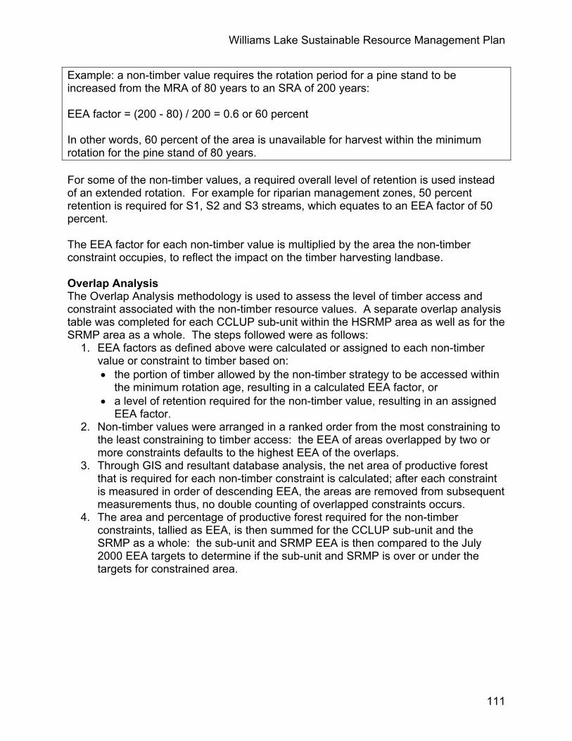
Williams Lake Sustainable Resource Management Plan
111
Example: a non-timber value requires the rotation period for a pine stand to be increased from the MRA of 80 years to an SRA of 200 years: EEA factor = (200 - 80) / 200 = 0.6 or 60 percent In other words, 60 percent of the area is unavailable for harvest within the minimum rotation for the pine stand of 80 years. For some of the non-timber values, a required overall level of retention is used instead of an extended rotation. For example for riparian management zones, 50 percent retention is required for S1, S2 and S3 streams, which equates to an EEA factor of 50 percent. The EEA factor for each non-timber value is multiplied by the area the non-timber constraint occupies, to reflect the impact on the timber harvesting landbase. Overlap Analysis The Overlap Analysis methodology is used to assess the level of timber access and constraint associated with the non-timber resource values. A separate overlap analysis table was completed for each CCLUP sub-unit within the HSRMP area as well as for the SRMP area as a whole. The steps followed were as follows:
1. EEA factors as defined above were calculated or assigned to each non-timber value or constraint to timber based on: • the portion of timber allowed by the non-timber strategy to be accessed within
the minimum rotation age, resulting in a calculated EEA factor, or • a level of retention required for the non-timber value, resulting in an assigned
EEA factor. 2. Non-timber values were arranged in a ranked order from the most constraining to
the least constraining to timber access: the EEA of areas overlapped by two or more constraints defaults to the highest EEA of the overlaps.
3. Through GIS and resultant database analysis, the net area of productive forest that is required for each non-timber constraint is calculated; after each constraint is measured in order of descending EEA, the areas are removed from subsequent measurements thus, no double counting of overlapped constraints occurs.
4. The area and percentage of productive forest required for the non-timber constraints, tallied as EEA, is then summed for the CCLUP sub-unit and the SRMP as a whole: the sub-unit and SRMP EEA is then compared to the July 2000 EEA targets to determine if the sub-unit and SRMP is over or under the targets for constrained area.
Copyright © 2022 FDOKUMEN