Westward Ho! Indo-aryans. Panjnad and Saptasindhu -- five and seven rivers --navigation channels of...
51
1 Westward Ho! Indo-aryans. Panjnad and Saptasindhu -- five and seven rivers --navigation channels of 3rd millennium BCE, of Pañcanjanah five peoples, Meluhha seafaring merchants The context is geographic, hydrology studies of northwest Bhāratam, archaeo-metallurgical evidence of Ancient Near East and Indus Script Corpora which validate the metalwork of mleccha (meluhha) seafaring merchants and artisans -- a group of Indo-aryans of Indian sprachbund called bhāratam janam, lit.'metalcaster folk'. Mleccha (meluhha), Proto- Prākritam was parole, vernacular speech (vāk) evidenced in hieroglyphs of Indus Script Corpora which deploy rebus-metonymy layered cipher for Meluhha speech; while chandas of Rigveda was literary, prosodic Samskritam by philosphers of fire and of knowledge systems. The monograph also reinforces the imperative of further PIE/IE studies based on this reality and trade/cultural contacts of Meluhha (Indo-aryans) in Tocharian-speaker areas and Ancient Near East: Westward Ho! of migrations of Meluhhan group of Meluhha metalcasters called bhāratam janam into Ancient Near East as Meluhha seafaring merchants. This monograph validates the evidence and views of Shrikant G. Talageri (2000, 2008) and Nicholas Kazanas (2012) on the westward migration of Indoaryans and relative early chronology of Vedic diction. Shrikant G. Talageri, 2008, Rigveda and the Avesta: The final evidence, Delhi, Aditya Prakashan http://ancientvoice.wikidot.com/article:rigveda-and-avesta-the-final-evidence Shrikant G. Talageri, 2000, Rigveda: A historical Analysis, Delhi, Voice of India. http://www.trueindianhistory.org/ppt/History%20of%20Rigveda.pdf
-
Upload
independent -
Category
Documents
-
view
1 -
download
0
Transcript of Westward Ho! Indo-aryans. Panjnad and Saptasindhu -- five and seven rivers --navigation channels of...
1
Westward Ho! Indo-aryans. Panjnad and Saptasindhu -- five and seven
rivers --navigation channels of 3rd millennium BCE, of Pañcanjanah
five peoples, Meluhha seafaring merchants
The context is geographic, hydrology studies of northwest Bhāratam, archaeo-metallurgical
evidence of Ancient Near East and Indus Script Corpora which validate the metalwork of
mleccha (meluhha) seafaring merchants and artisans -- a group of Indo-aryans of
Indian sprachbund called bhāratam janam, lit.'metalcaster folk'. Mleccha (meluhha), Proto-
Prākritam was parole, vernacular speech (vāk) evidenced in hieroglyphs of Indus Script Corpora
which deploy rebus-metonymy layered cipher for Meluhha speech; while chandas of Rigveda
was literary, prosodic Samskritam by philosphers of fire and of knowledge systems.
The monograph also reinforces the imperative of further PIE/IE studies based on this reality and
trade/cultural contacts of Meluhha (Indo-aryans) in Tocharian-speaker areas and Ancient Near
East: Westward Ho! of migrations of Meluhhan group of Meluhha metalcasters called bhāratam
janam into Ancient Near East as Meluhha seafaring merchants.
This monograph validates the evidence and views of Shrikant G. Talageri (2000, 2008) and
Nicholas Kazanas (2012) on the westward migration of Indoaryans and relative early chronology
of Vedic diction.
Shrikant G. Talageri, 2008, Rigveda and the Avesta: The final evidence, Delhi, Aditya Prakashan
http://ancientvoice.wikidot.com/article:rigveda-and-avesta-the-final-evidence
Shrikant G. Talageri, 2000, Rigveda: A historical Analysis, Delhi, Voice of India.
http://www.trueindianhistory.org/ppt/History%20of%20Rigveda.pdf

2
Satellite image map overlayed with site indicators clearly evidences flusters of sites along the
Vedic River Sarasvati flowing from the foothills of Himalayas into Rann of Kutch sites, Bet
Dwarak and sites of Saurashtra in Gujarat. This riverine navigable channel together with the
Persian Gulf facilitated navigation by seafaring Meluhha merchants of Sarasvati-Sindhu (Hindu)
civilization transacting with interaction areas in Makan, Dilmun, Mesopotamia/Sumer/Elam and
beyond through Tigris-Euphrates river navigation into the Mediterrarean (Haifa, Israel).
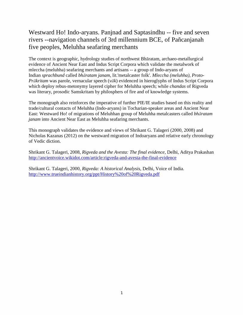
Panjnad, Punjab
"Panjnad River (Urdu/Punjabi Shahmukhi: دنجنپ, Punjabi Gurmukhi ) (panj = five, nadi
= river) is a river at the extreme end of Bahawalpur district in Punjab, Pakistan. Panjnad River is
formed by successive confluence of the five rivers of Punjab,
namely Jhelum, Chenab, Ravi, Beas and Sutlej. Jhelum and Ravi join Chenab, Beas joins Sutlej,
and then Sutlej and Chenab join to form Panjnad 10 miles north of Uch Sharif, lit. 'holy high
place' in Bahawalpur district. The combined stream runs southwest for approximately 45 miles
and joins Indus River at Mithankot. The Indus continues into the Arabian
Sea." http://en.wikipedia.org/wiki/Panjnad_River A dam constructed in 1925, on the Panjnad just
after the Sutlej’s junction with the Chenāb is part of the Sutlej Valley (irrigation) Project. It

3
provides irrigation channels for Punjab and Sindh provinces south of the Sutlej and east of the
Indus rivers.
Harappa is an archaeological site on the westbank of Ravi river.
The 400 archaeological sites of Cholistan of Bahawalpur province, explored by Rafique Mughal
are watered NOT by the Panjnad or Sutlej but by Hakra river, an extension of Ghaggar flowing
from Thar desert (Marusthali). This Hakra river which flowed into Arabian Sea, is now dry. The
archaeological sites of Cholistan were continuously inhabited from 4th millennium BCE, thus
constituting an Early Sarasvati-Sindhu (Hindu) civilization area.
Bahawalpur, Pakistan is on the present-day channel of Sutlej River before river joins Panjnad
river. Source: http://manaz.8m.net/
4
Panjnad river (before it joins River Sindhu) is joined by five rivers (hence, the name panjnad lit.
'five rivers'): the five rivers are from east to west: Sutlej, Beas, Ravi, Chenab, Jhelum [which in
Rigveda are called: S'utudri (Sutlej), Vipasa (Beas), Asikni (Chenab), Parus'ni (Ravi), Vitasta
(Jhelum).]
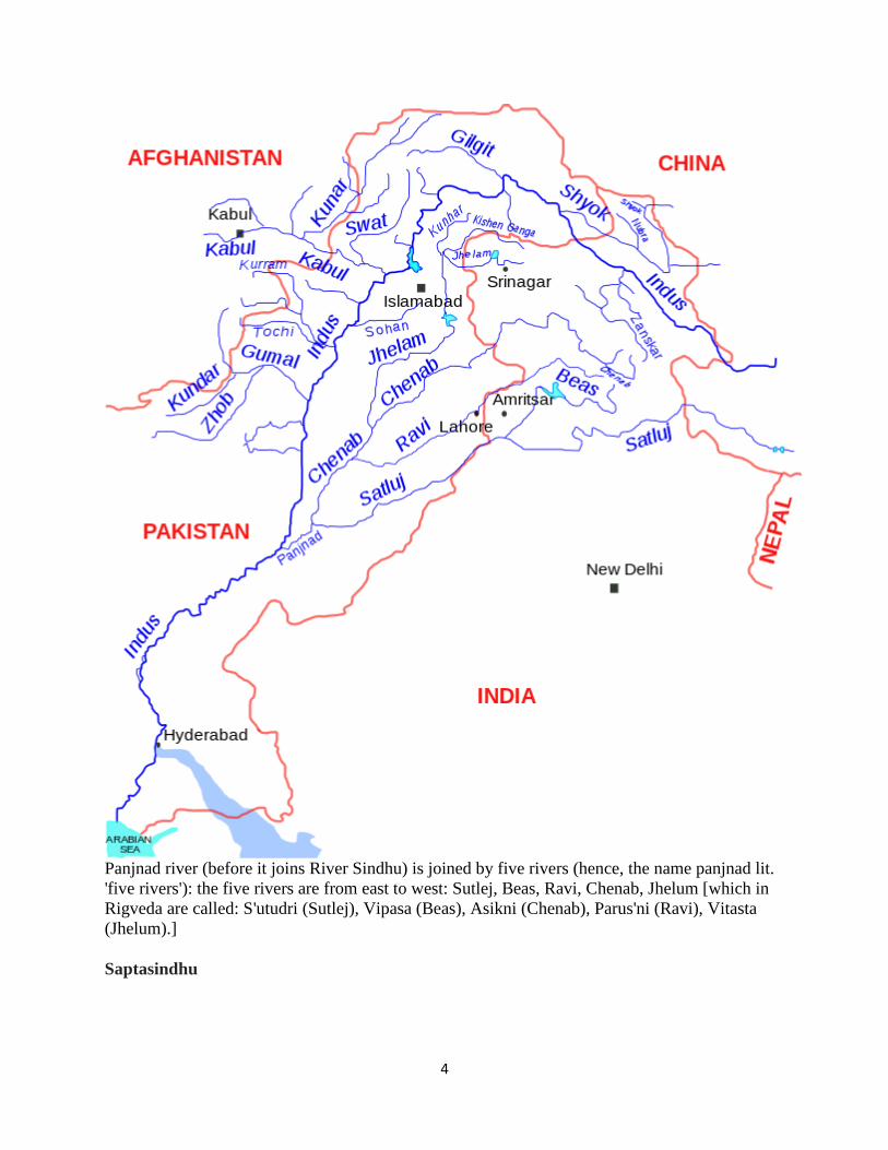
Saptasindhu
5
Map of Sapta Sindhu (Nation of Seven Rivers): Theatre of Panchajanaah, Five Peoples by
Marius Fontane, 1881, Histoire Universelle, Inde Vedique (de 1800 a 800 av. J.C.), Alphonse
Lemerre, Editeur, Paris Source: http://www.newsnfo.co.uk/images/saptasindhu.jpg
The expression used in vedic texts sapta-sindhu or sapta-sindhavah lit. sapta (“seven”)
and sindhu (“streams or rivers”) gave rise to the glosses recognized historically: Indus and Hindu
6
(RV 2.12; RV 4.28; RV 8.24). A cognate is Avestan hapta həndu. This expression suggests that
in Rigvedic times the Punjab (or Panjnad) as we know it today did not exist.
In RV 6.61.10, Sarasvati is called "she with seven sisters" (saptasvasā) indicating that the eighth
river may be Drishadvati.or Apaya (RV 3.23.4, Mahabharata Apaga.)
What existed was a region watered by seven rivers (sapta-sindhu) which, in addition to the five
rivers of S'utudri (Sutlej), Vipasa (Beas), Asikni (Chenab), Parus'ni (Ravi), Vitasta
(Jhelum), included Sindhu river in the west and Sarasvati river in the east.
Rigveda refers to three rivers, naming Sindhu, Sarasvati and Sarayu, thus clearly distinguishing
Sindhu and Sarasvati apart from other five rivers: S'utudri (Sutlej), Vipasa (Beas), Asikni
(Chenab), Parushni (Ravi), Vitasta (Jhelum)
Let the great streams come hither with their mighty help, Sindhu, Sarasvati, and Sarayu
with waves. Ye Goddess Floods, ye Mothers, animating all, promise us water rich in fatness and
in balm. (RV 10.64.9)
Rigveda refers to Sarasvati as Sindhumaataa, mother of rivers: आ यत य त त त | य य त य य || aa yata
saakam yazaso vaavas'aanaah sarasvatii saptathii sindhumaataa yaah sushvayanta sudhaaraa abhi
savena payasaa peepyamaanaah (RV 7.36.6) Trans. May the seventh (stream), Sarasvati, the
mother of the Sindhu and those rivers that flow copious and fertilizing, bestowing abundance of
food, and nourishing (the people) by their waters, come at once together.
This is an elucidation of Sarasvati as the best of rivers: ambitame naditame devitame sarasvati
apras’astA iva smas’I pras’astim amba nas krudhi (RV. 2.41.16) best of mothers ... best of rivers
... give us fame, recognizing that we are without fame. Ascertaining the wishes of the great sages
the best of rivers (the Saras vati) incorporated AruNA with her own body; formerly the flow (of
the AruNA) was hidden. Afterwards (the Sarasvati) inundated the divine AruNA wih its own
waters.
य त त त त य | य त तय य य य || Trans. Favour ye this my laud, O Ganga, Yamuna, O Sutudri, Parushni and
Sarasvati (RV 10.75.5)
With Asikni, Vitasta, O Marudvrdha, O Arjikiya with Susoma hear my call.(RV 10.75)
Vishnu Purana mentions Drishadwati, Vipasa, Iravati, Vitasta: Bahuda 6; the
satadru, Chandrabhaga, and great river Yamuna; the Drishadwati 7, Vipasa 8, and Vipapa, with
coarse sands; the Vetravati, the deep Krishnaveni, the Iravati 9, Vitasta 10, Payoshni 11, (VP
2.3)
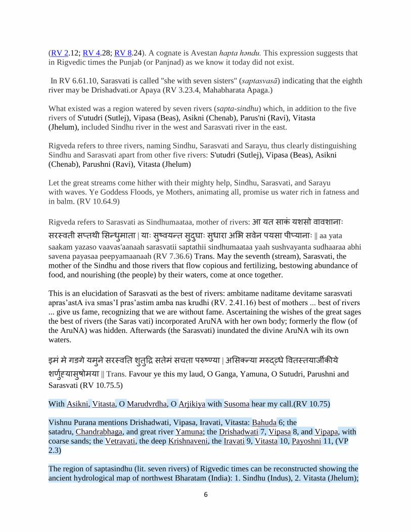
The region of saptasindhu (lit. seven rivers) of Rigvedic times can be reconstructed showing the
ancient hydrological map of northwest Bharatam (India): 1. Sindhu (Indus), 2. Vitasta (Jhelum);
7
3. Asikni (Chenab); 4. Parus'ni or Airavati (Ravi); 5. Vipasa (Beas); 6. S'utudri (Sutlej); 7.
Sarasvati. (Map after KS Valdiya, 1996)
Consistent with the explanation of Bharatam Janam as lit. 'metalcaster folk' who lived in the
region of seven rivers, the people are divided into 5 categories of artisans or metalworkers:
goldsmith, blacksmith, engraver, carpenter, smelter, as attested in a Tamil gloss:
pañca-kammāḷar, n. < pañcantaṭṭāṉ, kaṉṉāṉ, ciṟpaṉ, taccaṉ, kollaṉ;
, , ,
. ( . அ .)(Tamil)
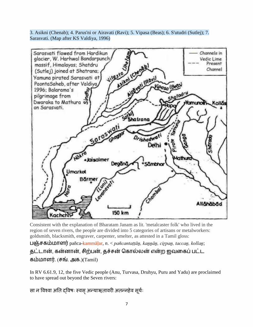
In RV 6.61.9, 12, the five Vedic people (Anu, Turvasa, Druhyu, Puru and Yadu) are proclaimed
to have spread out beyond the Seven rivers:
त य त त य
8
saa na vizvaa ati dvishah svasR anyaa RtaavarI atannaheva suuryah
Trans. She (Sarasvati) has spread us all beyond the other (7) sister (-rivers) as the sun spreads
out days. (RV 6.61.9,12)
Five Vedic people expanding beyond Saptasindhu (After Fig.2 Nicholas Kazanas, Rigvedic all-
comprehensiveness,"...George Dales published in 1966 his seminal article showing that there had
never been an invasion nor fighting and destruction in Saptasindhu. All expert archaeologists of
the ISC (=Indus-sarasvati civilisation) insist now on the unbroken continuity of the culture
there...As we saw earlier RV 6.1.9,12 says: The five tribes spread beyond the Seven Rivers.
Other hymns state that the sages and their ancestors had always been 'here' (Angiras family 4.1.3;
Vasishtha 7.76.4). And the vast Vedic corpus does not contain one single reference to an
immigration, not one memory of a different previous habitat unlike the Hebrews who, in their
Old Testament, record previous homelands, sojourns into other lands and other people met on the
way to their historical habitat. On the contrary, apart from Rigvedic references of Aryan sages
and laws spreading abroad, Baudhayana Srautasutra 18.14 says, there were two migrations of the
Aryans: the eastern one called Ayava moving into the Gangetic plains and further; the western
one Amavasa engendering the Gandharis, Parsus (=Persians) and Arattas (=people of Ararat, by
the Black sea, or Urartu, just south of Ararat). Note, that the Iranians record in Avesta that they
had passed from Haptahendu (=Saptasindhu) and Haraxvaiti (=Sarasvati) whereas the Indo-
Aryans do not mention any travel from Iran into Saptasindhu, nor, more important, from
northwestern regions into Iran. Back in 1997 Joahna Nichols, an accomplished linguist and by no
means a supporter of Indo-Aryan indigenism, had calculated on linguistic types of evidence
(loanwords, isoglosses etc.) that the area of dispersal was in Bactria. She probably would be very
pleased to know that Vedic and Avestan literary sources provide historical evidences as well for
her conclusions. Yes, from Saptasindhu proper the Indo-Aryans spread west and north but it was
from Bactria, the much wider Saptasindhu, that they dispersed even farther." (p.21, pp.34-
35) http://www.sanskrit.nic.in/svimarsha/v6/c2.pdf
9
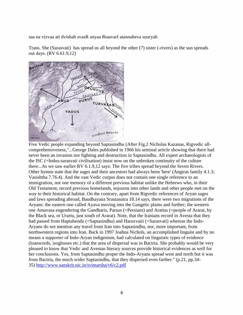
Indoaryan migrations, eastward and westward. After Fig. 5 Nicholas Kazanas ibid.
https://www.scribd.com/doc/264009611/Rgvedic-All-comprehensiveness-Nicholas-Kazanas-
2012
pañcan num. a. (Always pl., nom. and acc. ) Five. 1 a man, man- kind. -2 N.
of a demon who had assumed the form of a conch-shell, and was slain by Kṛiṣṇa; त त त Bhāg.3.3.2. -3 the soul. -4 the five classes of beings; i. e. gods, men,
Gandharvas, serpents and pitṛis; य आ त त Bṛi. Up.4.4.17. -
5 the four primary castes of the Hindus ( , य, य and ) with the Niṣādas or
barbarians as the fifth (pl. in these two senses); (for a full exposition see Sārirabhāṣya on Br.
Sūtras 1.4.11-13) (TS. S'Br.). (- ) an assemblage of five persons. - a. devoted to the five
races. (- ) an actor, a mimic, buffoon, one who is devoted to the pentad viz. singer, musician,

10
dancer, harlot and a jester; य - त त Bhāsāvritti on
P.V.1.9. (Samskritam.Apte) 'five elements'; 'assemblage of 5 persons' (Monier-
Williams, p.576).
hinduḥ also . N. of the people of Hindusthan or Bhāratavarṣa. The name appears
to have been derived from Sindhu, the name of the celebrated river where the Vedic Āryans
recited their Vedic mantras. In the Avesta is pronounced as ; so was pronounced
by the Persians as त . The Bhaviṣya-Purāṇa speaks of त . Here are a few references
in a few Kośas and the Purāṇas :- (1) The Kālikā-Purāṇa says, " त । य त य ॥" (2) The Merutantra of the 8th century A. D.--
" त य त त । य य य यत य ॥" (3) The
Rāmakośa--" त य । त य ॥" (4)
The Hemantakavikośa-- " य त त " (5) The Adbhutarūpakośa--
" ।"
"Beyond the confluence of Indus and Panjnad rivers, the Indus river was known as Satnad (Sat =
seven) carrying the waters of seven rivers including Indus river, which is believed to be in earlier
times the Saraswati/Ghaggar/Hakra river which eventually dried and became a seasonal river due
to seismic shifts in the glacial region of Himachal Pradesh where it originated and later on Kabul
river and the five rivers of Punjab".http://en.wikipedia.org/wiki/Panjnad_River
The chronological changes in the hydrology of Northwest Bharatam related to the seven rivers
have been subjected to many geological, glaciological and archaeological studies.
The consensus which emerges is that a little earlier than ca. 5000 Before Present, a series of plate
tectonic events resulted in river migrations: First, eastward migration of Yamuna due to Yamuna
tear caused by the lateral shift in Siwalik ranges and transfer of Bata valley (Sarasvati waters
from Tamasa-Giri tributaries) waters into Yamuna; second, westward migration of Sutlej at
Ropar and gradual depletion in flowsx of glacier waters into Sarasvati River (Ghaggar-Hakra-
Nara-Wahind channels).
Until the final shift of Sutlej river migration westwards from Ropar towards Panjnad and Sindhu
occurred (i.e. ca. 5000 BP), there were navigable channels available on the Sarasvati River
system to facilitate transactions by seafaring Meluhha merchants from sites such as Harappa,
Rakhigarhi, Ropar, Banawali, Kalibangan, Bhirrana, Dholavira, Khirsara, Surkota, Kanmer,
Shikarpur, Bet Dwarka, Ganweriwala, c. 400 Cholistan sites (on the banks of Ghaggar-Hakra),
Chanhudaro, Mohenjo-daro, Lothal.
11
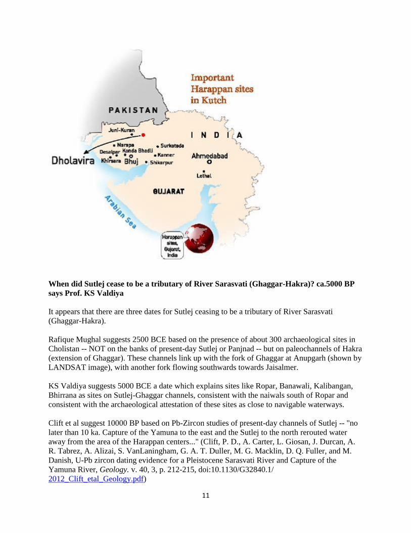
When did Sutlej cease to be a tributary of River Sarasvati (Ghaggar-Hakra)? ca.5000 BP
says Prof. KS Valdiya
It appears that there are three dates for Sutlej ceasing to be a tributary of River Sarasvati
(Ghaggar-Hakra).
Rafique Mughal suggests 2500 BCE based on the presence of about 300 archaeological sites in
Cholistan -- NOT on the banks of present-day Sutlej or Panjnad -- but on paleochannels of Hakra
(extension of Ghaggar). These channels link up with the fork of Ghaggar at Anupgarh (shown by
LANDSAT image), with another fork flowing southwards towards Jaisalmer.
KS Valdiya suggests 5000 BCE a date which explains sites like Ropar, Banawali, Kalibangan,
Bhirrana as sites on Sutlej-Ghaggar channels, consistent with the naiwals south of Ropar and
consistent with the archaeological attestation of these sites as close to navigable waterways.
Clift et al suggest 10000 BP based on Pb-Zircon studies of present-day channels of Sutlej -- "no
later than 10 ka. Capture of the Yamuna to the east and the Sutlej to the north rerouted water
away from the area of the Harappan centers..." (Clift, P. D., A. Carter, L. Giosan, J. Durcan, A.
R. Tabrez, A. Alizai, S. VanLaningham, G. A. T. Duller, M. G. Macklin, D. Q. Fuller, and M.
Danish, U-Pb zircon dating evidence for a Pleistocene Sarasvati River and Capture of the
Yamuna River, Geology. v. 40, 3, p. 212-215, doi:10.1130/G32840.1/
2012_Clift_etal_Geology.pdf)

12
We seem to be dealing with two plate tectonic events here: 1. eastward shift of Yamuna caused
by the Yamuna-tear by lateral shift on Siwalik ranges; 2. wesward 90-degree shift of Sutlej at
Ropar. Maybe, the two events occurred on two different dates, with the Yamuna-tear occurring
at an earlier date, maybe 10 ka. But, the date of Ropar 90-degree shift seems to be a date later
than 10 ka.
This surmise is based on the fact that there are NO archaeological sites on the present-day
channel of Sutlej west of Ropar, but there are archaeological sites of the riverine civilization 1.
south of Ropar -- sites such as Ropar, Banawali, Kalibangan, Bhirrana, Ganweriwala; and along
Ghaggar-Hakra paleochannel in Cholistan, over 300 archaeological sites identified by Rafique
Mughal which are NOT on the banks of the present-day channels of Sutlej or Panjnad. It also
appears that the riverine/seafaring contacts with Mesopotamia across the Persian Gulf ceased
after Sutlej waters gradually shifted westwards at Ropar and finally ceased flowing into Sarasvati
River (Ghaggar-Hakra), ca. 2000 BCE
The argument and evidence
Yashpal et al studied the LANDSAT imagery of palaeochannels (Refer – “Remote sensing of the
Lost Sarasvati River (1980)” and deciphered these as under :-
[Present river system and the major palaeochannels as deciphered from LANDSAT imagery
(after YashPal et at-1980)]– pg 123 of Memoir 42 of GSI, Bangalore.
The study led to the description of present drainage system and palaeochannels of Sarasvati and
its tributaries and it supported the following conclusions :-
(i) The Sutlej once flowed into the present Ghaggar (Sarasvati) river bed and was probably
joined by the Yamuna.
13
(ii) The Sutlej has a sharp westward right-angled bend near Ropar suggestive of its diversion due
to change in the river course.
(iii) There is a sudden widening of narrow Ghaggar valley at Shatrana (25 Km south of Patiala)
indicative of a major river joining Ghaggar bed here.
(iv) Another channel which corresponds to the Drishadvati (present Chautang) joins Sarasvati
(Ghaggar) near Suratgarh.
(v) That the Yamuna probably flowed into the ancient Sarasvati before joining Ganga through
Chambal.
(vi) Physiographically, there is depression westward (elevation less than 230 m msl) and a
corresponding uplift eastward (elevation more than 250 m msl) of the old Sutlej bed, which
might have forced its westward migration.
(vii) Near Anupgarh Sarasvati bifurcates and both channels come to an abrupt end at Marot and
Beriwala (in Bahawalpur Distt of Pakistan) from where Sarasvati is likely to have extended
through the Hakra/Nara bed to the present Runn of Kachchh.

14
Landsat image showing the bifurcation of River Sarasvati at Anupgarh -- one channel flowing
westward into Bahawalpur province and paleochannel flowing southwards towards Jaisalmer.
4.13: Palaeo-drainage map of Thar desert region using IRS P3 WiFS satellite image

15
4.16: Simplified map of Vedic Saraswati River from Manasarovar to Dwarka in northwest India
NEARCHUS reconstructed the Water Network Map of Hakra Channel (Yamuna-Sarasvati-
Sultej) in 1875 as under after conducting extensive geographical/geophysical surveys.

16
[Reconstruction of water network in the region of the Hakra channel (Yamuna-Sarasvati-Sutlej)-
1874 – pg. 101 of Memoir 42 of GSI,Bangalore.
Thus, even in 1874 when drainage and palaeochannels network was reconstructed on the basis of
geological surveys, Sutlej and Drishadvati were shown as the tributaries of Sarasvati, whereas
Ghaggar and Hakra were described as its dried up palaeochannels, corroborating the satellite
imagery.
Archaeological Finds :
Archaeological excavations and research reports further corroborate the geological findings and
satellite imagery. More than 1200 ancient settlements on Sarasvati river basin have been dug out
giving clinching evidence of existence of a mighty river, which sustained maritime civilization
and metal-based economy prior to 3000 BC (S.Kalyanaraman in journal of Geological Society of
India No.42, 1`999 PP 25-33). It has been concluded that it was possible to travel on the
Sarasvati river from the gulf of Khambat to Mathura via Lothal, Dholavira, Granweriwala,
Kalibangan, Banawali, Paonta-Doon, Rakhigarhi and Indraprastha. Based on the evidence
gathered through exacavations, the Arachaeologists have concluded that between 7000 BC to
2500 BC an advanced civilization, vedic in nature, was flourishing along Sarasvati and Indus
rivers. When Sarasvati started drying up, Vedic Aryans moved towards west beyond Indus, east

17
beyond Ganges & south beyond Godavari. It was the continuation of Sarasvati-Indus
Civilization, which was given the name ‘Harappan’ probably because the first town excavated
was Harappa. Archaeological Survey of India has dug out more than 2400 settlements at the
ancient Indus-Sarasvati river basins but no ancient settlements have been found along the present
day course of Sutlej (west of Ropar).
As per V.S.Wakankar, who is known as ‘Bhisham Pitamah’ of Archaeology, extensive
excavations carried out by the Archaeological Survey of India have revealed that :
(i) Harappan and Pre-Harappan Civilizations developed along ancient Sarasvati and therefore
these may be more appropriately described as part of Sarasvati-Indus Civilizations.
(ii) Most of the Rishi Ashrams described in Ramayana and Mahabharata were lined along
Sarasvati river.
(iii) Perforated pottery jars and fire altars (µÖ–Ö•ãÓ›) are found in most of the 1200
settlements excavated along Sarasvati river indicating that civilization which flourished was
vedic.
(iv) Land was fertile and barley etc were cultivated in the Sarasvati region even 7000 years back
and same style of cultivating the fields continues till date in areas like Rajasthan & Haryana.
[Atharvaved (6:30:1)]
(v) It is unhistoric and unscientific to say that Vedic Aryans migrated from any other region to
India. They belonged to India & compiled Vedas in settlements along Sarasvati River.
The same culture and civilization continues till date, as has been convincingly described by Dr.
B.B.Lal, Director General (Retd.) of Archaeological Survey of India, in his book “The Sarasvati
Flows on – the continuity of Indian Culture”.
http://factsfootprint.blogspot.in/2012/09/mystery-of-sarsavati-river-missing-
of.html

18
Sarasvati river sites in North India (Punjab and Haryana)

19
Sarasvati River sites in Bahawalpur Province (Mughal, 1984, p.515)
The Cemetery H related sites of the late Harappan period in Cholistan (circa 2000-1500 BCE)
http://bharatkalyan97.blogspot.in/2015/04/drishadvati-ghaggar-hakra-river.html Drishadvati-
Ghaggar-Hakra River archaeological evidence points to ca. 2500 BCE as the start date for the
desiccation of Vedic River Sarasvati
20
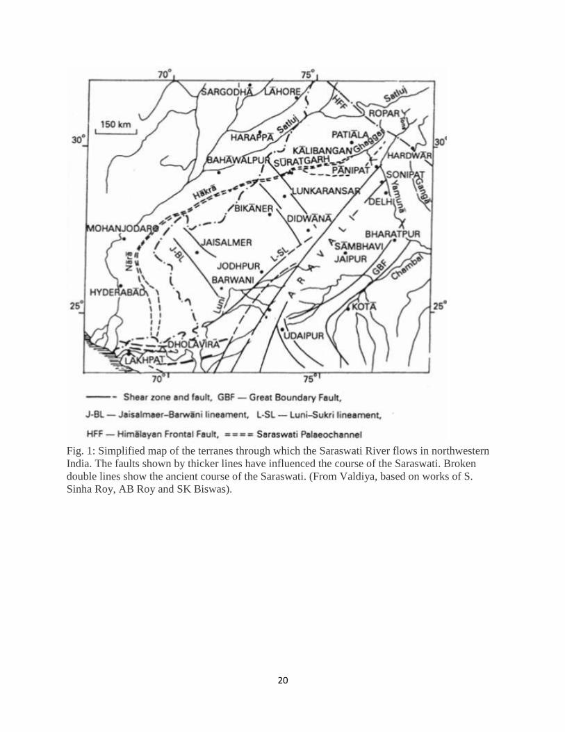
Fig. 1: Simplified map of the terranes through which the Saraswati River flows in northwestern
India. The faults shown by thicker lines have influenced the course of the Saraswati. Broken
double lines show the ancient course of the Saraswati. (From Valdiya, based on works of S.
Sinha Roy, AB Roy and SK Biswas).
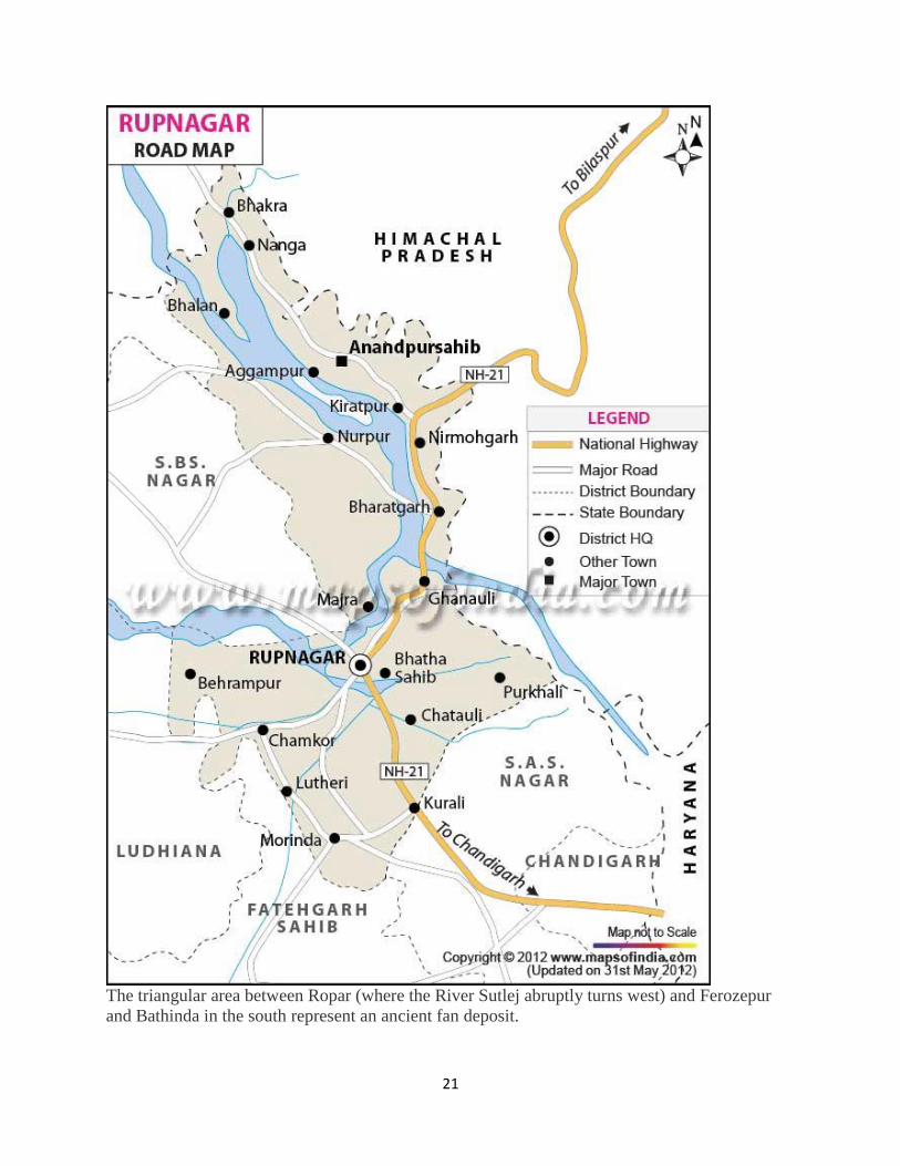
21
The triangular area between Ropar (where the River Sutlej abruptly turns west) and Ferozepur
and Bathinda in the south represent an ancient fan deposit.
22
Evidence for Sutlej-Sarasvati as a Himalayan river system. Visit Ropar. A suggestion to Liviu
Giosan et al.
From tectonically to erosionally controlled development of the Himalayan orogen
Thiede et al. Geology 2005 33 (8), p. 689
Rasmus C. Thiede, J Ramon Arrowsmith, Bodo Bookhagen, Michael O McWilliams, Edward R.
Sobel and Manfred R. Strecker Geology 2005; 33; 689-692, The Geological Society of America
Abstract
Whether variations in the spatial distribution of erosion influence the location, style, and
magnitude of deformation within the Himalayan orogen is a matter of debate…The locus of
pronounced exhumation defined by the apatite fission-track (AFT) data correlates with a region
of high precipitation, discharge, and sediment flux rates during the Holocene. This correlation
suggests that although tectonic processes exerted the dominant control on the denudation pattern
before and until the middle Miocene; erosion may have been the most important factor since the
Pliocene…
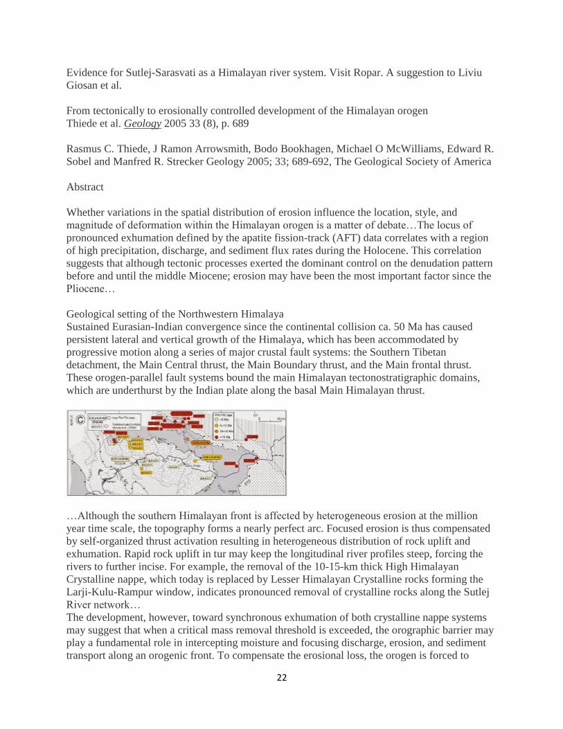
Geological setting of the Northwestern Himalaya
Sustained Eurasian-Indian convergence since the continental collision ca. 50 Ma has caused
persistent lateral and vertical growth of the Himalaya, which has been accommodated by
progressive motion along a series of major crustal fault systems: the Southern Tibetan
detachment, the Main Central thrust, the Main Boundary thrust, and the Main frontal thrust.
These orogen-parallel fault systems bound the main Himalayan tectonostratigraphic domains,
which are underthurst by the Indian plate along the basal Main Himalayan thrust.
…Although the southern Himalayan front is affected by heterogeneous erosion at the million
year time scale, the topography forms a nearly perfect arc. Focused erosion is thus compensated
by self-organized thrust activation resulting in heterogeneous distribution of rock uplift and
exhumation. Rapid rock uplift in tur may keep the longitudinal river profiles steep, forcing the
rivers to further incise. For example, the removal of the 10-15-km thick High Himalayan
Crystalline nappe, which today is replaced by Lesser Himalayan Crystalline rocks forming the
Larji-Kulu-Rampur window, indicates pronounced removal of crystalline rocks along the Sutlej
River network…
The development, however, toward synchronous exhumation of both crystalline nappe systems
may suggest that when a critical mass removal threshold is exceeded, the orographic barrier may
play a fundamental role in intercepting moisture and focusing discharge, erosion, and sediment
transport along an orogenic front. To compensate the erosional loss, the orogen is forced to

23
internally reorganize, and therefore erosion may control the distribution of exhumation and rock
uplift. For the past 10 m.y., the Himalayan deformation front has migrated only 20-50 km.
southward. Therefore internal rock uplift and focused exhumation concentrated orogenic
deformation in this internal sector, rather than propagating the deformation front southward.
Read the full text pdf document
here:https://drive.google.com/file/d/0B4BAzCi4O_l4bXFJREpFSjR6VU0/edit?usp=sharing
Sutlej Valley from Rampur c. 1857
In the early 18th century, it was used to transport devdar woods for Bilaspur district, Hamirpur
district, and other places along the Sutlej's banks.
The Sutlej, along with all of the Punjab rivers, is thought to have drained east into
the Ganges prior to 5 mya. There is substantial geologic evidence to indicate that prior to 1700
BC, and perhaps much earlier, the Sutlej was an important tributary of the Ghaggar-Hakra
River (thought to be the legendary Sarasvati River) rather than the Indus, with various authors
putting the redirection from 2500-2000 BC,( Mughal, M. R. Ancient Cholistan. Archaeology and
Architecture. Rawalpindi-Lahore-Karachi: Ferozsons 1997, 2004) from 5000-3000
BC,( Valdiya, K. S., in Dynamic Geology, Educational monographs published by J. N. Centre
for Advanced Studies, Bangalore, University Press (Hyderabad), 1998.) or before 8000
BC.( Clift et al. 2012. "U-Pb zircon dating evidence for a Pleistocene Sarasvati River and capture
of the Yamuna River." Geology, v. 40. [2]) Geologists believe that tectonic activity created
elevation changes which redirected the flow of Sutlej from the southeast to the southwest.( K.S.
Valdiya. 2013. "The River Saraswati was a Himalayan-born river". Current Science 104 (01). ) If
the diversion of the river occurred recently (about 4000 years ago), it may have been responsible
for the Ghaggar-Hakra (Saraswati) drying up, causing desertification of Cholistan and the eastern
part of the modern state of Sindh, and the abandonment of Harappan settlements along the
Ghaggar. However, the Sutlej may have already been captured by the Indus thousands of years
earlier.http://en.wikipedia.org/wiki/Sutlej
24
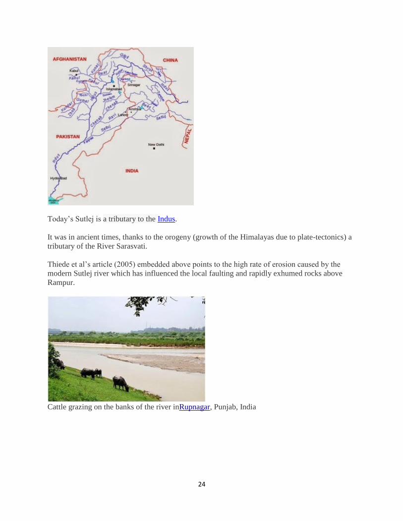
Today’s Sutlej is a tributary to the Indus.
It was in ancient times, thanks to the orogeny (growth of the Himalayas due to plate-tectonics) a
tributary of the River Sarasvati.
Thiede et al’s article (2005) embedded above points to the high rate of erosion caused by the
modern Sutlej river which has influenced the local faulting and rapidly exhumed rocks above
Rampur.
Cattle grazing on the banks of the river inRupnagar, Punjab, India

25
Crossing the Sutlej near Simla upon inflated animal skins
Sutlej river is 1,450 km. long, raising in the Manasarovar Kailas range, SW Tibet region. In the
Punjab it receives the Beas river and forms part of the Indo-Pakistan border and continues into
Pakistan.
Bhakra dam (229 m) impounds part of the water of Sutlej. The mean flow rate at Rupar is
approximately 500 cu m per sec, and the maximum is about 20,000 cu m per sec.
“Major irrigation canals from the Sutlej include the Dipalpur, Pakpattan, Panjnad, Sirhind, and
Bikaner canals. During floods, the canals carry 100 to 300 cu m of water per sec. During high
water, the Sutlej is navigable in some parts. The large Bhakra-Nangal hydraulic engineering
complex has been built in India at the point where the river emerges from the mountains. The
major cities on the Sutlej are Nangal and Phillaur in India and Bahawalpur in Pakistan.” (AP
Muranov). http://encyclopedia2.thefreedictionary.com/Sutlej+valley
Any study related to the history of evolution and secular desiccation of the River Sarasvati has to
take into account the migration of River Sutlej recorded at Ropar (Rupanagar).
Ropar is a very important archaeological site of Indus-Sarasvati civilization. A site museum is
also organized at this place and shoule be visited by any explorer or researcher evaluating the
causes for the ‘drying up’ of River Sarasvati .
26
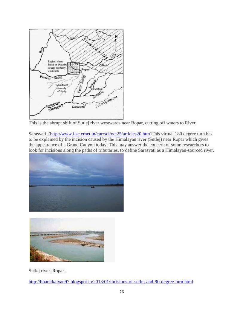
This is the abrupt shift of Sutlej river westwards near Ropar, cutting off waters to River
Sarasvati. (http://www.iisc.ernet.in/currsci/oct25/articles20.htm)This virtual 180 degree turn has
to be explained by the incision caused by the Himalayan river (Sutlej) near Ropar which gives
the appearance of a Grand Canyon today. This may answer the concern of some researchers to
look for incisions along the paths of tributaries, to define Sarasvati as a Himalayan-sourced river.
Sutlej river. Ropar.
http://bharatkalyan97.blogspot.in/2013/01/incisions-of-sutlej-and-90-degree-turn.html
27
JAN
16
Incisions of Sutlej and 90 degree turn at Ropar. Giosan et al should visit the Ropar
Archaeological museum
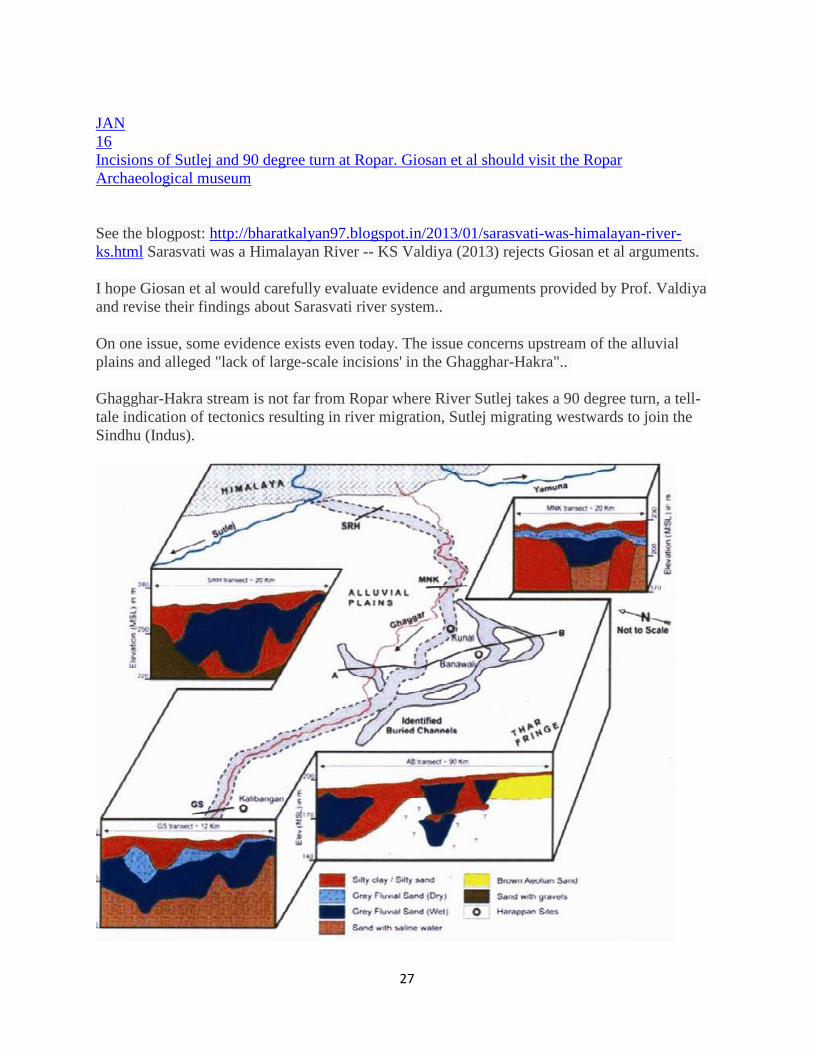
See the blogpost: http://bharatkalyan97.blogspot.in/2013/01/sarasvati-was-himalayan-river-
ks.html Sarasvati was a Himalayan River -- KS Valdiya (2013) rejects Giosan et al arguments.
I hope Giosan et al would carefully evaluate evidence and arguments provided by Prof. Valdiya
and revise their findings about Sarasvati river system..
On one issue, some evidence exists even today. The issue concerns upstream of the alluvial
plains and alleged "lack of large-scale incisions' in the Ghagghar-Hakra"..
Ghagghar-Hakra stream is not far from Ropar where River Sutlej takes a 90 degree turn, a tell-
tale indication of tectonics resulting in river migration, Sutlej migrating westwards to join the
Sindhu (Indus).
http://www.blogger.com/post-edit.g?blogID=3900879694651725760&postID=3256372995779691386&from=pencil
28
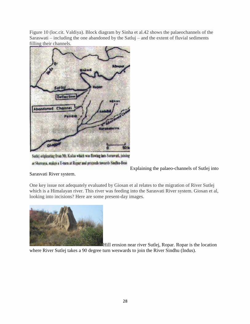
Figure 10 (loc.cit. Valdiya). Block diagram by Sinha et al.42 shows the palaeochannels of the
Saraswati – including the one abandoned by the Satluj – and the extent of fluvial sediments
filling their channels.
Explaining the palaeo-channels of Sutlej into
Sarasvati River system.
One key issue not adequately evaluated by Giosan et al relates to the migration of River Sutlej
which is a Himalayan river. This river was feeding into the Sarasvati River system. Giosan et al,
looking into incisions? Here are some present-day images.
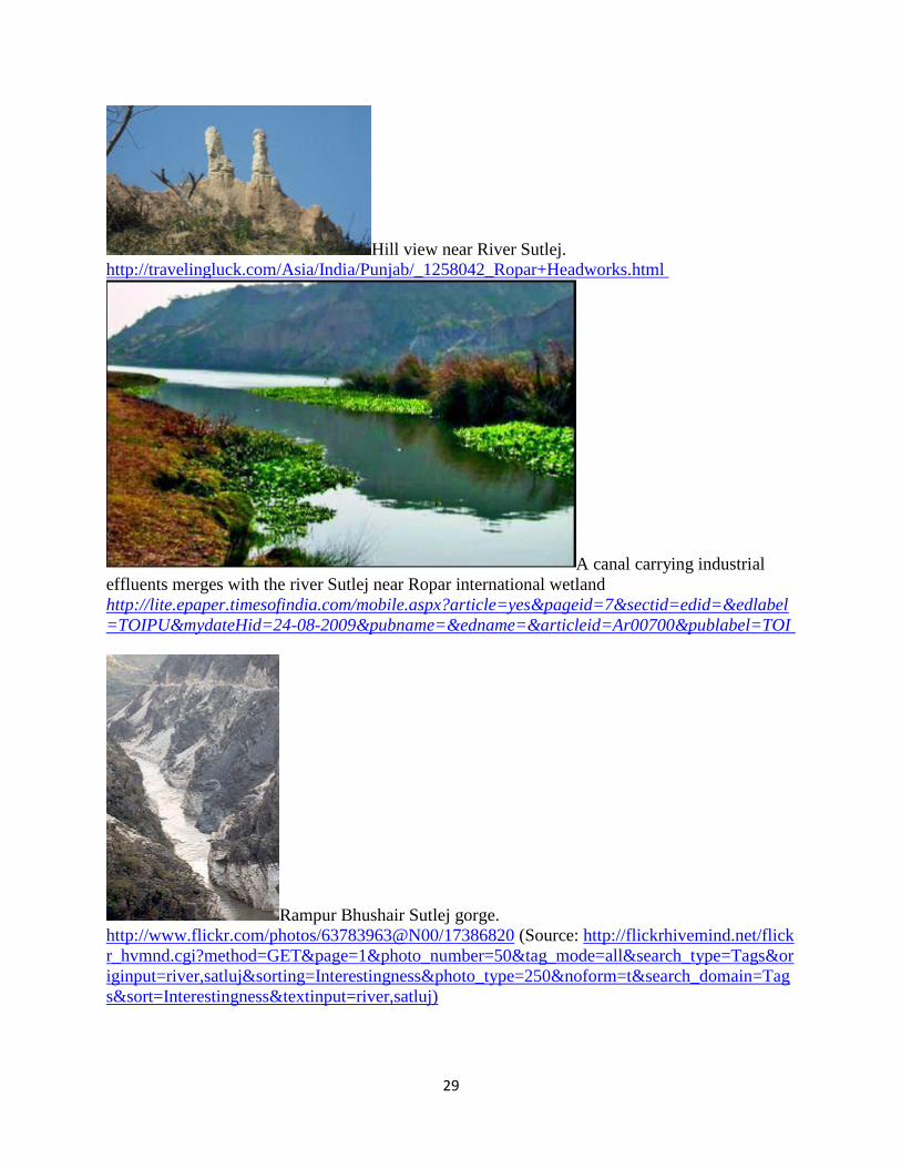
Hill erosion near river Sutlej, Ropar. Ropar is the location
where River Sutlej takes a 90 degree turn weswards to join the River Sindhu (Indus).
29
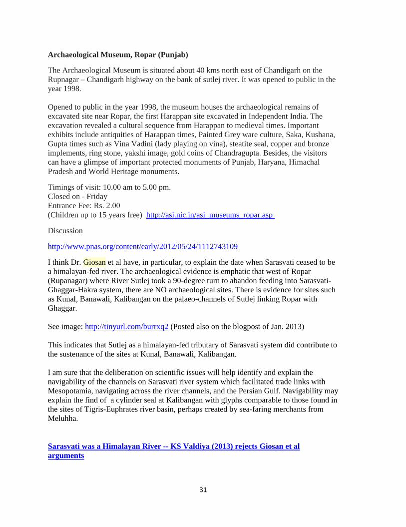
Hill view near River Sutlej.
http://travelingluck.com/Asia/India/Punjab/_1258042_Ropar+Headworks.html
A canal carrying industrial
effluents merges with the river Sutlej near Ropar international wetland
http://lite.epaper.timesofindia.com/mobile.aspx?article=yes&pageid=7§id=edid=&edlabel
=TOIPU&mydateHid=24-08-2009&pubname=&edname=&articleid=Ar00700&publabel=TOI
Rampur Bhushair Sutlej gorge.
http://www.flickr.com/photos/63783963@N00/17386820 (Source: http://flickrhivemind.net/flick
r_hvmnd.cgi?method=GET&page=1&photo_number=50&tag_mode=all&search_type=Tags&or
iginput=river,satluj&sorting=Interestingness&photo_type=250&noform=t&search_domain=Tag
s&sort=Interestingness&textinput=river,satluj)

30
Sutlej en route to
Powari. http://farm9.static.flickr.com/8002/7203725524_8c034b82a7_m.jpg
Giosan et al should visit the Ropar (Rupnagar) Archaeological Museum which celebrates Ropar
as a 'Harappan' site. Why did the river Sutlej take 90 degree turn here? Where was it flowing,
southwards before this 90 degree turn?
This museum at Ropar is a cute, beautiful museum. I would strongly urge all researchers of
Sarasvati River basin and study of Hindu civilization history should visit this Museum and see
the Indus script seals excavated from the site and kept there. The excavations were carried out
by Dr. Y.D. Sharma of the Archaeological Survey of India."At Ropar excavations at the lowest
levels yielded Harappan traits belonging to Period 1. Findings include a steatite seal with Indus
scriptprobably used for trading goods, impressions of seals on a terracotta lump of
burnt clay, chert blades, copper implements, terracotta beads and bangles and typical
standardised pottery of the Indus Valley civilization. The earliest houses at Ropar were built with
river pebbles available in abundance but soon they made use of cut slabs of lime with the same
ratio of 4:2:1. Sun baked bricks were sometimes used in the
foundations." http://en.wikipedia.org/wiki/Rupnagar
Ropar 1,Text 9021(One side of the tablet has two incised circles;
the other side has three glyphs of Indus script).
The occurrence of this archaeological site at Ropar and its identification as an early Indus site
(Period 1) has to be evaluated in the context of geo-hydraulics of the times. Is it not notable that
there are no major site locations identified on the present-day banks of River Sutlej as it moves
westward to join River Beas? Maybe, during the 'mature' phases of the civilization, the path of
the river was NOT westward? It may be helpful if a comprehensive provenance study is carried
out on this stretch of River Sutlej, of the type of study done on Luni river system by Bajpai et al
(as mentioned by Prof. Valdiya).
Museum - Ropar
31
Archaeological Museum, Ropar (Punjab)
The Archaeological Museum is situated about 40 kms north east of Chandigarh on the
Rupnagar – Chandigarh highway on the bank of sutlej river. It was opened to public in the
year 1998.
Opened to public in the year 1998, the museum houses the archaeological remains of
excavated site near Ropar, the first Harappan site excavated in Independent India. The
excavation revealed a cultural sequence from Harappan to medieval times. Important
exhibits include antiquities of Harappan times, Painted Grey ware culture, Saka, Kushana,
Gupta times such as Vina Vadini (lady playing on vina), steatite seal, copper and bronze
implements, ring stone, yakshi image, gold coins of Chandragupta. Besides, the visitors
can have a glimpse of important protected monuments of Punjab, Haryana, Himachal
Pradesh and World Heritage monuments.
Timings of visit: 10.00 am to 5.00 pm.
Closed on - Friday
Entrance Fee: Rs. 2.00
(Children up to 15 years free) http://asi.nic.in/asi_museums_ropar.asp
Discussion
http://www.pnas.org/content/early/2012/05/24/1112743109
I think Dr. Giosan et al have, in particular, to explain the date when Sarasvati ceased to be
a himalayan-fed river. The archaeological evidence is emphatic that west of Ropar
(Rupanagar) where River Sutlej took a 90-degree turn to abandon feeding into Sarasvati-
Ghaggar-Hakra system, there are NO archaeological sites. There is evidence for sites such
as Kunal, Banawali, Kalibangan on the palaeo-channels of Sutlej linking Ropar with
Ghaggar.
See image: http://tinyurl.com/burrxq2 (Posted also on the blogpost of Jan. 2013)
This indicates that Sutlej as a himalayan-fed tributary of Sarasvati system did contribute to
the sustenance of the sites at Kunal, Banawali, Kalibangan.
I am sure that the deliberation on scientific issues will help identify and explain the
navigability of the channels on Sarasvati river system which facilitated trade links with
Mesopotamia, navigating across the river channels, and the Persian Gulf. Navigability may
explain the find of a cylinder seal at Kalibangan with glyphs comparable to those found in
the sites of Tigris-Euphrates river basin, perhaps created by sea-faring merchants from
Meluhha.
Sarasvati was a Himalayan River -- KS Valdiya (2013) rejects Giosan et al
arguments

32
Saraswati was a Himalayan River (Valdiya, KS, Current Science, Vol. 104, No. 1, January
2013)
CURRENT SCIENCE, VOL. 104, NO. 1, 10 JANUARY 2013, Pages 42 to 54.
http://www.currentscience.ac.in/Volumes/104/01/0042.pdf
Abstract
Giosan and co-workers contend that the ‘mythical’ Saraswati River was not a glacier-fed
Himalayan river. Questioning the findings of Indian archaeologists and geologists, they
postulate that the Saraswati was a monsoonal river originating in the foothills of the
Siwalik Hills and did not water the heartland of the Harappan Civilization. Reduction in its
discharges due to weakening of the monsoon rains resulted in its drying up, leading to the
demise of the Harappa Civilization. I have put forth a number of evidences gathered in the
last 10–15 years to show that their arguments are not acceptable and by giving eloquent
examples have asserted that the climate is not the only cause of all changes occurring on
the surface of the Earth, and that there are other factors, some more powerful, which bring
about changes.
Read on...
http://www.scribd.com/doc/120120964/Saraswati-as-Himalayan-River-Valdiya-2013
Saraswati as Himalayan River Valdiya 2013 by kalyan974696
Mirror:
http://www.docstoc.com/docs/141465952/SaraswatiasHimalayanRiverValdiya2013
SaraswatiasHimalayanRiverValdiya2013
http://bharatkalyan97.blogspot.in/2013/01/sarasvati-was-himalayan-river-ks.html
Sutlej The Sutlej originates from the Rakas Lake, which is connected to the Manasarovar lake by a
stream, in Tibet. Its flows in a north-westerly direction and enters Himachal Pradesh at the
Shipki Pass, where it is joined by the Spiti river. It cuts deep gorges in the ranges of the
Himalayas, and finally enters the Punjab plain after cutting a gorge in a hill range, the Naina
Devi Dhar, where the Bhakra Dam having a large reservoir of water, called the Gobind Sagar,
has been constructed. It turns west below Rupar and is later joined by the Beas. It enters Pakistan
near Sulemanki, and is later joined by the Chenab. It has a total length of almost 1500 km.
http://www.nih.ernet.in/rbis/india_information/rivers.htm
Clift, P.D. and Blusztajn, J., Reorganization of the western Himalayan river system after five
million years ago. Nature, 438, 1001–1003, doi:10.1038/nature04379. Click here to listen to the
33
relatedpodcast.
http://www.geol.lsu.edu/pclift/pclift/Publications_files/2012_Clift_etal_Geology.pdf
Indus River
Published: February 24, 2012, 12:00 am
Updated: April 22, 2012, 10:20 am
Author: C Michael Hogan
Indus River at flood stage near Sukkur from satellite. Source: NASA
The Indus River is one of the major rivers of the world that drains one of Asia's chief catchment
basins, and is the locus of some of the earliest known human civilizations.
Source: World Wildlife Fund

34
The Satluj River, the eastern most tributary of the Indus
River, as it passess through the state ofHimachal Pradesh in
India shortly after it crosses the border from China. Source:
Sanyam Bahga
The Indus Basin measures 399.000 square kilometers, ranked as the twelfth largest river basin
on Earth.
Headwaters of the river can be traced to the Tibetan Plateau, thereafter flowing
through Indiaand Pakistan to discharge to the Arabian Sea.
Flow of the perennial Indus is dominated by: (a) meltwaters from the Tibetan ice field, the third
largest ice sheet formation in the world; (b) snowfall and snowmelt from higher elevation of the
watershed; and (c) episodic monsoonal rains that lead to periodic flooding in the basin.
35
The Indus River supplies essential ingredients for human life for many urban areas including the
Pakistani cities of Islamabad, Lahore, Peshawar and Karachi. This freshwater supply has been in
long term decline for decades due to the human population explosion of this region and upriver
withdrawals in both Pakistan and India.
In the Indus River there are a number of aquaticorganisms, notably the endangered species Indus
River dolphin. There are also numerous demersal fish species present in the Indus mainstem and
its tributaries.
Geological history
Evidence of prehistorical flows of the Indus River is exhibited by sediment deposition in the
Arabian Sea, and also to an earlier delta created by eastward flow to merge with the Ganges
River at a point in time older than five million years ago. At an even earlier date of around 50 to
45 million years before present, there is evidence of a proto Indus River delta emerging into the
Arabian Sea. Thus this great river has had a major change of course and direction at least twice
in the most recent fifty million years.
Hydrology
Major tributaries of the Indus rise in the Himalayan Mountains and the Hindu Kush; these
influent rivers include the Chenab, Jhelum, Ravi and Sutlej.
The Indus mainstem rises on the Tibetan Plateau and flows generally westward; interestingly,
Asia's largest river, the Yangtze River also rises on the east side of the Tibetan Plateau and flows
eastward through China.
One major tributary of the Indus rises in Afghanistan: the Kabul River.
Generally the Indus sustains slower velocities with a wider channel as the river approaches its
delta on the Arabian Sea. The Indus transports massive amounts of silt generated by human
disturbances in its watershed as well as the torrential monsoonal rain events.
Principal flow is carried by the western tributaries: chiefly the Chenab, Jhelum and mainstem
Indus, which combine to contribute about 179 billion cubic meters of flow per annum; however,
approximately 120 to 130 billion cubic meters of this flow are diverted form agricultural uses in
the basin. Another roughly ten billion cubic meters are lost to evapotranspiration and floodwater
loss from the channel, before the Indus waters reach the delta.
Since ancient times local peoples have established temporary dams and diversions for the
purpose of agriculture and human domestic use. These holding structures, termed barrages, are
sufficiently large that they are readily seen from space platforms (NASA. 2009)
Water quality
Water quality issues in the Indus Basin have historically been dominated by sediment loading in
a watershed which is subject to high natural erosivity, and early disturbance by
sedentary agriculture on the floodplains and valleys. Beginning in the twentieth century, water
pollution has been aggravated by massive water withdrawals for agriculture that have then
concentrated pollutants. The Green Revolution has exacerbated water pollution by considerable

36
additions of nitrate to promote crop growth. Other aggravating factors have included increasing
amounts of herbicides and pesticides, as pressures to increase crop production expand. Salinity
levels in downriver areas is also a concern, as agricultural return waters and concentration of
salts from water withdrawals places pressure on salinity.
Aquatic biota
Gi
ant devil catfish can attain a length of over 2.4 meters. @ Thomas Henry SullivanThe largest
aquatic faunal species is theendangered marine mammal Indus River dolphin. There are a
number of native high trophic leveldemersal (fish living on or near the bottom) fish
species present in the Indus, including the mottled loach (Acanthocobitis botia), the 244
centimeter (cm) giant devil catfish (Bagarius yarrelli), silond catfish (Silonia silondia), the 180
cm Long-whiskered catfish (Sperata aor), the 150 cm giant river-catfish (Sperata seenghala) and
the 150 cm near threatened clown knifefish (Chitala chitala), the last three of these species being
very large fish, that often mature at over one meter in length; the measurements given are the
species typical maximum length by each taxon in the Indus River.
Benthopelagic fish inhabit the water column niche immediately above the bottom, feeding
on benthos and zooplankton. There are a number of moderate sized native benthopelagic fish
taxa that are found in the Indus River system including: the 70 cm scaly osman (Diptychus
maculatus), the 30 cm reba (Bangana ariza), the 30 cm Indus snowtrout (Ptychobarbus
conirostris), the 30 cm Kunar snowtrout (Schizothorax labiatus), the 35 cm false osman
(Schizopygopsis stoliczkai), the 47 cm Chirruh snowtrout (Schizothorax esocinus), and the 40
cm Sattar snowtrout (Schizopyge curvifrons).

37
Braided channels of
the Indus River delta, fringing on the Arabian Sea. @ NASA
Delta
The delta of the Indus River consists of an area of approximately 41,400 square kilometers,
about one seventh of which is active as a sediment deposition zone. The climate of this area is
quite arid, with typical annual precipitation averaging 250 to 500millimeters. Correspondingly,
this is one of the most arid mangrove ecosystems on Earth. The earliest recorded history of the
Indus delta derives from Alexander the Great mooring the Macedonian fleet here circa 325 BC.,
with attendant tsunami damage to his fleet.
Since approximately 1970 the flow rate to the delta has diminished sharply, due to upriver
diversions and dramatic population growth in the basin. As of 1994 the delta freshwater inflow
was estimated at approximately 43,000,000,000 cubic meters, containing about 100,000,000
metric tons of silt.
Terrestrial ecosystems

38
The Idus basin includes a wide
range of ecosystems between its
headwaters in the Tibetan Plateau
Himalayan Mountains and its
delta on the Arabian Sea.
1.Indus River Delta-Arabian Sea
mangroves
2. Northwestern thorn scrub
forests
3. Baluchistan xeric woodlands
4. Indus Valley desert
5. Sulaiman Range alpine
meadows
6. East Afghan montane conifer
forests
7. Central Afghan Mountains
xeric woodlands
8. Thar Desert
9. Western Himalayan subalpine
conifer forests
10. Himalayan subtropical pine
forests
11. Western Himalayan broadleaf
forests
12. Northwestern Himalayan
alpine shrub and meadows
13. Karakoram-West Tibetan
Plateau alpine steppe
14. Central Tibetan Plateau
alpine steppe
Ecoregions of the Indus Watershed. Source: World Wildlife
Fund
Several of the ecoregions in the Indus watershed have their salient characteristics summarized in
the following:
Central Tibetan Plateau alpine steppe
The Central Tibetan Plateau alpine steppe is the ecoregion near the headwaters of the Indus
River. The Tibetan Plateau, treeless except in the southeastern river valleys, supports a gamut of
alpine vegetation types that includes meadow, steppe, cold desert and sub-nival
cushion plant communities at elevations ranging from 3500 to nearly 6000 meters. Dry, cold, and
expansive, the Tibetan Plateau possesses an alpine landscape of complex zonation with a general
trend from moist alpine scrub to steppe vegetation gradating to high, cold desert along a transect
from southeast to northwest.
Dominant vegetation is a sparse steppe of purple feathergrass (Stipa purpurea), a hardy species
for which this ecoregion is the center of distribution. Total plant cover seldom exceeds 20
39
percent. Some cushion plants and woolly alpine forbs like Leontopodium, Saussurea, Arenaria
bryophylla, and Thylacospermum caespitosum also grow here and owe their distinctive
morphology to the rigors of the alpine environment, including a short growing season, persistent
winds, high potential evapotranspiration, and intense solar radiation. As the climate across the
Changtang becomes colder and drier on a transect from southeast to northwest, dominant plant
species change along a sequence of Kobresia pygmaea (a turf-forming sedge),Stipa
purpurea, Carex moorcroftii (a sedge), and cushion forbs such as Ceratoides compacta.
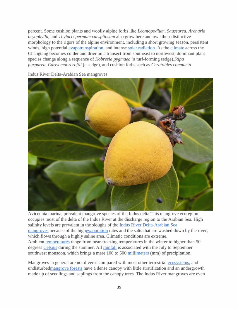
Indus River Delta-Arabian Sea mangroves
Avicennia marina, prevalent mangrove species of the Indus delta.This mangrove ecoregion
occupies most of the delta of the Indus River at the discharge region to the Arabian Sea. High
salinity levels are prevalent in the sloughs of the Indus River Delta-Arabian Sea
mangroves because of the highevaporation rates and the salts that are washed down by the river,
which flows through a highly saline area. Climatic conditions are extreme.
Ambient temperatures range from near-freezing temperatures in the winter to higher than 50
degrees Celsius during the summer. All rainfall is associated with the July to September
southwest monsoon, which brings a mere 100 to 500 millimeters (mm) of precipitation.
Mangroves in general are not diverse compared with most other terrestrial ecosystems, and
undisturbedmangrove forests have a dense canopy with little stratification and an undergrowth
made up of seedlings and saplings from the canopy trees. The Indus River mangroves are even
40
less diverse, being comprised of nearly monospecific stands of Avicennia marina, a species that
is highly resistant to high salinity levels and capable of surviving the region's extreme conditions.
Other species that are sometimes associated with theAvicennia include Rhizophora
apiculata and Acanthus ilicifolius, with occasional smaller patches ofRhizophora
mucronata and Ceriops tagal scattered throughout. The former usually are found closer to
braided creeks within the delta.
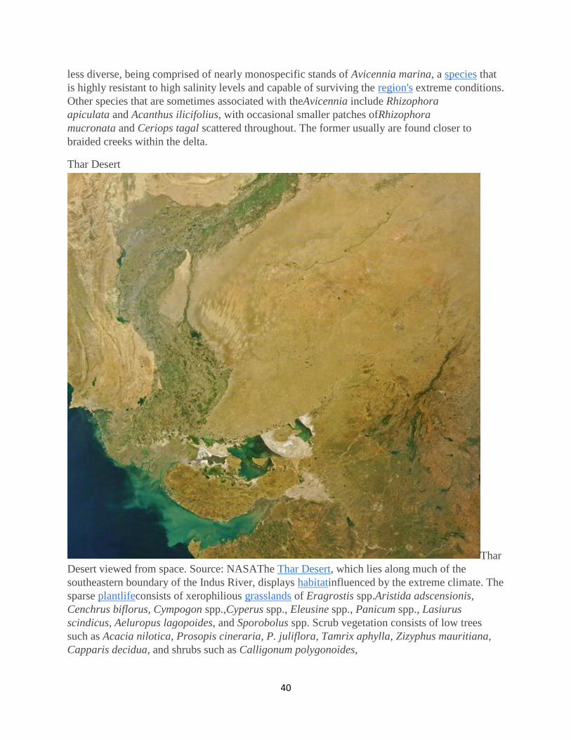
Thar Desert
Thar
Desert viewed from space. Source: NASAThe Thar Desert, which lies along much of the
southeastern boundary of the Indus River, displays habitatinfluenced by the extreme climate. The
sparse plantlifeconsists of xerophilious grasslands of Eragrostis spp.Aristida adscensionis,
Cenchrus biflorus, Cympogon spp.,Cyperus spp., Eleusine spp., Panicum spp., Lasiurus
scindicus, Aeluropus lagopoides, and Sporobolus spp. Scrub vegetation consists of low trees
such as Acacia nilotica, Prosopis cineraria, P. juliflora, Tamrix aphylla, Zizyphus mauritiana,
Capparis decidua, and shrubs such as Calligonum polygonoides,

41
Calotropis spp., Aerva spp.,Crotalaria spp., and Haloxylon salicornicum. Haloxylon
recurvum are also present.
In spite of the extremely hot climate, several species haveevolved to survive the conditions of the
Thar Desert. Among the mammalian fauna, the blackbuck (Antilope cervicapra), chinkara
(Gazella bennettii), caracal (Felis caracal), and desert fox (Vulpes bengalensis) inhabit the open
plains, grasslands, and saline depressions known as chappar or rann in the core area of the
desert. The entire mammalian fauna consists of forty-one species, none of which areendemic to
the ecoregion; however, the blackbuck is a threatened species whose populations take refuge in
this harsh environment.
Among the 141 birds known in this ecoregion, the great Indian bustard (Chirotis nigricaps) is a
globally threatened species whose populations in this ecoregion have rebounded in recent years.
A migration flyway used by cranes (Grus grus, Anthropoides virgo) and flamingos
(Phoenicopterus spp.) cross the Thar on their way to the Rann of Kutch further to the south.
Ancient history
Ruins
of the Bronze Age city Moheno-daro.The Indus River Valley boasts one of the earliest locales
transitioning to sedentary agriculture, with evidence in the early Holocene of wheat, barley and
sheep farming as early as 11,000 years ago. At Mohenjo-daro in the Indus basin circa 4600 years
before present, a population of around 40,000 was present, whose works include the building of a
platform under its citadel requiring an estimated 300 to 400 thousand man days of labor. These
data imply vast discretionary time for humans generated by sedentary agriculture.
(McIntosh.2008) Mohenjo-daro was thought to be the largest city in south Asia of its era. Total
land area at Mohenjo-daro (including agricultural use) was approximately 150,000 acres, and the
human population was about 40,000. Farther upriver at Harappa, another early Bronze Age
culture emerged slightly later, evincing additional evidence that the Indus basin was one of the
earliest world regions to establish advanced agriculture as well as urbanization.

42
References
Peter D.Clift and Jerzy Blusztajn (December 15, 2005). Reorganization of the western
Himalayan river system after five million years ago. Nature 438 (7070): 1001–1003
A.H.Dani. 1992. Critical Assessment of Recent Evidence on Mohenjo-daro. Second
International Symposium on Mohenjo-daro, February, 1992
Avijit Gupta, ed. 2008. "The Geographic, Geological and Oceanographic setting of the
Indus river".Large Rivers: Geomorphology and Management. John Wiley & Sons. ISBN
9780470723715.
Kumar Jain, Pushpendra K. Agarwal, Vijay P. Singh. 2007. Hydrology and water
resources of India. 1258 pages Google eBook
M.Rajesh Kumar, A.S.Rajawat and T.N.Singh. 2005. Applications of remote sensing for
educidate the Palaeochannels in an extended Thar desert, Western Rajasthan, 8th annual
International conference, Map India 2005, New Delhi.
J.M.Kenoyer. 1997. Trade and Technology of the Indus Valley: New insights from
Harappa Pakistan, World Archaeology, 29(2), pp. 260-280, High definition archaeology
J.MacKinnon. 1997. Protected areas systems review of the Indo-Malayan realm.
Canterbury, UK: The Asian Bureau for Conservation (ABC) and The World Conservation
Monitoring Center (WCMC)/ World Bank Publication.
Jane McIntosh. 2008. The ancient Indus Valley: new perspectives. ABC-CLIO. 441
pages
Monirul Qader Mirza and Qazi Kholiquzzaman Ahmad. 2005 Climate change and water
resources in South Asia. 322 pages Google eBook
Tim McNeese and Shane Mountjoy. 2004. The Indus River. books.google.com 110 pages
National Aeronautics and Space Administration. 2009. Seasons of the Indus River.
NASA Earth Observatory Program
Plutarch of Chaeronea. 79 AD. Life of Alexander, 356-323 BC, translated by John
Dryden.
G.V.Skogerboe and D.J.Bandaragoda. Towards environmentally sustainable agriculture
in the Indus Basin Irrigation System. Final report. IWMI
Citation
Hogan, C. (2012). Indus River. Retrieved from http://www.eoearth.org/view/article/173762
http://www.eoearth.org/view/article/173762/
2015
Ferrier, K.L., Mitrovica, J.X., Giosan, L., Clift, P.D., 2015. Sea-level responses to erosion and
deposition of sediment in the Indus River basin and the Arabian Sea. Earth and Planetary Science
Letters, 416: 12–20. 2015_Ferrier_etal_2015.pdf
2014
Clift, P. D., and Giosan, L. 2014, Sediment fluxes and buffering in the post-glacial Indus
Basin, Basin Research 25, , 1–18, DOI: 10.1111/bre.12038. 2014_Clift_Giosan_Basin Res.pdf

43
Clift, P.D., Giosan, L., Henstock, T. and Tabrez, A.R., 2014. Sediment Storage and Reworking
on the Shelf and in the Canyon of the Indus River-Fan System since the Last Glacial
Maximum. Basin Research, 26, 183–202. 2014_Clift_etal_Basin Res.pdf
Wu, F. Y., W. Q. Ji, J. G. Wang, C. Z. Liu, S. L. Chung, and P. D. Clift, 2014, Zircon U-Pb and
Hf isotopic constraints on the onset time of India-Asia collision, American Journal of Science,
314, 548 –579, doi10.2475/02.2014.04. 2014-Wu-etal.pdf
2013
Clift, P.D. and Sun, Z., 2013. Introduction to special collection on geology, tectonics and
hydrocarbon systems of SE Asia. Marine Geophysical Research, 34: 153–158.
doi:10.1007/s11001-013-9206-4.
Draut, A.E. and Clift, P.D., 2013. Differential preservation in the geologic record of intraoceanic
arc sedimentary and tectonic processes. Earth Science Reviews 116, 57–84,
DOI:10.1016/j.earscirev. 2012.11.003. 2013_Draut_Clift_ESR.pdf
2012
Wan, S., Clift, P.D., Li, A., Yu, Z., Li, T. and Hu, D., 2012. Tectonic and climatic controls on
long-term silicate weathering in Asia since 5 Ma. Geophysical Research Letters 39(L15611),
doi:10.1029/2012GL052377. 2012_Wan_etal_2012.pdf
Alizai, A., Hillier, S., Clift, P.D. and Giosan, L., 2012. Clay mineral variations in Holocene
terrestrial sediments from the Indus Basin; a response to SW Asian Monsoon variability.
Quaternary Research 77(3), 368–381,
doi:10.1016/j.yqres.2012.01.008. 2012_Alizai_etal_QuatRes.pdf
Giosan, L., Clift, P. D., Macklin, M. G., Fuller, D. Q., Constantinescu, S., Durcan, J. A., Stevens,
T., Duller, G. A. T., Tabrez, A., Adhikari, R., Gangal, K., Alizai, A., Filip, F., VanLaningham,
S., and Syvitski, J. P. M., 2012, Fluvial Landscapes of the Harappan Civilization: Proceedings of
the National Academy of Sciences, 87(52), OS14A-04. 2012_Giosan_etal_PNAS.pdf
Limmer, D. R., P. Boening, L. Giosan, C. Ponton, C. M. Köhler, M. J. Cooper, A. R. Tabrez, and
P. D. Clift. 2012. Geochemical Record of Holocene to Recent Sedimentation on the Western
Indus continental shelf, Arabian Sea, Geochem. Geophys. Geosyst., 13,
doi:10.1029/2011GC003845.2012_Limmer_etal_G-Cubed.pdf
Clift, P. D., A. Carter, L. Giosan, J. Durcan, A. R. Tabrez, A. Alizai, S. VanLaningham, G. A. T.
Duller, M. G. Macklin, D. Q. Fuller, and M. Danish, U-Pb zircon dating evidence for a
Pleistocene Sarasvati River and Capture of the Yamuna River, Geology. v. 40, 3, p. 212-215,
doi:10.1130/G32840.1/ 2012_Clift_etal_Geology.pdf
Giosan, L., Clift, P. D., Macklin, M. G., Fuller, D. Q., Constantinescu, S., Durcan, J. A., Stevens,
T., Duller, G. A. T., Tabrez, A., Adhikari, R., Gangal, K., Alizai, A., Filip, F., VanLaningham,

44
S., and Syvitski, J. P. M., 2012, Fluvial Landscapes of the Harappan Civilization: Proceedings of
the National Academy of Sciences, doi/10.1073/pnas.1112743109/ 2012_Giosan_etal_PNAS.pdf
Alizai, A., Hillier, S., Clift, P. D., and Giosan, L., 2012, Clay mineral variations in Holocene
terrestrial sediments from the Indus Basin; a response to SW Asian Monsoon
variability: Quaternary Research, v. 77, 3, p. 368–381,
doi:10.1016/j.yqres.2012.01.008/ 2012_Alizai_etal_QuatRes.pdf
2011
Alizai, A, Clift, P.D., Giosan, L., VanLaningham, S., Hinton, R., Tabrez, A.R., Danish, M., 2011.
Pb Isotopic Variability in the Modern-Pleistocene Indus River System measured by Ion
Microprobe in detrital K-feldspar grains. Geochimca et Cosmochimica Acta, 75, 4771-4795,
doi:10.1016/j.gca.2011.05.039. 2011_Alizai_etal_GCA.pdf
2010
Calves, G., A. M. Schwab, M. Huuse, P. D. Clift, and A. Inam (2010), Thermal regime of the
northwest Indian rifted margin - Comparison with predictions, Marine and Petroleum
Geology 27, 1133-1147, doi:10.1016/j.marpetgeo.2010.02.010.
2009
Clift, P.D., Schouten, H., and Vannucchi, P., 2009. Arc-continent collisions, subduction mass
recycling and the maintenance of the continental crust, in Cawood, P. and Kroener, A.,
eds., Earth Accretionary Systems in Space and Time, Geological Society of London, special
publication, 318, 75–103.
2008
Calves, G., Huuse, M., Schwab, A. and Clift, P.D., 2008. 3D seismic analysis of high-amplitude
anomalies in the shallow subsurface of the Northern Indus Fan: sedimentary and/or fluid
origin.Journal of Geophysical Research, 113, B11103, doi:10.1029/2008JB005666.
2007
Wu, F.Y., Clift, P.D., and Yang, J.H., 2007. Zircon Hf isotopic constraints on the sources of the
Indus Molasse, Ladakh Himalaya, India. Tectonics, 26, TC2014, doi:10.1029/2006TC002051.
2005
Clift, P.D. and Blusztajn, J., Reorganization of the western Himalayan river system after five
million years ago. Nature, 438, 1001–1003, doi:10.1038/nature04379. Click here to listen to the
relatedpodcast.

45
Garzanti, E., Vezzoli, G., Andò, S., Paparella, P., and Clift, P.D., 2005. Petrology and mineralogy
of Indus River sands : a key to interpret erosion history of the Western Himalayan
Syntaxis, Earth and Planetary Science Letters, 229, 287–302.
2003
Clift, P.D. and Molnar, P., 2003. Drilling of submarine fans in the Indian Ocean. EOS, 84 (42),
442–443.
2002
Clift, P.D., Gaedicke, C., Edwards, R., Lee, J.I., Hildebrand, P., Amjad, S., White, R.S., and
Schülter, H.U., 2002. The stratigraphic evolution of the Indus Fan and the history of
sedimentation in the Arabian Sea. Marine Geophysical Researches, 23 (3), 223–245.
Clift, P. D., Carter, A. Krol, M. and Kirby, E., 2002. Constraints on India-Eurasia Collision in the
Arabian Sea Region taken from the Indus Group, Ladakh Himalaya, India. In, Clift, P.D., Kroon,
D., Craig, J., and Gaedicke, C. (Editors), The Tectonic and Climatic Evolution of the Arabian
Sea Region, Geological Society of London special publication, 195, 97-116.
Clift, P. D., 2002. A brief history of the Indus River. In, Clift, P.D., Kroon, D., Craig, J., and
Gaedicke, C. (Editors), The Tectonic and Climatic Evolution of the Arabian Sea Region,
Geological Society of London special publication, 195, 237-258.
2001
Clift, P.D., 2001. The Indus Fan: Climate tectonic interactions in the western
Himalaya. Geoscientist , 11 (12), 4-9.
Clift, P.D., Shimizu, N., Layne, G., Gaedicke, C., Schlüter, H.U., Clark, M. and Amjad, S., 2001.
Development of the Indus Fan and its significance for the erosional history of the western
Himalaya and Karakoram. Geological Society of America Bulletin, 113, 1039-1051.
1993
Najman, Y.M.R., Clift, P.D., Johnson, M.R., and Robertson, A.H.F., 1993. Early Tertiary foreland
basin evolution in the Lesser Himalaya. In Searle, M.P., and Treloar, P. (Eds.), Himalayan
Tectonics. Geological Society Special Publication, 74, 541-558.
ASI Museum - Rupnagar
The Archaeological Museum is situated about 40 kms north east of Chandigarh in Rupnagar
town situated on the bank of sutlej river. It was opened to public in the year 1998.
46
Opened to public in the year 1998, the museum houses the archaeological remains of excavated
site near Ropar, the first Harappan site excavated in Independent India. The excavation revealed
a cultural sequence from Harappan to medieval times. Important exhibits include antiquities of
Harappan times, Painted Grey ware culture, Saka, Kushana, Gupta times such as Vina Vadini
(lady playing on vina), steatite seal, copper and bronze implements, ring stone, yakshi image,
gold coins of Chandragupta. Besides, the visitors can have a glimpse of important protected
monuments of Punjab, Haryana, Himachal Pradesh and World Heritage monuments
Rupar, Ropar (300 58; 76O 32'), Dt Rupnagar, Punjab
Lying on the left bank of the Sutlej. The excavations yielded a sequence of six Periods: I
(Harappa, c. 2100 to 14OOB.C,); II (PGW, c. 1000 to 600 B.C.); III (NBPW or early historical,
c. 600 to 200B.C.); IV (middle to late historical, c. 200 B.C. to A.D. 700); V (late historical, c.
700-1200); and VI (medieval, c.l200-1700). Some of these Periods are divided into-Sub Periods.
There are three mounds at Ropar, n., S., and w. The s mound is occupied by the present-day
town. Excavations were confined to the n. and w. mounds, the latter concealing a Harappa
cemetery. Ropar has the distinction of being the site where the remains of the Harappa
civilization were excavated for the first time in post-partition India.
Apart from mature Harappa objects named above, mention may also be made of beads and
bangles of faience triangular terracotta cakes and chert weights. Compared with the mature
Harappa as asemblage at Harappa and Mohenjo-daro, it is the absence of the goblet with pointed
base and terracotta figurines including the mother goddess which strikes one most. In I A levels
only one mud-brick wall of three
courses has been encountered. The bricks are irregular in size but have a uniform thickness of 10
cm. The only wall noticed in I B at RPR-2 is built of river pebbles. Phase I C is however rich in
housing remains with seven structures assignable to five phases. The building material consists
of kankar stone, mud brick and kiln-burnt brick. One of the well-built houses has foundations of
kankar stone and superstructure of mud brick. The kiln burnt bricks measure 20x 10x40 cm.
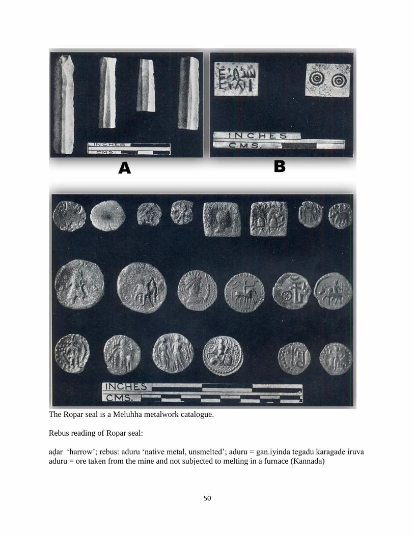
A single Harappa seal found in RPR-1 in I C levels is made of steatite and bears three familiar
symbols on the obverse and two concentric circles on the reverse. It is thin and small without any
holding device. Another burnt clay lump with a hole to pass a string through bears impressions
of three typical seals with bull motif and legend in the familiar script. Graffiti on pottery include
the Indus script.
A cemetery of the Harappa, recalling Cemetery R-37 of Harappa, lies to the w. of the n. mound.
It has been considerably disturbed by later occupants, mainly by the users of the row, but some
of the burials are sufficiently intact to give an adequate idea of the method of burial. The body is
laid in a grave pit, measuring 2.45 x .91 m and 60 cm in depth. The head is placed usually on the
n.-w. Most of the burials contain an assemblage of typical pots, and some of them also reveal
personal ornaments, such as bangles of faience or shell, beads of faience and semiprecious stones
and ring of copper. A faience bangle was intact on the left wrist of the wearer and a copper ring
on the middle finger of the right hand. A single grave pit contained the skeleton of a dog at the
bottom and that of a human being, presumably its master, above it. There is very little Bara
47
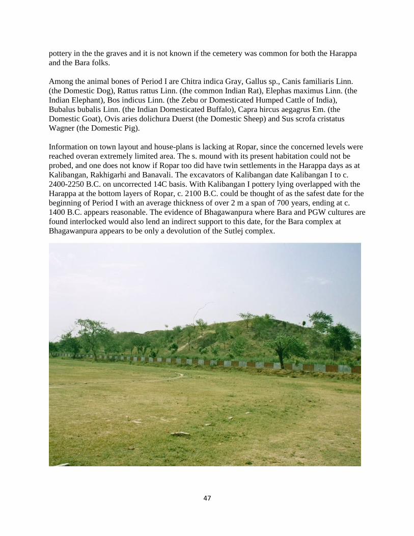
pottery in the the graves and it is not known if the cemetery was common for both the Harappa
and the Bara folks.
Among the animal bones of Period I are Chitra indica Gray, Gallus sp., Canis familiaris Linn.
(the Domestic Dog), Rattus rattus Linn. (the common Indian Rat), Elephas maximus Linn. (the
Indian Elephant), Bos indicus Linn. (the Zebu or Domesticated Humped Cattle of India),
Bubalus bubalis Linn. (the Indian Domesticated Buffalo), Capra hircus aegagrus Em. (the
Domestic Goat), Ovis aries dolichura Duerst (the Domestic Sheep) and Sus scrofa cristatus
Wagner (the Domestic Pig).
Information on town layout and house-plans is lacking at Ropar, since the concerned levels were
reached overan extremely limited area. The s. mound with its present habitation could not be
probed, and one does not know if Ropar too did have twin settlements in the Harappa days as at
Kalibangan, Rakhigarhi and Banavali. The excavators of Kalibangan date Kalibangan I to c.
2400-2250 B.C. on uncorrected 14C basis. With Kalibangan I pottery lying overlapped with the
Harappa at the bottom layers of Ropar, c. 2100 B.C. could be thought of as the safest date for the
beginning of Period I with an average thickness of over 2 m a span of 700 years, ending at c.
1400 B.C. appears reasonable. The evidence of Bhagawanpura where Bara and PGW cultures are
found interlocked would also lend an indirect support to this date, for the Bara complex at
Bhagawanpura appears to be only a devolution of the Sutlej complex.

48
Period II. After a long break the site was occupied by the users of the row, identified with the
early Aryans by some and with the contemporaries of the later Vedic texts by others. Wheel-
turned from well-levigated fine- grained clay, the PGW is sometimes self-slipped orcovered with
grey wash, but often it seems to have no surface treatment. After it is painted with designs in
black it is subjected to even and gradually reduced tem- perature. The sagger-based dish with
incurved side and deep bowl with straight side are the most common shapes in the PGW. The
painted designs comprise bands, grouped verticals, oblique and criss-cross lines, Z sigmas,
svastikas, apirals, chains, rows of dots and dashes and concentric circles or semicircles.
Apparently; the PGW was mainly used for purposes of dining. The discovery of a PGW water-
pot (lotii) at Ropar completes ,the normal set of dining utensils, consisting of a plate or dish
(thali) bowl (katori) and a water-pot (loti). The design is sometimes whitish-grey, which is
obtained by blocking the design from the application of the slip. Other associated wares in these
levels are plain grey ware, Black-slipped Ware and dusty-red ware. The former two cover the
same shapes as the PGW, but the vessels of the dusty-red ware are largely used for cooking and
storage, such as the frying pan, cooking pot (handi), large bowl basin, water pitchers and storage
jar.
Period. III The introduction and disappearance of the NBPW define the span of Period III. Ropar
was sufficiently removed from the Ganga plains of e. U.P. and Bihar, where the NBPW had its
beginnings, yet over 450 sherds recovered from the limited excavated depths here proclaim its
great popularity. It must have reached here obviously through pilgrinls and traders. That it was
not locally manufactured and was a treasured piece of pottery is clear from the fact that broken
NBPW vessels are often found joined with copper wire.Period III may be divided into Sub-
Periods, m A and m B. In trench RPR-2, out of nearly 300 NBPW sherds 85% occur in III A and
only 15% in m B, which, however, is richer in structural remains.
49
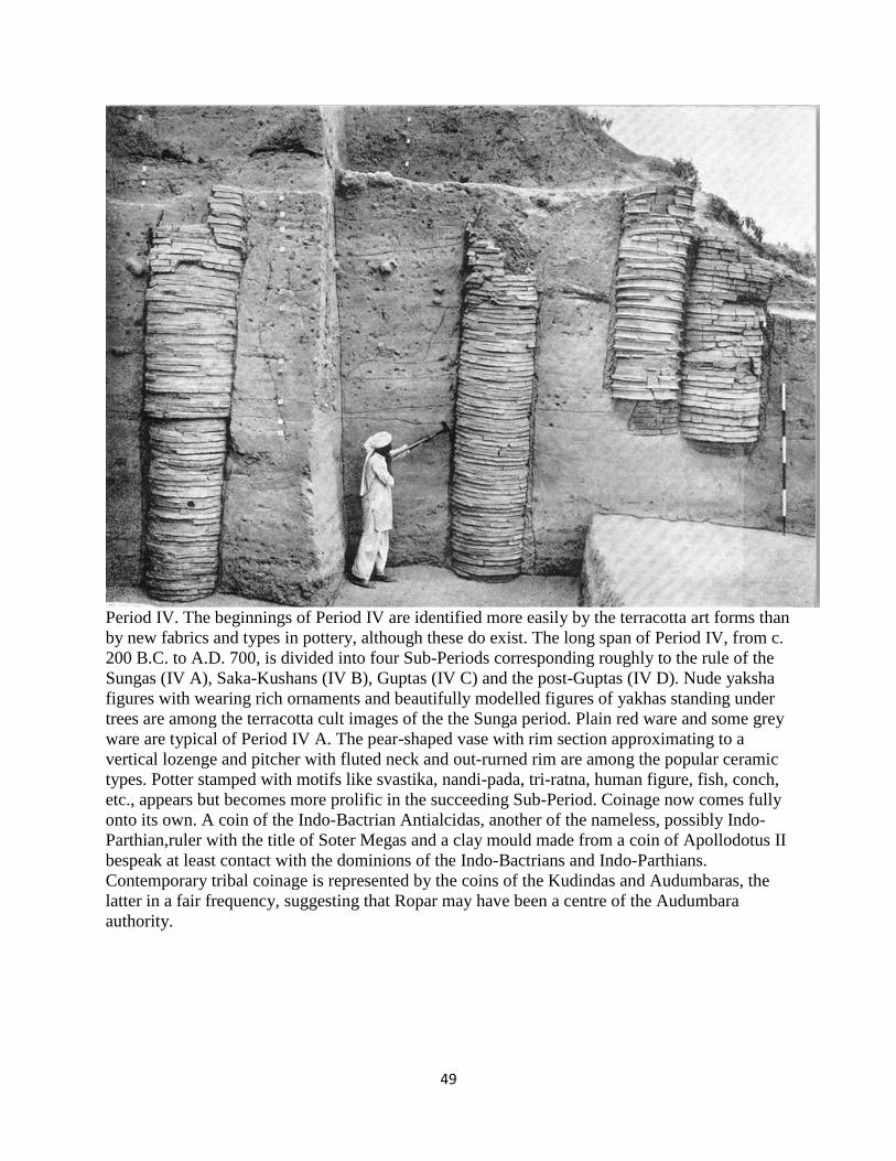
Period IV. The beginnings of Period IV are identified more easily by the terracotta art forms than
by new fabrics and types in pottery, although these do exist. The long span of Period IV, from c.
200 B.C. to A.D. 700, is divided into four Sub-Periods corresponding roughly to the rule of the
Sungas (IV A), Saka-Kushans (IV B), Guptas (IV C) and the post-Guptas (IV D). Nude yaksha
figures with wearing rich ornaments and beautifully modelled figures of yakhas standing under
trees are among the terracotta cult images of the the Sunga period. Plain red ware and some grey
ware are typical of Period IV A. The pear-shaped vase with rim section approximating to a
vertical lozenge and pitcher with fluted neck and out-rurned rim are among the popular ceramic
types. Potter stamped with motifs like svastika, nandi-pada, tri-ratna, human figure, fish, conch,
etc., appears but becomes more prolific in the succeeding Sub-Period. Coinage now comes fully
onto its own. A coin of the Indo-Bactrian Antialcidas, another of the nameless, possibly Indo-
Parthian,ruler with the title of Soter Megas and a clay mould made from a coin of Apollodotus II
bespeak at least contact with the dominions of the Indo-Bactrians and Indo-Parthians.
Contemporary tribal coinage is represented by the coins of the Kudindas and Audumbaras, the
latter in a fair frequency, suggesting that Ropar may have been a centre of the Audumbara
authority.
50
The Ropar seal is a Meluhha metalwork catalogue.
Rebus reading of Ropar seal:
aḍar ‘harrow’; rebus: aduru ‘native metal, unsmelted’; aduru = gan.iyinda tegadu karagade iruva
aduru = ore taken from the mine and not subjected to melting in a furnace (Kannada)
51
The word for a 'set of four' is: gaṇḍa (Santali); bar gaṇḍa poesa = two annas; pon gaṇḍa aphor
menaka, there are 16 bunches of rice seedlings; gaṇḍa guṇḍa to be broken into pieces or
fragments; fragments; gaṇḍa guṭi to dive, to make up an account; the system of 'gaṇḍa guṭi' is to
put down a pebble, or any other small object, as the name of each person entitled to share is
mentioned. Then a share is placed alongside of each pebble, or whatever else laid down. (Santali)
Thus, the complex glyph is read: aduru ayo kaṇḍ 'native metal furnace'.
ayo, hako 'fish'; a~s = scales of fish (Santali); rebus: aya = iron (G.); ayah, ayas = metal
(Rigveda) PLUS gaṇḍa ‘four' Rebus: kaṇḍ = altar, furnace (Santali) Rebus: ayaskāṇḍa 'metal
furnace'; “a quantity of iron, excellent iron” (Pāṇ gaṇ)
kāmsako, kāmsiyo = a large sized comb (G.) Rebus: kaṁsa 'bronze' (Telugu)
S. Kalyanaraman
Sarasvati Research Center
May 4, 2015
Rgvedic All comprehensiveness (Nicholas Kazanas, 2012)