westside.pdf - City of San Ramon
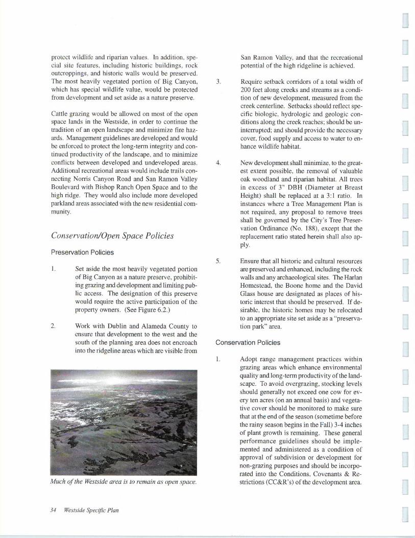
85
-
Upload
khangminh22 -
Category
Documents
-
view
0 -
download
0
Transcript of westside.pdf - City of San Ramon


I
ICHAPTER 1 Introduction and Background
I
I
I Purpose of the Specific Plan
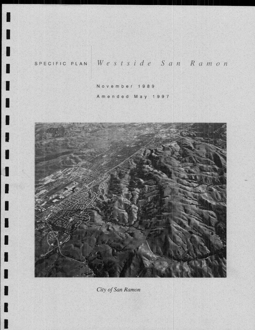
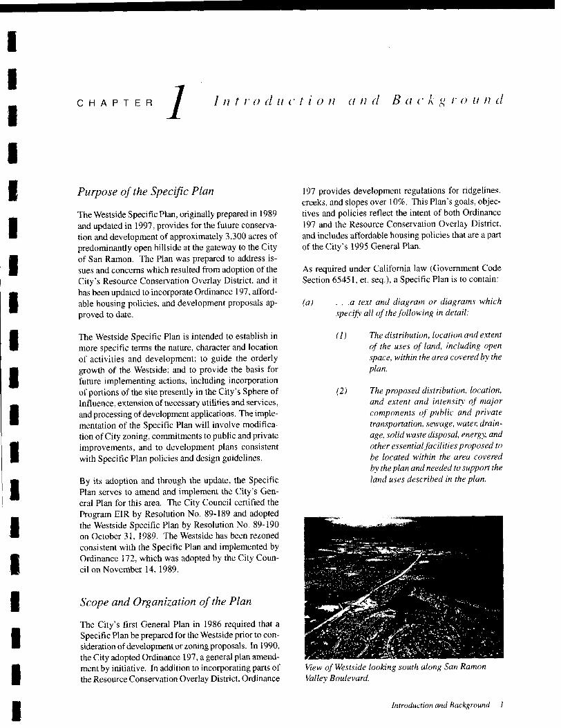
IThe Westside Specific Plan, originally prepared in 1989
and updated in 1997, provides for the future conserva-
tion and development of approximately 3,300 acres of
predominantly open hillside at the gateway to the Cityof San Ramon, The Plan was prepared to address is-
sues and concerns which resulted from adoption of the
City' s Resource Conservation Overlay District, and it
has been updated to incorporate Ordinance 197, afford-
able housing policies, and development proposals ap-
proved to date.
I
I
I The Wests ide Specific Plan is intended to establish in
more specific terms the nature, character and location
of activities and development; to guide the orderly
growth of the Westside; and to provide the basis for
future implementing actions, including incorporationof portions of the site presently in the City' s Sphere of
Influence, extension of necessary utilities and services,
and processing ofdevelopment applications. The imple-mentation of the Specific Plan will involve modifica-
tion of City zoning, commitments to public and privateimprovements, and to development plans consistent
with Specific Plan policies and design guidelines,
I
I
I
IBy its adoption and through the update, the SpecificPlan serves to amend and implement the City' s Gen-
eral Plan for this area, The City Council certified the
Program ErR by Resolution No, 89- 189 and adoptedthe Westside Specific Plan by Resolution No, 89- 190
on October 31, 1989. The Westside has been rezoned
consistent with the Specific Plan and implemented byOrdinance 172, which was adopted by the City Coun-
cil on November 14, 1989,
I
I
I Scope and Organization of the Plan
I
I
The City' s first General Plan in 1986 required that a
Specific Plan be prepared for the Westside prior to con-
sideration ofdevelopment or zoning proposals. In 1990,
the City adopted Ordinance 197, a general plan amend-
ment by initiative, In addition to incorporating parts of
the Resource Conservation Overlay District, Ordinance
I
197 provides development regulations for ridgelines,creeks, and slopes over 10%. This Plan' s goals, objec-tives and policies reflect the intent of both Ordinance
197 and the Resource Conservation Overlay District,
and includes affordable housing policies that are a part
of the City' s 1995 General Plan,
As required under California law ( Government Code
Section 65451, et. seq,), a Specific Plan is to contain:
a) . , , a text and diagram or diagrams which
specify all of the following in detail:
1) The distribution. location and extent
of the uses of land, including open
space, within the area covered by the
plan.
2) The proposed distribution, location.
and extent and intensity of major
components of public and privatetransportation. sewage, water, drain-
age, solid waste disposal. energy, and
other essentialfacilities proposed to
be located within the area covered
by the plan and needed to support the
land uses described in the plan.
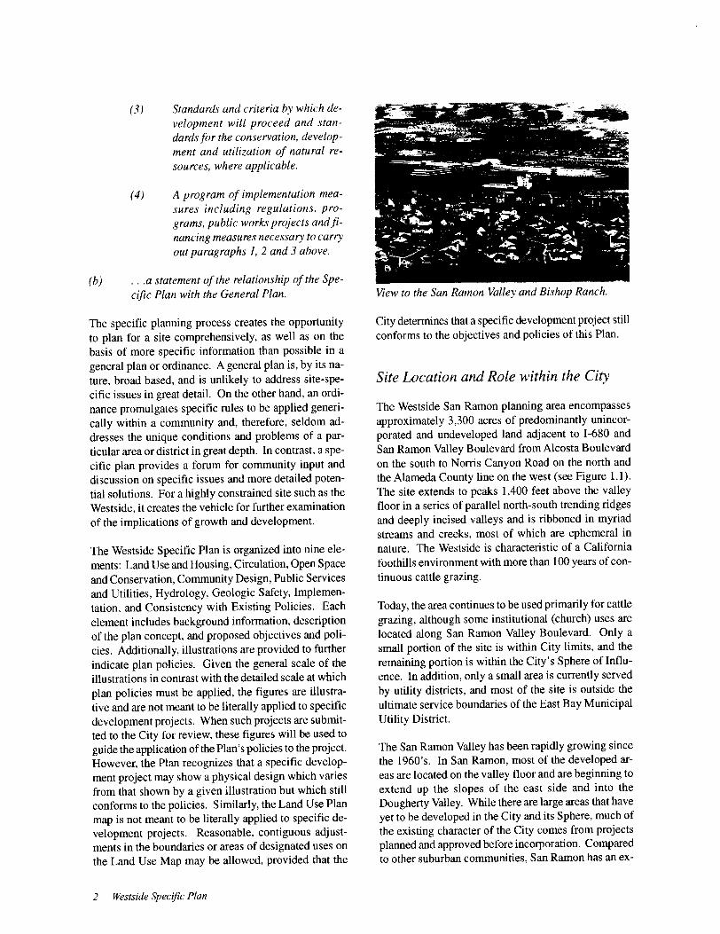
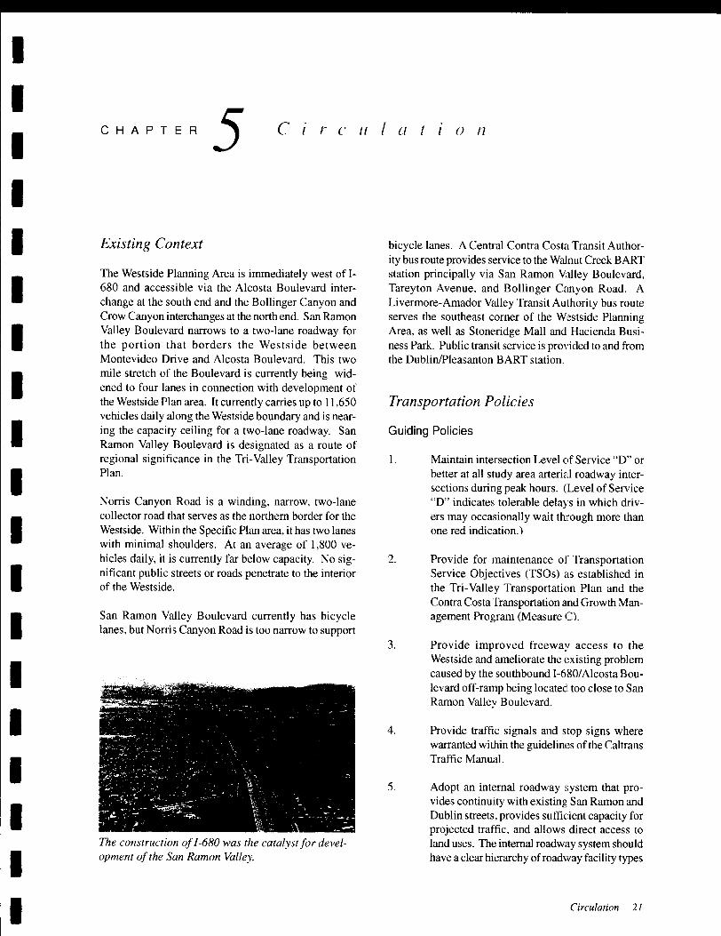
View of Wests ide looking south along San Ranwn
Valley Boulevard,
Introduction and Background 1

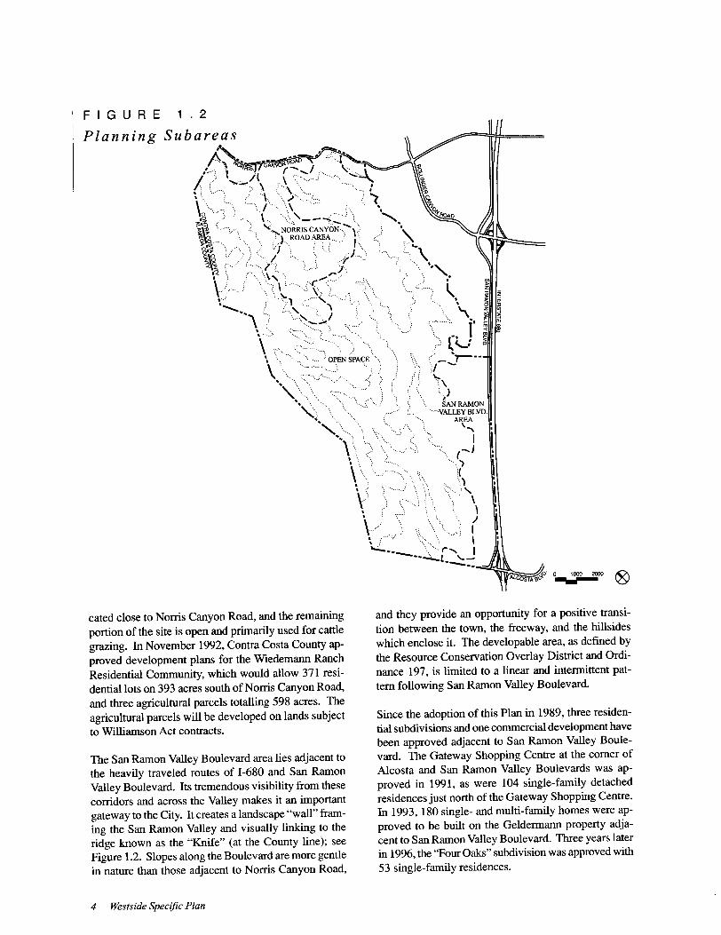
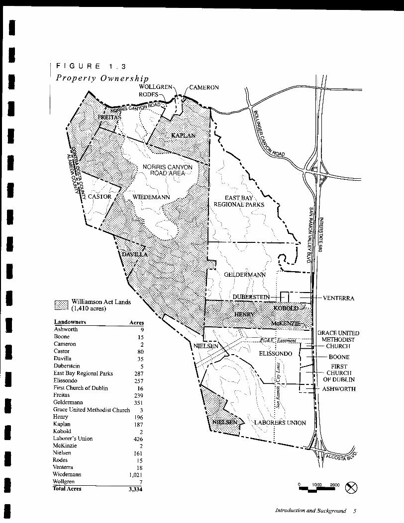
Ownership and Easements
Much of the land in the Westside has been in continu-
ous ownership by ranching families descended from
the original pioneers of the San Ramon Valley. In the
size and configuration of land holdings, the Westside
recalls the extensive land grant ranches dating from the
Spanish secularization of the landscape in the 1800' s.
Many of the properties in the Westside are over 200
acres in size, are in agricultural preserves under the
Williamson Act ( see Figure 1.3), do not adjoin local
roads, and extend over the " Knife" ( the ridgeline at the
County line) to include land in Alameda County.
In addition to recently-approved subdivisions, some
smaller division of land has occurred along the front-
6 Westside Specific Plan
age of existing improved roads, particularly San Ramon
Valley Boulevard. In the hillsides to the west of devel-
oped subdivisions, approximately 300 acres of land have
been dedicated for open space purposes and are owned
by the East Bay Regional Park District. In addition,
the portion of the Geldermann property immediately to
the west of the Twin Creeks project has been restricted
in its deed to a maximum of five dwelling units.
There are a number of easements which affect the de-
velopment of properties within the Westside. A Pacific
Gas & Electric easement for high voltage transmission
lines crosses the southerly portion of the site in an east-
west axis on the Elissondo/Ove property, and transmis-
sion towers are located on the Wiedemann property with
underground easements to Norris Canyon Road.
parks, recreational areas and developed areas
with the regional open space system,
A recreational trail along San Catanio Creek
will also be developed by the City, consistent
with existing City policies.
Fire trails will be maintained to provide ac-
cess throughout the area for fire vehicles and
prevention activities, and grazing encouragedto give protection against fire.
The open space will be managed in such a way
as to minimize erosion and potential hazards,
to protect and enhance wildlife values, and to
encourage public access to resources in se-
lected locations.
Preservation of all major and minor ridgelinesas defined by the City' s Resource Conserva-
tion Overlay District, stream corridors, and
slopes over 20 percent, is encouraged within
the City' s Sphere of Influence, and requiredwithin City boundaries.
Off-site surface water runoff will not exceed
existing conditions, nor will development in-
crease off-site flood hazards,
Approaches to conservation of water resources
are encouraged by limiting irrigated areas,
encouraging drought-tolerant plantings, dual
water systems, and other water conservation
measures.
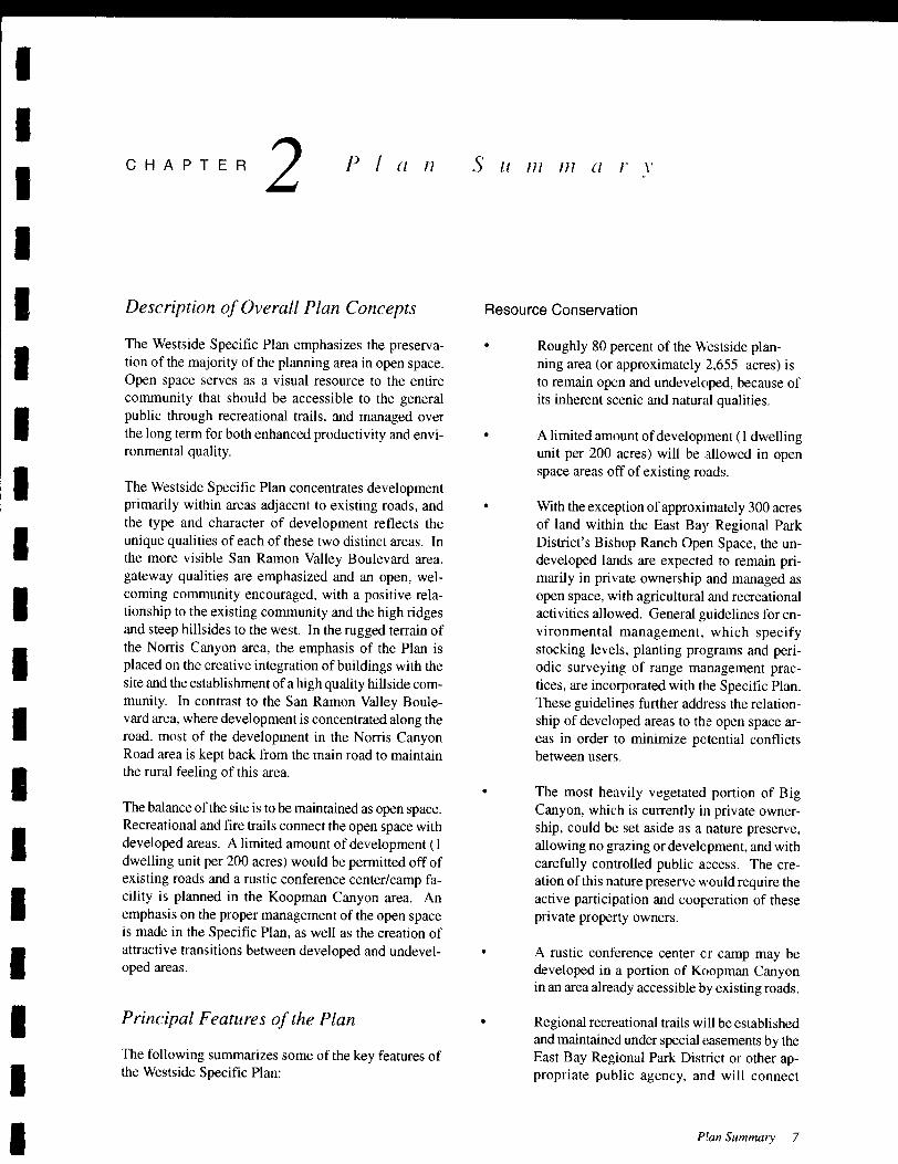
Steep hills and creek valleys define the Wests ide land-
scape,
8 Wests ide Specific Plan
Image and Identity
The predominant open space identity of the
Westside landscape will be preserved, and
development will be concentrated in approxi-mately 20 percent of the overall planning area,
Development in the Norris Canyon Road area
will be primarily located away from the road
and adjacent to the cross valley ridge,
Development will be confined to slopes less
than 20 percent in the San Ramon Valley Bou-
levard area, and the development pattern de-
fined by a series of open spaces and parks ex-
tending to agricultural open spaces to the west
and by landscaped setback areas along the
road.
A minimal amount of woodland is removed
to accommodate development as shown in the
illustrative site plan for the San Ramon Val-
ley Boulevard area. In general, removed
woodland areas and riparian vegetation shall
be replaced at a 3 to 1 ratio,
Housing
An estimated 1, 289 dwelling units are assumed
in the Plan,
Of the residential units, approximately 900
units would be single- family units, 175 would
be multi- family, and 200 (as a base) would be
senior housing, Approximately 14 dwellingunits are permitted in the open space area.
Maximum number of dwelling units per par-
cel will be determined by a slope analysis pur-
suant to Ordinance 197, Specifically, above
the 500- foot elevation, residential develop-ment is limited to one dwelling unit per one
1) acre on slopes between 10% and 15%, and
to one unit per five (5) acres on slopes between
15% and 20%. For areas of 10% slope or less,
density will be determined by the Plan' s un-
derlying zoning districts, Development is pro-
hibited in areas with slopes of20% or greater.
A variety of different types of housing is en-
couraged, with densities ranging from less than
2 dwelling units per net acre in the Norris
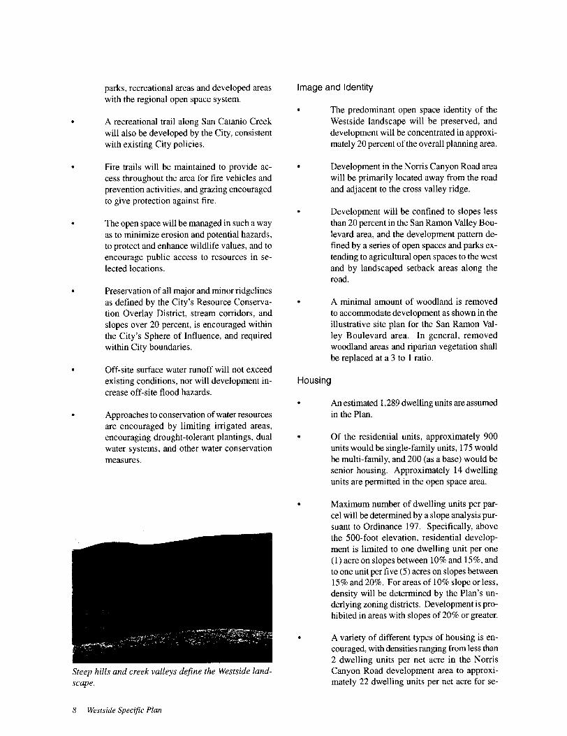
Canyon Road development area to approxi-mately 22 dwelling units per net acre for se-
I
Ibe protected from encroachment by people,domestic animals and livestock.
I Common open space would be set aside and
maintained as visual easements connectingthe San Ramon Valley Boulevard area to the
western undeveloped hillsides. In the Norris
Canyon Road area, common open spaces
would protect much of the viewshed from the
road and would include stream corridors.
I
I
IUtility Service
I
The Norris Canyon Road area is within the
service boundaries of the East Bay MunicipalUtility District for water and the Central Con-
tra Costa Sanitary District for sewer service.
Development in this area will require majorinfrastructural improvements in terms of sewer
and water extensions and water storage tanks
every 200-foot elevation above the 650- foot
elevation as required by East Bay MunicipalUtility District).
I
IMuch of the San Ramon Valley Boulevard area
is within water and sewer service districts and
can be easily served, but utility extensions to
specific sites are required.I
I Noise and Safety
IA careful review will be made by qualifiedprofessional engineers prior to the approvalof any proposed development or land alter-
ation within the Alquist-Priolo zone in the vi-
cinity of the Calaveras faultline and in other
geologically sensitive areas to ensure that theI
I
I
I
I
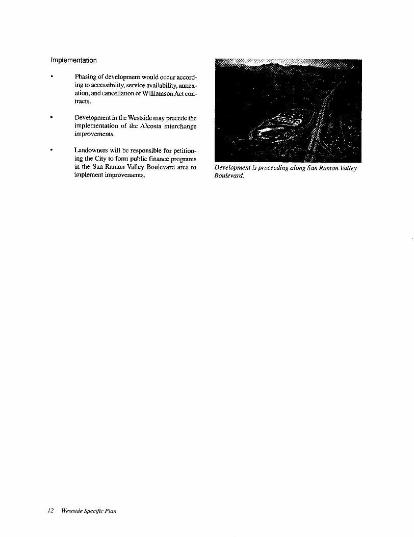
IDevelopment along the freeway is subject to highernoise levels than elsewhere in the city.
I
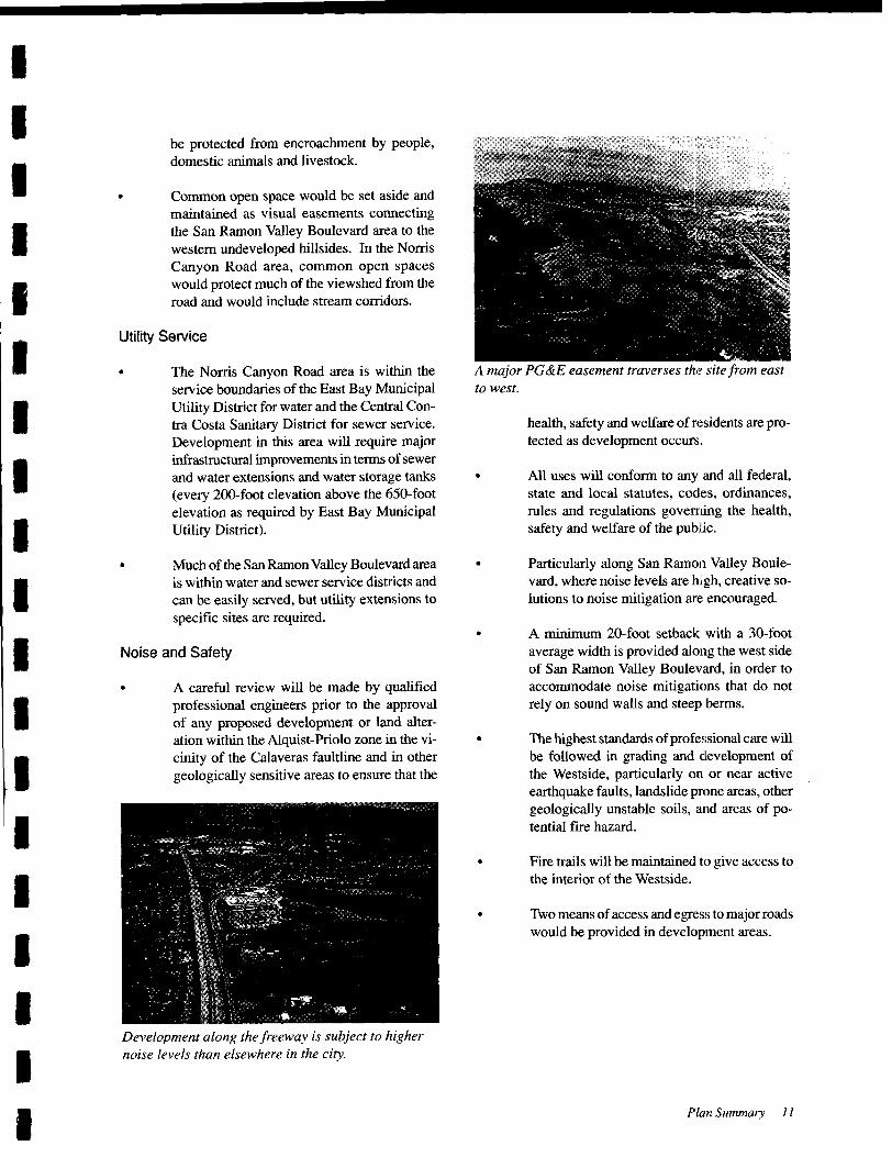
A major PG& E easement traverses the site from east
to west.
health, safety and welfare of residents are pro-tected as development occurs.
All uses will conform to any and all federal,
state and local statutes, codes, ordinances,
rules and regulations governing the health,
safety and welfare of the public.
Particularly along San Ramon Valley Boule-
vard, where noise levels are high, creative so-
lutions to noise mitigation are encouraged.
A minimum 20-foot setback with a 30- foot
average width is provided along the west side
of San Ramon Valley Boulevard, in order to
accommodate noise mitigations that do not
rely on sound walls and steep berms.
The highest standards ofprofessional care will
be followed in grading and development of
the Westside, particularly on or near active
earthquake faults, landslide prone areas, other
geologically unstable soils, and areas of po-
tential fire hazard.
Fire trails will be maintained to give access to
the interior of the Westside.
Two means of access and egress to major roads
would be provided in development areas.
Plan Summary 11
I
ICHAPTER 3 S pee ifi c P I a n G () a Is ([ n d 0 hj e c f i l' e s
I
I
I Primary Goal
IThe overall goal for the Westside is to preserve the open
space character of the area and, at the same time, create
a high quality, attractive community of lasting value
which enhances the unique visual and scenic qualitiesof the area and links regional and local- serving recre-
ational areas within a larger open space system,I
I Supporting Goals and Objectives
IEnvironmental Preservation
I
The majority of the Westside should remain open and
undeveloped and its scenic, recreational, open space
and wildlife values enhanced, Major ridgelines, creek
corridors, woodland, and steep slopes visible from San
Ramon Valley Boulevard should be protected from de-
velopment. Agricultural and grazing activities should
be encouraged to continue over most of the area, ob-
serving the best management practices for maintainingand improving environmental quality, A portion of the
Big Canyon area should be preserved as habitat for wild-
life, Public access to scenic resources should be en-
couraged through trails, bikeways, parks, and the de-
velopment of a rustic conference centerlcamp,
I
I
Pattern of Development
I Development should be permitted in those areas where
constraints can be minimized and environmental op-
portunities for development exist. The development
pattern should be determined by the organization and
character of open spaces, It should be excluded from
major ridges visible from San Ramon Valley Boule-
vard; from creeks and earthquake faults; and in the most
heavily vegetated portion of Big Canyon, In the San
Ramon Valley Boulevard area, development should be
concentrated in the lower slopes, with higher intensityuses adjacent to the road and lower density uses in the
higher elevations, In the Norris Canyon Road area,
development should be concentrated away from the road
and, to a great extent, concealed from view of the road
and from San Ramon Valley Boulevard, Development
I
I
I
I
I
should generally decrease in density as elevation in-
creases away from existing residential areas, for a more
positive transition to the surrounding landscape. Clus-
tered development should be encouraged to improve
diversity and to take advantage of site opportunities in
the Norris Canyon Road area,
Residential Development
The Wests ide should offer a wide range of housing op-
portunities that are unlikely to be available in other partsof the City, These should be distinguished by high qual-
ity residential design standards carefully fitted to the
constrained hillside environment, by a range of hous-
ing intensities and choices, and by a larger community
identity characteristic of a master planned project, rather
than a series of discrete and separate subdivisions,
Land Use Relationships
Potential conflicts between uses in the Westside. par-
ticularly between residential development. recreation
and agriculture, should be minimized, Developmentshould contribute to the overall enhancement of the
environment and create positive linkages between the
City of San Ramon and its undeveloped hillsides,
Image and Identity
Development should offer opportuni ties to create a
positive image and identity for the City of San Ramon;
build upon natural resources and scenic character; givestructure and orientation to the urban environment; and
foster creativity and innovation in fitting new develop-ment within a highly constrained natural landscape, A
coherent pattern of development should be organizedaround a series of open spaces and natural areas.
Community Services
Necessary services to support the reSidential popula-tion and contribute to the overall livability of the com-
munity should be provided, For example, provisionshould be made for recreational trails, parks, and retail
shopping,
Specific Plan Goals and Objectives 13

Retail
From the preceding demographic analysis, it is expectedthat San Ramon will continue to attract relatively af-
fluent households, who will tend to be small house-
holds, some without children, attracted by employmentopportunities in the 1- 680 corridor. It is expected that
this demographic base will exhibit high levels of retail
spending.
Description ofLand Use
The Westside Specific Plan provides for the continua-
tion of agricultural activities and the development of
residential uses, with an estimated 1, 289 dwelling units
and 3, 558 new residents (using ABAG assumptions of
2.76 persons per household). This equals approximatelyseven percent of the total population at buildout of the
General Plan in 2010.
Of the estimated 1, 289 dwelling units, 200 (base only)are attached senior housing units, approximately 175
are multi-family townhouse units, and approximately900 are detached single-family dwelling units. At a
density of one dwelling unit per 200 acres, 14 dwellingunits would be permitted in the open space area. In
addition, the Plan allows a 10- acre retail shopping cen-
ter (which was built in 1994), a rustic conference facil-
ity or camp, and approximately 36 acres of new publicparks.
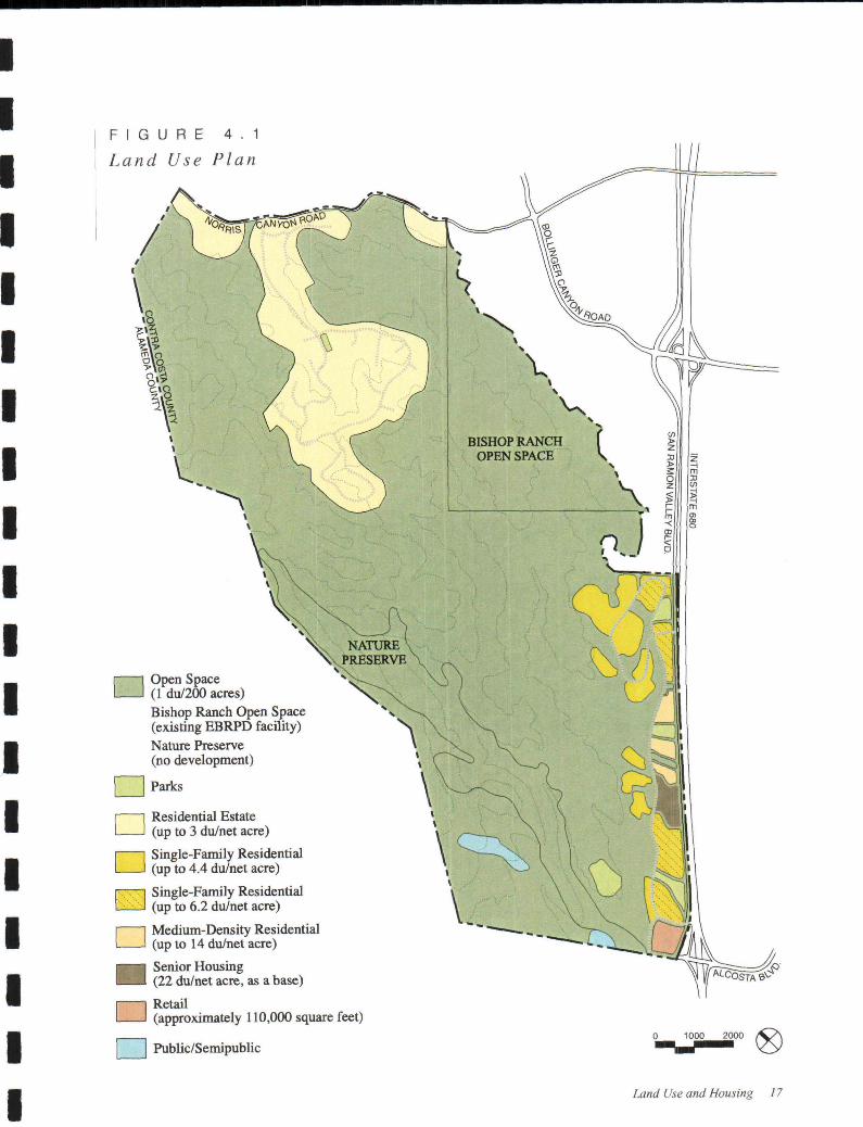
As shown on the Land Use Plan map (see Figure 4. 1),
the Specific Plan includes five residential categories,ranging from large lot single-family in the upland por-
Residential development in the Westside will providehousing close to jobs at Bishop Ranch,
16 Westside Specific Plan
Development within Westside San Ramon will be pre-
dominantly residential.
tions of the Norris Canyon area to multi-family and
senior housing adjacent to San Ramon Valley Boule-
vard. There is no commitment to approve the estimated
number of units within either development subarea, as
shown in Table 4. 1. Final approvals will be based on
such factors as geologic safety, slope analysis pursuantto Ordinance 197, views and visual appearance, and
the design integrity of the proposed project.
Open Space
This category is intended to encourage the continuance
ofcattle grazing activities in the area. In the open space,
residential development is permitted at a density of 1
dwelling unit per 200 acres. In the nature preserve area,
however, which may be located in a portion of BigCanyon, neither grazing nor agricultural uses would be
permitted.
Parks
This category includes proposed parks, but does not
include private common area open spaces or the pro-
posed nature preserve, which is a part of the open space
designation and requires active property owner partici-pation.
The Land Use Plan map and an illustrative plan ( see
Figure 4.2) indicate designated locations for residen-
tial development. An estimated 450 dwelling units are
allowed in the Norris Canyon Road area, with the ma-
jority concentrated away from the road. An estimated
825 dwelling units are allowed in the San Ramon Val-
ley Boulevard area, with lot sizes increasing with el-
evation. The senior housing site is shown to be located
on the property belonging to the Baptist Church, which
has expressed interest in pursuing the development of
such housing. Parks are distributed throughout the San


Retail
From the preceding demographic analysis, it is expectedthat San Ramon will continue to attract relatively af-
fluent households, who will tend to be small house-
holds, some without children, attracted by employmentopportunities in the 1- 680 corridor. It is expected that
this demographic base will exhibit high levels of retail
spending.
Description of Land Use
The Westside Specific Plan provides for the continua-
tion of agricultural activities and the development of
residential uses, with an estimated 1, 289 dwelling units
and 3, 558 new residents ( using ABAG assumptions of
2,76 persons per household), This equals approximatelyseven percent of the total population at buildout of the
General Plan in 2010,
Of the estimated 1, 289 dwelling units, 200 (base only)are attached senior housing units, approximately 175
are multi-family townhouse units, and approximately900 are detached single- family dwelling units, At a
density of one dwelling unit per 200 acres, 14 dwellingunits would be permitted in the open space area. In
addition, the Plan allows a 1 a- acre retail shopping cen-
ter (which was built in 1994), a rustic conference facil-
ity or camp, and approximately 36 acres of new publicparks,
As shown on the Land Use Plan map (see Figure 4.1),the Specific Plan includes five residential categories,ranging from large lot single- family in the upland por-
Residential development in the Westside will providehousing close to jobs at Bishop Ranch.
16 Westside Specific Plan
Development within Wests ide San Ramon will be pre-
dominantly residential.
tions of the Norris Canyon area to multi- family and
senior housing adjacent to San Ramon Valley Boule-
vard, There is no commitment to approve the estimated
number of units within either development subarea, as
shown in Table 4. 1. Final approvals will be based on
such factors as geologic safety, slope analysis pursuantto Ordinance 197, views and visual appearance, and
the design integrity of the proposed project.
Open Space
This category is intended to encourage the continuance
of cattle grazing activities in the area, In the open space,residential development is permitted at a density of 1
dwelling unit per 200 acres. In the nature preserve area,
however, which may be located in a portion of BigCanyon, neither grazing nor agricultural uses would be
permitted.
Parks
This category includes proposed parks, but does not
include private common area open spaces or the pro-
posed nature preserve, which is a part of the open space
designation and requires active property owner partici-pation.
The Land Use Plan map and an illustrative plan ( see
Figure 4.2) indicate designated locations for residen-
tial development. An estimated 450 dwelling units are
allowed in the Norris Canyon Road area, with the ma-
jority concentrated away from the road. An estimated
825 dwelling units are allowed in the San Ramon Val-
ley Boulevard area, with lot sizes increasing with el-
evation. The senior housing site is shown to be located
on the property belonging to the Baptist Church, which
has expressed interest in pursuing the development of
such housing, Parks are distributed throughout the San

that serves different purposes and helps driv-
ers orient themselves,
6, Establish specific horizontal and vertical align-ments for Norris Canyon Road, San Ramon
Valley Boulevard and Westside Drive to en-
sure orderly and coordinated development of
these roads.
7, Align roadways in consideration of the topo-
graphic character of hillside areas. Roads with
cross- slope alignments should undulate and
incorporate street trees to minimize visual
impact.
8, Minimize street widths and on-street parkingin hillside areas to reduce grading and con-
struction impacts,
9. Provide bicycle and pedestrian facilities suit-
able for commuter, school, and recreational
trips,
10, Provide transit support facilities to increase the
attractiveness to potential passengers,
11. Provide improved transit service to key em-
ployment and retail centers and the Dublin/
Pleasanton BART station,
12. Protect existing residential neighborhoodsfrom substantial increases in through traffic.
Internal Roadway Policies
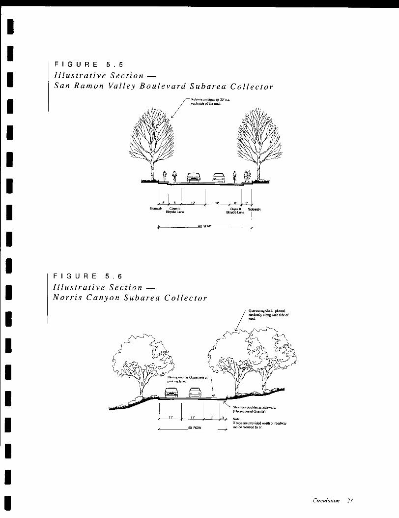
1. San Ramon Valley Boulevard Area Collector
Road System - Provide a north-south collec-
tor " spine road" ( Westside Drive) linked to
nearby San Ramon Valley Boulevard by three
east- west collector roads,
2. Stop Signs should be provided to control mi-
nor street traffic at all intersections of collec-
tor roads with arterial roads or with other col-
lector roads ( except where traffic signals are
recommended),
3. The principal Collector Streets in the San
Ramon Valley Boulevard area should include
a minimum of two l2-foot wide travel lanes
and sidewalks ( and bike lanes on Westside
Drive, the west leg of Alcosta, and the north-
ernmost access collector south of Montevideo
Drive), Other collectors in the San Ramon
22 Westside Specific Plan
Valley Boulevard and Norris Canyon Road
areas should include two II-foot travel lanes
and a single eight- foot wide parking lane
where houses front on the street. ( If a splitlevel roadway is used for a collector road in
the Norris Canyon Road area, a wider road-
way width shall be considered for safety rea-
sons,)
4, Local Residential Streets should have a mini-
mum paved width of26 feet (with no on- street
parking, but parking provided in off-street
bays), Alternatively, parking can be providedon one side, with a minimum width of 32 feet.
Widths are curb- to-curb and include two feet
of width for gutters,
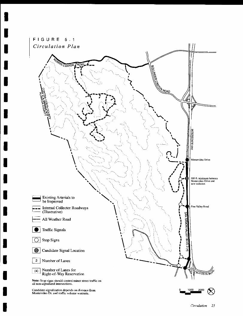
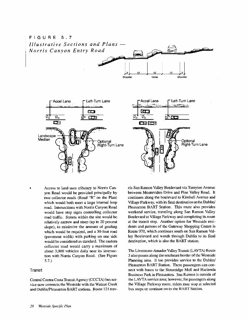
Circulation Improvements
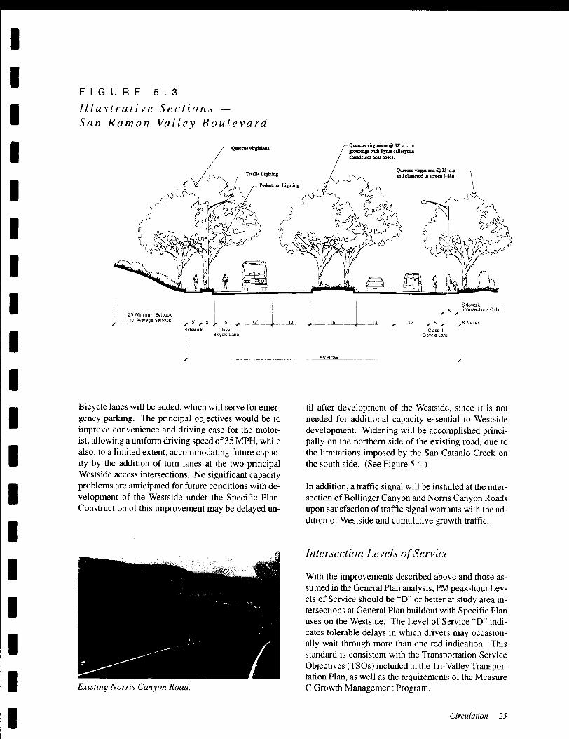
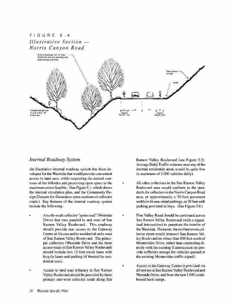
Three major freeway/roadway improvements are pro-
posed in the Circulation Plan ( as illustrated in Figure5. 1):
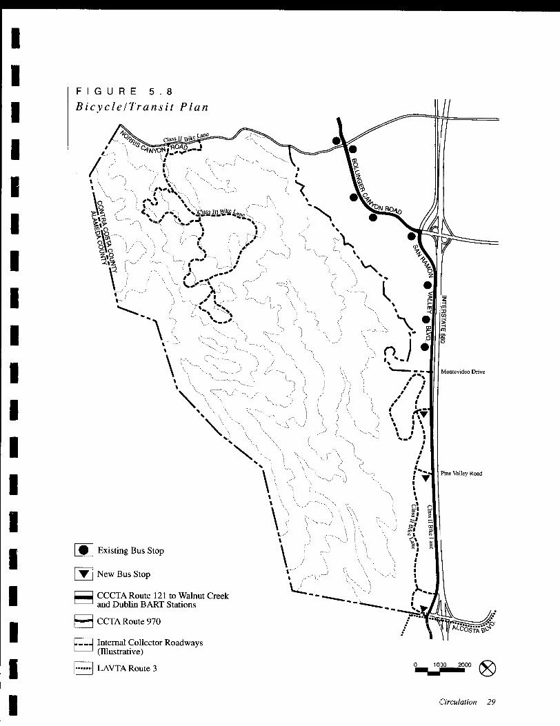
Alcosta/I-680 Interchange upgradeSan Ramon Valley Boulevard wideningNorris Canyon Road widening
These are described in greater detail below.
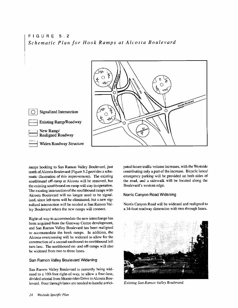
Alcosta Interchange
Improvements to the Alcosta interchange are needed to
remedy existing operational problems in which west-
bound queues waiting at the Alcosta/San Ramon Val-
ley Boulevard intersection back up and block the nearbysouthbound off-ramp, and to avoid future capacity con-
ditions at the ramp terminals. In 1994, Caltrans ap-
proved a " hook ramp" design at this location, The new
interchange will include new southbound on- and off-
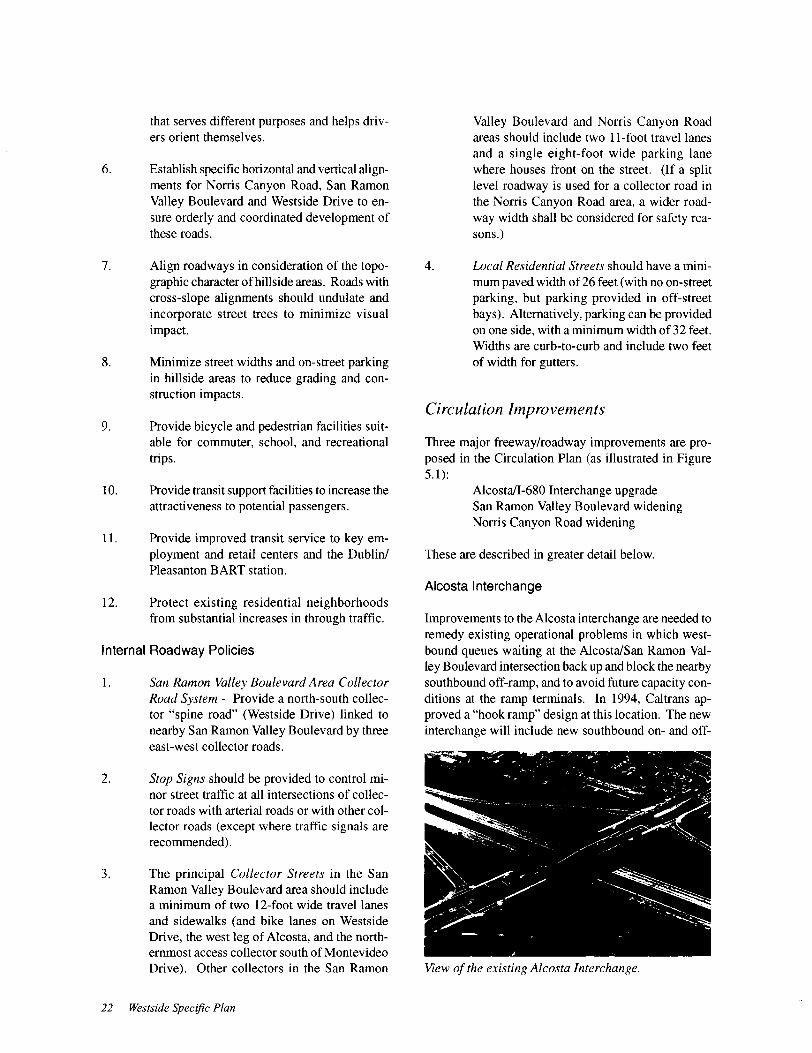
View of the existing Alcosta Interchange,
I
ICHAPTER 6 Ope n Spa (' e and C () n s e r \' a f ion
I
I
I Background
I
I
To many, the Westside landscape appears a rugged wil-
derness that has eluded modification and adaptation for
human use, In fact, like much of the California foot-
hills, the Westside has had a long productive historydating from the Spanish secularization of the landscapeinto ranches. In addition to cattle grazing, parts of the
Westside have been quarried and mined, woodland has
been forested for fire wood, ridges have been reshapedand roads extended. With the exception of the Laborer' s
Union property, most of the major land holdings are
owned or leased to cattlemen that use its steep hillsides,
creek valleys and broad ridges as range for over two
hundred head of cattle,
I
I
IThe intense use of the Wests ide landscape for many
years has taken away much of its biological value as
habitat and has contributed to unstable slopes,downcutting of streams, and general erosion of fragileterrain, On the other hand, the Wests ide remains of
great scenic value as an open space backdrop to the
San Ramon Valley. In contrast to the more arid east
side of the Valley, the Westside appears a verdant land-
scape with a greater number of trees and diversity of
plants, It has steeper slopes, more eccentric and promi-nent land forms and is ribboned by myriad streams and
drainages, most of which are ephemeral in nature, The
Westside landscape naturally breaks into a series of
canyons and valleys, which run north and south, creat-
ing clearly defined physiographic units, Three of these
valleys are quite large and include San Catanio Creek
Canyon off of Norris Canyon Road; the Oak Creek
Canyon which extends to the heart of the San Ramon
Valley Boulevard area; and Big Canyon, which is rela-
tively isolated and characterized by extremely steepslopes and areas of dense vegetation.
I
I
I
I
I
IThe primary purpose of this element of the SpecificPlan is to preserve and enhance the integrity of the
Westside landscape and to balance its diverse values
and uses as wildlife habitat, for cattle grazing, as sce-
nic open space and as a recreational opportunity for
Wests ide and San Ramon Valley residents.
I
I
I
Biotic Communities
The Westside is characteristic of a California foothills
environment with a history of heavy grazing and is pri-marily comprised of five basic plant communities: non-
native grassland that has replaced the native perennialbunch grasses with wild oats, brome grass and rye
grasses; oak woodland ( primarily valley oaks) found
on slopes and gentle ridges; broadleaved upland forest
with a mixture of coast live oak, California bay, big-leaf maple and an occasional Madrolli~; riparian forest
dominated by white alder; and the Diablan Sage Scrub
comprised of drought-deciduous shrubs,
Biologically, the most important habitats in the Westside
are the creekside habitats and the riparian woodlands
that exist in most of the canyons and gullies in the
Westside area, Due to the presence of water, these ar-
eas are, in most cases, more densely vegetated, and
house a greater density of wildlife than any other habi-
tat area in the planning area, They are also importantwildlife corridors,
In general, however, most of the springs and creek beds
have been heavily trampled and are of limited habitat
value, Only one small drainage near the Wiedemann
ranch house contains species associated with riparianhabitats and probably carries water throughout the an-
nual cycle in good water years, Even this drainage,
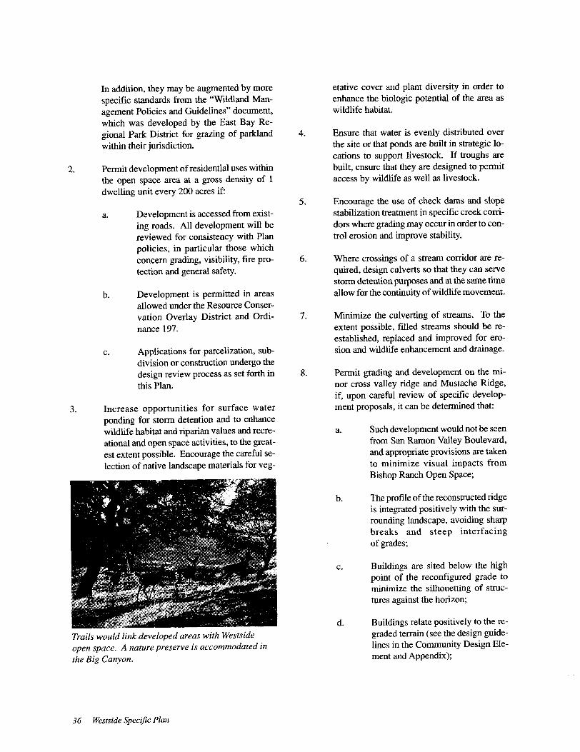
View ofBig Canyon andfuture nature preserve.
Open Space and Conservation 31

though, has been degraded as useful aquatic habitat bycattle grazing. Near the uppermost springs in this drain-
age, several male California newts in breeding condi-
tion were observed in small pools, Other wildlife spe-cies commonly found in these densely wooded canyonbottoms include the raccoon, California mouse, Pacific
tree frog, ringneck snake, and a wide variety of wood-
land birds, including Nuttall's woodpecker, Stellar' s jay,Hutton' s vireo, and the orange- crowned warbler.
The open grassland habitats provide for many wildlife
species and excellent hunting areas for raptors and other
predators, In portions of the planning area which are
not overgrazed, the grassland habitat supports a wide
variety of animals and birds including the valley pocketgopher, California vole, Pacific Coast Blacktail deer,
Pacific gopher snake and western fence lizard, as well
as many birds such as the lesser goldfinch, homed lark,
and red-tailed hawk, ( See Figure 6. 1.)
Open Space Areas
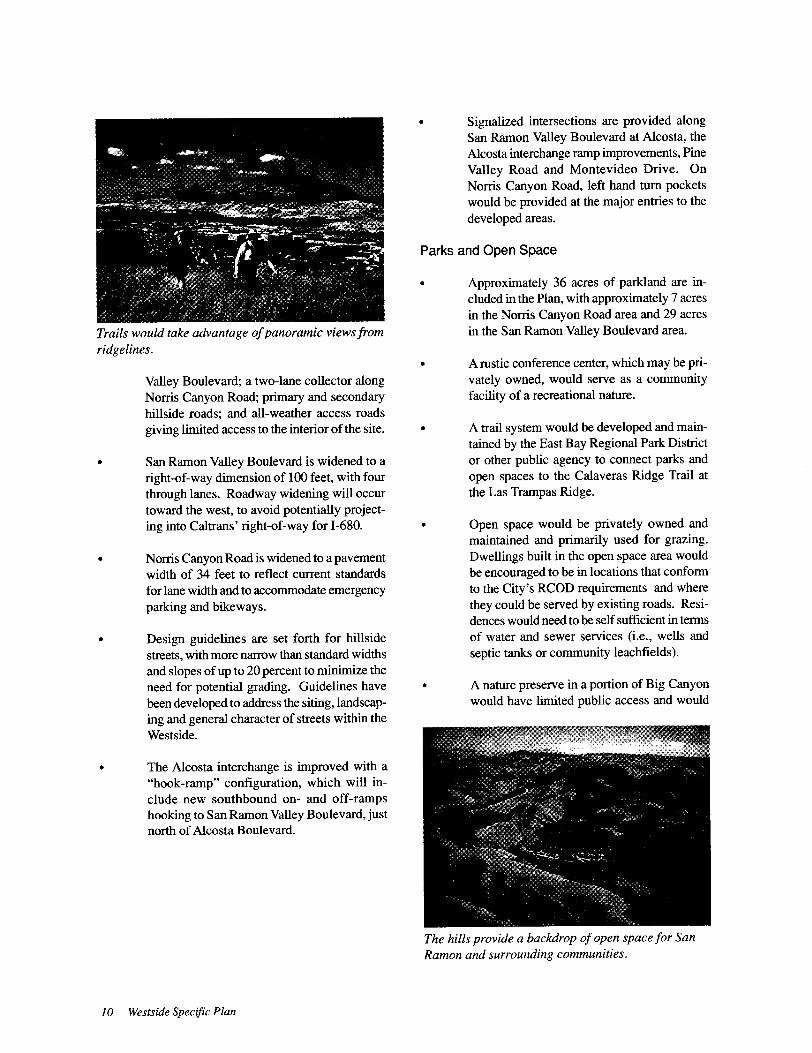
As discussed, the Wests ide is of tremendous scenic
value as visual open space, providing a backdrop to the
developed areas within the San Ramon Valley. The
visual character of the Westside is comprised of a com-
plex layering of different elements. These include the
regionally visible ridge line and slopes above 1,400 feet
and the locally visible ridges as well as landmarks such
as the PG& E towers and Wiedemann Hill transmission
facilities; woodland areas associated with coast live oak!
California bay forests and riparian habitat; and San
Catanio Creek which is notable for its continual flow
of water. In addition, Big Canyon has been identified
as a discrete physiographic unit of great scenic beautydeserving of a special response, as is the rural charac-
ter of Norris Canyon Road, the historic buildings and
property walls and the specific outcroppings of rock
which occur on high hillsides throughout the Wests ide,
The basic visual elements of the landscape also con-
tribute to the potential visibility of development. Visu-
ally sensitive areas include the high ridgeline at the
County line and side slopes approximately four hun-
dred feet below it. This ridge is of great value from a
regional perspective and provides landmarks that can
be seen from throughout the Valley. The intermediate
ridges give definition to the landscape and are also quitesensitive to possible development. Finally, foregroundareas in the view from the road ( or the " proximateviewshed") are also particularly vulnerable, The re-
maining categories identify those areas where devel-
32 Westside Specific Plan
opment might be, at least initially, conspicuous, In de-
scending order, these range from exposed grasslandsto concealed wooded areas in the valley.
In addition to its value as visual open space, the Westside
landscape has tremendous potential for recreation.
Popular recreational activities include horseback riding,camping and hiking, which occur throughout the
Wests ide except where the steepness of the topographyprohibits such activities, In addition, special commu-
nity events, such as " Kite Day", have been instituted
atop a broad sloping plane on the Wiedemann prop-
erty, Although a variety of recreational activities take
place within privately held land, a 300-acre open space
area in the northeastern portion of the Westside is owned
by the East Bay Regional Park District. Known as the
Bishop Ranch Regional Open Space, this land provideshiking opportunities on existing unmarked fire roads,
and will be included in the planned Calaveras RidgeTrail corridor, which will extend from Las TrampasRegional Wilderness near Danville to Sunol RegionalWilderness to the east of Fremont.
Conservation Concepts
The Westside Specific Plan emphasizes open space pres-
ervation on the majority of the planning area in areas
of special scenic value, Development would be pro-hibited on major and minor ridgelines as defined bythe City' s Resource Conservation Overlay District and
high slopes over 1,400 feet in elevation (or within four
hundred feet of the high ridge at the County line).
Creeks, springs and ponds would be protected from
development and enhanced for limited public access
and as wildlife habitat. Buildings would set back from
the creeks and include a two-hundred foot corridor to
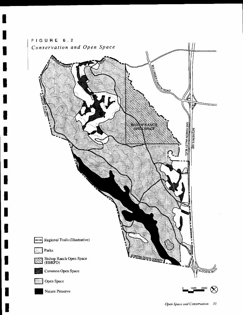

I
I2. Encourage creative solutions which would in-
tegrate new development within the landscapeof the Westside.I
3. Concentrate development in areas which mini-mize their visual prominence from adjacentstreets and San Ramon Valley Boulevard.I
I4. Create a coherent development pattern, uni-
fied by a larger organizational framework of
streets and entries, open spaces and parks.
I 5. Encourage the development of a sequenceofopen space easements which provide visualaccess to upland hillsides and maintain an
open and uncrowded feeling within the devel-
opment areas.I
I6. Encourage the appearance of a welcoming
residential community and avoid the use of
gated entries as well as high walls and steepembankments on perimeter boundaries.
I 7. Encourage development that builds upon the
hillside environment and avoids " flatland"
grading approaches to building pads.I8. Keep building heights low relative to the street
and step them down in relation to the topogra-phy.I
9. Minimize the apparent bulk of buildings.
I 10. Encourage a minimum of 25% single-storyhomes in new developments to provide visual
relief and more variety in building form.
I
I
I
I
I
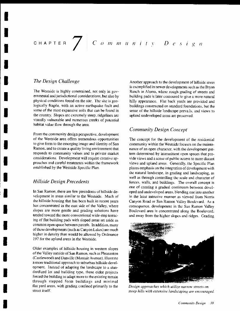
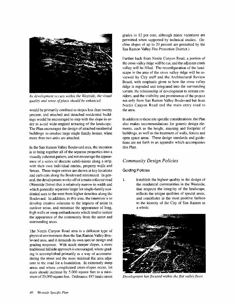
IThe Plan discourages flat pads in hillside areas.
I
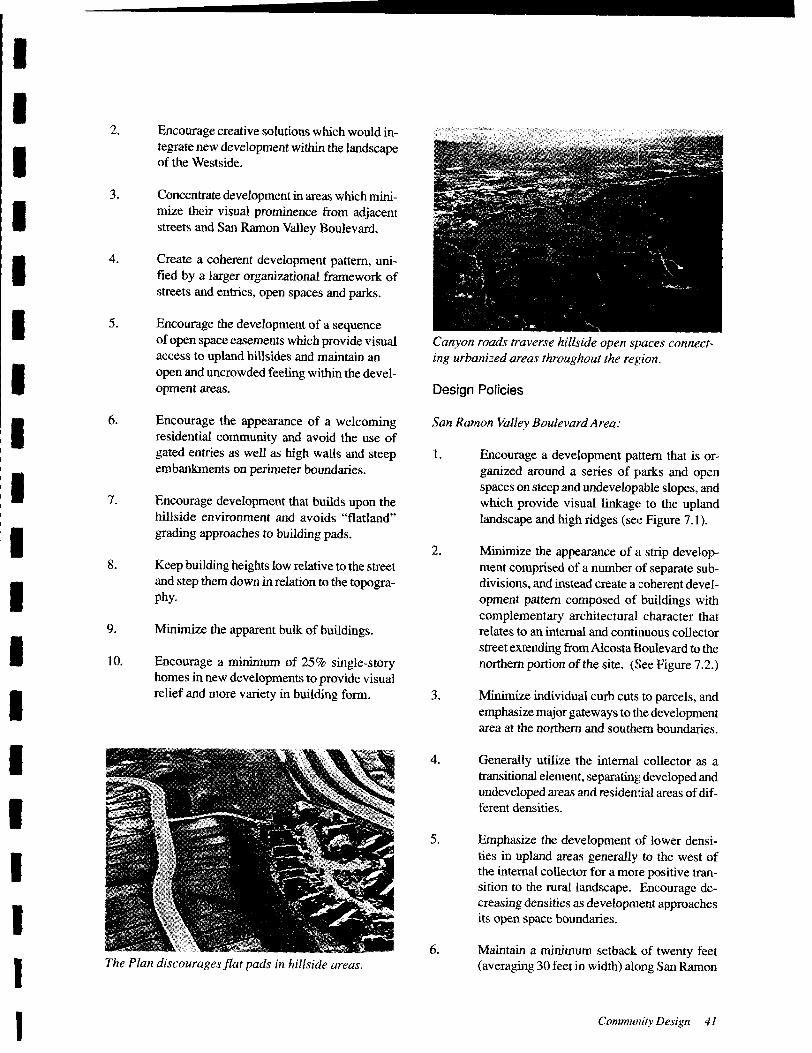
Canyon roads traverse hillside open spaces connect-
ing urbanized areas throughout the region.
Design Policies
San Ramon Valley Boulevard Area:
1. Encourage a development pattern that is or-
ganized around a series of parks and open
spaces on steep and undevelopable slopes, and
which provide visual linkag(: to the uplandlandscape and high ridges ( see Figure 7. 1).
2. Minimize the appearance of a strip develop-ment comprised of a number of separate sub-
divisions, and instead create a coherent devel-
opment pattern composed of buildings with
complementary architectural character that
relates to an internal and continuous collector
street extending fromAlcosta Boulevard to the
northern portion of the site. ( See Figure 7.2.)
3. Minimize individual curb cuts to parcels, and
emphasize major gateways to the developmentarea at the northern and southern boundaries.
4. Generally utilize the internal collector as a
transitional element, separating developed and
undeveloped areas and residellltial areas ofdif-
ferent densities.
5. Emphasize the development of lower densi-
ties in upland areas generally to the west of
the internal collector for a more positive tran-
sition to the rural landscape. Encourage de-
creasing densities as development approachesits open space boundaries.
6. Maintain a minimum setback of twenty feet
averaging 30 feet in width) along San Ramon
Community Design 41
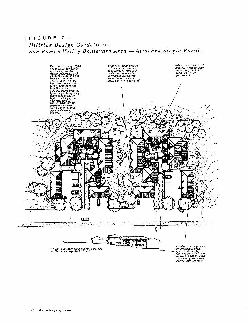
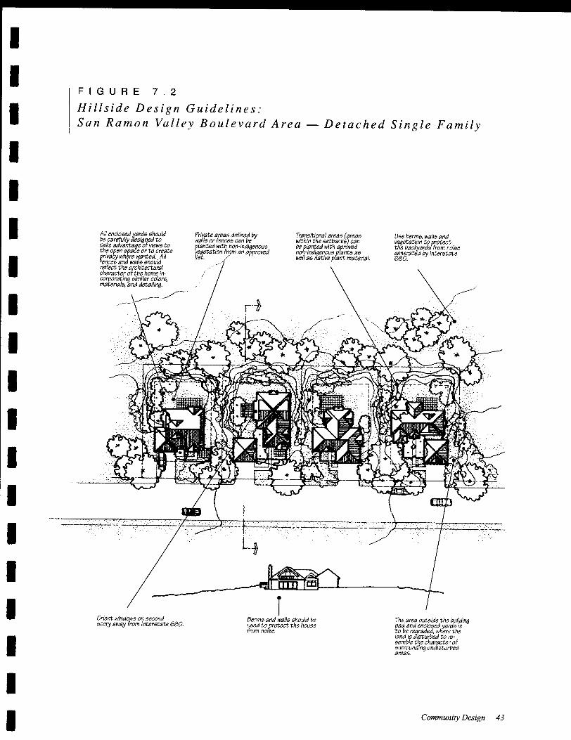
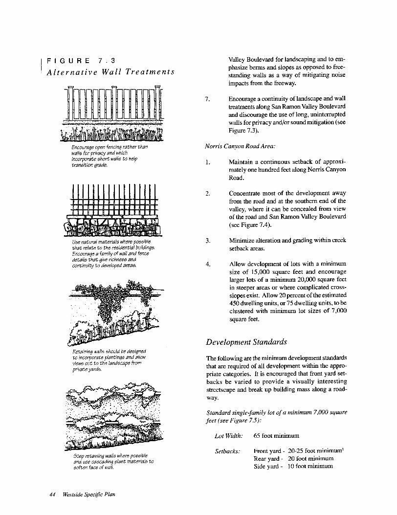
FIGURE 7. 3
Alternative Wall Treatments
Encourage open fencing rather than
walls for privacy and which
incorporate short walls to helptransition grade.
Use natural materials where possiblethat relate to the residential buildings.Encourage a family of wall and fence
details that give richness and
continuity to developed areas.
Retaining walls should be designedto incorporate plantings and allow
views out to the landscape from
private yards.
Step retaining walls where pO<'7<'7ible
and use cascading plant material<'7 to
soften face of wall,
44 Westside Specific Plan
Valley Boulevard for landscaping and to em-
phasize berms and slopes as opposed to free-
standing walls as a way of mitigating noise
impacts from the freeway.
7. Encourage a continuity of landscape and wall
treatments along San Ramon Valley Boulevard
and discourage the use of long, uninterruptedwalls for privacy and/or sound mitigation (see
Figure 7.3).
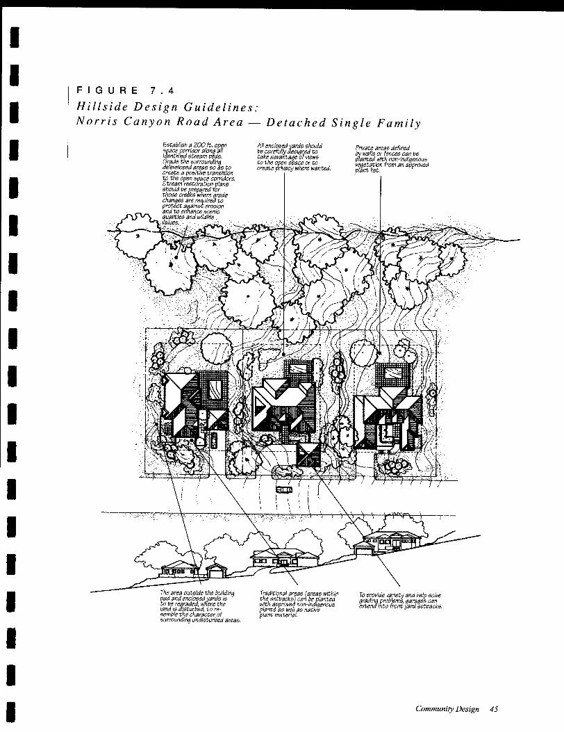
Norris Canyon Road Area:
1. Maintain a continuous setback of approxi-mately one hundred feet along Norris CanyonRoad.
2. Concentrate most of the development away
from the road and at the southern end of the
valley, where it can be concealed from view
of the road and San Ramon Valley Boulevard
see Figure 7.4).
3. Minimize alteration and grading within creek
setback areas.
4. Allow development of lots with a minimum
size of 15, 000 square feet and encourage
larger lots of a minimum 20,000 square feet
in steeper areas or where complicated cross-
slopes exist. Allow 20 percent of the estimated
450 dwelling units, or 75 dwelling units, to be
clustered with minimum lot sizes of 7, 000
square feet.
Development Standards
The following are the minimum development standards
that are required of all development within the appro-
priate categories. It is encouraged that front yard set-
backs be varied to provide a visually interesting
streetscape and break up building mass along a road-
way.
Standard single-family lot ofa minimum 7,000 square
feet (see Figure 7.5):
Lot Width: 65 foot minimum
Setbacks: Front yard - 20-25 foot minimum!
Rear yard - 20 foot minimum
Side yard - 10 foot minimum
I
IFIGURE 7. 4
Hillside Design Guidelines:
Norris Canyon Road Area Detached Single FamilyI
I
I
Establish a 200 ft. openspace corridor along allidentified stream beds,Grade the surroundingde/eveloped areas so as tocreate tJ positive transitionto the open space corridors,Stream restdration plansshould be prepared forthose creeks where gradechanges are, r~ uirea ,to
e~~~~ge ; c~::jgnqualities and WIldlifevalues" '
All enclosed yards shouldbe carefully designed totake advantage Of viewsto the open space or tocreate privacy where wanted,
Private areas definedby waifs or fences can be
planted with non- indigenousvt;getatlon from an approved
plant list,
I
I
I
I
I
I
I
I
I
I
IThe area outside the buildingpad and enclosed yards Is
n~ei; egr:r~~g'e~ lit//;~esemble the character ofsurrounding undisturbed areas,
Traditional areas (areas withinthe setbacks) can be plantedwith approved non- indigenousplants as well as native
plant material,
To provide variety and help solvegrading problems. garages can
extend into front yard setbacks,
I
I
I Community Design 45

65' 65'
1 R~ar rU ~ --
lu5,250sf~~:
1<: :
DGradedPod
iI' 5,250 sf IIu. I :
GnIded Pad ,.
IjMmMm! :
I, I
II ~ ____
Lu___S8tbacks
Street FrontBuilding Walls
I~':~ L_ (~~:::"L-__:.;.Grade
Figure 7.5 Standard single-family lot
Iw ~ W
I
r ~ -----------r--------------lI
I: 6,500 sf Mox. iiGraded Pod :
6,500 sf IIu.Graded Pad I1M" :
I II ~ I :
L _____ ______ u..JS8tb8cks
Street FrontBuHdlng WIllis
10%
StreetGrade
Figure 7.6 Medium single-family lot
RJar100'
I
11---- -I
I
I1I
II,.
IMi.,
7,500 sf -,
Graded Pod
II
II
I
1.-_ ______
SetbacksStreet Front
7,500 sf Mox.Graded Pod
Building WIllis
2%StreetGrade
Figure 7.7 Large single-family lot
46 Westside Specific Plan
Medium single-family lot ofa minimum 10,000 square
feet (see Figure 7,6):
Lot Width: 80- 100 foot minimum
Setbacks: Front yard - 20-25 foot minimuml
Rear yard - 20 foot minimum
Side yard - 10 foot minimum
Large single-family lots of a minimum 15,000 and
20,000 square feet (see Figure 7.7):
Lot Width: 100 foot minimum
Setbacks: Front yard - 30 foot minimum
Rear yard - 25 foot minimum
Side yard - 10 foot and 15 foot
minimums
Exceptions to Standards
Building height is limited to 32 feet for property over
the 500-foot elevation and on slopes greater than 10
percent. Otherwise, maximum allowable heights are the
same as those set forth in the City' s Zoning Ordinance.
Building height shall be measured pursuant to Section
D4- 134 of the Zoning Ordinance.
Front yard setbacks can be reduced to 18 feet with
roll-up garage doors. They may also be reduced to 10
feet for side entry garages, which can straddle the prop-
erty line with a shared driveway. In areas designatedfor light grading, reduction of front yard setbacks would
be permitted upon design review.
Rear yard setbacks need not apply if there is no ad-
joining rear residence.
If exceptions to development standards are requestedwith application of the Affordable Housing DensityBonus, they will be reviewed for consistency with the
City' s Zoning Ordinance. Development standards for
senior housing, multi-family housing, and retail shop-
ping are otherwise the same as those set forth in the
applicable zoning district.
Design Review Procedures
The special qualities of the hillside landscape and its
role in giving structure and identity to the City make
the character of land forms, the alignment of roads, lay-out of individual parcels, and the design of specificbuildings of particular importance to the successful
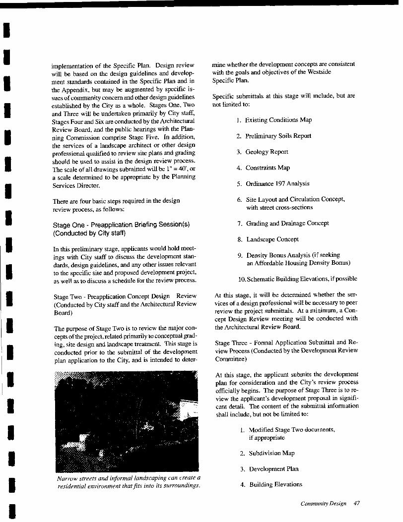
I
Iimplementation of the Specific Plan. Design review
will be based on the design guidelines and develop-ment standards contained in the Specific Plan and in
the Appendix, but may be augmented by specific is-
sues of community concern and other design guidelinesestablished by the City as a whole. Stages One, Two
and Three will be undertaken primarily by City staff,
Stages Four and Six are conducted by the Architectural
Review Board, and the public hearings with the Plan-
ning Commission comprise Stage Five. In addition,
the services of a landscape architect or other design
professional qualified to review site plans and gradingshould be used to assist in the design review process.
The scale of all drawings submitted will be I" = 40', or
a scale determined to be appropriate by the PlanningServices Director.
I
I
I
I
IThere are four basic steps required in the designreview process, as follows:
I Stage One - Preapplication Briefing Session(s)
Conducted by City staff)
I In this preliminary stage, applicants would hold meet-
ings with City staff to discuss the development stan-
dards, design guidelines, and any other issues relevant
to the specific site and proposed development project,as well as to discuss a schedule for the review process.
I
I Stage Two - Preapplication Concept Design Review
Conducted by City staff and the Architectural Review
Board)
I The purpose of Stage Two is to review the major con-
cepts of the project, related primarily to conceptual grad-
ing, site design and landscape treatment. This stage is
conducted prior to the submittal of the developmentplan application to the City, and is intended to deter-I
I
I
I
I
INarrow streets and informal landscaping can create a
residential environment that fits into its surroundings.
I
mine whether the development concepts are consistent
with the goals and objectives of the W.~stside
Specific Plan.
Specific submittals at this stage will include, but are
not limited to:
1. Existing Conditions Map
2. Preliminary Soils Report
3. Geology Report
4. Constraints Map
5. Ordinance 197 Analysis
6. Site Layout and Circulation Concept,with street cross- sections
7. Grading and Drainage Concept
8. Landscape Concept
9. Density Bonus Analysis (i:f seekingan Affordable Housing Density Bonus)
10. Schematic Building Elevations, ifpossible
At this stage, it will be determined whether the ser-
vices of a design professional will be m:cessary to peer
review the project submittals. At a minimum, a Con-
cept Design Review meeting will be conducted with
the Architectural Review Board.
Stage Three - Formal Application Submittal and Re-
view Process (Conducted by the Development Review
Committee)
At this stage, the applicant submits the development
plan for consideration and the City' s review process
officially begins. The purpose of Stage: Three is to re-
view the applicant' s development proposal in signifi-cant detail. The content of the submittal information
shall include, but not be limited to:
1. Modified Stage Two documents,
if appropriate
2. Subdivision Map
3. Development Plan
4. Building Elevations
Community Design 47
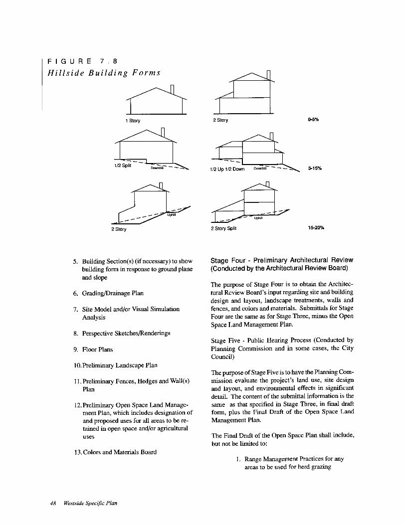
FIGURE 7. 8
Hillside Building Forms
C11 Story
1/ 2 Split hill--_
2 Story
5. Building Section( s) ( if necessary) to show
building form in response to ground planeand slope
6. Grading/Drainage Plan
7. Site Model and/or Visual Simulation
Analysis
8. Perspective Sketches/Renderings
9. Floor Plans
10. Preliminary Landscape Plan
11. Preliminary Fences, Hedges and Wall(s)
Plan
12. Preliminary Open Space Land Manage-ment Plan, which includes designation of
and proposed uses for all areas to be re-
tained in open space and/or agriculturaluses
13. Colors and Materials Board
48 Westside Specific Plan
2 Story 0-5%
5-15%1/2 Up 1/ 2 Down ~ hill
2 Story Split 15-20%
Stage Four - Preliminary Architectural Review
Conducted by the Architectural Review Board)
The purpose of Stage Four is to obtain the Architec-
tural Review Board' s input regarding site and building
design and layout, landscape treatments, walls and
fences, and colors and materials. Submittals for StageFour are the same as for Stage Three, minus the Open
Space Land Management Plan.
Stage Five - Public Hearing Process ( Conducted by
Planning Commission and in some cases, the CityCouncil)
The purpose of Stage Five is to have the Planning Com-
mission evaluate the project' s land use, site designand layout, and environmental effects in significantdetail. The content of the submittal information is the
same as that specified in Stage Three, in fmal draft
form, plus the Final Draft of the Open Space Land
Management Plan.
The Final Draft of the Open Space Plan shall include,
but not be limited to:
1. Range Management Practices for any
areas to be used for herd grazing
I
I2. Wildlife Habitat Management and Mitiga-
tion Plan
I 3. Tree Management and Mitigation Plan
I 4. Rare Plant Survey and Mitigation Plan
5. Creek Management and Mitigation Plan
I 6. Erosion Control Plan
I7. Long-term Maintenance Practices for all
open space areas
I Stage Six - Final Building and Landscape DesignReview, if necessary (Conducted by ArchitecturalReview Board)
I In this stage, building and landscape treatment reviewwill be completed. Specific submittals at this stage will
include, but not be limited to:
I 1. Final Landscape Plan
I2. Final Fences, Hedges and Walls Plan
3. Perspective Sketches/Renderings
I 4. Floor Plans and Roof Plans
I
I
Ii
I
I
I
I
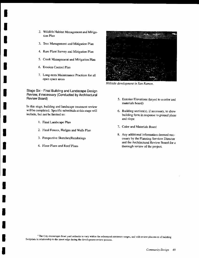
Hillside development in San Ramon,
5. Exterior Elevations (keyed to a color and
materials board)
6. Building section(s), if necessary, to show
building form in response to ground planeand slope
7. Color and Materials Board
8. Any additional information deemed nec-
essary by the Planning Services Director
and the Architectural Review Board for a
thorough review of the pro~ect.
1 The City encourages front yard setbacks to vary within the referenced minimum ranges, and will review placement of buildingfootprints in relationship to the street edge during the development review process,
I Community Design 49

I
Ibut not within, the ultimate service boundary for
EBMUD.
I The existing distribution system within the Westside
area contained within EBMUD' s service boundary con-
sists of three pressure zones. The fIrst zone covers the
elevations of 340 to 540 feet, and is named the Amador
Pressure Zone. The second zone, the San Ramon Pres-
sure Zone, serves elevations from 450 feet to 650 feet.
The Derby Pressure Zone, between 650 feet and 850
feet, presently serves the general area located to the
west of Bollinger Canyon Road and south of Norris
Canyon Road.
I
I
I
IThe water demand generated by development in this
area would be approximately 1.0 MGD. This repre-sents less than one percent of the current demand of the
District. This increase in demand could easily be ac-
commodated by the current water supply system dur-
ing normal years.I
IThe Wiedemann Ranch Residential Community will
require water service from four pressure zones, ofwhich
three will be entirely new zones. The base zone (Derby)will serve lots between elevations 650 feet and 850 feet,
the second zone ( Bishop) between 850 feet to 1, 060
feet, and the third pressure zone (Wiedemann) between
1, 060 feet to 1, 270 feet. The fourth or highest zone
Knife) will serve the lots above the elevation of 1, 270
feet. New water storage, pumping and transmission
facilities will be needed to extend the existing DerbyPressure Zone to the project area. Necessary offsite
improvements along Norris Canyon Road will include
the oversizing of planned pipeline improvements be-
tween San Ramon Valley Boulevard and Bollinger Can-
yon Road, and a pipeline extension ( including a new
pumping plant) westerly from Bollinger Canyon Road
to the Wiedemann site. The construction of the majorfacilities in these zones would be funded by a separateSystem Capacity Charge ( SCC) imposed by EBMUD
under its regulations, which would be calculated on the
basis of average water use by meter size, and also in-
clude components for future water supply, water main
upsizing, and improvements in new zones supplyingthe area. The SCC would be placed on all new devel-
opment within the affected area.
I
I
I
I
I
I
IThe area along San Ramon Valley Boulevard could be
served by existing facilities as long as development is
kept within EBMUD' s service area and below the el-
evation of 650 feet. However, these existing facilities
may need to be upsized or replaced to meet water ser-
vice and fIre flow requirements. Additional paralleland looped water main installations may be needed to
I
I
I
provide pipeline capacity and adequate fIre flows for
development in this area. All development would be
required to pay the established SCC for EBMUD' s
Region 7, unless new major facilities are required to serve
the area The cost of water service would also includewater mains, fIre hydrants and service connections as
required by EBMUD regulations, rates, and charges.
Other areas to be developed within the Westside planarea but outside EBMUD' s current service area would
require annexation to EBMUD for services. EBMUD' s
policy is to oppose all annexations outside its Ultimate
Service Boundary unless certain fmdings can be made
consistent with the District's Policy 1, adopted Febru-
ary 14, 1991.
The Westside planning area is currently being evalu-ated for inclusion within the DSRSDIEBMUD Re-
cycled Water Authority (DERWA) service area. It is
thus possible that all parks, streetscapes, golf courses
and other large public areas will be inigated with re-
cycled water. Any areas within DERWI\'s service area
would be subject to EBMUD' s Nonpotable Water Policyand water service regulations, including any dual
plumbing requirements.
Police and Fire Protection
Most of the Westside is currently served by the Contra
Costa Sheriff' s Department. When development oc-
curs and the entire site is annexed into the City of SanRamon, police protection will be provided by the Cityof San Ramon Police Department.
The project site is currently served by the San Ramon
Valley Fire Protection District ( SRVFPD). The SanRamon Valley Fire Protection District' s "'First Due" fIre
response would arrive at the Westside from Fire Sta-tion #34 located near the intersection of Alcosta Bou-
levard and Bollinger Canyon Road, and from Station39, located at Alcosta Boulevard and Fircrest Lane.
Additional assistance would come from Station # 38located on Bollinger Canyon Road at Crow CanyonRoad.
Development of the Westside planning area would in-
crease demand for fire/emergency services. While the
existing fIre stations meet San Ramon Valley Fire Pro-
tection District standards and can adequately provideemergency response to this area, it will be necessary to
ensure that adequate access directly from San Ramon
Valley Boulevard is provided so that acceptable re-
sponse times are maintained.
Public Services and Utilities 53
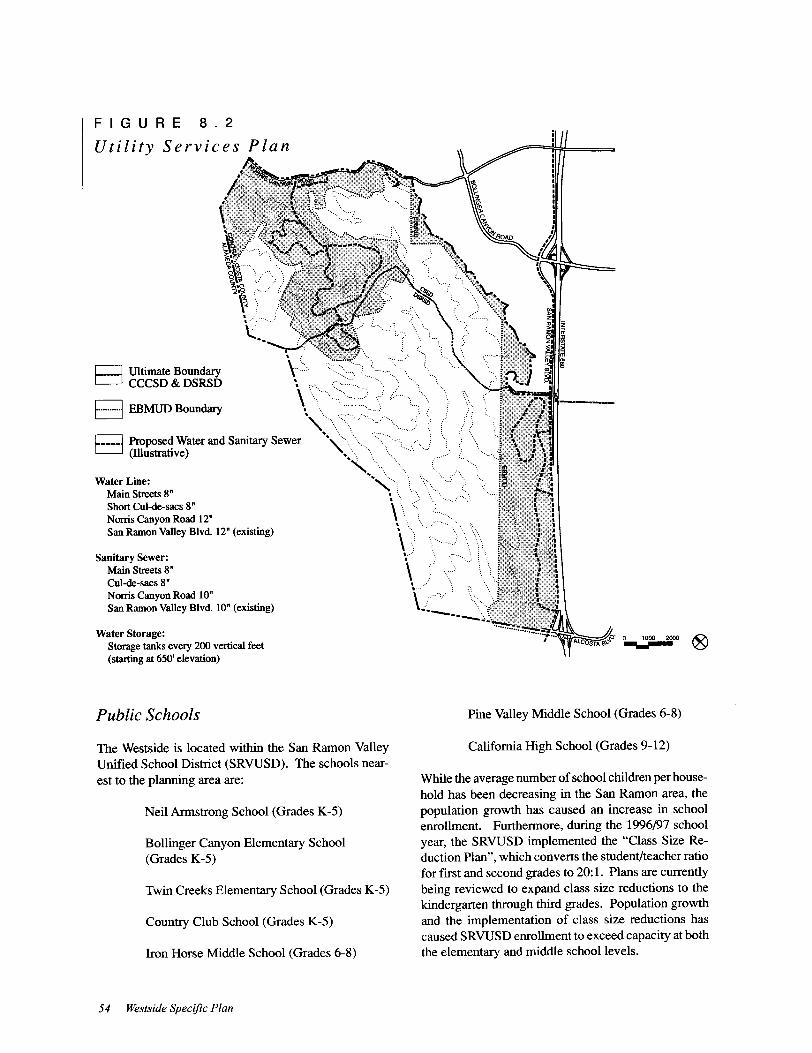
FIGURE 8. 2
Utility Services Plan
Water Storage:Storage tanks every 200 vertical feet
starting at 650' elevation)
o 1000 2000 IV\Y
c.=J Ultimate Boundaryc=J CCCSD & DSRSD
j EBMUD Boundary
qW
tL// .l '
Ui>',,\, ',,','
r---- j ~~~~:; ater and Sanitary Sewer ""':""u'
i
U,
t,),.
U
C:'..j_~
Sanitary Sewer:
Main Streets 8"
Cul-de- sacs 8"
Norris Canyon Road 10"
San Ramon Valley Blvd, 10" ( existing)
Water Line:
Main Streets 8"
Short Cul-de- sacs 8"
Norris Canyon Road 12"
San Ramon Valley Blvd. 12" ( existing)
Public Schools Pine Valley Middle School (Grades 6- 8)
The Westside is located within the San Ramon ValleyUnified School District (SRVUSD). The schools near-
est to the planning area are:
California High School (Grades 9- 12)
Country Club School (Grades K-5)
While the average number of school children per house-
hold has been decreasing in the San Ramon area, the
population growth has caused an increase in school
enrollment. Furthermore, during the 1996/97 school
year, the SRVUSD implemented the " Class Size Re-
duction Plan", which converts the student/teacher ratio
for fIrst and second grades to 20: 1. Plans are currently
being reviewed to expand class size reductions to the
kindergarten through third grades. Population growthand the implementation of class size reductions has
caused SRVUSD enrollment to exceed capacity at both
the elementary and middle school levels.
Neil Armstrong School (Grades K-5)
Bollinger Canyon Elementary School
Grades K-5)
Twin Creeks Elementary School (Grades K-5)
Iron Horse Middle School (Grades 6- 8)
54 Westside Specific Plan
I
IThe SRVUSD' s future plans include seven new schools
in the Dougherty Valley: four elementary, two middle,
and one high school. The District also plans to expandthree elementary schools (Bollinger, Twin Creeks, and
Neil Armstrong), the Iron Horse Middle School, and
California High.
I
I
IThe District is also studying the possibility of increas-
ing developer fees for the purpose of building new
school campuses and expanding existing facilities.
However, none of these actions are a direct result of
development in the Westside planning area.
I
IEnergy, Telephone and Wireless Commu-nications, Cable Television
IElectricity and natural gas will be supplied to the
Westside by the Pacific Gas & Electric CompanyPG& E). Existing gas and electric facilities are located
near the area.
I Pacific Bell provides telephone and wireless commu-
nication services to the San Ramon area. A number of
private, wireless service companies also offer an arrayof telecommunication options to the community. Ex-
isting facilities are located on San Ramon Valley Bou-
levard and within the development area adjacent to the
Boulevard. Facilities for cable television service also
exist within the Westside area.
I
I
IPublic Services Policies
I1. Annex the northern portion of the planning area
development area only) to CCCSD, and the south-
ern portion (development area) to DSRSD, as ap-
propriate, to provide service to these areas.
I 2. Extend sewer improvements to the site in accor-
dance with the requirements of the appropriatesewer districts. ( See Figure 8. 2.)
I 3. Locate all new sewer lines underground and within
the street rights-of-way with easements over pub-lic lines on private property.
I 4. Apply special standards, as required by the relevant
district, for construction of sewer facilities in hill-
side areas.I
I5. Request development that is proposed in areas out-
side of East Bay Municipal Utility District's Ur-
I
ban Service Boundary to pursue other agencies for
water service.
6. Provide new water facilities ( potable and
nonpotable) in accordance with EBMUD standards
and requirements.
7. Locate a new reservoir so that the overflow eleva-
tion is 100 feet above the nominal upper service
limit of the fully developed pressure zone and the
new pressure zone will normally cover a two hun-
dred foot elevation band.
8. Utilize water conservation and reclamation ap-
proaches in the design of all new water facilities.
9. Work with the water district to site and design water
holding tanks so that their visibility from Norris
Canyon Road and San Ramon Valley Boulevard is
minimized to the greatest extent p.assible.
10. Ensure that all development with:ln the Westside
conforms to the applicable fire codes and devel-
opment standards of the fire district.
11. Ensure that the development includes fire protec-tion features such as the following:
a. The capability to provide not less than 1, 500
GPM at 20 PSI fire flow from EBMUD hy-drants on all engineered pubhc water mains,
except as otherwise recommended by the fire
district.
b. Provide fire apparatus access roads meetingthe following criteria:
1. Maximum 20 percent street slope,grooved concrete or rough asphalt for
short stretches of road over 15 percent.
11. Minimum road widths of:
1) 20 feet with " no parking" on both
sides of the road.
2) 28 feet with "no parking" on one side
of the road.
3) 36 feet with parking on both sides of
the road.
4) Parking restrictions indicated by
Public Services and Utilities 55
I
I9.
I
I10.
I11.
I
I
I
I
I
I
I
I
I
I
I
I
I
I
Coordinate any creek modifications with per-
mitting agencies ( the Regional Water QualityControl Board, California Department of Fish
Game, and U.S. Army Corps of Engineersshould be consulted to determine their regu-
latory authority).
Provide a 200- foot corridor along creeks, mea-
sured from the creek centerline.
Minimize the number of required creek
road crossings. Road crossings shall be de-
signed to prevent erosion while being visu-
ally attractive and minimizing wildlife and
vegetation impacts.
12. Maintain and restore riparian vegetation. Re-
place disturbed areas with native riparian trees
and shrubs. Restrict cattle access to the creeks
on any open space areas which remain open
to animal grazing.
13. Restrict public access to desired areas to
minimize wildlife disturbance and access to
private yards.
14. Provide guidelines on recommended backyard
fencing and landscaping to future residents in
the Norris Canyon area.
15. Ensure that the drainage plans for specificprojects prevent increased peaks in the creeks,
while maintaining existing flow rates to main-
tain riparian values.
16. In general, bridges are preferred to culverts
for major creek crossings to maximize habitat
and allow wildlife passage. However, in ar-
eas of deep alluvial soil, stabilization may be
needed to prevent channel degradation.
17. The design of the detention basins should
include landscaping to create visually attrac-
tive areas with wildlife values and recreational
opportunities.
18. In any location where creeks are graded,specific restoration plans should be provided.These would include reconfiguration, channel
design and stabilization, and revegetationand non-local creek enhancements, where nec-
essary.
Implementation
As part of the fmal design, and to allow for phased con-
struction, the City should require a detailed plan for
each project phase, which includes provision for drain-
age and erosion control. These plans should include
the following elements:
Drainage Plan
1. Pre- and post-project flows ,md volumes for
both frequent and extreme stonDS at key pointsin the development.
2. The plan should include size, shape, outlet
works, revegetation, and long-term mainte-
nance provisions for detention basins. Mul-
tiple use of detention basins for recreation and
open space as well as wildlife habitat should
be encouraged, and the design of the basins
should be carefully integrated with the sur-
rounding terrain.
3. The location and size of the culvert system,
with energy dissipation structures where the
culverts discharge to the creeks.
4. Typical details for creek road crossings, in-
cluding erosion prevention alld revegetationplans.
5. A site grading plan which minimizes pavedareas.
6. Plan for management/maintenance of the creek
corridors as an integral part of the open space
program. This should include grazing con-
trols, provision of creek maintenance, moni-
toring of creek erosion, access, and treatment
of backyards which front on the creek.
Erosion and Sedimentation Plan
1. A construction-phase stormwater management
plan should be prepared by project applicantswhich specifies control meas,ures to reduce
stormwater pollution problem;, and reviewed
by the appropriate State and/or local agency.
This plan should address:
a. Location of all areas where vegeta-tion will be removed,
Hydrology 61


Specific Plan and its environmental documents, This
fee is subject to annual Consumer Price Index increases,
as determined by the City, to reflect the time value of
the money initially advanced by the City of San Ramon
to complete planning for the Westside,
Financing Planned Improvements
The two development areas within the Westside are
extremely different in character, The Norris CanyonRoad area is remote and characterized by highly con-
strained topography. The need to ready lots for devel-
opment in difficult terrain, extend utilities, and make
associated roadway improvements all contribute to a
high level of development costs, Prior to annexation
by the City, identified funding sources for needed on-
and off-site improvements will be required. It is the
developer' s responsibility to work with Contra Costa
County to establish financing mechanisms for the
needed improvements,
In the San Ramon Valley Boulevard area, the costs of
development on a per unit basis are also significant.To assure both the orderly progress of construction, and
that all affected landowners will participate equitablyin the responsibility to pay for necessary public im-
provements, it is anticipated that a combination of fi-
nancing techniques may be used, as follows:
Citywide development impact fees collected
throughout San Ramon;
Development impact fees applicable only to
the San Ramon Valley Boulevard area; and
Some form of tax- free municipal bonds to fi-
nance improvements which are needed at the
outset and will require ongoing City mainte-
nance,
All currently existing development fees applicable in
San Ramon, including fees which are necessary to fund
off-site roadway improvements, such as the wideningof San Ramon Valley Boulevard and the 1- 680/ Alcosta
Boulevard hook ramp design, will be adjusted to payfor planned improvements, As development continues
and improvement plans are refined, development im-
pact fees may increase, For instance, it is assumed that
the major improvements at the I-680/Alcosta Boule-
vard interchange will be funded in part from the
citywide roadway impact fee, and that citywide fees
will be adjusted to fund this additional improvement.
68 Westside Specific Plan
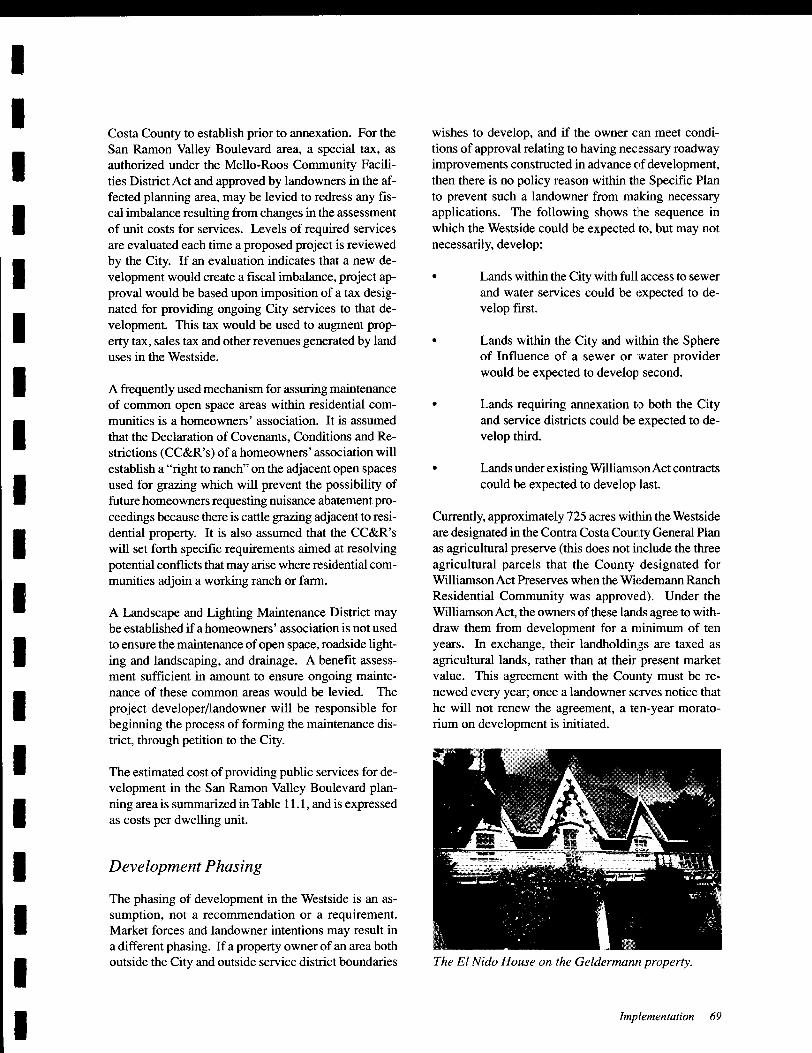
Built in the mid-1800's. the Glass House ( shown here
in its original location) has been identified by the
City as one of three historic homes along San Ramon
Valley Boulevard that should be preserved,
If it is determined that municipal bonds are necessary,
project developers must petition the City to form an
assessment district. This would occur prior to the City' s
approval of proposed developments, Two forms of fi-
nancing districts that could be used are a Special As-
sessment District or a Mello-Roos Community Facili-
ties District. The exact form of the financing district
can be selected at the time the district is created to re-
flect landowner preferences.
Monitoring and Maintenancefor OngoingCity Services
Prior to project approval, a mechanism for maintainingongoing public services must be determined for devel-
opment areas both inside and outside the City' s corpo-rate limits. For the area outside the City, a likely fund-
ing source would be a County Service Area assessment
district, for which landowners would petition Contra
JIIiIThe Boone House is a good example ofhigh styleDutch Colonial homes built in the early 1900 'so
I
I
I
I
I to
IWests ide Plan was in and
the first General Plan was in October1995, The 995 incorporated this Plan' s land
and The of the
Plan is intended to incorporate pre-
policy, in particular Ordinance 197
Save Our Hills and Ordinance 248 (the
Affordable Housing as well as to
make the entire document current with de-
entitlements and adopted programs,discussion outlines the General
to the Wests ide and shows the
Plan to them, The other
Plan demonstrate this consis"in greater detaiL
Iuse
Westside
I
IThe
Plan
of the
elements of the
Iof
I One of the policies of the of San Ramonis that the open space character of the Westside be pre-served, In support of this goal, the of theWestside will be preserved for agriculturaland open space uses, and development confined withintwo basic areas one to Norris Canyon Roadand the other to San Ramon Boulevard,
in accordance with Ordinance 197, de-
is on slopes than 20 per-cent, within 100 feet and 50 feet of Major and Minor
as denoted on the Ridgelineand Creek Protection Zone and within 100 feet ofthe centerline of creeks or stream channels shown on
the same The Plan also restricts density on land
greater than 10 percent slope over the 500 foot eleva-tion, Residential may not exceed one unit perone acre on between 10 percent and 15 percent,and one unit per five acres on between 15 per-
and 20 percent.
I
I
I
I
I
I Resource Conservation District
which was adopted Ordinance 129 in
the submittal of "resource conservation
with the district
of severalI
I
an conditions map, map, site and circu-lation soils report. and drain-
age reports, and a The Wests idecific Plan the submittal of these documents in
with
and! or
area' s oak trees,
in
and also " land
which shall describe the
to maintain land for open spaceuses, and to preserve and protect the
areas with
and tree managementand
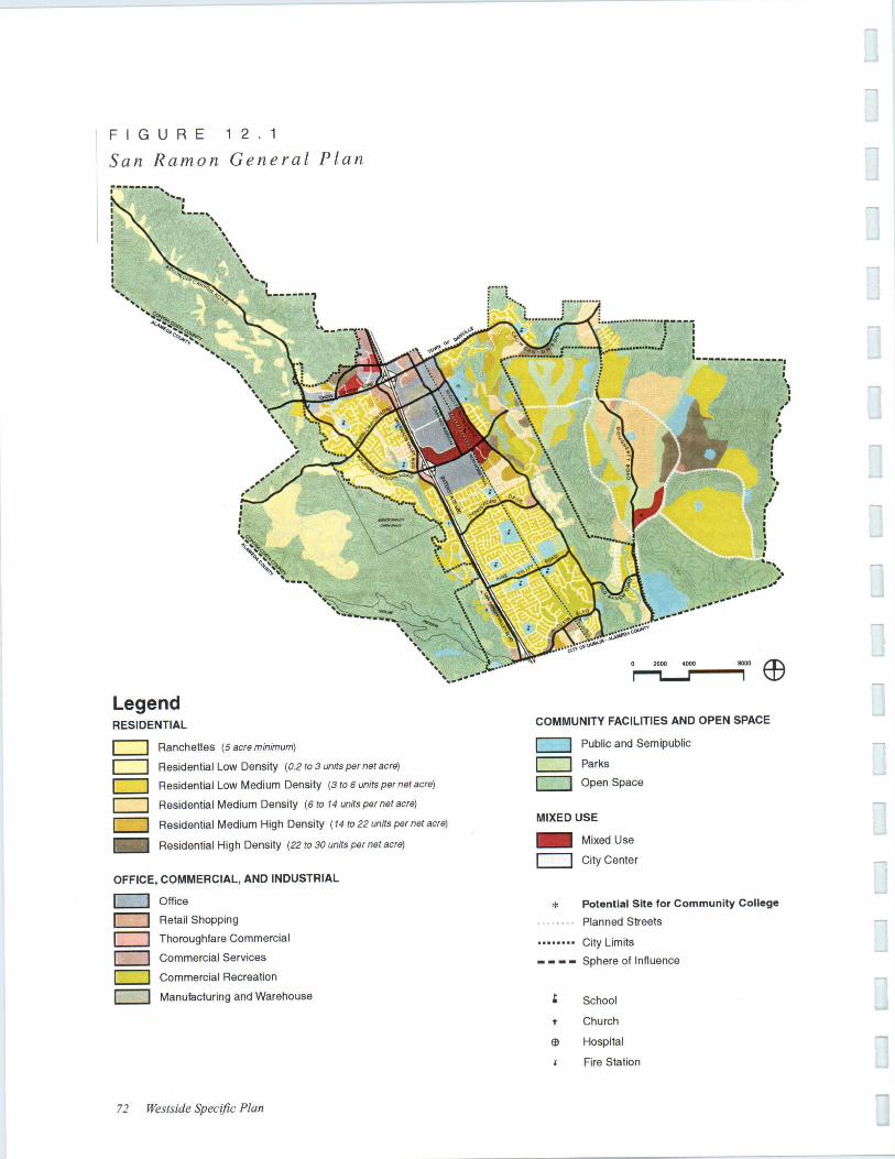
of Land Uses
The Plan for residentialin two discrete areas, one
of which is within the boundaries area
cent to San Ramon the other withinits of Influence area south of Norris Can-
yon Both the 1995 General Plan and this
cific Plan have the Wiedemann Ranch
which was Contrain December 1992, as 'Nell as
updated General residentialin the Norris Road area in addi-
tion to the Wiedemann Ranch Residentialwhich was indicated in the 1989 Westside Plan,This further residential could occur on
both to the west and east of the WiedemannRancho If future residential is
consistent with and with minimum
a maximum of 35 units couldbe built in the Norris Road area,
Plan densities for Norris Can-
yon Road are within the range in the
General lots behinda laO- foot setback from the road, of
lots is if these smaller Jots are
consistent with the and ofthis Plan, In the San Ramon Boulevard area,
densities range from 4,5 to 14 units per net
acre, Senior is at the First
Church site at 22 units per acre,
Consistent with the General Plan. senior den-bonuses may be applied which would allow the
Policies 71
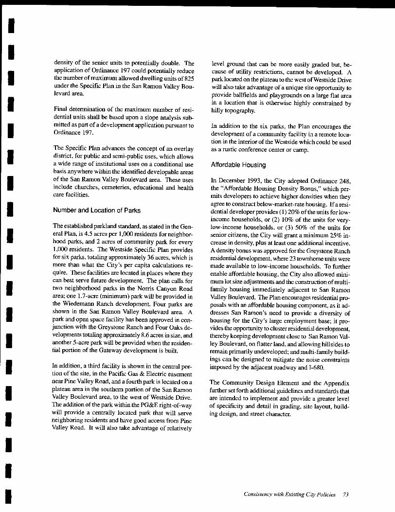
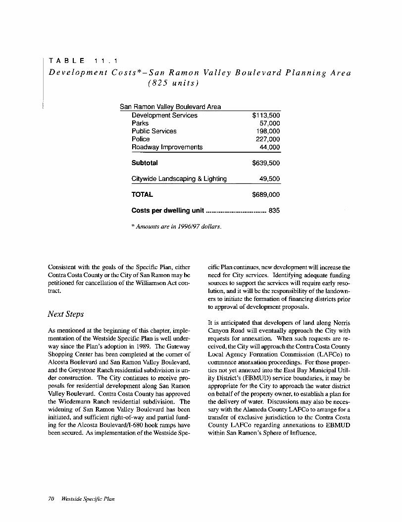
Detention ponds can serve as amenities
for development.
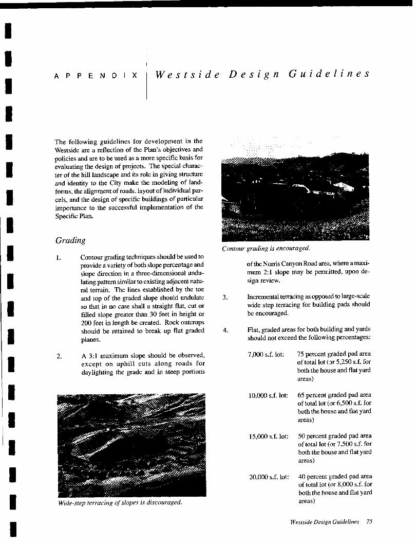
Graded pad percentages should apply only to
parcels where the natural slope averages over
five percent. In the areas designated for light
grading, stepped form buildings would be re-
quired with a minimal graded area. Graded
pad restrictions may be relaxed if yard areas
are terraced in the direction of the slope of the
hill and upon design review.
5. The volume of earth moved for cuts and fills
should be minimized, and balanced againstvisibility considerations. The volume and
extent of grading will be governed by the Spe-cific Plan.
6 Split pads and stepped form buildings should
be used to minimize the need for grading.
7. Site drainage should be accommodated with
swales and catch basins rather than V-ditches
and benches.
8. Hillside drainage should, to the maximum
extent feasible, maintain all natural drainage
patterns and courses. Roofwater collection
and drainage-dispersal systems should be pro-
vided for all dwelling units that do not drain
directly onto a paved surface.
9. Impervious areas should be minimized to the
extent possible.
76 Westside Specific Plan
Building Design
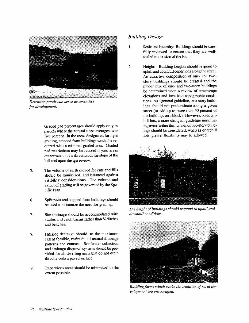
1. Scale and Intensity: Buildings should be care-
fully reviewed to ensure that they are well-
scaled to the size of the lot.
2. Height: Building heights should respond to
uphill and downhill conditions along the street.
An attractive composition of one- and two-
story buildings should be created and the
proper mix of one- and two-story buildingsbe determined upon a review of streetscapeelevations and localized topographic condi-
tions. As a general guideline, two-story build-
ings should not predominate along a givenstreet ( or add up to more than 50 percent of
the buildings on a block). However, on down-
hill lots, a more stringent guideline minimiz-
ing even further the number of two-story build-
ings should be considered, whereas on uphilllots, greater flexibility may be allowed.
The height ofbuildings should respond to uphill and
downhill conditions,
Building forms which evoke the tradition of rural de-
velopment are encouraged,


I
I
I
I
I
I
I
I
I
I
I
I
I
I
I
I
I
I
I
ACKNOWLEDGEMENTS Westslde Specific Plan
No house should ever be on any hill or on anything. It should be of the hill, belonging to
it, so hill and house could live together each the happier for the other."
Frank Lloyd Wright
City ofSan Ramon City Council
Patricia Boom- MayorHermann Welm- Vice MayorByronAthanCurtis KinneyRonald Raab
City ofSan Ramon StaffHerb Moniz-City ManagerPhil Wong- Planning Services Director
Deborah Raines-Senior Planner
John Dillon- Transportation Services Director
Jeff Eorio-Parks and Community Services Director
Joye Fukuda- Engineering Services DirectorCity ofSan Ramon Planning Commission
Dave Hudson-Chairperson
Jim Livingstone- Vice Chair
Sara Kimber
Rolf SabyeIngrid Wemess
Photo Credits:
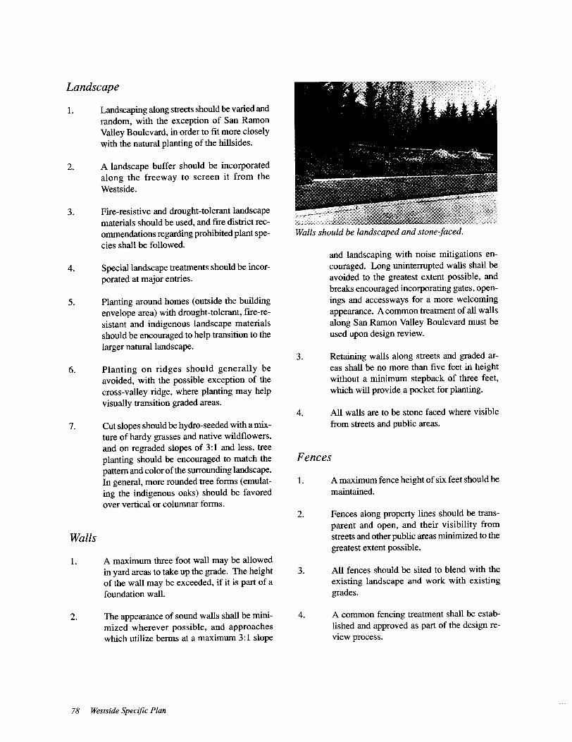
Bob Walker (Pages: 8, 9, 10- top, ll-bottom, 14, 16-
bottom, 20, 21, 24, 25, 31, 32, 36, 39, 41- bottom, 4~
49, 60, 63, 65, 73, 74, 75, 76, 77)
Patrick Carney (Pages: 10-bottom,1l- top, 12, 15, 16-
top, 29, 34, 37, 40, 41- top, 59)
Acknowledgements 81