west-coast-vale-soilrpt.pdf - URA
99
-
Upload
khangminh22 -
Category
Documents
-
view
0 -
download
0
Transcript of west-coast-vale-soilrpt.pdf - URA

thant
Stamp
thant
Stamp

URBAN REDEVELOPMENT AUTHORITY TERM CONTRACT FOR SOIL INVESTIGATION (URA/T/13/010)
Soil Investigation Works At Sungei Tengah Agrotechnology Park
Report No: ECGP 2531 URA ECON GEOTECH PTE LTD
CCOONNTTEENNTTSS VOLUME I
PPaaggee NNoo..
1.0 INTRODUCTION 005
1.1 General 005
2.0 FIELD WORKS 006
2.1 General 006
2.2 Description of Field Investigation 006 2.2.1 Drilling 006 2.2.2 Undisturbed Sampling 006 2.2.3 Standard Penetration Testing 006
3.0 LABORATORY TESTING 007
3.1 General 007
3.2 Code of Practice 007
3.3 Physical Properties 007
3.3.1 Moisture Content 007 3.3.2 Bulk and Dry Density 008 3.3.3 Atterberg Limit 008
3.3.4 Grain Size Analysis 008
3.4 Mechanical Properties 008
3.4.1 Unconsolidated Undrained (UU) Triaxial Test 008
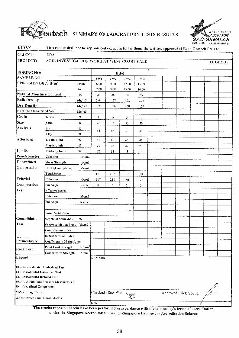
3.5 Summary of Laboratory Test Results for Soils 009
4.0 SOIL CLASSIFICATION 009
5.0 LIST OF GEOLOGICAL CROSS-SECTIONS 011
REFERENCES 012
LIST OF TABLES
Table 1.1 Quantity of Field Works and Laboratory Tests 013
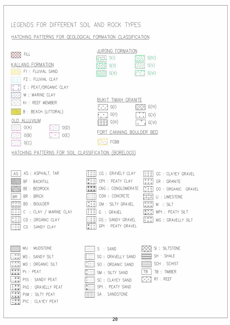
Table 2.1 Classification / Symbol of Soil and Rock Type 014
3
3

URBAN REDEVELOPMENT AUTHORITY TERM CONTRACT FOR SOIL INVESTIGATION (URA/T/13/010)
Soil Investigation Works At Sungei Tengah Agrotechnology Park
Report No: ECGP 2531 URA ECON GEOTECH PTE LTD
Table 2.2 Geological Stratigraphy of Singapore 015
Table 2.3 Identification and Description of Soils 016
Table 2.4 Weathering Classification of Soils / Rocks 018
Table 2.5 Plasticity Chart 019
Table 2.6.1 Classification of Clays/Silts from Shear Strength 020
Table 2.6.2 Classification of Clays/Silts from SPT results 020
Table 2.6.3 Classification of Sands from SPT Results 020
LLIISSTT OOFF FFIIGGUURREESS
Fig. 1 Illustration of Boring Work 021 Fig. 2 Illustration of Standard Penetration Test 022
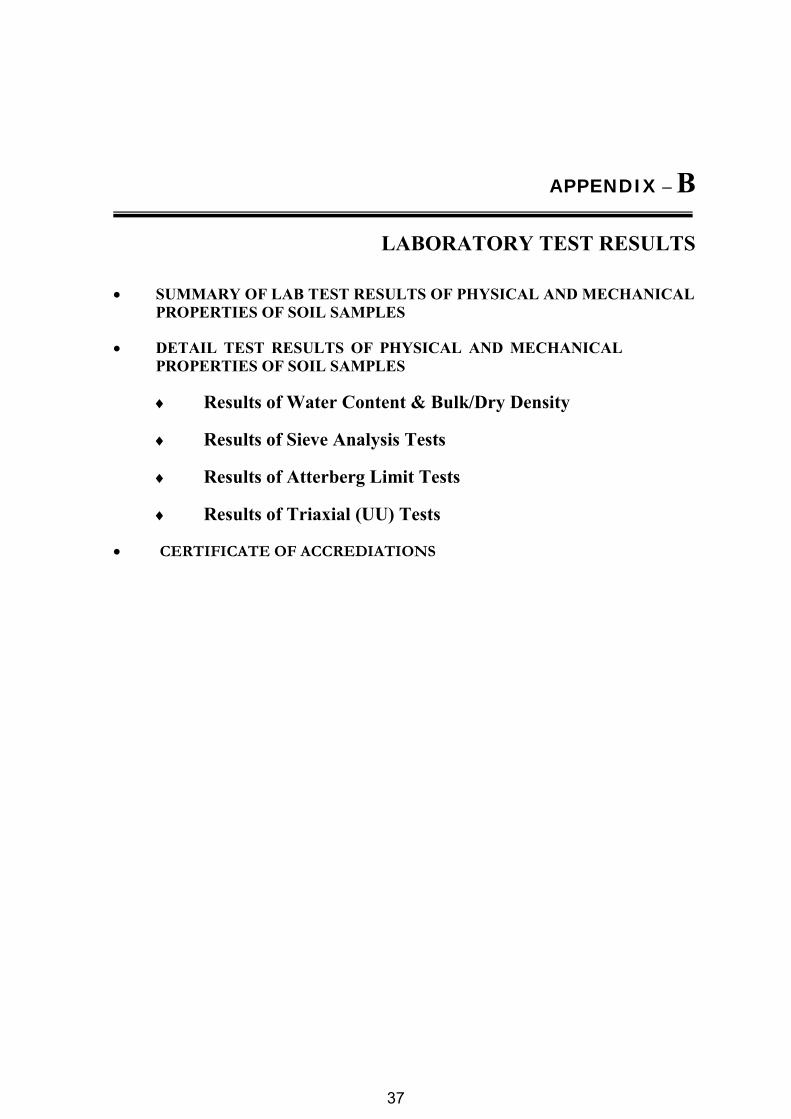
AAPPPPEENNDDIICCEESS
APPENDIX AA
· Location Plan 024
· Borehole Location Plan 025
· As-built Borehole Locations 026
· Cross-Sections 027
· Legends for different soil and rock types 028
· Borehole Logs 029-036
APPENDIX BB
· Laboratory Test Results of Physical & Mechanical Properties of Soil Samples 038-097
· Certificate of Accreditations 098
aaõõbb
4
4
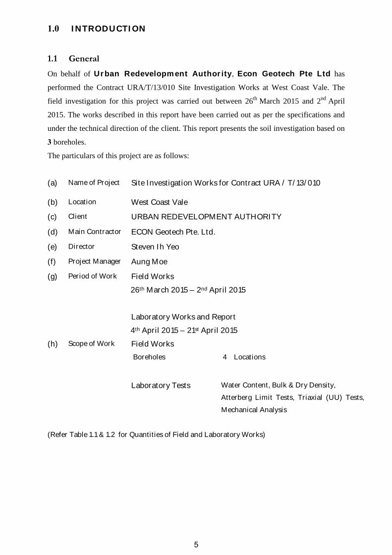
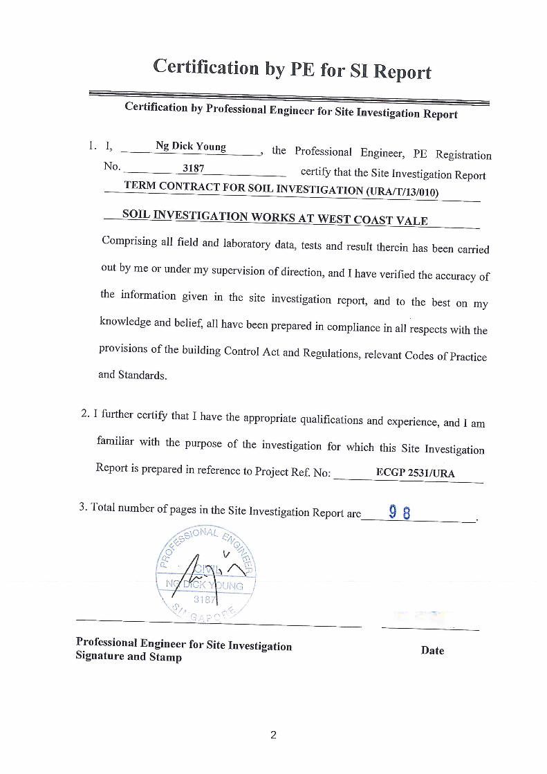
1.0 INTRODUCTION
1.1 General
On behalf of Urban Redevelopment Authority, Econ Geotech Pte Ltd has
performed the Contract URA/T/13/010 Site Investigation Works at West Coast Vale. The
field investigation for this project was carried out between 26th March 2015 and 2nd April
2015. The works described in this report have been carried out as per the specifications and
under the technical direction of the client. This report presents the soil investigation based on
3 boreholes.
The particulars of this project are as follows:
(a) Name of Project Site Investigation Works for Contract URA / T/13/010
(b) Location West Coast Vale
(c) Client URBAN REDEVELOPMENT AUTHORITY
(d) Main Contractor ECON Geotech Pte. Ltd.
(e) Director Steven Ih Yeo
(f) Project Manager Aung Moe
(g)
Period of Work Field Works
26th March 2015 – 2nd April 2015
Laboratory Works and Report
4th April 2015 – 21st April 2015
(h) Scope of Work Field Works
Ø Boreholes
Ø
4 Locations
Laboratory Tests Water Content, Bulk & Dry Density,
Atterberg Limit Tests, Triaxial (UU) Tests,
Mechanical Analysis
(Refer Table 1.1 & 1.2 for Quantities of Field and Laboratory Works)
5

2.0 FIELD WORKS
2.1 General
The field works were carried out in accordance with BS 5930: 1999 “Code of Practice for Site
Investigation” and / or as directed by the client.
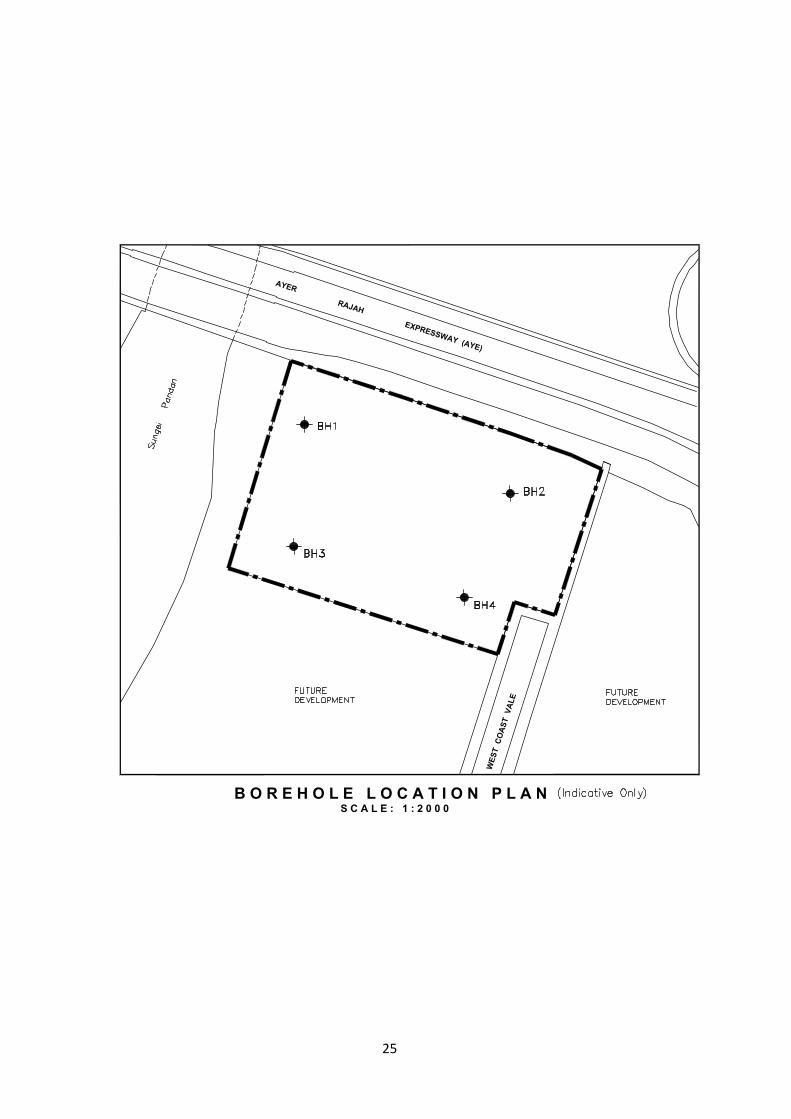
The Borehole Location Plan for proposed site investigation works is shown in AAppppeennddiixx--AA..
The as-built coordinates and reduced levels of the boreholes are also presented in respective
borelogs in AAppppeennddiixx--AA..
2.2 Description of Field Investigation
2.2.1 Drilling
This investigation was performed using rotary drilling rig. A cutting tool was attached to the
drilling rod to drill through the soils, which produces 100mm diameter borehole. Circulated
mud water was pumped through the hollow rods into the hole to stabilize the borehole and to
wash out the soil debris (resulted due to drilling) to the ground surface by pressure. Partial
casing (100mmф) was used to stabilize the soil on top in the borehole apart from using mud
circulation. Trial pits of size 1.0 x 0.8 x 1.0 m depth was dug manually at every borehole
locations. The boreholes were terminated at the depths as suggested by the client. Illustration
of boring works was shown in (Fig.2.1)
During the investigation, a site bore log was done and kept by the geotechnical site
supervisor to note down soil descriptions, stratum changes, SPT and coring field records.
2.2.2 Undisturbed Sampling
Undisturbed samples (UD samples) were collected at the depth of 2m interval in Kallang
Formation and 3m interval in OA (Old Alluvium) and other formations, unless specified by
the client. Before a sample was taken, the bottom of the borehole was properly cleaned. Each
sample was then collected using a 75 mm diameter by 1000 mm long thin wall sampler tube
driven by hydraulic push. Samples of very stiff to hard soil were collected by using Mazier
sampler. Thin wall piston samplers were used for very soft to soft soil. After a sample was
retrieved from borehole, it was immediately labeled and sealed with wax at both ends before
sending to laboratory.
2.2.3 Standard Penetration Testing
Standard Penetration Tests (SPT) is performed at 3.0m interval in all soil layers, except in the
Kallang Formation. In Kallang Formation, the SPT is conducted at 2m interval. Once the
borehole reached the required test depth, the borehole was cleaned by flushing with
6
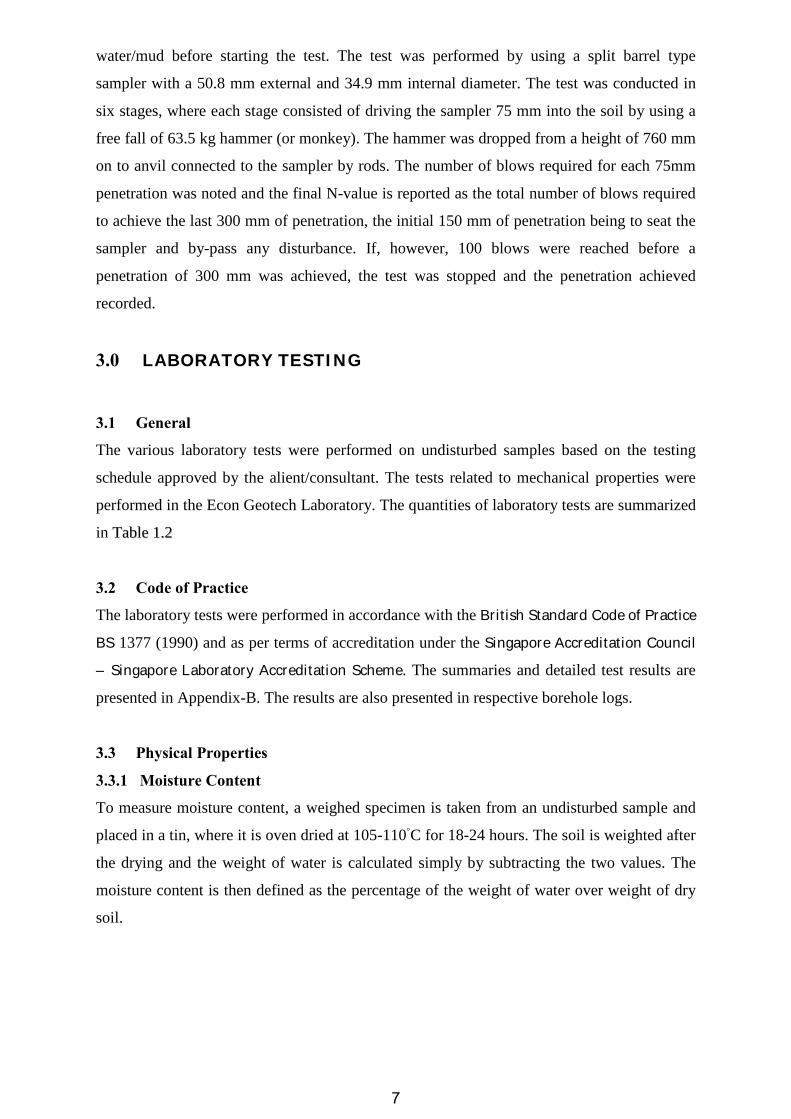
water/mud before starting the test. The test was performed by using a split barrel type
sampler with a 50.8 mm external and 34.9 mm internal diameter. The test was conducted in
six stages, where each stage consisted of driving the sampler 75 mm into the soil by using a
free fall of 63.5 kg hammer (or monkey). The hammer was dropped from a height of 760 mm
on to anvil connected to the sampler by rods. The number of blows required for each 75mm
penetration was noted and the final N-value is reported as the total number of blows required
to achieve the last 300 mm of penetration, the initial 150 mm of penetration being to seat the
sampler and by-pass any disturbance. If, however, 100 blows were reached before a
penetration of 300 mm was achieved, the test was stopped and the penetration achieved
recorded.
3.0 LABORATORY TESTING
3.1 General
The various laboratory tests were performed on undisturbed samples based on the testing
schedule approved by the alient/consultant. The tests related to mechanical properties were
performed in the Econ Geotech Laboratory. The quantities of laboratory tests are summarized
in TTaabbllee 11..22
3.2 Code of Practice
The laboratory tests were performed in accordance with the British Standard Code of Practice
BS 1377 (1990) and as per terms of accreditation under the Singapore Accreditation Council
– Singapore Laboratory Accreditation Scheme. The summaries and detailed test results are
presented in Appendix-B. The results are also presented in respective borehole logs.
3.3 Physical Properties
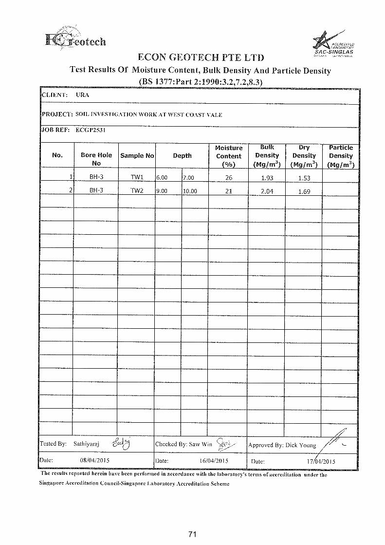
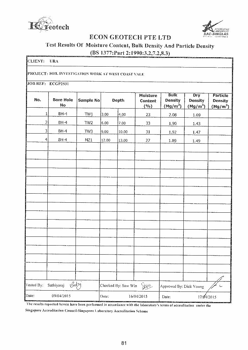
3.3.1 Moisture Content
To measure moisture content, a weighed specimen is taken from an undisturbed sample and
placed in a tin, where it is oven dried at 105-110◦C for 18-24 hours. The soil is weighted after
the drying and the weight of water is calculated simply by subtracting the two values. The
moisture content is then defined as the percentage of the weight of water over weight of dry
soil.
7
3.3.2 Bulk and Dry Density
The bulk density is the measured weight of a solid cylindrical soil specimen taken from an
undisturbed sample divided by its volume. The dry density was calculated from bulk density
and moisture content.
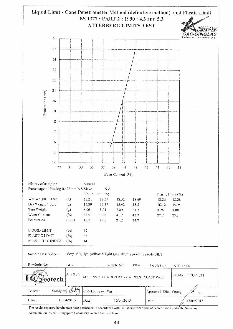
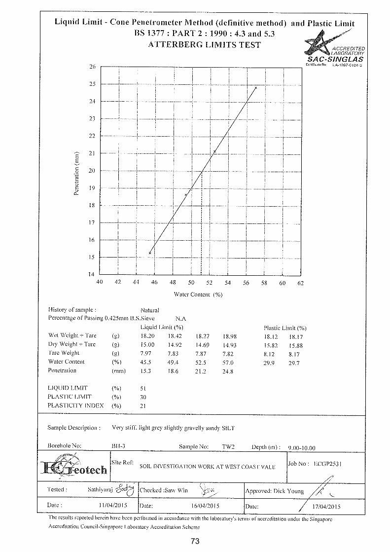
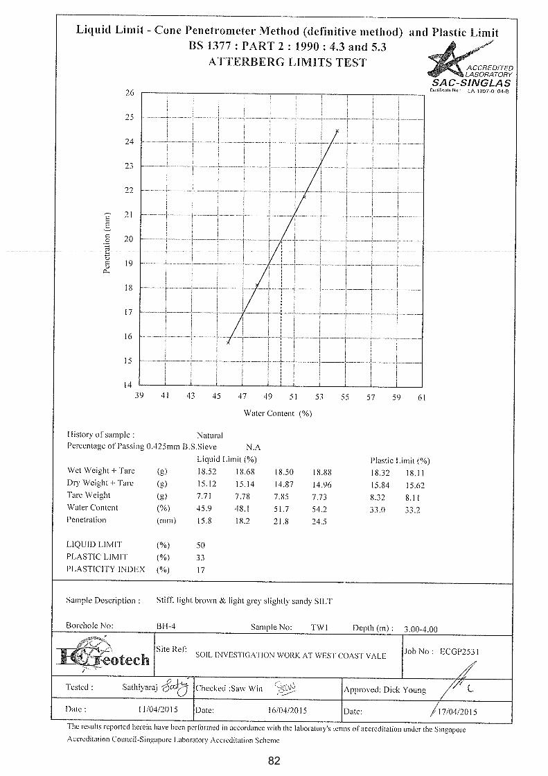
3.3.3 Atterberg Limit
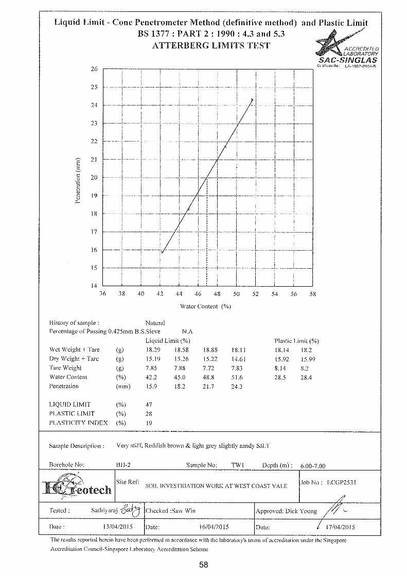
The liquid limit of a specimen is derived using the cone penetrometer method as to BS 1377.
The plastic limit is defined as the moisture content of a specimen at the point where it can be
satisfactorily rolled into a 3mm diameter thread with just starting to crumble. The soils’
plasticity index is then derived by subtracting the plastic limit from the liquid limit.
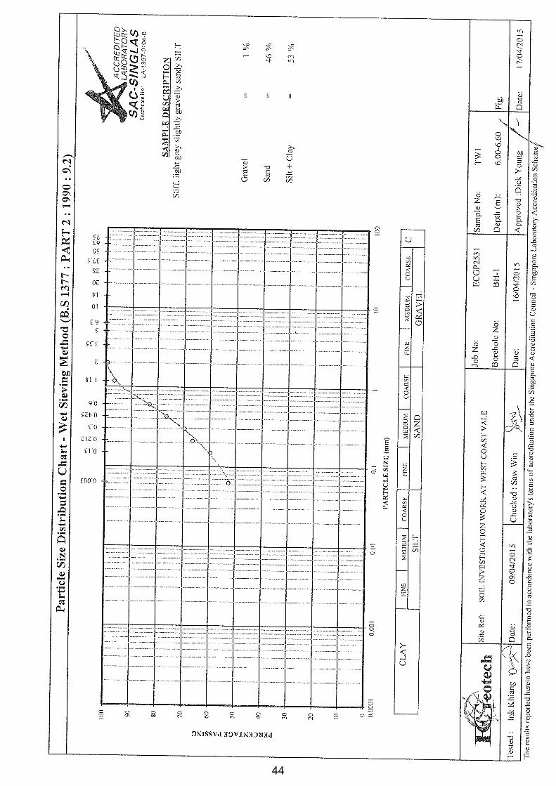
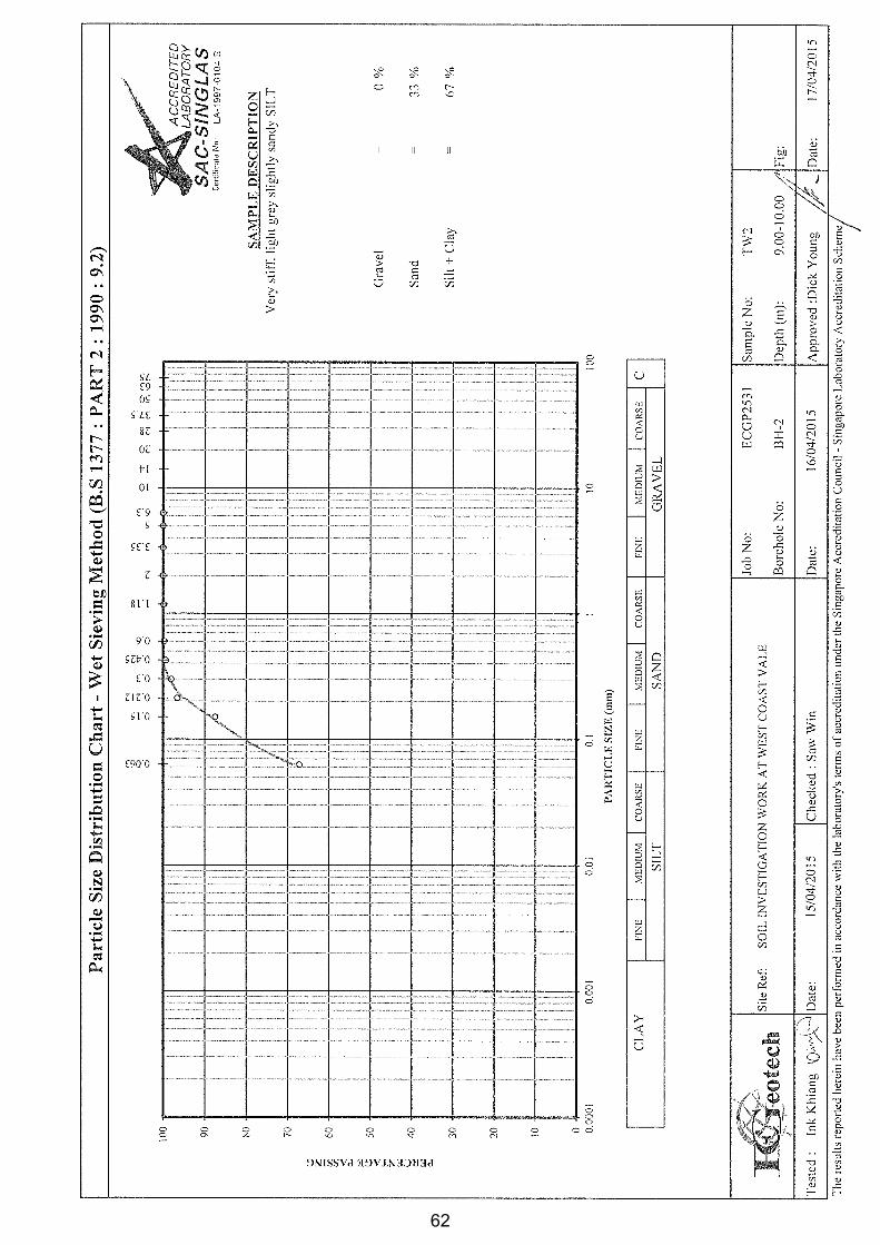
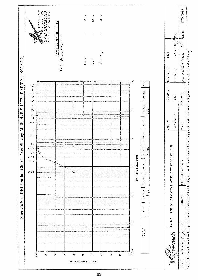
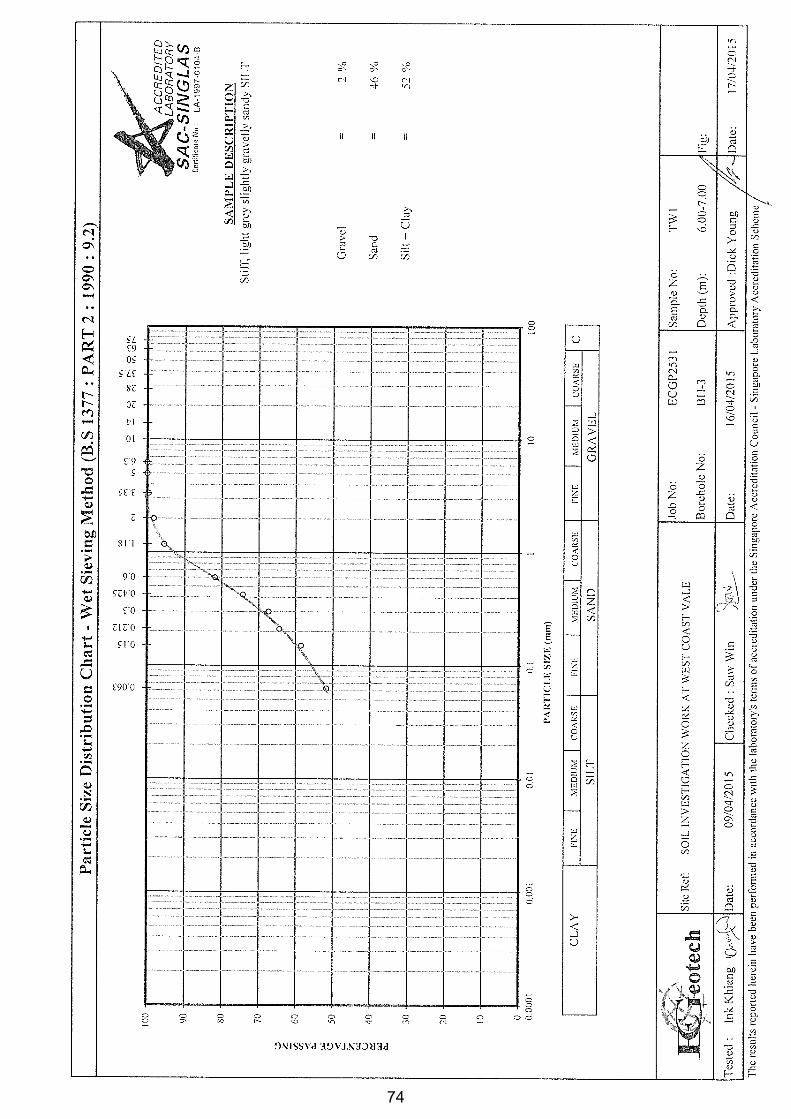
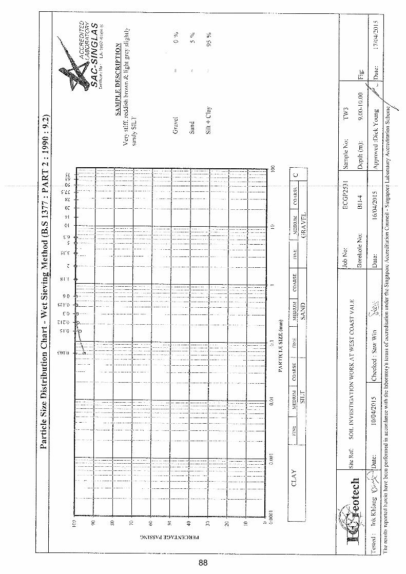
3.3.4 Grain Size Analysis
The grain size analysis has been carried out utilizing both sieve and hydrometer analysis.
The sieve analysis was carried out by wet sieving method in which the material was first
washed through a 2 mm test sieve nested in a 63 mm test sieve. The soils retained in the
sieves were then dried in an oven. The dried soils were then sieved by dry sieving by passing
the soils through a series of square mesh sieves, which become progressively finer down to
63 mm mesh. Each fraction thus collected was then weighed and the percentage retained on
each sieve was calculated by dividing individual weights by the total sample weight.
The soils passing through 63 mm mesh was analyzed by sedimentation using hydrometer
method. The hydrometer method involves measuring the rate of settlement of fine particles
suspended in a solution. Utilizing the principle of Stokes’ law, particle size can be directly
related to its rate of settlement in a fluid such as water. From this process, the particle
diameter and percentage finer is calculated.
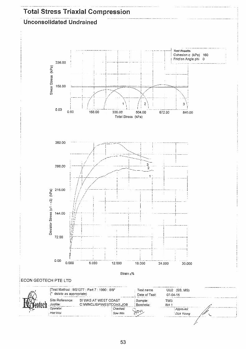
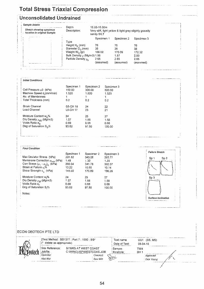
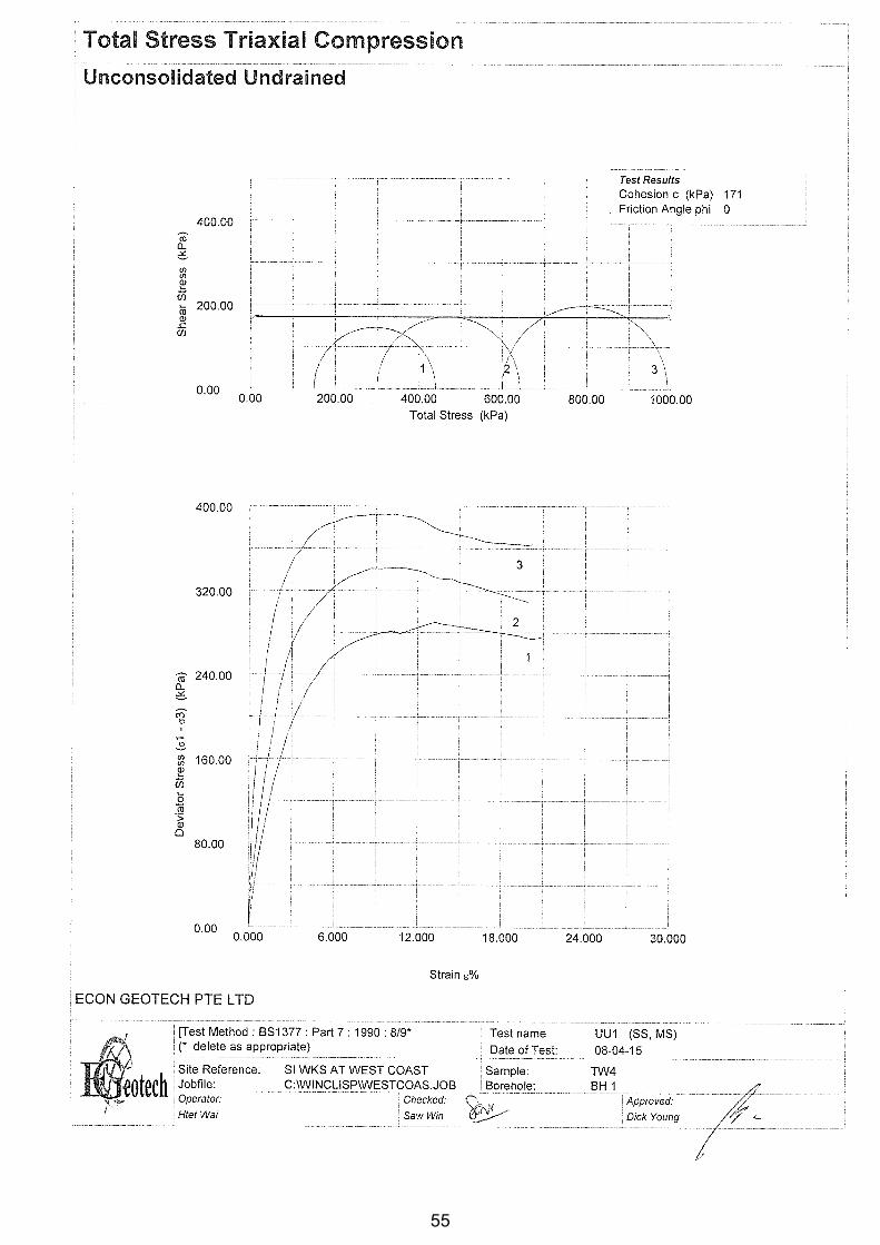
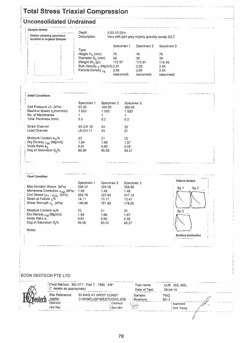
3.4 Mechanical Properties
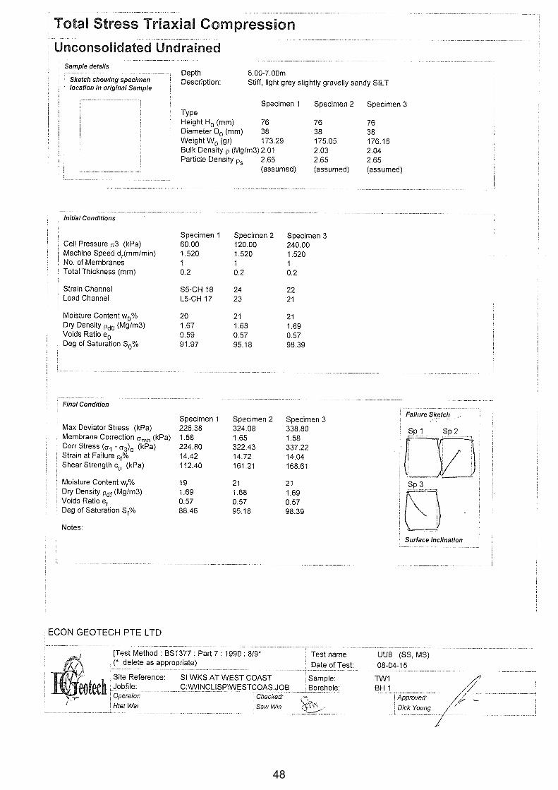
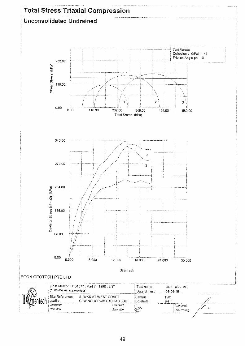
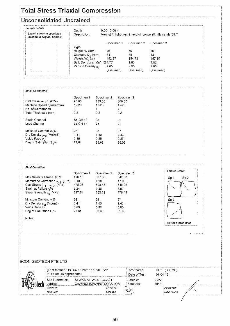
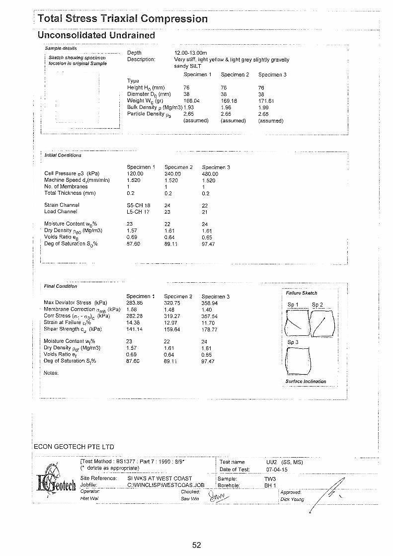
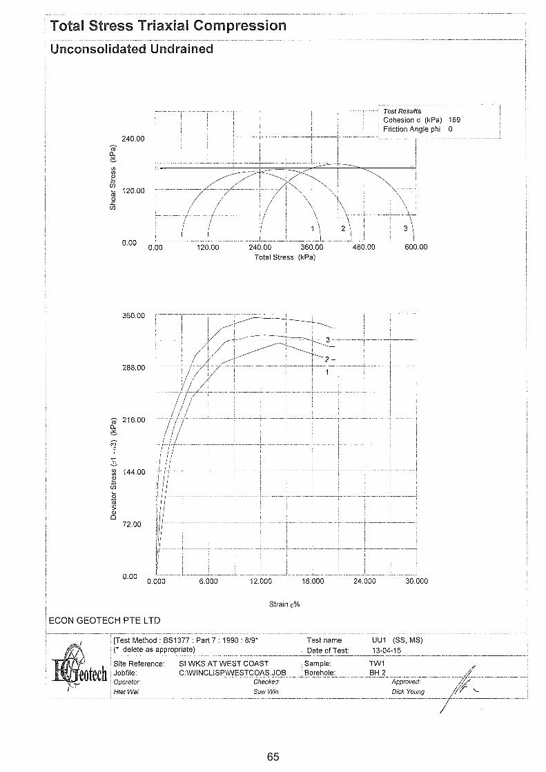
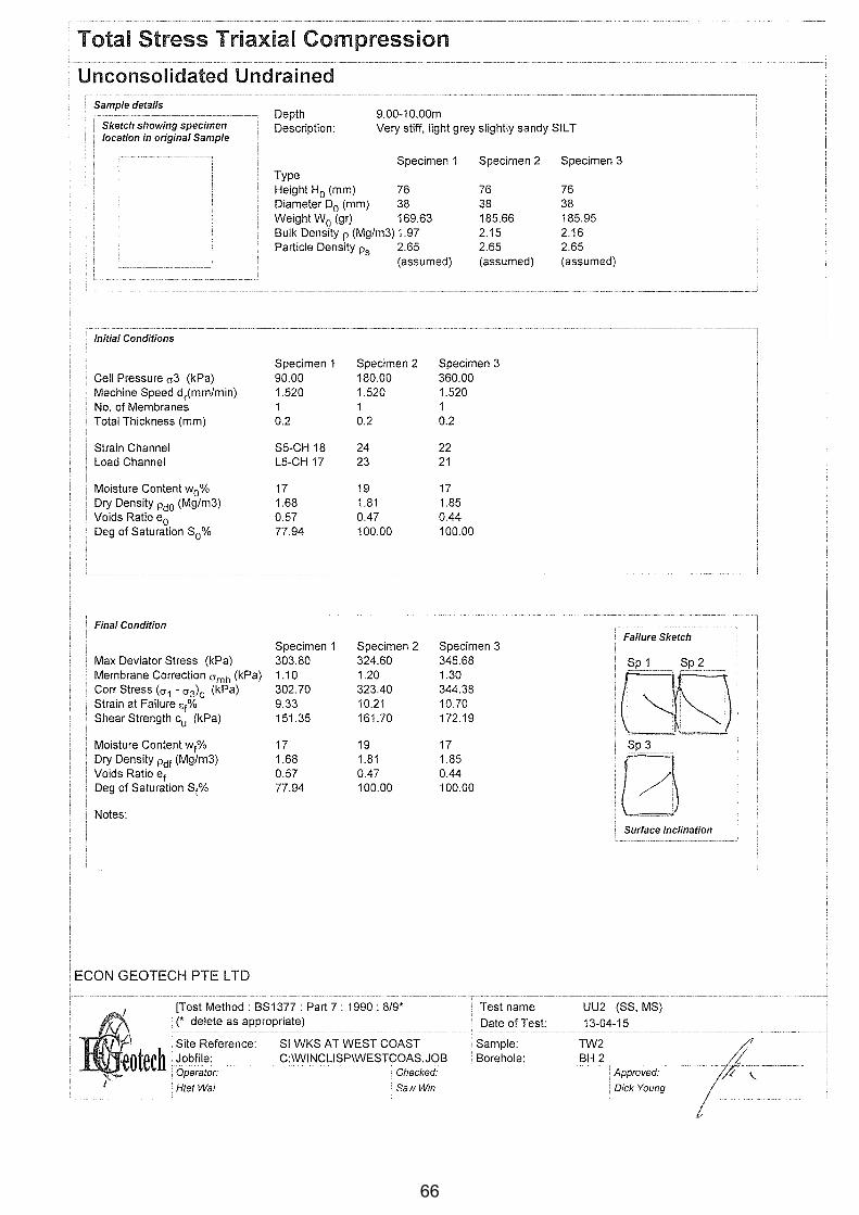
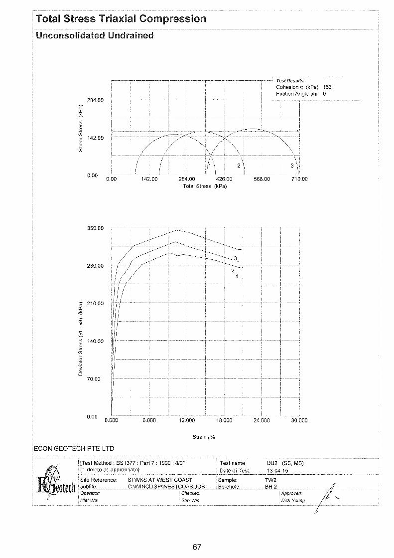
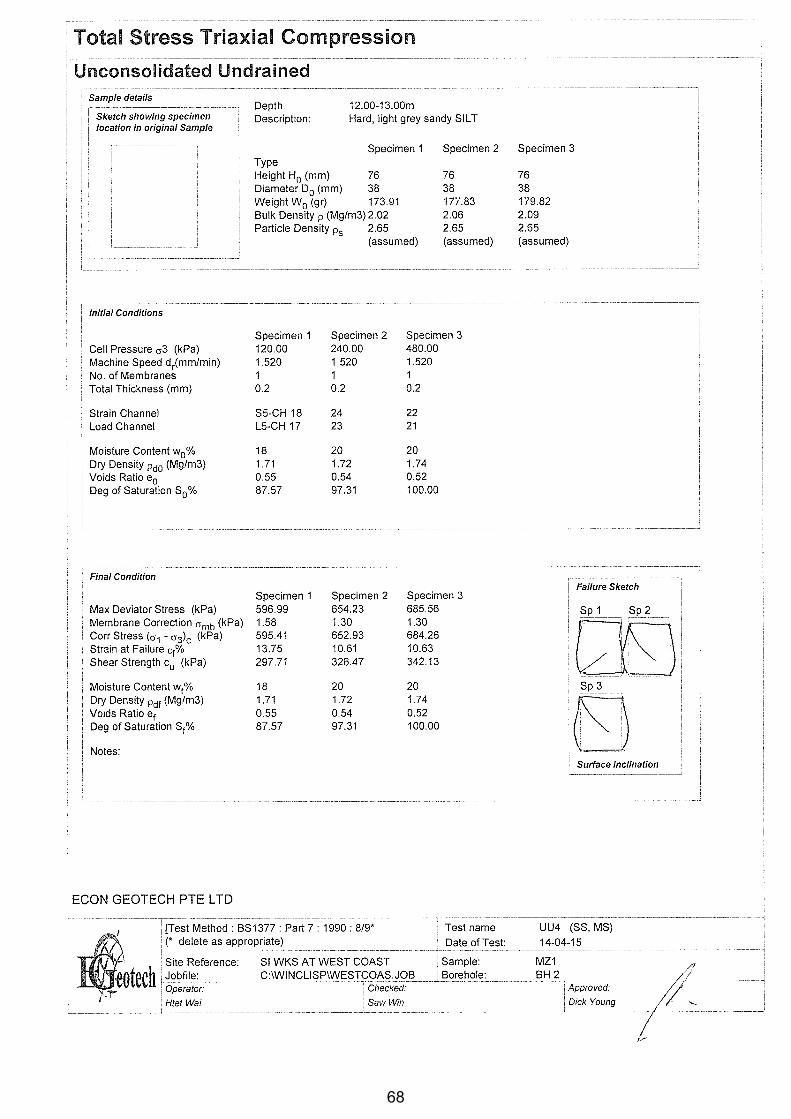
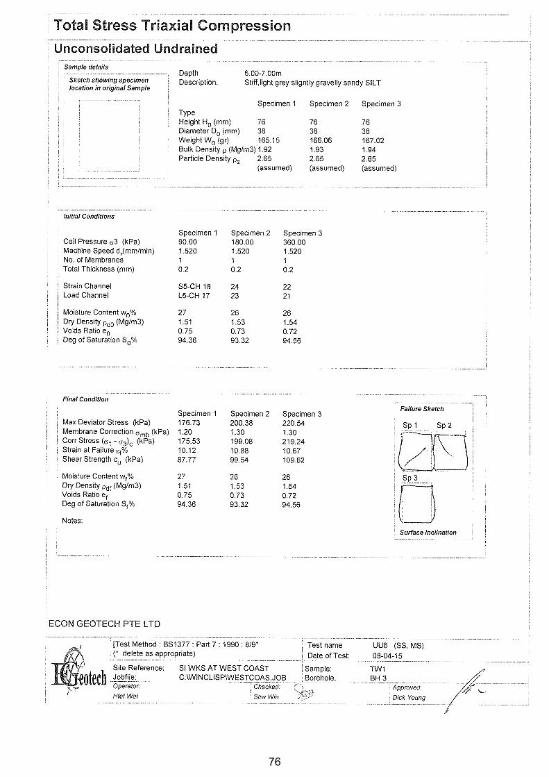
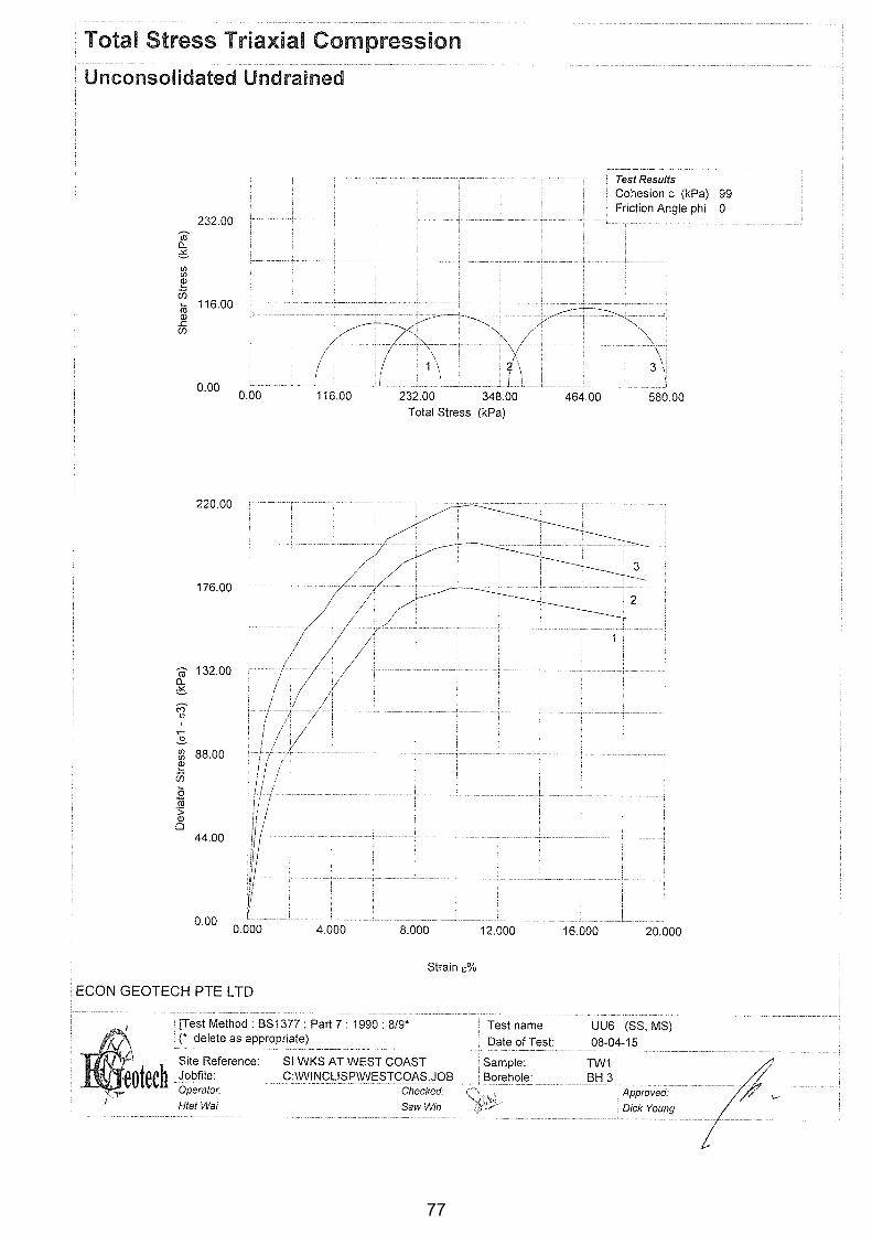
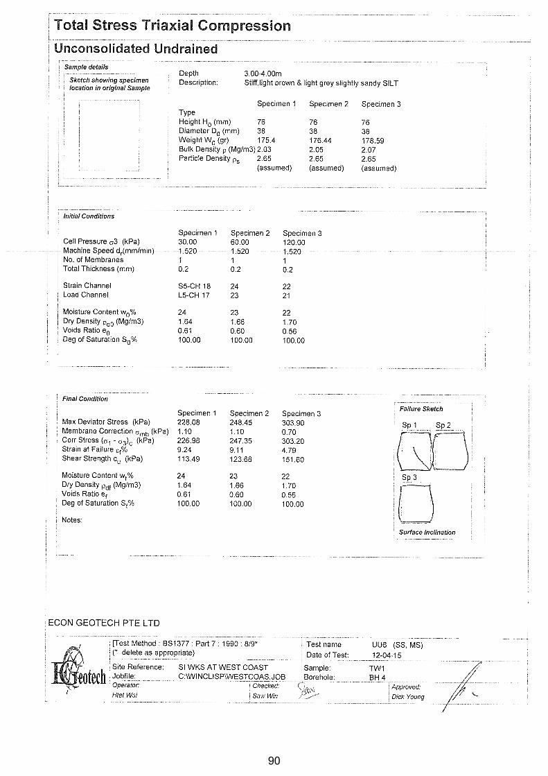
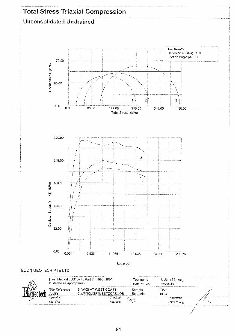
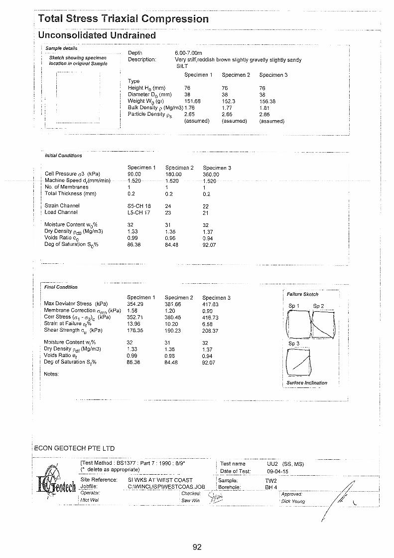
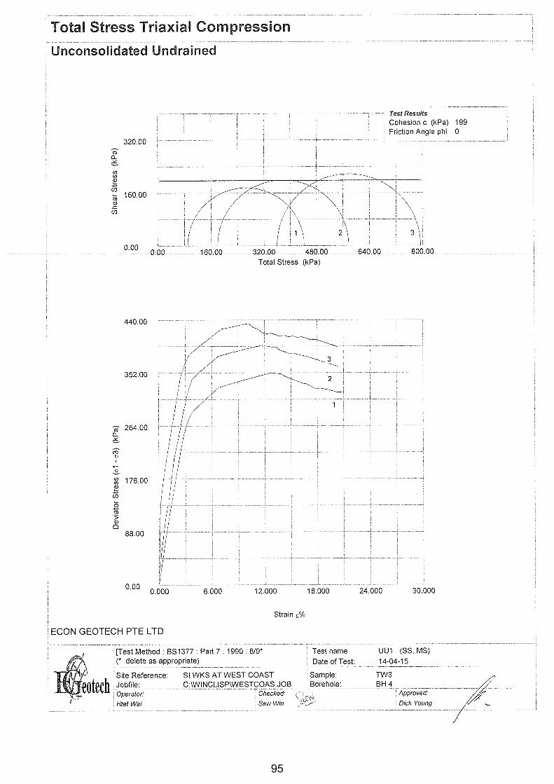
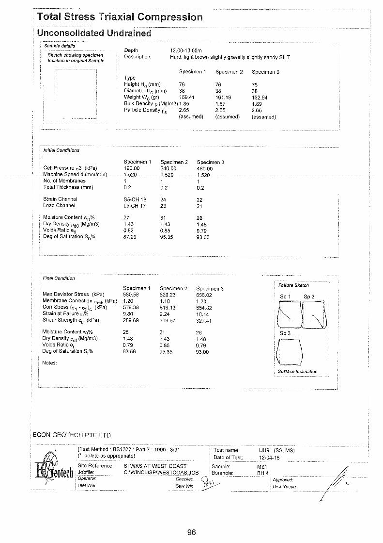
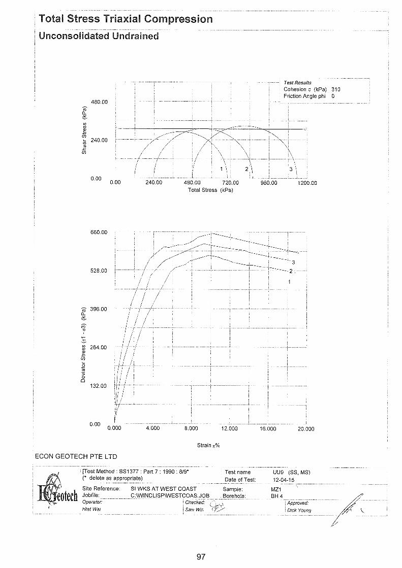
3.4.1 Unconsolidated Undrained (UU) Triaxial Test
This test is generally performed as a set of three single stage tests (UU). However, if the
sample is not enough, the test is conducted using two or single (multistage) specimen. The
general testing procedure is as explained below.
With the three single stage tests, three specimens were extracted from a single undisturbed
sample, and was trimmed and cut to a length to diameter ratio is about two. The specimens
were then weighed before putting the rubber membrane and placing into triaxial cell. Cell
pressures of 0.5sv, sv, and 2sv (where sv is total overburden pressure at the sampling depth)
were applied to the three specimens followed by shearing under undrained conditions at a
8
constant rate of strain (usually 2% per minute). Axial load and displacement were recorded at
regular intervals until a maximum deviator stress, or 20% of strain is reached. For tests with
two specimens, cell pressure of sv and 2sv were used.
3.5 Summary of Laboratory Test Results for Soils
Laboratory tests were generally performed in accordance with the British Standards Code of
Practice BS 1377 (1990). The tests were carried out on undisturbed samples to determine the
physical, mechanical and chemical properties.
Details results of physical and mechanical properties of soil for each geological classification
are presented together with borehole logs in Appendix-B. Summaries of test results are also
presented respectively.
4.0 SOIL CLASSIFICATION
The soil classification is based on the geological classification and British classification
system as given in AAppppeennddiixx--AA. The consistencies of clay/silt and relative densities of sand
have been classified according to the (BS5930: 1999). Classification of sand, clay and silt
from SPT and Shear Strength are presented in (Table 2.9.1 to 2.9.3).
4.1 Description of Soil under Present Investigating Area Based on the borehole data and in-situ tests results obtained from the boreholes, the
underlying subsoil can be sub-divided into the following layers:
- FILL
- KALLANG FORMATION
- JURONG FORMATION
4.1.1 FILL
Fill is inhomogeneous material made by man. The fill layer consists of firm to very stiff,
reddish brown and light grey, slightly sandy to sandy SILT with pieces of concrete and
stones. Fill layers were observed in all of the four (4) boreholes (BH1, BH2, BH3 and BH4).
Thickness of the Fill layers ranges from 3.00m (BH1, BH2 and BH3) to 6.00m (BH3).
4.1.2 KALLANG FORMATION
4.1.2.1 Transitional Member (Kt)
Estuarine Peaty/Organic SILT/CLAY/SAND (E)
The Kallang Formation – Transitional or Estuarine Member (E) was observed in one (1)
boreholes (BH1). Soft, dark brown, Peaty CLAY & PEAT with trace of sand layer was major
9

soil types of the Kallang Estuarine Member (E). Thickness of the (E) layers ranges was
3.00m (BH1).
4.1.2.2 Alluvial Member (Ka)
The Kallang Formation – Alluvial Member (Fluvial SAND and Fluvial SILT/CLAY) was
observed in one (1) borehole (BH3). This Alluvial Member is consisted of fine and coarse
fluvial sediments such as:
- Fluvial SAND (F1)
- Fluvial SILT/ CLAY (F2).
a) Fluvial SAND (F1)
The Kallang Formation – Fluvial SAND Member (F1) was not observed in assigned area.
b) Fluvial CLAY / SILT (F2)
It consists of stiff, light grey, slightly gravelly sandy. (F2) layer was observed only in one (1)
borehole (BH3). Thickness of (F2) layers was 3.00m (BH3) with SPT N-value 2.
4.1.2.3 Marine Member (M)
Marine Member (M) of the Kallang Formation was also not observed in assigned area.
4.1.2 JURONG FORMATION (J)
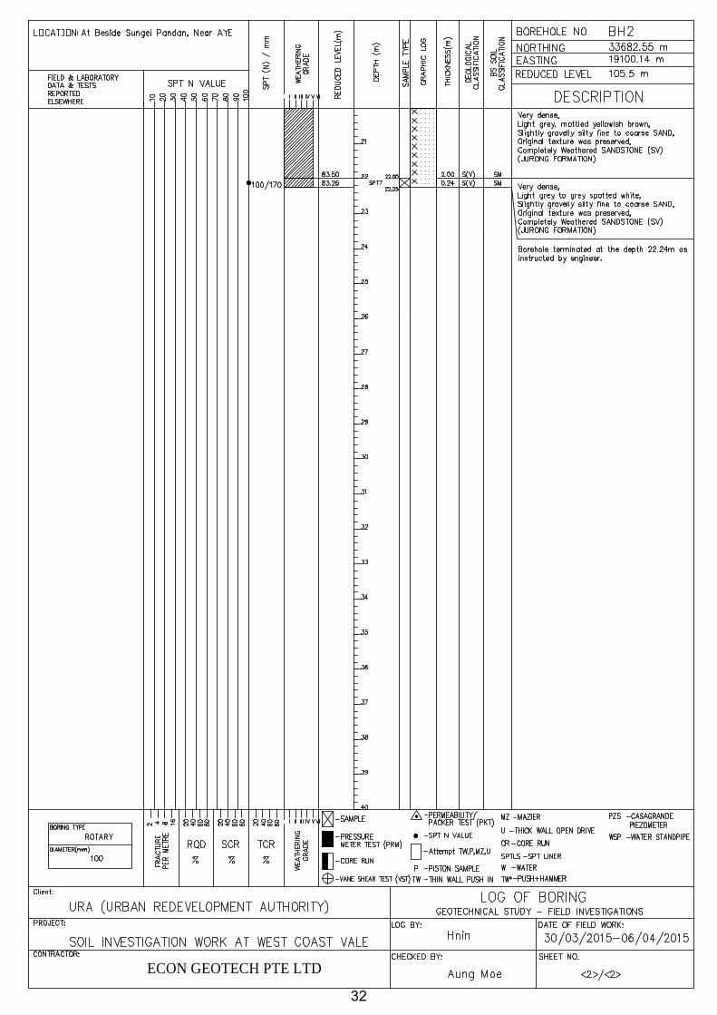
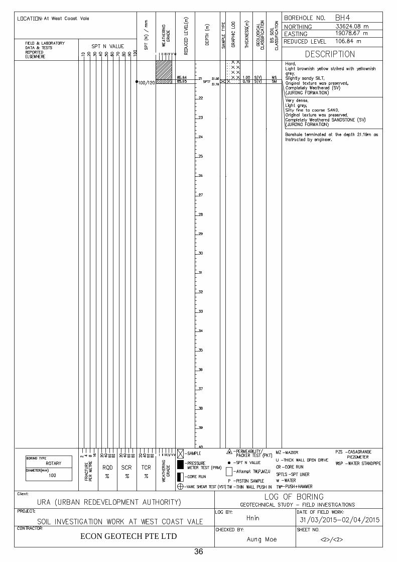
The soil and rock samples, retrieved from all four (4) boreholes (BH1, BH2, BH3 and BH4)
indicated the occurrence of the SILTSTONE, SANDSTONE and alternation of Siltstone and
Sandstone of the Jurong Formation. There were evidences of Residual Soil of Jurong
Formation (S VI) to Completely Weathered Sedimentary Rocks (S V) at these boreholes.
Highly Weathered Rocks (S IV), Moderately Weathered Rocks (S III), Slightly Weathered
Rocks (SII) and Fresh Rocks (SI) of the Jurong Formation were not encountered until the
termination depth.
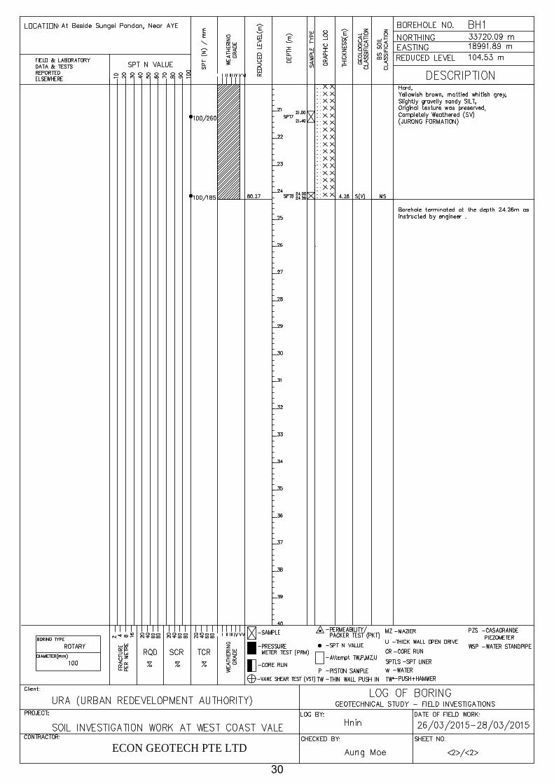
4.1.2.1 The Residual Soils (S VI) of the Jurong Formation were composed of very stiff to
hard, light grey, reddish brown, light purplish reddish brown mottled light grey, slightly
gravelly slightly fine to medium sandy to sandy SILT. SPT N-value varies from 19 (BH1) to
31 (BH2). Thickness of Residual Soil of Jurong Formation (SIV) ranges from 3.00m (BH3)
to 12.00m (BH1).
10
4.1.2.2 The Completely Weathered Sedimentary Rocks (S V) were composed of hard ,
light yellow to yellowish grey, light grey spotted white, purple strike whitish grey, slightly
gravelly slightly fine to coarse sandy to sandy SILT; very dense, light grey, light yellowish
brown to yellowish brown mottled pale purple, light brownish yellow striked yellowish grey,
slightly gravelly slightly silty to silty, fine to coarse SAND. SPT N-value varies from 35
(BH1) to >100 (BH1, BH2, BH3 and BH4). Measurable thickness of Completely Weathered
Rock of Jurong Formation (SV) ranges from 6.26m (BH1) to 14.19m (BH4).
4.1.2.3 The Highly Weathered Sedimentary Rocks (S IV) of the Jurong Formation was not
encountered in assigned area.
4.1.2.4 The Moderately Weathered Sedimentary Rocks (S III) of the Jurong Formation
was not encountered in these assigned boreholes.
4.1.2.5. The Slightly Weathered Sedimentary Rocks (S II) and Fresh Sedimentary rocks
(S I) of the Jurong Formation was not encountered in these assigned boreholes.
4.1.3 Summary
Summary of Geological Units in the present area is shown in Table 4.0.
5.0 LIST OF GEOLOGICAL CROSS-SECTIONS
Geological cross-sections showing the soil strata profile at the borehole locations are
presented in AAppppeennddiixx--AA..
SECTION BOREHOLES
1 BH1 – BH2 – BH4 – BH3
11

REFERENCES
1. BS 5930: 1999.“Code of Practice for Site Investigation”, British Standard Institution.
2. Braja M. Das, 1994. Principles of Geotechnical Engineering, Third Edition. PWS Publishing
Company, Boston
3. Coduto, Donald P, 1994. Foundation Design: Principles and Practices. Pentice-Hall, New
Jersey.
4. Karl Terzaghi, Ralph B. Peck and Gholamreza Mesri, 1996. Soil Mechanics in Engineering
Practice, Third Edition.
5. Michael Carter and Stephen P Bentley, 1991. Correlations of Soil Properties. Pentech Press,
London.
6. P.W.D., 1976. “The Geology of the Republic of Singapore”, Public Works Department,
Singapore.
7. DSTA, 2009. “Geology of Singapore”, 2nd ed., Defense Science and Technology Agency,
Singapore.
12

DS
Sta
rtin
gD
ate
Fin
ishe
dD
ate
Tria
l Pit
Siz
e
(mxm
xm)
Tot
al
Dril
ling
Dep
th
(m)
Soi
lD
rillin
g
(m)
Roc
k C
orin
g
(m)
SP
TT
WP
SM
Z/T
hick
w
all
Water Content
Bulk Density
Particle Density
Grain Size (Hydro)
Grain Size (Sieve)
LL/P
LU
UC
U
Consolidation
BH
126
-Mar
-15
28-M
ar-1
51.
0x1.
0x1.
024
.26
24.2
6-
84
--
44
--
44
4-
-
BH
230
-Mar
-15
06-A
pr-1
51.
0x1.
0x1.
022
.24
22.2
4-
72
-1
33
--
33
3-
-
BH
326
-Mar
-15
28-M
ar-1
51.
0x1.
0x1.
024
.25
24.2
5-
82
--
22
--
22
2-
-
BH
431
-Mar
-15
02-A
pr-1
51.
0x1.
0x1.
021
.19
21.1
9-
73
-1
44
--
24
4-
-
To
tal
91.9
491
.94
-30
11-
213
13-
-11
1313
--
Tria
l Pit
~ H
and
auge
r fr
om G
L-1.
0 to
2.0
mS
PT
= S
tand
ard
Pen
etra
tion
Tes
tT
W=
Thi
n W
all S
oil S
ampl
e, P
S=
Pis
ton
Soi
l Sam
ple,
MZ
= M
azie
r S
ampl
eLL
/PL=
Atte
rber
g Li
mits
Tes
t
Bo
reh
ole
No
.
SO
IL IN
VE
ST
IGA
TIO
N W
OR
K A
T W
ES
T C
OA
ST
VA
LE
In S
itu
Tes
t &
Sam
plin
g
TA
BL
E 1
.1 Q
UA
NT
ITY
OF
FIE
LD
WO
RK
S A
ND
LA
BO
RA
TO
RY
TE
ST
S
So
il D
rilli
ng
Wo
rkU
nd
istr
ub
ed S
amp
leS
oil
Lab
ora
tory
Tes
t
13
REFERENCE SOIL & ROCK TYPE GENERAL DESCRIPTION GEOLOGICAL
FORMATION (PWD, 1976)
B BEACH (Littoral) Sandy, sometimes silty, with gravels, coral and shells
KALLANG Littoral, possibly also part of all other members& TEKONG
E ESTUARINE (Transitional)
Peats, peaty and organic clays, organic sands KALLANG Transitional, possibly part of Alluvial andMarine.
F FLUVIAL (Alluvial)
Sands, silty sands, silts and clays KALLANG Alluvial, possibly part of all othermembers and TEKONG.
F1 Predominantly granular soils including silty sands, clayey sands and sandy silts
Bed of Alluvial Member of KALLANG
F2 Cohesive soils including silty clays, sandy clays and clayey silts
Bed of Alluvial Member of KALLANG
M MARINE Very soft to soft blue or grey clay KALLANG Marine Member
O OLD ALLUVIUM Very weak to weak beds of sandstone and mudstone. See C-5 for weathering classification
OLD ALLUVIUM
FC FORT CANNING BOULDER BED (also known as S3, Bouldery Clay or Boulder Bed)
A colluvial deposit of boulders in a soil matrix. The matrix is typically a hard silty clay, but can be granular. The material is largely derived from the rocks and weathered rocks of the Jurong Formation
Not shown in PWD (1976)
S SEDIMENTARIES (Rocks & associated soils)
Sandstones, siltstones mudstones, conglomerate and limestone. The rockhas been subjected to a varying degree ofmetamorphism.
JURONG Tengah, Rimau, Ayer Chawan and Queenstown Facies (plus the Pandan Limestone, which was not identified in PWD (1976)
G GRANITE (Rock and associated Residual soils)
Granitic rocks, including granodiorite, adamellite and granite.
BUKIT TIMAH GRANITE
C-3 Classificatiion/ Symbol of Soil and Rock Type
14
Econ
Text Box
Table 2.1

Geological Time Series/Stage Description of stratum
Era Period Epoch Formation Stratum Zone Symbol Particular Origin
Time Bp-year
First Organic Clay
Au (O1) Consists mainly decomposed organic material. Very soft & high water content.
Deposit of limnetic brackish water
First Sand
Au(S1) Poor graded medium grain loose sand with some shell fragments.
Deposited at beach and shallow water depth of sea.
Marine Clay
Au(M) Very soft high water content and high plasticity clay.
Seabed deposit at 5-30m depth drowned valley.
First Cohesive soil
Au(C) Very soft high water content clayey silt with sand.
Deposit of limnetic-half brackish water.
Second Organic Clay
Au(O2) Very soft decomposed organic matter with clay.
Deposit of limnetic-half Brackish water.
Second Sand
Au(S2) Well graded sand with some organic. Deposit at shallow water depth..
6000 -
10000
Brown Clay
AL(B) Lower water content stiff clay. Thickness varies at each location.
Alteration by weathering oxidation.
Third Sand
AL(S1) Medium dense fine to medium grained sand Deposit at shallow sea water depth or beach.
Lower Marine Clay
AL(M) Soft and high plasticity homogeneous clay with shell fragments.
Seabed deposit at 5-30m depth drowned valley.
Second Cohesive Soil
AL(C) Soft to firm high plasticity clayey silt with fine sand.
Deposit of limnetic-half brackish water.
Third Organic Clay
AL(O) Soft low water content organic clay. Deposit at shallow water depth.
Fourth Sand
AL(S2) Well graded sand with some gravel and organic material
Shallow seabed deposit.
11000
- 15000
Weathered Zone OA(W) Weaken and alteration by weathering/ oxidation.
Cemented Zone OA(C)
Irregular alternating layers of well graded sandy soil and clayey silt. Very Dense and hard by cementation.
Materials is very hard & dense by chemical/ diagenesis.
Approx 3.5-5.0 x 10⁴
Weathered Zone Bc(W)
Cemented Zone Bc(C)
Very hard reddish brown clay with various sizes of strong sandstone boulder. Size of boulder ranges from 10-45cm.
Produce of fault as fault clay and fault breccia and cemented during some geological period.
Residual Soil
J(R) Wholly decomposed material by weathering.
Completely Weathered Zone
J(C) Decomposed material by weathering.
Highly Weathered Zone
J(H) Weak and friable material by weathering
Moderately Weathered Zone
J(M) Materials weakened near joint surface by weathering.
Slightly Weathered Zone
J(S) Many joints developed with some weathering at joint surface.
Fresh Zone J(F)
Constituted of alternating sandstone, mudstone and conglomerate. Limestone developed as thin layers. Many fault zones are found and material near the granite area is disturbed. Thermal metamorphism occurs near the granite zone.
Strong massive rock.
Approx2.0x108
-
2.1x10⁸
Residual Soil
G(R Wholly decomposed material to soil.
Completely Weathered Zone
G(C) Decomposed weak material by weathering.
Highly Weathered Zone
G(H) Weak and friable material by weathering.
Moderately Weathered Zone
G(M) Material is weak near the joint.
Slightly Weathered Zone
G(S) Joints developed with some weathering at joint surfaces.
Fresh Zone G(F)
Coarse-grained granodiorite and biotite granite. Contains porphyrite and lamprophyre as dike. Two types of fault system are found to develop.
Strong massive rock.
Approx2.1x108
-
2.2x10⁸
C-2 Geological Stratigraphy of Singapore (M.W. TAN & A.WADA, 11TH S.E ASIAN GEOTECH.
CONF., 4-8 MAY, 1993)
Upper Alluvium
Lower Alluvium
Old Alluvium
Boulder Clay
Jurong Formation
Bukit Timah Granite
Holocene
Pleistocene
Jurassic- Initial
Late
Middle
Initial
Triassic
Mes
ozoi
c
Tertiary__ Unknown__
Quarter nary
Cen
ozoi
c
15
Econ
Text Box
Table 2.2 Geological Stratigraphy of Singapore (M.W TAN & A.WADA, 11TH S.E ASIAN GEOTECH. CONF., 4-8 MAY, 1993)
Econ
Text Box
Ver
y co
arse
so
ils
Coa
rse
soils
(o
ver
abou
t 65%
sand
and
gra
vel s
izes
) Fi
ne S
oils
(o
ver
abou
t 35
% si
lt an
d cl
ay si
zes)
O
rgan
ic S
oil
C-4 Identification and Description of Soil (BS 5930, 1999)
16
Econ
Text Box
Table 2.3 Identification and description of soils (BS 5930, 1999)

Table 3.2 Identification and description of soils (continued)
BOULDERS Only seen complete in pits or exposuresCOBBLES Often difficult to recover whole from boreholes
ALLUVIUM,
using terms such as; WEATHERED BRACKLESHAMCLAY,
with rare
with occasional LIAS CLAY,
with abundant/frequent/ numerous
TOPSOIL,
Notesa) Or described as coarse soil depending on mass behaviour d) Gravelly sandy and/or silty or clayey
b) Or described as fine soil depending on mass behaviour e) Gravelly and/ or sandy
c) %coarse or fine soil type assessed excluding cobbles and boulders f) Gravelly of sandy
Example descriptions
Easily visible to naked eye: particle shape can be described: grading can be described.GRAVEL
SAND Visible to naked eye: no cohesion when dry: grading can be described.
Medium dense light brown gravelly clayey fine SAND, Gravel is fine (GLACIAL DEPOSITS)
PRINCIPALSOIL TYPE Visual identification Minor constituents Stratum name
Dry lumps can be broken but not powdered between the fingers; they also disintegrate under water but more slowly than silt; smooth to the touch; exhibits plasticity but no dilatancy; sticks to the fingers and dries slowly; shrinks appreciably on drying usually showing cracks.
CLAY
SILT
Only coarse silt visible with hand lens; exhibits little plasticity and marked dilatancy: slightly granular or silky to the touch; disintegrates in water; lumps dry quickly; possesses cohesion but can be powdered easily between fingers
Intermediate in behaviour between clay and silt. Slightly dilatantCLAY/SILT
Shell fragments, pockets of peal, gypsum crystals, flint gravel, fragments of brick, rootlets, plastic bags etc
%defined on a site or material specific basis or subjective
MADE GROUND OR GLACIAL DEPOSITS? etc.
EMBANKMENTFILL,
RECENTDEPOSITS,
Stiff very closely sheared orange mottled brown slighlty gravelly CLAY. Gravel is fine and medium of rounded quartzite. (REWORKED WEATHERED LONDON CLAY)
Plastic brown clayey amorphous PEAT (RECENT DEPOSITS)
Firm thinly laminated grey CLAY with closely spaced thick laminae of sand (ALLUVIUM)
Loose brown very sandy sub-angular fine to coarse flint GRAVEL with small pockets(up to 30mm)of clay. (TERRACE GRAVELS)
17
Econ
Text Box
Table 2.3 Identification and description of soils (continued)
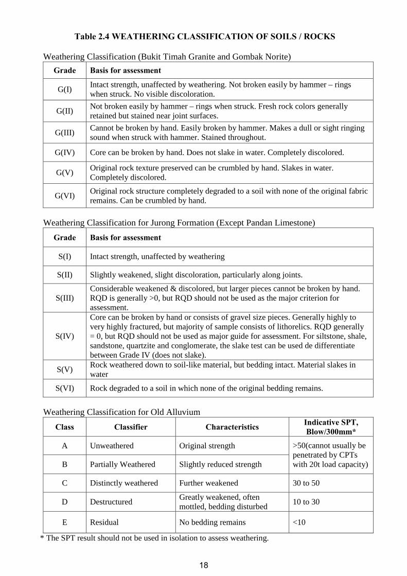
Table 2.4 WEATHERING CLASSIFICATION OF SOILS / ROCKS
Weathering Classification (Bukit Timah Granite and Gombak Norite)
Grade Basis for assessment
G(I) Intact strength, unaffected by weathering. Not broken easily by hammer – rings when struck. No visible discoloration.
G(II) Not broken easily by hammer – rings when struck. Fresh rock colors generally retained but stained near joint surfaces.
G(III) Cannot be broken by hand. Easily broken by hammer. Makes a dull or sight ringing sound when struck with hammer. Stained throughout.
G(IV) Core can be broken by hand. Does not slake in water. Completely discolored.
G(V) Original rock texture preserved can be crumbled by hand. Slakes in water. Completely discolored.
G(VI) Original rock structure completely degraded to a soil with none of the original fabric remains. Can be crumbled by hand.
Weathering Classification for Jurong Formation (Except Pandan Limestone)
Grade Basis for assessment
S(I) Intact strength, unaffected by weathering
S(II) Slightly weakened, slight discoloration, particularly along joints.
S(III) Considerable weakened & discolored, but larger pieces cannot be broken by hand. RQD is generally >0, but RQD should not be used as the major criterion for assessment.
S(IV)
Core can be broken by hand or consists of gravel size pieces. Generally highly to very highly fractured, but majority of sample consists of lithorelics. RQD generally = 0, but RQD should not be used as major guide for assessment. For siltstone, shale, sandstone, quartzite and conglomerate, the slake test can be used de differentiate between Grade IV (does not slake).
S(V) Rock weathered down to soil-like material, but bedding intact. Material slakes in water
S(VI) Rock degraded to a soil in which none of the original bedding remains.
Weathering Classification for Old Alluvium
Class Classifier Characteristics Indicative SPT, Blow/300mm*
A Unweathered Original strength
B Partially Weathered Slightly reduced strength
>50(cannot usually be penetrated by CPTs with 20t load capacity)
C Distinctly weathered Further weakened 30 to 50
D Destructured Greatly weakened, often mottled, bedding disturbed
10 to 30
E Residual No bedding remains <10
* The SPT result should not be used in isolation to assess weathering.
18

19
Econ
Text Box
Table 2.5

Undrained Shear Strength (kPa) Consistency
< 20 Very Soft
20 – 40 Soft
40 – 75 Firm
75 – 150 Stiff
150 – 300 Very Stiff
> 300 Hard
Table 2.6.1 Classification of Clays/Silts from Shear Strength (BS5930: 1999)
Approximate Relation of Consistency to SPT
N-Value (blows/300mm of penetration) Consistency
< 2 Very Soft
2 – 4 Soft
4 – 8 Firm
8 – 15 Stiff
15 – 30 Very Stiff
> 30 Hard
Table 2.6.2 Classification of Clays/Silts from SPT results (Terzaghi and Peck)
Approximate Relation of Relative Density to SPT
N-Value (blows/300mm of penetration) Relative Density
< 4 Very Loose
4 – 10 Loose
10 – 30 Medium Dense
30 – 50 Dense
> 50 Very Dense
Table 2.6.3 Classification of Sands from SPT results (BS5930: 1999)
20

Fig. 1. Illustration of Boring Work
21
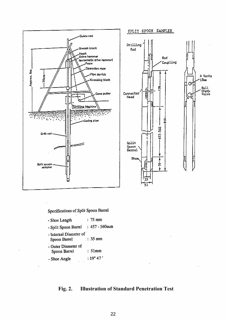
Fig. 2. Illustration of Standard Penetration Test
22

APPENDIX - A
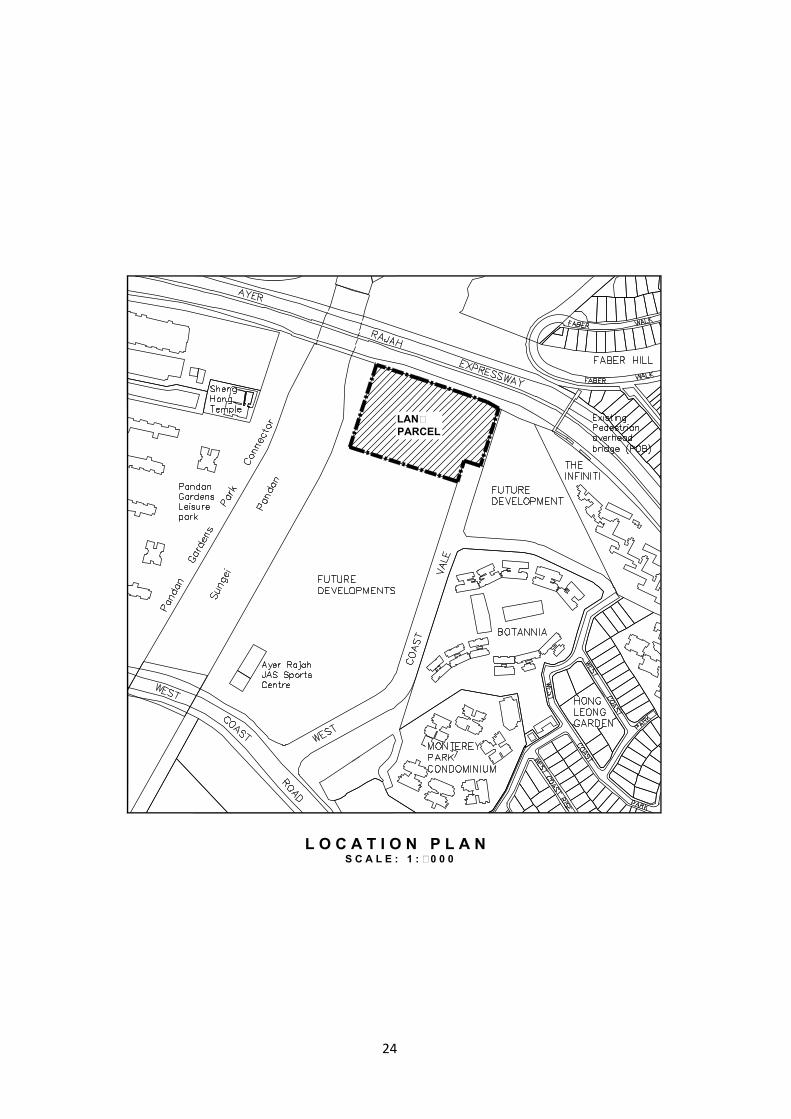
BOREHOLE LOCATION PLAN, GEOLOGICAL INFROMATION AND BOREHOLE DATA
· LOCATION PLAN
· BOREHOLE LOCATION PLAN
· AS BUILT BOREHOLE LOCATION PLAN
· CROSS - SECTIONS
· LEGENDS FOR DIFFERENT SOIL AND ROCK TYPES
· BOREHOLE LOGS
23
4.5m D.R.
LANDPARCEL
S C A L E : 1 : 5 0 0 0L O C A T I O N P L A N
24
AYER RAJAH EXPRESSWAY (AYE)
WE
ST
CO
AS
T V
AL
E
S C A L E : 1 : 2 0 0 0B O R E H O L E L O C A T I O N P L A N
25

26

JURONG FORMATION
GEOLOGICAL CLASSIFICATION
SECTION1 : BH1, BH2, BH4 & BH3
VERTICAL SCALE -
HORIZONTAL SCALE -
Drawn By:
Checked By:
Date:
Date:NOT TO SCALENOT TO SCALE
1:150
KALLANG FORMATION
27
28

ECON GEOTECH PTE LTD
29
ECON GEOTECH PTE LTD
30

ECON GEOTECH PTE LTD
31
ECON GEOTECH PTE LTD
32

ECON GEOTECH PTE LTD
33

ECON GEOTECH PTE LTD
34

ECON GEOTECH PTE LTD
35
ECON GEOTECH PTE LTD
36
APPENDIX – B
LABORATORY TEST RESULTS
· SUMMARY OF LAB TEST RESULTS OF PHYSICAL AND MECHANICAL PROPERTIES OF SOIL SAMPLES
· DETAIL TEST RESULTS OF PHYSICAL AND MECHANICAL PROPERTIES OF SOIL SAMPLES
¨ Results of Water Content & Bulk/Dry Density
¨ Results of Sieve Analysis Tests
¨ Results of Atterberg Limit Tests
¨ Results of Triaxial (UU) Tests
· CERTIFICATE OF ACCREDIATIONS
37
38

39

40

41

42
43
44

45

46

47
48
49
50

51
52
53
54
55

56
57
58

59

60

61
62
63

64
65
66
67
68

69

70
71

72
73
74

75
76
77
78

79

80
81
82

83

84

85

86

87
88

89
90
91
92

93

94
95
96
97

98
SOIL INVESTIGATION REPORT
Project : Soil Investigation Work At West Coast Vale
Date : 22 April 2015
IMPORTANT:
DISCLAIMER NOTICE
The Authority shall not be held responsible in any way for the accuracy or completeness of
the soil investigation report and shall not be liable for any loss or damages suffered or
expenses incurred by any parties as a result of any use of or reliance on the information in
the said report.
The successful tenderer/purchaser is to conduct his own soil investigation for the purpose of
his planning and development of the Land Parcel.