Waterways and Drainage Investment Plan - Melbourne Water
88
Waterways and Drainage Investment Plan July 2021 – June 2026
-
Upload
khangminh22 -
Category
Documents
-
view
0 -
download
0
Transcript of Waterways and Drainage Investment Plan - Melbourne Water

Waterways and Drainage Investment Plan July 2021 – June 2026

ABORIGINAL ACKNOWLEDGEMENT
Melbourne Water respectfully acknowledges Aboriginal and Torres Strait Islander peoples as the Traditional Owners and custodians of the land and water on which all Australians rely.
We pay our respects to Wurundjeri Woi wurrung, Bunurong and Wadawurrung, their Elders past, present and future, as Traditional Owners and the custodians of the land and water on which we rely and operate.
We acknowledge and respect the continued cultural, social, economic and spiritual connections of all Aboriginal Victorians. We also acknowledge the broader Aboriginal and Torres Strait Islander community and their connections with lands and waters, and recognise and value their inherent responsibility to care for and protect them for thousands of generations.
Melbourne Water acknowledges Aboriginal Victorians as Traditional Owners and, in the spirit of reconciliation, we remain committed to developing partnerships with Traditional Owners to ensure meaningful, ongoing contributions to the future of land and water management.
FOREWORD
Melbourne is renowned as one of the most liveable cities in the world. The city’s iconic green spaces and waterways are a vital element in making it such a great place to live. Melbourne Water and our people are proud of the role we play in supporting the liveability and environment of Greater Melbourne through the services we deliver to more than five million people across the region.
Melbourne Water provides waterway management, flood and drainage services on behalf of the community across the Port Phillip and Westernport region. As the second largest public land owner in the state, we manage over 25,000km of waterways and an extensive drainage network stretching across 128,000 hectares of urban, semi-urban and rural land. Our waterways and drainage services also help to deliver government policy and strategies such as Water for Victoria, Victorian Waterway Management Strategy, Victorian Floodplain Management Strategy and Marine and Coastal Strategy (in development).
Our region is experiencing a period of profound change. Our waterways are under significant threat due to climate change and rapid population growth. Without increased action, waterway health will decline irreversibly. Increasing hard surfaces from urbanisation combined with more frequent intense storms and sea level rise is increasing the risk of flooding. At the same time, our customers and the community have been very clear they want improved protection of waterways and the environment, reduced flooding impacts and better opportunities for community use of land and waterways. The COVID-19 pandemic has further highlighted the importance of public open space, such as waterway corridors and shared paths. Visitors to waterways are increasingly going for respite, connection with nature, exercise and general wellbeing. Affordability is also a key concern for our customers and we need to balance service improvements with keeping prices low.
As the population has boomed, we have constructed new waterways and wetlands and expanded the drainage network. Every year, there are more waterways and drainage assets to maintain. We have driven significant efficiencies in our programs through innovation, strong partnerships, prudent management and a more integrated approach to delivering our services, to reduce costs to our customers.
We particularly recognise the importance of learning from Traditional Owners, building on tens of thousands of years of traditional knowledge. Taking a whole of landscape approach for waterway and associated land management, we are working with Traditional Owners to identify practical ways to deliver shared benefits on Country.
Working in partnership with community groups, local councils and government, we are enhancing waterway habitat and biodiversity, reducing stormwater runoff and pollution, addressing erosion, improving access to green spaces and restoring drains to naturalised waterways. Together we are also managing and reducing flood risks. We are continuously improving our collective knowledge and capability, drawing on a wide range of flood and stormwater management approaches to better address community concerns, minimise the effects of floods, and manage the challenges of urban growth and climate change.
We will continue to work harder and smarter to meet the challenges we face and embrace new technologies for monitoring, managing and improving. Embedding efficiencies and seeking opportunities, we have developed our most comprehensive plan yet, delivering on our customers’ expectations at a price lower than they were prepared to pay. We will meet our obligations and strategic objectives, arrest further degradation, and improve water quality, and flora and fauna outcomes. This Waterways and Drainage Investment Plan 2021–2026 outlines our commitment to customers, stakeholders and the community. Our services will help ensure our region remains resilient, sustainable, liveable and thriving for future generations.
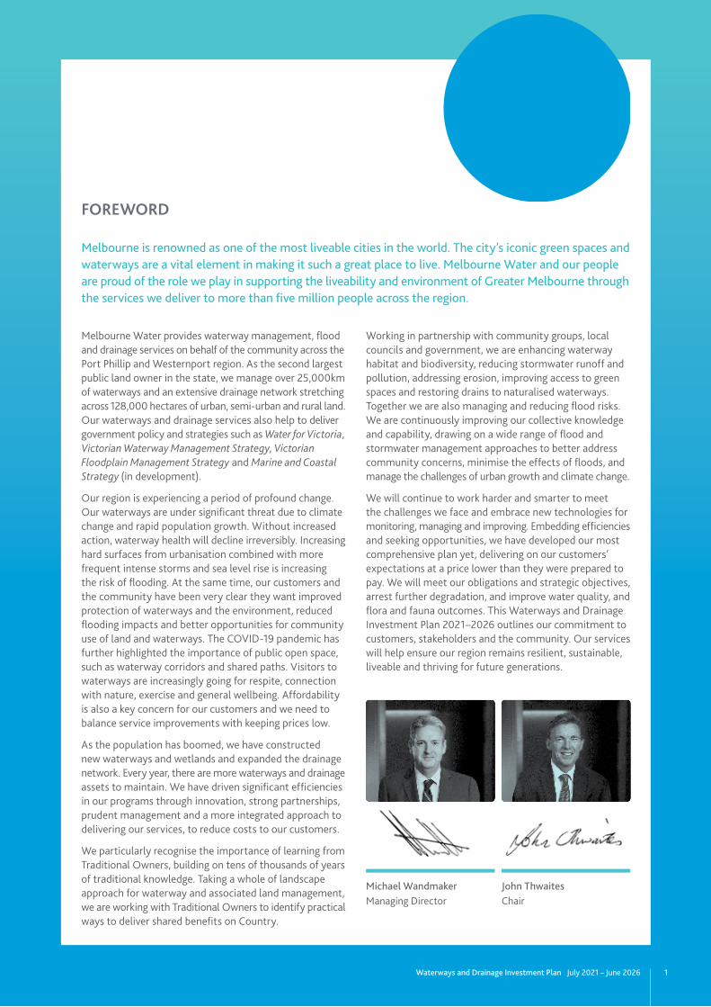
John ThwaitesChair
Michael Wandmaker Managing Director
1Waterways and Drainage Investment Plan July 2021 – June 2026

We manage magnificent rivers and creeks, natural drainage areas and wetlands, forests, woodlands and grasslands – all important ecosystems that not only support a rich diversity of plants and wildlife but also the health and wellbeing of our community. We also manage an extensive drainage network and flood retarding basins. These often double as sportsfields and parks as well as extensive stormwater treatment wetlands that clean dirty stormwater before it ends up in creeks and the bays.
This Waterways and Drainage Investment Plan (the investment plan) details our commitment to customers, stakeholders and the community to deliver effective and affordable waterways and drainage services from 2021 to 2026. The investment it delivers aligns with our commitment to enhancing life and liveability across the region, and supports our responsibilities to protect and improve waterway health, provide regional drainage services, work with partner organisations to reduce flooding impacts, and manage river diversions.
Balancing key considerations
In developing this investment plan we balanced our legislative obligations, policy directions, strategies, and customer expectations. These key considerations have expanded over the last five years. For example, we are now working with Traditional Owner groups to consider Aboriginal cultural values and uses of waterways in developing our services. We are obliged to protect, enhance and consider opportunities for social and recreational values for waterways. We are required to provide advice on coastal erosion and consider climate change in planning and delivering our services. And we are implementing integrated water management (IWM) as a key policy direction that takes a more holistic approach to water management. This involves considering our water, sewerage, waterways and drainage services together, and across different scales, to drive more efficient and improved outcomes. IWM helps us to deliver services that achieve multiple benefits for people, water security, affordability and the environment. This includes collecting and reusing stormwater for uses such as irrigation, watering sporting ovals and toilet flushing, whilst also protecting waterway health and reducing flood risk.
The investment plan also aligns with two key Melbourne Water-led strategies: the Healthy Waterways Strategy 2018 and the Flood Management Strategy – Port Phillip and Westernport 2020 (draft).
EXECUTIVE SUMMARYMelbourne Water is responsible for managing waterways (rivers, creeks, wetlands and estuaries) and major drainage systems (including floodplains) in the Port Phillip and Westernport region as well as bulk water supply and sewerage services. We are also the second biggest landholder in the state. Seventeen percent of our land is for waterway and drainage purposes.
Maribyrnong River, Avondale HeightsScotchmans Creek, Mount Waverley Dandenong Creek
2 Waterways and Drainage Investment Plan July 2021 – June 2026

Both strategies have been co-developed and co-delivered with communities and partner organisations. We work with communities at a local level, who have an attachment to and aspirations for the places where they live. We also work with organisations such as local government to manage drainage infrastructure, Parks Victoria and local government to manage our land for public open space, and emergency services to prepare for and respond to flood events.
These strategies acknowledge that over the next 50 years climate change, urbanisation and rapid population growth are significant threats to the region, including our waterways. Climate change leads to longer, drier periods and more frequent extreme rainfall events, which degrade waterway health and increase flood risk. Urbanisation is reducing areas that can absorb water. Despite the slowing of population due to the COVID-19 pandemic, we expect Melbourne’s population growth will continue to increase. All of these factors will result in more stormwater runoff from hard surfaces, which changes the natural flow regime and degrades the waterway, and increases the risk of extreme heat and flooding. In turn, this increases risks for people, property, infrastructure, waterways and places. Without increased action, we will see an irreversible decline in waterway health and greater flooding. Our investment plan directs our response to these challenges.
The COVID-19 pandemic and resulting restrictions pose risks and challenges to the delivery of our services. To ensure we continue to provide essential services in a way that is safe both for our people and our customers, we have adapted our ways of working. This includes enabling staff to work from home, implementing social distancing practices, and continuing to find innovative approaches to meeting any limitations and challenges that these restrictions may pose. While some challenges may not yet be apparent, and we will need to adaptively manage these as they arise, opportunities have also presented. The creation of over 100 jobs to protect and improve waterways as part of our Waterway Blitz program is one such example. This has come about through the State government’s Working for Victoria initiative and will help us deliver on some of the priorities in the Healthy Waterways Strategy as well as provide much needed employment for people affected by the pandemic.
Listening to our customers
We engaged with our customers and the community from February 2019 to June 2020. They pay for the services we provide, primarily through the Waterways and Drainage Charge (the charge) levied on properties in the region. The levels of service that we provide are driven by a combination of obligations and ‘customer value’ – that is, our customers’ preferences for levels of service, priorities, and the price they are willing to pay for these services.
We take the need to provide affordable services very seriously. The global COVID-19 pandemic is causing financial pressure for customers and communities across Victoria, Australia and around the world. Retail water companies in the region (providers of billing services on our behalf for waterways and drainage, as well as our customers in delivery of wholesale services relating to water and sewerage provision) have reported increased numbers of customers seeking bill support. In developing our investment plan, we have balanced the levels of service we provide with affordability for customers. We will continue to work closely with the retail water companies and monitor the ongoing impacts of the pandemic, with consideration for our customers, throughout the delivery of this investment plan.
The customer research (customer preference and willingness to pay survey) found that the majority of customers would prefer to pay a higher charge for increased services (up to $8 for metropolitan residential customers) in relation to stormwater management (pollution removal and stormwater harvesting), waterway management, flood risk management, access to land and water, and community education and involvement programs. However, some customers are experiencing financial pressure, particularly relating to utility costs, and would prefer reduced services and a lower charge. This customer research was undertaken during 2019, prior to the COVID-19 pandemic, which is creating greater affordability issues for our customers. We are therefore striving to deliver the vast majority of the increased services for a $5.32 total price increase over five years. This will be staged as a 1 per cent increase per year over the five-year period and equates to an increase of approximately $1 a year above CPI on metropolitan residential bills. A community deliberative panel supported our investment proposal in April 2020, during the initial stage of the COVID-19 pandemic.
The Essential Services Commission (ESC) regulates the prices we charge to ensure we are delivering our services efficiently and effectively and are guided by customer expectations and preferences.
3Waterways and Drainage Investment Plan July 2021 – June 2026

Grasmere constructed wetlands for biodiversity, Berwick
Our proposed investment plan
This investment plan covers our proposed expenditure to deliver waterways and drainage services from 1 July 2021 to 30 June 2026. It informs our price submission to the ESC. To make sure our region remains a great place to live, subject to the ESC’s pricing determination, we propose $2,060 million of investment (inclusive of corporate costs) in nine services:
1. Stormwater management $264 million
2. Healthy waterways $301 million
3. Flood risk management $271 million
4. Aboriginal cultural values $2.4 million
5. Community access, involvement and recreation
$73 million
6. Land management $40 million
7. Emergency and pollution response $31 million
8. Coastal erosion advice $1.5 million
9. Urban development $723 million
Maribyrnong River
We will increase investment over the 2021 to 2026 period to address the significant deterioration in waterway health and increasing flood risk resulting from a changing climate and growing urbanisation that has occurred up to the start of this investment plan. This investment will result in the protection of waterway condition that would otherwise decline and the improvement of waterway condition in some priority areas. For most services, it will deliver improvements in line with our regional strategies and customer preferences. It will also enable us to deliver new services to meet our new or expanded obligations. Future population growth and climate change will put even greater pressure on waterways and drainage services and the infrastructure that supports these services. Key areas of increased investment include stormwater harvesting, flood mitigation, maintaining constructed wetlands and improving access to waterways and land. We have balanced the need for greater action with affordability concerns to ensure the most cost-effective investments, which reflect the preferences of our customers.
Based on the in-depth customer and stakeholder engagement to establish community preferences, we are proposing that the Waterways and Drainage Charge for households in the metropolitan area change from $104.32 in 2020/21 to $105.36 in 2021/22. For the four subsequent years, the charge would be increased by an additional 1 per cent each year, an increase of just over $1 each year above CPI.
Note – Funding to deliver the services and programs outlined in the Waterways and Drainage Investment Plan is subject to the Essential Service Commission’s pricing determination. Following the ESC’s final determination, this document may be updated to reflect changes in available funding. This plan was completed prior to finalisation of Melbourne Water’s 2021 Price Submission. In the case of any conflict in financials, the price submission document takes precedence.
4 Waterways and Drainage Investment Plan July 2021 – June 2026

Kananook Creek Reserve, Frankston
We have balanced the need for greater action with affordability concerns to ensure the most cost-effective investments, which reflect the preferences of our customers.
5Waterways and Drainage Investment Plan July 2021 – June 2026

Aboriginal acknowledgement
Foreword 1
Executive summary 2
Balancing key considerations 2Listening to our customers 3Our proposed investment plan 4
1 Investment proposal 8
1.1 Scope 91.2 What you pay and what you receive 111.3 Balancing key considerations for efficient and effective investment 14
2 Meeting obligations and responsibilities 16
2.1 Legislative and policy framework 17
3 Aligning with regional co-developed strategies 22
3.1 Our co-developed strategies 23
4 Responding to customer and community engagement 28
4.1 What we heard across all engagement activities 294.2 Key findings from the customer research 324.3 Key outcomes from the deliberative panel 354.4 Key feedback from local government 364.5 Customer council 374.6 Traditional Owner, fee-for-service, developer and other engagement 37
5 Determining priorities for the investment plan 38
5.1 Obligations and level of service 395.2 Performance review 405.3 Program planning and business forecasting 405.4 Performance, risk, engagement, management and outcomes framework (PREMO) 40
6 Proposed services and programs 42
6.1 Stormwater management 446.2 Healthy waterways 496.3 Flood risk management 546.4 Aboriginal cultural values 586.5 Community access, involvement and recreation 596.6 Land management 636.7 Emergency and pollution response 656.8 Coastal erosion advice 686.9 Urban development 69
TABLE OF CONTENTS
6 Waterways and Drainage Investment Plan July 2021 – June 2026

7 Continuous improvement 72
7.1 Efficiencies 747.2 Innovation 777.3 Measuring performance 797.4 Key performance indicators 807.5 Reporting 81
8 Conclusion 82
Glossary 84
FIGURES
Figure 1 Melbourne Water’s service area 9Figure 2 Revenue by customer 11Figure 3 Number of customers 11Figure 4 Waterways and drainage service areas 12Figure 5 Total expenditure by service area for the 5-year plan 14Figure 6 Balancing key considerations to develop an efficient and effective investment plan 15Figure 7 The Waterways and Drainage Investment Plan – informing the Price Submission and delivery of actions 15Figure 8 Legislative and policy framework 17Figure 9 Melbourne Water’s primary legislative obligations, roles and responsibilities 18Figure 10 Growth and urbanisation – increase in stormwater 25Figure 11 Demonstrating the link between the science of our Healthy Waterways Strategy and investment plan 26Figure 12 Demonstrating our collaborative approach to managing flooding 27Figure 13 Summary of our approach to engagement 30Figure 14 Summary of customer and community engagement and key statistics 31Figure 15 Customer preferences and willingness to pay 33Figure 16 Established requirements and customer-driven levels of service 39Figure 17 Development of the investment plan 41Figure 18 Waterways and drainage services and programs 43Figure 19 Elements of the waterways and drainage system 44Figure 20 Stormwater management 5-year investment plan total forecast expenditure 47Figure 21 Example of a potential Sunbury integrated water management arrangement 48Figure 22 Healthy waterways 5-year investment plan total forecast expenditure 52Figure 23 Highlighting activities for healthy waterways, stormwater and land 53Figure 24 Flood risk management 5-year investment plan total forecast expenditure 56Figure 25 Highlighting activities in flood risk management 57Figure 26 Community access, involvement and recreation 5-year investment plan total forecast expenditure 61Figure 27 Highlighting projects in community access, involvement and recreation 62Figure 28 Land management 5-year investment plan total forecast expenditure 64Figure 29 Emergency and pollution response 5-year investment plan total forecast expenditure 66Figure 30 Urban development 5-year investment plan total forecast expenditure 71Figure 31 The plan’s continuous improvement cycle 73
TABLES
Table 1 Waterways and Drainage Charge 14
7Waterways and Drainage Investment Plan July 2021 – June 2026

SECTION 1
INVESTMENT PROPOSAL
The Waterways and Drainage Charge (the charge) is a fee that is applied to properties within our service area. This investment plan sets out Melbourne Water’s
responsibilities, vision, rationale and investment for waterways, drainage and flood management services
that are funded through the charge and fee-for-service.
Balcombe Creek estuary
8 Waterways and Drainage Investment Plan July 2021 – June 2026

1.1 ScopeMelbourne Water manages water supply catchments, treats and supplies drinking and recycled water, removes and treats most of Melbourne’s sewage, and manages waterways and major drainage systems in the Port Phillip and Westernport region (see Figure 1). Melbourne Water is owned by the Victorian Government.
This investment plan sets out Melbourne Water’s responsibilities, vision, rationale and investment for waterways, drainage and flood management services that are funded through the Waterways and Drainage Charge (the charge) and fee-for-service.
The charge is paid by residential, rural and business customers in the region. Some customers pay fee-for-service for additional direct services. These customers are urban developers, property owners who pay to use river water or stormwater (diverters), rural drainage customers within the Koo Wee Rup and Longwarry Flood Protection District, and some Patterson Lakes residents who pay jetty leasing and lake-flushing fees.
We have developed this investment plan as a requirement of, and to meet Melbourne Water’s legislative obligations under the Water Industry Act 1994 (Vic) and our Statement of Obligations (General).
Figure 1. Melbourne Water’s service area
0 5 10 15 20 km
5
3
2
1
4
The region includes five major river basins: the Werribee, Maribyrnong and Yarra rivers, Dandenong Creek, and the Westernport river systems. These river basins make up most of the catchments of Port Phillip Bay and Westernport.
Mornington
Rosebud
Drouin
Port Phillip Bay
Western Port
Werribee
Sunbury
Gisborne
Pakenham
Melbourne
Frankston
Healesville
Whittlesea
Melton
Major catchments
1
2
3
4
5
Werribee
Maribyrnong
Yarra
Dandenong
Westernport
Major Waterways
9Waterways and Drainage Investment Plan July 2021 – June 2026
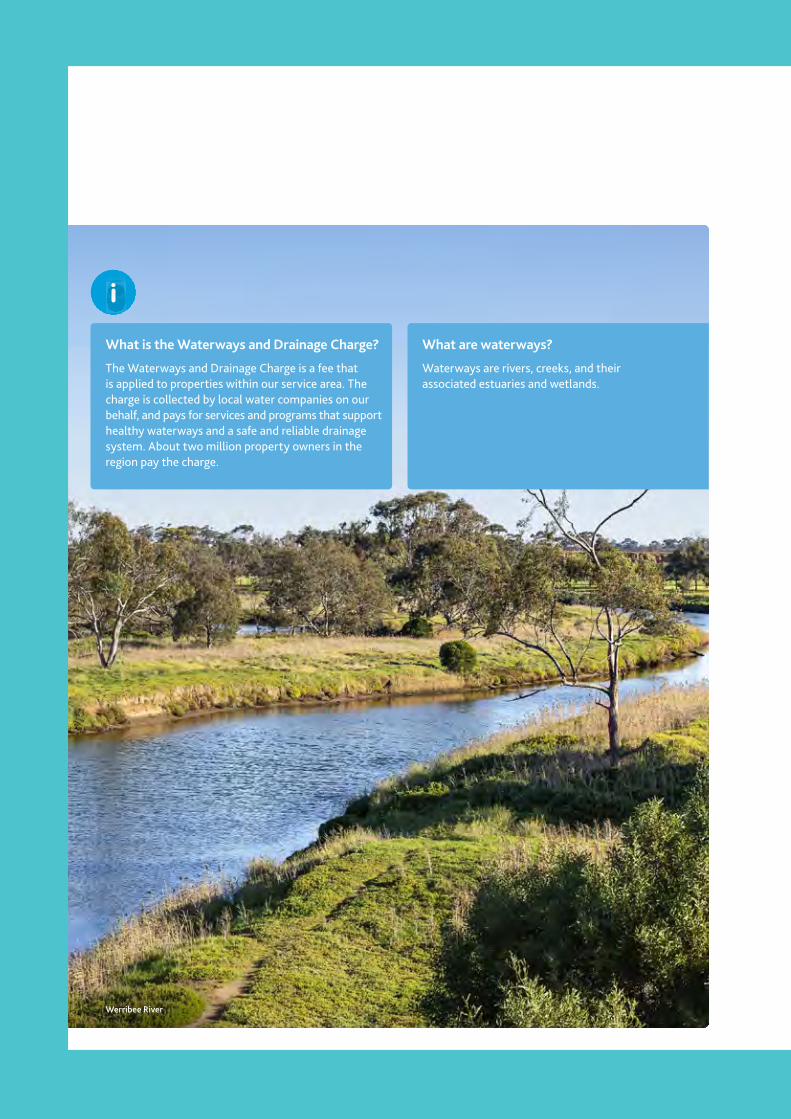
What is the Waterways and Drainage Charge?
The Waterways and Drainage Charge is a fee that is applied to properties within our service area. The charge is collected by local water companies on our behalf, and pays for services and programs that support healthy waterways and a safe and reliable drainage system. About two million property owners in the region pay the charge.
What are waterways?
Waterways are rivers, creeks, and their associated estuaries and wetlands.
Werribee River
10 Waterways and Drainage Investment Plan July 2021 – June 2026

1.2 What you pay and what you receiveThe total projected revenue for the five-year period commencing on 1 July 2021 is $2,030 million. The revenue includes $1,360 million (67 per cent) from the charge and $670 million (33 per cent) from fee-for-service, contributed by developers and other fee-for-service customers, as shown in Figures 2 and 3.
1.2.1 Our services
The investment plan includes nine distinct service areas and their associated programs, as illustrated in Figure 4. These services are interrelated in ensuring community value, healthy waterways, community protection from flooding and reduced impacts from urban development.
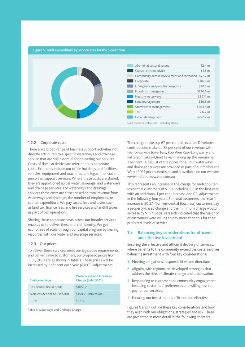
To deliver these service areas, the total expenditure forecast for the five-year period is $2,060 million, comprising capital expenditure of $1,275 million and operating expenditure of $785 million.
The distribution of expenditure across the service areas is shown in Figure 5. Note revenue and expenditure don’t match due to timing around when we recover our expenditure. Developer contributions are received progressively over many years as land is developed; however, capital assets are generally built earlier in the development process. Also, capital assets such as pipes and channels are depreciated over the life of the asset, so we spend money to build the asset up front and then recover our costs over time.
Figure 2. Revenue by customer
Residential households $1,125.56 m
Non residential $199.32 m
Rural $35.24 m
Developers $658.61 m
Other (diverters, Koo Wee Rup– Longwarry, Patterson Lakes) $11.31 m
Note: Total revenue for five years (2021/22 to 2025/26) shown in real 2021 dollars
Waterways and Drainage Charge
Direct Service Fees
Figure 3. Number of customers
Residential households 1,947,344
Non residential 158,619
Rural 111,042
Other (diverters, rural drainage, jetty management & lake flushing) 6,708
Note: Customer numbers shown for June 2020
11Waterways and Drainage Investment Plan July 2021 – June 2026

Aboriginal cultural values • Waterway cultural values
Flood risk management • Flood preparedness and mitigation• Flood investigation and research• Flood information and planning• Maintenance and upgrading of drainage• Rural drainage (fee-for-service)
Stormwater management • Stormwater quality treatment systems• Stormwater harvesting and infiltration• Monitoring, planning and research• Managing pollution
Figure 4. Waterways and drainage service areas
Healthy waterways • Waterway condition• Planting trees and shrubs• Constructing or upgrading fishways• Monitoring, planning and research• Diversions (fee-for-service)
Community access, involvement and recreation• Managing litter• Recreational access to water• Planting trees and shrubs• Lake flushing and jetty leasing (fee-for-service)
12 Waterways and Drainage Investment Plan July 2021 – June 2026
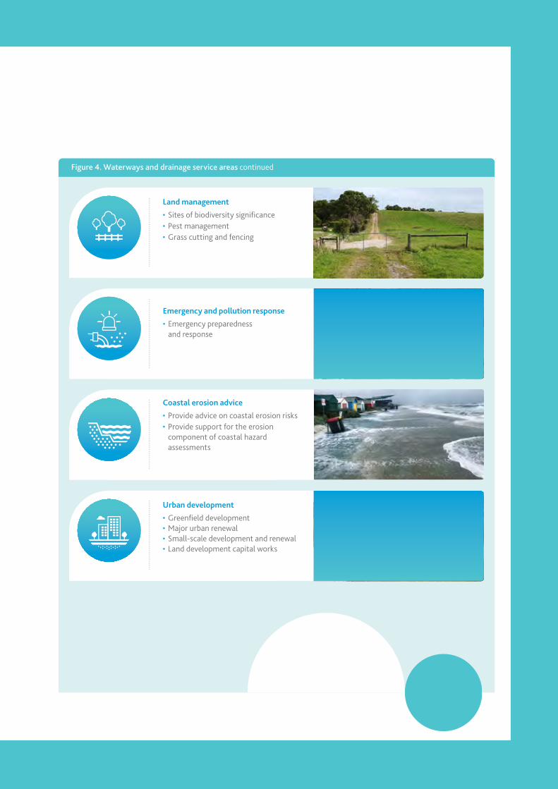
Figure 4. Waterways and drainage service areas continued
Coastal erosion advice • Provide advice on coastal erosion risks• Provide support for the erosion
component of coastal hazard assessments
Land management • Sites of biodiversity significance • Pest management• Grass cutting and fencing
Emergency and pollution response • Emergency preparedness and response
Urban development • Greenfield development• Major urban renewal• Small-scale development and renewal• Land development capital works
13Waterways and Drainage Investment Plan July 2021 – June 2026
1.2.2 Corporate costs
There are a broad range of business support activities not directly attributed to a specific waterways and drainage service that are still essential for delivering our services. Costs of these activities are referred to as corporate costs. Examples include our office buildings and facilities, vehicles, equipment and machines, and legal, financial and personnel support services. Where these costs are shared, they are apportioned across water, sewerage, and waterways and drainage services. For waterways and drainage services these costs are either based on total revenue from waterways and drainage, the number of employees, or capital expenditure. We pay taxes, fees and levies such as land tax, licence fees, and fire services and landfill levies as part of our operations.
Sharing these corporate costs across our broader services enables us to deliver these more efficiently. We get economies of scale through our capital program by sharing resources with our water and sewerage services.
1.2.3 Our prices
To deliver these services, meet our legislative requirements and deliver value to customers, our proposed prices from 1 July 2021 are as shown in Table 1. These prices will be increased by 1 per cent each year plus CPI adjustments.
The charge makes up 67 per cent of revenue. Developer contributions make up 32 per cent of our revenue with fee-for-service (diverters, Koo Wee Rup–Longwarry and Patterson Lakes–Quiet Lakes) making up the remaining 1 per cent. A full list of the prices for all our waterways and drainage services are provided as part of our Melbourne Water 2021 price submission and is available on our website www.melbournewater.com.au.
This represents an increase in the charge for metropolitan residential customers of $1.04 including CPI in the first year, with an additional 1 per cent increase and CPI adjustments in the following four years. For rural customers, the Year 1 increase is $0.57. Non-residential (business) customers pay a property-based charge and the minimum charge would increase by $1.57. Social research indicated that the majority of customers were willing to pay more than this for their preferred levels of service.
1.3 Balancing key considerations for efficient and effective investment
Ensuring the effective and efficient delivery of services, where benefits to the community exceed the costs, involves balancing investment with four key considerations:
1. Meeting obligations, responsibilities and directions.
2. Aligning with regional co-developed strategies that address the risks of climate change and urbanisation.
3. Responding to customer and community engagement, including customers’ preferences and willingness to pay for our services.
4. Ensuring our investment is efficient and effective.
Figures 6 and 7 outline these key considerations and how they align with our obligations, strategies and risk. These are presented in more detail in the following chapters.
Table 1. Waterways and Drainage Charge
Figure 5. Total expenditure by service area for the 5-year plan
Aboriginal cultural values $2.4 m
Coastal erosion advice $1.5 m
Community access, involvement and recreation $72.7 m
Corporate $316.6 m
Emergency and pollution response $30.5 m
Flood risk management $270.5 m
Healthy waterways $301.1 m
Land management $40.3 m
Stormwater management $263.8 m
Tax $37.7 m
Urban development $722.7 m
Note: Dollars are Real 2021, including labour
Fig 5
14 Waterways and Drainage Investment Plan July 2021 – June 2026
Customer typeWaterways and Drainage Charge (July 2021)
Residential households $105.36
Non-residential households $158.29 minimum
Rural $57.85

• Planning and forecasting• Resourcing and delivery mechanisms• Research and innovation • Essential Services Commission
water pricing framework (PREMO–prioritisation, risk, engagement, management and outcomes)
• Legislation, policy, strategies
• Expanded responsibilities and directions: social and Aboriginal cultural values, coastal erosion, Yarra Strategic Plan, and integrated water management
• Healthy Waterways Strategy
• Flood Management Strategy
• Port Phillip Bay Environmental Management Plan
• Waterways and Drainage Investment Plan vision
• Customer and community engagement • Social research on customer preferences and willingness to pay • Local government engagement • Public engagement
Aligning with regional
co-developed strategies
Responding to customer and
community engagement
Determining priorities for
efficiency and effectiveness
Meeting obligations and responsibilities
Figure 6. Balancing key considerations to develop an efficient and effective investment plan
Figure 7. The Waterways and Drainage Investment Plan – informing the Price Submission and delivery of actions
WATERWAYS AND DRAINAGE INVESTMENT PLAN
(Melbourne Water programs)
OTHER ORGANISATIONS’ PLANNING
(Other organisations’ actions)
PRICE SUBMISSION 2021
(All Melbourne Water services – water, sewerage, waterways
and drainage)
DELIVERY OF ACTIONS
(Including partnerships and co-delivery for improved efficiency
and cost-effectiveness)
CUSTOMER RESEARCH AND ENGAGEMENT
(e.g. Waterways and Drainage customer council, deliberative panel, direct service customer engagement, customer preference and willingness
to pay survey)
LEGISLATION / OBLIGATIONS
(e.g. Water Act, Planning and Environment Act, State Environment Protection Policy, Melbourne Water
Statement of Obligations)
CO-DEVELOPED STRATEGIES
(Healthy Waterways Strategy, Flood Strategy,
Port Phillip Bay Environmental Management Plan)
15Waterways and Drainage Investment Plan July 2021 – June 2026

SECTION 2
MEETING OBLIGATIONS AND RESPONSIBILITIES
As a Victorian Government-owned corporation, Melbourne Water operates under a comprehensive
legislative and policy framework. Changes in legislation and policy have expanded Melbourne Water’s
responsibilities over the last five years.
Werribee River
Waterways and Drainage Investment Plan July 2021 – June 202616

Requirements, measures and guidelines
Defining policy, setting values and determining environmental quality
indicators
Outlining actions and targets to manage risks
and protect values
Specific obligations, tasks and on-ground programs
for achieving targets
Policy settingLegislationStrategic policy implementation
Melbourne Water obligations and plans
Water Industry Act1994
Victorian Waterway Management Strategy
Regional Catchment Strategy
Water Act 1989
Victorian Floodplain Management Strategy
Building controls
Yarra Strategic Plan
Healthy Waterways
Strategy
Flood Strategy
Environment Protection Act 1970
Environmental Reference Standards
Port Phillip Bay Environmental
Management Plan
Marine and Coastal Act 2018
Marine and Coastal Reforms Final
Transition Plan
Statement of Obligations
Planning & Environment Act 1987
Building Regulations Act 1993 (Cth)
Catchment scale IWM plans
Marine and Coastal Policy
Victorian Planning Provisions
Have undergone major revision since the 2016 Pricing Determination
Figure 8. Legislative and policy framework
Corporate Plan
Price Determination
Waterways & Drainage Investment Plan
Customer charter and Principles for Provision
of Waterway and Drainage Services for Urban Growth
Healthy Waterways
Strategy co-delivery
Flood Strategy
action plan
2.1 Legislative and policy frameworkThe following framework (see Figure 8) establishes our statutory obligations and responsibilities as the designated waterway and floodplain manager for the region.
17Waterways and Drainage Investment Plan July 2021 – June 2026

Primary legislative obligations and responsibilities associated with waterways and drainage
Water Act 1989 (Vic):
Designated waterway manager, with responsibility for managing waterways, major drainage systems, floodplains, and the Environmental Water Reserve.
• Floodplain management and major drainage functions, including:
- Predicting floodwater extent and height and declaring flood levels.
- Developing and implementing plans or schemes, and taking action needed to minimise flooding and flood damage, bring into operation new drainage systems and improve stormwater quality in drainage systems.
- Providing advice about flooding and controls on development, including declaring the flood level of an event that has a 1 per cent probability of occurring in any one year.
- Planning, providing information, and implementing and operating drainage infrastructure to manage flood risk for existing and new developments.
- Ensuring that adequate drainage and flood protection standards for development are achieved and that waterway beds and banks are protected and enhanced. This is facilitated through the preparation of development services schemes.
• Prepare and implement a regional waterway management strategy to improve and protect the health and environmental values of the rivers, wetlands and estuaries within the Port Phillip and Westernport region, on behalf of the community. This includes water quality and other uses that depend on environmental condition.
• Consider opportunities to provide for Aboriginal cultural values and uses of waterways, and their social, economic and recreational values and uses.
• Educate the public about waterway management.
Environment Protection Act 2017 (Vic):
• Have regard to the principles of environment protection when discharging functions.
• Meet the requirements of the new General Environment Duty.
• Help achieve water quality objectives for individual waterways, and protect environmental values and beneficial uses of waterways (such as recreation) by reducing nutrient, sediment and toxicant loads delivered by stormwater. In doing so, we implement Victoria’s Urban Stormwater Best Practice Environmental Management Guidelines for ecological protection of waterways from urban stormwater.
Water Industry Act 1994 (Vic):
• Compliance with Statement of Obligations (General, Emissions Reduction) and Water Industry Regulatory Order issued by the Minister for Water.
Melbourne Water Statement of Obligations 2015:
• Develop and implement the Waterways and Drainage Investment Plan.
• Facilitate opportunities for stormwater capture and fit-for-purpose re-use.
• Take into account principles of integrated water management.
Climate Change Act 2017 (Vic):
• Required sector pledge to reduce emissions (achieve net zero emissions by 2050). Melbourne Water has pledged to achieve net zero emissions by 2030.
Figure 9. Melbourne Water’s primary legislative obligations, roles and responsibilities
2.1.1 Legislative obligations and responsibilities
Figure 9 summarises the key legislative obligations and responsibilities relevant to this investment plan.
Waterways and Drainage Investment Plan July 2021 – June 202618

Planning and Environment Act 1987 (Vic):
• Statutory referral authority role for planning applications that may affect waterways.
• Enables Melbourne Water to comment on or in some cases object to applications.
• Enables Melbourne Water to place conditions on planning permits relating to the use or development of a property, in relation to flood-related zones and overlays.
Subdivision Act 1988 (Vic):
• Referral authority powers for the assessment of planning permits to subdivide land.
Emergency Management Act 2013 (Vic):
• Role in contributing to flood response and recovery.• Role in risk management of owned and operated
critical infrastructure.
Catchment and Land Protection Act 1994 (Vic):
• Must take all reasonable steps (as a land owner) to avoid land degradation, conserve soil, protect water resources, and eradicate weeds and pest animals.
Marine and Coastal Act 2018 (Vic):
• Provide technical advice on any matters relating to or affecting coastal erosion in our waterway management district, including matters relating to or affecting the marine and coastal environment.
Flora and Fauna Guarantee Act 1998 (Vic) and Environmental Protection and Biodiversity Conservation Act 1999 (Cth):
• Responsibilities for biodiversity conservation for three Ramsar wetlands (wetlands of international significance that are protected under international treaties and law).
Emergency Management Manual Victoria (2018) and Non-hazardous pollution of inland waterways response plan (Department of Environment, Land, Water and Planning 2019)
• Designates Melbourne Water as the incident controller for non-hazardous pollution of inland water.
Figure 9. Melbourne Water’s primary legislative obligations, roles and responsibilities continued
Dandenong Creek Grasmere natural wetlands, Berwick
Waterways and Drainage Investment Plan July 2021 – June 2026 19

2.1.2 Expanded responsibilities over the last five years
Changes in legislation and policy have expanded Melbourne Water’s responsibilities over the last five years.
2.1.2.1 Aboriginal cultural valuesAmendments to the Water Act in 2019 require Melbourne Water to consider opportunities to provide for Aboriginal cultural values and uses of waterways. This is also in accordance with Water for Victoria (DELWP 2016), the state government’s long-term plan for managing Victoria’s precious water resources. The plan requires water corporations such as Melbourne Water to recognise Aboriginal values and objectives of water, include Aboriginal values and traditional ecological knowledge in water planning, support Aboriginal access to water for economic development, and build capacity to increase Aboriginal participation in water management.
2.1.2.2 Social and recreational valuesThe 2019 amendments to the Act require Melbourne Water to consider opportunities to provide for social and recreational uses of waterways. The Act defines social and recreational uses and values as (a) the uses of waterways for social and recreational purposes; and (b) the economic, aesthetic and wellbeing benefits that the community derives from the use of waterways for social and recreational purposes. Our Statement of Obligations states we must ‘manage water resources in a sustainable manner that enhances environmental outcomes and amenity in urban and rural landscapes’. The Ministerial Letter of Expectations 2019 states that ‘Melbourne Water will commit to strengthening its community engagement efforts to consider shared benefits, including recreational benefits of water in planning and management decisions’.
2.1.2.3 Coastal erosion adviceUnder the Marine and Coastal Act 2018, the minister may require Melbourne Water to provide technical advice on coastal erosion in its waterway management district, including matters relating to or affecting the marine and coastal environment. Our role does not extend beyond providing advice. The Marine and Coastal Policy 2020 clarifies that owners of property or assets at risk from coastal hazards are responsible for their own risk exposure, and that state government and Crown land managers do not have an obligation to manage coastal processes or Crown land for protection of private property.
2.1.2.4 Integrated water management (IWM)Melbourne Water’s Statement of Obligations requires us to take into account the principles of integrated water management (IWM) in delivering efficient and effective waterways and drainage services. Melbourne Water participates in and supports the five collaborative IWM catchment forums that the Department of Environment, Land, Water and Planning (DELWP) established as part of Water for Victoria. These forums align with the catchments of the Healthy Waterways Strategy and support IWM-related services, including stormwater and flood management, and healthy waterways. Key benefits of IWM include the re-use of alternative water sources such as stormwater and recycled water. This can provide benefits to waterway health and also reduce the need to use precious drinking water for uses such as irrigation or toilet flushing.
20 Waterways and Drainage Investment Plan July 2021 – June 2026

Maribyrnong River at Footscray Park
21Waterways and Drainage Investment Plan July 2021 – June 2026
Integrated water management
Integrated water management (IWM) is a holistic approach to delivering water services. IWM considers the natural water cycle and all water systems, including flooding, drainage, waterway, water supply and sewerage services, as one single system.
Adopting an IWM approach encourages development of regional-scale to place-based responses that can provide multiple benefits.
These include supporting environmental health, community wellbeing, affordable services and water resilience.
For example, we can capture, filter and direct stormwater to irrigate parks and to support healthy flows for rivers; and we can provide access to waterways and open spaces to develop green, cool places for refuge in a time of climate change. Local government and the water sector have implemented IWM projects to maintain green spaces, cool urban environments and increase water security.

SECTION 3
ALIGNING WITH REGIONAL
CO-DEVELOPED STRATEGIES
We recognise that taking a collective approach is the only way to ensure our waterways remain healthy and flood
impacts are minimised.
Merri Creek at Yarra Bend
Waterways and Drainage Investment Plan July 2021 – June 202622

3. Aligning with regional co-developed strategies
While our legislative obligations and policy directions require us to co-develop regional strategies that direct activities to protect waterways and deliver drainage and flood management improvements, we also recognise that taking a collective approach is the only way to ensure our waterways remain healthy and flood impacts are minimised.
Addressing the significant threats from climate change and urbanisation on waterways and flooding requires the combined action of many organisations and individuals who all have different responsibilities for various aspects of waterways and drainage.
This investment plan translates the shared longer-term strategic vision, objectives and actions developed for the Healthy Waterways Strategy and the Flood Management Strategy – Port Phillip and Westernport into a five-year investment plan, to guide the delivery of Melbourne Water’s actions and ensure these are funded.
Both strategies were co-developed and will continue to be co-delivered with our partners to ensure coordinated action for greater benefits. This approach flows through into nearly all our waterways and drainage programs. We aim to deliver these in partnership with others to ensure the charge our customers pay for waterways and drainage services goes as far as possible and delivers more than it otherwise would. This means we can keep prices as low as possible, whilst delivering the improved services and outcomes our customers have asked for.
3.1 Our co-developed strategiesThe Healthy Waterways Strategy was co-designed with our engaged community (actively involved and interested in waterways and their management) and delivery partners including local communities, community groups, Traditional Owners and local government. Engagement was in-depth and extensive, involving 23 forums across the five catchments. The process was overseen by an independently chaired project leadership team, with representation from the Port Phillip and Westernport Catchment Management Authority, Environment Protection Authority (EPA) Victoria, DELWP, Parks Victoria, the Municipal Association of Victoria and Melbourne Water.
Underpinned by extensive scientific research, the strategy demonstrates that urgent action is needed to protect our waterways in the context of climate change and urbanisation, and that stormwater is a primary threat to waterway health. This strategy aligns with the Yarra Strategic Plan, which is an integrated corridor plan developed collaboratively by the Wurundjeri Woi wurrung Cultural Heritage Aboriginal Corporation and all 15 state and local government agencies involved in managing the river. The strategy also aligns with the Port Phillip Bay Environmental Management Plan, developed in collaboration with DELWP and EPA Victoria, and identifies priority areas for investment to protect environmental, social, cultural and economic waterway values.
The Flood Management Strategy, focuses on collectively understanding, preparing for, managing and recovering from flooding events. It is currently being refreshed with our flood management partners: local, state and federal government; water authorities; emergency services and the insurance sector. The process is being overseen by a flood leadership committee comprising flood partner organisations and Melbourne Water.
The key objectives of the strategy are:
• The right information is available at the right time to the people who need it.
• Flood risks and opportunities are managed to reduce impacts and get the best social, economic and environmental outcomes.
• Land, water and emergency agencies work together to manage flooding effectively.
The refreshed strategy recognises that despite the extensive drainage network in the region, flood risks are growing due to climate change and urban development. The strategy is focusing on continuing to evolve our flood management approaches to ensure we can keep building resilience to flooding and making the region safer for our community.
Bunyip River, Nine Mile Road
23Waterways and Drainage Investment Plan July 2021 – June 2026

3.1.1 The interaction of climate change and urbanisation as key threats to waterways and flooding
We are living in a changing climate. Climate projections for Melbourne show that while overall rainfall is reducing, when storms do happen, they are more intense. Increased hard surfaces (impervious surfaces) reduce the opportunity for rainfall to soak into the ground, which is needed to support local waterways in drier periods. Additionally, stormwater flows more rapidly during storms and results in unnaturally high flows. This damages the waterways and degrades their ecosystems. Figure 10 illustrates how growth and urbanisation increases stormwater and impacts our waterways.
Over the past five years, the city’s population has grown faster than ever before. Even with a slowing of population growth due to the COVID-19 pandemic, long-term population in Greater Melbourne is projected to increase from five million in 2018 to nine million in 20561.
As our population grows, more people seek access to waterways for recreation and to receive the health benefits of being in nature. This has been particularly noticeable during the pandemic when we have seen significant increases in people using waterway corridors for these purposes.
Population growth also brings urbanisation and more hard surfaces such as roads, roofs and pavements. Runoff from these hard surfaces carries pollutants and litter into the drainage system and into our waterways and bays.
When urbanisation is combined with increasing storm intensity, more stormwater enters our drains and can cause flash flooding. Flooding also occurs when the amount of stormwater flowing into creeks exceeds the capacity of river systems, and through coastal storm surges.
We have a greater understanding of how climate change and urbanisation is impacting our waterways and their environmental, social, cultural and economic values (see Figures 10 and 11). We also understand the impacts this will have on the effectiveness of our services. Without increased investment, waterway health will deteriorate significantly.
The impacts of climate change and urbanisation are increasing flood risk and a collaborative approach across all responsible organisations is essential to reducing the risk and building resilience (Figure 12).
This plan details investment in waterways and drainage services over the next five years. This timeframe is critical. What we do now sets the region on a trajectory for the next 30 years.
Development showing urbanisationCarrum (David Hannah)
24 Waterways and Drainage Investment Plan July 2021 – June 2026
1 State Government of Victoria, Department of Environment, Land, Water and Planning, (2019), Victoria in Future 2019. Population Projections 2016 to 2056. July 2019

Less permeablesubsoil on rock
Forested Urban
Evaporation
Transpiration Transpiration
Evaporation
Precipitation
Water table
InfiltrationInfiltration
Base flowRunoff Runoff
Base flow
Precipitation
Permeable topsoil
Time since rainfall
Rainfall
Erosion & habitat damage
No flowUrb
an fl
ows
Time since rainfall
Rainfall
Nat
ural
flow
s
Figure 10. Growth and urbanisation – increase in stormwater
Melbourne predicted to be 59% more impervious within 50 years
Changes to flow in local waterways: higher peak flows, more often and longer periods of zero flow
25Waterways and Drainage Investment Plan July 2021 – June 2026

Over two decades of biological data from
our waterways and extensive research
Scientific models to predict behaviour
under different conditions including climate change and
urbanisation
Engaged community and partner involvement
Habitat suitability modelling –
How suitable is the waterway habitat for different animals and plants e.g. frogs, fish,
aquatic life?
Conceptual models – which management
actions are likely to be most effective
See Healthy Waterways Strategy at www.melbournewater.com.au for detailed information on the science supporting our programs
Scientific modelling
Planning scenarios
Target trajectory (expected change with increased coordinated, collaborative and prioritised effort
and investment) – results in maintaining and where possible improving waterway health
Determine appropriate actions Consider actions by other co-delivery partners
Determining cost-effective actions
Customer preferences and willingness to pay Waterways and Drainage Investment Plan programs
Set performance objectives and targets
50-year vision – engaged community, Melbourne Water and partners
20-50 year goals
10-20 year targets
5-10 year performance objectives
Continue to use scientific data and expert and community input to refine programs through a monitoring, evaluation, reporting and improvement (MERI) program
Threat analysis and management opportunities tool – which are the most cost-effective actions
Current trajectory (expected change in waterway health if
current programs and investment continues) – results in a decline
across the majority of waterways
Figure 11. Demonstrating the link between the science of our Healthy Waterways Strategy and investment plan
Healthy Waterways Strategy – How research and science supports our investment plan
26 Waterways and Drainage Investment Plan July 2021 – June 2026

Vision Together we are aware, responsive and resilient. Communities, business and government understand flooding, plan collaboratively for challenges and take action to manage risks and optimise opportunities, for now and the future.
5-year action plans x2Actions
5-year action plans x2Actions
5-year action plans x2Actions
Waterways and Drainage Investment Plan programs
Objective 1The right information is available at the right time to the people who need it
Objective 2Flood risks and opportunities are managed to reduce impacts and get the best social, economic and environmental outcomes
Objective 3Land, water and emergency agencies work together to manage flooding effectively
10-year outcomes• Agency knowledge of flood
risks has improved• Communities in flood-prone
areas have increased awareness of flood risk
• Flood affected communities have access to clear, appropriate and timely emergency information
10-year outcomes• Flood impacts are reduced
(relative to a do-nothing scenario)• Land use and development in flood-prone
areas is appropriate to the level of flood risk • The impacts of climate change and
coastal flooding are incorporated into planning and decision-making
• Integrated water management and flood infrastructure achieve maximum public value
10-year outcomes• Clear roles and responsibilities allow agencies to deliver effective flood management and emergency services• Agencies collaborate to plan for
and manage flood risk and flood emergencies
Focus areas• Fit-for-purpose information• Community knowledge platform• Empowering communities
Focus areas• Flood effects reduction• Land use planning• Challenges of climate change• Multiple benefits embedded
in decision-making
Focus areas• Clarifying roles and responsibilities• Emergency agency preparedness
and response• Flood recovery
Our collaborative approach to managing flooding in the region – working with our 50+ flood partners
Figure 12. Demonstrating our collaborative approach to managing flooding
27Waterways and Drainage Investment Plan July 2021 – June 2026

SECTION 4
RESPONDING TO CUSTOMER
AND COMMUNITY ENGAGEMENT
We developed this investment plan using industry-leading engagement approaches with our customers and community. Overall, customers and
the community strongly supported our services. The majority of customers were willing to pay more than the current charge for increased service levels.
28 Waterways and Drainage Investment Plan July 2021 – June 2026
Yarra River, Warburton

4. Responding to customer and community engagement
We developed this investment plan using industry-leading engagement approaches with our customers and community. We established specific groups to undertake a guiding role, and undertook activities to understand people’s needs, values, aspirations and perceptions in relation to our services. (See Figure 13 for our approach and Figure 14 for a summary of our engagement activities and statistics).
4.1 What we heard across all engagement activities
Overall, customers and the community strongly supported our services. Many were surprised that we were able to do so much with so little investment. Many thought that they were paying more for our services than they actually were.
In general, our customers and community preferred that we invest more on services for the environment than for social purposes. However, community enjoyment was still seen as very important and had strong support.
Customers most strongly supported more investment in stormwater management – to address the impacts of urban development and climate change on waterway health and flood risk, and to make more water available for community uses. Support for healthy waterways was consistent and strong across all customer engagement and research.
However, engagement showed general confusion about the roles of different organisations, including Melbourne Water, for services such as community access and recreation, emergency and pollution management, and aspects of flood risk management. People were concerned that there could be duplication from organisations doing similar work. A minority of customers questioned what we do and thought that we should perform our services at the same or lower cost.
Customers appreciated the education they received in participating in our engagement. They supported more education for the community, so that they could better understand the important services we provide and the value and benefits they receive.
Galahs at Pound Bend, Yarra River, Warrandyte Platypus (Doug Gimesy)
29Waterways and Drainage Investment Plan July 2021 – June 2026

Key purpose and features of engagement for the investment plan
Direct customer voice – representative of entire waterways and drainage charge customer base, recruited
Vision and Values Panel – vision and values development for the Price Submission and the investment plan:
’In 2026, Melbourne Water will be an environmental leader, delivering reliable and sustainable water management solutions benefitting all Melburnians through its efficient, forward-thinking and innovative mindset.’ (March 2019)
• Seek broader community views
• Promote participation in engagement activities
• Raise general awareness for customers and community
Community presence and digital engagement
Community pop-up events
• ‘Drip Trip’ game developed to build awareness and understanding
• New ways to connect with our customers
• Educate and engage new audiences
• Seek broader community views and participation• Short surveys – ‘ask the team’• Central information location for information and comments on draft • Price submission proposals
• Strong social media presence
• Connecting with our key stakeholders including state government
• Digital animations explaining our services
Communications activities and digital engagement
Gamification Drip Trip pilot project Your Say
Customer segments Traditional OwnersLocal government
Customer and community representation
Waterways and Drainage Customer Council
Actively involved in waterways community, local councils, one metropolitan customer, one rural, fee-for-service customer (floodplain and diverter), and partner organisations. Purpose to:
• Ensure community and customer expectations were central to developing the investment plan.
• Ensure a transparent approach to developing the plan.
• Consider the Vision and Values Panel’s values in providing advice on the benefits and value customers receive from our services.
• Inform the development of the quantitative customer survey and to test strategic ideas.
Targeted engagement of fee-for-service customers receiving services beyond those provided by the Waterways and Drainage Charge:• Developer services• Koo Wee Rup −Longwarry flood plain management• Lake flushing and jetty maintenance• Waterway diversions (licences).
Engagement with Bunurong, Wadawurrung and Wurundjeri Woi wurrung Traditional Owners for Aboriginal cultural services.
Preferences and advice on key issues, opportunities and focus areas representative of their communities.
Online submission, invitation to all councils in our service area to participate in an online submissions process.
Quantitative research Deliberative panelQualitative research
Statistically representative customer preference and trade-off survey of 1,690 residential (metropolitan), 135 residential (rural), and 150 non-residential (business). Participants were given points proportional to indicative costs (mid-2019 estimates), which they could spend on service areas, programs, and service levels to indicate their preferences. Participants were able to revise their point allocation across services over three rounds. This resulted in a mix of services and service levels that a majority of customers preferred and were willing to pay for.
Waterways and Drainage 5-year vision: ‘The climate crisis and the urban expansion rate are threatening our water systems. We recommend aggressive investment and innovation in a needs-driven strategy based on scientific evidence and future-proof solutions.’ (Dec 2019)
The panel represented diverse customer interests and provided insight into community priorities, values, drivers and select topics as an extension of customer research data.
Eight geographically and demographically diverse customer focus groups provided insights to inform quantitative survey development. This provided a better understanding of any service gaps, customer perceptions of services, how to more clearly communicate services, and where customers might desire differing levels of service.
Values, ranked order:
1. Environment and sustainability2. Reliability 3. Forward-thinking
4. For everyone 5. Innovation 6. Efficiency
Figure 13. Summary of our approach to engagement
30 Waterways and Drainage Investment Plan July 2021 – June 2026

TRADITIONALOWNER
REPRESENTATIVE ORGANISATIONS
CONSULTED
3
Figure 14. Summary of customer and community engagement and key statistics
31Waterways and Drainage Investment Plan July 2021 – June 2026
Manningham and Stringybark Festivals 2019
4.2 Key findings from the customer researchWe conducted a survey to understand customer preferences for service levels and their willingness to pay for them. This was informed by customer focus group research and advice from the customer council, which was established to ensure customer expectations were central to the development of the investment plan.
4.2.1 Findings from the customer focus groups
Customer focus groups enabled our customers to share their perspectives on the benefits and value customers receive from our services, which in turn informed the development of the quantitative survey.
Key findings from the focus groups were that they:
• did not want waterway or land environments to decline, and valued works to improve waterway health• wanted more education to increase public value and perceptions of waterways, land and biodiversity • viewed stormwater harvesting as the priority, for non-potable reuse
• expressed trust in Melbourne Water to undertake appropriate research and planning, to make the right choices for waterways and drainage services
• were confused over the different authorities responsible for flooding issues.
They also expressed concern:
• that more needed to be done to prevent flooding in well-known flood-prone areas and near-new developments
• that some projects for access, recreation and creek reinvigoration may be expensive and investment may be better elsewhere
• over organisational responsibilities and duplication
• over our role in emergency and pollution management, and that of other organisations, and that the community was forced to pay for others’ bad behaviour
• about the impacts of urban development on our other services, highlighting the interaction of all of our services and the opportunities to counteract urbanisation and climate change impacts.
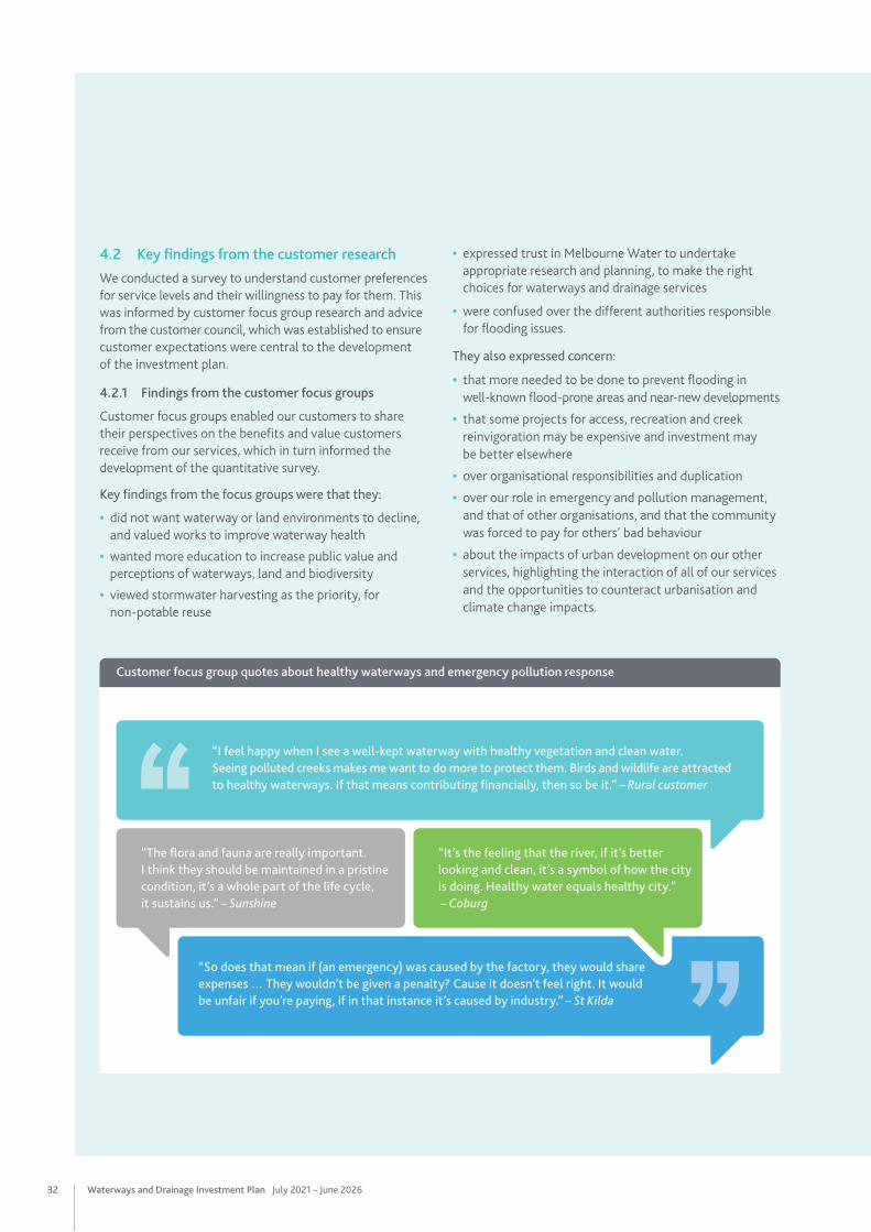
“I feel happy when I see a well-kept waterway with healthy vegetation and clean water. Seeing polluted creeks makes me want to do more to protect them. Birds and wildlife are attracted to healthy waterways. If that means contributing financially, then so be it.” – Rural customer
“So does that mean if (an emergency) was caused by the factory, they would share expenses … They wouldn’t be given a penalty? Cause it doesn’t feel right. It would be unfair if you’re paying, if in that instance it’s caused by industry.” – St Kilda
“The flora and fauna are really important. I think they should be maintained in a pristine condition, it’s a whole part of the life cycle, it sustains us.” – Sunshine
Customer focus group quotes about healthy waterways and emergency pollution response
“It’s the feeling that the river, if it’s better looking and clean, it’s a symbol of how the city is doing. Healthy water equals healthy city.” – Coburg
32 Waterways and Drainage Investment Plan July 2021 – June 2026

4.2.2 Findings from the online survey
A rigorous survey approach known as Simultaneous Multi Attribute Level Trade Off (SIMALTO) was used to enable customers to trade off services and arrive at a preferred mix of service levels and at a preferred price. Refer to Figure 15.
A majority of customers (68 per cent) were willing to pay more than the current charge for increased services:
• $110 per year for metropolitan customers (compared with $102 in year of the survey)
• $64 per year for rural customers ($56 in year of the survey)
• $153 per year for business customers (a minimum charge of $145 in year of the survey).
The lowest level of service and a decrease in the charge was preferred by 15 per cent of residential customers and 11 per cent of business customers. Furthermore, 13 per cent of residents and 30 per cent of businesses wanted to retain current service levels. Seven per cent expressed affordability concerns.
Increasing level of service and cost
Litter
Stormwater quality
Stormwater harvesting
Vegetation for environment
Natural wetlands
Estuaries
Vegetation for community enjoymentS
Land access
Recreational paddling
Flood preparedness
Flood mitigation
Waterway restoration
Community involvement
S P
S
S
S
S
S
S
S
P C
P C
P
S
P
P
C
C
S
S
C
S C
P C
P C
P C
P C
P C
P C
P C
Figure 15. Customer preferences and willingness to pay
S Current service level P Proposed service level C Customer preferred service level
Maximum service level in survey
Note: for simplification only the metropolitan residential customer is represented.
33Waterways and Drainage Investment Plan July 2021 – June 2026

Specific service preferences were as follows:
• The strongest preference was for investing in increased stormwater services and particularly for stormwater harvesting.
• A majority of customers indicated a preference to significantly increase waterway service levels and associated expenditure. They preferred the current level of service to be maintained for environmental vegetation, which requires increased investment due to greater threats.
• Residential customers preferred increases in all flood services tested, but business customers preferred no change. This included flood risk awareness campaigns, information and warnings for high-risk properties to reduce potential damages, and flood mitigation for high-risk properties.
• Water and land access programs for community enjoyment and recreation were strongly supported. However, metropolitan customers preferred vegetation services for community enjoyment, and improving channelised drains (creeks and rivers) for community enjoyment (Reimagining Your Creek program), to be maintained at current levels.
• Business customers preferred reduced investment in vegetation for community enjoyment, maintained investment in vegetation for environment and flood preparedness, and an increase in all other services.
• Rural residential customers wanted more land access and waterway restoration (Reimagining Your Creek) than metropolitan customers, and reduced vegetation for community enjoyment. They wanted to maintain current service levels for vegetation for the environment, and an increase in all other services.
Further exploration with 75 of the customers surveyed highlighted potentially contentious areas:
• Mixed views and limited understanding of flooding and drainage issues. There was tension between the importance of developing community flood resilience and managing impacts, versus a perception that this service is only relevant for people living in flood-prone areas, who should already be prepared. There were also perceptions that flooded roads were indicative of inadequate flood mitigation. It was unknown that roads in part are infrastructure designed to move floodwaters. However, participants were aware of the importance of flood prevention and mitigation to reduce repair and insurance costs, and the need to maintain reliable drainage systems.
• A preference for increased litter removal. There was a desire for more litter collection and research and investigation into causes. Acknowledging the high cost of litter collection, and a shared responsibility with other agencies such as local government and the EPA, we explored this issue further with the deliberative panel (outlined in the following section).
The overall message from this customer engagement and research was that the majority of customers, when faced with the choices that we are wrestling with, landed on a preferred outcome of an increase of $8 to deliver a range of improvements to service levels.
Melbourne Water Baykeepers eventRural customer, Koo Wee Rup
34 Waterways and Drainage Investment Plan July 2021 – June 2026

4.3 Key outcomes from the deliberative panel The deliberative panel provided deeper insights into key areas that required further exploration, after receiving presentations from independent and Melbourne Water subject matter experts.
• Stormwater: The panel generally supported stormwater programs, and identified both stormwater harvesting which protects waterways from stormwater, and pollution and litter as two of their top three priorities. The panel generally preferred longer-term outcomes involving partnerships and incentives with local councils and other authorities, over the short-term outputs of traditional grants.
• Healthy waterways: The panel expressed that research and planning was important to make the right choices for waterways and drainage services.
• Flood risk reduction: The panel identified flood mitigation as one of their top three priorities. They supported a lower increase in spending for flood mitigation (contrary to survey customers preferring a higher increase).
• Community access, involvement and recreation: The panel strongly supported our focus on strategic upstream source investigations into litter hotspots, over end-of-pipe litter removal.
It is difficult to communicate the complexity of our services to customers in a short survey. The deliberative panel provided us with an opportunity to explain in more detail the motivation behind our proposed investment. Because of this, the panel’s support for our proposed approach played a more prominent role in the final decisions around flood risk management and litter programs.
Deliberative panel engagement
A sketch capturing Day 1 of the deliberative panel, Lucinda Gifford, The Sketch Group
35Waterways and Drainage Investment Plan July 2021 – June 2026

4.4 Key feedback from local governmentMany local government participants considered the priority for waterway management to be environmental values, including the biodiversity and ecology of waterway environments and how they support natural ecosystems. Participants also believed collaboration is needed to provide community value and achieve healthy waterways.
Local government supported grants and incentive programs to continue collaboration on both large-scale and small local projects for water sensitive urban design (see boxed text ‘What is water sensitive urban design?’).
Participants preferred service level improvements in the following areas:
• litter management and prevention• stormwater incentives• green infrastructure maintenance• managing water pollution events• vegetation and revegetation along waterways to improve
connectivity of biodiversity • water quality monitoring.
Decreases in any waterway management services was not supported.
Participants identified areas where they would like further collaboration with Melbourne Water, including monitoring and maintenance, on-ground management activities, whole-of-catchment approaches, and improved service levels for litter management and water pollution events.
What is water sensitive urban design?
Water sensitive urban design is an approach to land planning and engineering design that considers the urban water cycle, including stormwater and groundwater. This improves the environment and the appearance of our streetscapes, suburbs and cities.
Raingarden near the MCG
Water sensitive urban design streetscape and gardens
Water sensitive urban design (raingardens)
36 Waterways and Drainage Investment Plan July 2021 – June 2026

4.5 Customer council The customer council prepared strategic advice for Melbourne Water to consider in developing this investment plan.
The council’s concerns focused on the impact of climate change and urban development on waterways and flooding, and the significant gap between the size of the challenge and the funding available to address it.
They supported greater action on litter, education, and delivering on the objectives set out in the Healthy Waterways Strategy and Flood Management Strategy.
The council advocated for an increase in the charge greater than 5 per cent. Key reasons were the need for increased service levels to address the deterioration in waterway health and prevent increased flooding. However, support for this was not unanimous.
The council’s concerns for waterways and drainage often aligned with feedback from community engagement activities. This affirmed the value of such engagement in the early stages of developing the investment plan.
Key issues identified were:
• Communities value passive recreation in naturalistic landscapes. Making parks and open spaces ‘useful’ with active recreation opportunities could be an unnecessary use of limited funding.
• Increased expectations and obligations for Melbourne Water require an increase in the charge to fund necessary capital and operational works.
• Urban waterway health is dependent on upstream waterway health. Therefore, it is necessary to rebalance investment between rural and urban areas.
• Cross-agency and cross-sectoral approaches will be essential in maximising adaptation to climate change, population growth and urbanisation.
4.6 Traditional Owner, fee-for-service, developer and other engagement
Investment to understand and protect Aboriginal cultural values are funded through the Waterways and Drainage Charge and further discussed in chapter 6. Discussions with Traditional Owners are ongoing.
We also have some customers who pay a charge beyond the Waterways and Drainage Charge. The preferences of a small group of customers that receive services for a separate fee (fee-for-service programs) were tested through a survey of specific customer segments within Patterson Lakes’ Quiet Lakes (bore flushing services) and Koo Wee Rup and Longwarry (flood mitigation and waterway health services).
Engagement with waterway diversion customers is ongoing.
Engagement with developers and the development industry is ongoing and there are no immediate changes to service provision.
Yarra River at Warburton
Cardinia Creek at Upper Beaconsfield
37Waterways and Drainage Investment Plan July 2021 – June 2026

SECTION 5
DETERMINING PRIORITIES FOR THE INVESTMENT PLAN
We balanced a range of considerations to ensure we deliver on our obligations,
strategies and customer preferences at an affordable price.
Waterways and Drainage Investment Plan July 2021 – June 202638
Sycamore Street, Caulfield South

5. Determining priorities for the investment plan
This section outlines the process we undertook to determine service level priorities and total expenditure for the investment plan.
In developing our investment plan, we balanced a range of considerations to ensure we deliver on our obligations, strategies and customer preferences at an affordable price.
Our usual business process includes undertaking more detailed planning and implementation over the plan’s five-year period to recognise priorities and objectives at catchment and local scales, including specific community, environmental and economic considerations (see Figure 17).
5.1 Obligations and level of serviceMelbourne Water has clear obligations to provide the services in this investment plan.
Some of these services have a high degree of accountability and oversight, and the level of service that we must provide has ‘established requirements’ through existing standards and agreements. For example, land development and emergency pollution and response have clear requirements – we cannot ignore a requirement to provide land-use planning advice or a diesel spill into a creek. We also provide fee-for-service activities, such as lake flushing, where we have service level agreements with specific customers and collect additional fees.
For other services, while the obligation to provide the service is clear, the required level of service (e.g. how much, where, and by when) is not clearly defined. In these cases, in addition to being guided by science and strategy, the levels of service are guided by the preferences of our customers and community, defined through our engagement for this investment plan. Services with a ‘customer-driven’ level of service include flood risk management; healthy waterways; community access, involvement and recreation; and stormwater. Figure 16 breaks this down.
Waterways and Drainage Investment Plan July 2021 – June 2026 39
Figure 16. Established requirements and customer-driven levels of service
Level of service Established requirements Customer-driven
Description Existing level of service and high degree of accountability, not tested with the broader community (may be tested with customer segments)
Ability to change the level of service taking into account customer preferences
Service areas • Emergency pollution and response
• Land management
• Urban development – developer charges
• Fee-for-service jetty management, lake flushing, diversions, rural drainage
• Stormwater management
• Healthy waterways
• Flood risk management
New obligation New obligation
• Aboriginal cultural values• Coastal erosion advice
• Community access, involvement and recreation

5.2 Performance reviewWe review our performance and achievements throughout each investment period. The learning from the current plan (2016–2021) has been incorporated into the development of this investment plan. We have used it to revise our programs and services, and to ensure that we are delivering the right level of service at a fair and reasonable price. A continuous improvement process is outlined in chapter 7.
5.3 Program planning and business forecastingWe undertake program planning and business forecasting of operational and capital expenditure, accounting for:
• new obligations• customer and community engagement to determine
customer value• social, environmental and economic risks and potential
opportunities• the objectives and commitments in regional strategies
and plans we have developed or contribute to, including the Healthy Waterways Strategy, the Flood Management Strategy and the Port Phillip Bay Environmental Management Plan.
5.4 Performance, risk, engagement, management and outcomes framework (PREMO)
Throughout this process we follow guidance material from the Victorian government and the Essential Services Commission (ESC). The final investment plan will be guided by the ESC’s price determination following our Price Submission.
Streetwater Creek, Frankston
Waterways and Drainage Investment Plan July 2021 – June 202640

Existing investment plan
Balancing key considerations
Finalising programs
Revised Waterways and Drainage
Investment Plan
Revised key performance
indicators
Price determination
Current investment plan – services and programs
Measuring performance and key performance
indicators
Proposal for the next five years
Legislative obligations, requirements and policy
directions
Customer and community engagement and social
research into preferences and willingness to pay
Aligning with strategic objectives in regional plans developed with
communities and partners – including known effects
of climate change and urbanisation on our region and service
Performance review including key performance
indicators
Risk assessment including Essential Services
Commission guidance and our risk framework
Program planning and business forecasting
of capital and operational expenditure and associated pricing
and finance
Figure 17. Development of the investment plan
Medway Golf Club revegetation, Maribyrnong River catchmentEdithvale–Seaford Wetland Discovery Centre bird watchers
41Waterways and Drainage Investment Plan July 2021 – June 2026
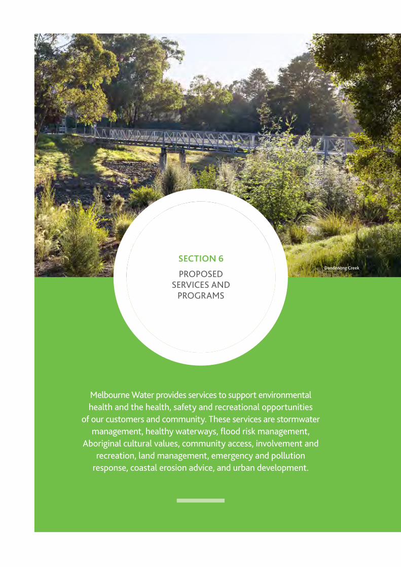
SECTION 6
PROPOSED SERVICES AND
PROGRAMS
Melbourne Water provides services to support environmental health and the health, safety and recreational opportunities
of our customers and community. These services are stormwater management, healthy waterways, flood risk management,
Aboriginal cultural values, community access, involvement and recreation, land management, emergency and pollution
response, coastal erosion advice, and urban development.
42 Waterways and Drainage Investment Plan July 2021 – June 2026
Dandenong Creek

Figure 18. Waterways and drainage services and programs
Aboriginal cultural values • Waterway cultural values
Urban development • Greenfield development• Major urban renewal• Small-scale development and renewal• Land development capital works
Flood risk management • Flood preparedness and mitigation• Flood investigation and research• Flood information and planning• Maintenance and upgrading of drainage• Rural drainage (fee-for-service)
Coastal erosion advice • Provide advice on coastal
erosion risks• Provide support for the erosion
component of coastal hazard assessments
Healthy waterways • Waterway condition• Planting trees and shrubs• Constructing or upgrading fishways• Monitoring, planning and research• Diversions (fee-for-service)
Emergency and pollution response • Emergency preparedness and response
Stormwater management • Stormwater quality treatment systems• Stormwater harvesting and infiltration• Monitoring, planning and research• Managing pollution
Land management • Sites of biodiversity significance • Pest management• Grass cutting and fencing
Community access, involvement and recreation• Managing litter• Recreational access to water• Planting trees and shrubs• Lake flushing and jetty leasing (fee-for-service)
43Waterways and Drainage Investment Plan July 2021 – June 2026
Melbourne Water provides waterways, drainage and flood management services to support environmental health and the health, safety and recreational opportunities of our customers and community. Our nine services and supporting programs are shown in Figure 18.

6.1 Stormwater management
Investing in programs to manage stormwater, including its quality and quantity, is crucial to protecting the health of our waterways and bays.
In natural conditions, most rainfall is captured by trees and plants. Some of it soaks into the ground, feeding rivers so they continue flowing long after the rain has stopped. With urban development, large volumes of stormwater now run off roads, footpaths and roofs into stormwater drains. These drains take the stormwater into waterways, which then run into the bay. Urbanisation results in higher flows when it rains, which damage waterways and habitat, and low flows when it does not rain, as groundwater levels are reduced.
Stormwater also picks up pollution from the surfaces it runs off, such as sediment, nutrients, heavy metals and litter, and transports this into waterways.
The changes to the flow intensity and water quality impact on the things our customers value about waterways – such as habitat for fish, frogs, platypus and birds, and being a natural place for relaxation and recreation.
The health of our waterways and bays is affected by the amount and quality of the water they contain. So, unmanaged, stormwater leads to a decline in waterway condition. The Healthy Waterways Strategy has identified priority areas for enhanced stormwater management. It aims to maintain the natural water cycle needed to protect the ecological health of waterways including healthy plants, wildlife and clean water.
Regional urbanarea
Forestedheadwaters
Tributary
Natural wetland
Floodplain
Billabong
BayEstuary
Groundwaterdependentecosystem(fed from
water table)Constructed urban
wetland
River
Urbancentre
Figure 19. Elements of the waterways and drainage system
44 Waterways and Drainage Investment Plan July 2021 – June 2026

6.1.1 Our key programs
We will manage stormwater through three key programs:
1. Stormwater quality: Treating stormwater through constructed wetlands and water sensitive urban design.
2. Stormwater harvesting and infiltration: Managing increasing stormwater impacts from urbanisation to maintain the water cycle needed to protect waterway health.
3. Stormwater monitoring, planning and research: Conducting planning, investigations and research to identify innovative stormwater management solutions that contribute to waterway health and provide water for reuse.
6.1.1.1 Stormwater qualityWe own and maintain 490 wetlands to manage stormwater quality. These are organised into 204 constructed wetland systems (52 built by Melbourne Water and 152 built by developers and then handed over to Melbourne Water to manage), and their upstream treatments such as sediment ponds and litter traps.
Constructed wetlands are designed to remove harmful pollutants from stormwater before it reaches waterways and bays. They also:
• slow the flow of stormwater and store it, lessening the impact of rainfall and storm events on waterway health downstream and reducing flooding
• provide local cooling, habitat and space for recreational activities like bushwalking and birdwatching
• provide a water source for irrigation.
Each year, approximately nine wetlands are built in new urban developments. These are then owned and maintained by Melbourne Water.
The stormwater quality program will maintain our investment in managing pollution and the impact of stormwater on waterways and bays by:
• maintaining the performance of our stormwater quality treatment system assets
• renewing older stormwater quality assets to reset existing service level and/or improve performance
• continuing to co-invest with partners, such as local government, on local water sensitive urban design through our incentives and partnership programs
• improving partner capacity to implement stormwater quality treatment through our Clearwater training program.
Additional information on stormwater quality treatment systems can be found in case study 3 on page 76.
6.1.1.2 Stormwater harvesting and infiltrationExcess stormwater can be collected and treated for a range of uses, including watering sporting ovals and grassed public areas. This supports healthy rivers and bays, while providing cooler, greener spaces. It can also reduce the need to use drinking water to irrigate parks and sports fields.
The Healthy Waterways Strategy identified that managing the impacts from increasing hard surfaces due to urbanisation would require capturing over 80,000 million litres of stormwater each year (32,000 Olympic-sized swimming pools) and allowing 20,000 million litres each year to soak into the ground. This is needed over the long term to protect and in some cases restore priority waterways.
One Olympic-sized swimming pool contains 2.5 million litres.
Meeting these targets requires a range of investments. These include large-scale regional schemes (see case study 1, page 48), which harvest up to 3,000 million litres per year, and smaller schemes where we provide incentives to partners such as councils to deliver stormwater harvesting and infiltration projects and water sensitive urban design.
Litter trap in a constructed wetland
45Waterways and Drainage Investment Plan July 2021 – June 2026

The stormwater harvesting and infiltration program will:
• invest significant capital to deliver harvesting and infiltration projects across the region over the next five years to keep the Healthy Waterways Strategy’s 10-year performance objectives on track
• redirect investment through our partnerships and incentives program towards stormwater harvesting and infiltration outcomes in priority stormwater areas
• improve the capacity of our partners, such as councils, to implement stormwater harvesting and infiltration projects.
Figure 20 provides an overview of our investment over the next five years. This is broken down further as:
• stormwater harvesting and infiltration infrastructure to ultimately deliver up to 8,000 million litres – $100 million
• stormwater harvesting investigations to support delivery of this infrastructure – an additional $1.5 million
• capacity building for the water industry to deliver harvesting and infiltration performance objectives – an additional $600,000
• maintenance of stormwater harvesting assets – an additional $4.2 million
• maintaining stormwater treatment assets (wetlands etc.) – $147.4 million with an additional $1.26 million for the increasing number each year and an additional $7.6 million for increased landfill costs for sediment disposal (from cleaning out treatment systems) where reuse is not appropriate.
6.1.1.3 Stormwater monitoring, planning and research We conduct planning, investigations and research to identify innovative stormwater management solutions that contribute to waterway health and provide water for reuse.
This includes working with the water industry to influence stormwater policy. Policy influences regulations, which in turn influence investment. IWM forums help us and our partners, including councils and retail water companies, to develop more holistic solutions, under the guidance of policy and regulation.
Our research program will invest in priorities identified by the Healthy Waterways Strategy to:
• improve stormwater treatment performance and determine the optimal maintenance of water sensitive urban design systems
• understand the costs and benefits of different stormwater management methods and impacts for biodiversity, community enjoyment and recreational outcomes
• develop improved technologies and systems to support stormwater harvesting and reuse
• identify and address institutional and structural barriers to IWM
• develop tools to inform the most effective stormwater treatment systems and locations to protect waterway biodiversity (the number and variety of plants, animals and other living things), community enjoyment and recreation.
6.1.2 Our planned investments
We propose to make significant changes to the way stormwater is managed. These changes will enable us to deliver on our obligations, customer preferences and the Healthy Waterways Strategy, while responding to increasing pressures of rapid population growth, urbanisation and the effects of climate change.
Greening parks and gardens for recreation
Water sensitive urban design infiltration site for stormwater
46 Waterways and Drainage Investment Plan July 2021 – June 2026

We will also continue to invest in pollution and litter management, and incentives to improve water quality, stormwater harvesting and infiltration.
We will adopt new technologies to efficiently manage the sediment removed from our stormwater treatment assets. It is estimated that this will result in $2.26 million in savings to offset rising landfill fees (refer to case study 3, page 76, for more information).
6.1.3 How our stormwater investment program aligns with customer preferences
Across all engagement on our services customers showed strongest support for more stormwater investment to:
• address the threats of urban development and climate change to waterway health and flood risk
• make more water available for community uses.
Our stormwater program aligns strongly with customer preferences through additional investment in stormwater quality, and particularly in stormwater harvesting and infiltration where we will invest $100 million in infrastructure.
In contrast to customer survey preferences, but supported by the deliberative panel, we will not increase investment in stormwater harvesting partnerships. Instead, we will seek greater return from existing investment through leveraging industry IWM forums and grants and partnerships through our incentives program. We will also continue to work with government on policy reform, such as revising Best Practice Environmental Management Guidelines for Stormwater and the review of Melbourne Urban Stormwater Institutional Arrangements. This approach will help to balance delivery of improved stormwater harvesting outcomes with customer affordability.
Upgraded pit and drainage
Stormwater pit under construction
47Waterways and Drainage Investment Plan July 2021 – June 2026
Fig 20. Stormwater management 5-year investment plan
Total forecast expenditure: $263.8 m
Stormwater harvesting and infiltration $109.5 m
Stormwater monitoring, planning and research $7.0 m
Stormwater quality $147.4 m
Note: Real dollars 2021, including labour

Jacksons Creek Holden Flora Reserve - Kate Griffin
48 Waterways and Drainage Investment Plan July 2021 – June 2026
Case study 1
The Sunbury region is facing the challenges of a growing population, projected to double over the next 20 years, and climate change, which is reducing the water available in our creeks, rivers and reservoirs.
Together with Western Water, we identified a number of challenges and consequences of continuing with the current ‘business-as-usual’ water management approach. The dilemma is how to meet Sunbury’s additional water needs (for both water supply and waterway flows) and deal with the excess recycled water and stormwater caused by urban growth, while protecting the environment – particularly local waterways (see Figure 21).
Between October 2018 and March 2019, Western Water and Melbourne Water started the first phase of community engagement to inform the development of an IWM plan for Sunbury. We established Sunbury’s Water Future Community Panel, consisting of around 30 randomly selected members representative of the Sunbury community.
We also conducted a community survey and a series of nine face-to-face discussions with the panel, including targeted discussions, community workshops and one-on-one conversations.
In June 2019, the panel delivered its recommendations to Western Water and Melbourne Water on the water management solutions they believed to be the best for the community and the environment. We then invited the panel to attend an informal briefing and presentation of the response report in October 2019.
Over the next few years, Western Water and Melbourne Water will use the panel’s recommendations to the greatest extent possible in developing a detailed IWM plan for Sunbury. We will further investigate the feasibility and strategic alignment of the panel’s recommendations, and will share annual progress updates with the panel and wider Sunbury community through our ‘Your Say’ online engagement hub.
Sunbury’s Water FutureSunbury’s Water Future is jointly led by Western Water and Melbourne Water, with support from Hume City Council and DELWP.
Jacksons Creek Holden Flora Reserve (Kate Griffin)
Waterways and Drainage Investment Plan July 2021 – June 202648
Roads &gutters
Stormwaterpipe (drain)
Stormwaterpipe (drain)
Stormwaterpipe (drain)
Sewerage
Reservoir
Irrigation uses - open spaces, livestock feed
Melbournesystem
Water supply pipe
Recycledwater pipe
Recycled water pipe
Parks & reservesWastewaterTreatment Plant
Wetlands & Basins (in some areas)
Local water sources and usesAs the population grows, there’s increasing pressure on our drinking water supplies. There’s also increased potential to capture and produce alternative water for reuse.
Figure 21. Example of a potential Sunbury integrated water management arrangement
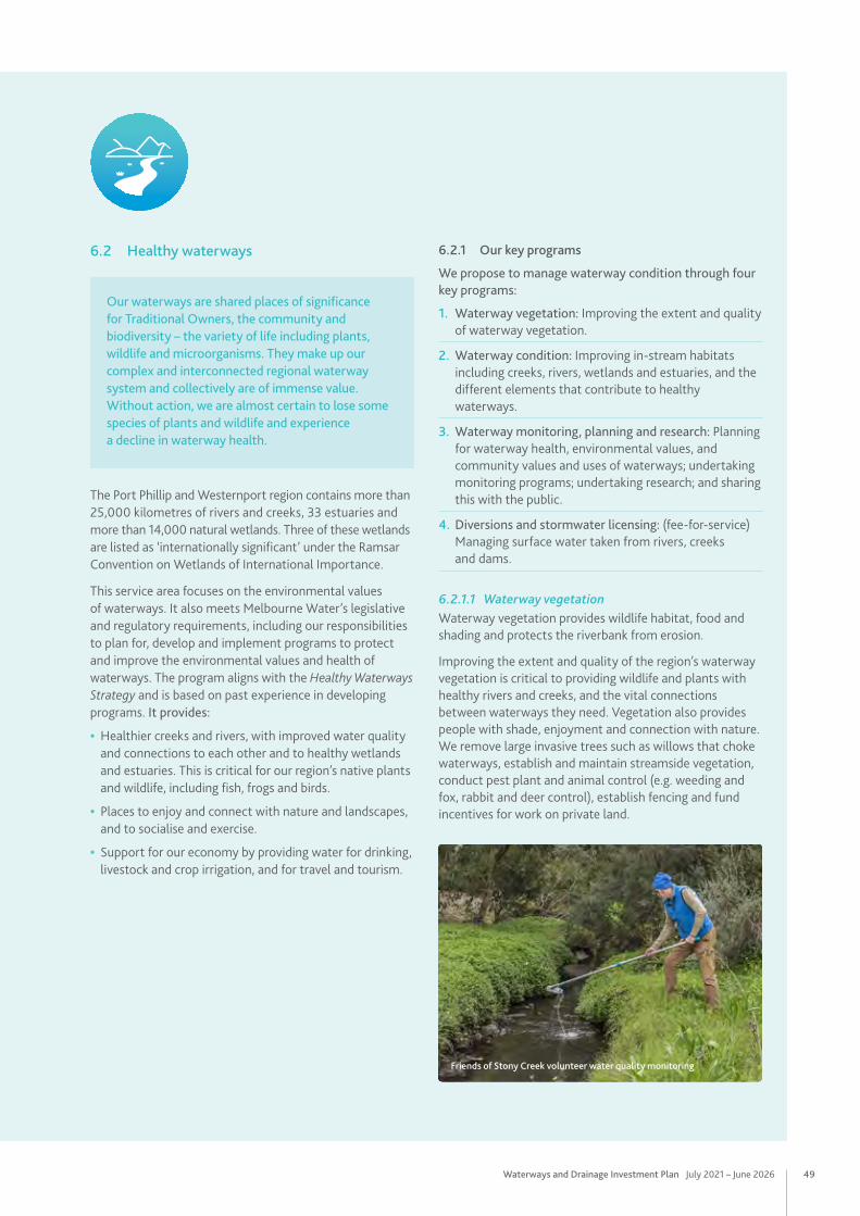
6.2 Healthy waterways
Our waterways are shared places of significance for Traditional Owners, the community and biodiversity – the variety of life including plants, wildlife and microorganisms. They make up our complex and interconnected regional waterway system and collectively are of immense value. Without action, we are almost certain to lose some species of plants and wildlife and experience a decline in waterway health.
The Port Phillip and Westernport region contains more than 25,000 kilometres of rivers and creeks, 33 estuaries and more than 14,000 natural wetlands. Three of these wetlands are listed as ‘internationally significant’ under the Ramsar Convention on Wetlands of International Importance.
This service area focuses on the environmental values of waterways. It also meets Melbourne Water’s legislative and regulatory requirements, including our responsibilities to plan for, develop and implement programs to protect and improve the environmental values and health of waterways. The program aligns with the Healthy Waterways Strategy and is based on past experience in developing programs. It provides:
• Healthier creeks and rivers, with improved water quality and connections to each other and to healthy wetlands and estuaries. This is critical for our region’s native plants and wildlife, including fish, frogs and birds.
• Places to enjoy and connect with nature and landscapes, and to socialise and exercise.
• Support for our economy by providing water for drinking, livestock and crop irrigation, and for travel and tourism.
6.2.1 Our key programs
We propose to manage waterway condition through four key programs:
1. Waterway vegetation: Improving the extent and quality of waterway vegetation.
2. Waterway condition: Improving in-stream habitats including creeks, rivers, wetlands and estuaries, and the different elements that contribute to healthy waterways.
3. Waterway monitoring, planning and research: Planning for waterway health, environmental values, and community values and uses of waterways; undertaking monitoring programs; undertaking research; and sharing this with the public.
4. Diversions and stormwater licensing: (fee-for-service) Managing surface water taken from rivers, creeks and dams.
6.2.1.1 Waterway vegetationWaterway vegetation provides wildlife habitat, food and shading and protects the riverbank from erosion.
Improving the extent and quality of the region’s waterway vegetation is critical to providing wildlife and plants with healthy rivers and creeks, and the vital connections between waterways they need. Vegetation also provides people with shade, enjoyment and connection with nature. We remove large invasive trees such as willows that choke waterways, establish and maintain streamside vegetation, conduct pest plant and animal control (e.g. weeding and fox, rabbit and deer control), establish fencing and fund incentives for work on private land.
Friends of Stony Creek volunteer water quality monitoring
49Waterways and Drainage Investment Plan July 2021 – June 2026
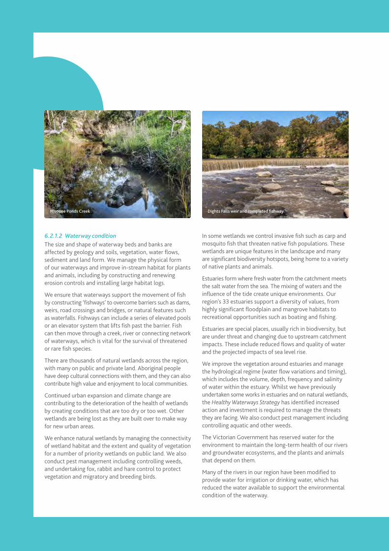
6.2.1.2 Waterway conditionThe size and shape of waterway beds and banks are affected by geology and soils, vegetation, water flows, sediment and land form. We manage the physical form of our waterways and improve in-stream habitat for plants and animals, including by constructing and renewing erosion controls and installing large habitat logs.
We ensure that waterways support the movement of fish by constructing ‘fishways’ to overcome barriers such as dams, weirs, road crossings and bridges, or natural features such as waterfalls. Fishways can include a series of elevated pools or an elevator system that lifts fish past the barrier. Fish can then move through a creek, river or connecting network of waterways, which is vital for the survival of threatened or rare fish species.
There are thousands of natural wetlands across the region, with many on public and private land. Aboriginal people have deep cultural connections with them, and they can also contribute high value and enjoyment to local communities.
Continued urban expansion and climate change are contributing to the deterioration of the health of wetlands by creating conditions that are too dry or too wet. Other wetlands are being lost as they are built over to make way for new urban areas.
We enhance natural wetlands by managing the connectivity of wetland habitat and the extent and quality of vegetation for a number of priority wetlands on public land. We also conduct pest management including controlling weeds, and undertaking fox, rabbit and hare control to protect vegetation and migratory and breeding birds.
In some wetlands we control invasive fish such as carp and mosquito fish that threaten native fish populations. These wetlands are unique features in the landscape and many are significant biodiversity hotspots, being home to a variety of native plants and animals.
Estuaries form where fresh water from the catchment meets the salt water from the sea. The mixing of waters and the influence of the tide create unique environments. Our region’s 33 estuaries support a diversity of values, from highly significant floodplain and mangrove habitats to recreational opportunities such as boating and fishing.
Estuaries are special places, usually rich in biodiversity, but are under threat and changing due to upstream catchment impacts. These include reduced flows and quality of water and the projected impacts of sea level rise.
We improve the vegetation around estuaries and manage the hydrological regime (water flow variations and timing), which includes the volume, depth, frequency and salinity of water within the estuary. Whilst we have previously undertaken some works in estuaries and on natural wetlands, the Healthy Waterways Strategy has identified increased action and investment is required to manage the threats they are facing. We also conduct pest management including controlling aquatic and other weeds.
The Victorian Government has reserved water for the environment to maintain the long-term health of our rivers and groundwater ecosystems, and the plants and animals that depend on them.
Many of the rivers in our region have been modified to provide water for irrigation or drinking water, which has reduced the water available to support the environmental condition of the waterway.
Dights Falls weir and completed fishwayMoonee Ponds Creek
50 Waterways and Drainage Investment Plan July 2021 – June 2026

Balcombe Creek estuary, Mount Martha
Climate change is adding further pressure to our river systems and is expected to result in further reduction in streamflows. Additional water will be needed to meet environmental objectives for our waterways.
Melbourne Water plans and manages the use of environmental water working with the Victorian Environmental Water Holder and other delivery partners. We conduct studies to identify the flows needed by a particular river or wetland, and monitor them to make sure environmental flows released are effective.
6.2.1.3 Waterway monitoring, planning and researchThe Healthy Waterways Strategy acknowledges the need for collective and coordinated action across agencies, so that we can deliver more efficient programs and better outcomes for our waterways.
Research and scientific models are critical to understanding our natural environment and prioritising management actions in our waterways and catchments. They are vital to innovation and continuous improvement across our services.
We have adopted a framework of continuous improvement and learning to acknowledge changes in the environment, such as climatic variations, policy modifications and technology advances, and modify our management approaches accordingly.
6.2.1.4 Diversions and stormwater harvesting licences (fee-for-service)
Melbourne Water manages the taking of surface water from rivers, creeks and dams in the Yarra River, Lower Maribyrnong River and western tributary catchments. We manage approximately 1300 licences from waterways and the drainage network and administer approximately 600 farm dam registrations. Water use is primarily for agricultural, industrial, commercial, sporting grounds and domestic and stock purposes.
We also issue licences to harvest stormwater from our waterways or drains. The cost of this service is met by licence fees and charges.
6.2.2 Our planned investments
The Healthy Waterways Strategy guides regional action to protect and improve our waterways. It proposes measured, cooperative and targeted investment to prevent widespread decline in waterway health in the face of a rapidly growing population and changing climate.
Figure 22 provides an overview of this investment. This is broken down further as:
• establishing over 3,218 hectares of new vegetation and maintaining over 5,523 hectares of vegetation – $186 million
• funding habitat improvement and conservation actions for threatened and significant species, including works to avoid the total extinction of platypus within the Dandenong catchment – $4.8 million
• monitoring, tracking and informing the community of our progress in meeting the outcomes of the Healthy Waterways Strategy – $13.6 million
Nesting boxes for migratory birds at Edithvale–Seaford wetland
51Waterways and Drainage Investment Plan July 2021 – June 2026

• improving the management of our environmental water program, including engaging with Traditional Owners and implementing actions to secure additional water for the environment to make up for shortfalls resulting from climate change – $10.5 million
• improving in-stream connectivity and increasing fish passage by removing 16 priority barriers within the region, which opens up lengthy sections of a river allowing fish populations to return naturally – $23.5 million
• maintaining waterway form and in-stream physical habitat – $25.8 million
• improving the monitoring of water quality in waterways – $5.1 million
• improving estuary condition – $4.0 million• increasing the priority wetlands we manage for improved
condition – $4.6 million, (a significant increase).• our priority research initiatives over the next five year
period will be $15 million.
Our current investment levels will be maintained for waterway planning and governance and diversions and stormwater licencing.
It should be noted that our stormwater investment will also provide significant benefit to waterway health (see Figure 20).
6.2.3 How our program aligns with customer preferences
Support for waterway condition, including vegetation, estuaries and wetlands, was consistent and strong across customer research. A strong majority indicated they were willing to pay more to support waterway condition programs.
In general, customers participating in social research did not want waterway environments to decline. The majority indicated a preference to significantly increase the level of service for waterways, with an increase in expenditure. Although they preferred that the condition of vegetation for the environment be maintained at current levels, this requires a relative increase in investment given significant additional threats from urbanisation and climate change.
Participants in the deliberative panel expressed the importance of Melbourne Water conducting research and planning to make the right choices for waterways and drainage services.
Our program aligns with these customer preferences. We will deliver a new program for the Waterways Monitoring, Evaluation, Reporting and Improvement Framework as outlined in the Healthy Waterways Strategy, to improve the efficiency and effectiveness of our healthy waterways service.
We will meet customer preferences for estuary management with an uplift in expenditure. We will actively manage 13 higher priority estuaries for waterway condition for the environment, wildlife habitat, and community enjoyment. Previously we have responded reactively to significant problems as they arise. It is important to note, however, that managing high-priority natural wetlands is a new program that involves working closely with private landholders on whose properties these wetlands are mostly found. Setting up a new program is complex, and takes time to build landholder willingness to participate and to better understand costs involved. Although there was customer support for a larger program, we are proposing to pilot a smaller program and expand it over time as landholders’ interest increases. Regardless, there is a significant uplift in spending for natural wetlands to manage 20 priority wetlands for the most benefit to wildlife, and stretch ourselves beyond this. This is considered to be a more realistic approach to introducing this new program to full customer preference and will help balance customer affordability with improvements to wetland condition.
52 Waterways and Drainage Investment Plan July 2021 – June 2026
Figure 22. Healthy waterways 5-year investment plan
Fig 21
Total forecast expenditure: $301.1 m
Diversions and stormwater licencing $5.3 m
Waterway condition $73.9 m
Waterway monitoring, planning and research $36.3 m
Waterway vegetation $185.5 m
Note: Real dollars 2021, including labour

26 educational sessions on stormwater delivered during 2016–2020
18.5 billion litres of environmental water released in 2018/19
16,518 millions of litres of water released in 2018/19 to improve �ows in the Yarra River and re-engage Billabongs, improving waterway and billabong health
798 platypus surveys conducted at 300 sites across the region
More than 37,000 voluntary bird surveys from BirdLife conducted since July 2016, and more than 310 species of birds recorded, including the Orange-bellied parrot
$1.11 million in funding invested in stormwater harvesting projects
36 sites of erosion control works completed to stabilise waterway beds and banks to protect habitat
67 regional biodiversity research projects funded since July 2016
881 km vegetation established in 2013-2018
8842 km vegetation managed in 2013-2018
490 constructed wetlands maintained to improve water quality before it �ows into waterways and bays
We’re working with our community to protect and improve waterways across our region, guided by the co-designed Healthy Waterways Strategy. Melbourne Water delivers work across each of the five major catchments within the Port Phillip and Westernport region, to help achieve the shared Healthy Waterways Strategy vision, and to help improve the health of rivers, estuaries and wetlands across the region. This map highlights a few of the many projects delivered under the existing Waterways and Drainage Investment Plan.
Healthy Waterways and Stormwater Management
53Waterways and Drainage Investment Plan July 2021 – June 2026
Figure 23. Highlighting activities for healthy waterways, stormwater and land
7 �shways funded and constructed since 2016 to help support �sh migration

6.3 Flood risk management
Flooding is a serious hazard for our community. It is also our most expensive natural disaster, with an estimated $735 million in annual average damages. Over 200,000 properties are at risk of flooding across Melbourne.
Melbourne Water is the floodplain manager for the Port Phillip and Westernport region. In performing this role, we work with more than 50 organisations involved in various aspects of flood management across the region, including state and 38 local governments, water authorities and emergency services. We also establish and deliver key programs to understand, prepare for, respond during and recover from flood events (see Figure 24).
Melbourne Water manages an extensive network of drainage and flood mitigation infrastructure. The network stretches across 128,000 hectares of urban, semi-urban and rural land and includes different types of assets:
• 243 flood retarding basins (fenced-off areas that retain floodwater)
• 229 kilometres of levee banks and 65 drainage bridges
• 1,488 kilometres of regional underground drains and 106 kilometres of concrete or hard-lined channels
• 24 drainage pumping stations
• 11 tidal gates and 343 flood gates
• 111 rain gauges, and 125 stream hydrographic monitoring stations.
We are currently responsible for managing catchments greater than 60 hectares, with councils responsible for catchments smaller than this. DELWP is currently leading a review together with Melbourne Water and Municipal Association of Victoria on behalf of local councils to determine the most appropriate future management responsibilities, which may change the current management arrangements.
Flooding brings risks to people, property, infrastructure and the natural environment. Climate change, population growth and urbanisation are increasing flood risk in the region. More frequent, intense storms and rising sea levels, combined with more stormwater runoff due to more hard surfaces, is exposing more people, property and infrastructure to damaging floods.
The Flood Management Strategy outlines regional objectives and priority actions for flood risk management within the region. The objectives are:
• The right information is available at the right time to the people who need it.
• Flood risks and opportunities are managed to reduce impacts and get the best social, economic and environmental outcomes.
• Land, water and emergency agencies work together to manage flooding effectively.
6.3.1 Our key programs
We will manage flood risk through five key programs:
1. Flood effects reduction: Preparing for and mitigating the impacts of flooding.
2. Drainage management: Maintaining and renewing the region’s drainage network.
3. Flood information: Modelling and mapping flood risks, and providing flood information.
4. Flood planning: Strategic planning and collaborative implementation with our partners.
5. Rural drainage (fee-for-service): Providing enhanced drainage services in the Koo Wee Rup and Longwarry Flood Protection District as agreed and funded by these local communities.
Flooding at Yarra Glen (David Hannah)
54 Waterways and Drainage Investment Plan July 2021 – June 2026

6.3.1.1 Flood effects reduction The impacts of flooding (flood effects) can be reduced by increased awareness and preparedness, as well as through additional or enhanced flood infrastructure.
Being aware of and prepared for flooding enables property owners to take action to reduce the impacts of flood events. This includes avoiding placing possessions in low lying areas, considering flow paths when landscaping and fencing, ensuring reliable access to flood warning systems, and pre-planning responses such as sandbagging and ‘stay or go’ actions in the event of flood warnings. Our flood preparedness activities enable agencies and the community to be aware and ready to manage flooding before, during and after it occurs. Our services include:
• community flood education, delivered in partnership with Victoria State Emergency Service (VICSES)
• flood warnings including waterway monitoring and agency notifications before, during and after flood events, and flash flood warnings and notification to residents via SMS in pilot areas
• collaboration with the SES and local government in developing and reviewing flood emergency management plans.
Our flood mitigation program investigates, plans and delivers large drainage assets to reduce flood risks. This includes constructing, renewing or upgrading retarding basins, pipes or channels, flood gates, levee banks and culverts.
6.3.1.2 Drainage managementWe are responsible for maintaining and renewing Melbourne’s regional drainage network. This includes regular maintenance to ensure the drainage system continues to function effectively and to clear out any sediment, vegetation, litter or other obstructions. We maintain mechanical and electrical assets such as pumping stations and tidal gates and repair any erosion of channels. Our maintenance also includes cutting grass in drainage reserves and retarding basins. We also undertake inspections of our assets, including closed circuit TV assessments of underground drains and condition inspections of retarding basins, levees and other assets.
This program also replaces assets when they reach the end of their life to ensure the drainage system continues to function effectively.
6.3.1.3 Flood informationMelbourne Water and our partners use flood information to quantify, manage and reduce flood risk. Flood information includes flood modelling and mapping and providing information to the community. Flood information informs our approach to managing flooding, including:
• providing development advice via planning schemes, property information statements and referrals
• developing flood risk reduction programs and projects that protect or enhance community safety and social, recreational and environmental values
• assisting the community to understand and manage their own flood risks through information, education and warnings
• informing other agencies involved in flood management (local government; DELWP; SES; Emergency Management Victoria (EMV) and others) of the extent to which flood waters affect assets and safe access
• preparing for climate change and sea level rise adaptation• making the data and information available to local
government online via the Melbourne Water self-service portal for inclusion into local planning schemes.
6.3.1.4 Flood planning Flood planning focuses on preparing and implementing the Flood Management Strategy and coordinating with the many organisations involved in flood management. Key activities include:
• leading collaborative implementation of the strategy• undertaking flood research to inform new approaches
to managing flooding• developing and implementing a flood monitoring,
evaluation, reporting and improvement plan to ensure our actions are delivering the outcomes we expect, learnings are shared across agencies and we are continuously improving
• coordinating and maximising the value of actions occurring across all flood management agencies, the primary mechanism of which is flood management plans, which are established for each municipality.
6.3.1.5 Rural drainage (fee-for-service)Melbourne Water delivers enhanced drainage services to properties in the Koo Wee Rup and Longwarry Flood Protection District. Landholders in this district pay an additional charge for the higher level of service they receive. The maintenance and capital works program for the flood protection district is intensive due to the concentration of drains and the significant flood risk in the area.
55Waterways and Drainage Investment Plan July 2021 – June 2026

6.3.2 Our planned investments
The Flood Management Strategy identifies a number of aspects of flood management that need additional focus to meet current and future challenges.
Figure 24 outlines how, over the next five years, increased investment will effectively deliver on our obligations and customer expectations under this strategy. This is further broken down as:
• Flood preparedness: We propose a substantial increase in flood warning and education to meet the strategy’s intent – total $3.5 million.
• Flood monitoring, evaluation reporting and improvement (MERI) program: Additional investment is proposed to develop a MERI program and to undertake the necessary research to ensure accountability and continual improvement – total $0.9 million.
• Flood information: Additional investment is required to ensure flood information is available in accordance with the level of service specified in the strategy, and as required by legislation – $18.8 million.
• Flood risk management: These projects are very challenging to develop and implement in urban areas, primarily due to the competing demands for space and high costs. However, they are important in protecting communities from flooding. We are proposing to increase our investment in this program by $30 million – total $101.6 million.
• Rural drainage (fee-for-service): An average price increase of $3.97 for properties in the Koo Wee Rup and Longwarry Flood Protection District to support additional weed maintenance and drainage capacity improvements for some assets to meet customers’ preferred service levels. This takes the current 2020/21 average property based charge of $232.78 per year, and increases to an average of $236.75 per year across the 2021/22 to 2025/26 period.
We propose to decrease overall expenditure on our drainage renewal program due to the completion of a large program of retarding basin upgrades over the life of the current investment plan. The investment in renewals and maintenance of other drainage assets remains at current levels: $59.1 million and $78.1 million respectively.
6.3.3 How our program aligns with customer preferences
Both metropolitan and rural residential participants in the customer survey preferred increased levels of service for all activities under the flood risk services tested. They preferred increases in flood risk awareness campaigns, information and warnings to high-risk properties to save on repairs, and flood mitigation for high-risk properties. Business customers, however, were satisfied with the current level of service. Our proposed program aligns with customer preferences for increased levels of service for flood preparedness and flood mitigation.
The drainage renewals and maintenance programs were discussed with the deliberative panel. They were supportive of our proposed level of service following a series of presentations by experts, which included Melbourne Water people.
After reviewing engagement feedback for rural drainage (fee-for-service) with the Koo Wee Rup–Longwarry District Advisory Committee, and with their agreement, we are proposing an average $236.75 per property per annum for additional activities to improve drainage capacity in some assets.
56 Waterways and Drainage Investment Plan July 2021 – June 2026
Figure 24. Flood risk management 5-year investment plan
Fig 23
Total forecast expenditure: $270.5 m
Drainage management $137.2 m
Flood information $18.8 m
Flood planning $6.5 m
Flood risk management $101.6 m
Rural drainage $6.4 m
Note: Real dollars 2021, including labour

70 individual �ood modelling projects delivered jointly with councils. This leads to �ood overlays being introduced into local planning schemes to assure appropriate development occurs in areas affected by �ooding
We managed 237 retarding basins (�ood retention) in 2018/19
49 basin upgrades have been completed in the past �ve years
Over12,000 households received �ood education and awareness under the Melbourne Water and VICSES partnership
More than 279 km of drains have been assessed and monitored on their condition
Over 100,000 m³ of sediment removed from waterways to prevent localised �ooding across the region
Flood partners collaborated on 70 plans and projects to improve �ood management and community safety
13 joint planning scheme amendments completed by Melbourne Water and councils to ensure new buildings and infrastructure are not at risk of �ooding
02
Melbourne Water works closely with state and local government agencies to manage drainage and flooding. The Waterways and Drainage Charge funds a wide range of waterway, flood and regional drainage services. We deliver local and regional projects that benefit the community.
Flood and Drainage
Figure 25. Highlighting activities in flood risk management
57Waterways and Drainage Investment Plan July 2021 – June 2026

6.4 Aboriginal cultural values
Traditional Owners have lived in this region for tens of thousands of years. They have connections with the landscape and waterways through significant places, artefacts, language, stories and traditions. Aboriginal cultural values are based on the physical and spiritual connection of people to land and waters, and are both contemporary and ancient.
This new service enables the establishment of formal partnerships with Traditional Owners so we can work together towards the Healthy Waterways Strategy goal:‘Traditional Owners have a recognised role as custodians of waterways and their cultural values. Their unique perspective and knowledge allows them to influence the agenda for waterway management and actively participate in caring for their Country.’
The service allows for a self-determined approach to value and formalise the involvement of Traditional Owners in waterway management. This is not only required to meet our new and existing obligations and expectations as a water industry leader, but will also support Traditional Owners to self-determine essential work to document cultural values, stories and knowledge as a way to counter rapid urbanisation and threats to culture.
6.4.1 Our program
As a society, we are only just starting to appreciate the wealth of cultural knowledge and meaning of waterways for Traditional Owners. At present, the lack of documented information is limiting our aspirations. Working with Traditional Owners to understand, protect and promote their cultural knowledge and facilitate a greater involvement in waterway management will help to achieve better outcomes for the environment and our community.
We are working closely with Traditional Owners to understand their priorities and to develop formal agreements to commit to mutually agreed outcomes. This program will support Bunurong, Wadawurrung and Wurundjeri Woi wurrung to take steps toward both an increased knowledge base for communicating cultural values and information, and committing to partnership principles that support relationships critical for sharing and using this new knowledge.
This innovative program will secure sufficient time and resources for Traditional Owners to work through each priority location, building on learning from each involvement and site-specific experiences in a genuine partnership approach.
6.4.2 Our planned investments
The five-year program will include:
• support for formal partnerships with Traditional Owners, confirming their role as co-delivery partners in the management of waterways – $1.1 million
• research agreements allowing Traditional Owners to document and determine their cultural values for three of the five major waterways – $1.3 million.
In addition, we deliver outcomes for Aboriginal cultural values through existing programs in our other service areas. This includes sharing waterway and vegetation knowledge and working together on strategy development and implementation. We also engage Traditional Owner delivery crews for the protection of environmental values.
6.4.3 How our program aligns with customer preferences
Melbourne Water continues to engage with the three Traditional Owner groups for our service area: the Bunurong, Wadawurrung and Wurundjeri Woi wurrung. Through consultation we aim to better understand their interests and proposed activities, and seek formal agreements with each Traditional Owner group.
Maribyrnong River
58 Waterways and Drainage Investment Plan July 2021 – June 2026

6.5 Community access, involvement and recreation
Melbourne Water owns and manages a significant land portfolio across the region in order to provide our core services. We have an opportunity to maximise the social values of the waterways and drainage land that we manage and consider how to improve access, recreation and community involvement.
During the current investment plan period Melbourne has experienced its biggest wave of population growth. In new developments, house sizes are staying the same whilst block sizes are becoming significantly smaller, resulting in reduced private outdoor space and growing pressure on public open spaces.
Increasing densification and a hotter, drier climate is leading to customers’ need for greater access to public open space for enjoyment and respite, to connect to nature, and for passive and active recreation. The COVID-19 pandemic has also resulted in a significant increase in visitors reporting they are going to waterways for these purposes.
Legislation, policy and community feedback is placing increasing importance on managing the social values of waterways and providing greater community access to our land, resulting in new obligations for Melbourne Water. The Healthy Waterways Strategy highlights key waterway social values such as public access, the potential for people to connect to nature and recreational opportunities. The Flood Management Strategy also highlights these multiple community benefits that may be achieved on drainage land.
Connecting people with nature and the assets that we manage, requires collaboration with customers, communities and partner organisations to ensure we are meeting their needs. While we are responsible for managing waterways, we also facilitate customer and community engagement and involvement with waterways.
There are currently 225km of paths on Melbourne Water owned land and an additional 77km of paths along waterway corridors, on land owned by others. We work with councils, the Department of Transport and other authorities to enable them to use our land to link existing trail networks and provide shared pathways that contribute to community access and recreation outcomes.
6.5.1 Our key programs
We support waterways and drainage area social values through four key programs (see Figure 26):
1. Access: Increasing access to waterways and drainage land for community recreation and access to nature, in urban and rural areas.
2. Recreation: Improving the quality of accessible open space for community enjoyment.
3. Involvement: Broad-scale education and engagement programs to involve the community in their local waterway, to support them to take a bigger role in waterway management, and to connect to environmental and cultural values.
4. Jetty management and lake flushing (fee-for-service): Delivering specific jetty management services, and monitoring and flushing out constructed lakes in the Patterson Lakes area to the south-east of Melbourne, at an additional charge to these residents.
As we renew assets such as retarding basins, we look for opportunities to increase community enjoyment as a focus in the way we design them. This aligns to our Corporate Plan Capital KPI of ‘80% capital projects improving community connection to nature and recreation’.
6.5.1.1 AccessWe will achieve greater access to and better quality of waterways and drainage land by:
• Improving community access to waterways and drainage land such as previously fenced-off areas that retain floodwater, known as retarding basins. We have 243 retarding basins, the vast majority of which are accessible to the public, with only 21 closed to the public. Of these, 36 per cent of these have active recreation and 54 per cent have passive recreation on or adjacent to them.
• Fencing to improve access, safety and protection of some areas, for rivers and creeks and sign-posting, for example, eroded areas requiring bank stabilisation works, or where species are being protected from dog swimming.
• Mosquito management in priority areas.
59Waterways and Drainage Investment Plan July 2021 – June 2026

6.5.1.2 RecreationImproving the ability for the community to enjoy waterways and drainage land, including:
• recreational paddling access – providing waterway access points to enable launching of canoes and kayaks
• monitoring water quality for recreation – YarraWatch monitoring program and monitoring of blue-green algae
• the Reimagining Your Creek program – transforming channelised drains (creeks and rivers) into quality places for local communities to enjoy, including making the creek area look more natural, planting urban forests and improving open space
• managing litter • vegetation management to provide cooler, greener, more
enjoyable spaces around waterways and surrounding land.
6.5.1.3 InvolvementEnabling customers to be educated and engaged, and to value waterways by: • developing and delivering broad-scale community
education programs, including information about major waterways through interpretive signage, brochures, web content, and educational resources to enhance community connection and access to nature
• involving customers and the community in waterway management, and supporting people to participate in protecting waterway health through citizen science and volunteering.
6.5.1.4 Jetty management and lake flushing (fee-for-service)
Residents within the Patterson Lakes tidal canals pay a separate annual jetty infrastructure charge if they have a mooring allocation attached to their property. This recovers the cost of maintenance and new jetty construction. We are not proposing changes to the jetty infrastructure charge or service levels.
For Quiet Lakes property owners on Lakes Legana and Illawong, bore flushing and visual algae monitoring services will be aligned to majority customer preferences and willingness to pay, at $188 per year.
6.5.2 Our planned investmentsOver the next five years we will invest in community access to and enjoyment of our waterways and drainage land, through:
• providing cooler, greener and more enjoyable spaces • enhancing community connection and access to nature • creating opportunities for community recreation and
enjoyment• facilitating the opportunity for the community to connect
to and be involved in waterways.
Figure 26 provides an overview of investment, which is broken down further as:• co-funding five recreational paddling platforms along
priority sites on the Yarra River – $1.8 million• improving community access to three retarding basins
(excavated areas providing flood protection by storing water entering a waterway), which are suitable for additional work by other authorities – $11.3 million
• the Reimagining Your Creek program, which together with our partners will transform four to five modified, earthen or concreted waterways (12 kilometres) into improved places for communities and includes planting urban forests, open space and community access improvements – $29.9 million
Waterwatch citizen science program
60 Waterways and Drainage Investment Plan July 2021 – June 2026

• providing additional information about major waterways in the form of interpretive signage, brochures, web content and educational resources, and supporting 5000 people to participate in protecting waterway health through citizen science and volunteer activities – $3.4 million.
We will maintain levels of service in the following areas:• litter management for visual enjoyment, including
maintaining five litter traps, building two new litter traps and collecting litter, and investing $200,000 in upstream investigations to better understand litter hotspots and prevention measures – total of $7.0 million
• mosquito management – $320,000• recreational water quality monitoring – $380,000 for
continuation of current blue-green algae and YarraWatch monitoring programs.
We will maintain current levels of service for vegetation for community enjoyment ($9.9 million) by managing vegetation along 25 per cent of urban rivers and creeks (539 kilometres). However, we will deliver this with a 20 per cent reduction in investment from current levels. We anticipate finding efficiencies in current programs and projects by drawing on what we have learned through customer engagement during the development of this plan, as well as via ongoing engagement for particular sites and programs.
Our investment in Reimagining Your Creek, retarding basin activation and establishing paddling platforms all require co-investment from partners to fully deliver the programs. This reduces the cost to our customers, and similar programs and pilots have proven this to be a reasonable assumption to date.
6.5.3 How our program aligns with customer preferences
Our response to customer and stakeholder feedback has been to increase investment in the land access, on-water access and community involvement programs, while maintaining current levels of investment in programs for vegetation for community enjoyment and litter management.
For waterway restoration projects, we are investing more in business and rural interfacing areas whilst maintaining the current urban investment and level of service. This responds to differing customer preferences for these groups.
Customer engagement for this investment plan indicated support for greater investment to better connect the community to waterways, land and nature. In turn, this can improve physical and mental wellbeing, and increase the value the community places on their local waterways and land. We have increased investment for community education and engagement in line with the strong recommendation from the deliberative panel.
There was significant customer support for additional litter collection, which we explored in detail with the panel. The panel was supportive of our approach to focus on prevention whilst maintaining waterway litter collection. This recognises our customers’ view that there is a large number of organisations with responsibilities for managing litter.
Figure 26. Community access, involvement and recreation 5-year investment plan
Fig 25
Total forecast expenditure: $72.7 m
Access $19.7 m
Involvement $3.4 m
Jetty leasing and lake flushing $0.6 m
Recreation $49.0 m
Note: Real dollars 2021, including labour
61Waterways and Drainage Investment Plan July 2021 – June 2026

Community garden built along a pipe track in Croydon, in partnership with Hope City Mission to connect the community and build capacity
5,717 frog reports submitted by 1,576 volunteers via the Frog Census app since September 2016
2 boat ramps constructed to help improve recreation and community enjoyment of the waterways
$230,460 Seed funding grants delivering community outcomes on waterways
1.4 km of concrete channel removed, including existing stormwater pipe to recreate a natural waterway, and to construct educational and recreational spaces
30ha of shade and cooling delivered across the Jacana wetlands, Edithvale wetlands and Maribyrnong River to combat heatwaves
$20,000 invested in research and investigation of options to address a local litter problem in the Moonee Valley City Council (MVCC)
9,850m3 of debris, sediment and litter removed since July 2016
277 platypus sightings reported by the community through PlatypusSPOT
We’re working with our community to protect and improve waterways across our region, guided by the co-designed Healthy Waterways Strategy. Melbourne Water delivers work across each of the five major catchments within the Port Phillip and Westernport region, to help achieve the shared Healthy Waterways Strategy vision, and to help improve the health of rivers, estuaries and wetlands across the region.This map highlights a few of the many projects delivered under the existing Waterways and Drainage Investment Plan.
Community access, involvement and recreation
Figure 27. Highlighting projects in community access, involvement and recreation
62 Waterways and Drainage Investment Plan July 2021 – June 2026

6.6 Land management
Melbourne Water owns and manages land to enable the safe, efficient and effective delivery of our core services. Seventeen percent of our land is for drainage purposes, including drainage basins, wetlands, waterway corridors and flood plains, and drains and easements. We manage our land to ensure public safety and reduce impacts on neighbouring properties. We also consider opportunities for enhanced social, recreational and environmental outcomes where compatible with core service functions. Investing in land management programs is critical to meeting our environmental and safety obligations and delivering additional value to the community.
This land management service meets our obligations for waterways and drainage land such as waterway corridors, retarding basins and drainage easements, manages risk and meets customer expectations.
6.6.1 Our key programs
We will manage our land through five key programs:
1. Pest plant and animal management: As a land owner we have obligations to manage weeds and pest animals on our land. These can contribute to a decline in habitat and condition of our land and waterways. We undertake actions to meet these obligations and protect asset integrity. Proactive pest management will be carried out on sites of high or very high value. We also undertake significant pest plant and animal management throughout the region on waterways land we manage but do not own as part of our vegetation for environment, wetland and estuary programs as well as on our land through the Sites of Biodiversity Significance (SoBS) program.
2. SoBS: This program delivers on our obligations to protect and enhance biodiversity values on land we own. It is focused on protecting significant biodiversity assets as well as threatened species and communities, and includes management of the Edithvale–Seaford Wetlands listed as a site of international significance under the Ramsar Convention.
3. Grass cutting: A proactive and prioritised grass cutting program covers all Melbourne Water land, and is particularly important to our neighbours and adjoining landowners. It ensures grass is managed cost effectively, allowing safe access to our sites and assets, and reduces fire risk.
4. Fencing and encroachments: This program ensures risks associated with unauthorised encroachments onto Melbourne Water land are identified, assessed, recorded and managed in a timely, transparent, impartial and consistent manner.
5. Tree management: Effectively managing vegetation around all Melbourne Water assets is essential for public and workplace safety and reliability and cost-effectiveness of service delivery. This includes proactively managing trees to ensure vegetation does not risk the safety of our staff or community. Industry standards require that hazardous trees are proactively managed in areas where we invite people onto our land.
Weed control
63Waterways and Drainage Investment Plan July 2021 – June 2026
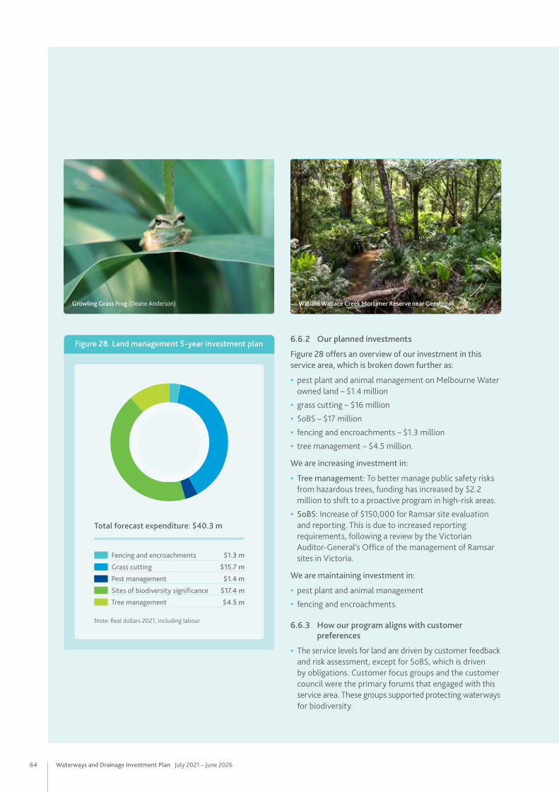
6.6.2 Our planned investments
Figure 28 offers an overview of our investment in this service area, which is broken down further as:
• pest plant and animal management on Melbourne Water owned land – $1.4 million
• grass cutting – $16 million• SoBS – $17 million• fencing and encroachments – $1.3 million• tree management – $4.5 million.
We are increasing investment in:
• Tree management: To better manage public safety risks from hazardous trees, funding has increased by $2.2 million to shift to a proactive program in high-risk areas.
• SoBS: Increase of $150,000 for Ramsar site evaluation and reporting. This is due to increased reporting requirements, following a review by the Victorian Auditor-General’s Office of the management of Ramsar sites in Victoria.
We are maintaining investment in:
• pest plant and animal management • fencing and encroachments.
6.6.3 How our program aligns with customer preferences
• The service levels for land are driven by customer feedback and risk assessment, except for SoBS, which is driven by obligations. Customer focus groups and the customer council were the primary forums that engaged with this service area. These groups supported protecting waterways for biodiversity.
Growling Grass Frog (Deane Anderson) William Wallace Creek Mortimer Reserve near Gembrook
Figure 28. Land management 5-year investment plan
Total forecast expenditure: $40.3 m
Fig 27
Note: Real dollars 2021, including labour
Fencing and encroachments $1.3 m
Grass cutting $15.7 m
Pest management $1.4 m
Sites of biodiversity significance $17.4 m
Tree management $4.5 m
64 Waterways and Drainage Investment Plan July 2021 – June 2026

6.7 Emergency and pollution response
When a flood occurs in our service area, or there is a minor spill or major pollution emergency that threatens our waterways, it is critical that we are ready to respond. Our emergency and pollution response helps to minimise impacts on communities and the environment, and ensure the reliability of our waterway and drainage assets.
Waterway pollution is a key threat to the health of our waterways, and therefore requires effective management and response. There is a heightened awareness of the issue following several high-profile pollution events that have significantly impacted waterways and increased community expectations of our response. Urban growth and densification of development also place our waterways under increased threat from minor pollution events such as oil spills. Major fires impact waterways through polluted fire water runoff via the stormwater system.
Our emergency and pollution response service is strongly driven by our obligations and consideration of community and customer expectations. These obligations are identified within the Environment Protection Act, the Emergency Management Act and the Water Act, and under our Statement of Obligations.
In order to meet these obligations, we maintain an all-hours incident response capability to fulfil emergency management requirements for flooding, asset failures, pollution, major fires and blue-green algae outbreaks. This is a critical service to protect the environment, public safety and community enjoyment of public spaces.
Customers for our all-hours incident response capability are peak emergency management agencies such as Emergency Management Victoria (EMV), Melbourne Metropolitan Fire Brigade (MMFB), Victoria Police, State Emergency Service (SES), Environment Protection Authority Victoria (EPA), Bureau of Meteorology (BoM), Department of Environment, Land, Water and Planning (DELWP) and VicRoads. They rely upon this capacity as part of a ‘network of agencies’ approach that seeks to minimise the damage and disruption to the community, asset owners and the environment.
6.7.1 Our key programs
We manage these services via two programs:
1. Emergency preparedness: Planning for emergencies related to waterways and drainage.
2. Emergency response: All-hours incident management and response for flood events, and pollution events near the stormwater system, constructed wetlands and waterways.
6.7.1.1 Emergency preparednessEmergency preparedness focuses on:
• implementing plans and procedures for service continuity in the event of a threat or impact to our waterways and drainage assets
• regular review of our Emergency Management Framework and our General Emergency Management System (GEMS) to ensure changes in legislation or obligations are adhered to, and to ensure all incidents are managed in accordance with GEMS
• providing timely and accurate flood information, predictions and warnings
• developing and maintaining a network of real-time data-logger monitoring sites for measuring rainfall and streamflow data across the region. This provides information to agencies to enable warnings and community response during flood emergencies. Data is also used by us and our customers for other valuable applications.
6.7.1.2 Emergency responseEmergency response focuses on:
• maintaining our all-hours incident response capabilities to ensure a timely incident response can be provided
• providing emergency works to alleviate flooding, clear waterways and drainage assets after flooding, and clean up after waterway pollution events
• providing advice and support to the EPA, SES, EMV, BoM and other response agencies regarding the impact of an emergency (including pollution) within our waterway management district.
65Waterways and Drainage Investment Plan July 2021 – June 2026

6.7.2 Our planned investments
Figure 29 provides an outline of the proposed investment of $31 million over the five years for this service area.
A modest increase is proposed for emergency and pollution response, consistent with the increased costs over the current pricing period to deal with minor pollution events. Funding for larger pollution events has not been included due to the inability to accurately forecast their scope or frequency, and the potential for cost recovery consistent with the Emergency Management Manual Victoria. Where costs for large events cannot be recovered, investment is redirected from other programs – which impacts our ability to deliver other services.
6.7.3 How our program aligns with customer preferences
Whilst not tested in the customer survey, customer engagement reflected increasing expectations for how waterway pollution events in waterways are managed. Customers would like more preventative action by responsible organisations and are concerned that large pollution events may affect funding for other waterways and drainage services, given several large industrial hazardous waste fires have devastated local waterways in recent years.
As a protection agency, we will continue to meet our agreed obligations for emergency management, investing $31 million over five years. We cannot effectively anticipate the costs associated with major pollution events, such as in Stony Creek (case study 2), but where possible we will seek to recover our costs to avoid impacting other services.
Stony Creek Dandenong Creek
Figure 29. Emergency and pollution response 5-year investment plan
Fig 28
Total forecast expenditure: $30.5 m
Emergency preparedness $1.3 m
Emergency response $29.2 m
Note: Real dollars 2021, including labour
66 Waterways and Drainage Investment Plan July 2021 – June 2026

67
Case study 2
Firewater runoff washed into the creek, causing contamination to a five-kilometre reach that resulted in a significant loss of plant and animal life and impacted human health.
Described as the worst pollution event to a Melbourne waterway in almost 30 years, the scale of the disaster – including the high level of community concern and public impacts – commanded a matching response. Melbourne Water joined a collaborative multi-agency partnership to respond to the incident and undertake on-ground recovery efforts. We led the long-term rehabilitation planning process, which involved extensive consultation with the community.
Our priority was to clean up the most publicly used and visited parts of Stony Creek and prevent further contamination downstream. Our recovery works included pumping 70 million litres of polluted water from the creek, removing toxic sludge by scraping creek banks and pressure-washing rocks and vegetation, and clearing away affected trees and shrubs. Between March and July 2019, more than 2000 cubic metres of contaminated sediment was removed from the creek.
This was processed, treated and tested before being safely transported off site for disposal at a secure landfill site nominated by EPA Victoria.
Together with our partner agencies and the local community, we recognised that a sustained effort was needed to move beyond the recovery of Stony Creek and focus on a more positive phase of rehabilitation.
The local community provided input into the rehabilitation plan, in collaboration with our partner agencies – Maribyrnong City Council and the EPA. Through community events, online activities and conversations, the community contributed their ideas, aspirations and priorities to support the long-term rehabilitation and future protection of Stony Creek. Their insights, values and recommended actions were used to create the 10-year Stony Creek Rehabilitation Plan.
Recovery efforts are ongoing and works are being coordinated across multiple agencies, guided by advice from specialists in contaminated land.
Stony Creek In August 2018, Stony Creek in Melbourne’s inner west suffered devastating impacts from a fire in an industrial warehouse in Tottenham/West Footscray, which was storing unregistered toxic chemicals.
Stony CreekReducing pollution impacts in Stony Creek
67Waterways and Drainage Investment Plan July 2021 – June 2026

6.8 Coastal erosion advice
Coastal erosion affects both public and private land and assets. By better understanding areas at greater risk of erosion, both now and in future as sea levels continue to rise, proactive planning can occur.
Coastal land and assets such as beaches, coastal parks and jetties can be at risk from coastal erosion, but so too can other assets in the coastal zone, such as underground pipelines, roads and telecommunications assets, as well as private property. As sea levels continue to rise, the risk of coastal erosion increases.
Coastal erosion advice is a new service that meets Melbourne Water’s new obligation under the Marine and Coastal Act to provide advice on coastal erosion within our waterway management district. This is aligned with and linked to our role as floodplain manager, where we already consider coastal inundation – the collective impacts of sea level rise, tidal inundation, storm tide and localised catchment flooding – as part of our current services.
This new service does not include providing coastal management activities such as advising on land management actions, on-ground works, and managing coastal land and protecting assets, as these responsibilities sit with other organisations.
6.8.1 Our planned investments
We propose to invest $1.5 million over the five years into this new service area.
Melbourne Water and DELWP are currently scoping the erosion advice that we must provide. It is expected that this will cover the following areas:
• providing support for the erosion component of coastal hazard assessments
• documenting areas with identified coastal erosion risk at the regional level, to inform priorities for future coastal hazard assessments and input into erosion risk assessments
• advising land managers and local government on coastal erosion extents, including in relation to planning applications and planning scheme amendments
• providing planning advice on existing and predicted erosion risks from storm surges, severe winds and sea level rise.
The advice will be informed by data from the Western Port and Port Phillip Bay Coastal Hazard Assessments. It is expected that this advice may include property information statements, planning advice, and community education and awareness.Carrum (David Hannah)
Coastal erosion at Altona
68 Waterways and Drainage Investment Plan July 2021 – June 2026
6.9 Urban development
Melbourne Water provides services to the development industry and private landowners to support the planning and building of resilient, sustainable and liveable communities. Our services ensure development meets appropriate standards for flood protection, water quality, waterway health and community enjoyment.
As a provider of essential services to Australia’s second-largest city, playing a role in the provision of housing for our growing city is of great importance. Melbourne Water contributes to healthy places and a healthy environment by supporting our customers across the entire breadth of urban development. From broadacre greenfield areas, through to urban renewal and development in established suburbs, we help to ensure developments are flood resilient and provide stormwater treatment to protect the health of waterways and bays, with water sensitive urban design principles supporting enhanced community enjoyment.
6.9.1 Our key programs
We deliver our services in this area via three programs:
1. Greenfield development services.
2. Major urban renewal services.
3. Small-scale development and urban renewal services.
6.9.1.1 Greenfield development servicesGreenfield development services include:
• creating and managing catchment-scale drainage strategies (stormwater infrastructure plans)
• stipulating development requirements and conditions
• oversight of sequencing and timing of stormwater management asset construction
• surveillance of asset construction to ensure functionality and quality
• creating and managing development services schemes (a funding mechanism to provide cost equity within a catchment).
We ensure new development meets appropriate flood protection, water quality, waterway health and community enjoyment standards. The timing of works delivered is primarily in response to growth that has already occurred and has reached a threshold where infrastructure needs to be built. This is often early in the development of new suburbs and the infrastructure continues to provide protection as future growth occurs.
We work with other authorities and the land development industry to determine, plan for and deliver development-related drainage infrastructure. Drainage infrastructure is best delivered in conjunction with other growth-related infrastructure such as other utilities. Developers are best placed to deliver this infrastructure in a coordinated, efficient manner.
Under a developer services scheme, each developer pays their share of the total cost of building drainage assets in the catchment, and is responsible for building assets within their land to service the entire catchment. Melbourne Water reimburses costs to developers once stormwater conveyance and treatment assets are built. We then own and maintain these assets through their lifecycle.
Developers pay Melbourne Water fees to account for the cost of the capital investment needed to provide drainage and waterway services on undeveloped land. We have a set of pricing principles that determine how developer charges are calculated. These principles were approved by the Essential Services Commission in 2016 and remain the same in this investment plan.
Urban greenfield development
69Waterways and Drainage Investment Plan July 2021 – June 2026

6.9.1.2 Major urban renewal servicesUrban renewal provides an opportunity to reshape future precincts with improved flood management, open space, improved water quality and liveability outcomes. Melbourne Water has been supporting state government in its planning of priority urban renewal precincts at Fishermans Bend and Arden Macaulay, as identified in Plan Melbourne (2017).
Both areas are subject to significant flooding, which will worsen under the influence of climate and sea level rise, and require regional flood mitigation infrastructure to support proposed levels of development. The total capital expenditure investment is approximately $300 million across both precincts to 2050.
Within both precincts a range of drainage assets are required to manage local stormwater runoff, including pumps, pipes, and above-ground and underground flood storages. Along the Yarra River in Fishermans Bend, and spanning the east and west banks of Moonee Ponds Creek adjacent to the Arden and Macaulay precinct, levee banks are required to manage the risk posed by elevated levels in these waterways as well as tidal impacts.
As with greenfield development, a regional drainage approach is required. We intend to fund regional flood infrastructure in these two precincts utilising development services schemes paid for by developer charges.
6.9.1.3 Small-scale development and urban renewal services
Where development occurs in established areas, Melbourne Water provides advice to ensure landowners are supported to meet flood, stormwater and water quality guidelines and standards. This ensures effective drainage and protects downstream waterways and bays.
In delivering this service, we provide:
• pre-development advice to customers
• flood level information on request
• responses to council planning permit application referrals, as a determining referral authority or as an interested party
• explanation for planning application and permit referral decisions
• guidance, decisions and agreements on building near or over existing Melbourne Water assets in urban environments
• creation and maintenance of flood information and flood models, input into council flood maps and overlays (Special Building Overlays (SBOs) and Land Subject to Inundation Overlays (LSIOs))
• maintenance of information on the locations of Melbourne Water assets.
The Waterways and Drainage Charge includes funding to support small-scale development services. Melbourne Water acts as a referral authority to councils’ referred planning permit applications. We also provide services to small-scale developers and community members, including providing pre-development advice and other advice on our development requirements.
High-density developmentRecreational infrastructure at Point Cook
70 Waterways and Drainage Investment Plan July 2021 – June 2026

6.9.2 Our planned investments
As outlined in Figure 30, this investment plan proposes $723 million of expenditure for the five-year period, with $705 million of that for capital expenditure toward infrastructure. The scale of investment is based on expected customer activity levels and the investment required to provide these services and facilitate the required outcomes.
Our programs for this investment plan remain the same as in the current period; however, the scale of investment planned for greenfield development services is proposed to increase. Over the past five years, there has been significantly higher land development activity in greenfield areas than forecast and this is projected to continue.
6.9.3 How our program aligns with customer preferences
Melbourne Water’s urban development services are prescribed. Therefore, the level of service we provide is not tested with general customers. Instead, focused engagement is undertaken specifically with local government and developer customers. The greenfield service is largely funded by developers.
However, during engagement customers recognised the impacts of development on waterways and drainage services and supported appropriate action to ensure development meets appropriate standards.
Wetlands in new estate
Construction of wetlands
Figure 30. Urban development 5-year investment plan
Total forecast expenditure: $722.7 m
Fig 29
Note: Real dollars 2021, including labour
Greenfield development services $669.7 m
Major urban renewal services $52.2 m
Small scale development and urban renewal services $0.9 m
Waterways and Drainage Investment Plan July 2021 – June 2026 71

We adopt a continuous improvement approach to deliver efficiency and innovations in our services.
This includes an extensive research, monitoring and investigation program, which has led
to some exciting innovations.
72 Waterways and Drainage Investment Plan July 2021 – June 2026
Yarra River at the TanSECTION 7
CONTINUOUS IMPROVEMENT

WDIP development: Define investment for services• Functions and obligations• Established requirements• Customer preferred service levels
Program and project planning• Detailed planning including
options analysis
WDIP implementation• Program and projects delivery• Operations and maintenance• Research and investigation
7. Continuous improvement
We adopt a continuous improvement approach for planning and delivery of our waterways and drainage services.
The key elements discussed in this investment plan, along with our key performance indicators (KPIs), planning processes, program delivery and review, all form our continuous improvement cycle and ensure this plan is not a ‘set and forget’ plan. Figure 31 provides an outline of the cycle.
We also use an adaptive planning approach. This involves planning using different future scenarios for things like climate change and urbanisation. We undertake regular monitoring to inform our future programs and any changes we need to make, and to drive efficiencies. We also undertake research and implement innovative approaches across the breadth of our planning, delivery, maintenance, monitoring, education and engagement programs.
Review• Investment plan comparison
to spend and forecast (final ESC determined prices)
• KPIs – annual report• Customer research (whole of service)• Program efficiency and effectiveness• Strategic MERIs – comparison of
activities to performance objectives• Environment Improvement Plans • Legal /obligations review• Operating environment scan
Targeted improvement• Adjusts KPIs if improvement
identified• Adjusts service area spend
or direction• Considers original or changing
customer preferences
Service area programs• Respond to customer feedback
considering WDIP improvement identified• Annual business planning processes• Final annual program forecasts and adjustment
PLAN
1
CHECK
3
DO
2
ACT
4
Figure 31. The plan’s continuous improvement cycle
73Waterways and Drainage Investment Plan July 2021 – June 2026

7.1 Efficiencies
We have embedded key efficiencies into programs in the current investment plan, to keep prices low. These include:
Flood risk managementUrban growth has led to an increase in our drainage assets, expanding the coverage of our drainage asset maintenance program. However, through efficient practices we have been able to keep our maintenance costs stable, meaning we are now maintaining more assets with the same level of investment. Over the last five years we have incorporated the following new flood and drainage assets into our maintenance programs:
• 29 kilometres of new constructed waterways
• 8 new retarding basins
• 1 new levee bank.
Emergency management In recent years there has been an increase in events that have required an emergency response from us. Of note are major pollution events such as factory and warehouse fires causing highly contaminated water to enter the drainage system and ultimately the waterways.
We can sometimes recover some of our costs for emergency management, but not all, with a shortfall of millions. The cost of our Stony Creek pollution response necessitated finding savings and efficiencies in other programs to enable us to cover these costs. Case study 2 on page 67 describes our Stony Creek response. As the cost of these major events is challenging to forecast, we do not set aside a budget to manage these. We will continue to manage these through finding efficiencies in our other programs.
Vegetation management programs Our waterways strategies have matured through long-term investment in research and on-ground knowledge. Combined with improved asset management capability, this enables us to better target our investment.
Using research, data analysis, environmental modelling and detailed collaborative planning we co-developed the Healthy Waterways Strategy. Through this we have embedded a more efficient, effective and targeted vegetation management program. Over the past two years we have been managing a significantly expanded vegetation management program in line with the priorities identified in the strategy.
The area of vegetation to be maintained has increased by 125 per cent compared to the previous strategy and we have been able to accommodate this within current budgets.
For this investment plan we will build on this more efficient approach, with formalised prioritisation of revegetation areas (of which established areas have increased by 124 per cent compared to the previous strategy) according to presence of drought refuges, multiple values and landscape connectivity. We will assess how key revegetation species are influenced by a changing climate, which species are at most risk and whether species selection may reduce that risk, to further our efficiencies and successes in revegetation programs. See Figure 9 on pages 18-19 for a description of the strategy’s scientific relationship with this investment plan.
Increased community expectationsAs rural areas become urbanised and as communities who once turned their backs on their local waterway reorient their houses to face onto their local creek, more people visit their local waterway. As more people visit their waterway, their expectations increase which results in more frequent maintenance or the waterway being maintained to a higher standard than before. This increase in maintenance requirements for areas such as grass cutting, vegetation management and litter collection, has been delivered within existing budgets through greater efficiencies in maintenance delivery.
Stormwater quality sediment managementOver the last five years we have had an increase in stormwater quality management assets as a result of urban growth. There are an additional 11 sediment traps and the number of constructed wetlands we manage increased from 478 in 2016 to 490 in 2020. The rapid increase in urban development has also resulted in an increase in sediments flowing into stormwater wetlands, requiring significant maintenance to ensure they continue to treat dirty stormwater before it reaches our waterways.
Case study 3, page 76, provides a detailed description of the significant challenges we face with rising costs, and our most successful example of delivering efficiencies for our customers during the current investment plan period.
We have also piloted some new programs based on customer preferences in the last Waterways and Drainage Investment Plan that the Essential Services Commission did not approve funding for. We have found efficiencies in other programs to enable these new pilots to be delivered.
74 Waterways and Drainage Investment Plan July 2021 – June 2026

Driving efficiencies to transform waterwaysOver the past five years we have piloted an innovative new program called Reimagining Your Creek that has transformed concrete channels and drains into naturalised waterways, creating fantastic community spaces and opportunities to engage with nature.
This program was supported by our customers in the previous Waterways and Drainage Investment Plan; however, we were not funded to deliver it. Recognising the value it provided to the community, we found efficiencies in other Programs to enable the funding of two pilots – at Arnolds Creek in Melton West and Blind Creek in Boronia.
We kept costs lower by partnering with others to co-invest in the project and worked closely with the local community to ensure we designed the project to meet their needs.
Driving efficiencies to fund urban coolingCities are getting hotter as a result of replacing vegetation with hard materials like concrete and asphalt as well as the compounding impacts of climate change. On hot days, standing under a tree in the shade can feel 10 degrees cooler than standing in the sun. As the manager of over 33,000 hectares of land across the Port Phillip and Westernport region, we have been doing our part to make Melbourne feel cooler through a pilot program called the Urban Cooling program. This program creates cooler and greener spaces so they are enjoyable for more days of the year.
Over the past five years we have created 30 hectares of shade by planting trees along paths at Jacana Wetlands in Melbourne’s north, Edithvale–Seaford Wetlands in the south east and along the lower Maribyrnong River bicycle trail in the west.
The Urban Cooling Program was supported by our customers in the last investment plan but was not funded and so we found efficiencies in other programs to enable us to deliver this for our customers.
Opportunities to align with other major infrastructure authoritiesWe continually seek opportunities to align our works with major infrastructure projects delivered by other authorities, to minimise duplication of activities such as excavation, safety and traffic management, and minimise disruption to the community. This enables us to be more efficient and reduce costs compared to delivering these in isolation. For example, we are currently coordinating flood mitigation projects in Eltham and Croydon as part of level crossing removal works.
Moonee Ponds Creek at Jacana Wetlands
Arnolds Creek Melton, under construction
Trees planted for urban cooling
75Waterways and Drainage Investment Plan July 2021 – June 2026
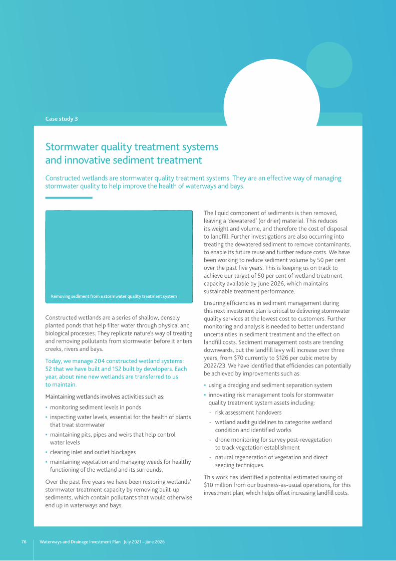
Case study 3
Constructed wetlands are a series of shallow, densely planted ponds that help filter water through physical and biological processes. They replicate nature’s way of treating and removing pollutants from stormwater before it enters creeks, rivers and bays.
Today, we manage 204 constructed wetland systems: 52 that we have built and 152 built by developers. Each year, about nine new wetlands are transferred to us to maintain.
Maintaining wetlands involves activities such as:
• monitoring sediment levels in ponds• inspecting water levels, essential for the health of plants
that treat stormwater• maintaining pits, pipes and weirs that help control
water levels• clearing inlet and outlet blockages• maintaining vegetation and managing weeds for healthy
functioning of the wetland and its surrounds.
Over the past five years we have been restoring wetlands’ stormwater treatment capacity by removing built-up sediments, which contain pollutants that would otherwise end up in waterways and bays.
Stormwater quality treatment systems and innovative sediment treatment Constructed wetlands are stormwater quality treatment systems. They are an effective way of managing stormwater quality to help improve the health of waterways and bays.
The liquid component of sediments is then removed, leaving a ‘dewatered’ (or drier) material. This reduces its weight and volume, and therefore the cost of disposal to landfill. Further investigations are also occurring into treating the dewatered sediment to remove contaminants, to enable its future reuse and further reduce costs. We have been working to reduce sediment volume by 50 per cent over the past five years. This is keeping us on track to achieve our target of 50 per cent of wetland treatment capacity available by June 2026, which maintains sustainable treatment performance.
Ensuring efficiencies in sediment management during this next investment plan is critical to delivering stormwater quality services at the lowest cost to customers. Further monitoring and analysis is needed to better understand uncertainties in sediment treatment and the effect on landfill costs. Sediment management costs are trending downwards, but the landfill levy will increase over three years, from $70 currently to $126 per cubic metre by 2022/23. We have identified that efficiencies can potentially be achieved by improvements such as:
• using a dredging and sediment separation system• innovating risk management tools for stormwater
quality treatment system assets including: - risk assessment handovers - wetland audit guidelines to categorise wetland
condition and identified works - drone monitoring for survey post-revegetation
to track vegetation establishment - natural regeneration of vegetation and direct
seeding techniques.
This work has identified a potential estimated saving of $10 million from our business-as-usual operations, for this investment plan, which helps offset increasing landfill costs.
Removing sediment from a stormwater quality treatment system
76 Waterways and Drainage Investment Plan July 2021 – June 2026

7.2 Innovation
We conduct an extensive research and investigation program including partnerships with research institutions, which has to led to some exciting innovations. We also encourage innovation throughout the planning and delivery of our programs. Some recent examples include:
Artificial intelligence helping to map vegetation in retarding basins
The vegetation health of retarding basins must be monitored to ensure they meet minimum design standards. This ensures they perform their function in reducing flooding by holding heavy rainfall in low-lying areas. We have recently developed a new monitoring method using unmanned aerial vehicle (UAV) capabilities, which replaces traditional manual counting methods for trees and vegetation. This has been combined with machine learning to interpret retarding basin images taken by UAVs. The technology is now better than the human eye for detecting features in UAV photographic images. This reduces the cost of vegetation monitoring in retarding basins.
Flood-gate automation improving safety and service delivery at Patterson Lakes
Flood gates in Patterson Lakes separate the tidal waterways and town centre marina from Patterson River. They are manually closed when river levels are high, protecting the area’s 1400 residents, their properties and local roads from flooding. A new automated system currently being installed will allow the gates to close remotely as soon as we receive an alert about potential flood conditions. This instant response will mean reduced chances of floodwater entering the tidal canal system as well as lowering labour costs, improving operator safety (as they often attend sites in the dark and in bad weather and helping to protect homes and businesses).
DNA barcodes: Improving the way we monitor waterway health
Ongoing aquatic macroinvertebrate (water bugs) surveys are undertaken to understand the types of waterbugs present in our waterways, assess the health of rivers and creeks, and determine major threats. They are carried out by collecting waterbugs in the field and preparing them in the laboratory. We have collaboratively developed a new technique that involves extracting DNA from waterbug samples in the laboratory, replacing the traditional method of manually identifying and counting water bugs with a microscope. So far we have found it compares favourably with microscopic analysis in quality and cost. It also provides additional data on biodiversity, such as changes in the number of species, or the occurrence of threatened or invasive species. This method is expected to become part of our routine monitoring program.
Aquatic macroinvertebrates (water bugs) photos by J. Gooderham & E. Tsyrlin
Flood gate automation at Patterson Lakes
77Waterways and Drainage Investment Plan July 2021 – June 2026

Lightweight filters reduce heavy sampling loads The vegetation health of retarding basins must be monitored to ensure they meet minimum design standards. This ensures they perform their function in reducing flooding by holding heavy rainfall in low-lying areas. We have recently developed a new monitoring method using unmanned aerial vehicle (UAV) capabilities, which replaces traditional manual counting methods for trees and vegetation. This has been combined with machine learning to interpret retarding basin images taken by UAVs. The technology is now better than the human eye for detecting features in UAV photographic images. This reduces the cost of vegetation monitoring in retarding basins.
Engaging the community: a disaster resilience relief pilot in Whittlesea In 2018 Melbourne Water engaged Melbourne University to work with the Victoria State Emergency Service and the community in flood-prone areas of the City of Whittlesea, to undertake an innovative approach to community education called Community Engagement for Disaster Risk Reduction. This involved door-to-door engagement to assess residents’ preparedness for floods, while also asking residents to engage with their friends, neighbours and others who could benefit. Initial findings show a significant number of households took action due to the pilot. The approach also pioneered an engagement form that creates a ‘ripple effect’ in which the community takes ownership and leads the sharing of flood preparedness information. We are now looking at how this approach can be incorporated into our overall flood preparedness program.
Monitoring waterway diversity using environmental DNAMelbourne Water is utilising a revolutionary, innovative sampling and monitoring technique known as environmental DNA (eDNA) to understand the extent and diversity of wildlife in our waterways. Traditional techniques such as netting and electrofishing involve some inherent safety challenges, can be invasive, are time consuming and can underestimate species. eDNA is safer and more efficient. Water samples are collected from multiple locations along waterways. DNA of the target species that has been left in the water (e.g. hair, scales, mucous, skin) is then extracted and examined in the laboratory. Recently, eDNA has been used to monitor a diverse range of aquatic animals, including platypus, fish, frogs, birds and invertebrates across Melbourne and will improve Melbourne Water’s biodiversity data and related management decisions.
Lightweight ultrafiltration samplers
Platypus (Doug Gimesy)
Flooding in Caulfield South
78 Waterways and Drainage Investment Plan July 2021 – June 2026

7.3 Measuring performance
As required by Melbourne Water’s Statement of Obligations, this investment plan includes key performance indicators (KPIs) that describe how progress in implementing the investment plan will be measured over the next five years.
The investment plan KPIs, which are outlined in 7.4, have been developed to ensure they cover an appropriate representation of programs and service areas across waterways and drainage functions and programs with significant levels of investment. The KPIs have been developed in consultation with internal subject matter experts, external stakeholder and community groups, particular customer segments, organisational delivery partners and Melbourne Water governance.
As some outcomes cannot be meaningfully measured on an annual basis (requiring two to five years or longer), a mix of output and outcome-based KPIs are proposed to measure performance.
As well as the KPIs, and as part of our commitment to continual improvement, many of the programs in this investment plan are extensively monitored and evaluated through MERI frameworks associated with the Healthy Waterways Strategy and Flood Management Strategy. There are also a number of waterways and drainage-related KPIs that are monitored and reported as part of Melbourne Water’s 2021 Price Submission Outcomes (together with water and sewerage KPIs).
Yarra River at Warburton
79Waterways and Drainage Investment Plan July 2021 – June 2026

7.4 Key performance indicators
Service area Target
Overall Community satisfaction with waterways is annually maintained at greater than 85%
Community access, involvement and recreation
42 hectares of vegetation will be improved and programmed maintenance undertaken to enhance amenity and community benefit
Community access, involvement and recreation
31 hectares of Melbourne Water land and assets are activated to increase community enjoyment of nature and recreation
Community access, involvement and recreation
200 community education and/or citizen science initiatives will be delivered
Community access involvement and recreation
Community satisfaction with the cleaning up of litter will improve and litter will be reduced at management sites
Aboriginal cultural values Formal partnership agreements with Traditional Owner organisations will be established and agreed commitments implemented
Emergency and pollution response
100% of incidents that require a response will be managed in accordance with relevant legislation
Flood risk management Melbourne Water will deliver flood awareness activities in accordance with the agreed Flood Engagement Program, to improve community awareness of flood risk and increase the program’s reach
Flood risk management A reduction in flood damages of $155m achieved over the life of the works
Flood risk management Flood information is renewed in 25% of rural catchments and 35% of urban catchments subject to flooding
Waterway flora Canoeists Yarra River Pound Bend, Kew
Waterways and Drainage Investment Plan July 2021 – June 202680

7.4 Key performance indicators continued
Service area Target
Flood risk management The drainage network is condition assessed and remedial action taken as specified in the relevant standard
Flood risk management and healthy waterways
In collaboration with key delivery partners, Melbourne Water will implement the MERI plans for the Healthy Waterways Strategy and Flood Management Strategy
Healthy waterways 3218 hectares of vegetation will be established and 5523 hectares maintained for ecological benefit
Healthy waterways Environmental water initiatives and outcomes will be delivered in accordance with legislative obligations and agreed priorities
Stormwater management Stormwater harvesting and infiltration capacity will increase by 8 GL/yr, through Melbourne Water programs
Stormwater management Melbourne Water’s stormwater quality treatment asset management and incentives programs will improve pollutant load reduction performance against an agreed dynamic baseline
Stormwater management 100 capacity-building initiatives will be delivered under the Clearwater program
Urban development Responses will be provided for 100% of statutory and non-statutory applications and at least 95% will be within the agreed timeframe
Urban development 100% of development services schemes will be implemented in accordance with the development planning program
Each year we will report our progress in implementing the Waterways and Drainage Investment Plan. In addition, the Healthy Waterways Strategy and Flood Management Strategy – Port Phillip and Westernport have MERI plans, through which we annually report our performance against these strategies to the public.
7.5 Reporting
Effective reporting is important to ensure accountability for the investment of funds in this investment plan.
Progress against the KPIs in the investment plan is independently audited at the end of each financial year and reported to the public on our website.
7.5 Reporting
Our annual reporting will include some of our initiatives, challenges and achievements, and progress towards delivering our KPIs.
81Waterways and Drainage Investment Plan July 2021 – June 2026

The investment outlined in this plan will enable us to reduce flood risk, protect waterway condition in the face
of climate change and urbanisation, protect and enhance Aboriginal cultural values, and better meet the social and
recreational needs along our waterways. Most importantly, it means we can continue to deliver high-quality,
affordable services for our customers.
SECTION 8
CONCLUSION
Werribee River
82 Waterways and Drainage Investment Plan July 2021 – June 2026

8. Conclusion
This investment plan is our most comprehensive yet. We have worked harder and smarter, through our strategies, science and research, relationships, delivery and oversight, and importantly, our customer engagement, to develop investment programs that meet our obligations and strategic objectives and deliver on our customers’ expectations.
Significant challenges face our growing and urbanising region in a changing climate. The health of our waterways is threatened, and without increased action and investment, nearly all will decline. Flood risk is increasing faster than works to reduce the impacts as severe storms become more frequent and sea levels continue to rise.
We will increase investment over the 2021 to 2026 period to address the significant deterioration in waterway health, increasing flood risk resulting from a changing climate and increased urbanisation that has occurred up to the start of this investment plan. Future population growth and climate change will put even greater pressure on waterways and drainage services and the infrastructure that supports these services.
Extensive engagement with our customers revealed they want us to do more to protect waterways and reduce flood risk. However, this comes at a cost and customer affordability is critical at this time. Meeting the challenges we face will cost more than today.
When faced with the choices we are wrestling with, metropolitan and rural residential customers surveyed preferred to pay an additional $8 on their bill to address these challenges, which will help us realise the goals in the Flood Management Strategy and Healthy Waterways Strategy.
In developing our programs we have carefully prioritised, taken on considered risk, embedded efficiencies and sought opportunities to further drive down the cost of delivering our works to keep our costs as low as possible. This has enabled us to develop an investment plan that will deliver the vast majority of the desired increases in service levels our customers sought and were willing to pay for. The price rise for customers will be $1.04 for metropolitan residential households, $0.57 for rural households and $1.57 for the minimum non-residential business in July 2021, followed by an additional 1 per cent increase and CPI adjustments in the following four years.
Meeting our customers’ service expectations at a lower price than they were willing to pay is the highlight of this investment plan. The investment outlined in this plan ensures we can meet the challenges we face in reducing flood risk. Waterway condition will be protected rather than decline in the face of climate change and urbanisation, and in some priority areas it will be enhanced. It also enables us to provide new services to protect and enhance Aboriginal cultural values, to better meet the social and recreational needs along our waterways, and to provide coastal erosion advice. Most importantly, it means we can continue to deliver high-quality, affordable services for our customers.
Enjoying a local waterway during the COVID-19 pandemic
83Waterways and Drainage Investment Plan July 2021 – June 2026

Family enjoying river environment at WarburtonMaribyrnong River, Footscray Park
84 Waterways and Drainage Investment Plan July 2021 – June 2026
Glossary
Annual average damage
The annual average damage estimate includes flood damages to residential and commercial properties, damages to roads, and disruption to services such as public transport. The estimate also includes ‘intangible’ damages, which are the social and environmental costs of flooding. The social impacts, including increased levels of stress and psychological and physical illness, can be long lasting.
Biodiversity A measure of the number and variety of plants, animals and other living things (including microorganisms) across our land, waterways and seas. It includes the diversity of their genetic information, the habitats and ecosystems within which they live, and their connections with other life forms and the natural world. Reduced biodiversity is considered a negative influence on the health of an ecosystem.
CatchmentThe land from which all rainfall flows, other than that removed by evaporation, into waterways and then to the sea. In the Port Phillip and Westernport region there are five catchments: Werribee, Maribyrnong, Yarra, Dandenong and Westernport.
Customer value Our customers’ preferences for levels of service, priorities, and the price they are willing to pay for these services.
Fee-for-service Fees that some customers pay for additional and direct services. These customers are urban developers, property owners who are paying to use river water or stormwater (diverters), rural drainage customers within the Koo Wee Rup and Longwarry Flood Protection District, and some Patterson Lakes residents who pay jetty management and lake flushing fees.
Ecosystem A community of living organisms and their physical environment interacting as a system.
Habitat The natural home or environment of an animal, plant or other organism.
Integrated water management Integrated water management (IWM) is a holistic approach to delivering water services. IWM considers the natural water cycle and all water supply and management systems as a single system, including flooding, drainage, waterways, water supply and sewerage services. Adopting an IWM approach encourages development of catchment-wide and place-based responses that can provide multiple benefits including supporting environmental health, community wellbeing, affordable services and water resilience.

Glossary continued
ISBN 978-1-921603-07-5 (Print)ISBN 978-1-921603-08-2 (Online)
© Copyright October 2020 Melbourne Water Corporation. All rights reserved.
No part of the document may be reproduced, stored in a retrieval system, photocopied or otherwise dealt with without prior written permission of Melbourne Water Corporation.
Disclaimer: This publication may be of assistance to you but Melbourne Water and its employees do not guarantee that the publication is without flaw of any kind or is wholly appropriate for your particular purposes and therefore disclaims all liability for any error, loss or other consequence which may arise from you relying on any information in this publication.
All actions in this investment plan will be delivered subject to funding.
Monitoring, evaluation reporting and improvement (MERI) An approach to assess the impact, appropriateness, effectiveness, efficiency and legacy of activities and programs and a process to drive continuous improvement.
Ramsar Convention on Wetlands of International Importance An international treaty for the conservation and sustainable use of wetlands. It is also known as the Convention on Wetlands. It is named after the city of Ramsar in Iran, where the convention was signed in 1971.
Real dollarsDollars adjusted to a base year (in this case 2021) by removing inflation.
Retarding basinAn excavated area to reduce flooding of a nearby waterway.
Stormwater Rainfall that runs off roofs, roads and other urban surfaces into gutters, drains, creeks and rivers, and eventually into the sea. This water can carry contaminants such as sediments, litter, oils, detergents, heavy metals, nutrients, pathogens and other toxicants.
WaterwaysWaterways are rivers, creeks and other streams, their associated estuaries and floodplains (including floodplain wetlands), and non-riverine wetlands.
Waterways and Drainage Charge The Waterways and Drainage Charge is a fee that is applied to properties within our service area. The charge is collected by retail water corporations on our behalf. The charge pays for services and programs that support healthy waterways and a safe and reliable drainage system as a public service. Approximately two million property owners in the region pay the charge.
Water sensitive urban design (WSUD) A land planning and engineering design approach considering the urban water cycle, including stormwater, groundwater and other water, to improve the environment and the way our streetscapes, suburbs and cities look. This can be done in conjunction with large and small-scale stormwater harvesting and infiltration schemes.
Wetlands Wetlands are areas – whether natural, modified or constructed – that are subject to permanent or temporary inundation; hold static or very slow-moving water; and develop, or have the potential to develop, biota adapted to inundation and the aquatic environment. They may be fresh or saline. Constructed wetland systems may contain more than one constructed wetland.
VICSES Victoria State Emergency Service (VICSES) is a volunteer-based organisation responding to natural disasters and working to ensure the safety of communities around Victoria, Australia.

Melbourne Water990 La Trobe Street, Docklands, Vic 3008PO Box 4342 Melbourne Victoria 3001Telephone 131 722 melbournewater.com.au