Annual Flood Report 2021 - Irrigation & Waterways Department
229
For Official Use Only DIRECTOR Advance Planning, Project Evaluation & Monitoring Cell Jalasampad Bhavan (2 nd Floor), Salt Lake, Kolkata – 700 091
-
Upload
khangminh22 -
Category
Documents
-
view
2 -
download
0
Transcript of Annual Flood Report 2021 - Irrigation & Waterways Department

For Official Use Only
DIRECTOR
Advance Planning, Project Evaluation & Monitoring Cell
Jalasampad Bhavan (2nd Floor), Salt Lake, Kolkata – 700 091

ANNUAL FLOOD REPORT 2021
CHAPTER Page No.
1. Preface and Introduction 1
2. River Systems and Flood Problems 4
3. Details of River Basins and Sub-basins 9
4. Hydro-Meteorological Data Collection
& Dissemination 20
5. Rainfall 2021 23
6. Flood Season 2021 29
7. Conclusion 36
Annexure I : River System Details 37
Annexure II : Index Map of River Basins 42
Annexure III : Existing Hydro-met Stations 43
Annexure IV-A : District-wise Monthly Rainfall Statistics 55
Annexure IV-B : District-wise Monthly Rainfall Graphs 58
Annexure V-A : Season-wise Average Rainfall Statistics 68
Annexure V-B : Station-wise Monthly Monsoon Rainfall 69
Annexure VI : Comparison of last five years Rainfall 71
Annexure VII : Station-wise Monsoon River Levels 82
Annexure VIII-A : Flood levels of North Bengal Rivers 84
Annexure VIII-B : Flood levels of South Bengal Rivers 92
Annexure IX-A : Monsoon Dam-Barrage Statistics 113
Annexure IX-B : Monsoon Dam-Barrage Graphs 114
Annexure X : List of Signal Imposed 121
Annexure XI-A : Primary Damages due to Very Severe
Cyclone ‘Yaas’
122
Annexure XI-B : Flood Damage Report during the year 125
Annexure XII : Flood Control Rooms under I.&W. Dept. 222

Annual Flood Report 2015
ANNUAL FLOOD REPORT, 2021
1
PREFACE
West Bengal being the lowermost riparian state of Ganga Basin and situated
at the foothills of several Himalayan rivers of Brahmaputra Basin, the problem of flood
management and drainage is quite acute here. Most of the rivers in the State originate
from outside of the State boundary and thus they are either inter State or International
category. The State has often witnessed destructive floods, even without any
substantial rainfall within the geographical limits of its own. Along-with flood and water
logging, various allied problems like bank erosion, embankment breach, drainage
congestion, and cyclonic storm has often accentuated the flood disaster. The coastal
areas along the Sundarban delta, which happens to be the largest delta of the
world, often experience high tidal surges resulting in severe erosion and inundation
to the country sides. In a nutshell, West Bengal has about 42.5% of its geographical
area as flood prone, happens to be one of the prime floods affected States in the
country.
The flood and water related disasters and associated problems in West Bengal
has become almost an annual feature. Many parts of the State get onslaught of
flood waters almost every year resulting in severe loss to standing crops, cattle and
properties. Statistically, this flood fury has increased during the last two decades.
To protect the country-side from flood ingress during peak monsoons and high
tide, flood embankments are constructed along the vulnerable river banks. These
embankments; constructed in various districts of the State in general and in the deltaic
Sundarbans in particular, are used as prime communication links, particularly during
periods of natural calamity for safe passage of people and relief materials. It virtually
serves as vital lifeline to the affected areas during adverse situation. Disruption of such
communication links due to failure by way of subsidence and sudden breach during
flood creates havoc, bringing the life of affected areas to a grinding halt as the areas
become devoid of basic amenities of life.
Factors such as intensity and duration of rainfall, sedimentation of river bed,
imprudent reservoir control, tidal lockage, obstruction and encroachment in natural
waterways play vital role in the occurrence of flood. Basin-wise study of flood factors
and evaluation of flood hazards are indispensable for chalking out future effective
plans for flood control and management measures. Accordingly, Irrigation &
Waterways Directorate at the end of every flood season ritually brings out an Annual
Flood Report incorporating the history of rainfall patterns of the monsoon season, district
rainfall records, and major river gauge levels across the State, reservoir inflow-outflows
and major flood events of the year.
Throughout the year, overall rainfall of the State is 20.6% above normal. The
rainfall in the north is 7.1% less than normal while in the south, it is 35.1% above nomal.
Incessant and unprecedented rainfall in frequent spells in Sorth Bengal made the rivers
to flow in high stages and as a consequent several damages occured. Before the onset
of monsoon, the State has experienced very severe cyclone ‘Yaas’. Damages has also
occurred at vulnerable spots of the flood embankments, river and sea protective works
mainly in the coastal districts of West Bengal. However, the restoration works are well
undertaken by the Department both for ‘Yaas’ and for the damages that occurred
during the normal flood season period of 2021.

Annual Flood Report 2015
ANNUAL FLOOD REPORT, 2021
2
RIVER NETWORK IN WEST BENGAL

Annual Flood Report 2015
ANNUAL FLOOD REPORT, 2021
3
1. INTRODUCTION
Geographically, the State of West Bengal is capped by the Himalayan snow-
peaks in the North and frothy sea of Bay of Bengal on the South. The terrain is a
combination of land varying from hilly regions in the north and partly high plateau in
the south-west to the Gangetic alluvial plains in the rest areas. The State is beset with
extensive network of rivers, their tributaries, rivulets, jhoras, irrigation canals,
wetlands, ponds, beels and low-lying pockets of water bodies. With the Tropic of
Cancer passing across it, the State is situated in between 21°31' & 27°13'14" North
Latitudes and 85°45'20" & 89°53' East Longitudes.
Salient features of West Bengal are given below in seriatim to give an outline of
the flood situation of the State.
Salient Features:
Geographical area of State : 88,752 sq. km.
Population (as per last census, 2011) : 9.13 crores
No. of Districts : 23
Total no. of blocks : 341
No. of flood susceptible districts : 19
No. of Vulnerable blocks : 198 (in Flood & Tidal inundation)
River basins (with CWC code) : Ganga (2A), Brahmaputra (2B), and
Subarnarekha (6).
Number of River Sub-basins : 39
Total Catchment area : 1,80,628 sq. km.
Catchment area outside of the State : 91,876 sq. km. (outside of West Bengal
but within India: 57624 sq.km. & outside
of country: 34,252 sq.km.)
Annual average rainfall : 1,826 mm (Northern part: 2750 mm,
Alluvial & Deltaic plain: 1650 mm,
Western plateau: 1450 mm)
Total flood prone area : 37,760 sq. km.
Area already protected : 35, 380 sq. km.
Length of Embankment : 10,584 km.
Length of Drainage Channel : 8,409 km.
Length of erosion protection work
other than embankments : 2,389 km.
Length of sea wall : 67 km.
Total number of Outfall sluices : 2,781
Number of Pumping stations : 20
Surface water potential : 136.9 BCM

Annual Flood Report 2015
ANNUAL FLOOD REPORT, 2021
4
2. RIVER SYSTEMS AND FLOOD PROBLEMS
West Bengal, a part of Bengal Delta, has a long-recorded history of flood. At
present 42.55% of total area of the State is susceptible to flood. Reason is the
landmass of the State was formed by the Ganga-Padma system of rivers through
the delta building process of which flood being the main carrier of sediments, the bulk of fluvial deposit, in huge volumes. The highest affected area as recorded in 1978
is about 30,607 sq. km and in 2000, it is about 23,971 sq. km.
Most of the rivers in the State are either Inter-State or International in character. The flood problems of the State are of different nature at different
regions which are describing below.
2.1. In North Bengal:
In North Bengal, rivers viz. Teesta, Torsa, Jaldhaka, Raidak and Sankosh after originating in the neighbouring countries of Bhutan and Tibet and the State
of Sikkim, flow downwards through the districts of Darjeeling, Kalimpong,
Jalpaiguri, Alipurduar and Coochbehar to meet the River Brahmaputra at different locations in Bangladesh, another neighbouring country. The combined
catchment of all this system of rivers upto the international border is 37,545 sq.
km.
The rivers of the districts of Uttar Dinajpur and Dakshin Dinajpur namely, Dauk, Nagor, Kulik, Tangon and Punarbhaba after originating at Bangladesh
pass through these districts and either directly or indirectly contribute
catchment discharges into the River Ganga-Padma in Bangladesh after the Farakka Barrage. River Atreyee’s major upstream inflow from Bangladesh, runs
across Dakshin Dinajpur and outfalls into River Brahmaputra in Bangladesh
again. The combined catchment area of the river system up to the international
border is 8,873 sq. km.
The southern part of district Malda through which the River Ganga flows
receives its flood water from about 11 States and is battered by the run-off flow
generated from these vast areas. Ultimately the river flows down the Farakka
Barrage to Bangladesh. The western side of the Malda district receives floodwater mostly from neighbouring country of Nepal and State of Bihar
through a network of rivers called Mahananda and Fulahar. Fulahar, after
flowing straight south, joins with Ganga upstream of Farakka barrage while Mahananda turns towards south-east and after bifurcating Malda, outfalls into
River Ganga-Padma at downstream of Farakka Barrage in Bangladesh. The
combined catchment of Mahananda-Fulahar system is 19,342 sq. km.
Major contributing factors to flood in North Bengal regions are the run-off because of heavy local rainfall, discharge of upper basin areas and also outfall
condition in the neighbouring countries. The Mahananda and most of the rivers
of Uttar and Dakshin Dinajpur districts get stagnated when the Ganga upstream and downstream of Farakka Barrage rules high thereby not allowing drainage
of flood discharge during that period.
2.2. In South Bengal:
There are certain distinctive features of drainage condition which give rise to flood situation in south Bengal. The flood in this zone becomes voluminous
because of the shape of the catchment area, its steep slope starting from a
high-level plateau area and sloping sharply down to a flat terrain near the

Annual Flood Report 2015
ANNUAL FLOOD REPORT, 2021
5
outfall of limited capacity. This feature is again adversely affected by tidal conditions as is generally noticed in the month of September, the likely month
of occurrence of flood.
Basin-wise there are quite a number of river systems on the right bank of
the river Bhagirathi-Hooghly like Pagla-Bansloi, Dwarka-Brahmani, Mayurakshi-Babla and Ajoy. These rivers together drain out flood water from an area of
18,177 sq. km, spread over the State of Jharkhand (the Chotanagpur Plateau)
and the districts of Birbhum, western part of Murshidabad, West and East Burdwan, and finally outfall into river Bhagirathi. Carrying capacity of the river
Bhagirathi is only 25% of the combined peak flood discharges generated from
these basins because of simultaneous heavy rainfall, as it occurred during the
flood of September 2000. In this vast tract of land there is one major reservoi r, that is, Massanjore Dam over river Mayurakshi which interferes the flood
discharge of only 11% of aforesaid combined catchments.
On the left bank of the Bhagirathi River system the Bhairab-Jalangi-Sealmari group of rivers originate from Ganga-Padma at Akherigunj in
Murshidabad district and meet the Bhagirathi at Swarupgunj in Nadia District.
This system of rivers between them drains a total area of 2,537 sq. km. of
Murshidabad and Nadia districts. Generally, this area suffers from flood because of three reasons – (i) high intensity rainfall in the basin area itself (ii) inflow of
flood water from Ganga-Padma at its high spate and (iii) drainage congestion
at its outfall because of high stage of river Bhagirathi during high tide.
In the Damodar-Barakar River system, the rivers originate at Chotanagpur
plateau of Jharkhand and flows down the plains of West Bengal to outfall into
the Rupnarayan-Hooghly system through two channels namely Mundeswari and
Amta Channel. The catchment area upto Durgapur Barrage is 18,026 sq. km. as against total catchment of 24,341 sq. km. In this catchment area there are only
4 (four) reservoirs having a storage capacity of 1.21 BCM. The original concept
of flood storage was to have an area reserved for storing a volume of 3.58 BCM.
Thus, with this limited flood storage capacity the storage dams at present can modify only the peak flood discharge. Any discharge above 70,000 cusecs
downstream of Durgapur barrage may cause flood depending on the outfall
condition of the Mundeswari at Harinkhola.
The Shilabati-Darakeswar and Kangsabati-Kaliaghai river systems which
have combined catchment areas of 16,938 sq. km spread out in the districts of
Purulia, Bankura, Jhargram, Paschim and Purba Medinipur outfall into river
Rupnarayan and Haldi respectively which finally meet river Hooghly. The Kangsabati-Kumari dam at Mukutmanipur, Bankura intercepts flood discharge
of only 22% of the aforesaid combined catchment area. In this basin spillway
discharge from Kangsabati dam above 50,000 cusecs may cause flood at lower reaches downstream of Mohanpur Anicut near Midnapore Town depending on
tidal condition of the outfall and rainfall in the uncontrolled catchment
downstream of Kangsabati dam.
The Mathabhanga-Churni-Ichamati system of rivers originate at the Mathabhanga off-taking from Ganga-Padma downstream of Farakka Barrage
in Bangladesh and on reaching West Bengal at Majdia in Nadia district,
bifurcates in two branches (i) the Churni flowing on South-Westerly direction meeting the Bhagirathi at Ranaghat and (ii) the other branch namely, the
Ichamati flowing on South-Easterly direction to meet Bay of Bengal through the
Annual Flood Report 2015
ANNUAL FLOOD REPORT, 2021
6
creek of Raimangal. The main flood situation in this area arises because of inflow from Ganga-Padma (when it rules high), rainfall in the own catchment area and
also tide lockage. In 2000 flood, a very unusual situation arose where the
Bhagirathi transferred a large volume of its floodwater to this basin area by
breaching its embankments at several places.
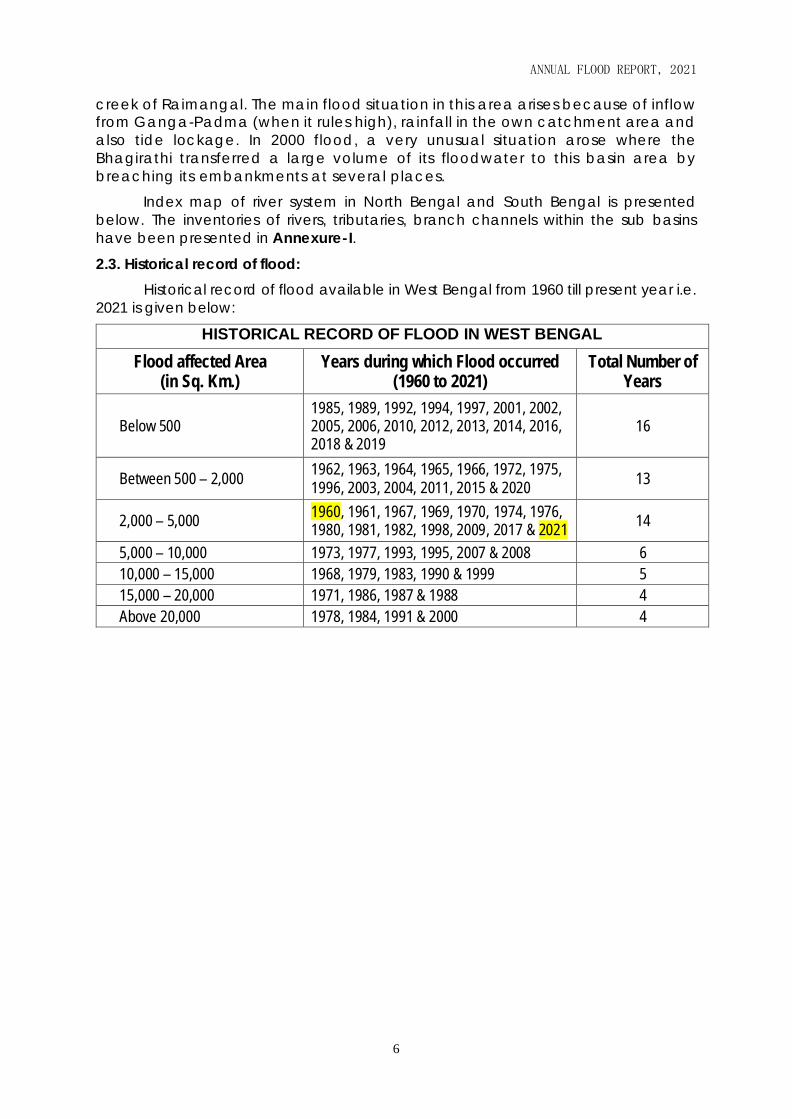
Index map of river system in North Bengal and South Bengal is presented
below. The inventories of rivers, tributaries, branch channels within the sub basins
have been presented in Annexure-I.
2.3. Historical record of flood:
Historical record of flood available in West Bengal from 1960 till present year i.e.
2021 is given below:
HISTORICAL RECORD OF FLOOD IN WEST BENGAL
Flood affected Area (in Sq. Km.)
Years during which Flood occurred (1960 to 2021)
Total Number of Years
Below 500 1985, 1989, 1992, 1994, 1997, 2001, 2002, 2005, 2006, 2010, 2012, 2013, 2014, 2016, 2018 & 2019
16
Between 500 – 2,000 1962, 1963, 1964, 1965, 1966, 1972, 1975, 1996, 2003, 2004, 2011, 2015 & 2020
13
2,000 – 5,000 1960, 1961, 1967, 1969, 1970, 1974, 1976, 1980, 1981, 1982, 1998, 2009, 2017 & 2021
14
5,000 – 10,000 1973, 1977, 1993, 1995, 2007 & 2008 6
10,000 – 15,000 1968, 1979, 1983, 1990 & 1999 5
15,000 – 20,000 1971, 1986, 1987 & 1988 4
Above 20,000 1978, 1984, 1991 & 2000 4

Annual Flood Report 2015
ANNUAL FLOOD REPORT, 2021
7

Annual Flood Report 2015
ANNUAL FLOOD REPORT, 2021
8

Annual Flood Report 2015
ANNUAL FLOOD REPORT, 2021
9
3. DETAILS OF RIVER BASINS AND SUB-BASINS
The State can be demarcated into three distinct drainage basins namely
Ganga (CWC basin code no. 2A), Brahmaputra (CWC basin code no. 2B) and
Subarnarekha (CWC basin code no. 6) basins respectively. Ganga basin has been
further divided into two parts namely Bhagirathi lower & others and Damodar.
These three main river basins can be divided into sub-basins having individual
catchment of their own. Index maps of different river sub-basins and basins are
presented in Annexure-II.
3.1. BRAHAMAPUTRA BASIN
The rainfall in the northern region of the State is generally high. The
ground slope is steep, particularly in the Sub-Himalayan regions of the northern
districts. Most of these northern districts belong to Brahmaputra basin. This system
consists of a total area of 10,584 sq. km., nearly 12% of the geographical area of
the State. This basin area is interspersed with a large number of drainage
channels, which join the main drainage arteries of the regions like the rivers
Teesta, Torsa, Raidak, Jaldhaka etc. All these rivers originate from the
Himalayas in neighbouring countries Bhutan, Sikkim and Tibet, and flow across
the Terai region and reach the plains of West Bengal and then flow to
Bangladesh joining ultimately the Brahmaputra in Bangladesh. The catchment
area distribution of this basin and sub-basins bounded within different
neighbouring States and countries has been presented in the following table.
Distribution of Catchment Area of River Basins & Sub-Basins of West Bengal
CWC
Basin
Code
River
Basin Sub-Basins
CATCHMENT AREA (Sq. Km.) TOTAL
(Sq. Km) Assam Sikkim West
Bengal
Bangla-
desh Bhutan Tibet
2B
BRAHAMAPUTRA
Brahmap
utra
Lower
Jaldhaka 76 3916 351 959 5302 Raidak 246 4590 16 4852
Sankosh 175 162 9734 75 10146
Teesta 7000 3012 12 29 10053
Torsa 3248 2363 1581 7192
Sub-Total 175 7076 10584 363 17646 1701 37545
3.1.1. Sankosh Sub-basin
The river Sankosh with its origin in Bhutan is the eastern most river of
Brahmaputra River basin. It serves as the boundary between the two states
West Bengal and Assam. It joins with Raidak-II and finally falls into
Brahmaputra in Bangladesh by name Gangadhar. The length of Sankosh in
West Bengal is 24 km. The total catchment area of this river sub-basin is 10,146
sq.km.
3.1.2. Raidak Sub-basin
It originates in Mt. Akungphu at an altitude of 6,400 m. in Bhutan. The
river Raidak then bifurcates into two channels namely Raidak-I and
Raidak-II at Bhutanghat, close to Indo-Bangladesh border. Raidak-I joins
the united stream of Torsa and Kaljani, while Raidak-II is joined by
Sankosh and finally outfalls into Brahmaputra in Bangladesh by the

Annual Flood Report 2015
ANNUAL FLOOD REPORT, 2021
10
name Gangadhar. The length of Raidak-II is around 50 km in West
Bengal. The total catchment area of Raidak-II river sub-basin is 4,852
sq.km.
3.1.3. Torsa Sub-basin
The river Torsa originates in Chumbi Valley of southern Tibet at an
altitude of 7,065 m. It flows through Tibet, Bhutan, West Bengal and
Bangladesh. Below Hasimara Bridge on NH-31, it bifurcates into two
channels namely Sil-Torsa and Char-Torsa. They reunite at PatlaKhowa
forest. The river passes by the Coochbehar town and is joined by river
Kaljani and Raidak-I. The combined flows outfalls into Brahmaputra near
Nageswari at Rangpur in Bangladesh. The total length of this river is 222
km out of which 74 km is situated within West Bengal. The total catchment
area of this river sub-basin is 7,192 sq.km.
3.1.4. Jaldhaka Sub-basin
The river Jaldhaka has its origin at Bitang Lake in Sikkim at an altitude
of 4,400 m. It flows through Sikkim, Bhutan, West Bengal and Bangladesh.
After the river is joined by a number of streams and tributaries; both in
mountainous and sub-mountainous regions, it finally flows into river
Dharala and the combined system, by the name Dharala ultimately
outfalls into Brahmaputra in Bangladesh. The total length of this river is
192 km out of which 122 km is situated within West Bengal. The total
catchment area of this river Sub-basin is 5,302 sq.km.
3.1.5. Teesta Sub-basin
Teesta, the mighty river of North Bengal originates in the glaciers of
North Sikkim at an altitude of 6,400 m and is formed by the union of two
streams viz. Lachen and Lachung at Chungthung in Sikkim. It enters West
Bengal at Rangpo and upto Mechi, it forms the boundary between West
Bengal and Sikkim. Two of its tributaries, Great-Rangeet and Rammam
also serve as the natural boundary between the two States. The river
finally outfalls into Brahmaputra in Rangpur district of Bangladesh. The
total length of this river is 309 km. out of which 103 km. is situated within
Sikkim and 121 km. in West Bengal. The total catchment area of this river
Sub-basin is 10,053 sq. km. Under ‘Teesta Barrage Project’, a barrage has
been constructed at Gazoldoba under Jalpaiguri district.
3.2. GANGA BASIN
The two holy rivers - Bhagirathi and Alakananda originating from the
glaciers of the Himalayas at an altitude of 7,000 m join at Devprayag and the
combined stream is known as the Ganga. It emerges into the plains at
Rishikesh in Uttarakhand. After flowing exclusively through Uttarakhand and
Uttar Pradesh, it receives the flow of Yamuna, one of its major tributaries near
Allahabad. The other major tributaries of Ganga are Ton, Gomti, Gharghara,
Son, Gandak, Kosi and Fulahar. The Ganga forms the boundary between
Uttar Pradesh and Bihar for a length of about 110 km and the river then enters
Bihar and flows more or less through the middle of the state. After its
confluence with the Kosi, the Ganga continues its eastward flows in Bihar for
about 40 km.

Annual Flood Report 2015
ANNUAL FLOOD REPORT, 2021
11
At Bhagalpur of Bihar, the river begins to flow south-southeast and as it
enters West Bengal, the river swings round the Rajmahal hill range. It begins
its attrition with the branching away of its first distributary, the Bhagirathi -
Hooghly, which goes on to become the Hooghly River after meeting with
Jalangi near Nabadwip and ultimately outfalls into the Bay of Bengal near
Sagar Island. Just before the border with Bangladesh, the Farakka Barrage
controls the flow of the Ganges, diverting some of the water into a feeder
canal linked to the Hooghly for keeping it relatively silt-free.
The North-Central, South-Central, Western, Southwestern and Southern
parts of West Bengal constitute the Ganga Basin. This basin is largely divided
into two major sub-basins namely Bhagirathi lower and Damodar. The total
length of the river Ganga from its point of origin to the point where it falls into
sea is about 2,575 km. (measured along Bhagirathi and the Hooghly) of which
1,450 km. lies in Uttarakhand and Uttar Pradesh, 110 km along Uttar Pradesh
and Bihar border, 445 km. in Bihar and 570 km. in West Bengal.
The Ganga system comprises a total area of 74,575 sq. km. within the
state of West Bengal. The catchment area distribution of this basin and sub-
basins bounded within different neighbouring states and countries has been
presented in the following table.
Distribution of Catchment Area of River Basins & Sub-Basins of West Bengal
CWC Basin Code
River Basin
Sub-Basins
CATCHMENT AREA (Sq. Km) TOTAL (Sq. Km) Bihar Jharkhand Orissa
West Bengal
Bangladesh Nepal
2A
GANGA
Bhagirathi and
Others (Ganga Lower)
Atreyee 1627 2262 3889
Fulahar 2940 325 2684 5949
Mahananda 2739 6040 1319 3295 13393
Punarbhaba 1125 1809 2934
Tangon 1244 806 2050
Ajay 386 3204 2503 6093
Amta Channel Kana Damodar
1490 1490
Bansloi 1794 119 1913
Behula 549 549
Bhagirathi-Hooghly 1292 4160 5452
Bidyadhari 2014 2014
Brahamani 985 154 1139
Churni 975 1304 2279
Dwarka 329 2649 2978
Ganga-Padma 1673 1673
Ghea 1167 1167
Ichamati 2313 1063 3376
Jalangi 2537 2537
Khari 2268 2268
Mayurakshi 2949 2529 5478
Pagla 239 337 576
Sundarban area 10209 10209

Annual Flood Report 2015
ANNUAL FLOOD REPORT, 2021
12
Distribution of Catchment Area of River Basins & Sub-Basins of West Bengal
CWC Basin Code
River Basin
Sub-Basins
CATCHMENT AREA (Sq. Km) TOTAL (Sq. Km)
Bihar Jharkhand Orissa West
Bengal Bangladesh Nepal
Damodar
Damodar 17087 4325 21412
Dwarakeswar 4292 4292
Haldi 614 614
Kaliaghai 1913 1913
Kangsabati 321 6324 6645
Mundeswari 1439 1439
Pichabani 17 791 808
Rasulpur 1556 1556
Rupnarayan 1226 1226
Shilabati 4088 4088
Sub-Total 6065 28200 17 74575 8563 5979 123399
3.2.1. Mahananda-Fulhar Sub-basin
The river Mahananda originates from Ghoom near Darjeeling
town in the district of Darjeeling. It is bounded on the north by the
Himalayas, in the east by the ridges separating it from Teesta river
system, the river Ganga on the South and the Kosi river system in the
east. The river bifurcates into two channels at Barsoi in Bihar. Out of the
two branches one flows through Bihar by the name Fulahar and the
other flows through West Bengal as Mahananda. The river Mahananda
carrying the flow of four tributaries namely, Nagar, Kalindri, Tangon and
Punarbhaba, drains into the river Ganga from the Northwestern side at
Godogarighat just downstream of the point where Ganga leaves the
boundary of West Bengal. The combined catchment area of these two
Sub-basins is 19,342 sq. km. Under ‘Teesta Barrage Project’, a barrage
has been constructed over Mahananda near Siliguri and another pick-
up barrage has been constructed over river Dauk near Chopra of North
Dinajpur district, which is a tributary of Mahananda.
3.2.2. Atreyee Sub-basin
Some rivers like Sahu, Neem, Talma, Chaoai, Panga originating from
the high lands in districts of Jalpaiguri and meet together to form
Kartowa which then enters into Bangladesh by the name Atreyee. The
river Atreyee then bifurcates into two channels namely Dheepa and
Atreyee. The Western Channel named Atreyee re-enters into West
Bengal in South Dinajpur district covering a length of 40 km in the State.
It again enters into Bangladesh and ultimately outfalls into river Jamuna
after passing through Chalanbeel. The total catchment area of this river
sub-basin is 3,889 sq.km at the point of leaving West Bengal boundary.
3.2.3. Punarbhaba Sub-basin
The river Dheepa after emerging out from Atreyee in Bangladesh,
has taken a South - Western course to enter into South Dinajpur district
assuming the name Punarbhaba. Covering a length of about 40 km. in
the district, it touches the eastern boundary of Malda district and finally

Annual Flood Report 2015
ANNUAL FLOOD REPORT, 2021
13
enters into Bangladesh. Further down, Punarbhaba meets the river
Mahananda in Bangladesh. The catchment area of this sub-basin is
2,934 sq. km.
3.2.4. Nagar-Kulik, Gamari-Chiramati, Tangon Sub-basins
All these rivers flow through the districts Malda and North Dinajpur
and outfall into the river Mahananda. In course of their flow, somewhere
they form the boundary either between West Bengal and Bihar or
between West Bengal and Bangladesh. Nagar, originat ing in
Bangladesh flows along the boundary of West Bengal and taking a
Southeastern course, receives a spill channel of Mahananda and is
joined by Kulick, which has also its origin in Bangladesh.
Gamari and Chiramati (or Srimati) are two small rivers that flow
through North Dinajpur district before they are united. This combined
streams finally outfalls into the river Mahananda. Tangon is a tributary
of river Mahananda. It rises in Bangladesh. It flows through the district of
North Dinajpur and Malda and meets Mahananda on the boundary of
Malda and Bangladesh. The catchment area of Tangon is 2,050 sq. km.
3.2.5. Bhagirathi-Hooghly Sub-basin
Farakka Barrage diverts water from river Ganga into Bhagirathi
through a channel known as Feeder canal near Tildanga town of
Murshidabad district in order to ensure minimum flow in Bhagirathi
especially during dry season. This canal flowing parallel to Ganga
passes Dhulian and ends just above Jangipur where Bhagirathi takes its
own course. Two right bank tributaries namely Pagla and Bansloi outfall
into the Feeder canal before it turns into actual Bhagirathi. It has been
renamed as river Hooghly as it passes on the eastern side of Hooghly
district until it outfalls into the Bay of Bengal near Sagar island.
During its entire course from origin to outfall, Bhagirathi has
formed boundaries between the districts of Purba Bardhaman & Nadia,
Hooghly & North 24-Parganas, Howrah & Kolkata, Purba Medinipur &
South 24-Parganas. River Ajay, Mayurakshi, Damodar (Amta Channel),
Rupnarayan and Haldiare the major tributaries on its right bank while
river Jalangi and Churni are the major tributaries on its left bank. Some
other minor tributaries on its right bank are Khari, Behula, Ghea and
Rasulpur. Moreover, there are so many small drainage channels and
khals which directly outfall into this river from its both banks thus forming
local catchment areas of 5,452 sq.km. The Tolly's Nullah or the Adi-
Ganga, as it is sometimes called is a small but important tidal creek
draining into the river Hooghly from the left near the city of Kolkata.
One important factor that affects the drainage potential of river
Hooghly is the effect of tides. The tide runs rapidly on Hooghly and
produces a remarkable example of the fluvial phenomenon known as
a ‘tidal bore’. This consists of the head-wave of the advancing tide,
hemmed in where the estuary narrows suddenly into the river, and often
exceeds 2.1 m. in height. The difference from the lowest point of low
water in the dry season to the highest point of high water in the rainy

Annual Flood Report 2015
ANNUAL FLOOD REPORT, 2021
14
season is reported to be more than 6 m. It has been observed that the
incident of flood devastation in the districts of Purba & Paschim
Medinipur, Howrah and Hooghly occur mostly when high flood
discharges from Jharkhand districts along-with those from Bankura,
Birbhum, Paschim Bardhaman, Purba Bardhaman and Purulia districts of
West Bengal synchronizes with high tides in river Hooghly specially
during the month of August and September.
3.2.6. Jalangi-Bhairab Sub-basin
The river Jalangi originates from the right bank of the river Padma
in Murshidabad district, 165 km. downstream of Farakka. Jalangi is dead
for all purposes except during the periods of heavy rain, when it
receives water from Padma. The river ends its journey by finally outfalling
into the river Bhagirathi near Nabadwip town of Nadia district. The
major tributary of Jalangi is river Bhairab that starts its journey from the
river Ganga near Lalbag of Murshidabad district. It is now almost a
dead channel but during rainy season, it receives water from Padma.
Catchment area of Jalangi Sub-basin is 2,537 sq.km.
3.2.7. Mathabhanga-Churni Sub-basin
River Mathabhanga originates from the right bank of the Padma,
at Munshiganjin Kushtia district of Bangladesh. It bifurcates near Majdia
of Nadia in India, creating two channels. The western course, Churni
runs a few km. through Nadia in a south-west direction to meet
Bhagirathi and the other course Ichamati, after traversing a length of
20 km in India, enters into Bangladesh near Mubarakpur. The length of
Churni is almost 56 km. Catchment area of Mathabhanga-Churni Sub-
basin is 2,279 sq.km.
3.2.8. Ichamati- Bidyadhari Sub-basins
After entering into Bangladesh near Mubarakpur, river Ichamati
flows for 35 km in Bangladesh and again re-enters into India at
Duttaphulia of Nadia. It forms the international border between India
and Bangladesh for 21 km. and finally outfalls into river Kalindi of
Sundarban area. The length of Ichamati is 208 km. with the catchment
area of 2,313 sq. km. within West Bengal and 1,063 sq. km. within
Bangladesh. Bidyadhari originates near Haringhata in Nadia district and
then flows through Deganga, Habra and Barasat areas of North 24
Parganas before joining the Raimangal River in the Sundarbans. It has
been the major drainage system of North 24-Parganas and Kolkata
having catchment area of 2,014 sq. km.
3.2.9. Pagla-Bansloi Sub-basins
These rivers originate from the Rajmahal hills in the Sahebganj
district of Jharkhand. Flowing eastern across Birbhum district, they
entered Murshidabad district as the tributaries of the river Bhagirathi.
The combined catchment area of these sub-basins is 2,489 sq. km.
3.2.10. Brahamani-Dwarka Sub-basin

Annual Flood Report 2015
ANNUAL FLOOD REPORT, 2021
15
Dwaraka originating in Dumka district of Jharkhand, flows through
Birbhum and Murshidabad districts where it joins with Mayurakshi to form
Babla which finally outfalls into the river Bhagirathi. Brahamani is the
main tributary of Dwarka. It also originates in Dumka district of
Jharkhand and flows through Birbhum and Murshidabad districts to
meet with Dwarka. There are Baidhara and Deocha barrages across
the river Brahamani and Dwarka respectively under the 'Mayurakshi
Reservoir Project'. The total catchment area of this sub-basin is 4,117 sq.
km.
3.2.11. Mayurakshi-Babla Sub-basin
River Mayurakshi (or Mor), the major river in Birbhum district, has a
long history of devastating floods. It has its source on Trikut hill, about 16
km from Deoghar in Jharkhand state. Several spill channels - the
Manikarnika, Kana Mor etc. take off from the Mayurakshi in its lower
reaches. All these rivers including river Dwarka flow into the lower
pocket of Hijal beel in the district of Murshidabad. The combined flow
when starts journey from the beel named as river Babla that finally
drains into the river Bhagirathi. The ruling level of Bhagirathi considerably
influences the drainage and flood level in the HijalBeel.
Massanjore dam and Tilpara barrage have been constructed across this
river as a part of 'Mayurakshi Reservoir Project’, which is the first major
irrigation project in West Bengal after independence. Other important
structures of this project situated in Birbhum are Kopai barrage on river
Kopai and Kandisala weir over river Bakreswar. The combined flows of
Kopai and Bakreswar are called river Kuia which outfalls into
Mayurakhshi near Kandi of Murshidabad. Mayurakshi is about 250 km
long out of which nearly 100 km passes through West Bengal. The total
catchment area of this sub-basin is 5,478 sq.km. River Siddheswari and
Noonbeel are two major tributaries of Mayurakshi outfalling into itat 8
km downstream of Massanjore dam and largely contribute the high
volume of uncontrolled flood discharge during monsoon.
3.2.12. Ajay Sub-basin
River Ajay originates on a small hill about 300 m high, southwest
of Munger in Bihar. It then flows through Jharkhand and enters West
Bengal at Simjuri, near Chittaranjan. It forms the border between
Birbhum and old Burdwan districts and finally joins the Bhagirathi River
near Katwa town of Purba Bardhaman. Total length of the Ajay is 288
km. out of which 152 km. lays in West Bengal. The important tributaries
of Ajay are Pathro and Jayanti in Jharkhand, Hinglow in Birbhum and
Kunur in Purba Bardhaman district of West Bengal.
There is a barrage across river Ajay constructed by Govt. of
Jharkhand at Sikatia. The floods of this river are flashy and of short
duration. There are some pockets in the Ajay-Kunur catchment, which
suffer from frequent inundation. Large areas of Purba Bardhaman,
Birbhum and Murshidabad districts experience inundation due to
drainage congestion whenever flood of the Ajay coincides with those

Annual Flood Report 2015
ANNUAL FLOOD REPORT, 2021
16
of the Mayurakshi and Dwarka. A dam has been constructed over the
tributary Hinglow for the purpose of irrigation in some parts of Birbhum
district. The total catchment area of this Sub-basin is 6,093 sq.km.
3.2.13. Khari-Behula-Ghea Sub-basins
Khari river a minor right bank tributary of river Bhagirathi originates
from the swampy field of Kanksa-Panagarh region of Purba Bardhaman
district and flows mainly eastward and later south-eastward to outfall
into river Bhagirathi upstream of Kalna town. Its main tributary is Banka
River, which acts as a spill channel of river Damodar, and after flowing
almost parallel to Khari, it meets with Khari just before its outfall into
Bhagirathi. The catchment area of this sub-basin is 2,268 sq. km.
Behula, also a spill channel of river Damodar originates near Palla
village of Purba Bardhaman district and after flowing eastward it outfalls
into river Bhagirathi upstream of Balagarh town of Hooghly district. Its
main tributary is Gangur river. The catchment area of this sub-basin is
549 sq. km.
Ghea is another spill channel of river Damodar, originating in the
Burdwan district and after flowing southward and south-eastward
through Hooghly district it outfalls into Hooghly river near Champdani
town. The main tributaries of this river are Kana and Kunti having a
catchment area of 1,167 sq. km.
3.2.14. Damodar-Mundeswari Sub-basins
River Damodar originating from Palamau hills in Jharkhand and
flowing through a length of 541 km between several districts of
Jharkhand and West Bengal bifurcates into two channels at
Beguahana of Purba Bardhaman district near Jamalpur. One channel
carrying dominant flood discharge has been named as river
Mundeswari that drains into Rupnarayan at Bakshi of Howrah district.
The other channel after passing through Hooghly and Howrah districts
as Amta channel carries its discharge and outfalls into the river Hooghly
through an outfall sluice near Uluberia.
The river causes floods in its lower reaches in the districts of Purba
Bardhaman, Hooghly and Howrah, mainly on the right bank of the river
below Beguahana. Earlier known as the 'Sorrow of Bengal' because of
its ravaging floods in the plains of West Bengal, the Damodar and its
tributaries have been somewhat tamed with the construction of four
dams (Maithon, Panchet, Konar and Tilayia) under the control of
'Damodar Valley Corporation (DVC)'. There is another dam at Tenughat
across Damodar under the direct control of Government of Jharkhand
and in the lower catchment; there are one barrage at Durgapur and
one weir at Randiha under the direct control of Irrigation & Waterways
Department, Government of West Bengal.
River Barakar and Bokaro are two major tributaries of Damodar in
Jharkhand which meet Damodar from its left bank whereas river Shali in
Bankura district of West Bengal is other major tributary situated on its

Annual Flood Report 2015
ANNUAL FLOOD REPORT, 2021
17
right bank. Harinkhola, Short-Cut channel, Kana Dwarakeswar, Hurhura
khal are other important drainage arteries of this catchment which play
important role in draining out flood discharge into river Rupnarayan,
having tidal influence. The total catchment area of Damodar sub-basin
in Jharkhand is 17,087 sq.km and in West Bengal is 4,325 sq. km. upto
Beguahana point. The local catchment area of Mundeswari sub-basin
is 1,439 sq.km and that of Amta Channel-Kana Damodar sub-basin is
1,490 sq.km.
3.2.15. Dwarakeswar Sub-basin
Darakeswar river (also known as Dhalkishore) is a major river in the
western part of West Bengal. It originates from Tilboni hill of
Chhotanagpur Plateau in Purulia district and enters Bankura district near
Chatna. It mainly flows southeastward and after entering into Hooghly
district it turns south near Arambag town. Its main tributary Gandheswari
rising from Bankura district meets Darakeswar near Bankura town. After
receiving contributions from other minor tributaries like Arkasha, Berai,
and Shankari etc. Darakeswar finally joins with Shilabati at Bandar near
Ghatal town of Paschim Medinipur district to form river Rupnarayan.
There is proposal of "Darakeswar-Gandheswari Reservoir Project" within
this sub-basin. Catchment area of this sub-basin is 4,292 sq. km.
3.2.16. Silabati Sub-basin
Like Darakeswar, river Silabati (also known as Shilai) emerging from hilly
terrain of Chhota Nagpur Plateau in the Purulia district, traverses south-
eastward through the districts of Bankura and Paschim Medinipur to meet
with Darakeswar to form Rupnarayan River. River Joyponda, Ketia, Donai,
Kubai and Parang are major tributaries of Shilabati. There is a small pickup
barrage constructed across the river at Kadamdeuli in Bankura district as
a part of 'Kangsabati Reservoir Project'. The catchment area of this sub-
basin is 4,088 sq. km.
3.2.17. Kangsabati Sub-basin
The river Kangsabati (also variously known as the Kasai and Cossye)
originating from Chhota Nagpur Plateau in the Purulia district and flowing
south-eastward, joins with its main tributary Kumari river at Mukutmanipur
of Bankura district where a reservoir popularly known as Mukutmanipur
dam has been constructed under the 'Kangsabati Reservoir Project' for
the purpose of both irrigation and flood control. An Anicut structure built
on this river near Midnapore town in 1872 was also added to the
operations of the project. Further down, after entering into the district of
Paschim Medinipur it joins with combined streams of Bhairab Banki and
Tarafeni rivers. Both the rivers have barrages over them under the Project.
After travelling further east in a tortuous course, it bifurcates into two rivers
at Kapastikri of Paschim Medinipur.
Northern branch, known as Old Cossye after flowing through certain
distance, further bifurcates into two courses at Daspur of Paschim
Medinipur. One course, named as Palaspai khal flow further east to outfall
into the Rupnarayan and the main course, known as Durbachati flows

Annual Flood Report 2015
ANNUAL FLOOD REPORT, 2021
18
southeasterly along the border of both Medinipur districts to outfall into
river Rupnarayan. Old Cossye is also connected with river Silabati through
a small channel known as Kanki khal.
The southern course, known as New Cossye, flows further southeasterly
direction to meet with river Kaliaghai at Dheubhanga of Purba Medinipur
district and forms river Haldi that flows eastwardly into the river Hooghly
at Haldia. Kherai and Bakshi khal is the main tributary of river New Cossye.
The total length of Kangsabati is around 465 km. The catchment area of
this sub-basin is 6,645 sq.km. Very often, lower portion of this sub-basin
especially Ghatal area of Paschim Medinipur and Panskura area of Purba
Medinipur districts suffer from inundation due to high flood discharge from
its uncontrolled catchment downstream of the Mukutmanipur dam
synchronizing with high tide in river Rupnarayan.
3.2.18. Kaliaghai Sub-basin
The river Kaliaghai trickles out from Dudhkundi of Jhargram district and
flows south-easterly through Paschim and Purba Medinipur to meet the
other arm of Kangsabati i.e., New Cossye to form Haldi. During the course
of its journey, it is fed by the flow of its tributaries namely Kapaleswari,
Baghai and Chandia. The length of this river is 121 km and catchment
area is 1,913 sq. km. This river is mainly responsible for flood in Sabang
area of Paschim Medinipur district.
3.2.19. Rupnarayan Sub-basin
River Rupnarayan is the major drainage artery of southwestern
districts of South Bengal. Being the main tributary of Hooghly River, it
receives tidal discharge of Bay of Bengal throughout the year and plays
an important role in draining floodwater from vast catchment area.
Irrespective of discharges from its major tributaries like Mundeswari,
Darakeswar, Shilabati and Kangsabati, it also receives flood water from
many local drainage channels like Kata khal of Hooghly, Bakshikhal of
Howrah, Chandreswar khal of Paschim Medinipur, Denan-Dehaty-
Soadighi-Gangakhali-Pratapkhali-Shankrara khals of Purba Medinipur
which directly outfall into Rupnarayan from its both banks. The length of
this river is 80 km having local catchment area of 1,226 sq.km.
3.2.20. Haldi Sub-basin
Two rivers New Cossye and Kaliaghai join at Dheubhanga of Purba
Medinipur to form river Haldi which after traversing southeastward outfalls
into river Hooghly near Haldia town. It divides the Purba Medinpur district
into two parts, the Northern part can be categorized as drainage area of
Tamluk and the southern part can be categorized as Rasulpur-Nandigram
drainage area. Except upper catchment discharges from Kaliaghai-New
Cossye sub-basins, river Haldi drains out water from parts of both the
above-mentioned drainage areas. The lower portion of the river Haldi is
affected by over bank spills and drainage problem during the monsoon
as entire stretch of 42 km of the river falls under the tidal influence of river
Hooghly. The local catchment area of this sub-basin is 614 sq.km.

Annual Flood Report 2015
ANNUAL FLOOD REPORT, 2021
19
3.2.21. Rasulpur Sub-basin
The river Rasulpur is formed by union of two drainage channels namely
Bagda andSadarkhals. It is the main drainage channel in Contai sub-
division of Purba Medinipur district. The river having length 19 km drains
out floodwater of 1,556 sq. km. into the river Hooghly.
3.2.22. Pichabani-Negua Channel Sub-basin
River Pichabani and Negua Diversion channel systems are used to
discharge rainwater out from Dubda basin of Purba Medinipur district. The
two channelsoutfall into Bay of Bengal. Catchment area of this sub-basin
is 808 sq.km.
3.2.23. Sundarban Drainage Sub-basin
Apart from the rivers described earlier within the Ganga basin, there
is a group of rivers in Southern part of the State, which falls in the deltaic
zone. These tidal rivers, estuaries and creeks are situated on the eastern
side of Hooghly River popularly known as Sundarbans, which is nothing
but an intricate network of number of deltaic islands of the district of
South 24-Parganas. These rivers drain off whatsoever fresh discharge
comes from countrysides, thus ultimately draining into Bay of Bengal.
Some important rivers in Sundarban are Muriganga, Mridangabhanga,
Saptamukhi, Raimangal, Matla, Bidya, Thakuran, Malancha, Kalindi,
Gomar etc. The total land area of Sundarban sub-basin is 6,747 sq. km.
whereas including all rivers and creeks, Sundarban has gross area of
10,209 sq. km.
3.3. SUBARNAREKHA BASIN
The river Subarnarekha (also called Swarnarekha) though it has small
catchment within this state, has separate entity as it directly falls into the Bay of
Bengal. Originating in the Chhotonagpur Range at an elevation of 609 m. near
Ranchi, it traverses through three states viz. Jharkhand, West Bengal and Orissa. It
drains out rainwater from a total area of 19,684 sq. km. out of which only 3,593 sq. km
falls within Purulia, Paschim Medinipur and Jhargram districts of West Bengal.
One major dam at Chandil and one barrage at Galudi have been
constructed across Subarnarekha in Jharkhand. The important tributaries on the
right bank of this river are Kanchi and Karkari, which meet Subarnarekha above
Chandil dam and another right bank main tributary named as Kharkai meets this
river near Jamshedpur upstream of Galudi barrage. Dulung is the main tributary,
which joins Subarnarekha from its left in the Jhargram district of West Bengal. The
total length of this river is 395 km. out of which 83 km. falls within West Bengal.
Distribution of Catchment Area of River Basins & Sub-Basins of West Bengal CWC Basin Code
River Basin Sub-Basins CATCHMENT AREA (Sq. Km.) TOTAL
(Sq. Km) Jharkhand Orissa West Bengal
6 SUBARNAREKHA
Subarnarekha 13014 3077 3286 19377
Kashpal 307 307
Sub-Total 13014 3077 3593 19684

Annual Flood Report 2015
ANNUAL FLOOD REPORT, 2021
20
4. HYDRO-METEOROLOGICAL DATA COLLECTION & DISSEMINATION
Irrigation and Waterways Department (IWD), Govt. of West Bengal is responsible
for maintenance, collection, compilation and dissemination of hydrological and
meteorological data for the purpose of monitoring of flood or flood-like situation for
almost all river sub-basins of the State during monsoon. For this purpose, network of
river gauges and rain gauges have been established at the important locations and
during monsoon flood control rooms in each district are set up including the Central
Flood Control Room (CFCR) at Jalasampad Bhavan, Salt Lake, Kolkata.
4.1. Rain and River Gauges
Apart from IWD, other organizations like Central Water Commission (CWC), India
Meteorological Department (IMD), State Agricultural Department (AGRI), Kolkata Port
Trust (KoPT), Damodar Valley Corporation (DVC) and Surface Water Investigation
Directorate (SWID) under Water Resources Investigation & Development Department
(WRIDD) have set up network of river gauges and rain gauges of their own at different
locations for monitoring hydrological and meteorological data. These field data
mainly include daily rainfall, water level of river and reservoir, river discharge and
inflow-outflow from reservoir. In addition to that other information like inflow forecast,
meteorological forecast and flood damage are also collected.
Existing Hydro-Met Monitoring Stations in the State
Type IWD CWC IMD Others Rain Gauge Stations (ORG/ARG/AWS/FCS)
103 45 65 55
River Gauge / Discharge Stations (G/G-D/HOS)
100 81 - 144
Total 203 126 65 199
ORG = Ordinary Rain Gauges ARG = Automatic Rain Gauges
AWS= Automatic Weather Station FCS = Full Climatic Station
HOS = Hydrological Observation Station (Gauge, Discharge, Silt/Sediment, Water Quality)
HMS = Hydro-Meteorological Station (Rainfall, Temperature, Wind speed, Solar radiation,
Humidity, & other Weather parameters)
Besides Ordinary Rain & River gauges, IWD also maintains seven (7) Gauge-
Discharge stations at different rivers and fourteen (14) Hydrological Observation
Stations (HOS) at Dam & Barrage sites for measurement of Reservoir levels, Inflow,
IWD, 203, 34%
CWC, 126, 21%IMD, 65, 11%
Others, 199, 34%
Distribution of Hydro-met Stations amongst various Govt. Organisations In West Bengal

Annual Flood Report 2015
ANNUAL FLOOD REPORT, 2021
21
Outflow, Canal discharges & sediment/silt content if requires.
Summary of Hydromet Station Data under Irrigation and Waterways Department
Type of Hydromet Stations Total number of Station Data
collected in IWD web inventory Published in Daily
Flood Reports Number of Rain Gauges 141 84
Number of River Gauges 89 60
Number of River Gauge & Discharge 7 7
Number of Dam & Barrage Monitoring Sites (Reservoir/Pond Level, Inflow, Outflow)
20 13
A comprehensive list of existing Hydro-Met stations within the State under the
jurisdiction of Irrigation & Waterways Department, Central Water Commission and
India Meteorological Department and the data recorded by Irrigation & Waterways
Department, is given in Annexure-III.
Recently under National Hydrology Project (NHP), IWD is going to commission
a ‘Real Time Data Acquisition System (RTDAS)’ for efficient flood forecasting and
inundation modelling within the State. For this, fully automated radar and sensor type
hydro-met stations proposed to be installed. Following sensors are proposed:
Sensor Type Total No. to be installed
Automatic Rain Gauge (ARG) 69
Automatic Weather Station (AWS, including ARG) 7
Automatic Water Level Recorder (AWLR) 128
Dam-Barrage Gate Sensor (GS) 13
PAN evaporimeter (PAN) 4
Automatic Flow Meter (AFM) 19
Automatic Tide Gauge (ATG) 3
The work is conceived in three phases and two are under progress and
detailed lists of those stations are given in Annexure-III. Besides RTDAS, IWD had also
proposed two canal SCADA system for Kangsabati & Mayurakshi system under NHP.
4.2. Role of Central Flood Control Room
The present flood monitoring and management system in the State comprises
with the preparation of Daily Flood Report by Central Flood Control Room (CFCR) of
IWD and transmission of the same to the State Disaster Management Department with
the Head Quarter at Kolkata. This report is also shared with the Chief Secretary, Home
Secretary of the State and other organization like Railway Authorities, Bengal Army
Headquarters, CWC-Easten Zone Monitoring Office, Kolkata Port Trust (KoPT), Kolkata
Municipal Corporation (KMC) and all District Magistrates of the State.
This Daily Flood Report (DFR) generally contains rainfall, river and gauge and
discharge, river warning levels/ signals, weather information, reservoir
level/inflow/outflow data of different Stations within and outside the State. Sometimes
the location and extent of major damages, the status of affected areas under
inundation etc. are also included, as and when the situation such warrants. These
data are collected from different district flood control rooms under IWD (details given
in Annexure-XII) along with other agencies like IMD, CWC and DVC by telephone,
fax, e-mail or Whatsapp messages. During emergency, separate Flood Bulletin is

Annual Flood Report 2015
ANNUAL FLOOD REPORT, 2021
22
issued and the same will be disseminated also to the District Disaster Management
Cells and other authorities via e-mail, Fax, SMS or Whatsapp messages. Daily flood
reports are also uploaded in the departmental web site: www.wbiwd.gov.in.
This year, CFCR was operational 24x7 during entire monsoon & flood season
starting from 1st June, 2021 to 31st October 2021, collected raw data from all existing
hydro-met stations & reservoir data of IWD’s district control rooms, rainfall and weather
forecast/warning from IMD websites, relevant data from CWC, DVC, Chandil Dam,
Galudih & Sikatia barrage authorities, compiled all these in the standard proforma
and finally prepared the Daily Flood Report for dissemination by 10.00 to 10:30 a.m.
Besides the normal flood season, this year CFCR was also in force round the clock
during Very Severe Cyclonic Storm ‘Yaas’ right from its formation until it faded away
from the State (24th to 29th May, 2021). CFCR continuously monitored the position &
stages, gathered weather informations like rainfall, wind speed, strom surge etc. from
IMD New Delhi & Kolkata offices, collected physical damage reports from IWD field
offices and published Special Bulletins twice daily.
Again, for cyclonic strom ‘Jawad’ CFCR became operational round the clock from
3rd to 7th December, 2021 and issued Special Bulletins until it faded as Low-Pressure Area
and became remnant of the cyclonic storm.

Annual Flood Report 2015
ANNUAL FLOOD REPORT, 2021
23
5. RAINFALL
Climatological variations are observed in West Bengal due to its physical and
geographical position. The annual normal rainfall of the State is 1,826 mm, of which 77%
occurs during the monsoon period while the hilly regions at the foothills of Himalaya
receive the heaviest rainfall ranging from 2500 mm to 4000 mm. The southern districts in the
plains receive average of 1125 mm to 1875 mm. Main rainfall season in this state is the
South-West monsoon season during which the entire land (excepting the extreme north,
the extreme north-east and extreme south) gets 75% of the annual rainfall. The gangetic
plains of West Bengal get 78% of its annual rainfall during the monsoon period distributed
normally from 1st week of June to the end of September. But during last few years, some
parts of West Bengal have experienced cyclone, premature heavy rainfall in the last
week of May causing flood and drainage congestion. However, the late withdrawal
of monsoon even after second week of October has also been observed.
5.1. Normal Rainfall Pattern
The river Ganga divides the State into two parts, which are by and large
homogeneous from the meteorological point of view. The northern half is designated as
'Sub-Himalayan West Bengal' and the southern half as 'Gangetic West Bengal'. Sub-
Himalayan West Bengal is more susceptible to heavy rains both in respect of amount as well
as in frequency of occurrence.
Very heavy rain is more frequent in first two months (June and July) than in
subsequent, in the Sub-Himalayan West Bengal. In Gangetic West Bengal, the frequency
is maximum in August followed by June, July and September in that order. On the basis
of rainfall distribution, the State can be divided into two broad zones -(i) The Himalayan
and Sub-Himalayan Region (ii) The Gangetic Plains
i) Himalayan and Sub-Himalayan Region
The Himalayan and Sub-Himalayan Region comprises the districts of Darjeeling,
Kalimpong, Jalpaiguri, Alipurduar, Coochbehar and Northern part of Islampur Sub-
Division of Uttar Dinajpur district of high intensity of average annual rainfall from 2000
mm to over 4000 mm, about 80% of which is found to occur during monsoon season
(Annual normal of entire districts of North Bengal = 2484 mm). On an average,
Darjeeling, Coochbehar and Jalpaiguri get 114, 112 and 110 rainy days respectively in
a year.
The monsoon generally follows a northern track to ultimately break up against
Eastern Himalaya causing very heavy rainfall and thereafter, trough of low pressure
under break monsoon conditions. It then shifts northward to the Himalayan foothills. It
has been found that a precipitation between 200 to 300 mm in two hours is not unusual.
ii) Gangetic Plains
The gangetic plains which constitute the major portion of the State, can be
further sub-divided into the following three sectors on the basis of average rainfall.
Sector-I: Bankura, Burdwan (Purba & Paschim), Hooghly, Nadia and Purulia
districts which receive an average annual rainfall between 1140 mm and 1400 mm
(Annual normal =1348 mm).
Sector-II: Birbhum, Midnapore (Purba & Paschim including Jhargram),
Murshidabad and North 24-Parganas having an average annual rainfall between 1400
mm and 1650 mm (Annual normal =1590 mm).
Sector-III: Kolkata, Howrah and South 24-Parganas having an average annual
rainfall - between 1650 mm and 1900 mm (Annual normal = 1796 mm).
Such regional variations in the precipitation may causes flood condition time to time.

Annual Flood Report 2015
ANNUAL FLOOD REPORT, 2021
24
5.2. Intensity & Spatial Distribution of Rainfall
As per Heavy Rain Warning Services of India Meteorological Department (IMD),
Ministry of Earth Sciences, Govt. of India, Classification of Rainfall, Category of Rain Spell and
Spatial distribution of daily Rainfall are as follows:
Category of Rain Spell
Category
Range of daily
Rainfall of a Station
(mm/hour)
Category
Range of daily
Rainfall of a Station
(mm/hour)
Light spell 10 Very Intense spell 31 - 50
Moderate spell 11 – 20 Extremely Intense spell 51 - 99
Intense spell 21 - 30 Cloud Brust >= 100
Classification of Rainfall Intensity
Category
24 hours Rainfall over a ststion ending at
0830 Hrs IST (in mm)
Category
24 hours Rainfall over a ststion ending at
0830 Hrs IST (in mm)
Very Light Rain Trace - 2.4 Heavy Rain 64.5 – 115.5
Light Rain 2.5 - 15.5 Very Heavy Rain 115.6 - 204.4
Moderate Rain 15.5 – 64.4 Extremely Heavy Rain >= 204.5
Spatial Distribution of Rainfall
Distribution No. of Places Description
Isolated One or two places < 25% of stations get rainfall
Scattered At a few Places (26–50) % of stations get rainfall
Fairly Widespread At many places (51–75) % of stations get rainfall
Wide spread At most places (76–100) % of stations get rainfall
Dry ̵̶ No station reported rainfall
Weekly/Seasonal Rainfall Distribution on Regional Scale
Large Excess
Percentage departure of realized rainfall from normal rainfall is + 60% or more.
Excess Percentage departure of realized rainfall from normal rainfall is between + 20% to + 59%.
Normal Percentage departure of realized rainfall from normal rainfall is between - 19 % to + 19 %.
Deficient Percentage departure of realized rainfall from normal rainfall is between - 20 % to - 59 %.
Scanty Percentage departure of realized rainfall from normal rainfall is between - 60 % to - 99 %.
No Rain Percentage departure of realized rainfall from normal rainfall is - 100 %.
Rainfall Distribution on All India Scale
Normal Percentage departure of realized rainfall from normal rainfall is within ± 10 % of the Long Period Average.
Below Normal
Percentage departure of realized rainfall from normal rainfall is < 10 % of the Long Period Average.
Above Normal
Percentage departure of realized rainfall from normal rainfall is > 10 % of the Long Period Average.
All India Drought
Year
When the rainfall deficiency is more than 10%, and when 20 to 40% of the country is under drought conditions, then the year is termed as All India Drought Year
All India Severe
Drought Year
When the rainfall deficiency is more than 10% and when the spatial coverage of drought is more than 40%, it is called as All India Severe Drought Year.

Annual Flood Report 2015
ANNUAL FLOOD REPORT, 2021
25
5.3. Monsoon 2021
As per IMD-Delhi, this year South West Monsoon had onset over Kerala on 3rd June
and had arrived some part of West Bengal & Sikkim on 10th June and covered whole of
West Bengal within 12th June.
The Sectoral variations of monthly average rainfall in West Bengal during monsoon
months 2021 is given below with colour coding, which is derived from IMD’s district-wise
monthly rainfall data (presented in Annexure IV-A).
Variation of Monthly Average Rainfall (mm) of Sub-Himalayan West Bengal during Monsoon 2021
Month June July August September
North Bengal Sector
Actual Normal % Dep Actual Normal % Dep Actual Normal % Dep Actual Normal % Dep
432.8 462.6 -6.4% 448.9 627.8 -28.5% 584.3 470.6 24.2% 206.2 384.6 -46.4%
Variation of Monthly Average Rainfall (mm) of Gangetic Plains of West Bengal during Monsoon 2021
Month June July August September
South Bengal Actual Normal % Dep Actual Normal % Dep Actual Normal % Dep Actual Normal % Dep
Sector-I 353.5 232.3 52.2% 372.7 296.6 25.7% 221.9 275.3 -19.4% 350.8 235.1 49.2%
Sector-II 341.5 257.7 32.5% 398.0 330.7 20.4% 278.8 318.4 -12.4% 488.0 292.9 66.6%
Sector-III 408.2 281.9 44.8% 529.3 388.5 36.2% 300.1 353.4 -15.1% 629.5 318.5 97.6%
*Dep = Departure **Raw Data Source: IMD, Kolkata
The graphical representation of district-wise monthly rainfall 2021 vis-à-vis normal
rainfall are given in Annexure IV-B. The cumulative monthly rainfall of various Rain gauge
stations for different River Sub-Basins, as observed at IWD’s Central Flood Control Room
during entire flood season i.e., from 1st June to 31st October, is given in Annexure V-B.

Annual Flood Report 2015
ANNUAL FLOOD REPORT, 2021
26
The progress of monsoon 2021 week by week, as per IMD-New Delhi for two
meteorological sud-divistions in West Bengal, is presented below.
In North Bengal districts, the average monsoon rainfall deviation was -14% from its
normal average i.e. NORMAL while that of South Bengal districts was 29% i.e. EXCESS.
Average Monsoon [01.06.21-30.09.21] Rainfall (mm)
Zone Actual Normal % Dep
North Bengal 1672.3 1945.5 -14.0%
South Bengal 1509.7 1170.9 28.9%
West Bengal 1613.0 1405.0 14.8%
For the State as a whole, the monsoon rainfall as per IMD, from 1st June to 30th
September 2021 was normal with the percentage departure (i.e., deviation from its
normal value) was 14.8%. The annual rainfall of the State was EXCESS a little with
percentage departure 20.6% due to pre-monsoon excess and post monsoon large
excess rainfall. Season-wise Average Rainfall Statistics of West Bengal for the Year 2021
as per data provided by IMD, Kolkata is presented in Annexure V-A.
As per IMD-Delhi, the process of South-west monsoon withdrawn from West Bengal
started on 11th October and finally withdrawn on 22nd October 2021. The withdrawal map
is given below.

Annual Flood Report 2015
ANNUAL FLOOD REPORT, 2021
27
5.4. Rainfall Observed at CFCR
The DFR of CFCR, IWD contains 84 raingauge stations, which captures daily rainfall
data from 1st June to 31st October. The Rainfall Data Statistics out of 12,852 data is
presented below:
5.5. Annual Rainfall 2021
As defined by IMD, meteorological seasons comprising of four seasons. They are:
Winter (1st January to 28th February), Pre-monsoon (1st March to 31st May), Monsoon (1st
June to 30th September) and Post-monsoon (1st October to 31st December) seasons.
The seasonal distribution of total annual rainfall of the State is presented below:
A district-wise visual comparison of last five years (2017-2021) average monsoon
rainfall is presented in Annexure VI. Large multiple peaks are observed for the year 2021.
10, 0.1%
5786, 45.0%
1233, 9.6%
2989, 23.3%
2325, 18.1%
367, 2.9%
118, 0.9% 24, 0.2%
CFCR Recorded Rainfall Data Statistics 2022
No. of 'NA' Data or No Records No Rain Very Light Light Moderate Heavy Very Heavy Extremely Heavy
Winter Avg. Rainfall, 2.1, 0%
Pre-Monsoon Avg. Rainfall, 306.3, 14%
Monsoon Avg. Rainfall, 1613, 73%
Post-Monsoon Avg. Rainfall, 286.9, 13%
Distribution of Seasonal Acutal Rainfall of West Bengal in 2021
Winter Avg. Rainfall, 31.1, 2%
Pre-Monsoon Avg. Rainfall, 235.8, 13%
Monsoon Avg. Rainfall, 1405, 77%
Post-Monsoon Avg. Rainfall, 159.1, 8%
Distribution of Seasonal Normal Rainfall of West Bengal in 2021

Annual Flood Report 2015
ANNUAL FLOOD REPORT, 2021
28
IMD, RMC, Kolkata has prepared a percentage rainfall departure map from long
period average for the districts in West Bengal for winter, pre-monsoon, monsoon, and
post monsoon period which are presented below:

Annual Flood Report 2015
ANNUAL FLOOD REPORT, 2021
29
6. FLOOD SEASON 2021
As per Govt. of India’s Water Resources Information System ( India-WRIS) and
Central Water Commission (CWC), monsoon period comprises of five months from
June to October. Accordingly, flood season in West Bengal also covers from June to
October. The distribution of monthly average rainfall in the State for this season shows
excess rainfall with average departure of 25.5% that varies from maximum surplus of
61.9% in October 2021 to maximum deficit of only -0.6% in August 2021.
Distribution of Monthly Average Rainfall in West Bengal during Flood Season 2021
Month Actual Rainfall (mm) Normal Rainfall (mm) % Departure Remarks
June-21 394.3 316.7 24.5% Excess rainfall July-21 435.8 419.8 3.8% Normall rainfall
Aug.-21 358.7 361.0 -0.6% Normall rainfall Sept.-21 424.2 307.5 38.0% Excess rainfall Oct.-21 214.2 132.3 61.9% Large excess rainfall
* Data source: IMD-Kolkata
Month-wise statistical analysis of River Gauges i.e. Maximum peak values,
Minimum river gauges, average river stages, number of days river level crossed
primary danger level (PDL), danger level (DL) and extreme danger level (EDL) and
during Flood Season, 2021 is presented in Annexure-VII.
6.1. Flood Spells in North Bengal
6.1.1. In June 2021: After the onset of monsoon, significant rainfall had occurred at
few places of North Bengal on 30th June with extremely heavy rainfall at Hasimara,
Banarhat & Malbazar. Monthly average rainfall was closed to normal, only -6.4%
deviation. As the rivers were normally thirsty after summer, it was well attenuated and
river stages has just crossed primery danger levels only.
6.1.2. In July 2021: With few discrete rainfalls throughout the month, one day maximum
rainfall had occurred on 17th of July at Coochbehar District. Monthly average rainfall
was deficient with -28.5% deviation. Thus, the river stages were well under control
except River Jaldhaka at NH-31 crossing where it had crossed just primery danger
level.
6.1.3. In August 2021: Average rainfall of August in North Bengal was excess i.e., above
normal with 4-5 days rainfall spells occurred thrice. Hence, river stages raised and River
Torsa at Hasimara and River Jaldhaka at NH-31croosing were very close to
corresponding dander levels. River Fulahar at Teljana and River Ganga-Padma at
Manikchakghat ruled very high. They crossed extreme danger levels and remained in
high spate on most of the month.
6.1.4. In September 2021: On the contrary, rainfall in North Bengal districts in
September were largely deficient except one day heavy rainfall occurred on 2nd
September over Jalpaiguri, Alipurduar and Coochbehar districts. As a result, Torsa,
Jaldhaka and Mansai river showed some higher stages on 3 rd September.
6.1.5. In October 2021: Rainfall of October in North Bengal was huge on 20th due to
low pressure formation over Bay of Bengal and its movement around the region.
Extremely heavy rainfalls occurred at Darjeeling, Siliguri, Jalpaiguri and heavy to very
heavy rainfall at most of the places of North Bengal. Hence river stages of Teesta were
abnormaly high with imposition of ‘Red’ warning signals. Torsa, jaldhaka and other
rivers were ruled high. Later, after the withdrawal of monsoon all became normal.
All monthly rainfall variations are stated in cl. 5.3 of previous chapter and also
presented in Annexure IV- A & B. Flood frequency curves (Gauge Level vs. Time) of
different rivers in entire North Bengal have been presented in Annexure VIII-A. Due to

Annual Flood Report 2015
ANNUAL FLOOD REPORT, 2021
30
high river stages, warning signals were frequently imposed for unprotected &
protected areas of North Bengal. List of such signals is presented in Annexure-X.
6.2. Flood Spells in South Bengal
6.2.1. In June 2021: A good amount of rainfall received in this month Average rainfall
of June in South Bengal was also excess i.e., above normal with 2-3 days rainfall spell
occurred between 16th to 18th. River Dwarakeswar and Channels within Lower
Damodar region viz. Hurhura, Amta, Short Cut where on high stages due to cumulative
upland discharges.
6.2.2. In July 2021: Huge rainfall also received in this month. Average rainfall of July in
South Bengal was excess i.e., above normal with 3-4 days rainfall spell occurred at the
end of month. Extremely heavy rainfall occurred at Kangsabati-Silabati catchments;
Heavy to very heavy rainfall occurred at Ajoy, Dwarakeswar, Lower Damodar and
Haldi catchments. As a consequence, most of the rivers were on very high stages due
to incessant rainfall and cumulative upland discharges. Several damages had
occurred as a result of erosion, subsidence and failure of flood embankments.
6.2.3. In August 2021: On the contrary, rainfall in South Bengal districts in September
were normal with -15.5% deficiency. Scattered rainfall received though out the
month, mostly at beginning. Due to exceptional rainfall at July end, South Western
flashy rivers were at high stages at the beginning along with Ganga-Padma,
Bhaghirathi-Hughli system which on an average on high stage due to upper
catchment run-off.
6.2.4. In September 2021: Average Rainfall in September was in Large Excess for South
Bengal with 69.2% extra, due to back-to-back low-pressure formation and presence
of deep depressions. 2-3 days huge rainspells thrice in this month made devastation
in Kangsabati-Silabati, Kaliaghai-Kapaleswari, Haldi, Chandia, Rasulpur and Lower
Damodar-Roopnarayan sub-catchments. Most of the rivers run above extreme
danger levels and as result several damages had occurred.
6.2.5. In Oclober 2021: Average Rainfall in October was reduced compared to prvious
month though in Excess in 38% than normal. Widespread rainfall upto withdrawn of
Monsson seen with a low-pressure effect. As a result of September end’s heavy
downpour, river stages of most of the rivers of South Bengal were fatty at beginning,
later subsided with dry days.
Statistical analysis of River gauge data for whole West Bengal during the flood
season 2021 is detailed in Annexure-VII. Flood frequency curves of different rivers in
South Bengal have been presented in Annexure VIII-B.
6.3. Reservoir and Barrage Data
The instantaneous Inflow-Outflow and Reservoir level of large dams and
important barrages either under the control of Irrigation & Waterways Department or
those have direct impact on the flood situation of West Bengal have been measured
during the flood season. Monthly Statistics of data of those Dam-Barrage Operations
i.e. maximum, minimum & average reservoir level, inflow & outflow data was analyzed
and presented in Annexure IX-A. The inflow-outflow data along-with reservoir levels of
those important Dams and Barrages during 1st June to 31st October, 2021 have been
graphically presented in Annexure IX-B.
6.4. Warning / Signal System
North Bengal Central Flood Control Room, Jalpaiguri imposes warning / signal
system for protected and unprotected river banks of North Bengal during peak flood
period. The details of signal imposed and later withdrawn; on receding of river levels
in given in the following table.

Annual Flood Report 2015
ANNUAL FLOOD REPORT, 2021
31
Flood Warning Levels of North Bengal Rivers
Gauge Signal Imposed
By
Name of River Name of Gauge Station Unprotected Area Protected Area
obtained
from Yellow Red Yellow Red
Irri
gat
ion
& W
ater
way
s D
epar
tmen
t,
Go
vern
men
t o
f W
est
Ben
gal
JPG Teesta
Teesta Bazar 211.00 213.00
Coronation Bridge 149.40 151.80 150.00 153.60
Domohoni 85.65 85.95 85.95 86.30
CBR Mekhliganj 65.45 65.95
JPG Jaldhaka N.H-31 C (Nagrakata) 160.70 161.30 161.00 161.80
N.H-31 Crossing 80.00 80.50 80.10 80.90
CBR Mansai Mathabhanga 47.70 48.70 48.40 48.90
APD Torsa
N.H-31 C (Hasimara) 116.30 116.90 116.30 117.50
CBR C.B.R (Kashab Ashram) 42.07 42.68
APD
Kaljani P.W.D (Alipurduar) 45.10 45.70
Raidak-I N.H-31C (Chapan) 46.70 47.60 47.00 47.90
Raidak-II N.H-31C (Telepara) 48.10 49.00 48.40 49.30
Daina Chengmari 200.50 201.40
Sankosh N.H-31C (LRP) 48.20 49.10 48.50 49.40
CBR Mujnai Bhutnir Ghat 61.70 62.30
Raidak-I Tufanganj 34.22 35.30
SLG Mahananda Siliguri 115.97 116.59 Abbreviations: - JGP: Jalpaiguri, CBR: Coochbehar, APD: Alipurduar, SLG: Siliguri
The warning signals imposed for different rivers in North Bengal for this flood
season is tabulated in Annexure-X.
6.5. Flood Damage Data
As spelt earlier, this year flood damages were huge. Extent and expenditure
involved for restoration of flood damages occurred in different districts of West Bengal
have been presented in Annexure XI-A. Typical pictures of damages and restoration
measures taken in 2021 are presented below:
Bagedantola restoration works at P.S. Bhutni, Block – Manikchak, Malda
Keshorpur restoration works at P.S. Bhutni, Block – Manikchak, Malda
Damages of Ganga Left Bank Palliative work done Ongoing restoration work

Annual Flood Report 2015
ANNUAL FLOOD REPORT, 2021
32
Bheemtala Breach Closing Work at Khanakul-I, Hooghly
Darakeswar Left Bank During Work Post Work
Bandar Jelepara Breach Closing Works at Khanakul-II, Hooghly
Rupnarayan Left Bank During Work Post Work
6.6. Cyclonic Storms in 2021
6.6.1. Very Severe Cyclonic Storm “YAAS” over Bay of Bengal (23rd–29th May, 2021)
A low-pressure area (LPA) formed over eastcentral Bay of Bengal (BoB) in the
morning of 22nd May. It lay as a well marked LPA in the same afternoon over
eastcentral BoB. Under favourable environmental conditions, it concentrated into a
depression over eastcentral BoB in the noon of 23rd May, 2021. It moved
northwestwards and intensified into a deep depression (DD) over eastcentral BoB in
the midnight of 23rd May and into the Cyclonic Storm (CS) ―YAAS, in the early morning
of 24th over the same region.
It moved nearly north-northwestwards and intensified into a Severe Cyclonic
Storm (SCS) in the midnight of 24 th May over eastcentral BoB. It started moving
northwards from the morning of 25th and intensified into a Very Severe Cyclonic Storm
(VSCS) in the evening over northwest BoB. Thereafter, it moved north-northwestwards
reached peak intensity of 75 knots (kts) and lay centred over northwest BoB about 30
km east of Dhamra Port, Odisha during early morning of 26 th May. Continuing to move
north-northwestwards, it crossed north Odisha coast near latitude 21.35°N and
longitude 86.95°E, about 20 km to the south of Balasore as a VSCS with maximum
sustained wind speed of 75 kts gusting to 85 kts (130 -140 kmph gusting to 155 kmph)
between 10:30-11:30 IST of 26th.
Further moving north-northwestwards, it weakened rapidly into a SCS over north
coastal Odisha in the afternoon, into a CS over north Odisha in the evening and into
a DD in the midnight of 26th over north interior Odisha and adjoining Jharkhand. It
weakened into a depression over central parts of Jharkhand in the noon of 27 th.
Thereafter, it moved northwestwards and weakened into a well-marked LPA over
Bihar and adjoining southeast Uttar Pradesh in the early morning of 28 th May. It
became an LPA over southeast UP and adjoining Bihar on 28 th evening and became
less marked on 29th morning.
Typical INSAT 3D satellite and radar imagery from Doppler Weather Radar at
Paradip as monitored by IMD are presented below.

Annual Flood Report 2015
ANNUAL FLOOD REPORT, 2021
33
The IMD forecasted and observed track of Yaas is also presented below:
IMD’s Observed track and forecast track of Yaas
Gale wind speed reaching 130-140 gusting to 155 kmph prevailed along and off
Balasore, Bhadrak districts of north coastal Odisha and 100-120 gusting to 130 kmph
prevailed along and off coastal districts of West Bengal (Purba Medinipur and South
24 Parganas district) during the time of landfall. Estimated storm surge of about 2 -4
meters height above astronomical tide inundated low lying areas of Balasore and
Bhadrak districts of north coastal Odisha and coastal West Bengal districts (Purba
Medinipur and 24 Pargana districts) during the time of landfall.
As per IMD’s report on Yaas (June, 2021), no death was reported in West Bengal.
The state has incurred a total loss of more than Rs 20,000 crore due to Cyclone, Yaas
which battered the state and around 2.21 lakh hectare of crops were damaged. 3
lakh houses were damaged in West Bengal; while around 1 crore people were
affected in the state. The cumulative list of Damages to the flood management
infrastructure of I&WD due to the Very Severe Cyclonic Storm "YAAS"on 26th May 2021
(realized and updated upto 28th May 2021) is provided in Annexure XI-B.
Rescue from flood in West Bengal Devastated homes in West Bengal

Annual Flood Report 2015
ANNUAL FLOOD REPORT, 2021
34
Damaged shoreline at a beach in Shankarpur Flooding in coastal Digha-Shankarpur area
Few representative pictures of I&WD’s Infrastructure damaged in YAAS and
restoration measures taken thereafter are presented below side by side:
Embankments damaged in ‘YAAS’ Restoration works done
Mouza Banashyamnager, River Pakhirala, South 24 Parganas
Mouza-Sapkhali, River Hooghly, South 24 Parganas
Kalibazar embankment at Panskura, Purba Medinipur

Annual Flood Report 2015
ANNUAL FLOOD REPORT, 2021
35
Left Bank of River Dansa, Mouza-Kumirmari, GP. Khulna, South 24 Parganas
AILA Embankment, Mouza-Atapur, GP. Monipur, River Baro Kalagachi, North 24 Parganas
ANNUAL FLOOD REPORT, 2O2I
7. CONCTUSTON
Our Stote is o huge recipient of run-off generoted from ouiside of the Stote. lthos typicol bosin chorocteristics. ln the northern Sub-Himoloyon region, the roinfoll ishigh ond the terroin slope is steep. The rivers in the Teroi region ore wide, shollow ondmostly broided. Due to mindless denudoiion of forest cover ond unstoble geology in thehills, the silt loods ore continuously deposited in the river beds, reducing the corryingcopocity of rivers. lt couses overflow during high dischorges, often creoting flood situotions.ln the northern foothills, cenlrol ond southern region, heovy roinfoll ond surfoce run-offdescending from the upper cotchments, ofien outside the Stote boundory, couses floodinundotion ond droinoge congestion due to flot topogrophy of the region.
Moin structurol meosures of flood control in West Bengol ore river embonkmentsmeosuring obout I0,500 km., spreod over different river systems, constructed over theyeors. There ore mojor doms ocross river Kongsoboti, Moyurokshi ond Domodor Riversystems. ln the Domodor system. moderotion of the dom releose during the peok floodis possible to some extent.
ln North Bengol, crn eloborote flood worning system is mointoined by thedeportment thot worns the common people obout the trend of rise of woter level inrivers ond thus olorms them to toke necessory precoutionory meosures well beforehond.ln Centrol ond South Bengol, ihe woter level of ,Cifferent rivers together with their dongerond extreme donger levels ond the releoses from different doms ond borroges oreintimoted to different outhoriiies' time to time during the enlire flood seoson.
Besides this, our deportment continuously mointoins close lioison with theRegionol Meieorologicol Centre (RMC), Kolkoto ond keeps continuous trock of lndioMeteorologicol Deportment (lMD) website in order to collect dynomic informotionon weother condiiion during entire monsoon period. ln criticol situotions, thedeportment odopts oppropriote meosures commensurqte with the circumstonces.Centrol Woter Commission (CWC) olwoys extend their co-operotion by providingdifferent hydro-meteorologicol doto under their jurisdiction.
ln every monsoon ond during cyclonic storm emergencies beyond the normolflood seqson, Centrol Flood Control Room (CFCR), with toll-free londline focilities, becomesoperolionol of Jolosompod Bhowon, Solt Loke, Kolkoto to keep close vigil of the situotions.It functions round the clock ond is olwoys on high olert. lt collects doily hydro-meteorologicol ond climotologicol doio from oll possible sources, prepores Doily FloodReports ond Bulletins ond disseminotes the some to oll concerned. Doily reports duringentire monsoon period ore olso ovoiloble in public domoin in the deportmenlol websitewww.wbiwd.eov.in. Like previous yeor, this yeor two regionol flood control rooms (RFCR) otNorth Bengol, one of Club Rood, Jolpoiguri ond onother ol Green Pork, Moldo were olsofunctionol for communicotion of informotion in o better woy.
Besides the normol monsoon period, this yeor CFCR wos olso forced to be pre-opened ond re-opened during extreme exigencies of the severe cyclonic storms 'Yoos'ond 'Jowod' ihot hod struck on 26tn Moy, 2A21 ond Sth December, 2021 respectively. CFCRhod continuously monitored ond kept trock of the development ond odvoncement of thestorm, collected doto, of ossocioted roinfoll, wind speed, storm surge ond domoges ofdeportmentdl infrostructure ond published specioi bulletins fwicJ doily during -these
exigencies.
ln the previous yeor, overoll roinfoll hos been qbove normol in South Bengolwith frequent incessont spells leoding to severol breoches, domoges to IWDinfrostructure creoting flood situotion of some ploces. Aport from thot, domoges in riverond seo embonkmenis of coostol districts hove occurred due to very severe cyclone'Yoos'. For oll situotions, deportment hos token oppropriote oction in proper lime for
36
lrrigation & Wateruays Di6ctorite ,--..^-.,^L1?)l:!.;, lrigation & Wateruays Diiectorate
(Sujoy Patra) (Dr. Abhijit Saha) | I)eputy Direbtor (Distiict Plan) \ \ Director | 'AOvince Planning, Proiect ' \ \ Advance P-!q1ni,!g, ?rojgct.Evaluation&MoniibringiCelt, . \ \ .lr\.pV.Evaluation.&Monitbring-Cell,
Chief Engineerlrrigation & Wi
& Research)Doted: 31 st Morch. 2022. Directorate

ANNUAL FLOOD REPORT, 2021
37
Annexure I: Details of River Network
Sl. No.
RIVER Tributaries Location
Primary Secondary STATE District
BASIN 2A: BRAHAMAPUTRA SUB-BASIN: LOWER BRAHAMAPUTRA
1 Sankosh
Assam Kokrajhar
West Bengal Coochbehar
Chhoto Sankosh Assam Kokrajhar
West Bengal Alipurduar
Raidak-II West Bengal Alipurduar, Coochbehar
2 Torsa
West Bengal Alipurduar, Coochbehar
Raidak-I Dhakshi West Bengal Alipurduar, Coochbehar
Gadadhar Jayanti West Bengal Alipurduar
Kaljani
Bala West Bengal Alipurduar
Nonai West Bengal Alipurduar
Dima West Bengal Alipurduar
Pana West Bengal Alipurduar
Garam West Bengal Alipurduar
Bania West Bengal Alipurduar
Ghargharia West Bengal Alipurduar, Coochbehar
Holong West Bengal Alipurduar, Coochbehar
Dharala West Bengal Coochbehar
3 Jaldhaka
West Bengal Kalimpong, Jalpaiguri, Coochbehar
Mujnai
Titi West Bengal Alipurduar
Pagli West Bengal Alipurduar
Ekti West Bengal Alipurduar
Shukti West Bengal Alipurduar
Jurapani Dudua West Bengal Jalpaiguri, Alipurduar
Gilandi West Bengal Jalpaiguri
Diana Longit West Bengal Jalpaiguri
Khuji Diana Chetia West Bengal Jalpaiguri
Jiti West Bengal Jalpaiguri
Murti West Bengal Jalpaiguri
Sutanga West Bengal Coochbehar
Jarda Bagdan West Bengal Jalpaiguri, Coochbehar
Dolong West Bengal Coochbehar
4 Teesta
Sikkim North Sikkim, South Sikkim
West Bengal Darjeeling, Jalpaiguri, Coochbehar
Lachung Yumthang Sikkim North Sikkim
Lasha Sikkim North Sikkim
Lohnak Poke, Gome Sikkim North Sikkim
Rangyung Ringpi, Rukel Sikkim North Sikkim
Chakung Sikkim North Sikkim
Dick Sikkim North Sikkim
Rangit
Rimbi Sikkim West Sikkim
Kalej Sikkim West Sikkim
Rammam Sikkim West Sikkim
Little Rangit West Bengal Darjeeling
Rani Sikkim East Sikkim
Rangpo Nathang Sikkim East Sikkim
Relli West Bengal Kalimpong
Rangio West Bengal Darjeeling
Leesh West Bengal Kalimpong, Jalpaiguri
Gheesh West Bengal Kalimpong, Jalpaiguri
Dharala
West Bengal Kalimpong, Jalpaiguri
Neora West Bengal Kalimpong, Jalpaiguri
Mal West Bengal Darjeeling, Jalpaiguri
Chel West Bengal Jalpaiguri
Karla

ANNUAL FLOOD REPORT, 2021
38
Sl. No.
RIVER Tributaries Location
Primary Secondary STATE District
BASIN 2B: GANGA SUB-BASIN: BHAGIRATHI LOWER & OTHERS
1 Mahananda
West Bengal Darjeeling, Uttar Dinajpur, Malda
Bihar Kishanganj, Purnia
Balason Rohini West Bengal Darjeeling
Lachka West Bengal Darjeeling
Taipu Manjha West Bengal Darjeeling
Mechi Biring Bihar Kishanganj
Kankai Ratwa Bihar Kishanganj, Purnia
Panar
Bihar Araria, Purnia, Katihar
Bakra Bihar Araria, Purnia
Kesaliya Bihar Araria, Purnia
Dauk West Bengal Uttar Dinajpur
Pitani Bakuna West Bengal Uttar Dinajpur
Nagar Sudhani West Bengal Uttar Dinajpur
Kulik West Bengal Uttar Dinajpur
Chiramati West Bengal Uttar Dinajpur
Sui West Bengal Uttar Dinajpur
Tangon West Bengal Uttar & Dakshin Dinajpur, Malda
Mora Mahananda West Bengal Malda
Kalindri West Bengal Malda
2 Fulhar Bihar Katihar
West Bengal Malda
3 Punarbhaba West Bengal Dakshin Dinajpur, Malda
4 Atreyee
West Bengal Dakshin Dinajpur
Kartowa
Neem West Bengal Jalpaiguri
Sahoo West Bengal Jalpaiguri
Chauli West Bengal Jalpaiguri
Talma West Bengal Jalpaiguri
Panga West Bengal Jalpaiguri
Jamuna West Bengal Dakshin Dinajpur
Brahmani West Bengal Dakshin Dinajpur
5 Ganga-Padma
Pagla West Bengal Malda
Gumani West Bengal Murshidabad
Jharkhand Godda, Sahebganj
6 Bansloi
Jharkhand Sahebganj, Pakur
West Bengal Birbhum, Murshidabad
Bagmari Jharkhand Pakur
West Bengal Murshidabad
Krilor West Bengal Murshidabad
7 Pagla
Jharkhand Pakur
West Bengal Birbhum, Murshidabad
Buri West Bengal Birbhum
8 Dwarka
Brahamani
Jharkhand Dumka
West Bengal Birbhum, Murshidabad
Gumra Jharkhand Dumka
Tripti Jharkhand Dumka
West Bengal Birbhum
Gambhira Gamri West Bengal Birbhum, Murshidabad
Chailan Jharkhand Dumka
West Bengal Birbhum
Ghormora West Bengal Birbhum
Kajuli West Bengal Birbhum
Daoka Manikarnika West Bengal Birbhum, Murshidabad
Banka West Bengal Murshidabad

ANNUAL FLOOD REPORT, 2021
39
Sl. No.
RIVER Tributaries Location
Primary Secondary STATE District
9 Mayurakshi
Jharkhand Deoghar, Dumka
West Bengal Birbhum, Murshidabad
Dhabai Jharkhand Dumka
Bhurbhuri Jharkhand Dumka
Tepra Jharkhand Dumka
Siddeswari Jharkhand Jamtara, Deoghar, Dumka
Noonbeel Jharkhand Deoghar
Kushkarini Jharkhand Jamtara
West Bengal Birbhum
Kuia Bakreswar
West Bengal Birbhum, Murshidabad
Jharkhand Jamtara
Kopai West Bengal Birbhum
10 Babla Mayurakshi West Bengal Murshidabad
Dwarka West Bengal Murshidabad
11 Ajay
Bihar Munger
Jharkhand Deoghar, Jamtara
West Bengal Birbhum, East & West Burdwan
Dudhwa Bihar Munger
Jharkhand Deoghar
Pathro & Jayanti Jharkhand Giridih, Deoghar
Hinglow Amba Jharkhand Jamtara
West Bengal Birbhum
Tumoni West Bengal West Burdwan
Kunur West Bengal East & West Burdwan
Kana Ajay West Bengal Birbhum
12 Jalangi
West Bengal Murshidabad, Nadia
Bhairab West Bengal Murshidabad
Sialamari West Bengal Murshidabad
Suti Chhoto Bhairab West Bengal Murshidabad
Bhandardaha West Bengal Murshidabad
13 Churni Anjana West Bengal Nadia
14 Ichhamati Jamuna West Bengal Nadia, North 24-Parganas
15 Bidyadhari Nowai West Bengal North 24-Parganas
16 Khari Brahmani West Bengal East Burdwan
Banka West Bengal East Burdwan
17 Behula Gangur West Bengal East Burdwan, Hooghly
18 Kunti West Bengal Hooghly
19 Ghea Kedarmati West Bengal East Burdwan, Hooghly
Kana West Bengal East Burdwan, Hooghly
20 Saraswati West Bengal Hooghly, Howrah
21 Kana Damodar West Bengal East Burdwan, Hooghly, Howrah
22 Amta Channel West Bengal East Burdwan, Hooghly, Howrah
23 Kalindri West Bengal South 24-Parganas
24 Rai Mangal West Bengal South 24-Parganas
25 Bidya West Bengal South 24-Parganas
26 Matla West Bengal South 24-Parganas
27 Gosaba West Bengal South 24-Parganas
28 Thakuran West Bengal South 24-Parganas
29 Saptamukhi West Bengal South 24-Parganas
30 Muri Ganga West Bengal South 24-Parganas
31 Adi Ganga / Tolly's Nullah West Bengal Kolkata, South 24-Parganas
32 Bhagirathi-Hooghly West Bengal
Birbhum, Murshidabad, Nadia, East
Burdwan, Hooghly, Howrah, South & North
24 Parganas, Purba Medinipur
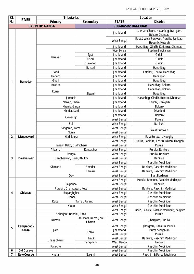
ANNUAL FLOOD REPORT, 2021
40
Sl. No.
RIVER Tributaries Location
Primary Secondary STATE District
BASIN 2B: GANGA SUB-BASIN: DAMODAR
1 Damodar
Jharkhand Latehar, Chatra, Hazaribag, Ramgarh,
Bokaro Dhanbad
West Bengal East & West Burdwan, Purulia, Bankura,
Hooghly, Howrah
Barakar
Jharkhand Hazaribag, Giridih, Kodarma, Dhanbad West Bengal Paschim Bardhaman
Igra Jharkhand Giridih
Ushri Jharkhand Giridih
Dumohon Jharkhand Giridih
Barsoti Jharkhand Hazaribag
Barki Jharkhand Latehar, Chatra, Hazaribag
Haharo Jharkhand Hazaribag
Ghari Jharkhand Hazaribag
Bokaro Jharkhand Hazaribag, Bokaro
Konar Jharkhand Hazaribag, Bokaro
Siwani Jharkhand Hazaribag
Jamunia Jharkhand Hazaribag, Giridih, Bokaro, Dhanbad
Naikari, Bhera Jharkhand Ranchi, Ramgarh
Khanjo, Garga Jharkhand Bokaro
Khadia, Katri Jharkhand Dhanbad
Gowai, Ijri Jharkhand Bokaro
West Bengal Purulia
Sali West Bengal Bankura
Singaran, Tamal West Bengal West Burdwan
Nunia West Bengal
2 Mundeswari Harinkhola West Bengal East Burdwan, Hooghly
3 Darakeswar
West Bengal Purulia, Bankura, East Burdwan, Hooghly
Futiary, Beko, Dudhibheria West Bengal Purulia
Arkasha Kansachor West Bengal Purulia, Bankura
Dangra West Bengal Purulia, Bankura
Gandheswari, Berai, Khukra West Bengal Bankura
Shankari
West Bengal Paschim Medinipur
Amodar West Bengal Bankura, Paschim Medinipur
Tarajuli West Bengal Bankura, Paschim Medinipur
Dev West Bengal East Burdwan
4 Shilabati
West Bengal Purulia, Bankura, Paschim Medinipur
Jaiponda West Bengal Bankura
Puratan, Champayan, Ketia West Bengal Bankura, Paschim Medinipur
Ruparghghra West Bengal Paschim Medinipur
Donai West Bengal Paschim Medinipur
Kubai Tamal, Parang West Bengal Paschim Medinipur
Katan West Bengal Paschim Medinipur
5 Kangsabati /
Kansai
West Bengal Purulia, Bankura, Paschim Medinipur, Jhargram
Saharjore, Bandhu, Patloi West Bengal Purulia
Kumari Hanumata, Kerro, Jore,
Charan West Bengal Jhargram, Purulia
Jam
West Bengal Jhargram, Bankura, Purulia
Tatko Jharkhand Purba Singbhum
West Bengal Purulia
Bhairabbanki Jhinuk West Bengal Bankura, Paschim Medinipur
Tarapheni West Bengal Jhargram
Kalaichu West Bengal Paschim Medinipur
6 Old Cossye West Bengal Paschim Medinipur
7 New Cossye Kherai Bakshi West Bengal Paschim & Purba Medinipur

ANNUAL FLOOD REPORT, 2021
41
Sl. No.
RIVER Tributaries Location
Primary Secondary STATE District
8
Rupnarayan
Kana Dwarakeswar West Bengal Hooghly, East Burdwan
Polashpai West Bengal Paschim Medinipur
Durbachaty West Bengal Purba Medinipur
10 Kaliaghai
West Bengal Paschim & Purba Medinipur
Kapaleswari, Deuli West Bengal Paschim Medinipur
Chandia West Bengal Paschim & Purba Medinipur
Baghai West Bengal Paschim & Purba Medinipur
11 Haldi West Bengal Purba Medinipur
12 Rasulpur West Bengal Purba Medinipur
13 Pichabani West Bengal Purba Medinipur
14 Negua Channel West Bengal Paschim & Purba Medinipur
BASIN 6: SUBARNAREKHA
1 Subarnarekha
Jharkhand Ranchi, Seraikela-Kharswan, Purba
Shingbhum
West Bengal Purulia, Jhargram, Paschim Medinipur
Odisha Balasore
Jhumur, Rupai Jharkhand Ranchi
Kakro Rarhu Jharkhand Ranchi
Karru Jharkhand Ranchi
West Bengal Purulia
Kanchi Jharkhand Ranchi
Damra Jharkhand Ranchi, Seraikela-Kharswan
Karkari Jharkhand Ranchi, Seraikela-Kharswan
Chinguru West Bengal Purulia
Jharkhand Seraikela-Kharswan
Kharkai
Bankabol, Khadkari, Kandria, Nesa, Burhai
Odisha Mayurbhanj
Torlo, Illgara, Roro, Sanjai
Jharkhand Paschim Shingbhum
Garra, Sankh, Kodia Jharkhand Purba Shingbhum
Gurma Jharkhand Purba Shingbhum
West Bengal Purulia
Singaduba Jharkhand Purba Shingbhum
West Bengal Paschim Medinipur Dulung, Khaijori West Bengal Jhargram
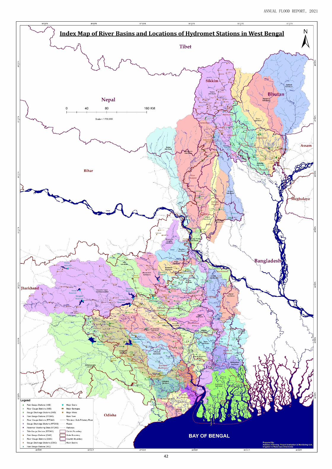
ANNUAL FLOOD REPORT, 2021
42

ANNUAL FLOOD REPORT, 2021
43
Annexure –III A) List of Existing Rain Gauge Stations under I. & W. Dept.
Sl. No.
Rain Gauge Station
Type Name of the River Sub-
basin District
Normal Annual Rainfall
(mm)
Division
1 Uttarbhag ORG Adi Ganga South 24 Parganas 2088.0 Metropolitan Drainage Mechanical Division.
2 Bahari ORG
Ajoy
Birbhum 1612.4 Mayurakshi South Canal Division
3 Bhedia ORG Purba Bardhaman 1315.2 Damodar Head Works Division
4 Debogram ORG Birbhum 1612.4 Mayurakshi South Canal Division
5 Nanur ORG Birbhum 1612.4 Mayurakshi South Canal Division
6 Satkahania ORG Paschim Bardhaman 1315.2 Damodar Head Works Division.
7 Sikatia ORG Deoghar 1162.1 Dy. Director (Dist. Plan)
8 Balurghat ORG Atrayi Dakshin Dinajpur 1584.9 South Dinajpur (I) Division
9 Salar ORG Babla Murshidabad 1391.1 Mayurakshi South Canal Division
10 Kadisala ORG Bakreswar Birbhum 1612.4 Mayurakshi South Canal Division
11 Balgona ORG Banka
Purba Bardhaman 1315.2 EE-II, Damador Canal Division
12 Sanko ORG Purba Bardhaman 1315.2 EE-I, Damodar Canal Division
13 Paikor ORG Bansloi Birbhum 1612.4 Mayurakshi North Canal Division
14 Berhampur ORG Bhagirathi-Hoogly
Murshidabad 1391.1 Berhampur (I) Division
15 Katwa ORG Purba Bardhaman 1315.2 EE-II, Damador Canal Division
16 Bhairab Banki Barrage
ORG Bhairab Banki Bankura 1535.5 Kangsabati Canal Division-V
17 Barasat ARG
Bidyadhari
North 24 Parganas 1560.8 Bidyadhari Drainage Division
18 Chowbhaga ORG South 24 parganas 2088.0 Metropolitan Drainage Mechanical Division.
19 Dum Dum RMC North 24 Parganas 1560.8 Dy. Director (Dist. Plan)
20 Md. Bazar ORG Brahmani
Birbhum 1612.4 Mayurakshi North Canal Division
21 Nalhati ORG Birbhum 1612.4 Mayurakshi North Canal Division
22 Barisha ORG Chandia Paschim Medinipur 1535.5 East Midnapur Division
23 Arsha ORG
Cossye
Purulia 1363.3 Purulia Const. Division
24 Purulia ORG Purulia 1363.3 Purulia(I) Division
25 Simulia ORG Purulia 1363.3 Bankura Irrigation Division
26 Tusuma ORG Purulia 1363.3 Bankura Irrigation Division
27 Amta ORG
Damodar
Howrah 1600.0 EE-I, Lower Damodar Construction Division
28 Antpur ORG Hooghly 1418.7 EE-I, Lower Damodar (I) Division
29 Asansol ORG Paschim Bardhaman 1315.2 Damodar Head Works Division
30 Champadanga ORG Hooghly 1418.7 EE-I, Lower Damodar (I) Division
31 Durgapur ORG Paschim Bardhaman 1315.2 Damodar Head Works Division
32 Galsi ORG Purba Bardhaman 1315.2 Dy. Director (Statistics)
33 Jamalpur ORG Purba Bardhaman 1418.7 EE-I, Lower Damodar (I) Division
34 Khandakosh ORG Purba Bardhaman 1315.2 Right Bank (I) Division
35 Lohai (Raina) ORG Purba Bardhaman 1315.2 Right Bank (I) Division
36 Maithon CWC Dhanbad 1355.2 Dy. Director (Dist. Plan)
37 Maliara ORG Bankura 1340.4 Right Bank (I) Division
38 Panchet CWC Dhanbad 1355.2 Dy. Director (Dist. Plan)
39 Para ORG Purulia 1363.3 Purulia I&P Division
40 Raghunathpur ORG Purulia 1363.3 Purulia Const. Division
41 Rondia ORG Purba Bardhaman 1315.2 Damodar Head Works Division
42 Tenughat CWC Bokaro 1247.5 Dy. Director (Dist. Plan)
43 Tilaiya CWC Damodar Koderma
1116.2 Dy. Director (Dist. Plan)

ANNUAL FLOOD REPORT, 2021
44
44 Uchalan ORG Bankura 1315.2 Right Bank (I) Division
45 Chandrakona ORG Donai Paschim Medinipur 1535.5 Kangsabati Canal Division-I
46 Lodhashuli ORG Dulung Jhargram 1535.5 Kangsabati Canal Division-V
47 Arambag ORG
Dwarakeswar
Hooghly 1418.7 Hooghly Irrigation Division
48 Bankura ORG Bankura 1330.9 Bankura Irrigation Division
49 Bowaichandi ORG Purba Bardhaman 1315.2 Right Bank (I) Division
50 Indus ORG Bankura 1340.4 Right Bank (I) Division
51 Kamarpukur ORG Hooghly 1418.7 Kangsabati Canal Division III
52 Kotolpur ORG Bankura 1330.9 Kangsabati Canal Division III
53 Salbandh ORG Bankura 1340.4 Right Bank (I) Division
54 Deocha Barrage ORG
Dwarka
Birbhum 1612.4 Mayurakshi North Canal Division
55 Mollarpur ORG Birbhum 1612.4 Mayurakshi North Canal Division
56 Rampurhat ORG Birbhum 1612.4 Mayurakshi North Canal Division
57 Singur ORG Ghea Hooghly 1418.7 EE-I, Lower Damodar (I) Division
58 Itamogra ORG Haldi Purba Medinipur 1669.6 Contai (I) Division
59 Hinglow Dam ORG Hinglow
Birbhum 1612.4 Mayurakshi South Canal Division
60 Khayrashole ORG Birbhum 1612.4 Mayurakshi South Canal Division
61 Alipore RMC Hooghly Kolkata 1709.2 Dy. Director (Dist. Plan)
62 Bongaon ORG Ichamati
North 24 Parganas 1559.8 Bidyadhari Drainage Division
63 Tentulia ORG North 24 Parganas 1560.8 Basirhat Irrigation Division
64 Swarupganj ORG Jalangi Nadia 1261.6 Nadia (I) Division
65 Banarhat ORG Jaldhaka
Jalpaiguri 3463.0 Jalpaiguri (I) Division
66 Mainaguri ORG Jalpaiguri 3463.3 Jalpaiguri (I) Division
67 Amgachia ORG Kaliaghai
Purba Medinipur 1669.6 Contai (I) Division
68 Kesiapata ORG Jhargram 1535.5 Kangsabati Canal Division-V
69 Jhargram ORG
Kangsabati
Paschim Medinipur 1535.5 Kangsabati Canal Division-V
70 Manikpara ORG Jhargram 1535.5 Kangsabati Canal Division-V
71 Midnapore ARG Paschim Medinipur 1535.5 West Midnapur Division
72 Mohanpur ORG Paschim Medinipur 1535.5 West Midnapur Division
73 Mukutmanipur ORG Bankura 1330.9 Bankura Irrigation Division
74 Sabang ORG Kapaleswari Paschim Medinipur 1535.5 Kaliaghai-Kapaleswari-Baghai Project Div.
75 Dhaniakhali ARG Khari-Behula-Ghea
Hooghly 1418.7 Dy. Director (Dist. Plan)
76 Memari ORG Purba Bardhaman 1418.7 EE-I, Lower Damodar (I) Division
77 Kultore Barrage ORG Kopai
Birbhum 1612.4 Mayurakshi South Canal Division
78 Shyambati ORG Birbhum 1612.4 Mayurakshi South Canal Division
79 Adalia ORG Kubai Paschim Medinipur 1535.5 Kangsabati Canal Division-I
80 Kirnahar ORG Kuia Birbhum 1612.4 Mayurakshi South Canal Division
81 Balarampur ORG
Kumari
Purulia 1363.3 Purulia(I) Division
82 Kharidwar ORG Purulia 1363.3 Bankura Irrigation Division
83 Phulberia ORG Purulia 1363.3 Bankura Irrigation Division
84 Purihansa ORG Purulia 1363.3 Bankura Irrigation Division
85 Gushkara ORG Kunur Purba Bardhaman 1315.2 Damodar Head Works Division
86 English Bazar ORG
Mahananda
Malda 1419.4 Malda (I) Division
87 Islampur ORG Uttar Dinajpur 1727.6 North Dinajpur (I) Division
88 Raiganj ORG Uttar Dinajpur 1727.6 North Dinajpur (I) Division
89 Siliguri ORG Darjeeling 3118.5 Siliguri (I) Division
90 Malbazar ORG Mal Jalpaiguri 3463.3 Jalpaiguri (I) Division
91 Mathabhanga ORG Mansai Coochbehar 3443.7 Coochbehar (I) Division
92 Haripur ORG Mayurakshi Dumka 1381.5 Mayurakshi Headquarter Division

ANNUAL FLOOD REPORT, 2021
45
93 Kandi ORG Murshidabad 1391.1 Berhampur (I) Division
94 Khushiary ORG Dumka 1381.5 Mayurakshi Headquarter Division
95 Maharo ORG Dumka 1381.5 Mayurakshi Headquarter Division
96 Massanjore ORG Dumka 1381.5 Mayurakshi Headquarter Division
97 Narayanpur ARG Murshidabad 1391.1 Berhampur (I) Division
98 Suri ORG Birbhum 1381.5 Mayurakshi Headquarter Division
99 Tilpara Barrage ORG Birbhum 1612.4 Mayurakshi Headquarter Division
100 Raina ORG Mundeswari
Purba Bardhaman 1315.2 Right Bank (I) Division
101 Sehera Bazar ORG Purba Bardhaman 1330.9 Right Bank (I) Division
102 Panskura ORG New Cossye Purba Medinipur 1669.6 East Midnapur Division
103 Gangarampur ORG Punarbhaba Dakshin Dinajpur 1584.9 South Dinajpur (I) Division
104 Tufanganj ORG Raidak-I Coochbehar 3443.7 Coochbehar (I) Division
105 Contai CWC Rasulpur Purba Medinipur 1669.6 Contai (I) Division
106 Ghatal ORG Rupnarayan
Paschim Medinipur 1535.5 West Midnapur Division
107 Tamluk ORG Purba Medinipur 1669.6 East Midnapur Division
108 Barabisha CWC Sankosh Alipurduar 3463.3 Dy. Director (Dist. Plan)
109 Domjur ORG Saraswati Howrah 1600.0 EE-I, Lower Damodar Construction Division
110 Kantabandh ORG Shali
Bankura 1340.4 Right Bank (I) Division
111 Sonamukhi ORG Bankura 1330.9 Right Bank (I) Division
112 Amlagora ORG Shilabati
Paschim Medinipur 1535.5 Kangsabati Canal Division-I
113 Panikotar ORG Paschim Medinipur 1535.5 Kangsabati Canal Division-I
114 Tantloi ORG Siddheswari Dumka 1381.5 Mayurakshi Headquarter Division
115 Baghmundi ORG
Subarnarekha
Purulia 1363.3 Purulia(I) Division
116 Digha ORG Purba Medinipur 1669.6 Contai (I) Division
117 Gopiballavpur ORG Jhargram 1535.5 Jhargram Flood Management & Planning Div.
118 Jhalda ORG Purulia 1363.3 Purulia(I) Division
119 Sagar Island AWS Sundarban
Area South 24 Parganas 2088.0 Dy. Director (Dist. Plan)
120 Salboni ORG Tamal Paschim Medinipur 1535.5 Kangsabati Canal Division-I
121 Tarapheni Barrage
ORG Tarapheni Jhargram 1535.5 Kangsabati Canal Division-V
122 Darjeeling RMC
Teesta
Darjeeling 3118.5 Dy. Director (Dist. Plan)
123 Gangtok RMC East Sikkim 2739.0 Dy. Director (Dist. Plan)
124 Jalpaiguri ORG Jalpaiguri 3463.3 Jalpaiguri (I) Division
125 Alipurduar ORG
Torsa
Alipurduar 3463.3 Alipurduar (I) Division
126 Coochbehar ORG Coochbehar 3443.7 Coochbehar (I) Division
127 Hasimara ORG Alipurduar 3463.3 Alipurduar (I) Division
*ORG: Ordinary Rain Gauge (I&WD); ARG: Automatic Rain Gauge (IMD); AWS: Automatic Weather Station
(IMD); RMC: Regional Meteorological Centre (IMD, Kolkata); CWC: Rain Gauge of Central Water Commission.

ANNUAL FLOOD REPORT, 2021
46
Annexure –III B) List of Existing River Gauge Stations under I. & W. Dept.
Sl. No.
River Gauge Station
Name of the River Sub-
basin
Danger Level
(Metre)
Extreme Danger Level
(Metre)
District Division
1 Budra
Ajoy
39.42 40.34 Purba Bardhaman Damodar Head Works Division
2 Gheropara 39.42 40.42 Birbhum Mayurakshi South Canal Division
3 Katwa 14.48 15.04 Purba Bardhaman EE-II, Damador Canal Division
5 Balurghat Atrayi 23.15 23.76 Dakshin Dinajpur South Dinajpur (I) Division
6 Bazarshow Babla 15.02 15.65 Murshidabad Mayurakshi South Canal Division
7 Bansloi Rail bridge Bansloi 31.85 32.76 Birbhum Mayurakshi North Canal Division
8 Berhampur
Bhagirathi-Hoogly
17.22 17.83 Murshidabad Berhampur (I) Division
9 Kalna 7.63 8.24 Purba Bardhaman EE-II, Damador Canal Division
10 Katwa 13.71 14.32 Purba Bardhaman EE-II, Damador Canal Division
11 Swarupganj 8.44 9.05 Nadia Nadia (I) Division
12 Jagdhari Road Bridge
Brahmani 33.00 33.40 Birbhum Mayurakshi North Canal Division
13 Barisha Chandia 4.55 5.00 Paschim Medinipur East Midnapur Division
14 Hanskhali Churni 7.53 8.14 Nadia Nadia (I) Division
15 Champadanga
Damodar
12.90 13.50 Hooghly EE-I Lower Damodar (I) Division
16 Edilpur 32.79 32.95 Purba Bardhaman EE-I Damodar canal division
17 Giara 16.16 16.77 Hooghly EE-I Lower Damodar (I) Division
18 Jamalpur 23.24 23.54 Purba Bardhaman EE-I Lower Damodar (I) Division
19 Rondiha 52.13 52.89 Purba Bardhaman Damodar Head Works Division
20 Chopra Dauk 69.46 70.07 Uttar Dinajpur North Dinajpur (I) Division
21 Chengmari Diana 200.50 201.20 Jalpaiguri Jalpaiguri (I) Division
22 Khanyadihi Durbachati 5.03 5.65 Purba Medinipur East Midnapur Division
23 Arambag
Dwarakeswar
17.22 17.83 Hooghly Hooghly Irrigation Division
24 Bankura 76.50 77.11 Bankura Bankura Irrigation Division
25 Patakhola 76.50 77.11 Bankura Bankura Irrigation Division
26 Shakepore 11.75 12.35 Hooghly Hooghly Irrigation Division
27 Ranagram Dwarka
17.36 17.86 Murshidabad Berhampur (I) Division
28 Sankoghat 20.40 21.30 Murshidabad Berhampur (I) Division
29 Teljana Fulhar 27.43 28.35 Malda Malda (I) Division
30 Itahar Gamari 26.82 27.41 Uttar Dinajpur North Dinajpur (I) Division
31 Manikchakghat Ganga 24.69 25.30 Malda Malda (I) Division
32 Akheriganj
Ganga-Padma
18.44 19.05 Murshidabad Berhampur (I) Division
33 Geria 20.94 21.55 Murshidabad Ganga Anti Erosion Division-I
34 Nimtita 21.90 22.51 Murshidabad Ganga Anti Erosion Division-I
35 Nurpur 21.03 21.64 Murshidabad Ganga Anti Erosion Division-I
36 Muchighata Hurhura khal 6.16 6.77 Howrah EE-I, Lower Damodar Construction Division
37 RD Setu (Bangaon) Ichamati
4.70 5.25 North 24 Parganas Bidyadhari Drainage Division
38 Tentulia 5.10 5.40 North 24 Parganas Basirhat Irrigation Division
39 Nagrakata Jaldhaka
160.70 161.80 Jalpaiguri Jalpaiguri (I) Division
40 NH 31 Crossing 80.10 80.90 Jalpaiguri Jalpaiguri (I) Division
41 Gaighata Jamuna
4.45 5.05 North 24 Parganas Bidyadhari Drainage Division
42 Gobardanga 4.30 4.90 North 24 Parganas Bidyadhari Drainage Division
43 Amgachia
Kaliaghai
5.79 6.40 Purba Medinipur Contai (I) Division
44 Bhakrabad 8.40 8.85 Paschim Medinipur Kaliaghai-Kapaleswari-Baghai Project Div.
45 Dehati 6.55 7.00 Paschim Medinipur Kaliaghai-Kapaleswari-Baghai Project Div.
46 Kalimondop 5.03 5.65 Paschim Medinipur Kaliaghai-Kapaleswari-Baghai Project Div.
47 Alipurduar Kaljani 45.10 45.70 Alipurduar Alipurduar (I) Division
48 Mohanpur Kangsabati 25.75 26.36 Paschim Medinipur West Midnapur Division

ANNUAL FLOOD REPORT, 2021
47
Sl. No.
River Gauge Station
Name of the River Sub-
basin
Danger Level
(Metre)
Extreme Danger Level
(Metre)
District Division
49 Narayanbarh Kapaleswari 5.33 5.94 Paschim Medinipur Kaliaghai-Kapaleswari-Baghai Project Div.
50 Angarpur Kuia
19.05 20.05 Murshidabad Mayurakshi South Canal Division
51 Tarapur 22.71 23.35 Murshidabad Berhampur (I) Division
52 Railway Bridge Kulick 31.20 32.69 Uttar Dinajpur North Dinajpur (I) Division
54 Hill Curt Road Mahananda
115.98 116.59 Darjeeling Siliguri (I) Division
55 Sonapur 75.77 76.38 Uttar Dinajpur North Dinajpur (I) Division
56 Mathabhanga Mansai 47.70 48.20 Coochbehar Coochbehar (I) Division
57 Majdia Mathabhanga 7.82 8.43 Nadia Nadia (I) Division
58 Narayanpur Mayurakshi 27.99 28.79 Murshidabad Berhampur (I) Division
59 Makdampur Nagar 31.54 31.86 Uttar Dinajpur North Dinajpur (I) Division
60 Dobandi New Cossye
5.02 5.63 Purba Medinipur East Midnapur Division
61 Panskura 9.29 9.90 Purba Medinipur East Midnapur Division
62 Kalmijole Old Cossye 9.29 9.90 Paschim Medinipur West Midnapur Division
63 Gangarampur Punarbhaba 25.82 26.42 Dakshin Dinajpur South Dinajpur (I) Division
64 LRP Crossing Raidak-I
47.00 47.90 Alipurduar Alipurduar (I) Division
65 Tufanganj 35.30 35.90 Coochbehar Coochbehar (I) Division
66 LRP Crossing Raidak-II 48.40 49.30 Alipurduar Alipurduar (I) Division
67 Bandar
Rupnarayan
6.85 7.46 Paschim Medinipur West Midnapur Division
68 Denan 4.42 5.02 Purba Medinipur East Midnapur Division
69 Gopiganj 5.03 5.65 Paschim Medinipur West Midnapur Division
70 Ranichak 5.33 5.94 Paschim Medinipur West Midnapur Division
71 LRP Crossing Sankosh 48.50 49.40 Alipurduar Alipurduar (I) Division
72 Banka Shilabati
15.08 15.69 Paschim Medinipur West Midnapur Division
73 Gadghat 8.99 9.60 Paschim Medinipur West Midnapur Division
74 Gopiballavpur Subarnarekha
45.50 46.50 Jhargram Jhargram Flood Management & Planning Div.
75 Sonakonia 16.15 16.75 Paschim Medinipur Contai (I) Division
76 Kachua Sui
25.49 26.09 Uttar Dinajpur North Dinajpur (I) Division
77 Pajol 27.43 28.00 Uttar Dinajpur North Dinajpur (I) Division
78 Bansihari Tangon
25.60 26.21 Dakshin Dinajpur South Dinajpur (I) Division
79 Radhikapur 33.45 34.05 Uttar Dinajpur North Dinajpur (I) Division
80 Coronation Bridge
Teesta
150.00 153.60 Darjeeling Jalpaiguri (I) Division
81 Domohani 85.95 86.30 Jalpaiguri Jalpaiguri (I) Division
82 Mekhliganj 65.95 66.30 Coochbehar Jalpaiguri (I) Division
83 Coochbehar Torsa
42.07 42.68 Coochbehar Coochbehar (I) Division
84 Hasimara 116.30 117.50 Alipurduar Alipurduar (I) Division

ANNUAL FLOOD REPORT, 2021
48
Annexure –III C) List of Existing Dam Barrage Monitoring Stations under I. & W. Dept.
Sl. No.
Dam / Barrage Name of the River
Sub-basin
Conservation / Pond Level
(ft.)
Maximum Flood
Level (ft.) District Division
1 Chandil Dam Subarnarekha 630.00 630.00 Kolkata Dy. Director (Dist. Plan)
2 Durgapur Barrage Damodar 211.50 211.50 Paschim Bardhaman Damodar Head Works Division
3 Galudih Barrage Subarnarekha 302.00 332.00 Kolkata Dy. Director (Dist. Plan)
4 Hinglow Dam Hinglow 321.00 324.00 Birbhum Mayurakshi South Canal Division
5 Mahananda Barrage Mahananda 352.00 352.00 Darjeeling Mahananda Barrage Division
6 Maithon Dam Damodar 480.00 495.00 Paschim Bardhaman Damodar Head Works Division
7 Massanjore Dam Mayurakshi 398.00 398.00 Birbhum Mayurakshi Headquarter Division
8 Mukutmonipur Dam Kangsabati 434.00 440.00 Bankura Kangsabati Canal Division No.-II
9 Panchet Dam Damodar 410.00 425.00 Paschim Bardhaman Damodar Head Works Division
10 Sikatia Barrage Ajay 558.00 559.70 Kolkata Dy. Director (Dist. Plan)
11 Teesta Barrage Teesta 375.00 378.30 Jalpaiguri Teesta Barrage Division
12 Tenughat Dam Damodar 852.00 864.00 Paschim Bardhaman Damodar Head Works Division
13 Tilpara Barrage Mayurakshi 206.00 206.00 Birbhum Mayurakshi Headquarter Division
D) List of Existing River Gauge Discharge Stations under I. & W. Dept.
Sl. No.
River Gauge Discharge Station
Name of the River / Channel
Danger Level
(Metre)
Extreme Danger Level
(Metre)
District Division
1 Amuliaghat Ajoy 104.73 105.33 Purba Bardhaman Burdwan Inv. & Planning Division
2 Amta Amta Channel 5.64 6.24 Howrah EE-I, I.& P. Division. (South)
3 Champadanga Lower Damodar 12.90 13.50 Hooghly EE-I, I.& P. Division. (South)
4 Kapastikri Kangsabati 16.00 16.60 Nadia Dy. Director (Statistics)
5 Englishbazar Mahananda 21.00 21.75 Malda Malda (I) Division
6 Harinkhola Mundeswari 12.80 13.41 Paschim Medinipur EE-I, I.& P. Division. (South)
7 Sehagori Short Cut Channel 5.10 5.70 Howrah EE-I, I.& P. Division. (South)

ANNUAL FLOOD REPORT, 2021
49
Annexure –III E) List of Proposed RTDAS Stations under NHP (Phase-I)
Sl. Rain Gauge Site River Sub basin District Latitude (N) Longitude E) Sensor Remarks
1 Banarhat Jaldhaka Jalpaiguri 26.794000 89.02525 ARG
2 Dalkhola Mahananda North Dinajpur 25.819648 87.92152 ARG New Site
3 Karnajora Kulik North Dinajpur 25.642981 88.136773 ARG New Site
4 Balurghat Atreyee South Dinajpur 25.24033 88.78315 ARG
5 Bishnupur Dwarakeswar Bankura 23.080000 87.320000 ARG New Site
6 Indus Dwarakeswar Bankura 23.150587 87.621309 ARG
7 Kenduadihi Dwarakeswar Bankura 23.230267 87.050337 ARG
8 Taldangra Shilabati Bankura 22.999655 87.099753 ARG
9 Shyambati Kopai Birbhum 23.694512 87.681606 ARG
10 Paikar Pagla Birbhum 24.432831 87.910331 ARG
11 Satkahania Ajay Paschim Burdwan 23.596498 87.500395 ARG
12 Memari Behula Purba Burdwan 23.173334 88.095281 ARG
13 Galsi Damodar Purba Burdwan 23.344731 87.682500 AWS
14 Manteswar Khari Purba Burdwan 23.306178 88.136978 ARG New Site
15 Gushkara Kunur Purba Burdwan 23.482142 87.720728 ARG
16 Raina Mundeswari Purba Burdwan 23.002687 87.858034 ARG
17 Champadanga Damodar Hooghly 22.836581 87.970381 ARG
18 Arambag Dwarakeswar Hooghly 22.889978 87.779453 ARG
19 Singur Ghea Hooghly 22.820612 88.224939 ARG
20 Amta Amta Channel Howrah 22.572492 88.001253 ARG
21 Domjur Saraswati Howrah 22.649848 88.191212 ARG
22 Salar Babla Murshidabad 23.771800 88.11129 ARG
23 Kandi Mayurakshi Murshidabad 23.951253 88.041917 ARG
24 Swarupganj Bhagirathi Nadia 23.415383 88.390032 ARG
25 Majdiha Bhagirathi Nadia 23.404031 88.712432 ARG
26 Salt Lake Bidyadhari North 24 Parganas 22.590617 88.417589 AWS New Site
27 Tentulia Ichamati North 24 Parganas 22.789750 88.854534 ARG
28 Hijli Kaliaghai Paschim Medinipur 22.302765 87.303007 ARG New Site
29 Sabang Kaliaghai Paschim Medinipur 22.173553 87.599134 ARG
30 Ghatal Rupnarayan Paschim Medinipur 22.664131 87.738594 ARG
31 Amlagora Shilabati Paschim Medinipur 22.847276 87.33489 ARG
32 Chandrakona Shilabati Paschim Medinipur 22.732016 87.516456 ARG New Site
33 Pirorgari Shilabati Paschim Medinipur 22.856260 87.001822 ARG New Site
34 Salboni Shilabati Paschim Medinipur 22.642119 87.318483 ARG New Site
35 Kesiapata Subarnarekha Paschim Medinipur 22.208892 87.133575 ARG
36 Itamogra Haldi Purba Medinipur 22.113286 87.945075 ARG
37 Panskura Kangsabati Purba Medinipur 22.395875 87.712793 ARG
38 Egra Pichabani Purba Medinipur 21.900021 87.537202 ARG New Site
39 Itaberia Rasulpur Purba Medinipur 21.998417 87.670433 ARG New Site
40 Ramchandrapur Damodar Purulia 23.586845 86.826762 ARG New Site
41 Kashipur Dwarakeswar Purulia 23.434136 86.667866 ARG New Site
42 Kenda Kangsabati Purulia 23.195514 86.515855 ARG New Site
43 Tatko Kangsabati Purulia 22.929089 86.512748 AWS New Site
44 Uttarbhag Sundarban South 24 Parganas 22.343076 88.514740 ARG
1 Hinglow Dam Hinglow Birbhum 23.822585 87.193983 AWLR with Gate sensor 2 Kangsabati Dam Kangsabati Bankura 22.965221 86.786532 AWLR with Gate sensor

ANNUAL FLOOD REPORT, 2021
50
Sl. River Gauge Site River/ Tributary District Latitude (N) Longitude (E) Type of site Sensor Remarks
1 Alipurduar Kaljani Alipurduar 26.480157 89.515881 Road Bridge Radar
2 NH-31D Crossing Mujnai Alipurduar 26.519988 89.170432 Road Bridge Radar New Site
3 Coochbehar Torsa Coochbehar 26.285950 89.458847 Road Bridge Radar
4 Dharla Aqueduct Dharla Jalpaiguri 26.691721 88.736939 Hydraulic Str. Radar New Site
5 Hill Curt Road Mahananda Darjeeling 26.719813 88.419856 Road Bridge Radar
6 Raiganj Kulik Uttar Dinajpur 25.619053 88.115633 Road Bridge Radar
7 Makdampur Nagar Uttar Dinajpur 25.708746 88.046213 Road Bridge Radar
8 Balurghat Atreyee Dakshin Dinajpur 25.224993 88.776686 Road Bridge Radar
9 Gangarampur Punarbhaba Dakshin Dinajpur 25.405853 88.514005 Road Bridge Radar
10 Bansihari Tangon Dakshin Dinajpur 25.395988 88.416242 Road Bridge Radar
11 Englishbazar Mahananda Malda 24.986039 88.147669 Road Bridge Radar
12 Bankura Dwarakeswar Bankura 23.212857 87.076035 Road Bridge Radar New Site
13 Bankura Gandheswari Bankura 23.237074 87.084168 Road Bridge Radar New Site
14 Illambazar Ajay Birbhum 23.615138 87.531678 Road Bridge Radar New Site
15 Bansloi Road Bridge
Bansloi Birbhum 24.479712 87.861192 Road Bridge Radar
16 Paikar Pagla Birbhum 24.436354 87.898999 Road Bridge Radar New Site
17 Katwa Ajay Purba Burdwan 23.654644 88.134791 Road Bridge Radar
18 Burdwan Damodar Purba Burdwan 23.211614 87.848477 Road Bridge Radar New Site
19 Randiha Weir Damodar Paschim Burdwan 23.372641 87.475325 Hydraulic Str. Radar New Site
20 Guskara Kunur Purba Burdwan 23.49849 87.7438 Road Bridge Radar New Site
21 Champadanga Damodar Hooghly 22.840060 87.969621 Road Bridge Radar
22 Arambag Dwarakeswar Hooghly 22.887077 87.775808 Road Bridge Radar
23 Muchighata Hurhura Hooghly 22.635565 87.899648 Road Bridge Radar New Site
24 Amta Amta Channel Howrah 22.573748 87.998360 Road Bridge Radar
25 Bakshi Short Cut Channel
Howrah 22.531268 87.897570 Road Bridge Radar New Site
26 Bazarshow Babla Murshidabad 23.839826 88.161673 River Bank Radar
27 Berhampore Bhagirathi Murshidabad 24.100453 88.245508 Road Bridge Radar
28 Sankoghat Dwarka Murshidabad 24.156715 88.017284 Road Bridge Radar
29 Ranagram Dwarka Murshidabad 24.016806 88.093360 Road Bridge Radar
30 Tarapur Kuia Murshidabad 23.839406 87.968376 Road Bridge Radar
31 Hanskhali Churni Nadia 23.355547 88.607073 Road Bridge Radar
32 Swarupganj Hooghly Nadia 23.385263 88.367727 River Bank Radar
33 Krishnanagar Jalangi Nadia 23.413683 88.471300 Road Bridge Radar New Site
34 Ghusighata Bidyadhari North 24 Parganas 22.524207 88.687412 Road Bridge Radar New Site
35 Gaighata Jamuna North 24 Parganas 22.931127 88.732460 Road Bridge Radar
36 Tentulia Ichamati North 24 Parganas 22.787288 88.852451 Road Bridge Radar
37 Barisha Chandia Paschim Medinipur 22.245505 87.703644 Road Bridge Radar
38 Khukurdah Durbachati Paschim Medinipur 22.473935 87.750782 Road Bridge Radar New Site
39 Dehati Kaliaghai Paschim Medinipur 22.090965 87.495089 Road Bridge Radar
40 Sal Dahari Kangsabati Paschim Medinipur 22.488876 87.558162 River Bank Radar New Site
41 Khirpai Ketia Paschim Medinipur 22.720523 87.602071 Road Bridge Radar New Site
42 Kapastikri Old Cossye Paschim Medinipur 22.498421 87.558884 River Bank Radar New Site
43 Tabageria New Cossye Paschim Medinipur 22.484145 87.579123 River Bank Radar New Site
44 Goura Palashpai Paschim Medinipur 22.527944 87.746223 Road Bridge Radar New Site
45 Bandar Rupnarayan Paschim Medinipur 22.664589 87.783971 River Bank Radar
46 Banka Shilabati Paschim Medinipur 22.727636 87.577081 Road Bridge Radar
47 Garhbeta Shilabati Paschim Medinipur 22.886163 87.361286 Road Bridge Radar New Site
48 Ghatal Shilabati Paschim Medinipur 22.661713 87.731618 Road Bridge Radar New Site
49 Narghat Haldi Purba Medinipur 22.135447 87.890932 Road Bridge Radar New Site
50 Moyna New Cossye Purba Medinipur 22.248224 87.798520 Road Bridge Radar New Site
51 Panskura New Cossye Purba Medinipur 22.395875 87.712793 Road Bridge Radar
52 Kalinagar Rasulpur Purba Medinipur 21.916866 87.786026 Road Bridge Radar New Site
53 Petuaghat Rasulpur Purba Medinipur 21.795455 87.881636 River Bank Radar New Site
54 Budhpur Cossye Purulia 23.105106 86.661912 Road Bridge Radar New Site
55 Dabra Kumari Purulia 23.047784 86.561858 Road Bridge Radar New Site
56 Diamond harbour Hooghly South 24-Pargans 22.193544 88.181347 River Bank Radar New Site

ANNUAL FLOOD REPORT, 2021
51
Annexure –III F) List of Proposed Dam Barrage RTDAS Stations under NHP (Phase-II)
Sl. Name of the Site River/ Tributary District Latitude (N) Longitude (E) Sensor Type(s)
1 Saharajore Dam Saharajore Purulia 23.3162417 86.0542556 AWLR ARG
2 Kumari Dam Kumari Purulia 23.1564778 86.2846111 AWLR ARG
3 Tatko Dam Tatko Purulia 22.92900556 86.51275278 AWLR
4 Barabhum Dam Kerro Purulia 23.0320306 86.3087611 AWLR ARG
5 Hanumata Dam Hanumata Purulia 23.1105694 86.2643167 AWLR
6 Kestobazar Dam Kistobazar Purulia 23.182721 86.086156 AWLR
7 Tara Dam Tara Purulia 23.2433778 86.3486806 AWLR ARG
8 Sankha Dam Sankha Purulia 23.123191 86.15222 AWLR
9 Fakidih Dam Nimijore Purulia 23.340085 85.941618 AWLR
10 Parga Dam Parga Purulia 23.4376556 86.0820278 AWLR ARG
11 Buridumur Dam Buridumur Purulia 23.308984 86.103979 AWLR ARG
12 Golamarajore Dam Golamarajore Purulia 23.4274444 86.3650667 AWLR ARG
13 Patloi Dam Patloi Purulia 23.3622583 86.4838472 AWLR
14 Dimu Dam Dimu Purulia 23.424883 85.980239 AWLR
15 Turga Dam Turga Purulia 23.1978917 86.0626389 AWLR ARG
16 Khairabera Dam Khairabera Purulia 23.2637361 86.0052861 AWLR AWS
17 Dangra Dam Dangra Purulia 23.4529111 86.7832278 AWLR ARG
18 Majra Dam Majrajore Purulia 23.386448 86.62844 AWLR
19 Bandajore Dam Bandajore Purulia 23.603415 86.560724 AWLR ARG
20 Fuljore Dam Fuljore Purulia 23.233175 86.2290472 AWLR
21 Taragonia Dam Taragoniajore Purulia 23.4780083 86.3875889 AWLR
22 Moutorejore Dam Moutorejore Purulia 23.5801778 86.5870222 AWLR ARG
23 Lipaniajore Dam Lipaniajore Purulia 23.4669528 86.4601111 AWLR AWS
24 Futiary Dam Futiary Purulia 23.3845583 86.5672833 AWLR
25 Beko Dam Beko Purulia 23.4778389 86.6286056 AWLR ARG
26 Ramchandrapur Dam Muchkunda Purulia 23.5876167 86.8376778 AWLR
27 Rupai Dam Rupai Purulia 23.3100083 85.9213306 AWLR
28 Karrior Dam Karrior Purulia 23.4251222 85.9456861 AWLR
29 ExtnBandhu Dam Bandhu Purulia 23.302029 86.195946 AWLR ARG
30 Kansai Dam Kansai Purulia 23.4188278 86.0302 AWLR
31 Sali Dam Sali Bankura 23.4054333 87.0853889 AWLR ARG
32 Maliarajore Dam Maliarajore Bankura 23.4494611 87.19975 AWLR ARG
33 Puinala Dam Puinala Paschim Bardhaman 23.775587 86.971121 AWLR
34 Bara Mandira Dam Baramandira Paschim Bardhaman 23.832875 86.9544111 AWLR
35 Nachan Dam Nachan Paschim Bardhaman 23.6172611 87.3215056 AWLR
36 Deocha Barrage Dwarka Birbhum 24.040025 87.59495 AWLR
37 Baidhara Barrage Brahmani Birbhum 24.251252 87.739034 AWLR ARG
38 Kultore Barrage Kopai Birbhum 23.728264 87.506661 AWLR AWS
39 Khanpur Barrage Kuye Birbhum 23.8048611 87.8970278 AWLR
40 Uparkhara Barrage Kana Ajay Birbhum 23.6150306 87.7457083 AWLR
41 Kadamdeuli Barrage Shilabati Bankura 23.1013028 86.8634528 AWLR
42 Bhairab Banki Barrage Bhairab Banki Bankura 22.764825 86.8245083 AWLR AWS
43 Tarafeni Barrage Tarafeni Jhargram 22.6718889 86.792675 AWLR ARG
44 Mahananda Barrage Mahananda Jalpaiguri 26.645126 88.400538 AWLR ARG
45 Karatowa Talma Barrage Karatowa Jalpaiguri 26.639125 88.496803 AWLR
46 Dauk Barrage Dauk Uttar Dinajpur 26.401805 88.376217 AWLR
47 Berai Weir Berai Bankura
23.092564 87.176453 AWLR

ANNUAL FLOOD REPORT, 2021
52
Annexure –IV G) List of Proposed Additional RTDAS Stations under NHP (Phase-III)
Sl. Name of the
site River /
Tributary Gauge Type
District / Taluka
Latitude (N)
Longitude (E)
Site Location Sensor Type*
Remarks
1 Mirik Mahananda Rain
Gauge Darjeeling 26.888160 88.186720 PWD-Roads Rest shed ARG New
2 Itahar Mahananda Rain
Gauge Uttar Dinajpur 25.451104 88.172672
Itahar Block Office Premises
ARG
3 Mallikpur Punarbhaba Rain
Gauge Dakshin Dinajpur
25.509963 88.569652 Govt. Premises (BSF) ARG New
4 Bhaluka Fulahar Rain
Gauge Malda 25.278866 87.880474 Govt Premises (I&WD) ARG
5 Jangipur Bhagirathi Rain
Gauge Murshidabad 24.465546 88.068915
I & W Dte. Office Premises
ARG
6 Kadamdeuli Silabati Rain
Gauge Bankura 23.100118 86.864475
Sec. Office of Barrage, I&WD
ARG
7 Bakhrabad Kaliaghai Rain
Gauge Paschim Medinipur
22.116294 87.370680 Govt. Premises (GP
Office) ARG
8 Raidighi Raidighi Rain
Gauge South 24 Parganas
21.998686 88.441926 Govt. Premises ARG
9 Gosaba Bidya Rain
Gauge South 24 Parganas
22.171808 88.803347 Gosaba Irr. Sub-Div. ARG
10 Basanti Sundarban Rain
Gauge South 24 Parganas
22.197060 88.713458 Govt Premises ARG
11 English Bazar Mahananda Gauge
Discharge Malda 24.984297 88.150206 Road Bridge AFM New
12 Nakkati Bridge Fulahar Gauge
Discharge Malda 25.245087 87.861989 Road Bridge AFM New
13 Kalyani Bhagirathi Gauge
Discharge Nadia 22.967148 88.407206 Iswar Gupta Setu AFM New
14 Laghata Kuia Gauge
Discharge Birbhum 23.806019 87.819267 Laghata Bridge AFM New
15 Bankura Darakeswar Gauge
Discharge Bankura 23.212857 87.076035 Road Bridge (NH 14) AFM New
16 Belut Shali River Gauge
Discharge Bankura 23.230382 87.584232 Road Bridge AFM New
17 Asansol
Dhanbad NH Barakar
Gauge Discharge
Paschim Bardhaman
23.766014 86.825526 Road Bridge (NH 19) AFM New
18 Disergarh
Bridge Damodar
Gauge Discharge
Paschim Bardhaman
23.684485 86.823237 Road Bridge AFM New
19 Pandaweswar Ajoy Gauge
Discharge Paschim
Bardhaman 23.733112 87.278529 Road Bridge (NH 14) AFM New
20 Budra Ajoy Gauge
Discharge Purba
Bardhaman 23.618055 87.702148 Road Bridge (NH 2B) AFM New
21 Jamalpur Damodar Gauge
Discharge Purba
Bardhaman 23.068315 87.987929 Road Bridge AFM New
22 Kolaghat Rupnarayan Gauge
Discharge Purba
Medinipur 22.438348 87.880435 Sarat Setu (NH 6) AFM New
23 Muchighata Hurhura Khal Gauge
Discharge Hooghly 22.635565 87.899648 Road Bridge AFM New
24 Harinkhola Mundeswari Gauge
Discharge Hooghly 22.838311 87.903269 SH-2 Bridge AFM New
25 Sehagori Short-cut Channel
Gauge Discharge
Howrah 22.586448 87.968046 Road Bridge AFM New
26 Buxi Buxi Khal Gauge
Discharge Howrah 22.531319 87.897505 Buxi Bridge AFM New
27 Satpota Lower Rampur
Khal Gauge
Discharge Howrah 22.589710 87.948080 Road Bridge AFM New
28 Amta Amta Channel Gauge
Discharge Howrah 22.573748 87.998360 Road Bridge AFM New

ANNUAL FLOOD REPORT, 2021
53
Sl. Name of the
site River /
Tributary Gauge Type
District / Taluka
Latitude (N)
Longitude (E)
Site Location Sensor Type*
Remarks
29 Bokpota Amta Channel Gauge
Discharge Howrah 22.722550 87.990300 Road Bridge AFM New
30 Dudhia Balason River
Gauge Darjeeling 26.821710 88.242100 Road Bridge AWLR New
31 Gulma Mahananda River
Gauge Darjeeling 26.806312 88.409390 Composite Rd. Bridge AWLR New
32 Mohorgaon Panchnoi River
Gauge Darjeeling 26.784810 88.375410 Road Bridge AWLR New
33 Chengmari Diana River
Gauge Jalpaiguri 26.862567 89.000197 Road Bridge (NH 31C) AWLR
34 Jubilee Park Karola River
Gauge Jalpaiguri 26.522988 88.729507 Subhash Setu AWLR New
35 Radhikapur Tangon River
Gauge Uttar Dinajpur 25.644083 88.434591 Road Bridge AWLR
36 Chopra Dauk River
Gauge Uttar Dinajpur 26.369917 88.310012 Road Bridge (NH 31) AWLR
37 Nalagola Tangon River
Gauge Malda 25.264600 88.406529 River Bank AWLR
38 Teljana Fulahar River
Gauge Malda 25.314328 87.827446 River Bank AWLR
39 Ashapur Mahananda River
Gauge Malda 25.425054 88.095206 River Bank AWLR New
40 Manikchakghat Ganga-Padma River
Gauge Malda 25.056000 87.904533 River Bank AWLR
41 Nimtita Ganga-Padma River
Gauge Murshidabad 24.643366 88.014496 River Bank AWLR
42 Mougram Bhagirathi River
Gauge Murshidabad 23.748491 88.177125 River Bank AWLR New
43 Akheriganj Bhairab River
Gauge Murshidabad 24.309453 88.402389 River Bank AWLR
44 Dhanyagram Kushkarini River
Gauge Birbhum 23.944587 87.490265 PWD Bridge AWLR New
45 Saithia Mayurakshi River
Gauge Birbhum 23.952987 87.671479 PWD Bridge (MDR) AWLR New
46 Bakreswar Bakreswar River
Gauge Birbhum 23.825664 87.416303 D/S of Weir AWLR New
47 Jagdhari Road
Bridge Brahamani
River Gauge
Birbhum 24.275350 87.837801 Road Bridge (NH 14) AWLR
48 Mejia Bridge Damodar River
Gauge Paschim
Bardhaman 23.583020 87.103025 Road Bridge (NH 14) AWLR
49 Kathgola Para,
Katwa Bhagirathi
River Gauge
Purba Burdwan
23.646942 88.140930 River Bank AWLR
50 Chorki, Katowa Ajoy River
Gauge Purba
Burdwan 23.649210 88.072140 SH-6 Bridge AWLR
51 Nandai Khari River
Gauge Purba
Burdwan 23.314414 88.315739 Road Bridge AWLR New
52 Shakepore Dwarakeswar River
Gauge Hooghly 22.794308 87.765820 River Bank AWLR New
53 Cut Kunti Sluice Hooghly River
Gauge Hooghly 22.806980 88.351837 G.T. Road Lock Gate AWLR New
54 Ulughata Amta Channel River
Gauge Howrah 22.349589 88.074767 D/S of 58-Vent Sluice AWLR New
55 Bhatora Mundeswari River
Gauge Howrah 22.595072 87.853536 River Bank AWLR New
56 Gopiballavpur Subarnarekha River
Gauge Jhargram 22.219580 86.904295 SH-9 Bridge AWLR
57 Narayanbar Kapaleswari River
Gauge Paschim Medinipur
22.133633 87.600077 Mohinibazar RC bridge AWLR
58 Gadghat Shilabati River
Gauge Paschim Medinipur
22.631627 87.718102 River Bank AWLR
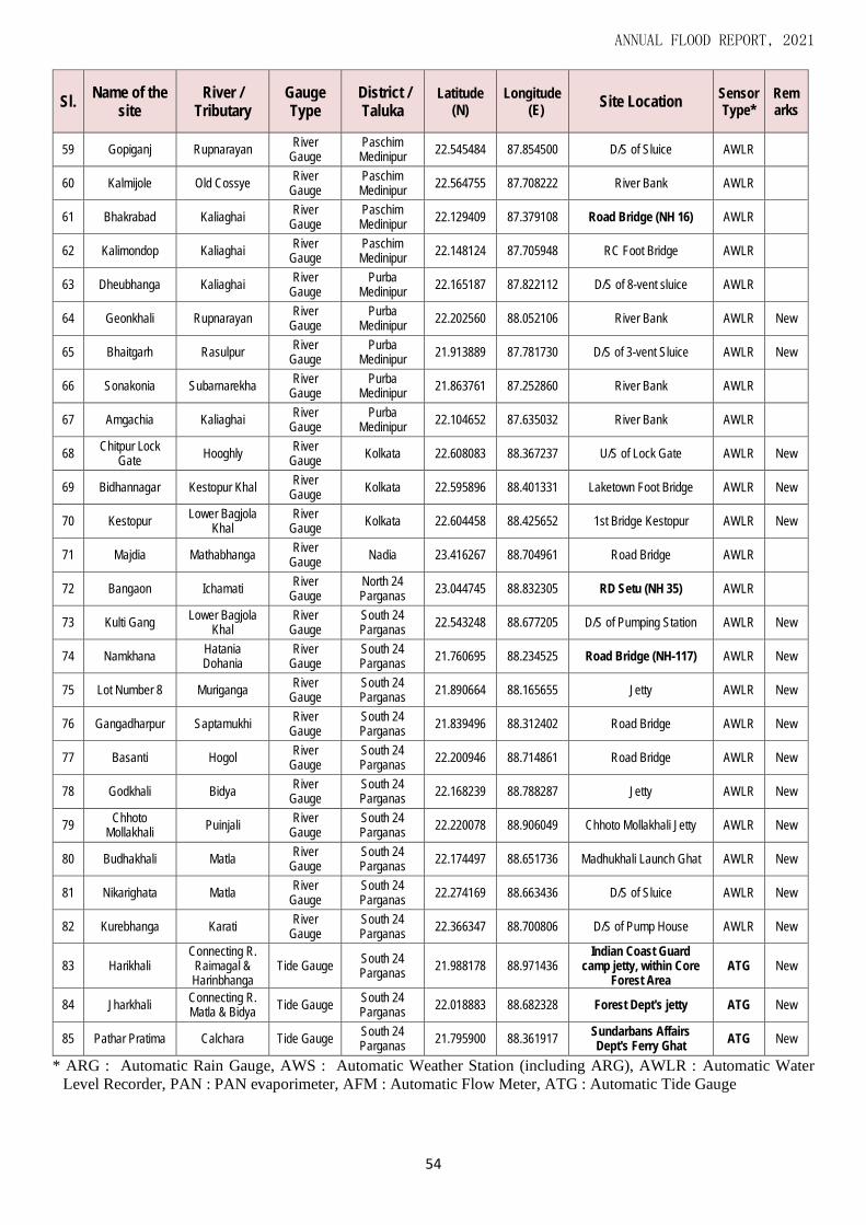
ANNUAL FLOOD REPORT, 2021
54
Sl. Name of the
site River /
Tributary Gauge Type
District / Taluka
Latitude (N)
Longitude (E)
Site Location Sensor Type*
Remarks
59 Gopiganj Rupnarayan River
Gauge Paschim Medinipur
22.545484 87.854500 D/S of Sluice AWLR
60 Kalmijole Old Cossye River
Gauge Paschim Medinipur
22.564755 87.708222 River Bank AWLR
61 Bhakrabad Kaliaghai River
Gauge Paschim Medinipur
22.129409 87.379108 Road Bridge (NH 16) AWLR
62 Kalimondop Kaliaghai River
Gauge Paschim Medinipur
22.148124 87.705948 RC Foot Bridge AWLR
63 Dheubhanga Kaliaghai River
Gauge Purba
Medinipur 22.165187 87.822112 D/S of 8-vent sluice AWLR
64 Geonkhali Rupnarayan River
Gauge Purba
Medinipur 22.202560 88.052106 River Bank AWLR New
65 Bhaitgarh Rasulpur River
Gauge Purba
Medinipur 21.913889 87.781730 D/S of 3-vent Sluice AWLR New
66 Sonakonia Subarnarekha River
Gauge Purba
Medinipur 21.863761 87.252860 River Bank AWLR
67 Amgachia Kaliaghai River
Gauge Purba
Medinipur 22.104652 87.635032 River Bank AWLR
68 Chitpur Lock
Gate Hooghly
River Gauge
Kolkata 22.608083 88.367237 U/S of Lock Gate AWLR New
69 Bidhannagar Kestopur Khal River
Gauge Kolkata 22.595896 88.401331 Laketown Foot Bridge AWLR New
70 Kestopur Lower Bagjola
Khal River
Gauge Kolkata 22.604458 88.425652 1st Bridge Kestopur AWLR New
71 Majdia Mathabhanga River
Gauge Nadia 23.416267 88.704961 Road Bridge AWLR
72 Bangaon Ichamati River
Gauge North 24 Parganas
23.044745 88.832305 RD Setu (NH 35) AWLR
73 Kulti Gang Lower Bagjola
Khal River
Gauge South 24 Parganas
22.543248 88.677205 D/S of Pumping Station AWLR New
74 Namkhana Hatania Dohania
River Gauge
South 24 Parganas
21.760695 88.234525 Road Bridge (NH-117) AWLR New
75 Lot Number 8 Muriganga River
Gauge South 24 Parganas
21.890664 88.165655 Jetty AWLR New
76 Gangadharpur Saptamukhi River
Gauge South 24 Parganas
21.839496 88.312402 Road Bridge AWLR New
77 Basanti Hogol River
Gauge South 24 Parganas
22.200946 88.714861 Road Bridge AWLR New
78 Godkhali Bidya River
Gauge South 24 Parganas
22.168239 88.788287 Jetty AWLR New
79 Chhoto
Mollakhali Puinjali
River Gauge
South 24 Parganas
22.220078 88.906049 Chhoto Mollakhali Jetty AWLR New
80 Budhakhali Matla River
Gauge South 24 Parganas
22.174497 88.651736 Madhukhali Launch Ghat AWLR New
81 Nikarighata Matla River
Gauge South 24 Parganas
22.274169 88.663436 D/S of Sluice AWLR New
82 Kurebhanga Karati River
Gauge South 24 Parganas
22.366347 88.700806 D/S of Pump House AWLR New
83 Harikhali Connecting R.
Raimagal & Harinbhanga
Tide Gauge South 24 Parganas
21.988178 88.971436 Indian Coast Guard
camp jetty, within Core Forest Area
ATG New
84 Jharkhali Connecting R. Matla & Bidya
Tide Gauge South 24 Parganas
22.018883 88.682328 Forest Dept's jetty ATG New
85 Pathar Pratima Calchara Tide Gauge South 24 Parganas
21.795900 88.361917 Sundarbans Affairs Dept's Ferry Ghat
ATG New
* ARG : Automatic Rain Gauge, AWS : Automatic Weather Station (including ARG), AWLR : Automatic Water
Level Recorder, PAN : PAN evaporimeter, AFM : Automatic Flow Meter, ATG : Automatic Tide Gauge
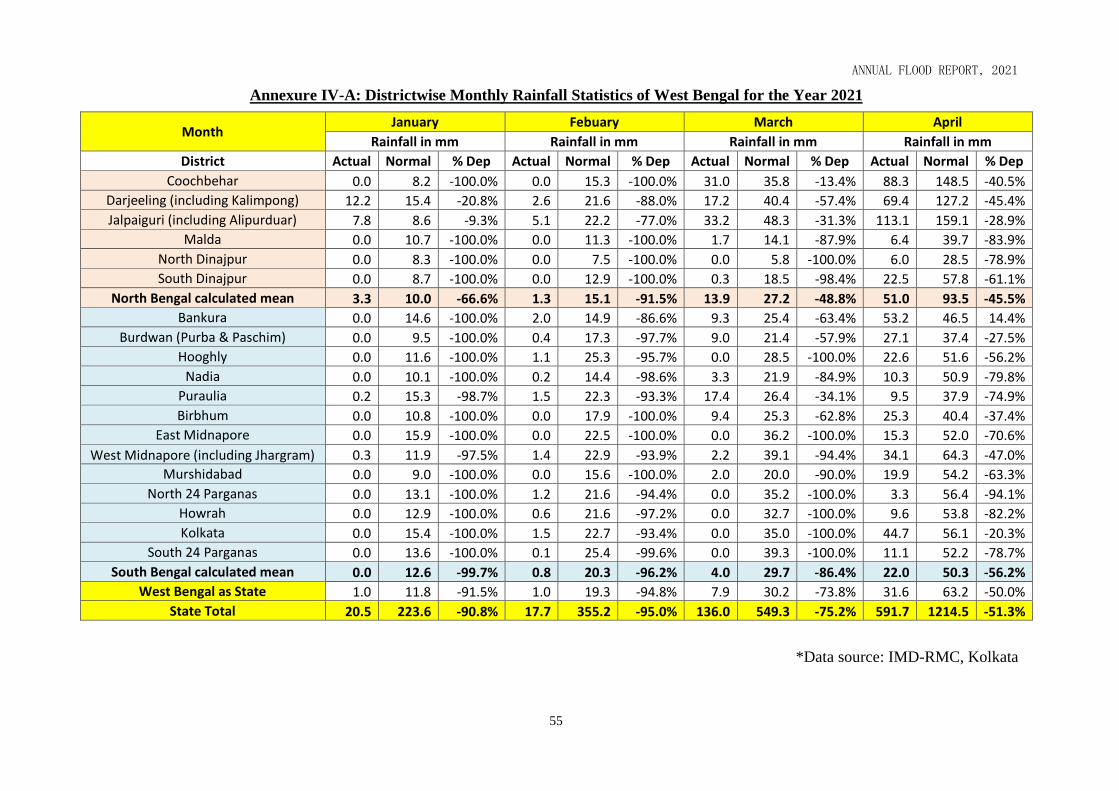
Annual Flood Report 2015
ANNUAL FLOOD REPORT, 2021
55
Annexure IV-A: Districtwise Monthly Rainfall Statistics of West Bengal for the Year 2021
Month January Febuary March April
Rainfall in mm Rainfall in mm Rainfall in mm Rainfall in mm
District Actual Normal % Dep Actual Normal % Dep Actual Normal % Dep Actual Normal % Dep
Coochbehar 0.0 8.2 -100.0% 0.0 15.3 -100.0% 31.0 35.8 -13.4% 88.3 148.5 -40.5%
Darjeeling (including Kalimpong) 12.2 15.4 -20.8% 2.6 21.6 -88.0% 17.2 40.4 -57.4% 69.4 127.2 -45.4%
Jalpaiguri (including Alipurduar) 7.8 8.6 -9.3% 5.1 22.2 -77.0% 33.2 48.3 -31.3% 113.1 159.1 -28.9%
Malda 0.0 10.7 -100.0% 0.0 11.3 -100.0% 1.7 14.1 -87.9% 6.4 39.7 -83.9%
North Dinajpur 0.0 8.3 -100.0% 0.0 7.5 -100.0% 0.0 5.8 -100.0% 6.0 28.5 -78.9%
South Dinajpur 0.0 8.7 -100.0% 0.0 12.9 -100.0% 0.3 18.5 -98.4% 22.5 57.8 -61.1%
North Bengal calculated mean 3.3 10.0 -66.6% 1.3 15.1 -91.5% 13.9 27.2 -48.8% 51.0 93.5 -45.5%
Bankura 0.0 14.6 -100.0% 2.0 14.9 -86.6% 9.3 25.4 -63.4% 53.2 46.5 14.4%
Burdwan (Purba & Paschim) 0.0 9.5 -100.0% 0.4 17.3 -97.7% 9.0 21.4 -57.9% 27.1 37.4 -27.5%
Hooghly 0.0 11.6 -100.0% 1.1 25.3 -95.7% 0.0 28.5 -100.0% 22.6 51.6 -56.2%
Nadia 0.0 10.1 -100.0% 0.2 14.4 -98.6% 3.3 21.9 -84.9% 10.3 50.9 -79.8%
Puraulia 0.2 15.3 -98.7% 1.5 22.3 -93.3% 17.4 26.4 -34.1% 9.5 37.9 -74.9%
Birbhum 0.0 10.8 -100.0% 0.0 17.9 -100.0% 9.4 25.3 -62.8% 25.3 40.4 -37.4%
East Midnapore 0.0 15.9 -100.0% 0.0 22.5 -100.0% 0.0 36.2 -100.0% 15.3 52.0 -70.6%
West Midnapore (including Jhargram) 0.3 11.9 -97.5% 1.4 22.9 -93.9% 2.2 39.1 -94.4% 34.1 64.3 -47.0%
Murshidabad 0.0 9.0 -100.0% 0.0 15.6 -100.0% 2.0 20.0 -90.0% 19.9 54.2 -63.3%
North 24 Parganas 0.0 13.1 -100.0% 1.2 21.6 -94.4% 0.0 35.2 -100.0% 3.3 56.4 -94.1%
Howrah 0.0 12.9 -100.0% 0.6 21.6 -97.2% 0.0 32.7 -100.0% 9.6 53.8 -82.2%
Kolkata 0.0 15.4 -100.0% 1.5 22.7 -93.4% 0.0 35.0 -100.0% 44.7 56.1 -20.3%
South 24 Parganas 0.0 13.6 -100.0% 0.1 25.4 -99.6% 0.0 39.3 -100.0% 11.1 52.2 -78.7%
South Bengal calculated mean 0.0 12.6 -99.7% 0.8 20.3 -96.2% 4.0 29.7 -86.4% 22.0 50.3 -56.2%
West Bengal as State 1.0 11.8 -91.5% 1.0 19.3 -94.8% 7.9 30.2 -73.8% 31.6 63.2 -50.0%
State Total 20.5 223.6 -90.8% 17.7 355.2 -95.0% 136.0 549.3 -75.2% 591.7 1214.5 -51.3%
*Data source: IMD-RMC, Kolkata

Annual Flood Report 2015
ANNUAL FLOOD REPORT, 2021
56
Annexure IV-A: Districtwise Monthly Rainfall Statistics of West Bengal for the Year 2021
Month May June July August
Rainfall in mm Rainfall in mm Rainfall in mm Rainfall in mm
District Actual Normal % Dep Actual Normal % Dep Actual Normal % Dep Actual Normal % Dep
Coochbehar 260.5 329.0 -20.8% 482.6 642.7 -24.9% 722.0 821.8 -12.1% 707.1 657.4 7.6%
Darjeeling (including Kalimpong) 309.7 273.4 13.3% 584.3 575.4 1.5% 722.1 852.2 -15.3% 876.8 617.6 42.0%
Jalpaiguri (including Alipurduar) 229.8 339.7 -32.4% 672.2 721.1 -6.8% 623.9 959.9 -35.0% 1014.0 666.5 52.1%
Malda 385.0 114.5 236.2% 242.6 223.3 8.6% 203.4 335.2 -39.3% 269.8 272.8 -1.1%
North Dinajpur 236.8 216.7 9.3% 217.5 326.1 -33.3% 291.7 433.5 -32.7% 354.1 366.0 -3.3%
South Dinajpur 222.0 168.6 31.7% 397.4 286.9 38.5% 130.5 364.3 -64.2% 284.2 243.1 16.9%
North Bengal calculated mean 274.0 240.3 14.0% 432.8 462.6 -6.4% 448.9 627.8 -28.5% 584.3 470.6 24.2%
Bankura 254.7 78.0 226.5% 440.7 247.9 77.8% 481.0 342.1 40.6% 151.2 319.2 -52.6%
Burdwan (Purba & Paschim) 182.6 73.2 149.5% 407.5 217.4 87.4% 398.8 279.9 42.5% 253.4 275.3 -8.0%
Hooghly 273.3 106.4 156.9% 322.4 248.0 30.0% 335.0 299.3 11.9% 265.6 259.6 2.3%
Nadia 283.9 113.9 149.3% 255.8 207.1 23.5% 235.9 273.9 -13.9% 228.1 214.8 6.2%
Puraulia 310.0 66.6 365.5% 341.1 240.9 41.6% 412.6 287.7 43.4% 211.0 307.4 -31.4%
Birbhum 208.9 95.6 118.5% 309.6 237.7 30.2% 302.7 331.4 -8.7% 247.4 314.7 -21.4%
East Midnapore 323.9 106.6 203.8% 384.2 278.2 38.1% 422.5 340.4 24.1% 326.2 346.4 -5.8%
West Midnapore (including Jhargram) 270.4 116.0 133.1% 308.8 257.5 19.9% 425.8 329.3 29.3% 232.9 326.6 -28.7%
Murshidabad 235.6 123.6 90.6% 318.6 221.8 43.6% 291.8 317.6 -8.1% 229.8 263.4 -12.8%
North 24 Parganas 351.9 138.9 153.3% 386.1 293.4 31.6% 547.2 334.8 63.4% 357.5 340.7 4.9%
Howrah 248.7 121.9 104.0% 331.2 234.3 41.4% 517.5 344.4 50.3% 291.5 324.6 -10.2%
Kolkata 391.4 124.9 213.4% 401.8 287.5 39.8% 525.2 376.7 39.4% 229.0 349.2 -34.4%
South 24 Parganas 218.1 136.7 59.5% 491.7 323.9 51.8% 545.1 444.3 22.7% 379.7 386.4 -1.7%
South Bengal calculated mean 273.3 107.9 153.4% 361.5 253.5 42.6% 418.5 330.9 26.5% 261.8 309.9 -15.5%
West Bengal as State 261.4 142.4 83.6% 394.3 316.7 24.5% 435.8 419.8 3.8% 358.7 361.0 -0.6%
State Total 5197.2 2844.2 82.7% 7296.1 6071.1 20.2% 8134.7 8068.7 0.8% 6909.3 6851.7 0.8%
*Data source: IMD-RMC, Kolkata

Annual Flood Report 2015
ANNUAL FLOOD REPORT, 2021
57
Annexure IV-A: Districtwise Monthly Rainfall Statistics of West Bengal for the Year 2021
Month September October November December
Rainfall in mm Rainfall in mm Rainfall in mm Rainfall in mm
District Actual Normal % Dep Actual Normal % Dep Actual Normal % Dep Actual Normal % Dep
Coochbehar 306.5 451.7 -32.1% 380.8 156.8 142.9% 0.0 12.6 -100.0% 1.0 6.5 -84.6%
Darjeeling (including Kalimpong) 356.6 429.7 -17.0% 385.9 144.8 166.5% 21.2 17.4 21.8% 15.8 9.2 71.7%
Jalpaiguri (including Alipurduar) 332.7 491.5 -32.3% 288.8 175.6 64.5% 3.7 16.7 -77.8% 1.7 7.2 -76.4%
Malda 66.3 281.0 -76.4% 160.7 120.9 32.9% 0.0 12.4 -100.0% 8.4 6.7 25.4%
North Dinajpur 78.1 375.2 -79.2% 273.3 130.8 108.9% 0.0 7.6 -100.0% 8.8 6.4 37.5%
South Dinajpur 97.1 278.3 -65.1% 243.9 117.5 107.6% 0.0 13.8 -100.0% 4.1 5.4 -24.1%
North Bengal calculated mean 206.2 384.6 -46.4% 288.9 141.1 104.8% 4.2 13.4 -69.1% 6.6 6.9 -3.9%
Bankura 466.0 249.0 87.1% 195.0 119.5 63.2% 38.1 11.8 222.9% 54.8 10.5 421.9%
Burdwan (Purba & Paschim) 361.1 225.7 60.0% 144.1 99.5 44.8% 59.2 6.6 797.0% 51.5 5.0 930.0%
Hooghly 318.3 240.1 32.6% 151.9 112.0 35.6% 24.5 16.4 49.4% 140.6 8.0 1657.5%
Nadia 228.2 202.1 12.9% 103.3 97.8 5.6% 32.8 10.5 212.4% 110.0 5.9 1764.4%
Puraulia 380.2 258.6 47.0% 178.3 93.4 90.9% 52.8 15.6 238.5% 25.8 8.9 189.9%
Birbhum 211.3 288.9 -26.9% 154.5 110.4 39.9% 45.6 14.6 212.3% 7.4 7.2 2.8%
East Midnapore 811.9 340.7 138.3% 291.6 166.0 75.7% 4.3 38.9 -88.9% 79.7 6.7 1089.6%
West Midnapore (including Jhargram) 766.6 271.1 182.8% 202.1 113.9 77.4% 13.9 15.5 -10.3% 102.4 5.4 1796.3%
Murshidabad 149.0 263.7 -43.5% 74.3 127.5 -41.7% 10.2 11.4 -10.5% 2.5 5.4 -53.7%
North 24 Parganas 501.1 300.3 66.9% 212.1 149.2 42.2% 12.5 26.6 -53.0% 127.1 8.5 1395.3%
Howrah 579.4 293.5 97.4% 149.9 126.2 18.8% 5.9 29.2 -79.8% 109.2 8.9 1127.0%
Kolkata 613.8 312.7 96.3% 144.3 159.8 -9.7% 2.1 28.2 -92.6% 97.7 9.4 939.4%
South 24 Parganas 695.4 349.4 99.0% 292.1 186.7 56.5% 4.0 51.5 -92.2% 64.2 8.9 621.3%
South Bengal calculated mean 467.9 276.6 69.2% 176.4 127.8 38.0% 23.5 21.3 10.5% 74.8 7.6 885.7%
West Bengal as State 424.2 307.5 38.0% 214.2 132.3 61.9% 20.5 19.5 5.1% 52.2 7.3 615.1%
State Total 7319.6 5903.2 24.0% 4026.9 2508.3 60.5% 330.8 357.3 -7.4% 1012.7 140.1 622.8%
*Data source: IMD-RMC, Kolkata

Annual Flood Report 2015
ANNUAL FLOOD REPORT, 2021
58
Annexure IV-B: Graphical Representation of Monthly Rainfall Statistics at different Districts of West Bengal (after IMD, Kolkata)
0.0
100.0
200.0
300.0
400.0
500.0
600.0
700.0
800.0
Jan
uar
y
Feb
uar
y
Mar
ch
Ap
ril
May
Jun
e
July
Au
gust
Sep
tem
ber
Oct
ob
er
No
vem
be
r
Dec
em
be
r
Rai
nfa
ll (m
m)
Months
Monthly Rainfall Statistics of Coochbehar District for the Year 2021
Actual Rainfall
Normal Rainfall
0.0
100.0
200.0
300.0
400.0
500.0
600.0
700.0
800.0
900.0
1000.0
Jan
uar
y
Feb
uar
y
Mar
ch
Ap
ril
May
Jun
e
July
Au
gust
Sep
tem
ber
Oct
ob
er
No
vem
be
r
Dec
em
be
r
Rai
nfa
ll (m
m)
Months
Monthly Rainfall Statistics of Jalpaiguri & Alipurduar District for the Year 2021
Actual Rainfall
Normal Rainfall

Annual Flood Report 2015
ANNUAL FLOOD REPORT, 2021
59
Annexure IV-B: Graphical Representation of Monthly Rainfall Statistics at different Districts of West Bengal (after IMD, Kolkata)
0.0
100.0
200.0
300.0
400.0
500.0
600.0
700.0
800.0
900.0
1000.0
Jan
uar
y
Feb
uar
y
Mar
ch
Ap
ril
May
Jun
e
July
Au
gust
Sep
tem
ber
Oct
ob
er
No
vem
be
r
Dec
em
be
r
Rai
nfa
ll (m
m)
Months
Monthly Rainfall Statistics of Darjeeling & Kalimpong District for the Year 2021
Actual Rainfall
Normal Rainfall
0.0
50.0
100.0
150.0
200.0
250.0
300.0
350.0
400.0
450.0
Jan
uar
y
Feb
uar
y
Mar
ch
Ap
ril
May
Jun
e
July
Au
gust
Sep
tem
be
r
Oct
ob
er
No
vem
be
r
Dec
em
be
r
Rai
nfa
ll (m
m)
Months
Monthly Rainfall Statistics of North Dinajpur District for the Year 2021
Actual Rainfall
Normal Rainfall

Annual Flood Report 2015
ANNUAL FLOOD REPORT, 2021
60
Annexure IV-B: Graphical Representation of Monthly Rainfall Statistics at different Districts of West Bengal (after IMD, Kolkata)
0.0
50.0
100.0
150.0
200.0
250.0
300.0
350.0
400.0
450.0
Jan
uar
y
Feb
uar
y
Mar
ch
Ap
ril
May
Jun
e
July
Au
gust
Sep
tem
ber
Oct
ob
er
No
vem
be
r
Dec
em
be
r
Rai
nfa
ll (m
m)
Months
Monthly Rainfall Statistics of South Dinajpur District for the Year 2021
Actual Rainfall
Normal Rainfall
0.0
50.0
100.0
150.0
200.0
250.0
300.0
350.0
400.0
Jan
uar
y
Feb
uar
y
Mar
ch
Ap
ril
May
Jun
e
July
Au
gust
Sep
tem
ber
Oct
ob
er
No
vem
be
r
Dec
em
be
r
Rai
nfa
ll (m
m)
Months
Monthly Rainfall Statistics of Malda District for the Year 2021
Actual Rainfall
Normal Rainfall
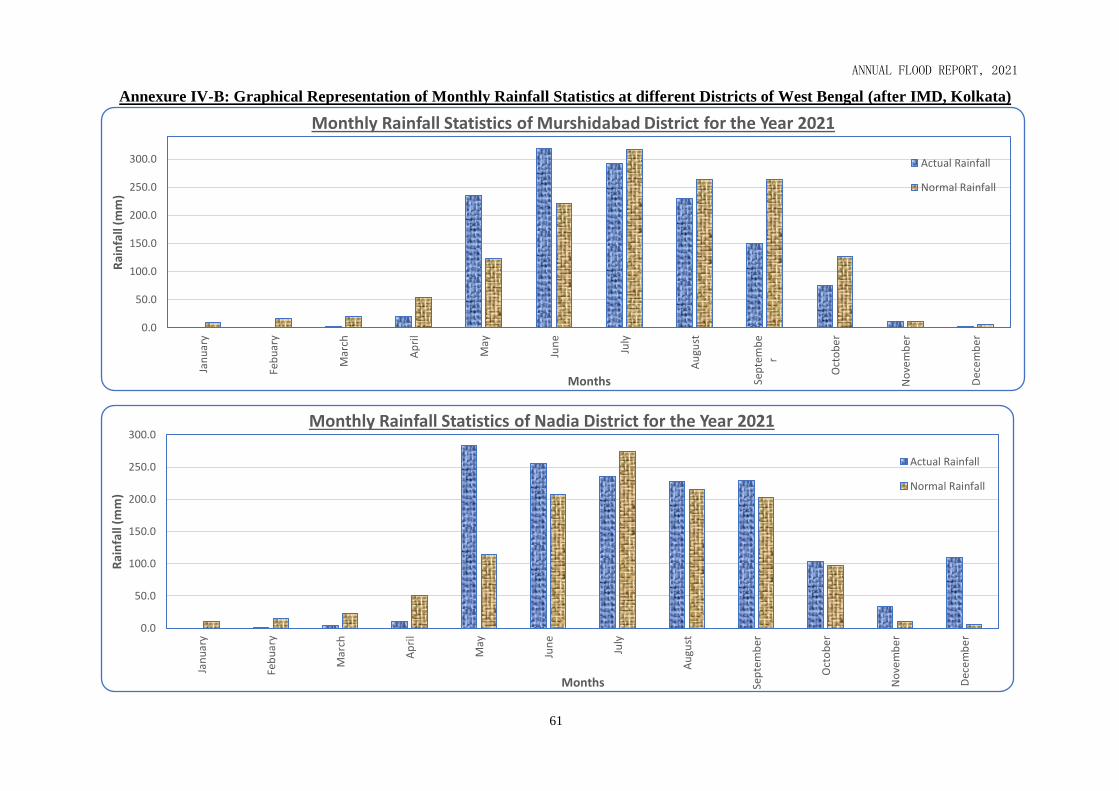
Annual Flood Report 2015
ANNUAL FLOOD REPORT, 2021
61
Annexure IV-B: Graphical Representation of Monthly Rainfall Statistics at different Districts of West Bengal (after IMD, Kolkata)
0.0
50.0
100.0
150.0
200.0
250.0
300.0
Jan
uar
y
Feb
uar
y
Mar
ch
Ap
ril
May
Jun
e
July
Au
gust
Sep
tem
be
r
Oct
ob
er
No
vem
be
r
Dec
em
be
r
Rai
nfa
ll (m
m)
Months
Monthly Rainfall Statistics of Murshidabad District for the Year 2021
Actual Rainfall
Normal Rainfall
0.0
50.0
100.0
150.0
200.0
250.0
300.0
Jan
uar
y
Feb
uar
y
Mar
ch
Ap
ril
May
Jun
e
July
Au
gust
Sep
tem
ber
Oct
ob
er
No
vem
be
r
Dec
em
be
r
Ra
infa
ll (m
m)
Months
Monthly Rainfall Statistics of Nadia District for the Year 2021
Actual Rainfall
Normal Rainfall

Annual Flood Report 2015
ANNUAL FLOOD REPORT, 2021
62
Annexure IV-B: Graphical Representation of Monthly Rainfall Statistics at different Districts of West Bengal (after IMD, Kolkata)
0.0
50.0
100.0
150.0
200.0
250.0
300.0
350.0
Jan
uar
y
Feb
uar
y
Mar
ch
Ap
ril
May
Jun
e
July
Au
gust
Sep
tem
ber
Oct
ob
er
No
vem
be
r
Dec
em
be
r
Rai
nfa
ll (m
m)
Months
Monthly Rainfall Statistics of Birbhum District for the Year 2021
Actual Rainfall
Normal Rainfall
0.0
50.0
100.0
150.0
200.0
250.0
300.0
350.0
400.0
450.0
500.0
Jan
uar
y
Feb
uar
y
Mar
ch
Ap
ril
May
Jun
e
July
Au
gust
Sep
tem
be
r
Oct
ob
er
No
vem
be
r
Dec
em
be
r
Rai
nfa
ll (m
m)
Months
Monthly Rainfall Statistics of Bankura District for the Year 2021
Actual Rainfall
Normal Rainfall

Annual Flood Report 2015
ANNUAL FLOOD REPORT, 2021
63
Annexure IV-B: Graphical Representation of Monthly Rainfall Statistics at different Districts of West Bengal (after IMD, Kolkata)
0.0
50.0
100.0
150.0
200.0
250.0
300.0
350.0
400.0
Jan
uar
y
Feb
uar
y
Mar
ch
Ap
ril
May
Jun
e
July
Au
gust
Sep
tem
ber
Oct
ob
er
No
vem
be
r
Dec
em
be
r
Rai
nfa
ll (m
m)
Months
Monthly Rainfall Statistics of Purulia District for the Year 2021
Actual Rainfall
Normal Rainfall
0.0
100.0
200.0
300.0
400.0
500.0
600.0
700.0
800.0
Jan
uar
y
Feb
uar
y
Mar
ch
Ap
ril
May
Jun
e
July
Au
gust
Sep
tem
be
r
Oct
ob
er
No
vem
be
r
Dec
em
be
r
Rai
nfa
ll (m
m)
Months
Monthly Rainfall Statistics of Paschim Medinipur & Jhargram District for the Year 2021
Actual Rainfall
Normal Rainfall

Annual Flood Report 2015
ANNUAL FLOOD REPORT, 2021
64
Annexure IV-B: Graphical Representation of Monthly Rainfall Statistics at different Districts of West Bengal (after IMD, Kolkata)
0.0
100.0
200.0
300.0
400.0
500.0
600.0
700.0
800.0
Jan
uar
y
Feb
uar
y
Mar
ch
Ap
ril
May
Jun
e
July
Au
gust
Sep
tem
ber
Oct
ob
er
No
vem
be
r
Dec
em
be
r
Rai
nfa
ll (m
m)
Months
Monthly Rainfall Statistics of Purba Medinipur District for the Year 2021
Actual Rainfall
Normal Rainfall
0.0
50.0
100.0
150.0
200.0
250.0
300.0
350.0
400.0
Jan
uar
y
Feb
uar
y
Mar
ch
Ap
ril
May
Jun
e
July
Au
gust
Sep
tem
ber
Oct
ob
er
No
vem
be
r
Dec
em
be
r
Rai
nfa
ll (m
m)
Months
Monthly Rainfall Statistics of Burdwan (Purba & Paschim) District for the Year 2021
Actual Rainfall
Normal Rainfall

Annual Flood Report 2015
ANNUAL FLOOD REPORT, 2021
65
Annexure IV-B: Graphical Representation of Monthly Rainfall Statistics at different Districts of West Bengal (after IMD, Kolkata)
0.0
50.0
100.0
150.0
200.0
250.0
300.0
350.0
Jan
uar
y
Feb
uar
y
Mar
ch
Ap
ril
May
Jun
e
July
Au
gust
Sep
tem
be
r
Oct
ob
er
No
vem
be
r
Dec
em
be
r
Rai
nfa
ll (m
m)
Months
Monthly Rainfall Statistics of Hooghly District for the Year 2021
Actual Rainfall
Normal Rainfall
0.0
100.0
200.0
300.0
400.0
500.0
600.0
Jan
uar
y
Feb
uar
y
Mar
ch
Ap
ril
May
Jun
e
July
Au
gust
Sep
tem
ber
Oct
ob
er
No
vem
be
r
Dec
em
be
r
Ra
infa
ll (m
m)
Months
Monthly Rainfall Statistics of Howrah District for the Year 2021
Actual Rainfall
Normal Rainfall

Annual Flood Report 2015
ANNUAL FLOOD REPORT, 2021
66
Annexure IV-B: Graphical Representation of Monthly Rainfall Statistics at different Districts of West Bengal (after IMD, Kolkata)
0.0
100.0
200.0
300.0
400.0
500.0
600.0
Jan
uar
y
Feb
uar
y
Mar
ch
Ap
ril
May
Jun
e
July
Au
gust
Sep
tem
ber
Oct
ob
er
No
vem
be
r
Dec
em
be
r
Rai
nfa
ll (m
m)
Months
Monthly Rainfall Statistics of Kolkata District for the Year 2021
Actual Rainfall
Normal Rainfall
0.0
100.0
200.0
300.0
400.0
500.0
Jan
uar
y
Feb
uar
y
Mar
ch
Ap
ril
May
Jun
e
July
Au
gust
Sep
tem
ber
Oct
ob
er
No
vem
be
r
Dec
em
be
r
Rai
nfa
ll (m
m)
Months
Monthly Rainfall Statistics of North 24-Parganas District for the Year 2021
Actual Rainfall
Normal Rainfall

Annual Flood Report 2015
ANNUAL FLOOD REPORT, 2021
67
Annexure IV-B: Graphical Representation of Monthly Rainfall Statistics at different Districts of West Bengal (after IMD, Kolkata)
0.0
100.0
200.0
300.0
400.0
500.0
600.0
700.0
Jan
uar
y
Feb
uar
y
Mar
ch
Ap
ril
May
Jun
e
July
Au
gust
Sep
tem
ber
Oct
ob
er
No
vem
be
r
Dec
em
be
r
Rai
nfa
ll (m
m)
Months
Monthly Rainfall Statistics of South 24-Parganas District for the Year 2021
Actual Rainfall
Normal Rainfall
0
50
100
150
200
250
300
350
400
450
Jan
uar
y
Feb
uar
y
Mar
ch
Ap
ril
May
Jun
e
July
Au
gust
Sep
tem
ber
Oct
ob
er
No
vem
be
r
Dec
em
be
r
Rai
nfa
ll (m
m)
Months
Monthly Rainfall Statistics of West Bengal as State for the Year 2021
Actual Rainfall
Normal Rainfall

Annual Flood Report 2015
ANNUAL FLOOD REPORT, 2021
68
Annexure V-A: Season-wise Average Rainfall Statistics of West Bengal for the Year 2021
Seasonal Rainfall (mm) Winter Avg. Rainfall Pre-Monsoon Avg. Rainfall Monsoon Avg. Rainfall Post-Monsoon Avg. Rainfall Annual Avgerage Rainfall
(1st January to 28th February) (1st March to 31st May) (1st June to 30th September) (1st October to 31st December) (1st January to 31st December)
Districts Actual Normal % Dep Actual Normal % Dep Actual Normal % Dep Actual Normal % Dep Actual Normal % Dep
Coochbehar 0 23.5 -100.0% 379.8 513.3 -26.0% 2218.1 2573.6 -13.8% 381.8 175.9 117.1% 2979.70 3286.30 -9.3%
Darjeeling (including Kalimpong) 14.8 37 -60.0% 396.3 441 -10.1% 2539.9 2474.9 2.6% 422.9 171.4 146.7% 3373.90 3124.30 8.0%
Jalpaiguri (including Alipurduar) 13 30.8 -57.8% 376.1 547.1 -31.3% 2642.8 2839 -6.9% 294.2 199.5 47.5% 3326.10 3616.40 -8.0%
Malda 0 22 -100.0% 393.2 168.3 133.6% 782.1 1112.3 -29.7% 169.1 140 20.8% 1344.40 1442.60 -6.8%
North Dinajpur 0 15.8 -100.0% 242.7 251 -3.3% 941.4 1500.8 -37.3% 282.1 144.8 94.8% 1466.20 1912.40 -23.3%
South Dinajpur 0 21.6 -100.0% 244.8 244.9 0.0% 909.2 1172.6 -22.5% 248 136.7 81.4% 1402.00 1575.80 -11.0%
North Bengal calculated mean 4.63 25.12 -81.6% 338.82 360.93 -6.1% 1672.25 1945.53 -14.0% 299.68 161.38 85.7% 2315.38 2492.97 -7.1%
Bankura 2 29.5 -93.2% 317.3 149.9 111.7% 1538.9 1158.2 32.9% 287.9 141.8 103.0% 2146.10 1479.40 45.1%
Birbhum 0 28.7 -100.0% 243.7 161.3 51.1% 1071 1172.7 -8.7% 207.5 132.2 57.0% 1522.20 1494.90 1.8%
Burdwan (Purba & Paschim) 0.4 26.8 -98.5% 218.7 132 65.7% 1420.8 998.3 42.3% 254.8 111.1 129.3% 1894.70 1268.20 49.4%
East Midnapore 0 38.4 -100.0% 339.2 194.8 74.1% 1944.8 1305.7 48.9% 375.6 211.6 77.5% 2659.60 1750.50 51.9%
Hooghly 1.1 36.9 -97.0% 295.9 186.5 58.7% 1241.3 1047 18.6% 317 136.4 132.4% 1855.30 1406.80 31.9%
Howrah 0.6 34.5 -98.3% 258.2 208.4 23.9% 1719.7 1196.8 43.7% 265 164.3 61.3% 2243.50 1604.00 39.9%
Kolkata 1.5 38.1 -96.1% 436.1 216 101.9% 1769.8 1326.1 33.5% 244.1 197.4 23.7% 2451.50 1777.60 37.9%
Murshidabad 0 24.6 -100.0% 301.9 197.8 52.6% 989.2 1066.5 -7.2% 86.9 144.3 -39.8% 1378.00 1433.20 -3.9%
Nadia 0.2 24.5 -99.2% 286.3 186.7 53.3% 948 897.9 5.6% 246.1 114.2 115.5% 1480.60 1223.30 21.0%
North 24 Parganas 1.2 34.7 -96.5% 441.5 230.5 91.5% 1791.8 1269.2 41.2% 351.8 184.3 90.9% 2586.30 1718.70 50.5%
Puraulia 1.7 37.6 -95.5% 311.4 130.9 137.9% 1344.9 1094.6 22.9% 256.9 117.9 117.9% 1914.90 1381.00 38.7%
South 24 Parganas 0.1 39 -99.7% 251.1 228.2 10.0% 2111.9 1504 40.4% 360.3 247.1 45.8% 2723.40 2018.30 34.9%
West Midnapore (including Jhargram) 1.7 34.8 -95.1% 293.7 219.4 33.9% 1734 1184.5 46.4% 318.3 134.8 136.1% 2347.70 1573.50 49.2%
South Bengal calculated mean 0.8 32.9 -97.5% 307.3 187.9 63.6% 1509.7 1170.9 28.9% 274.8 156.7 75.3% 2092.6 1548.4 35.1%
West Bengal as State 2.1 31.1 -93.2% 306.3 235.8 29.9% 1613 1405 14.8% 286.9 159.1 80.3% 2208.3 1831.0 20.6%
*Data source: IMD-RMC, Kolkata

Annual Flood Report 2015
ANNUAL FLOOD REPORT, 2021
69
Annexure V-B: Station-wise Monthly Rainfall Statistics during Monsoon, 2021
Sl. No.
RIVER SUB BASIN
DISTRICT
Annual Normal Rainfall (mm)
Location of Rain Gauge Station
Monthly Total Rainfall (mm) One Day Maximum Rainfall
(mm)
Jun-21 Jul-21 Aug-21 Sep-21 Oct-21 1-D
Max. Type of Rainfall
Date of Max.
1
TEESTA
EAST SIKKIM 2658.60 Gangtok 942.8 673.0 715.9 456.9 386.1 129.7 V. Heavy 20.10.21
2 DARJEELING 3124.30 Darjeeling 510.4 777.8 726.5 202.2 448.4 233.8 V. Heavy 20.10.21
3
JALPAIGURI 3616.40
Malbazar 721.9 938.3 1734.4 578.2 511.2 320.0 E. Heavy 20.10.21
4 Jalpaiguri 473.8 590.1 666.7 331.5 319.2 183.6 V. Heavy 2.9.21
5
JALDHAKA
Banarhat 963.85 788.45 1297.7 595.3 286.85 342.25 E. Heavy 30.6.21
6 Mainaguri 424.1 656.0 618.0 312.0 261.0 176.0 V. Heavy 2.9.21
7 COOCHBEHAR 3286.30 Mathabhanga 468.2 668.4 737.0 259.6 337.4 159.4 V. Heavy 17.7.21
8 SANKOSH ALIPURDUAR
3616.40
Barabisha 930.54 450.6 905.1 259.4 355.2 164.6 V. Heavy 30.6.21
9
TORSA
JALPAIGURI Hasimara 603.75 386.5 947.5 310.0 165.0 205 V. Heavy 30.6.21
10 ALIPURDUAR Alipurduar 933.6 728.8 1294.6 465.8 300.2 208.2 V. Heavy 2.9.21
11 COOCHBEHAR 3286.30
Coochbehar 542.2 836.3 795.1 346.7 425.4 201.7 V. Heavy 17.7.21
12 Tufanganj 649.2 789.2 501.8 216.0 371.8 184.2 V. Heavy 17.7.21
13
MAHANANDA-FULHAR
DARJEELING 3124.30 Siliguri 589.0 590.2 1278.2 428.5 437.5 245.2 E. Heavy 20.10.21
14 UTTAR DINAJPUR
1912.40 Islampur 176.8 420.8 299.2 54.0 140.0 104.2 Heavy 6.7.21
15 Raiganj 219.2 243.8 368.3 57.0 342.6 103.6 Heavy 28.8.21
16 MALDA 1442.60 English Bazar 183.7 236.8 214.3 43.2 81.7 46.6 Normal 10.8.21
17 ATREYEE DAKSHIN DINAJPUR
1575.80
Balurghat 418.0 118.6 463.8 91.8 201.2 123.6 Heavy 29.6.21
18 PUNARBHABA
Gangarampur 511.2 272.4 307.95 192.0 277.0 136 V. Heavy 29.6.21
19 BHAGIRATHI - HOOGHLY
MURSHIDABAD 1433.20 Berhampore 315.2 288.6 392.8 184.0 80.4 72 Heavy 16.6.21
20 PURBA BURDWAN
1268.20 Katwa 174.5 445.0 315.4 145.0 282.0 103.04 Heavy 4.7.21
21 JALANGI NADIA 1223.30 Swarupganj 375.0 201.8 472.2 307.6 162.4 127.4 V. Heavy 2.8.21
22 PAGLA-BANSLOI
BIRBHUM 1494.90
Paikor 245.2 355.8 402.4 163.2 66.0 70 Heavy 18.7.21
23
BRAHAMANI-DWARKA
Md. Bazar 313.4 345.4 335.7 134.9 163.0 52.4 Normal 19.10.21
24 Rampurhat 344.0 284.8 349.6 109.8 122.0 102 Heavy 21.6.21
25 Mallarpur 260.0 285.0 312.0 136.0 100.0 55 Normal 30.7.21
26 Deocha 334.3 216.8 258.9 214.4 152.8 71.1 Heavy 12.8.21
27
MAYURAKSHI-BABLA
DUMKA 1381.50
Haripur 277.4 299.4 237.0 241.0 197.6 49.2 Normal 1.10.21
28 Khusiary 419.4 378.2 369.4 159.0 236.6 130.2 V. Heavy 20.10.21
29 Maharo 321.6 256.4 305.4 199.4 157.4 94.4 Heavy 13.6.21
30 Massanjore 322.0 387.0 240.2 186.4 174.0 96.4 Heavy 5.7.21
31 Tantloi 288.6 308.8 255.8 208.6 177.4 81 Heavy 30.9.21
32 BIRBHUM 1494.90
Tilpara Barrage
389.8 287.2 388.8 204.0 166.0 78 Heavy 11.8.21
33 Shyambati 466.0 463.0 228.0 352.0 211.0 102 Heavy 17.6.21
34 MURSHIDABAD 1433.20 Kandi 349.4 360.0 162.0 226.4 117.6 105 Heavy 16.6.21
35
AJAY-HINGLOW
DEOGHAR 1162.10 Sikatia 483.0 309.6 409 412.6 115.8 280.8 E. Heavy 30.9.21
36 BIRBHUM 1494.90
Hinglow 373.0 318.0 236.0 340.0 205.0 150 V. Heavy 30.9.21
37 Debogram 366.0 554.0 246.0 278.0 203.0 200 V. Heavy 30.7.21
38 PASCHIM BURDWAN
1268.20 Satkahania 207.0 182.6 125.0 141.2 81.8 49.2 Normal 18.6.21
39 Guskara 430.5 515.0 445.0 386.5 188.0 118.5 Heavy 30.7.21
40
DAMO DAR
KODARMA 1116.20 Tilaiya 374.0 449.6 191.4 218.0 92.4 95 Heavy 31.7.21
41 BOKARO 1247.50 Tenughat 287.0 419.6 221.4 232.4 192.6 108.2 Heavy 31.7.21
42 DHANBAD 1355.20
Maithon 628.2 465.2 275.4 344.6 177.4 205.4 V. Heavy 30.9.21
43 Panchet 514.4 438.2 161.0 389.4 168.0 174.2 V. Heavy 30.9.21

Annual Flood Report 2015
ANNUAL FLOOD REPORT, 2021
70
Sl. No.
RIVER SUB BASIN
DISTRICT
Annual Normal Rainfall
(mm)
Location of Rain Gauge Station
Monthly Total Rainfall (mm) One Day Maximum Rainfall
(mm)
Jun-21 Jul-21 Aug-21 Sep-21 Oct-21 1-D
Max. Type of Rainfall
Date of Max.
44
DAMODAR
PASCHIM BURDWAN
1268.20
Asansol 413.6 456.0 333.6 535.2 180.2 345.6 E. Heavy 30.9.21
45 Durgapur 477.2 415.0 283.2 433.0 152.6 220.2 V. Heavy 30.9.21
46 PURBA BURDWAN
Jamalpur 328.0 276.0 222.0 226.0 112.0 89.0 Heavy 15.9.21
47 BANKURA 1479.40 Sonamukhi 440.0 445.5 272.5 320.0 182.5 100.0 Heavy 18.6.21
48 KHARI-BEHULA-GHEA PURBA
BURDWAN 1268.20
Kanainatsal 304.4 457.6 209.8 284.4 125.8 118.0 Heavy 15.9.21
49 Memari 415.0 298.0 301.0 376.0 267.0 126.0 V. Heavy 8.8.21
50 MUNDESWARI
Seharabazar 412.0 549.5 149.5 245.0 172.0 166.0 V. Heavy 30.7.21
51 Lohai (Raina) 379.0 427.0 266.0 258.0 150.0 142.0 V. Heavy 30.7.21
52
AMTA CHANNEL (DAMODAR)
HOOGLY 1406.80
Tarakeswar 290.6 426.2 249.3 319.2 127.4 150.6 V. Heavy 15.9.21
53 Champadanga 222.0 384.0 239.0 341.0 75.0 142.0 V. Heavy 27.7.21
54 Singur 331.3 462.0 180.0 406.5 192.75 181.0 V. Heavy 27.7.21
55 HOWRAH 1604.00
Amta 292.0 497.0 290.0 447.0 167.0 175.0 V. Heavy 30.7.21
56 Domjur 317.0 501.0 227.0 486.0 148.0 163.0 V. Heavy 30.7.21
57 DWARA KESWAR
BANKURA 1479.40 Bankura 695.8 472.2 152.6 566.0 215.4 231.0 V. Heavy 30.9.21
58 Indus 473.1 974.8 195.9 367.0 223.2 195.0 V. Heavy 27.7.21
59 HOOGLY 1406.80 Arambag 279.0 384.0 277.0 279.0 172.5 111.0 Heavy 30.7.21
60 SHILA BATI
PASCHIM MEDINIPUR
1573.50 Amlagora 201.2 289.8 199.8 398.0 83.6 83.8 Heavy 30.7.21
61 Ghatal 374.6 549.4 313.6 701.8 103.4 227.0 V. Heavy 15.9.21
62
KANGSA BATI
PURULIA 1381.00
Simulia 317.8 436.0 167.8 311.8 279.6 141.6 V. Heavy 30.9.21
63 Purihansa 212.6 296.6 188.6 274.8 126.4 88.8 Heavy 30.9.21
64 Tusuma 246.0 543.6 216.0 495.8 153.4 188.4 V. Heavy 30.9.21
65 Kharidwar 406.8 463.6 260.2 529.6 62.6 219.0 V. Heavy 30.9.21
66 Phulberia 423.4 401.2 283.6 340.6 98.6 113.6 Heavy 30.9.21
67 BANKURA 1479.40 Mukutmanipur 329.4 376.4 214.8 580.0 189.0 139.2 V. Heavy 30.9.21
68 PASCHIM MEDINIPUR
1573.50 Midnapore 285.8 487.4 350.4 843.4 233.4 260.0 E. Heavy 15.9.21
69
PURBA MEDINIPUR
1750.50
Panskura 436.5 513.3 275.5 1027.3 194.6 317.0 E. Heavy 15.9.21
70 RUPNARAYAN
Tamluk 473.7 293.8 209.1 531.8 137.3 172.7 V. Heavy 18.6.21
71 KALIA GHAI
Amgachia 362.4 361.0 232.8 621.7 242.0 173.0 V. Heavy 15.9.21
72 PASCHIM MEDINIPUR
1573.50
Sabang 361.5 368.0 180.0 780.5 253.5 257.0 E. Heavy 15.9.21
73 KANGSA BATI
JHARGRAM Jhargram 417.4 549.9 126.6 697.9 234.6 116.45 Heavy 22.9.21
74 CHANDIA PASCHIM MEDINIPUR
Barisha 409.5 371.0 343.5 781.0 207.0 221.0 V. Heavy 15.9.21
75 HALDI PURBA MEDINIPUR
1750.50 Itamogra 339.3 608.0 266.0 805.9 137.1 234.4 V. Heavy 15.9.21
76 RASULPUR Contai 418.2 326.4 356.2 840.2 285.8 174.2 V. Heavy 15.9.21
77 HOOGHLY KOLKATA 1777.60 Alipore 401.8 553.5 229.0 641.3 144.3 150.0 V. Heavy 30.7.21
78 ICHHA MATI NORTH 24-
PARGANAS 1718.70
Bangaon 248.2 368.2 428.4 219.2 143.0 132.4 V. Heavy 30.7.21
79 Tentulia 476.0 678.0 332.0 388.0 251.0 178 V. Heavy 20.9.21
80 BIDYA DHARI
Dumdum 312.2 708.0 342.3 589.4 196.9 159.4 V. Heavy 15.9.21
81 SOUTH 24-PARGANAS
2018.30
Chowbaga 301.0 501.0 282.0 641.0 265.0 163.0 V. Heavy 20.9.21
82 SUNDARBAN AREA
Uttarbhag 251.0 582.0 233.0 569.0 249.0 122.0 Heavy 15.9.21
83 Sagar Island 441.6 368.4 418.6 845.4 279.2 212.8 V. Heavy 21.9.21
84 SUBARNAREKHA
PURBA MEDINIPUR
1750.50 Digha 199.5 254.0 197.0 598.0 240.0 95.0 Heavy 18.10.21
* Data Source: Daily Flood Reports of Central Flood Control Room, I&WD

Annual Flood Report 2015
ANNUAL FLOOD REPORT, 2021
71
Annexure VI: Graphical comparison of last five years average rainfall of different districts
415.70
0.0
70.0
140.0
210.0
280.0
350.0
420.0
15-Jun
20-Jun
25-Jun
30-Jun
05-Jul
10-Jul
15-Jul
20-Jul
25-Jul
30-Jul
04-Aug
09-Aug
14-Aug
19-Aug
24-Aug
29-Aug
03-Sep
08-Sep
13-Sep
18-Sep
23-Sep
28-Sep
03-Oct
08-Oct
13-Oct
18-Oct
23-Oct
Daily Rainfall Average (mm) of Alipurduar District for Last 5-years (2017-2021) (Average Daily Rainfall of Rain Gauge Stations at Barabisha & Alipurduar)
2017
2018
2019
2020
2021
276.53
0.0
40.0
80.0
120.0
160.0
200.0
240.0
280.0
15-Jun
20-Jun
25-Jun
30-Jun
05-Jul
10-Jul
15-Jul
20-Jul
25-Jul
30-Jul
04-Aug
09-Aug
14-Aug
19-Aug
24-Aug
29-Aug
03-Sep
08-Sep
13-Sep
18-Sep
23-Sep
28-Sep
03-Oct
08-Oct
13-Oct
18-Oct
23-Oct
Daily Rainfall Average (mm) of Coochbehar District for Last 5-years (2017-2021) (Average Daily Rainfall of Rain Gauge Stations at Mathabhanga, Coochbehar & Tufanganj)
2017
2018
2019
2020
2021

Annual Flood Report 2015
ANNUAL FLOOD REPORT, 2021
72
Annexure VI: Graphical comparison of last five years average rainfall of different districts
292.30
0.0
50.0
100.0
150.0
200.0
250.0
300.015-Jun
20-Jun
25-Jun
30-Jun
05-Jul
10-Jul
15-Jul
20-Jul
25-Jul
30-Jul
04-Aug
09-Aug
14-Aug
19-Aug
24-Aug
29-Aug
03-Sep
08-Sep
13-Sep
18-Sep
23-Sep
28-Sep
03-Oct
08-Oct
13-Oct
18-Oct
23-Oct
Daily Rainfall Average (mm) of Jalpaiguri District for Last 5-years (2017-2021) (Average Daily Rainfall of Rain Gauge Stations at Malbazar, Jalpaiguri, Banarhat, Mainaguri & Hasimara)
2017
2018
2019
2020
2021
148.00
0.0
25.0
50.0
75.0
100.0
125.0
150.0
15-Jun
20-Jun
25-Jun
30-Jun
05-Jul
10-Jul
15-Jul
20-Jul
25-Jul
30-Jul
04-Aug
09-Aug
14-Aug
19-Aug
24-Aug
29-Aug
03-Sep
08-Sep
13-Sep
18-Sep
23-Sep
28-Sep
03-Oct
08-Oct
13-Oct
18-Oct
23-Oct
Ra
infa
ll (m
m)
Daily Rainfall Average of Darjeeling District for Last 5-years (2017-2021) (Average Daily Rainfall of Rain Gauge Stations at Darjeeling & Siliguri)
2017
2018
2019
2020
2021

Annual Flood Report 2015
ANNUAL FLOOD REPORT, 2021
73
Annexure VI: Graphical comparison of last five years average rainfall of different districts
121.65
0.0
25.0
50.0
75.0
100.0
125.0
15-Jun
20-Jun
25-Jun
30-Jun
05-Jul
10-Jul
15-Jul
20-Jul
25-Jul
30-Jul
04-Aug
09-Aug
14-Aug
19-Aug
24-Aug
29-Aug
03-Sep
08-Sep
13-Sep
18-Sep
23-Sep
28-Sep
03-Oct
08-Oct
13-Oct
18-Oct
23-Oct
Daily Rainfall Average (mm) of Uttar Dinajpur District for Last 5-years (2017-2021) (Average Daily Rainfall of Rain Gauge Stations at Islampur & Raiganj)
2017
2018
2019
2020
2021
129.80
0.0
25.0
50.0
75.0
100.0
125.0
15-Jun
20-Jun
25-Jun
30-Jun
05-Jul
10-Jul
15-Jul
20-Jul
25-Jul
30-Jul
04-Aug
09-Aug
14-Aug
19-Aug
24-Aug
29-Aug
03-Sep
08-Sep
13-Sep
18-Sep
23-Sep
28-Sep
03-Oct
08-Oct
13-Oct
18-Oct
23-Oct
Daily Rainfall Average (mm) of Dakshin Dinajpur District for Last 5-years (2017-2021) (Average Daily Rainfall of Rain Gauge Stations at Balurghat & Gangarampur)
2017
2018
2019
2020
2021

Annual Flood Report 2015
ANNUAL FLOOD REPORT, 2021
74
Annexure VI: Graphical comparison of last five years average rainfall of different districts
102.00
107.10
0.0
20.0
40.0
60.0
80.0
100.0
05-Jun
10-Jun
15-Jun
20-Jun
25-Jun
30-Jun
05-Jul
10-Jul
15-Jul
20-Jul
25-Jul
30-Jul
04-Aug
09-Aug
14-Aug
19-Aug
24-Aug
29-Aug
03-Sep
08-Sep
13-Sep
18-Sep
23-Sep
28-Sep
03-Oct
08-Oct
13-Oct
18-Oct
23-Oct
Daily Rainfall Average (mm) of Malda District for Last 5-years (2017-2021) (Daily Rainfall of Rain Gauge Station at Englishbazar)
2017
2018
2019
2020
2021
97.40
0.0
20.0
40.0
60.0
80.0
100.0
15-Jun
20-Jun
25-Jun
30-Jun
05-Jul
10-Jul
15-Jul
20-Jul
25-Jul
30-Jul
04-Aug
09-Aug
14-Aug
19-Aug
24-Aug
29-Aug
03-Sep
08-Sep
13-Sep
18-Sep
23-Sep
28-Sep
03-Oct
08-Oct
13-Oct
18-Oct
23-Oct
Daily Rainfall Average (mm) of Murshidabad District for Last 5-years (2017-2021) (Average Daily Rainfall of Rain Gauge Stations at Berhampore & Kandi)
2017
2018
2019
2020
2021

Annual Flood Report 2015
ANNUAL FLOOD REPORT, 2021
75
Annexure VI: Graphical comparison of last five years average rainfall of different districts
84.44
0.0
15.0
30.0
45.0
60.0
75.0
90.0
15-Jun
20-Jun
25-Jun
30-Jun
05-Jul
10-Jul
15-Jul
20-Jul
25-Jul
30-Jul
04-Aug
09-Aug
14-Aug
19-Aug
24-Aug
29-Aug
03-Sep
08-Sep
13-Sep
18-Sep
23-Sep
28-Sep
03-Oct
08-Oct
13-Oct
18-Oct
23-Oct
Daily Rainfall Average (mm) of Birbhum District for Last 5-years (2017-2021) (Average Daily Rainfall of Rain Gauge Stations at Paikor, Md. Bazar, Rampurhat, Mallarpur, Deocha, Tilpara Barrage,
Shyambati, Hinglow & Debogram)
2017
2018
2019
2020
2021
121.16124.70 124.30
0.0
25.0
50.0
75.0
100.0
125.0
15-Jun
20-Jun
25-Jun
30-Jun
05-Jul
10-Jul
15-Jul
20-Jul
25-Jul
30-Jul
04-Aug
09-Aug
14-Aug
19-Aug
24-Aug
29-Aug
03-Sep
08-Sep
13-Sep
18-Sep
23-Sep
28-Sep
03-Oct
08-Oct
13-Oct
18-Oct
23-Oct
Daily Rainfall Average (mm) of Bankura District for Last 5-years (2017-2021) (Average Daily Rainfall of Rain Gauge Stations at Sonamukhi, Bankura, Indus & Mukutmanipur)
2017
2018
2019
2020
2021

Annual Flood Report 2015
ANNUAL FLOOD REPORT, 2021
76
Annexure VI: Graphical comparison of last five years average rainfall of different districts
150.28
0.0
25.0
50.0
75.0
100.0
125.0
150.0
15-Jun
20-Jun
25-Jun
30-Jun
05-Jul
10-Jul
15-Jul
20-Jul
25-Jul
30-Jul
04-Aug
09-Aug
14-Aug
19-Aug
24-Aug
29-Aug
03-Sep
08-Sep
13-Sep
18-Sep
23-Sep
28-Sep
03-Oct
08-Oct
13-Oct
18-Oct
23-Oct
Daily Rainfall Average (mm) of Purulia District for Last 5-years (2017-2021) (Average Daily Rainfall of Rain Gauge Stations at Simulia, Purihansa, Tusuma, Kharidwar & Phulberia)
2017
2018
2019
2020
2021
276.25
0.0
50.0
100.0
150.0
200.0
250.0
15-Jun
20-Jun
25-Jun
30-Jun
05-Jul
10-Jul
15-Jul
20-Jul
25-Jul
30-Jul
04-Aug
09-Aug
14-Aug
19-Aug
24-Aug
29-Aug
03-Sep
08-Sep
13-Sep
18-Sep
23-Sep
28-Sep
03-Oct
08-Oct
13-Oct
18-Oct
23-Oct
Daily Rainfall Average (mm) of Jhargram District for Last 5-years (2017-2021) (Daily Rainfall of Rain Gauge Station at Jhargram)
2017
2018
2019
2020
2021

Annual Flood Report 2015
ANNUAL FLOOD REPORT, 2021
77
Annexure VI: Graphical comparison of last five years average rainfall of different districts
204.88
0.0
25.0
50.0
75.0
100.0
125.0
150.0
175.0
200.0
15-Jun
20-Jun
25-Jun
30-Jun
05-Jul
10-Jul
15-Jul
20-Jul
25-Jul
30-Jul
04-Aug
09-Aug
14-Aug
19-Aug
24-Aug
29-Aug
03-Sep
08-Sep
13-Sep
18-Sep
23-Sep
28-Sep
03-Oct
08-Oct
13-Oct
18-Oct
23-Oct
Daily Rainfall Average (mm) of West Midnapore District for Last 5-years (2017-2021) (Average Daily Rainfall of Rain Gauge Stations at Amlagora, Ghatal, Midnapore, Sabang & Barisha)
2017
2018
2019
2020
2021
187.66
0.0
25.0
50.0
75.0
100.0
125.0
150.0
175.0
200.0
15-Jun
20-Jun
25-Jun
30-Jun
05-Jul
10-Jul
15-Jul
20-Jul
25-Jul
30-Jul
04-Aug
09-Aug
14-Aug
19-Aug
24-Aug
29-Aug
03-Sep
08-Sep
13-Sep
18-Sep
23-Sep
28-Sep
03-Oct
08-Oct
13-Oct
18-Oct
23-Oct
Daily Rainfall Average (mm) of East Midnapore District for Last 5-years (2017-2021) (Average Daily Rainfall of Rain Gauge Stations at Panskura, Tamluk, Amgachia, Itamogra, Contai & Digha)
2017
2018
2019
2020
2021

Annual Flood Report 2015
ANNUAL FLOOD REPORT, 2021
78
Annexure VI: Graphical comparison of last five years average rainfall of different districts
155.83
0.0
25.0
50.0
75.0
100.0
125.0
150.0
15-Jun
20-Jun
25-Jun
30-Jun
05-Jul
10-Jul
15-Jul
20-Jul
25-Jul
30-Jul
04-Aug
09-Aug
14-Aug
19-Aug
24-Aug
29-Aug
03-Sep
08-Sep
13-Sep
18-Sep
23-Sep
28-Sep
03-Oct
08-Oct
13-Oct
18-Oct
23-Oct
Daily Rainfall Average (mm) of Paschim Bardhaman District for Last 5-years (2017-2021) (Average Daily Rainfall of Rain Gauge Stations at Satkahania, Guskara, Asansol & Durgapur)
2017
2018
2019
2020
2021
110.01
0.0
25.0
50.0
75.0
100.0
15-Jun
20-Jun
25-Jun
30-Jun
05-Jul
10-Jul
15-Jul
20-Jul
25-Jul
30-Jul
04-Aug
09-Aug
14-Aug
19-Aug
24-Aug
29-Aug
03-Sep
08-Sep
13-Sep
18-Sep
23-Sep
28-Sep
03-Oct
08-Oct
13-Oct
18-Oct
23-Oct
Daily Rainfall Average (mm) of Purba Bardhaman District for Last 5-years (2017-2021) (Average Daily Rainfall of Rain Gauge Stations at Katwa, Jamalpur, Kanainatsal, Memari, Seharabazar & Lohai (Raina))
2017
2018
2019
2020
2021

Annual Flood Report 2015
ANNUAL FLOOD REPORT, 2021
79
Annexure VI: Graphical comparison of last five years average rainfall of different districts
111.15103.55
109.53
0.00
20.00
40.00
60.00
80.00
100.00
120.0015-Jun
20-Jun
25-Jun
30-Jun
05-Jul
10-Jul
15-Jul
20-Jul
25-Jul
30-Jul
04-
Aug
09-
Aug
14-
Aug
19-
Aug
24-
Aug
29-
Aug
03-
Sep
08-
Sep
13-
Sep
18-
Sep
23-
Sep
28-
Sep
03-Oct
08-Oct
13-Oct
18-Oct
23-Oct
Daily Rainfall Average (mm) of Hooghly District for Last 5-years (2017-2021)(Average Daily Rainfall of Rain Gauge Stations at Arambag, Singur, Champadanga & Tarakeswar)
2017
2018
2019
2020
2021
169.00
0.0
25.0
50.0
75.0
100.0
125.0
150.0
175.0
15-Jun
20-Jun
25-Jun
30-Jun
05-Jul
10-Jul
15-Jul
20-Jul
25-Jul
30-Jul
04-Aug
09-Aug
14-Aug
19-Aug
24-Aug
29-Aug
03-Sep
08-Sep
13-Sep
18-Sep
23-Sep
28-Sep
03-Oct
08-Oct
13-Oct
18-Oct
23-Oct
Daily Rainfall Average (mm) of Howrah District for Last 5-years (2017-2021) (Average Daily Rainfall of Rain Gauge Stations at Domjur & Amta)
2017
2018
2019
2020
2021

Annual Flood Report 2015
ANNUAL FLOOD REPORT, 2021
80
Annexure VI: Graphical comparison of last five years average rainfall of different districts
162.60
0.0
20.0
40.0
60.0
80.0
100.0
120.0
140.0
160.0
15-Jun
20-Jun
25-Jun
30-Jun
05-Jul
10-Jul
15-Jul
20-Jul
25-Jul
30-Jul
04-Aug
09-Aug
14-Aug
19-Aug
24-Aug
29-Aug
03-Sep
08-Sep
13-Sep
18-Sep
23-Sep
28-Sep
03-Oct
08-Oct
13-Oct
18-Oct
23-Oct
Daily Rainfall Average (mm) of Kolkata District for Last 5-years (2017-2021) (Daily Rainfall of Rain Gauge Station at Alipore)
2017
2018
2019
2020
2021
134.87
0.0
25.0
50.0
75.0
100.0
125.0
15-Jun
20-Jun
25-Jun
30-Jun
05-Jul
10-Jul
15-Jul
20-Jul
25-Jul
30-Jul
04-Aug
09-Aug
14-Aug
19-Aug
24-Aug
29-Aug
03-Sep
08-Sep
13-Sep
18-Sep
23-Sep
28-Sep
03-Oct
08-Oct
13-Oct
18-Oct
23-Oct
Daily Rainfall Average (mm) of North 24 Parganas District for Last 5-years (2017-2021) (Average Daily Rainfall of Rain Gauge Stations at Bangaon, Tentulia & Dumdum)
2017
2018
2019
2020
2021

Annual Flood Report 2015
ANNUAL FLOOD REPORT, 2021
81
Annexure VI: Graphical comparison of last five years average rainfall of different districts
32.50
68.00
143.07 137.93
0.0
25.0
50.0
75.0
100.0
125.0
150.0
15-Jun
20-Jun
25-Jun
30-Jun
05-Jul
10-Jul
15-Jul
20-Jul
25-Jul
30-Jul
04-Aug
09-Aug
14-Aug
19-Aug
24-Aug
29-Aug
03-Sep
08-Sep
13-Sep
18-Sep
23-Sep
28-Sep
03-Oct
08-Oct
13-Oct
18-Oct
23-Oct
Daily Rainfall Average (mm) of South 24 Parganas District for Last 5-years (2017-2021) (Average Daily Rainfall of Rain Gauge Stations at Chowbaga, Uttarbhag & Sagar Island)
2017
2018
2019
2020
2021

Annual Flood Report 2015
ANNUAL FLOOD REPORT, 2021
82
Annexure-VII: Monthly Statistics of River Gauges during Flood Season, 2021
Sl. No.
Name of River
Gauge Station District PDL / WL
(mGTS)
DL (mGTS)
EDL (mGTS)
Monthly Avg. River Gauge Level (mGTS) Max. Level
(mGTS)
Max. GL w.r.t reference value
Date of Peak
Min. Level
(mGTS)
No. of Days crossing
Jun-21 Jul-21 Aug-21 Sep-21 Oct-21 PDL DL EDL
1 Sankosh
L.R.P. Crossing Alipurduar
47.60 48.50 49.40 45.85 46.34 46.53 46.04 45.59 47.10 29.8.21 45.10 0 0 0
2 Raidak-II 47.50 48.40 49.30 44.74 44.91 44.92 44.85 44.94 45.95 21.10.21 44.60 0 0 0
3 Raidak-I
46.10 47.00 47.90 43.90 44.12 43.99 43.82 43.63 45.15 27.8.21 43.60 0 0 0
4 Tufanganj Coochbehar 34.70 35.30 35.90 32.01 32.94 32.95 32.71 32.29 34.60 27.8.21 31.77 0 0 0
5 Torsa
Hasimara Alipurduar 115.10 116.30 117.50 114.87 115.18 115.32 114.50 114.49 116.60 0.30 m. above DL 20.10.21 114.00 60 1 0
6 Coochbehar Coochbehar 41.46 42.07 42.68 40.83 41.26 41.29 40.82 40.52 41.92 0.46 m. above PDL 20.10.21 40.20 12 0 0
7 Kaljani Alipurduar Alipurduar 44.50 45.10 45.70 42.90 43.12 43.44 43.06 42.90 45.00 0.50 m. above PDL 30.6.21 42.70 3 0 0
8 Diana Chengmari
Jalpaiguri
199.90 200.50 201.20 198.92 199.32 199.24 199.18 198.36 200.10 0.20 m. above PDL 30.6.21 198.05 2 0 0
9 Jaldhaka
Nagrakata 160.10 160.70 161.80 156.49 156.55 156.58 156.39 156.22 157.82 20.10.21 155.97 0 0 0
10 NH-31 Crossing 79.30 80.10 80.90 79.18 79.59 79.63 79.36 79.13 80.10 0.00 m. above DL 20.10.21 78.86 89 1 0
11 Mansai Mathabhanga Coochbehar 47.20 47.70 48.20 45.65 46.30 46.51 45.87 45.62 47.69 0.49 m. above PDL 3.9.21 44.58 8 0 0
12 Teesta Coronation Br. Darjeeling 149.40 150.00 153.60 #DIV/0! #DIV/0! 143.93 143.00 143.05 149.45 0.05 m. above PDL 20.10.21 141.70 1 0 0
13 Teesta Domohani Jalpaiguri 85.60 85.95 86.30 85.21 85.44 85.42 85.14 84.78 86.58 0.28 m. above EDL 20.10.21 84.30 19 0 1
14 Teesta Mekhliganj Coochbehar 65.35 65.95 66.30 64.44 64.56 64.73 64.25 64.07 66.55 0.25 m. above EDL 20.10.21 63.47 3 0 1
15 Mahananda
Hill Curt Road Darjeeling 115.38 115.98 116.59 113.22 113.45 113.74 113.39 113.36 115.30 19.8.21 113.10 0 0 0
16 Sonapur
North Dinajpur
75.17 75.77 76.38 73.28 #DIV/0! 73.78 #DIV/0! 74.38 74.38 20.10.21 73.28 0 0 0
17 Dauk Chopra 68.86 69.46 70.07 #DIV/0! #DIV/0! 65.45 #DIV/0! 65.66 65.66 20.10.21 65.45 0 0 0
18 Nagar Makdampur 30.94 31.54 31.86 27.59 28.72 28.69 28.31 28.17 30.15 10.7.21 27.25 0 0 0
19 Fulahar Teljana Malda 26.51 27.43 28.35 23.88 26.38 27.44 26.43 25.82 28.42 0.07 m. above EDL 22.8.21 23.25 33 25 3
20 Atreyee Balurghat
South Dinajpur
22.54 23.15 23.76 18.68 19.04 19.13 19.16 19.14 21.95 31.8.21 18.25 0 0 0
21 Tangon Radhikapur 32.85 33.45 34.05 28.58 28.97 29.68 29.22 28.77 30.70 4.9.21 28.10 0 0 0
22 Punarbhaba Gangarampur 25.22 25.82 26.42 22.25 22.31 22.70 23.16 23.10 24.70 1.9.21 22.00 0 0 0
23 Ganga-Padma
Manikchakghat Malda 24.09 24.69 25.30 22.35 23.67 25.22 24.33 23.86 25.99 0.69 m. above EDL 20.8.21 21.64 20 21 15
24 Nimtita Murshidabad 21.30 21.90 22.51 18.37 19.72 21.60 20.94 19.54 22.43 0.53 m. above DL 21.8.21 15.97 22 11 0
25 Bansloi Bansloi Rly Br. Birbhum 31.25 31.85 32.76 29.58 29.60 28.93 #DIV/0! #DIV/0! 31.00 20.6.21 28.80 0 0 0
26 Brahamani Jagdhari Rd. Br. Birbhum 32.40 33.00 33.40 29.02 29.21 29.09 #DIV/0! 29.10 30.40 31.7.21 28.60 0 0 0
27 Dwarka
Sankoghat
Murshidabad
19.50 20.40 21.30 17.23 16.95 19.08 16.25 16.72 20.57 0.17 m. above DL 1.8.21 15.06 9 1 0
28 Ranagram 16.76 17.36 17.86 14.23 13.95 16.09 13.71 14.20 17.05 0.29 m. above PDL 7.8.21 12.30 6 0 0
29 Mayurakshi Narayanpur 27.19 27.99 28.79 22.25 22.33 22.90 22.20 22.69 26.20 1.10.21 22.20 0 0 0
30 Kuia Tarapur 22.11 22.71 23.35 18.70 18.38 19.49 18.72 19.24 21.80 1.8.21 17.32 0 0 0
31 Babla Bazarshow 14.42 15.02 15.65 12.27 12.41 13.40 12.33 12.76 14.83 0.41 m. above PDL 7.8.21 11.56 0 0
32 Ajoy Gheropara Birbhum 38.42 39.42 40.42 35.18 35.39 35.46 34.99 34.83 41.78 1.36 m. above EDL 1.10.21 34.20 0 0 1
33 Bhagirathi-Hoogly
Baharampur Murshidabad 16.62 17.22 17.83 14.52 14.62 15.39 14.84 14.80 15.80 7.8.21 14.02 0 0 0
34 Katwa Purba Burdwan 13.10 13.71 14.32 10.34 10.30 12.11 10.60 11.38 13.65 0.55 m. above PDL 2.10.21 9.30 4 0 0
35 Swarupganj Nadia
7.83 8.44 9.05 6.41 6.77 8.45 7.50 7.78 9.08 0.03 m. above EDL 4.10.21 5.36 35 19 2
36 Mathabhanga Majdia 7.21 7.82 8.43 4.54 5.37 6.95 6.96 6.11 7.59 0.38 m. above PDL 30.8.21 3.81 17 0 0

Annual Flood Report 2015
ANNUAL FLOOD REPORT, 2021
83
Sl. No.
Name of River
Gauge Station District PDL / WL
(mGTS)
DL (mGTS)
EDL (mGTS)
Monthly Avg. River Gauge Level (mGTS) Max. Level
(mGTS)
Max. GL w.r.t reference value
Date of Peak
Min. Level
(mGTS)
No. of Days crossing
Jun-21 Jul-21 Aug-21 Sep-21 Oct-21 PDL DL EDL
37 Churni Hanskhali Nadia 6.92 7.53 8.14 4.27 4.94 6.40 6.32 5.59 6.89 30.8.21 3.48 0 0 0
38 Ichamati RD Setu (Bongaon)
North 24 Parganas
4.10 4.70 5.25 #DIV/0! 2.30 3.73 3.99 4.01 4.14 0.04 m. above PDL 4.10.21 2.20 11 0 0
39 Jamuna Gaighata 3.85 4.45 5.05 2.59 2.76 3.79 3.96 4.34 4.53 0.08 m. above DL 26.9.21 2.15 53 2 0
40
Damodar
Rondiha Paschim Burdwan
51.53 52.13 52.89 50.00 50.00 50.34 50.06 50.18 51.57 0.04 m. above PDL 1.10.21 49.04 1 0 0
41 Edilpur Purba Burdwan
32.19 32.79 32.95 27.46 27.48 27.53 27.47 27.45 27.81 2.8.21 27.00 0 0 0
42 Jamalpur 22.93 23.24 23.54 17.49 17.08 18.07 16.81 17.71 22.45 1.10.21 16.68 0 0 0
43 Hurhura Muchighata Howrah 5.56 6.16 6.77 4.94 4.72 6.00 4.24 6.36 8.73 1.96 m. above EDL 2.10.21 3.40 10 5 9
44 Dwarakeswar
Arambag Hooghly
16.61 17.22 17.83 12.16 12.03 11.98 11.87 12.34 18.80 0.97 m. above EDL 1.10.21 8.11 1 1 1
45 Shakepore 11.15 11.75 12.35 9.29 8.33 8.70 8.32 8.62 13.14 0.79 m. above EDL 1.10.21 7.12 4 1 2
46 Shilabati
Banka
Paschim Medinipur
14.47 15.08 15.69 #DIV/0! 16.32 15.16 13.80 12.93 16.37 0.68 m. above EDL 31.7.21 11.49 3 3 4
47 Gadghat 8.38 8.99 9.60 #DIV/0! 9.11 8.89 7.92 6.53 10.39 0.79 m. above EDL 1.8.21 3.14 7 4 3
48 Rupnarayan
Bandar 6.24 6.85 7.46 6.60 7.49 7.24 5.80 4.84 8.56 1.10 m. above EDL 1.8.21 1.27 15 5 8
49 Gopiganj 4.41 5.03 5.65 #DIV/0! 4.82 5.10 3.41 3.26 6.14 0.49 m. above EDL 3.10.21 1.47 9 7 6
50 Kangsabati Mohanpur 25.14 25.75 26.36 #DIV/0! 25.30 #DIV/0! 24.90 24.94 25.60 0.46 m. above PDL 2.10.21 24.62 11 0 0
51 Old Cossye Kalmijole 8.68 9.29 9.90 #DIV/0! 10.35 9.08 8.96 7.54 10.50 0.60 m. above EDL 2.10.21 6.00 4 6 6
52 New Cossye Panskura Purba Medinipur
8.68 9.29 9.90 #DIV/0! 7.16 8.52 8.30 7.82 10.76 0.86 m. above EDL 3.10.21 6.05 2 8 5
53 Chandia Barisha
Paschim Medinipur
5.70 6.30 6.90 3.51 3.07 4.56 5.06 4.85 7.11 0.21 m. above EDL 17.9.21 2.50 10 9 2
54 Kapaleswari Narayanbarh 4.72 5.33 5.94 3.88 3.53 4.38 5.23 4.55 7.74 1.80 m. above EDL 17.9.21 2.84 25 8 11
55
Kaliaghai
Bakhrabad 7.80 8.40 8.85 6.20 7.13 6.13 8.16 6.61 11.80 2.95 m. above EDL 15.9.21 5.65 4 3 9
56 Dehati 5.95 6.55 7.00 4.35 4.39 4.76 6.00 4.91 9.38 2.38 m. above EDL 16.9.21 3.10 8 5 7
57 Amgachia Paschim Medinipur
5.18 5.79 6.40 4.31 3.82 4.43 5.29 4.63 7.70 1.30 m. above EDL 17.9.21 3.41 11 8 5
58 Kalimandop 4.40 5.00 5.33 3.41 3.33 3.61 4.36 3.62 6.05 0.72 m. above EDL 17.9.21 3.00 11 1 3
59 Subarnarekha
Gopiballavpur Jhargram
44.90 45.50 46.50 40.97 40.72 41.29 41.67 41.26 43.60 2.8.21 40.44 0 0 0
60 Sonakonia 15.15 16.15 16.75 10.53 10.50 11.76 12.15 11.28 14.85 2.8.21 10.00 0 0 0
60 Mahananda Englishbazar Malda 20.40 21.00 21.75 16.12 18.33 19.75 19.36 18.36 20.80 0.40 m. above PDL 3.9.21 15.28 17 0 0
61 Ajoy Amuliaghat Birbhum 104.13 104.73 105.33 102.47 102.72 102.77 102.74 102.83 103.70 1.10.21 102.00 0 0 0
62 Kangsabati Kapastikri Paschim Medinipur
15.40 16.00 16.60 11.23 11.60 12.79 12.95 13.06 17.15 0.55 m. above EDL 16.9.21 10.57 4 2 2
63 Damodar Champadanga Hooghly 12.30 12.90 13.50 10.75 10.60 11.71 10.16 10.85 14.50 1.00 m. above EDL 2.10.21 8.00 11 5 7
64 Mundeswari Harinkhola Hooghly 12.20 12.80 13.41 7.77 6.81 8.43 6.41 8.28 14.30 0.89 m. above EDL 1.10.21 4.80 1 3 2
65 Amta Channel Amta Howrah 5.04 5.64 6.24 4.34 4.43 5.32 4.22 4.80 7.85 1.61 m. above EDL 1.10.21 2.50 15 20 14
66 S. C. Channel Sehagori Howrah 5.60 6.20 6.80 5.00 4.64 5.57 4.44 5.29 6.90 0.10 m. above EDL 2.8.21 3.00 21 15 7
Abbreviation: GL: Gauge Level; BG: Below Gauge; PDL/WL: Primery Danger Level/Warning Level; DL: Danger Level; EDL: Extreme Danger Level

Annual Flood Report 2015
ANNUAL FLOOD REPORT, 2021
84
Annexure VIII-A: Gauge Levels of different Rivers of North Bengal during Flood Season 2021
47.60, PDL/WL (mGTS)
48.50, DL (mGTS)
49.40, EDL (mGTS)
45.0
45.5
46.0
46.5
47.0
47.5
48.0
48.5
49.0
49.5
50.0
1.6
.21
6.6
.21
11
.6.2
1
16
.6.2
1
21
.6.2
1
26
.6.2
1
1.7
.21
6.7
.21
11
.7.2
1
16
.7.2
1
21
.7.2
1
26
.7.2
1
31
.7.2
1
5.8
.21
10
.8.2
1
15
.8.2
1
20
.8.2
1
25
.8.2
1
30
.8.2
1
4.9
.21
9.9
.21
14
.9.2
1
19
.9.2
1
24
.9.2
1
29
.9.2
1
4.1
0.2
1
9.1
0.2
1
14
.10
.21
19
.10
.21
24
.10
.21
29
.10
.21
Ga
ug
e L
ev
el i
n m
GT
S
Date
Gauge Level of R. Sankosh at L.R.P. Crossing during Flood Season 2021
Gauge Level (mGTS)
PDL/WL (mGTS)
DL (mGTS)
EDL (mGTS)
47.50, PDL/WL (mGTS)
48.40, DL (mGTS)
49.30, EDL (mGTS)
44.0
45.0
46.0
47.0
48.0
49.0
50.0
1.6
.21
6.6
.21
11
.6.2
1
16
.6.2
1
21
.6.2
1
26
.6.2
1
1.7
.21
6.7
.21
11
.7.2
1
16
.7.2
1
21
.7.2
1
26
.7.2
1
31
.7.2
1
5.8
.21
10
.8.2
1
15
.8.2
1
20
.8.2
1
25
.8.2
1
30
.8.2
1
4.9
.21
9.9
.21
14
.9.2
1
19
.9.2
1
24
.9.2
1
29
.9.2
1
4.1
0.2
1
9.1
0.2
1
14
.10
.21
19
.10
.21
24
.10
.21
29
.10
.21
Ga
ug
e L
ev
el i
n m
GT
S
Date
Gauge Level of R. Raidak-II at L.R.P. Crossing during Flood Season 2021
Gauge Level (mGTS)
PDL/WL (mGTS)
DL (mGTS)
EDL (mGTS)

Annual Flood Report 2015
ANNUAL FLOOD REPORT, 2021
85
Annexure VIII-A: Gauge Levels of different Rivers of North Bengal during Flood Season 2021
46.10, PDL/WL (mGTS)
47.00, DL (mGTS)
47.90, EDL (mGTS)
43.0
43.5
44.0
44.5
45.0
45.5
46.0
46.5
47.0
47.5
48.0
1.6
.21
6.6
.21
11
.6.2
1
16
.6.2
1
21
.6.2
1
26
.6.2
1
1.7
.21
6.7
.21
11
.7.2
1
16
.7.2
1
21
.7.2
1
26
.7.2
1
31
.7.2
1
5.8
.21
10
.8.2
1
15
.8.2
1
20
.8.2
1
25
.8.2
1
30
.8.2
1
4.9
.21
9.9
.21
14
.9.2
1
19
.9.2
1
24
.9.2
1
29
.9.2
1
4.1
0.2
1
9.1
0.2
1
14
.10
.21
19
.10
.21
24
.10
.21
29
.10
.21
Ga
ug
e L
ev
el
in m
GT
S
Date
Gauge Level of R. Raidak-I at L.R.P. Crossing during Flood Season 2021
Gauge Level (mGTS)
PDL/WL (mGTS)
DL (mGTS)
EDL (mGTS)
34.70, PDL/WL (mGTS)
35.30, DL (mGTS)
35.90, EDL (mGTS)
31.0
31.5
32.0
32.5
33.0
33.5
34.0
34.5
35.0
35.5
36.0
1.6
.21
6.6
.21
11
.6.2
1
16
.6.2
1
21
.6.2
1
26
.6.2
1
1.7
.21
6.7
.21
11
.7.2
1
16
.7.2
1
21
.7.2
1
26
.7.2
1
31
.7.2
1
5.8
.21
10
.8.2
1
15
.8.2
1
20
.8.2
1
25
.8.2
1
30
.8.2
1
4.9
.21
9.9
.21
14
.9.2
1
19
.9.2
1
24
.9.2
1
29
.9.2
1
4.1
0.2
1
9.1
0.2
1
14
.10
.21
19
.10
.21
24
.10
.21
29
.10
.21
Ga
ug
e L
ev
el i
n m
GT
S
Date
Gauge Level of R. Raidak-I at Tufanganj during Flood Season 2021
Gauge Level (mGTS)
PDL/WL (mGTS)
DL (mGTS)
EDL (mGTS)
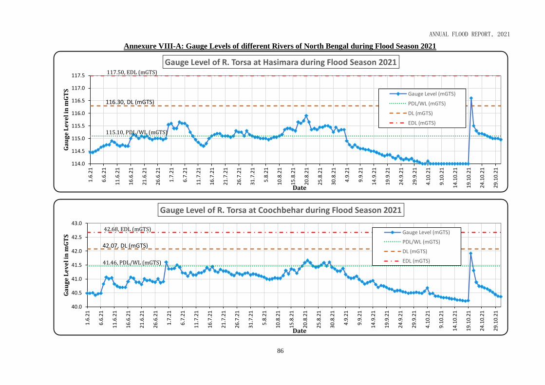
Annual Flood Report 2015
ANNUAL FLOOD REPORT, 2021
86
Annexure VIII-A: Gauge Levels of different Rivers of North Bengal during Flood Season 2021
115.10, PDL/WL (mGTS)
116.30, DL (mGTS)
117.50, EDL (mGTS)
114.0
114.5
115.0
115.5
116.0
116.5
117.0
117.5
1.6
.21
6.6
.21
11
.6.2
1
16
.6.2
1
21
.6.2
1
26
.6.2
1
1.7
.21
6.7
.21
11
.7.2
1
16
.7.2
1
21
.7.2
1
26
.7.2
1
31
.7.2
1
5.8
.21
10
.8.2
1
15
.8.2
1
20
.8.2
1
25
.8.2
1
30
.8.2
1
4.9
.21
9.9
.21
14
.9.2
1
19
.9.2
1
24
.9.2
1
29
.9.2
1
4.1
0.2
1
9.1
0.2
1
14
.10
.21
19
.10
.21
24
.10
.21
29
.10
.21
Ga
ug
e L
ev
el i
n m
GT
S
Date
Gauge Level of R. Torsa at Hasimara during Flood Season 2021
Gauge Level (mGTS)
PDL/WL (mGTS)
DL (mGTS)
EDL (mGTS)
41.46, PDL/WL (mGTS)
42.07, DL (mGTS)
42.68, EDL (mGTS)
40.0
40.5
41.0
41.5
42.0
42.5
43.0
1.6
.21
6.6
.21
11
.6.2
1
16
.6.2
1
21
.6.2
1
26
.6.2
1
1.7
.21
6.7
.21
11
.7.2
1
16
.7.2
1
21
.7.2
1
26
.7.2
1
31
.7.2
1
5.8
.21
10
.8.2
1
15
.8.2
1
20
.8.2
1
25
.8.2
1
30
.8.2
1
4.9
.21
9.9
.21
14
.9.2
1
19
.9.2
1
24
.9.2
1
29
.9.2
1
4.1
0.2
1
9.1
0.2
1
14
.10
.21
19
.10
.21
24
.10
.21
29
.10
.21
Ga
ug
e L
ev
el i
n m
GT
S
Date
Gauge Level of R. Torsa at Coochbehar during Flood Season 2021
Gauge Level (mGTS)
PDL/WL (mGTS)
DL (mGTS)
EDL (mGTS)

Annual Flood Report 2015
ANNUAL FLOOD REPORT, 2021
87
Annexure VIII-A: Gauge Levels of different Rivers of North Bengal during Flood Season 2021
44.50, PDL/WL (mGTS)
45.10, DL (mGTS)
45.70, EDL (mGTS)
42.0
42.5
43.0
43.5
44.0
44.5
45.0
45.5
46.0
1.6
.21
6.6
.21
11
.6.2
1
16
.6.2
1
21
.6.2
1
26
.6.2
1
1.7
.21
6.7
.21
11
.7.2
1
16
.7.2
1
21
.7.2
1
26
.7.2
1
31
.7.2
1
5.8
.21
10
.8.2
1
15
.8.2
1
20
.8.2
1
25
.8.2
1
30
.8.2
1
4.9
.21
9.9
.21
14
.9.2
1
19
.9.2
1
24
.9.2
1
29
.9.2
1
4.1
0.2
1
9.1
0.2
1
14
.10
.21
19
.10
.21
24
.10
.21
29
.10
.21
Ga
ug
e L
ev
el i
n m
GT
S
Date
Gauge Level of R. Kaljani at Alipurduar during Flood Season 2021
Gauge Level (mGTS)
PDL/WL (mGTS)
DL (mGTS)
EDL (mGTS)
199.90, PDL/WL (mGTS)
200.50, DL (mGTS)
201.20, EDL (mGTS)
197.5
198.0
198.5
199.0
199.5
200.0
200.5
201.0
201.5
1.6
.21
6.6
.21
11
.6.2
1
16
.6.2
1
21
.6.2
1
26
.6.2
1
1.7
.21
6.7
.21
11
.7.2
1
16
.7.2
1
21
.7.2
1
26
.7.2
1
31
.7.2
1
5.8
.21
10
.8.2
1
15
.8.2
1
20
.8.2
1
25
.8.2
1
30
.8.2
1
4.9
.21
9.9
.21
14
.9.2
1
19
.9.2
1
24
.9.2
1
29
.9.2
1
4.1
0.2
1
9.1
0.2
1
14
.10
.21
19
.10
.21
24
.10
.21
29
.10
.21
Ga
ug
e L
ev
el i
n m
GT
S
Date
Gauge Level of R. Diana at Chengmari during Flood Season 2021
Gauge Level (mGTS)
PDL/WL (mGTS)
DL (mGTS)
EDL (mGTS)

Annual Flood Report 2015
ANNUAL FLOOD REPORT, 2021
88
Annexure VIII-A: Gauge Levels of different Rivers of North Bengal during Flood Season 2021
160.10, PDL/WL (mGTS)
160.70, DL (mGTS)
161.80, EDL (mGTS)
155.5
156.5
157.5
158.5
159.5
160.5
161.5
162.5
1.6
.21
6.6
.21
11
.6.2
1
16
.6.2
1
21
.6.2
1
26
.6.2
1
1.7
.21
6.7
.21
11
.7.2
1
16
.7.2
1
21
.7.2
1
26
.7.2
1
31
.7.2
1
5.8
.21
10
.8.2
1
15
.8.2
1
20
.8.2
1
25
.8.2
1
30
.8.2
1
4.9
.21
9.9
.21
14
.9.2
1
19
.9.2
1
24
.9.2
1
29
.9.2
1
4.1
0.2
1
9.1
0.2
1
14
.10
.21
19
.10
.21
24
.10
.21
29
.10
.21
Ga
ug
e L
ev
el i
n m
GT
S
Date
Gauge Level of R. Jaldhaka at Nagrakata during Flood Season 2021
Gauge Level (mGTS)
PDL/WL (mGTS)
DL (mGTS)
EDL (mGTS)
79.30, PDL/WL (mGTS)
80.10, DL (mGTS)
80.90, EDL (mGTS)
78.5
79.0
79.5
80.0
80.5
81.0
81.5
1.6
.21
6.6
.21
11
.6.2
1
16
.6.2
1
21
.6.2
1
26
.6.2
1
1.7
.21
6.7
.21
11
.7.2
1
16
.7.2
1
21
.7.2
1
26
.7.2
1
31
.7.2
1
5.8
.21
10
.8.2
1
15
.8.2
1
20
.8.2
1
25
.8.2
1
30
.8.2
1
4.9
.21
9.9
.21
14
.9.2
1
19
.9.2
1
24
.9.2
1
29
.9.2
1
4.1
0.2
1
9.1
0.2
1
14
.10
.21
19
.10
.21
24
.10
.21
29
.10
.21
Ga
ug
e L
ev
el i
n m
GT
S
Date
Gauge Level of R. Jaldhaka at NH-31 Crossing during Flood Season 2021
Gauge Level (mGTS)
PDL/WL (mGTS)
DL (mGTS)
EDL (mGTS)

Annual Flood Report 2015
ANNUAL FLOOD REPORT, 2021
89
Annexure VIII-A: Gauge Levels of different Rivers of North Bengal during Flood Season 2021
149.40, PDL/WL (mGTS)
150.00, DL (mGTS)
153.60, EDL (mGTS)
141.0
143.0
145.0
147.0
149.0
151.0
153.0
155.0
1.6
.21
6.6
.21
11
.6.2
1
16
.6.2
1
21
.6.2
1
26
.6.2
1
1.7
.21
6.7
.21
11
.7.2
1
16
.7.2
1
21
.7.2
1
26
.7.2
1
31
.7.2
1
5.8
.21
10
.8.2
1
15
.8.2
1
20
.8.2
1
25
.8.2
1
30
.8.2
1
4.9
.21
9.9
.21
14
.9.2
1
19
.9.2
1
24
.9.2
1
29
.9.2
1
4.1
0.2
1
9.1
0.2
1
14
.10
.21
19
.10
.21
24
.10
.21
29
.10
.21
Ga
ug
e L
ev
el i
n m
GT
S
Date
Gauge Level of R. Teesta at Coronation Bridge during Flood Season 2021
Gauge Level (mGTS)
PDL/WL (mGTS)
DL (mGTS)
EDL (mGTS)
85.60, PDL/WL (mGTS)
85.95, DL (mGTS)
86.30, EDL (mGTS)
84.0
84.5
85.0
85.5
86.0
86.5
87.0
1.6
.21
6.6
.21
11
.6.2
1
16
.6.2
1
21
.6.2
1
26
.6.2
1
1.7
.21
6.7
.21
11
.7.2
1
16
.7.2
1
21
.7.2
1
26
.7.2
1
31
.7.2
1
5.8
.21
10
.8.2
1
15
.8.2
1
20
.8.2
1
25
.8.2
1
30
.8.2
1
4.9
.21
9.9
.21
14
.9.2
1
19
.9.2
1
24
.9.2
1
29
.9.2
1
4.1
0.2
1
9.1
0.2
1
14
.10
.21
19
.10
.21
24
.10
.21
29
.10
.21
Ga
ug
e L
ev
el i
n m
GT
S
Date
Gauge Level of R. Teesta at Domohani during Flood Season 2021
Gauge Level (mGTS)
PDL/WL (mGTS)
DL (mGTS)
EDL (mGTS)

Annual Flood Report 2015
ANNUAL FLOOD REPORT, 2021
90
Annexure VIII-A: Gauge Levels of different Rivers of North Bengal during Flood Season 2021
65.35, PDL/WL (mGTS)65.95, DL (mGTS)66.30, EDL (mGTS)
63.0
63.5
64.0
64.5
65.0
65.5
66.0
66.5
67.0
1.6
.21
6.6
.21
11
.6.2
1
16
.6.2
1
21
.6.2
1
26
.6.2
1
1.7
.21
6.7
.21
11
.7.2
1
16
.7.2
1
21
.7.2
1
26
.7.2
1
31
.7.2
1
5.8
.21
10
.8.2
1
15
.8.2
1
20
.8.2
1
25
.8.2
1
30
.8.2
1
4.9
.21
9.9
.21
14
.9.2
1
19
.9.2
1
24
.9.2
1
29
.9.2
1
4.1
0.2
1
9.1
0.2
1
14
.10
.21
19
.10
.21
24
.10
.21
29
.10
.21
Ga
ug
e L
ev
el i
n m
GT
S
Date
Gauge Level of R. Teesta at Mekhliganj during Flood Season 2021
Gauge Level (mGTS)
PDL/WL (mGTS)
DL (mGTS)
EDL (mGTS)
47.20, PDL/WL (mGTS)
47.70, DL (mGTS)
48.20, EDL (mGTS)
44.5
45.0
45.5
46.0
46.5
47.0
47.5
48.0
48.5
1.6
.21
6.6
.21
11
.6.2
1
16
.6.2
1
21
.6.2
1
26
.6.2
1
1.7
.21
6.7
.21
11
.7.2
1
16
.7.2
1
21
.7.2
1
26
.7.2
1
31
.7.2
1
5.8
.21
10
.8.2
1
15
.8.2
1
20
.8.2
1
25
.8.2
1
30
.8.2
1
4.9
.21
9.9
.21
14
.9.2
1
19
.9.2
1
24
.9.2
1
29
.9.2
1
4.1
0.2
1
9.1
0.2
1
14
.10
.21
19
.10
.21
24
.10
.21
29
.10
.21
Ga
ug
e L
ev
el i
n m
GT
S
Date
Gauge Level of R. Mansai at Mathabhanga during Flood Season 2021
Gauge Level (mGTS)
PDL/WL (mGTS)
DL (mGTS)
EDL (mGTS)

Annual Flood Report 2015
ANNUAL FLOOD REPORT, 2021
91
Annexure VIII-A: Gauge Levels of different Rivers of North Bengal during Flood Season 2021
115.38, PDL/WL (mGTS)
115.98, DL (mGTS)
116.59, EDL (mGTS)
113.0
113.5
114.0
114.5
115.0
115.5
116.0
116.5
117.0
1.6
.21
6.6
.21
11
.6.2
1
16
.6.2
1
21
.6.2
1
26
.6.2
1
1.7
.21
6.7
.21
11
.7.2
1
16
.7.2
1
21
.7.2
1
26
.7.2
1
31
.7.2
1
5.8
.21
10
.8.2
1
15
.8.2
1
20
.8.2
1
25
.8.2
1
30
.8.2
1
4.9
.21
9.9
.21
14
.9.2
1
19
.9.2
1
24
.9.2
1
29
.9.2
1
4.1
0.2
1
9.1
0.2
1
14
.10
.21
19
.10
.21
24
.10
.21
29
.10
.21
Ga
ug
e L
ev
el i
n m
GT
S
Date
Gauge Level of R. Mahananda at Hill Cart Road during Flood Season 2021
Gauge Level (mGTS)
PDL/WL (mGTS)
DL (mGTS)
EDL (mGTS)
20.40, PDL/WL (mGTS)
21.00, DL (mGTS)
21.75, EDL (mGTS)
15.0
16.0
17.0
18.0
19.0
20.0
21.0
22.0
1.6
.21
6.6
.21
11
.6.2
1
16
.6.2
1
21
.6.2
1
26
.6.2
1
1.7
.21
6.7
.21
11
.7.2
1
16
.7.2
1
21
.7.2
1
26
.7.2
1
31
.7.2
1
5.8
.21
10
.8.2
1
15
.8.2
1
20
.8.2
1
25
.8.2
1
30
.8.2
1
4.9
.21
9.9
.21
14
.9.2
1
19
.9.2
1
24
.9.2
1
29
.9.2
1
4.1
0.2
1
9.1
0.2
1
14
.10
.21
19
.10
.21
24
.10
.21
29
.10
.21
Ga
ug
e L
ev
el i
n m
GT
S
Date
Gauge Level of R. Mahananda at English Bazar during Flood Season 2021
Gauge Level (mGTS)
PDL/WL (mGTS)
DL (mGTS)
EDL (mGTS)
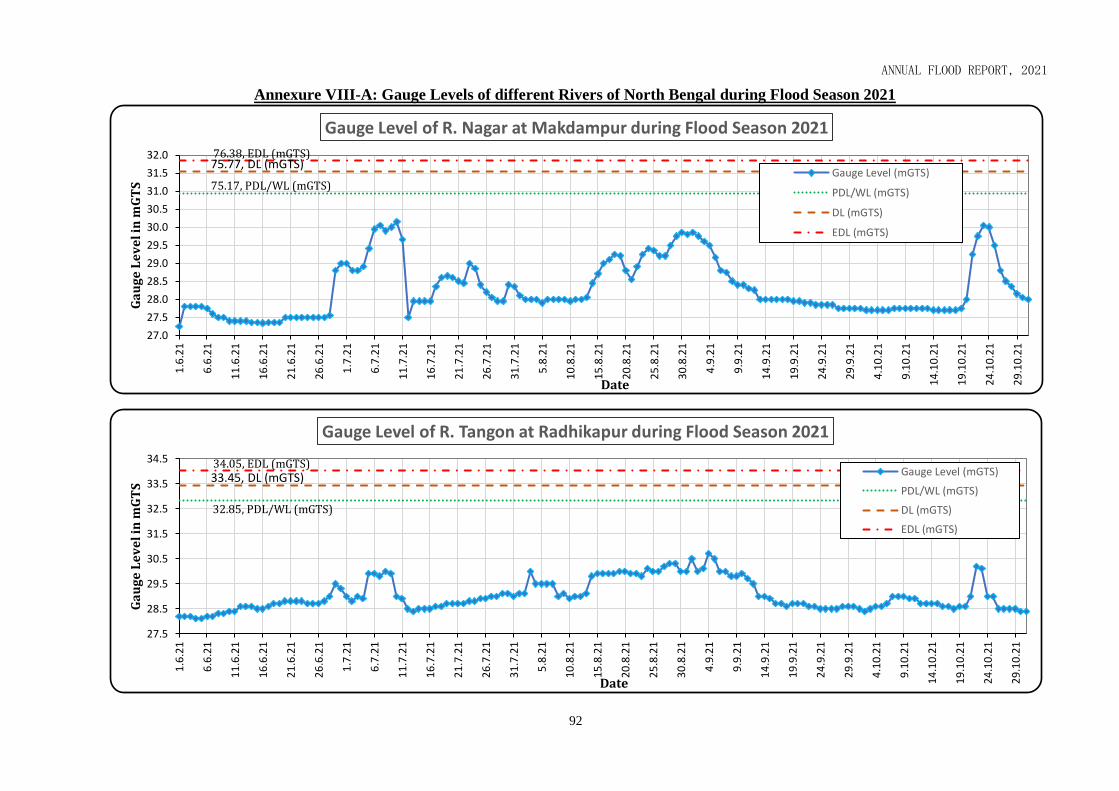
Annual Flood Report 2015
ANNUAL FLOOD REPORT, 2021
92
Annexure VIII-A: Gauge Levels of different Rivers of North Bengal during Flood Season 2021
75.17, PDL/WL (mGTS)
75.77, DL (mGTS)76.38, EDL (mGTS)
27.0
27.5
28.0
28.5
29.0
29.5
30.0
30.5
31.0
31.5
32.0
1.6
.21
6.6
.21
11
.6.2
1
16
.6.2
1
21
.6.2
1
26
.6.2
1
1.7
.21
6.7
.21
11
.7.2
1
16
.7.2
1
21
.7.2
1
26
.7.2
1
31
.7.2
1
5.8
.21
10
.8.2
1
15
.8.2
1
20
.8.2
1
25
.8.2
1
30
.8.2
1
4.9
.21
9.9
.21
14
.9.2
1
19
.9.2
1
24
.9.2
1
29
.9.2
1
4.1
0.2
1
9.1
0.2
1
14
.10
.21
19
.10
.21
24
.10
.21
29
.10
.21
Ga
ug
e L
ev
el i
n m
GT
S
Date
Gauge Level of R. Nagar at Makdampur during Flood Season 2021
Gauge Level (mGTS)
PDL/WL (mGTS)
DL (mGTS)
EDL (mGTS)
32.85, PDL/WL (mGTS)
33.45, DL (mGTS)34.05, EDL (mGTS)
27.5
28.5
29.5
30.5
31.5
32.5
33.5
34.5
1.6
.21
6.6
.21
11
.6.2
1
16
.6.2
1
21
.6.2
1
26
.6.2
1
1.7
.21
6.7
.21
11
.7.2
1
16
.7.2
1
21
.7.2
1
26
.7.2
1
31
.7.2
1
5.8
.21
10
.8.2
1
15
.8.2
1
20
.8.2
1
25
.8.2
1
30
.8.2
1
4.9
.21
9.9
.21
14
.9.2
1
19
.9.2
1
24
.9.2
1
29
.9.2
1
4.1
0.2
1
9.1
0.2
1
14
.10
.21
19
.10
.21
24
.10
.21
29
.10
.21
Ga
ug
e L
ev
el i
n m
GT
S
Date
Gauge Level of R. Tangon at Radhikapur during Flood Season 2021
Gauge Level (mGTS)
PDL/WL (mGTS)
DL (mGTS)
EDL (mGTS)

Annual Flood Report 2015
ANNUAL FLOOD REPORT, 2021
93
Annexure VIII-A: Gauge Levels of different Rivers of North Bengal during Flood Season 2021
23.76, EDL (mGTS)
23.15, DL (mGTS)
22.54, PDL/WL (mGTS)
18.0
19.0
20.0
21.0
22.0
23.0
24.0
1.6
.21
6.6
.21
11
.6.2
1
16
.6.2
1
21
.6.2
1
26
.6.2
1
1.7
.21
6.7
.21
11
.7.2
1
16
.7.2
1
21
.7.2
1
26
.7.2
1
31
.7.2
1
5.8
.21
10
.8.2
1
15
.8.2
1
20
.8.2
1
25
.8.2
1
30
.8.2
1
4.9
.21
9.9
.21
14
.9.2
1
19
.9.2
1
24
.9.2
1
29
.9.2
1
4.1
0.2
1
9.1
0.2
1
14
.10
.21
19
.10
.21
24
.10
.21
29
.10
.21
Ga
ug
e L
ev
el i
n m
GT
S
Date
Gauge Level of R. Atreyee at Balurghat during Flood Season 2021
Gauge Level (mGTS)
EDL (mGTS)
DL (mGTS)
PDL/WL (mGTS)
25.22, PDL/WL (mGTS)
25.82, DL (mGTS)
26.42, EDL (mGTS)
22.0
22.5
23.0
23.5
24.0
24.5
25.0
25.5
26.0
26.5
27.0
1.6
.21
6.6
.21
11
.6.2
1
16
.6.2
1
21
.6.2
1
26
.6.2
1
1.7
.21
6.7
.21
11
.7.2
1
16
.7.2
1
21
.7.2
1
26
.7.2
1
31
.7.2
1
5.8
.21
10
.8.2
1
15
.8.2
1
20
.8.2
1
25
.8.2
1
30
.8.2
1
4.9
.21
9.9
.21
14
.9.2
1
19
.9.2
1
24
.9.2
1
29
.9.2
1
4.1
0.2
1
9.1
0.2
1
14
.10
.21
19
.10
.21
24
.10
.21
29
.10
.21
Ga
ug
e L
ev
el i
n m
GT
S
Date
Gauge Level of R. Punarbhaba at Gangarampur during Flood Season 2021
Gauge Level (mGTS)
PDL/WL (mGTS)
DL (mGTS)
EDL (mGTS)

Annual Flood Report 2015
ANNUAL FLOOD REPORT, 2021
94
Annexure VIII-A: Gauge Levels of different Rivers of North Bengal during Flood Season 2021
26.51, PDL/WL (mGTS)
27.43, DL (mGTS)
28.35, EDL (mGTS)
23.0
24.0
25.0
26.0
27.0
28.0
29.0
1.6
.21
6.6
.21
11
.6.2
1
16
.6.2
1
21
.6.2
1
26
.6.2
1
1.7
.21
6.7
.21
11
.7.2
1
16
.7.2
1
21
.7.2
1
26
.7.2
1
31
.7.2
1
5.8
.21
10
.8.2
1
15
.8.2
1
20
.8.2
1
25
.8.2
1
30
.8.2
1
4.9
.21
9.9
.21
14
.9.2
1
19
.9.2
1
24
.9.2
1
29
.9.2
1
4.1
0.2
1
9.1
0.2
1
14
.10
.21
19
.10
.21
24
.10
.21
29
.10
.21
Ga
ug
e L
ev
el i
n m
GT
S
Date
Gauge Level of R. Fulhar at Teljana during Flood Season 2021
Gauge Level (mGTS)
PDL/WL (mGTS)
DL (mGTS)
EDL (mGTS)
24.09, PDL/WL (mGTS)
24.69, DL (mGTS)
25.30, EDL (mGTS)
21.5
22.0
22.5
23.0
23.5
24.0
24.5
25.0
25.5
26.0
26.5
1.6
.21
6.6
.21
11
.6.2
1
16
.6.2
1
21
.6.2
1
26
.6.2
1
1.7
.21
6.7
.21
11
.7.2
1
16
.7.2
1
21
.7.2
1
26
.7.2
1
31
.7.2
1
5.8
.21
10
.8.2
1
15
.8.2
1
20
.8.2
1
25
.8.2
1
30
.8.2
1
4.9
.21
9.9
.21
14
.9.2
1
19
.9.2
1
24
.9.2
1
29
.9.2
1
4.1
0.2
1
9.1
0.2
1
14
.10
.21
19
.10
.21
24
.10
.21
29
.10
.21
Ga
ug
e L
ev
el i
n m
GT
S
Date
Gauge Level of R. Ganga-Padma at Manikchakghat during Flood Season 2021
Gauge Level (mGTS)
PDL/WL (mGTS)
DL (mGTS)
EDL (mGTS)

Annual Flood Report 2015
ANNUAL FLOOD REPORT, 2021
92
Annexure VIII-B: Gauge Levels of different Rivers of South Bengal during Flood Season 2021
21.30, PDL/WL (mGTS)
21.90, DL (mGTS)22.51, EDL (mGTS)
16.0
17.0
18.0
19.0
20.0
21.0
22.0
23.01
.6.2
1
6.6
.21
11
.6.2
1
16
.6.2
1
21
.6.2
1
26
.6.2
1
1.7
.21
6.7
.21
11
.7.2
1
16
.7.2
1
21
.7.2
1
26
.7.2
1
31
.7.2
1
5.8
.21
10
.8.2
1
15
.8.2
1
20
.8.2
1
25
.8.2
1
30
.8.2
1
4.9
.21
9.9
.21
14
.9.2
1
19
.9.2
1
24
.9.2
1
29
.9.2
1
4.1
0.2
1
9.1
0.2
1
14
.10
.21
19
.10
.21
24
.10
.21
29
.10
.21
Ga
ug
e L
ev
el i
n m
GT
S
Date
Gauge Level of R. Ganga-Padma at Nimtita during Flood Season 2021
Gauge Level (mGTS)
PDL/WL (mGTS)
DL (mGTS)
EDL (mGTS)
32.40, PDL/WL (mGTS)
33.00, DL (mGTS)33.40, EDL (mGTS)
28.5
29.0
29.5
30.0
30.5
31.0
31.5
32.0
32.5
33.0
33.5
1.6
.21
6.6
.21
11
.6.2
1
16
.6.2
1
21
.6.2
1
26
.6.2
1
1.7
.21
6.7
.21
11
.7.2
1
16
.7.2
1
21
.7.2
1
26
.7.2
1
31
.7.2
1
5.8
.21
10
.8.2
1
15
.8.2
1
20
.8.2
1
25
.8.2
1
30
.8.2
1
4.9
.21
9.9
.21
14
.9.2
1
19
.9.2
1
24
.9.2
1
29
.9.2
1
4.1
0.2
1
9.1
0.2
1
14
.10
.21
19
.10
.21
24
.10
.21
29
.10
.21
Ga
ug
e L
ev
el i
n m
GT
S
Date
Gauge Level of R. Brahamani at Jagdhari Road Bridge during Flood Season 2021
Gauge Level (mGTS)
PDL/WL (mGTS)
DL (mGTS)
EDL (mGTS)

Annual Flood Report 2015
ANNUAL FLOOD REPORT, 2021
93
Annexure VIII-B: Gauge Levels of different Rivers of South Bengal during Flood Season 2021
19.50, PDL/WL (mGTS)
20.40, DL (mGTS)
21.30, EDL (mGTS)
14.5
15.5
16.5
17.5
18.5
19.5
20.5
21.5
1.6
.21
6.6
.21
11
.6.2
1
16
.6.2
1
21
.6.2
1
26
.6.2
1
1.7
.21
6.7
.21
11
.7.2
1
16
.7.2
1
21
.7.2
1
26
.7.2
1
31
.7.2
1
5.8
.21
10
.8.2
1
15
.8.2
1
20
.8.2
1
25
.8.2
1
30
.8.2
1
4.9
.21
9.9
.21
14
.9.2
1
19
.9.2
1
24
.9.2
1
29
.9.2
1
4.1
0.2
1
9.1
0.2
1
14
.10
.21
19
.10
.21
24
.10
.21
29
.10
.21
Ga
ug
e L
ev
el i
n m
GT
S
Date
Gauge Level of R. Dwarka at Sankoghat during Flood Season 2021
Gauge Level (mGTS)
PDL/WL (mGTS)
DL (mGTS)
EDL (mGTS)
16.76, PDL/WL (mGTS)
17.36, DL (mGTS)17.86, EDL (mGTS)
12.0
13.0
14.0
15.0
16.0
17.0
18.0
19.0
1.6
.21
6.6
.21
11
.6.2
1
16
.6.2
1
21
.6.2
1
26
.6.2
1
1.7
.21
6.7
.21
11
.7.2
1
16
.7.2
1
21
.7.2
1
26
.7.2
1
31
.7.2
1
5.8
.21
10
.8.2
1
15
.8.2
1
20
.8.2
1
25
.8.2
1
30
.8.2
1
4.9
.21
9.9
.21
14
.9.2
1
19
.9.2
1
24
.9.2
1
29
.9.2
1
4.1
0.2
1
9.1
0.2
1
14
.10
.21
19
.10
.21
24
.10
.21
29
.10
.21
Ga
ug
e L
ev
el
in m
GT
S
Date
Gauge Level of R. Dwarka at Ranagram during Flood Season 2021
Gauge Level (mGTS)
PDL/WL (mGTS)
DL (mGTS)
EDL (mGTS)

Annual Flood Report 2015
ANNUAL FLOOD REPORT, 2021
94
Annexure VIII-B: Gauge Levels of different Rivers of South Bengal during Flood Season 2021
27.19, PDL/WL (mGTS)
27.99, DL (mGTS)
28.79, EDL (mGTS)
22.0
23.0
24.0
25.0
26.0
27.0
28.0
29.0
30.01
.6.2
1
6.6
.21
11
.6.2
1
16
.6.2
1
21
.6.2
1
26
.6.2
1
1.7
.21
6.7
.21
11
.7.2
1
16
.7.2
1
21
.7.2
1
26
.7.2
1
31
.7.2
1
5.8
.21
10
.8.2
1
15
.8.2
1
20
.8.2
1
25
.8.2
1
30
.8.2
1
4.9
.21
9.9
.21
14
.9.2
1
19
.9.2
1
24
.9.2
1
29
.9.2
1
4.1
0.2
1
9.1
0.2
1
14
.10
.21
19
.10
.21
24
.10
.21
29
.10
.21
Ga
ug
e L
ev
el i
n m
GT
S
Date
Gauge Level of R. Mayurakshi at Narayanpur during Flood Season 2021
Gauge Level (mGTS)
PDL/WL (mGTS)
DL (mGTS)
EDL (mGTS)
22.11, PDL/WL (mGTS)
22.71, DL (mGTS)
23.35, EDL (mGTS)
17.0
18.0
19.0
20.0
21.0
22.0
23.0
24.0
1.6
.21
6.6
.21
11
.6.2
1
16
.6.2
1
21
.6.2
1
26
.6.2
1
1.7
.21
6.7
.21
11
.7.2
1
16
.7.2
1
21
.7.2
1
26
.7.2
1
31
.7.2
1
5.8
.21
10
.8.2
1
15
.8.2
1
20
.8.2
1
25
.8.2
1
30
.8.2
1
4.9
.21
9.9
.21
14
.9.2
1
19
.9.2
1
24
.9.2
1
29
.9.2
1
4.1
0.2
1
9.1
0.2
1
14
.10
.21
19
.10
.21
24
.10
.21
29
.10
.21
Ga
ug
e L
ev
el i
n m
GT
S
Date
Gauge Level of R. Kuia at Tarapur during Flood Season 2021
Gauge Level (mGTS)
PDL/WL (mGTS)
DL (mGTS)
EDL (mGTS)

Annual Flood Report 2015
ANNUAL FLOOD REPORT, 2021
95
Annexure VIII-B: Gauge Levels of different Rivers of South Bengal during Flood Season 2021
22.11, PDL/WL (mGTS)
22.71, DL (mGTS)
23.35, EDL (mGTS)
11.5
12.0
12.5
13.0
13.5
14.0
14.5
15.0
15.5
16.01
.6.2
1
6.6
.21
11
.6.2
1
16
.6.2
1
21
.6.2
1
26
.6.2
1
1.7
.21
6.7
.21
11
.7.2
1
16
.7.2
1
21
.7.2
1
26
.7.2
1
31
.7.2
1
5.8
.21
10
.8.2
1
15
.8.2
1
20
.8.2
1
25
.8.2
1
30
.8.2
1
4.9
.21
9.9
.21
14
.9.2
1
19
.9.2
1
24
.9.2
1
29
.9.2
1
4.1
0.2
1
9.1
0.2
1
14
.10
.21
19
.10
.21
24
.10
.21
29
.10
.21
Ga
ug
e L
ev
el i
n m
GT
S
Date
Gauge Level of R. Babla at Bazarshaw during Flood Season 2021
Gauge Level (mGTS)
PDL/WL (mGTS)
DL (mGTS)
EDL (mGTS)
38.42, PDL/WL (mGTS)
39.42, DL (mGTS)
40.42, EDL (mGTS)
34.0
35.0
36.0
37.0
38.0
39.0
40.0
41.0
42.0
43.0
1.6
.21
6.6
.21
11
.6.2
1
16
.6.2
1
21
.6.2
1
26
.6.2
1
1.7
.21
6.7
.21
11
.7.2
1
16
.7.2
1
21
.7.2
1
26
.7.2
1
31
.7.2
1
5.8
.21
10
.8.2
1
15
.8.2
1
20
.8.2
1
25
.8.2
1
30
.8.2
1
4.9
.21
9.9
.21
14
.9.2
1
19
.9.2
1
24
.9.2
1
29
.9.2
1
4.1
0.2
1
9.1
0.2
1
14
.10
.21
19
.10
.21
24
.10
.21
29
.10
.21
Ga
ug
e L
ev
el i
n m
GT
S
Date
Gauge Level of R. Ajoy at Gheropara during Flood Season 2021
Gauge Level (mGTS)
PDL/WL (mGTS)
DL (mGTS)
EDL (mGTS)

Annual Flood Report 2015
ANNUAL FLOOD REPORT, 2021
96
Annexure VIII-B: Gauge Levels of different Rivers of South Bengal during Flood Season 2021
16.62, PDL/WL (mGTS)
17.22, DL (mGTS)
17.83, EDL (mGTS)
14.0
14.5
15.0
15.5
16.0
16.5
17.0
17.5
18.0
1.6
.21
6.6
.21
11
.6.2
1
16
.6.2
1
21
.6.2
1
26
.6.2
1
1.7
.21
6.7
.21
11
.7.2
1
16
.7.2
1
21
.7.2
1
26
.7.2
1
31
.7.2
1
5.8
.21
10
.8.2
1
15
.8.2
1
20
.8.2
1
25
.8.2
1
30
.8.2
1
4.9
.21
9.9
.21
14
.9.2
1
19
.9.2
1
24
.9.2
1
29
.9.2
1
4.1
0.2
1
9.1
0.2
1
14
.10
.21
19
.10
.21
24
.10
.21
29
.10
.21
Ga
ug
e L
ev
el i
n m
GT
S
Date
Gauge Level of R. Bhagirathi-Hoogly at Baharampur during Flood Season 2021
Gauge Level (mGTS)
PDL/WL (mGTS)
DL (mGTS)
EDL (mGTS)
13.10, PDL/WL (mGTS)
13.71, DL (mGTS)
14.32, EDL (mGTS)
9.0
10.0
11.0
12.0
13.0
14.0
15.0
1.6
.21
6.6
.21
11
.6.2
1
16
.6.2
1
21
.6.2
1
26
.6.2
1
1.7
.21
6.7
.21
11
.7.2
1
16
.7.2
1
21
.7.2
1
26
.7.2
1
31
.7.2
1
5.8
.21
10
.8.2
1
15
.8.2
1
20
.8.2
1
25
.8.2
1
30
.8.2
1
4.9
.21
9.9
.21
14
.9.2
1
19
.9.2
1
24
.9.2
1
29
.9.2
1
4.1
0.2
1
9.1
0.2
1
14
.10
.21
19
.10
.21
24
.10
.21
29
.10
.21
Ga
ug
e L
ev
el i
n m
GT
S
Date
Gauge Level of R. Bhagirathi-Hoogly at Katwa during Flood Season 2021
Gauge Level (mGTS)
PDL/WL (mGTS)
DL (mGTS)
EDL (mGTS)

Annual Flood Report 2015
ANNUAL FLOOD REPORT, 2021
97
Annexure VIII-B: Gauge Levels of different Rivers of South Bengal during Flood Season 2021
7.83, PDL/WL (mGTS)
8.44, DL (mGTS)
9.05, EDL (mGTS)
5.0
5.5
6.0
6.5
7.0
7.5
8.0
8.5
9.0
9.51
.6.2
1
6.6
.21
11
.6.2
1
16
.6.2
1
21
.6.2
1
26
.6.2
1
1.7
.21
6.7
.21
11
.7.2
1
16
.7.2
1
21
.7.2
1
26
.7.2
1
31
.7.2
1
5.8
.21
10
.8.2
1
15
.8.2
1
20
.8.2
1
25
.8.2
1
30
.8.2
1
4.9
.21
9.9
.21
14
.9.2
1
19
.9.2
1
24
.9.2
1
29
.9.2
1
4.1
0.2
1
9.1
0.2
1
14
.10
.21
19
.10
.21
24
.10
.21
29
.10
.21
Ga
ug
e L
ev
el i
n m
GT
S
Date
Gauge Level of R. Bhagirathi-Hoogly at Swarupganj during Flood Season 2021
Gauge Level (mGTS)
PDL/WL (mGTS)
DL (mGTS)
EDL (mGTS)
7.21, PDL/WL (mGTS)
7.82, DL (mGTS)
8.43, EDL (mGTS)
3.0
4.0
5.0
6.0
7.0
8.0
9.0
1.6
.21
6.6
.21
11
.6.2
1
16
.6.2
1
21
.6.2
1
26
.6.2
1
1.7
.21
6.7
.21
11
.7.2
1
16
.7.2
1
21
.7.2
1
26
.7.2
1
31
.7.2
1
5.8
.21
10
.8.2
1
15
.8.2
1
20
.8.2
1
25
.8.2
1
30
.8.2
1
4.9
.21
9.9
.21
14
.9.2
1
19
.9.2
1
24
.9.2
1
29
.9.2
1
4.1
0.2
1
9.1
0.2
1
14
.10
.21
19
.10
.21
24
.10
.21
29
.10
.21
Ga
ug
e L
ev
el i
n m
GT
S
Date
Gauge Level of R. Mathabhanga at Majdia during Flood Season 2021
Gauge Level (mGTS)
PDL/WL (mGTS)
DL (mGTS)
EDL (mGTS)

Annual Flood Report 2015
ANNUAL FLOOD REPORT, 2021
98
Annexure VIII-B: Gauge Levels of different Rivers of South Bengal during Flood Season 2021
6.92, PDL/WL (mGTS)
7.53, DL (mGTS)
8.14, EDL (mGTS)
3.0
4.0
5.0
6.0
7.0
8.0
1.6
.21
6.6
.21
11
.6.2
1
16
.6.2
1
21
.6.2
1
26
.6.2
1
1.7
.21
6.7
.21
11
.7.2
1
16
.7.2
1
21
.7.2
1
26
.7.2
1
31
.7.2
1
5.8
.21
10
.8.2
1
15
.8.2
1
20
.8.2
1
25
.8.2
1
30
.8.2
1
4.9
.21
9.9
.21
14
.9.2
1
19
.9.2
1
24
.9.2
1
29
.9.2
1
4.1
0.2
1
9.1
0.2
1
14
.10
.21
19
.10
.21
24
.10
.21
29
.10
.21
Ga
ug
e L
ev
el i
n m
GT
S
Date
Gauge Level of R. Churni at Hanskhali during Flood Season 2021
Gauge Level (mGTS)
PDL/WL (mGTS)
DL (mGTS)
EDL (mGTS)
4.10, PDL/WL (mGTS)
4.70, DL (mGTS)
5.25, EDL (mGTS)
1.5
2.0
2.5
3.0
3.5
4.0
4.5
5.0
5.5
1.6
.21
6.6
.21
11
.6.2
1
16
.6.2
1
21
.6.2
1
26
.6.2
1
1.7
.21
6.7
.21
11
.7.2
1
16
.7.2
1
21
.7.2
1
26
.7.2
1
31
.7.2
1
5.8
.21
10
.8.2
1
15
.8.2
1
20
.8.2
1
25
.8.2
1
30
.8.2
1
4.9
.21
9.9
.21
14
.9.2
1
19
.9.2
1
24
.9.2
1
29
.9.2
1
4.1
0.2
1
9.1
0.2
1
14
.10
.21
19
.10
.21
24
.10
.21
29
.10
.21
Ga
ug
e L
ev
el i
n m
GT
S
Date
Gauge Level of R. Ichamati at RD Setu (Bongaon) during Flood Season 2021
Gauge Level (mGTS)
PDL/WL (mGTS)
DL (mGTS)
EDL (mGTS)

Annual Flood Report 2015
ANNUAL FLOOD REPORT, 2021
99
Annexure VIII-B: Gauge Levels of different Rivers of South Bengal during Flood Season 2021
3.85, PDL/WL (mGTS)
4.45, DL (mGTS)
5.05, EDL (mGTS)
2.5
3.0
3.5
4.0
4.5
5.0
5.51
.6.2
1
6.6
.21
11
.6.2
1
16
.6.2
1
21
.6.2
1
26
.6.2
1
1.7
.21
6.7
.21
11
.7.2
1
16
.7.2
1
21
.7.2
1
26
.7.2
1
31
.7.2
1
5.8
.21
10
.8.2
1
15
.8.2
1
20
.8.2
1
25
.8.2
1
30
.8.2
1
4.9
.21
9.9
.21
14
.9.2
1
19
.9.2
1
24
.9.2
1
29
.9.2
1
4.1
0.2
1
9.1
0.2
1
14
.10
.21
19
.10
.21
24
.10
.21
29
.10
.21
Ga
ug
e L
ev
el i
n m
GT
S
Date
Gauge Level of R. Jamuna at Gaighata during Flood Season 2021
Gauge Level (mGTS)
PDL/WL (mGTS)
DL (mGTS)
EDL (mGTS)
51.53, PDL/WL (mGTS)
52.13, DL (mGTS)
52.89, EDL (mGTS)
49.0
49.5
50.0
50.5
51.0
51.5
52.0
52.5
53.0
1.6
.21
6.6
.21
11
.6.2
1
16
.6.2
1
21
.6.2
1
26
.6.2
1
1.7
.21
6.7
.21
11
.7.2
1
16
.7.2
1
21
.7.2
1
26
.7.2
1
31
.7.2
1
5.8
.21
10
.8.2
1
15
.8.2
1
20
.8.2
1
25
.8.2
1
30
.8.2
1
4.9
.21
9.9
.21
14
.9.2
1
19
.9.2
1
24
.9.2
1
29
.9.2
1
4.1
0.2
1
9.1
0.2
1
14
.10
.21
19
.10
.21
24
.10
.21
29
.10
.21
Ga
ug
e L
ev
el i
n m
GT
S
Date
Gauge Level of R. Damodar at Rondiha during Flood Season 2021
Gauge Level (mGTS)
PDL/WL (mGTS)
DL (mGTS)
EDL (mGTS)

Annual Flood Report 2015
ANNUAL FLOOD REPORT, 2021
100
Annexure VIII-B: Gauge Levels of different Rivers of South Bengal during Flood Season 2021
32.19, PDL/WL (mGTS)
32.79, DL (mGTS)
32.95, EDL (mGTS)
27.0
28.0
29.0
30.0
31.0
32.0
33.01
.6.2
1
6.6
.21
11
.6.2
1
16
.6.2
1
21
.6.2
1
26
.6.2
1
1.7
.21
6.7
.21
11
.7.2
1
16
.7.2
1
21
.7.2
1
26
.7.2
1
31
.7.2
1
5.8
.21
10
.8.2
1
15
.8.2
1
20
.8.2
1
25
.8.2
1
30
.8.2
1
4.9
.21
9.9
.21
14
.9.2
1
19
.9.2
1
24
.9.2
1
29
.9.2
1
4.1
0.2
1
9.1
0.2
1
14
.10
.21
19
.10
.21
24
.10
.21
29
.10
.21
Ga
ug
e L
ev
el i
n m
GT
S
Date
Gauge Level of R. Damodar at Edilpur during Flood Season 2021
Gauge Level (mGTS)
PDL/WL (mGTS)
DL (mGTS)
EDL (mGTS)
22.93, PDL/WL (mGTS)
23.24, DL (mGTS)
23.54, EDL (mGTS)
16.0
17.0
18.0
19.0
20.0
21.0
22.0
23.0
24.0
1.6
.21
6.6
.21
11
.6.2
1
16
.6.2
1
21
.6.2
1
26
.6.2
1
1.7
.21
6.7
.21
11
.7.2
1
16
.7.2
1
21
.7.2
1
26
.7.2
1
31
.7.2
1
5.8
.21
10
.8.2
1
15
.8.2
1
20
.8.2
1
25
.8.2
1
30
.8.2
1
4.9
.21
9.9
.21
14
.9.2
1
19
.9.2
1
24
.9.2
1
29
.9.2
1
4.1
0.2
1
9.1
0.2
1
14
.10
.21
19
.10
.21
24
.10
.21
29
.10
.21
Ga
ug
e L
ev
el i
n m
GT
S
Date
Gauge Level of R. Damodar at Jamalpur during Flood Season 2021
Gauge Level (mGTS)
PDL/WL (mGTS)
DL (mGTS)
EDL (mGTS)

Annual Flood Report 2015
ANNUAL FLOOD REPORT, 2021
101
Annexure VIII-B: Gauge Levels of different Rivers of South Bengal during Flood Season 2021
22.93, PDL/WL (mGTS)
23.24, DL (mGTS)
23.54, EDL (mGTS)
2.5
3.5
4.5
5.5
6.5
7.5
1.6
.21
6.6
.21
11
.6.2
1
16
.6.2
1
21
.6.2
1
26
.6.2
1
1.7
.21
6.7
.21
11
.7.2
1
16
.7.2
1
21
.7.2
1
26
.7.2
1
31
.7.2
1
5.8
.21
10
.8.2
1
15
.8.2
1
20
.8.2
1
25
.8.2
1
30
.8.2
1
4.9
.21
9.9
.21
14
.9.2
1
19
.9.2
1
24
.9.2
1
29
.9.2
1
4.1
0.2
1
9.1
0.2
1
14
.10
.21
19
.10
.21
24
.10
.21
29
.10
.21
Ga
ug
e L
ev
el i
n m
GT
S
Date
Gauge Level of Amta Channel at Amta during Flood Season 2021
Gauge Level (mGTS)
PDL/WL (mGTS)
DL (mGTS)
EDL (mGTS)
5.56, PDL/WL (mGTS)
6.16, DL (mGTS)
6.77, EDL (mGTS)
3.0
4.0
5.0
6.0
7.0
8.0
9.0
1.6
.21
6.6
.21
11
.6.2
1
16
.6.2
1
21
.6.2
1
26
.6.2
1
1.7
.21
6.7
.21
11
.7.2
1
16
.7.2
1
21
.7.2
1
26
.7.2
1
31
.7.2
1
5.8
.21
10
.8.2
1
15
.8.2
1
20
.8.2
1
25
.8.2
1
30
.8.2
1
4.9
.21
9.9
.21
14
.9.2
1
19
.9.2
1
24
.9.2
1
29
.9.2
1
4.1
0.2
1
9.1
0.2
1
14
.10
.21
19
.10
.21
24
.10
.21
29
.10
.21
Ga
ug
e L
ev
el i
n m
GT
S
Date
Gauge Level of Hurhura khal at Muchighata during Flood Season 2021
Gauge Level (mGTS)
PDL/WL (mGTS)
DL (mGTS)
EDL (mGTS)

Annual Flood Report 2015
ANNUAL FLOOD REPORT, 2021
102
Annexure VIII-B: Gauge Levels of different Rivers of South Bengal during Flood Season 2021
16.61, PDL/WL (mGTS)17.22, DL (mGTS)17.83, EDL (mGTS)
11.0
12.0
13.0
14.0
15.0
16.0
17.0
18.0
19.01
.6.2
1
6.6
.21
11
.6.2
1
16
.6.2
1
21
.6.2
1
26
.6.2
1
1.7
.21
6.7
.21
11
.7.2
1
16
.7.2
1
21
.7.2
1
26
.7.2
1
31
.7.2
1
5.8
.21
10
.8.2
1
15
.8.2
1
20
.8.2
1
25
.8.2
1
30
.8.2
1
4.9
.21
9.9
.21
14
.9.2
1
19
.9.2
1
24
.9.2
1
29
.9.2
1
4.1
0.2
1
9.1
0.2
1
14
.10
.21
19
.10
.21
24
.10
.21
29
.10
.21
Ga
ug
e L
ev
el i
n m
GT
S
Date
Gauge Level of R. Dwarakeswar at Arambag during Flood Season 2021
Gauge Level (mGTS)
PDL/WL (mGTS)
DL (mGTS)
EDL (mGTS)
11.15, PDL/WL (mGTS)
11.75, DL (mGTS)
12.35, EDL (mGTS)
7.0
8.0
9.0
10.0
11.0
12.0
13.0
1.6
.21
6.6
.21
11
.6.2
1
16
.6.2
1
21
.6.2
1
26
.6.2
1
1.7
.21
6.7
.21
11
.7.2
1
16
.7.2
1
21
.7.2
1
26
.7.2
1
31
.7.2
1
5.8
.21
10
.8.2
1
15
.8.2
1
20
.8.2
1
25
.8.2
1
30
.8.2
1
4.9
.21
9.9
.21
14
.9.2
1
19
.9.2
1
24
.9.2
1
29
.9.2
1
4.1
0.2
1
9.1
0.2
1
14
.10
.21
19
.10
.21
24
.10
.21
29
.10
.21
Ga
ug
e L
ev
el i
n m
GT
S
Date
Gauge Level of R. Dwarakeswar at Shakepore during Flood Season 2021
Gauge Level (mGTS)
PDL/WL (mGTS)
DL (mGTS)
EDL (mGTS)

Annual Flood Report 2015
ANNUAL FLOOD REPORT, 2021
103
Annexure VIII-B: Gauge Levels of different Rivers of South Bengal during Flood Season 2021
14.47, PDL/WL (mGTS)
15.08, DL (mGTS)
15.69, EDL (mGTS)
11.0
12.0
13.0
14.0
15.0
16.0
17.01
.6.2
1
6.6
.21
11
.6.2
1
16
.6.2
1
21
.6.2
1
26
.6.2
1
1.7
.21
6.7
.21
11
.7.2
1
16
.7.2
1
21
.7.2
1
26
.7.2
1
31
.7.2
1
5.8
.21
10
.8.2
1
15
.8.2
1
20
.8.2
1
25
.8.2
1
30
.8.2
1
4.9
.21
9.9
.21
14
.9.2
1
19
.9.2
1
24
.9.2
1
29
.9.2
1
4.1
0.2
1
9.1
0.2
1
14
.10
.21
19
.10
.21
24
.10
.21
29
.10
.21
Ga
ug
e L
ev
el i
n m
GT
S
Date
Gauge Level of R. Shilabati at Banka during Flood Season 2021
Gauge Level (mGTS)
PDL/WL (mGTS)
DL (mGTS)
EDL (mGTS)
8.38, PDL/WL (mGTS)
8.99, DL (mGTS)
9.60, EDL (mGTS)
3.0
4.0
5.0
6.0
7.0
8.0
9.0
10.0
11.0
1.6
.21
6.6
.21
11
.6.2
1
16
.6.2
1
21
.6.2
1
26
.6.2
1
1.7
.21
6.7
.21
11
.7.2
1
16
.7.2
1
21
.7.2
1
26
.7.2
1
31
.7.2
1
5.8
.21
10
.8.2
1
15
.8.2
1
20
.8.2
1
25
.8.2
1
30
.8.2
1
4.9
.21
9.9
.21
14
.9.2
1
19
.9.2
1
24
.9.2
1
29
.9.2
1
4.1
0.2
1
9.1
0.2
1
14
.10
.21
19
.10
.21
24
.10
.21
29
.10
.21
Ga
ug
e L
ev
el i
n m
GT
S
Date
Gauge Level of R. Shilabati at Gadghat during Flood Season 2021
Gauge Level (mGTS)
PDL/WL (mGTS)
DL (mGTS)
EDL (mGTS)

Annual Flood Report 2015
ANNUAL FLOOD REPORT, 2021
104
Annexure VIII-B: Gauge Levels of different Rivers of South Bengal during Flood Season 2021
6.24, PDL/WL (mGTS)6.85, DL (mGTS)7.46, EDL (mGTS)
1.0
2.0
3.0
4.0
5.0
6.0
7.0
8.0
9.01
.6.2
1
6.6
.21
11
.6.2
1
16
.6.2
1
21
.6.2
1
26
.6.2
1
1.7
.21
6.7
.21
11
.7.2
1
16
.7.2
1
21
.7.2
1
26
.7.2
1
31
.7.2
1
5.8
.21
10
.8.2
1
15
.8.2
1
20
.8.2
1
25
.8.2
1
30
.8.2
1
4.9
.21
9.9
.21
14
.9.2
1
19
.9.2
1
24
.9.2
1
29
.9.2
1
4.1
0.2
1
9.1
0.2
1
14
.10
.21
19
.10
.21
24
.10
.21
29
.10
.21
Ga
ug
e L
ev
el i
n m
GT
S
Date
Gauge Level of R. Rupnarayan at Bandar during Flood Season 2021
Gauge Level (mGTS)
PDL/WL (mGTS)
DL (mGTS)
EDL (mGTS)
4.41, PDL/WL (mGTS)
5.03, DL (mGTS)
5.65, EDL (mGTS)
1.0
2.0
3.0
4.0
5.0
6.0
7.0
1.6
.21
6.6
.21
11
.6.2
1
16
.6.2
1
21
.6.2
1
26
.6.2
1
1.7
.21
6.7
.21
11
.7.2
1
16
.7.2
1
21
.7.2
1
26
.7.2
1
31
.7.2
1
5.8
.21
10
.8.2
1
15
.8.2
1
20
.8.2
1
25
.8.2
1
30
.8.2
1
4.9
.21
9.9
.21
14
.9.2
1
19
.9.2
1
24
.9.2
1
29
.9.2
1
4.1
0.2
1
9.1
0.2
1
14
.10
.21
19
.10
.21
24
.10
.21
29
.10
.21
Ga
ug
e L
ev
el i
n m
GT
S
Date
Gauge Level of R. Rupnarayan at Gopiganj during Flood Season 2021
Gauge Level (mGTS)
PDL/WL (mGTS)
DL (mGTS)
EDL (mGTS)

Annual Flood Report 2015
ANNUAL FLOOD REPORT, 2021
105
Annexure VIII-B: Gauge Levels of different Rivers of South Bengal during Flood Season 2021
8.68, PDL/WL (mGTS)
9.29, DL (mGTS)
9.90, EDL (mGTS)
6.0
6.5
7.0
7.5
8.0
8.5
9.0
9.5
10.0
10.5
11.01
.6.2
1
6.6
.21
11
.6.2
1
16
.6.2
1
21
.6.2
1
26
.6.2
1
1.7
.21
6.7
.21
11
.7.2
1
16
.7.2
1
21
.7.2
1
26
.7.2
1
31
.7.2
1
5.8
.21
10
.8.2
1
15
.8.2
1
20
.8.2
1
25
.8.2
1
30
.8.2
1
4.9
.21
9.9
.21
14
.9.2
1
19
.9.2
1
24
.9.2
1
29
.9.2
1
4.1
0.2
1
9.1
0.2
1
14
.10
.21
19
.10
.21
24
.10
.21
29
.10
.21
Ga
ug
e L
ev
el i
n m
GT
S
Date
Gauge Level of R. Old Cossye at Kalmijole during Flood Season 2021
Gauge Level (mGTS)
PDL/WL (mGTS)
DL (mGTS)
EDL (mGTS)
8.68, PDL/WL (mGTS)
9.29, DL (mGTS)
9.90, EDL (mGTS)
6.0
6.5
7.0
7.5
8.0
8.5
9.0
9.5
10.0
10.5
11.0
1.6
.21
6.6
.21
11
.6.2
1
16
.6.2
1
21
.6.2
1
26
.6.2
1
1.7
.21
6.7
.21
11
.7.2
1
16
.7.2
1
21
.7.2
1
26
.7.2
1
31
.7.2
1
5.8
.21
10
.8.2
1
15
.8.2
1
20
.8.2
1
25
.8.2
1
30
.8.2
1
4.9
.21
9.9
.21
14
.9.2
1
19
.9.2
1
24
.9.2
1
29
.9.2
1
4.1
0.2
1
9.1
0.2
1
14
.10
.21
19
.10
.21
24
.10
.21
29
.10
.21
Ga
ug
e L
ev
el i
n m
GT
S
Date
Gauge Level of R. New Cossye at Panskura during Flood Season 2021
Gauge Level (mGTS)
PDL/WL (mGTS)
DL (mGTS)
EDL (mGTS)

Annual Flood Report 2015
ANNUAL FLOOD REPORT, 2021
106
Annexure VIII-B: Gauge Levels of different Rivers of South Bengal during Flood Season 2021
5.70, PDL/WL (mGTS)
6.30, DL (mGTS)
6.90, EDL (mGTS)
2.5
3.0
3.5
4.0
4.5
5.0
5.5
6.0
6.5
7.0
7.51
.6.2
1
6.6
.21
11
.6.2
1
16
.6.2
1
21
.6.2
1
26
.6.2
1
1.7
.21
6.7
.21
11
.7.2
1
16
.7.2
1
21
.7.2
1
26
.7.2
1
31
.7.2
1
5.8
.21
10
.8.2
1
15
.8.2
1
20
.8.2
1
25
.8.2
1
30
.8.2
1
4.9
.21
9.9
.21
14
.9.2
1
19
.9.2
1
24
.9.2
1
29
.9.2
1
4.1
0.2
1
9.1
0.2
1
14
.10
.21
19
.10
.21
24
.10
.21
29
.10
.21
Ga
ug
e L
ev
el i
n m
GT
S
Date
Gauge Level of R. Chandia at Barisha during Flood Season 2021
Gauge Level (mGTS)
PDL/WL (mGTS)
DL (mGTS)
EDL (mGTS)
4.72, PDL/WL (mGTS)
5.33, DL (mGTS)
5.94, EDL (mGTS)
2.5
3.5
4.5
5.5
6.5
7.5
1.6
.21
6.6
.21
11
.6.2
1
16
.6.2
1
21
.6.2
1
26
.6.2
1
1.7
.21
6.7
.21
11
.7.2
1
16
.7.2
1
21
.7.2
1
26
.7.2
1
31
.7.2
1
5.8
.21
10
.8.2
1
15
.8.2
1
20
.8.2
1
25
.8.2
1
30
.8.2
1
4.9
.21
9.9
.21
14
.9.2
1
19
.9.2
1
24
.9.2
1
29
.9.2
1
4.1
0.2
1
9.1
0.2
1
14
.10
.21
19
.10
.21
24
.10
.21
29
.10
.21
Ga
ug
e L
ev
el i
n m
GT
S
Date
Gauge Level of R. Kapaleswari at Narayanbarh during Flood Season 2021
Gauge Level (mGTS)
PDL/WL (mGTS)
DL (mGTS)
EDL (mGTS)

Annual Flood Report 2015
ANNUAL FLOOD REPORT, 2021
107
Annexure VIII-B: Gauge Levels of different Rivers of South Bengal during Flood Season 2021
7.80, PDL/WL (mGTS)
8.40, DL (mGTS)8.85, EDL (mGTS)
5.5
6.5
7.5
8.5
9.5
10.5
11.51
.6.2
1
6.6
.21
11
.6.2
1
16
.6.2
1
21
.6.2
1
26
.6.2
1
1.7
.21
6.7
.21
11
.7.2
1
16
.7.2
1
21
.7.2
1
26
.7.2
1
31
.7.2
1
5.8
.21
10
.8.2
1
15
.8.2
1
20
.8.2
1
25
.8.2
1
30
.8.2
1
4.9
.21
9.9
.21
14
.9.2
1
19
.9.2
1
24
.9.2
1
29
.9.2
1
4.1
0.2
1
9.1
0.2
1
14
.10
.21
19
.10
.21
24
.10
.21
29
.10
.21
Ga
ug
e L
ev
el i
n m
GT
S
Date
Gauge Level of R. Kaliaghai at Bakhrabad during Flood Season 2021
Gauge Level (mGTS)
PDL/WL (mGTS)
DL (mGTS)
EDL (mGTS)
5.95, PDL/WL (mGTS)6.55, DL (mGTS)7.00, EDL (mGTS)
3.0
4.0
5.0
6.0
7.0
8.0
9.0
10.0
1.6
.21
6.6
.21
11
.6.2
1
16
.6.2
1
21
.6.2
1
26
.6.2
1
1.7
.21
6.7
.21
11
.7.2
1
16
.7.2
1
21
.7.2
1
26
.7.2
1
31
.7.2
1
5.8
.21
10
.8.2
1
15
.8.2
1
20
.8.2
1
25
.8.2
1
30
.8.2
1
4.9
.21
9.9
.21
14
.9.2
1
19
.9.2
1
24
.9.2
1
29
.9.2
1
4.1
0.2
1
9.1
0.2
1
14
.10
.21
19
.10
.21
24
.10
.21
29
.10
.21
Ga
ug
e L
ev
el i
n m
GT
S
Date
Gauge Level of R. Kaliaghai at Dehati during Flood Season 2021
Gauge Level (mGTS)
PDL/WL (mGTS)
DL (mGTS)
EDL (mGTS)

Annual Flood Report 2015
ANNUAL FLOOD REPORT, 2021
108
Annexure VIII-B: Gauge Levels of different Rivers of South Bengal during Flood Season 2021
5.18, PDL/WL (mGTS)
5.79, DL (mGTS)
6.40, EDL (mGTS)
3.0
3.5
4.0
4.5
5.0
5.5
6.0
6.5
7.0
7.5
8.01
.6.2
1
6.6
.21
11
.6.2
1
16
.6.2
1
21
.6.2
1
26
.6.2
1
1.7
.21
6.7
.21
11
.7.2
1
16
.7.2
1
21
.7.2
1
26
.7.2
1
31
.7.2
1
5.8
.21
10
.8.2
1
15
.8.2
1
20
.8.2
1
25
.8.2
1
30
.8.2
1
4.9
.21
9.9
.21
14
.9.2
1
19
.9.2
1
24
.9.2
1
29
.9.2
1
4.1
0.2
1
9.1
0.2
1
14
.10
.21
19
.10
.21
24
.10
.21
29
.10
.21
Ga
ug
e L
ev
el i
n m
GT
S
Date
Gauge Level of R. Kaliaghai at Amgachia during Flood Season 2021
Gauge Level (mGTS)
PDL/WL (mGTS)
DL (mGTS)
EDL (mGTS)
4.40, PDL/WL (mGTS)
5.00, DL (mGTS)
5.33, EDL (mGTS)
3.0
3.5
4.0
4.5
5.0
5.5
6.0
6.5
1.6
.21
6.6
.21
11
.6.2
1
16
.6.2
1
21
.6.2
1
26
.6.2
1
1.7
.21
6.7
.21
11
.7.2
1
16
.7.2
1
21
.7.2
1
26
.7.2
1
31
.7.2
1
5.8
.21
10
.8.2
1
15
.8.2
1
20
.8.2
1
25
.8.2
1
30
.8.2
1
4.9
.21
9.9
.21
14
.9.2
1
19
.9.2
1
24
.9.2
1
29
.9.2
1
4.1
0.2
1
9.1
0.2
1
14
.10
.21
19
.10
.21
24
.10
.21
29
.10
.21
Ga
ug
e L
ev
el i
n m
GT
S
Date
Gauge Level of R. Kaliaghai at Kalimandop during Flood Season 2021
Gauge Level (mGTS)
PDL/WL (mGTS)
DL (mGTS)
EDL (mGTS)

Annual Flood Report 2015
ANNUAL FLOOD REPORT, 2021
109
Annexure VIII-B: Gauge Levels of different Rivers of South Bengal during Flood Season 2021
44.90, PDL/WL (mGTS)45.50, DL (mGTS)
46.50, EDL (mGTS)
40.0
41.0
42.0
43.0
44.0
45.0
46.0
47.01
.6.2
1
6.6
.21
11
.6.2
1
16
.6.2
1
21
.6.2
1
26
.6.2
1
1.7
.21
6.7
.21
11
.7.2
1
16
.7.2
1
21
.7.2
1
26
.7.2
1
31
.7.2
1
5.8
.21
10
.8.2
1
15
.8.2
1
20
.8.2
1
25
.8.2
1
30
.8.2
1
4.9
.21
9.9
.21
14
.9.2
1
19
.9.2
1
24
.9.2
1
29
.9.2
1
4.1
0.2
1
9.1
0.2
1
14
.10
.21
19
.10
.21
24
.10
.21
29
.10
.21
Ga
ug
e L
ev
el i
n m
GT
S
Date
Gauge Level of R. Subarnarekha at Gopiballavpur during Flood Season 2021
Gauge Level (mGTS)
PDL/WL (mGTS)
DL (mGTS)
EDL (mGTS)
15.15, PDL/WL (mGTS)
16.15, DL (mGTS)
16.75, EDL (mGTS)
9.0
10.0
11.0
12.0
13.0
14.0
15.0
16.0
17.0
18.0
1.6
.21
6.6
.21
11
.6.2
1
16
.6.2
1
21
.6.2
1
26
.6.2
1
1.7
.21
6.7
.21
11
.7.2
1
16
.7.2
1
21
.7.2
1
26
.7.2
1
31
.7.2
1
5.8
.21
10
.8.2
1
15
.8.2
1
20
.8.2
1
25
.8.2
1
30
.8.2
1
4.9
.21
9.9
.21
14
.9.2
1
19
.9.2
1
24
.9.2
1
29
.9.2
1
4.1
0.2
1
9.1
0.2
1
14
.10
.21
19
.10
.21
24
.10
.21
29
.10
.21
Ga
ug
e L
ev
el i
n m
GT
S
Date
Gauge Level of R. Subarnarekha at Sonakonia during Flood Season 2021
Gauge Level (mGTS)
PDL/WL (mGTS)
DL (mGTS)
EDL (mGTS)

Annual Flood Report 2015
ANNUAL FLOOD REPORT, 2021
110
Annexure VIII-B: Gauge Levels of different Rivers of South Bengal during Flood Season 2021
104.13, PDL/WL (mGTS)
104.73, DL (mGTS)
105.33, EDL (mGTS)
102.0
102.5
103.0
103.5
104.0
104.5
105.0
105.51
.6.2
1
6.6
.21
11
.6.2
1
16
.6.2
1
21
.6.2
1
26
.6.2
1
1.7
.21
6.7
.21
11
.7.2
1
16
.7.2
1
21
.7.2
1
26
.7.2
1
31
.7.2
1
5.8
.21
10
.8.2
1
15
.8.2
1
20
.8.2
1
25
.8.2
1
30
.8.2
1
4.9
.21
9.9
.21
14
.9.2
1
19
.9.2
1
24
.9.2
1
29
.9.2
1
4.1
0.2
1
9.1
0.2
1
14
.10
.21
19
.10
.21
24
.10
.21
29
.10
.21
Ga
ug
e L
ev
el i
n m
GT
S
Date
Gauge Level of R. Ajoy at Amuliaghat during Flood Season 2021
Gauge Level (mGTS)
PDL/WL (mGTS)
DL (mGTS)
EDL (mGTS)
15.40, PDL/WL (mGTS)16.00, DL (mGTS)16.60, EDL (mGTS)
10.0
11.0
12.0
13.0
14.0
15.0
16.0
17.0
18.0
1.6
.21
6.6
.21
11
.6.2
1
16
.6.2
1
21
.6.2
1
26
.6.2
1
1.7
.21
6.7
.21
11
.7.2
1
16
.7.2
1
21
.7.2
1
26
.7.2
1
31
.7.2
1
5.8
.21
10
.8.2
1
15
.8.2
1
20
.8.2
1
25
.8.2
1
30
.8.2
1
4.9
.21
9.9
.21
14
.9.2
1
19
.9.2
1
24
.9.2
1
29
.9.2
1
4.1
0.2
1
9.1
0.2
1
14
.10
.21
19
.10
.21
24
.10
.21
29
.10
.21
Ga
ug
e L
ev
el i
n m
GT
S
Date
Gauge Level of R. Kangsabati at Kapastikri during Flood Season 2021
Gauge Level (mGTS)
PDL/WL (mGTS)
DL (mGTS)
EDL (mGTS)

Annual Flood Report 2015
ANNUAL FLOOD REPORT, 2021
111
Annexure VIII-B: Gauge Levels of different Rivers of South Bengal during Flood Season 2021
104.13, PDL/WL (mGTS)
104.73, DL (mGTS)105.33, EDL (mGTS)
7.5
8.5
9.5
10.5
11.5
12.5
13.5
14.51
.6.2
1
6.6
.21
11
.6.2
1
16
.6.2
1
21
.6.2
1
26
.6.2
1
1.7
.21
6.7
.21
11
.7.2
1
16
.7.2
1
21
.7.2
1
26
.7.2
1
31
.7.2
1
5.8
.21
10
.8.2
1
15
.8.2
1
20
.8.2
1
25
.8.2
1
30
.8.2
1
4.9
.21
9.9
.21
14
.9.2
1
19
.9.2
1
24
.9.2
1
29
.9.2
1
4.1
0.2
1
9.1
0.2
1
14
.10
.21
19
.10
.21
24
.10
.21
29
.10
.21
Ga
ug
e L
ev
el i
n m
GT
S
Date
Gauge Level of Amta Channel at Champadanga during Flood Season 2021
Gauge Level (mGTS)
PDL/WL (mGTS)
DL (mGTS)
EDL (mGTS)
12.2, PDL/WL (mGTS)
12.80, DL (mGTS)13.41, EDL (mGTS)
4.5
5.5
6.5
7.5
8.5
9.5
10.5
11.5
12.5
13.5
14.5
1.6
.21
6.6
.21
11
.6.2
1
16
.6.2
1
21
.6.2
1
26
.6.2
1
1.7
.21
6.7
.21
11
.7.2
1
16
.7.2
1
21
.7.2
1
26
.7.2
1
31
.7.2
1
5.8
.21
10
.8.2
1
15
.8.2
1
20
.8.2
1
25
.8.2
1
30
.8.2
1
4.9
.21
9.9
.21
14
.9.2
1
19
.9.2
1
24
.9.2
1
29
.9.2
1
4.1
0.2
1
9.1
0.2
1
14
.10
.21
19
.10
.21
24
.10
.21
29
.10
.21
Ga
ug
e L
ev
el i
n m
GT
S
Date
Gauge Level of R. Mundeswari at Harinkhola during Flood Season 2021
Gauge Level (mGTS)
PDL/WL (mGTS)
DL (mGTS)
EDL (mGTS)

Annual Flood Report 2015
ANNUAL FLOOD REPORT, 2021
112
Annexure VIII-B: Gauge Levels of different Rivers of South Bengal during Flood Season 2021
4.5, PDL/WL (mGTS)
5.1, DL (mGTS)
5.7, EDL (mGTS)
3.0
3.5
4.0
4.5
5.0
5.5
6.0
6.5
7.0
1.6
.21
6.6
.21
11
.6.2
1
16
.6.2
1
21
.6.2
1
26
.6.2
1
1.7
.21
6.7
.21
11
.7.2
1
16
.7.2
1
21
.7.2
1
26
.7.2
1
31
.7.2
1
5.8
.21
10
.8.2
1
15
.8.2
1
20
.8.2
1
25
.8.2
1
30
.8.2
1
4.9
.21
9.9
.21
14
.9.2
1
19
.9.2
1
24
.9.2
1
29
.9.2
1
4.1
0.2
1
9.1
0.2
1
14
.10
.21
19
.10
.21
24
.10
.21
29
.10
.21
Ga
ug
e L
ev
el i
n m
GT
S
Date
Gauge Level of Short Cut channel at Sehagori during Flood Season 2021
Gauge Level (mGTS)
PDL/WL (mGTS)
DL (mGTS)
EDL (mGTS)

Annual Flood Report 2015
ANNUAL FLOOD REPORT, 2021
113
Annexure IX-A: Monthly Statistics of Dam-Barrage Operation during Flood Season, 2021
Sl. No.
River Basin Name of Reservoir Conservation Level (ft)
Max. Flood Level (ft)
Monthly Avg. Reservoir Level (ft) Max.Res. Level (ft)
Min. Res. Level (ft) Jun-21 Jul-21 Aug-21 Sep-21 Oct-21
1 Mayurakshi Massanjore dam 398.00 398.00 370.09 381.92 384.71 384.56 381.61 386.90 364.60
2 Ajoy Hinglow Dam 321.00 324.00 310.87 318.07 317.81 318.45 314.39 319.90 308.50
3 Damodar Tenughat Dam 852.00 864.00 846.65 848.81 851.56 849.55 853.12 861.89 843.32
4 Damodar Maithon Dam 480.00 495.00 469.99 477.06 485.79 481.51 486.23 491.79 461.15
5 Damodar Panchet Dam 410.00 435.00 411.52 409.17 418.74 408.46 417.47 429.94 259.19
6 Kangsabati Mukutmanipur 434.00 440.00 415.83 429.21 431.69 430.67 433.78 437.15 409.65
7 Subarnarekha Chandil dam 630.00 630.00 592.45 594.87 594.37 594.21 594.42 600.06 588.41
Sl. No.
River Basin Name of Barrage Max. Flood Level (ft)
Pond Level
(ft)
Monthly Avg. Water Level (ft) Max. Water Level (ft)
Min. Water Level (ft) Jun-21 Jul-21 Aug-21 Sep-21 Oct-21
1 Mahananda Mahananda Barrage
352.00 352.00 351.17 351.17 351.06 350.90 351.00 351.94 350.30
2 Teesta Teesta Barrage 378.30 375.00 375.73 375.67 376.19 376.54 376.33 376.64 374.90
3 Mayurakshi Tilpara Barrage 206.00 206.00 194.74 203.44 203.84 204.39 203.34 205.80 190.50
4 Ajoy Sikatia Barrage 559.70 558.00 554.46 555.05 555.35 555.87 554.23 557.51 546.35
5 Damodar Durgapur Barrage 211.50 211.50 211.50 211.50 211.37 211.50 211.50 211.50 211.00
6 Subarnarekha Galudih Barrage 332.00 310.00 293.00 301.80 301.92 301.58 301.18 308.40 281.82
Name of Reservoir
Monthly Avg. Inflow (Acre-ft) Max. Inflow (Ac.ft)
Min. Inflow (Ac.ft)
Monthly Avg. Outflow (Ac.ft) Max. Outflow (Ac.ft)
Min. Outflow (Ac.ft) Jun-21 Jul-21 Aug-21 Sep-21 Oct-21 Jun-21 Jul-21 Aug-21 Sep-21 Oct-21
Massanjore Dam
3391 3948 15746 2667 6030 2,24,250 0 0 2785 6660 2250 6879 27,902 0
Hinglow Dam 1009 2511 2222 2268 3542 44,645 0 911 2511 2271 2422 3963 49,645 0
Tenughat Dam
7316 13443 21049 13910 8631 2,24,838 1020 7615 10872 24753 12392 7042 1,86,362 317
Maithon Dam 20783 14246 23754 9833 26814 2,71,912 16 14725 12049 24448 10883 24483 1,58,048 397
Panchet Dam 23386 21579 42813 24588 35444 3,45,606 4167 21971 17221 46059 24325 33008 1,99,962 1,005
Mukutmanipur Dam
9715 11351 12440 11669 16141 1,41,407 182 4465 11158 16839 12378 16894 66,550 0
Chandil Dam NA NA 13396 NA NA 16,020 8561 11924 18893 41449 31762 23851 2,67,432 956
Name of Barrage Design Discharge
(cusec)
Monthly Avg. River Discharge down the Barrage (cusec) Maximum River Discharge
(cusec)
Minimum River Discharge
(cusec) Jun-21 Jul-21 Aug-21 Sep-21 Oct-21
Mahananda Barrage 80,000 453 1881 5029 999 1724 25,717 0
Teesta Barrage 7,09,800 51435 65071 73675 52997 37481 1,80,906 12,890
Tilpara Barrage 3,00,000 182 1520 4722 85 3344 20,657 0
Sikatia Barrage 5079 2694 3826 4847 6010 90,000 0
Durgapur Barrage 5,50,000 24703 21954 42795 20091 32537 1,89,095 50
Galudih Barrage 18146 20176 38866 46348 27527 2,99,515 1,133

Annual Flood Report 2015
ANNUAL FLOOD REPORT, 2021
114
Annexure IX-B1: Graphical Representation of Barrage Operation during Flood Season, 2021
370.0
371.0
372.0
373.0
374.0
375.0
376.0
377.0
378.0
379.0
380.0
0
20,000
40,000
60,000
80,000
1,00,000
1,20,000
1,40,000
1,60,000
1,80,000
01-0
6-21
06-0
6-21
11-0
6-21
16-0
6-21
21-0
6-21
26-0
6-21
01-0
7-21
06-0
7-21
11-0
7-21
16-0
7-21
21-0
7-21
26-0
7-21
31-0
7-21
05-0
8-21
10-0
8-21
15-0
8-21
20-0
8-21
25-0
8-21
30-0
8-21
04-0
9-21
09-0
9-21
14-0
9-21
19-0
9-21
24-0
9-21
29-0
9-21
04-1
0-21
09-1
0-21
14-1
0-21
19-1
0-21
24-1
0-21
29-1
0-21
Re
serv
oir
Le
vel (
ft)
Dis
char
ge (C
use
c)
Date
Pond Level vs. River Discharge of Teesta Barrage during Flood Season, 2021
River Discharge (cusec)
Pond Level (ft)
Conservation Level (ft)
Max. Flood Level (ft)
350.0
350.5
351.0
351.5
352.0
352.5
353.0
0
5,000
10,000
15,000
20,000
25,000
01-0
6-21
06-0
6-21
11-0
6-21
16-0
6-21
21-0
6-21
26-0
6-21
01-0
7-21
06-0
7-21
11-0
7-21
16-0
7-21
21-0
7-21
26-0
7-21
31-0
7-21
05-0
8-21
10-0
8-21
15-0
8-21
20-0
8-21
25-0
8-21
30-0
8-21
04-0
9-21
09-0
9-21
14-0
9-21
19-0
9-21
24-0
9-21
29-0
9-21
04-1
0-21
09-1
0-21
14-1
0-21
19-1
0-21
24-1
0-21
29-1
0-21
Re
serv
oir
Le
vel (
ft)
Dis
char
ge (C
use
c)
Date
Pond Level vs. River Discharge of Mahananda Barrage during Flood Season, 2021
River Discharge (cusec)
Pond Level (ft)
Conservation Level (ft)
Max. Flood Level (ft)

Annual Flood Report 2015
ANNUAL FLOOD REPORT, 2021
115
Annexure IX-B1: Graphical Representation of Barrage Operation during Flood Season, 2021
190.0
192.0
194.0
196.0
198.0
200.0
202.0
204.0
206.0
208.0
210.0
0
2,000
4,000
6,000
8,000
10,000
12,000
14,000
16,000
18,000
20,000
01-0
6-21
06-0
6-21
11-0
6-21
16-0
6-21
21-0
6-21
26-0
6-21
01-0
7-21
06-0
7-21
11-0
7-21
16-0
7-21
21-0
7-21
26-0
7-21
31-0
7-21
05-0
8-21
10-0
8-21
15-0
8-21
20-0
8-21
25-0
8-21
30-0
8-21
04-0
9-21
09-0
9-21
14-0
9-21
19-0
9-21
24-0
9-21
29-0
9-21
04-1
0-21
09-1
0-21
14-1
0-21
19-1
0-21
24-1
0-21
29-1
0-21
Re
serv
oir
Le
vel (
ft)
Dis
char
ge (C
use
c)
Date
Pond Level vs. River Discharge of Tilpara Barrage during Flood Season, 2021
River Discharge (cusec)
Pond Level (ft)
Conservation Level (ft)
Max. Flood Level (ft)
200.0
202.0
204.0
206.0
208.0
210.0
212.0
214.0
0
25,000
50,000
75,000
1,00,000
1,25,000
1,50,000
1,75,000
01-0
6-21
06-0
6-21
11-0
6-21
16-0
6-21
21-0
6-21
26-0
6-21
01-0
7-21
06-0
7-21
11-0
7-21
16-0
7-21
21-0
7-21
26-0
7-21
31-0
7-21
05-0
8-21
10-0
8-21
15-0
8-21
20-0
8-21
25-0
8-21
30-0
8-21
04-0
9-21
09-0
9-21
14-0
9-21
19-0
9-21
24-0
9-21
29-0
9-21
04-1
0-21
09-1
0-21
14-1
0-21
19-1
0-21
24-1
0-21
29-1
0-21
Re
serv
oir
Le
vel (
ft)
Dis
char
ge (C
use
c)
Date
Pond Level vs. River Discharge of Durgapur Barrage during Flood Season, 2021
River Discharge (cusec)
Pond Level (ft)
Conservation Level (ft)
Max. Flood Level (ft)

Annual Flood Report 2015
ANNUAL FLOOD REPORT, 2021
116
Annexure IX-B1: Graphical Representation of Barrage Operation during Flood Season, 2021
545.0
547.0
549.0
551.0
553.0
555.0
557.0
559.0
0
10,000
20,000
30,000
40,000
50,000
60,000
70,000
80,000
90,000
01-0
6-21
06-0
6-21
11-0
6-21
16-0
6-21
21-0
6-21
26-0
6-21
01-0
7-21
06-0
7-21
11-0
7-21
16-0
7-21
21-0
7-21
26-0
7-21
31-0
7-21
05-0
8-21
10-0
8-21
15-0
8-21
20-0
8-21
25-0
8-21
30-0
8-21
04-0
9-21
09-0
9-21
14-0
9-21
19-0
9-21
24-0
9-21
29-0
9-21
04-1
0-21
09-1
0-21
14-1
0-21
19-1
0-21
24-1
0-21
29-1
0-21
Re
serv
oir
Le
vel (
ft)
Dis
char
ge (C
use
c)
Date
Pond Level vs. River Discharge of Sikatia Barrage during Flood Season, 2021
River Discharge (cusec)
Pond Level (ft)
Conservation Level (ft)
Max. Flood Level (ft)
275.0
285.0
295.0
305.0
315.0
325.0
335.0
0
50,000
1,00,000
1,50,000
2,00,000
2,50,000
3,00,000
01-0
6-21
06-0
6-21
11-0
6-21
16-0
6-21
21-0
6-21
26-0
6-21
01-0
7-21
06-0
7-21
11-0
7-21
16-0
7-21
21-0
7-21
26-0
7-21
31-0
7-21
05-0
8-21
10-0
8-21
15-0
8-21
20-0
8-21
25-0
8-21
30-0
8-21
04-0
9-21
09-0
9-21
14-0
9-21
19-0
9-21
24-0
9-21
29-0
9-21
04-1
0-21
09-1
0-21
14-1
0-21
19-1
0-21
24-1
0-21
29-1
0-21
Re
serv
oir
Le
vel (
ft)
Dis
char
ge (C
use
c)
Date
Pond Level vs. River Discharge of Galudih Barrage during Flood Season, 2021
River Discharge (cusec)
Pond Level (ft)
Conservation Level (ft)
Max. Flood Level (ft)

Annual Flood Report 2015
ANNUAL FLOOD REPORT, 2021
117
Annexure IX-B2: Graphical Representation of Dam Operation during Flood Season, 2021
360.0
365.0
370.0
375.0
380.0
385.0
390.0
395.0
400.0
0
5,000
10,000
15,000
20,000
25,000
30,000
35,000
40,00001
-06-
21
06-0
6-21
11-0
6-21
16-0
6-21
21-0
6-21
26-0
6-21
01-0
7-21
06-0
7-21
11-0
7-21
16-0
7-21
21-0
7-21
26-0
7-21
31-0
7-21
05-0
8-21
10-0
8-21
15-0
8-21
20-0
8-21
25-0
8-21
30-0
8-21
04-0
9-21
09-0
9-21
14-0
9-21
19-0
9-21
24-0
9-21
29-0
9-21
04-1
0-21
09-1
0-21
14-1
0-21
19-1
0-21
24-1
0-21
29-1
0-21
Re
serv
oir
Le
vel (
ft)
Dis
char
ge (A
c.ft
.)
Date
Inflow-Outflow-Reservoir Level of Massanjore Dam during Flood Season, 2021
Inflow (Ac.ft)
Outflow (Ac.ft)
Reservoir Level (ft)
Conservation Level (ft)
Max. Flood Level (ft)
308.0
310.0
312.0
314.0
316.0
318.0
320.0
322.0
324.0
0
5,000
10,000
15,000
20,000
25,000
30,000
35,000
40,000
45,000
50,000
01-0
6-21
06-0
6-21
11-0
6-21
16-0
6-21
21-0
6-21
26-0
6-21
01-0
7-21
06-0
7-21
11-0
7-21
16-0
7-21
21-0
7-21
26-0
7-21
31-0
7-21
05-0
8-21
10-0
8-21
15-0
8-21
20-0
8-21
25-0
8-21
30-0
8-21
04-0
9-21
09-0
9-21
14-0
9-21
19-0
9-21
24-0
9-21
29-0
9-21
04-1
0-21
09-1
0-21
14-1
0-21
19-1
0-21
24-1
0-21
29-1
0-21
Re
serv
oir
Le
vel (
ft)
Dis
char
ge (C
use
c)
Date
Inflow-Outflow-Reservoir Level of Hinglow Dam during Flood Season, 2021
Inflow (Ac.ft)
Outflow (Ac.ft)
Reservoir Level (ft)
Conservation Level (ft)
Max. Flood Level (ft)

Annual Flood Report 2015
ANNUAL FLOOD REPORT, 2021
118
Annexure IX-B2: Graphical Representation of Dam Operation during Flood Season, 2021
460.0
465.0
470.0
475.0
480.0
485.0
490.0
495.0
500.0
0
30,000
60,000
90,000
1,20,000
1,50,000
1,80,000
2,10,000
2,40,000
2,70,00001
-06-
21
06-0
6-21
11-0
6-21
16-0
6-21
21-0
6-21
26-0
6-21
01-0
7-21
06-0
7-21
11-0
7-21
16-0
7-21
21-0
7-21
26-0
7-21
31-0
7-21
05-0
8-21
10-0
8-21
15-0
8-21
20-0
8-21
25-0
8-21
30-0
8-21
04-0
9-21
09-0
9-21
14-0
9-21
19-0
9-21
24-0
9-21
29-0
9-21
04-1
0-21
09-1
0-21
14-1
0-21
19-1
0-21
24-1
0-21
29-1
0-21
Re
serv
oir
Le
vel (
ft)
Dis
char
ge (A
c.ft
.)
Date
Inflow-Outflow-Reservoir Level of Maithon Dam during Flood Season, 2021
Inflow (Ac.ft)
Outflow (Ac.ft)
Reservoir Level (ft)
Conservation Level (ft)
Max. Flood Level (ft)
390.0
395.0
400.0
405.0
410.0
415.0
420.0
425.0
430.0
435.0
0
50,000
1,00,000
1,50,000
2,00,000
2,50,000
3,00,000
3,50,000
01-0
6-21
06-0
6-21
11-0
6-21
16-0
6-21
21-0
6-21
26-0
6-21
01-0
7-21
06-0
7-21
11-0
7-21
16-0
7-21
21-0
7-21
26-0
7-21
31-0
7-21
05-0
8-21
10-0
8-21
15-0
8-21
20-0
8-21
25-0
8-21
30-0
8-21
04-0
9-21
09-0
9-21
14-0
9-21
19-0
9-21
24-0
9-21
29-0
9-21
04-1
0-21
09-1
0-21
14-1
0-21
19-1
0-21
24-1
0-21
29-1
0-21
Re
serv
oir
Le
vel (
ft)
Dis
char
ge (A
c.ft
.)
Date
Inflow-Outflow-Reservoir Level of Panchet Dam during Flood Season, 2021
Inflow (Ac.ft)
Outflow (Ac.ft)
Reservoir Level (ft)
Conservation Level (ft)
Max. Flood Level (ft)

Annual Flood Report 2015
ANNUAL FLOOD REPORT, 2021
119
Annexure IX-B2: Graphical Representation of Dam Operation during Flood Season, 2021
840.0
845.0
850.0
855.0
860.0
865.0
0
25,000
50,000
75,000
1,00,000
1,25,000
1,50,000
1,75,000
2,00,000
2,25,000
01-0
6-21
06-0
6-21
11-0
6-21
16-0
6-21
21-0
6-21
26-0
6-21
01-0
7-21
06-0
7-21
11-0
7-21
16-0
7-21
21-0
7-21
26-0
7-21
31-0
7-21
05-0
8-21
10-0
8-21
15-0
8-21
20-0
8-21
25-0
8-21
30-0
8-21
04-0
9-21
09-0
9-21
14-0
9-21
19-0
9-21
24-0
9-21
29-0
9-21
04-1
0-21
09-1
0-21
14-1
0-21
19-1
0-21
24-1
0-21
29-1
0-21
Re
serv
oir
Le
vel (
ft)
Dis
char
ge (C
use
c)
Date
Inflow-Outflow-Reservoir Level of Tenughat Dam during Flood Season, 2021
Inflow (Ac.ft)
Outflow (Ac.ft)
Reservoir Level (ft)
Conservation Level (ft)
Max. Flood Level (ft)
410.0
415.0
420.0
425.0
430.0
435.0
440.0
445.0
0
15,000
30,000
45,000
60,000
75,000
90,000
1,05,000
1,20,000
1,35,000
01-0
6-21
06-0
6-21
11-0
6-21
16-0
6-21
21-0
6-21
26-0
6-21
01-0
7-21
06-0
7-21
11-0
7-21
16-0
7-21
21-0
7-21
26-0
7-21
31-0
7-21
05-0
8-21
10-0
8-21
15-0
8-21
20-0
8-21
25-0
8-21
30-0
8-21
04-0
9-21
09-0
9-21
14-0
9-21
19-0
9-21
24-0
9-21
29-0
9-21
04-1
0-21
09-1
0-21
14-1
0-21
19-1
0-21
24-1
0-21
29-1
0-21
Re
serv
oir
Le
vel (
ft)
Dis
char
ge (A
c.ft
.)
Date
Inflow-Outflow-Reservoir Level of Mukutmanipur Dam during Flood Season, 2021
Inflow (Ac.ft)
Outflow (Ac.ft)
Reservoir Level (ft)
Conservation Level (ft)
Max. Flood Level (ft)

Annual Flood Report 2015
ANNUAL FLOOD REPORT, 2021
120
Annexure IX-B2: Graphical Representation of Dam Operation during Flood Season, 2021
580.0
590.0
600.0
610.0
620.0
630.0
640.0
0
40,000
80,000
1,20,000
1,60,000
2,00,000
2,40,00001
-06-
21
06-0
6-21
11-0
6-21
16-0
6-21
21-0
6-21
26-0
6-21
01-0
7-21
06-0
7-21
11-0
7-21
16-0
7-21
21-0
7-21
26-0
7-21
31-0
7-21
05-0
8-21
10-0
8-21
15-0
8-21
20-0
8-21
25-0
8-21
30-0
8-21
04-0
9-21
09-0
9-21
14-0
9-21
19-0
9-21
24-0
9-21
29-0
9-21
04-1
0-21
09-1
0-21
14-1
0-21
19-1
0-21
24-1
0-21
29-1
0-21
Re
serv
oir
Le
vel (
ft)
Dis
char
ge (A
c.ft
.)
Date
Inflow-Outflow-Reservoir Level of Chandil Dam during Flood Season, 2021
Inflow (Ac.ft)
Outflow (Ac.ft)
Reservoir Level (ft)
Conservation Level (ft)
Max. Flood Level (ft)

ANNUAL FLOOD REPORT, 2021
121
Annexure – X: Flood Warning Signals in North Bengal Rivers during Monsoon 2021
Sl. No.
Name of River Area
Date of Signal
Imposed
Time of Signal
Imposed Type of Signal
Date of Signal
Withdrawn
Time of Signal
Withdrawn 1 Teesta Unprotected areas from Domohoni to Bangladesh border on both banks 08.06.2021 18:30 Yellow 09.06.2021 7:30
2 Teesta Unprotected areas from Domohoni to Bangladesh border on both banks 19.06.2021 6:30 Yellow 19.06.2021 10:30
3 Teesta Unprotected areas from Domohoni to Bangladesh border on both banks 20.06.2021 7:30 Yellow 20.06.2021 19:20
4 Teesta Unprotected areas from Domohoni to Bangladesh border on both banks 30.06.2021 6:30 Yellow 30.06.2021 14:40
5 Jaldhaka Unprotected areas of NH-31 to Mathabhanga on both banks 30.06.2021 6:40 Yellow 30.06.2021 14:30
6 Mansai Both protected & unprotected areas of Mathabhnga upto Bangladesh border on both banks 30.06.2021 9:00 Yellow 01.07.2021 4:00
7 Teesta Unprotected areas from Domohoni to Bangladesh border on both banks 03.07.2021 18:15 Yellow 04.07.2021 6:30
8 Teesta Unprotected areas from Domohoni to Bangladesh border on both banks 08.07.2021 7:30 Yellow 09.07.2021 5:30
9 Teesta Unprotected areas from Domohoni to Bangladesh border on both banks 11.07.2021 8:30 Yellow 12.07.2021 8:20
10 Teesta Unprotected areas from Domohoni to Bangladesh border on both banks 14.07.2021 8:20 Yellow 16.07.2021 5:30
11 Teesta Unprotected areas from Domohoni to Bangladesh border on both banks 19.07.2021 13:30 Yellow 20.07.2021 5:20
12 Teesta Unprotected areas from Domohoni to Bangladesh border on both banks 15.08.2021 11:20 Yellow 16.08.2021 7:30
13 Teesta Unprotected areas from Domohoni to Bangladesh border on both banks 17.08.2021 6:45 Yellow 17.08.2021 18:30
14 Teesta Unprotected areas from Domohoni to Bangladesh border on both banks 18.08.2021 9:30 Yellow 20.08.2021 6:00
15 Jaldhaka Unprotected areas of NH-31 to Mathabhanga on both banks 19.08.2021 8:30 Yellow 19.08.2021 16:30
16 Mansai Unprotected areas of Mathabhnga upto Bangladesh border on both banks 19.08.2021 17:00 Yellow 22.08.2021 12:00
17 Mansai Both protected & unprotected areas of Mathabhnga upto Bangladesh border on both banks 19.08.2021 19:00 Yellow 22.08.2021 12:00
18 Jaldhaka Unprotected areas of NH-31 to Mathabhanga on both banks 20.08.2021 8:30 Yellow 20.08.2021 19:20
19 Jaldhaka Protected areas of NH-31 to Mathabhanga on both banks 20.08.2021 13:30 Yellow 20.08.2021 19:20
20 Teesta Unprotected areas from Domohoni to Bangladesh border on both banks 21.08.2021 17:30 Yellow 22.08.2021 12:45
21 Teesta Unprotected areas from Domohoni to Bangladesh border on both banks 23.08.2021 10:40 Yellow 24.08.2021 13:20
22 Teesta Unprotected areas from Domohoni to Bangladesh border on both banks 25.08.2021 7:30 Yellow 25.08.2021 14:30
23 Teesta Unprotected areas from Domohoni to Bangladesh border on both banks 26.08.2021 6:45 Yellow 27.08.2021 16:30
24 Teesta Unprotected areas from Domohoni to Bangladesh border on both banks 28.08.2021 12:45 Yellow 29.08.2021 07:40
25 Jaldhaka Unprotected areas of NH-31 to Mathabhanga on both banks 28.08.2021 15:40 Yellow 29.08.2021 10:30
26 Mansai Unprotected areas of Mathabhnga upto Bangladesh border on both banks 02.09.2021 19:00 Yellow 04.09.2021 6:00
27 Mansai Both protected & unprotected areas of Mathabhnga up to Bangladesh border on both banks 02.09.2021 22:00 Yellow 04.09.2021 6:00
28 Jaldhaka Unprotected areas of NH-31 to Mathabhanga on both banks 19.10.2021 23:20 Yellow 20.10.2021 18:40
29 Teesta Unprotected areas of Domohani to Bangladesh border on both banks 19.10.2021 18:20 Yellow 21.10.2021 6:40
30 Teesta Unprotected areas of Domohani to Bangladesh border on both banks 19.10.2021 20:30 Red 20.10.2021 18:30
31 Teesta Protected areas of Domohani to Bangladesh border on both banks 19.10.2021 20:30 Yellow 20.10.2021 18:30
32 Teesta Protected areas of Domohani to Bangladesh border on both banks 20.10.2021 1:20 Red 20.10.2021 13:30
33 Torsa Hasimara, Alipurduar District 20.10.2021 7:00 Yellow 20.10.2021 15:00
34 Jaldhaka Protected areas of NH-31 to Mathabhanga on both banks 20.10.2021 8:30 Yellow 20.10.2021 18:40
35 Torsa Both protected & unprotected areas areas at Keshab Ashram Coochbehar upto Bangladesh border 20.10.2021 15:00 Yellow 21.10.2021 7:00
36 Teesta Unprotected areas of Domohani to Bangladesh border on both banks 22.10.2021 9:30 Yellow 22.10.2021 14:40
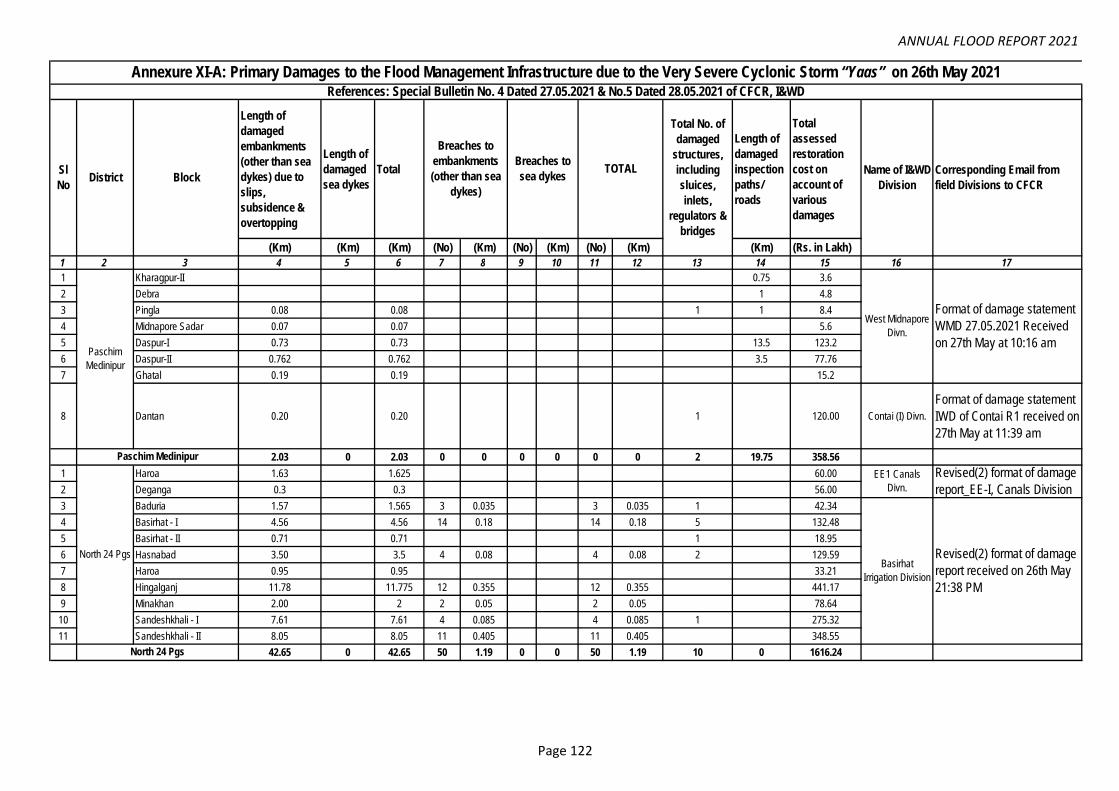
ANNUAL FLOOD REPORT 2021
Length of
damaged
embankments
(other than sea
dykes) due to
slips,
subsidence &
overtopping
Length of
damaged
sea dykes
Total
Length of
damaged
inspection
paths/
roads
Total
assessed
restoration
cost on
account of
various
damages
(Km) (Km) (Km) (No) (Km) (No) (Km) (No) (Km) (Km) (Rs. in Lakh)
1 2 3 4 5 6 7 8 9 10 11 12 13 14 15 16 171 Kharagpur-II 0.75 3.6
2 Debra 1 4.8
3 Pingla 0.08 0.08 1 1 8.4
4 Midnapore Sadar 0.07 0.07 5.6
5 Daspur-I 0.73 0.73 13.5 123.2
6 Daspur-II 0.762 0.762 3.5 77.76
7 Ghatal 0.19 0.19 15.2
8 Dantan 0.20 0.20 1 120.00 Contai (I) Divn.
Format of damage statement
IWD of Contai R1 received on
27th May at 11:39 am
2.03 0 2.03 0 0 0 0 0 0 2 19.75 358.56
1 Haroa 1.63 1.625 60.00
2 Deganga 0.3 0.3 56.00
3 Baduria 1.57 1.565 3 0.035 3 0.035 1 42.34
4 Basirhat - I 4.56 4.56 14 0.18 14 0.18 5 132.48
5 Basirhat - II 0.71 0.71 1 18.95
6 Hasnabad 3.50 3.5 4 0.08 4 0.08 2 129.59
7 Haroa 0.95 0.95 33.21
8 Hingalganj 11.78 11.775 12 0.355 12 0.355 441.17
9 Minakhan 2.00 2 2 0.05 2 0.05 78.64
10 Sandeshkhali - I 7.61 7.61 4 0.085 4 0.085 1 275.32
11 Sandeshkhali - II 8.05 8.05 11 0.405 11 0.405 348.55
42.65 0 42.65 50 1.19 0 0 50 1.19 10 0 1616.24
Paschim Medinipur
North 24 Pgs
North 24 Pgs
Sl
NoDistrict Block
Annexure XI-A: Primary Damages to the Flood Management Infrastructure due to the Very Severe Cyclonic Storm “Yaas” on 26th May 2021References: Special Bulletin No. 4 Dated 27.05.2021 & No.5 Dated 28.05.2021 of CFCR, I&WD
Paschim
Medinipur
Total No. of
damaged
structures,
including
sluices,
inlets,
regulators &
bridges
Breaches to
embankments
(other than sea
dykes)
Breaches to
sea dykesTOTAL Name of I&WD
Division
West Midnapore
Divn.
EE1 Canals
Divn.
Basirhat
Irrigation Division
Corresponding Email from
field Divisions to CFCR
Format of damage statement
WMD 27.05.2021 Received
on 27th May at 10:16 am
Revised(2) format of damage
report_EE-I, Canals Division
Revised(2) format of damage
report received on 26th May
21:38 PM
Page 122

ANNUAL FLOOD REPORT 2021
1 2 3 4 5 6 7 8 9 10 11 12 13 14 15 16 172 Gosaba 29.05 29.05 889.98
3 Basanti 16.17 16.17 489.95
4 Canning-I 2.82 2.82 105.80
5 Canning-II 0.35 0.35 14.00
6 Mathurapur-I 0.20 0.200 5.00
7 Mathurapur-II 5.940 5.940 157.00
8 Patharpratima 8.380 8.380 23 0.36 23 0.36 237.70
9 Kultali 25.360 25.357 6 0.29 6 0.29 1 728.90
10 Joynagar-II 2.070 2.070 56.40
11 Budge Budge-I 1.35 1.35 2.70 67.50
12 Budge Budge-II 0.60 0.6 1.20 30.00
13 Thakurpukur Mahastala 0.30 0.3 0.60 15.00
14 KMC 141(W) 0.15 0.15 0.30 7.50
15 Kulpi 0.28 0.28 2 3.59 82.00
16 Kakdwip 2 2.00 10.00
17 Falta 0.27 0.270 0.54 13.50
18 Diamond Harbour-I 0.13 0.13 0.26 6.50
19 Diamond Harbour-II 0.80 0.8 1.60 40.00
20 Maheshtala Municipality 0.18 0.175 2 0.08 2 0.08 50.00Suburban
Drainage Divn.
Format of damage statement
under GCDC Received on
27th May at 12:26 pm
21 Namkhana 20.075 2.9 22.975 3 0.06 3 0.06 1365.65
22 Kakdwip 7.05 7.05 206.25
23 Sagar 9.357 2.05 11.407 3 0.18 2 0.08 5 0.26 605.50
24 Patharpratima 13.8 0.7 14.5 3 0.15 0 0 3 0.15 588.00
144.68 5.65 150.32 40 1.115 2 0.08 42 1.195 5 12.79 5772.13
1 Hooghly Khanakul-II 2.10 0.00 2.10 1.50 100.00
EE 1 Lower
Damodar (I)
Divn.
Format of damage statement
in Excel (EE-I, LDID)
Received on 27th May at
7:47am2.100 0.000 2.10 0 0.00 0 0.00 0 0.00 0 1.50 100.00
South 24 Pgs
Hooghly
South 24 Pgs
Kakdwip (I) Divn.
EE1 Joynagar (I)
Divn.
Revised(2) format of damage
report received on 26th May
23:19 PM
Format in damage statement
in excel received on 26th May
23:51 PM
Revised format of damage
statement in Excell-R1 EE 2
Canals Received on 27th
May at 11:02am
Damage report in Cfcri
Format KID received on 27th
May at 11:55 AM
EE II Joynagar (I)
Divn.
EE II Canals
Divn.
Page 123

ANNUAL FLOOD REPORT 2021
1 2 3 4 5 6 7 8 9 10 11 12 13 14 15 16 171 Sankrail 0.89 0.89 3.00 0.10 3.00 0.10 5.00 2.00 316.50
2 Uluberiya Municipality 0.31 0.31 87.00
3 Shyampur I 2.00 44.00
4 Shyampur II 1.00 4.00
5 Uluberiya-I 5.00 12.00
6 Uluberia-I 2.10 2.10 4.00 0.60 4.00 0.60 7.00 0.60 290.00
7 Uluberia Municipality 1.30 1.30 3.00 58.00
8 Shyampur-I 3.15 3.15 11.00 1.10 11.00 1.10 5.00 1.10 488.00
9 Shyampur-II 7.20 7.20 18.00 1.65 18.00 1.65 3.00 1.65 822.00
10 Bagnan-I 4.75 4.75 0.00 0.00 0.00 0.00 4.00 198.00
11 Bagnan-II 3.70 3.70 8.00 0.75 8.00 0.75 1.00 0.75 390.00
12 Amta-II 1.20 1.20 5.00 58.00
24.60 0 24.60 44 4.2 0 0 44 4.2 41 6.1 2767.50
1 Ramnagar I 0.00 8.80 8.80 4.00 1685.00
2 Ramnagar- II 0.00 0.70 0.70 1.00 35.00
3 Contai I 9.00 60.00
4 Deshopran 2.50 2.50 4.00 260.00
5 Contai III 3.80 3.80 7.00 370.00
6 Bhagabanpur-II 11.00 11.00 13.00 737.00
7 Egra-II 0.40 0.40 21.00 200.00
8 Patashpur-I 0.15 0.15 3.00 100.00
9 Nandigram-I 1.50 1.50 1.00 95.00
10 Nandigram-II 0.20 0.20 2.00 49.00
11 Khejuri-I 0.30 0.30 14.00 82.00
12 Khejuri-II 0.02 0.02 2.00
13 Bhagabanpur-I 0.07 0.07 18.00 110.00
14 Egra-I 0.20 0.20 3.00 110.00
15 Kolaghat 5.18 5.18 2 0.26 329.25
16 Sahid Matangini 8.93 8.93 1 172.30
17 Tamluk 3.00 3.00 2 42.50
18 Nandakumar 4.65 4.65 101.50
19 Mahisadal 13.30 13.30 0.15 236.75
20 Sutahata 2.20 2.20 37.00
21 Haldia 1.59 1.59 65.00
22 Moyna 2.05 2.05 5 73.73
23 Panskura 1.10 1.10 102.00
59.64 12.00 71.64 0 0 0 0 0 0 110 0.41 5055.03
GRAND TOTAL 275.69 17.65 293.34 134 6.51 2 0.08 136 6.59 168 40.55 15669.46
Howrah
Purba Medinipur
Purba
Medinipur
Howrah
EE 1 Lower
Damodar
Construction
Divn.
EE II Lower
Damodar
Construction
Divn.
Contai (I) Divn.
East Midnapore
Divn.
Format of damage statement
in excel received on 27th May
at 12:36 PM
format of damage statement
in Excell, EE-II, LDCD
received on 27th May at
9:37am
Format of damage statement
IWD of Contai R1 received on
27th May at 11:39 am
Damage report Format
received on 27th May at
11:36 AM
Page 124

ANNUAL FLOOD REPORT 2021
Breach
(m)
Slip /
Subsidenc
e / Erosion
(m)
Protective
works
(m)
Sluices/
Bridge/
Culverts
etc.
(no)1 2 3 4 5 6 7 8 9 10 11 12 13
1 Torsa Alipurduar Kalchini 55 4.99 30/06/21, 14/08/21 Erosion
2 Torsa Alipurduar Kalchini 60 4.95 30/06/21, 14/08/21 Erosion
3 Kalkut Alipurduar APD-II 270 4.85 30/06/21, 14/08/21 Erosion
4 Torsa Alipurduar Kalchini 100 4.84 30/06/21, 14/08/21 Breach
5 Gabur Basra Alipurduar Kalchini 120 4.79 30/06/21, 14/08/21 Erosion
6 Gaburjyoti Alipurduar Kalchini 410 4.91 30/06/21, 14/08/21 Erosion
7 Kharkhola Alipurduar Kalchini 450 4.93 30/06/21, 14/08/21 Erosion
8 Sil Torsa Alipurduar APD-I 1500 4.54 30/06/21, 14/08/21 Erosion
9 Kaljani Alipurduar APD-II 380 4.94 30/06/21, 14/08/21 Erosion
10 Jayanti Alipurduar APD-II 1000 4.80 30/06/21, 14/08/21 Erosion
11 Gaburbasra Alipurduar Kalchini 168 29.48 30/06/21, 14/08/21 Erosion
12 Sil Torsa Alipurduar APD-I 1 40.31 30/06/21, 14/08/21 Spur (01 no)
13 Raidak Alipurduar Kumargram 150 12.88 30/06/21, 14/08/21 Erosion
14 Torsa Alipurduar Kalchini 250 21.02 30/06/21, 14/08/21 Erosion
15 Kaljani Alipurduar Kalchini 200 23.25 30/06/21, 14/08/21 Erosion
16 Mujnai Alipurduar Falakata 300 15.41 30/06/21, 14/08/21 Erosion
17 Jogikhola Alipurduar Kalchini 450 9.33 30/06/21, 14/08/21 Erosion
18 Bamni Alipurduar Totpara-I 150 150 7.48 30/06/21, 14/08/21 Apron pitching
19 Kaljani Alipurduar APD-II 380 6.22 30/06/21, 14/08/21 Erosion
20 Dima & Kaljani Alipurduar APD Municipality 7800 31 14.02 30/06/21, 14/08/2131 nos of Vents
Sluice Gates
21 Kaljani Alipurduar APD-II 700 16.05 30/06/21, 14/08/21Round sausages
Slips down
22 Sil Torsa Alipurduar APD-I 1 5.88 30/06/21, 14/08/21 01 no Spur
23 Sankosh Alipurduar Kumargram 350 17.00 30/06/21, 14/08/21 Slips
24 Raidak Alipurduar Kumargram 210 5.09 30/06/21, 14/08/21 Erosion
25 Raidak-II Alipurduar Kumargram 150 2 9.53 30/06/21, 14/08/21 Spur (2 no)
26 Raidak Alipurduar Kumargram 150 9.86 30/06/21, 14/08/21 Erosion
27 Raidak Alipurduar Kumargram 150 11.64 30/06/21, 14/08/21 Erosion
Nature and Extent of DamagesInaundated/
Water logged
Area
(Sq. Km.)
Cost of
Damages
(Lakhs)
Date of Damage
Occurences
Annexure XI-B: District wise Flood Damage Report of the Embankments / Structures etc. due to Flood / Waterlogging / Drainage Congestion during 2021
Remarks
Co
rres
po
nd
ence
s
Alipurduar Irrigation Division
Em
ail o
f SE
/NE
IC-I
Dat
ed: 2
2.02
.202
2, E
mai
l of E
E/A
ID D
td, 1
8.05
.202
2
References: This Office Memo No. 8-38/49 (12) Dated: 24.01.2022; Memo. No. 8-38/108 (11) Dated 21.02.2022 & Memo. No. 8-38/ 241 (13) Dated 19.04.2022
Sl.
No.
Name of River/
Stream/ ChannelDistrict/ Block/ P.S
Location of Damage
(GP/ Village/ Mouza)
16.86
Page 125

ANNUAL FLOOD REPORT 2021
1 2 3 4 5 6 7 8 9 10 11 12 13
28 Torsa Alipurduar Kalchini 470 19.82 30/06/21, 14/08/21 Erosion
29 Jayanti Alipurduar APD-II 850 8.86 30/06/21, 14/08/21 Erosion
30 Sisamara Alipurduar APD-I 1000 25.54 30/06/21, 14/08/21 Erosion
31 Garam Alipurduar APD-I 150 11.13 30/06/21, 14/08/21 Erosion
32 Nonai Alipurduar APD-I 150 10.08 30/06/21, 14/08/21 Erosion
33 Reti Sukriti Alipurduar Madarihat 400 30.08 30/06/21, 14/08/21 Erosion
34 Surti Irr. Scheme Alipurduar Jateswar-I 3000 11.68 30/06/21, 14/08/21 Irrigation Canal
35 Mujnai Alipurduar Deogaon,Falakata 300 13.59 30/06/21, 14/08/21 Erosion
36 Gabur Basra Alipurduar Kalchini 89 13.11 30/06/21, 14/08/21 Erosion
37 Gaburjyoti Alipurduar Kalchini 410 9.38 30/06/21, 14/08/21 Erosion
38 Mujnai Alipurduar Falakata 100 14.67 30/06/21, 14/08/21 Erosion
39 Gaburjyoti Alipurduar Kalchini 380 9.24 30/06/21, 14/08/21 Erosion
40 Mujnai Alipurduar Falakata 150 11.75 30/06/21, 14/08/21 Erosion
41 Kharkhola Alipurduar Kalchini 550 9.21 30/06/21, 14/08/21 Erosion
42 Kalkut Alipurduar APD-II 120 14.69 30/06/21, 14/08/21 Erosion
43 Raidak-II Alipurduar Kumargram 150 7.71 30/06/21, 14/08/21 Erosion
44 Torsa (R/B) CoochbeharKalpani area, P.S-Pundibari, G.P-
Madhupur1000 100.00 20.10.21 Erosion
45 Torsa (R/B) CoochbeharIchamari Champaguri area, P.S-Pundibari.
G.P- Madhupur230 50.00 20.10.21 Erosion
46 Torsa (R/B) Coochbehar Damodar Para area, P.S-Pundibari, G.P-
Takagach-Rajarhat1200 30.00 20.10.21 Erosion
47 Torsa (R/B) Coochbehar Malatiguri area, P.S-Pundibari, G.P-
Takagach-Rajarhat900 12.00 20.10.21 Erosion
48 Torsa (R/B) Coochbehar Dhologuri area. P.S-Pundibari, G.P-
Ambari.400 70.00 20.10.21 Erosion
49 Ghargharia (L/B) CoochbeharJhaljhali area P.S-Pundibari, G.P-
Marichbari.200 15.00 30.06.21 Erosion
50 Kaljani (R/B) CoochbeharSoldhukri area, GP Balarampur-I Block-
Tufanganj-I , P.S-Tufanganj-I200 12.00 30.06.21 Erosion
51 Torsa (R/B) CoochbeharGhugumari area, G.P. Ghugumari Block-
Cooch Behar-I P.S. Kotwali 200 18.50 30.06.21 Erosion
52 Kaljani (R/B) CoochbeharNatabari area, G.P. Natabari Block-
Tufanganj-I.P.S.Tufanganj-I200 20.50 30.06.21 Erosion
53 Kaljani (R/B) CoochbeharKhapaidanga area, G.P. Khapaidanga
Block-Cooch Behar-II P.S.Pundibari400 7.50 30.06.21 Erosion
0.00
Em
ail o
f SE
/NE
IC-I
Dat
ed: 2
2.02
.202
2, E
mai
l of E
E/A
ID D
td, 1
8.05
.202
2
Coochbehar Irrigation Division
16.86
Page 126

ANNUAL FLOOD REPORT 2021
1 2 3 4 5 6 7 8 9 10 11 12 13
54 Kaljani (R/B) CoochbeharDakshin Ambari, G.P. Ambari Block-Cooch
Behar-II P.S. Pundibari300 7.00 30.06.21 Erosion
55 Ghargharia (R/B) CoochbeharPanishala, G.P. Maruganj Block-Tufanganj-
IP.S. Tufanganj-I400 7.00 30.06.21 Erosion
56 Ghargharia (R/B) CoochbeharMaruganj, G.P. Maruganj Block-Tufanganj-
IP.S. Tufanganj-I150 4.00 30.06.21 Erosion
57 Torsa (L/B) CoochbeharFalimari, G.P. Dwaguri Block-Coochbehar-
IP.S. Kotwali1000 6.00 20.10.21 Erosion
58 Baniadaha(R/B) CoochbeharKismat Mokrani, G.P. Nayarhat gobrachara
Block- Dinhata-II P.S. Dinhata-II600 6.00 30.06.21 Erosion
59 Torsa(R/B) CoochbeharKharija Baniadaha, G.P. Nayarhat
gobrachara Block- Dinhata-II P.S. Dinhata-II300 7.00 20.10.21 Erosion
60 Torsa(L/B) CoochbeharLankabar area, G.P.Ghugumari Block-
Coochbehar-I P.S. Kotwali300 4.00 20.10.21 Erosion
61 Torsa(L/B) CoochbeharGadarpar area, G.P. Guriahati-II Block-
Coochbehar-I P.S.kotwali 200 5.00 30.06.21 Erosion
62 Ghargharia (L/B) CoochbeharPanichara area, G.P. Maruganj Block-
Tufanganj-IP.S. Tufanganj-I 150 6.00 30.06.21 Erosion
63 Kaljani (R/B) CoochbeharChatowa area, G.P. Maruganj Block-
Tufanganj-IP.S. Tufanganj-I130 5.50 30.06.21 Erosion
64 Mansai (R/B) CoochbeharMathabhanga Municipality area, Block-
Mathabhanga-I, P.S. Mathabhanga, 125 30.00 30.06.21 Erosion
65 Mansai (R/B) Coochbehar Bara Adabari area, Block & P.S. Sitai, 50 25.00 19.08.21 Erosion
66 Mansai (R/B) Coochbehar Kismat Adabari area, Block-Sitai, P.S. Sitai, 30 25.00 02.09.21 Erosion
67 Kaljani (L/B) CoochbeharBhairabertari area, Block-Tufanganj-IP.S.
Tufanganj150 15.00 20.10.21 Erosion
68 Raidak (R/B) CoochbeharBarmanpara Rajarkuthi Primary School
area, Block-Tufanganj-I,P.S. Tufanganj90 15.00 30.06.21 Erosion
69 Raidak (R/B) CoochbeharGhoshpara, downstream of Barmanpara
area, Block-Tufanganj-I,P.S. Tufanganj180 15.00 20.10.21 Erosion
70 Mahananda Darjeeling, Matigara Nagradoba 240 12.00 20.10.21
71 Balason Darjeeling, Matigara Mouria Busty 265 8.30 19.10.21
72 Balason Darjeeling, Matigara Sishabari 295 7.20 19.10.21
73 Rakti Darjeeling, Matigara Paskelguri 210 6.60 20.10.21
0.00
0.00
Em
ail o
f SE
/NE
IC-I
Dat
ed: 2
2.02
.202
2, E
mai
l of E
E/A
ID D
td, 1
8.05
.202
2
Siliguri Irrigation Division
SE
/NE
IC-I
I. M
emo
no. 1
23/F
DR
-II,
Dat
ed: 2
5.02
.202
2 (E
mai
l: 28
.02.
2022
) &
Em
ail o
f EE
/JID
Dtd
. 29.
04.2
022.
Page 127

ANNUAL FLOOD REPORT 2021
1 2 3 4 5 6 7 8 9 10 11 12 13
74 Balason Darjeeling Matigara New Rangia 275 7.50 20.10.21
75 Balason Darjeeling, Matigara Nimai 225 7.40 20.10.21
76 Balason Darjeeling, Matigara Pal Para 265 6.40 19.10.21
77 Rohini Darjeeling, Matigara Khaprail Bazari 205 7.60 20.10.21
78 Balason Darjeeling, Matigara Patiram 230 6.40 19.10.21
79 Chenga Darjeeling, Phansidewa Mingara 195 6.10 20.10.21
80 Taipu Darjeeling, Phansidewa Taipu area 215 6.50 20.10.21
81 Chenga Darjeeling, Phansidewa Gourikachari 245 6.40 19.10.21
82 Buri Balason Darjeeling, Phansidewa Choudhuriagoch 265 6.20 20.10.21
83 Buri Balason Darjeeling, Phansidewa Sovagoch 245 6.75 19.10.21
84 Dudlong Darjeeling, Kharibari Ambaline 285 12.00 20.10.21
85 Mechi Darjeeling, Naxalbari Baromaniram 270 12.00 19.10.21
86 Mahananda Jalpaiguri, SMC Bhupendra Nagar Ward No- 42 195 6.00 20.10.21
87 Singhijhora Jalpaiguri, Rajganj Taribari 215 8.00 20.10.21
88 Mahananda Jalpaiguri, Rajganj Betgara 205 7.00 20.10.21
89 Mahananda Jalpaiguri, Rajganj Deepnagar 190 6.00 19.10.21
90 Teesta Jalpaiguri, Maynaguri New Basusuba embkt, Roy Para 101 12.00 20.10.21
91 Teesta Jalpaiguri, Maynaguri New Basusuba embkt spur-4, 5 112 10.00 19.10.21
92 Jaldhaka Jalpaiguri, Maynaguri Panbari embkt 130 12.00 19.10.21
93 Jaldhaka Jalpaiguri, Maynaguri Baksidanga Embkt 90 8.00 20.10.21
94 Teesta Jalpaiguri, Maynaguri Spur No-105, 65 of Bakali Emb. 120 10.00 20.10.21
95 Teesta Jalpaiguri, Maynaguri Spur-1400, 600 of Dharampur Emb. 121 10.00 20.10.21
96 Teesta Jalpaiguri, Maynaguri Spur-3200, 2200 of Dharampur Emb. 95 10.00 19.10.21
97 Teesta Jalpaiguri, Maynaguri Padamati-I GP, 113 11.00 20.10.21
98 Teesta Jalpaiguri, Maynaguri Padamati- II GP 136 10.00 19.10.21
99 Teesta Jalpaiguri, Maynaguri Sanyasi jote 135 12.00 20.10.21
100 Jaldhaka Jalpaiguri, Maynaguri Dharaikuri Embkt 120 10.00 20.10.21
101 Teesta Jalpaiguri, Maynaguri Helapakri Emnkt, spur-3 120 10.00 19.10.21
102 Gheesh Jalpaiguri, Mal Manabari Emb. in btwn. ch. 200m to 450.m 78 7.00 20.10.21
103 Gheesh Jalpaiguri, Mal Manabari Emb. in btwn. ch. 500m to 780m 55 6.00 19.10.21
104 Gheesh Jalpaiguri, Mal Manabari Emb. in btwn. ch. 830m to 1100m 69 6.00 20.10.21
105 Gheesh Jalpaiguri, MalManabari Emb. in btwn. ch. 1300m to
1600m57 7.00 19.10.21
0.00
0.75
SE
/NE
IC-I
I. M
emo
no. 1
23/F
DR
-II,
Dat
ed: 2
5.02
.202
2 (E
mai
l: 28
.02.
2022
) &
Em
ail o
f EE
/JID
Dtd
. 29.
04.2
022.
Jalpaiguri Irrigation Division
Page 128

ANNUAL FLOOD REPORT 2021
1 2 3 4 5 6 7 8 9 10 11 12 13
106 Gheesh Jalpaiguri, MalManabari Emb. in btwn. ch. 1700m to
1900m72 7.00 20.10.21
107 Leesh Jalpaiguri, MalBagrakote Emb. in btwn. 800m to900m
,GP- Bagrakote66 5.00 20.10.21
108 Leesh Jalpaiguri, MalBagrakote Emb. in btwn. 1160m to1250m
,GP- Bagrakote73 5.00 20.10.21
109 Leesh Jalpaiguri, MalBagrakote Emb. in btwn. 900m to1250m
,GP- Bagrakote54 5.00 19.10.21
110 Leesh Jalpaiguri, MalBagrakote Emb. in btwn. 250.0m to ch
320m ,GP- Bagrakote70 5.00 20.10.21
111 Leesh Jalpaiguri, MalBagrakote Emb. in btwn.350.0m to ch
410m, GP- Bagrakote68 5.00 20.10.21
112 Leesh Jalpaiguri, MalBagrakote Emb. in btwn. 450.0m to ch
500m ,GP- Bagrakote48 5.00 19.10.21
113 Leesh Jalpaiguri, MalBagrakote Emb. in btwn. 1600.0m to ch
2100m ,GP- Bagrakote47 7.00 20.10.21
114 Leesh Jalpaiguri, Mal Bagrakote Emb. GP- Bagrakote 80 7.00 20.10.21
115 Leesh Jalpaiguri, Mal Manabari Emb. 85 7.00 20.10.21
116 Leesh Jalpaiguri, Mal Saily Basty BP works 89 7.00 19.10.21
117 Chel Jalpaiguri, Mal Saily Jote area 57 5.00 19.10.21
118 Chel Jalpaiguri, Rajganj Chumukdanga BP works 49 7.00 20.10.21
119 Chel Jalpaiguri, Kranti Premganj Emb. ch.2600 to 3400m 52 7.00 19.10.21
120 Teesta Jalpaiguri, Kranti Premganj Emb. ch. 4500 to 5200m 87 7.00 20.10.21
121 Teesta Jalpaiguri, Kranti Dhupjhora Emb. ch.100 to 700m 87 7.00 19.10.21
122 Teesta Jalpaiguri, Kranti Dhupjhora Emb. ch. 900 to 1500m 73 7.00 20.10.21
123 Murti Jalpaiguri, Kranti Dhupjhora Emb. ch. 2000 to 2200m 81 7.00 19.10.21
124 Murti Jalpaiguri, Mal Mechpara Emb. ch. 500 to 1000m 69 5.00 20.10.21
125 Murti Jalpaiguri, Kranti Sidhabari changmari Emb. 71 6.00 19.10.21
126 Chel Jalpaiguri, Mal Digholtari 70 7.00 19.10.21
127 Chel Jalpaiguri, MalChel kumlai avulsion preventing Emb. in
btwn. ch.1.0 to 3.0km74 7.00 20.10.21
128 Diana Jalpaiguri, Banarhat Kalabari, Dhumpara 103 10.00 19.10.21
129 Angrabhasa Jalpaiguri, Banarhat Sisu Sikha kendra, Gaterkata 59 5.00 20.10.21
130 Gilandi Jalpaiguri, Dhupguri Paschim Pundibari 63 5.00 19.10.21
131 Dudua Jalpaiguri, Dhupguri Sonakhali 68 5.00 19.10.21
132 Reti Sukriti Jalpaiguri, Banarhat Riyabari 70 5.00 20.10.21
133 Angrabhasa Jalpaiguri, Banarhat Santipara, Gayerkata 65 5.00 19.10.21
134 Dudua Jalpaiguri, Dhupguri Balasundar 57 5.00 20.10.21
0.75
SE
/NE
IC-I
I. M
emo
no. 1
23/F
DR
-II,
Dat
ed: 2
5.02
.202
2 (E
mai
l: 28
.02.
2022
) &
Em
ail o
f EE
/JID
Dtd
. 29.
04.2
022.
Page 129

ANNUAL FLOOD REPORT 2021
1 2 3 4 5 6 7 8 9 10 11 12 13
135 Angrabhasa Jalpaiguri, Banarhat Bighaline, Gayerkata 53 5.00 19.10.21
136 Hatinala Jalpaiguri, Banarhat Binnaguri 61 5.00 20.10.21
137 Jaldhaka Jalpaiguri, Nagrakata Tandu 63 5.00 19.10.21
138 Angrabhasa Jalpaiguri, Banarhat DS of Bighaline & Kongar colony 111 10.00 19.10.21
139 Jhumar Ghaora haga Jalpaiguri, Banarhat Nunkhowa Danga 54 3.00 20.10.21
140 Gilandi Jalpaiguri, Dhupguri Paschim pundibari 56 8.00 19.10.21
141 Diana Jalpaiguri, Nagrakata Bamondanga 57 5.00 20.10.21
142 Jaldhaka Jalpaiguri, Dhupguri Maynatali 58 3.00 19.10.21
143 Jaldhaka Jalpaiguri, Dhupguri Salbari 49 5.00 19.10.21
144 Gilandi Jalpaiguri, Dhupguri Patkidhaya 57 5.00 20.10.21
145 Jaldhaka Jalpaiguri, Dhupguri Betgara 53 5.00 20.10.21
146 Jaldhaka Jalpaiguri, Banarhat Banarhat 62 3.00 19.10.21
147 Hatinala Jalpaiguri, Banarhat Chantamoni 58 5.00 19.10.21
148 Jaldhaka Jalpaiguri, Dhupguri Sawan ghat 60 3.00 20.10.21
149 Jaldhaka Jalpaiguri, Nagrakata Majhiali 61 3.00 19.10.21
150 Dudua Jalpaiguri, Dhupguri Sonakhali 59 10.00 19.10.21
151 Reti Sukriti Jalpaiguri, Banarhat Chamurchi 48 5.00 20.10.21
152 Teesta Jalpaiguri, Sadar Spur no-1 of Kadobari Mandalghat Emb. 55 5.00 19.10.21
153 Teesta Jalpaiguri, Sadar Mandalghat Emb. 65 7.00 20.10.21
154 Teesta Jalpaiguri, Sadar Tikiapara Kadobari Emb. 62 8.00 19.10.21
155 Teesta Jalpaiguri, Sadar Spur no- 6 of Mandalghat Emb. 59 5.00 19.10.21
156 Teesta Jalpaiguri, Sadar Spur no- 4A of Mandalghat Emb. 77 5.00 19.10.21
157 Teesta Jalpaiguri,Sadar Spur no- 7 of Mandalghat Emb. 69 5.00 20.10.21
158 Jaldhaka Jalpaiguri, Dhupguri Spur no- 3 of Gadhyearkuthi Emb. 63 5.00 20.10.21
159 Jaldhaka Jalpaiguri, Dhupguri Spur no- 3A of Gadhyearkuthi Emb. 60 5.00 19.10.21
160 Jaldhaka Jalpaiguri, Dhupguri Spur no- 4 of Gadhyearkuthi Emb. 54 5.00 19.10.21
161 Jaldhaka Jalpaiguri, Dhupguri Spur no-7 of Gadhyearkuthi Emb. 59 5.00 20.10.21
162 Jaldhaka Jalpaiguri, Dhupguri Spur no-6 of Gadhyearkuthi Emb. 62 5.00 19.10.21
163 Jamuna Jalpaiguri, Sadar Jhakuapara 57 5.00 20.10.21
164 Jamuna Jalpaiguri, Sadar Haruadanga 65 5.00 19.10.21
165 Jamuna Jalpaiguri, Sadar Dhologram 45 5.00 20.10.21
166 Panga Jalpaiguri, Sadar Battala near Pradhanpara 52 5.00 19.10.21
167 Teesta Jalpaiguri, SadarMandalghat GP Segregating Emb., (Spur
No.18) 148 7.00 20.10.21
168 Teesta Jalpaiguri, SadarPaharpur GP Bibekananda Pally Emb.,
(Ch.0.00 km.to 0.250Km.)97 6.00 20.10.21
169 Teesta Jalpaiguri, SadarPaharpur GP Bibekananda Pally Emb.,
(Ch.0.250 km.to 0.550Km.)155 8.00 19.10.21
0.75
SE
/NE
IC-I
I. M
emo
no. 1
23/F
DR
-II,
Dat
ed: 2
5.02
.202
2 (E
mai
l: 28
.02.
2022
) &
Em
ail o
f EE
/JID
Dtd
. 29.
04.2
022.
Page 130

ANNUAL FLOOD REPORT 2021
1 2 3 4 5 6 7 8 9 10 11 12 13
170 Teesta Jalpaiguri, SadarMandalghat GP Segrigating Emb., (Ch.
6.50Km to 6.25 Km)135 7.00 19.10.21
171 Teesta Jalpaiguri, SadarMandalghat GP Segrigating Emb., (Spur
No.14)110 7.00 20.10.21
172 Teesta Jalpaiguri, RajganjMantadari GP Milanpally Emb., (Ch 1.05 km
to 1.20 km.)198 9.00 19.10.21
173 Teesta Jalpaiguri, RajganjMantadari GP Milanpally Emb., (Ch 0.90 km
to 1.05 km.)203 9.00 19.10.21
174 Teesta Jalpaiguri, SadarMandalghat GP Segrigating Emb., (Ch.
6.10Km to 5.75 Km)98 8.00 20.10.21
175 Teesta Jalpaiguri, SadarPaharpur GP Bibekananda Pally Emb.,
(Ch.0.55 km.to 0.800Km.)140 7.00 20.10.21
176 Teesta Jalpaiguri, SadarPaharpur GP Bibekananda Pally Emb.,
(Ch.0.8 km.to 1.1Km.)194 9.00 19.10.21
177 Teesta Jalpaiguri, SadarKharia GP Sukanta Nagar Emb., (Ch.
200.00m)189 8.00 20.10.21
178 Teesta Jalpaiguri, RajganjMantadari GP Birenbasty Emb., (Ch 0.80
km to 0.90 km.)195 6.00 19.10.21
179 Teesta Jalpaiguri, RajganjMantadari GP Birenbasty Emb., (Ch 0.90
km to 1.00 km.)115 6.00 19.10.21
180 Teesta Haldibari Spur no-7 Daripattani, Balapara 55 7.00 19.10.21
181 Teesta Haldibari B/J Emb. Kamatbindi, Purbapara 50 6.50 19.10.21
182 Teesta Haldibari B/J Emb. Kamatbindi, 45 6.00 20.10.21
183 Teesta Haldibari Burigram Emb. Jharsingheswar, 45 6.00 20.10.21
184 Teesta Haldibari Spur no-3 of B/J Emb. Jharsingheswar. 45 5.00 19.10.21
185 Teesta Haldibari Spur no-4 of B/J Emb. Jharsingheswar. 50 7.00 20.10.21
186 Teesta HaldibariIn btwn. Spur no-2 to Spur no-3A of B/J
Emb. Jharsingheswar.60 7.50 20.10.21
187 Teesta HaldibariIn btwn. Spur no-2 to Spur no-3A of B/J
Emb. Jharsingheswar, 50 6.50 19.10.21
188 Teesta Haldibari Spur no-2A of B/J Emb. Jharsingheswar, 50 6.50 20.10.21
189 Teesta HaldibariIn btwn. Spur no-5 to Spur no-6 of B/J Emb.
Jharsingheswar, 45 6.00 19.10.21
190 Teesta HaldibariIn btwn. Spur no-0 to Spur no-1 of B/J Emb.
Kamat para 55 7.00 20.10.21
191 Teesta MekhliganjSpur no-11 of Helapakri Emb. , Vill.- 76
Niztaraf85 10.00 19.10.21
0.75
SE
/NE
IC-I
I. M
emo
no. 1
23/F
DR
-II,
Dat
ed: 2
5.02
.202
2 (E
mai
l: 28
.02.
2022
) &
Em
ail o
f EE
/JID
Dtd
. 29.
04.2
022.
Page 131

ANNUAL FLOOD REPORT 2021
1 2 3 4 5 6 7 8 9 10 11 12 13
192 Teesta Mekhliganj Kutchlibari 75 10.00 20.10.21
193 Teesta Mekhliganj Kutchlibari 85 10.00 20.10.21
194 Teesta Mekhliganj 72 no. Niztaraf 80 10.00 19.10.21
195 Teesta Mekhliganj 72 no. Niztaraf 75 10.00 20.10.21
196 Teesta Mekhliganj 72 no. Niztaraf 85 10.00 19.10.21
197 Jaldhaka Mekhliganj Giria Emb., Saru hati area 80 10.00 20.10.21
198 Jaldhaka Mekhliganj Spur no-8 of Giria Emb., Ranirhat area 85 10.00 20.10.21
200 Nonagang North 24 Pgs./ Barasat II Cholpur 200 8.50 27.05.21
201 Nonagang North 24 Pgs./ Barasat II Belvelli 150 6.00 02.06.21
202 Nonagang North 24 Pgs./ Barasat II Tehata 120 5.00 24.06.21
203 Nonagang North 24 Pgs./ Deganga Telia 100 4.00 20.09.21
204 Nonagang North 24 Pgs. /Deganga Ghosalabad 300 12.00 26.05.21
205 Nonagang North 24 Pgs./ Deganga Tentultala 100 4.00 20.09.21
206 Nonagang North 24 Pgs./ Deganga Hasia 200 8.00 20.09.21
207 Nonagang North 24 Pgs./ Barasat II Tehata 300 120.00 26.06.21
208 Sunti North 24 Pgs./ BarasatBurma coloney at Ward no. 19 under
Barasat Municdipality100 30.00 26.05.21
209Tender Khal of Sealdha
Gong Main Channel
North 24 Pgs./
Basirhat-IIMallickpur, Ghona 60 2.80 27.05.21
210
Tender Khal Branch
channel of Sealdha Gong
Main Channel
North 24 Pgs./
Basirhat-IIParuiPara, Andulpota 50 1.80 27.05.21
211
KK1 Branch channel of
Sealdha Gong Main
Channel
North 24 Pgs./
Basirhat-IIKata Bagan, Dhopaberia 50 1.65 27.05.21
212 Sarat Khali KhalNorth 24 Pgs./
Basirhat-IMerudandi, Shibhati, Sangrampur 100 27.05.21
213 MatlaSouth 24 Pgs./ Canning-
I/CanningDabu Irrigation Premises at G.P-Nikarighata 80 6.50 26-05-2021
214 Suryapur Link ChannelSouth 24 Pgs./
Baruipur/BaruipurDhannokhola Gourdaha 225 41.75
28-09-21, 29-09-21,27-
10-21,28-10-21
215 R.HooghlySouth 24 Pgs. /
Rabindranagar
Ward No-7 Maheshtala Municipality/
Jagannathnagar Mouza 80 205 155.00 26th. May 21. Cyclone YAAS.
216 Churial Diversion Khal South 24 Pgs. / Pujali Ward No-3 Pujali Municipality Pujali Mouza 155 32.15 26th. May 21. DO
0.75
0.00
0.00
Bidyadhari Drainage Division
SE
/GC
DC
-Em
ail D
ated
: 11.
02.2
022
& D
td. 0
6.05
.202
2
Mograhat Drainage Division
Suburban Drainage Division
SE
/NE
IC-I
I. M
emo
no. 1
23/F
DR
-II,
Dat
ed: 2
5.02
.202
2 (E
mai
l: 28
.02.
2022
) &
Em
ail o
f EE
/JID
Dtd
. 29.
04.2
022.
2.86
Page 132

ANNUAL FLOOD REPORT 2021
1 2 3 4 5 6 7 8 9 10 11 12 13
217 New Monikhali CanalSouth 24 Pgs. /
Rabindranagar
Ward No-7 Maheshtala Municipality/
Jagannathnagar Mouza 170 40.00 26th. June 21. Bara Kotal
218 Ganga Malda/Manikchak vil.-Bagedantola, under G.P-Hiranandapur 40 40 15.00 11-08-2021
219 Ganga Malda/Manikchak
vil.-Bagedantola, Nilkantotola, Nonditola,
Kalutontola, Rajkumartola, under G.P-Uttar
Chandipur, Hiranandapur
70 70 45.00 07-08-2021
Waterlogged area
in the unprotected
zone
220 Ganga Malda/ManikchakVill- Khanpur, Balutola & Elahitola G.P-
Gopalpur & P.S -Manikchak 300 300 100.00 23-06-2021
221 Ganga Malda/Manikchak
vil.-Keshorpur, Srimantatola, Mannutola,
Gobardhantoala, Kartiktola, Bhubantola,
Durlabhtola, Parantola, Gangadhartola,
Kristatola, under G.P-Uttar
Chandipur,Hiranandapur
70 70 45.00 20-07-2021
222 Ganga Malda/Kaliachak-IIVillge-Jotkosturi, Balukhara G.P- Bangitola
P.S-Mothabari 300 300 45.00 26-07-2021
223 Punarbhava Malda/Bamongolavil.-Barshipara, Mouza- Nababnagar G.P-
Madnabati, RB of R. Punarbhaba. 80 80 20.00 07-08-2021
224 Bramhoni Malda/Bamongolavil.-Nalagola, Mouza- Doulatpur , G.P-
Madnabati, RB of R. Bramhoni100 100 20.00 07-08-2021
225 Ganga Malda/Kaliachak-III
Vill.-Parlalpur, Paranupnagar,
Parparanpara, G.P-Pardeonapur-Sovapur,
P.S-Baisnabnagar LB of R. Ganga
515 515 115.0024-06-21, 26/07/21 &
21-08-21
226 Ganga Malda/Kaliachak-II
Vill.Sakurullapur, Panchanandpur,
Ghoshpara, Panchkoritola under P.S-
Mothabari in the LB of R. Ganga
80 80 20.00 26-07-2021
227 Ganga Malda/Manikchakvil.-Keshorpur, mouza-Keshorpur, under
G.P-Uttar Chandipur, P.S –Bhutni.125 125 50.00 13-08-2021
228 Ganga Malda/Manikchakvil.-Keshorpur, mouza-Keshorpur under
G.P-Uttar Chandipur, P.S-Bhutni.80 80 90.00 13-08-2021
229 Ganga Malda/Manikchakvil.-Borokartiktola, mouza-Keshorpur under
G.P-Uttar Chandipur. P.S-Bhutni1160 1160 120.00 13-08-2021
230 Tangon Malda/Gazole
vil.-Sisha Piralutala, Mathamora, Piralutola,
Dobakhoksan upstream and downstream,
under Chaknagar G.P.
70 70 35.00 15-06-2021
27.44
SE
/GC
DC
-Em
ail D
ated
: 11.
02.2
022
& D
td. 0
6.05
.202
2
Malda Irrigation Division
NIC
/I, M
emo
no. I
F-3
/325
, Dat
ed: 2
5/02
/22
(Em
ail:
25.0
2.20
22)
& E
mai
led
on 2
8.04
.202
2
2.86
Page 133

ANNUAL FLOOD REPORT 2021
1 2 3 4 5 6 7 8 9 10 11 12 13
231 Ganga Malda/ Manikchak
Vill- Jotpatta, Domehat, Bhubontola,
Chamatola & Madantola G.P & P.S -
Manikchak LB of R. Ganga.
420 420 65.00 23-06-2021
232 Ganga Malda/ Kaliachak-II
vil.-Nayabazar Ramlaltola, Mouza-
Ramlaltola, G.P-Panchanandapur-I, P.S-
Mothabari
35 35 3.00 15-08-2021
233 Ganga Malda/ Manikchak Kamaltipur, G.P-Gopalpur, 50 50 8.50 15-08-2021
234 Fulhar & KoshiMalda/Manikchak
& Ratua-I
Kalitolaghat at mouza Nazirpur, under G.P-
Uttar Chandipur, P.S- Bhutni, Manikchak
Block. Khasmahal under G.P-
Mahanandatola, Ratua-I Block
40 40 3.00 16-08-2021
235 Ganga Malda/ManikchakKalutontola, Keshorpur mouza, Uttar
Chandipur G.P70 70 20.00 18-08-2021
236 Fulahar Malda/H.C.Pur-II/H.C.Pur Doulatnagar GP/ Gobra/ Doulatnagar 490 490 127.0013-11-21to
20.11.21
237 Fulahar Malda/Ratua-I/Ratua Debipur GP/ Sombhu Ferry Ghat/ Bajitpur 500 500 90.00 25-08-21 to 20-09.21
238 Fulahar Malda/H.C.Pur-II/H.C.Pur Islampur GP/ Khopakati/ Khopakati 1000 105.00 20-08-21 to 15-09.21
239 Fulahar Malda/ Ratua-I /Ratua Kahala/Kamalpur/Lakshipur-Bishnupur 230 120 150.0007/09/21 to
14/09/21
240 Mahananda Malda/ Ratua-II /Pukhuria Maharajpur/Pramanik Para 150 77.0001/08/21 to
15/08/21
241 Mahananda Malda/ Ratua-II /Pukhuria Maharajpur / Sansad no-5 250 130.0001/08/21 to
15/08/21
242 Mahananda Malda/ Ratua-II /Pukhuria Maharajpur / Rajapur 200 105.0001/08/21 to
15/08/21
243 Mahananda Malda/ Ratua-II /Pukhuria Maharajpur / Rngamatiya 500 255.00
244 Mahananda Malda/ Ratua-II /Pukhuria Maharajpur / Ellahabad (Primary School) 200 140.00
245 Mahananda Malda/ Ratua-II /Pukhuria Maharajpur / Ellahabad 100 15.00
246 Mahananda Malda/ Ratua-II /Pukhuria Maharajpur / Sultanganj 50 25.00
247 Mahananda Malda Kharba GP/ Islampur / Islampur 400 400 65.00 26-10-2021
248 Mahananda Malda Motiharpur GP/ Galimpur/ Galimpur 800 800 150.00 15/08/21 to 26/10/21
249 Mahananda Malda Chandrapara GP/ Balarampu/ Balarampur 200 95.00 15/08/2020 to 26/10/21
250 Mahananda Uttar Dinajpur, Goalpokhar-II Kanki G.P, Baliya 234 4.78
27.44
0.00
119.13
NIC
/I, M
emo
no. I
F-3
/325
, Dat
ed: 2
5/02
/22
(Em
ail:
25.0
2.20
22)
& E
mai
led
on 2
8.04
.202
2
Mahananda Emb. Division
25/08/21 to
31/08/21
North Dinajpur Irrigation Division
06/07/21 to 18/07/21
Page 134

ANNUAL FLOOD REPORT 2021
1 2 3 4 5 6 7 8 9 10 11 12 13
251 Mahananda Uttar Dinajpur, Goalpokhar-II 236 4.82
252 Mahananda Uttar Dinajpur, Goalpokhar-II Bidyandapur G.P., Kalta 200 4.09
253 Mahananda Uttar Dinajpur, Goalpokhar-II Surjapur- II G.P., Simulia 237 4.84
254 Sudhani Uttar Dinajpur, Goalpokhar-II Chakulia G.P, Pathati 210 4.29
255 Doloncha Uttar Dinajpur, Islampur Kamalagaon Sujali GP, Kamalagaon 80 1.49
256 Doloncha Uttar Dinajpur, Islampur Matikunda -II G.P. Rabivita 22 1.33
257 Doloncha Uttar Dinajpur, Islampur Ramganj- I G.P. 100 2.23
258 Mahananda Uttar Dinajpur, Chopra Sonapur G.P 120 3.24
259 Dauk Uttar Dinajpur, Chopra Chopra- G.P 50 2.00
260 Siriyani Uttar Dinajpur, Islampur Gaisal- II G.P. Kalnagin Sasan 135 4.61
261 Nagar Uttar Dinajpur, Karandighi Rasakhoa-II G.P. - Dhauta 130 2.42
262 Nagar Uttar Dinajpur, Karandighi Rasakhoa-II G.P. - Dhauta 210 4.85
263 Doloncha Uttar Dinajpur, Islampur Sujali & Gobindrapur G.P Kadamgachhi 185 3.35
264 Brahmani Nabagram, Murshidabad Rasulpur 38 4.75 27/05/21
265 Brahmani Nabagram, Murshidabad Rasulpur 40 4.77 28/05/21
266 Brahmani Nabagram, Murshidabad Sukhdebpur 44 2.50 14/07/21
267 Brahmani Nabagram, Murshidabad Sukhdebpur 45 2.56 07-11-2021
268 Brahmani Nabagram, Murshidabad Ratanpur 22 2.50 13/07/21
269 Brahmani Nabagram, Murshidabad Ratanpur 21 2.50 07-09-2021
270 Brahmani Nabagram, Murshidabad Dangapara 80 1.99 07-12-2021 Damage repaired
271 Brahmani Nabagram, Murshidabad Kochubari, Milki-bagdipara 150 4.85 08-05-2021
272 Brahmani Nabagram, Murshidabad Jhulanpur 200 4.83 08-04-2021
273 Babla Berhampore, Murshidabad Santoshnagar 1 2.42 31/07/21 Gorabeel Sluice
274 Babla Berhampore, Murshidabad Nolghosa, Paradanga 240 2.08 08-02-2021
275 Bhagirathi Lalgola, Murshidabad Basumati & Nashipur 120 20.00 27-05-2021 4 nos. of spot
276 Bhagirathi Lalgola,Murshidabad Siteshnagar vil., G.P-Dewansarai 150 26.00 08-10-2021
277 Bhagirathi Lalgola,Murshidabad Ujjalnagar vil. G.P-Nashipur 25 1.50 08-10-2021
278 Bhagirathi Bhagwangola-I, Murshidabad Sadashib-Gobindapur G.P-Sundarpur 150 32.00 08-10-2021
279 BhagirathiMurshidabad Municipality under
Murshidabad PSIchhaganj & Sahanagar 50 4.48 08-10-2021 2 nos. of spot
280 Bhagirathi Berhampore,Murshidabad Halsanapara G.P-Satui-Chowrigacha 50 3.83 08-10-2021
281 Bhagirathi Beldanga-I,Murshidabad Banamalipur G.P-Sujapur- Mumarpur 40 2.50 08-10-2021
282 Bhagirathi Beldanga-II,Murshidabad Mian Kataikona G.P-Shaktipur 205 3.00 08-10-2021 4 nos. of spot
283 Bhagirathi Lalgola,Murshidabad Kadamtala Burning Ghat, G.P-Nashipur 80 12.00 21-09-2021
284 Bhagirathi Berhampore,Murshidabad Kalaberia, G.P-Haridasmati 100 15.00 21-09-2021
119.13
0.00
NIC
/I, M
emo
no. I
F-3
/325
, Dat
ed: 2
5/02
/22
(Em
ail:
25.0
2.20
22)
& E
mai
led
on 2
8.04
.202
2
06/07/21 to 18/07/21
Berhampur Irrigation Division
NIC
/II,
Mem
o no
. 266
, Dat
ed: 2
5.02
.22
(Em
ail:
04.0
3.20
22)
& E
mai
l of E
E/G
AE
D-I
I Dtd
. 11.
05.2
022.
Page 135

ANNUAL FLOOD REPORT 2021
1 2 3 4 5 6 7 8 9 10 11 12 13
285 Bhagirathi Beldanga-I, Murshidabad
Kumarpur,
G.P-Sujapur- Kumarpur 190 34.00 21-09-2021 2 nos. of spot
286 Bhagirathi Beldanga-I, MurshidabadMirzapur,
G.P-Mirzapur-II90 16.00 21-09-2021
287 Bhagirathi Beldanga-II,MurshidabadMohammadpur –Dhowra,
G.P-Ramnagar Bachra185 37.00 21-09-2021 2 nos. of spot
288 Bhagirathi Beldanga-II,MurshidabadRamnagar Ghat near RamSita Temple, G.P-
Ramnagar Bachra75 11.00 21-09-2021
289 Bhagirathi Beldanga-II,MurshidabadMajlishpur –Paschimpara,
G.P-Kamnagar100 16.50 21-09-2021
290 Brahmani Khargram,Murshidabad Jhilli/Titidanga & Jadavpur 110 6.00 01-08-2021
291 Mayurakshi Burwan,Murshidabad Panchthupi/ Panchthupi 20 1.00 01-08-2021
292 Mayurakshi Bharatpur-I, Murshidabad Gadda/Chandpur, Kolla 40 2.00 01-08-2021
293 Kuye Kandi, Murshidabad Hizole/Sabitrinagar 60 3.00 01-08-2021
294 Kuye Bharatpur-I,Murshidabad Gundoria/ Ibrahimpur 100 15.00 07-08-2021
295 Bele Kandi, Murshidabad Hizole/Sapmara 60 1.20 07-08-2021
296 Bele Kandi, Murshidabad Hizole/Hazarbigha 300 2.50 07-08-2021
297 Mayurakshi Bharatpur-I, Murshidabad Gundoria/ Jakhini 22 5.00 01-10-2021
298 Mayurakshi Bharatpur-I, Murshidabad Gadda/Kolla 14 3.00 01-10-2021
299 Kuye Kandi, Murshidabad Hizole/ Sabitrinagar 35 3.00 01-10-2021
300 GangaPorapara, Narayanmandalpara,
Sayedalipara & Parsujapur120 32.28 07-08-2021
301 Ganga Khaspara(4 Nos. Spot) 97 17.72 07-08-2021
302 GangaNear PHE intake and D/S of Pump House
(2 Nos. Spots)55 14.70 07-08-2021
303 Ganga Near Swasan, Ward No.17 30 20.00 04-09-2021
304 Ganga Near Kabristan, Ward No.17 100 75.00 28-09-2021
305 Ganga Near PHE intake and Lalpur (Raiganj) 225 300.00 02-10-2021
306 GangaNear upstream of Electric Substation of
Water Treatment125 125.00 18-10-2021
307 Ganga Dhangara (U/S Side) 100 50.00 01-08-2021
308 Ganga Shibpur 70 35.00 09-08-2021
309 Ganga Kamalpur 100 75.00 01-09-2021
310 Ganga Sikdarpur 500 100.00 04-09-2021
311 Ganga Durgapur 150 150.00 15-09-2021
312 Ganga Chachanda and Loharpur 400 300.00 08-10-2021
0.00
0.00
NIC
/II,
Mem
o no
. 266
, Dat
ed: 2
5.02
.22
(Em
ail:
04.0
3.20
22)
& E
mai
l of E
E/G
AE
D-I
I Dtd
. 11.
05.2
022.
Ganga Anti Erosion Division No.-I
Murshidabad/
Farakka/Farakka
Murshidabad/
Dhuliyan Municipality/
Samserganj
Murshidabad/
Samserganj/
Samserganj
Page 136
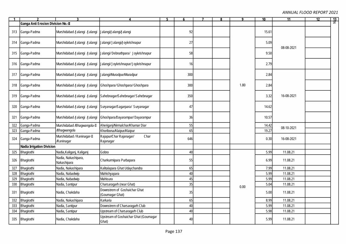
ANNUAL FLOOD REPORT 2021
1 2 3 4 5 6 7 8 9 10 11 12 13
313 Ganga-Padma Murshidabad /Jalangi /Jalangi Jalangi/Jalangi/Jalangi 92 15.61
314 Ganga-Padma Murshidabad /Jalangi /Jalangi Jalangi/ Jalangi/Joykrishnapur 27 5.09
315 Ganga-Padma Murshidabad /Jalangi /Jalangi Jalangi/ Debnathpara/ Joykrishnapur 58 9.50
316 Ganga-Padma Murshidabad /Jalangi /Jalangi Jalangi/ Joykrishnapur/ Joykrishnapur 16 2.79
317 Ganga-Padma Murshidabad /Jalangi /Jalangi Jalangi/Muradpur/Muradpur 300 2.84
318 Ganga-Padma Murshidabad /Jalangi /Jalangi Ghoshpara/ Ghoshpara/ Ghoshpara 300 2.84
319 Ganga-Padma Murshidabad /Jalangi /Jalangi Sahebnagar/Sahebnagar/ Sahebnagar 350 3.32
320 Ganga-Padma Murshidabad /Jalangi /Jalangi Suryanagar/Sagarpara/ Suryanagar 47 14.62
321 Ganga-Padma Murshidabad /Jalangi /Jalangi Ghoshpara/Dayarampur/ Dayarampur 36 10.57
322 Ganga-Padma Aheriganj/Nirmalchar/Khamar Diar 55 14.42
323 Ganga-Padma Khoribona/Alaipur/Alaipur 65 19.27
324 Ganga-PadmaMurshidabad / Raninagar-II
/Raninagar
Rajapur/Char Rajanagar/ Char
Rajanagar646 0.30 16-08-2021
325 Bhagirathi Nadia,Kaliganj, Kaliganj Gobra 40 5.99 11.08.21
326 BhagirathiNadia, Nakashipara,
NakashiparaCharkurmipara Purbapara 55 6.99 11.08.21
327 Bhagirathi Nadia, Nakashipara Kalitalapara Ghat Udaychandra 65 7.99 11.08.21
328 Bhagirathi Nadia, Nabadwip Mahishyapara 40 5.99 11.08.21
329 Bhagirathi Nadia, Nabadwip Mahisura 45 5.99 11.08.21
330 Bhagirathi Nadia, Santipur Charsaragarh (near Ghat) 35 5.04 11.08.21
331 Bhagirathi Nadia, ChakdahaDownstrem of Goshaichar Ghat
(Gournagar Ghat)35 5.00 11.08.21
332 Bhagirathi Nadia, Nakashipara Karkaria 65 8.99 11.08.21
333 Bhagirathi Nadia, Santipur Downstrem of Charsaragarh Club 40 5.99 11.08.21
334 Bhagirathi Nadia, Santipur Upstream of Charsaragarh Club 40 5.98 11.08.21
335 Bhagirathi Nadia, ChakdahaUpstream of Goshaichar Ghat (Gournagar
Ghat)40 5.99 11.08.21
1.80
0.00
NIC
/II,
Mem
o no
. 266
, Dat
ed: 2
5.02
.22
(Em
ail:
04.0
3.20
22)
& E
mai
l of E
E/G
AE
D-I
I Dtd
. 11.
05.2
022.
Ganga Anti Erosion Division No.-II
08-08-2021
16-08-2021
Murshidabad /Bhagwangola-II
/Bhagwangola08-10-2021
Nadia Irrigation Division
Page 137

ANNUAL FLOOD REPORT 2021
1 2 3 4 5 6 7 8 9 10 11 12 13
336 AjoyPurba Bardhaman, Block-
Ketugram-II P.S.- Ketugram.
Rosui, Billeswar, Chorki Bortala under
Billeswar G.P.215.00 392 929.00 01.10.21
Ajoy above EDL
on 30.09.21
337 Kuia R. Birbhum/ Labpur/ labpur
Thiba and Indus/ Balarampur, Kandarkula,
Sahapur, Khanpur, Thiba/ Thiba,
Kandarkula, Sahapur
111.00 340 40 210.00 31.07.21
338 AjoyBirbhum, Block- Nanoor, P.S.-
NanoorSundarpur, Thupsara. 165.00 188 304.00 01.10.21
Ajoy above EDL
on 30.09.21
339 BrahmaniP.S- Nalhati, Block- Nalhati-I,
Dist-Birbhum
G.P- Dunigram, vil.- Kutubpur Mouza:-
Balsa30 5.00 27.06.21 Slip
340 BrahmaniP.S- Margram, Block-
Rampurhat-II, Dist-Birbhum
G.P- Dunigram, vil.- Gopalpur Mouza:-
Purba Gopalpur30 5.00 01-08-2021 Slip
341 BrahmaniP.S- Margram, Block-
Rampurhat-II, Dist-Birbhum
G.P- Dunigram, vil.- Joychandrapur Mouza:-
Purba Gopalpur30 5.00 08-07-2021 Slip
342 BrahmaniP.S- Margram, Block-
Rampurhat-II, Dist-Birbhum
G.P- Dunigram, vil.- Babladanga, Mouza:-
Purba Gopalpur20 3.80 16-08-2021 Slip
343 BrahmaniP.S- Nalhati, Block- Nalhati-II,
Dist-Birbhum
G.P- Shitalgram vil.- Barunighata, Mouza:-
Prosadpur120 29.00 Bank Erosion
344 BrahmaniP.S- Nalhati, Block- Nalhati-II,
Dist-Birbhum
G.P- Shitalgram vil.- Barunighata,60 17.00
Boulder pitching
Slides
345 BanshloiP.S- Muraroi Block- Muraroi -I
Dist:- Birbhum
G.P - Mohurapur vil.- Ratanpur Mouza-
Ratanpur, Tegharia700 182.00 Bank Erosion
346 PaglaP.S- Muraroi Block- Muraroi -I
Dist:- Birbhum
G.P - Muraroi vil.- Dadpur Mouza- Kashipur,
Dadpur1100 156.00 Bank Erosion
347 PaglaP.S- Paikor Block- Muraroi -II
Dist:- Birbhum
G.P - Amdol vil.- Uttor Ramchandrapur
Mouza- Uttor Ramchandrapur700 216.00
Boulder
protection Slides
348 R. Kaliaghai Paschim Medinipur / Sabang Chaulkuri / Andulia / Andulia 17 2.12 29-07-2021
349 R. Kaliaghai Paschim Medinipur / Sabang Dasagram / Bangaldari & Koptipur /
Bangaldari & Koptipur45 4.46 29-07-2021
350 R. Kaliaghai Paschim Medinipur / Sabang Dasagram / Bangaldari / Bangaldari 1800 4.99 30-07-2021
351 R. Kaliaghai Paschim Medinipur / Sabang Dasagram / Mansagram / Mansagram 25 4.95 29-07-2021
352 R. Kaliaghai Paschim Medinipur / Sabang Chaulkuri / Nedhua / Nedhua 380 4.93 15-09-2021
353 R. Kaliaghai Paschim Medinipur / Sabang Dasagram / Kolonda / Kolonda 20 2.78 29-07-2021
354 R. Kaliaghai Paschim Medinipur / Sabang Dasagram / Khaukhonda / Khaukhonda 20 2.79 30-07-2021
4.30
248.86
Mayurakshi Canal Circle
Mem
o no
: 151
& 1
46 D
ated
: 22.
02.2
022
of S
E/M
CC
& E
mai
l Dat
ed. 2
9.04
.202
2.
19.0
6.21
to 8
.10.
21
K.K.B. Project Division
Wes
tern
Circ
le-I
I, E
mai
l Dat
ed: 1
0.02
.202
2 &
Em
ail o
f EE
/WM
D D
td. 1
2.05
.202
2.
Page 138
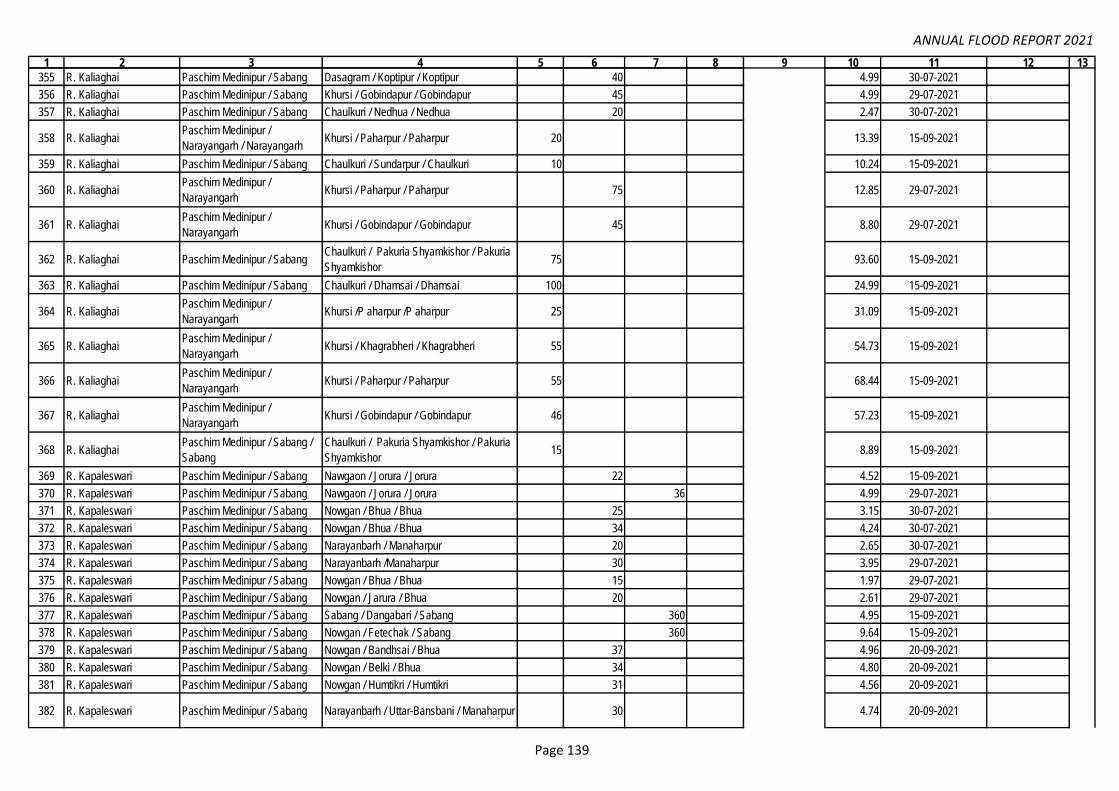
ANNUAL FLOOD REPORT 2021
1 2 3 4 5 6 7 8 9 10 11 12 13
355 R. Kaliaghai Paschim Medinipur / Sabang Dasagram / Koptipur / Koptipur 40 4.99 30-07-2021
356 R. Kaliaghai Paschim Medinipur / Sabang Khursi / Gobindapur / Gobindapur 45 4.99 29-07-2021
357 R. Kaliaghai Paschim Medinipur / Sabang Chaulkuri / Nedhua / Nedhua 20 2.47 30-07-2021
358 R. Kaliaghai Paschim Medinipur /
Narayangarh / NarayangarhKhursi / Paharpur / Paharpur 20 13.39 15-09-2021
359 R. Kaliaghai Paschim Medinipur / Sabang Chaulkuri / Sundarpur / Chaulkuri 10 10.24 15-09-2021
360 R. Kaliaghai Paschim Medinipur /
Narayangarh Khursi / Paharpur / Paharpur 75 12.85 29-07-2021
361 R. Kaliaghai Paschim Medinipur /
Narayangarh Khursi / Gobindapur / Gobindapur 45 8.80 29-07-2021
362 R. Kaliaghai Paschim Medinipur / Sabang Chaulkuri / Pakuria Shyamkishor / Pakuria
Shyamkishor75 93.60 15-09-2021
363 R. Kaliaghai Paschim Medinipur / Sabang Chaulkuri / Dhamsai / Dhamsai 100 24.99 15-09-2021
364 R. Kaliaghai Paschim Medinipur /
Narayangarh Khursi /P aharpur /P aharpur 25 31.09 15-09-2021
365 R. Kaliaghai Paschim Medinipur /
Narayangarh Khursi / Khagrabheri / Khagrabheri 55 54.73 15-09-2021
366 R. Kaliaghai Paschim Medinipur /
Narayangarh Khursi / Paharpur / Paharpur 55 68.44 15-09-2021
367 R. Kaliaghai Paschim Medinipur /
Narayangarh Khursi / Gobindapur / Gobindapur 46 57.23 15-09-2021
368 R. Kaliaghai Paschim Medinipur / Sabang /
Sabang
Chaulkuri / Pakuria Shyamkishor / Pakuria
Shyamkishor15 8.89 15-09-2021
369 R. Kapaleswari Paschim Medinipur / Sabang Nawgaon / Jorura / Jorura 22 4.52 15-09-2021
370 R. Kapaleswari Paschim Medinipur / Sabang Nawgaon / Jorura / Jorura 36 4.99 29-07-2021
371 R. Kapaleswari Paschim Medinipur / Sabang Nowgan / Bhua / Bhua 25 3.15 30-07-2021
372 R. Kapaleswari Paschim Medinipur / Sabang Nowgan / Bhua / Bhua 34 4.24 30-07-2021
373 R. Kapaleswari Paschim Medinipur / Sabang Narayanbarh / Manaharpur 20 2.65 30-07-2021
374 R. Kapaleswari Paschim Medinipur / Sabang Narayanbarh /Manaharpur 30 3.95 29-07-2021
375 R. Kapaleswari Paschim Medinipur / Sabang Nowgan / Bhua / Bhua 15 1.97 29-07-2021
376 R. Kapaleswari Paschim Medinipur / Sabang Nowgan / Jarura / Bhua 20 2.61 29-07-2021
377 R. Kapaleswari Paschim Medinipur / Sabang Sabang / Dangabari / Sabang 360 4.95 15-09-2021
378 R. Kapaleswari Paschim Medinipur / Sabang Nowgan / Fetechak / Sabang 360 9.64 15-09-2021
379 R. Kapaleswari Paschim Medinipur / Sabang Nowgan / Bandhsai / Bhua 37 4.96 20-09-2021
380 R. Kapaleswari Paschim Medinipur / Sabang Nowgan / Belki / Bhua 34 4.80 20-09-2021
381 R. Kapaleswari Paschim Medinipur / Sabang Nowgan / Humtikri / Humtikri 31 4.56 20-09-2021
382 R. Kapaleswari Paschim Medinipur / Sabang Narayanbarh / Uttar-Bansbani / Manaharpur 30 4.74 20-09-2021
248.86
Wes
tern
Circ
le-I
I, E
mai
l Dat
ed: 1
0.02
.202
2 &
Em
ail o
f EE
/WM
D D
td. 1
2.05
.202
2.
Page 139

ANNUAL FLOOD REPORT 2021
1 2 3 4 5 6 7 8 9 10 11 12 13
383 R. Kapaleswari Paschim Medinipur / Sabang Narayanbarh / Narayanbarh / Narayanbarh 30 4.77 20-09-2021
384 R. Kapaleswari Paschim Medinipur / Sabang Nowgan / Fetechak / Sabang 20 3.56 21-09-2021
385 R. Kapaleswari Paschim Medinipur / Sabang Nowgan / Humtikri / Humtikri 15 2.26 21-09-2021
386 R. Kapaleswari Paschim Medinipur / Sabang Narayanbarh / Uttar-Bansbani / Manaharpur 34 4.97 21-09-2021
387 R. Kapaleswari Paschim Medinipur / Sabang Narayanbarh / Amarbarh / Manaharpur 35 4.99 21-09-2021
388 R. Kapaleswari Paschim Medinipur / Sabang Narayanbarh / Narayanbarh / Uttar Eral 1400 4.99 21-09-2021
389 R. Kapaleswari Paschim Medinipur / Sabang Sabang / Sabang / Sabang 75 9.95 21-09-2021
390 R. Kapaleswari Paschim Medinipur / Sabang Chaulkuri / Andulia / Andulia 20 4.48 21-09-2021
391 R. Kapaleswari Paschim Medinipur / Sabang Chaulkuri / Chaulkuri / Chaulkuri 20 3.95 21-09-2021
392 R. Kapaleswari Paschim Medinipur / Sabang Chaulkuri / Chaulkuri / Chaulkuri 25 5.00 21-09-2021
393 R. Kapaleswari Paschim Medinipur / Sabang Chaulkuri / Chaulkuri / Chaulkuri 72 16.23 21-09-2021
394 R. Kapaleswari Paschim Medinipur / Sabang Chaulkuri / Andulia / Andulia 80 99.46 15-09-2021
395 R. Kapaleswari Paschim Medinipur / Sabang Chaulkuri / Andulia / Andulia 45 56.16 15-09-2021
396 R. Deuli Paschim Medinipur / Sabang Sarta / Rampura / Rampura 390 9.84 15-09-2021
397 R. Deuli Paschim Medinipur / Sabang Sarta / Rampura / Rampura 385 4.99 15-09-2021
398 R. Deuli Paschim Medinipur / Sabang Dasagram / Ramchak / Ramchak 17 15.77 15-09-2021
399 R. Deuli Paschim Medinipur / Sabang Dasagram / Chaksafi / Chaksafi 16 14.98 15-09-2021
400 R. Deuli Paschim Medinipur / Sabang Dasagram / Bangaldanri / Bangaldanri 7 47 14.58 15-09-2021
401 R. Deuli Paschim Medinipur / Sabang Dasagram / Ramchak / Ramchak 100 98.39 15-09-2021
402 R. Deuli Paschim Medinipur / Sabang Dasagram / Kesiabheri / Kesiabheri 26 32.35 15-09-2021
403 R. Deuli Paschim Medinipur / Sabang Dasagram / Chakabdulla / Chakabdulla 37 46.03 15-09-2021
404 R. Deuli Paschim Medinipur / Sabang Dasagram / Chakabdulla / Chakabdulla 40 49.87 15-09-2021
405 Bonai Khal Paschim Medinipur / Sabang Nawgaon / Chhina / Chhina 370 9.92 15-09-2021
406 Bonai Khal Paschim Medinipur / Sabang Nawgaon / Chinna / Chinna 10 2.67 20-09-2021
407 Bonai Khal Paschim Medinipur / Sabang Chaulkuri / Kharika / Kharika 35 4.71 20-09-2021
408 Bonai Khal Paschim Medinipur / Sabang Chaulkuri / Ghusinga / Kharika 16 15.58 15-09-2021
409 Bonai Khal Paschim Medinipur / Sabang Chaulkuri / Ghusinga / Kharika 20 19.82 15-09-2021
410 Bonai Khal Paschim Medinipur / Sabang Chaulkuri / Ghusinga / Kharika 14 14.38 15-09-2021
411 Bonai Khal Paschim Medinipur / Sabang Chaulkuri / Ghusinga / Kharika 13 13.52 15-09-2021
412 Dokhali Khal Paschim Medinipur / Sabang Nawgaon / Manikara / Manikara 17 2.13 30-07-2021
413 Dokhali Khal Paschim Medinipur / Sabang Nawgaon / Manikara / Manikara 26 3.50 30-07-2021
414 Dokhali Khal Paschim Medinipur / Sabang Chaulkuri / Uttar Eral / Uttar Eral 35 4.69 30-07-2021
415 Dokhali Khal Paschim Medinipur / Sabang Chaulkuri / Uttar Eral / Uttar Eral 41 3.80 30-07-2021
416 Dokhali Khal Paschim Medinipur / Sabang Chaulkuri / Kharika / Kharika 25 3.08 30-07-2021
417 Dokhali Khal Paschim Medinipur / Sabang Chaulkuri / Uttar Eral / Uttar Eral 25 3.36 30-07-2021
418 Dokhali Khal Paschim Medinipur / Sabang Chaulkuri / Uttar Eral / Uttar Eral 20 24.53 15-09-2021
248.86
Wes
tern
Circ
le-I
I, E
mai
l Dat
ed: 1
0.02
.202
2 &
Em
ail o
f EE
/WM
D D
td. 1
2.05
.202
2.
Page 140

ANNUAL FLOOD REPORT 2021
1 2 3 4 5 6 7 8 9 10 11 12 13
419 Sundarpur Khal Paschim Medinipur / Sabang Chaulkuri / Sundarpur/ Chaulkuri 25 3.85 20-09-2021
420 Sundarpur Khal Paschim Medinipur / Sabang Chaulkuri / Sundarpur/ Chaulkuri 25 3.80 20-09-2021
421 Sundarpur Khal Paschim Medinipur / Sabang Chaulkuri / Kharika / Kharika 50 62.22 15-09-2021
422 Sundarpur Khal Paschim Medinipur / Sabang Chaulkuri / Uttar Eral / Uttar Eral 40 49.85 15-09-2021
423 Sundarpur Khal Paschim Medinipur / Sabang Chaulkuri / Kharika / Kharika 16 19.94 15-09-2021
424 Kharika Khal Paschim Medinipur / Sabang Sarta / Rampura / Rampura 30 3.56 29-07-2021
425 Kharika Khal Paschim Medinipur / Sabang Chaulkuri / Chaulkhola / Chaulkhola 25 3.40 20-09-2021
426Dehati Channel (Old
stream of R. Kaliaghali)Paschim Medinipur / Sabang Dasagram / Dehati / Dehati 38 46.52 15-09-2021
427 Kalimondop Khal Paschim Medinipur / Sabang Mohar / Nimkimohar / Uttar Nimkimohar 838 4.94 15-09-2021
428 Kalimondop Khal Paschim Medinipur / Sabang Mohar / Uchitpur / Uchitpur 22 2.99 19-09-2021
429 Kalimondop Khal Paschim Medinipur / Sabang Mohar / Roychak / Roychak 34 4.26 19-09-2021
430 Kalimondop Khal Paschim Medinipur / Sabang Mohar / Roychak / Roychak 27 3.34 19-09-2021
431 Kalimondop Khal Paschim Medinipur / Sabang Mohar / BahabalPur / BahabalPur 20 2.76 19-09-2021
432 Kalimondop Khal Paschim Medinipur / Sabang Mohar / Uchitpur / Uchitpur 32 4.26 19-09-2021
433 Kalimondop Khal Paschim Medinipur / Sabang Mohar / Uttar Nimkimohar / Uttar
Nimkimohar47 6.92 16-09-2021
434 Amrakhali Khal Paschim Medinipur / Sabang Narayanbarh / Hariharpur / Hariharpur 1 4.88 29-07-2021
435 Amrakhali Khal Paschim Medinipur / Sabang Sabang / Sabang / Sabang 1 4.99 29-07-2021
436 Amrakhali Khal Paschim Medinipur / Sabang Narayanbarh / Amarbar / Amarbar 1 5.00 29-07-2021
437 Amrakhali Khal Paschim Medinipur / Sabang Sabang/ Rambhadrapur /Rambhadrapur 20 4.94 16-09-2021
438 Amrakhali Khal Paschim Medinipur / Sabang Bishnupur / Ghol Bishnupur / Bishnupur 95 11.62 17-09-2021
439 Amrakhali Khal Paschim Medinipur / Sabang Bishnupur / Shibchak / Shibchak 30 2.61 17-09-2021
440 Amrakhali khal Paschim Medinipur / Sabang Narayanbarh / Kalyanpur to Hariharpur /
Kalyanpur to Hariharpur1600 11.06 20-09-2021
441 Ganapath khal Paschim Medinipur / Sabang
Bishnupur, Bural, Bhemua / Anantachak,
Murarichak, Bahabalpur / Anantachak,
Murarichak, Bahabalpur
4 3.83 30-07-2021
442 Ganapath khal Paschim Medinipur / Sabang Bhemua / Chandpur to Gobindopur /
Chandpur to Gobindopur2800 13.37 20-09-2021
443 Kalchity Khal Paschim Medinipur / Sabang Bural / Baharkundra / Baharkundra 1 4.59 29-07-2021
444 Kalchity Khal Paschim Medinipur / Sabang Narayanbarh / Kapasda / Kapasda 60 5.03 18-09-2021
445Kalchity Drainage
channelPaschim Medinipur / Sabang Narayanbarh / Kundra / Kundra 500 7.47 15-09-2021
446 Banskona Khal Paschim Medinipur / Sabang Bhemua / Shyamsundarpur /
Shyamsundarpur35 4.95 20-09-2021
248.86
Wes
tern
Circ
le-I
I, E
mai
l Dat
ed: 1
0.02
.202
2 &
Em
ail o
f EE
/WM
D D
td. 1
2.05
.202
2.
West Midnapore Division
Page 141
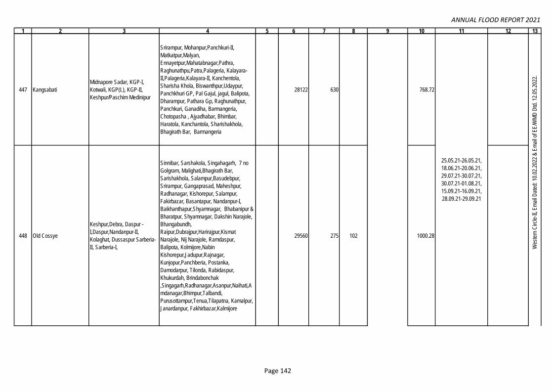
ANNUAL FLOOD REPORT 2021
1 2 3 4 5 6 7 8 9 10 11 12 13
447 Kangsabati
Midnapore Sadar, KGP-I,
Kotwali, KGP(L), KGP-II,
Keshpur/Paschim Medinipur
Srirampur, Mohanpur,Panchkuri-II,
Matkatpur,Malyan,
Ennayetpur,Mahatabnagar,Pathra,
Raghunathpu,Patra,Palageria, Kalayara-
II,Palageria,Kalayara-II, Kanchentola,
Sharisha Khola, Biswanthpur,Udaypur,
Panchkhuri GP, Pal Gajul, jagul, Balipota,
Dharampur, Pathara Gp, Raghunathpur,
Panchkuri, Ganadiha, Barmangeria,
Chotopasha , Ajyadhabar, Bhimbar,
Haratola, Kanchantola, Sharishakhola,
Bhagirath Bar, Barmangeria
28122 630 768.72
448 Old Cossye
Keshpur,Debra, Daspur -
I,Daspur,Nandanpur-II,
Kolaghat, Dussaspur Sarberia-
II, Sarberia-I,
Sinnibar, Sarshakola, Singahagarh, 7 no
Golgram, Malighati,Bhagirath Bar,
Sarishakhola, Salampur,Basudebpur,
Srirampur, Gangaprasad, Maheshpur,
Radhanagar, Kishorepur, Salampur,
Fakirbazar, Basantapur, Nandanpur-I,
Baikhanthapur,Shyamnagar, Bhabanipur &
Bharatpur, Shyamnagar, Dakshin Narajole,
Bhangabundh,
Raipur,Dubrajpur,Harirajpur,Kismat
Narajole, Nij Narajole, Ramdaspur,
Balipota, Kolmijore,Nabin
Kishorepur,Jadupur,Rajnagar,
Kunjopur,Panchberia, Postanka,
Damodarpur, Tilonda, Rabidaspur,
Khukurdah, Brindabonchak
,Singagarh,Radhanagar,Asanpur,Naihati,A
mdanagar,Bhimpur,Talbandi,
Purusottampur,Tenua,Tilapatna, Kamalpur,
Janardanpur, Fakhirbazar,Kalmijore
29560 275 102 1000.28
Wes
tern
Circ
le-I
I, E
mai
l Dat
ed: 1
0.02
.202
2 &
Em
ail o
f EE
/WM
D D
td. 1
2.05
.202
2.
25.05.21-26.05.21,
18.06.21-20.06.21,
29.07.21-30.07.21,
30.07.21-01.08.21,
15.09.21-16.09.21,
28.09.21-29.09.21
296.66
Page 142

ANNUAL FLOOD REPORT 2021
1 2 3 4 5 6 7 8 9 10 11 12 13
449 New Cossye Debra
Gopal Pur,7 no
Golgram,Birsingpur,Nandabari,
Mamudabad, Jaganathpur, Gayespur,
Makarimpur, Khanamohan & Satyapur,
Gourangachak, Paikpari,
Raipur,Bhainagar,Shanrpur,Kolkuria,Gaesh
pur,Ramchandrapur Talberia-
Ghunghuni,Naraharipur & Mankhanda,
Satyapur & Lowada, Makarimpur,
Kanakpur, Bahadurpur, Birsinghapur,
Gopalpur, Bishnupur, Amodpur,
Puanpat,Nandabari, Mamudabad,
Bharatpur & Golagram, Baikhanthapur &
Shyamnagar, Malihati
1580 280 208 207.00
450 Kalaichandi Khal Midnapur Sadar, Kotwali
Cherrua, Panchkhuri-6/2, Panchkuri, Kulda,
Amaodpur pal, 6/1 Panchkuri, Maharajpur,
Nischintapur, Birsinghpur, 6/2 Panchkuri,
62 127.00
451 Jhumi Ghatal
Prasadchak,Dhasachadpur, Khasbarh,
Irpala, Amodarkul, Khasbarh, Ramchak,
Chauli Shingpur, Gangaprasad,Mansuka-2,
Blarampur, Blarampur, Kisorchak
4060 307.00
452 Cossye
Debra,Kharagpur-II ,
Kharagpur(Local) Meudipur,
Midnapore Sadar, Kotowali
Haridrapat,Keshpur, Palpara, Muksudpur,
Kaliarah- II, Pelageria,Gopalpur,Aima,
Kaliarah-I,
Akhra,Rajshar,Kuliara,Markandapur,Meudip
ur,Ramnagar,Mahashpur,Muksudpur,Radha
kristapur,Keshpur, Kaliarah-I &
II,Bhavanipur, Golgram, Gopalpur,
Makrampur, Lowada, Makarampur,
Malihati,Satyapur & Bhavanipur, Malihati,
Shyamsundarpur,Tenyua, Malihati,
Shyamsundarpur, Kaliyara-II, Satyapur,
Lowada Shanrpur, Akra, Mukshedpur,
Rambhadrapur, Paschim Lahana &
Ramchandrapur Shanrpur, Paschim
Lahana, Pathra, Jagul, PalJagul, Jagul &
Udaipur
16850 77 79.40
Wes
tern
Circ
le-I
I, E
mai
l Dat
ed: 1
0.02
.202
2 &
Em
ail o
f EE
/WM
D D
td. 1
2.05
.202
2.
25.05.21-26.05.21,
18.06.21-20.06.21,
29.07.21-30.07.21,
30.07.21-01.08.21,
15.09.21-16.09.21,
28.09.21-29.09.21
296.66
Page 143

ANNUAL FLOOD REPORT 2021
1 2 3 4 5 6 7 8 9 10 11 12 13
453 Durbachati Daspur-II, Daspur
Kasinathpur ,Khukurdaha, Naryanchak,
Jotghnashyam, Kolaghat,
Brindabonchak,Parbatipur,
Sahapur,Rabidaspur, Nandanpur-I,
Kasinathpur, Jot Ghanashyam,
10097 1 1105.80
454 Bhosra Khal Daspur-I, Daspur, Debra
Dharma,Chak Bualia, Nandanpur-I &II,
Brindabanpur, Malihati, Arkhana,
Nandanpur-II, Jyotisab,Manikpur,Kakdari,
Sarberia - II, Purba
Darkhola,Brindabanpur,Chakpurusottampur
,Chak Madhuri.Chakkripan, Golagram
16850 500 1 130.65
455 ShilabatiDaspur-I, Daspur, Ghatal
Annandagarh,Rajnagar, Suratpur, Gadghat,
Panna, Ajbnagar, Dewanchak,
Krishnaballavpur, Dewanchak-II, Simulia,
Radhaballavpur, Jaykrishnapur,
Radhachak, Dewanchak-II, Simana, Bolluri,
Hazakundu, Danikola, Nij Narajole,
Gobrakundu, Bachhrakundu, Rajnagar, Nij
Narajole, Rajnagar, Krishnaballavpur,
Gobrakundu, Bachhrakundu, Gurli,
Suratpur, Sitakundu, Mursednagar,
Rasikganj, Gobindapur,Katan, Konnaga,
Ghatal Municipality, Haishinghapur,
Pratappur, Manoharpur-I, Gurli, Suratpur,
Haishinghapur, Pratappur, Manoharpur-I,
Nimtala, Jodupur, Sujanagar
813 33760 177 2094.70
456 Harighata Khal Daspur-II , Daspur Chak Chaipat, Chaipat 560 11.50
457 Nag canal Kharagpur-II, Kharagpur(Local) Atasangra, Chakmakrampur, Gopinathpur,
Paparara-I, 2500 18.00 25.05.21-26.05.21,
18.06.21-20.06.21,
29.07.21-30.07.21,
30.07.21-01.08.21,
15.09.21-16.09.21,
28.09.21-29.09.21
Wes
tern
Circ
le-I
I, E
mai
l Dat
ed: 1
0.02
.202
2 &
Em
ail o
f EE
/WM
D D
td. 1
2.05
.202
2.
25.05.21-26.05.21,
18.06.21-20.06.21,
29.07.21-30.07.21,
30.07.21-01.08.21,
15.09.21-16.09.21,
28.09.21-29.09.21
296.66
Page 144

ANNUAL FLOOD REPORT 2021
1 2 3 4 5 6 7 8 9 10 11 12 13
458
MMC, Dy-7, Dy-3,
Chaltageria Canal,
Baitabarh canal, Dy-5s,
6Main canal, 1-Main
Canal
Kharagpur-II ,
Kharagpur(Local), Debra,
Basantapur, Barbasantapur, Kaliarah- I,
Gaylageria, Chandanpur, Kismat Dhamtore,
Gobindapur, Barabandi, Paschim Satkona,
Khanamohan, Baita, Gourhati, Barhratan,
Salkhuti, Asutia, Baita, Gourhati, Barhratan,
Salkhuti, Asutia, Gangaramchak, Baragarh,
Pakui, Jalimanda, Raipur, Satyapur,
Dannageria, Hijolda, Radhamohanpur-I,
Panskura, Gotpota, Ghoshpur, Jinsahar-7
no Barkola GP, Benageria Paparara-I
9320 143 4 168.00
459 Parang Daspur - I ,Daspur
Chandipur, Raikundu, Harirajpur, Nij
Narajole, 962 5500 1155.00
460 Kanki Daspur -I, Daspur
Ramdebpur, Rajnagar, Anandagarh,
Jadupur, Suratpur, Sitakundu,
Mursednagar,
265 9250 689.50
461 Donai Daspur -I, Daspur Bolluri, Nij Narajole, 130 6 168.00
462 Dwarakeswar (Jhumi) Ghatal
Anandapur,Dhasachandpur,Prasadchak,
Baghanala, Mansuka-II, Dirghagram,
Monsuka, Barkatipur,
5250 660 6 129.80
463 RupnarayanGhatal, Daspur-II , Daspur,
Daspur-I
Harishpur, Shyamsundarpur, Manoharpur-
I, Jotkanuramgarh, Ranichak, Kumarchak,
Kuijuri, Ranichak, Benai, Dudhkomra,
Daspur-I, Sribora, Shyamganj,
Chakdogechia
19900 125 78 212.40
464 Gomrai Daspur-II, Daspur Dakshin Bard, Kheput, Near Mondal Para 70 10.50
465 Palaspai Daspur -I,Daspur,
Kunjopur, Uttargobindanagar, Panchberia,
Gobindanagar, Nandanpur-II, Rampur ,
Goura, Palaspai, Nischintapur, Satpota,
Jot Ghanashyaaam, Ajuria, Dakshinbar,
Kheput, Gourichak , Chaksultan, Gochati,
Sitapur, Goura, Hardachak, Kultikari,
Dudhkomra,
6812 300 1 339.98
466 Khirai Khal Debra ChakKanu 16 1 5.00
25.05.21-26.05.21,
18.06.21-20.06.21,
29.07.21-30.07.21,
30.07.21-01.08.21,
15.09.21-16.09.21,
28.09.21-29.09.21
25.05.21-26.05.21,
18.06.21-20.06.21,
29.07.21-30.07.21,
30.07.21-01.08.21,
15.09.21-16.09.21,
28.09.21-29.09.21
Wes
tern
Circ
le-I
I, E
mai
l Dat
ed: 1
0.02
.202
2 &
Em
ail o
f EE
/WM
D D
td. 1
2.05
.202
2.
296.66
Page 145

ANNUAL FLOOD REPORT 2021
1 2 3 4 5 6 7 8 9 10 11 12 13
467 Chandia Khal PinglaMaligram, Lakshmibari, Purusttampur,
Agarara, & Naratha1080 8.40
468 Buri Ganga Ghatal Boramara, Harirajpur, Supa 234 713.00
469 Kangsabati R.Dist. - Jhargram, Block - Binpur -
I, P.S. - LalgarhMouza - Chaltapal, Lachipur 75 47.97 05/09/21 to 10/09/21
470 Kangsabati R.Dist. - Jhargram, Block -
Jhargram, P.S. - JhargramMouza - Elani 30 06-09-2021
471 Kangsabati R.Dist. - Jhargram, Block -
Jhargram, P.S. - JhargramMouza - Chubka, Markandapur 26 08-09-2021
472 ChandiaPurba Medinipur,
Block-Moyna
GP-Paramanandapur, Mouza-
Paramanandapur90 14.12 28.7.21 to 30.7.21
473 ChandiaPurba Medinipur,
Block-Moyna
GP-Paramanandapur, Haridaspur,
Gokulnagar, Ramchak, Bakcha, Mouza-
Paramanandapur, Jigirchak, Kachichak,
Mudibar, Arankiarana, Chadebenia, Baruna
345 5 69.00 Sept., 21
474 New CossyePurba Medinipur,
Block-MoynaGP-Naichhanpur-II,Mouza Narkeldah 100 1 18.00 Sept., 21
475 Kaliaghai Purba Medinipur,Block-Moyna GP-Bakcha,Mouza Khidirpur 1 2.50 Sept., 21
476 Birkhali KhalPurba Medinipur,
Block-MoynaGP-Bakcha,Mouza Chadibenia 40 1 1.73 Sept., 21
477 Petua KhalPurba Medinipur,
Block-MoynaGP-Bakcha,Mouza Arankiarana 30 3.00 Sept., 21
478 ChandiaPurba Medinipur,
Block-Moyna
GP-Paramanadapur, Ramchak,
Mouza-Paramanandapur Sudampur117 16.00 November, 21
479Mirzapur Khal (Right
Emb.)
Purba Medinipur, Block-Sahid
Matangini P.S - Tamluk
G.P - Kharui-II
Mouza- Aluachak75 9.40 Sept., 21
480Durbachatty R. (right
Emb.)
Purba Medinipur, Block & P.S-
Kolaghat
G.P-Baishnabchak
Mouza- Bhorda110 23.97 Sept., 21
481Noapania Khal (right
Emb.)
Purba Medinipur, Block & P.S-
Kolaghat
G.P- Gopalnagar
Mouza- Bathanberia40 3.67 Sept., 21
482 Denan khal ( Right Emb.)Purba Medinipur, Block & P.S-
Kolaghat
G.P- Amalhanda
Mouza- Mahisgot60 6.60 Sept., 21
0.00
0.00
25.05.21-26.05.21,
18.06.21-20.06.21,
29.07.21-30.07.21,
30.07.21-01.08.21,
15.09.21-16.09.21,
28.09.21-29.09.21
Jhargram Flood Management & Planning Division
East Midnapor Division
Wes
tern
Circ
le-I
I, E
mai
l Dat
ed: 1
0.02
.202
2 &
Em
ail o
f EE
/WM
D D
td. 1
2.05
.202
2.
296.66
Mem
o no
: 188
Dat
ed: 2
3.02
.202
2 of
Wes
tern
Circ
le -
III &
Em
ail D
ated
27.
04.2
022.
Page 146

ANNUAL FLOOD REPORT 2021
1 2 3 4 5 6 7 8 9 10 11 12 13
483 Jugibar KhalPurba Medinipur, Block & P.S-
Kolaghat
G.P- Kola-II
Mouza- Arror1 2.07 28.07.21
484Nowapenia Khal( Right
Emb.)
Purba Medinipur, Block & P.S-
Kolaghat
G.P- Gopalnagar
Mouza- Bathanberia40 3.80 28.07.21
485Durbachatty R. (right
Emb.)
Purba Medinipur, Block & P.S-
Kolaghat
G.P- Baishnabchak
Mouza- Baishnabchak75 7.71 28.07.21
486Kharichak Khal (Right
Emb.)
Purba Medinipur, Block & P.S-
Kolaghat G.P- Kola-II, Mouza- Arror 80 7.45 28.07.21
487Durbachatty R. (right
Emb.)
Purba Medinipur, Block & P.S-
Kolaghat
G.P-Baishnabchak
Mouza- Kolagachia1 6.62 11.06.21
488 RupnarayanPurba Medinipur,
TamlukUttarchara sankara,Tamralipta Municipality 192 13.58 28.07.21
489 Pairatungi khalPurba Medinipur,
TamlukAbasbarichar,Tamralipta Municipality 124 7.09 28.07.21
490 RupnarayanPurba Medinipur,
Nandakumar
Tatulberira &Ichhanpur
G.P-Babarttarhut purba88 17.06 28.07.21
491 RupnarayanPurba Medinipur,
Tamluk & Mahishadal
Narayanpur, Bholsora & Banka.
G.P-Amritberia,Satish Samanta & Tamluk
Municiplaity.
3 5.18 28.07.21
492 Hooghly & Haldi Purba Medinipur,
Mahishadal & Nandakumar
Lakhya, Jaganathkhali, Chaturia, Kirtruia,
Banipatha, Anandakhali & Tetulberia.
Mouza-Banskhana Jalpai G.P-Baruttarhingli
& Kalyanpur.
7 7.01 28.07.21
493 Soadighi khalPurba Medinipur,
Sahid MatanginiMouza-Alinan. G.P-Kakharda. 40 3.86 28.07.21
494 Tentulberia khalPurba Medinipur,
MahishadalGopalchak, Betkundu 45 4.80 28.07.21
495 Nayanjuli SluicePurba Medinipur,
Tamluk
Nimtouri(DM office), Mouza-Ganapatinagar,
G.P-Uttarsonabhui1 1.57 28.07.21
496 Tripurakhali khalPurba Medinipur,
Nandakumar
Swarberia jalpai-II, Mouza-Kalagechia,
G.P.Saoraberia jalpai II80 6.14 28.07.21
497 Girish KhalPurba Medinipur,
Nandakumar
Grishchak,Sitalpur Pashim, Mouza-
Grishchak G.p-Sitalpur paschim1 0.55 28.07.21
498 Hooghly Purba Medinipur,
Mahishadal
Mouza-Sukhalalpur,Betkundu
G.P-Betkundu108 1.30 28.07.21
499 Hooghly Purba Medinipur,
Mahishadal
Geonkhali(I) Bunglow Mouza- Natsal G.P-
Natsal I71 11.45 28.07.21
0.00
Mem
o no
: 188
Dat
ed: 2
3.02
.202
2 of
Wes
tern
Circ
le -
III &
Em
ail D
ated
27.
04.2
022.
Page 147

ANNUAL FLOOD REPORT 2021
1 2 3 4 5 6 7 8 9 10 11 12 13
500 RupnarayanPurba Medinipur,
Mahishadal
Mayachar, Mouza-BarAmritberia G.P-
Amritberia.596 19.34 28.07.21
501 RupnarayanPurba Medinipur,
Mahishadal
Mayachar, Mouza-BarAmritberia
G.P-Amritberia.564 12.08 28.07.21
502 RupnarayanPurba Medinipur,
Mahishadal
Mayachar, Mouza-BarAmritberia
G.P-Amritberia.362 10.74 28.07.21
503 RupnarayanPurba Medinipur,
Mahishadal
Mayachar, Mouza-BarAmritberia
G.P-Amritberia.78 10.13 28.07.21
504 RupnarayanPurba Medinipur,
Mahishadal
Mayachar, Mouza-BarAmritberia
G.P-Amritberia.59 17.70 28.07.21
505 RupnarayanPurba Medinipur,
Mahishadal
Mayachar, Mouza-BarAmritberia
G.P-Amritberia.59 9.75 28.07.21
506 RupnarayanPurba Medinipur,
Mahishadal
Mayachar, Mouza-BarAmritberia
G.P-Amritberia.216 9.16 28.07.21
507 RupnarayanPurba Medinipur,
Mahishadal
Mayachar, Mouza-BarAmritberia
G.P-Amritberia.60 25.20 28.07.21
508 RupnarayanPurba Medinipur,
Mahishadal
Mayachar, Mouza-BarAmritberia
G.P-Amritberia.63 7.24 28.07.21
509 RupnarayanPurba Medinipur,
Mahishadal
Mayachar, Mouza-BarAmritberia
G.P-Amritberia.81 4.28 28.07.21
510 RupnarayanPurba Medinipur,
Mahishadal
Mayachar, Mouza-BarAmritberia
G.P-Amritberia.75 3.95 28.07.21
511 RupnarayanPurba Medinipur,
Mahishadal
Mayachar, Mouza-BarAmritberia
G.P-Amritberia.76 3.48 28.07.21
512 RupnarayanPurba Medinipur,
Mahishadal
Mayachar, Mouza-BarAmritberia
G.P-Amritberia.82 3.32 28.07.21
513 RupnarayanPurba Medinipur,
Mahishadal
Mayachar, Mouza-BarAmritberia
G.P-Amritberia.145 3.87 28.07.21
514 RupnarayanPurba Medinipur,
Mahishadal
Mayachar, Mouza-BarAmritberia
G.P-Amritberia.80 2.23 28.07.21
515 Soadighi khal Sahid Matangini Krishnaganj G.P-Dhalhara. 65 4.86 28.07.21
516 Sankarara Khal Purba Medinipur, Tamluk Mouza-Kakgechia G.P-Padumpur-I 34 2.80 28.07.21
517 GangaKhali KhalPurba Medinipur, Sahid
MatanginiGhora Thakuria G.P-Raghunathpur-I 60 4.56 28.07.21
518 GangaKhali KhalPurba Medinipur,
Sahid MatanginiNayabasan G.P-Dhalhara. 20 1.49 28.07.21
519 GangaKhali KhalPurba Medinipur,
Tamluk
Radhaballavpur,ward No-03
Tamluk municipality50 3.72 28.07.21
0.00
Mem
o no
: 188
Dat
ed: 2
3.02
.202
2 of
Wes
tern
Circ
le -
III &
Em
ail D
ated
27.
04.2
022.
Page 148

ANNUAL FLOOD REPORT 2021
1 2 3 4 5 6 7 8 9 10 11 12 13
520 GangaKhali KhalPurba Medinipur,
Tamluk
Abasbarichak,Ward No-01
Tamluk municipality40 3.03 28.07.21
521 GangaKhali Khal Purba Medinipur, Tamluk Tamralipta Municipality 1 1.11 28.07.21
522 RupnarayanPurba Medinipur,
Mahishadal
Matshyachak, Mouza-Natsal
G.P-Natsal I.30 4.06 28.07.21
523 Pratapkhali KhalPurba Medinipur,
Tamluk
Ganapatinagar, Mouza-Ganapatinagar, G.P-
Uttarsonabhui80 9.54 28.07.21
524 Jaganathkhali Khal Purba Medinipur,
Nandakumar
Rangametya, Mouza-Kalyanpur, G.P-
Kalyanpur80 7.43 28.07.21
525 Tripurakhali khalPurba Medinipur,
Nandakumar
Kalagechia, Mouza-Kalagechia
G.P-Saoraberia jalpai II105 7.00 28.07.21
526 Jaganathkhali Khal Purba Medinipur,
Nandakumar
Ramgametya, Mouza-Kalyanpur
G.P-Kalyanpur40 3.85 28.07.21
527 Tripurakhali khalPurba Medinipur,
Nandakumar
Chunakhali Basumati Brick field,Mouza-
Chunakhali, G.P-Saoraberia jalpai II120 9.20 28.07.21
528 New Cossye Purba Medinipur,
Nandakumar
Bhuniakhali, Mouza-Bhuinakhali
G.P-Nainchanpur II30 1.69 28.07.21
529 New Cossye Purba Medinipur,
Nandakumar
Tongtala, Mouza-Bargoda.
G.P-Bargoda30 4.98 28.07.21
530 Buxi Khal Purba Medinipur/Panskura Amdan 72 0.00 17.09.21
531 Buxi Khal Purba Medinipur/Panskura Parahanshapur 135 0.00 16.09.21
532 New Cossye Purba Medinipur/Panskura Purba Chilka 465 0.00 17.09.21
533 New CossyePurba Medinipur/ Panskura,
TamlukRajnarayanchak, Dobandy Ghat 305 0.00 17.09.21
534 New Cossye Purba Medinipur/ Tamluk Madanmohanchak 355 0.00 17.09.21
535 New CossyePurba Medinipur/ Panskura,
TamlukPurba Dobandy Patna 420 0.00 17.09.21
536 New CossyePurba Medinipur/ Panskura,
TamlukChankra Kalaganda,Purba Dobandy 410 0.00 17.09.21
537 New CossyePurba Medinipur/ Panskura,
TamlukSrirampur, Changra Kalaganda 435 0.00 17.09.21
538 New Cossye Purba Medinipur/ Tamluk Madanmohanchak 200 0.00 17.09.21
539 Buxi Khal Purba Medinipur/Panskura Radhaban 140 0.00 17.09.21
540 Buxi Khal Purba Medinipur/Panskura Norai, Dumdam, Norai Ramchandrapur 540 0.00 17.09.21
541 Kherai - Buxi Purba Medinipur/ Moyna Bishnumishrachak 60 0.00 17.09.21
542 Buxi Khal Purba Medinipur/Panskura Mirjapur 90 0.00 17.09.21
543 New Cossye Purba Medinipur/ Tamluk Srirampur 60 0.00 17.09.21
544 New Cossye Purba Medinipur/ Tamluk Srirampur 61 0.00 17.09.21
0.00
Mem
o no
: 188
Dat
ed: 2
3.02
.202
2 of
Wes
tern
Circ
le -
III &
Em
ail D
ated
27.
04.2
022.
Page 149

ANNUAL FLOOD REPORT 2021
1 2 3 4 5 6 7 8 9 10 11 12 13
545 New Cossye Purba Medinipur/ Tamluk Srirampur 60 0.00 17.09.21
546 New Cossye Purba Medinipur/ Tamluk Srirampur 35 0.00 17.09.21
547 New Cossye Purba Medinipur/ Tamluk Srirampur 50 0.00 17.09.21
548 New Cossye Purba Medinipur/ Tamluk Srirampur 45 0.00 17.09.21
549 New Cossye Purba Medinipur/ Tamluk Chankra Kalaganda, 60 0.00 17.09.21
550 New Cossye Purba Medinipur/Panskura Rajnarayanchak, 113 0.00 16.09.21
551 New Cossye Purba Medinipur/Panskura Rajnarayanchak, 65 0.00 16.09.21
552 New Cossye Purba Medinipur/ Moyna Purba Dobandy Patna 60 0.00 16.09.21
553 New Cossye Purba Medinipur/ Moyna Purba Dobandy Patna 60 0.00 16.09.21
554 New Cossye Purba Medinipur/ Moyna Purba Dobandy Patna 60 0.00 16.09.21
555 New Cossye Purba Medinipur/ Moyna Purba Dakshin Moyna 63 0.00 16.09.21
556 New Cossye Purba Medinipur/ Moyna Purba Dakshin Moyna 57 0.00 16.09.21
557 New Cossye Purba Medinipur/ Moyna Purba Dobandy Patna 61 0.00 16.09.21
558 New Cossye Purba Medinipur/ Moyna Purba Dobandy Patna 58 0.00 16.09.21
559 New Cossye Purba Medinipur/ Moyna Purba Dobandy Patna 60 0.00 16.09.21
560 New Cossye Purba Medinipur/ Moyna Purba Dobandy Patna 61 0.00 16.09.21
561 New Cossye Purba Medinipur/ Moyna Purba Dobandy Patna 61 0.00 16.09.21
562 New Cossye Purba Medinipur/ Moyna Purba Dobandy Patna 61 0.00 16.09.21
563 New Cossye Purba Medinipur/ Moyna Purba Dobandy Patna 63 0.00 16.09.21
564 New Cossye Purba Medinipur/ Moyna Purba Dobandy Patna 61 0.00 16.09.21
565 Buxi Khal Purba Medinipur,Panskura Jagannathchak 140 0.00 16.09.21
566 Buxi Khal Purba Medinipur,Panskura Zordai, Pulsita 130 0.00 16.09.21
567 Buxi Khal Purba Medinipur,Panskura Mirjapur 120 0.00 18.09.21
568 New Cossye Purba Medinipur/ Tamluk Srirampur 58 0.00 18.09.21
569 New Cossye Purba Medinipur/ Tamluk Srirampur 60 0.00 18.09.21
570 New Cossye Purba Medinipur/ Tamluk Srirampur 40 0.00 18.09.21
571 New Cossye Purba Medinipur/ Tamluk Srirampur 57 0.00 18.09.21
572 New Cossye Purba Medinipur/ Tamluk Srirampur 57 0.00 18.09.21
573 New Cossye Purba Medinipur/ Tamluk Srirampur 58 0.00 18.09.21
574 New Cossye Purba Medinipur/ Nandakumar Bargada 50 0.00 18.09.21
575 New Cossye Purba Medinipur/ Tamluk Srirampur 59 0.00 18.09.21
576 New Cossye Purba Medinipur/ Tamluk Srirampur 61 0.00 18.09.21
577 New Cossye Purba Medinipur/ Tamluk Srirampur 45 0.00 18.09.21
578 New Cossye Purba Medinipur/ Moyna Prajabar 40 0.00 18.09.21
579 New Cossye Purba Medinipur/ Moyna Prajabar 35 0.00 18.09.21
580 New Cossye Purba Medinipur/ Moyna Purba Dobandy 50 0.00 18.09.21
581 New Cossye Purba Medinipur/ Moyna Prajabar 35 0.00 18.09.21
0.00
Mem
o no
: 188
Dat
ed: 2
3.02
.202
2 of
Wes
tern
Circ
le -
III &
Em
ail D
ated
27.
04.2
022.
Page 150

ANNUAL FLOOD REPORT 2021
1 2 3 4 5 6 7 8 9 10 11 12 13
582 New Cossye Purba Medinipur/ Moyna Purba Dobandy 20 0.00 18.09.21
583 New Cossye Purba Medinipur/ Moyna Prajabar 45 0.00 17.09.21
584 New Cossye Purba Medinipur/ Moyna Prajabar 35 0.00 17.09.21
585 New Cossye Purba Medinipur,Panskura Udaypur 28.00 0.00 16.09.21
586 New Cossye Purba Medinipur,Panskura Domghat 19.00 0.00 16.09.21
587 Topa Drainage Cut Purba Medinipur/ KolaghatChabda, Amirchak. Bardabar,
Brindabanchak80 0.00 17.09.21
588 Durbachatty Purba Medinipur/ Kolaghat Brindabanchak 60 0.00 17.09.21
589 Durbachatty Purba Medinipur/ Kolaghat NijKhaira 30 0.00 17.09.21
590 Bhosra KhalPurba Medinipur/
Panskura/Panskura, Gopal Hazra 50 0.00 17.09.21
591 Durbachatty Purba Medinipur/ Kolaghat Brindabanchak 190 0.00 17.09.21
592 Durbachatty Purba Medinipur/ Kolaghat Brindabanchak 270 0.00 17.09.21
593 New Cossye Purba Medinipur/Panskura Jagatpur 119 0.00 16.09.21
594 New Cossye Purba Medinipur/Panskura Janabar 87 0.00 16.09.21
595 New Cossye Purba Medinipur/Panskura Naskardighi 124 0.00 16.09.21
596 New Cossye Purba Medinipur/Panskura Dokanda 117 0.00 16.09.21
597 New Cossye Purba Medinipur/Panskura Raniara 65 0.00 16.09.21
598 New Cossye Purba Medinipur/Panskura Sahanagar, Saraighat 119 0.00 16.09.21
599 New Cossye Purba Medinipur/Panskura Fakirbazar 151 0.00 16.09.21
600 New Cossye Purba Medinipur/Panskura Dakshin Gopalpur 1180 0.00 17.09.21
601 New Cossye Purba Medinipur/Panskura Golghat 220 0.00 16.09.21
602 New Cossye Purba Medinipur/Panskura Udaypur 1560 0.00 17.09.21
603 New Cossye Purba Medinipur/Panskura Kanashi 760 0.00 17.09.21
604 New Cossye Purba Medinipur/Panskura Domghat 910 0.00 17.09.21
605 New Cossye Purba Medinipur/Panskura Dakshin Gopalpur 150 0.00 16.09.21
606 New Cossye Purba Medinipur/Panskura Dokanda 150 0.00 16.09.21
607 New Cossye Purba Medinipur/Panskura Dakshin Gopalpur 92 0.00 16.09.21
608 New Cossye Purba Medinipur/Panskura Dakshin Gopalpur 130 0.00 16.09.21
609 New Cossye Purba Medinipur/Panskura Serhati 34 0.00 16.09.21
610 New Cossye Purba Medinipur/Panskura Alalpara 38 0.00 16.09.21
611 New Cossye Purba Medinipur/Panskura Alalpara 39 0.00 16.09.21
612 New Cossye Purba Medinipur/Panskura Harirampur 35 0.00 16.09.21
613 New Cossye Purba Medinipur/Panskura Udaypur 93 0.00 16.09.21
614 New Cossye Purba Medinipur/Panskura Raybundh 25 0.00 16.09.21
615 New Cossye Purba Medinipur/Panskura Raybundh 25 0.00 16.09.21
616 Kherai - Buxi Purba Medinipur/Panskura Bijoynagar 50 0.00 16.09.21
617 New Cossye Purba Medinipur/Panskura Ghol Maguri 92 0.00 16.09.21
0.00
Mem
o no
: 188
Dat
ed: 2
3.02
.202
2 of
Wes
tern
Circ
le -
III &
Em
ail D
ated
27.
04.2
022.
Page 151
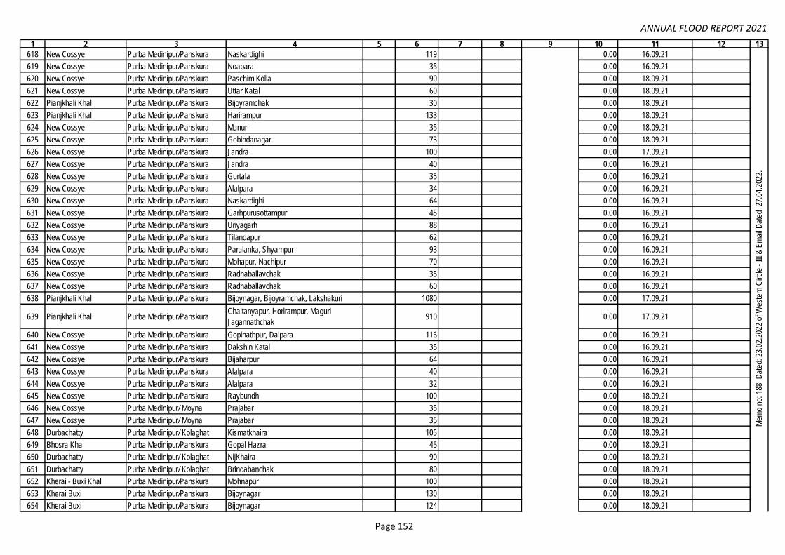
ANNUAL FLOOD REPORT 2021
1 2 3 4 5 6 7 8 9 10 11 12 13
618 New Cossye Purba Medinipur/Panskura Naskardighi 119 0.00 16.09.21
619 New Cossye Purba Medinipur/Panskura Noapara 35 0.00 16.09.21
620 New Cossye Purba Medinipur/Panskura Paschim Kolla 90 0.00 18.09.21
621 New Cossye Purba Medinipur/Panskura Uttar Katal 60 0.00 18.09.21
622 Pianjkhali Khal Purba Medinipur/Panskura Bijoyramchak 30 0.00 18.09.21
623 Pianjkhali Khal Purba Medinipur/Panskura Harirampur 133 0.00 18.09.21
624 New Cossye Purba Medinipur/Panskura Manur 35 0.00 18.09.21
625 New Cossye Purba Medinipur/Panskura Gobindanagar 73 0.00 18.09.21
626 New Cossye Purba Medinipur/Panskura Jandra 100 0.00 17.09.21
627 New Cossye Purba Medinipur/Panskura Jandra 40 0.00 16.09.21
628 New Cossye Purba Medinipur/Panskura Gurtala 35 0.00 16.09.21
629 New Cossye Purba Medinipur/Panskura Alalpara 34 0.00 16.09.21
630 New Cossye Purba Medinipur/Panskura Naskardighi 64 0.00 16.09.21
631 New Cossye Purba Medinipur/Panskura Garhpurusottampur 45 0.00 16.09.21
632 New Cossye Purba Medinipur/Panskura Uriyagarh 88 0.00 16.09.21
633 New Cossye Purba Medinipur/Panskura Tilandapur 62 0.00 16.09.21
634 New Cossye Purba Medinipur/Panskura Paralanka, Shyampur 93 0.00 16.09.21
635 New Cossye Purba Medinipur/Panskura Mohapur, Nachipur 70 0.00 16.09.21
636 New Cossye Purba Medinipur/Panskura Radhaballavchak 35 0.00 16.09.21
637 New Cossye Purba Medinipur/Panskura Radhaballavchak 60 0.00 16.09.21
638 Pianjkhali Khal Purba Medinipur/Panskura Bijoynagar, Bijoyramchak, Lakshakuri 1080 0.00 17.09.21
639 Pianjkhali Khal Purba Medinipur/PanskuraChaitanyapur, Horirampur, Maguri
Jagannathchak910 0.00 17.09.21
640 New Cossye Purba Medinipur/Panskura Gopinathpur, Dalpara 116 0.00 16.09.21
641 New Cossye Purba Medinipur/Panskura Dakshin Katal 35 0.00 16.09.21
642 New Cossye Purba Medinipur/Panskura Bijaharpur 64 0.00 16.09.21
643 New Cossye Purba Medinipur/Panskura Alalpara 40 0.00 16.09.21
644 New Cossye Purba Medinipur/Panskura Alalpara 32 0.00 16.09.21
645 New Cossye Purba Medinipur/Panskura Raybundh 100 0.00 18.09.21
646 New Cossye Purba Medinipur/ Moyna Prajabar 35 0.00 18.09.21
647 New Cossye Purba Medinipur/ Moyna Prajabar 35 0.00 18.09.21
648 Durbachatty Purba Medinipur/ Kolaghat Kismatkhaira 105 0.00 18.09.21
649 Bhosra Khal Purba Medinipur/Panskura Gopal Hazra 45 0.00 18.09.21
650 Durbachatty Purba Medinipur/ Kolaghat NijKhaira 90 0.00 18.09.21
651 Durbachatty Purba Medinipur/ Kolaghat Brindabanchak 80 0.00 18.09.21
652 Kherai - Buxi Khal Purba Medinipur/Panskura Mohnapur 100 0.00 18.09.21
653 Kherai Buxi Purba Medinipur/Panskura Bijoynagar 130 0.00 18.09.21
654 Kherai Buxi Purba Medinipur/Panskura Bijoynagar 124 0.00 18.09.21
0.00
Mem
o no
: 188
Dat
ed: 2
3.02
.202
2 of
Wes
tern
Circ
le -
III &
Em
ail D
ated
27.
04.2
022.
Page 152

ANNUAL FLOOD REPORT 2021
1 2 3 4 5 6 7 8 9 10 11 12 13
655 Kherai Buxi Purba Medinipur/Panskura Mohnapur 102 0.00 18.09.21
656 Kherai Buxi Purba Medinipur/Panskura Bijoynagar 102 0.00 18.09.21
657 Kherai Buxi Purba Medinipur/Panskura Bijoynagar 100 0.00 18.09.21
658 Kherai Buxi Purba Medinipur/ Moyna Bishnumishrachak 60 0.00 18.09.21
659 Kherai Buxi Purba Medinipur/ Moyna Bishnumishrachak 59 0.00 18.09.21
660 New Cossye Purba Medinipur/ Moyna Purba Dobandy 50 0.00 18.09.21
661 New Cossye Purba Medinipur/ Moyna Purba Dobandy 60 0.00 18.09.21
662 New Cossye Purba Medinipur/ Moyna Purba Dobandy 40 0.00 18.09.21
663 New Cossye Purba Medinipur/ Moyna Purba Dobandy Patna 59 0.00 18.09.21
664 New Cossye Purba Medinipur/ Moyna Purba Dobandy Patna 58 0.00 18.09.21
665 New Cossye Purba Medinipur/ Moyna Purba Dobandy Patna 57 0.00 18.09.21
666 New Cossye Purba Medinipur/ Moyna Purba Dobandy Patna 60 0.00 17.09.21
667 New Cossye Purba Medinipur/ Moyna Purba Dobandy Patna 58 0.00 17.09.21
668 New Cossye Purba Medinipur/ Moyna Purba Dobandy Patna 35 0.00 17.09.21
669 New Cossye Purba Medinipur/ Moyna Purba Dobandy 59 0.00 17.09.21
670 New Cossye Purba Medinipur/ Tamluk Srirampur 55 0.00 17.09.21
671 New Cossye Purba Medinipur/ Tamluk Srirampur 59 0.00 17.09.21
672 New Cossye Purba Medinipur/ Tamluk Srirampur 60 0.00 17.09.21
673 New Cossye Purba Medinipur/ Moyna Purba Dobandy Patna 56 0.00 17.09.21
674 New Cossye Purba Medinipur/ Moyna Purba Dobandy Patna 55 0.00 17.09.21
675 New Cossye Purba Medinipur/ Moyna Purba Dobandy Patna 59 0.00 17.09.21
676 New Cossye Purba Medinipur/ Moyna Purba Dobandy Patna 60 0.00 17.09.21
677 New Cossye Purba Medinipur/ Moyna Purba Dobandy Patna 50 0.00 17.09.21
678 New Cossye Purba Medinipur/ Moyna Purba Dobandy 46 0.00 17.09.21
679 New Cossye Purba Medinipur/ Moyna Purba Dobandy 57 0.00 17.09.21
680 New Cossye Purba Medinipur/ Tamluk Srirampur 58 0.00 16.09.21
681 New Cossye Purba Medinipur/ Tamluk Srirampur 45 0.00 16.09.21
682 New Cossye Purba Medinipur/Panskura Raybundh 26 0.00 16.09.21
683 New Cossye Purba Medinipur/Panskura Raybundh 44 0.00 16.09.21
684 New Cossye Purba Medinipur/Panskura Raybundh 64 0.00 16.09.21
685 New Cossye Purba Medinipur/Panskura Raybundh Paschim 113 0.00 16.09.21
686 Pianjkhali Khal Purba Medinipur/Panskura Horirampur 18.00 0.00 16.09.21
687 New Cossye Purba Medinipur/Panskura Naskardighi 35 0.00 17.09.21
688 New Cossye Purba Medinipur/Panskura Domghat Bazar 20 0.00 17.09.21
689 New Cossye Purba Medinipur/Panskura Baju 70 0.00 17.09.21
690 New Cossye Purba Medinipur/Panskura Uttar Katal 45 0.00 17.09.21
691 New Cossye Purba Medinipur/Panskura Tilandapur 101 0.00 17.09.21
692 New Cossye Purba Medinipur/Panskura Bahartala 128 0.00 17.09.21
0.00
Mem
o no
: 188
Dat
ed: 2
3.02
.202
2 of
Wes
tern
Circ
le -
III &
Em
ail D
ated
27.
04.2
022.
Page 153

ANNUAL FLOOD REPORT 2021
1 2 3 4 5 6 7 8 9 10 11 12 13
693 New Cossye Purba Medinipur/Panskura Udaypur 65 0.00 17.09.21
694 New Cossye Purba Medinipur/Panskura Udaypur 100 0.00 17.09.21
695 New Cossye Purba Medinipur/Panskura Raybundh 53 0.00 17.09.21
696 New Cossye Purba Medinipur/Panskura Udaypur 65 0.00 17.09.21
697 New Cossye Purba Medinipur/Panskura Garhpurusottampur 92 0.00 17.09.21
698 New Cossye Purba Medinipur/Panskura Domghat 98 0.00 17.09.21
699 Pianjkhali Khal Purba Medinipur/Panskura Horirampur 35.00 0.00 16.09.21
700 New Cossye Purba Medinipur/Panskura Bhabanipur 35 0.00 16.09.21
701 New Cossye Purba Medinipur/Panskura Serhati 85 0.00 16.09.21
702 New Cossye Purba Medinipur/Panskura Domghat 24 0.00 16.09.21
703 New Cossye Purba Medinipur/Panskura Domghat 32.00 0.00 16.09.21
704 New Cossye Purba Medinipur/Panskura Udaypur 37.00 0.00 16.09.21
705 New Cossye Purba Medinipur/Panskura Udaypur 70.00 0.00 16.09.21
706 New Cossye Purba Medinipur/Panskura Udaypur 40.00 0.00 16.09.21
707 Pianjkhali Khal Purba Medinipur/Panskura Maguri jagannathchak 42.00 0.00 16.09.2022
708 New Cossye Purba Medinipur/Panskura Dakshin Katal 36 0.00 28.07.21
709 New Cossye Purba Medinipur/Panskura Tilandapur 31 0.00 29.07.21
710 New Cossye Purba Medinipur/Panskura Ranihati 72 0.00 29.07.21
711 New Cossye Purba Medinipur/Panskura Domghat 92 0.00 29.07.2022
712 New Cossye Purba Medinipur/ Moyna Srikantha 1 0.00 29.07.21
713 New Cossye Purba Medinipur/ Tamluk Srikanthakalaganda, Changra Kalaganda 2 0.00 30.07.21
714 New Cossye Purba Medinipur/ Nandakumar Bargodagoda 105 0.00 30.07.21
715 New Cossye Purba Medinipur/Panskura Ramgarh 34 0.00 29.07.21
716 Kherai Purba Medinipur/Panskura Paubanki, Chowlakuri 2 0.00 30.07.21
717 Durbachatty Purba Medinipur/ Kolaghat Brindabanchak 60 0.00 29.07.21
718 Durbachatty Purba Medinipur/ Kolaghat Kismatkhaira 50 0.00 29.07.21
719 Durbachatty Purba Medinipur/ Kolaghat Kismatkhaira 30 0.00 30.07.21
720 New Cossye Purba Medinipur/Panskura Jagatpur 84 0.00 28.07.21
721 Durbachatty Purba Medinipur/ Kolaghat Brindabanchak 100 0.00 29.07.21
722 Durbachatty Purba Medinipur/ Kolaghat Brindabanchak 140 0.00 29.07.21
723 Durbachatty Purba Medinipur/ Kolaghat Brindabanchak 180 0.00 29.07.21
724 Durbachatty Purba Medinipur/ Kolaghat Brindabanchak 75 0.00 29.07.21
725 Bhosra Khal Purba Medinipur/Panskura Gopal Hazra 126 0.00 30.07.21
726 Durbachatty Purba Medinipur/ Kolaghat Brindabanchak 85 0.00 30.07.21
727 New Cossye Purba Medinipur/Panskura Serhati 35 0.00 29.07.21
728 Pianjkhali Khal Purba Medinipur/Panskura Bijoynagar 1 0.00 29.07.21
729 Durbachatty Purba Medinipur/ Kolaghat Brindabanchak 60 0.00 29.07.21
0.00
Mem
o no
: 188
Dat
ed: 2
3.02
.202
2 of
Wes
tern
Circ
le -
III &
Em
ail D
ated
27.
04.2
022.
Page 154

ANNUAL FLOOD REPORT 2021
1 2 3 4 5 6 7 8 9 10 11 12 13
730 New Cossye Purba Medinipur/Panskura Tilandapur 34 0.00 30.07.21
731 New Cossye Purba Medinipur/Panskura Isakpur 34 0.00 29.07.21
732 New Cossye Purba Medinipur/Panskura Gobindanagar 33 0.00 29.07.21
733 New Cossye Purba Medinipur/Panskura Nochipur 34 0.00 30.07.21
734 New Cossye Purba Medinipur/Panskura Ranihati 103 0.00 29.07.21
735 Pianjkhali Khal Purba Medinipur/Panskura Chaitanyapur 52 0.00 30.07.21
736 New Cossye Purba Medinipur/Panskura Bhabanipur 36 0.00 29.07.21
737 New Cossye Purba Medinipur/Panskura Fakirbazar 105 0.00 29.07.21
738 New Cossye Purba Medinipur/Panskura Joykrishanapur 72 0.00 29.07.21
739 New Cossye Purba Medinipur/Panskura Naskardighi 126 0.00 29.07.21
740 New Cossye Purba Medinipur/Panskura Golghat 34 0.00 29.07.21
741 New Cossye Purba Medinipur/Panskura Uriyagarh 45 0.00 29.07.21
742 New Cossye Purba Medinipur/ Tamluk Srirampur 1 0.00 29.07.21
743 Durbachatty Purba Medinipur/ Kolaghat Brindabanchak 40 0.00 30.07.21
744 New Cossye Purba Medinipur/Panskura Serhati 36 0.00 29.07.21
745 New Cossye Purba Medinipur/Panskura Udaypur 62 0.00 28.07.21
746 Durbachatty Purba Medinipur/ Kolaghat Kajichak 67 0.00 30.07.21
747 Topa Drainage Cut Purba Medinipur/ KolaghatGobindachak, Chabda, Paramanandapur,
Uttar Jianda227 0.00 29.07.21
748 Topa Drainage Cut Purba Medinipur/ KolaghatGobardhanpur, Amirchak, Bardabar,
Chabda205 0.00 30.07.21
749 Bay of BengalPurba Medinipur / Contai-II /
Junput CoastalDariapur / Bankiput 150 100.00 26.05.21
Cyclonic Storm
YAAS
750 Bay of BengalPurba Medinipur / Contai-II /
Junput CoastalDariapur / Gopalpur 250 3 300.00 26.05.21
Cyclonic Storm
YAAS
751 Bay of BengalPurba Medinipur / Contai-I /
Junput CoastalNayaput / Soula 150 2 200.00 26.05.21
Cyclonic Storm
YAAS
752 Bay of BengalPurba Medinipur / Contai-I /
Junput Coastal
Majilapur / Raghusardar Bar Jalpai and
Baguran Jalpai.250 3 100.00 26.05.21
Cyclonic Storm
YAAS
753 RasulpurPurba Medinipur / Contai-II /
Junput CoastalDariapur / Pratappur 60 40.00 26.05.21
Cyclonic Storm
YAAS
754 Contai / Panipia CanalPurba Medinipur / Contai-I /
Junput Coastal
Nayaput / Satberia, Amartalya and
Balbhadrapur1 100.00 14.09.21
755 RasulpurPurba Medinipur/ Contai-III/
Marishda
Amtolia / Umapatibar, Sunia , Barchanberia
, Goraghata, and Phulbari250 3 300.00 26.05.21
Cyclonic Storm
YAAS
756 Balighai Main drainPurba Medinipur/ Contai - II/
MarishdaKanaidighi / Kalinagar bazar and Bhaitgarh. 150 1 100.00 26.05.21
Cyclonic Storm
YAAS
0.00
1044.70
Contai Irrigation Division
Mem
o no
: 188
Dat
ed: 2
3.02
.202
2 of
Wes
tern
Circ
le -
III &
Em
ail D
ated
27.
04.2
022.
Page 155

ANNUAL FLOOD REPORT 2021
1 2 3 4 5 6 7 8 9 10 11 12 13
757 Balighai Main drainPurba Medinipur/ Contai-III/
MarishdaKumirda/ Sukunia , Sarpai and Bhaitgarh. 300 150.00 26.05.21
Cyclonic Storm
YAAS
758 Jhaubani CanalPurba Medinipur/ Contai-III/
MarishdaKanaidighi / Jhaubani and Kulanjhara 50 1 75.00 14.09.21
759 Balighai Main drainPurba Medinipur/ Bhagwanpur-
II/ Bhagwanpur
Boroj/ Powsia/ Powsia, Chirakuti and
Golbagda450 2 15.00 26.05.21
Cyclonic Storm
YAAS
760 Singda Purba Medinipur/ Patashpur-II/
Patashpur
Srirampur and Mathura / Srirampur,
Bagmari, Pratapdighi, Saheb nagar , Chak
Garua, Irda, Mathura , Balyagobindapur.
1000.00 14.09.21
761 A.D Cut CanalPurba Medinipur/ Patashpur-II/
Patashpur
Argoal and Southkanda / Argoal /
Brajaballabpur, Samashpur, Argoal.500 15 300.00 14.09.21
762 Rasulpur Purba Medinipur / Bhagwanpur-
II / Bhagwanpur
Arjunnagar / Arjunnagar / Nata Gechhia and
Dhaipukuria150 50.00 14.09.21
763 RasulpurPurba Medinipur/ Bhagwanpur-
II/ Bhagwanpur
Boroj/ Golbagda/ Simulbari, Kalikapur and
Bajbajia400 15.00 26.05.21
Cyclonic Storm
YAAS
764 Orrisha Coast Canal Egra-I Sahara G.P 17.09.21
765 Baghai R. Patashpur-I Naipur G.P 60.00 200 45.00 17.09.21
766 Baghai R. Patashpur-I Gokulpur-I G.P 275 36.00 17.09.21
767 Baghai R. Datan-II Sauri G.P. 150 15.00 17.09.2022
768 Beta Khal Egra-II Dubda G.P 17.09.21
769 Khagda Khal Egra-II Dubda G.P 17.09.21
770 Kultikiri Khal Egra-II Paniparul G.P. 17.09.21
771 Beta-Khagda Khal Egra-II Dubda G.P 17.09.21
772 Balighai Baromile Khal Egra-II Dubda G.P 17.09.21
773 Rasulpur R.Khejuri-I, Khejuri, Purba
MedinipurBirbandar 350 1 7.50
774 Rasulpur R. Janka 250 13.00
775 Rasulpur R. Nijkasba 750 20.00
776 Sonachura 350 1 25.00
777 Kendamari 1200 1 20.00
778 Haldi R. Vekutia 250 60.00
779 Haldi R.Nandigram-II, Nandigram,
Purba MedinipurBoyal-I 165 18.00
780 Haldi R.Chandipur, Chandipur, Purba
MedinipurDibakarpur 250 9.00
781 Kaliaghai Gurgram 8 16.00
782 Kaliaghai Mohammadpur-I 6 13.00
1044.70
26.05.21
Mem
o no
: 188
Dat
ed: 2
3.02
.202
2 of
Wes
tern
Circ
le -
III &
Em
ail D
ated
27.
04.2
022.
Dubda Basin
Cyclonic Storm
YAAS
Khejuri-II, Khejuri, Purba
Medinipur
Hooghly R. Nandigram-I, Nandigram, Purba
Medinipur
Bhagabanpur-I, Bhagabanpur,
Purba Medinipur
Page 156

ANNUAL FLOOD REPORT 2021
1 2 3 4 5 6 7 8 9 10 11 12 13
783 KaliaghaiPatashpur-I, Patashpur, Purba
MedinipurAmarshi-II 110 4.00
784 Hijli Tidal Khal 150 1 13.00
785 Palaboni Khal 1 11.00
786 Boroj KhalBhagabanpur-II, Bhagabanpur,
Purba MedinipurJukhia 1 2.00
787 Kaliaghai R.Patashpur-I, Patashpur, Purba
MedinipurGopalpur 75 15.00
788 Kaliaghai R.Sabang, Sabang, Paschim
MedinipurBishnupur 1 7.00
789 Kaliaghai R. Chistipur-I 115.00 700.00
790 Kaliaghai R. Amarshi-II 700 200.00
791 Kaliaghai R. Gopalpur 250 2 45.00
792 Kaliaghai R.Bhagabanpur-I, Bhagabanpur,
Purba Medinipur Mahammadpur-I 500 70.00
793 Kaliaghai R.Sabang, Sabang, Paschim
MedinipurBishnupur 100 13.00
794Narandari, Ketokitala
Khal
Chandipur, Chandipur, Purba
MedinipurChowkhali, Jalpai 15.00
Drainage
Congestion
795 Hijli Tidal Canal Khodambari 150 15.00
796 Takapura Khal Boyal-I 100 10.00
797 Tengua Khal 200 60.00
798 Haldi R. 125 25.00
799 Masuria khalBhagabanpur-I, Bhagabanpur,
Purba Medinipur Bibhisanpur 8.00
Drainage
Congestion
800 Kaliaghai R.Patashpur-I, Patashpur, Purba
MedinipurGopalpur 60 1 10.00
801 Bay of Bengal
Purba Medinipur / Ramnagar-I
& II / Ramnagar & Mandarmoni
Coastal & Digha Mohana
Coastal
Padima-I & II, Talgachari-II, Kalindi 428 8186 2 1985.50 26.05.21Cyclonic Storm
YAAS
802 ChandiaPaschim Medinipur,
Block-PinglaGP-Pindrui, Mouza -Chandipur,Chakchandi 75 9.50 28.7.21 to 30.7.21
1044.70
26.05.21
18.10 21 to 20.10.21
East Midnapor Division
Khejuri-I, Khejuri, Purba
MedinipurHenria
29.07.21
Patashpur-I, Patashpur, Purba
Medinipur
15.08 21 to 15.09.21
Nandigram-II, Nandigram,
Purba Medinipur
Nandigram-I, Nandigram, Purba
MedinipurVekutia
Mem
o no
: 188
Dat
ed: 2
3.02
.202
2 of
Wes
tern
Circ
le -
III &
Em
ail D
ated
27.
04.2
022.
Cyclonic Storm
YAAS
Page 157

ANNUAL FLOOD REPORT 2021
1 2 3 4 5 6 7 8 9 10 11 12 13
803 Kababi khalPaschim Medinipur,
Block-PinglaGP-Pindrui,Mouza -Chakchandi 42 4.60 28.7.21 to 30.7.21
804 ChandiaPaschim Medinipur,
Block-Pingla
GP-Pindrui,Jalchak-I,Mouza -
Chandipur,Nungodar, Barisha170 1 34.00 Sept., 21
805 Patchada KhalPaschim Medinipur/
Pingla/PinglaGobardhanpur 800 5.09 16.09.21
806 Buxi Khal Paschim Medinipur/
Pingla/PinglaUpaldaha 72 20.41 17.09.21
807 Buxi Khal Paschim Medinipur/
Pingla/PinglaUpaldaha 72 20.48 17.09.21
808 Buxi Khal Paschim Medinipur/
Pingla/PinglaUpaldaha 35 11.00 17.09.21
809 Buxi Khal Paschim Medinipur/
Pingla/PinglaSamsara 75 20.59 16.09.21
810 Buxi Khal Paschim Medinipur/
Pingla/PinglaSamsara 53 14.83 16.09.21
811 Buxi Khal Paschim Medinipur/
Pingla/PinglaUpaldaha 75 20.52 16.09.21
812 Buxi Khal Paschim Medinipur/
Pingla/PinglaUpaldaha 76 20.20 18.09.21
813 Buxi Khal Paschim Medinipur/
Pingla/PinglaUpaldaha 73 20.46 18.09.21
814 Patchada KhalPaschim Medinipur/
Pingla/PinglaKalidan 40 13.32 18.09.21
815 Buxi Khal Paschim Medinipur/
Pingla/PinglaUpaldaha 70 19.75 18.09.21
816 Buxi Khal Paschim Medinipur/
Pingla/PinglaUpaldaha 72 19.67 18.09.21
817 Patchada KhalPaschim Medinipur/
Pingla/PinglaHarma 60 6.39 29.07.21
818 SilabatiPaschim Medinipur/
Chandrakona - IMonoharpur - I /Hiradharpur 70 22.40 30.07.21
819 SilabatiPaschim Medinipur/
Chandrakona - I Monoharpur - I /Khamarberia 60 24.37 30.07.21
820 Maria KhalPaschim Medinipur/
Chandrakona - IMonoharpur - II /Monoharpur 115 45.48 31.07.21
1044.70
21.29
Kangsabati Canal Division-I
Em
ail o
f Kan
gsab
ati C
ircle
-II o
n 11
.03.
2022
& E
mai
l of E
E/K
CD
-I o
n 17
.05.
2022
.M
emo
no: 1
88 D
ated
: 23.
02.2
022
of W
este
rn C
ircle
- II
I & E
mai
l Dat
ed 2
7.04
.202
2.
Page 158

ANNUAL FLOOD REPORT 2021
1 2 3 4 5 6 7 8 9 10 11 12 13
821 SilabatiPaschim Medinipur/
Chandrakona - I Manikkundu/Bhabanipur /Bhabanipur 40 13.85 30.07.21
822 Kethia khalPaschim Medinipur/
Chandrakona - IManikkundu /Manikkundu/Manikkundu uttar 590 173.35 30.07.21
823 Donai KhalPaschim Medinipur/
Chandrakona - I
Manoharpur-II/ Sitarampur/Sitarampur78 22.52 03.08.21
824 Nagulia KhalPaschim Medinipur/
Chandrakona - I
Manoharpur-II/ Sitarampur/Sitarampur25 5.86 03.08.21
825 SilabatiPaschim Medinipur/
Chandrakona - IManikkundu/Bhabanipur/Bhabanipur 90 29.33 21.08.21
826 SilabatiPaschim Medinipur/
Chandrakona - IMonoharpur - I / Hijli/Hijli 360 127.16 21.08.21
827 Kethia khalPaschim Medinipur/
Chandrakona - IManikkundu /Manikkundu uttar 240 84.11 21.08.21
828 SilabatiPaschim Medinipur/
Chandrakona - IManoharpur-I/ Khamarberia/Khamarberia 100 30.12 21.08.21
829 SilabatiPaschim Medinipur/
Chandrakona - IManikkundu/ Jagannathpur/Jagannathpur 26.39 02.10.21
830 SilabatiPaschim Medinipur/
Chandrakona - IManikkundu/ Bhabanipur/Bhabanipur 18 7.34 02.10.21
831 Kethia khalPaschim Medinipur/
Chandrakona - IManikkundu/ Manikkundu/Manikkundu uttar 54 15.18 02.10.21
832 silabatiPaschim Medinipur/
Chandrakona - IManoharpur-I/ Hiradharpur/Hiradharpur 125.00 26.88 01.10.21
833 Kethia khalPaschim Medinipur/
Chandrakona - IManikkundu /Manikkundu/Manikkundu uttar 36.00 1.79 01.10.21
834 Kethia khalPaschim Medinipur/
Chandrakona - IManikkundu /Manikkundu/Manikkundu uttar 19 0.95 01.10.21
835 SilabatiPaschim Medinipur/
Chandrakona - IMonoharpur - I / Hijli/Hijli 1.00 01.10.21
836 SilabatiPaschim Medinipur/
Chandrakona - IMonoharpur - I / Nirbhaypur/Nirbhaypur 0.58 01.10.21
837 SilabatiPaschim Medinipur/
Chandrakona - IIBachanchara-/Akatkola 20 7.67 30.07.21
838 SilabatiPaschim Medinipur/
Chandrakona - IIBachanchara-/Jadupur 20 8.73 30.07.21
839 SilabatiPaschim Medinipur/
Chandrakona - IIBhagabantapur-I/ Ghoskira 20 6.85 30.07.21
21.29
Em
ail o
f Kan
gsab
ati C
ircle
-II o
n 11
.03.
2022
& E
mai
l of E
E/K
CD
-I o
n 17
.05.
2022
.
Page 159

ANNUAL FLOOD REPORT 2021
1 2 3 4 5 6 7 8 9 10 11 12 13
840 Kethia khalPaschim Medinipur/
Chandrakona - IIBachanchara-III/Gopalpur 50 10.84 30.07.21
841 Kethia khalPaschim Medinipur/
Chandrakona - IIBachanchara-III/Gopalpur 50 11.23 30.07.21
842 SilabatiPaschim Medinipur/
Chandrakona - IIBhagabantapurI/Ghoskira 70 14.48 30.07.21
843 SilabatiPaschim Medinipur/
Chandrakona - IIBhagabantapur-II/ Nischintapur 100 18.42 30.07.21
844 SilabatiPaschim Medinipur/
Chandrakona - IIBhagabantapur-II/ Nischintapur 80 15.74 30.07.21
845 Kethia khalPaschim Medinipur/
Chandrakona - IIBachanchara-III/Gopalpur 150 30.82 03.08.21
846 SilabatiPaschim Medinipur/
Chandrakona - IIBhagabantapurI/Ghoskira 110 26.25 03.08.21
847 SilabatiPaschim Medinipur/
Chandrakona - IINityanandapur 75 17.90 21.08.21
848 SilabatiPaschim Medinipur
/Chandrakona - IIBachanchara/Choto Akna 35 8.45 21.08.21
849 SilabatiPaschim Medinipur/
Chandrakona - IIBhagabantapur-II/ Nischintapur 75 19.92 21.08.21
850 Kethia khalPaschim Medinipur/
Chandrakona - IIBachanchara-III/Gopalpur 115 31.31 21.08.21
851 SilabatiPaschim Medinipur/
Chandrakona - IIBhagabantapurI/Chaitanyapur 270 87.11 21.08.21
852
Midnapur Branch
Canal(MBC) (In btwn. Ch.
446 to Ch. 1145)
Dist:-Paschim Medinipur Block:-
Salboni, Midnapore Sadar, P.S.-
Salboni
GP:-Bhimpur, Pirakata, Satpati, Chandra
Mouza :- Jhitka, Dalkunda Bhangadali,
Lakhanpur, Hatimara, Kalsibhanga
8687 18.08 29/07/21 to 31/07/21. Inspection Path
853
Midnapur Branch
Canal(MBC) (In btwn. Ch.
1145.00 to Ch. 1872.00)
Dist:-Paschim Medinipur
Block:-Salboni, Midnapore
Sadar,P.S.-Salboni,Midnapore
Sadar.
G.P:-Bhadutala, Pirakata, Kankabati,
Siromoni, Panchkuri. Mouza:- Kalsibhanga,
Pathar Kumkumi, Bhadutala, Siromoni,
Bhutasol, Panchkuri.
15941 18.06 29/07/21 to 31/07/21. Inspection Path
21.29
Em
ail o
f Kan
gsab
ati C
ircle
-II o
n 11
.03.
2022
& E
mai
l of E
E/K
CD
-I o
n 17
.05.
2022
.
Kangsabati Canals Division No-IV
0.00
Page 160

ANNUAL FLOOD REPORT 2021
1 2 3 4 5 6 7 8 9 10 11 12 13
854
Tarafani SouthMain
Canal (TSMC(S)) (In
btwn. Ch. 541.50.00 to
Ch. 1027.00)
Dist:-Paschim Medinipur Block:-
Kharagpur-I,II PS.:-Kharagpur
GP:-Arjuni, Hariatara, Gopali, Changual.
Mouza:-Doyarkhola, Hariatara, Pathri,
Talbagicha, Sonamukhi, Khagra,
Sholadhar, Mirpur, Koushyala
,Madanmohan
14798 28.86 29/07/21 to 31/07/21. Inspection Path
855 Bidyadhari North 24 Pgs./ Haroa Nazarnagar (Palpara) 170 110.00 May-21Lat :22.592368,
Long:88.677003
856 Bidyadhari North 24 Pgs./ Haroa Indali 150 90.00 May-21Lat : 22.575007,
Long: 88.675903
857 Bidyadhari North 24 Pgs./ Haroa Brahmonchak 300 140.00 May-21Lat : 22.548433,
Long: 88.672891
858 Bidyadhari North 24 Pgs./ Haroa Makhali 150 100.00 May-21Lat : 22.537955,
Long: 88.680394
859 Bidyadhari North 24 Pgs./ Haroa Kamarganti 150 100.00 May-21Lat : 22.539899,
Long: 88.680348
860 Bidyadhari North 24 Pgs./ Haroa Nowapara, Baltia, Kamarganti 750 345.00 May-21Lat : 22.5711, Long:
88.6761
861 Bidyadhari North 24 Pgs./ Deganga Gangdhulat 750 340.00 May-21Lat : 22.6233, Long:
88.6500
862 Hooghly North 24 Pgs./ Baranagar P.S.Baranagar Municipality/ Alambazar B.S.F.
Ghat and Rajbari210 300.00 May-21
Lat : 22.6503, Long:
88.3581
863 Hooghly North 24 Pgs./ Noapara P.S. Garulia Municipality/ Bichali Ghat 190 250.00 May-21Lat : 22.823086,
Long: 88.359109
864 Hooghly North 24 Pgs./ Noapara P.S. Garulia Municipality/ Babu Ghat 170 220.00 May-21Lat : 22.8230078,
Long: 88.359127
865 HooghlyNorth 24 Pgs./ Barrackpore
P.S.
North Barrackpore Municipality/ Debdwar
Park180 225.00 May-21
Lat : 22.769434,
Long: 88.338566
866 HooghlyNorth 24 Pgs./ Barrackpore
P.S.
Barrackpore Municipality/ Malancha Tourist
Lodge80 225.00 May-21
Lat : 22.756236,
Long: 88.359712
867 HooghlyNorth 24 Pgs./ Barrackpore
P.S.Garulia Municipality/ Kangali Ghat 90 120.00 May-21
Lat : 22.82707,
Long: 88.366462
868 Bagjola Part-II North 24 Pgs./ Haroa Haroa/ Talberia/ Sonapukur Sankarpur G.P. 120 60.00 May-21Lat : 22.58416,
Long: 88.6177
869 Hooghly R. Block-Budge-Budge-II Mouza-Naldari 50 7.00 26-05-21
870 Hooghly R. Block-Budge-Budge-II Mouza-Burul 100 8.00 27-05-21
871 Hooghly R. Block-Falta Mouza-Rajarampur 120 12.00 26-05-21
2.00E
mai
l of K
angs
abat
i Circ
le-I
I on
11.0
3.20
22 &
Em
ail o
f EE
/KC
D-I
on
17.0
5.20
22.
0.00
5.54
Executive Engineer-I, Canals Division
Executive Engineer-II, Canals Division
Page 161
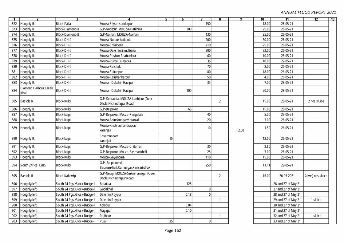
ANNUAL FLOOD REPORT 2021
1 2 3 4 5 6 7 8 9 10 11 12 13
872 Hooghly R. Block-Falta Mouza-Shyamsundarpur 150 18.00 26-05-21
873 Hooghly R. Block-Diamond-II G.P-Noorpur, MOUZA-Hatkhola 200 25.00 26-05-21
874 Hooghly R. Block-Diamond-II G.P-Nainan, MOUZA-Nainan 130 25.00 26-05-21
875 Hooghly R. Block-DH-II Mouza-Nurpur-hatkhola 200 30.00 26-05-21
876 Hooghly R. Block-DH-II Mouza-Srifalberia 210 25.00 26-05-21
877 Hooghly R. Block-DH-II Mouza-Dakshin Simulberia 300 32.00 26-05-21
878 Hooghly R. Block-DH-II Mouza-Pashim Bhabanipur 60 10.00 28-05-21
879 Hooghly R. Block-DH-II Mouza-Purba Durgapur 35 10.00 27-05-21
880 Hooghly R. Block-DH-II Mouza-Raichak 70 8.00 26-05-21
881 Hooghly R. Block-DH-I Mouza-Sultanpur 80 18.00 26-05-21
882 Hooghly R. Block-DH-I Mouza-Kalishankarpur 50 4.00 26-05-21
883 Hooghly R. Block-DH-I Mouza - Dakshin Hazipur 35 7.00 28-05-21
884Diamond Harbour Creek
KhalBlock-DH-I Mouza - Dakshin Hazipur 100 20.00 28-05-21
885 Bastola R. Block-KulpiG.P-Keoratola, MOUZA-Lakhipur (Over
Dhola Nichindrapur Road)2 15.00 28-05-21 2 nos sluice
886 Hooghly R. Block-Kulpi G.P-Belpukur 65 15.00 28-05-21
887 Hooghly R. Block-kulpi G.P-Belpukur, Mouza-Rangafala 40 5.00 29-05-21
888 Hooghly R. Block-kulpi Mouza-Anindanagar/Karanjali 20 3.00 26-05-21
889 Hooghly R. Block-kulpiMouza-Krishnachandrapur/
karanjali10 1.50 26-05-21
890 Hooghly R. Block-kulpiShyamnagar/
karanjali15 12.00 26-05-21
891 Hooghly R. Block-kulpi G.P-Belpukur, Mouza-Chitamari 30 3.60 26-05-21
892 Hooghly R. Block-kulpi G.P-Belpukur, Mouza-Basmankhali 25 3.00 26-05-21
893 Hooghly R. Block-Kulpi Mouza-Gayenpara 110 15.00 26-05-21
894 South 24Pgs. Emb. Block-KulpiG.P- Belpukur,vil.-
Basmankhali,Ramnagar,Kansarirchak250 11.11 29-05-21
895 Bastola R. Block-KakdwipG.P-Netaji, MOUZA-Srikrishanagar (Over
Dhola Nichindrapur Road)2 15.00 26-05-2021 2(two) nos sluice
896 Hooghly(left) South 24 Pgs./Block-Budge-ll Baratala 125 26 and 27 of May 21
897 Hooghly(left) South 24 Pgs./Block-Budge-ll Godakhali 0 27 and 27 of May 21
898 Hooghly(left) South 24 Pgs./Block-Budge-ll Dakshin Roypur 0.18 0 28 and 27 of May 21
899 Hooghly(left) South 24 Pgs./Block-Budge-ll Dakshin Roypur 1 29 and 27 of May 21 1 sluice
900 Hooghly(left) South 24 Pgs./Block-Budge-ll Achipur 0.04 30 and 27 of May 21
901 Hooghly(left) South 24 Pgs./Block-Budge-l Mayapur 0.10 31 and 27 of May 21
902 Hooghly(left) South 24 Pgs./Block-Budge-l Rajibpur 1 32 and 27 of May 21 1 sluice
903 Hooghly(left) South 24 Pgs./Block-Budge-l Pujali 35 0 33 and 27 of May 21
2.00
Page 162

ANNUAL FLOOD REPORT 2021
1 2 3 4 5 6 7 8 9 10 11 12 13
904 Hooghly(left) South 24 Pgs./Block-Budge-l Kalipur 0.08 34 and 27 of May 21
905 Hooghly(left) South 24 Pgs./Block-Budge-l Joychandipur charial 0 35 and 27 of May 21
906 Hooghly(left) South 24 Pgs./Block-Budge-l Badekalinagar 0 36 and 27 of May 21
907 Hooghly(left) South 24 Pgs. Maheshtala municipality 0.30 37 and 27 of May 21
908 Hooghly(left) South 24 Pgs. K.M.C ward 141 0.25 38 and 27 of May 21
909 Hooghly(left) South 24 Pgs. K.M.C ward 140 0.11 39 and 27 of May 21
910 Hogol S 24 Pgs / Basanti Sonakhali 500 19.75 26-05-2021
911 Hana S 24 Pgs / Basanti Hogolduri 800 19.77 26-05-2021
912 Hogol S 24 Pgs / Basanti Ramchandrakhali 500 16.63 26-05-2021
913 Hana S 24 Pgs / Basanti Kalahazra 500 9.63 26-05-2021
914 Hana S 24 Pgs / Basanti Fulmalancha 200 6.65 26-05-2021
915 Hana S 24 Pgs / Basanti Chunakhali (3 sport) 750 31.11 26-05-2021
916 Hana S 24 Pgs / Basanti Begulakhali (3 sport) 500 9.80 26-05-2021
917 Piprakhali S 24 Pgs / Basanti Kumrakhali (9 spots) 1200 39.87 26-05-2021
918 Bidya S 24 Pgs / Basanti Parbatipur(4 spots) 1000 39.78 26-05-2021
919 Bidya S 24 Pgs / Basanti Jharkhali III (2 spots) 400 9.89 26-05-2021
920 Bidya S 24 Pgs / Basanti Birinchibari (3 spots) 1000 39.77 26-05-2021
921 Bidya S 24 Pgs / Basanti Bagmari 250 6.65 26-05-2021
922 Bidya S 24 Pgs / Basanti Tridibnagar( 3 spots) 1000 18.00 26-05-2021
923 Matla S 24 Pgs / Basanti Jharkhali IV ( 3 Spots) 400 9.31 26-05-2021
924 Matla S 24 Pgs / Basanti Jharkhali I (2 spots) 400 9.65 26-05-2021
925 Bidya S 24 Pgs / Basanti Jyotispur 350 9.31 26-05-2021
926 Kartal & Bidya S 24 Pgs / Basanti Masjid bati (3 spots) 600 9.70 26-05-2021
927 Bidya S 24 Pgs / Basanti Ramgopalpur 600 39.70 26-05-2021
928 Bidya S 24 Pgs / Basanti Gadkhali 200 5.32 26-05-2021
929 Hogol S 24 Pgs / Basanti Basanti (6 spots) 600 19.78 26-05-2021
930 Hogol S 24 Pgs / Basanti Purandar 100 2.00 26-05-2021
931 Hogol S 24 Pgs / Basanti Radhaballavpur 300 7.98 26-05-2021
932 Matla S 24 Pgs / Basanti Parbatipur 350 9.31 26-05-2021
933 Matla S 24 Pgs / Basanti Laskarpur 120 3.19 26-05-2021
934 Hogol S 24 Pgs / Basanti 126 no plot, Jharkhali 200 9.89 26-05-2021
935 Matla S 24 Pgs / Basanti Goran bose VI 400 8.90 26-05-2021
936 Matla S 24 Pgs / Basanti Goran bose III 350 18.00 26-05-2021
937 Matla S 24 Pgs / Basanti Goran bose II 300 7.00 26-05-2021
938 Matla S 24 Pgs / Basanti Goran bose I 400 6.00 26-05-2021
939 Matla S 24 Pgs / Basanti Anandabad 250 6.65 26-05-2021
940 Matla S 24 Pgs / Basanti Jharkhali II (2 spots) 200 3.30 26-05-2021
2.00
Executive Engineer-I, Joynagar Irrigation Division.
72.50
Page 163

ANNUAL FLOOD REPORT 2021
1 2 3 4 5 6 7 8 9 10 11 12 13
941 Matla S 24 Pgs / Basanti Kumirmari 240 17.00 26-05-2021
942 Matla S 24 Pgs / Basanti Narayan tala 200 3.00 26-05-2021
943 Matla S 24 Pgs / Basanti Kanthalberia 250 4.00 26-05-2021
944 Matla S 24 Pgs / Basanti Gourdaspara 160 4.00 26-05-2021
945 Matla S 24 Pgs / Basanti Sikaripara 300 5.00 26-05-2021
946 Matla S 24 Pgs / Basanti Harbhagi 300 5.00 26-05-2021
947 Hana S 24 Pgs / Basanti Ramchandrakhali 300 19.50 27-05-2021
948 Hogol S 24 Pgs / Basanti Chandrakona 200 12.00 27-05-2021
949 Matla S 24 Pgs / Basanti Charanekhali 175 8.00
950 Kartal S 24 Pgs / Basanti Masjitbati 200 9.65
951 Hogol S 24 Pgs / Basanti Ramchandrakhali 100 4.00
952 Hogol S 24 Pgs / Basanti Ramchandrakhali 100 4.00
953 Hana S 24 Pgs / Basanti Kotrakhali 200 8.00
954Chunakhali 6 vent sluice
outfall channelS 24 Pgs / Basanti Begulakhali 200 9.85
955 Hana S 24 Pgs / Basanti Mansakhali 175 7.50
956 Piprakhali S 24 Pgs / Basanti 9 no Kumrakhali 150 6.00
957 Baniboalia S 24 Pgs / Basanti Mouza 10 no Kumrakhali 150 6.00
958 Baniboalia S 24 Pgs / Basanti 11 no Kumrakhali 150 6.00
959 Bidya S 24 Pgs / Basanti Jharkhali 200 9.75
960 Goranbose S 24 Pgs / Basanti Birinchibari 200 9.80
961 Piprakhali S 24 Pgs / Basanti Kumrakhali 200 9.87
962 Hana S 24 Pgs / Basanti Begulakhali 150 9.80 06/10/21 to 08/10/21
963 Hana S 24 Pgs / Basanti Sacheakhali 150 8.75 06/10/21 to 08/10/21
964 Hogal S 24 Pgs / Basanti Sajnetala 150 8.80 06/10/21 to 08/10/21
965 Hogal S 24 Pgs / Basanti Radhaballavpur 100 9.00 06/10/21 to 08/10/21
966 Hogal S 24 Pgs / Basanti Chandrokona 100 7.00 06/10/21 to 08/10/21
967 Hogal S 24 Pgs / Basanti Ramchandrakhali 150 8.50 06/10/21 to 08/10/21
968 Bidya S 24 Pgs / Basanti Parbotipur 150 7.90 06/10/21 to 08/10/21
969 Hana S 24 Pgs / Basanti Chunakhali 180 8.70 17/10/21 to 22/10/21
970 Hana S 24 Pgs / Basanti Chunakhali 120 9.95 17/10/21 to 22/10/21
971 Hogal S 24 Pgs / Basanti Sajnetala 150 8.50 17/10/21 to 22/10/21
972 Bidya S 24 Pgs / Basanti Ramgopalpur 200 8.20 17/10/21 to 22/10/21
973 Bidya S 24 Pgs / Basanti Ramgopalpur 200 8.50 17/10/21 to 22/10/21
974 Hogal S 24 Pgs / Basanti Radhaballavpur 500 40.00 17/10/21 to 22/10/21
975 Hogal S 24 Pgs / Basanti Ramchandrakhali 200 7.50 17/10/21 to 22/10/21
976 Bidya S 24 Pgs / Basanti Jotispur 120 7.85 17/10/21 to 22/10/21
977 Bidya S 24 Pgs / Basanti Birinchibari 150 7.00 17/10/21 to 22/10/21
21/08/21 to 25/08/21 &
07/09/21 to 09/09/21
72.50
Page 164

ANNUAL FLOOD REPORT 2021
1 2 3 4 5 6 7 8 9 10 11 12 13
978 Bidya S 24 Pgs / Basanti Jharkhali 150 7.70 17/10/21 to 22/10/21
979 Matla S 24 Pgs / Basanti Kathalberia 300 6.00 17/10/21 to 22/10/21
980 Hogal S 24 Pgs / Basanti Ramchandrakhali/ near Sluice 150 5.00 04/12/21 to 06/12/21
981 Hogal S 24 Pgs / Basanti Ramchandrakhali/ Hogalduri 150 5.00 04/12/21 to 06/12/21
982 Bidya S 24 Pgs / Basanti2 spot, Jharkhali/ Jharkhali/ Near CPM
Gheri150 10.00 04/12/21 to 06/12/21
983 Bidya S 24 Pgs / Basanti2 spot, Jharkhali/ Near H/O Saym Patra/
Tridipnagar150 10.00 04/12/21 to 06/12/21
984 Hana S 24 Pgs / BasantiChunakhali/ 2 spot/ Sacheakhali,
Begulakhali250 15.00 04/12/21 to 06/12/21
985 Piprakhali S 24 Pgs / Basanti Charabidya/ 2 spot/ Kumrakhali 250 15.00 04/12/21 to 06/12/21
986 Hogal S 24 Pgs / Basanti Basanti/Colony Para/near H/o Nijam Molla 150 25.00 04/12/21 to 06/12/21
987 Matla S 24 Pgs / BasantiUttar Mokamberia/ Harbangi/near
Harbhangi Sluice150 10.00 04/12/21 to 06/12/21
988 Beledona S 24 Pgs / Canning-I Kripakhali 450 16.00 26-05-2021
989 Matla S 24 Pgs / Canning-I Utta Budhakhali 60 2.40 26-05-2021
990 Matla S 24 Pgs / Canning-I Moddhukhali 300 12.00 26-05-2021
991 Matla S 24 Pgs / Canning-I Gharkhali 250 10.00 26-05-2021
992 Matla S 24 Pgs / Canning-I Belekhali 60 2.40 26-05-2021
993 Matla S 24 Pgs / Canning-I Budhakhali (2 no spots) 1200 44.00 26-05-2021
994 Matla S 24 Pgs / Canning-I redokhali 200 8.00 26-05-2021
995 Matla S 24 Pgs / Canning-II Moukhali 300 11.00 26-05-2021
996 Matla S 24 Pgs / Canning-II Hediabad 350 14.00 26-05-2021
997 Matla S 24 Pgs / Canning-I Budhakhali 200 10.20 26/09/21 to 29/09/21
998 Matla S 24 Pgs / Canning-I Kripakhali 250 5.00 26/09/21 to 29/09/21
999 Matla S 24 Pgs / Canning-I Madhukhali 280 4.98 26/09/21 to 29/09/21
1000 Beledona S 24 Pgs / Canning-I Kripakhali 380 20.60 26/09/21 to 29/09/21
1001 Beledona S 24 Pgs / Canning-I Kripakhali 120 13.90 26/09/21 to 29/09/21
1002 Kapura S 24 Pgs / Block Gosaba Kalidaspur 600 18.38 26-05-2021
1003 Sarsa S 24 Pgs / Block Gosaba Kalidaspur 600 18.38 26-05-2021
1004 Bagna S 24 Pgs / Block Gosaba Kumirmari 100 1340 55.20 26-05-2021
1005 Raymongal S 24 Pgs / Block Gosaba Kumirmari 750 22.98 26-05-2021
1006 Sarsa S 24 Pgs / Block Gosaba Kumirmari 900 27.57 26-05-2021
1007 Puinjali S 24 Pgs / Block Gosaba Kumirmari 900 27.57 26-05-2021
1008 Raymongal S 24 Pgs / Block Gosaba Puinjali 900 27.57 26-05-2021
1009 Raymongal S 24 Pgs / Block Gosaba Chimta 1200 36.76 26-05-2021
1010 Puinjali S 24 Pgs / Block Gosaba Amtoli 450 13.79 26-05-2021
72.50
Page 165

ANNUAL FLOOD REPORT 2021
1 2 3 4 5 6 7 8 9 10 11 12 13
1011 Bidya S 24 Pgs / Block Gosaba Chhotomollakhali 1500 45.96 26-05-2021
1012 Sarsa S 24 Pgs / Block Gosaba Chhotomollakhali 600 18.38 26-05-2021
1013 Melmel S 24 Pgs / Block Gosaba Hentalbari 600 18.38 26-05-2021
1014 Bidya S 24 Pgs / Block Gosaba Shombhunagar 1000 30.64 26-05-2021
1015 Bidya S 24 Pgs / Block Gosaba Kochukhali 15.00 2478 76.59 26-05-2021
1016 Hana S 24 Pgs / Block Gosaba Pathankhali 500 15.32 26-05-2021
1017 Bidya S 24 Pgs / Block Gosaba Radhanagar 1500 45.96 26-05-2021
1018 Hana S 24 Pgs / Block Gosaba Kamarpara 1300 39.83 26-05-2021
1019 Hana S 24 Pgs / Block Gosaba Shombhunagar 1000 30.64 26-05-2021
1020 Bidya S 24 Pgs / Block Gosaba Rangabelia 100 215 21.45 26-05-2021
1021 Gomor S 24 Pgs / Block Gosaba Rangabelia 50 625 26.25 26-05-2021
1022 Durgaduani S 24 Pgs / Block Gosaba Birajnagar 400 12.25 26-05-2021
1023 Durgaduani S 24 Pgs / Block Gosaba Bijoynagar 900 27.57 26-05-2021
1024 Durgaduani S 24 Pgs / Block Gosaba Dulki 150 375 33.75 26-05-2021
1025 Durgaduani S 24 Pgs / Block Gosaba Sonaga 70 475 24.75 26-05-2021
1026 Gomor S 24 Pgs / Block Gosaba Sonaga 20 310 12.30 26-05-2021
1027 Gomor S 24 Pgs / Block Gosaba Pakhirala 60 1130 42.90 26-05-2021
1028 Bidya S 24 Pgs / Block Gosaba Bali I 550 16.85 26-05-2021
1029 Gomor S 24 Pgs / Block Gosaba Bali II 400 12.25 26-05-2021
1030 Bidya S 24 Pgs / Block Gosaba Uttardanga 30 300 13.50 26-05-2021
1031 Conf.of Gomor & Sajna S 24 Pgs / Block Gosaba Dayapur 1200 36.76 26-05-2021
1032 Gomor S 24 Pgs / Block Gosaba Satjelia 650 19.91 26-05-2021
1033 Datta S 24 Pgs / Block Gosaba Banikhali, Sudhangshupur 650 19.91 26-05-2021
1034 Kapura S 24 Pgs / Block Gosaba Kalidaspur 1200 54.00 27-05-2021
1035 Sarsa S 24 Pgs / Block Gosaba Kalidaspur 300 13.50 27-05-2021
1036 Bagna S 24 Pgs / Block Gosaba Kumirmari 300 13.50 27-05-2021
1037 Raymongal S 24 Pgs / Block Gosaba Kumirmari 450 20.25 27-05-2021
1038 Sarsa S 24 Pgs / Block Gosaba Kumirmari 500 22.50 27-05-2021
1039 Puinjali S 24 Pgs / Block Gosaba Kumirmari 1700 76.50 27-05-2021
1040 Raymongal S 24 Pgs / Block Gosaba Puinjali 600 27.00 27-05-2021
1041 Puinjali S 24 Pgs / Block Gosaba Puinjali 2000 90.00 27-05-2021
1042 Puinjali S 24 Pgs / Block Gosaba Amtoli 500 22.50 27-05-2021
1043 Puinjali S 24 Pgs / Block Gosaba Chotomollakhali 1300 58.50 27-05-2021
1044 Bidya S 24 Pgs / Block Gosaba Kachukhali 15 0.68 27-05-2021
1045 Bidya S 24 Pgs / Block Gosaba Rangabelia 350 15.75 27-05-2021
1046 Gomor S 24 Pgs / Block Gosaba Rangabelia 400 18.00 27-05-2021
1047 Durgaduani S 24 Pgs / Block Gosaba Bijoynagar 850 38.25 27-05-2021
1048 Gomor S 24 Pgs / Block Gosaba Bijoynagar 750 33.75 27-05-2021
72.50
SE/
East
ern
Circl
e,
Ema
il:
Date
d:
01.0
3.20
22 &
Ema
il
Date
d
25.0
4.20
22.
Page 166

ANNUAL FLOOD REPORT 2021
1 2 3 4 5 6 7 8 9 10 11 12 13
1049 Durgaduani S 24 Pgs / Block Gosaba Dulki 700 31.50 27-05-2021
1050 Durgaduani S 24 Pgs / Block Gosaba Sonaga 200 9.00 27-05-2021
1051 Gomor S 24 Pgs / Block Gosaba Sonaga 400 18.00 27-05-2021
1052 Bidya S 24 Pgs / Block Gosaba Uttardanga 550 24.75 27-05-2021
1053 Melmel S 24 Pgs / Block Gosaba Satjelia 150 5.4521/8/21 to 25/8/21 &
07/9/21 to 09/9/21
1054 Gomor S 24 Pgs / Block Gosaba Satjelia 120 5.10 -do-
1055 Gomor S 24 Pgs / Block Gosaba Satjelia 200 10.00 -do-
1056 Gomor S 24 Pgs / Block Gosaba Satjelia 145 5.30 -do-
1057 Dutta S 24 Pgs / Block Gosaba Hamilton Abad 130 5.20 -do-
1058 Bidya S 24 Pgs / Block Gosaba Uttardanga 145 5.30 -do-
1059 Bidya S 24 Pgs / Block Gosaba Uttardanga 100 4.90 -do-
1060 Bidya S 24 Pgs / Block Gosaba Uttardanga 110 5.00 -do-
1061 Bidya S 24 Pgs / Block Gosaba Rangabalia 200 20.00 -do-
1062 Bidya S 24 Pgs / Block Gosaba Rangabalia 200 20.00 -do-
1063 Bidya S 24 Pgs / Block Gosaba Rangabalia 145 5.30 -do-
1064 Bidya S 24 Pgs / Block Gosaba Gosaba 60 10.00 -do-
1065 Durgaduani S 24 Pgs / Block Gosaba Birajnagar 75 12.50 -do-
1066 Durgaduani S 24 Pgs / Block Gosaba Bijoynagar 100 12.50 -do-
1067 Sarsa S 24 Pgs / Block Gosaba Kumirmari 145 5.00 -do-
1068 Sarsa S 24 Pgs / Block Gosaba Kumirmari 140 4.80 -do-
1069 Puinjali S 24 Pgs / Block Gosaba Chotomollakhali 130 4.50 -do-
1070 Kapura S 24 Pgs / Block Gosaba Kalidaspur 150 5.20 -do-
1071 Puinjali S 24 Pgs / Block Gosaba Kumirmari 150 4.90 -do-
1072 Sarsa S 24 Pgs / Block Gosaba Chotomollakhali 140 4.80 -do-
1073 Puinjali S 24 Pgs / Block Gosaba Kumirmari 150 5.10 -do-
1074 Roymangal S 24 Pgs / Block Gosaba Kumirmari 145 5.00 -do-
1075 Sarsa S 24 Pgs / Block Gosaba Kumirmari 140 14.70 -do-
1076 Hana S 24 Pgs / Block Gosaba Jelapara 150 20.00 -do-
1077 Bidya S 24 Pgs / Block Gosaba Kachukhali 150 15.00 -do-
1078 Bidya S 24 Pgs / Block Gosaba Kachukhali 500 16.00 -do-
1079 Bidya S 24 Pgs / Block Gosaba Dk. Radhanagar 80 8.00 -do-
1080 Hana S 24 Pgs / Block Gosaba Kamarpara 150 10.00 -do-
1081 Hana S 24 Pgs / Block Gosaba Pathankhali 200 16.00 -do-
1082 Hana, Bidya S 24 Pgs / Block Gosaba Shambhunagar 600 15.00 -do-
1083 Gomor S 24 Pgs / Block Gosaba Sonaga 65 5.00 -do-
1084 Durgaduani S 24 Pgs / Block Gosaba Haldarpara 45 7.50 -do-
1085 Bagna S 24 Pgs / Block Gosaba Kumirmari 150 15.00 -do-
72.50
SE/
East
ern
Circl
e,
Ema
il:
Date
d:
01.0
3.20
22 &
Ema
il
Date
d
25.0
4.20
22.
Page 167
ANNUAL FLOOD REPORT 2021
1 2 3 4 5 6 7 8 9 10 11 12 13
1086 Bagna S 24 Pgs / Block Gosaba Kumirmari 500 7.50 -do-
1087 Roymangal S 24 Pgs / Block Gosaba Puinjali 150 15.00 -do-
1088 Durgaduani S 24 Pgs / Block Gosaba Arampur 120 14.24 06/10/21 to 08/10/21
1089 Kartal S 24 Pgs / Block Gosaba Chandipur 150 10.00 -do-
1090 Durgaduani S 24 Pgs / Block Gosaba Arampur 45 4.12 -do-
1091 Durgaduani S 24 Pgs / Block Gosaba Sonaga 500 26.63 -do-
1092 Durgaduani S 24 Pgs / Block Gosaba Sonaga 500 26.63 -do-
1093 Durgaduani S 24 Pgs / Block Gosaba Sonaga 450 23.93 -do-
1094 Durgaduani S 24 Pgs / Block Gosaba Sonaga 450 23.93 -do-
1095 Sazna S 24 Pgs / Block Gosaba Hamiltonabad 230 35.00 -do-
1096 Puinjali S 24 Pgs / Block Gosaba Kumirmari 100 1.50 -do-
1097 Bidya S 24 Pgs / Block Gosaba Taranagar 150 4.50 -do-
1098 Puinjali S 24 Pgs / Block Gosaba Puinjali 150 7.00 -do-
1099 Durgaduani S 24 Pgs / Block Gosaba Birajnagar 70 22.00 17/10/21 to 22/10/21
1100 Bagna S 24 Pgs / Block Gosaba Kumirmari 100 2.50 -do-
1101 Bidya S 24 Pgs / Block Gosaba Chotomollakhali 150 1.50 -do-
1102 Bidya S 24 Pgs / Block Gosaba Kachukhali 100 12.00 -do-
1103 Pathankhali S 24 Pgs / Block Gosaba Harishpur 100 10.00 -do-
1104 Durgaduani S 24 Pgs / Block Gosaba Bijoynagar 200 20.00 -do-
1105 Raimongal S 24 Pgs / Block Gosaba Puinjali 120 10.00 -do-
1106 Gomor S 24 Pgs / Block Gosaba Pakhirala 200 20.00 -do-
1107 Gomor S 24 Pgs / Block Gosaba Jotirampur 1 2.00 -do-
1108 Gomor S 24 Pgs / Block Gosaba Dulki 1 2.00 -do-
1109 Bidya S 24 Pgs / Block Gosaba Uttardanga 1 2.00 -do-
1110 Durgaduani S 24 Pgs / Block Gosaba Bijoynagar 1 2.00 -do-
1111 Bidya S 24 Pgs / Block Gosaba Gosaba 1 2.00 -do-
1112 Melmel S 24 Pgs / Block Gosaba Hentalbari 1 2.00 -do-
1113 Bali S 24 Pgs / Block Gosaba Daudpur 1 2.00 -do-
1114 Sarsa S 24 Pgs / Block Gosaba Kalidaspur 1 2.00 -do-
1115 Bidya S 24 Pgs / Block Gosaba Kachukhali 1 2.00 -do-
1116 Pathankhali S 24 Pgs / Block Gosaba Harishpur 1 2.00 -do-
1117 Bidya S 24 Pgs / Block Gosaba Kachukhali 1 2.00 -do-
1118 Bidya S 24 Pgs / Block Gosaba Dakshin Radhanagar 1 2.00 -do-
1119 Bagna S 24 Pgs / Block Gosaba Kumirmari 90 9.00 04/12/21 to 06/12/21
1120 Bidya S 24 Pgs / Block Gosaba Kachukhali 200 20.00 -do-
1121 Roymangal S 24 Pgs / Block Gosaba Kumirmari 900 50.00 -do-
1122 Gomor S 24 Pgs / Block Gosaba Bali 150 25.00 -do-
1123 Gomor S 24 Pgs / Block Gosaba Amlamethi 150 30.00 -do-
72.50
SE/
East
ern
Circl
e,
Ema
il:
Date
d:
01.0
3.20
22 &
Ema
il
Date
d
25.0
4.20
22.
Page 168

ANNUAL FLOOD REPORT 2021
1 2 3 4 5 6 7 8 9 10 11 12 13
1124 Chatua S 24 Pgs /Mathurapur-II Kumrapara 120 4.00 26-05-2021
1125 Raidighi S 24 Pgs /Mathurapur-II Kumrapara 470 14.00 26-05-2021
1126 Raidighi S 24 Pgs /Mathurapur-II Raidighi Abad 130 4.00 26-05-2021
1127 Nakchara S 24 Pgs /Mathurapur-II Kailashpur 530 13.00 26-05-2021
1128 Mridangabhanga S 24 Pgs /Mathurapur-II Mahabatnagar 380 10.00 26-05-2021
1129 Mridangabhanga S 24 Pgs /Mathurapur-II Kailashpur 500 13.00 26-05-2021
1130 Thakuran S 24 Pgs /Mathurapur-II Purba Sridharpur 550 13.00 26-05-2021
1131 Chatua S 24 Pgs /Mathurapur-II Nagendrapur 350 11.00 26-05-2021
1132 Pukchara S 24 Pgs /Mathurapur-II Nagendrapur 600 15.00 26-05-2021
1133 Sutarbag S 24 Pgs /Mathurapur-II Dighirpar Bakultala 250 7.00 26-05-2021
1134 Chatua S 24 Pgs /Mathurapur-II Narayanpur 150 5.00 26-05-2021
1135 Pukchara S 24 Pgs /Mathurapur-II Madhusudanchak 200 6.00 26-05-2021
1136 Chatua & Raidighi S 24 Pgs /Mathurapur-II Kankandighi 450 9.00 26-05-2021
1137 Mridangabhanga S 24 Pgs /Mathurapur-II Nandakumarpur 550 13.00 26-05-2021
1138 Nakchara S 24 Pgs /Mathurapur-II Mahabatnagar 70 3.00 26-05-2021
1139 Thakuran S 24 Pgs /Mathurapur-II Purba jatar deul 200 6.00 26-05-2021
1140 Sutarbag S 24 Pgs /Mathurapur-II Dakshin Joykrishnapur 60 2.00 26-05-2021
1141 Thakuran S 24 Pgs /Mathurapur-II Domkal 380 9.00 26-05-2021
1142 Sutarbag S 24 Pgs /Mathurapur-II Shankarpur 200 5.00 26-05-2021
1143 Sutarbag S 24 Pgs /Patharpratima Dakhin Roypur 550 14.00 26-05-2021
1144 Sutarbag S 24 Pgs /Patharpratima Piprakhali 450 11.00 26-05-2021
1145 Thakuran S 24 Pgs /Patharpratima GP -Achintanagar, Mouza - Purba
Sripatinagar,950 16.00 26-05-2021
1146 Jagaddal S 24 Pgs /Patharpratima GP & Mouza -Sridharnagar, 20 0.70 26-05-2021
1147 Mridangabhanga S 24 Pgs /Patharpratima GP & Mouza -Ramganga 100 3.00 26-05-2021
1148 Sibua S 24 Pgs /Patharpratima GP & Mouza-Laxmijanardanpur, 50 1.50 26-05-2021
1149 Mridangabhanga S 24 Pgs /Patharpratima GP -Laxmijanardanpur,Mouza - Kaderpur, 10 0.50 26-05-2021
1150 Jagaddal S 24 Pgs /Patharpratima Sridharnagar 105 500 25.00 26-05-2021
1151 Danchikhal S 24 Pgs /Patharpratima Sridharnagar 50 400 18.00 26-05-2021
1152 Ramganga S 24 Pgs /Patharpratima Ramganga 300 8.00 26-05-2021
1153 Gobadia S 24 Pgs /Patharpratima DK. Gobindapur, Ramganga 100 3.00 26-05-2021
1154 Thakuran S 24 Pgs /Patharpratima Achintanagar, Purba Sripatinagar 150 5.00 26-05-2021
1155 Gobadia S 24 Pgs /Patharpratima Digambarpur, Parbotipur 20 300 8.00 26-05-2021
1156 Gobadia S 24 Pgs /Patharpratima Ramganga, Dk Gobindapur 50 300 8.00 26-05-2021
1157 Thakuran S 24 Pgs /Patharpratima Achinta nagar, Paschim Sripatinagar 50 350 18.00 26-05-2021
1158 Nakchara S 24 Pgs /Patharpratima Herombogopalpur, Kuemari 80 1050 40.00 26-05-2021
Executive Engineer-II, Joynagar Irrigation Division
0.00
SE/
East
ern
Circl
e,
Ema
il:
Date
d:
01.0
3.20
22 &
Ema
il
Date
d
25.0
4.20
22.
Page 169
ANNUAL FLOOD REPORT 2021
1 2 3 4 5 6 7 8 9 10 11 12 13
1159 Thakuran S 24 Pgs /Patharpratima Herombogopalpur, DK Kashinagar 100 2.00 26-05-2021
1160 Nakchara S 24 Pgs /Patharpratima Laxmijanardanpur, Purba Dwarikapur 500 12.00 26-05-2021
1161 Mridangabhanga S 24 Pgs /Patharpratima Laxmijanardanpur, Kedarpur 300 7.00 26-05-2021
1162 Mridangabhanga S 24 Pgs /Patharpratima Digambarpur, Indranarayanpur 900 12.00 26-05-2021
1163 Mridangabhanga S 24 Pgs /Patharpratima Ranganga (Near Sapkhali Sluice) 300 8.00 26-05-2021
1164 Gobadia S 24 Pgs /Patharpratima Ramganga 100 4.00 26-05-2021
1165 Mridangabhanga S 24 Pgs /Patharpratima Achintanagar, Laxmipur 50 1.50 26-05-2021
1166 Jagaddal S 24 Pgs /Patharpratima Sridharnagar 150 4.50 26-05-2021
1167 Nabipukur S 24 Pgs /Kultali Sankijahan 500 14.00 26-05-2021
1168 Thakuran S 24 Pgs /Kultali Madhya Gurguria 550 14.00 26-05-2021
1169 Thakuran S 24 Pgs /Kultali Chuprijhora 450 13.00 26-05-2021
1170 Thakuran S 24 Pgs /Kultali Madhusudanpur 150 5.50 26-05-2021
1171 Banchapri S 24 Pgs /Kultali Purba Gurguria 200 6.00 26-05-2021
1172 Banchapri S 24 Pgs /Kultali Purba Gurguria 20 0.70 26-05-2021
1173 Thakuran S 24 Pgs /Kultali Purba Radhaballavpur 15 0.50 26-05-2021
1174 Moni S 24 Pgs /Joynagar-II Nolgora 10 1.10 26-05-2021
1175 Gurakhal S 24 Pgs /Kultali Nagenabad 27 13.00 26-05-2021
1176 Thakuran S 24 Pgs /Kultali Bhubaneswari 600 18.00 26-05-2021
1177 Thakuran S 24 Pgs /Kultali Bhubaneswari 900 22.00 26-05-2021
1178 Thakuran S 24 Pgs /Kultali Madhya Gurguria 200 6.00 26-05-2021
1179 Matla S 24 Pgs /Kultali Dongajhora 2000 50.00 26-05-2021
1180 Beledona S 24 Pgs /Kultali Purba Shyamnagar 1000 24.00 26-05-2021
1181 Petkulchand S 24 Pgs /Kultali Shyamnagar 200 6.00 26-05-2021
1182 Matla S 24 Pgs /Kultali Deulbari Debipur 1500 30.00 26-05-2021
1183 Chituri khal S 24 Pgs /Kultali Deulbari Debipur 450 13.00 26-05-2021
1184 Olian S 24 Pgs /Kultali Binodpur 30 0.20 26-05-2021
1185 Beledona S 24 Pgs /Kultali Kailashnagar 1000 25.00 26-05-2021
1186 Gurakhal S 24 Pgs /Kultali Bhubaneswari 100 3.00 26-05-2021
1187 Thakuran S 24 Pgs /Kultali Bhubaneswari 100 3.00 26-05-2021
1188 Thakuran S 24 Pgs /Kultali Kishorimohanpur 95 3.00 26-05-2021
1189 Olian S 24 Pgs /Kultali Binodpur 200 6.00 26-05-2021
1190 Olian S 24 Pgs /Kultali Baikanthapur 500 14.00 26-05-2021
1191 Thakuran S 24 Pgs /Kultali Binodpur 40 6.00 26-05-2021
1192 Thakuran S 24 Pgs /Kultali Baikanthapur 30 5.00 26-05-2021
1193 Petkulchand S 24 Pgs /Kultali Madhya Gurguria 40 6.00 26-05-2021
1194 Thakuran S 24 Pgs /Kultali Debipur 20 3.00 26-05-2021
1195 Matla S 24 Pgs /Kultali Gopalganj 1000 26.00 26-05-2021
1196 Piyali S 24 Pgs /Kultali Andhereya 800 20.00 26-05-2021
0.00
SE/
East
ern
Circl
e,
Ema
il:
Date
d:
01.0
3.20
22 &
Ema
il
Date
d
25.0
4.20
22.
Page 170

ANNUAL FLOOD REPORT 2021
1 2 3 4 5 6 7 8 9 10 11 12 13
1197 Nabipukur S 24 Pgs /Kultali Shankijan 550 15.00 26-05-2021
1198 Thakuran S 24 Pgs /Joynagar-II Chuprijhora 600 17.00 26-05-2021
1199 Thakuran S 24 Pgs /Kultali Kishorimohanpur 300 8.00 26-05-2021
1200 Petkulchand S 24 Pgs /Kultali Purba Gurguria 700 20.00 26-05-2021
1201 Gurakhal S 24 Pgs /Kultali Purba Gurguria 750 20.00 26-05-2021
1202 Thakuran S 24 Pgs /Kultali Debipur 700 22.00 26-05-2021
1203 Thakuran S 24 Pgs /Kultali Purba gabtala 1200 30.00 26-05-2021
1204 Thakuran S 24 Pgs /Joynagar-II Chuprijhora 1000 25.00 26-05-2021
1205 Piyali S 24 Pgs /Kultali Dongajhora 400 12.00 26-05-2021
1206 Petkulchand S 24 Pgs /Kultali Shyamnagar 1000 25.00 26-05-2021
1207 Petkulchand S 24 Pgs /Kultali Dakshindurgapur 1 8.00 26-05-2021
1208 Thakuran S 24 Pgs /Kultali Shyamnagar 300 8.00 26-05-2021
1209 Beledona S 24 Pgs /Kultali Kailashnagar 500 14.00 26-05-2021
1210 Piyali S 24 Pgs /Kultali Andhereya 700 20.00 26-05-2021
1211 Beledona S 24 Pgs /Kultali Benimadhabpur 1000 25.00 26-05-2021
1212 Matla S 24 Pgs /Kultali Dongajhora 1000 25.00 26-05-2021
1213 Gurakhal S 24 Pgs /Kultali Madhya Gurguria 750 20.00 26-05-2021
1214 Moni S 24 Pgs /Jaynagar-II Nolgora 450 13.00 26-05-2021
1215 Thakuran S 24 Pgs /Jaynagar-II Chuprijhora 10 0.30 26-05-2021
1216 Chituri khal S 24 Pgs /Kultali Deulbari-Debipur 1200 30.00 26-05-2021
1217 Petkulchand S 24 Pgs /Kultali Purbagurguria 60 10.00 26-05-2021
1218 Thakuran S 24 Pgs /Kultali Debipur 100 16.00 26-05-2021
1219 Nimania S 24 Pgs /Kultali Kundakhali 1000 25.00 26-05-2021
1220 Olian S 24 Pgs /Kultali Maipith 720 20.00 26-05-2021
1221 Chatua S 24 Pgs /Mathurapur -II Kumrapara 30 200 9.00 26-05-2021
1222 Raidighi S 24 Pgs /Mathurapur -II Kumrapara 40 170 9.00 26-05-2021
1223 Moni S 24 Pgs /Mathurapur -II Kankandighi 40 12.00 26-05-2021
1224 Thakuran S 24 Pgs /Mathurapur -II Purba Sridharpur 40 6.00 26-05-2021
1225 Nakchara S 24 Pgs /Patharpratima Herombogopalpur , Kuemari 80 1200 50.00 26-05-2021
1226 Thakuran S 24 Pgs /Patharpratima Purba Sripatinagar 500 14.00 26-05-2021
1227 Thakuran S 24 Pgs /Kultali Debipur 150 20.00 26-05-2021
1228 Thakuran S 24 Pgs /Kultali Debipur 1500 35.00 26-05-2021
1229 Matla S 24 Pgs /Kultali Gopalganj 200 30.00 26-05-2021
1230 Chituri khal S 24 Pgs /Kultali Deulbari Debipur 400 62.00 26-05-2021
1231 Petkulchand S 24 Pgs /Kultali Shyamnagar 360 55.00 26-05-2021
1232 Petkulchand S 24 Pgs /Kultali Shyamnagar 2000 40.00 26-05-2021
1233 Thakuran S 24 Pgs /Kultali Madhabpur 1500 32.00 26-05-2021
1234 Thakuran S 24 Pgs /Kultali Madhabpur 420 60.00 26-05-2021
0.00
SE/
East
ern
Circl
e,
Ema
il:
Date
d:
01.0
3.20
22 &
Ema
il
Date
d
25.0
4.20
22.
Page 171

ANNUAL FLOOD REPORT 2021
1 2 3 4 5 6 7 8 9 10 11 12 13
1235 Matla S 24 Pgs /Kultali Gopalganj 500 15.00 26-05-2021
1236 Petkulchand S 24 Pgs /Kultali Purbagurguria 20 3.00 26-05-2021
1237 Gurakhal S 24 Pgs /Kultali Bhubaneswari 35 5.00 26-05-2021
1238 Gurakhal S 24 Pgs /Kultali Nagenabad 1000 25.00 26-05-2021
1239 Thakuran S 24 Pgs /Kultali Bhubaneswari 60 10.00 26-05-2021
1240 Moni S 24 Pgs /Joynagar-II Sonatikari 20 0.60 26-05-2021
1241 Nabipukur S 24 Pgs /Kultali Kantamari 700 20.00 26-05-2021
1242 Moni S 24 Pgs /Kultali Nolgora 15 2.40 26-05-2021
1243 Matla S 24 Pgs /Kultali Kaikhali 600 15.00 29-05-2021
1244 Nabipukur S 24 Pgs /Kultali Kaikhali 900 18.00 29-05-2021
1245 Nakchara S 24 Pgs /Mathurapur-II Nandakumarpur 130 18.00 24.08.21
1246 Nakchara S 24 Pgs /Mathurapur-II Nandakumarpur 90 10.00 24.08.21
1247 Nakchara S 24 Pgs /Mathurapur-II Nandakumarpur 100 12.00 24.08.21
1248 Mridangabhanga S 24 Pgs/ Patharpratima Digambarpur, Indranarayanpur 300 25.00 24.08.21
1249 Nakchara S 24 Pgs/ Patharpratima Herombogopalpur 200 20.00 24.08.21
1250 Nabipukur S 24 Pgs /Kultali Kantamari 100 35.00 24.08.21
1251 Thakuran S 24 Pgs /Kultali Binodpur 50 4.00 24.08.21
1252 Matla S 24 Pgs /Kultali Dongajora 100 18.00 24.08.21
1253 Thakuran S 24 Pgs /Kultali Binodpur 50 3.00 24.08.21
1254 Nakchara S 24 Pgs/Mathurapur-II Nandakumarpur 130 18.00 10.09.21
1255 Nakchara S 24 Pgs/Mathurapur-II Nandakumarpur 90 10.00 10.09.21
1256 Nakchara S 24 Pgs/Mathurapur-II Nandakumarpur 100 12.00 10.09.21
1257 Chatua S 24 Pgs/Mathurapur-II Nagendrapur 120 10.00 10.09.21
1258 Mridangabhanga S 24 Pgs/ Patharpratima Digambarpur, Indranarayanpur 350 29.00 10.09.21
1259 Nackchara S 24 Pgs/ Patharpratima Herombogopalpur 200 20.00 10.09.21
1260 Gobadia S 24 Pgs/Patharpratima Digambarpur, Dk. Durgapur 50 16.00 10.09.21
1261 Saptamukhi S 24 Pgs/ Patharpratima Srinarayanpur -Purnachandapur, Taranagar 150 4.50 10.09.21
1262 Gobadia S 24 Pgs/Patharpratima Digambarpur, Parbotipur 30 1.00 10.09.21
1263 Nabipukur S 24 Pgs /Kultali Kantamari 200 45.00 10.09.21
1264 Thakuran S 24 Pgs /Kultali Binodpur 50 4.00 10.09.21
1265 Thakuran S 24 Pgs /Kultali Binodpur 50 3.00 10.09.21
1266 Matla S 24 Pgs /Kultali Dongajora 150 24.00 10.09.21
1267 Olian S 24 Pgs /Kultali Binodpur 50 1.50 10.09.21
1268 Beledona S 24 Pgs /Kultali Benimadhabpur 50 5.00 10.09.21
1269 Gurakhal S 24 Pgs /Kultali Nagenabad 300 25.00 22.09.21
1270 Keoratala S 24 Pgs /Kultali Kishorimohonpur 50 4.00 22.09.21
1271 Moni Joynagar-II Nolgora 150 15.00 22.09.21
0.00
SE/
East
ern
Circl
e,
Ema
il:
Date
d:
01.0
3.20
22 &
Ema
il
Date
d
25.0
4.20
22.
Page 172

ANNUAL FLOOD REPORT 2021
1 2 3 4 5 6 7 8 9 10 11 12 13
1272 Moni Joynagar-II Nolgora 50 4.00 22.09.21
1273 Thakuran Mathurapur-II Purba Sridharpur 300 10.00 22.09.21 1 No. Gough
1274 Mridangabhanga Mathurapur-II Harir kheya, Nandakumarpur 100 10.00 22.09.21
1275 Sutarbag Mathurapur-II Jaykrishnapur 70 5.00 22.09.21
1276 Raidighi Mathurapur-II Kumrapara 300 12.00 22.09.21
1277 Thakuran S 24 Pgs /Kultali Madhya Gurguria 200 18.00 29.09.21
1278 Thakuran S 24 Pgs /Kultali Bhuvaneswari 150 17.00 29.09.21
1279 Thakuran S 24 Pgs /Kultali Bhuvaneswari 250 22.00 29.09.21
1280 Thakuran S 24 Pgs /Kultali Shyamnagar 150 5.00 29.09.21
1281 Petkulchand S 24 Pgs /Kultali Dakshin Durgapur 200 7.00 29.09.21
1282 Nabipukur S 24 Pgs /Kultali Kantamari 300 25.00 29.09.21
1283 Nabipukur S 24 Pgs /Kultali Kantamari 100 10.00 29.09.21
1284 Raidighi S 24 Pgs /Mathurapur II Kankandighi 50 3.00 29.09.21 1 No. Gough
1285 Mridangabhanga S 24 Pgs /Mathurapur II Nandakumarpur 160 7.00 29.09.21
1286 Mridangabhanga S 24 Pgs /Mathurapur II Nandakumarpur 40 3.00 29.09.21
1287 Pukchora S 24 Pgs /Mathurapur II Narendrapur 40 3.00 29.09.21
1288 Sutarbag S 24 Pgs /Mathurapur II Dk. Roypur (Sankarpur) 230 8.00 29.09.21
1289 Sutarbag S 24 Pgs /Mathurapur II Chapla 110 5.00 29.09.21
1290 Pukchara S 24 Pgs /Mathurapur II Madhusudanchak 140 6.00 29.09.21
1291 Nukchara S 24 Pgs /Mathurapur II Kailashpur 90 4.00 29.09.21
1292 Moni S 24 Pgs /Mathurapur II Radhakantapur 150 7.00 29.09.21
1293 Mridangabhanga S 24 Pgs /Patharpratima Digambarpur 200 6.00 29.09.21
1294 Gobadia S 24 Pgs /Patharpratima Ramganga, Dk Gobindapur 100 10.00 29.09.21
1295 Chatua S 24 Pgs /Mathurapur II Nagendrapur 110 12.00 19.10.21
1296 Pukchara S 24 Pgs /Mathurapur II Madhusudanchak 130 14.00 19.10.21
1297 Raidighi S 24 Pgs /Mathurapur II Kankandighi 70 8.00 19.10.21
1298 Nabipukur S 24 Pgs /Kultali Kantamari Bazar 140 15.00 19.10.21
1299 Gurakhal S 24 Pgs /Kultali Madhya Gurguria 100 5.00 19.10.21
1300 Gurakhal S 24 Pgs /Kultali Nagenabad 115 12.00 19.10.21
1301 Petkulchand S 24 Pgs /Kultali Purba Gurguria 160 8.00 19.10.21
1302 Thakuran S 24 Pgs /Kultali Kishorimohonpur 120 14.00 19.10.21
1303 Thakuran S 24 Pgs /Kultali Madhya Gurguria 255 24.00 19.10.21
1304 Thakuran S 24 Pgs /Kultali Bhubaneswari 110 12.00 19.10.21
1305 Saptamukhi Furon S 24 Pgs /Patharpratima Srinarayanpur-Purnachandapur, Taranagar 300 24.00 19.10.21
1306 Atharogachi Khal S 24 Pgs /Patharpratima Achintanagar, Bishnupur 250 18.00 19.10.21
1307 Mridangabhnaga S 24 Pgs /Patharpratima laxmijanardanpur/kumarpur, kedarpur 100 5.00 19.10.21
1308 Thakuran S 24 Pgs /Kultali Shyamnagar 600 15.00 06.12.21
0.00
SE/
East
ern
Circl
e,
Ema
il:
Date
d:
01.0
3.20
22 &
Ema
il
Date
d
25.0
4.20
22.
Page 173

ANNUAL FLOOD REPORT 2021
1 2 3 4 5 6 7 8 9 10 11 12 13
1309 Nabipukur S 24 Pgs /Kultali Gopalganj 500 12.00 06.12.21
1310 Thakuran S 24 Pgs /Kultali Madhya Gurguria 700 18.00 06.12.21
1311 Moni S 24 Pgs/Mathurapur-II Kumropara 150 4.00 06.12.21
1312 Chatua S 24 Pgs/Mathurapur-II Kumropara 15 200 7.00 06.12.21
1313 Pukchora S 24 Pgs/Mathurapur-II Madhusudanchak 100 3.00 06.12.21
1314 Moni S 24 Pgs/Mathurapur-II Kankandighi 150 6.00 06.12.21
1315 Hatania Dowania Namkhana/Namkhana Namkhana/Madangaunj 25 500 18.50 26.05.21
1316 Saptamukhi Namkhana/Frazergaunj Coastal Frazergaunj/Bijaybati 150 5.00 Do
1317
Conflunce of R.
Chenargang and Bay of
Bengal
Namkhana/Frazergaunj Coastal Mousuni/Baliara 10 3500 424.50 Do
1318
Conflunce of R.
Chenargang and Bay of
Bengal
Namkhana/Namkhana Shibrampur/ Patibonia 1700 125.00 Do
1319 Hatania Dowania Namkhana/Namkhana Namkhana/Namkhana 15 635 28.00 Do
1320Hatania Dowania &
SaptamukhiNamkhana/Namkhana Namkhana/Dwariknagar 20 760 17.50 Do
1321 Saptamukhi Namkhana/Namkhana Namkhana/Uttar Narayangang 1100 47.00 Do
1322 Hatania Dowania Namkhana/Namkhana Namkhana/Debnagar 650 28.05 Do
1323 Saptamukhi Namkhana/Haripur Haripur /Haripur 540 18.00 Do
1324 Bay of Bengal Namkhana/Ferzergang Coastal Ferzergang /Lakshimipur Abad 800 700 194.00 Do
1325Chenargang and
MurigangNamkhana/Ferzergang Coastal Mousuni/Bagdanga 30 3600 239.50 Do
1326Chenargang and
MurigangNamkhana/Ferzergang Coastal Mousuni/Mousuni 20 4000 80.00 Do
1327Chenargang and
MurigangNamkhana/Ferzergang Coastal Mousuni/Kusumtala 1000 11.00 Do
1328 Chenargang Namkhana/Namkhana Rajnagar/Rajnagar 300 11.00 Do
1329 Sundarika Namkhana/Namkhana Uttar Chandanpiri/ Uttar Chandanpiri 630 9.00 Do
1330 Sundarika Namkhana/Namkhana Dakshin Chandanpiri/Dakshin Chandanpiri 220 6.00 Do
1331 Sundarika Namkhana/Namkhana Haripur/Dakshin Chandannagar 350 6.00 Do
1332 Hatania Dowania Namkhana/Namkhana Narayanpur/Narayanpur 200 7.00 Do
1333Hatania
Dowania/SaptamukhiNamkhana/Namkhana Iswaripur/Iswaripur 2775 69.50 Do
Kakdwip Irrigation Division
6.33
0.00
SE/
East
ern
Circl
e,
Ema
il:
Date
d:
01.0
3.20
22 &
Ema
il
Date
d
25.0
4.20
22.
Page 174

ANNUAL FLOOD REPORT 2021
1 2 3 4 5 6 7 8 9 10 11 12 13
1334 Muriganga Namkhana/Namkhana Nadabhanga/Nadabhanga 925 18.00 Do
1335 Muriganga Namkhana/Namkhana Ganeshnagar 820 27.60 Do
1336 Muriganga Namkhana/Namkhana Budakhali 1550 30.00 Do
1337 Muriganga Namkhana/Namkhana Rajnagar 400 14.00 Do
1338 Muriganga Namkhana/Namkhana Budakhali/Fatikpur 150 3.00 Do
1339 Gobadia Kakdwip/Kakdwip Mandir Ghat/Ramgopalpur/Harendranagar 350 15.60 Do
1340 Hooghly Kakdwip/Kakdwip Suryanagar/Uttar Chandranagar 400 10.00 Do
1341 Bastala Kakdwip/Kakdwip Thangora 400 21.00 Do
1342 Bastala Kakdwip/Kakdwip Gopalnagar 500 16.00 Do
1343 Kalnagini Kakdwip/Kakdwip Sankberia 500 15.00 Do
1344 Kurulia Kakdwip/Kakdwip Ramratanpur 200 7.00 Do
1345 Hooghly Kakdwip/Kakdwip Ramtanunagar 300 10.00 Do
1346 Muriganga Kakdwip/Kakdwip Mudhusudhanpur/Lakshipur 350 13.00 Do
1347 Muriganga Kakdwip/Kakdwip Mudhusudhanpur 700 16.00 Do
1348 Muriganga Kakdwip/Kakdwip MudhusudhanpurShibkalinagar 500 10.00 Do
1349 Muriganga Kakdwip/Kakdwip Ramkrishna/Kashinagar 500 10.00 Do
1350 Muriganga Kakdwip/Kakdwip Ramkrishna/Kalinagar 300 5.00 Do
1351 Muriganga Kakdwip/Kakdwip Swamibibakananda /Prasadpur 500 18.00 Do
1352 Banstala Kakdwip/Kakdwip Rishibankim/Gobindarampur 100 3.65 Do
1353 Banstala Kakdwip/Kakdwip Taktipur/Taktipur 400 13.00 Do
1354 Banstala Kakdwip/Kakdwip Khoaberia 800 22.00 Do
1355 Banstala Kakdwip/Kakdwip Manmathapur 800 21.00 Do
1356 Gundakata Kakdwip/Kakdwip Mrinalnagar 300 13.00 Do
1357 Chunpiri Kakdwip/Kakdwip Bamanagar 800 27.00 Do
1358 Gobadia Kakdwip/Kakdwip Kashiabad 400 15.00 Do
1359 Bay of Bengal Sagar/Sagar Dhablat/Dhablat 300 50.00 Do
1360 Bay of Bengal Sagar/Sagar Dhablat/Shibpur 80 1500 99.50 Do
1361 Bay of Bengal Sagar/Sagar Dhablat/Chemaguri 200 500 70.00 Do
1362 Muriganga Sagar/Sagar Muriganga-1/Muriganga 30 300 40.00 Do
1363 Hooghly Sagar/Sagar Muriganga-2/Mandirtala 450 65 48.00 Do
1364 Hooghly Sagar/Sagar Muriganga-2/Bamankhali 50 3.00 Do
1365 Muriganga Sagar/Sagar Muriganga-I/Kachuberia 50 1500 150.00 Do
1366 Muriganga/Hooghly Sagar/Sagar Ghoramara/Ghoramara 4920 449.50 Do
1367 Muriganga Sagar/Sagar Sumatinagar/Sumatinagar 710 400 61.00 Do
1368 Bay of Bengal Sagar/Sagar Gangasagar/Beguakhali 950 1000 120.00 Do
1369 Hooghly Sagar/Sagar Muriganga-1/Sapkhali 50 2350 437 85.00 Do
1370 Muriganga Sagar/Sagar Kashtala 50 1600 75.00 Do
6.33
SE/
East
ern
Circl
e,
Ema
il:
Date
d:
01.0
3.20
22 &
Ema
il
Date
d
25.0
4.20
22.
Page 175

ANNUAL FLOOD REPORT 2021
1 2 3 4 5 6 7 8 9 10 11 12 13
1371 Muriganga Sagar/Sagar Bankimnagar/ 300 500 64.50 Do
1372 Hooghly Sagar/Sagar Ramkarchak/Naraharipur 160 10.00 Do
1373 Fuldubi Khal Sagar/Sagar Ramkarchak/Krishnanagar 60 5.00 Do
1374 Harinbari Khal Sagar/Sagar Ramkarchak/Chakfuldubi 90 5.00 Do
1375 Fuldubi Khal Sagar/Sagar Rudranagar/Radhakrishnapur 50 5.00 Do
1376 Curzon Creek Patharpratima/ PatharpratimaBrajavallavpur/Patra Corner/Gobindopur
Abad40 1250 76.50 Do
1377 Rakshkhali Patharpratima/ Patharpratimal Brajaballavpur/Khetramohanpur 670 42.00 Do
1378 Walls Creek Patharpratima/ Patharpratimal Patharpratima/Kishorinagar 300 11.00 Do
1379 Curzon CreekPatharpratima/ Gobordhanpur
CoastalG plot/Krishnadaspur 50 2150 52.00 Do
1380 JagaddalPatharpratima/ Gobordhanpur
CoastalG plot/Sitarampur 1050 65.00 Do
1381 Bay of BengalPatharpratima/ Gobordhanpur
CoastalGplot/Gobordhanpur 30 800 115.50 Do
1382 ChaltaboniaPatharpratima/ Gobordhanpur
CoastalGplot/Daspur 50 600 46.00 Do
1383 SaptamukhiPatharpratima/ Gobordhanpur
CoastalGplot/Buroburir Tat 550 43.00 Do
1384 Gobadia Patharpratima/ Patharpratimal Tookra Gopalnagar 325 18.00 Do
1385 Gobadia Patharpratima/ Patharpratimal /Uttar Gopalnagar(near Bankim Maity Ghat) 300 10.00 Do
1386 Curzon Creek Patharpratima/ Patharpratimal Choto Rakshkhali/Moumita jana 870 95 37.30 Do
1387 Jagaddal Patharpratima/ Patharpratimal Gangapur/ swapan Berar teka 640 30.00 Do
1388 Chaltabonia Patharpratima/ Patharpratimal Gangapur/Dilip Patra seema 1155 41.00 Do
1389 Saptamukhi Patharpratima/ Patharpratimal Durbachiti/Paschim Surendranagar 700 49.00 Do
1390 Saptamukhi Patharpratima/ Patharpratimal Gopalnagar/Harekrishnapur 80 500 68.50 Do
1391 Pakhirala Patharpratima/ Patharpratimal Banashyamnagar 1050 47.00 Do
1392 Curzon Creek Patharpratima/ Patharpratimal shibnagar/ shiter ghat 150 5.00 Do
1393 Curzon Creek Patharpratima/ Patharpratimal Banashyamnagar/Choto Banashyamnagar 550 19.00 Do
1394 Jagaddal Patharpratima/ Patharpratimal shibnagar/ Dulal das seema 100 4.00 Do
1395 Saptamukhi Patharpratima/ Patharpratimal Durbachoti 475 24.00 Do
1396 walls creek Patharpratima/ Patharpratimal Brajaballavpur/ Bazar Ghat 150 18.00 Do
1397 JagaddalPatharpratima/ Gobordhanpur
CoastalG-plot/Indrapur 700 25.00 Do
1398 SaptamukhiPatharpratima/ Gobordhanpur
CoastalG-plot/Indrapur 1150 57.00 Do
6.33
SE/
East
ern
Circl
e,
Ema
il:
Date
d:
01.0
3.20
22 &
Ema
il
Date
d
25.0
4.20
22.
Page 176

ANNUAL FLOOD REPORT 2021
1 2 3 4 5 6 7 8 9 10 11 12 13
1399 JagaddalPatharpratima/ Gobordhanpur
CoastalG-plot/satyadaspur 50 550 26.00 Do
1400 JagaddalPatharpratima/ Gobordhanpur
CoastalG-plot/Dakshin surendraganj 300 13.00 Do
1401 Selemari Patharpratima/ Patharpratimal Gopalnagar/Mahendranagar 100 4.00 Do
1402 Selemari Patharpratima/ Patharpratimal Gopalnagar/Dakshin Gopalnagar 120 4.00 Do
1403 Gobadia Patharpratima/ Patharpratimal Gopalnagar/Durgagobindapur 300 11.00 Do
1404 Walls Creek Patharpratima/ PatharpratimalPatharpratima/ Dakshin
Lakshiminarayanpur300 7.00 Do
1405 Walls Creek Patharpratima/ Patharpratimal Patharpratima/ Barodapur 330 6.00 Do
1406 Gobadia Patharpratima/ Patharpratimal Gopalnagar/Uttar Gopalnagar 300 14.00 Do
1407 Gobadia Patharpratima/ Patharpratimal Kamdevnagar 445 25.00 Do
1408 Walls Creek Patharpratima/ Patharpratimal Dakshin Shibganj 120 6.00 Do
1409 Bay of Bengal Sagar/Sagar Dhablat / Chemaguri / Saogheri 1700 75.00 Do
1410 Bay of Bengal Sagar/Sagar Dhablat / Shibpur 800 95.00 Do
1411 Bay of Bengal Namkhana Baliara 1050 120.00 Do
1412 Hatania Doania Namkhana Namkhana 100 5.00 07.09.21 & 08.09.21
1413 Chenargang Namkhana Dk. Durgapur 250 10.00 Do
1414 Chenargang Namkhana Dk. Durgapur 100 4.50 Do
1415 Chenargang Namkhana Dk. Durgapur 80 3.00 Do
1416Chenargang & Bay of
Bengal Conf. Namkhana Patibunia 300 17.00 Do
1417 Chenargang Namkhana Patibunia 240 12.00 Do
1418 Bay of Bengal Namkhana Lakhhipur Abad 250 30.00 Do
1419Muriganga & Bay of
Bengal Conf. Namkhana Baliara 250 30.00 Do
1420 Bay of Bengal Namkhana Baliara 240 18.00 Do
1421Chenargang & Bay of
Bengal Conf. Namkhana Baliara 150 11.00 Do
1422 Chenargang Namkhana Bagdanga 300 15.00 Do
1423 Muriganga Namkhana Bagdanga 150 10.00 Do
1424 Muriganga Namkhana Bagdanga 120 8.00 Do
1425 Saptamukhi Namkhana Haripur 200 6.00 Do
1426 Saptamukhi Namkhana Haripur 60 3.00 Do
1427 Muriganga Namkhana Rajnagar 150 6.00 Do
1428 Muriganga Namkhana Nadabhanga 300 12.00 Do
1429 Muriganga Namkhana Nadabhanga 100 4.00 Do
1430 Saptamukhi Namkhana Durganagar 250 12.00 Do
6.33
SE/
East
ern
Circl
e,
Ema
il:
Date
d:
01.0
3.20
22 &
Ema
il
Date
d
25.0
4.20
22.
Page 177

ANNUAL FLOOD REPORT 2021
1 2 3 4 5 6 7 8 9 10 11 12 13
1431 Saptamukhi Namkhana Dwariknagar 80 3.00 Do
1432 Hatania Doania Namkhana Dwariknagar 40 1.50 Do
1433 Chenargang Namkhana Mousuni 180 5.50 Do
1434 Chenargang Namkhana Mousuni 200 7.00 Do
1435 Chenargang Namkhana Kushumtala 180 10.00 Do
1436 Chenargang Namkhana Kushumtala 150 6.50 Do
1437 Edward Creek Namkhana Shibpur 50 2.00 Do
1438 Muriganga Namkhana Dk. Narayanganj 50 2.00 Do
1439 Saptamukhi Namkhana Iswaripur 250 10.00 Do
1440 Hatania Doania Namkhana Iswaripur 400 16.00 Do
1441 Muriganga Namkhana Narayanpur 200 8.00 Do
1442 Muriganga Namkhana Budhakhali 150 4.00 Do
1443 Muriganga Namkhana Ganeshnagar 1 8.00 Do
1444 Ghatihara Kakdwip Bhubannagar 100 20.00 Do
1445 Banstala Kakdwip Manmathapur 50 4.00 Do
1446 Banstala Kakdwip Manmathapur 1 2.00 Do
1447 Muriganga Kakdwip Shbkalinagar 100 4.00 Do
1448 Muriganga Kakdwip Shbkalinagar 200 8.00 Do
1449 Muriganga Kakdwip Laxmipur 300 18.00 Do
1450 Muriganga Kakdwip Laxmipur 100 6.00 Do
1451 Bay of Bengal Patharpratima Gobardhanpur 210 60.00 Do
1452 Bay of Bengal Patharpratima Gobardhanpur 130 40.00 Do
1453 Bay of Bengal Patharpratima Gobardhanpur 100 34.00 Do
1454 Jagaddal Patharpratima Sitarampur 190 8.00 Do
1455 Jagaddal Patharpratima Sitarampur 40 3.00 Do
1456 Chaltabonia Patharpratima Gangapur 40 3.00 Do
1457 Curzon Creek Patharpratima Krishnadaspur 60 3.00 Do
1458 Jagaddal Patharpratima Indrapur 300 9.50 Do
1459 Saptamukhi Patharpratima Indrapur 100 3.00 Do
1460 Saptamukhi Patharpratima Indrapur 1 1.00 Do
1461 Chaltabonia Patharpratima Satyadaspur 1 1.00 Do
1462 Jagaddal Patharpratima Daspur 1 1.00 Do
1463 Gobadia Patharpratima Tookra Gopalnagar 250 5.00 Do
1464 Gobadia Patharpratima Tookra Gopalnagar 200 5.00 Do
1465 Saptamukhi Patharpratima Chintamonipur 200 5.00 Do
1466 Saptamukhi Patharpratima Chintamonipur 60 2.00 Do
1467 Saptamukhi Patharpratima Paschim Dwarikapur 150 3.00 Do
1468 Saptamukhi Patharpratima Brajaballavpur 300 7.00 Do
6.33
SE/
East
ern
Circl
e,
Ema
il:
Date
d:
01.0
3.20
22 &
Ema
il
Date
d
25.0
4.20
22.
Page 178

ANNUAL FLOOD REPORT 2021
1 2 3 4 5 6 7 8 9 10 11 12 13
1469 Curzon Creek Patharpratima Gobindapur Abad 200 3.00 Do
1470 Curzon Creek Patharpratima Gobindapur Abad 230 4.00 Do
1471 Curzon Creek Patharpratima Gobindapur Abad 300 5.00 Do
1472 Curzon Creek Patharpratima Gobindapur Abad 1 1.00 Do
1473 Rakshaskali Khal Patharpratima Khetramohanpur 1 0.50 Do
1474 Saptamukhi Patharpratima Buroburir Tat 100 3.00 Do
1475 Muriganga Sagar Kachubaria 30 8.00 Do
1476 Muriganga Sagar Kachubaria 200 27.00 Do
1477 Muriganga Sagar Muriganga (Companichar) 1 5.00 Do
1478 Muriganga Sagar Sikarpur 1 4.50 Do
1479 Muriganga Sagar Bankimnagar 200 13.50 Do
1480 Muriganga Sagar Bankimnagar 200 15.00 Do
1481 Hooghly Sagar Sapkhali 250 10.00 Do
1482 Hooghly Sagar Sapkhali 120 6.00 Do
1483 Hooghly Sagar Kastala (near Kachuberia BusStop) 30 1.00 Do
1484 Hooghly Sagar Mandirtala 75 12.00 Do
1485 Muriganga Sagar Bankimnagar 200 28.00 05.12.21
1486 Muriganga Sagar Muriganga 30 8.00 Do
1487 Bay of Bengal Sagar Shibpur 100 5.00 Do
1488 Hooghly Sagar Mandirtala 70 13.00 Do
1489 Bay of Bengal Sagar Gangasagar 700 29.00 Do
1490 Muriganga Namkhana Uttarnarayanganj 32 14.00 Do
1491 Chenargang Namkhana Baliara 40 17.00 Do
1492 Chenargang Namkhana Patiabunia 200 11.00 Do
1493 Hatania-Doania Namkhana Namkhana 100 9.00 Do
1494 Bay of Bengal Namkhana Baliara 180 21.00 Do
1495 Chenargang Namkhana Rajnagar 200 9.00 Do
1496 Chenargang Namkhana Debnagar 70 7.00 Do
1497 Bay of Bengal Namkhana Laxmipur Abad 200 19.00 Do
1498Conf. pt. of Muriganga &
ChanergangNamkhana Mousuni (E) 300 20.00 Do
1499 Sundurika & Saptamukhi Namkhana Haripur 100 8.00 Do
1500 Muriganga Namkhana Nadabhanga(balopota pt.) 100 6.00 Do
1501 Saptamukhi Namkhana Nadabhanga (Durganagar) 200 12.00 Do
1502 Kalnagini Kakdwip Bhubannagar 110 8.00 Do
1503 Curzon Creek Patharpratima Gobindapur Abad 50 5.00 Do
1504 Curzon Creek Patharpratima Gobindapur Abad 30 5.00 Do
6.33
SE/
East
ern
Circl
e,
Ema
il:
Date
d:
01.0
3.20
22 &
Ema
il
Date
d
25.0
4.20
22.
Page 179

ANNUAL FLOOD REPORT 2021
1 2 3 4 5 6 7 8 9 10 11 12 13
1505 Rakshaskhali Khal Patharpratima Khetramohanpur 100 9.00 Do
1506 Selemari Patharpratima Paschim Surendranagar 80 5.00 Do
1507 Bay of Bengal Patharpratima Gobardhanpur 180 35.00 Do
1508Curzon Creek,
Saptamukhi & JagaddalPatharpratima
Krishnadaspur, Buroburirtat, Dakshin
Surendraganj & Sitarampur5 5.00 Do 2 Nos.
1509 Gobadia Patharpratima Uttar Gopalnagar 160 18.00 Do
1510 Saptamukhi Patharpratima Harekrishnapur 60 7.00 Do
1511 Chaltabonia Patharpratima Gangapur 180 5.00 Do
1512 Walls Creek Patharpratima Dakshin shibguange 160 5.00 Do
1513 L/B of Sahebkhali Hingalganj Santra Kheya Ghat,Mouza- Choto
Sahebkhali45 0.65
1514 R/B of Goureswar HingalganjNear BhandarKhali Bazaar ,Mouza-
Bhandarkhali45 0.89
1515 BidyadhariSandeshkhali-I,
P.S-Nazat
Kharihat, G.P-
Boyermari-I160 1.25
1516 ChotokalagachiSandeshkhali-II,
P.S-SandeshkhaliMouza-Bermajur GP-Bermajur-I 80 1.19
1517 ChotokalagachiSandeshkhali-II,
P.S-SandeshkhaliMouza-Dhamakhali GP-Bermajur-I 200 2.98
1518 R/B Ichamati Hasnabad Mayer Bari, BSF Camp 22 0.54
1519 R/B Ichamati Hasnabad D/s of Jetty 15 0.42
1520 R/B Kantakhali Hasnabad Near Post Office 40 0.60
1521 L/B Kantakhali Hasnabad Palpara 15 0.27
1522 L/B Dansa Hasnabad Palpara 75 0.89
1523 L/B Dansa Hasnabad Baidyapara 35 0.30
1524 L/B Dansa Hasnabad Pansighata 15 0.30
1525 L/B Dansa Hingalganj Hularchalk 10 0.18
1526 L/B Dansa Hingalganj Jetty Ghat 25 0.48
1527 L/B Dansa Hingalganj Jetty Ghat 35 0.60
1528 L/B Dansa Sandeshkhali-II Tongtola 10 0.54
1529 L/B Dansa Sandeshkhali-II Near sluice 15 0.89
1530 L/B Dansa Sandeshkhali-II Khulna bazar 20 0.89
1531 L/B Baro Kolagachi Sandeshkhali-II Rajanichowkidar 5 0.18
1532 L/B Sahebkhali Hingalganj Kachari ghat 40 0.30
1533 L/B Sahebkhali Hingalganj Schoolbari 12 0.18
1534 L/B Raimongol Hingalganj Sardarpara 15 0.30
1535 L/B Raimongol Hingalganj Old Sardarpara 9 0.27
Basirhat Irrigation Division
26 th
to
28 th
May
21
(Dam
age
occu
rred
dur
ing
cycl
one
YA
AS
)
6.33
151.17
SE/
East
ern
Circl
e,
Ema
il:
Date
d:
01.0
3.20
22 &
Ema
il
Date
d
25.0
4.20
22.
Page 180

ANNUAL FLOOD REPORT 2021
1 2 3 4 5 6 7 8 9 10 11 12 13
1536 L/B Raimongol Hingalganj Coastal PS 18 0.42
1537 R/B Kalindi Hingalganj Boltala 23 0.48
1538 R/B Kalindi Hingalganj Jetty Ghat 20 0.45
1539 R/B Kalindi Hingalganj JelePara 33 0.36
1540 R/B Kalindi Hingalganj BSF Camp & Saswan Ghat 30 0.30
1541 R/B Kalindi Hingalganj Santra 37 0.18
1542 R/B Kalindi Hingalganj BSF Camp 15 0.30
1543 R/B Kalindi Hingalganj BSF Camp 15 0.30
1544 R/B Kalindi Hingalganj Mondalpara 18 0.60
1545 R/B Kalindi Hingalganj Adibasi Para 32 0.60
1546 R/B Kalindi Hingalganj Gumti Bazar 10 0.48
1547 R/B Kalindi Hingalganj Raftanpara 15 0.60
1548 R/B Kalindi Hingalganj Near sluice 5 0.18
1549 R/B Kalindi Hingalganj Jhinga Camp 11 0.18
1550 R/B Kalindi Hingalganj Byapari Ghat, 4 No sluice 27 0.71
1551 R/B of R. Ichamati Block - Basirhat - I Mouza - Dhaltitha 15 0.57
1552 R/B of R. Ichamati Block - Basirhat - I Ward no -16 under Basirhat Municipality 60 0.36
1553 R/B of R. Ichamati Block - Basirhat - I Ward no -11 under Basirhat Municipality 25 0.18
1554 R/B of R. Ichamati Block - Basirhat - II Mouza - Bajitpur 85 0.48
1555 R/B of R. Ichamati Block - Basirhat - II Ward no -10 under Baduria Municipality 125 0.71
1556 L/B of R. Ichamati Block - Baduria Mouza - Fatullapur 130 0.74
1557 L/B of R. Ichamati Block - Baduria Mouza - Punra 50 0.39
1558 L/B of R. Ichamati Block - Baduria Ward no -11 under Baduria Municipality 130 0.77
1559 BoroKalagachi (R/B) Sandeshkhali - II Near SDB Sluice gate,Mouza - Atapur, 120 2.65
1560 Dansa (R/B) Hasnabad near south of SDB Sluice,Mouza-Ichapur 50 0.92
1561 Dansa (R/B) Hasnabad Ichapur gabtala, Mouza - Ichapur 60 1.11
1562 Dansa (R/B) Hasnabad Sulkuni Jelepara, Mouza - Sulkuni 155 1.07
1563 L/B of Sahebkhali HingalganjSantra Kheya Ghat,Mouza- Choto
Sahebkhali25 385 9.67
1564 L/B of Sahebkhali Hingalganj Putia Mathbari Kheya Ghat, Mouza-Putia 85 0.83
1565 R/B of Sahebkhali Hingalganj Manasa Bari, Mouza-Ketarchak, 55 0.52
1566 R/B of Sahebkhali Hingalganj Swarupkathi Launch Ghat 60 0.62
1567 R/B of Goureswar Hingalganj Bispur Swashan Ghat, Mouza-Bispur, 150 1.56
1568 R/B of Goureswar HingalganjDharamberia Kheya Ghat, Mouza-
Dharamberia120 1.25
1569 L/B of Goureswar Hingalganj Lebukhali Bazaar, Mouza-Lebukhali, 130 0.83
26 th
to
28 th
May
21
(Dam
age
occu
rred
dur
ing
cycl
one
YA
AS
)
151.17
SE/
East
ern
Circl
e,
Ema
il:
Date
d:
01.0
3.20
22 &
Ema
il
Date
d
25.0
4.20
22.
Page 181

ANNUAL FLOOD REPORT 2021
1 2 3 4 5 6 7 8 9 10 11 12 13
1570 R/B of Goureswar Hingalganj Near BhandarKhali Bazaar ,Mouza-
Bhandarkhali85 1.77
1571 R/B of Sahebkhali Hingalganj Near Amberia Ghat ,Mouza-Bhandarkhali 10 80 2.70
1572 L/B of Goureswar HingalganjNear Kadamberia sluice ,Mouza-
Bhandarkhali110 1.14
1573 L/B of Sahebkhali HingalganjIn front of Dulduli High School ,Mouza-
Dulduli100 2.08
1574 R/B of Goureswar HingalganjNear Dharamberia Sluicegate, Mouza :
Dharamberia75 1.56
1575 R/B of Rai Mongal Sandeshkhali II Mouza: Manipur, Bowaliar Char 120 450 21.84
1576 R/B of Rai Mongal Sandeshkhali II Mouza: Manipur, Khargeswar F.P. School 150 3.12
1577 R/B of Rai Mongal Sandeshkhali II Mouza: Manipur, Near Gobinda Gher 50 150 8.32
1578 R/B of Rai Mongal Sandeshkhali II Mouza: Manipur, Near J.P. Gueat House 150 3.12
1579 R/B of Rai Mongal Sandeshkhali II Mouza: Manipur, Near Swasan Pota 130 2.70
1580 R/B of Rai Mongal Sandeshkhali IIMouza: Manipur, Near House of Nikhil
Ghosal250 5.20
1581 R/B of Baro Kalagachhi Sandeshkhali II Mouza: Atapur, Near Gopaler Ghat 60 450 15.60
1582 R/B of Baro Kalagachhi Sandeshkhali II Mouza: Atapur, Near Chatur Sardar 70 150 10.40
1583 R/B of Baro Kalagachhi Sandeshkhali II Mouza: Atapur, Near Basumata Fishery 60 200 10.40
1584 R/B of Baro Kalagachhi Sandeshkhali II Mouza: Atapur, Near SDB Sluicegate 150 3.12
1585 R/B of Baro Kalagachhi Sandeshkhali II Mouza: Atapur, Near Atapur Aila Emb. 400 8.32
1586 L/B of R. Bidya Sandeshkhali II Mouza: Gabberia, Near H/O Gobinda
Senapati60 1.25
1587 L/B of R. Bani Boyalia Sandeshkhali II Mouza: Gabberia, Near H/O Sandip Naskar 110 2.29
1588 L/B of R. Bidya Sandeshkhali II Mouza: Jyotishpur, Near H/O Burning Ghat 120 2.50
1589 L/B of R. Bani Boyalia Sandeshkhali II Mouza: Gabberia, Near High School 200 4.16
1590 L/B of R. Bidya Sandeshkhali II Mouza: Gabberia, Near Tri Mohini
Ferryghat200 4.16
26 th
to
28 th
May
21
(Dam
age
occu
rred
dur
ing
cycl
one
YA
AS
)
151.17
SE/
East
ern
Circl
e,
Ema
il:
Date
d:
01.0
3.20
22 &
Ema
il
Date
d
25.0
4.20
22.
Page 182

ANNUAL FLOOD REPORT 2021
1 2 3 4 5 6 7 8 9 10 11 12 13
1591 R/B of R. Dansa Sandeshkhali II Mouza: Dwarir Jungle, Near Khulna
Ferryghat150 3.12
1592L/B of R. Chhoto
KalagachhiSandeshkhali II
Mouza: Dwarir Jungle, Near Conf. pt. of
Dansa and Chhoto Kalagachhi150 3.12
1593 R/B of R. Bidyadhari Minakhan Mouza Bihari 40 200 11.30
1594 R/B of R. Bidyadhari Minakhan Mouza Kochurhula 10 150 4.16
1595 L/B of Kantakhali Hasnabad Mouza Sulkuni 290 3.43
1596 R/B of Dansa Hasnabad Mouza Sulkuni 150 3.12
1597 R/B of Dansa Hasnabad Mouza Sulkuni 60 1.25
1598 Bhaijuri Khal Hasnabad Mouza Sulkuni 100 2.08
1599 Benti (L/B) Sandeshkhali - I, Nazat Mouza- Putimari 20 600 14.56
1600 Benti (L/B) Sandeshkhali - I, Nazat near Gazalia sluice, Mouza- Gazalia 95 1.98
1601 Benti (L/B) Sandeshkhali - I, Nazatnear H/O Abul Mistry to sluice at Ghoshpur,
Mouza- Gazalia220 4.58
1602 Benti (L/B) Sandeshkhali - I, NazatKalinagar karat kal to ghat,
Mouza- Kalinagar120 2.50
1603 Benti (L/B) Sandeshkhali - I, Nazat Kalinagar Charpara, Mouza- Kalinagar 90 1.87
1604 Benti (L/B) Sandeshkhali - I, NazatKalinagar SSK to Masjid,
Mouza- Kalinagar150 3.12
1605 Benti (L/B) Sandeshkhali - I, NazatKalinagar ring bundh,
Mouza- Kalinagar365 7.59
1606 Ghatihara (L/B) Sandeshkhali - I, NazatDakshin Kalinagar ,
Mouza- Kalinagar300 6.24
1607 Dansa (R/B) Sandeshkhali - I, NazatGhatihara ,
Mouza- Ghatihara160 3.33
1608 Dansa (R/B) Sandeshkhali - I, Nazatnear Bekar market ,
Mouza- Ghatihara70 1.46
1609 Benti (R/B) Sandeshkhali - I, NazatSirishtala,
Mouza- Metiakhali110 2.29
1610 Benti (R/B) Sandeshkhali - I, NazatKalabagan,
Mouza- Akhratala90 1.87
1611 Benti (R/B) Sandeshkhali - I, Nazatnear Dona Brick Field,
Mouza- Akhratala20 220 6.66
1612 Benti (R/B) Sandeshkhali - I, Nazatnear Bhaba Mondal fishary, at Chandpara
Mouza- Akhratala20 135 4.89
1613 Benti (R/B) Sandeshkhali - I, Nazatnear Nazat market at Khadipara,
Mouza- Akhratala60 1.25
26 th
to
28 th
May
21
(Dam
age
occu
rred
dur
ing
cycl
one
YA
AS
)
151.17
SE/
East
ern
Circl
e,
Ema
il:
Date
d:
01.0
3.20
22 &
Ema
il
Date
d
25.0
4.20
22.
Page 183

ANNUAL FLOOD REPORT 2021
1 2 3 4 5 6 7 8 9 10 11 12 13
1614 Ghatihara (L/B) Sandeshkhali - I, Nazatnear H/O Dhananjoy Sardar at Nityaberia ,
Mouza- Nityaberia50 1.04
1615 Ghatihara (L/B) Sandeshkhali - I, NazatNityaberia swasan ,
Mouza- Nityaberia130 2.70
1616 Ghatihara (L/B) Sandeshkhali - I, NazatCherakhali ,
Mouza- Nityaberia410 6.55
1617 Ghatihara (L/B) Sandeshkhali - I, Nazatnear Paschim Bholakhali sluice ,
Mouza- Bholakhali140 2.91
1618 Ghatihara (L/B) Sandeshkhali - I, Nazatnear H/O Jaga Das at Paschim Bholakhali,
Mouza- Bholakhali25 650 16.12
1619 Ghatihara (L/B) Sandeshkhali - I, NazatPaschim Bholakhali sluice ,
Mouza- Bholakhali0.00
1620 Dansa (R/B) Sandeshkhali - I, NazatPurba Bholakhali malompara ,
Mouza- Bholakhali150 3.12
1621 Dansa (R/B) Sandeshkhali - I, Nazatnear Jay jayanti club at Baro Sehara,
Mouza- Baro Sehara120 2.50
1622 Dansa (R/B) Sandeshkhali - I, Nazatfrom H/O Mirza Shek to Anchar Shek at
Shekhpara, Mouza- Choto Sehara290 6.03
1623 Dansa (R/B) Sandeshkhali - I, Nazat Manasatala, Mouza- Choto Sehara 125 1.30
1624 Dansa (R/B) Sandeshkhali - I, Nazat Raypur Maitypara, Mouza- Choto Sehara 120 1.25
1625 Ghatihara (R/B)Sandeshkhali - II,
Sandeshkhali
5 no. Dwarir Jungal, G.P.- Sandeshkhali,
Mouza- Dwarir Jungal120 1.25
1626 Ghatihara (R/B)Sandeshkhali - II,
Sandeshkhali
near Bholakhali ghat at 7 no. Dwarir Jungal
,
Mouza- Dwarir Jungal
15 150 4.68
1627 Chotokalagachi(L/B)Sandeshkhali - II,
Sandeshkhali
3 no. Dwarir Jungal ,
Mouza- Dwarir Jungal130 1.35
1628 Chotokalagachi(L/B) Sandeshkhali - II, Sandeshkhali Katkhali , Mouza- Dwarir Jungal 145 1.51
1629 Tushkhaki (R/B)Sandeshkhali - II,
Sandeshkhali
Bhanga Tushkhali,
mouza - Jelliakhali190 1.98
1630 Rampur (L/B)Sandeshkhali - II,
Sandeshkhali
Mollapara & Tarafderpara,
mouza - Jelliakhali145 1.51
1631 Bani Boalia(L/B)Sandeshkhali - II,
SandeshkhaliVardubi para, mouza - Jelliakhali (W) 120 1.25
26 th
to
28 th
May
21
(Dam
age
occu
rred
dur
ing
cycl
one
YA
AS
)
151.17
SE/
East
ern
Circl
e,
Ema
il:
Date
d:
01.0
3.20
22 &
Ema
il
Date
d
25.0
4.20
22.
Page 184
ANNUAL FLOOD REPORT 2021
1 2 3 4 5 6 7 8 9 10 11 12 13
1632 Bani Boalia(L/B)Sandeshkhali - II,
Sandeshkhali
near Pakhiralaya ghat,
mouza - Jelliakhali (W)110 1.14
1633 Bani Boalia(L/B)Sandeshkhali - II,
Sandeshkhali
near Satkeora,
mouza - Jelliakhali (W)180 3.74
1634 Tushkhali (R/B)Sandeshkhali - II,
SandeshkhaliTushkhali, mouza - Baro tushkhali 140 1.46
1635 L/B of Chhoto KalagachhiSandeshkhali - II,
Sandeshkhali Mouza Dwarir Jungle, Near Avijan Sangha 15 150 4.68
1636 L/B of Benti Sandeshkhali - I Near Sluice Gate 290 6.03
1637 R/B of R. Ichamati Block - Hasnabad Ward no-1, 2 ,3,4 & 5 under Taki
Municipality25 750 2 22.88
1638 R/B of R. Ichamati Block - Basirhat - I Mouza - Dakshin Bagundi 125 3.38
1639 L/B of R. Ichamati Block - Basirhat - I Mouza - -Panitor 50 480 10.92
1640 L/B of R. Ichamati Block - Basirhat - I Mouza - Itinda 300 5.20
1641 L/B of R. Ichamati Block - Basirhat - I Mouza - Akharpur 400 1 9.36
1642 R/B of R. Ichamati Block - Basirhat - I Mouza - Dhaltitha & Ward no -5 70 150 1 15.88
1643 L/B of R. Ichamati Block - Basirhat - I Mouza - Sangrampur 150 1 3.64
1644 R/B of R. Ichamati Block - Basirhat - I Ward no -6 under Basirhat Municipality 100 1.04
1645 R/B of R. Ichamati Block - Basirhat - I Ward no -16,15,11& 10 under Basirhat
Municipality85 900 2 30.84
1646 L/B of R. Ichamati Block - Basirhat - I Mouza - Chowrah 25 300 8.84
1647 R/B of R. Ichamati Block - Basirhat - II Mouza - Bajitpur 100 100 3.64
1648 R/B of R. Ichamati Block - Basirhat - II Ward no -10 under Baduria Municipality 100 2.81
1649 L/B of R. Ichamati Block - Baduria Mouza - Fatullapur 150 3.64
1650 L/B of R. Ichamati Block - Baduria Mouza - Punra 150 4.37
1651 L/B of R. Ichamati Block - Baduria Ward no -11 under Baduria Municipality 220 2.18
1652 R/B of R. Ichamati Block - Baduria Mouza- kankrasuti 35 180 4.99
1653 R/B of R. Ichamati Block - Baduria Mouza- Media 70 5.51
1654 L/B of R. Ichamati Baduria Municipality Mouza- Khorgachi 150 70 0.73
1655 L/B of R. Ichamati Block - Baduria Mouza- Polta 30 1 3.64
1656 L/B of R. Ichamati Block - Baduria Mouza- Punra 150 0.31
1657 R/B Ichamati HasnabadNear Mayer Bari, BSF Camp, Mouza-
Barunhat5 250 1.56
1658 R/B Ichamati Hasnabad D/s of Jetty, Mouza-Kalutala 100 5.72
1659 R/B Kantakhali Hasnabad Near Post Office,Laskarnagar 200 2.08
1660 L/B Kantakhali Hasnabad Palpara, Mouza- Tangramari 150 4.16
1661 L/B Dansa Hasnabad Palpara, Mouza- Tangramari 250 3.12
26 th
to
28 th
May
21
(Dam
age
occu
rred
dur
ing
cycl
one
YA
AS
)
151.17
SE/
East
ern
Circl
e,
Ema
il:
Date
d:
01.0
3.20
22 &
Ema
il
Date
d
25.0
4.20
22.
Page 185

ANNUAL FLOOD REPORT 2021
1 2 3 4 5 6 7 8 9 10 11 12 13
1662 L/B Dansa HasnabadBaidyapara,Moti brick field, Howlipara
Mouza-Khanpukur25 250 5.20
1663 L/B Dansa HasnabadPansighata, Kanai Das fishery, Khalsakhali
Mouza-Chalkpatli25 350 7.80
1664 L/B Dansa Hingalganj Hularchalk, Mouza-Durgapur 200 9.88
1665 L/B Dansa Hingalganj Jetty Ghat Bailani, Mouza 100 4.16
1666 L/B Dansa Hingalganj sluice gate Kakaria Mouza 15 150 2.08
1667 L/B Dansa Hingalganj Manasatola, Jetty Ghat, Mouza-Kumirmari 35 150 4.68
1668 L/B Dansa Hingalganj Near ICDS 244, Mouza- Rupamari 120 7.80
1669 L/B Dansa Hingalganj Near Berer Chalk, Mouza-Banstola 350 2.50
1670 L/B Dansa Sandeshkhali-II Tongtola, Mouza- Tongtola 100 7.28
1671 L/B Dansa Sandeshkhali-II H/o MahNear sluice, Mouza- Bowthakurani 250 2.08
1672 L/B Dansa Sandeshkhali-II Swar Mondal 450 5.20
1673 L/B Dansa Sandeshkhali-II Khulna bazar, Mouza- Khulna, GP Khulna 250 9.36
1674 L/B Baro Kolagachi Sandeshkhali-IIRajanichowkidar, Mouza-Khulna , GP
Khulna15 200 5.20
1675 L/B Baro Kolagachi Sandeshkhali-IIMistripara, Jetty Ghat & Mondir Ghat,
Mouza- Sitalia, GP Khulna500 5.72
1676 R/B Sahebkhali Sandeshkhali-II Saswanghat, Mouza-Sitalia , GP Khulna 200 10.40
1677 L/B Sahebkhali Hingalganj Kachari ghat, Mouza-Pukuria 400 4.16
1678 L/B Sahebkhali HingalganjSchoolbari, Kacharighat, Mouza- Ramapur,
GP Sahebkhali145 8.32
1679 L/B Raimongol HingalganjSardarpara, Old Sardarpara, Jagannathghat
Mouza- Madhabkati GP Jogeshganj30 550 3.02
1680 L/B Raimongol HingalganjNear Aila bumdh, Mouza-Jogeshganj , GP
Jogeshganj1000 12.48
1681 L/B Raimongol HingalganjMetakhali, Mouza- Hemnagar, GP
Jogeshganj25 10.40
1682 L/B Raimongol HingalganjCoastal PS, adjacent, Mouza- Pargumti, GP
Kalitala30 350 0.52
1683 Gomoti Hingalganj Diff. pt.s, Mouza-Pargumti , GP Kalitala 300 9.88
26 th
to
28 th
May
21
(Dam
age
occu
rred
dur
ing
cycl
one
YA
AS
)
151.17
SE/
East
ern
Circl
e,
Ema
il:
Date
d:
01.0
3.20
22 &
Ema
il
Date
d
25.0
4.20
22.
Page 186

ANNUAL FLOOD REPORT 2021
1 2 3 4 5 6 7 8 9 10 11 12 13
1684 R/B Kalindi Hingalganj
Boltala, Jellepara, BSF Camp, Jetty Ghat,
GP area, Subham brick field to Silpa brick
field, Mouza-Hingalganj , GP Hingalganj
50 700 6.24
1685 R/B Kalindi Hingalganj
BSF Camp, sluice gate, H/O S. Gazi, M.
Dhali fishery & Saswan Ghat, Mouza-
Bankra , GP Sandelerbill
700 17.68
1686 R/B Kalindi HingalganjSantra, Mouza-Choto Sahebkhali , GP
Sahebkhali1200 12.48
1687 R/B Kalindi HingalganjBSF Camp, Mouza- 2 No Sahebkhali, GP
Sahebkhali500 22.88
1688 R/B Kalindi HingalganjBSF Camp, Mouza- 4 No Sahebkhali, GP
Sahebkhali400 10.40
1689 R/B Kalindi HingalganjMondalpara, Mouza-5 No Sahebkhali , GP
Sahebkhali300 8.32
1690 R/B Kalindi HingalganjAdibasi Para, Mouza-Khogbas , GP
Hingalganj5 750 6.24
1691 R/B Kalindi HingalganjHorimondir, etc Mouza- Charralkhali, GP
Sahebkhali60 400 16.12
1692 R/B Kalindi HingalganjGumti Baza, Raftanpara, Near sluice,
Mouza- Malekangumti GP Gobindakati350 14.56
1693 R/B Kalindi Hingalganj
Jhinga Camp, 2 no Post office more,
Simana ghat, Byapari Ghat, Mouza-
Samsernagar , GP Kalitala
500 7.28
1694 R/B Kalindi, Sukunkhali HingalganjByapari Ghat, Kalitala Bazar, 4 No sluice,
Mouza- Kalitala, GP Kalitala300 10.40
1695 Bidyadhari, R/B Sandeshkhali-I,P.S-Nazat Baunia Abad 700 6.24
1696 Bidyadhari L/B Sandeshkhali-I, P.S-Nazat Kharihat 350 14.56
1697 Bidyadhari L/B Sandeshkhali-I, P.S-Nazat Nazat 750 7.28
1698 Bidyadhari R/B Sandeshkhali-I, P.S-Nazat Kanmari 150 15.60
1699 Bidyadhari R/B Sandeshkhali-I, P.S-Nazat Hatgachi 400 3.12
1700 Chotokalagachi R/BSandeshkhali-II,
P.S-SandeshkhaliBermajur 250 8.32
1701 Chotokalagachi R/BSandeshkhali-II,
P.S-SandeshkhaliJhupkhali 300 5.20
1702 Chotokalagachi R/BSandeshkhali-II,
P.S-SandeshkhaliDhamakhali 150 6.24
26 th
to
28 th
May
21
(Dam
age
occu
rred
dur
ing
cycl
one
YA
AS
)
151.17
SE/
East
ern
Circl
e,
Ema
il:
Date
d:
01.0
3.20
22 &
Ema
il
Date
d
25.0
4.20
22.
Page 187

ANNUAL FLOOD REPORT 2021
1 2 3 4 5 6 7 8 9 10 11 12 13
1703 Rampur L/BSandeshkhali-II,
P.S-SandeshkhaliDhamakhali 200 3.12
1704 Haroagang-Kultigang L/B Minakhan, P.S-Haroa Behari 200 4.16
1705 Metia R/B Minakhan, P.S-Haroa Mohanpur 200 4.16
1706 Bidyadhari L/BMinakhan,
P.S-HaroaAtpukur 850 4.16
1707 Bidyadhari L/BMinakhan,
P.S-HaroaUchildah 400 17.68
1708 Metia R/B Haroa, P.S-Haroa Khatra 200 8.32
1709 Metia R/B Haroa, P.S-Haroa Tentulia Abad 300 4.16
1710 Haroagang-Kultigang R/B Haroa, P.S-Haroa Kamarganti 150 6.24
1711 Haroagang-Kultigang L/B Haroa, P.S-Haroa Ranigachi 100 3.12
1712 Haroagang-Kultigang L/B Haroa, P.S-Haroa Shyamla 200 2.08
1713 L/B Kantakhali HingalganjBSF camp, Mouza-Hasnabad, Taki
Municipality20 4.16
1714 L/B Goureswar HingalganjUttar Mamudpur, Mouza-Hingalganj, G.P
Hingalganj45 2.08
1715 R/B Goureswar HingalganjRupamari Bazaar, Mouza-Rupamari, G.P
Rupamari300 4.68
1716 L/B Goureswar Hingalganj Kothabari, Mouza- Kothabari, G.P- Dulduli 30 6.24
1717 R/B Raimangal Sandeshkhali IIChimta Bazar, Mouza- Monipur, G.P-
Monipur30 300 11.82
1718 R/B Raimangal Sandeshkhali IIPoritosh Dey, Mouza- Monipur, G.P-
Monipur250 7.89
1719 R/B Raimangal Sandeshkhali IIManashatala, Mouza- Monipur, G.P-
Monipur250 7.89
1720 R/B Barokalagachi Sandeshkhali IIH/O Raju Sardar, Mouza- Atapur, G.P-
Monipur250 7.89
1721 R/B Barokalagachi Sandeshkhali II near Taltala, Mouza- Atapur, G.P- Monipur 300 9.46
1722 R/B Chotokalagachi Sandeshkhali IInear H/O Khoda and Tachir Shek, Mouza-
Atapur, G.P- Korakati200 6.31
26 th
to
28 th
May
21
(Dam
age
occu
rred
dur
ing
cycl
one
YA
AS
)
151.17
SE/
East
ern
Circl
e,
Ema
il:
Date
d:
01.0
3.20
22 &
Ema
il
Date
d
25.0
4.20
22.
Page 188

ANNUAL FLOOD REPORT 2021
1 2 3 4 5 6 7 8 9 10 11 12 13
1723 R/B Dansa Sandeshkhali IInear 97B/I AILA, Mouza-Dwarir Jungal, G.P-
Monipur200 6.31
1724 L/B Hatakhali Sandeshkhali IInear Jagarani sangha, Mouza-
Durgamondop, G.P- Durgamondop120 3.79
1725 L/B Hatakhali Sandeshkhali IInear haladhar naskar, Mouza-gabberial,
G.P- Durgamondop120 3.79
1726 L/B Baniboliai Sandeshkhali IINear h.o.Kashim molla, Mouza-Gabberial,
G.P- Durgamondop90 2.84
1727 L/B Baniboliai Sandeshkhali IInearh0 Netya Sardar, Mouza-Gabberial,
G.P- Durgamondop120 3.79
1728 Dansa R/B Hasnabadnear Belepota & Purbapara,Mouza -
Sulkuni, Bhabanipur-1 GP 450 14.20
1729 Dansa R/B Hasnabadnear Tiyamari Ghat,Mouza - Sulkuni,
Bhabanipur-1 GP 600 18.93
1730 Dansa R/B Hasnabadnear Motarchak AILA Bundh,Mouza -
Sulkuni, Bhabanipur-ii GP 400 12.62
1731 Kantakhali L/B Hasnabadnear jogamari & VURKUNDA sluice,Mouza -
ghosalati, Bhabanipur-i GP 75 100 10.71
1732 Tushkhali R/B Sandeshkhali IInear 700 bigha
Mouza - jeliakhali, Jeliakhali GP 20 400 8.33
1733 Tushkhali R/B Sandeshkhali IInear 500 bigha
Mouza - jeliakhali, Jeliakhali GP 45 140 8.78
1734 Tushkhali R/B Sandeshkhali IIat Pantamari
Mouza - jeliakhali, Jeliakhali GP 85 210 7.04
1735 Tushkhali R/B Sandeshkhali IInear H/O Biren Das
Mouza - jeliakhali, Jeliakhali GP 15 170 3.81
1736 Tushkhali R/B Sandeshkhali IInear H/O Mojam baidya
Mouza - jeliakhali, Jeliakhali GP 15 140 3.21
1737 Tushkhali R/B Sandeshkhali IInear H/O Noor Islam (malipara club) Mouza
- jeliakhali, Jeliakhali GP 15 140 3.22
1738 Bani Boali L/B Sandeshkhali IInear H/O Ayub Ali Molla at Pakhiralaya
Mouza - jeliakhali (W), Jeliakhali GP 20 140 3.38
1739 Bani Boali L/B Sandeshkhali IInear H/O Arabinda Niya at Pakhiralaya
Mouza - jeliakhali (W), Jeliakhali GP 20 190 4.36
1740 Rampur L/B Sandeshkhali IInear H/O Mujibar Laskar
Mouza - jeliakhali, Jeliakhali GP 15 330 6.95
26 th
to
28 th
May
21
(Dam
age
occu
rred
dur
ing
cycl
one
YA
AS
)
151.17
SE/
East
ern
Circl
e,
Ema
il:
Date
d:
01.0
3.20
22 &
Ema
il
Date
d
25.0
4.20
22.
Page 189

ANNUAL FLOOD REPORT 2021
1 2 3 4 5 6 7 8 9 10 11 12 13
1741 Rampur L/B Sandeshkhali IInearAzijer ghat
Mouza - jeliakhali, Jeliakhali GP 15 240 5.18
1742 Dansa R/B Sandeshkhali Inear Mirza shek Mouza - Choto Sehara,
Sehara Radhanagar GP 260 4.95
1743 Dansa R/B Sandeshkhali Inear Shekpara Mouza - Choto Sehara,
Sehara Radhanagar GP 330 6.29
1744 Benti R/B Sandeshkhali Inear Priya brick field
Mouza -Akhratalai, Nazat II GP 20 220 5.89
1745 R/B of Rai Mongal Sandeshkhali IIGP. Manipur, Mouza: Manipur, Khargeswar
F.P. School37 100 6.06
1746 R/B of Rai Mongal Sandeshkhali IIGP. Manipur, Mouza: Manipur, Near
Gobinda Gher8 0.62
1747 R/B of Rai Mongal Sandeshkhali IIGP. Manipur, Mouza: Manipur, Near J.P.
Gueat House100 3.15
1748 R/B of Rai Mongal Sandeshkhali IIGP. Manipur, Mouza: Manipur, Near
Boyaliarchar char sluice Gate12 70 3.16
1749 R/B of Baro Kalagachhi Sandeshkhali IIGP. Manipur, Mouza: Atapur, Near Chatur
Sardar250 7.89
1750 R/B of Baro Kalagachhi Sandeshkhali II
GP. Manipur, Mouza: Atapur, Near
Basumata Fishery ( Ringh Bundh to be
constructed 250 m.)
200 71.42
1751 R/B of Baro Kalagachhi Sandeshkhali II
GP. Manipur, Mouza: Atapur, Near SDB
Sluicegate ( Ringh Bundh to be constructed
280 m.)
44.64
1752 R/B of Baro Kalagachhi Sandeshkhali IIGP. Manipur, Mouza: Atapur, Near Atapur
Aila Emb.25 320 9.56
1753 Benti R/B Sandeshkhali Inear Gangadebi fishary
Mouza -Dakshin Akhratala, Nazat II GP 60 120 8.50
1754 Benti R/B Sandeshkhali Inear Bhabesh Das Mouza -Dakshin
Akhratala, Nazat II GP 70 110 8.97
1755 Benti L/B Sandeshkhali Inear 3 no ghat at Putimari Mouza -Dakshin
Akhratala, Nazat II GP 90 210 13.69
1756 Benti R/B Sandeshkhali Inear Dakshin Kalinagar Mouza -Dakshin
Akhratala, Nazat II GP 430 15.36
1757 Bidyadhari(L/B) Haroa Haribhanga, Mouza Ranigachi 56 10.00
1758 Buri(L/B) Minakhan Uchildah, Garh Kuyati 75 13.39
1759 Buri(L/B) Minakhan Ramjoygheri 20 3.57
26 th
to
28 th
May
21
(Dam
age
occu
rred
dur
ing
cycl
one
YA
AS
)
151.17
SE/
East
ern
Circl
e,
Ema
il:
Date
d:
01.0
3.20
22 &
Ema
il
Date
d
25.0
4.20
22.
Page 190

ANNUAL FLOOD REPORT 2021
1 2 3 4 5 6 7 8 9 10 11 12 13
1760 Putimari Khal(R/B) Minakhan Kushangra, Ghusighata 45 520 85.00
1761 Bidyadhari(R/B) Sandeshkhali I 1no. Baunia 50 8.93
1762 Bidyadhari(R/B) Sandeshkhali I 2no. Baunia 50 8.93
1763 Benti (R/B) Sandeshkhali I Nazat Patnipara 25 4.46
1764 Choto Kalagachi (R/B) Sandeshkhali II Near Dhulia Sluicegate 25 4.46
1765 Rampur R/B Sandeshkhali II Sardarpara 45 8.04
1766 Rampur R/B Sandeshkhali II Near Dhamakhali Petrol Pump 20 3.57
1767 Rampur R/B Sandeshkhali II Near Guest House 30 5.36
1768 Choto Kalagachi ( R/B) Sandeshkhali II Aynalli Molla Ghat 10 1.79
1769 Choto Kalagachi ( R/B) Sandeshkhali II Mekokhali vil. 45 8.04
1770 Bidyadhari L/B Minakhan Mouza Mohanpur 72 12.86
1771 Bidyadhari L/B Minakhan Mouza Bachra 24 4.29
1772 Bidyadhari L/B Minakhan Mouza Mohanpur 10 1.79
1773 R/B of R. Ichamati Block - Hasnabad Ward no-1 under Taki Municipality 45 150 50 8.93
1774 R/B of R. Ichamati Block - Hasnabad Ward no-1 under Taki Municipality 50 150 3.57
1775 L/B of R. Ichamati Block - Basirhat - I Mouza - -Panitor 75 100 3.87
1776 L/B of R. Ichamati Block - Basirhat - I Mouza - Itinda 150 100 4.46
1777 L/B of R. Ichamati Block - Basirhat - I Mouza - Akharpur 100 200 5.36
1778 R/B of R. Ichamati Block - Baduria Mouza - Kankrasuti 60 150 0 5.71
1779 L/B of R. Ichamati Block - Baduria Ward no -11 under Baduria Municipality 125 175 5.65
1780 R/B of R. Ichamati Block - Baduria Mouza - Kulia ,G.P- Nayabastia Miloni 125 175 5.65
1781 L/B Kantakhali Hasnabad Palpara, Mouza- Tangramari, GP Hasnabad 10 1.79
1782 L/B Dansa Hasnabad Palpara, Mouza- Tangramari, GP Hasnabad 70 12.50
1783 L/B Dansa HingalganjManasatola, Jetty Ghat, Mouza-Kumirmari ,
GP Rupamari215 37.50
1784 L/B Dansa HingalganjNear ICDS 244, Mouza- Rupamari, GP
Rupamari60 10.71
1785 L/B Dansa HingalganjNear Berer Chalk, Mouza-Banstola , GP
Rupamari130 23.21
1786 L/B Dansa Sandeshkhali-IITongtola, Mouza- Tongtola, GP
Sandeshkhali75 13.39
1787 L/B Dansa Sandeshkhali-IIH/o MahNear sluice, Mouza- Bowthakurani,
GP Sandeshkhali20 0.71
1788 L/B Dansa Sandeshkhali-II Swar Mondal , Dholkhali 300 10.71
1789 L/B Dansa Sandeshkhali-II Khulna bazar, Mouza- Khulna, GP Khulna 300 10.71
26 th
to
28 th
May
21
(Dam
age
occu
rred
dur
ing
cycl
one
YA
AS
)
151.17
SE/
East
ern
Circl
e,
Ema
il:
Date
d:
01.0
3.20
22 &
Ema
il
Date
d
25.0
4.20
22.
Page 191

ANNUAL FLOOD REPORT 2021
1 2 3 4 5 6 7 8 9 10 11 12 13
1790 L/B Raimongol HingalganjSardarpara, Old Sardarpara, Jagannathghat
Mouza- Madhabkati GP Jogeshganj30 5.36
1791 R/B Kalindi Hingalganj
BSF Camp, sluice gate, H/O S. Gazi, M.
Dhali fishery & Saswan Ghat, Mouza-
Bankra , GP Sandelerbill
20 3.57
1792 R/B Kalindi HingalganjGumti Baza, Raftanpara, Near sluice,
Mouza- Malekangumti GP Gobindakati50 8.93
1793 L/B of Sahebkhali Hingalganj Dullduli High School, Mouza- Dulduli 40 110 10.71
1794 R/B of Goureswar Hingalganj Dakshin Bispur, Mouza- Bispur 120 4.29
1795 L/B of Goureswar Hingalganj Lebukhali Bazaar, Mouza-Lebukhali, 70 170 15.48
1796 R/B of Sahebkhali Hingalganj Near Amberia Ghat ,Mouza-Bhandarkhali 140 5.00
1797 R/B of Goureswar HingalganjRabindra Natya Sangstha , Mouza-
Bhandarkhali170 5.95
1798 L/B of Goureswar HingalganjNear Kadamberia sluice ,Mouza-
Bhandarkhali30 1.07
1799 L/B Kantakhali HasnabadBSF camp, Mouza-Hasnabad, Taki
Municipality20 0.71
1800 L/B Goureswar HingalganjUttar Mamudpur, Mouza-Mamudpur G.P
Hingalganj60 10.71
1801 L/B Goureswar HingalganjJeliakhali, Mouza-Mamudpur, G.P
Hingalganj150 26.78
1802 R/B Goureswar HingalganjRupamari Bazaar, Mouza-Rupamari, G.P
Rupamari120 4.29
1803 L/B Goureswar Hingalganj Kothabari, Mouza- Kothabari, G.P- Dulduli 85 2.98
1804 R/B Sahebkhali Hingalganj Mouza Dulduli 600 8.00
1805 L/B Raimongol Hingalganj Dighirpar, Mouza Madhabkati 150 9.50
1806 R/B Kalindi Hingalganj BSF Camp , Mouza Charalkhali 500 7.50
1807 R/B Kalindi Hingalganj Near BDO Office, Mouza Hingalganj 300 6.00
1808 R/B Kalindi Hingalganj Mouza Khosbas 500 8.00
1809 R/B Ichamati Hasnabad Mouza Champatala 600 5.50
1810 L/B Kantakhali Hasnabad Mouza Rajnagar 340 10.00
1811 L/B Dansa HasnabadNear SDB Sluicegate and Diya Brick Field,
Mouza Khanpukur290 5.70
1812 L/B Dansa Hasnabad Near 24 Bigha , Mouza Khanpukur 165 15.00
26 th
to
28 th
May
21
(Dam
age
occu
rred
dur
ing
cycl
one
YA
AS
)
151.17
SE/
East
ern
Circl
e,
Ema
il:
Date
d:
01.0
3.20
22 &
Ema
il
Date
d
25.0
4.20
22.
Page 192

ANNUAL FLOOD REPORT 2021
1 2 3 4 5 6 7 8 9 10 11 12 13
1813 L/B Dansa HingalganjNear Murighat, H/O Bijoy Mondal, Mouza
Dhanikhali550 550 20.00
1814 L/B Dansa Hingalganj D/S of Sluicegate, Mouza Bainara 320 2.70
1815 L/B Sahebkhali Hingalganj Mouza Choto Sahebkhali 140 3.80
1816 R/B Goureswar Hingalganj Mouza Rupamari 100 2.90
1817 R/B Ichamati Hasnabad Ward no. 1,5 450 17.50
1818 L/B Ichamati Basirhat - I Mouza Sangrampur 300 8.50
1819 L/B Ichamati Baduria Ward no. 11 250 3.50
1820 L/B Ichamati Baduria Fatullapur 150 3.50
1821 L/B Ichamati Swarupnagar Mouza Banglani 300 6.00
1822 L/B Ichamati Basirhat - I Mouza Panitore 600 33.00
1823 L/B Ichamati Basirhat - I Mouza akherpur 50 5.20
1824 Ghatihara (L/B) Sandeshkhali - I Nityaberia 40 1.06
1825 Ghatihara (L/B) Sandeshkhali - I Cherakhali 90 2.49
1826 Dansa (R/B) Sandeshkhali - I Boro Sehera 140 7.75
1827 Benti (L/B) Sandeshkhali - I Putimari 35 1.28
1828 Benti (R/B) Sandeshkhali - I Atbunia Para 60 1.35
1829 Ghatihara (R/B) Sandeshkhali - II 7 no Dwarir Jungal 50 1.35
1830 Bani Boalia (L/B) Sandeshkhali - II Satkeora 50 4.25
1831Benti (R/B) & Ghatihara
(L/B)Sandeshkhali - I Nityaberia & Gazipara 2 1.17
2 nos sluice
repair
1832 Hatakhali (L/B) Sandeshkhali - II Gabberia 35 1.10
1833 Bani Boalia (L/B) Sandeshkhali - II Trimohini Swamsanghat 45 2.20
1834 Borokalagachi( R/B) Sandeshkhali - II Near Naren Mahato Sluice Gate. 70 2.25
1835 Borokalagachi( R/B) Sandeshkhali - II Near Gopaler Ghat Primary School. 120 3.70
1836 Borokalagachi( R/B) Sandeshkhali - II Atapur Taltola Jetty ghat 60 2.00
1837 Hatakhali (L/B) Sandeshkhali - II Near h/o Uttam sardar,Sukhduani 35 1.15
1838 Dansa (R/B) Sandeshkhali - II Near Karnokhali Sluice Gate. 30 1.00
1839 Kantakhali (L/B) Hasnabad Ghosalati 120 3.20
1840 Kantakhali (L/B) Hasnabad Sardarpara,Ghosalati 100 3.00
1841 Kantakhali (L/B) Hasnabad Padua, Ghosalati 50 1.50
1842 Kantakhali (L/B) Hasnabad Paschim Para, Sulkuniabad. 50 1.50
1843 Dansa (R/B) Hasnabad Dakshin Para, Sulkuniabad. 30 0.90
1844 Dansa (R/B) Hasnabad Moktarchak 50 2.20
1845 Kantakhali (L/B) Hasnabad Bholam Sluice 1 1.30 1 no sluice repair.
1846 Kantakhali (R/B) Hasnabad Abad Kuliadanga 1 0.68 1 no sluice repair.
26 th
to
28 th
May
21
(Dam
age
occu
rred
dur
ing
cycl
one
YA
AS
)
151.17
Fro
m 0
7.09
.21
to 0
9.09
.21
( D
amag
es o
ccur
red
durin
g A
mab
asya
hig
h K
otal
)
&
20.
09.2
1 on
war
ds (
Dam
ages
occ
urre
d du
ring
Pur
nim
a hi
gh k
otal
syn
chro
nise
d w
ith d
epre
ssio
n )
SE/
East
ern
Circl
e,
Ema
il:
Date
d:
01.0
3.20
22 &
Ema
il
Date
d
25.0
4.20
22.
Page 193

ANNUAL FLOOD REPORT 2021
1 2 3 4 5 6 7 8 9 10 11 12 13
1847 Kantakhali (L/B) Hasnabad Near h/o Bhaben Hauli 25 2.08
1848 Bidya (L/B) Sandeshkhali - II Near h/o Ashok Sardar, Jyotishpur. 35 1.45
1849
Roymongal (R/B),
Hatakhali (L/B), Bali (L/B
& R/B)
Sandeshkhali - IIMonipur, Lalkachari, Joygopalpur, Daudpur,
Sukhduani etc.6 2.95
6 nos sluice
repair.
1850 Benti ( R/B & L/B) Sandeshkhali - I Ghatihara & Sirishtola 2 0.782 nos sluice
repair.
1851 Tushkhali (R/B), Sandeshkhali - IINear 700 bigha at mouza - Bhanga
Tushkhali.30 1.13
1852 Bidya (L/B) Sandeshkhali - II Near Biplab Mukherjee Fishery, Jyotishpur. 42 4.05
1853 L/B of Sahebkhali Hingalganj sluice & adjacent Pry School at Mouza-
Pukuria425 1 10.00
1854 L/B Raimongol Hingalganj
Sardarpara Old & H/o Parimal Sardar at
Mouza- Patghora and New Sardarpara,
adjacent to metal roadat Mouza-
Madhabkati
665 9.50
1855 L/B of Raimongal Hingalganj Mongalchandi Sluice Metakhali sluice at
Mouza-Jogeshganj2 1.50
1856 L & R/B of Gomoti Hingalganjnear Bridge, H/o Tapan Mondal & Swapan
Mondal at Mouza-Hemnagar500 9.50
1857 R/B Ichamati Hasnabad
Confluance of Goreswar & Ichamati R. &
BSF Camp at Mouza-Barunhat and Palpara
at Mouza- Champatala
275 4.30
1858 L/B Dansa Hasnabad near Hamgura at Mouza-Tangramari 20 0.50
1859 L/B Dansa Hasnabad
Saswan Ghat at Mouza- Tangramari and
Baidyapara at Mouza-, Khanpukur and
Khalsakhali at Mouza- Chalkpatli
505 15 7.00
1860 L/B Dansa Hingalganj sluice at Mouza-Durgapur & Kakaria 2 2.30
1861 L/B Dansa Hingalganjsluice at Mouza-Bainara & near jetty at
Mouza-Kumirmari15 10 1 1.40
1862 L/B Dansa Sandeshkhali-II near sluice at Mouza- Tongtola 40 0.70
1863 L/B Dansa Sandeshkhali-IIH/o Abtar Gazi & near Paschimpara &
Purbapara at Mouza-Dholkhali, 150 50 4.00
1864 L/B Dansa Sandeshkhali-II
Rajanichowkidar at Mouza- Khulna
Palpara, Mistripara And adjacent to
Hatgacha at Mouza- Sitalia
600 5.00
151.17
Fro
m 0
7.09
.21
to 0
9.09
.21
( D
amag
es o
ccur
red
durin
g A
mab
asya
hig
h K
otal
)
&
20.
09.2
1 on
war
ds (
Dam
ages
occ
urre
d du
ring
Pur
nim
a hi
gh k
otal
syn
chro
nise
d w
ith d
epre
ssio
n )
SE/
East
ern
Circl
e,
Ema
il:
Date
d:
01.0
3.20
22 &
Ema
il
Date
d
25.0
4.20
22.
Page 194
ANNUAL FLOOD REPORT 2021
1 2 3 4 5 6 7 8 9 10 11 12 13
1865 R/B Kalindi Hingalganj
BSF Camp, sluice gate, H/O S. Gazi, M.
Dhali fishery & Saswan Ghat, Mouza-
Bankra , GP Sandelerbill
185 15 1.00
1866 R/B Kalindi Hingalganj Adibasi Para, a Mouza- Khosbas 25 0.60
1867 R/B Kalindi HingalganjSantra, H/o Gour Gayenat Mouza- Chto
Sahebkhali130 0.60
1868 R/B Kalindi HingalganjH/oBinoy Joarddar at Mouza- 5No & 2no
Sahebkhali125 2.45
1869 R/B Kalindi HingalganjD/s of Horimondir & Durhamandap at
Mouza- Charralkhali, 380 2.30
1870 R/B Kalindi Hingalganj Masonry Sluice gate at Mouza- Singerkati 1 4.75
1871 R/B Kalindi Hingalganj
Sridharkati, Gobindakati & Faidakati and
Gumti Bazar near Horimondir and Adjacent
to B.S.F Camp at Mouza-Malekangumti
560 30 8.80
1872 R/B Kalindi Hingalganj
1 No sluice & Haridaskati sluice, Simana
ghat, and adjacent to ICDS centre at
Mouza-Samsernagar
245 15 2 8.50
1873 R/B Kalindi, Sukunkhali Hingalganj Kalitala Bazar at Mouza-Kalitala 10 0.50
1874 L /B of Sukunkhali Hingalganj Zero pt. at Mouza-Samsernagar 15 1.00
1875 R/B of Goureswar Hingalganj Dharamberia 85 2.90
1876 L/B of Goureswar Hingalganj Near Kuniakhali Sluice gate,Mouza-
Mamudpur45 2 1.95
1877 R/B Katakhali Hasnabad Hasnabad BSF camp, 40 1.75
1878 L/B Goureswar Hingalganj Mouza-Sandeler Bill 25 3 2.00
1879 L/B Goureswar Hingalganj Mouza-Sandeler Bill 70 1.05
1880 L/B Sahebkhali Hingalganj Mouza-Choto Sahebkhali, 40 1.90
1881 R/B of Goureswar Hingalganj Mouza- Rupamari 65 2.05
1882 R/B of Sahebkhali Hingalganj Mouza- Amberia 65 1.22
1883 R/B of Goureswar Hingalganj Mouza- Rupamari 20 1.40
1884 R/B of Sahebkhali Hingalganj Mouza- Hatgacha 20 1.25
1885 L/B & R/B of Goureswar Hingalganj Mouza Dharamberia & Sandeler Bill 20 1.76
1886 R/B of Goureswar Hingalganj Mouza Mamudpur Sandeler Bill 20 4.25
1887 R/B & L/B of Goureswar Hingalganj Mouza Lebukhali 30 3.80
1888 L/B of Sahebkhali Hingalganj Mouza Choto Sahebkhali 70 6.89
151.17
Fro
m 0
7.09
.21
to 0
9.09
.21
( D
amag
es o
ccur
red
durin
g A
mab
asya
hig
h K
otal
)
&
20.
09.2
1 on
war
ds (
Dam
ages
occ
urre
d du
ring
Pur
nim
a hi
gh k
otal
syn
chro
nise
d w
ith d
epre
ssio
n )
SE/
East
ern
Circl
e,
Ema
il:
Date
d:
01.0
3.20
22 &
Ema
il
Date
d
25.0
4.20
22.
Page 195

ANNUAL FLOOD REPORT 2021
1 2 3 4 5 6 7 8 9 10 11 12 13
1889 Ichamati (L/B) Baduria Mouza - Polta, near h/o Madan Nath. 120 3.10
1890 Ichamati (R/B) Basirhat - I Near Dakshin Bagundi Jame Masjid. 90 4.12
1891 R/B of R. Ichamati Block & P.S- Hasnabad Ward no-1 under Taki Municipality 75 4.61
1892 R/B of R. Ichamati Block & P.S- Hasnabad Ward no-1 under Taki Municipality 70 4.62
1893 R/B of R. Ichamati Block - Basirhat - I Ward no-16 under Basirhat Municipality 60 5.15
1894 R/B of R. Ichamati Block - Basirhat - I Ward no-16 under Basirhat Municipality 150 12.00
1895 L/B of R. Ichamati Block - Baduria Ward no-11 under Baduria Municipality 200 3.74
1896 R/B of R. Ichamati Block & P.S- Hasnabad Ward no-1 under Taki Municipality 80 2.60
1897 R/B of R. Ichamati Block - Baduria Mouza - Kankrasuti 25 4.15
1898 R/B of R. Ichamati Block - Basirhat - II Mouza - Bajitpur 60 2.00
1899 R/B of R. Ichamati Block - Basirhat - I Ward no -11 under Baduria Municipality 100 3.00
1900 L/B of Bidyadhari Minakhan Chak Ahmedpur 70 3.50
1901 L/B of Bidyadhari Minakhan Atpukur 30 5.00
1902 L/B of Rampur Sandeshkhali-II, Rampur 40 6.00
1903R/B of Haroagang
KultigangHaroa Kamargati 1 5.00
1904 L/B Sahebkhali Hingalganj Mandirbari, sluice & adjacent embnk, at
Mouza- Dulduli160 1 2.30
1905 L/B Sahebkhali HingalganjKalibari, H/o Biswajit Mistri at Mouza-
Pukuria235 2.20
1906 L/B Raimongol Hingalganjnear Ferry Ghat, sluice & tagging Emb. at
Mouza- Ramapur75 1 3.00
1907 L/B Raimongol Hingalganj
sluice & tagging Emb. at Mouza- Patghora
and Sardarpara, H/o Bishnu Mondal at
Mouza- Madhabkati
370 1 3.00
1908 L/B Raimongol Hingalganjnear Ferry ghat, Coastal PS & local Market
at Mouza-Hemnagar150 2.40
1909 L/B & R/B Kantakhali Hasnabadat Mouza- Angnara &Tangramari and near
post office Laskarnagar140 2.00
1910 L/B Dansa Hasnabadnear Jetty ghat, Howlipara & Saswan Ghat
at Mouza-, Khanpukur 505 15 3.00
1911 L/B Dansa Sandeshkhali-II
Birpara at Mouza- Tongtola; Pry. School at
Mouza- Bowthakurani, near Thakurbari &
GP office at Mouza-Dholkhali,
250 20 10.00
1912 L/B Dansa Sandeshkhali-II
near bazar towards sluice at Mouza- Khulna
And adjacent to Sitala Mandir, ICDS &
Horimondir at Mouza- Sitalia
755 10.00
151.17
Fro
m 0
7.09
.21
to 0
9.09
.21
( D
amag
es o
ccur
red
durin
g A
mab
asya
hig
h K
otal
)
&
20.
09.2
1 on
war
ds (
Dam
ages
occ
urre
d du
ring
Pur
nim
a hi
gh k
otal
syn
chro
nise
d w
ith d
epre
ssio
n )
Fro
m 2
8.09
.21
to 3
0.09
.21
( D
amag
es o
ccur
red
durin
g hi
gh K
otal
)
&
17.
10.2
1 to
19.
10.2
1 (D
amag
es o
ccur
red
durin
g d
epre
ssio
n sy
nchr
onis
ed w
ith M
ahal
aya
Kot
al )
SE/
East
ern
Circl
e,
Ema
il:
Date
d:
01.0
3.20
22 &
Ema
il
Date
d
25.0
4.20
22.
Page 196

ANNUAL FLOOD REPORT 2021
1 2 3 4 5 6 7 8 9 10 11 12 13
1913 R/B Kalindi HingalganjSaswan Ghat, Sluice gate, Jellepara, &
Camp Mouza-Hingalganj 525 15 3.50
1914 R/B Kalindi Hingalganj
Santra at Mouza- Choto Sahebkhali, near
sluice at Mouza- 2no Sahebkhali & Mouza-
3no Sahebkhali
235 2 2.00
1915 R/B Kalindi Hingalganjadjacent to sluice at Mouza- 4No & 5no
Sahebkhali160 2.00
1916 R/B Kalindi Hingalganjnear BSF camp towards Horimondir at
Mouza- Charralkhali, 365 1 1.50
1917 R/B Kalindi Hingalganj
adjacent to sluice tagging Emb. at Mouza-
Kanaikati Gobindakati & Faidakati and
Raftanpara, Purbapara & Hori Mondir &
uttar malekana at Mouza-Malekangumti
610 30 3 5.50
1918 R/B Kalindi HingalganjSaswan ghat, and adjacent sluice tagging
Emb., BSF Camp at Mouza-Samsernagar 245 15 2 2.80
1919 L/B of Sahebkhali Hingalganjnear H/O Amulya Gayen, old santra ferry
ghat, Mouza- Choto sahebkhali40 120 48.00
1920 R/B Goueswar Hingalganj Near H/O Khitish Bera , Mouza Rupamari 50 2.80
1921 L/B Goureswar Hingalganj Near Bagdikhali Sluice, Mouza- Mamudpur 20 1 1.80
1922 L/B Goureswar Hingalganj Near Kuniakhali Sluice, Mouza- Mamudpur 25 1 2.90
1923 R/B Sahebkhali Hingalganjnear 14 no. sandeler bill sluice, Mouza-
14no. Sandeler bill20 1 2.50
1924 R/B Sahebkhali Sandeshkhali-II near Hatgacha sluice, Mouza- Hatgacha 30 1 2.20
1925 Roymongal (R/B) Sandeshkhali-IINear Boyaliar char Sluice, Mouza -
Monipur.130 4.50
1926 Roymongal (R/B) Sandeshkhali-II Near Chimta Bazar, Mouza - Monipur. 110 3.80
1927 Borokalagachi (R/B) Sandeshkhali-II Near h/o Ruid Ali at mouza - Atapur 100 3.20
1928 Bidya (L/B) Sandeshkhali-IINear h/o Lakshman Adikhari at mouza -
Gabberia80 2.60
1929 Bidya (L/B) Sandeshkhali-IINear h/o Ramen Sardar at mouza -
Gabberia50 1.60
1930 Baniboyalia (L/B) Sandeshkhali-IINear Gabberia Burning Ghat at mouza -
Gabberia50 1.80
151.17
Fro
m 2
8.09
.21
to 3
0.09
.21
( D
amag
es o
ccur
red
durin
g hi
gh K
otal
)
&
17.
10.2
1 to
19.
10.2
1 (D
amag
es o
ccur
red
durin
g d
epre
ssio
n sy
nchr
onis
ed w
ith M
ahal
aya
Kot
al )
SE/
East
ern
Circl
e,
Ema
il:
Date
d:
01.0
3.20
22 &
Ema
il
Date
d
25.0
4.20
22.
Page 197

ANNUAL FLOOD REPORT 2021
1 2 3 4 5 6 7 8 9 10 11 12 13
1931 Benti (L/B) Sandeshkhali-IINear Kathkhali Sluice Gate at mouza -
Dwarir Jungal.15 0.75
1932 Bali (L/B) Sandeshkhali-II 3 no Korakathi sluice 1 0.40 1 no Sluice
1933 Ghatihara (L/B) Sandeshkhali-II AT Dakshin Kalinagar, Mouza - Kalinaggar. 90 3.20
1934 Dansa (R/B) Sandeshkhali-II Raipur Sluice Gate. 1 0.10 1 no Sluice
1935 L/B of Bidyadhari Sandeshkhali-I Baunia 6 150 10.74
1936 L/B of Bidyadhari Sandeshkhali-I Patnipara 85 4.79
1937 R/B of Bidyadhari Sandeshkhali-I Baunia 3 65 4.99
1938 L/B of Bidyadhari Sandeshkhali-I Bantala 80 4.78
1939 L/B of Bidyadhari Sandeshkhali-I Bantala 1 3.50 1 no Sluice
1940 R/B of Metia Minakhan Mediapara 120 3.05
1941 L/B of Bidyadhari Minakhan Harinhoola 50 1.10
1942R/B of Haroagang-
KultigangHaroa Kamargati 1 1.50 1 no Sluice
1943 L/B of Piprakhali Sandeshkhali-II Rampur Bazar 20 3.00
1944 L/B of Rampur Sandeshkhali-II Halder gheri 40 0.80
1945 R/B of Bidyadhari Sandeshkhali-I Hatgachi 7 no 50 3.50
1946 R/B of Bidyadhari Sandeshkhali-I Hatgachi 9 no 1 1.00 1 no Sluice
1947 L/B of R. Ichamati Block - Basirhat - I Near Sangampur old Kheya ghat, Mouza-
Sangrampur150 3.15
1948 R/B of R. Ichamati Block - Basirhat - I Near Som Nursing Home, Ward- 05 30 2.00
1949 R/B of R. Ichamati Block - Basirhat - I Near Tapachar 1- vent Sluice, Ward-11 100 3.00
1950 R/B of R. Ichamati Block - Basirhat - I Near Basirhat Boat ghat, Ward - 07 & Near
Basirhat Burning ghat, Ward - 1155 2.70
1951 L/B of Maskata Khal Block - Baduria Mouza - Kankrasuti 25 2.00
1952 L/B of R. Ichamati Block - Basirhat - I Near Anandolok Mission (D/S of Ichamati
Bridge), Mouza- Sangrampur110 3.40
1953 L/B of R. Ichamati Block - Basirhat - I Near Jame Masjid at Sarderpara , Mouza-
Akharpur150 3.60
1954 L/B Goureswar HingalganjNear Aminul Gazi Jalkar & SDB sluice at
Mouza- Pukuria120 18.50
1955 R/B Goueswar Hingalganjnear H/O Kalipada Sarkar sluice & tagging
Emb. at Mouza- Dharamberia110 1.50
1956 R/B Sahebkhali Sandeshkhali II Sluice & tagging Emb. at Mouza- Hatgacha 20 1.40
1957 R/B Goureswar Hingalganj near Moukhali sluice at Mouza- Khejurberia 25 1.00
151.17
Fro
m 2
8.09
.21
to 3
0.09
.21
( D
amag
es o
ccur
red
durin
g hi
gh K
otal
)
&
17.
10.2
1 to
19.
10.2
1 (D
amag
es o
ccur
red
durin
g d
epre
ssio
n sy
nchr
onis
ed w
ith M
ahal
aya
Kot
al )
Fro
m 0
4.12
.21
to 0
6.12
.21
(Dam
ages
occ
urre
d du
ring
New
Moo
n K
otal
syn
chro
nise
d w
ith D
epre
ssio
n be
ing
rem
nant
of C
S 'J
AW
AD
' )
SE/
East
ern
Circl
e,
Ema
il:
Date
d:
01.0
3.20
22 &
Ema
il
Date
d
25.0
4.20
22.
Page 198

ANNUAL FLOOD REPORT 2021
1 2 3 4 5 6 7 8 9 10 11 12 13
1958 L/B & R/B Kantakhali HasnabadNear Hasnabad BSF camp at Mouza-
Laskarnagar115 2.00
1959 L/B Raimongol HingalganjFP School & D/s of Jetty at Mouza-
Ramapur75 7.00
1960 L/B Raimongol Hingalganjsluice & adjacent vil. road at Mouza-
Patghora120 1 3.50
1961 L/B Raimongol Hingalganj old & new Sardarpara at Mouza-
Madhabkati125 2.50
1962 R/B Ichamoti Hasnabad D/s of Jetty at Mouza- Kalutala 160 1.00
1963 R/B Kantakhali HasnabadOld Boat Ghat & post office at Mouza-
Laskarnagar150 2.50
1964 L/B Kantakhali Hasnabad Jetty ghat at Mouza- Angnara 120 4.50
1965 L/B Dansa Sandeshkhali-II H/o Nitai Mondal at Mouza-Dholkhali, 65 1.00
1966 L/B Dansa Sandeshkhali-II sluice & Mistripara at Mouza- Sitalia 130 1.00
1967 R/B Kalindi Hingalganj
Santra Howliland, H/o Gour Gayen at
Mouza- Chto Sahebkhali, H/o Sadhan
Mondal at Mouza- 5no Sahebkhali
90 2.50
1968 R/B Kalindi Hingalganj Boat Ghat , Raftanpara & Uttar Malekana,
BSF Camp at Mouza-Malekangumti190 1.50
1969 R/B Kalindi Hingalganj1No sluice, Simana ghat, Bouliapara at
Mouza-Samsernagar 95 1 1.00
1970 R/B of Bidyadhari Minakhan Bamonpukur 50 1.00
1971 R/B of Bidyadhari Minakhan Kushangra 100 1.00
1972 R/B of Bidyadhari Sandeshkhali-I Baunia Abad 180 2.00
1973 R/B of Metia Minakhan Near Media Pry School 35 2.00
1974 R/B of Bidyadhari Sandeshkhali-I Kanmari Bazar at Mouza-Kanmari 40 1.50
1975 R/B of Chotokalagachi Sandeshkhali-IINear H/O Gopal sardar at Mouza-
Dhamakhali35 1.50
1976 R/B of Chotokalagachi Sandeshkhali-IINear Arshad Mia Masjid at Mouza-
Dhamakhali30 1.00
1977 R/B of Chotokalagachi Sandeshkhali-IINear Dhamakhali Bazar at Mouza-
Dhamakhali7 1.00
1978 Roymongal (R/B) Sandeshkhali-II Near Swamsanpota, Mouza - Monipur. 80 2.00
1979 Dansa (R/B) Sandeshkhali-IINear u/s of Aila Bundh, at Mouza - 8 no
Dwarir Jungal.1.50
1980 Choto Kalagachi ( R/B) Sandeshkhali-II Near h/o Tachir Sekh, Mouza - Tushkhali 0.80
151.17
Fro
m 0
4.12
.21
to 0
6.12
.21
(Dam
ages
occ
urre
d du
ring
New
Moo
n K
otal
syn
chro
nise
d w
ith D
epre
ssio
n be
ing
rem
nant
of C
S 'J
AW
AD
' )
SE/
East
ern
Circl
e,
Ema
il:
Date
d:
01.0
3.20
22 &
Ema
il
Date
d
25.0
4.20
22.
Page 199
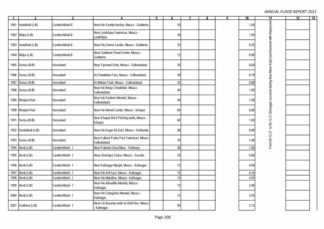
ANNUAL FLOOD REPORT 2021
1 2 3 4 5 6 7 8 9 10 11 12 13
1981 Hatakhali (L/B) Sandeshkhali-II Near h/o Sandip Naskar, Mouza - Gabberia. 50 1.00
1982 Bidya (L/B) Sandeshkhali-IINear Jyotishpur Swamsan, Mouza -
Jyotishpur.30 1.00
1983 Hatakhali (L/B) Sandeshkhali-II Near h/o Jharna Sardar, Mouza - Gabberia. 35 0.95
1984 Bidya (L/B) Sandeshkhali-IINear Gabberia Flood Centre, Mouza -
Gabberia15 0.80
1985 Dansa (R/B) Hasnabad Near Tiyamari Ghat, Mouza - Sulkuniabad. 30 0.60
1986 Dansa (R/B) Hasnabad At Chowkidar Para, Mouza - Sulkuniabad. 30 0.70
1987 Dansa (R/B) Hasnabad At Moktar Chak, Mouza - Sulkuniabad. 35 0.80
1988 Dansa (R/B) HasnabadNear h/o Binoy Chowkidar, Mouza -
Sulkuniabad.40 1.00
1989 Bhaijuri Khal HasnabadNear h/o Paritosh Mondal, Mouza -
Sulkuniabad.40 1.00
1990 Bhaijuri Khal Hasnabad Near h/o Nirmal Sardar, Mouza - Ichapur. 60 0.80
1991 Dansa (R/B) HasnabadNear Ichapur Brick Pitching work, Mouza -
Ichapur.60 1.00
1992 Kantakhali (L/B) Hasnabad Near h/o Asgar Ali Gazi, Mouza - Vurkunda. 40 0.80
1993 Dansa (R/B) HasnabadNear Sulkuni Purba Para Swamsan, Mouza -
Sulkuniabad.70 5.40
1994 Benti (L/B) Sandeshkhali - I Near Putimari Ghat.Mouz - Putimary. 40 1.00
1995 Benti (L/B) Sandeshkhali - I Near Ghoshpur Sluice, Mouza - Gazalia. 26 0.80
1996 Benti (L/B) Sandeshkhali - I Near Kalinagar Masjid, Mouza - Kalinagar. 15 4.00
1997 Benti (L/B) Sandeshkhali - I Near h/o Arif Gazi, Mouza - Kalinagar. 15 4.10
1998 Benti (L/B) Sandeshkhali - I Near h/o MulaBox, Mouza - Kalinagar. 15 4.05
1999 Benti (L/B) Sandeshkhali - INear h/o Allauddin Mondal, Mouza -
Kalinagar.15 3.90
2000 Benti (L/B) Sandeshkhali - INear h/o Sahajahan Mondal, Mouza -
Kalinagar.15 3.95
2001 Gatihara (L/B) Sandeshkhali - INear L/o Basanta ardar to Akhil Bar, Mouza
- Kalinagar.90 2.15
151.17
Fro
m 0
4.12
.21
to 0
6.12
.21
(Dam
ages
occ
urre
d du
ring
New
Moo
n K
otal
syn
chro
nise
d w
ith D
epre
ssio
n be
ing
rem
nant
of C
S 'J
AW
AD
' )
SE/
East
ern
Circl
e,
Ema
il:
Date
d:
01.0
3.20
22 &
Ema
il
Date
d
25.0
4.20
22.
Page 200

ANNUAL FLOOD REPORT 2021
1 2 3 4 5 6 7 8 9 10 11 12 13
2002 Dansa (R/B) Sandeshkhali - I Near Gatihara Saupara, Mouza - Gatihara. 30 0.75
2003 Gatihara (L/B) Sandeshkhali - INear Paschim Bholakhali Sluice to Jetty
Ghat, Mouza - Bholakhali.70 1.50
2004 Dansa (R/B) Sandeshkhali - INear Purba Bholakhali Malom Para, Mouza -
Bholakhali.45 1.00
2005 Dansa (R/B) Sandeshkhali - INear H/O Moktar Sekh at Sekh Para ,
Mouza - Choto Sehera.66 1.00
2006 Dansa (R/B) Sandeshkhali - INear Boro Sehera Prymary School , Mouza -
Boro Sehera.65 1.10
2007 Chotokalagachi (L/B) Sandeshkhali - IINear 9 no Dwarir Jungal Sluice , Mouza -
Dwarir Jungal.40 1.00
2008 Bani Boyalia (L/B) Sandeshkhali - IIFrom Chalantika Sangha to Bhardubi Khal ,
Mouza - Jeliakhali.170 2.80
2009 Bani Boyalia (L/B) Sandeshkhali - IIAt Lakshmikanta Haldar Sluice , Mouza -
Jeliakhali.1 0.80
2010 Tushkhali (R/B) Sandeshkhali - II At Bediapara , Mouza - Bhang Tushkhali. 80 1.30
2011 L/B of R. Ichamati Block - Basirhat - I Near Sangampur old Kheya ghat, Mouza-
Sangrampur150 3.15
2012 L/B of R. Ichamati Block - Basirhat - I Near Anandolok Mission (D/S of Ichamati
Bridge), Mouza- Sangrampur145 3.17
2013 R/B of R. Ichamati Block - Baduria Near H/O Sahajahan Karigar , Mouza- Kulia 150 3.29
2014 L/B of R. Ichamati Block - Swarupnagar Near H/O Jamal Seikh , Mouza- Kabilpur 150 3.43
2015 Hooghly R. Uluberia Municipality Ward no 21 35 8.25 26.05.21 & 27.05.21
2016 Hooghly R. Uluberia Municipality Ward no 21 33 7.85 -do-
2017 Hooghly R. Uluberia Municipality Ward no 21 55 12.30 -do-
2018 Hooghly R. Uluberia Municipality Ward no 21 300 66.00 -do-
2019 Hooghly R. Uluberia Municipality Ward no 21 400 5.00 -do-
2020 Hooghly R. Uluberia Municipality Ward no 21 350 8.00 -do-
2021 Hooghly R. Uluberia Municipality Ward no 22 40 13.00 -do-
2022 Hooghly R. Uluberia Municipality Ward no 23 145 50.00 -do-
2023 Hooghly R. Uluberia Municipality Ward no 23 260 70.00 -do-
2024 Hooghly R. Uluberia Municipality Ward no 24 300 46.00 -do-
2025 Hooghly R. Uluberia Municipality Ward no 24 130 55.00 -do-
151.17
Fro
m 0
4.12
.21
to 0
6.12
.21
(Dam
ages
occ
urre
d du
ring
New
Moo
n K
otal
syn
chro
nise
d w
ith D
epre
ssio
n be
ing
rem
nant
of C
S 'J
AW
AD
' )
Lower Damodar Construction Division -II
Wes
tern
Circ
le-I
, Em
ail:
14.0
3.20
22 &
15.
03.2
022
(296
/EE
-II/L
DC
D, D
ated
: 07.
03.2
022
& 4
91E
/EE
-I/L
DC
D, D
ate:
15.
03.2
022)
& E
mai
l of E
E/L
DC
D-I
Dat
ed 1
1.05
.202
2.
13.80
SE/
East
ern
Circl
e,
Ema
il:
Date
d:
01.0
3.20
22 &
Ema
il
Date
d
25.0
4.20
22.
Page 201

ANNUAL FLOOD REPORT 2021
1 2 3 4 5 6 7 8 9 10 11 12 13
2026 Hooghly R. Uluberia Municipality Ward no 24 300 2.50 -do-
2027 Hooghly R. Uluberia Municipality Ward no 24 300 3.50 -do-
2028 Hooghly R. Uluberia Municipality Ward no 24 100 25.00 -do-
2029 Hooghly R. Uluberia Municipality Ward no 24 50 15.00 -do-
2030 Hooghly R. Uluberia Municipality Ward no 21 45 17.00 -do-
2031 Hooghly R. Uluberia Municipality Ward no 11 200 80.00 -do-
2032 Hooghly R. Uluberia Municipality Ward no 11 200 3.50 -do-
2033 Hooghly R. Uluberia Municipility Ward no 11 1 5.50 -do-
2034 Midnapore Main Canal Uluberia-I Maheshpur 1 3.50 -do-
2035 Hooghly R. Shyampur-I Baneswarpur-I 65 2.50 -do-
2036 Hooghly R. Shyampur-I Baneswarpur-I 72 3.00 -do-
2037 Hooghly R. Shyampur-I Baneswarpur-I 40 2.30 -do-
2038 Hooghly R. Shyampur-I Baneswarpur-I 39 1.30 -do-
2039 Hooghly R. Shyampur-I Baneswarpur-I 18 0.60 -do-
2040 Hooghly R. Shyampur-I Baneswarpur-I 135 4.50 -do-
2041 Hooghly R. Shyampur-I Baneswarpur-I 61 1.30 -do-
2042 Hooghly R. Shyampur-I Baneswarpur-I 74 1.50 -do-
2043 Hooghly R. Shyampur-I Baneswarpur-I 13 5.50 -do-
2044 Hooghly R. Shyampur-I Baneswarpur-II 40 1.50 -do-
2045 Hooghly R. Shyampur-I Baneswarpur-II 6 2.20 -do-
2046 Hooghly R. Shyampur-I Baneswarpur-II 8 0.40 -do-
2047Ateswari Khal &
Keyakhali KhalShyampur-I Baneswarpur-II & Dingakhola 2 1.50 -do-
2048 Rameswarpur-Alpin khal. Shyampur-I Shyampur 10 2.50 -do-
2049 Rameswarpur-Alpin khal. Shyampur-I Shyampur 40 3.50 -do-
2050 Rameswarpur-Alpin khal. Shyampur-I Shyampur 10 3.30 -do-
2051 Alpin khal. Shyampur-I Shyampur 26 3.00 -do-
2052 Rameswarpur-Alpin khal. Shyampur-I Shyampur 25 2.50 -do-
2053 Hooghly R. Shyampur-I Dingakhola 100 4.50 -do-
2054 Hooghly R. Shyampur-I Dingakhola 100 4.90 -do-
2055 Keyakhali Khal Shyampur-I Dingakhola 52 19.50 -do-
2056 Keyakhali Khal Shyampur-I Dingakhola 10 5.00 -do-
2057 Gurepole khal Shyampur-I Dingakhola 150 11.00 -do-
2058 Gurepole khal Shyampur-I Baneswarpur-I 15 3.20 -do-
Wes
tern
Circ
le-I
, Em
ail:
14.0
3.20
22 &
15.
03.2
022
(296
/EE
-II/L
DC
D, D
ated
: 07.
03.2
022
& 4
91E
/EE
-I/L
DC
D, D
ate:
15.
03.2
022)
& E
mai
l of E
E/L
DC
D-I
Dat
ed 1
1.05
.202
2.
13.80
Page 202

ANNUAL FLOOD REPORT 2021
1 2 3 4 5 6 7 8 9 10 11 12 13
2059 Rupnarayan Bagnan-II Orphuli 28 7.00 -do-
2060 Rupnarayan Bagnan-II Orphuli 220 18.00 -do-
2061 Midnapore Main Canal Bagnan-II Bantul Baidyanathpur 14 8.00 -do- (R-VII)
2062 Midnapore Main Canal Bagnan-II Bantul Baidyanathpur 8 4.00 -do- (R-VII)
2063 Midnapore Main Canal Bagnan-II Bantul Baidyanathpur 14 8.00 -do- (R-VII)
2064 Midnapore Main Canal Bagnan-II Bantul Baidyanathpur 20 10.00 -do- (R-VII)
2065 Midnapore Main Canal Bagnan-II Bantul Baidyanathpur 22 11.00 -do- (R-VII)
2066 Midnapore Main Canal Bagnan-II Bantul Baidyanathpur 110 15.00 -do- (R-VII)
2067 Midnapore Main Canal Bagnan-II Bantul Baidyanathpur 100 3.00 -do- (R-VII)
2068 Rupnarayan Bagnan-II Muckbenapur 65 5.00 -do-
2069 Rupnarayan Bagnan-II Muckbenapur 216 15.00 -do-
2070 Rupnarayan Shyampur-II Muckbenapur 16 10.00 -do-
2071 Rupnarayan Shyampur-II Nakole 22 17.00 -do-
2072 Rupnarayan Shyampur-II Nakole 10 5.00 -do-
2073 Rupnarayan Shyampur-II Nakole 19 13.00 -do-
2074 Rupnarayan Shyampur-II Nakole 30 18.00 -do-
2075 Rupnarayan Shyampur-II Nakole 15 8.00 -do-
2076 Rupnarayan Shyampur-II Nakole 45 6.00 -do-
2077 Rupnarayan Shyampur-II Nakole 135 7.00 -do-
2078 Rupnarayan Shyampur-II Nakole 190 8.00 -do-
2079 Rupnarayan Shyampur-II Nakole 30 10.00 -do-
2080 Rupnarayan Shyampur-II Nakole 6 3.00 -do-
2081 Rupnarayan Shyampur-II Nakole 12 7.00 -do-
2082 Rupnarayan Shyampur-II Sasati 45 6.00 -do-
2083 Rupnarayan Shyampur-II Sasati 421 20.00 -do-
2084 Rupnarayan Shyampur-II Sasati 372 17.00 -do-
2085 Rupnarayan Shyampur-II Sasati 393 17.00 -do-
2086 Rupnarayan Shyampur-II Sasati 800 34.00 -do-
2087 Rupnarayan Shyampur-II Sasati 9 5.00 -do-
2088 Rupnarayan Shyampur-II DM Ghat-II 10 8.00 -do-
2089 Rupnarayan Shyampur-II DM Ghat-II 15 4.00 -do-
2090 Rupnarayan Shyampur-II DM Ghat-II 8 3.00 -do-
2091 Rupnarayan Shyampur-II DM Ghat-II 96 7.00 -do-
2092 Lahiripara Khal Shyampur-II DM Ghat-II 15 6.00 -do-
2093 Lahiripara Khal Shyampur-II DM Ghat-II 10 6.00 -do-
2094 Lahiripara Khal Shyampur-II DM Ghat-II 1 3.00 -do-
2095 Rupnarayan Shyampur-II DM Ghat-II 40 4.00 -do-
2096 Rupnarayan Shyampur-II DM Ghat-II 60 20.00 -do-
Wes
tern
Circ
le-I
, Em
ail:
14.0
3.20
22 &
15.
03.2
022
(296
/EE
-II/L
DC
D, D
ated
: 07.
03.2
022
& 4
91E
/EE
-I/L
DC
D, D
ate:
15.
03.2
022)
& E
mai
l of E
E/L
DC
D-I
Dat
ed 1
1.05
.202
2.
13.80
Page 203

ANNUAL FLOOD REPORT 2021
1 2 3 4 5 6 7 8 9 10 11 12 13
2097 Rupnarayan Shyampur-II DM Ghat-II 80 10.00 -do-
2098 Rupnarayan Shyampur-II DM Ghat-II 20 10.00 -do-
2099 Rupnarayan Shyampur-II DM Ghat-II 15 8.00 -do-
2100 Rupnarayan Shyampur-II DM Ghat-II 15 7.00 -do-
2101 Rupnarayan Shyampur-II DM Ghat-II 10 5.00 -do-
2102 Rupnarayan Shyampur-II DM Ghat-II 15 6.00 -do-
2103 Rupnarayan Shyampur-II DM Ghat-II 8 2.00 -do-
2104 Rupnarayan Shyampur-II DM Ghat-II 4 2.00 -do-
2105 Rupnarayan Shyampur-II DM Ghat-II 115 5.00 -do-
2106 Rupnarayan Shyampur-II DM Ghat-II 210 16.00 -do-
2107 Rupnarayan Shyampur-II DM Ghat-II 13 5.00 -do-
2108 Rupnarayan Shyampur-II DM Ghat-II 6 2.00 -do-
2109 Rupnarayan Shyampur-II DM Ghat-II 16 9.00 -do-
2110 Rupnarayan Shyampur-II DM Ghat-II 200 17.00 -do-
2111 Rupnarayan Shyampur-II DM Ghat-II 145 11.00 -do-
2112 Rupnarayan Shyampur-II DM Ghat-II 45 14.00 -do-
2113 Rupnarayan Shyampur-II DM Ghat-II 45 20.00 -do-
2114 Rupnarayan Shyampur-II DM Ghat-II 10 6.00 -do-
2115 Rupnarayan Shyampur-II DM Ghat-II 15 7.50 -do-
2116 Rupnarayan Shyampur-II DM Ghat-II 860 40.00 -do-
2117 Jallabad Khal Shyampur-II DM Ghat-II 33 4.00 -do-
2118 Rupnarayan Bagnan-II Orphuli 618 3.00 -do-
2119 Rupnarayan Bagnan-II & Shyampur-II Muckbenapur & Nakole 723 4.00 -do-
2120 Rupnarayan Shyampur-II Kamalpure 545 3.00 -do-
2121 Rupnarayan Shyampur-II Sasati 1200 11.00 -do-
2122 Rupnarayan Shyampur-II Sasati 1100 11.00 -do-
2123 Rupnarayan Shyampur-II Sasati 1100 12.00 -do-
2124 Rupnarayan Shyampur-II Orphuli 2000 20.00 -do-
2125 Chandipur Khal Shyampur-I Belari 140 12.00 -do-
2126 Chandipur Khal Shyampur-I Belari 150 10.00 -do-
2127 Chandipur Khal Shyampur-I Belari 250 15.00 -do-
2128 Chandipur Khal Shyampur-I Belari 100 8.00 -do-
2129 Chandipur Khal Shyampur-I Belari 80 6.50 -do-
2130 Chapa Khal Uluberia-I Bahira 75 6.00 -do-
2131 Chapa Khal Uluberia-I Kalinagar 80 6.00 -do-
2132 Chapa Khal Uluberia-I Kalinagar 80 38.00 -do-
2133 Hooghly Shyampur-I Belari 1 3.50 -do-
2134 Hooghly Uluberia-I Hirapur 1 3.50 -do-
Wes
tern
Circ
le-I
, Em
ail:
14.0
3.20
22 &
15.
03.2
022
(296
/EE
-II/L
DC
D, D
ated
: 07.
03.2
022
& 4
91E
/EE
-I/L
DC
D, D
ate:
15.
03.2
022)
& E
mai
l of E
E/L
DC
D-I
Dat
ed 1
1.05
.202
2.
13.80
Page 204

ANNUAL FLOOD REPORT 2021
1 2 3 4 5 6 7 8 9 10 11 12 13
2135 Hooghly Uluberia-I Hirapur 1 3.50 -do-
2136 Hooghly Uluberia-I Hirapur 1 5.00 -do-
2137 Hooghly Shyampur-I Belari 1 5.00 -do-
2138 Hooghly Uluberia-I Bahira 1 5.00 -do-
2139 Chapa Khal Uluberia-I Bahira 1 3.00 -do-
2140 Hooghly Shyampur-I Belari / Nabagram 1500 16.00 -do-
2141 Hooghly Uluberia-I Kalinagar 800 45.00 -do-
2142 Hooghly Uluberia-I Kalinagar 750 45.00 -do-
2143 Hooghly Uluberia-I & Shyampur-I Hirapur 450 20.00 -do-
2144 Hooghly Uluberia-I & Shyampur-I Hirapur 480 19.00 -do-
2145 Hooghly Uluberia-I & Shyampur-I Hirapur 520 18.00 -do-
2146 Hooghly Uluberia-I & Shyampur-I Hirapur 400 15.00 -do-
2147 Hooghly Uluberia-I Hirapur 140 18.00 -do-
2148 Hooghly Shyampur-I Dhulosimla/Belari 250 19.00 -do-
2149 Hooghly Shyampur-I Belari 200 16.00 -do-
2150 Hooghly Uluberia-I Kalinagar 350 3.80 -do-
2151 Hooghly Uluberia-I Hirapur 1200 8.40 -do-
2152 Hooghly Uluberia-I Hirapur/Dhulosimla 1400 8.40 -do-
2153 Hooghly Shyampur-I Dhandali/Belari 1600 5.60 -do-
2154 Hooghly Shyampur-I Belari 800 8.60 -do-
2155 Hooghly Shyampur-I Nabagram 250 3.50 -do-
2156 Chandipur khal Shyampur-I Belari 60 15.00 -do-
2157 Hooghly Shyampur-I Dhulosimla 24 15.00 -do-
2158 Rupnarayan Amta-II G.B. Chitnan 250 19.95 -do-
2159 Rupnarayan Amta-II G.B. Chitnan 140 19.98 -do-
2160 Rupnarayan Amta-II G.B. Chitnan 225 19.50 -do-
2161 Mundeswari Amta-II Kashmoli 105 7.50 -do-
2162 Rupnarayan Bagnan-I & II Saratchandra 145 9.20 -do-
2163 Rupnarayan Bagnan-I Buxir-hat 120 19.56 -do-
2164 Purana Khal Uluberia-I Uluberia Municipility 170 19.99 -do-
2165 Purana Khal Uluberia-I Uluberia Municipility 110 9.50 -do-
2166 Rupnarayan Bagnan-I Kallyanpur 350 66.65 -do-
2167 Rupnarayan Bagnan-I Buxir-hat 150 19.97 -do-
2168 Gaighata Khal Bagnan-I Khalna 180 18.88 -do-
2169 Lahiripara Khal Shyampur-II DM Ghat-II 26 4.00 28.07.21 to 03.08.21
2170 Lahiripara Khal Shyampur-II DM Ghat-II 35 4.20 -do-
2171 Lahiripara Khal Shyampur-II DM Ghat-II 35 4.10 -do-
2172 Rupnarayan R. Shyampur-II DM Ghat-II 73 4.00 -do-
Wes
tern
Circ
le-I
, Em
ail:
14.0
3.20
22 &
15.
03.2
022
(296
/EE
-II/L
DC
D, D
ated
: 07.
03.2
022
& 4
91E
/EE
-I/L
DC
D, D
ate:
15.
03.2
022)
& E
mai
l of E
E/L
DC
D-I
Dat
ed 1
1.05
.202
2.
13.80
Page 205

ANNUAL FLOOD REPORT 2021
1 2 3 4 5 6 7 8 9 10 11 12 13
2173 Gadiara Khal Shyampur-I Baneswarpur-I 20 1.00 -do-
2174 Rupnarayan R. Shyampur-I Baneswarpur-II 35 1.50 -do-
2175 Rupnarayan R. Shyampur-I Baneswarpur-II 32 5.00 -do-
2176 Rupnarayan R. Shyampur-I Baneswarpur-II 30 5.00 -do-
2177 Rupnarayan R. Shyampur-I Baneswarpur-II 59 3.50 -do-
2178 Rajapur Khal Uluberia Municipality Ward no-16 45 5.00 -do-
2179 Rajapur Khal Uluberia Municipality Ward no-16 25 3.50 -do-
2180 Rajapur Khal Uluberia Municipality Ward no-16 35 4.50 -do-
2181 Rajapur Khal Uluberia Municipality Ward no-18 50 4.90 -do-
2182 Rajapur Khal Uluberia Municipality Ward no-18 25 3.10 -do-
2183 Rajapur Khal Uluberia Municipality Ward no-23 23 5.00 -do-
2184 Hooghly R. Uluberia Municipality Ward no-21 40 1.00 -do-
2185 Rajapur Khal Uluberia-II Basudebpur 1 5.00 -do-
2186 Chandipur Khal Shyampur-I Belari 60 5.00 -do-
2187 Chandipur Khal Shyampur-I Belari 52 4.80 -do-
2188 Chandipur Khal Shyampur-I Belari 48 4.40 -do-
2189 Chandipur Khal Shyampur-I Belari 50 4.50 -do-
2190 Kuldhipi Khal Amta-II Kashmol 160 15.95 -do-
2191 Kuldhipi Khal Amta-II Kashmol 150 15.10 -do-
2192 Maja Damodar Khal Amta-II Kashmol 40 4.10 -do-
2193 Hurhura & Kuldhipi Khal Amta-II Kashmoli 130 7.20 -do-
2194 Hurhura Khal Amta-II Kashmoli & G.B. Chitnan 1 5.00 -do-
2195 Hurhura Khal Amta-II Buxir-hat 200 19.12 -do-
2196 Maja Damodar Khal Amta-II Kashmoli 70 6.50 -do-
2197 Gaighata Khal Bagnan-I & Amta-II Khalna & Bainan 1 12.00 -do-
2198 Purana Khal Uluberia-II Tehatta Kataberia - I 36 15.00 -do-
2199 Purana Khal Uluberia-II Tehatta Kataberia - I 35 15.00 -do-
2200 Gujarpur Khal Bagnan-I Haturia-I 30 8.00 -do-
2201 Nabinbabu Khal Amta-I Chandrapur 30 2.00 -do-
2202 Gujarpur Khal Amta-I Amta 1 2.00 -do-
2203Banaspati khal, Gujarpur
khal, Nabinbabu KhalUluberia-II, Bagnan-I, Amta-I Haturia-1 1 5.00 -do-
2204 Nabinbabu Khal Amta-I Mahisgoa 1 8.00 -do-
2205 Kuldhipi Khal Amta-II G.B.Chitnan 65 4.95 29.09.21 to 06.10.21
2206 Kuldhipi Khal Amta-II Kashmoli 380 3.50 -do-
2207 Kuldhipi Khal Amta-II Kashmoli 365 3.40 -do-
Wes
tern
Circ
le-I
, Em
ail:
14.0
3.20
22 &
15.
03.2
022
(296
/EE
-II/L
DC
D, D
ated
: 07.
03.2
022
& 4
91E
/EE
-I/L
DC
D, D
ate:
15.
03.2
022)
& E
mai
l of E
E/L
DC
D-I
Dat
ed 1
1.05
.202
2.
13.80
Page 206

ANNUAL FLOOD REPORT 2021
1 2 3 4 5 6 7 8 9 10 11 12 13
2208 Gaighata Khal Amta-II Khalna 360 3.38 -do-
2209 Moja Damodar Amta-II Kashmoli 300 5.10 -do-
2210 Hurhura Khal Amta-II Kashmoli 250 7.50 -do-
2211 Hurhura Khal Amta-II Kashmoli 55 6.50 -do-
2212 Damodar R. Bagnan-I Bagnan-II 4 1.15 -do-
2213 Gaighata Khal Amta-II Bainan & Khalna 4 1.50 -do-
2214 Gaighata Khal Amta-II Khalna 4 1.30 -do-
2215 Moja Damodar R. Amta-II Kashmoli 7 1.30 -do-
2216 Damodar R. Bagnan-I Bangalpur 2 1.05 -do-
2217 Damodar R. Bagnan-II Bagnan-II 4 0.85 -do-
2218 Hurhura Khal Amta-II G.B. Chitnan & Bhatora 3 1.12 -do-
2219 Gaighata Khal Amta-II Khalna and Kushberia 4 0.80 -do-
2220 Gaighata Khal Amta-II Khalna 3 4.95 -do-
2221 Damodar R. Bagnan-I Bagnan-II 92 15.15 -do-
2222 Damodar R. Bagnan-I Bagnan-II 140 18.10 -do-
2223 Damodar R. Bagnan-I Bainan 85 14.12 -do-
2224 Damodar R. Bagnan-I Bangalpur 450 3.20 -do-
2225 Hurhura Khal Amta-II G.B.Chitnan 120 9.31 -do-
2226 Nalpukur Khal Bagnan-II Hallyan 150 14.45 -do-
2227 Gaighata Khal Bagnan-I Bainan 130 12.10 -do-
2228 Damodar R. Bagnan-II Chandrabhag. 75 8.20 -do-
2229 Damodar R. Bagnan-II Chandrabhag. 65 8.00 -do-
2230 Banspati Kha Bagnan-II Mugkallyan 100 7.80 -do-
2231Damodar R. and
Gujrpur KhalBagnan-I Bangalpur 130 12.20 -do-
2232 Tiorkhali Khal Bagnan-II Hallyan 12 5.90 -do-
2233 Godaipur Khal Uluberia-I Hutgacha-II 140 11.50 -do-
2234 Tiorkhali Khal Bagnan-II Hallyan 95 7.80 -do-
2235 Barberia Khal Uluberia-I Hutgacha-II 90 8.50 -do-
2236 Tetua Khal Bagnan-II Hallyan 125 10.80 -do-
2237 Kshmul Khal Uluberia-I Hutgacha-II 85 6.50 -do-
2238 Rupnarayan R. Amta-II Bhatora 110 28.00 -do-
2239 Moja Damodar Khal Amta-II Kashmoli , Jhamtia 200 68.90 -do-
2240 Short Cut Channel Amta-II Jhamtia, Khalna, Kashmoli 195 5.00 -do-
2241 Short Cut Channel Amta-II Jhamtia, Thalia 205 2.80 -do-
2242 Short Cut Channel Amta-II Jhamtia, Thalia 200 2.50 -do-
2243 Short Cut Channel Amta-II & Bagnan-I Khalna, Bakshi 125 2.20 -do-
2244 Short Cut Channel Amta-II Thalia 3 1.50 -do-
Wes
tern
Circ
le-I
, Em
ail:
14.0
3.20
22 &
15.
03.2
022
(296
/EE
-II/L
DC
D, D
ated
: 07.
03.2
022
& 4
91E
/EE
-I/L
DC
D, D
ate:
15.
03.2
022)
& E
mai
l of E
E/L
DC
D-I
Dat
ed 1
1.05
.202
2.
13.80
Page 207

ANNUAL FLOOD REPORT 2021
1 2 3 4 5 6 7 8 9 10 11 12 13
2245 Purana khal Uluberia-II TK-I 60 8.15 -do-
2246 Purana khal Uluberia-II TK-I 30 8.00 -do-
2247 Gujarpur khal Bagnan-I Haturia 90 10.00 -do-
2248 Jagarampur Khal Uluberia-II Jowargori 200 20.00 -do-
2249 Purana Khal Amta-I Debandi 40 4.95 -do-
2250 Purana Khal Amta-I Kandua 40 4.90 -do-
2251 Purana khal Amta - I Anolia 1 6.00 -do-
2252 Jallabad Khal Shyampur-I Baneswarpur-II 35 2.00 -do-
2253 Sibpur khal Shyampur-I Baneswarpur-II 27 2.15 -do-
2254 Alpin Khal Shyampur-I Shyampur 60 4.80 -do-
2255 Alpin Khal Shyampur-I Shyampur 8 0.80 -do-
2256 Alpin Khal Shyampur-I Shyampur 12 1.00 -do-
2257 Alpin Khal Shyampur-I Shyampur 20 1.60 -do-
2258 Alpin Rameswrpur khal Shyampur-I Shyampur 27 4.94 -do-
2259 Damodar R. Shyampur-I Shyampur 60 5.00 -do-
2260 Shakhabhanga Khal Uluberia-I Hirapur 40 4.42 -do-
2261 Ranghamati Khal Uluberia-I Kalinagar 35 2.70 -do-
2262 R. Maja Damodar Howrah/Udaynarayanpur Debipur / Debipur Duttapara 1 4.00 28-7-21 to 03-8-21 Wooden Bridge
2263 R. Maja Damodar Howrah/Udaynarayanpur Garbhabanipur Sonatala Karatipara 1 8.00 -do- Wooden Bridge
2264 R. Maja Damodar Howrah/Udaynarayanpur Garbhabanipur Sonatala Karatipara 40 7.00 -do-
2265 R. Maja Damodar Howrah/Udaynarayanpur R.D.A/Dihiburshut Hanagora 20 5.00 -do-
2266 R. Maja Damodar Howrah/UdaynarayanpurR.D.A/Dihiburshut Hanagora, Kalitala,
Ghola 3 5.00 -do- Wooden Bridge
2267 R. Maja Damodar Howrah/Udaynarayanpur R.D.A./Dihiburshut Kanrarpara 20 3.00 -do-
2268 R. Maja Damodar Howrah/Udaynarayanpur R.D.A/Dakshin Dihiburshut RCC Br. 50 5.00 -do-
2269 R. Maja Damodar Howrah/Udaynarayanpur R.D.A /Lebutala RCC Bridge 30 5.00 -do-
2270 R. Maja Damodar Howrah/Udaynarayanpur Kurchi Shibpur / Hariharpur 1 7.50 -do- Wooden Bridge
2271 R. Maja Damodar Howrah/Udaynarayanpur Kurchi Shibpur /Hariharpur 50 10.00 -do-
2272 R. Maja Damodar Howrah/Udaynarayanpur Kurchi Shibpur /Kurchi palpara 40 10.00 -do-
2273 R. Maja Damodar Howrah/Udaynarayanpur Kurchi Shibpur/ Baira Kurchi 430 40.00 -do-
2274 R. Maja Damodar Howrah/UdaynarayanpurKurchi Shibpur / U.N.Pur Dharapara to
Pratapchak wooden bridge100 5.00 -do-
2275 R. Maja Damodar Howrah/Udaynarayanpur Kurchi Shibpur /Shibpur 1 8.00 -do- Wooden Bridge
2276 R. Maja Damodar Howrah/Udaynarayanpur Singty / Rajapur Brahmanpara 20 1 2.00 -do- Wooden Bridge
2277 R. Maja Damodar Howrah/Udaynarayanpur Singty / Harighata 20 1 8.50 -do- Wooden Bridge
2278 R. Maja Damodar Howrah/Udaynarayanpur Singty /Dakshin singty 16 1 8.00 -do- Wooden Bridge
2279 R. Maja Damodar Howrah/Udaynarayanpur Kanupat Mansuka /Raychak 1 8.50 -do- Wooden Bridge
100.78
Wes
tern
Circ
le-I
, Em
ail:
14.0
3.20
22 &
15.
03.2
022
(296
/EE
-II/L
DC
D, D
ated
: 07.
03.2
022
& 4
91E
/EE
-I/L
DC
D, D
ate:
15.
03.2
022)
& E
mai
l of E
E/L
DC
D-I
Dat
ed 1
1.05
.202
2.
13.80
Lower Damodar Construction Division -I
Page 208

ANNUAL FLOOD REPORT 2021
1 2 3 4 5 6 7 8 9 10 11 12 13
2280 R. Maja Damodar Howrah/UdaynarayanpurGarbhabanipur Sonatala/ Kumarchak near
Kabarstan 1 4.00 -do- Wooden Bridge
2281 R. Maja Damodar Howrah/UdaynarayanpurGarbhabanipur Sonatala /Kumarchak
Kabarsthan 200 25.00 -do-
2282 R. Maja Damodar Howrah/Udaynarayanpur Garbhabanipur Sonatala / /Garbhabanipur 20 6.00 -do-
2283 R. Maja Damodar Howrah/Udaynarayanpur B.B. Pur/ Gumgarh 21 1 7.00 -do- Wooden Bridge
2284 Tuker Khal Howrah/Udaynarayanpur Harali U.N. Pur /HaGaja to Piarapur 90 95.00 -do- 4 Nos spots
2285 Tuker Khal Howrah/UdaynarayanpurHarali U.N. Pur/ Gaja to Piarapur to Harali
sluice 40 10.00 -do-
2286 Tuker Khal Howrah/UdaynarayanpurHarali U.N. Pur/ Gaja to Piarapur to Harali
sluice 1000 6.00 -do-
Damage
inspection path
2287 R. Damodar Howrah/Udaynarayanpur Kanupat Mansuka /Joynagar 1 6.00 -do- sluice
2288 Lower Rampur Khal Howrah /Amta-II Jhamtia /Kamargoria 1 10.75 -do- sluice
2289 Lower Rampur Khal Howrah /Amta-II Jhamtia /Kamargoria Dolui Para 20 20.00 -do- 1 spot - 20m
2290 Lower Rampur Khal Howrah /Amta-II Narit / Narit sluice to Nayanjuli sluice 150 6.00 -do-
2291 Lower Rampur Khal Howrah /Amta-II Jhamtia /Choto Satpota 100 6.50 -do-
2292 Lower Rampur Khal Howrah /Amta-II B.K.Bati /Joypur beltala 300 6.75 -do-
2293 Lower Rampur Khal Howrah /Amta-IISatpota /Satpota RCC bridge to satpota
sluice250 4.00 -do-
2294 Lower Rampur Khal Howrah /Amta-II Jhamtia /Syphon to Kamrgoria monsatala 900 10.00 -do-
2295 Lower Rampur Khal Howrah /Amta-II Thalia /Bhategori 900 14.00 -do-
2296 Mahishamuri Khal Howrah /Amta-II Tajpur /Narit RCC Bridge to SPIC sluice 80 4.50 -do-
2297 Mahishamuri Khal Howrah /Amta-II Tajpur/ Serol 1 2.50 -do- Sluice
2298 R. Maja Damodar Howrah /Amta-IIJhamtia & Joypur /Militarypota to
Kamarkhola 25 25.00 -do- Inspection path
2299 Lower Rampur Khal Howrah /Amta-II Thalia /Sheagori Kalitala 530 23.00 -do- Inspection path
2300 Mahishamuri Khal Howrah /Amta-II Tajpur /Mahishamuri Ashramgora 2720 24.50 -do- Inspection path
2301 Mahishamuri Khal Howrah /Amta-IITajpur/ SPIC sluice to Mahishamuri
bansbagan450 8.00 -do-
2302 Subgushtala Khal Howrah /Amta-II Khalna 1 0.50 -do- Sluice
2303 Lower Rampur Khal Howrah /Amta-II Joypur beltala to Ranjoybar 2200 12.00 -do- Inspection path
2304 Lower Rampur Khal Howrah /Amta-II Joypur beltala to Syphon (left) 2700 16.00 -do- inspection path
2305 Lower Rampur Khal Howrah /Amta-II Joypur beltala to Syphon (right) 2800 10.00 -do- Inspection path
2306 Lower Rampur Khal Howrah /Amta-II Syphon (D/S) to Kamargoria - LS 1700 8.00 -do- Inspection path
2307 Lower Rampur Khal Howrah /Amta-II Syphon (D/S) to Kamargoria - RS 1800 10.00 -do- Inspection path
100.78
Wes
tern
Circ
le-I
, Em
ail:
14.0
3.20
22 &
15.
03.2
022
(296
/EE
-II/L
DC
D, D
ated
: 07.
03.2
022
& 4
91E
/EE
-I/L
DC
D, D
ate:
15.
03.2
022)
& E
mai
l of E
E/L
DC
D-I
Dat
ed 1
1.05
.202
2.
Page 209

ANNUAL FLOOD REPORT 2021
1 2 3 4 5 6 7 8 9 10 11 12 13
2308 Lower Rampur Khal Howrah /Amta-IIKamargoria Baidyanath Setu to Narit RCC
Bridge (Right side)1400 14.00 -do- Inspection path
2309 Mahishamuri Khal Howrah /Amta-II Tajpur / Simultala 1 5.00 -do- sluice
2310 Mahishamuri Khal Howrah /Amta-II Tajpur /Sauria 1 2.50 -do- sluice
2311 R. Damodar Howrah /Amta-I Rashpur /Balichak 1 2.00 -do- sluice
2312 R. Damodar. Howrah /Amta-IUdang-II & Amta / Ranapara & Amta
Bandar 350 8.00 -do- Ring Bandh
2313 R. Kana Damodar Howrah/Jagatballavpur Polgostia /Nalda 100 7.50 -do-
2314 R. Kana Damodar Howrah/Jagatballavpur Sankarhati-II/ Hafezpur . 100 6.00 -do-
2315 R. Kana Damodar Howrah/Jagatballavpur Sankarhati-II / Hafezpur bridge. 70 15.00 -do-
2316 R. Kana Damodar Howrah/Jagatballavpur Maju /Maju 1 8.50 -do- Wooden Bridge
2317 R. Kana Damodar Howrah/Jagatballavpur JB Pur-I / Kharapara 1 10.50 -do- Wooden Bridge
2318 R. Kana Damodar Howrah/Jagatballavpur JB Pur-I / Ichchanagari 1 3.00 -do- Sluice
2319 Sitapur Ratanmala Khal Howrah/Shampur-II Amardaha / Sitapur 150 15.00 -do-
2320 R. Maja Damodar Howrah/ Udaynarayanpur R.D.A./ Dihiburshut Hanagora 50 7.00 29-9-21 to 06-10-21
2321 R. Maja Damodar Howrah/ Udaynarayanpur R.D.A / Lebutala 25 10.00 -do-
2322 R. Maja Damodar Howrah/ Udaynarayanpur R.D.A./Ghola school 90 19.00 -do-
2323 R. Maja Damodar Howrah/ Udaynarayanpur R.D.A /Hariharpur 40 10.00 -do-
2324 R. Maja Damodar Howrah /Udaynarayanpur Kurchi Shibpur / Kurchi RCC Br. 100 15.00 -do-
2325 R. Maja Damodar Howrah/ Udaynarayanpur Kurchi/ Patrapara 100 12.00 -do-
2326 R. Maja Damodar Howrah/ Udaynarayanpur Harali U.N. Pur /Pratapchak 18 15.00 -do-
2327 R. Maja Damodar Howrah/ Udaynarayanpur Harali U.N. pur / Baira Kurchi 320 9.00 -do-
2328 R. Maja Damodar Howrah/ Udaynarayanpur Harali U.N. pur / Pratapchak 50 6.00 -do-
2329 R. Maja Damodar Howrah/ Udaynarayanpur Kurchi Shibpur /Binodbati 100 4.00 -do-
2330 R. Maja Damodar Howrah/ Udaynarayanpur Kurchi Shibpur / U.N.Pur Mukherjee 60 8.00 -do-
2331 R. Maja Damodar Howrah/ Udaynarayanpur Kurchi Shibpur / Pratapchak & Balichak 1 4.00 -do- Wooden Bridge
2332 R. Maja Damodar Howrah/ Udaynarayanpur Kurchi Shibpur /Shibanipur 20 3.00 -do-
2333 R. Maja Damodar Howrah/ Udaynarayanpur Kanupat Mansuka /Joynagar 6 1.00 -do-
2334 R. Maja Damodar Howrah/ Udaynarayanpur Kanupat Monsuka /Kumarchak 225 25.00 -do-
2335 R. Maja Damodar Howrah/ Udaynarayanpur Kanupat Monsuka/ Purpat 20 3.00 -do-
2336 R. Maja Damodar Howrah/ Udaynarayanpur Singty / Singty R.C.C. bridge 25 3.00 -do-
2337 R. Maja Damodar Howrah/ Udaynarayanpur Debipur / Kamarpara 1 12.00 -do- Wooden Bridge
2338 R. Maja Damodar Howrah/ Udaynarayanpur Kanupat Monsuka / Purpat 1 8.00 -do- Wooden Bridge
2339 R. Maja Damodar Howrah/ Udaynarayanpur Garbhabanipur Sonatala /Gumgar 15 2.00 -do-
2340 R. Maja Damodar Howrah/ UdaynarayanpurGarbhabanipur Sonatala / Sonatala
painpara20 3.00 -do-
2341 R. Maja Damodar Howrah/ Udaynarayanpur R.D.A / Dakshin Dihiburshut 30 4.00 -do-
100.78
Wes
tern
Circ
le-I
, Em
ail:
14.0
3.20
22 &
15.
03.2
022
(296
/EE
-II/L
DC
D, D
ated
: 07.
03.2
022
& 4
91E
/EE
-I/L
DC
D, D
ate:
15.
03.2
022)
& E
mai
l of E
E/L
DC
D-I
Dat
ed 1
1.05
.202
2.
Page 210

ANNUAL FLOOD REPORT 2021
1 2 3 4 5 6 7 8 9 10 11 12 13
2342 Tuker Khal Howrah/ Udaynarayanpur Harali U.N. Pur / Gaja 60 35.00 -do-Breach of Ring
bundh
2343 Tuker Khal Howrah/ Udaynarayanpur Harali U.N. Pur / Konchowki 165 26.00 -do-
2344 Tuker Khal Howrah/ Udaynarayanpur Harali U.N. pur / Konchwki 37 20.00 -do-Breach of Ring
bundh
2345 Tuker Khal Howrah/ Udaynarayanpur Harali U.N.Pur/ Piarapur 37 20.00 -do- 3 nos breaches
2346 Tuker Khal Howrah/ Udaynarayanpur Harali U.N. pur / Harali 123 16.50 -do- Slip 6 nos
2347 Tuker Khal Howrah/ Udaynarayanpur Harali U.N.Pur/ Konchwki 100 12.00 -do- Inspection path
2348 Upper Rampur Howrah/ Udaynarayanpur Pancharul / Puncharul Polley pukur 40 28.00 -do-Breach of Ring
bundh
2349 Upper Rampur Howrah/ Udaynarayanpur Pancharul/ Khardha Itara 150 15.00 -do- Slip 8 nos
2350 Upper Rampur Howrah/ Udaynarayanpur Pancharul / Kharda Itara 30 30.00 -do-
2351 R. Damodar Howrah/ Udaynarayanpur Kanupat Monsuka / Naronarayanpur Chowk 30 10.00 -do-
2352 Kharibon Khal Howrah/ Udaynarayanpur B.B.Pur / .Khoribon 142 15.50 -do-
2353 Kharibon Khal Howrah /Udaynarayanpur B.B. Pur / Khoriban 625 12.00 -do- Inspection path
2354 Kharibon Khal Howrah / Uluberia-1 Hirapur / near Kantakhali 75 7.00 -do-
2355 Kana Damodar R. Howrah / Panchla Bonhorishpur / Bonhorishpur 20 3.50 -do-
2356 Rajapur Brnch Channel Howrah / Domjur Jhapordha / Nonakundu 100 15.00 -do-
2357 Someswar Khal Howrah / Amta-I Rashpur / Chardaha 150 3.10 -do-
2358 R. Maja Damodar Howrah / Amta-I Udang-II / Purba Gazipur 30 2.00 -do-
2359 Lower Rampur Khal Howrah / Amta-II B.K. Bati / Nischintapur 100 3.10 -do-
2360 Lower Rampur Khal Howrah / Amta-II B.K. Bati / Joypur Beltala 120 3.00 -do-
2361 Lower Rampur Khal Howrah / Amta-II Jhamtia/ Joypur Satpota 300 9.00 -do-
2362 Lower Rampur Khal Howrah / Amta-II Jhamtia / Satpota 300 16.00 -do-
2363 Lower Rampur Khal Howrah / Amta-II Jhamtia /Satpota 25 2.00 -do-
2364 Lower Rampur Khal Howrah / Amta-II Jhamtia / Satpota 35 2.50 -do-
2365 Lower Rampur Khal Howrah / Amta-II Jhamtia / Chhoto satpota 65 12.56 -do-
2366 Lower Rampur Khal Howrah / Amta-II Jhamtia/ Syphon 12 1.50 -do-
2367 Lower Rampur Khal Howrah / Amta-II Garbhabanipur Sonatala/ Kamargoria 600 20.54 -do-
2368 Lower Rampur Khal Howrah / Amta-II Jhamtia / Kamargoria 200 20.50 -do-
2369 Lower Rampur Khal Howrah / Amta-II Tajpur / Narit 200 7.00 -do-
2370 Lower Rampur Khal Howrah / Amta-II Kushberia / SPIC sluice 150 8.50 -do-
2371 Mahishamuri Khal Howrah / Amta-II Tazpur / Mahishamuri 429 19.56 -do-
2372 Lower Rampur Khal Howrah / Amta-II Thalia / Bhateghori 100 7.00 -do-
2373 Lower Rampur Khal Howrah / Amta-II Thalia / Bhategori 650 20.20 -do-
2374Mahishamuri Khal &
Damodar RightHowrah / Amta-II Tajpur / Simultala 3 7.74 -do- Sluice
100.78
Wes
tern
Circ
le-I
, Em
ail:
14.0
3.20
22 &
15.
03.2
022
(296
/EE
-II/L
DC
D, D
ated
: 07.
03.2
022
& 4
91E
/EE
-I/L
DC
D, D
ate:
15.
03.2
022)
& E
mai
l of E
E/L
DC
D-I
Dat
ed 1
1.05
.202
2.
Page 211

ANNUAL FLOOD REPORT 2021
1 2 3 4 5 6 7 8 9 10 11 12 13
2375 Lower Rampur Khal Howrah / Amta-II B.K. Bati / Ronjoyber 300 46.00 -do-
2376 Lower Rampur Khal Howrah / Amta-II Jhamtia / Sauria 70 5.00 -do-
2377 Lower Rampur Khal Howrah / Amta-II Jhamtia / Gajipur 265 41.00 -do-
2378 Lower Rampur Khal Howrah / Amta-II Jhamtia / Kamargoria 27 6.00 -do-
2379 Lower Rampur Khal Howrah / Amta-II Jhamtia / Kamargoria 26 6.00 -do-
2380 R. Maja Damodar Howrah / Amta-II Joypur/ Militarypota 1 8.00 -do- Wooden Bridge
2381Link Channel of Maja
Damodar Howrah / Amta-II Amoragori / Ghano shyamchak 1 5.50 -do- Wooden Bridge
2382Link Channel of Maja
Damodar Howrah / Amta-II Amoraagori / Ghano shyamchak 1 6.00 -do- Wooden Bridge
2383 R. Maja Damodar Howrah / Amta-II Amoragori /Manuchak 15 10.00 -do- Inspection path
2384Link Channel of Maja
Damodar Howrah / Amta-II Jhikira / Bhairavpur 20 5.00 -do- Inspection path
2385 Rajapur Branch Channl Howrah / Domjur Uttar Jhapordha/ Nonakundu 1 6.50 -do- Wooden Bridge
2386 DamodarPurba Bardhaman, Block & PS-
Khandaghosh
GP-Lodna
Mouza-Beldanga 1450 230.00 01.10.21
2387 DamodarPurba Bardhaman, Block & PS-
Khandaghosh
GP-Lodna
Mouza-Banamalipur280 75 11.00 01.10.21
2388 DamodarPurba Bardhaman, Block & PS-
Khandaghosh
GP-Sasanga
Mouza- Kumirkola22.00 01.10.21
2389 DamodarPurba Bardhaman, Block & PS-
Khandaghosh
GP-Sasanga
Mouza- Napara700 50.00 01.10.21
2390 DamodarPurba Bardhaman, Block & PS-
Khandaghosh
GP-Sasanga
Mouza- Tildanga11.00 01.10.21
2391 DamodarPurba Bardhaman, Block & PS-
Jamalpur
GP-Berugram
Mouza- Haibatpur18.00 01.10.21
2392 DamodarPurba Bardhaman, Block & PS-
Jamalpur
GP-Berugram
Mouza- Chalbalpur & Kanakpur 450 275 52.00 01.10.21
2393 DamodarPurba Bardhaman, Block & PS-
Jamalpur
GP-Jamalpur-I
Mouza- Dipermana110 20 78.00 01.10.21
2394 DamodarPurba Bardhaman, Block & PS-
Jamalpur
GP-Jotsriram
Mouza- Rajarampur, Srikrishnapur 150 30 12.00 01.10.21
2395 DarakeswarPurba Bardhaman, Block & PS-
Khandaghosh
GP-Gopalbera
Mouza-Rautara175 80 188.00 30.07.21
2396 DarakeswarPurba Bardhaman, Block-Raina-
II, PS- MadhabdihiGP-Uchalan Mouza-Moniary 240 36.00 30.07.21
28.85
100.78
Damodar Canal Division-I
Dam
odar
Irrig
atio
n C
ircle
: Mem
o N
o: 5
79, D
ated
: 22.
03.2
022
& E
mai
l fro
m E
E/L
DID
-I D
ated
11.
05.2
022.
Wes
tern
Circ
le-I
, Em
ail:
14.0
3.20
22 &
15.
03.2
022
(296
/EE
-II/L
DC
D, D
ated
: 07.
03.2
022
& 4
91E
/EE
-I/L
DC
D, D
ate:
15.
03.2
022)
& E
mai
l of E
E/L
DC
D-I
Dat
ed 1
1.05
.202
2.
Page 212

ANNUAL FLOOD REPORT 2021
1 2 3 4 5 6 7 8 9 10 11 12 13
2397 Dev KhalPurba Bardhaman, Block & PS-
KhandaghoshGP-Gopalbera Mouza-Rautara 730 225.00 30.07.21
2398 Dev KhalPurba Bardhaman, Block-Raina-
II, PS- Madhabdihi
GP-Uchalan
Mouza-Makorkola, Aklakhi740 1 330.00 30.07.21
2399 Dev KhalPurba Bardhaman, Block-Raina-
II, PS- Madhabdihi
GP-Uchalan
Mouza-Narattambati460 26.00 30.07.21
2400 Dwarakeswar Patrasayer Nandur & Akhrasal 1515 34.50 01.08.21
2401 Dwarakeswar Patrasayer Naricha 1050 23.86 01.08.21
2402 Dwarakeswar Indas Khatnagar 810 18.40 01.10.21
2403 Dwarakeswar Indas Kunjapur 940 21.36 01.10.21
2404 Dwarakeswar Indas Bamnia & Nagatentul 1665 37.84 01.10.21
2405 Dwarakeswar Indas Betanal 1170 26.59 01.10.21
2406 Dwarakeswar Indas Pantrai 980 22.27 01.10.21
2407 Damodar Sonamukhi Nityanandapur,Kenety, Rangamati 230.65 01.10.21
2408 Shali Sonamukhi Majhirdanga & Choulia 900 20.45 01.08.21
2409 Shali Sonamukhi Bahulia
2410 Shali Sonamukhi Patsol
2411 Shali Sonamukhi Sonamukhi
2412 Shali Sonamukhi Bnese
2413 Shali Sonamukhi Banparulia
2414 Shali Sonamukhi Rautora
2415 Shali Sonamukhi Madanmahonpur
2416 Shali Sonamukhi Palsora
2417 BankaPurba Bardhaman
Memari-II/ P.S.:Memari
GP:Bohar-I,vil.:Rukaspur
Mouza :Rukaspur120 26.50 1.10.21
2418 Banka Purba Bardhaman/Memari-II GP:Bohar-I,vil.:Rukaspur 150 30.20 1.10.21
2419 Banka Purba Bardhaman/Memari-II GP:Bohar-I,vil.:Rukaspur 165 34.00 1.10.21
2420 BankaPurba Bardhaman
Block & P.S.:Monteswar
GP:Jamna,vil.:Kuley Dakshinpara
Mouza :Kuley200 42.30 1.10.21
2421 BankaPurba Bardhaman
Memari-II/ Memari
GP:Bijur-II, vil.:Monohardanga
Mouza :Begunia298 38.00 1.08.21
2422 BankaPurba Bardhaman
Bardhaman-II/Saktigarh
GP:Nabastha-II,vil.:Palsit
Mouza :Karanda234 35.00 1.08.21
2423 Khari(R/B) Purba Bardhaman/Burdwan-I GP:Khetia,vil.:Parui 425 70.00 1.08.21
2424 Khari(R/B) Purba Bardhaman/Burdwan-I GP:Kurmun-I, vil.:Chotabelun 180 30.00 1.08.21
2425 Damodar Purba Bardhaman/ Galsi-II Belkash/ Konarpur, Marual / Konarpur 750 320.00 1.08.21 Erosion
2426 DamodarPurba Bardhaman/
Khandaghosh Sasonga/Gaitanpur/ Gaitanpur 860 358.00 1.08.21 Erosion
28.85
Dam
odar
Irrig
atio
n C
ircle
: Mem
o N
o: 5
79, D
ated
: 22.
03.2
022
& E
mai
l fro
m E
E/L
DID
-I D
ated
11.
05.2
022.
124.54 01.10.21
Page 213

ANNUAL FLOOD REPORT 2021
1 2 3 4 5 6 7 8 9 10 11 12 13
2427 DamodarPurba Bardhaman/ Jamalpur /
JamalpurGohogram / Joykrisnapur / Joykrishnapur 200 42.00 1.08.21 Erosion
2428 BankaPurba Bardhaman/ Bardhaman-
II /Bardhaman
Baikhantapur-I/ Ganshipara, Chandaipur/
Bamchandaipur150 80.00 1.08.21 Slip/ Subsidence
2429 Damodar Purba Bardhaman Barsul-II/ Hatsimul/ Hatsimul 180 40.00 1.08.21 Slip/ Subsidence
2430 R. Ajoy Purba Bardhaman / Katwa-I vil. Churpuni 70 28.00 01-10-2021
2431 R. Ajoy Purba Bardhaman / Katwa-I vil. Rajua 340 130.00 01-10-2021
2432 R. Ajoy PurbaBardhaman/Ketugram-II Mouza Begunkola 1350 295.00 01-10-2021
2433 R. AjoyPurba Bardhaman / Mongalkote
Blockvil. Majhaigram 700 245.00 01-10-2021
2434 Khari R. Purba Bardhaman/Bhatar Mahachanda/ Parhat (Kheyari Para) 60 60 .00 08-06-2021
2435 R. AjoyPurba Bardhaman/ Ausgram-II/
Ausgram
Bhedia/ Santla/ Santla (Lat 23.60611°,
Long 87.720471°)75 134.53 01.10.21 Right Emb.
2436 R. AjoyPurba Bardhaman/ Mongalkote
/ Mongalkote
Paligram/ Paligram/ Paligram (Lat
23.571203°, Long 87.788195°) 85 47.92 01.10.21
Ex-Zamindary
Emb.
2437 R. AjoyPurba Bardhaman/ Mongalkote
/ Mongalkote
Paligram/ Paligram/ Paligram (Lat
23.570138°, Long 87.7*3131°) 1500 125.49 01.10.21
Crack on top of
Emb.
2438 R. AjoyPurba Bardhaman/ Block &
P.S.-Mongalkote
Paligram/ Paligram-Taldanga (Lat
23.571832°, Long 87.791204°) 240 54.16 01.10.21
Erosion through
out the berm
2439 R. AjoyPurba Bardhaman, Block: &
P.S.-Mongalkote
Paligram/ Majkhara/Majkhara (Lat
23.578761°, Long 87.765569°) 170 17.87 01.10.21
Protection against
ghoges and
piping
2440 R. AjoyPurba Bardhaman, Block &
P.S.-Mongalkote
Paligram/ Paschim-Nabagram (Lat
23.577654°, Long 87.768208°) 150 15.91 01.10.21
Protection against
ghoges and
piping
2441 R. AjoyPashim Bardhaman/ Kanksa
/P.S.-KanksaBonkathi/Mosna/Mosna 660 196.65 26-07-2021
2442 R. AjoyPashim Bardhaman, Block &
P.S.-Kanksa
Bidbihar/Tarbahari/Sondipur & Dubrajpur
mana1260 351.91 26-07-2021
2443 R. AjoyPashim Bardhaman/ Faridpur-
Durgapur/ KanksaGogla/ Pansiuli/ Pansiuli 594 160.69 26-07-2021
2444 R. AjoyPashim Bardhaman/ Faridpur-
Durgapur/ KanksaGogla/ Pansiuli/ Pansiuli 114 37.28 30-09-2021
8.83
35.07
28.85
Dam
odar
Irrig
atio
n C
ircle
: Mem
o N
o: 5
79, D
ated
: 22.
03.2
022
& E
mai
l fro
m E
E/L
DID
-I D
ated
11.
05.2
022.
Damodar Canal Division-II
Damodar Head Works Division
Page 214

ANNUAL FLOOD REPORT 2021
1 2 3 4 5 6 7 8 9 10 11 12 13
2445 R. DamodarBankura/ Sonamukhi / P.S.-
Sonamukhi
Radhamahonpur/Rupaishyar, Kapalinmana,
Beliowa, Beliowa600 54.24 28-07-2021
2446 R. DamodarDistrict: Bankura//Block:
Sonamukhi / Sonamukhi
Radhamahonpur/ Rupaishyar, kapalinmana,
Beliowa, Beliowa601 88.17 30-09-2021
2447 L.B.M.C. Purba Bardhaman/ Galsi-I Vill -Chaktatul,G.P.-Chaktatul 270 55.62 30-09-2021
2448 L.B.M.C. Purba Bardhaman/ Galsi-I Vill -Chaktatul,G.P.-Chaktatul 366 57.28 30-09-2021
2449 Kunur Purba Bardhaman/ Bhatar Vill -Basatpur,G.P.-Mahata, 120 30.00 01.10.21
2450 Kunur Purba Bardhaman/ Bhatar Vill -Barmallick,G.P.-Mahata, 120 30.00 01-10-2021
2451 Kunur Purba Bardhaman/Mongalkote Vill -Surulia,G.P.-Chanak 48 12.00 01-10-2021
2452 Damodar Bankura/Mejia Barjora/Sonaichandipur 1500 80.00 30-07-2021
2453 Damodar Bankura/Barjora Barjora/Kuldiha 1000 75.00 30-09-2021
2454 DamodarPaschim Bardhaman/ Durgapur
Municipal Corp.Ward No. 39 Under DMC / Ashisnagar 1200 65.00 30-07-2021
2455 Damodar Bankura/Barjora Barjora/Pallyshree/Paharpur 900 90.00 30-07-2021
2456 Damodar Bankura/BarjoraBarjora/Sitarampur Mana/ Barjora/
Paharpur1000 80.00 30-09-2021
2457 Damodar Bankura/Barjora Barjora/ Pratappur/ Pratappur 500 35.00 30-07-2021
2458 Sali Bankura/Barjora Khenderi/Beliatore/Taltore, Nirisha 600 30.00 30-07-2021
2459 R.B.M.C of Sali Diversion Bankura/BarjoraBeliatore, Chhandar & Brindavanpur/
Dangarpara, Talanda, Murakta300 30.00 30-07-2021
2460 L.B.M.C of Sali Diversion Bankura/BarjoraKhandari,Goderdihi/Nirisha, Gosaipur,
Lalbazar450 20.00 30-09-2021
2461 L.B.M.C of Sali Reservoir Bankura/Gangajalghati Gangajalghati/ Gangajalghati 400 10.00 30-09-2021
2462 Tamlanala Drg. Channl Bankura/Barjora Barjora/Sitarampur 900 80.00 30-09-2021
2463Maliarajore Drainage
ChannelBankura/Barjora Barjora/Nandin, Natungram, Metali, Taltore 1200 75.00 30-09-2021
2464L.B.M.C of DVC Canal
System
Paschim Bardhaman/ Durgapur
Municipal Corp.Ward No. 43 under D.M.C/Sukantapally 200 40.00 30-09-2021
2465 Darakaswar Hooghly/ Arambagh Arambagh Muncipality & Salepur-I 6 100.00 01.10.21 Sluices
2466 Darakaswar Hooghly/ Arambagh Arambagh Muncipality/ Daulatpur 30 30 80.00 01.10.21 Breach closed
2467 Darakaswar Hooghly/ Arambagh Arambagh Muncipality/ Bindarampur 30 30 80.00 01.10.21 -Do-
2468 Darakaswar Hooghly/ Arambagh Salepur-II/ Daharkundu 75 75 90.00 01.10.21 -Do-
2469 Darakaswar Hooghly/ Arambagh Bali/ Dighra 50 50 120.00 01.10.21 -Do-
2470 Darakaswar Hooghly/ Khanakul-I Kishorepur-II/ Ghasua 100 100 80.00 01.10.21 -Do-
2471 Darakaswar Hooghly/ Khanakul-I Kishorepur-II/ Talit 45 45 75.00 01.10.21 -Do-
8.83
Dam
odar
Irrig
atio
n C
ircle
: Mem
o N
o: 5
79, D
ated
: 22.
03.2
022
& E
mai
l fro
m E
E/L
DID
-I D
ated
11.
05.2
022.
Lower Damodar Irrigation Division-I
74.98
Page 215

ANNUAL FLOOD REPORT 2021
1 2 3 4 5 6 7 8 9 10 11 12 13
2472 Darakaswar Hooghly/ Khanakul-I Kishorepur-I/ Bandipur 60 60 90.00 31.07.21 -Do-
2473 Darakaswar Hooghly/ Khanakul-I Thakuranichak/ Purba Thakuranichak 190 190 220.00 31.07.21 -Do-
2474 Darakaswar Hooghly/ Khanakul-IThakuranichak/ Paschim Thakuranichak
Hana Gora60 60 70.00 31.07.21 -Do-
2475 Rupnarayan Hooghly/ Khanakul-II Dhannyaghori/ jela para 125 125 180.00 31.07.21 -Do-
2476 Rupnarayan Hooghly/ Khanakul-II Dhannyaghori/ Maity para 120 120 150.00 31.07.21 -Do-
2477 Rupnarayan Hooghly/ Khanakul-II Jagatpur/ Jagatpur 40 40 120.00 31.07.21Damaged
repaired
2478 Darakaswar Hooghly/ Arambagh Arambagh Muncipality 6600 6600 600.00 -Do-
2479 Darakaswar Hooghly/ Arambagh Salepur-I 3000 3000 315.10 -Do-
2480 Darakaswar Hooghly/ Arambagh Salepur-II 8385 8385 1006.90 -Do-
2481 Darakaswar Hooghly/ Arambagh Kishorepur-II 2810 2810 217.95 -Do-
2482 Darakaswar Hooghly/ Khanakul-I Ghoshpur 3240 3240 554.85 -Do-
2483 Darakaswar Hooghly/ Khanakul-I Kishorepur-I 2365 2365 296.58 -Do-
2484 Darakaswar Hooghly/ Khanakul-I Thakuranichak 5110 5110 517.25 -Do-
2485 Darakaswar Hooghly/ Khanakul-II Dhannyaghori 2760 2760 676.10 -Do-
2486 Darakaswar Hooghly/ Khanakul-II Jagatpur 1855 1855 550.00 -Do-
2487 Darakaswar Hooghly/ Khanakul-II Marokhana 2540 2540 465.00 -Do-
2488 Mundeswari Hooghly/ Khanakul-II Sabalsighapur 1100 1100 300.00 -Do-
2489 Darakaswar Hooghly/ Arambagh Bali 6565 6565 1210.10 01.10.21 -Do-
2490 Damodar Hooghly / Pursurah Dehibatpur / Rasulpur 150 40.00 31.07.21 to 08.08.21 -Do-
2491 Damodar Hooghly / PursurahSrirampur / Harihar chatimtala and Harihar
Khetopara163 41.00 Do -Do-
2492 Damodar Hooghly / Pursurah Srirampur / Harihar Kalitala 157 42.00 Do -Do-
2493 Damodar Hooghly / Pursurah Srirampur / Srirampur Sluice Gate 148 41.00 Do -Do-
2494 Damodar Hooghly / Pursurah Srirampur/ Hetamchak Pry. Schl. 160 22.00 Do -Do-
2495 Damodar Hooghly / PursurahChiladangi / Ankri Samata Para and Ankri
Shekh Para.151 35.00 Do -Do-
2496 Damodar Hooghly / PursurahChiladangi / Fatepur Health Centre and
Near Fatepur Brick Field147 40.00 Do -Do-
2497 Damodar Hooghly / PursurahChiladangi / Fatepur More and Near
Fatepur Hanuman Mandir 160 45.00 Do -Do-
2498 Damodar Hooghly / PursurahShyampur / Kumarchak Samabai Samity
and Kotalpara Lodge145 50.00 Do -Do-
2499 Damodar Hooghly / PursurahShyampur / Kumarchak Patrapara Country
Side140 20.00 Do -Do-
2500 Damodar Hooghly / Pursurah Shyampur / Kumarchak Patrapara R. Side 165 40.00 Do -Do-
Dam
odar
Irrig
atio
n C
ircle
: Mem
o N
o: 5
79, D
ated
: 22.
03.2
022
& E
mai
l fro
m E
E/L
DID
-I D
ated
11.
05.2
022.
31.07.21 & 01.10.21
74.98
Page 216

ANNUAL FLOOD REPORT 2021
1 2 3 4 5 6 7 8 9 10 11 12 13
2501 Damodar Hooghly / Pursurah Shyampur / Kotalpara Dhal 160 35.00 Do -Do-
2502 Damodar Hooghly / PursurahShyampur / Kumarchak Samabai Samity
South portion165 40.00 31.07.21 to 08.08.21 -Do-
2503 Mundeswari Hooghly / Pursurah Chiladangi / Benegachhi, Dhanpota 88 20.00 Do -Do-
2504 Mundeswari Hooghly / Pursurah Chiladangi / Gopimohanpur 70 30.00 Do -Do-
2505 Mundeswari Hooghly / Pursurah Chiladangi / Gopimohanpur 67 40.00 Do -Do-
2506 Mundeswari Hooghly / Pursurah Chiladangi / Gopimohanpur 72 70.00 Do Do
2507 Mundeswari Hooghly / Pursurah Shyampur / Baradigrui Durgatala 86 80.00 Do Do
2508 Upper Harinakhali Khal Hooghly / Pursurah Chiladangi / Harua 76 75.00 Do Do
2509 Upper Harinakhali Khal Hooghly / Pursurah Shyampur / Gholdigrui 72 60.00 Do Do
2510 Upper Harinakhali Khal Hooghly / Pursurah Shyampur / Gholdigrui Ghoruipara 84 20.00 Do Do
2511 Mundeswari Hooghly / Pursurah Shyampur / Digruighat Manasa Mandir 84 25.00 Do Do
2512 Mundeswari Hooghly / Pursurah Shyampur / Digruighat Manasa Mandir 76 40.00 Do Do
2513 Mundeswari Hooghly / Pursurah Srirampur / Bheutia 83 21.00 31.07.21 to 08.08.21 Do
2514 Mundeswari Hooghly / Pursurah Chiladangi / Jashar 86 40.00 Do Do
2515 Lower Harinakhali Khal Hooghly / Khanakul-I Balipur / Balipur Bhimtala 88 60.00 Do Do
2516 Lower Harinakhali Khal Hooghly / Khanakul-I Balipur / Balipur Kalitala 84 70.00 Do Do
2517 Lower Harinakhali Khal Hooghly / Khanakul-I Balipur / Radhanagar Pry. School 72 50.00 Do Do
2518 Lower Harinakhali Khal Hooghly / Khanakul-I Balipur / Balipur High School 88 60.00 Do Do
2519 Lower Harinakhali Khal Hooghly / Khanakul-I Balipur / Kanakpur Adakpara 86 25.00 Do Do
2520 Mundeswari Hooghly / Khanakul-I Tantishal / Paschim Durgapur Durgatala 85 20.00 Do Do
2521 Mundeswari Hooghly / Khanakul-I Tantishal / Paschim Durgapur High School 87 30.00 Do Do
2522 Mundeswari Hooghly / Khanakul-I Tantishal / Paschim Durgapur Samantapara 54 25.00 Do Do
2523 Mundeswari Hooghly / Khanakul-I Tantishal / Paschim Durgapur Sashmalpara 61 21.00 Do Do
2524 Mundeswari Hooghly / Khanakul-I Arunda / Kabilpur Daluipara 75 40.00 Do Do
2525 Mundeswari Hooghly / Khanakul-I Arunda / Chakjalkar 78 40.00 Do Do
2526 Dakatia Khal Hooghly / HaripalSahadeb Haripal / Kamrajpur, Kalubati and
Khejuria56 15.00 Do Do
2527 Dakatia Khal Hooghly / Jangipara
Radhanagar, Bhimpur,
Kotalpur/Khandaapukur, Srihatta &
Kumarpara to Sitapur
70 60.00 Do Do
2528 Dakatia Khal Hooghly / HaripalNarayanpur Bahirkhanda & Dwarhatta /
Kanakpur, Paschim Mallickpur & Tajpur81 60.00 Do Do
2529 Raner Khal Hooghly / TarakeswarBhanjipur and Astara / Bhanjipur, Saita
Haulla play ground and Astara96 50.00 Do Do
Dam
odar
Irrig
atio
n C
ircle
: Mem
o N
o: 5
79, D
ated
: 22.
03.2
022
& E
mai
l fro
m E
E/L
DID
-I D
ated
11.
05.2
022.
74.98
Page 217
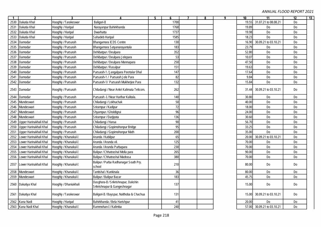
ANNUAL FLOOD REPORT 2021
1 2 3 4 5 6 7 8 9 10 11 12 13
2530 Dakatia Khal Hooghly / Tarakeswar Baligori-II 1700 19.55 31.07.21 to 08.08.21 Do
2531 Dakatia Khal Hooghly / Haripal Narayanpur Bahirkhanda 1768 19.89 Do Do
2532 Dakatia Khal Hooghly / Haripal Dwarhatta 1737 19.98 Do Do
2533 Dakatia Khal Hooghly / Haripal Sahadeb Haripal 1585 18.23 Do Do
2534 Damodar Hooghly / Pursurah Bhangamora ICDS Centre 130 16.90 30.09.21 to 03.10.21 Do
2535 Damodar Hooghly / Pursurah Bhangamora Satyanarayantala 183 23.79 Do Do
2536 Damodar Hooghly / Pursurah Dehibatpur / Deulpara 352 52.80 Do Do
2537 Damodar Hooghly / Pursurah Dehibatpur / Deulpara Jelepara 53 10.07 Do Do
2538 Damodar Hooghly / Pursurah Dehibatpur / Deulpara Mannapara 250 47.50 Do Do
2539 Damodar Hooghly / Pursurah Dehibatpur / Rasulpur 151 19.63 Do Do
2540 Damodar Hooghly / Pursurah Pursurah-1 / Jangalpara Peertalar Dhal 147 17.64 Do Do
2541 Damodar Hooghly / Pursurah Pursurah-1 / Pursurah Jele Para 82 9.84 Do Do
2542 Damodar Hooghly / Pursurah Pursurah-1/ Pursurah Mukherjee Para 132 15.84 Do Do
2543 Damodar Hooghly / Pursurah Chiladangi / Near Ankri Kalimata Telicom. 262 31.44 30.09.21 to 03.10.21 Do
2544 Damodar Hooghly / Pursurah Pursurah -I / Near Harihar Kalitala. 140 30.80 Do Do
2545 Mundeswari Hooghly / Pursurah Chiladangi / Lokhuchak 50 40.00 Do Do
2546 Mundeswari Hooghly / Pursurah Srirampur / Kadipur 72 18.00 Do Do
2547 Mundeswari Hooghly / Pursurah Shyampur / Gholdigrui 96 24.00 Do Do
2548 Mundeswari Hooghly / Pursurah Srirampur / Darjipota 136 30.60 Do Do
2549 Upper Harinakhali Khal Hooghly / Pursurah Chiladangi / Harua 90 56.70 Do Do
2550 Upper Harinakhali Khal Hooghly / Pursurah Chiladangi / Gopimohonpur Bridge 95 33.25 Do Do
2551 Upper Harinakhali Khal Hooghly / Pursurah Chiladangi / Gopimohonpur Math 200 35.00 Do Do
2552 Lower Harinakhali Khal Hooghly / Khanakul-I Arunda / Kabilpur 65 20.00 30.09.21 to 03.10.21 Do
2553 Lower Harinakhali Khal Hooghly / Khanakul-I Arunda / Arunda vil. 125 70.00 Do Do
2554 Lower Harinakhali Khal Hooghly / Khanakul-I Arunda / Arunda Purbapara 230 70.00 Do Do
2555 Lower Harinakhali Khal Hooghly / Khanakul-I Balipur / Chhatrashal Molla para 265 90.00 Do Do
2556 Lower Harinakhali Khal Hooghly / Khanakul-I Balipur / Chhatrashal Madrasa 380 70.00 Do Do
2557 Lower Harinakhali Khal Hooghly / Khanakul-I Balipur / Purba Radhanagar South Pry.
school 210 80.00 Do Do
2558 Mundeswari Hooghly / Khanakul-I Tantishal / Kunkinala 36 80.00 Do Do
2559 Mundeswari Hooghly / Khanakul-I Balipur / Balipur Bazar 183 45.75 Do Do
2560 Dakatiya Khal Hooghly / DhaniakhaliDasghora-II / Srikrishnapur, Dakshin
Srikrishnapur & Gangeshnagar137 15.00 Do Do
2561 Dakatiya Khal Hooghly / Tarakeswar Baligori-II / Bayspur, Nalthoba & Chachua 131 15.00 30.09.21 to 03.10.21 Do
2562 Kana Nadi Hooghly / Haripal Bahirkhanda / Bela Harishpur 41 20.00 Do Do
2563 Kana Nadi Khal Hooghly / Khanakul-I Rammohan-I / Kalimba 240 57.00 30.09.21 to 03.10.21 Do
Dam
odar
Irrig
atio
n C
ircle
: Mem
o N
o: 5
79, D
ated
: 22.
03.2
022
& E
mai
l fro
m E
E/L
DID
-I D
ated
11.
05.2
022.
74.98
Page 218

ANNUAL FLOOD REPORT 2021
1 2 3 4 5 6 7 8 9 10 11 12 13
2564 Dakatia khal Hooghly / Jangipara Radhanagar / Srihatta 2 20.00 Do Do
2565 Dakatia khal Hooghly / Jangipara Kotulpur / Khandapukur 1 6.75 Do Do
2566 Mundeswari Hooghly / Arambagh Harinkhola-I / Arunbera vil. 50 25.00 Do Do
2567 Mundeswari Hooghly / Arambagh Harinkhola-II / Gholtazpur 30 20.00 Do Do
2568 Kananadi Khal Hooghly / Arambagh Arandi-II / Raipur 70 14.37 Do Do
2569 Kananadi Khal Hooghly / Arambagh Arandi-II / Dakshin Narayanpur 120 24.22 Do Do
2570 Kananadi Khal Hooghly / Khanakul-I Rammohon-II / Khamargori 140 28.03 Do Do
2571 Mundeswari Hooghly / Khanakul-I Tantishal / Udna 220 51.96 Do Do
2572 Mundeswari Hooghly / Pursurah Shrirampur / Dhanpota 130 27.49 Do Do
2573 Mundeswari Hooghly / Pursurah Shyampur / Baradigrui 40 19.22 Do Do
2574 Mundeswari Hooghly / Pursurah Shyampur / Baradigrui Purbapara 300 59.63 30.09.21 to 03.10.21 Do
2575 Mundeswari Hooghly / Pursurah Shyampur / Baradigrui Khanpara 100 20.18 Do Do
2576 Mundeswari Hooghly / Pursurah Shyampur / Digruighat 75 15.38 Do Do
2577 Mundeswari Hooghly / Arambagh Arandi-II / Chandraban 150 30.70 Do Do
2578 Upper Harinakhali Khal Hooghly / Pursurah Chiladangi / Chiladangi 35 20.00 Do Do
2579 Upper Harinakhali Khal Hooghly / Pursurah Shrirampur / Hati 35 20.00 Do Do
2580 Upper Harinakhali Khal Hooghly / Pursurah Pursurah-II / Routara 30 20.00 Do Do
2581 Kana Darakeswar Khal Hooghly / Khanakul-1 Pole-II / Saibona vil. 440 45.58 Do Do
2582 Mundeswari Hooghly / Khanakul-1 Arunda / Kabilpur 320 69.99 Do Do
2583 Mundeswari Hooghly / Khanakul-1 Rammohon-I / Sarda 35 20.00 Do Do
2584 Lower Harinakhali Khal Hooghly / Khanakul-1 Balipur/Radhanagar Aima Banstala 240 47.59 Do Do
2585 Kananadi Khal Hooghly / Khanakul-1 Rammohon-II / Khedial 60 16.65 Do Do
2586 Lower Harinakhali Khal Hooghly / Khanakul-2 Arunda / Arunda Majhar Char 250 49.88 Do Do
2587 Lower Harinakhali Khal Hooghly / Khanakul-3 Arunda / Par Chabbishpur 200 39.97 Do Do
2588 Lower Harinakhali Khal Hooghly / Khanakul-4 Arunda / Solaasta 350 70.96 Do Do
2589 Upper Harinakhali Khal Hooghly / Pursurah Kelepara / Tokipur 30 5.26 Do Do
2590 Upper Harinakhali Khal Hooghly / Pursurah Kelepara / Keshabpur 160 20.68 Do Do
2591 Mundeswari Hooghly / Pursurah Srirampur/ Kadipur Poramanikpara 200 39.39 Do Do
2592 Mundeswari Hooghly / Pursurah Shrirampur / Kadipur Bagpara 300 39.62 Do Do
2593 Mundeswari Hooghly / Pursurah Shrirampur / Bheuta RLI 83 16.47 Do Do
2594 Hurhura Khal Hooghly / Khanakul-II Natibpur-II / Talgope Balpai 130 24.47 Do Do
2595 Hurhura Khal Hooghly / Khanakul-II Palaspai-II / Narendrapur 145 26.93 Do Do
2596 Hurhura Khal Hooghly / Khanakul-II Palaspai-II / Narendrapur Taltala 84 27.53 Do Do
2597 Damodar R. Purba Bardhaman /Jamalpur Jarogram / Sajmantala, Adibasipara/ Uttar
Mohanpur
2598 Damodar R. Purba Bardhaman /Jamalpur Jarogram / Amarpur Ferighat, Bartikra,
Nandanpur/ Uttar Mohanpur24.24 30.09.21 to 02.10.21
Dam
odar
Irrig
atio
n C
ircle
: Mem
o N
o: 5
79, D
ated
: 22.
03.2
022
& E
mai
l fro
m E
E/L
DID
-I D
ated
11.
05.2
022.
1250
74.98
Page 219

ANNUAL FLOOD REPORT 2021
1 2 3 4 5 6 7 8 9 10 11 12 13
2599 Damodar R. Purba Bardhaman /Jamalpur
Chakdighi / Sonargoria, Dhapdhara,
Paikpara, Jyotchand / Sonargoria,
Dhapdhara, Paikpara, Jyotchand
2600 Damodar R. Purba Bardhaman /Jamalpur Chakdighi / Haragobindapur
2601 Uppar Rampur Channel Hoogly,Khanakui-II Balaichak , Chingra G.P 52 5.75 02.08.21
2602 Uppar Rampur Channel Hoogly,Khanakui-II Balaichak , Chingra G.P 970 6.79 02.08.21
2603 Uppar Rampur Channel Hoogly,Khanakui-II Balaichak , Chingra G.P 970 6.79 02.10.21
2604 Uppar Rampur Channel Hoogly,Khanakui-II 24 Pur Bazar Chingra G.P 430 3.01 02.08.21
2605 Uppar Rampur Channel Hoogly,Khanakui-II 24 Pur Bazar Chingra G.P 430 3.01 02.10.21
2606 Uppar Rampur Channel Hoogly,Khanakui-II Chingra, Chingra G.P 900 6.30 02.08.21
2607 Uppar Rampur Channel Hoogly,Khanakui-II Chingra, Chingra G.P 900 6.30 02.10.21
2608 Uppar Rampur Channel Hoogly,Khanakui-I Ramsaran,Arunda G.P 30 4.60 02.08.21
2609 Uppar Rampur Channel Hoogly,Khanakui-I Ramsaran,Arunda G.P 460 3.22 02.08.22
2610 Uppar Rampur Channel Hoogly,Khanakui-I Ramsaran,Arunda G.P 460 3.22 02.10.21
2611 Uppar Rampur Channel Howrah/Udaynarayanpur Harali G.P 440 2.64 02.08.21
2612 Uppar Rampur Channel Howrah/Udaynarayanpur Harali G.P 220 1.32 02.10.21
2613 Uppar Rampur Channel Howrah/Udaynarayanpur Harali G.P 28 2.30 02.10.21
2614 Uppar Rampur Channel Howrah/Udaynarayanpur Harali G.P 17 1.80 02.10.21
2615 Damodar Howrah/Udaynarayanpur Chak thakurani/ Singti/ Chak thakurani. 55 59 95.00 01.08.21
2616 Damodar Howrah/Udaynarayanpur Shibanipur (main)/Singti/ Shibanipur. 20 24 42.00 01.08.21
2617 Damodar Howrah/Udaynarayanpur Shibanipur ring bundh-1/Singti 33 37 35.00 01.08.21
2618 Damodar Howrah/Udaynarayanpur Shibanipur ring bundh-2/Singti 22 26 24.00 01.08.21
2619 Damodar Howrah/Udaynarayanpur Shibanipur ring bundh-3/Singti 13 17 18.00 01.08.21
2620 Damodar Howrah/Udaynarayanpur Shibanipur ring bundh-4/Singti 20 24 22.00 01.08.21
2621 Damodar Howrah/Udaynarayanpur Shibanipur ring bundh-5/Singti 13 17 16.00 01.08.21
2622 Damodar Howrah/Udaynarayanpur Shibanipur ring bundh-6/Singti 20 24 26.00 01.08.21
2623 Damodar Howrah/Udaynarayanpur Ghola Mandalpara /RDA/ Ghola. 13 17 20.00 01.08.21
2624 Damodar Howrah/Udaynarayanpur Ghola Masjidtala/RDA/ Ghola. 27 31 33.00 01.08.21
2625 Damodar Howrah/Udaynarayanpur Ghola Playground /RDA/ Ghola. 12 16 18.00 01.08.21
2626 Damodar Howrah/Udaynarayanpur Pathaiguri/Garh Bhabanipur /Bhabanipur 20 24 14.00 30.09.21
2627 Damodar Howrah/Udaynarayanpur Mansukha/Kanuput Mansuka/ Mansuka 33 37 75.00 30.09.21
2628 Damodar Howrah/Udaynarayanpur Jaynagar-1 /Singti/ Jaynagar 12 16 12.00 30.09.21
2629 Damodar Howrah/Udaynarayanpur Jaynagar-2 /Singti/ Jaynagar 30 34 45.00 30.09.21
2630 Damodar Howrah/Udaynarayanpur Akna-1/Singti/ Akna Dwittia 20 24 10.00 30.09.21
2631 Damodar Howrah/Udaynarayanpur Akna-2/Singti/ Akna Dwittia 15 19 11.00 30.09.21
2632 Damodar Howrah/Udaynarayanpur Shibanipur Main/Singti/ Shibanipur 21 25 13.00 30.09.21
2633 Damodar Howrah/Udaynarayanpur Ghola Janapara /RDA/ Ghola. 56 60 42.00 30.09.21
330.67
24.24 30.09.21 to 02.10.21
APD-DMPU-II under WBMIFMP
Add
ition
al P
roje
ct D
irect
or-I
V, D
MP
U-I
I Und
er W
BM
IFM
P, M
emo:
200
-DP
MU
-II,
Dat
ed: 2
8.03
.22
(Em
ai fr
om C
E/P
D, D
t: 28
.03.
22)
& E
mai
l of A
PD
-IV
, Dtd
. 27.
04.2
2D
amod
ar Ir
rigat
ion
Circ
le: M
emo
No:
579
, Dat
ed: 2
2.03
.202
2 &
Em
ail f
rom
EE
/LD
ID-I
Dat
ed 1
1.05
.202
2.
1250
74.98
Page 220

ANNUAL FLOOD REPORT 2021
1 2 3 4 5 6 7 8 9 10 11 12 13
2634 Damodar Howrah/Udaynarayanpur Ghola Mandalpara-1 /RDA/ Ghola. 10 14 9.00 30.09.21
2635 Damodar Howrah/Udaynarayanpur Ghola Mandalpara-2 /RDA/ Ghola. 15 19 12.00 30.09.21
2636 Damodar Howrah/Udaynarayanpur Ghola Mandalpara-3 /RDA/ Ghola. 17 21 16.00 30.09.21
2637 Damodar Howrah/Udaynarayanpur Ghola Playground /RDA/ Ghola 10 14 8.00 30.09.21
2638 Damodar Howrah/UN Pur/ Penro. Simchak/Khila /Kalyanckhak 300 150 22.00 30.09.21
2639 Damodar Howrah/Amta I/Penro. Baguya/ Balichak/ Baje Pratap. 250 210 24.00 30.09.21
2640 Damodar Hooghly, Block & PS-
Jangipara
GP -Rajbalhat-1& Rashidpur, vil.-
Shibchak& Harihar 100 40.00 03.08.21
2641 Hurhurah Hooghly/ Khanakul-II Bhuktapara [Palaspai-I/Mostafapur] 155 2.50 31.07.21
2642 Hurhurah Hooghly/ Khanakul-II Malikpara [Palaspai-I/Mostafapur] 180 3.27 02.08.21
2643 Hurhurah Hooghly/ Khanakul-II Talghugi [Palaspai-I/palaspai/Palaspai] 85 1.85 31.07.21
2644 Hurhurah Hooghly/ Khanakul-II Mondal Para [Palaspai-I/Palaspai] 117 2.10 01.08.21
2645 Hurhurah Hooghly/ Khanakul-II Muchighata [Palaspai-I/Palaspai] 275 3.18 31.07.21
2646 Hurhurah Howrah/Amta-II/ Joypur Giri Para [Bhatora/ Uttar Bhatora] 200 2.25 01.08.21
2647 Hurhurah Hooghly/ Khanakul-IIMustafapur Gandhi High School [Palaspai-
I/Mostafapur/Mostafapur]177 1.95 01.10.21
2648 Hurhurah Hooghly/ Khanakul-IINear Mustafapur Sluice [Palaspai-
I/Mostafapur/ Mostafapur]155 1.72 03.10.21
2649 Hurhurah Hooghly/ Khanakul-II/
Khamakul
Mustafapur Santra Para [Palaspai-
I/Mostafapur/ Mostafapur]135 1.90 02.10.21
2650 Hurhurah Hooghly/ Khanakul-II Shee Para [Palaspai-I/Palaspai] 178 2.23 01.10.21
2651 Hurhurah Hooghly/ Khanakul-IINear Muchighata Gauge [Palaspai-I
/Palaspai]163 1.23 30.09.21
2652 Hurhurah Howrah/Amta-II/ Joypur Gayen Para [Bhatora/Uttar Bhatora] 195 2.17 03.10.21
2653 Hurhurah Howrah/Amta-II/ Joypur Raj Banshi Para [Bhatora/Uttar Bhatora] 200 2.05 02.10.21
2654 Hurhurah Howrah/Amta-II/ JoypurBally Bundh Para [Ghoraberia
Chitnan/Kulia/ Ghoraberia]220 2.15 02.10.21
Total= 17896 742696 188598 985 2601.36 67098
330.67
Add
ition
al P
roje
ct D
irect
or-I
V, D
MP
U-I
I Und
er W
BM
IFM
P, M
emo:
200
-DP
MU
-II,
Dat
ed: 2
8.03
.22
(Em
ai fr
om C
E/P
D, D
t: 28
.03.
22)
& E
mai
l of A
PD
-IV
, Dtd
. 27.
04.2
2
Page 221
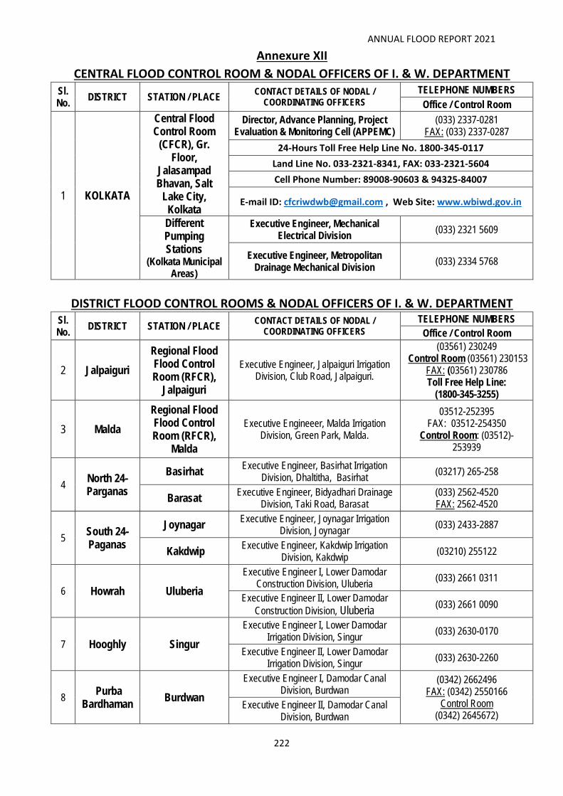
ANNUAL FLOOD REPORT 2021
222
Annexure XII
CENTRAL FLOOD CONTROL ROOM & NODAL OFFICERS OF I. & W. DEPARTMENT
Sl. No.
DISTRICT STATION / PLACE CONTACT DETAILS OF NODAL /
COORDINATING OFFICERS
TELEPHONE NUMBERS
Office / Control Room
1 KOLKATA
Central Flood Control Room
(CFCR), Gr. Floor,
Jalasampad Bhavan, Salt
Lake City, Kolkata
Director, Advance Planning, Project Evaluation & Monitoring Cell (APPEMC)
(033) 2337-0281 FAX: (033) 2337-0287
24-Hours Toll Free Help Line No. 1800-345-0117
Land Line No. 033-2321-8341, FAX: 033-2321-5604
Cell Phone Number: 89008-90603 & 94325-84007
E-mail ID: [email protected] , Web Site: www.wbiwd.gov.in
Different Pumping Stations
(Kolkata Municipal Areas)
Executive Engineer, Mechanical Electrical Division
(033) 2321 5609
Executive Engineer, Metropolitan Drainage Mechanical Division
(033) 2334 5768
DISTRICT FLOOD CONTROL ROOMS & NODAL OFFICERS OF I. & W. DEPARTMENT Sl. No.
DISTRICT STATION / PLACE CONTACT DETAILS OF NODAL /
COORDINATING OFFICERS
TELEPHONE NUMBERS
Office / Control Room
2 Jalpaiguri
Regional Flood Flood Control Room (RFCR),
Jalpaiguri
Executive Engineer, Jalpaiguri Irrigation Division, Club Road, Jalpaiguri.
(03561) 230249 Control Room (03561) 230153
FAX: (03561) 230786 Toll Free Help Line:
(1800-345-3255)
3 Malda
Regional Flood Flood Control Room (RFCR),
Malda
Executive Engineeer, Malda Irrigation Division, Green Park, Malda.
03512-252395 FAX: 03512-254350
Control Room: (03512)-253939
4 North 24-Parganas
Basirhat Executive Engineer, Basirhat Irrigation
Division, Dhaltitha, Basirhat (03217) 265-258
Barasat Executive Engineer, Bidyadhari Drainage
Division, Taki Road, Barasat (033) 2562-4520 FAX: 2562-4520
5 South 24-Paganas
Joynagar Executive Engineer, Joynagar Irrigation
Division, Joynagar (033) 2433-2887
Kakdwip Executive Engineer, Kakdwip Irrigation
Division, Kakdwip (03210) 255122
6 Howrah Uluberia
Executive Engineer I, Lower Damodar Construction Division, Uluberia
(033) 2661 0311
Executive Engineer II, Lower Damodar
Construction Division, Uluberia (033) 2661 0090
7 Hooghly Singur
Executive Engineer I, Lower Damodar Irrigation Division, Singur
(033) 2630-0170
Executive Engineer II, Lower Damodar Irrigation Division, Singur
(033) 2630-2260
8 Purba
Bardhaman Burdwan
Executive Engineer I, Damodar Canal Division, Burdwan
(0342) 2662496 FAX: (0342) 2550166
Control Room (0342) 2645672)
Executive Engineer II, Damodar Canal Division, Burdwan

ANNUAL FLOOD REPORT 2021
223
Sl. No.
DISTRICT STATION / PLACE CONTACT DETAILS OF NODAL /
COORDINATING OFFICERS TELEPHONE NUMBERS
9 Paschim
Bardhaman
Durgapur Executive Engineer, Damodar Head
Works Division, Durgapur (0343) 2555640
(0343) 2002012 (Barrage)
Asansol Executive Engineer, Asansol Irrigation
Division, Asansol New Office
10 Bankura Bankura
Executive Engineer, Bankura Irrigation Division, Bankura
(03242) 254934
Khatra Executive Engineer, Kangsabati Canal
Divn.No.II, Khatra (03243) 255236
11 Purulia Purulia Executive Engineer, Purulia Irrigation
Division, Purulia 03252-222407
12 Jhargram Jhargram Executive Engineer,
Jhargram Flood Management & Planning Division, Jhargram
New Office
13 Paschim
Medinipur Midnapore
Executive Engineer, West Medinipur Division, Midnapore
(03222) 275373
14 Purba
Medinipur
Tamluk Executive Engneer, East Medinipur
Division, Tamluk (03228) 266889
Contai Executive Engineer, Contai Irrigation
Division, Contai (03220) 255162
FAX: (03220) 256436
15 Birbhum
Suri Executive Engineer, Mayurakshi Hd. Qtrs.
Division, Suri 03462-255229
Bolpur Executive Engineer, Mayurakshi South
Canals Division, Shyambati, Bolpur 03463-262256
Rampurhat Executive Engineer, Mayurakshi North
Canals Division, Rampurhat 03461-255039
16 Nadia Krishnanagar Executive Engineer, Nadia Irrigation
Division, Krishnanagar 03472-252451
17 Murshidabad Berhampore Executive Engineer, Berhampore Irrigation
Division, Berhampore 03482-250645
18 Uttar
Dinajpur Raigunj
Executive Engineer, North Dinajpur Irrigation Division
03523-252008
19 Dakshin Dinajpur
Balurghat Executive Engineer, South Dinajpur
Irrigation Division 03522-255113
20 Darjeeling Siliguri Executive Engineer, Siliguri Irrigation
Division, Mahanandapara, Siliguri 0353-2431842
21 Coochbehar Coochbehar Executive Engineer, Coochbehar Irrigation
Division, Coochbehar 03582-228305
Control Room: (03582) 229114
22 Alipurduar Alipurduar Executive Engineer, Alipurduar Irrigation
Division, Alipurduar 03564-255305
Control Room: (03564) 274198
23
Jalpaiguri (Control Rooms
under Teesta Barrage Project)
Gajoldoba Teesta Barrage Control Room 9064161095
Fulbari Mahananda Barrage Control Room (03532) 005612