Annual Flood Report 1997 - Irrigation & Waterways Department
Upload
khangminh22Category
view
1download
0
536
SUBCHAPTER P—PORTS AND WATERWAYS SAFETY
PART 160—PORTS AND WATERWAYS SAFETY—GENERAL
Subpart A—General
Sec. 160.1 Purpose. 160.3 Definitions. 160.5 Delegations. 160.7 Appeals.
Subpart B—Control of Vessel and Facility Operations
160.101 Purpose. 160.103 Applicability. 160.105 Compliance with orders. 160.107 Denial of entry. 160.109 Waterfront facility safety. 160.111 Special orders applying to vessel op-
erations. 160.113 Prohibition of vessel operation and
cargo transfers. 160.115 Withholding of clearance.
Subpart C—Notifications of Arrival, Haz-ardous Conditions, and Certain Dan-gerous Cargoes
160.201 General. 160.202 Applicability. 160.203 Exemptions. 160.204 Definitions. 160.206 Information required in an NOA. 160.208 Changes to a submitted NOA. 160.210 Methods for submitting an NOA. 160.212 When to submit an NOA. 160.214 Waivers. 160.215 Notice of hazardous conditions.
Subpart D—Crewmember Identification
160.300 Applicability. 160.305 Exceptions. 160.310 Definitions. 160.315 Crewmember identification require-
ment. 160.320 Sanctions and vessel control.
AUTHORITY: 33 U.S.C. 1223, 1231; 46 U.S.C. Chapter 701; Department of Homeland Secu-rity Delegation No. 0170.1. Subpart C is also issued under the authority of 33 U.S.C. 1225 and 46 U.S.C. 3715.
SOURCE: CGD 79–026, 48 FR 35404, Aug. 4, 1983, unless otherwise noted.
Subpart A—General
§ 160.1 Purpose. (a) This subchapter contains regula-
tions implementing the Ports and Wa-
terways Safety Act (33 U.S.C. 1221) and related statutes.
§ 160.3 Definitions.
For the purposes of this subchapter: Bulk means material in any quantity
that is shipped, stored, or handled without the benefit of package, label, mark or count and carried in integral or fixed independent tanks.
Captain of the Port means the Coast Guard officer designated by the Com-mandant to command a Captain of the Port Zone as described in part 3 of this chapter.
Commandant means the Commandant of the United States Coast Guard.
Deviation means any departure from any rule in this subchapter.
Director, Vessel Traffic Services means the Coast Guard officer designated by the Commandant to command a Vessel Traffic Service (VTS) as described in part 161 of this chapter.
District Commander means the Coast Guard officer designated by the Com-mandant to command a Coast Guard District as described in part 3 of this chapter.
ETA means estimated time of arrival. Length of Tow means, when towing
with a hawser, the length in feet from the stern of the towing vessel to the stern of the last vessel in tow. When pushing ahead or towing alongside, length of tow means the tandem length in feet of the vessels in tow excluding the length of the towing vessel.
Person means an individual, firm, corporation, association, partnership, or governmental entity.
State means each of the several States of the United States, the Dis-trict of Columbia, the Commonwealth of Puerto Rico, Guam, American Samoa, the United States Virgin Is-lands, the Trust Territories of the Pa-cific Islands, the Commonwealth of the Northern Marianas Islands, and any other commonwealth, territory, or pos-session of the United States.
Tanker means a self-propelled tank vessel constructed or adapted pri-marily to carry oil or hazardous mate-rials in bulk in the cargo spaces.
VerDate Mar<15>2010 07:59 Sep 03, 2010 Jkt 220131 PO 00000 Frm 00546 Fmt 8010 Sfmt 8010 Y:\SGML\220131.XXX 220131erow
e on
DS
K5C
LS3C
1PR
OD
with
CF
R

537
Coast Guard, DHS § 160.7
Tank Vessel means a vessel that is constructed or adapted to carry, or that carries, oil or hazardous material in bulk as cargo or cargo residue.
Vehicle means every type of convey-ance capable of being used as a means of transportation on land.
Vessel means every description of watercraft or other artificial contriv-ance used, or capable of being used, as a means of transportation on water.
Vessel Traffic Services (VTS) means a service implemented under part 161 of this chapter by the United States Coast Guard designed to improve the safety and efficiency of vessel traffic and to protect the environment. The VTS has the capability to interact with marine traffic and respond to traf-fic situations developing in the VTS area.
Vessel Traffic Service Area or VTS Area means the geographical area encom-passing a specific VTS area of service as described in part 161 of this chapter. This area of service may be subdivided into sectors for the purpose of allo-cating responsibility to individual Ves-sel Traffic Centers or to identify dif-ferent operating requirements.
NOTE: Although regulatory jurisdiction is limited to the navigable waters of the United States, certain vessels will be encouraged or may be required, as a condition of port entry, to report beyond this area to facili-tate traffic management within the VTS area.
VTS Special Area means a waterway within a VTS area in which special op-erating requirements apply.
[CGD 90–020, 59 FR 36323, July 15, 1994, as amended at USCG–2010–0351, 75 FR 36286, June 25, 2010]
§ 160.5 Delegations. (a) District Commanders and Cap-
tains of the Ports are delegated the au-thority to establish safety zones.
(b) Under the provisions of §§ 6.04–1 and 6.04–6 of this chapter, District Commanders and Captains of the Ports have been delegated authority to estab-lish security zones.
(c) Under the provisions of § 1.05–1 of this chapter, District Commanders have been delegated authority to estab-lish regulated navigation areas.
(d) Subject to the supervision of the cognizant Captain of the Port and Dis-
trict Commander, Directors, Vessel Traffic Services are delegated author-ity under 33 CFR 1.01–30 to discharge the duties of the Captain of the Port that involve directing the operation, movement, and anchorage of vessels within a Vessel Traffic Service area in-cluding management of vessel traffic within anchorages, regulated naviga-tion areas and safety zones, and to en-force Vessel Traffic Service and ports and waterways safety regulations. This authority may be exercised by Vessel Traffic Center personnel. The Vessel Traffic Center may, within the Vessel Traffic Service area, provide informa-tion, make recommendations, or, to a vessel required under part 161 of this chapter to participate in a Vessel Traf-fic Service, issue an order, including an order to operate or anchor as directed; require the vessel to comply with or-ders issued; specify times of entry, movement or departure; restrict oper-ations as necessary for safe operation under the circumstances; or take other action necessary for control of the ves-sel and the safety of the port or of the marine environment.
[CGD 79–026, 48 FR 35404, Aug. 4, 1983, as amended by CGD 88–037, 53 FR 21815, June 10, 1988; CGD 90–020, 59 FR 36324, July 15, 1994; USCG–2010–0351, 75 FR 36287, June 25, 2010]
§ 160.7 Appeals. (a) Any person directly affected by a
safety zone or an order or direction issued under this subchapter may re-quest reconsideration by the official who issued it or in whose name it was issued. This request may be made oral-ly or in writing, and the decision of the official receiving the request may be rendered orally or in writing.
(b) Any person directly affected by the establishment of a safety zone or by an order or direction issued by, or on behalf of, a Captain of the Port may appeal to the District Commander through the Captain of the Port. The appeal must be in writing, except as al-lowed under paragraph (e) of this sec-tion, and shall contain complete sup-porting documentation and evidence which the appellant wishes to have considered. Upon receipt of the appeal, the District Commander may direct a representative to gather and submit documentation or other evidence which
VerDate Mar<15>2010 07:59 Sep 03, 2010 Jkt 220131 PO 00000 Frm 00547 Fmt 8010 Sfmt 8010 Y:\SGML\220131.XXX 220131erow
e on
DS
K5C
LS3C
1PR
OD
with
CF
R

538
33 CFR Ch. I (7–1–10 Edition) § 160.101
would be necessary or helpful to a reso-lution of the appeal. A copy of this doc-umentation and evidence is made available to the appellant. The appel-lant is afforded five working days from the date of receipt to submit rebuttal materials. Following submission of all materials, the District Commander issues a ruling, in writing, on the ap-peal. Prior to issuing the ruling, the District Commander may, as a matter of discretion, allow oral presentation on the issues.
(c) Any person directly affected by the establishment of a safety zone or by an order or direction issued by, or on behalf of, a District Commander, or who receives an unfavorable ruling on an appeal taken under paragraph (b) of this section may appeal to the Area Commander through the District Com-mander. The appeal must be in writing, except as allowed under paragraph (e) of this section, and shall contain com-plete supporting documentation and evidence which the appellant wishes to have considered. Upon receipt of the appeal, the Area Commander may di-rect a representative to gather and submit documentation or other evi-dence which would be necessary or helpful to a resolution of the appeal. A copy of this documentation and evi-dence is made available to the appel-lant. The appellant is afforded five working days from the date of receipt to submit rebuttal materials. Fol-lowing submission of all materials, the Area Commander issues a ruling, in writing, on the appeal. Prior to issuing the ruling, the Area Commander may, as a matter of discretion, allow oral presentation on the issues.
(d) Any person who receives an unfa-vorable ruling on an appeal taken under paragraph (c) of this section, may appeal through the Area Com-mander to the Assistant Commandant for Prevention (formerly known as the Assistant Commandant for Marine Safety, Security and Environmental Protection), U.S. Coast Guard, (CG–5), 2100 2nd St. SW., Stop 7355, Wash-ington, DC 20593–7355. The appeal must be in writing, except as allowed under paragraph (e) of this section. The Area Commander forwards the appeal, all the documents and evidence which formed the record upon which the order
or direction was issued or the ruling under paragraph (c) of this section was made, and any comments which might be relevant, to the Assistant Com-mandant for Prevention. A copy of this documentation and evidence is made available to the appellant. The appel-lant is afforded five working days from the date of receipt to submit rebuttal materials to the Assistant Com-mandant for Prevention. The decision of the Assistant Commandant for Pre-vention is based upon the materials submitted, without oral argument or presentation. The decision of the As-sistant Commandant for Prevention is issued in writing and constitutes final agency action.
(e) If the delay in presenting a writ-ten appeal would have significant ad-verse impact on the appellant, the ap-peal under paragraphs (b) and (c) of this section may initially be presented orally. If an initial presentation of the appeal is made orally, the appellant must submit the appeal in writing within five days of the oral presen-tation to the Coast Guard official to whom the presentation was made. The written appeal must contain, at a min-imum, the basis for the appeal and a summary of the material presented orally. If requested, the official to whom the appeal is directed may stay the effect of the action while the ruling is being appealed.
[CGD 79–026, 48 FR 35404, Aug. 4, 1983, as amended by CGD 88–052, 53 FR 25122, July 1, 1988; CGD 96–026, 61 FR 33668, June 28, 1996; CGD 97–023, 62 FR 33364, June 19, 1997; USCG– 2002–12471, 67 FR 41333, June 18, 2002; USCG– 2006–25150, 71 FR 39211, July 12, 2006; 72 FR 17409, Apr. 9, 2007; USCG–2010–0351, 75 FR 36287, June 25, 2010]
Subpart B—Control of Vessel and Facility Operations
§ 160.101 Purpose.
This subpart describes the authority exercised by District Commanders and Captains of the Ports to insure the safety of vessels and waterfront facili-ties, and the protection of the navi-gable waters and the resources therein. The controls described in this subpart are directed to specific situations and hazards.
VerDate Mar<15>2010 07:59 Sep 03, 2010 Jkt 220131 PO 00000 Frm 00548 Fmt 8010 Sfmt 8010 Y:\SGML\220131.XXX 220131erow
e on
DS
K5C
LS3C
1PR
OD
with
CF
R

539
Coast Guard, DHS § 160.113
§ 160.103 Applicability. (a) This subpart applies to any— (1) Vessel on the navigable waters of
the United States, except as provided in paragraphs (b) and (c) of this sec-tion;
(2) Bridge or other structure on or in the navigable waters of the United States; and
(3) Land structure or shore area im-mediately adjacent to the navigable waters of the United States.
(b) This subpart does not apply to any vessel on the Saint Lawrence Sea-way.
(c) Except pursuant to international treaty, convention, or agreement, to which the United States is a party, this subpart does not apply to any foreign vessel that is not destined for, or de-parting from, a port or place subject to the jurisdiction of the United States and that is in:
(1) Innocent passage through the ter-ritorial sea of the United States;
(2) Transit through the navigable wa-ters of the United States which form a part of an international strait.
§ 160.105 Compliance with orders. Each person who has notice of the
terms of an order issued under this sub-part must comply with that order.
§ 160.107 Denial of entry. Each District Commander or Captain
of the Port, subject to recognized prin-ciples of international law, may deny entry into the navigable waters of the United States or to any port or place under the jurisdiction of the United States, and within the district or zone of that District Commander or Captain of the Port, to any vessel not in com-pliance with the provisions of the Port and Tanker Safety Act (33 U.S.C. 1221– 1232) or the regulations issued there-under.
§ 160.109 Waterfront facility safety. (a) To prevent damage to, or the de-
struction of, any bridge or other struc-ture on or in the navigable waters of the United States, or any land struc-ture or shore area immediately adja-cent to such waters, and to protect the navigable waters and the resources therein from harm resulting from ves-
sel or structure damage, destruction, or loss, each District Commander or Captain of the Port may:
(1) Direct the handling, loading, un-loading, storage, and movement (in-cluding the emergency removal, con-trol and disposition) of explosives or other dangerous articles and sub-stances, including oil or hazardous ma-terial as those terms are defined in 46 U.S.C. 2101 on any structure on or in the navigable waters of the United States, or any land structure or shore area immediately adjacent to those waters; and
(2) Conduct examinations to assure compliance with the safety equipment requirements for structures.
[CGD 79–026, 48 FR 35404, Aug. 4, 1983, as amended by USCG–1998–3799, 63 FR 35531, June 30, 1998]
§ 160.111 Special orders applying to vessel operations.
Each District Commander or Captain of the Port may order a vessel to oper-ate or anchor in the manner directed when:
(a) The District Commander or Cap-tain of the Port has reasonable cause to believe that the vessel is not in com-pliance with any regulation, law or treaty;
(b) The District Commander or Cap-tain of the Port determines that the vessel does not satisfy the conditions for vessel operation and cargo transfers specified in § 160.113; or
(c) The District Commander or Cap-tain of the Port has determined that such order is justified in the interest of safety by reason of weather, visibility, sea conditions, temporary port conges-tion, other temporary hazardous cir-cumstances, or the condition of the vessel.
§ 160.113 Prohibition of vessel oper-ation and cargo transfers.
(a) Each District Commander or Cap-tain of the Port may prohibit any ves-sel, subject to the provisions of chapter 37 of Title 46, U.S. Code, from operating in the navigable waters of the United States, or from transferring cargo or residue in any port or place under the jurisdiction of the United States, and within the district or zone of that Dis-trict Commander or Captain of the
VerDate Mar<15>2010 07:59 Sep 03, 2010 Jkt 220131 PO 00000 Frm 00549 Fmt 8010 Sfmt 8010 Y:\SGML\220131.XXX 220131erow
e on
DS
K5C
LS3C
1PR
OD
with
CF
R

540
33 CFR Ch. I (7–1–10 Edition) § 160.115
Port, if the District Commander or the Captain of the Port determines that the vessel’s history of accidents, pollu-tion incidents, or serious repair prob-lems creates reason to believe that the vessel may be unsafe or pose a threat to the marine environment.
(b) The authority to issue orders pro-hibiting operation of the vessels or transfer of cargo or residue under para-graph (a) of this section also applies if the vessel:
(1) Fails to comply with any applica-ble regulation;
(2) Discharges oil or hazardous mate-rial in violation of any law or treaty of the United States;
(3) Does not comply with applicable vessel traffic service requirements;
(4) While underway, does not have at least one deck officer on the naviga-tion bridge who is capable of commu-nicating in the English language.
(c) When a vessel has been prohibited from operating in the navigable waters of the United States under paragraphs (a) or (b) of this section, the District Commander or Captain of the Port may allow provisional entry into the navi-gable waters of the United States, or into any port or place under the juris-diction of the United States and within the district or zone of that District Commander or Captain of the Port, if the owner or operator of such vessel proves to the satisfaction of the Dis-trict Commander or Captain of the Port, that the vessel is not unsafe or does not pose a threat to the marine environment, and that such entry is necessary for the safety of the vessel or the persons on board.
(d) A vessel which has been prohib-ited from operating in the navigable waters of the United States, or from transferring cargo or residue in a port or place under the jurisdiction of the United States under the provisions of paragraph (a) or (b)(1), (2) or (3) of this section, may be allowed provisional entry if the owner or operator proves, to the satisfaction of the District Com-mander or Captain of the Port that has jurisdiction, that the vessel is no longer unsafe or a threat to the envi-ronment, and that the condition which
gave rise to the prohibition no longer exists.
[CGD 79–026, 48 FR 35404, Aug. 4, 1983, as amended by CGD 96–026, 61 FR 33668, June 28, 1996; USCG–1998–3799, 63 FR 35531, June 30, 1998; USCG–2006–24371, 74 FR 11212, Mar. 16, 2009]
§ 160.115 Withholding of clearance.
Each District Commander or Captain of the Port may request the Secretary of the Treasury, or the authorized rep-resentative thereof, to withhold or re-voke the clearance required by 46 U.S.C. App. 91 of any vessel, the owner or operator of which is subject to any penalties under 33 U.S.C. 1232.
[CGD 79–026, 48 FR 35404, Aug. 4, 1983; 48 FR 39059, Aug. 29, 1983, as amended by USCG– 1998–3799, 63 FR 35531, June 30, 1998]
Subpart C—Notification of Arrival, Hazardous Conditions, and Certain Dangerous Cargos
SOURCE: USCG–2002–11865, 68 FR 9543, Feb. 28, 2003, unless otherwise noted.
§ 160.201 General.
This subpart contains requirements and procedures for submitting Notices of Arrival (NOA) and Notice of Haz-ardous Condition. The sections in this subpart describe:
(a) Applicability and exemptions from requirements in this subpart;
(b) Required information in an NOA; (c) Required changes to an NOA; (d) Methods and times for submission
of an NOA and changes to an NOA; (e) How to obtain a waiver; and (f) Requirements for submission of
the Notice of Hazardous Conditions.
§ 160.202 Applicability.
(a) This subpart applies to U.S. and foreign vessels bound for or departing from ports or places in the United States.
(b) This subpart does not apply to U.S. recreational vessels under 46 U.S.C. 4301 et seq., but does apply to for-eign recreational vessels.
(c) Unless otherwise specified in this subpart, the owner, agent, master, op-erator, or person in charge of a vessel regulated by this subpart is responsible
VerDate Mar<15>2010 07:59 Sep 03, 2010 Jkt 220131 PO 00000 Frm 00550 Fmt 8010 Sfmt 8010 Y:\SGML\220131.XXX 220131erow
e on
DS
K5C
LS3C
1PR
OD
with
CF
R
541
Coast Guard, DHS § 160.204
for compliance with the requirements in this subpart.
(d) Towing vessels controlling a barge or barges required to submit an NOA under this subpart must submit only one NOA containing the informa-tion required for the towing vessel and each barge under its control.
[USCG–2002–11865, 68 FR 9543, Feb. 28, 2003, as amended by USCG–2004–19963, 70 FR 74669, Dec. 16, 2005]
§ 160.203 Exemptions. (a) Except for reporting notice of haz-
ardous conditions, the following vessels are exempt from requirements in this subpart:
(1) Passenger and supply vessels when they are employed in the exploration for or in the removal of oil, gas, or mineral resources on the continental shelf.
(2) Oil Spill Recovery Vessels (OSRVs) when engaged in actual spill response operations or during spill re-sponse exercises.
(3) Vessels operating upon the fol-lowing waters:
(i) Mississippi River between its sources and mile 235, Above Head of Passes;
(ii) Tributaries emptying into the Mississippi River above mile 235;
(iii) Atchafalaya River above its junction with the Plaquemine-Morgan City alternate waterway and the Red River; and
(iv) The Tennessee River from its confluence with the Ohio River to mile zero on the Mobile River and all other tributaries between those two points.
(b) If not carrying certain dangerous cargo or controlling another vessel car-rying certain dangerous cargo, the fol-lowing vessels are exempt from NOA requirements in this subpart:
(1) Vessels 300 gross tons or less, ex-cept for foreign vessels entering any port or place in the Seventh Coast Guard District as described in 33 CFR 3.35–1(b).
(2) Vessels operating exclusively within a Captain of the Port Zone.
(3) Vessels arriving at a port or place under force majeure.
(4) Towing vessels and barges oper-ating solely between ports or places in the continental United States.
(5) Public vessels.
(6) Except for tank vessels, U.S. ves-sels operating solely between ports or places in the United States on the Great Lakes.
(c) Vessels less than 500 gross tons need not submit the International Safety Management (ISM) Code Notice (Entry (7) to Table 160.206).
(d) Vessels operating solely between ports or places in the continental United States need not submit the Cargo Declaration (Customs Form 1302), (Entry (8) to Table 160.206).
(e) This section does not exempt any vessel from compliance with the U.S. Customs Service (USCS) reporting or submission requirements.
(f) U.S. vessels need not submit the International Ship and Port Facility Code (ISPS) Notice information (Entry (9) to Table 160.206).
[USCG–2002–11865, 68 FR 9543, Feb. 28, 2003, as amended by USCG–2003–14749, 68 FR 39313, July 1, 2003; 68 FR 63735, Nov. 10, 2003]
EFFECTIVE DATE NOTE: By USCG–2002– 11865, 68 FR 27908, May 22, 2003, in § 160.203, paragraphs (d) and (e) were suspended, effec-tive May 22, 2003.
§ 160.204 Definitions. As used in this subpart: Agent means any person, partnership,
firm, company or corporation engaged by the owner or charterer of a vessel to act in their behalf in matters con-cerning the vessel.
Barge means a non-self propelled ves-sel engaged in commerce.
Carried in bulk means a commodity that is loaded or carried on board a vessel without containers or labels and received and handled without mark or count.
Certain dangerous cargo (CDC) in-cludes any of the following:
(1) Division 1.1 or 1.2 explosives as de-fined in 49 CFR 173.50.
(2) Division 1.5D blasting agents for which a permit is required under 49 CFR 176.415 or, for which a permit is re-quired as a condition of a Research and Special Programs Administration ex-emption.
(3) Division 2.3 ‘‘poisonous gas’’, as listed in 49 CFR 172.101 that is also a ‘‘material poisonous by inhalation’’ as defined in 49 CFR 171.8, and that is in a quantity in excess of 1 metric ton per vessel.
VerDate Mar<15>2010 07:59 Sep 03, 2010 Jkt 220131 PO 00000 Frm 00551 Fmt 8010 Sfmt 8010 Y:\SGML\220131.XXX 220131erow
e on
DS
K5C
LS3C
1PR
OD
with
CF
R
542
33 CFR Ch. I (7–1–10 Edition) § 160.204
(4) Division 5.1 oxidizing materials for which a permit is required under 49 CFR 176.415 or for which a permit is re-quired as a condition of a Research and Special Programs Administration ex-emption.
(5) A liquid material that has a pri-mary or subsidiary classification of Di-vision 6.1 ‘‘poisonous material’’ as list-ed in 49 CFR 172.101 that is also a ‘‘ma-terial poisonous by inhalation,’’ as de-fined in 49 CFR 171.8 and that is in a bulk packaging, or that is in a quan-tity in excess of 20 metric tons per ves-sel when not in a bulk packaging.
(6) Class 7, ‘‘highway route controlled quantity’’ radioactive material or ‘‘fissile material, controlled ship-ment,’’ as defined in 49 CFR 173.403.
(7) Bulk liquefied chlorine gas and Bulk liquefied gas cargo that is flam-mable and/or toxic and carried under 46 CFR 154.7.
(8) The following bulk liquids: (i) Acetone cyanohydrin, (ii) Allyl alcohol, (iii) Chlorosulfonic acid, (iv) Crotonaldehyde, (v) Ethylene chlorohydrin, (vi) Ethylene dibromide, (vii) Methacrylonitrile, and (viii) Oleum (fuming sulfuric acid). (ix) Propylene oxide, alone or mixed
with ethylene oxide. (9) The following bulk solids: (i) Ammonium nitrate listed as a Di-
vision 5.1 (oxidizing) material in 49 CFR 172.101 that is not certain dan-gerous cargo residue (CDC residue).
(ii) Ammonium nitrate based fer-tilizer listed as a Division 5.1 (oxi-dizing) material in 49 CFR 172.101 that is not CDC residue.
Certain dangerous cargo residue (CDC residue) means ammonium nitrate in bulk or ammonium nitrate based fer-tilizer in bulk remaining after all sale-able cargo is discharged, not exceeding 1,000 pounds in total and not individ-ually accumulated in quantities ex-ceeding two cubic feet.
Charterer means the person or organi-zation that contracts for the majority of the carrying capacity of a ship for the transportation of cargo to a stated port for a specified period. This in-cludes ‘‘time charterers’’ and ‘‘voyage charterers.’’
Crewmember means all persons carried on board the vessel to provide naviga-tion and maintenance of the vessel, its machinery, systems, and arrangements essential for propulsion and safe navi-gation or to provide services for other persons on board.
Great Lakes means Lakes Superior, Michigan, Huron, Erie, and Ontario, their connecting and tributary waters, the Saint Lawrence River as far as Saint Regis, and adjacent port areas.
Gross tons means the tonnage deter-mined by the tonnage authorities of a vessel’s flag state in accordance with the national tonnage rules in force be-fore the entry into force of the Inter-national Convention on Tonnage Meas-urement of Ships, 1969 (‘‘Convention’’). For a vessel measured only under Annex I of the Convention, gross tons means that tonnage. For a vessel meas-ured under both systems, the higher gross tonnage is the tonnage used for the purposes of the 300-gross-ton threshold.
Hazardous condition means any condi-tion that may adversely affect the safe-ty of any vessel, bridge, structure, or shore area or the environmental qual-ity of any port, harbor, or navigable waterway of the United States. It may, but need not, involve collision, allision, fire, explosion, grounding, leaking, damage, injury or illness of a person aboard, or manning-shortage.
Nationality means the state (nation) in which a person is a citizen or to which a person owes permanent alle-giance.
Operator means any person including, but not limited to, an owner, a charterer, or another contractor who conducts, or is responsible for, the op-eration of a vessel.
Persons in addition to crewmembers mean any person onboard the vessel, including passengers, who are not in-cluded on the list of crewmembers.
Port or place of departure means any port or place in which a vessel is an-chored or moored.
Port or place of destination means any port or place in which a vessel is bound to anchor or moor.
Public vessel means a vessel that is owned or demise-(bareboat) chartered by the government of the United States, by a State or local government,
VerDate Mar<15>2010 07:59 Sep 03, 2010 Jkt 220131 PO 00000 Frm 00552 Fmt 8010 Sfmt 8010 Y:\SGML\220131.XXX 220131erow
e on
DS
K5C
LS3C
1PR
OD
with
CF
R

543
Coast Guard, DHS § 160.206
or by the government of a foreign country and that is not engaged in commercial service.
Time charterer means the party who hires a vessel for a specific amount of time. The owner and his crew manage the vessel, but the charterer selects the ports of destination.
Voyage charterer means the party who hires a vessel for a single voyage. The owner and his crew manage the vessel, but the charterer selects the ports of destination.
[USCG–2002–11865, 68 FR 9543, Feb. 28, 2003, as amended by USCG–2004–19963, 70 FR 74669, Dec. 16, 2005]
§ 160.206 Information required in an NOA. (a) Each NOA must contain all of the information items specified in Table
160.206.
TABLE 160.206—NOA INFORMATION ITEMS
Required information Vessels not carrying CDC
Vessels carrying CDC
Vessels
Towing ves-sels controlling
vessels car-rying CDC
(1) Vessel Information: (i) Name; .................................................................................................... X X X (ii) Name of the registered owner; ............................................................. X X X (iii) Country of registry; ............................................................................... X X X (iv) Call sign; .............................................................................................. X X X (v) International Maritime Organization (IMO) international number or, if
vessel does not have an assigned IMO international number, sub-stitute with official number; ..................................................................... X X X
(vi) Name of the operator; .......................................................................... X X X (vii) Name of the charterer; and ................................................................. X X X (viii) Name of classification society ............................................................ X X X
(2) Voyage Information: (i) Names of last five ports or places visited; ............................................ X X X (ii) Dates of arrival and departure for last five ports or places visited; ..... X X X (iii) For each port or place in the United States to be visited list the
names of the receiving facility, the port or place, the city, and the state; ....................................................................................................... X X X
(iv) For each port or place in the United States to be visited, the esti-mated date and time of arrival; .............................................................. X X X
(v) For each port or place in the United States to be visited, the esti-mated date and time of departure; ......................................................... X X X
(vi) The location (port or place and country) or position (latitude and lon-gitude or waterway and mile marker) of the vessel at the time of re-porting; and ............................................................................................. X X X
(vii) The name and telephone number of a 24-hour point of contact ....... X X X (3) Cargo Information:
(i) A general description of cargo, other than CDC, onboard the vessel (e.g.: grain, container, oil, etc.); ............................................................. X X X
(ii) Name of each certain dangerous cargo carried, including cargo UN number, if applicable; and ...................................................................... ........................ X X
(iii) Amount of each certain dangerous cargo carried ............................... ........................ X X (4) Information for each Crewmember Onboard:
(i) Full name; .............................................................................................. X X X (ii) Date of birth; ......................................................................................... X X X (iii) Nationality; ............................................................................................ X X X (iv) Passport or mariners document number (type of identification and
number); ................................................................................................. X X X (v) Position or duties on the vessel; and ................................................... X X X (vi) Where the crewmember embarked (list port or place and country) ... X X X
(5) Information for each Person Onboard in Addition to Crew: (i) Full name; .............................................................................................. X X X (ii) Date of birth; ......................................................................................... X X X (iii) Nationality; ............................................................................................ X X X (iv) Passport number; and ......................................................................... X X X (v) Where the person embarked (list port or place and country) .............. X X X
(6) Operational condition of equipment required by § 164.35 of this chapter .. X X X (7) International Safety Management (ISM) Code Notice:
(i) The date of issuance for the company’s Document of Compliance certificate that covers the vessel; ........................................................... X X X
VerDate Mar<15>2010 07:59 Sep 03, 2010 Jkt 220131 PO 00000 Frm 00553 Fmt 8010 Sfmt 8010 Y:\SGML\220131.XXX 220131erow
e on
DS
K5C
LS3C
1PR
OD
with
CF
R

544
33 CFR Ch. I (7–1–10 Edition) § 160.208
TABLE 160.206—NOA INFORMATION ITEMS—Continued
Required information Vessels not carrying CDC
Vessels carrying CDC
Vessels
Towing ves-sels controlling
vessels car-rying CDC
(ii) The date of issuance for the vessel’s Safety Management Certificate; and .......................................................................................................... X X X
(iii) The name of the Flag Administration, or the recognized organiza-tion(s) representing the vessel flag administration, that issued those certificates ............................................................................................... X X X
(8) Cargo Declaration (Customs Form 1302) as described in 19 CFR 4.7 ..... X X X (9) International Ship and Port Facility Code (ISPS) Notice *:
(i) The date of issuance for the vessel’s International Ship Security Cer-tificate (ISSC), if any; ............................................................................. X X X
(ii) Whether the ISSC, if any, is an initial Interim ISSC, subsequent and consecutive Interim ISSC, or final ISSC; ............................................... X X X
(iii) Declaration that the approved ship security plan, if any, is being im-plemented; .............................................................................................. X X X
(iv) If a subsequent and consecutive Interim ISSC, the reasons therefor; X X X (v) The name and 24-hour contact information for the Company Security
Officer; and ............................................................................................. X X X (vi) The name of the Flag Administration, or the recognized security or-
ganization(s) representing the vessel flag Administration that issued the ISSC. ................................................................................................ X X X
* The information required by items 9(i)-(iii) need not be submitted before January 1, 2004. All other information required by item 9 need not be submitted before July 1, 2004.
(b) Vessels operating solely between ports or places in the continental United States need submit only the name of and date of arrival and depar-ture for the last port or places visited to meet the requirements in entries (2)(i) and (ii) to Table 160.206 of this section.
(c) You may submit a copy of INS Form I–418 to meet the requirements of entries (4) and (5) in Table 160.206.
(d) Any vessel planning to enter two or more consecutive ports or places in the United States during a single voy-age may submit one consolidated Noti-fication of Arrival at least 96 hours be-fore entering the first port or place of destination. The consolidated notice must include the name of the port or place and estimated arrival and depar-ture date for each destination of the voyage. Any vessel submitting a con-solidated notice under this section must still meet the requirements of § 160.208 of this part concerning require-ments for changes to an NOA.
[USCG–2002–11865, 68 FR 9543, Feb. 28, 2003, as amended by USCG–2003–14749, 68 FR 39313, July 1, 2003; 68 FR 63735, Nov. 10, 2003]
EFFECTIVE DATE NOTE: By USCG–2002– 11865, 68 FR 27908, May 22, 2003, in § 160.206, in paragraph (a), item (8) in table 160.206 was suspended, effective May 22, 2003.
§ 160.208 Changes to a submitted NOA.
(a) Unless otherwise specified in this section, when submitted NOA informa-tion changes, vessels must submit a no-tice of change within the times re-quired in § 160.212.
(b) Changes in the following informa-tion need not be reported:
(1) Changes in arrival or departure times that are less than six (6) hours;
(2) Changes in vessel location or posi-tion of the vessel at the time of report-ing (entry (2)(vi) to Table 160.206); and
(3) Changes to crewmembers’ position or duties on the vessel (entry (5)(v) to Table 160.206).
(c) When reporting changes, submit only the name of the vessel, original NOA submission date, the port of ar-rival, the specific items to be cor-rected, and the new location or posi-tion of the vessel at the time of report-ing. Only changes to NOA information need to be submitted.
§ 160.210 Methods for submitting an NOA.
(a) Submission to the National Vessel Movement Center (NVMC). Except as provided in paragraphs (b) and (c) of this section, vessels must submit NOA information required by § 160.206 (en-tries 1 through 9 in Table 160.206) to the
VerDate Mar<15>2010 07:59 Sep 03, 2010 Jkt 220131 PO 00000 Frm 00554 Fmt 8010 Sfmt 8010 Y:\SGML\220131.XXX 220131erow
e on
DS
K5C
LS3C
1PR
OD
with
CF
R
545
Coast Guard, DHS § 160.212
NVMC, United States Coast Guard, 408 Coast Guard Drive, Kearneysville, WV 25430, by:
(1) Electronic submission via the electronic Notice of Arrival and Depar-ture (eNOAD) and consisting of the fol-lowing three formats:
(i) A Web site that can be used to submit NOA information directly to the NVMC, accessible from the NVMC web site at http://www.nvmc.uscg.gov;
(ii) Electronic submission of Exten-sible Markup Language (XML) for-matted documents via web service;
(iii) Electronic submission via Micro-soft InfoPath; contact the NVMC at [email protected] or by telephone at 1–800–708–9823 or 304–264–2502 for more information;
(2) E-mail at [email protected]. Workbook available at http:// www.nvmc.uscg.gov;
(3) Fax at 1–800–547–8724 or 304–264– 2684. Workbook available at http:// www.nvmc.uscg.gov; or,
(4) Telephone at 1–800–708–9823 or 304– 264–2502.
(b) Saint Lawrence Seaway transits. Those vessels transiting the Saint Lawrence Seaway inbound, bound for a port or place in the United States, may meet the submission requirements of paragraph (a) of this section by submit-ting the required information to the Saint Lawrence Seaway Development Corporation and the Saint Lawrence Seaway Management Corporation of Canada by fax at 315–764–3235 or at 315– 764–3200. The Cargo Declaration (Cus-toms Form 1302) in entry (8) in Table 160.206 must be submitted electroni-cally to the USCS, as required by para-graph (d) of this section.
(c) Seventh Coast Guard District. Those foreign vessels 300 or less gross tons op-erating in the Seventh Coast Guard District must submit an NOA to the cognizant Captain of the Port (COTP). The Cargo Declaration (Customs Form 1302) in entry (8) in Table 160.206 must be submitted electronically to the USCS, as required by paragraph (d) of this section.
(d) Submission to the United States Cus-toms Service’s Sea Automated Manifest System (AMS). (1) Beginning July 1, 2003, the Cargo Declaration (Customs Form 1302) in entry (8) in Table 160.206 must be submitted electronically to
the USCS Sea AMS by one of the fol-lowing methods:
(i) By direct connection with USCS or by purchasing the proper software; or
(ii) Using a service provider or a Port Authority.
(2) To become a participant in Sea AMS, submitters must provide a letter of intent to USCS prior to first submis-sion.
[USCG–2002–11865, 68 FR 9543, Feb. 28, 2003; 68 FR 63735, Nov. 10, 2003, as amended by USCG– 2004–19963, 70 FR 74669, Dec. 16, 2005]
EFFECTIVE DATE NOTE: By USCG–2002– 11865, 68 FR 27908, May 22, 2003, in § 160.210, the last sentence of paragraph (b), the last sentence of paragraph (c), and paragraph (d) were suspended, effective May 22, 2003.
§ 160.212 When to submit an NOA.
(a) Submission of NOA. (1) Except as set out in paragraph (a)(2) of this sec-tion, all vessels must submit NOAs within the times required in paragraph (a)(3) of this section.
(2) Towing vessels, when in control of a vessel carrying CDC and operating solely between ports or places in the continental United States, must sub-mit an NOA before departure but at least 12 hours before entering the port or place of destination.
(3) Times for submitting NOAs areas follows:
If your voyage time is— You must submit an NOA—
(i) 96 hours or more; or.
At least 96 hours before entering the port or place of destination; or
(ii) Less than 96 hours.
Before departure but at least 24 hours before entering the port or place of destination.
(b) Submission of changes to NOA. (1) Except as set out in paragraph (b)(2) of this section, vessels must submit changes in NOA information within the times required in paragraph (b)(3) of this section.
(2) Towing vessels, when in control of a vessel carrying CDC and operating solely between ports or places in the continental United States, must sub-mit changes to an NOA as soon as prac-ticable but at least 6 hours before en-tering the port or place of destination.
(3) Times for submitting changes to NOAs are as follows:
VerDate Mar<15>2010 07:59 Sep 03, 2010 Jkt 220131 PO 00000 Frm 00555 Fmt 8010 Sfmt 8010 Y:\SGML\220131.XXX 220131erow
e on
DS
K5C
LS3C
1PR
OD
with
CF
R

546
33 CFR Ch. I (7–1–10 Edition) § 160.214
If your remaining voyage time is—
Then you must submit changes to an NOA—
(i) 96 hours or more;.
As soon as practicable but at least 24 hours before entering the port or place of destination;
(ii) Less than 96 hours but not less than 24 hours; or
As soon as practicable but at least 24 hours before entering the port or place of destination; or
(iii) Less than 24 hours.
As soon as practicable but at least 12 hours before entering the port or place of destination.
(c) Submission of the Cargo Declaration (Customs Form 1302). (1) Except as set out in paragraph (c)(2) of this section, all vessels must submit to USCS the Cargo Declaration (Customs Form 1302) in entry (8) to Table 160.206, within the times required in paragraph (a)(3) of this section.
(2)(i) Except for vessels carrying con-tainerized cargo or break bulk cargo, vessels carrying bulk cargo may sub-mit the Cargo Declaration (Customs Form 1302), (Entry (8) to Table 160.206) before departure but at least 24 hours before entering the U.S. port or place of destination.
(ii) Vessels carrying break bulk cargo operating under a USCS exemption granted under 19 CFR 4.7(b)(4)(ii) may, during the effective period of the USCS exemption, submit the Cargo Declara-tion (Customs Form 1302), (Entry (8) to Table 160.206) before departure but at least 24 hours before entering the U.S. port or place of destination.
[USCG–2002–11865, 68 FR 9543, Feb. 28, 2003; 68 FR 63735, Nov. 10, 2003]
EFFECTIVE DATE NOTE: By USCG–2002– 11865, 68 FR 27908, May 22, 2003, in § 160.212, paragraph (c) was suspended, effective May 22, 2003.
§ 160.214 Waivers.
The Captain of the Port may waive, within that Captain of the Port’s des-ignated zone, any of the requirements of this subpart for any vessel or class of vessels upon finding that the vessel, route, area of operations, conditions of the voyage, or other circumstances are such that application of this subpart is unnecessary or impractical for pur-poses of safety, environmental protec-tion, or national security.
§ 160.215 Notice of hazardous condi-tions.
Whenever there is a hazardous condi-tion either aboard a vessel or caused by a vessel or its operation, the owner, agent, master, operator, or person in charge shall immediately notify the nearest Coast Guard Sector Office or Group Office. (Compliance with this section does not relieve responsibility for the written report required by 46 CFR 4.05–10.)
[USCG–2002–11865, 68 FR 9543, Feb. 28, 2003, as amended by USCG–2006–25556, 72 FR 36328, July 2, 2007]
Subpart D—Crewmember Identification
SOURCE: USCG–2007–28648, 74 FR 19140, Apr. 28, 2009, unless otherwise noted.
§ 160.300 Applicability. (a) This subpart applies to crew-
members on the following vessels in the navigable waters of the United States en route to a U.S. port or place of destination or at a U.S. port or place:
(1) A foreign vessel engaged in com-mercial service, and
(2) A U.S. vessel engaged in commer-cial service and coming from a foreign port or place of departure.
(b) This subpart also applies to the operators of the vessels listed in para-graph (a) of this section.
§ 160.305 Exceptions. Requirements in this subpart do not
apply to crewmembers and operators on a vessel bound for a U.S. port or place of destination under force majeure.
§ 160.310 Definitions. As used in this subpart, and only for
purposes of this supbpart— Acceptable identification means a: (1) Passport; (2) U.S. Permanent Resident Card; (3) U.S. merchant mariner document; (4) U.S. merchant mariner credential; (5) Transportation Worker Identifica-
tion Credential (TWIC) issued by the Transportation Security Administra-tion under 49 CFR part 1572; or
VerDate Mar<15>2010 07:59 Sep 03, 2010 Jkt 220131 PO 00000 Frm 00556 Fmt 8010 Sfmt 8010 Y:\SGML\220131.XXX 220131erow
e on
DS
K5C
LS3C
1PR
OD
with
CF
R

547
Coast Guard, DHS Pt. 161
(6) Seafarer’s Identification Docu-ment (SID) issued by or under the au-thority of the government of a country that has ratified the International Labour Organization Seafarers’ Iden-tity Documents Convention (Revised), 2003 (ILO 185), meeting all the require-ments of ILO 185.
Commercial service means any type of trade or business involving the trans-portation of goods or individuals, ex-cept service performed by a combatant vessel.
Crewmember means all persons carried onboard a vessel to provide: navigation services; maintenance of the vessel, its machinery, or systems; arrangements essential for propulsion or safe naviga-tion; or services for other persons on-board.
Foreign vessel means a vessel of for-eign registry or operated under the au-thority of a country except the United States.
Navigable waters of the United States means the same as this term is defined in 33 CFR 2.36(a). This includes a 12- nautical-mile wide U.S. territorial sea as measured from the baseline, U.S. in-ternal waters subject to tidal influ-ence, and certain U.S. internal waters not subject to tidal influence.
Operator means any person including, but not limited to, an owner, a charterer, or another contractor who conducts, or is responsible for, the op-eration of a vessel.
Passport means any travel document issued by competent authority showing the bearer’s origin, identity, and na-tionality if any, which is valid for the admission of the bearer into a foreign country.
Port or place of departure means any port or place in which a vessel is an-chored or moored.
Port or place of destination means any port or place in which a vessel is bound to anchor or moor.
§ 160.315 Crewmember identification requirement.
(a) A crewmember subject to this subpart must carry and present on de-mand an acceptable identification. An operator subject to this subpart must ensure that every crewmember on the vessel has an acceptable identification in his or her possession when the vessel
is in the navigable waters of the United States. For purposes of this section, a crewmember may secure his or her ac-ceptable identification with the ves-sel’s master, so long as the identifica-tion can be presented on demand.
(b) Compliance with the require-ments in this section does not relieve vessel crewmembers and operators of any requirements under the Immigra-tion and Nationality Act (INA) or INA implementing regulations. Likewise, compliance with INA requirements does not relieve vessel crewmembers and operators of the requirements in this section.
§ 160.320 Sanctions and vessel control.
Failure to comply with this subpart will subject the crewmember and oper-ator to a civil penalty under 46 U.S.C. 70119 and the vessel to control under 33 U.S.C. 1223(b).
PART 161—VESSEL TRAFFIC MANAGEMENT
Subpart A—Vessel Traffic Services
GENERAL RULES
Sec. 161.1 Purpose and Intent. 161.2 Definitions. 161.3 Applicability. 161.4 Requirement to carry the rules. 161.5 Deviations from the rules.
SERVICES, VTS MEASURES, AND OPERATING REQUIREMENTS
161.10 Services. 161.11 VTS measures. 161.12 Vessel operating requirements. 161.13 VTS Special Area operating require-
ments.
Subpart B—Vessel Movement Reporting System
161.15 Purpose and intent. 161.16 Applicability. 161.17 Definitions. 161.18 Reporting requirements. 161.19 Sailing Plan (SP). 161.20 Position Report (PR). 161.21 Automated reporting. 161.22 Final Report (FR).
VerDate Mar<15>2010 07:59 Sep 03, 2010 Jkt 220131 PO 00000 Frm 00557 Fmt 8010 Sfmt 8010 Y:\SGML\220131.XXX 220131erow
e on
DS
K5C
LS3C
1PR
OD
with
CF
R

548
33 CFR Ch. I (7–1–10 Edition) § 161.1
161.23 Reporting exemptions.
Subpart C—Vessel Traffic Service and Ves-sel Movement Reporting System Areas and Reporting Points
161.25 Vessel Traffic Service New York Area.
161.30 Vessel Traffic Service Louisville. 161.35 Vessel Traffic Service Houston/Gal-
veston. 161.40 Vessel Traffic Service Berwick Bay. 161.45 Vessel Traffic Service St. Marys
River. 161.50 Vessel Traffic Service San Francisco. 161.55 Vessel Traffic Service Puget Sound
and the Cooperative Vessel Traffic Serv-ice for the Juan de Fuca Region.
161.60 Vessel Traffic Service Prince William Sound.
AUTHORITY: 33 U.S.C. 1223, 1231; 46 U.S.C. 70114, 70119; Pub. L. 107–295, 116 Stat. 2064; De-partment of Homeland Security Delegation No. 0170.1.
SOURCE: CGD 90–020, 59 FR 36324, July 15, 1994, unless otherwise noted.
Subpart A—Vessel Traffic Services
GENERAL RULES
§ 161.1 Purpose and Intent.
(a) The purpose of this part is to pro-mulgate regulations implementing and enforcing certain sections of the Ports and Waterways Safety Act (PWSA) set-ting up a national system of Vessel Traffic Services that will enhance navigation, vessel safety, and marine environmental protection, and promote safe vessel movement by reducing the potential for collisions, rammings, and groundings, and the loss of lives and property associated with these inci-dents within VTS areas established hereunder.
(b) Vessel Traffic Services provide the mariner with information related to the safe navigation of a waterway. This information, coupled with the mariner’s compliance with the provi-sions set forth in this part, enhances the safe routing of vessels through con-gested waterways or waterways of par-ticular hazard. Under certain cir-cumstances, a VTS may issue direc-tions to control the movement of ves-sels in order to minimize the risk of collision between vessels, or damage to property or the environment.
(c) The owner, operator, charterer, master, or person directing the move-ment of a vessel remains at all times responsible for the manner in which the vessel is operated and maneuvered, and is responsible for the safe naviga-tion of the vessel under all cir-cumstances. Compliance with these rules or with a direction of the VTS is at all times contingent upon the ex-igencies of safe navigation.
(d) Nothing in this part is intended to relieve any vessel, owner, operator, charterer, master, or person directing the movement of a vessel from the con-sequences of any neglect to comply with this part or any other applicable law or regulation (e.g., the Inter-national Regulations for Prevention of Collisions at Sea, 1972 (72 COLREGS) or the Inland Navigation Rules) or of the neglect of any precaution which may be required by the ordinary practice of seamen, or by the special cir-cumstances of the case.
§ 161.2 Definitions. For the purposes of this part: Cooperative Vessel Traffic Services
(CVTS) means the system of vessel traf-fic management established and jointly operated by the United States and Can-ada within adjoining waters. In addi-tion, CVTS facilitates traffic move-ment and anchorages, avoids jurisdic-tional disputes, and renders assistance in emergencies in adjoining United States and Canadian waters.
Hazardous Vessel Operating Condition means any condition related to a ves-sel’s ability to safely navigate or ma-neuver, and includes, but is not limited to:
(1) The absence or malfunction of vessel operating equipment, such as propulsion machinery, steering gear, radar system, gyrocompass, depth sounding device, automatic radar plot-ting aid (ARPA), radiotelephone, Auto-matic Identification System equip-ment, navigational lighting, sound sig-naling devices or similar equipment.
(2) Any condition on board the vessel likely to impair navigation, such as lack of current nautical charts and publications, personnel shortage, or similar condition.
(3) Vessel characteristics that affect or restrict maneuverability, such as
VerDate Mar<15>2010 07:59 Sep 03, 2010 Jkt 220131 PO 00000 Frm 00558 Fmt 8010 Sfmt 8010 Y:\SGML\220131.XXX 220131erow
e on
DS
K5C
LS3C
1PR
OD
with
CF
R
549
Coast Guard, DHS § 161.4
cargo arrangement, trim, loaded condi-tion, underkeel clearance, speed, or similar characteristics.
Navigable waters means all navigable waters of the United States including the territorial sea of the United States, extending to 12 nautical miles from United States baselines, as described in Presidential Proclamation No. 5928 of December 27, 1988.
Precautionary Area means a routing measure comprising an area within de-fined limits where vessels must navi-gate with particular caution and with-in which the direction of traffic may be recommended.
Towing Vessel means any commercial vessel engaged in towing another vessel astern, alongside, or by pushing ahead.
Vessel Movement Center (VMC) means the shore-based facility that operates the vessel tracking system for a Vessel Movement Reporting System (VMRS) area or sector within such an area. The VMC does not necessarily have the ca-pability or qualified personnel to inter-act with marine traffic, nor does it nec-essarily respond to traffic situations developing in the area, as does a Vessel Traffic Service (VTS).
Vessel Movement Reporting System (VMRS) means a mandatory reporting system used to monitor and track ves-sel movements. This is accomplished by a vessel providing information under established procedures as set forth in this part in the areas defined in Table 161.12(c) (VTS and VMRS Cen-ters, Call Signs/MMSI, Designated Fre-quencies, and Monitoring Areas).
Vessel Movement Reporting System (VMRS) User means a vessel, or an owner, operator, charterer, Master, or person directing the movement of a vessel that is required to participate in a VMRS.
Vessel Traffic Center (VTC) means the shore-based facility that operates the vessel traffic service for the Vessel Traffic Service area or sector within such an area.
Vessel Traffic Services (VTS) means a service implemented by the United States Coast Guard designed to im-prove the safety and efficiency of ves-sel traffic and to protect the environ-ment. The VTS has the capability to interact with marine traffic and re-
spond to traffic situations developing in the VTS area.
Vessel Traffic Service Area or VTS Area means the geographical area encom-passing a specific VTS area of service. This area of service may be subdivided into sectors for the purpose of allo-cating responsibility to individual Ves-sel Traffic Centers or to identify dif-ferent operating requirements.
NOTE: Although regulatory jurisdiction is limited to the navigable waters of the United States, certain vessels will be encouraged or may be required, as a condition of port entry, to report beyond this area to facili-tate traffic management within the VTS area.
VTS Special Area means a waterway within a VTS area in which special op-erating requirements apply.
VTS User means a vessel, or an owner, operator, charterer, master, or person directing the movement of a vessel, that is:
(a) Subject to the Vessel Bridge-to- Bridge Radiotelephone Act; or
(b) Required to participate in a VMRS within a VTS area (VMRS User).
VTS User’s Manual means the manual established and distributed by the VTS to provide the mariner with a descrip-tion of the services offered and rules in force for that VTS. Additionally, the manual may include chartlets showing the area and sector boundaries, general navigational information about the area, and procedures, radio frequencies, reporting provisions and other infor-mation which may assist the mariner while in the VTS area.
[CGD 90–020, 59 FR 36324, July 15, 1994, as amended by CGE 97–023, 62 FR 33364, June 19, 1997; USCG–2003–14757, 68 FR 39364, July 1, 2003]
§ 161.3 Applicability. The provisions of this subpart shall
apply to each VTS User and may also apply to any vessel while underway or at anchor on the navigable waters of the United States within a VTS area, to the extent the VTS considers nec-essary.
§ 161.4 Requirement to carry the rules. Each VTS User shall carry on board
and maintain for ready reference a copy of these rules.
VerDate Mar<15>2010 07:59 Sep 03, 2010 Jkt 220131 PO 00000 Frm 00559 Fmt 8010 Sfmt 8010 Y:\SGML\220131.XXX 220131erow
e on
DS
K5C
LS3C
1PR
OD
with
CF
R

550
33 CFR Ch. I (7–1–10 Edition) § 161.5
NOTE: These rules are contained in the ap-plicable U.S. Coast Pilot, the VTS User’s Manual which may be obtained by con-tacting the appropriate VTS, and periodi-cally published in the Local Notice to Mari-ners. The VTS User’s Manual and the World VTS Guide, an International Maritime Orga-nization (IMO) recognized publication, con-tain additional information which may as-sist the prudent mariner while in the appro-priate VTS area.
§ 161.5 Deviations from the rules. (a) Requests to deviate from any pro-
vision in this part, either for an ex-tended period of time or if anticipated before the start of a transit, must be submitted in writing to the appropriate District Commander. Upon receipt of the written request, the District Com-mander may authorize a deviation if it is determined that such a deviation provides a level of safety equivalent to that provided by the required measure or is a maneuver considered necessary for safe navigation under the cir-cumstances. An application for an au-thorized deviation must state the need and fully describe the proposed alter-native to the required measure.
(b) Requests to deviate from any pro-vision in this part due to cir-cumstances that develop during a tran-sit or immediately preceeding a tran-sit, may be made verbally to the appro-priate VTS Director. Requests to devi-ate shall be made as far in advance as practicable. Upon receipt of the re-quest, the VTS Director may authorize a deviation if it is determined that, based on vessel handling characteris-tics, traffic density, radar contacts, en-vironmental conditions and other rel-evant information, such a deviation provides a level of safety equivalent to that provided by the required measure or is a maneuver considered necessary for safe navigation under the cir-cumstances.
[CGD 90–020, 59 FR 36324, July 15, 1994, as amended by USCG–2005–21531, 70 FR 36350, June 23, 2005]
SERVICES, VTS MEASURES, AND OPERATING REQUIREMENTS
§ 161.10 Services. To enhance navigation and vessel
safety, and to protect the marine envi-ronment, a VTS may issue advisories,
or respond to vessel requests for infor-mation, on reported conditions within the VTS area, such as:
(a) Hazardous conditions or cir-cumstances;
(b) Vessel congestion; (c) Traffic density; (d) Environmental conditions; (e) Aids to navigation status; (f) Anticipated vessel encounters; (g) Another vessel’s name, type, posi-
tion, hazardous vessel operating condi-tions, if applicable, and intended navi-gation movements, as reported;
(h) Temporary measures in effect; (i) A description of local harbor oper-
ations and conditions, such as ferry routes, dredging, and so forth;
(j) Anchorage availability; or (k) Other information or special cir-
cumstances.
§ 161.11 VTS measures.
(a) A VTS may issue measures or di-rections to enhance navigation and vessel safety and to protect the marine environment, such as, but not limited to:
(1) Designating temporary reporting points and procedures;
(2) Imposing vessel operating require-ments; or
(3) Establishing vessel traffic routing schemes.
(b) During conditions of vessel con-gestion, restricted visibility, adverse weather, or other hazardous cir-cumstances, a VTS may control, super-vise, or otherwise manage traffic, by specifying times of entry, movement, or departure to, from, or within a VTS area.
§ 161.12 Vessel operating require-ments.
(a) Subject to the exigencies of safe navigation, a VTS User shall comply with all measures established or direc-tions issued by a VTS.
(b) If, in a specific circumstance, a VTS User is unable to safely comply with a measure or direction issued by the VTS, the VTS User may deviate only to the extent necessary to avoid endangering persons, property or the environment. The deviation shall be re-ported to the VTS as soon as is prac-ticable.
VerDate Mar<15>2010 07:59 Sep 03, 2010 Jkt 220131 PO 00000 Frm 00560 Fmt 8010 Sfmt 8010 Y:\SGML\220131.XXX 220131erow
e on
DS
K5C
LS3C
1PR
OD
with
CF
R
551
Coast Guard, DHS § 161.12
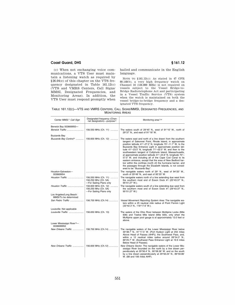
(c) When not exchanging voice com-munications, a VTS User must main-tain a listening watch as required by § 26.04(e) of this chapter on the VTS fre-quency designated in Table 161.12(c) (VTS and VMRS Centers, Call Signs/ MMSI, Designated Frequencies, and Monitoring Areas). In addition, the VTS User must respond promptly when
hailed and communicate in the English language.
NOTE TO § 161.12(c): As stated in 47 CFR 80.148(b), a very high frequency watch on Channel 16 (156.800 MHz) is not required on vessels subject to the Vessel Bridge-to- Bridge Radiotelephone Act and participating in a Vessel Traffic Service (VTS) system when the watch is maintained on both the vessel bridge-to-bridge frequency and a des-ignated VTS frequency.
TABLE 161.12(C)—VTS AND VMRS CENTERS, CALL SIGNS/MMSI, DESIGNATED FREQUENCIES, AND MONITORING AREAS
Center MMSI 1 Call Sign Designated frequency (Chan-nel designation)—purpose 2 Monitoring area 3,4
Berwick Bay 003669950— Berwick Traffic .......................... 156.550 MHz (Ch. 11) ............ The waters south of 29°45′ N., west of 91°10′ W., north of
29°37′ N., and east of 91°18′ W. Buzzards Bay Buzzards Bay Control 5 ............ 156.600 MHz (Ch. 12) ............ The waters east and north of a line drawn from the southern
tangent of Sakonnet Point, Rhode Island, in approximate position latitude 41°–27.2′ N, longitude 70°–11.7′ W, to the Buzzards Bay Entrance Light in approximate position lati-tude 41°–23.5′ N, longitude 71°–02.0′ W, and then to the southwestern tangent of Cuttyhunk Island, Massachusetts, at approximate position latitude 41°–24.6′ N, longitude 70°– 57.0′ W, and including all of the Cape Cod Canal to its eastern entrance, except that the area of New Bedford har-bor within the confines (north of) the hurricane barrier, and the passages through the Elizabeth Islands, is not consid-ered to be ‘‘Buzzards Bay’’.
Houston-Galveston— 003669954.
.................................................. The navigable waters north of 29° N., west of 94°20′ W., south of 29°49′ N., and east of 95°20′ W.
Houston Traffic ......................... 156.550 MHz (Ch. 11) ............156.250 Mhz (Ch. 5A) —For Sailing Plans only
The navigable waters north of a line extending due west from the southern most end of Exxon Dock #1 (20°43.37′ N., 95°01.27′ W.).
Houston Traffic ......................... 156.600 MHz (Ch. 12) ............156.250 Mhz (Ch. 5A) —For Sailing Plans only
The navigable waters south of a line extending due west from the southern most end of Exxon Dock #1 (29°43.37′ N., 95°01.27′ W.)
Los Angeles/Long Beach: MMSI/To be determined
San Pedro Traffic ..................... 156.700 MHz (Ch.14) .............. Vessel Movement Reporting System Area: The navigable wa-ters within a 25 nautical mile radius of Point Fermin Light (33°42.3′ N., 118°17.6′ W.).
Louisville: Not applicable Louisville Traffic ....................... 156.650 MHz (Ch. 13) The waters of the Ohio River between McAlpine Locks (Mile
606) and Twelve Mile Island (Mile 593), only when the McAlpine upper pool gauge is at approximately 13.0 feet or above.
Lower Mississippi River 6— 0036699952
New Orleans Traffic ................. 156.700 MHz (Ch.14) .............. The navigable waters of the Lower Mississippi River below 30°38.7′ N., 91°17.5′ W. (Port Hudson Light at 255 miles Above Head of Passes (AHP)), the Southwest Pass, and, within a 12 nautical miles radius around 28°54.3′ N., 89°25.7′ W. (Southwest Pass Entrance Light at 19.9 miles Below Head of Passes).
New Orleans Traffic ................. 156.600 MHz (Ch.12) .............. New Orleans Sector. The navigable waters of the Lower Mis-sissippi River bounded on the north by a line drawn per-pendicularly at 29°56.4′ N., 90°08.36′ W. and on the south by a line drawn perpendicularly at 29°56.24′ N., 89°59.86′ W. (88 and 106 miles AHP).
VerDate Mar<15>2010 07:59 Sep 03, 2010 Jkt 220131 PO 00000 Frm 00561 Fmt 8010 Sfmt 8010 Y:\SGML\220131.XXX 220131erow
e on
DS
K5C
LS3C
1PR
OD
with
CF
R
552
33 CFR Ch. I (7–1–10 Edition) § 161.12
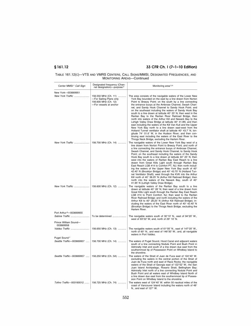
TABLE 161.12(C)—VTS AND VMRS CENTERS, CALL SIGNS/MMSI, DESIGNATED FREQUENCIES, AND MONITORING AREAS—Continued
Center MMSI 1 Call Sign Designated frequency (Chan-nel designation)—purpose 2 Monitoring area 3,4
New York—003669951 New York Traffic ...................... 156.550 MHz (Ch. 11) ............
—For Sailing Plans only 156.600 MHz (Ch. 12) —For vessels at anchor
The area consists of the navigable waters of the Lower New York Bay bounded on the east by a line drawn from Norton Point to Breezy Point; on the south by a line connecting the entrance buoys at the Ambrose Channel, Swash Chan-nel, and Sandy Hook Channel to Sandy Hook Point; and on the southeast including the waters of Sandy Hook Bay south to a line drawn at latitude 40° 25′ N; then west in the Raritan Bay to the Raritan River Railroad Bridge, then north into waters of the Arthur Kill and Newark Bay to the Lehigh Valley Draw Bridge at latitude 40° 41.9N; and then east including the waters of the Kill Van Kull and the Upper New York Bay north to a line drawn east-west from the Holland Tunnel ventilator shaft at latitude 40° 43.7′ N, lon-gitude 74° 01.6′ W, in the Hudson River; and then con-tinuing east including the waters of the East River to the Throgs Neck Bridge, excluding the Harlem River.
New York Traffic ...................... 156.700 MHz (Ch. 14) ............ The navigable waters of the Lower New York Bay west of a line drawn from Norton Point to Breezy Point; and north of a line connecting the entrance buoys of Ambrose Channel, Swash Channel, and Sandy Hook Channel, to Sandy Hook Point; on the southeast including the waters of the Sandy Hook Bay south to a line drawn at latitude 40° 25′ N; then west into the waters of Raritan Bay East Reach to a line drawn from Great Kills Light south through Raritan Bay East Reach LGB #14 to Comfort PT, NJ; then north includ-ing the waters of the Upper New York Bay south of 40° 42.40′ N (Brooklyn Bridge) and 40° 43.70′ N (Holland Tun-nel Ventilator Shaft); west through the KVK into the Arthur Kill north of 40° 38.25′ N (Arthur Kill Railroad Bridge); then north into the waters of the Newark Bay, south of 40° 41.95′ N (Lehigh Valley Draw Bridge).
New York Traffic ...................... 156.600 MHz (Ch. 12) ............ The navigable waters of the Raritan Bay south to a line drawn at latitude 40° 26′ N; then west of a line drawn from Great Kills Light south through the Raritan Bay East Reach LGB #14 to Point Comfort, NJ; then west to the Raritan River Railroad Bridge; and north including the waters of the Arthur Kill to 40° 28.25′ N (Arthur Kill Railroad Bridge); in-cluding the waters of the East River north of 40° 42.40′ N (Brooklyn Bridge) to the Throgs Neck Bridge, excluding the Harlem River.
Port Arthur 6—003669955 Sabine Traffic ........................... To be determined .................... The navigable waters south of 30°10′ N., east of 94°20′ W.,
west of 93°22′ W, and, north of 29° 10′ N. Prince William Sound—
003669958 Valdez Traffic ........................... 156.650 MHz (Ch. 13) ............ The navigable waters south of 61°05′ N., east of 147°20′ W.,
north of 60° N., and west of 146°30′ W.; and, all navigable waters in Port Valdez.
Puget Sound 7 Seattle Traffic—003669957 ..... 156.700 MHz (Ch. 14) ............ The waters of Puget Sound, Hood Canal and adjacent waters
south of a line connecting Nodule Point and Bush Point in Admiralty Inlet and south of a line drawn due east from the southernmost tip of Possession Point on Whidbey Island to the shoreline.
Seattle Traffic—003669957 ..... 156.250 MHz (Ch. 5A) ............ The waters of the Strait of Juan de Fuca east of 124°40′ W. excluding the waters in the central portion of the Strait of Juan de Fuca north and east of Race Rocks; the navigable waters of the Strait of Georgia east of 122°52′ W.; the San Juan Island Archipelago, Rosario Strait, Bellingham Bay; Admiralty Inlet north of a line connecting Nodule Point and Bush Point and all waters east of Whidbey Island North of a line drawn due east from the southernmost tip of Posses-sion Point on Whidbey Island to the shoreline.
Tofino Traffic—003160012 ....... 156.725 MHz (Ch. 74) ............ The waters west of 124°40′ W. within 50 nautical miles of the coast of Vancouver Island including the waters north of 48° N., and east of 127° W.
VerDate Mar<15>2010 07:59 Sep 03, 2010 Jkt 220131 PO 00000 Frm 00562 Fmt 8010 Sfmt 8010 Y:\SGML\220131.XXX 220131erow
e on
DS
K5C
LS3C
1PR
OD
with
CF
R

553
Coast Guard, DHS § 161.12
TABLE 161.12(C)—VTS AND VMRS CENTERS, CALL SIGNS/MMSI, DESIGNATED FREQUENCIES, AND MONITORING AREAS—Continued
Center MMSI 1 Call Sign Designated frequency (Chan-nel designation)—purpose 2 Monitoring area 3,4
Victoria Traffi—003160010 ...... 156.550 MHz (Ch. 11) ............ The waters of the Strait of Georgia west of 122°52′ W., the navigable waters of the central Strait of Juan de Fuca north and east of Race Rocks, including the Gulf Island Archi-pelago, Boundary Pass and Haro Strait.
San Francisco—003669956 San Francisco Traffic ............... 156.700 MHz (Ch. 14) ............ The navigable waters of the San Francisco Offshore Pre-
cautionary Area, the navigable waters shoreward of the San Francisco Offshore Precautionary Area east of 122°42.0′ W. and north of 37°40.0′ N. extending eastward through the Golden Gate, and the navigable waters of San Francisco Bay and as far east as the port of Stockton on the San Joaquin River, as far north as the port of Sac-ramento on the Sacramento River.
San Francisco Traffic ............... 156.600 MHz (Ch. 12) ............ The navigable waters within a 38 nautical mile radius of Mount Tamalpais (37°55.8′ N., 122°34.6′ W.) west of 122°42.0′ W. and south of 37°40.0′ N and excluding the San Francisco Offshore Precautionary Area.
St. Marys River—003669953 Soo Traffic ................................ 156.600 MHz (Ch. 12) ............ The waters of the St. Marys River between 45°57′ N. (De
Tour Reef Light) and 46°38.7′ N. (lle Parisienne Light), ex-cept the St. Marys Falls Canal and those navigable waters east of a line from 46°04.16′ N. and 46°01.57′ N. (La Pointe to Sims Point in Potagannissing Bay and Worsley Bay).
NOTES: 1 Maritime Mobile Service Identifier (MMSI) is a unique nine-digit number assigned that identifies ship stations, ship earth sta-
tions, coast stations, coast earth stations, and group calls for use by a digital selective calling (DSC) radio, an INMARSAT ship earth station or AIS. AIS requirements are set forth in §§ 161.21 and 164.46 of this subchapter. The requirements set forth in §§ 161.21 and 164.46 of this subchapter apply in those areas denoted with a MMSI number.
2 In the event of a communication failure, difficulties or other safety factors, the Center may direct or permit a user to monitor and report on any other designated monitoring frequency or the bridge-to-bridge navigational frequency, 156.650 MHz (Channel 13) or 156.375 MHz (Ch. 67), to the extent that doing so provides a level of safety beyond that provided by other means. The bridge-to-bridge navigational frequency, 156.650 MHz (Ch. 13), is used in certain monitoring areas where the level of reporting does not warrant a designated frequency.
3 All geographic coordinates (latitude and longitude) are expressed in North American Datum of 1983 (NAD 83). 4 Some monitoring areas extend beyond navigable waters. Although not required, users are strongly encouraged to maintain a
listening watch on the designated monitoring frequency in these areas. Otherwise, they are required to maintain watch as stated in 47 CFR 80.148.
5 In addition to the vessels denoted in section 161.16 of this chapter, requirements set forth in subpart B of 33 CFR part 161 also apply to any vessel transiting VMRS Buzzards Bay required to carry a bridge-to-bridge radiotelephone by part 26 of this chapter.
6 Until rules regarding VTS Lower Mississippi River and VTS Port Arthur are published, vessels are exempted of all VTS and VMRS requirements set forth in 33 CFR part 161, except those set forth in §§ 161.21 and 164.46 of this subchapter.
7 A Cooperative Vessel Traffic Service was established by the United States and Canada within adjoining waters. The appro-priate Center administers the rules issued by both nations; however, enforces only its own set of rules within its jurisdiction. Note, the bridge-to-bridge navigational frequency, 156.650 MHz (Ch. 13), is not so designated in Canadian waters, therefore users are encouraged and permitted to make passing arrangements on the designated monitoring frequencies.
(d) As soon as is practicable, a VTS User shall notify the VTS of any of the following:
(1) A marine casualty as defined in 46 CFR 4.05–1;
(2) Involvement in the ramming of a fixed or floating object;
(3) A pollution incident as defined in § 151.15 of this chapter;
(4) A defect or discrepancy in an aid to navigation;
(5) A hazardous condition as defined in § 160.203 of this chapter;
(6) Improper operation of vessel equipment required by part 164 of this chapter;
(7) A situation involving hazardous materials for which a report is required by 49 CFR 176.48; and
(8) A hazardous vessel operating con-dition as defined in § 161.2.
[CGD 90–020, 59 FR 36324, July 15, 1994, as amended by CGD 95–033, 60 FR 28329, May 31, 1995; CGD 92–052, 61 FR 45326, Aug. 29, 1996; USCG–1999–6141, 64 FR 69636, Dec. 14, 1999; USCG–2003–14757, 68 FR 39364, July 1, 2003; 68 FR 60569, Oct. 22, 2003; USCG–2004–18057, 69 FR 34926, June 23, 2004; CGD01–04–133, 72 FR 50058, Aug. 30, 2007; 72 FR 70780, Dec. 13, 2007; USCG–2008–0179, 73 FR 35016, June 19, 2008]
VerDate Mar<15>2010 07:59 Sep 03, 2010 Jkt 220131 PO 00000 Frm 00563 Fmt 8010 Sfmt 8010 Y:\SGML\220131.XXX 220131erow
e on
DS
K5C
LS3C
1PR
OD
with
CF
R

554
33 CFR Ch. I (7–1–10 Edition) § 161.13
§ 161.13 VTS Special Area operating requirements.
The following operating require-ments apply within a VTS Special Area:
(a) A VTS User shall, if towing astern, do so with as short a hawser as safety and good seamanship permits.
(b) A VMRS User shall: (1) Not enter or get underway in the area without prior approval of the VTS;
(2) Not enter a VTS Special Area if a hazardous vessel operating condition or circumstance exists;
(3) Not meet, cross, or overtake any other VMRS User in the area without prior approval of the VTS; and
(4) Before meeting, crossing, or over-taking any other VMRS User in the area, communicate on the designated vessel bridge-to-bridge radiotelephone frequency, intended navigation move-ments, and any other information nec-essary in order to make safe passing arrangements. This requirement does not relieve a vessel of any duty pre-scribed by the International Regula-tions for Prevention of Collisions at Sea, 1972 (72 COLREGS) or the Inland Navigation Rules.
Subpart B—Vessel Movement Reporting System
§ 161.15 Purpose and intent. (a) A Vessel Movement Reporting
System (VMRS) is a system used to monitor and track vessel movements VTS or VMRS area. This is accom-plished by requiring that vessels pro-vide information under established pro-cedures as set forth in this part, or as directed by the Center.
(b) To avoid imposing an undue re-porting burden or unduly congesting
radiotelephone frequencies, reports shall be limited to information which is essential to achieve the objectives of the VMRS. These reports are consoli-dated into three reports (sailing plan, position, and final).
[CGD 90–020, 59 FR 36324, July 15, 1994, as amended by USCG–2003–14757, 68 FR 39366, July 1, 2003]
§ 161.16 Applicability.
Unless otherwise stated, the provi-sions of this subpart apply to the fol-lowing vessels and VMRS Users:
(a) Every power-driven vessel of 40 meters (approximately 131 feet) or more in length, while navigating;
(b) Every towing vessel of 8 meters (approximately 26 feet) or more in length, while navigating; or
(c) Every vessel certificated to carry 50 or more passengers for hire, when engaged in trade.
[CGD 90–020, 59 FR 36324, July 15, 1994, as amended by USCG–2003–14757, 68 FR 39366, July 1, 2003]
§ 161.17 Definitions.
As used in this subpart: Center means a Vessel Traffic Center
or Vessel Movement Center. Published means available in a wide-
ly-distributed and publicly available medium (e.g., VTS User’s Manual, ferry schedule, Notice to Mariners).
[USCG–2003–14757, 68 FR 39366, July 1, 2003]
§ 161.18 Reporting requirements.
(a) A Center may: (1) Direct a vessel to provide any of the information set forth in Table 161.18(a) (IMO Standard Ship Reporting System);
TABLE 161.18(a)—THE IMO STANDARD SHIP REPORTING SYSTEM
A ALPHA ......................... Ship .............................. Name, call sign or ship station identity, and flag.
B BRAVO ........................ Dates and time of event A 6 digit group giving day of month (first two digits), hours and minutes (last four digits). If other than UTC state time zone used.
C CHARLIE ..................... Position ........................ A 4 digit group giving latitude in degrees and minutes suffixed with N (north) or S (south) and a 5 digit group giving longitude in de-grees and minutes suffixed with E (east) or W (west); or.
VerDate Mar<15>2010 07:59 Sep 03, 2010 Jkt 220131 PO 00000 Frm 00564 Fmt 8010 Sfmt 8010 Y:\SGML\220131.XXX 220131erow
e on
DS
K5C
LS3C
1PR
OD
with
CF
R
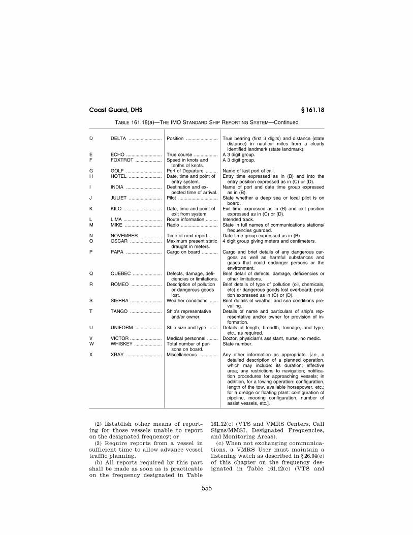
555
Coast Guard, DHS § 161.18
TABLE 161.18(a)—THE IMO STANDARD SHIP REPORTING SYSTEM—Continued
D DELTA ......................... Position ........................ True bearing (first 3 digits) and distance (state distance) in nautical miles from a clearly identified landmark (state landmark).
E ECHO ........................... True course .................. A 3 digit group. F FOXTROT .................... Speed in knots and
tenths of knots.A 3 digit group.
G GOLF ........................... Port of Departure ......... Name of last port of call. H HOTEL ......................... Date, time and point of
entry system.Entry time expressed as in (B) and into the
entry position expressed as in (C) or (D). I INDIA ........................... Destination and ex-
pected time of arrival.Name of port and date time group expressed
as in (B). J JULIET ......................... Pilot .............................. State whether a deep sea or local pilot is on
board. K KILO ............................. Date, time and point of
exit from system.Exit time expressed as in (B) and exit position
expressed as in (C) or (D). L LIMA ............................. Route information ......... Intended track. M MIKE ............................ Radio ............................ State in full names of communications stations/
frequencies guarded. N NOVEMBER ................. Time of next report ...... Date time group expressed as in (B). O OSCAR ........................ Maximum present static
draught in meters.4 digit group giving meters and centimeters.
P PAPA ........................... Cargo on board ............ Cargo and brief details of any dangerous car-goes as well as harmful substances and gases that could endanger persons or the environment.
Q QUEBEC ...................... Defects, damage, defi-ciencies or limitations.
Brief detail of defects, damage, deficiencies or other limitations.
R ROMEO ....................... Description of pollution or dangerous goods lost.
Brief details of type of pollution (oil, chemicals, etc) or dangerous goods lost overboard; posi-tion expressed as in (C) or (D).
S SIERRA ........................ Weather conditions ...... Brief details of weather and sea conditions pre-vailing.
T TANGO ........................ Ship’s representative and/or owner.
Details of name and particulars of ship’s rep-resentative and/or owner for provision of in-formation.
U UNIFORM .................... Ship size and type ....... Details of length, breadth, tonnage, and type, etc., as required.
V VICTOR ........................ Medical personnel ........ Doctor, physician’s assistant, nurse, no medic. W WHISKEY ..................... Total number of per-
sons on board.State number.
X XRAY ........................... Miscellaneous .............. Any other information as appropriate. [i.e., a detailed description of a planned operation, which may include: its duration; effective area; any restrictions to navigation; notifica-tion procedures for approaching vessels; in addition, for a towing operation: configuration, length of the tow, available horsepower, etc.; for a dredge or floating plant: configuration of pipeline, mooring configuration, number of assist vessels, etc.].
(2) Establish other means of report-ing for those vessels unable to report on the designated frequency; or
(3) Require reports from a vessel in sufficient time to allow advance vessel traffic planning.
(b) All reports required by this part shall be made as soon as is practicable on the frequency designated in Table
161.12(c) (VTS and VMRS Centers, Call Signs/MMSI, Designated Frequencies, and Monitoring Areas).
(c) When not exchanging communica-tions, a VMRS User must maintain a listening watch as described in § 26.04(e) of this chapter on the frequency des-ignated in Table 161.12(c) (VTS and
VerDate Mar<15>2010 07:59 Sep 03, 2010 Jkt 220131 PO 00000 Frm 00565 Fmt 8010 Sfmt 8010 Y:\SGML\220131.XXX 220131erow
e on
DS
K5C
LS3C
1PR
OD
with
CF
R

556
33 CFR Ch. I (7–1–10 Edition) § 161.19
VMRS Centers, Call Signs/MMSI, Des-ignated Frequencies, and Monitoring Areas). In addition, the VMRS User must respond promptly when hailed and communicate in the English lan-guage.
NOTE: As stated in 47 CFR 80.148(b), a VHF watch on Channel 16 (156.800 MHz) is not re-quired on vessels subject to the Vessel Bridge-to-Bridge Radiotelephone Act and participating in a Vessel Traffic Service (VTS) system when the watch is maintained on both the vessel bridge-to-bridge frequency and a designated VTS frequency.
(d) A vessel must report: (1) Any significant deviation from its
Sailing Plan, as defined in § 161.19, or from previously reported information; or
(2) Any intention to deviate from a VTS issued measure or vessel traffic routing system.
(e) When reports required by this part include time information, such in-formation shall be given using the local time zone in effect and the 24- hour military clock system.
[CGD 90–020, 59 FR 36324, July 15, 1994, as amended by USCG–2003–14757, 68 FR 39366, July 1, 2003]
§ 161.19 Sailing Plan (SP).
Unless otherwise stated, at least 15 minutes before navigating a VTS area, a vessel must report the:
(a) Vessel name and type; (b) Position; (c) Destination and ETA; (d) Intended route; (e) Time and point of entry; and (f) Dangerous cargo on board or in its
tow, as defined in § 160.203 of this chap-ter, and other required information as set out in § 160.211 and § 160.213 of this chapter, if applicable.
§ 161.20 Position Report (PR).
A vessel must report its name and position:
(a) Upon point of entry into a VMRS area;
(b) At designated reporting points as set forth in subpart C; or
(c) When directed by the Center.
[CGD 90–020, 59 FR 36324, July 15, 1994, as amended by USCG–2003–14757, 68 FR 39366, July 1, 2003]
§ 161.21 Automated reporting.
(a) Unless otherwise directed, vessels equipped with an Automatic Identifica-tion System (AIS) are required to make continuous, all stations, AIS broadcasts, in lieu of voice Position Reports, to those Centers denoted in Table 161.12(c) of this part.
(b) Should an AIS become non-oper-ational, while or prior to navigating a VMRS area, it should be restored to op-erating condition as soon as possible, and, until restored a vessel must:
(1) Notify the Center; (2) Make voice radio Position Reports
at designated reporting points as re-quired by § 161.20(b) of this part; and
(3) Make any other reports as di-rected by the Center.
[USCG–2003–14757, 68 FR 39366, July 1, 2003]
§ 161.22 Final Report (FR).
A vessel must report its name and position:
(a) On arrival at its destination; or (b) When leaving a VTS area.
§ 161.23 Reporting exemptions.
(a) Unless otherwise directed, the fol-lowing vessels are exempted from pro-viding Position and Final Reports due to the nature of their operation:
(1) Vessels on a published schedule and route;
(2) Vessels operating within an area of a radius of three nautical miles or less; or
(3) Vessels escorting another vessel or assisting another vessel in maneu-vering procedures.
(b) A vessel described in paragraph (a) of this section must:
(1) Provide a Sailing Plan at least 5 minutes but not more than 15 minutes before navigating within the VMRS area; and
(2) If it departs from its promulgated schedule by more than 15 minutes or changes its limited operating area, make the established VMRS reports, or report as directed.
[CGD 90–020, 59 FR 36324, July 15, 1994, as amended by CGD 97–023, 62 FR 33364, June 19, 1997; USCG–2003–14757, 68 FR 39367, July 1, 2003]
VerDate Mar<15>2010 07:59 Sep 03, 2010 Jkt 220131 PO 00000 Frm 00566 Fmt 8010 Sfmt 8010 Y:\SGML\220131.XXX 220131erow
e on
DS
K5C
LS3C
1PR
OD
with
CF
R

557
Coast Guard, DHS § 161.35
Subpart C—Vessel Traffic Service and Vessel Movement Report-ing System Areas and Report-ing Points
NOTE: All geographic coordinates con-tained in part 161 (latitude and longitude) are expressed in North American Datum of 1983 (NAD 83).
§ 161.25 Vessel Traffic Service New York Area.
The area consists of the navigable waters of the Lower New York Harbor bounded on the east by a line drawn from Norton Point to Breezy Point; on the south by a line connecting the en-trance buoys at the Ambrose Channel, Swash Channel, and Sandy Hook Chan-nel to Sandy Hook Point; and on the southeast including the waters of Sandy Hook Bay south to a line drawn at latitude 40°25′ N.; then west into wa-ters of the Raritan Bay to the Raritan River Rail Road Bridge; and then north including the waters of the Arthur Kill and Newark Bay to the Lehigh Valley Draw Bridge at latitude 40°41.9′ N.; and then east including the waters of the Kill Van Kull and Upper New York Bay north to a line drawn east-west from the Holland Tunnel Ventilator Shaft at latitude 40°43.7′ N., longitude 74°01.6′ W. in the Hudson River; and then con-tinuing east including the waters of the East River to the Throgs Neck Bridge, excluding the Harlem River.
NOTE: Although mandatory participation in VTSNY is limited to the area within the navigable waters of the United States, VTSNY will provide services beyond those waters. Prospective users are encouraged to report beyond the area of required participa-tion in order to facilitate advance vessel traffic management in the VTS area and to receive VTSNY advisories and/or assistance.
[CGD 92–052, 61 FR 45327, Aug. 29, 1996]
§ 161.30 Vessel Traffic Service Louis-ville.
The VTS area consists of the navi-gable waters of the Ohio River between
McAlpine Locks (Mile 606.8) and Twelve Mile Island (Mile 593), only when the McAlpine upper pool gauge is at 13.0 feet or above.
[CGD 90–020, 59 FR 36324, July 15, 1994, as amended by USCG–1998–3799, 63 FR 35531, June 30, 1998]
§ 161.35 Vessel Traffic Service Hous-ton/Galveston.
(a) The VTS area consists of the fol-lowing major waterways and portions of connecting waterways: Galveston Bay Entrance Channel; Outer Bar Channel; Inner Bar Channel; Bolivar Roads Channel; Galveston Channel; Gulf ICW and Galveston-Freeport Cut- Off from Mile 346 to Mile 352; Texas City Channel; Texas City Turning Basin; Texas City Canal Channel; Texas City Canal Turning Basin; Hous-ton Ship Channel; Bayport Channel; Bayport Turning Basin; Houston Turn-ing Basin; and the following pre-cautionary areas associated with these waterways.
(b) Precautionary areas.
TABLE 161.35(B)—VTS HOUSTON/GALVESTON PRECAUTIONARY AREAS
Precautionary area name
Radius (yds.)
Center point
Latitude Longitude
Bolivar Roads 4000 29°20.9′ N 94°47.0′ W Red Fish Bar 4000 29°29.8′ N 94°51.9′ W Bayport Chan-
nel.4000 29°36.7′ N 94°57.2′ W
Morgans Point 2000 29°41.0′ N 94°59.0′ W Upper San
Jacinto Bay.1000 29°42.3′ N 95°01.1′ W
Baytown ......... 1000 29°43.6′ N 95°01.4′ W Lynchburg ...... 1000 29°45.8′ N 95°04.8′ W Carpenters
Bayou.1000 29°45.3′ N 95°05.6′ W
Jacintoport ..... 1000 29°44.8′ N 95°06.0′ W Greens Bayou 1000 29°44.8′ N 95°10.2′ W Hunting Bayou 1000 29°44.3′ N 95°12.1′ W Sims Bayou ... 1000 29°43.2′ N 95°14.4′ W Brady Island .. 1000 29°43.5′ N 95°16.4′ W Buffalo Bayou 1000 29°45.0′ N 95°17.3′ W
NOTE: Each Precautionary Area encompasses a circular area of the radius denoted.
(c) Reporting points.
TABLE 161.35(C)—VTS HOUSTON/GALVESTON REPORTING POINTS
Desig-nator Geographic name Geographic description Latitude/ longitude Notes
1 ............. Galveston Bay Entrance Channel.
Galveston Bay Entrance CH Lighted Buoy (LB) ‘‘1C’’.
29° 18.2′ N; 94° 37.6′ W
2 ............. Galveston Bay Entrance Channel.
Galveston Bay Entrance Chan-nel LB 11 and 12.
29° 20.6′ N; 94° 44.6′ W
VerDate Mar<15>2010 07:59 Sep 03, 2010 Jkt 220131 PO 00000 Frm 00567 Fmt 8010 Sfmt 8010 Y:\SGML\220131.XXX 220131erow
e on
DS
K5C
LS3C
1PR
OD
with
CF
R

558
33 CFR Ch. I (7–1–10 Edition) § 161.40
TABLE 161.35(C)—VTS HOUSTON/GALVESTON REPORTING POINTS—Continued
Desig-nator Geographic name Geographic description Latitude/ longitude Notes
E ............ Bolivar Land Cut .............. Mile 349 Intracoastal Water-way (ICW).
29° 22.5′ N; 94° 46.9′ W Tows entering HSC also report at HSC LB 25 & 26.
W ........... Pelican Cut ...................... Mile 351 ICW ........................... 29° 21.4′ N; 94° 48.5′ W Tows entering HSC also report at HSC LB 25 & 26.
G ............ Galveston Harbor ............ Galveston Channel Lt. 2 .......... 29° 20.2′ N; 94° 46.6′ W Coast Guard Base. T ............ Texas City Channel ......... Texas City Channel Lt. 12 ....... 29° 22.4′ N; 94° 50.9′ W X ............ Houston Ship Channel
ICW Intersection.Houston Ship Channel (HSC)
LB 25 and 26.29° 22.2′ N; 94° 48.1′ W Tow entering HSC
from ICW or Texas Cut Only.
3 ............. Lower Galveston Bay ...... HSC Lt. 31 and LB 32 ............. 29° 23.8′ N; 94° 48.9′ W 4 ............. Red Fish Bar ................... HSC Lt. 53 & 54 ...................... 29° 30.3′ N; 94° 52.4′ W P ............ Bayport Ship Channel ..... Bayport Ship Channel Lt. 8
and 9.29° 36.8′ N; 94° 59.5′ W Bayport Land Cut.
4A .......... Upper Galveston Bay ...... HSC Lt. 69 and 70 ................... 29° 34.7′ N; 94° 55.8′ W Tows only. 5 ............. Morgan’s Point ................ HSC Lt. 91 ............................... 29° 41.0′ N; 94° 59.0′ W 6 ............. Exxon ............................... HSC Lt. 109A ........................... 29° 43.5′ N; 95° 01.4′ W 7 ............. Lynchburg ........................ Ferry crossing .......................... 29° 45.8′ N; 95° 04.8′ W 8 ............. Shell Oil ........................... Boggy Bayou ........................... 29° 44.1′ N; 95° 08.0′ W 9 ............. Greens Bayou ................. HSC Lt. 152 ............................. 29° 44.8′ N; 95° 10.1′ W 10 ........... Hunting Bayou ................. Hunting Bayou Turning Basin. 29° 44.4′ N; 95° 12.1′ W 11 ........... Lyondell ........................... Sims Bayou Turning Basin. ..... 29° 43.2′ N; 95° 14.4′ W 12 ........... I–610 Bridge .................... I–610 Bridge ............................ 29° 43.5′ N; 95° 16.0′ W 13 ........... Buffalo Bayou .................. Houston Turning Basin ............ 29° 45.0′ N; 95° 17.4′ W
[CGD 90–020, 59 FR 36324, July 15, 1994, as amended by CGD 95–033, 60 FR 28331, May 31, 1995; USCG–2000–7223, 65 FR 40058, June 29, 2000; USCG–2007–27887, 72 FR 45904, Aug. 16, 2007]
§ 161.40 Vessel Traffic Service Berwick Bay.
(a) The VTS area consists of the nav-igable waters of the following segments of waterways: the Intracoastal Water-way (ICW) Morgan City to Port Allen Alternate Route from Mile Marker 0 to Mile Marker 5; the ICW from Mile Marker 93 west of Harvey Lock (WHL) to Mile Marker 102 WHL; the Atchafalaya River Route from Mile Marker 113 to Mile Marker 122; from
Bayou Shaffer Junction (ICW Mile Marker 94.5 WHL) south one statute mile along Bayou Shaffer; and from Berwick Lock northwest one statute mile along the Lower Atchafalaya River.
(b) VTS Special Area. The Berwick Bay VTS Special Area consists of those waters within a 1000 yard radius of the Burlington Northern/Santa Fe Railroad Bridge located at Mile .03 MC/PA.
(c) Reporting Points.
TABLE 161.40(c)—VTS BERWICK BAY REPORTING POINTS
Designator Geographic name Geographic description Latitude/lon-gitude Notes
1 ........................... Stouts Pass ........................ Stouts Point Light ‘‘1’’ Mile 113–Atchafalaya River.
29°43′47″ N 91°13′25″ W
2 ........................... Berwick Lock ...................... Mile 1.9 MC/PA .................. 29°43′10″ N 91°13′28″ W
If transiting the Lock.
3 ........................... Conrad’s Point Junction ..... Buoy ‘‘1’’ Mile 1.5 MC/PA .. 29°42′32″ N 91°13′14″ W
4 ........................... Swift Ships Flat Lake Junc-tion.
Mile 3 MC/PA ..................... 29°43′26″ N 91°12′22″ W
5 ........................... Burlington Northern/Santa Fe Railroad Bridge.
Mile 0.3 MC/PA .................. 29°41′34″ N 91°12′44″ W
6 ........................... 20 Grant Point Junction ..... Bayou Boeuf-Atchafalaya R. Mile 95.5 ICW.
29°41′18″ N 91°12′36″ W
7 ........................... ICW ..................................... Overhead Power Cable Mile 96.5 ICW.
29°40′43″ N 91°13′18″ W
8 ........................... Wax Bayou Junction .......... Light ‘‘A’’ Mile 98.2W ICW 29°39′29″ N 91°14′46″ W
VerDate Mar<15>2010 07:59 Sep 03, 2010 Jkt 220131 PO 00000 Frm 00568 Fmt 8010 Sfmt 8010 Y:\SGML\220131.XXX 220131erow
e on
DS
K5C
LS3C
1PR
OD
with
CF
R
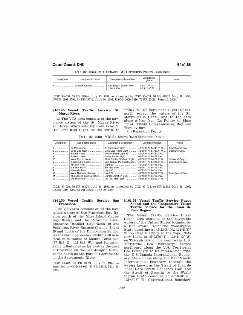
559
Coast Guard, DHS § 161.55
TABLE 161.40(c)—VTS BERWICK BAY REPORTING POINTS—Continued
Designator Geographic name Geographic description Latitude/lon-gitude Notes
9 ........................... Shaffer Junction ................. ICW-Bayou Shaffer Mile 94.5 ICW.
29°41′10″ N 91°11′38″ W
[CGD 90–020, 59 FR 36324, July 15, 1994, as amended by CGD 95–033, 60 FR 28332, May 31, 1995; USCG–1998–3799, 63 FR 35531, June 30, 1998; USCG–2009–0416, 74 FR 27441, June 10, 2009]
§ 161.45 Vessel Traffic Service St. Marys River.
(a) The VTS area consists of the nav-igable waters of the St. Marys River and lower Whitefish Bay from 45°57′ N. (De Tour Reef Light) to the south, to
46°38.7′ N. (Ile Parisienne Light) to the north, except the waters of the St. Marys Falls Canal, and to the east along a line from La Pointe to Sims Point, within Potagannissing Bay and Worsley Bay.
(b) Reporting Points.
TABLE 161.45(b)—VTS ST. MARYS RIVER REPORTING POINTS
Designator Geographic name Geographic description Latitude/longitude‘ Notes
1 .................... Ile Parisienne ....................... Ile Parisienne Light .............. 46°37.3′ N; 84°45.9′ W ... Downbound Only. 2 .................... Gros Cap Reef ..................... Gros Cap Reefs Light .......... 46°30.6′ N; 84°37.1′ W ... Upbound Only. 3 .................... Round Island ........................ Round Island Light 32 .......... 46°26.9′ N; 84°31.7′W. 4 .................... Pointe Louise ....................... Pointe Louise Light .............. 46°27.8′ N; 84°28.2′W. 5* ................... West End of Locks ............... West Center Pierhead Light 46°30.2′ N; 84°22.2′ W ... Upbound Only. 6 .................... East End of Locks ................ East Center Pierhead Light .. 46°30.1′ N; 84°20.3′ W ... Downbound Only. 7 .................... Mission Point ........................ Light 99 ................................ 46°29.2′ N; 84°18.1′W. 8 .................... Six Mile Point ....................... Six Mile Point ....................... 46°26.1′ N; 84°15.4′W. 9 .................... Ninemile Point ...................... Light 80 ................................ 46°23.5′ N; 84°14.1′W. 10 .................. West Neebish Channel ........ Light 29 ................................ 46°16.9′ N; 84°12.5′ W ... Downbound Only. 11 .................. Munuscong Lake Junction ... Lighted Junction Buoy .......... 46°10.8′ N; 84°05.6′W. 12 .................. De Tour Reef ....................... De Tour Reef Light .............. 46°56.9′ N; 83°53.7′ W.
[CGD 90–020, 59 FR 36324, July 15, 1994, as amended by CGD 95–033, 60 FR 28332, May 31, 1995; USCG–1998–3799, 63 FR 35531, June 30, 1998]
§ 161.50 Vessel Traffic Service San Francisco.
The VTS area consists of all the nav-igable waters of San Francisco Bay Re-gion south of the Mare Island Cause-way Bridge and the Petaluma River Entrance Channel Daybeacon 19 and Petaluma River Entrace Channel Light 20 and north of the Dumbarton Bridge; its seaward approaches within a 38 nau-tical mile radius of Mount Tamalpais (37–55.8′ N., 122–34.6′ W.); and its navi-gable tributaries as far east as the port of Stockton on the San Joaquin River, as far north as the port of Sacramento on the Sacramento River.
[CGD 90–020, 59 FR 36324, July 15, 1994, as amended by CGD 95–033, 60 FR 28332, May 31, 1995]
§ 161.55 Vessel Traffic Service Puget Sound and the Cooperative Vessel Traffic Service for the Juan de Fuca Region.
The Vessel Traffic Service Puget Sound area consists of the navigable waters of the United States bounded by a line drawn from the Washington State coastline at 48°23′08″ N., 124°43′37″ W. on Cape Flattery to the Cape Flat-tery Light at 48°23′30″ N., 124°44′12″ W. on Tatoosh Island, due west to the U.S. Territorial Sea Boundary; thence northward along the U.S. Territorial Sea Boundary to its intersection with the U.S./Canada International Bound-ary; thence east along the U.S./Canada International Boundary through the waters known as the Strait of Juan de Fuca, Haro Strait, Boundary Pass, and the Strait of Georgia to the Wash-ington State coastline at 49°00′06″ N., 122°45′18″ W. (International Boundary
VerDate Mar<15>2010 07:59 Sep 03, 2010 Jkt 220131 PO 00000 Frm 00569 Fmt 8010 Sfmt 8010 Y:\SGML\220131.XXX 220131erow
e on
DS
K5C
LS3C
1PR
OD
with
CF
R

560
33 CFR Ch. I (7–1–10 Edition) § 161.60
Range C Rear Light). This area in-cludes: Puget Sound, Hood Canal, Pos-session Sound, the San Juan Island Ar-chipelago, Rosario Strait, Guemes Channel, Bellingham Bay, the U.S. wa-ters of the Strait of Juan de Fuca and the Strait of Georgia, and all waters adjacent to the above.
(a) Vessel Traffic Service Puget Sound participates in a U.S./Canadian Cooperative Vessel Traffic Service (CVTS) to jointly manage vessel traffic in the Juan de Fuca Region. The CVTS for the Juan de Fuca Region consists of all waters of the Strait of Juan de Fuca and its offshore approaches, southern Georgia Strait, the Gulf and San Juan Archipelagos, Rosario Strait, Boundary Pass and Haro Strait, bounded on the northwest by 48°35′45″ N.; and on the southwest by 48°23′30″ N.; and on the west by the rhumb line joining 48°35′45″ N., 124°47′30″ W. with 48°23′30″ N., 124°48′37″ W.; and on the northeast in the Strait of Georgia, by a line drawn along 49° N. from Vancouver Island to Semiahmoo Bay; and on the southeast, by a line drawn from McCurdy Point on the Quimper Peninsula to Point Par-tridge on Whidbey Island. Canadian and United States Vessel Traffic Cen-ters (Tofino, B.C., Canada, Vancouver, BC, Canada and Seattle, WA) manage traffic within the CVTS area irrespec-tive of the International Boundary.
(b) VTS Special Areas. (1) The Rosario Strait VTS Special Area con-sists of those waters bounded to the south by the center of Precautionary Area ‘‘RB’’ (a circular area of 2,500 yards radius centered at 48°26′24″ N., 122°45′12″ W.), and to the north by the center of Precautionary Area ‘‘C’’ (a circular area of 2,500 yards radius cen-tered at 48°40′34″ N., 122°42′44″ W.; Light-ed Buoy ‘‘C’’); and
NOTE: The center of precautionary area ‘‘RB’’ is not marked by a buoy. All pre-cautionary areas are depicted on National Oceanic and Atmospheric Administration (NOAA) nautical charts.
(2) The Guemes Channel VTS Special Area consists of those waters bounded to the west by Shannon Point on Fidalgo Island and to the east by Southeast Point on Guemes Island.
(c) Additional VTS Special Area Op-erating Requirements. The following additional requirements are applicable
in the Rosario Strait and Guemes Channel VTS Special Areas:
(1) A vessel engaged in towing shall not impede the passage of a vessel of 40,000 dead weight tons or more.
(2) A vessel of less than 40,000 dead weight tons is exempt from the provi-sion set forth in § 161.13(b)(1) of this part.
(3) A vessel of less than 100 meters in length is exempt from the provisions set forth in § 161.13(b)(3) of this part. Approval will not be granted for:
(i) A vessel of 100 meters or more in length to meet or overtake; or cross or operate within 2,000 yards (except when crossing astern) of a vessel of 40,000 dead weight tons or more; or
(ii) A vessel of 40,000 dead weight tons or more to meet or overtake; or cross or operate within 2,000 yards (except when crossing astern) of a vessel of 100 meters or more in length.
(d) Reporting Point. Inbound vessels in the Strait of Juan de Fuca upon crossing 124–W.
[CGD 90–020, 59 FR 36324, July 15, 1994, as amended by USCG–1998–3799, 63 FR 35531, June 30, 1998]
§ 161.60 Vessel Traffic Service Prince William Sound.
(a) The VTS area consists of the nav-igable waters of the United States north of a line drawn from Cape Hinchinbrook Light to Schooner Rock Light, comprising that portion of Prince William Sound between 146°30′ W. and 147°20′ W. and includes Valdez Arm, Valdez Narrows and Port Valdez.
(b) The Valdez Arm VTS Special Area consists of the waters of the Valdez Arm Traffic Separation Scheme (de-scribed in § 167.1703 of this chapter); the waters northeast of a line drawn from shoreline to shoreline through the points 60°58.04′ N, 146°46.52′ W and 60°58.93′ N, 146°48.86′ W; and southwest of a line bearing 307° True from Tongue Point at 61°02.10′ N, 146°40.00′ W.
(c) The Valdez Narrows VTS Special Area consists of those waters of Valdez Arm, Valdez Narrows, and Port Valdez northeast of a line bearing 307° True from Tongue Point at 61°02′06″ 146°40′ W.; and southwest of a line bearing 307° True from Entrance Island Light at 61°05′06″ N., 146°36′42″ W.
VerDate Mar<15>2010 07:59 Sep 03, 2010 Jkt 220131 PO 00000 Frm 00570 Fmt 8010 Sfmt 8010 Y:\SGML\220131.XXX 220131erow
e on
DS
K5C
LS3C
1PR
OD
with
CF
R
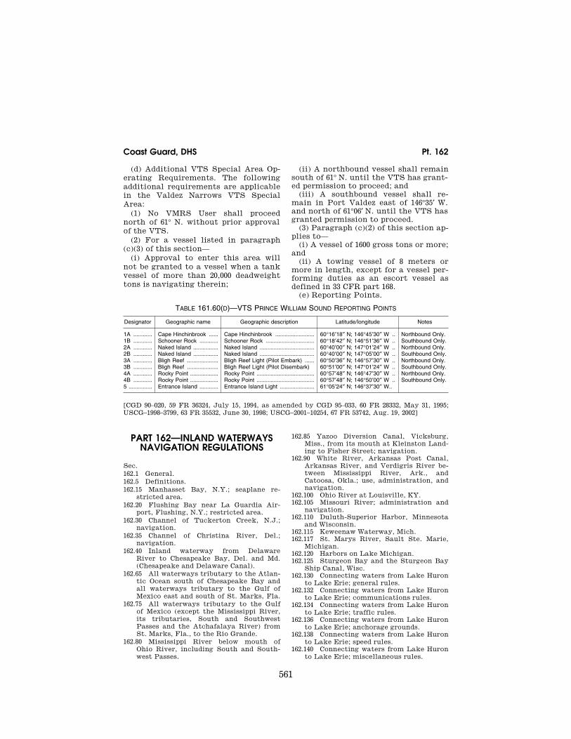
561
Coast Guard, DHS Pt. 162
(d) Additional VTS Special Area Op-erating Requirements. The following additional requirements are applicable in the Valdez Narrows VTS Special Area:
(1) No VMRS User shall proceed north of 61° N. without prior approval of the VTS.
(2) For a vessel listed in paragraph (c)(3) of this section—
(i) Approval to enter this area will not be granted to a vessel when a tank vessel of more than 20,000 deadweight tons is navigating therein;
(ii) A northbound vessel shall remain south of 61° N. until the VTS has grant-ed permission to proceed; and
(iii) A southbound vessel shall re-main in Port Valdez east of 146°35′ W. and north of 61°06′ N. until the VTS has granted permission to proceed.
(3) Paragraph (c)(2) of this section ap-plies to—
(i) A vessel of 1600 gross tons or more; and
(ii) A towing vessel of 8 meters or more in length, except for a vessel per-forming duties as an escort vessel as defined in 33 CFR part 168.
(e) Reporting Points.
TABLE 161.60(D)—VTS PRINCE WILLIAM SOUND REPORTING POINTS
Designator Geographic name Geographic description Latitude/longitude Notes
1A ............ Cape Hinchinbrook ...... Cape Hinchinbrook ......................... 60°16′18″ N; 146°45′30″ W .. Northbound Only. 1B ............ Schooner Rock ............ Schooner Rock ............................... 60°18′42″ N; 146°51′36″ W .. Southbound Only. 2A ............ Naked Island ................ Naked Island ................................... 60°40′00″ N; 147°01′24″ W .. Northbound Only. 2B ............ Naked Island ................ Naked Island ................................... 60°40′00″ N; 147°05′00″ W .. Southbound Only. 3A ............ Bligh Reef .................... Bligh Reef Light (Pilot Embark) ...... 60°50′36″ N; 146°57′30″ W .. Northbound Only. 3B ............ Bligh Reef .................... Bligh Reef Light (Pilot Disembark) 60°51′00″ N; 147°01′24″ W .. Southbound Only. 4A ............ Rocky Point .................. Rocky Point ..................................... 60°57′48″ N; 146°47′30″ W .. Northbound Only. 4B ............ Rocky Point .................. Rocky Point ..................................... 60°57′48″ N; 146°50′00″ W .. Southbound Only. 5 ............... Entrance Island ............ Entrance Island Light ...................... 61°05′24″ N; 146°37′30″ W..
[CGD 90–020, 59 FR 36324, July 15, 1994, as amended by CGD 95–033, 60 FR 28332, May 31, 1995; USCG–1998–3799, 63 FR 35532, June 30, 1998; USCG–2001–10254, 67 FR 53742, Aug. 19, 2002]
PART 162—INLAND WATERWAYS NAVIGATION REGULATIONS
Sec. 162.1 General. 162.5 Definitions. 162.15 Manhasset Bay, N.Y.; seaplane re-
stricted area. 162.20 Flushing Bay near La Guardia Air-
port, Flushing, N.Y.; restricted area. 162.30 Channel of Tuckerton Creek, N.J.;
navigation. 162.35 Channel of Christina River, Del.;
navigation. 162.40 Inland waterway from Delaware
River to Chesapeake Bay, Del. and Md. (Chesapeake and Delaware Canal).
162.65 All waterways tributary to the Atlan-tic Ocean south of Chesapeake Bay and all waterways tributary to the Gulf of Mexico east and south of St. Marks, Fla.
162.75 All waterways tributary to the Gulf of Mexico (except the Mississippi River, its tributaries, South and Southwest Passes and the Atchafalaya River) from St. Marks, Fla., to the Rio Grande.
162.80 Mississippi River below mouth of Ohio River, including South and South-west Passes.
162.85 Yazoo Diversion Canal, Vicksburg, Miss., from its mouth at Kleinston Land-ing to Fisher Street; navigation.
162.90 White River, Arkansas Post Canal, Arkansas River, and Verdigris River be-tween Mississippi River, Ark., and Catoosa, Okla.; use, administration, and navigation.
162.100 Ohio River at Louisville, KY. 162.105 Missouri River; administration and
navigation. 162.110 Duluth-Superior Harbor, Minnesota
and Wisconsin. 162.115 Keweenaw Waterway, Mich. 162.117 St. Marys River, Sault Ste. Marie,
Michigan. 162.120 Harbors on Lake Michigan. 162.125 Sturgeon Bay and the Sturgeon Bay
Ship Canal, Wisc. 162.130 Connecting waters from Lake Huron
to Lake Erie; general rules. 162.132 Connecting waters from Lake Huron
to Lake Erie; communications rules. 162.134 Connecting waters from Lake Huron
to Lake Erie; traffic rules. 162.136 Connecting waters from Lake Huron
to Lake Erie; anchorage grounds. 162.138 Connecting waters from Lake Huron
to Lake Erie; speed rules. 162.140 Connecting waters from Lake Huron
to Lake Erie; miscellaneous rules.
VerDate Mar<15>2010 07:59 Sep 03, 2010 Jkt 220131 PO 00000 Frm 00571 Fmt 8010 Sfmt 8010 Y:\SGML\220131.XXX 220131erow
e on
DS
K5C
LS3C
1PR
OD
with
CF
R
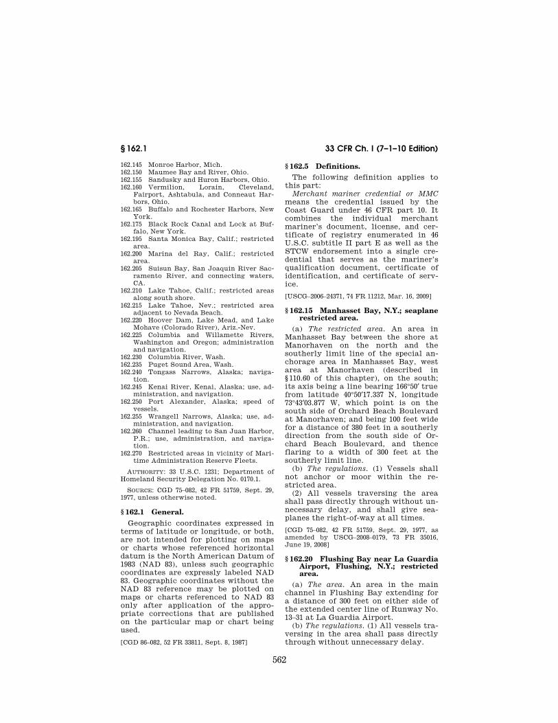
562
33 CFR Ch. I (7–1–10 Edition) § 162.1
162.145 Monroe Harbor, Mich. 162.150 Maumee Bay and River, Ohio. 162.155 Sandusky and Huron Harbors, Ohio. 162.160 Vermilion, Lorain, Cleveland,
Fairport, Ashtabula, and Conneaut Har-bors, Ohio.
162.165 Buffalo and Rochester Harbors, New York.
162.175 Black Rock Canal and Lock at Buf-falo, New York.
162.195 Santa Monica Bay, Calif.; restricted area.
162.200 Marina del Ray, Calif.; restricted area.
162.205 Suisun Bay, San Joaquin River Sac-ramento River, and connecting waters, CA.
162.210 Lake Tahoe, Calif.; restricted areas along south shore.
162.215 Lake Tahoe, Nev.; restricted area adjacent to Nevada Beach.
162.220 Hoover Dam, Lake Mead, and Lake Mohave (Colorado River), Ariz.-Nev.
162.225 Columbia and Willamette Rivers, Washington and Oregon; administration and navigation.
162.230 Columbia River, Wash. 162.235 Puget Sound Area, Wash. 162.240 Tongass Narrows, Alaska; naviga-
tion. 162.245 Kenai River, Kenai, Alaska; use, ad-
ministration, and navigation. 162.250 Port Alexander, Alaska; speed of
vessels. 162.255 Wrangell Narrows, Alaska; use, ad-
ministration, and navigation. 162.260 Channel leading to San Juan Harbor,
P.R.; use, administration, and naviga-tion.
162.270 Restricted areas in vicinity of Mari-time Administration Reserve Fleets.
AUTHORITY: 33 U.S.C. 1231; Department of Homeland Security Delegation No. 0170.1.
SOURCE: CGD 75–082, 42 FR 51759, Sept. 29, 1977, unless otherwise noted.
§ 162.1 General. Geographic coordinates expressed in
terms of latitude or longitude, or both, are not intended for plotting on maps or charts whose referenced horizontal datum is the North American Datum of 1983 (NAD 83), unless such geographic coordinates are expressly labeled NAD 83. Geographic coordinates without the NAD 83 reference may be plotted on maps or charts referenced to NAD 83 only after application of the appro-priate corrections that are published on the particular map or chart being used.
[CGD 86–082, 52 FR 33811, Sept. 8, 1987]
§ 162.5 Definitions. The following definition applies to
this part: Merchant mariner credential or MMC
means the credential issued by the Coast Guard under 46 CFR part 10. It combines the individual merchant mariner’s document, license, and cer-tificate of registry enumerated in 46 U.S.C. subtitle II part E as well as the STCW endorsement into a single cre-dential that serves as the mariner’s qualification document, certificate of identification, and certificate of serv-ice.
[USCG–2006–24371, 74 FR 11212, Mar. 16, 2009]
§ 162.15 Manhasset Bay, N.Y.; seaplane restricted area.
(a) The restricted area. An area in Manhasset Bay between the shore at Manorhaven on the north and the southerly limit line of the special an-chorage area in Manhasset Bay, west area at Manorhaven (described in § 110.60 of this chapter), on the south; its axis being a line bearing 166°50′ true from latitude 40°50′17.337 N, longitude 73°43′03.877 W, which point is on the south side of Orchard Beach Boulevard at Manorhaven; and being 100 feet wide for a distance of 380 feet in a southerly direction from the south side of Or-chard Beach Boulevard, and thence flaring to a width of 300 feet at the southerly limit line.
(b) The regulations. (1) Vessels shall not anchor or moor within the re-stricted area.
(2) All vessels traversing the area shall pass directly through without un-necessary delay, and shall give sea-planes the right-of-way at all times.
[CGD 75–082, 42 FR 51759, Sept. 29, 1977, as amended by USCG–2008–0179, 73 FR 35016, June 19, 2008]
§ 162.20 Flushing Bay near La Guardia Airport, Flushing, N.Y.; restricted area.
(a) The area. An area in the main channel in Flushing Bay extending for a distance of 300 feet on either side of the extended center line of Runway No. 13–31 at La Guardia Airport.
(b) The regulations. (1) All vessels tra-versing in the area shall pass directly through without unnecessary delay.
VerDate Mar<15>2010 07:59 Sep 03, 2010 Jkt 220131 PO 00000 Frm 00572 Fmt 8010 Sfmt 8010 Y:\SGML\220131.XXX 220131erow
e on
DS
K5C
LS3C
1PR
OD
with
CF
R

563
Coast Guard, DHS § 162.65
(2) No vessels having a height of more than 35 feet with reference to the plane of mean high water shall enter or pass through the area whenever visibility is less than one mile.
§ 162.30 Channel of Tuckerton Creek, N.J.; navigation.
(a) Power boats or other vessels pro-pelled by machinery shall not proceed at any time within the limits of these waters at a greater speed than 8 stat-ute miles per hour.
§ 162.35 Channel of Christina River, Del.; navigation.
(a) That vessels of over 20 tons capac-ity, propelled by machinery, shall not proceed at any time within the limits of these waters at a greater speed than 8 statute miles per hour.
§ 162.40 Inland waterway from Dela-ware River to Chesapeake Bay, Del. and Md. (Chesapeake and Delaware Canal).
(a) Applicability. The regulations in this section are applicable to that part of the inland waterway from Delaware River to Chesapeake Bay, Del. and Md., between Reedy Point, Delaware River, and Old Town Point Wharf, Elk River.
(b) Speed. No vessel in the waterway shall be raced or crowded alongside an-other vessel. Vessels of all types, in-cluding pleasure craft, are required to travel at all times at a safe speed throughout the canal and its ap-proaches so as to avoid damage by suc-tion or wave wash to wharves, land-ings, riprap protection, or other boats, or injury to persons. Pilots and vessel operators transiting the canal and its approaches are warned that violation of this rule may result in having their privilege to transit the canal sus-pended. Passages of vessels through the canal will be monitored and specific cases will be investigated where dam-age by suction or wave wash does occur. Owners and operators of yachts, motorboats, rowboats and other craft are cautioned that large deep draft ocean-going vessels and other large commercial vessels ply the canal, and such owners and operators should be particularly careful to moor or anchor well away from the main ship channels,
with moorings and lines which are suf-ficient and proper.
(c) Right-of-way. All vessels pro-ceeding with the current shall have the right-of-way over those proceeding against the current. Large vessels or tows must not overtake and attempt to pass other large vessels or tows in the waterway. All small pleasure craft shall relinquish the right-of-way to deeper draft vessels, which have a lim-ited maneuvering ability due to their draft and size.
(d) Stopping in waterway. Vessels will not be permitted to stop or anchor in the ship channel.
(e) Water skiing. Water skiing in the waterway is prohibited between Reedy Point and Welch Point.
(f) Sailboats. Transiting the canal by vessels under sail is not permitted be-tween Reedy Point and Welch Point.
NOTE: The Corps of Engineers also has reg-ulations dealing with this section in 33 CFR part 207.
§ 162.65 All waterways tributary to the Atlantic Ocean south of Chesapeake Bay and all waterways tributary to the Gulf of Mexico east and south of St. Marks, Fla.
(a) Description. This section applies to the following:
(1) Waterways. All navigable waters of the United States, natural or artificial, including bays, lakes, sounds, rivers, creeks, intracoastal waterways, as well as canals and channels of all types, which are tributary to or connected by other waterways with the Atlantic Ocean south of Chesapeake Bay or with the Gulf of Mexico east and south of St. Marks, Florida.
(2) United States property. All river and harbor lands owned by the United States in or along the waterways de-scribed in paragraph (a)(1) of this para-graph, including lock sites and all structures thereon, other sites for Gov-ernment structures and for the accom-modation and use of employees of the United States, and rights of way and spoil disposal areas to the extent of Federal interest therein.
(3) Vessels and rafts. The term ‘‘ves-sel’’ as used in this section includes all floating things moved over these wa-terways other than rafts.
(b) Waterways—(1) Fairway. A clear channel shall at all times be left open
VerDate Mar<15>2010 07:59 Sep 03, 2010 Jkt 220131 PO 00000 Frm 00573 Fmt 8010 Sfmt 8010 Y:\SGML\220131.XXX 220131erow
e on
DS
K5C
LS3C
1PR
OD
with
CF
R

564
33 CFR Ch. I (7–1–10 Edition) § 162.65
to permit free and unobstructed navi-gation by all types of vessels and rafts that normally use the various water-ways or sections thereof. The District Commander may specify the width of the fairway required in the various wa-terways under his charge.
(2) Stoppage in waterway, anchorage or mooring. (i) No vessels or rafts shall an-chor or moor in any of the land cuts or other narrow parts of the waterway, except in case of an emergency. When-ever it becomes necessary for a vessel or raft to stop in any such portions of the waterway it shall be securely fas-tened to one bank and as close to the bank as possible. This shall be done only at such a place and under such conditions as will not obstruct or pre-vent the passage of other vessels or craft. Stoppages shall be only for such periods as may be necessary.
(ii) No vessel or raft will be allowed to use any portion of the fairway as a mooring place except temporarily as authorized above without the written permission from the District Com-mander.
(iii) When tied up, all vessels must be moored by bow and stern lines. Rafts and tows shall be secured at suffi-ciently close intervals to insure their not being drawn away from the bank by winds, currents or the suction of passing vessels. Tow lines shall be shortened so that the different parts of the tow shall be as close together as possible. In narrow sections, no vessel or raft shall be tied abreast of another.
(iv) Lights shall be displayed in ac-cordance with provisions of the Naviga-tion Rules, International-Inland, Com-mandant Instruction M16672.2 (series).
(v) No vessel, even if fastened to the bank as prescribed in paragraph (b)(2)(i) of this section, shall be left without a sufficient crew to care for it properly.
(vi) Vessels will not be permitted to load or unload in any of the land cuts except as a regular established landing or wharf without written permission secured in advance from the District Commander.
(vii) No vessel, regardless of size, shall anchor in a dredged channel or narrow portion of a waterway for the purpose of fishing, if navigation is ob-structed, thereby.
(viii) Except in cases of emergency the dropping of anchors, weights, or other ground tackle, within areas occu-pied by submarine cable or pipe cross-ings, is prohibited. Such crossings will ordinarily be marked by signboards on each bank of the shore or indicated on coast charts.
(3) Speed. (i) Vessels shall proceed at a speed which will not endanger other vessels or structures and will not inter-fere with any work in progress incident to maintaining, improving, surveying or marking the channel.
(ii) Official signs indicating limiting speeds through critical portions of the waterways shall be strictly obeyed.
(iii) Vessels approaching and passing through a bridge shall so govern their speed as to insure passage through the bridge without damage to the bridge or its fenders.
(4) Assembly and handling of tows. (i) All vessels drawing tows and equipped with rudders shall use two tow lines or a bridle and shorten them to the great-est possible extent so as to have full control at all times. The various parts of a tow shall be securely assembled with the individual units connected by lines as short as practicable. If nec-essary, as in the case of lengthy or cumbersome tows or tows in restricted channels, the District Commander may require that tows be broken up and may require the installation of a rud-der, drag or other approved steering de-vice on the tow in order to avoid ob-structing navigation or damaging the property of others, including aids to navigation maintained by the United States or under its authorization, by collision or otherwise.
(ii) No tow shall be drawn by a vessel that has insufficient power or crew to permit ready maneuverability and safe handling.
(iii) Tows desiring to pass a bridge shall approach the opening along the axis of the channel so as to pass through without danger of striking the bridge or its fenders. No vessel or tow shall navigate through a drawbridge until the movable span is fully opened.
(iv) In the event that it is evident to the master of a towing vessel that a tow cannot be safely handled through a bridge, it will be brought to anchor and the towed vessels will be taken through
VerDate Mar<15>2010 07:59 Sep 03, 2010 Jkt 220131 PO 00000 Frm 00574 Fmt 8010 Sfmt 8010 Y:\SGML\220131.XXX 220131erow
e on
DS
K5C
LS3C
1PR
OD
with
CF
R

565
Coast Guard, DHS § 162.75
the bridge in small units, or singly if necessary, or the tow will wait until navigation conditions have improved to such an extent that the tow can pass through the bridge without damage.
(5) Projections from vessels. No vessel carrying a deck load which overhangs or projects over the side of said vessel, or whose rigging projects over the side of the vessel so as to endanger passing vessels, wharves or other property, will enter or pass through any of the nar-row parts of the waterway.
(6) Meeting and passing. Vessels, on meeting or overtaking, shall give the proper signals and pass in accordance with the Navigation Rules, Inter-national-Inland, Commandant Instruc-tion M16672.2 (series). Rafts shall give to vessels the side demanded by proper signal. All vessels approaching dredges or other plant engaged on improve-ments to a waterway, shall give the signal for passing and slow down suffi-ciently to stop if so ordered or if no an-swering signal is received. On receiving the answering signal, they shall then proceed to pass at a speed sufficiently slow to insure safe navigation.
NOTE: The Corps of Engineers also has reg-ulations dealing with this section in 33 CFR part 207.
[CGD 75–082, 42 FR 51759, Sept. 29, 1977, as amended by CGD 93–072, 59 FR 39963, Aug. 5, 1994; USCG–2000–7223, 65 FR 40058, June 29, 2000]
§ 162.75 All waterways tributary to the Gulf of Mexico (except the Mis-sissippi River, its tributaries, South and Southwest Passes and Atchafalaya River) from St. Marks, Fla., to the Rio Grande.
(a) The regulations in this section shall apply to:
(1) Waterways. All navigable waters of the U.S. tributary to or connected by other waterways with the Gulf of Mex-ico between St. Marks, Fla., and the Rio Grande, Tex. (both inclusive), and the Gulf Intracoastal Waterway; except the Mississippi River, its tributaries, South and Southwest Passes, and the Atchafalaya River above its junction with the Morgan City-Port Allen Route.
(2) Bridges, wharves, and other struc-tures. All bridges, wharves, and other structures in or over these waterways.
(3) Vessels. The term ‘‘vessels’’ as used in this section includes all float-ing craft other than rafts.
(b) Waterways: (1) A clear channel shall at all times
be left open to permit free and unob-structed navigation by all types of ves-sels and tows normally using the var-ious waterways covered by the regula-tions of this section
(2) Fairway: The District Commander may specify the width of the fairway required in the various waterways under his charge.
(3) Anchoring or mooring: (i) Vessels or tows shall not anchor
or moor in any of the land cuts or other narrow parts of the waterway, except in an emergency, or with per-mission of the District Commander. Whenever it becomes necessary for a vessel or tow to stop in any such por-tions of the waterway, it shall be se-curely fastened to one bank and as close to the bank as possible. This shall be done only at such a place and under such conditions as will not obstruct or prevent the passage of other vessels or tows. Stoppages shall be only for such periods as may be necessary.
(ii) When tied up individually, all vessels and tows shall be moored by bow and stern lines. Tows shall be se-cured at sufficiently frequent intervals to insure their not being drawn away form the bank by winds, currents, or the suction of passing vessels. Lines shall be shortened so that the various barges in a tow will be as close to-gether as possible.
(iii) Lights shall be displayed in ac-cordance with provisions of the Naviga-tion Rules, International-Inland, Com-mandant Instruction M16672.2 (series).
(iv) Whenever any vessel or tow is moored to the bank (paragraph (b)(3)(i) of this section) at least one crew mem-ber shall always remain on board to see that proper signals are displayed and that the vessel or tow is properly moored at all times.
(v) No vessel, regardless of size, shall anchor in a dredged channel or narrow portion of a waterway for the purpose of fishing if navigation is obstructed thereby.
(4) Speed: Speeding in narrow sec-tions is prohibited. Official signs indi-cating limited speeds shall be obeyed.
VerDate Mar<15>2010 07:59 Sep 03, 2010 Jkt 220131 PO 00000 Frm 00575 Fmt 8010 Sfmt 8010 Y:\SGML\220131.XXX 220131erow
e on
DS
K5C
LS3C
1PR
OD
with
CF
R

566
33 CFR Ch. I (7–1–10 Edition) § 162.75
Vessels shall reduce speed sufficiently to prevent damage when passing other vessels or structures in or along the waterway.
(5) Size, assembly, and handling of tows:
(i) On waterways 150 feet wide or less, tows which are longer than 1,180 feet, including the towing vessel, but ex-cluding the length of the hawser, or wider than one-half of the bottom width of the channel or 55 feet, which-ever is less will not be allowed, except when the District Commander has given special permission or the water-way has been exempted from these re-strictions by the District Commander. Before entering any narrow section of the Gulf Intracoastal Waterway, tows in excess of one-half the channel width, or 55 feet, will be required to stand by until tows which are less than one-half the channel width or 55 feet wide have cleared the channel. When passing is necessary in narrow channels, overwidth tows shall yield to the max-imum. Separate permission must be re-ceived from the District Commander for each overlength or overwidth move-ment. In addition, the following excep-tions are allowed:
(ii) Gulf Intracoastal Waterway—Be-tween mile 6.2 EHL (Inner Harbor Navi-gation Canal Lock) and mile 33.6 EHL tows of 78 feet in width will be allowed.
(iii) Gulf Intercoastal Waterway—Be-tween mile 33.6 EHL and the Mobile Bay Ship Channel, tows of 108 feet in width will be allowed if under 750 feet in length including the towboat but ex-cluding the length of the hawser.
(iv) Gulf Intracoastal Waterway—Mo-bile Bay Ship Channel to St. Marks, Fla., for tows made up of empty barges on the off or shallow side, a width of 75 feet will be allowed.
(v) All vessels pulling tows not equipped with rudders in restricted channels and land cuts shall use two towlines, or a bridle on one towline, shortened as much as safety of the tow-ing vessel permits, so as to have max-imum control at all times. The various parts of a tow shall be securely assem-bled with the individual units con-nected by lines as short as practicable. In open water, the towlines and fas-tenings between barges may be length-ened so as to accommodate the wave
surge. In the case of lengthy or cum-bersome tows, or tows in restricted channels, the District Commander may require that tows be broken up, and may require the installation of a rud-der or other approved steering device on the tow in order to avoid obstruct-ing navigation or damaging the prop-erty of others. Pushing barges with towing vessel astern, towing barges with towing vessel alongside, or push-ing and pulling barges with units of the tow made up both ahead and astern of the towing vessel are permissible pro-vided that adequate power is employed to keep the tows under full control at all times. No tow shall be drawn by a vessel that has insufficient power or crew to permit ready maneuverability and safe handling.
(vi) All tows navigating the Pass Manchac bridges in Louisiana are lim-ited to no more than two barges, not to exceed a combined tow length of 400 feet (excluding the towboat). Vessel op-erators for tows exceeding these limits must request and receive permission from the COTP New Orleans prior to navigating the bridges. Requests should be made by telephoning the COTP at 504–846–5923. Any decision made by the COTP is final agency ac-tion.
(6) Projections from vessels: Vessels or tows carrying a deck load which overhangs or projects over the side, or whose rigging projects over the side, so as to endanger passing vessels, wharves, or other property, shall not enter or pass through any of the nar-row parts of the waterway without prior approval of the District Com-mander.
(7) Meeting and passing: Passing ves-sels shall give the proper signals and pass in accordance with the Inter-national Rules, the Navigation Rules, International-Inland, Commandant In-struction M16672.2 (Series), where ap-plicable. At certain intersections where strong currents may be encountered, sailing directions may be issued through navigation bulletins or signs posted on each side of the intersec-tions.
VerDate Mar<15>2010 07:59 Sep 03, 2010 Jkt 220131 PO 00000 Frm 00576 Fmt 8010 Sfmt 8010 Y:\SGML\220131.XXX 220131erow
e on
DS
K5C
LS3C
1PR
OD
with
CF
R
567
Coast Guard, DHS § 162.90
NOTE: The Corps of Engineers also has reg-ulations dealing with this section in 33 CFR 207.
[CGD 75–082, 42 FR 51759, Sept. 29, 1977, as amended by CGD 78–050, 45 FR 43167, June 26, 1980; USCG–2000–7223, 65 FR 40058, June 29, 2000; USCG–2008–0179, 73 FR 35016, June 19, 2008]
§ 162.80 Mississippi River below mouth of Ohio River, including South and Southwest passes.
(a) Mooring on the Mississippi River be-tween miles 311.5 AHP and 340.0 AHP. (1) No vessel or craft shall moor along ei-ther bank of the Mississippi River be-tween miles 311.5 AHP and mile 340.0 AHP except in case of an emergency, pursuant to an approved navigation permit, or as authorized by the District Commander. Vessels may be moored any place outside the navigation chan-nel in this reach in case of an emer-gency and then for only the minimum time required to terminate the emer-gency. When so moored, all vessels shall be securely tied with bow and stern lines of sufficient strength and fastenings to withstand currents, winds, wave action, suction from pass-ing vessels or any other forces which might cause the vessels to break their moorings. When vessels are so moored, a guard shall be on board at all times to ensure that proper signals are dis-played and that the vessels are se-curely and adequately moored.
(2) Vessels may be moored any time at facilities constructed in accordance with an approved navigation permit or as authorized by the District Com-mander. When so moored, each vessel shall have sufficient fastenings to pre-vent the vessels from breaking loose by wind, current, wave action, suction from passing vessels or any other forces which might cause the vessel to break its mooring. The number of ves-sels in one fleet and the width of the fleet of vessels tied abreast shall not extend into the fairway or be greater than allowed under the permit.
(3) Mariners should report imme-diately by radio or fastest available means to the lockmaster at Old River Lock or to any government patrol or survey boat in the vicinity any emer-gency mooring or vessels drifting un-controlled within the area described in paragraph (a)(1) of this section. It is
the responsibility and duty of the mas-ter of a towing vessel releasing or mooring a vessel in this reach of the Mississippi River to report such action immediately.
(b) Mooring on Mississippi River below Baton Rouge, La., including South and Southwest Passes. (1) When tied up indi-vidually or in fleets, vessels shall be moored with sufficient lines and shore fastenings to insure their remaining in place and withstanding the action of winds, currents and the suction of pass-ing vessels.
NOTE: The Corps of Engineers also has reg-ulations dealing with this section in 33 CFR part 207.
(Sec. 7, 38 Stat. 1053, as amended, (33 U.S.C. 471); Sec. 6(g)(1)(A) 80 Stat 937, (49 U.S.C. 1655(g)(1)(A); Sec. 12, 92 Stat. 1471, (33 U.S.C. 1231); 49 CFR 1.46 (c)(1) and (n)(4))
[CGD 75–082, 42 FR 51759, Sept. 29, 1977, as amended by CGD 77–028, 46 FR 49851, Oct. 8, 1981; CGD8 87–09, 53 FR 15555, May 2, 1988]
§ 162.85 Yazoo Diversion Canal, Vicks-burg, Miss., from its mouth at Kleinston Landing to Fisher Street; navigation.
(a) Speed. Excessive speeding is pro-hibited. A vessel shall reduce its speed sufficiently to prevent any damage when approaching another vessel in motion or tied up, a wharf or other structure, works under construction, plant engaged in river and harbor im-provement, levees, floodwalls with-standing floodwaters, buildings sub-merged or partially submerged by high waters, or any other structure or im-provement likely to be damaged by col-lision, suction, or wave action.
NOTE: The Corps of Engineers also has reg-ulations dealing with this section in 33 CFR part 207.
§ 162.90 White River, Arkansas Post Canal, Arkansas River, and Verdi-gris River between Mississippi River, Ark., and Catoosa, Okla.; use, administration, and navigation.
(a) The regulations in this section shall apply to:
(1) Waterways. White River between Mississippi River and Arkansas Post Canal, Ark.; Arkansas Post Canal, Ark.; Arkansas River between Arkan-sas Post Canal, Ark., and Verdigris River, Okla.; Verdigris River between
VerDate Mar<15>2010 07:59 Sep 03, 2010 Jkt 220131 PO 00000 Frm 00577 Fmt 8010 Sfmt 8010 Y:\SGML\220131.XXX 220131erow
e on
DS
K5C
LS3C
1PR
OD
with
CF
R
568
33 CFR Ch. I (7–1–10 Edition) § 162.90
Arkansas River and Catoosa, Okla.; and reservoirs on these waterways be-tween Mississippi River Ark., and Catoosa, Okla.
(2) Bridges, wharves and other struc-tures. All bridges, wharves, and other structures in or over the waterways de-scribed in paragraph (a)(1) of this sec-tion.
(3) Vessels and rafts. The term ‘‘ves-sels’’ as used in this section includes every description of watercraft used, or capable of being used, as a means of transportation on water, other than rafts.
(b) Waterways: (1) Fairway. A clear channel shall at
all times be left open to permit free and unobstructed navigation by all types of vessels and rafts that nor-mally use the various waterways or sections thereof. The District Com-mander may specify the width of the fairway required in the waterways under his charge.
(2) Anchoring or mooring in waterway. (i) No vessels or rafts shall anchor or moor in any of the land cuts or other narrow parts of the waterway, except in an emergency. Whenever it becomes necessary for a vessel or raft to stop in any such portions of the waterway, it shall be securely fastened to one bank and as close to the bank as possible. This shall be done only at such a place and under such conditions as will not obstruct or prevent the passage of other vessels or rafts. Stoppages shall be only for such periods as may be nec-essary.
(ii) Except temporarily, as authorized in paragraph (b)(2)(i) of this section, no vessel or raft will be allowed to use any portion of the fairway as a mooring place without written permission from the District Commander.
(iii) When tied up individually, all vessels shall be moored by bow and stern lines. Rafts and tows shall be se-cured at sufficiently close intervals to insure their not being drawn away from the bank by winds, currents, or the suction of passing vessels. Towlines shall be shortened so that the different parts of the tow will be as close to-gether as possible. In narrow sections, no vessel or raft shall be tied abreast of another if the combined width of ves-sels or rafts is greater than 70 feet.
(iv) When a vessel is moored under an emergency condition, as provided in paragraph (b)(2)(i) of this section, at least one crew member shall remain in attendance to display proper lights and signals and tend the mooring lines. The crew member shall be provided with an adequate means of communication or signalling a warning in the event that, for any reason, the vessel or tow should go adrift. Immediately after comple-tion of the emergency mooring, the lockmaster of the first lock down-stream shall be notified of the char-acter and cargo of the vessel and the location of such mooring.
(v) Vessels will not be permitted to load or unload in any of the land cuts, except at a regular established landing or wharf, without written permission secured in advance from the District Commander.
(vi) Except in an emergency, no ves-sel or raft shall anchor over revetted banks of the waterway, nor shall any type vessel except launches and other small craft land against banks pro-tected by revetment except at regular commercial landings.
(3) Speed. (i) Excessive speed in nar-row sections is prohibited. Official signs indicating limiting speeds through critical sections shall be strictly obeyed.
(ii) When approaching and passing through a bridge, all vessels and rafts, regardless of size, shall control their speed so as to insure that no damage will be done to the bridge or its fend-ers.
(iii) Within the last mile of approach to unattended, normally open auto-matic, movable span bridges, the factor of river flow velocity, of vessel (and tow) velocity, and of vessel power and crew capability are never to be per-mitted to result in a condition whereby the movement of vessel (and tow) can-not be completely halted or reversed within a 3-minute period.
(iv) A vessel shall reduce its speed sufficiently to prevent any damage when approaching another vessel in motion or tied up, a wharf or other structure, works under construction, plant engaged in river and harbor im-provement, levees withstanding flood-waters, buildings submerged or par-tially submerged by high waters, or
VerDate Mar<15>2010 07:59 Sep 03, 2010 Jkt 220131 PO 00000 Frm 00578 Fmt 8010 Sfmt 8010 Y:\SGML\220131.XXX 220131erow
e on
DS
K5C
LS3C
1PR
OD
with
CF
R

569
Coast Guard, DHS § 162.100
any other manner of structure or im-provements likely to be damaged by collision, suction, or wave action.
(4) Assembly and handling of tows. (i) All vessels drawing tows not equipped with rudders in restricted channels and land cuts shall use two towlines, or a bridle on one towline, shortened to the greatest possible extent so as to have maximum control at all times. The various parts of a tow shall be securely assembled with the individual units connected by lines as short as prac-ticable. In open water, the towlines and fastenings between barges may be lengthened so as to accommodate the wave surge. In the case of length or cumbersome tows, or tows in restricted channels, the District Commander may require that tows be broken up, and may require the installation of a rud-der or other approved steering device on the tow in order to avoid obstruct-ing navigation or damaging the prop-erty of others. Pushing barges with towing vessel astern, towing barges with towing vessel alongside, or push-ing and pulling barges with units of the tow made up both ahead and astern of the towing vessel is permissible pro-vided that adequate power is employed to keep the tow under full control at all times.
(ii) No tow shall be drawn by a vessel that has insufficient power or crew to permit ready maneuverability and safe handling.
(iii) No vessel or tow shall navigate through a drawbridge until the mov-able span is fully opened.
(5) Projections from vessels. No vessels carrying a deck load which overhangs or projects over the side, or whose rig-ging projects over the side, so as to en-danger passing vessels, wharves, or other property, shall enter or pass through any of the narrow parts of the waterway.
(6) Meeting and passing. Vessels on meeting or overtaking shall give the proper signals and pass in accordance with the Inland Rules and the Pilot Rules for Inland Waters. Rafts shall give to vessels the side demanded by proper signal. All vessels approaching dredges or other plant engaged on im-provements to a waterway shall give the signal for passing and slow down sufficiently to stop if so ordered or if
no answering signal is received. On re-ceiving the answering signal, they shall then pass at a speed sufficiently slow to insure safe navigation. Vessels approaching an intersection or bend where the view is obstructed must ex-ercise due caution. At certain intersec-tions where strong currents may be en-countered, sailing directions may be issued from time to time through navi-gation bulletins or signs posted on each side of the intersections which must be observed.
NOTE: The Corps of Engineers also has reg-ulations dealing with this section in 33 CFR part 207.
[CGD 75–082, 42 FR 51759, Sept. 29, 1977, as amended by USCG–2008–0179, 73 FR 35016, June 19, 2008]
§ 162.100 Ohio River at Louisville, KY.
(a) Emergency Mooring Buoys. The U.S. Army Corp of Engineers has estab-lished four pairs of emergency mooring bouys. Each buoy is 10 feet in diameter with retro-reflective sides. The two buoys which comprise each pair are 585 feet apart and are located approxi-mately at:
(1) Indiana Bank—Mile 582.3 (near 18 Mile Island);
(2) Six Mile Island—Mile 597.5; (3) Six Mile Island—Mile 598.2; and (4) Kentucky Bank—Mile 599.8 (Cox’s
Park).
NOTE: All buoys, except those at Six Mile Island—Mile 598.2, are removed between May 1 and September 30. Due to the close prox-imity of the municipal water intakes, moor-ing of tank vessels laden with petroleum products or hazardous materials is not au-thorized on the Kentucky Bank, Mile 599.8 (Cox’s Park).
(b) The regulations. A vessel must not use the emergency mooring buoys that have been established by the U.S. Army Corps of Engineers, unless spe-cifically authorized. The Captain of the Port, upon request, may authorize the use of the emergency mooring buoys by downbound towing vessels that are awaiting Vessel Traffic Center ap-proval to proceed.
[CGD 90–020, 59 FR 36333, July 15, 1994]
VerDate Mar<15>2010 07:59 Sep 03, 2010 Jkt 220131 PO 00000 Frm 00579 Fmt 8010 Sfmt 8010 Y:\SGML\220131.XXX 220131erow
e on
DS
K5C
LS3C
1PR
OD
with
CF
R

570
33 CFR Ch. I (7–1–10 Edition) § 162.105
§ 162.105 Missouri River; administra-tion and navigation.
(a) Supervision. The District Com-mander, Eighth Coast Guard District, has certain administrative supervision overreaches of the river within the lim-its of his district and is charged with the enforcement under his direction of emergency regulations to govern navi-gation on the river.
(b) Navigation. During critical flood stages on any particular limited reach of the Missouri River when lives, float-ing plant, or major shore installations and levees are endangered, the District Commander in charge of the locality shall have the authority to declare the reach of the river closed to navigation or to prescribe temporary speed regula-tions whenever it appears to him that such action is necessary to prevent im-mediate human suffering or to miti-gate major property damage or de-struction from wave action. The period of closure and all speed regulations prescribed by the District Commander shall be for the duration of the emer-gency as determined by the District Commander and shall be terminated at the earliest practicable time that im-proved river conditions permit.
[CGD 75–082, 42 FR 51759, Sept. 29, 1977, as amended by USCG–1998–3799, 63 FR 35532, June 30, 1998]
§ 162.110 Duluth-Superior Harbor, Minnesota and Wisconsin.
(a) No vessel greater than 100 feet in length may exceed 8 miles per hour in Duluth-Superior Harbor.
(b) In the Duluth Ship Canal: (1) No vessel may meet or overtake
another vessel if each vessel is greater than 150 feet in length (including tug and tow combinations).
(2) An inbound vessel has the right of way over an outbound vessel.
[CGD 79–151, 46 FR 7960, Jan. 26, 1981]
§ 162.115 Keweenaw Waterway, Mich.
No vessel greater than 40 feet in length may exceed 8 miles per hour be-tween Lily Pond and Pilgrim Point.
[CGD 79–151, 46 FR 7960, Jan. 26, 1981, as amended by CGD 09–00–010, 65 FR 53595, Sept. 5, 2000]
§ 162.117 St. Marys River, Sault Ste. Marie, Michigan.
(a) The area. The waters of the St. Marys River and lower Whitefish Bay from 45°57′ N. (De Tour Reef Light) to the south, to 46°38.7′ N. (Ile Parisienne Light) to the north, except the waters of the St. Marys Falls Canal, and to the east along a line from La Pointe to Sims Point, within Potagannissing Bay and Worsley Bay.
(b) Definitions. As used in this sec-tion:
Two-way route means a directional route within defined limits inside which two-way traffic is established, and which is intended to improve safe-ty in waters where navigation is dif-ficult.
Two-way traffic means that traffic flow is permitted in opposing direc-tions, but a vessel may not meet, cross, nor overtake any other vessel in such a manner that it would be abreast of more than one other vessel within the defined limits of a waterway.
(c) Anchoring Rules. (1) A vessel must not anchor: (i) within the waters between Brush
Point and the waterworks intake crib off Big Point southward of the Point Aux Pins range; or
(ii) within 0.2 nautical miles of the intake crib off Big Point.
(2) In an emergency, vessels may an-chor in a dredged channel. Vessels shall anchor as near to the edge of the chan-nel as possible and shall get underway as soon as the emergency ceases, unless otherwise directed. Vessel Traffic Serv-ices St. Marys River must be advised of any emergency anchoring as soon as is practicable.
(3) Vessels collected in any part of the VTS Area by reason of temporary closure of a channel or an impediment to navigation shall get underway and depart in the order in which they ar-rived, unless otherwise directed by Ves-sel Traffic Service St. Marys River. Vessel Traffic Service St. Marys River may advance any vessel in the order of departure to expedite the movement of mails, passengers, cargo of a perishable nature, to facilitate passage of vessels through any channel by reason of spe-cial circumstance, or to facilitate pas-sage through the St. Marys Falls Canal.
VerDate Mar<15>2010 07:59 Sep 03, 2010 Jkt 220131 PO 00000 Frm 00580 Fmt 8010 Sfmt 8010 Y:\SGML\220131.XXX 220131erow
e on
DS
K5C
LS3C
1PR
OD
with
CF
R
571
Coast Guard, DHS § 162.117
(d) Traffic Rules. (1) A vessel must proceed only in the established direc-tion of traffic flow in the following wa-ters:
(i) West Neebish Channel from Buoy ‘‘53’’ to Buoy ‘‘1’’—downbound traffic only;
(ii) Pipe Island Course from Sweets Point to Watson Reefs Light- downbound traffic only.
(iii) Middle Neebish Channel from Buoy ‘‘2’’ to Buoy ‘‘76’’—upbound traf-fic only; and
(iv) Pipe Island Passage to the east of Pipe Island Shoal and north of Pipe Is-land Twins from Watson Reefs Light to Sweets Point—upbound traffic only.
(2) A vessel 350 feet or more in length must not overtake or approach within .2 nautical miles of another vessel pro-ceeding in the same direction in the following waterways:
(i) West Neebish Channel between Nine Mile Point and Munuscong Lake Junction Lighted Bell Buoy;
(ii) Middle Neebish Channel between Munuscong Lake Junction Lighted Bell Buoy and Nine Mile Point; and
(iii) Little Rapids Cut from Six Mile Point to Buoy ‘‘102’’.
(3) When two-way traffic is author-ized in Middle Neebish Channel, a ves-sel 350 feet or more in length must not meet, cross, or overtake another vessel at:
(i) Johnson Point from Buoy ‘‘18’’ to Buoy ‘‘22’’;
(ii) Mirre Point from Buoy ‘‘26’’ to Buoy ‘‘28’’; or
(iii) Stribling Point from Buoy ‘‘39’’ to Buoy ‘‘43’’.
(4) Paragraph (d)(2) of this section does not apply to a vessel navigating through an ice field.
(e) Winter Navigation. During the win-ter navigation season, the following waterways are normally closed:
(1) West Neebish Channel, from Buoy ‘‘53’’ to Buoy ‘‘1’’;
(2) Pipe Island Passage to the east of Pipe Island Shoal; and
(3) North of Pipe Island Twins, from Watson Reef Light to Sweets Point.
(f) Alternate Winter Navigation Routes. (1) When West Neebish Channel is closed, Middle Neebish Channel (from Buoy ‘‘2’’ to Buoy ‘‘76’’) will be open ei-ther as a two-way route or an alter-nating one way traffic lane.
(i) When Middle Neebish Channel is a two-way route:
(A) An upbound vessel must use the easterly 197 feet of the channel. How-ever, a vessel of draft 20 feet or more must not proceed prior to Vessel Traf-fic Center approval; and
(B) A downbound vessel must use the westerly 295 feet of the channel.
(ii) When Middle Neebish Channel is an alternating one-way traffic lane. A vessel must use the westerly 295 feet of the channel in the established direc-tion of traffic flow.
(2) When Pipe Island Passage is closed, Pipe Island Course is a two-way route.
NOTE: The Vessel Traffic Service closes or opens these channels as ice conditions re-quire after giving due consideration to the protection of the marine environment, wa-terway improvements, aids to navigation, the need for cross channel traffic (e.g., fer-ries), the availability of icebreakers, and the safety of the island residents who, in the course of their daily business, must use nat-urally formed ice bridges for transportation to and from the mainland. Under normal sea-sonal conditions, only one closing each win-ter and one opening each spring are antici-pated. Prior to closing or opening these channels, interested parties including both shipping entities and island residents, will be given at least 72 hours notice by the Coast Guard.
(g) Speed Rules. (1) The following speed limits indicate speed over the ground. Vessels must adhere to the fol-lowing speed limits:
TABLE 162.117(g)—ST. MARYS RIVER SPEED RULES
Maximum speed limit between Mph Kts
De Tour Reef Light and Sweets Point Light ....................................................... 14 12.2
Round Island Light and Point Aux Frenes Light ‘‘21’’ ............................................... 14 12.2
Munuscong Lake Lighted Buoy ‘‘8’’ and Everens Point ......................................... 12 10.4
Everens Point and Reed Point .................. 9 7.8 Reed Point and Lake Nicolet Lighted
Buoy ‘‘62’’ .............................................. 10 8.7 Lake Nicolet Lighted Buoy ‘‘62’’ and Lake
Nicolet Light ‘‘80’’ ................................... 12 10.4 Lake Nicolet Light ‘‘80’’ and Winter Point
(West Neebish Channel) ....................... 10 8.7 Lake Nicolet Light ‘‘80’’ and Six Mile Point
Range Rear Light .................................. 10 8.7 Six Mile Point Range Rear Light and
lower limit of the St. Marys Falls Canal Upbound ............................................. 8 7.0 Downbound ........................................ 10 8.7
VerDate Mar<15>2010 07:59 Sep 03, 2010 Jkt 220131 PO 00000 Frm 00581 Fmt 8010 Sfmt 8010 Y:\SGML\220131.XXX 220131erow
e on
DS
K5C
LS3C
1PR
OD
with
CF
R

572
33 CFR Ch. I (7–1–10 Edition) § 162.120
TABLE 162.117(g)—ST. MARYS RIVER SPEED RULES—Continued
Maximum speed limit between Mph Kts
Upper limit of the St. Marys Falls Canal and Point Aux Pins Main Light .............. 12 10.4
Note: A vessel must not navigate any dredged channel at a speed of less than 5 statute miles per hour (4.3 knots).
(2) Temporary speed limit regula-tions may be established by Com-manding Officer Vessel Traffic Service St. Marys River. Notice of the tem-porary speed limits and their effective dates and termination are published in the FEDERAL REGISTER and Local No-tice to Mariners. These temporary speed limits, if imposed, will normally be placed in effect and terminated dur-ing the winter navigation season.
(h) Towing Requirement. A towing ves-sel must: (1) Maintain positive control of its tow south of Gros Cap Reef Light;
(2) Not impede the passage of any other vessel;
(3) Not tow a vessel of 200 feet or less in length with a tow line longer than 250 feet; and
(4) Not tow a vessel of 200 feet or more in length with a tow line longer than the length of the towed vessel plus 50 feet.
[CGD 90–020, 59 FR 36333, July 15, 1994, as amended by CGD 95–033, 60 FR 28333, May 31, 1995; USCG–1998–3799, 63 FR 35532, June 30, 1998; USCG–2003–15404, 68 FR 37741, June 25, 2003]
§ 162.120 Harbors on Lake Michigan.
(a) No vessel greater than 40 feet in length may exceed 8 miles per hour in the harbors of Michigan City, Indiana; St. Joseph, South Haven, Saugatuck, Holland (Lake Macatawa), Grand Haven, Muskegon, White Lake, Pentwater, Ludington, Manistee, Por-tage Lake (Manistee County), Frank-fort, Charlevois, and Petroskey, Michi-gan.
(b) No vessel greater than 40 feet in length may exceed 4 miles per hour in the harbors of Menominee, Michigan and Wisconsin; Algoma, Kewaunee, Two Rivers, Manitowac, Sheboygan, Port Washington, Milwaukee, Racine, Kenosha and Green Bay, Wisconsin; and Waukegan, Illinois.
[CGD 79–151, 46 FR 7960, Jan. 26, 1981]
§ 162.125 Sturgeon Bay and the Stur-geon Bay Ship Canal, Wisc.
(a) In the Sturgeon Bay Ship Canal: (1) No vessel may exceed 5 miles per
hour. (2) No vessel greater than 150 feet in
length (including tug and tow combina-tions) may come about.
(3) No vessel 65 feet or greater in length (including tug and tow combina-tions) may either:
(i) Enter or pass through the canal two or more abreast; or
(ii) Overtake another vessel. (4) No vessel may anchor or moor un-
less given permission to do so by the Captain of the Port.
(5) Each vessel must keep to the cen-ter, except when meeting or overtaking another vessel.
(b) In Sturgeon Bay and the Sturgeon Bay Ship Canal:
(1) Each laden vessel under tow must be towed with at least two towlines. Each towline must be shortened to the extent necessary to provide maximum control of the tow.
(2) Each unladen vessel may be towed with one towline.
(3) No towline may exceed 100 feet in length.
(4) No vessel may tow another vessel alongside.
(5) No vessel may tow a raft greater than 50 feet in width.
NOTE: The Corps of Engineers also has reg-ulations dealing with these areas in 33 CFR Part 207.
[CGD 79–151, 46 FR 7960, Jan. 26, 1981]
§ 162.130 Connecting waters from Lake Huron to Lake Erie; general rules.
(a) Purpose. The regulations in §§ 162.130 through 162.140 prescribe rules for vessel operation in U.S. waters con-necting Lake Huron to Lake Erie (in-cluding the River Rouge) to prevent collisions and groundings, to protect waterway improvements, and to pro-tect these waters from environmental harm resulting from collisions and groundings.
NOTE: The Canadian Government has issued similar regulations which apply in the Canadian portion of the waterway. Provi-sions which apply only in Canadian waters are noted throughout the text.
VerDate Mar<15>2010 07:59 Sep 03, 2010 Jkt 220131 PO 00000 Frm 00582 Fmt 8010 Sfmt 8010 Y:\SGML\220131.XXX 220131erow
e on
DS
K5C
LS3C
1PR
OD
with
CF
R

573
Coast Guard, DHS § 162.132
(b) Applicability. (1) Unless otherwise specified, the rules in §§ 162.130 through 162.140 apply to all U.S. vessels and all other vessels in U.S. waters.
(2) The speed rules in § 162.138 apply to vessels 20 meters or more in length.
(3) The communication rules in § 162.132, the traffic rules in § 162.134, ex-cept for § 162.134(c)(2), and the anchor-age rules in § 162.136 apply to the fol-lowing vessels:
(i) Vessels of 20 meters or more in length;
(ii) Commercial vessels more than 8 meters in length engaged in towing an-other vessel astern, alongside, or by pushing ahead; and
(iii) Each dredge and floating plant. (4) The traffic rules contained in
§ 162.134(c)(2) apply to the following ves-sels:
(i) Sailing vessels of 20 meters or more in length;
(ii) Power driven vessels of 55 meters or more in length;
(iii) Vessels engaged in towing an-other vessel astern, alongside or by pushing ahead; and
(iv) Each dredge and floating plant. (c) Definitions. As used in §§ 162.130
through 162.140: Captain of the Port means the United
States Coast Guard Captain of the Port of Detroit, Michigan.
Detroit River means the connecting waters from Windmill Point Light to the lakeward limits of the improved navigation channels at the head of Lake Erie.
District Commander means Com-mander, Ninth Coast Guard District, Cleveland, Ohio.
Master means the master or operator, the person designated by the master or operator to navigate the vessel, or, on a vessel not requiring persons holding licenses or merchant mariner creden-tial officer endorsements, the person in command of the vessel.
River Rouge means the waters of the Short Cut Canal and the River Rouge from Detroit Edison Cell Light 1 to the head of navigation.
St. Clair River means the connecting waters from the lakeward limit of the improved navigation channel at the lower end of Lake Huron to St. Clair Flats Canal Light 2.
SARNIA TRAFFIC means the Cana-dian Coast Guard traffic center at Sarnia Ontario.
(d) Laws and regulations not affected. The regulations in §§ 162.130 through 162.140 do not relieve the owners or op-erators of vessels from complying with any other laws or regulations relating to navigation on the Great Lakes and their connecting or tributary waters.
(e) Delegations. The District Com-mander, in coordination with appro-priate Canadian officials, may make local arrangements that do not conflict with these regulations in the interest of safety of operations, to facilitate traffic movement and anchorage, to avoid disputes as to jurisdiction and to take necessary action to render assist-ance in emergencies. This authority may be redelegated.
[CGD 78–151, 49 FR 18301, Apr. 30, 1984; 49 FR 26722, June 29, 1984, as amended by CGD 85– 060, 51 FR 17016, May 8, 1986; CGD 93–024, 58 FR 59365, Nov. 9, 1993; USCG–2006–24371, 74 FR 11213, Mar. 16, 2009]
§ 162.132 Connecting waters from Lake Huron to Lake Erie; communica-tions rules.
(a) Radio listening watch. The master of each vessel required to comply with this section shall continuously mon-itor:
(1) Channel 11 (156.55 mhz) between Lake Huron Cut Lighted Buoy 11 and Lake St. Clair Light; and
(2) Channel 12 (156.60 mhz) between Lake St. Clair Light and Detroit River Light.
(b) Radiotelephone equipment. Reports required by this section shall be made by the master using a radiotelephone capable of operation on a vessel’s navi-gation bridge, or in the case of a dredge, from its main control station.
(c) English language. Reports required by this section shall be made in the English language.
(d) Traffic reports. (1) Reports re-quired by this section shall be made to SARNIA TRAFFIC on the frequency designated for the radio listening watch in paragraph (a) of this section.
(2) Reports shall include the name of the vessel, location, intended course of action, and ETA at next reporting point.
VerDate Mar<15>2010 07:59 Sep 03, 2010 Jkt 220131 PO 00000 Frm 00583 Fmt 8010 Sfmt 8010 Y:\SGML\220131.XXX 220131erow
e on
DS
K5C
LS3C
1PR
OD
with
CF
R

574
33 CFR Ch. I (7–1–10 Edition) § 162.134
(e) Permanent reporting points. The master of each vessel to which this sec-tion applies shall report as required by paragraph (d) of this section at the lo-cation indicated in Table I.
TABLE I
Downbound vessels Reporting points Upbound
vessels
Report ......... 30 Minutes North of Lake Huron Cut.
Lighted Horn Buoy ‘‘11’’ Report ......... Lake Huron Cut Light ‘‘7’’
Lake Huron Cut Lighted Buoy ‘‘1’’.
Report.
Report ......... St. Clair/Black River Junction Light.
Report.
Stag Island Upper Light ......... Report. Report ......... Marine City Salt Dock Light ... Report. Report ......... Grande Pointe Light ‘‘23’’
St. Clair Flats Canal Light ‘‘2’’ Report. Report ......... Lake St. Clair Light ................ Report. Report ......... Belle Isle Light Report ......... Grassy Island Light ................ Report. Report ......... Detroit River Light .................. Report.
(f) Additional traffic reports. (1) A re-port shall be made upon leaving any dock, mooring, or anchorage, in the Detroit River, Lake St. Clair, and the St. Clair River except for—
(i) Ferries on regular runs; and (ii) Vessels in the River Rouge. (2) A report shall be made before ma-
neuvering to come about. (3) A report shall be made— (i) 20 minutes before entering or de-
parting the River Rouge; and (ii) Immediately before entering or
departing the River Rouge. (g) Report of impairment or other haz-
ard. The master of a vessel shall report to SARNIA TRAFFIC as soon as pos-sible:
(1) Any condition on the vessel that may impair its navigation, including but not limited to: fire, defective steer-ing equipment, or defective propulsion machinery.
(2) Any tow that the towing vessel is unable to control, or can control only with difficulty.
(h) Exemptions. Compliance with this section is not required when a vessel’s radiotelphone equipment has failed.
[CGD 78–151, 49 FR 18301, Apr. 30, 1984; 49 FR 26722, June 29, 1984, as amended by CGD 85– 060, 51 FR 17016, May 8, 1986; CGD 85-060, 51 FR 37274, Oct. 21, 1986]
§ 162.134 Connecting waters from Lake Huron to Lake Erie; traffic rules.
(a) Detroit River. The following traffic rules apply in the Detroit River:
(1) The West Outer Channel is re-stricted to downbound vessels.
(2) The Livingston Channel, west of Bois Blanc Island, is restricted to downbound vessels.
NOTE: The Amherstburg Channel, in Cana-dian waters east of Bois Blanc Island, is nor-mally restricted to upbound vessels. No ves-sel may proceed downbound in the Amherstburg Channel without authorization from the Regional Director General.
(3) Between Fighting Island Channel South Light and Bar Point Pier Light 29D, no vessels shall meet or overtake in such a manner that more than two vessels would be abreast at any time.
(4) Between the west end of Belle Isle and Peche Island Light, vessels may only overtake vessels engaged in tow-ing.
(b) River Rouge. In the River Rouge, no vessel shall overtake another vessel.
(c) St. Clair River. The following traf-fic rules apply in the St. Clair River:
(1) Between St. Clair Flats Canal Light 2 and Russell Island Light 33, vessels may only overtake vessels en-gaged in towing.
(2) Between Lake Huron Cut Lighted Buoy 1 and Port Huron Traffic Lighted Buoy there is a zone of alternating one way traffic. Masters shall coordinate their movements in accordance with the following rules;
(i) Vessels shall not overtake. (ii) Vessels shall not come about. (iii) Vessels shall not meet. (iv) Downbound vessels which have
passed Lake Huron Cut Lighted Buoy 7 have the right of way over upbound vessels which have not reached the Port Huron Traffic Lighted Buoy. Upbound vessels awaiting transit of downbound vessels will maintain posi-tion south of the Port Huron Traffic Lighted Buoy.
(v) Vessels transiting the zone shall coordinate passage by using commu-nication procedures in § 162.132.
(vi) Transiting vessels shall have the right of way over moored vessels get-ting underway within the zone.
(d) In the waters described in § 162.130(a), the District Commander or
VerDate Mar<15>2010 07:59 Sep 03, 2010 Jkt 220131 PO 00000 Frm 00584 Fmt 8010 Sfmt 8010 Y:\SGML\220131.XXX 220131erow
e on
DS
K5C
LS3C
1PR
OD
with
CF
R

575
Coast Guard, DHS § 162.140
Captain of the Port may establish tem-porary traffic rules for reasons which include but are not limited to: channel obstructions, winter navigation, un-usual weather conditions, or unusual water levels.
(e) The requirements of this section do not apply to public vessels of the U.S. or Canada engaged in icebreaking or servicing aids to navigation or to vessels engaged in river and harbor im-provement work.
(f) The prohibitions in this section on overtaking in certain areas do not apply to vessels operating in the non-displacement mode. In this section, ‘‘nondisplacement mode’’ means a mode of operation in which the vessel is supported by hydrodynamic forces, rather than displacement of its weight in the water, to an extent such that the wake which would otherwise be gen-erated by the vessel is significantly re-duced.
[CGD 78–151, 49 FR 18302, Apr. 30, 1984; 49 FR 26722, June 29, 1984, as amended by CGD 09– 95–002, 60 FR 35701, July 11, 1995]
§ 162.136 Connecting waters from Lake Huron to Lake Erie; anchorage grounds.
(a) In the Detroit River, vessels shall be anchored so as not to swing into the channel or across steering courses.
NOTE: There is an authorized anchorage in Canadian waters just above Fighting Island and an authorized anchorage in U.S. waters south of Belle Isle (33 CFR 110.206).
(b) In the St. Clair River, vessels shall be anchored so as not to swing into the channel or across steering courses.
[CGD 78–151, 49 FR 18302, Apr. 30, 1984, as amended by CGD 85–060, 51 FR 17016, May 8, 1986]
§ 162.138 Connecting waters from Lake Huron to Lake Erie; speed rules.
(a) Maximum speed limit for vessels in normal displacement mode. (1) Except when required for the safety of the ves-sel or any other vessel, vessels of 20 meters or more in length operating in normal displacement mode shall pro-ceed at a speed not greater than—
(i) 12 statute miles per hour (10.4 knots) between Fort Gratiot Light and St. Clair Flats Canal Light 2;
(ii) 12 statute miles per hour (10.4 knots) between Peche Island Light and Detroit River Light; and
(iii) 4 statute miles per hour (3.5 knots) in the River Rouge.
(2) The maximum speed limit is 5.8 statute miles per hour (5 knots) in the navigable channel south of Peche Is-land (under Canadian jurisdiction).
(b) Maximum speed limit for vessels op-erating in nondisplacement mode. (1) Ex-cept when required for the safety of the vessel or any other vessel, vessels 20 meters or more in length but under 100 gross tons operating in the non-displacement mode and meeting the re-quirements set out in paragraph (c) of this section, may operate at a speed not exceeding 40 miles per hour (34.8 knots)—
(i) During daylight hours (sunrise to sunset);
(ii) When conditions otherwise safely allow; and
(iii) When approval has been granted by the Coast Guard Captain of the Port, Detroit or Commander of the Ninth Coast Guard District prior to each transit of the area.
(2) In this section, ‘‘nondisplacement mode’’ means a mode of operation in which the vessel is supported by hydro-dynamic forces, rather than displace-ment of its weight in the water, to an extent such that the wake which would otherwise be generated by the vessel is significantly reduced.
(c) Unsafe vessels. The Captain of the Port or the District Commander may deny approval for operations under paragraph (b) of this section if it ap-pears that the design and operating characteristics of the vessels in ques-tion are not safe for the designated wa-terways, or if it appears that oper-ations under this section have become unsafe for any reason.
(d) Temporary speed limits. The Dis-trict Commander may temporarily es-tablish speed limits or temporarily amend existing speed limit regulations on the waters described in § 162.130(a).
[CGD 09–95–002, 60 FR 35702, July 11, 1995]
§ 162.140 Connecting waters from Lake Huron to Lake Erie; miscellaneous rules.
(a) Rules for towing vessels. (1) A tow-ing vessel may drop or anchor its tows
VerDate Mar<15>2010 07:59 Sep 03, 2010 Jkt 220131 PO 00000 Frm 00585 Fmt 8010 Sfmt 8010 Y:\SGML\220131.XXX 220131erow
e on
DS
K5C
LS3C
1PR
OD
with
CF
R

576
33 CFR Ch. I (7–1–10 Edition) § 162.145
only in accordance with the provisions of § 162.136.
(2) A towing vessel engaged in ar-ranging its tow shall not obstruct the navigation of other vessels.
(b) Pilots. In the St. Clair River be-tween Lake Huron Cut Lighted Buoy 1 and Port Huron Traffic Lighted Buoy, vessels shall not take on, discharge, or exchange pilots unless weather condi-tions would make the maneuver unsafe in the customary pilot area.
[CGD 78–151, 49 FR 18302, Apr. 30, 1984]
§ 162.145 Monroe Harbor, Mich.
(a) In the lake channel, no vessel greater than 40 feet in length may ex-ceed 10 miles per hour.
(b) In the river channel: (1) No vessel greater than 40 feet in
length may exceed 6 miles per hour. (2) No vessel may use a towline ex-
ceeding 200 feet in length.
[CGD 79–151, 46 FR 7960, Jan. 26, 1981]
§ 162.150 Maumee Bay and River, Ohio.
(a) In Maumee Bay (lakeward of Maumee River Lighted Buoy 49(L/L No. 770)), no vessel greater than 100 feet in length may exceed 12 miles per hour.
(b) In Maumee River (inward of Maumee River Lighted Buoy 49(L/L No. 770)):
(1) No vessel greater than 40 feet in length may exceed 6 miles per hour.
(2) No vessel greater than 100 feet in length (including tug and tow combina-tions) may overtake another vessel.
[CGD 79–151, 46 FR 7960, Jan. 26, 1981]
§ 162.155 Sandusky and Huron Har-bors, Ohio.
(a) In Sandusky Harbor, no vessel greater than 40 feet in length may ex-ceed 10 miles per hour.
(b) In Huron Harbor, no vessel great-er than 40 feet in length may exceed 6 miles per hour, except in the outer har-bor where no vessel greater than 40 feet in length may exceed 10 miles per hour.
NOTE: The Corps of Engineers also has reg-ulations dealing with these areas in 33 CFR Part 207.
[CGD 79–151, 46 FR 7960, Jan. 26, 1981]
§ 162.160 Vermilion, Lorain, Cleveland, Fairport, Ashtabula, and Conneaut Harbors, Ohio.
(a) In Vermilion Harbor, no vessel may exceed 6 miles per hour.
(b) In Lorain, Cleveland, Fairport, Ashtabula, and Conneaut Harbors, no vessel may exceed 6 miles per hour, ex-cept in the outer harbors, where no vessel may exceed 10 miles per hour.
NOTE: The Corps of Engineers also has reg-ulations dealing with these areas in 33 CFR Part 207.
[CGD 79–151, 46 FR 7960, Jan. 26, 1981]
§ 162.165 Buffalo and Rochester Har-bors, New York.
In Buffalo and Rochester Harbors, no vessel may exceed 6 miles per hour, ex-cept in the outer harbors where no ves-sel may exceed 10 miles per hour.
NOTE: The Corps of Engineers also has reg-ulations dealing with these areas in 33 CFR Part 207.
[CGD 79–151, 46 FR 7960, Jan. 26, 1981]
§ 162.175 Black Rock Canal and Lock at Buffalo, New York.
In the Black Rock Canal and Lock, no vessel may exceed 6 miles per hour.
NOTE: The Corps of Engineers also has reg-ulations dealing with these areas in 33 CFR Part 207.
[CGD 79–151, 46 FR 7960, Jan. 26, 1981]
§ 162.195 Santa Monica Bay, Calif.; re-stricted area.
(a) The area. The waters of the Pa-cific Ocean, Santa Monica Bay, in an area extending seaward from the shore-line a distance of about 5 nautical miles (normal to the shoreline) and ba-sically outlined as follows:
Station Latitude North Longitude West
A ........................................ 33°54′59″ 118°25′41″ B ........................................ 33°54′59″ 118°28′00″ C ........................................ 33°53′59.5″ 118°31′37″ D ........................................ 33°56′19.5″ 118°34′05″ E ........................................ 33°56′25″ 118°26′29″
(b) The regulations. (1) Vessels shall not anchor within the area at any time without permission.
(2) Dredging, dragging, seining, or other fishing operations which might foul underwater installations within the area are prohibited.
VerDate Mar<15>2010 07:59 Sep 03, 2010 Jkt 220131 PO 00000 Frm 00586 Fmt 8010 Sfmt 8010 Y:\SGML\220131.XXX 220131erow
e on
DS
K5C
LS3C
1PR
OD
with
CF
R
577
Coast Guard, DHS § 162.205
(3) All vessels entering the area, other than vessels operated by or for the United States, the State of Cali-fornia, the county of Los Angeles, or the city of Los Angeles, shall proceed across the area by the most direct route and without unnecessary delay. The area will be open and unrestricted to small recreational craft for rec-reational activities at all times.
(4) The placing of bouys, markers, or other devices requiring anchors will not be permitted.
(5) The city of Los Angeles will main-tain a patrol of the area as needed.
§ 162.200 Marina del Rey, Calif.; re-stricted area.
(a) The area. That portion of the Pa-cific Ocean lying shoreward of the off-shore breakwater and the most sea-ward 1,000 feet of the entrance channel between the north and south jetties, and basically outlined as follows:
Station Latitude North Longitude West
A ................................ 33°57′46.0″ 118°27′39.5″ B ................................ 33°57′52.3″ 118°27′43.6″ C ................................ 33°57′48.6″ 118°27′48.8″ D ................................ 33°57′29.8″ 118°27′34.7″ E ................................ 33°57′30.9″ 118°27′29.1″ F ................................ 33°57′37.4″ 118°27′33.8″ G ................................ 33°57′42.4″ 118°27′23.0″ H ................................ 33°57′50.6″ 118°27′28.3″
(b) The regulations. (1) Vessels shall not anchor within the area at any time without permission except in an emer-gency.
(2) Dredging, dragging, seining, or other fishing operations which might foul underwater installations within the area are prohibited.
[CGD 75–082, 42 FR 51759, Sept. 29, 1977, as amended by USCG–2008–0179, 73 FR 35016, June 19, 2008]
NOTE: The Corps of Engineers also has reg-ulations dealing with this section in 33 CFR Part 207.
§ 162.205 Suisun Bay, San Joaquin River, Sacramento River, and con-necting waters, CA.
(a) San Joaquin River Deep Water Channel between Suisun Bay and the eas-terly end of the channel at Stockton; use, administration and navigation—(1) Max-imum speed. The maximum speed for all ocean-going craft shall not exceed 10 miles per hour above the lower end of New York Slough, seven miles per hour
above Criminal Point, or five miles per hour while passing any wharf, dock, or moored craft. As used in this para-graph, the speed of a vessel when navi-gating with the current shall be its rate of movement in excess of the ve-locity of the current.
(2) Passing. All craft passing other boats, barges, scows, etc., in motion, moored or anchored, shall slow down and take every necessary precaution to avoid damage.
(3) Right of way. (i) United States dredges, tugs, launches, derrick boats, and similar plant of contractors exe-cuting river and harbor improvement work for the United States, and dis-playing the signals prescribed by the regulations contained in part 80 of this chapter shall have the right of way and other craft shall exercise special cau-tion to avoid interference with the work on which the plant is engaged. Dredges, whether Federal or contrac-tors’ plant, working the channel must however, take special care to give ocean-going vessels sufficient room for passing, and must lift both spuds and the ladder, and pull clear, if an ade-quate width of clear channelway can-not otherwise be provided. Ocean-going vessels may show at the masthead a black ball not more than 20 inches in diameter as a signal to the dredge, and may also blow five long blasts of the whistle when within reasonable hear-ing distance of the dredge, such signal to be followed at the proper time by the passing signal described in the local pilot rules. The dredge shall promptly acknowledge both signals in the usual manner.
(ii) Light-draft vessels when meeting or being overtaken by ocean-going ves-sels, shall give the right of way to such vessels by making use of the shallower portions of the waterway.
(iii) Rafts and tows must promptly give the channel side demanded upon proper signal by a vessel, and must be handled in such a manner as not to ob-struct or interfere with the free use of the waterway by other craft.
(4) Collisions. (i) Ocean-going vessels in collision in the channel or turning basin must, if still afloat and in a con-dition making anchorage necessary, be immediately removed to an approved
VerDate Mar<15>2010 07:59 Sep 03, 2010 Jkt 220131 PO 00000 Frm 00587 Fmt 8010 Sfmt 8010 Y:\SGML\220131.XXX 220131erow
e on
DS
K5C
LS3C
1PR
OD
with
CF
R

578
33 CFR Ch. I (7–1–10 Edition) § 162.205
anchorage ground, or if in such condi-tion that beaching is necessary, they shall be temporarily beached on the northwest side of Mandeville Island or in the Old River.
(ii) Light-draft vessels suffering colli-sion shall be disposed of as directed by the District Commander or his author-ized representative.
(5) Wrecks. In no case following acci-dents of fire or collision will a vessel be allowed to remain either anchored or grounded in the channel, or beached at any place where it endangers other ves-sels, while settlement is pending with the underwriters.
(6) Other laws and regulations. In all other respects, the existing Federal laws and rules and regulations affect-ing navigable waters of the United States will govern in this channel.
(b) Sacramento Deep Water Ship Chan-nel between Suisun Bay and easterly end of Turning Basin at West Sacramento; use, administration, and navigation—(1) Maximum speed for all ocean going craft—(i) Between Tolands Landing (Mile 6.2) and Rio Vista Bridge. When going against a current of two knots or more, the maximum speed over the bottom shall not exceed 8 knots. When going with the current, in slack water, or against a current of two knots or less, the maximum speed through the water shall not exceed 10 knots.
(ii) Between Rio Vista Bridge and Port of Sacramento. When going against a current of two knots or more, the max-imum speed over the bottom shall not exceed 5 knots. When going with the current, in slack water, or against a current of two knots or less, the max-imum speed through the water shall not exceed 7 knots.
(iii) Speed past docks or moored craft. Within 550 feet of the centerline of the channel the speed shall be the min-imum required to maintain steerage-way; wind, tide, current, etc., being taken into consideration.
(iv) Passing. All craft passing other boats, barges, scows, etc., underway, moored or anchored, shall take every necessary precaution to avoid damage.
(v) Speed, high-water precautions. When passing another vessel (under-way, anchored, or tied up); a wharf or other structure; work under construc-tion; plant engaged in river and harbor
improvement; levees withstanding flood waters; buildings partially or wholly submerged by high water; or any other structure liable to damage by collision, suction or wave action; vessels shall give as much leeway as circumstances permit and reduce their speed sufficiently to preclude causing damage to the vessel or structure being passed. As deemed necessary for public safety during high river stages, floods, or other emergencies, the District Commander may prescribe, by naviga-tion bulletins or other means, the lim-iting speed in knots or temporarily close the waterway or any reach of it to traffic. Since this subparagraph per-tains directly to the manner in which vessels are operated, masters of vessels shall be held responsible for strict ob-servance and full compliance herewith.
(2) Right of way. (i) Dredges, tugs, launches, derrick boats and other simi-lar equipment, executing river and har-bor improvement work for the United States, and displaying the signals pre-scribed by the regulations contained in part 80, of this Chapter, shall have the right-of-way and other craft shall exer-cise special caution to avoid inter-ference with the work on which the plant is engaged. Dredges, whether Federal or contractor’s plant, working the channel must however, take special care to give ocean-going vessels suffi-cient room for passing, and must lift both spuds and the ladder, and pull clear, if an adequate width of clear channelway cannot otherwise be pro-vided.
(ii) Vessels intending to pass dredges or other types of floating plant work-ing in navigable channels, when within a reasonable distance therefrom and not in any case over a mile, shall indi-cate such intention by one long blast of the whistle, and shall be directed to the proper side for passage by the sounding, by the dredge or other float-ing plant, of the signal prescribed in the inland pilot rules for vessels under-way and approaching each other from opposite directions, which shall be an-swered in the usual manner by the ap-proaching vessel. If the channel is not clear, the floating plant shall sound the alarm or danger signal and the ap-proaching vessel shall slow down or
VerDate Mar<15>2010 07:59 Sep 03, 2010 Jkt 220131 PO 00000 Frm 00588 Fmt 8010 Sfmt 8010 Y:\SGML\220131.XXX 220131erow
e on
DS
K5C
LS3C
1PR
OD
with
CF
R

579
Coast Guard, DHS § 162.205
stop and await further signal from the plant.
(iii) When the pipeline from a dredge crosses the channel in such a way that an approaching vessel cannot pass safe-ly around the pipeline or dredge, there shall be sounded immediately from the dredge the alarm or danger signal and the approaching vessel shall slow down or stop and await further signal from the dredge. The pipeline shall then be opened and the channel cleared as soon as practicable; when the channel is clear for passage the dredge shall so in-dicate by sounding the usual passing signal as prescribed in paragraph (c)(2)(ii) of this section. The approach-ing vessel shall answer with a cor-responding signal and pass promptly.
(iv) When any pipeline or swinging dredge shall have given an approaching vessel or tow the signal that the chan-nel is clear, the dredge shall straighten out within the cut for the passage of the vessel or tow.
(v) Shallow draft vessels when meet-ing or being overtaken by ocean-going vessels, shall give the right-of-way to such vessels by making use of the shallower portions of the waterway, wherever possible.
(vi) Tows should promptly give the channel side requested by proper signal from a vessel, and should be handled in such a manner as not to obstruct or interfere with the free use of the water-way by other craft.
(3) Obstruction of traffic. (i) Except as provided in paragraph (c)(2) of this sec-tion no person shall willfully or care-lessly obstruct the free navigation of the waterway, or delay any vessel hav-ing the right to use the waterway.
(ii) No vessel shall anchor within the channel except in distress or under stress of weather. Any vessel so an-chored shall be moved as quickly as possible to such anchorage as will leave the channel clear for the passage of vessels.
(iii) Motorboats, sailboats, rowboats, and other small craft shall not anchor or drift in the regular ship channel ex-cept under stress of weather or in case of breakdown. Such craft shall be so operated that they will not interfere with or endanger the movement of commercial or public vessels.
(4) Collisions. (i) Ocean-going vessels in collision in the channel or turning basin, must if still afloat and in a con-dition making anchorage necessary, be immediately removed to an approved anchorage ground, or if in such condi-tion that beaching is necessary, they shall be temporarily beached on the southwest side of Ryer Island from Mile 15.0 to Mile 16.3 or in the Harbor and Turning Basin at West Sac-ramento.
(ii) Light-draft vessels suffering colli-sion shall be disposed of as directed by the District Commander or his author-ized representative.
(5) Marine accidents. Masters, mates, pilots, owners, or other persons using the waterway to which this paragraph applies shall notify the District Com-mander and in the case of undocu-mented vessels, the State Division of Small Craft Harbors also, by the most expeditious means available of all ma-rine accidents, such as fire, collision, sinking or stranding, where there is possible obstruction of the channel or interference with navigation or where damage to Government property is in-volved, furnishing a clear statement as to the name, address, and ownership of the vessel or vessels involved, the time and place, and the action taken. In all cases, the owner of the sunken vessel shall take immediate steps to mark the wreck properly.
(6) Other laws and regulations. In all other respects, existing Federal laws and rules and regulations affecting navigable waters of the United States will govern in this channel.
(c) Sacramento River, Decker Island Restricted Anchorage for Vessels of the U.S. Government—(1) The anchorage ground. An elongated area in the Sac-ramento River bounded on the west by the shore of Decker Island and the fol-lowing lines: Beginning on the shore at Decker Island North End Light at lati-tude 38°06′16″ N., longitude 121°42′32.5″ W.; thence easterly to latitude 38°06′15″ N., longitude 121°42′27″ W.; thence southerly to latitude 38°05′22″ N., lon-gitude 121°42′30″ W.; thence southwest-erly to latitude 38°05′08″ N., longitude 121°42′40″ W.; thence west southwesterly to latitude 38°05′02″ N., longitude 121°42′50″ W.; thence northwesterly to
VerDate Mar<15>2010 07:59 Sep 03, 2010 Jkt 220131 PO 00000 Frm 00589 Fmt 8010 Sfmt 8010 Y:\SGML\220131.XXX 220131erow
e on
DS
K5C
LS3C
1PR
OD
with
CF
R

580
33 CFR Ch. I (7–1–10 Edition) § 162.210
the shore of Decker Island at latitude 38°05′04″ N., longitude 121°42′52.5″ W.
(2) Special Regulation. No Vessel or other craft except those owned by or operating under contract with the United States may navigate or anchor within 50 feet of any moored Govern-ment vessel in the area. Commercial and pleasure craft shall not moor to buoys or chains of Government vessels, nor may they, while moored or under-way, obstruct the passage of Govern-ment or other vessels through the area.
NOTE: The Corps of Engineers also has reg-ulations dealing with this section in 33 CFR Part 207.
[CGD 75–082, 42 FR 51759, Sept. 29, 1977, as amended by CGD12 84–07, 51 FR 12318, Apr. 10, 1986; CGD11–94–007, 60 FR 16796, Apr. 3, 1995; USCG–1998–3799, 63 FR 35532, June 30, 1998]
§ 162.210 Lake Tahoe, Calif.; restricted areas along south shore.
(a) The areas—(1) Baldwin Beach, under the control of the Forest Service, Department of Agriculture. The waters of Lake Tahoe shoreward of a line de-scribed as follows: Beginning at the intersection of the high waterline with the west boundary line of Lot 2, Sec-tion 26, Township 13 North (Mount Dia-blo Base Line), Range 17 East (Mount Diablo Meridian); thence north 300 feet; thence southeasterly about 2,850 feet to the east line of Section 26 at a point 300 feet north of the high waterline; thence northeasterly 1,740 feet to a point 300 feet north of the high waterline; thence southeasterly about 1,810 feet to the projected east line of the former Bald-win property at a point 300 feet north of the high waterline; and thence south 300 feet to the high waterline.
(2) Camp Richardson, under the control of the Forest Service, Department of Agri-culture. The waters of Lake Tahoe shoreward of a line described as fol-lows: Beginning at the southeasterly corner of sec. 25, T. 13 N., R. 17 E., Mount Diablo Base and Meridian; thence north 410 feet along the east line of sec. 25; thence northwesterly 95 feet to the high waterline which is the true point of beginning; thence north 130 feet; thence southeasterly 565 feet; and thence south 130 feet to the high waterline.
(3) Pope Beach, under the control of the Forest Service, Department of Agriculture.
The waters of Lake Tahoe shoreward of a line described as follows: Beginning at the intersection of the high water-line with the west line of the former Pope property, about 750 feet westerly of the west boundary line of Lot 2, Sec-tion 6, Township 12 North (Mount Dia-blo Base Line), Range 18 East (Mount Diablo Meridian); thence north 300 feet; thence southeasterly 4,200 feet to a point 300 feet north of the high water-line; and thence south 300 feet to the high waterline.
(4) El Dorado County Beach. The wa-ters of Lake Tahoe shoreward of a line described as follows: Beginning at the intersection of the high waterline with the west boundary line of Lot 1, Sec-tion 32, Township 13 North (Mount Dia-blo Base Line), Range 18 East (Mount Diablo Meridian); thence north 500 feet; thence northeasterly about 1,350 feet to the projected east line of Lot 1 at a point 500 feet north of the high water-line; and thence south 500 feet to the high waterline.
(b) The regulations. No sail or ma-chine-propelled watercraft, except ves-sels owned or controlled by the U.S. Coast Guard, shall navigate or anchor in the restricted area.
§ 162.215 Lake Tahoe, Nev.; restricted area adjacent to Nevada Beach.
(a) The restricted area. The waters of Lake Tahoe shoreward of a line de-scribed as follows: Beginning at the intersection of the high waterline with a line projected in a general southerly direction 200 feet from a point lying 310 feet west of section corner common to section 15, 16, 21, and 22, Township 13 North (Mount Diablo Base Line), Range 18 East (Mount Diablo Meridian); thence 300 feet lakeward at right an-gles to the high waterline; thence southeasterly approximately 2,170 feet to the projected south boundary line of the Forest Service property at a point 300 feet west of the high waterline; and thence east 300 feet to the high water line.
(b) The regulations. No sail or motor propelled watercraft, except vessels owned or controlled by the United States Government and vessels duly authorized by the United States Coast Guard, shall navigate or anchor in the restricted area.
VerDate Mar<15>2010 07:59 Sep 03, 2010 Jkt 220131 PO 00000 Frm 00590 Fmt 8010 Sfmt 8010 Y:\SGML\220131.XXX 220131erow
e on
DS
K5C
LS3C
1PR
OD
with
CF
R
581
Coast Guard, DHS § 162.235
§ 162.220 Hoover Dam, Lake Mead, and Lake Mohave (Colorado River), Ariz.-Nev.
(a) Lake Mead and Lake Mohave; re-stricted areas—(1) The areas. That por-tion of Lake Mead extending 700 feet upstream of the axis of Hoover Dam and that portion of Lake Mohave (Colo-rado River) extending 4,500 feet down-stream of the axis of Hoover Dam.
(2) The regulations. The restricted areas shall be closed to navigation and other use by the general public. Only vessels owned by or controlled by the U.S. Government and the States of Ari-zona and Nevada shall navigate or an-chor in the restricted areas: Provided, however, The Regional Director, Region 3, U.S. Bureau of Reclamation, Boulder City, Nev., may authorize, by written permit, individuals or groups to navi-gate or anchor in the restricted areas when it is deemed in the public inter-est. Copies of said permits must be fur-nished to the enforcing agencies.
(b) Lake Mead; speed regulation. In that portion of Lake Mead extending 300 feet upstream of the restricted area described in paragraph (a) of this sec-tion, a maximum speed of 5 miles per hour shall not be exceeded.
(c) Supervision. The regulations in this section shall be supervised by the District Commander, Eleventh Coast Guard District.
[CGD 75–082, 42 FR 51759, Sept. 29, 1977, as amended by USCG–2008–0179, 73 FR 35016, June 19, 2008]
§ 162.225 Columbia and Willamette Rivers, Washington and Oregon; ad-ministration and navigation.
(a) Supervision. The District Com-mander, Thirteenth Coast Guard Dis-trict, has certain administrative super-vision over the Columbia and Willam-ette Rivers, and is charged with the en-forcement under his direction of emer-gency regulations to govern navigation of these streams.
(b) Speed. During very high water stages (usually 25 feet or more on the Vancouver, Washington, gage) when lives, floating plant or major shore in-stallations are endangered, the District Commander shall have authority to prescribe such temporary speed regula-tions as he may deem necessary for the public safety. During critical periods of
freshets under 25 feet on the Van-couver, Washington, gage when con-struction is in progress, rehabilitation, or other unusual emergency makes a major shore installation susceptible to loss or major damage from wave ac-tion, the District Commander shall have authority to prescribe for a par-ticular limited reach of the river as ap-propriate such temporary speed regula-tions as he may deem necessary to pro-tect the integrity of such structure. All speed regulations prescribed by the District Commander shall be obeyed for the duration of the emergency and shall be terminated at the earliest practicable time that improved stream conditions permit.
§ 162.230 Columbia River, Wash.
(a) Grand Coulee Dam discharge chan-nel; restricted area—(1) The area. That portion of the Columbia River between Grand Coulee Dam (situated at river mile 596.6) and river mile 593.7.
(2) The regulations. (i) No vessel shall enter or navigate within the area with-out permission from the enforcing agency.
(ii) The regulation in this section shall be enforced by the Chief, Power Field Division, Columbia Basin Project, U.S. Department of the Inte-rior, Coulee Dam, Washington.
§ 162.235 Puget Sound Area, Wash.
(a) Waterway connecting Port Town-send and Oak Bay; use, administration, and navigation—(1) Works to which regu-lations apply. The ‘‘canal grounds’’ when used in this paragraph shall mean that area between the south end of the jetties in Oak Bay and the northerly end of the dredge channel approxi-mately 400 yards northwest of Port Townsend Canal Light. The ‘‘canal’’ is the water lying between these limits and the banks containing the same.
(2) Speed. The speed limit within the canal grounds shall not exceed five miles per hour.
(3) Signals. All boats desiring to use the canal shall give one long and one short whistle. Southbound boats shall sound the signal within 600 yards of Port Townsend Canal Light. North-bound boats shall sound this signal at least 500 feet south from the end of the
VerDate Mar<15>2010 07:59 Sep 03, 2010 Jkt 220131 PO 00000 Frm 00591 Fmt 8010 Sfmt 8010 Y:\SGML\220131.XXX 220131erow
e on
DS
K5C
LS3C
1PR
OD
with
CF
R
582
33 CFR Ch. I (7–1–10 Edition) § 162.240
jetties in Oak bay. If no other boat an-swers the signal the first boat shall have the right of way through the canal. Any approaching boat that is in the canal shall answer by giving the same signal and the first boat shall not enter the canal until the second boat shall have passed through the canal. In the case of boats going in the same di-rection the boat which is in the canal shall not answer the signal of the boat desiring to enter.
(4) Passing. Steamers shall not under any circumstances attempt to pass each other in the canal, either when going in the same or opposite direc-tions.
(5) Anchoring. No steamers or boats shall anchor or tie up within the canal grounds unless they are well over on the tide flats to the west of the dredged channel, and off the right of way be-longing to the United States.
(6) Tows. No tow shall enter or pass through the canal with a towline more than 200 feet in length.
(7) Delaying traffic. No person shall cause or permit any vessel or boat of which he is in charge, or on which he is employed, to obstruct the canal in any way or delay in passing through it.
(b) West Waterway, Seattle Harbor; navigation. (1) The movement of vessels of 250 gross tons or over and all vessels with tows of any kind through the nar-row section of West Waterway between the bend at Fisher’s Flour Mill dock and the bend at the junction of East Waterway with Duwamish Waterway, and through the draws of the City of Seattle and Northern Pacific Railway Company bridges crossing this narrow section, shall be governed by red and green traffic signal lights mounted on the north and south sides of the west tower of the City Light power crossing at West Spokane Street.
(2) Two green lights, one vertically above the other, displayed ahead of a vessel, shall indicate that the water-way is clear. Two red lights, one vertically above the other, displayed ahead of a vessel, shall indicate that the waterway is not clear.
(3) A vessel approaching the narrow section and drawbridges from either end of the waterway shall give one long blast of a whistle and shall not enter
the narrow section until green lights are displayed.
(4) One vessel may follow another vessel in either direction, but the chan-nel shall not be kept open in the same direction for an unreasonable time if a vessel is waiting at the other end.
(5) Tugs, launches, and small craft shall keep close to one side of the chan-nel when vessels or boats with tows are passing.
(6) All craft shall proceed with cau-tion. The display of a green light is not a guarantee that the channel is clear of traffic, and neither the United States nor the City of Seattle will be respon-sible for any damage to vessels or other property which may be chargeable to mistakes in the operation of the signal lights or to their failure to operate.
NOTE: The Corps of Engineers also has reg-ulations dealing with this section in 33 CFR Part 207.
[CGD 75–082, 42 FR 51759, Sept. 29, 1977, as amended by USCG–2008–0179, 73 FR 35016, June 19, 2008]
§ 162.240 Tongass Narrows, Alaska; navigation.
(a) Definitions. The term ‘‘Tongass Narrows’’ includes the body of water lying between Revillagigedo Channel and Guard Island in Clarence Strait.
(b) No vessel, except for public law enforcement and emergency response vessels, floatplanes during landings and take-offs, and vessels of 23 feet reg-istered length or less, shall exceed a speed of 7 knots in the region of Tongass Narrows bounded to the north by Tongass Narrows Buoy 9 and to the south by Tongass Narrows East Chan-nel Regulatory marker at position 55°19′22.0″ N, 131°36′40.5″ W and Tongass Narrows West Channel Regulatory marker at position 55°19′28.5″ N, 131°39′09.7″ W, respectively.
(c) No vessel shall while moored or at anchor, or by slow passage or otherwise while underway, unreasonably obstruct the free passage and progress of other vessels.
(d) No vessel shall moor or anchor to any structure of the United States other than mooring piers, wharves, and
VerDate Mar<15>2010 07:59 Sep 03, 2010 Jkt 220131 PO 00000 Frm 00592 Fmt 8010 Sfmt 8010 Y:\SGML\220131.XXX 220131erow
e on
DS
K5C
LS3C
1PR
OD
with
CF
R

583
Coast Guard, DHS § 162.255
floats without the consent of the Com-mander, Sector Juneau.
[CGD 75–082, 42 FR 51759, Sept. 29, 1977, as amended by CGD 77–217, 43 FR 60458, Dec. 28, 1978; CGD 82–039, 47 FR 27266, June 24, 1982; USCG–1998–3799, 63 FR 35532, June 30, 1998; CGD17–99–002, 64 FR 29557, June 2, 1999, 64 FR 32103, June 15, 1999; CGD 17–99–002, 65 FR 18245, Apr. 7, 2000; USCG–2006–25556, 72 FR 36328, July 2, 2007; USCG–2008–0179, 73 FR 35016, June 19, 2008]
§ 162.245 Kenai River, Kenai, Alaska; use, administration, and navigation.
(a) The area. The main channel area of the river, having a width of 150 feet, beginning at a point directly offshore from the centerline of the city dock and extending about 2,200 feet up-stream to a point 200 feet upstream from the Inlet Co. dock.
(b) The regulations. (1) Vessels may navigate, anchor, or moor within the area until such time as notification is received or observation is made of in-tended passage to or from the docking areas.
(2) Notice of anticipated passage of towboats and barges shall be indicated 24 hours in advance by display of a red flag by the Inlet Co. from its ware-house.
§ 162.250 Port Alexander, Alaska; speed of vessels.
(a) Definition. The term ‘‘Port Alex-ander’’ includes the entire inlet from its head to its entrance from Chatham Strait.
(b) Speed. The speed of all vessels of 5 tons or more gross, ships register, shall not exceed 3 miles per hour either in entering, leaving, or navigating within Port Alexander, Alaska.
[CGD 75–082, 42 FR 51759, Sept. 29, 1977, as amended by CGD 82–039, 47 FR 27266, June 24, 1982]
§ 162.255 Wrangell Narrows, Alaska; use, administration, and navigation.
(a) Definitions. (1) The term ‘‘Wrangell Narrows’’ includes the en-tire body of water between Wrangell Narrows North Entrance Lighted Bell Buoy 63 and Midway Rock Light.
(2) The term ‘‘raft section’’ refers to a standard raft of logs or piling se-curely fastened together for long tow-ing in Alaska inland waters in the
manner customary with the local log-ging interests, i.e., with booms, swifters, and tail sticks. It normally contains 30,000 to 70,000 feet board measure of logs or piling and has a width of 45 to 60 feet and a length of 75 to 100 feet.
(b) Speed restrictions. No vessel shall exceed a speed of seven (7) knots in the vicinity of Petersburg, between Wrangell Narrows Channel Light 58 and Wrangell Narrows Lighted Buoy 60.
(c) Tow channel. The following route shall be taken by all tows passing through Wrangell Narrows when the towboat has a draft of 9 feet or less (northbound, read down; southbound, read up):
East of Battery Islets: East of Tow Channel Buoy 1 TC. East of Tow Channel Buoy 3 TC. West of Tow Channel Buoy 4 TC.
East of Colorado Reef: East of Wrangell Narrows Channel Light
21. West of Wrangell Narrows Channel Lighted
Buoy 25. East of Tow Channel Buoy 5 TC. East of Tow Channel Buoy 7 TC.
West of Petersburg: East of Wrangell Narrows Channel Light 54
Fr. East of Wrangell Narrows Channel Light 56
Qk FR. East of Wrangell Narrows Channel Light 58
Fr., thence proceeding to west side of channel and leaving Wrangell Narrows by making passage between Wrangell Nar-rows Channel Daybeacon 61 and Wrangell Narrows North Entrance Lighted Bell Buoy 63 F.
(d) Size of tows. The maximum tows permitted shall be one pile driver, or three units of other towable equipment or seven raft sections.
(e) Arrangement of tows. (1) No towline or aggregate of towlines between towboat and separated pieces shall ex-ceed 150 feet in length.
(2) Raft and barge tows of more than one unit shall not exceed 65 feet in width overall. Single barge tows shall not exceed 100 feet in width overall.
(3) Tows other than rafts shall be taken alongside the towboat whenever possible.
(f) Anchorage. Vessels may anchor in the anchorage basin in the vicinity of Anchor Point. No craft or tow shall be anchored in Wrangell Narrows in either the main ship channel or the towing
VerDate Mar<15>2010 07:59 Sep 03, 2010 Jkt 220131 PO 00000 Frm 00593 Fmt 8010 Sfmt 8010 Y:\SGML\220131.XXX 220131erow
e on
DS
K5C
LS3C
1PR
OD
with
CF
R
584
33 CFR Ch. I (7–1–10 Edition) § 162.260
channel, nor shall any craft or tow be anchored so that it can swing into ei-ther of these channels.
(g) Disabled craft. Disabled craft in a condition of absolute necessity are ex-empt from the regulations in this sec-tion.
[CGD 75–082, 42 FR 51759, Sept. 29, 1977, as amended by CGD 82–039, 47 FR 27266, June 24, 1982; CGD 94–026, 60 FR 63624, Dec. 12, 1995]
§ 162.260 Channel leading to San Juan Harbor, P.R.; use, administration, and navigation.
(a) Steamers passing dredge engaged in improving the channel shall not have a speed greater than 4 miles an hour, and the propelling machinery shall be stopped when crossing the lines to the dredge anchors.
(b) Vessels using the channel shall pass the dredge on the side designated from the dredge by the signals pre-scribed in paragraph (c) of this section.
(c) Dredge shall display the red flag by day and four white lights hung in a vertical line by night to indicate the passing side.
(d) Vessels shall not anchor on the ranges of stakes or other marks placed for the guidance of the dredge, nor in such a manner as to obstruct the chan-nel for passing vessels.
(e) Vessels shall not run over or dis-turb stake, lanterns, or other marks placed for the guidance of the dredge.
(f) Dredges working in the prosecu-tion of the work shall not obstruct the channel unnecessarily.
(g) The dredge will slack lines run-ning across the channel from the dredge on the passing side, for passing vessels, when notified by signal, with whistle or horn.
(h) The position of anchors of the dredge shall be marked by buoys plain-ly visible to passing vessels.
§ 162.270 Restricted areas in vicinity of Maritime Administration Reserve Fleets.
(a) The regulations in this section shall govern the use and navigation of waters in the vicinity of the following National Defense Reserve Fleets of the Maritime Administration, Department of Transportation:
(1) James River Reserve Fleet, Fort Eustis, Virginia.
(2) Beaumont Reserve Fleet, Neches River near Beaumont, Texas.
(3) Suisun Bay Reserve Fleet near Benicia, California.
(b) No vessels or other watercraft, ex-cept those owned or controlled by the United States Government, shall cruise or anchor between Reserve Fleet units within 500 feet of the end vessels in each Reserve Fleet unit, or within 500 feet of the extreme units of the fleets, unless specific permission of do so has first been granted in each case by the enforcing agency.
(c) The regulations in this section shall be enforced by the respective Fleet Superintendents and such agen-cies as they may designate.
[CGD 75–082, 42 FR 51759, Sept. 29, 1977, as amended by CGD 86–053, 51 FR 43742, Dec. 4, 1986]
PART 163—TOWING OF BARGES
Sec. 163.01 Application. 163.03 Definitions. 163.05 Tows of seagoing barges within in-
land waters. 163.20 Bunching of tows.
AUTHORITY: 33 U.S.C. 152, 2071; 49 CFR l.46(n).
§ 163.01 Application.
(a) The regulations in this part apply to vessels navigating the harbors, riv-ers, and inland waters of the United States, except the Great Lakes and their connecting and tributary waters as far east as Montreal, the Red River of the North, the Mississippi River and its tributaries above Huey P. Long Bridge, and that part of the Atchafalaya River above its junction with the Plaquemine-Morgan City al-ternate waterway.
(b) Seagoing barges and their towing vessels shall be subject to the require-ments in this part under the provisions of section 14 of the Act of May 28, 1908, as amended (sec. 14, 35 Stat. 428, as amended; 33 U.S.C. 152). Under the pro-visions of section 15 of the Act of May 28, 1908, as amended (sec. 15, 35 Stat. 429; 33 U.S.C. 153), the penalty for use of an unlawful towline shall be an action against the master of the towing vessel seeking the suspension or revocation of
VerDate Mar<15>2010 07:59 Sep 03, 2010 Jkt 220131 PO 00000 Frm 00594 Fmt 8010 Sfmt 8010 Y:\SGML\220131.XXX 220131erow
e on
DS
K5C
LS3C
1PR
OD
with
CF
R

585
Coast Guard, DHS § 164.01
his license or merchant mariner cre-dential.
[CGFR 60–61, 25 FR 9045, Sept. 21, 1960, as amended by CGFR 66–59, 31 FR 13647, Oct. 22, 1966. Redesignated by CGD 81–017, 46 FR 28154, May 26, 1981; USCG–2006–24371, 74 FR 11213, Mar. 16, 2009]
§ 163.03 Definitions.
The following definition applies to this part:
Merchant mariner credential or MMC means the credential issued by the Coast Guard under 46 CFR part 10. It combines the individual merchant mariner’s document, license, and cer-tificate of registry enumerated in 46 U.S.C. subtitle II part E as well as the STCW endorsement into a single cre-dential that serves as the mariner’s qualification document, certificate of identification, and certificate of serv-ice.
[USCG–2006–24371, 74 FR 11213, Mar. 16, 2009]
§ 163.05 Tows of seagoing barges with-in inland waters.
(a) The tows of seagoing barges when navigating the inland waters of the United States shall be limited in length to five vessels, including the towing vessel or vessels.
[CGFR 60–61, 25 FR 9045, Sept. 21, 1960. Redes-ignated by CGD 81–017, 46 FR 28154, May 26, 1981]
§ 163.20 Bunching of tows.
(a) In all cases where tows can be bunched, it should be done.
(b) Tows navigating in the North and East Rivers of New York must be bunched above a line drawn between Robbins Reef Light and Owls Head, Brooklyn, but the quarantine anchor-age and the north entrance to Ambrose Channel shall be avoided in the process of bunching tows.
(c) Tows must be bunched above the mouth of the Schuylkill River, Pa.
[CGFR 60–61, 25 FR 9045, Sept. 21, 1960, as amended by CGFR 64–21, 29 FR 5733, Apr. 30, 1964. Redesignated by CGD 81–017, 46 FR 28154, May 26, 1981]
PART 164—NAVIGATION SAFETY REGULATIONS
Sec. 164.01 Applicability. 164.02 Applicability exception for foreign
vessels. 164.03 Incorporation by reference. 164.11 Navigation under way: General. 164.13 Navigation underway: tankers. 164.15 Navigation bridge visibility. 164.19 Requirements for vessels at anchor. 164.25 Tests before entering or getting un-
derway. 164.30 Charts, publications, and equipment:
General. 164.33 Charts and publications. 164.35 Equipment: All vessels. 164.37 Equipment: Vessels of 10,000 gross
tons or more. 164.38 Automatic radar plotting aids
(ARPA). 164.39 Steering gear: Foreign tankers. 164.40 Devices to indicate speed and dis-
tance. 164.41 Electronic position fixing devices. 164.42 Rate of turn indicator. 164.43 Automatic Identification System
Shipborne Equipment—Prince William Sound.
164.46 Automatic Identification System (AIS).
164.51 Deviations from rules: Emergency. 164.53 Deviations from rules and reporting:
Non-operating equipment. 164.55 Deviations from rules: Continuing op-
eration or period of time. 164.61 Marine casualty reporting and record
retention. 164.70 Definitions. 164.72 Navigational-safety equipment,
charts or maps, and publications re-quired on towing vessels.
164.74 Towline and terminal gear for towing astern.
164.76 Towline and terminal gear for towing alongside and pushing ahead.
164.78 Navigation under way: Towing ves-sels.
164.80 Tests, inspections, and voyage plan-ning.
164.82 Maintenance, failure, and reporting.
AUTHORITY: 33 U.S.C. 1222(5), 1223, 1231; 46 U.S.C. 2103, 3703; Department of Homeland Security Delegation No. 0170.1 (75). Sec. 164.13 also issued under 46 U.S.C. 8502. Sec. 164.61 also issued under 46 U.S.C. 6101.
§ 164.01 Applicability. (a) This part (except as specifically
limited by this section) applies to each self-propelled vessel of 1600 or more gross tons (except as provided in para-graphs (c) and (d) of this section, or for
VerDate Mar<15>2010 07:59 Sep 03, 2010 Jkt 220131 PO 00000 Frm 00595 Fmt 8010 Sfmt 8010 Y:\SGML\220131.XXX 220131erow
e on
DS
K5C
LS3C
1PR
OD
with
CF
R

586
33 CFR Ch. I (7–1–10 Edition) § 164.02
foreign vessels described in § 164.02) when it is operating in the navigable waters of the United States except the St. Lawrence Seaway.
(b) Sections 164.70 through 164.82 of this part apply to each towing vessel of 12 meters (39.4 feet) or more in length operating in the navigable waters of the United States other than the St. Lawrence Seaway; except that a tow-ing vessel is exempt from the require-ments of § 164.72 if it is—
(1) Used solely within a limited geo-graphic area, such as a fleeting-area for barges or a commercial facility, and used solely for restricted service, such as making up or breaking up larger tows;
(2) Used solely for assistance towing as defined by 46 CFR 10.103;
(3) Used solely for pollution response; or
(4) Any other vessel exempted by the Captain of the Port (COTP). The COTP, upon written request, may, in writing, exempt a vessel from § 164.72 for a spec-ified route if he or she decides that ex-empting it would not allow its unsafe navigation under anticipated condi-tions.
(c) Provisions of §§ 164.11(a)(2) and (c), 164.30, 164.33, and 164.46 do not apply to warships or other vessels owned, leased, or operated by the United States Government and used only in government noncommercial service when these vessels are equipped with electronic navigation systems that have met the applicable agency regula-tions regarding navigation safety.
(d) Provisions of § 164.46 apply to some self-propelled vessels of less than 1600 gross tonnage.
[CGD 83–004, 49 FR 43466, Oct. 29, 1984, as amended by CGD 94–020, 61 FR 35072, July 3, 1996; USCG–2000–8300, 66 FR 21864, May 2, 2001; USCG–2003–14757, 68 FR 39367, July 1, 2003]
§ 164.02 Applicability exception for foreign vessels.
(a) Except as provided in § 164.46(a)(2) of this part, including §§ 164.38 and 164.39, this part does not apply to ves-sels that:
(1) Are not destined for, or departing from, a port or place subject to the ju-risdiction of the United States; and
(2) Are in:
(i) Innocent passage through the ter-ritorial sea of the United States; or
(ii) Transit through navigable waters of the United States which form a part of an international strait.
[CGD 77–063, 44 FR 66530, Nov. 19, 1979, as amended by CGD 79–148, 45 FR 54039, Aug. 14, 1980; USCG–2003–14757, 68 FR 39367, July 1, 2003; 68 FR 60569, Oct. 22, 2003]
§ 164.03 Incorporation by reference.
(a) Certain material is incorporated by reference into this part with the ap-proval of the Director of the Federal Register under 5 U.S.C. 552(a) and 1 CFR part 51. To enforce any edition other than that specified in paragraph (b) of this section, the Coast Guard must publish notice of change in the FEDERAL REGISTER and the material must be available to the public. All ap-proved material is available for inspec-tion at the Navigation Systems Divi-sion (CG–5413), Coast Guard Head-quarters, 2100 2nd St. SW., Stop 7355, Washington, DC 20593–7355 and at the National Archives and Records Admin-istration (NARA). For information on the availability of this material at NARA, call 202–741–6030, or go to: http:// www.archives.gov/federallregister/ codeloflfederallregulations/ ibrllocations.html. All approved mate-rial is available from the sources indi-cated in paragraph (b) of this section.
(b) The materials approved for incor-poration by reference in this part and the sections affected are as follows: American Petroleum Institute (API),
1220 L Street NW., Washington, DC 20005 API Specification 9A, Specifica-
tion for Wire Rope, Section 3, Properties and Tests for Wire and Wire Rope, May 28, 1984 ..... 164.74
American Society for Testing and Ma-terials (ASTM), 100 Barr Harbor Drive, West Conshohocken, PA 19428-2959 ASTM D4268–93, Standard Test
Method for Testing Fiber Ropes 164.74 Cordage Institute, 350 Lincoln
Street, Hingham, MA 02043 CIA–3, Standard Test Methods for
Fiber Rope Including Standard Terminations, Revised, June 1980 ........................................... 164.74
VerDate Mar<15>2010 07:59 Sep 03, 2010 Jkt 220131 PO 00000 Frm 00596 Fmt 8010 Sfmt 8010 Y:\SGML\220131.XXX 220131erow
e on
DS
K5C
LS3C
1PR
OD
with
CF
R

587
Coast Guard, DHS § 164.11
International Electrotechnical Com-mission (IEC), 3, rue de Varemb, Geneva, Switzerland. IEC 61993–2, Maritime navigation
and radiocommunication equip-ment and systems—Automatic identification systems (AIS)— part 2: Class A shipborne equip-ment of the universal auto-matic identification system (AIS)—Operational and per-formance requirements, meth-ods of test and required test re-sults First edition, 2001–12 ........ 164.46
International Maritime Organization (IMO), 4 Albert Embankment, London SE1 7SR, U.K. IMO Resolution A342(IX), Rec-
ommendation on Performance Standards for Automatic Pi-lots, adopted November 12, 1975 164.13
Resolution MSC.74(69), Annex 3, Recommendation on Perform-ance Standards for a Universal Shipborne Automatic Identi-fication System (AIS), adopted May 12, 1998 .............................. 164.46
SN/Circ.227, Guidelines for the In-stallation of a Shipborne Auto-matic Identification System (AIS), dated January 6, 2003 ..... 164.46
SOLAS, International Conven-tion for Safety of Life at Sea, 1974, and 1988 Protocol relating thereto, 2000 Amendments, ef-fective January and July 2002, (SOLAS 2000 Amendments) ...... 164.46
Conference resolution 1, Adop-tion of amendments to the Annex to the International Convention for the Safety of Life at Sea, 1974, and amend-ments to Chapter V of SOLAS 1974, adopted December 12, 2002 164.46
International Telecommunication Union Radiocommuni- cation Bu-reau (ITU-R), Place de Nations CH–1211 Geneva 20 Switzerland (1) ITU-R Recommendation
M.821, Optional Expansion of the Digital Selective-Calling System for Use in the Maritime Mobile Service, 1992 .................. 164.43
(2) ITU-R Recommendation M.825, Characteristics of a Transponder System Using Dig-ital Selective-Calling Tech-niques for Use with Vessel Traffic Services and Ship-to- Ship Identification, 1992 ........... 164.43
ITU-R Recommendation M.1371–1, Technical characteristics for a universal shipborne automatic identification system using time division multiple access in the VHF maritime mobile band, 1998–2001 .......................... 164.46
Radio Technical Commission for Mar-itime Services, 655 Fifteenth Street, NW., Suite 300, Wash-ington, DC 20005 (1) RTCM Paper 12–78/DO–100,
Minimum Performance Stand-ards, Loran C Receiving Equip-ment, 1977 ................................. 164.41
(2) RTCM Paper 194–93/SC104– STD, RTCM Recommended Standards for Differential NAVSTAR GPS Service, Version 2.1, 1994 ........................ 164.43
(3) RTCM Paper 71–95/SC112–STD, RTCM Recommended Stand-ards for Marine Radar Equip-ment Installed on Ships of Less Than 300 Tons Gross Tonnage, Version 1.1, October 10, 1995 ...... 164.72
(4) RTCM Paper 191–93/SC112–X, RTCM Recommended Stand-ards for Maritime Radar Equip-ment Installed on Ships of 300 Tons Gross Tonnage and Up-wards, Version 1.2, December 20, 1993 ...................................... 164.72
[CGD 91–203, 58 FR 27632, May 10, 1993, as amended by CGD 83–043, 60 FR 24771, May 10, 1995; CGD 93–022, 60 FR 51734, Oct. 3, 1995; CGD 96–026, 61 FR 33669, June 28, 1996; CGD 94–020, 61 FR 35072, July 3, 1996; USCG–1999– 5151, 64 FR 67176, Dec. 1, 1999; USCG–2002– 12471, 67 FR 41333, June 18, 2002; USCG–2003– 14757, 68 FR 39367, July 1, 2003; 68 FR 60569, Oct. 22, 2003; 69 FR 18803, Apr. 9, 2004; USCG– 2004–18057, 69 FR 34926, June 23, 2004; USCG– 2008–0179, 73 FR 35016, June 19, 2008; USCG– 2010–0351, 75 FR 36287, June 25, 2010]
§ 164.11 Navigation under way: Gen-eral.
The owner, master, or person in charge of each vessel underway shall ensure that:
(a) The wheelhouse is constantly manned by persons who:
(1) Direct and control the movement of the vessel; and
(2) Fix the vessel’s position; (b) Each person performing a duty de-
scribed in paragraph (a) of this section is competent to perform that duty;
(c) The position of the vessel at each fix is plotted on a chart of the area and the person directing the movement of
VerDate Mar<15>2010 07:59 Sep 03, 2010 Jkt 220131 PO 00000 Frm 00597 Fmt 8010 Sfmt 8010 Y:\SGML\220131.XXX 220131erow
e on
DS
K5C
LS3C
1PR
OD
with
CF
R

588
33 CFR Ch. I (7–1–10 Edition) § 164.11
1 See also 46 U.S.C. 8702(d), which requires an able seaman at the wheel on U.S. vessels of 100 gross tons or more in narrow or crowd-ed waters during low visibility.
the vessel is informed of the vessel’s position;
(d) Electronic and other navigational equipment, external fixed aids to navi-gation, geographic reference points, and hydrographic contours are used when fixing the vessel’s position;
(e) Buoys alone are not used to fix the vessel’s position;
NOTE: Buoys are aids to navigation placed in approximate positions to alert the mar-iner to hazards to navigation or to indicate the orientation of a channel. Buoys may not maintain an exact position because strong or varying currents, heavy seas, ice, and colli-sions with vessels can move or sink them or set them adrift. Although buoys may cor-roborate a position fixed by other means, buoys cannot be used to fix a position: how-ever, if no other aids are available, buoys alone may be used to establish an estimated position.
(f) The danger of each closing visual or each closing radar contact is evalu-ated and the person directing the movement of the vessel knows the evaluation;
(g) Rudder orders are executed as given;
(h) Engine speed and direction orders are executed as given;
(i) Magnetic variation and deviation and gyrocompass errors are known and correctly applied by the person direct-ing the movement of the vessel;
(j) A person whom he has determined is competent to steer the vessel is in the wheelhouse at all times; 1
(k) If a pilot other than a member of the vessel’s crew is employed, the pilot is informed of the draft, maneuvering characteristics, and peculiarities of the vessel and of any abnormal cir-cumstances on the vessel that may af-fect its safe navigation.
(l) Current velocity and direction for the area to be transited are known by the person directing the movement of the vessel;
(m) Predicted set and drift are known by the person directing movement of the vessel;
(n) Tidal state for the area to be transited is known by the person di-recting movement of the vessel;
(o) The vessel’s anchors are ready for letting go;
(p) The person directing the move-ment of the vessel sets the vessel’s speed with consideration for:
(1) The prevailing visibility and weather conditions;
(2) The proximity of the vessel to fixed shore and marine structures;
(3) The tendency of the vessel under-way to squat and suffer impairment of maneuverability when there is small underkeel clearance;
(4) The comparative proportions of the vessel and the channel;
(5) The density of marine traffic; (6) The damage that might be caused
by the vessel’s wake; (7) The strength and direction of the
current; and (8) Any local vessel speed limit; (q) The tests required by § 164.25 are
made and recorded in the vessel’s log; and
(r) The equipment required by this part is maintained in operable condi-tion.
(s) Upon entering U.S. waters, the steering wheel or lever on the navi-gating bridge is operated to determine if the steering equipment is operating properly under manual control, unless the vessel has been steered under man-ual control from the navigating bridge within the preceding 2 hours, except when operating on the Great Lakes and their connecting and tributary waters.
(t) At least two of the steering-gear power units on the vessel are in oper-ation when such units are capable of si-multaneous operation, except when the vessel is sailing on the Great Lakes and their connecting and tributary wa-ters, and except as required by para-graph (u) of this section.
(u) On each passenger vessel meeting the requirements of the International Convention for the Safety of Life at Sea, 1960 (SOLAS 60) and on each cargo vessel meeting the requirements of SOLAS 74 as amended in 1981, the num-ber of steering-gear power units nec-essary to move the rudder from 35° on either side to 30° on the other in not
VerDate Mar<15>2010 07:59 Sep 03, 2010 Jkt 220131 PO 00000 Frm 00598 Fmt 8010 Sfmt 8010 Y:\SGML\220131.XXX 220131erow
e on
DS
K5C
LS3C
1PR
OD
with
CF
R
589
Coast Guard, DHS § 164.15
more than 28 seconds must be in simul-taneous operation.
[CGD 74–77, 42 FR 5956, Jan. 31, 1977, as amended by CGD 83–004, 49 FR 43466, Oct. 29, 1984; CGD 91–203, 58 FR 27633, May 10, 1993; CGD 83–043, 60 FR 24771, May 10, 1995]
§ 164.13 Navigation underway: tankers. (a) As used in this section, ‘‘tanker’’
means a self-propelled tank vessel, in-cluding integrated tug barge combina-tions, constructed or adapted primarily to carry oil or hazardous material in bulk in the cargo spaces and inspected and certificated as a tanker.
(b) Each tanker must have an engi-neering watch capable of monitoring the propulsion system, communicating with the bridge, and implementing manual control measures immediately when necessary. The watch must be physically present in the machinery spaces or in the main control space and must consist of at least an engineer with an appropriately endorsed license or merchant mariner credential.
(c) Each tanker must navigate with at least two deck officers with an ap-propriately endorsed license or mer-chant mariner credential on watch on the bridge, one of whom may be a pilot. In waters where a pilot is required, the second officer, must be an individual holding an appropriately endorsed li-cense or merchant mariner credential and assigned to the vessel as master, mate, or officer in charge of a naviga-tional watch, who is separate and dis-tinct from the pilot.
(d) Except as specified in paragraph (e) of this section, a tanker may oper-ate with an auto pilot engaged only if all of the following conditions exist:
(1) The operation and performance of the automatic pilot conforms with the standards recommended by the Inter-national Maritime Organization in IMO Resolution A.342(IX).
(2) A qualified helmsman is present at the helm and prepared at all times to assume manual control.
(3) The tanker is not operating in any of the following areas:
(i) The areas of the traffic separation schemes specified in subchapter P of this chapter.
(ii) The portions of a shipping safety fairway specified in part 166 of this chapter.
(iii) An anchorage ground specified in part 110 of this chapter.
(iv) An area within one-half nautical mile of any U.S. shore.
(e) A tanker equipped with an inte-grated navigation system, and com-plying with paragraph (d)(2) of this sec-tion, may use the system with the auto pilot engaged while in the areas de-scribed in paragraphs (d)(3) (i) and (ii) of this section. The master shall pro-vide, upon request, documentation showing that the integrated navigation system—
(1) Can maintain a predetermined trackline with a cross track error of less than 10 meters 95 percent of the time;
(2) Provides continuous position data accurate to within 20 meters 95 percent of the time; and
(3) Has an immediate override con-trol.
[CGD 91–203, 58 FR 27633, May 10, 1993, as amended by CGD 91–203, 58 FR 36141, July 6, 1993; USCG–2006–24371, 74 FR 11213, Mar. 16, 2009]
§ 164.15 Navigation bridge visibility.
(a) The arrangement of cargo, cargo gear, and trim of all vessels entering or departing from U.S. ports must be such that the field of vision from the navi-gation bridge conforms as closely as possible to the following requirements:
(1) From the conning position, the view of the sea surface must not be ob-scured by more than the lesser of two ship lengths or 500 meters (1640 feet) from dead ahead to 10 degrees on either side of the vessel. Within this arc of visibility any blind sector caused by cargo, cargo gear, or other permanent obstruction must not exceed 5 degrees.
(2) From the conning position, the horizontal field of vision must extend over an arc from at least 22.5 degrees abaft the beam on one side of the ves-sel, through dead ahead, to at least 22.5 degrees abaft the beam on the other side of the vessel. Blind sectors forward of the beam caused by cargo, cargo gear, or other permanent obstruction must not exceed 10 degrees each, nor total more than 20 degrees, including any blind sector within the arc of visi-bility described in paragraph (a)(1) of this section.
VerDate Mar<15>2010 07:59 Sep 03, 2010 Jkt 220131 PO 00000 Frm 00599 Fmt 8010 Sfmt 8010 Y:\SGML\220131.XXX 220131erow
e on
DS
K5C
LS3C
1PR
OD
with
CF
R

590
33 CFR Ch. I (7–1–10 Edition) § 164.19
(3) From each bridge wing, the field of vision must extend over an arc from at least 45 degrees on the opposite bow, through dead ahead, to at least dead astern.
(4) From the main steering position, the field of vision must extend over an arc from dead ahead to at least 60 de-grees on either side of the vessel.
(b) A clear view must be provided through at least two front windows at all times regardless of weather condi-tions.
[CGD 85–099, 55 FR 32247, Aug. 8, 1990, as amended by USCG–2006–25150, 71 FR 39211, July 12, 2006]
§ 164.19 Requirements for vessels at anchor.
The master or person in charge of each vessel that is anchored shall en-sure that:
(a) A proper anchor watch is main-tained;
(b) Procedures are followed to detect a dragging anchor; and
(c) Whenever weather, tide, or cur-rent conditions are likely to cause the vessel’s anchor to drag, action is taken to ensure the safety of the vessel, structures, and other vessels, such as being ready to veer chain, let go a sec-ond anchor, or get underway using the vessel’s own propulsion or tug assist-ance.
[CGD 74–77, 42 FR 5956, Jan. 31, 1977]
§ 164.25 Tests before entering or get-ting underway.
(a) Except as provided in paragraphs (b) and (c) of this section no person may cause a vessel to enter into or get underway on the navigable waters of the United States unless no more than 12 hours before entering or getting un-derway, the following equipment has been tested:
(1) Primary and secondary steering gear. The test procedure includes a vis-ual inspection of the steering gear and its connecting linkage, and, where ap-plicable, the operation of the following:
(i) Each remote steering gear control system.
(ii) Each steering position located on the navigating bridge.
(iii) The main steering gear from the alternative power supply, if installed.
(iv) Each rudder angle indicator in relation to the actual position of the rudder.
(v) Each remote steering gear control system power failure alarm.
(vi) Each remote steering gear power unit failure alarm.
(vii) The full movement of the rudder to the required capabilities of the steering gear.
(2) All internal vessel control com-munications and vessel control alarms.
(3) Standby or emergency generator, for as long as necessary to show proper functioning, including steady state temperature and pressure readings.
(4) Storage batteries for emergency lighting and power systems in vessel control and propulsion machinery spaces.
(5) Main propulsion machinery, ahead and astern.
(b) Vessels navigating on the Great Lakes and their connecting and tribu-tary waters, having once completed the test requirements of this subpart, are considered to remain in compliance until arriving at the next port of call on the Great Lakes.
(c) Vessels entering the Great Lakes from the St. Lawrence Seaway are con-sidered to be in compliance with this sub-part if the required tests are con-ducted preparatory to or during the passage of the St. Lawrence Seaway or within one hour of passing Wolfe Is-land.
(d) No vessel may enter, or be oper-ated on the navigable waters of the United States unless the emergency steering drill described below has been conducted within 48 hours prior to entry and logged in the vessel logbook, unless the drill is conducted and logged on a regular basis at least once every three months. This drill must include at a minimum the following:
(1) Operation of the main steering gear from within the steering gear compartment.
(2) Operation of the means of commu-nications between the navigating bridge and the steering compartment.
VerDate Mar<15>2010 07:59 Sep 03, 2010 Jkt 220131 PO 00000 Frm 00600 Fmt 8010 Sfmt 8010 Y:\SGML\220131.XXX 220131erow
e on
DS
K5C
LS3C
1PR
OD
with
CF
R

591
Coast Guard, DHS § 164.35
(3) Operation of the alternative power supply for the steering gear if the ves-sel is so equipped.
(92 Stat. 1471 (33 U.S.C. 1221 et seq.); 49 CFR 1.46(n)(4))
[CGD 77–183, 45 FR 18925, Mar. 24, 1980, as amended by CGD 83–004, 49 FR 43466, Oct. 29, 1984]
§ 164.30 Charts, publications, and equipment: General.
No person may operate or cause the operation of a vessel unless the vessel has the marine charts, publications, and equipment as required by §§ 164.33 through 164.41 of this part.
[CGD 82–055, 48 FR 44535, Sept. 29, 1983]
§ 164.33 Charts and publications. (a) Each vessel must have the fol-
lowing: (1) Marine charts of the area to be
transited, published by the National Ocean Service, U.S. Army Corps of En-gineers, or a river authority that—
(i) Are of a large enough scale and have enough detail to make safe navi-gation of the area possible; and
(ii) Are currently corrected. (2) For the area to be transited, a
currently corrected copy of, or applica-ble currently corrected extract from, each of the following publications:
(i) U.S. Coast Pilot. (ii) Coast Guard Light List. (3) For the area to be transited, the
current edition of, or applicable cur-rent extract from:
(i) Tide tables published by private entities using data provided by the Na-tional Ocean Service.
(ii) Tidal current tables published by private entities using data provided by the National Ocean Service, or river current publication issued by the U.S. Army Corps of Engineers, or a river au-thority.
(b) As an alternative to the require-ments for paragraph (a) of this section, a marine chart or publication, or appli-cable extract, published by a foreign government may be substituted for a U.S. chart and publication required by this section. The chart must be of large enough scale and have enough detail to make safe navigation of the area pos-sible, and must be currently corrected. The publication, or applicable extract,
must singly or in combination contain similar information to the U.S. Gov-ernment publication to make safe navi-gation of the area possible. The publi-cation, or applicable extract must be currently corrected, with the excep-tions of tide and tidal current tables, which must be the current editions.
(c) As used in this section, ‘‘currently corrected’’ means corrected with changes contained in all Notices to Mariners published by the National Im-agery and Mapping Agency, or an equivalent foreign government publica-tion, reasonably available to the ves-sel, and that is applicable to the ves-sel’s transit.
[CGD 82–055, 48 FR 44535, Sept. 29, 1983, as amended by USCG–2001–9286, 66 FR 33641, June 25, 2001]
§ 164.35 Equipment: All vessels. Each vessel must have the following: (a) A marine radar system for surface
navigation. (b) An illuminated magnetic steering
compass, mounted in a binnacle, that can be read at the vessel’s main steer-ing stand.
(c) A current magnetic compass devi-ation table or graph or compass com-parison record for the steering com-pass, in the wheelhouse.
(d) A gyrocompass. (e) An illuminated repeater for the
gyrocompass required by paragraph (d) of this section that is at the main steering stand, unless that gyro-compass is illuminated and is at the main steering stand.
(f) An illuminated rudder angle indi-cator in the wheelhouse.
(g) The following maneuvering infor-mation prominently displayed on a fact sheet in the wheelhouse:
(1) A turning circle diagram to port and starboard that shows the time and distance and advance and transfer re-quired to alter course 90 degrees with maximum rudder angle and constant power settings, for either full and half speeds, or for full and slow speeds. For vessels whose turning circles are essen-tially the same for both directions, a diagram showing a turning circle in one direction, with a note on the dia-gram stating that turns to port and starboard are essentially the same, may be substituted.
VerDate Mar<15>2010 07:59 Sep 03, 2010 Jkt 220131 PO 00000 Frm 00601 Fmt 8010 Sfmt 8010 Y:\SGML\220131.XXX 220131erow
e on
DS
K5C
LS3C
1PR
OD
with
CF
R

592
33 CFR Ch. I (7–1–10 Edition) § 164.37
(2) The time and distance to stop the vessel from either full and half speeds, or from full and slow speeds, while maintaining approximately the initial heading with minimum application of the rudder.
(3) For each vessel with a fixed pro-peller, a table of shaft revolutions per minute for a representative range of speeds.
(4) For each vessel with a control-lable pitch propeller, a table of control settings for a representative range of speeds.
(5) For each vessel that is fitted with an auxiliary device to assist in maneu-vering, such as a bow thruster, a table of vessel speeds at which the auxiliary device is effective in maneuvering the vessel.
(6) The maneuvering information for the normal load and normal ballast condition for:
(i) Calm weather—wind 10 knots or less, calm sea;
(ii) No current; (iii) Deep water conditions—water
depth twice the vessel’s draft or great-er; and
(iv) Clean hull. (7) At the bottom of the fact sheet,
the following statement:
WARNING
The response of the (name of the vessel) may be different from that listed above if any of the following conditions, upon which the maneuvering information is based, are varied:
(1) Calm weather—wind 10 knots or less, calm sea;
(2) No current; (3) Water depth twice the vessel’s draft or
greater; (4) Clean hull; and (5) Intermediate drafts or unusual trim.
(h) An echo depth sounding device. (i) A device that can continuously
record the depth readings of the ves-sel’s echo depth sounding device, ex-cept when operating on the Great Lakes and their connecting and tribu-tary waters.
(j) Equipment on the bridge for plot-ting relative motion.
(k) Simple operating instructions with a block diagram, showing the change-over procedures for remote steering gear control systems and steering gear power units, permanently
displayed on the navigating bridge and in the steering gear compartment.
(l) An indicator readable from the centerline conning position showing the rate of revolution of each propeller, except when operating on the Great Lakes and their connecting and tribu-tary waters.
(m) If fitted with controllable pitch propellers, an indicator readable from the centerline conning position show-ing the pitch and operational mode of such propellers, except when operating on the Great Lakes and their con-necting and tributary waters.
(n) If fitted with lateral thrust pro-pellers, an indicator readable from the centerline conning position showing the direction and amount of thrust of such propellers, except when operating on the Great Lakes and their con-necting and tributary waters.
(o) A telephone or other means of communication for relaying headings to the emergency steering station. Also, each vessel of 500 gross tons and over and constructed on or after June 9, 1995 must be provided with arrange-ments for supplying visual compass- readings to the emergency steering sta-tion.
(92 Stat. 1471 (33 U.S.C. 1221 et seq.); 49 CFR 1.46(n)(4))
[CGD 74–77, 42 FR 5956, Jan. 31, 1977, as amended by CGD 77–183, 45 FR 18925, Mar. 24, 1980; CGD 83–004, 49 FR 43466, Oct. 29, 1984; CGD 83–043, 60 FR 24771, May 10, 1995; 60 FR 28834, June 2, 1995]
§ 164.37 Equipment: Vessels of 10,000 gross tons or more.
(a) Each vessel of 10,000 gross tons or more must have, in addition to the radar system under § 164.35(a), a second marine radar system that operates independently of the first.
NOTE: Independent operation means two completely separate systems, from separate branch power supply circuits or distribution panels to antennas, so that failure of any component of one system will not render the other system inoperative.
(b) On each tanker of 10,000 gross tons or more that is subject to 46 U.S.C. 3708, the dual radar system required by this part must have a short range capa-bility and a long range capability; and
VerDate Mar<15>2010 07:59 Sep 03, 2010 Jkt 220131 PO 00000 Frm 00602 Fmt 8010 Sfmt 8010 Y:\SGML\220131.XXX 220131erow
e on
DS
K5C
LS3C
1PR
OD
with
CF
R
593
Coast Guard, DHS § 164.38
each radar must have true north fea-tures consisting of a display that is stabilized in azimuth.
(Titles I and II, 86 Stat. 426, 427 (33 U.S.C. 1224; 46 U.S.C. 391(a); 49 CFR 1.46(n)(4))
[CGD 77–016, 43 FR 32112, July 24, 1978, as amended by CGD 79–033, 44 FR 26741, May 7, 1979; CGD 79–033, 47 FR 34389, Aug. 9, 1982; USCG–1998–3799, 63 FR 35532, June 30, 1998]
§ 164.38 Automatic radar plotting aids (ARPA).
(a) The following definitions are used in this section—
Bulk means material in any quantity that is shipped, stored, or handled without benefit of package, label, mark or count and carried in integral or fixed independent tanks.
Constructed means a stage of con-struction where—
(1) The keel is laid; (2) Construction identifiable with a
specific ship begins; or (3) Assembly of that ship has com-
menced comprising at least 50 tons or 1 percent of the estimated mass of all structural material, whichever is less.
Hazardous material means— (1) A flammable liquid as defined in
46 CFR 30.10–22 or a combustible liquid as defined in 46 CFR 30.10–15;
(2) A material listed in table 151.05 of 46 CFR 151.05, table 1 of 46 CFR 153, or table 4 of 46 CFR Part 154; or
(3) A liquid, liquefied gas, or com-pressed gas listed in 49 CFR 172.101.
Self-propelled vessel includes those combinations of pushing vessel and vessel being pushed ahead which are rigidly connected in a composite unit and are required by Rule 24(b) of the International Regulations for Pre-venting Collisions at Sea, 1972 (72 COLREGS) (App. A to 33 CFR Part 81) to exhibit the lights prescribed in Rule 23 for a ‘‘Power Driven Vessel Under-way’’.
Tank vessel means a vessel that is constructed or adapted to carry; or car-ries, oil or hazardous materials in bulk as cargo or cargo residue.
(b) An Automatic Radar Plotting Aid (ARPA) that complies with the stand-ard for such devices adopted by the International Maritime Organization in its ‘‘Operational Standards for Auto-matic Radar Plotting Aids’’ (Appendix A), and that has both audible and vis-
ual alarms, must be installed as fol-lows:
(1) Each self-propelled vessel, except a public vessel, of 10,000 gross tons or more carrying oil or hazardous mate-rials in bulk as cargo or in residue on the navigable waters of the United States, or which transfers oil or haz-ardous materials in any port or place subject to the jurisdiction of the United States, must be equipped with an ARPA.
(2) Each tank vessel of 10,000 gross tons or more operating on the navi-gable waters of the United States must be equipped with an ARPA.
(3) Each self-propelled vessel of 15,000 gross tons or more that is not a tank vessel, and is not carrying oil or haz-ardous material in bulk as cargo or in residue operating on the navigable wa-ters of the United States, and was con-structed before September 1, 1984, must be equipped with an ARPA, except when it is operating on the Great Lakes and their connecting and tribu-tary waters.
(4) Each vessel of 10,000 gross tons or more, except when operating on the Great Lakes and their connecting and tributary waters, constructed on or after September 1, 1984 must be equipped with an ARPA.
(c) [Reserved] (d)(1) Each device required under
paragraph (b) of this section must have a permanently affixed label containing:
(i) The name and address of the man-ufacturer; and
(ii) The following statement: ‘‘This device was designed and manu-
factured to comply with the Inter-national Maritime Organization (IMO) ‘Performance Standards for Automatic Radar Plotting Aids (ARPA).’ ’’
(2) Each device allowed under para-graph (c) of this section must have a permanently affixed label containing;
(i) The name and address of the man-ufacturer; and
(ii) The following statement: ‘‘This device was designed and manu-
factured to comply with the U.S. Mari-time Administration’s ‘Collision Avoidance System Specification.’ ’’
VerDate Mar<15>2010 07:59 Sep 03, 2010 Jkt 220131 PO 00000 Frm 00603 Fmt 8010 Sfmt 8010 Y:\SGML\220131.XXX 220131erow
e on
DS
K5C
LS3C
1PR
OD
with
CF
R

594
33 CFR Ch. I (7–1–10 Edition) § 164.38
APPENDIX A TO § 164.38—PERFORMANCE STAND-ARDS FOR AUTOMATIC RADAR PLOTTING AIDS (ARPA)
1 Introduction
1.1 The Automatic Radar Plotting Aids (ARPA) should, in order to improve the standard of collision avoidance at sea:
.1 Reduce the work-load of observers by enabling them to automatically obtain infor-mation so that they can perform as well with multiple targets as they can by manually plotting a single target; and
.2 Provide continuous, accurate and rapid situation evaluation.
1.2 In addition to the General Require-ments for Electronic Navigational Aids ([IMO] Res. A.281(VII)), the ARPA should comply with the following minimum per-formance standards.
2 Definitions
2.1 Definitions of terms in these perform-ance standards are given in Annex 1.
3 Performance Standards
3.1 Detection 3.1.1 Where a separate facility is provided
for detection of targets, other than by the radar observer, it should have a performance not inferior to that which could be obtained by the use of the radar display.
3.2 Acquisition 3.2.1 Target acquisition may be manual or
automatic. However, there should always be a facility to provide for manual acquisition and cancellation. ARPA with automatic ac-quisition should have a facility to suppress acquisition in certain areas. On any range scale where acquisition is suppressed over a certain area, the area of acquisition should be indicated on the display.
3.2.2 Automatic or manual acquisition should have a performance not inferior to that which could be obtained by the user of the radar display.
3.3 Tracking 3.3.1 The ARPA should be able to auto-
matically track, process, simultaneously dis-play and continuously update the informa-tion on at least:
.1 20 targets, if automatic acquisition is provided, whether automatically or manu-ally acquired; or
.2 10 targets, if only manual acquisition is provided.
3.3.2 If automatic acquisition is provided, description of the criteria of selection of tar-gets for tracking should be provided to the user. If the ARPA does not track all targets visible on the display, targets which are being tracked should be clearly indicated on the display. The reliability of tracking should not be less than that obtainable using
manual recording of successive target posi-tions obtained from the radar display.
3.3.3 Provided the target is not subject to target swop, the ARPA should continue to track an acquired target which is clearly dis-tinguishable on the display for 5 out of 10 consecutive scans.
3.3.4 The possibility of tracking errors, in-cluding target swop, should be minimized by ARPA design. A qualitative description of the effects of error sources on the automatic tracking and corresponding errors should be provided to the user, including the effects of low signal to noise and low signal to clutter ratios caused by sea returns, rain, snow, low clouds and non-synchronous emission.
3.3.5 The ARPA should be able to display on request at least four equally time-spaced past positions of any targets being tracked over a period of at least eight minutes.
3.4 Display 3.4.1 The Display may be a separate or in-
tegral part of the ship’s radar. However, the ARPA display should include all the data re-quired to be provided by a radar display in accordance with the performance standards for navigational radar equipment adopted by the Organization.
3.4.2 The design should be such that any malfunction of ARPA parts producing infor-mation additional to information to be pro-duced by the radar as required by the per-formance standards for navigational equip-ment adopted by IMO should not affect the integrity of the basic radar presentation.
3.4.3 The display on which ARPA informa-tion is presented should have an effective di-ameter of at least 340 mm.
3.4.4 The ARPA facilities should be avail-able on at least the following range scales:
.1 12 or 16 miles;
.2 3 or 4 miles. 3.4.5 There should be a positive indication
of the range scale in use. 3.4.6 The ARPA should be capable of oper-
ating with a relative motion display with ‘‘north-up’’ and either ‘‘head-up’’ or ‘‘course- up’’ azimuth stabilization. In addition, the ARPA may also provide for a true motion display. If true motion is provided, the oper-ator should be able to select for his display either true or relative motion. There should be a positive indication of the display mode and orientation in use.
3.4.7 The course and speed information generated by the ARPA for acquired targets should be displayed in a vector or graphic form which clearly indicates the target’s predicted motion. In this regard:
.1 ARPA presenting predicted information in vector form only should have the option of both true and relative vectors;
.2 An ARPA which is capable of pre-senting target course and speed information in graphic form, should also, on request, pro-vide the target’s true and/or relative vector;
VerDate Mar<15>2010 07:59 Sep 03, 2010 Jkt 220131 PO 00000 Frm 00604 Fmt 8010 Sfmt 8010 Y:\SGML\220131.XXX 220131erow
e on
DS
K5C
LS3C
1PR
OD
with
CF
R

595
Coast Guard, DHS § 164.38
.3 Vectors displayed should be either time adjustable or have a fixed time-scale;
.4 A positive indication of the time-scale of the vector in use should be given.
3.4.8 The ARPA information should not obscure radar information in such a manner as to degrade the process of detecting tar-gets. The display of ARPA data should be under the control of the radar observer. It should be possible to cancel the display of unwanted ARPA data.
3.4.9 Means should be provided to adjust independently the brilliance of the ARPA data and radar data, including complete elimination of the ARPA data.
3.4.10 The method of presentation should ensure that the ARPA data is clearly visible in general to more than one observer in the conditions of light normally experienced on the bridge of a ship by day and by night. Screening may be provided to shade the dis-play from sunlight but not to the extent that it will impair the observer’s ability to main-tain a proper lookout. Facilities to adjust the brightness should be provided.
3.4.11 Provisions should be made to obtain quickly the range and bearing of any object which appears on the ARPA display.
3.4.12 When a target appears on the radar display and, in the case of automatic acquisi-tion, enters within the acquisition area cho-sen by the observer or, in the case of manual acquisition, has been acquired by the ob-server, the ARPA should present in a period of not more than one minute an indication of the target’s motion trend and display within three minutes the target’s predicted motion in accordance with paragraphs 3.4.7, 3.6, 3.8.2 and 3.8.3.
3.4.13 After changing range scales on which the ARPA facilities are available or resetting the display, full plotting informa-tion should be displayed within a period of time not exceeding four scans.
3.5 Operational Warnings 3.5.1 The ARPA should have the capa-
bility to warn the observer with a visual and/ or audible signal of any distinguishable tar-get which closes to a range or transits a zone chosen by the observer. The target causing the warning should be clearly indicated on the display.
3.5.2 The ARPA should have the capa-bility to warn the observer with a visual and/ or audible signal of any tracked target which is predicted to close to within a minimum range and time chosen by the observer. The
target causing the warning should be clearly indicated on the display.
3.5.3 The ARPA should clearly indicate if a tracked target is lost, other than out of range, and the target’s last tracked position should be clearly indicated on the display.
3.5.4 It should be possible to activate or de-activate the operational warnings.
3.6 Data Requirements 3.6.1 At the request of the observer the
following information should be immediately available from the ARPA in alphanumeric form in regard to any tracked target:
1. Present range to the target; 2. Present bearing of the target;. .3 Predicted target range at the closest
point of approach (CPA); .4 Predicted time to CPA (TCPA); .5 Calculated true course of target; .6 Calculated true speed of target.
3.7 Trial Manoeuvre 3.7.1 The ARPA should be capable of sim-
ulating the effect on all tracked targets of an own ship manoeuvre without interrupting the updating of target information. The sim-ulation should be initiated by the depression either of a spring-loaded switch, or of a func-tion key, with a positive identification on the display.
3.8 Accuracy 3.8.1 The ARPA should provide accuracies
not less than those given in paragraphs 3.8.2 and 3.8.3 for the four scenarios defined in Annex 2. With the sensor errors specified in Annex 3, the values given relate to the best possible manual plotting performance under environmental conditions of plus and minus ten degrees of roll.
3.8.2 An ARPA should present within one minute of steady state tracking the relative motion trend of a target with the following accuracy values (95 percent probability val-ues):
Scenario/data Relative
course (de-grees)
Relative speed (Knots)
CPA (n.m.)
1 ......................... 11 2.8 1.6 2 ......................... 7 0.6 ....................3 ......................... 14 2.2 1.8 4 ......................... 15 1.5 2.0
3.8.3 An ARPA should present within three minutes of steady state tracking the motion of a target with the following accu-racy values (95 percent probability values):
Scenario/data Relative course
(degrees)
Relative speed (knots)
C.P.A. (n.m.)
TCPA (mins)
True course
(degrees)
True speed (knots)
1 ........................................................................ 3.0 0.8 0.5 1.0 7.5 1.2 2 ........................................................................ 2.3 .3 .................. .................. 2.9 .8 3 ........................................................................ 4.4 .9 .7 1.0 3.3 1.0 4 ........................................................................ 4.6 .8 .7 1.0 2.6 1.2
VerDate Mar<15>2010 07:59 Sep 03, 2010 Jkt 220131 PO 00000 Frm 00605 Fmt 8010 Sfmt 8010 Y:\SGML\220131.XXX 220131erow
e on
DS
K5C
LS3C
1PR
OD
with
CF
R

596
33 CFR Ch. I (7–1–10 Edition) § 164.38
1 For the purpose of these definitions there is no need to distinguish between sea or ground stabilization.
3.8.4 When a tracked target, or own ship, has completed a manoeuvre, the system should present in a period of not more than one minute an indication of the target’s mo-tion trend, and display within three minutes the target’s predicted motion in accordance with paragraphs 3.4.7, 3.6, 3.8.2 and 3.8.3
3.8.5 The ARPA should be designed in such a manner that under the most favorable conditions of own ship motion the error con-tribution from the ARPA should remain in-significant compared to the errors associated with the input sensors, for scenarios of Annex 2.
3.9 Connections with other equipment 3.9.1 The ARPA should not degrade the
performance of any equipment providing sen-sor inputs. The connection of the ARPA to any other equipment should not degrade the performance of that equipment.
3.10 Performance test and warnings 3.10.1 The ARPA should provide suitable
warnings of ARPA malfunction to enable the observer to monitor the proper operation of the system. Additionally test programmes should be available so that the overall per-formance of ARPA can be assessed periodi-cally against a known solution.
3.11 Equipment used with ARPA 3.11.1 Log and speed indicators providing
inputs to ARPA equipment should be capable of providing the ship’s speed through the water.
ANNEX 1 TO APPENDIX A TO § 164.38—DEFINI-TIONS OF TERMS TO BE USED ONLY IN CON-NECTION WITH ARPA PERFORMANCE STAND-ARDS
Relative course—The direction of motion of a target related to own ship as deduced from a number of measurements of its range and bearing on the radar. Expressed as an an-gular distance from North.
Relative speed—The speed of a target re-lated to own ship, as deduced from a number of measurements of its range and bearing on the radar.
True course—The apparent heading of a target obtained by the vectorial combination of the target’s relative motion and ship’s own motion 1. Expressed as an angular dis-tance from North.
True speed—The speed of a target obtained by the vectorial combination of its relative motion and own ship’s motion 1.
Bearing—The direction of one terrestrial point from another. Expressed as an angular distance from North.
Relative motion display—The position of own ship on such a display remains fixed.
True motion display—The position of own ship on such display moves in accordance with its own motion.
Azimuth stabilization—Own ship’s compass information is fed to the display so that echoes of targets on the display will not be caused to smear by changes of own ship’s heading. /North-up—The line connecting the center
with the top of this display is North. /Head-up—The line connecting the center
with the top of the display is own ship heading.
/Course-up—An intended course can be set to the line connecting the center with the top of the display.
Heading—The direction in which the bow of a vessel is pointing. Expressed as an angu-lar distance from North.
Target’s predicted motion—The indication on the display of a liner extrapolation into the future of a target’s motion, based on measurements of the target’s range and bearing on the radar in the recent past.
Target’s motion trend—An early indica-tion of the target’s predicted motion.
Radar Plotting—The whole process of tar-get detection, tracking, calculation of pa-rameters and display of information.
Detection—The recognition of the presence of a target.
Acquisition—The selection of those targets requiring a tracking procedure and the initi-ation of their tracking.
Tracking—The process of observing the se-quential changes in the position of a target, to establish its motion.
Display—The plan position presentation of ARPA data with radar data.
Manual—An activity which a radar ob-server performs, possibly with assistance from a machine.
Automatic—An activity which is per-formed wholly by a machine.
ANNEX 2 TO APPENDIX A TO § 164.38— OPERATIONAL SCENARIOS
For each of the following scenarios pre-dictions are made at the target position de-fined after previously tracking for the appro-priate time of one or three minutes:
Scenario 1
Own ship course—000° Own ship speed—10 kt Target range—8 n.m. Bearing of target—000° Relative course of target—180° Relative speed of target—20 kt
Scenario 2
Own ship course—000° Own ship speed—10 kt Target range—1 n.m. Bearing of target—000° Relative course of target—090°
VerDate Mar<15>2010 07:59 Sep 03, 2010 Jkt 220131 PO 00000 Frm 00606 Fmt 8010 Sfmt 8010 Y:\SGML\220131.XXX 220131erow
e on
DS
K5C
LS3C
1PR
OD
with
CF
R
597
Coast Guard, DHS § 164.38
2 In calculations leading to the accuracy figures quoted in paragraph 3.8, these sensor error sources and magnitudes were used. They were arrived at during discussions with national government agencies and equip-ment manufacturers and are appropriate to equipments complying with the Organiza-tion’s draft performance standards for radar equipment (preliminary) (NAV XXII/WP.14), gyro compasses (NAV XXI/9, Annex X) and logs (preliminary) (NAV XXII/WP.15).
Independent studies carried out by na-tional government agencies and equipment manufacturers have resulted in similar accu-racies, where comparisons were made.
Relative speed of target—10 kt
Scenario 3
Own ship course—000° Own ship speed—5 kt Target range—8 n.m. Bearing of target—045° Relative course of target—225° Relative speed of target—20 kt
Scenario 4
Own ship course—000° Own ship speed—25 kt Target range—8 n.m. Bearing of target—045° Relative course of target—225° Relative speed of target—20 kt
ANNEX 3 TO APPENDIX A TO § 164.38—SENSOR ERRORS
The accuracy figures quoted in paragraph 3.8 are based upon the following sensor errors and are appropriate to equipment complying with the Organization’s performance stand-ards for shipborne navigational equipment. 2
Note: o means ‘‘standard deviation’’
Radar
Target Glint (Scintillation) (for 200 m length target)
Along length of target o = 30 m. (normal distribution)
Across beam of target o = 1 m. (normal dis-tribution)
Roll-Pitch Bearing. The bearing error will peak in each of the four quadrants around own ship for targets on relative bearings of 045°, 135°, 225° and 315° and will be zero at rel-ative bearings of 0°, 90°, 180° and 270°. This error has a sinusoidal variation at twice the roll frequency. For a 10° roll the mean error is 0.22° with a 0.22° peak sine wave super-imposed.
Beam shape—assumed normal distribution giving bearing error with o = 0.05.
Pulse shape— assumed normal distribution giving range error with o = 20 meters.
Antenna backlash—assumed rectangular distribution giving bearing error ± 0.5 max-imum.
Quantization
Bearing—rectangular distribution ± 0.01° maximum.
Range—rectangular distribution ± 0.01 n.m. maximum.
Bearing encoder assumed to be running from a remote synchro giving bearing errors with a normal distribution o = 0.03°
Gyro compass
Calibration error 0.5°. Normal distribution about this with o =
0.12°.
Log
Calibration error 0.5 kt. Normal distribution about this, 3 o = 0.2
kt.
APPENDIX B TO § 164.38—U.S. MARITIME AD-MINISTRATION COLLISION AVOIDANCE SYSTEM SPECIFICATION
A collision system designed as a supple-ment to both surface search navigational ra-dars via interswitching shall be installed. The system shall provide unattended moni-toring of all radar echoes and automatic audio and visual alarm signals that will alert the watch officer of a possible threat. The display shall be contained within a console capable of being installed adjacent to the radar displays in the wheelhouse and may form a part of the bridge console.
Provision for signal input from the ship’s radars, gyro compass, and speed log, without modification to these equipments shall be made. The collision avoidance system, whether operating normally or having failed, must not introduce any spurious signals or otherwise degrade the performance of the ra-dars, the gyro compass or the speed log.
Computer generated display data for each acquired target shall be in the form of a line or vector indicating true or relative target course, speed and both present and extrapo-lated future positions. Data shall be auto-matically displayed on a cathode ray tube or other suitable display contrivance suffi-ciently bright and unobstructed to permit viewing by more than one person at a time.
In addition to displaying the collision po-tential of the most threatening fixed and moving targets, the system shall be capable of simultaneously showing land masses.
The system display shall include a heading indication and bearing ring. The system shall also have the capability of allowing the operator to select ‘‘head-up’’ and to cancel the vector or line presentation of any of the targets. The presentation shall be non- smearing when changing modes or display
VerDate Mar<15>2010 07:59 Sep 03, 2010 Jkt 220131 PO 00000 Frm 00607 Fmt 8010 Sfmt 8010 Y:\SGML\220131.XXX 220131erow
e on
DS
K5C
LS3C
1PR
OD
with
CF
R

598
33 CFR Ch. I (7–1–10 Edition) § 164.39
scales in order to permit rapid evaluation of the displayed data.
Target acquisition, for display data pur-poses, may be manual, automatic or both, as specified by Owner.
For any manual acquisition system the alarms shall be initiated by a preset min-imum range; and likewise for any automatic acquisition system the alarms shall be initi-ated by a preset minimum acceptable pass-ing distance (CPA—Closest Point of Ap-proach) and a preset advance warning time (TCPA—Time to Closest Point of Approach). Means shall be provided to silence the audio alarm for a given threat but the alarm shall resound upon a subsequent threat. The vis-ual alarm shall continue to operate until all threats have been eliminated. If the collision avoidance system fails to perform as indi-cated above, after the system is set for unat-tended monitoring, the system shall produce both audio and visual warning alarms.
The system shall be capable of simulating a trial maneuver.
In addition to the target display, an alpha- numeric readout shall be provided which can present range, bearing, course, speed, CPA and TCPA for any selected target, either on the target display or by other display means.
The collision avoidance system shall be en-ergized from the interior communications panel board in the wheelhouse.
The collision avoidance function may be incorporated in an integrated conning sys-tem, provided that failure of any other inte-grated system component will not degrade the collision avoidance function.
[CGD 79–148, 45 FR 54039, Aug. 14, 1980; 45 FR 71800, Oct. 30, 1980, as amended by CGD 83– 004, 49 FR 43467, Oct. 29, 1984; USCG–1998–3799, 63 FR 35532, June 30, 1998]
§ 164.39 Steering gear: Foreign tank-ers.
(a) This section applies to each for-eign tanker of 10,000 gross tons or more, except a public vessel, that—
(1) Transfers oil at a port or place subject to the jurisdiction of the United States; or
(2) Otherwise enters or operates in the navigable waters of the United States, except a vessel described by § 164.02 of this part.
(b) Definitions. The terms used in this section are as follows:
Constructed means the same as in Chapter II–1, Regulations 1.1.2 and 1.1.3.1, of SOLAS 74.
Existing tanker means a tanker— (1) For which the building contract is
placed on or after June 1, 1979;
(2) In the absence of a building con-tract, the keel of which is laid or which is at a similar stage of construction on or after January 1, 1980;
(3) The delivery of which occurs on or after June 1, 1982; or
(4) That has undergone a major con-version contracted for on or after June 1, 1979; or construction of which was begun on or after January 1, 1980, or completed on or after June 1, 1982.
Public vessel, oil, hazardous materials, and foreign vessel mean the same as in 46 U.S.C. 2101.
SOLAS 74 means the International Convention for the Safety of Life at Sea, 1974, as amended.
Tanker means a self-propelled vessel defined as a tanker by 46 U.S.C. 2101(38) or as a tank vessel by 46 U.S.C. 2101(39).
(c) Each tanker constructed on or after September 1, 1984, must meet the applicable requirements of Chapter II– 1, Regulations 29 and 30, of SOLAS 74.
(d) Each tanker constructed before September 1, 1984, must meet the re-quirements of Chapter II–1, Regulation 29.19, of SOLAS 74.
(e) Each tanker of 40,000 gross tons or more, constructed before September 1, 1984, that does not meet the single-fail-ure criterion of Chapter II–1, Regula-tion 29.16, of SOLAS 74, must meet the requirements of Chapter II–1, Regula-tion 29.20, of SOLAS 74.
(f) Each tanker constructed before September 1, 1984, must meet the appli-cable requirements of Chapter II–1, Regulations 29.14 and 29.15, of SOLAS 74.
[CGD 83–043, 60 FR 24771, May 10, 1995]
§ 164.40 Devices to indicate speed and distance.
(a) Each vessel required to be fitted with an Automatic Radar Plotting Aid (ARPA) under § 164.38 of this part must be fitted with a device to indicate speed and distance of the vessel either through the water or over the ground.
(b) The device must meet the fol-lowing specifications:
(1) The display must be easily read-able on the bridge by day or night.
(2) Errors in the indicated speed, when the vessel is operating free from shallow water effect, and from the ef-fects of wind, current, and tide, should not exceed 5 percent of the speed of the
VerDate Mar<15>2010 07:59 Sep 03, 2010 Jkt 220131 PO 00000 Frm 00608 Fmt 8010 Sfmt 8010 Y:\SGML\220131.XXX 220131erow
e on
DS
K5C
LS3C
1PR
OD
with
CF
R

599
Coast Guard, DHS § 164.43
vessel, or 0.5 knot, whichever is great-er.
(3) Errors in the indicated distance run, when the vessel is operating free from shallow water effect, and from the effects of wind, current, and tide, should not exceed 5 percent of the dis-tance run of the vessel in one hour or 0.5 nautical mile in each hour, which-ever is greater.
[CGD 83–004, 49 FR 43467, Oct. 29, 1984, as amended by USCG–1998–3799, 63 FR 35532, June 30, 1998]
§ 164.41 Electronic position fixing de-vices.
(a) Each vessel calling at a port in the continental United States, includ-ing Alaska south of Cape Prince of Wales, except each vessel owned or bareboat chartered and operated by the United States, or by a state or its po-litical subdivision, or by a foreign na-tion, and not engaged in commerce, must have one of the following:
(1) A Type I or II LORAN C receiver as defined in Section 1.2(e), meeting Part 2 (Minimum Performance Stand-ards) of the Radio Technical Commis-sion for Marine Services (RTCM) Paper 12–78/DO–100 dated December 20, 1977, entitled ‘‘Minimum Performance Standards (MPS) Marine Loran-C Re-ceiving Equipment’’. Each receiver in-stalled must be labeled with the infor-mation required under paragraph (b) of this section.
(2) A satellite navigation receiver with:
(i) Automatic acquisition of satellite signals after initial operator settings have been entered; and
(ii) Position updates derived from satellite information during each usa-ble satellite pass.
(3) A system that is found by the Commandant to meet the intent of the statements of availability, coverage, and accuracy for the U.S. Coastal Con-fluence Zone (CCZ) contained in the U.S. ‘‘Federal Radionavigation Plan’’ (Report No. DOD-NO 4650.4-P, I or No. DOT-TSC-RSPA-80-16, I). A person de-siring a finding by the Commandant under this subparagraph must submit a written application describing the de-vice to the Assistant Commandant for Operations, (CG–3), 2100 2nd St. SW., Stop 7238, Washington, DC 20593–7238.
After reviewing the application, the Commandant may request additional information to establish whether or not the device meets the intent of the Federal Radionavigation Plan.
NOTE: The Federal Radionavigation Plan is available from the National Technical Infor-mation Service, Springfield, Va. 22161, with the following Government Accession Num-bers: Vol 1, ADA 116468 Vol 2, ADA 116469 Vol 3, ADA 116470 Vol 4, ADA 116471
(b) Each label required under para-graph (a)(1) of this section must show the following:
(1) The name and address of the man-ufacturer.
(2) The following statement by the manufacturer:
This receiver was designed and manu-factured to meet Part 2 (Minimum Per-formance Standards) of the RTCM MPS for Marine Loran-C Receiving Equip-ment.
(Sec. 12, 92 Stat. 1477 (33 U.S.C. 1231); 49 CFR 1.46(n)(4))
[CGD 81–081, 47 FR 58244, Dec. 30, 1982, as amended by CGD 88–052, 53 FR 25122, July 1, 1988; CGD 96–026, 61 FR 33669, June 28, 1996; CGD 97–023, 62 FR 33365, June 19, 1997; USCG– 1998–3799, 63 FR 35532, June 30, 1998; USCG– 2010–0351, 75 FR 36287, June 25, 2010]
§ 164.42 Rate of turn indicator. Each vessel of 100,000 gross tons or
more constructed on or after Sep-tember 1, 1984 shall be fitted with a rate of turn indicator.
[CGD 83–004, 49 FR 43468, Oct. 29, 1984]
§ 164.43 Automatic Identification Sys-tem Shipborne Equipment—Prince William Sound.
(a) Until December 31, 2004, each ves-sel required to provide automated posi-tion reports to a Vessel Traffic Service (VTS) under § 165.1704 of this sub-chapter must do so by an installed Automatic Identification System Ship-borne Equipment (AISSE) system con-sisting of a:
(1) Twelve-channel all-in-view Dif-ferential Global Positioning System (dGPS) receiver;
(2) Marine band Non-Directional Bea-con receiver capable of receiving dGPS error correction messages;
VerDate Mar<15>2010 07:59 Sep 03, 2010 Jkt 220131 PO 00000 Frm 00609 Fmt 8010 Sfmt 8010 Y:\SGML\220131.XXX 220131erow
e on
DS
K5C
LS3C
1PR
OD
with
CF
R

600
33 CFR Ch. I (7–1–10 Edition) § 164.46
(3) VHF—FM transceiver capable of Digital Selective Calling (DSC) on the designated DSC frequency; and
(4) Control unit. (b) An AISSE must have the fol-
lowing capabilities: (1) Use dGPS to sense the position of
the vessel and determine the time of the position using Universal Coordi-nated Time (UTC);
(2) Fully use the broadcast type 1, 2, 3, 5, 6, 7, 9, and 16 messages, as specified in RTCM Recommended Standards for Differential NAVSTAR GPS Service in determining the required information;
(3) Achieve a position error which is less than ten meters (32.8 feet) 2 dis-tance root mean square (2 drms) from the true North American Datum of 1983 (NAD 83) in the position information transmitted to a VTS;
(4) Achieve a course error of less than 0.5 degrees from true course over ground in the course information transmitted to a VTS;
(5) Achieve a speed error of less than 0.05 knots from true speed over ground in the speed information transmitted to a VTS;
(6) Receive and comply with com-mands broadcast from a VTS as DSC messages on the designated DSC fre-quency;
(7) Receive and comply with RTCM messages broadcast as minimum shift keying modulated medium frequency signals in the marine radiobeacon band, and supply the messages to the dGPS receiver;
(8) Transmit the vessel’s position, tagged with the UTC at position solu-tion, course over ground, speed over ground, and Lloyd’s identification number to a VTS;
(9) Display a visual alarm to indicate to shipboard personnel when a failure to receive or utilize the RTCM mes-sages occurs;
(10) Display a separate visual alarm which is triggered by a VTS utilizing a DSC message to indicate to shipboard personnel that the U.S. Coast Guard dGPS system cannot provide the re-quired error correction messages; and
(11) Display two RTCM type 16 mes-sages, one of which must display the position error in the position error broadcast.
(c) An AISSE is considered non-oper-ational if it fails to meet the require-ments of paragraph (b) of this section.
NOTE: Vessel Traffic Service (VTS) areas and operating procedures are set forth in part 161 of this chapter.
[CGD 90–020, 59 FR 36334, July 15, 1994, as amended by CGD 97–023, 62 FR 33365, June 19, 1997; USCG–2003–14757, 68 FR 39367, July 1, 2003; 68 FR 60569, Oct. 22, 2003]
§ 164.46 Automatic Identification Sys-tem (AIS).
(a) The following vessels must have a properly installed, operational, type approved AIS as of the date specified:
(1) Self-propelled vessels of 65 feet or more in length, other than passenger and fishing vessels, in commercial service and on an international voyage, not later than December 31, 2004.
(2) Notwithstanding paragraph (a)(1) of this section, the following, self-pro-pelled vessels, that are on an inter-national voyage must also comply with SOLAS, as amended, Chapter V, regu-lation 19.2.1.6, 19.2.4, and 19.2.3.5 or 19.2.5.1 as appropriate (Incorporated by reference, see § 164.03):
(i) Passenger vessels, of 150 gross ton-nage or more, not later than July 1, 2003;
(ii) Tankers, regardless of tonnage, not later than the first safety survey for safety equipment on or after July 1, 2003;
(iii) Vessels, other than passenger vessels or tankers, of 50,000 gross ton-nage or more, not later than July 1, 2004; and
(iv) Vessels, other than passenger vessels or tankers, of 300 gross tonnage or more but less than 50,000 gross ton-nage, not later than the first safety survey for safety equipment on or after July 1, 2004, but no later than Decem-ber 31, 2004.
(3) Notwithstanding paragraphs (a)(1) and (a)(2) of this section, the following vessels, when navigating an area de-noted in table 161.12(c) of § 161.12 of this chapter, not later than December 31, 2004:
(i) Self-propelled vessels of 65 feet or more in length, other than fishing ves-sels and passenger vessels certificated to carry less than 151 passengers-for- hire, in commercial service;
VerDate Mar<15>2010 07:59 Sep 03, 2010 Jkt 220131 PO 00000 Frm 00610 Fmt 8010 Sfmt 8010 Y:\SGML\220131.XXX 220131erow
e on
DS
K5C
LS3C
1PR
OD
with
CF
R

601
Coast Guard, DHS § 164.61
(ii) Towing vessels of 26 feet or more in length and more than 600 horse-power, in commercial service;
(iii) Passenger vessels certificated to carry more than 150 passengers-for- hire.
NOTE TO § 164.46(a): ‘‘Properly installed’’ re-fers to an installation using the guidelines set forth in IMO SN/Circ.227 (incorporated by reference, see § 164.03). Not all AIS units are able to broadcast position, course, and speed without the input of an external positioning device (e.g. dGPS); the use of other external devices (e.g. transmitting heading device, gyro, rate of turn indicator) is highly rec-ommended, however, not required except as stated in § 164.46(a)(2). ‘‘Type approved’’ re-fers to an approval by an IMO recognized Ad-ministration as to comply with IMO Resolu-tion MSC.74(69), ITU-R Recommendation M.1371–1, and IEC 61993–2 (Incorporated by reference, see § 164.03). ‘‘Length’’ refers to ‘‘registered length’’ as defined in 46 CFR part 69. ‘‘Gross tonnage’’ refers to tonnage as de-fined under the International Convention on Tonnage Measurement of Ships, 1969.
(b) The requirements for Vessel Bridge-to-Bridge radiotelephones in §§ 26.04(a) and (c), 26.05, 26.06 and 26.07 of this chapter also apply to AIS. The term ‘‘effective operating condition’’ used in § 26.06 of this chapter includes accurate input and upkeep of AIS data fields.
(c) The use of a portable AIS is per-missible only to the extent that elec-tromagnetic interference does not af-fect the proper function of existing navigation and communication equip-ment on board and such that only one AIS unit may be in operation at any one time.
(d) The AIS Pilot Plug, on each ves-sel over 1,600 gross tons on an inter-national voyage, must be available for pilot use, easily accessible from the primary conning position of the vessel, and near a 120 Volt, AC power, 3-prong receptacle.
[USCG–2003–14757, 68 FR 60569, Oct. 22, 2003]
§ 164.51 Deviations from rules: Emer-gency.
Except for the requirements of § 164.53(b), in an emergency, any person may deviate from any rule in this part to the extent necessary to avoid endan-gering persons, property, or the envi-ronment.
[CGD 74–77, 42 FR 5956, Jan. 31, 1977]
§ 164.53 Deviations from rules and re-porting: Non-operating equipment.
(a) If during a voyage any equipment required by this part stops operating properly, the person directing the movement of the vessel may continue to the next port of call, subject to the directions of the District Commander or the Captain of the Port, as provided by part 160 of this chapter.
(b) If the vessel’s radar, radio naviga-tion receivers, gyrocompass, echo depth sounding device, or primary steering gear stops operating properly, the person directing the movement of the vessel must report or cause to be reported that it is not operating prop-erly to the nearest Captain of the Port, District Commander, or, if partici-pating in a Vessel Traffic Service, to the Vessel Traffic Center, as soon as possible.
(Sec. 2, Pub. L. 95–474, 92 Stat. 1471 (33 U.S.C. 1221); 49 CFR 1.46(n)(4))
[CGD 74–77, 42 FR 5956, Jan. 31, 1977]
EDITORIAL NOTE: For FEDERAL REGISTER ci-tations affecting § 164.53, see the List of CFR Sections Affected, which appears in the Finding Aids section of the printed volume and on GPO Access.
§ 164.55 Deviations from rules: Con-tinuing operation or period of time.
The Captain of the Port, upon writ-ten application, may authorize a devi-ation from any rule in this part if he determines that the deviation does not impair the safe navigation of the vessel under anticipated conditions and will not result in a violation of the rules for preventing collisions at sea. The au-thorization may be issued for vessels operating in the waters under the juris-diction of the Captain of the Port for any continuing operation or period of time the Captain of the Port specifies.
[CGD 74–77, 42 FR 5956, Jan. 31, 1977]
§ 164.61 Marine casualty reporting and record retention.
When a vessel is involved in a marine casualty as defined in 46 CFR 4.03–1, the master or person in charge of the vessel shall:
(a) Ensure compliance with 46 CFR Subpart 4.05, ‘‘Notice of Marine Cas-ualty and Voyage Records;’’ and
VerDate Mar<15>2010 07:59 Sep 03, 2010 Jkt 220131 PO 00000 Frm 00611 Fmt 8010 Sfmt 8010 Y:\SGML\220131.XXX 220131erow
e on
DS
K5C
LS3C
1PR
OD
with
CF
R

602
33 CFR Ch. I (7–1–10 Edition) § 164.70
(b) Ensure that the voyage records required by 46 CFR 4.05–15 are retained for:
(1) 30 days after the casualty if the vessel remains in the navigable waters of the United States; or
(2) 30 days after the return of the ves-sel to a United States port if the vessel departs the navigable waters of the United States within 30 days after the marine casualty.
[CGD 74–77, 42 FR 5956, Jan. 31, 1977]
§ 164.70 Definitions. For purposes of §§ 164.72 through
164.82, the term— Current edition means the most recent
published version of a publication, chart, or map required by § 164.72.
Currently corrected edition means a current or previous edition of a publi-cation required by § 164.72, corrected with changes that come from Notices to Mariners (NTMs) or Notices to Navi-gation reasonably available and that apply to the vessel’s transit. Hand-an-notated river maps from the U.S. Army Corps of Engineers (ACOE) are cur-rently corrected editions if issued with-in the previous 5 years.
Great Lakes means the Great Lakes and their connecting and tributary wa-ters including the Calumet River as far as the Thomas J. O’Brien Lock and Controlling Works (between miles 326 and 327), the Chicago River as far as the east side of the Ashland Avenue Bridge (between miles 321 and 322), and the Saint Lawrence River as far east as the lower exit of Saint Lambert Lock.
Merchant mariner credential or MMC means the credential issued by the Coast Guard under 46 CFR part 10. It combines the individual merchant mariner’s document, license, and cer-tificate of registry enumerated in 46 U.S.C. subtitle II part E as well as the STCW endorsement into a single cre-dential that serves as the mariner’s qualification document, certificate of identification, and certificate of serv-ice.
Swing-meter means an electronic or electric device that indicates the rate of turn of the vessel on board which it is installed.
Towing vessel means a commercial vessel engaged in or intending to en-gage in pulling, pushing or hauling
alongside, or any combination of pull-ing, pushing, or hauling alongside.
Western Rivers means the Mississippi River, its tributaries, South Pass, and Southwest Pass, to the navigational- demarcation lines dividing the high seas from harbors, rivers, and other in-land waters of the United States, and the Port Allen-Morgan City Alter-native Route, and that part of the Atchafalaya River above its junction with the Port Allen-Morgan City Alter-native Route including the Old River and the Red River and those waters specified by §§ 89.25 and 89.27 of this chapter, and such other, similar waters as are designated by the COTP.
[CGD 94–020, 61 FR 35072, July 3, 1996, as amended by USCG–2006–24371, 74 FR 11213, Mar. 16, 2009]
§ 164.72 Navigational-safety equip-ment, charts or maps, and publica-tions required on towing vessels.
(a) Except as provided by § 164.01(b), each towing vessel must be equipped with the following navigational-safety equipment:
(1) Marine radar. By August 2, 1997, a marine radar that meets the following applicable requirements:
(i) For a vessel of less than 300 tons gross tonnage that engages in towing on navigable waters of the U.S., includ-ing Western Rivers, the radar must meet—
(A) The requirements of the Federal Communications Commission (FCC) specified by 47 CFR part 80; and
(B) RTCM Standard for Marine Radar Equipment Installed on Ships of Less Than 300 Tons Gross Tonnage, RTCM Paper 71–95/SC112–STD, Version 1.1, dis-play Category II and stabilization Cat-egory Bravo.
(ii) For a vessel of less than 300 tons gross tonnage that engages in towing seaward of navigable waters of the U.S. or more than three nautical miles from shore on the Great Lakes, the radar must meet—
(A) The requirements of the FCC specified by 47 CFR part 80; and
(B) RTCM Standard for Marine Radar Equipment Installed on Ships of Less Than 300 Tons Gross Tonnage, RTCM Paper 71–95/SC112–STD, Version 1.1, dis-play Category I and stabilization Cat-egory Alpha.
VerDate Mar<15>2010 07:59 Sep 03, 2010 Jkt 220131 PO 00000 Frm 00612 Fmt 8010 Sfmt 8010 Y:\SGML\220131.XXX 220131erow
e on
DS
K5C
LS3C
1PR
OD
with
CF
R

603
Coast Guard, DHS § 164.72
(iii) For a vessel of 300 tons gross ton-nage or more that engages in towing on navigable waters of the U.S., including Western rivers, the radar must meet—
(A) The requirements of the Federal Communications Commission (FCC) specified by 47 CFR part 80; and
(B) RTCM Recommended Standards for Marine Radar Equipment Installed on Ships of 300 Tons Gross Tonnage and Upwards, RTCM Paper 191–93/SC112–X, Version 1.2 except the requirements for azimuth stabilization in paragraph 3.10.
(iv) For a vessel of 300 tons gross ton-nage or more that engages in towing seaward of navigable waters of the U.S. or more than three nautical miles from shore on the Great Lakes, the radar must meet—
(A) The requirements of the FCC specified by 47 CFR Part 80; and
(B) RTCM Recommended Standards for Marine Radar Equipment Installed on Ships of 300 Tons Gross Tonnage and Upwards, RTCM Paper 191–93/SC112–X, Version 1.2.
(v) A towing vessel with an existing radar must meet the applicable re-quirements of paragraphs (a)(1) (i) through (iv) of this section by August 2, 1998; except that a towing vessel with an existing radar must meet the dis-play and stabilization requirements of paragraph (a)(1)(ii)(B) of this section by August 2, 2001.
(2) Searchlight. A searchlight, directable from the vessel’s main steer-ing station and capable of illuminating objects at a distance of at least two times the length of the tow.
(3) VHF-FM radio. An installation or multiple installations of VHF-FM ra-dios as prescribed by part 26 of this chapter and 47 CFR part 80, to main-tain a continuous listening watch on the designated calling channel, VHF- FM Channel 13 (except on portions of the Lower Mississippi River, where VHF-FM Channel 67 is the designated calling channel), and to separately monitor the International Distress and Calling Channel, VHF-FM Channel 16, except when transmitting or receiving traffic on other VHF-FM channels or when participating in a Vessel Traffic Service (VTS) or monitoring a channel of a VTS. (Each U.S. towing vessel of 26 feet (about 8 meters) or more in length, except a public vessel, must hold a
ship-radio-station license for radio transmitters (including radar and EPIRBs), and each operator must hold a restricted operator’s license or high-er. To get an application for either li-cense, call (800) 418–FORM or (202) 418– FORM, or write to the FCC; Wireless Bureau, Licensing Division; 1270 Fair-field Road; Gettysburg, PA 17325–7245.)
(4) Magnetic compass. Either— (i) An illuminated swing-meter or an
illuminated card-type magnetic steer-ing compass readable from the vessel’s main steering station, if the vessel en-gages in towing exclusively on Western Rivers; or
(ii) An illuminated card-type mag-netic steering compass readable from the vessel’s main steering station.
(5) Echo depth-sounding device. By Au-gust 2, 2001, an echo depth-sounding de-vice readable from the vessel’s main steering station, unless the vessel en-gages in towing exclusively on Western Rivers.
(6) Electronic position-fixing device. An electronic position-fixing device, either a LORAN-C receiver or a satellite navi-gational system such as the Global Po-sitioning System (GPS) as required by § 164.41, if the vessel engages in towing seaward of navigable waters of the U.S. or more than three nautical miles from shore on the Great Lakes.
(b) Each towing vessel must carry on board and maintain the following:
(1) Charts or maps. Marine charts or maps of the areas to be transited, pub-lished by the National Ocean Service (NOS), the ACOE, or a river authority that satisfy the following require-ments:
(i) The charts or maps must be of a large enough scale and have enough de-tail to make safe navigation of the areas possible.
(ii) The charts or maps must be ei-ther—
(A) Current editions or currently cor-rected editions, if the vessel engages in towing exclusively on navigable waters of the U.S., including Western Rivers; or
(B) Currently corrected editions, if the vessel engages in towing seaward of navigable waters of the U.S. or more than three nautical miles from shore on the Great Lakes.
VerDate Mar<15>2010 07:59 Sep 03, 2010 Jkt 220131 PO 00000 Frm 00613 Fmt 8010 Sfmt 8010 Y:\SGML\220131.XXX 220131erow
e on
DS
K5C
LS3C
1PR
OD
with
CF
R

604
33 CFR Ch. I (7–1–10 Edition) § 164.72
(iii) The charts or maps may be, in-stead of charts or maps required by paragraphs (b)(1) (i) and (ii) of this sec-tion, currently corrected marine charts or maps, or applicable extracts, pub-lished by a foreign government. These charts or maps, or applicable extracts, must contain information similar to that on the charts or maps required by paragraphs (b)(1) (i) and (ii) of this sec-tion, be of large enough scale, and have enough detail to make safe navigation of the areas possible, and must be cur-rently corrected.
(2) General publications. A currently corrected edition of, or an applicable currently corrected extract from, each of the following publications for the area to be transited:
(i) If the vessel is engaged in towing exclusively on Western Rivers—
(A) U.S. Coast Guard Light List; (B) Applicable Notices to Navigation
published by the ACOE, or Local No-tices to Mariners (LNMs) published by the Coast Guard, for the area to be transited, when available; and
(C) River-current tables published by the ACOE or a river authority, if avail-able.
(ii) If the vessel is engaged other than in towing exclusively on Western Rivers—
(A) Coast Guard Light List; (B) Notices to Mariners published by
the National Imagery and Mapping Agency, or LNMs published by the Coast Guard;
(C) Tidal-current tables published by private entities using data provided by the NOS, or river-current tables pub-lished by the ACOE or a river author-ity:
(D) Tide tables published by private entities using data provided by the NOS; and
(E) U.S. Coast Pilot. (c) Table 164.72, following, summa-
rizes the navigational-safety equip-ment, charts or maps, and publications required for towing vessels of 12 meters or more in length engaged in towing:
TABLE 164.72—EQUIPMENT, CHARTS OR MAPS, AND PUBLICATIONS FOR TOWING VESSELS OF 12 METERS OR MORE IN LENGTH
Western rivers U.S. navigable waters other than western rivers
Waters seaward of navigable waters and 3 NM or more from
shore on the Great Lakes
Marine Radar: Towing Vessels of
Less Than 300 GT.RTCM Paper 71–95/SC112–
STD Version 1.1, Display Category II 1 Stabilization Category BRAVO.
RTCM Paper 71–95/SC112– STD Version 1.1, Display Category II 1 Stabilization Category BRAVO.
RTCM Paper 71–95/SC112– STD Version 1.1, Display Category I 2 Stabilization Cat-egory ALPHA.
Towing Vessels of 300 GT or More.
RTCM Paper 191–93/SC112–X Version 1.2 (except the Azmuth stabilization require-ment in paragraph 3.10). 1.
RTCM Paper 191–93/SC112–X Version 1.2 (except the Azmuth stabilization require-ment in paragraph 3.10). 1.
RTCM Paper 191–93/SC112–X Version 1.2. 1
Searchlight .................. X X X VHF-FM Radio ............ X X X Magnetic Compass ..... X 3 X X Swing-Meter ................ X 3 Echo Depth-Sounding
Device.X X
Electronic Position-Fix-ing Device.
X
Charts or Maps ........... (1) Large enough scale ............. (1) Large enough scale ............. (1) Large enough scale. (2) Current edition or currently
corrected edition.(2) Current edition or currently
corrected edition.(2) Currently corrected edition.
General Publications ... (1) U.S. Coast Guard Light List (1) U.S. Coast Guard Light List (1) U.S. Coast Guard Light List. (2) Notices to Navigation or
Local Notices to Mariners.(2) Local Notices to Mariners ... (2) Local Notices to Mariners.
(3) River-current Tables ............ (3) Tidal-current Tables ............ (3) Tidal-current Tables. (4) Tide Tables .......................... (4) Tide Tables. (5) U.S. Coast Pilot ................... (5) U.S. Coast Pilot.
NOTES: 1 Towing vessels with existing radar must meet this requirement by August 2, 1998. 2 Towing vessels with existing radar must meet this requirement by August 2, 1998 but do not need to meet the display and
stabilization requirements until August 2, 2001. 3 A towing vessel may carry either a swing-meter or a magnetic compass.
VerDate Mar<15>2010 07:59 Sep 03, 2010 Jkt 220131 PO 00000 Frm 00614 Fmt 8010 Sfmt 8016 Y:\SGML\220131.XXX 220131erow
e on
DS
K5C
LS3C
1PR
OD
with
CF
R

605
Coast Guard, DHS § 164.74
[CGD 94–020, 61 FR 35073, July 3, 1996, as amended by CGD 97–034, 62 FR 40272, July 28, 1997; USCG–1999–5832, 64 FR 34715, June 29, 1999; USCG–2001–9286, 66 FR 33641, June 25, 2001; USCG– 2010–0351, 75 FR 36287, June 25, 2010]
§ 164.74 Towline and terminal gear for towing astern.
(a) Towline. The owner, master, or op-erator of each vessel towing astern shall ensure that the strength of each towline is adequate for its intended service, considering at least the fol-lowing factors:
(1) The size and material of each tow-line must be—
(i) Appropriate for the horsepower or bollard pull of the vessel;
(ii) Appropriate for the static loads and dynamic loads expected during the intended service;
(iii) Appropriate for the sea condi-tions expected during the intended service;
(iv) Appropriate for exposure to the marine environment and to any chemi-cals used or carried on board the ves-sel;
(v) Appropriate for the temperatures of normal stowage and service on board the vessel;
(vi) Compatible with associated navi-gational-safety equipment; and
(vii) Appropriate for the likelihood of mechanical damage.
(2) Each towline as rigged must be— (i) Free of knots; (ii) Spliced with a thimble, or have a
poured socket at its end; and (iii) Free of wire clips except for tem-
porary repair, for which the towline must have a thimble and either five wire clips or as many wire clips as the manufacturer specifies for the nominal diameter and construction of the tow-line, whichever is more.
(3) The condition of each towline must be monitored through the—
(i) Keeping on board the towing ves-sel or in company files of a record of the towline’s initial minimum break-ing strength as determined by the man-ufacturer, by a classification (‘‘class’’) society authorized in § 157.04 of this chapter, or by a tensile test that meets API Specification 9A, Specification for Wire Rope, Section 3; ASTM D 4268 (in-corporated by reference, see § 164.03), Standard Test Method for Testing Fiber Ropes; or Cordage Institute CIA
3, Standard Test Methods for Fiber Rope Including Standard Termi-nations;
(ii) If the towline is purchased from another owner, master, or operator of a vessel with the intent to use it as a towline or if it is retested for any rea-son, keeping on board the towing vessel or in company files of a record of each retest of the towline’s minimum break-ing strength as determined by a class society authorized in § 157.04 of this chapter or by a tensile test that meets API Specification 9A, Section 3; ASTM D 4268 (incorporated by reference, see § 164.03) or Cordage Institute CIA 3, Standard Test Methods;
(iii) Conducting visual inspections of the towline in accordance with the manufacturer’s recommendations, or at least monthly, and whenever the serviceability of the towline is in doubt (the inspections being conducted by the owner, master, or operator, or by a per-son on whom the owner, master, or op-erator confers the responsibility to take corrective measures appropriate for the use of the towline);
(iv) Evaluating the serviceability of the whole towline or any part of the towline, and removing the whole or part from service either as rec-ommended by the manufacturer or a class society authorized in § 157.04 of this chapter or in accordance with a re-placement schedule developed by the owner, master, or operator that ac-counts for at least the—
(A) Nautical miles on, or time in service of, the towline;
(B) Operating conditions experienced by the towline;
(C) History of loading of the towline; (D) Surface condition, including cor-
rosion and discoloration, of the tow-line;
(E) Amount of visible damage to the towline;
(F) Amount of material deterioration indicated by measurements of diameter and, if applicable, measurements of lay extension of the towline; and
(G) Point at which a tensile test proves the minimum breaking strength
VerDate Mar<15>2010 07:59 Sep 03, 2010 Jkt 220131 PO 00000 Frm 00615 Fmt 8010 Sfmt 8010 Y:\SGML\220131.XXX 220131erow
e on
DS
K5C
LS3C
1PR
OD
with
CF
R
606
33 CFR Ch. I (7–1–10 Edition) § 164.76
of the towline inadequate by the stand-ards of paragraph (a)(1) of this section, if necessary; and
(v) Keeping on board the towing ves-sel or in company files of a record of the material condition of the towline when inspected under paragraphs (a)(3)(iii) and (iv) of this section. Once this record lapses for three months or more, except when a vessel is laid up or out of service or has not deployed its towline, the owner, master, or operator shall retest the towline or remove it from service.
(b) Terminal gear. The owner, master, or operator of each vessel towing astern shall ensure that the gear used to control, protect, and connect each towline meets the following criteria:
(1) The material and size of the ter-minal gear are appropriate for the strength and anticipated loading of the towline and for the environment;
(2) Each connection is secured by at least one nut with at least one cotter pin or other means of preventing its failure;
(3) The lead of the towline is appro-priate to prevent sharp bends in the towline from fairlead blocks, chocks, or tackle;
(4) There is provided a method, whether mechanical or non-mechan-ical, that does not endanger operating personnel but that easily releases the towline;
(5) The towline is protected from ab-rasion or chafing by chafing gear, lag-ging, or other means;
(6) Except on board a vessel towing in ice on Western Rivers or one using a towline of synthetic or natural fiber, there is fitted a winch that evenly spools and tightly winds the towline; and
(7) If a winch is fitted, there is at-tached to the main drum a brake that has holding power appropriate for the horsepower or bollard pull of the vessel and can be operated without power to the winch.
[CGD 94–020, 61 FR 35074, July 3, 1996, as amended by USCG–1999–5151, 64 FR 67176, Dec. 1, 1999]
§ 164.76 Towline and terminal gear for towing alongside and pushing ahead.
The owner, master, or operator of each vessel towing alongside or push-ing ahead shall ensure that the face wires, spring lines, and push gear used—
(a) Are appropriate for the vessel’s horsepower;
(b) Are appropriate for the arrange-ment of the tow;
(c) Are frequently inspected; and (d) Remain serviceable.
[CGD 94–020, 61 FR 35075, July 3, 1996]
§ 164.78 Navigation under way: Towing vessels.
(a) The owner, master, or operator of each vessel towing shall ensure that each person directing and controlling the movement of the vessel—
(1) Understands the arrangement of the tow and the effects of maneuvering on the vessel towing and on the vessel, barge, or object being towed;
(2) Can fix the position of the vessel using installed navigational equip-ment, aids to navigation, geographic reference-points, and hydrographic contours;
(3) Does not fix the position of the vessel using buoys alone (Buoys are aids to navigation placed in approxi-mate positions either to alert mariners to hazards to navigation or to indicate the orientation of a channel. They may not maintain exact charted positions, because strong or varying currents, heavy seas, ice, and collisions with ves-sels can move or sink them or set them adrift. Although they may corroborate a position fixed by other means, they cannot fix a position; however, if no other aids are available, buoys alone may establish an estimated position.);
(4) Evaluates the danger of each clos-ing visual or radar contact;
(5) Knows and applies the variation and deviation, where a magnetic com-pass is fitted and where charts or maps have enough detail to enable this type of correction;
(6) Knows the speed and direction of the current, and the set, drift, and tidal state for the area to be transited;
(7) Proceeds at a safe speed taking into account the weather, visibility,
VerDate Mar<15>2010 07:59 Sep 03, 2010 Jkt 220131 PO 00000 Frm 00616 Fmt 8010 Sfmt 8010 Y:\SGML\220131.XXX 220131erow
e on
DS
K5C
LS3C
1PR
OD
with
CF
R

607
Coast Guard, DHS § 164.80
density of traffic, draft of tow, possi-bility of wake damage, speed and direc-tion of the current, and local speed- limits; and
(8) Monitors the voyage plan required by § 164.80.
(b) The owner, master, or operator of each vessel towing shall ensure that the tests and inspections required by § 164.80 are conducted and that the re-sults are entered in the log or other record carried on board.
[CGD 94–020, 61 FR 35075, July 3, 1996, as amended by USCG–2000–6931, 68 FR 22610, Apr. 29, 2003; 69 FR 34068, June 18, 2004]
§ 164.80 Tests, inspections, and voyage planning.
(a) The owner, master, or operator of each towing vessel of less than 1,600 GT shall ensure that the following tests and inspections of gear occur before the vessel embarks on a voyage of more than 24 hours or when each new master or operator assumes command:
(1) Steering-systems. A test of the steering-gear-control system; a test of the main steering gear from the alter-native power supply, if installed; a verification of the rudder-angle indi-cator relative to the actual position of the rudder; and a visual inspection of the steering gear and its linkage.
(2) Navigational equipment. A test of all installed navigational equipment.
(3) Communications. Operation of all internal vessel control communica-tions and vessel-control alarms, if in-stalled.
(4) Lights. Operation of all naviga-tional lights and all searchlights.
(5) Terminal gear. Visual inspection of tackle; of connections of bridle and towing pendant, if applicable; of chaf-ing gear; and of the winch brake, if in-stalled.
(6) Propulsion systems. Visual inspec-tion of the spaces for main propulsion machinery, of machinery, and of de-vices for monitoring machinery.
(b) The owner, master, or operator of each towing vessel of 1,600 GT or more shall ensure that the following tests of equipment occur at the frequency re-quired by § 164.25 and that the following inspections of gear occur before the vessel embarks on a voyage of more than 24 hours or when each new master or operator assumes command:
(1) Navigational equipment. Tests of onboard equipment as required by § 164.25.
(2) Terminal gear. Visual inspection of tackle; of connections of bridle and towing pendant, if applicable; of chaf-ing gear; and of the winch brake, if in-stalled.
(c)(1) The voyage-planning require-ments outlined in this section do not apply to you if your towing vessel is—
(i) Used solely for any of the fol-lowing services or any combination of these services—
(A) Within a limited geographic area, such as a fleeting-area for barges or a commercial facility, and used for re-stricted service, such as making up or breaking up larger tows;
(B) For harbor-assist; (C) For assistance towing as defined
by 46 CFR 10.103; (D) For response to emergency or pol-
lution; (ii) A public vessel that is both
owned, or demise chartered, and oper-ated by the United States Government or by a government of a foreign coun-try; and that is not engaged in com-mercial service;
(iii) A foreign vessel engaged in inno-cent passage; or
(iv) Exempted by the Captain of the Port (COTP).
(2) If you think your towing vessel should be exempt from these voyage planning requirements for a specified route, you should submit a written re-quest to the appropriate COTP. The COTP will provide you with a written response granting or denying your re-quest.
(3) If any part of a towing vessel’s in-tended voyage is seaward of the base-line (i.e., the shoreward boundary) of the territorial sea of the U.S., then the owner, master, or operator of the ves-sel, employed to tow a barge or barges, must ensure that the voyage with the barge or barges is planned, taking into account all pertinent information be-fore the vessel embarks on the voyage. The master must check the planned route for proximity to hazards before the voyage begins. During a voyage, if a decision is made to deviate substan-tially from the planned route, then the master or mate must plan the new route before deviating from the
VerDate Mar<15>2010 07:59 Sep 03, 2010 Jkt 220131 PO 00000 Frm 00617 Fmt 8010 Sfmt 8010 Y:\SGML\220131.XXX 220131erow
e on
DS
K5C
LS3C
1PR
OD
with
CF
R

608
33 CFR Ch. I (7–1–10 Edition) § 164.82
planned route. The voyage plan must follow company policy and consider the following (related requirements noted in parentheses):
(i) Applicable information from nau-tical charts and publications (also see paragraph (b) of section 164.72), includ-ing Coast Pilot, Coast Guard Light List, and Coast Guard Local Notice to Mariners for the port of departure, all ports of call, and the destination;
(ii) Current and forecast weather, in-cluding visibility, wind, and sea state for the port of departure, all ports of call, and the destination (also see para-graphs (a)(7) of section 164.78 and (b) of section 164.82);
(iii) Data on tides and currents for the port of departure, all ports of call, and the destination, and the river stages and forecast, if appropriate;
(iv) Forward and after drafts of the barge or barges and under-keel and vertical clearances (air-gaps) for all bridges, ports, and berthing areas;
(v) Pre-departure checklists; (vi) Calculated speed and estimated
time of arrival at proposed waypoints; (vii) Communication contacts at any
Vessel Traffic Services, bridges, and fa-cilities, and any port-specific require-ments for VHF radio;
(viii) Any master’s or operator’s standing orders detailing closest points of approach, special conditions, and critical maneuvers; and
(ix) Whether the towing vessel has sufficient power to control the tow under all foreseeable circumstances.
[CGD 94–020, 61 FR 35075, July 3, 1996, as amended by USCG–2000–6931, 68 FR 22610, Apr. 29, 2003; 69 FR 34068, June 18, 2004]
§ 164.82 Maintenance, failure, and re-porting.
(a) Maintenance. The owner, master, or operator of each towing vessel shall maintain operative the navigational- safety equipment required by § 164.72.
(b) Failure. If any of the navigational- safety equipment required by § 164.72 fails during a voyage, the owner, mas-ter, or operator of the towing vessel shall exercise due diligence to repair it at the earliest practicable time. He or she shall enter its failure in the log or other record carried on board. The fail-ure of equipment, in itself, does not constitute a violation of this rule; nor
does it constitute unseaworthiness; nor does it obligate an owner, master, or operator to moor or anchor the vessel. However, the owner, master, or oper-ator shall consider the state of the equipment—along with such factors as weather, visibility, traffic, and the dic-tates of good seamanship—in deciding whether it is safe for the vessel to pro-ceed.
(c) Reporting. The owner, master, or operator of each towing vessel whose equipment is inoperative or otherwise impaired while the vessel is operating within a Vessel Traffic Service (VTS) Area shall report the fact as required by 33 CFR 161.124. (33 CFR 161.124 re-quires that each user of a VTS report to the Vessel Traffic Center as soon as practicable:
(1) Any absence or malfunction of vessel-operating equipment for naviga-tional safety, such as propulsion ma-chinery, steering gear, radar, gyro-compass, echo depth-sounding or other sounding device, automatic dependent surveillance equipment, or naviga-tional lighting;
(2) Any condition on board the vessel likely to impair navigation, such as shortage of personnel or lack of cur-rent nautical charts or maps, or publi-cations; and
(3) Any characteristics of the vessel that affect or restrict the maneuver-ability of the vessel, such as arrange-ment of cargo, trim, loaded condition, under-keel clearance, and speed.)
(d) Deviation and authorization. The owner, master, or operator of each tow-ing vessel unable to repair within 96 hours an inoperative marine radar re-quired by § 164.72(a) shall so notify the Captain of the Port (COTP) and shall seek from the COTP both a deviation from the requirements of this section and an authorization for continued op-eration in the area to be transited. Failure of redundant navigational-safe-ty equipment, including but not lim-ited to failure of one of two installed radars, where each satisfies § 164.72(a), does not necessitate either a deviation or an authorization.
(1) The initial notice and request for a deviation and an authorization may be spoken, but the request must also be
VerDate Mar<15>2010 07:59 Sep 03, 2010 Jkt 220131 PO 00000 Frm 00618 Fmt 8010 Sfmt 8010 Y:\SGML\220131.XXX 220131erow
e on
DS
K5C
LS3C
1PR
OD
with
CF
R

609
Coast Guard, DHS Pt. 165
written. The written request must ex-plain why immediate repair is imprac-ticable, and state when and by whom the repair will be made.
(2) The COTP, upon receiving even a spoken request, may grant a deviation and an authorization from any of the provisions of §§ 164.70 through 164.82 for a specified time if he or she decides that they would not impair the safe navigation of the vessel under antici-pated conditions.
[CGD 94–020, 61 FR 35075, July 3, 1996]
PART 165—REGULATED NAVIGA-TION AREAS AND LIMITED AC-CESS AREAS
Subpart A—General
Sec. 165.1 Purpose of part. 165.3 Definitions. 165.5 Establishment procedures. 165.7 Notification. 165.8 Geographic coordinates. 165.9 Geographic application of limited and
controlled access areas and regulated navigation areas.
Subpart B—Regulated Navigation Areas
165.10 Regulated navigation areas. 165.11 Vessel operating requirements (regu-
lations). 165.13 General regulations.
Subpart C—Safety Zones
165.20 Safety zones. 165.23 General regulations
Subpart D—Security Zones
165.30 Security zones. 165.33 General regulations.
Subpart E—Restricted Waterfront Areas
165.40 Restricted waterfront areas.
Subpart F—Specific Regulated Navigation Areas and Limited Access Areas
FIRST COAST GUARD DISTRICT
165.T01–0176 Regulated Navigation Area; Lake Champlain Bridge Construction, Crown Point, New York and Chimney Point, Vermont.
165.T01–0239 Safety zones; Marine events within the Captain of the Port Sector Northern New England area of responsi-bility.
165.T01–0315 Safety zones; Marine Events within the Captain of the Port Sector Northern New England Area of Responsi-bility, July through September.
165.T01–0519 Safety zone; ship repair in Pe-nobscot Bay, ME.
165.T01–0542 Safety zones: Neptune Deep-water Port, Atlantic Ocean, Boston, MA.
165.100 Regulated Navigation Area: Navi-gable waters within the First Coast Guard District.
165.101 Kittery, Maine—regulated naviga-tion area.
165.102 Security Zone: Walkers Point, Kennebunkport, ME.
165.103 Safety and Security Zones; LPG Vessel Transits in Portland, Maine, Cap-tain of the Port Zone, Portsmouth Har-bor, Portsmouth, New Hampshire.
165.104 Safety Zone: Vessel Launches, Bath Iron Works, Kennebec River, Bath, Maine.
165.105 Security Zones; Passenger Vessels, Portland, Maine, Captain of the Port Zone.
165.106 Security Zone: Seabrook Nuclear Power Plant, Seabrook, New Hampshire.
165.110 Safety and Security Zone; Liquefied Natural Gas Carrier Transits and An-chorage Operations, Boston, Massachu-setts.
165.111 Safety Zone: Boston Harbor, Boston, Massachusetts.
165.112 Safety Zone: USS CASSIN YOUNG, Boston, Massachusetts.
165.113 Security Zone: Dignitary arrival/de-parture Logan International Airport, Boston, MA.
165.114 Safety and Security Zones: Escorted Vessels—Boston Harbor, Massachusetts.
165.115 Safety and Security Zones; Pilgrim Nuclear Power Plant, Plymouth, Massa-chusetts.
165.116 Safety and Security Zones; Salem and Boston Harbors, Massachusetts.
165.117 Regulated Navigation Areas, Safety and Security Zones: Deepwater Ports, First Coast Guard District.
165.120 Safety Zone: Chelsea River, Boston Inner Harbor, Boston, MA.
165.121 Safety and Security Zones: High In-terest Vessels, Narragansett Bay, Rhode Island.
165.122 Regulated Navigation Area: Navi-gable waters within Narragansett Bay and the Providence River, Rhode Island.
165.130 Sandy Hook Bay, New Jersey—secu-rity zone.
165.140 New London Harbor, Connecticut— security zone.
165.141 Safety Zone: Sunken vessel EMPIRE KNIGHT, Boon Island, ME.
165.150 New Haven Harbor, Quinnipiac River, Mill River.
165.151 Safety Zones; Long Island Sound an-nual fireworks displays.
VerDate Mar<15>2010 07:59 Sep 03, 2010 Jkt 220131 PO 00000 Frm 00619 Fmt 8010 Sfmt 8010 Y:\SGML\220131.XXX 220131erow
e on
DS
K5C
LS3C
1PR
OD
with
CF
R
610
33 CFR Ch. I (7–1–10 Edition) Pt. 165
165.152 Coast Guard Station Fire Island, Long Island, New York—safety zone.
165.153 Regulated Navigation Area: Long Is-land Sound Marine Inspection and Cap-tain of the Port Zone.
165.154 Safety and Security Zones: Long Is-land Sound Marine Inspection Zone and Captain of the Port Zone.
165.155 Northville Industries Offshore Plat-form, Riverhead, Long Island, New York—safety zone.
165.156 Regulated Navigation Area: East Rockaway Inlet to Atlantic Beach Bridge, Nassau County, Long Island, New York.
165.158 Safety Zone: Patchogue Grand Prix, Patchogue Bay, Patchogue, NY.
165.161 Safety zones: Coast Guard Captain of the Port New York annual fireworks dis-plays.
165.162 Safety Zone: New York Super Boat Race, Hudson River, New York.
165.163 Safety Zones; Port of New York/New Jersey Fleet Week.
165.164 Security Zones: Dignitary Arrival/ Departure and United Nations Meetings, New York, NY.
165.166 Safety zone: Macy’s July 4th Fire-works, East River, NY.
165.168 Safety Zones; Coast Guard Captain of the Port New York Fireworks Dis-plays.
165.169 Safety and Security Zones: New York Marine Inspection Zone and Cap-tain of the Port Zone.
165.170 Safety Zone: Triathlon, Ulster, Landing, Hudson River, NY.
165.202 [Reserved]
FIFTH COAST GUARD DISTRICT
165.T05–0091 Safety Zone; Alligator River, NC.
165.500 Safety/Security Zones; Chesapeake Bay, Maryland.
165.501 Chesapeake Bay entrance and Hamp-ton Roads, VA and adjacent waters—Reg-ulated Navigation Area.
165.502 Safety and Security Zone; Cove Point Liquefied Natural Gas Terminal, Chesapeake Bay, Maryland.
165.503 Security Zone; Captain of the Port Hampton Roads Zone.
165.504 Newport News Shipbuilding and Dry Dock Company Shipyard, James River, Newport News, Va.
165.505 Security Zone; Calvert Cliffs Nuclear Power Plant, Chesapeake Bay, Calvert County, Maryland.
165.506 Safety Zones; Fifth Coast Guard Dis-trict Fireworks Displays.
165.507 Security Zone; Chesapeake Bay, be-tween Sandy Point and Kent Island, MD.
165.508 Security Zone; Georgetown Channel, Potomac River, Washington, DC.
165.509 Security Zone; Severn River and College Creek, Annapolis, MD.
165.510 Delaware Bay and River, Salem River, Christina River and Schuylkill River-Regulated Navigation Area.
165.511 Security Zone; Atlantic Ocean, Chesapeake & Delaware Canal, Delaware Bay, Delaware River and its tributaries.
165.512 Safety Zone; Patapsco River, North-west and Inner Harbors, Baltimore, MD.
165.514 Safety Zone: Atlantic Intracoastal Waterway and connecting waters, vicin-ity of Marine Corps Base Camp Lejeune, North Carolina.
165.515 Safety Zone: Cape Fear River, Wil-mington, North Carolina.
165.518 Security Zone; Waters of the Fifth Coast Guard District.
165.530 Safety Zone: Cape Fear and North-east Cape Fear Rivers, NC.
165.535 Safety Zone: Atlantic Ocean, Vicin-ity of Cape Henlopen State Park, Dela-ware.
165.540 Regulated Navigation Area; Cape Fear River, Northeast Cape Fear River, Wilmington, North Carolina
165.552 Security Zone; Oyster Creek Genera-tion Station, Forked River, Ocean Coun-ty, New Jersey.
165.553 Security Zone; Salem and Hope Creek Generation Stations, Delaware River, Salem County, New Jersey.
165.554 Security Zone; Three Mile Island Generating Station, Susquehanna River, Dauphin County, Pennsylvania.
165.555 Safety Zone; Delaware River. 165.556 Regulated Navigation Area; Chesa-
peake and Delaware Canal, Chesapeake City Anchorage Basin, MD.
SEVENTH COAST GUARD DISTRICT
165.701 Vicinity, Kennedy Space Center, Merritt Island, Florida—security zone.
165.703 Tampa Bay, Florida—Safety Zone. 165.704 Safety Zone: Tampa Bay, Florida. 165.T0704 Safety Zone: Savannah River, Sa-
vannah, Georgia. 165.705 Port Canaveral Harbor, Cape Canav-
eral, Florida. 165.708 Safety/Security Zone; Charleston
Harbor and Cooper River, Charleston, SC. 165.709 Security Zone; Charleston Harbor,
Cooper River, South Carolina. 165.711 Safety Zone: Port Everglades, Fort
Lauderdale, FL. 165.714 Regulated Navigation Area; Atlantic
Ocean, Charleston, SC. 165.720 Safety/Security Zone: St. Johns
River, Jacksonville, FL. 165.721 Safety Zone: St. Johns River, Jack-
sonville, FL. 165.722 Security Zone: St. Johns River,
Jacksonville, Florida. 165.726 Regulated Navigation Areas; Miami
River, Miami, Florida. 165.728 Jacksonville, Florida—safety zones. 165.729 Jacksonville Harbor, Florida—secu-
rity zone.
VerDate Mar<15>2010 07:59 Sep 03, 2010 Jkt 220131 PO 00000 Frm 00620 Fmt 8010 Sfmt 8010 Y:\SGML\220131.XXX 220131erow
e on
DS
K5C
LS3C
1PR
OD
with
CF
R

611
Coast Guard, DHS Pt. 165
165.730 King’s Bay, Georgia—Regulated navigation area.
165.731 Safety/Security Zone: Cumberland Sound, Georgia and St. Marys River En-trance Channel.
165.749 Security Zone: Escorted Vessels, Sa-vannah, Georgia, Captain of the Port Zone.
165.751 Security Zone: LNG mooring slip, Savannah River, Savannah, Georgia.
165.752 Sparkman Channel, Tampa, Flor-ida—regulated navigation area.
165.753 Regulated navigation area; Tampa Bay, Florida.
165.754 Safety Zone: San Juan Harbor, San Juan, PR.
165.755 Safety Zone: Guayanilla, Puerto Rico
165.756 Regulated Navigation Area; Savan-nah River, Georgia.
165.757 Safety Zones; Ports of Ponce, Tallaboa, and Guayanilla, Puerto Rico and Limetree Bay, St. Croix, U.S.V.I.
165.758 Security Zone; San Juan, Puerto Rico.
165.759 Security Zones; Ports of Jackson-ville, Fernandina, and Canaveral, Flor-ida.
165.760 Security Zones; Tampa Bay, Port of Tampa, Port of Saint Petersburg, Port Manatee, Rattlesnake, Old Port Tampa, Big Bend, Weedon Island, and Crystal River, Florida.
165.761 Security Zones; Port of Palm Beach, Port Everglades, Port of Miami, and Port of Key West, Florida.
165.762 Security Zone; St. Thomas, U.S. Vir-gin Islands.
165.763 Moving and Fixed Security Zone, Port of Fredericksted, Saint Croix, U.S. Virgin Islands.
165.764 [Reserved] 165.765 Regulated Navigation Area; Port Ev-
erglades Harbor, Fort Lauderdale, Flor-ida.
165.766 Security Zone: HOVENSA Refinery, St. Croix, U.S. Virgin Islands.
165.767 Security Zone; Manbirtee Key, Port of Manatee, Florida.
165.768 Security Zone; MacDill Air Force Base, Tampa Bay, FL.
165.769 Security Zone; Escorted Vessels, Charleston, South Carolina, Captain of the Port Zone
165.770 Security Zone: HOVENSA Refinery, St. Croix, U.S. Virgin Islands.
165.771 Safety Zone; Bahia de Ponce, Puerto Rico
165.773 Security Zone; Escorted Vessels in Captain of the Port Zone Jacksonville, Florida.
165.775 Safety Zone; Captain of the Port Zone Jacksonville; Offshore Cape Canav-eral, Florida.
165.776 Security Zone; Coast Guard Base San Juan, San Juan Harbor, Puerto Rico
165.777 Security Zone; West Basin, Port Ca-naveral Harbor, Cape Canaveral, Florida.
165.778 Security Zone; Port of Mayaguez, Puerto Rico.
EIGHTH COAST GUARD DISTRICT
165.T08–290 Safety Zone; Gulf of Mexico— Johns Pass, Florida.
165.802 Lower Mississippi River, vicinity of Old River Control Structure—Safety Zone.
165.803 Mississippi River—regulated naviga-tion area.
165.804 Snake Island, Texas City, Texas; mooring and fleeting of vessels—safety zone.
165.805 Security Zones; Calcasieu River and Ship Channel, Louisiana.
165.806 Sabine Neches Waterway, Texas— regulated navigation area.
165.807 Calcasieu River, Louisiana—regu-lated navigation area.
165.808 Corpus Christi Ship Channel, Corpus Christi, TX, safety zone.
165.809 Security Zones; Port of Port Lavaca- Point Comfort, Point Comfort, TX and Port of Corpus Christi Inner Harbor, Cor-pus Christi, TX.
165.810 Mississippi River, LA-regulated navigation area.
165.811 Atchafalaya River, Berwick Bay, LA-regulated navigation area.
165.812 Security Zones; Lower Mississippi River, Southwest Pass Sea Buoy to Mile Marker 96.0, New Orleans, LA.
165.813 Security Zones; Ports of Houston and Galveston, TX.
165.814 Security Zones; Captain of the Port Houston-Galveston Zone.
165.815 Ohio River at Louisville, KY; regu-lated navigation area.
165.817 Arkansas River, Mile 118.2 to 125.4, Little Rock Arkansas—regulated naviga-tion area.
165.818 Moving Security Zones, for certain vessels in Freeport Entrance Channel, Freeport, Texas.
165.820 Security Zone; Ohio River, Mile 34.6 to 35.1, Shippingport, Pennsylvania.
165.821 Ohio River at Cincinnati, OH; regu-lated navigation area.
165.825 Security Zones; Captain of the Port St. Louis, Missouri.
165.830 Regulated Navigation Area; Report-ing Requirements for Barges Loaded with Certain Dangerous Cargoes, Inland Riv-ers, Eighth Coast Guard District.
165.835 Security Zone; Port of Mobile, Mo-bile Ship Channel, Mobile, AL.
165.836 Security Zone; Escorted Vessels, Mo-bile, Alabama, Captain of the Port.
165.837 Safety Zone; Invista Inc Facility Docks, Victoria Barge Canal, Victoria, Texas.
165.838 Regulated Navigation Area; New Or-leans Area of Responsibility, New Orle-ans, LA.
VerDate Mar<15>2010 07:59 Sep 03, 2010 Jkt 220131 PO 00000 Frm 00621 Fmt 8010 Sfmt 8010 Y:\SGML\220131.XXX 220131erow
e on
DS
K5C
LS3C
1PR
OD
with
CF
R

612
33 CFR Ch. I (7–1–10 Edition) Pt. 165
NINTH COAST GUARD DISTRICT
165.T09–0073 Safety and Security Zones; Tall Ships Challenge 2010; Great Lakes; Cleve-land, OH; Bay City, MI; Duluth, MN; Green Bay, WI; Sturgeon Bay, WI; Chi-cago, IL; Erie, PA.
165.T09–0124 Safety Zone; St. Louis River, Tallas Island, Duluth, MN.
165.T09–0166 Safety Zone, Brandon Road Lock and Dam to Lake Michigan includ-ing Des Plaines River, Chicago Sanitary and Ship Canal, Chicago River, and Cal-umet-Saganashkee Channel, Chicago, IL.
165.T09–0290 Safety Zones; Blasting Oper-ations and Movement of Explosives, St. Marys River, Sault Sainte Marie, MI.
165.T09–0333 Safety zone; Marathon Oil Re-finery construction, Rouge River, De-troit, MI.
165.T09–0452 Safety Zone; Festivals & Fire-works Celebration, East Moran Bay, Lake Huron, St. Ignace, MI.
165.T09–1080 Safety Zone and Regulated Navigation Area, Chicago Sanitary and Ship Canal, Romeoville, IL.
165.901 Great Lakes—regulated navigation areas.
165.902 Niagara River at Niagara Falls, New York—safety zone.
165.903 Safety Zones: Cuyahoga River and Old River, Cleveland, OH.
165.904 Lake Michigan at Chicago Harbor & Burnham Park Harbor—Safety and Secu-rity Zone.
165.905 USX Superfund Site Safety Zones: St. Louis River.
165.906 Lakeside Yacht Club in Cleveland Harbor, Cleveland, OH—regulated navi-gation areas.
165.907 [Reserved] 165.909 [Reserved] 165.910 Security Zones; Captain of the Port
Lake Michigan. 165.911 Security Zones; Captain of the Port
Buffalo Zone. 165.912 Security Zone; Lake Erie, Perry,
OH. 165.914 [Reserved] 165.915 Security zones; Captain of the Port
Detroit. 165.916 Security Zones; Captain of the Port
Milwaukee Zone, Lake Michigan. 165.918 [Reserved] 165.920 Regulated Navigation Area: USCG
Station Port Huron, Port Huron, MI, Lake Huron.
165.921 Regulated Navigation Area; Report-ing Requirements for Barges Loaded with Certain Dangerous Cargoes, Illinois Wa-terway System located within the Ninth Coast Guard District.
165.923 Regulated Navigation Area between mile markers 296.1 and 296.7 of the Chi-cago Sanitary and Ship Canal located near Romeoville, IL.
165.927 Safety Zone; St. Louis River, Du-luth/Interlake Tar Remediation Site, Du-luth, MN.
165.928 Security Zone; Mackinac Bridge, Straits of Mackinac, Michigan.
165.929 Safety Zones; Annual events requir-ing safety zones in the Captain of the Port Lake Michigan zone.
165.931 Safety Zone, Chicago Harbor, Navy Pier Southeast, Chicago, IL.
165.933 Safety Zone, Chicago Harbor, Navy Pier East, Chicago, IL.
165.935 Safety Zone, Milwaukee Harbor, Mil-waukee, WI.
165.939 Safety Zones; Annual Fireworks Events in the Captain of the Port Buffalo Zone.
165.941 Safety Zones; Annual Fireworks Events in the Captain of the Port Detroit Zone.
ELEVENTH COAST GUARD DISTRICT
165.T11–281 Safety Zone; Lake Mead Intake Construction; Lake Mead, Boulder City, NV.
165.T11–304 Safety zone; Sea World Summer Nights Fireworks; Mission Bay, San Diego, California.
165.1101 Security Zone: San Diego Bay, CA. 165.1102 Security Zone; Naval Base Point
Loma; San Diego Bay, San Diego, CA. 165.1104 Security Zone: San Diego Bay, CA. 165.1105 Security Zone: San Diego Bay, Cali-
fornia. 165.1106 San Diego Bay, California—safety
zone. 165.1107 San Diego Bay, California. 165.1108 Security Zones; Cruise Ships, Port
of San Diego, California. 165.1110 Security Zone: Coronado Bay
Bridge, San Diego, CA. 165.1120 Security Zone; Naval Amphibious
Base, San Diego, CA. 165.1121 Security Zone: Fleet Supply Center
Industrial Pier, San Diego, CA. 165.1122 San Diego Bay, Mission Bay and
their Approaches—Regulated navigation area.
165.1131 Security Zone: Wilson Cove, San Clemente Island, California.
165.1141 Safety Zone; San Clemente 3 NM Safety Zone, San Clemente Island, CA.
165.1151 Security Zones; liquefied hazardous gas tank vessels, San Pedro Bay, Cali-fornia.
165.1152 San Pedro Bay, California—Regu-lated navigation area.
165.1154 Security Zones; Cruise Ships, San Pedro Bay, California.
165.1155 Security Zone; Diablo Canyon Nu-clear Power Plant, Avila Beach, Cali-fornia.
165.1156 Safety Zone; Offshore Marine Ter-minal, El Segundo, CA.
165.1171 Copper Canyon, Lake Havasu, Colo-rado River—Regulated Navigation Area.
VerDate Mar<15>2010 07:59 Sep 03, 2010 Jkt 220131 PO 00000 Frm 00622 Fmt 8010 Sfmt 8010 Y:\SGML\220131.XXX 220131erow
e on
DS
K5C
LS3C
1PR
OD
with
CF
R

613
Coast Guard, DHS Pt. 165
165.1181 San Francisco Bay Region, Cali-fornia—regulated navigation area.
165.1182 Safety/Security Zone: San Fran-cisco Bay, San Pablo Bay, Carquinez Strait, and Suisun Bay, CA.
165.1183 Security Zones; Cruise Ships, Tank-ers and High Interest Vessels, San Fran-cisco Bay and Delta Ports, Monterey Bay and Humboldt Bay, California.
165.1185 Regulated Navigation Area; San Francisco Bay, San Pablo Bay, Carquinez Strait, Suisun Bay, Sacramento River, San Joaquin River, and connecting wa-ters in California.
165.1187 Security Zones; Golden Gate Bridge and the San Francisco-Oakland Bay Bridge, San Francisco Bay, California.
165.1190 Security Zone; San Francisco Bay, Oakland Estuary, Alameda, CA.
165.1191 Safety zones: Northern California annual fireworks events.
165.1192 Security Zones; Waters surrounding San Francisco International Airport and Oakland International Airport, San Francisco Bay, California.
165.1195 Regulated Navigation Area; Hum-boldt Bay Bar Channel and Humboldt Bay Entrance Channel, Humboldt Bay, California.
165.1197 Security Zones; San Francisco Bay, San Pablo Bay, Carquinez Strait, Suisun Bay, California.
165.1199 Security Zones; Military Ocean Terminal Concord (MOTCO), Concord, California.
THIRTEENTH COAST GUARD DISTRICT
165.T13–137 Safety Zone; North Jetty, named the Barview Jetty, Tillamook Bay, OR.
165.T13–149 Safety Zone; McNary-John Day Transmission Line Project, Columbia River, Hermiston, OR.
165.1301 Puget Sound and Adjacent Waters in Northwestern Washington—Regulated Navigation Area.
165.1302 Bangor Naval Submarine Base, Bangor, WA.
165.1303 Puget Sound and adjacent waters, WA—regulated navigation area.
165.1304 Bellingham Bay, Bellingham, WA. 165.1305 Commencement Bay, Tacoma, WA. 165.1306 Lake Union, Seattle, WA. 165.1307 Elliott Bay, Seattle, WA. 165.1308 Columbia River, Vancouver WA. 165.1309 Eagle Harbor, Bainbridge Island,
WA. 165.1310 Strait of Juan de Fuca and adjacent
coastal waters of Northwest Washington; Makah Whale Hunting—Regulated Navi-gation Area.
165.1311 Olympic View Resource Area, Ta-coma, WA.
165.1312 Security Zone; Portland Rose Fes-tival on Willamette River.
165.1313 Security zone regulations, tank ship protection, Puget Sound and adja-cent waters, Washington
165.1314 Safety Zone; Fort Vancouver Fire-works Display, Columbia River, Van-couver, Washington.
165.1315 Safety Zones: Fireworks displays in the Captain of the Port Portland Zone.
165.1316 Safety Zone; Columbia River, Astoria, Oregon.
165.1317 Security and Safety Zone; Large Passenger Vessel Protection, Puget Sound and adjacent waters, Washington.
165.1318 Security and Safety Zone Regula-tions, Large Passenger Vessel Protec-tion, Portland, OR Captain of the Port Zone
165.1319 Safety Zone Regulations, Seafair Blue Angels Air Show Performance, Se-attle, WA.
165.1321 Security Zone; Protection of Mili-tary Cargo, Captain of the Port Zone Puget Sound, WA.
165.1322 Regulated Navigation Area: Wil-lamette River Portland, Oregon Captain of the Port Zone.
165.1323 Regulated Navigation Area: Wil-lamette River Portland, Oregon Captain of the Port Zone.
165.1324 Safety and Security Zone; Cruise Ship Protection, Elliott Bay and Pier-91, Seattle, Washington.
165.1325 Regulated Navigation Areas; Bars Along the Coasts of Oregon and Wash-ington.
165.1326 Regulated Navigation Areas; Port of Portland Terminal 4, Willamette River, Portland, OR.
165.1327 Security Zone; escorted U.S. Navy submarines in Sector Seattle Captain of the Port Zone.
165.1328 Regulated Navigation Area; U.S. Navy submarines, Hood Canal, WA.
165.1332 Safety Zones; annual firework dis-plays within the Captain of the Port, Puget Sound Area of Responsibility.
FOURTEENTH COAST GUARD DISTRICT
165.T14–204 Safety Zone; fixed mooring balls, south of Barbers Pt Harbor Chan-nel, Oahu, Hawaii.
165.1401 Apra Harbor, Guam—safety zones. 165.1402 Apra Outer Harbor, Guam—regu-
lated navigation area. 165.1403 Security Zones; Tinian, Common-
wealth of the Northern Mariana Islands. 165.1404 Apra Harbor, Guam—security zone. 165.1405 Regulated Navigation Areas and Se-
curity Zones; Designated Escorted Ves-sels-Philippine Sea and Apra Harbor, Guam (including Cabras Island Channel), and Tanapag Harbor, Saipan, Common-wealth of the Northern Mariana Islands (CNMI).
165.1406 Safety Zone: Pacific Missile Range Facility (PMRF), Barking Sands, Island of Kauai, Hawaii.
VerDate Mar<15>2010 07:59 Sep 03, 2010 Jkt 220131 PO 00000 Frm 00623 Fmt 8010 Sfmt 8010 Y:\SGML\220131.XXX 220131erow
e on
DS
K5C
LS3C
1PR
OD
with
CF
R

614
33 CFR Ch. I (7–1–10 Edition) § 165.1
165.1407 Security Zones; Oahu, HI. 165.1408 Security Zones; Maui, HI. 165.1409 Security Zones; Hawaii, HI. 165.1410 Security Zones; Kauai, HI. 165.1411 Security Zone; waters surrounding
U.S. Forces vessel SBX–1, HI. 165.1412 Security Zone; escorted U.S. Navy
submarines in Sector Honolulu Captain of the Port Zone.
SEVENTEENTH COAST GUARD DISTRICT
165.1701 Port Valdez, Valdez, Alaska—safety zone.
165.1702 Gastineau Channel, Juneau, Alas-ka—safety zone.
165.1703 Ammunition Island, Port Valdez, Alaska.
165.1704 Prince William Sound, Alaska-regu-lated navigation area.
165.1706 Gastineau Channel, Juneau, Alas-ka—Safety Zone.
165.1708 Tongass Narrows, Ketchikan, Alas-ka—Safety Zone.
165.1709 Security Zones: Liquefied Natural Gas Tanker Transits and Operations at Phillips Petroleum LNG Pier, Cook Inlet, AK.
165.1710 Port Valdez and Valdez Narrows, Valdez, Alaska—security zones.
165.1711 Security Zones; Waters of the Sev-enteenth Coast Guard District
Subpart G—Protection of Naval Vessels
165.2010 Purpose. 165.2015 Definitions. 165.2020 Enforcement authority. 165.2025 Atlantic Area. 165.2030 Pacific Area.
AUTHORITY: 33 U.S.C. 1231; 46 U.S.C. Chap-ter 701, 3306, 3703; 50 U.S.C. 191, 195; 33 CFR 1.05–1, 6.04–1, 6.04–6, and 160.5; Pub. L. 107–295, 116 Stat. 2064; Department of Homeland Se-curity Delegation No. 0170.1.
SOURCE: CGD 79–034, 47 FR 29660, July 8, 1982, unless otherwise noted.
EDITORIAL NOTE: Nomenclature changes to part 165 appear by USCG–2006–25556, 72 FR 36328, 36329, July 2, 2007.
Subpart A—General
§ 165.1 Purpose of part. The purpose of this part is to: (a) Prescribe procedures for estab-
lishing different types of limited or controlled access areas and regulated navigation areas;
(b) Prescribe general regulations for different types of limited or controlled access areas and regulated navigation areas;
(c) Prescribe specific requirements for established areas; and
(d) List specific areas and their boundaries.
§ 165.3 Definitions. The following definitions apply to
this part: Credential means any or all of the fol-
lowing: (1) Merchant mariner’s document. (2) Merchant mariner’s license. (3) STCW endorsement. (4) Certificate of registry. (5) Merchant mariner credential. Merchant mariner credential or MMC
means the credential issued by the Coast Guard under 46 CFR part 10. It combines the individual merchant mariner’s document, license, and cer-tificate of registry enumerated in 46 U.S.C. subtitle II part E as well as the STCW endorsement into a single cre-dential that serves as the mariner’s qualification document, certificate of identification, and certificate of serv-ice.
[USCG–2006–24371, 74 FR 11213, Mar. 16, 2009]
§ 165.5 Establishment procedures. (a) A safety zone, security zone, or
regulated navigation area may be es-tablished on the initiative of any au-thorized Coast Guard official.
(b) Any person may request that a safety zone, security zone, or regulated navigation area be established. Except as provided in paragraph (c) of this sec-tion, each request must be submitted in writing to either the Captain of the Port or District Commander having ju-risdiction over the location as de-scribed in part 3 of this chapter, and in-clude the following:
(1) The name of the person submit-ting the request;
(2) The location and boundaries of the safety zone, security zone, or regu-lated navigation area;
(3) The date, time, and duration that the safety zone, security zone, or regu-lated navigation area should be estab-lished;
(4) A description of the activities planned for the safety zone, security zone, or regulated navigation area;
(5) The nature of the restrictions or conditions desired; and
VerDate Mar<15>2010 07:59 Sep 03, 2010 Jkt 220131 PO 00000 Frm 00624 Fmt 8010 Sfmt 8010 Y:\SGML\220131.XXX 220131erow
e on
DS
K5C
LS3C
1PR
OD
with
CF
R

615
Coast Guard, DHS § 165.9
(6) The reason why the safety zone, security zone, or regulated navigation area is necessary.
(c) Safety Zones and Security Zones. If, for good cause, the request for a safety zone or security zone is made less than 5 working days before the zone is to be established, the request may be made orally, but it must be fol-lowed by a written request within 24 hours.
(Requests for safety zones, security zones, and regulated navigation areas are approved by the Office of Management and Budget under control number 1625–0020)
[CGD 79–034, 47 FR 29660, July 8, 1982, as amended by CGD 79–026, 48 FR 35408, Aug. 4, 1983; USCG–2006–25150, 71 FR 39211, July 12, 2006]
§ 165.7 Notification.
(a) The establishment of these lim-ited access areas and regulated naviga-tion areas is considered rulemaking. The procedures used to notify persons of the establishment of these areas vary depending upon the circumstances and emergency conditions. Notification may be made by marine broadcasts, local notice to mariners, local news media, distribution in leaflet form, and on-scene oral notice, as well as publica-tion in the FEDERAL REGISTER.
(b) Notification normally contains the physical boundaries of the area, the reasons for the rule, its estimated du-ration, and the method of obtaining au-thorization to enter the area, if appli-cable, and special navigational rules, if applicable.
(c) Notification of the termination of the rule is usually made in the same
form as the notification of its estab-lishment.
§ 165.8 Geographic coordinates.
Geographic coordinates expressed in terms of latitude or longitude, or both, are not intended for plotting on maps or charts whose referenced horizontal datum is the North American Datum of 1983 (NAD 83), unless such geographic coordinates are expressly labeled NAD 83. Geographic coordinates without the NAD 83 reference may be plotted on maps or charts referenced to NAD 83 only after application of the appro-
priate corrections that are published on the particular map or chart being used.
[CGD 86–082, 52 FR 33811, Sept. 8, 1987]
§ 165.9 Geographic application of lim-ited and controlled access areas and regulated navigation areas.
(a) General. The geographic applica-tion of the limited and controlled ac-cess areas and regulated navigation areas in this part are determined based on the statutory authority under which each is created.
(b) Safety zones and regulated naviga-tion areas. These zones and areas are created under the authority of the Ports and Waterways Safety Act, 33 U.S.C. 1221–1232. Safety zones estab-lished under 33 U.S.C. 1226 and regu-lated navigation areas may be estab-lished in waters subject to the jurisdic-tion of the United States as defined in § 2.38 of this chapter, including the ter-ritorial sea to a seaward limit of 12 nautical miles from the baseline.
(c) Security zones. These zones have two sources of authority—the Ports and Waterways Safety Act, 33 U.S.C. 1221–1232, and the Act of June 15, 1917, as amended by both the Magnuson Act of August 9, 1950 (‘‘Magnuson Act’’), 50 U.S.C. 191–195, and sec. 104 the Mari-time Transportation Security Act of 2002 (Pub. L. 107–295, 116 Stat. 2064). Se-curity zones established under either 33 U.S.C. 1226 or 50 U.S.C. 191 may be es-tablished in waters subject to the juris-diction of the United States as defined in § 2.38 of this chapter, including the territorial sea to a seaward limit of 12 nautical miles from the baseline.
(d) Naval vessel protection zones. These zones are issued under the authority of 14 U.S.C. 91 and 633 and may be estab-lished in waters subject to the jurisdic-tion of the United States as defined in § 2.38 of this chapter, including the ter-ritorial sea to a seaward limit of 12 nautical miles from the baseline.
[USCG–2001–9044, 68 FR 42602, July 18, 2003, as amended by USCG–2006–25411, 71 FR 54421, Sept. 15, 2006]
VerDate Mar<15>2010 07:59 Sep 03, 2010 Jkt 220131 PO 00000 Frm 00625 Fmt 8010 Sfmt 8010 Y:\SGML\220131.XXX 220131erow
e on
DS
K5C
LS3C
1PR
OD
with
CF
R

616
33 CFR Ch. I (7–1–10 Edition) § 165.10
Subpart B—Regulated Navigation Areas
§ 165.10 Regulated navigation areas.
A regulated navigation area is a water area within a defined boundary for which regulations for vessels navi-gating within the area have been estab-lished under this part.
§ 165.11 Vessel operating requirements (regulations).
Each District Commander may con-trol vessel traffic in an area which is determined to have hazardous condi-tions, by issuing regulations:
(a) Specifying times of vessel entry, movement, or departure to, from, with-in, or through ports, harbors, or other waters;
(b) Establishing vessel size, speed, draft limitations, and operating condi-tions; and
(c) Restricting vessel operation, in a hazardous area or under hazardous con-ditions, to vessels which have par-ticular operating characteristics or ca-pabilities which are considered nec-essary for safe operation under the cir-cumstances.
[CGD 79–026, 48 FR 35408, Aug. 4, 1983]
§ 165.13 General regulations. (a) The master of a vessel in a regu-
lated navigation area shall operate the vessel in accordance with the regula-tions contained in Subpart F.
(b) No person may cause or authorize the operation of a vessel in a regulated navigation area contrary to the regula-tions in this part.
Subpart C—Safety Zones
§ 165.20 Safety zones. A Safety Zone is a water area, shore
area, or water and shore area to which, for safety or environmental purposes, access is limited to authorized persons, vehicles, or vessels. It may be sta-tionary and described by fixed limits or it may be described as a zone around a vessel in motion.
§ 165.23 General regulations. Unless otherwise provided in this
part:
(a) No person may enter a safety zone unless authorized by the COTP or the District Commander;
(b) No person may bring or cause to be brought into a safety zone any vehi-cle, vessel, or object unless authorized by the COTP or the District Com-mander;
(c) No person may remain in a safety zone or allow any vehicle, vessel, or ob-ject to remain in a safety zone unless authorized by the COTP or the District Commander; and
(d) Each person in a safety zone who has notice of a lawful order or direc-tion shall obey the order or direction of the COTP or District Commander issued to carry out the purposes of this subpart.
Subpart D—Security Zones
§ 165.30 Security zones. (a) A security zone is an area of land,
water, or land and water which is so designated by the Captain of the Port or District Commander for such time as is necessary to prevent damage or injury to any vessel or waterfront fa-cility, to safeguard ports, harbors, ter-ritories, or waters of the United States or to secure the observance of the rights and obligations of the United States.
(b) The purpose of a security zone is to safeguard from destruction, loss, or injury from sabotage or other subver-sive acts, accidents, or other causes of a similar nature:
(1) Vessels, (2) Harbors, (3) Ports, and (4) Waterfront facilities:
in the United States and all territory and water, continental or insular, that is subject to the jurisdiction of the United States.
§ 165.33 General regulations. Unless otherwise provided in the spe-
cial regulations in Subpart F of this part:
(a) No person or vessel may enter or remain in a security zone without the permission of the Captain of the Port;
(b) Each person and vessel in a secu-rity zone shall obey any direction or order of the Captain of the Port;
VerDate Mar<15>2010 07:59 Sep 03, 2010 Jkt 220131 PO 00000 Frm 00626 Fmt 8010 Sfmt 8010 Y:\SGML\220131.XXX 220131erow
e on
DS
K5C
LS3C
1PR
OD
with
CF
R

617
Coast Guard, DHS § 165.T01–0176
(c) The Captain of the Port may take possession and control of any vessel in the security zone;
(d) The Captain of the Port may re-move any person, vessel, article, or thing from a security zone;
(e) No person may board, or take or place any article or thing on board, any vessel in a security zone without the permission of the Captain of the Port; and
(f) No person may take or place any article or thing upon any waterfront facility in a security zone without the permission of the Captain of the Port.
Subpart E—Restricted Waterfront Areas
§ 165.40 Restricted waterfront areas.
The Commandant, may direct the COTP to prevent access to waterfront facilities, and port and harbor areas, including vessels and harbor craft therein. This section may apply to per-sons who do not possess the credentials outlined in § 125.09 of this chapter when certain shipping activities are con-ducted that are outlined in § 125.15 of this chapter.
Subpart F—Specific Regulated Navigation Areas and Limited Access Areas
FIRST COAST GUARD DISTRICT
§ 165.T01–0176 Regulated Navigation Area; Lake Champlain Bridge Con-struction, Crown Point, New York and Chimney Point, Vermont.
(a) Description of the regulated naviga-tion area (RNA). All navigable waters on Lake Champlain 300 yards to the north and south of the Lake Champlain Bridge construction zone at Crown Point, New York and Chimney Point, Vermont. The area is bounded by co-ordinates 44°01′59″ N, 073°25′31″ W and 44°02′04″ N, 073°25′28″ W to the north, and 44°01′56″ N, 073°25′08″ W and 44°01′53″ N, 073°25′14″ W to the south. The area will be marked with four white and or-ange-striped ‘‘NO WAKE’’ buoys to de-fine the start and end of the regulated area.
(b) Regulations. In addition to 33 CFR 165.10, 165.11, and 165.13, the following
restrictions or conditions apply within this RNA:
(1) No vessel may operate at a speed in excess of five knots.
(2) All vessels must proceed through the area with caution and operate in such a manner as to produce no wake.
(3) Vessels must comply with all di-rections given to them by the Captain of the Port (COTP) Sector Northern New England or his on-scene represent-ative. The ‘‘on-scene representative’’ of the COTP is any Coast Guard commis-sioned, warrant, or petty officer who has been designated by the COTP to act on the COTP’s behalf. The on-scene representative may be on a Coast Guard vessel, New York State Police, New York Department of Environ-mental Conservation, Vermont State Police, and Vermont Fish and Game or other designated craft, or may be on shore and will communicate with ves-sels via VHF–FM radio or loudhailer. Members of the Coast Guard Auxiliary may be present to inform vessel opera-tors of this regulation.
(4) During certain construction ac-tivities including installation of the bridge lift span and as deemed nec-essary by the COTP, all vessel move-ment into or within the regulated area may be prohibited.
(5) For purposes of navigational safe-ty, the COTP or on-scene representa-tive may authorize a deviation from this regulation.
(c) Enforcement. (1) This regulated navigation area is enforceable from April 23, 2010 through December 31, 2011.
(2) The COTP may temporarily sus-pend all vessel traffic through the RNA, temporarily suspend enforcement of the RNA, or suspend enforcement of the RNA at the conclusion of bridge construction. In any of these events, the COTP will give notice by all appro-priate means to ensure the widest pub-licity among the affected segments of the public. Such means of notification may include, but are not limited to, Broadcast Notice to Mariners and Local Notice to Mariners. Notification will include the beginning and end dates and times when the traffic sus-pension or enforcement suspension is effective.
VerDate Mar<15>2010 07:59 Sep 03, 2010 Jkt 220131 PO 00000 Frm 00627 Fmt 8010 Sfmt 8010 Y:\SGML\220131.XXX 220131erow
e on
DS
K5C
LS3C
1PR
OD
with
CF
R

618
33 CFR Ch. I (7–1–10 Edition) § 165.T01–0239
(3) Violations of this RNA should be reported to the COTP at (207) 767–0303 or on VHF–Channel 16. Persons in vio-lation of this RNA may be subject to civil and criminal penalties.
EFFECTIVE DATE NOTE: By USCG–2010–0176, 75 FR 22231, Apr. 28, 2010, temporary § 165.T01– 0176 was added, effective Apr. 23, 2010 through Dec. 31, 2011.
§ 165.T01–0239 Safety zones; Marine events within the Captain of the Port Sector Northern New England area of responsibility.
(a) Safety zones. (1) The following areas are designated safety zones:
(2) Locations. For all fireworks events listed in the events table in this para-graph (a)(2), all navigable waters with-in a 350 yard radius of the fireworks launch site. For all power boat races, regattas, boat parades, rowing races, and paddling boat races, all vessels not associated with the event must main-tain a 50 yard radius around all vessels participating in the event.
EVENTS TABLE
5.0 MAY
5.1 Downeast Adventure Race ................. Event Type: Rowing and paddling boat race. Sponsor: Washington County Community College. Date: May 1, 2010. Enforcement Time: 10 am to 2 pm. Location: The regulated area includes all U.S. waters in the Saint Croix River from
the launch site in Calais, Maine at approximate position 45°11′24″ N, 067°16′48″ W (NAD 83), following the river bank to the end site at position 44°10′07″ N, 067°14′29″ W (NAD 83).
5.2 Hampton Beach Fireworks ................. Event Type: Fireworks display. Sponsor: Hampton Beach Village District. Dates: Every Wednesday, Saturday and Sunday from May 5, 2010 through Sep-
tember 29, 2010, as specified in the USCG District 1 Local Notice to Mariners at: http://www.navcen.uscg.gov/LNM/default.htm.
Enforcement Time: 8 pm to 10:30 pm. Location: In the vicinity of the Hampton Beach, New Hampshire waterfront in ap-
proximate position 42°54′33″ N, 070°48′38″ W (NAD 83).
5.3 Tall Ships Visiting Portsmouth ........... Event Type: Regatta and boat parade. Sponsor: Portsmouth Maritime Commission, Inc. Date: May 28 through May 31, 2010 Enforcement Time: 10 am to 7 pm. Location: The regulated area includes all waters of Portsmouth Harbor, New
Hampshire within the following points (NAD 83): 43°03′11″ N 070°42′26″ W 43°03′18″ N 070°41′51″ W 43°04′42″ N 070°42′11″ W 43°04′28″ N 070°44′12″ W 43°05′36″ N 070°45′56″ W 43°05′29″ N 070°46′09″ W 43°04′19″ N 070°44′16″ W 43°04′22″ N 070°42′33″ W
6.0 JUNE
6.1 Bar Harbor Blessing of the Fleet ........ Event Type: Regatta and boat parade. Sponsor: Town of Bar Harbor, Maine. Date: June 6, 2010. Enforcement Time: 12 pm to 1:30 pm. Location: The regulated area includes all waters of Bar Harbor, Maine within the
following points (NAD 83): 44°23′32″ N 068°12′19″ W 44°23′30″ N 068°12′00″ W 44°23′37″ N 068°12′00″ W 44°23′35″ N 068°12′19″ W
6.2 Boothbay Harbor Lobster Boat Races Event Type: Power boat race. Sponsor: Boothbay Harbor Lobster Boat Race Committee. Date: June 19, 2010. Enforcement Time: 10 am to 3 pm. Location: The regulated area includes all waters of Boothbay Harbor, Maine within
the following points (NAD 83):
VerDate Mar<15>2010 07:59 Sep 03, 2010 Jkt 220131 PO 00000 Frm 00628 Fmt 8010 Sfmt 8010 Y:\SGML\220131.XXX 220131erow
e on
DS
K5C
LS3C
1PR
OD
with
CF
R

619
Coast Guard, DHS § 165.T01–0239
EVENTS TABLE—Continued
5.0 MAY
43°50′04″ N 069°38′37″ W 43°50′54″ N 069°38′06″ W 43°50′49″ N 069°37′50″ W 43°50′00″ N 069°38′20″ W
6.3 Rockland Harbor Lobster Boat Races Event Type: Power boat race. Sponsor: Rockland Harbor Lobster Boat Race Committee. Date: June 20, 2010. Enforcement Time: 10 am to 3 pm. Location: The regulated area includes all waters of Rockland Harbor, Maine within
the following points (NAD 83): 44°05′59″ N 069°04′53″ W 44°06′43″ N 069°05′25″ W 44°06′50″ N 069°05′05″ W 44°06′05″ N 069°04′34″ W
6.4 Windjammer Days Parade of Ships ... Event Type: Regatta and boat parade. Sponsor: Boothbay Region Chamber of Commerce. Date: June 22 & 23, 2010. Enforcement Time: 12 pm to 5 pm. Location: The regulated area includes all waters of Boothbay Harbor, Maine within
the following points (NAD 83): 43°51′02″ N 069°37′33″ W 43°50′47″ N 069°37′31″ W 43°50′23″ N 069°37′57″ W 43°50′01″ N 069°37′45″ W 43°50′01″ N 069°38′31″ W 43°50′25″ N 069°38′25″ W 43°50′49″ N 069°37′45″ W
6.5 Windjammer Days Fireworks ............. Event Type: Fireworks display. Sponsor: Boothbay Harbor Region Chamber of Commerce. Date: June 23, 2010. Enforcement Time: 8 pm to 10:30 pm. Location: In the vicinity of McFarland Island, Boothbay Harbor, Maine in approxi-
mate position 43°50′38″ N, 069°37′57″ W (NAD 83).
(b) Notification. Coast Guard Sector Northern New England will cause no-tice of the enforcement of these tem-porary safety zones to be made by all appropriate means to affect the widest publicity among the effected segments of the public, including publication in the Local Notice to Mariners and Broadcast Notice to Mariners.
(c) Effective period. This rule is effec-tive from 10 a.m. on May 1, 2010, through 11:59 p.m. on September 29, 2010.
(d) Enforcement period. This section will be enforced for the duration of each event indicated in the table in paragraph (a)(2) of this section. If the event is cancelled due to inclement weather, this section is in effect for the day following the scheduled time listed in the table above. Notification of events held on a rain date will be made by Broadcast Notice to Mariners.
(e) Regulations. (1) The general regu-lations contained in 33 CFR 165.23
apply. During the enforcement period, entry into, transiting, remaining with-in, mooring or anchoring within these safety zones is prohibited unless au-thorized by the Captain of the Port or his designated representatives.
(2) These temporary safety zones are closed to all vessel traffic, except as may be permitted by the Captain of the Port or his designated representatives. Vessel operators given permission to enter or operate in the safety zones must comply with all directions given to them by the Captain of the Port or his designated representatives. Vessels that are granted permission by the Captain of the Port or designated rep-resentative to enter or remain within a safety zone may be required to be at anchor or moored to a waterfront facil-ity such that the vessel’s location will not interfere with the progress of the event. At all times when a vessel has been granted permission to enter with-in a safety zone, it shall endeavor to
VerDate Mar<15>2010 07:59 Sep 03, 2010 Jkt 220131 PO 00000 Frm 00629 Fmt 8010 Sfmt 8010 Y:\SGML\220131.XXX 220131erow
e on
DS
K5C
LS3C
1PR
OD
with
CF
R

620
33 CFR Ch. I (7–1–10 Edition) § 165.T01–0315
maintain at least 50 yards distance from any event participant unless oth-erwise directed.
(3) The ‘‘designated representative’’ is any Coast Guard commissioned, war-rant, or petty officer who has been des-ignated by the Captain of the Port to act on his behalf. The designated rep-resentative will be aboard either a Coast Guard or Coast Guard Auxiliary vessel.
(4) Vessel operators desiring to enter or operate within the safety zones shall telephone the Captain of the Port at 207–767–0303, or his designated rep-resentative via VHF Channel 16 to ob-tain permission to do so.
(5) The Captain of the Port or his des-ignated representative may delay or terminate any event listed in the events table in paragraph (a)(2) of this section to ensure safety. Such action may be required as a result of weather, vessel traffic density, spectator activi-ties or participant behavior.
EFFECTIVE DATE NOTE: By USCG–2010–0239, 75 FR 25768, May 10, 2010, temporary § 165.T01–0239 was added, effective May 10, 2010 through 11:59 p.m. on Sept. 29, 2010.
§ 165.T01–0315 Safety zones; Marine Events within the Captain of the Port Sector Northern New England Area of Responsibility, July through September.
(a) Safety zones. The following areas are designated safety zones:
Locations. The locations for each safety zone are provided in the below EVENTS TABLE. For all events listed in the EVENTS TABLE below, the safety zones for firework displays in-cludes all navigable waters within a 350 yard radius of the fireworks launch site; for all swim events listed in the Events Table, a 200 foot radius around all participants; for all regattas, power boat races, row and paddle boat races, and parades listed in the EVENTS TABLE below, all navigable waters within a 50 yard radius around all ves-sels participating in the event.
EVENTS TABLE
7.0 July
7.1 Burlington Independence Day Fireworks ....... • Event Type: Fireworks Display. • Sponsor: City of Burlington, VT. • Date: July 3, 2010. • Time: 8 pm to 10:30 pm. • Location: From a barge in he vicinity of Burlington Harbor, Burlington,
Vermont in approximate position 44°28′30″ N, 073°13′31″ W (NAD 83).
7.2 Town of Islesboro Fireworks .......................... • Event Type: Fireworks Display. • Sponsor: Town of Islesboro, Maine. • Date: July 3, 2010. • Time: 8 pm to 10:30 pm. • Location: In the vicinity of Grindle Point, Islesboro, Maine in approximate
position 44°16′52″ N, 068°56′24″ W (NAD 83).
7.3 The Great Race .............................................. • Event Type: Row and Paddle Boat Race. • Sponsor: The Great Race Committee. • Date: July 4, 2010. • Time: 10 am to 12:30 pm. • Location: The regulated area includes all waters of Lake Champlain in
the vicinity of Saint Albans Bay in St. Albans, Vermont within the fol-lowing points (NAD 83):
44°47′18″ N, 073°10′27″ W. 44°47′10″ N, 073°08′51″ W.
7.4 Moosabec Lobster Boat Races ...................... • Event Type: Power Boat Race. • Sponsor: Moosabec Boat Race Committee. • Date: July 4, 2010. • Time: 10 am to 3 pm. • Location: The regulated area includes all waters of Jonesport, Maine
within the following points (NAD 83): 44°31′21″ N, 067°36′44″ W. 44°31′36″ N, 067°36′47″ W. 44°31′44″ N, 067°35′36″ W. 44°31′29″ N, 067°35′33″ W.
7.5 Bangor 4th of July Fireworks ......................... • Event Type: Fireworks Display. • Sponsor: Bangor 4th of July Fireworks. • Date: July 4, 2010.
VerDate Mar<15>2010 07:59 Sep 03, 2010 Jkt 220131 PO 00000 Frm 00630 Fmt 8010 Sfmt 8010 Y:\SGML\220131.XXX 220131erow
e on
DS
K5C
LS3C
1PR
OD
with
CF
R

621
Coast Guard, DHS § 165.T01–0315
EVENTS TABLE—Continued
7.0 July
• Time: 8 pm to 10:30 pm. • Location: In the vicinity of the Bangor Waterfront, Bangor, Maine in ap-
proximate position 44°47′27″ N, 068°46′31″ W (NAD 83).
7.6 Bar Harbor 4th of July Fireworks ................... • Event Type: Fireworks Display. • Sponsor: Bar Harbor Chamber of Commerce. • Date: July 4, 2010. • Time: 8 pm to 10:30 pm. • Location: In the vicinity of Bar Harbor Town Pier, Bar Harbor, Maine in
approximate position 44°23′30″ N, 068°2′16″ W (NAD 83).
7.7 Bath 4th of July Fireworks .............................. • Event Type: Fireworks Display. • Sponsor: Main Street Bath. • Date: July 4, 2010. • Time: 8 pm to 10:30 pm. • Location: In the vicinity of Reed and Reed Boat Yard, Woolwich, Maine in
approximate position 43°54′56″ N, 069°48′16″ W (NAD 83).
7.8 Boothbay Harbor 4th of July Fireworks .......... • Event Type: Fireworks Display. • Sponsor: Town of Boothbay Harbor. • Date: July 4, 2010. • Time: 8 pm to 10:30 pm. • Location: In the vicinity of McFarland Island, Boothbay Harbor, Maine in
approximate position 43°50′38″ N, 069°37′57″ W (NAD 83).
7.9 Castine 4th of July Fireworks ......................... • Event Type: Fireworks Display. • Sponsor: Castine Fire Department. • Date: July 4, 2010. • Time: 8 pm to 10:30 pm. • Location: From a float in the vicinity of Castine Harbor, Castine, Maine in
approximate position 44°23′11″ N, 068°47′39″ W (NAD 83).
7.10 Colchester 4th of July Fireworks .................. • Event Type: Fireworks Display. • Sponsor: Town of Colchester Recreation Department. • Date: July 4, 2010. • Time: 8 pm to 10:30 pm. • Location: In the vicinity of Bayside Beach and Mallets Bay in Colchester,
Vermont at approximate position 44°54′51″ N, 073°21′54″ W (NAD 83).
7.11 Eastport 4th of July Fireworks ...................... • Event Type: Fireworks Display. • Sponsor: Eastport 4th of July Committee. • Date: July 4, 2010. • Time: 8 pm to 10:30 pm. • Location: From the Waterfront Public Pier in Eastport, Maine at approxi-
mate position 44°54′25″ N, 066°58′55″ W (NAD 83).
7.12 Portland Harbor 4th of July Fireworks ......... • Event Type: Fireworks Display. • Sponsor: Department of Parks and Recreation, Portland, Maine. • Date: July 4, 2010. • Time: 8 pm to 10:30 pm. • Location: In the vicinity of East End Beach, Portland, Maine in approxi-
mate position 43°40′11″ N, 070°14′29″ W (NAD 83).
7.13 St. Albans Day Fireworks ............................. • Event Type: Fireworks Display. • Sponsor: St. Albans Town Recreation Department. • Date: July 4, 2010. • Time: 8 pm to 10:30 pm. • Location: From the St. Albans Bay dock in St. Albans, Vermont in ap-
proximate position 44°48′25″ N, 073°08′23″ W (NAD 83).
7.14 Stonington 4th of July Fireworks .................. • Event Type: Fireworks Display. • Sponsor: Deer Isle—Stonington Chamber of Commerce. • Date: July 4, 2010. • Time: 8 pm to 10:30 pm. • Location: In the vicinity of Two Bush Island, Stonington, Maine in approxi-
mate position 44°08′57″ N, 068°39′54″ W (NAD 83).
7.15 Windjammer Days Fireworks (Rain Date) .... • Event Type: Fireworks display. • Sponsor: Boothbay Harbor Region Chamber of Commerce. • Date: July 4, 2010. • Time: 8 pm to 10:30 pm.
VerDate Mar<15>2010 07:59 Sep 03, 2010 Jkt 220131 PO 00000 Frm 00631 Fmt 8010 Sfmt 8010 Y:\SGML\220131.XXX 220131erow
e on
DS
K5C
LS3C
1PR
OD
with
CF
R

622
33 CFR Ch. I (7–1–10 Edition) § 165.T01–0315
EVENTS TABLE—Continued
7.0 July
• Location: In the vicinity of McFarland Island, Boothbay Harbor, Maine in approximate position 43°50′38″ N, 069°37′57″ W (NAD 83).
7.16 Bath Heritage Days Fireworks ..................... • Event Type: Fireworks Display. • Sponsor: Main Street Bath. • Date: July 5, 2010. • Time: 8 pm to 10:30 pm. • Location: In the vicinity of Reed and Reed Boat Yard, Woolwich, Maine in
approximate position 43°54′56″ N, 069°48′16″ W (NAD 83).
7.17 Festival of Lights Boat Parade ..................... • Event Type: Regatta and Boat Parade. • Sponsor: Plattsburgh Sunrise Rotary. • Date: July 8, 2010. • Time: 7 pm to 11:30 pm. • Location: The regulated area includes all waters of Cumberland Bay on
Lake Champlain in the vicinity of Plattsburgh, New York within the fol-lowing points (NAD 83):
44°43′10″ N, 073°25′50″ W. 44°42′01″ N, 073°25′59″ W. 44°40′57″ N, 073°26′05″ W. 44°40′49″ N, 073°26′27″ W.
7.18 Searsport Lobster Boat Races ..................... • Event Type: Power Boat Race. • Sponsor: Searsport Lobster Boat Race Committee. • Date: July 10, 2010. • Time: 10 am to 3 pm. • Location: The regulated area includes all waters of Searsport Harbor,
Maine within the following points (NAD 83): 44°26′50″ N, 068°55′20″ W. 44°27′04″ N, 068°55′26″ W. 44°27′12″ N, 068°54′35″ W. 44°26′59″ N, 068°54′29″ W.
7.19 Urban/EPIC Triathlon ................................... • Event Type: Swim. • Sponsor: Tri-Maine Productions. • Date: July 10, 2010. • Time: 7 am to 11 am. • Location: The regulated area includes all waters of Portland Harbor in the
vicinity of East End Beach in Portland, Maine within the following points (NAD 83):
43°40′00″ N, 070°14′20″ W. 43°40′00″ N, 070°14′00″ W. 43°40′15″ N, 070°14′29″ W. 43°40′17″ N, 070°13′22″ W.
7.20 Mayor’s Cup Regatta .................................... • Event Type: Regatta and Boat Parade. • Sponsor: Plattsburgh Sunrise Rotary. • Date: July 10, 2010. • Time: 10 am to 4 pm. • Location: The regulated area includes all waters of Cumberland Bay on
Lake Champlain in the vicinity of Plattsburgh, New York within the fol-lowing points (NAD 83):
44°39′26″ N, 073°26′25″ W. 44°41′27″ N, 073°23′12″ W.
7.21 Stonington Lobster Boat Races ................... • Event Type: Power Boat Race. • Sponsor: Stonington Lobster Boat Race Committee. • Date: July 10, 2010. • Time: 10 am to 3 pm. • Location: The regulated area includes all waters of Stonington, Maine
within the following points (NAD 83): 44°08′55″ N, 068°40′12″ W. 44°09′00″ N, 068°40′15″ W. 44°09′11″ N, 068°39′42″ W. 44°09′07″ N, 068°39′39″ W.
7.22 The Challenge Race ..................................... • Event Type: Row and Paddle Boat Race. • Sponsor: Lake Champlain Maritime Museum. • Date: July 17, 2010. • Time: 11 am to 3 pm. • Location: The regulated area includes all waters of Lake Champlain in
the vicinity of Button Bay State Park, Vergennes, Vermont within the fol-lowing points (NAD 83):
VerDate Mar<15>2010 07:59 Sep 03, 2010 Jkt 220131 PO 00000 Frm 00632 Fmt 8010 Sfmt 8010 Y:\SGML\220131.XXX 220131erow
e on
DS
K5C
LS3C
1PR
OD
with
CF
R

623
Coast Guard, DHS § 165.T01–0315
EVENTS TABLE—Continued
7.0 July
44°12′25″ N, 073°22′32″ W. 44°12′00″ N, 073°21′42″ W. 44°12′19″ N, 073°21′25″ W. 44°13′16″ N, 073°21′36″ W.
7.23 Tenants Harbor Fireworks ............................ • Event Type: Fireworks Display. • Sponsor: Town of St. George, Maine. • Date: July 17, 2010. • Time: 8 pm to 10:30 pm. • Location: From a barge in the vicinity of the inner harbor, Tenants Har-
bor, Maine in approximate position 43°57′40″ N, 069°12′48″ W (NAD 83).
7.24 Peaks to Portland Swim ............................... • Event Type: Swim. • Sponsor: Cumberland County YMCA. • Date: July 24, 2010. • Time: 5 am to 1 pm. • Location: The regulated area includes all waters of Portland Harbor be-
tween Peaks Island and East End Beach in Portland, Maine within the following points (NAD 83):
43°39′20″ N, 070°11′58″ W. 43°39′45″ N, 070°13′19″ W. 43°40′11″ N, 070°14′13″ W. 43°40′08″ N, 070°14′29″ W. 43°40′00″ N, 070°14′23″ W. 43°39′34″ N, 070°13′31″ W. 43°39′13″ N, 070°11′59″ W.
7.25 Friendship Lobster Boat Races .................... • Event Type: Power Boat Race. • Sponsor: Friendship Lobster Boat Race Committee. • Date: July 24, 2010. • Time: 9:30 am to 3 pm. • Location: The regulated area includes all waters of Friendship Harbor,
Maine within the following points (NAD 83): 43°57′51″ N, 069°20′46″ W. 43°58′14″ N, 069°19′53″ W. 43°58′19″ N, 069°20′01″ W. 43°58′00″ N, 069°20′46″ W.
7.26 Arthur Martin Memorial Regatta ................... • Event Type: Row and Paddle Boat Race. • Sponsor: I Row. • Date: July 24, 2010. • Time: 10 am to 12 pm. • Location: The regulated area includes all waters of the Piscataqua River,
in the vicinity of Kittery Point, Maine within the following points (NAD 83): 43°03′51″ N, 070°41′55″ W. 43°04′35″ N, 070°42′18″ W. 43°04′42″ N, 070°43′15″ W. 43°05′14″ N, 070°43′12″ W. 43°05′14″ N, 070°43′06″ W. 43°04′44″ N, 070°43′11″ W. 43°04′35″ N, 070°42′13″ W. 43°03′53″ N, 070°41′40″ W.
7.27 Harpswell Lobster Boat Races ..................... • Event Type: Power Boat Race. • Sponsor: Harpswell Lobster Boat Race Committee. • Date: July 25, 2010. • Time: 10 am to 3 pm. • Location: The regulated area includes all waters of Potts Harbor, Maine
within the following points (NAD 83): 43°43′55″ N, 070°02′36″ W. 43°44′23″ N, 070°02′14″ W. 43°44′16″ N, 070°01′51″ W. 43°43′48″ N, 070°02′24″ W.
8.0 August
8.1 Southport Rowgatta Row Boat Race ............. • Event Type: Row and Paddle Boat Race. • Sponsor: Boothbay Region YMCA. • Date: August 4, 2010. • Time: 8 am to 3 pm. • Location: The regulated area includes all waters of Sheepscot Bay and
Booth Bay, on the shore side of Southport Island, Maine within the fol-lowing points (NAD 83):
VerDate Mar<15>2010 07:59 Sep 03, 2010 Jkt 220131 PO 00000 Frm 00633 Fmt 8010 Sfmt 8010 Y:\SGML\220131.XXX 220131erow
e on
DS
K5C
LS3C
1PR
OD
with
CF
R

624
33 CFR Ch. I (7–1–10 Edition) § 165.T01–0315
8.0 August
43°50′26″ N, 069°39′10″ W. 43°49′10″ N, 069°38′35″ W. 43°46′53″ N, 069°39′06″ W. 43°46′50″ N, 069°39′32″ W. 43°49′07″ N, 069°41′43″ W. 43°50′19″ N, 069°41′14″ W. 43°51′11″ N, 069°40′06″ W.
8.2 Westerlund’s Landing Party Fireworks ........... • Event Type: Fireworks Display. • Sponsor: Portside Marina. • Date: August 7, 2010. • Time: 8 pm to 10:30 pm. • Location: In the vicinity of Westerlund′s Landing in South Gardiner,
Maine in approximate position 44°10′19″ N, 069°45′24″ W (NAD 83).
8.3 Rockland Lobster Festival Fireworks ............. • Event Type: Fireworks Display. • Sponsor: Rockland Festival Committee. • Date: August 7, 2010. • Time: 8 pm to 10:30 pm. • Location: In the vicinity of Rockland Ferry Terminal, Rockland, Maine in
approximate position 44°06′19″ N, 069°06′06″ W (NAD 83).
8.4 Eggemoggin Reach Regatta .......................... • Event Type: Regatta and Boat Parade. • Sponsor: Rockport Marine, Inc. and Brookline Boat Yard. • Date: August 7, 2010. • Time: 11 am to 7 pm. • Location: The regulated area includes all waters of Eggemoggin Reach
and Jericho Bay in the vicinity of Naskeag Harbor, Maine within the fol-lowing points (NAD 83):
44°15′16″ N, 068°36′26″ W. 44°12′41″ N, 068°29′26″ W. 44°07′38″ N, 068°31′30″ W. 44°12′54″ N, 068°33′46″ W.
8.5 Sprucewold Cabbage Island Swim ................ • Event Type: Swim. • Sponsor: Sprucewold Association. • Date: August 7, 2010. • Time: 1 pm to 6 pm. • Location: The regulated area includes all waters of Linekin Bay between
Cabbage Island and Sprucewold Beach in Boothbay Harbor, Maine within the following points (NAD 83):
43°50′37″ N, 069°36′23″ W. 43°50′37″ N, 069°36′59″ W. 43°50′16″ N, 069°36′46″ W. 43°50′22″ N, 069°36′21″ W.
8.6 Y-Tri Triathlon ................................................. • Event Type: Swim. • Sponsor: Plattsburgh YMCA. • Date: August 7, 2010. • Time: 9 am to 10 am. • Location: The regulated area includes all waters of Treadwell Bay in the
vicinity of Point Au Roche State Park, Plattsburgh, New York within the following points (NAD 83):
44°46′30″ N, 073°23′26″ W. 44°46′17″ N, 073°23′26″ W. 44°46′17″ N, 073°23′46″ W. 44°46′29″ N, 073°23′46″ W.
8.7 Lake Champlain Dragon Boat Festival .......... • Event Type: Row and Paddle Boat Race. • Sponsor: Dragonheart Vermont. • Date: August 8, 2010. • Time: 7 am to 5 pm. • Location: The regulated area includes all waters of Burlington Bay within
the following points (NAD 83): 44°28′51″ N, 073°13′28″ W. 44°28′40″ N, 073°13′40″ W. 44°28′37″ N, 073°13′29″ W. 44°28′40″ N, 073°13′17″ W.
8.8 Monhegan Island Race .................................. • Event Type: Regatta and Boat Race. • Sponsor: Portland Yacht Club. • Date: August 12, 2010 through August 15, 2010. • Time: 11 am on day one until 10 am on day three.
VerDate Mar<15>2010 07:59 Sep 03, 2010 Jkt 220131 PO 00000 Frm 00634 Fmt 8010 Sfmt 8010 Y:\SGML\220131.XXX 220131erow
e on
DS
K5C
LS3C
1PR
OD
with
CF
R

625
Coast Guard, DHS § 165.T01–0315
8.0 August
• Location: The regulated area for the start of the race includes all waters of Casco Bay, Maine in the vicinity of Long Island within the following points (NAD 83):
43°41′55″ N, 070°11′05″ W. 43°41′55″ N, 070°09′32″ W. 43°42′53″ N, 070°09′32″ W. 43°42′53″ N, 070°11′05″ W.
8.9 Greater Burlington YMCA Lake Swim ............ • Event Type: Swim. • Sponsor: Greater Burlington YMCA. • Date: August 14, 2010. • Time: 8 am to 6 pm. • Location: The regulated area includes all waters in Lake Champlain in
the vicinity of North Hero Island within the following points (NAD 83): 44°46′55″ N, 073°22′14″ W. 44°47′08″ N, 073°19′05″ W. 44°46′48″ N, 073°17′13″ W. 44°46′09″ N, 073°16′39″ W. 44°41′08″ N, ;073°20′58″ W. 44°41′36″ N, 073°23′01″ W.
8.10 Winter Harbor Lobster Boat Races .............. • Event Type: Power Boat Race. • Sponsor: Winter Harbor Chamber of Commerce. • Date: August 14, 2010. • Time: 10 am to 3 pm. • Location: The regulated area includes all waters of Winter Harbor, Maine
within the following points (NAD 83): 44°22′06″ N, 068°05′13″ W. 44°23′06″ N, 068°05′08″ W. 44°23′04″ N, 068°04′37″ W. 44°22′05″ N, 068°04′44″ W.
8.11 Lake Champlain Antique Boat Show ........... • Event Type: Regatta and Boat Parade. • Sponsor: Lake Champlain Antique and Classic Boat Society. • Date: August 14, 2010. • Time: 5 pm to 6 pm. • Location: The regulated area includes all waters of Burlington Bay within
the following points (NAD 83): 44°28′51″ N, 073°13′28″ W. 44°28′40″ N, 073°13′36″ W. 44°28′33″ N, 073°13′31″ W. 44°28′33″ N, 073°13′18″ W.
8.12 Tri for a Cure Triathlon ................................. • Event Type: Swim. • Sponsor: Maine Cancer Foundation. • Date: August 15, 2010. • Time: 8 am to 2 pm. • Location: The regulated area includes all waters of Portland Harbor,
Maine in the vicinity of Spring Point Light within the following points (NAD 83):
43°39′01″ N, 070°13′32″ W. 43°39′07″ N, 070°13′29″ W. 43°39′06″ N, 070°13′41″ W. 43°39′01″ N, 070°13′36″ W.
8.13 Merritt Brackett Lobster Boat Races ............ • Event Type: Power Boat Race. • Sponsor: Town of Bristol, Maine. • Date: August 15, 2010. • Time: 10 am to 3 pm. • Location: The regulated area includes all waters of Pemaquid Harbor,
Maine within the following points (NAD 83): 43°52′16″ N, 069°32′10″ W. 43°52′41″ N, 069°31′43″ W. 43°52′35″ N, 069°31′29″ W. 43°52′09″ N, 069°31′56″ W.
8.14 MS Poker Run .............................................. • Event Type: Regatta and Boat Parade. • Sponsor: Maine Chapter, Multiple Sclerosis Society. • Date: August 21, 2010. • Time: 11 am to 2 pm. • Location: The regulated area for the start of the race includes all waters
of Casco Bay, Maine in the vicinity of Little Diamond Island and Fort Gorges within the following points (NAD 83):
43°39′40″ N, 070°13′24″ W.
VerDate Mar<15>2010 07:59 Sep 03, 2010 Jkt 220131 PO 00000 Frm 00635 Fmt 8010 Sfmt 8010 Y:\SGML\220131.XXX 220131erow
e on
DS
K5C
LS3C
1PR
OD
with
CF
R

626
33 CFR Ch. I (7–1–10 Edition) § 165.T01–0315
8.0 August
43°39′33″ N, 070°13′24″ W. 43°39′33″ N, 070°13′13″ W. 43°39′40″ N, 070°13′13″ W.
8.15 Come Boating! Row Regatta ........................ • Event Type: Row and Paddle Boat Race. • Sponsor: Come Boating! • Date: August 21, 2010. • Time: 9:30 am to 4 pm. • Location: The regulated area includes all waters of Belfast Bay, in the vi-
cinity of Belfast, Maine within the following points (NAD 83): 44°25′50″ N, 069°00′00″ W. 44°25′14″ N, 068°58′08″ W. 44°25′03″ N, 068°58′16″ W. 44°25′43″ N, 068°00′13″ W.
8.16 MS Regatta ................................................... • Event Type: Regatta and Sailboat Race. • Sponsor: Maine Chapter, Multiple Sclerosis Society. • Date: August 21, 2010. • Time: 10 am to 4 pm. • Location: The regulated area for the start of the race includes all waters
of Casco Bay, Maine in the vicinity of Peaks Island within the following points (NAD 83):
43°40′24″ N, 070°14′20″ W. 43°40′36″ N, 070°13′56″ W. 43°39′58″ N, 070°13′21″ W. 43°39′46″ N, 070°13′51″ W.
8.17 Maine Retired Skippers Race ...................... • Event Type: Regatta and Boat Race. • Sponsor: Maine Retired Skippers Race Committee. • Date: August 21, 2010. • Time: 12 pm to 6 pm. • Location: The regulated area for the start of the race includes all waters
of Castine Harbor, Maine in the vicinity of Dice Head within the following points (NAD 83):
44°22′52″ N, 068°49′23″ W. 44°22′52″ N, 068°48′39″ W. 44°22′32″ N, 068°48′39″ W. 44°22′32″ N, 068°49′23″ W.
8.18 Tour Di Verona ............................................. • Event Type: Row and Paddle Boat Race. • Sponsor: Baldwin Boat Co. • Date: August 21, 2010. • Time: 12 pm to 3 pm. • Location: The regulated area includes all waters of the Penobscot River,
on the shore side of Verona Island, Maine within the following points (NAD 83):
44°34′10″ N, 068°47′30″ W. 44°33′14″ N, 068°48′21″ W. 44°31′33″ N, 068°48′06″ W. 44°30′02″ N, 068°46′54″ W. 44°30′34″ N, 068°45′38″ W. 44°31′58″ N, 068°45′27″ W. 44°32′42″ N, 068°46′05″ W. 44°33′58″ N, 068°46′35″ W.
8.19 MS Harborfest Tugboat Muster .................... • Event Type: Power Boat Race. • Sponsor: Maine Chapter, National Multiple Sclerosis Society. • Date: August 22, 2010. • Time: 10 am to 3 pm. • Location: The regulated area includes all waters of Portland Harbor,
Maine within the following points (NAD 83): 43°40′24″ N, 070°14′20″ W. 43°40′36″ N, 070°13′56″ W. 43°39′58″ N, 070°13′21″ W. 43°39′46″ N, 070°13′51″ W.
8.20 Rockland Breakwater Swim ......................... • Event Type: Swim. • Sponsor: Pen-Bay Masters. • Date: August 28, 2010. • Time: 8:30 am to 12:30 pm. • Location: The regulated area includes all waters of Rockland Harbor,
Maine in the vicinity of Jameson Point within the following points (NAD 83):
44°06′15″ N, 069°04′38″ W.
VerDate Mar<15>2010 07:59 Sep 03, 2010 Jkt 220131 PO 00000 Frm 00636 Fmt 8010 Sfmt 8010 Y:\SGML\220131.XXX 220131erow
e on
DS
K5C
LS3C
1PR
OD
with
CF
R

627
Coast Guard, DHS § 165.T01–0315
8.0 August
44°06′13″ N, 069°04′36″ W. 44°06′12″ N, 069°04′43″ W. 44°06′17″ N, 069°04′44″ W. 44°06′17″ N, 069°04′40″ W.
9.0 September
9.1 Windjammer Weekend Fireworks .................. • Event Type: Fireworks Display. • Sponsor: Town of Camden, Maine. • Date: September 3, 2010. • Time: 8 pm to 10:30 pm. • Location: From a barge in the vicinity of Northeast Point, Camden Har-
bor, Maine in approximate position 44°12′32″ N, 069°02′58″ W (NAD 83).
9.2 Windjammer Weekend ................................... • Event Type: Regatta and Boat Parade. • Sponsor: Windjammer Weekend Committee. • Date: September 4, 2010 through September 6, 2010. • Time: 9 am to 10 pm. • Location: The regulated area includes all waters in Camden Harbor,
Camden, Maine within the following points (NAD 83): 44°12′13″ N, 069°03′18″ W. 44°12′33″ N, 069°02′47″ W.
9.3 The Lobsterman Triathlon .............................. • Event Type: Swim. • Sponsor: Tri-Maine Productions. • Date: September 18, 2010. • Time: 8 am to 10 am. • Location: The regulated area includes all waters in the vicinity of Winslow
Park in South Freeport, Maine within the following points (NAD 83): 43°47′59″ N, 070°06′56″ W. 43°47′44″ N, 070°06′56″ W. 43°47′44″ N, 070°07′27″ W. 43°47′57″ N, 070°07′27″ W.
9.4 Eliot Festival Day Fireworks ........................... • Event Type: Fireworks Display. • Sponsor: Eliot Festival Day Committee. • Date: September 25, 2010. • Time: 8 pm to 10:30 pm. • Location: In the vicinity of Eliot Town Boat Launch, Eliot, Maine in ap-
proximate position 43°08′56″ N, 070°49′52″ W (NAD 83).
(b) Notification. Coast Guard Sector Northern New England will cause no-tice of the enforcement of these tem-porary safety zones to be made by all appropriate means to affect the widest publicity among the effected segments of the public, including publication in the Local Notice to Mariners and Broadcast Notice to Mariners.
(c) Effective period. This rule is effec-tive from 8 p.m. on July 3, 2010 through 11:59 p.m. on September 29, 2010.
(d) Enforcement period. This section will be enforced for the duration of each event indicated in the table above. If the event is cancelled due to inclement weather, this section is in effect for the day following the sched-uled time listed in the table above or as indicated in the Local Notice to Mariners. Notification of events held on a rain date will be made by Broad-cast Notice to Mariners.
(e) Regulations. (1) The general regu-lations contained in 33 CFR 165.23 apply. During the enforcement period, entry into, transiting through, remain-ing, mooring or anchoring within these safety zones is prohibited unless au-thorized by the Captain of the Port or his designated representatives.
(2) These temporary safety zones are closed to all vessel traffic, except as may be permitted by the Captain of the Port or his designated representatives. Vessel operators given permission to enter or operate in the safety zones must comply with all directions given to them by the Captain of the Port or his designated representatives. Vessels that are granted permission to enter or remain within a safety zone may be re-quired to be at anchor or moored to a waterfront facility such that the ves-sel’s location will not interfere with the progress of the event. At all times
VerDate Mar<15>2010 07:59 Sep 03, 2010 Jkt 220131 PO 00000 Frm 00637 Fmt 8010 Sfmt 8010 Y:\SGML\220131.XXX 220131erow
e on
DS
K5C
LS3C
1PR
OD
with
CF
R

628
33 CFR Ch. I (7–1–10 Edition) § 165.T01–0519
when a vessel has been granted permis-sion to enter within a safety zone, it shall endeavor to maintain at least 50 yards distance from any event partici-pant unless otherwise directed.
(3) The ‘‘designated representative’’ is any Coast Guard commissioned, war-rant or petty officer who has been des-ignated by the Captain of the Port to act on his behalf. The on-scene rep-resentative may be on a Coast Guard vessel, a state or local law enforcement vessel, or other designated craft, or may be on shore and will communicate with vessels via VHF–FM radio or loudhailer. In addition, members of the Coast Guard Auxiliary may be present to inform vessel operators of this regu-lation.
(4) Vessel operators desiring to enter or operate within the safety zones shall request permission to do so by con-tacting the Captain of the Port Sector Northern New England at 207–767–0303, or via VHF Channel 16.
(5) The Captain of the Port or his des-ignated representative may direct the delay, cancellation, or relocation of the specific area to be regulated within the generally described locations listed in the EVENTS TABLE above to en-sure safety and compliance with envi-ronmental laws. Such changes in im-plementation of the safety zones may be required as a result of factors that could affect their associated marine events such as weather, vessel traffic density, spectator activities, partici-pant behavior or potential environ-mental impacts.
EFFECTIVE DATE NOTE: By USCG–2010–0315, 75 FR 32285, June 8, 2010, temporary § 165.T01– 0315 was added, effective June 8, 2010 through 11:59 p.m. on Sept. 29, 2010.
§ 165.T01–0519 Safety zone; ship repair in Penobscot Bay, ME.
(a) Location. The following area is a safety zone: All waters within a 100 yard radius of the drill ship STENA FORTH while at anchor in Penobscot Bay, Maine, in approximate position: 44°06′54″ N., 069°02′54″ W., one mile northeast of Rockland Harbor Break-water Light (LLNR 4130), and approxi-mately one and a half miles north of Owl’s Head, Maine.
(b) Notification. Coast Guard Sector Northern New England will cause no-
tice of the enforcement of this tem-porary safety zone to be made by all appropriate means to effect the widest publicity among the affected segments of the public, including publication in the Local Notice to Mariners and Broadcast Notice to Mariners.
(c) Effective period. This safety zone is effective from 12:01 a.m. on June 15, 2010, until 11:59 p.m. on July 5, 2010.
(d) Enforcement Period. The safety zone in this section will be enforced while the drill ship STENA FORTH is at anchor in Penobscot Bay, Maine.
(e) Regulations. (1) The general regu-lations contained in 33 CFR 165.23 apply. During the enforcement period, entry into, transiting, mooring, an-choring or remaining within this safety zone is prohibited unless authorized by the Captain of the Port or his des-ignated representatives.
(2) This temporary safety zone is closed to all vessel traffic, except as may be permitted by the Captain of the Port or his designated representative. Vessel operators given permission to enter or operate in the safety zone must comply with all directions given to them by the Captain of the Port or his designated representatives.
(3) The ‘‘designated representative’’ is any Coast Guard commissioned, war-rant, or petty officer who has been des-ignated by the Captain of the Port to act on his behalf. The on-scene rep-resentative may be on a Coast Guard vessel, a Coast Guard Auxiliary vessel, or onboard a local or state agency ves-sel that is authorized to act in support of the Coast Guard. In addition, mem-bers of the Coast Guard Auxiliary or Cianbro repair crew may be present to inform vessel operators of this regula-tion.
(4) Vessel operators desiring to enter or operate within the safety zone shall contact the Captain of the Port or his designated representative by telephone at 207–767–0303 or via VHF radio chan-nel 16 to obtain permission to do so.
EFFECTIVE DATE NOTE: By USCG–2010–0519, 75 FR 35301, June 22, 2010, temporary § 165.T01–0519 was added, effective June 22, 2010 through 11:59 p.m. on July 5, 2010.
VerDate Mar<15>2010 07:59 Sep 03, 2010 Jkt 220131 PO 00000 Frm 00638 Fmt 8010 Sfmt 8010 Y:\SGML\220131.XXX 220131erow
e on
DS
K5C
LS3C
1PR
OD
with
CF
R

629
Coast Guard, DHS § 165.100
§ 165.T01–0542 Safety Zones: Neptune Deepwater Port, Atlantic Ocean, Boston, MA.
(a) Location. The following areas are safety zones: All navigable waters of the United States within a 500-meter radius of each of the two STL buoys of the Neptune Deepwater Port, marked on the surface of the water by several small, white buoys labeled LNG with red flags and radar-reflected buoys known as ‘‘Hi Flyers’’ located at ap-proximate positions 42°29′12.3″ N, 070°36′29.7″ W and 42° 27′20.5″ N, 070°36′07.3″ W. [NAD83].
(b) Notification. Coast Guard Sector Boston will cause notice of the enforce-ment of this temporary safety zone to be made by all appropriate means to af-fect the widest publicity among the ef-fected segments of the public, includ-ing publication in the Local Notice to Mariners and Broadcast Notice to Mariners.
(c) Enforcement period. This safety zone will be enforced at 12:01 a.m. Sat-urday June 12, 2010 until 11:59 p.m. De-cember 31, 2010.
(d) Definitions. As used in this sec-tion:
Authorized representative means a Coast Guard commissioned, warrant, or petty officer or a Federal, State, or local law enforcement officer des-ignated by or assisting the Captain of the Port Boston (COTP).
Deepwater port means any facility or structure meeting the definition of deepwater port in 33 CFR 148.5.
Support vessel means any vessel meet-ing the definition of support vessel in 33 CFR 148.5.
(e) Regulations. (1) The general regu-lations contained in 33 CFR 165.23 apply.
(2) In accordance with the general regulations entry into or movement within these safety zones is prohibited unless authorized by the Captain of the Port Boston. Liquefied Natural Gas Carrier vessels and related Support Vessels calling on the Neptune Deep-water Port are authorized to enter and move within the safety zones of this section in the normal course of their operations.
(3) All persons and vessels shall com-ply with the Coast Guard Captain of the Port or authorized representative.
(4) Upon being hailed by an author-ized representative by siren, radio, flashing light or other means, the oper-ator of the vessel shall proceed as di-rected.
(5) Persons and vessels may contact the Coast Guard to request permission to enter the zone on VHF–FM Channel 16 or via phone at 617–223–5761.
[USCG–2010–0542, 75 FR 34932, June 21, 2010]
EFFECTIVE DATE NOTE: By USCG–2010–0542, 75 FR 34932, June 21, 2010, temporary § 165.T01–0542 was added, effective June 21, 2010 until 11:59 p.m., Dec. 31, 2010.
§ 165.100 Regulated Navigation Area: Navigable waters within the First Coast Guard District.
(a) Regulated navigation area. All nav-igable waters of the United States, as that term is used in 33 CFR 2.36, within the geographic boundaries of the First Coast Guard District, as defined in 33 CFR 3.05–1(b).
(b) Definitions. Terms used in this section have the same meaning as those found in 33 CFR 157.03. Single- hull identifies any tank barge that is not a double-hull tank barge.
(c) Applicability. This section applies to primary towing vessels engaged in towing tank barges carrying petroleum oil in bulk as cargo in the regulated navigation area, or as authorized by the District Commander.
(d) Regulations—(1) Positive control for barges. (i) Except as provided in para-graph (d)(1)(iii) and paragraph 5 of this section, each single hull tank barge, unless being towed by a primary tow-ing vessel with twin-screw propulsion and with a separate system for power to each screw, must be accompanied by an escort tug of sufficient capability to promptly push or tow the tank barge away from danger of grounding or col-lision in the event of—
(A) A propulsion failure; (B) A parted towing line; (C) A loss of tow; (D) A fire; (E) Grounding; (F) A loss of steering; or (G) Any other time a vessel may be
operating in a Hazardous Vessel Oper-ating Condition as defined in § 161.2 of this Chapter.
VerDate Mar<15>2010 07:59 Sep 03, 2010 Jkt 220131 PO 00000 Frm 00639 Fmt 8010 Sfmt 8010 Y:\SGML\220131.XXX 220131erow
e on
DS
K5C
LS3C
1PR
OD
with
CF
R

630
33 CFR Ch. I (7–1–10 Edition) § 165.100
(ii) Double-hull tank barges are ex-empt from paragraph (d)(1)(i) of this section.
(iii) The cognizant Captain of the Port (COTP), upon written application, may authorize an exemption from the requirements of paragraph (d)(1)(i) of this section for—
(A) Any tank barge with a capacity of less than 25,000 barrels, operating in an area with limited depth or width such as a creek or small river; or
(B) Any tank barge operating on any waters within the COTP Zone, if the operator demonstrates to the satisfac-tion of the COTP that the barge em-ploys an equivalent level of safety to that provided by the positive control provisions of this section. Each request for an exemption under this paragraph must be submitted in writing to the cognizant COTP no later than 7 days before the intended transit.
(iv) The operator of a towing vessel engaged in towing any tank barge must immediately call for an escort or assist tug to render assistance in the event of any of the occurrences identified in paragraph (d)(1)(i) of this section.
(2) Enhanced communications. Each vessel engaged in towing a tank barge must communicate by radio on marine band or Very High Frequency (VHF) channel 13 or 16, and issue security calls on marine band or VHF channel 13 or 16, upon approach to the following places:
(i) Execution Rocks Light (USCG Light List No. [LLNR] 21440).
(ii) Matinecock Point Shoal Buoy (LLNR 21420).
(iii) 32A Buoy (LLNR 21380). (iv) Cable and Anchor Reef Buoy
(LLNR 21330). (v) Stratford Middle Ground Light
(LLNR 21260). (vi) Old Field Point Light (LLNR
21275). (vii) Approach to Stratford Point
from the south (NOAA Chart 12370). (viii) Falkner Island Light (LLNR
21170). (ix) TE Buoy (LLNR 21160). (x) CF Buoy (LLNR 21140). (xi) PI Buoy (LLNR 21080). (xii) Race Rock Light (LLNR 19815). (xiii) Valiant Rock Buoy (LLNR
19825).
(xiv) Approach to Point Judith in vi-cinity of Block Island ferry route.
(xv) Buzzards Bay Entrance Light (LLNR 630).
(xvi) Buzzards Bay Midchannel Light-ed Buoy (LLNR 16055)
(xvii) Cleveland East Ledge Light (LLNR 16085).
(xviii) Hog Island buoys 1 (LLNR 16130) and 2 (LLNR 16135).
(xix) Approach to the Bourne Bridge. (xx) Approach to the Sagamore
Bridge. (xxi) Approach to the eastern en-
trance of Cape Cod Canal. (3) Voyage planning. (i) Each owner or
operator of a towing vessel employed to tow a tank barge shall prepare a written voyage plan for each transit of the tank barge.
(ii) The watch officer is authorized to make modifications to the plan and validate it as necessary.
(iii) Except as provided in paragraph (d)(3)(iv) of this section, each voyage plan must contain:
(A) A description of the type, volume, and grade of cargo.
(B) Applicable information from nau-tical charts and publications, including Coast Pilot, Coast Guard Light List, and Coast Guard Local Notice to Mari-ners, for the destination(s).
(C) Current and forecasted weather, including visibility, wind, and sea state for the destination(s).
(D) Data on tides and tidal currents for the destination(s).
(E) Forward and after drafts of the tank barge, and under-keel and vertical clearances for each port and berthing area.
(F) Pre-departure checklists. (G) Calculated speed and estimated
times of arrival at proposed waypoints. (H) Communication contacts at Ves-
sel Traffic Service (VTS) (if applica-ble), bridges, and facilities, and port- specific requirements for VHF radio.
(I) The master’s standing orders de-tailing closest points of approach, spe-cial conditions, and critical maneu-vers.
(iv) Each owner or operator of a tank barge on an intra-port transit of not more than four hours may prepare a voyage plan that contains:
VerDate Mar<15>2010 07:59 Sep 03, 2010 Jkt 220131 PO 00000 Frm 00640 Fmt 8010 Sfmt 8010 Y:\SGML\220131.XXX 220131erow
e on
DS
K5C
LS3C
1PR
OD
with
CF
R
631
Coast Guard, DHS § 165.100
(A) The information described in paragraphs (d)(3)(iii)(D) and (E) of this section.
(B) Current weather conditions in-cluding visibility, wind, and sea state. This information may be entered in ei-ther the voyage plan or towing vessel’s log book.
(C) The channels of VHF radio to monitor.
(D) Other considerations such as availability of pilot, assist tug, berth, and line-handlers, depth of berth at mean low water, danger areas, and se-curity calls.
(4) Navigation restriction areas. Unless authorized by the cognizant COTP, no tank barge may operate in—
(i) The waters of Cape Cod Bay south of latitude 42°5′ North and east of lon-gitude 70°25′ West; or
(ii) The waters of Fishers Island Sound east of longitude 72°2′ West, and west of longitude 71°55′ West.
(5) Special Buzzards Bay regulations. (i) For the purposes of this section, ‘‘Buzzards Bay’’ is the body of water east and north of a line drawn from the southern tangent of Sakonnet Point, Rhode Island, in approximate position latitude 41°–27.2′ North, longitude 70°– 11.7′ West, to the Buzzards Bay En-trance Light in approximate position latitude 41°–23.5′ North, longitude 71°– 02.0′ West, and then to the south-western tangent of Cuttyhunk Island, Massachusetts, at approximate posi-tion latitude 41°–24.6′ North, longitude 70°–57.0′ West, and including all of the Cape Cod Canal to its eastern entrance, except that the area of New Bedford harbor within the confines (north) of the hurricane barrier, and the passages through the Elizabeth Islands, is not considered to be ‘‘Buzzards Bay’’.
(ii) Additional positive control for barges. Except as provided in paragraph (d)(1)(iii) of this section, each single hull tank barge transiting Buzzards Bay and carrying 5,000 or more barrels of oil or other hazardous material must, in addition to its primary tug, be accompanied by an escort tug of suffi-cient capability to promptly push or tow the tank barge away from danger of grounding or collision in the event of—
(A) A propulsion failure; (B) A parted tow line;
(C) A loss of tow; (D) A fire; (E) Grounding; (F) A loss of steering; or (G) Any other time a vessel may be
operating in a Hazardous Vessel Oper-ating Condition as defined in § 161.2 of this subchapter.
(iii) Federal pilotage. Each single hull tank barge transiting Buzzards Bay and carrying 5,000 or more barrels of oil or other hazardous material must be under the direction and control of a pilot, who is not a member of the crew, operating under a valid, appropriately endorsed, Federal first class pilot’s li-cense issued by the Coast Guard (‘‘fed-erally licensed pilot’’). Pilots are re-quired to embark, direct, and control from the primary tug during transits of Buzzards Bay.
(iv) In addition to the vessels denoted in § 161.16 of this chapter, requirements set forth in subpart B of 33 CFR part 161 also apply to any vessel transiting VMRS Buzzards Bay required to carry a bridge-to-bridge radiotelephone by part 26 of this chapter.
(A) A VMRS Buzzards Bay user must: (1) Not enter or get underway in the
area without first notifying the VMRS Center;
(2) Not enter VMRS Buzzards Bay if a Hazardous Vessel Operating Condition or circumstance per § 161.2 of this Sub-chapter exists;
(3) If towing astern, do so with as short a hawser as safety and good sea-manship permits;
(4) Not meet, cross, or overtake any other VMRS user in the area without first notifying the VMRS center;
(5) Before meeting, crossing, or over-taking any other VMRS user in the area, communicate on the designated vessel bridge-to-bridge radiotelephone frequency, intended navigation move-ments, and any other information nec-essary in order to make safe passing arrangements. This requirement does not relieve a vessel of any duty pre-scribed by the International Regula-tions for Prevention of Collisions at Sea, 1972 (33 U.S.C. 1602(c)) or the In-land Navigation Rules (33 U.S.C. 2005).
(B) [Reserved]
VerDate Mar<15>2010 07:59 Sep 03, 2010 Jkt 220131 PO 00000 Frm 00641 Fmt 8010 Sfmt 8010 Y:\SGML\220131.XXX 220131erow
e on
DS
K5C
LS3C
1PR
OD
with
CF
R
632
33 CFR Ch. I (7–1–10 Edition) § 165.101
(e) In addition to the authority for this part 165, this section is also au-thorized under authority of section 311, Pub. L. 105–383.
[CGD1–98–151, 63 FR 71770, Dec. 30, 1998, as amended by CGD01–98–151, 64 FR 12749, Mar. 15, 1999; USCG–1999–5832, 64 FR 34715, June 29, 1999; CGD01–98–151, 65 FR 35838, June 6, 2000; CGD01–04–133, 72 FR 50058, Aug. 30, 2007; 72 FR 70780, Dec. 13, 2007; USCG–2008–0179, 73 FR 35016, June 19, 2008]
§ 165.101 Kittery, Maine—regulated navigation area.
(a) The following is a regulated navi-gation area—Waters within the bound-aries of a line beginning at 43°04′50″ N, 70°44′52″ W; then to 43°04′52″ N, 70°44′53″ W; then to 43°04′59″ N, 70°44′46″ W; then to 43°05′05″ N, 70°44′32″ W; then to 43°05′03″ N, 70°44′30″ W; then to the be-ginning point.
(b) Regulations. No vessel may oper-ate in this area at a speed in excess of five miles per hour.
§ 165.102 Security Zone: Walkers Point, Kennebunkport ME.
(a) Location. The following area is a security zone: From point of land lo-cated on Cape Arundel at latitude 43°20.4′ North, Iongitude 070°28.0′ West; thence to a point approximately 500 yards southwest of Walkers Point lo-cated at latitude 43°20.2′ North, lon-gitude 070°27.9′ West; thence to a point located approximately 500 yards south of Walkers Point at latitude 43°20.1′ North, longitude 070°27.6′ West; thence to a point located approximately southeast of Walkers Point at latitude 43°20.4′ North, longitude 070°27.2′ West; thence to an unnamed point of land lo-cated at 43°20.9′ North, longitude 070°27.1′ West; thence along the shore-line of Walkers Point to the beginning point. The aforementioned offshore po-sitions are approximated by white buoys marked in orange indicating an exclusionary area.
(b) Regulations. (1) In accordance with the general regulations in § 165.33 of this part, entry into this zone is pro-hibited unless authorized by the Cap-tain of the Port, Portland, Maine. Sec-tion 165.33 also contained other general requirements.
(2) No person may swim upon or below the surface of the water within the boundaries of this security zone.
[CGDI 89–008, 54 FR 13883, Apr. 6, 1989]
§ 165.103 Safety and Security Zones; LPG Vessel Transits in Portland, Maine, Captain of the Port Zone, Portsmouth Harbor, Portsmouth, New Hampshire.
(a) Location. The following areas are safety and security zones: (1) Except as provided in paragraph (a) (2) of this section, all navigable waters of the Portland, Maine, Captain of the Port zone, as defined in 33 CFR 3.05–15, one mile ahead, one half mile astern, and 1000-yards on either side of any Lique-fied Petroleum Gas vessel.
(2) All waters of the Piscataqua River within a 500-yard radius of any Lique-fied Petroleum Gas (LPG) vessel while it is moored at the LPG receiving facil-ity on the Piscataqua River, Newington, New Hampshire.
(b) Definitions. For purposes of this section, navigable waters of the United States includes all waters of the terri-torial sea as described in Presidential Proclamation No. 5928 of December 27, 1988. Presidential Proclamation No. 5928 of December 27, 1988 declared that the territorial sea of the United States extends to 12 nautical miles from the baseline of the United States.
(c) Regulations. (1) In accordance with the general regulations in §§ 165.23 and 165.33 of this part, entry into or move-ment within these zones is prohibited unless previously authorized by the Captain of the Port (COTP), Portland, Maine.
(2) All persons and vessels shall com-ply with the instructions of the COTP or the designated on-scene U.S. Coast Guard patrol personnel. On-scene Coast Guard patrol personnel include com-missioned, warrant, and petty officers of the Coast Guard on board Coast Guard, Coast Guard Auxiliary, and local, state, and federal law enforce-ment vessels. Emergency response ves-sels are authorized to move within the zone, but must abide by restrictions imposed by the Captain of the Port.
(3) No person may swim upon or below the surface of the water within the boundaries of the safety and secu-rity zones unless previously authorized
VerDate Mar<15>2010 07:59 Sep 03, 2010 Jkt 220131 PO 00000 Frm 00642 Fmt 8010 Sfmt 8010 Y:\SGML\220131.XXX 220131erow
e on
DS
K5C
LS3C
1PR
OD
with
CF
R

633
Coast Guard, DHS § 165.106
by the Captain of the Port, Portland, Maine or his authorized patrol rep-resentative.
(d) The Captain of the Port will no-tify the maritime community and local agencies of periods during which these safety and security zones will be in ef-fect by providing notice of arrivals and departures of LPG vessels via the tele-phone and/or Marine Safety Informa-tion Radio Broadcasts.
[CGD01–02–045, 67 FR 56487, Sept. 4, 2002]
§ 165.104 Safety Zone: Vessel Launches, Bath Iron Works, Ken-nebec River, Bath, Maine.
(a) Location. The following is a safety zone: all waters of the Kennebec River within a 150-yard radius of the Bath Iron Works dry dock while it is being moved to and from its moored position at the Bath Iron Works Facility in Bath, Maine to a deployed position in the Kennebec River, and while launch-ing or recovering vessels.
(b) Regulations. (1) In accordance with the general regulations in § 165.23 of this part, entry into or movement within this zone is prohibited unless authorized by the Captain of the Port, Portland, Maine.
(2) All vessel operators shall comply with the instructions of the COTP or the designated on-scene U. S. Coast Guard patrol personnel. On-scene Coast Guard patrol personnel include com-missioned, warrant and petty officers of the Coast Guard on board Coast Guard, Coast Guard Auxiliary, local, state and federal law enforcement ves-sels.
(c) Notifications. The Captain of the Port will notify the maritime commu-nity of periods during which this safety zone will be in effect by providing ad-vance notice via Marine Safety Infor-mation Radio Broadcasts.
[CGD01–01–155, 67 FR 49582, July 31, 2002]
§ 165.105 Security Zones; Passenger Vessels, Portland, Maine, Captain of the Port Zone.
(a) Definition. ‘‘Passenger vessel’’ as used in this section means a passenger vessel over 100 gross tons authorized to carry more than 500 passengers for hire making voyages, any part of which is on the high seas, and for which pas-sengers are embarked, disembarked or
pay a port call, in the Portland, Maine, Captain of the Port zone as delineated in 33 CFR 3.05–15.
(b) Location. The following areas are security zones:
(1) All navigable waters within the Portland, Maine, Captain of the Port Zone, extending from the surface to the sea floor, within a 100-yard radius of any passenger vessel that is anchored, moored, or in the process of mooring.
(2) All navigable waters, within the Portland, Maine, Captain of the Port Zone, extending from the surface to the sea floor, extending 200 yards ahead, and 100 yards aside and astern of any passenger vessel that is underway.
(c) Regulations. (1) In accordance with the general regulations in § 165.33 of this part, entry into or movement within these zones is prohibited unless previously authorized by the Coast Guard Captain of the Port, Portland, Maine (COTP) or his designated rep-resentative.
(2) All persons and vessels must com-ply with the instructions of the COTP or the designated on-scene Coast Guard patrol personnel. On-scene Coast Guard patrol personnel include commissioned, warrant and petty officers of the Coast Guard on board Coast Guard, Coast Guard Auxiliary, and local, state and federal law enforcement vessels. Emer-gency response vessels are authorized to move within the zone, but must abide by restrictions imposed by the COTP or his designated representative.
(3) No person may swim upon or below the surface of the water within the boundaries of these security zones unless previously authorized by the COTP or his designated representative.
(d) Enforcement. The Captain of the Port will enforce these zones and may enlist the aid and cooperation of any Federal, state, county, municipal, or private agency to assist in the enforce-ment of the regulation.
[CGD01–03–001, 68 FR 22305, Apr. 28, 2003]
§ 165.106 Security Zone: Seabrook Nu-clear Power Plant, Seabrook, New Hampshire.
(a) Location. The following area is a security zone: All land and waters within 250 yards of the waterside prop-erty boundary of Seabrook Nuclear
VerDate Mar<15>2010 07:59 Sep 03, 2010 Jkt 220131 PO 00000 Frm 00643 Fmt 8010 Sfmt 8010 Y:\SGML\220131.XXX 220131erow
e on
DS
K5C
LS3C
1PR
OD
with
CF
R
634
33 CFR Ch. I (7–1–10 Edition) § 165.110
Power Plant identified as follows: be-ginning at position 42°53′58″ N, 070°51′06″ W then running along the property boundaries of Seabrook Nuclear Power Plant to position 42°53′46″ N, 070°51′06″ W. All coordinates reference 1983 North American Datum (NAD 83).
(b) Regulations. (1) In accordance with the general regulations in § 165.33 of this part, entry into or movement within this zone is prohibited unless authorized by the Captain of the Port, Portland, Maine (COTP).
(2) All persons and vessels shall com-ply with the instructions of the Coast Guard Captain of the Port, Portland, Maine or designated on-scene U.S. Coast Guard patrol personnel. On-scene Coast Guard patrol personnel include commissioned, warrant, and petty offi-cers of the Coast Guard on board Coast Guard, Coast Guard Auxiliary, local, state and federal law enforcement ves-sels.
(3) No person may swim upon or below the surface of the water within the boundaries of this security zone.
[CGD01–02–092, 67 FR 64815, Oct. 22, 2002]
§ 165.110 Safety and Security Zone; Liquefied Natural Gas Carrier Transits and Anchorage Operations, Boston, Massachusetts.
(a) Definitions. As used in this sec-tion—
Authorized representative means a Coast Guard commissioned, warrant, or petty officer or a Federal, State, or local law enforcement officer des-ignated by or assisting the Captain of the Port (COTP) Boston.
Deepwater port means any facility or structure meeting the definition of deepwater port in 33 CFR 148.5.
Support vessel means any vessel meet-ing the definition of support vessel in 33 CFR 148.5.
(b) Location. The following areas are safety and security zones:
(1) Vessels underway. All navigable waters of the United States within the Captain of the Port (COTP) Boston zone, as defined in 33 CFR 3.05–10, two miles ahead and one mile astern, and 500 yards on each side of any liquefied natural gas carrier (LNGC) vessel while underway.
(2) Vessels anchored in the Broad Sound. All waters within a 500-yard ra-
dius of any anchored LNGC vessel lo-cated in the waters of Broad Sound bounded by a line starting at position 42 deg. 25′ N, 070 deg. 58′ W; then run-ning southeast to position 42 deg. 22′ N, 070 deg. 56′ W; then running east to po-sition 42 deg. 22′ N, 070 deg. 50′ W; then running north to position 42 deg. 25′ N, 070 deg. 50′ W; then running west back to the starting point (NAD 83).
(3) Vessels moored at the Distrigas LNG facility. All waters within a 400-yard ra-dius of any LNGC vessel moored at the Distrigas LNG facility in Everett, MA.
(4) Vessels calling on a deepwater port. All waters within a 500-meter radius of any LNGC engaged in regasification or transfer, or otherwise moored, an-chored, or affixed to a deepwater port listed in 33 CFR 150.490 and falling within the waters of the Boston COTP Zone, as defined in 33 CFR 3.05–10.
(c) Regulations. (1) In accordance with the general regulations in Sec. 165.23 and Sec. 165.33 of this part, entry into or movement within these zones is pro-hibited unless authorized by the Cap-tain of the Port Boston, or his/her au-thorized representative.
(2) No person or vessel may enter the waters within the boundaries of the safety and security zones described in paragraph (b) of this section unless pre-viously authorized by the COTP Bos-ton, or his/her authorized representa-tive. However, LNGCs and support ves-sels, as defined in 33 CFR 148.5, oper-ating in the vicinity of NEGDWP are authorized to enter and move within such zones in the normal course of their operations following the require-ments set forth in 33 CFR 150.340 and 150.345, respectively.
(3) All vessels operating within the safety and security zones described in paragraph (b) of this section must com-ply with the instructions of the COTP or his/her authorized representative.
[CGD01–02–023, 67 FR 63263, Oct. 11, 2002, as amended by USCG–2007–0087, 73 FR 34194, June 17, 2008]
§ 165.111 Safety Zone: Boston Harbor, Boston, Massachusetts.
(a) The following areas are estab-lished as safety zones during the condi-tions specified:
(1) Around the U.S.S. Constitution or any accompanying parade vessels when
VerDate Mar<15>2010 07:59 Sep 03, 2010 Jkt 220131 PO 00000 Frm 00644 Fmt 8010 Sfmt 8010 Y:\SGML\220131.XXX 220131erow
e on
DS
K5C
LS3C
1PR
OD
with
CF
R

635
Coast Guard, DHS § 165.113
Constitution is under way—300 yards in all directions in the waters around the U.S.S. Constitution and each parade ves-sel accompanying Constitution when-ever the U.S.S. Constitution is under-way in Boston Harbor from the time such vessels depart their respective berths until the time they complete their transit and are safely moored.
(2) Whenever Constitution is moored at Pier 1, Charlestown Navy Yard—the waters between Hoosac Pier and Pier 1, Charlestown Navy Yard, from the imaginary line connecting the outer easternmost point protruding into Bos-ton Harbor from Hoosac Pier to the outer westernmost point protruding into Boston Harbor from Pier 1, Charlestown Navy Yard, extending in-bound along the face of both piers to the landside points where both piers end.
(3) Around the U.S.S. Constitution— fifty yards in all directions in the wa-ters around Constitution when the ves-sel is moored at any Boston berthing location other than Pier 1, Charlestown Navy Yard.
(b) The general regulations governing safety zones as contained in 33 CFR 165.23 apply.
[CGD1 91–109, 57 FR 30407, July 9, 1992]
§ 165.112 Safety Zone: USS CASSIN YOUNG, Boston, Massachusetts.
(a) Location. The following area is a safety zone:
Around the USS CASSIN YOUNG (DD–793) and any accompanying parade vessels when the USS CASSIN YOUNG is underway. The zone extends 100 yards in all directions in the waters around the USS CASSIN YOUNG and accompanying parade vessels whenever the USS CASSIN YOUNG is underway in Boston Harbor from the time the USS CASSIN YOUNG departs its berth until it is safely moored.
(b) Regulations. The general regula-tions governing safety zones as con-tained in 33 CFR 165.23 apply.
[CGD01–93–001, 58 FR 47991, Sept. 14, 1993]
§ 165.113 Security Zone: Dignitary ar-rival/departure Logan International Airport, Boston, MA
(a) Location. The permanent security zone consists of four sectors that may
be activated in part, or in whole, upon the request of the U.S. Secret Service. These zones are for the protection of the President or Vice President of the United States, as well as visiting heads of foreign states or foreign govern-ments arriving at, or departing from, Logan International Airport and as de-termined by the transit route across Boston Harbor. The security zone will be as follows:
(1) Sector one will go into effect 15 minutes prior to the scheduled landing or takeoff of the aircraft carrying ei-ther the President, Vice President, or visiting heads of foreign states or for-eign governments at Logan Inter-national Airport. Sector one will pre-clude all vessels from approaching within three hundred yards of the Logan International Airport shoreline, bound on the west by a line drawn be-tween positions 42°22′45″ N., 071°01′05″ W. and 42°21′48″ N., 071°01′45″ W. (NAD) 1983).
(2) Sector two will go into effect 15 minutes before the vehicle carrying the President, Vice President, or visiting heads of foreign states or foreign gov-ernments enters the Callahan Tunnel or Sumner Tunnel. Sector two may preclude vessels, as necessary, from en-tering an area of the main ship chan-nel, Boston Inner Harbor; fifty yards in all directions from a point directly above the Callahan Tunnel or Sumner Tunnel.
(3) Sector three will go into effect 15 minutes before the vehicle carrying the President, Vice President, or visiting heads of foreign states or foreign gov-ernments enters the Ted Williams Tun-nel. Sector three may preclude vessels, as necessary, from entering an area of the main ship channel, Boston Inner Harbor, fifty yards in all directions from a point directly above the Ted Williams Tunnel.
(4) Sector four will go into effect 15 minutes before the President, Vice President, or visiting heads of foreign states or foreign governments board the designated transport vessel. Sector four will preclude all vessels from ap-proaching within three hundred yards in all directions from the designated vessel transporting the President, Vice President, or visiting heads of foreign states or foreign governments between
VerDate Mar<15>2010 07:59 Sep 03, 2010 Jkt 220131 PO 00000 Frm 00645 Fmt 8010 Sfmt 8010 Y:\SGML\220131.XXX 220131erow
e on
DS
K5C
LS3C
1PR
OD
with
CF
R

636
33 CFR Ch. I (7–1–10 Edition) § 165.114
Logan International Airport and any location in Boston Harbor.
(5) The activation of a particular sec-tor of this security zone will be an-nounced via Safety Marine Information Broadcasts and/or by locally issued no-tices.
(b) Regulations. (1) The general regu-lations covering security zones con-tained in 33 CFR 165.33 apply.
(2) All persons and vessels shall com-ply with the instructions of the Coast Guard Captain of the Port or the des-ignated on scene patrol personnel. Coast Guard patrol personnel include commissioned, warrant, and petty offi-cers of the Coast Guard. Upon being hailed by a Coast Guard vessel via siren, radio, flashing light, or other means, the operator of a vessel shall proceed as directed.
[CGD01–97–004, 63 FR 16117, Apr. 2, 1998]
§ 165.114 Safety and Security Zones: Escorted Vessels—Boston Harbor, Massachusetts.
(a) Location. The following waters within the Boston Captain of the Port Zone, 1000 yards ahead and astern, and 100 yards on each side of any des-ignated escorted vessel, are established as safety and security zones: All waters of Boston Inner Harbor, including the waters of the Mystic River, Chelsea River, and Reserved Channel west of a line running from Deer Island Light, at position 42°20′25″ N, 070°57′15″ W, to Long Island, at position 42°19′48″ N, 070°57′15″ W, and west of the Long Is-land Bridge, running from Long Island to Moon Head.
(b) Escorted vessel definition. For the purposes of this section, escorted ves-sels operating in Boston Harbor include the following: Any vessels deemed to be in need of escort protection by the Cap-tain of the Port, Boston for security reasons.
(c) Regulations. (1) In accordance with the general regulations in §§ 165.23 and 165.33 of this part, entry into or move-ment within this zone is prohibited un-less authorized by the Captain of the Port Boston.
(2) All vessel operators shall comply with the instructions of the COTP or the designated on-scene U.S. Coast Guard patrol personnel. On-scene Coast Guard patrol personnel include com-
missioned, warrant, and petty officers of the Coast Guard on board Coast Guard, Coast Guard Auxiliary, local, state, and federal law enforcement ves-sels.
[CGD01–01–227, 67 FR 20912, Apr. 29, 2002, as amended by CGD01–01–227, 67 FR 63265, Oct. 11, 2002]
§ 165.115 Safety and Security Zones; Pilgrim Nuclear Power Plant, Plym-outh, Massachusetts.
(a) Location. All waters of Cape Cod Bay and land adjacent to those waters enclosed by a line beginning at position 41°56′59.3″ N, 070°34′58.5″ W; thence to 1°57′12.2″ N, 070°34′41.9″ W; thence to 41°56′42.3″ N, 070°34′00.1″ W; thence to 41°56′29.5″ N, 070°34′14.5″ W.
(b) Regulations. (1) In accordance with the general regulations in §§ 165.23 and 165.33 of this part, entry into or move-ment within these zones is prohibited unless authorized by the Captain of the Port Boston.
(2) All vessel operators shall comply with the instructions of the COTP or the designated on-scene U.S. Coast Guard patrol personnel. On-scene Coast Guard patrol personnel include com-missioned, warrant, and petty officers of the Coast Guard on board Coast Guard, Coast Guard Auxiliary, local, state, and federal law enforcement ves-sels.
(3) No person may enter the waters or land area within the boundaries of the safety and security zones unless pre-viously authorized by the Captain of the Port, Boston or his authorized pa-trol representative.
[CGD01–02–002, 67 FR 37693, May 30, 2002, as amended by USCG–2009–0311, 74 FR 50925, Oct. 2, 2009]
§ 165.116 Safety and Security Zones; Salem and Boston Harbors, Massa-chusetts.
(a) Location. The following areas are permanent safety and security zones:
(1) Reserved Channel, Boston Harbor. All waters of Boston Harbor within one hundred fifty (150) yards off the bow and stern and one hundred (100) yards abeam of any vessel moored at the Massachusetts Port Authority Black Falcon Terminal;
(2) Boston Inner Harbor. All waters of Boston Harbor within one hundred (100)
VerDate Mar<15>2010 07:59 Sep 03, 2010 Jkt 220131 PO 00000 Frm 00646 Fmt 8010 Sfmt 8010 Y:\SGML\220131.XXX 220131erow
e on
DS
K5C
LS3C
1PR
OD
with
CF
R

637
Coast Guard, DHS § 165.117
feet of the Coast Guard Integrated Sup-port Command (ISC) Boston piers and;
(3) Salem Harbor. All waters of Salem Harbor within a two-hundred and fifty (250) yard radius of the center point of the PG & E Power Plant Terminal Wharf, Salem, MA, located at 42°31.33′ N, 070°52.67′ W when a vessel is moored at this pier. All coordinates are North American Datum 1983.
(b) Regulations. (1) In accordance with the general regulations in § 165.23 and § 165.33 of this part, entry into or move-ment within these zones is prohibited unless authorized by the Captain of the Port Boston.
(2) All vessel operators shall comply with the instructions of the Captain of the Port or the designated on-scene U.S. Coast Guard patrol personnel. On- scene Coast Guard patrol personnel in-clude commissioned, warrant, and petty officers of the Coast Guard on board Coast Guard, Coast Guard Auxil-iary, local, state, and federal law en-forcement vessels.
(3) No person may enter the waters or land area within the boundaries of the safety and security zones unless pre-viously authorized by the Captain of the Port, Boston or his authorized pa-trol representative.
[CGD01–02–016, 67 FR 45909, July 11, 2002, as amended by USCG–2009–0416, 74 FR 27441, June 10, 2009]
§ 165.117 Regulated Navigation Areas, Safety and Security Zones: Deep-water Ports, First Coast Guard Dis-trict.
(a) Location—(1) Regulated navigation areas. All waters within a 1,000 meter radius of the geographical positions set forth in paragraph (a)(3) of this section are designated as regulated navigation areas.
(2) Safety and security zones. All wa-ters within a 500-meter radius of the geographic positions set forth in para-graph (a)(3) of this section are des-ignated as safety and security zones.
(3) Coordinates. (i) The geographic co-ordinates forming the loci for the regu-lated navigation areas, safety and secu-rity zones for the Northeast Gateway Deepwater Port are: 42°23′38″ N, 070°35′31″ W; and 42°23′56″ N, 070°37′00″ W (NAD 83).
(ii) [Reserved]
(b) Definitions. As used in this sec-tion—
Authorized representative means a Coast Guard commissioned, warrant, or petty officer or a Federal, State, or local law enforcement officer des-ignated by or assisting the Captain of the Port (COTP) Boston.
Deepwater port means any facility or structure meeting the definition of deepwater port in 33 CFR 148.5.
Dredge means fishing gear consisting of a mouth frame attached to a holding bag constructed of metal rings or mesh.
Support vessel means any vessel meet-ing the definition of support vessel in 33 CFR 148.5.
Trap means a portable, enclosed de-vice with one or more gates or en-trances and one or more lines attached to surface floats used for fishing. Also called a pot.
(c) Applicability. This section applies to all vessels operating in the regu-lated navigation areas set forth in paragraph (a) of this section, except—
(1) Those vessels conducting cargo transfer operations with the deepwater ports whose coordinates are provided in paragraph (a)(3) of this section,
(2) Support vessels operating in con-junction therewith, and
(3) Coast Guard vessels or other law enforcement vessels operated by or under the direction of an authorized representative of the COTP Boston.
(d) Regulations. (1) No vessel may an-chor or engage in commercial fishing using nets, dredges, or traps (pots) in the regulated navigation areas set forth in paragraph (a)(1) of this section.
(2) In accordance with the general regulations in §§ 165.23 and 165.33 of this part, entry into or movement within the safety and security zones des-ignated in paragraph (a)(2) of this sec-tion is prohibited unless authorized by the COTP Boston, or his/her authorized representative.
(3) Notwithstanding paragraph (d)(2) of this section, tankers and support vessels, as defined in 33 CFR 148.5, oper-ating in the vicinity of NEGDWP are authorized to enter and move within such zones in the normal course of their operations following the require-ments set forth in 33 CFR 150.340 and 150.345, respectively.
VerDate Mar<15>2010 07:59 Sep 03, 2010 Jkt 220131 PO 00000 Frm 00647 Fmt 8010 Sfmt 8010 Y:\SGML\220131.XXX 220131erow
e on
DS
K5C
LS3C
1PR
OD
with
CF
R
638
33 CFR Ch. I (7–1–10 Edition) § 165.120
(4) All vessels operating within the safety and security zones described in paragraph (a)(2) of this section must comply with the instructions of the COTP or his/her authorized representa-tive.
[USCG–2007–0087, 73 FR 34194, June 17, 2008]
§ 165.120 Safety Zone: Chelsea River, Boston Inner Harbor, Boston, MA.
(a) Location. The following area is a safety zone: The waters of the Chelsea River, Boston Inner Harbor, for 100 yards upstream and downstream of the center of the Chelsea Street Draw span (in the approximate position of lati-tude 42°23′10.3″ N., longitude 71°01′21.2″ W.). [NAD83].
(b) Regulation. The following stand-ards are the minimum requirements for transit of the Safety Zone. Additional precautions may be taken by the pilot and/or person in charge (Master or Op-erator).
(1) All tankships greater than 1,000 Gross Tons shall be under the direction and control of an individual holding a valid merchant mariner’s license or merchant mariner credential endorsed as pilot. This does not relieve persons in charge (Masters or Operators) from their ultimate responsibility for the safe navigation of vessels.
(2) All vessel(s) speed shall be kept to a minimum considering all factors and the need for optimum vessel control.
(3) Restrictions on size and draft of vessels:
(i) No vessel greater than 661 feet in length (using length overall) or greater than 90.5 feet in beam (using extreme breadth) shall transit the Safety Zone.
(ii) No vessel greater than 630.5 feet in length or 85.5 feet or greater in beam shall transit the Safety Zone during the period between sunset and sunrise.
(iii) No tankship greater than 550.5 feet in length shall transit the Safety Zone, either inbound or outbound, with a draft less than 18.0 feet forward and 24.0 feet aft.
(4) Restrictions when the Chelsea River channel is obstructed by vessel(s) moored at the Northeast Petroleum Terminal located downstream of the Chelsea Street Bridge on the Chelsea, MA side of the Chelsea River—here-after referred to as the Jenny Dock (approximate position latitude
42°23′05.2″ N., longitude 71°01′35.8″ W.)— or the Mobile Oil Terminal located on the East Boston Side of the Chelsea River downstream of the Chelsea Street Bridge (approximate position latitude 42°23′04.9″ N., longitude 71°01′28.52″ W.): [NAD83].
(i) When there is a vessel moored at each terminal, no vessel greater than 300.5 feet in length or greater than 60.5 feet in beam, shall transit the safety zone.
(ii) When a vessel with a beam great-er than 60.5 feet is moored at either terminal, no vessel greater than 630.5 feet in length or greater than 85.5 feet in beam shall transit the Safety Zone.
(iii) When a vessel with a beam great-er than 85.5 feet is moored at either terminal, no vessel greater than 550.5 feet in length or greater than 85.5 feet in beam shall transit the Safety Zone.
(5) Requirements for tug assistance: (i) All tankships greater than 630.5
feet in length or greater than 85.5 feet in beam shall be assisted by at least four tugs of adequate horsepower.
(ii) All tankships from 450 feet in length up to and including 630.5 feet in length and less than 85.5 feet in beam shall be assisted by at least three tugs of adequate horsepower.
(iii) All tug/barge combinations with a tonnage of over 10,000 Gross Tons (for the barge(s), in all conditions of draft, shall be assisted by at least one tug of adequate horsepower.
(6) U.S. Certificated integrated tug/ barge (ITB) combinations shall meet the requirements of a tankship of simi-lar length and beam except that one less assist tug would be required.
(7) Variances from the above stand-ard must be approved in advance by the Captain of the Port of Boston, MA.
[CCGD1–85–4R, 51 FR 10835, Mar. 31, 1986; 51 FR 23415, June 27, 1986, as amended by USCG– 1998–3799, 63 FR 35532, June 30, 1998; USCG– 2006–24371, 74 FR 11213, Mar. 16, 2009; USCG– 2009–0416, 74 FR 27441, June 10, 2009]
§ 165.121 Safety and Security Zones: High Interest Vessels, Narragansett Bay, Rhode Island.
(a) Location. (1) All waters of Rhode Island Sound within a 1⁄2 mile radius of any high interest vessel while the ves-sel is anchored within 1⁄2 mile of the point Latitude 41°25′ N, Longitude 71°23′
VerDate Mar<15>2010 07:59 Sep 03, 2010 Jkt 220131 PO 00000 Frm 00648 Fmt 8010 Sfmt 8010 Y:\SGML\220131.XXX 220131erow
e on
DS
K5C
LS3C
1PR
OD
with
CF
R

639
Coast Guard, DHS § 165.122
W in the Narragansett Bay Pre-cautionary Area.
(2) All waters of Rhode Island Sound, Narragansett Bay, the Providence and Taunton Rivers 2 miles ahead and 1 mile astern, and extending 1000 yards on either side of any high interest ves-sel transiting Narragansett Bay, or the Providence and Taunton Rivers.
(3) All waters and land within a 1000- yard radius of any high interest vessel moored at a waterfront facility in the Providence Captain of the Port zone.
(b) High interest vessels defined. For purposes of this section, high interest vessels operating in the Providence Captain of the Port zone include the following: barges or ships carrying liq-uefied petroleum gas (LPG), liquefied natural gas (LNG), chlorine, anhydrous ammonia, or any other cargo deemed to be high interest by the Captain of the Port, Providence.
(c) Regulations. (1) Entry into or movement within these zones, includ-ing below the surface of the water, dur-ing times in which high interest vessels are present and the zones are enforced is prohibited unless authorized by the COTP Providence or authorized rep-resentative.
(2) The general regulations covering safety and security zones in §§ 165.23 and 165.33, respectively, of this part apply.
(3) All persons and vessels shall com-ply with the instructions of the COTP, and the designated on-scene U.S. Coast Guard personnel. On-scene Coast Guard patrol personnel include commissioned, warrant, and petty officers of the Coast Guard on board Coast Guard, Coast Guard Auxiliary, local, state, and fed-eral law enforcement vessels.
[CGD01–02–065, 67 FR 56224, Sept. 3, 2002]
§ 165.122 Regulated Navigation Area: Navigable waters within Narragan-sett Bay and the Providence River, Rhode Island.
(a) Description of the regulated naviga-tion area (RNA). The Regulated Naviga-tion Area (RNA) encompasses all of the navigable waters of Narragansett Bay north of the COLREGS demarcation line and west of the Mt. Hope Bridge, and all of the navigable waters of the Providence River from Conimicut
Point to the Providence hurricane bar-rier.
(b) Regulations. (1) All commercial vessels must:
(i) Maintain a minimum 10% of the vessel’s draft as an under-keel clear-ance when not assisted by tugs, or when not moored at an assigned berth. Under-keel clearance is the minimum clearance available between the deep-est point on the vessel and the bottom of the waterway, in calm water.
(ii) Have at least one mile of visi-bility to transit the Providence River between 41°43′01.4″ N; 071°20′41.7″ W (Conimicut Light (LLNR 18305)) and 41°47′38.8″ N; 071°22′46.7″ W (Channel Light 42 (LLNR 18580)).
(2) Vessels over 65 feet in length in-bound for berths in the Providence River are required to make Safety Sig-nal (SECURITE) calls on both VHF channels 13 and 16 at the following geo-graphic locations:
(i) Pilot Boarding Area; (ii) Abeam of Castle Hill; (iii) Abeam of Sandy Point; (iv) Abeam of 41°43′01.4″ N; 071°20′41.7″
W (Conimicut Point Light (LLNR 18305));
(v) Abeam of Sabin Point; and (vi) Upon mooring. (3) Vessels over 65 feet in length in-
bound for berths in Mount Hope Bay or in the Taunton River are required to make SECURITE calls on both VHF channels 13 and 16 at the following geo-graphic locations:
(i) Pilot Boarding Area; (ii) Abeam of Castle Hill; (iii) Abeam of Sandy Point; and (iv) At position 41°39′32.4″ N;071°14′
02.6″ W (Mount Hope Bay Junction Lighted Gong Buoy ‘‘MH’’ (LLNR 18790)).
(4) Vessels over 65 feet in length out-bound for sea down the Providence River Channel shall make SECURITE calls on VHF channels 13 and 16 at the following geographic locations:
(i) One-half hour prior to departure from the berth;
(ii) At departure from the berth; (iii) Abeam of Sabin Point; (iv) Abeam of Gaspee Point; and (v) Abeam of position 41°43′01.4″ N;
071°20′41.7″ W (Conimicut Light (LLNR 18305)).
VerDate Mar<15>2010 07:59 Sep 03, 2010 Jkt 220131 PO 00000 Frm 00649 Fmt 8010 Sfmt 8010 Y:\SGML\220131.XXX 220131erow
e on
DS
K5C
LS3C
1PR
OD
with
CF
R

640
33 CFR Ch. I (7–1–10 Edition) § 165.130
(5) Vessels over 65 feet in length out-bound for sea down from Mount Hope Bay through Narragansett Bay are re-quired to make SECURITE calls on VHF channels 13 and 16 at the fol-lowing geographic locations:
(i) One-half hour prior to departure from the berth;
(ii) At departure from the berth; and (iii) At position 41°39′32.4″ N;071°14′
02.6″ W (Mount Hope Bay Junction Lighted Gong Buoy ‘‘MH’’ (LLNR 18790)).
(6) Vessels 65 feet and under in length, and all recreational vessels, when meeting deep draft commercial vessel traffic in all locations within this RNA shall keep out of the way of the oncoming deep draft commercial vessel. Nothing in this regulation, how-ever, relieves a vessel of any duty pre-scribed in the Inland Navigation Rules (set forth in 33 U.S.C. 2005 et seq.)
(7) The Captain of the Port (COTP) Southeastern New England may au-thorize a deviation from these regula-tions. Parties wishing to request a de-viation must do so in advance by con-tacting the COTP Southeastern New England, at 508–457–3211, or via VHF Channel 13 (156.7 MHz), or VHF channel 16 (156.8 MHz). Any person or vessel re-ceiving permission from the COTP to deviate from these regulations must comply with any specific instructions provided by the COTP.
(c) Enforcement. Violations of this RNA should be reported to the COTP Southeastern New England at 508–457– 3211. Persons found in violation of these regulations may be subject to civil or criminal penalties as provided for in 33 U.S.C. 1232.
[USCG–2009–0143, 75 FR 15347, Mar. 29, 2010]
§ 165.130 Sandy Hook Bay, New Jer-sey—security zone.
(a) Naval Ammunition Depot Piers. The navigable waters within the following boundaries are a security zone: A line beginning on the shore at 40°25′55.6″ N, 074°04′31.4″ W; thence to 40°26′54.0″ N, 074°03′53.0″ W; thence to 40°26′58.0″ N, 074°04′03.0″ W; thence to 40°27′56.0″ N, 074°03′24.0″ W; thence to 40°27′28.5″ N, 074°02′10.4″ W; thence to 40°26′29.5″ N, 074°02′51.2″ W; thence to 40°26′31.4″ N, 074°02′55.4″ W; thence to 40°25′27.1″ N,
074°03′39.7″ W; thence northwest along the shoreline to the beginning point.
(b) Terminal Channel. The waters within the following boundaries are a security zone—A line beginning at 40°27′41.2″ N, 74°02′46″ W; then to 40°28′27″ N, 74°02′17.2″ W; then to 40°28′21.1″ N, 74°02′00″ W; then to 40°28′07.8″ N, 74°02′22″ W; then to 40°27′39.8″ N, 74°02′41.4″ W; then to the beginning.
(c) The following rules apply to the security zone established in paragraph (b) of this section (Terminal Channel) instead of the rule in § 165.33(a):
(1) No vessel shall anchor, stop, re-main or drift without power at any-time in the security zone.
(2) No vessel shall enter, cross, or otherwise navigate in the security zone when a public vessel, or any other ves-sel, that cannot safely navigate outside the Terminal Channel, is approaching or leaving the Naval Ammunition Depot Piers at Leonardo, New Jersey.
(3) Vessels may enter or cross the se-curity zone, except as provided in para-graph (c)(2) of this section.
(4) No person may swim in the secu-rity zone.
[CGD 77–118a, 42 FR 35784, July 11, 1977. Re-designated by CGD 81–017, 46 FR 28154, May 26, 1981, and CGD 87–008b, 52 FR 25218, July 6, 1987; USCG–2007–0074, 74 FR 7191, Feb. 13, 2009]
§ 165.140 New London Harbor, Con-necticut—security zone.
(a) Security zones—(1) Security Zone A. The waters of the Thames River west of the Electric Boat Corporation Ship-yard enclosed by a line beginning at a point on the shoreline at 41°20′16″ N, 72°04′47″ W; then running west to 41°20′16″ N, 72°04′57″ W; then running north to 41°20′26″ N, 72°04′57″ W; then northwest to 41°20′28.7″ N, 72°05′01.7″ W; then north-northwest to 41°20′53.3″ N, 72°05′04.8″ W; then north-northeast to 41°21′02.9″ N, 72°05′04.9″ W; then east to a point on shore at 41°21′02.9″ N, 72°04′58.2″ W.
(2) Security Zone B. The waters of the Thames River, west of the Naval Sub-marine Base, New London, CT, en-closed by a line beginning at a point on the shoreline at 41°23′15.8″ N., 72°05′17.9″ W.; then to 41°23′15.8″ N., 72°05′22″ W.; then to 41°23′25.9″ N., 72°05′29.9″ W.; then to 41°23′33.8″ N., 72°05′34.7″ W.; then to
VerDate Mar<15>2010 07:59 Sep 03, 2010 Jkt 220131 PO 00000 Frm 00650 Fmt 8010 Sfmt 8010 Y:\SGML\220131.XXX 220131erow
e on
DS
K5C
LS3C
1PR
OD
with
CF
R
641
Coast Guard, DHS § 165.150
41°23′37.0″ N., 72°05′38.0″ W.; then to 41°23′41.0″ N., 72°05′40.3″ W.; then to 41°23′47.2″ N., 72°05′42.3″ W.; then to 41°23′53.8″ N., 72°05′43.7″ W.; then to 41°23′59.8″ N., 72°05′43.0″ W.; then to 41°24′12.4″ N., 72°05′43.2″ W.; then to a point on the shoreline at 41°24′14.4″ N., 72°05′38″ W.; then along the shoreline to the point of beginning.
(3) All coordinates are North Amer-ican Datum 1983.
(b) Special regulation. Section 165.33 does not apply to public vessels when operating in Security Zone A, or to vessels owned by, under hire to, or per-forming work for the Electric Boat Di-vision when operating in Security Zone A.
[CGD 79–034, 47 FR 29660, July 8, 1982, as amended by COTP 83–01, 48 FR 33264, July 21, 1983; CGD3–83–29, 48 FR 51622, Nov. 10, 1983; CGD3–84–26, 49 FR 40405, Oct. 16, 1984; CGD3– 86–56, 52 FR 17296, May 7, 1987. Redesignated by CGD 87–008b, 52 FR 25218, July 6, 1987; CDG3 86–56, 52 FR 44107, Nov. 18, 1987; CGD01– 97–104, 62 FR 51782, Oct. 3, 1997; CGD01–03–012, 69 FR 4244, Jan. 29, 2004]
§ 165.141 Safety Zone: Sunken vessel EMPIRE KNIGHT, Boon Island, ME.
(a) Location. The following area is a safety zone: All waters of the Atlantic Ocean within a 1,000 yard radius of the stern section of the sunken vessel EM-PIRE KNIGHT, in approximate posi-tion 43°06′19″ N, 70°27′09″ W, (NAD 1983) and extending from the water’s surface to the seabed floor.
(b) Effective date. This section is ef-fective on August 23, 1996, twenty-four hours a day, seven days a week.
(c) Regulations. (1) The general regu-lations contained in 33 CFR 165.23 apply.
(2) All vessels and persons are prohib-ited from anchoring, diving, dredging, dumping, fishing, trawling, laying cable, or conducting salvage operations in this zone except as authorized by the Coast Guard Captain of the Port, Port-land, Maine. Innocent transit through the area within the safety zone is not affected by this regulation and does not require the authorization of the Captain of the Port.
(3) All persons and vessels shall com-ply with the instructions of the COTP or the designated on scene patrol per-sonnel. U.S. Coast Guard patrol per-sonnel include commissioned, warrant,
and petty officers of the Coast Guard. Upon being hailed by a U.S. Coast Guard vessel via siren, radio, flashing light, or other means, the operator of a vessel shall proceed as directed.
[CGD 01–95–141, 61 FR 60032, Nov. 26, 1996]
§ 165.150 New Haven Harbor, Quinnipiac River, Mill River.
(a) The following is a regulated naviga-tion area: The waters surrounding the Tomlinson Bridge located within a line extending from a point A at the south-east corner of the Wyatt terminal dock at 41°17′50″ N, 72°54′36″ W thence along a line 126°T to point B at the southwest corner of the Gulf facility at 41°17′42″ N, 72°54′21″ W thence north along the shoreline to point C at the northwest corner of the Texaco terminal dock 41°17′57″ N, 72°54′06″ W thence along a line 303°T to point D at the west bank of the mouth of the Mill River 41°18′05″ N, 72°54′23″ W thence south along the shoreline to point A.
(b) Regulations. (1) No person may op-erate a vessel or tow a barge in this Regulated Navigation Area in violation of these regulations.
(2) Applicability. The regulations apply to barges with a freeboard great-er than ten feet and to any vessel tow-ing or pushing these barges on out-bound transits of the Tomlinson Bridge.
(3) Regulated barges may not transit the bridge—
(i) During the period from one hour to five hours after high water slack,
(ii) When the wind speed at the bridge is greater than twenty knots, and
(iii) With the barge being towed on a hawser, stern first.
(4) Regulated barges with a beam greater than fifty feet must be pushed ahead through the bridge.
(5) If the tug operator does not have a clear view over the barge when push-ing ahead, the operator shall post a lookout on the barge with a means of communication with the operator.
(6) Regulated barges departing the Mill River may transit the bridge only between sunrise and sunset. Barges must be pushed ahead of the tug, bow first, with a second tug standing by to assist at the bow.
VerDate Mar<15>2010 07:59 Sep 03, 2010 Jkt 220131 PO 00000 Frm 00651 Fmt 8010 Sfmt 8010 Y:\SGML\220131.XXX 220131erow
e on
DS
K5C
LS3C
1PR
OD
with
CF
R
642
33 CFR Ch. I (7–1–10 Edition) § 165.151
(7) Nothing in this section is intended to relieve any person from complying with:
(i) Applicable Navigation and Pilot Rules for Inland Waters;
(ii) Any other laws or regulations; (iii) Any order or direction of the
Captain of the Port. (8) The Captain of the Port, New
Haven, may issue an authorization to deviate from any rule in this section if the COTP finds that an alternate oper-ation can be done safely.
[CGD 79–034, 47 FR 29660, July 8, 1982, as amended by CGD 80–069, 47 FR 53368, Nov. 26, 1982. Redesignated by CGD 87–008b, 52 FR 25218, July 6, 1987]
§ 165.151 Safety Zones; Long Island Sound annual fireworks displays.
(a) Safety Zones. The following areas are designated safety zones. All coordi-nates references 1983 North American Datum (NAD83).
(1) Indian Harbor Yacht Club Fireworks Safety Zone. All waters of Long Island Sound off Greenwich CT, within a 800- foot radius of the fireworks barge lo-cated in approximate position 41°00′35″ N, 073°37′05″ W.
(2) City of Rowayton Fireworks Safety Zone. All waters of Long Island Sound in Sheffield Channel off of Ballast Reef within a 1000-foot radius of the fire-works barge located in approximate po-sition 41°03′11″ N, 073°26′41″ W.
(3) The Yampol Family Fireworks Safe-ty Zone. All waters of Long Island Sound off Cold Springs Harbor, Cove Neck New York within a 1200-foot ra-dius of the fireworks barge located in approximate position 41°53′00″ N, 073°29″ 13″ W.
(4) Groton Long Point Yacht Club Fire-works Safety Zone. All waters of Long Island Sound off of Groton Long Point, Groton, CT, within a 600-foot radius of the fireworks barge in approximate po-sition 41°18′05″ N, 072°02″ 08″ W.
(5) City of West Haven Fireworks Safety Zone. All waters of New Haven Harbor on Long Island Sound off Bradley Point within a 1200-foot radius of the fire-works barge in approximate position 41°15′07″ N, 072°57′26″ W.
(6) New Haven Festival Fireworks Safe-ty Zone. All waters of New Haven Har-bor on Long Island Sound within a 1200- foot radius of the fireworks barge in
approximate position 40°17′31″ N, 072°54′48″ W.
(7) Madison Cultural Arts Fireworks Safety Zone. All the waters of Long Is-land Sound located off the City of Madison within an 800-foot radius of the fireworks barge in approximate po-sition 41°16′10″ N, 072°36′30″ W.
(8) Arnold L. Chase Fireworks Safety Zone. All waters of Connecticut River within a 600 foot radius of the fire-works barge located in approximate po-sition 41°15′56″ N, 072°21′49″ W, about 100-yards off Fenwick Pier.
(9) Saybrook Summer Pops Fireworks Safety Zone. All waters of Connecticut River within a 600-foot radius of the fireworks barge located in approximate position 41°17′35″ N, 072°21′20″ W.
(10) Mashantucket Pequot Fireworks Safety Zone. All waters of the Thames River off of New London, CT, within a 1200–foot radius of a fireworks barge lo-cated in approximate position 41°20′57.1″ N, 72°05′22.1″ W; and within 1000–feet of fireworks barges located in approximate positions: barge one, 41°21′03.3″ N, 72°05′24.5″ W; and barge two, 41°20′51.75″ N, 72°05′18.90″ W.
(11) Harbor Day Fireworks Safety Zone. All waters of Thames River within a 600-foot radius of the fireworks barge located in approximate position 41°31′14″ N, 072°04′44″ W, located off American Warf Marina, Norwich, CT.
(12) Riverfest Fireworks Safety Zone. All the waters of the Connecticut River within a 600-foot radius of the fire-works barge located in approximate po-sition 41°45′34″ N, 072°39′37″ W.
(13) Southampton Fresh Air Home Fire-works Safety Zone. All the waters of Shinnecock Bay within a 600-foot ra-dius of the fireworks barge located in approximate position 40°51′48″ N, 072°28′30″ W, off of Southampton, NY.
(14) T.E.L. Enterprises Fireworks Safety Zone. All the waters of Great South Bay within a 600-foot radius of the fire-works barge located in approximate po-sition 40°41′17″ N, 073°00′20″ W, off of Davis Park, NY.
(15) Patchogue Chamber of Commerce Fireworks Safety Zone. All the waters of Great South Bay within an 800-foot ra-dius of the fireworks barge located in approximate position 40°44′38″ N, 073°00′33″ W, off of Patchogue, NY.
VerDate Mar<15>2010 07:59 Sep 03, 2010 Jkt 220131 PO 00000 Frm 00652 Fmt 8010 Sfmt 8010 Y:\SGML\220131.XXX 220131erow
e on
DS
K5C
LS3C
1PR
OD
with
CF
R

643
Coast Guard, DHS § 165.152
(16) Fire Island Tourist Bureau Fire-works Safety Zone. All the waters of Great South Bay within a 600-foot ra-dius of the fireworks barge located in approximate position 40°35′45″ N, 073°05′23″ W, off of Cherry Cove, NY.
(17) Treibeck’s Party Fireworks Safety Zone. All the waters of the Atlantic Ocean within a 1200-foot radius of the fireworks barge located in approximate position 40°54′04″ N, 072°16′50″ W, off of Sagaponack, NY.
(18) Norwich July Fireworks Safety Zone. All waters of the Thames River within a 600–foot radius of the fire-works launch area in approximate posi-tion 41°31′20.9″ N, 072°04′45.9′ W, located off of Norwich, CT.
(19) Town of Branford Fireworks Safety Zone. All waters of Branford Harbor off of Branford Point within a 600–foot ra-dius of the fireworks launch area lo-cated on Branford Point in approxi-mate position 41°15′30″ N, 072°49′22″ W.
(20) Vietnam Veterans Local 484/Town of East Haven Fireworks Safety Zone. All waters of Long Sound off of Cosey Beach, East Haven, CT within a 1000– foot radius of the fireworks barge in approximate position 41°14′19″ N, 072°52′9.8″ W.
(21) Westport Police Athletic League Fireworks Safety Zone. All waters of Long Island Sound off Compo Beach, Westport, CT within a 800–foot radius of the fireworks barge in approximate position 41°09′2.5″ N, 073°20′1.1″ W.
(22) Westbrook, CT July Celebration Safety Zone. All waters of Westbrook Harbor in Long Island Sound within a 800–foot radius of the fireworks barge located in approximate position 41°16′50″ N, 072°26′14″ W.
(23) Norwalk Fireworks Safety Zone. All waters of Long Island Sound off of Calf Pasture Beach in Norwalk, CT within a 1000–foot radius of the fire-works barge located in approximate po-sition 40°05′10″ N, 073°23′20″ W.
(24) Town of Stratford Fireworks Safety Zone. All waters of Long Island Sound off of Short Beach in Stratford, CT, within a 800–foot radius of the fire-works launch area located in approxi-mate position 41°09′5″ N, 073°06′5″ W.
(25) Old Black Point Beach Association Fireworks Safety Zone. All waters of Long Island Sound off Old Black Point Beach in East Lyme, CT, within a 1000-
foot radius of the fireworks launch area located on Old Black Point Beach in approximate position 41°17′34.9″ N, 072°12′55.6″ W.
(26) Village of Asharoken Fireworks Safety Zone. All waters of Northport Bay off of Asharoken Beach in Asharoken, NY within a 600-foot radius of the fireworks launch area located in approximate position 40°55′30″ N, 072°21′ W.
(b) Notification. Coast Guard Sector Long Island Sound and Coast Guard Sector Field Office Moriches will cause notice of the activation of these safety zones to be made by all appropriate means to effect the widest publicity among the affected segments of the public, including publication in the local notice to mariners, marine infor-mation broadcasts, and facsimile. Fire-works barges used in these locations will also have a sign on their port and starboard side labeled ‘‘FIREWORKS— STAY AWAY’’. Displays launched from shore sites will have a sign labeled ‘‘FIREWORKS—STAY AWAY’’ with the same size requirements. The signs required by this section must consist of red letters at least 10 inches high, and 1.5 inch thick on a white background.
(c) Enforcement period. Specific zones in this section will be enforced from 8 p.m. to 11 p.m. each day a barge or land based launch site with sign reading ‘‘FIREWORKS—STAY AWAY’’ is present in that zone.
(d) Regulations. Vessels may not enter, remain in, or transit through the safety zones in this section during the enforcement period unless author-ized by the Captain of the Port Long Island Sound or designated Coast Guard patrol personnel on scene.
[CGD01–01–077, 67 FR 22352, May 3, 2002, as amended by USCG–2003–15404, 68 FR 37741, June 25, 2003; 68 FR 40024, July 3, 2003; CGD01–05–012, 70 FR 43764, July 29, 2005]
§ 165.152 Coast Guard Station Fire Is-land, Long Island, New York—safety zone.
(a) Location. The following waters of Fire Island Inlet are a safety zone: Be-ginning at a point on shore at 40°37.523′ N, 073°15.685′ W; then north to 40°37.593′ N, 073°15.719′ W; then east to 40°37.612′ N, 073°15.664′ W; then east to 40°37.630′ N, 073°15.610′ W; then east to 40°37.641′
VerDate Mar<15>2010 07:59 Sep 03, 2010 Jkt 220131 PO 00000 Frm 00653 Fmt 8010 Sfmt 8010 Y:\SGML\220131.XXX 220131erow
e on
DS
K5C
LS3C
1PR
OD
with
CF
R

644
33 CFR Ch. I (7–1–10 Edition) § 165.153
N, 073°15.558′ W; then southeast to 40°37.630′ N, 073°15.475′ W; then south-east to 40°37.625′ N, 073–15.369′ W; then southeast to 40°37.627′ N, 073°15.318′ W; then southeast to point on shore at 40°37.565′ N, 073°15.346′ W. All coordi-nates are North American Datum 1983.
(b) Regulations. (1) The general regu-lations contained in 33 CFR § 165.23 apply.
(2) All persons and vessels must com-ply with the Coast Guard Captain of the Port or designated on-scene patrol personnel. On-scene Coast Guard patrol personnel include commissioned, war-rant, and petty officers of the Coast Guard on board Coast Guard, Coast Guard Auxiliary, and local, state, and federal law enforcement vessels. Upon being hailed by siren, radio, flashing light or other means from a U.S. Coast Guard vessel or other vessel with on- scene patrol personnel aboard, the op-erator of the vessel shall proceed as di-rected.
[CGD01–03–025, 69 FR 26045, May 11, 2004]
§ 165.153 Regulated Navigation Area: Long Island Sound Marine Inspec-tion and Captain of the Port Zone.
(a) Regulated Navigation Area location. All waters of the Long Island Sound Marine Inspection and Captain of the Port (COTP) Zone, as delineated in 33 CFR 3.05–35, extending seaward 12 nau-tical miles from the territorial sea baseline, are established as a regulated navigation area (RNA).
(b) Applicability. This section applies to all vessels operating within the RNA excluding public vessels.
(c) Definitions. The following defini-tions apply to this section:
Commercial service means any type of trade or business involving the trans-portation of goods or individuals, ex-cept service performed by a combatant vessel.
Ferry means a vessel that: (1) Operates in other than ocean or
coastwise service; (2) Has provisions only for deck pas-
sengers or vehicles, or both; (3) Operates on a short run on a fre-
quent schedule between two points over the most direct water route; and
(4) Offers a public service of a type normally attributed to a bridge or tun-nel.
Public vessels means vessels owned or bareboat chartered and operated by the United States, or by a State or polit-ical subdivision thereof, or by a foreign nation, except when such vessel is en-gaged in commercial service.
Territorial sea baseline means the line defining the shoreward extent of the territorial sea of the United States drawn according to the principles, as recognized by the United States, of the Convention on the Territorial Sea and the Contiguous Zone, 15 U.S.T. 1606, and the 1982 United Nations Conven-tion on the Law of the Sea (UNCLOS), 21 I.L.M. 1261. Normally, the territorial sea baseline is the mean low water line along the coast of the United States.
(d) Regulations. (1) Speed restrictions in the vicinity of Naval Submarine Base New London and Lower Thames River. Unless authorized by the Cap-tain of the Port (COTP), vessels of 300 gross tons or more may not proceed at a speed in excess of eight knots in the Thames River from New London Har-bor channel buoys 7 and 8 (Light List numbers 21875 and 21880 respectively) north through the upper limit of the Naval Submarine Base New London Re-stricted Area, as that area is specified in 33 CFR 334.75(a). The U.S. Navy and other Federal, State and municipal agencies may assist the U.S. Coast Guard in the enforcement of this rule.
(2) Enhanced communications. Vessels of 300 gross tons or more and all vessels engaged in towing barges must issue securite calls on marine band or Very High Frequency (VHF) radio channel 16 upon approach to the following loca-tions:
(i) Inbound approach to Cerberus Shoal; and
(ii) Outbound approach to Race Rock Light (USCG Light List No. 19815).
(3) All vessels operating within the RNA that are bound for a port or place located in the United States or that must transit the internal waters of the United States, must be inspected to the satisfaction of the U. S. Coast Guard, before entering waters within three nautical miles from the territorial sea baseline. Vessels awaiting inspection will be required to anchor in the man-ner directed by the COTP. This section does not apply to vessels operating ex-clusively within the Long Island Sound
VerDate Mar<15>2010 07:59 Sep 03, 2010 Jkt 220131 PO 00000 Frm 00654 Fmt 8010 Sfmt 8010 Y:\SGML\220131.XXX 220131erow
e on
DS
K5C
LS3C
1PR
OD
with
CF
R

645
Coast Guard, DHS § 165.154
Marine Inspection and COTP Zone, ves-sels on a single voyage which depart from and return to the same port or place within the RNA, all towing ves-sels engaged in coastwise trade, vessels in innocent passage not bound for a port or place subject to the jurisdiction of the United States, and all vessels not engaged in commercial service whose last port of call was in the United States. Vessels requiring in-spection by the COTP may contact the COTP via marine band or Very High Frequency (VHF) channel 16, telephone at (203) 468–4401, facsimile at (203) 468– 4418, or letter addressed to Captain of the Port, Long Island Sound, 120 Wood-ward Ave., New Haven, CT 06512.
(4) All vessels operating within the RNA that are bound for a port or place located in the United States or that must transit the internal waters of the United States, must obtain authoriza-tion from the Captain of the Port (COTP) before entering waters within three nautical miles from the terri-torial sea baseline. Vessels awaiting COTP authorization to enter waters within three nautical miles from the territorial sea baseline will be required to anchor in the manner directed by the COTP. This section does not apply to vessels operating exclusively within the Long Island Sound Marine Inspec-tion and COTP Zone, vessels on a sin-gle voyage which depart from and re-turn to the same port or place within the RNA, all towing vessels engaged in coastwise trade, vessels in innocent passage not bound for a port or place subject to the jurisdiction of the United States, and all vessels not en-gaged in commercial service whose last port of call was in the United States. Vessels may request authorization from the COTP by contacting the COTP via marine band or Very High Frequency (VHF) channel 16, telephone at (203) 468–4401, facsimile at (203) 468– 4418, or letter addressed to Captain of the Port, Long Island Sound, 120 Wood-ward Ave., New Haven, CT 06512.
(5) Vessels over 1,600 gross tons oper-ating in the RNA within three nautical miles from the territorial sea baseline that are bound for a port or place lo-cated in the United States or that must transit the internal waters of the United States must receive authoriza-
tion from the COTP prior to transiting or any intentional vessel movements, including, but not limited to, shifting berths, departing anchorage, or getting underway from a mooring. This section does not apply to vessels in innocent passage not bound for a port or place subject to the jurisdiction of the United States.
(6) Ferry vessels. Vessels of 300 gross tons or more are prohibited from enter-ing all waters within a 1200-yard radius of any ferry vessel transiting in any portion of the Long Island Sound Ma-rine Inspection and COTP Zone with-out first obtaining the express prior authorization of the ferry vessel oper-ator, master, COTP, or the designated COTP on-scene patrol.
(7) Vessels engaged in commercial serv-ice. No vessel may enter within a 100- yard radius of any vessel engaged in commercial service while that vessel is transiting, moored, or berthed in any portion of the Long Island Sound Ma-rine Inspection and COTP zone, with-out the express prior authorization of the vessel’s operator, master, COTP, or the designated COTP on-scene rep-resentative.
(8) Bridge foundations. Any vessel op-erating beneath a bridge must make a direct, immediate and expeditious pas-sage beneath the bridge while remain-ing within the navigable channel. No vessel may stop, moor, anchor or loiter beneath a bridge at any time. No vessel may approach within a 25-yard radius of any bridge foundation, support, stanchion, pier or abutment except as required for the direct, immediate and expeditious transit beneath a bridge.
(9) This section does not relieve any vessel from compliance with applicable navigation rules.
[CGD01–02–104, 68 FR 48802, Aug. 15, 2003, as amended by USCG–2006–24371, 74 FR 11213, Mar. 16, 2009]
§ 165.154 Safety and Security Zones: Long Island Sound Marine Inspec-tion Zone and Captain of the Port Zone.
(a) Safety and security zones. The fol-lowing areas are safety and security zones:
(1) Dominion Millstone Nuclear Power Plant Safety and Security Zones. (i) All waters north and north east of a line
VerDate Mar<15>2010 07:59 Sep 03, 2010 Jkt 220131 PO 00000 Frm 00655 Fmt 8010 Sfmt 8010 Y:\SGML\220131.XXX 220131erow
e on
DS
K5C
LS3C
1PR
OD
with
CF
R

646
33 CFR Ch. I (7–1–10 Edition) § 165.155
running from Bay Point, at approxi-mate position 41–18.57 N, 072–10.41 W, to Millstone Point at approximate posi-tion 41–18.25 N, 072–09.96 W.
(ii) All waters west of a line starting at 41–18.700 N, 072–09.650 W, running south to the eastern most point of Fox Island at approximate position 41–18.400 N, 072–09.660 W. All coordinates are North American Datum 1983.
(2) Coast Guard Vessels Safety and Se-curity Zones. All waters within a 100- yard radius of any anchored Coast Guard vessel. For the purposes of this section, Coast Guard vessels includes any commissioned vessel or small boat in the service of the regular Coast Guard and does not include Coast Guard Auxiliary vessels.
(b) Regulations. (1) The general regu-lations contained in § 165.23 and § 165.33 of this part apply.
(2) In accordance with the general regulations in § 165.23 and § 165.33 of this part, entry into or movement within this zone is prohibited unless author-ized by the Captain of the Port Long, Island Sound.
(3) All persons and vessels shall com-ply with the instructions of the Coast Guard Captain of the Port or on-scene patrol personnel. These personnel com-prise commissioned, warrant, and petty officers of the Coast Guard. Upon being hailed by a U. S. Coast Guard vessel by siren, radio, flashing light, or other means, the operator of a vessel shall proceed as directed.
[CGD01–02–104, 68 FR 48803, Aug. 15, 2003]
§ 165.155 Northville Industries Off-shore Platform, Riverhead, Long Is-land, New York—safety zone.
(a) The following area is established as a safety zone during the specified condition:
(1) The waters within a 500 yard ra-dius of the Northville Industries Off-shore Platform, Long Island, New York, 1 mile North of the Riverhead shoreline at 41°00″ N, 072°38″ W, while a Liquefied Petroleum Gas (LPG) vessel is moored at the Offshore Platform. The safety zone remains in effect until the LPG vessel departs the Offshore Platform.
(b) The general regulations governing safety zone contained in 33 CFR 165.23 apply.
(c) The Captain of the Port will no-tify the maritime community of peri-ods during which this safety zone will be in effect by providing notice of scheduled moorings at the Northville Industries Offshore Platform of LPG vessels via Marine Safety Information Radio Broadcast.
[CGD3 85–86, 51 FR 37181, Oct. 20, 1986. Redes-ignated by CGD 87–008b, 52 FR 25218, July 6, 1987]
§ 165.156 Regulated Navigation Area: East Rockaway Inlet to Atlantic Beach Bridge, Nassau County, Long Island, New York.
(a) Location. The following area is a Regulated Navigation Area: All waters of East Rockaway Inlet in an area bounded by lines drawn from position 40°34′56″ N, 073°45′19″ W, (approximate position of Silver Point breakwater buoy, LLNR 31500) running north to a point of land on the northwest side of the inlet at position 40°35′28″ N, 073°46′12″ W, thence easterly along the shore to the east side of the Atlantic Beach Bridge, State Route 878, over East Rockaway Inlet, thence across the bridge to the south side of East Rock-away Inlet, thence westerly along the shore and across the water to the be-ginning.
(b) Regulations. (1) The general regu-lations contained in 33 CFR 165.10, 165.11, and 165.13 apply.
(2) In accordance with the general regulations, the following regulations apply to vessels carrying petroleum products in excess of 250 barrels:
(i) The vessel must have plans in place to maintain a minimum of two feet under keel clearance at all times.
(ii) A vessel requiring a nighttime transit through East Rockaway Inlet may only do so only after receiving ap-proval from the Captain of the Port Long Island Sound.
(iii) Vessels are prohibited from transiting East Rockaway Inlet if a small craft advisory or greater has been issued for the area unless specific approval is received from the Captain of the Port Long Island Sound.
(iv) In an emergency, any vessel may deviate from the regulations in this section to the extent necessary to
VerDate Mar<15>2010 07:59 Sep 03, 2010 Jkt 220131 PO 00000 Frm 00656 Fmt 8010 Sfmt 8010 Y:\SGML\220131.XXX 220131erow
e on
DS
K5C
LS3C
1PR
OD
with
CF
R

647
Coast Guard, DHS § 165.161
avoid endangering the safety of per-sons, the environment, and or prop-erty. If deviation from the regulations is necessary, the master or their des-ignee shall inform the Coast Guard as soon as it is practicable to do so.
(c) Waivers. (1) The Captain of the Port Long Island Sound may, upon re-quest, waive any regulation in this sec-tion.
(2) An application for a waiver must state the need for the waiver and de-scribe the proposed vessel operations through the Regulated Navigation Area.
[USCG–2008–0085, 74 FR 57887, Nov. 10, 2009]
§ 165.158 Safety Zone: Patchogue Grand Prix, Patchogue Bay, Patchogue, NY.
(a) Location. The following area is a safety zone: All navigable waters of Patchogue Bay, NY bounded by an area beginning at a point on land in Patchogue, NY at approximate position 40°44′56″ N, 073°00′49″ W; then running south to a point in Patchogue Bay at approximate position 40°44′29″ N, 073°00′49″ W; then running south east to a point in Great South Bay at approxi-mate position 40°43′47″ N, 072°59′54″ W; then running east to approximate posi-tion 40°43′53″ N, 072°58′46″ W; then to ap-proximate position 40°43′57″ N, 072°57′06″ W; then north to a point on land at ap-proximate position 40°44′29″ N, 072°57′09″ W. All coordinates are North American Datum 1983.
(b) Definitions. The following defini-tions apply to this section: Designated on-scene patrol personnel, means any commissioned, warrant and petty offi-cers of the U.S. Coast Guard operating Coast Guard vessels who has been au-thorized to act on the behalf of the Captain of the Port Long Island Sound.
(c) Regulations. (1) The general regu-lations contained in 33 CFR § 165.23 apply.
(2) In accordance with the general regulations in § 165.23 of this part, entry into or movement within this zone is prohibited unless authorized by the Captain of the Port Long Island Sound.
(3) All persons and vessels must com-ply with the Coast Guard Captain of the Port or the designated on-scene pa-trol personnel.
(4) Upon being hailed by a U.S. Coast Guard vessel by siren, radio, flashing light or other means, the operator of the vessel must proceed as directed.
(5) Persons and vessels may request permission to enter the zone on VHF–16 or via phone at (203) 468–4401.
(d) Enforcement period. This rule will be enforced from 11 a.m. to 5 p.m. on August 22, 23, and 24, 2008 and each year thereafter at dates and times specified in a FEDERAL REGISTER notice.
[USCG–2008–0264, 73 FR 51367, Sept. 3, 2008]
§ 165.161 Safety zones: Coast Guard Captain of the Port New York an-nual fireworks displays.
(a) Safety zones. The following areas are designated safety zones:
(1) Bar Beach fireworks, Hempstead Harbor, NY:
(i) Location. All waters of Hempstead Harbor within a 300-yard radius of the fireworks barge in approximate posi-tion 40°49′54″ N 073°39′14″ W (NAD 1983), about 360 yards north of Bar Beach, Hempstead Harbor.
(ii) Effective period. Paragraph (a)(1)(i) of this section is in effect an-nually from 8 p.m. (e.s.t.) to 1 a.m. (e.s.t.) on the Friday before Memorial Day, and the Saturday after Labor Day. If the event is cancelled due to in-clement weather, then paragraph (a)(1)(i) of this section is effective from 8 p.m. (e.s.t.) to 1 a.m. (e.s.t.) on the Saturday before Memorial Day and the Sunday after Labor Day.
(2) Seaport Memorial Day fireworks, East River, NY:
(i) Location. All waters of the East River south of the Brooklyn Bridge and north of a line drawn from the south-west corner of Pier 3, Brooklyn, to the northeast corner of Pier 6, Manhattan.
(ii) Effective period. Paragraph (a)(2)(i) of this section is in effect an-nually from 8 p.m. (e.s.t.) to 1 a.m. (e.s.t.) on Memorial Day. If the event is cancelled due to inclement weather, then paragraph (a)(2)(i) of this section is effective from 8 p.m. (e.s.t.) to 1 a.m. (e.s.t.) on the day following Memorial Day.
(3) Red Bank, NJ, July 3rd fireworks, Navesink River:
VerDate Mar<15>2010 07:59 Sep 03, 2010 Jkt 220131 PO 00000 Frm 00657 Fmt 8010 Sfmt 8010 Y:\SGML\220131.XXX 220131erow
e on
DS
K5C
LS3C
1PR
OD
with
CF
R

648
33 CFR Ch. I (7–1–10 Edition) § 165.162
(i) Location. All waters of the Navesink River within a 360-yard ra-dius of the fireworks barge in approxi-mate position 40°21′20″ N 074°04′10″ W (NAD 1983), about 360 yards northwest of Red Bank, NJ.
(ii) Effective period. Paragraph (a)(3)(i) of this section is in effect an-nually from 8 p.m. (e.s.t.) to 1 a.m. (e.s.t.) on July 3rd. If the event is can-celled due to inclement weather, then paragraph (a)(3)(i) of this section is ef-fective from 8 p.m. (e.s.t.) to 1 a.m. (e.s.t.) on July 4th.
(4) Seaport Labor Day fireworks, East River, NY:
(i) Location. All waters of the East River south of the Brooklyn Bridge and north of a line drawn from the south-west corner of Pier 3, Brooklyn, to the northeast corner of Pier 6, Manhattan.
(ii) Effective period. Paragraph (a)(4)(i) of this section is in effect an-nually from 8 p.m. (e.s.t.) to 1 a.m. (e.s.t.) on Labor Day. If the event is cancelled due to inclement weather, then paragraph (a)(4)(i) of this section is effective from 8 p.m. (e.s.t.) to 1 a.m. (e.s.t.) on the day following Labor Day.
(5) Deepavali Festival fireworks, East River, NY:
(i) Location. All waters of the East River south of the Brooklyn Bridge and north of a line drawn from the south-west corner of Pier 3, Brooklyn, to the northeast corner of Pier 6, Manhattan.
(ii) Effective period. Paragraph (a)(5)(i) of this section is in effect an-nually from 6 p.m. (e.s.t.) to 1 a.m. (e.s.t.) on the first Sunday in October. If the event is cancelled due to inclem-ent weather, then paragraph (a)(5)(i) of this section is effective from 6 p.m. (e.s.t.) to 1 a.m. (e.s.t.) on the first Monday in October.
(6) Seaport New Year’s Eve fireworks, East River, NY:
(i) Location. All waters of the East River south of the Brooklyn Bridge and north of a line drawn from the south-west corner of Pier 3, Brooklyn, to the northeast corner of Pier 6, Manhattan.
(ii) Effective period. Paragraph (a)(6)(i) of this section is in effect an-nually from 8 p.m. (e.s.t.) to 1 a.m. (e.s.t.) on New Year’s Eve. If the event is cancelled due to inclement weather, then paragraph (a)(6)(i) of this section is effective from 8 p.m. (e.s.t.) to 1 a.m.
(e.s.t.) on the day following New Year’s Eve.
(b) Regulations. (1) The general regu-lations contained in 33 CFR 165.23 apply.
(2) All persons and vessels must com-ply with the instructions of the Coast Guard Captain of the Port or the des-ignated on-scene-patrol personnel. These personnel comprise commis-sioned, warrant, and petty officers of the Coast Guard. Upon being hailed by a U.S. Coast Guard vessel by siren, radio, flashing light, or other means, the operator of a vessel shall proceed as directed.
[USCG–2008–0179, 73 FR 35016, June 19, 2008]
§ 165.162 Safety Zone: New York Super Boat Race, Hudson River, New York.
(a) Regulated area. The following area is a safety zone: All waters of the Lower Hudson River south of a line drawn from the northwest corner of Pier 76 in Manhattan to a point on the New Jersey shore in Weehawken, New Jersey at approximate position 40°45′52″ N 074°01′01″ W (NAD 1983) and north of a line connecting the following points (all coordinates are NAD 1983):
Latitude Longitude
40°42′16.0″ N 074°01′09.0″ W, then south to
40°41′55.0″ N 074°01′16.0″ W, then west to 40°41′47.0″ N 074°01′36.0″ W, then
northwest to 40°41′55.0″ N 074°01′59.0″ W, then to
shore at 40°42′20.5″ N 074°02′06.0″ W.
(b) Regulations. (1) Vessels not par-ticipating in this event, swimmers, and personal watercraft of any nature are prohibited from entering or moving within the regulated area unless au-thorized by the Patrol Commander.
(2) All persons and vessels shall com-ply with the instructions of the Coast Guard Captain of the Port or the de-signed on-scene-patrol personnel. These personnel comprise commis-sioned, warrant, and petty officers of the Coast Guard. Upon being hailed by a U.S. Coast Guard vessel by siren, radio, flashing light, or other means, the operator of a vessel shall proceed as directed.
VerDate Mar<15>2010 07:59 Sep 03, 2010 Jkt 220131 PO 00000 Frm 00658 Fmt 8010 Sfmt 8010 Y:\SGML\220131.XXX 220131erow
e on
DS
K5C
LS3C
1PR
OD
with
CF
R
649
Coast Guard, DHS § 165.164
(c) Effective period. This section is in effect annually from 10 a.m. until 4 p.m. on the Sunday following Labor Day.
[CGD01–98–175, 64 FR 31984, June 15, 1999]
§ 165.163 Safety Zones; Port of New York/New Jersey Fleet Week.
(a) The following areas are estab-lished as safety zones:
(1) Safety Zone A—(i) Location. A mov-ing safety zone for the Parade of Ships including all waters 500 yards ahead and astern, and 200 yards of each side of the designated column of parade ves-sels as it transits the Port of New York and New Jersey from the Verrazano Narrows Bridge to Riverside State Park on the Hudson River between West 137th and West 144th Streets, Manhattan.
(ii) Enforcement period. Paragraph (a)(1)(i) of this section is enforced an-nually from 8 a.m. until 5 p.m. on the Wednesday before Memorial Day.
(2) Safety Zone B—(i) Location. A safe-ty zone including all waters of the Hud-son River between Piers 83 and 90, Man-hattan, from the parade column east to the Manhattan shoreline.
(ii) Enforcement period. Paragraph (a)(2)(i) of this section is enforced an-nually from 8 a.m. until 5 p.m. on the Wednesday before Memorial Day.
(3) Safety Zone C—(i) Location. A mov-ing safety zone including all waters of the Hudson River within a 200-yard ra-dius of each parade vessel upon its leaving the parade of ships until it is safely berthed.
(ii) Enforcement period. Paragraph (a)(3)(i) of this section is enforced an-nually from 8 a.m. until 5 p.m. on the Wednesday before Memorial Day.
(4) Safety Zone D—(i) Location. A safe-ty zone including all waters of the Hud-son River bound by the following points: from the southeast corner of Pier 90, Manhattan, where it intersects the seawall, west to approximate posi-tion 40°46′10″ N 074°00′13″ W (NAD 1983), south to approximate position 40°45′54″ N 074°00′25″ W (NAD 1983), then east to the northeast corner of Pier 83 where it intersects the seawall.
(ii) Enforcement period. Paragraph (a)(4)(i) of this section is enforced an-nually from 10 a.m. until 5 p.m., from
Friday through Monday, Memorial Day weekend.
(5) Safety Zone E—(i) Location. A mov-ing safety zone including all waters 500 yards ahead and astern, and 200 yards on each side of the departing U.S. Navy Aircraft or Helicopter Carrier as it transits the Port of New York and New Jersey from its mooring at the Intrepid Sea, Air and Space Museum, Manhat-tan, to the COLREGS Demarcation line at Ambrose Channel Entrance Lighted Bell Buoy 2 (LLNR 34805).
(ii) Enforcement period. Paragraph (a)(5)(i) of this section is enforced an-nually on the Wednesday following Me-morial Day. Departure time is depend-ent on tide, weather, and granting of authority for departure by the Captain of the Port, New York.
(b) Effective period. This section is ef-fective annually from 8 a.m. on the Wednesday before Memorial Day until 4 p.m. on the Wednesday following Me-morial Day.
(c) Regulations. (1) The general regu-lations contained in 33 CFR 165.23 apply.
(2) All persons and vessels shall com-ply with the instructions of the Coast Guard Captain of the Port or the des-ignated on-scene-patrol personnel. these personnel comprise commis-sioned, warrant, and petty officers of the Coast Guard. Upon being hailed by a U. S. Coast Guard vessel by siren, radio, flashing light, or other means, the operator of a vessel shall proceed as directed.
[CGD1–98–170, 64 FR 24946, May 10, 1999]
§ 165.164 Security Zones: Dignitary Ar-rival/Departure and United Nations Meetings, New York, NY.
(a) The following areas are estab-lished as security zones:
(1) Location. Wall Street heliport: All waters of the East River within the fol-lowing boundaries: East of a line drawn between approximate position 40°42′01″ N 074°00′39″ W (east of The Battery) to 40°41′36″ N 074°00′52″ W (NAD 1983) (point north of Governors Island) and north of a line drawn from the point north of Governors Island to the southwest cor-ner of Pier 7 North, Brooklyn; and south of a line drawn between the northeast corner of Pier 13, Manhattan,
VerDate Mar<15>2010 07:59 Sep 03, 2010 Jkt 220131 PO 00000 Frm 00659 Fmt 8010 Sfmt 8010 Y:\SGML\220131.XXX 220131erow
e on
DS
K5C
LS3C
1PR
OD
with
CF
R

650
33 CFR Ch. I (7–1–10 Edition) § 165.166
and the northwest corner of Pier 2 North, Brooklyn.
(2) [Reserved] (3) Location. Marine Air Terminal, La
Guardia Airport: All waters of Bowery Bay, Queens, New York, south of a line drawn from the western end of La Guardia Airport at approximate posi-tion 40°46′47″ N 073°53′05″ W (NAD 1983) to the Rikers Island Bridge at approxi-mate position 40°46′51″ N 073°53′21″ W (NAD 1983) and east of a line drawn be-tween the point at the Rikers Island Bridge to a point on the shore in Queens, New York, at approximate po-sition 40°46′36″ N 073°53′31″ W (NAD 1983).
(4) Location. All waters of the East River bound by the following points: 40°44′37″ N, 073°58′16.5″ W (the base of East 35th Street, Manhattan), then east to 40°44′34.5″ N, 073°58′10.5″ W (about 175 yards offshore of Manhat-tan), then northeasterly to 40°45′29″ N, 073°57′26.5″ W (about 125 yards offshore of Manhattan at the Queensboro Bridge), then northwesterly to 40°45′31″ N, 073°57′30.5″ W (Manhattan shoreline at the Queensboro Bridge), then south-erly to the starting point at 40°44′37″ N, 073°58′16.5″ W. All nautical positions are based on North American Datum of 1983.
(5) Location. All waters of the East River north of a line drawn from ap-proximate position 40°44′37″ N, 073°58′16.5″ W (the base of East 35th Street, Manhattan), to approximate po-sition 40°44′23″ N, 073°57′44.5″ W (Hunters Point, Long Island City), and south of the Queensboro Bridge. All nautical po-sitions are based on North American Datum of 1983.
(6) The security zone will be acti-vated 30 minutes before the dignitaries’ arrival into the zone and remain in ef-fect until 15 minutes after the dig-nitaries’ departure from the zone.
(7) The activation of a particular zone will be announced by facsimile and marine information broadcasts.
(b) Regulations. (1) The general regu-lations contained in 33 CFR 165.33 apply.
(2) All persons and vessels shall com-ply with the instructions of the Coast Guard Captain of the Port or the des-ignated on-scene-patrol personnel. These personnel comprise commis-
sioned, warrant, and petty officers of the Coast Guard. Upon being hailed by a U.S. Coast Guard vessel using siren, radio, flashing light, or other means, the operator of a vessel shall proceed as directed.
[CGD01–98–006, 64 FR 24948, May 10, 1999, as amended by CGD01–00–146, 65 FR 47320, Aug. 2, 2000]
§ 165.166 Safety Zone: Macy’s July 4th Fireworks, East River, NY.
(a) Regulated area. The following area is a safety zone: All waters of the Upper New York Bay south of a line drawn from Pier A (Fireboat Station Pier), Battery Park City, in approxi-mate position 40°42′15.4″ N 074°01′06.8″ W (NAD 1983) to the easternmost corner of the Ellis Island Security Zone, in ap-proximate position 40°41′57.6″ N 074°02′06.7″ W (NAD 1983); north of a line drawn from Pier 7, Jersey City, NJ, in approximate position 40°41′26.4″ N 074°03′17.3″ W (NAD 1983) to Liberty Is-land Lighted Gong Buoy 29 (LLNR 34995), in approximate position 40°41′02.2″ N 074°02′24.7″ W (NAD 1983), on to Governor’s Island Extension Light (LLNR 35000), in approximate po-sition 40°41′08.3″ N 074°01′35.4″ W (NAD 1983); all waters of the East River north of a line drawn from Governors Island, in approximate position 40°41′25.3″ N 074°00′42.5″ W (NAD 1983) to the south-west corner of Pier 9A, Brooklyn; south of a line drawn from East 47th Street, Manhattan through the southern point of Roosevelt Island to 46 Road, Queens; and all waters of Newtown Creek west of the Pulaski Bascule Bridge.
(b) Activation period. This section is activated annually from 6:30 p.m. until 11:30 p.m. on July 4th. If the event is cancelled due to inclement weather then this section is in effect from 6:30 p.m. until 11:30 p.m. on July 5th.
(c) Regulations. (1) The general regu-lations contained in 33 CFR 165.23 apply.
(2) No vessels, except the Staten Is-land Ferries, will be allowed to transit the safety zone without the permission of the Captain of the Port, New York.
(3) All persons and vessels shall com-ply with the instructions of the Coast Guard Captain of the Port or the des-ignated on-scene patrol personnel.
VerDate Mar<15>2010 07:59 Sep 03, 2010 Jkt 220131 PO 00000 Frm 00660 Fmt 8010 Sfmt 8010 Y:\SGML\220131.XXX 220131erow
e on
DS
K5C
LS3C
1PR
OD
with
CF
R
651
Coast Guard, DHS § 165.168
These personnel comprise commis-sioned, warrant, and petty officers of the Coast Guard. Upon being hailed by a U.S. Coast Guard vessel by siren, radio, flashing light, or other means, the operator of a vessel shall proceed as directed.
(4) Vessels equal to or greater than 20 meters (65.6 feet) in length, carrying persons for the purpose of viewing the fireworks, may take position in an area inside the safety zone, at least 200 yards off the bulkhead on the west bank and just off the pierhead faces on the east bank of the East River be-tween the Williamsburg Bridge and North 9th Street, Brooklyn. This area is bound by the following points: 40°42′45.5″ N 073°58′07.4″ W; thence to 40°42′50.4″ N 073°58′23.2″ W; thence to 40°43′23.1″ N 073°58′12.7″ W; thence to 40°43′21.5″ N 073°57′45.7″ W; (NAD 1983) thence back to the point of beginning. All vessels must be in this location by 6:30 p.m. (e.s.t.) the day of the event.
[CGD01–00–242, 66 FR 20405, Apr. 23, 2001, as amended by CGD01–05–017, 70 FR 35536, June 21, 2005]
§ 165.168 Safety Zones; Coast Guard Captain of the Port New York Fire-works Displays.
(a) New York Harbor. The following areas are safety zones:
(1) Liberty Island Safety Zone: All wa-ters of Upper New York Bay within a 360-yard radius of the fireworks barge in approximate position 40°41′16.5″ N 074°02′23″ W (NAD 1983), located in Fed-eral Anchorage 20–C, about 360 yards east of Liberty Island.
(2) Ellis Island Safety Zone: All waters of Upper New York Bay within a 360- yard radius of the fireworks barge lo-cated between Federal Anchorages 20–A and 20–B, in approximate position 40°41′45″ N 074°02′09″ W (NAD 1983), about 365 yards east of Ellis Island.
(3) South Beach, Staten Island Safety Zone: All waters of Lower New York Bay within a 360-yard radius of the fireworks barge in approximate posi-tion 40°35′11″ N 074°03′42″ W (NAD 1983), about 350 yards east of South Beach, Staten Island.
(4) Raritan Bay Safety Zone: All wa-ters of Raritan Bay in the vicinity of the Raritan River Cutoff and Ward Point Bend (West) within a 240-yard ra-
dius of the fireworks barge in approxi-mate position 40°30′04″ N 074°15′35″ W (NAD 1983), about 240 yards east of Raritan River Cutoff Channel Buoy 2 (LLNR 36595).
(5) Coney Island Safety Zone: All wa-ters of Lower New York Bay within a 250-yard radius of the fireworks land shoot located on the south end of Stee-plechase Pier, Coney Island, in approxi-mate position 40°34′11″ N 073°59′00″ W (NAD 1983).
(6) Arthur Kill, Elizabeth, New Jersey Safety Zone: All waters of the Arthur Kill within a 150-yard radius of the fire-works land shoot located in Elizabeth, New Jersey, in approximate position 40°38′50″ N 074°10′58″ W (NAD 1983), about 675 yards west of Arthur Kill Channel Buoy 20 (LLNR 36780).
(7) South Ellis Island Safety Zone: All waters of Upper New York Bay within a 240-yard radius of the fireworks barge in approximate position 40°41′39.9′ N 074°02′33.7′ W (NAD 1983), about 260 yards south of Ellis Island.
(8) Rockaway Beach Safety Zone: All waters of the Atlantic Ocean within a 360 yard radius of the fireworks barge in approximate position 40°34′28.2′ N 073°50′00.0′ W (NAD 1983), off Beach 116th Street.
(9) Rockaway Inlet Safety Zone: All waters of Rockaway Inlet within a 360 yard radius of the fireworks barge in approximate position 40°34′19.1′ N 073°54′43.5′ W (NAD 1983), about 1,200 yards south of Point Breeze.
(10) Pierhead Channel, NJ Safety Zone: All waters of Pierhead Channel and the Kill Van Kull within a 360-yard radius of the fireworks barge in approximate position 40°39′18.8″ N 074°04′39.1″ W (NAD 1983), approximately 315 yards north of the Kill Van Kull Channel.
(11) Midland Beach, Staten Island Safe-ty Zone: All waters of Lower New York Bay within a 500-yard radius of the fireworks barge in approximate posi-tion 40°34′12.0″ N 074°04′29.6″ W (NAD 1983), approximately 800 yards south-east of Midland Beach.
(12) Wolfes Pond Park, Staten Island Safety Zone: All waters of Raritan Bay within a 500-yard radius of the fire-works barge in approximate position 40°30′52.1″ N 074°10′58.8″ W (NAD 1983), approximately 540 yards east of Wolfes Pond Park.
VerDate Mar<15>2010 07:59 Sep 03, 2010 Jkt 220131 PO 00000 Frm 00661 Fmt 8010 Sfmt 8010 Y:\SGML\220131.XXX 220131erow
e on
DS
K5C
LS3C
1PR
OD
with
CF
R

652
33 CFR Ch. I (7–1–10 Edition) § 165.168
(b) Western Long Island Sound. The following areas are safety zones:
(1) Peningo Neck, Western Long Island Sound Safety Zone: All waters of west-ern Long Island Sound within a 300- yard radius of the fireworks barge in approximate position 40°56′21″ N 073°41′23″ W (NAD 1983), about 525 yards east of Milton Point, Peningo Neck, New York.
(2) Satans Toe, Western Long Island Sound Safety Zone: All waters of west-ern Long Island Sound within a 360- yard radius of the fireworks barge in approximate position 40°55′21″ N 073°43′41″ W (NAD 1983), about 635 yards northeast of Larchmont Harbor (East Entrance) Light 2 (LLNR 25720).
(3) Larchmont, Western Long Island Sound Safety Zone: All waters of west-ern Long Island Sound within a 240- yard radius of the fireworks barge in approximate position 40°54′45″ N 073°44′55″ W (NAD 1983), about 450 yards southwest of the entrance to Horseshoe Harbor.
(4) Manursing Island, Western Long Is-land Sound Safety Zone: All waters of western Long Island Sound within a 360-yard radius of the fireworks barge in approximate position 40°57′47″ N 073°40′06″ W (NAD 1983), about 380 yards north of Rye Beach Transport Rock Buoy 2 (LLNR 25570).
(5) Glen Island, Western Long Island Sound Safety Zone: All waters of west-ern Long Island Sound within a 240- yard radius of the fireworks barge in approximate position 40°53′12″ N 073°46′33″ W (NAD 1983), about 350 yards east of the northeast corner of Glen Is-land, New York.
(6) Twin Island, Western Long Island Sound Safety Zone: All waters of west-ern Long Island Sound within a 200- yard radius of the fireworks land shoot in approximate position 40°52′10″ N 073°47′07″ W (NAD 1983), at the east end of Orchard Beach, New York.
(7) Davenport Neck, Western Long Is-land Sound Safety Zone: All waters of western Long Island Sound within a 360-yard radius of the fireworks barge in Federal Anchorage No. 1–A, in ap-proximate position 40°53′46″ N 073°46′04″ W (NAD 1983), about 360 yards north-west of Emerald Rock Buoy (LLNR 25810).
(8) Glen Cove, Hempstead Harbor Safety Zone: All waters of Hempstead Harbor within a 360-yard radius of the fire-works barge in approximate position 40°51′58″ N 073°39′34″ W (NAD 1983), about 500 yards northeast of Glen Cove Breakwater Light 5 (LLNR 27065).
(9) Bar Beach, Hempstead Harbor Safe-ty Zone: All waters of Hempstead Har-bor within a 180-yard radius of the fire-works barge in approximate position 40°49′50″ N 073°39′12″ W (NAD 1983), about 190 yards north of Bar Beach, Hempstead Harbor, New York.
(10) Larchmont Harbor, Western Long Island Sound Safety Zone: All waters of western Long Island Sound within a 240-yard radius of the fireworks barge in approximate position 40°55′21.8″ N 073°44′21.7″ W (NAD 1983), about 540 yards north of Umbrella Rock.
(11) Orchard Beach, The Bronx, Safety Zone: All waters of Long Island Sound in an area bound by the following points: 40°51′43.5″ N 073°47′36.3″ W; thence to 40°52′12.2″ N 073°47′13.6″ W; thence to 40°52′02.5″ N 073°46′47.8″ W; thence to 40°51′32.3″ N 073°47′09.9″ W (NAD 1983), thence to the point of ori-gin.
(c) East River. The following areas are safety zones:
(1) Pier 14, East River Safety Zone: All waters of the East River within a 180- yard radius of the fireworks barge in approximate position 40°42′07.5″ N 074°00′06″ W (NAD 1983), about 250 yards southeast of Pier 14, Manhattan, New York.
(2) Wards Island, East River Safety Zone: All waters of the East River within a 150-yard radius of the fire-works land shoot in approximate posi-tion 40°46′55.5″ N 073°55′33″ W (NAD 1983), about 200 yards northeast of the Triborough Bridge.
(3) Pier 16, East River Safety Zone: All waters of the East River within a 180- yard radius of the fireworks barge in approximate position 40°42′12.5″ N 074°00′02.0″ W (NAD 1983), about 200 yards east of Pier 16.
(4) Newtown Creek, East River Safety Zone: All waters of the East River within a 360-yard radius of the fire-works barge in approximate position 40°44′24.0′ N 073°58′00.0″ W (NAD 1983), about 785 yards south of Belmont Is-land.
VerDate Mar<15>2010 07:59 Sep 03, 2010 Jkt 220131 PO 00000 Frm 00662 Fmt 8010 Sfmt 8010 Y:\SGML\220131.XXX 220131erow
e on
DS
K5C
LS3C
1PR
OD
with
CF
R
653
Coast Guard, DHS § 165.168
(d) Hudson River. The following areas are safety zones:
(1) Pier 60, Hudson River Safety Zone: All waters of the Hudson River within a 360-yard radius of the fireworks barge in approximate position 40°44′49″ N 074°01′02″ W (NAD 1983), about 500 yards west of Pier 60, Manhattan, New York.
(2) The Battery, Hudson River Safety Zone: All waters of the Hudson River and Anchorage Channel within a 360- yard radius of the fireworks barge in approximate position 40°42′00″ N 074°01′17″ W (NAD 1983), about 500 yards south of The Battery, Manhattan, New York.
(3) Battery Park City, Hudson River Safety Zone: All waters of the Hudson River within a 360-yard radius of the fireworks barge in approximate posi-tion 40°42′39″ N 074°01′21″ W (NAD 1983), about 480 yards southwest of North Cove Yacht Harbor, Manhattan, New York.
(4) Pier 90, Hudson River Safety Zone: All waters of the Hudson River within a 360-yard radius of the fireworks barge in approximate position 40°46′11.8′ N 074°00′14.8″ W (NAD 1983), about 375 yards west of Pier 90, Manhattan.
(5) Yonkers, New York, Hudson River Safety Zone: All waters of the Hudson River within a 360-yard radius of the fireworks barge in approximate posi-tion 40°56′14.5″ N 073°54′33″ W (NAD 1983), about 475 yards northwest of the Yonkers Municipal Pier, New York.
(6) Hastings-on-Hudson, New York, Hudson River Safety Zone: All waters of the Hudson River within a 360-yard ra-dius of the fireworks barge in approxi-mate position 40°59′44.5″ N 073°53′28″ W (NAD 1983), about 425 yards west of Hastings-on-Hudson, New York.
(7) Pier D, Hudson River Safety Zone: All waters of the Hudson River within a 360-yard radius of the fireworks barge in approximate position 40°42′57.5″ N 074°01′34″ W (NAD 1983), about 375 yards southeast of Pier D, Jersey City, New Jersey.
(8) Pier 54, Hudson River Safety Zone: All waters of the Hudson River within a 360-yard radius of the fireworks barge in approximate position 40°44′31″ N 074°01′00″ W (NAD 1983), about 380 yards west of Pier 54, Manhattan.
(9) Pier 84, Hudson River Safety Zone: All waters of the Hudson River within
a 360-yard radius of the fireworks barge in approximate position 40°45′56.9″ N 074°00′25.4″ W (NAD 1983), about 380 yards west of Pier 84, Manhattan.
(10) Peekskill Bay, Hudson River Safety Zone: All waters of Peekskill Bay with-in a 360-yard radius of the fireworks barge in approximate position 41°17′16″ N 073°56′18″ W (NAD 1983), about 670 yards north of Travis Point.
(11) Jersey City, Hudson River Safety Zone: All waters of the Hudson River within a 360-yard radius of the fire-works barge in approximate position 40°42′37.3″ N 074°01′41.6″ W (NAD 1983), about 420 yards east of Morris Canal Little Basin.
(12) Newburgh, NY, Safety Zone: All waters of the Hudson River within a 360-yard radius of the fireworks barge in approximate position 41°30′01.2″ N 073°59′42.5″ W (NAD 1983), approxi-mately 930 yards east of Newburgh, NY.
(e) Notification. Coast Guard Activi-ties New York will cause notice of the activation of these safety zones to be made by all appropriate means to ef-fect the widest publicity among the af-fected segments of the public, includ-ing publication in the local notice to mariners, marine information broad-casts, and facsimile. Fireworks barges used in these locations will also have a sign on their port and starboard side labeled ‘‘FIREWORKS—STAY AWAY’’. This sign will consist of 10″ high by 1.5″ wide red lettering on a white back-ground. Shore sites used in these loca-tions will display a sign labeled ‘‘FIREWORKS—STAY AWAY’’ with the same dimensions.
(f) Enforcement period. This section will be enforced from 6 p.m. (e.s.t.) to 1 a.m. (e.s.t.) each day a barge with a ‘‘FIREWORKS—STAY AWAY’’ sign on the port and starboard side is on-scene or a ‘‘FIREWORKS—STAY AWAY’’ sign is posted in a location listed in paragraphs (a) through (d) of this sec-tion. Vessels may enter, remain in, or transit through these safety zones dur-ing this time frame if authorized by the Captain of the Port New York or designated Coast Guard patrol per-sonnel on scene.
(g) Regulations. (1) The general regu-lations contained in 33 CFR 165.23 apply.
VerDate Mar<15>2010 07:59 Sep 03, 2010 Jkt 220131 PO 00000 Frm 00663 Fmt 8010 Sfmt 8010 Y:\SGML\220131.XXX 220131erow
e on
DS
K5C
LS3C
1PR
OD
with
CF
R

654
33 CFR Ch. I (7–1–10 Edition) § 165.169
(2) All persons and vessels shall com-ply with the instructions of the Coast Guard Captain of the Port or the des-ignated on-scene-patrol personnel. These personnel comprise commis-sioned, warrant, and petty officers of the Coast Guard. Upon being hailed by a U. S. Coast Guard vessel by siren, radio, flashing light, or other means, the operator of a vessel shall proceed as directed.
[CDG01–00–004, 65 FR 43239, July 13, 2000, as amended by CGDO1–00–221, 66 FR 16000, Mar. 22, 2001; CGD01–03–102, 69 FR 41199, July 8, 2004]
§ 165.169 Safety and Security Zones: New York Marine Inspection Zone and Captain of the Port Zone.
(a) Safety and security zones. The fol-lowing waters within the New York Marine Inspection Zone and Captain of the Port Zone are safety and security zones:
(1) Indian Point Nuclear Power Station (IPNPS). All waters of the Hudson River within a 300-yard radius of the IPNPS pier in approximate position 41°16′12.4″ N, 073°57′16.2″ W (NAD 83).
(2) U.S. Coast Guard Cutters and Shore Facilities. All waters within 100 yards of: Each moored, or anchored, Coast Guard Cutter; Coast Guard Station New York, Staten Island, NY; Coast Guard Station Sandy Hook, NJ; Coast Guard Station Kings Point, NY; and Coast Guard Aids to Navigation Team New York, Bayonne, NJ.
(3) Part 105 Facilities—(i) Definition. For the purposes of this section, Part 105 Facility means any facility subject to the regulations contained in 33 CFR part 105, including those designated as ‘‘Public Access Facilities’’ as defined in 33 CFR 101.105. For public identifica-tion purposes, all of these facilities are required to have signs posted along the shoreline, facing the water, indicating that there is a 25 yard waterfront secu-rity zone surrounding the facilities.
(ii) Location. All waters within 25 yards of each Part 105 Facility. When a barge, ferry, or other commercial ves-sel is conducting transfer operations at a Part 105 Facility, the 25-yard zone is measured from the outboard side of the commercial vessel.
(iii) Regulations. (A) Vessels not ac-tively engaged in passenger, cargo, pro-
vision, facility maintenance or inspec-tion, bunker transfer operations, or docking or undocking operations, au-thorized in advance by the Facility Se-curity Plan, Facility Security Officer or designated representative, must not enter within any part of a zone de-scribed in paragraph (a)(3) of this sec-tion without the express permission of the Coast Guard Captain of the Port, a designated representative or des-ignated on-scene patrol personnel.
(B) Persons seeking Captain of the Port permission to enter within a par-ticular zone for official business other than authorized passenger, cargo, pro-vision, facility maintenance or inspec-tion, bunker transfer operations or au-thorized docking or undocking oper-ations may request such authorization by contacting: Commander Coast Guard Sector New York, via the Sector Command Center (SCC), at: 212 Coast Guard Drive, Staten Island, NY 10305, or via fax to (718) 354–4125 or by con-tacting the Sector Command Center Duty Officer by phone at: (718) 354–4353.
(C) Vessels may transit through any portion of the zone that extends into the navigable channel for the sole pur-pose of direct and expeditious transit so long as they remain within the navi-gable channel, maintain the maximum safe distance from the Part 105 facility, and do not stop or loiter within the zone.
(4) Liberty and Ellis Islands. All waters within 150 yards of Liberty Island, Ellis Island, and the bridge between Liberty State Park and Ellis Island.
(5) Bridge Piers and Abutments, Over-head Power Cable Towers, Piers and Tun-nel Ventilators. All waters within 25 yards of any bridge pier or abutment, overhead power cable tower, pier or tunnel ventilators south of the Troy, NY Locks. Vessels may transit through any portion of the zone that extends into the navigable channel for the sole purpose of direct and expeditious tran-sit through the zone so long as they re-main within the navigable channel, maintain the maximum safe distance from the waterfront facility and do not stop or loiter within the zone.
(6) New York City Passenger Ship Ter-minal, Hudson River, NY—(i) Location. All navigable waters of the Hudson River bound by the following points:
VerDate Mar<15>2010 07:59 Sep 03, 2010 Jkt 220131 PO 00000 Frm 00664 Fmt 8010 Sfmt 8010 Y:\SGML\220131.XXX 220131erow
e on
DS
K5C
LS3C
1PR
OD
with
CF
R
655
Coast Guard, DHS § 165.169
From the point 40°46′09″ N, 073°59′48.7″ W on the seawall midway between Pier 92 and 94, thence northwest to approxi-mate position 40°46′14″ N, 074°00′00.9″ W, approximately 125 yards northwest of Pier 92, thence southwest to approxi-mate position 40°45′56.7″ N, 074°00′15.3″ W, approximately 150 yards west of Pier 86, thence east to the seawall be-tween Pier 84 and Pier 86 at approxi-mate position 40°45′49.6″ N, 073°59′58.1″ W (NAD 1983), thence northeast along the shoreline to the point of origin.
(ii) Regulations. Vessels not actively engaged in passenger, cargo, provision, facility maintenance or inspection, bunker transfer operations, or docking or undocking operations, authorized in advance by the Facility Security Plan, Facility Security Officer or designated representative, must not enter within any part of a zone described in para-graph (a)(6) of this section without the express permission of the Coast Guard Captain of the Port, a designated rep-resentative or designated on-scene pa-trol personnel. Persons seeking Cap-tain of the Port permission to enter within the zone described in paragraph (a)(6) of this section for official busi-ness other than authorized passenger, cargo, provision, facility maintenance or inspection, bunker transfer oper-ations or authorized docking or undocking operations may request such authorization by contacting: Commander Coast Guard Sector New York, via the Sector Command Center (SCC), at: 212 Coast Guard Drive, Stat-en Island, NY 10305, or via fax to (718) 354–4125 or by contacting the Sector Command Center Duty Officer by phone at: (718) 354–4353.
(7) La Guardia Airport, Bowery and Flushing Bays, Queens, NY. (i) Location: 200-Yard Zone. All waters of Bowery and Flushing Bays within approxi-mately 200 yards of La Guardia Airport bound by the following points: Onshore at Steinway, Queens, in approximate position 40°46′32.1″ N, 073°53′22.4″ W, thence to 40°46′52.8″ N, 073°53′09.3″ W, thence to 40°46′54.8″ N, 073°52′54.2″ W, thence to 40°46′59.3″ N, 073°52′51.3″ W, thence to 40°47′11.8″ N, 073°53′17.3″ W, thence to 40°47′13.0″ N, 073°53′16.1″ W on Rikers Island, thence easterly along the Rikers Island shoreline to approxi-mate position 40°47′12.9″ N, 073°52′17.9″
W, thence to 40°47′16.7″ N, 073°52′09.2″ W, thence to 40°47′36.1″ N, 073°51′52.5″ W, thence to 40°47′35.1″ N, 073°51′50.5″ W, thence to 40°47′15.9″ N, 073°52′06.4″ W, thence to 40°47′14.5″ N, 073°52′03.1″ W, thence to 40°47′10.6″ N, 073°52′06.7″ W, thence to 40°47′01.9″ N, 073°52′02.4″ W, thence to 40°46′50.4″ N, 073°52′08.1″ W, thence to 40°46′26.8″ N, 073°51′18.5″ W, thence to 40°45′57.2″ N, 073°51′01.8″ W, thence to 40°45′51.2″ N, 073°50′59.6″ W, thence to 40°45′49.5″ N, 073°51′07.2″ W, thence to 40°45′58.8″ N, 073°51′13.2″ W, thence to 40°46′02.3″ N, 073°51′20.1″ W, thence to 40°45′48.4″ N, 073°51′37.0″ W, (NAD 1983) thence along the shoreline to the point of origin.
(ii) Location: 100-Yard Zone. All wa-ters of Bowery and Flushing Bays with-in approximately 100 yards of La Guardia Airport bound by the following points: Onshore at Steinway, Queens, in approximate position 40°46′32.1″ N, 073°53′22.4″ W, thence to 40°46′50.6″ N, 073°53′07.3″ W, thence to 40°46′53.0″ N, 073°52′50.9″ W, thence to 40°46′57.6″ N, 073°52′47.9″ W, thence to 40°47′11.8″ N, 073°53′17.3″ W, thence to 40°47′13.0″ N, 073°53′16.1″ W on Rikers Island, thence easterly along the Rikers Island shore-line to approximate position 40°47′12.9″ N, 073°52′17.9″ W, thence to 40°47′16.7″ N, 073°52′09.2″ W, thence to 40°47′36.1″ N, 073°51′52.5″ W, thence to 40°47′35.1″ N, 073°51′50.5″ W, thence to 40°47′15.9″ N, 073°52′06.4″ W, thence to 40°47′14.5″ N, 073°52′03.1″ W, thence to 40°47′07.9″ N, 073°52′09.2″ W, thence to 40°47′01.4″ N, 073°52′06.1″ W, thence to 40°46′50.0″ N, 073°52′14.6″ W, thence to 40°46′22.2″ N, 073°51′16.0″ W, thence to 40°45′57.2″ N, 073°51′01.8″ W, thence to 40°45′52.4″ N, 073°51′00.2″ W, thence to 40°45′50.6″ N, 073°51′07.9″ W, thence to 40°45′58.8″ N, 073°51′13.2″ W, thence to 40°46′04.0″ N, 073°51′23.3″ W, thence to 40°45′51.2″ N, 073°51′38.8″ W, (NAD 1983) thence along the shoreline to the point of origin.
(iii) Enforcement period. The zones de-scribed in paragraph (a)(7) of this sec-tion will be effective at all times. When port security conditions permit, the Captain of the Port will allow vessels to operate within that portion of the waters described in paragraph (a)(7)(i) that lies outside of the waters de-scribed in paragraph (a)(7)(ii). Author-ization to enter the waters that lie be-tween the outer boundaries of the
VerDate Mar<15>2010 07:59 Sep 03, 2010 Jkt 220131 PO 00000 Frm 00665 Fmt 8010 Sfmt 8010 Y:\SGML\220131.XXX 220131erow
e on
DS
K5C
LS3C
1PR
OD
with
CF
R

656
33 CFR Ch. I (7–1–10 Edition) § 165.169
zones described in paragraphs (a)(7)(i) and (a)(7)(ii) will be communicated by the Captain of the Port to the public by marine broadcast, or local notice to mariners, or notice posted at http:// homeport.uscg.mil/newyork.
(8) John F. Kennedy Airport, Jamaica Bay, Queens, NY. (i) Location: Bergen Basin. All waters of Bergen Basin north of 40°39′26.4″ N.
(ii) Location: Thurston Basin. All wa-ters of Thurston Basin north of 40°38′21.2″ N.
(iii) Location: 200-Yard Zone. All wa-ters of Jamaica Bay within approxi-mately 200 yards of John F. Kennedy Airport bound by the following points: Onshore east of Bergen Basin, Queens, in approximate position 40°38′49.0″ N, 073°49′09.1″ W, thence to 40°38′42.5″ N, 073°49′13.2″ W, thence to 40°38′00.6″ N, 073°47′35.1″ W, thence to 40°37′52.3″ N, 073°47′55.0″ W, thence to 40°37′50.3″ N, 073°47′53.5″ W, thence to 40°37′59.4″ N, 073°47′32.6″ W, thence to 40°37′46.1″ N, 073°47′07.2″ W, thence to 40°37′19.5″ N, 073°47′30.4″ W, thence to 40°37′05.5″ N, 073°47′03.0″ W, thence to 40°37′34.7″ N, 073°46′40.6″ W, thence to 40°37′20.5″ N, 073°46′23.5″ W, thence to 40°37′05.7″ N, 073°46′34.9″ W, thence to 40°36′54.8″ N, 073°46′26.7″ W, thence to 40°37′14.1″ N, 073°46′10.8″ W, thence to 40°37′36.9″ N, 073°45′52.8″ W, thence to 40°38′00.8″ N, 073°44′54.9″ W, thence to 40°38′05.1″ N, 073°45′00.3″ W, (NAD 1983) thence along the shoreline to the point of origin.
(iv) Location: 100-Yard Zone. All wa-ters of Jamaica Bay within approxi-mately 100 yards of John F. Kennedy Airport bound by the following points: Onshore east of Bergen Basin, Queens, in approximate position 40°38′49.0″ N, 073°49′09.1″ W, thence to 40°38′45.1″ N, 073°49′11.6″ W, thence to 40°38′02.0″ N, 073°47′31.8″ W, thence to 40°37′52.3″ N, 073°47′55.0″ W, thence to 40°37′50.3″ N, 073°47′53.5″ W, thence to 40°38′00.8″ N, 073°47′29.4″ W, thence to 40°37′47.4″ N, 073°47′02.4″ W, thence to 40°37′19.9″ N, 073°47′25.0″ W, thence to 40°37′10.0″ N, 073°47′03.7″ W, thence to 40°37′37.7″ N, 073°46′41.2″ W, thence to 40°37′22.6″ N, 073°46′21.9″ W, thence to 40°37′05.7″ N, 073°46′34.9″ W, thence to 40°36′54.8″ N, 073°46′26.7″ W, thence to 40°37′14.1″ N, 073°46′10.8″ W, thence to 40°37′40.0″ N, 073°45′55.6″ W, thence to 40°38′02.8″ N, 073°44′57.5″ W, thence to 40°38′05.1″ N,
073°45′00.3″ W, (NAD 1983) thence along the shoreline to the point of origin.
(v) Enforcement period. The zones de-scribed in paragraphs (a)(8) of this sec-tion will be effective at all times. When port security conditions permit, the Captain of the Port will allow vessels to operate within that portion of the waters described in paragraph (a)(8)(iii) that lies outside of the waters de-scribed in paragraph (a)(8)(iv). Author-ization to enter the waters that lie be-tween the outer boundaries of the zones described in paragraphs (a)(8)(iii) and (a)(8)(iv) will be communicated by the Captain of the Port to the public by marine broadcast, local notice to mariners, or notice posted at http:// homeport.uscg.mil/newyork.
(9) NYPD Ammunition Depot, Rodman Neck, Eastchester Bay, NY. (i) Location: 150-Yard Zone. All waters of Eastchester Bay within approximately 150 yards of Rodman Neck bound by the following points: Onshore in approxi-mate position 40°51′30.4″ N, 073°48′14.9″ W, thence to 40°51′29.9″ N, 073°48′20.7″ W, thence to 40°51′16.9″ N, 073°48′22.5″ W, thence to 40°51′07.5″ N, 073°48′18.7″ W, thence to 40°50′54.2″ N, 073°48′11.1″ W, thence to 40°50′48.5″ N, 073°48′04.6″ W, thence to 40°50′49.2″ N, 073°47′56.5″ W, thence to 40°51′03.6″ N, 073°47′47.3″ W, thence to 40°51′15.7″ N, 073°47′46.8″ W, thence to 40°51′23.5″ N, 073°47′41.9″ W, (NAD 1983) thence southwesterly along the shoreline to the point of origin.
(ii) Location: 100-Yard Zone. All wa-ters of Eastchester Bay within approxi-mately 100 yards of Rodman Neck bound by the following points: Onshore in approximate position 40°51′30.4″ N, 073°48′14.9″ W, thence to 40°51′30.1″ N, 073°48′19.0″ W, thence to 40°51′16.8″ N, 073°48′20.5″ W, thence to 40°51′07.9″ N, 073°48′16.8″ W, thence to 40°50′54.9″ N, 073°48′09.0″ W, thence to 40°50′49.7″ N, 073°48′03.6″ W, thence to 40°50′50.1″ N, 073°47′57.9″ W, thence to 40°51′04.6″ N, 073°47′48.9″ W, thence to 40°51′15.9″ N, 073°47′48.4″ W, thence to 40°51′23.5″ N, 073°47′41.9″ W, (NAD 1983) thence south-westerly along the shoreline to the point of origin.
(iii) Enforcement period. The zones de-scribed in paragraph (a)(9) of this sec-tion will be effective at all times. When port security conditions permit, the Captain of the Port will allow vessels
VerDate Mar<15>2010 07:59 Sep 03, 2010 Jkt 220131 PO 00000 Frm 00666 Fmt 8010 Sfmt 8010 Y:\SGML\220131.XXX 220131erow
e on
DS
K5C
LS3C
1PR
OD
with
CF
R

657
Coast Guard, DHS § 165.169
to operate within that portion of the waters described in paragraph (a)(9)(i) that lies outside of the waters de-scribed in paragraph (a)(9)(ii). Author-ization to enter the waters that lie be-tween the outer boundaries of the zones described in paragraphs (a)(9)(i) and (a)(9)(ii) will be communicated by the Captain of the Port to the public by marine broadcast, local notice to mariners, or notice posted at http:// homeport.uscg.mil/newyork.
(10) Port Newark/Port Elizabeth, New-ark Bay, NJ. All waters of Newark Bay bound by the following points: 40°41′49.9″ N, 074°07′32.2″ W, thence to 40°41′46.5″ N, 074°07′20.4″ W, thence to 40°41′10.7″ N, 074°07′45.9″ W, thence to 40°40′54.3″ N, 074°07′55.7″ W, thence to 40°40′36.2″ N, 074°08′03.8″ W, thence to 40°40′29.1″ N, 074°08′06.3″ W, thence to 40°40′21.9″ N, 074°08′10.0″ W, thence to 40°39′27.9″ N, 074°08′43.6″ W, thence to 40°39′21.5″ N, 074°08′50.1″ W, thence to 40°39′21.5″ N, 074°09′54.3″ W, (NAD 1983) thence northerly along the shoreline to the point of origin.
(11) Global Marine Terminal, Upper New York Bay. All waters of Upper New York Bay between the Global Marine and Military Ocean Terminals, west of the New Jersey Pierhead Channel.
(12) Approaches to New York, Atlantic Ocean—(i) Location: All waters of the Atlantic Ocean between the Ambrose to Hudson Canyon Traffic Lane and the Barnegat to Ambrose Traffic Lane bound by the following points: 40°21′29.9″ N, 073°44′41.0″ W, thence to 40°21′04.5″ N, 073°45′31.4″ W, thence to 40°15′28.3″ N, 073°44′13.8″ W, thence to 40°15′35.4″ N, 073°43′29.8″ W, thence to 40°19′21.2″ N, 073°42′53.0″ W, (NAD 1983) thence to the point of origin.
(ii) Enforcement period. Enforcement periods for the zone in paragraph (a)(12) of this section will be announced through marine information broadcast or other appropriate method of commu-nication and the zone is activated whenever a vessel is anchored in the area described in paragraph (a)(12)(i) or a Coast Guard patrol vessel is on-scene.
(iii) Regulations. (A) The area de-scribed in paragraph (a)(12) of this sec-tion is not a Federal Anchorage Ground. Only vessels directed by the Captain of the Port or his or her des-
ignated representative to enter this zone are authorized to anchor here.
(B) Vessels do not need permission from the Captain of the Port to transit the area described in paragraph (a)(12) of this section during periods when that security zone is not being en-forced.
(13) Liquefied Hazardous Gas (LHG) Vessels—(i) Definitions. For the purposes of this section, LHG Vessel means any vessel constructed or converted to carry, in bulk, any of the flammable or toxic products listed in 33 CFR 127.005, Table 127.005.
(ii) Location. All waters within a 200- yard radius of any LHG Vessel that is underway and all waters within a 100- yard radius of any LHG Vessel that is moored or at anchor.
(iii) Enforcement period. The zone de-scribed in paragraph (a)(13) of this sec-tion will be activated upon entry of a LHG Vessel into the navigable waters of the United States (see 33 CFR 2.36(a) to include the 12 NM territorial sea) in the New York Captain of the Port Zone (33 CFR 3.05–30). The LHG Vessel will be identifiable by the requirement to fly the Bravo flag (red international signal flag under Pub. 102, Inter-national Code of Signals) from the out-ermost halyard (above the pilot house) where it can most easily be seen. In ad-dition to visual identification of the LHG Vessel, the Captain of the Port will notify the maritime community of periods during which this zone will be enforced by methods in accordance with 33 CFR 165.7.
(14) Cruise ships—(i) Definition. For the purposes of this section, cruise ship means a passenger vessel as defined in 46 U.S.C. 2101(22), that is authorized to carry more than 400 passengers and is 200 or more feet in length. A cruise ship under this section will also include fer-ries as defined in 46 CFR 2.10–25 that are authorized to carry more than 400 passengers and are 200 feet or more in length.
(ii) Location. All waters within a 100- yard radius of any Cruise ship whether underway, anchored, or at berth.
(iii) Enforcement period. The zone de-scribed in paragraph (a)(14) of this sec-tion will be activated upon entry of any cruise ship into the navigable wa-ters of the United States (see 33 CFR
VerDate Mar<15>2010 07:59 Sep 03, 2010 Jkt 220131 PO 00000 Frm 00667 Fmt 8010 Sfmt 8010 Y:\SGML\220131.XXX 220131erow
e on
DS
K5C
LS3C
1PR
OD
with
CF
R
658
33 CFR Ch. I (7–1–10 Edition) § 165.169
2.36(a) to include the 12 NM territorial sea) in the New York Captain of the Port Zone (33 CFR 3.05–30). This zone will remain activated at all times while the cruise ship is within the nav-igable waters of the United States in the New York Captain of the Port Zone.
(15) Designated Vessels—(i) Definition. For the purposes of this section, Des-ignated Vessels are vessels carrying gov-ernment officials, dignitaries, or other passengers requiring protection by the U.S. Secret Service, or other Federal, State or local law enforcement agency; barges or ships carrying petroleum products, chemicals, or other haz-ardous cargo; and passenger vessels (as defined in 46 U.S.C. 2101(22)), that are authorized to carry more than 400 pas-sengers and are less than 200 feet in length.
(ii) Location. All waters within a 100- yard radius of any Designated Vessel.
(iii) Enforcement period. The zone de-scribed in paragraph (a)(15) of this sec-tion will be activated upon entry of any Designated Vessel into the navi-gable waters of the United States (see 33 CFR 2.36(a) to include the 12 NM ter-ritorial sea) in the New York Captain of the Port Zone (33 CFR 3.05–30). This zone will remain activated at all times while the Designated Vessel is within the navigable waters of the United States in the New York Captain of the Port Zone. The Designated Vessels, in-cluding ships and barges carrying pe-troleum products, chemicals, or other hazardous cargo will be recognized by the requirement to fly the Bravo flag (red international signal flag under Pub 102, International Code of Signals from the outermost halyard (above the pilot house) where it can most easily be seen. Vessels that are constrained by their draft from leaving the channel may transit through the zone for the sole purpose of direct and expeditious transit so long as they remain within the navigable channel, maintain the maximum possible safe distance from the Designated Vessel, and do not stop or loiter within the zone. Designated Vessels carrying government officials, dignitaries, or other passengers requir-ing protection, and passenger vessels authorized to carry more than 400 pas-sengers and are less than 200 feet in
length will be recognizable by their being escorted by a federal, state or local law enforcement or security ves-sel. The law enforcement or security vessel will be identifiable by flashing light, siren, flags, markings and/or through other means that clearly iden-tify the vessel as engaged in law en-forcement or security operations.
(16) 134th Street Pipeline Metering and Regulating Station—(i) Location. All wa-ters of the Hudson River within 25 yards of the 134th Street Pipeline Me-tering and Regulating Station.
(ii) Regulations. (A) Vessels not ac-tively engaged in facility maintenance or inspection operations authorized in advance by the Pipeline Security Offi-cer or designated representative, or au-thorized docking or undocking oper-ations, must not enter within any part of a zone described in paragraph (a)(16) of this section without the express per-mission of the Coast Guard Captain of the Port, a designated representative or designated on-scene patrol per-sonnel.
(B) Persons seeking Captain of the Port permission to enter within a par-ticular zone for official business other than authorized passenger, cargo, pro-vision, facility maintenance or inspec-tion, bunker transfer operations or au-thorized docking or undocking oper-ations may request such authorization by contacting: Commander Coast Guard Sector New York, via the Sector Command Center (SCC), at: 212 Coast Guard Drive, Staten Island, NY 10305, or via fax to (718) 354–4125 or by con-tacting the Sector Command Center Duty Officer by phone at: (718) 354–4353.
(17) Waterfront heliports—(i) Location. All waters of the East River within 25 yards of the East 34th Street and Wall Street Heliports, and all waters of the Hudson River within 25 yards of the West 30th Street Heliport and the Jer-sey City/Newport Helistop, areas of land or water under and in immediate proximity to them; buildings on such structures or contiguous to them; and equipment and materials on such structures and in such buildings. When a barge, ferry, or other commercial vessel is conducting transfer oper-ations at a waterfront heliport, the 25- yard zone is measured from the out-board side of the commercial vessel.
VerDate Mar<15>2010 07:59 Sep 03, 2010 Jkt 220131 PO 00000 Frm 00668 Fmt 8010 Sfmt 8010 Y:\SGML\220131.XXX 220131erow
e on
DS
K5C
LS3C
1PR
OD
with
CF
R

659
Coast Guard, DHS § 165.T05–0091
(ii) Regulations. (A) Vessels not ac-tively engaged in passenger, cargo, pro-vision, facility maintenance or inspec-tion, bunker transfer operations, or docking or undocking operations, au-thorized in advance by the Facility Se-curity Plan, Facility Security Officer or designated representative, must not enter within any part of a zone de-scribed in paragraph (a)(17) of this sec-tion without the express permission of the Coast Guard Captain of the Port, a designated representative, or des-ignated on-scene patrol personnel.
(B) Persons seeking Captain of the Port permission to enter within a par-ticular zone for official business other than authorized passenger, cargo, pro-vision, facility maintenance or inspec-tion, bunker transfer operations or au-thorized docking or undocking oper-ations may request such authorization by contacting: Commander Coast Guard Sector New York, via the Sector Command Center (SCC), at: 212 Coast Guard Drive, Staten Island, NY 10305, or via fax to (718) 354–4125 or by con-tacting the Sector Command Center Duty Officer by phone at: (718) 354–4353.
(C) Vessels entering or departing the marina north of the Newport Helistop are authorized to transit through the safety/security zone around the New-port Helistop during their transit, pro-vided that helicopters are not taking off or landing. No loitering or unneces-sary delay is authorized during these transits.
(b) Regulations. (1) Entry into or re-maining in a safety or security zone is prohibited unless authorized by the Coast Guard Captain of the Port, New York.
(2) Persons desiring to transit the area of a safety or security zone may contact the Captain of the Port at tele-phone number 718–354–4088 or on VHF channel 14 (156.7 MHz) or VHF channel 16 (156.8 MHz) to seek permission to transit the area. If permission is grant-ed, all persons and vessels must comply with the instructions of the Captain of the Port or his or her designated rep-resentative.
[CGD01–02–132, 68 FR 2890, Jan. 22, 2003, as amended by CGD01–03–036, 69 FR 2670, Jan. 20, 2004; CGD01–03–020, 69 FR 23306, June 15, 2004; USCG–2008–0179, 73 FR 35017, June 19, 2008; USCG–2007–0074, 74 FR 7191, Feb. 13, 2009]
§ 165.170 Safety Zone: Triathlon, Ulster Landing, Hudson River, NY.
(a) Regulated area. The following area is a safety zone: All waters of the Hud-son River, in the vicinity of Ulster Landing, bound by the following points: 42°00′03.7″ N, 073°56′43.1″ W; thence to 41°59′52.5″ N, 073°56′34.2″ W; thence to 42°00′15.1″ N, 073°56′25.2″ W; thence to 42°00′05.4″ N, 073°56′41.9″ W (NAD 1983); thence along the shoreline to the point of beginning.
(b) Effective period. This section is in effect annually from 6 a.m. until 9 a.m. on the first Sunday after July 4th.
(c) Regulations. (1) The general regu-lations contained in 33 CFR 165.23 apply.
(2) No vessels will be allowed to tran-sit the safety zone without the permis-sion of the Captain of the Port, New York.
(3) All persons and vessels shall com-ply with the instructions of the Coast Guard Captain of the Port or the des-ignated on-scene patrol personnel. These personnel comprise commis-sioned, warrant, and petty officers of the Coast Guard. Upon being hailed by a U.S. Coast Guard vessel by siren, radio, flashing light, or other means, the operator of a vessel shall proceed as directed.
[CGD01–00–248, 66 FR 29486, May 31, 2001]
§ 165.202 [Reserved]
FIFTH COAST GUARD DISTRICT
§ 165.T05–0091 Safety Zone; Alligator River, NC.
(a) Definitions. For the purposes of this section, Captain of the Port means the Commander, Sector North Caro-lina. Representative means any Coast Guard commissioned, warrant, or petty officer who has been authorized to act on the behalf of the Captain of the Port.
(b) Location. The following area is a safety zone: The temporary safety zone will encompass a 100 yard radius on the waters of the Alligator River centered at (35°54′3″ N/076°00′25″ W) a position di-rectly under the U.S. Highway 64 Swing Bridge.
(c) Regulations. (1) The general regu-lations contained in § 165.23 of this part
VerDate Mar<15>2010 07:59 Sep 03, 2010 Jkt 220131 PO 00000 Frm 00669 Fmt 8010 Sfmt 8010 Y:\SGML\220131.XXX 220131erow
e on
DS
K5C
LS3C
1PR
OD
with
CF
R

660
33 CFR Ch. I (7–1–10 Edition) § 165.500
apply to the area described in para-graph (b) of this section.
(2) Persons or vessels requiring entry into or passage through any portion of the safety zone must first request au-thorization from the Captain of the Port, or a designated representative, unless the Captain of the Port pre-viously announced via Marine Safety Radio Broadcast on VHF Marine Band Radio channel 22 (157.1 MHz) that this regulation will not be enforced in that portion of the safety zone. The Captain of the Port can be contacted at (252) 247–4570 or by VHF Marine Band Radio channels 13 and 16.
(d) Enforcement. The U.S. Coast Guard may be assisted in the patrol and enforcement of the zone by Fed-eral, State, and local agencies.
(e) Enforcement period. This zone will be in effect from 7 p.m. to 7 a.m. daily from July 1, 2010 through September 30, 2010. A daily opening will be provided at 1 a.m. if a two hour advanced notice is provided to the contractor by con-tacting the bridge at telephone number (252) 796–7261 or VHF Marine Band Radio channel 13.
EFFECTIVE DATE NOTE: By USCG–2010–0091, 75 FR 34367, June 17, 2010, temporary § 165.T05–0091 was added, effective from 7 p.m. July 1, 2010 through 7 a.m. Sept. 30, 2010.
§ 165.500 Safety/Security Zones; Chesa-peake Bay, Maryland.
(a) Definitions. (1) Certain Dangerous Cargo (CDC) means a material defined in 33 CFR part 160.
(2) Liquefied Hazardous Gas (LHG) means a material defined in 33 CFR part 127.
(3) Liquefied Natural Gas (LNG) means a material defined in 33 CFR part 127.
(4) Cruise ship means a vessel defined as a ‘‘passenger vessel’’ in 46 U.S.C. 2101 (22).
(b) Location. The following areas are a safety/security zone: All waters of the Chesapeake Bay and its tributaries, from surface to bottom, within a 500 yard radius around cruise ships and vessels transporting CDC, LNG, or LHG while transiting, anchored, or moored within the COTP Baltimore zone.
(c) Regulations. (1) The COTP will no-tify the maritime community of af-fected vessels and the periods during
which the safety/security zones will be enforced by providing notice to mari-ners in accordance with 33 CFR 165.7.
(2) Entry into or remaining in this zone is prohibited unless authorized by the Coast Guard COTP, Baltimore, Maryland or his designated representa-tive.
(3) Persons desiring to transit the area of the security zone may contact the COTP at telephone number 410–576– 2693 or on VHF channel 16 (156.8 MHz) to seek permission to transit the area. If permission is granted, all persons and vessels must comply with the in-structions of the COTP or his or her designated representative.
(d) Authority. In addition to 33 U.S.C. 1231, the authority for this section in-cludes 50 U.S.C. 191.
[CDG05–03–008, 68 FR 43311, July 22, 2003]
§ 165.501 Chesapeake Bay entrance and Hampton Roads, VA and adja-cent waters—Regulated Navigation Area.
(a) Location. The waters enclosed by the shoreline and the following lines are a Regulated Navigation Area:
(1) Offshore zone. A line drawn due East from the mean low water mark at the North Carolina and Virginia border at latitude 36°33′03″ N, longitude 75°52′00″ W, to the Territorial Seas boundary line at latitude 36°33′05″ N, longitude 75°36′51″ W, thence generally Northeastward along the Territorial Seas boundary line to latitude 38°01′39″ N, longitude 74°57′18″ W, thence due West to the mean low water mark at the Maryland and Virginia border at latitude 38°01′39″ N, longitude 75°14′30″ W, thence South along the mean low water mark on the Virginia coast, and eastward of the Colregs Demarcation Lines across Chincoteague Inlet, Assawoman Inlet, Gargathy Inlet, Metompkin Inlet, Wachapreague Inlet, Quinby Inlet, Great Machipongo Inlet, Sand Shoal Inlet, New Inlet, Ship Shoal Inlet and Little Inlet, to the Colregs Demarcation Line across the mouth of Chesapeake Bay, continuing south along the Virginia low water mark and eastward of the Colregs De-marcation Line across Rudee Inlet to the point of beginning. All positions reference NAD 83.
VerDate Mar<15>2010 07:59 Sep 03, 2010 Jkt 220131 PO 00000 Frm 00670 Fmt 8010 Sfmt 8010 Y:\SGML\220131.XXX 220131erow
e on
DS
K5C
LS3C
1PR
OD
with
CF
R
661
Coast Guard, DHS § 165.501
(2) Inland zone. The waters enclosed by the shoreline and the following lines:
(i) A line drawn across the entrance to Chesapeake Bay between Wise Point and Cape Charles Light, and then con-tinuing to Cape Henry Light.
(ii) A line drawn across the Chesa-peake Bay between Old Point Comfort Light and Cape Charles City Range ‘‘A’’ Rear Light.
(iii) A line drawn across the James River along the eastern side of U.S. Route 17 highway bridge, between New-port News and Isle of Wight County, Virginia.
(iv) A line drawn across Chuckatuck Creek along the northern side of the north span of the U.S. Route 17 high-way bridge, between Isle of Wight County and Suffolk, Virginia.
(v) A line drawn across the Nansemond River along the northern side of the Mills Godwin (U.S. Route 17) Bridge, Suffolk, Virginia.
(vi) A line drawn across the mouth of Bennetts Creek, Suffolk, Virginia.
(vii) A line drawn across the Western Branch of the Elizabeth River along the eastern side of the West Norfolk Bridge, Portsmouth, Virginia.
(viii) A line drawn across the South-ern Branch of the Elizabeth River along the northern side of the I–64 highway bridge, Chesapeake, Virginia.
(ix) A line drawn across the Eastern Branch of the Elizabeth River along the western side of the west span of the Campostella Bridge, Norfolk, Virginia.
(x) A line drawn across the Lafayette River along the western side of the Hampton Boulevard Bridge, Norfolk, Virginia.
(xi) A line drawn across Little Creek along the eastern side of the Ocean View Avenue (U.S. Route 60) Bridge, Norfolk, Virginia.
(xii) A line drawn across Lynnhaven Inlet along the northern side of Shore Drive (U.S. Route 60) Bridge, Virginia Beach, Virginia.
(b) Definitions. In this section: CBBT means the Chesapeake Bay
Bridge Tunnel. Coast Guard Patrol Commander is a
Coast Guard commissioned, warrant or petty officer who has been designated by the Commander, Coast Guard Sector Hampton Roads.
Designated representative of the Cap-tain of the Port means a person, includ-ing the duty officer at the Coast Guard Sector Hampton Roads, the Joint Har-bor Operations Center watchstander, or the Coast Guard or Navy Patrol Com-mander who has been authorized by the Captain of the Port to act on his or her behalf and at his or her request to carry out such orders and directions as needed. All patrol vessels shall display the Coast Guard Ensign at all times when underway.
I–664 Bridge Tunnel means the Mon-itor Merrimac Bridge Tunnel.
Inland waters means waters within the COLREGS Line of Demarcation.
Thimble Shoal Channel consists of the waters bounded by a line connecting Thimble Shoal Channel Lighted Bell Buoy 1TS, thence to Thimble Shoal Lighted Gong Buoy 17, thence to Thim-ble Shoal Lighted Buoy 19, thence to Thimble Shoal Lighted Buoy 21, thence to Thimble Shoal Lighted Buoy 22, thence to Thimble Shoal Lighted Buoy 18, thence to Thimble Shoal Lighted Buoy 2, thence to the beginning.
Thimble Shoal North Auxiliary Channel consists of the waters in a rectangular area 450 feet wide adjacent to the north side of Thimble Shoal Channel, the southern boundary of which extends from Thimble Shoal Channel Lighted Buoy 2 to Thimble Shoal Lighted Buoy 18.
Thimble Shoal South Auxiliary Channel consists of the waters in a rectangular area 450 feet wide adjacent to the south side of Thimble Shoal Channel, the northern boundary of which extends from Thimble Shoal Channel Lighted Bell Buoy 1TS, thence to Thimble Shoal Lighted Gong Buoy 17, thence to Thimble Shoal Lighted Buoy 19, thence to Thimble Shoal Lighted Buoy 21.
(c) Applicability. This section applies to all vessels operating within the Reg-ulated Navigation Area, including naval and public vessels, except vessels that are engaged in the following oper-ations:
(1) Law enforcement. (2) Servicing aids to navigation. (3) Surveying, maintenance, or im-
provement of waters in the Regulated Navigation Area.
(d) Regulations—(1) Anchoring restric-tions. No vessel over 65 feet long may
VerDate Mar<15>2010 07:59 Sep 03, 2010 Jkt 220131 PO 00000 Frm 00671 Fmt 8010 Sfmt 8010 Y:\SGML\220131.XXX 220131erow
e on
DS
K5C
LS3C
1PR
OD
with
CF
R

662
33 CFR Ch. I (7–1–10 Edition) § 165.501
anchor or moor in the inland waters of the Regulated Navigation Area outside an anchorage designated in § 110.168 of this title, with these exceptions:
(i) The vessel has the permission of the Captain of the Port.
(ii) Only in an emergency, when un-able to proceed without endangering the safety of persons, property, or the environment, may a vessel anchor in a channel.
(iii) A vessel may not anchor within the confines of Little Creek Harbor, Desert Cove, or Little Creek Cove with-out the permission of the Captain of the Port. The Captain of the Port shall consult with the Commander, Naval Amphibious Base Little Creek, before granting permission to anchor within this area.
(2) Anchoring detail requirements. A self-propelled vessel over 100 gross tons, which is equipped with an anchor or anchors (other than a tugboat equipped with bow fenderwork of a type of construction that prevents an anchor being rigged for quick release), that is underway within two nautical miles of the CBBT or the I–664 Bridge Tunnel shall station its personnel at locations on the vessel from which they can anchor the vessel without delay in an emergency.
(3) Secondary towing rig requirements on inland waters. (i) A vessel over 100 gross tons may not be towed in the in-land waters of the Regulated Naviga-tion Area unless it is equipped with a secondary towing rig, in addition to its primary towing rig, that:
(A) Is of sufficient strength for tow-ing the vessel.
(B) Has a connecting device that can receive a shackle pin of at least two inches in diameter.
(C) Is fitted with a recovery pickup line led outboard of the vessel’s hull.
(ii) A tow consisting of two or more vessels, each of which is less than 100 gross tons, that has a total gross ton-nage that is over 100 gross tons, shall be equipped with a secondary towing rig between each vessel in the tow, in addition to its primary towing rigs, while the tow is operating within this Regulated Navigation Area. The sec-ondary towing rig must:
(A) Be of sufficient strength for tow-ing the vessels.
(B) Have connecting devices that can receive a shackle pin of at least two inches in diameter.
(C) Be fitted with recovery pickup lines led outboard of the vessel’s hull.
(4) Thimble Shoals Channel controls. (i) A vessel drawing less than 25 feet may not enter the Thimble Shoal Channel, unless the vessel is crossing the chan-nel. Masters should consider the squat of their vessel based upon vessel design and environmental conditions. Channel crossings shall be made as perpen-dicular to the channel axis as possible.
(ii) Except when crossing the chan-nel, a vessel in the Thimble Shoal North Auxiliary Channel shall proceed in a westbound direction.
(iii) Except when crossing the chan-nel, a vessel in the Thimble Shoal South Auxiliary Channel shall proceed in an eastbound direction.
(5) Restrictions on vessels with impaired maneuverability—(i) Before entry. A ves-sel over 100 gross tons, whose ability to maneuver is impaired by heavy weath-er, defective steering equipment, defec-tive main propulsion machinery, or other damage, may not enter the Regu-lated Navigation Area without the per-mission of the Captain of the Port.
(ii) After entry. A vessel over 100 gross tons, which is underway in the Regu-lated Navigation Area, that has its ability to maneuver become impaired for any reason, shall, as soon as pos-sible, report the impairment to the Captain of the Port.
(6) Requirements for navigation charts, radars, and pilots. No vessel over 100 gross tons may enter the Regulated Navigation Area, unless it has on board:
(i) Corrected charts of the Regulated Navigation Area. Instead of corrected paper charts, warships or other vessels owned, leased, or operated by the United States Government and used only in government noncommercial service may carry electronic charting and navigation systems that have met the applicable agency regulations re-garding navigation safety.
(ii) An operative radar during periods of reduced visibility;
(iii) When in inland waters, a pilot or other person on board with previous ex-perience navigating vessels on the wa-ters of the Regulated Navigation Area.
VerDate Mar<15>2010 07:59 Sep 03, 2010 Jkt 220131 PO 00000 Frm 00672 Fmt 8010 Sfmt 8010 Y:\SGML\220131.XXX 220131erow
e on
DS
K5C
LS3C
1PR
OD
with
CF
R

663
Coast Guard, DHS § 165.502
(7) Emergency procedures. (i) Except as provided in paragraph (d)(7)(ii) of this section, in an emergency any vessel may deviate from the regulations in this section to the extent necessary to avoid endangering the safety of per-sons, property, or the environment.
(ii) A vessel over 100 gross tons with an emergency that is located within two nautical miles of the CBBT or I–664 Bridge Tunnel shall notify the Captain of the Port of its location and the na-ture of the emergency, as soon as pos-sible.
(8) Vessel speed limits—(i) Little Creek. A vessel may not proceed at a speed over five knots between the Route 60 bridge and the mouth of Fishermans Cove (Northwest Branch of Little Creek).
(ii) Southern Branch of the Elizabeth River. A vessel may not proceed at a speed over six knots between the junc-tion of the Southern and Eastern Branches of the Elizabeth River and the Norfolk and Portsmouth Belt Line Railroad Bridge between Chesapeake and Portsmouth, Virginia.
(iii) Norfolk Harbor Reach. Nonpublic vessels of 300 gross tons or more may not proceed at a speed over 10 knots be-tween the Elizabeth River Channel Lighted Gong Buoy 5 of Norfolk Harbor Reach (southwest of Sewells Point) at approximately 36°58′00″ N, 076°20′00″ W, and gated Elizabeth River Channel Lighted Buoys 17 and 18 of Craney Is-land Reach (southwest of Norfolk International Terminal at approxi-mately 36°54′17″ N, and 076°20′11″ W.
(9) Port security requirements. Vessels in excess of 300 gross tons, including tug and barge combinations in excess of 300 gross tons (combined), shall not enter the Regulated Navigation Area, move within the Regulated Navigation Area, or be present within the Regu-lated Navigation Area, unless they comply with the following require-ments:
(i) Obtain authorization to enter the Regulated Navigation Area from the designated representative of the Cap-tain of the Port prior to entry. All ves-sels entering or remaining in the Regu-lated Navigation Area may be subject to a Coast Guard boarding.
(ii) Ensure that no person who is not a permanent member of the vessel’s
crew, or a member of a Coast Guard boarding team, boards the vessel with-out a valid purpose and photo identi-fication.
(iii) Report any departure from or movement within the Regulated Navi-gation Area to the designated rep-resentative of the Captain of the Port prior to getting underway.
(iv) The designated representative of the Captain of the Port is the Sector Command Center (SCC)—Joint Harbor Operations Center (JHOC) which shall be contacted on VHF–FM channel 12, or by calling (757) 668–5555.
(v) In addition to the authorities list-ed in this part, this paragraph is pro-mulgated under the authority under 33 U.S.C. 1226.
(e) Waivers. (1) The Captain of the Port may, upon request, waive any reg-ulation in this section.
(2) An application for a waiver must state the need for the waiver and de-scribe the proposed vessel operations.
(f) Control of vessels within the regu-lated navigation area. (1) When nec-essary to prevent damage, destruction or loss of any vessel, facility or port in-frastructure, the Captain of the Port may direct the movement of vessels or issue orders requiring vessels to anchor or moor in specific locations.
(2) If needed for the maritime, com-mercial or security interests of the United States, the Captain of the Port may order a vessel to move from the location in which it is anchored to an-other location within the Regulated Navigation Area.
(3) The master of a vessel within the Regulated Navigation Area shall com-ply with any orders or directions issued to the master’s vessel by the Captain of the Port.
[CGD05–02–099, 68 FR 35175, June 12, 2003, as amended by USCG–2006–25150, 71 FR 39211, July 12, 2006]
§ 165.502 Safety and Security Zone; Cove Point Liquefied Natural Gas Terminal, Chesapeake Bay, Mary-land.
(a) Location. The following area is a safety and security zone: All waters of the Chesapeake Bay, from surface to bottom, encompassed by lines con-necting the following points, beginning at 38°24′27″ N, 76°23′42″ W, thence to
VerDate Mar<15>2010 07:59 Sep 03, 2010 Jkt 220131 PO 00000 Frm 00673 Fmt 8010 Sfmt 8010 Y:\SGML\220131.XXX 220131erow
e on
DS
K5C
LS3C
1PR
OD
with
CF
R

664
33 CFR Ch. I (7–1–10 Edition) § 165.503
38°24′44″ N, 76°23′11″ W, thence to 38°23′55″ N, 76°22′27″ W, thence to 38°23′37″ N, 76°22′58″ W, thence to begin-ning at 38°24′27″ N, 76°23′42″ W. These coordinates are based upon North American Datum (NAD) 1983. This area is 500 yards in all directions from the Cove Point LNG terminal structure.
(b) Regulations. (1) In accordance with the general regulations in §§ 165.23 and 165.33 of this part, entry into or move-ment within this zone is prohibited un-less authorized by the Coast Guard Captain of the Port, Baltimore, Mary-land or his designated representative. Designated representatives include any Coast Guard commissioned, warrant, or petty officer.
(2) Persons desiring to transit the area of the zone may contact the Cap-tain of the Port at telephone number (410) 576–2693 or via VHF Marine Band Radio Channel 16 (156.8 MHz) to seek permission to transit the area. If per-mission is granted, all persons and ves-sels must comply with the instructions of the Captain of the Port or his des-ignated representative.
(c) Enforcement. The U.S. Coast Guard may be assisted in the patrol and en-forcement of the zone by Federal, State, local, and private agencies.
[CGD05–03–023, 68 FR 75133, Dec. 30, 2003]
§ 165.503 Security Zone; Captain of the Port Hampton Roads Zone.
(a) Definitions. As used in this sec-tion—
Certain dangerous cargo or CDC means a material defined as CDC in 33 CFR 160.204.
Designated Representative of the Cap-tain of the Port is any U.S. Coast Guard commissioned, warrant or petty officer who has been authorized by the Captain of the Port (COTP), Hampton Roads, Virginia to act on his or her be-half.
Passenger vessel means a vessel de-fined as a passenger vessel in 46 CFR part 70.
(b) Location. All navigable waters of the Captain of the Port Hampton Roads zone (defined in 33 CFR 3.25–10) within 500 yards around a passenger vessel or vessel carrying a CDC, while the passenger vessel or vessel carrying CDC is transiting, moored or anchored.
(c) Regulations. (1) No vessel may ap-proach within 500 yards of a passenger vessel or vessel carrying a CDC within the Captain of the Port Hampton Roads zone, unless traveling at the minimum speed necessary to navigate safely.
(2) Under § 165.33, no vessel or person may approach within 100 yards of a passenger vessel or vessel carrying a CDC within the Captain of the Port Hampton Roads zone, unless authorized by the COTP Hampton Roads or his or her designated representative.
(3) The COTP Hampton Roads may notify the maritime and general public by marine information broadcast of the periods during which individual secu-rity zones have been activated by pro-viding notice in accordance with 33 CFR 165.7.
(4) A security zone in effect around a moving or anchored vessel will be en-forced by a law enforcement vessel. A security zone in effect around a moored vessel will be enforced by a law en-forcement agent shoreside, a law en-forcement vessel waterside, or both.
(5) Persons desiring to transit the area of the security zone within 100 yards of a passenger vessel or vessel carrying a CDC must contact the COTP Hampton Roads on VHF-FM channel 16 (156.8 MHz) or telephone number (757) 668–5555 or (757) 484–8192 to seek permis-sion to transit the area. All persons and vessels must comply with the in-structions of the COTP or the COTP’s designated representative.
(d) Enforcement. The COTP will en-force these zones and may enlist the aid and cooperation of any Federal, state, county, or municipal law en-forcement agency to assist in the en-forcement of the regulation.
[CGD05–04–067, 69 FR 40769, July 7, 2004]
§ 165.504 Newport News Shipbuilding and Dry Dock Company Shipyard, James River, Newport News, Va.
(a) Location. The following is a secu-rity zone: The waters of the James River encompassed by a line beginning at the intersection of the shoreline with the northernmost property line of the Newport News Shipbuilding and Dry Dock Co. at latitude 37°00′38.1″ N, longitude 76°27′05.7″ W, thence south-erly to latitude 36°59′58.4″ N, longitude
VerDate Mar<15>2010 07:59 Sep 03, 2010 Jkt 220131 PO 00000 Frm 00674 Fmt 8010 Sfmt 8010 Y:\SGML\220131.XXX 220131erow
e on
DS
K5C
LS3C
1PR
OD
with
CF
R
665
Coast Guard, DHS § 165.505
76°27′16.7″ W, thence southeasterly to latitude 36°59′23.0″ N, longitude 76°26′54.6″ W, thence westerly to lati-tude 36°59′21.5″ N, longitude 76°26′58.4″ W, thence southeasterly to latitude 36°59′12.9″ N, longitude 76°26′52.4″ W, thence easterly to latitude 36°59′14.2″ N, longitude 76°26′49.1″ W, thence south-easterly to latitude 36°58′37.8″ N, lon-gitude 76°26′26.3″ W, thence easterly to latitude 36°58′43.5″ N, longitude 76°26′13.7″ W, thence northerly to the intersection of the shoreline with the southernmost property line of the New-port News Shipbuilding and Dry Dock Co. at latitude 36°58′48.0″ N, longitude 76°26′11.2″ W, thence northwesterly along the shoreline to the point of be-ginning.
(b) Security zone anchorage. The fol-lowing is a security zone anchorage: The waters of the James River encom-passed by a line beginning at the inter-section of the shoreline with the north-ernmost property line of the Newport News Shipbuilding and Dry Dock Com-pany shipyard at latitude 37°00′38.1″ N, longitude 76°27′05.7″ W, thence south-erly to latitude 36°59′58.4″ N, longitude 76°27′16.7″ W, thence easterly to the shoreline at latitude 36°59′58.5″ N, lon-gitude 76°27′11.6″ W, thence along the shoreline to the point of beginning.
(c) Special Regulations. (1) Section 165.33 (a), (e), and (f) do not apply to the following vessels or individuals on board those vessels:
(i) Public vessels of the United States.
(ii) Public vessels owned or operated by the Commonwealth of Virginia or its subdivisions for law enforcement or firefighting purposes.
(iii) Vessels owned by, operated by, or under charter to Newport News Shipbuilding and Dry Dock Co.
(iv) Vessels that are performing work at Newport News Shipbuilding and Dry Dock Co., including the vessels of sub-contractors and other vendors of New-port News Shipbuilding and Dry Dock Co. or other persons that have a con-tractual relationship with Newport News Shipbuilding and Dry Dock Co.
(v) Vessels that are being built, re-built, repaired, or otherwise worked on at or by Newport News Shipbuilding and Dry Dock Co. or another person au-
thorized to perform work at the ship-yard.
(vi) Vessels that are authorized by Newport News Shipbuilding and Dry Dock Company to moor at and use its facilities.
(vii) Commercial shellfish harvesting vessels taking clams from the shellfish beds within the zone, if
(A) The owner of the vessel has pre-viously provided the Captain of the Port, Hampton Roads, Virginia, infor-mation about the vessel, including:
(1) The name of the vessel; (2) The vessel’s official number, if
documented, or state number, if num-bered by a state issuing authority;
(3) A brief description of the vessel, including length, color, and type of vessel;
(4) The name, Social Security num-ber, current address, and telephone number of the vessel’s master, oper-ator, or person in charge; and
(5) Upon request, information the vessel’s crew.
(B) The vessel is operated in compli-ance with any specific orders issued to the vessel by the Captain of the Port or other regulations controlling the oper-ation of vessels within the security zone that may be in effect.
(d) Enforcement. The U.S. Coast Guard may be assisted in the enforce-ment of this zone by the U.S. Navy.
[CGD5 86–03, 51 FR 18322, May 19, 1986, as amended by CGD5 87–038, 52 FR 41996, Nov. 2, 1987]
§ 165.505 Security Zone; Calvert Cliffs Nuclear Power Plant, Chesapeake Bay, Calvert County, Maryland.
(a) Location. The following area is a security zone: All waters of the Chesa-peake Bay, from surface to bottom, en-compassed by lines connecting the fol-lowing points, beginning at 38°26′06″ N, 076°26′18″ W, thence to 38°26′10″ N, 076°26′12″ W, thence to 38°26′21″ N, 076°26′28″ W, thence to 38°26′14″ N, 076°26′33″ W, thence to beginning at 38°26′06″ N, 076°26′18″ W. These coordi-nates are based upon North American Datum (NAD) 1983.
(b) Regulations. (1) Entry into or re-maining in this zone is prohibited un-less authorized by the Coast Guard Captain of the Port, Baltimore, Mary-land.
VerDate Mar<15>2010 07:59 Sep 03, 2010 Jkt 220131 PO 00000 Frm 00675 Fmt 8010 Sfmt 8010 Y:\SGML\220131.XXX 220131erow
e on
DS
K5C
LS3C
1PR
OD
with
CF
R
666
33 CFR Ch. I (7–1–10 Edition) § 165.506
(2) Persons desiring to transit the area of the security zone may contact the Captain of the Port at telephone number 410–576–2693 or on VHF channel 16 (156.8 MHz) to seek permission to transit the area. If permission is grant-ed, all persons and vessels must comply with the instructions of the Captain of the Port or his or her designated rep-resentative.
(c)Authority: In addition to 33 U.S.C. 1231 and 50 U.S.C. 191, the authority for this section includes 33 U.S.C. 1226.
[CGD05–02–080, 68 FR 15053, Mar. 28, 2003]
§ 165.506 Safety Zones; Fifth Coast Guard District Fireworks Displays.
(a) Regulations. The following regula-tions apply to the fireworks safety zones listed in the Table to § 165.506.
(1) The general regulations contained in 33 CFR 165.23 apply.
(2) These regulations will be enforced annually, for the duration of each fire-works event listed in the Table to § 165.506. In the case of inclement weather the event may be conducted on the day following the date listed in the Table to § 165.506. Annual notice of the exact dates and times of the enforce-ment period of the regulation with re-spect to each safety zone, the geo-graphical area, and other details con-cerning the nature of the fireworks event will be published in Local No-tices to Mariners and transmitted via Broadcast Notice to Mariners over VHF–FM marine band radio.
(3) All persons and vessels shall com-ply with the instructions of the Coast Guard Captain of the Port or the des-ignated on-scene-patrol personnel. Those personnel are comprised of com-missioned, warrant, and petty officers of the U.S. Coast Guard. Other Federal, State and local agencies may assist these personnel in the enforcement of the safety zone. Upon being hailed by a U.S. Coast Guard vessel by siren, radio, flashing light or other means, the oper-ator of a vessel shall proceed as di-rected.
(b) Notification. (1) Fireworks barges and launch sites on land that operate within the regulated areas contained in the Table to § 165.506 will have a sign affixed to the port and starboard side of the barge, or mounted on a post 3 feet above ground level when on land
immediately adjacent to the shoreline and facing the water labeled ‘‘FIRE-WORKS—DANGER—STAY AWAY’’. This will provide on scene notice that the safety zone will be enforced on that day. This notice will consist of a dia-mond shaped sign 4 feet by 4 feet with a 3-inch orange retro reflective border. The word ‘‘DANGER’’ shall be 10-inch black block letters centered on the sign with the words ‘‘FIREWORKS’’ and ‘‘STAY AWAY’’ in 6-inch black block letters placed above and below the word ‘‘DANGER’’ respectively on a white background.
(2) Coast Guard Captains of the Port in the Fifth Coast Guard District will notify the public of the enforcement of these safety zones by all appropriate means to effect the widest publicity among the affected segments of the public. Publication in the Local Notice to Mariners, marine information broad-casts, and facsimile broadcasts may be made for these events, beginning 24 to 48 hours before the event is scheduled to begin, to notify the public. The pub-lic may also be notified about many of the listed marine events by local news-papers, radio and television stations. The various methods of notification provided by the Coast Guard and local community media outlets will facili-tate informing mariners so they can adjust their plans accordingly.
(c) Contact information. Questions about safety zones and related events should be addressed to the local Coast Guard Captain of the Port for the area in which the event is occurring. Con-tact information is listed below. For a description of the geographical area of each Coast Guard Sector—Captain of the Port zone, please see 33 CFR 3.25.
(1) Coast Guard Sector Delaware Bay—Captain of the Port Zone, Phila-delphia, Pennsylvania: (215) 271–4944.
(2) Coast Guard Sector Baltimore— Captain of the Port Zone, Baltimore, Maryland: (410) 576–2525.
(3) Coast Guard Sector Hampton Roads—Captain of the Port Zone, Nor-folk, Virginia: (757) 483–8567.
(4) Coast Guard Sector North Caro-lina—Captain of the Port Zone, Atlan-tic Beach, North Carolina: (252) 247– 4545.
(d) Enforcement period. The safety zones in the Table to § 165.506 will be
VerDate Mar<15>2010 07:59 Sep 03, 2010 Jkt 220131 PO 00000 Frm 00676 Fmt 8010 Sfmt 8010 Y:\SGML\220131.XXX 220131erow
e on
DS
K5C
LS3C
1PR
OD
with
CF
R

667
Coast Guard, DHS § 165.506
enforced from 5:30 p.m. to 1 a.m. each day a barge with a ‘‘FIREWORKS— DANGER—STAY AWAY’’ sign on the port and starboard side is on-scene or a ‘‘FIREWORKS—DANGER—STAY AWAY’’ sign is posted on land adjacent to the shoreline, in a location listed in
the Table to § 165.506. Vessels may not enter, remain in, or transit through the safety zones during these enforce-ment periods unless authorized by the Captain of the Port or designated Coast Guard patrol personnel on scene.
TABLE TO § 165.506 [All coordinates listed in the Table to § 165.506 reference Datum NAD 1983.]
Number Date Location Regulated area
(a) Coast Guard Sector Delaware Bay—COTP Zone
1 ............... July 4th .............................. North Atlantic Ocean, Beth-any Beach, DE, Safety Zone.
The waters of the North Atlantic Ocean within a 500 yard radius of the fireworks launch platform in ap-proximate position latitude 38°32′08’’ N, longitude 075°03′15″ W, adjacent to shoreline of Bethany Beach, DE.
2 ............... Labor Day .......................... Indian River Bay, DE, Safety Zone.
All waters of the Indian River Bay within a 360 yard ra-dius of the fireworks launch location on the pier in approximate position latitude 38°36′42″ N, longitude 075°08′18″ W, about 700 yards east of Pots Net Point, DE.
3 ............... July 4th .............................. Atlantic Ocean, Rehoboth Beach, DE, Safety Zone.
All waters of the Atlantic Ocean within a 360 yard ra-dius of the fireworks barge in approximate position latitude 38°43′01.2″ N, longitude 075°04′21″ W, ap-proximately 400 yards east of Rehoboth Beach, DE.
4 ............... July 4th .............................. North Atlantic Ocean, Ava-lon, NJ, Safety Zone.
The waters of the North Atlantic Ocean within a 500 yard radius of the fireworks barge in approximate lo-cation latitude 39°05′31″ N, longitude 074°43′00″ W, in the vicinity of the shoreline at Avalon, NJ.
5 ............... July 4th, September—2nd Saturday.
Barnegat Bay, Barnegat Township, NJ, Safety Zone.
The waters of Barnegat Bay within a 500 yard radius of the fireworks barge in approximate position lati-tude 39°44′50″ N, longitude 074°11′21″ W, approxi-mately 500 yards north of Conklin Island, NJ.
6 ............... July 4th .............................. North Atlantic Ocean, Cape May, NJ, Safety Zone.
The waters of the North Atlantic Ocean within a 500 yard radius of the fireworks barge in approximate lo-cation latitude 38°55′36″ N, longitude 074°55′26″ W, immediately adjacent to the shoreline at Cape May, NJ.
7 ............... July 3rd .............................. Delaware Bay, North Cape May, NJ, Safety Zone.
All waters of the Delaware Bay within a 500 yard ra-dius of the fireworks barge in approximate position latitude 38°58′00″ N, longitude 074°58′30″ W.
8 ............... August—3rd Sunday .......... Great Egg Harbor Inlet, Margate City, NJ, Safety Zone.
All waters within a 500 yard radius of the fireworks barge in approximate location latitude 39°19′33″ N, longitude 074°31′28″ W, on the Intracoastal Water-way near Margate City, NJ.
9 ............... July 4th, August every Thursday, September 1st Thursday.
Metedeconk River, Brick Township, NJ, Safety Zone.
The waters of the Metedeconk River within a 300 yard radius of the fireworks launch platform in approxi-mate position latitude 40°03′24″ N, longitude 074°06′42″ W, near the shoreline at Brick Township, NJ.
10 ............. July 4th .............................. North Atlantic Ocean, Ocean City, NJ, Safety Zone.
The waters of the North Atlantic Ocean within a 500 yard radius of the fireworks barge in approximate lo-cation latitude 39°16′22″ N, longitude 074°33′54″ W, in the vicinity of the shoreline at Ocean City, NJ.
11 ............. May—4th Saturday ............ Barnegat Bay, Ocean Township, NJ, Safety Zone.
All waters of Barnegat Bay within a 500 yard radius of the fireworks barge in approximate position latitude 39°47′33″ N, longitude 074°10′46″ W.
12 ............. July 4th .............................. Little Egg Harbor, Parker Island, NJ, Safety Zone.
All waters of Little Egg Harbor within a 500 yard radius of the fireworks barge in approximate position lati-tude 39°34′18″ N, longitude 074°14′43″ W, approxi-mately 100 yards north of Parkers Island.
13 ............. September—3rd Saturday Delaware River, Chester, PA, Safety Zone.
All waters of the Delaware River near Chester, PA just south of the Commodore Barry Bridge within a 250 yards radius of the fireworks barge located in ap-proximate position latitude 39°49′43.2″ N, longitude 075°22′42″ W.
VerDate Mar<15>2010 07:59 Sep 03, 2010 Jkt 220131 PO 00000 Frm 00677 Fmt 8010 Sfmt 8010 Y:\SGML\220131.XXX 220131erow
e on
DS
K5C
LS3C
1PR
OD
with
CF
R
668
33 CFR Ch. I (7–1–10 Edition) § 165.506
TABLE TO § 165.506—Continued [All coordinates listed in the Table to § 165.506 reference Datum NAD 1983.]
Number Date Location Regulated area
14 ............. September—3rd Saturday Delaware River, Essington, PA, Safety Zone.
All the waters of the Delaware River near Essington, PA, west of Little Tinicum Island within a 250 yards radius of the fireworks barge located in the approxi-mate position latitude 39°51′18″ N, longitude 075°18′57″ W.
15 ............. July 4th, Columbus Day, December 31st, January 1st.
Delaware River, Philadel-phia, PA, Safety Zone.
All waters of Delaware River, adjacent to Penns Land-ing, Philadelphia, PA, bounded from shoreline to shoreline, bounded on the south by a line running east to west from points along the shoreline at lati-tude 39°56′31.2″ N, longitude 075°08′28.1″ W; thence to latitude 39°56′29.1″ N, longitude 075°07′56.5″ W, and bounded on the north by the Benjamin Franklin Bridge.
(b) Coast Guard Sector Baltimore—COTP Zone
1 ............... April—1st or 2nd Saturday Washington Channel, Upper Potomac River, Washington, DC, Safety Zone.
All waters of the Upper Potomac River within a 150 yard radius of the fireworks barge in approximate position latitude 38°52′09″ N, longitude 077°01′13″ W, located within the Washington Channel in Wash-ington Harbor, DC.
2 ............... July 4th, December—1st and 2nd, Saturday, De-cember 31st.
Severn River and Spa Creek, Annapolis, MD, Safety Zone.
All waters of the Severn River and Spa Creek within an area bounded by a line drawn from latitude 38°58′39.6″ N, longitude 076°28′49″ W; thence to latitude 38°58′41″ N, longitude 076°28′14″ W; thence to latitude 38°59′01″ N, longitude 076°28′37″ W; thence to latitude 38°58′57″ N, longitude 076°28′40″ W, located near the entrance to Spa Creek in Annapolis, Maryland.
3 ............... Saturday before Independ-ence Day holiday.
Middle River, Baltimore County, MD, Safety Zone.
All waters of the Middle River within a 300 yard radius of the fireworks barge in approximate position lati-tude 39°17′45″ N, longitude 076°23′49″ W, approxi-mately 300 yards east of Rockaway Beach, near Turkey Point.
4 ............... July 4th, December 31st .... Patapsco River (Middle Branch), Baltimore, MD, Safety Zone.
All waters of the Patapsco River, Middle Branch, within an area bound by a line drawn from the following points: latitude 39°15′22″ N, longitude 076°36′36″ W; thence to latitude 39°15′10″ N, longitude 076°36′00″ W; thence to latitude 39°15′40″ N, lon-gitude 076°35′23″ W; thence to latitude 39°15′49″ N, longitude 076°35′47″ W; thence to the point of ori-gin, located approximately 600 yards east of Han-over Street (SR–2) Bridge.
5 ............... June 14th, July 4th, Sep-tember—2nd Saturday, December 31st.
Northwest Harbor (East Channel), Patapsco River, MD, Safety Zone.
All waters of the Patapsco River within a 300 yard ra-dius of the fireworks barge in approximate position 39°15′55″ N, 076°34′35″ W, located adjacent to the East Channel of Northwest Harbor.
6 ............... May—3rd Friday, July 4th, December 31st.
Baltimore Inner Harbor, Pa-tapsco River, MD, Safety Zone.
All waters of the Patapsco River within a 150 yard ra-dius of the fireworks barge in approximate position latitude 39°16′55″ N, longitude 076°36′17″ W, lo-cated at the entrance to Baltimore Inner Harbor, ap-proximately 150 yards southwest of pier 6.
7 ............... May—3rd Friday, July 4th, December 31st.
Baltimore Inner Harbor, Pa-tapsco River, MD, Safety Zone.
The waters of the Patapsco River within a 100 yard ra-dius of approximate position latitude 39°17′03″ N, longitude 076°36′36″ W, located in Baltimore Inner Harbor, approximately 150 yards southeast of pier 1.
8 ............... July 4th, December 31st .... Northwest Harbor (West Channel) Patapsco River, MD, Safety Zone.
All waters of the Patapsco River within a 300 yard ra-dius of the fireworks barge in approximate position latitude 39°16′21″ N, longitude 076°34′38″ W, lo-cated adjacent to the West Channel of Northwest Harbor.
9 ............... July 4th .............................. Patuxent River, Calvert County, MD, Safety Zone.
All waters of the Patuxent River within a 280 yard ra-dius of the fireworks barge in approximate position latitude 38°19′06.6″ N, longitude 076°26′10.1″ W, approximately 1450 yards west of Drum Point, MD.
10 ............. July 4th .............................. Patuxent River, Solomons Island, Calvert County, MD, Safety Zone.
All waters of the Patuxent River within a 400 yard ra-dius of the fireworks barge located at latitude 38°19′03″ N, longitude 076°26′07.6″ W.
VerDate Mar<15>2010 07:59 Sep 03, 2010 Jkt 220131 PO 00000 Frm 00678 Fmt 8010 Sfmt 8010 Y:\SGML\220131.XXX 220131erow
e on
DS
K5C
LS3C
1PR
OD
with
CF
R
669
Coast Guard, DHS § 165.506
TABLE TO § 165.506—Continued [All coordinates listed in the Table to § 165.506 reference Datum NAD 1983.]
Number Date Location Regulated area
11 ............. July 4th .............................. Patuxent River, Solomons Island, MD, Safety Zone.
All waters of Patuxent River within a 300 yard radius of the fireworks barge in an area bound by the fol-lowing points: latitude 38°19′42″ N, longitude 076°28′02″ W; thence to latitude 38°19′26″ N, lon-gitude 076°28′18″ W; thence to latitude 38°18′48″ N, longitude 076°27′42″ W; thence to latitude 38°19′06″ N, longitude 076°27′25″ W; thence to the point of or-igin, located near Solomons Island, MD.
12 ............. July 4th .............................. Chester River, Kent Island Narrows, MD, Safety Zone.
All waters of the Chester River, within an area bound by a line drawn from the following points: latitude 38°58′50″ N, longitude 076°15′00″ W; thence north to latitude 38°59′00″ N, longitude 076°15′00″ W; thence east to latitude 38°59′00″ N, longitude 076°14′46″ W; thence southeast to latitude 38°58′50″ N, longitude 076°14′28″ W; thence south-west to latitude 38°58′37″ N, longitude 076°14′36″ W, thence northwest to latitude 38°58′42″ N, lon-gitude 076°14′55″ W, thence to the point of origin, located approximately 900 yards north of Kent Island Narrows (US–50/301) Bridge.
13 ............. July 3rd .............................. Chesapeake Bay, Chesa-peake Beach, MD, Safe-ty Zone.
All waters of the Chesapeake Bay within a 150 yard radius of the fireworks barge in approximate position latitude 38°41′33″ N, longitude 076°31′48″ W, lo-cated near Chesapeake Beach, Maryland.
14 ............. July 4th .............................. Choptank River, Cam-bridge, MD, Safety Zone.
All waters of the Choptank River within a 300 yard ra-dius of the fireworks launch site at Great Marsh Point, located at latitude 38°35′06″ N, longitude 076°04′46″ W.
15 ............. July—2nd and last Satur-day.
Potomac River, Charles County, MD, Safety Zone.
All waters of the Potomac River within a 300 yard ra-dius of the fireworks barge in approximate position latitude 38°20′18″ N, longitude 077°15′00″ W, ap-proximately 700 yards north of the shoreline at Fair-view Beach, Virginia.
16 ............. May—last Saturday, July 4th.
Potomac River, Charles County, MD—Mount Vernon, Safety Zone.
All waters of the Potomac River within a 300 yard ra-dius of the fireworks launch site near the Mount Vernon Estate, in Fairfax County, Virginia, located at latitude 38°42′24″ N, longitude 077°04′56″ W.
17 ............. October—1st Saturday ...... Dukeharts Channel, Poto-mac River, MD, Safety Zone.
All waters of the Potomac River within a 300 yard ra-dius of the fireworks barge in approximate position latitude 38°13′48″ N, longitude 076°44′37″ W, lo-cated adjacent to Dukeharts Channel near Coltons Point, Maryland.
18 ............. July—Day before Inde-pendence Day holiday, November—last Friday.
Potomac River, National Harbor, MD, Safety Zone.
All waters of the Potomac River within an area bound by a line drawn from the following points: latitude 38°47′18″ N, longitude 077°01′01″ W; thence to lati-tude 38°47′11″ N, longitude 077°01′26″ W; thence to latitude 38°47′25″ N, longitude 077°01′33″ W; thence to latitude 38°47′32″ N, longitude 077°01′08″ W; thence to the point of origin, located at National Harbor, Maryland.
19 ............. July 4th, September—last Saturday.
Susquehanna River, Havre de Grace, MD, Safety Zone.
All waters of the Susquehanna River within a 150 yard radius of the fireworks barge in approximate position latitude 39°32′42″ N, longitude 076°04′30″ W, ap-proximately 800 yards east of the waterfront at Havre de Grace, MD.
20 ............. June and July—Saturday before Independence Day holiday.
Miles River, St. Michaels, MD, Safety Zone.
All waters of the Miles River within a 200 yard radius of the fireworks barge in approximate position lati-tude 38°47′42″ N, longitude 076°12′23″ W, located near the waterfront of St. Michaels, Maryland.
21 ............. June and July—Saturday or Sunday before Inde-pendence Day holiday.
Tred Avon River, Oxford, MD, Safety Zone.
All waters of the Tred Avon River within a 150 yard ra-dius of the fireworks barge in approximate position latitude 38°41′48″ N, longitude 076°10′38″ W, ap-proximately 500 yards northwest of the waterfront at Oxford, MD.
22 ............. July 3rd .............................. Northeast River, North East, MD, Safety Zone.
All waters of the Northeast River within a 300 yard ra-dius of the fireworks barge in approximate position latitude 39°35′26″ N, longitude 075°57′00″ W, ap-proximately 400 yards south of North East Commu-nity Park.
VerDate Mar<15>2010 07:59 Sep 03, 2010 Jkt 220131 PO 00000 Frm 00679 Fmt 8010 Sfmt 8010 Y:\SGML\220131.XXX 220131erow
e on
DS
K5C
LS3C
1PR
OD
with
CF
R

670
33 CFR Ch. I (7–1–10 Edition) § 165.506
TABLE TO § 165.506—Continued [All coordinates listed in the Table to § 165.506 reference Datum NAD 1983.]
Number Date Location Regulated area
23 ............. June—2nd or 3rd Satur-day, July—1st or 2nd Saturday, September— 1st or 2nd Saturday.
Upper Potomac River, Al-exandria, VA, Safety Zone.
All waters of the Upper Potomac River within a 300 yard radius of the fireworks barge in approximate position 38°48′37″ N, 077°02′02″ W, located near the waterfront of Alexandria, Virginia.
24 ............. March through October, at the conclusion of evening MLB games at Washington Nationals Ball Park.
Anacostia River, Wash-ington, DC, Safety Zone.
All waters of the Anacostia River, within a 350 yard ra-dius of the fireworks barge in approximate position 38°52′16″ N, 077°00′13″ W, approximately 500 yards southeast of the shoreline near Washington Nationals Ball Park.
25 ............. June—last Saturday .......... Potomac River, Prince Wil-liam County, VA, Safety Zone.
All waters of the Potomac River within a 200 yard ra-dius of the fireworks barge in approximate position latitude 38°34′08″ N, longitude 077°15′34″ W, lo-cated near Cherry Hill, Virginia.
(c) Coast Guard Sector Hampton Roads—COTP Zone
1 ............... July 4th .............................. Atlantic Ocean, Ocean City, MD, Safety Zone.
All waters of the Atlantic Ocean in an area bound by the following points: latitude 38°19′39.9″ N, longitude 075°05′03.2″ W; thence to latitude 38°19′36.7″ N, longitude 075°04′53.5″ W; thence to latitude 38°19′45.6″ N, longitude 075°04′49.3″ W; thence to latitude 38°19′49.1″ N, longitude 075°05′00.5″ W; thence to point of origin. The size of the proposed zone extends approximately 300 yards offshore from the fireworks launch area located at the High Water mark on the beach.
2 ............... May—4th Sunday, June— 3rd Monday, June 29th and July 4th, August— 1st and 4th Sunday, Au-gust 6th, September— 1st and 4th Sunday.
Isle of Wight Bay, Ocean City, MD, Safety Zone.
All waters of Isle of Wight Bay within a 350 yard radius of the fireworks barge in approximate position lati-tude 38°22′32″ N, longitude 075°04′30″ W.
3 ............... July 4th .............................. Assawoman Bay, Fenwick Island—Ocean City, MD, Safety Zone.
All waters of Assawoman Bay within a 360 yard radius of the fireworks launch location on the pier at the West end of Northside Park, in approximate position latitude 38°25′57.6″ N, longitude 075°03′55.8″ W.
4 ............... July 4th .............................. Broad Bay, Virginia Beach, VA, Safety Zone.
All waters of the Broad Bay within a 400 yard radius of the fireworks display in approximate position latitude 36°52′08″ N, longitude 076°00′46″ W, located on the shoreline near the Cavalier Golf and Yacht Club, Vir-ginia Beach, Virginia.
5 ............... October—1st Friday ........... York River, West Point, VA, Safety Zone.
All waters of the York River near West Point, VA within a 400 yard radius of the fireworks display located in approximate position latitude 37°31′25″ N, longitude 076°47′19″ W.
6 ............... July 4th .............................. York River, Yorktown, VA, Safety Zone.
All waters of the York River within a 400 yard radius of the fireworks display in approximate position latitude 37°14′14″ N, longitude 076°30′02″ W, located near Yorktown, Virginia.
7 ............... July 4th .............................. Chincoteague Channel, Chincoteague, VA, Safe-ty Zone.
All waters of the Chincoteague Channel within a 360 yard radius of the fireworks launch location at the Chincoteague carnival waterfront in approximate po-sition latitude 37°55′40.3″ N, longitude 075°23′10.7″ W, approximately 900 yards southwest of Chin-coteague Swing Bridge.
8 ............... May—1st Friday, July 4th .. James River, Newport News, VA, Safety Zone.
All waters of the James River within a 325 yard radius of the fireworks barge in approximate position lati-tude 36°58′30″ N, longitude 076°26′19″ W, located in the vicinity of the Newport News Shipyard, New-port News, Virginia.
9 ............... July 9th .............................. Chesapeake Bay, Hamp-ton, VA, Safety Zone.
All waters of the Chesapeake Bay within a 350 yard radius of approximate position latitude 37°02′23″ N, longitude 076°17′22″ W, located near Buckroe Beach.
10 ............. June—4th Friday ............... Chesapeake Bay, Norfolk, VA, Safety Zone.
All waters of the Chesapeake Bay within a 400 yard radius of the fireworks display located in position latitude 36°57′21″ N, longitude 076°15′00″ W, lo-cated near Ocean View Fishing Pier.
VerDate Mar<15>2010 07:59 Sep 03, 2010 Jkt 220131 PO 00000 Frm 00680 Fmt 8010 Sfmt 8010 Y:\SGML\220131.XXX 220131erow
e on
DS
K5C
LS3C
1PR
OD
with
CF
R

671
Coast Guard, DHS § 165.506
TABLE TO § 165.506—Continued [All coordinates listed in the Table to § 165.506 reference Datum NAD 1983.]
Number Date Location Regulated area
11 ............. July 4th .............................. Chesapeake Bay, Virginia Beach, VA, Safety Zone.
All waters of the Chesapeake Bay 400 yard radius of the fireworks display in approximate position latitude 36°55′02″ N, longitude 076°03′27″ W, located at the First Landing State Park at Virginia Beach, Virginia.
12 ............. Memorial Day, June—1st and 2nd Friday, Saturday and Sunday, July 4th, November—4th Satur-day, December—1st Sat-urday and December 31st, January—1st.
Elizabeth River, Southern Branch, Norfolk, VA, Safety Zone.
All waters of the Elizabeth River Southern Branch in an area bound by the following points: latitude 36°50′54.8″ N, longitude 076°18′10.7″ W; thence to latitude 36°51′7.9″ N, longitude 076°18′01″ W; thence to latitude 36°50′45.6″ N, longitude 076°17′44.2″ W; thence to latitude 36°50′29.6″ N, longitude 076°17′23.2″ W; thence to latitude 36°50′7.7″ N, longitude 076°17′32.3″ W; thence to latitude 36°49′58″ N, longitude 076°17′28.6″ W; thence to latitude 36°49′52.6″ N, longitude 076°17′43.8″ W; thence to latitude 36°50′27.2″ N, longitude 076°17′45.3″ W thence to the point of ori-gin.
13 ............. May—2nd Saturday, Sep-tember—1st Saturday and Sunday, Decem-ber—1st Saturday.
Appomattox River, Hope-well, VA, Safety Zone.
All waters of the Appomattox River within a 400 yard radius of the fireworks barge in approximate position latitude 37°19′11″ N, longitude 077°16′55″ W.
14 ............. July—3rd Saturday ............ John H. Kerr Reservoir, Clarksville, VA, Safety Zone.
All waters of John H. Kerr Reservoir within a 400 yard radius of approximate position latitude 36°37′51″ N, longitude 078°32′50″ W, located near the south end of the State Route 15 Highway Bridge.
15 ............. May, June, July, August, September, October— every Wednesday, Fri-day, Saturday and Sun-day, July 4th.
Atlantic Ocean, Virginia Beach, VA, Safety Zone. A.
All waters of the Atlantic Ocean within a 1000 yard ra-dius of the center located near the shoreline at ap-proximate position latitude 36°51′12″ N, longitude 075°58′06″ W, located off the beach between 17th and 31st streets.
16 ............. September—4th Saturday Atlantic Ocean, VA Beach, VA, Safety Zone. B.
All waters of the Atlantic Ocean within a 350 yard ra-dius of approximate position latitude 36°50′35″ N, longitude 075°58′09″ W, located on the 14th Street Fishing Pier.
17 ............. August—4th Friday and Saturday.
Atlantic Ocean, VA Beach, VA, Safety Zone. C.
All waters of the Atlantic Ocean within a 350 yard ra-dius of approximate position latitude 36°49′55″ N, longitude 075°58′00″ W, located off the beach be-tween 2nd and 6th streets.
18 ............. July 4th .............................. Nansemond River, Suffolk, VA, Safety Zone.
All waters of the Nansemond River within a 350 yard radius of approximate position latitude 36°44′27″ N, longitude 076°34′42″ W, located near Constant’s Wharf in Suffolk, VA.
19 ............. February—4th Saturday, July 4th.
Chickahominy River, Wil-liamsburg, VA, Safety Zone.
All waters of the Chickahominy River within a 400 yard radius of the fireworks display in approximate posi-tion latitude 37°14′50″ N, longitude 076°52′17″ W, near Barrets Point, Virginia.
20 ............. July 4th .............................. James River, Williamsburg, VA, Safety Zone.
All waters of the James River within a 350 yard radius of approximate position latitude 37°13′23.3″ N, lon-gitude 076°40′11.8″ W, located near Kingsmill Re-sort.
(d) Coast Guard Sector North Carolina—COTP Zone
1 ............... July 4th, October—1st Fri-day.
Morehead City Harbor Channel, NC, Safety Zone.
All waters of the Morehead City Harbor Channel that fall within a 360 yard radius of latitude 34°43′01″ N, longitude 076°42′59.6″ W, a position located at the west end of Sugar Loaf Island, NC.
2 ............... April—2nd Saturday, July 4th, August—3rd Mon-day, October—1st Friday.
Cape Fear River, Wil-mington, NC, Safety Zone.
All waters of the Cape Fear River within an area bound by a line drawn from the following points: lati-tude 34°13′54″ N, longitude 077°57′06″ W; thence northeast to latitude 34°13′57″ N, longitude 077°57′05″ W; thence north to latitude 34°14′11″ N, longitude 077°57′07″ W; thence northwest to latitude 34°14′22″ N, longitude 077°57′19″ W; thence west to latitude 34°14′22″ N, longitude 077°57′06″ W; thence southeast to latitude 34°14′07″ N, longitude 077°57′00″ W; thence south to latitude 34°13′54″ N, longitude 077°56′58″ W; thence to the point of ori-gin, located approximately 500 yards north of Cape Fear Memorial Bridge.
VerDate Mar<15>2010 07:59 Sep 03, 2010 Jkt 220131 PO 00000 Frm 00681 Fmt 8010 Sfmt 8010 Y:\SGML\220131.XXX 220131erow
e on
DS
K5C
LS3C
1PR
OD
with
CF
R

672
33 CFR Ch. I (7–1–10 Edition) § 165.507
TABLE TO § 165.506—Continued [All coordinates listed in the Table to § 165.506 reference Datum NAD 1983.]
Number Date Location Regulated area
3 ............... July 4th .............................. Green Creek and Smith Creek, Oriental, NC, Safety Zone.
All waters of Green Creek and Smith Creek that fall within a 300 yard radius of the fireworks launch site at latitude 35°01′29.6″ N, longitude 076°42′10.4″ W, located near the entrance to the Neuse River in the vicinity of Oriental, NC.
4 ............... July 4th .............................. Pasquotank River, Eliza-beth City, NC, Safety Zone.
All waters of the Pasquotank River within a 300 yard radius of the fireworks launch site in approximate position latitude 36°18′00″ N, longitude 076°13′00″ W, approximately 200 yards south of the east end of the Elizabeth City Bascule Bridges.
5 ............... July 4th .............................. Currituck Sound, Corolla, NC, Safety Zone.
All waters of the Currituck Sound within a 300 yard ra-dius of the fireworks barge in approximate position latitude 36°22′48″ N, longitude 075°51′15″ W.
6 ............... July 4th, November—3rd Saturday.
Middle Sound, Figure Eight Island, NC, Safety Zone.
All waters of the Figure Eight Island Causeway Chan-nel from latitude 34°16′32″ N, longitude 077°45′32″ W, thence east along the marsh to a position lo-cated at latitude 34°16′19″ N, longitude 077°44′55″ W, thence south to the causeway at position latitude 34°16′16″ N, longitude 077°44′58″ W, thence west along the shoreline to position latitude 34°16′29″ N, longitude 077°45′34″ W, thence back to the point of origin.
7 ............... June—2nd Saturday, July—1st Saturday after July 4th.
Pamlico River, Washington, NC, Safety Zone.
All waters of the Pamlico River that fall within a 300 yard radius of the fireworks launch site at latitude 35°32′19″ N, longitude 077°03′20.5″ W, located 500 yards north of Washington railroad trestle bridge.
8 ............... July 4th .............................. Neuse River, New Bern, NC, Safety Zone.
All waters of the Neuse River within a 360 yard radius of the fireworks barge in approximate position lati-tude 35°06′07.1″ N, longitude 077°01′35.8″ W, lo-cated 420 yards north of the New Bern, Twin Span, high rise bridge.
9 ............... July 4th .............................. Edenton Bay, Edenton, NC, Safety Zone.
All waters within a 300 yard radius of position latitude 36°03′04″ N, longitude 076°36′18″ W, approximately 150 yards east of the entrance to Queen Anne Creek, Edenton, NC.
10 ............. July 4th, November—4th Monday.
Motts Channel, Banks Channel, Wrightsville Beach, NC, Safety Zone.
All waters of Motts Channel within a 300 yard radius of the fireworks barge in approximate position latitude 34°12′29″ N, longitude 077°48′27″ W, approximately 560 yards south of Sea Path Marina, Wrightsville Beach, NC.
11 ............. July 4th .............................. Cape Fear River, Southport, NC, Safety Zone.
All waters of the Cape Fear River within a 600 yard ra-dius of the fireworks barge in approximate position latitude 33°54′40″ N, longitude 078°01′18″ W, ap-proximately 700 yards south of the waterfront at Southport, NC.
12 ............. July 4th .............................. Big Foot Slough, Ocracoke, NC, Safety Zone.
All waters of Big Foot Slough within a 300 yard radius of the fireworks launch site in approximate position latitude 35°06′54″ N, longitude 075°59′24″ W, ap-proximately 100 yards west of the Silver Lake En-trance Channel at Ocracoke, NC.
13 ............. August—1st Tuesday ........ New River, Jacksonville, NC, Safety Zone.
All waters of the New River within a 300 yard radius of the fireworks launch site in approximate position lati-tude 34°44′45″ N, longitude 077°26′18″ W, approxi-mately one half mile south of the Hwy 17 Bridge, Jacksonville, North Carolina.
[USCG–2008–0189, 74 FR 15848, Apr. 8, 2009]
§ 165.507 Security Zone; Chesapeake Bay, between Sandy Point and Kent Island, MD.
(a) Definitions. The Captain of the Port, Baltimore, Maryland means the Commander, Coast Guard Sector Balti-more, Maryland or any Coast Guard
commissioned, warrant, or petty offi-cer who has been authorized by the Captain of the Port, Baltimore, Mary-land to act on his or her behalf.
(b) Location. The following area is a security zone: All waters of the Chesa-peake Bay, from the surface to the bot-tom, within 250 yards north of the north (westbound) span of the William
VerDate Mar<15>2010 07:59 Sep 03, 2010 Jkt 220131 PO 00000 Frm 00682 Fmt 8010 Sfmt 8010 Y:\SGML\220131.XXX 220131erow
e on
DS
K5C
LS3C
1PR
OD
with
CF
R

673
Coast Guard, DHS § 165.509
P. Lane Jr. Memorial Bridge, and 250 yards south of the south (eastbound) span of the William P. Lane Jr. Memo-rial Bridge, from the western shore at Sandy Point to the eastern shore at Kent Island, Maryland.
(c) Regulations. (1) All persons are re-quired to comply with the general reg-ulations governing security zones found in § 165.33 of this part.
(2) Entry into or remaining in this zone is prohibited unless authorized by the Coast Guard Captain of the Port, Baltimore, Maryland.
(3) Persons or vessels requiring entry into or passage through the security zone must first request authorization from the Captain of the Port, Balti-more to seek permission to transit the area. The Captain of the Port, Balti-more, Maryland can be contacted at telephone number (410) 576–2693. The Coast Guard vessels enforcing this sec-tion can be contacted on VHF Marine Band Radio, VHF channel 16 (156.8 MHz). Upon being hailed by a U.S. Coast Guard vessel by siren, radio, flashing light, or other means, the op-erator of a vessel shall proceed as di-rected. If permission is granted, all per-sons and vessels must comply with the instructions of the Captain of the Port, Baltimore, Maryland and proceed at the minimum speed necessary to main-tain a safe course while within the zone.
(d) Enforcement. The U.S. Coast Guard may be assisted in the patrol and enforcement of the zone by Fed-eral, State, and local agencies.
(e) Enforcement period. This section will be enforced annually on the first Sunday in May from 7 a.m. to 5 p.m. local time.
[CGD05–06–104, 72 FR 14422, Mar. 28, 2007]
§ 165.508 Security Zone; Georgetown Channel, Potomac River, Wash-ington, DC.
(a) Definitions. (1) The Captain of the Port, Baltimore, Maryland means the Commander, Coast Guard Sector Balti-more, Maryland or any Coast Guard commissioned, warrant, or petty offi-cer who has been authorized by the Captain of the Port, Baltimore, Mary-land to act on his or her behalf.
(b) Location. The following area is a security zone: All waters of the George-
town Channel of the Potomac River, from the surface to the bottom, 75 yards from the eastern shore measured perpendicularly to the shore, between the Long Railroad Bridge (the most eastern bridge of the 5-span, Four-teenth Street Bridge Complex) to the Theodore Roosevelt Memorial Bridge and all waters in between, totally in-cluding the waters of the Georgetown Channel Tidal Basin.
(c) Regulations. (1) All persons are re-quired to comply with the general reg-ulations governing security zones found in § 165.33 of this part.
(2) Entry into or remaining in this zone is prohibited unless authorized by the Coast Guard Captain of the Port, Baltimore, Maryland.
(3) Persons or vessels requiring entry into or passage through the security zone must first request authorization from the Captain of the Port, Balti-more to seek permission to transit the area. The Captain of the Port, Balti-more, Maryland can be contacted at telephone number (410) 576–2693. The Coast Guard vessels enforcing this sec-tion can be contacted on VHF Marine Band Radio, VHF channel 16 (156.8 MHz). Upon being hailed by a U.S. Coast Guard vessel by siren, radio, flashing light, or other means, the op-erator of a vessel shall proceed as di-rected. If permission is granted, all per-sons and vessels must comply with the instructions of the Captain of the Port, Baltimore, Maryland and proceed at the minimum speed necessary to main-tain a safe course while within the zone.
(d) Enforcement. The U.S. Coast Guard may be assisted in the patrol and enforcement of the zone by Fed-eral, State, and local agencies.
(e) Enforcement period. This section will be enforced from 12:01 a.m. to 11:59 p.m. local time annually on July 4.
[CGD05–06–105, 72 FR 15836, Apr. 3, 2007]
§ 165.509 Security Zone; Severn River and College Creek, Annapolis, MD.
(a) Definitions. For purposes of this section, the Captain of the Port, Balti-more, Maryland means the Commander, Coast Guard Sector Baltimore, Mary-land or any Coast Guard commissioned, warrant, or petty officer who has been authorized by the Captain of the Port,
VerDate Mar<15>2010 07:59 Sep 03, 2010 Jkt 220131 PO 00000 Frm 00683 Fmt 8010 Sfmt 8010 Y:\SGML\220131.XXX 220131erow
e on
DS
K5C
LS3C
1PR
OD
with
CF
R

674
33 CFR Ch. I (7–1–10 Edition) § 165.510
Baltimore, Maryland to act on his or her behalf.
(b) Location. The following area is a security zone: All waters of the Severn River, from shoreline to shoreline, bounded by a line drawn from Horse-shoe Point, at 38°59′47.6″ N, 076°29′33.2″ W; eastward across the Severn river to a point located at 39°00′01.5″ N, 076°29′08.5″ W; and a line drawn from Biemans Point, at 38°59′14.4″ N, 076°28′30.1″ W; westward across the Sev-ern River to a point 38°59′03.5″ N, 076°28′50.0″ W, located on the Naval Academy waterfront. This security zone includes the waters of College Creek eastward of the King George Street Bridge (NAD 1983).
(c) Regulations. (1) The general regu-lations governing security zones found in § 165.33 apply to the security zone de-scribed in paragraph (b) of this section.
(2) Entry into or remaining in this zone is prohibited unless authorized by the Coast Guard Captain of the Port, Baltimore, Maryland.
(3) Persons or vessels requiring entry into or passage through the security zone must first request authorization from the Captain of the Port, Balti-more to seek permission to transit the area. The Captain of the Port, Balti-more, Maryland can be contacted at telephone number (410) 576–2693. The Coast Guard vessels enforcing this sec-tion can be contacted on Marine Band Radio VHF channel 16 (156.8 MHz). Upon being hailed by a U.S. Coast Guard vessel by siren, radio, flashing light, or other means, the operator of a vessel shall proceed as directed. If per-mission is granted, all persons and ves-sels must comply with the instructions of the Captain of the Port, Baltimore, Maryland and proceed at the minimum speed necessary to maintain a safe course while within the zone.
(d) Enforcement. The U.S. Coast Guard may be assisted in the patrol and enforcement of the zone by Fed-eral, State, and local agencies.
(e) Enforcement period. This section will be enforced annually on the Friday before the Memorial Day holiday in May from 7:30 a.m. to 2 p.m. local time.
[CGD05–06–112, 72 FR 24188, May 2, 2007]
§ 165.510 Delaware Bay and River, Salem River, Christina River and Schuylkill River-Regulated Naviga-tion Area.
(a) Regulated Navigation Area. The fol-lowing is a Regulated Navigation Area: The navigable waters of Delaware Bay and River, Salem River, Christina River, and Schuylkill River, in an area bounded on the south by a line drawn across the entrance to the Delaware Bay between Cape May Light and Har-bor of Refuge Light and then con-tinuing to the northernmost extremity of Cape Henlopen, and bounded on the north by a line drawn across the Dela-ware River between Trenton, NJ and Morrisville, PA along the southern side of the U.S. Route 1 Bridge.
(b) Definitions. As used in this sec-tion:
COTP means the Captain of the Port, Delaware Bay and any Coast Guard commissioned, warrant or petty officer who has been authorized by the COTP to act on his or her behalf.
Dangerous Cargo means those cargoes listed in § 160.203 of this chapter when carried in bulk, but does not include cargoes listed in table 1 of 46 CFR part 153.
Underway means that a vessel is not at anchor, made fast to the shore, or aground.
(c) Applicability. This section applies to any vessel operating within the Reg-ulated Navigation Area, including a naval or public vessel, except a vessel engaged in:
(1) Law enforcement; (2) Servicing aids to navigation; or (3) Surveying, maintaining, or im-
proving waters within the Regulated Navigation Area.
(d) Draft limitation. Unless otherwise authorized by the COTP, no vessel with a draft greater than 55 feet may enter this regulated navigation area.
NOTE: The project depth in many areas of the Regulated Navigation Area is less than 55 feet.
(e) Oil transfer operations. Unless oth-erwise authorized by the COTP, no ves-sel to vessel oil transfer operations, ex-cluding bunkering, may be conducted within the area between the southern boundary of this regulated navigation area and the southern span of the Dela-ware Memorial Bridge except within
VerDate Mar<15>2010 07:59 Sep 03, 2010 Jkt 220131 PO 00000 Frm 00684 Fmt 8010 Sfmt 8010 Y:\SGML\220131.XXX 220131erow
e on
DS
K5C
LS3C
1PR
OD
with
CF
R
675
Coast Guard, DHS § 165.510
the anchorage ground designated in 110.157(a)(1) of this chapter.
(f) Requirements for vessels carrying dangerous cargoes. The master, owner, or operator of a vessel carrying a dan-gerous cargo shall:
(1) Notify the COTP at least 72 hours before the vessel enters or departs the regulated navigation area and at least 12 hours before the vessel moves within the regulated navigation area. The no-tice must include a report of the ves-sel’s propulsion and machinery status and, for foreign flag vessels, the notice must include any outstanding defi-ciencies identified by the vessel’s flag state or classification society;
(2) Not enter, get or remain under-way within the regulated navigation area if visibility is or is expected to be less than two (2) miles. If during the transit visibility becomes less than two (2) miles, the vessel must seek safe an-chorage and notify the COTP imme-diately;
(3) Not anchor in any area within the regulated navigation area unless in times of emergency or with COTP per-mission;
(4) Not transfer dangerous cargo while the vessel is at anchor or bun-kering;
(5) Maintain a manned watch in the steering compartment whenever the vessel is underway within the regu-lated navigation area unless the vessel has two separate and independent steering control systems with dupli-cate pilothouse steering gear control systems which meet the requirements of 46 CFR 58.25–70;
(6) When anchored within the regu-lated navigation area and:
(i) Sustained winds are greater than 25 knots but less than 40 knots, ensure the main engines are ready to provide full power in five minutes or less; and
(ii) Sustained winds are 40 knots or over, ensure that the main engines are on line to immediately provide propul-sion;
(7) While moored within the regu-lated navigation area, ensure that at least two wire cable mooring lines (firewarps) are rigged and ready for use as emergency towing hookups fore and aft on the outboard side of the vessel;
(8) While underway or anchored with-in the regulated navigation area, en-
sure that at least two wire cable moor-ing lines (firewarps) are rigged and ready for use as emergency towing hookups fore and aft on the vessel; and,
(9) Proceed as directed by the COTP. (g) Requirements for vessels operating
in the vicinity of a vessel carrying dan-gerous cargoes. (1) Except for a vessel that is attending a vessel carrying dan-gerous cargo with permission from the master of the vessel carrying dan-gerous cargo or a vessel that is an-chored or moored at a marina, wharf, or pier, and which remains moored or at anchor, no vessel may, without the permission of the COTP:
(i) Come or remain within 500 yards of the port or starboard side or within 1,000 yards of the bow or stern of an un-derway vessel that is carrying dan-gerous cargo; or
(ii) Come or remain within 100 yards of a moored or anchored vessel car-rying dangerous cargo.
(2) The master, owner, or operator of any vessel receiving permission under paragraph (g)(1) of this section shall:
(i) Maintain a continuous radio guard on VHF-FM channels 13 and 16;
(ii) Operate at ‘‘no wake’’ speed or the minimum speed needed to maintain steerage; and
(iii) Proceed as directed by the COTP.
(3) No vessel may overtake a vessel carrying dangerous cargoes unless the overtaking can be completed before reaching any bend in the channel. Be-fore any overtaking, the pilots, mas-ters or operators of both the over-taking vessel and the vessel being over-taken must clearly agree on the cir-cumstances of the overtaking, includ-ing vessel speeds, time and location of overtaking.
(h) Additional restrictions above the C&D Canal. When operating on the Delaware River above the C&D Canal:
(1) A vessel carrying dangerous cargo must be escorted by at least one com-mercial tug; and
(2) Meeting situations shall be avoid-ed on river bends to the maximum ex-tent possible.
(i) The COTP will issue a Broadcast Notice to Mariners to inform the ma-rine community of scheduled vessel
VerDate Mar<15>2010 07:59 Sep 03, 2010 Jkt 220131 PO 00000 Frm 00685 Fmt 8010 Sfmt 8010 Y:\SGML\220131.XXX 220131erow
e on
DS
K5C
LS3C
1PR
OD
with
CF
R
676
33 CFR Ch. I (7–1–10 Edition) § 165.511
movements during which the restric-tions imposed by paragraphs (g) and (h) of this section will be in effect.
[CGD 05–96–010, 62 FR 40275, July 28, 1997, as amended by USCG–2000–7223, 65 FR 40058, June 29, 2000]
§ 165.511 Security Zone; Atlantic Ocean, Chesapeake & Delaware Canal, Delaware Bay, Delaware River and its tributaries.
(a) Location. A 500-yard radius around escorted passenger vessels in the Cap-tain of the Port, Delaware Bay zone as defined in 33 CFR 3.25–05.
(b) Regulations. (1) All persons are re-quired to comply with the general reg-ulations governing security zones in § 165.33 of this part.
(2) All persons or vessels operating at the minimum safe speed necessary to maintain navigation may transit with-in 500 yards of an escorted passenger vessel without the permission of the Captain of the Port Delaware Bay, PA or designated representative while the escorted passenger vessel is in the Cap-tain of the Port Delaware Bay zone.
(3) No person or vessel may transit or remain within 100 yards of an escorted passenger vessel without the permis-sion of the Captain of the Port Dela-ware Bay or designated representative while the passenger vessel is in the Captain of the Port Philadelphia zone.
(4) Any person or vessel authorized to enter the security zone must operate in strict conformance with any directions given by the Captain of the Port Dela-ware Bay or designated representative and leave the security zone imme-diately if the Captain of the Port Dela-ware Bay or designated representative so orders.
(5) When an escorted passenger vessel approaches within 100 yards of any ves-sel that is moored or anchored, the sta-tionary vessel must stay moored or an-chored while it remains within 100 yards of the passenger vessel unless it is either ordered by or given permis-sion by the Captain of the Port, Dela-ware Bay or designated representative to do otherwise.
(6) The Coast Guard designated rep-resentative enforcing this section can be contacted on VHF Marine Band Radio, channels 13 and 16. The Captain
of the Port can be contacted at (215) 271–4807.
(c) Maneuver-restricted vessels. When conditions permit, the Captain of the Port or designated representative should:
(1) Permit vessels constrained by their navigational draft or restricted in their ability to maneuver to pass with-in the 100 yards of the passenger vessel in order to ensure safe passage in ac-cordance with the Navigation Rules as seen in 33 CFR chapter I, subchapters D and E; and
(2) Permit vessels constrained by their navigational draft or restricted in their ability to maneuver that must transit via a navigable channel or wa-terway to pass within 100 yards of an anchored passenger vessel.
(d) Definitions. As used in this sec-tion—
Captain of the Port means the Com-manding Officer of the Coast Guard Sector Delaware Bay or any Coast Guard commissioned, warrant, or petty officer who has been authorized by the Captain of the Port to act as a des-ignated representative on his behalf.
Escort means assets (surface or air) with the Coast Guard insignia that ac-company and protect the escorted ves-sel, armed with crew-served weapons that are manned and ready.
Passenger vessels means vessels great-er than 100 feet in length, over 100 gross tons that are authorized to carry 500 or more passengers, making voyages last-ing more than 24 hours, except for fer-ries.
[CGD05–04–047, 69 FR 56697, Sept. 22, 2004]
§ 165.512 Safety Zone; Patapsco River, Northwest and Inner Harbors, Bal-timore, MD.
(a) Definitions. For the purposes of this section:
(1) Captain of the Port, Baltimore, Maryland means the Commander, Coast Guard Sector Baltimore or any Coast Guard commissioned, warrant, or petty officer who has been authorized by the Captain of the Port, Baltimore, Mary-land to act on his or her behalf.
(2) USS CONSTELLATION ‘‘turn- around’’ participants means the USS CONSTELLATION, its support craft and the accompanying towing vessels.
VerDate Mar<15>2010 07:59 Sep 03, 2010 Jkt 220131 PO 00000 Frm 00686 Fmt 8010 Sfmt 8010 Y:\SGML\220131.XXX 220131erow
e on
DS
K5C
LS3C
1PR
OD
with
CF
R

677
Coast Guard, DHS § 165.514
(b) Location. The following area is a moving safety zone: All waters, from surface to bottom, within 200 yards ahead of or 100 yards outboard or aft of the historic sloop-of-war USS CON-STELLATION, while operating in the Inner Harbor, the Northwest Harbor and the Patapsco River.
(c) Regulations. (1) The general regu-lations governing safety zones, found in § 165.23, apply to the safety zone de-scribed in paragraph (b) of this section.
(2) With the exception of USS CON-STELLATION ‘‘turn-around’’ partici-pants, entry into or remaining in this zone is prohibited, unless authorized by the Captain of the Port, Baltimore, Maryland.
(3) Persons or vessels requiring entry into or passage through the moving safety zone must first request author-ization from the Captain of the Port, Baltimore, Maryland to seek permis-sion to transit the area. The Captain of the Port, Baltimore, Maryland can be contacted at telephone number (410) 576–2693. The Coast Guard vessels en-forcing this section can be contacted on Marine Band Radio VHF Channel 16 (156.8 MHz). Upon being hailed by a U.S. Coast Guard vessel by siren, radio, flashing light, or other means, the per-son or vessel shall proceed as directed. If permission is granted, all persons or vessels must comply with the instruc-tions of the Captain of the Port, Balti-more, Maryland, and proceed at the minimum speed necessary to maintain a safe course while within the zone.
(d) Enforcement. The U.S. Coast Guard may be assisted in the patrol and enforcement of the zone by Fed-eral, State and local agencies.
(e) Enforcement period. This section will be enforced from 2 p.m. through 7 p.m. local time, annually, on the Fri-day following Labor Day.
[CGD05–07–010, 72 FR 34624, June 25, 2007]
§ 165.514 Safety Zone: Atlantic Intra-coastal Waterway and connecting waters, vicinity of Marine Corps Base Camp Lejeune, North Caro-lina.
(a) Location. The following area is a safety zone: All waters of the Atlantic Intracoastal Waterway (AICW) and connecting waters, from Bogue Sound—New River Daybeacon 58
(LLNR 39210) at approximate position 34°37′57″ North, 077°12′18″ West, and con-tinuing in the AICW southwest to Bogue Sound—New River Daybeacon 70 (LLNR 39290) at approximate position 34°33′07″ North, 077°20′30″ West. All co-ordinates reference Datum: NAD 1983.
(b) Regulations. Notwithstanding the provisions of 33 CFR 334.440(e)(2)(i), no vessel may enter the safety zone de-scribed in paragraph (a) of this section while weapons firing exercises are in progress, except as provided in para-graph (c) of this section or unless per-mitted by the Captain of the Port (COTP) Wilmington.
(1) Red warning flags or red warning lights will be displayed on towers lo-cated at both ends of the safety zone (Bear Creek and Cedar Point) while fir-ing exercises are in progress. The flags or lights will be displayed by 8 a.m. on days where firing exercises are sched-uled, and will be removed at the end of the firing exercise.
(2) A Coast Guard or U.S. Navy vessel will patrol each end of the safety zone to ensure the public is aware that fir-ing exercises are in progress and that the firing area is clear of vessel traffic before weapons are fired.
(c) General information—(1) Announce-ments. The COTP Wilmington will an-nounce the specific times and locations of firing exercises by Broadcast Notice to Mariners and Local Notice to Mari-ners. Normally, weapons firing for each firing exercise is limited to a two nau-tical mile portion of the safety zone. The COTP may issue general permis-sion to transit all or specified parts of the safety zone outside of the actual firing area or if firing is temporarily stopped. This general permission will be announced in a Local Notice to Mariners and Broadcast Notice to Mariners.
(2) Camp Lejeune artillery operations. Artillery weapons firing over the AICW from Marine Corps Base Camp Lejeune will be suspended and vessels permitted to transit the specified 2-nautical-mile firing area for a 1-hour period begin-ning at the start of each odd-numbered hour local time (e.g., 9 a.m.; 1 p.m.). A
VerDate Mar<15>2010 07:59 Sep 03, 2010 Jkt 220131 PO 00000 Frm 00687 Fmt 8010 Sfmt 8010 Y:\SGML\220131.XXX 220131erow
e on
DS
K5C
LS3C
1PR
OD
with
CF
R

678
33 CFR Ch. I (7–1–10 Edition) § 165.515
vessel may not enter the specified fir-ing area unless it will be able to com-plete its transit of the firing area be-fore firing exercises are scheduled to re-start.
(3) Atlantic Ocean naval gunnery live fire operations. Naval gunnery live fire operations over the AICW from off shore on the Atlantic Ocean may be conducted for periods not to exceed 4 hours, then suspended and vessels per-mitted to transmit the specified two- mile firing area for a minimum of one hour before firing may resume. A ves-sel may not enter the specified firing area unless it will be able to complete its transit of the firing area before fir-ing exercises are scheduled to re-start.
(d) Contact information. U.S. Navy safety vessels may be contacted on VHF marine band radio channels 13 (156.65 MHz) and 16 (156.8 MHz). The Captain of the Port may be contacted at the Marine Safety Unit Wilmington, NC by telephone at 1 (877) 229–0770 or (910) 770–2200.
[CGD 05–98–38, 63 FR 58636, Nov. 2, 1998, as amended by USCG–2000–7223, 65 FR 40058, June 29, 2000; CGD05–03–167, 69 FR 41946, July 13, 2004]
§ 165.515 Safety Zone: Cape Fear River, Wilmington, North Carolina.
(a) Location. The following area is a safety zone:
(1) The waters of the Cape Fear River bounded by a line connecting the fol-lowing points:
Latitude Longitude
34°14′12″ N 77°57′10″ W 34°14′12″ N 77°57′06″ W 34°13′54″ N 77°57′00″ W 34°13′54″ N 77°57′06″ W
(2) The safety zone boundary can be described as follows: starting at the stern of the Battleship USS NORTH CAROLINA, across the Cape Fear River to the north end of the Coast Guard moorings, down along the east bank of the Cape Fear River to the bow of the tug CAPTAIN JOHN TAXIS Memorial (Chandler’s Wharf), back across the Cape Fear River to Eagle Island, and then up along the west bank of the Cape Fear River to the stern of the Battleship USS NORTH CAROLINA.
(b) Definitions. The designated rep-resentative of the Captain of the Port is
any Coast Guard commissioned, war-rant, or petty officer who has been au-thorized by the Captain of the Port, Wilmington, North Carolina to act on his behalf.
(c) General information. The Captain of the Port and the Duty Officer at the Marine Safety Unit, Wilmington, North Carolina, can be contacted at telephone number 1–800–325–4956. The Coast Guard Patrol Commander and the senior boarding officer on each vessel enforc-ing the safety zone can be contacted on VHF-FM channels 16 and 81.
(d) Regulation. Except for persons or vessels authorized by the Coast Guard Patrol Commander, no person or vessel may enter or remain in the regulated area.
(1) The operator of any vessel in the immediate vicinity of this safety zone shall:
(i) Stop the vessel immediately upon being directed to do so by any commis-sioned, warrant, or petty officer on board a vessel displaying a Coast Guard Ensign.
(ii) Proceed as directed by any com-missioned, warrant, or petty officer on board a vessel displaying a Coast Guard Ensign.
(2) Any spectator vessel may anchor outside of the regulated area specified in paragraph (a) of the section, but may not block a navigable channel.
(e) Effective date. The Captain of the Port will issue a Marine Safety Infor-mation Broadcast and a Notice to Mariners to notify the public when this section is in effect.
[59 FR 33200, June 28, 1994, as amended by USCG–2000–7223, 65 FR 40059, June 29, 2000]
§ 165.518 Security Zone; Waters of the Fifth Coast Guard District.
(a) Definitions. As used in this sec-tion—
Designated Representative means any U.S. Coast Guard commissioned, war-rant or petty officer who has been au-thorized by the District Commander or local Captain of the Port (COTP), as defined in 33 CFR part 3, subpart 3.25, to act on his or her behalf.
Escorted vessel means a vessel, other than a U.S. naval vessel as defined in § 165.2015, that is accompanied by one or more Coast Guard assets or Federal,
VerDate Mar<15>2010 07:59 Sep 03, 2010 Jkt 220131 PO 00000 Frm 00688 Fmt 8010 Sfmt 8010 Y:\SGML\220131.XXX 220131erow
e on
DS
K5C
LS3C
1PR
OD
with
CF
R

679
Coast Guard, DHS § 165.530
State or local law enforcement agency assets as listed below:
(1) Coast Guard surface or air asset displaying the Coast Guard insignia.
(2) Coast Guard Auxiliary surface asset displaying the Coast Guard Aux-iliary insignia.
(3) State and/or local law enforce-ment asset displaying the applicable agency markings and or equipment as-sociated with the agency.
State and/or local law enforcement offi-cers means any State or local govern-ment law enforcement officer who has authority to enforce State criminal laws.
(b) Location. The following area is a security zone: 500-yard radius around escorted vessels in the navigable wa-ters of the Fifth Coast Guard District as defined in 33 CFR 3.25–1, from sur-face to bottom.
(c) Regulations. (1) No vessel may ap-proach within 500 yards of an escorted vessel within the navigable waters of the Fifth Coast Guard District, unless traveling at the minimum speed nec-essary to navigate safely.
(2) No vessel may enter within a 100- yard radius of an escorted vessel within the navigable waters of the Fifth Coast Guard District, without approval from the District Commander, Captain of the Port or their designated represent-atives.
(3) Moored or anchored vessels, which are overtaken by a moving zone, must remain stationary at their location until the escorted vessel maneuvers at least 500 yards past.
(4) Vessels restricted in their ability to maneuver may request permission of the District Commander, Captain of the Port or designated representative to enter the security zone in order to ensure safe passage in accordance with the Navigation Rules in 33 CFR chapter I, subparts D and E.
(5) The local COTP may notify the maritime and general public by marine information broadcast of the periods during which individual security zones have been activated by providing no-tice in accordance with 33 CFR 165.7.
(6) When moored, a security zone around an escorted vessel may also be enforced by Coast Guard, State or Local law enforcement personnel shoreside.
(7) Persons desiring to transit within 100 yards of an escorted vessel in the Fifth Coast Guard District must con-tact the local Captain of the Port on VHF channel 16 (156.800 MHz), VHF channel 13 (156.650 MHz) or at telephone numbers:
Philadelphia: (215) 271–4807 Baltimore: (410) 576–2693 Hampton Roads: (757) 668–5555 or (757) 484–
8192 Wilmington: (910) 772–2200 or (910) 254–1500
(8) If permission is granted to transit within 100 yards of an escorted vessel, all persons and vessels must comply with the instructions of the District Commander, Captain of the Port or their designated representative.
[CGD05–04–171, 70 FR 11551, Mar. 9, 2005]
§ 165.530 Safety Zone: Cape Fear and Northeast Cape Fear Rivers, NC.
(a) Location. The following area is a moving safety zone during the specified conditions: The waters of the Cape Fear and Northeast Cape Fear Rivers for 500 yards ahead and astern, and 75 yards abeam of a vessel carrying haz-ardous materials when designated by the Captain of the Port Wilmington, North Carolina.
(b) General Information. (1) The Cap-tain of the Port and the Duty Officer at the Marine Safety Unit, Wilmington, North Carolina, can be contacted at telephone number 1–800–325–4956. The Coast Guard Patrol Commander enforc-ing the safety zone can be contacted on VHF-FM channels 16 and 81.
(2) The Captain of the Port may au-thorize and designate any Coast Guard commissioned, warrant, or petty offi-cer to act on his behalf in enforcing this safety zone.
(3) The Marine Safety Unit Wil-mington will notify the maritime com-munity of periods during which this safety zone will be in effect by pro-viding advance notice of scheduled ar-rivals and departures of loaded haz-ardous materials vessels via a marine broadcast Notice to Mariners.
(c) Regulation. The general regula-tions governing safety zones contained in § 165.23 apply.
[COTP Wilmington, NC 94–004, 59 FR 42759, Aug. 19, 1994, as amended by USCG–2000–7223, 65 FR 40059, June 29, 2000]
VerDate Mar<15>2010 07:59 Sep 03, 2010 Jkt 220131 PO 00000 Frm 00689 Fmt 8010 Sfmt 8010 Y:\SGML\220131.XXX 220131erow
e on
DS
K5C
LS3C
1PR
OD
with
CF
R

680
33 CFR Ch. I (7–1–10 Edition) § 165.535
§ 165.535 Safety Zone: Atlantic Ocean, Vicinity of Cape Henlopen State Park, Delaware.
(a) Location. The following area is a safety zone: All waters of the Atlantic Ocean within the area bounded by a line drawn north from the tip of Cape Henlopen located at latitude 38°48.2′ N, longitude 75°05.5′ W, to a point located at latitude 38°49.4′ N, longitude 75°05.5′ W; thence east to a point located at latitude 38°49.4′ N, longitude 75°01.4′ W; thence south to a point located at lati-tude 38°43.0′ N, longitude 75°01.4′ W; thence west to a point on the shoreline located at latitude 38°43.0′ N, longitude 75°04.5′ W; thence north following the shoreline, to a point located at latitude 38°48.2′ N, longitude 75°05.5′ W. All co-ordinate refer to Datum: NAD 1983.
(b) Regulation. The general regula-tions governing safety zones contained in § 165.23 apply. Vessels may not enter the safety zone without first obtaining permission from the Captain of the Port (COTP) Delaware Bay.
(c) Dates. This section is enforced an-nually on the second Saturday in May and the following day.
(d) General information. (1) Those times during which hazardous condi-tions exist inside the safety zone will be announced by Broadcast Notice to Mariners. General permission to enter the safety zone will be broadcast dur-ing non-hazardous times.
(2) You can gain access to the safety by calling Sector Field Office Atlantic City command center at telephone number (609) 677–2222 and on VHF chan-nel 13 or 16.
(3) The COTP Delaware Bay may au-thorize and designate any Coast Guard commissioned, warrant, or petty offi-cer to act on his behalf in enforcing this safety zone.
[CGD05–98–043, 69 FR 28827, May 19, 2004]
§ 165.540 Regulated Navigation Area; Cape Fear River, Northeast Cape Fear River, Wilmington, North Carolina.
(a) Description of the Regulated Navi-gation Area (RNA). The RNA encom-passes all waters of the Cape Fear River and Northeast Cape Fear River from the intersection of Bald Head Shoal Channel and Smith Island Chan-nel (centerline coordinates Latitude
33°52′24.028″ N, Longitude 78°00′29.624″ W (NAD 83)) to mile 26.7 on the Northeast Cape Fear River.
(b) Work areas. Dredging work within the RNA will be conducted in five dis-tinct areas: Ocean Bar II, Horseshoe Shoal, Passing Lane & Anchorage Basin, Big Island, and the Northeast Cape Fear River. Drilling or blasting is expected to occur within the Passing Lane & Anchorage Basin, Big Island, and the Northeast Cape Fear River work areas. The blast sites within the RNA, will be identified and made avail-able to the public through: Broadcast Notices to Mariners or Local Notices to Mariners (Local Notices to Mariners are available on-line at www.navcen.uscg.gov/lnm/d5/); direct contact with the control vessel on channel 16 VHF-FM; direct contact with the contractor; or through the Captain of the Port on VHF marine Band Radio, channels 13 and 16; or at telephone number (910) 772–2200. In ad-dition, dredge and blasting companies will have a control vessel present at the site of each blast.
(c) Enforcement period. This section will be enforced during the months of August, September, October, Novem-ber, December, and January, each year. This rule will expire on January 31, 2006.
(d) Definitions. Active work area means a work area in which blasting, drilling, or dredging operations are currently taking place.
Blast site means the area where explo-sive material is handled during load-ing, including the perimeter formed by the loaded blast holes and fifty (50) feet (15.2 meters) in all directions from loaded holes.
Blasting operations means the detona-tion of explosives on the river bottom.
Captain of the Port means the Coast Guard officer designated by the Com-mandant to command the Captain of the Port Zone as described in 33 CFR 3.25–20.
Control vessel means the vessel at an active work area which coordinates op-erations within the active work area.
Hangfire means a blast that fails to detonate at initiation, but detonates at a later time.
Mile means measured as nautical miles.
VerDate Mar<15>2010 07:59 Sep 03, 2010 Jkt 220131 PO 00000 Frm 00690 Fmt 8010 Sfmt 8010 Y:\SGML\220131.XXX 220131erow
e on
DS
K5C
LS3C
1PR
OD
with
CF
R

681
Coast Guard, DHS § 165.540
Misfire means a blast that fails to detonate completely after an attempt at initiation, also the explosive mate-rial that failed to detonate as planned.
RNA means Regulated Navigation Area.
Work area means those places within the RNA where dredging, drilling, and blasting shall be conducted.
(e) Description of work areas in the RNA—(1) Ocean Bar II, mouth of Cape Fear. The work area includes: Part of Bald Head Shoal Channel, Smith Island Channel, Baldhead Caswell Channel, Southport Channel, Battery Island Channel, Lower Swash Channel, and the majority of Snows Marsh Channel. The downstream end of the work area (centerline coordinates: Latitude 33° 50′43.668″ N, Longitude 78° 01′40.068″ W (NAD 1983)) is located southeast of Cape Fear River Channel Lighted Buoy 8 (LL 30350), approximately 2,560 feet east of the centerline of the existing Bald Head Shoal Channel. Upstream end of the work area is located 1,200 feet downstream of the intersection of Snows Marsh Channel and Horseshoe Shoal Channel at turn six (mile 6.5, ap-proximately 1,150 feet downstream of Cape Fear River Channel Lighted Buoy 25 (LL 30530/39965)).
(2) Horseshoe Shoal. The work area in-cludes: Horseshoe Shoal Channel and part of Snows Marsh Channel. Down-stream end of the work area is located 1,200 feet downstream of the intersec-tion of Snows Marsh Channel and Horseshoe Shoal Channel (mile 6.5, ap-proximately 1,150 feet downstream of Cape Fear River Channel Lighted Buoy 25 (LL 30530/39965)). Upstream end of the work area is located at the inter-section of Horseshoe Shoal Channel and Reaves Point Channel (mile 7.7, at about Cape Fear River Channel Lighted Buoy 27 (LL 30550/39945)).
(3) Big Island. The work area in-cludes: Part of Keg Island Channel, Lower Big Island Channel, Upper Big Island Channel, and part of Lower Brunswick Channel. Downstream end of the work area is approximately 2,230 feet upstream of the intersection of Upper Lilliput Channel and Keg Island Channel (mile 16.2, approximately 1,320 feet downstream of Cape Fear River Channel Lighted Buoy 46 (LL 30765) and approximately 2,300 feet upstream of
Cape Fear River Channel Lighted Buoy 44 (LL 30750)). Upstream end of the work area is approximately 2,680 feet upstream of intersection of Upper Big Island Channel and Lower Brunswick Channel (mile 18.7, approximately 1,620 feet upstream of Cape Fear River Chan-nel Lighted Buoy 56 (LL 30830) and ap-proximately 590 feet downstream of the Carolina Power & Light Company (CP&L) overhead power line crossing).
(4) Passing Lane and Anchorage Basin. There are two separate work areas for this contract, separated by the Big Is-land Contract.
(i) Passing Lane work area is located immediately downstream of the Big Is-land contract work area. The work area includes: Reaves Point Channel, Lower Midnight Channel, Upper Mid-night Channel, Lilliput Channel, and part of Keg Island Channel. Down-stream end of Passing Lane work area is the intersection of Horseshoe Shoal Channel and Reaves Point Channel (mile 7.7, at about Cape Fear River Channel Lighted Buoy 27 (LL 30550/ 39945)). Upstream end of the Passing Lane work area is approximately 2,230 feet upstream of intersection of Upper Lilliput Channel and Keg Island Chan-nel (mile 16.2, approximately 1,320 feet downstream of Cape Fear River Chan-nel Lighted Buoy 46 (LL 30765) and ap-proximately 2,300 feet upstream of Cape Fear River Channel Lighted Buoy 44 (LL 30750)).
(ii) Anchorage Basin work area is lo-cated immediately upstream of the Big Island contract work area. The work area includes: Part of Lower Brunswick Channel, Fourth East Jetty Channel, Between Channel, and Anchorage Basin Channel. Downstream end of Anchor-age Basin work area is approximately 2,680 feet upstream of intersection of Upper Big Island Channel and Lower Brunswick Channel (mile 18.7, approxi-mately 1,620 feet upstream of Cape Fear River Channel Lighted Buoy 56 (LL 30830) and approximately 590 feet downstream of the CP&L overhead power line crossing). Upstream end of Anchorage Basin work area is the Cape Fear Memorial Bridge (mile 23.6).
(5) Northeast Cape Fear River. The downstream end of the work area is the Cape Fear Memorial Bridge (mile 23.6).
VerDate Mar<15>2010 07:59 Sep 03, 2010 Jkt 220131 PO 00000 Frm 00691 Fmt 8010 Sfmt 8010 Y:\SGML\220131.XXX 220131erow
e on
DS
K5C
LS3C
1PR
OD
with
CF
R

682
33 CFR Ch. I (7–1–10 Edition) § 165.552
Upstream end of the work area (ap-proximately mile 26.7) is on the North-east Cape Fear River and is approxi-mately 700 feet upstream of the turning basin located opposite Koch Sulfur Products Co. and approximately 90 feet downstream of the submerged gas pipe-line crossing.
(f) Regulations. (1) Blasting, drilling, and dredging operations raise many safety issues for vessels transiting the RNA. All mariners are reminded to ex-ercise caution while transiting or oper-ating in the RNA.
(2) Active work areas, control ves-sels, and blast sites will be identified via Broadcast Notices to Mariners or Local Notices to Mariners. The Local Notice to Mariners is available on-line at www.navcen.uscg.gov/lnm/d5/. Control vessels shall monitor channel 16 VHF- FM.
(3) The following requirements apply to all vessels.
(i) All vessels shall inform them-selves of the active work areas prior to entering the RNA.
(ii) All vessels shall contact and re-ceive permission from the control ves-sel for that work area before entering the active work area.
(iii) All vessels transiting an active work area shall do so at no wake speed or the minimum speed necessary to maintain steerage.
(iv) During blasting operations all vessels are prohibited from entering an area of 500 yards surrounding the blast site. Upon notification of a misfire or hangfire, all vessels underway in the RNA shall proceed to clear the active work area in which the misfire or hangfire occurred.
(4) Vessels over 300 gross tons and tugs with tows are required to contact the COTP 12 hours before vessel move-ment within the RNA.
(5) Vessels meeting the notice of ar-rival requirements under 33 CFR 160.207 are encouraged to notify the COTP at least 48-hours before the vessel enters the RNA to facilitate scheduling and minimize delays. Updates are encour-aged at least 12 hours before arriving at the RNA boundaries. The COTP may delay entry into the RNA to accommo-date other commercial traffic.
(6) Vessels of 300 gross tons or greater shall be prohibited from entering the
RNA when they are advised that a mis-fire or hangfire has occurred.
(7) For any vessel with another ves-sel/barge in tow transiting an active work area, the hawser or wire length of the tow shall not exceed 275 feet, meas-ured from the towing bit on the tug to the point where the hawser or wire connects with the towed vessel or barge.
(8) Vessels of 300 gross tons or greater and tugs with tows, shall, prior to en-tering the RNA, ensure that they have sufficient propulsion and directional control to safely navigate the RNA under the prevailing conditions.
(9) Vessels of 300 gross tons or greater and tugs with tows are prohibited from meeting or overtaking vessels of 300 gross tons or greater or tugs with tows in active work areas or within one nau-tical mile of an active work area.
(10) The Captain of the Port, Wil-mington may, upon written request, authorize a deviation from any regula-tion in this section if it is found that the proposed operations can be done safely. An application for deviation must be received not less than 48 hours before intended operation and must state the need and describe the pro-posal.
[CGD05–01–006, 66 FR 39099, July 27, 2001]
§ 165.552 Security Zone; Oyster Creek Generation Station, Forked River, Ocean County, New Jersey.
(a) Location. The following area is a security zone: Starting at the south branch of the Forked River in the vi-cinity of the Oyster Creek Generation Station, bounded by a line beginning at 39°49′12.0″ N, 074°12′13.0″ W; thence to 39°48′39.7″ N, 074°12′0″ W; along the shoreline, thence to 39°48′40.0″ N, 074°12′0.3″ W; thence to 39°49′11.8″ N, 074°12′10.5″ W; thence back along the shoreline to the beginning point. All coordinates reference Datum: NAD 1983.
(b) Regulations. (1) All persons are re-quired to comply with the general reg-ulations governing security zones in § 165.33 of this part.
(2) No person or vessel may enter or navigate within this security zone un-less authorized to do so by the Coast Guard or designated representative. Any person or vessel authorized to
VerDate Mar<15>2010 07:59 Sep 03, 2010 Jkt 220131 PO 00000 Frm 00692 Fmt 8010 Sfmt 8010 Y:\SGML\220131.XXX 220131erow
e on
DS
K5C
LS3C
1PR
OD
with
CF
R

683
Coast Guard, DHS § 165.554
enter the security zones must operate in strict conformance with any direc-tions given by the Coast Guard or des-ignated representative and leave the security zone immediately if the Coast Guard or designated representative so orders.
(3) The Coast Guard or designated representative enforcing this section can be contacted on VHF Marine Band Radio, channels 13 and 16. The Captain of the Port can be contacted at (215) 271–4807.
(4) The Captain of the Port will no-tify the public of any changes in the status of this security zone by Marine Safety Radio Broadcast on VHF-FM marine band radio, channel 22 (157.1 MHZ).
(c) Definitions. For the purposes of this section, Captain of the Port means the Commanding Officer of the Coast Guard Sector Delaware Bay, or any Coast Guard commissioned, warrant, or petty officer who has been authorized by the Captain of the Port to act as a designated representative on his be-half.
[CGD05–03–111, 69 FR 5284, Feb. 4, 2004]
§ 165.553 Security Zone; Salem and Hope Creek Generation Stations, Delaware River, Salem County, New Jersey.
(a) Location. The following area is a security zone: the waters of the Dela-ware River in the vicinity of the Salem and Hope Creek Generation Stations bounded by a line drawn from a point located at 39°28′08.0″ N, 075°32′31.7″ W to 39°28′06.5″ N, 075°32′47.4″ W, thence to 39°27′28.4″ N, 075°32′15.8″ W, thence to 39°27′28.8″ N, 075°31′56.6″ W, thence to 39°27′39.9″ N, 075°31′51.6″ W, thence along the shoreline to the point of 39°28′08.0″ N, 075°32′31.7″ W. All coordinates ref-erence Datum: NAD 1983.
(b) Regulations. (1) All persons are re-quired to comply with the general reg-ulations governing security zones in § 165.33 of this part.
(2) No person or vessel may enter or navigate within this security zone un-less authorized to do so by the Coast Guard or designated representative. Any person or vessel authorized to enter the security zones must operate in strict conformance with any direc-tions given by the Coast Guard or des-
ignated representative and leave the security zone immediately if the Coast Guard or designated representative so orders.
(3) The Coast Guard or designated representative enforcing this section can be contacted on VHF Marine Band Radio, channels 13 and 16. The Captain of the Port can be contacted at (215) 271–4807.
(4) The Captain of the Port will no-tify the public of any changes in the status of this security zone by Marine Safety Radio Broadcast on VHF-FM marine band radio, channel 22 (157.1 MHZ).
(c) Definitions. For the purposes of this section, Captain of the Port means the Commanding Officer of the Coast Guard Sector Delaware Bay, or any Coast Guard commissioned, warrant, or petty officer who has been authorized by the Captain of the Port to act as a designated representative on his be-half.
[CGD05–03–113, 69 FR 5279, Feb. 4, 2004]
§ 165.554 Security Zone; Three Mile Is-land Generating Station, Susque-hanna River, Dauphin County, Pennsylvania.
(a) Location. The following area is a security zone: the waters of the Sus-quehanna River in the vicinity of the Three Mile Island Generating Station bounded by a line beginning at 40°09′14.74″ N, 076°43′40.77″ W; thence to 40°09′14.74″ N, 076°43′42.22″ W, thence to 40°09′16.67″ N, 076°43′42.22″ W, thence to 40°09′16.67″ N, 076°43′40.77″ W; thence back to the beginning point 40°09′14.74″ N, 076°43′40.77″ W. All coordinates ref-erence Datum: NAD 1983.
(b) Regulations. (1) All persons are re-quired to comply with the general reg-ulations governing security zones in § 165.33 of this part.
(2) No person or vessel may enter or navigate within this security zone un-less authorized to do so by the Coast Guard or designated representative. Any person or vessel authorized to enter the security zone must operate in strict conformance with any directions given by the Coast Guard or designated representative and leave the security zone immediately if the Coast Guard or designated representative so orders.
VerDate Mar<15>2010 07:59 Sep 03, 2010 Jkt 220131 PO 00000 Frm 00693 Fmt 8010 Sfmt 8010 Y:\SGML\220131.XXX 220131erow
e on
DS
K5C
LS3C
1PR
OD
with
CF
R

684
33 CFR Ch. I (7–1–10 Edition) § 165.555
(3) The Coast Guard or designated representative enforcing this section can be contacted on VHF Marine Band Radio, channels 13 and 16. The Captain of the Port can be contacted at (215) 271–4807. The Security Manager at Three Mile Island can be contacted at (717) 948–8208 or (717) 948–8039.
(4) The Captain of the Port will no-tify the public of any changes in the status of this security zone by Marine Safety Radio Broadcast on VHF-FM marine band radio, channel 22 (157.1 MHZ).
(c) Definitions. For the purposes of this section, Captain of the Port means the Commanding Officer of the Coast Guard Sector Delaware Bay, Coast Guard commissioned, warrant, or petty officer who has been authorized by the Captain of the Port to act as a des-ignated representative on his behalf.
[CGD05–03–116, 69 FR 46103, Aug. 2, 2004]
§ 165.555 Safety Zone; Delaware River.
(a) Definition. As used in this section, Captain of the Port means the Com-mander of Sector Delaware Bay or any Coast Guard commissioned, warrant or petty officer who has been authorized by the Captain of the Port to act on his behalf. The Captain of the Port may be contacted by telephone at (215) 271–4807 or via VHF marine band radio, channel 16.
(b) Location. The following area is a safety zone: All waters located within a 150-yard radius around the dredging op-eration and barge, conducting dredging operations in or near the Marcus Hook Range in the vicinity of Anchorage 7.
(c) Enforcement. This safety zone will be enforced annually beginning on Sep-tember 1 through December 31.
(d) Regulations. (1) All persons are re-quired to comply with the general reg-ulations governing safety zones in 33 CFR 165.23 of this part.
(2) All Coast Guard vessels enforcing this safety zone or watch officers aboard the Dredge and Barge can be contacted on VHF marine band radio, channel 16. The Captain of the Port may be contacted by telephone at (215) 271–4807 or via VHF marine band radio, channel 16.
[CGD05–04–035, 70 FR 40887, July 15, 2005]
§ 165.556 Regulated Navigation Area; Chesapeake and Delaware Canal, Chesapeake City Anchorage Basin, MD.
(a) Location. The following area is a regulated navigation area: All waters of the Chesapeake and Delaware (C & D) Canal within the anchorage basin at Chesapeake City, Maryland, bounded by a line drawn across the entrance to the basin from position latitude 39°31′39.6″ N, longitude 075°48′36.5″ W, to position latitude 39°31′40.6″ N, longitude 075°48′43.3″ W. All coordinates refer to NAD 1983.
(b) Definitions. For the purposes of this section:
District Commander means the Com-mander, Fifth Coast Guard District or any Coast Guard commissioned, war-rant, or petty officer who has been au-thorized by the Commander, Fifth Coast Guard District, to act on his or her behalf, or his or her designated rep-resentative.
(c) Regulations. The general regula-tions governing regulated navigation areas, found in 33 CFR 165.13, apply to the regulated navigation area de-scribed in paragraph (a) of this section.
(1) All vessels and persons are prohib-ited from entering and accessing this regulated navigation area, except as authorized by the District Commander or his or her designated representative.
(2) Persons or vessels requiring entry into or passage within the regulated navigation area must request author-ization from the District Commander or his or her designated representative, by telephone at (410) 576–2693 or by ma-rine band radio on VHF–FM Channel 16 (156.8 MHz), from 12:01 a.m. until 11:59 p.m. on the last Saturday in June, an-nually. All Coast Guard vessels enforc-ing this regulated navigation area can be contacted on marine band radio VHF–FM Channel 16 (156.8 MHz).
(3) The operator of any vessel enter-ing or located within this regulated navigation area shall:
(i) Travel at no-wake speed, (ii) Stop the vessel immediately upon
being directed to do so by any commis-sioned, warrant or petty officer on board a vessel displaying a Coast Guard Ensign, and
(iii) Proceed as directed by any com-missioned, warrant or petty officer on
VerDate Mar<15>2010 07:59 Sep 03, 2010 Jkt 220131 PO 00000 Frm 00694 Fmt 8010 Sfmt 8010 Y:\SGML\220131.XXX 220131erow
e on
DS
K5C
LS3C
1PR
OD
with
CF
R

685
Coast Guard, DHS § 165.703
board a vessel displaying a Coast Guard Ensign.
(4) All vessels and persons within this regulated navigation area must comply with any additional instructions of the District Commander or the designated representative.
(d) Enforcement. The U.S. Coast Guard may be assisted in the patrol and enforcement of the regulated navi-gation area by any Federal, State, and local agencies.
(e) Enforcement period. This section will be enforced from 12:01 a.m. until 11:59 p.m. on the last Saturday in June, annually.
[USCG–2008–1119, 74 FR 28611, June 17, 2009]
SEVENTH COAST GUARD DISTRICT
§ 165.701 Vicinity, Kennedy Space Cen-ter, Merritt Island, Florida—secu-rity zone.
(a) The water, land, and land and water within the following boundaries are a security zone—The perimeter of the Cape Canaveral Barge Canal and the Banana River at 28°24′33″ N., 80°39′48″ W.; then due west along the northern shoreline of the barge canal for 1,300 yards; then due north to 28°28′42″ N., 80°40′30″ W., on Merritt Is-land. From this position, the line pro-ceeds irregularly to the eastern shore-line of the Indian River to a position 1,300 yards south of the NASA Cause-way at 28°30′54″ N., 80°43′42″ W. (the line from the barge canal to the eastern shoreline of the Indian River is marked by a three-strand barbed-wire fence), then north along the shoreline of the Indian River to the NASA Causeway at 28°31′30″ N., 80°43′48″ W. The line con-tinues west on the southern shoreline of the NASA Causeway to NASA Gate 3 (permanent), then north to the north-ern shoreline of the NASA Causeway and east on the northern shoreline of the causeway back to the shoreline on Merritt Island at position 28°31′36″ N., 80°43′42″ W., then northwest along the shoreline to 28°41′01.2″ N., 80°47′10.2″ W. (Blackpoint); then due north to chan-nel marker #6 on the Intracoastal Wa-terway (ICW), then northeast along the southern edge of the ICW to the west-ern entrance to the Haulover Canal. From this point, the line continues northeast along the southern edge of
the Haulover Canal to the eastern en-trance to the canal; then due east to a point in the Atlantic Ocean 3 miles off-shore at 28°44′42″ N., 80°37′51″ W.; then south along a line 3 miles from the coast to Wreck Buoy ‘‘WR6’’, then to Port Canaveral Channel Lighted Buoy 10, then west along the northern edge of the Port Canaveral Channel to the northeast corner of the intersection of the Cape Canaveral Barge Canal and the ICW in the Banana River at 28°24′36″ N., 80°38′42″ W. The line con-tinues north along the east side of the Intracoastal Waterway to daymarker ‘35’ thence North Westerly one quarter of a mile south of NASA Causeway East (Orsino Causeway) to the shore-line on Merritt Island at position 28°30.95′ N., 80°37.6′ W., then south along the shoreline to the starting point.
(b) The area described in paragraph (a) of this section is closed to all ves-sels and persons, except those vessels and persons authorized by the Com-mander, Seventh Coast Guard District, or the COTP Jacksonville, Florida, whenever space vehicles are to be launched by the United States Govern-ment from Cape Canaveral.
(c) COTP Jacksonville, Florida, closes the security zone, or specific portions of it, by means of locally pro-mulgated notices. The closing of the area is signified by the display of a red ball from a 90-foot pole near the shore-line at approximately 28°35′00″ N., 80°34′36″ W., and from a 90-foot pole near the shoreline at approximately 28°25′18″ N., 80°35′00″ W. Appropriate Local Notices to Mariners will also be broadcast on 2670 KHZ.
[CGD 79–034, 47 FR 29660, July 8, 1982, as amended by CGD 7–82–10, 48 FR 11696, Mar. 21, 1983; USCG–1998–3799, 63 FR 35532, June 30, 1998]
§ 165.703 Tampa Bay, Florida—Safety Zone.
(a) A floating safety zone is estab-lished consisting of an area 1000 yards fore and aft of a loaded anhydrous am-monia vessel and the width of the channel in the following areas:
(1) For inbound tank vessels loaded with anhydrous ammonia, Tampa Bay Cut ‘‘F’’ Channel from Lighted Buoys ‘‘3F’’ and ‘‘4F’’ north through and in-cluding Gadsden Point Cut Lighted
VerDate Mar<15>2010 07:59 Sep 03, 2010 Jkt 220131 PO 00000 Frm 00695 Fmt 8010 Sfmt 8010 Y:\SGML\220131.XXX 220131erow
e on
DS
K5C
LS3C
1PR
OD
with
CF
R

686
33 CFR Ch. I (7–1–10 Edition) § 165.704
Buoy ‘‘3’’ and commencing at Gadsden Point Cut Lighted Buoys ‘‘7’’ and ‘‘8’’ north and including Hillsborough Cut ‘‘C’’ Channel.
(i) For vessels bound for R. E. Knight Pier at Hookers Point the safety zone includes, in addition to the area in paragraph (a)(1) of this section, Hillsborough Cut ‘‘D’’ Channel to the southern tip of Harbor Island.
(ii) For vessels bound for the anhy-drous ammonia receiving terminals to Port Sutton the safety zone includes, in addition to the area in paragraph (a)(1) of this section, Port Sutton Channel.
(2) For outbound tank vessels loaded with anhydrous ammonia the safety zone is established when the vessel de-parts the receiving terminal and con-tinues through the area described in paragraph (a)(1) of this section.
(3) The floating safety zone is dis-established when the anhydrous ammo-nia carrier is safely moored at the an-hydrous ammonia receiving facility.
(b) All vessels over 5000 gross tons in-tending to pass anhydrous ammonia vessels moored in Port Sutton, and all vessels intending to moor in the R. E. Knight facilities at Hookers Point while an anhydrous ammonia vessel is moored in this facility, must give 30 minutes notice to the anhydrous am-monia vessel so it may take appro-priate safety precautions.
(c) The general regulations governing safety zones contained in § 165.23 apply.
(d) The Sector St. Petersburg will no-tify the maritime community of peri-ods during which these safety zones will be in effect by providing advance notice of scheduled arrivals and depar-tures of loaded anhydrous ammonia vessels via a marine broadcast Notice to Mariners.
(e) Should the actual time of entry of the anhydrous ammonia vessel into the safety zone vary more than one half hour from the scheduled time stated in the broadcast Notice to Mariners, the person directing the movement of the anhydrous ammonia vessel shall obtain permission from Captain of the Port Tampa before commencing the transit.
(f) Prior to commencing the move-ment, the person directing the move-ment of the anhydrous ammonia vessel shall make a security broadcast to ad-
vise mariners of the intended transit. All additional security broadcasts as recommended by the U.S. Coast Pilot 5, ATLANTIC COAST shall be made through the transit.
(g) Vessels carrying anhydrous am-monia are permitted to enter and tran-sit Tampa and Hillsborough Bay and approaches only with a minimum of three miles visibility.
(h) The Captain of the Port Tampa may waive any of the requirements of this subpart for any vessel upon finding that the vessel or class of vessel, oper-ational conditions, or other cir-cumstances are such that application of this subpart is unnecessary or im-practical for purposes of port safety or environmental safety.
(i) The owner, master, agent or per-son in charge of a vessel or barge, load-ed with anhydrous ammonia shall re-port the following information to the Captain of the Port, Tampa at least twenty-four hours before entering Tampa Bay or its approaches or depart-ing from Tampa Bay:
(1) Name and country of registry of the vessel or barge;
(2) The name of the port or place of departure;
(3) The name of the port or place of destination:
(4) The estimated time that the ves-sel is expected to begin its transit of Tampa Bay and the time it is expected to commence its transit of the safety zone.
(5) The cargo carried and amount.
[CGD7–85–32, 51 FR 28382, Aug. 7, 1986 as amended by CGD07–87–07, 52 FR 31763, Aug. 24, 1987; 65 FR 9221, Feb. 24, 2000]
§ 165.704 Safety Zone; Tampa Bay, Florida.
(a) A floating safety zone is estab-lished consisting of an area 1000 yards fore and aft of a loaded Liquefied Pe-troleum Gas (LPG) vessel and the width of the channel in the following areas. Any vessels desiring to enter the safety zone must obtain authorization from the Captain of the Port St. Pe-tersburg.
(1) For vessels loaded with LPG and bound for the LPG receiving terminal in Port Sutton the safety zone starts at Tampa Bay Cut ‘‘F’’ Channel from
VerDate Mar<15>2010 07:59 Sep 03, 2010 Jkt 220131 PO 00000 Frm 00696 Fmt 8010 Sfmt 8010 Y:\SGML\220131.XXX 220131erow
e on
DS
K5C
LS3C
1PR
OD
with
CF
R
687
Coast Guard, DHS § 165.T0704
Lighted Buoys ‘‘3F’’ and ‘‘4F’’ and pro-ceeds north ending at Gadsden Point Cut Lighted Buoys ‘‘3’’ and ‘‘4’’. The safety zone starts again at Gadsden Point Cut Lighted Buoys ‘‘7’’ and ‘‘8’’ and proceeds north through Hillsborough Cut ‘‘C’’, Port Sutton En-trance Channel, and ends at the Port Sutton LPG facility.
(2) For vessels loaded with LPG and bound for the LPG receiving terminal in Rattlesnake the safety zone starts at Tampa Bay Cut ‘‘J’’ Channel from lighted buoy ‘‘10J’’ and proceeds north through Tampa Bay Cut ‘‘K’’ Channel to buoy ‘‘11K.’’ When a loaded LPG ves-sel departs the marked channel at Tampa Bay Cut ‘‘K’’ buoy ‘‘11K’’ enroute to Rattlesnake, Tampa, FL, the floating safety zone extends 500 yards in all directions surrounding the loaded LPG vessel, until it arrives at the entrance to Rattlesnake. While the loaded LPG vessel is maneuvering in the Rattlesnake slip and until it is safely moored at the LPG facility, the floating safety zone extends 150 feet fore and aft of the loaded LPG vessel and the width of the slip. Moored ves-sels are allowed within the parameters of the 150-foot safety zone.
(b) The floating safety zone is dis-established when the LPG carrier is safely moored at the LPG receiving fa-cility.
(c) For outbound tank vessels loaded with LPG, the safety zone is estab-lished when the vessel departs the ter-minal and continues through the area described in paragraph (a) of this sec-tion.
(d) All vessels over 5000 gross tons in-tending to pass LPG vessels moored in Port Sutton, and all vessels intending to pass LPG vessels moored in Rattle-snake, must give 30 minutes notice to the LPG vessel so it may take appro-priate safety precautions.
(e) The general regulations governing safety zones contained in § 165.23 apply.
(f) The Coast Guard Captain of the Port St. Petersburg will notify the maritime community of periods during which these safety zones will be in ef-fect by providing advance notice of scheduled arrivals and departures of loaded LPG vessels via a marine broad-cast Notice to Mariners.
(g) Should the actual time of entry of the LPG vessel into the safety zone vary more than one half (1⁄2) hour from the scheduled time stated in the broad-cast Notice to Mariners, the person di-recting the movement of the LPG ves-sel shall obtain permission from Cap-tain of the Port St. Petersburg before commencing the transit.
(h) Prior to commencing the move-ment, the person directing the move-ment of the LPG vessel shall make a security broadcast to advise mariners of the intended transit. All additional security broadcasts as recommended by the U.S. Coast Pilot 5, ATLANTIC COAST, shall be made throughout the transit.
(i) Vessels carrying LPG are per-mitted to enter and transit Tampa Bay and Hillsborough Bay and approaches only with a minimum of three miles visibility.
(j) The Captain of the Port St. Pe-tersburg may waive any of the require-ments of this subpart for any vessel upon finding that the vessel or class of vessel, operational conditions, or other circumstances are such that applica-tion of this subpart is unnecessary or impractical for purposes of port safety or environmental safety.
(k) The owner, master, agent or per-son in charge of a vessel or barge, load-ed with LPG shall report, at a min-imum, the following information to the Captain of the Port St. Petersburg at least twenty-four (24) hours before en-tering Tampa Bay, its approaches, or departing Tampa Bay:
(1) The name and country of registry of the vessel or barge;
(2) The name of the port or place of departure;
(3) The name of the port or place of destination;
(4) The estimated time that the ves-sel is expected to begin its transit of Tampa Bay and the time it is expected to commence its transit of the safety zone(s); and
(5) The cargo carried and amount.
[COTP Tampa 00–054, 66 FR 14489, Mar. 13, 2001]
§ 165.T0704 Safety Zone: Savannah River, Savannah, Georgia.
(a) Location. The following area is a safety zone: Two hundred foot radius
VerDate Mar<15>2010 07:59 Sep 03, 2010 Jkt 220131 PO 00000 Frm 00697 Fmt 8010 Sfmt 8010 Y:\SGML\220131.XXX 220131erow
e on
DS
K5C
LS3C
1PR
OD
with
CF
R
688
33 CFR Ch. I (7–1–10 Edition) § 165.705
around Garden City Terminal, approxi-mate position 32 degrees 8 minutes, N, 81 degrees 9.5 minutes W, and around all cargo ships loaded with military equipment and transiting the Savan-nah River.
(b) Effective dates. This regulation be-comes effective at 12 p.m. 14 December 1990 until terminated by the Captain of the Port, Savannah, GA.
(c) Regulation. In accordance with the general regulations in § 165.23 of this part, entry into the zone is subject to the following requirements.
(1) All persons and vessels in the vi-cinity of the safety zone shall imme-diately obey any direction or order of the Captain of the Port or a represent-ative of the Captain of the Port.
(2) The ‘‘representative of the Cap-tain of the Port’’ is any Coast Guard commissioned, warrant or petty officer who has been designated by the Cap-tain of the Port, Savannah, GA to act on his behalf. A representative of the Captain of the Port may be contacted on board any Coast Guard vessel as-signed to enforce the safety zone.
(3) Before entering the safety zone, a vessel operator shall contact the Cap-tain of the Port or a representative of the Captain of the Port to determine what restrictions, if any, have been im-posed on vessels in the safety zone. The Captain of the Port may be contacted by telephone via the Command Duty Officer at (912) 944–4371. Coast Guard vessels assisting in the enforcement of the safety zone may be contacted on VHF-FM channels 13 or 16, or vessel op-erators may determine restrictions in effect for the safety zone by coming alongside a Coast Guard vessel patrol-ling the perimeter of the safety zone.
(4) The Captain of the Port will issue a Marine Safety Information Broadcast Notice to Mariners to Notify the mari-time community of the safety zone and restrictions imposed.
[Reg. 90–129, 55 FR 52272, Dec. 21, 1990]
EFFECTIVE DATE NOTE: At 55 FR 52272, Dec. 21, 1990, § 165.T0704 was added. This is an emergency temporary rule and will remain in effect until terminated by the Captain of the Port Savannah, GA.
§ 165.705 Port Canaveral Harbor, Cape Canaveral, Florida.
(a) Security Zone A—East (Trident) Basin, Port Canaveral Harbor, at Cape Canaveral Air Force Station, Brevard County, Florida. All waters of the East Basin north of latitude 28°24′36″ N.
(b) Security Zone B—Middle Basin, Port Canaveral Harbor, adjacent to the Navy wharf at Cape Canaveral Air Force Station, Brevard County, Flor-ida. The waters of Port Canaveral Har-bor within a line circumscribing the water approaches to the Navy wharf along the northeasterly edge of the Port Canaveral Harbor turning basin at a distance of 200 feet from all portions of the wharf including the dolphins lo-cated 200 feet off the northwest end and 75 feet off the southeast end of the wharf.
(c) Entrance into these zones by ves-sels other than vessels owned or leased by the United States is prohibited without permission of the Captain of the Port, Jacksonville, Florida.
(d) The general regulations governing security zones contained in 33 CFR 165.33 apply.
[CGD7 87–38, 53 FR 38718, Oct. 3, 1988; CGD7 87–38, 54 FR 611, Jan. 9, 1989; CGD7 89–21, 54 FR 26198, June 22, 1989]
§ 165.708 Safety/Security Zone; Charleston Harbor and Cooper River, Charleston, SC.
(a) Regulated area. The following boundaries are established as a safety and security zone during specified con-ditions:
(1) All waters 200 yards ahead and astern and 100 yards to each side of a vessel transporting nuclear materials while the vessel transits from Charles-ton Harbor Entrance Buoy ‘‘C’’ (LLNR 1885, position 32–39.6N, 079–40.9W) to the Charleston Naval Weapons Station (po-sition 32–55.4N, 079–56.0W) on the Coo-per River. All coordinates referenced use datum: NAD 1983.
(2) All waters within 100 yards of the vessel described in paragraph (a)(1) of this section while the vessel is con-ducting cargo operations at the Charleston Naval Weapons Station.
(b) Captain of the Port Charleston will announce the activation of the safety/security zones described in para-graph (a) of this section by Broadcast
VerDate Mar<15>2010 07:59 Sep 03, 2010 Jkt 220131 PO 00000 Frm 00698 Fmt 8010 Sfmt 8010 Y:\SGML\220131.XXX 220131erow
e on
DS
K5C
LS3C
1PR
OD
with
CF
R

689
Coast Guard, DHS § 165.714
Notice to Mariners. The general regula-tions governing safety and security zones contained in §§ 165.23 and 165.33 apply.
[COTP Charleston 96–034, 61 FR 68156, Dec. 27, 1996]
§ 165.709 Security Zone; Charleston Harbor, Cooper River, South Caro-lina.
(a) Regulated area. The Coast Guard is establishing a fixed security zone on all waters of the Cooper River, bank-to- bank and surface to bottom, from the Don Holt I–526 Bridge to the intersec-tion of Foster Creek at a line on 32 de-grees 58 minutes North Latitude.
(b) Enforcement period. This section will be enforced when security assets are on scene and Sector Charleston has notified the maritime community that an Enforcement Period is in effect. Sector Charleston will notify the mari-time community by broadcast notice to mariners on VHF Marine Band Radio, Channel 16 (156.8 MHz), or Ma-rine Safety Information Bulletins, or actual notice from on scene security assets enforcing the security zone.
(c) Regulations. During enforcement of the security zone described in para-graph (a) of this section, vessels or per-sons are prohibited from entering, transiting, mooring, anchoring, or loi-tering within the security zone unless authorized by the Captain of the Port Charleston, South Carolina or his or her designated representative.
(1) Persons desiring to transit the Regulated Area may contact the Cap-tain of the Port via VHF-FM channel 16 or by telephone at (843) 720–3240 and request permission to transit the secu-rity zone.
(2) If permission to transit the secu-rity zone is granted, all persons and vessels must comply with the instruc-tions of the Captain of the Port or his or her designated representative.
[COTP Charleston 05–037, 70 FR 43282, July 27, 2005]
§ 165.711 Safety Zone: Port Everglades, Fort Lauderdale, FL.
(a) Regulated area. A moving safety zone is established in the following area:
(1) The waters around naval aircraft carriers entering Port Everglades in an
area 700 yards forward, 500 yards astern and 350 yards on either side of each ves-sel, beginning at the Port Everglades Sea Buoy in approximate position 26°05.5′ N, 80°04.8′ W and continuing until the vessel is safely moored in ap-proximate position 26°04.9′ N, 80°06.9′ W. All coordinates referenced use datum: NAD 83.
(2) The waters around naval aircraft carriers departing Port Everglades in an area 700 yards forward, 500 yards astern and 350 yards on either side of each vessel beginning at the Pier in ap-proximate position 26°04.9′N, 80°06.9′W, and continuing until the stern passes the Port Everglades Sea Buoy, in ap-proximate position 26°05.5′ N, 80°04.8′ W. All coordinates referenced use datum: NAD 83.
(b) Regulations. (1) No person or ves-sel may enter, transit, or remain in the safety zone unless authorized by the Captain of the Port, Miami, Florida, or a Coast Guard commissioned, warrant, or petty officer designated by him.
(2) Vessels encountering emergencies which require transit through the mov-ing safety zone should contact the Coast Guard patrol craft on VHF Chan-nel 16. In the event of an emergency, the Coast Guard patrol craft may au-thorize a vessel to transit through the safety zone with a Coast Guard des-ignated escort.
(3) All persons and vessels shall com-ply with the instructions of on-scene patrol personnel. On-scene patrol per-sonnel include commissioned, warrant, or petty officers of the U.S. Coast Guard. Coast Guard Auxiliary and local or state officials may be present to in-form vessel operators of this regulation and other applicable laws.
[COTP MIAMI 96–054, 62 FR 32201, June 13, 1997]
§ 165.714 Regulated Navigation Area; Atlantic Ocean, Charleston, SC.
(a) Location. The following area is a Regulated Navigation Area: A trape-zoid at the water surface, and the en-tire water column from surface to sea-bed inclusive of the vessel, bounded by the following four coordinates:
Latitude Longitude
Western boundary.
32°42′56″ N 79°47′34″ W
VerDate Mar<15>2010 07:59 Sep 03, 2010 Jkt 220131 PO 00000 Frm 00699 Fmt 8010 Sfmt 8010 Y:\SGML\220131.XXX 220131erow
e on
DS
K5C
LS3C
1PR
OD
with
CF
R
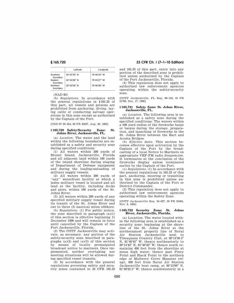
690
33 CFR Ch. I (7–1–10 Edition) § 165.720
Latitude Longitude
Southern boundary.
32°42′32″ N 79°46′42″ W
Eastern boundary.
32°43′26″ N 79°45′27″ W
Northern boundary.
32°43′56″ N 79°46′08″ W
(NAD 83) (b) Regulations. In accordance with
the general regulations in § 165.23 of this part, all vessels and persons are prohibited from anchoring, diving, lay-ing cable or conducting salvage oper-ations in this zone except as authorized by the Captain of the Port.
[CGD 07–95–054, 60 FR 45047, Aug. 30, 1995]
§ 165.720 Safety/Security Zone: St. Johns River, Jacksonville, FL.
(a) Location. The water and the land within the following boundaries are es-tablished as a safety and security zone during specified conditions:
(1) All waters within 200 yards of Blount Island, Jacksonville, Florida and all adjacent land within 100 yards of the island shoreline during staging of Department of Defense equipment and during the loading/unloading of military supply vessels.
(2) All waters within 200 yards of ‘‘any’’ waterfront facility at which a laden military vessel is located and all land at the facility, including docks and piers, within 100 yards of the St. Johns River.
(3) All waters within 200 yards of any specified military supply vessel during its transit of the St. Johns River and out to three (3) nautical miles offshore.
(b) Regulations. (1) For public notice, the zone described in paragraph (a)(1) of this section is effective beginning 11 December 1990 and will remain in force until cancelled by the Captain of the Port Jacksonville, Florida.
(2) The COTP Jacksonville may acti-vate, as necessary, any portion of the safety/security zone described in para-graphs (a)(2) and (a)(3) of this section by means of locally promulgated broadcast notice to mariners. Once im-plemented, neither overtaking nor meeting situations will be allowed dur-ing specified vessel transits.
(3) In accordance with the general regulations governing safety and secu-rity zones contained in 33 CFR 165.23
and 165.33 of this part, entry into any portion of the described zone is prohib-ited unless authorized by the Captain of the Port Jacksonville, Florida.
(4) This regulation does not apply to authorized law enforcement agencies operating within the safety/security zone.
[COTP Jacksonville, FL Reg. 90–124, 55 FR 51700, Dec. 17, 1990]
§ 165.721 Safety Zone: St. Johns River, Jacksonville, FL.
(a) Location. The following area is es-tablished as a safety zone during the specified conditions: The waters within a 500 yard radius of the fireworks barge or barges during the storage, prepara-tion, and launching of fireworks in the St. Johns River between the Hart and Acosta Bridges.
(b) Effective dates. This section be-comes effective upon activation by the Captain of the Port by the broad-casting of a local Notice to Mariners on appropriate VHF-FM radio frequencies. It terminates at the conclusion of the fireworks display unless terminated earlier by the Captain of the Port.
(c) Regulations. (1) In accordance with the general regulations in 165.23 of this part, anchoring, mooring or transiting in this zone is prohibited unless au-thorized by the Captain of the Port or District Commander.
(2) This regulation does not apply to authorized law enforcement agencies operating within the Safety Zone.
[COTP Jacksonville Reg. 94–027, 59 FR 55584, Nov. 8, 1994]
§ 165.722 Security Zone: St. Johns River, Jacksonville, Florida.
(a) Location. The water located with-in the following area is established as a security zone: beginning at the shore-line of the St. Johns River at the northernmost property line of Naval Air Station Jacksonville next to Timuquana Country Club, at 30°14′39.5″ N, 81°40′45″ W; thence northeasterly to 30°14′42″ N, 81°40′42″ W; thence south re-maining 400 feet from the shoreline at mean high water; thence past Piney Point and Black Point to the northern edge of Mulberry Cover Manatee ref-uge, 400 feet from Naval Air Station Jacksonville boat ramp, at 30°13′00″ N, 81°40′23.5″ W; thence southwesterly in a
VerDate Mar<15>2010 07:59 Sep 03, 2010 Jkt 220131 PO 00000 Frm 00700 Fmt 8010 Sfmt 8010 Y:\SGML\220131.XXX 220131erow
e on
DS
K5C
LS3C
1PR
OD
with
CF
R

691
Coast Guard, DHS § 165.728
straight line to position 30°12′14″ N, 81°40′42″ W; thence southerly, remain-ing 400′ seaward of the mean high water shoreline to 30°11′40″ N, 81°41′15.5″ W; thence northwest to the point at the end of the property line of Naval Air Station Jacksonville just north of the Buckman Bridge at position 30°11′42.30″ N, 81°41′23.66″ W; thence northeasterly along the mean high water shoreline of the St. Johns River and Mulberry Cove to the point of beginning. Datum: NAD 83
(b) In accordance with the general regulations in § 165.33 of this part, no person or vessel may enter or remain in the zone without the permission of the Captain of the Port Jacksonville, Florida. All other portions of § 165.33 remain applicable.
(c) This regulation does not apply to Coast Guard vessels and authorized law enforcement vessels operating within the Security Zone.
[COTP Jacksonville Reg. 93–115, 60 FR 65571, Dec. 20, 1995]
§ 165.726 Regulated Navigation Areas; Miami River, Miami, Florida.
(a) Location. The following are Regu-lated Navigation Areas:
(1) All the waters of the Miami River, Miami, Florida, from the Brickell Ave-nue Bridge, in approximate position 25°46′19″ N, 80°11′4″ W, inland to the South Florida Water Management Dis-trict’s salinity dam in approximate po-sition 25°48′4″ N, 80°15′6″ W.
(2) The Tamiami Canal from its intersection with the Miami river in approximate position 25°47′7″ N, 80°14′7″ W to the N.W. 37th Avenue bridge in approximate position 25°48′5″ N, 80°15′5″ W. All coordinates referenced use datum: NAD 83.
(b) Regulations. The restrictions in this paragraph apply to vessels oper-ating within the regulated navigation areas in paragraph (a) of this section unless authorized to deviate by the Captain of the Port, Miami, Florida, or a Coast Guard commissioned, warrant, or petty officer designated by him.
(1) All rafted vessels (inboard and outboard) must be properly moored in accordance with applicable municipal laws and regulations.
(2) At no time shall any vessels be rafted more than two abreast.
(3) Neither single nor rafted vessels shall extend greater than 54 feet into the main river (measured from the dock) without permission of the Cap-tain of the Port.
(4) A minimum channel width of 65 feet shall be maintained at all times on the Miami River from the Brickell Av-enue Bridge west to the Tamiami Canal. A minimum channel width of 45 feet shall be maintained at all times on the Miami River west of the junction of the Miami River and the Tamiami Canal to the South Florida Water Man-agement District’s salinity dam, as well as on the Tamiami Canal from its mouth to the N.W. 37th Avenue Bridge.
(5) All moored and rafted vessels shall provide safe access from the shore.
(6) All moored and rafted vessels shall provide clear and ready access for land-based firefighters to safely and quickly reach outboard rafted vessels.
(7) No vessels shall moor or raft in any manner as to impede safe passage of another vessel to any of the tribu-taries of the Miami River.
(8) Nothing in these regulations shall prohibit the U.S. Army Corps of Engi-neers from requiring the relocation or movement of vessels in a declared flood emergency.
(c) Enforcement. Violations of these regulated navigation areas should be reported to the Captain of the Port, Miami. Persons in violation of these regulations will be subject to civil pen-alty under § 165.13(b) of this part.
[CGD07–97–019, 62 FR 50512, Sept. 26, 1997]
§ 165.728 Jacksonville, Florida—safety zones.
(a) The water, land, and land and water within the following boundaries are established as safety zones during the specified conditions:
(1) Zone A. 200 yards in all directions around any specified Maritime Prepositioned Ship as it transits be-tween the St. Johns River entrance sea buoy (STJ) and its berth inside the Mayport Basin (Ribault Bay), Mayport, Florida. The prescribed safety zone will also be in effect as the vessel transits to its berth at Blount Island Marine Terminal, Jacksonville, Florida.
(2) Zone B. 100 yards in all directions on land and 200 yards on water from
VerDate Mar<15>2010 07:59 Sep 03, 2010 Jkt 220131 PO 00000 Frm 00701 Fmt 8010 Sfmt 8010 Y:\SGML\220131.XXX 220131erow
e on
DS
K5C
LS3C
1PR
OD
with
CF
R

692
33 CFR Ch. I (7–1–10 Edition) § 165.729
the eastern end of Transit Shed #2 to the east shore of Alligator Creek at Blount Island Terminal, Jacksonville, Florida.
(3) Zone C: 100 yards in all directions on land from Gate berth #1 and all wa-ters within the Back River (locally known as the Gate Slip) on Blount Is-land, Jacksonville, Florida, com-mencing from a line drawn between the southwesterly most shore point lati-tude 30°23′34″, longitude 81°30′52″ and the southeasterly most shore point latitude 30°23′38″, longitude 81°30′36″.
(b) The areas described in paragraph (a) of this section may be closed to all vessels and persons, except those ves-sels and persons authorized by the Commander, Seventh Coast Guard Dis-trict or the Captain of the Port, Jack-sonville, Florida, whenever specified Maritime Prepositioned Ships are transiting the St. Johns River (Zone A), moored at Blount Island (Zone B), or moored at Gate Terminal (Zone C).
(c) The general regulations governing safety zones contained in 33 CFR 165.23 apply.
(d) The Captain of the Port Jackson-ville, Florida will activate the safety zones or specific portions of them by issuing a local broadcast notice to mariners. The closing of the area at Blount Island, described above, will be signified by the display of a rotating yellow light located on the waterfront at Blount Island Marine Terminal or at the Gate Terminal Berth #1.
[CGD7 87–15, 52 FR 23442, June 22, 1987, as amended by CGD7 91–33, 56 FR 22826, May 17, 1991]
§ 165.729 Jacksonville Harbor, Flor-ida—security zone.
(a) The water, land, and land and water within the following boundaries are established as security zones dur-ing the specified conditions:
(1) Zone A. 200 yards in all directions around any specified Maritime Prepositioned Ship as it transits be-tween the St. Johns River entrance sea buoy (STJ) and its berth inside the Mayport Naval Basin (Ribault Bay), Mayport, Florida. The prescribed secu-rity zone will also be in effect as the vessel transits to its berth at Blount Island Marine Terminal, Jacksonville, Florida.
(2) Zone B. 100 yards in all directions on land and 200 yards on water from the eastern end of Transit Shed #2 to the east shore of Alligator Creek at Blount Island Terminal, Jacksonville, Florida.
(3) Zone C: 100 yards in all directions on land from Gate berth #1 and all wa-ters within the Back River (locally known as the Gate Slip) on Blount Is-land, Jacksonville, Florida, com-mencing from a line drawn between the southwesterly most shore point lati-tude 30°23′34″, longitude 81°30′52″ and the southeasterly most shore point latitude 30°23′38″, longitude 81°30′36″.
(b) The areas described in paragraph (a) of this section shall be closed to all vessels and persons, except those ves-sels and persons authorized by the Commander, Seventh Coast Guard Dis-trict or the Captain of the Port, Jack-sonville, Florida, whenever specified Maritime Prepositioned Ships are transiting the St. Johns River (Zone A), moored at Blount Island (Zone B), or moored at Gate Terminal (Zone C).
(c) The general regulations governing security zones contained in 33 CFR 165.33 apply.
(d) The Captain of the Port Jackson-ville, Florida will activate the security zones or specific portions of them by issuing a local broadcast notice to mariners. The closing of the area at Blount Island, described above, will be signified by the display of a rotating yellow light located on the waterfront at Blount Island Marine Terminal or at the Gate Terminal Berth #1.
[CGD7 87–16, 52 FR 23443, June 22, 1987, as amended by CGD7 91–34, 56 FR 22827, May 17, 1991]
§ 165.730 King’s Bay, Georgia—Regu-lated navigation area.
Vessels transiting in the water bounded by the line connecting the fol-lowing points must travel no faster than needed for steerageway: Latitude Longtitude 30°48′00.0″ N 081°29′24.0″ W 30°46′19.5″ N 081°29′17.0″ W 30°47′35.0″ N 081°30′16.5″ W and thence to the point of beginning
[CGD7 92–41, 58 FR 38057, July 15, 1993]
VerDate Mar<15>2010 07:59 Sep 03, 2010 Jkt 220131 PO 00000 Frm 00702 Fmt 8010 Sfmt 8010 Y:\SGML\220131.XXX 220131erow
e on
DS
K5C
LS3C
1PR
OD
with
CF
R

693
Coast Guard, DHS § 165.749
§ 165.731 Safety/Security Zone: Cum-berland Sound, Georgia and St. Marys River Entrance Channel.
(a) Location. A permanent safety/se-curity zone is established within the following coordinates, the area en-closed by a line starting at 30°44′55″ N, 081°29′39″ W; thence to 30°44′55″ N, 081°29′18″ W; thence to 30°46′35″ N, 081°29′18″ W; thence to 30°47′02″ N, 081°29′34″ W; thence to 30°47′21″ N, 081°29′39″ W; thence to 30°48′00″ N, 081°29′42″ W; thence to 30°49′07″ N, 081°29′56″ W; thence to 30°49′55″ N, 081°30′35″ W; thence to 30°50′15″ N, 081°31′08″ W; thence to 30°50′14″ N, 081°31′30″ W; thence to 30°49′58″ N, 081°31′45″ W; thence to 30°49′58″ N, 081°32′03″ W; thence to 30°50′12″ N, 081°32′17″ W; thence following the land based perimeter boundary to the point of origin.
(b) A temporary safety/security zone, when activated by the Captain of the Port, Jacksonville, Florida, encom-passes all waters and land from bank to bank within Cumberland Sound and the St. Marys Entrance Channel: the northern extent of this zone starts at the southern tip of Crab Island; lighted buoy number ‘‘1’’ at the mouth of the Amelia River demarks the southern boundary; day marker number ‘‘2’’ at the mouth of the St. Marys River indi-cates the western boundary; and the eastern boundary extends out to three (3) nautical miles in the Atlantic Ocean, with the zone also encom-passing the waters within 1000 yards of the entrance channel east of the jet-ties.
(c) Regulations. (1) The Captain of the Port, Jacksonville, Florida will acti-vate the temporary safety/security zone described in paragraph (b) of this section by issuing a local broadcast no-tice to mariners.
(2) All persons and vessels in the vi-cinity of the safety/security zone shall immediately obey any direction or order of the Captain of the Port, Jack-sonville, Florida.
(3) The general regulations governing safety and security zones contained in 33 CFR 165.23 and .33 apply. No person or vessel may enter or remain within the designated zones without the per-mission of the Captain of the Port, Jacksonville, Florida.
(4) This regulation does not apply to persons or vessels operating under the authority of the United States Navy nor to authorized law enforcement agencies.
[COTP Jacksonville Reg. 90–94, 55 FR 42374, Oct. 19, 1990]
§ 165.749 Security Zone: Escorted Ves-sels, Savannah, Georgia, Captain of the Port Zone.
(a) Definitions. The following defini-tions apply to this section:
COTP means Captain of the Port Sa-vannah, GA.
Designated representatives means Coast Guard Patrol Commanders in-cluding Coast Guard coxswains, petty officers and other officers operating Coast Guard vessels, and Federal, State, and local officers designated by or assisting the COTP, in the enforce-ment of the security zone.
Escorted vessel means a vessel, other than a large U.S. naval vessel as de-fined in 33 CFR 165.2015, that is accom-panied by one or more Coast Guard as-sets or other Federal, State or local law enforcement agency assets clearly identifiable by lights, vessel markings, or with agency insignia as listed below:
(1) Coast Guard surface or air asset displaying the Coast Guard insignia.
(2) State and/or local law enforce-ment asset displaying the applicable agency markings and/or equipment as-sociated with the agency.
(3) When escorted vessels are moored, dayboards or other visual indications such as lights or buoys may be used. In all cases, broadcast notice to mariners will be issued to advise mariners of these restrictions.
Minimum safe speed means the speed at which a vessel proceeds when it is fully off plane, completely settled in the water and not creating excessive wake. Due to the different speeds at which vessels of different sizes and con-figurations may travel while in compli-ance with this definition, no specific speed is assigned to minimum safe speed. In no instance should minimum safe speed be interpreted as a speed less than that required for a particular ves-sel to maintain steerageway. A vessel is not proceeding at minimum safe speed if it is:
(1) On a plane;
VerDate Mar<15>2010 07:59 Sep 03, 2010 Jkt 220131 PO 00000 Frm 00703 Fmt 8010 Sfmt 8010 Y:\SGML\220131.XXX 220131erow
e on
DS
K5C
LS3C
1PR
OD
with
CF
R

694
33 CFR Ch. I (7–1–10 Edition) § 165.751
(2) In the process of coming up onto or coming off a plane; or
(3) Creating an excessive wake. (b) Regulated area. All navigable wa-
ters, as defined in 33 CFR 2.36, within the Captain of the Port Zone, Savan-nah, Georgia 33 CFR 3.35–15.
(c) Security zone. A 300-yard security zone is established around each es-corted vessel within the regulated area described in paragraph (b) of this sec-tion. This is a moving security zone when the escorted vessel is in transit and becomes a fixed zone when the es-corted vessel is anchored or moored. A security zone will not extend beyond the boundary of the regulated area in this section.
(d) Regulations. (1) The general regu-lations for security zones contained in § 165.33 of this part apply to this sec-tion.
(2) A vessel may request the permis-sion of the COTP Savannah or a des-ignated representative to enter the se-curity zone described in paragraph (c) of this section. If permitted to enter the security zone, a vessel must pro-ceed at the minimum safe speed and must comply with the orders of the COTP or a designated representative. No vessel or person may enter the inner 50-yard portion of the security zone closest to the vessel.
(e) Notice of security zone. The COTP will inform the public of the existence or status of the security zones around escorted vessels in the regulated area by Broadcast Notice to Mariners. Coast Guard assets or other Federal, State or local law enforcement agency assets will be clearly identified by lights, ves-sel markings, or with agency insignia. When escorted vessels are moored, dayboards or other visual indications such as lights or buoys may be used.
(f) Contact information. The COTP Sa-vannah may be reached via phone at (912) 652–4353. Any on scene Coast Guard or designated representative as-sets may be reached via VHF–FM chan-nel 16.
[USCG–2007–0157, 73 FR 37837, July 2, 2008]
§ 165.751 Security Zone: LNG mooring slip, Savannah River, Savannah, Georgia.
(a) Security zone. The following area is a security zone: All the waters from surface to bottom of the northeastern most mooring dolphin located at ap-proximately 32[deg]05.01′ North, 080[deg]59.38′ West, to the southeastern most mooring dolphin located at ap-proximately 32[deg]04.79′ North, 080[deg]59.35′ West, and continues west along the North and South shoreline of the mooring slip to the shoreline of the right descending bank of the Savannah River. All marine traffic is prohibited from entering this zone unless author-ized by the Captain of the Port (COTP).
(b) Applicability. This section applies to all vessels including naval and other public vessels, except vessels that are engaged in the following operations:
(1) Law enforcement, security, or search and rescue;
(2) Servicing aids to navigation; (3) Surveying, maintenance, or im-
provement of waters in the security zone; or
(4) Actively engaged in escort, ma-neuvering, or support duties for an LNG tankship.
(c) Regulations. In accordance with the general regulations in § 165.33 of this part, entry into or movement within this zone is prohibited unless authorized by the Captain of the Port Savannah or vessels engaged in activi-ties defined in paragraph (b).
(d) Reporting of violations. Violations of this section should be reported to the Captain of the Port, Savannah, at (912) 652–4353.
[COTP SAVANNAH 06–160, 72 FR 27246, May 15, 2007]
§ 165.752 Sparkman Channel, Tampa, Florida—regulated navigation area.
(a) A regulated navigation area is es-tablished to protect vessels from lim-ited water depth in Sparkman Channel caused by an underwater pipeline. The regulated navigation area is in Sparkman Channel between the lines connecting the following points (ref-erenced in NAD 83):
Latitude Longitude Latitude Longitude
1:
VerDate Mar<15>2010 07:59 Sep 03, 2010 Jkt 220131 PO 00000 Frm 00704 Fmt 8010 Sfmt 8010 Y:\SGML\220131.XXX 220131erow
e on
DS
K5C
LS3C
1PR
OD
with
CF
R

695
Coast Guard, DHS § 165.754
Latitude Longitude Latitude Longitude
27°56′20.5″ N 082°26′42.0″ W .............................. to 27°56′19.3″ N ................................. 82°26′37.5″ W 2:
27°55′32.0″ N 082°26′54.0″ W .............................. to 27°55′30.9″ N ................................. 82°26′49.1″ W
(b) Ships requiring Federal or State pilotage shall not meet or overtake other like vessels in Sparkman Chan-nel.
(c) Vessels having a draft of more than 35.5 feet may not transit Sparkman Channel.
(d) Vessels having a draft of 34.5 feet, but not over 35.5 feet, may transit Sparkman Channel only when the tide is at least one foot above mean low water.
(e) Vessels with a draft of 30 feet or greater shall transit as near as possible to the center of the channel.
[CGD7 90–52, 56 FR 36005, July 30, 1991, as amended by USCG–1998–3799, 63 FR 35532, June 30, 1998]
§ 165.753 Regulated navigation area; Tampa Bay, Florida.
(a) The following is a regulated navi-gation area (RNA): All the navigable waters of Tampa Bay, Hillsborough Bay and Old Tampa Bay, including all navigable waterways tributary thereto. Also included are the waters of Egmont Channel, Gulf of Mexico from Tampa Bay to the seabuoy, Tampa Lighted Whistle Buoy T, LLNR 18465.
(b) The master, pilot, or person in charge of any vessel of 50 meters or greater shall give a Navigational Advi-sory Broadcast in accordance with 47 CFR 80.331 on VHF-FM channel 13 at the following broadcast/reporting points:
(1) Prior to getting underway from any berth or anchorage;
(2) Prior to entering Egmont Channel from seaward;
(3) Prior to passing Egmont Key in any direction;
(4) Prior to transiting the Skyway Bridge in either direction;
(5) Prior to transiting the intersec-tion of Tampa Bay Cut F Channel, Tampa Bay Cut G Channel, and Gads-den Point Cut Channel;
(6) Prior to anchoring or approaching a berth for docking;
(7) Prior to tending hawser;
(8) Prior to transiting Point Pinellas Channel Light 1 in either direction.
(c) Each Navigational Advisory re-quired by this section shall be made in the English language and will contain the following information:
(1) The words ‘‘Hello all vessels, a Navigational Advisory follows’’;
(2) Name of vessel; (3) If engaged in towing, the nature of
the tow; (4) Direction of Movement; (5) Present location; and, (6) The nature of any hazardous con-
ditions as defined by 33 CFR 160.203. (d) Nothing in this section shall su-
persede either the International Regu-lations for Preventing Collisions at Sea, 1972 (72 COLREGS) or the Inland Navigation Rules, as applicable, or re-lieve the Master or person in charge of the vessel of responsibility for the safe navigation of the vessel.
[CGD07–94–094, 60 FR 58519, Nov. 28, 1995]
§ 165.754 Safety Zone: San Juan Har-bor, San Juan, PR.
(a) Regulated area. A moving safety zone is established in the following area:
(1) The waters around Liquefied Pe-troleum Gas ships entering San Juan Harbor in an area one half mile around each vessel, beginning one mile north of the San Juan Harbor #1 Sea Buoy, in approximate position 18–29.3N, 66–07.6W and continuing until the vessel is safe-ly moored at either the Gulf Refinery Oil dock or the Catano Oil dock in ap-proximate position 18–25.8N, 66–06.5W. All coordinates referenced use datum: NAD 83.
(2) The waters around Liquefied Pe-troleum Gas ships departing San Juan Harbor in an area one half mile around each vessel beginning at either the Gulf Refinery Oil dock or Catano Oil dock in approximate position 18–25.8N, 66–06.5W when the vessel gets under-way, and continuing until the stern passes the San Juan Harbor #1 Sea Buoy, in approximate position 18–28.3N,
VerDate Mar<15>2010 07:59 Sep 03, 2010 Jkt 220131 PO 00000 Frm 00705 Fmt 8010 Sfmt 8010 Y:\SGML\220131.XXX 220131erow
e on
DS
K5C
LS3C
1PR
OD
with
CF
R

696
33 CFR Ch. I (7–1–10 Edition) § 165.755
66–07.6W. All coordinates referenced use datum: NAD 83.
(b) Regulations. (1) No person or ves-sel may enter, transit or remain in the safety zone unless authorized by the Captain of the Port, San Juan, Puerto Rico, or a designated Coast Guard com-missioned, warrant, or petty officer.
(2) Vessels encountering emergencies which require transit through the mov-ing safety zone should contact the Coast Guard patrol craft on VHF Chan-nel 16. In the event of an emergency, the Coast Guard patrol craft may au-thorize a vessel to transit through the safety zone with a Coast Guard des-ignated escort.
(3) The Captain of the Port and the Duty Officer at Sector San Juan, Puer-to Rico, can be contacted at telephone number 787–289–2041. The Coast Guard Patrol Commander enforcing the safety zone can be contacted on VHF-FM channels 16 and 22A.
(4) Coast Guard Sector San Juan will notify the marine community of peri-ods during which these safety zones will be in effect by providing advance notice of scheduled arrivals and depar-tures of Liquefied Petroleum Gas ves-sels via a marine broadcast Notice to Mariners.
(5) Should the actual time of entry of the Liquefied Petroleum Gas vessel vary more than one half hour from the scheduled time stated in the broadcast Notice to Mariners, the person direct-ing the movement of the Liquefied Pe-troleum Gas vessel shall obtain permis-sion from Captain of the Port San Juan before commencing the transit.
(6) All persons and vessels shall com-ply with the instructions of on-scene patrol personnel. On-scene patrol per-sonnel include commissioned, warrant, or petty officers of the U.S. Coast Guard. Coast Guard Auxiliary and local or state officials may be present to in-form vessel operators of the require-ments of this section, and other appli-cable laws.
[COTP SAN JUAN 97–045, 63 FR 27681, May 20, 1998, as amended by USCG–2001–9286, 66 FR 33641, June 25, 2001; USCG–2008–0179, 73 FR 35017, June 19, 2008]
§ 165.755 Safety Zone; Guayanilla, Puerto Rico
(a) The following area is established as a safety zone during the specified conditions:
(1) A 100 yard radius surrounding a vessel carrying Liquefied Natural Gas (LNG) while transiting north of Lati-tude 17°56.0′ N in the waters of the Car-ibbean Sea, on approach to or depar-ture from the Eco-Electrica waterfront facility in Guayanilla Bay, Puerto Rico. The safety zone remains in effect until the LNG vessel is docked at the Eco-Electrica waterfront facility or south of Latitude 17°56.0′ N.
(2) The waters within 150 feet of a LNG vessel when the vessel is along-side the Eco-Electrica waterfront facil-ity in Guayanilla Bay, at position 17°58.55′ N, 066°45.3′ W. This safety zone remains in effect while the LNG vessel is docked with product aboard or is transferring LNG.
(b) In accordance with the general regulations in 165.23 of this part, an-choring, mooring or transiting in these zones is prohibited unless authorized by the Coast Guard Captain of the Port.
(c) Coast Guard Sector San Juan will notify the maritime community of pe-riods during which the safety zones will be in effect by providing advance notice of scheduled arrivals and depar-tures of LNG vessels via a marine broadcast Notice to Mariners.
[COTP San Juan 00–095, 66 FR 16870, Mar. 28, 2001, as amended by USCG–2008–0179, 73 FR 35017, June 19, 2008]
§ 165.756 Regulated Navigation Area; Savannah River, Georgia.
(a) Regulated Navigation Area (RNA). The Savannah River between Fort Jackson (32°04.93′ N, 081°02.19′ W) and the Savannah River Channel Entrance Sea Buoy is a regulated navigation area when an LNG tankship in excess of heel is transiting the area or moored at the LNG facility. All coordinates are North American Datum 1983.
(b) Definitions. The following defini-tions apply to this section:
Bare steerage way means the min-imum speed necessary for a ship to maintain control over its heading.
Bollard pull means an industry stand-ard used for rating tug capabilities and
VerDate Mar<15>2010 07:59 Sep 03, 2010 Jkt 220131 PO 00000 Frm 00706 Fmt 8010 Sfmt 8010 Y:\SGML\220131.XXX 220131erow
e on
DS
K5C
LS3C
1PR
OD
with
CF
R

697
Coast Guard, DHS § 165.756
is the pulling force imparted by the tug to the towline. It means the power that an escort tug can apply to its working line(s) when operating in a direct mode.
Direct mode means a towing technique defined as a method of operation by which a towing vessel generates tow-line forces by thrust alone at an angle equal to or nearly equal to the towline, or thrust forces applied directly to the escorted vessel’s hull.
Fire Wire means a length of wire rope or chain hung from the bow and stern of a vessel in port to allow the vessel to be towed away from the pier in case of fire; also called fire warp or emergency towing wire.
Heel means the minimum quantity of liquefied natural gas (LNG) retained in an LNG tankship after unloading at the LNG facility to maintain tempera-ture, pressure, and/or prudent oper-ations. A quantity of LNG less than five percent (5 %) of the LNG tank-ship’s carrying capacity shall be pre-sumed to be heel.
Indirect mode means a towing tech-nique defined as a method of operation by which an escorting towing vessel generates towline forces by a combina-tion of thrust and hydrodynamic forces resulting from a presentation of the underwater body of the towing vessel at an oblique angle to the towline. This method increases the resultant bollard pull, thereby arresting and controlling the motion of an escorted vessel.
LNG tankship means a vessel as de-scribed in 46 CFR 154.
Made-up means physically attached by cable, towline, or other secure means in such a way as to be imme-diately ready to exert force on a vessel being escorted.
Make-up means the act of, or prep-arations for becoming made-up.
Operator means the person who owns, operates, or is responsible for the oper-ation of a facility or vessel.
Savannah River Channel Entrance Sea Buoy means the aid to navigation la-beled R W ‘‘T’’ Mo (A) WHIS on the Na-tional Oceanic and Atmospheric Ad-ministration’s (NOAA) Nautical Chart 11512.
Standby means readily available at the facility and equipped to provide a ready means of assistance to maintain
a safe zone around LNG tankships, pro-vide emergency firefighting assistance, and aid the LNG tankship in the event of an emergency departure.
Underway means that a vessel is not at anchor, not made fast to the shore, or not aground.
(c) Applicability. This section applies to all vessels operating within the RNA, including naval and other public vessels, except vessels that are engaged in the following operations:
(1) Law enforcement, security, or search and rescue;
(2) Servicing aids to navigation; (3) Surveying, maintenance, or im-
provement of waters in the RNA; or (4) Actively engaged in escort, ma-
neuvering, or support duties for an LNG tankship.
(d) Regulations—(1) Requirements for vessel operations while a LNG tankship, carrying LNG in excess of heel, is under-way within the RNA. (i) Except for a vessel that is moored at a marina, wharf, or pier, and remains moored, no vessel 1,600 gross tons or greater may come within two nautical miles of a LNG tankship, carrying LNG in excess of heel, which is underway within the Savannah River shipping channel with-out the permission of the Captain of the Port (COTP).
(ii) All vessels less than 1,600 gross tons shall keep clear of transiting LNG tankships.
(iii) The owner, master, or operator of a vessel carrying liquefied natural gas (LNG) shall:
(A) Comply with the notice require-ments of 33 CFR part 160. The COTP may delay the vessel’s entry into the RNA to accommodate other commer-cial traffic.
(B) Obtain permission from the COTP before commencing the transit into the RNA.
(C) Not enter or get underway within the RNA if visibility during the transit is not sufficient to safely navigate the channel, and/or wind speed is, or is ex-pected to be, greater than 25 knots.
(D) While transiting the RNA, the LNG tankship, carrying LNG in excess of heel, shall have a minimum of two escort towing vessels with a minimum of 100,000 pounds of bollard pull, 4,000 horsepower and capable of safely oper-ating in the indirect mode. At least one
VerDate Mar<15>2010 07:59 Sep 03, 2010 Jkt 220131 PO 00000 Frm 00707 Fmt 8010 Sfmt 8010 Y:\SGML\220131.XXX 220131erow
e on
DS
K5C
LS3C
1PR
OD
with
CF
R

698
33 CFR Ch. I (7–1–10 Edition) § 165.756
of the towing vessels shall be FiFi Class 1 equipped.
(2) Requirements while an LNG tank-ship is moored outside of the LNG facility slip. (i) An LNG tankship moored out-side of the LNG facility slip shall have on-scene a minimum of two escort tow-ing vessels each with a minimum of 100,000 pounds of bollard pull, 4,000 horsepower and capable of safely oper-ating in the indirect mode in order to escort transiting vessels 1,600 gross tons or greater past the moored LNG tankship. At least one of these towing vessels shall be FiFi Class 1 equipped.
(ii) In addition to the two towing ves-sels required by paragraph (d)(2)(i) of this section, the LNG tankship moored outside of the slip shall have at least one standby towing vessel with a min-imum of 90,000 pounds of bollard pull to take appropriate actions in an emer-gency as directed by the LNG vessel bridge watch required in paragraph (d)(5) of this section.
(3) Requirements while LNG tankships are moored inside the LNG facility slip. (i) An LNG tankship moored inside the LNG facility slip shall have two stand-by towing vessels with a minimum ca-pacity of 100,000 pounds of bollard pull, 4,000 horsepower, and the ability to op-erate safely in the indirect mode. At least one of these towing vessels shall be FiFi Class 1 equipped. The standby towing vessels shall take appropriate action in an emergency as directed by the LNG vessel bridge watch required in paragraph (d)(5) of this section.
(ii) If two LNG tankships are moored inside the LNG facility slip, each vessel shall provide a standby towing vessel that is FiFi class 1 equipped with a minimum capacity of 100,000 pounds of bollard pull and 4,000 horsepower that is available to assist as directed by the LNG vessel bridge watch required in paragraph (d)(5) of this section.
(4) Requirements while LNG tankships are moored both inside the LNG facility slip and outside the LNG facility slip. (i) When one LNG tankship is moored in-side and one LNG tankship is moored outside of the LNG facility slip, the LNG tankship moored outside of the LNG facility slip shall have on-scene a minimum of two escort towing vessels each with a minimum of 100,000 pounds of bollard pull, 4,000 horsepower and ca-
pable of safely operating in the indi-rect mode in order to escort transiting vessels 1,600 gross tons or greater past the moored LNG tankship. At least one of these towing vessels shall be FiFi Class 1 equipped. In addition, the LNG tankship moored inside of the slip shall have at least one standby towing vessel with a minimum of 100,000 pounds of bollard pull, 4,000 horsepower and FiFi Class 1 equipped to take appropriate actions in an emergency as directed by the LNG vessel bridge watch required in paragraph (d)(5) of this section.
(ii) When one LNG tankship is moored outside and two LNG tankships are moored inside the LNG facility slip, the LNG tankship moored outside of the LNG facility slip shall have on- scene a minimum of two escort towing vessels each with a minimum of 100,000 pounds of bollard pull, 4,000 horsepower and capable of safely operating in the indirect mode in order to escort transiting vessels 1,600 gross tons or greater past the moored LNG tankship. At least one of these towing vessels shall be FiFi Class 1 equipped. In addi-tion, the LNG tankships moored inside of the slip shall have at least one standby towing vessel between the two ships with a minimum of 100,000 pounds of bollard pull, 4,000 horsepower and FiFi Class 1 equipped to take appro-priate actions in an emergency as di-rected by the LNG vessel bridge watch required in paragraph (d)(5) of this sec-tion.
(iii) In the event of an actual emer-gency, escort towing vessels can be uti-lized as stand-by towing vessels to take appropriate actions as directed by the LNG vessel bridge watch required in paragraph (d)(5) of this section.
(5) Requirements for moored LNG tank-ships. (i) While moored within the RNA, each LNG tankship shall maintain a bridge watch consisting of a docking pilot or licensed deck officer who shall monitor all vessels transiting past the LNG facility. In addition, the LNG Bridge Watch shall communicate with the pilots of vessels greater than 1600 gross tons at the points identified in section (d)(6)(iii) of this section prior to passing the LNG facility in order to take actions of the towing vessel(s) re-quired in paragraphs (d)(2) through (4) of this section.
VerDate Mar<15>2010 07:59 Sep 03, 2010 Jkt 220131 PO 00000 Frm 00708 Fmt 8010 Sfmt 8010 Y:\SGML\220131.XXX 220131erow
e on
DS
K5C
LS3C
1PR
OD
with
CF
R

699
Coast Guard, DHS § 165.757
(ii) While moored within the RNA, LNG tankships shall have emergency towing wires (fire wires) positioned one meter above the waterline, both on the off-shore bow and quarter of the ship. LNG vessels equipped with waterline bollards are exempt from this require-ment.
(6) Requirements for other vessels while within the RNA. (i) Transiting vessels 1,600 gross tons or greater, when pass-ing an LNG tankship moored outside of the LNG facility slip, shall have a min-imum of two towing vessels with a minimum capacity of 100,000 pounds of bollard pull, 4,000 horsepower, and the ability to operate safely in the indirect mode, made-up in such a way as to be immediately available to arrest and control the motion of an escorted ves-sel in the event of steering, propulsion or other casualty. At least one of the towing vessels shall be FiFi Class 1 equipped. While it is anticipated that vessels will utilize the towing vessel services required in paragraphs (d)(2)(i) and (d)(4)(i) of this section, this section does not preclude escorted vessel oper-ators from providing their own towing vessel escorts, provided they meet the requirements of this part.
(A) Outbound vessels shall be made- up and escorted from Bight Channel Light 46 until the vessel is safely past the LNG dock.
(B) Inbound vessels shall be made-up and escorted from Elba Island Light 37 until the vessel is safely past the LNG dock.
(ii) The requirements in paragraph (d)(6)(i) of this section do not apply when one or more LNG tankships are moored in the LNG facility slip and no LNG tankship is moored at the pier outside of the LNG facility slip.
(iii) Vessels 1,600 gross tons or great-er shall make a broadcast on channel 13 at the following points on the Sa-vannah River:
(A) Buoy ‘‘33’’ in the vicinity of Fields Cut for inbound vessels;
(B) Buoy ‘‘53’’ in the vicinity of Fort Jackson for outbound vessels.
(iv) Vessels 1,600 gross tons or greater shall at a minimum, transit at bare steerageway when within an area 1,000 yards on either side of the LNG facility slip to minimize potential wake or
surge damage to the LNG facility and vessel(s) within the slip.
(v) Vessels 1,600 gross tons or greater shall not meet nor overtake within an area 1,000 yards on either side of the LNG facility slip when an LNG tank-ship is present within the slip.
(vi) All vessels less than 1,600 gross tons shall not approach within 70 yards of an LNG tankship, carrying LNG in excess of heel, without the permission of the Captain of the Port.
(vii) Except for vessels involved in those operations noted in paragraph (c) of this section entitled Applicability, no vessel shall enter the LNG facility slip at any time without the permis-sion of the Captain of the Port.
(e) Waivers. (1) The COTP may waive any requirement in this section, if the COTP finds that it is in the best inter-est of safety or in the interest of na-tional security. Such waivers may be verbal or in writing.
(2) An application for a waiver of these requirements must state the compelling need for the waiver and de-scribe the proposed operation and methods by which adequate levels of safety are to be obtained.
(f) Enforcement. Violations of this sec-tion should be reported to the Captain of the Port, Savannah, at (912) 652–4353. In accordance with the general regula-tions in § 165.13 of this part, no person may cause or authorize the operation of a vessel in the regulated navigation area contrary to the provisions of this section.
[CGD07–05–138, 72 FR 2453, Jan. 19, 2007]
§ 165.757 Safety Zones; Ports of Ponce, Tallaboa, and Guayanilla, Puerto Rico and Limetree Bay, St. Croix, U.S.V.I.
(a) Location. The following areas are established as a safety zones during the specified conditions:
(1) Port of Ponce, Puerto Rico. A 100- yard radius surrounding all Liquefied Hazardous Gas (LHG) vessels with product aboard while transiting north of Latitude 17°57.0′ N in the waters of the Caribbean Sea on approach to or departing from the Port of Ponce, Puerto Rico (NAD 83). The safety zone remains in effect until the LHG vessel is docked.
VerDate Mar<15>2010 07:59 Sep 03, 2010 Jkt 220131 PO 00000 Frm 00709 Fmt 8010 Sfmt 8010 Y:\SGML\220131.XXX 220131erow
e on
DS
K5C
LS3C
1PR
OD
with
CF
R

700
33 CFR Ch. I (7–1–10 Edition) § 165.758
(2) Port of Tallaboa, Puerto Rico. A 100- yard radius surrounding all Liquefied Hazardous Gas (LHG) vessels with product aboard while transiting north of Latitude 17°56.0′ N in the waters of the Caribbean Sea on approach to or departing from the Port of Tallaboa, Puerto Rico (NAD 83). The safety zone remains in effect until the LHG vessel is docked.
(3) Port of Guayanilla, Puerto Rico. A 100-yard radius surrounding all Lique-fied Hazardous Gas (LHG) vessels around with product aboard while transiting north of Latitude 17°57.0′ N in the waters of the Caribbean Sea on approach to or departing from the Port of Guayanilla, Puerto Rico (NAD 83). The safety zone remains in effect until the LHG vessel is docked.
(4) Port of Limetree Bay, St. Croix, U.S.V.I. A 100-yard radius surrounding all Liquefied Hazardous Gas (LHG) ves-sels with product aboard while transiting north of Latitude 17°39.0′ N in the waters of the Caribbean Sea on approach to or departing from the Port of Limetree Bay, U.S.V.I. (NAD 83). The safety zone remains in effect until the LHG vessel is docked.
(b) Regulations. In accordance with the general regulations in § 165.23 of this part, anchoring, mooring or transiting in these zones is prohibited unless authorized by the Coast Guard Captain of the Port. Coast Guard Sec-tor San Juan will notify the maritime community of periods during which these safety zones will be in effect by providing advance notice of scheduled arrivals and departures on LHG car-riers via a broadcast notice to mariners on VHF Marine Band Radio, Channel 16 (156.8 MHz).
[COTP San Juan 02–038, 67 FR 60867, Sept. 27, 2002, as amended by USCG–2008–0179, 73 FR 35017, June 19, 2008]
§ 165.758 Security Zone; San Juan, Puerto Rico.
(a) Location. Moving and fixed secu-rity zones are established 50 yards around all cruise ships entering, de-parting, moored or anchored in the Port of San Juan, Puerto Rico. The se-curity zone for a cruise ship entering port is activated when the vessel is one mile north of the #3 buoy, at approxi-mate position 18°28′17′ N, 66°07′37.5′ W.
The security zone for a vessel is deacti-vated when the vessel passes this buoy on its departure from the port.
(b) Regulations. (1) Under general reg-ulations in § 165.33 of this part, enter-ing, anchoring, mooring or transiting in these zones is prohibited unless au-thorized by the Coast Guard Captain of the Port of San Juan.
(2) Persons desiring to transit the area of the security zone may contact the Captain of the Port at the Sector San Juan at (787) 289–2041 or via VHF radio on Channel 16 to seek permission to transit the area. If permission is granted, all persons and vessels must comply with the instructions of the Captain of the Port or his designated representative.
(3) The Coast Guard Sector San Juan will attempt to notify the maritime community of periods during which these security zones will be in effect by providing advance notice of scheduled arrivals and departures of cruise ships via a broadcast notice to mariners.
(c) Definition. As used in this section, cruise ship means a passenger vessel greater than 100 feet in length that is authorized to carry more than 150 pas-sengers for hire, except for a ferry.
(d) Authority. In addition to 33 U.S.C 1231 and 50 U.S.C. 191, the authority for this section includes 33 U.S.C. 1226.
[CGD07–02–042, 67 FR 76991, Dec. 16, 2002, as amended by USCG–2008–0179, 73 FR 35017, June 19, 2008]
§ 165.759 Security Zones; Ports of Jacksonville, Fernandina, and Ca-naveral, Florida.
(a) Regulated area. Moving security zones are established 100 yards around all tank vessels, cruise ships, and mili-tary pre-positioned ships during tran-sits entering or departing the ports of Jacksonville, Fernandina, and Canav-eral, Florida. These moving security zones are activated when the subject vessels pass the St. Johns River Sea Buoy, at approximate position 30 deg. 23′ 35″ N, 81 deg, 19′ 08″ West, when en-tering the port of Jacksonville, or pass Port Canaveral Channel Entrance Buoys # 3 or # 4, at respective approxi-mate positions 28 deg. 22.7 N, 80 deg 31.8 W, and 28 deg. 23.7 N, 80 deg. 29.2 W, when entering Port Canaveral. Fixed security zones are established 100 yards
VerDate Mar<15>2010 07:59 Sep 03, 2010 Jkt 220131 PO 00000 Frm 00710 Fmt 8010 Sfmt 8010 Y:\SGML\220131.XXX 220131erow
e on
DS
K5C
LS3C
1PR
OD
with
CF
R

701
Coast Guard, DHS § 165.760
around all tank vessels, cruise ships, and military pre-positioned ships docked in the Ports of Jacksonville, Fernandina, and Canaveral, Florida.
(b) Regulations. In accordance with the general regulations § 165.33 of this part, entry into these zones is prohib-ited except as authorized by the Cap-tain of the Port, or a Coast Guard com-missioned, warrant, or petty officer designated by him. The Captain of the Port will notify the public of any changes in the status of this zone by Marine Safety Radio Broadcast on VHF Marine Band Radio, Channel 22 (157.1 MHz).
(c) Definition. As used in this section: cruise ship means a passenger vessel, except for a ferry, greater than 100 feet in length that is authorized to carry more than 12 passengers for hire.
(d) Authority. In addition to 33 U.S.C. 1231 and 50 U.S.C. 191, the authority for this section includes 33 U.S.C. 1226.
[COTP Jacksonville 02–066, 68 FR 3186, Jan. 23, 2003]
§ 165.760 Security Zones; Tampa Bay, Port of Tampa, Port of Saint Peters-burg, Port Manatee, Rattlesnake, Old Port Tampa, Big Bend, Weedon Island, and Crystal River, Florida.
(a) Location. The following areas, de-noted by coordinates fixed using the North American Datum of 1983 (World Geodetic System 1984), are security zones:
(1) Rattlesnake, Tampa, FL. All water, from surface to bottom, in Old Tampa Bay east and south of a line com-mencing at position 27°53.32′ N, 082°32.05′ W; north to 27°53.36′ N, 082°32.05′ W, including on land portions of Chemical Formulators Chlorine Fa-cility, where the fenced area is bounded by a line connecting the following points: 27°53.21′ N, 082°32.11′ W; west to 27°53.22′ N, 082°32.23′ W; then north to 27°53.25′ N, 082°32.23′ W; then west again to 27°53.25′ N, 082°32.27′ W; then north again to 27°53.29′ N, 082°32.25′ W; then east to 27°53.30′ N, 082°32.16′ W; then southeast terminating at 27°53.21′ N, 082°32.11′ W.
(2) Old Port Tampa, Tampa, FL. All waters, from surface to bottom, in Old Tampa Bay encompassed by a line con-necting the following points: 27°51.62′ N, 082°33.14′ W; east to 27°51.71′ N,
082°32.5′ W; north to 27°51.76′ N, 082°32.5′ W; west to 27°51.73′ N, 082°33.16′ W; and south to 27°51.62′ N, 082°33.14′ W, closing off the Old Port Tampa channel.
(3) Sunshine Skyway Bridge, FL. All waters in Tampa Bay, from surface to bottom, in Cut ‘‘A’’ channel beneath the bridge’s main span encompassed by a line connecting the following points: 27°37.30′ N, 082°39.38′ W to 27°37.13′ N, 082°39.26′ W; and the bridge structure columns, base and dolphins. This zone is specific to the bridge structure and dolphins and does not include waters adjacent to the bridge columns or dol-phins outside of the bridge’s main span.
(4) Vessels carrying hazardous cargo, Tampa, FL. All waters, from surface to bottom, 200 yards around vessels moored in Tampa Bay carrying or transferring Liquefied Petroleum Gas (LPG), Anhydrous Ammonia (NH3) and/ or grade ‘‘A’’ and ‘‘B’’ flammable liquid cargo. Any vessel transiting within the outer 100 yards of the zone for moored vessels carrying or transferring Lique-fied Petroleum Gas (LPG), Anhydrous Ammonia (NH3) and/or grade ‘‘A’’ and ‘‘B’’ cargo may operate unless other-wise directed by the Captain of the Port or his designee but must proceed through the area at the minimum speed necessary to maintain safe navi-gation. No vessel may enter the inner 100-yard portion of the security zone closest to the vessel.
(5) Piers, seawalls, and facilities, Port of Tampa and Port Sutton, Tampa, FL. All waters, from surface to bottom, ex-tending 50 yards from the shore, sea-wall, and piers around facilities in Port Sutton within the Port of Tampa en-compassed by a line connecting the fol-lowing points: 27°54.15′ N, 082°26.11′ W; east northeast to 27°54.19′ N, 082°26.00′ W; then northeast to 27°54.37′ N, 082°25.72′ W, closing off all Port Sutton channel; then northerly to 27°54.48′ N, 082°25.70′ W.
(6) Piers, seawalls, and facilities, Port of Tampa, East Bay and the eastern side of Hooker’s Point. All waters, from sur-face to bottom, extending 50 yards from the shore, seawall and piers around facilities on East Bay and on the East Bay Channel within the Port of Tampa encompassed by a line con-necting the following points: 27°56.05′ N, 082°25.95′ W, southwesterly to
VerDate Mar<15>2010 07:59 Sep 03, 2010 Jkt 220131 PO 00000 Frm 00711 Fmt 8010 Sfmt 8010 Y:\SGML\220131.XXX 220131erow
e on
DS
K5C
LS3C
1PR
OD
with
CF
R
702
33 CFR Ch. I (7–1–10 Edition) § 165.760
27°56.00′ N, 082°26.07′ W, then southerly to 27°55.83′ N, 082°26.07′ W, then south-easterly to 27°55.55′ N, 082°25.75′ W, then south to 27°54.75′ N, 082°25.75′ W, then southwesterly and terminating at point 27°54.57′ N, 082°25.86′ W.
(7) Piers, seawalls, and facilities, Port of Tampa, on the western side of Hooker’s Point, Tampa, FL. All waters, from sur-face to bottom, extending 50 yards from the shore, seawall, and piers around facilities on Hillsborough Bay northern portion of Cut ‘‘D’’ channel, Sparkman channel, Ybor Turning Basin, and Ybor channel within the Port of Tampa encompassed by a line connecting the following points: 27°54.74′ N, 082°26.47′ W; northwest to 27°55.25′ N, 082°26.73′ W; then north- northwest to 27°55.60′ N, 082°26.80′ W; then north-northeast to 27°56.00′ N, 082°26.75′ W; then northeast to 27°56.58′ N, 082°26.53′ W; and north to 27°57.29′ N, 082°26.51′ W; west to 27°57.29′ N, 082°26.61′ W; then southerly to 27°56.65′ N, 082°26.63′ W; southwesterly to 27°56.58′ N, 082°26.69′ W; then southwesterly and terminating at 27°56.53′ N, 082°26.90′ W.
(8) Piers, seawalls, and facilities, Port of Manatee. All waters, from surface to bottom, within the Port of Manatee ex-tending 50 yards from the shore, sea-wall and piers around facilities. This security zone encompasses all piers and seawalls of the cruise terminal berths 9 and 10 in Port Manatee, Florida begin-ning at 27°38.00′ N, 082°33.81′ W; con-tinuing east to 27°38.00′ N, 082°33.53′ W.
(9) Moving cruise ships in the Port of Tampa, Port of Saint Petersburg, and Port Manatee, Florida. All waters, from surface to bottom, extending 200 yards around all cruise ships entering or de-parting Port of Tampa, Port of Saint Petersburg, or Port Manatee, Florida. These temporary security zones are ac-tivated on the inbound transit when a cruise ship passes the Tampa Lighted Whistle Buoy ‘‘T’’, located at 27°35.35′ N, 083°00.71′ W and terminate when the vessel is moored at a cruise ship ter-minal. The security zones are activated on the outbound transit when a cruise ship gets underway from a terminal and terminates when the cruise ship passes the Tampa Lighted Whistle Buoy ‘‘T’’, located at 27°35.35′ N, 083°00.71′ W. Any vessel transiting with-in the outer 100 yards of the zone for a
cruise ship may operate unless other-wise directed by the Captain of the Port or his designee but must proceed through the area at the minimum speed necessary to maintain safe navi-gation. No vessel may enter the inner 100-yard portion of the security zone closest to the vessel.
(10) Moored cruise ships in the Port of Tampa, Port of Saint Petersburg, and Port Manatee, Florida. All waters, from surface to bottom, extending 200 yards around moored cruise ships in the Ports of Tampa, Saint Petersburg, or Port Manatee, Florida. Any vessel transiting within the outer 100 yards of the zone of moored cruise ships may operate unless otherwise directed by the Captain of the Port or his designee but must proceed through the area at the minimum speed necessary to main-tain safe navigation. No vessel may enter the inner 100-yard portion of the security zone closest to the vessel.
(11) Saint Petersburg Harbor, FL. All waters, from surface to bottom, ex-tending 50 yards from the seawall and around all moorings and vessels in Saint Petersburg Harbor (Bayboro Har-bor), commencing on the north side of the channel at dayboard ‘‘10’’ in ap-proximate position 27°45.56′ N, 082°37.55′ W, and westward along the seawall to the end of the cruise terminal in ap-proximate position 27°45.72′ N, 082°37.97′ W. The zone will also include the Coast Guard south moorings in Saint Peters-burg Harbor. The zone will extend 50 yards around the piers commencing from approximate position 27°45.51′ N, 082°37.99′ W; to 27°45.52′ N, 082°37.57′ W. The southern boundary of the zone is shoreward of a line between the en-trance to Salt Creek easterly to Green Daybeacon 11 (LLN 2500).
(12) Crystal River Nuclear Power Plant. All waters, from surface to bottom, around the Florida Power Crystal River nuclear power plant located at the end of the Florida Power Corpora-tion Channel, Crystal River, Florida, encompassed by a line connecting the following points: 28°56.87′ N, 082°45.17′ W (Northwest corner); 28°57.37′ N, 082°41.92′ W (Northeast corner); 28°56.81′ N, 082°45.17′ W (Southwest corner); and 28°57.32′ N, 082°41.92′ W (Southeast cor-ner).
VerDate Mar<15>2010 07:59 Sep 03, 2010 Jkt 220131 PO 00000 Frm 00712 Fmt 8010 Sfmt 8010 Y:\SGML\220131.XXX 220131erow
e on
DS
K5C
LS3C
1PR
OD
with
CF
R

703
Coast Guard, DHS § 165.761
(13) Crystal River Demory Gap Channel. All waters, from surface to bottom, in the Demory Gap Channel in Crystal River, Florida, encompassed by a line connecting the following points: 28°57.61′ N, 082°43.42′ W (Northwest cor-ner); 28°57.53′ N, 082°41.88′ W (Northeast corner); 28°57.60′ N, 082°43.42′ W (South-west corner); and 28°57.51′ N, 082°41.88′ W (Southeast corner).
(14) Big Bend Power Plant, FL. All wa-ters of Tampa Bay, from surface to bot-tom, adjacent to the Big Bend Power Facility, and within an area bounded by a line connecting the following points: 27°48.08′ N, 082°24.88′ W; then northwest to 27°48.15′ N, 082°24.96′ W; then southwest to 27°48.10′ N, 082°25.00′ W; then south-southwest to 27°47.85′ N, 082°25.03′ W; then southeast to 27°47.85′ N, 082°24.79′ W; then east to 27°47.55′ N, 082°24.04′ W; then north to 27°47.62′ N, 082°84.04′ W; then west to 27°47.60′ N, 082°24.72′ W; then north to 27°48.03′ N, 082°24.70′ W; then northwest to 27°48.08′ N, 082°24.88′ W, closing off entrance to Big Bend Power Facility and the at-tached cooling canal.
(15) Weedon Island Power Plant, FL. All waters of Tampa Bay, from surface to bottom, extending 50-yards from the shore, seawall and piers around the Power Facility at Weedon Island en-compassed by a line connecting the fol-lowing points: 27°51.52′ N, 082°35.82′ W; then north and east along the shore to 27°51.54′ N, 082°35.78′ W; then north to 27°51.68′ N, 082°35.78′ W; then north to 27°51.75′ N, 082°35.78′ W, closing off en-trance to the canal; then north to 27°51.89′ N, 082°35.82′ W; then west along the shore to 27°51.89′ N, 082°36.10′ W; then west to 27°51.89′ N, 082°36.14′ W, closing off entrance to the canal.
(b) Definitions. As used in this sec-tion—
Cruise ship means a vessel required to comply with 33 CFR part 120.
Designated representative means Coast Guard Patrol Commanders including Coast Guard coxswains, petty officers and other officers operating Coast Guard vessels, and federal, state, and local officers designated by or assisting the Captain of the Port (COTP), in the enforcement of regulated navigation areas, safety zones, and security zones.
(c) Regulation. (1) Entry into or re-maining on or within the zones de-
scribed in paragraph (a) of this section is prohibited unless authorized by the Captain of the Port Sector St. Peters-burg or a designated representative.
(2) Persons desiring to transit the area of the security zone may contact the Captain of the Port Sector St. Pe-tersburg or a designated representative on VHF channel 16 to seek permission to transit the area. If permission is granted, all persons and vessels must comply with the instructions of the Captain of the Port or designated rep-resentative. In the case of moving secu-rity zones, notification of activation of these zones will be given by Broadcast Notice to Mariners on VHF FM Marine Band Radio, Channel 22A. For vessels not equipped with a radio, there will also be on site notification via a des-ignated representative of the Captain of the Port.
NOTE TO § 165.760(c)(2): A graphical rep-resentation of all fixed security zones will be made available via the Coast Pilot and nau-tical charts.
(3) Enforcement. Under § 165.33, no per-son may cause or authorize the oper-ation of a vessel in the security zones contrary to the provisions of this sec-tion.
(d) Authority. In addition to 33 U.S.C. 1231 and 50 U.S.C. 191, the authority for this section includes 33 U.S.C. 1226.
[COTP Tampa 02–053, 68 FR 52342, Sept. 3, 2003, as amended by USCG–2007–0062, 73 FR 1282, Jan. 8, 2008]
§ 165.761 Security Zones; Port of Palm Beach, Port Everglades, Port of Miami, and Port of Key West, Flor-ida.
(a) Location. The following areas are security zones:
(1) Fixed and moving security zones around vessels in the Ports of Palm Beach, Port Everglades, Miami, and Key West, Florida. Moving security zones are established 100 yards around all passenger vessels, vessels carrying car-goes of particular hazard, or vessels carrying liquefied hazardous gas (LHG) as defined in 33 CFR parts 120, 126 and 127 respectively, during transits enter-ing or departing the Ports of Palm Beach, Port Everglades, Miami or Key West, Florida. These moving security zones are activated when the subject
VerDate Mar<15>2010 07:59 Sep 03, 2010 Jkt 220131 PO 00000 Frm 00713 Fmt 8010 Sfmt 8010 Y:\SGML\220131.XXX 220131erow
e on
DS
K5C
LS3C
1PR
OD
with
CF
R

704
33 CFR Ch. I (7–1–10 Edition) § 165.761
vessel passes: ‘‘LW’’ buoy, at approxi-mate position 26°46.3′ N, 080°00.6′ W, when entering the Port of Palm Beach, passes ‘‘PE’’ buoy, at approximate po-sition 26°05.5′ N, 080°04.8′ W, when enter-ing Port Everglades; the ‘‘M’’ buoy, at approximate position 25°46.1′ N, 080°05.0′ W, when entering the Port of Miami; and ‘‘KW’’ buoy, at approximate posi-tion 24°27.7′ N, 081°48.1′ W, when enter-ing the Port of Key West. Fixed secu-rity zones are established 100 yards around all passenger vessels, vessels carrying cargoes of particular hazard or liquefied hazardous gas (LHG) as de-fined in 33 CFR parts 120, 126 and 127 re-spectively, while they are docked in the Ports of Palm Beach, Port Ever-glades, Miami or Key West, Florida.
(2) Fixed security zone in the Port of Miami, Florida. A fixed security zone encompasses all waters between Wat-son Park and Star Island on the Mac-Arthur Causeway south to the Port of Miami. The western boundary is formed by an imaginary line from points 25°46.79′ N, 080°10.90′ W, to 25°46.77′ N, 080°10.92′ W to 25°46.88′ N, 080°10.84′ W, and ending on Watson Park at 25°47.00′ N, 080°10.67′ W. The eastern boundary is formed by an imaginary line from the traffic light located at Bridge road, in approximate position 25°46.33′ N, 080°09.12′ W, which leads to Star Island, and MacArthur Causeway directly extending across the Main Channel to the Port of Miami, at 25°46.26′ N, 080°09.18′ W. The fixed secu-rity zone is activated when two or more passenger vessels, vessels car-rying cargoes of particular hazard, or vessels carrying liquefied hazardous gas (LHG) as defined in 33 CFR parts 120, 126 and 127 respectively, enter or moor within this zone.
(i) Vessels may be allowed to transit the Main Channel when only one pas-senger vessel or vessel carrying cargoes of particular hazard are berthed, by staying on the north side of the law en-forcement boats and cruise ship tenders which will mark a transit lane in channel.
(ii) When passenger vessels are not berthed on the Main Channel, naviga-tion will be unrestricted. Law enforce-ment vessels can be contacted on VHF Marine Band Radio, Channel 16 (156.8 MHz).
(3) Fixed security zones in the Port Ev-erglades. A fixed security zone encom-passes all waters west of an imaginary line starting at the northern most point 26°05.98′ N, 080°07.15′ W, near the west side of the 17th Street Causeway Bridge, to the southern most point 26°05.41′ N, 080°06.96′ W, on the northern tip of pier 22. An additional fixed secu-rity zone encompasses the Intracoastal Waterway between a line connecting point 26°05.41′ N, 080°06.97′ W, on the northern tip of berth 22 and a point di-rectly east across the Intracoastal Wa-terway to 26°05.41′ N, 080°06.74′ W; and a line drawn from the corner of Port Ev-erglades berth 29 at point 26°04.72′ N, 080°06.92′ W, easterly across the Intra-coastal Waterway to John U. Lloyd Beach, State Recreational Area at point 26°04.72′ N, 080°06.81′ W.
(i) Vessels may be allowed to transit the Intracoastal Waterway when pas-senger vessels or vessels carrying car-goes of particular hazard are berthed, by staying east of the law enforcement vessels and cruise ship tenders, which will mark a transit lane in the Intra-coastal Waterway.
(ii) Periodically, vessels may be re-quired to temporarily hold their posi-tions while large commercial traffic operates in this area. Vessels in this se-curity zone must follow the orders of the COTP or his designated representa-tive, who may be embarked in law en-forcement or other vessels on scene. When passenger vessels are not berthed on the Intracoastal Waterway, naviga-tion will be unrestricted. Law enforce-ment vessels can be contacted on VHF Marine Band Radio, Channel 16 (156.8 MHz).
(b) Regulations. (1) Prior to com-mencing the movement, the person di-recting the movement of a passenger vessel, a vessel carrying cargoes of par-ticular hazard or a vessel carrying liq-uefied hazardous gas (LHG) as defined in Title 33, Code of Federal Regulations parts 120, 126 and 127 respectively, is encouraged to make a security broad-cast on VHF Marine Band Radio, Chan-nel 13 (156.65 MHz) to advise mariners of the moving security zone activation and intended transit.
(2) In accordance with the general regulations § 165.33 of this part, entry into these zones is prohibited except as
VerDate Mar<15>2010 07:59 Sep 03, 2010 Jkt 220131 PO 00000 Frm 00714 Fmt 8010 Sfmt 8010 Y:\SGML\220131.XXX 220131erow
e on
DS
K5C
LS3C
1PR
OD
with
CF
R

705
Coast Guard, DHS § 165.763
authorized by the Captain of the Port Miami or his designated representa-tive. Other vessels such as pilot boats, cruise ship tenders, tug boats and con-tracted security vessels may assist the Coast Guard Captain of the Port under the direction of his designated rep-resentative by monitoring these zones strictly to advise mariners of the re-strictions. The Captain of the Port will notify the public via Marine Safety Radio Broadcast on VHF Marine Band Radio, Channel 16 (156.8 MHz) when the security zones are being enforced.
(3) Persons desiring to enter or tran-sit the area of the security zone may contact the Captain of the Port at (305) 535–8701 or on VHF Marine Band Radio, Channel 16 (156.8 MHz) to seek permis-sion to transit the area. If permission is granted, all persons and vessels must comply with the instructions of the Captain of the Port or his or her des-ignated representative.
(4) The Captain of the Port Miami may waive any of the requirements of this subpart for any vessel upon finding that the vessel or class of vessel, oper-ational conditions, or other cir-cumstances are such that application of this subpart is unnecessary or im-practical for the purpose of port secu-rity, safety or environmental safety.
(c) Definition. As used in this section, cruise ship means a passenger vessel greater than 100 feet in length and over 100 gross tons that is authorized to carry more than 12 passengers for hire making voyages lasting more than 24 hours, except for a ferry.
(d) Authority. In addition to 33 U.S.C. 1231 and 50 U.S.C. 191, the authority for this section includes 33 U.S.C. 1226.
[COTP Miami 02–115, 68 FR 3189, Jan. 23, 2003]
§ 165.762 Security Zone; St. Thomas, U.S. Virgin Islands.
(a) Location. Moving and fixed secu-rity zones are established 50 yards around all cruise ships entering, de-parting, moored or anchored in the Port of St. Thomas, U.S. Virgin Is-lands. The security zone for a cruise ship entering port is activated when the vessel passes: St. Thomas Harbor green lighted buoy 3 in approximate position 18°19′19″ North, 64°55′40″ West when entering the port using St. Thomas Channel; red buoy 2 in approxi-
mate position 18°19′15″ North, 64°55′59″ West when entering the port using East Gregorie Channel; and red lighted buoy 4 in approximate position 18°18′16″ North, 64°57′30″ West when entering the port using West Gregorie Channel. These zones are deactivated when the cruise ship passes any of these buoys on its departure from the Port.
(b) Regulations. (1) Under general reg-ulations in § 165.33 of this part, enter-ing, anchoring, mooring or transiting in these zones is prohibited unless au-thorized by the Coast Guard Captain of the Port of San Juan.
(2) Persons desiring to transit the area of the security zone may contact the Captain of the Port at the Sector San Juan at (787) 289–2041 or via VHF radio on Channel 16 to seek permission to transit the area. If permission is granted, all persons and vessels must comply with the instructions of the Captain of the Port or his designated representative.
(3) Coast Guard Sector San Juan will attempt to notify the maritime com-munity of periods during which these security zones will be in effect by pro-viding advance notice of scheduled ar-rivals and departures of cruise ships via a broadcast notice to mariners.
(c) Definition. As used in this section, cruise ship means a passenger vessel greater than 100 feet in length that is authorized to carry more than 150 pas-sengers for hire, except for a ferry.
(d) Authority. In addition to 33 U.S.C 1231 and 50 U.S.C. 191, the authority for this section includes 33 U.S.C. 1226.
[COTP San Juan 03–024, 68 FR 33391, June 4, 2003, as amended by USCG–2008–0179, 73 FR 35017, June 19, 2008]
§ 165.763 Moving and Fixed Security Zone, Port of Fredericksted, Saint Croix, U.S. Virgin Islands.
(a) Location. A moving and fixed secu-rity zone is established that surrounds all cruise ships entering, departing, mooring or anchoring in the Port of Fredericksted, Saint Croix, U.S. Virgin Islands. The security zone extends from the cruise ship outward and forms a 50- yard radius around the vessel, from surface to bottom. The security zone for a cruise ship entering port is acti-vated when the vessel is within one nautical mile west of the Fredericksted
VerDate Mar<15>2010 07:59 Sep 03, 2010 Jkt 220131 PO 00000 Frm 00715 Fmt 8010 Sfmt 8010 Y:\SGML\220131.XXX 220131erow
e on
DS
K5C
LS3C
1PR
OD
with
CF
R

706
33 CFR Ch. I (7–1–10 Edition) § 165.764
Pier lights. The security zone for a ves-sel is deactivated when the cruise ship is beyond one nautical mile west of the Fredericksted Pier lights. The Fredericksted Pier lights are at the following coordinates: 17°42′49″ N, 64°53′19″ W. All coordinates are North American Datum 1983 (NAD 1983).
(b) Regulations. (1) Under general reg-ulations in § 165.33 of this part, enter-ing, anchoring, mooring, or transiting in these zones is prohibited unless au-thorized by the Coast Guard Captain of the Port San Juan or their designated representative.
(2) Persons desiring to transit through a security zone may contact the Captain of the Port San Juan who can be reached on VHF Marine Band Radio, Channel 16 (156.8 Mhz) or by calling (787) 289–2041, 24-hours-a-day, 7- days-a-week. If permission is granted, all persons and vessels must comply with the instructions of the Captain of the Port or designated representative.
(3) Sector San Juan will attempt to notify the maritime community of pe-riods during which these security zones will be in effect by providing advance notice of scheduled arrivals and depar-tures of cruise ships via a broadcast no-tice to mariners.
(c) Definition. As used in this section, cruise ship means a passenger vessel greater than 100 feet in length that is authorized to carry more than 150 pas-sengers for hire, except for a ferry.
(d) Authority. In addition to 33 U.S.C. 1231 and 50 U.S.C. 191, the authority for this section includes 33 U.S.C. 1226.
[COTP San Juan 05–002, 70 FR 22256, Apr. 29, 2005]
§ 165.764 [Reserved]
§ 165.765 Regulated Navigation Area; Port Everglades Harbor, Fort Lau-derdale, Florida.
(a) Location. The following area in Port Everglades harbor is a regulated navigation area: all waters of Port Ev-erglades harbor, from shore to shore, encompassed by a line commencing at the south mid-point tip of Harbor Heights approximately 26°05.687′ N, 080°06.684′ W; thence south across Bar Cut to a point north of the Nova Uni-versity Marina approximately 26°05.552′ N, 080°06.682′ W, thence southwesterly
to a point near the center of Lake Mabel approximately 26°05.482′ N, 080°06.793′ W, thence northwesterly to a point near the Quick Flashing Red #12 approximately 26°05.666′ N, 080°06.947′ W, thence east to south mid-point tip of Harbor Heights (starting point) ap-proximately 26°05.687′ N, 080°06.684′ W.
(b) Regulations. Vessels less than 150 meters entering and transiting through the regulated navigation area shall proceed at a slow speed. Nothing in this section alleviates vessels or opera-tors from complying with all state and local laws in the area including man-atee slow speed zones. Nor should any-thing in this section be construed as conflicting with the requirement to op-erate at safe speed under the Inland Navigation Rules, 33 U.S.C. 2001 et seq.
(c) Definition. As used in this section, slow speed means the speed at which a vessel proceeds when it is fully off plane, completely settled in the water and not creating excessive wake. Due to the different speeds at which vessels of different sizes and configurations may travel while in compliance with this definition, no specific speed is as-signed to slow speed. A vessel is not proceeding at slow speed if it is:
(1) On a plane; (2) In the process of coming up on or
coming off of plane; or (3) Creating an excessive wake.
[CDG07–03–069, 68 FR 63991, Nov. 12, 2003]
§ 165.766 Security Zone: HOVENSA Re-finery, St. Croix, U.S. Virgin Is-lands.
(a) Regulated area. The Coast Guard is establishing a security zone in and around the HOVENSA Refinery on the south coast of St. Croix, U.S. Virgin Is-lands. This security zone includes all waters from surface to bottom, encom-passed by an imaginary line connecting the following points: Point 1: 17°41′31″ North, 64°45′09″ West, Point 2: 17°39′36″ North, 64°44′12″ West, Point 3: 17°40′00″ North, 64°43′36″ West, Point 4: 17°41′48″ North, 64°44′25″ West, and returning to the point of origin. These coordinates are based upon North American Datum 1983 (NAD 1983).
(b) Regulations. (1) Under § 165.33, entry into or remaining in the security zone in paragraph (a) of this section is prohibited unless authorized by the
VerDate Mar<15>2010 07:59 Sep 03, 2010 Jkt 220131 PO 00000 Frm 00716 Fmt 8010 Sfmt 8010 Y:\SGML\220131.XXX 220131erow
e on
DS
K5C
LS3C
1PR
OD
with
CF
R

707
Coast Guard, DHS § 165.768
Coast Guard Captain of the Port San Juan or vessels have a scheduled ar-rival in accordance with the Notice of Arrival requirements of 33 CFR part 160, subpart C.
(2) Persons and vessels desiring to transit the Regulated Area may con-tact the U.S. Coast Guard Captain of the Port, San Juan, at telephone num-ber 787–289–2041 or on VHF channel 16 (156.8 MHz) to seek permission to tran-sit the area. If permission is granted, all persons and vessels must comply with the instructions of the Captain of the Port.
[COTP San Juan 05–007, 72 FR 43537, Aug. 6, 2007]
§ 165.767 Security Zone; Manbirtee Key, Port of Manatee, Florida.
(a) Regulated area. The following area is a security zone: All waters, from sur-face to bottom, surrounding Manbirtee Key, Tampa Bay, FL extending 500 yards from the island’s shoreline, in all directions, not to include the Port Manatee Channel.
(b) Definitions. As used in this sec-tion, designated representative means Coast Guard Patrol Commanders in-cluding Coast Guard coxswains, petty officers and other officers operating Coast Guard vessels, and Federal, State, and local officers designated by or assisting the Captain of the Port (COTP), in the enforcement of regu-lated navigation areas, safety zones, and security zones.
(c) Regulation. (1) Entry into or re-maining on or within the security zone is prohibited unless authorized by the Captain of the Port Sector St. Peters-burg or his designee.
(2) Persons desiring to transit the se-curity zone may contact the Captain of the Port Sector St. Petersburg or his designee on VHF channel 16 to seek permission to transit the area. If per-mission is granted, all persons and ves-sels must comply with the instructions of the Captain of the Port or des-ignated representative.
(3) Enforcement. Under § 165.33, no per-son may cause or authorize the oper-ation of a vessel in the security zone contrary to the provisions of this sec-tion.
[USCG–2007–0061, 73 FR 3651, Jan. 22, 2008]
§ 165.768 Security Zone; MacDill Air Force Base, Tampa Bay, FL.
(a) Location. The following area is a security zone which exists concurrent with an Army Corps of Engineers re-stricted area in § 334.635 of this title. All waters within Tampa Bay, Florida in the vicinity of MacDill Air Force Base, including portions of the waters of Hillsborough Bay, Old Tampa Bay, and Tampa Bay, encompassed by a line connecting the following coordinates: latitude 27°51′52.901″ N., longitude 82°29′18.329″ W., thence directly to lati-tude 27°52′00.672″ N., longitude 82°28′51.196″ W., thence directly to lati-tude 27°51′28.859″ N., longitude 82°28′10.412″ W., thence directly to lati-tude 27°51′01.067″ N., longitude 2°27′45.355″ W., thence directly to lati-tude 27°50′43.248″ N., longitude 82°27′36.491″ W., thence directly to lati-tude 27°50′19.817″ N., longitude 82°27′35.466″ W., thence directly to lati-tude 27°49′38.865″ N., longitude 82°27′43.642″ W., thence directly to lati-tude 27°49′20.204″ N., longitude 82°27′47.517″ W., thence directly to lati-tude 27°49′06.112″ N., longitude 82°27′52.750″ W., thence directly to lati-tude 27°48′52.791″ N., longitude 82°28′05.943″ W., thence directly to lati-tude 27°48′45.406″ N., longitude 82°28′32.309″ W., thence directly to lati-tude 27°48′52.162″ N., longitude 82°29′26.672″ W., thence directly to lati-tude 27°49′03.600″ N., longitude 82°30′23.629″ W., thence directly to lati-tude 27°48′44.820″ N., longitude 82°31′10.000″ W., thence directly to lati-tude 27°49′09.350″ N., longitude 82°32′24.556″ W., thence directly to lati-tude 27°49′38.620″ N., longitude 82°33′02.444″ W., thence directly to lati-tude 27°49′56.963″ N., longitude 82°32′45.023″ W., thence directly to lati-tude 27°50′05.447″ N., longitude 82°32′48.734″ W., thence directly to lati-tude 27°50′33.715″ N., longitude 82°32’45.220″ W., thence directly to a point on the western shore of the base at latitude 27°50′42.836″ N., longitude 82°32′10.972″ W.
(b) Definitions. The following defini-tion applies to this section. Designated representative means Coast Guard Pa-trol Commanders including Coast Guard coxswains, petty officers and other officers operating Coast Guard
VerDate Mar<15>2010 07:59 Sep 03, 2010 Jkt 220131 PO 00000 Frm 00717 Fmt 8010 Sfmt 8010 Y:\SGML\220131.XXX 220131erow
e on
DS
K5C
LS3C
1PR
OD
with
CF
R
708
33 CFR Ch. I (7–1–10 Edition) § 165.769
vessels, and federal, state, and local of-ficers designated by or assisting the Captain of the Port St. Petersburg (COTP), in the enforcement of regu-lated navigation areas, safety zones, and security zones.
(c) Regulations. In accordance with the general regulations in § 165.33 of this part, entry into, anchoring, moor-ing, or transiting this zone by persons or vessels is prohibited without the prior permission of the Coast Guard Captain of the Port St. Petersburg or a designated representative.
[USCG–2008–0013, 73 FR 6613, Feb. 5, 2008]
§ 165.769 Security Zone; Escorted Ves-sels, Charleston, South Carolina, Captain of the Port Zone
(a) Definitions. The following defini-tions apply to this section:
COTP means Captain of the Port Charleston, SC.
Designated representatives means Coast Guard Patrol Commanders in-cluding Coast Guard coxswains, petty officers and other officers operating Coast Guard vessels, and federal, state, and local officers designated by or as-sisting the COTP, in the enforcement of the security zone.
Escorted vessel means a vessel, other than a large U.S. naval vessel as de-fined in 33 CFR 165.2015, that is accom-panied by one or more Coast Guard as-sets or other Federal, State or local law enforcement agency assets clearly identifiable by lights, vessel markings, or with agency insignia as listed below:
Coast Guard surface or air asset dis-playing the Coast Guard insifnia.
State and/or local law enforcement asset displaying the applicable agency markings and/or equipment associated with the agency.
When escorted vessels are moored, dayboards or other visual indications such as lights or buoys may be used. In all cases, broadcast notice to mariners will be issued to advise mariners of these restrictions.
Minimum safe speed means the speed at which a vessel proceeds when it is fully off plane, completely settled in the water and not creating excessive wake. Due to the different speeds at which vessels of different sizes and con-figurations may travel while in compli-ance with this definition, no specific
speed is assigned to minimum safe speed. In no instance should minimum safe speed be interpreted as a speed less than that required for a particular ves-sel to maintain steerageway. A vessel is not proceeding at minimum safe speed if it is:
(1) On a plane; (2) In the process of coming up onto
or coming off a plane; or (3) Creating an excessive wake. (b) Regulated area. All navigable wa-
ters, as defined in 33 CFR 2.36, within the Captain of the Port Zone, Charles-ton, South Carolina 33 CFR 3.35–15.
(c) Security zone. A 300-yard security zone is established around each es-corted vessel within the regulated area described in paragraph (b) of this sec-tion. This is a moving security zone when the escorted vessel is in transit and becomes a fixed zone when the es-corted vessel is anchored or moored. A security zone will not extend beyond the boundary of the regulated area in this section.
(d) Regulations. (1) The general regu-lations for security zones contained in § 165.33 of this part applies to this sec-tion.
(2) A vessel may request the permis-sion of the COTP Charleston or a des-ignated representative to enter the se-curity zone described in paragraph (c) of this section. If permitted to enter the security zone, a vessel must pro-ceed at the minimum safe speed and must comply with the orders of the COTP or a designated representative. No vessel or person may enter the inner 50-yard portion of the security zone closest to the vessel.
(e) Notice of security zone. The COTP will inform the public of the existence or status of the security zones around escorted vessels in the regulated area by Broadcast Notice to Mariners. Coast Guard assets or other Federal, State or local law enforcement agency assets will be clearly identified by lights, ves-sel markings, or with agency insignia. When escorted vessels are moored, dayboards or other visual indications such as lights or buoys may be used.
(f) Contact information. The COTP Charleston may be reached via phone at (843) 724–7616. Any on scene Coast
VerDate Mar<15>2010 07:59 Sep 03, 2010 Jkt 220131 PO 00000 Frm 00718 Fmt 8010 Sfmt 8010 Y:\SGML\220131.XXX 220131erow
e on
DS
K5C
LS3C
1PR
OD
with
CF
R
709
Coast Guard, DHS § 165.773
Guard or designated representative as-sets may be reached via VHF-FM chan-nel 16.
[USCG–2007–0115, 73 FR 30562, May 28, 2008]
§ 165.770 Security Zone: HOVENSA Re-finery, St. Croix, U.S. Virgin Is-lands.
(a) Regulated area. The Coast Guard is establishing a security zone in and around the HOVENSA Refinery on the south coast of St. Croix, U.S. Virgin Is-lands. This security zone includes all waters from surface to bottom, encom-passed by an imaginary line connecting the following points: Point 1 in posi-tion 17°41′31″ N, 064°45′09″ W; Point 2 in position 17°39′36″ N, 064°44′12″ W; Point 3 in position 17°40′00″ N, 064°43′36″ W; Point 4 in position 17°41′48″ N, 064°44′25″ W; then tracing the shoreline along the water’s edge to the point of origin. These coordinates are based upon North American Datum 1983 (NAD 1983).
(b) Regulations. (1) Under § 165.33, entry into or remaining within the reg-ulated area in paragraph (a) of this sec-tion is prohibited unless authorized by the Coast Guard Captain of the Port San Juan or vessels have a scheduled arrival at HOVENSA, Limetree Bay, St. Croix, in accordance with the No-tice of Arrival requirements of 33 CFR part 160, subpart C.
(2) Persons and vessels desiring to transit the Regulated Area may con-tact the U.S. Coast Guard Captain of the Port San Juan at telephone num-ber 787–289–2041 or on VHF channel 16 (156.8 MHz) to seek permission to tran-sit the area. If permission is granted, all persons and vessels must comply with the instructions of the Captain of the Port.
[USCG–2008–0284, 73 FR 27746, May 14, 2008]
§ 165.771 Safety Zone; Bahia de Ponce, Puerto Rico
(a) Location. The following area is es-tablished as a safety zone during the specified conditions:
(1) A 100 yard radius around any ves-sel carrying Liquefied Natural Gas (LNG) cargo while transiting north of Latitude 17°54′00″ N in the waters of the Caribbean Sea and the Bahia de Ponce, on approach to or departure from the
Puerto de Ponce waterfront facility in Bahia de Ponce.
(2) The waters within 150 feet of any vessel carrying LNG cargo while moored at the Puerto de Ponce water-front facility in Bahia de Ponce, be-tween berths 4 and 7 at approximate position 17°58′12″N, 066°37′08″ W.
(b) Definitions. The following defini-tions apply to this section:
Designated representative means Coast Guard Patrol Commander including Coast Guard coxswains, petty officers and other officers operating Coast Guard vessels and federal, state, and local officers designated by or assisting the COTP San Juan in the enforcement of the safety zone.
(c) Regulations. In accordance with the general regulations in § 165.23 of this part, anchoring, mooring or transiting in these zones is prohibited unless authorized by the Coast Guard Captain of the Port or a designated representative. Persons and vessels de-siring to transit the Regulated Area may contact the U.S. Coast Guard Cap-tain of the Port San Juan at telephone number 787–289–2041 or on VHF channel 16 (156.9 MHz).
(d) Enforcement periods. The Coast Guard will notify the maritime com-munity of effective periods via a broad-cast notice to mariners on VHF Marine Band Radio, Channel 22A (156.8 MHz).
[USCG–2007–0075, 73 FR 54951, Sept. 24, 2008]
§ 165.773 Security Zone; Escorted Ves-sels in Captain of the Port Zone Jacksonville, Florida.
(a) Definitions. The following defini-tions apply to this section:
COTP means Captain of the Port Jacksonville, FL.
Designated representatives means Coast Guard Patrol Commanders in-cluding Coast Guard coxswains, petty officers and other officers operating Coast Guard vessels or aircraft, and federal, state, and local officers des-ignated by or assisting the COTP, in the enforcement of the security zone.
Escorted vessel means a vessel, other than a large U.S. naval vessel as de-fined in 33 CFR 165.2015, that is accom-panied by one or more Coast Guard as-sets or other Federal, State, or local law enforcement agency assets clearly
VerDate Mar<15>2010 07:59 Sep 03, 2010 Jkt 220131 PO 00000 Frm 00719 Fmt 8010 Sfmt 8010 Y:\SGML\220131.XXX 220131erow
e on
DS
K5C
LS3C
1PR
OD
with
CF
R

710
33 CFR Ch. I (7–1–10 Edition) § 165.775
identifiable by lights, vessel markings, or with agency insignia as follows:
(1) Coast Guard surface or air asset displaying the Coast Guard insignia.
(2) State and/or local law enforce-ment asset displaying the applicable agency markings and/or equipment as-sociated with the agency.
(3) When escorted vessels are moored, dayboards or other visual indications such as lights or buoys may be used. In all cases, broadcast notice to mariners will be issued to advise mariners of these restrictions.
Minimum safe speed means the speed at which a vessel proceeds when it is fully off plane, completely settled in the water and not creating excessive wake. Due to the different speeds at which vessels of different sizes and con-figurations may travel while in compli-ance with this definition, no specific speed is assigned to minimum safe speed. In no instance should minimum safe speed be interpreted as a speed less than that required for a particular ves-sel to maintain steerageway. A vessel is not proceeding at minimum safe speed if it is:
(1) On a plane; (2) In the process of coming up onto
or coming off a plane; or (3) Creating an excessive wake. (b) Regulated area. All navigable wa-
ters, as defined within Captain of the Port Zone, Jacksonville, Florida as de-fined in 33 CFR 3.35–20.
(c) Security zone. A 500-yard security zone is established around each es-corted vessel within the regulated area described in paragraph (b) of this sec-tion. This is a moving security zone when the escorted vessel is in transit and becomes a fixed zone when the es-corted vessel is anchored or moored. A security zone will not extend beyond the boundary of the regulated area in this section.
(d) Regulations. (1) The general regu-lations for security zones contained in § 165.33 of this part applies to this sec-tion.
(2) A vessel may request the permis-sion of the COTP or a designated rep-resentative to enter the security zone described in paragraph (c) of this sec-tion. If permitted to enter the security zone, a vessel must proceed at the min-imum safe speed and must comply with
the orders of the COTP or a designated representative. No vessel or person may enter the inner 100-yard portion of the security zone closest to the vessel.
(e) Notice of security zone. The COTP will inform the public of the existence or status of the security zones around escorted vessels in the regulated area by Broadcast Notice to Mariners. Coast Guard assets or other Federal, State or local law enforcement agency assets will be clearly identified by lights, ves-sel markings, or with agency insignia. When escorted vessels are moored, dayboards or other visual indications such as lights or buoys may be used.
(f) Contact information. The COTP Jacksonville may be reached via phone at (904) 564–7513. Any on scene Coast Guard or designated representative as-sets may be reached via VHF–FM chan-nel 16.
[USCG–2008–0203, 73 FR 28710, May 19, 2008]
§ 165.775 Safety Zone; Captain of the Port Zone Jacksonville; Offshore Cape Canaveral, Florida.
(a) Regulated area. (1) Zone (A) is de-fined by four latitude and longitude corner points. Zone A originates from the baseline at position 28°45.7′ N, 080°42.7′ W; then proceeds northeast to 28°50.1′ N, 080°29.9′ W; then proceeds southeast to 28°31.3′ N, 080°19.6′ W; then proceeds west back to the baseline at position 28°31.3′ N, 080°33.4′ W.
(2) Zone (B) is defined by four lati-tude and longitude corner points. Zone B originates from the baseline at posi-tion 28°40.1′ N, 080°38.4′ W; then pro-ceeds northeast to 28°48.8′ N, 080°28.9′ W; then proceeds southeast to 28°29.7′ N, 080°18.9′ W; then proceeds west back to the baseline at position 28°29.7′ N, 080°31.6′ W.
(3) Zone (C) is defined by four lati-tude and longitude corner points. Zone C originates from the baseline at posi-tion 28°36.2′ N, 080°35.3′ W; then pro-ceeds northeast to 28°45.6′ N, 080°25.2′ W; then proceeds south to 28°26′ N, 080°20.8′ W; then proceeds west back to the baseline at position 28°26′ N, 080°34.4′ W.
(4) Zone (D) is defined by four lati-tude and longitude corner points. Zone D originates from the baseline at posi-tion 28°31.6′ N, 080°34′ W; then proceeds east to 28°31.6′ N, 080°20.1′ W; then pro-ceeds south to 28°16.7′ N, 080°23.3′ W;
VerDate Mar<15>2010 07:59 Sep 03, 2010 Jkt 220131 PO 00000 Frm 00720 Fmt 8010 Sfmt 8010 Y:\SGML\220131.XXX 220131erow
e on
DS
K5C
LS3C
1PR
OD
with
CF
R
711
Coast Guard, DHS § 165.777
then proceeds northwest back to the baseline at position 28°21.6′ N, 080°36.1′ W.
(b) Definitions. The following defini-tions apply to this section:
Designated representative means Coast Guard Patrol Commanders including Coast Guard coxswains, petty officers and other officers operating Coast Guard vessels, and federal, state, and local officers designated by or assisting the Captain of the Port (COTP) Jack-sonville in the enforcement of regu-lated navigation areas, safety zones, and security zones.
(c) Regulations. In accordance with the general regulations in § 165.23 of this part, anchoring, mooring or transiting in this zone is prohibited un-less authorized by the Coast Guard Captain of the Port Jacksonville or his designated representative.
(d) Notice of a safety zone. The pro-posed safety zones are temporary in na-ture and will only be enacted and en-forced prior to, and just after a suc-cessful launch. The COTP will inform the public of the existence or status of the safety zone(s) by Broadcast Notice to Mariners on VHF–FM channel 16, Public Notice, on-scene presence, and by the display of a yellow ball from a 90-foot pole near the shoreline at ap-proximately 28°35′00″ N, 080°34′36″ W, and from a 90-foot pole near the shore-line at approximately 28°25′18″ N, 080°35′00″ W. Coast Guard assets or other Federal, State, or local law en-forcement assets will be clearly identi-fied by lights, markings, or with agen-cy insignia.
(e) Contact information. The COTP Jacksonville may be reached by tele-phone at (904) 564–7513. Any on-scene Coast Guard or designated representa-tive assets may be reached on VHF–FM channel 16.
[USCG–2008–0411, 74 FR 14728, Apr. 1, 2009]
§ 165.776 Security Zone; Coast Guard Base San Juan, San Juan Harbor, Puerto Rico
(a) Location. The following area is a security zone: All waters from surface to bottom, encompassed by an imagi-nary line connecting the following points, beginning at 18°27′39″ N, 066°06′56″ W; then east to Point 2 at 18°27′39″ N, 066°06′52″ W; then south to
Point 3 at 18°27′35″ N, 066°06′52″ W; then southwest to Point 4 at 18°27′30″ N, 066°06′59″ W; then northeast to Point 5 at 18°27′25″ N, 066°07′07″ W; then north to Point 6 at 18°27′46″ N, 066°07′10″ W; then back to shore at the northwest end of the CG facility at Point 7 at 18°27′46″ N, 066°07′07″ W. These coordinates are based upon North American Datum 1983.
(b) Definitions. As used in this sec-tion—
Vessel means every description of watercraft or other artificial contriv-ance used, or capable of being used, as a means of transportation on water, ex-cept U.S. Coast Guard or U.S. naval vessels.
(c) Regulations. (1) No person or vessel may enter into the security zone de-scribed in paragraph (a) of this section unless authorized by the Captain of the Port San Juan.
(2) Vessels seeking to enter the secu-rity zone established in this section may contact the COTP on VHF channel 16 or by telephone at (787) 289–2041 to request permission.
[USCG–2008–0440, 74 FR 9769, Mar. 6, 2009]
§ 165.777 Security Zone; West Basin, Port Canaveral Harbor, Cape Ca-naveral, Florida.
(a) Regulated area. The following area is a security zone: All waters of the West Basin of Port Canaveral Harbor northwest of an imaginary line be-tween two points: 28°24′57.88″ N, 080°37′25.69″ W to 28°24′37.48″ N, 080°37′34.03″ W.
(b) Requirement. (1) This security zone will be activated 4 hours prior to the scheduled arrival of a cruise ship at the West Basin of Port Canaveral Harbor during MARSEC Levels 2 and 3 or when the COTP determines there is a speci-fied credible threat during MARSEC Level 1. This security zone will not be deactivated until the departure of all cruise ships from the West Basin. The zone is subject to enforcement when it is activated.
(2) Under general security zone regu-lations of 33 CFR 165.33, no vessel or person may enter or navigate within the regulated area unless specifically authorized by the COTP or the COTP’s designated representative. Any person
VerDate Mar<15>2010 07:59 Sep 03, 2010 Jkt 220131 PO 00000 Frm 00721 Fmt 8010 Sfmt 8010 Y:\SGML\220131.XXX 220131erow
e on
DS
K5C
LS3C
1PR
OD
with
CF
R

712
33 CFR Ch. I (7–1–10 Edition) § 165.778
or vessel authorized to enter the secu-rity zone must operate in strict con-formance with any direction given by the COTP or a designated representa-tive and leave the security zone imme-diately if so ordered.
(3) The public will be notified when the security zone is activated by the display of a red ball on a 50-foot pole located at the east end of Cruise Ship terminal 10. This red ball will be low-ered when the security zone is deacti-vated. To ensure boaters are given suf-ficient knowledge of the security zone, the Coast Guard will continuously broadcast the activations of the zone and law enforcement vessels will be on scene to inform boaters that the zone has been activated. Vessels encroach-ing on the security zone will be issued a Public Notice which clearly states the location of the security zone and the times it will be enforced. This will be the boater’s first warning prior to enforcement action being taken.
(c) Definitions. The following defini-tion applies to this section:
Designated representative means Coast Guard Patrol Commanders including Coast Guard coxswains, petty officers and other officers operating Coast Guard vessels, and federal, state, and local law enforcement officers des-ignated by or assisting the COTP in the enforcement of the security zone.
(d) Captain of the Port contact informa-tion. If you have questions about this regulation, please contact the Sector Command Center at (904) 564–7513.
(e) Enforcement periods. This section will only be subject to enforcement when the security zone described in paragraph (a) is activated as specified in paragraph (b)(1) of this section.
[USCG–2008–0752, 74 FR 15856, Apr. 8, 2009]
§ 165.778 Security Zone; Port of Maya-guez, Puerto Rico.
(a) Security zone. A moving and fixed security zone is established around all cruise ships entering, departing, moor-ing, or anchoring in the Port of Maya-guez, Puerto Rico. The regulated area includes all waters from surface to bot-tom within a 50-yard radius of the ves-sel. The zone is activated when a cruise ship on approach to the Port of Maya-guez enters within 1 nautical mile of the Bahia de Mayaguez Range Front
Light located in position 18°13′12″ N 067°10′46″ W. The zone is deactivated when a cruise ship departs the Port of Mayaguez and is no longer within 1 nautical mile of the Bahia de Maya-guez Range Front Light.
(b) Definitions. As used in this sec-tion:
Cruise ship means any vessel over 100 gross registered tons, carrying more than 12 passengers for hire.
Designated representative means Coast Guard Patrol Commanders including Coast Guard coxswains, petty officers and other officers operating Coast Guard vessels and Federal, State, and local officers designated by or assisting the Captain of the Port San Juan in the enforcement of the security zone.
Vessel means every description of watercraft or other artificial contriv-ance used, or capable of being used, as a means of transportation on water, ex-cept U.S. Coast Guard or U.S. Naval vessels and servicing pilot and tug boats.
(c) Regulations. (1) No person or vessel may enter into the security zone under this section unless authorized by the Captain of the Port San Juan.
(2) Vessels seeking to enter a secu-rity zone established in this section, may contact the COTP on VHF channel 16 or by telephone at (787) 289–2041 to request permission.
(3) All persons and vessels granted permission to enter the security zone must comply with the orders of the Captain of the Port San Juan and des-ignated on-scene U.S. Coast Guard pa-trol personnel. On-scene U.S. Coast Guard patrol personnel include com-missioned, warrant, and petty officers of the U.S. Coast Guard.
(d) Effective period. This section is ef-fective on April 29, 2009.
[USCG–2008–0070, 74 FR 14049, Mar. 30, 2009]
EIGHTH COAST GUARD DISTRICT
§ 165.T08–290 Safety Zone; Gulf of Mex-ico—Johns Pass, Florida.
(a) Regulated area. The Coast Guard is establishing a temporary safety zone on the waters of the Gulf of Mexico, Florida, in the vicinity of the John’s Pass Bridge, that includes all the wa-ters from surface to bottom, within a
VerDate Mar<15>2010 07:59 Sep 03, 2010 Jkt 220131 PO 00000 Frm 00722 Fmt 8010 Sfmt 8010 Y:\SGML\220131.XXX 220131erow
e on
DS
K5C
LS3C
1PR
OD
with
CF
R
713
Coast Guard, DHS § 165.803
100-yard radius of the following coordi-nates: 27°46′58″ N, 082°46′57″ W. All co-ordinates referenced use datum: NAD 83.
(b) Definitions. The following defini-tion applies to this section:
Designated representative means Coast Guard Patrol Commanders including Coast Guard coxswains, petty officers and other officers operating Coast Guard vessels, and federal, state, and local officers designated by or assisting the Captain of the Port (COTP) St. Pe-tersburg, Florida, in the enforcement of regulated navigation areas and safe-ty and security zones.
(c) Regulations. In accordance with the general regulations in § 165.23 of this part, no person or vessel may an-chor, moor or transit the Regulated Area without the prior permission of the Captain of the Port St. Petersburg, Florida, or a designated representative.
(d) Dates. This rule is effective until the bridge construction is completed tentatively scheduled for July 2010.
(e) Enforcement. This regulated area will only be enforced while construc-tion operations are taking place. The Coast Guard does not know the exact dates of the construction operations at this time, however Sector St. Peters-burg will announce each enforcement period by publishing the restriction in the local notice to mariners and issuing Broadcast Notice to Mariners 24 to 48 hours prior to the start of en-forcement. Additionally, on-scene no-tice will be provided by Coast Guard or other local law enforcement maritime units enforcing the safety zone.
EFFECTIVE DATE NOTE: By USCG–2008–0290, 73 FR 51942, Sept. 8, 2008, temporary § 165.T08– 290 was added, effective Aug. 29, 2008 through Aug. 30, 2010.
§ 165.802 Lower Mississippi River, vi-cinity of Old River Control Struc-ture—Safety Zone.
(a) The area enclosed by the fol-lowing boundary is a safety zone—from the Black Hawk Point Light, mile 316.1 AHP LMR to a point opposite Ft. Adams Light, mile 311.5 AHP along the low water reference plane above the right descending bank; thence to the levee on a line perpendicular to the channel centerline; thence along the levee to the upstream end of the Old
River Overbank structure; thence along a line to the Black Hawk Point Light.
(b) Any vessel desiring to enter this safety zone must first obtain permis-sion from the Captain of the Port, New Orleans. The resident engineer at Old River Control Structure (WUG–424) is delegated the authority to permit entry into this safety zone.
[CGD8–87–10, 53 FR 15207, Apr. 28, 1988, as amended by CGD8 89–03, 54 FR 16108, Apr. 21, 1989]
§ 165.803 Mississippi River—regulated navigation area.
The following is a Regulated Naviga-tion Area—The waters of the Mis-sissippi River between miles 88 and 240 above Head of Passes.
(a) Definitions. As used in this sec-tion:
(1) Breakaway means a barge that is adrift and is not under the control of a towing vessel.
(2) COTP means the Captain of the Port, New Orleans.
(3) Fleet includes one or more tiers. (4) Fleeting facility means the geo-
graphic area along or near a river bank at which a barge mooring service, ei-ther for hire or not for hire, is estab-lished.
(5) Mooring barge or spar barge means a barge moored to mooring devices and to which other barges may be moored.
(6) Mooring device includes a deadman, anchor, pile or other reliable holding apparatus.
(7) Person in charge includes any owner, agent, pilot, master, officer, op-erator, crewmember, supervisor, dis-patcher or other person navigating, controlling, directing or otherwise re-sponsible for the movement, action, se-curing, or security of any vessel, barge, tier, fleet or fleeting facility subject to the regulations in this section.
(8) Tier means barges moored inter-dependently in rows or groups.
(b) Waivers: (1) The COTP may, upon written request, except as allowed in paragraph (3) of this subsection, waive any regulation in this section if it is found that the proposed operation can be conducted safely under the terms of that waiver.
VerDate Mar<15>2010 07:59 Sep 03, 2010 Jkt 220131 PO 00000 Frm 00723 Fmt 8010 Sfmt 8010 Y:\SGML\220131.XXX 220131erow
e on
DS
K5C
LS3C
1PR
OD
with
CF
R

714
33 CFR Ch. I (7–1–10 Edition) § 165.803
(2) Each written request for a waiver must state the need for the waiver and describe the proposed operation.
(3) Under unusual circumstances due to time constraints, the person in charge may orally request an imme-diate waiver from the COTP. The writ-ten request for a waiver must be sub-mitted within five working days after the oral request.
(4) The COTP may, at any time, ter-minate any waiver issued under this subsection.
(c) Emergencies. In an emergency, a person may depart from any regulation in this section to the extent necessary to avoid immediate danger to persons, property or the environment.
(d) Mooring: General. (1) No person may secure a barge to trees or to other vegetation.
(2) No person may allow a barge to be moored with unraveled or frayed lines or other defective or worn mooring.
(3) No person may moor barges side to side unless they are secured to each other from fittings as close to each cor-ner of abutting sides as practicable.
(4) No person may moor barges end to end unless they are secured to each other from fittings as close to each cor-ner of abutting ends as practicable.
(e) Mooring to a mooring device. (1) A barge may be moored to mooring de-vices if the upstream end of that barge is secured to at least one mooring de-vice and the downstream end is secured to at least one other mooring device, except that from mile 127 to mile 240 a barge may be moored to mooring de-vices if the upstream end of that barge is secured to at least one mooring de-vice.
(2) Barges moored in tiers may be shifted to mooring devices if the shore-ward barge at the upstream end of the tier is secured to at least one mooring device, and the shoreward barge at the downstream end of the tier is secured to at least one other mooring device, except that from mile 127 to mile 240 barges moored in tiers may be shifted to mooring devices if the shoreward barge at the upstream end of the tier is secured to at least one mooring device.
(3) Each wire rope used between the upstream end of a barge and a mooring device must have at least a diameter of 11⁄4 inch. Chain or line used between the
upstream end of a barge and a mooring device must be at least equivalent in strength to 11⁄4 inch diameter wire rope.
(4) Each wire rope used between the downstream end of a barge and a moor-ing device must have at least a diame-ter of 7⁄8 inch. Chain or line used be-tween the downstream end of a barge and a mooring device must be of at least equivalent strength of 7⁄8 inch di-ameter wire rope.
(f) Moorings: Barge-to-barge; barge- to-vessel; barge-to-wharf or pier. The person in charge shall ensure that a barge moored to another barge, a mooring or spar barge, a vessel, a wharf, or a pier, is secured as near as practicable to each abutting corner of the barge being moored by:
(1) Three parts of wire rope of at least 7⁄8 inch diameter with an eye at each end of the rope passed around the timberhead, caval, or button;
(2) A mooring of natural or synthetic fiber rope that has at least 75 percent of the breaking strength of three parts of 7⁄8 inch diameter wire rope; or
(3) Fixed rigging that is at least equivalent to three parts of 7⁄8 inch di-ameter wire rope.
(g) Mooring: Person in charge. (1) The person in charge of a barge, tier, fleet or fleeting facility shall ensure that the barge, tier, fleet or fleeting facility meets the requirements in paragraphs (d) and (e) of this section.
(2) The person in charge shall ensure that all mooring devices, wires, chains, lines and connecting gear are of suffi-cient strength and in sufficient number to withstand forces that may be ex-erted on them by moored barges.
(h) Fleeting facility: inspection of moor-ings. (1) The person in charge of a fleet-ing facility shall assign a person to in-spect moorings in accordance with the requirements in paragraph (h)(2) of this section.
(2) The person assigned to inspect moorings shall inspect:
(i) At least twice each day during pe-riods that are six hours or more apart, each mooring wire, chain, line and con-necting gear between mooring devices and each wire, line and connecting equipment used to moor each barge; and
VerDate Mar<15>2010 07:59 Sep 03, 2010 Jkt 220131 PO 00000 Frm 00724 Fmt 8010 Sfmt 8010 Y:\SGML\220131.XXX 220131erow
e on
DS
K5C
LS3C
1PR
OD
with
CF
R

715
Coast Guard, DHS § 165.803
(ii) After a towboat adds barges to, withdraws barges from, or moves barges at a fleeting facility, each mooring wire, line, and connecting equipment of each barge within each tier affected by that operation.
(3) The person who inspects moorings shall take immediate action to correct each deficiency.
(i) Fleeting facility: Records. The per-son in charge of a fleeting facility shall maintain, and make available to the Coast Guard, records containing the following information:
(1) The time of commencement and termination of each inspection re-quired in paragraph (h)(2) of this sec-tion.
(2) The name of each person who makes the inspection required in para-graph (h)(2) of this section.
(3) The identification of each barge entering and departing the fleeting fa-cility, along with the following infor-mation:
(i) Date and time of entry and depar-ture; and
(ii) The names of any hazardous cargo which the barge is carrying.
NOTE: The requirements in paragraph (i)(3) of this section for the listing of hazardous cargo refer to cargoes regulated by Sub-chapters D and O of Chapter I, Title 46, Code of Federal Regulations.
(j) Fleeting facility: Surveillance. (1) The person in charge of a fleeting facil-ity shall assign a person to be in con-tinuous surveillance and to observe the barges in the fleeting facility. Joint use of this person by adjacent facilities may be considered upon submisssion of a detailed proposal for a waiver to the COTP.
(2) The person who observes the barges shall:
(i) Inspect for movements that are unusual for properly secured barges; and
(ii) Take immediate action to correct each deficiency.
(k) Fleeting facility: person in charge. The person in charge of a fleeting facil-ity shall ensure that each deficiency found under the requirements of para-graph (h) or (j) of this section is cor-rected.
(l) Securing breakaways. The person in charge shall take immediate action to:
(1) Secure each breakaway; and
(2) Report each breakaway as soon as possible to the COTP by telephone, radio or other means of rapid commu-nication.
(m) High water. (1) This subsection applies to barges on the Mississippi River between miles 88 and 240 above Head of Passes when:
(i) The Carrollton gage stands 12 feet or more; or
(ii) The Carrollton gage stands 10 feet, the U.S. Army Corps of Engineers forecasts the Mississippi River is rising to 12 feet, and the District Commander determines these circumstances to be especially hazardous and issues orders directing that paragraphs (m)(2) and (3) of this section are in effect.
(2) During high water, the person in charge of a fleeting facility shall en-sure compliance with the following re-quirements:
(i) Each fleet consisting of eight or more barges must be attended by at last one radar-equipped towboat for each 100 barges or less. Joint use of this towboat by adjacent facilities may be considered upon submission of a de-tailed proposal for a waiver.
(ii) Each fleet must have two or more towboats in attendance when:
(A) Barges are withdrawn from or moved within the fleet and the fleet at the start of the operation contains eight or more barges; or
(B) Barges are added to the fleet and the number of barges being added plus the fleet at the start of the operation total eight or more.
(iii) Each towboat required in para-graphs (m)(2)(i) and (2)(ii) of this sec-tion must be:
(A) Capable of safely withdrawing, moving or adding each barge in the fleet;
(B) Immediately operational; (C) Radio-equipped; (D) Within 500 yards of the barges;
and (iv) The person in charge of each
towboat required in paragraphs (m)(2)(i) and (2)(ii) of this section shall maintain:
(A) A continuous guard on the fre-quency specified by current Federal Communications Commission regula-tions found in Part 83 of Title 47, Code of Federal Regulations; and
VerDate Mar<15>2010 07:59 Sep 03, 2010 Jkt 220131 PO 00000 Frm 00725 Fmt 8010 Sfmt 8010 Y:\SGML\220131.XXX 220131erow
e on
DS
K5C
LS3C
1PR
OD
with
CF
R
716
33 CFR Ch. I (7–1–10 Edition) § 165.804
(B) When moored, a continuous watch on the barges in the fleeting fa-cility.
(v) During periods when visibility is less than 200 yards, the person in charge of each towboat required in paragraph (m)(2)(i) of this subsection shall maintain, when moored, a contin-uous radar surveillance of the barges moored in the fleeting facility.
(3) During high water when visibility is reduced to less than 200 yards:
(i) Tows may not be assembled or dis-assembled;
(ii) No barge may be added to, with-drawn from or moved within a fleet ex-cept:
(A) A single barge may be added to or withdrawn from the channelward or downstream end of the fleet; and
(B) Barges made up in a tow may de-part a fleet from the channelward or downstream end of the fleet; and
(iii) No person in charge of a tow ar-riving in this regulated navigation area may moor unless the COTP is notified prior to arrival in the regulated navi-gation area.
[CGD 79–034, 47 FR 29660, July 8, 1982, as amended by CGD 82–020, 47 FR 35483, Aug. 16, 1982; CGD 79–026, 48 FR 35408, Aug. 4, 1983; CGD 88–075, 54 FR 14958, Apr. 14, 1989; CGD08– 94–006, 59 FR 21935, Apr. 28, 1994; CGD08–94– 006, 60 FR 37944, July 25, 1995]
§ 165.804 Snake Island, Texas City, Texas; mooring and fleeting of ves-sels—safety zone.
(a) The following is a safety zone: (1) The west and northwest shores of
Snake Island; (2) The Turning Basin west of Snake
Island; (3) The area of Texas City Channel
from the north end of the Turning Basin to a line drawn 000° true from the northwesternmost point of Snake Is-land.
(b) Special regulations. All vessels are prohibited from mooring, anchoring, or otherwise stopping in the safety zone, except in case of an emergency.
(c) Barges are prohibited from fleet-ing or grounding in the zone.
(d) In an emergency, vessels shall ad-vise the Captain of the Port, Houston- Galveston, of the nature of the emer-
gency via the most rapid means avail-able.
[CGD 79–034, 47 FR 29660, July 8, 1982, as amended by USCG–2000–7223, 65 FR 40058, June 29, 2000]
§ 165.805 Security Zones; Calcasieu River and Ship Channel, Louisiana.
(a) Location. (1) The following areas are designated as fixed security zones (all coordinates are based upon North American Datum of 1983 [NAD 83]):
(i) Trunkline LNG basin. All waters encompassed by a line connecting the following points, beginning at 30°06′36″ N, 93°17′36″ W, south to a point 30°06′33″ N, 93°17′36″ W, east to a point 30°06′30″ N, 93°17′02″ W, north to a point 30°06′33″ N, 93°17′01″ W, then tracing the shore-line along the water’s edge to the point of origin.
(ii) Cameron LNG basin. All waters en-compassed by a line connecting the fol-lowing points, beginning at 30°02′33″ N, 093°19′53″ W, east to a point at 30°02′34″ N, 093°19′50″ W, south to a point at 30°02′10″ N, 093°19′52″ W and west to a point at 30°02′10″ N, 93°19′59″ W, then tracing the shoreline along the water’s edge to the point of origin.
(iii) PPG Industries basin. All waters encompassed by a line connecting the following points: Beginning at 30°13′29″ N, 93°16′34″ W, southwest to a point at 30°13′11″ N, 93°16′51″ W, then proceeding southerly following 100 feet off the shoreline to a point at 30°12′57.2″ N, 93°16′53.2″ W, then east to a point at 30°12′57.2″ N, 93°16′50.6″ W then south-erly to a point at 30°12′47.7″ N, 93°16′50.3″ W then west to the shoreline and then following along the water’s edge to the point of origin.
(2) The following areas are moving security zones: All waters within the Captain of the Port, Port Arthur zone commencing at U.S. territorial waters and extending channel edge to channel edge on the Calcasieu Channel and shoreline to shoreline on the Calcasieu River, 2 miles ahead and 1 mile astern of certain designated vessels while in transit. Meeting, crossing or over-taking situations are not permitted within the security zone unless specifi-cally authorized by the Captain of the Port. Coast Guard patrol assets will be
VerDate Mar<15>2010 07:59 Sep 03, 2010 Jkt 220131 PO 00000 Frm 00726 Fmt 8010 Sfmt 8010 Y:\SGML\220131.XXX 220131erow
e on
DS
K5C
LS3C
1PR
OD
with
CF
R

717
Coast Guard, DHS § 165.807
on scene with flashing blue lights ener-gized when the moving security zones are in effect.
(b) Regulations. (1) Entry into or re-maining in a fixed zone described in paragraph (a)(1) of this section is pro-hibited for all vessels except:
(i) Commercial vessels operating at waterfront facilities within these zones;
(ii) Commercial vessels transiting di-rectly to or from waterfront facilities within these zones;
(iii) Vessels providing direct oper-ational or logistical support to com-mercial vessels within these zones;
(iv) Vessels operated by the appro-priate port authority or by facilities located within these zones; and
(v) Vessels operated by federal, state, county, or municipal agencies.
(2) Entry into or remaining in mov-ing zones described in paragraph (a)(2) of this section is prohibited for all ves-sels except:
(i) Moored vessels or vessels anchored in a designated anchorage area. A moored or an anchored vessel in a secu-rity zone described in paragraph (a)(2) of this section must remain moored or anchored unless it obtains permission from the Captain of the Port to do oth-erwise;
(ii) Commercial vessels operating at waterfront facilities located within the zone;
(iii) Vessels providing direct oper-ational support to commercial vessels within a moving security zone;
(iv) Vessels operated by federal, state, county, or municipal agencies.
(3) Other persons or vessels requiring entry into security zones described in this section must request permission from the Captain of the Port, Port Ar-thur or designated representatives.
(4) To request permission as required by these regulations, contact Marine Safety Unit Lake Charles at (337) 491– 7800 or the on scene patrol vessel.
(5) All persons and vessels within a security zone described in this section must comply with the instructions of the Captain of the Port, Port Arthur, designated on-scene U.S. Coast Guard patrol personnel or other designated representatives. On-scene U.S. Coast Guard patrol personnel include com-missioned, warrant, and petty officers
of the U.S. Coast Guard. Designated representatives include federal, state, local and municipal law enforcement agencies.
(c) Informational broadcasts: The Cap-tain of the Port, Port Arthur will in-form the public when moving security zones have been established around vessels via Broadcast Notices to Mari-ners and written notice provided by es-cort vessels.
[USCG–2009–0317, 75 FR 18757, Apr. 13, 2010]
§ 165.806 Sabine Neches Waterway, Texas—regulated navigation area.
(a) The following is a regulated navi-gation area—The Sabine Neches Water-way which includes the following wa-ters: Sabine Pass Channel, Port Arthur Canal, Sabine Neches Canal, Neches River, Sabine River and all navigable waterways tributary thereto.
(b) Unless otherwise authorized by the Captain of the Port, Port Arthur, Texas, tows on a hawser of 1000 gross tons or greater transiting the Sabine- Neches Waterway are prohibited unless such tows have a tug of sufficient horsepower made up to the tow in such a manner as to insure that complete and effective control is maintained throughout the transit. Inbound vessels only, may shift the tow or pick up an additional tug within 100 yards inside the entrance jetties provided that such action is necessary for reasons of pru-dent seamanship.
[CGD8–83–09, 49 FR 35500, Sept. 10, 1984]
§ 165.807 Calcasieu River, Louisiana— regulated navigation area.
(a) The following is a regulated navi-gation area—The Calcasieu River from the Calcasieu jetties up to and includ-ing the Port of Lake Charles.
(b) Unless otherwise authorized by the Captain of the Port, Port Arthur, Texas, tows on a hawser of 1000 gross tons or greater transiting the Calcasieu River are prohibited unless such tows have a tug of sufficient horsepower made up to the tow in such a manner as to insure that complete and effective control is maintained at all times. Inbound vessels only, may shift the tow or pick up an additional
VerDate Mar<15>2010 07:59 Sep 03, 2010 Jkt 220131 PO 00000 Frm 00727 Fmt 8010 Sfmt 8010 Y:\SGML\220131.XXX 220131erow
e on
DS
K5C
LS3C
1PR
OD
with
CF
R
718
33 CFR Ch. I (7–1–10 Edition) § 165.808
tug within 100 yards inside the en-trance jetties provided that such ac-tion is necessary for reasons for pru-dent seamanship.
[CGD8–83–09, 49 FR 35500, Sept. 10, 1984]
§ 165.808 Corpus Christi Ship Channel, Corpus Christi, TX, safety zone.
(a) The following areas are estab-lished as safety zones during specified conditions:
(1) For incoming tank vessels loaded with Liquefied Petroleum Gas, the wa-ters within a 500 yard radius of the LPG carrier while the vessel transits the Corpus Christi Ship Channel to the LPG receiving facility. The safety zone remains in effect until the LPG vessel is moored at the LPG receiving facil-ity.
(2) For outgoing tank vessels loaded with LPG, the waters within a 500 yard radius of the LPG carrier while the vessel departs the LPG facility and transits the Corpus Christi Ship Chan-nel. The safety zone remains in effect until the LPG vessel passes the sea-ward extremity of the Aransas Pass Jetties.
(b) The general regulations governing safety zones contained in 33 CFR 165.23 apply.
(c) The Captain of the Port will no-tify the maritime community of peri-ods during which this safety zone will be in effect by providing advance no-tice of scheduled arrivals and depar-tures of loaded LPG vessels via a Ma-rine Safety Information Broadcast No-tice to Mariners.
[CGD 8–84–07, 50 FR 15744, Apr. 22, 1985; 50 FR 19933, May 13, 1985]
§ 165.809 Security Zones; Port of Port Lavaca-Point Comfort, Point Com-fort, TX and Port of Corpus Christi Inner Harbor, Corpus Christi, TX.
(a) Location. The following area is designated as a security zone: all wa-ters of the Corpus Christi Inner Harbor from the Inner Harbor Bridge (U.S. Hwy 181) to, and including the Viola Turning Basin.
(b) Regulations. (1) No recreational vessels, passenger vessels, or commer-cial fishing vessels may enter the secu-rity zone unless specifically authorized by the Captain of the Port Corpus Christi or a designated representative.
(2) Recreational vessels, passenger vessels and commercial fishing vessels requiring entry into the security zone must contact the Captain of the Port Corpus Christi or a designated rep-resentative. The Captain of the Port may be contacted via VHF Channel 16 or via telephone at (361) 888–3162 to seek permission to transit the area. If permission is granted, all persons and vessels must comply with the instruc-tions of the Captain of the Port, Corpus Christi or a designated representative.
(3) Designated representatives in-clude U.S. Coast Guard commissioned, warrant, and petty officers.
(c) Authority. In addition to 33 U.S.C. 1231, the authority for this section in-cludes 33 U.S.C. 1226.
[COTP Corpus Christi–02–003, 67 FR 64046, Oct. 17, 2002, as amended by COTP Corpus Christi–04–006, 70 FR 39178, July 7, 2005]
§ 165.810 Mississippi River, LA-regu-lated navigation area.
(a) Purpose and applicability. This sec-tion prescribes rules for all vessels op-erating in the Lower Mississippi River below mile 233.9 above Head of Passes including South Pass and Southwest Pass, to assist in the prevention of allisions; collisions and groundings so as to ensure port safety and protect the navigable waters of the Mississippi River from environmental harm result-ing from those incidents, and to en-hance the safety of passenger vessels moored or anchored in the Mississippi River.
(b) Lower Mississippi River below mile 233.9 above Head of Passes includ-ing South and Southwest Passes:
(1) Supervision. The use, administra-tion, and navigation of the waterways to which this paragraph applies shall be under the supervision of the District Commander, Eighth Coast Guard Dis-trict.
(2) Speed; high-water precautions. When passing another vessel (in mo-tion, anchored, or tied up), a wharf or other structure, work under construc-tion, plant engaged in river and harbor improvement, levees withstanding flood waters, building partially or wholly submerged by high water, or any other structure liable to damage by collision, suction or wave action, vessels shall give as much leeway as
VerDate Mar<15>2010 07:59 Sep 03, 2010 Jkt 220131 PO 00000 Frm 00728 Fmt 8010 Sfmt 8010 Y:\SGML\220131.XXX 220131erow
e on
DS
K5C
LS3C
1PR
OD
with
CF
R

719
Coast Guard, DHS § 165.810
circumstances permit and reduce their speed sufficiently to preclude causing damages to the vessel or structure being passed. Since this subparagraph pertains directly to the manner in which vessels are operated, masters of vessels shall be held responsible for strict observance and full compliance therewith. During high river stages, floods, or other emergencies, the Dis-trict Commander may prescribe by navigation bulletins or other means the limiting speed in land miles per hour deemed necessary for the public safety for the entire section or any part of the waterways covered by this paragraph, and such limiting speed shall be strictly observed.
(3) Towing. Towing in any formation by a vessel with insufficient power to permit ready maneuverability and safe handling is prohibited.
(c) Movement of vessels in vicinity of Algiers Point, New Orleans Harbor:
(1) Control lights. When the Mis-sissippi River reaches 8 feet on the Carrollton Gage on a rising stage, and until the gage reads 9 feet on a falling stage, the movement of all tugs with tows and all ships, whether under their own power or in tow, but excluding tugs or towboats without tows or river craft of comparable size and maneuver-ability operating under their own power, in the vicinity of Algiers Point shall be governed by red and green lights designated and located as fol-lows: Governor Nicholls Light located on the left descending bank on the wharf shed at the upstream end of Es-planade Avenue Wharf, New Orleans, approximately 94.3 miles above Head of Passes; and Gretna Light located on the right descending bank on top of the levee at the foot of Ocean Avenue, Gretna, approximately 96.6 miles above Head of Passes. Governor Nicholls Light has lights visible from both up-stream and downstream, and Gretna Light has lights visible from upstream, all indicating by proper color the direc-tion of traffic around Algiers Point. From downstream, Gretna Light al-ways shows green. All lights are visible throughout the entire width of the river and flash once every second. A green light displayed ahead of a vessel (in the direction of travel) indicates that Algiers Point is clear and the ves-
sel may proceed. A red light displayed ahead of a vessel (in the direction of travel) indicates that Algiers Point is not clear and the vessel shall not pro-ceed. Absence of lights shall be consid-ered a danger signal and no attempt shall be made to navigate through the restricted area.
NOTE: To provide advance information to downbound vessels whether the control light at Gretna (Gretna Light) is red or green, a traffic light is located at Westwego on the right descending bank, on the river batture at the end of Avenue B, approximately 101.4 miles above Head of Passes.
(2) Ascending vessels. Ascending ves-sels shall not proceed farther up the river than a line connecting the upper end of Atlantic Street Discharge Light (on right descending bank) with the lower end of Desire Street Wharf (on left descending bank) when a red light is displayed. Vessels waiting for a change of signal shall keep clear of de-scending vessels.
(3) Descending vessels. (i) Descending vessels shall not proceed farther down the river than a line connecting the lower end of Julia Street Wharf (on left descending bank) with the vertical flagpole at Eastern Associated Termi-nals (on right descending bank) when a red light is displayed. Vessels shall round to and be headed upstream be-fore they reach that line, if the signal remains against the vessel. Vessels waiting for a change of signal shall keep clear of ascending vessels.
(ii) Vessels destined to a wharf above the lower end of Julia Street Wharf shall signal the Gretna towerman three long blasts and one short blast of a whistle or horn to indicate that the vessel is not bound below the Julia Street Wharf.
(iii) The master, pilot, or authorized representative of any vessel scheduled to depart from a wharf between Gov-ernor Nicholls Light and Louisiana Av-enue, bound downstream around Al-giers Point, shall communicate with the Governor Nicholls Light towerman by telephone to determine whether the channel at Algiers Point is clear before departure. When the point is clear, ves-sels shall then proceed promptly so that other traffic will not be unneces-sarily delayed.
VerDate Mar<15>2010 07:59 Sep 03, 2010 Jkt 220131 PO 00000 Frm 00729 Fmt 8010 Sfmt 8010 Y:\SGML\220131.XXX 220131erow
e on
DS
K5C
LS3C
1PR
OD
with
CF
R

720
33 CFR Ch. I (7–1–10 Edition) § 165.810
NOTE: Telephone numbers of both signal towers will be published in navigation bul-letins in advance of each operating period.
(4) Minor changes. The District Com-mander is authorized to waive oper-ation or suspension of the lights when-ever prospective river stages make it appear that the operation or suspen-sion will be required for only a brief pe-riod of time or when river stages will rise or fall below the critical stage which is established for operation or suspension by only a few tenths on the Carrollton Gage.
(5) Underpowered vessels. When the Carrollton Gage reads 12 feet or higher, any vessel which is considered by the master or pilot as being underpowered or a poor handler shall not navigate around Algiers Point without the as-sistance of a tug or tugs.
(6) Towing. When the Carrollton Gage reads 12 feet or higher, towing on a hawser in a downstream direction be-tween Julia Street and Desire Street is prohibited except by special permission of the District Commander.
(d) Navigation of South and South-west Passes.
(1) No vessel, except small craft and towboats and tugs without tows, shall enter either South Pass or Southwest Pass from the Gulf until after any de-scending vessel which has approached within two and one-half (21⁄2) miles of the outer end of the jetties and visible to the ascending vessel shall have passed to sea.
(2) No vessel having a speed of less than ten mph shall enter South Pass from the Gulf when the stage of the Mississippi River exceeds 15 feet on the Carrollton Gage at New Orleans. This paragraph does not apply when South-west Pass is closed to navigation.
(3) No vessel, except small craft and towboats and tugs without tows, as-cending South Pass shall pass Franks Crossing Light until after a descending vessel shall have passed Depot Point Light.
(4) No vessel, except small craft and towboats and tugs without tows, shall enter the channel at the head of South Pass until after an ascending vessel which has reached Franks Crossing Light shall have passed through into the river.
(5) When navigating South Pass dur-ing periods of darkness no tow shall consist of more than one towed vessel other than small craft, and during day-light hours no tow shall consist of more than two towed vessels other than small craft. Tows may be in any formation. When towing on a hawser, the hawser shall be as short as prac-ticable to provide full control at all times.
(6) When towing in Southwest Pass during periods of darkness no tow shall consist of more than two towed vessels other than small craft, and during day-light hours no tow shall consist of more than three towed vessels other than small craft.
(e) Watch requirements for anchored and moored passenger vessels.
(1) Passenger vessels. Except as pro-vided in paragraph (e)(2) of this sec-tion, each passenger vessel with one or more passengers on board, must—
(i) Keep a continuously manned pilot-house; and
(ii) Monitor river activities and ma-rine VHF, emergency and working fre-quencies of the port, so as to be imme-diately available to take necessary ac-tion to protect the vessel, crew, and passengers if an emergency radio broadcast, danger signal, or visual or other indication of a problem is re-ceived or detected.
(2) Each ferryboat, and each small passenger vessel to which 46 CFR 175.110 applies, may monitor river ac-tivities using a portable radio from a vantage point other than the pilot-house.
(f) Each self-propelled vessel of 1,600 or more gross tons subject to 33 CFR part 164 shall also comply with the fol-lowing:
(1) While under way in the RNA, each vessel must have an engineering watch capable of monitoring the propulsion system, communicating with the bridge, and implementing manual-con-trol measures immediately when nec-essary. The watch must be physically present in the machinery spaces or in the machinery-control spaces and must consist of at least an appropriately li-censed or credentialed engineer officer.
(2) Before embarking a pilot when en-tering or getting under way in the RNA, the master of each vessel shall
VerDate Mar<15>2010 07:59 Sep 03, 2010 Jkt 220131 PO 00000 Frm 00730 Fmt 8010 Sfmt 8010 Y:\SGML\220131.XXX 220131erow
e on
DS
K5C
LS3C
1PR
OD
with
CF
R

721
Coast Guard, DHS § 165.811
ensure that the vessel is in compliance with 33 CFR part 164.
(3) The master shall ensure that the chief engineer has certified that the following additional operating condi-tions will be satisfied so long as the vessel is under way within the RNA:
(i) The main propulsion plant is in all respects ready for operations including the main-propulsion air-start systems, fuel systems, lubricating systems, cool-ing systems, and automation systems;
(ii) Cooling, lubricating, and fuel-oil systems are at proper operating tem-peratures;
(iii) Main propulsion machinery is available to immediately respond to the full range of maneuvering com-mands any load-limiting programs or automatic acceleration-limiting pro-grams that would limit the speed of re-sponse to engine orders beyond that needed to prevent immediate damage to the propulsion machinery are capa-ble of being overridden immediately.
(iv) Main-propulsion standby systems are ready to be immediately placed in service.
(g) Movement of vessels in the vicinity of Eighty-One Mile Point, Geary LA mm 167.5–187.9 LMR. (1) Prior to proceeding upriver past MM 167.5, LMR, Sunshine Bridge, vessels shall contact Vessel Traffic Center (VTC) New Orleans on VHF Channel 63A to check-in. Vessels must provide name, destination, con-firm proper operation of their auto-mated identification system (AIS) if required under 33 CFR 164.46 and, if ap-plicable, size of tow and number of loaded and empty barges. At MM 173.7, LMR, Bringier Point Light, ascending vessels shall contact VTC New Orleans and provide a follow-on position check. At both check-in and follow-on posi-tion check, VTC New Orleans will ad-vise the vessel on traffic approaching Eighty-One Mile Point.
(2) Prior to proceeding downriver past MM 187.9, LMR, COS-MAR Lights, vessels shall contact Vessel Traffic Center (VTC) New Orleans on VHF Channel 63A to check-in. Vessels must provide name, destination, confirm proper operation of their automated identification system (AIS) if required under 33 CFR 164.46 and, if applicable, size of tow and number of loaded and empty barges. At MM 183.9 LMR, Wy-
andotte Chemical Dock Lights, de-scending vessels shall contact VTC New Orleans and provide a follow-on position check. At both check-in and follow-on position check VTC New Or-leans will advise the vessel on traffic approaching Eighty-One Mile Point.
(3) All vessels getting underway be-tween miles 167.5 and 187.9 must check- in with VTC New Orleans on VHF Channel 63A immediately prior to get-ting underway and must comply with the respective ascending and descend-ing check-in and follow-on points listed in paragraphs (g)(1) and (g)(2) above.
(4) Fleet vessels must check-in with VTC New Orleans if they leave their re-spective fleet or if they move into the main channel. Fleet vessels are not re-quired to check-in if they are operating exclusively within their fleet.
(Sec. 104, Pub. L. 92–340, 86 Stat. 424 (33 U.S.C. 1224); sec. 2, Pub. L. 95–474, 92 Stat. 1471 (33 U.S.C. 1223); 49 CFR 1.46(n)(4))
[CGD 75–082, 42 FR 51759, Sept. 29, 1977, as amended by CGD 78–080, 44 FR 47933, Aug. 16, 1979; CGD 86–049, 51 FR 27840, Aug. 4, 1986. Re-designated by CGD 90–020, 59 FR 36324, July 15, 1994; CGD 95–033, 60 FR 28333, May 31, 1995; CCGD08–97–020, 62 FR 58653, Oct. 30, 1997; 64 FR 18813, Apr. 16, 1999; CGD08–07–007, 72 FR 41625, July 31, 2007; USCG–2006–24371, 74 FR 11213, Mar. 16, 2009]
§ 165.811 Atchafalaya River, Berwick Bay, LA-regulated navigation area.
(a) The following is a regulated navi-gation area: the waters of the Atchafalaya River in Berwick Bay bounded on the northside from 2,000 yards north of the U.S. 90 Highway Bridge and on the southside from 4,000 yards south of the Southern Pacific Railroad (SPRR) Bridge.
(b) Within the regulated navigation area described in paragraph (a) of this section, § 161.40 of this chapter estab-lishes a VTS Special Area for waters within a 1000 yard radius of the SPRR Bridge.
(c) When the Morgan City River gauge reads 3.0 feet or above mean sea level, in addition to the requirements set forth in § 161.13 of this chapter, the requirements of paragraph (d) and (e) of this section apply to a towing vessel which will navigate:
(1) under the lift span of the SPRR Bridge; or
VerDate Mar<15>2010 07:59 Sep 03, 2010 Jkt 220131 PO 00000 Frm 00731 Fmt 8010 Sfmt 8010 Y:\SGML\220131.XXX 220131erow
e on
DS
K5C
LS3C
1PR
OD
with
CF
R

722
33 CFR Ch. I (7–1–10 Edition) § 165.812
(2) through the navigational opening of the U.S. 90 Highway Bridge: or
(3) through the navigational opening of the Highway 182 Bridge.
(d) Towing requirements. (1) Towing on a hawser is not authorized, except that one self-propelled vessel may tow one other vessel without barges upbound;
(2) A towing vessel and barges must be arranged in tandem, except that one vessel may tow one other vessel along-side;
(3) Length of tow must not exceed 1,180 feet; and
(4) Tows with a box end in the lead must not exceed 400 feet in length.
NOTE: The variation in the draft and the beam of the barges in a multi-barge tow should be minimized in order to avoid unnec-essary strain on coupling wires.
(e) Horsepower Requirement. (1) The following requirements apply to a tow-ing vessel of 3,000 hp or less:
TABLE 165.811(e)—MINIMUM AVAILABLE HORSEPOWER REQUIREMENT
[The greater value listed.]
Direction of tow Daytime (sunrise to sunset)
Nighttime (sunset to sunrise)
Upbound ............... 400hp or (Length of tow—300ft) × 3.
600hp or (Length of tow—200ft) × 3.
Downbound .......... 600hp or (Length of tow—200ft) × 3.
600hp or (Length of tow) × 3.
NOTE: A 5% variance from the available horsepower is authorized.
(2) All tows carrying cargoes of par-ticular hazard as defined in § 160.203 of this chapter must have available horse-power of at least 600 hp or three times the length of tow, whichever is greater.
(f) Notice of Requirements. Notice that these rules are anticipated to be put into effect, or are in effect, will be given by:
(1) Marine information broadcasts; (2) Notices to mariners; (3) Vessel Traffic Center advisories or
upon vessel information request; and
[CGD 90–020, 59 FR 36334, July 15, 1994, as amended by CGD 95–033, 60 FR 28333, May 31, 1995; CGD08–06–023, 72 FR 27741, May 17, 2007]
§ 165.812 Security Zones; Lower Mis-sissippi River, Southwest Pass Sea Buoy to Mile Marker 96.0, New Or-leans, LA.
(a) Location. Within the Lower Mis-sissippi River and Southwest Pass, moving security zones are established around all cruise ships between the Southwest Pass Entrance Lighted Buoy ‘‘SW’’, at approximate position 28°52′42″ N, 89°25′54″ W [NAD 83] and Lower Mississippi River mile marker 96.0 in New Orleans, Louisiana. These moving security zones encompass all waters within 500 yards of a cruise ship. These zones remain in effect during the entire transit of the vessel and con-tinue while the cruise ship is moored or anchored.
(b) Regulations. (1) Entry of persons and vessels into these zones is prohib-ited unless authorized as follows.
(i) Vessels may enter within 500 yards but not closer than 100 feet of a cruise ship provided they operate at the min-imum speed necessary to maintain a safe course.
(ii) No person or vessel may enter within 100 feet of a cruise ship unless expressly authorized by the Coast Guard Captain of the Port New Orleans or his designated representative.
(iii) Moored vessels or vessels an-chored in a designated anchorage area are permitted to remain within 100 feet of a cruise ship while it is in transit.
(2) Vessels requiring entry within 500 yards of a cruise ship that cannot slow to the minimum speed necessary to maintain a safe course must request express permission to proceed from the Captain of the Port New Orleans or his designated representative.
(3) For the purpose of this rule the term ‘‘cruise ship’’ is defined as a pas-senger vessel over 100 gross tons, car-rying more than 12 passengers for hire, making a voyage lasting more than 24 hours, any part of which is on the high seas, and for which passengers are em-barked or disembarked in the United States or its territories.
(4) The Captain of the Port New Orle-ans will inform the public of the mov-ing security zones around cruise ships via Marine Safety Information Broad-casts.
VerDate Mar<15>2010 07:59 Sep 03, 2010 Jkt 220131 PO 00000 Frm 00732 Fmt 8010 Sfmt 8010 Y:\SGML\220131.XXX 220131erow
e on
DS
K5C
LS3C
1PR
OD
with
CF
R

723
Coast Guard, DHS § 165.814
(5) To request permission as required by these regulations contact ‘‘New Or-leans Traffic’’ via VHF Channels 13/67 or via phone at (504) 589–2780 or (504) 589–6261.
(6) All persons and vessels within the moving security zones shall comply with the instructions of the Captain of the Port New Orleans and designated on-scene U.S. Coast Guard patrol per-sonnel. On-scene U.S. Coast Guard pa-trol personnel include commissioned, warrant, and petty officers of the U.S. Coast Guard.
(c) Authority. In addition to 33 U.S.C. 1231, the authority for this section in-cludes 33 U.S.C. 1226.
[COTP New Orleans–02–005, 67 FR 61989, Oct. 3, 2002]
§ 165.813 Security Zones; Ports of Houston and Galveston, TX.
(a) Location. Within the Ports of Houston and Galveston, Texas, moving security zones are established encom-passing all waters within 500 yards of a cruise ship between Galveston Bay Ap-proach Lighted Buoy ‘‘GB’’, at approxi-mate position 29°21′18″ N, 94°37′36″ W [NAD 83] and up to, and including, Barbours Cut. These zones remain in effect during the inbound and outbound entire transit of the cruise ship and continues while the cruise ship is moored or anchored.
(b) Regulations. (1) Entry of vessels or persons into these zones is prohibited unless authorized as follows.
(i) Vessels may enter within 500 yards but not closer than 100 yards of a cruise ship provided they operate at the min-imum speed necessary to maintain a safe course.
(ii) No person or vessel may enter within 100 yards of a cruise ship unless expressly authorized by the Coast Guard Captain of the Port Houston- Galveston. Where the Houston Ship Channel narrows to 400 feet or less be-tween Houston Ship Channel Entrance Lighted Bell Buoy ‘‘18’’, light list no. 34385 at approximately 29°21′06″ N, 94°47′00″ W [NAD 83] and Barbours Cut, the Captain of the Port Houston-Gal-veston may permit vessels that must transit the navigable channel between these points to enter within 100 yards of a cruise ship.
(iii) Moored vessels or vessels an-chored in a designated anchorage area are permitted to remain within 100 yards of a cruise ship while it is in transit.
(2) Vessels requiring entry within 500 yards of a cruise ship that cannot slow to the minimum speed necessary to maintain a safe course must request express permission to proceed from the Captain of the Port Houston-Gal-veston, or his designated representa-tive.
(3) For the purpose of this section the term ‘‘cruise ship’’ is defined as a pas-senger vessel over 100 gross tons, car-rying more than 12 passengers for hire, making a voyage lasting more than 24 hours, any part of which is on the high seas, and for which passengers are em-barked or disembarked in the United States or its territories.
(4) The Captain of the Port Houston- Galveston will inform the public of the moving security zones around cruise ships via Marine Safety Information Broadcasts.
(5) To request permission as required by these regulations contact ‘‘Houston Traffic’’ via VHF Channels 11/12 or via phone at (713) 671–5103.
(6) All persons and vessels within the moving security zone shall comply with the instructions of the Captain of the Port Houston-Galveston and des-ignated on-scene U.S. Coast Guard pa-trol personnel. On-scene U.S. Coast Guard patrol personnel include com-missioned, warrant, and petty officers of the U.S. Coast Guard.
(c) Authority. In addition to 33 U.S.C. 1231, the authority for this section in-cludes 33 U.S.C. 1226.
[COTP Houston-Galveston–02–010, 67 FR 64048, Oct. 17, 2002]
§ 165.814 Security Zones; Captain of the Port Houston-Galveston Zone.
(a) Location. The following areas are designated as security zones:
(1) Houston, Texas. The Houston Ship Channel and all associated turning ba-sins, bounded by a line drawn between Houston Ship Channel Light 132 (LLNR–24445) and Houston Ship Chan-nel Light 133 (LLNR–24450) west to the T & N Rail Road Swing Bridge at the entrance to Buffalo Bayou, including all waters adjacent to the ship channel
VerDate Mar<15>2010 07:59 Sep 03, 2010 Jkt 220131 PO 00000 Frm 00733 Fmt 8010 Sfmt 8010 Y:\SGML\220131.XXX 220131erow
e on
DS
K5C
LS3C
1PR
OD
with
CF
R
724
33 CFR Ch. I (7–1–10 Edition) § 165.814
from shoreline to shoreline and the first 200 yards of connecting water-ways.
(2) Morgan’s Point, Texas. The Barbours Cut Ship Channel and Turn-ing Basin containing all waters west of a line drawn between Junction Light ‘‘Barbours Cut’’ 29°41′12″ N, 94°59′12″ W (LLNR–23525), and Houston Ship Chan-nel Light 91, 29°41′00″ N, 94°59′00″ W (LLNR–23375) (NAD 1983).
(3) Bayport, TX. The Port of Bayport, Bayport Ship Channel and Bayport Turning Basin containing all waters south of latitude 28°36′45″ N and west of Bayport Ship Channel Light 9 (LLNR– 23295) (NAD 1983).
(4) Texas City, Texas. The Port of Texas City Channel, Turning Basin and Industrial Canal containing all waters bounded by the area south and west of a line drawn from Texas City Channel Light 19 (LLNR 24810) through Cut B Inner Range Front Light (LLNR 24765) and terminating on land in position 29°23′16″ N, 94°53′15″ W (NAD 1983).
(5) Freeport, Texas. (i) The Dow Barge Canal, containing all waters of the Dow Barge Canal north of a line drawn be-tween 28°56.81′ N/095°18.33′ W and 28°56.63′ N/095°18.54′ W (NAD 1983).
(ii) The Brazos Harbor, containing all waters west of a line drawn between 28°56.45′ N, 095°20.00′ W, and 28°56.15′ N, 095°20.00′ W (NAD 1983) at its junction with the Old Brazos River.
(iii) The Dow Chemical plant, con-taining all waters of the Brazos Point Turning Basin within 100′ of the north shore and bounded on the east by the longitude line drawn through 28°56.58′ N/095°18.64′ W and on the west by the longitude line drawn through 28°56.64′ N/095°19.13′ W (NAD 1983).
(iv) The Seaway Teppco Facility, containing all waters of the Brazos Port Turning Basin bounded on the south by the shore, the north by the Federal Channel, on the east by the longitude line running through 28°56.44′ N, 095°18.83′ W and 28°56.48′ N 095°18.83′ W and on the West by the longitude line running through 28°56.12′ N, 095°19.27′ W and 28°56.11′ N, 095°19.34′ W (NAD 1983).
(v) The Conoco Phillips Facility docks, containing all waters within 100′ of a line drawn from a point on shore at Latitude 28°55.96′ N, Longitude
095°19.77′ W, extending west to a point on shore at Latitude 28°56.19′ N, Lon-gitude 095°20.07′ W (NAD 1983).
(vi) The Freeport LNG Basin con-taining all waters shoreward of a line drawn between the eastern point at latitude 28°56′25″ N, 095°18′13″ W, and the western point at 28°56′28″ N, 095°18′31″ W, east towards the jetties.
(b) Regulations. (1) Entry of into these zones is prohibited except for the fol-lowing:
(i) Commercial vessels operating at waterfront facilities within these zones;
(ii) Commercial vessels transiting di-rectly to or from waterfront facilities within these zones;
(iii) Vessels providing direct oper-ational/logistic support to commercial vessels within these zones;
(iv) Vessels operated by the appro-priate port authority or by facilities located within these zones; and
(v) Vessels operated by federal, state, county, or municipal agencies.
(2) Other persons or vessels requiring entry into a zone described in this sec-tion must request express permission to enter from the Captain of the Port Houston-Galveston, or designated rep-resentative. The Captain of the Port Houston-Galveston’s designated rep-resentatives are any personnel granted authority by the Captain of the Port Houston-Galveston to receive, evalu-ate, and issue written security zone entry permits, or the designated on- scene U.S. Coast Guard patrol per-sonnel described in paragraph (b)(4).
(3) To request permission as required by these regulations contact ‘‘Houston Traffic’’ via VHF Channels 11/12 or by phone at (713) 671–5103.
(4) All persons and vessels shall com-ply with the instructions of the Cap-tain of the Port Houston-Galveston and designated on-scene U.S. Coast Guard patrol personnel. On-scene U.S. Coast Guard patrol personnel include com-missioned, warrant, and petty officers of the U.S. Coast Guard.
[COTP Houston-Galveston–02–009, 67 FR 23593, May 5, 2003, as amended by USCG–2009– 0501, 75 FR 8493, Feb. 25, 2010; USCG–2008–0124, 75 FR 11002, Mar. 10, 2010]
VerDate Mar<15>2010 07:59 Sep 03, 2010 Jkt 220131 PO 00000 Frm 00734 Fmt 8010 Sfmt 8010 Y:\SGML\220131.XXX 220131erow
e on
DS
K5C
LS3C
1PR
OD
with
CF
R
725
Coast Guard, DHS § 165.818
§ 165.815 Ohio River at Louisville, KY; regulated navigation area.
(a) The following is a regulated navi-gation area: The waters of the Ohio River from the Clark Memorial (High-way) Bridge at Mile 603.5, downstream to McAlpine Dam at Mile 604.4.
(b) The general regulations governing regulated navigation area contained in 33 CFR part 165, subpart B apply.
(c) No pleasure or fishing craft shall be operated within the regulated navi-gation area at any time without prior permission of the Captain of the Port, Louisville, Kentucky, except in case of emergency and except for passage through McAlpine Lock.
[CGD 2–89–04, 55 FR 23203, June 7, 1990. Redes-ignated by CGD 96–026, 61 FR 33669, June 28, 1996]
§ 165.817 Arkansas River, Mile 118.2 to 125.4, Little Rock Arkansas—regu-lated navigation area.
(a) Location. The following is a regu-lated navigation area (RNA): The wa-ters of the Arkansas River between mile 118.2 and mile 125.4.
(b) Regulations. Transit of the RNA is limited during periods of high veloc-ity flow, defined as the flow rate of 70,000 cubic feet per second or more at the Murray Lock and Dam at mile 125.4. The flow rate at this location is calculated by the U.S. Army Corps of Engineers on a regular and routine basis. This information will be distrib-uted by announcements by Coast Guard Marine Information Broadcasts, publication in Coast Guard Local No-tice to Mariners, and telephone or radio contact with the Lockmaster at Murray Lock and Dam.
(c) Transit of the RNA during periods of high velocity flow may only occur under the following conditions:
(1) Vessels may not meet or pass in the RNA.
(2) No vessel shall anchor, stop, re-main or drift without power at any time in the RNA.
(3) All vessels shall continually mon-itor VHF-FM channel 13 on their radio-telephone while in or approaching the RNA.
(4) Prior to entering the RNA, downbound vessels shall make a broad-cast in the blind on VHF-FM channel 13 announcing their estimated time of
departure from Murray Lock and Dam or from the mooring cells at mile 121.5 to ensure there are no upbound vessels within the RNA. If there is upbound traffic within the RNA, the downbound vessel shall not depart until the upbound vessel has passed through the RNA. After departing, vessels will pro-ceed through the RNA, including all drawbridges located therein, without delay.
(5) When upbound vessels reach mile 116, they shall make a broadcast in the blind on VHF-FM channel 13 announc-ing their estimated arrival time at the Rock Island Railroad Bridge at mile 118.2.
(6) When a downbound vessel is al-ready in the RNA, an upbound vessel shall adjust its speed so as to avoid a meeting situation in the RNA.
(d) Refer to 33 CFR 117.123 for draw-bridge operation regulations.
[CGD2–90–04, 57 FR 22176, May 27, 1992. Redes-ignated by CGD 96–026, 61 FR 33669, June 28, 1996]
§ 165.818 Moving Security Zones, for certain vessels in Freeport En-trance Channel, Freeport, Texas.
(a) Location. The following areas are security zones: All waters within the Captain of the Port Houston-Galveston Zone commencing at U.S. territorial waters through the Freeport Entrance Channel, from surface to bottom, one thousand (1000) yards ahead and astern and five hundred (500) yards on each side of any vessel that has a moving se-curity zone established around it.
(b) Regulations. Entry into or remain-ing in the zones described in paragraph (a) of this section is prohibited unless authorized as follows:
(1) Moored vessels or vessels an-chored in a designated anchorage area are permitted to remain moored or an-chored if they come within a security zone described in paragraph (a) of this section. A moored or an anchored ves-sel in a security zone must remain moored or anchored unless it obtains permission from the Captain of the Port to do otherwise.
(2) Commercial vessels operating at the waterfront facilities within these zones.
VerDate Mar<15>2010 07:59 Sep 03, 2010 Jkt 220131 PO 00000 Frm 00735 Fmt 8010 Sfmt 8010 Y:\SGML\220131.XXX 220131erow
e on
DS
K5C
LS3C
1PR
OD
with
CF
R
726
33 CFR Ch. I (7–1–10 Edition) § 165.820
(3) Commercial vessel transiting di-rectly to or from waterfront facilities within these zones.
(4) Vessels providing direct oper-ational/logistic support to commercial vessels within these zones.
(5) Vessels operated by the port au-thority or by facilities located within these zones.
(6) Vessels operated by Federal, State, county, or municipal agencies.
(7) All persons and vessels within the moving security zone must comply with the instructions of the Captain of the Port Houston-Galveston and des-ignated on-scene U.S. Coast Guard pa-trol personnel. On-scene U.S. Coast Guard patrol personnel include com-missioned, warrant, and petty officers of the U.S. Coast Guard.
(8) To request permission as required by these regulations, contact the Sec-tor Houston-Galveston Command Cen-ter by telephone at (713) 671–5113. In Freeport, vessels should contact the Captain of the Port’s designated on- scene representative for the moving se-curity zone on VHF Channel 16, or by telephone at (979) 233–7551.
(c) Certain vessel definition. For the purposes of this section, certain vessel means any vessel within the 12 nau-tical mile U.S. Territorial Waters and bound for the Port of Freeport that is deemed to be in need of a moving secu-rity zone by the Captain of the Port, Houston-Galveston for security rea-sons. In making this determination, the Captain of the Port considers all relevant security factors, including but not limited to the presence of unusu-ally harmful or hazardous substances and the risk to population or infra-structure.
(d) Informational broadcasts. The Cap-tain of the Port Houston-Galveston will inform the public when moving se-curity zones have been established around certain vessels via Broadcast Notice to Mariners on VHF channel 16 and 13. Vessels that have a moving se-curity zone in place around them will display the international signal flag or pennant number five.
(e) Authority. In addition to 33 U.S.C. 1231 and 50 U.S.C. 191, the authority for this section includes 33 U.S.C. 1226.
[USCG–2008–0125, 75 FR 8490, Feb. 25, 2010]
§ 165.820 Security Zone; Ohio River Mile, 34.6 to 35.1, Shippingport, Pennsylvania.
(a) Location. The following area is a security zone: The waters of the Ohio River, extending 200 feet from the shoreline of the left descending bank beginning from mile marker 34.6 and ending at mile marker 35.1.
(b) Regulations. (1) Entry into or re-maining in this zone is prohibited un-less authorized by the Coast Guard Captain of the Port, Pittsburgh.
(2) Persons and vessels desiring to transit the area of the security zone may contact the Captain of the Port Pittsburgh at telephone number 412– 644–5808 or on VHF channel 16 to seek permission to transit the area. If per-mission is granted, all persons and ves-sels must comply with the instructions of the Captain of the Port Pittsburgh or his designated representative.
(c) Authority. In addition to 33 U.S.C. 1231, the authority for this section in-cludes 33 U.S.C. 1226.
[COTP Pittsburgh–02–005, 67 FR 40163, June 12, 2002]
§ 165.821 Ohio River at Cincinnati, OH; regulated navigation area.
(a) Location. The following is a regu-lated navigation area (RNA)—The wa-ters of the Ohio River between mile 466.0 and mile 473.0.
(b) Activation. The restrictions in paragraphs (c) (1) through (4) are in ef-fect from one-half hour before sunset to one-half hour after sunrise when the Cincinnati, Ohio, Ohio River Gauge is at or above the 45 foot level. The Cap-tain of the Port, Louisville, Kentucky will publish a notice in the Local No-tice to Mariners and will make an-nouncements by Coast Guard Marine Information Broadcasts whenever the river level measured at the gauge acti-vates or terminates the navigation re-strictions in this section.
(c) Regulations. (1) Transit through the RNA by all downbound vessels tow-ing cargoes regulated by Title 46 Code of Federal Regulations Subchapters D and O with a tow length exceeding 600 feet excluding the tow boat is prohib-ited.
(2) No vessel shall loiter, anchor, stop, remain or drift without power at
VerDate Mar<15>2010 07:59 Sep 03, 2010 Jkt 220131 PO 00000 Frm 00736 Fmt 8010 Sfmt 8010 Y:\SGML\220131.XXX 220131erow
e on
DS
K5C
LS3C
1PR
OD
with
CF
R

727
Coast Guard, DHS § 165.830
any time within the navigation chan-nel of the RNA.
(3) All commercial vessels shall con-tinually monitor VHF-FM channel 13 on their radiotelephone while in or ap-proaching the RNA.
(4) Between Ohio River miles 464.0 and 466.0, downbound vessels shall make a broadcast in the blind, on VHF- FM channel 13 announcing their esti-mated time of entering the RNA.
[CGD02–95–003, 61 FR 2417, Jan. 26, 1996. Re-designated by CGD 97–023, 62 FR 33365, June 19, 1997, as amended by USCG–1998–3799, 63 FR 35533, June 30, 1998]
§ 165.825 Security Zones; Captain of the Port St. Louis, Missouri.
(a) Location. The following areas are security zones:
(1) Fort Calhoun Nuclear Power Station Security Zone, Fort Calhoun, Nebraska— all waters of the Missouri River, ex-tending 75 feet from the shoreline of the right descending bank beginning from mile marker 645.6 and ending at mile marker 646.0.
(2) Cooper Nuclear Station Security Zone, Brownville, Nebraska—all waters of the Missouri River, extending 250 feet from the shoreline of the right de-scending bank beginning from mile marker 532.5 and ending at mile mark-er 532.9.
(3) Quad Cities Generating Station Se-curity Zone, Cordova, Illinois—all waters of the Upper Mississippi River, extend-ing 300 feet from the shoreline of the left descending bank beginning from mile marker 506.3 and ending at mile marker 507.3.
(4) Prairie Island Nuclear Generating Facility Security Zone, Welch, Min-nesota—all waters of the Upper Mis-sissippi River, extending 300 feet from the shoreline of the right descending bank beginning from mile marker 798.0 and ending at 798.3.
(5) Clinton Power Station Security Zone, Clinton, Illinois—all waters of Lake Clinton in Dewitt County in East Central Illinois bounded by a dam con-structed near the confluence of Salt Creek River mile 56 and the north fork of Salt Creek. The zone extends out 600 feet from shore. Boundaries of the zone begin at 40°10′30″ N, 88°50′30″ W; thence east to 40°10′30″ N, 88°49′55″ W; thence south to 40°10′15″ N, 88°49′55″ W; thence
west to 40°10′15″ N, 88°50′30″ W; thence returning north to the origin. These coordinates are based upon [NAD 83].
(b) Regulations. (1) Entry into these security zones is prohibited unless au-thorized by the Coast Guard Captain of the Port, St. Louis or designated rep-resentative.
(2) The Ft. Calhoun and Cooper secu-rity zones include a portion of the nav-igable channel of the Missouri River. All vessels that may safely navigate outside of the channel are prohibited from entering the security zone with-out the express permission of the Cap-tain of the Port St. Louis or designated representative. Vessels that are re-quired to use the channel for safe navi-gation are authorized entry into the zone but must remain within the chan-nel unless expressly authorized by the Captain of the Port St. Louis or des-ignated representative.
(3) Persons or vessels requiring the Captain of the Port St. Louis’ permis-sion to enter the security zones must contact the Coast Guard Sector Upper Mississippi River at telephone number 319 524–7511 or on VHF marine channel 16 or Marine Safety Detachment Quad Cities at telephone number 309 782–0627 or the Captain of the Port, St. Louis at telephone number 314 539–3091, ext. 3500 in order to seek permission to enter the security zones. If permission is granted, all persons and vessels must comply with the instructions of the Captain of the Port, St. Louis or des-ignated representative.
(4) Designated representatives are commissioned, warrant, and petty offi-cers of the U.S. Coast Guard.
(c) Authority. In addition to 33 U.S.C. 1231, the authority for this section in-cludes 33 U.S.C. 1226.
[COTP St. Louis–02–005, 67 FR 64043, Oct. 17, 2002]
§ 165.830 Regulated Navigation Area; Reporting Requirements for Barges Loaded with Certain Dangerous Cargoes, Inland Rivers, Eighth Coast Guard District.
(a) Regulated Navigation Area. The fol-lowing waters are a regulated naviga-tion area (RNA): the Mississippi River above mile 235.0, Above Head of Passes, including all its tributaries; the
VerDate Mar<15>2010 07:59 Sep 03, 2010 Jkt 220131 PO 00000 Frm 00737 Fmt 8010 Sfmt 8010 Y:\SGML\220131.XXX 220131erow
e on
DS
K5C
LS3C
1PR
OD
with
CF
R

728
33 CFR Ch. I (7–1–10 Edition) § 165.830
Atchafalaya River above mile 55.0, in-cluding the Red River; the Ohio River and all its tributaries; and the Ten-nessee River from its confluence with the Ohio River to mile zero on the Mo-bile River and all other tributaries be-tween these two rivers.
(b) Applicability. This section applies to towing vessel operators and fleeting area managers responsible for CDC barges in the RNA. This section does not apply to:
(1) Towing vessel operators respon-sible for barges not carrying CDCs barges, or
(2) Fleet tow boats moving one or more CDC barges within a fleeting area.
(c) Definitions. As used in this sec-tion—
Barge means a non-self propelled ves-sel engaged in commerce, as set out in 33 CFR 160.204.
Certain Dangerous Cargo or (CDC) in-cludes any of the following:
(1) Division 1.1 or 1.2 explosives as de-fined in 49 CFR 173.50.
(2) Division 1.5D blasting agents for which a permit is required under 49 CFR 176.415 or, for which a permit is re-quired as a condition of a Research and Special Programs Administration ex-emption.
(3) Division 2.3 ‘‘poisonous gas’’, as listed in 49 CFR 172.101 that is also a ‘‘material poisonous by inhalation’’ as defined in 49 CFR 171.8, and that is in a quantity in excess of 1 metric ton per barge.
(4) Division 5.1 oxidizing materials for which a permit is required under 49 CFR 176.415 or, for which a permit is re-quired as a condition of a Research and Special Programs Administration ex-emption.
(5) A liquid material that has a pri-mary or subsidiary classification of Di-vision 6.1 ‘‘poisonous material’’ as list-ed in 49 CFR 172.101 that is also a ‘‘ma-terial poisonous by inhalation’’, as de-fined in 49 CFR 171.8 and that is in a bulk packaging, or that is in a quan-tity in excess of 20 metric tons per barge when not in a bulk packaging.
(6) Class 7, ‘‘highway route controlled quantity’’ radioactive material or ‘‘fissile material, controlled ship-ment’’, as defined in 49 CFR 173.403.
(7) Bulk liquefied chlorine gas and bulk liquefied gas cargo that is flam-mable and/or toxic and carried under 46 CFR 154.7.
(8) The following bulk liquids— (i) Acetone cyanohydrin, (ii) Allyl alcohol, (iii) Chlorosulfonic acid, (iv) Crotonaldehyde, (v) Ethylene chlorohydrin, (vi) Ethylene dibromide, (vii) Methacrylonitrile, (viii) Oleum (fuming sulfuric acid),
and (ix) Propylene oxide. CDC barge means a barge containing
CDCs or CDC residue. Downbound means the tow is trav-
eling with the current. Eighth Coast Guard District means the
Coast Guard District as set out in 33 CFR 3.40–1.
Fleeting area means any fleet, includ-ing any facility, located within the area covered by one single port.
Fleet tow boat means any size vessel that is used to move, transport, or de-liver a CDC barge within a fleeting area.
Inland River Vessel Movement Center or (IRVMC) means the Coast Guard of-fice that is responsible for collecting the information required by this sec-tion.
Towing vessel means any size vessel that is used to move, transport, or de-liver a CDC barge to a fleet or facility that is located in a different port than where the voyage originated.
Towing vessel operator means the Cap-tain or pilot who is on watch on board a towing vessel.
Upbound means the tow is traveling against the current.
(d) Regulations. The following must report to the Inland River Vessel Move-ment Center (IRVMC):
(1) The towing vessel operator re-sponsible for one or more CDC barges in the RNA must report all the infor-mation items specified in table 165.830(f), in paragraph (f) of this sec-tion, to the IRVMC:
(i) Upon point of entry into the RNA with one or more CDC barges;
(ii) Four hours before originating a voyage within the RNA with one or more CDC barges, except if the evo-lution of making up a tow with a CDC
VerDate Mar<15>2010 07:59 Sep 03, 2010 Jkt 220131 PO 00000 Frm 00738 Fmt 8010 Sfmt 8010 Y:\SGML\220131.XXX 220131erow
e on
DS
K5C
LS3C
1PR
OD
with
CF
R

729
Coast Guard, DHS § 165.830
barge will take less than four hours be-fore originating a voyage, and the tow-ing vessel operator did not receive the order to make up a tow with a CDC barge in advance of four hours before originating the voyage with one or more CDC barges, in which case the towing vessel operator shall submit the required report to the IRVMC as soon as possible after receiving orders to make up a tow with one or more CDC barges;
(iii) Upon dropping off one or more CDC barges at a fleeting area or facil-ity;
(iv) Upon picking up one or more ad-ditional CDC barges from a fleeting area or facility;
(v) At designated reporting points, set forth in paragraph (e) of this sec-tion;
(vi) When the estimated time of ar-rival (ETA) to a reporting point varies by 6 hours from the previously reported ETA;
(vii) Any significant deviation from previously reported information;
(viii) Upon departing the RNA with one or more CDC barges; and
(ix) When directed by the IRVMC. (2) The fleeting area manager respon-
sible for one or more CDC barges in the RNA must report all the information items specified in table 165.830(g), in paragraph (g) of this section, to the IRVMC:
(i) Once daily, report all CDC barges within the fleeting area;
(ii) Upon moving one or more CDC barges within a fleeting area by a fleet tow boat;
(iii) Any significant deviation from previously reported information; and
(iv) When directed by the IRVMC. (3) Reports required by this section
may be made by a company representa-tive or dispatcher on behalf of the fleeting area manager.
(4) Reports required by this section must be made to the IRVMC either by telephone to (866) 442–6089, by fax to (866) 442–6107, or by e-mail to [email protected]. A reporting form and e-mail link are available at http:// www.uscg.mil/d8/Divs/M/IRVMC.htm.
(5) The general regulations contained in 33 CFR 165.13 apply to this section.
(e) Eighth Coast Guard District Inland River RNA Reporting points. Towing ves-
sel operators responsible for one or more CDC barges in the RNA must make reports to the IRVMC at each point listed in this paragraph (e): (1) Lower Mississippi River (LMR), between
Mile Markers (M): (i) M 235.0–240.0 (Entering & Exiting RNA) (ii) M 338.0–343.0 (iii) M 430.0–435.0 (iv) M 520.0–525.0 (v) M 621.0–626.0 (vi) M 695.0–700.0 (vii) M 772.0–777.0 (viii) M 859.0–864.0 (ix) M 945.0–950.0
(2) Upper Mississippi River (UMR), between Mile Markers (M) and Departing Lock & Dam (L&D), unless otherwise indicated:
(i) L&D 3 (ii) L&D 4 (iii) L&D 8 (iv) L&D 11 (v) L&D 14 (vi) L&D 18 (vii) L&D 21 (viii) L&D 25 (ix) Arriving Melvin Price L&D
(downbound) (x) Departing Melvin Price L&D (upbound) (xi) M 150.0–145.0 (xii) M 66.0–61.0
(3) Missouri River (MOR), between Mile Markers (M):
(i) M 54.0–56.0 (ii) M 115.0–117.0 (iii) M 208.0–210.0 (iv) M 326.0–328.0 (v) M 397.0–399.0 (vi) M 487.0–489.0 (vii) M 572.0–574.0 (viii) M 652.0–654.0 (ix) M 745.0–750.0
(4) Illinois River (ILR), at Mile Marker (M) and Lock & Dam (L&D), as indicated:
(i) M 0.0 (ii) Departing New LaGrange L&D (iii) M 140.0 (iv) M 187.2 (Entering & Exiting RNA)
(5) Ohio River, between Mile Markers (M) and at Lock & Dam (L&D), as indicated:
(i) M 950.0–952.0 (ii) Arriving Smithland L&D (iii) M 826.0–828.0 (iv) M 748.0–750.0 (v) M 673.0–675.0 (vi) M 628.0–630.0 (vii) M 556.0–559.0 (viii) M 511.0–513.0 (ix) Departing Capt Anthony Meldahl L&D (x) Arriving Greenup L&D (upbound) (xi) Departing Greenup L&D (downbound) (xii) Departing Robert C. Byrd L&D
(upbound) (xiii) Arriving Robert C. Bryd L&D
(downbound) (xiv) Departing Belleville L&D
VerDate Mar<15>2010 07:59 Sep 03, 2010 Jkt 220131 PO 00000 Frm 00739 Fmt 8010 Sfmt 8010 Y:\SGML\220131.XXX 220131erow
e on
DS
K5C
LS3C
1PR
OD
with
CF
R

730
33 CFR Ch. I (7–1–10 Edition) § 165.830
(xv) Departing Hannibal L&D (xvi) Departing Montgomery L&D
(6) Allegheny River at Lock & Dam (L&D), as indicated:
(i) Departing L&D 4 (upbound) (ii) Arriving L&D 4 (downbound)
(7) Monongahela River Departing Lock & Dam (L&D):
(i) Grays Landing L&D (ii) L&D 3
(8) Kanawha River, at Lock & Dam (L&D), as indicated:
(i) Arriving Winfield L&D (upbound) (ii) Departing Winfield L&D (downbound)
(9) Cumberland River, between Mile Markers (M) and Departing Lock & Dam (L&D), unless otherwise indicated:
(i) Departing Old Hickory L&D (upbound) (ii) Arriving Old Hickory L&D (downbound) (iii) M 127.0–129.0 (iv) Barkley L&D
(10) Tennessee River, between Mile Markers (M) and when Departing Lock & Dam (L&D), unless otherwise indicated:
(i) Fort Loudon L&D (ii) Watts Bar L&D (iii) Departing Chickamauga L&D
(upbound) (iv) Arriving Chickamauga L&D
(downbound) (v) Nickajack L&D (vi) Gunterville L&D (vii) General Joe Wheeler L&D (viii) Pickwick Landing L&D (ix) M 122.0–124.0 (x) Kentucky L&D
(11) Tennessee-Tombigbee River, between Mile Markers (M) and when Departing Lock & Dam (L&D):
(i) Lock D (ii) Aberdeen L&D (iii) Aliceville L&D
(iv) M 202.0–203.0 (v) Coffeeville L&D
(12) Mobile River, at Mile Marker (M): (i) 0.0 (Entering & Exiting RNA) (ii) [Reserved]
(13) Black Warrior River, when Departing L&D:
(i) Holt L&D (ii) [Reserved]
(14) Alabama River, when Departing L&D: (i) Claiborne L&D (ii) Henry L&D
(15) McClellan-Kerr Arkansas River Naviga-tion System, when Departing Lock & Dam (L&D), unless otherwise indicated:
(i) Chouteau L&D (ii) W.D. Mayo L&D (iii) Ozark-Jeta Taylor L&D (iv) L&D 9 (v) Arriving David D. Terry L&D (upbound) (vi) Departing David D. Terry L&D
(downbound) (vii) L&D 2
(16) Red River, between Mile Markers (M) and when Departing Lock & Dam (L&D):
(i) L.C. Boggs L&D (ii) Lock 3 (iii) M 178.0–180.0
(17) Atchafalaya River, at Mile Marker (M): (i) 55.0 (Entering & Exiting RNA) (ii) [Reserved] (f) Information to be reported to the
IRVMC by towing vessel operators. With the exception noted in paragraph (d)(1)(ii) of this section, towing vessel operators responsible for one or more CDC barges in the RNA must report all the information required by this sec-tion as set out in table 165.830(f) of this paragraph.
VerDate Mar<15>2010 07:59 Sep 03, 2010 Jkt 220131 PO 00000 Frm 00740 Fmt 8010 Sfmt 8010 Y:\SGML\220131.XXX 220131erow
e on
DS
K5C
LS3C
1PR
OD
with
CF
R

731
Coast Guard, DHS § 165.830
TA
BLE
165.
830(
F)—
INF
OR
MA
TIO
NT
OB
ER
EP
OR
TE
DT
OT
HE
IRV
MC
BY
TO
WIN
GV
ES
SE
LO
PE
RA
TO
RS
24-h
our
cont
act
num
ber
Nam
e of
ve
ssel
mov
-in
g ba
rge(
s)
Bar
ge(s
) na
me
and
offic
ial n
um-
ber
Typ
e, n
ame
and
amou
nt
of C
DC
on-
boar
d
Est
imat
ed
time
of d
e-pa
rtur
e fr
om
fleet
ing
area
or
fac
ility
Nam
e an
d lo
-ca
tion
of d
es-
tinat
ion
of
CD
C b
arge
(f
leet
ing
area
or
fac
ility
), in
-cl
udin
g es
ti-m
ated
tim
e of
ar
rival
Rep
ortin
g po
int
Est
imat
ed
time
of a
r-riv
al (
ET
A)
to n
ext
re-
port
ing
poin
t (I
f ap
plic
a-bl
e)
(1)
Upo
n po
int
of
entr
y in
to
the
RN
A
with
a
CD
C b
arge
......
......
......
......
......
......
......
......
......
X
X
X
X
......
......
......
..X
X
X
(2
) 4
hour
s be
fore
to
orig
inat
ing
a vo
yage
with
-in
the
RN
A w
ith o
ne o
r m
ore
CD
C b
arge
s;
but
see
exce
ptio
n in
pa
ragr
aph
(d)(
1)(ii
) of
th
is s
ectio
n X
X
X
X
X
X
...
......
......
.....
X
(3)
Upo
n dr
oppi
ng o
ff on
e or
mor
e C
DC
bar
ges
at a
fle
etin
g ar
ea o
r fa
cilit
y ...
......
......
.....
X
X
......
......
......
.....
......
......
.....
......
......
......
......
......
......
......
.....
......
......
.....
(4)
Upo
n pi
ckin
g up
on
e or
m
ore
addi
tiona
l C
DC
bar
ges
from
a f
leet
ing
area
or
faci
lity
......
......
......
..X
X
X
...
......
......
.....
......
......
......
......
......
......
......
.....
......
......
.....
(5)
At
desi
gnat
ed
repo
rtin
g po
ints
in
ta
ble
165.
830(
e)...
......
......
......
......
......
......
......
......
....
......
......
......
..X
X
(1
) ...
......
......
.....
(1)
X
X
(6)
Whe
n E
TA
to
a re
port
ing
poin
t va
ries
by 6
ho
urs
from
pre
viou
sly
repo
rted
ET
A...
......
......
......
......
......
..X
(1
) (1
) ...
......
......
.....
......
......
......
......
......
......
......
..X
(7
) A
ny s
igni
fican
t de
viat
ion
from
pre
viou
sly
re-
port
ed in
form
atio
n (a
ll th
at a
pply
)...
......
......
....
X
X
X
X
X
X
X
X
(8)
Upo
n de
part
ing
the
RN
A
with
a
CD
C
barg
e(s)
......
......
......
......
......
......
......
......
......
.....
......
......
......
..X
X
...
......
......
.....
......
......
......
.....
......
......
......
...X
...
......
......
.....
(9)
Whe
n di
rect
ed b
y th
e IR
VM
C...
......
......
......
..X
X
X
X
X
X
X
X
1If
chan
ged.
VerDate Mar<15>2010 07:59 Sep 03, 2010 Jkt 220131 PO 00000 Frm 00741 Fmt 8010 Sfmt 8010 Y:\SGML\220131.XXX 220131erow
e on
DS
K5C
LS3C
1PR
OD
with
CF
R

732
33 CFR Ch. I (7–1–10 Edition) § 165.835
(g) Information to be reported to the IRVMC by fleeting area managers. Fleet-ing area managers responsible for one or more CDC barges in the RNA must
report the information required by this section as set out in table 165.830(g) of this paragraph.
TABLE 165.830(G)—INFORMATION TO BE REPORTED TO THE IRVMC BY FLEETING AREA MANAGERS
24-hour contact number
Barge(s) name and official num-
ber
Type, name and amount of CDC
onboard
Location of CDC barge (fleeting area or facility)
(1) Once daily, all CDC barges in a fleeting area X X X X (2) Upon moving one or more CDC barges within
a fleeting area by a fleet tow boat .................... ............................ X X X (3) Any significant deviation from previously re-
ported information (all that apply) ..................... X X X X (4) When directed by the IRVMC ......................... X X X X
(h) Alternative reporting. The Eighth Coast Guard District Commander may consider and approve alternative meth-ods to be used by a reporting party to meet any reporting requirements if—
(1) the request is submitted in writ-ing to Commander, Eighth Coast Guard District (m), Hale Boggs Federal Bldg., 501 Magazine Street, New Orleans, LA 70130; and
(2) the alternative provides an equiv-alent level of the reporting that which would be achieved by the Coast Guard with the required check-in points.
(i) Deviation from this section is pro-hibited unless specifically authorized by the Commander, Eighth Coast Guard District or the IRVMC.
(Approved by the Office of Management and Budget under OMB control number 1625–0105)
[CDG08–03–029, 68 FR 57363, Oct. 3, 2003; 68 FR 63988, Nov. 12, 2003, as amended at 68 FR 69959, Dec. 16, 2003]
§ 165.835 Security Zone; Port of Mo-bile, Mobile Ship Channel, Mobile, AL.
(a) Definition. As used in this sec-tion—
Cruise ship means a passenger vessel over 100 gross tons, carrying more than 12 passengers for hire, making a voyage lasting more than 24 hours any part of which is on the high seas, and for which passengers are embarked or dis-embarked in the United States or its territories. This definition covers pas-senger vessels that must comply with 33 CFR parts 120 and 128.
(b) Location. The following areas are security zones: all waters of the Port of Mobile and Mobile Ship Channel—
(1) Within 100 yards of a cruise ship that is transiting shoreward of the Mo-bile Sea Buoy (located in approximate position 28°07′50″ N, 88°04′12″ W; NAD 83), and
(2) Within 25 yards of a cruise ship that is moored shoreward of the Mobile Sea Buoy.
(c) Periods of enforcement. This rule will only be enforced when a cruise ship is transiting the Mobile Ship Channel shoreward of the Mobile Sea Buoy, while transiting in the Port of Mobile, or while moored in the Port of Mobile. The Captain of the Port Mobile or a designated representative would inform the public through broadcast notice to mariners of the enforcement periods for the security zone.
(d) Regulations. (1) Under § 165.33 of this part, entry into a security zone is prohibited unless authorized by the Captain of the Port Mobile or a des-ignated representative.
(2) While a cruise ship is transiting on the Mobile Ship Channel shoreward of the Mobile Sea Buoy, and while transiting in the Port of Mobile, all persons and vessels are prohibited from entering within 100 yards of a cruise ship.
(3) While a cruise ship is moored in the Port of Mobile, all persons and ves-sels are prohibited from entering with-in 25 yards of a cruise ship.
(4) Persons or vessels that desire to enter into the security zone for the purpose of passing or overtaking a cruise ship that is in transit on the Mo-bile Ship Channel or in the Port of Mo-bile must contact the on-scene Coast
VerDate Mar<15>2010 07:59 Sep 03, 2010 Jkt 220131 PO 00000 Frm 00742 Fmt 8010 Sfmt 8010 Y:\SGML\220131.XXX 220131erow
e on
DS
K5C
LS3C
1PR
OD
with
CF
R

733
Coast Guard, DHS § 165.836
Guard representative, request permis-sion to conduct such action, and re-ceive authorization from the on-scene Coast Guard representative prior to initiating such action. The on-scene Coast Guard representative may be contacted on VHF-FM channel 16.
(5) All persons and vessels authorized to enter into this security zone must obey any direction or order of the Cap-tain of the Port or designated rep-resentative. The Captain of the Port Mobile may be contacted by telephone at (251) 441–5976. The on-scene Coast Guard representative may be contacted on VHF-FM channel 16.
(6) All persons and vessels shall com-ply with the instructions of the Cap-tain of the Port Mobile and designated on-scene U.S. Coast Guard patrol per-sonnel. On-scene Coast Guard patrol personnel include commissioned, war-rant, and petty officers of the U.S. Coast Guard.
[COTP Mobile–04–057, 70 FR 20813, Apr. 22, 2005]
§ 165.836 Security Zone; Escorted Ves-sels, Mobile, Alabama, Captain of the Port.
(a) Definitions. The following defini-tions apply to this section:
COTP means Captain of the Port Mo-bile, AL.
Designated representatives means Coast Guard Patrol Commanders in-cluding Coast Guard coxswains, petty officers and other officers operating Coast Guard vessels, and Federal, State, and local officers designated by or assisting the COTP, in the enforce-ment of the security zone.
Escorted vessel means a vessel, other than a large U.S. naval vessel as de-fined in 33 CFR 165.2015, that is accom-panied by one or more Coast Guard as-sets or other Federal, State, or local law enforcement agency assets clearly identifiable by flashing lights, vessel markings, or with agency insignia as follows: Coast Guard surface or air asset displaying the Coast Guard insig-nia. State and/or local law enforcement asset displaying the applicable agency markings and/or equipment associated with the agency. Escorted vessel also means a moored or anchored vessel that was escorted by Coast Guard as-sets or other Federal, State, or local
law enforcement agency assets to its present location and some or all of those properly marked assets remain on-scene to continue to enforce the se-curity zone.
Minimum safe speed means the speed at which a vessel proceeds when it is fully off plane, completely settled in the water and not creating excessive wake or surge. Due to the different speeds at which vessels of different sizes and configurations may travel while in compliance with this defini-tion, no specific speed is assigned to minimum safe speed. In no instance should minimum safe speed be inter-preted as a speed less than that re-quired for a particular vessel to main-tain steerageway. A vessel is not pro-ceeding at minimum safe speed if it is:
(1) On a plane; (2) In the process of coming up onto
or coming off a plane; or (3) Creating an excessive wake or
surge. (b) Regulated area. All navigable wa-
ters, as defined in 33 CFR 2.36, within the Captain of the Port Zone, Mobile, Alabama, as described in 33 CFR 3.40– 10.
(c) Security zone. A 500-yard security zone is established around each es-corted vessel within the regulated area described in paragraph (b) of this sec-tion. This is a moving security zone when the escorted vessel is in transit and becomes a fixed zone when the es-corted vessel is anchored or moored. A security zone will not extend beyond the boundary of the regulated area de-scribed in paragraph (b) of this section.
(d) Regulations. (1) The general regu-lations for security zones contained in § 165.33 of this part applies to this sec-tion.
(2) A vessel may request the permis-sion of the COTP Mobile or a des-ignated representative to enter the se-curity zone described in paragraph (c) of this section. If permitted to enter the security zone, a vessel must pro-ceed at the minimum safe speed and must comply with the orders of the COTP or a designated representative.
(e) Notice of security zone. The COTP will inform the public of the existence or status of the security zones around escorted vessels in the regulated area
VerDate Mar<15>2010 07:59 Sep 03, 2010 Jkt 220131 PO 00000 Frm 00743 Fmt 8010 Sfmt 8010 Y:\SGML\220131.XXX 220131erow
e on
DS
K5C
LS3C
1PR
OD
with
CF
R
734
33 CFR Ch. I (7–1–10 Edition) § 165.837
by broadcast notices to mariners, nor-mally issued at 30-minute intervals while the security zones remains in ef-fect. Escorted vessels will be identified by the presence of Coast Guard assets or other Federal, State or local law en-forcement agency assets.
(f) Contact information. The COTP Mo-bile may be reached via phone at (251) 441–6211. Any on scene Coast Guard or designated representative assets may be reached via VHF–FM channel 16.
[USCG–2008–1013, 73 FR 67107, Nov. 13, 2008, as amended at 74 FR 22102, May 12, 2009]
§ 165.837 Safety Zone; Invista Inc Fa-cility Docks, Victoria Barge Canal, Victoria, Texas.
(a) Location. The following area is a safety zone: All waters contained with-in a 500-foot (152.5m) extension east and west of the Invista Inc facility docks while performing offloading operations.
(b) Enforcement period. This rule will be enforced for periods of 24–30 hours twice a month, from the time the over-sized barge docks at the Invista Inc fa-cility until the vessel departs the facil-ity upon conclusion of its offloading operations. The Captain of the Port Corpus Christi will issue a Broadcast Notice to Mariners before beginning enforcement and upon ceasing enforce-ment of the safety zone.
(c) Definitions. The following defini-tion applies to this section: designated representative means any commis-sioned, warrant, and petty officers of the Coast Guard on board Coast Guard, Coast Guard Auxiliary, and local, state, and Federal law enforcement vessels who have been authorized to act on the behalf of the Captain of the Port Corpus Christi.
(d) Regulations. (1) Persons desiring to transit the area of the safety zone may contact the Captain of the Port at telephone number 1–361–939–6393, or the barge on VHF Channel 16 (156.800MHz) to seek permission to transit the area. If permission is granted, all persons and vessels must comply with the in-structions of the Captain of the Port or his or her designated representative.
(2) All persons and vessels must com-ply with the instructions of the Coast Guard Captain of the Port or the des-ignated representative.
(3) Upon being hailed by U.S. Coast Guard patrol personnel by siren, radio, flashing light, or other means the oper-ator of a vessel must proceed as di-rected.
(4) The Coast Guard may be assisted by other Federal, State, or local agen-cies.
(5) In accordance with the general regulations in 33 CFR part 165.23, no person or vessel may enter or remain in the zone described in paragraph (a) of this section except for support ves-sels/aircraft and support personnel, or other vessels authorized by the Captain of the Port Corpus Christi or his des-ignated representative.
(e) Penalties. Vessels or persons vio-lating this rule are subject to the pen-alties set forth in 33 U.S.C. 1232 and 50 U.S.C. 192.
[USCG–2009–0797, 75 FR 13436, Mar. 22, 2010]
§ 165.838 Regulated Navigation Area; New Orleans Area of Responsibility, New Orleans, LA.
(a) Regulated Navigation Area. The fol-lowing is a regulated navigation area (RNA):
(1) The Inner Harbor Navigation Canal (IHNC) from Mile Marker 22 (west of Chef Menteur Pass) on the Gulf Intracoastal Waterway, west through the Gulf Intracoastal Water-way and the Inner Harbor Navigation Canal, out to Lake Ponchartrain and to the Mississippi River in New Orle-ans, LA;
(2) The Harvey Canal, between the Lapalco Boulevard Bridge and the intersection of the Harvey Canal and the Algiers Canal of the Intracoastal Waterway; and
(3) The Algiers Canal, from the Al-giers Lock to the intersection of the Algiers Canal and the Harvey Canal.
(b) Definitions. As used in this sec-tion:
COTP means the Captain of the Port, New Orleans; and
Floating vessel means any floating vessel to which the Ports and Water-ways Safety Act, 33 U.S.C. 1221 et seq., applies.
(c) Enforcement. (1) The provisions of this paragraph (c) will be enforced only 24 hours in advance of, and during the duration of, any of the following pre-dicted weather conditions:
VerDate Mar<15>2010 07:59 Sep 03, 2010 Jkt 220131 PO 00000 Frm 00744 Fmt 8010 Sfmt 8010 Y:\SGML\220131.XXX 220131erow
e on
DS
K5C
LS3C
1PR
OD
with
CF
R

735
Coast Guard, DHS § 165.T09–0073
(i) Predicted winds of 74 miles per hour (mph) or more or a predicted storm surge of 8 feet or more for the Inner Harbor Navigation Canal;
(ii) Predicted winds of 111 mph or more and/or a predicted storm surge of 10.5 feet or more for the Harvey or Al-giers Canals through post storm land-fall, or other hurricane or tropical storm conditions as determined by the COTP; or
(iii) Other hurricane or tropical storm conditions expected to inflict significant damage to low lying and vulnerable shoreline areas, as deter-mined by the COTP through National Weather Service/Hurricane Center weather predictions.
(2) In the event that a particularly dangerous storm is predicted to have winds or storm surge significantly ex-ceeding the conditions specified in paragraphs (c)(1)(i) through (c)(1)(iii) of this section, the COTP may begin en-forcement 72 hours in advance of the predicted conditions.
(3) During enforcement: (i) All floating vessels are prohibited
from entering or remaining in the RNA except pending approval of a waiver re-quest made in accordance with para-graph (d) of this section or as author-ized by a waiver approved by the COTP in accordance with paragraph (d);
(ii) Transient vessels will not be per-mitted to seek safe haven in the RNA except in accordance with a pre-arranged agreement between the vessel and a facility within the RNA, or as authorized by a waiver approved by the COTP in accordance with paragraph (d) of this section.
(4) The COTP will announce enforce-ment periods through Marine Safety Information Bulletins and Safety Broadcast Notices to Mariners.
(d) Waivers. (1) Upon request of the vessel owner or operator, the COTP may waive any provision of paragraph (c) of this section, if the COTP finds that the vessel’s proposed operation can be conducted safely under the terms of that waiver.
(2) A request for waiver must be in writing, except as provided by para-graph (d)(3) of this section, and must describe or provide:
(i) The reason for requesting the waiver;
(ii) The vessel’s current operations; (iii) The name of any intended moor-
ing facility, the specific mooring loca-tion within that facility, and a list of vessels routinely engaged in business at that facility;
(iv) The vessel’s proposed operation during the RNA enforcement period, including intended mooring arrange-ments that comply with 33 CFR 165.803 and the mooring facility’s equipment for supporting those arrangements; and
(v) Contact information for the vessel owner or operator during the RNA en-forcement period.
(3) Under unusual circumstances due to time constraints, such as the mal-function of a bridge or lock within the RNA, the person in charge of a vessel may orally request an immediate waiv-er from the COTP, but the vessel owner or operator must send written con-firmation of the request, containing the information required by paragraph (d)(2) of this section, to the COTP with-in five days of the oral request.
(4) The COTP may condition approval of a waiver request on the vessel own-er’s or operator’s taking measures ad-ditional to those proposed in the waiv-er request, and may terminate a waiver at any time, if the COTP deems it nec-essary to provide safety.
(e) Penalties. Failure to comply with this section may result in civil or criminal penalties pursuant to the Ports and Waterways Safety Act, 33 U.S.C. 1221 et seq.
(f) Notice of enforcement. The COTP will notify the maritime community of periods during which this regulated navigation area will be enforced by providing advance notice through a Marine Safety Information Bulletin and Safety Broadcast Notice to Mari-ners.
[USCG–2009–0139, 75 FR 32279, June 8, 2010]
NINTH COAST GUARD DISTRICT
§ 165.T09–0073 Safety and Security Zones; Tall Ships Challenge 2010; Great Lakes; Cleveland, OH; Bay City, MI; Duluth, MN; Green Bay, WI; Sturgeon Bay, WI; Chicago, IL; Erie, PA.
(a) Definitions. The following defini-tions apply to this section: Navigation Rules means the Navigation Rules,
VerDate Mar<15>2010 07:59 Sep 03, 2010 Jkt 220131 PO 00000 Frm 00745 Fmt 8010 Sfmt 8010 Y:\SGML\220131.XXX 220131erow
e on
DS
K5C
LS3C
1PR
OD
with
CF
R

736
33 CFR Ch. I (7–1–10 Edition) § 165.T09–0124
International and Inland (See, 1972 COLREGS and 33 U.S.C. 2001 et seq.).
Official Patrol means those persons designated by Captain of the Port Buf-falo, Detroit, Sault Ste. Marie, Duluth and Lake Michigan to monitor a Tall Ship safety and security zone, permit entry into the zone, give legally en-forceable orders to persons or vessels within the zone, and take other actions authorized by the cognizant Captain of the Port.
Public Vessel means vessels owned, chartered, or operated by the United States or by a State or political sub-division thereof.
Tall Ship means any sailing vessel participating in the Tall Ships Chal-lenge 2010 in the Great Lakes. This in-cludes, but is not limited to, the fol-lowing: Sailing Vessel (S/V) AMISTAD, S/V APPLEDORE IV, S/V APPLEDORE V, HMS BOUNTY, S/V DENIS SUL-LIVAN, S/V EUROPA, S/V FAZISI, S/V FRIENDS OF GOOD WILL, S/V IN-LAND SEAS, S/V LAREVENANTE, S/V LYNX, S/V MADELINE, S/V FLAG-SHIP NIAGARA, S/V PATHFINDER, S/ V PLAYFAIR, S/V PRIDE OF BALTI-MORE II, S/V ROALD AMUNDSEN, S/ V RED WITCH, S/V ROTALISTE, S/V ROSEWAY, S/V UNICORN, S/V WEL-COME, and S/V WINDY.
(b) Location. The following area is a safety and security zone: all navigable waters of the United States located in the Ninth Coast Guard District within a 100 yard radius of any Tall Ship.
(c) Regulations. (1) Entry into a safety and security zone described in para-graph (b) of this section is prohibited unless authorized by the cognizant Coast Guard Captain of the Port or the Official Patrol.
(2) Vessels may request permission to enter into a safety and security zone described in paragraph (b) of this sec-tion by contacting the Official Patrol on VHF channel 16.
(3) Any vessel operating within a safety and security zone established by this section must operate at the min-imum speed necessary to maintain a safe course and must proceed as di-rected by the Captain of the Port or the on-scene Official Patrol. Any vessel or person allowed to enter a safety and security zone established by this sec-tion must still remain at least 25 yards
from any Tall Ship, unless authorized to come within such a distance pursu-ant to paragraph (c)(4) of this section or permitted to come within such a dis-tance by the cognizant Captain of the Port, his or her designated representa-tive, or the on-scene Official Patrol.
(4) Vessels are permitted to transit through the safety and security zone in waterways that do not provide ade-quate navigable waters greater than 100 yards from the Tall Ships. Vessels transiting such areas must operate at the minimum speed necessary to main-tain a safe course while also maintain-ing the greatest possible distance away from the Tall Ships.
(d) Effective period. This rule is effec-tive from 12:01 a.m. on Wednesday, June 23, 2010 through 12:01 a.m. on Monday September 13, 2010.
(e) Navigation Rules. The Navigation Rules must apply at all times within a Tall Ships safety and security zone.
(f) When a Tall Ship approaches with-in 25 yards of any vessel that is moored or anchored, the stationary vessel must stay moored or anchored while it remains within the tall ship’s safety and security zone unless ordered by or given permission from the cognizant Captain of the Port, his or her des-ignated representative, or the on-scene official patrol to do otherwise.
EFFECTIVE DATE NOTE: By USCG–2010–0073, 75 FR 33508, June 14, 2010, temporary § 165.T09–0073 was added, effective from 12:01 a.m. on June 23, 2010 until 12:01 a.m. on Sept. 13, 2010.
§ 165.T09–0124 Safety Zone; St. Louis River, Tallas Island, Duluth, MN.
(a) Location. The following area is a temporary safety zone: near Tallas Is-land on the St. Louis River to include all waters contained within the zone located at 46°42.30 N 092°11.56 W and then run northeast to position; 46°42.53 N 092°11.30 W and then run northwest to position; 46°43.5 N 092°11.41 W and then run southwest to position; 46°42.37 N 092°12.11 W and then running southeast back to the starting point (NAD 83). The safety zone’s boundary is approxi-mately 3500 ft. by 1500 ft. on the long end, extending behind Tallas Island, and 3000 ft by 1500 ft on the short end, extending into open waters.
VerDate Mar<15>2010 07:59 Sep 03, 2010 Jkt 220131 PO 00000 Frm 00746 Fmt 8010 Sfmt 8010 Y:\SGML\220131.XXX 220131erow
e on
DS
K5C
LS3C
1PR
OD
with
CF
R

737
Coast Guard, DHS § 165.T09–0166
(b) Effective dates. This rule is effec-tive from 12:01 a.m. May 1, 2010 until 11:59 p.m. November 30, 2010.
(c) Regulations. (1) In accordance with the general regulations in section 165.23 of this part, entry into this zone is prohibited unless authorized by the Coast Guard Captain of the Port Du-luth, or his designated on-scene rep-resentative.
(2) This safety zone is closed to all vessel traffic, except as may be per-mitted by the Captain of the Port Du-luth or his designated on-scene rep-resentative.
(3) The ‘‘on-scene representative’’ of the Captain of the Port is any Coast Guard commissioned, warrant, or petty officer who has been designated by the Captain of the Port to act on his be-half. The on-scene representative of the Captain of the Port will be aboard ei-ther a Coast Guard or Coast Guard Auxiliary vessel. The Captain of the Port or his designated on-scene rep-resentative may be contacted via VHF Channel 16.
(4) Vessel operators desiring to enter or operate within the safety zone shall contact the Captain of the Port Duluth or his on-scene representative to ob-tain permission to do so. Vessel opera-tors permitted to enter or operate in the safety zone must comply with the instructions given to them by the Cap-tain of the Port Duluth or his on-scene representative.
EFFECTIVE DATE NOTE: By USCG–2010–0124, 75 FR 24404, May 5, 2010, temporary § 165.T09– 0124 was added, effective from May 5, 2010 through 11:59 p.m. Nov. 30, 2010.
§ 165.T09–0166 Safety Zone, Brandon Road Lock and Dam to Lake Michi-gan including Des Plaines River, Chicago Sanitary and Ship Canal, Chicago River, and Calumet- Saganashkee Channel, Chicago, IL.
(a) Location. The following areas are a temporary safety zone:
(1) Des Plaines River. All U.S. waters of the Des Plaines River located be-tween mile marker 286.0 (Brandon Road Lock and Dam) and mile marker 290.0 (point at which the Des Plaines River connects with the Chicago Sanitary and Ship Canal).
(2) Chicago Sanitary and Ship Canal. All U.S. waters of the Chicago Sanitary and Ship Canal between mile marker
290.0 (point at which the Chicago Sani-tary and Ship Canal connects to the Des Plaines River) and mile marker 321.8 (point at which the Chicago Sani-tary and Ship Canal Connects to the South Branch Chicago River).
(3) South Branch Chicago River. All U.S. waters of the South Branch Chi-cago River between mile marker 321.8 (point at which the South Branch Chi-cago River connects to the Chicago Sanitary and Ship Canal) and mile marker 325.6 (point at which the South Branch Chicago River connects to the Chicago River (Main Branch) and North Branch Chicago River).
(4) Chicago River (Main Branch). All U.S. waters of the Chicago River (Main Branch) between mile marker 325.6 (point at which the Chicago River con-nects to the South Branch Chicago River) and 100 yards extending past the end of the Chicago River covering the area of the Federal channel within Chi-cago Harbor.
(5) North Branch Chicago River. All U.S. waters of the North Branch Chi-cago River between mile marker 325.6 (point at which the North Branch Chi-cago River connects to the Chicago River (Main Branch) and the South Branch Chicago River) and mile mark-er 331.4 (end of navigation channel).
(6) Calumet-Saganashkee Channel. All U.S. waters of the Calumet- Saganashkee Channel between mile marker 303.5 (point at which the Cal-umet-Saganashkee Channel connects to the Chicago Sanitary and Ship Canal) and mile marker 333.0; all U.S. waters of the Calumet-Saganashkee Channel between mile marker 333.0 and Lake Michigan (Calumet Harbor).
(b) Effective period. This rule is effec-tive in the CFR on May 11, 2010 This rule is effective with actual notice for purposes of enforcement on April 28, 2010. This rule will remain in effect until March 1, 2011.
(c) Enforcement. (1) The Captain of the Port, Sector Lake Michigan, may enforce this safety zone in whole, in segments, or by any combination of segments. The Captain of the Port, Sector Lake Michigan, may suspend the enforcement of any segment of this safety zone for which notice of enforce-ment had been given.
VerDate Mar<15>2010 07:59 Sep 03, 2010 Jkt 220131 PO 00000 Frm 00747 Fmt 8010 Sfmt 8010 Y:\SGML\220131.XXX 220131erow
e on
DS
K5C
LS3C
1PR
OD
with
CF
R

738
33 CFR Ch. I (7–1–10 Edition) § 165.T09–0290
(2) The safety zone established by this section will be enforced, pursuant to paragraph (c)(1) of this section, only upon notice by the Captain of the Port, Sector Lake Michigan. Suspension of any previously announced period of en-forcement will also be provided by the Captain of the Port, Sector Lake Michigan. All notices of enforcement and notices of suspension of enforce-ment will clearly describe any seg-ments of the safety zone affected by the notice. At a minimum, notices of enforcement and notices of suspension of enforcement will identify any af-fected segments by reference to mile markers. When possible, the Captain of the Port, Sector Lake Michigan, will also identify enforced segments of this safety zone by referencing readily iden-tifiable geographical points. In addi-tion to providing the geographical bounds of any enforced segment of this safety zone, notices of enforcement and notices of suspension of enforcement will also provide the date(s) and time(s) at which enforcement will com-mence or suspend.
(3) The Captain of the Port, Sector Lake Michigan, will publish notices of enforcement and notices of suspension of enforcement in accordance with 33 CFR 165.7(a) and in a manner to pro-vide as much notice to the public as possible. The primary method of notifi-cation will be through publication in the FEDERAL REGISTER. The Captain of the Port, Sector Lake Michigan, will also provide notice through other means, such as Broadcast Notice to Mariners, local Notice to Mariners, local news media, distribution in leaf-let form, and on-scene oral notice. Ad-ditionally, the Captain of the Port, Sector Lake Michigan, may notify rep-resentatives from the maritime indus-try through telephonic and email noti-fications.
(d) Regulations. (1) In accordance with the general regulations in § 165.23 of this part, entry into, transiting, moor-ing, laying up, or anchoring within any enforced segment of the safety zone is prohibited unless authorized by the Captain of the Port, Sector Lake Michigan, or his or her designated rep-resentative.
(2) The ‘‘designated representative’’ of the Captain of the Port, Sector Lake
Michigan, is any Coast Guard commis-sioned, warrant or petty officer who has been designated by the Captain of the Port, Sector Lake Michigan, to act on his or her behalf. The designated representative of the Captain of the Port, Sector Lake Michigan, will be aboard a Coast Guard, Coast Guard Auxiliary, or other designated vessel or will be on shore and will communicate with vessels via VHF radio, loudhailer, or by phone. The Captain of the Port, Sector Lake Michigan, or his or her designated representative may be con-tacted via VHF radio Channel 16 or the Coast Guard Sector Lake Michigan Command Center at 414–747–7182.
(3) To obtain permission to enter or operate within an enforced segment of the safety zone established by this sec-tion, Vessel operators must contact the Captain of the Port, Sector Lake Michigan, or his or her designated rep-resentative. Vessel operators given per-mission to operate in an enforced seg-ment of the safety zone must comply with all directions given to them by the Captain of the Port, Sector Lake Michigan, or his or her designated rep-resentative.
(4) When a segment of the safety zone is being enforced, it will be closed to all vessel traffic, except as may be per-mitted by the Captain of the Port, Sec-tor Lake Michigan, or his or her des-ignated representative. As soon as op-erations permit, the Captain of the Port, Sector Lake Michigan, will issue a notice of suspension of enforcement as specified in paragraph (c) of this sec-tion.
(5) All persons entering any enforced segment of the safety zone established in this section are advised that they do so at their own risk.
EFFECTIVE DATE NOTE: By USCG–2010–0166, 75 FR 26097, May 11, 2010, temporary § 165.T09–0166 was added, effective May 11, 2010 through Mar. 1, 2011.
§ 165.T09–0290 Safety Zones; Blasting Operations and Movement of Explo-sives, St. Marys River, Sault Sainte Marie, MI.
(a) Location. The following areas are safety zones:
(1) All U.S. navigable waters down-stream of the Sabin and Davis Locks, Sault Sainte Marie, Michigan, with
VerDate Mar<15>2010 07:59 Sep 03, 2010 Jkt 220131 PO 00000 Frm 00748 Fmt 8010 Sfmt 8010 Y:\SGML\220131.XXX 220131erow
e on
DS
K5C
LS3C
1PR
OD
with
CF
R

739
Coast Guard, DHS § 165.T09–0290
east and west boundaries starting ap-proximately 250 feet due east of the center of the Sabin Lock downstream gate, to approximately 1,750 feet due east of the center of the Davis Lock downstream gate. The zone is further bound by the southern pier face of the Northeast Pier, and the northern pier face of the East Center Pier. This zone also includes a portion of the Army Corps of Engineers hydroelectric power plant effluence, and waters sur-rounding the eastern tip of the North-east Pier. This portion of the zone ex-tends west approximately 1,100 feet from the tip of the Northeast Pier, and out to the north, approximately 150 feet. The zone is bound by the fol-lowing coordinates: 46°30′22.50″ N/ 084°20′40.81″ W; 46°30′22.50″ N/084°20′29.35″ W; 46°30′20.16″ N/084°20′25.29″ W; 46°30′18.81″ N/084°20′25.29″ W; 46°30″18.66″ N/084°20′28.36″ W; 46°30′12.90″ N/ 084°20′28.36″ W; 46°30′13.18″ N/084°20′39.17″ W; 46°30′15.27″ N/084°20′48.17″ W; 46°30′15.45″ N/084°20′51.00″ W; 46°30′16.41″ N/084°20′51.00″ W; 46°30′16.98″ N/ 084°20′40.81″ W; (NAD 83).
(2) All U.S. navigable waters within a radius of 1,100 feet centered on the test blast location approximately 600 feet due east of the pier between the Sabin and Davis locks, Sault Sainte Marie, Michigan at 46°30′15.46″ N/084°20′39.12″ W; (NAD 83).
(3) All U.S. navigable waters within a radius of 500 feet from the barge ‘‘M2’’ at any time the barge is involved in ex-plosives loading operations or while transiting with explosives on board.
(4) All U.S. navigable waters down-stream of the Sabin and Davis Locks, Sault Sainte Marie, Michigan, with east and west boundaries starting ap-proximately 1,750 feet due east of the center of the Davis Lock downstream gate, to approximately 2,850 feet due east of the center of the Davis Lock downstream gate. The zone is bound to the south by the northern pier face of the East Center Pier. The northern boundary of the zone is approximately 600 feet north of the East Center Pier. The area is bound by the following co-ordinates: 46°30′18.66″ N/84°20′28.36″ W; 46°30′19.36″ N/84°20′14.23’’ W;
46°30′19.20″ N/84°20′13.87″ W; 46°30′11.59″ N/84°20′12.96″ W;
46°30′11.78″ N/84°20′19.53″ W; 46°30′12.69″ N/84°20′19.68″ W;
46°30′12.90″ N/84°20′28.36″ W; (NAD 83). (b) Effective period. This regulation is
effective from 5 a.m. April 23, 2010 through 10 p.m. August 31, 2010. The safety zones established in paragraph (a) of this section will be enforced as follows:
(1) The zone described in paragraph (a)(1) of this section will be enforced continually from 5 a.m. April 23, 2010 through 10 p.m. August 31, 2010.
(2) The zone described paragraph (a)(2) of this section will be intermit-tently enforced from 5 a.m. April 23, 2010 through 10 p.m. May 14, 2010.
(3) The zone described in paragraph (a)(3) of this section is subject to en-forcement from 5 a.m. April 23, 2010 through 10 p.m. August 31, 2010, any time the barge ‘‘M2’’ is transiting with explosives on board or involved in ex-plosives loading operations.
(4) The zone described paragraph (a)(4) of this section will be intermit-tently enforced from 5 a.m. April 23, 2010 through 10 p.m. August 31, 2010.
(5) The Captain of the Port, Sector Sault Sainte Marie may suspend at any time the enforcement of any safety zone established under this section.
(6) The Captain of the Port, Sector Sault Sainte Marie, will notify the public of the enforcement and suspen-sion of enforcement of a safety zone es-tablished by this section via any means that will provide as much notice as possible to the public. These means might include some or all of those list-ed in 33 CFR 165.7(a). The primary method of notification, however, will be through Broadcast Notice to Mari-ners and local Notice to Mariners.
(c) Regulations. (1) In accordance with the general regulations in section 165.23 of this part, entry into, transiting, or anchoring within an en-forced safety zone established by this section is prohibited unless authorized by the Captain of the Port, Sector Sault Sainte Marie, or his on-scene representative.
(2) This safety zone is closed to all vessel traffic, except as may be per-mitted by the Captain of the Port, Sec-tor Sault Sainte Marie, or his on-scene representative.
VerDate Mar<15>2010 07:59 Sep 03, 2010 Jkt 220131 PO 00000 Frm 00749 Fmt 8010 Sfmt 8010 Y:\SGML\220131.XXX 220131erow
e on
DS
K5C
LS3C
1PR
OD
with
CF
R
740
33 CFR Ch. I (7–1–10 Edition) § 165.T09–0333
(3) The ‘‘on-scene representative’’ of the Captain of the Port, Sector Sault Sainte Marie, is any Coast Guard com-missioned, warrant or petty officer who has been designated by the Captain of the Port, Sector Sault Sainte Marie, to act on his behalf. The on-scene rep-resentative of the Captain of the Port, Sector Sault Sainte Marie, will be aboard either a Coast Guard or Coast Guard Auxiliary vessel.
(4) Vessel operators desiring to enter or operate within an enforced safety zone shall contact the Captain of the Port, Sector Sault Sainte Marie, or his on-scene representative to obtain per-mission to do so. The Captain of the Port, Sector Sault Sainte Marie, or his on-scene representative may be con-tacted via VHF Channel 16. Vessel op-erators given permission to enter or operate in the safety zone must comply with all directions given to them by the Captain of the Port, Sector Sault Sainte Marie, or his on-scene rep-resentative.
EFFECTIVE DATE NOTE: By USCG–2010–0290, 75 FR 23592, May 4, 2010, temporary § 165.T09– 0290 was added, effective May 4, 2010 through 10 p.m. Aug. 31, 2010.
§ 165.T09–0333 Safety zone; Marathon Oil Refinery construction, Rouge River, Detroit, MI.
(a) Location. The following area is a temporary safety zone: all U.S. waters of the Rouge River, Detroit, MI, bound by a line starting from a point on land on the south shore of the Rouge River at position 42°17.8′ N; 083° 9.1′ W, con-tinuing southeast to a point on land at position 42°17.7′ N; 083° 9.0′ W, across to the north side of the river to a point on land at position 42°17.8′ N; 083°8.9′ W, along the shore northwest to a point on land at position 42°17.8′ N; 083°9.0′ W, continuing back southwest to the point of origin. All geographic coordinates are North American Datum of 1983 (NAD 83). This safety zone effectively covers all of the Rouge River from the Dix Ave. bridge to the north end of Fordson Island.
(b) Effective period. This regulation is effective from 7 a.m. on May 1, 2010 to 7 p.m. on November 30, 2010. This rule will be enforced from 7 a.m. to 7 p.m. daily, on multiple dates to be deter-mined during the effective period. The
public will be notified of the specific enforcement dates as soon as prac-ticable through the publication of a Notice of Enforcement and by Broad-cast Notice to Mariners.
(c) Regulations. (1) In accordance with the general regulations in § 165.23 of this part, entry into, transiting, or an-choring within this safety zone is pro-hibited unless authorized by the Cap-tain of the Port Detroit, or his des-ignated on-scene representative.
(2) This safety zone is closed to all vessel traffic, except as may be per-mitted by the Captain of the Port De-troit or his designated on-scene rep-resentative.
(3) The ‘‘on-scene representative’’ of the Captain of the Port is any Coast Guard commissioned, warrant, or petty officer who has been designated by the Captain of the Port to act on his be-half. The on-scene representative of the Captain of the Port will be aboard ei-ther a Coast Guard or Coast Guard Auxiliary vessel. The Captain of the Port or his designated on scene rep-resentative may be contacted via VHF Channel 16.
(4) Vessel operators desiring to enter or operate within the safety zone shall contact the Captain of the Port Detroit or his on-scene representative to ob-tain permission to do so.
(5) Vessel operators given permission to enter or operate in the safety zone must comply with all directions given to them by the Captain of the Port or his on-scene representative.
EFFECTIVE DATE NOTE: By USCG–2010–0333, 75 FR 27643, May 18, 2010, temporary § 165.T09–0333 was added, effective May 18, 2010 until 7 p.m. on Nov. 30, 2010.
§ 165.T09–0452 Safety Zone; Festivals & Fireworks Celebration, East Moran Bay, Lake Huron, St. Ignace, MI.
(a) Location. The following area is a temporary safety zone: All waters of Lake Huron within a 600-foot radius from the fireworks launch site in East Moran Bay, with its center in position: 45°52′16.92″ N., 084°43′18.48″ W.: [DATUM: NAD 83].
(b) Effective period. This regulation is effective from 9 p.m. on June 26, 2010 until 11 p.m. on September 5, 2010.
(1) This rule will be enforced on the following date and times:
VerDate Mar<15>2010 07:59 Sep 03, 2010 Jkt 220131 PO 00000 Frm 00750 Fmt 8010 Sfmt 8010 Y:\SGML\220131.XXX 220131erow
e on
DS
K5C
LS3C
1PR
OD
with
CF
R

741
Coast Guard, DHS § 165.T09–1080
(i) June 26, 2010 from 9 p.m. through 11 p.m., with an alternate date & time for inclement weather of June 27, 2010 from 9 p.m. through 11 p.m.
(ii) July 10, 2010 from 9 p.m. through 11 p.m. with an alternate date & time for inclement weather of July 11, 2010 from 9 p.m. through 11 p.m.
(iii) July 17, 2010 from 9 p.m. through 11 p.m. with an alternate date & time for inclement weather of July 18, 2010 from 9 p.m. through 11 p.m.
(iv) July 24, 2010 from 9 p.m. through 11 p.m. with an alternate date & time for inclement weather of July 25, 2010 from 9 p.m. through 11 p.m.
(v) July 31, 2010 from 9 p.m. through 11 p.m. with an alternate date & time for inclement weather of August 1, 2010 from 9 p.m. through 11 p.m.
(vi) August 7, 2010 from 9 p.m. through 11 p.m. with an alternate date & time for inclement weather of Au-gust 8, 2010 from 9 p.m. through 11 p.m.
(vii) August 14, 2010 from 9 p.m. through 11 p.m. with an alternate date & time for inclement weather of Au-gust 15, 2010 from 9 p.m. through 11 p.m.
(viii) August 21, 2010 from 9 p.m. through 11 p.m. with an alternate date & time for inclement weather of Au-gust 22, 2010 from 9 p.m. through 11 p.m.
(ix) August 28, 2010 from 9 p.m. through 11 p.m. with an alternate date & time for inclement weather of Au-gust 29, 2010 from 9 p.m. through 11 p.m.
(x) September 4, 2010 from 9 p.m. through 11 p.m. with an alternate date & time for inclement weather of Sep-tember 5, 2010 from 9 p.m. through 11 p.m.
(2) The Captain of the Port, Sector Sault Sainte Marie may suspend at any time the enforcement of any safety zone established under this section.
(3) The Captain of the Port, Sector Sault Sainte Marie, will notify the public of the enforcement and suspen-sion of enforcement of a safety zone es-tablished by this section via any means that will provide as much notice as possible to the public. These means might include some or all of those list-ed in 33 CFR 165.7(a). The primary method of notification, however, will
be through Broadcast Notice to Mari-ners and local Notice to Mariners.
(c) Regulations. (1) In accordance with the general regulations in § 165.23 of this part, entry into, transiting, or an-choring within an enforced safety zone established by this section is prohib-ited unless authorized by the Captain of the Port, Sector Sault Sainte Marie, or his on-scene representative.
(2) This safety zone is closed to all vessel traffic, except as may be per-mitted by the Captain of the Port, Sec-tor Sault Sainte Marie, or his on-scene representative.
(3) The ‘‘on-scene representative’’ of the Captain of the Port, Sector Sault Sainte Marie, is any Coast Guard com-missioned, warrant or petty officer who has been designated by the Captain of the Port, Sector Sault Sainte Marie, to act on his behalf. The on-scene rep-resentative of the Captain of the Port, Sector Sault Sainte Marie, will be aboard either a Coast Guard or Coast Guard Auxiliary vessel.
(4) Vessel operators desiring to enter or operate within an enforced safety zone shall contact the Captain of the Port, Sector Sault Sainte Marie, or his on-scene representative to obtain per-mission to do so. The Captain of the Port, Sector Sault Sainte Marie, or his on-scene representative may be con-tacted via VHF Channel 16.
EFFECTIVE DATE NOTE: By USCG–2010–0452, 75 FR 34364, June 17, 2010, temporary § 165.T09–0452 was added, effective from 9 p.m. on June 26, 2010 until 11 p.m. on Sept. 5, 2010.
§ 165.T09–1080 Safety Zone and Regu-lated Navigation Area, Chicago San-itary and Ship Canal, Romeoville, IL.
(a) Safety Zone. (1) The following area is a temporary safety zone: All waters of the Chicago Sanitary and Ship Canal, Romeoville, IL located between mile marker 296.1 (approximately 450 feet south of the Romeo Road Bridge and mile marker 296.7 (aerial pipeline located approximately 0.51 miles north east of Romeo Road Bridge).
(2) Regulations. (i) All vessels are pro-hibited from transiting the safety zone with any non-potable water on board if they intend to release that water in any form within, or on the other side of
VerDate Mar<15>2010 07:59 Sep 03, 2010 Jkt 220131 PO 00000 Frm 00751 Fmt 8010 Sfmt 8010 Y:\SGML\220131.XXX 220131erow
e on
DS
K5C
LS3C
1PR
OD
with
CF
R

742
33 CFR Ch. I (7–1–10 Edition) § 165.T09–1080
the safety zone. Non-potable water in-cludes but is not limited to any water taken on board to control or maintain trim, draft, stability or stresses of the vessel, or taken on board due to free communication between the hull of the vessel and exterior water. Potable water is water treated and stored aboard the vessel that is suitable for human consumption.
(ii) Vessels with non-potable water onboard are permitted to transit the safety zone if they have taken steps to prevent the release of that water in any form, in or on the other side of, the safety zone, or alternatively if they have plans to dispose of the water in a biologically sound manner.
(iii) Vessels with non-potable water aboard that intend to discharge on the other side of the zone must contact the COTP, her designated representative or her on-scene representative and obtain permission to transit and discharge prior to transit. Examples of dis-charges that may be approved by the COTP include plans to dispose of the water in a biologically sound manner or demonstrate through testing that the non-potable water does not contain potential live Silver or Asian carp, or viable eggs or, gametes from these carp.
(iv) In accordance with the general regulations in § 165.23 of this part, entry into, transiting, or anchoring within this safety zone by vessels with non-potable water on board is prohib-ited unless authorized by the Captain of the Port Lake Michigan, her des-ignated representative, or her on-scene representative.
(v) The ‘‘on-scene representative’’ of the Captain of the Port is any Coast Guard commissioned, warrant or petty officer who has been designated by the Captain of the Port Lake Michigan to act on her behalf. The on-scene rep-resentative of the Captain of the Port Lake Michigan will be aboard a Coast Guard, Coast Guard Auxiliary, or other designated vessel or will be on shore and will communicate with vessels via VHF–FM radio or loudhailer. The Cap-tain of the Port Lake Michigan or her on-scene representative may also be contacted via VHF–FM radio Channel 16 or through the Coast Guard Sector
Lake Michigan Command Center at 414–747–7182.
(b) Regulated Navigation Area. (1) The following is a regulated navigation area (RNA): All waters of the Chicago Sanitary and Ship Canal, Romeoville, IL located between mile marker 295.5 (approximately 3600 feet south of the Romeo Road Bridge) and mile marker 297.2 (approximately 0.5 miles north of the pipeline arch).
(2) Regulations. (i) The general regu-lations contained in 33 CFR 165.13 apply.
(ii) Vessels that comply with the fol-lowing restrictions are permitted to transit the RNA:
(A) All up-bound and down-bound barge tows that consist of barges car-rying flammable liquid cargos (Grade A through C, flashpoint below 140 degrees Fahrenheit, or heated to within 15 de-grees Fahrenheit of flash point) must engage the services of a bow boat at all times until the entire tow is clear of the RNA.
(B) Vessels engaged in commercial service, as defined in 46 U.S.C. 2101(5), may not pass (meet or overtake) in the RNA and must make a SECURITE call when approaching the RNA to an-nounce intentions and work out pass-ing arrangements.
(C) Commercial tows transiting the RNA must be made up with only wire rope to ensure electrical connectivity between all segments of the tow.
(D) All vessels are prohibited from loitering in the RNA.
(E) Vessels may enter the RNA for the sole purpose of transiting to the other side and must maintain headway throughout the transit. All vessels and persons are prohibited from dredging, laying cable, dragging, fishing, con-ducting salvage operations, or any other activity, which could disturb the bottom of the RNA.
(F) Except for law enforcement and emergency response personnel, all per-sonnel on vessels transiting the RNA should remain inside the cabin, or as inboard as practicable. If personnel must be on open decks, they must wear a Coast Guard approved personal flota-tion device.
(G) Vessels may not moor or lay up on the right or left descending banks of the RNA.
VerDate Mar<15>2010 07:59 Sep 03, 2010 Jkt 220131 PO 00000 Frm 00752 Fmt 8010 Sfmt 8010 Y:\SGML\220131.XXX 220131erow
e on
DS
K5C
LS3C
1PR
OD
with
CF
R
743
Coast Guard, DHS § 165.901
(H) Towboats may not make or break tows if any portion of the towboat or tow is located in the RNA.
(I) Persons on board any vessel transiting this RNA in accordance with this rule or otherwise are advised they do so at their own risk.
(J) Vessels must be greater than twenty feet in length.
(K) Vessels must not be a personal watercraft of any kind (e.g. jet skis, wave runners, kayaks, etc.).
(c) Definitions. The following defini-tions apply to this section:
Bow boat means a towing vessel capa-ble of providing positive control of the bow of a tow containing one or more barges, while transiting the RNA. The bow boat must be capable of preventing a tow containing one or more barges from coming into contact with the shore and other moored vessels.
Designated representative means the Captain of the Port Lake Michigan and Commanding Officer, Marine Safety Unit Chicago.
Vessel means every description of watercraft or other artificial contriv-ance used, or capable or being used, as a means of transportation on water. This definition includes, but is not lim-ited to, barges.
(d) Enforcement period. The regulated navigation area and safety zone will be enforced from 5 p.m. on December 18, 2009, until 5 p.m. on December 1, 2010. This regulated navigation area and safety zone are enforceable with actual notice by Coast Guard personnel begin-ning December 18, 2009, until January 6, 2010.
(e) Compliance. All persons and ves-sels must comply with this section and any additional instructions or orders of the Ninth Coast Guard District Com-mander, or his designated representa-tives. Any person on board any vessel transiting this RNA in accordance with this rule or otherwise does so at their own risk.
(f) Waiver. For any vessel, the Ninth Coast Guard District Commander, or his designated representatives, may waive any of the requirements of this section, upon finding that operational conditions or other circumstances are such that application of this section is unnecessary or impractical for the pur-poses of vessel and mariner safety.
EFFECTIVE DATE NOTE: By USCG–2009–1080, 75 FR 759, Jan. 6, 2010, temporary § 165.T09– 1080 was added, effective Jan. 6, 2010 until 5 p.m. on Dec. 1, 2010. At 75 FR 36291, June 25, 2010, paragraphs (a)(1) and (b)(1) were revised and paragraphs (b)(2)(ii)(J) and (b)(2)(ii)(K) were added, effective June 25, 2010 until 5 p.m. on Dec. 1, 2010.
§ 165.901 Great Lakes—regulated navi-gation areas.
(a) Lake Huron. The following are regulated navigation areas:
(1) The waters of Lake Huron known as South Channel between Bois Blanc Island and Cheboygan, Michigan; bounded by a line north from Cheyboygan Crib Light (LL–1340) at 45°39′48″ N, 84°27′36″ W; to Bois Blanc Is-land at 45°43′42″ N, 84°27′36″ W; and a line north from the mainland at 45°43′00″ N, 84°35′30″ W; to the western tangent of Bois Blanc Island at 45°48′42″ N, 84°35′30″ W.
(2) The waters of Lake Huron be-tween Mackinac Island and St. Ignace, Michigan, bounded by a line east from position 45°52′12″ N, 84°43′00″ W; to Mackinac Island at 45°52′12″ N, 84°39′00″ W; and a line east from the mainland at 45°53′12″ N, 84°43′30″ W; to the north-ern tangent of Mackinac Island at 45°53′12″ N, 84°38′48″ W.
(b) Lake Michigan. The following is a regulated navigation area—The waters of Lake Michigan known as Gray’s Reef Passage bounded by a line from Gray’s Reef Light (LL–2006) at 45°46′00″ N, 85°09′12″ W; to White Shoals Light (LL–2003) at 45°50′30″ N, 85°08′06″ W; to a point at 45°49′12″ N, 85°04′48″ W; then to a point at 45°45′42″ N, 85°08′42″ W; then to the point of beginning.
(c) Regulations. The COTP, Sault Ste. Marie, will close and open these regu-lated navigation areas as ice conditions dictate. Under normal seasonal condi-tions, only one closing each winter and one opening each spring are antici-pated. Prior to the closing or opening of the regulated navigation areas, the COTP will give interested parties, in-cluding both shipping interests and is-land residents, not less than 72 hours notice of the action. No vessel may navigate in a regulated navigation area which has been closed by the COTP. Under emergency conditions, the COTP
VerDate Mar<15>2010 07:59 Sep 03, 2010 Jkt 220131 PO 00000 Frm 00753 Fmt 8010 Sfmt 8010 Y:\SGML\220131.XXX 220131erow
e on
DS
K5C
LS3C
1PR
OD
with
CF
R

744
33 CFR Ch. I (7–1–10 Edition) § 165.902
may authorize specific vessels to navi-gate in a closed regulated navigation area.
[CGD 79–034, 47 FR 29660, July 8, 1982, as amended by CGD 79–026, 48 FR 35408, Aug. 4, 1983]
§ 165.902 Niagara River at Niagara Falls, New York—safety zone.
(a) The following is a safety zone— The United States waters of the Niag-ara River from the crest of the Amer-ican and Horseshoe Falls, Niagara Falls, New York to a line drawn across the Niagara River from the down-stream side of the mouth of Gill Creek to the upstream end of the breakwater at the mouth of the Welland River.
§ 165.903 Safety Zones: Cuyahoga River and Old River, Cleveland, OH.
(a) Location. The waters of the Cuya-hoga River and the Old River extending ten feet into the river at the following eleven locations, including the adja-cent shorelines, are safety zones, co-ordinates for which are based on NAD 83.
(1) From the point where the shore-line intersects longitude 81°42′24.5″ W, which is the southern side of the Nor-folk and Southern No. 1 railroad bridge, southeasterly along the shore for six hundred (600) feet to the point where the shoreline intersects lon-gitude 81°42′24.5″ W, which is the Holy Moses Water Taxi Landing at Fado’s Restaurant.
(2) One hundred (100) feet downriver to one hundred (100) feet upriver from 41 degrees 29′53.5″ N, 81 degrees 42′33.5″ W, which is the knuckle on the north side of the Old River entrance at On-tario Stone.
(3) Fifty (50) feet downriver to fifty (50) feet upriver from 41 degrees 29′48.4″ N, 81 degrees 42′44″ W, which is the knuckle adjacent to the Ontario Stone warehouse on the south side of the Old River.
(4) From 41 degrees 29′51.1″ N, 81 de-grees 42′32.0″ W, which is the corner of Christie’s Cabaret pier at Sycamore Slip on the Old River, to fifty (50) feet east of 41 degrees 29′55.1″ N, 81 degrees 42′27.6″ W, which is the north point of the pier at Shooter’s Restaurant on the Cuyahoga River.
(5) Twenty-five (25) feet downriver to twenty-five (25) feet upriver of 41 de-grees 29′48.9″ N, 81 degrees 42′10.7″ W, which is the knuckle toward the downriver corner of the Nautica Stage.
(6) Ten (10) feet downriver to ten (10) feet upriver of 41 degrees 29′45.5″ N, 81 degrees 42′9.7″ W, which is the knuckle toward the upriver corner of the Nautica Stage.
(7) The fender on the west bank of the river at 41 degrees 29′45.2″ N, 81 de-grees 42.10″ W, which is the knuckle at Bascule Bridge (railroad).
(8) The two hundred seventy (270) foot section on the east bank of the river between the Columbus Road bridge (41 degrees 29′18.8″ N, 81 degrees 42′02.3W) downriver to the chain link fence at the upriver end of the Com-modores Club Marina.
(9) Fifty (50) feet downriver of twen-ty-five (25) feet upriver from 41 degrees 29′24.5″ N, 81 degrees 41′57.2″ W, which is the knuckle at the Upriver Marine fuel pump.
(10) Seventy-five (75) feet downriver to seventy-five (75) feet upriver from 41 degrees 29′33.7″ N, 81 degrees 41′57.5″ W. which is the knuckle adjacent to the warehouse at Alpha Precast Products (United Ready Mix).
(11) Fifteen (15) feet downriver to fif-teen (15) feet upriver from 41 degrees 29′41″ N, 81 degrees 41′38.6″ W, which is the end of the chain link fence between The Club Mega and Shippers C & D.
(b) Regulations—(1) General Rule. Ex-cept as provided below, entry of any kind or for any purpose into the fore-going zones is strictly prohibited in ac-cordance with the general regulations in § 165.23 of this part.
(2) Exceptions. Any vessel may tran-sit, but not moor, stand or anchor in, the foregoing zones as necessary to comply with the Inland Navigation Rules or to otherwise facilitate safe navigation. Cargo vessels of 1600 gross tons (GT) or greater may moor in these zones when conducting cargo transfer operations.
(3) Waivers. Owners or operators of docks wishing a partial waiver of these regulations may apply to the Captain of the Port, Cleveland, Ohio. Partial waivers will only be considered to allow for the mooring of vessels in a safety zone when vessels of 1600 GT on
VerDate Mar<15>2010 07:59 Sep 03, 2010 Jkt 220131 PO 00000 Frm 00754 Fmt 8010 Sfmt 8010 Y:\SGML\220131.XXX 220131erow
e on
DS
K5C
LS3C
1PR
OD
with
CF
R

745
Coast Guard, DHS § 165.906
greater are not navigating in the proxi-mate area. Any requests for a waiver must include a plan to ensure imme-diate removal of any vessels moored in a safety zone upon the approach of a vessel(s) 1600 GTs or greater.
[COTP Cleveland REG 89–01, 54 FR 9778, Mar. 8, 1989, as amended by CGD 09–95–018, 61 FR 37685, July 19, 1996; USCG–2000–7223, 65 FR 40059, June 29, 2000; USCG–2001–9286, 66 FR 33642, June 25, 2001]
§ 165.904 Lake Michigan at Chicago Harbor & Burnham Park Harbor— Safety and Security Zone.
(a) Location. All waters, waterfront facilities, and shoreline areas within 1000 yards of the shoreline surrounding Merrill C. Meigs Airfield constitute a safety and security zone. This includes all waters including Burnham Park Harbor and the southern part of Chi-cago Harbor, Lake Michigan, bounded by the following coordinates:
(1) Northwest point: 41°52′33″ N, 87°36′58″ W
(2) Northeast point: 41°52′33″ N, 87°35′41″ W
(3) Southeast point: 41°50′42″ N, 87°35′41″ W
(4) Southwest point: 41°50′42″ N, 87°36′33″ W
(5) From the southwest point, north along the Lake Michigan shoreline, in-cluding Burnham Park Harbor, to the northwest point.
(b) Effective times and dates. This safe-ty and security zone will be in effect at various times to be published in the Coast Guard Local Notice to Mariners or broadcasted via Marine Radio VHF- FM Channels 16 & 22. These times will include the actual effective time and date and the termination time and date.
(c) Restrictions. (1) In accordance with the general regulations in section 165.23 and 165.33 of this part, entry into this zone is prohibited, unless author-ized by the U.S. Coast Guard Captain of the Port Lake Michigan, or the U.S. Secret Service. Other general require-ments in §§ 165.23 and 165.33 also apply. Further, no person may enter or re-main in the shoreline areas of the es-tablished safety and security zone, un-less cleared by a Coast Guard or U.S. Secret Service official.
(2) Vessels in Burnham Park Harbor at the commencement of the safety and security zone must be moored and re-main moored while the safety and secu-rity zone is established, unless author-ized to get underway by a Coast Guard or U.S. Secret Service official.
(3) No person may engage in swim-ming, snorkeling, or diving within the established safety and security zone, except with the permission of the Cap-tain of the Port or U.S. Secret Service.
[CGD09–94–005, 59 FR 45227, Sept. 1, 1994]
§ 165.905 USX Superfund Site Safety Zones: St. Louis River.
(a) The following areas of the St. Louis River, within the designated boxes of latitude and longitude, are safety zones:
(1) Safety Zone #1 (North Spirit Lake):
North Boundary: 46°41′33″ W South Boundary: 46°41′18″ W East Boundary: 92°11′53″ W West Boundary: 92°12′11″ W
(2) Safety Zone #2 (South Spirit Lake):
North Boundary: 46°40′45″ N South Boundary: 46°40′33″ N East Boundary: 92°11′40″ W West Boundary: 92°12′05″ W
(b) Transit of vessels through the wa-ters covered by these zones is prohib-ited. Swimming (including water ski-ing or other recreational use of the water which involves a substantial risk of immersion in the water) or taking of fish (including all forms of aquatic ani-mals) from the waters covered by these safety zones is prohibited at all times.
[CGD09–95–026, 60 FR 52862, Oct. 11, 1995]
§ 165.906 Lakeside Yacht Club in Cleveland Harbor, Cleveland, OH— regulated navigation areas.
(a) Restricted Areas. The following are areas inside Cleveland Harbor which are subject to navigational restrictions based on the height of vessel masts as specified in paragraph (b) of this sec-tion. For the purpose of this section, the term ‘‘mast’’ will be used to in-clude masts, antennae or any other portion of the vessel extending above the waterline. All of these areas are in-side the ‘‘Lakeside Yacht Club en-trance channel,’’ defined as the water area between the Lakeside Yacht Club
VerDate Mar<15>2010 07:59 Sep 03, 2010 Jkt 220131 PO 00000 Frm 00755 Fmt 8010 Sfmt 8010 Y:\SGML\220131.XXX 220131erow
e on
DS
K5C
LS3C
1PR
OD
with
CF
R
746
33 CFR Ch. I (7–1–10 Edition) § 165.906
jetties and the Burke Lakefront Air-port landfill, or inside the ‘‘Lakeside Yacht Club docks,’’ defined as the docking area inside the Lakeside Yacht Club jetties and immediately adjacent to Lakeside Yacht Club.
(1) Restricted area no. 1. Restricted area no. 1 is the water area on the southwest end of the Lakeside Yacht Club entrance channel which is south-west of a line running 328° T and north-west of a line running 232° T from a point at 41°31′28.00″ N, 81°40′02.60″ W, which point is marked by a fixed flash-ing yellow light.
(2) Restricted area no. 2. Restricted area no. 2 is the water area of the Lakeside Yacht Club entrance channel which is outside restricted area no. 1 and the entrance to the Yacht Club docking area, and southwest of a line running 328° T from the intersection of 81°39′58.47″ W and reference line run-ning between point A at 41°31′33.45″ N, 81°39′47.45″ W and point B at 41°31′19.67″ N, 81°40′19.17″ W.
(3) Restricted area no. 3. Restricted area no. 3 is the water area of the Lakeside Yacht Club entrance channel which is outside restricted area no. 1, and southwest of a line running 328° T from point A at 41°31′33.45″ N., 81°39′47.45″ W.
(4) Restricted area no. 4. Restricted area no. 4 is the area inside the Lake-side Yacht Club docks which is south-west of a line running 328° T from the intersection of 81°39′58.47″ W and a ref-erence line running between point A at 41°31′33.45″ N, 81°39′47.45″ W and point B at 41°31′19.67″ N, 81°40′19.17″ W, and northwest of the same reference line.
(5) Restricted area no. 5. Restricted area no. 5 is the area inside the Lake-side Yacht Club docks which is outside restricted area 4 and northwest of a line 183 feet southeast and parallel to a reference line running between point A at 41°31′33.45″ N, 81°39′47.45″ W and point B at 41°31′19.67″ N, 81°40′19.17″ W.
(6) Restricted area no. 6. Restricted area no. 6 is the area inside the Lake-side Yacht Club docks which is outside restricted areas 4 and 5.
(b) Restrictions applicable to vessels of certain heights. Vessels with masts of certain heights are subject to the fol-lowing restrictions with reference to the restricted areas detailed in para-
graph (a) of this section. The height of a vessel is the height above the water line of masts, antennas, navigational equipment, or any other structure.
(1) Less than 41 feet. Vessels less than 41 feet in height are not subject to any restrictions under this section.
(2) 41 to 45 feet. Vessels at least 41 feet in height yet less than 45 feet in height may not enter restricted area 1.
(3) 45 to 53 feet. Vessels at least 45 feet in height yet less than 53 feet in height may not enter restricted area 1 and must comply with the clearance proce-dures prescribed in paragraph (c) when navigating through restricted area 2.
(4) 53 to 63 feet. Vessels at least 53 feet in height yet less than 63 feet in height may not enter restricted area 1, must comply with the clearance procedures prescribed in paragraph (c) of this sec-tion when navigating through re-stricted area 2, and may not dock in or enter restricted area 4 at any time.
(5) 63 to 95 feet. Vessels at least 63 feet in height yet less than 95 feet in height may not enter restricted area 1, must comply with the clearance procedures prescribed in paragraph (c) of this sec-tion when navigating through re-stricted areas 2 or 3, and may not dock in or enter restricted areas 4 or 5 at any time.
(6) 95 feet or more. Vessel 95 feet or more in height may not enter any re-stricted area, 1 through 6, at any time.
(c) Clearance procedures. Except dur-ing the times specified in paragraph (d), operators of vessels subject to these procedures must do the fol-lowing:
(1) Obtain clearance from the Burke Lakefront Air Traffic Control Tower before navigating through the re-stricted area(s);
(2) Navigate promptly through the area(s) at a safe and practical speed. Navigation at a safe and practical speed includes brief stops at the fueling dock inside restricted area 3 by vessels with masts between 63 and 95 feet in height; and
(3) Promptly inform the Burke Lake-front Air Traffic Control Tower after clearing the restricted area(s), or of any difficulty preventing prompt clear-ance. The Burke Lakefront Air Traffic Control Tower may be contacted on
VerDate Mar<15>2010 07:59 Sep 03, 2010 Jkt 220131 PO 00000 Frm 00756 Fmt 8010 Sfmt 8010 Y:\SGML\220131.XXX 220131erow
e on
DS
K5C
LS3C
1PR
OD
with
CF
R
747
Coast Guard, DHS § 165.910
marine radio channel 14, or by tele-phone at (216) 781–6411 except as noted during the suspended hours listed in paragraph (d) of this section. The radio and telephone will be manned when the instrument guided approach system is being utilized.
(4) Clearance may also be obtained for longer periods or for groups of ves-sels when arranged in advance with Burke Lakefront Airport by any appro-priate means of communication, in-cluding a prior written agreement.
(d) Enforcement of clearance require-ments. The clearance procedures speci-fied in paragraph (c) of this section will not be enforced during the following times:
(1) 11:00 p.m. n Fridays to 7:00 a.m. on Saturdays.
(2) 11:00 p.m. on Saturdays to 8:00 a.m. on Sundays.
(3) 12:00 midnight Sunday nights to 7:00 a.m. on Mondays.
(e) Enforcement. This section will not be enforced during any period in which the Federal Aviation Administration withdraws approval for operation of an instrument-only approach to runway 24 on the northeast end of Burke Lake-front Airport.
[CGD09–97–002, 64 FR 8006, Feb. 18, 1999]
§ 165.907 [Reserved]
§ 165.909 [Reserved]
§ 165.910 Security Zones; Captain of the Port Lake Michigan.
(a) Security zones. The following areas, defined by coordinates based upon North American Datum 1983, are security zones:
(1) Navy Pier Northside. (i) Location. All waters between the Navy Pier and the Jardine Water Filtration Plant shoreward of a line drawn from the southeast corner of the Jardine Water Filtration Plant at 41°53′36″ N, 87°36′10″ W, to the northeast corner of the Navy Pier at 41°53′32″ N, 87°35′55″ W; then fol-lowing the Navy Pier, seawall, and Jardine Water Filtration Plant back to the beginning.
(ii) Regulations. The Captain of the Port Lake Michigan will normally per-mit those U.S. Coast Guard certificated passenger vessels that normally load and unload passengers at Navy Pier to
operate in the zone. However, should the Captain of the Port Lake Michigan determine it is appropriate, he will re-quire even those U.S. Coast Guard cer-tificated passenger vessels which nor-mally load and unload passengers at Navy Pier to request permission before leaving or entering the security zones. The Captain of the Port Lake Michigan will notify these vessels via Broadcast Notice to Mariners if they must notify the Coast Guard before entering or transiting the security zone. As such, vessels that regularly operate within this zone are responsible for moni-toring Broadcasts Notice to Mariners for the Chicago area. These broadcasts will be made by U.S. Coast Guard Sec-tor Lake Michigan.
(2) Dresden Nuclear Power Plant. All waters of the Illinois River in the vi-cinity of Dresden Nuclear Power Plant encompassed by a line starting on the shoreline at 41°23′45″ N, 88°16′18″ W; then east to the shoreline at 41°23′39″ N, 88°16′09″ W; then following along the shoreline back to the beginning.
(3) Donald C. Cook Nuclear Power Plant. All waters of Lake Michigan around the Donald C. Cook Nuclear Power Plant encompassed by a line starting on the shoreline at 41°58.656′ N, 86°33.972′ W; then northwest to 41°58.769′ N, 86°34.525′ W; then southwest to 41°58.589′ N, 86°34.591′ W; then southeast to the shoreline at 41°58.476′ N, 86°34.038′ W; and following along the shoreline back to the beginning.
(4) Palisades Nuclear Power Plant. All waters of Lake Michigan around the Palisades Nuclear Power Plant within a line starting on the shoreline at 42°19′07″ N, 86°19′05″ W; then northwest to 42°19′22″ N, 86°19′54″ W; then north to 42°19′44″ N, 86°19′43″ W; then southeast back to the shoreline at 42°19′31″ N, 86°18′50″ W; then following along the shoreline back to the beginning.
(5) Hammond Intake Crib. All navi-gable waters bounded by the arc of a circle with a 100-yard radius with its center in approximate position 41°42′15″ N, 087°29′49″ W (NAD 83).
(6) Zion Nuclear Power Plant. All wa-ters of Lake Michigan encompassed by a line starting on the shoreline at 42°26′36″ N, 87°48′03″ W; then southeast to 42°26′20″ N, 87°47′35″ W; then north-east to 42°26′53″ N, 87°47′22″ W; then
VerDate Mar<15>2010 07:59 Sep 03, 2010 Jkt 220131 PO 00000 Frm 00757 Fmt 8010 Sfmt 8010 Y:\SGML\220131.XXX 220131erow
e on
DS
K5C
LS3C
1PR
OD
with
CF
R

748
33 CFR Ch. I (7–1–10 Edition) § 165.911
northwest to the shoreline at 42°27′06″ N, 87°48′00″ W; then following along the shoreline back to the beginning.
(7) 68th Street Water Intake Crib. All waters of Lake Michigan within the arc of a circle with a 100-yard radius of the 68th Street Crib with its center in ap-proximate position 41°47′10″ N, 87°31′51″ W.
(8) Dever Water Intake Crib. All waters of Lake Michigan within the arc of a circle with a 100-yard radius of the Dever Crib with its center in approxi-mate position 41°54′55″ N, 87°33′20″ W.
(9) 79th Street Water Intake Crib. All waters of Lake Michigan within the arc of a circle with a 100-yard radius of the 79th Street Water Filtration Plant with its center in the approximate po-sition 41°45′30″ N, 87°32′32″ W.
(b) Regulations. (1) Under § 165.33, entry into these zones is prohibited un-less authorized by the Coast Guard Captain of the Port Lake Michigan. Section 165.33 also contains other gen-eral requirements.
(2) All persons and vessels shall com-ply with the instruction of the Captain of the Port Lake Michigan or the des-ignated on-scene U.S. Coast Guard pa-trol personnel. On-scene patrol per-sonnel include commissioned, warrant, and petty officers of the U.S. Coast Guard on board Coast Guard, Coast Guard Auxiliary, local, state, and fed-eral law enforcement vessels. Emer-gency response vessels are authorized to move within the zone but must abide by the restrictions imposed by the Captain of the Port.
(3) Persons who would like to transit through a security zone in this section must contact the Captain of the Port at telephone number (630) 986–2175 or on VHF channel 16 (121.5 MHz) to seek per-mission to transit the area. If permis-sion is granted, all persons and vessels shall comply with the instructions of the Captain of the Port or his or her designated representative.
(c) Authority. In addition to 33 U.S.C. 1231 and 50 U.S.C. 191, the authority for this section includes 33 U.S.C. 1226.
[CGD09–02–001, 67 FR 53502, Aug. 16, 2002; 67 FR 65041, Oct. 23, 2002, as amended by CGD09– 04–020, 69 FR 71709, Dec. 10, 2004]
§ 165.911 Security Zones; Captain of the Port Buffalo Zone.
(a) Location. The following are secu-rity zones:
(1) Nine Mile Point and Fitzpatrick Nu-clear Power Plants. The navigable wa-ters of Lake Ontario bounded by the following coordinates: commencing at 43°30.8′ N, 076°25.7′ W; then north to 43°31.2′ N, 076°25.7′ W; then east-north-east to 43°31.6′ N, 076°24.9′ W; then east to 43°31.8′ N, 076°23.2′ W; then south to 43°31.5′ N, 076°23.2′ W; and then fol-lowing the shoreline back to the point of origin (NAD 83).
(2) Ginna Nuclear Power Plant. The waters of Lake Ontario bounded by the following area, starting at 43°16.9′ N, 077°18.9′ W; then north to 43°17.3′ N, 077°18.9′ W; then east to 43°17.3′ N, 077°18.3′ W; then south to 43°16.7′ N, 077°18.3′ W; then following the shoreline back to starting point (NAD 83).
(3) Moses-Saunders Power Dam. The waters of the St. Lawrence River bounded by the following area, starting at 45°00.73′ N, 074°47.85′ W; southeast fol-lowing the international border to 45°00.25′ N, 074°47.56′ W; then southwest to 45°00.16′ N, 074°47.76′ W; then east to the shoreline at 45°00.16′ N, 074°47.93′ W; then northwest to 45°00.36′ N, 074°48.16′ W; then northeast back to the starting point (NAD 83).
(4) Long Sault Spillway Dam. The wa-ters of the St. Lawrence River bounded by the following area, starting at 44°59.5′ N, 074°52.0′ W; north to 45°00.0′ N, 074°52.0′ W; east to 45°00.0′ N, 074°51.6′ W, then south to 44°59.5′ N, 074°51.6′ W; then west back to the starting point (NAD 83).
(b) Regulations. (1) In accordance with § 165.33, entry into this zone is prohib-ited unless authorized by the Coast Guard Captain of the Port Buffalo.
(2) Persons or vessels desiring to transit the area of the Nine Mile Point and Fitzpatrick Nuclear Power Plants or Ginna Nuclear Power Plant security zones must contact the Captain of the Port Buffalo at telephone number (716) 843–9570, or on VHF/FM channel 16 to seek permission to transit the area. Persons desiring to transit the area of Moses-Saunders Power Dam or Long Sault Spillway Dam security zones must contact the Supervisor, Marine
VerDate Mar<15>2010 07:59 Sep 03, 2010 Jkt 220131 PO 00000 Frm 00758 Fmt 8010 Sfmt 8010 Y:\SGML\220131.XXX 220131erow
e on
DS
K5C
LS3C
1PR
OD
with
CF
R

749
Coast Guard, DHS § 165.916
Safety Detachment Massena at tele-phone number (315) 764–3284, or on VHF/ FM channel 16 to seek permission to transit the area. If permission is grant-ed, all persons and vessels shall comply with the instructions of the Captain of the Port or his or her designated rep-resentative.
(c) Authority. In addition to 33 U.S.C. 1231 and 50 U.S.C. 191, the authority for this section includes 33 U.S.C. 1226.
[CGD09–02–005, 67 FR 53500, Aug. 16, 2002]
§ 165.912 Security Zone; Lake Erie, Perry, OH.
(a) Location: The following area is a security zone: all navigable waters of Lake Erie bounded by a line drawn be-tween the following coordinates begin-ning at 41° 48.187′ N, 081° 08.818′ W; then due north to 41° 48.7′ N, 081° 08.818′ W; then due east to 41° 48.7′ N, 081° 08.455′ W; then due south to the south shore of Lake Erie at 41° 48.231′ N, 081° 08.455′ W; thence westerly following the shoreline back to the beginning (NAD 83).
(b) Regulations. In accordance with the general regulations in § 165.33 of this part, entry into this zone is pro-hibited unless authorized by the Coast Guard Captain of the Port Cleveland, or the designated on-scene representa-tive.
(c) Authority. In addition to 33 U.S.C. 1231 and 50 U.S.C. 191, the authority for this section includes 33 U.S.C. 1226.
[CGD09–02–006, 67 FR 52611, Aug. 13, 2002]
§ 165.914 [Reserved]
§ 165.915 Security zones; Captain of the Port Detroit.
(a) Security zones. The following areas are security zones:
(1) Enrico Fermi 2 Nuclear Power Sta-tion. All waters and adjacent shoreline encompassed by a line commencing at 41°58.4′ N, 083°15.4′ W; then northeast to 41°58.5′ N, 083°15.0′ W; then southeast to 41°58.2′ N, 083°13.7′ W; then south to 41°56.9′ N, 083°13.8′ W; then west to 41°56.9′ N, 083°15.2′ W; then back to the starting point at 41°58.4′ N, 083°15.4′ W (NAD 83).
(2) Davis Besse Nuclear Power Station. All waters and adjacent shoreline en-compassed by a line commencing at 41°36.1′ N, 083°04.7′ W; north to 41°37.0′ N, 083°03.9′ W; east to 41°35.9′ N, 083°02.5′ W;
southwest to 41°35.4′ N, 083°03.7′ W; then back to the starting point 41°36.1′ N, 083°04.7′ W (NAD 83).
(b) Regulations. (1) In accordance with § 165.33, entry into this zone is prohib-ited unless authorized by the Coast Guard Captain of the Port Detroit. Sec-tion 165.33 also contains other general requirements.
(2) Persons desiring to transit through either of these security zones, prior to transiting, must contact the Captain of the Port Detroit at tele-phone number (419) 418–6050, or on VHF/ FM channel 16 and request permission. If permission is granted, all persons and vessels shall comply with the in-structions of the Captain of the Port or his or her designated representative.
(c) Authority. In addition to 33 U.S.C. 1231 and 50 U.S.C. 191, the authority for this section includes 33 U.S.C. 1226.
[CGD09–02–011, 67 FR 46386, July 15, 2002]
§ 165.916 Security Zones; Captain of the Port Milwaukee Zone, Lake Michigan.
(a) Location. The following are secu-rity zones:
(1) Kewaunee Nuclear Power Plant. All navigable waters of Western Lake Michigan encompassed by a line com-mencing from a point on the shoreline at 44°20.715′ N, 087°32.080′ W; then eas-terly to 44°20.720′ N, 087°31.630′ W; then southerly to 44°20.480′ N, 087°31.630′ W; then westerly to 44°20.480′ N, 087°31.970′ W, then northerly following the shore-line back to the point of origin (NAD 83).
(2) Point Beach. All navigable waters of Western Lake Michigan encom-passed by a line commencing from a point on the shoreline at 44° 17.06 N, 087° 32.15 W, then northeasterly to 44° 17.12 N, 087° 31.59 W, then southeasterly to 44° 16.48 N, 087° 31.42 W, then south-westerly to 44° 16.42 N, 087° 32.02 W, then northwesterly along the shoreline back to the point of origin. All coordi-nates are based upon North American Datum 1983.
(b) Regulations. (1) In accordance with § 165.33, entry into this zone is prohib-ited unless authorized by the Coast Guard Captain of the Port Milwaukee. Section 165.33 also contains other gen-eral requirements.
VerDate Mar<15>2010 07:59 Sep 03, 2010 Jkt 220131 PO 00000 Frm 00759 Fmt 8010 Sfmt 8010 Y:\SGML\220131.XXX 220131erow
e on
DS
K5C
LS3C
1PR
OD
with
CF
R
750
33 CFR Ch. I (7–1–10 Edition) § 165.918
(2) Persons desiring to transit the area of the security zone may contact the Captain of the Port at telephone number (414) 747–7155 or on VHF-FM Channel 16 to seek permission to tran-sit the area. If permission is granted, all persons and vessels shall comply with the instructions of the Captain of the Port or his or her designated rep-resentative.
(c) Authority. In addition to 33 U.S.C. 1231 and 50 U.S.C. 191, the authority for this section includes 33 U.S.C. 1226.
[CGD09–02–007, 67 FR 49578, July 31, 2002, as amended by CGD09–03–277, 69 FR 4242, Jan. 29, 2004]
§ 165.918 [Reserved]
§ 165.920 Regulated Navigation Area: USCG Station Port Huron, Port Huron, MI, Lake Huron.
(a) Location. All waters of Lake Huron encompassed by the following: starting at the northwest corner at 43°00.4′ N, 082°25.327′ W; then east to 43°00.4′ N, 082°25.23.8′ W; then south to 43°00.3′ N, 082°25.238′ W; then west to 43°00.3′ N, 082°25.327′ W; then following the shoreline north back to the point of origin (NAD 83).
(b) Special regulations. No vessel may fish, anchor, or moor within the RNA without obtaining the approval of the Captain of the Port (COTP) Detroit. Vessels need not request permission from COTP Detroit if only transiting through the RNA. COTP Detroit can be reached by telephone at (313) 568–9580, or by writing to: MSO Detroit, 110 Mt. Elliot Ave., Detroit MI 48207–4380.
[CDG09–03–287, 69 FR 23103, Apr. 28, 2004]
§ 165.921 Regulated Navigation Area; Reporting Requirements for Barges Loaded with Certain Dangerous Cargoes, Illinois Waterway System located within the Ninth Coast Guard District.
(a) Regulated Navigation Area. The fol-lowing waters are a regulated naviga-tion area (RNA): the Illinois Waterway System above mile 187.2 to the Chicago Lock on the Chicago River at mile 326.7 and to the confluence of the Calumet River and Lake Michigan at mile 333.5 of the Calumet River.
(b) Applicability. This section applies to towing vessel operators and fleeting
area managers responsible for CDC barges in the RNA. This section does not apply to towing vessel operators responsible for barges not carrying CDC barges, or fleet tow boats moving one or more CDC barges within a fleet-ing area.
(c) Definitions. As used in this sec-tion—
Barge means a non-self propelled ves-sel engaged in commerce, as set out in 33 CFR 160.204.
Certain Dangerous Cargo or (CDC) in-cludes any of the following:
(1) Division 1.1 or 1.2 explosives as de-fined in 49 CFR 173.50.
(2) Division 1.5D blasting agents for which a permit is required under 49 CFR 176.415 or, for which a permit is re-quired as a condition of a Research and Special Programs Administration ex-emption.
(3) Division 2.3 ‘‘poisonous gas’’, as listed in 49 CFR 172.101 that is also a ‘‘material poisonous by inhalation’’ as defined in 49 CFR 171.8, and that is in a quantity in excess of 1 metric ton per barge.
(4) Division 5.1 oxidizing materials for which a permit is required under 49 CFR 176.415 or, for which a permit is re-quired as a condition of a Research and Special Programs Administration ex-emption.
(5) A liquid material that has a pri-mary or subsidiary classification of Di-vision 6.1 ‘‘poisonous material’’ as list-ed in 49 CFR 172.101 that is also a ‘‘ma-terial poisonous by inhalation’’, as de-fined in 49 CFR 171.8 and that is in a bulk packaging, or that is in a quan-tity in excess of 20 metric tons per barge when not in a bulk packaging.
(6) Class 7, ‘‘highway route controlled quantity’’ radioactive material or ‘‘fissile material, controlled ship-ment’’, as defined in 49 CFR 173.403.
(7) Bulk liquefied chlorine gas and bulk liquefied gas cargo that is flam-mable and/or toxic and carried under 46 CFR 154.7.
(8) The following bulk liquids— (i) Acetone cyanohydrin, (ii) Allyl alcohol, (iii) Chlorosulfonic acid, (iv) Crotonaldehyde, (v) Ethylene chlorohydrin, (vi) Ethylene dibromide, (vii) Methacrylonitrile,
VerDate Mar<15>2010 07:59 Sep 03, 2010 Jkt 220131 PO 00000 Frm 00760 Fmt 8010 Sfmt 8010 Y:\SGML\220131.XXX 220131erow
e on
DS
K5C
LS3C
1PR
OD
with
CF
R

751
Coast Guard, DHS § 165.921
(viii) Oleum (fuming sulfuric acid), and
(ix) Propylene Oxide. CDC barge means a barge containing
CDCs or CDC residue. Downbound means the tow is trav-
eling with the current. Fleet tow boat means any size vessel
that is used to move, transport, or de-liver a CDC barge within a fleeting area.
Fleeting area means any fleet, includ-ing any facility, located within the area covered by one single port.
Inland River Vessel Movement Center or (IRVMC) means the Coast Guard of-fice that is responsible for collecting the information required by this sec-tion.
Ninth Coast Guard District means the Coast Guard District as set out in 33 CFR 3.45–1.
Towing vessel means any size vessel that is used to move, transport, or de-liver a CDC barge to a fleet or facility that is located in a different port than where the voyage originated.
Towing vessel operator means the Cap-tain or pilot who is on watch on board a towing vessel.
Upbound means the tow is traveling against the current.
(d) Regulations. The following must report to the Inland River Vessel Move-ment Center (IRVMC):
(1) The towing vessel operator re-sponsible for one or more CDC barges in the RNA must report all the infor-mation items specified in table 165.921(f), in paragraph (f) of this sec-tion, to the IRVMC:
(i) Upon point of entry into the RNA with one or more CDC barges;
(ii) Four hours before originating a voyage within the RNA with one or more CDC barges, except if the evo-lution of making up a tow with a CDC barge will take less than 4 hours before originating a voyage, and the towing vessel operator did not receive the order to make up a tow with a CDC barge in advance of 4 hours before orig-inating the voyage with one or more CDC barges, in which case the towing vessel operator shall submit the re-quired report to the IRVMC as soon as possible after receiving orders to make up a tow with one or more CDC barges;
(iii) Upon dropping off one or more CDC barges at a fleeting area or facil-ity;
(iv) Upon picking up one or more ad-ditional CDC barges from a fleeting area or facility;
(v) At designated reporting points, set forth in paragraph of this section;
(vi) When the estimated time of ar-rival (ETA) to a reporting point varies by 6 hours from the previously reported ETA;
(vii) Any significant deviation from previously reported information;
(viii) Upon departing the RNA with one or more CDC barges; and
(ix) When directed by the IRVMC. (2) The fleeting area manager respon-
sible for one or more CDC barges in the RNA must report all the information items specified in table 165.921(g), in paragraph (g) of this section, to the IRVMC:
(i) Once daily, report all CDC barges within the fleeting area;
(ii) Upon moving one or more CDC barges within a fleeting area by a fleet tow boat;
(iii) Any significant deviation from previously reported information; and
(iv) When directed by the IRVMC. (3) Reports required by this section
may be made by a company representa-tive or dispatcher on behalf of the fleeting area manager.
(4) Reports required by this section must be made to the IRVMC either by telephone to (866) 442–6089, by fax to (866) 442–6107, or by e-mail to [email protected]. A reporting form and e-mail link are available at http:// www.uscg.mil/d8/Divs/M/IRVMC.htm.
(5) The general regulations contained in 33 CFR 165.13 apply to this section.
(e) Ninth Coast Guard District Illinois Waterway System RNA Reporting points. Towing vessel operators responsible for one or more CDC barges in the RNA must make reports to the Inland River Vessel Movement Center at each point listed in this paragraph (e).
(1) Illinois River (ILR) Upbound, at Mile Markers (M) and when Departing Lock & Dam (L&D)—
(i) M 187.2 (Southern Boundary MSU Chicago AOR),
(ii) M 303.5 Junction of Chicago Sani-tary Ship Canal and Calumet-Sag Channel,
VerDate Mar<15>2010 07:59 Sep 03, 2010 Jkt 220131 PO 00000 Frm 00761 Fmt 8010 Sfmt 8010 Y:\SGML\220131.XXX 220131erow
e on
DS
K5C
LS3C
1PR
OD
with
CF
R
752
33 CFR Ch. I (7–1–10 Edition) § 165.921
(iii) M 326.4 Thomas S. O’Brien L&D, Calumet River,
(iv) M 333.5 Confluence of Calumet River and Lake Michigan, and
(v) M 326.7 Chicago L&D, Chicago River.
(2) Illinois River (ILR) Downbound Reporting Points, at Mile Markers (M) and when Departing Lock & Dam (L&D)—
(i) M 326.7 Chicago L&D, Chicago River,
(ii) M 333.5 Confluence of Calumet River and Lake Michigan,
(iii) M 326.4 Thomas S. O’Brien L&D, Calumet River,
(iv) M 303.5 Junction of Chicago Sani-tary Ship Canal and Calumet-Sag Channel, and
(v) M 187.2 (Southern Boundary MSU Chicago AOR).
(f) Information to be reported to the IRVMC by towing vessel operators. With the exception noted in paragraph (d)(1)(ii) of this section, towing vessel operators responsible for one or more CDC barges in the RNA must report all the information required by this sec-tion as set out in table 165.921(f) of this paragraph.
VerDate Mar<15>2010 07:59 Sep 03, 2010 Jkt 220131 PO 00000 Frm 00762 Fmt 8010 Sfmt 8010 Y:\SGML\220131.XXX 220131erow
e on
DS
K5C
LS3C
1PR
OD
with
CF
R

753
Coast Guard, DHS § 165.921
TA
BLE
165.
921(
f)—
INF
OR
MA
TIO
NT
OB
ER
EP
OR
TE
DT
OT
HE
IRV
MC
BY
TO
WIN
GV
ES
SE
LO
PE
RA
TO
RS
24-h
our
cont
act
num
ber
Nam
e of
ve
ssel
m
ovin
g ba
rge(
s)
Bar
ge(s
) na
me
and
offic
ial
num
ber
Typ
e, n
ame
and
amou
nt
of C
DC
on
boar
d
Est
imat
ed
time
of
depa
rtur
e fr
om
fleet
ing
area
or
faci
lity
Nam
e an
d lo
-ca
tion
of d
es-
tinat
ion
of
CD
C b
arge
(f
leet
ing
area
or
fac
ility
), in
-cl
udin
g es
ti-m
ated
tim
e of
ar
rival
Rep
ortin
g po
int
Est
imat
ed t
ime
of a
rriv
al
(ET
A)
to n
ext
repo
rtin
g po
int
(If
appl
icab
le)
(1)
Upo
n po
int
of e
ntry
into
the
RN
A w
ith a
CD
C b
arge
......
......
......
......
......
X
X
X
X
......
......
......
X
X
X
(2)
4 ho
urs
befo
re o
rigin
atin
g a
voya
ge w
ithin
the
RN
A w
ith o
ne o
r m
ore
CD
C b
arge
s; b
ut s
ee e
xcep
tion
in p
arag
raph
(d)
(1)(
ii) o
f th
is s
ectio
n....
..X
X
X
X
X
X
...
......
......
...X
(3
) U
pon
drop
ping
off
one
or m
ore
CD
C b
arge
s at
a f
leet
ing
area
or
faci
lity
......
......
....
X
X
(4)
Upo
n pi
ckin
g up
one
or
mor
e ad
ditio
nal
CD
C b
arge
s fr
om a
fle
etin
g ar
ea o
r fa
cilit
y....
......
......
......
......
......
......
......
......
......
......
......
......
......
......
.....
......
......
....
X
X
X
(5)
At
desi
gnat
ed r
epor
ting
poin
ts in
165
.921
(e)
......
......
......
......
......
......
......
....
......
......
.X
X
(1
) ...
......
......
...(1
) X
X
(6
) W
hen
ET
A t
o a
repo
rtin
g po
int
varie
s by
6 h
ours
fro
m p
revi
ousl
y re
-po
rted
ET
A...
......
......
......
......
......
......
......
......
......
......
......
......
......
......
......
....
......
......
....
X
(1)
(1)
......
......
......
......
......
......
......
......
......
......
X
(7)
Any
sig
nific
ant
devi
atio
n fr
om p
revi
ousl
y re
port
ed i
nfor
mat
ion
(all
that
ap
ply)
......
......
......
......
......
......
......
......
......
......
......
......
......
......
......
......
......
....
X
X
X
X
X
X
X
X
(8)
Upo
n de
part
ing
the
RN
A w
ith a
CD
C b
arge
(s)
......
......
......
......
......
......
.....
......
......
.X
X
...
......
......
.....
......
......
......
......
......
......
......
X
(9)
Whe
n di
rect
ed b
y th
e IR
VM
C...
......
......
......
......
......
......
......
......
......
......
...X
X
X
X
X
X
X
X
1If
chan
ged.
VerDate Mar<15>2010 07:59 Sep 03, 2010 Jkt 220131 PO 00000 Frm 00763 Fmt 8010 Sfmt 8010 Y:\SGML\220131.XXX 220131erow
e on
DS
K5C
LS3C
1PR
OD
with
CF
R

754
33 CFR Ch. I (7–1–10 Edition) § 165.923
(g) Information to be reported to the IRVMC by fleeting area managers. Fleet-ing area managers responsible for one or more CDC barges in the RNA must
report the information required by this section as set out in table 165.921(g) to this paragraph.
TABLE 165.921(g)—INFORMATION TO BE REPORTED TO THE IRVMC BY FLEETING AREA MANAGERS
24-hour con-tact number
Barge(s) name and official
number
Type, name and amount of CDC onboard
Location of CDC barge
(fleeting area or facility)
(1) Once daily, all CDC barges in a fleeting area ................ X X X X (2) Upon moving one or more CDC barges within a fleeting
area by a fleet tow boat .................................................... ........................ X X X (3) Any significant deviation from previously reported infor-
mation (all that apply) ........................................................ X X X X (4) When directed by the IRVMC ......................................... X X X X
(h) Alternative reporting. The Ninth Coast Guard District Commander may consider and approve alternative meth-ods to be used by a reporting party to meet any reporting requirements if—
(1) The request is submitted in writ-ing to Commander, Ninth Coast Guard District (m), 1240 E. Ninth Street, Cleveland, Ohio, 44199–2060; and
(2) The alternative provides an equiv-alent level of the reporting that which would be achieved by the Coast Guard with the required check-in points.
(i) Deviation from this section is pro-hibited unless specifically authorized by the Commander, Ninth Coast Guard District or the IRVMC.
(Approved by the Office of Management and Budget under OMB control number 1625–1505)
[CDG09–03–241, 68 FR 57622, Oct. 6, 2003]
§ 165.923 Regulated Navigation Area between mile markers 296.1 and 296.7 of the Chicago Sanitary and Ship Canal located near Romeoville, IL.
(a) Location. The following is a Regu-lated Navigation Area: All waters of the Chicago Sanitary and Ship Canal, Romeoville, IL between the north side of Romeo Road Bridge Mile Marker 296.1, and the south side of the Aerial Pipeline Mile Marker 296.7.
(b) Regulations. (1) The general regu-lations contained in 33 CFR 165.13 apply.
(2) All vessels are prohibited from loitering in the regulated navigation area.
(3) Vessels may enter the regulated navigation area for the sole purpose of transiting to the other side, and must
maintain headway throughout the transit.
(4) All personnel on open decks must wear a Coast Guard approved Type I personal flotation device while in the regulated navigation area.
(5) Vessels may not moor or lay up on the right or left descending banks of the regulated navigation area.
(6) Towboats may not make or break tows in the regulated navigation area.
(7) Vessels may not pass (meet or overtake) in the regulated navigation area and must make a SECURITE call when approaching the barrier to an-nounce intentions and work out pass-ing arrangements on either side.
(8) Commercial tows transiting the regulated navigation area must be made up with wire rope to ensure elec-trical connectivity between all seg-ments of the tow.
(c) Compliance. All persons and ves-sels shall comply with this rule and any additional instructions of the Ninth Coast Guard District Com-mander, or his designated representa-tive. The Captain of the Port, Lake Michigan is a designated representa-tive of the District Commander for the purposes of this rule.
[CGD09–05–131, 70 FR 76694, Dec. 28, 2005]
EFFECTIVE DATE NOTE: By USCG–2009–1080, 75 FR 759, Jan. 6, 2010, § 165.923 was suspended from Jan. 6, 2010 until 5 p.m. on Dec. 1, 2010.
§ 165.927 Safety Zone; St. Louis River, Duluth/Interlake Tar Remediation Site, Duluth, MN.
(a) Location: The following area is a safety zone: All waters of Stryker Bay
VerDate Mar<15>2010 07:59 Sep 03, 2010 Jkt 220131 PO 00000 Frm 00764 Fmt 8010 Sfmt 8010 Y:\SGML\220131.XXX 220131erow
e on
DS
K5C
LS3C
1PR
OD
with
CF
R

755
Coast Guard, DHS § 165.928
and Hallett Slips 6 & 7 which are lo-cated north of a boundary line delin-eated by the following points: From the shoreline at 46°43′10.00″ N, 092°10′31.66″ W, then south to 46°43′06.24″ N, 092°10′31.66″ W, then east to 46°43′06.24″ N, 092°09′41.76″ W, then north to the shoreline at 46°43′10.04″ N, 092°09′41.76″ W. [Datum NAD 83].
(b) Regulations. (1) In accordance with the general regulations in § 165.23 of this part, entry into, transiting, or an-choring within this safety zone is pro-hibited unless authorized by the Cap-tain of the Port Duluth, or his des-ignated on-scene representative.
(2) This safety zone is closed to all vessel traffic, except as may be per-mitted by the Captain of the Port Du-luth or his designated on-scene rep-resentative.
(3) The ‘‘designated on-scene rep-resentative’’ of the Captain of the Port is any Coast Guard commissioned, war-rant or petty officer who has been des-ignated by the Captain of the Port to act on his behalf. The on-scene rep-resentative of the Captain of the Port will be aboard either a Coast Guard or Coast Guard Auxiliary vessel. The Cap-tain of the Port or his designated on- scene representative may be contacted by calling Coast Guard Marine Safety Unit Duluth at (218) 720–5286.
(4) Vessel operators desiring to enter or operate within the safety zone shall contact the Captain of the Port Duluth to obtain permission to do so. Vessel operators given permission to enter or operate in the safety zone shall comply with all directions given to them by the Captain of the Port Duluth or his on-scene representative.
[CGD09–06–122, 71 FR 66112, Nov. 13, 2006]
§ 165.928 Security Zone; Mackinac Bridge, Straits of Mackinac, Michi-gan.
(a) Definitions. The following defini-tions apply to this section:
(1) Designated Representative means those persons designated by the Cap-tain of the Port to monitor these secu-rity zones, permit entry into these zones, give legally enforceable orders to persons or vessels within these zones and take other actions authorized by the Captain of the Port. Persons au-thorized in paragraph (e) to enforce
this section and Vessel Traffic Service St. Marys River (VTS) are Designated Representatives.
(2) Federal Law Enforcement Officer means any employee or agent of the United States government who has the authority to carry firearms and make warrantless arrests and whose duties involve the enforcement of criminal laws of the United States.
(3) Navigable waters of the United States means those waters defined as such in 33 CFR part 2.
(4) Public vessel means vessels owned, chartered, or operated by the United States, or by a State or political sub-division thereof.
(5) Michigan Law Enforcement Officer means any regularly employed member of a Michigan police force responsible for the prevention and detection of crime and the enforcement of the gen-eral criminal laws of Michigan as de-fined in Michigan Compiled Laws sec-tion 28.602(l)(i).
(b) Security zone. The following area is a security zone: All waters enclosed by a line connecting the following points: 45°50.763 N: 084°43.731 W, which is the northwest corner; thence east to 45°50.705 N: 084°43.04 W, which is the northeast corner; thence south to 45°47.242 N: 084°43.634 W, which is the southeast corner; thence west to 45°47.30 N: 084°44.320 W, which is the southwest corner; then north to the point of origin. The zone described above includes all waters on either side of the Mackinac Bridge within one- quarter mile of the bridge. [Datum: NAD 1983].
(c) Obtaining permission to enter or move within, the security zone: All ves-sels must obtain permission from the COTP or a Designated Representative to enter or move within, the security zone established in this section. Ves-sels with an operable Automatic Iden-tification System (AIS) unit should seek permission from the COTP or a Designated Representative at least 1 hour in advance. Vessels with an oper-able AIS unit may contact VTS St. Marys River (Soo Traffic) on VHF channel 12. Vessels without an operable AIS unit should seek permission at least 30 minutes in advance. Vessels
VerDate Mar<15>2010 07:59 Sep 03, 2010 Jkt 220131 PO 00000 Frm 00765 Fmt 8010 Sfmt 8010 Y:\SGML\220131.XXX 220131erow
e on
DS
K5C
LS3C
1PR
OD
with
CF
R

756
33 CFR Ch. I (7–1–10 Edition) § 165.929
without an operable AIS unit may con-tact Coast Guard Station St. Ignace on VHF channel 16.
(d) Regulations. The general regula-tions in 33 CFR part 165 subpart D, apply to any vessel or person in the navigable waters of the United States to which this section applies. No per-son or vessel may enter the security zone established in this section unless authorized by the Captain of the Port or his designated representatives. Ves-sels and persons granted permission to enter the security zone shall obey all lawful orders or directions of the Cap-tain of the Port or his designated rep-resentatives. All vessels entering or moving within the security zone must operate at speeds which are necessary to maintain a safe course and which will not exceed 12 knots.
(e) Enforcement. Any Coast Guard commissioned, warrant or petty officer may enforce the rules in this section. In the navigable waters of the United States to which this section applies, when immediate action is required and representatives of the Coast Guard are not present or not present in sufficient force to provide effective enforcement of this section, any Federal Law En-forcement Officer or Michigan Law En-forcement Officer may enforce the rules contained in this section pursu-ant to 33 CFR 6.04–11. In addition, the Captain of the Port may be assisted by other Federal, state or local agencies in enforcing this section pursuant to 33 CFR 6.04–11.
(f) Exemption. Public vessels as de-fined in paragraph (a) of this section are exempt from the requirements in this section.
(g) Waiver. For any vessel, the Cap-tain of the Port Sault Ste. Marie may waive any of the requirements of this section, upon finding that operational conditions or other circumstances are such that application of this section is unnecessary or impractical for the pur-pose of port security, safety or environ-mental safety.
(h) Enforcement period. This rule will be enforced Labor Day of each year; 6 a.m. (local) to 11:59 p.m. (midnight) (local).
[CGD09–06–019, 71 FR 45389, Aug. 9, 2006]
§ 165.929 Safety Zones; Annual events requiring safety zones in the Cap-tain of the Port Lake Michigan zone.
(a) Safety Zones. The following areas are designated safety zones:
(1) St. Patrick’s Day Fireworks; Manitowoc, WI—(i) Location. All waters of the Manitowoc River and Manitowoc Harbor, near the mouth of the Manitowoc River on the south shore, within the arc of a circle with a 100- foot radius from the fireworks launch site located in position 44°05′30″ N, 087°39′12″ W (NAD 83).
(ii) Enforcement date and time. The third Saturday of March; 5:30 p.m. to 7 p.m.
(2) Michigan Aerospace Challenge Sport Rocket Launch; Muskegon, MI—(i) Loca-tion. All waters of Muskegon Lake, near the West Michigan Dock and Mar-ket Corp facility, within the arc of a circle with a 1500-yard radius from the rocket launch site located in position 43°14′21″ N, 086°15′35″ W (NAD 83).
(ii) Enforcement date and time. The last Saturday of April; 8 a.m. to 4 p.m.
(3) Tulip Time Festival Fireworks; Hol-land, MI—(i) Location. All waters of Lake Macatawa, near Kollen Park, within the arc of a circle with a 1000- foot radius from the fireworks launch site in position 42°47′23″ N, 086°07′22″ W (NAD 83).
(ii) Enforcement date and time. The first Friday of May; 7 p.m. to 11 p.m. If the Friday fireworks are cancelled due to inclement weather, then this section will be enforced on the first Saturday of May; 7 p.m. to 11 p.m.
(4) Rockets for Schools Rocket Launch; Sheboygan, WI—(i) Location. All waters of Lake Michigan and Sheboygan Har-bor, near the Sheboygan South Pier, within the arc of a circle with a 1500- yard radius from the rocket launch site located with its center in position 43°44′55″ N, 087°41′52″ W (NAD 83).
(ii) Enforcement date and time. The first Saturday of May; 8 a.m. to 5 p.m.
(5) Celebrate De Pere; De Pere, WI—(i) Location. All waters of the Fox River, near Voyageur Park, within the arc of a circle with a 500-foot radius from the fireworks launch site located in posi-tion 44°27′10″ N, 088°03′50″ W (NAD 83).
VerDate Mar<15>2010 07:59 Sep 03, 2010 Jkt 220131 PO 00000 Frm 00766 Fmt 8010 Sfmt 8010 Y:\SGML\220131.XXX 220131erow
e on
DS
K5C
LS3C
1PR
OD
with
CF
R

757
Coast Guard, DHS § 165.929
(ii) Enforcement date and time. The Sunday before Memorial Day; 8:30 p.m. to 10 p.m.
(6) [Reserved] (7) River Splash; Milwaukee, WI—(i)
Location. All waters of the Milwaukee River, near Pere Marquette Park, with-in the arc of a circle with a 300-foot ra-dius from the fireworks launch site lo-cated on a barge in position 43°02′32″ N, 087°54′45″ W (NAD 83).
(ii) Enforcement date and time. The first Friday and Saturday of June; 9 p.m. to 11 p.m. each day.
(8) International Bayfest; Green Bay, WI—(i) Location. All waters of the Fox River, near the Western Lime Company 1.13 miles above the head of the Fox River, within the arc of a circle with a 1000-foot radius from the fireworks launch site located in position 44°31′24″ N, 088°00′42″ W (NAD 83).
(ii) Enforcement date and time. The second Friday of June; 9 p.m. to 11 p.m.
(9) Harborfest Music and Family Fes-tival; Racine, WI—(i) Location. All wa-ters of Lake Michigan and Racine Har-bor, near the Racine Launch Basin En-trance Light, within the arc of a circle with a 200-foot radius from the fire-works launch site located in position 42°43′43″ N, 087°46′40″ W (NAD 83).
(ii) Enforcement date and time. Friday and Saturday of the third complete weekend of June; 9 p.m. to 11 p.m. each day.
(10) Jordan Valley Freedom Festival Fireworks; East Jordan, MI—(i) Location. All waters of Lake Charlevoix, near the City of East Jordan, within the arc of a circle with a 1000-foot radius from the fireworks launch site in position 45°09′18″ N, 085°07′48″ W (NAD 83).
(ii) Enforcement date and time. Satur-day of the third weekend of June; 9 p.m. to 11 p.m.
(11) Spring Lake Heritage Festival Fire-works; Spring Lake, MI—(i) Location. All waters of the Grand River, near buoy 14A, within the arc of a circle with a 500-foot radius from the fireworks launch site located on a barge in posi-tion 43°04′24″ N, 086°12′42″ W (NAD 83).
(ii) Enforcement date and time. The third Saturday of June; 9 p.m. to 11 p.m.
(12) Elberta Solstice Festival Fireworks; Elberta, MI—(i) Location. All waters of Betsie Bay, near Waterfront Park,
within the arc of a circle with a 500- foot radius from the fireworks launch site located in position 44°37′43″ N, 086°14′27″ W (NAD 83).
(ii) Enforcement date and time. The last Saturday of June; 9 p.m. to 11 p.m.
(13) [Reserved] (14) Pentwater July Third Fireworks;
Pentwater, MI—(i) Location. All waters of Lake Michigan and the Pentwater Channel within the arc of a circle with a 1000-foot radius from the fireworks launch site located in position 43°46′57″ N, 086°26′38″ W (NAD 83).
(ii) Enforcement date and time. July 3; 9 p.m. to 11 p.m. If the July 3 fireworks are cancelled due to inclement weath-er, then this section will be enforced July 4; 9 p.m. to 11 p.m.
(15) Taste of Chicago Fireworks; Chi-cago IL—(i) Location. All waters of Monroe Harbor and all waters of Lake Michigan bounded by a line drawn from 41°53′24″ N, 087°35′59″ W; then east to 41°53′15″ N, 087°35′26″ W; then south to 41°52′49″ N, 087°35′26″ W; then southwest to 41°52′27″ N, 087°36′37″ W; then north to 41°53′15″ N, 087°36′33″ W; then east re-turning to the point of origin. (NAD 83)
(ii) Enforcement date and time. July 3; 9 p.m. to 11 p.m. If the July 3 fireworks are cancelled due to inclement weath-er, then this section will be enforced July 4; 9 p.m. to 11 p.m.
(16) U.S. Bank Fireworks; Milwaukee, WI—(i) Location. All waters of Mil-waukee Harbor, in the vicinity of Vet-erans Park, within the arc of a circle with a 1000-foot radius from the fire-works launch site located on a barge in position 43°02′27″ N, 087°53′45″ W (NAD 83).
(ii) Enforcement date and time. July 3; 9 p.m. to 11 p.m. If the July 3 fireworks are cancelled due to inclement weath-er, then this section will be enforced July 4; 9 p.m. to 11 p.m.
(17) National Cherry Festival Fourth of July Celebration Fireworks; Traverse City, MI—(i) Location. All waters of the West Arm of Grand Traverse Bay within the arc of a circle with a 1000-foot radius from the fireworks launch site located on a barge in position 44°46′12″ N, 085°37′06″ W (NAD 83).
(ii) Enforcement date and time. July 4; 9 p.m. to 11 p.m. If the July 4 fireworks
VerDate Mar<15>2010 07:59 Sep 03, 2010 Jkt 220131 PO 00000 Frm 00767 Fmt 8010 Sfmt 8010 Y:\SGML\220131.XXX 220131erow
e on
DS
K5C
LS3C
1PR
OD
with
CF
R
758
33 CFR Ch. I (7–1–10 Edition) § 165.929
are cancelled due to inclement weath-er, then this section will be enforced July 5; 9 p.m. to 11 p.m.
(18) Harbor Springs Fourth of July Cele-bration Fireworks; Harbor Springs, MI— (i) Location. All waters of Lake Michi-gan and Harbor Springs Harbor within the arc of a circle with a 1000-foot ra-dius from the fireworks launch site lo-cated on a barge in position 45°25′30″ N, 084°59′06″ W (NAD 83).
(ii) Enforcement date and time. July 4; 9 p.m. to 11 p.m. If the July 4 fireworks are cancelled due to inclement weath-er, then this section will be enforced July 5; 9 p.m. to 11 p.m.
(19) Bay Harbor Yacht Club Fourth of July Celebration Fireworks; Petoskey, MI—(i) Location. All waters of Lake Michigan and Bay Harbor Lake within the arc of a circle with a 500-foot radius from the fireworks launch site located on a barge in position 45°21′50″ N, 085°01′37″ W (NAD 83).
(ii) Enforcement date and time. July 3; 9 p.m. to 11 p.m. If the July 3 fireworks are cancelled due to inclement weath-er, then this section will be enforced July 4; 9 p.m. to 11 p.m.
(20) Petoskey Fourth of July Celebration Fireworks; Petoskey, MI—(i) Location. All waters of Lake Michigan and Petoskey Harbor, in the vicinity of Bay Front Park, within the arc of a circle with a 1000-foot radius from the fire-works launch site located in position 45°22′40″ N, 084°57′30″ W (NAD 83).
(ii) Enforcement date and time. July 4; 9 p.m. to 11 p.m. If the July 4 fire works are cancelled due to inclement weath-er, then this section will be enforced July 5; 9 p.m. to 11 p.m.
(21) Boyne City Fourth of July Celebra-tion Fireworks; Boyne City, MI—(i) Loca-tion. All waters of Lake Charlevoix, in the vicinity of Veterans Park, within the arc of a circle with a 1400-foot ra-dius from the fireworks launch site lo-cated in position 45°13′30″ N, 085°01′40″ W (NAD 83).
(ii) Enforcement date and time. July 4; 9 p.m. to 11 p.m. If the July 4 fireworks are cancelled due to inclement weath-er, then this section will be enforced July 5; 9 p.m. to 11 p.m.
(22) Independence Day Fireworks; Manistee, MI—(i) Location. All waters of Lake Michigan, in the vicinity of the First Street Beach, within the arc of a
circle with a 1000-foot radius from the fireworks launch site located in posi-tion 44°14′51″ N, 086°20′46″ W (NAD 83)
(ii) Enforcement date and time. July 3; 9 p.m. to 11 p.m. If the July 3 fireworks are cancelled due to inclement weath-er, then this section will be enforced July 4; 9 p.m. to 11 p.m.
(23) Frankfort Independence Day Fire-works; Frankfort, MI—(i) Location. All waters of Lake Michigan and Frankfort Harbor, in the vicinity of the north breakwater, within the arc of a circle with a 1000-foot radius from the fire-works launch site located in position 44°38′00″ N, 086°14′50″ W (NAD 83).
(ii) Enforcement date and time. July 4; 9 p.m. to 11 p.m. If the July 4 fireworks are cancelled due to inclement weath-er, then this section will be enforced July 5; 9 p.m. to 11 p.m.
(24) Freedom Festival Fireworks; Ludington, MI—(i) Location. All waters of Lake Michigan and Ludington Har-bor, in the vicinity of the Loomis Street Boat Ramp, within the arc of a circle with a 1000-foot radius from the fireworks launch site located in posi-tion 43°57′16″ N, 086°27′42″ W (NAD 83).
(ii) Enforcement date and time. July 4; 9 p.m. to 11 p.m. If the July 4 fireworks are cancelled due to inclement weath-er, then this section will be enforced July 5; 9 p.m. to 11 p.m.
(25) White Lake Independence Day Fireworks; Montague, MI—(i) Location. All waters of White Lake, in the vicin-ity of the Montague boat launch, with-in the arc of a circle with a 1000-foot radius from the fireworks launch site located in position 43°24′33″ N, 086°21′28″ W (NAD 83).
(ii) Enforcement date and time. July 4; 9 p.m. to 11 p.m. If the July 4 fireworks are cancelled due to inclement weath-er, then this section will be enforced July 5; 9 p.m. to 11 p.m.
(26) Muskegon Summer Celebration July Fourth Fireworks; Muskegon, MI—(i) Lo-cation. All waters of Muskegon Lake, in the vicinity of Heritage Landing, with-in the arc of a circle with a 1000-foot radius from a fireworks launch site lo-cated on a barge in position 43°14′00″ N, 086°15′50″ W (NAD 83).
(ii) Enforcement date and time. July 4; 9 p.m. to 11 p.m. If the July 4 fireworks
VerDate Mar<15>2010 07:59 Sep 03, 2010 Jkt 220131 PO 00000 Frm 00768 Fmt 8010 Sfmt 8010 Y:\SGML\220131.XXX 220131erow
e on
DS
K5C
LS3C
1PR
OD
with
CF
R
759
Coast Guard, DHS § 165.929
are cancelled due to inclement weath-er, then this section will be enforced July 5; 9 p.m. to 11 p.m.
(iii) Impact on Special Anchorage Area regulations: Regulations for that por-tion of the Muskegon Lake East Spe-cial Anchorage Area, as described in 33 CFR 110.81(b), which are overlapped by this regulation, are suspended during this event. The remaining area of the Muskegon Lake East Special Anchor-age Area not impacted by this regula-tion remains available for anchoring during this event.
(27) Grand Haven Jaycees Annual Fourth of July Fireworks; Grand Haven, MI. (i) Location. All waters of The Grand River between longitude 087°14′00″ W, near The Sag, then west to longitude 087°15′00″ W, near the west end of the south pier (NAD 83).
(ii) Enforcement date and time. July 4; 9 p.m. to 11 p.m. If the July 4 fireworks are cancelled due to inclement weath-er, then this section will be enforced July 5; 9 p.m. to 11 p.m.
(28) Celebration Freedom Fireworks; Holland, MI. (i) Location. All waters of Lake Macatawa, in the vicinity of Kollen Park, within the arc of a circle with a 1000-foot radius from the fire-works launch site located in position 42°47′23″ N, 086°07′22″ W (NAD 83).
(ii) Enforcement date and time. July 4, 2007; 9 p.m. to 11 p.m. Thereafter this section will be enforced the Saturday prior to July 4; 9 p.m. to 11 p.m. If the fireworks are cancelled due to inclem-ent weather, then this section will be enforced the Sunday prior to July 4; 9 p.m. to 11 p.m.
(29) Van Andel Fireworks Show, Hol-land, MI. (i) Location. All waters of Lake Michigan and the Holland Chan-nel within the arc of a circle with a 1000-foot radius from the fireworks launch site located in position 42°46′21″ N, 086°12′48″ W (NAD 83).
(ii) Enforcement date and time. July 3; 9 p.m. to 11 p.m. If the July 3 fireworks are cancelled due to inclement weath-er, then this section will be enforced July 4; 9 p.m. to 11 p.m.
(30) Independence Day Fireworks; Saugatuck, MI. (i) Location. All waters of Kalamazoo Lake within the arc of a circle with a 1000-foot radius from the fireworks launch site in position 42°38′52″ N, 086°12′18″ W (NAD 83).
(ii) Enforcement date and time. July 4; 9 p.m. to 11 p.m. If the July 4 fireworks are cancelled due to inclement weath-er, then this section will be enforced July 5; 9 p.m. to 11 p.m.
(31) South Haven Fourth of July Fire-works; South Haven, MI. (i) Location. All waters of Lake Michigan and the Black River within the arc of a circle with a 1000-foot radius from the fireworks launch site located in position 42°24′08″ N, 086°17′03″ W (NAD 83).
(ii) Enforcement date and time. July 4; 9 p.m. to 11 p.m. If the July 4 fireworks are cancelled due to inclement weath-er, then this section will be enforced July 5; 9 p.m. to 11 p.m.
(32) St. Joseph Fourth of July Fire-works; St. Joseph, MI. (i) Location. All waters of Lake Michigan and the St. Joseph River within the arc of a circle with a 1000-foot radius from the fire-works launch site located in position 42°06′48″ N, 086°29′5″ W (NAD 83).
(ii) Enforcement date and time. July 4; 9 p.m. to 11 p.m. If the July 4 fireworks are cancelled due to inclement weath-er, then this section will be enforced July 5; 9 p.m. to 11 p.m.
(33) Town of Dune Acres Independence Day Fireworks; Dune Acres, IN. (i) Loca-tion. All waters of Lake Michigan with-in the arc of a circle with a 1000-foot radius from the fireworks launch site located in position 41°39′23″ N, 087°04′59″ W (NAD 83).
(ii) Enforcement date and time. July 4; 9 p.m. to 11 p.m. If the July 4 fireworks are cancelled due to inclement weath-er, then this section will be enforced July 5; 9 p.m. to 11 p.m.
(34) Gary Fourth of July Fireworks; Gary, IN. (i) Location. All waters of Lake Michigan, approximately 2.5 miles east of Gary Harbor, within the arc of a circle with a 500-foot radius from the fireworks launch site located in position 41°37′19″ N, 087°14′31″ W (NAD 83).
(ii) Enforcement date and time. July 4; 9 p.m. to 11 p.m. If the July 4 fireworks are cancelled due to inclement weath-er, then this section will be enforced July 5; 9 p.m. to 11 p.m.
(35) Joliet Independence Day Celebra-tion Fireworks; Joliet, IL. (i) Location. All waters of the Des Plains River, at mile 288, within the arc of a circle with a 500-foot radius from the fireworks
VerDate Mar<15>2010 07:59 Sep 03, 2010 Jkt 220131 PO 00000 Frm 00769 Fmt 8010 Sfmt 8010 Y:\SGML\220131.XXX 220131erow
e on
DS
K5C
LS3C
1PR
OD
with
CF
R
760
33 CFR Ch. I (7–1–10 Edition) § 165.929
launch site located in position 41°31′31″ N, 088°05′15″ W (NAD 83).
(ii) Enforcement date and time. July 3; 9 p.m. to 11 p.m. If the July 3 fireworks are cancelled due to inclement weath-er, then this section will be enforced July 4; 9 p.m. to 11 p.m.
(36) Glencoe Fourth of July Celebration Fireworks; Glencoe, IL. (i) Location. All waters of Lake Michigan, in the vicin-ity of Lake Front Park, within the arc of a circle with a 500-foot radius from the fireworks launch site located in po-sition 42°08′17″ N, 087°44′55″ W (NAD 83).
(ii) Enforcement date and time. July 4; 9 p.m. to 11 p.m. If the July 4 fireworks are cancelled due to inclement weath-er, then this section will be enforced July 5; 9 p.m. to 11 p.m.
(37) Lakeshore Country Club Independ-ence Day Fireworks; Glencoe, IL. (i) Lo-cation. All waters of Lake Michigan within the arc of a circle with a 1000- foot radius from the fireworks launch site located in position 42°08′27″ N, 087°44′57″ W (NAD 83).
(ii) Enforcement date and time. July 4; 9 p.m. to 11 p.m. If the July 4 fireworks are cancelled due to inclement weath-er, then this section will be enforced July 5; 9 p.m. to 11 p.m.
(38) Shore Acres Country Club Inde-pendence Day Fireworks; Lake Bluff, IL. (i) Location. All waters of Lake Michi-gan, approximately one mile north of Lake Bluff, IL, within the arc of a cir-cle with a 1000-foot radius from the fireworks launch site located in posi-tion 42°17′59″ N, 087°50′03″ W (NAD 83).
(ii) Enforcement date and time. July 4; 9 p.m. to 11 p.m. If the July 4 fireworks are cancelled due to inclement weath-er, then this section will be enforced July 5; 9 p.m. to 11 p.m.
(39) Kenosha Independence Day Fire-works; Kenosha, WI. (i) Location. All wa-ters of Lake Michigan and Kenosha Harbor within the arc of a circle with a 1000-foot radius from the fireworks launch site located in position 42°35′17″ N, 087°48′27″ W (NAD 83).
(ii) Enforcement date and time. July 4; 9 p.m. to 11 p.m. If the July 4 fireworks are cancelled due to inclement weath-er, then this section will be enforced July 5; 9 p.m. to 11 p.m.
(40) Fourthfest of Greater Racine Fire-works; Racine, WI. (i) Location. All wa-ters of Lake Michigan and Racine Har-
bor, in the vicinity of North Beach, within the arc of a circle with a 1000- foot radius from the fireworks launch site located in position 42°44′17″ N, 087°46′42″ W (NAD 83).
(ii) Enforcement date and time. July 4; 9 p.m. to 11 p.m. If the July 4 fireworks are cancelled due to inclement weath-er, then this section will be enforced July 5; 9 p.m. to 11 p.m.
(41) Sheboygan Fourth of July Celebra-tion Fireworks; Sheboygan, WI. (i) Loca-tion. All waters of Lake Michigan and Sheboygan Harbor, in the vicinity of the south pier, within the arc of a cir-cle with a 1000-foot radius from the fireworks launch site located in posi-tion 43°44′55″ N, 087°41′51″ W (NAD 83).
(ii) Enforcement date and time. July 4; 9 p.m. to 11 p.m. If the July 4 fireworks are cancelled due to inclement weath-er, then this section will be enforced July 5; 9 p.m. to 11 p.m.
(42) Manitowoc Independence Day Fire-works; Manitowoc, WI. (i) Location. All waters of Lake Michigan and Manitowoc Harbor, in the vicinity of south breakwater, within the arc of a circle with a 1000-foot radius from the fireworks launch site located in posi-tion 44°05′24″ N, 087°38′45″ W (NAD 83).
(ii) Enforcement date and time. July 4; 9 p.m. to 11 p.m. If the July 4 fireworks are cancelled due to inclement weath-er, then this section will be enforced July 5; 9 p.m. to 11 p.m.
(43) Sturgeon Bay Independence Day Fireworks; Sturgeon Bay, WI. (i) Loca-tion. All waters of Sturgeon Bay, in the vicinity of Sunset Park, within the arc of a circle with a 1000-foot radius from the fireworks launch site located on a barge in position 44°50′37″ N, 087°23′18″ W (NAD 83).
(ii) Enforcement date and time. July 4; 9 p.m. to 11 p.m. If the July 4 fireworks are cancelled due to inclement weath-er, then this section will be enforced July 5; 9 p.m. to 11 p.m.
(44) Fish Creek Independence Day Fire-works; Fish Creek, WI. (i) Location. All waters of Green Bay, in the vicinity of Fish Creek Harbor, within the arc of a circle with a 1000-foot radius from the fireworks launch site located on a barge in position 45°07′52″ N, 087°14′37″ W (NAD 83).
VerDate Mar<15>2010 07:59 Sep 03, 2010 Jkt 220131 PO 00000 Frm 00770 Fmt 8010 Sfmt 8010 Y:\SGML\220131.XXX 220131erow
e on
DS
K5C
LS3C
1PR
OD
with
CF
R
761
Coast Guard, DHS § 165.929
(ii) Enforcement date and time. The first Saturday after July 4; 9 p.m. to 11 p.m.
(45) Celebrate Americafest Fireworks; Green Bay, WI. (i) Location. All waters of the Fox River between the railroad bridge located 1.03 miles above the mouth of the Fox River and the Main Street Bridge located 1.58 miles above the mouth of the Fox River, including all waters of the turning basin east to the mouth of the East River.
(ii) Enforcement date and time. July 4; 9 p.m. to 11 p.m. If the July 4 fireworks are cancelled due to inclement weath-er, then this section will be enforced July 5; 9 p.m. to 11 p.m.
(46) Marinette Fourth of July Celebra-tion Fireworks; Marinette, WI. (i) Loca-tion. All waters of the Menominee River, in the vicinity of Stephenson Is-land, within the arc of a circle with a 1000-foot radius from the fireworks launch site located in position 45°06′09″ N, 087°37′39″ W and all waters located between the Highway U.S. 41 bridge and the Hattie Street Dam (NAD 83).
(ii) Enforcement date and time. July 4; 9 p.m. to 11 p.m. If the July 4 fireworks are cancelled due to inclement weath-er, then this section will be enforced July 5; 9 p.m. to 11 p.m.
(47) Evanston Fourth of July Fireworks; Evanston, IL. (i) Location. All waters of Lake Michigan, in the vicinity of Cen-tennial Park Beach, within the arc of a circle with a 500-foot radius from the fireworks launch site located in posi-tion 42°02′56″ N, 087°40′21″ W (NAD 83).
(ii) Enforcement date and time. July 4; 9 p.m. to 11 p.m. If the July 4 fireworks are cancelled due to inclement weath-er, then this section will be enforced July 5; 9 p.m. to 11 p.m.
(48) [Reserved] (49) Muskegon Summer Celebration
Fireworks; Muskegon, MI. (i) Location. All waters of Muskegon Lake, in the vicinity of Heritage Landing, within the arc of a circle with a 1000-foot ra-dius from a fireworks barge located in position 43°14′00″ N, 086°15′50″ W (NAD 83).
(ii) Enforcement date and time. The Sunday following July 4; 9 p.m. to 11 p.m.
(iii) Impact on Special Anchorage Area regulations: Regulations for that por-tion of the Muskegon Lake East Spe-
cial Anchorage Area, as described in 33 CFR 110.81(b), which are overlapped by this regulation, are suspended during this event. The remaining area of the Muskegon Lake East Special Anchor-age Area is not impacted by this regu-lation and remains available for an-choring during this event.
(50) National Cherry Festival Air Show; Traverse City, MI. (i) Location. All wa-ters of the West Arm of Grand Traverse Bay bounded by a line drawn from 44°46′48″ N, 085°38′18″ W, then southeast to 44°46′30″ N, 085°35′30″ W, then south-west to 44°46′00″ N, 085°35′48″ W, then northwest to 44°46′30″ N, 085°38′30″ W, then back to the point of origin (NAD 83).
(ii) Enforcement date and time. Friday, Saturday, and Sunday of the first com-plete weekend of July; 12 noon to 4 p.m. each day.
(51) National Cherry Festival Finale Fireworks; Traverse City, MI. (i) Loca-tion. All waters and adjacent shoreline of the West Arm of Grand Traverse Bay within the arc of a circle with a 1000- foot radius from the fireworks launch site located on a barge in position 44°46′12″ N, 085°37′06″ W (NAD 83).
(ii) Enforcement date and time. The second Saturday of July; 9 p.m. to 11 p.m.
(52) Gary Air and Water Show; Gary, IN—(i) Location. All waters of Lake Michigan bounded by a line drawn from 41°37′42″ N, 087°16′38″ W; then east to 41°37′54″ N, 087°14′00″ W; then south to 41°37′30″ N, 087°13′56″ W; then west to 41°37′17″ N, 087°16′36″ W; then north re-turning to the point of origin. (NAD 83)
(ii) Enforcement date and time. Friday, Saturday, and Sunday of the second weekend of July; from 8 a.m. to 6 p.m. each day.
(53) Milwaukee Air Expo, Milwaukee, WI. (i) Location. All waters Lake Michi-gan and Milwaukee Harbor located within a 4000-yard by 1000-yard rec-tangle with its major axis bearing ap-proximately 030°T located in the north-ern half of Milwaukee Harbor and along the north shore of Milwaukee bounded by the points beginning at 43°01′36″ N, 087°53′02″ W; then northeast to 43°03′20″ N, 087°51′40″ W; then north-west to 43°03′35″ N, 087°52′16″ W; then southwest to 43°01′51″ N, 087°53′38″ W;
VerDate Mar<15>2010 07:59 Sep 03, 2010 Jkt 220131 PO 00000 Frm 00771 Fmt 8010 Sfmt 8010 Y:\SGML\220131.XXX 220131erow
e on
DS
K5C
LS3C
1PR
OD
with
CF
R
762
33 CFR Ch. I (7–1–10 Edition) § 165.929
the back to the point of origin (NAD 83).
(ii) Enforcement date and time. Friday, Saturday, and Sunday of the second weekend of July; from 1 p.m. to 5 p.m. each day.
(54) Annual Trout Festival Fireworks; Kewaunee, WI. (i) Location. All waters of Kewaunee Harbor and Lake Michi-gan within the arc of a circle with a 1000-foot radius from the fireworks launch site located in position 44°27′29″ N, 087°29′45″ W (NAD 83).
(ii) Enforcement date and time. Friday of the second complete weekend of July; 9 p.m. to 11 p.m.
(55) Michigan City Summerfest Fire-works; Michigan City, IN. (i) Location. All waters of Michigan City Harbor and Lake Michigan within the arc of a cir-cle with a 1000-foot radius from the fireworks launch site located in posi-tion 41°43′42″ N, 086°54′37″ W (NAD 83).
(ii) Enforcement date and time. July 15, 2007, and thereafter the Sunday of the first complete weekend of July; 9 p.m. to 11 p.m.
(56) Port Washington Fish Day Fire-works; Port Washington, WI. (i) Location. All waters of Port Washington Harbor and Lake Michigan, in the vicinity of the WE Energies coal dock, within the arc of a circle with a 1000-foot radius from the fireworks launch site located in position 43°23′07″ N, 087°51′54″ W (NAD 83).
(ii) Enforcement date and time. The third Saturday of July; 9 p.m. to 11 p.m.
(57) Bay View Lions Club South Shore Frolics Fireworks; Milwaukee, WI. (i) Lo-cation. All waters of Milwaukee Harbor and Lake Michigan, in the vicinity of South Shore Park, within the arc of a circle with a 500-foot radius from the fireworks launch site in position 42°59′42″ N, 087°52′52″ W (NAD 83).
(ii) Enforcement date and time. Friday, Saturday, and Sunday of the second or third weekend of July; 9 p.m. to 11 p.m. each day.
(58) Venetian Festival Fireworks; St. Jo-seph, MI. (i) Location. All waters of Lake Michigan and the St. Joseph River, near the east end of the south pier, within the arc of a circle with a 1000-foot radius from the fireworks launch site located in position 42°06′48″ N, 086°29′15″ W (NAD 83).
(ii) Enforcement date and time. Satur-day of the third complete weekend of July; 9 p.m. to 11 p.m.
(59) Joliet Waterway Daze Fireworks; Joliet, IL. (i) Location. All waters of the Des Plaines River, at mile 287.5, within the arc of a circle with a 300-foot radius from the fireworks launch site located in position 41°31′15″ N, 088°05′17″ W (NAD 83).
(ii) Enforcement date and time. Friday and Saturday of the third complete weekend of July; 9 p.m. to 11 p.m. each day.
(60) Charlevoix Venetian Festival Fri-day Night Fireworks; Charlevoix, MI. (i) Location. All waters of Lake Charlevoix, in the vicinity of Depot Beach, within the arc of a circle with a 1000-foot radius from the fireworks launch site located on a barge in posi-tion 45°19′08″ N, 085°14′18″ W (NAD 83).
(ii) Enforcement date and time. Friday of the fourth weekend of July; 9 p.m. to 11 p.m.
(61) EAA Airventure; Oshkosh, WI. (i) Location. All waters of Lake Winnebago bounded by a line drawn from 43°57′30″ N, 088°30′00″ W; then south to 43°56′56″ N, 088°29′53″ W, then east to 43°56′40″ N, 088°28′40″ W; then north to 43°57′30″ N, 088°28′40″ W; then west returning to the point of origin (NAD 83).
(ii) Enforcement date and time. The last complete week of July, beginning Monday and ending Sunday; from 8 a.m. to 8 p.m. each day.
(62) Charlevoix Venetian Festival Satur-day Night Fireworks; Charlevoix, MI. (i) Location. All waters of Round Lake within the arc of a circle with a 300- foot radius from the fireworks launch site located on a barge in position 45°19′03″ N, 085°15′18″ W (NAD 83).
(ii) Enforcement date and time. Satur-day of the fourth weekend of July; 9 p.m. to 11 p.m.
(63) Venetian Night Fireworks; Saugatuck, MI. (i) Location. All waters of Kalamazoo Lake within the arc of a circle with a 500-foot radius from the fireworks launch site located on a barge in position 42°38′52″ N, 086°12′18″ W (NAD 83)
(ii) Enforcement date and time. The last Saturday of July; 9 p.m. to 11 p.m.
VerDate Mar<15>2010 07:59 Sep 03, 2010 Jkt 220131 PO 00000 Frm 00772 Fmt 8010 Sfmt 8010 Y:\SGML\220131.XXX 220131erow
e on
DS
K5C
LS3C
1PR
OD
with
CF
R

763
Coast Guard, DHS § 165.929
(64) Roma Lodge Italian Festival Fire-works; Racine, WI. (i) Location. All wa-ters of Lake Michigan and Racine Har-bor within the arc of a circle with a 1000-foot radius from the fireworks launch site located in position 42°44′04″ N, 087°46′20″ W (NAD 83).
(ii) Enforcement date and time. Friday and Saturday of the last complete weekend of July; 9 p.m. to 11 p.m.
(65) Venetian Night Fireworks; Chicago, IL—(i) Location. All waters of Monroe Harbor and all waters of Lake Michi-gan bounded by a line drawn from 41°53′03″ N, 087°36′36″ W; then east to 41°53′03″ N, 087°36′21″ W; then south to 41°52′27″ N, 087°36′21″ W; then west to 41°52′27″ N, 087°36′37″ W; then north re-turning to the point of origin (NAD 83).
(ii) Enforcement date and time. Satur-day of the last weekend of July; 9 p.m. to 11 p.m.
(66) Port Washington Maritime Heritage Festival Fireworks; Port Washington, WI. (i) Location. All waters of Port Wash-ington Harbor and Lake Michigan, in the vicinity of the WE Energies coal dock, within the arc of a circle with a 1000-foot radius from the fireworks launch site located in position 43°23′07″ N, 087°51′54″ W (NAD 83).
(ii) Enforcement date and time. Satur-day of the last complete weekend of July or the second weekend of August; 9 p.m. to 11 p.m.
(67) [Reserved] (68) Grand Haven Coast Guard Festival
Fireworks; Grand Haven, MI. (i) Loca-tion. All waters of the Grand River be-tween longitude 087°14′00″ W, near The Sag, then west to longitude 087°15′00″ W, near the west end of the south pier (NAD 83).
(ii) Enforcement date and time. First weekend of August; 9 p.m. to 11 p.m.
(69) Sturgeon Bay Yacht Club Evening on the Bay Fireworks; Sturgeon Bay, WI. (i) Location. All waters of Sturgeon Bay, in the vicinity of the Sturgeon Bay Yacht Club, within the arc of a cir-cle with a 500-foot radius from the fire-works launch site located on a barge in position 44°49′33″ N, 087°22′26″ W (NAD 83).
(ii) Enforcement date and time. The first Saturday of August; 9 p.m. to 11 p.m.
(70) Elk Rapids Harbor Days Fireworks; Elk Rapids, MI. (i) Location. All waters
of Grand Traverse Bay, in the vicinity of Edward G. Grace Memorial Park, within the arc of a circle with a 1000- foot radius from the fireworks launch site located in position 44°53′58″ N, 085°25′04″ W (NAD 83).
(ii) Enforcement date and time. The first Saturday of August; 9 p.m. to 11 p.m.
(71) Hammond Marina Venetian Night Fireworks; Hammond, IN. (i) Location. All waters of Hammond Marina and Lake Michigan within the arc of a cir-cle with a 1000-foot radius from the fireworks launch site located in posi-tion 41°41′53″ N, 087°30′43″ W (NAD 83).
(ii) Enforcement date and time. The first Saturday of August; 9 p.m. to 11 p.m.
(72) North Point Marina Venetian Fes-tival Fireworks; Winthrop Harbor, IL. (i) Location. All waters of Lake Michigan within the arc of a circle with a 1000- foot radius from the fireworks launch site located in position 42°28′55″ N, 087°47′56″ W (NAD 83).
(ii) Enforcement date and time. The second Saturday of August; 9 p.m. to 11 p.m.
(73) Waterfront Festival Fireworks; Me-nominee MI. (i) Location. All waters of Green Bay, in the vicinity of Menom-inee Marina, within the arc of a circle with a 1000-foot radius from a fireworks barge in position 45°06′17″ N, 087°35′48″ W (NAD 83).
(ii) Enforcement date and time. Satur-day following first Thursday in August; 9 p.m. to 11 p.m.
(74) Ottawa Riverfest Fireworks; Ot-tawa, IL. (i) Location. All waters of the Illinois River, at mile 239.7, within the arc of a circle with a 300-foot radius from the fireworks launch site located in position 41°20′29″ N, 088°51′20″ W (NAD 83).
(ii) Enforcement date and time. The first Sunday of August; 9 p.m. to 11 p.m.
(75) Algoma Shanty Days Fireworks; Algoma WI. (i) Location. All waters of Lake Michigan and Algoma Harbor within the arc of a circle with a 1000- foot radius from the fireworks launch site located in position 44°36′24″ N, 087°25′54″ W (NAD 83).
(ii) Enforcement date and time. Sunday of the second complete weekend of Au-gust; 9 p.m. to 11 p.m.
VerDate Mar<15>2010 07:59 Sep 03, 2010 Jkt 220131 PO 00000 Frm 00773 Fmt 8010 Sfmt 8010 Y:\SGML\220131.XXX 220131erow
e on
DS
K5C
LS3C
1PR
OD
with
CF
R
764
33 CFR Ch. I (7–1–10 Edition) § 165.929
(76) New Buffalo Ship and Shore Fes-tival Fireworks; New Buffalo, MI. (i) Lo-cation. All waters of Lake Michigan and New Buffalo Harbor within the arc of a circle with a 1000-foot radius from the fireworks launch site located in po-sition 41°48′09″ N, 086°44′49″ W (NAD 83).
(ii) Enforcement date and time. The second Sunday of August; 9 p.m. to 11 p.m.
(77) Pentwater Homecoming Fireworks; Pentwater, MI. (i) Location. All waters of Lake Michigan and the Pentwater Channel within the arc of a circle with a 1000-foot radius from the fireworks launch site located in position 43°46′56.5″ N, 086°26′38″ W (NAD 83).
(ii) Enforcement date and time. Satur-day following the second Thursday of August; 9 p.m. to 11 p.m.
(78) Chicago Air and Water Show; Chi-cago, IL. (i) Location. All waters and ad-jacent shoreline of Lake Michigan and Chicago Harbor bounded by a line drawn from 41°55′54″ N at the shoreline, then east to 41°55′54″ N, 087°37′12″ W, then southeast to 41°54′00″ N, 087°36′00″ W (NAD 83), then southwestward to the northeast corner of the Jardine Water Filtration Plant, then due west to the shore.
(ii) Enforcement date and time. The third Thursday, Friday, Saturday, and Sunday of August; from 9 a.m. to 6 p.m. each day.
(79) [Reserved] (80) Downtown Milwaukee BID 21 Fire-
works; Milwaukee, WI. (i) Location. All waters of the Milwaukee River between the Kilbourn Avenue Bridge at 1.7 miles above the Milwaukee Pierhead Light to the State Street Bridge at 1.79 miles above the Milwaukee Pierhead Light.
(ii) Enforcement date and time. The third Thursday of November; 6 p.m. to 8 p.m.
(81) New Years Eve Fireworks; Chicago, IL. (i) Location. All waters of Monroe Harbor and Lake Michigan within the arc of a circle with a 1000-foot radius from the fireworks launch site located on a barge in position 41°52′41″ N, 087°36′37″ W (NAD 83).
(ii) Enforcement date and time. Decem-ber 31; 11 p.m. to January 1; 1 a.m.
(82) Cochrane Cup; Blue Island, IL—(i) Location. All waters of the Calumet Sag Channel from the South Halstead
Street Bridge at 41°39′27″ N, 087°38′29″ W; to the Crawford Avenue Bridge at 41°39′05″ N, 087°43′08″ W; and the Little Calumet River from the Ashland Ave-nue Bridge at 41°39′7″ N, 087°39′38″ W; to the junction of the Calumet Sag Chan-nel at 41°39′23″ N, 087°39′ W (NAD 83).
(ii) Enforcement date and time. The first Saturday of May; 6:30 a.m. to 5 p.m.
(83) World War II Beach Invasion Re- enactment; St. Joseph, MI—(i) Location. All waters of Lake Michigan in the vi-cinity of Tiscornia Park in St. Joseph, MI beginning at 42°06.55 N, 086°29.23 W; then west/northwest along the north breakwater to 42°06.59 N, 086°29.41 W; the northwest 100 yards to 42°07.01 N, 086°29.44 W; then northeast 2,243 yards to 42°07.50 N, 086°28.43 W; the southeast to the shoreline at 42°07.39 N, 086°28.27 W; then southwest along the shoreline to the point of origin (NAD 83).
(ii) Enforcement date and time. The third Saturday of June; 8 a.m. to 2 p.m.
(b) Definitions. The following defini-tions apply to this section:
(1) Designated representative means any Coast Guard commissioned, war-rant, or petty officer designated by the Captain of the Port Lake Michigan to monitor this safety zone, permit entry into this zone, give legally enforceable orders to persons or vessels within this zones and take other actions author-ized by the Captain of the Port.
(2) Public vessel means vessels owned, chartered, or operated by the United States, or by a State or polit-ical subdivision thereof.
(c) Regulations. (1) The general regu-lations in 33 CFR 165.23 apply.
(2) All persons and vessels must com-ply with the instructions of the Coast Guard Captain of the Port or a des-ignated representative. Upon being hailed by the U.S. Coast Guard by siren, radio, flashing light or other means, the operator of a vessel shall proceed as directed.
(3) All vessels must obtain permis-sion from the Captain of the Port or a designated representative to enter, move within or exit the safety zone es-tablished in this section when this safety zone is enforced. Vessels and persons granted permission to enter the safety zone shall obey all lawful or-ders or directions of the Captain of the
VerDate Mar<15>2010 07:59 Sep 03, 2010 Jkt 220131 PO 00000 Frm 00774 Fmt 8010 Sfmt 8010 Y:\SGML\220131.XXX 220131erow
e on
DS
K5C
LS3C
1PR
OD
with
CF
R

765
Coast Guard, DHS § 165.931
Port or a designated representative. While within a safety zone, all vessels shall operate at the minimum speed necessary to maintain a safe course.
(d) Suspension of Enforcement. If the event concludes earlier than scheduled, the Captain of the Port or a designated representative will issue a Broadcast Notice to Mariners notifying the public when enforcement of the safety zone established by this section is sus-pended.
(e) Exemption. Public vessels as de-fined in paragraph (b) of this section are exempt from the requirements in this section.
(f) Wavier. For any vessel, the Cap-tain of the Port Lake Michigan or a designated representative may waive any of the requirements of this section, upon finding that operational condi-tions or other circumstances are such that application of this section is un-necessary or impractical for the pur-poses of safety or environmental safe-ty.
[CGD09–07–005, 72 FR 32183, June 12, 2007, as amended by USCG–2010–0129, 75 FR 26652, May 12, 2010]
§ 165.931 Safety Zone, Chicago Harbor, Navy Pier Southeast, Chicago, IL.
(a) Location. The following area is a safety zone: The waters of Lake Michi-gan within Chicago Harbor between the east end of the Chicago Lock guide wall and the Chicago Harbor break-water beginning at 41°53′24″ N, 087°35′26″ W; then south to 41°53′09″ N, 087°35′26″ W; then east to 41°53′09″ N, 087°36′09″ W; then north to 41°53′24″ N, 087°36′09″ W; then back to the point of origin.
(b) Definitions. The following defini-tions apply to this section:
(1) Designated representative means any Coast Guard commissioned, war-rant, or petty officer designated by the Captain of the Port Lake Michigan to monitor this safety zone, permit entry into this zone, give legally enforceable orders to persons or vessels within this zone and take other actions authorized by the Captain of the Port.
(2) Public vessel means vessels owned, chartered, or operated by the United States, or by a State or political sub-division thereof.
(c) Regulations. (1) The general regu-lations in 33 CFR 165.23 apply.
(2) All persons and vessels must com-ply with the instructions of the Coast Guard Captain of the Port or a des-ignated representative. Upon being hailed by the U.S. Coast Guard by siren, radio, flashing light or other means, the operator of a vessel shall proceed as directed.
(3) All vessels must obtain permis-sion from the Captain of the Port or a designated representative to enter, move within or exit the safety zone es-tablished in this section when this safety zone is enforced. Vessels and persons granted permission to enter the safety zone shall obey all lawful or-ders or directions of the Captain of the Port or a designated representative. While within a safety zone, all vessels shall operate at the minimum speed necessary to maintain a safe course.
(d) Notice of Enforcement or Suspension of Enforcement. The safety zone estab-lished by this section will be enforced only upon notice of the Captain of the Port. The Captain of the Port will cause notice of enforcement of the safety zone established by this section to be made by all appropriate means to the affected segments of the public in-cluding publication in the FEDERAL REGISTER as practicable, in accordance with 33 CFR 165.7(a). Such means of no-tification may also include, but are not limited to Broadcast Notice to Mari-ners or Local Notice to Mariners. The Captain of the Port will issue a Broad-cast Notice to Mariners notifying the public when enforcement of the safety zone established by this section is sus-pended.
(e) Exemption. Public vessels as de-fined in paragraph (b) of this section are exempt from the requirements in this section.
(f) Waiver. For any vessel, the Cap-tain of the Port Lake Michigan or a designated representative may waive any of the requirements of this section, upon finding that operational condi-tions or other circumstances are such that application of this section is un-necessary or impractical for the pur-poses of safety or environmental safe-ty.
[CGD09–07–006, 72 FR 32521, June 13, 2007]
VerDate Mar<15>2010 07:59 Sep 03, 2010 Jkt 220131 PO 00000 Frm 00775 Fmt 8010 Sfmt 8010 Y:\SGML\220131.XXX 220131erow
e on
DS
K5C
LS3C
1PR
OD
with
CF
R
766
33 CFR Ch. I (7–1–10 Edition) § 165.933
§ 165.933 Safety Zone, Chicago Harbor, Navy Pier East, Chicago, IL.
(a) Location. The following area is a safety zone: The waters of Lake Michi-gan within Chicago Harbor between the east end of Navy Pier and the Chicago Harbor breakwater beginning at 41°53′37″ N, 087°35′26″ W; then south to 41°53′24″ N, 087°35′26″ W; then east to 41°53′24″ N, 087°35′55″ W; then north to 41°53′37″ N, 087°35′55″ W; then back to the point of origin.
(b) Definitions. The following defini-tions apply to this section:
(1) Designated representative means any Coast Guard commissioned, war-rant, or petty officer designated by the Captain of the Port Lake Michigan to monitor this safety zone, permit entry into this zone, give legally enforceable orders to persons or vessels within this zones and take other actions author-ized by the Captain of the Port.
(2) Public vessel means vessels owned, chartered, or operated by the United States, or by a State or political sub-division thereof.
(c) Regulations. (1) The general regu-lations in 33 CFR 165.23 apply.
(2) All persons and vessels must com-ply with the instructions of the Coast Guard Captain of the Port Lake Michi-gan or a designated representative. Upon being hailed by the U.S. Coast Guard by siren, radio, flashing light or other means, the operator of a vessel shall proceed as directed.
(3) All vessels must obtain permis-sion from the Captain of the Port Lake Michigan or a designated representa-tive to enter, move within or exit the safety zone established in this section when this safety zone is enforced. Ves-sels and persons granted permission to enter the safety zone shall obey all lawful orders or directions of the Cap-tain of the Port Lake Michigan or a designated representative. While with-in a safety zone, all vessels shall oper-ate at the minimum speed necessary to maintain a safe course.
(d) Notice of Enforcement or Suspension of Enforcement. The safety zone estab-lished by this section will be enforced only upon notice of the Captain of the Port. The Captain of the Port Lake Michigan will cause notice of enforce-ment of the safety zone established by this section to be made by all appro-
priate means to the affected segments of the public including publication in the FEDERAL REGISTER as practicable, in accordance with 33 CFR 165.7(a). Such means of notification may also include, but are not limited to Broad-cast Notice to Mariners or Local No-tice to Mariners. The Captain of the Port Lake Michigan will issue a Broad-cast Notice to Mariners notifying the public when enforcement of the safety zone established by this section is sus-pended.
(e) Exemption. Public vessels as de-fined in paragraph (b) of this section are exempt from the requirements in this section.
(f) Wavier. For any vessel, the Cap-tain of the Port Lake Michigan or a designated representative may waive any of the requirements of this section, upon finding that operational condi-tions or other circumstances are such that application of this section is un-necessary or impractical for the pur-poses of safety or environmental safe-ty.
[CGD09–07–007, 72 FR 32525, June 13, 2007]
§ 165.935 Safety Zone, Milwaukee Har-bor, Milwaukee, WI.
(a) Location. The following area is a safety zone: the waters of Lake Michi-gan within Milwaukee Harbor includ-ing the Harbor Island Lagoon enclosed by a line connecting the following points: beginning at 43°02′00″ N, 087°53′53″ W; then south to 43°01′44″ N, 087°53′53″ W; then east to 43°01′44″ N, 087°53′25″ W; then north to 43°02′00″ N, 087°53′25″ W; then west to the point of origin.
(b) Definitions. The following defini-tions apply to this section:
(1) Designated representative means any Coast Guard commissioned, war-rant, or petty officer designated by the Captain of the Port Lake Michigan to monitor this safety zone, permit entry into this zone, give legally enforceable orders to persons or vessels within this zone and take other actions authorized by the Captain of the Port.
(2) Public vessel means vessels owned, chartered, or operated by the United States, or by a State or political sub-division thereof.
(c) Regulations. (1) The general regu-lations in 33 CFR 165.23 apply.
VerDate Mar<15>2010 07:59 Sep 03, 2010 Jkt 220131 PO 00000 Frm 00776 Fmt 8010 Sfmt 8010 Y:\SGML\220131.XXX 220131erow
e on
DS
K5C
LS3C
1PR
OD
with
CF
R

767
Coast Guard, DHS § 165.939
(2) All persons and vessels must com-ply with the instructions of the Coast Guard Captain of the Port or a des-ignated representative. Upon being hailed by the U.S. Coast Guard by siren, radio, flashing light or other means, the operator of a vessel shall proceed as directed.
(3) All vessels must obtain permis-sion from the Captain of the Port or a designated representative to enter, move within or exit the safety zone es-tablished in this section when this safety zone is enforced. Vessels and persons granted permission to enter the safety zone shall obey all lawful or-ders or directions of the Captain of the Port or a designated representative. While within a safety zone, all vessels shall operate at the minimum speed necessary to maintain a safe course.
(d) Notice of Enforcement or Suspension of Enforcement. The safety zone estab-lished by this section will be enforced only upon notice of the Captain of the Port. The Captain of the Port will cause notice of enforcement of the safety zone established by this section to be made by all appropriate means to the affected segments of the public in-cluding publication in the FEDERAL REGISTER as practicable, in accordance with 33 CFR 165.7(a). Such means of no-tification may also include, but are not limited to Broadcast Notice to Mari-ners or Local Notice to Mariners. The Captain of the Port will issue a Broad-cast Notice to Mariners notifying the public when enforcement of the safety zone established by this section is sus-pended.
(e) Exemption. Public vessels as de-fined in paragraph (b) of this section are exempt from the requirements in this section.
(f) Waiver. For any vessel, the Cap-tain of the Port Lake Michigan or a designated representative may waive any of the requirements of this section, upon finding that operational condi-tions or other circumstances are such that application of this section is un-necessary or impractical for the pur-poses of safety or environmental safe-ty.
[CGD09–07–008, 72 FR 32523, June 13, 2007]
§ 165.939 Safety Zones; Annual Fire-works Events in the Captain of the Port Buffalo Zone.
(a) Safety zones. The following areas are designated Safety zones and are listed geographically from New York to Ohio.
(1) Boldt Castle 4th of July Fireworks, Heart Island, NY—(i) Location. All wa-ters of the St. Lawrence River within a 500-foot radius of the land position: 44°20′39″ N, 075°55′16″ W; at Heart Island, NY. (DATUM: NAD 83).
(ii) Enforcement date. This section is effective from 9 p.m. to 10 p.m. on July 4 of each year.
(2) Clayton Chamber of Commerce Fire-works, Calumet Island, NY—(i) Location. All waters of the St. Lawrence River within a 500-foot radius of land posi-tion: 44°15′05″ N, 076°05′35″ W; in Cal-umet Island Harbor, NY. (DATUM: NAD 83).
(ii) Enforcement date. This section is effective from 9 p.m. to 10 p.m. on July 1 of each year.
(3) French Festival Fireworks, Cape Vincent, NY—(i) Location. All waters of the St. Lawrence River within a 500- foot radius of land position: 44°07′53″ N, 076°20′02″ W. (DATUM: NAD 83).
(ii) Enforcement date. This section is effective from 9:30 p.m. to 10:30 p.m. on the first or second weekend of July each year.
(4) Brewerton Fireworks, Brewerton, NY—(i) Location. All waters of Lake Oneida within a 500-foot radius of barge position: 43°14′15″ N, 076°08′03″ W; in Brewerton, NY. (DATUM: NAD 83).
(ii) Enforcement date. This section is effective from 9:30 p.m. to 10:30 p.m. on the first weekend of July each year.
(5) Celebrate Baldwinsville Fireworks, Baldwinsville, NY—(i) Location. All wa-ters of the Seneca River within a 500- foot radius of land position: 43°09′21″ N, 076°20′01″ W. (DATUM: NAD 83).
(ii) Enforcement date. This section is effective from 9:30 p.m. to 10 p.m. on the third weekend of September each year.
(6) Island Festival Fireworks Display, Baldwinsville, NY—(i) Location. All wa-ters of the Seneca River within a 500- foot radius of land position: 43°09′25″ N, 076°20′21″ W; in Baldwinsville, NY. (DATUM: NAD 83).
VerDate Mar<15>2010 07:59 Sep 03, 2010 Jkt 220131 PO 00000 Frm 00777 Fmt 8010 Sfmt 8010 Y:\SGML\220131.XXX 220131erow
e on
DS
K5C
LS3C
1PR
OD
with
CF
R

768
33 CFR Ch. I (7–1–10 Edition) § 165.939
(ii) Enforcement date. This section is effective from 10 p.m. to 10:30 p.m. on the first weekend of July each year.
(7) Seneca River Days, Baldwinsville, NY—(i) Location. All waters of the Sen-eca River within a 500-foot radius of land position: 43°09′25″ N, 076°20′21″ W; in Baldwinsville, NY. (DATUM: NAD 83).
(ii) Enforcement date. This section is effective from 9:30 p.m. to 10:30 p.m. on the first weekend of July each year.
(8) Oswego Harborfest, Oswego, NY—(i) Location. All waters of Lake Ontario within a 1,000-foot radius of barge posi-tion 43°28′10″ N, 076°31′04″ W; in Oswego, NY. (DATUM: NAD 83).
(ii) Enforcement date. This section is effective from 9 p.m.to 10 p.m. on the last Saturday in July each year.
(9) Village Fireworks, Sodus Point, NY—(i) Location. All waters of Sodus Bay within a 500-foot radius of land po-sition: 43°16′27″ N, 076°58′27″ W; in Sodus Point, NY. (DATUM: NAD 83).
(ii) Enforcement date. This section is effective from 10 p.m. to 10:30 p.m. on the first Saturday in July each year.
(10) City of Syracuse Fireworks Celebra-tion, Syracuse, NY—(i) Location. All wa-ters of Onondaga Lake within a 350- foot radius of land position 43°03′37″ N, 076°09′59″ W; in Syracuse, NY. (DATUM: NAD 83).
(ii) Enforcement date. This section is effective from 9:30 p.m. to 10:30 p.m. on the last weekend in June each year.
(11) Tom Graves Memorial Fireworks, Port Bay, NY—(i) Location. All waters of Port Bay within a 500-foot radius of barge position: 43°17′46″ N, 076°50′02″ W; in Port Bay, NY. (DATUM: NAD 83).
(ii) Enforcement date. This section is effective from 10 p.m. to 10:30 p.m. on the first weekend in July each year.
(12) Rochester Harbor and Carousel Fes-tival, Rochester, NY—(i) Location. All waters of Lake Ontario within a 500- foot radius of land position: 43°15′21″ N, 077°36′19″ W in Rochester, NY. (DATUM: NAD 83).
(ii) Enforcement date. This section is effective from 8 p.m. to 10 p.m. on June 24th of each year.
(13) North Tonawanda Fireworks Dis-play, Tonawanda, NY—(i) Location. All waters of the East Niagara River with-in a 500-foot radius of a barge located at position: 43°01′12″ N, 078°53′36″ W; in
North Tonawanda, NY. (DATUM: NAD 83).
(ii) Enforcement date. This section is effective from 9:45 p.m. to 10:15 p.m. on July 4th of each year.
(14) Tonawanda’s Canal Fest Fire-works, Tonawanda, NY—(i) Location. All waters of the East Niagara River with-in a 500-foot radius of barge position: 43°01′12″ N, 078°53′36″ W; in Tonawanda, NY. (DATUM: NAD 83).
(ii) Enforcement date. This section is effective from 9:30 p.m. to 10:30 p.m. on the fourth Sunday in July each year.
(15) Celebrate Erie Fireworks, Erie, PA—(i) Location. All waters of Presque Isle Bay within an 800-foot radius of land position: 42°08′19″ N, 080°05′29″ W; at the end of Dobbins Landing Pier, Erie, PA. (DATUM: NAD 83).
(ii) Enforcement date. This section is effective from 9:45 p.m. to 10:30 p.m. on the third weekend in August each year.
(16) Ashtabula Area Fireworks, Walnut Beach, Ashtabula, OH—(i) Location. All waters of Lake Erie and Ashtabula Harbor within a 300-yard radius of land position: 41°54.167′ N, 080°48.416′ W; in Ashtabula, OH. (DATUM: NAD 83).
(ii) Enforcement date. This section is effective from 9:45 p.m. to 11 p.m. on the second weekend in July each year.
(17) Fairport Harbor Mardi Gras, Fairport Harbor, OH—(i) Location. All waters of Fairport Harbor and Lake Erie within a 300-yard radius of land position: 41°45.500′ N, 081°16.300′ W; east of the harbor entrance at Fairport Har-bor Beach, OH. (DATUM: NAD 83).
(ii) Enforcement date. This section is effective from 9:45 p.m. to 11 p.m. on the first Saturday of July each year.
(18) Lake County Perchfest Fireworks, Fairport, OH—(i) Location. All waters of Fairport Harbor and Lake Erie within a 300-yard radius of land position: 41°45.500′ N, 081°16.300′ W; in Fairport, OH. (DATUM: NAD 83).
(ii) Enforcement date. This section is effective from 9:45 p.m. to 11 p.m. on the second weekend in September each year.
(19) Mentor Harbor Yacht Club Fire-works, Mentor Harbor, OH—(i) Location. All waters of Lake Erie and Mentor Harbor within a 200-yard radius of 41°43.200′ N, 081°21.400′ W (west of the harbor entrance); in Mentor Harbor, OH. (DATUM: NAD 83).
VerDate Mar<15>2010 07:59 Sep 03, 2010 Jkt 220131 PO 00000 Frm 00778 Fmt 8010 Sfmt 8010 Y:\SGML\220131.XXX 220131erow
e on
DS
K5C
LS3C
1PR
OD
with
CF
R

769
Coast Guard, DHS § 165.939
(ii) Enforcement date. This section is effective from 9:45 p.m. to 11 p.m. on the first weekend in July each year.
(20) Browns Football Halftime Fire-works, Cleveland, OH—(i) Location. All navigable waters of Cleveland Harbor and Lake Erie beginning in approxi-mate land position: 41°30.823′ N, 081°41.620′ W (the northwest corner of Burke Lakefront Airport); continuing northwest to 41°31.176′ N, 081°41.884′ W; then southwest to 41°30.810′ N, 081°42.515′ W; then southeast to 41°30.450′ N, 081°42.222′ W (the northwest corner of dock 28 at the Cleveland Port Authority) then northeast back to the starting point at 41°30.823′ N, 081°41.620′ W. (DATUM: NAD 83).
(ii) Enforcement date. This section is effective on a Sunday during the sec-ond or third Cleveland Brown’s home game each year.
(21) City of Cleveland 4th of July Fire-works, Cleveland, OH—(i) Location. All navigable waters of Cleveland Harbor and Lake Erie within a 400-yard radius of Main Entrance Light 5 (LLNR 4180) at position: 41°30.23′ N, 081°42.7′ W; in Cleveland, OH (DATUM: NAD 83).
(ii) Enforcement date. This section is effective from 9:45 p.m. to 11 p.m. on the first weekend in July each year.
(22) Dollar Bank Jamboree Fireworks Display, Cleveland, OH—(i) Location. All navigable waters of Cleveland Harbor and Lake Erie beginning at land posi-tion: 41°30.823′ N, 081°41.620′ W (the northwest corner of Burke Lakefront Airport); continuing northwest to 41°31.176′ N, 081°41.884′ W; then south-west to 41°30.810′ N, 081°42.515′ W; then southeast to 41°30.450′ N, 081°42.222′ W (the northwest corner of dock 28 at the Cleveland Port Authority) then north-east back to the starting point at 41°30.823′ N, 081°41.620′ W. (DATUM: NAD 83).
(ii) Enforcement date. This section is effective from 9:45 p.m. to 11 p.m. on the first weekend in July each year.
(23) Lakewood City Fireworks Display, Lakewood, OH—(i) Location. All waters of Lake Erie within a 200-yard radius of land position: 41°29.755′ N, 081°47.780′ W (off of Lakewood Park); in Lakewood, OH. (DATUM: NAD 83).
(ii) Enforcement date. This section is effective from 9:45 p.m. to 11 p.m. on the first weekend in July each year.
(24) Cleveland Yachting Club Fireworks Display, Rocky River, OH—(i) Location. All waters of the Rocky River and Lake Erie within a 200-yard radius of land position 41°29.428′ N, 081°50.309′ W (DATUM: NAD 83) at Sunset Point on the western side of the mouth of the Rocky River in Cleveland, OH.
(ii) Enforcement date. This section is effective from 9:45 p.m. to 11 p.m. on the third weekend in July each year.
(25) Lorain 4th of July Celebration Fire-works Display, Lorain, OH—(i) Location. All waters of Lorain Harbor within a 300-yard radius of land position 41°28.591′ N, 082°10.855′ W (DATUM: NAD 83), east of the harbor entrance on the end of the break wall near Spitzer’s Marina.
(ii) Enforcement date. This section is effective from 9:45 p.m. to 11 p.m. on the first weekend in July each year.
(26) Lorain Port Fest Fireworks Dis-play, Lorain, OH—(i) Location. All wa-ters of Lorain Harbor within a 250-yard radius of land position: 41°28.040′ N, 082°10.365′ W; in Lorain, OH (DATUM: NAD 83).
(ii) Enforcement date. This section is effective from 9:45 p.m. to 11 p.m. on the third weekend in July each year.
(b) Definitions. The following defini-tions apply to this section:
(1) Designated Representative means any Coast Guard commissioned, war-rant, or petty officer designated by the Captain of the Port Buffalo to monitor a safety zone, permit entry into the zone, give legally enforceable orders to persons or vessels within the zones, and take other actions authorized by the Captain of the Port.
(2) Public vessel means vessels owned, chartered, or operated by the United States, or by a State or political sub-division thereof.
(c) Regulations. (1) In accordance with the general regulations in section 165.23 of this part, entry into, transiting, or anchoring within this safety zone is prohibited unless author-ized by the Captain of the Port Buffalo, or his designated representative.
(2)(i) These safety zones are closed to all vessel traffic, except as may be per-mitted by the Captain of the Port Buf-falo or his designated representative.
(ii) All persons and vessels must com-ply with the instructions of the Coast
VerDate Mar<15>2010 07:59 Sep 03, 2010 Jkt 220131 PO 00000 Frm 00779 Fmt 8010 Sfmt 8010 Y:\SGML\220131.XXX 220131erow
e on
DS
K5C
LS3C
1PR
OD
with
CF
R

770
33 CFR Ch. I (7–1–10 Edition) § 165.941
Guard Captain of the Port or his des-ignated representative.
(iii) Upon being hailed by the U.S. Coast Guard by siren, radio, flashing light or other means, the operator of a vessel shall proceed as directed.
(3)(i)All vessels must obtain permis-sion from the Captain of the Port or his designated representative to enter, move within, or exit the safety zone es-tablished in this section when this safety zone is enforced.
(ii) Vessels and persons granted per-mission to enter the safety zone must obey all lawful orders or directions of the Captain of the Port or a designated representative.
(iii) While within a safety zone, all vessels must operate at the minimum speed necessary to maintain a safe course.
(d) Exemption. Public vessels, as de-fined in paragraph (b) of this section, are exempt from the requirements in this section.
(e) Waiver. For any vessel, the Cap-tain of the Port Buffalo or his des-ignated representative may waive any of the requirements of this section, upon finding that operational condi-tions or other circumstances are such that application of this section is un-necessary or impractical for the pur-poses of public or environmental safe-ty.
(f) Notification. The Captain of the Port Buffalo will notify the public that that the zones in this proposal are or will be enforced by all appropriate means to the affected segments of the public including publication in the FEDERAL REGISTER as practicable, in accordance with 33 CFR 165.7(a). Such means of notification may also include, but are not limited to Broadcast Notice to Mariners or Local Notice to Mari-ners. The Captain of the Port will issue a Broadcast Notice to Mariners noti-fying the public when enforcement of the safety zone established by this sec-tion is cancelled.
[USCG–2008–0219, 73 FR 28705, May 19, 2008]
§ 165.941 Safety Zones; Annual Fire-works Events in the Captain of the Port Detroit Zone.
(a) Safety Zones. The following areas are designated Safety zones: (1)
Roostertail Fireworks (barge), Detroit, MI:
(i) Location: All waters of the Detroit River within a 300-foot radius of the fireworks launch site located at posi-tion 42°21′16.67″ N, 082°58′20.41″ W. (NAD 83). This area is located between De-troit and Belle Isle near the Roostertail restaurant.
(ii) Expected date: One evening during the third week in July. The exact dates and times for this event will be deter-mined annually.
(2) Washington Township Summerfest Fireworks, Toledo, OH:
(i) Location: All waters of the Ottawa River within a 600-foot radius of the fireworks launch site located at posi-tion 41°43′29″ N, 083°28′47″ W (NAD 83). This area is located at the Fred C. Young Bridge, Toledo, OH.
(ii) Expected date: One evening during the last week in June or the first week in July. The exact dates and times for this event will be determined annually.
(3) Au Gres City Fireworks, Au Gres, MI:
(i) Location: All waters of Saginaw Bay within a 700-foot radius of the fire-works launch site located at position 44°1.4′ N, 083°40.4′ W (NAD 83). This area is located at the end of the pier near the end of Riverside Drive in Au Gres, MI.
(ii) Expected date: One evening during the last week in June or the first week in July. The exact dates and times for this event will be determined annually.
(4) The Old Club Fireworks, Harsens Island, MI:
(i) Location: All waters of Lake St. Clair within an 850-foot radius of the fireworks launch site located at posi-tion 42°32.4′ N, 082°40.1′ W (NAD 83). This area is located near the southern end of Harsen’s Island, MI.
(ii) Expected date: One evening during the last week of June or the first week of July. The exact dates and times for this event will be determined annually.
(5) Alpena Fireworks, Alpena, MI: (i) Location: All waters of Lake Huron
within an 800-foot radius of the fire-works launch site located at position 45°2.7′ N, 083°26.8′ W (NAD 83). This area is located near the end of Mason Street, South of State Avenue, in Alpena, MI.
VerDate Mar<15>2010 07:59 Sep 03, 2010 Jkt 220131 PO 00000 Frm 00780 Fmt 8010 Sfmt 8010 Y:\SGML\220131.XXX 220131erow
e on
DS
K5C
LS3C
1PR
OD
with
CF
R
771
Coast Guard, DHS § 165.941
(ii) Expected date: One evening during the last week in of June or the first week of July. The exact dates and times for this event will be determined annually.
(6) Put-In-Bay Fourth of July Fire-works, Put-In-Bay, OH:
(i) Location: All waters of Lake Erie within a 1000-foot radius of the fire-works launch site located at position 41°39.7′ N, 082°48.0′ W (NAD 83). This area is located in Put-In-Bay Harbor.
(ii) Expected date: One evening during the first week of July. The exact dates and times for this event will be deter-mined annually.
(7) Gatzeros Fireworks, Grosse Point Park, MI:
(i) Location: All waters of Lake St. Clair within a 300-foot radius of the fireworks launch site located at posi-tion 42° 22.6′ N, 082°54.8′ W (NAD 83). This area is located near Grosse Point Park, MI.
(ii) Expected date: One evening during the first week in July. The exact dates and times for this event will be deter-mined annually.
(8) Harrisville Fireworks, Harrisville, MI:
(i) Location: All waters of Lake Huron within a 450-foot radius of the fire-works launch site located at position 44°39.7′ N, 083°17.0′ W (NAD 83). This area is located at the end of the break wall at the Harrisville harbor in Har-risville, MI.
(ii) Expected date: One evening during the first week in July. The exact dates and times for this event will be deter-mined annually.
(9) Harbor Beach Fireworks, Harbor Beach, MI:
(i) Location: All waters of Lake Huron within a 700-foot radius of the fire-works launch site located at position 43°50.8′ N, 082° 38.6′ W (NAD 83). This area is located at the end of the rail-road pier east of the end of State Street in Harbor Beach, MI.
(ii) Expected date: One evening during the second week in July. The exact dates and times for this event will be determined annually.
(10) Trenton Rotary Roar on the River Fireworks, Trenton, MI:
(i) Location: All waters of the Detroit River within a 420-foot radius of the fireworks launch site located at posi-
tion 42°7.8′ N, 083°10.4 ′ W (NAD 83). This area is located between Grosse Ile and Elizabeth Park in Trenton, MI.
(ii) Expected date: One evening during the third week in July. The exact dates and times for this event will be deter-mined annually.
(11) Nautical Mile Venetian Festival Fireworks, St. Clair Shores, MI:
(i) Location: All waters of Lake St. Clair within a 210-foot radius of the fireworks launch site located at posi-tion 42°28.2′ N, 082°52.5′ W (NAD 83). This area is located near Jefferson Beach Marina in St. Clair Shores, MI.
(ii) Expected date: One evening during the second week in August. The exact dates and times for this event will be determined annually.
(12) Cheeseburger Festival Fireworks, Caseville, MI:
(i) Location: All waters of Lake Huron within a 300-foot radius of the fire-works launch site located at position 43°56.9′ N, 083°17.2′ W (NAD 83). This area is located near the break wall lo-cated at Caseville County Park, Caseville, MI.
(ii) Expected date: One evening during the second week in August. The exact dates and times for this event will be determined annually.
(13) Detroit International Jazz Fes-tival Fireworks, Detroit, MI:
(i) Location: All waters of the Detroit River within a 560-foot radius of the fireworks launch site located at posi-tion 42°19.6′ N, 83°2.6′ W (NAD 83). This area is located in the Detroit River be-tween Cobo Hall and the GM Head-quarters in Detroit, MI.
(ii) Expected date: One evening during the last week in August or the first week in September. The exact dates and times for this event will be deter-mined annually.
(14) Marine City Maritime Festival Fireworks, Marine City, MI:
(i) Location: All waters of the St. Clair River within an 840-foot radius of the fireworks launch site located at po-sition 42°42.9′ N, 082°29.1′ W (NAD 83). This area is located east of Marine City.
(ii) Expected date: One evening during the third week in September. The exact dates and times for this event will be determined annually.
VerDate Mar<15>2010 07:59 Sep 03, 2010 Jkt 220131 PO 00000 Frm 00781 Fmt 8010 Sfmt 8010 Y:\SGML\220131.XXX 220131erow
e on
DS
K5C
LS3C
1PR
OD
with
CF
R

772
33 CFR Ch. I (7–1–10 Edition) § 165.941
(15) Schoenith Family Foundation Fireworks, Detroit, MI:
(i) Location: All waters of the Detroit River, within a 210-foot radius of the fireworks launch site located at posi-tion 42°21.2′ N, 82°58.4′ W. (NAD 83). This area is located between Detroit and Belle Isle.
(ii) Expected date: One evening during the third week in September. The exact dates and times for this event will be determined annually.
(16) Toledo Country Club Memorial Celebration and Fireworks, Toledo, OH:
(i) Location: All waters of the Maumee River, within a 250-yard radius of the fireworks launch site located on shore at position 41°35′12.58″ N, 83°36′16.58″ W. (NAD 83). This area is lo-cated at the Toledo Country Club’s 18th Green and encompasses the fire-works launch site.
(ii) Expected date: One evening during the last week in May. The exact dates and times for this event will be deter-mined annually.
(17) Luna Pier Fireworks Show, Luna Pier, MI:
(i) Location: All waters of Lake Erie, within a 300-yard radius of the fire-works launch site located at position 41°48′32″ N, 83°26′23″ W. (NAD 83). This area is located at the Clyde E. Evens Municipal Pier.
(ii) Expected date: One evening during the first week in July. The exact dates and times for this event will be deter-mined annually.
(18) Toledo Country Club 4th of July Fireworks, Toledo, OH:
(i) Location: All waters of the Maumee River, within a 250-yard radius of the fireworks launch site located on shore at position 41°35′12.58″ N, 83°36′16.58″ W. (NAD 83). This area is lo-cated at the Toledo Country Club’s 18th Green and encompasses the fire-works launch site.
(ii) Expected date: One evening during the first week in July. The exact dates and times for this event will be deter-mined annually.
(19) Pharm Lights Up The Night Fire-works, Toledo, OH:
(i) Location: All waters of the Maumee River, within a 300-yard radius of the fireworks launch site located at position 41°38′35″ N, 83°31′54″ W. (NAD 83). This position is located at the bow
of the museum ship SS WILLIS B. BOYER.
(ii) Expected date: One day evening during the first or second weeks in July. The exact dates and times for this event will be determined annually.
(20) Perrysburg/Maumee 4th of July Fireworks, Perrysburg, OH:
(i) Location: All waters of the Maumee River, within an 850-foot ra-dius of the fireworks launch site lo-cated at position 41°33′27″ N, 83°38′59″ W. (NAD 83). This position is located at the Perrysburg/Maumee Hwy 20 Bridge.
(ii) Expected date: One evening during the first week in July. The exact dates and times for this event will be deter-mined annually.
(21) Lakeside July 4th Fireworks, Lakeside, OH:
(i) Location: All waters of Lake Erie, within a 560-foot radius of the fire-works launch site located at position 41°32′52″ N, 82°45′03″ W. (NAD 83). This position is located at the Lakeside As-sociation Dock.
(ii) Expected date: One evening during the first week in July. The exact dates and times for this event will be deter-mined annually.
(22) Catawba Island Club Fireworks, Catawba Island, OH:
(i) Location: All waters of Lake Erie, within a 300-yard radius of the fire-works launch site located at position 41°34′20″ N, 82°51′18″ W. (NAD 83). This position is located at the northwest end of the Catawba Cliffs Harbor Light Pier.
(ii) Expected date: One evening during the first week in July. The exact dates and times for this event will be deter-mined annually.
(23) Red, White and Blues Bang Fire-works, Huron, OH:
(i) Location: All waters of the Huron River, within a 300-yard radius of the fireworks launch site located at posi-tion 41°23′29″ N, 82°32′55″ W. (NAD 83). This position is located at the Huron Ore Docks in Huron, OH.
(ii) Expected date: One evening during the first week in July. The exact dates and times for this event will be deter-mined annually.
(24) Huron Riverfest Fireworks, Huron, OH:
VerDate Mar<15>2010 07:59 Sep 03, 2010 Jkt 220131 PO 00000 Frm 00782 Fmt 8010 Sfmt 8010 Y:\SGML\220131.XXX 220131erow
e on
DS
K5C
LS3C
1PR
OD
with
CF
R
773
Coast Guard, DHS § 165.941
(i) Location: All waters of Huron Har-bor, within a 350-foot radius of the fire-works launch site located at the Huron Ore Docks at position 41°23′38″ N, 82°32′59″ W. (NAD 83).
(ii) Expected date: One evening during the second week in July. The exact dates and times for this event will be determined annually.
(25) Kellys Island, Island Fest Fire-works, Kellys Island, OH:
(i) Location: All waters of Lake Erie, within a 300-yard radius of the fire-works launch site located at position 41°35′43″ N, 82°43′30″ W. (NAD 83). This position is located at the old Neuman Boat Line Dock.
(ii) Expected date: One evening during the third or fourth weeks in July. The exact dates and times for this event will be determined annually.
(26) Riverfest at the International Docks, Toledo, OH:
(i) Location: All waters of the Maumee River, extending from the bow of the museum ship SS WILLIS B. BOYER (41°38′35″ N, 83°31′54″ W), then north/north-east to the south end of the City of Toledo Street (41°38′51″ N, 83°31′50″ W), then south-west to the red nun buoy #64 (41°38′48″ N, 83°31′58″), then south/south-east back to the point of origin at the bow of the museum ship SS WILLIS B. BOYER. (NAD 83).
(ii) Expected date: One evening during the first week in September. The exact dates and times for this event will be determined annually.
(27) Rossford Labor Day Fireworks, Rossford, OH:
(i) Location: All waters of the Maumee River, within a 350-yard radius of the fireworks launch site located at position 41°36′58″ N, 83°33′56″ W. (NAD 83). This position is located at Veterans Memorial Park.
(ii) Expected date: One evening during the first week in September. The exact dates and times for this event will be determined annually.
(28) Lakeside Labor Day Fireworks, Lakeside, OH:
(i) Location: All waters of Lake Erie, within a 560-foot radius of the fire-works launch site located at position 41°32′52″ N, 82°45′03″ W. (NAD 83). This position is located at the Lakeside As-sociation Dock.
(ii) Expected date: One evening during the first week in September. The exact dates and times for this event will be determined annually.
(29) Catawba Island Club Fireworks, Catawba Island, OH:
(i) Location: All waters of Lake Erie, within a 300-yard radius of the fire-works launch site located at position 41°34′20″ N, 82°51′18″ W. (NAD 83). This position is located at the northwest end of the Catawba Cliffs Harbor Light Pier.
(ii) Expected date: One evening during the first week in September. The exact dates and times for this event will be determined annually.
(30) Bay-Rama Fishfly Festival Fire-works, New Baltimore, MI:
(i) Location: All waters of Lake St. Clair-Anchor Bay, off New Baltimore City Park, within a 300-yard radius of the fireworks launch site located at po-sition 42°41′ N, 082°44′ W (NAD 83).
(ii) Expected date: One evening during the first week in June. The exact dates and times for this event will be deter-mined annually.
(31) Lake Erie Metropark Fireworks, Gibraltar, MI:
(i) Location: All waters of Lake Erie, off Lake Erie Metro Park, within a 300- yard radius of the fireworks launch site located at position 42°03′N, 083°11′W (NAD 83). This position is located off the Brownstown Wave pool area.
(ii) Expected date: One evening during the first week in July. The exact dates and times for this event will be deter-mined annually.
(32) City of St. Clair Fireworks, St. Clair, MI:
(i) Location: All waters off the St. Clair River near St. Clair City Park, within a 300-yard radius of the fire-works launch site located at position 42°49′ N, 082°29′ W (NAD 83).
(ii) Expected date: One evening during the first week in July. The exact dates and times for this event will be deter-mined annually.
(33) Oscoda Township Fireworks, Oscoda, MI:
(i) Location: All waters of Lake Huron, off the DNR Boat Launch near the mouth of the Au Sable River with-in a 300-yard radius of the fireworks launch site located at position 44°19′ N, 083°25′ W (NAD 83).
VerDate Mar<15>2010 07:59 Sep 03, 2010 Jkt 220131 PO 00000 Frm 00783 Fmt 8010 Sfmt 8010 Y:\SGML\220131.XXX 220131erow
e on
DS
K5C
LS3C
1PR
OD
with
CF
R

774
33 CFR Ch. I (7–1–10 Edition) § 165.941
(ii) Expected date: One evening during the first week in July. The exact dates and times for this event will be deter-mined annually.
(34) Port Austin Fireworks, Port Aus-tin, MI:
(i) Location: All waters of Lake Huron, off the Port Austin break wall within a 300-yard radius of the fire-works launch site located at position 42°03′ N, 082°40′ W. (NAD 83).
(ii) Expected date: One evening during the first week in July. The exact dates and times for this event will be deter-mined annually.
(35) City of Wyandotte Fireworks, Wyandotte, MI:
(i) Location: All waters of the Detroit River, off the break wall between Oak and Van Alstyne St., within a 300-yard radius of the fireworks launch site lo-cated at position 42°12′ N, 083°09′ W. (NAD 83).
(ii) Expected date: One evening during the first week in July. The exact dates and times for this event will be deter-mined annually.
(36) Grosse Pointe Farms Fireworks, Grosse Point Farms, MI:
(i) Location: All waters of Lake St. Clair, within a 300-yard radius of the fireworks barge located at position 42°23′ N, 082°52′ W. (NAD 83). This posi-tion is located 300 yards east of Grosse Pointe Farms, MI.
(ii) Expected date: One evening during the first week in July. The exact dates and times for this event will be deter-mined annually.
(37) Caseville Fireworks, Caseville, MI:
(i) Location: All waters of Saginaw Bay, within a 300-yard radius of the fireworks launch site located at posi-tion 43°56.9′ N, 083°17.2′ W. (NAD 83). This position is located off the Caseville break wall.
(ii) Expected date: One evening during the first week in July. The exact dates and times for this event will be deter-mined annually.
(38) Algonac Pickerel Tournament Fireworks, Algonac, MI:
(i) Location: All waters of the St. Clair River, within a 300-yard radius of the fireworks barge located at position 41°37′ N, 082°32′ W. (NAD 83). This posi-tion is located between Algonac and
Russel Island, St. Clair River-North Channel.
(ii) Expected date: One evening during the first week in July. The exact dates and times for this event will be deter-mined annually.
(39) Port Sanilac Fireworks, Port Sanilac, MI:
(i) Location: All waters of Lake Huron within a 300-yard radius of the fire-works launch site located at position 43°25′ N, 082°31′ W. (NAD 83). This posi-tion is located at the South Harbor Break wall in Port Sanilac.
(ii) Expected date: One evening during the first week in July. The exact dates and times for this event will be deter-mined annually.
(40) St. Clair Shores Fireworks, St. Clair Shores, MI:
(i) Location: All waters of Lake St. Clair within a 300-yard radius of the fireworks barge located at position 42°32′ N, 082°51′ W. (NAD 83). This posi-tion is located 1000 yards east of Vet-eran’s Memorial Park, St. Clair Shores.
(ii) Expected date: One evening during the first week in July. The exact dates and times for this event will be deter-mined annually.
(41) Port Huron 4th of July Fire-works, Port Huron, MI:
(i) Location: All waters of the Black River within a 300-yard radius of the fireworks barge located at position 42°58′ N, 082°25′ W. (NAD 83). This posi-tion is located 300 yards east of 223 Huron Ave., Black River.
(ii) Expected date: One evening during the first week in July. The exact dates and times for this event will be deter-mined annually.
(42) Grosse Point Yacht Club 4th of July Fireworks, Grosse Point Shores, MI:
(i) Location: All waters of Lake St. Clair within a 300-yard radius of the fireworks barge located at position 42°25′ N, 082°52′ W. (NAD 83). This posi-tion is located 400 yards east of the Grosse Point Yacht Club seawall, Lake St. Clair.
(ii) Expected date: One evening during the first week in July. The exact dates and times for this event will be deter-mined annually.
(43) Lexington Independence Festival Fireworks, Lexington, MI:
VerDate Mar<15>2010 07:59 Sep 03, 2010 Jkt 220131 PO 00000 Frm 00784 Fmt 8010 Sfmt 8010 Y:\SGML\220131.XXX 220131erow
e on
DS
K5C
LS3C
1PR
OD
with
CF
R

775
Coast Guard, DHS § 165.941
(i) Location: All waters of Lake Huron within a 300-yard radius of the fire-works barge located at position 43°13′ N, 082°30′ W. (NAD 83). This position is located 300 yards east of the Lexington break wall, Lake Huron.
(ii) Expected date: One evening during the first week in July. The exact dates and times for this event will be deter-mined annually.
(44) City of Ecorse Water Festival Fireworks, Ecorse, MI:
(i) Location: All waters of the Detroit River within a 300-yard radius of the fireworks barge located at position 41°14′ N, 083°09′ W. (NAD 83). This posi-tion is located in the Ecorse Channel at the northern end of Mud Island.
(ii) Expected date: One evening during the first week in July. The exact dates and times for this event will be deter-mined annually.
(45) Grosse Isle Yacht Club Fire-works, Grosse Isle, MI:
(i) Location: All waters of the Detroit River within a 300-yard radius of the fireworks launch site located at posi-tion 42°05′ N, 083°09′ W. (NAD 83). This position is located in front of the Grosse Isle Yacht Club.
(ii) Expected date: One evening during the first week in July. The exact dates and times for this event will be deter-mined annually.
(46) Trenton Fireworks, Trenton, MI: (i) Location: All waters of the Detroit
River within a 300-yard radius of the fireworks barge located at position 42°09′ N, 083°10′ W. (NAD 83). This posi-tion is located 200 yards east of Tren-ton in the Trenton Channel near Tren-ton, MI.
(ii) Expected date: One evening during the first week in July. The exact dates and times for this event will be deter-mined annually.
(47) Belle Maer Harbor 4th of July Fireworks, Harrison Township, MI:
(i) Location: All waters of Lake St. Clair within a 300-yard radius of the fireworks barge located at position 42°36′ N, 082°47′ W. (NAD 83). This posi-tion is located 400 yards east of Belle Maer Harbor, Lake St. Clair.
(ii) Expected date: One evening during the first week in July. The exact dates and times for this event will be deter-mined annually.
(48) Tawas City 4th of July Fire-works, Tawas, MI:
(i) Location: All waters of Lake Huron within a 300-yard radius of the fire-works launch site located at position 44°13′ N, 083°30′ W. (NAD 83). This posi-tion is located off the Tawas City Pier.
(ii) Expected date: One evening during the first week in July. The exact dates and times for this event will be deter-mined annually.
(49) Venetian Festival Boat Parade and Fireworks, St. Clair Shores, MI:
(i) Location: All waters of Lake St. Clair within a 300-yard radius of the fireworks barge located at position 42°28′ N, 082°52′ W. (NAD 83). This posi-tion is located 600 yards off Jefferson Beach Marina, Lake St, Clair.
(ii) Expected date: One evening during the second week in August. The exact dates and times for this event will be determined annually.
(50) Celebrate America Fireworks, Grosse Pointe Farms, MI:
(i) Location: All waters of Lake St. Clair within a 500-foot radius of the fireworks launch site located at posi-tion 42°22′58″ N, 082°53′46″ W. (NAD 83). This area is located southeast of the Grosse Point Yacht Club.
(ii) Expected date: One evening during the third week in June. The exact dates and times for this event will be determined annually.
(51) Target Fireworks, Detroit, MI: (i) Location: The following three
areas are safety zones: (A) The first safety zone area will en-
compass all waters of the Detroit River bounded by the arc of a circle with a 900-foot radius with its center in posi-tion 42°19′23″ N, 083°04′34″ W.
(B) The second safety zone area will encompass a portion of the Detroit River bounded on the South by the International Boundary line, on the West by 083°03′30″ W, on the North by the City of Detroit shoreline and on the East by 083°01′15″ W.
(C) The third safety zone will encom-pass a portion of the Detroit River bounded on the South by the Inter-national Boundary line, on the West by the Ambassador Bridge, on the North by the City of Detroit shoreline, and on the East by the downstream end of
VerDate Mar<15>2010 07:59 Sep 03, 2010 Jkt 220131 PO 00000 Frm 00785 Fmt 8010 Sfmt 8010 Y:\SGML\220131.XXX 220131erow
e on
DS
K5C
LS3C
1PR
OD
with
CF
R

776
33 CFR Ch. I (7–1–10 Edition) § 165.941
Belle Isle. The Captain of the Port De-troit has determined that vessels below 65 feet in length may enter this zone.
(ii) Expected date: One evening during the last week in June. The exact dates and times for this event will be deter-mined annually.
(52) Sigma Gamma Association Fire-works, Grosse Pointe Farms, MI:
(i) Location: All waters of Lake St. Clair, within a 300-yard radius of the fireworks launch site located at posi-tion 42°27′ N, 082°52′ W (NAD 83) This position is located in the vicinity of Ford’s Cove.
(ii) Expected date: One evening during the last week in June. The exact dates and times for this event will be deter-mined annually.
(53) Southside Summer Fireworks, Port Huron, MI:
(i) Location: All waters of St. Clair River within a 300 yard radius of posi-tion 42°57′55″ N, 082°25′20″ W. This posi-tion is located on the shore of the St. Clair River in the vicinity of Oak and 3rd Street, Port Huron, MI. All geo-graphic coordinates are North Amer-ican Datum of 1983 (NAD 83).
(ii) Expected date: One evening during the last week in June. The exact dates and times for this event will be deter-mined annually.
(54) Bay City Fireworks Festival, Bay City, MI:
(i) Location: All waters of the Sagi-naw River near Bay City, MI, from the Veteran’s Memorial Bridge, located at position 43°35.8′ N; 083°53.6′ W, south ap-proximately 1000 yards to the River Walk Pier, located at position 43°35.3′ N; 083°53.8′ W. All geographic coordi-nates are North American Datum of 1983 (NAD 83).
(ii) Expected date: Three evenings dur-ing the first week in July. The exact dates and times for this event will be determined annually.
(55) Toledo 4th of July Fireworks, To-ledo, OH:
(i) Location: All waters of the Maumee River within a 300-yard radius of the fireworks launch site located at position 41°38′35″ N, 083°31′54″ W. All ge-ographic coordinates are North Amer-ican Datum of 1983 (NAD 83).
(ii) Expected date: One evening during the first week in July. The exact dates
and times for this event will be deter-mined annually.
(56) Toledo Labor Day Fireworks, To-ledo, OH:
(i) Location: All waters of the Maumee River within a 300-yard radius of the fireworks launch site located at position 41°38′35″ N, 083°31′54″ W. All ge-ographic coordinates are North Amer-ican Datum of 1983 (NAD 83).
(ii) Expected date: One evening during the first week in September. The exact dates and times for this event will be determined annually.
(b) Definitions. The following defini-tions apply to this section:
(1) Designated Representative means any Coast Guard commissioned, war-rant, or petty officer designated by the Captain of the Port Detroit to monitor a safety zone, permit entry into the zone, give legally enforceable orders to persons or vessels within the zones, and take other actions authorized by the Captain of the Port.
(2) Public vessel means vessels owned, chartered, or operated by the United States, or by a State or polit-ical subdivision thereof.
(c) Regulations. (1) In accordance with the general regulations in § 165.23 of this part, entry into, transiting, or an-choring within this safety zone is pro-hibited unless authorized by the Cap-tain of the Port Detroit, or his des-ignated representative.
(2)(i) These safety zones are closed to all vessel traffic, except as may be per-mitted by the Captain of the Port De-troit or his designated representative.
(ii) All persons and vessels must com-ply with the instructions of the Coast Guard Captain of the Port or his des-ignated representative.
(iii) Upon being hailed by the U.S. Coast Guard by siren, radio, flashing light or other means, the operator of a vessel shall proceed as directed.
(3)(i) All vessels must obtain permis-sion from the Captain of the Port or his designated representative to enter, move within, or exit the safety zone es-tablished in this section when this safety zone is enforced.
(ii) Vessels and persons granted per-mission to enter the safety zone must obey all lawful orders or directions of the Captain of the Port or a designated representative.
VerDate Mar<15>2010 07:59 Sep 03, 2010 Jkt 220131 PO 00000 Frm 00786 Fmt 8010 Sfmt 8010 Y:\SGML\220131.XXX 220131erow
e on
DS
K5C
LS3C
1PR
OD
with
CF
R

777
Coast Guard, DHS § 165.T11–304
(iii) While within a safety zone, all vessels must operate at the minimum speed necessary to maintain a safe course.
(d) Exemption. Public vessels, as de-fined in paragraph (b) of this section, are exempt from the requirements in this section.
(e) Waiver. For any vessel, the Cap-tain of the Port Detroit or his des-ignated representative may waive any of the requirements of this section, upon finding that operational condi-tions or other circumstances are such that application of this section is un-necessary or impractical for the pur-poses of public or environmental safe-ty.
(f) Notification. The Captain of the Port Detroit will notify the public that the safety zones in this section are or will be enforced by all appropriate means to the affected segments of the public including publication in the FEDERAL REGISTER as practicable, in accordance with 33 CFR 165.7(a). Such means of notification may also include, but are not limited to Broadcast Notice to Mariners or Local Notice to Mari-ners. The Captain of the Port will issue a Broadcast Notice to Mariners noti-fying the public when enforcement of the safety zone established by this sec-tion is cancelled.
[USCG–2008–0218, 73 FR 46197, Aug. 8, 2008, as amended by USCG–2010–0126, 75 FR 32668, June 9, 2010]
ELEVENTH COAST GUARD DISTRICT
§ 165.T11–281 Safety Zone; Lake Mead Intake Construction; Lake Mead, Boulder City, NV.
(a) Location. The limits of the safety zone will include the navigable waters of Lake Mead within a 1300 foot radius around the construction vessels located at approximately 36°05′24″ N, 114°45′60″ W.
(b) Enforcement period. This section will be enforced from March 15, 2010 through December 31, 2010 during con-struction operations. The safety zone will only be enforced during blasting, excavation, and other general con-struction operations. General public boating will be notified prior to com-mencement of construction operations by construction crew via Broadcast No-
tice to Mariners. If the construction concludes prior to the scheduled termi-nation time, the COTP will cease en-forcement of this safety zone.
(c) Definitions. The following defini-tions apply to this section:
(1) Designated representative means any Commissioned, Warrant, or Petty Officers of the Coast Guard, Coast Guard Auxiliary, or local, state, and federal law enforcement vessels who have been authorized to act on the be-half of the COTP.
(2) Non-authorized personnel and ves-sels, means any civilian boats, fisher-men, divers, and swimmers.
(d) Regulations. (1) Entry into, transit through or anchoring within this safe-ty zone is prohibited unless authorized by the COTP San Diego or his des-ignated representative.
(2) Non-authorized personnel and ves-sels requesting permission to transit through the safety zone may request authorization to do so from the COTP San Diego or his designated representa-tive. They may be contacted on VHF– FM Channel 16, or at telephone number (619) 278–7033.
(3) Vessels involved in the construc-tion operations are allowed in the con-fines of the established safety zone.
(4) All persons and vessels must com-ply with the instructions of the Coast Guard COTP or his designated rep-resentative.
(5) Upon being hailed by U.S. Coast Guard or other official personnel by siren, radio, flashing light, or other means, the operator of a vessel must proceed as directed.
(6) The Coast Guard may be assisted by other federal, state, or local agen-cies.
EFFECTIVE DATE NOTE: By USCG–2009–1031, 75 FR 13234, Mar. 19, 2010, temporary § 165.T11–281 was added, effective Mar. 19, 2010 through Dec. 31, 2010.
§ 165.T11–304 Safety zone; Sea World Summer Nights Fireworks; Mission Bay, San Diego, California.
(a) Location. The limits of the safety zone will include a 600 foot radius around the barge in approximate posi-tion 32°46′03″ N, 117°13′11″ W.
(b) Enforcement period. This section will be enforced from 8:50 p.m. to 10
VerDate Mar<15>2010 07:59 Sep 03, 2010 Jkt 220131 PO 00000 Frm 00787 Fmt 8010 Sfmt 8010 Y:\SGML\220131.XXX 220131erow
e on
DS
K5C
LS3C
1PR
OD
with
CF
R
778
33 CFR Ch. I (7–1–10 Edition) § 165.1101
p.m. on March 27, 2010 through Sep-tember 6, 2010. If the event concludes prior to the scheduled termination time, the Captain of the Port will cease enforcement of this safety zone and will announce that fact via Broadcast Notice to Mariners.
(c) Definitions. The following defini-tion applies to this section: Designated representative, means any commis-sioned, warrant, and petty officers of the Coast Guard on board Coast Guard, Coast Guard Auxiliary, and local, State, and Federal law enforcement vessels who have been authorized to act on the behalf of the Captain of the Port.
(d) Regulations. (1) Entry into, transit through or anchoring within this safe-ty zone is prohibited unless authorized by the Captain of the Port of San Diego or his designated on-scene representa-tive.
(2) Mariners requesting permission to transit through the safety zone may re-quest authorization to do so from the Sector San Diego Command Center. The Command Center may be con-tacted on VHF–FM Channel 16.
(3) All persons and vessels shall com-ply with the instructions of the Coast Guard Captain of the Port or the des-ignated representative.
(4) Upon being hailed by U.S. Coast Guard patrol personnel by siren, radio, flashing light, or other means, the op-erator of a vessel shall proceed as di-rected.
(5) The Coast Guard may be assisted by other Federal, State, or local agen-cies.
EFFECTIVE DATE NOTE: By USCG–2010–0213, 75 FR 19250, Apr. 14, 2010, temporary § 165.T11– 304 was added, effective from Mar. 27, 2010 through Sept. 6, 2010.
§ 165.1101 Security Zone: San Diego Bay, CA.
(a) Location. The following area is a security zone: the water area within Naval Station, San Diego enclosed by the following points: Beginning at 32°41′16.5″ N, 117°08′01″ W (Point A); thence running southwesterly to 32°40′58.3″ N, 117°08′11.0″ W (Point B); to 32°40′36.0″ N 117°07′49.1″ W (Point C); to 32°40′17.0′ N, 117°07′34.6″ W (Point D); to 32°39′36.4″ N, 117°07′24.8″ W (Point E); to 32°39′38.5″ N 117°07′06.5″ W, (Point F);
thence running generally northwest-erly along the shoreline of the Naval Station to the place of the beginning. All coordinates referenced use datum: NAD 1983.
(b) Regulations. (1) In accordance with the general regulations in § 165.33 of this part, entry into the area of this zone is prohibited unless authorized by the Captain of the Port San Diego; Commander, Naval Base San Diego; Commander, Navy Region Southwest; or the Commanding Officer, Naval Sta-tion, San Diego.
(2) Persons desiring to transit the area of the security zone may contact the Captain of the Port at telephone number 619–683–6495 or on VHF channel 16 (156.8 MHz) to seek permission to transit the area. If permission is grant-ed, all persons and vessels must comply with the instructions of the Captain of the Port or his or her designated rep-resentative.
(c) Authority. In addition to 33 U.S.C. 1231 and 50 U.S.C. 191, the authority for this section includes 33 U.S.C. 1226.
(d) Enforcement. The U.S. Coast Guard may be assisted in the patrol and enforcement of this security zone by the U.S. Navy.
[COTP San Diego 04–019, 70 FR 2021, Jan. 12, 2005]
§ 165.1102 Security Zone; Naval Base Point Loma; San Diego Bay, San Diego, CA.
(a) Location. The following area is a security zone: The water adjacent to the Naval Base Point Loma, San Diego, CA, enclosed by the following coordi-nates:
32°42.48′ N, 117°14.22′ W (Point A); 32°42.48′ N, 117°14.21′ W (Point B); 32°42.17′ N, 117°14.05′ W (Point C); 32°41.73′ N, 117°14.21′ W (Point D); 32°41.53′ N, 117°14.23′ W (Point E); 32°41.55′ N, 117°14.02′ W (Point F); 32°41.17′ N, 117°13.95′ W (Point G); 32°41.17′ N, 117°13.97′ W (Point H); thence running generally north along the
shoreline to Point A.
(b) Regulations. (1) The general regu-lations governing security zones found in 33 CFR 165.33 apply to the security zone described in paragraph (a) of this section.
(2) Entry into, or remaining in, the area of this zone is prohibited unless
VerDate Mar<15>2010 07:59 Sep 03, 2010 Jkt 220131 PO 00000 Frm 00788 Fmt 8010 Sfmt 8010 Y:\SGML\220131.XXX 220131erow
e on
DS
K5C
LS3C
1PR
OD
with
CF
R

779
Coast Guard, DHS § 165.1105
authorized by the Captain of the Port San Diego; Commanding Officer, Naval Base Point Loma; or Commander, Navy Region Southwest.
(3) Persons desiring to transit the area of the security zone may request permission from the Captain of the Port San Diego at telephone number (619) 278–7033 or on VHF channel 16 (156.8 MHz) or from either the Com-manding Officer, Naval Base Point Loma or the Commander, Navy Region Southwest by calling the Navy Port Operation Dispatch at telephone num-ber (619) 556–1433 or on VHF–FM chan-nels 16 or 12. If permission is granted, all persons and vessels must comply with the instructions of the Captain of the Port San Diego or his or her des-ignated representative.
(c) Definitions. For purposes of this section: Captain of the Port San Diego, means the Commanding Officer of the Coast Guard Sector San Diego; Com-mander, Navy Region Southwest, means Navy Region Commander responsible for the Southwest Region; Commanding Officer, Naval Base Point Loma, means the Installation Commander of the naval base located on Point Loma, San Diego, California; Designated Represent-ative, means any U.S. Coast Guard commissioned, warrant, or petty offi-cer who has been designated by the Captain of the Port San Diego to assist in the enforcement of the security zone described in paragraph (a) of this sec-tion.
(d) Enforcement. The U.S. Coast Guard may be assisted in the patrol and enforcement of the security zone described in paragraph (a) of this sec-tion by the U.S. Navy and local law en-forcement agencies.
[USCG–2008–1016, 74 FR 50708, Oct. 1, 2009]
§ 165.1104 Security Zone: San Diego Bay, CA.
(a) Location. The following area is a security zone: on the waters along the northern shoreline of Naval Base Coro-nado, the area enclosed by the fol-lowing points: Beginning at 32°42′53.0″ N, 117°11′45.0 W (Point A); thence run-ning northerly to 32°42′55.5″ N, 117°11′45.0″ W, (Point B); thence running easterly to 32°42′57.0″ N, 117°11′31.0″ W, (Point C); thence southeasterly to 32°42′42.0″ N, 117°11′04.0″ W (Point D);
thence southeasterly to 32°42′21.0″ N, 117°10′47.0″ W (Point E) thence running southerly to 32°42′13.0″ N, 117°10′51.0″ W (Point F); thence running generally northwesterly along the shoreline of Naval Base Coronado to the place of be-ginning. All coordinates referenced use datum: NAD 1983.
(b) Regulations. (1) In accordance with the general regulations in Sec. 165.33 of this part, entry into the area of this zone is prohibited unless authorized by the Captain of the Port San Diego; Commander, Naval Base Coronado, or Commander, Navy Region Southwest.
(2) Persons desiring to transit the area of the security zone may contact the Captain of the Port at telephone number 619–683–6495 or on VHF channel 16 (156.8 MHz) to seek permission to transit the area. If permission is grant-ed, all persons and vessels must comply with the instructions of the Captain of the Port or his or her designated rep-resentative.
(c) Authority. In addition to 33 U.S.C. 1231 and 50 U.S.C. 191, the authority for this section includes 33 U.S.C. 1226.
(d) Enforcement. The U.S. Coast Guard may be assisted in the patrol and enforcement of this security zone by the U.S. Navy.
[COTP San Diego, 68 FR 25290, May 12, 2003]
§ 165.1105 Security Zone: San Diego Bay, California.
(a) Location. (1) The following area is a security zone: The water area adja-cent to Naval Air Station North Island, Coronado, California, and within 100 yards (91 meters) of Bravo Pier, and vessels moored thereto, bounded by the following points (when no vessel is moored at the pier):
(i) Latitude 32°41′53.0″ N, Longitude 117°13′33.6″ W;
(ii) Latitude 32°41′53.0″ N, Longitude 117°13′40.6″ W;
(iii) Latitude 32°41′34.0″ N, Longitude 117°13′40.6″ W;
(iv) Latitude 32°41′34.0″ N, Longitude 117°13′34.1″ W.
(2) Because the area of this security zone is measured from the pier and from vessels moored thereto, the ac-tual area of this security zone will be larger when a vessel is moored at Bravo Pier.
VerDate Mar<15>2010 07:59 Sep 03, 2010 Jkt 220131 PO 00000 Frm 00789 Fmt 8010 Sfmt 8010 Y:\SGML\220131.XXX 220131erow
e on
DS
K5C
LS3C
1PR
OD
with
CF
R

780
33 CFR Ch. I (7–1–10 Edition) § 165.1106
(b) Regulations. In accordance with the general regulations in § 165.33 of this part, entry into the area of this zone is prohibited unless authorized by the Captain of the Port or the Com-manding Officer, Naval Air Station North Island. Section 165.33 also con-tains other general requirements.
[COTP San Diego Reg. 85–11, 51 FR 3776, Jan. 30, 1986, as amended at 52 FR 8893, Mar. 20, 1987. Redesignated by USCG–2001–9286, 66 FR 33642, June 25, 2001]
§ 165.1106 San Diego Bay, California— safety zone.
(a) The waters of San Diego Bay en-closed by the following boundaries are a safety zone:
From a point located on the bound-ary of Coast Guard Air Station San Diego, California at latitude 32°43′37.2″ N, longitude 117°10′45.0″ W (point A), for a point of beginning; thence southeast-erly to latitude 32°43′36.2″ N, longitude 117°10′41.5″ W (point B); thence south-westerly to latitude 32°43′20.2″ N, lon-gitude 117°10′49.5″ W (point C); thence northwesterly to latitude 32°43′25.7″ N, longitude 117°11′04.6″ W (point D); thence northeasterly to latitude 32°43′35.7″ N, longitude 117°10′59.5″ W (point E); thence generally easterly along the air station boundary to the point of beginning (point A).
(b)(1) In accordance with the general regulations in § 165.23 of this part, entry into the area of this zone is pro-hibited unless authorized by the Cap-tain of the Port, except as provided for below.
(2) Vessels may transit the area of this safety zone without permission, but may not anchor, stop, remain with-in the zone, or approach within 100 yards (92 meters) of the land area of Coast Guard Air Station San Diego or structures attached thereto.
[CGD 85–034, 50 FR 14703, Apr. 15, 1985 and COTP San Diego Reg. 85–06, 50 FR 38003, Sept. 19, 1985. Redesignated by USCG–2001– 9286, 66 FR 33642, June 25, 2001]
§ 165.1107 San Diego Bay, California. (a) Location. The area encompassed
by the following geographic coordi-nates is a regulated navigation area: 32°41′24.6″ N 117°14′21.9″ W 32°41′34.2″ N 117°13′58.5″ W 32°41′34.2″ N 117°13′37.2″ W
Thence south along the shoreline to 32°41′11.2″ N 117°13′31.3″ W 32°41′11.2″ N 117°13′58.5″ W Thence north along the shoreline to the
point of origin.
Datum: NAD 1983. (b) Regulations. (1) During submarine
docking/undocking operations at the U.S. Naval Submarine Base on Ballast Point, San Diego Bay, California, mari-ners transiting within the regulated navigation area shall proceed at a speed that generates no wake from their vessel.
(2) The Coast Guard will issue a Broadcast Notice to Mariners, and if time permits a Local Notice to Mari-ners, to inform the maritime commu-nity of the dates and times of the sub-marine docking/undocking operations covered by paragraph (b)(1).
(3) The master and/or operator of a vessel within the regulated navigation area shall comply with any other or-ders or directions issued by the Coast Guard as required for the safety of the submarine docking/undocking oper-ations covered by paragraph (b)(1).
[CGD11–90–07, 56 FR 14645, Apr. 11, 1991; 56 FR 40360, Aug. 14, 1991, as amended by USCG– 1998–3799, 63 FR 35533, June 30, 1998. Redesig-nated by USCG–2001–9286, 66 FR 33642, June 25, 2001]
§ 165.1108 Security Zones; Cruise Ships, Port of San Diego, California.
(a) Definition. ‘‘Cruise ship’’ as used in this section means a passenger ves-sel, except for a ferry, 100 gross tons or more, authorized to carry more than 12 passengers for hire; capable of making international voyages lasting more than 24 hours, any part of which is on the high seas; and for which passengers are embarked, disembarked or at a port of call in the San Diego port.
(b) Location. The following areas are security zones:
(1) All waters, extending from the surface to the sea floor, within a 100 yard radius around any cruise ship that is anchored at a designated anchorage within the San Diego port area inside the sea buoys bounding the port of San Diego.
(2) The shore area and all waters, ex-tending from the surface to the sea floor, within a 100 yard radius around any cruise ship that is moored at any
VerDate Mar<15>2010 07:59 Sep 03, 2010 Jkt 220131 PO 00000 Frm 00790 Fmt 8010 Sfmt 8010 Y:\SGML\220131.XXX 220131erow
e on
DS
K5C
LS3C
1PR
OD
with
CF
R

781
Coast Guard, DHS § 165.1121
berth within the San Diego port area inside the sea buoys bounding the Port of San Diego; and
(3) All waters, extending from the surface to the sea floor, within a 100 yard radius around any cruise ship that is underway on the waters inside the sea buoys bounding the Port of San Diego.
(c) Regulations. (1) In accordance with the general regulation in § 165.33 of the part, entry into or remaining in these zones is prohibited unless authorized by the Coast Guard Captain of the Port, San Diego or his designated rep-resentative.
(2) Persons desiring to transit the area of the security zones may contact the Captain of the Port at telephone number (619) 683–6495 or on VHF-FM channel 16 (156.8 MHz) to seek permis-sion to transit the area. If permission is granted, all persons and vessels must comply with the instructions of the Captain of the Port or his or her des-ignated representative.
(d) Authority. In addition to 33 U.S.C. 1231 and 50 U.S.C. 191, the authority for this section includes 33 U.S.C. 1226.
(e) Enforcement. The U.S. Coast Guard may be assisted in the patrol and en-forcement of the security zones by the San Diego Harbor Police.
[COTP San Diego 02–026, 68 FR 1008, Jan. 8, 2003]
§ 165.1110 Security Zone: Coronado Bay Bridge, San Diego, CA.
(a) Location. All navigable waters of San Diego Bay, from the surface to the sea floor, within 25 yards of all piers, abutments, fenders and pilings of the Coronado Bay Bridge. These security zones will not restrict the main naviga-tional channel nor will it restrict ves-sels from transiting through the chan-nel.
(b) Regulations. (1) Under § 165.33, entry into, transit through, loitering, or anchoring within any of these secu-rity zones by all persons and vessels is prohibited, unless authorized by the Captain of the Port, or his designated representative. Mariners seeking per-mission to transit through a security zone may request authorization to do so from Captain of the Port or his des-ignated representative. The Coast
Guard can be contacted on San Diego Bay via VHF-FM channel 16.
(2) Vessels may enter a security zone if it is necessary for safe navigation and circumstances do not allow suffi-cient time to obtain permission from the Captain of the Port.
[COTP San Diego 04–015, 69 FR 43915, July 23, 2004]
§ 165.1120 Security Zone; Naval Am-phibious Base, San Diego, CA.
(a) Location. The following area is a security zone: the waters of San Diego Bay, enclosed by lines connecting the following points: Beginning at 32°40′30.0″ N, 117°10′03.0″ W (Point A); thence running northeasterly to 32°40′54.0″ N, 117°09′35.5″ W (Point B); thence running northeasterly to 32°40′55.0″ N, 117°09′27.0″ W (Point C); thence running southeasterly to 32°40′43.0″ N, 117°09′09.0″ W (Point D); thence running southerly to 32°40′39.0″ N, 117°09′08.0″ (Point E); thence running southwesterly to 32°40′30.0″ N, 117°09′12.9″ W (Point F); thence running a short distance to 32°40′29.0″ N, 117°09′14.0″ W (Point G); thence running southwesterly to 32°40′26.0″ N, 117°09′17.0″ W (Point H); thence running northwesterly to the shoreline to 32°40′ 31.0″ N, 117°09′ 22.5″ W (Point I), thence running along the shoreline to the be-ginning point.
(b) Regulations. In accordance with the general regulations in § 165.33 of this part, entry into the area of this zone is prohibited unless authorized by the Captain of the Port or the Com-mander, Navy Region Southwest.
(c) Enforcement. The U.S. Coast Guard may be assisted in the patrol and en-forcement of this security zone by the U.S. Navy.
[CGD11–01–011, 67 FR 4661, Jan. 31, 2002]
§ 165.1121 Security Zone: Fleet Supply Center Industrial Pier, San Diego, CA.
(a) Location. The following area is a security zone: the waters of San Diego Bay extending approximately 100 feet from the north, west, and south sides of the Fleet Industrial Supply Center en-closed by lines connecting the fol-lowing points: Beginning at 32°42′50″ N, 117°10′25″ W (Point A); to 32°42′50″ N, 117°10′38″ W (Point B); to 32°42′54″ N,
VerDate Mar<15>2010 07:59 Sep 03, 2010 Jkt 220131 PO 00000 Frm 00791 Fmt 8010 Sfmt 8010 Y:\SGML\220131.XXX 220131erow
e on
DS
K5C
LS3C
1PR
OD
with
CF
R

782
33 CFR Ch. I (7–1–10 Edition) § 165.1122
117°10′38″ W (Point C); to 32°42′54″ N, 117°10′25″ W (Point D).
(b) Regulations. In accordance with the general regulations in § 165.33, entry into the area of this zone is pro-hibited unless authorized by the Cap-tain of the Port or the Commander, Navy Region Southwest. Section 165.33 also contains other general require-ments.
(c) Enforcement. The U.S. Coast Guard may be assisted in the patrol and en-forcement of this security zone by the U.S. Navy.
[CGD11–01–008, 67 FR 4660, Jan. 31, 2002]
§ 165.1122 San Diego Bay, Mission Bay and their Approaches—Regulated navigation area.
(a) Regulated navigation area. The fol-lowing area is a regulated navigation area (RNA): All waters of San Diego Bay, Mission Bay, and their approaches encompassed by a line commencing at Point La Jolla (32°51′06″ N, 117°16′42″ W); thence proceeding seaward on a line bearing 255° T to the outermost extent of the territorial seas; thence pro-ceeding southerly along the outermost extent of the territorial seas to the intersection of the maritime boundary with Mexico; thence proceeding eas-terly, along the maritime boundary with Mexico to its intersection with the California coast; thence proceeding northerly, along the shoreline of the California coast—and including the in-land waters of San Diego Bay and Mis-sion Bay, California, shoreward of the COLREGS Demarcation Line —back to the point of origin. All coordinates ref-erence 1983 North American Datum (NAD 83).
(b) Definitions. As used in this sec-tion—
COLREGS Demarcation Line means the line described at 33 CFR 80.1104 or 80.1106.
Public vessel means a vessel that is owned or demise—(bareboat) chartered by the government of the United States, by a State or local government, or by the government of a foreign country and that is not engaged in commercial service.
Vessel means every description of watercraft or other artificial contriv-ance used, or capable of being used, as
a means of transportation on water other than a public vessel.
(c) Applicability. This section applies to all vessels of 100 gross tons (GT) or more, including tug and barge com-binations of 100 GT or more (com-bined), operating within the RNA, with the exception of public vessels, vessels not intending to cross the COLREGS Demarcation Line and enter San Diego Bay or Mission Bay, and any vessels exercising rights under principles of international law, including innocent passage or force majeure, within the area of this RNA. Vessels operating properly installed, operational, type approved automatic identification sys-tem (AIS) as denoted in 33 CFR 164.46 are exempted from making requests as required in this regulation.
(d) Regulations. (1) No vessel to which this rule applies may enter, depart or move within San Diego Bay or Mission Bay unless it complies with the fol-lowing requirements:
(i) Obtain permission to enter San Diego Bay or Mission Bay from the Captain of the Port or designated rep-resentative immediately upon entering the RNA. However, to avoid potential delays, we recommend seeking permis-sion 30 minutes prior to entering the RNA.
(ii) Follow all instructions issued by the Captain of the Port or designated representative.
(iii) Obtain permission for any depar-ture from or movement within the RNA from the Captain of the Port or designated representative prior to get-ting underway.
(iv) Follow all instructions issued by the Captain of the Port or designated representative.
(v) Requests may be made by tele-phone at 619–278–7033 (select option 2) or via VHF-FM radiotelephone on channel 16 (156.800 Mhz). The call sign for radiotelephone requests to the Cap-tain of the Port or designated rep-resentative is ‘‘Coast Guard Sector San Diego.’’
(2) For purposes of the requirements in paragraph (d)(1) of this section, the Captain of the Port or designated rep-resentative means any official des-ignated by the Captain of the Port, in-cluding but not limited to commis-sioned, warrant, and petty officers of
VerDate Mar<15>2010 07:59 Sep 03, 2010 Jkt 220131 PO 00000 Frm 00792 Fmt 8010 Sfmt 8010 Y:\SGML\220131.XXX 220131erow
e on
DS
K5C
LS3C
1PR
OD
with
CF
R

783
Coast Guard, DHS § 165.1141
the U.S. Coast Guard, and any U.S. Coast Guard patrol vessel. Upon being hailed by a U.S. Coast Guard vessel by siren, radio, flashing light, or other means, the operator of a vessel shall proceed as directed.
(e) Waivers. The Captain of the Port or designated representative may, upon request, waive any regulation in this section.
[CGD11–05–002, 70 FR 70495, November 22, 2005]
§ 165.1131 Security Zone: Wilson Cove, San Clemente Island, California.
(a) Location. The following area is a security zone: The water area adjacent to San Clemente Island, California within 1.5 nautical miles (1.73 statute miles, 2.8 kilometers) of the shoreline of San Clemente Island from Wilson Cove North End Light (LLNR 2565) to Spruce Pier, approximately 4.1 nautical miles (4.7 statute miles, 7.65 kilo-meters) southeast of Wilson Cove North End Light, described as follows:
Starting at a point on the shoreline of San Clemente Island, California, in position 33°01′25.0″ N, 118°33′43.0″ W, for a place of beginning (point A), thence northeasterly to 33°02′11.0″ N, 118°32′13.5″ W (point B), thence south-easterly to 32 °58′40.5″ N, 118°29′15.5″ W (point C), thence southwesterly to 32°57′54.0″ N, 118°31′17.2″ W (point D), thence northwesterly along the shore-line of San Clemente Island to the place of beginning.
(b) Regulations. In accordance with the general regulations in § 165.33 of this part, entry into the area of this zone is prohibited unless authorized by the Captain of the Port, San Diego, California. Section 165.33 also contains other general requirements.
[COTP San Diego Reg. 87–04, 52 FR 18230, May 14, 1987. Redesignated by USCG–2001– 9286, 66 FR 33642, June 25, 2001]
§ 165.1141 Safety Zone; San Clemente 3 NM Safety Zone, San Clemente Is-land, CA.
(a) Location. The following area is a safety zone: All waters of the Pacific Ocean surrounding San Clemente Is-land, from surface to bottom, extend-ing from the high tide line on the is-land seaward 3 NM. The zone consists of the following sections (see Figure 1):
(1) Section A
Beginning at 33°02.05′ N, 118°35.85′ W; thence to 33°04.93′ N, 118°37.07′ W; thence running parallel to the shore at a distance of approximately 3 NM from the high tide line to 33°02.82′ N, 118°30.65′ W; thence 33°01.29′ N, 118°33.88′ W; thence along the shoreline return-ing to 33°02.05′ N, 118°35.85′ W.
(2) Section B
Beginning at 32°57.30′ N, 118°30.88′ W; thence to 32°59.60′ N, 118°28.33′ W; thence running parallel to the shore at a distance of approximately 3 NM from the high tide line to 32°55.83′ N, 118°24.22′ W; thence to 32°53.53′ N, 118°26.52′ W; thence along the shoreline returning to 32°57.30′ N, 118°30.88′ W.
(3) Section C
Beginning at 32°53.53′ N, 118°26.52′ W; thence to 32°55.83′ N, 118°24.22′ W; thence running parallel to the shore at a distance of approximately 3 NM from the high tide line to 32°47.27′ N, 118°18.23′ W; thence to 32°49.10′ N, 118°21.05′ W; thence along the shoreline returning to 32°53.53′ N, 118°26.52′ W.
(4) Section D
Beginning at 32°49.10′ N, 118°21.05′ W; thence to 32°47.27′ N, 118°18.23′ W; thence running parallel to the shore at a distance of approximately 3 NM from the high tide line to 32°48.38′ N, 118°31.69′ W; thence to 32°50.70′ N, 118°29.37′ W; thence along the shoreline returning to 32°49.10′ N, 118°21.05′ W.
(5) Section E
Beginning at 32°50.70′ N, 118°29.37′ W; thence to 32°48.05′ N, 118°31.68′ W; thence running parallel to the shore at a distance of approximately 3 NM from the high tide line to 32°53.62′ N, 118°35.93′ W; thence to 32°56.13′ N, 118°32.95′ W; thence along the shoreline returning to 32°50.70′ N, 118°29.37′ W.
(6) Section F
Beginning at 32°56.13′ N, 118°32.95′ W; thence to 32°53.62′ N, 118°35.93′ W; thence running parallel to the shore at a distance of approximately 3 NM from the high tide line to 32°59.95′ N, 118°39.77′ W; thence to 33°01.08′ N,
VerDate Mar<15>2010 07:59 Sep 03, 2010 Jkt 220131 PO 00000 Frm 00793 Fmt 8010 Sfmt 8010 Y:\SGML\220131.XXX 220131erow
e on
DS
K5C
LS3C
1PR
OD
with
CF
R

784
33 CFR Ch. I (7–1–10 Edition) § 165.1141
118°36.33′ W; thence along the shoreline returning to 32°56.13′ N, 118°32.95′ W.
(7) Section G
Beginning at 33°01.08’ N, 118°36.333’ W; thence to 32°59.95′ N, 118°39.77′ W; thence running parallel to the shore at a distance of approximately 3 NM from the high tide line to 33°04.93′ N, 118°37.07′ W; thence to 33°02.05′ N, 118°35.85′ W; along the shoreline return-ing to 33°01.08′ N, 118°36.33′ W.
(8) Wilson Cove
Beginning at 33°01.28′ N, 118°33.88′ W; thence to 33°02.82′ N, 118°30.65′ W; thence running parallel to the shore at a distance of approximately 3 NM from the high tide line to 32°59.60’ N, 118°28.33′ W; thence to 32°57.30′ N, 118°30.88′ W; thence along the shoreline returning to 33°01.28′ N, 118°33.88′ W.
(b) Definitions. The following defini-tion applies to this section: designated representative, means any commis-sioned, warrant, and petty officers of the Coast Guard on board Coast Guard, Coast Guard Auxiliary, and local,
state, and Federal law enforcement vessels who have been authorized to act on the behalf of the Captain of the Port (COTP).
(c) Enforcement. (1) This regulation will be enforced at all times in Section
VerDate Mar<15>2010 07:59 Sep 03, 2010 Jkt 220131 PO 00000 Frm 00794 Fmt 8010 Sfmt 8010 Y:\SGML\220131.XXX 220131 ER
20M
Y10
.000
</G
PH
>
erow
e on
DS
K5C
LS3C
1PR
OD
with
CF
R

785
Coast Guard, DHS § 165.1151
G and the Wilson Cove section of the safety zone described in paragraph (a) of this section. Mariners must obtain permission in accordance with the pro-cedure described in paragraph (d)(2) of this section before entering either of those sections (paragraphs (a)(7) and (8)).
(2) This regulation will be enforced in Sections A through F of the safety zone described in paragraphs (a)(1) through (6) of this section except when the Coast Guard notifies the public that enforcement of the zone in speci-fied sections is temporarily suspended. Mariners need not obtain permission in accordance with the procedure de-scribed in paragraph (d)(2) of this sec-tion to enter a zone section in which enforcement is temporarily suspended. At all other times, mariners must ob-tain permission in accordance with the procedure described in paragraph (d)(2) before entering any of those sections.
(3) The COTP will provide notice of suspended enforcement by means ap-propriate to effect the widest publicity, including broadcast notice to mariners, publication in the local notice to mari-ners, and posting the schedule of re-stricted access periods by date, loca-tion and duration at http:// www.scisland.org.
(d) Regulations. (1) The general regu-lations governing safety zones found in 33 CFR 165.23 apply to the safety zone described in paragraph (a) of this sec-tion.
(2) Mariners requesting permission to transit through any section of the zone may request authorization to do so from the Fleet Area Control and Sur-veillance Facility (FACSFAC) San Diego by either calling 619–545–4742 or establishing a VHF bridge to bridge radio connection on Channel 16. Imme-diately upon completing transit, the vessel operator must promptly notify the FACSFAC of safe passage through the safety zone. Failure to expedi-tiously notify FACSFAC of passage through the safety zone will result in a determination by the Navy that the vessel is still in the safety zone, there-by restricting the use of the area for naval operations. If the Navy deter-mines that facilitating safe transit through the zone negatively impacts range operations, the Navy will cease
this practice and enforce the safety zones in these two areas without excep-tion.
(3) All persons and vessels must com-ply with the instructions of the U.S. Navy, Coast Guard Captain of the Port or the designated representative.
(4) Upon being hailed by U.S. Navy or U.S. Coast Guard patrol personnel by siren, radio, flashing light, or other means, the operator of a vessel must proceed as directed.
(5) The U.S. Coast Guard may be as-sisted in the patrol and enforcement of the safety zone described in paragraph (a) of this section by the U.S. Navy and local law enforcement agencies.
[USCG–2009–0277, 75 FR 28198, May 20, 2010]
§ 165.1151 Security Zones; liquefied hazardous gas tank vessels, San Pedro Bay, California.
(a) Definition. ‘‘Liquefied Hazardous Gas’’ as used in this section means a liquid containing one or more of the products listed in Table 127.005 of this part that is carried in bulk on board a tank vessel as liquefied petroleum gas, liquefied natural gas, or similar lique-fied gas products.
(b) Location. The following areas are security zones:
(1) All waters, extending from the surface to the sea floor, within a 500 yard radius around any liquefied haz-ardous gas (LHG) tank vessel that is anchored at a designated anchorage ei-ther inside the Federal breakwaters bounding San Pedro Bay or outside at designated anchorages within three nautical miles of the breakwater;
(2) The shore area and all waters, ex-tending from the surface to the sea floor, within a 500 yard radius around any LHG tank vessel that is moored, or in the process of mooring, at any berth within the Los Angeles or Long Beach port areas inside the Federal break-waters bounding San Pedro Bay;
(3) All waters, extending from the surface to the sea floor, within 1000 yards ahead and 500 yards on each side and astern of any LHG tank vessel that is underway either on the waters inside the Federal breakwaters bounding San Pedro Bay or on the waters within three nautical miles seaward of the Federal breakwaters.
VerDate Mar<15>2010 07:59 Sep 03, 2010 Jkt 220131 PO 00000 Frm 00795 Fmt 8010 Sfmt 8010 Y:\SGML\220131.XXX 220131erow
e on
DS
K5C
LS3C
1PR
OD
with
CF
R

786
33 CFR Ch. I (7–1–10 Edition) § 165.1152
(c) Regulations. (1) In accordance with the general regulations in § 165.33 of this part, entry into or remaining in these zones is prohibited unless author-ized by the Coast Guard Captain of the Port Los Angeles-Long Beach, or his or her designated representative.
(2) Persons desiring to transit the area of the security zone may contact the Captain of the Port at telephone number (800) 221–USCG (8724) or on VHF-FM channel 16 (156.8 MHz) to seek permission to transit the area. If per-mission is granted, all persons and ves-sels shall comply with the instructions of the Captain of the Port or his or her designated representative.
(3) When any LHG tank vessels ap-proach within 500 yards of a vessel that is moored or anchored, the stationary vessel must stay moored or anchored while it remains within the LHG tank vessel’s security zone unless it is either ordered by or given permission from the Captain of the Port Los Angeles- Long Beach to do otherwise.
(d) Authority. In addition to 33 U.S.C. 1231 and 50 U.S.C. 191, the authority for this section includes 33 U.S.C. 1226.
(e) Enforcement. The U.S. Coast Guard may be assisted in the patrol and en-forcement of these security zones by the Los Angeles Port Police and the Long Beach Police Department.
[COTP Los Angeles-Long Beach 02–005, 68 FR 13233, Mar. 19, 2003]
§ 165.1152 San Pedro Bay, California— Regulated navigation area.
(a) Applicability. This section applies to all vessels unless otherwise speci-fied. (Note: All geographic coordinates are defined using North American Datum 1983 (NAD 83)).
(b) Deviations. The Captain of the Port of Los Angeles-Long Beach or his or her designated representative may authorize a deviation from the require-ments of this regulation when it is deemed necessary in the interests of safety.
(c) Location. (1) The San Pedro Bay Regulated Navigation Area (RNA) con-sists of the water area enclosed by the Los Angeles-Long Beach breakwater and a line connecting Point Fermin Light at 33°42.30′ N, 118°17.60′ W, with the following geographical positions:
Latitude Longitude
33°35.50′ N ............................................ 118°17.60′ W 33°35.50′ N ............................................ 118°09.00′ W 33°37.70′ N ............................................ 118°06.50′ W 33°43.40′ N ............................................ 118°10.80′ W
(2) The San Pedro Bay RNA consists of the following named sub-areas, de-fined by lines connecting their respec-tive geographic coordinates:
(i) The Los Angeles Pilot Area:
Latitude Longitude
33°42.50′ N ............................ 118°15.10′ W (Los Angeles Light)
33°42.62′ N ............................ 118°14.70′ W 33°41.30′ N ............................ 118°13.50′ W 33°40.85′ N ............................ 118°14.90′ W 33°42.50′ N ............................ 118°15.10′ W
(ii) The Long Beach Pilot Area:
Latitude Longitude
33°43.40′ N ............................ 118°11.20′ W (Long Beach Light)
33°43.40′ N ............................ 118°10.80′ W 33°41.50′ N ............................ 118°10.22′ W 33°40.52′ N ............................ 118°10.22′ W 33°40.52′ N ............................ 118°11.82′ W 33°41.50′ N ............................ 118°11.82′ W 33°43.40′ N ............................ 118°11.20′ W
(iii) The Los Angeles Deep Water Traf-fic Lane:
Latitude Longitude
33°42.47′ N ............................................ 118°14.95′ W 33°42.56′ N ............................................ 118°14.75′ W 33°39.48′ N ............................................ 118°13.32′ W 33°39.42′ N ............................................ 118°13.55′ W 33°42.47′ N ............................................ 118°14.95′ W
(iv) The Long Beach Deep Water Traf-fic Lane:
Latitude Longitude
33°43.43′ N ............................................ 118°11.15′ W 33°43.39′ N ............................................ 118°10.90′ W 33°41.51′ N ............................................ 118°10.71′ W 33°41.50′ N ............................................ 118°10.95′ W 33°43.43′ N ............................................ 118°11.15′ W
(v) Los Angeles Deep Water Pilot Area: A 0.5nm radius around 33°39.00′ N, 118°13.19′ W.
(d) General regulations. The following regulations contained in paragraphs (d)(1) through (d)(3) of this section apply to power driven vessels of 1600 or more gross tons, a towing vessel of 8 meters (approximately 26 feet) or over in length engaged in towing, or vessels of 100 gross tons and upward carrying one or more passengers for hire.
VerDate Mar<15>2010 07:59 Sep 03, 2010 Jkt 220131 PO 00000 Frm 00796 Fmt 8010 Sfmt 8010 Y:\SGML\220131.XXX 220131erow
e on
DS
K5C
LS3C
1PR
OD
with
CF
R
787
Coast Guard, DHS § 165.1154
(1) A vessel shall not exceed a speed of 12 knots through the water within the RNA.
(2) A vessel navigating within the RNA, shall have its engine(s) ready for immediate maneuver and shall operate its engine(s) in a control mode and on fuel that will allow for an immediate response to any engine order, ahead or astern, including stopping its engine(s) for an extended period of time.
(3) A vessel navigating within the RNA shall maintain a minimum sepa-ration from other vessels of at least 0.25 nm.
(e) Specific regulations—(1) Los Angeles Pilot Area. (i) No vessel may enter the Los Angeles Pilot Area unless it is en-tering or departing Los Angeles Harbor entrance (Angels Gate).
(ii) Vessels entering the Los Angeles Pilot Area shall pass directly through without stopping or loitering except as necessary to embark or disembark a pilot.
(2) Long Beach Pilot Area. (i) No vessel may enter the Long Beach Pilot Area unless it is entering or departing Long Beach Harbor entrance (Queens Gate).
(ii) Vessels entering the Long Beach Pilot Area shall pass directly through without stopping or loitering except as necessary to embark or disembark a pilot.
(iii) Every vessel shall leave Long Beach Approach Lighted Whistle Buoy ‘‘LB’’ to port when entering and de-parting Long Beach Channel and de-parting vessels shall pass across the southern boundary of the Long Beach Pilot Area.
(3) Los Angeles and Long Beach Deep Water Traffic Lanes. When a vessel of 50 foot draft or greater is using the Los Angeles or Long Beach Deep Water Traffic Lane no other vessel shall enter the Deep Water Traffic Lane if it will result in a meeting, crossing or over-taking situation.
(4) Los Angeles Deep Water Pilot Area. When a vessel of 50 foot draft or great-er is embarking or disembarking a pilot in the Los Angeles Deep Water Pilot Area no other vessel shall enter the Deep Water Pilot Area.
(5) Vessels described in paragraph (d) of this section may not enter the wa-ters between Commercial Anchorage G and the Middle Breakwater as defined
by an area enclosed by the line begin-ning at Los Angeles Main Channel En-trance Light 2 (33°42.70′ N, 118°14.70′ W), thence east along the Middle Break-water to Long Beach Light (33°43.40′ N, 118°11.20′ W), thence south to (33°43.08′ N, 118°11.26′ W), thence westerly to (33°43.08′ N, 118°12.26′ W), thence south-westerly parallel to the breakwater to (33°42.43′ N, 118°14.30′ W), thence to the point of origin, unless such vessel is:
(i) In an emergency; (ii) Proceeding to anchor in or de-
parting Commercial Anchorage G; (iii) Standing by with confirmed pilot
boarding arrangements; or, (iv) Engaged in towing vessels to or
from Commercial Anchorage G, or to or from the waters between Commer-cial Anchorage G and the Middle Breakwater.
[CGD11–00–007, 65 FR 62294, Oct. 18, 2000. Re-designated by USCG–2001–9286, 66 FR 33642, June 25, 2001]
§ 165.1154 Security Zones; Cruise Ships, San Pedro Bay, California.
(a) Definition. ‘‘Cruise ship’’ as used in this section means a passenger ves-sel, except for a ferry, over 100 feet in length, authorized to carry more than 12 passengers for hire; making voyages lasting more than 24 hours, any part of which is on the high seas; and for which passengers are embarked or dis-embarked in the Port of Los Angeles or Port of Long Beach.
(b) Location. The following areas are security zones:
(1) All waters, extending from the surface to the sea floor, within a 100 yard radius around any cruise ship that is anchored at a designated anchorage either inside the Federal breakwaters bounding San Pedro Bay or outside at designated anchorages within 3 nau-tical miles of the Federal breakwaters;
(2) The shore area and all waters, ex-tending from the surface to the sea floor, within a 100 yard radius around any cruise ship that is moored, or is in the process of mooring, at any berth within the Los Angeles or Long Beach port areas inside the Federal break-waters bounding San Pedro Bay; and
(3) All waters, extending from the surface to the sea floor, within 200 yards ahead, and 100 yards on each side
VerDate Mar<15>2010 07:59 Sep 03, 2010 Jkt 220131 PO 00000 Frm 00797 Fmt 8010 Sfmt 8010 Y:\SGML\220131.XXX 220131erow
e on
DS
K5C
LS3C
1PR
OD
with
CF
R
788
33 CFR Ch. I (7–1–10 Edition) § 165.1155
and astern of a cruise ship that is un-derway either on the waters inside the Federal breakwaters bounding San Pedro Bay or on the waters within 3 nautical miles seaward of the Federal breakwaters.
(c) Regulations. (1) In accordance with the general regulations in § 165.33 of this part, entry into or remaining in these zones is prohibited unless author-ized by the Coast Guard Captain of the Port, Los Angeles-Long Beach, or his designated representative.
(2) Persons desiring to transit the area of the security zone may contact the Captain of the Port at telephone number 1–800–221–USCG (8724) or on VHF-FM channel 16 (156.8 MHz) to seek permission to transit the area. If per-mission is granted, all persons and ves-sels must comply with the instructions of the Captain of the Port or his or her designated representative.
(3) When a cruise ship approaches within 100 yards of a vessel that is moored, or anchored, the stationary vessel must stay moored or anchored while it remains within the cruise ship’s security zone unless it is either ordered by, or given permission from, the COTP Los Angeles-Long Beach to do otherwise.
(d) Authority. In addition to 33 U.S.C. 1231 and 50 U.S.C. 191, the authority for this section includes 33 U.S.C. 1226.
(e) Enforcement. The U.S. Coast Guard may be assisted in the patrol and en-forcement of the security zone by the Los Angeles Port Police and the Long Beach Police Department.
[COTP Los Angeles-Long Beach 02–004, 67 FR 72563, Dec. 6, 2002]
§ 165.1155 Security Zone; Diablo Can-yon Nuclear Power Plant, Avila Beach, California.
(a) Location. The following area is a security zone: all waters of the Pacific Ocean, from surface to bottom, within a 2,000 yard radius of Diablo Canyon Nuclear Power Plant centered at posi-tion 35°12′23″ N, 120°51′23″ W. [Datum: NAD 83].
(b) Regulations. (1) In accordance with the general regulations in § 165.33 of this part, entry into or remaining in this zone is prohibited unless author-ized by the Coast Guard Captain of the
Port, Los Angeles-Long Beach, or his or her designated representative.
(2) Persons desiring to transit the area of the security zone may contact the Captain of the Port at telephone number 1–800–221–8724 or on VHF-FM channel 16 (156.8 MHz). If permission is granted, all persons and vessels must comply with the instructions of the Captain of the Port or his or her des-ignated representative.
(c) Authority. In addition to 33 U.S.C. 1231, the authority for this section in-cludes 33 U.S.C. 1226.
[COTP Los Angeles-Long Beach 02–006, 67 FR 77430, Dec. 18, 2002]
§ 165.1156 Safety Zone; Offshore Ma-rine Terminal, El Segundo, CA.
(a) Location. The following area is a safety zone: All waters of Santa Monica Bay, from surface to bottom, enclosed by a line beginning at latitude 33°54′59″ N, longitude 118°26′50″ W; then to latitude 33°54′59″ N, longitude 118°27′34″ W; then to latitude 33°54′00″ N, longitude 118°27′34″ W; then to latitude 33°54′00″ N, longitude 118°26′50″ W; then to the point of beginning (NAD 1983).
(b) Regulations. (1) In accordance with the general regulations in § 165.23 of this part, entry into or movement within this zone is prohibited except for:
(i) Commercial vessels authorized to use the offshore marine terminal for loading or unloading;
(ii) Commercial tugs, lighters, barges, launches, or other vessels au-thorized to engage in servicing the off-shore marine terminal or vessels there-in;
(iii) Public vessels of the United States.
(2) Persons desiring to transit the area of the safety zone may contact the Captain of the Port at telephone num-ber 1–800–221–8724 or on VHF-FM chan-nel 16 (156.8 MHz). If permission is granted, all persons and vessels must comply with the instructions of the Captain of the Port or his or her des-ignated representative.
(3) Nothing in this section shall be construed as relieving the owner or person in charge of any vessel from complying with the Navigation Rules
VerDate Mar<15>2010 07:59 Sep 03, 2010 Jkt 220131 PO 00000 Frm 00798 Fmt 8010 Sfmt 8010 Y:\SGML\220131.XXX 220131erow
e on
DS
K5C
LS3C
1PR
OD
with
CF
R

789
Coast Guard, DHS § 165.1181
as defined in 33 CFR chapter I, sub-chapters D and E and safe navigation practice.
[COTP Los Angeles-Long Beach 03–002, 70 FR 30640, May 27, 2005]
§ 165.1171 Copper Canyon, Lake Havasu, Colorado River—Regulated Navigation Area.
(a) Location. The following is a regu-lated navigation area:
(1) In the water area of Copper Can-yon, Lake Havasu, Colorado River, be-ginning at the approximate center of the mouth of Copper Canyon and draw-ing a line down the approximate center of the canyon extending shoreward to the end of the navigable waters of the canyon, and comprising a semi-rectan-gular area extending 30 feet on each side of the line, for a total semi-rectan-gular width of 60 feet.
(2) This line is more precisely de-scribed as: beginning at latitude 34°25′67.6″ N, longitude 114°18′38.5″ W, thence southwesterly to latitude 34°25′64″ N, longitude 114°18′45.7″ W, thence northwesterly to latitude 34°25′65.6″ N, longitude 114°18′46.7″ W, thence southeasterly to latitude 34°25′60.7″ N, longitude 114°18′42.7″ W, thence southwesterly to longitude 34°25′51.4″ N, latitude 114°18′46.2″ W, thence southeasterly to latitude 34°25′47.1″ N, longitude 114°18′49.4″ W, thence to the end of the navigable wa-ters of the canyon.
(b) Definitions. For the purposes of this section:
(1) Vessel: Every description of watercraft, used or capable of being used as a means of transportation on the water, and regardless of mode of power.
(2) Patrol Vessel: Vessels designated by the Captain of the Port, San Diego, to enforce or assist in enforcing these regulations, including Coast Guard, Coast Guard Auxiliary, and San Bernardino County Sheriff’s Depart-ment Vessels.
(c) Regulations. (1) Vessels, with the exception of patrol vessels, shall not anchor, moor, loiter in, or otherwise impede the transit of any other vessel within the regulated navigation area. Furthermore, all vessels, with the ex-ception of patrol vessels, shall expedi-tiously and continuously transit the
regulated navigation area via the most direct route consistent with naviga-tional safety.
(2) During periods of vessels conges-tion within the Copper Canyon area, as determined by the Captain of the Port or his or her designated on-scene rep-resentative, the regulated navigation area will be closed to all vessels, with the exception of patrol vessels. During designated closure periods, no vessel may enter, remain in, or transit through the regulated navigation area, with the exception of patrol vessels. Designation of periods of vessel conges-tion and announcement of the closure of the regulated navigation area will be conducted by broadcast notices to mariners on VHF-FM Channel 16 no less frequently than every hour for the duration of the closure period.
(3) Each person in the regulated navi-gation area shall comply with the di-rections of the Captain of the Port or his or her designated on-scene rep-resentative regarding vessel operation.
[CGD11–97–010, 63 FR 38308, July 16, 1998. Re-designated by USCG–2001–9286, 66 FR 33642, June 25, 2001]
§ 165.1181 San Francisco Bay Region, California—regulated navigation area.
(a) Applicability. This section applies to all vessels unless otherwise speci-fied.
(b) Deviations. The Captain of the Port, San Francisco Bay, or the Com-manding Officer, Vessel Traffic Service San Francisco, as a representative of the Captain of the Port, may authorize a deviation from the requirements of this regulation when it is deemed nec-essary in the interests of safety.
(c) Regulated Navigation Areas—(1) San Francisco Bay RNA. (i) The fol-lowing is a regulated navigation area— The waters bounded by a line con-necting the following coordinates, be-ginning at:
37°47′18″ N, 122°30′22″ W; thence to 37°48′55″ N, 122°31′41″ W; thence along the shoreline to 37°50′38″ N, 122°28′37″ W; thence to 37°50′59″ N, 122°28′00″ W; thence to 37°51′45″ N, 122°27′28″ W; thence to 37°52′58″ N, 122°26′06″ W; thence to 37°51′53″ N, 122°24′58″ W; thence to 37°51′53″ N, 122°24′00″ W; thence to 37°51′40″ N, 122°23′48″ W; thence to 37°49′22″ N, 122°23′48″ W; thence to 37°48′20″ N, 122°22′12″ W; thence to 37°47′02″ N, 122°21′33″ W; thence to 37°47′02″ N, 122°23′04″ W;
VerDate Mar<15>2010 07:59 Sep 03, 2010 Jkt 220131 PO 00000 Frm 00799 Fmt 8010 Sfmt 8003 Y:\SGML\220131.XXX 220131erow
e on
DS
K5C
LS3C
1PR
OD
with
CF
R
790
33 CFR Ch. I (7–1–10 Edition) § 165.1181
thence along the shoreline to the point of be-ginning.
Datum: NAD 83
(ii) The San Francisco Bay RNA con-sists of the following defined sub-areas:
(A) Golden Gate Traffic Lanes—(1) Westbound traffic lane: Bounded by the Golden Gate precautionary area and the COLREGS Demarcation Line (33 CFR 80.1142), between the separation zone and a line connecting the fol-lowing coordinates:
37°48′30″ N, 122°31′22″ W; thence to 37°49′03″ N, 122°29′52″ W.
Datum: NAD 83
(2) Eastbound traffic lane. Bounded by the COLREGS Demarcation Line (33 CFR 80.1142) and the Golden Gate pre-cautionary area, between the separa-tion zone and a line connecting the fol-lowing coordinates:
37°47′50″ N, 122°30′48″ W; thence to 37°48′30″ N, 122°29′29″ W.
Datum: NAD 83
(3) Golden Gate Separation Zone: The area 75 yards each side of a line con-necting the following coordinates:
37°48′08″ N, 122°31′05″ W; thence to 37°48′46″ N, 122°29′40″ W.
Datum: NAD 83
(B) Golden Gate Precautionary Area: An area bounded by a line connecting the following coordinates beginning at:
37°48′30″ N, 122°29′29″ W; thence to 37°48′52″ N, 122°28′41″ W; thence to 37°48′52″ N, 122°27′49″ W; thence to 37°49′36″ N, 122°27′46″ W; thence to 37°49′55″ N, 122°28′09″ W; thence to 37°49′28″ N, 122°28′45″ W; thence to 37°49′03″ N, 122°29′52″ W; thence returning to the point of beginning.
Datum: NAD 83
(C) Central Bay Traffic Lanes—(1) Westbound traffic lane: Bounded by the Central Bay precautionary area and the Golden Gate precautionary area, between the Central Bay and the Deep Water Traffic Lane separation zones.
(2) Eastbound traffic lane: Bounded by the Golden Gate precautionary area and the Central Bay precautionary area, between the Central Bay Separa-tion Zone and a line connecting the fol-lowing coordinates, beginning at:
37°48′41″ N, 122°25′17″ W; thence to 37°48′50″ N, 122°26′14″ W; thence to 37°48′52″ N, 122°27′49″ W.
Datum: NAD 83
(3) Deep Water (two-way) Traffic Lane: Bounded by the Central Bay pre-cautionary area and the Golden Gate precautionary area, between the Deep Water Traffic Lane separation zone and a line connecting the following coordi-nates, beginning at:
37°49′55″ N, 122°28′09″ W; thence to 37°50′36″ N, 122°27′12″ W; thence to 37°50′47″ N, 122°26′26″ W.
Datum: NAD 83
(D) Central Bay Separation Zone: The area 75 yards each side of a line con-necting the following coordinates, be-ginning at:
37°49′17″ N, 122°27′47″ W; thence to 37°49′35″ N, 122°25′25″ W.
Datum: NAD 83
(E) Deep Water Traffic Lane Separation Zone: The area 75 yards each side of a line connecting the following coordi-nates, beginning at:
37°49′36″ N, 122°27′46″ W; thence to 37°50′22″ N, 122°26′49″ W; thence to 37°50′25″ N, 122°26′22″ W.
Datum: NAD 83
(F) Central Bay Precautionary Area: An area bounded by a line connecting the following coordinates, beginning at:
37°48′41″ N, 122°25′17″ W; thence to 37°49′32″ N, 122°25′13″ W; thence to 37°50′25″ N, 122°26′22″ W; thence to 37°50′47″ N, 122°26′26″ W; thence to 37°51′04″ N, 122°24′58″ W; thence to 37°51′53″ N, 122°24′58″ W; thence to 37°51′53″ N, 122°24′00″ W; thence to 37°51′40″ N, 122°23′48″ W; thence to 37°49′22″ N, 122°23′48″ W; thence to 37°48′20″ N, 122°22′12″ W; thence to 37°47′02″ N, 122°21′33″ W; thence to 37°47′02″ N, 122°23′04″ W; thence re-turning along the shoreline to the point of beginning.
Datum: NAD 83
(2) North Ship Channel RNA. The fol-lowing is a regulated navigation area— The waters bounded by a line con-necting the following coordinates, be-ginning at:
37°51′53″ N, 122°24′58″ W; thence to 37°54′15″ N, 122°27′27″ W; thence to 37°56′06″ N, 122°26′49″ W; thence to 37°56′06″ N, 122°26′34″ W; thence to 37°54′48″ N, 122°26′42″ W; thence to 37°54′02″ N,
VerDate Mar<15>2010 07:59 Sep 03, 2010 Jkt 220131 PO 00000 Frm 00800 Fmt 8010 Sfmt 8003 Y:\SGML\220131.XXX 220131erow
e on
DS
K5C
LS3C
1PR
OD
with
CF
R

791
Coast Guard, DHS § 165.1181
122°26′10″ W; thence to 37°51′53″ N, 122°24′00″ W; thence to returning to the point of begin-ning.
Datum: NAD 83
(3) San Pablo Strait Channel RNA. The following is a regulated navigation area—The waters bounded by a line connecting the following coordinates, beginning at:
37°56′06″ N, 122°26′49″ W; thence to 37°57′26″ N, 122°27′21″ W; thence to 38°00′48″ N, 122°24′45″ W; thence to 38°01′54″ N, 122°22′24″ W; thence to 38°01′44″ N, 122°22′18″ W; thence to 37°57′37″ N, 122°26′23″ W; thence to 37°56′06″ N, 122°26′34″ W; thence returning to the point of beginning.
Datum: NAD 83
(4) Pinole Shoal Channel RNA. The fol-lowing is a regulated navigation area— The waters bounded by a line con-necting the following coordinates, be-ginning at:
38°01′54″ N, 122°22′25″ W; thence to 38°03′13″ N, 122°19′50″ W; thence to 38°03′23″ N, 122°18′31″ W; thence to 38°03′13″ N, 122°18′29″ W; thence to 38°03′05″ N, 122°19′28″ W; thence to 38°01′44″ N, 122°22′18″ W; thence returning to the point of beginning.
Datum: NAD 83
(5) Benicia-Martinez Railroad Draw-bridge Regulated Navigation Area (RNA): The following is a regulated navigation area—The waters bounded by the fol-lowing longitude lines:
(i) 122°13′31″ W (coinciding with the charted location of the Carquinez Bridge)
(ii) 121°53′17″ W (coinciding with the charted location of New York Point)
Datum: NAD 83 (6) Southampton Shoal Channel/Rich-
mond Harbor RNA: The following, con-sisting of two distinct areas, is a regu-lated navigation area—
(i) The waters bounded by a line con-necting the following coordinates, be-ginning at:
37°54′17″ N, 122°22′00″ W; thence to 37°54′08″ N, 122°22′00″ W; thence to 37°54′15″ N, 122°23′12″ W; thence to 37°54′30″ N, 122°23′09″ W; thence along the shoreline to the point of beginning.
Datum: NAD 83
(ii) The waters bounded by a line con-necting the following coordinates, be-ginning at:
37°54′28″ N, 122°23′36″ W; thence to 37°54′20″ N, 122°23′38″ W; thence to 37°54′23″ N, 122°24′02″ W; thence to 37°54′57″ N, 122°24′51″ W; thence to 37°55′05″ N, 122°25′02″ W; thence to 37°54′57″ N, 122°25′22″ W; thence to 37°53′26″ N, 122°25′03″ W; thence to 37°53′24″ N, 122°25′13″ W; thence to 37°55′30″ N, 122°25′35″ W; thence to 37°55′40″ N, 122°25′10″ W; thence to 37°54′54″ N, 122°24′30″ W; thence to 37°54′30″ N, 122°24′00″ W; thence returning to the point of beginning.
Datum: NAD 83
(7) Oakland Harbor RNA: The fol-lowing is a regulated navigation area— The waters bounded by a line con-necting the following coordinates, be-ginning at:
37°48′40″ N, 122°19′58″ W; thence to 37°48′50″ N, 122°20′02″ W; thence to 37°48′29″ N, 122°20′39″ W; thence to 37°48′13″ N, 122°21′26″ W; thence to 37°48′10″ N, 122°21′39″ W; thence to 37°48′20″ N, 122°22′12″ W; thence to 37°47′36″ N, 122°21′50″ W; thence to 37°47′52″ N, 122°21′40″ W; thence to 37°48′03″ N, 122°21′00″ W; thence to 37°47′48″ N, 122°19′46″ W; thence to 37°47′55″ N, 122°19′43″ W; thence returning along the shoreline to the point of the begin-ning.
Datum: NAD 83
(d) General regulations. (1) A power- driven vessel of 1600 or more gross tons, or a tug with a tow of 1600 or more gross tons, navigating within the RNAs defined in paragraph (c) of this section, shall not exceed a speed of 15 knots through the water.
(2) A power-driven vessel of 1600 or more gross tons, or a tug with a tow of 1600 or more gross tons, navigating within the RNAs defined in paragraph (c) of this section, shall have its en-gine(s) ready for immediate maneuver and shall operate its engine(s) in a con-trol mode and on fuel that will allow for an immediate response to any en-gine order, ahead or astern, including stopping its engine(s) for an extended period of time.
(3) The master, pilot or person direct-ing the movement of a vessel within the RNAs defined in paragraph (c) of this regulation shall comply with Rule 9 of the Inland Navigation Rules (INRs) (33 U.S.C. 2009) in conjunction with the provisions of the associated INRs.
VerDate Mar<15>2010 07:59 Sep 03, 2010 Jkt 220131 PO 00000 Frm 00801 Fmt 8010 Sfmt 8010 Y:\SGML\220131.XXX 220131erow
e on
DS
K5C
LS3C
1PR
OD
with
CF
R

792
33 CFR Ch. I (7–1–10 Edition) § 165.1181
(e) Specific Regulations—(1) San Fran-cisco Bay RNA: (i) A vessel shall navi-gate with particular caution in a pre-cautionary area, or in areas near the terminations of traffic lanes or chan-nels, as described in this regulation.
(ii) A power-driven vessel of 1600 or more gross tons, or a tug with a tow of 1600 or more gross tons, shall:
(A) Use the appropriate traffic lane and proceed in the general direction of traffic flow for that lane;
(B) Use the Central Bay Deep Water Traffic Lane if eastbound with a draft of 45 feet or greater or westbound with a draft of 28 feet or greater;
(C) Not enter the Central Bay Deep Water Traffic Lane when another power-driven vessel of 1600 or more gross tons or tug with a tow of 1600 or more gross tons is navigating therein when either vessel is:
(1) Carrying certain dangerous car-goes (as denoted in section 160.203 of this subchapter);
(2) Carrying bulk petroleum prod-ucts; or
(3) A tank vessel in ballast if such entry would result in meeting, cross-ing, or overtaking the other vessel.
(D) Normally join or leave a traffic lane at the termination of the lane, but when joining or leaving from either side, shall do so at as small an angle to the general direction of traffic flow as practicable;
(E) So far as practicable keep clear of the Central Bay Separation Zone and the Deep Water Traffic Lane Separa-tion Zone;
(F) Not cross a traffic lane separation zone unless crossing, joining, or leav-ing a traffic lane.
(2) Pinole Shoal Channel RNA: (i) A vessel less than 1600 gross tons or a tug with a tow of less than 1600 gross tons is not permitted within this RNA.
(ii) A power-driven vessel of 1600 or more gross tons or a tug with a tow of 1600 or more gross tons shall not enter Pinole Shoal Channel RNA when an-other power-driven vessel of 1600 or more gross tons or tug with a tow of 1600 or more gross tons is navigating therein if such entry would result in meeting, crossing, or overtaking the other vessel, when either vessel is:
(A) Carrying certain dangerous car-goes (as denoted in § 160.203 of this sub-chapter);
(B) Carrying bulk petroleum prod-ucts; or
(C) A tank vessel in ballast. (iii) Vessels permitted to use this
channel shall proceed at a reasonable speed so as not to endanger other ves-sels or interfere with any work which may become necessary in maintaining, surveying, or buoying the channel, and they shall not anchor in the channel except in case of a deviation authorized under paragraph (b) of this section.
(iv) This paragraph shall not be con-strued as prohibiting any necessary use of the channel by any public vessels while engaged in official duties, or in emergencies by pilot boats.
(3) Benicia-Martinez Railroad Draw-bridge Regulated Navigation Area (RNA)—(i) Eastbound vessels: (A) The master, pilot, or person directing the movement of a power-driven vessel of 1600 or more gross tons or a tug with a tow of 1600 or more gross tons traveling eastbound and intending to transit under the lift span (centered at coordi-nates 38°02′18″ N, 122°07′17″ W) of the railroad bridge across Carquinez Strait at mile 7.0 shall, immediately after en-tering the RNA, determine whether the visibility around the lift span is 1⁄2 nau-tical mile or greater.
(B) If the visibility is less than 1⁄2 nautical mile, or subsequently becomes less than 1⁄2 nautical mile, the vessel shall not transit under the lift span.
(ii) Westbound vessels: (A) The master, pilot, or person directing the move-ment of a power-driven vessel of 1600 or more gross tons or a tug with a tow of 1600 or more gross tons traveling west-bound and intending to transit under the lift span (centered at coordinates 38°02′18″ N, 122°07′17″ W) of the railroad bridge across Carquinez Strait at mile 7.0 shall, immediately after entering the RNA determine whether the visi-bility around the lift span is 1⁄2 nau-tical mile or greater.
(B) If the visibility is less than 1⁄2 nautical mile, the vessel shall not pass beyond longitude line 121°55′19″ W (co-inciding with the charted position of the westernmost end of Mallard Island) until the visibility improves to greater
VerDate Mar<15>2010 07:59 Sep 03, 2010 Jkt 220131 PO 00000 Frm 00802 Fmt 8010 Sfmt 8010 Y:\SGML\220131.XXX 220131erow
e on
DS
K5C
LS3C
1PR
OD
with
CF
R

793
Coast Guard, DHS § 165.1183
than 1⁄2 nautical mile around the lift span.
(C) If after entering the RNA visi-bility around the lift span subse-quently becomes less than 1⁄2 nautical mile, the master, pilot, or person di-recting the movement of the vessel ei-ther shall not transit under the lift span or shall request a deviation from the requirements of the RNA as pre-scribed in paragraph (b) of this section.
(D) Vessels that are moored or an-chored within the RNA with the intent to transit under the lift span shall re-main moored or anchored until visi-bility around the lift span becomes greater than 1⁄2 nautical mile.
(4) Southampton Shoal/Richmond Har-bor RNA: A power-driven vessel of 1600 or more gross tons, or a tug with a tow of 1600 or more gross tons, shall not enter Southampton Shoal/Richmond Harbor RNA when another power-driv-en vessel of 1600 or more gross tons, or a tug with a tow of 1600 or more gross tons, is navigating therein, if such entry would result in meeting, cross-ing, or overtaking the other vessel.
(5) Oakland Harbor RNA: A power- driven vessel of 1600 or more gross tons or a tug with a tow of 1600 or more gross tons shall not enter the Oakland Harbor RNA when another power-driv-en vessel of 1600 or more gross tons, or a tug with a tow of 1600 or more gross tons, is navigating therein, if such entry would result in meeting, cross-ing, or overtaking the other vessel.
[CGD11–94–007, 60 FR 16796, Apr. 3, 1995; 60 FR 30157, June 7, 1995. Redesignated by USCG– 2001–9286, 66 FR 33642, June 25, 2001, as amended by USCG–2003–15404, 68 FR 37741, June 25, 2003; CGD11–03–001, 69 FR 2843, Jan. 21, 2004]
§ 165.1182 Safety/Security Zone: San Francisco Bay, San Pablo Bay, Carquinez Strait, and Suisun Bay, CA.
(a) Regulated area. The following area is established as a moving safety/secu-rity zone:
(1) All waters 200 yards ahead and astern and 100 yards to each side of every vessel transporting nuclear ma-terials on behalf of the United States Department of Energy while such ves-sels transit from a line drawn between San Francisco Main Ship Channel buoys 7 and 8 (LLNR 4190 & 4195, posi-
tions 37°46.9′ N, 122°35.4′ W & 37°46.5′ N, 122°35.2′ W, respectively) until safely moored at the Weapons Support Facil-ity Seal Beach Detachment Concord on Suisun Bay (position 38°03.3′ N, 122°02.5′ W). All coordinates referenced use datum: NAD 1983.
(2) All waters within 100 yards of such vessels described in paragraph (a)(1) of this section while such vessels are con-ducting cargo operations at the Weap-ons Support Facility Seal Beach De-tachment Concord.
(b) Notification. Commander, Elev-enth Coast Guard District, will cause notice of the activation of this safety/ security zone to be made by all appro-priate means to effect the widest pub-licity among the affected segments of the public, including publication in the FEDERAL REGISTER as practicable, in accordance with the provisions of 33 CFR 165.7(a); such means of announce-ment may include, but are not limited to, Broadcast Notice to Mariners. The Coast Guard will issue a Broadcast No-tice to Mariners notifying the public when nuclear materials cargo handling has been completed.
(c) Effective Period. The safety/secu-rity zone will be effective commencing at the time any vessel described in paragraph (a)(1) of this section enters the zone described in paragraph (a)(1) of this section and will remain in effect until all spent nuclear materials cargo handling operations have been com-pleted at Weapons Support Facility Seal Beach Detachment Concord.
(d) Regulations. The general regula-tions governing safety and security zones contained in both 33 CFR 165.23 in 33 CFR 165.33 apply. Entry into, transit through, or anchoring within this moving safety/security zone is pro-hibited unless authorized by Com-mander, Eleventh Coast Guard Dis-trict, or his designated representative.
[CGD11–98–005, 63 FR 38754, July 20, 1998. Re-designated by USCG–2001–9286, 66 FR 33642, June 25, 2001]
§ 165.1183 Security Zones; Cruise Ships, Tankers and High Interest Vessels, San Francisco Bay and Delta Ports, Monterey Bay and Humboldt Bay, California.
(a) Definitions. As used in this sec-tion—
VerDate Mar<15>2010 07:59 Sep 03, 2010 Jkt 220131 PO 00000 Frm 00803 Fmt 8010 Sfmt 8010 Y:\SGML\220131.XXX 220131erow
e on
DS
K5C
LS3C
1PR
OD
with
CF
R

794
33 CFR Ch. I (7–1–10 Edition) § 165.1185
Cruise ship means any vessel over 100 gross register tons, carrying more than 12 passengers for hire which makes voyages lasting more than 24 hours, of which any part is on the high seas. Pas-sengers from cruise ships are embarked or disembarked in the U.S. or its terri-tories. Cruise ships do not include fer-ries that hold Coast Guard Certificates of Inspection endorsed for ‘‘Lakes, Bays and Sounds’’ that transit inter-national waters for only short periods of time on frequent schedules.
High Interest Vessel or HIV means any vessel deemed by the Captain of the Port, or higher authority, as a vessel requiring protection based upon risk assessment analysis of the vessel and is therefore escorted by a Coast Guard or other law enforcement vessel with an embarked Coast Guard commissioned, warrant, or petty officer.
Tanker means any self-propelled tank vessel constructed or adapted pri-marily to carry oil or hazardous mate-rials in bulk in the cargo spaces.
(b) Locations. The following areas are security zones:
(1) San Francisco Bay. All waters, ex-tending from the surface to the sea floor, within 100 yards ahead, astern and extending 100 yards along either side of any cruise ship, tanker or HIV that is underway, anchored, or moored within the San Francisco Bay and Delta port areas shoreward of the line drawn between San Francisco Main Ship Channel buoys 7 and 8 (LLNR 4190 & 4195, positions 37°46.9′ N, 122°35.4′ W and 37°46.5′ N, 122°35.2′ W, respectively);
(2) Monterey Bay. All waters, extend-ing from the surface to the sea floor, within 100 yards ahead, astern and ex-tending 100 yards along either side of any cruise ship, tanker or HIV that is underway, anchored, or moored within the Monterey Bay area shoreward of a line drawn between Santa Cruz Light (LLNR 305) to the north in position 36°57.10′ N, 122°01.60′ W, and Cypress Point, Monterey to the south, in posi-tion 36°34.90′ N, 121°58.70′ W.
(3) Humboldt Bay. All waters, extend-ing from the surface to the sea floor, within 100 yards ahead, astern and ex-tending 100 yards along either side of any cruise ship, tanker or HIV that is underway, anchored, or moored within the Humboldt Bay area shoreward of a
4 nautical mile radius line drawn to the west of the Humboldt Bay Entrance Lighted Whistle Buoy HB (LLNR 8130), in position 40°46.25′ N, 124°16.13′ W.
(c) Regulations. (1) In accordance with the general regulations in § 165.33 of this part, entry into or remaining in this zone is prohibited unless author-ized by the Coast Guard Captain of the Port, San Francisco Bay, or his des-ignated representative.
(2) Persons desiring to transit the area of the security zone may contact the Captain of the Port at telephone number 415–399–3547 or on VHF-FM channel 16 (156.8 MHz) to seek permis-sion to transit the area. If permission is granted, all persons and vessels must comply with the instructions of the Captain of the Port, or his designated representative.
[COTP San Francisco Bay 04–003, 70 FR 18307, Apr. 11, 2005]
§ 165.1185 Regulated Navigation Area; San Francisco Bay, San Pablo Bay, Carquinez Strait, Suisun Bay, Sac-ramento River, San Joaquin River, and connecting waters in Cali-fornia.
(a) Location. All waters of San Fran-cisco Bay, San Pablo Bay, Carquinez Strait, Suisun Bay, Sacramento River, San Joaquin River, and connecting wa-ters in California are a Regulated Navi-gation Area.
(b) Definitions. ‘‘Liquefied hazardous gas (LHG)’’ is a liquid containing one or more of the products listed in Table 127.005 of 33 CFR 127.005 that is carried in bulk on board a tank vessel as a liq-uefied gas product. The hazards nor-mally associated with these products include toxic or flammable properties or a combination of both.
(c) Regulations. All vessels loaded with a cargo of liquefied hazardous gas (LHG) within this Regulated Naviga-tion Area must proceed directly to their intended cargo reception facility to discharge their LHG cargo, unless:
(1) The vessel is otherwise directed or permitted by the Captain of the Port. The Captain of the Port can be reached at telephone number (415) 399–3547 or on VHF-FM channel 16 (156.8 MHz). If per-mission is granted, all persons and ves-sels must comply with the instructions
VerDate Mar<15>2010 07:59 Sep 03, 2010 Jkt 220131 PO 00000 Frm 00804 Fmt 8010 Sfmt 8010 Y:\SGML\220131.XXX 220131erow
e on
DS
K5C
LS3C
1PR
OD
with
CF
R

795
Coast Guard, DHS § 165.1190
of the Captain of the Port or his or her designated representative.
(2) The vessel is in an emergency sit-uation and unable to proceed as di-rected in paragraph (a) of this section without endangering the safety of per-sons, property, or the environment.
[CGD11 04–001, 69 FR 30206, May 27, 2004]
§ 165.1187 Security Zones; Golden Gate Bridge and the San Francisco-Oak-land Bay Bridge, San Francisco Bay, California.
(a) Location. All waters extending from the surface to the sea floor, with-in 25 yards of all piers, abutments, fenders and pilings of the Golden Gate Bridge and the San Francisco-Oakland Bay Bridge, in San Francisco Bay, California.
(b) Regulations. (1) In accordance with the general regulations in § 165.33 of this part, entry into these security zones is prohibited, unless doing so is necessary for safe navigation, to con-duct official business such as scheduled maintenance or retrofit operations, or unless specifically authorized by the Captain of the Port San Francisco Bay or his designated representative.
(2) Persons desiring to transit the area of the security zone may contact the Captain of the Port at telephone number 415–399–3547 or on VHF-FM channel 16 (156.8 MHz) to seek permis-sion to transit the area. If permission is granted, all persons and vessels must comply with the instructions of the Captain of the Port or his or her des-ignated representative.
(c) Enforcement. All persons and ves-sels shall comply with the instructions of the Coast Guard Captain of the Port or the designated on-scene patrol per-sonnel. Patrol personnel comprise com-missioned, warrant, and petty officers of the Coast Guard onboard Coast Guard, Coast Guard Auxiliary, local, state, and federal law enforcement ves-sels. Upon being hailed by U.S. Coast Guard patrol personnel by siren, radio, flashing light, or other means, the op-erator of a vessel shall proceed as di-rected.
[COTP San Francisco Bay 03–029, 69 FR 11316, Mar. 10, 2004]
§ 165.1190 Security Zone; San Fran-cisco Bay, Oakland Estuary, Ala-meda, CA.
(a) Location. The following area is a security zone: All navigable waters of the Oakland Estuary, California, from the surface to the sea floor, approxi-mately 50 yards into the Oakland Estu-ary surrounding the Coast Guard Island Pier. The perimeter of the security zone follows the same perimeter as the floating security barrier installed around the Coast Guard Island pier. The perimeter of the security barrier is located along the following coordi-nates: commencing at a point on land approximately 50 yards northwest of the northwestern end of the Coast Guard Island Pier at latitude 37°46′53.60″ N and longitude 122°15′06.10″ W; thence to the edge of the navigable channel at latitude 37°46′51.83″ N and longitude 122°15′07.47″ W; thence to a position approximately 10 yards into the charted navigation channel at lati-tude 37°46′51.27″ N and longitude 122°15′07.22″ W; thence closely paral-leling the edge of the charted naviga-tion channel to latitude 37°46′46.75″ N and longitude 122°15′00.21″ W; thence closely paralleling the edge of the charted navigation channel to a point approximately 20 yards into the charted navigation channel at latitude 37°46′42.36″ N and longitude 122°14′51.55″ W; thence to a point on land approxi-mately 50 yards southeast of the south-eastern end of the Coast Guard Island Pier at latitude 37°46′44.80″ N and lon-gitude 122°14′48.80″ W; thence northwest along the shoreline back to the begin-ning point.
(b) Regulations. (1) Under § 165.33, entry into or remaining in this zone is prohibited unless authorized by the Coast Guard Captain of the Port, San Francisco Bay, or his designated rep-resentative.
(2) Persons desiring to transit the area of the security zone may contact the Captain of the Port at telephone number 415–399–3547 or on VHF-FM channel 16 (156.8 MHz) to seek permis-sion to transit the area. If permission is granted, all persons and vessels must comply with the instructions of the Captain of the Port or his designated representative.
VerDate Mar<15>2010 07:59 Sep 03, 2010 Jkt 220131 PO 00000 Frm 00805 Fmt 8010 Sfmt 8010 Y:\SGML\220131.XXX 220131erow
e on
DS
K5C
LS3C
1PR
OD
with
CF
R

796
33 CFR Ch. I (7–1–10 Edition) § 165.1191
(c) Enforcement. The Captain of the Port will enforce this security zone and may be assisted in the patrol and en-forcement of this security zone by any Federal, State, county, municipal, or private agency.
[COTP San Francisco Bay 05–006, 70 FR 48874, Aug. 22, 2005]
§ 165.1191 Safety zones: Northern Cali-fornia annual fireworks events.
(a) General. Safety zones are estab-lished for the events listed in Table 1 of this section. Further information on exact dates, times, and other details concerning the exact geographical de-scription of the areas are published by the Eleventh Coast Guard District in the Local Notice to Mariners prior to each event.
(b) Regulations. ‘‘Official Patrol Ves-sels’’ consist of any Coast Guard, other Federal, state or local law enforce-ment, and any public or sponsor-pro-vided vessels assigned or approved by Commander, Coast Guard Sector San Francisco, to patrol each event.
(1) In accordance with the general regulations in § 165.23 of this part, en-tering into, transiting through, or an-choring within these zones is prohib-ited, unless authorized by the Patrol Commander.
(2) Each person in a safety zone who receives notice of a lawful order or di-rection issued by an official patrol ves-sel shall obey the order or direction.
(3) The Patrol Commander (PATCOM) is empowered to forbid and control the movement of all vessels in the regulated area. The Patrol Com-mander shall be designated by the Commander, Coast Guard Sector San Francisco; will be a U.S. Coast Guard commissioned officer, warrant officer or petty officer to act as the Sector Commander’s official representative; and will be located aboard the lead offi-cial patrol vessel.
(4) The Patrol Commander may, upon request, allow the transit of commer-cial vessels through regulated areas when it is safe to do so.
TABLE 1 TO § 165.1191 [All coordinates referenced use datum NAD 83]
KFOG KaBoom Sponsor ..................................... KFOG Radio, San Francisco. Event Description ...................... Fireworks display. Date ........................................... Last Saturday in May. Location ..................................... 1,000 feet off Pier 30/32. Regulated Area ......................... That area of navigable waters within a 1,000 foot radius of the launch plat-
form.
Fourth of July Fireworks, City of Monterey
Sponsor ..................................... City of Monterey, Recreation & Community Services Department. Event Description ...................... Fireworks Display. Date ........................................... July 4th. Location ..................................... Monterey Bay, East of Municipal Wharf #2. Regulated Area ......................... That area of navigable waters within a 1,000 foot radius of the launch plat-
form.
Fourth of July Fireworks, City of Sausalito
Sponsor ..................................... City of Sausalito. Event Description ...................... Fireworks Display. Date ........................................... July 4th. Location ..................................... 1,000 feet off-shore from Sausalito waterfront, North of Spinnaker Rest. Regulated Area ......................... That area of navigable waters within a 1,000 foot radius of the launch plat-
form.
Fourth of July Fireworks, Lake Tahoe
Sponsor ..................................... Anchor Trust. Event Description ...................... Fireworks Display. Date ........................................... July 4th. Location ..................................... 1,000 feet off Incline Village, Nevada in Crystal Bay.
VerDate Mar<15>2010 07:59 Sep 03, 2010 Jkt 220131 PO 00000 Frm 00806 Fmt 8010 Sfmt 8010 Y:\SGML\220131.XXX 220131erow
e on
DS
K5C
LS3C
1PR
OD
with
CF
R

797
Coast Guard, DHS § 165.1191
TABLE 1 TO § 165.1191—Continued [All coordinates referenced use datum NAD 83]
Regulated Area ......................... That area of navigable waters within a 1,000 foot radius of the launch plat-form.
Fourth of July Fireworks, South Lake Tahoe Gaming Alliance
Sponsor ..................................... Harrah’s Lake Tahoe. Event Description ...................... Fireworks Display. Date ........................................... July 4th. Location ..................................... Off South Lake Tahoe, California near Nevada border. Regulated Area ......................... That area of navigable waters within a 1,000 foot radius of the launch plat-
form.
Independence Day Fireworks
Sponsor ..................................... North Tahoe Fire Protection District. Event Description ...................... Fireworks Display. Date ........................................... July 4th. Location ..................................... Offshore from Kings Beach State Beach. Regulated Area ......................... That area of navigable waters within a 1,000 foot radius of the launch plat-
form.
July 4th Fireworks Display
Sponsor ..................................... North Tahoe Fire Protection District. Event Description ...................... Fireworks Display. Date ........................................... July 4th. Location ..................................... Offshore of Common Beach, Tahoe City, CA. Regulated Area ......................... That area of navigable waters within a 1,000 foot radius of the launch plat-
form.
San Francisco Chronicle Fireworks Display
Sponsor ..................................... San Francisco Chronicle. Event Description ...................... Fireworks Display. Date ........................................... July 4th. Location 1 .................................. A barge located approximately 1,000 feet off of San Francisco Pier 39 at
approximately: 37°48′49.0″ N, 122°24′46.5″ W. Regulated Area ......................... The area of navigable waters within a 1,000 foot radius of the launch plat-
form. Location 2 .................................. The end of the San Francisco Municipal Pier at Aquatic Park at approxi-
mately: 37°48′38.5″ N, 122°25′30.0″ W. Regulated Area ......................... The area of navigable waters within a 1,000 foot radius of the launch plat-
form.
Vallejo Fourth of July Fireworks
Sponsor ..................................... Vallejo Marina. Event Description ...................... Fireworks Display. Date ........................................... July 4th. Location ..................................... Mare Island Strait. Regulated Area ......................... That area of navigable waters within a 1,000 foot radius of the launch plat-
form.
[CGD 11–99–007, 64 FR 39030, July 21, 1999. Redesignated by USCG–2001–9286, 66 FR 33642, June 25, 2001]
VerDate Mar<15>2010 07:59 Sep 03, 2010 Jkt 220131 PO 00000 Frm 00807 Fmt 8010 Sfmt 8016 Y:\SGML\220131.XXX 220131erow
e on
DS
K5C
LS3C
1PR
OD
with
CF
R

798
33 CFR Ch. I (7–1–10 Edition) § 165.1192
§ 165.1192 Security Zones; Waters sur-rounding San Francisco Inter-national Airport and Oakland Inter-national Airport, San Francisco Bay, California.
(a) Locations. The following areas are security zones:
(1) San Francisco International Airport Security Zone. This security zone in-cludes all waters extending from the surface to the sea floor within approxi-mately 200 yards seaward from the shoreline of the San Francisco Inter-national Airport and encompasses all waters in San Francisco Bay within a line connecting the following geo-graphical positions—
Latitude Longitude
37°36′19″ N 122°22′36″ W 37°36′45″ N 122°122′18″ W 37°36′26″ N 122°21′30″ W 37°36′31″ N 122°21′21″ W 37°36′17″ N 122°20′45″ W 37°36′37″ N 122°20′40″ W 37°36′50″ N 122°21′08″ W 37°37′00″ N 122°21′12″ W 37°37′21″ N 122°21′53″ W 37°37′39″ N 122°21′44″ W 37°37′56″ N 122°21′51″ W 37°37′50″ N 122°22′20″ W 37°38′25″ N 122°22′54″ W 37°38′23″ N 122°23′01″ W
and along the shoreline back to the be-ginning point.
(2) Oakland International Airport Secu-rity Zone. This security zone includes all waters extending from the surface to the sea floor within approximately 200 yards seaward from the shoreline of the Oakland International Airport and encompasses all waters in San Fran-cisco Bay within a line connecting the following geographical positions—
Latitude Longitude
37°43′35″ N 122°15′00″ W 37°43′40″ N 122°15′05″ W 37°43′34″ N 122°15′12″ W 37°43′24″ N 122°15′11″ W 37°41′54″ N 122°13′05″ W 37°41′51″ N 122°12′48″ W 37°41′53″ N 122°12′44″ W 37°41′35″ N 122°12′18″ W 37°41′46″ N 122°12′08″ W 37°42′03″ N 122°12′34″ W 37°42′08″ N 122°12′32″ W 37°42′35″ N 122°12′30″ W 37°42′40″ N 122°12′06″ W
and along the shoreline back to the be-ginning point.
(b) Regulations. (1) Under § 165.33, en-tering, transiting through, or anchor-
ing in this zone is prohibited unless au-thorized by the Coast Guard Captain of the Port, San Francisco Bay, or his designated representative.
(2) Persons desiring to transit the area of a security zone may contact the Captain of the Port at telephone num-ber 415–399–3547 or on VHF-FM channel 16 (156.8 MHz) to seek permission to transit the area. If permission is grant-ed, all persons and vessels must comply with the instructions of the Captain of the Port or his or her designated rep-resentative.
(c) Enforcement. All persons and ves-sels shall comply with the instructions of the Coast Guard Captain of the Port or the designated on-scene patrol per-sonnel. Patrol personnel comprise com-missioned, warrant, and petty officers of the Coast Guard onboard Coast Guard, Coast Guard Auxiliary, local, state, and federal law enforcement ves-sels. Upon being hailed by U.S. Coast Guard patrol personnel by siren, radio, flashing light, or other means, the op-erator of a vessel shall proceed as di-rected.
[COTP San Francisco Bay 03–009, 69 FR 34282, June 21, 2004]
§ 165.1195 Regulated Navigation Area; Humboldt Bay Bar Channel and Humboldt Bay Entrance Channel, Humboldt Bay, California.
(a) Location. The Regulated Naviga-tion Area (RNA) includes all navigable waters of the Humboldt Bay Bar Chan-nel and the Humboldt Bay Entrance Channel, Humboldt Bay, California.
(b) Definitions. As used in this sec-tion—
COTP means the Captain of the Port as defined in Title 33, Code of Federal Regulations, Section 1.01–30 and 3.55–20.
Sector means Coast Guard Sector/Air Station Humboldt Bay.
Sector Commander means the Com-manding Officer of Coast Guard Sector/ Air Station Humboldt Bay.
Hazardous material means any of the materials or substances listed in 46 CFR 153.40.
Humboldt Bay Area means the area described in the location section of this regulation.
Oil means oil of any kind or in any form, including but not limited to, pe-troleum, fuel oil, sludge, oil refuse, and
VerDate Mar<15>2010 07:59 Sep 03, 2010 Jkt 220131 PO 00000 Frm 00808 Fmt 8010 Sfmt 8010 Y:\SGML\220131.XXX 220131erow
e on
DS
K5C
LS3C
1PR
OD
with
CF
R

799
Coast Guard, DHS § 165.1195
oil mixed with wastes other than dredged spoil.
Station means Coast Guard Station Humboldt Bay.
Tank Vessel means any vessel that is constructed or adapted to carry, or that carries, oil or hazardous material in bulk as cargo or cargo residue.
(c) Applicability. These regulations apply to the owners and operators of tank vessels transporting oil or haz-ardous material as cargo within the Humboldt Bay Area.
(d) Regulations. (1) In addition to the arrival and departure notification re-quirements listed in title 33 CFR, part 160, Ports and Waterways Safety—Gen-eral, subpart C—Notifications of ‘‘Ar-rivals, Departures, Hazardous Condi-tions, and Certain Dangerous Cargoes’’, the owner, master, agent or person in charge of a vessel to which this notice applies shall obtain permission to cross within four hours of crossing the Hum-boldt Bay Bar. Between 6:30 a.m. and 10 p.m., notification/requests for permis-sion can be made to Station Humboldt Bay on VHF-FM Channel 16, or at (707) 443–2213. If between 10 p.m. and 6:30 a.m., or if unable to reach the Station, notification/requests for permission can be made directly to Sector/Air Sta-tion Humboldt Bay on VHF-FM Chan-nel 16 or at (707) 839–6113.
(2) Permission for a bar crossing by vessels or towing vessels and their tows to which this regulation applies is de-pendent on environmental and safety factors, including but not limited to: Sea state, winds, visibility, size and type of vessel or tow, wave period, time of day/night, and tidal currents. The final decision to close the bar rests with Humboldt Bay Sector Commander or his designated representative. At a minimum, Humboldt Bay Bar Channel crossings by vessels subject to this ad-visory will generally not be permitted unless all of the following conditions exist: Proper permission to cross has been received, sea conditions at the bar are less than 6 feet, winds at the bar are less than 30 knots, the transit will take place during daylight hours, the vessel has only a single tow or no tow, the visibility at the bar is greater than 1,000 yards, and the vessel and tow are in proper operating condition.
(3) If the bar is closed to vessels to which this regulation applies, waiver requests will be accepted within four hours of crossing the entrance channel. If the waiver request is made between 6:30 a.m. and 10 p.m., the request should be made to Station Humboldt Bay on VHF-FM Channel 16, or at (707) 443–2213. If between 10 p.m. and 6:30 a.m., or if unable to reach the Station, the request can be made directly to Sector/Air Station Humboldt Bay on VHF-FM Channel 16 or at (707) 839–6113. Waiver requests must be made by the vessel master and must provide the fol-lowing: A description of the proposed operation, the conditions for which the waiver is requested, the reasons for re-questing the waiver, the reasons that the requester believes the proposed op-eration can be accomplished safely, and a callback phone number. The Sta-tion or Sector Watchstander receiving the request will brief the Officer in Charge of the Station who will then brief the Sector Commander. The au-thority to grant waivers rests with the Sector Commander or his designated representative.
(4) In addition to the requirements in paragraphs (d)(1)–(3) of this section, vessels transporting liquefied haz-ardous gases or compressed hazardous gases in bulk as cargo into or out of Humboldt Bay are required to be aided by two assist tugs. If the vessel car-rying the gases is towed, the assist tug requirement is in addition to the tow-ing tug. The assist tugs shall escort the vessel through its transit and must be stationed so as to provide immediate assistance in response to the loss of power or steering of the cargo vessel, its towing tug, or loss of control over the tow.
(5) Vessels to which this regulation applies may be required by the Sector Commander or his designated rep-resentative to be escorted by a Coast Guard vessel during their transit. In addition, if a vessel master, agent, or pilot has concerns about the safety of a vessel’s transit through the Humboldt Bay Entrance Channel, a Coast Guard escort may be requested. Requests for an escort should be directed to Station on VHF-FM channel 16 or at (707) 443– 2213 between 6:30 a.m. and 10 p.m., or to Sector on VHF-FM channel 16 or at
VerDate Mar<15>2010 07:59 Sep 03, 2010 Jkt 220131 PO 00000 Frm 00809 Fmt 8010 Sfmt 8010 Y:\SGML\220131.XXX 220131erow
e on
DS
K5C
LS3C
1PR
OD
with
CF
R
800
33 CFR Ch. I (7–1–10 Edition) § 165.1197
(707) 839–6113 if between 10 p.m. and 6:30 a.m.
(e) Enforcement. Acting as a rep-resentative of the Captain of the Port, the Humboldt Bay Sector Commander will enforce this regulation and has the authority to take steps necessary to ensure the safe transit of vessels in Humboldt Bay. The Sector Commander can enlist the aid and cooperation of any Federal, State, county, and munic-ipal agency to assist in the enforce-ment of the regulation. All persons and vessels shall comply with the instruc-tions of the Sector Commander or the designated on-scene patrol personnel. Patrol personnel comprise commis-sioned, warrant, and petty officers of the Coast Guard onboard Coast Guard, Coast Guard Auxiliary, local, State, and Federal law enforcement vessels.
Upon being hailed by U.S. Coast Guard patrol personnel by siren, radio, flashing light, or other means, the op-erator of a vessel shall proceed as di-rected.
[CGD11–05–006, 70 FR 49492, Aug. 24, 2005]
§ 165.1197 Security Zones; San Fran-cisco Bay, San Pablo Bay, Carquinez Strait, Suisun Bay, Cali-fornia.
(a) Locations. The following areas are security zones:
(1) Chevron Long Wharf, San Francisco Bay. This security zone includes all wa-ters extending from the surface to the sea floor within approximately 100 yards of the Chevron Long Wharf, Richmond, CA, and encompasses all waters in San Francisco Bay within a line connecting the following geo-graphical positions—
Latitude Longitude
37°55′52.2″ N 122°24′04.7″ W 37°55′41.8″ N 122°24′07.1″ W 37°55′26.8″ N 122°24′35.9″ W 37°55′47.1″ N 122°24′55.5″ W 37°55′42.9″ N 122°25′03.5″ W 37°55′11.2″ N 122°24′32.8″ W 37°55′14.4″ N 122°24′27.5″ W 37°55′19.7″ N 122°24′23.7″ W 37°55′22.2″ N 122°24′26.2″ W 37°55′38.5″ N 122°23′56.9″ W 37°55′47.8″ N 122°23′53.3″ W
and along the shoreline back to the be-ginning point.
(2) Conoco-Phillips, San Pablo Bay. This security zone includes all waters
extending from the surface to the sea floor within approximately 100 yards of the Conoco-Phillips Wharf, Rodeo, CA, and encompasses all waters in San Pablo Bay within a line connecting the following geographical positions—
Latitude Longitude
38°03′06.0″ N 122°15′32.4″ W 38°03′20.7″ N 122°15′35.8″ W 38°03′21.8″ N 122°15′29.8″ W 38°03′29.1″ N 122°15′31.8″ W 38°03′23.8″ N 122°15′55.8″ W 38°03′16.8″ N 122°15′53.2″ W 38°03′18.6″ N 122°15′45.2″ W 38°03′04.0″ N 122°15′42.0″ W
and along the shoreline back to the be-ginning point.
(3) Shell Terminal, Carquinez Strait. This security zone includes all waters extending from the surface to the sea floor within approximately 100 yards of the Shell Terminal, Martinez, CA, and encompasses all waters in San Pablo Bay within a line connecting the fol-lowing geographical positions—
Latitude Longitude
38°01′39.8″ N 122°07′40.3″ W 38°01′54.0″ N 122°07′43.0″ W 38°01′56.9″ N 122°07′37.9″ W 38°02′02.7″ N 122°07′42.6″ W 38°01′49.5″ N 122°08′08.7″ W 38°01′43.7″ N 122°08′04.2″ W 38°01′50.1″ N 122°07′50.5″ W 38°01′36.3″ N 122°07′47.6″ W
and along the shoreline back to the be-ginning point.
(4) Amorco Pier, Carquinez Strait. This security zone includes all waters ex-tending from the surface to the sea floor within approximately 100 yards of the Amorco Pier, Martinez, CA, and en-compasses all waters in the Carquinez Strait within a line connecting the fol-lowing geographical positions—
Latitude Longitude
38°02′03.1″ N 122°07′11.9″ W 38°02′05.6″ N 122°07′18.9″ W 38°02′07.9″ N 122°07′14.9″ W 38°02′13.0″ N 122°07′19.4″ W 38°02′05.7″ N 122°07′35.9″ W 38°02′00.5″ N 122°07′31.1″ W 38°02′01.8″ N 122°07′27.3″ W 38°01′55.0″ N 122°07′11.0″ W
and along the shoreline back to the be-ginning point.
(5) Valero, Carquinez Strait. This secu-rity zone includes all waters extending
VerDate Mar<15>2010 07:59 Sep 03, 2010 Jkt 220131 PO 00000 Frm 00810 Fmt 8010 Sfmt 8010 Y:\SGML\220131.XXX 220131erow
e on
DS
K5C
LS3C
1PR
OD
with
CF
R

801
Coast Guard, DHS § 165.1199
from the surface to the sea floor within approximately 100 yards of the Valero Pier, Benicia, CA, and encompasses all waters in the Carquinez Strait within a line connecting the following geo-graphical positions—
Latitude Longitude
38°02′37.6″ N 122°07′51.5″ W 38°02′34.7″ N 122°07′48.9″ W 38°02′44.1″ N 122°07′34.9″ W 38°02′48.0″ N 122°07′37.9″ W 38°02′47.7″ N 122°07′42.1″ W
and along the shoreline back to the be-ginning point.
(6) Avon Pier, Suisun Bay. This secu-rity zone includes all waters extending from the surface to the sea floor within approximately 100 yards of the Avon Pier, Martinez, CA, and encompasses all waters in Suisun Bay within a line connecting the following geographical positions—
Latitude Longitude
38°02′24.6″ N 122°04′52.9″ W 38°02′54.0″ N 122°05′19.5″ W 38°02′55.8″ N 122°05′16.1″ W 38°03′02.1″ N 122°05′19.4″ W 38°02′55.1″ N 122°05′42.6″ W 38°02′48.8″ N 122°05′39.2″ W 38°02′52.4″ N 122°05′27.7″ W 38°02′46.5″ N 122°05′22.4″ W
and along the shoreline back to the be-ginning point.
(b) Regulations. (1) In accordance with the general regulations in § 165.33, entry into the security zones described in paragraph (a) of this section is pro-hibited, unless specifically authorized by the Captain of the Port San Fran-cisco Bay, or his designated representa-tive.
(2) Persons desiring to transit the area of a security zone may contact the Captain of the Port at telephone num-ber 415–399–3547 or on VHF-FM channel 16 (156.8 MHz) to seek permission to transit the area. If permission is grant-ed, all persons and vessels must comply with the instructions of the Captain of the Port or his designated representa-tive.
(c) Enforcement. The U.S. Coast Guard may be assisted in the patrol and en-forcement of these security zones by
federal, state and local law enforce-ment as necessary.
[COTP San Francisco Bay 05–007, 71 FR 12138, Mar. 9, 2006]
§ 165.1199 Security Zones; Military Ocean Terminal Concord (MOTCO), Concord, California.
(a) Location. The security zone(s) en-compass the navigable waters of Suisun Bay, California, extending from the surface to the sea floor, within 500 yards of the three Military Ocean Ter-minal Concord (MOTCO) piers in Con-cord, California.
(b) Regulations. (1) The Captain of the Port (COTP) San Francisco Bay will enforce the security zone(s) established by this section during military onload or offload operations only upon notice. Upon notice of enforcement by the COTP, entering, transiting through or anchoring in the zone(s) is prohibited unless authorized by the COTP or his designated representative. Upon notice of suspension of enforcement by the COTP, all persons and vessels are granted general permissions to enter, transit, and exit the security zone(s).
(2) If more than 1 pier is involved in onload or offload operations at the same time, the 500-yard security zone for each involved pier will be enforced.
(3) Persons desiring to transit the area of a security zone may contact the Patrol Commander on scene on VHF- FM channel 13 or 16 or the COTP at telephone number 415–399–3547 to seek permission to transit the area. If per-mission is granted, all persons and ves-sels must comply with the instructions of the COTP or his designated rep-resentative.
(c) Enforcement. All persons and ves-sels must comply with the instructions of the Coast Guard Captain of the Port or the designated on-scene patrol per-sonnel. Patrol personnel comprise com-missioned, warrant, and petty officers of the Coast Guard onboard Coast Guard, Coast Guard Auxiliary, local, state, and federal law enforcement ves-sels. The U.S. Coast Guard may be as-sisted in the patrol and enforcement of the security zones by local law enforce-ment and the MOTCO police as nec-essary. Upon being hailed by U.S. Coast Guard patrol personnel by siren, radio,
VerDate Mar<15>2010 07:59 Sep 03, 2010 Jkt 220131 PO 00000 Frm 00811 Fmt 8010 Sfmt 8010 Y:\SGML\220131.XXX 220131erow
e on
DS
K5C
LS3C
1PR
OD
with
CF
R
802
33 CFR Ch. I (7–1–10 Edition) § 165.T13–137
flashing light, or other means, the op-erator of a vessel must proceed as di-rected.
(d) Notice of enforcement or suspension of enforcement of security zone(s). The COTP San Francisco Bay will cause no-tification of enforcement of the secu-rity zone(s) to be made by issuing a Local Notice to Mariners and a Broad-cast Notice to Mariners to inform the affected segments of the public. During periods that the security zone(s) are being enforced, Coast Guard patrol per-sonnel will notify mariners to keep out of the security zone(s) as they ap-proach the area. In addition, Coast Guard Sector San Francisco Bay main-tains a telephone line that is main-tained 24 hours a day, 7 days a week. The public can contact Sector San Francisco Bay at (415) 399–3530 to ob-tain information concerning enforce-ment of this rule. When the security zone(s) are no longer needed, the COTP will cease enforcement of the security zone(s) and issue a Broadcast Notice to Mariners to notify the public. Upon no-tice of suspension of enforcement, all persons and vessels are granted general permissions to enter, move within and exit the security zone(s).
[COTP San Francisco Bay 04–007, 70 FR 3301, Jan. 24, 2005]
THIRTEENTH COAST GUARD DISTRICT
§ 165.T13–137 Safety Zone; North Jetty, named the Barview Jetty, Tillamook Bay, OR.
(a) Location. The following area is a safety zone: All waters within a 250 feet radius of the north jetty, named the Barview Jetty, near Tillamook Bay, Oregon starting at latitude 45°34′12″ N, longitude 123°57′31″ W; thence heading offshore to latitude 45°34′12″ N, lon-gitude 123°57′58″ W; thence across the tip of the jetty to latitude 45°34′17.5″ N, longitude 123°57′58″ W; thence back in-land to latitude 45° 34′ 15″ N, longitude 123°57′31″ W.
(b) Regulations. In accordance with the general regulations in § 165.23, no person may enter or remain in the safe-ty zone created in paragraph (a) of this section or bring, cause to be brought, or allow to remain in the safety zone created in paragraph (a) of this section any vehicle, vessel or object unless au-
thorized by the Captain of the Port or his designated representative.
(c) Enforcement. The safety zone will be enforced daily June 15, 2010 through September 31, 2010 between the hours of 5:30 a.m. and 7:30 p.m.
(1) The Captain of the Port, Sector Portland, will notify the public of the enforcement and suspension of enforce-ment of the safety zone established by this section via any means that will provide as much notice as possible to the public. These means might include some or all of those listed in 33 CFR 165.7(a). The primary method of notifi-cation, however, will be through Broad-cast Notice to Mariners and local No-tice to Mariners.
(d) Effective period. The safety zone created in paragraph (a) of this section will be in effect from 12:01 a.m. June 15, 2010 until 11:59 p.m. September 30, 2010 while work is being conducted on the jetty.
EFFECTIVE DATE NOTE: By USCG–2010–0214, 75 FR 35972, June 24, 2010, temporary § 165.T13–137 was added, effective from June 24, 2010 until 11:59 p.m. on Sept. 30, 2010.
§ 165.T13–149 Safety Zone; McNary- John Day Transmission Line Project, Columbia River, Hermiston, OR.
(a) Location: The following is a safety zone: All waters of the Columbia River between two lines with the first line starting at the north bank at 45° 56′ 16.5″ N/119° 19′ 24″ W then across the river to the south bank at 45° 55′ 47″ N/ 119° 19′ 07″ W and the second line start-ing at the north bank at 45° 56′ 05″ N/ 119° 19′ 48″ W and then across the river to the south bank at 45° 55′ 44″ N/119° 19′ 38″ W. Geographically this location is from the West bridge of I–82 east ap-proximately 1200 feet toward the McNary Dam.
(b) Regulations. In accordance with the general regulations in 33 CFR Part 165, Subpart C, no person may enter or remain in the safety zone created in this section or bring, cause to be brought, or allow to remain in the safe-ty zone created in this section any ve-hicle, vessel, or object unless author-ized by the Captain of the Port or his designated representative. Designated representatives are Coast Guard per-sonnel authorized by the Captain of the
VerDate Mar<15>2010 07:59 Sep 03, 2010 Jkt 220131 PO 00000 Frm 00812 Fmt 8010 Sfmt 8010 Y:\SGML\220131.XXX 220131erow
e on
DS
K5C
LS3C
1PR
OD
with
CF
R

803
Coast Guard, DHS § 165.1301
Port to grant persons or vessels per-mission to enter or remain in the safe-ty zone created by this section. See 33 CFR part 165, subpart C, for additional information and requirements.
(c) Enforcement period. The safety zone created in this section will be in effect from 10 a.m.. on June 10, 2010 through 11:59 p.m. on October 31, 2011.
EFFECTIVE DATE NOTE: By USCG–2010–0504, 75 FR 33999, June 16, 2010, temporary § 165.T13–149 was added, effective from June 16, 2010 until 11:59 p.m. on Oct. 31, 2010.
§ 165.1301 Puget Sound and Adjacent Waters in Northwestern Wash-ington—Regulated Navigation Area.
The following is a regulated naviga-tion area—All of the following north-western Washington waters under the jurisdiction of the Captain of the Port, Puget Sound: Puget Sound, Hood Canal, Possession Sound, Elliott Bay, Commencement Bay, the San Juan Ar-chipelago, Rosario Strait, Guemes Channel, Bellingham Bay, U.S. waters of the Strait of the Strait of Juan de Fuca, Haro Strait, Boundary Pass, and Georgia Strait, and all lesser bays and harbors adjacent to the above.
(a) Definitions as used in this sec-tion:
(1) Vessels engaged in fishing are as identified in the definition found in Rule 3 of the International Regulations for Prevention of Collisions at Sea, 1972, (72 COLREGS), found in appendix A, part 81 of this chapter.
(2) Hazardous levels of vessel traffic congestion are as defined at the time by Puget Sound Vessel Traffic Service.
(b) Nothing in this section shall be construed as relieving any party from their responsibility to comply with ap-plicable rules set forth in the 72 COLREGS.
(c) General Regulations: The provi-sions of this paragraph apply at all times.
(1) Vessels engaged in fishing or other operations—that are distinct from vessels following a TSS or a con-necting precautionary area east of New Dungeness and which are not required by the Bridge to Bridge Radiotelephone Regulations to maintain a listening watch, are highly encouraged to main-tain a listening watch on the Puget Sound Vessel Traffic Service (PSVTS)
VHF-FM radio frequency for the area in which the vessel is operating. A safe alternative to the radio listening watch is to stay clear of the TSS and connecting precautionary area.
(2) Vessels engaged in gill net fishing at any time between sunset and sunrise in any of the waters defining the regu-lated navigation are of this section shall, in addition to the navigation lights and shapes required by Part 81 of this title (72 COLREGS), display at the end of the net most distant from the vessel on all-round (32-point) white light visible for a minimum of two nau-tical miles and displayed from at least three feet above the surface of the water.
(3) Vessels engaged in fishing, includ-ing gillnet and purse seine fishing, are prohibited in the following Prohibited Fishing Area: The Hood Canal Bridge, to include the waters within a one-half nautical mile radius of the center of the main ship channel draw span dur-ing the immediate approach and tran-sit of the draw by public vessels of the United States.
(4) East of New Dungeness, vessels engaged in fishing in a traffic lane or connecting precautionary area shall tend nets or other gear placed in the water so as to facilitate the movement of the vessel or gear from the traffic lane or precautionary area upon the approach of a vessel following the TSS.
(d) Congested Regulations: The provi-sions under this paragraph apply only when imposed in specific locations by Puget Sound Vessel Traffic Service. They are intended to enhance vessel traffic safety during periods and in lo-cations where hazardous levels of ves-sel traffic congestion are deemed to exist by Puget Sound Vessel Traffic Service. Operations potentially cre-ating vessel traffic congestion include, but are not limited to, vessels engaged in fishing, including gillnet or purse seine, recreational fishing derbies, re-gattas, or permitted marine events.
(1) Vessels engaged in fishing or other operations—that are distinct from vessels following a Traffic Sepa-ration Scheme (TSS) or a connecting precautionary area east of New Dunge-ness, may not remain in, nor their gear remain in, a traffic lane or a con-necting precautionary area east of New
VerDate Mar<15>2010 07:59 Sep 03, 2010 Jkt 220131 PO 00000 Frm 00813 Fmt 8010 Sfmt 8010 Y:\SGML\220131.XXX 220131erow
e on
DS
K5C
LS3C
1PR
OD
with
CF
R

804
33 CFR Ch. I (7–1–10 Edition) § 165.1302
Dungeness when a vessel following a TSS approaches. Such vessels not fol-lowing a TSS or a connecting pre-cautionary area shall draw in their gear, maneuver, or otherwise clear these areas so that their action is com-plete at least fifteen minutes before the arrival of a vessel following the TSS. Vessels which are required by this paragraph to remain clear of a con-necting precautionary area east of New Dungeness or a traffic lane must also remain clear of the adjacent separation zone when in a TSS east of New Dunge-ness.
(2) A vessel following the TSS may not exceed a speed of 11 knots through the water.
(3) Vessels engaged in fishing, includ-ing gillnet and purse seine fishing, are prohibited in the following Prohibited Fishing Area: Edmonds/Kingston ferry crossing lanes, to include the waters within one-quarter nautical mile on ei-ther side of a straight line connecting the Edmonds and Kingston ferry land-ings during the hours that the ferry is operating.
(e) Authorization to deviate from this section.
(1) Commander, Thirteenth Coast Guard District may, upon written re-quest, issue an authorization to deviate from this section if the proposed devi-ation provides a level of safety equiva-lent to or beyond that provided by the required procedure. An application for authorization must state the need for the deviation and describe the proposed alternative operation.
(2) PSVTS may, upon verbal request, authorize a deviation from this section for a voyage, or part of a voyage, if the proposed deviation provides a level of safety equivalent to or beyond that provided by the required procedure. The deviation request must be made well in advance to allow the requesting vessel and the Vessel Traffic Center (VTC) sufficient time to assess the safety of the proposed deviation. Dis-cussions between the requesting vessel and the VTC should include, but are not limited to, information on vessel handling characteristics, traffic den-sity, radar contracts, and environ-mental conditions.
(3) In an emergency, the master, pilot, or person directing the move-
ment of the vessel following the TSS may deviate from this section to the extent necessary to avoid endangering persons, property, or the environment, and shall report the deviation to the VTC as soon as possible.
[CGD 13–98–002, 63 FR 7708, Feb. 17, 1998]
§ 165.1302 Bangor Naval Submarine Base, Bangor, WA.
(a) Location. The following is a secu-rity zone: The waters of the Hood Canal encompassed by a line com-mencing on the east shore of Hood Canal at latitude 47°43′17″ N., longitude 122°44′44″ W., thence to latitude 47°43′32″ N., longitude 122°44′40″ W.; thence to latitude 47°43′50″ N., longitude 122°44′40″ W.; thence to latitude 47°44′24″ N., lon-gitude 122°44′22″ W.; thence to latitude 47°45′47″ N., longitude 122°43′22″ W.; thence to latitude 47°46′23″ N., lon-gitude 122°42′42″ W.; thence to latitude 47°46′23″ N., longitude 122°42′20″ W.; thence to latitude 47°46′20″ N., lon-gitude 122°42′12″ W.: thence southerly along the shoreline to the point of be-ginning.
(b) Security zone anchorage. The fol-lowing is a security zone anchorage: Area No. 2. Waters of Hood Canal with-in a circle of 1,000 yards diameter cen-tered on a point located at latitude 47°46′26″ N., longitude 122°42′49″ W.
(c) Special Regulations. (1) Section 165.33 paragraphs, (a), (e), and (f) do not apply to the following vessels or indi-viduals on board those vessels:
(i) Public vessels of the United States, other than United States Naval vessels.
(ii) Vessels that are performing work at Naval Submarine Base Bangor pur-suant to a contract with the United States Navy which requires their pres-ence in the security zone.
(iii) Any other vessels or class of ves-sels mutually agreed upon in advance by the Captain of the Port and Com-manding Officer, Naval Submarine Base Bangor. Vessels operating in the security zone under this exemption must have previously obtained a copy of a certificate of exemption permit-ting their operation in the security zone from the Security Office, Naval Submarine Base Bangor. This written exemption shall state the date(s) on which it is effective and may contain
VerDate Mar<15>2010 07:59 Sep 03, 2010 Jkt 220131 PO 00000 Frm 00814 Fmt 8010 Sfmt 8010 Y:\SGML\220131.XXX 220131erow
e on
DS
K5C
LS3C
1PR
OD
with
CF
R

805
Coast Guard, DHS § 165.1304
any further restrictions on vessel oper-ations within the security zone as have been previously agreed upon by the Captain of the Port and Commanding Officer, Naval Submarine Base Bangor. The certificate of exemption shall be maintained on board the exempted ves-sel so long as such vessel is operating in the security zone.
(2) Any vessel authorized to enter or remain in the security zone may an-chor in the security zone anchorage.
(3) Other vessels desiring access to this zone shall secure permission from the Captain of the Port through the Se-curity Office of the Naval Submarine Base Bangor. The request shall be for-warded in a timely manner to the Cap-tain of the Port by the appropriate Navy official.
(d) Enforcement. The U.S. Coast Guard may be assisted in the patrol and monitoring of this security zone by the U.S. Navy.
[CDG13 87–06, 52 FR 47924, Dec. 17, 1987]
§ 165.1303 Puget Sound and adjacent waters, WA—regulated navigation area.
(a) The following is a regulated navi-gation area: the waters of the United States east of a line extending from Discovery Island Light to New Dunge-ness Light and all points in the Puget Sound area north and south of these lights.
(b) Regulations. (1) Tank vessel navi-gation restrictions: Tank vessels larger than 125,000 deadweight tons bound for a port or place in the United States may not operate in the regulated navi-gation area.
(2) Commander, Thirteenth Coast Guard District may, upon written re-quest, issue an authorization to deviate from paragraph (b)(1) of this section if it is determined that such deviation provides an adequate level of safety. Any application for authorization must state the need and fully describe the proposed procedure.
(c) Precautionary Area Regulations. (1) A vessel in a precautionary area which is depicted on National Oceanic and At-mospheric Administration (NOAA) nautical charts, except precautionary ‘‘RB’’ (a circular area of 2,500 yards ra-dius centered at 48–26′24″ N., 122–45′12″
W.), must keep the center of the pre-cautionary area to port.
NOTE: The center of precautionary area ‘‘RB’’ is not marked by a buoy.
(2) The Puget Sound Vessel Traffic Service (PSVTS) may, upon verbal re-quest, authorize a onetime deviation from paragraph (c)(1) of this section for a voyage, or part of a voyage, if the proposed deviation provides a level of safety equivalent to or beyond that provided by the required procedure. The deviation request must be made well in advance to allow the requesting vessel and the Vessel Traffic Center (VTC) sufficient time to assess the safety of the proposed deviation. Dis-cussions between the requesting vessel and the VTC should include, but are not limited to, information on the ves-sel handling characteristics, traffic density, radar contacts, and environ-mental conditions.
(3) In an emergency, the master, pilot, or person directing the move-ment of the vessel may deviate from paragraph (c)(1) of this section to the extent necessary to avoid endangering persons, property, or the environment, and shall report the deviation to the VTC as soon as possible.
[CGD 90–020, 59 FR 36335, July 15, 1994, as amended by CGD 13–97–003, 62 FR 23660, May 1, 1997]
§ 165.1304 Bellingham Bay, Bel-lingham, WA.
(a) Location. The following area is a safety zone: All waters of Bellingham Bay, Washington, bounded by a circle with a radius of 1000 yards centered on the fireworks launching site located on the Georgia Pacific Lagoon Seawall at position latitude 48°44′56″ N, longitude 122°29′40″ W, including the entrances to the I & J Street Waterway and the Whatcom Creek Waterway. [Datum: NAD 83]
(b) Effective dates. This section is ef-fective annually on July fourth from 9:30 p.m. to 11 p.m. unless otherwise specified by FEDERAL REGISTER notice.
(c) Regulation. In accordance with the general regulations in § 165.23 of this
VerDate Mar<15>2010 07:59 Sep 03, 2010 Jkt 220131 PO 00000 Frm 00815 Fmt 8010 Sfmt 8010 Y:\SGML\220131.XXX 220131erow
e on
DS
K5C
LS3C
1PR
OD
with
CF
R

806
33 CFR Ch. I (7–1–10 Edition) § 165.1305
part, entry into this safety zone is pro-hibited unless authorized by the Cap-tain of the Port, Puget Sound, Seattle, WA.
[CGD13–95–008, 60 FR 61480, Nov. 30, 1995, as amended by CGD 13–96–028, 61 FR 47824, Sept. 11, 1996]
§ 165.1305 Commencement Bay, Ta-coma, WA.
(a) Location. The following area is a safety zone: All portions of Commence-ment Bay bounded by the following co-ordinates: Latitude 47°17′34″ N, Lon-gitude 122°28′36″ W; thence to Latitude 47°17′06″ N, Longitude 122°27′40″ W; thence to Latitude 47°16′42″ N, Lon-gitude 122°28′06″ W; thence to Latitude 47°17′10″ W, Longitude 122°29′02″ W; thence returning to the origin. This safety zone resembles a rectangle lying adjacent to the shoreline along Ruston Way. Floating markers will be placed by the sponsor of the event to delineate the boundaries of the safety zone. [Datum: NAD 1983].
(b) Effective dates. This section is ef-fective annually on July the fourth from 2 p.m. to 12:30 a.m. July the fifth unless otherwise specified by FEDERAL REGISTER notice.
(c) Regulation. In accordance with the general regulations in § 165.23 of this part, entry into this safety zone is pro-hibited unless authorized by the Cap-tain of the Port, Puget Sound, Seattle, WA.
[CGD13–95–009, 60 FR 61481, Nov. 30, 1995]
§ 165.1306 Lake Union, Seattle, WA. (a) Location. The following area is a
safety zone: All portions of the waters of Lake Union bounded by the fol-lowing coordinates: Latitude 47°38′32″ N, Longitude 122°20′34″ W; thence to Latitude 47°38′32″ N, Longitude 122°19′48″ W; thence to Latitude 47°38′10″ N, Longitude 122°19′45″ W; thence to Latitude 47°38′10″ N, Longitude 122°20′24″ W; thence returning to the or-igin. This safety zone begins 1,000 feet south of Gas Works Park and encom-passes all waters from east to west for 2,500 feet. Floating markers will be placed by the sponsor of the fireworks demonstration to delineate the bound-aries of the safety zone. [Datum: NAD 1983]
(b) Effective dates. This section is ef-fective annually on July fourth from 9:30 p.m. to 11 p.m. unless otherwise specified by FEDERAL REGISTER notice.
(c) Regulation. In accordance with the general regulations in § 165.23 of this part, entry into the safety zone is pro-hibited unless authorized by the Cap-tain of the Port, Puget Sound, Seattle, WA. The Captain of the Port may es-tablish transit lanes along the east and west shorelines of Lake Union and may allow boaters to transit north and south through the safety zone in these lanes. If established, these transit lanes will remain open until 10 p.m. and then be closed until the end of the fireworks display (approximately 30 minutes).
[CGD13–95–010, 60 FR 61483, Nov. 30, 1995]
§ 165.1307 Elliott Bay, Seattle, WA. (a) Location. The following area is a
safety zone: All portions of Elliott Bay bounded by the following coordinates: Latitude 47°37′22″ N, Longitude 122°22′06″ W; thence to Latitude 47°37′06″ N, Longitude 122°21′45″ W; thence to Latitude 47°36′54″ N, Longitude 122°22′05″ W; thence to Latitude 47°37′08″ N, Longitude 122°22′27″ W; thence re-turning to the origin. This safety zone resembles a square centered around the barge from which the fireworks will be launched and begins 100 yards from the shoreline of Myrtle Edwards Park. Floating markers will be placed by the sponsor of the fireworks display to de-lineate the boundaries of the safety zone [Datum NAD 1983].
(b) Effective dates. This section is ef-fective annually on July fourth from 9:30 p.m. to 11 p.m. unless otherwise specified by FEDERAL REGISTER notice.
(c) Regulation. In accordance with the general regulations in § 165.23 of this part, entry into this safety zone is pro-hibited unless authorized by the Cap-tain of the Port, puget sound, Seattle, WA.
[CGD13–95–007, 60 FR 61482, Nov. 30, 1995, as amended by CGD13–97–015, 62 FR 39445, July 23, 1997]
§ 165.1308 Columbia River, Vancouver, WA.
(a) Location. The following area is a safety zone: All waters of the Columbia
VerDate Mar<15>2010 07:59 Sep 03, 2010 Jkt 220131 PO 00000 Frm 00816 Fmt 8010 Sfmt 8010 Y:\SGML\220131.XXX 220131erow
e on
DS
K5C
LS3C
1PR
OD
with
CF
R
807
Coast Guard, DHS § 165.1310
River at Vancouver, Washington, bounded by a line commencing at the northern base of the Interstate 5 high-way bridge at latitude 45°37′17″ N, lon-gitude 122°40′22″ W; thence south along the Interstate 5 highway bridge to lati-tude 45°37′03″ N, longitude 122°40′32″ W; thence to latitude 45°36′28″ N, longitude 122°38′35″ W; thence to Ryan’s Point at latitude 45°36′42″ N, longitude 122°38′35″ W; thence along the Washington shore-line to the point of origin. [Datum: NAD 83].
(b) Effective dates. This section is ef-fective annually on July fourth from 9 p.m. to 11 p.m. (PDT) unless otherwise specified by FEDERAL REGISTER notice.
(c) Regulation. In accordance with the general regulations in § 165.23 of this part, entry into this safety zone is pro-hibited unless authorized by the Cap-tain of the Port, Portland, Oregon.
[CGD13–95–055, 61 FR 18949, Apr. 30, 1996]
§ 165.1309 Eagle Harbor, Bainbridge Island, WA.
(a) Regulated area. A regulated navi-gation area is established on that por-tion of Eagle Harbor bounded by a line beginning at: 47°36′56″ N, 122°30′36″ W; thence to 47°37′11″ N, 122°30′36″ W; thence to 47°37′25″ N, 122°30′17″ W; thence to 47°37′24″ N, 122°30′02″ W; thence to 47°37′16″ N, 122°29′55″ W; thence to 47°37′03″ N, 122°30′027sec; W; thence returning along the shoreline to point of origin. [Datum NAD 1983].
(b) Regulations. All vessels and per-sons are prohibited from anchoring, dredging, laying cable, dragging, seining, bottom fishing, conducting salvage operations, or any other activ-ity which could potentially disturb the seabed in the designated area. Vessels may otherwise transit or navigate within this area without reservation.
(c) Waiver. The Captain of the Port, Puget Sound, upon advice from the U.S. EPA Project Manager and the Washington State Department of Nat-ural Resources, may, upon written re-quest, authorize a waiver from this sec-tion if it is determined that the pro-posed operation supports USEPA reme-dial objectives, or can be performed in a manner that ensures the integrity of the sediment cap. A written request must describe the intended operation, state the need, and describe the pro-
posed precautionary measures. Re-quests should be submitted in trip-licate, to facilitate review by U.S. EPA, Coast Guard, and Washington State Agencies. USEPA managed reme-dial design, remedial action, habitat mitigation, or monitoring activities associated with the Wyckoff/Eagle Har-bor Superfund Site are excluded from the waiver requirement. USEPA is re-quired, however, to alert the Coast Guard in advance concerning any of the above-mentioned activities that may, or will, take place in the Regu-lated Area.
[CGD 13–98–004, 64 FR 72561, Dec. 28, 1999]
§ 165.1310 Strait of Juan de Fuca and adjacent coastal waters of North-west Washington; Makah Whale Hunting—Regulated Navigation Area.
(a) The following area is a Regulated Navigation Area (RNA): From 48°02.25′ N, 124°42.1′ W northward along the mainland shoreline of Washington State to Cape Flattery and thence eastward along the mainland shoreline of Washington State to 48°22′ N, 124°34′ W; thence due north to 48°24.55′ N, 124°34′ W; thence northwesterly to 48°27.1′ N, 124°41.7′ W; thence due west to 48°27.1′ N, 124°45.5′ W; thence south-westerly to 48°20.55′ N, 124°51.05′ W, thence west south west to 48°18.0′ N 124°59.0′ W, thence due south to 48°02.25′ N, 124°59.0′ W) thence due east back to the shoreline of Washington at 48°02.25′ N, 124°42.1′ W. Datum: NAD 1983.
(b) During a whale hunt, while the international numeral pennant five (5) is flown by a Makah whale hunt vessel, the following area within the RNA is a Moving Exclusion Zone: The column of water from the surface to the seabed with a radius of 500 yards centered on the Makah whale hunt vessel dis-playing international numeral pennant five (5). This Moving Exclusionary Zone is activated only when surface visibility exceeds one nautical mile, between sunrise and sunset, and the Makah whale hunt vessel displays the international numeral pennant five (5). The Moving Exclusionary Zone is de-activated upon sunset, visibility is re-duced to less than one nautical mile, or when the Makah hunt vessel strikes international numeral pennant five (5).
VerDate Mar<15>2010 07:59 Sep 03, 2010 Jkt 220131 PO 00000 Frm 00817 Fmt 8010 Sfmt 8010 Y:\SGML\220131.XXX 220131erow
e on
DS
K5C
LS3C
1PR
OD
with
CF
R

808
33 CFR Ch. I (7–1–10 Edition) § 165.1311
(c) Unless otherwise authorized by the Commander, Thirteenth Coast Guard District or his or her representa-tive, no person or vessel may enter the active Moving Exclusionary Zone ex-cept for:
(1) Authorized Makah whale hunt vessel actively engaged in hunting op-erations under direction of the master of the Makah vessel flying inter-national numeral pennant five (5), and
(2) A single authorized media pool vessel operating in accordance with paragraph (f) of this section.
(d) The international numeral pen-nant five (5) is only authorized to be displayed from one Makah whale hunt vessel during actual whale hunt oper-ations. No other vessels may display this pennant within the RNA at any time. Whale hunt operations com-mence when a whale hunt vessel is un-derway and its master intends to have a whale killed during the voyage. Whale hunt operations cease once this intent is abandoned, a whale is landed, or when the international numeral pen-nant five (5) is struck.
(e) The Makah Tribe shall make SECURITE broadcasts beginning one half hour before the commencement of a hunt and every half hour thereafter until hunting activities are concluded. This broadcast shall be made on chan-nel 16 VHF-FM and state:
A whale hunt is proceeding today within the Regulated Navigation Area established for Makah whaling activities. The (name of vessel) is a (color and description of vessel) and will be flying international numeral pen-nant five (5) while engaged in whaling oper-ations. This pennant is yellow and blue in color. Mariners are required by federal regu-lation to stay 500 yards away from (name of vessel), and are strongly urged to remain even further away from whale hunt activi-ties as an additional safety measure.
(f)(1) Credentialed members of the media interested in entering the Mov-ing Exclusionary Zone may request permission to operate a single media vessel in the Moving Exclusionary Zone by telephoning Coast Guard Pub-lic Affairs, as soon as practicable at (206) 220–7237 during normal working hours, and (206) 220–7001 after hours. Coast Guard preauthorization is re-quired prior to entry into the Moving Exclusionary Zone by a single media pool vessel.
(2) The media pool vessel must be a U.S. documented vessel. The media pool vessel must be under command at all times within the Moving Exclu-sionary zone by a master holding a li-cense or merchant mariner credential issued in the U.S. to carry passenger for hire. All expenses, liabilities and risks associated with operation of the media pool vessel lie with members of the pool and the pool vessel owners and operators.
(3) The master of the media pool ves-sel shall maneuver to avoid positioning the pool vessel between whales and hunt vessel(s), out of the line of fire, at a prudent distance and location rel-ative to whale hunt operations, and in a manner that avoids hindering the hunt or path of the whale in any way.
(4) Although permitted to maneuver within the Moving Exclusionary Zone, personnel aboard the media pool vessel are still required to follow safety and law enforcement related instructions of Coast Guard personnel.
[CGD 13–98–023, 63 FR 52609, Oct. 1, 1998, as amended by CGD 13–98–023, 64 FR 61212, Nov. 10, 1999; USCG–2006–24371, 74 FR 11213, Mar. 16, 2009]
§ 165.1311 Olympic View Resource Area, Tacoma, WA.
(a) Regulated area. A regulated navi-gation area is established on that por-tion of Commencement Bay bounded by a line beginning at: 47°15′40.19753″ N, 122°26′09.27617″ W; thence to 47°15′42.21070″ N, 122°26′10.65290″ W; thence to 47°15′41.84696″ N, 122°26′11.80062″ W; thence to 47°15′45.57725″ N, 122°26′14.35173″ W; thence to 47°15′53.06020″ N, 122°26′06.61366″ W; thence to 47°15′46.74493″ N, 122°26′02.50574″ W; thence returning along the shoreline to the point of origin. [Datum NAD 1983].
(b) Regulations. All vessels and per-sons are prohibited from anchoring, dredging, laying cable, dragging, seining, bottom fishing, conducting salvage operations, or any other activ-ity which could potentially disturb the seabed in the designated area. Vessels may otherwise transit or navigate within this area without reservation.
(c) Waiver. The Captain of the Port, Puget Sound, upon advice from the
VerDate Mar<15>2010 07:59 Sep 03, 2010 Jkt 220131 PO 00000 Frm 00818 Fmt 8010 Sfmt 8010 Y:\SGML\220131.XXX 220131erow
e on
DS
K5C
LS3C
1PR
OD
with
CF
R

809
Coast Guard, DHS § 165.1313
United States Environmental Protec-tion Agency (USEPA) Project Manager and the Washington State Department of Natural Resources, may, upon writ-ten request, authorize a waiver from this section if it is determined that the proposed operation supports USEPA re-medial objectives, or can be performed in a manner that ensures the integrity of the sediment cap. A written request must describe the intended operation, state the need, and describe the pro-posed precautionary measures. Re-quests shall be submitted in triplicate, to facilitate review by USEPA, Coast Guard, and Washington State Agencies. USEPA managed remedial design, re-medial action, habitat mitigation, or monitoring activities associated with the Olympic View Resource Area Superfund Site are excluded from the waiver requirement. USEPA is re-quired, however, to alert the Coast Guard in advance concerning any of the above-mentioned activities that may, or will, take place in the Regu-lated Area.
[CGD13–02–016, 68 FR 17735, Apr. 11, 2003]
§ 165.1312 Security Zone; Portland Rose Festival on Willamette River.
(a) Location. The following area is a security zone: All waters of the Wil-lamette River, from surface to bottom, encompassed by the Hawthorne and Steel Bridges.
(b) Regulations. In accordance with § 165.33, entry into this zone is prohib-ited unless authorized by the Coast Guard Captain of the Port, Portland or his designated representatives. Section 165.33 also contains other general re-quirements.
(c) Authority. In addition to 33 U.S.C. 1231, the authority for this section in-cludes 33 U.S.C. 1226.
(d) Enforcement period. This section is enforced annually in June from the first Wednesday in June falling on the 4th or later through the following Mon-day in June. The event will be 6 days in length and the specific dates of en-forcement will be published each year in the FEDERAL REGISTER. In 2005, the zone will be enforced on Wednesday, June 8, through Monday, June 13.
[CGD13–02–020, 68 FR 31979, May 29, 2003, as amended by CDG13–05–007, 70 FR 33353, June 8, 2005]
§ 165.1313 Security zone regulations, tank ship protection, Puget Sound and adjacent waters, Washington
(a) Notice of enforcement or suspension of enforcement. The tank ship security zone established by this section will be enforced only upon notice by the Cap-tain of the Port Puget Sound. Captain of the Port Puget Sound will cause no-tice of the enforcement of the tank ship security zone to be made by all ap-propriate means to effect the widest publicity among the affected segments of the public including publication in the FEDERAL REGISTER as practicable, in accordance with 33 CFR 165.7(a). Such means of notification may also include but are not limited to, Broad-cast Notice to Mariners or Local No-tice to Mariners. The Captain of the Port Puget Sound will issue a Broad-cast Notice to Mariners and Local No-tice to Mariners notifying the public when enforcement of the tank ship se-curity zone is suspended.
(b) The following definitions apply to this section:
(1) Federal Law Enforcement Officer means any employee or agent of the United States government who has the authority to carry firearms and make warrantless arrests and whose duties involve the enforcement of criminal laws of the United States.
(2) Navigable waters of the United States means those waters defined as such in 33 CFR part 2.
(3) Navigation Rules means the Navi-gation Rules, International-Inland.
(4) Official patrol means those persons designated by the Captain of the Port to monitor a tank ship security zone, permit entry into the zone, give legally enforceable orders to persons or vessels with in the zone and take other actions authorized by the Captain of the Port. Persons authorized in paragraph (k) to enforce this section are designated as the official patrol.
(5) Public vessel means vessels owned, chartered, or operated by the United States, or by a State or political sub-division thereof.
(6) Tank ship security zone is a regu-lated area of water, established by this section, surrounding tank ships for a 500-yard radius that is necessary to provide for the security of these ves-sels.
VerDate Mar<15>2010 07:59 Sep 03, 2010 Jkt 220131 PO 00000 Frm 00819 Fmt 8010 Sfmt 8010 Y:\SGML\220131.XXX 220131erow
e on
DS
K5C
LS3C
1PR
OD
with
CF
R

810
33 CFR Ch. I (7–1–10 Edition) § 165.1314
(7) Tank ship means a self-propelled tank vessel that is constructed or adapted primarily to carry oil or haz-ardous material in bulk as cargo or cargo residue in the cargo spaces. The definition of tank ship does not include tank barges.
(8) Washington Law Enforcement Offi-cer means any General Authority Washington Peace Officer, Limited Au-thority Washington Peace Officer, or Specially Commissioned Washington Peace Officer as defined in Revised Code of Washington section 10.93.020.
(c) Security zone: There is established a tank ship security zone extending for a 500-yard radius around all tank ships located in the navigable waters of the United States in Puget Sound, WA, east of 123 degrees, 30 minutes West Longitude. [Datum: NAD 1983]
(d) Compliance: The tank ship secu-rity zone established by this section re-mains in effect around tank ships at all times, whether the tank ship is under-way, anchored, or moored. Upon notice of enforcement by the Captain of the Port Puget Sound, the Coast Guard will enforce the tank ship security zone in accordance with rules set out in this section. Upon notice of suspension of enforcement by the Captain of the Port Puget Sound, all persons and vessels are authorized to enter, transit, and exit the tank ship security zone, con-sistent with the Navigation Rules.
(e) The Navigation Rules shall apply at all times within a tank ship security zone.
(f) When within a tank ship security zone all vessels shall operate at the minimum speed necessary to maintain a safe course and shall proceed as di-rected by the on-scene official patrol or tank ship master. No vessel or person is allowed within 100 yards of a tank ship, unless authorized by the on-scene official patrol or tank ship master.
(g) To request authorization to oper-ate within 100 yards of a tank ship, contact the on-scene official patrol or tank ship master on VHF-FM channel 16 or 13.
(h) When conditions permit, the on- scene official patrol or tank ship mas-ter should:
(1) Permit vessels constrained by their navigational draft or restricted in their ability to maneuver to pass with-
in 100 yards of a tank ship in order to ensure a safe passage in accordance with the Navigation Rules;
(2) Permit commercial vessels an-chored in a designated anchorage area to remain at anchor when within 100 yards of a passing tank ship; and
(3) Permit vessels that must transit via a navigable channel or waterway to pass within 100 yards of a moored or anchored tank ship with minimal delay consistent with security.
(i) Exemption. Public vessels as de-fined in paragraph (b) of this section are exempt from complying with para-graphs (c), (d), (f), (g), (h), (j), and (k) of this section.
(j) Exception. 33 CFR Part 161 promul-gates Vessel Traffic Service regula-tions. Measures or directions issued by Vessel Traffic Service Puget Sound pursuant to 33 CFR Part 161 shall take precedence over the regulations in this section.
(k) Enforcement. Any Coast Guard commissioned, warrant or petty officer may enforce the rules in this section. In the navigable waters of the United States to which this section applies, when immediate action is required and representatives of the Coast Guard are not present or not present in sufficient force to provide effective enforcement of this section in the vicinity of a tank ship, any Federal Law Enforcement Of-ficer or Washington Law Enforcement Officer may enforce the rules contained in this section pursuant to 33 CFR § 6.04–11. In addition, the Captain of the Port may be assisted by other federal, state or local agencies in enforcing this section.
[CGD13–02–018, 68 FR 15374, Mar. 31, 2003]
§ 165.1314 Safety Zone; Fort Vancouver Fireworks Display, Columbia River, Vancouver, Washington.
(a) Location. The following area is a safety zone: All waters of the Columbia River at Vancouver, Washington bounded by a line commencing at the northern base of the Interstate 5 high-way bridge at latitude 45°37″ 16.5′ N, longitude 122°40″ 22.5′’ W; thence south along the Interstate 5 highway bridge to Hayden Island, Oregon at latitude 45°36″ 51.5′ N, longitude 122°40″ 39′ W; thence east along Hayden Island to latitude 45°36″ 36′ N, longitude 122°39″
VerDate Mar<15>2010 07:59 Sep 03, 2010 Jkt 220131 PO 00000 Frm 00820 Fmt 8010 Sfmt 8010 Y:\SGML\220131.XXX 220131erow
e on
DS
K5C
LS3C
1PR
OD
with
CF
R

811
Coast Guard, DHS § 165.1315
48′ W (not to include Hayden Bay); thence north across the river thru the preferred channel buoy, RG Fl(2+1)R 6s, to the Washington shoreline at latitude 45°37″ 1.5′ N, longitude 122°39″ 29′ W; thence west along the Washington shoreline to the point of origin.
(b) Regulations. In accordance with the general regulations in § 165.23 of this part, no person or vessel may enter or remain in this zone unless au-thorized by the Captain or the Port or his designated representatives.
(c) Authority. In addition to 33 U.S.C. 1231, the authority for this section in-cludes 33 U.S.C. 1226.
(d) Enforcement period. This section will be enforced every July 4, from 9:30 p.m. (P.D.T.) to 11 p.m. (P.D.T.).
[CGD13–03–001, 68 FR 31610, May 28, 2003]
§ 165.1315 Safety Zones: Fireworks dis-plays in the Captain of the Port Portland Zone.
(a) Safety zones. The following areas are designated safety zones:
(1) Cinco de Mayo Fireworks Display, Portland, OR:
(i) Location. Waters on the Willam-ette River bounded by the Morrison Bridge to the north, Hawthorne Bridge to the south, and the shoreline to the east and west.
(ii) Enforcement period. One day in early May.
(2) Portland Rose Festival Fireworks Display, Portland, OR:
(i) Location. Waters on the Willam-ette River bounded by the Morrison Bridge to the north, Hawthorne Bridge to the south, and the shoreline to the east and west.
(ii) Enforcement period. One day in late May or early June.
(3) Tri-City Chamber of Commerce Fire-works Display, Columbia Park, Kennewick, WA:
(i) Location. Waters on the Columbia River bounded by shoreline to the north and south, Interstate 395 bridge to the east, and 1000 feet of water to the west of the launching barge which is centered at 46 degrees 13 minutes 38 seconds North, 119 degrees 08 minutes 52 seconds West.
(ii) Enforcement date. Every July 4th. (4) Cedco Inc. Fireworks Display, North
Bend, OR
(i) Location. Waters on the Coos River bounded by shoreline to the east and west and 1000 feet of water to the north and south of the launching barge which is centered at 43 degrees 23 minutes 45 seconds North, 124 degrees 12 minutes 50 seconds West.
(ii) Enforcement period. One day in early July.
(5) Astoria 4th of July Fireworks, Astoria, OR
(i) Location. All waters of the Colum-bia River at Astoria, Oregon enclosed by the following points: North from the Oregon shoreline at 123 degrees 50 min-utes 1 second West to 46 degrees 11 min-utes 50 seconds North, thence east to 123 degrees 49 minutes 15 seconds West, thence south to the Oregon shoreline and finally westerly along the Oregon shoreline to the point of origin.
(ii) Enforcement period. One day in early July.
(6) Oregon Food Bank Blues Festival Fireworks, Portland, OR
(i) Location. Waters on the Willam-ette River bounded by the Hawthorne Bridge to the north, Marquam Bridge to the south, and shoreline to the east and west.
(ii) Enforcement period. One day in early July.
(7) Oregon Symphony Concert Fire-works Display, Portland, OR
(i) Location. All waters of the Willam-ette River bounded by the Hawthorne Bridge to the north, Marquam Bridge to the south, and shoreline to the east and west.
(ii) Enforcement period. One day in late August.
(8) Florence Chamber 4th of July Fire-works Display, Florence, OR
(i) Location. All water of the Siuslaw River enclosed by the following points: 43°58′05″ N, 124°05′54″ W following the shoreline to 43°58′20″ N 124°04′46″ W then south to 43°58′07″ N 124°04′40″ W fol-lowing the shoreline to 43°57′48″ N 124°05′54″ W then back to the point of origin.
(ii) Enforcement period. This section is enforced annually on July fourth from 9 p.m. to 11 p.m. (PDT).
(9) Oaks Park July 4th Celebration, Portland, OR
(i) Location. All water of the Willam-ette River enclosed by the following points: 45°28′26″ N 22°39′43″ W following
VerDate Mar<15>2010 07:59 Sep 03, 2010 Jkt 220131 PO 00000 Frm 00821 Fmt 8010 Sfmt 8010 Y:\SGML\220131.XXX 220131erow
e on
DS
K5C
LS3C
1PR
OD
with
CF
R

812
33 CFR Ch. I (7–1–10 Edition) § 165.1315
the shoreline to 45°28′10″ N 122°39′54″ W then west to 45°28′41″ N 122°40′06″ W fol-lowing the shoreline to 45°28′31″ N 122°40′01″ W then back to the point of origin.
(ii) Enforcement period. This section is enforced annually on July fourth from 9 p.m. to 11 p.m. (PDT).
(10) Rainier Days Fireworks Celebra-tion, Rainier, OR
(i) Location. All water of the Colum-bia River enclosed by the following points: 46°06′04″ N, 122°56′35″ W following the shoreline to 46°05′53″ N 122°55′58″ W then south to 46°05′24″ N 122°55′58″ W following the shoreline to 46°05′38″ N 122°56′35″ W then back to the point of origin.
(ii) Enforcement period. This section is enforced annually on the second Satur-day of July each year from 9 p.m. to 11 p.m. (PDT). Except that when the first Saturday falls on July 1, this section will be enforced on the third Saturday of July.
(11) Ilwaco July 4th Committee Fire-works, Ilwaco, WA
(i) Location. All water of the Colum-bia River extending out to a 700′ radius from the launch site at 46°18′17″ N 124°01′55″ W.
(ii) Enforcement period. This section is enforced annually on the first Satur-day of July from 9 p.m. to 11 p.m. (PDT).
(12) Milwaukie Centennial Fireworks Display, Milwaukie, OR
(i) Location. All water of the Willam-ette River enclosed by the following points: 45°26′41″ N, 122°38′46″ W following the shoreline to 45°26′17″ N 122°38′36″ W then west to 45°26′17″ N 122°38′55″ W fol-lowing the shoreline to 45°26′36″ N 122°38′50″ W then back to the point of origin.
(ii) Enforcement period. This section is enforced annually on the third Satur-day of July each year from 9 p.m. to 11 p.m. (PDT). Except that when the first Saturday falls on July 1, this section will be enforced on the fourth Saturday of July.
(13) Splash Aberdeen Waterfront Fes-tival, Aberdeen, WA
(i) Location. All water of the Chehalis River extending out to 500 feet of the following points: 46°58′40″ N, 123°47′45″ W.
(ii) Enforcement period. This section is enforced annually on July fourth from 9 p.m. to 11 p.m. (PDT).
(14) City of Coos Bay July 4th Celebra-tion, Coos Bay, OR
(i) Location. All water of the Coos River extending out to 1200 feet of the following points: 43°22′12″ N, 124°12′39″ W.
(ii) Enforcement period. This section is enforced annually on July fourth from 9 p.m. to 11 p.m. (PDT).
(15) Arlington Chamber of Commerce Fireworks Display, Arlington, OR:
(i) Location. All waters of the Colum-bia River encompassed by lines con-necting the following points in the vi-cinity of Arlington, Oregon: from the southern shore of the Columbia River at 45°43′23″ N 120°12′11″ W, thence to 45°43′29″ N 120°12′12″ W, thence to 45°43′31″ N 120°12′06″ W, thence to the southern shore of the Columbia River at 45°43′26″ N 120° 12′12″ W.
(ii) Enforcement period. This safety zone is in effect from approximately 8:30 p.m. to approximately 11:30 p.m. for one day during the last week of June or the first week of July each year.
(16) East County 4th of July Fireworks, Gresham, OR:
(i) Location. All waters of the Colum-bia River encompassed in a 500 foot ra-dius around position 45°33′33″ N 122°27′03″ W.
(ii) Enforcement period. This safety zone is in effect from approximately 8:30 p.m. to approximately 11:30 p.m. for one day during the first week of July each year.
(17) Port of Cascade Locks July 5th Fireworks Display, Cascade Locks, OR:
(i) Location. All waters of the Colum-bia River encompassed in a 500 foot ra-dius around position 45°40′16″ N 121°53′38″ W.
(ii) Enforcement period. This safety zone is in effect from approximately 8:30 p.m. to approximately 11:30 p.m. for one day during the first week of July each year.
(18) Astoria Regatta Association Fire-works Display, Astoria, OR:
(i) Location. All waters of the Colum-bia River encompassed by lines con-necting the following points in the vi-cinity of Astoria, Oregon: from the southern shore of the Columbia River
VerDate Mar<15>2010 07:59 Sep 03, 2010 Jkt 220131 PO 00000 Frm 00822 Fmt 8010 Sfmt 8010 Y:\SGML\220131.XXX 220131erow
e on
DS
K5C
LS3C
1PR
OD
with
CF
R

813
Coast Guard, DHS § 165.1316
at 46°22′34″ N 123°48′33″ W, thence to 46°11′52″ N 123°48′35″ W, thence to 46°11′52″ N 123°48′19″ W, thence to the southern shore of the Columbia River at 46°11′39″ N 123° 48′13″ W.
(ii) Enforcement period. This safety zone is in effect from approximately 11:30 p.m. one day during the second weekend of August each year.
(19) City of Washougal July 4th Fire-works Display, Washougal WA:
(i) Location. All waters of the Colum-bia River encompassed by lines con-necting the following points in the vi-cinity of Washougal, Washington: from the northern shore of the Columbia River at 45°33′50″ N 122°20′16″ W, thence to 45°33′42″ N 122°02′29″ W, thence to 45°33′53″ N 122°20′39″ W, thence to the northern shore of the Columbia River at 45°35′04″ N 122°20′53″ W.
(ii) Enforcement period. This safety zone is in effect from approximately 8:30 p.m. to approximately 11:30 p.m. one day during the first week of July each year.
(20) City of St. Helens 4th of July Fire-works Display, St. Helens, OR:
(i) Location. All waters of the Colum-bia River encompassed in a 1200 foot ra-dius around position 45°51′51″ N 122°47′22″ W.
(ii) Enforcement period. This safety zone is in effect from approximately 8:30 p.m. to approximately 11:30 p.m. one day during the first week of July each year.
(21) Waverly Country Club 4th of July Fireworks Display, Milwaukie, OR:
(i) Location. All waters of the Willam-ette River encompassed by lines con-necting the following points in the vi-cinity of Milwaukie, Oregon: from 45°27′10″ N 122°29′35″ W, thence to 45°27′12″ N 122°39′25″ W, thence to 45°26′56″ N 122°39′15″ W, thence to 45°26′52″ N 122°39′25″ W.
(ii) Enforcement period. This safety zone is in effect from approximately 8:30 p.m. to approximately 11:30 p.m. one day during the first week of July each year.
(22) Booming Bay Fireworks, Westport, WA:
(i) Location. All waters of Grays Har-bor encompassed in a 600 foot radius around position 46°54′14″ N 124°06′08″ W.
(ii) Enforcement period. This safety zone is in effect from approximately
8:30 p.m. to approximately 11:30 p.m. one day during the last week of June or the first week of July each year.
(23) Hood River 4th of July, Hood River, OR:
(i) Location. All waters of the Colum-bia River encompassed in a 1000 foot ra-dius around position 45°42′58″ N 121° 30″31″ W.
(ii) Enforcement period. This safety zone is in effect from 8:30 p.m. to ap-proximately 11:30 p.m. one day during the last week of June or the first week of July each year.
(24) Rufus 4th of July Fireworks, Rufus, OR:
(i) Location. All waters of the Colum-bia River encompassed in a 500 foot ra-dius around position 45°41′30″ N 120°45′47″ W.
(ii) Enforcement period. This safety zone is in effect from approximately 8:30 p.m. to approximately 11:30 p.m. for one day during the last week of June or the first week of July each year.
(b) Regulations. In accordance with § 165.23 of this part, no person may enter or remain in these safety zones unless authorized by the Captain of the Port, Portland or his/her designated representative. Also in accordance with § 165.23 of this part, no person may bring into, cause to be brought into, or allow to remain in these safety zones any vehicle, vessel, or object unless au-thorized by the Captain of the Port, Portland or his/her designated rep-resentative.
(c) Notice. In accordance with § 165.7 of this part, notification of the specific period of enforcement for each of these safety zones may be made by marine broadcast, local notice to mariners, local news media, distribution in leaf-let form, on-scene oral notices, and/or publication in the FEDERAL REGISTER.
[CGD01–03–008, 68 FR 32368, May 30, 2003, as amended by CGD13–06–009, 71 FR 30805, May 31, 2006; USCG–2008–1096, 74 FR 68161, Dec. 23, 2009]
§ 165.1316 Safety Zone; Columbia River, Astoria, Oregon.
(a) Location. The following area is a safety zone: All waters of the Columbia River at Astoria, Oregon enclosed by the following points: North from the Oregon shoreline at 123°49′36″ West to
VerDate Mar<15>2010 07:59 Sep 03, 2010 Jkt 220131 PO 00000 Frm 00823 Fmt 8010 Sfmt 8010 Y:\SGML\220131.XXX 220131erow
e on
DS
K5C
LS3C
1PR
OD
with
CF
R

814
33 CFR Ch. I (7–1–10 Edition) § 165.1317
46°11′51″ North thence east to 123°48′53″ West thence south to the Oregon shore-line and finally westerly along the Or-egon shoreline to the point of origin.
(b) Regulations. In accordance with the general regulations in § 165.23 of this part, no person or vessel may enter or remain in this zone unless au-thorized by the Captain or the Port or his designated representatives.
(c) Authority. In addition to 33 U.S.C. 1231, the authority for this section in-cludes 33 U.S.C. 1226.
(d) Enforcement period. This section will normally be enforced on the sec-ond Saturday of August from 9:30 p.m. (PDT) to 10:30 p.m. (PDT). Announce-ment of enforcement periods may be made by the methods described in 33 CFR 165.7, or any other reasonable method.
[CGD13–03–013, 68 FR 42290, July 17, 2003]
§ 165.1317 Security and Safety Zone; Large Passenger Vessel Protection, Puget Sound and adjacent waters, Washington.
(a) Notice of enforcement or suspension of enforcement. The large passenger ves-sel security and safety zone established by this section will be enforced only upon notice by the Captain of the Port Puget Sound. Captain of the Port Puget Sound will cause notice of the enforcement of the large passenger ves-sel security and safety zone to be made by all appropriate means to effect the widest publicity among the affected segments of the public including publi-cation in the FEDERAL REGISTER as practicable, in accordance with 33 CFR 165.7(a). Such means of notification may also include but are not limited to, Broadcast Notice to Mariners or Local Notice to Mariners. The Captain of the Port Puget Sound will issue a Broadcast Notice to Mariners and Local Notice to Mariners notifying the public when enforcement of the large passenger vessel security and safety zone is suspended.
(b) Definitions. The following defini-tions apply to this section:
Federal Law Enforcement Officer means any employee or agent of the United States government who has the authority to carry firearms and make warrantless arrests and whose duties
involve the enforcement of criminal laws of the United States.
Large Passenger Vessel means any cruise ship over 100 feet in length car-rying passengers for hire, and any auto ferries and passenger ferries over 100 feet in length carrying passengers for hire such as the Washington State Fer-ries, M/V COHO and Alaskan Marine Highway Ferries. Large Passenger Ves-sel does not include vessels inspected and certificated under 46 CFR, Chapter I, Subchapter T such as excursion ves-sels, sight seeing vessels, dinner cruise vessels, and whale watching vessels.
Large Passenger Vessel Security and Safety Zone is a regulated area of water established by this section, sur-rounding large passenger vessels for a 500-yard radius to provide for the secu-rity and safety of these vessels.
Navigable waters of the United States means those waters defined as such in 33 CFR part 2.
Navigation Rules means the Naviga-tion Rules, International—Inland.
Official Patrol means those persons designated by the Captain of the Port to monitor a large passenger vessel se-curity and safety zone, permit entry into the zone, give legally enforceable orders to persons or vessels within the zone and take other actions authorized by the Captain of the Port. Persons au-thorized in paragraph (l) to enforce this section are designated as the Official Patrol.
Public vessel means vessels owned, chartered, or operated by the United States, or by a State or political sub-division thereof.
Washington Law Enforcement Officer means any General Authority Wash-ington Peace Officer, Limited Author-ity Washington Peace Officer, or Spe-cially Commissioned Washington Peace Officer as defined in Revised Code of Washington section 10.93.020.
(c) Security and safety zone. There is established a large passenger vessel se-curity and safety zone extending for a 500-yard radius around all large pas-senger vessels located in the navigable waters of the United States in Puget Sound, WA, east of 123°30′ West Lon-gitude. [Datum: NAD 1983].
(d) Compliance. The large passenger vessel security and safety zone estab-lished by this section remains in effect
VerDate Mar<15>2010 07:59 Sep 03, 2010 Jkt 220131 PO 00000 Frm 00824 Fmt 8010 Sfmt 8010 Y:\SGML\220131.XXX 220131erow
e on
DS
K5C
LS3C
1PR
OD
with
CF
R

815
Coast Guard, DHS § 165.1318
around large passenger vessels at all times, whether the large passenger ves-sel is underway, anchored, or moored. Upon notice of enforcement by the Cap-tain of the Port Puget Sound, the Coast Guard will enforce the large pas-senger vessel security and safety zone in accordance with rules set out in this section. Upon notice of suspension of enforcement by the Captain of the Port Puget Sound, all persons and vessels are authorized to enter, transit, and exit the large passenger vessel security and safety zone, consistent with the Navigation Rules.
(e) The Navigation Rules shall apply at all times within a large passenger vessel security and safety zone.
(f) When within a large passenger vessel security and safety zone all ves-sels must operate at the minimum speed necessary to maintain a safe course and must proceed as directed by the on-scene official patrol or large passenger vessel master. No vessel or person is allowed within 100 yards of a large passenger vessel that is underway or at anchor, unless authorized by the on-scene official patrol or large pas-senger vessel master. No vessel or per-son is allowed within 25 yards of a large passenger vessel that is moored.
(g) To request authorization to oper-ate within 100 yards of a large pas-senger vessel that is underway or at anchor, contact the on-scene official patrol or large passenger vessel master on VHF-FM channel 16 or 13.
(h) When conditions permit, the on- scene official patrol or large passenger vessel master should:
(1) Permit vessels constrained by their navigational draft or restricted in their ability to maneuver to pass with-in 100 yards of a large passenger vessel in order to ensure a safe passage in ac-cordance with the Navigation Rules; and
(2) Permit vessels that must transit via a navigable channel or waterway to pass within 100 yards of an anchored large passenger vessel or within 25 yards of a moored large passenger ves-sel with minimal delay consistent with security.
(i) When a large passenger vessel ap-proaches within 100 yards of any vessel that is moored or anchored, the sta-tionary vessel must stay moored or an-
chored while it remains within the large passenger vessel’s security and safety zone unless it is either ordered by, or given permission by the Captain of the Port Puget Sound, his des-ignated representative or the on-scene official patrol to do otherwise.
(j) Exemption. Public vessels as de-fined in paragraph (b) of this section are exempt from complying with para-graphs (c), (d), (f), (g), (h), and (i), of this section.
(k) Exception. 33 CFR part 161 con-tains Vessel Traffic Service regula-tions. When measures or directions issued by Vessel Traffic Service Puget Sound pursuant to 33 CFR part 161 also apply, the measures or directions gov-ern rather than the regulations in this section.
(l) Enforcement. Any Coast Guard commissioned, warrant or petty officer may enforce the rules in this section. In the navigable waters of the United States to which this section applies, when immediate action is required and representatives of the Coast Guard are not present or not present in sufficient force to provide effective enforcement of this section in the vicinity of a large passenger vessel, any Federal Law En-forcement Officer or Washington Law Enforcement Officer may enforce the rules contained in this section pursu-ant to 33 CFR 6.04–11. In addition, the Captain of the Port may be assisted by other federal, state or local agencies in enforcing this section.
(m) Waiver. The Captain of the Port Puget Sound may waive any of the re-quirements of this section for any ves-sel or class of vessels upon finding that a vessel or class of vessels, operational conditions or other circumstances are such that application of this section is unnecessary or impractical for the pur-pose of port security, safety or environ-mental safety.
[CGD13–03–018, 69 FR 2068, Jan. 14, 2004; 69 FR 4245, Jan. 29, 2004]
§ 165.1318 Security and Safety Zone Regulations, Large Passenger Ves-sel Protection, Portland, OR Cap-tain of the Port Zone
(a) Notice of enforcement or suspension of enforcement. The large passenger ves-sel security and safety zone established by this section will be enforced only
VerDate Mar<15>2010 07:59 Sep 03, 2010 Jkt 220131 PO 00000 Frm 00825 Fmt 8010 Sfmt 8010 Y:\SGML\220131.XXX 220131erow
e on
DS
K5C
LS3C
1PR
OD
with
CF
R
816
33 CFR Ch. I (7–1–10 Edition) § 165.1318
upon notice by the Captain of the Port Portland. Captain of the Port Portland will cause notice of the enforcement of the large passenger vessel security and safety zone to be made by all appro-priate means to effect the widest pub-licity among the affected segments of the public including publication in the FEDERAL REGISTER as practicable, in accordance with 33 CFR 165.7(a). Such means of notification may also include but are not limited to, Broadcast No-tice to Mariners or Local Notice to Mariners. The Captain of the Port Portland will issue a Broadcast Notice to Mariners and Local Notice to Mari-ners notifying the public when enforce-ment of the large passenger vessel se-curity and safety zone is suspended.
(b) Definitions. As used in this sec-tion—
Federal Law Enforcement Officer means any employee or agent of the United States government who has the authority to carry firearms and make warrantless arrests and whose duties involve the enforcement of criminal laws of the United States.
Large passenger vessel means any ves-sel over 100 feet in length (33 meters) carrying passengers for hire including, but not limited to, cruise ships, auto ferries, passenger ferries, and excursion vessels.
Large passenger vessel security and safety zone is a regulated area of water, established by this section, sur-rounding large passenger vessels for a 500 yard radius that is necessary to provide for the security and safety of these vessels.
Navigable waters of the United States means those waters defined as such in 33 CFR part 2.
Navigation Rules means the Naviga-tion Rules, International-Inland.
Official Patrol means those persons designated by the Captain of the Port to monitor a large passenger vessel se-curity and safety zone, permit entry into the zone, give legally enforceable orders to persons or vessels with in the zone and take other actions authorized by the Captain of the Port. Persons au-thorized as Federal Law Enforcement Officers to enforce this section are des-ignated as the Official Patrol.
Oregon Law Enforcement Officer means any Oregon Peace Officer as de-
fined in Oregon Revised Statutes sec-tion 161.015.
Public vessel means vessels owned, chartered, or operated by the United States, or by a State or political sub-division thereof.
Washington Law Enforcement Officer means any General Authority Wash-ington Peace Officer, Limited Author-ity Washington Peace Officer, or Spe-cially Commissioned Washington Peace Officer as defined in Revised Code of Washington section 10.93.020.
(c) Security and safety zone. There is established a large passenger vessel se-curity and safety zone extending for a 500 yard radius around all large pas-senger vessels in the navigable waters of the United States, in Portland, OR at the Columbia River Bar ‘‘C’’ buoy and extending eastward on the Colum-bia River to Kennewick, WA and upriver through Lewiston, ID on the Snake River.
(d) Compliance. The large passenger vessel security and safety zone estab-lished by this section remains in effect around large passenger vessels at all times, whether the large passenger ves-sel is underway, anchored, or moored. Upon notice of enforcement by the Cap-tain of the Port Portland, the Coast Guard will enforce the large passenger vessel security and safety zone in ac-cordance with rules set out in this sec-tion. Upon notice of suspension of en-forcement by the Captain of the Port Portland, all persons and vessels are authorized to enter, transit, and exit the large passenger vessel security and safety zone, consistent with the Navi-gation Rules.
(e) Navigation Rules. The Navigation Rules shall apply at all times within a large passenger vessel security and safety zone.
(f) Restrictions based on distance from large passenger vessel. When within a large passenger vessel security and safety zone, all vessels shall operate at the minimum speed necessary to main-tain a safe course and shall proceed as directed by the on-scene official patrol or large passenger vessel master. No vessel or person is allowed within 100 yards of a large passenger vessel that is underway or at anchor, unless author-ized by the on-scene official patrol or large passenger vessel master.
VerDate Mar<15>2010 07:59 Sep 03, 2010 Jkt 220131 PO 00000 Frm 00826 Fmt 8010 Sfmt 8010 Y:\SGML\220131.XXX 220131erow
e on
DS
K5C
LS3C
1PR
OD
with
CF
R
817
Coast Guard, DHS § 165.1319
(g) Requesting authorization to operate within 100 yards of large passenger vessel. To request authorization to operate within 100 yards of a large passenger vessel that is underway or at anchor, contact the on-scene official patrol or large passenger vessel master on VHF- FM channel 16 or 13.
(h) Maneuver-restricted vessels. When conditions permit, the on-scene official patrol or large passenger vessel master should:
(1) Permit vessels constrained by their navigational draft or restricted in their ability to maneuver to pass with-in 100 yards of a large passenger vessel in order to ensure a safe passage in ac-cordance with the Navigation Rules; and
(2) Permit commercial vessels an-chored in a designated anchorage area to remain at anchor within 100 yards of a passing large passenger vessel; and
(3) Permit vessels that must transit via a navigable channel or waterway to pass within 100 yards of an anchored large passenger vessel.
(i) Stationary vessels. When a large passenger vessel approaches within 100 yards of any vessel that is moored or anchored, the stationary vessel must stay moored or anchored while it re-mains with in the large passenger ves-sel’s security and safety zone unless it is either ordered by, or given permis-sion by the Captain of the Port Port-land, his designated representative or the on-scene official patrol to do other-wise.
(j) Exemption. Public vessels as de-fined in paragraph (b) of this section are exempt from complying with para-graphs (c), (d), (f), (g), (h), and (i), of this section.
(k) Enforcement. Any Coast Guard commissioned, warrant or petty officer may enforce the rules in this section. In the navigable waters of the United States to which this section applies, when immediate action is required and representatives of the Coast Guard are not present or not present in sufficient force to provide effective enforcement of this section in the vicinity of a large passenger vessel, any Federal Law En-forcement Officer, Oregon Law En-forcement Officer or Washington Law Enforcement Officer may enforce the rules contained in this section pursu-
ant to 33 CFR 6.04–11. In addition, the Captain of the Port may be assisted by other federal, state or local agencies in enforcing this section.
(l) Waiver. The Captain of the Port Portland may waive any of the require-ments of this section for any vessel or class of vessels upon finding that a ves-sel or class of vessels, operational con-ditions or other circumstances are such that application of this section is un-necessary or impractical for the pur-pose of port security, safety or environ-mental safety.
[CGD13–03–022, 68 FR 53679, Sept. 12, 2003]
§ 165.1319 Safety Zone Regulations, Seafair Blue Angels Air Show Per-formance, Seattle, WA.
(a) Enforcement period. This section will be enforced annually during the last week in July and the first two weeks of August from 8 a.m. until 4 p.m., each day during the event. The event will be one week or less in dura-tion. The specific dates during this time frame will be published in the FEDERAL REGISTER.
(b) Location. The following is a safety zone: All waters of Lake Washington, Washington State, enclosed by the fol-lowing points: Near the termination of Roanoke Way 47°35′44″ N, 122°14′47″ W; thence to 47°35′48″ N, 122°15′45″ W; thence to 47°36′02.1″ N, 122°15′50.2″ W; thence to 47°35′56.6″ N, 122°16′29.2″ W; thence to 47°35′42″ N, 122°16′24″ W; thence to the east side of the entrance to the west highrise of the Interstate 90 bridge; thence westerly along the south side of the bridge to the shoreline on the western terminus of the bridge; thence southerly along the shoreline to Andrews Bay at 47°33′06″ N, 122°15′32″ W; thence northeast along the shoreline of Bailey Peninsula to its northeast point at 47°33′44″ N, 122°15′04″ W; thence eas-terly along the east-west line drawn tangent to Bailey Peninsula; thence northerly along the shore of Mercer Is-land to the point of origin. [Datum: NAD 1983]
(c) Regulations. In accordance with the general regulations in 33 CFR Part 165, Subpart C, no person or vessel may enter or remain in the zone except for support vessels and support personnel, vessels registered with the event orga-nizer, or other vessels authorized by
VerDate Mar<15>2010 07:59 Sep 03, 2010 Jkt 220131 PO 00000 Frm 00827 Fmt 8010 Sfmt 8010 Y:\SGML\220131.XXX 220131erow
e on
DS
K5C
LS3C
1PR
OD
with
CF
R
818
33 CFR Ch. I (7–1–10 Edition) § 165.1321
the Captain of the Port or his des-ignated representatives. Vessels and persons granted authorization to enter the safety zone shall obey all lawful or-ders or directions of the Captain of the Port or his designated representatives.
[CGD13–04–002, 69 FR 35250, June 24, 2004]
§ 165.1321 Security Zone; Protection of Military Cargo, Captain of the Port Zone Puget Sound, WA.
(a) Notice of enforcement or suspension of enforcement. The Captain of the Port Puget Sound will enforce the security zones established by this section only upon notice. Captain of the Port Puget Sound will cause notice of the enforce-ment of these security zone to be made by all appropriate means to effect the widest publicity among the affected segments of the public including publi-cation in the FEDERAL REGISTER as practicable, in accordance with 33 CFR 165.7(a). Such means of notification may also include but are not limited to, Broadcast Notice to Mariners or Local Notice to Mariners. The Captain of the Port Puget Sound will issue a Broadcast Notice to Mariners and Local Notice to Mariners notifying the public when enforcement of these secu-rity zones is suspended.
(b) Definitions. The following defini-tions apply to this section:
Designated Representative means those persons designated by the Captain of the Port to monitor these security zones, permit entry into these zones, give legally enforceable orders to per-sons or vessels with in these zones and take other actions authorized by the Captain of the Port. Persons author-ized in paragraph (g) to enforce this section and Vessel Traffic Service Puget Sound (VTS) are Designated Representatives.
Federal Law Enforcement Officer means any employee or agent of the United States government who has the authority to carry firearms and make warrantless arrests and whose duties involve the enforcement of criminal laws of the United States.
Navigable waters of the United States means those waters defined as such in 33 CFR Part 2.
Public vessel means vessels owned, chartered, or operated by the United
States, or by a State or political sub-division thereof.
Washington Law Enforcement Officer means any General Authority Wash-ington Peace Officer, Limited Author-ity Washington Peace Officer, or Spe-cially Commissioned Washington Peace Officer as defined in Revised Code of Washington section 10.93.020.
(c) Security zone. The following areas are security zones:
(1) Blair Waterway Security Zone: The Security Zone in the Blair Waterway, Commencement Bay, WA, includes all waters enclosed by a line connecting the following points: 47°16′57′′ N, 122°24′39′′ W, which is approximately the beginning of Pier No. 23 (also known as the Army pier); then north-westerly to 47°17′05′′ N, 122°24′52′′ W, which is the end of the Pier No. 23 (Army pier); then southwesterly to 47°16′42′′ N, 122°25′ 18′′ W, which is the approximate location of a private buoy on the end of the sewage outfall; then southeasterly to 47°16′33′′ N, 122°25′04′′ W, which is approximately the north-western end of Pier No. 5; then north-easterly to the northwestern end of Pier No. 1; then southeasterly along the shoreline of the Blair Waterway to the Blair Waterway turning basin; then along the shoreline around the Blair Waterway turning basin; then north-westerly along the shoreline of the Blair Waterway to the Commencement Bay Directional Light (light list num-ber 17159); then northeasterly along the shoreline to the point of origin. [Datum: NAD 1983].
(2) Sitcum Waterway Security Zone: The Security Zone in the Sitcum Wa-terway, Commencement Bay, WA, in-cludes all waters enclosed by a line connecting the following points: 47°16′33′′ N, 122°25′04′′ W, which is ap-proximately the northwestern end of Pier No. 5; then northwesterly to 47°16′42′′ N, 122°25′18′′ W, which is the ap-proximate location of a private buoy on the end of the sewage outfall; then southwesterly to 47°16′23′′ N, 122°25′36′′ W; then southeasterly to 47°16′10′′ N, 122°25′27′′ W, which is the northwestern corner of Pier No. 2; then extending northeasterly to 47°16′13′′ N, 122°25′13′′ W; then extending southeasterly along the shoreline of the Sitcum Waterway; then northeasterly along the shoreline
VerDate Mar<15>2010 07:59 Sep 03, 2010 Jkt 220131 PO 00000 Frm 00828 Fmt 8010 Sfmt 8010 Y:\SGML\220131.XXX 220131erow
e on
DS
K5C
LS3C
1PR
OD
with
CF
R

819
Coast Guard, DHS § 165.1322
at the terminus of the Sitcum Water-way and then northwesterly along the shoreline of the Sitcum Waterway; then northeasterly along the shoreline of Pier No. 5 to the point of origin. [Datum: NAD 1983].
(3) Budd Inlet Security Zone: The Se-curity Zone in Budd Inlet, West Bay, Olympia WA includes all waters en-closed by a line connecting the fol-lowing points: 47°03′12″ N, 122°54′21″ W, which is approximately the north-western end of the fence line enclosing Berth 1 at Port of Olympia; then north-erly to 47°03′15″ N, 122°54′21″ W, which is the approximate 300 feet north along the shoreline; then westerly to 47°03′15″ N, 122°54′26″ W; then southerly to 47°03′06″ N, 122°54′26″ W; then southeast-erly to 47°03′03″ N, 122°54′20″ W, which is approximately the end of the T-shaped pier; then north to 47°03′04″ N, 122°54′19.5″ W, which is approximately the southwestern corner of berth 1; then northerly along the shoreline to the point of origin. [Datum: NAD 1983].
(d) Obtaining permission to enter, move within, or exit the security zones. All ves-sels must obtain permission from the COTP or a Designated Representative to enter, move within, or exit the secu-rity zones established in this section when these security zones are enforced. Vessels 20 meters or greater in length should seek permission from the COTP or a Designated Representative at least 4 hours in advance. Vessels less than 20 meters in length should seek permis-sion at least 1 hour in advance. VTS Puget Sound may be reached on VHF channel 14.
(e) Compliance. Upon notice of en-forcement by the Captain of the Port Puget Sound, the Coast Guard will en-force these security zones in accord-ance with rules set out in this section. Upon notice of suspension of enforce-ment by the Captain of the Port Puget Sound, all persons and vessels are au-thorized to enter, transit, and exit these security zones.
(f) Regulations. Under the general reg-ulations in 33 CFR part 165 subpart D, this section applies to any vessel or person in the navigable waters of the United States to which this section ap-plies. No person or vessel may enter the security zones established in this section unless authorized by the Cap-
tain of the Port or his designated rep-resentatives. Vessels and persons granted permission to enter the secu-rity zone shall obey all lawful orders or directions of the Captain of the Port or his designated representatives. All ves-sels shall operate at the minimum speed necessary to maintain a safe course.
(g) Enforcement. Any Coast Guard commissioned, warrant or petty officer may enforce the rules in this section. In the navigable waters of the United States to which this section applies, when immediate action is required and representatives of the Coast Guard are not present or not present in sufficient force to provide effective enforcement of this section, any Federal Law En-forcement Officer or Washington Law Enforcement Officer may enforce the rules contained in this section pursu-ant to 33 CFR 6.04–11. In addition, the Captain of the Port may be assisted by other federal, state or local agencies in enforcing this section pursuant to 33 CFR 6.04–11.
(h) Exemption. Public vessels as de-fined in paragraph (b) of this section are exempt from the requirements in this section.
(i) Waiver. For any vessel, the Cap-tain of the Port Puget Sound may waive any of the requirements of this section, upon finding that operational conditions or other circumstances are such that application of this section is unnecessary or impractical for the pur-pose of port security, safety or environ-mental safety.
[CGD13–04–019, 69 FR 52603, Aug. 27, 2004, as amended by CGD13–04–040, 69 FR 71711, Dec. 10, 2004; CGD13–04–46, 70 FR 2019, Jan. 12, 2005; CGD13–05–031, 70 FR 45537, Aug. 8, 2005]
§ 165.1322 Regulated Navigation Area: Willamette River Portland, Oregon Captain of the Port Zone.
(a) Location. The following is a regu-lated navigation area (RNA): All wa-ters of the Willamette River encom-passed by a line commencing at 45°34′.47″ N, 122°45′28″ W along the shore-line to 45°34′47″ N, 122°45′30″ W thence to 45° 34′47″ N, 122°45′30″ W thence to 45°34′48″ N, 122°45′30″ W thence to 45°34′48″ N, 122°45′30″ W thence to 45°34′48″ N, 122°45′28″ W thence to 45°34′47″ N, 122°45′28″ W and back to the
VerDate Mar<15>2010 07:59 Sep 03, 2010 Jkt 220131 PO 00000 Frm 00829 Fmt 8010 Sfmt 8010 Y:\SGML\220131.XXX 220131erow
e on
DS
K5C
LS3C
1PR
OD
with
CF
R

820
33 CFR Ch. I (7–1–10 Edition) § 165.1323
point of origin. All coordinates ref-erence 1983 North American Datum (NAD 83).
(b) Regulations. (1) Motoring, anchor-ing, dragging, dredging, or trawling are prohibited in the regulated area.
(2) All vessels transiting or accessing the regulated area shall do so at a no wake speed or at the minimum speed necessary to maintain steerage.
[USCG–2008–0112, 74 FR 5988, Feb. 4, 2009]
§ 165.1323 Regulated Navigation Area: Willamette River Portland, Oregon Captain of the Port Zone.
(a) Location. The following is a regu-lated navigation area (RNA): All wa-ters of the Willamette River encom-passed by a line commencing at 45°34′.33″ N, 122°44′17″ W to 45°34′32″ N, 122°44′18″ W thence to 45°34′35″ N, 122°44′24″ W thence to 45°34′35″ N, 122°44′27″ W thence to 45°34′35″ N, 122°44′36″ W thence to 45°34′35″ N, 122°44′37″ W thence to 45°34′38″ N, 122°44′42″ W to 45°34′39″ N, 122°44′43″ W thence to 45°34′44″ N, 122°44′51″ W thence to 45°34′45″ N, 122°44′53″ W thence to 45°34′47’’ N, 122°44′51″ W thence to 45°34′45″ N, 122°44′46″ W to 45°34′45″ N, 122°44′45″ W thence to 45°34′47″ N, 122°44′43″ W thence to 45°34′46″ N, 122°44′42″ W thence to 45°34′48″ N, 122°44′40’’ W thence to 45°34′48″ N, 122°44′38″ W and along the shoreline to 45°34′46″ N, 122°44′39″ W and back to the point of origin. All coordinates ref-erence 1983 North American Datum (NAD 83).
(b) Regulations. (1) Anchoring, spud-ding, dredging, laying cable, dragging, trawling, conducting salvage oper-ations, operating commercial vessels of any size, and operating recreational vessels greater than 30 feet in length are prohibited in the regulated area.
(2) All vessels transiting or accessing the regulated area shall do so at no wake speed or at the minimum speed necessary to maintain steerage.
[USCG–2008–0121, 74 FR 5991, Feb. 4, 2009]
§ 165.1324 Safety and Security Zone; Cruise Ship Protection, Elliott Bay and Pier-91, Seattle, Washington.
(a) Safety and security zones. (1) The following area is a safety and security zone: All waters within the following points: a rectangle, starting at 47°37′53″
N/122°23′07″ W, thence south to position 47°37′06″ N/122°23′07″ W, thence east to position 47°37′06″ N/122°22′43″ W, thence north to position 47°37′58″ N/122°22′43″ W. This zone will be enforced only dur-ing the arrival or departure of Large Passenger Cruise Vessels at Pier 91, Se-attle, Washington.
(2) The following area is a safety and security zone: All waters within 100 yards of Pier 91, Seattle, Washington, at approximate position 47°37′35″ N/ 122°23′00″ W. This zone will be enforced only when a Large Passenger Cruise Vessel is moored at Pier 91.
(b) Regulations. In accordance with the general regulations in 33 CFR Part 165, Subpart D, no person or vessel may enter or remain in either Safety and Security Zone except for vessels au-thorized by the Captain of the Port or Designated Representatives.
(c) Definitions. The following defini-tions apply to this section:
Facility Security Officer means the person designated as responsible for the development, implementation, re-vision and maintenance of the facility security plan and for liaison with the COTP and Company and Vessel Secu-rity Officers.
Large Passenger Cruise Vessel means any cruise ship over 100 feet in length carrying passengers for hire. Large Passenger Cruise Vessel does not in-clude vessels inspected and certificated under 46 CFR, Chapter I, Subchapter T such as excursion vessels, sight seeing vessels, dinner cruise vessels, and whale watching vessels.
Official Patrol means those persons designated by the Captain of the Port to monitor a Large Passenger Cruise Vessel security and safety zone, permit entry into the zone, give legally en-forceable orders to persons or vessels within the zone and take other actions authorized by the Captain of the Port. Persons authorized in paragraph (e) to enforce this section are designated as the Official Patrol.
(d) Authorization. To request author-ization to operate within 100 yards of a Large Passenger Cruise Vessel that is moored at Pier 91, contact the on-scene Official Patrol on VHF–FM channel 16 or 13 or the Facility Security Officer at (206) 728–3688.
VerDate Mar<15>2010 07:59 Sep 03, 2010 Jkt 220131 PO 00000 Frm 00830 Fmt 8010 Sfmt 8010 Y:\SGML\220131.XXX 220131erow
e on
DS
K5C
LS3C
1PR
OD
with
CF
R
821
Coast Guard, DHS § 165.1325
(e) Enforcement. Any Coast Guard commissioned, warrant or petty officer may enforce the rules in this section. In the navigable waters of the United States to which this section applies, when immediate action is required and representatives of the Coast Guard are not present or not present in sufficient force to provide effective enforcement of this section in the vicinity of a Large Passenger Cruise Vessel, any Federal or Washington Law Enforce-ment Officer may enforce the rules contained in this section pursuant to 33 CFR 6.04–11. In addition, the Captain of the Port may be assisted by other Fed-eral, state or local agencies in enforc-ing this section.
(f) Waiver. The Captain of the Port Puget Sound may waive any of the re-quirements of this section for any ves-sel or class of vessels upon finding that a vessel or class of vessels, operational conditions or other circumstances are such that application of this section is unnecessary or impractical for the pur-pose of port security, safety or environ-mental safety.
[USCG–2009–0331, 74 FR 42028, Aug. 20, 2009]
§ 165.1325 Regulated Navigation Areas; Bars Along the Coasts of Oregon and Washington.
(a) Regulated navigation areas. Each of the following areas is a regulated navi-gation area:
(1) Quillayute River Entrance, Wash.: From the west end of James Island 47°54′23′ N., 124°39′05′ W. southward to buoy No. 2 at 47°53′42′ N., 124°38′42′ W. eastward to the shoreline at 47°53′42′ N., 124°37′51′ W., thence northward along the shoreline to 47°54′29′ N., 124°38′20′ W. thence northward to 47°54′36′ N., 124°38′22′ W. thence westward to the be-ginning.
(2) Grays Harbor Entrance, Wash.: From a point on the shoreline at 46°59′00″ N., 124°10′10″ W. westward to 46°59′00″ N., 124°15′30″ W. thence south-ward to 46°51′00″ N., 124°15′30″ W. thence eastward to a point on the shoreline at 46°51′00″ N., 124°06′40″ W. thence north-ward along the shoreline to a point at the south jetty 46°54′20″ N., 124°08′07″ W. thence eastward to 46°54′10″ N., 124°05′00″ W. thence northward to 46°55′00″ N., 124°03′30″ W. thence northwestward to Damon Point at
46°56′50″ N., 124°06′30″ W. thence west-ward along the north shoreline of the harbor to the north jetty at 46°55′40″ N., 124°10′27″ W. thence northward along the shoreline to the beginning.
(3) Willapa Bay, Wash.: From a point on the shoreline at 46°46′00″ N., 124°05′40″ W. westward to 46°44′00″ N., 124°10′45″ W. thence eastward to a point on the shoreline at 46°35′00″ N., 124°03′45″ W. thence northward along the shoreline around the north end of Leadbetter Point thence southward along the east shoreline of Leadbetter Point to 46°36′00″ N., 124°02′15″ W. thence eastward to 46°36′00″ N., 124°00′00″ W. thence northward to Toke point at 46°42′15″ N., 123°58′00″ W. thence westward along the north shoreline of the harbor and northward along the seaward shoreline to the beginning.
(4) Columbia River Bar, Wash.-Oreg.: From a point on the shoreline at 46°18′00″ N., 124°04′39″ W. thence west-ward to 46°18′00″ N., 124°09′30″ W. thence southward to 46°12′00″ N., 124°09′30″ W. thence eastward to a point on the shoreline at 46°12′00″ N., 123°59′33″ W. thence eastward to Tansy Point Range Front Light at 46°11′16″ N., 123°55′05″ W.; thence northward to Chinook Point at 46°15′08″ N., 123°55′25″ W. thence northwestward to the north end of Sand Island at 46°17′29″ N., 124°01′25″ W. thence southwestward to a point on the north shoreline of the harbor at 46°16′25″ N., 124°02′28″ W. thence northwestward and southwestward along the north shoreline of the harbor and northward along the seaward shoreline to the beginning.
(5) Nehalem River Bar, Oreg.: From a point on the shoreline 45°41′25″ N., 123°56′16″ W. thence westward 45°41′25″ N., 123°59′00″ W. thence southward to 45°37′25″ N., 123°59′00″ W. thence east-ward to a point on the shoreline at 45°37′25″ N., 123°56′38″ W. thence north-ward along the shoreline to the north end of the south jetty at 45°39′40″ N., 123°55′45″ W. thence westward to a point on the shoreline at 45°39′45″ N., 123°56′19″ W. thence northward along the shoreline to the beginning.
(6) Tillamook Bay Bar, Oreg.: From a point on the shoreline at 45°35′15″ N., 123°57′05″ W. thence westward 45°35′15″ N., 124°00′00″ W. thence southward to
VerDate Mar<15>2010 07:59 Sep 03, 2010 Jkt 220131 PO 00000 Frm 00831 Fmt 8010 Sfmt 8010 Y:\SGML\220131.XXX 220131erow
e on
DS
K5C
LS3C
1PR
OD
with
CF
R

822
33 CFR Ch. I (7–1–10 Edition) § 165.1325
45°30′00″ N., 124°00′00″ W. thence east-ward to a point on the shoreline at 45°30′00″ N., 123°57′40″ W. thence north-ward along the shoreline to the north end of Kincheloe Point at 45°33′30″ N., 123°56′05″ W. thence northward to a point on the north shoreline of the har-bor at 45°33′40″ N., 123°55′59″ W. thence westward along the north shoreline of the harbor then northward along the seaward shoreline to the beginning.
(7) Netarts Bay Bar, Oreg.: From a point on the shoreline at 45°28′05″ N. thence westward to 45°28′05″ N., 124°00′00″ W. thence southward to 45°24′00″ N., 124°00′00″ W. thence east-ward to a point on the shoreline at 45°24′00″ N., 123°57′45″ W. thence north-ward along the shoreline to 45°26′03″ N., 123°57′15″ W. thence eastward to a point on the north shoreline of the harbor at 45°26′00″ N., 123°56′57″ W. thence north-ward along the shoreline to the begin-ning.
(8) Siletz Bay Bar, Oreg.: From a point on the shoreline at 44°56′32″ N., 124°01′29″ W. thence westward to 44°56′32″ N., 124°03′00″ W. thence south-ward to 44°54′40″ N., 124°03′15″ W. thence eastward to a point on the shoreline at 44°54′40″ N., 124°01′55″ W. thence north-ward along the shoreline to 44°55′35″ N., 124°01′25″ W. thence northward to a point on the north shoreline of the har-bor at 44°55′45″ N., 124°01′20″ W. thence westward and northward along the shoreline to the beginning.
(9) Depoe Bay Bar, Oreg.: From a point on the shoreline at 44°49′15″ N., 124°04′00″ W. thence westward to 44°49′15″ N., 124°04′35″ W. thence south-ward to 44°47′55″ N., 124°04′55″ W. thence eastward to a point on the shoreline at 44°47′53″ N., 124°04′25″ W. thence north-ward along the shoreline and eastward along the south bank of the entrance channel to the highway bridge thence northward to the north bank at the bridge thence westward along the north bank of the entrance channel and northward along the seaward shoreline to the beginning.
(10) Yaquina Bay Bar, Oreg.: From a point on the shoreline at 44°38′11″ N., 124°03′47″ W. thence westward to 44°38′11″ N., 124°05′55″ W. thence south-ward to 44°35′15″ N., 124°06′05″ W. thence eastward to a point on the shoreline at 44°35′15″ N., 124°04′02″ W. thence north-
ward along the shoreline and eastward along the south bank of the entrance channel to the highway bridge thence northward to the north bank of the en-trance channel at the bridge thence westward along the north bank of the entrance channel and northward along the seaway shoreline to the beginning.
(11) Siuslaw River Bar, Oreg.: From a point on the shoreline at 44°02′00″ N., 124°08′00″ W. thence westward to 44°02′00″ N., 124°09′30″ W. thence south-ward to 44°00′00″ N., 124°09′30″ W. thence eastward to a point on the shoreline at 44°00′00″ N., 124°08′12″ W. thence north-ward along the shoreline and south-ward along the west bank of the en-trance channel to 44°00′35″ N., 124°07′48″ W. thence southeastward to a point on the east bank of the entrance channel at 44°00′20″ N., 124°07′31″ W. thence northward along the east bank of the entrance channel and northward along the seaward shoreline to the beginning.
(12) Umpqua River Bar, Oreg.: From a point on the shoreline at 43°41′20″ N., 124°11′58″ W. thence westward to 43°41′20″ N., 124°13′32″ W. thence south-ward to 43°38′35″ N., 124°14′25″ W. thence eastward to a point on the shoreline at 43°38′35″ N., 124°12′35″ W. thence north-ward along the shoreline to light ‘‘8″ at 43°40′57″ N., 124°11′13″ W. thence south-westward to a point on the west bank of the entrance channel at 43°40′52″ N., 124°11′34″ W. thence southwestward along the west bank of the entrance channel thence northward along the seaward shoreline to the beginning.
(13) Coos Bay Bar, Oreg.: From a point on the shoreline at 43°22′15′ N., 124°19′34′ W. thence westward to 43°22′20′ N., 124°22′28′ W. thence southwestward to 43°21′00′ N., 124°23′35′ W. thence southeastward to a point on the shore-line at 43°20′25′ N., 124°22′28′ W. thence northward along the shoreline and eastward along the south shore of the entrance channel to a point on the shoreline at 43°20′52′ N., 124°19′12′ W. thence eastward to a point on the east shoreline of the harbor at 43°21′00′ N., 124°18′50′ W. thence northward to a point on the west shoreline of the har-bor at 43°21′45′ N., 124°19′10′ W. thence south and west along the west shore-line of the harbor thence northward along the seaward shoreline to the be-ginning.
VerDate Mar<15>2010 07:59 Sep 03, 2010 Jkt 220131 PO 00000 Frm 00832 Fmt 8010 Sfmt 8010 Y:\SGML\220131.XXX 220131erow
e on
DS
K5C
LS3C
1PR
OD
with
CF
R

823
Coast Guard, DHS § 165.1325
(14) Coquille River Bar, Oreg.: From a point on the shoreline at 43°08′25′ N., 124°25′04′ W. thence southwestward to 43°07′50′ N., 124°27′05′ W. thence south-westward to 43°07′03′ N., 124°28′25′ W. thence eastward to a point on the shoreline at 43°06′00′ N., 124°25′55′ W. thence northward along the shoreline and eastward along the south shoreline of the channel entrance to 43°07′17′ N., 124°25′00′ W. thence northward to the east end of the north jetty at 43°07′24′ N., 124°24′59′ W. thence westward along the north shoreline of the entrance channel and northward along the sea-ward shoreline to the beginning.
(15) Rogue River Bar, Oreg.: From a point on the shoreline at 42°26′25′ N., 124°26′03′ W. thence westward to 42°26′10′ N., 124°27′05′ W. thence southward to 42°24′15′ N., 124°27′05′ W. thence east-ward to a point on the shoreline at 42°24′15′ N., 124°25′30′ W. thence north-ward along the shoreline and eastward along the south shoreline of the en-trance channel to the highway bridge thence northward across the inner har-bor jetty to a point on the north shore-line of the entrance channel at the highway bridge thence westward along the north shoreline of the entrance channel thence northward along the seaward shoreline to the beginning.
(16) Chetco River Bar, Oreg.: From a point on the shoreline at 42°02′35′ N., 124°17′20′ W. thence southeastward to 42°01′45′ N., 124°16′30′ W. thence northwestward to a point on the shore-line at 42°02′10′ N., 124°15′35′ W. thence northwestward along the shoreline thence northward along the east shore-line of the channel entrance to 42°02′47′ N., 124°16′03′ W. thence northward along the west face of the inner jetty and east shoreline of the channel entrance to the highway bridge thence westward to the west shoreline of the channel at the highway bridge thence southward along the west shoreline of the channel thence westward along the seaward shoreline to the beginning.
(b) Definitions. For the purposes of this section:
(1) Bar closure means that the oper-ation of any vessel within a regulated navigation area established in para-graph (a) of this section has been pro-hibited by the Coast Guard.
(2) Bar crossing plan (also known as a Go/No-Go plan) means a plan developed by local industry professionals, in co-ordination with the Coast Guard, for a bar within a regulated navigation area established in paragraph (a) of this sec-tion and adopted by the master or op-erator of a small passenger vessel to guide his vessel’s operations on and in the vicinity of that bar.
(3) Bar restriction means that oper-ation of a recreational or uninspected passenger vessel within a regulated navigation area established in para-graph (a) of this section has been pro-hibited by the Coast Guard.
(4) Commercial fishing industry vessel means a fishing vessel, fish tender ves-sel, or a fish processing vessel.
(5) Designated representative means any Coast Guard commissioned, war-rant, or petty officer that has been au-thorized by the Captain of the Port to act on his behalf.
(6) Fish processing vessel means a ves-sel that commercially prepares fish or fish products other than by gutting, de-capitating, gilling, skinning, shucking, icing, freezing, or brine chilling.
(7) Fish tender vessel means a vessel that commercially supplies, stores, re-frigerates, or transports fish, fish prod-ucts, or materials directly related to fishing or the preparation of fish to or from a fishing, fish processing, or fish tender vessel or a fish processing facil-ity.
(8) Fishing vessel means a vessel that commercially engages in the catching, taking, or harvesting of fish or an ac-tivity that can reasonably be expected to result in the catching, taking, or harvesting of fish.
(9) Readily accessible means equip-ment that is taken out of stowage and is available within the same space as any person for immediate use during an emergency.
(10) Recreational vessel is any vessel manufactured or used primarily for non-commercial use or leased, rented, or chartered to another for the latter’s non-commercial use. It does not in-clude a vessel engaged in carrying pay-ing passengers.
(11) Small passenger vessel means a vessel inspected under 46 CFR sub-chapter T or 46 CFR subchapter K.
VerDate Mar<15>2010 07:59 Sep 03, 2010 Jkt 220131 PO 00000 Frm 00833 Fmt 8010 Sfmt 8010 Y:\SGML\220131.XXX 220131erow
e on
DS
K5C
LS3C
1PR
OD
with
CF
R

824
33 CFR Ch. I (7–1–10 Edition) § 165.1325
(12) Uninspected passenger vessel means an uninspected vessel—
(i) Of at least 100 gross tons; (A) Carrying not more than 12 pas-
sengers, including at least one passenger-for-hire; or (B) That is chartered with the crew
provided or specified by the owner or the owner’s representative and car-rying not more than 12 passengers; or
(ii) Of less than 100 gross tons; (A) Carrying not more than six pas-
sengers, including at least one pas-senger-for-hire; or
(B) That is chartered with the crew provided or specified by the owner or the owner’s representative and car-rying not more than six passengers.
(13) Unsafe condition exists when the wave height within a regulated naviga-tion area identified in paragraph (a) of this section is equal to or greater than the maximum wave height determined by the formula L/10 + F = W where:
L = Overall length of a vessel measured in feet in a straight horizontal line along and parallel with the centerline between the intersections of this line with the vertical planes of the stem and stern pro-files excluding deckhouses and equip-ment.
F = The minimum freeboard when measured in feet from the lowest point along the upper strake edge to the surface of the water.
W = Maximum wave height in feet to the nearest highest whole number.
(c) Regulations—(1)(i) Bar restriction. Passage across the bars located in the regulated navigation areas established in paragraph (a) of this section will be restricted for recreational and uninspected passenger vessels as deter-mined by the Captain of the Port (COTP) or his designated representa-tive. In making this determination, the COTP or his designated representative will determine whether an unsafe con-dition exists for such vessels as defined in paragraph (b) of this section. Addi-tionally, the COTP or his designated representative will use their profes-sional maritime experience and knowl-edge of local environmental conditions in making their determination. Fac-tors that will be considered include, but are not limited to: size and type of vessel, sea state, winds, wave period, and tidal currents. When a bar is re-stricted, the operation of recreational
and uninspected passenger vessels in the regulated navigation area estab-lished in paragraph (a) of this section in which the restricted bar is located is prohibited unless specifically author-ized by the COTP or his designated rep-resentative.
(ii) Bar closure. The bars located in the regulated navigation areas estab-lished in paragraph (a) of this section will be closed to all vessels whenever environmental conditions exceed the operational limitations of the relevant Coast Guard search and rescue re-sources as determined by the COTP. When a bar is closed, the operation of any vessel in the regulated navigation area established in paragraph (a) of this section in which the closed bar is located is prohibited unless specifically authorized by the COTP or his des-ignated representative. For bars having deep draft vessel access, the COTP will consult with the local pilots associa-tion, when practicable, prior to closing the affected bar.
(iii) The Coast Guard will notify the public of bar restrictions and bar clo-sures via a Broadcast Notice to Mari-ners on VHF–FM Channel 16 and 22A. Additionally, Coast Guard personnel may be on-scene to advise the public of any bar restrictions and/or closures.
(2) Safety requirements for recreational vessels. The operator of any rec-reational vessel operating in a regu-lated navigation area established in paragraph (a) of this section shall en-sure that whenever their vessel is being towed or escorted across a bar by the Coast Guard all persons located in any unenclosed areas of their vessel are wearing lifejackets and that lifejackets are readily accessible for/to all persons located in any enclosed areas of their vessel.
(3) Safety requirements for Uninspected Passenger Vessels (UPV). (i) The master or operator of any uninspected pas-senger vessel operating in a regulated navigation area established in para-graph (a) of this section shall ensure that all persons located in any unenclosed areas of their vessel are wearing lifejackets and that lifejackets are readily accessible for/to all persons located in any enclosed areas of their vessel:
VerDate Mar<15>2010 07:59 Sep 03, 2010 Jkt 220131 PO 00000 Frm 00834 Fmt 8010 Sfmt 8010 Y:\SGML\220131.XXX 220131erow
e on
DS
K5C
LS3C
1PR
OD
with
CF
R

825
Coast Guard, DHS § 165.1325
(A) When crossing the bar and a bar restriction exists for recreational ves-sels of the same length or
(B) Whenever their vessel is being towed or escorted across the bar by the Coast Guard.
(ii) The master or operator of any uninspected passenger vessel operating in a regulated navigation area estab-lished in paragraph (a) of this section during the conditions described in paragraph (c)(3)(i)(A) of this section shall contact the Coast Guard on VHF– FM Channel 16 or 22A prior to crossing the bar between sunset and sunrise. The master or operator shall report the following:
(A) Vessel name, (B) Vessel location or position, (C) Number of persons onboard the
vessel, and (D) Vessel destination. (4) Safety requirements for Small Pas-
senger Vessels (SPV). (i) The master or operator of any small passenger vessel operating in a regulated navigation area established in paragraph (a) of this section shall ensure that all per-sons located in any unenclosed areas of their vessel are wearing lifejackets and that lifejackets are readily accessible for/to all persons located in any en-closed areas of their vessel:
(A) When crossing the bar and a bar restriction exists for recreational ves-sels or uninspected passenger vessels of the same length or
(B) Whenever their vessel is being towed or escorted across the bar by the Coast Guard.
(ii) Small passenger vessels with bar crossing plans that have been reviewed by and accepted by the Officer in Charge, Marine Inspection (OCMI) are exempt from the safety requirements provided in paragraph (c)(4)(i) of this section during the conditions described in paragraph (c)(4)(i)(A) of this section so long as when crossing the bar the master or operator ensures that all persons on their vessel wear lifejackets in accordance with their bar crossing plan. If the vessel’s bar crossing plan does not specify the conditions when the persons on their vessel must wear lifejackets, however, then the master or operator must comply with the safe-ty requirements provided in paragraph
(c)(4)(i) of this section in their en-tirety.
(iii) The master or operator of any small passenger vessel operating in a regulated navigation area established in paragraph (a) of this section during the conditions described in paragraph (c)(4)(i)(A) of this section shall contact the Coast Guard on VHF–FM Channel 16 or 22A prior to crossing the bar be-tween sunset and sunrise. The master or operator shall report the following:
(A) Vessel name, (B) Vessel location or position, (C) Number of persons onboard the
vessel, and (D) Vessel destination. (5) Safety requirements for Commercial
Fishing Vessels (CFV). (i) The master or operator of any commercial fishing vessel operating in a regulated naviga-tion area established in paragraph (a) of this section shall ensure that all per-sons located in any unenclosed areas of their vessel are wearing lifejackets or immersion suits and that lifejackets or immersion suits are readily accessible for/to all persons located in any en-closed spaces of their vessel:
(A) When crossing the bar and a bar restriction exists for recreational ves-sels or uninspected passenger vessels of the same length or
(B) Whenever their vessel is being towed or escorted across the bar by the Coast Guard.
(ii) The master or operator of any commercial fishing vessel operating in a regulated navigation area established in paragraph (a) of this section during the conditions described in paragraph (c)(5)(i)(A) of this section shall contact the Coast Guard on VHF–FM Channel 16 or 22A prior to crossing the bar be-tween sunset and sunrise. The master or operator shall report the following:
(A) Vessel name, (B) Vessel location or position, (C) Number of persons onboard the
vessel, and (D) Vessel destination. (6) All persons and vessels within the
regulated navigation areas established in paragraph (a) of this section must comply with the orders of Coast Guard personnel. Coast Guard personnel in-clude commissioned, warrant, and
VerDate Mar<15>2010 07:59 Sep 03, 2010 Jkt 220131 PO 00000 Frm 00835 Fmt 8010 Sfmt 8010 Y:\SGML\220131.XXX 220131erow
e on
DS
K5C
LS3C
1PR
OD
with
CF
R

826
33 CFR Ch. I (7–1–10 Edition) § 165.1326
petty officers of the United States Coast Guard.
[USCG–2008–1017, 74 FR 59101, Nov. 17, 2009, as amended by USCG–2008–1017, 75 FR 10688, Mar. 9, 2010; 75 FR 18055, Apr. 9, 2010]
§ 165.1326 Regulated Navigation Areas; Port of Portland Terminal 4, Wil-lamette River, Portland, OR.
(a) Regulated navigation areas. Each of the following areas is a regulated navi-gation area:
(1) All waters of the Willamette River in the head of the Port of Portland’s Terminal 4 Slip 3, encompassed by a line commencing at 45° 36′ 01.861″ N/ 122°46′ 20.995″ W thence to 45° 36′ 01.455 N/122° 46′ 20.887″ W thence to 45° 36′ 00.993″ N/122° 46′ 20.714″ W thence to 45° 36′ 00.725″ N/122° 46′ 20.923″ W thence to 45° 36′ 00.731″ N/122° 46′ 21.262″ W thence to 45° 36′ 00.712″ N/122° 46′ 21.823″ W thence to 45° 36′ 01.230″ N/122° 46′ 22.048″ W thence to 45° 36′ 01.651″ N/122° 46′ 22.168″ W thence to 45° 36′ 01.684″ N/122° 46′ 22.372″ W thence to 45° 36′ 01.873″ N/ 122° 46′ 22.303″ W thence to 45° 36′ 02.065″ N/122° 46′ 21.799″ W thence to 45° 36′ 01.989″ N/122° 46′ 21.574″ W thence to 45° 36′ 01.675″ N/122° 46′ 21.483″ W thence to 45° 36′ 01.795″ N/122° 46′ 21.442″ W thence to 45° 36′ 01.861″ N 122° 46′ 20.995″ W.
(2) All waters of the Willamette River in Wheeler Bay between Slip 1 and Slip 3 in the Port of Portland’s Terminal 4, encompassed by a line commencing at 45° 36′ 10.634″ N/122° 46′ 39.056″ W thence to 45° 36′ 10.269″ N/122° 46′ 37.140″ W thence to 45° 36′ 10.027″ N/122° 46′ 36.050″ W thence to 45° 36′ 09.722″ N/122° 46′ 34.181″ W thence to 45° 36′ 09.425″ N/122° 46′ 33.118″ W thence to 45° 36′ 08.960″ N/ 122° 46′ 32.150″ W thence to 45° 36′ 08.653″ N/122° 46′ 31.681″ W thence to 45° 36′ 08.191″ N/122° 46′ 31.341″ W thence to 45° 36′ 07.886″ N/122° 46′ 31.269″ W thence to 45° 36′ 07.517″ N/122° 46′ 31.038″ W thence to 45° 36′ 07.235″ N/122° 46′ 31.066″ W thence to 45° 36′ 07.040″ N/122° 46′ 30.941″ W thence to 45° 36′ 06.697″ N/122° 46′ 30.987″ W thence to 45° 36′ 06.509″ N/122° 46′ 31.251″ W thence to 45° 36′ 06.201″ N/ 122° 46′ 31.517″ W thence to 45° 36′ 06.081″ N/122° 46′ 1.812″ W thence to 45° 36′ 06.550″ N/122° 46′ 32.124″ W thence to 45° 36′ 06.970″ N/122° 46′ 31.895″ W thence to 45° 36′ 07.172″ N/122° 46′ 31.868″ W thence to 45° 36′ 07.883″ N/122° 46′ 32.316″ W thence to 45° 36′ 08.370″ N/122° 46′ 32.927″
W thence to 45° 36′ 08.775″ N/122° 46′ 33.888″ W thence to 45° 36′ 09.121″ N/122° 46′ 35.337″ W thence to 45° 36′ 09.230″ N/ 122° 46′ 36.166″ W thence to 45° 36′ 09.442″ N/122° 46′ 37.759″ W thence to 45° 36′ 09.865″ N/122° 46′ 39.511″ W thence to 45° 36′ 10.421″ N/122° 46′ 39.469″ W thence to 45° 36′ 10.634″ N/122° 46′ 39.056″ W.
(b) Regulations. All vessels are prohib-ited from anchoring, dragging, dredg-ing, or trawling in the regulated navi-gation areas established in paragraph (a) of this section.
[USCG–2009–0370, 75 FR 20525, Apr. 20, 2010]
§ 165.1327 Security Zone; escorted U.S. Navy submarines in Sector Seattle Captain of the Port Zone.
(a) Location. The following area is a security zone: All waters within 1000 yards of any U.S. Navy submarine that is operating in the Sector Seattle Cap-tain of the Port Zone, as defined in 33 CFR Section 3.65–10, and is being es-corted by the Coast Guard.
(b) Regulations. In accordance with the general regulations in 33 CFR Sec-tion 165, Subpart D, no person or vessel may enter or remain in the security zone created by paragraph (a) of this section unless authorized by the Coast Guard patrol commander. The Coast Guard patrol commander will coordi-nate with Vessel Traffic System users on a case-by-case basis to make appro-priate passing arrangements under the circumstances. 33 CFR Section 165, Subpart D, contains additional provi-sions applicable to the security zone created in paragraph (a) of this section.
(c) Notification. The Coast Guard se-curity escort will attempt, when nec-essary and practicable, to notify any persons or vessels inside or in the vi-cinity of the security zone created in paragraph (a) of this section of its ex-istence via VHF Channel 16 and/or any other means reasonably available.
[USCG–2009–1057, 75 FR 28204, May 20, 2010]
§ 165.1328 Regulated Navigation Area; U.S. Navy submarines, Hood Canal, WA.
(a) Location. The following area is a regulated navigation area (RNA): All waters of the Hood Canal in the State of Washington whenever any U.S. Navy submarine is operating in the Hood Canal and is being escorted by the
VerDate Mar<15>2010 07:59 Sep 03, 2010 Jkt 220131 PO 00000 Frm 00836 Fmt 8010 Sfmt 8010 Y:\SGML\220131.XXX 220131erow
e on
DS
K5C
LS3C
1PR
OD
with
CF
R
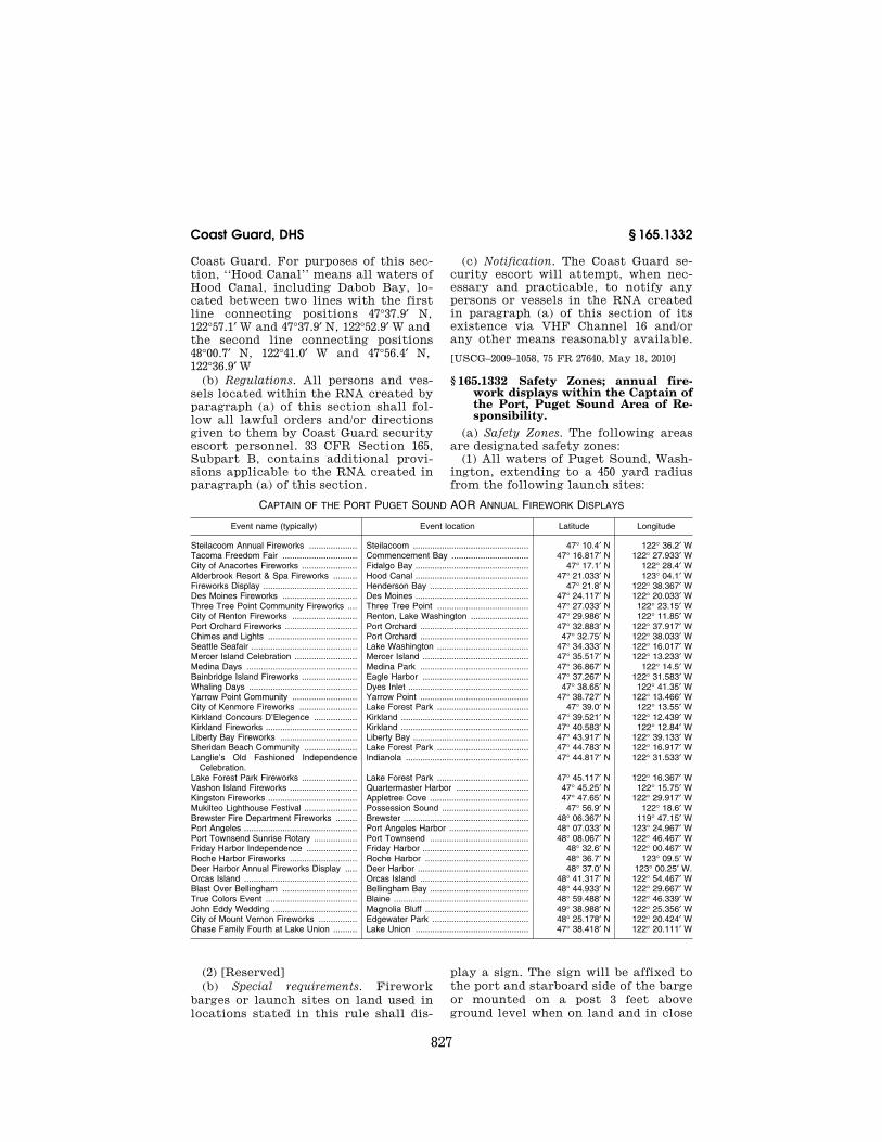
827
Coast Guard, DHS § 165.1332
Coast Guard. For purposes of this sec-tion, ‘‘Hood Canal’’ means all waters of Hood Canal, including Dabob Bay, lo-cated between two lines with the first line connecting positions 47°37.9′ N, 122°57.1′ W and 47°37.9′ N, 122°52.9′ W and the second line connecting positions 48°00.7′ N, 122°41.0′ W and 47°56.4′ N, 122°36.9′ W
(b) Regulations. All persons and ves-sels located within the RNA created by paragraph (a) of this section shall fol-low all lawful orders and/or directions given to them by Coast Guard security escort personnel. 33 CFR Section 165, Subpart B, contains additional provi-sions applicable to the RNA created in paragraph (a) of this section.
(c) Notification. The Coast Guard se-curity escort will attempt, when nec-essary and practicable, to notify any persons or vessels in the RNA created in paragraph (a) of this section of its existence via VHF Channel 16 and/or any other means reasonably available.
[USCG–2009–1058, 75 FR 27640, May 18, 2010]
§ 165.1332 Safety Zones; annual fire-work displays within the Captain of the Port, Puget Sound Area of Re-sponsibility.
(a) Safety Zones. The following areas are designated safety zones:
(1) All waters of Puget Sound, Wash-ington, extending to a 450 yard radius from the following launch sites:
CAPTAIN OF THE PORT PUGET SOUND AOR ANNUAL FIREWORK DISPLAYS
Event name (typically) Event location Latitude Longitude
Steilacoom Annual Fireworks .................... Steilacoom ................................................ 47° 10.4′ N 122° 36.2′ W Tacoma Freedom Fair ............................... Commencement Bay ................................ 47° 16.817′ N 122° 27.933′ W City of Anacortes Fireworks ....................... Fidalgo Bay ............................................... 47° 17.1′ N 122° 28.4′ W Alderbrook Resort & Spa Fireworks .......... Hood Canal ............................................... 47° 21.033′ N 123° 04.1′ W Fireworks Display ....................................... Henderson Bay ......................................... 47° 21.8′ N 122° 38.367′ W Des Moines Fireworks ............................... Des Moines ............................................... 47° 24.117′ N 122° 20.033′ W Three Tree Point Community Fireworks .... Three Tree Point ...................................... 47° 27.033′ N 122° 23.15′ W City of Renton Fireworks ........................... Renton, Lake Washington ........................ 47° 29.986′ N 122° 11.85′ W Port Orchard Fireworks .............................. Port Orchard ............................................. 47° 32.883′ N 122° 37.917′ W Chimes and Lights ..................................... Port Orchard ............................................. 47° 32.75′ N 122° 38.033′ W Seattle Seafair ............................................ Lake Washington ...................................... 47° 34.333′ N 122° 16.017′ W Mercer Island Celebration .......................... Mercer Island ............................................ 47° 35.517′ N 122° 13.233′ W Medina Days .............................................. Medina Park ............................................. 47° 36.867′ N 122° 14.5′ W Bainbridge Island Fireworks ....................... Eagle Harbor ............................................ 47° 37.267′ N 122° 31.583′ W Whaling Days ............................................. Dyes Inlet .................................................. 47° 38.65′ N 122° 41.35′ W Yarrow Point Community ........................... Yarrow Point ............................................. 47° 38.727′ N 122° 13.466′ W City of Kenmore Fireworks ........................ Lake Forest Park ...................................... 47° 39.0′ N 122° 13.55′ W Kirkland Concours D’Elegence .................. Kirkland ..................................................... 47° 39.521′ N 122° 12.439′ W Kirkland Fireworks ...................................... Kirkland ..................................................... 47° 40.583′ N 122° 12.84′ W Liberty Bay Fireworks ................................ Liberty Bay ................................................ 47° 43.917′ N 122° 39.133′ W Sheridan Beach Community ...................... Lake Forest Park ...................................... 47° 44.783′ N 122° 16.917′ W Langlie’s Old Fashioned Independence
Celebration.Indianola ................................................... 47° 44.817′ N 122° 31.533′ W
Lake Forest Park Fireworks ....................... Lake Forest Park ...................................... 47° 45.117′ N 122° 16.367′ W Vashon Island Fireworks ............................ Quartermaster Harbor .............................. 47° 45.25′ N 122° 15.75′ W Kingston Fireworks ..................................... Appletree Cove ......................................... 47° 47.65′ N 122° 29.917′ W Mukilteo Lighthouse Festival ...................... Possession Sound .................................... 47° 56.9′ N 122° 18.6′ W Brewster Fire Department Fireworks ......... Brewster .................................................... 48° 06.367′ N 119° 47.15′ W Port Angeles ............................................... Port Angeles Harbor ................................. 48° 07.033′ N 123° 24.967′ W Port Townsend Sunrise Rotary .................. Port Townsend ......................................... 48° 08.067′ N 122° 46.467′ W Friday Harbor Independence ..................... Friday Harbor ............................................ 48° 32.6′ N 122° 00.467′ W Roche Harbor Fireworks ............................ Roche Harbor ........................................... 48° 36.7′ N 123° 09.5′ W Deer Harbor Annual Fireworks Display ..... Deer Harbor .............................................. 48° 37.0′ N 123° 00.25′ W. Orcas Island ............................................... Orcas Island ............................................. 48° 41.317′ N 122° 54.467′ W Blast Over Bellingham ............................... Bellingham Bay ......................................... 48° 44.933′ N 122° 29.667′ W True Colors Event ...................................... Blaine ........................................................ 48° 59.488′ N 122° 46.339′ W John Eddy Wedding ................................... Magnolia Bluff ........................................... 49° 38.988′ N 122° 25.356′ W City of Mount Vernon Fireworks ................ Edgewater Park ........................................ 48° 25.178′ N 122° 20.424′ W Chase Family Fourth at Lake Union .......... Lake Union ............................................... 47° 38.418′ N 122° 20.111′ W
(2) [Reserved] (b) Special requirements. Firework
barges or launch sites on land used in locations stated in this rule shall dis-
play a sign. The sign will be affixed to the port and starboard side of the barge or mounted on a post 3 feet above ground level when on land and in close
VerDate Mar<15>2010 07:59 Sep 03, 2010 Jkt 220131 PO 00000 Frm 00837 Fmt 8010 Sfmt 8010 Y:\SGML\220131.XXX 220131erow
e on
DS
K5C
LS3C
1PR
OD
with
CF
R
828
33 CFR Ch. I (7–1–10 Edition) § 165.T14–204
proximity to the shoreline facing the water labeled ‘‘FIREWORKS–DAN-GER–STAY AWAY.’’ This will provide on-scene notice that the safety zone is, or will, be enforced on that day. This notice will consist of a diamond shaped sign, 4 foot by 4 foot, with a 3 inch or-ange retro-reflective border. The word ‘‘DANGER’ shall be 10 inch black block letters centered on the sign with the words ‘‘FIREWORKS’’ and ‘‘STAY AWAY’’ in 6 inch black block letters placed above and below the word ‘‘DANGER’’ respectively on a white background. An on-scene patrol vessel will enforce these safety zones 30 min-utes prior to the start and 30 minutes after the conclusion of the fireworks display.
(c) Notice of enforcement. These safety zones will be activated and thus sub-ject to enforcement, under the fol-lowing conditions: the Coast Guard must receive and approve a marine event permit for each firework display and then the Captain of the Port will cause notice of the enforcement of these safety zones to be made by all ap-propriate means to provide notice to the affected segments of the public as practicable, in accordance with 33 CFR 165.7(a). The Captain of the Port will issue a Broadcast Notice to Mariners and Local Notice to Mariners notifying the public of activation and suspension of enforcement of these safety zones. Additionally, an on-scene Patrol Com-mander will ensure enforcement of this safety zone by limiting the transit of non-participating vessels in the des-ignated areas described above.
(d) Regulations. In accordance with the general regulations in 33 CFR part 165, subpart C, no vessel operator may enter, transit, moor, or anchor within this safety zone, except for vessels au-thorized by the Captain of the Port or Designated Representative.
(e) Authorization. All vessel operators who desire to enter the safety zone must obtain permission from the Cap-tain of the Port or Designated Rep-resentative by contacting either the on-scene patrol craft on VHF Ch 13 or Ch 16 or the Coast Guard Sector Se-attle Joint Harbor Operations Center (JHOC) via telephone at (206) 217–6002.
(f) Enforcement period. This rule will be enforced from 5 p.m. until 1 a.m.
each day a barge with a ‘‘FIRE-WORKS–DANGER–STAY AWAY’’ sign is located within any of the above des-ignated safety zone locations and meets the criteria established in sec-tion (b), within the following time-frames:
(1) The last two weeks of December until the conclusion of the first week-end of January.
(2) The last weekend of June until the conclusion of the third week of July.
(3) The second weekend of August until the conclusion of the fourth week of August.
(4) The first weekend of September until the conclusion of the third week of September.
(5) The first weekend of December. (g) Contact information. Questions
about safety zones and related events should be addressed to COMMANDER (spw), U.S. COAST GUARD SECTOR, Attention: Waterways Management Di-vision, 1519 Alaskan Way South, Se-attle, WA 98134–1192.
[USCG–2010–0063, 75 FR 33700, June 15, 2010]
FOURTEENTH COAST GUARD DISTRICT
§ 165.T14–204 Safety Zone; fixed moor-ing balls, south of Barbers Pt Har-bor Channel, Oahu, Hawaii.
(a) Location. The following area is a safety zone: All waters contained with-in a 400-yard radius (366-meter) radius around position 21°18′35.00″ N., 158°07′33.00″ W. This position is approxi-mately 2,500 yards south of Barbers Point Harbor channel buoy #2, Oahu, Hawaii. This Safety Zone will have six (6), 24-inch white mooring balls with a single blue reflective stripe. The moor-ing balls will be placed 133 yards (121 meters) in a circular design for preapproved vessel mooring purposes. This safety zone extends from the sur-face of the water to the ocean floor. These coordinates are based upon the National Oceanic and Atmospheric Ad-ministration Coast Survey, Pacific Ocean, Oahu, Hawaii, chart 19357.
(b) Regulations. (1) Entry into or re-maining in the safety zone described in paragraph (a) of this section is prohib-ited unless authorized by the Coast Guard Captain of the Port Honolulu zone.
VerDate Mar<15>2010 07:59 Sep 03, 2010 Jkt 220131 PO 00000 Frm 00838 Fmt 8010 Sfmt 8010 Y:\SGML\220131.XXX 220131erow
e on
DS
K5C
LS3C
1PR
OD
with
CF
R

829
Coast Guard, DHS § 165.1402
(2) Persons desiring to transit the safety zone may contact the Honolulu Captain of the Port on VHF channel 81A (157.075 MHz), VHF channel 16 (156.800 MHz), or at telephone numbers 1–808–563–9906 or 808–842–2600 to seek permission to transit the area with a designated escort vessel. If permission is granted, all persons and vessels must comply with the instructions of the Captain of the Port or his or her des-ignated representative. All other ves-sels are requested to pass to the west, or makai side, of the Safety Zone to avoid grounding on the shallow and live coral reef area located between the safety zone and the shoreline.
(c) Enforcement period. This rule will be enforced from 6 a.m. on July 1, 2010 until 6 p.m. on July 21, 2010 or unless canceled earlier by the Captain of the Port.
(d) Regulations. In accordance with the general regulations in 33 CFR part 165, Subpart C, no person or vessel may enter or remain in the zone except for support vessels/aircraft and support personnel, or other vessels authorized by the Captain of the Port or his des-ignated representatives.
(e) Penalties. Vessels or persons vio-lating this rule are subject to the pen-alties set forth in 33 U.S.C. 1232 and 50 U.S.C. 192.
EFFECTIVE DATE NOTE: By USCG–2010–0457, 75 FR 38021, July 1, 2010, temporary § 165.T14– 204 was added, effective from 6 a.m. on July 1, 2010 through 6 p.m. on July 21, 2010.
§ 165.1401 Apra Harbor, Guam—safety zones.
(a) The following is designated as Safety Zone A—The waters of the Pa-cific Ocean and Apra Outer Harbor en-compassed within an arc of 725 yards radius centered at the center of Wharf H. (Located at 13°27′47″ N and 144°39′01.9″ E. Based on World Geodetic System 1984 Datum)
(b) The following is designated Safe-ty Zone B—The waters of Apra Outer Harbor encompassed within an arc of 680 yards radius centered at the center of Naval Wharf Kilo. (Located at 13°26′43″ N, 144°37′46.7″ E. Based on World Geodetic system 1984 Datum)
(c) Special regulations. (1) Section 165.23 does not apply to Safety Zone A and/or Safety Zone B, except when
Wharf H and/or Naval Wharf Kilo, or a vessel berthed at Wharf H and/or Naval Wharf Kilo, is displaying a red (BRAVO) flag by day or a red light by night.
(2) In accordance with the general regulations in 165.23 of this part, entry into these zones is prohibited unless authorized by the Captain of the Port, Guam.
[COTP Guam Reg. 89–001, 55 FR 18725, May 4, 1990]
§ 165.1402 Apra Outer Harbor, Guam— regulated navigation area.
(a) The following is a regulated navi-gation area—The waters of the Pacific Ocean and Apra Outer Harbor enclosed by a line beginning at latitude 13°26′47″ N, longitude 144°35′07″ E; thence to Spanish Rocks at latitude 13°27′09.5″ N, longitude 144°37′20.6″ E; thence along the shoreline of Apra Outer Harbor to latitude 13°26′28.1″ N, longitude 144°39′52.5″ E (the northwest corner of Polaris Point); thence to latitude 13°26′40.2″ N, longitude 144°39′28.1″ E; thence to latitude 13°26′32.1″ N, lon-gitude 144°39′02.8″ E; thence along the shoreline of Apra Outer Harbor to Orote Point at latitude 13°26′42″ N, lon-gitude 144°36′58.5″ E; thence to the be-ginning. (Based on WGS 84 Datum)
(b) Regulations: (1) Except for public vessels of the
United States, vessels may not enter Apra Outer Harbor without permission of the Captain of the Port if they have on board more than 25 tons of high ex-plosives.
(2) Except for vessels not more than 65 feet in length, towboats or tugs without tows, no vessel may pass an-other vessel in the vicinity of the Outer Harbor entrance.
(3) Vessels over 100 gross tons shall: (i) Steady on the entrance range at
least 2 miles west of the entrance when approaching Apra Outer Harbor and;
(ii) [Reserved] (iii) Steady on the range when de-
parting Apra Outer Harbor. (4) Vessels may not anchor in the
fairway. The fairway is the area within 375 feet on either side of a line begin-ning at latitude 13°26′47″ N, longitude 144°35′07″ E; thence to latitude 13°27′14.1″ N, longitude 144°39′14.4″ E;
VerDate Mar<15>2010 07:59 Sep 03, 2010 Jkt 220131 PO 00000 Frm 00839 Fmt 8010 Sfmt 8010 Y:\SGML\220131.XXX 220131erow
e on
DS
K5C
LS3C
1PR
OD
with
CF
R

830
33 CFR Ch. I (7–1–10 Edition) § 165.1403
thence to latitude 13°26′35.2″ N, lon-gitude 144°39′46.4″ E; thence to latitude 13°26′30.8″ N, longitude 144°39′44.4″ E. (Based on WGS 84 Datum)
(5) Vessels over 100 gross tons may not proceed at a speed exceeding 12 knots within the harbor.
(6) No vessel may leave Apra Outer Harbor until any inbound vessel over 65 feet in length has cleared the Outer Harbor Entrance.
[CGD 79–034, 47 FR 29660, July 8, 1982, as amended by CGD 96–026, 61 FR 33669, June 28, 1996; USCG–1998–3799, 63 FR 35533, June 30, 1998]
§ 165.1403 Security Zones; Tinian, Commonwealth of the Northern Mariana Islands.
(a) Location. The following areas are security zones:
(1) The waters of the Pacific Ocean off Tinian between 14°59′04.9″ N, 145°34′58.6″ E to 14°59′20.1″ N, 145°35′41.5″ E to 14°59′09.8″ N, 145°36′02.1″ E to 14°57′49.3″ N, 145°36′28.7″ E to 14°57′29.1″ N, 145°35′31.1″ E and back to 14°59′04.9″ N, 145°34′58.6″ E. This zone will be en-forced when one, or more, of the Mari-time Preposition Ships is in the zone or moored at Mooring A located at 14°58′57.0″ N and 145°35′40.8″ E or Moor-ing B located at 14°58′15.9″ N, 145°35′54.8″ E.
(2) Additionally, a 50-yard security zone in all directions around Moorings A and B will be enforced when no ves-sels are moored thereto but mooring balls are anchored and on station.
NOTE TO § 165.1403(a): All positions of lati-tude and longitude are from International Spheroid, Astro Pier 1944 (Saipan) Datum (NOAA Chart 81071).
(b) Regulations. (1) In accordance with general regulations in § 165.33 of this part, entry into this security zone is prohibited unless authorized by the Captain of the Port.
[COTP Honolulu Reg. 86–08, 51 FR 42220, Nov. 24, 1986, as amended by USCG–2001–9286, 66 FR 33642, June 25, 2001; COTP Guam 07–005, 72 FR 65460, Nov. 21, 2007]
§ 165.1404 Apra Harbor, Guam—secu-rity zone.
(a) The following is designated as Se-curity Zone C—The waters of Apra Outer Harbor, Guam surrounding Naval Mooring Buoy No. 702 (Located at
13°27′30.1″ N and 144°38′12.9″ E. Based on World Geodetic System 1984 Datum) and the Maritime Prepositioning ships moored thereto. The security zone will extend 100 yards in all directions around the vessel and its mooring. Ad-ditionally, a 50 yard security zone will remain in effect in all directions around buoy No. 702 when no vessel is moored thereto.
(b) In accordance with the general regulations in § 165.33 of this part, entry into Security Zone C is prohib-ited unless authorized by the Captain of the Port, Guam.
[COTP Guam Reg. 89–001, 55 FR 18725, May 4, 1990]
§ 165.1405 Regulated Navigation Areas and Security Zones; Designated Es-corted Vessels-Philippine Sea and Apra Harbor, Guam (including Cabras Island Channel), and Tanapag Harbor, Saipan, Common-wealth of the Northern Mariana Is-lands (CNMI).
(a) Regulated navigation area. The fol-lowing areas, designated by coordi-nates referencing World Geodetic Datum (1984), are regulated navigation areas (RNAs).
(1) Philippine Sea, Guam—All waters from the surface to the bottom of the Philippine Sea, Guam, encompassed by lines connecting the following points, beginning at 13°27′10″ N, 144°35′05″ E, thence easterly to 13°27′17″ N, 144°37′27″ E, thence south westerly to 13°26′52″ N, 144°37′05″ E, thence westerly to 13°26′37″ N, 144°35′05″ E, thence due north back to point of origin.
(2) Apra Harbor, Guam—All waters from surface to bottom of Apra Harbor, Guam, shoreward of the COLREGS De-marcation as described in 33 CFR part 80.
(3) Tanapag Harbor, Saipan—The wa-ters from surface to bottom of Tanapag Harbor, Saipan (CNMI), encompassed by lines connecting the following points, beginning at 15°12′10″ N, 145°40′28″ E, thence north easterly to 15°14′08″ N, 145°42′00″ E, thence due east to 15°14′08″ N, 145°44′02″ E, thence south easterly to 15°13′54″ N, 144°44′20″ E, thence south westerly along the shore-line to 15°13′11″ N, 145°43′01″ E, thence south westerly to 15°12′10″ N, 145°40′28″ E.
VerDate Mar<15>2010 07:59 Sep 03, 2010 Jkt 220131 PO 00000 Frm 00840 Fmt 8010 Sfmt 8010 Y:\SGML\220131.XXX 220131erow
e on
DS
K5C
LS3C
1PR
OD
with
CF
R

831
Coast Guard, DHS § 165.1406
(4) Cabras Island Channel, Guam—All waters from surface to bottom of Cabras Island Channel, Guam, begin-ning at point 13°27′34″ N, 144°39′39″ E and extending south easterly to posi-tion 13°27′24″ N, 144°39′59″ E then head-ing easterly along the shoreline to po-sition 13°27′31″ N, 144°40′22″ E then head-ing north to position 13°27′37″ N, 144°40′22″ E following the shoreline in a westerly direction back to point of ori-gin.
(b) Security zones. A 100-yard radius security zone is established around, and is centered on, each escorted vessel within the regulated navigation areas in paragraph (a) of this section. A secu-rity zone is activated when an escorted vessel enters an RNA and remains ac-tive until the escorted vessel leaves the RNA. This is a moving security zone when the escorted vessel is in transit and becomes a fixed zone when the es-corted vessel is anchored or moored. A security zone will not extend beyond the boundary of the RNA in this sec-tion.
(c) Definitions. As used in this sec-tion:
(1) Designated representative means any Coast Guard commissioned, war-rant, or petty officer that has been au-thorized to act on behalf of the COTP.
(2) Escorted Vessel means any vessel operating in the RNA deemed by the COTP to be in need of escort protection for security reasons or under other cir-cumstances. A designated representa-tive aboard a Coast Guard cutter or pa-trol boat will accompany vessels deemed in need of escort protection into the RNA.
(3) Navigation rules mean inter-national and inland navigation rules in 33 CFR chapter I, subchapters D and E.
(4) Vessel means every description of watercraft or other artificial contriv-ance used, or capable of being used, as a means of transportation on water, ex-cept U.S. Coast Guard or U.S. naval vessels.
(d) Regulations. (1) No person or ves-sel may enter into the security zones under this section unless authorized by the COTP Guam or a designated rep-resentative.
(2) A vessel in the RNA established under paragraph (a) of this section op-erating within 500 yards of an escorted
vessel must proceed at a minimum speed necessary to maintain a safe course, unless required to maintain speed by the navigation rules.
(3) When an escorted vessel in the RNA approaches within 100 yards of a vessel that is moored, or anchored in a designated anchorage area, the sta-tionary vessel must stay moored or an-chored while it remains within the es-corted vessel’s security zone unless it is either ordered by, or given permis-sion from the COTP Guam or a des-ignated representative to do otherwise.
(4) The COTP will inform the public of the existence or status of the secu-rity zones around escorted vessels in the RNA periodically by Broadcast No-tice to Mariners.
(5) Persons or vessels that must enter a security zone or exceed speed limits established in this section may contact the COTP at command center tele-phone number (671) 339–6100 or on VHF channel 16 (156.8 Mhz) to request per-mission.
(6) All persons and vessels within 500 yards of an escorted vessel in the RNA must comply with the orders of the COTP Guam or his designated rep-resentatives.
(e) Authority. In addition to 33 U.S.C. 1231 and 50 U.S.C. 191, the authority for this section includes 33 U.S.C. 1226.
[CGD14–02–002, 68 FR 4384, Jan. 29, 2003]
§ 165.1406 Safety Zone: Pacific Missile Range Facility (PMRF), Barking Sands, Island of Kauai, Hawaii.
(a) Location. The following area is es-tablished as a safety zone during launch operations at PMRF, Kauai, Ha-waii: The waters bounded by the fol-lowing coordinates: (22°01.2′ N, 159°47.3′ W), (22°01.2′ N, 159°50.7′ W), (22°06.3′ N, 159°50.7′ W), (22°06.3′ N, 159°44.8′ W). (Datum: OHD)
(b) Activation. The above safety zone will be activated during launch oper-ations at PMRF, Kauai, Hawaii. The Coast Guard will provide notice that the safety zone will be activated through published and broadcast local notice to mariners prior to scheduled launch dates.
(c) Regulation. The area described in paragraph (a) of this section will be closed to all vessels and persons, except those vessels and persons authorized by
VerDate Mar<15>2010 07:59 Sep 03, 2010 Jkt 220131 PO 00000 Frm 00841 Fmt 8010 Sfmt 8010 Y:\SGML\220131.XXX 220131erow
e on
DS
K5C
LS3C
1PR
OD
with
CF
R

832
33 CFR Ch. I (7–1–10 Edition) § 165.1407
the Commander, Fourteenth Coast Guard District, or the Captain of the Port (COTP) Honolulu, Hawaii, when-ever Strategic Target System (STARS) vehicles are to be launched by the United States Government from the PMRF, Barking Sands, Kauai, Hawaii.
(d) The general regulations governing safety zones contained in 33 CFR 165.23 apply.
[CGD14 92–05, 57 FR 54508, Nov. 19, 1992, as amended by CGD 96–026, 61 FR 33669, June 28, 1996]
§ 165.1407 Security Zones; Oahu, HI. (a) Location. The following areas,
from the surface of the water to the ocean floor, are security zones that are activated and enforced subject to the provisions of paragraphs (c) and (d). All coordinates below are expressed in de-grees, minutes, and tenths or hun-dredths of minutes.
(1) Honolulu Harbor. All waters of Honolulu Harbor and Honolulu en-trance channel commencing at a line between entrance channel buoys no. 1 and no. 2, to a line between the fixed day beacons no. 14 and no. 15 west of Sand Island Bridge.
(2) Honolulu Harbor Anchorages B, C, and D. All waters extending 100 yards in all directions from each vessel in ex-cess of 300 gross tons anchored in Hono-lulu Harbor Anchorage B, C, or D, as defined in 33 CFR 110.235(a).
(3) Kalihi Channel and Keehi Lagoon, Oahu. All waters of Kalihi Channel and Keehi Lagoon beginning at Kalihi Channel entrance buoy no. 1 and con-tinuing along the general trend of Kalihi Channel to day beacon no. 13, thence continuing on a bearing of 332.5°T to shore, thence east and south along the general trend of the shoreline to day beacon no. 15, thence southeast to day beacon no. 14, thence southeast along the general trend of the shoreline of Sand Island, to the southwest tip of Sand Island at 21°18.0′ N/157°53.05′ W, thence southwest on a bearing of 233°T to Kalihi Channel entrance buoy no. 1.
(4) Honolulu International Airport—(i) Honolulu International Airport, North Section. All waters surrounding Hono-lulu International Airport from 21°18.25′ N/157° 55.58° W, thence south to 21°18.0′ N/157° 55.58′ W, thence east to the western edge of Kalihi Channel,
thence north along the western edge of the channel to day beacon no. 13, thence northwest at a bearing of 332.5°T to shore.
(ii) Honolulu International Airport, South Section. All waters near Honolulu International Airport from 21°18.0′ N/ 157°55.58′ W, thence south to 21°16.5′ N/ 157°55.58′ W, thence east to 21°16.5′ N/ 157°54.0′ W (the extension of the west-ern edge of Kalihi Channel), thence north along the western edge of the channel to Kalihi Channel buoy ‘‘5’’, thence west to 21°18.0′ N/157°55.58′ W.
(5) Barbers Point Offshore Moorings. All waters around the Tesoro Single Point and the Chevron Conventional Buoy Moorings beginning at 21°16.43′ N/ 158°06.03′ W, thence northeast to 21°17.35′ N/158°3.95′ W, thence southeast to 21°16.47′ N/ 158°03.5′ W, thence south-west to 21°15.53′ N/158°05.56′ W, thence north to the beginning point.
(6) Barbers Point Harbor, Oahu. All waters contained within the Barbers Point Harbor, Oahu, enclosed by a line drawn between Harbor Entrance Chan-nel Light 6 and the jetty point day bea-con at 21°19.5′ N/158°07.26′ W.
(7) Kahe Point, Oahu. All waters adja-cent to the Hawaiian Electric Company power plant at Kahe Point within 500 yards of 21° 21.30’ N/158′ 07.7° W (lighted tower).
(b) Definitions. As used in this sec-tion, MARSEC Level 2 or Maritime Secu-rity Level 2 means, as defined in 33 CFR 101.105, the level for which appropriate additional protective security meas-ures shall be maintained for a period of time as a result of heightened risk of a transportation security incident.
(c) Regulations. (1) Under 33 CFR 165.33, entry into the security zones de-scribed in this section is prohibited un-less authorized by the Coast Guard Captain of the Port, Honolulu or his or her designated representatives.
(2) Persons desiring to transit the areas of the security zones may con-tact the Captain of the Port at Com-mand Center telephone number (808) 842–2600 and (808) 842–2601, fax (808) 842– 2624 or on VHF channel 16 (156.8 Mhz) to seek permission to transit the area. Written requests may be submitted to the Captain of Port, U.S. Coast Guard Sector Honolulu, Sand Island Access Road, Honolulu, Hawaii 96819, or faxed
VerDate Mar<15>2010 07:59 Sep 03, 2010 Jkt 220131 PO 00000 Frm 00842 Fmt 8010 Sfmt 8010 Y:\SGML\220131.XXX 220131erow
e on
DS
K5C
LS3C
1PR
OD
with
CF
R

833
Coast Guard, DHS § 165.1408
to (808) 842–2622. If permission is grant-ed, all persons and vessels must comply with the instructions of the Captain of the Port or his or her designated rep-resentatives. For all seaplane traffic entering or transiting the security zones, a seaplane’s compliance with all Federal Aviation Administration regu-lations (14 CFR parts 91 and 99) regard-ing flight-plan approval is deemed ade-quate permission to transit the water-way security zones described in this section.
(d) Notice of enforcement or suspension of enforcement of security zones. (1) The security zones described in paragraphs (a)(3) (Kalihi Channel and Keehi La-goon, Oahu), (a)(4)(i) (Honolulu Inter-national Airport, North Section), (a)(4)(ii) (Honolulu International Air-port, South Section), (a)(6) (Barbers Point Harbor, Oahu), and (a)(7) (Kahe Point, Oahu) of this section, will be en-forced only upon the occurrence of one of the following events—
(i) Whenever the Maritime Security (MARSEC) level, as defined in 33 CFR part 101, is raised to 2 or higher; or
(ii) Whenever the Captain of the Port, after considering all available facts, determines that there is a heightened risk of a transportation se-curity incident or other serious mari-time incident, including but not lim-ited to any incident that may cause a significant loss of life, environmental damage, transportation system disrup-tion, or economic disruption in a par-ticular area.
(2) A notice will be published in the FEDERAL REGISTER reporting when events in paragraph (d)(1)(i) or (d)(1)(ii) have occurred.
(3) The Captain of the Port of Hono-lulu will cause notice of the enforce-ment of the security zones listed in paragraph (d)(1) of this section and no-tice of suspension of enforcement to be made by appropriate means to affect the widest publicity, including the use of broadcast notice to mariners and publication in the local notice to mari-ners.
(e) Informational notices. The Captain of the Port will cause notice of the presence of the security zones estab-lished in paragraph (a)(2) of this sec-tion, Honolulu Harbor Anchorages B, C, and D, to be made by appropriate
means to affect the widest publicity, including the use of broadcast notice to mariners and publication in the local notice to mariners.
(f) Enforcement. Any Coast Guard commissioned, warrant, or petty offi-cer, and any other Captain of the Port representative permitted by law, may enforce the rules in this section.
(g) Waiver. The Captain of the Port, Honolulu may waive any of the re-quirements of this section for any ves-sel or class of vessels upon his or her determination that application of this section is unnecessary or impractical for the purpose of port and maritime security.
(h) Penalties. Vessels or persons vio-lating this section are subject to the penalties set forth in 33 U.S.C. 1232 and 50 U.S.C. 192.
[CGD14–04–116, 70 FR 75040, Dec. 19, 2005, as amended by CGD 14–07–001, 72 FR 44777, Aug. 9, 2007; 72 FR 57863, Oct. 11, 2007; USCG–2009– 0416, 74 FR 27442, June 10, 2009]
§ 165.1408 Security Zones; Maui, HI. (a) Location. The following areas,
from the surface of the water to the ocean floor, are security zones that are activated and enforced subject to the provisions in paragraph (c):
(1) Kahului Harbor, Maui. All waters extending 100 yards in all directions from each large passenger vessel in Kahului Harbor, Maui, HI or within 3 nautical miles seaward of the Kahului Harbor COLREGS DEMARCATION (See 33 CFR 80.1460). This is a moving security zone when the LPV is in tran-sit and becomes a fixed zone when the LPV is anchored, position-keeping, or moored.
(2) Lahaina, Maui. All waters extend-ing 100 yards in all directions from each large passenger vessel in Lahaina, Maui, whenever the LPV is within 3 nautical miles of Lahaina Light (LLNR 28460). The security zone around each LPV is activated and enforced whether the LPV is underway, moored, posi-tion-keeping, or anchored, and will continue in effect until such time as the LPV departs Lahaina and the 3- mile enforcement area.
(b) Definitions. As used in this sec-tion, large passenger vessel or LPV means a cruise ship more than 300 feet in length that carries passengers for
VerDate Mar<15>2010 07:59 Sep 03, 2010 Jkt 220131 PO 00000 Frm 00843 Fmt 8010 Sfmt 8010 Y:\SGML\220131.XXX 220131erow
e on
DS
K5C
LS3C
1PR
OD
with
CF
R
834
33 CFR Ch. I (7–1–10 Edition) § 165.1409
hire, and any passenger ferry more than 300 feet in length that carries pas-sengers for hire.
(c) Regulations. (1) Under 33 CFR 165.33, entry into the security zones created by this section is prohibited unless authorized by the Coast Guard Captain of the Port, Honolulu or his or her designated representatives. When authorized passage through a large pas-senger vessel security zone, all vessels must operate at the minimum speed necessary to maintain a safe course and must proceed as directed by the Captain of the Port or his or her des-ignated representatives. No person is allowed within 100 yards of an LPV that is underway, moored, position- keeping, or at anchor, unless author-ized by the Captain of the Port or his or her designated representative.
(2) When conditions permit, the Cap-tain of the Port, or his or her des-ignated representative, may permit vessels that are at anchor, restricted in their ability to maneuver, or con-strained by draft to remain within an LPV security zone in order to ensure navigational safety.
(3) Persons desiring to transit the areas of the security zones in this sec-tion may contact the Captain of the Port at Command Center telephone number (808) 842–2600 or on VHF chan-nel 16 (156.8 Mhz) to seek permission to transit the area. Written requests may be submitted to the Captain of Port, U.S. Coast Guard Sector Honolulu, Sand Island Access Road, Honolulu, Hawaii 96819, or faxed to (808) 842–2622. If permission is granted, all persons and vessels must comply with the in-structions of the Captain of the Port or his or her designated representatives. For all seaplane traffic entering or transiting the security zones, compli-ance with all Federal Aviation Admin-istration regulations (14 CFR parts 91 and 99) regarding flight-plan approval is deemed adequate permission to tran-sit the waterway security zones de-scribed in this section.
(d) Enforcement. Any Coast Guard commissioned, warrant, or petty offi-cer, and any other Captain of the Port representative permitted by law, may enforce the rules in this section.
(e) Waiver. The Captain of the Port, Honolulu may waive any of the re-
quirements of this section for any ves-sel or class of vessels upon his or her determination that application of this section is unnecessary or impractical for the purpose of port and maritime security.
(f) Penalties. Vessels or persons vio-lating this section are subject to the penalties set forth in 33 U.S.C. 1232 and 50 U.S.C. 192.
[CGD14–04–116, 70 FR 75040, Dec. 19, 2005, as amended by CGD 14–07–001, 72 FR 44777, Aug. 9, 2007]
§ 165.1409 Security Zones; Hawaii, HI. (a) Location. The following areas,
from the surface of the water to the ocean floor, are security zones that are activated and enforced subject to the provisions in paragraph (c):
(1) Hilo Harbor, Hawaii. All waters ex-tending 100 yards in all directions from each large passenger vessel in Hilo Har-bor, Hawaii, HI or within 3 nautical miles seaward of the Hilo Harbor COLREGS DEMARCATION (See 33 CFR 80.1480). This is a moving security zone when the LPV is in transit and be-comes a fixed zone when the LPV is an-chored, position-keeping, or moored.
(2) Kailua-Kona, Hawaii. All waters extending 100 yards in all directions from each large passenger vessel in Kailua-Kona, Hawaii, whenever the LPV is within 3 nautical miles of Kukailimoku Point. The 100-yard secu-rity zone around each LPV is activated and enforced whether the LPV is un-derway, moored, position-keeping, or anchored and will continue in effect until such time as the LPV departs Kailua-Kona and the 3-mile enforce-ment area.
(3) Kawaihae Harbor, Hawaii. All wa-ters extending 100 yards in all direc-tions from each large passenger vessel in Kawaihae Harbor, Hawaii, or within 3 nautical miles seaward of the Kawaihae Harbor COLREGS DEMAR-CATION (See 33 CFR 80.1470). The 100- yard security zone around each LPV is activated and enforced whether the LPV is underway, moored, position- keeping, or anchored.
(b) Definitions. As used in this sec-tion, large passenger vessel or LPV means a cruise ship more than 300 feet in length that carries passengers for hire, and any passenger ferry more
VerDate Mar<15>2010 07:59 Sep 03, 2010 Jkt 220131 PO 00000 Frm 00844 Fmt 8010 Sfmt 8010 Y:\SGML\220131.XXX 220131erow
e on
DS
K5C
LS3C
1PR
OD
with
CF
R
835
Coast Guard, DHS § 165.1410
than 300 feet in length that carries pas-sengers for hire.
(c) Regulations. (1) Under 33 CFR 165.33, entry into the security zones created by this section is prohibited unless authorized by the Coast Guard Captain of the Port, Honolulu or his or her designated representative. When authorized passage through a large pas-senger vessel security zone, all vessels must operate at the minimum speed necessary to maintain a safe course and must proceed as directed by the Captain of the Port or his or her des-ignated representatives. No person is allowed within 100 yards of a large pas-senger vessel that is underway, moored, position-keeping, or at anchor, unless authorized by the Captain of the Port or his or her designated represent-atives.
(2) When conditions permit, the Cap-tain of the Port, or his or her des-ignated representatives, may permit vessels that are at anchor, restricted in their ability to maneuver, or con-strained by draft to remain within an LPV security zone in order to ensure navigational safety.
(3) Persons desiring to transit the areas of the security zones in this sec-tion may contact the Captain of the Port at Command Center telephone number (808) 842–2600 or on VHF chan-nel 16 (156.8 Mhz) to seek permission to transit the area. Written requests may be submitted to the Captain of Port, U.S. Coast Guard Sector Honolulu, Sand Island Access Road, Honolulu, Hawaii 96819, or faxed to (808) 842–2622. If permission is granted, all persons and vessels must comply with the in-structions of the Captain of the Port or his or her designated representatives. For all seaplane traffic entering or transiting the security zones, compli-ance with all Federal Aviation Admin-istration regulations (14 CFR parts 91 and 99) regarding flight-plan approval is deemed adequate permission to tran-sit the waterway security zones de-scribed in this section.
(d) Enforcement. Any Coast Guard commissioned, warrant, or petty offi-cer, and any other Captain of the Port representative permitted by law, may enforce the rules in this section.
(e) Waiver. The Captain of the Port, Honolulu may waive any of the re-
quirements of this section for any ves-sel or class of vessels upon his or her determination that application of this section is unnecessary or impractical for the purpose of port and maritime security.
(f) Penalties. Vessels or persons vio-lating this section are subject to the penalties set forth in 33 U.S.C. 1232 and 50 U.S.C. 192.
[CGD14–04–116, 70 FR 75041, Dec. 19, 2005, as amended by CGD14–07–001, 72 FR 44777, Aug. 9, 2007]
§ 165.1410 Security Zones; Kauai, HI. (a) Location. The following areas,
from the surface of the water to the ocean floor, are security zones that are activated and enforced subject to the provisions in paragraph (c):
(1) Nawiliwili Harbor, Lihue, Kauai. All waters extending 100 yards in all di-rections from each large passenger ves-sel in Nawiliwili Harbor, Kauai, HI or within 3 nautical miles seaward of the Nawiliwili Harbor COLREGS DEMAR-CATION (See 33 CFR 80.1450). This is a moving security zone when the LPV is in transit and becomes a fixed zone when the LPV is anchored, position- keeping, or moored.
(2) Port Allen, Kauai. All waters ex-tending 100 yards in all directions from each large passenger vessel in Port Allen, Kauai, HI or within 3 nautical miles seaward of the Port Allen COLREGS DEMARCATION (See 33 CFR 80.1440). This is a moving security zone when the LPV is in transit and be-comes a fixed zone when the LPV is an-chored, position-keeping, or moored.
(b) Definitions. As used in this sec-tion, large passenger vessel or LPV means a cruise ship more than 300 feet in length that carries passengers for hire, and any passenger ferry more than 300 feet in length that carries pas-sengers for hire.
(c) Regulations. (1) Under 33 CFR 165.33, entry into the security zones created by this section is prohibited unless authorized by the Coast Guard Captain of the Port, Honolulu or his or her designated representative. When authorized passage through an LPV se-curity zone, all vessels must operate at the minimum speed necessary to main-tain a safe course and must proceed as directed by the Captain of the Port or
VerDate Mar<15>2010 07:59 Sep 03, 2010 Jkt 220131 PO 00000 Frm 00845 Fmt 8010 Sfmt 8010 Y:\SGML\220131.XXX 220131erow
e on
DS
K5C
LS3C
1PR
OD
with
CF
R

836
33 CFR Ch. I (7–1–10 Edition) § 165.1411
his or her designated representative. No person is allowed within 100 yards of a large passenger vessel that is un-derway, moored, position-keeping, or at anchor, unless authorized by the Captain of the Port or his or her des-ignated representative.
(2) When conditions permit, the Cap-tain of the Port, or his or her des-ignated representative, may permit vessels that are at anchor, restricted in their ability to maneuver, or con-strained by draft to remain within an LPV security zone in order to ensure navigational safety.
(3) Persons desiring to transit the areas of the security zones may con-tact the Captain of the Port at Com-mand Center telephone number (808) 842–2600 or on VHF channel 16 (156.8 Mhz) to seek permission to transit the area. Written requests may be sub-mitted to the Captain of Port, U.S. Coast Guard Sector Honolulu, Sand Is-land Access Road, Honolulu, Hawaii 96819, or faxed to (808) 842–2622. If per-mission is granted, all persons and ves-sels must comply with the instructions of the Captain of the Port or his or her designated representatives. For all sea-plane traffic entering or transiting the security zones, compliance with all Federal Aviation Administration regu-lations (14 CFR parts 91 and 99) regard-ing flight-plan approval is deemed ade-quate permission to transit the water-way security zones described in this section.
(d) Enforcement. Any Coast Guard commissioned, warrant, or petty offi-cer, and any other Captain of the Port representative permitted by law, may enforce the rules in this section.
(e) Waiver. The Captain of the Port, Honolulu may waive any of the re-quirements of this section for any ves-sel or class of vessels upon his or her determination that application of this section is unnecessary or impractical for the purpose of port and maritime security.
(f) Penalties. Vessels or persons vio-lating this section are subject to the penalties set forth in 33 U.S.C. 1232 and 50 U.S.C. 192.
[CGD14–04–116, 70 FR 75041, Dec. 19, 2005, as amended by CGD14–07–001, 72 FR 44778, Aug. 9, 2007]
§ 165.1411 Security zone; waters sur-rounding U.S. Forces vessel SBX–1, HI.
(a) Location. The following area, in U.S. navigable waters within the Hono-lulu Captain of the Port Zone (see 33 CFR 3.70–10), from the surface of the water to the ocean floor, is a security zone: All waters extending 500 yards in all directions from U.S. Forces vessel SBX–1. The security zone moves with the SBX–1 while it is in transit and be-comes fixed when the SBX–1 is an-chored, position-keeping, or moored.
(b) Regulations. The general regula-tions governing security zones con-tained in 33 CFR 165.33 apply. Entry into, transit through, or anchoring within this zone while it is activated, and thus subject to enforcement, is prohibited unless authorized by the Captain of the Port or a designated representative thereof.
(c) Suspension of enforcement. The Coast Guard will suspend enforcement of the security zone described in this section whenever the SBX–1 is within the Honolulu Defensive Sea Area (see 6 FR 6675).
(d) Informational notice. The Captain of the Port of Honolulu will cause no-tice of the enforcement of the security zone described in this section to be made by broadcast notice to mariners. The SBX–1 is easy to recognize because it contains a large white object shaped like an egg supported by a platform that is larger than a football field. The platform in turn is supported by six pillars similar to those on large oil- drilling platforms.
(e) Authority to enforce. Any Coast Guard commissioned, warrant, or petty officer, and any other Captain of the Port representative permitted by law, may enforce the security zone de-scribed in this section.
(f) Waiver. The Captain of the Port may waive any of the requirements of this rule for any person, vessel, or class of vessel upon finding that application of the security zone is unnecessary or impractical for the purpose of mari-time security.
(g) Penalties. Vessels or persons vio-lating this rule are subject to the pen-alties set forth in 33 U.S.C. 1232 and 50 U.S.C. 192.
[USCG–2007–0195, 73 FR 13131, Mar. 12, 2008]
VerDate Mar<15>2010 07:59 Sep 03, 2010 Jkt 220131 PO 00000 Frm 00846 Fmt 8010 Sfmt 8010 Y:\SGML\220131.XXX 220131erow
e on
DS
K5C
LS3C
1PR
OD
with
CF
R

837
Coast Guard, DHS § 165.1703
§ 165.1412 Security Zone; escorted U.S. Navy submarines in Sector Hono-lulu Captain of the Port Zone.
(a) Location. The following area is a security zone: all waters, from the sur-face to the ocean floor, within 1,000 yards of any U.S. Navy submarine that is
(1) Operating in the Sector Honolulu Captain of the Port Zone, as defined in 33 CFR 3.70–10, and that
(2) Is being escorted by the U.S. Coast Guard.
(b) Regulations. In accordance with the general regulations in 33 CFR 165, Subpart D, no person or vessel may enter or remain in the security zone created by paragraph (a) of this section unless authorized by the Coast Guard patrol commander. The Coast Guard patrol commander may be contacted via VHF Channel 16 or other means reasonably available. 33 CFR part 165.30 and 165.33 contain additional provisions applicable to the security zone created in paragraph (a) of this section.
(c) Effective period. This rule is effec-tive from 6:00 a.m. on June 12, 2010 Ha-waiian Standard Time (HST).
(d) Notification. The Coast Guard se-curity escort will attempt, when nec-essary and practicable, to notify any persons or vessels inside or in the vi-cinity of the security one created in paragraph (a) of this section of the zone’s existence via VHF Channel 16 or other means reasonably available.
(e) Penalties. Vessels or persons vio-lating this rule are subject to the pen-alties set forth in 33 U.S.C. 1232 and 50 U.S.C. 192.
[USCG–2010–0409, 75 FR 33704, June 15, 2010]
SEVENTEENTH COAST GUARD DISTRICT
§ 165.1701 Port Valdez, Valdez, Alas-ka—safety zone.
The waters within the following boundaries are a safety zone—The area within 200 yards of any waterfront fa-cility at the Trans-Alaska Pipeline Valdez Terminal complex or vessels moored or anchored at the Trans-Alas-ka Pipeline Valdez Terminal complex and the area within 200 yards of any tank vessel maneuvering to approach, moor, unmoor, or depart the Trans- Alaska Pipeline Valdez Terminal com-plex.
§ 165.1702 Gastineau Channel, Juneau, Alaska—safety zone.
(a) The waters within the following boundaries are a safety zone: A line be-ginning at the Standard Oil Company Pier West Light (LLNR 3217), located at position 58°17.9′ N, 134°24.8′ W, in the direction of 140° True to Rock Dump Lighted Buoy 2A (LLNR 3213) at posi-tion 58°17.2′ N, 134°23.8′ W; thence in the direction of 003° True to a point at po-sition 58°17.4′ N, 134°23.7′ W, on the north shore of Gastineau Channel; thence northwesterly along the north shore of Gastineau Channel to the point of origin.
(b) Special Regulations: (1) All vessels may transit or navi-
gate within the safety zone. (2) No vessels, other than a large pas-
senger vessel (including cruise ships and ferries) may anchor within the Safety zone without the express con-sent from the Captain of the Port, Southeast Alaska.
[CGD 79–034, 47 FR 29660, July 8, 1982, as amended by CGD 79–026, 48 FR 35408, Aug. 4, 1983]
§ 165.1703 Ammunition Island, Port Valdez, Alaska.
(a) Location. The waters within the following boundaries is a safety zone— the area within a radius of 1330 yards of Ammunition Island, centered on lati-tude 61°07′28″ N, longitude 146°18′29″ W, (NAD 83) and the vessel moored or an-chored at Ammunition Island.
(b) The area 200 yards off the vessel navigating the Vessel Traffic system from abeam of Naked Island, maneu-vering to approach, moor, unmoor at Ammunition Island, or the departure of the vessel from Ammunition Island.
(c) Special regulation. (1) Section 165.23 does not apply to paragraph (a) of this section, except when the vessel is moored to Ammunition Island.
(d) Effective August 25, 1987 Notice of vessels arrival will be made in the No-tice to Mariners, Local Notice to Mari-ners and in the Local Valdez news- paper, prior to the vessel arrival.
[52 FR 30671, Aug. 17, 1987, as amended by USCG–1998–3799, 63 FR 35533, June 30, 1998; COTP Prince William Sound 02–010, 67 FR 45313, July 9, 2002]
VerDate Mar<15>2010 07:59 Sep 03, 2010 Jkt 220131 PO 00000 Frm 00847 Fmt 8010 Sfmt 8010 Y:\SGML\220131.XXX 220131erow
e on
DS
K5C
LS3C
1PR
OD
with
CF
R
838
33 CFR Ch. I (7–1–10 Edition) § 165.1704
§ 165.1704 Prince William Sound, Alas-ka-regulated navigation area.
(a) The following is a regulated navi-gation area: The navigable waters of the United States north of a line drawn from Cape Hinchinbrook Light to Schooner Rock Light, comprising that portion of Prince William Sound be-tween 146°30′ W. and 147°20′ W. and in-cludes Valdez Arm, Valdez Narrows, and Port Valdez.
(b) Within the regulated navigation area described in paragraph (a) of this section, § 161.60 of this chapter estab-lishes a VTS Special Area for the wa-ters of Valdez Arm, Valdez Narrows, and Port Valdez northeast of a line bearing 307° True from Tongue Point at 61°02′06″ N., 146°40′ W.; and southwest of a line bearing 307° True from Entrance Island Light at 61°05′06″ N., 146°36′42″ W.
(c) Regulations. In addition to the re-quirements set forth in § 161.13 and § 161.60(c) of this chapter, a tank vessel of 20,000 deadweight tons or more that intends to navigate within the regu-lated navigation area must:
(1) Report compliance with part 164 of this chapter, to the Vessel Traffic Center (VTC);
(2) Have at least two radiotelephones capable of operating on the designated VTS frequency, one of which is capable of battery operation;
(3) When steady wind conditions in the VTS Special Area or Port Valdez exceed, or are anticipated to exceed 40 knots, proceed as directed by the VTC (entry into the VTS Special Area and Port Valdez is prohibited);
(4) When transiting the VTS Special Area, limit speed to 12 knots;
(5) If laden and intending to navigate the VTS Special Area, limit speed to 12 knots except between Middle Rock and Potato Point where the speed limit shall be 6 knots; and
(6) Until December 31, 2004, have an operating Automatic Identification System Shipborne Equipment (AISSE) system installed.
(i) The designated digital selective calling frequency (DSC) in Prince Wil-liam Sound is 156.525MHz (VHF Chan-nel 70).
(ii) AISSE equipped vessels will not be required to make voice radio posi-tion reports at designated reporting
points required by § 161.20(b), unless otherwise directed by the VTC.
(iii) Whenever a vessel’s AISSE be-comes non-operational, as defined in § 164.43(c) of this chapter, before enter-ing or while underway in the VTS area, a vessel must:
(A) Notify the VTC; (B) Make the required voice radio po-
sition reports as set forth in § 161.60 and required by § 161.20(b) of this chapter;
(C) Make other voice radio reports as required by the VTS; and
(D) Restore the AISSE to operating condition as soon as possible.
(iv) Whenever a vessel’s AISSE be-comes non-operational due to a loss of position correction information (i.e., the U.S. Coast Guard dGPS system cannot provide the required error cor-rection messages) a vessel must:
(A) Make the required voice radio po-sition reports as set forth in § 161.60 and required by § 161.20(b) of this chapter; and
(B) Make other voice radio reports as required by the VTS.
(v) Whenever a vessel’s AISSE be-comes non-operational before getting underway in the VTS area, permission to get underway must be obtained from the VTC.
NOTE: Regulations pertaining to Auto-matic Identification System Shipborne Equipment (AISSE) required capabilities are set forth in Part 164 of this chapter.
[CGD 90–020, 59 FR 36335, July 15, 1994, as amended by CGD 95–033, 60 FR 28333, May 31, 1995; CGD 97–023, 62 FR 33365, June 19, 1997; USCG–1998–3799, 63 FR 35533, June 30, 1998; USCG–2003–14757, 68 FR 39368, July 1, 2003; 68 FR 60570, Oct. 22, 2003]
§ 165.1706 Gastineau Channel, Juneau, Alaska—Safety Zone.
(a) Location. The following area is a safety zone: the waters in Juneau Har-bor within a 300 yard radius of the ves-sel or waterfront facility located at 58°17′41″ N, 134°24′22″ W used to conduct fireworks displays.
(b) Effective date. The safety zone be-comes effective on July 3 each year at 10 p.m. ADT. It terminates at the con-clusion of the fireworks display at ap-proximately 2:30 a.m. ADT on July 5 each year, unless sooner terminated by the Captain of the Port. If the fire-works display is postponed because of
VerDate Mar<15>2010 07:59 Sep 03, 2010 Jkt 220131 PO 00000 Frm 00848 Fmt 8010 Sfmt 8010 Y:\SGML\220131.XXX 220131erow
e on
DS
K5C
LS3C
1PR
OD
with
CF
R

839
Coast Guard, DHS § 165.1709
inclement weather, the date and dura-tion of the safety zone will be an-nounced in the Local Notices to Mari-ners.
(c) Regulation. In accordance with the general regulations in § 165.23 of this part, entry into this zone is prohibited unless authorized by the Captain of the Port, Southeast Alaska.
[59 FR 31934, June 21, 1994, as amended by COTP Southeast Alaska 00–018, 65 FR 81363, Dec. 26, 2000]
§ 165.1708 Tongass Narrows, Ketch-ikan, Alaska—Safety Zone.
(a) Location. The following area is a safety zone: the waters in Tongass Nar-rows within a 300 yard radius of the barge located at 55°20′32″ N, 131°39′40″ W used to conduct fireworks displays.
(b) Effective date. The safety zone be-comes effective on July 3 each year at 10 p.m. ADT. It terminates at the con-clusion of the fireworks display at ap-proximately 2:30 a.m. ADT on July 5 each year, unless sooner terminated by the Captain of the Port. If the fire-works display is postponed because of inclement weather, the date and dura-tion of the safety zone will be an-nounced in the Local Notices to Mari-ners.
(c) Regulation. In accordance with the general regulations in § 165.23 of this part, entry into this zone is prohibited unless authorized by the Captain of the Port, Southeast Alaska.
[59 FR 31933, June 21, 1994, as amended at 65 FR 81362, Dec. 26, 2000]
§ 165.1709 Security Zones: Liquefied Natural Gas Tanker Transits and Operations at Phillips Petroleum LNG Pier, Cook Inlet, AK.
(a) Location. The following areas are established as security zones during the specified conditions:
(1) All navigable waters within a 1000- yard radius of the Liquefied Natural Gas (LNG) tankers during their in-bound and outbound transits through Cook Inlet, Alaska between the Phil-lips Petroleum LNG Pier, 60°40′43″ N and 151°24′10″ W, and the Homer Pilot Station at 59°34′86″ N and 151°25′74″ W. On the inbound transit, this security zone remains in effect until the tanker is alongside the Phillips Petroleum LNG Pier, 60°40′43″ N and 151°24′10″ W.
(2) All navigable waters within a 1000- yard radius of the Liquefied Natural Gas tankers while they are moored at Phillips Petroleum LNG Pier, 60°40′43″ N and 151°24′10″ W.
(b) Special Regulations. (1) For the purpose of this section, the general reg-ulations contained in 33 CFR 165.33 apply to all but the following vessels in the areas described in paragraph (a):
(i) Vessels scheduled to moor and off-load or load cargo at other Nikiski ma-rine terminals that have provided the Coast Guard with an Advance Notice of Arrival.
(ii) Commercial fishing vessels, in-cluding drift net and set net vessels, fishing from the waters within the zone, if
(A) The owner of the vessel has pre-viously requested approval from the Captain of the Port representative, Ma-rine Safety Detachment Kenai, Alaska, to fish in the security zone and
(B) Has provided the Captain of the Port representative, Marine Safety De-tachment Kenai, Alaska current infor-mation about the vessel, including:
(1) The name and/or the official num-ber, if documented, or state number, if numbered by a state issuing authority;
(2) A brief description of the vessel, including length, color, and type of vessel;
(3) The name, Social Security num-ber, current address, and telephone number of the vessel’s master, operator or person in charge; and
(4) Upon request, information on the vessel’s crew.
(C) A vessel owner or operator is re-quired to submit the information one time, but shall provide the Captain of the Port representative updated infor-mation when any part of it changes.
(D) The Captain of the Port must ap-prove a vessel’s request prior to being allowed into the security zone at the Phillips Petroleum LNG Pier.
(E) The vessel is operated in compli-ance with any specific orders issued to the vessel by the Captain of the Port or other regulations controlling the oper-ation of vessels within the security zone that may be in effect.
(2) All persons and vessels shall com-ply with the instructions of the Cap-tain of the Port representative or the designated on-scene patrol personnel.
VerDate Mar<15>2010 07:59 Sep 03, 2010 Jkt 220131 PO 00000 Frm 00849 Fmt 8010 Sfmt 8010 Y:\SGML\220131.XXX 220131erow
e on
DS
K5C
LS3C
1PR
OD
with
CF
R
840
33 CFR Ch. I (7–1–10 Edition) § 165.1710
These personnel are comprised of com-missioned, warrant, and petty officers of the Coast Guard. Upon being hailed by a U. S. Coast Guard vessel by siren, radio, flashing light, or other means, the operator of a vessel shall proceed as directed.
(3) The Marine Safety Detachment Kenai, Alaska will notify the maritime community of these security zones by publishing a Local Notice to Mariners and via a bimonthly marine Broadcast Notice to Mariners.
[COTP 02–001, 67 FR 44059, July 1, 2002]
§ 165.1710 Port Valdez and Valdez Nar-rows, Valdez, Alaska—security zones.
(a) Location. The following areas are security zones:
(1) Trans-Alaska Pipeline (TAPS) Valdez Terminal complex (Terminal), Valdez, Alaska and TAPS tank vessels. All waters enclosed within a line begin-ning on the southern shoreline of Port Valdez at 61°05′03.6″ N, 146°25′42″ W; thence northerly to yellow buoy at 61°06′00″ N, 146°25′42″ W; thence east to the yellow buoy at 61°06′00″ N, 146°21′30″ W; thence south to 61°05′06″ N, 146°21′30″ W; thence west along the shoreline and including the area 2000 yards inland along the shoreline to the beginning point.
(2) Tank vessel moving security zone. All waters within 200 yards of any TAPS tank vessel maneuvering to ap-proach, moor, unmoor or depart the TAPS Terminal or transiting, maneu-vering, laying to or anchored within the boundaries of the Captain of the Port, Prince William Sound Zone de-scribed in 33 CFR 3.85–20 (b).
(3) Valdez Narrows, Port Valdez, Valdez, Alaska. All waters 200 yards ei-ther side of the Valdez Narrows Tanker Optimum Track line bounded by a line beginning at 61°05′15″ N, 146°37′18″ W; thence south west to 61°04′00″ N, 146°39′52″ W; thence southerly to 61°02′32.5″ N, 146°41′25″ W; thence north west to 61°02′40.5″ N, 146°41′47″ W; thence north east to 61°04′07.5″ N, 146°40′15″ W; thence north east to 61°05′22″ N, 146°37′38″ W; thence south east back to the starting point at 61°05′15″ N, 146°37′18″ W.
(b) Regulations. (1) The general regu-lations in 33 CFR 165.33 apply to the se-
curity zones described in paragraph (a) of this section.
(2) Tank vessels transiting directly to the TAPS terminal complex, en-gaged in the movement of oil from the terminal or fuel to the terminal, and vessels used to provide assistance or support to the tank vessels directly transiting to the terminal, or to the terminal itself, and that have reported their movements to the Vessel Traffic Service, as required under 33 CFR part 161 and § 165.1704, may operate as nec-essary to ensure safe passage of tank vessels to and from the terminal.
(3) All persons and vessels must com-ply with the instructions of the Coast Guard Captain of the Port and the des-ignated on-scene patrol personnel. These personnel comprise commis-sioned, warrant, and petty officers of the Coast Guard. Upon being hailed by a vessel displaying a U.S. Coast Guard ensign by siren, radio, flashing light, or other means, the operator of the vessel must proceed as directed. Coast Guard Auxiliary and local or state agencies may be present to inform vessel opera-tors of the requirements of this section and other applicable laws.
[COTP Prince William Sound 02–011, 71 FR 2154, Jan. 13, 2006]
§ 165.1711 Security Zones; Waters of the Seventeenth Coast Guard Dis-trict
(a) Definitions. As used in this sec-tion—
Alaska Marine Highway System vessel (‘‘AMHS vessel’’) means any vessel owned or operated by the Alaska Ma-rine Highway System, including, but not limited to: M/V AURORA, M/V CHENEGA, M/V COLUMBIA, M/V FAIRWEATHER, M/V KENNICOTT, M/ V LECONTE, M/V LITUYA, M/V MALASPINA, M/V MATANUSKA, M/V TAKU, and the M/V TUSTUMENA.
Designated on Scene Representative means any U.S. Coast Guard commis-sioned, warrant or petty officer who has been authorized by the District Commander or local Captain of the Port (COTP), as defined in 33 CFR part 3, subpart 3.85, to act on his or her be-half, or other Federal, State or local law enforcement Officers designated by the COTP.
VerDate Mar<15>2010 07:59 Sep 03, 2010 Jkt 220131 PO 00000 Frm 00850 Fmt 8010 Sfmt 8010 Y:\SGML\220131.XXX 220131erow
e on
DS
K5C
LS3C
1PR
OD
with
CF
R

841
Coast Guard, DHS § 165.2015
Escorted HCPV or AMHS vessel means a HCPV or AMHS vessel that is accom-panied by one or more Coast Guard as-sets or Federal, State or local law en-forcement agency assets as listed below:
(1) Coast Guard surface or air asset displaying the Coast Guard insignia.
(2) State, Federal or local law en-forcement assets displaying the appli-cable agency markings and or equip-ment associated with the agency.
Federal Law Enforcement Officer means any Federal government law en-forcement officer who has authority to enforce federal criminal laws.
High Capacity Passenger Vessel (‘‘HCPV’’) means a passenger vessel greater than 100 feet in length that is authorized to carry more than 500 pas-sengers for hire.
State law enforcement Officer means any State or local government law en-forcement officer who has authority to enforce State or local criminal laws.
(b) Location. The following areas are security zones: all waters within 100 yards around escorted High Capacity Passenger Vessels or escorted Alaska Marine Highway System vessels in the navigable waters of the Seventeenth Coast Guard District as defined in 33 CFR 3.85–1, from surface to bottom.
(c) Regulations. (1) No vessel may ap-proach within 100 yards of an escorted HCPV or escorted AMHS vessel during their transits within the navigable wa-ters of the Seventeenth Coast Guard District.
(2) Moored or anchored vessels that are overtaken by this moving zone must remain stationary at their loca-tion until the escorted vessel maneu-vers at least 100 yards away.
(3) The local Captain of the Port may notify the maritime and general public by marine information broadcast of the periods during which individual secu-rity zones have been activated by pro-viding notice in accordance with 33 CFR 165.7.
(4) Persons desiring to transit within 100 yards of a moving, escorted HCPV or AMHS vessel in the Seventeenth Coast Guard District must contact the designated on scene representative on VHF channel 16 (156.800 MHz) or VHF channel 13 (156.650 MHz) to receive per-mission.
(5) If permission is granted to transit within 100 yards of an escorted HCPV or AMHS vessel, all persons and vessels must comply with the instructions of the designated on scene representative.
(6) All commercial fishing vessels as defined by 46 U.S.C. 2101(11a) while ac-tively engaged in fishing are exempted from the provisions of this section.
[CGD17–05–002, 71 FR 19123, Apr. 13, 2006]
Subpart G—Protection of Naval Vessels
AUTHORITY: 14 U.S.C. 91 and 633; 49 CFR 1.45.
SOURCE: LANT AREA–02–001, 67 FR 31960, May 13, 2002, unless otherwise noted.
§ 165.2010 Purpose. This subpart establishes the geo-
graphic parameters of naval vessel pro-tection zones surrounding U.S. naval vessels in the navigable waters of the United States. This subpart also estab-lishes when the U.S. Navy will take en-forcement action in accordance with the statutory guidelines of 14 U.S.C. 91. Nothing in the rules and regulations contained in this subpart shall relieve any vessel, including U.S. naval ves-sels, from the observance of the Navi-gation Rules. The rules and regulations contained in this subpart supplement, but do not replace or supercede, any other regulation pertaining to the safe-ty or security of U.S. naval vessels.
§ 165.2015 Definitions. The following definitions apply to
this subpart: Atlantic Area means that area de-
scribed in 33 CFR 3.04–1 Atlantic Area. Large U.S. naval vessel means any
U.S. naval vessel greater than 100 feet in length overall.
Naval defensive sea area means those areas described in 32 CFR part 761.
Naval vessel protection zone is a 500- yard regulated area of water sur-rounding large U.S. naval vessels that is necessary to provide for the safety or security of these U.S. naval vessels.
Navigable waters of the United States means those waters defined as such in 33 CFR part 2.
Navigation rules means the Naviga-tion Rules, International-Inland.
VerDate Mar<15>2010 07:59 Sep 03, 2010 Jkt 220131 PO 00000 Frm 00851 Fmt 8010 Sfmt 8010 Y:\SGML\220131.XXX 220131erow
e on
DS
K5C
LS3C
1PR
OD
with
CF
R

842
33 CFR Ch. I (7–1–10 Edition) § 165.2020
Official patrol means those personnel designated and supervised by a senior naval officer present in command and tasked to monitor a naval vessel pro-tection zone, permit entry into the zone, give legally enforceable orders to persons or vessels within the zone, and take other actions authorized by the U.S. Navy.
Pacific Area means that area de-scribed in 33 CFR 3.04–3 Pacific Area.
Restricted area means those areas es-tablished by the Army Corps of Engi-neers and set out in 33 CFR part 334.
Senior naval officer present in command is, unless otherwise designated by com-petent authority, the senior line officer of the U.S. Navy on active duty, eligi-ble for command at sea, who is present and in command of any part of the De-partment of Navy in the area.
U.S. naval vessel means any vessel owned, operated, chartered, or leased by the U.S. Navy; any pre-commis-sioned vessel under construction for the U.S. Navy, once launched into the water; and any vessel under the oper-ational control of the U.S. Navy or a Combatant Command.
Vessel means every description of watercraft or other artificial contriv-ance used, or capable of being used, as a means of transportation on water, ex-cept U.S. Coast Guard or U.S. naval vessels.
§ 165.2020 Enforcement authority. (a) Coast Guard. Any Coast Guard
commissioned, warrant or petty officer may enforce the rules and regulations contained in this subpart.
(b) Senior naval officer present in com-mand. In the navigable waters of the United States, when immediate action is required and representatives of the Coast Guard are not present or not present in sufficient force to exercise effective control in the vicinity of large U.S. naval vessels, the senior naval officer present in command is re-sponsible for the enforcement of the rules and regulations contained in this subpart to ensure the safety and secu-rity of all large naval vessels present. In meeting this responsibility, the sen-ior naval officer present in command may directly assist any Coast Guard enforcement personnel who are present.
§ 165.2025 Atlantic Area.
(a) This section applies to any vessel or person in the navigable waters of the United States within the bound-aries of the U.S. Coast Guard Atlantic Area, which includes the First, Fifth, Seventh, Eighth and Ninth U.S. Coast Guard Districts.
NOTE TO § 165.2025 PARAGRAPH (a): The boundaries of the U.S. Coast Guard Atlantic Area and the First, Fifth, Seventh, Eighth and Ninth U.S. Coast Guard Districts are set out in 33 CFR part 3.
(b) A naval vessel protection zone ex-ists around U.S. naval vessels greater than 100 feet in length overall at all times in the navigable waters of the United States, whether the large U.S. naval vessel is underway, anchored, moored, or within a floating drydock, except when the large naval vessel is moored or anchored within a restricted area or within a naval defensive sea area.
(c) The Navigation Rules shall apply at all times within a naval vessel pro-tection zone.
(d) When within a naval vessel pro-tection zone, all vessels shall operate at the minimum speed necessary to maintain a safe course, unless required to maintain speed by the Navigation Rules, and shall proceed as directed by the Coast Guard, the senior naval offi-cer present in command, or the official patrol. When within a naval vessel pro-tection zone, no vessel or person is al-lowed within 100 yards of a large U.S. naval vessel unless authorized by the Coast Guard, the senior naval officer present in command, or official patrol.
(e) To request authorization to oper-ate within 100 yards of a large U.S. naval vessel, contact the Coast Guard, the senior naval officer present in com-mand, or the official patrol on VHF-FM channel 16.
(f) When conditions permit, the Coast Guard, senior naval officer present in command, or the official patrol should:
(1) Give advance notice on VHF-FM channel 16 of all large U.S. naval vessel movements; and
(2) Permit vessels constrained by their navigational draft or restricted in their ability to maneuver to pass with-in 100 yards of a large U.S. naval vessel
VerDate Mar<15>2010 07:59 Sep 03, 2010 Jkt 220131 PO 00000 Frm 00852 Fmt 8010 Sfmt 8010 Y:\SGML\220131.XXX 220131erow
e on
DS
K5C
LS3C
1PR
OD
with
CF
R

843
Coast Guard, DHS Pt. 166
in order to ensure a safe passage in ac-cordance with the Navigation Rules; and
(3) Permit commercial vessels an-chored in a designated anchorage area to remain at anchor when within 100 yards of passing large U.S. naval ves-sels; and
(4) Permit vessels that must transit via a navigable channel or waterway to pass within 100 yards of a moored or anchored large U.S. naval vessel with minimal delay consistent with secu-rity.
NOTE TO § 165.2025 PARAGRAPH (f): The listed actions are discretionary and do not create any additional right to appeal or otherwise dispute a decision of the Coast Guard, the senior naval officer present in command, or the official patrol.
§ 165.2030 Pacific Area. (a) This section applies to any vessel
or person in the navigable waters of the United States within the bound-aries of the U.S. Coast Guard Pacific Area, which includes the Eleventh, Thirteenth, Fourteenth, and Seven-teenth U.S. Coast Guard Districts.
NOTE TO PARAGRAPH (a): The boundaries of the U.S. Coast Guard Pacific Area and the Eleventh, Thirteenth, Fourteenth, and Sev-enteenth U.S. Coast Guard Districts are set out in 33 CFR part 3.
(b) A naval vessel protection zone ex-ists around U.S. naval vessels greater than 100 feet in length overall at all times in the navigable waters of the United States, whether the large U.S. naval vessel is underway, anchored, moored, or within a floating dry dock, except when the large naval vessel is moored or anchored within a restricted area or within a naval defensive sea area.
(c) The Navigation Rules shall apply at all times within a naval vessel pro-tection zone.
(d) When within a naval vessel pro-tection zone, all vessels shall operate at the minimum speed necessary to maintain a safe course, unless required to maintain speed by the Navigation Rules, and shall proceed as directed by the Coast Guard, the senior naval offi-cer present in command, or the official patrol. When within a naval vessel pro-tection zone, no vessel or person is al-lowed within 100 yards of a large U.S.
naval vessel unless authorized by the Coast Guard, the senior naval officer present in command, or official patrol.
(e) To request authorization to oper-ate within 100 yards of a large U.S. naval vessel, contact the Coast Guard, the senior naval officer present in com-mand, or the official patrol on VHF-FM channel 16.
(f) When conditions permit, the Coast Guard, senior naval officer present in command, or the official patrol should:
(1) Give advance notice on VHF-FM channel 16 of all large U.S. naval vessel movements;
(2) Permit vessels constrained by their navigational draft or restricted in their ability to maneuver to pass with-in 100 yards of a large U.S. naval vessel in order to ensure a safe passage in ac-cordance with the Navigation Rules; and
(3) Permit commercial vessels an-chored in a designated anchorage area to remain at anchor when within 100 yards of passing large U.S. naval ves-sels; and
(4) Permit vessels that must transit via a navigable channel or waterway to pass within 100 yards of a moored or anchored large U.S. naval vessel with minimal delay consistent with secu-rity.
NOTE TO PARAGRAPH (f): The listed actions are discretionary and do not create any addi-tional right to appeal or otherwise dispute a decision of the Coast Guard, the senior naval officer present in command, or the official patrol.
[PAC AREA–02–001, 67 FR 38394, June 4, 2002]
PART 166—SHIPPING SAFETY FAIRWAYS
Subpart A—General
Sec. 166.100 Purpose. 166.103 Geographic coordinates. 166.105 Definitions. 166.110 Modification of areas.
Subpart B—Designations of Fairways and Fairway Anchorages
166.200 Shipping safety fairways and an-chorage areas, Gulf of Mexico.
166.300 Areas along the coast of California. 166.400 Areas along the coast of Alaska. 166.500 Areas along the Atlantic Coast.
VerDate Mar<15>2010 07:59 Sep 03, 2010 Jkt 220131 PO 00000 Frm 00853 Fmt 8010 Sfmt 8010 Y:\SGML\220131.XXX 220131erow
e on
DS
K5C
LS3C
1PR
OD
with
CF
R
844
33 CFR Ch. I (7–1–10 Edition) § 166.100
AUTHORITY: 33 U.S.C. 1223; 49 CFR 1.46.
Subpart A—General
§ 166.100 Purpose.
The purpose of these regulations is to establish and designate shipping safety fairways and fairway anchorages to provide unobstructed approaches for vessels using U.S. ports.
[CGD 81–80a, 48 FR 30110, June 30, 1983]
§ 166.103 Geographic coordinates.
Geographic coordinates expressed in terms of latitude or longitude, or both, are not intended for plotting on maps or charts whose referenced horizontal datum is the North American Datum of 1983 (NAD 83), unless such geographic coordinates are expressly labeled NAD 83. Geographic coordinates without the NAD 83 reference may be plotted on maps or charts referenced to NAD 83 only after application of the appro-priate corrections that are published on the particular map or chart being used.
[CGD 86–082, 52 FR 33811, Sept. 8, 1987]
§ 166.105 Definitions.
(a) Shipping safety fairway or fairway means a lane or corridor in which no artificial island or fixed structure, whether temporary or permanent, will be permitted. Temporary underwater obstacles may be permitted under cer-tain conditions described for specific areas in Subpart B. Aids to navigation approved by the U.S. Coast Guard may be established in a fairway.
(b) Fairway anchorage means an an-chorage area contiguous to and associ-ated with a fairway, in which fixed structures may be permitted within certain spacing limitations, as de-scribed for specific areas in Subpart B.
[CGD 81–80a, 48 FR 30110, June 30, 1983]
§ 166.110 Modification of areas.
Fairways and fairway anchorages are subject to modification in accordance with 33 U.S.C. 1223(c); 92 Stat. 1473.
[CGD 81–80a, 48 FR 30110, June 30, 1983]
Subpart B—Designations of Fairways and Fairway Anchorages § 166.200 Shipping safety fairways and
anchorage areas, Gulf of Mexico. (a) Purpose. Fairways and anchorage
areas as described in this section are established to control the erection of structures therein to provide safe ap-proaches through oil fields in the Gulf of Mexico to entrances to the major ports along the Gulf Coast.
(b) Special Conditions for Fairways in the Gulf of Mexico. Temporary anchors and attendant cables or chains at-tached to floating or semisubmersible drilling rigs outside a fairway may be placed within a fairway described in this section for the Gulf of Mexico, pro-vided the following conditions are met:
(1) Anchors installed within fairways to stablize semisubmersible drilling rigs shall be allowed to remain 120 days. This period may be extended by the Army Corps of Engineers, as pro-vided by § 209.135(b).
(2) Drilling rigs must be outside of any fairway boundary to whatever dis-tance is necessary to ensure that the minimum depth of water over an an-chor line within a fairway is 125 feet.
(3) No anchor buoys or floats or re-lated rigging will be allowed on the surface of the water or to a depth of at least 125 feet from the surface, within a fairway.
(4) Aids to Navigation or danger markings must be installed as required by 33 CFR Subchapter C.
(c) Special Conditions for Fairway An-chorages in the Gulf of Mexico. Struc-tures may be placed within an area des-ignated as a fairway anchorage, but the number of structures will be limited by spacing as follows:
(1) The center of a structure to be erected shall not be less than two (2) nautical miles from the center of any existing structure.
(2) In a drilling or production com-plex, associated structures connected by walkways shall be considered one structure for purposes of spacing, and shall be as close together as prac-ticable having due consideration for the safety factors involved.
(3) A vessel fixed in place by moor-ings and used in conjunction with the associated structures of a drilling or
VerDate Mar<15>2010 07:59 Sep 03, 2010 Jkt 220131 PO 00000 Frm 00854 Fmt 8010 Sfmt 8010 Y:\SGML\220131.XXX 220131erow
e on
DS
K5C
LS3C
1PR
OD
with
CF
R

845
Coast Guard, DHS § 166.200
production complex, shall be consid-ered an attendant vessel and the extent of the complex shall include the vessel and its moorings.
(4) When a drilling or production complex extends more than five hun-dred (500) yards from the center, a new structure shall not be erected closer than two (2) nautical miles from the outer limit of the complex.
(5) An underwater completion instal-lation in an anchorage area shall be considered a structure and shall be marked with a lighted buoy approved by the United States Coast Guard under § 66.01.
(d) Designated Areas—(1) Brazos Santiago Pass Safety Fairway. The areas between rhumb lines joining points at:
Latitude North Longitude West
26°03′27″ ............................... 97°08′36″ 26°02′57″ ............................... 97°07′11″ 26°02′06″ ............................... 96°57′24″ 25°58′54″ ............................... 96°19′00″
and rhumb lines joining points at:
Latitude North Longitude West
26°04′27″ ............................... 97°08′36″ 26°04′58″ ............................... 97°07′07″ 26°04′12″ ............................... 96°59′30″ 26°04′00″ ............................... 96°57′24″ 26°00′54″ ............................... 96°19′00″
(2) Brazos Santiago Pass Anchorage Areas. The areas enclosed by rhumb lines joining points at:
Latitude North Longitude West
26°02′57″ ............................... 97°07′11″ 26°02′06″ ............................... 96°57′24″ 25°58′54″ ............................... 96°57′24″ 25°58′54″ ............................... 97°07′18″ 26°02′57″ ............................... 97°07′11″
and rhumb lines joining points at:
Latitude North Longitude West
26°04′58″ ............................... 97°07′07″ 26°09′00″ ............................... 97°07′00″ 26°09′00″ ............................... 96°59′30″ 26°04′12″ ............................... 96°59′30″ 26°04′58″ ............................... 97°07′07″
(3) Port Mansfield Safety Fairway. The area between a rhumb line joining points at:
Latitude North Longitude West
26°33′39″ ............................... 97°16′04″ 26°33′43″ ............................... 97°14′38″
and rhumb lines joining points at:
Latitude North Longitude West
26°34′04″ ............................... 97°16′05″ 26°34′40″ ............................... 97°15′47″ 26°34′43″ ............................... 97°14′40″
(4) Aransas Pass Safety Fairway. The area between rhumb lines joining points at:
Latitude North Longitude West
27°49′21″ ............................... 97°02′08″ 27°48′11″ ............................... 97°01′06″ 27°46′26″ ............................... 96°57′40″ 27°45′14″ ............................... 96°55′26″ 27°44′09″ ............................... 96°53′25″ 27°42′47″ ............................... 96°51′39″ 27°39′24″ ............................... 96°48′26″ 27°21′59″ ............................... 96°11′42″
and rhumb lines joining points at:
Latitude North Longitude West
27°50′15″ ............................... 97°01′32″ 27°49′54″ ............................... 96°59′56″ 27°45′22″ ............................... 96°51′19″ 27°44′35″ ............................... 96°48′31″ 27°43′49″ ............................... 96°45′47″ 27°35′17″ ............................... 96°27′46″ 27°33′33″ ............................... 96°24′06″ 27°25′53″ ............................... 96°07′56″
separated by areas enclosed by rhumb lines joining points at:
Latitude North Longitude West
27°41′10″ ............................... 96°47′23″ 27°34′50″ ............................... 96°34′01″ 27°34′59″ ............................... 96°31′56″ 27°42′03″ ............................... 96°46′51″ 27°41′10″ ............................... 96°47′23″
and rhumb lines joining points at:
Latitude North Longitude West
27°33′06″ ............................... 96°30′21″ 27°23′33″ ............................... 96°10′12″ 27°24′19″ ............................... 96°09′26″ 27°33′15″ ............................... 96°28′16″ 27°33′06″ ............................... 96°30′21″
(5) Aransas Pass Anchorage Areas. The areas enclosed by rhumb lines joining points at:
Latitude North Longitude West
27°49′54″ ............................... 96°59′56″ 27°45′22″ ............................... 96°51′19″ 27°51′46″ ............................... 96°40′12″ 27°53′36″ ............................... 96°56′30″ 27°49′54″ ............................... 96°59′56″
and rhumb lines joining points at:
VerDate Mar<15>2010 07:59 Sep 03, 2010 Jkt 220131 PO 00000 Frm 00855 Fmt 8010 Sfmt 8010 Y:\SGML\220131.XXX 220131erow
e on
DS
K5C
LS3C
1PR
OD
with
CF
R

846
33 CFR Ch. I (7–1–10 Edition) § 166.200
Latitude North Longitude West
27°45′14″ ............................... 96°55′26″ 27°43′00″ ............................... 96°55′27″ 27°44′09″ ............................... 96°53′25″ 27°45′14″ ............................... 96°55′26″
(6) Matagorda Entrance Safety Fair-way. The areas between rhumb lines joining points at:
Latitude North Longitude West
28°24′50″ ............................... 96°19′38″ 28°22′16″ ............................... 96°17′40″ 28°14′48″ ............................... 96°09′42″ 28°11′24″ ............................... 96°06′06″ 28°10′06″ ............................... 96°04′42″ 27°38′02″ ............................... 95°49′39″
with rhumb lines joining points at:
Latitude North Longitude West
28°25′31″ ............................... 96°18′48″ 28°23′38″ ............................... 96°16′00″ 28°16′12″ ............................... 96°08′06″ 28°12′30″ ............................... 96°04′12″ 28°11′13″ ............................... 96°02′46″ 27°38′12″ ............................... 95°47′19″
(7) Matagorda Entrance Anchorage Areas. The areas enclosed by rhumb lines joining points at:
Latitude North Longitude West
28°22′16″ ............................... 96°17′40″ 28°14′48″ ............................... 96°09′42″ 28°12′42″ ............................... 96°12′12″ 28°20′12″ ............................... 96°20′12″ 28°22′16″ ............................... 96°17′40″
and rhumb lines joining points at:
Latitude North Longitude West
28°23′38″ ............................... 96°16′00″ 28°25′36″ ............................... 96°13′36″ 28°18′12″ ............................... 96°05′36″ 28°16′12″ ............................... 96°08′06″ 28°23′38″ ............................... 96°16′00″
(8) Freeport Harbor Safety Fairway. The area between rhumb lines joining points at:
Latitude North Longitude West
28°55′19″ ............................... 95°17′46″ 28°52′58″ ............................... 95°16′06″ 28°44′52″ ............................... 95°07′43″ 28°43′32″ ............................... 95°06′18″ 28°04′48″ ............................... 94°26′12″
and rhumb lines joining points at:
Latitude North Longitude West
28°55′59″ ............................... 95°16′55″ 28°54′05″ ............................... 95°14′10″
Latitude North Longitude West
28°45′58″ ............................... 95°5′48″ 28°44′39″ ............................... 95°04′22″ 28°07′46″ ............................... 94°26′12″
(9) Freeport Harbor Anchorage Areas. The areas enclosed by rhumb lines join-ing points at:
Latitude North Longitude West
28°52′58″ ............................... 95°16′06″ 28°44′52″ ............................... 95°07′43″ 28°42′24″ ............................... 95°12′00″ 28°51′30″ ............................... 95°18′42″ 28°52′58″ ............................... 95°16′06″
and rhumb lines joining points at:
Latitude North Longitude West
28°54′05″ ............................... 95°14′10″ 28°56′54″ ............................... 95°09′18″ 28°47′42″ ............................... 95°02′42″ 28°45′58″ ............................... 95°05′48″ 28°54′05″ ............................... 95°14′10″
(10) Galveston Entrance Safety Fair-ways. The areas between rhumb lines joining points at:
Latitude North Longitude West
27°44′03″ ............................... 94°26′12″ 28°04′48″ ............................... 94°26′12″ 28°07′46″ ............................... 94°26′12″ 29°06′24″ ............................... 94°26′12″ 29°07′42″ ............................... 94°27′48″ 29°18′10″ ............................... 94°39′16″ 29°19′39″ ............................... 94°41′33″ 29°20′44″ ............................... 94°40′44″ 29°19′23″ ............................... 94°37′08″ 29°10′30″ ............................... 94°22′54″ 29°10′17″ ............................... 94°22′30″ 29°09′06″ ............................... 94°20′36″ 28°17′17″ ............................... 92°57′59″
and rhumb lines joining points at:
Latitude North Longitude West
27°44′13″ ............................... 94°23′57″ 29°06′24″ ............................... 94°23′55″ 29°07′41″ ............................... 94°22′23″ 28°11′57″ ............................... 92°53′25″
(11) Galveston Entrance Anchorage Areas. The areas enclosed by rhumb lines joining points at:
Latitude North Longitude West
9°18′10″ ................................. 94°39′16″ 29°08′04″ ............................... 94°28′12″ 29°03′13″ ............................... 94°36′48″ 29°14′48″ ............................... 94°45′12″ 29°18′10″ ............................... 94°39′16″
and rhumb lines joining points at:
VerDate Mar<15>2010 07:59 Sep 03, 2010 Jkt 220131 PO 00000 Frm 00856 Fmt 8010 Sfmt 8010 Y:\SGML\220131.XXX 220131erow
e on
DS
K5C
LS3C
1PR
OD
with
CF
R

847
Coast Guard, DHS § 166.200
Latitude North Longitude West
29°19′23″ ............................... 94°37′08″ 29°22′18″ ............................... 94°32′00″ 29°14′23″ ............................... 94°25′53″ 29°13′24″ ............................... 94°27′33″ 29°19′23″ ............................... 94°37′08″
(12) Sabine Pass Safety Fairway. The areas between rhumb lines joining points at:
Latitude North Longitude West
29°38′25″ ............................... 93°50′02″ 29°35′19″ ............................... 93°49′10″ 29°33′00″ ............................... 93°46′26″ 29°32′03″ ............................... 93°46′44″ 29°30′39″ ............................... 93°43′41″ 29°28′30″ ............................... 93°41′09″ 29°07′28″ ............................... 93°41′08″ 28°17′17″ ............................... 92°57′59″ 28°11′57″ ............................... 92°53′25″ 27°51′58″ ............................... 92°36′20″
and rhumb lines joining points at:
Latitude North Longitude West
29°38′48″ ............................... 93°48′59″ 29°37′32″ ............................... 93°48′02″ 29°36′28″ ............................... 93°47′14″ 29°32′52″ ............................... 93°43′00″ 29°31′13″ ............................... 93°41′04″ 29°29′20″ ............................... 93°38′51″ 29°08′08″ ............................... 93°38′52″ 28°39′02″ ............................... 93°13′39″ 28°36′15″ ............................... 93°11′15″ 27°52′09″ ............................... 92°33′40″
(13) Sabine Pass Anchorage Areas—(i) Sabine Pass Inshore Anchorage Area. The area enclosed by rhumb lines joining points at:
Latitude North Longitude West
29°37′32″ ............................... 93°48′02″ 29°37′32″ ............................... 93°21′25″ 29°32′52″ ............................... 93°43′00″ 29°36′28″ ............................... 93°47′14″
(ii) Sabine Bank Offshore (North) An-chorage Area. The area enclosed by rhumb lines joining points at:
Latitude North Longitude West
29°26′06″ ............................... 93°43′00″ 29°26′06″ ............................... 93°41′08″ 29°24′06″ ............................... 93°41′08″ 29°24′06″ ............................... 93°43′00″
(iii) Sabine Bank Offshore (South) An-chorage Area. The area enclosed by rhumb lines joining points at:
Latitude North Longitude West
29°16′55″ ............................... 93°43′00″ 29°16′55″ ............................... 93°41′08″
Latitude North Longitude West
29°14′29″ ............................... 93°41′08″ 29°14′29″ ............................... 93°43′00″
(iv) Sabine Bank Offshore (East) An-chorage Area. The area enclosed by rhumb lines joining points at:
Latitude North Longitude West
29°26′06″ ............................... 93°38′52″ 29°26′06″ ............................... 93°37′00″ 29°24′06″ ............................... 93°37′00″ 29°24′06″ ............................... 93°38′52″
(14) Coastwise Safety Fairways—(i) Brazos Santiago Pass to Aransas Pass. The areas between rhumb lines joining points at:
Latitude North Longitude West
26°04′12″ ............................... 96°59′30″ 26°09′00″ ............................... 96°59′30″ 27°46′26″ ............................... 96°57′40″
and rhumb lines joining points at:
Latitude North Longitude West
25°58′54″ ............................... 96°57′24″ 26°02′06″ ............................... 96°57′24″ 26°04′00″ ............................... 96°57′24″ 27°40′36″ ............................... 96°55′30″ 27°43′00″ ............................... 96°55′27″ 27°45′14″ ............................... 96°55′26″
(ii) Aransas Pass to Calcasieu Pass. The areas between rhumb lines joining points at:
Latitude North Longitude West
27°43′00″ ............................... 96°55′27″ 27°44′09″ ............................... 96°53′25″ 27°45′22″ ............................... 96°51′19″ 27°51′46″ ............................... 96°40′12″ 28°11′24″ ............................... 96°06′06″ 28°12′30″ ............................... 96°04′12″ 28°42′24″ ............................... 95°12′00″ 28°44′52″ ............................... 95°07′43″ 28°45′58″ ............................... 95°05′48″ 28°47′42″ ............................... 95°02′42″ 29°07′42″ ............................... 94°27′48″ 29°10′17″ ............................... 94°22′30″ 29°29′30″ ............................... 93°58′24″ 29°32′03″ ............................... 93°46′44″ 29°33′00″ ............................... 93°46′26″ 29°32′52″ ............................... 93°43′00″ 29°37′32″ ............................... 93°21′25″
with rhumb lines joining points at:
Latitude North Longitude West
27°40′36″ ............................... 96°55′30″ 27°42′47″ ............................... 96°51′39″ 27°44′35″ ............................... 96°48′31″ 28°10′06″ ............................... 96°04′42″ 28°11′13″ ............................... 96°02′46″
VerDate Mar<15>2010 07:59 Sep 03, 2010 Jkt 220131 PO 00000 Frm 00857 Fmt 8010 Sfmt 8010 Y:\SGML\220131.XXX 220131erow
e on
DS
K5C
LS3C
1PR
OD
with
CF
R
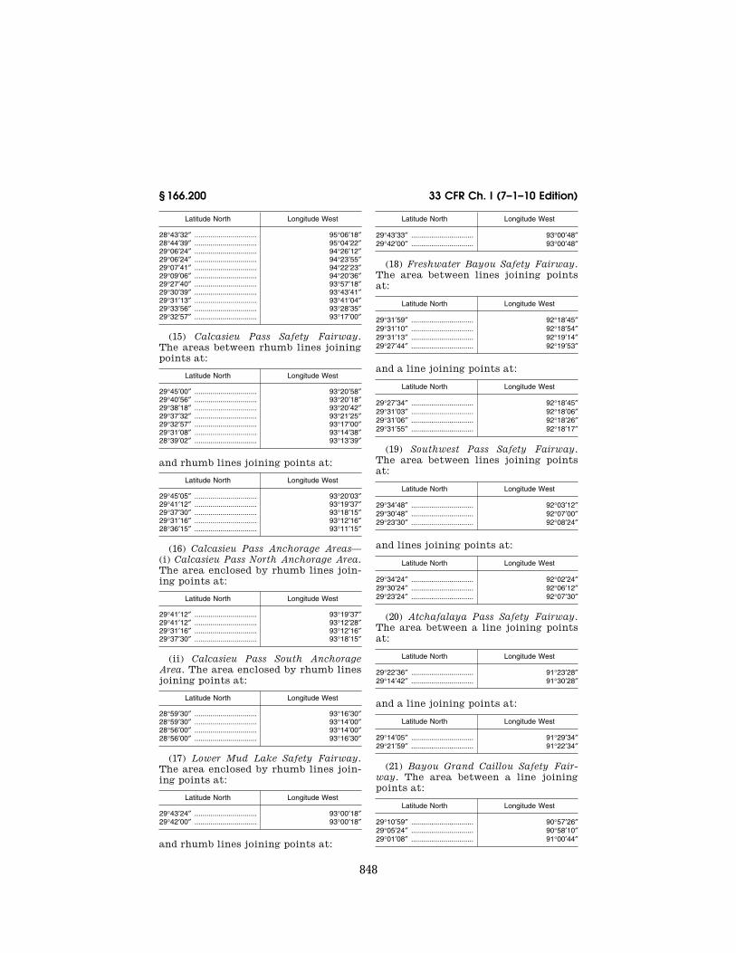
848
33 CFR Ch. I (7–1–10 Edition) § 166.200
Latitude North Longitude West
28°43′32″ ............................... 95°06′18″ 28°44′39″ ............................... 95°04′22″ 29°06′24″ ............................... 94°26′12″ 29°06′24″ ............................... 94°23′55″ 29°07′41″ ............................... 94°22′23″ 29°09′06″ ............................... 94°20′36″ 29°27′40″ ............................... 93°57′18″ 29°30′39″ ............................... 93°43′41″ 29°31′13″ ............................... 93°41′04″ 29°33′56″ ............................... 93°28′35″ 29°32′57″ ............................... 93°17′00″
(15) Calcasieu Pass Safety Fairway. The areas between rhumb lines joining points at:
Latitude North Longitude West
29°45′00″ ............................... 93°20′58″ 29°40′56″ ............................... 93°20′18″ 29°38′18″ ............................... 93°20′42″ 29°37′32″ ............................... 93°21′25″ 29°32′57″ ............................... 93°17′00″ 29°31′08″ ............................... 93°14′38″ 28°39′02″ ............................... 93°13′39″
and rhumb lines joining points at:
Latitude North Longitude West
29°45′05″ ............................... 93°20′03″ 29°41′12″ ............................... 93°19′37″ 29°37′30″ ............................... 93°18′15″ 29°31′16″ ............................... 93°12′16″ 28°36′15″ ............................... 93°11′15″
(16) Calcasieu Pass Anchorage Areas— (i) Calcasieu Pass North Anchorage Area. The area enclosed by rhumb lines join-ing points at:
Latitude North Longitude West
29°41′12″ ............................... 93°19′37″ 29°41′12″ ............................... 93°12′28″ 29°31′16″ ............................... 93°12′16″ 29°37′30″ ............................... 93°18′15″
(ii) Calcasieu Pass South Anchorage Area. The area enclosed by rhumb lines joining points at:
Latitude North Longitude West
28°59′30″ ............................... 93°16′30″ 28°59′30″ ............................... 93°14′00″ 28°56′00″ ............................... 93°14′00″ 28°56′00″ ............................... 93°16′30″
(17) Lower Mud Lake Safety Fairway. The area enclosed by rhumb lines join-ing points at:
Latitude North Longitude West
29°43′24″ ............................... 93°00′18″ 29°42′00″ ............................... 93°00′18″
and rhumb lines joining points at:
Latitude North Longitude West
29°43′33″ ............................... 93°00′48″ 29°42′00″ ............................... 93°00′48″
(18) Freshwater Bayou Safety Fairway. The area between lines joining points at:
Latitude North Longitude West
29°31′59″ ............................... 92°18′45″ 29°31′10″ ............................... 92°18′54″ 29°31′13″ ............................... 92°19′14″ 29°27′44″ ............................... 92°19′53″
and a line joining points at:
Latitude North Longitude West
29°27′34″ ............................... 92°18′45″ 29°31′03″ ............................... 92°18′06″ 29°31′06″ ............................... 92°18′26″ 29°31′55″ ............................... 92°18′17″
(19) Southwest Pass Safety Fairway. The area between lines joining points at:
Latitude North Longitude West
29°34′48″ ............................... 92°03′12″ 29°30′48″ ............................... 92°07′00″ 29°23′30″ ............................... 92°08′24″
and lines joining points at:
Latitude North Longitude West
29°34′24″ ............................... 92°02′24″ 29°30′24″ ............................... 92°06′12″ 29°23′24″ ............................... 92°07′30″
(20) Atchafalaya Pass Safety Fairway. The area between a line joining points at:
Latitude North Longitude West
29°22′36″ ............................... 91°23′28″ 29°14′42″ ............................... 91°30′28″
and a line joining points at:
Latitude North Longitude West
29°14′05″ ............................... 91°29′34″ 29°21′59″ ............................... 91°22′34″
(21) Bayou Grand Caillou Safety Fair-way. The area between a line joining points at:
Latitude North Longitude West
29°10′59″ ............................... 90°57′26″ 29°05′24″ ............................... 90°58′10″ 29°01′08″ ............................... 91°00′44″
VerDate Mar<15>2010 07:59 Sep 03, 2010 Jkt 220131 PO 00000 Frm 00858 Fmt 8010 Sfmt 8010 Y:\SGML\220131.XXX 220131erow
e on
DS
K5C
LS3C
1PR
OD
with
CF
R

849
Coast Guard, DHS § 166.200
and a line joining points at:
Latitude North Longitude West
29°00′40″ ............................... 90°59′43″ 29°05′06″ ............................... 90°57′03″ 29°09′46″ ............................... 90°56′27″
(22) Cat Island Pass Safety Fairway. The area between lines joining points at:
Latitude North Longitude West
29°05′57″ ............................... 90°34′32″ 29°04′56″ ............................... 90°35′09″ 29°03′14″ ............................... 90°35′10″ 29°03′14″ ............................... 90°35′17″ 29°01′24″ ............................... 90°34′55″
and lines joining points at:
Latitude North Longitude West
29°06′00″ ............................... 90°34′21″ 29°05′31″ ............................... 90°34′12″ 29°03′13″ ............................... 90°34′13″ 29°03′13″ ............................... 90°34′07″ 29°01′34″ ............................... 90°33′47″
(23) Belle Pass Safety Fairway. The area between a line joining points at:
Latitude North Longitude West
29°05′06″ ............................... 90°14′07″ 29°02′50″ ............................... 90°14′46″
and a line joining points at:
Latitude North Longitude West
29°02′56″ ............................... 90°13′48″ 29°05′06″ ............................... 90°13′10″
(24) Barataria Pass Safety Fairway. The area between a line joining points at:
Latitude North Longitude West
29°16′00″ ............................... 89°57′00″ 29°14′54″ ............................... 89°55′48″
and a line joining points at:
Latitude North Longitude West
29°16′30″ ............................... 89°56′06″ 29°15′18″ ............................... 89°55′00″
(25) Grand Bayou Pass Safety Fairway. The areas between a line joining points at:
Latitude North Longitude West
29°17′36″ ............................... 89°41′36″ 29°16′48″ ............................... 89°42′12″
and a line joining points at:
Latitude North Longitude West
29°17′18″ ............................... 89°40′36″ 29°16′18″ ............................... 89°41′18″
(26) Empire to the Gulf Safety Fairway. The area between a line joining points at:
Latitude North Longitude West
29°15′22″ ............................... 89°36′55″ 29°13′52″ ............................... 89°37′15″
and a line joining points at:
Latitude North Longitude West
29°13′24″ ............................... 89°36′11″ 29°14′54″ ............................... 89°35′51″
(27) Gulf Safety Fairway. Aransas Pass Safety Fairway to Southwest Pass Safety Fairway. The areas between rhumb lines joining points at:
Latitude North Longitude West
27°33′06″ ............................... 96°30′21″ 27°33′15″ ............................... 96°28′16″ 27°33′33″ ............................... 96°24′06″ 28°00′36″ ............................... 90°08′18″
and rhumb lines joining points at:
Latitude North Longitude West
27°34′50″ ............................... 96°34′01″ 27°34′59″ ............................... 96°31′56″ 27°35′17″ ............................... 96°27′46″ 27°38′02″ ............................... 95°49′39″ 27°38′12″ ............................... 95°47′19″ 27°44′03″ ............................... 94°26′12″ 27°44′13″ ............................... 94°23′57″ 27°51′58″ ............................... 92°36′20″ 27°52′09″ ............................... 92°33′40″ 28°02′32″ ............................... 90°09′28″
(28) Southwest Pass (Mississippi River) Safety Fairway—(i) Southwest Pass (Mis-sissippi River) to Gulf Safety Fairway. The area enclosed by rhumb lines join-ing points at:
Latitude North Longitude West
28°54′33″ ............................... 89°26′07″ 28°52′42″ ............................... 89°27′06″ 28°50′00″ ............................... 89°27′06″ 28°02′32″ ............................... 90°09′28″
and rhumb lines joining points at:
Latitude North Longitude West
28°54′18″ ............................... 89°25′46″ 28°53′30″ ............................... 89°25′18″ 28°53′30″ ............................... 89°23′48″
VerDate Mar<15>2010 07:59 Sep 03, 2010 Jkt 220131 PO 00000 Frm 00859 Fmt 8010 Sfmt 8010 Y:\SGML\220131.XXX 220131erow
e on
DS
K5C
LS3C
1PR
OD
with
CF
R

850
33 CFR Ch. I (7–1–10 Edition) § 166.200
Latitude North Longitude West
28°50′40″ ............................... 89°24′48″ 28°48′48″ ............................... 89°24′48″ 28°47′24″ ............................... 89°26′30″ 28°00′36″ ............................... 90°08′18″
(ii) Southwest Pass (Mississippi River) to Sea Safety Fairway. The area en-closed by rhumb lines joining points at:
Latitude North Longitude West
28°54′33″ ............................... 89°26′07″ 28°52′42″ ............................... 89°27′06″ 28°50′00″ ............................... 89°27′06″ 28°47′24″ ............................... 89°26′30″ 28°36′28″ ............................... 89°18′45″
and rhumb lines joining points at:
Latitude North Longitude West
28°54′18″ ............................... 89°25′46″ 28°53′30″ ............................... 89°25′18″ 28°53′30″ ............................... 89°23′48″ 28°50′40″ ............................... 89°24′48″ 28°48′48″ ............................... 89°24′48″ 28°45′06″ ............................... 89°22′12″ 28°43′27″ ............................... 89°21′01″ 28°37′54″ ............................... 89°17′06″
(iii) Southwest Pass (Mississippi River) to South Pass (Mississippi River) Safety Fairway. The areas between rhumb line joining points at:
Latitude North Longitude West
28°45′06″ ............................... 89°22′12″ 28°55′56″ ............................... 89°03′09″
and rhumb lines joining points at:
Latitude North Longitude West
28°43′27″ ............................... 89°21′01″ 28°54′55″ ............................... 89°00′44″
(29) Southwest Pass (Mississippi River) Anchorage. The area enclosed by rhumb lines joining points at:
Latitude North Longitude West
28°53′30″ ............................... 89°23′48″ 28°53′30″ ............................... 89°21′48″ 28°55′06″ ............................... 89°21′48″ 28°55′06″ ............................... 89°19′18″ 28°52′41″ ............................... 89°17′30″ 28°50′40″ ............................... 89°21′14″ 28°50′40″ ............................... 89°24′48″
(30) South Pass (Mississippi River) Safe-ty Fairway—(i) South Pass to Sea Safety Fairway. The areas between rhumb lines joining points at:
Latitude North Longitude West
28°59′18″ ............................... 89°08′30″ 28°58′42″ ............................... 89°07′30″ 28°58′09″ ............................... 89°08′30″ 28°55′56″ ............................... 89°03′09″ 28°54′55″ ............................... 89°00′44″ 28°54′15″ ............................... 88°59′00″
and rhumb lines joining points at:
Latitude North Longitude West
East jetty light: 28°59′24″ ........................ 89°08′12″ 29°00′09″ ........................ 89°07′24″ 29°00′00″ ........................ 89°07′00″ 28°57′56″ ........................ 89°02′18″ 28°57′18″ ........................ 89°00′48″ 28°56′16″ ........................ 88°58′29″ 28°55′42″ ........................ 88°57′06″
(ii) South Pass (Mississippi River) to Mississippi River-Gulf Outlet Channel Safety Fairway. The areas between rhumb lines joining points at:
Latitude North Longitude West
28°57′18″ ............................... 89°00′48″ 29°04′18″ ............................... 88°48′31″ 29°24′35″ ............................... 88°57′17″
and rhumb lines joining points at:
Latitude North Longitude West
28°56′16″ ............................... 88°58′29″ 29°03′30″ ............................... 88°45′42″ 29°23′06″ ............................... 88°54′11″ 29°26′28″ ............................... 88°55′39″
(31) South Pass (Mississippi River) An-chorage. The areas within rhumb lines joining points at:
Latitude North Longitude West
29°00′00″ ............................... 89°07′00″ 29°03′36″ ............................... 89°02′18″ 28°57′56″ ............................... 89°02′18″
(32) Mississippi River-Gulf Outlet Safety Fairway. (i) The areas between rhumb lines joining points at:
Latitude North Longitude West
29°42′10″ ............................... 89°25′49″ 29°29′33″ ............................... 89°07′47″ 29°27′14″ ............................... 89°03′20″ 29°24′38″ ............................... 89°00′00″ 29°24′35″ ............................... 88°57′17″
and rhumb lines joining points at:
Latitude North Longitude West
29°42′29″ ............................... 89°25′31″ 29°29′53″ ............................... 89°07′31″ 29°27′01″ ............................... 89°01′54″
VerDate Mar<15>2010 07:59 Sep 03, 2010 Jkt 220131 PO 00000 Frm 00860 Fmt 8010 Sfmt 8010 Y:\SGML\220131.XXX 220131erow
e on
DS
K5C
LS3C
1PR
OD
with
CF
R

851
Coast Guard, DHS § 166.200
Latitude North Longitude West
29°26′38″ ............................... 88°58′43″
(ii) Mississippi River-Gulf Outlet Chan-nel to Mobile Ship Channel Safety Fair-way. The areas within rhumb lines joining points at:
Latitude North Longitude West
29°26′38″ ............................... 88°58′43″ 29°29′57″ ............................... 88°54′48″ 29°38′59″ ............................... 88°44′04″ 29°56′43″ ............................... 88°20′50″ 29°58′03″ ............................... 88°19′05″ 30°05′29″ ............................... 88°09′19″
and rhumb lines joining points at:
Latitude North Longitude West
29°26′28″ ............................... 88°55′39″ 29°27′54″ ............................... 88°53′54″ 29°37′32″ ............................... 88°42′28″ 29°55′14″ ............................... 88°19′15″ 29°56′34″ ............................... 88°17′30″ 30°03′50″ ............................... 88°08′01″ 30°05′15″ ............................... 88°06′05″
(33) Mississippi River-Gulf Outlet An-chorage. (i) The areas within rhumb lines joining points at:
Latitude North Longitude West
29°27′01″ ............................... 89°01′54″ 29°32′12″ ............................... 88°55′42″ 29°29′57″ ............................... 88°54′48″ 29°26′38″ ............................... 88°58′43″
(ii) The areas within rhumb lines joining points at:
Latitude North Longitude West
29°26′28″ ............................... 88°55′39″ 29°27′54″ ............................... 88°53′54″ 29°24′33″ ............................... 88°52′27″ 29°23′06″ ............................... 88°54′11″
(34) Gulfport Safety Fairway. The areas between rhumb lines joining points at:
Latitude North Longitude West
30°20′54″ ............................... 89°05′36″ 30°13′56″ ............................... 88°59′42″ 30°11′09″ ............................... 88°59′56″ 30°06′45″ ............................... 88°56′24″ 30°05′42″ ............................... 88°56′24″
and rhumb lines joining points at:
Latitude North Longitude West
30°21′27″ ............................... 89°04′38″ 30°14′11″ ............................... 88°58′29″ 30°11′29″ ............................... 88°58′45″
Latitude North Longitude West
30°07′42″ ............................... 88°55′37″
(35) Biloxi Safety Fairway. The area between lines joining points at:
Latitude North Longitude West
30°24′06″ ............................... 88°50′57″ 30°23′15″ ............................... 88°50′22″ 30°21′11″ ............................... 88°47′36″ 30°20′13″ ............................... 88°47′04″ 30°15′06″ ............................... 88°47′06″ 30°13′09″ ............................... 88°47′46″ 30°12′23″ ............................... 88°49′02″
and lines joining points at:
Latitude North Longitude West
30°24′27″ ............................... 88°50′31″ 30°23′57″ ............................... 88°49′31″ 30°21′42″ ............................... 88°46′36″ 30°20′25″ ............................... 88°45′55″ 30°14′57″ ............................... 88°45′57″ 30°12′56″ ............................... 88°46′39″ 30°12′00″ ............................... 88°45′25″
(36) Ship Island Pass to Horn Island Pass Safety Fairway. The areas between rhumb line joining points at:
Latitude North Longitude West
30°05′42″ ............................... 88°56′24″ 30°06′38″ ............................... 88°31′26″
and rhumb line joining points at:
Latitude North Longitude West
30°07′42″ ............................... 88°55′37″ 30°08′27″ ............................... 88°36′57″
(37) Pascagoula Safety Fairway. The areas between rhumb lines joining points at:
Latitude North Longitude West
30°20′46″ ............................... 88°34′39″ 30°20′21″ ............................... 88°34′39″ 30°17′00″ ............................... 88°31′21″ 30°12′59″ ............................... 88°30′53″ 30°11′50″ ............................... 88°32′05″ 30°08′27″ ............................... 88°36′57″ 30°06′38″ ............................... 88°31′26″ 29°56′43″ ............................... 88°20′50″ 29°55′14″ ............................... 88°19′15″ 29°20′00″ ............................... 87°41′47″
and rhumb line joining points at:
Latitude North Longitude West
30°20′30″ ............................... 88°33′18″ 30°18′39″ ............................... 88°31′25″
and rhumb line joining points at:
VerDate Mar<15>2010 07:59 Sep 03, 2010 Jkt 220131 PO 00000 Frm 00861 Fmt 8010 Sfmt 8010 Y:\SGML\220131.XXX 220131erow
e on
DS
K5C
LS3C
1PR
OD
with
CF
R

852
33 CFR Ch. I (7–1–10 Edition) § 166.200
Latitude North Longitude West
30°20′26″ ............................... 188°31′25″ 30°18′39″ ............................... 188°31′25″
and rhumb lines joining points at:
Latitude North Longitude West
30°19′21″ ............................... 88°30′12″ 30°17′25″ ............................... 88°30′12″ 30°12′46″ ............................... 88°29′42″ 30°11′21″ ............................... 88°31′00″ 30°09′33″ ............................... 88°29′48″ 30°07′30″ ............................... 88°29′09″ 29°58′03″ ............................... 88°19′05″ 29°56′34″ ............................... 88°17′30″ 29°20′48″ ............................... 87°39′31″
(38) Horn Island Pass to Mobile Ship Channel Safety Fairway. The areas be-tween rhumb line joining points at:
Latitude North Longitude West
30°09′33″ ............................... 88°29′48″ 30°07′15″ ............................... 88°06′54″
and rhumb line joining points at:
Latitude North Longitude West
30°07′30″ ............................... 88°29′09″ 30°05′29″ ............................... 88°09′19″
(39) Mobile Safety Fairway—(i) Mobile Ship Channel Safety Fairway. The areas between rhumb lines joining points at:
Latitude North Longitude West
30°38′46″ ............................... 88°03′24″ 30°38′14″ ............................... 88°02′42″ 30°31′59″ ............................... 88°02′00″ 30°31′59″ ............................... 88°04′59″
and rhumb lines joining points at:
Latitude North Longitude West
30°31′00″ ............................... 88°05′30″ 30°31′00″ ............................... 88°01′54″ 30°26′55″ ............................... 88°01′26″ 30°16′35″ ............................... 88°02′45″ 30°14′09″ ............................... 88°03′24″ 30°10′36″ ............................... 88°03′53″ 30°08′10″ ............................... 88°04′40″ 30°07′15″ ............................... 88°06′54″
and rhumb lines joining points at:
Latitude North Longitude West
30°39′55″ ............................... 88°01′15″ 30°37′06″ ............................... 88°01′23″ 30°26′11″ ............................... 88°00′11″ 30°16′18″ ............................... 88°01′35″ 30°13′52″ ............................... 88°01′12″ 30°13′14″ ............................... 88°01′12″ 30°10′36″ ............................... 88°01′35″ 30°08′04″ ............................... 88°00′36″
(ii) Mobile Ship Channel to Sea Safety Fairway. The areas between rhumb lines joining points at:
Latitude North Longitude West
30°05′15″ ............................... 88°01′13″ 30°03′50″ ............................... 88°00′00″ 29°25′46″ ............................... 87°29′13″
and rhumb line joining points at:
Latitude North Longitude West
30°06′17″ ............................... 87°59′15″ 29°27′00″ ............................... 87°27′18″
(iii) Mobile to Pensacola Safety Fair-way. The areas between rhumb line joining points at:
Latitude North Longitude West
30°08′04″ ............................... 88°00′36″ 30°14′20″ ............................... 87°19′05″
and rhumb line joining points at:
Latitude North Longitude West
30°06′17″ ............................... 87°59′15″ 30°12′31″ ............................... 87°18′00″
(40) Mobile Anchorage. The areas with-in rhumb lines joining points at:
Latitude North Longitude West
30°05′15″ ............................... 88°06′05″ 30°05′15″ ............................... 88°01′13″ 30°03′50″ ............................... 88°00′00″ 30°03′50″ ............................... 88°08′01″
(41) Pensacola Safety Fairway. The areas between rhumb lines joining points at:
Latitude North Longitude West
30°23′41″ ............................... 87°14′34″ 30°23′06″ ............................... 87°13′53″ 30°22′54″ ............................... 87°13′53″ 30°20′47″ ............................... 87°15′45″
and rhumb lines joining points at:
Latitude North Longitude West
30°18′43″ ............................... 87°19′24″ 30°15′57″ ............................... 87°18′19″ 30°14′20″ ............................... 87°19′05″ 30°12′31″ ............................... 87°18′00″ 30°10′03″ ............................... 87°18′00″ 29°37′00″ ............................... 87°18′00″
and rhumb lines joining points at:
Latitude North Longitude West
30°26′27″ ............................... 87°08′28″
VerDate Mar<15>2010 07:59 Sep 03, 2010 Jkt 220131 PO 00000 Frm 00862 Fmt 8010 Sfmt 8010 Y:\SGML\220131.XXX 220131erow
e on
DS
K5C
LS3C
1PR
OD
with
CF
R

853
Coast Guard, DHS § 166.200
Latitude North Longitude West
30°25′35″ ............................... 87°10′30″
and rhumb lines joining points at:
Latitude North Longitude West
30°24′36″ ............................... 87°07′07″ 30°22′57″ ............................... 87°09′38″ 30°22′36″ ............................... 87°11′50″ 30°19′21″ ............................... 87°14′46″ 30°19′52″ ............................... 87°17′31″
and rhumb lines joining points at:
Latitude North Longitude West
30°19′15″ ............................... 87°17′37″ 30°16′28″ ............................... 87°16′32″ 30°14′32″ ............................... 87°16′06″ 30°12′33″ ............................... 87°15′43″ 29°42′30″ ............................... 87°15′43″
(42) Pensacola Anchorage. (i) The area within rhumb lines joining points at:
Latitude North Longitude West
30°11′49″ ............................... 87°22′41″ 30°12′31″ ............................... 87°18′00″ 30°10′03″ ............................... 87°18′00″ 30°09′21″ ............................... 87°22′41″
(ii) The area within rhumb lines join-ing points at:
Latitude North Longitude West
30°16′28″ ............................... 87°16′32″ 30°17′14″ ............................... 87°11′52″ 30°15′14″ ............................... 87°11′52″ 30°14′32″ ............................... 87°16′06″
(43) Pensacola to Panama City Safety Fairway. The area between rhumb lines joining points at:
Latitude North Longitude West
30°14′32″ ............................... 87°16′06″ 30°15′14″ ............................... 87°11′52″ 30°18′45″ ............................... 86°50′00″ 30°18′00″ ............................... 86°20′00″ 29°51′30″ ............................... 85°47′33″
and rhumb lines joining points at:
Latitude West Longitude West
30°12′33″ ............................... 87°15′43″ 30°16′44″ ............................... 86°49′49″ 30°16′01″ ............................... 86°20′57″ 29°48′45″ ............................... 85°47′33″
(44) Panama City Safety Fairways. The areas between rhumb lines joining points at:
Latitude North Longitude West
30°09′24″ ............................... 85°40′12″ 30°09′21″ ............................... 85°41′40″ 30°07′36″ ............................... 85°44′20″ 30°06′32″ ............................... 85°47′33″ 29°51′30″ ............................... 85°47′33″ 29°48′45″ ............................... 85°47′33″ 29°03′30″ ............................... 85°47′33″
and rhumb lines joining points at:
Latitude North Longitude West
30°08′34″ ............................... 85°40′16″ 30°07′55″ ............................... 85°41′50″ 30°06′49″ ............................... 85°43′28″ 30°04′40″ ............................... 85°45′15″ 29°55′27″ ............................... 85°45′15″ 29°51′20″ ............................... 85°45′15″ 29°49′19″ ............................... 85°45′15″ 29°00′00″ ............................... 85°45′15″
(45) Panama City Anchorage. The area within rhumb lines joining points at:
Latitude North Longitude West
29°55′27″ ............................... 85°45′15″ 29°55′27″ ............................... 85°42′25″ 29°51′39″ ............................... 85°42′25″ 29°51′20″ ............................... 85°45′15″
(46) Port St. Joe Fairway to Panama City Fairway. The area between rhumb lines joining points at:
Latitude North Longitude West
29°49′54″ ............................... 85°19′24″ 29°50′59″ ............................... 85°22′25″ 29°53′32″ ............................... 85°22′25″ 29°54′12″ ............................... 85°24′00″ 29°54′12″ ............................... 85°25′55″ 29°52′58″ ............................... 85°28′43″ 29°53′00″ ............................... 85°29′48″ 29°51′39″ ............................... 85°42′25″ 29°51′20″ ............................... 85°45′15″
and rhumb lines joining points at:
Latitude North Longitude West
29°48′22″ ............................... 85°18′12″ 29°47′21″ ............................... 85°21′00″ 29°50′42″ ............................... 85°23′31″ 29°52′51″ ............................... 85°23′36″ 29°53′10″ ............................... 85°24′18″ 29°53′10″ ............................... 85°25′33″ 29°51′57″ ............................... 85°28′19″ 29°51′04″ ............................... 85°29′00″ 29°50′40″ ............................... 85°32′39″ 29°49′19″ ............................... 85°45′15″
(47) Port St. Joe Anchorage. The area within rhumb lines joining points at:
Latitude North Longitude West
29°50′40″ ............................... 85°32′39″ 29°51′04″ ............................... 85°29′00″ 29°49′18″ ............................... 85°30′18″
VerDate Mar<15>2010 07:59 Sep 03, 2010 Jkt 220131 PO 00000 Frm 00863 Fmt 8010 Sfmt 8010 Y:\SGML\220131.XXX 220131erow
e on
DS
K5C
LS3C
1PR
OD
with
CF
R

854
33 CFR Ch. I (7–1–10 Edition) § 166.300
(48) Tampa Safety Fairways. The area between rhumb lines joining points at:
Latitude North Longitude West
27°37′48″ ............................... 82°45′54″ 27°36′48″ ............................... 82°55′54″ 27°36′48″ ............................... 83°00′00″ 27°36′48″ ............................... 84°39′10″
and rhumb lines joining points at:
Latitude North Longitude West
27°35′54″ ............................... 82°45′42″ 27°34′48″ ............................... 82°55′54″ 27°34′48″ ............................... 83°00′00″ 27°34′48″ ............................... 84°39′00″
(49) Tampa Anchorages—(i) Eastern Tampa Fairway Anchorage. The area en-closed by rhumb lines [North American Datum of 1927 (NAD–27)] joining points at:
Latitude North Longitude West
27°36′48″ ............................... 83°00′00″ 27°39′00″ ............................... 83°00′00″ 27°39′00″ ............................... 82°55′54″ 27°36′48″ ............................... 82°55′54″
(ii) Western Tampa Fairway Anchor-age. The area enclosed by rhumb lines [North American Datum of 1927 (NAD– 27)] joining points at:
Latitude North Longitude West
27°36′48″ ............................... 83°05′06″ 27°39′00″ ............................... 83°05′06″ 27°39′00″ ............................... 83°01′00″ 27°36′48″ ............................... 83°01′00″
(50) Charlotte Safety Fairways. The area between rhumb lines joining points at:
Latitude North Longitude West
26°41′18″ ............................... 82°19′00″ 25°30′00″ ............................... 84°22′00″
and rhumb lines joining points at:
Latitude North Longitude West
26°40′19″ ............................... 82°18′28″ 26°38′30″ ............................... 82°19′54″ 26°39′00″ ............................... 82°19′00″ 25°28′00″ ............................... 84°21′30″
(51) Charlotte Anchorage. The area within rhumb lines joining points at:
Latitude North Longitude West
26°39′00″ ............................... 82°19′00″ 26°38′12″ ............................... 82°18′24″ 26°37′36″ ............................... 82°19′18″
Latitude North Longitude West
26°38′30″ ............................... 82°19′54″
(52) Louisiana Offshore Oil Port (LOOP) Shipping Safety Fairway to Safe-ty Zone—(i) North of Gulf Safety Fair-way. The two mile wide area enclosed by rhumb lines joining points at:
Latitude North Longitude West
28°48′36″ ............................... 89°55′00″ 28°48′14″ ............................... 89°54′17″ 28°45′47″ ............................... 89°54′19″ 28°36′06″ ............................... 89°55′44″ 28°18′30″ ............................... 89°55′15″ 28°20′58″ ............................... 89°53′03″ 28°36′09″ ............................... 89°53′28″ 28°49′07″ ............................... 89°51′30″ 28°50′20″ ............................... 89°53′51″
(ii) South of Gulf Safety Fairway. The two-mile-wide area enclosed by rhumb lines joining points at:
Latitude North Longitude West
28°15′20″ ............................... 89°55′10″ 27°46′29″ ............................... 89°54′23″ 27°46′32″ ............................... 89°52′08″ 28°17′48″ ............................... 89°52′58″
(53) Heald Bank Cutoff Safety Fairway. The area enclosed by rhumb lines [North American Datum of 1927 (NAD– 27)], joining points at:
Latitude North Longitude West
28°57′15″ ............................... 94°23′55″ 28°51′30″ ............................... 93°56′30″ 28°48′30″ ............................... 93°51′45″ 28°55′15″ ............................... 94°23′55″
[CGD 81–040, 47 FR 20581, May 13, 1982]
EDITORIAL NOTE: For FEDERAL REGISTER ci-tations affecting § 166.200, see the List of CFR Sections Affected, which appears in the printed volume and on GPO Access.
§ 166.300 Areas along the coast of Cali-fornia.
(a) Purpose. Fairways as described in this section are established to control the erection of structures therein to provide safe vessel routes along the coast of California.
(b) Designated Areas—(1) Port Hueneme Safety Fairway. An area one nautical mile in width centered on the aline-ment of Port Hueneme Entrance Chan-nel and extending seaward from the 30- foot-depth curve for a distance of 1.5 nautical miles, thence turning south-erly and widening to 1.5 nautical miles
VerDate Mar<15>2010 07:59 Sep 03, 2010 Jkt 220131 PO 00000 Frm 00864 Fmt 8010 Sfmt 8010 Y:\SGML\220131.XXX 220131erow
e on
DS
K5C
LS3C
1PR
OD
with
CF
R

855
Coast Guard, DHS § 166.500
at the 3-mile limit, all between lines joining the following points:
Latitude Longitude
34°06′30″ N 119°15′00″ W 34°07′37″ N 119°14′25″ W 34°08′49″ N 119°13′21″ W
thence generally along the 30-foot-depth curve to the seaward end of the west en-trance jetty; seaward end of the east en-trance jetty, thence generally along the 30- foot-depth curve to:
Latitude Longitude
34°08′21″ N 119°12′15″ W 34°07′10″ N 119°13′20″ W 34°05′48″ N 119°13′23″ W
(2) [Reserved]
[CGD 82–101, 48 FR 49019, Oct. 24, 1983]
§ 166.400 Areas along the coast of Alas-ka.
(a) Purpose. Fairways, as described in this section, are established to control the erection of structures therein to provide safe vessel routes along the coast of Alaska.
(b) Designated Areas—(1) Prince Wil-liam Sound Safety Fairway. (i) Hinchinbrook Entrance Safety Fairway. The area enclosed by rhumb lines join-ing points at:
Latitude Longitude
59°59′00″ N 145°27′24″ W 60°13′18″ N 146°38′06″ W 60°11′24″ N 146°47′00″ W 59°55′00″ N 145°42′00″ W
(ii) Gulf to Hinchinbrook Safety Fair-way (recommended for inbound vessel traffic). The area enclosed by rhumb lines joining points at:
Latitude Longitude
59°15′42″ N 144°02′07″ W 59°59′00″ N 145°27′24″ W 59°58′00″ N 145°32′12″ W 59°14′18″ N 144°04′53″ W
(iii) Hinchinbrook to Gulf Safety Fair-way (recommended for outbound vessel traffic). The area enclosed by rhumb lines joining points at:
Latitude Longitude
59°15′41″ N 144°23′35″ W 59°56′00″ N 145°37′39″ W 59°55′00″ N 145°42′00″ W 59°14′19″ N 144°26′25″ W
(2) Unimak Pass Safety Fairway. (i) East/West Safety Fairway. The area en-closed by rhumb lines joining points at:
Latitude Longitude
54°25′58″ N 165°42′24″ W 54°22′50″ N 165°06′54″ W 54°22′10″ N 164°59′29″ W 54°07′58″ N 162°19′25″ W 54°04′02″ N 162°20′35″ W 54°22′02″ N 165°43′36″ W
(ii) North/South Safety Fairway. The area enclosed by rhumb lines joining points at:
Latitude Longitude
54°42′28″ N 165°16′19″ W 54°43′32″ N 165°09′41″ W 54°22′50″ N 165°06′54″ W 54°22′10″ N 164°59′29″ W
[CGD 81–103, 51 FR 43349, Dec. 2, 1986]
§ 166.500 Areas along the Atlantic Coast.
(a) Purpose. Fairways, as described in this section are established to control the erection of structures therein to provide safe vessel routes along the At-lantic Coast.
(b) Designated Areas—(1) Off New York Shipping Safety Fairway. (i) Ambrose to Nantucket Safety Fairway. The area enclosed by rhumb lines, [North Amer-ican Datum of 1927 (NAD–27)] joining points at:
Latitude Longitude
40°32′20″ N 73°04′57″ W 40°30′58″ N 72°58′25″ W 40°34′07″ N 70°19′23″ W 40°35′37″ N 70°14′09″ W 40°30′37″ N 70°14′00″ W 40°32′07″ N 70°19′19″ W 40°28′58″ N 72°58′25″ W 40°27′20″ N 73°04′57″ W
(ii) Nantucket to Ambrose Safety Fair-way. The area enclosed by rhumb lines, NAD–27, joining point at:
Latitude Longitude
28°54′33″ N 89°26′07″ W 40°24′20″ N 73°04′58″ W 40°22′58″ N 72°58′26″ W 40°26′07″ N 70°19′09″ W 40°27′37″ N 70°13′46″ W 40°22′37″ N 70°13′36″ W 40°24′07″ N 70°19′05″ W 40°20′58″ N 72°58′26″ W 40°19′20″ N 73°04′58″ W
VerDate Mar<15>2010 07:59 Sep 03, 2010 Jkt 220131 PO 00000 Frm 00865 Fmt 8010 Sfmt 8010 Y:\SGML\220131.XXX 220131erow
e on
DS
K5C
LS3C
1PR
OD
with
CF
R

856
33 CFR Ch. I (7–1–10 Edition) Pt. 167
[CGD 84–004, 52 FR 33589, Sept. 4, 1987; 52 FR 36248, Sept. 28, 1987]
PART 167—OFFSHORE TRAFFIC SEPARATION SCHEMES
Subpart A—General
Sec. 167.1 Purpose. 167.3 Geographic coordinates. 167.5 Definitions. 167.10 Operating rules. 167.15 Modification of schemes.
Subpart B—Description of Traffic Separa-tion Schemes and Precautionary Areas
ATLANTIC EAST COAST
167.150 Off New York Traffic Separation Scheme: General.
167.151 Off New York: Precautionary areas. 167.152 Off New York: Eastern approach, off
Nantucket. 167.153 Off New York: Eastern approach. 167.154 Off New York: South-eastern ap-
proach. 167.155 Off New York: Southern approach. 167.170 Off Delaware Bay Approach Traffic
Separation Scheme: General. 167.171 Off Delaware Bay: Eastern approach. 167.172 Off Delaware Bay: Southeastern ap-
proach. 167.173 Off Delaware Bay: Two-Way Traffic
Route. 167.174 Off Delaware Bay: Precautionary
area. 167.200 In the approaches to Chesapeake
Bay Traffic Separation Scheme: General. 167.201 In the approaches to Chesapeake
Bay: Precautionary area. 167.202 In the approaches to Chesapeake
Bay: Eastern approach. 167.203 In the approaches to Chesapeake
Bay: Southern approach.
ATLANTIC GULF COAST
167.350 In the approaches to Galveston Bay Traffic Separation Scheme and pre-cautionary areas.
PACIFIC WEST COAST
167.400 Off San Francisco Traffic Separation Scheme: General.
167.401 Off San Francisco: Precautionary area.
167.402 Off San Francisco: Northern ap-proach.
167.403 Off San Francisco: Southern ap-proach.
167.404 Off San Francisco: Western ap-proach.
167.405 Off San Francisco: Main ship chan-nel.
167.406 Off San Francisco: Area to be avoid-ed.
167.450 In the Santa Barbara Channel Traf-fic Separation Scheme: General.
167.451 In the Santa Barbara Channel: Be-tween Point Vicente and Point Concep-tion.
167.452 In the Santa Barbara Channel: Be-tween Point Conception and Point Arguello.
167.500 In the approaches to Los Angeles- Long Beach Traffic Separation Scheme: General.
167.501 In the approaches to Los Angeles/ Long Beach: Precautionary area.
167.502 In the approaches to Los Angeles- Long Beach: Western approach.
167.503 In the approaches to Los Angeles- Long Beach TSS: Southern approach.
167.1700 In Prince William Sound: General. 167.1701 In Prince William Sound: Pre-
cautionary areas. 167.1702 In Prince William Sound: Prince
William Sound Traffic 167.1703 In Prince William Sound: Valdez
Arm Traffic Separation Scheme.
AUTHORITY: 33 U.S.C. 1223; 49 CFR 1.46.
SOURCE: CGD 81–080, 48 FR 36456, Aug. 11, 1983, unless otherwise noted.
Subpart A—General
§ 167.1 Purpose. The purpose of the regulations in this
part is to establish and designate traf-fic separation schemes and pre-cautionary areas to provide access routes for vessels proceeding to and from U.S. ports.
§ 167.3 Geographic coordinates. Geographic coordinates are defined
using North American 1927 Datum (NAD 27) unless indicated otherwise.
[CGD 90–039, 59 FR 21937, Apr. 28, 1994]
§ 167.5 Definitions. (a) Area to be avoided means a routing
measure comprising an area within de-fined limits in which either navigation is particularly hazardous or it is excep-tionally important to avoid casualties and which should be avoided by all ships or certain classes of ships.
(b) Traffic separation scheme (TSS) means a designated routing measure which is aimed at the separation of op-posing streams of traffic by appro-priate means and by the establishment of traffic lanes.
VerDate Mar<15>2010 07:59 Sep 03, 2010 Jkt 220131 PO 00000 Frm 00866 Fmt 8010 Sfmt 8010 Y:\SGML\220131.XXX 220131erow
e on
DS
K5C
LS3C
1PR
OD
with
CF
R

857
Coast Guard, DHS § 167.151
(c) Traffic lane means an area within defined limits in which one-way traffic is established. Natural obstacles, in-cluding those forming separation zones, may constitute a boundary.
(d) Separation zone or line means a zone or line separating the traffic lanes in which ships are proceeding in oppo-site or nearly opposite directions; or separating a traffic lane from the adja-cent sea area; or separating traffic lanes designated for particular classes of ships proceeding in the same direc-tion.
(e) Precautionary area means a rout-ing measure comprising an area within defined limits where ships must navi-gate with particular caution and with-in which the direction of traffic flow may be recommended.
(f) Deep-water route means an inter-nationally recognized routing measure primarily intended for use by ships that, because of their draft in relation to the available depth of water in the area concerned, require the use of such a route.
(g) Two-way route means a route within defined limits inside which two- way traffic is established, aimed at providing safe passage of ships through waters where navigation is difficult or dangerous.
[CGD 81–080, 48 FR 36456, Aug. 11, 1983; 49 FR 15548, Apr. 19, 1984, as amended by CGD 90– 039, 59 FR 21937, Apr. 28, 1994; CGD 97–004, 65 FR 12945, Mar. 10, 2000; USCG–1999–5700, 65 FR 46605, July 31, 2000]
§ 167.10 Operating rules. The operator of a vessel in a TSS
shall comply with Rule 10 of the Inter-national Regulations for Preventing Collisions at Sea, 1972, as amended.
§ 167.15 Modification of schemes. (a) A traffic separation scheme or
precautionary area described in this Part may be permanently amended in accordance with 33 U.S.C. 1223 (92 Stat. 1473), and with international agree-ments.
(b) A traffic separation scheme or precautionary area in this Part may be temporarily adjusted by the Com-mandant of the Coast Guard in an emergency, or to accommodate oper-ations which would create an undue hazard for vessels using the scheme or
which would contravene Rule 10 of the International Regulations for Pre-venting Collisions at Sea, 1972. Adjust-ment may be in the form of a tem-porary traffic lane shift, a temporary suspension of a section of the scheme, a temporary precautionary area over-laying a lane, or other appropriate measure. Adjustments will only be made where, in the judgment of the Coast Guard, there is no reasonable al-ternative means of conducting an oper-ation and navigation safety will not be jeopardized by the adjustment. Notice of adjustments will be made in the ap-propriate Notice to Mariners and in the FEDERAL REGISTER. Requests by mem-bers of the public for temporary adjust-ments to traffic separation schemes must be submitted 150 days prior to the time the adjustment is desired. Such Requests, describing the interference that would otherwise occur to a TSS, should be submitted to the District Commander of the Coast Guard Dis-trict in which the TSS is located.
Subpart B—Description of Traffic Separation Schemes and Pre-cautionary Areas
ATLANTIC EAST COAST
SOURCE: CGD 84–004, 52 FR 33589, Sept. 4, 1987, unless otherwise noted.
§ 167.150 Off New York Traffic Separa-tion Scheme: General.
The specific areas in the Off New York Traffic Separation Scheme and Precautionary Areas are described in §§ 167.151, 167.152, 167.153, 167.154, and 167.155 of this chapter.
[CGD 84–004, 52 FR 33589, Sept. 4, 1987]
§ 167.151 Off New York: Precautionary areas.
(a) A circular precautionary area with a radius of 7 miles is established centered upon 40°27.50′ N, 73°49.90′ W.
(b) A precautionary area is estab-lished between the traffic separation scheme ‘‘Eastern Approach, off Nan-tucket’’ and the traffic separation scheme ‘‘In the Approach to Boston, Massachusetts.’’ (1) The precautionary area is bounded to the east by a circle of radius 15.5 miles, centered upon geo-graphical position 40°35.00′ N, 69°00.00′
VerDate Mar<15>2010 07:59 Sep 03, 2010 Jkt 220131 PO 00000 Frm 00867 Fmt 8010 Sfmt 8010 Y:\SGML\220131.XXX 220131erow
e on
DS
K5C
LS3C
1PR
OD
with
CF
R
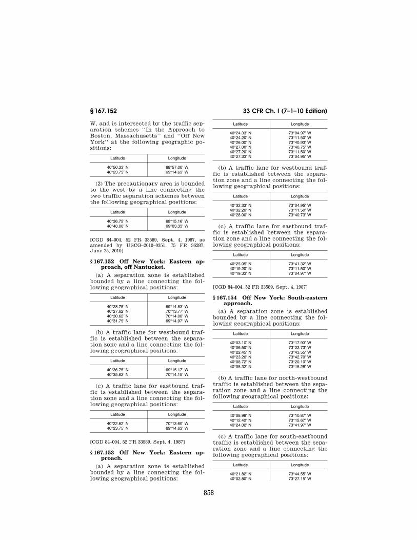
858
33 CFR Ch. I (7–1–10 Edition) § 167.152
W, and is intersected by the traffic sep-aration schemes ‘‘In the Approach to Boston, Massachusetts’’ and ‘‘Off New York’’ at the following geographic po-sitions:
Latitude Longitude
40°50.33′ N 68°57.00′ W 40°23.75′ N 69°14.63′ W
(2) The precautionary area is bounded to the west by a line connecting the two traffic separation schemes between the following geographical positions:
Latitude Longitude
40°36.75′ N 68°15.16′ W 40°48.00′ N 69°03.33′ W
[CGD 84–004, 52 FR 33589, Sept. 4, 1987, as amended by USCG–2010–0351, 75 FR 36287, June 25, 2010]
§ 167.152 Off New York: Eastern ap-proach, off Nantucket.
(a) A separation zone is established bounded by a line connecting the fol-lowing geographical positions:
Latitude Longitude
40°28.75′ N 69°14.83′ W 40°27.62′ N 70°13.77′ W 40°30.62′ N 70°14.00′ W 40°31.75′ N 69°14.97′ W
(b) A traffic lane for westbound traf-fic is established between the separa-tion zone and a line connecting the fol-lowing geographical positions:
Latitude Longitude
40°36.75′ N 69°15.17′ W 40°35.62′ N 70°14.15′ W
(c) A traffic lane for eastbound traf-fic is established between the separa-tion zone and a line connecting the fol-lowing geographical positions:
Latitude Longitude
40°22.62′ N 70°13.60′ W 40°23.75′ N 69°14.63′ W
[CGD 84–004, 52 FR 33589, Sept. 4, 1987]
§ 167.153 Off New York: Eastern ap-proach.
(a) A separation zone is established bounded by a line connecting the fol-lowing geographical positions:
Latitude Longitude
40°24.33′ N 73°04.97′ W 40°24.20′ N 73°11.50′ W 40°26.00′ N 73°40.93′ W 40°27.00′ N 73°40.75′ W 40°27.20′ N 73°11.50′ W 40°27.33′ N 73°04.95′ W
(b) A traffic lane for westbound traf-fic is established between the separa-tion zone and a line connecting the fol-lowing geographical positions:
Latitude Longitude
40°32.33′ N 73°04.95′ W 40°32.20′ N 73°11.50′ W 40°28.00′ N 73°40.73′ W
(c) A traffic lane for eastbound traf-fic is established between the separa-tion zone and a line connecting the fol-lowing geographical positions:
Latitude Longitude
40°25.05′ N 73°41.32′ W 40°19.20′ N 73°11.50′ W 40°19.33′ N 73°04.97′ W
[CGD 84–004, 52 FR 33589, Sept. 4, 1987]
§ 167.154 Off New York: South-eastern approach.
(a) A separation zone is established bounded by a line connecting the fol-lowing geographical positions:
Latitude Longitude
40°03.10′ N 73°17.93′ W 40°06.50′ N 73°22.73′ W 40°22.45′ N 73°43.55′ W 40°23.20′ N 73°42.70′ W 40°08.72′ N 73°20.10′ W 40°05.32′ N 73°15.28′ W
(b) A traffic lane for north-westbound traffic is established between the sepa-ration zone and a line connecting the following geographical positions:
Latitude Longitude
40°08.98′ N 73°10.87′ W 40°12.42′ N 73°15.67′ W 40°24.02′ N 73°41.97′ W
(c) A traffic lane for south-eastbound traffic is established between the sepa-ration zone and a line connecting the following geographical positions:
Latitude Longitude
40°21.82′ N 73°44.55′ W 40°02.80′ N 73°27.15′ W
VerDate Mar<15>2010 07:59 Sep 03, 2010 Jkt 220131 PO 00000 Frm 00868 Fmt 8010 Sfmt 8010 Y:\SGML\220131.XXX 220131erow
e on
DS
K5C
LS3C
1PR
OD
with
CF
R

859
Coast Guard, DHS § 167.172
Latitude Longitude
39°59.43′ N 73°22.35′ W
[CGD 84–004, 52 FR 33589, Sept. 4, 1987, as amended by CGD 97–023, 62 FR 33365, June 19, 1997]
§ 167.155 Off New York: Southern ap-proach.
(a) A separation zone is established bounded by a line connecting the fol-lowing geographical positions:
Latitude Longitude
39°45.70′ N 73°48.00′ W 40°20.63′ N 73°48.33′ W 40°20.87′ N 73°47.07′ W 39°45.70′ N 73°44.00′ W
(b) A traffic lane for northbound traf-fic is established between the separa-tion zone and a line connecting the fol-lowing geographical positions:
Latitude Longitude
39°45.70′ N 73°37.70′ W 40°21.25′ N 73°45.85′ W
(c) A traffic lane for southbound traf-fic is established between the separa-tion zone and a line connecting the fol-lowing geographical positions:
Latitude Longitude
40°20.53′ N 73°49.65′ W 39°45.70′ N 73°54.40′ W
[CGD 84–004, 52 FR 33589, Sept. 4, 1987, as amended by USCG–2010–0351, 75 FR 36287, June 25, 2010]
§ 167.170 Off Delaware Bay Approach Traffic Separation Scheme: Gen-eral.
The Off Delaware Bay Approach Traf-fic Separation Scheme consists of four parts: an Eastern Approach, a South-eastern Approach, a Two-Way Traffic Route, and a Precautionary Area. The specific areas in the Off Delaware Bay Approach Traffic Separation Scheme and Precautionary Area are described in §§ 167.171 through 167.174.
[CGD 97–004, 65 FR 12945, Mar. 10, 2000]
§ 167.171 Off Delaware Bay: Eastern approach.
(a) A separation zone is established bounded by a line connecting the fol-lowing geographic positions:
Latitude Longitude
38°46.30′ N 74°34.45′ W 38°46.33′ N 74°55.75′ W 38°47.45′ N 74°55.40′ W 38°47.35′ N 74°34.50′ W
(b) A traffic lane for westbound traf-fic is established between the separa-tion zone and a line connecting the fol-lowing geographic positions:
Latitude Longitude
38°48.32′ N 74°55.30′ W 38°49.80′ N 74°34.60′ W
(c) A traffic lane for eastbound traf-fic is established between the separa-tion zone and a line connecting the fol-lowing geographic positions:
Latitude Longitude
38°45.45′ N 74°56.20′ W 38°44.45′ N 74°34.35′ W
[CGD 97–004, 65 FR 12945, Mar. 10, 2000]
§ 167.172 Off Delaware Bay: South-eastern approach.
(a) A separation zone is established bounded by a line connecting the fol-lowing geographic positions:
Latitude Longitude
38°27.00′ N 74°42.30′ W 38°43.40′ N 74°58.00′ W 38°44.20′ N 74°57.20′ W 38°27.60′ N 74°41.30′ W
(b) A traffic lane for north-westbound traffic is established between separa-tion zone and a line connecting the fol-lowing geographic positions:
Latitude Longitude
38°28.80′ N 74°39.30′ W 38°45.10′ N 74°56.60′ W
(c) A traffic lane for south-eastbound traffic is established between the sepa-ration zone and a line connecting the following geographic positions:
Latitude Longitude
38°42.80′ N 74°58.90′ W
VerDate Mar<15>2010 07:59 Sep 03, 2010 Jkt 220131 PO 00000 Frm 00869 Fmt 8010 Sfmt 8010 Y:\SGML\220131.XXX 220131erow
e on
DS
K5C
LS3C
1PR
OD
with
CF
R
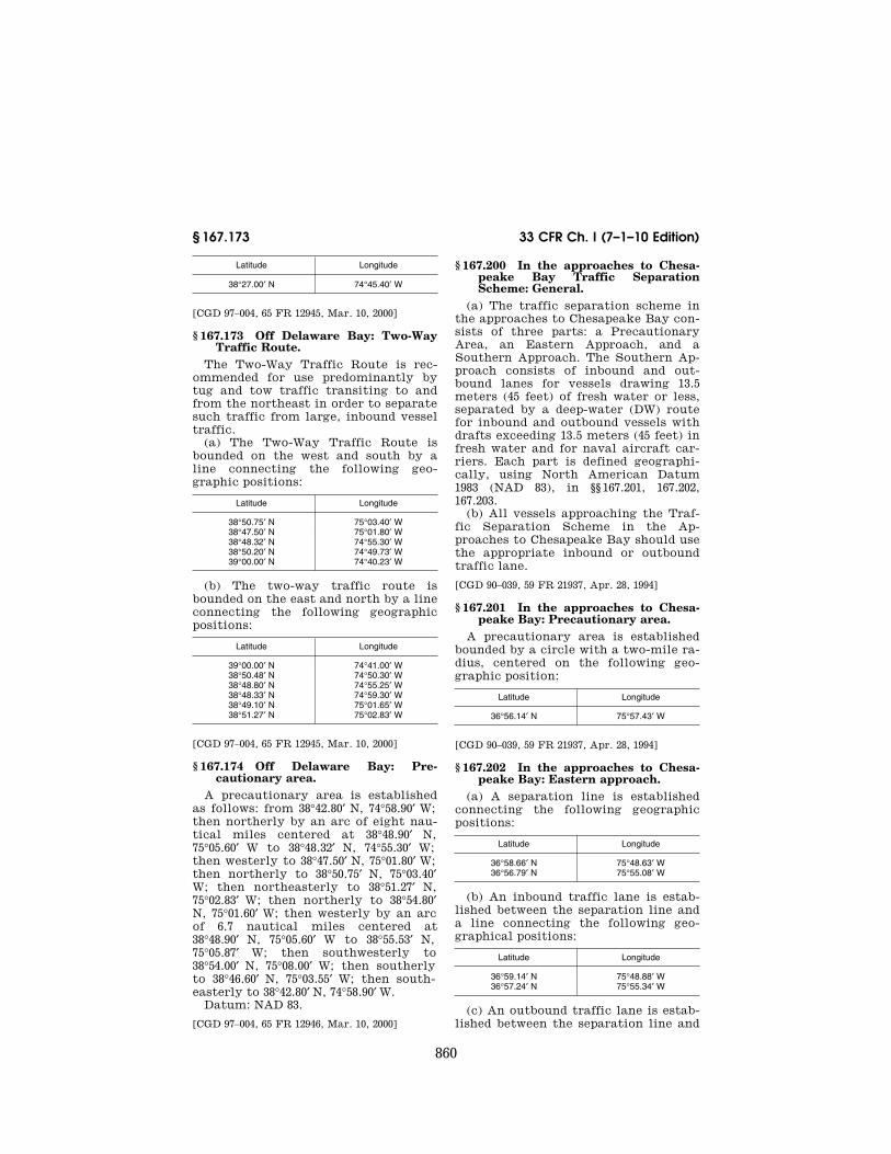
860
33 CFR Ch. I (7–1–10 Edition) § 167.173
Latitude Longitude
38°27.00′ N 74°45.40′ W
[CGD 97–004, 65 FR 12945, Mar. 10, 2000]
§ 167.173 Off Delaware Bay: Two-Way Traffic Route.
The Two-Way Traffic Route is rec-ommended for use predominantly by tug and tow traffic transiting to and from the northeast in order to separate such traffic from large, inbound vessel traffic.
(a) The Two-Way Traffic Route is bounded on the west and south by a line connecting the following geo-graphic positions:
Latitude Longitude
38°50.75′ N 75°03.40′ W 38°47.50′ N 75°01.80′ W 38°48.32′ N 74°55.30′ W 38°50.20′ N 74°49.73′ W 39°00.00′ N 74°40.23′ W
(b) The two-way traffic route is bounded on the east and north by a line connecting the following geographic positions:
Latitude Longitude
39°00.00′ N 74°41.00′ W 38°50.48′ N 74°50.30′ W 38°48.80′ N 74°55.25′ W 38°48.33′ N 74°59.30′ W 38°49.10′ N 75°01.65′ W 38°51.27′ N 75°02.83′ W
[CGD 97–004, 65 FR 12945, Mar. 10, 2000]
§ 167.174 Off Delaware Bay: Pre-cautionary area.
A precautionary area is established as follows: from 38°42.80′ N, 74°58.90′ W; then northerly by an arc of eight nau-tical miles centered at 38°48.90′ N, 75°05.60′ W to 38°48.32′ N, 74°55.30′ W; then westerly to 38°47.50′ N, 75°01.80′ W; then northerly to 38°50.75′ N, 75°03.40′ W; then northeasterly to 38°51.27′ N, 75°02.83′ W; then northerly to 38°54.80′ N, 75°01.60′ W; then westerly by an arc of 6.7 nautical miles centered at 38°48.90′ N, 75°05.60′ W to 38°55.53′ N, 75°05.87′ W; then southwesterly to 38°54.00′ N, 75°08.00′ W; then southerly to 38°46.60′ N, 75°03.55′ W; then south-easterly to 38°42.80′ N, 74°58.90′ W.
Datum: NAD 83.
[CGD 97–004, 65 FR 12946, Mar. 10, 2000]
§ 167.200 In the approaches to Chesa-peake Bay Traffic Separation Scheme: General.
(a) The traffic separation scheme in the approaches to Chesapeake Bay con-sists of three parts: a Precautionary Area, an Eastern Approach, and a Southern Approach. The Southern Ap-proach consists of inbound and out-bound lanes for vessels drawing 13.5 meters (45 feet) of fresh water or less, separated by a deep-water (DW) route for inbound and outbound vessels with drafts exceeding 13.5 meters (45 feet) in fresh water and for naval aircraft car-riers. Each part is defined geographi-cally, using North American Datum 1983 (NAD 83), in §§ 167.201, 167.202, 167.203.
(b) All vessels approaching the Traf-fic Separation Scheme in the Ap-proaches to Chesapeake Bay should use the appropriate inbound or outbound traffic lane.
[CGD 90–039, 59 FR 21937, Apr. 28, 1994]
§ 167.201 In the approaches to Chesa-peake Bay: Precautionary area.
A precautionary area is established bounded by a circle with a two-mile ra-dius, centered on the following geo-graphic position:
Latitude Longitude
36°56.14′ N 75°57.43′ W
[CGD 90–039, 59 FR 21937, Apr. 28, 1994]
§ 167.202 In the approaches to Chesa-peake Bay: Eastern approach.
(a) A separation line is established connecting the following geographic positions:
Latitude Longitude
36°58.66′ N 75°48.63′ W 36°56.79′ N 75°55.08′ W
(b) An inbound traffic lane is estab-lished between the separation line and a line connecting the following geo-graphical positions:
Latitude Longitude
36°59.14′ N 75°48.88′ W 36°57.24′ N 75°55.34′ W
(c) An outbound traffic lane is estab-lished between the separation line and
VerDate Mar<15>2010 07:59 Sep 03, 2010 Jkt 220131 PO 00000 Frm 00870 Fmt 8010 Sfmt 8010 Y:\SGML\220131.XXX 220131erow
e on
DS
K5C
LS3C
1PR
OD
with
CF
R

861
Coast Guard, DHS § 167.350
a line connecting the following geo-graphical positions:
Latitude Longitude
36°56.29′ N 75°54.93′ W 36°58.18′ N 75°48.48′ W
[CGD 90–039, 59 FR 21937, Apr. 28, 1994]
§ 167.203 In the approaches to Chesa-peake Bay: Southern approach.
(a) An inbound traffic lane is estab-lished between separation lines run-ning through the following geo-graphical positions:
Latitude Longitude
36°50.33′ N 75°46.29′ W 36°52.90′ N 75°51.52′ W 36°55.96′ N 75°54.97′ W 36°55.11′ N 75°55.23′ W 36°52.35′ N 75°52.12′ W 36°49.70′ N 75°46.80′ W
(b) An outbound traffic lane is estab-lished between separation lines run-ning through the following geo-graphical positions:
Latitude Longitude
36°49.52′ N 75°46.94′ W 36°52.18′ N 75°52.29′ W 36°54.97′ N 75°55.43′ W 36°54.44′ N 75°56.09′ W 36°51.59′ N 75°52.92′ W 36°48.87′ N 75°47.42′ W
(c) A deep-water route is established between lines running through the fol-lowing geographical positions:
Latitude Longitude
36°55.11′ N 75°55.23′ W 36°52.35′ N 75°52.12′ W 36°49.70′ N 75°46.80′ W 36°49.52′ N 75°46.94′ W 36°52.18′ N 75°52.29′ W 36°54.97′ N 75°55.43′ W
(d) The following vessels should use the deep-water route established in paragraph (c) of this section when bound for Chesapeake Bay from sea or to sea from Chesapeake Bay:
(1) Deep draft vessels (drafts greater than 13.5 meters/45 feet in fresh water).
(2) Naval aircraft carriers. (e) It is recommended that a vessel
using the deep-water route established in paragraph (c) of this section—
(1) Announce its intention on VHF- FM Channel 16 as it approaches Chesa-peake Bay Southern Approach Lighted
Whistle Buoy CB on the south end, or Chesapeake Bay Junction Lighted Buoy CBJ on the north end of the route;
(2) Avoid, as far as practicable, over-taking other vessels operating in the deep-water route; and
(3) Keep as near to the outer limit of the route which lies on the vessel’s starboard side as is safe and prac-ticable.
(f) Vessels other than those listed in paragraph (d) of this section should not use the deep-water route.
[CGD 90–039, 59 FR 21937, Apr. 28, 1994, as amended by 59 FR 28449, June 1, 1994]
ATLANTIC GULF COAST
§ 167.350 In the approaches to Gal-veston Bay Traffic Separation Scheme and precautionary areas.
(a) An inshore precautionary area bounded by a line connecting the fol-lowing geographical positions:
Latitude Longitude
(1) 29°18.10′ N 94°39.20′ W (2) 29°16.10′ N 94°37.00′ W (3) 29°18.00′ N 94°34.90′ W (4) 29°19.40′ N 94°37.10′ W (5) 29°19.80′ N 94°38.10′ W
(b) A traffic separation zone bounded by a line connecting the following geo-graphical positions:
Latitude Longitude
(6) 29°17.13′ N 94°35.86′ W (7) 29°09.55′ N 94°25.80′ W (8) 29°09.41′ N 94°25.95′ W (9) 29°17.00′ N 94°36.00′ W
(c) A traffic lane for inbound (north-westerly heading) traffic is established between the separation zone and a line connecting the following geographical positions:
Latitude Longitude
(3) 29°18.00′ N 94°34.90′ W (10) 29°11.20′ N 94°24.00′ W
(d) A traffic lane for outbound (southeasterly heading) traffic is estab-lished between the separation zone and line connecting the following geo-graphical positions:
Latitude Longitude
(2) 29°16.10′ N 94°37.00′ W
VerDate Mar<15>2010 07:59 Sep 03, 2010 Jkt 220131 PO 00000 Frm 00871 Fmt 8010 Sfmt 8010 Y:\SGML\220131.XXX 220131erow
e on
DS
K5C
LS3C
1PR
OD
with
CF
R

862
33 CFR Ch. I (7–1–10 Edition) § 167.400
Latitude Longitude
(11) 29°07.70′ N 94°27.80′ W
(e) An offshore precautionary area bounded by a line connecting the fol-lowing geographical positions:
Latitude Longitude
(11) 29°07.70′ N 94°27.80′ W (12) 29°06.40′ N 94°26.20′ W (13) 29°06.40′ N 94°23.90′ W (14) 29°09.10′ N 94°20.60′ W (10) 29°11.20′ N 94°24.00′ W
NOTE: A pilot boarding area is located near the center of the inshore precautionary area. Due to heavy vessel traffic, mariners are ad-vised not to anchor or linger in this pre-cautionary area except to pick up or dis-embark a pilot.
[CGD 81–080, 48 FR 36456, Aug. 11, 1983. Redes-ignated by CGD 84–004, 52 FR 33589, Sept. 4, 1987; CGD 89–019, 54 FR 28062, July 5, 1989; 54 FR 51972, Dec. 19, 1989]
PACIFIC WEST COAST
SOURCE: USCG–1999–5700, 65 FR 46605, July 31, 2000, unless otherwise noted.
§ 167.400 Off San Francisco Traffic Separation Scheme: General.
The Off San Francisco Traffic Sepa-ration Scheme consists of six parts: a Precautionary Area, a Northern Ap-proach, a Southern Approach, a West-ern Approach, a Main Ship Channel, and an Area To Be Avoided. The spe-cific areas in the Off San Francisco TSS and Precautionary Area are de-scribed in §§ 167.401 through 167.406 of this chapter. The geographic coordi-nates in §§ 167.401 through 167.406 are defined using North American Datum 1983 (NAD 83).
§ 167.401 Off San Francisco: Pre-cautionary area.
(a)(1) A precautionary area is estab-lished bounded to the west by an arc of a circle with a radius of 6 miles cen-tering upon geographical position 37°45.00′ N, 122°41.50′ W and connecting the following geographical positions:
Latitude Longitude
37°42.70′ N 122°34.60′ W. 37°50.30′ N 122°38.00′ W.
(2) The precautionary area is bounded to the east by a line connecting the fol-lowing geographic positions:
Latitude Longitude
37°42.70′ N 122°34.60′ W. 37°45.90′ N 122°38.00′ W. 37°50.30′ N 122°38.00′ W
(b) A pilot boarding area is located near the center of the precautionary area described in paragraph (a) of this section. Due to heavy vessel traffic, mariners are advised not to anchor or linger in this precautionary area ex-cept to pick up or disembark a pilot.
§ 167.402 Off San Francisco: Northern approach.
(a) A separation zone is bounded by a line connecting the following geo-graphical positions:
Latitude Longitude
37°48.40′ N 122°47.60′ W 37°56.70′ N 123°03.70′ W 37°55.20′ N 123°04.90′ W 37°47.70′ N 122°48.20′ W
(b) A traffic lane for north-westbound traffic is established between the sepa-ration zone and a line connecting the following geographical positions:
Latitude Longitude
37°49.20′ N 122°46.70′ W. 37°58.00′ N 123°02.70′ W.
(c) A traffic lane for south-eastbound traffic is established between the sepa-ration zone and a line connecting the following geographical positions:
Latitude Longitude
37°53.90′ N 123°06.10′ W. 37°46.70′ N 122°48.70′ W.
§ 167.403 Off San Francisco: Southern approach.
(a) A separation zone is bounded by a line connecting the following geo-graphical positions:
Latitude Longitude
37°39.10′ N 122°40.40′ W. 37°27.00′ N 122°40.40′ W. 37°27.00′ N 122°43.00′ W. 37°39.10′ N 122°43.00′ W.
VerDate Mar<15>2010 07:59 Sep 03, 2010 Jkt 220131 PO 00000 Frm 00872 Fmt 8010 Sfmt 8010 Y:\SGML\220131.XXX 220131erow
e on
DS
K5C
LS3C
1PR
OD
with
CF
R

863
Coast Guard, DHS § 167.451
(b) A traffic lane for northbound traf-fic is established between the separa-tion zone and a line connecting the fol-lowing geographical positions:
Latitude Longitude
37°39.30′ N 122°39.20′ W. 37°27.00′ N 122°39.20′ W.
(c) A traffic lane for southbound traf-fic is established between the separa-tion zone and a line connecting the fol-lowing geographical positions:
Latitude Longitude
37°27.00′ N 122°44.30′ W. 37°39.40′ N 122°44.30′ W.
§ 167.404 Off San Francisco: Western approach.
(a) A separation zone is bounded by a line connecting the following geo-graphical positions:
Latitude Longitude
37°41.90′ N 122°48.00′ W. 37°38.10′ N 122°58.10′ W. 37°36.50′ N 122°57.30′ W. 37°41.10′ N 122°47.20′ W.
(b) A traffic lane for south-westbound traffic is established between the sepa-ration zone and a line connecting the following geographical positions:
Latitude Longitude
37°42.80′ N 122°48.50′ W. 37°39.60′ N 122°58.80′ W.
(c) A traffic lane for north-eastbound traffic is established between the sepa-ration zone and a line connecting the following geographical positions:
Latitude Longitude
37°35.00′ N 122°56.50′ W. 37°40.40′ N 122°46.30′ W.
§ 167.405 Off San Francisco: Main ship channel.
(a) A separation line connects the fol-lowing geographical positions:
Latitude Longitude
37°45.90′ N 122°38.00′ W. 37°47.00′ N 122°34.30′ W. 37°48.10′ N 122°31.00′ W.
(b) A traffic lane for eastbound traf-fic is established between the separa-
tion line and a line connecting the fol-lowing geographical positions:
Latitude Longitude
37°45.80′ N 122°37.70′ W. 37°47.80′ N 122°30.80′ W.
(c) A traffic lane for westbound traf-fic is established between the separa-tion line and a line connecting the fol-lowing geographical positions:
Latitude Longitude
37°46.20′ N 122°37.90′ W. 37°46.90′ N 122°35.30′ W. 37°48.50′ N 122°31.30′ W.
§ 167.406 Off San Francisco: Area to be avoided.
A circular area to be avoided, with a radius of half of a nautical mile, is cen-tered upon geographic position:
Latitude Longitude
37°45.00′ N 122°41.50′ W.
§ 167.450 In the Santa Barbara Chan-nel Traffic Separation Scheme: Gen-eral.
The Traffic Separation Scheme in the Santa Barbara Channel is described in §§ 167.451 and 167.452. The geographic coordinates in §§ 167.451 and 167.452 are defined using North American Datum 1983 (NAD 83).
§ 167.451 In the Santa Barbara Chan-nel: Between Point Vicente and Point Conception.
(a) A separation zone is bounded by a line connecting the following geo-graphical positions:
Latitude Longitude
34°20.90′ N 120°30.16′ W 34°04.00′ N 119°15.96′ W. 33°44.90′ N 118°35.75′ W. 33°43.20′ N 118°36.95′ W. 34°02.20′ N 119°17.46′ W. 34°18.90′ N 120°30.96′ W.
(b) A traffic lane for north-westbound traffic is established between the sepa-ration zone and a line connecting the following geographical positions:
Latitude Longitude
34°21.80′ N 120°29.96′ W. 34°04.80′ N 119°15.16′ W. 33°45.80′ N 118°35.15′ W.
VerDate Mar<15>2010 07:59 Sep 03, 2010 Jkt 220131 PO 00000 Frm 00873 Fmt 8010 Sfmt 8010 Y:\SGML\220131.XXX 220131erow
e on
DS
K5C
LS3C
1PR
OD
with
CF
R

864
33 CFR Ch. I (7–1–10 Edition) § 167.452
(c) A traffic lane for south-eastbound traffic is established between the sepa-ration zone and a line connecting the following geographical positions:
Latitude Longitude
33°42.30′ N 118°37.55′ W. 34°01.40′ N 119°18.26′ W. 34°18.00′ N 120°31.16′ W.
§ 167.452 In the Santa Barbara Chan-nel: Between Point Conception and Point Arguello.
(a) A separation zone is bounded by a line connecting the following geo-graphical positions:
Latitude Longitude
34°20.90′ N 120°30.16′ W. 34°18.90′ N 120°30.96′ W. 34°25.70′ N 120°51.81′ W. 34°23.75′ N 120°52.51′ W.
(b) A traffic lane for westbound traf-fic is established between the separa-tion zone and a line connecting the fol-lowing geographical positions:
Latitude Longitude
34°21.80′ N 120°29.96′ W. 34°26.60′ N 120°51.51′ W.
(c) A traffic lane for eastbound traf-fic is established between the separa-tion zone and a line connecting the fol-lowing geographical positions:
Latitude Longitude
34°18.00′ N 120°31.16′ W. 34°22.80′ N 120°52.76′ W.
§ 167.500 In the approaches to Los An-geles-Long Beach Traffic Separa-tion Scheme: General.
The Traffic Separation Scheme in the approaches to Los Angeles-Long Beach consists of three parts: a Pre-cautionary Area, a Western Approach, and a Southern Approach. The specific areas in the approaches to Los Angeles- Long Beach are described in §§ 167.501 through 167.503. The geographic coordi-nates in §§ 167.501 through 167.503 are defined using North American Datum 1983 (NAD 83).
[USCG–2000–7695, 65 FR 53913, Sept. 6, 2000]
§ 167.501 In the approaches to Los An-geles/Long Beach: Precautionary area.
(a) The precautionary area consists of the water area enclosed by the Los Angeles-Long Beach breakwater and a line connecting Point Fermin Light at 33°42.30′ N, 118°17.60′ W, with the fol-lowing geographical positions:
Latitude Longitude
33°35.50′ N 118°17.60′ W. 33°35.50′ N 118°09.00′ W. 33°37.70′ N 118°06.50′ W. 33°43.40′ N 118°10.80′ W.
(b) Pilot boarding areas are located within the precautionary area de-scribed in paragraph (a) of this section. Specific regulations pertaining to ves-sels operating in these areas are con-tained in 33 CFR 165.1109(d).
[USCG–2000–7695, 65 FR 53913, Sept. 6, 2000]
§ 167.502 In the approaches to Los An-geles-Long Beach: Western ap-proach.
(a) A separation zone is bounded by a line connecting the following geo-graphical positions:
Latitude Longitude
33°37.70′ N 118°17.60′ W. 33°36.50′ N 118°17.60′ W. 33°36.50′ N 118°23.10′ W. 33°43.20′ N 118°36.90′ W. 33°44.90′ N 118°35.70′ W. 33°37.70′ N 118°20.90′ W.
(b) A traffic lane for northbound coastwise traffic is established between the separation zone and a line con-necting the following geographical po-sitions:
Latitude Longitude
33°38.70′ N 118°17.60′ W. 33°38.70′ N 118°20.60′ W. 33°45.80′ N 118°35.10′ W.
(c) A traffic lane for southbound coastwise traffic is established between the separation zone and a line con-necting the following geographical po-sitions:
Latitude Longitude
33°35.50′ N 118°17.60′ W. 33°35.50′ N 118°23.43′ W. 33°42.30′ N 118°37.50′ W.
VerDate Mar<15>2010 07:59 Sep 03, 2010 Jkt 220131 PO 00000 Frm 00874 Fmt 8010 Sfmt 8010 Y:\SGML\220131.XXX 220131erow
e on
DS
K5C
LS3C
1PR
OD
with
CF
R

865
Coast Guard, DHS § 167.1702
[USCG–2000–7695, 65 FR 53913, Sept. 6, 2000]
§ 167.503 In the approaches to Los An-geles-Long Beach TSS: Southern ap-proach.
(a) A separation zone is established bounded by a line connecting the fol-lowing geographic positions:
Latitude Longitude
33°35.50′ N 118°10.30′ W. 33°35.50′ N 118°12.75′ W. 33°19.70′ N 118°03.50′ W. 33°19.00′ N 118°05.60′ W.
(b) A traffic lane for northbound traf-fic is established between the separa-tion zone and a line connecting the fol-lowing geographical positions:
Latitude Longitude
33°35.50′ N 118°09.00′ W. 33°20.00′ N 118°02.30′ W.
(c) A traffic lane for southbound traf-fic is established between the separa-tion zone and a line connecting the fol-lowing geographical positions:
Latitude Longitude
33°35.50′ N 118°14.00′ W. 33°18.70′ N 118°06.75′ W.
[USCG–2000–7695, 65 FR 53913, Sept. 6, 2000]
§ 167.1700 In Prince William Sound: General.
The Prince William Sound Traffic Separation Scheme consists of four parts: Prince William Sound Traffic Separation Scheme, Valdez Arm Traf-fic Separation Scheme, and two pre-cautionary areas. These parts are de-scribed in §§ 167.1701 through 167.1703. The geographic coordinates in §§ 167.1701 through 167.1703 are defined using North American Datum 1983 (NAD 83).
[USCG–2001–10254, 67 FR 53743, Aug. 19, 2002]
§ 167.1701 In Prince William Sound: Precautionary areas.
(a) Cape Hinchinbrook. A pre-cautionary area is established and is bounded by a line connecting the fol-lowing geographical positions:
Latitude Longitude
60°20.59′ N 146°48.18′ W 60°12.67′ N 146°40.43′ W
Latitude Longitude
60°11.01′ N 146°28.65′ W 60°05.47′ N 146°00.01′ W 60°00.81′ N 146°03.53′ W 60°05.44′ N 146°27.58′ W 59°51.80′ N 146°37.51′ W 59°53.52′ N 146°46.84′ W 60°07.76′ N 146°36.24′ W 60°11.51′ N 146°46.64′ W 60°20.60′ N 146°54.31′ W
(b) Bligh Reef. A precautionary area is established of radius 1.5 miles cen-tered at geographical position 60°49.63′ N, 147°01.33′ W.
(c) Pilot boarding area. A pilot board-ing area located near the center of the Bligh Reef precautionary area is estab-lished. Regulations for vessels oper-ating in these areas are in § 165.1109(d) of this chapter.
[USCG–2001–10254, 67 FR 53743, Aug. 19, 2002]
§ 167.1702 In Prince William Sound: Prince William Sound Traffic Sepa-ration Scheme.
The Prince William Sound Traffic Separation Scheme consists of the fol-lowing:
(a) A separation zone bounded by a line connecting the following geo-graphical positions:
Latitude Longitude
60°20.77′ N 146°52.31′ W 60°48.12′ N 147°01.78′ W 60°48.29′ N 146°59.77′ W 60°20.93′ N 146°50.32′ W
(b) A traffic lane for northbound traf-fic between the separation zone and a line connecting the following geo-graphical positions:
Latitude Longitude
60°20.59′ N 146°48.18′ W 60°49.49′ N 146°58.19′ W
(c) A traffic lane for southbound traf-fic between the separation zone and a line connecting the following geo-graphical positions:
Latitude Longitude
60°49.10′ N 147°04.19′ W 60°20.60′ N 146°54.31′ W
[USCG–2001–10254, 67 FR 53743, Aug. 19, 2002]
VerDate Mar<15>2010 07:59 Sep 03, 2010 Jkt 220131 PO 00000 Frm 00875 Fmt 8010 Sfmt 8010 Y:\SGML\220131.XXX 220131erow
e on
DS
K5C
LS3C
1PR
OD
with
CF
R

866
33 CFR Ch. I (7–1–10 Edition) § 167.1703
§ 167.1703 In Prince William Sound: Valdez Arm Traffic Separation Scheme.
The Valdez Arm Traffic Separation Scheme consists of the following:
(a) A separation zone bounded by a line connecting the following geo-graphical positions:
Latitude Longitude
60°51.08′ N 147°00.33′ W 60°58.60′ N 146°48.10′ W 60°58.30′ N 146°47.10′ W 60°50.45′ N 146°58.75′ W
(b) A traffic lane for northbound traf-fic between the separation zone and a line connecting the following geo-graphical positions:
Latitude Longitude
60°49.39′ N 146°58.19′ W 60°58.04′ N 146°46.52′ W
(c) A traffic lane for southbound traf-fic between the separation zone and a line connecting the following geo-graphical positions:
Latitude Longitude
60°58.93′ N 146°48.86′ W 60°50.61′ N 147°03.60′ W
[USCG–2001–10254, 67 FR 53743, Aug. 19, 2002]
PART 168—ESCORT REQUIREMENTS FOR CERTAIN TANKERS
Sec. 168.01 Purpose. 168.05 Definitions. 168.10 Responsibilities. 168.20 Applicable vessels. 168.30 Applicable cargoes. 168.40 Applicable waters and number of es-
cort vessels. 168.50 Performance and operational require-
ments. 168.60 Pre-escort conference.
AUTHORITY: Section 4116(c), Pub. L. 101–380, 104 Stat. 520 (46 U.S.C. 3703 note); Depart-ment of Homeland Security Delegation No. 170.1, para. 2(82).
SOURCE: CGD 91–202, 59 FR 42968, Aug. 19, 1994, unless otherwise noted.
§ 168.01 Purpose. (a) This part prescribes regulations
in accordance with section 4116(c) of the Oil Pollution Act of 1990 (OPA 90)
(Pub. L. 101–380). The regulations will reduce the risk of oil spills from laden, single hull tankers over 5,000 GT by re-quiring that these tankers be escorted by at least two suitable escort vessels. The escort vessels will be immediately available to influence the tankers’ speed and course in the event of a steering or propulsion equipment fail-ure, thereby reducing the possibility of groundings or collisions.
(b) The regulations in this part estab-lish minimum escort vessel require-ments. Nothing in these regulations should be construed as relieving the master of a tanker from the duty to op-erate the vessel in a safe and prudent manner, taking into account the navi-gational constraints of the waterways to be traversed, other vessel traffic, and anticipated weather, tide, and sea conditions, which may require reduced speeds, greater assistance from escort vessels, or other operational pre-cautions.
§ 168.05 Definitions. As used in this part— Disabled tanker means a tanker expe-
riencing a loss of propulsion or steering control.
Escort transit means that portion of the tanker’s voyage through waters where escort vessels are required.
Escort vessel means any vessel that is assigned and dedicated to a tanker dur-ing the escort transit, and that is fendered and outfitted with towing gear as appropriate for its role in an emergency response to a disabled tank-er.
Laden means transporting in bulk any quantity of applicable cargo, ex-cept for clingage and residue in other-wise empty cargo tanks.
Single hull tanker means any self-pro-pelled tank vessel that is not con-structed with both double bottom and double sides in accordance with the provisions of 33 CFR 157.10d.
Tanker master means the licensed on-board person in charge of the tanker.
Tanker owner or operator means the owner or shoreside organization (indi-vidual, corporation, partnership, or as-sociation), including a demise charterer, responsible for the overall management and operation of the tanker.
VerDate Mar<15>2010 07:59 Sep 03, 2010 Jkt 220131 PO 00000 Frm 00876 Fmt 8010 Sfmt 8010 Y:\SGML\220131.XXX 220131erow
e on
DS
K5C
LS3C
1PR
OD
with
CF
R

867
Coast Guard, DHS § 168.50
§ 168.10 Responsibilities. (a) The tanker owner or operator
shall: (1) select escort vessels that can meet
the performance requirements of this part; and
(2) inform the tanker master of the performance capabilities of the se-lected escort vessels. This information must be provided to the master before beginning the escort transit.
(b) The tanker master shall operate the tanker within the performance ca-pabilities of the escort vessels, taking into account speed, sea and weather conditions, navigational consider-ations, and other factors that may change or arise during the escort tran-sit.
(c) In an emergency, the tanker mas-ter may deviate from the requirements of this part to the extent necessary to avoid endangering persons, property, or the environment, but shall imme-diately report the deviation to the cog-nizant Coast Guard Captain of the Port (COTP).
§ 168.20 Applicable vessels. The requirements of this part apply
to laden, single hull tankers of 5,000 gross tons or more.
§ 168.30 Applicable cargoes. The requirements of this part apply
to any petroleum oil listed in 46 CFR Table 30.25–1 as a pollution category I cargo.
§ 168.40 Applicable waters and number of escort vessels.
The requirements of this part apply to the following waters:
(a) Prince William Sound: Each tanker to which this part applies must be es-corted by at least two escort vessels in those navigable waters of the United States within Prince William Sound, Alaska, and the adjoining tributaries, bays, harbors, and ports, including the navigable waters of the United States within a line drawn from Cape Hinchinbrook Light, to Seal Rocks Light, to a point on Montague Island at 60°14.6′ North, 146°59′ West, and the waters of Montague Strait east of a line between Cape Puget and Cape Cleare.
(b) Puget Sound and certain associated waters: Each tanker to which this part applies must be escorted by at least two escort vessels in those navigable waters of the United States and Wash-ington State east of a line connecting New Dungeness Light with Discovery Island Light and all points in the Puget Sound area north and south of these lights. This area includes all the navigable waters of the United States within Haro Strait, Rosario Strait, the Strait of Georgia, Puget Sound, and Hood Canal, as well as those portions of the Strait of Juan de Fuca east of the New Dungeness-Discovery Island line.
§ 168.50 Performance and operational requirements.
(a) Except as provided in paragraph (c) of § 168.10, at all times during the es-cort transit each tanker to which this part applies:
(1) Must be accompanied by escort vessels that meet the performance re-quirements of paragraph (b) of this sec-tion (but not less than the number of escorts required by § 168.40).
(2) Must have the escort vessels posi-tioned relative to the tanker such that timely response to a propulsion or steering failure can be effected.
(3) Must not exceed a speed beyond which the escort vessels can reasonably be expected to safely bring the tanker under control within the navigational limits of the waterway, taking into consideration ambient sea and weather conditions, surrounding vessel traffic, hazards, and other factors that may re-duce the available sea room.
(b) The escort vessels, acting singly or jointly in any combination as need-ed, and considering their applied force vectors on the tanker’s hull, must be capable of—
(1) Towing the tanker at 4 knots in calm conditions, and holding it in steady position against a 45-knot headwind;
(2) [Reserved] (3) Holding the tanker on a steady
course against a 35-degree locked rud-der at a speed of 6 knots; and
(4) Turning the tanker 90 degrees, as-suming a free-swinging rudder and a speed of 6 knots, within the same dis-tance (advance and transfer) that it
VerDate Mar<15>2010 07:59 Sep 03, 2010 Jkt 220131 PO 00000 Frm 00877 Fmt 8010 Sfmt 8010 Y:\SGML\220131.XXX 220131erow
e on
DS
K5C
LS3C
1PR
OD
with
CF
R
868
33 CFR Ch. I (7–1–10 Edition) § 168.60
could turn itself with a hard-over rud-der.
[CGD 91–202, 59 FR 42968, Aug. 19, 1994, as amended at 70 FR 55730, Sept. 23, 2005]
§ 168.60 Pre-escort conference. (a) Before commencing an escort
transit, the tanker master shall confer, by radio or in person, with the tanker pilot and the masters of the escort ves-sels regarding the escort operation.
(b) The purpose of the pre-escort con-ference is for all parties to plan and discuss particulars of the escort tran-sit.
(c) At a minimum, the following top-ics must be addressed during the pre- escort conference:
(1) The destination, route, planned speed, other vessel traffic, anticipated weather, tide, and sea conditions, and other navigational considerations;
(2) The type and operational status of communication, towing, steering, and propulsion equipment on the tanker and escort vessels;
(3) The relative positioning and reac-tion time for the escort vessels to move into assist positions, including, if ap-propriate, pre-tethering the escort ves-sels at crucial points along the route;
(4) The preparations required on the tanker and escort vessels, and the methods employed in making an emer-gency towline connection, including stationing of deck crews, preparation of messenger lines, bridles, and other towing gear, and energizing appro-priate deck equipment;
(5) The manner in which an emer-gency towline connection would be made (which escort vessel will respond, how messengers and towlines will be passed, etc.);
(6) Other relevant information pro-vided by the tanker master, pilot or es-cort vessel masters.
PART 169—SHIP REPORTING SYSTEMS
Subpart A—General
Sec. 169.1 What is the purpose of this part? 169.5 How are terms used in this part de-
fined? 169.10 What geographic coordinates are
used?
169.15 Incorporation by reference: Where can I get a copy of the publications men-tioned in this part?
Subpart B—Establishment of Two Manda-tory Ship Reporting Systems for the Protection of Northern Right Whales
169.100 What mandatory ship reporting sys-tems are established by this subpart?
169.102 Who is the shore-based authority? 169.105 Where is the northeastern reporting
system located? 169.110 When is the northeastern reporting
system in effect? 169.115 Where is the southeastern reporting
system located? 169.120 When is the southeastern reporting
system in effect? 169.125 What classes of ships are required to
make reports? 169.130 When are ships required to make re-
ports? 169.135 How must the reports be made? 169.140 What information must be included
in the report?
Subpart C—Transmission of Long Range Identification and Tracking Information
169.200 What is the purpose of this subpart? 169.205 What types of ships are required to
transmit LRIT information (position re-ports)?
169.210 Where during its international voy-age must a ship transmit position re-ports?
169.215 How must a ship transmit position reports?
169.220 When must a ship be fitted with LRIT equipment?
169.225 Which Application Service Providers may a ship use?
169.230 How often must a ship transmit posi-tion reports?
169.235 What exemptions are there from re-porting?
169.240 When may LRIT equipment be switched off?
169.245 What must a ship master do if LRIT equipment is switched off or fails to op-erate?
AUTHORITY: 33 U.S.C. 1230(d), 1231; 46 U.S.C. 70115, Department of Homeland Security Del-egation No. 0170.1.
SOURCE: USCG–1999–5525, 64 FR 29234, June 1, 1999, unless otherwise noted.
Subpart A—General § 169.1 What is the purpose of this
part? This subpart prescribes the require-
ments for mandatory ship reporting systems. Ship reporting systems are
VerDate Mar<15>2010 07:59 Sep 03, 2010 Jkt 220131 PO 00000 Frm 00878 Fmt 8010 Sfmt 8010 Y:\SGML\220131.XXX 220131erow
e on
DS
K5C
LS3C
1PR
OD
with
CF
R

869
Coast Guard, DHS § 169.5
used to provide, gather, or exchange in-formation through radio reports. The information is used to provide data for many purposes including, but not lim-ited to: navigation safety, maritime se-curity and domain awareness, environ-mental protection, vessel traffic serv-ices, search and rescue, weather fore-casting and prevention of marine pollu-tion.
NOTE TO § 169.1: For ship reporting system requirements not established by the Coast Guard, see 50 CFR Part 404.
[USCG–1999–5525, 64 FR 29234, June 1, 1999, as amended by USCG–2005–22612, 73 FR 23318, Apr. 29, 2008; USCG–2009–0416, 74 FR 27442, June 10, 2009]
§ 169.5 How are terms used in this part defined?
As used in this part— Administration means the Govern-
ment of the State whose flag the ship is entitled to fly.
Cargo ship means any ship which is not a passenger ship.
Flag Administration means the Gov-ernment of a State whose flag the ship is entitled to fly.
Gross tonnage means tonnage as de-fined under the International Conven-tion on Tonnage Measurement of Ships, 1969 (Incorporated by reference, see § 169.15).
Gross tons means vessel tonnage measured in accordance with the meth-od utilized by the flag state adminis-tration of that vessel.
High speed craft means a craft that is operable on or above the water and is capable of a maximum speed equal to or exceeding V=3.7×displ .1667, where ‘‘V’’ is the maximum speed and ‘‘displ’’ is the vessel displacement cor-responding to the design waterline in cubic meters.
High speed passenger craft means a high speed craft carrying more than 12 passengers.
International voyage means a voyage from a country to which the present International Convention for the Safe-ty of Life at Sea (SOLAS), 1974 applies to a port outside such country, or con-versely. For U.S. ships, such voyages will be considered to originate at a port in the United States, regardless of when the voyage actually began. Such voyages for U.S. ships will continue
until the ship returns to the United States from its last foreign port.
Long range identification and tracking (LRIT) information or position report means a report containing the fol-lowing information:
(1) The identity of the ship; (2) The position of the ship (latitude
and longitude); and (3) The date and time of the position
provided. LRIT Data Center means a center es-
tablished by a SOLAS Contracting Government or a group of Contracting Governments, or in the case of the International Data Center, by IMO, to request, receive, process, and archive LRIT information. An LRIT Data Cen-ter may be National, Regional, Co-op-erative or International.
Mandatory ship reporting system means a ship reporting system that re-quires the participation of specified vessels or classes of vessels, and that is established by a government or govern-ments after adoption of a proposed sys-tem by the International Maritime Or-ganization (IMO) as complying with all requirements of regulation V/8–1 of the International Convention for the Safe-ty of Life at Sea, 1974, as amended (SOLAS), except paragraph (e) thereof.
Mobile offshore drilling unit means a self-propelled vessel capable of engag-ing in drilling operations for the explo-ration or exploitation of subsea re-sources.
Passenger ship means a ship that car-ries more than 12 passengers.
Self-propelled ships means ships pro-pelled by mechanical means.
Shore-based authority means the gov-ernment appointed office or offices that will receive the reports made by ships entering each of the mandatory ship reporting systems. The office or offices will be responsible for the man-agement and coordination of the sys-tem, interaction with participating ships, and the safe and effective oper-ation of the system. Such an authority may or may not be an authority in charge of a vessel traffic service.
United States means the States of the United States, the District of Colum-bia, Guam, Puerto Rico, the Virgin Is-lands, American Samoa, the Northern
VerDate Mar<15>2010 07:59 Sep 03, 2010 Jkt 220131 PO 00000 Frm 00879 Fmt 8010 Sfmt 8010 Y:\SGML\220131.XXX 220131erow
e on
DS
K5C
LS3C
1PR
OD
with
CF
R

870
33 CFR Ch. I (7–1–10 Edition) § 169.10
Mariana Islands, and any other terri-tory or possession of the United States.
[USCG–1999–5525, 66 FR 58070, Nov. 20, 2001, as amended by USCG–2005–22612, 73 FR 23318, Apr. 29, 2008]
§ 169.10 What geographic coordinates are used?
Geographic coordinates expressed in terms of latitude or longitude, or both, are not intended for plotting on maps or charts where the referenced hori-zontal datum is the North American Datum of 1983 (NAD 83), unless such ge-ographic coordinates are expressly la-beled NAD 83. Geographic coordinates without the NAD 83 reference may be plotted on maps or charts referenced to NAD 83 only after application of the appropriate corrections that are pub-lished on the particular map or chart being used.
§ 169.15 Incorporation by reference: Where can I get a copy of the publi-cations mentioned in this part?
(a) Certain material is incorporated by reference into this part with the ap-proval of the Director of the Federal Register under 5 U.S.C. 552(a) and 1 CFR part 51. To enforce any edition other than that specified in this sec-tion, the Coast Guard must publish no-tice of change in the FEDERAL REG-ISTER and the material must be avail-able to the public. All approved mate-rial is available for inspection at the National Archives and Records Admin-istration (NARA). For information on the availability of this material at NARA, call 202–741–6030 or go to http:// www.archives.gov/federallregister/ codeloflfederallregulations/ ibrllocations.html. Also, it is available for inspection at the Coast Guard, Of-fice of Navigation Systems (CG–54132), 2100 2nd St. SW., Stop 7581, Wash-ington, DC 20593–7581, and is available from the sources indicated in this sec-tion.
(b) International Electrotechnical Com-mission (IEC) Bureau Central de la Com-mission Electrotechnique Internationale, 3 rue de Varembe, P.O. Box 131, 1211 Ge-neva 20, Switzerland.
(1) IEC 60945, Fourth edition 2002–08, Maritime navigation and radiocommunication equipment and systems—General requirements—Meth-
ods of testing and required test results, incorporation by reference approved for § 169.215.
(2) [Reserved] (c) International Maritime Organization
(IMO), 4 Albert Embankment, London SE1 7SR, U.K.
(1) IMO Resolution MSC.202(81), adopted on May 19, 2006, Adoption of Amendments to the International Con-vention for the Safety of Life at Sea, 1974, as Amended, incorporation by ref-erence approved for § 169.240.
(2) IMO Resolution MSC.210(81), adopted on May 19, 2006, Performance Standards and Functional Require-ments for the Long-Range Identifica-tion and Tracking of Ships, incorpora-tion by reference approved for §§ 169.215 and 169.240.
(3) IMO Resolution MSC.254(83), adopted on October 12, 2007, Adoption of Amendments to the Performance Standards and Functional Require-ments for the Long-Range Identifica-tion and Tracking of Ships, incorpora-tion by reference approved for §§ 169.215 and 169.240.
(4) IMO Resolution A.694(17), adopted on November 6, 1991, General Require-ments for Shipborne Radio Equipment Forming Part of the Global Maritime Distress and Safety System (GMDSS) and for Electronic Navigational Aids, incorporation by reference approved for § 165.215.
(5) International Convention on Ton-nage Measurement of Ships, 1969, incor-poration by reference approved for § 169.5.
[USCG–2005–22612, 73 FR 23319, Apr. 29, 2008, as amended by USCG–2010–0351, 75 FR 36287, June 25, 2010]
Subpart B—Establishment of Two Mandatory Ship Reporting Systems for the Protection of Northern Right Whales
§ 169.100 What mandatory ship report-ing systems are established by this subpart?
This subpart prescribes requirements for the establishment and maintenance of two mandatory ship reporting sys-tems for the protection of the endan-gered northern right whale (also known as the North Atlantic right whale). These two systems are designated for
VerDate Mar<15>2010 07:59 Sep 03, 2010 Jkt 220131 PO 00000 Frm 00880 Fmt 8010 Sfmt 8010 Y:\SGML\220131.XXX 220131erow
e on
DS
K5C
LS3C
1PR
OD
with
CF
R
871
Coast Guard, DHS § 169.135
certain areas of the East Coast of the United States. One system is located in the northeast and is identified as WHALESNORTH. The other system is located in the southeast and is identi-fied as WHALESSOUTH.
NOTE TO § 169.100: 50 CFR 224.103(c) contains requirements and procedures concerning northern right whale approach limitations and avoidance procedures.
[USCG–1999–5525, 64 FR 29234, June 1, 1999, as amended by 66 FR 58070, Nov. 20, 2001]
§ 169.102 Who is the shore-based au-thority?
The U.S. Coast Guard is the shore- based authority for these mandatory ship reporting systems.
§ 169.105 Where is the northeastern re-porting system located?
Geographical boundaries of the northeastern area include the waters of Cape Cod Bay, Massachusetts Bay, and the Great South Channel east and southeast of Massachusetts. The co-ordinates (NAD 83) of the area are as follows: from a point on Cape Ann, Massachusetts at 42°39′ N, 70°37′ W; then northeast to 42°45′ N, 70°13′ W; then southeast to 42°10′ N, 68°31′ W; then south to 41°00′ N, 68°31′ W; then west to 41°00′ N, 69°17′ W; then northeast to 42°05′ N, 70°02′ W, then west to 42°04′ N, 70°10′ W; and then along the Massachu-setts shoreline of Cape Cod Bay and Massachusetts Bay back to the point on Cape Anne at 42°39′ N, 70°37′ W.
§ 169.110 When is the northeastern re-porting system in effect?
The mandatory ship reporting sys-tem in the northeastern United States operates year-round.
§ 169.115 Where is the southeastern re-porting system located?
Geographical boundaries of the southeastern area include coastal wa-ters within about 25 nautical miles (45 kilometer) along a 90-nautical mile (170-kilometer) stretch of the Atlantic seaboard in Florida and Georgia. The area coordinates (NAD 83) extends from the shoreline east to longitude 80°51.6′ W with the southern and northern boundaries at latitude 30°00′ N and 31°27′ N, respectively.
§ 169.120 When is the southeastern re-porting system in effect?
The mandatory ship reporting sys-tem in the southeastern United States operates during the period beginning on November 15 each year through April 16 of the following year.
[USCG–1999–5525, 66 FR 58070, Nov. 20, 2001]
§ 169.125 What classes of ships are re-quired to make reports?
Each self-propelled ship of 300 gross tons or greater must participate in the reporting systems, except government ships exempted from reporting by regu-lation V/8–1(c) of SOLAS. However, ex-empt ships are encouraged to partici-pate in the reporting systems.
[USCG–1999–5525, 66 FR 58070, Nov. 20, 2001]
§ 169.130 When are ships required to make reports?
Participating ships must report to the shore-based authority upon enter-ing the area covered by a reporting sys-tem. Additional reports are not nec-essary for movements made within a system or for ships exiting a system.
§ 169.135 How must the reports be made?
(a) A ship equipped with INMARSAT C must report in IMO standard format as provided in § 169.140 in table 169.140.
(b) A ship not equipped with INMARSAT C must report to the Coast Guard using other means, listed below in order of precedence—
(1) Narrow band direct printing (SITOR),
(2) HF voice communication, or (3) MF or VHF voice communica-
tions. (c) SITOR or HF reports made di-
rectly to the Coast Guard’s Commu-nications Area Master Station Atlantic (CAMSLANT) in Chesapeake, VA, or MF or VHF reports made to Coast Guard activities or groups, should only be made by ships not equipped with INMARSAT C. Ships in this category must provide all the required informa-tion to the Coast Guard watchstander.
[USCG–1999–5525, 64 FR 29234, June 1, 1999, as amended by 66 FR 58070, Nov. 20, 2001]
VerDate Mar<15>2010 07:59 Sep 03, 2010 Jkt 220131 PO 00000 Frm 00881 Fmt 8010 Sfmt 8010 Y:\SGML\220131.XXX 220131erow
e on
DS
K5C
LS3C
1PR
OD
with
CF
R
872
33 CFR Ch. I (7–1–10 Edition) § 169.140
§ 169.140 What information must be in-cluded in the report?
Each ship report made to the shore- based authority must follow the stand-
ard reporting and format requirements listed in this section in table 169.140. Current email addresses and telex num-bers are published annually in the US Coast Pilot.
TABLE 169.140—REQUIREMENTS FOR SHIP REPORTS
Telegraphy Function Information required
Name of system ....... System identifier ...................................... Ship reporting system WHALESNORTH or WHALESSOUTH. M .............................. INMARSAT Number ................................ Vessel INMARSAT number A ............................... Ship .......................................................... The name, call sign or ship station identity, IMO number, and
flag of the vessel. B ............................... Date and time of event ............................ A 6-digit group giving day of month (first two digits), hours
and minutes (last four digits). E ............................... True course ............................................. A 3-digit group indicating true course. F ............................... Speed in knots and tenths of knots ........ A 3-digit group. H ............................... Date, time and point of entry into system Entry time expressed as in (B) and entry position expressed
as-(1) a 4-digit group giving latitude in degrees and min-utes suffixed with N(north) or S (south) and a 5-digit group giving longitude in degrees and minutes suffixed with E (east) or W (west); or (2) True bearing (first 3 digits) and distance (state distance) in nautical miles from a clearly identified landmark (state landmark)
I ................................ Destination and expected time of arrival Name of port and date time group expressed as in (B) L ............................... Route information .................................... Intended track.
[USCG–1999–5525, 66 FR 58070, Nov. 20, 2001]
Subpart C—Transmission of Long Range Identification and Tracking Information
SOURCE: USCG–2005–22612, 73 FR 23319, Apr. 29, 2008, unless otherwise noted.
§ 169.200 What is the purpose of this subpart?
This subpart implements Regulation 19–1 of SOLAS Chapter V (SOLAS V/19– 1) and requires certain ships engaged on an international voyage to transmit vessel identification and position infor-mation electronically. This require-ment enables the Coast Guard to ob-tain long range identification and tracking (LRIT) information and thus heightens our overall maritime domain awareness, enhances our search and rescue operations, and increases our ability to detect anomalies and deter transportation security incidents.
§ 169.205 What types of ships are re-quired to transmit LRIT informa-tion (position reports)?
The following ships, while engaged on an international voyage, are required to transmit position reports:
(a) A passenger ship, including high speed passenger craft.
(b) A cargo ship, including high speed craft, of 300 gross tonnage or more.
(c) A mobile offshore drilling unit while underway and not engaged in drilling operations.
§ 169.210 Where during its inter-national voyage must a ship trans-mit position reports?
The requirements for the trans-mission of position reports, imposed by the United States, vary depending on the relationship of the United States to a ship identified in § 169.205.
(a) Flag State relationship. A U.S. flag ship engaged on an international voy-age must transmit position reports wherever they are located.
(b) Port State relationship. A foreign flag ship engaged on an international voyage must transmit position reports after the ship has announced its inten-tion to enter a U.S. port or place under requirements in 33 CFR part 160, sub-part C.
(c) Coastal State relationship. A for-eign flag ship engaged on an inter-national voyage must transmit posi-tion reports when the ship is within 1,000 nautical miles of the baseline of the United States, unless their Flag Administration, under authority of
VerDate Mar<15>2010 07:59 Sep 03, 2010 Jkt 220131 PO 00000 Frm 00882 Fmt 8010 Sfmt 8010 Y:\SGML\220131.XXX 220131erow
e on
DS
K5C
LS3C
1PR
OD
with
CF
R
873
Coast Guard, DHS § 169.245
SOLAS V/19–1.9.1, has directed them not to do so.
§ 169.215 How must a ship transmit po-sition reports?
A ship must transmit position re-ports using Long Range Identification and Tracking (LRIT) equipment that has been type-approved by their Ad-ministration. To be type-approved by the Coast Guard, LRIT equipment must meet the requirements of IMO Resolutions A.694(17), MSC.210(81), and MSC.254(83), and IEC standard IEC 60945 (Incorporated by reference, see § 169.15).
§ 169.220 When must a ship be fitted with LRIT equipment?
A ship identified in § 169.205 must be equipped with LRIT equipment—
(a) Before getting underway, if the ship is constructed on or after Decem-ber 31, 2008.
(b) By the first survey of the radio in-stallation after December 31, 2008, if the ship is—
(1) Constructed before December 31, 2008, and
(2) Operates within— (i) One hundred (100) nautical miles
of the United States baseline, or (ii) Range of an Inmarsat geo-
stationary satellite, or other Applica-tion Service Provider recognized by the Administration, with which continuous alerting is available.
(c) By the first survey of the radio in-stallation after July 1, 2009, if the ship is—
(1) Constructed before December 31, 2008, and
(2) Operates within the area or range specified in paragraph (b)(2) of this sec-tion as well as outside the range of an Inmarsat geostationary satellite with which continuous alerting is available. While operating in the area or range specified in paragraph (b)(2) of this sec-tion, however, a ship must install LRIT equipment by the first survey of the radio installation after December 31, 2008.
§ 169.225 Which Application Service Providers may a ship use?
A ship may use an Application Serv-ice Provider (ASP) recognized by its Administration. Some Communication
Service Providers may also serve as an ASP.
§ 169.230 How often must a ship trans-mit position reports?
A ship’s LRIT equipment must trans-mit position reports at 6-hour intervals unless a more frequent interval is re-quested remotely by an LRIT Data Center.
§ 169.235 What exemptions are there from reporting?
A ship is exempt from this subpart if it is—
(a) Fitted with an operating auto-matic identification system (AIS), under 33 CFR 164.46, and operates only within 20 nautical miles of the United States baseline,
(b) A warship, naval auxiliaries or other ship owned or operated by a SOLAS Contracting Government and used only on Government non-commer-cial service, or
(c) A ship solely navigating the Great Lakes of North America and their con-necting and tributary waters as far east as the lower exit of the St. Lam-bert Lock at Montreal in the Province of Quebec, Canada.
§ 169.240 When may LRIT equipment be switched off?
A ship engaged on an international voyage may switch off its LRIT equip-ment only when it is permitted by its Flag Administration, in circumstances detailed in SOLAS V/19–1.7, or in para-graph 4.4.1, of resolution MSC.210(81), as amended by resolution MSC.254(83) (Incorporated by reference, see § 169.15).
§ 169.245 What must a ship master do if LRIT equipment is switched off or fails to operate?
(a) If a ship’s LRIT equipment is switched off or fails to operate, the ship’s master must inform his or her Flag Administration without undue delay.
(b) The master must also make an entry in the ship’s logbook that states—
(1) His or her reason for switching the LRIT equipment off, or an entry that the equipment has failed to oper-ate, and
VerDate Mar<15>2010 07:59 Sep 03, 2010 Jkt 220131 PO 00000 Frm 00883 Fmt 8010 Sfmt 8010 Y:\SGML\220131.XXX 220131erow
e on
DS
K5C
LS3C
1PR
OD
with
CF
R
874
33 CFR Ch. I (7–1–10 Edition) § 169.245
(2) The period during which the LRIT equipment was switched off or non- operational.
NOTE TO § 169.245: For U.S. vessels, the U.S. Coast Guard serves as the Flag Administra-
tion for purposes of this section. All LRIT notifications for the U.S. Flag Administra-tion, in addition to requests or questions about LRIT, should be communicated to the U.S. Coast Guard by e-mail addressed to [email protected].
VerDate Mar<15>2010 07:59 Sep 03, 2010 Jkt 220131 PO 00000 Frm 00884 Fmt 8010 Sfmt 8010 Y:\SGML\220131.XXX 220131erow
e on
DS
K5C
LS3C
1PR
OD
with
CF
R
Copyright © 2022 FDOKUMEN